

Bahasa
Halaman
Hukum

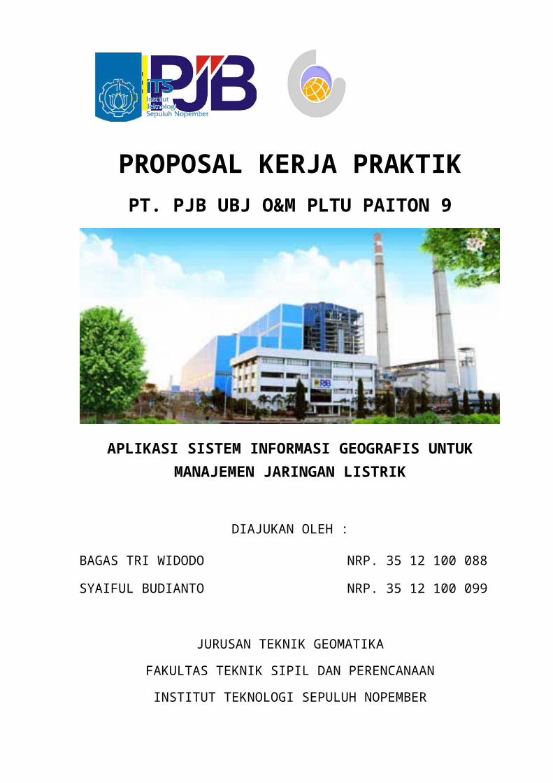
PROPOSAL KERJA PRAKTIKPT. PJB UBJ O&M PLTU PAITON 9
APLIKASI SISTEM INFORMASI GEOGRAFIS UNTUK MANAJEMEN JARINGAN LISTRIK
DIAJUKAN OLEH :
BAGAS TRI WIDODO NRP. 35 12 100 088
SYAIFUL BUDIANTO NRP. 35 12 100 099
JURUSAN TEKNIK GEOMATIKA
FAKULTAS TEKNIK SIPIL DAN PERENCANAAN
INSTITUT TEKNOLOGI SEPULUH NOPEMBER
SURABAYA
2015
1JURUSAN TEKNIK GEOMATIKAFAKULTAS TEKNIK SIPIL DAN PERENCANAANINSTITUT TEKNOLOGI SEPULUH NOPEMBERSURABAYA – 2015
PROPOSAL KERJA PRAKTIKPT. PJB UBJ O&M PLTU PAITON 9
Jl. Raya Surabaya Situbondo KM 141, Paiton
Probolinggo (67291)
PROPOSAL KERJA PRAKTIK
APLIKASI SISTEM INFORMASI GEOGRAFIS UNTUK MANAJEMEN JARINGAN LISTRIK
PT. PJB UBJ O&M PLTU PAITON 9Jl. Raya Surabaya Situbondo KM 141, Paiton
Probolinggo 67291, Indonesia
Telepon: (0335) 771805
Abstrak
Sistem Informasi Geografis (SIG) adalah sistem informasi yang berdasar pada data
keruangan dan tereferensi secara spasial yang merepresentasikan objek di bumi dengan
koordinat-koordinat geografi. SIG dirancang untuk mengumpulkan, menyimpan, dan
menganalisis objek-objek dan fenomena dimana lokasi geografi merupakan karakteristik
penting untuk dianalisis. Aplikasi SIG yang ada sekarang ini dapat digunakan untuk meneliti
banyak karakteristik geografis, serta bermanfaat untuk menganalisis jaringan sumber energi,
termasuk jaringan energi listrik.
Listrik memegang peranan yang vital dalam kehidupan. Dapat dikatakan bahwa listrik
telah menjadi sumber energi utama dalam setiap kegiatan baik di rumah tangga maupun
industri. Untuk itu ketersediaan jaringan listrik sangat diperlukan untuk seluruh wilayah
nusantara demi kemajuan Negara serta kemakmuran rakyat. Dalam pembuatan sistem
informasi geografis mengenai persebaran suplai jaringan listrik ini diharapkan dapat
membantu kinerja PT. PJB UBJ O&M PLTU PAITON 9 yang merupakan salah satu BUMN,
yang bertugas menyuplai kebutuhan energi listrik di Jawa Timur dan Bali agar semakin
efektif serta efisien.
Kata Kunci: Jaringan Listrik, Sistem Informasi Geografi (SIG)
2JURUSAN TEKNIK GEOMATIKAFAKULTAS TEKNIK SIPIL DAN PERENCANAANINSTITUT TEKNOLOGI SEPULUH NOPEMBERSURABAYA – 2015
PROPOSAL KERJA PRAKTIKPT. PJB UBJ O&M PLTU PAITON 9
Jl. Raya Surabaya Situbondo KM 141, Paiton
Probolinggo (67291)
1. Pendahuluan
Pendidikan tinggi merupakan salah satu dari beberapa variabel yang penting
dalam upaya memajukan bangsa. Kualitas pendidikan tinggi di suatu negara biasanya
berbanding lurus dengan kemajuan perekonomiannya. Semakin mumpuni kualitas
pendidikan tingginya, maka negara tersebut memiliki peluang yang lebih besar untuk
mencapai level perekonomian yang cemerlang. Di sinilah pendidikan tinggi berperan,
terutama dalam hal riset dan pengembangan. Dengan adanya riset dan pengembangan
secara berkesinambungan, pembangunan industri di Indonesia tentu akan memiliki
daya saing yang baik di level regional ASEN, Asia, hingga ke skala global.
Komunikasi dan kerjasama yang baik antara pemerintah, perusahaan, dan
perguruan tinggi (PT) adalah mutlak yang harus dipenuhi untuk mencapai kemajuan di
bidang ekonomi dan industri. Perguruan tinggi dituntut untuk memproduksi lulusan
yang siap dengan tantangan di dunia kerja. Selama ini, perusahaan sering
mengeluhkan lulusan PT yang kurang adaptif dengan dunia kerja. Atas dasar itulah,
perlu dilakukan snkronisasi antara PT dengan perusahaan. Salah satu solusi untuk
mengatasi masalah ini adalah dengan mengadakan kerja praktik bagi mahasiswa.
Kerja praktik ini bertujuan untuk memberikan gambaran kepada mahasiswa mengenai
kondisi sesungguhnya dalam dalam dunia industri. Selain itu, mahasiswa dapat
mengetahui aplikasi dari ilmu yang selama ini didapat di bangku kuliah, pada dunia
kerja, terutama dalam perencaan pembangunan industri yang sebenarnya.
Institut Teknologi Sepuluh Nopember (ITS) Surabaya sebagai salah satu
kampus teknologi terkemuka di Indonesia sangat menyadari pentingnya sinkronisasi
antara PT dengan perusahaan. ITS tidak hanya fokus dalam mengenbangkan teknologi
dan sains, namun juga mengembangkan kualitas mahasiswanya. Oleh karena itu, ITS
mewajibkan seluruh mahasiswanya untuk melakukan kerja praktik dalam updaya
meningkatkan kualitas lulusannya. Meningkatnya kualitas lulusan PT tentu akan
berimplikasi positif terhadap kemajuan pembangunan di Indonesia.
2. Latar Belakang
Ada beberapa hal yang melatarbelakangi pelaksanaan kerja praktik mahasiswa.
Yang pertama adalah kerja praktik merupakan mata kuliah yang harus dipenuhi oleh
3JURUSAN TEKNIK GEOMATIKAFAKULTAS TEKNIK SIPIL DAN PERENCANAANINSTITUT TEKNOLOGI SEPULUH NOPEMBERSURABAYA – 2015
PROPOSAL KERJA PRAKTIKPT. PJB UBJ O&M PLTU PAITON 9
Jl. Raya Surabaya Situbondo KM 141, Paiton
Probolinggo (67291)
setiap mahasiswa ITS, termasuk mahasiswa S-1 Jurusan Teknik Geomatika FTSP-ITS
Surabaya, untuk mendapatkan gelar sarjana teknik.
Yang kedua adalah kebutuhan mahasiswa untuk mendapat pemahaman yang
lebih dalam mengenai dunia industri. Mahasiswa akan dapat mengetahui
permasalahan sebenarnya yang dihadapi di dunia industri dan hubungannya dengan
ilmu yang selama ini dipelajari di kelas.
Mata kuliah kerja praktik menjadi sangat penting bukan hanya karena
merupakan salah satu syarat kelulusan, namun kerja praktik juga merupakan satu-
satunya jalan bagi setiap mahasiswa untuk mengenal kondisi di lapangan kerja dan
untuk memahami keselarasan antara ilmu pengetahuan yang diperoleh di bangku
kuliah dengan aplikasi praktis dalam dunia kerja.
Teknik Geomatika sendiri merupakan salah satu disiplin ilmu modern, yang
mengintegrasikan pengumpulan, pemodelan, analisis, dan manajemen data spasial
(berbasis lokasi). Data spatial didapat melalui pengukuran terestris, laut, wahana
angkasa dan sensor-sensor satelit dengan beracuan pada kerangka dasar Geodesi.
Termasuk juga proses transformasi data spasial dari berbagai sumber pengukuran ke
dalam suatu sistem informasi dengan karakteristik ketelitian yang terdefinisi dengan
baik.
Seorang ahli Teknik Geomatika menggunakan ilmu pengetahuan yang berasal
dari beberapa bidang, seperti:
- Geodesi (terestris, and pengukuran sistem koordinat);
- Survei Hidrografi (Pengukuran kedalaman, pengukuran sedimentasi, navigasi
kapal, konstruksi lepas pantai, survei batimetri);
- Sistem informasi geografis (menggunakan sistem komputer yang dapat merakit, ,
menyimpan, memanipulasi, dan menampilkan informasi terkait referensi
geografis);
- Sistem Hak Kepemilikan Tanah (mengelola informasi terkait tanah, survei daratan,
hak kepemilikan tanah).
- Navigasi dan Pengukuran Posisi (menggunakan GPS).
- Penggambaran Digital (bagaimana cara menghasilkan informasi dari suatu gambar
menurut penggunaannya, seperti studi lingkungan dan studi agrikultural) dan
4JURUSAN TEKNIK GEOMATIKAFAKULTAS TEKNIK SIPIL DAN PERENCANAANINSTITUT TEKNOLOGI SEPULUH NOPEMBERSURABAYA – 2015
PROPOSAL KERJA PRAKTIKPT. PJB UBJ O&M PLTU PAITON 9
Jl. Raya Surabaya Situbondo KM 141, Paiton
Probolinggo (67291)
Pemetaan (bagaimana membuat peta masa depan) menggunakan Fotogrametri
(fotografi udara) atau Penginderaan Jauh (gambar yang diambil dari sensor satelit).
3. Dasar Pemikiran
Dasar pemikiran yang melandasi diajukannya proposal kerja praktik
mahasiswa di PT. PJB UBJ O&M PLTU PAITON 9, yaitu:
a) Tujuan Pendidikan Nasional, yaitu untuk meningkatkan kualitas mahasiswa
Indonesia yang beriman dan bertakwa kepada Tuhan Yang Maha Esa, berbudi
pekerti luhur, berkepribadian, mandiri, maju, tangguh, cerdas, kreatif, terampil,
berdisiplin, beretos kerja, profesional, bertanggung jawab dan produktif serta sehat
jasmani rohani.
b) Tri Dharma Perguruan Tinggi, yaitu: Pendidikan, Penelitian, dan Pengabdian
Masyarakat.
c) Tujuan pendidikan ITS Surabaya, yaitu: kepemimpinan, keahlian, berpikir
ilmiah,dan sikap hidup bermasyarakat.
d) Program ITS Surabaya yang salah satunya adalah meningkatkan kerja sama
dengan industri dan masyarakat yang bertujuan untuk meningkatkan relevansi
terhadap mutu pendidikan dan penelitian.
e) Syarat kelulusan mata kuliah kerja praktik di Jurusan Teknik Geomatika, FTSP-
ITS Surabaya.
f) Diperlukan keselarasan antara sistem pendidikan tinggi dan dunia kerja.
g) Diperlukan sarana untuk mengimpelemntasikan ilmu-ilmu yang diperoleh di
bangku kuliah pada dunia kerja.
h) Peran dan Fungsi Mahasiswa sebagai Agent of Change, Social Control, Moral
Force, dan Iron Stock.
4. Tujuan
Tujuan pelaksanaan kerja praktik ini, antara lain:
A. Umum
1. Terciptanya suatu hubungan yang sinergis, jelas dan terarah antara dunia
5JURUSAN TEKNIK GEOMATIKAFAKULTAS TEKNIK SIPIL DAN PERENCANAANINSTITUT TEKNOLOGI SEPULUH NOPEMBERSURABAYA – 2015
PROPOSAL KERJA PRAKTIKPT. PJB UBJ O&M PLTU PAITON 9
Jl. Raya Surabaya Situbondo KM 141, Paiton
Probolinggo (67291)
perguruan tinggi dan dunia kerja sebagai pengguna outputnya.
2. Meningkatkan kepedulian dan partisipasi dunia usaha dalam memberikan
kontribusinya pada sistem pendidikan nasional.
3. Membuka wawasan mahasiswa agar dapat mengetahui dan memahami aplikasi
ilmunya di dunia kerja pada umumnya serta mampu menyerap dan berasosiasi
dengan dunia kerja secara utuh.
4. Menumbuhkan dan menciptakan pola berpikir konstruktif, serta memahami
permasalahan yang terjadi di dunia khususnya di dalam aplikasi bidang
geomatika.
B. Khusus
1. Untuk memenuhi beban satuan kredit semester (SKS) yang harus ditempuh
sebagai persyaratan akademis di Jurusan Teknik Geomatika FTSP-ITS,
Surabaya.
2. Diharapkan dapat membuat dan mengoperasikan sistem informasi geografis
untuk keperluan manajemen jaringan energi listrik.
3. Mempermudah penanganan data geospasial terkait manajemen jaringan energi
listrik, sehingga informasi menjadi lebih mudah dicari, dianalisa dan
direpresentasikan.
4. Mempermudah kegiatan pelaksanaan dan pengawasan, distribusi energi listrik
di PT. Pembangkitan Jawa-Bali UBJ O&M PLTU Paiton 9.
5. Manfaat
Beberapa manfaat dari kerja praktik ini, antara lain:
A. Untuk Mahasiswa
a) Untuk membangun dan menciptakan pola berpikir konstruktif
b) Membuka wawasan mahasiswa untuk menyadari dan memahami
penerapan ilmu dalam dunia industri, dan mampu bersosialisasi dengan
dunia kerja secara keseluruhan.
c) Mahasiswa dapat belajar dan memahami sistem kerja di dunia industri dan
mampu mengadakan pendekatan masalah secara keseluruhan.
6JURUSAN TEKNIK GEOMATIKAFAKULTAS TEKNIK SIPIL DAN PERENCANAANINSTITUT TEKNOLOGI SEPULUH NOPEMBERSURABAYA – 2015
PROPOSAL KERJA PRAKTIKPT. PJB UBJ O&M PLTU PAITON 9
Jl. Raya Surabaya Situbondo KM 141, Paiton
Probolinggo (67291)
B. Untuk Instansi
a) Terlibat dalam modernisasi pendidikan nasional, khususnya dalam mata
kuliah sistem informasi geografis.
b) Dapat mengembangkan manajemen distribusi jaringan listrik yang
disalurkan ke berbagai pelosok di Pulau Jawa dan Bali.
6. Tinjauan Pustaka
A. PT. Pembangkitan Jawa-Bali (PT. PJB)
The International Hydrographic Organization defines hydrography as “the
branch of applied science which deals with the measurement and description of the
physical features of the navigable portion of the earth’s surface [seas] and
adjoining coastal areas, with special reference to their use for the purpose of
navigation”.
Hydrography refers to the mapping or charting of water’s topographic features.
It involves measuring the depths, tides, and currents of a body of water and
establishing the topography and morphology of seas, rivers, and lake beds.
Normally and historically the purpose of charting a body of water is for
the safety of shipping navigation. Such charting includes the positioning and
identification of things such as wrecks, reefs, structures (platforms etc.),
navigational lights, marks and buoys and coastline characteristics. Hydrography
does not include water quality or composition which are part of the broader field
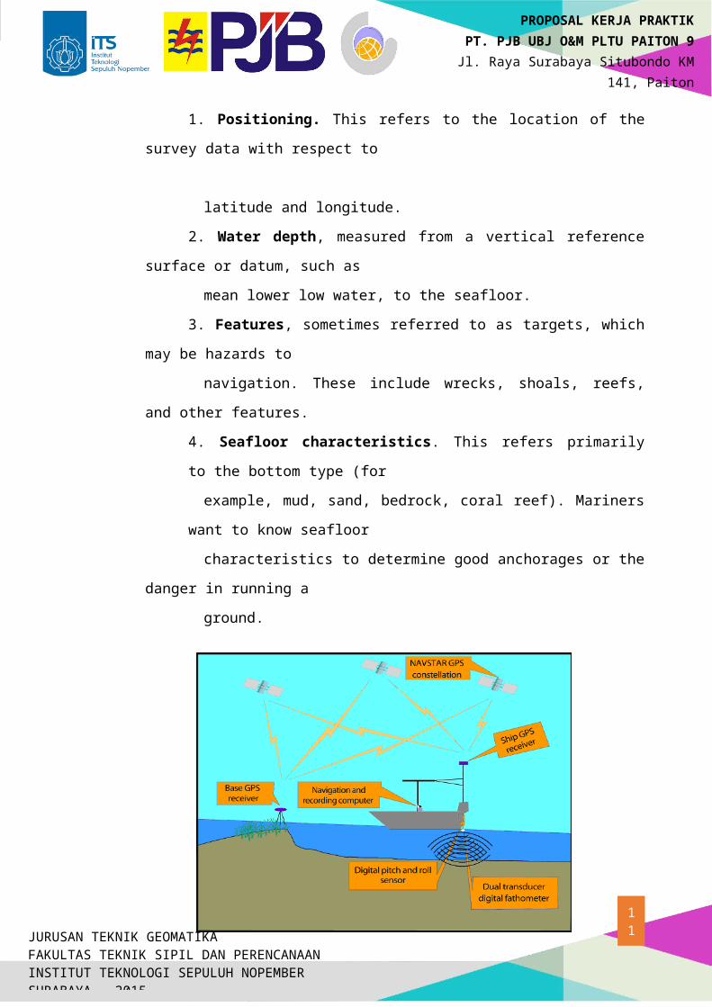
of hydrology. The end result of a hydrographic survey is a nautical chart: a map that shows
the seafloor and other features related to navigation. Thus every hydrographic
survey has four major components.
1. Positioning. This refers to the location of the survey data with respect to
latitude and longitude.
2. Water depth, measured from a vertical reference surface or datum, such as
mean lower low water, to the seafloor.
7JURUSAN TEKNIK GEOMATIKAFAKULTAS TEKNIK SIPIL DAN PERENCANAANINSTITUT TEKNOLOGI SEPULUH NOPEMBERSURABAYA – 2015
PROPOSAL KERJA PRAKTIKPT. PJB UBJ O&M PLTU PAITON 9
Jl. Raya Surabaya Situbondo KM 141, Paiton
Probolinggo (67291)
3. Features, sometimes referred to as targets, which may be hazards to
navigation. These include wrecks, shoals, reefs, and other features.
4. Seafloor characteristics. This refers primarily to the bottom type (for
example, mud, sand, bedrock, coral reef). Mariners want to know seafloor
characteristics to determine good anchorages or the danger in running a
ground.
Fig.1 Ilustrate of Hidrographic Survey
B. Horisontal Positioning at Sea
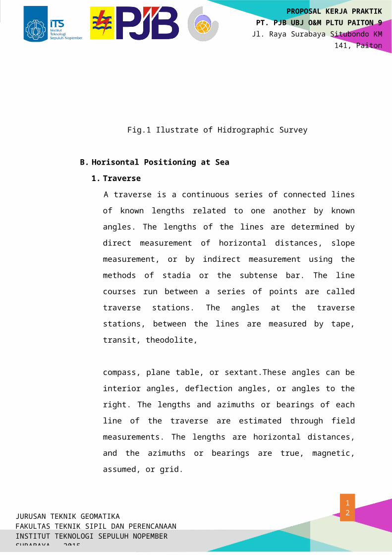
1. Traverse
A traverse is a continuous series of connected lines of known lengths related to
one another by known angles. The lengths of the lines are determined by direct
measurement of horizontal distances, slope measurement, or by indirect
measurement using the methods of stadia or the subtense bar. The line courses
run between a series of points are called traverse stations. The angles at the
traverse stations, between the lines are measured by tape, transit, theodolite,
compass, plane table, or sextant.These angles can be interior angles, deflection
angles, or angles to the right. The lengths and azimuths or bearings of each line
of the traverse are estimated through field measurements. The lengths are
8JURUSAN TEKNIK GEOMATIKAFAKULTAS TEKNIK SIPIL DAN PERENCANAANINSTITUT TEKNOLOGI SEPULUH NOPEMBERSURABAYA – 2015
PROPOSAL KERJA PRAKTIKPT. PJB UBJ O&M PLTU PAITON 9
Jl. Raya Surabaya Situbondo KM 141, Paiton
Probolinggo (67291)
A
B
P = Unknown Point
α
β
γ
horizontal distances, and the azimuths or bearings are true, magnetic, assumed,
or grid.
Fig. 2 Ilustrate of Traverse Method
Formula of traverse method :
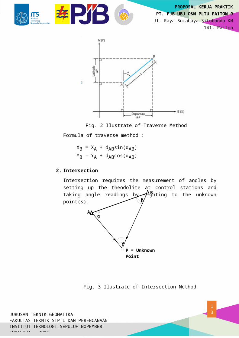
2. Intersection
Intersection requires the measurement of angles by setting up the theodolite at control stations and taking angle readings by sighting to the unknown point(s).
Fig. 3 Ilustrate of Intersection Method
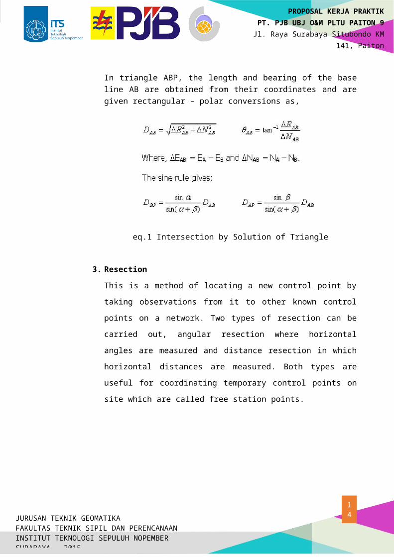
In triangle ABP, the length and bearing of the base line AB are obtained from their coordinates and are given rectangular – polar conversions as,
9
XB = XA + dABsin(αAB)
YB = YA + dABcos(αAB)
JURUSAN TEKNIK GEOMATIKAFAKULTAS TEKNIK SIPIL DAN PERENCANAANINSTITUT TEKNOLOGI SEPULUH NOPEMBERSURABAYA – 2015
PROPOSAL KERJA PRAKTIKPT. PJB UBJ O&M PLTU PAITON 9
Jl. Raya Surabaya Situbondo KM 141, Paiton
Probolinggo (67291)
eq.1 Intersection by Solution of Triangle
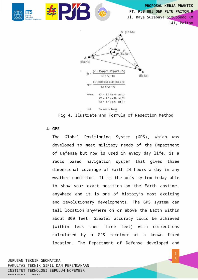
3. Resection
This is a method of locating a new control point by taking observations from it
to other known control points on a network. Two types of resection can be
carried out, angular resection where horizontal angles are measured and
distance resection in which horizontal distances are measured. Both types are
useful for coordinating temporary control points on site which are called free
station points.
Fig 4. Ilustrate and Formula of Resection Method
4. GPS
10JURUSAN TEKNIK GEOMATIKAFAKULTAS TEKNIK SIPIL DAN PERENCANAANINSTITUT TEKNOLOGI SEPULUH NOPEMBERSURABAYA – 2015
PROPOSAL KERJA PRAKTIKPT. PJB UBJ O&M PLTU PAITON 9
Jl. Raya Surabaya Situbondo KM 141, Paiton
Probolinggo (67291)
The Global Positioning System (GPS), which was developed to meet military
needs of the Department of Defense but now is used in every day life, is a
radio based navigation system that gives three dimensional coverage of Earth
24 hours a day in any weather condition. It is the only system today able to
show your exact position on the Earth anytime, anywhere and it is one of
history’s most exciting and revolutionary developments. The GPS system can
tell location anywhere on or above the Earth within about 300 feet. Greater
accuracy could be achieved (within less then three feet) with corrections
calculated by a GPS receiver at a known fixed location. The Department of
Defense developed and maintains GPS. Even though the system has been
completed only recently it has already proved to be a most valuable aid to U.S.
military forces. Operation Desert Storm was performed using GPS. Soldiers
were able to go places and maneuver in sandstorms or at night even when he
troops who lived there couldn’t. Navy ships use GPS for rendezvous,
minesweeping, and aircraft operation. GPS is also used for navigation in
planes, ships, cars, and trucks. GPS has become important in almost all
military operations and weapon systems.
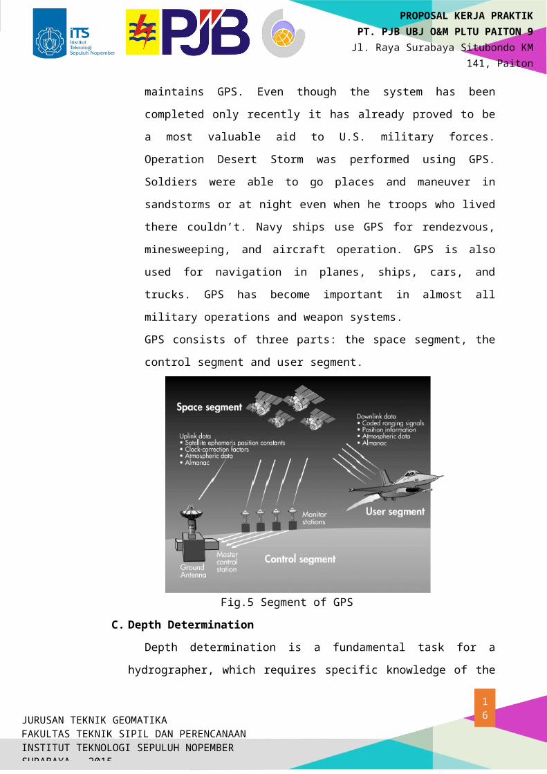
GPS consists of three parts: the space segment, the control segment and user
segment.
Fig.5 Segment of GPS
C. Depth Determination
11JURUSAN TEKNIK GEOMATIKAFAKULTAS TEKNIK SIPIL DAN PERENCANAANINSTITUT TEKNOLOGI SEPULUH NOPEMBERSURABAYA – 2015
PROPOSAL KERJA PRAKTIKPT. PJB UBJ O&M PLTU PAITON 9
Jl. Raya Surabaya Situbondo KM 141, Paiton
Probolinggo (67291)
Depth determination is a fundamental task for a hydrographer, which requires
specific knowledge of the medium, of underwater acoustics, of the plethora of
devices available for depth measurement, of complementary sensors for attitude
and heave measurement and proper procedures to achieve and meet the
internationally recommended standards for accuracy and coverage as articulated in
IHO publication S-44 4th Edition.
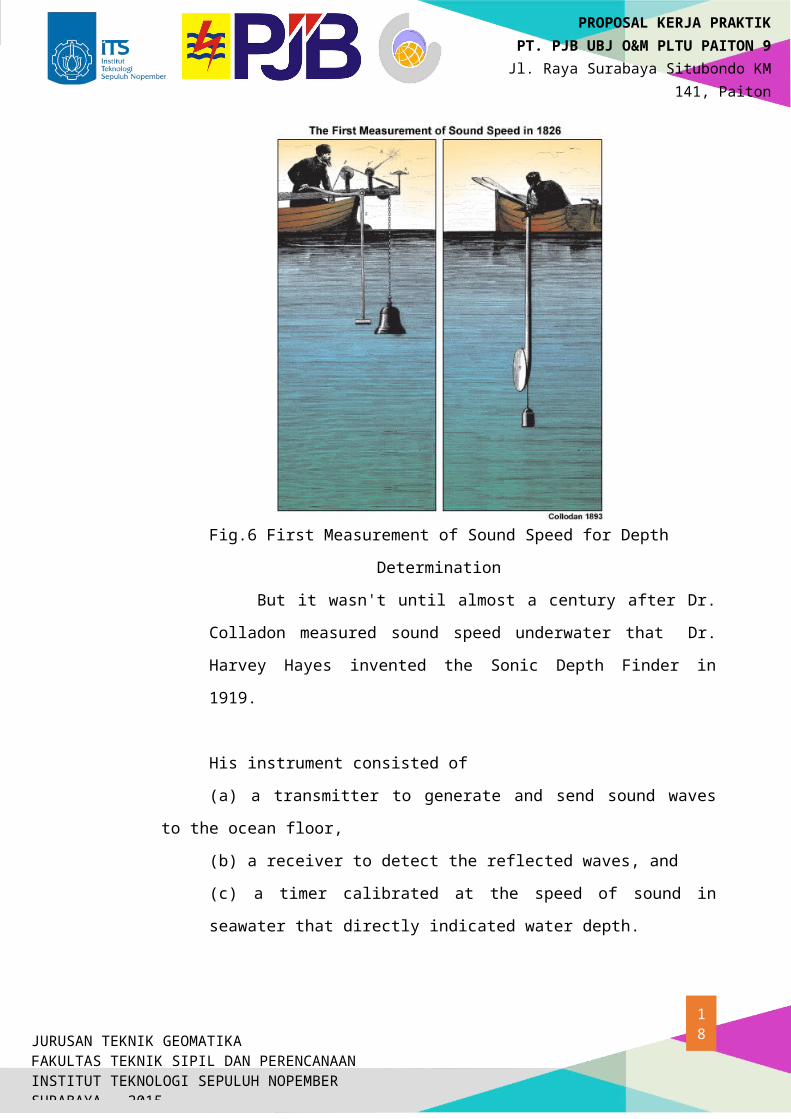
Today, most hydrographic sounding is done using acoustic methods. These
methods date back to 1822 when Daniel Colladon first measured the speed of
sound underwater in Lake Geneva, Switzerland. As this diagram shows, his
technique was to ring a bell underwater and ignite a pan of gunpowder at the same
time. On the receiving end, the time of the gunpowder flash and the time the sound
arrived were both measured, providing the travel time over a known distance. The
result was remarkably accurate.
Fig.6 First Measurement of Sound Speed for Depth Determination
But it wasn't until almost a century after Dr. Colladon measured sound
speed underwater that Dr. Harvey Hayes invented the Sonic Depth Finder in
1919.
12JURUSAN TEKNIK GEOMATIKAFAKULTAS TEKNIK SIPIL DAN PERENCANAANINSTITUT TEKNOLOGI SEPULUH NOPEMBERSURABAYA – 2015
PROPOSAL KERJA PRAKTIKPT. PJB UBJ O&M PLTU PAITON 9
Jl. Raya Surabaya Situbondo KM 141, Paiton
Probolinggo (67291)
His instrument consisted of
(a) a transmitter to generate and send sound waves to the ocean floor,
(b) a receiver to detect the reflected waves, and
(c) a timer calibrated at the speed of sound in seawater that directly indicated
water depth.
The U.S. Navy installed the Sonic Depth Finder on U.S.S. Stewart in 1922.
This chart shows soundings across the Straits of Gibraltar measured aboard the
U.S.S. Stewart on its first voyage with the sounder.
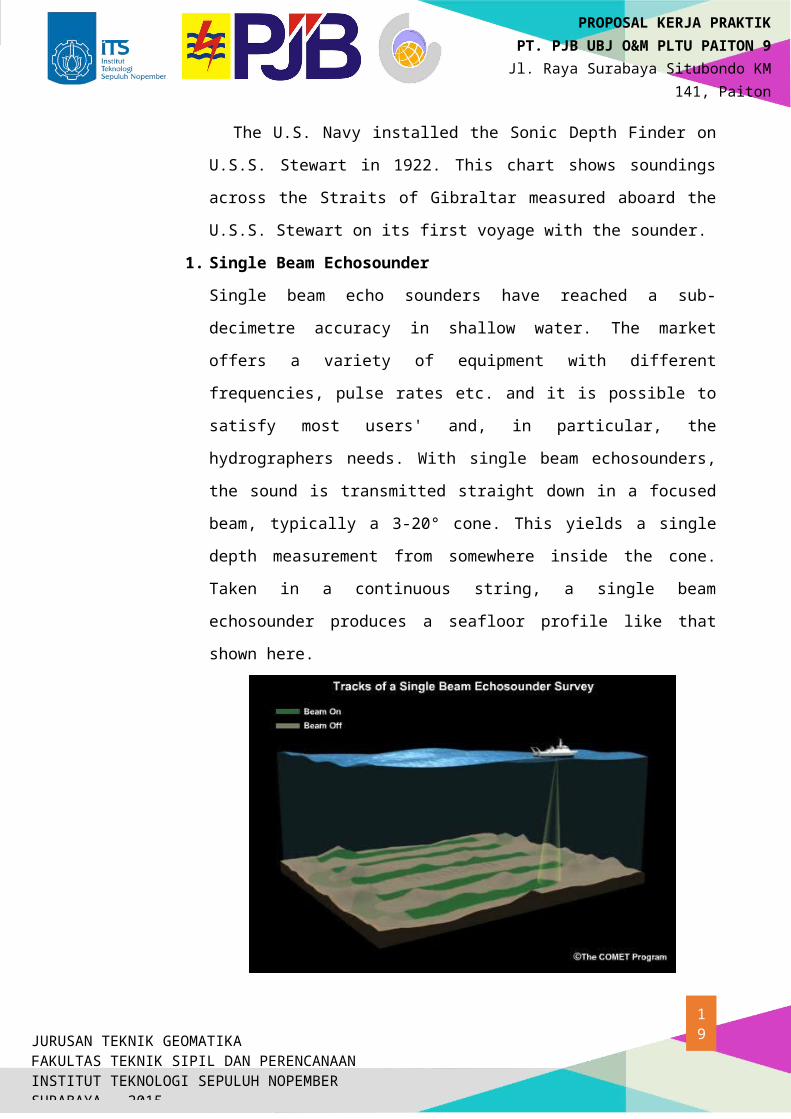
1. Single Beam Echosounder
Single beam echo sounders have reached a sub-decimetre accuracy in shallow
water. The market offers a variety of equipment with different frequencies,
pulse rates etc. and it is possible to satisfy most users' and, in particular, the
hydrographers needs. With single beam echosounders, the sound is transmitted
straight down in a focused beam, typically a 3-20° cone. This yields a single
depth measurement from somewhere inside the cone. Taken in a continuous
string, a single beam echosounder produces a seafloor profile like that shown
here.
Fig. 7 Ilustrate of Single Beam Echosounder Survey
13JURUSAN TEKNIK GEOMATIKAFAKULTAS TEKNIK SIPIL DAN PERENCANAANINSTITUT TEKNOLOGI SEPULUH NOPEMBERSURABAYA – 2015
PROPOSAL KERJA PRAKTIKPT. PJB UBJ O&M PLTU PAITON 9
Jl. Raya Surabaya Situbondo KM 141, Paiton
Probolinggo (67291)
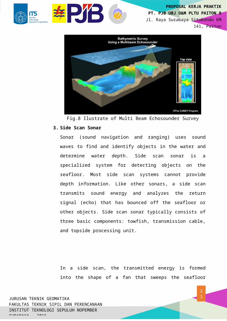
2. Multi Beam Echosounder
Multibeam echo sounder technology is developing rapidly and offers great
potential for accurate and total seafloor search if used with proper procedures
and provided that the resolution of the system is adequate for proper detection
of navigational hazards. Multibeam echosounders use many narrow, focused
beams (16-1400) to map a swath of seafloor. Each beam returns one depth
measurement. The width of the swath can equal from 2 to more than 5 times
the water depth. This width depends on many factors including the frequency
of the beams, the configuration of the transmitting and receiving transducers,
the water depth, and the sound velocity profile in the water column.
Fig.8 Ilustrate of Multi Beam Echosounder Survey
3. Side Scan Sonar
Sonar (sound navigation and ranging) uses sound waves to find and identify
objects in the water and determine water depth. Side scan sonar is a specialized
system for detecting objects on the seafloor. Most side scan systems cannot
provide depth information. Like other sonars, a side scan transmits sound
energy and analyzes the return signal (echo) that has bounced off the seafloor
or other objects. Side scan sonar typically consists of three basic components:
towfish, transmission cable, and topside processing unit.
14JURUSAN TEKNIK GEOMATIKAFAKULTAS TEKNIK SIPIL DAN PERENCANAANINSTITUT TEKNOLOGI SEPULUH NOPEMBERSURABAYA – 2015
PROPOSAL KERJA PRAKTIKPT. PJB UBJ O&M PLTU PAITON 9
Jl. Raya Surabaya Situbondo KM 141, Paiton
Probolinggo (67291)
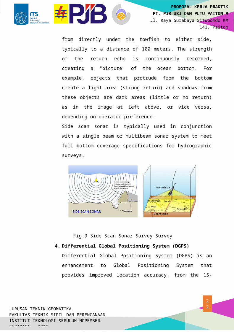
In a side scan, the transmitted energy is formed into the shape of a fan that
sweeps the seafloor from directly under the towfish to either side, typically to a
distance of 100 meters. The strength of the return echo is continuously
recorded, creating a "picture" of the ocean bottom. For example, objects that
protrude from the bottom create a light area (strong return) and shadows from
these objects are dark areas (little or no return) as in the image at left above, or
vice versa, depending on operator preference.
Side scan sonar is typically used in conjunction with a single beam or
multibeam sonar system to meet full bottom coverage specifications for
hydrographic surveys.
Fig.9 Side Scan Sonar Survey Survey
4. Differential Global Positioning System (DGPS)
Differential Global Positioning System (DGPS) is an enhancement to Global
Positioning System that provides improved location accuracy, from the 15-
meter nominal GPS accuracy to about 10 cm in case of the best
implementations.
DGPS uses a network of fixed, ground-based reference stations to broadcast
the difference between the positions indicated by the satellite systems and the
known fixed positions. These stations broadcast the difference between the
measured satellite pseudoranges and actual (internally computed)
pseudoranges, and receiver stations may correct their pseudoranges by the
same amount. The digital correction signal is typically broadcast locally over
ground-based transmitters of shorter range.
15JURUSAN TEKNIK GEOMATIKAFAKULTAS TEKNIK SIPIL DAN PERENCANAANINSTITUT TEKNOLOGI SEPULUH NOPEMBERSURABAYA – 2015
PROPOSAL KERJA PRAKTIKPT. PJB UBJ O&M PLTU PAITON 9
Jl. Raya Surabaya Situbondo KM 141, Paiton
Probolinggo (67291)
A reference stationcalculates differential corrections for its own location and
time. Users may be up to 200 nautical miles (370 km) from the station,
however, and some of the compensated errors vary with space: specifically,
satellite ephemeris errors and those introduced by ionospheric and tropospheric
distortions. For this reason, the accuracy of DGPS decreases with distance
from the reference station. The problem can be aggravated if the user and the
station lack "inter visibility"—when they are unable to see the same satellites.
16JURUSAN TEKNIK GEOMATIKAFAKULTAS TEKNIK SIPIL DAN PERENCANAANINSTITUT TEKNOLOGI SEPULUH NOPEMBERSURABAYA – 2015
PROPOSAL KERJA PRAKTIKPT. PJB UBJ O&M PLTU PAITON 9
Jl. Raya Surabaya Situbondo KM 141, Paiton
Probolinggo (67291)
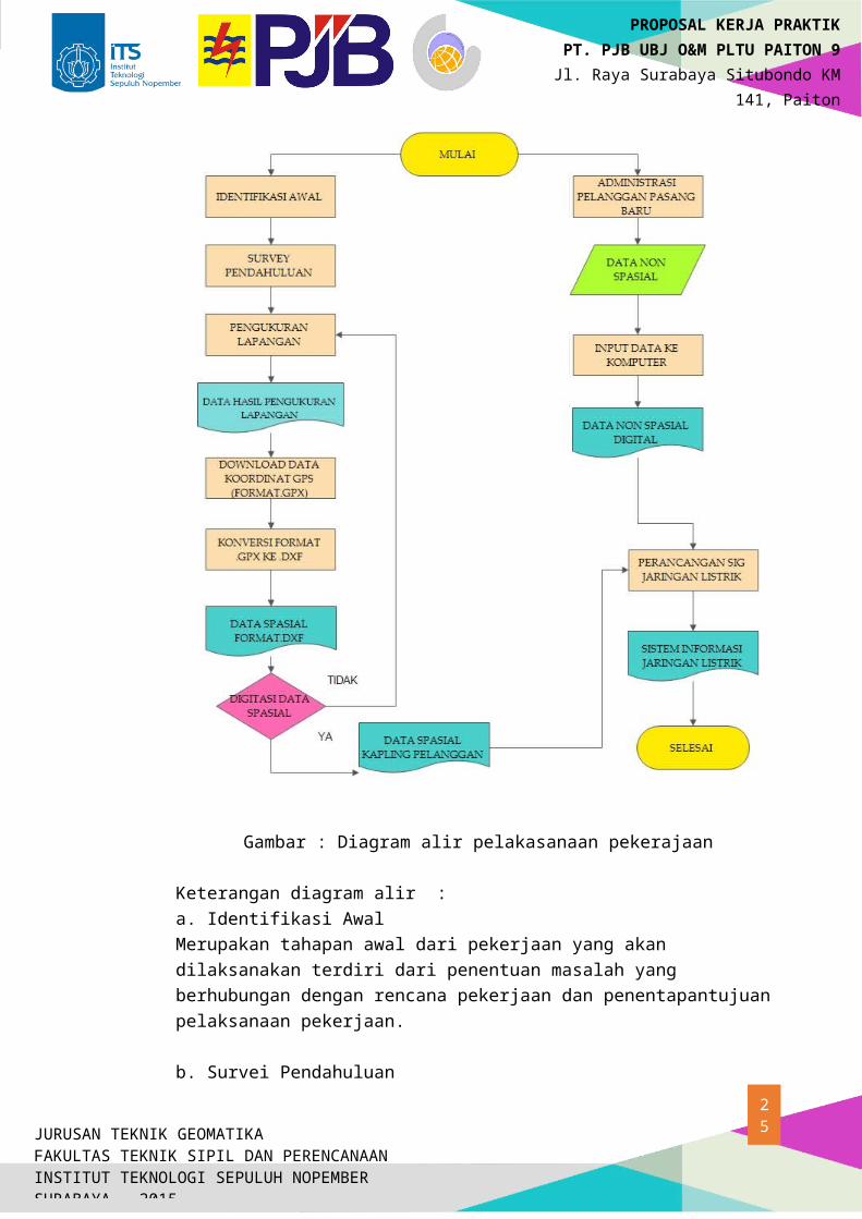
7. METODOLOGI PELAKSANAAN PRAKTIKUM
Gambar : Diagram alir pelakasanaan pekerajaan
Keterangan diagram alir :a. Identifikasi Awal Merupakan tahapan awal dari pekerjaan yang akan dilaksanakan terdiri dari penentuan masalah yang berhubungan dengan rencana pekerjaan dan penentapantujuan pelaksanaan pekerjaan.
17JURUSAN TEKNIK GEOMATIKAFAKULTAS TEKNIK SIPIL DAN PERENCANAANINSTITUT TEKNOLOGI SEPULUH NOPEMBERSURABAYA – 2015
PROPOSAL KERJA PRAKTIKPT. PJB UBJ O&M PLTU PAITON 9
Jl. Raya Surabaya Situbondo KM 141, Paiton
Probolinggo (67291)
b. Survei PendahuluanMerupakan tahapan awal sebelum pengukuran yang akan dilaksanakan terdiri dari daerah mana yang akan diukur dan mengenali medan di lapangan sehingga memudahkan dalam proses pengukuran.
c. Pengukuran LapanganPada tahap ini pengukuran dilakukan dengan menggunakan GPS Navigasi yang digunakan untuk me-marking setiap tiang jaringan baru yaitu Tiang Jaringan Tegangan Rendah (JTR) dan Tiang Jaringan Tegangan Menengah (JTM) dan setiap rumah warga untuk pembuatan kapling.
d. Download Data Koordinat GPS (Format .gpx)Pada tahap ini dilakukan download data dari GPS Navigasi menggunakan software EasyGPS dimana data diubah atau di save as ke format .gpx e. Konversi Data Format .gpx ke .dxfPada tahap konversi data menggunakan software MapSource dengan cara klik open pilih data dengan format .gpx kemudian data diubah atau di save as keformat .dxf
f. Data Spasial Format .dxfPada data spasial ini terdiri dari data hasil marking dandata hasil tracking dengan menggunakan GPS Navigasi.
g. Digitasi Data SpasialDigitasi data ini dilakukan untuk membuat kapling dari hasil marking dan pembuatan jalan dari hasil tracking menggunakan GPS Navigasi.
h.. Administrasi Pelanggan Pasang Baru Pada tahap ini dilakukan survey ke warga yang akan mendaftar untuk menjadi pelanggan dengan mengisi form yang sudah disediakan serta melengkapi persyaratanyang sudah ditentukan oleh PLN.
i. Data Non SpasialData Non Spasial ini terdiri dari informasi data pelanggan yang telah di survei .
j. Perancangan SIG Jaringan ListrikPada tahap ini, membuat layer baru yaitu layer Pasang Baru (PASBAR) kemudian memasukkan data atribut yang diperoleh dari hasil survei ke dalam tabel. k. SIG Jaringan Listrik Melengkapi data spasial dan data atribut sehingga informasi mengenai Sistem Informasi Jaringan Listrik telah ter-update.
18JURUSAN TEKNIK GEOMATIKAFAKULTAS TEKNIK SIPIL DAN PERENCANAANINSTITUT TEKNOLOGI SEPULUH NOPEMBERSURABAYA – 2015
PROPOSAL KERJA PRAKTIKPT. PJB UBJ O&M PLTU PAITON 9
Jl. Raya Surabaya Situbondo KM 141, Paiton
Probolinggo (67291)
8. Pelaksanaan
Kerja praktek ini akan dilaksanakan pada :
Waktu : juni 2015
Tempat : PT. PJB UBJ O&M PLTU PAITON 9Jl. Raya Surabaya Situbondo KM 141, PaitonProbolinggo (67291)
Phone : (0335) 771805
Website :
Email :
Dengan rincian kegiatan yang akan dilakukan meliputi kegiatan sebagai berikut:
Pengenalan perusahaan dan kerja praktek
Studi literatur
Pengamatan dan pengambilan data untuk perusahaan
Pelaksanaan tugas
Pengerjaan laporan
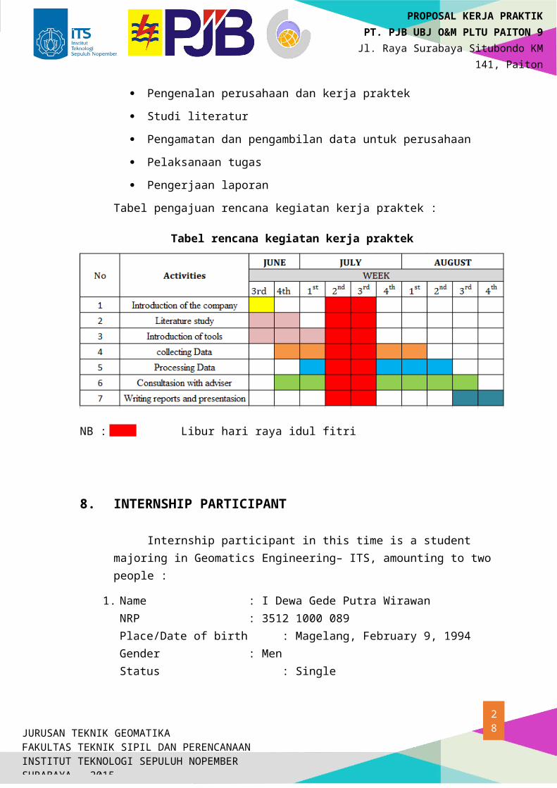
Tabel pengajuan rencana kegiatan kerja praktek :
Tabel rencana kegiatan kerja praktek
NB : Libur hari raya idul fitri
19JURUSAN TEKNIK GEOMATIKAFAKULTAS TEKNIK SIPIL DAN PERENCANAANINSTITUT TEKNOLOGI SEPULUH NOPEMBERSURABAYA – 2015
PROPOSAL KERJA PRAKTIKPT. PJB UBJ O&M PLTU PAITON 9
Jl. Raya Surabaya Situbondo KM 141, Paiton
Probolinggo (67291)
8. INTERNSHIP PARTICIPANT
Internship participant in this time is a student majoring in Geomatics Engineering– ITS, amounting to two people :
1. Name : I Dewa Gede Putra WirawanNRP : 3512 1000 089Place/Date of birth : Magelang, February 9, 1994Gender : MenStatus : SingleAddress : Jalan Barabai 2/26 GKB Gresik Jawa TimurPhone : 081330240161Surabaya Address : Keputih Gg Makam Blok B-7 Sukolilo, Surabaya.Phone : 085733319050E-mail : dewagede. putrawirawan @gmail.com GPA/Semester : 3.3 /5
2. Name : Syaiful budiantoNRP : 3512 100 099Place/Date of birth : Sidoarjo,Desember 18,1993Gender : Laki-lakiStatus : Belum KawinAddress : Jl Kedungrejo Timur no 11,Waru SidoarjoPhone : 031-8544985Surabaya Address : -Phone : 08989198952E-mail : [email protected]/Semester : 2.78 /5
20JURUSAN TEKNIK GEOMATIKAFAKULTAS TEKNIK SIPIL DAN PERENCANAANINSTITUT TEKNOLOGI SEPULUH NOPEMBERSURABAYA – 2015
PROPOSAL KERJA PRAKTIKPT. PJB UBJ O&M PLTU PAITON 9
Jl. Raya Surabaya Situbondo KM 141, Paiton
Probolinggo (67291)
9. CLOSING
So we made this proposal as a reference in internship carrying out. We hope
for help from all Management and employees of PT. Seascape Surveys Indonesia. For
the fluency and successful implementation of practical work that we are going to do.
PROGRAM STUDI TEKNIK GEOMATIKA FTSP-ITS
KAMPUS ITS SUKOLILO, SURABAYA 60111
Telp. 031-5929487, 5994251-55 ext 1149
Fax. 031-5929486
E-mail : [email protected]
21JURUSAN TEKNIK GEOMATIKAFAKULTAS TEKNIK SIPIL DAN PERENCANAANINSTITUT TEKNOLOGI SEPULUH NOPEMBERSURABAYA – 2015
PROPOSAL KERJA PRAKTIKPT. PJB UBJ O&M PLTU PAITON 9
Jl. Raya Surabaya Situbondo KM 141, Paiton
Probolinggo (67291)
ATTACHMENT
CURRICULUM VITAE
PERSONAL DATA
Full Name Romario SantosoNRP 35 12 100 097Gender MaleDepartment Teknik Geomatika
Home AddressKudu, Kecamatan Kertosono Kabupaten Nganjuk
Address In SurabayaJl. T. Hidrodinamika III T/90 , Perumahan Dosen ITS, Sukolilo Surabaya
Phone Number 082245435362GPA 3,10E-Mail Address saintromario @gmail.com
Date Of Birth 10 Agustus 1994
Quotes Don’t stop believing.
EDUCATIONAL BACKGROUND
Year Institution Name
2000 - 2006 SDN Kutorejo 1
2006 - 2009 SMPN 1 Kertosono
2009 - 2012 SMAN 1 Kertosono
2012 - Present Teknik Geomatika FTSP ITS
ORGANIZATIONAL ACTIVITIES
Year Organization Name Position2010 - 2011 ICT SMAN 1 Kertosono Member
2014 - Present HIMAGE-ITS Member
2014 - Present PMK-ITS Departmen Coordinator
TRAINING RECORD
Year Organizer Training Name2012 BEM FTSP ITS Pra LKMM TD2013 HIMAGE-ITS LKMM TD2014 KemenPSDM- BEM ITS SEKOLAH PENGADER ITS
22JURUSAN TEKNIK GEOMATIKAFAKULTAS TEKNIK SIPIL DAN PERENCANAANINSTITUT TEKNOLOGI SEPULUH NOPEMBERSURABAYA – 2015
PROPOSAL KERJA PRAKTIKPT. PJB UBJ O&M PLTU PAITON 9
Jl. Raya Surabaya Situbondo KM 141, Paiton
Probolinggo (67291)
SCIENTIFIC PRESENTATION
Year Presentation Name Organizer2013 Simposium Nasional HIMAGE-ITS
COMITTE EXPERIENCE
Year Events Organizer2013 Geomatics Goes to School HIMAGE-ITS
2013 Faculty Olympic BEM FTSP ITS
2014 LKMM TD HIMAGE-ITS
SCIENTIFIC PAPERS
Year Paper Style Event2013 Sport Deadline Shoes 132 PKM Tahun Pendanaan 2013
WORKS EXPERIENCE
TIM GPS NAVIGASI- Mapping Potential and Boundaries Cembor Village District Pacet Mojokerto
SKILLa. Computer Program
1. Microsoft Office2. AutoCad Map3. AutoCad Land Desktop4. Topcon Tools 8.235. GPS Tools6. ArcGIS ( ArcMap, ArcInfo, ArcView)7. Photo Modeler Scaner8. Adobe Photoshop9. Adobe Premiere Pro10. Sony Vegas Pro
b. Surveying Instrument1. Total Station2. GPS Geodetik3. GPS Navigasi4. Waterpass5. Theodolite
23JURUSAN TEKNIK GEOMATIKAFAKULTAS TEKNIK SIPIL DAN PERENCANAANINSTITUT TEKNOLOGI SEPULUH NOPEMBERSURABAYA – 2015
PROPOSAL KERJA PRAKTIKPT. PJB UBJ O&M PLTU PAITON 9
Jl. Raya Surabaya Situbondo KM 141, Paiton
Probolinggo (67291)
CURRICULUM VITAE
PERSONAL DATA
Full Name I Dewa Gede Putra WirawanNRP 35 12 100 089Gender MaleDepartment Teknik GeomatikaHome Address Jl. Barabai 2, GKB, Gresik.
Address In SurabayaJalan Arief Rachman Hakimm, Gg Makam, B-7, Kelurahan KeputihSukolilo Surabaya.
Phone Number 085733319050
GPA 3,35E-Mail Address dewagede. putrawirawan @gmail.com
Date Of Birth 9 Februari 1994
QuotesDon’t judge the someone by the cover
EDUCATIONAL BACKGROUND
Year Institution Name2000 – 2006 SD Negeri Pongangan 1
2006 – 2009 SMP Negeri 1 Gresik
2009 – 2012 SMA Negeri 1 Gresik
2012 - Present Teknik Geomatika FTSP ITS
ORGANIZATIONAL ACTIVITIES
Year Organization Name Position2008 - 2009 OSSIS SMPN 1 Gresik KO KEJASI2006 - 2009 PASSUS SMPN 1 Gresik Raiser Flag2009 - 2012 PASSUS SMAN 1 Gresik Leader of Ceremony2011 - 2012 OSSIS SMAN 1 Gresik Emissary Basket2013 - 2014 HIMAGE-ITS Member of Interest
and Talent division2014 - Present HIMAGE-ITS Kabiro alumni relation2015 – Present TPKH-ITS Expert Staff HUMAS2015 – Present IMGI Kaforkom its
2013 - 2015 Angkatan 2012 Leader
24JURUSAN TEKNIK GEOMATIKAFAKULTAS TEKNIK SIPIL DAN PERENCANAANINSTITUT TEKNOLOGI SEPULUH NOPEMBERSURABAYA – 2015
PROPOSAL KERJA PRAKTIKPT. PJB UBJ O&M PLTU PAITON 9
Jl. Raya Surabaya Situbondo KM 141, Paiton
Probolinggo (67291)
TRAINING RECORD
Year Training Name Organizer2012 Pra LKMM TD BEM FTSP ITS2013 LKMM TD HIMAGE-ITS2014 SEKOLAH PENGADER ITS KemenPSDM- BEM
ITS
COMITTE EXPERIENCE
Year Events Organizer2013 Faculty Olympic BEM FTSP ITS2013 Geomatics Goes to School HIMAGE-ITS2014 Pra LKMM TD BEM FTSP ITS2014 LKMM TD HIMAGE-ITS2014 Deklarasi IKA GeoITS HIMAGE ITS2014 Wisudawan 110 Teknik Geomatika ITS HIMAGE ITS
WORKS EXPERIENCE
TIM total station- Measurement of long cross major roads Sukosari village, Trawas, Mojokerto East Java- Marking Object with GPS navigation in BAPEKO Surabaya Project
SKILLa. Computer Program
1. Microsoft Office2. AutoCad Map3. AutoCad Land Desktop4. Topcon Tools 8.235. GPS Tools6. MatLab7. Er Mapper8. ArcGIS ( ArcMap, ArcInfo, ArcView )
b. Surveying Instrument1. Total Station2. GPS Geodetik3. GPS Navigasi4. Waterpass5. Theodolite
25JURUSAN TEKNIK GEOMATIKAFAKULTAS TEKNIK SIPIL DAN PERENCANAANINSTITUT TEKNOLOGI SEPULUH NOPEMBERSURABAYA – 2015
PROPOSAL KERJA PRAKTIKPT. PJB UBJ O&M PLTU PAITON 9
Jl. Raya Surabaya Situbondo KM 141, Paiton
Probolinggo (67291)
26JURUSAN TEKNIK GEOMATIKAFAKULTAS TEKNIK SIPIL DAN PERENCANAANINSTITUT TEKNOLOGI SEPULUH NOPEMBERSURABAYA – 2015
PROPOSAL KERJA PRAKTIKPT. PJB UBJ O&M PLTU PAITON 9
Jl. Raya Surabaya Situbondo KM 141, Paiton
Probolinggo (67291)
27JURUSAN TEKNIK GEOMATIKAFAKULTAS TEKNIK SIPIL DAN PERENCANAANINSTITUT TEKNOLOGI SEPULUH NOPEMBERSURABAYA – 2015
PROPOSAL KERJA PRAKTIKPT. PJB UBJ O&M PLTU PAITON 9
Jl. Raya Surabaya Situbondo KM 141, Paiton
Probolinggo (67291)
28JURUSAN TEKNIK GEOMATIKAFAKULTAS TEKNIK SIPIL DAN PERENCANAANINSTITUT TEKNOLOGI SEPULUH NOPEMBERSURABAYA – 2015
PROPOSAL KERJA PRAKTIKPT. PJB UBJ O&M PLTU PAITON 9
Jl. Raya Surabaya Situbondo KM 141, Paiton
Probolinggo (67291)
29JURUSAN TEKNIK GEOMATIKAFAKULTAS TEKNIK SIPIL DAN PERENCANAANINSTITUT TEKNOLOGI SEPULUH NOPEMBERSURABAYA – 2015
PROPOSAL KERJA PRAKTIKPT. PJB UBJ O&M PLTU PAITON 9
Jl. Raya Surabaya Situbondo KM 141, Paiton
Probolinggo (67291)
Copyright © 2022 FDOKUMEN

