West of Wales Shoreline Management Plan 2
134
West of Wales Shoreline Management Plan 2 Cardigan Bay and Ynys Enlli to the Great Orme Coastal Groups Appendix B Stakeholder Engagement November 2011 Final 9T9001
-
Upload
khangminh22 -
Category
Documents
-
view
1 -
download
0
Transcript of West of Wales Shoreline Management Plan 2

West of Wales Shoreline Management Plan 2Cardigan Bay and Ynys Enlli to the Great Orme Coastal Groups
Appendix B
Stakeholder Engagement
November 2011
Final
9T9001

A COMPANY OF
Document title West of Wales Shoreline Management Plan 2
Cardigan Bay and Ynys Enlli to the Great Orme Coastal Groups
Sections Appendix B
Stakeholder Engagement
Document short title West of Wales SMP2
Status Final
Date November 2011
Project name West of Wales SMP2
Project number 9T9001
Client Pembrokeshire County Council
Reference 9T9001/RSection1v4/301164PBor
Rightwell House
Bretton
Peterborough PE3 8DW
United Kingdom
+44 (0)1733 334455 Telephone
Fax
[email protected] E-mail
www.royalhaskoning.com Internet
HASKONING UK LTD.
COASTAL & RIVERS
Drafted by Gregor Guthrie and Victoria Clipsha
Checked by Gregor Guthrie
Date/initials check 11/11/11
Approved by Client Steering Group
Date/initials approval 29/11/11
West of Wales SMP2 9T9001/RSection1v4/301164PBor
Final November 2011
Appendix A SMP Development
Appendix B Stakeholder Engagement
Section 2 The Environmental
Assessment Process.
Section 3 The Background to the Plan
Historic and Current Perspective Sustainability Policy Thematic Review
Section 4 Introduction
Approach to policy development Division of the Coast
INTRODUCTION AND PROCESS
PLAN AND POLICY DEVELOPMENT
Section 1 Introduction to the SMP.
Principles Policy Definition The Process
Appendix E Strategic Environmental Assessment (including Theme Review and the Issues and Objective Evaluation and Scenario Testing)
Appendix C Coastal Processes
Appendix D Estuary Assessment
Appendix F Economic Assessment
Coastal A St Ann’s Head to Strumble Head
(PDZs 1, 2 & 3) Description
Coastal Process Summary Baseline Scenarios
Discussion Management Summary
Coastal B Strumble Head to New Quay Head
(PDZs 4, 5 & 6) Description
Coastal Process Summary Baseline Scenarios
Discussion Management Summary
Coastal C New Quay Head to Sarn Gynfelyn
(PDZs 7, 8 & 9) Description
Coastal Process Summary Baseline Scenarios
Discussion Management Summary
Coastal G Ynys Mon (excluding the Menai Strait)
(PDZs 17, 18 & 19) Description Coastal Process Summary Baseline Scenarios Discussion Management Summary
Coastal D Sarn Gynfelyn to Trwyn Cilan
(PDZs 10, 11, 12 & 13) Description
Coastal Process Summary Baseline Scenarios
Discussion Management Summary
Coastal E Trwyn Cilan to Carreg Ddu
(PDZ 14) Description
Coastal Process Summary Baseline Scenarios
Discussion Management Summary
Coastal F Menai Strait and Conwy
(PDZS 15, 16 & 20) Description
Coastal Process Summary Baseline Scenarios
Discussion Management Summary
Appendix G Habitats Regulation Assessment
Appendix H Water Framework Directive (WFD)
Section 5 Overview of the Plan
Section 6 Summary and comparison of policy
OVERVIEW
Section 7 Action Plan

West of Wales SMP2 9T9001/RSection1v4/301164PBor
Final November 2011
West of Wales SMP2 9T9001/RSection1v4/301164PBor
Final November 2011
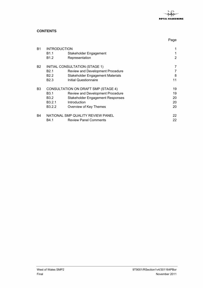
CONTENTS Page
B1 INTRODUCTION 1 B1.1 Stakeholder Engagement 1 B1.2 Representation 2
B2 INITIAL CONSULTATION (STAGE 1) 7 B2.1 Review and Development Procedure 7 B2.2 Stakeholder Engagement Materials 8 B2.3 Initial Questionnaire 11
B3 CONSULTATION ON DRAFT SMP (STAGE 4) 19 B3.1 Review and Development Procedure 19 B3.2 Stakeholder Engagement Responses 20 B3.2.1 Introduction 20 B3.2.2 Overview of Key Themes 20
B4 NATIONAL SMP QUALITY REVIEW PANEL 22 B4.1 Review Panel Comments 22

West of Wales SMP2 9T9001/RSection1v4/301164PBor
Final -Appendix B. 1 - November 2011
B1 INTRODUCTION
B1.1 Stakeholder Engagement
This appendix outlines the stakeholder consultation strategy for the development of the SMP and details how stakeholder involvement was achieved at each stage of the plan preparation. Stakeholder engagement strategies are a new label for consultation. When a plan is to be developed the Government is keen to ensure that the public (individual or organisation) is consulted and that their views are properly recorded and addressed. Consultation is a process of listening to views and receiving information and data leading to the development of policy which is then open to further comment by consultation before the policies are confirmed. Stakeholder consultation has played an integral role in the development of the shoreline management policies. Each authority organised the stakeholder consultation throughout the SMP development with the assistance of Royal Haskoning. The stakeholder group comprised representatives from groups with local, regional and national interest, in addition to site specific interests. Such a group was selected to try to achieve a ‘holistic’ consultation approach, taking consideration of all interests in the coast: The VISION is: The SMP Project Management Sub-Group’s vision is to gain a consensus among stakeholders by allowing them to help shape the process. To attain this vision, the sub-group will ensure that all stakeholders, either with an interest in the preparation of the SMP2, or affected by the policies produced (including agencies, authorities, organisations and private persons), are considered in the consultation process. The objectives of the Stakeholder Engagement Strategy are to:
1. Improve and build upon the existing information base by accessing information held by stakeholders;
2. Develop consensus and to increase SMP legitimacy; 3. Improve decision making, validate approaches, enable scrutiny and testing; 4. Resolve differences early; 5. Extend stakeholder understanding of SMPs; 6. Establish links and networks useful to SMP2 implementation.
One aspect to be addressed in the production of the SMP is the means of engaging stakeholders to improve the efficiency and effectiveness of their involvement and to avoid disputes. Dependant upon the local issues and organisations involved, it is sensible that different groups will be invited to engage in the process in different ways. In recognition of this, four basic stakeholder groups were identified, together with the methods of involving each group. These groups are:
Project Management Sub-Group; Elected Members; Key Stakeholders; Other Stakeholders.
West of Wales SMP2 9T9001/RSection1v4/301164PBor
Final -Appendix B. 2 - November 2011
The four groups facilitate varying degrees of stakeholder involvement in the development of the SMP offering differing levels of influence that stakeholders can exert in influencing the outcome.
B1.2 Representation
Project Management Sub-Group (PMG) The Sub-Group has overall responsibility for the delivery of the SMP. They initiated the SMP development process, undertaking or overseeing any scoping tasks required, procuring technical inputs required to complete the SMP, and managing the development and adoption processes. The PMG represent the principle operating authorities within the SMP area. The operating authorities of the Coastal Groups are Ceredigion County Council, Conwy County Borough Council, Gwynedd Council, Isle of Anglesey County Council and Pembrokeshire County Council. Other members are The Countryside Council for Wales, The Environment Agency Wales, Pembrokeshire Coast National Park Authority, Snowdonia National Park Authority, Cambria Archaeology, Gwynedd Archaeology, The Royal Commission for Ancient and Historic Monuments in Wales, CADW, the Country Land and Business Association, the Welsh Assembly Government, Network Rail and The National Trust. As such representatives cover the key disciplines of engineering, planning and conservation. Elected Members Forum The involvement of Elected Members in the process of SMP development reflects the “Cabinet” style approach to decision making operating in many local authorities. Politicians have been involved from the beginning, aiming to ensure that the policies will be acceptable to the local authorities. Due to the size of the SMP area it has not been practical to have meetings on a frequent basis of the Elected Members Forum. Two principle meetings have been held: - 9th July 2009; - 8th July 2010. A further meeting will be held during the formal consultation period. All authorities have undertaken consultation internally during the SMP process. Key Stakeholder Groups The Key Stakeholder Groups (KSG) have acted as focal points for discussion and consultation through development of the SMP. As with the Elected Members Forum it has not been possible to arrange a single meeting for this group and Key Stakeholders were identified by individual authorities and have been kept informed through the West of Wales Web site. The membership of the groups provide representation of the primary interests within the plan frontages, ensuring consideration of all interests during review of issues in the early stages of the process. Stakeholder representatives have typically included: - County Councils, also represented on the PMG; - Community Councils; - Residential Interest Groups and special interest groups;
West of Wales SMP2 9T9001/RSection1v4/301164PBor
Final -Appendix B. 3 - November 2011
- Commercial interests; - Conservation bodies, also represented on the PMG; - Recreational groups; - Cultural and historic interest groups, also represented on the PMG. The full list of consultees is set out in tabular form below. Partner Organisations
Organisation Remit
Ceredigion County Council Environmental Projects Manager
Ceredigion County Council Principal Planning Officer
Ceredigion County Council Assistant Director Engineering
Ceredigion County Council Procurement and Finance Manager
Ceredigion County Council Ecologist/LBAP Officer
Ceredigion County Council Forward Planning Officer
Ceredigion County Council Cardigan Bay SAC Officer
Gwynedd County Council Coast protection
Gwynedd County Council National Coastal monitoring officer
Isle of Anglesey County Council Highways and Transportation
Isle of Anglesey County Council Coastal Path Project Officer
Isle of Anglesey County Council Senior Planning Officer (Conservation)
Isle of Anglesey County Council Environmental Adviser
Isle of Anglesey County Council Senior Maritime Officer
Isle of Anglesey County Council Head of Planning Services
Isle of Anglesey County Council Head of Service Economic Development
Isle of Anglesey County Council Head of Service, Leisure and Community
Isle of Anglesey County Council Elected Member, Environment and Planning
Isle of Anglesey County Council Elected Member, Education and Leisure
Isle of Anglesey County Council
Elected Member, Economic Development and
Tourism
Isle of Anglesey County Council Elected member, Highways and maritime
Conwy County Council Environment (Steering Group)
Powys County Council Steering Group for Powys
Pembrokeshire County Council Sustainable Living officer
Pembrokeshire County Council Elec Div; Camrose
Pembrokeshire County Council Elec Div; Cilgerran
Pembrokeshire County Council Elec Div; Newport
Pembrokeshire County Council Elec Div; St Davids
Pembrokeshire County Council Elec Div; St Dogmaels
Pembrokeshire County Council Evec Div; Fishguard: North West
Pembrokeshire County Council Elec Div; Dinas Cross
Pembrokeshire County Council Elec Div; Goodwick
Pembrokeshire County Council Elec Div; Solva
Pembrokeshire County Council Elec Div; Fishguard, North East
Pembrokeshire County Council Elec Div; Llanrhian

West of Wales SMP2 9T9001/RSection1v4/301164PBor
Final -Appendix B. 4 - November 2011
Organisation Remit
Pembrokeshire County Council Highways and Construction
Pembrokeshire County Council Head of Property and Asset management
Pembrokeshire County Council Sustainability Appraisal officer
Pembrokeshire County Council Planning assistant (ecology)
Pembrokeshire County Council Forward Planning Officer
Pembrokeshire County Council Development Plans and conservation manager
Pembrokeshire County Council Head of Planning
Pembrokeshire County Council Senior Engineer
Pembrokeshire County Council Principal estates surveyor
Pembrokeshire County Council Lower Town Fishguard Harbourmaster
Pembrokeshire County Council Head of Maintenance
Pembrokeshire County Council Head of Economic Development
Pembrokeshire County Council Head of Environmental and civil Contingencies
Pembrokeshire County Council Head of Community regeneration and Tourism
Pembrokeshire County Council Leisure Services manager
Environment Agency Wales Flood Risk Manager (Regional)
Environment Agency Wales Flood Forecasting Team
Environment Agency Wales Customer Contact Officer
Countryside Council for Wales
Senior Coastal Scientist, Marine and Freshwater
Science Group
Countryside Council for Wales Land Use Plan Assessment Coordinator
Countryside Council for Wales Regional Sites Programme manager
The National Trust North West Wales Area Office
National Trust Head Warden, Pembrokeshire
National Trust General Manager, West Snowdonia & Llŷn
National Trust Property Manager, Anglesey
National Trust Southwood Property manager, Broadhaven
National Trust Area Warden for Mid and north Pembs
National Trust Land and Property Data Officer Wales
National Trust Coast and marine Support
Welsh Assembly Government Fisheries Branch WAG
Welsh Assembly Government Head of Coastal and Fluvial Flooding(?)
Network Rail Structures Management Engineer
CADW
Gwynedd Archaeological Trust Historic Environment Record Archaeologist
Gwynedd Archaeological Trust Head of Heritage Management
Dyfed Archaeological Trust Head of Heritage Management
Key Stakeholder Organisations
Organisation Organisation
The Coal Authority Llanelltyd Community Council
Royal Commission on the Ancient and Historic Llanfair Community Council

West of Wales SMP2 9T9001/RSection1v4/301164PBor
Final -Appendix B. 5 - November 2011
Organisation Organisation
Monuments
ABP Research & Consultancy Ltd. Llangelynin Community Council
ARC Marine Ltd. Botwnnog Community Council
Associated British Ports Clynnog Community Council
British Waterski Federation Talsarnau Community Council
The National Centre for Ornithology Aberdaron Community Council
Campaign for the Protection of Rural Wales Llanengan Community Council
Carmarthenshire County Council Llannor Town Council
Council for British Archaeology (Wales) Llanystumdwy Community Council
Council of Museums in Wales Criccieth Town Council
Country Landowners Association Llanaelhaearn Community Council
British Association of Shooting and Conservation Llanbedrog Community Council
Welsh Country Magazine Porthmadog Town Council
Countryside Commission Pwllheli Town Council
The Crown Estates Tudweiliog Community Council
Department of Trade and Industry Nefyn Town Council
Department of Environment Food and Rural Affairs Pistyll Community Council
Farming & Rural Conservation Agency Bontnewydd Community Council
Farming & Rural Conservation Agency Llandygai Community Council
Hydrographic Data Centre Llandwrog Community Council
Ministry of Defence Caernarfon Royal City Council
Marine Safety Agency Bangor City Council
Department of Environment Food and Rural Affairs Tywyn Town Council
Marine and Fisheries Agency Llanllechid Community Council
National Museum & Galleries of Wales Abergwyngregyn Community Council
Nautical Archaelogical Society Llanwnda Community Council
Association of Welsh RIGS Groups Penthir Community Council
R.S.P.B. Y Felinheli Community Council
Fishguard & Goodwick Town Council Pembrokeshire Coastal Forum
Newport Town Council Defence Estates Brecon
St Davids & Cathedral Close The Wildlife Trust Wales
Brawdy Community Council Marine Fisheries Agency
Camrose Community Council Maritime & Coastguard Agency
Cilgerran Community Council UK Hydrographic Office
Dale Community Council Navigation Directorate
Dinas Cross Community Council Aberaeron Town Council
Llanrhian Community Council Aberporth Community Council
Mathry Community Council Abertiefi / Cardigan Town Council
Marloes & St Brides Community Council Aberystywyth Town Council
Nevern Community Council Borth Community Council
Nolton & Roch Community Council Cei Newydd / New Quay Community Council
West of Wales SMP2 9T9001/RSection1v4/301164PBor
Final -Appendix B. 6 - November 2011
Organisation Organisation
Pencaer Community Council Llanrhystud Community Council
St Dogmaels Community Council Llansantffraid Community Council
Solva Community Council Tivyside Advertiser (Newspaper)
The Havens Community Council Mr Jim Brahnam
Cook & Arkwright St Dogmaels community council
Northwest & North Wales Sea Fisheries National Grid
The Wildlife Trust Wales RNLI
Crown Estates Agent St Davids City Council
Snowdonia National Parks Offices Milford Haven Port Authority
Port Penrhyn Dock Office Farmers Union of Wales
Caernarfon Harbour Trust Forestry Commission of Wales
NWS Dock Management Ltd Mr John Huges
Deep Dock Ltd Country Land and Business Association
Myti Mussels Ltd Llangranog Welfare Committee
Aberdyfi Community Council Afon Teifi Fairways Ltd
Barmouth Town Council Dr Chris Evans
Arthog Community Council Ferwig Comminity Council
Dolgellau Town Council Royal St Davids Golf Course
Dyffryn Ardudwy & Talynont Community Council
Aberdyfi Golf Course (First City Property
Consultants)
Pennal Community Council Llanfairfechan Town Council
Penrhyndeudraeth Town Council Llandygai Community Council
Harlech Town Council Red Wharf Bay Sailing and Watersports Club
Llanbedr Community Council Royal Anglesey Yacht Club
Llanelltyd Community Council Llanidan Community Council
Llanfair Community Council Llangranog Community Council
Dyffryn Arth Community Council Llandyssiliogogo Community Council
Geneu'r Glyn Community Council Llanfarian Community Council
Henfynw Community Council Llanllwchaiarn Community Council
Llancynfelin Community Council
West of Wales SMP2 9T9001/RSection1v4/301164PBor
Final -Appendix B. 7 - November 2011
B2 INITIAL CONSULTATION (STAGE 1)
B2.1 Review and Development Procedure
The SMP development process has sought involvement from over 150 organisations or individuals. Stakeholders were sent general information explaining the SMP together with a questionnaire. Forty seven responses were received. Following analysis of responses the main Initial Consultation, prior to policy being developed, was carried out between December 2009 and January 2010. The following meetings were held during this period. Local Meetings 7th December 09 Broad Haven Village School 8th December 09 Fishguard 9th December 09 New Quay town hall, town counsellors 9th December 09 Cardigan Guildhall 10th December 09 Llangrannog Community Council, Beach Cafe 10th December 09 New Quay Memorial Hall 11th December 09 Beaumaris Town Hall 14th December 09 Borth Community Hall 14th December 09 Ceredigion County Council Offices, Aberyswyth 15th December 09 Barmouth, Sunnysands Caravan Park, (just south of Tal y Bont) 15th December 09 Barmouth Dragon Theatre 18th January 10 Royal St David’s Golf Course, Harlech 18th January 10 The Institute, Tywyn 18th. January 10 Islawffordd Caravan Park, Tal y Bont, Gwynedd 19th January 10 Canolfan Frondeg, Pwllheli 20th January 10 Aberdyfi Golf Club, Aberdyfi 20th January 10 Canolfan Hamdden Glaslyn, Porthmadog 27th. January 10 Venue Cymru, Llandudno Organisations 7th December 09 CCW Offices, Pembroke Dock 8th December 09 CCW offices Swansea 10th December 09 Ceredigion Council Offices, Aberaeron Planning 15th December 09 Aberystwyth CCW offices Planners 19th January 10 Gwynedd Planners, Caernarvon Office 27th January 10 Environment Agency Wales, Bangor
Further meetings have been held since that time during the plan development process. This has involved further meetings with CCW and the EAW, discussing the approach and content of the SEA and HRA assessments. Telephone discussions have been held with local stakeholders, the EAW, CCW and local authority planners with respect to individual issues and areas. Subsequent presentations have been made to councillors and officers of Gwynedd and Ceredigion Councils and to the EAW Northern Area. The main activities in producing the SMP have been: Development and analysis of issues and objectives for various locations, assets
and themes based on the Initial Consultation;

West of Wales SMP2 9T9001/RSection1v4/301164PBor
Final -Appendix B. 8 - November 2011
Thematic reviews, reporting upon human, historic and natural environmental features and issues, evaluating these to determine relative values of the coast (reported in the SEA process);
Analysis of coastal processes and coastal evolution for baseline cases of not defending and continuing to defend as at present;
Agreement of objectives with the PMG, EMF and through public consultation, and from this determining possible policy scenarios;
Development of policy scenarios which consider different approaches to future shoreline management;
Examination of the coastal evolution in response to these scenarios and assessment of the implications for the human, historic and natural environment; and
Determination of the preferred plan and policies through review with the PMG, prior to compiling the SMP draft document.
B2.2 Stakeholder Engagement Materials
The initial Stakeholder Engagement materials posted out are listed below and samples are provided in the following sections: The invitation letter to the first round of consultation (refer B1); A leaflet explaining what the SMP is and stakeholder involvement (refer B2); A questionnaire and background text (refer B3). This consultation material was supported by information placed on the West of Wales website. (http://www.westofwalessmp.org/)

West of Wales SMP2 9T9001/RSection1v4/301164PBor
Final -Appendix B. 9 - November 2011
B1 – Typical Consultation Letter

West of Wales SMP2 9T9001/RSection1v4/301164PBor
Final -Appendix B. 10 - November 2011
B2- Consultation Leaflet

West of Wales SMP2 9T9001/RSection1v4/301164PBor
Final - Appendix B. 11 - November 2011
B2.3 Initial Questionnaire
The aim of this questionnaire is to allow you or your organisation to express your interests or concerns about the coast. We would appreciate your return of the questionnaire with your contact details even if you feel that you do not have any information to give us or do not wish to comment on the Shoreline Management Plan at this stage. We will keep your contact details until the completion of the project and include you in the future consultations that we will be undertaking on the Plan. We will also be holding various events throughout the Plan development process (which will take about 2 years) and invite anyone with an interest who gives us their contact details to attend. While the questionnaire has been set up to help trigger comments and will help us to correctly collate responses, we do not wish to constrain your views. If there are other issues that do not fit within these questions, please feel free to write them separately on the issues sheets provided.
The initial questions establish your contact details. These are followed by questions which allow you to identify any information you
may have which may help us understand our coast better. The final section allows you to record your interests, concerns or use of the coast
that has not been expressed elsewhere. While the Shoreline Management Plan focuses on the management of coastal defences and the threat and consequence of coastal flooding and erosion, we need to gain as broad a perspective as possible as to how such issues may impact upon and influence your interests. It will not be possible to solve all concerns through the Shoreline Management Plan. It is however, important that the management of defences is undertaken with a sound knowledge of all interests, so that where possible we work with not just natural processes but also the interests of our communities. Where it is not possible, for whatever reason, to meet the aspirations of everyone, then it is important that everyone understands why we can not and that the decision process is transparent. Please use the following questions as a template for your response. Our end date for responses is 7th September 2009 Responses may be returned by post to Emyr Williams (T&E), West of Wales SMP, PO Box 115, Haverfordwest, SA61 9DG or handed in to the contacts identified in the leaflet.

West of Wales SMP2 9T9001/RSection1v4/301164PBor
Final - Appendix B. 12 - November 2011
Your Contact Details 1. Your name or the name of your
organisation or business
2. Address
3. Name of contact (if relevant)
4. Position in organisation (if relevant)
5. Address if different from 2
6. Telephone No.
7. Fax No.
8. Email address
9. Referring to the attached list of consultees – is there anyone else that you would recommend we contact?

West of Wales SMP2 9T9001/RSection1v4/301164PBor
Final - Appendix B. 13 - November 2011
West of Wales SMP2 9T9001/RSection1v4/301164PBor
Final - Appendix B. 14 - November 2011
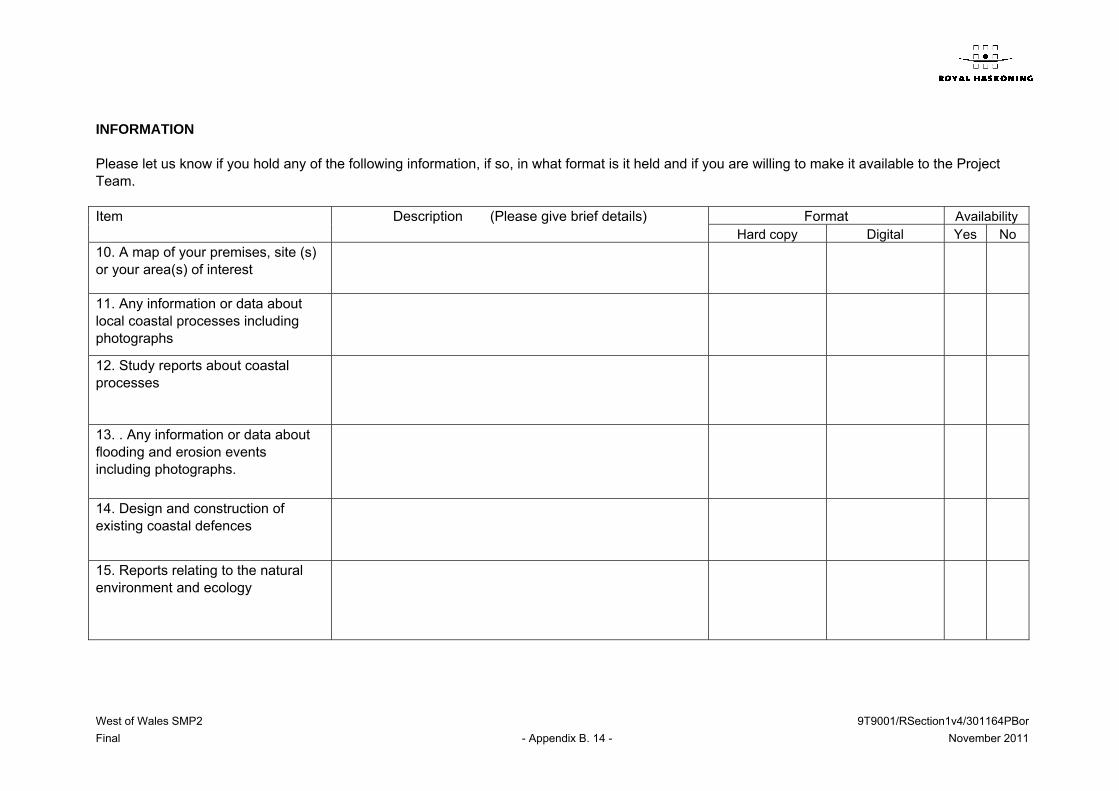
INFORMATION Please let us know if you hold any of the following information, if so, in what format is it held and if you are willing to make it available to the Project Team. Item Description (Please give brief details) Format Availability
Hard copy Digital Yes No 10. A map of your premises, site (s) or your area(s) of interest
11. Any information or data about local coastal processes including photographs
12. Study reports about coastal processes
13. . Any information or data about flooding and erosion events including photographs.
14. Design and construction of existing coastal defences
15. Reports relating to the natural environment and ecology

West of Wales SMP2 9T9001/RSection1v4/301164PBor
Final - Appendix B. 15 - November 2011
Item Description (Please give brief details) Format Availability Hard copy Digital Yes No
16. Reports relating to the built environment
17.Land use mapping
18. Coastal Industries
19. Ports and harbours
20. Agriculture
21. Tourism and Amenity Usage of the coast
22.Inshore Fisheries
23. Other
(Continue on separate sheets if necessary)

West of Wales SMP2 9T9001/RSection1v4/301164PBor
Final - Appendix B. 16- November 2011
COMMENT 24. Are you personally, or is your organisation or business, affected or potentially
affected by the risk of coastal flooding or erosion? If so, could you please give brief details and include details of any relevant significant historic events that you know about.
25. What are the main issues relating to the way in which the coastline is managed and
which you would want to see being dealt with in the plan?
26. What objectives do you suggest for the future management of the coastline? 27. Do you have any views on the way in which the existing coastal defences have
had an impact on the way in which the coastline has developed?
28. Do you have any views on changes that should be made to the existing coastal
defences? What effect do you think this would have?
Thank you for your time in completing this questionnaire.

West of Wales SMP2 9T9001/RSection1v4/301164PBor
Final - Appendix B. 17- November 2011
General Issues or Concerns Please fill these sheets in if there are any issues or concerns you have that have not
been considered in the questions above. Location or address
Issue: Why is this important?
Location or address
Issue: Why is this important?

West of Wales SMP2 9T9001/RSection1v4/301164PBor
Final - Appendix B. 18- November 2011
General Issues or Concerns Please fill these sheets in if there are any issues or concerns you have that have not
been considered in the questions above. Location or address
Issue: Why is this important?
Location or address
Issue: Why is this important?
West of Wales SMP2 9T9001/RSection1v4/301164PBor
Final - Appendix B. 19- November 2011
B3 CONSULTATION ON DRAFT SMP (STAGE 4)
B3.1 Review and Development Procedure
Having drafted the SMP2, taking account of comments received from all parties at all stages of the process, reports and/or presentations were made to officers and members of the various Councils. Further meetings were held with the Environment Agency Wales and CCW. The purpose of this was to gain formal approval from each organisation to embark on the 3 month period of public consultation on the draft SMP2. A formal 3 month period of consultation took place between 6th May 2011 to 8th August 2011. The draft SMP was made available for download on the website (www.westofwalessmp.org) and the Draft SMP was made available on disk on request. A letter was sent to all members of the CSG together with a 2-page consultation leaflet. All materials used during the consultation events, including the 2 and 4-page leaflets, the response questionnaire and the display boards are reproduced in Annex I. Annex II also provides photos from the consultation events. In addition to the public consultation events listed in the 2-page consultation leaflet, a number of additional meetings were held with key stakeholder groups. These were as follows: Llandanwg Site Visit (20/05/11); New Quay Town Council (07/06/11); and Llangrannog at the Beach Hut Café (08/06/11). The attendance record for both the public consultation events and individual stakeholder group meetings is provided in Annex III. In addition to the main public consultation events and the specific consultation meetings, two Planning Seminars were also held. A seminar for the northern section of the SMP study area was held on 18/05/11 at Venue Cymru, Llandudno, and was attended by the following authorities and organisations: Gwynedd Consultancy; Anglesey County Council; Conwy Borough Council; Powys County Council; Snowdonia National Park; Welsh Government – Department for the Economy and Transport; Environment Agency Wales; Countryside Council for Wales; and Pembrokeshire County Council. Apologies were received from Gwynedd Council’s Regulatory Department. The southern planning seminar was held on 06/06/11 at Pembrokeshire County Council’s offices, Haverfordwest, and was attended by the following authorities and organisations: Pembrokeshire County Council; Ceredigion County Council;
West of Wales SMP2 9T9001/RSection1v4/301164PBor
Final - Appendix B. 20- November 2011
Pembrokeshire Coast National Park; Welsh Government; Environment Agency Wales; and Countryside Council for Wales.
B3.2 Stakeholder Engagement Responses
B3.2.1 Introduction
Feedback from the 3 month period of public consultation is collated and presented in Annex IV. This feedback was reviewed and potential responses and changes to the SMP document were agreed by the CSG in August 2011. The draft SMP was then re-visited as necessary to provide corrections or improve clarity before the SMP was finalised.
B3.2.2 Overview of Key Themes
The aim of this section is to provide a brief overview of the main locations where the draft SMP policies were subject to discussion and debate during the SMP consultation process. Within the Teifi Estuary (PDZ5, MA9), there was discussion surrounding the draft policy for Epoch 1 along the Patch Caravan Park frontage. It was felt that there had been disregard to owners of caravans at the Patch Caravan Park when setting the policy for Epoch 1. It was confirmed during consultation that by the Countryside Council for Wales that a local approach of Hold the Line would be acceptable at Pen-yr-Ergyd during epoch 1. However, within the broader management of the whole area it was considered that the draft policy for MR was more appropriate. Further clarification has been provided in the document in discussion of this. At Llangrannog (PDZ6, MA12) there were concerns over the loss, adaptation or relocation of property at the interface between the car park and the sea front. It was felt that the ultimate aim of keeping Llangrannog as a sandy beach, irrespective of whether properties are lost to fulfil this aim, is too drastic. Consultees also felt that the policy put forward with respect to Llangrannog was too high-level and that details regarding implementation were missing. The text has been amended but the policy has remained as in the Draft. This has been discussed further with the community with the intent to start planning for the future. At New Quay (PDZ7, MA13) there were concerns over the loss of property, however it was highlighted that although the policy was NAI, private defences were not precluded, subject to normal approvals. Further clarification has been provided At Borth (PDZ10, MA19), issue were raised specifically in relation to policy that might impact on Borth Bog. These have been discussed with CCW and the CSG to ensure that the intent within the SMP is clear. Within the Upper Mawddach, there was concern from CCW that an initial policy of HTL might constrain early beneficial adaptation. The overall intent of the plan remains the same but clarification has been provided and the epoch 1 policy has been changed to MR. At Morfa Bychan (PDZ12, MA28) discussions were linked to dune management and protection. Consultees described how the dunes are regularly damaged by vehicles and

West of Wales SMP2 9T9001/RSection1v4/301164PBor
Final - Appendix B. 21- November 2011
fires. There were also concerns that access points within the dunes would lead to flooding from the sea. They appreciated that the dunes need to be allowed to develop naturally, but that the ongoing damage to the dunes by visitors to the beach needs to be controlled. It was felt that authorities lacked resources and that no one authority/agency is taking charge over the situation. Further issues were raised with respect to the Holiday Parks. These have all been addressed in edits to the plan. In addition to specific discussions regarding individual locations, a number of key themes were discussed which were common to the West of Wales SMP2 study area. The first of these themes was adaptation of communities. Consultees were concerned that a clear process of adaptation was not in place, and there were questions raised on issues such as compensation arrangements. The second theme was regarding the importance of sustaining economic development whilst accepting the future increases in flood and coastal erosion risk. There was also considerable discussion regarding the justification for maintaining defences to caravan parks and holiday centres on otherwise undefended sections of coastline. Finally there was the desire amongst the majority of consultees to preserve the natural environment and allow natural features to provide a natural coast protection function where possible. These issues have been discussed further. In principle, in many of these aspects, the SMP has to be seen as the start of a process that can now be addressed at a more local level. The benefit the SMP brings to this is in highlighting the consequences of different management scenarios and in setting high level aims that need to be addressed. Generally, in response to this, comment from consultees has been positive. Finally, the consultation on the draft policies for this SMP has highlighted a number of overarching issues which are common to all SMPs being undertaken in England and Wales: The first issue is regarding the communities themselves, and developing a long term
and sustainable way forward in terms of sustaining those communities and maintaining their core values. This is taken forward in critical areas through the action plan.
Secondly, the issue of maintaining transport links has been particularly important for this SMP. In a number of locations there is pressure on the railway line. The response form Network Rail has been very positive and is recorded in part below:
Railway infrastructure should be recognised as infrastructure of critical importance, and measures should be taken to ensure this is recognised when determining the value of defence or erosion protection schemes.
We welcome the need to identify ‘decision points’ over time for major planning decisions, and that our participation in the process that identifies these is seen as vital.
Network Rail’s position on responding to SMP2 consultations has been to promote a ‘Hold the Line’ policy, predicated on our statutory obligations and operating licence which requires us to operate, maintain and renew railway infrastructure on its existing alignment. We are also required to do this in a cost-effective way.
This highlights a potential conflict between obligations and practicality – of sustaining the railway in the face of sea level rise and climate change.
SMP2 shows some areas of managed realignment from existing (non-railway) defences or protections, to the line of the railway. Under current policies and obligations, Network Rail would be obliged to object to such a strategy.
Bearing in mind these observations, we have reached the conclusion that a policy of ‘holding the line’ is not a sustainable position; more

West of Wales SMP2 9T9001/RSection1v4/301164PBor
Final - Appendix B. 22- November 2011
detailed discussion on long term strategies is necessary with the relevant authorities.
The final key issue is how the SMP policies are translated into the Planning system. The SMP is a non-statutory document and therefore the intent of management detailed within the SMP needs to be translated into a statutory planning document in some form to ensure it is taken forward. In addition, at a number of locations where Managed Realignment is proposed in the medium or long term, planning decisions need to be taken now to restrict development in certain areas and encourage development in others.
B4 NATIONAL SMP QUALITY REVIEW PANEL
B4.1 Review Panel Comments
The National SMP Quality Review Panel undertook a review of the draft SMP2 and provided a number of comments. These have been addressed in finalising the SMP. Once all issues had been adequately addressed, the SMP2 was approved for sign-off by the Quality Review Panel. Annex V contains a spreadsheet showing the Quality Review Group’s comments and the Project Team’s responses.

West of Wales SMP2 9T9001/RSection1v4/301164PBor
Final - Appendix B. 23- November 2011
Annex I Consultation Material
West of Wales Shore l ine West of Wales Shore l ine West of Wales Shore l ine Management Plan 2Management Plan 2Management Plan 2
Flood and Coastal Erosion Risk SMPs were first produced nationwide in the early 2000’s and are now being reviewed. We need to take account of: • Existing concerns • The new risks associated with sea level rise • What benefits defences provide against future flooding • Whether we can continue to maintain defences • How management of the coast and estuaries affect other
interests These are important and difficult decisions that have to be made now.
In the intervening years: • Various detailed strategy studies have been undertaken,
providing up to date information;
• We have a better understanding of issues such as climate change and the uncertainties associated with this; and
• Important maintenance works and capital schemes have been completed;
• We have a clearer picture of how SMP policy inter-relates to planning policy.
In developing SMP2 we are able to draw together this information in review of the management policies.
The Shoreline Management Plan (SMP) looks at how we manage the flood and coastal erosion risk of the shoreline of Cardigan Bay and between Ynys Enlli and Great Orme over the next
century. The purpose is to provide sustainable coastal defence management policies, taking into account the influences and needs of both the natural and historic environment and the human and built environment, considering how these interests may best be supported through realistic
risk management.
This SMP2 is being developed through a partnership, including: • Local Authorities • Countryside Council for Wales • Environment Agency • Network Rail • National Trust • National Park Authorities The study is funded by the Welsh Assembly Government, Roy-al Haskoning are providing the technical support.
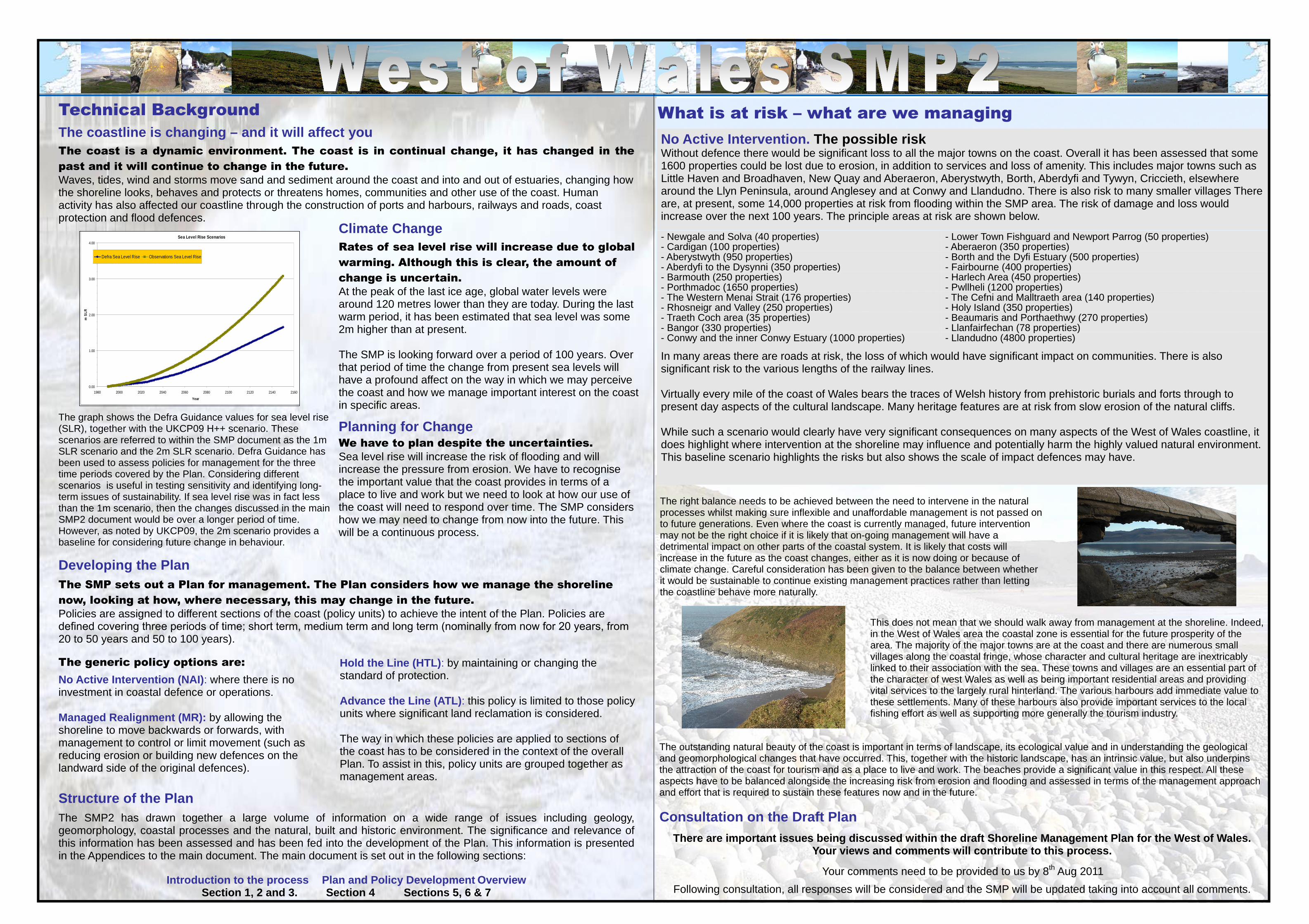
Technical Background
The coastline is changing – and it will affect you The coast is a dynamic environment. The coast is in continual change, it has changed in the
past and it will continue to change in the future.
Waves, tides, wind and storms move sand and sediment around the coast and into and out of estuaries, changing how the shoreline looks, behaves and protects or threatens homes, communities and other use of the coast. Human activity has also affected our coastline through the construction of ports and harbours, railways and roads, coast protection and flood defences.
Climate Change Rates of sea level rise will increase due to global
warming. Although this is clear, the amount of
change is uncertain.
At the peak of the last ice age, global water levels were around 120 metres lower than they are today. During the last warm period, it has been estimated that sea level was some 2m higher than at present. The SMP is looking forward over a period of 100 years. Over that period of time the change from present sea levels will have a profound affect on the way in which we may perceive the coast and how we manage important interest on the coast in specific areas.
The graph shows the Defra Guidance values for sea level rise (SLR), together with the UKCP09 H++ scenario. These scenarios are referred to within the SMP document as the 1m SLR scenario and the 2m SLR scenario. Defra Guidance has been used to assess policies for management for the three time periods covered by the Plan. Considering different scenarios is useful in testing sensitivity and identifying long-term issues of sustainability. If sea level rise was in fact less than the 1m scenario, then the changes discussed in the main SMP2 document would be over a longer period of time. However, as noted by UKCP09, the 2m scenario provides a baseline for considering future change in behaviour.
We have to plan despite the uncertainties. Sea level rise will increase the risk of flooding and will increase the pressure from erosion. We have to recognise the important value that the coast provides in terms of a place to live and work but we need to look at how our use of the coast will need to respond over time. The SMP considers how we may need to change from now into the future. This will be a continuous process.
Planning for Change
The SMP sets out a Plan for management. The Plan considers how we manage the shoreline
now, looking at how, where necessary, this may change in the future.
Policies are assigned to different sections of the coast (policy units) to achieve the intent of the Plan. Policies are defined covering three periods of time; short term, medium term and long term (nominally from now for 20 years, from 20 to 50 years and 50 to 100 years).
Developing the Plan
The generic policy options are: Hold the Line (HTL) : by maintaining or changing the standard of protection. Advance the Line (ATL) : this policy is limited to those policy units where significant land reclamation is considered. The way in which these policies are applied to sections of the coast has to be considered in the context of the overall Plan. To assist in this, policy units are grouped together as management areas.
No Active Intervention (NAI) : where there is no investment in coastal defence or operations. Managed Realignment (MR): by allowing the shoreline to move backwards or forwards, with management to control or limit movement (such as reducing erosion or building new defences on the landward side of the original defences).
Structure of the Plan
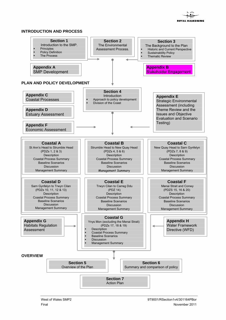
The SMP2 has drawn together a large volume of information on a wide range of issues including geology, geomorphology, coastal processes and the natural, built and historic environment. The significance and relevance of this information has been assessed and has been fed into the development of the Plan. This information is presented in the Appendices to the main document. The main document is set out in the following sections:
Introduction to the process Plan and Policy Develop ment Overview Section 1, 2 and 3. Section 4 Sections 5, 6 & 7
Sea Level Rise Scenarios
0.00
1.00
2.00
3.00
4.00
1980 2000 2020 2040 2060 2080 2100 2120 2140 2160
Year
m S
LR
Defra Sea Level Rise Observations Sea Level Rise
What is at risk – what are we managing
In many areas there are roads at risk, the loss of which would have significant impact on communities. There is also significant risk to the various lengths of the railway lines. Virtually every mile of the coast of Wales bears the traces of Welsh history from prehistoric burials and forts through to present day aspects of the cultural landscape. Many heritage features are at risk from slow erosion of the natural cliffs. While such a scenario would clearly have very significant consequences on many aspects of the West of Wales coastline, it does highlight where intervention at the shoreline may influence and potentially harm the highly valued natural environment. This baseline scenario highlights the risks but also shows the scale of impact defences may have.
- Llandudno (4800 properties) - Conwy and the inner Conwy Estuary (1000 properties) - Llanfairfechan (78 properties) - Bangor (330 properties) - Beaumaris and Porthaethwy (270 properties) - Traeth Coch area (35 properties) - Holy Island (350 properties) - Rhosneigr and Valley (250 properties) - The Cefni and Malltraeth area (140 properties) - The Western Menai Strait (176 properties) - Pwllheli (1200 properties) - Porthmadoc (1650 properties) - Harlech Area (450 properties) - Barmouth (250 properties) - Fairbourne (400 properties) - Aberdyfi to the Dysynni (350 properties) - Borth and the Dyfi Estuary (500 properties) - Aberystwyth (950 properties) - Aberaeron (350 properties) - Cardigan (100 properties) - Lower Town Fishguard and Newport Parrog (50 properties) - Newgale and Solva (40 properties)
No Active Intervention. The possible risk Without defence there would be significant loss to all the major towns on the coast. Overall it has been assessed that some 1600 properties could be lost due to erosion, in addition to services and loss of amenity. This includes major towns such as Little Haven and Broadhaven, New Quay and Aberaeron, Aberystwyth, Borth, Aberdyfi and Tywyn, Criccieth, elsewhere around the Llyn Peninsula, around Anglesey and at Conwy and Llandudno. There is also risk to many smaller villages There are, at present, some 14,000 properties at risk from flooding within the SMP area. The risk of damage and loss would increase over the next 100 years. The principle areas at risk are shown below.
The right balance needs to be achieved between the need to intervene in the natural processes whilst making sure inflexible and unaffordable management is not passed on to future generations. Even where the coast is currently managed, future intervention may not be the right choice if it is likely that on-going management will have a detrimental impact on other parts of the coastal system. It is likely that costs will increase in the future as the coast changes, either as it is now doing or because of climate change. Careful consideration has been given to the balance between whether it would be sustainable to continue existing management practices rather than letting the coastline behave more naturally.
This does not mean that we should walk away from management at the shoreline. Indeed, in the West of Wales area the coastal zone is essential for the future prosperity of the area. The majority of the major towns are at the coast and there are numerous small villages along the coastal fringe, whose character and cultural heritage are inextricably linked to their association with the sea. These towns and villages are an essential part of the character of west Wales as well as being important residential areas and providing vital services to the largely rural hinterland. The various harbours add immediate value to these settlements. Many of these harbours also provide important services to the local fishing effort as well as supporting more generally the tourism industry.
The outstanding natural beauty of the coast is important in terms of landscape, its ecological value and in understanding the geological and geomorphological changes that have occurred. This, together with the historic landscape, has an intrinsic value, but also underpins the attraction of the coast for tourism and as a place to live and work. The beaches provide a significant value in this respect. All these aspects have to be balanced alongside the increasing risk from erosion and flooding and assessed in terms of the management approach and effort that is required to sustain these features now and in the future.
Consultation on the Draft Plan
There are important issues being discussed within t he draft Shoreline Management Plan for the West of Wales. Your views and comments will contribute to this pro cess.
Your comments need to be provided to us by 8th Aug 2011
Following consultation, all responses will be considered and the SMP will be updated taking into account all comments.

Contact Details
Pembrokeshire County Council Emyr Williams Tel: 01437 776143 [email protected]
Ceredigion County Council Rhodri Llwyd Tel: 01545 572434 [email protected]
Powys County Council Graham Astley Tel: 01597 826209 [email protected]
Gwynedd Council Huw Davies Tel: 01341 424405 [email protected]
Isle of Anglesey County Council Rowland Thomas Tel: 01248 752312 [email protected]
Conwy County Borough Council Richard Evans Tel: 01492 575193 [email protected]
Your opportunity to comment
The draft SMP2 Documents are available for review on the SMP website where you can also provide us with your comments.
www.westofwalessmp.org/
You may also post your comments to: Emyr Williams (T&E) West of Wales SMP PO Box 115 Haverfordwest SA62 9DG
Public Consultation Period: 6th May to 8th Aug 2011
Appendix A SMP Development
Appendix B Stakeholder Engagement
Section 2 The Environmental Assessment Process.
Section 3 The Background to the Plan
� Historic and Current Perspective � Sustainability Policy � Thematic Review
Section 4 Introduction
� Approach to policy development � Division of the Coast
INTRODUCTION AND PROCESS
PLAN AND POLICY DEVELOPMENT
Section 1 Introduction to the SMP.
� Principles � Policy Definition � The Process
Appendix E Strategic Environmental Assessment (including Theme Review and the Issues and Objective Evaluation and Scenario Testing)
Appendix C Coastal Processes
Appendix D Estuary Assessment
Appendix F Economic Assessment
Coastal A St Anne’s Head to Strumble Head
(PDZs 1, 2 & 3) Description
Coastal Process Summary Baseline Scenarios
Discussion Management Summary
Coastal B Strumble Head to New Quay Head (PDZs
4, 5 & 6) Description
Coastal Process Summary Baseline Scenarios
Discussion Management Summary
Coastal C New Quay Head to Sarn Gynfelyn (PDZs
7, 8 & 9) Description
Coastal Process Summary Baseline Scenarios
Discussion Management Summary
Coastal G Ynys Mon (excluding the Menai Strait)
(PDZs 17, 18 & 19) � Description � Coastal Process Summary � Baseline Scenarios � Discussion � Management Summary
Coastal D Sarn Gynfelyn to Trwyn Cilan
(PDZs 10, 11, 12 & 13) Description
Coastal Process Summary Baseline Scenarios
Discussion Management Summary
Coastal E Trwyn Cilan to Carreg Ddu
(PDZ 14) Description
Coastal Process Summary Baseline Scenarios
Discussion Management Summary
Coastal F Menai Strait and Conwy
(PDZS 15, 16 & 20) Description
Coastal Process Summary Baseline Scenarios
Discussion Management Summary
Appendix G Habitats Regulation Assessment
Appendix H Water Framework Directive (WFD)
Section 5 Overview of the Plan
Section 6 Summary and comparison of policy
OVERVIEW
Section 7 Action Plan

Consultation SummaryThe West of Wales SMP2 covers over 1000km of coast.The shoreline has been divided into Coastal Areas (A to G), as shown on the figure below. Within each area the plan is developed by Policy Development Zones (PDZ) as identified below.
CoastalArea A
CoastalArea B
CoastalArea C
CoastalArea D
CoastalArea F
CoastalArea G
CoastalArea E
BackgroundThe first SMPs (SMP1s) were produced in 2002. The West of Wales SMP2 draws together the areas previously covered by the Cardigan Bay and the Ynys Enlli to Great Orme SMP1s. We are currently in the process of developing the second generation of the SMP. The SMP2 process has undergone significant changes since the SMP1s were developed.
Looking Forward
The Increasing Risk
How we mange the coast now sets the pattern for how we manage in the future.SMP2 looks ahead for 100 years, looking at where management is taking us. It considers management over the short term, the medium term and into the future. We recognise the increasing uncertainty in the future but equally the need to plan for this uncertainty. The SMP addresses the present problems while highlighting the issues that will arise.
Flood risk will increase in the future, due to climate change, as will coastal erosion and pressure for change at the shoreline.In areas where there is the need to manage defences, defences will cost more. We have to look at different ways in which defences and risk can be managed. This may require improved flood warning, emergency response and community resilience. In other areas continuing to manage risk in the way in which we do at present may not be sustainable. We will have to adapt. We need to understandand plan how we can change.
Improved UnderstandingSince SMP1, the behaviour of the coast has been monitored and various detailed studies have been undertaken. SMP2 develops from the understanding provided by SMP1. Where additional information is now available it has been built in to assessing how the shoreline may be managed.
Social & EnvironmentHow we manage the shoreline, the risk from flooding and erosion, and the sustainability of defences, has a major impact on the way in which we value, live and work at the coast. There are important communities at the coast. The coast supports a thriving tourist industry, important agricultural use, and other commercial and industrial interests at the shoreline. The coast is important for recreation, leisure activities and the quality of life, particularly given the superb landscape, the quality of the beaches and access to the sea. An essential part of this quality relies on the important ecology and the historic environment. Future management of the shoreline must allow natural habitats and features to respond and adjust, and must comply with legislation relating to conservation designations. It must also work with spatial planning in delivering balanced sustainability.
Who has prepared the Shoreline Management Plan?The Cardigan Bay and Ynys Enlli to the Great Orme Coastal Groups have led the development of the SMP2. The process has been managed by Pembrokeshire County Council on behalf of the Groups.
The Steering Group includes:• Pembrokeshire County Council• Ceredigion County Council• Powys County Council• Gwynedd Council
• Isle of Anglesey County Council • Conwy County Borough Council• Environment Agency Wales• Countryside Council for Wales
Development of the Plan is supported by the Welsh Assembly Government.
• Network Rail• National Trust• National Park Authorities
4

Llangefni – 17th May Council Chambers 3pm to 8pm
Llandudno – 18th May Llandudno Swimming Centre3pm to 8pm
Plas Menai – 19th May Plas Menai 3pm to 8pm
Fairbourne – 20th May Village Hall 3pm to 8pm
Pwllheli – 25th May Pwllheli Sailing Club10am to 8pm
Machynlleth – 26th May Y Plas, Aberystwyth Road3pm to 8pm
Borth – 27th May Community Hall3pm to 8pm
Cardigan – 7th June Guildhall3pm to 8pm
Aberaeron – 8th June Memorial Hall3pm to 8pm
Broad Haven – 9th June Broad Haven Village Hall3pm to 8pm
Fishguard – 10th June Town Hall3pm to 8pm
Porthmadog – 14th June Y Ganolfan3pm to 8pm
Aberdyfi – 15th June Neuadd Dyfi3pm to 8pm
Further details of meetings will be publicised in the local press and on the web site.
Contact DetailsPembrokeshire County CouncilEmyr WilliamsTel: 01437 [email protected]
Ceredigion County CouncilRhodri LlwydTel: 01545 [email protected]
Powys County CouncilGraham AstleyTel: 01597 [email protected]
Gwynedd CouncilHuw DaviesTel: 01341 [email protected]
Isle of Anglesey County CouncilRowland ThomasTel: 01248 [email protected]
Conwy County Borough CouncilRichard EvansTel: 01492 [email protected]
1
Consultation Summary
What is a Shoreline Management Plan (SMP)?The West of Wales Shoreline Management Plan provides a high level strategy for managing flood and erosion risk for the coastline between St Anne’s Head, at the entrance to Milford Haven, and the Great Orme. The Plan assesses these risks to people and the developed, historic and natural environment. It considers the immediate risks and how management of this risk can be developed in to the future in a sustainable manner, to ensure that this does not tie future generations to costly and unsustainable management. Although the Plan focuses on management of risk and defences, it has to take account of the broader issues of coastal management. It provides a framework within which opportunities for broader management can be considered and aims to provide the foundation for balanced management of other issues relating to the coastal area.
Your opportunity to comment
The draft SMP2 Documents are available for review on the SMP website (www.westofwalessmp.org/) where you can also provide us with your comments.
A series of public exhibitions will be held during May / June 2011 to present the draft Shoreline Management Plan
You may also post your comments to:Emyr Williams (T&E)West of Wales SMPPO Box 115HaverfordwestSA62 9DG
Public Consultation Period 6th May to 8th Aug 2011

Technical Background
The coastline is changing –
and it will affect youThe coast is a dynamic environment. The coast is in continual change, it has changed in the past and it will continue to change in the future. Waves, tides, wind and storms move sand and sediment around the coast and into and out of estuaries, changing how the shoreline looks, behaves and protects or threatens homes, communities and other use of the coast. Human activity has also affected our coastline through the construction of ports and harbours, railways and roads, coast protection and flood defences.
Climate ChangeRates of sea level rise will increase due to global warming. Although this is clear, the amount of change is uncertain. At the peak of the last ice age, global water levels were around 120 metres lower than they are today. During the last warm period, it has been estimated that sea level was some 2m higher than at present.
The SMP is looking forward over a period of 100 years. Over that period of time the change from present sea levels will have a profound affect on the way in which we may perceive the coast and how we manage important interest on the coast in specific areas.
The graph shows the Defra Guidance values for sea level rise (SLR), together with the UKCP09 H++ scenario. These scenarios are referred to within the SMP document as the 1m SLR scenario and the 2m SLRscenario. Defra Guidance has been used to assess policies for management for the three time periods covered by the Plan. Considering different scenarios is useful in testing sensitivity and identifying long-term issues of sustainability. If sea level rise was in fact less than the 1m scenario, then the changes discussed in the main SMP2 document would be over a longer period of time. However, as noted by UKCP09, the 2m scenario provides a baseline for considering future change in behaviour.
We have to plan despite the uncertainties.Sea level rise will increase the risk of flooding and will increase the pressure from erosion. We have to recognise the important value that the coast provides in terms of a place to live and work but we need to look at how our use of the coast will need to respond over time. The SMP considers how we may need to change from now into the future. This will be a continuous process.
Planning for Change
The SMP sets out a Plan for management. The Plan considers how we manage the shoreline now, looking at how, where necessary, this may change in the future. Policies are assigned to different sections of the coast (policy units) to achieve the intent of the Plan. Policies are defined covering three periods of time; short term, medium term and long term (nominally from now for 20 years, from 20 to 50 years and 50 to 100 years).
Developing the Plan
The generic policy options are:Hold the Line (HTL): by maintaining or changing the standard of protection.
Advance the Line (ATL): this policy is limited to those policy units where significant land reclamation is considered.
The way in which these policies are applied to sections of the coast has to be considered in the context of the overall Plan. To assist in this, policy units are grouped together as management areas.
No Active Intervention (NAI): where there is no investment in coastal defence or operations.
Managed Realignment (MR): by allowing the shoreline to move backwards or forwards, with management to control or limit movement (such as reducing erosion or building new defences on the landward side of the original defences).
Structure of the PlanThe SMP2 has drawn together a large volume of information on a wide range of issues including geology, geomorphology, coastal processes and the natural, built and historic environment. The significance and relevance of this information has been assessed and has been fed into the development of the Plan. This information is presented in the Appendices to the main document. The main document is set out in the following sections:
Introduction to the process Plan and Policy Development OverviewSection 1, 2 and 3. Section 4 Sections 5, 6 & 7
2
Sea Level Rise Scenarios
0.00
1.00
2.00
3.00
4.00
1980 2000 2020 2040 2060 2080 2100 2120 2140 2160
Year
m S
LR
Defra Sea Level Rise Observations Sea Level Rise

What is at risk – what are we managing
In many areas there are roads at risk, the loss of which would have significant impact on communities. There is also significantrisk to the various lengths of the railway lines.
Virtually every mile of the coast of Wales bears the traces of Welsh history from prehistoric burials and forts through to present day aspects of the cultural landscape. Many heritage features are at risk from slow erosion of the natural cliffs.
While such a scenario would clearly have very significant consequences on many aspects of the West of Wales coastline, it does highlight where intervention at the shoreline may influence and potentially harm the highly valued natural environment. This baseline scenario highlights the risks but also shows the scale of impact defences may have.
-Llandudno (4800 properties)- Conwy and the inner Conwy Estuary (1000 properties)- Llanfairfechan (78 properties)- Bangor (330 properties)- Beaumaris and Porthaethwy (270 properties)- Traeth Coch area (35 properties)- Holy Island (350 properties)- Rhosneigr and Valley (250 properties)- The Cefni and Malltraeth area (140 properties)- The Western Menai Strait (176 properties)- Pwllheli (1200 properties)- Porthmadoc (1650 properties)- Harlech Area (450 properties)- Barmouth (250 properties)- Fairbourne (400 properties)- Aberdyfi to the Dysynni (350 properties)- Borth and the Dyfi Estuary (500 properties)- Aberystwyth (950 properties)- Aberaeron (350 properties)- Cardigan (100 properties)- Lower Town Fishguard and Newport Parrog (50 properties)- Newgale and Solva (40 properties)
No Active Intervention. The possible riskWithout defence there would be significant loss to all the major towns on the coast. Overall it has been assessed that some 1600properties could be lost due to erosion, in addition to services and loss of amenity. This includes major towns such as Little Haven and Broadhaven, New Quay and Aberaeron, Aberystwyth, Borth, Aberdyfi and Tywyn, Criccieth, elsewhere around the Llyn Peninsula, around Anglesey and at Conwy and Llandudno. There is also risk to many smaller villages There are, at present, some 14,000 properties at risk from flooding within the SMP area. The risk of damage and loss would increase over the next 100 years. The principle areas at risk are shown below.
The right balance needs to be achieved between the need to intervene in the natural processes whilst making sure inflexible and unaffordable management is not passed on to future generations. Even where the coast is currently managed, future intervention may not be the right choice if it is likely that on-going management will have a detrimental impact on other parts of the coastal system. It is likely that costs will increase in the future as the coast changes, either as it is now doing or because of climate change. Careful consideration has been given to the balance between whether it would be sustainable to continue existing management practices rather than letting the coastline behave more naturally.
This does not mean that we should walk away from management at the shoreline. Indeed, in the West of Wales area the coastal zone is essential for the future prosperity of the area. The majority of the major towns are at the coast and there are numerous small villages along the coastal fringe, whose character and cultural heritage are inextricably linked to their association with the sea. These towns and villages are an essential part of the character of west Wales as well as being important residential areas and providing vital services to the largely rural hinterland. The various harbours add immediate value to these settlements. Many of these harbours also provide important services to the local fishing effort as well as supporting more generally the tourism industry.
The outstanding natural beauty of the coast is important in terms of landscape, its ecological value and in understanding the geological and geomorphological changes that have occurred. This, together with the historic landscape, has an intrinsic value, but also underpins the attraction of the coast for tourism and as a place to live and work. The beaches provide a significant value in this respect. All these aspects have to be balanced alongside the increasing risk from erosion and flooding and assessed in terms of the management approach and effort that is required to sustain these features now and in the future.
Consultation on the Draft PlanThere are important issues being discussed within the draft Shoreline Management Plan for the West of Wales.
Your views and comments will contribute to this process.
Your comments need to be provided to us by 8th Aug 2011Following consultation, all responses will be considered and the SMP will be updated taking into account all comments.
3

West of Wales SMP2 9T9001/RSection1v4/301164PBor
Final - Appendix B. 24- November 2011
Annex II Consultation Photographs
West of Wales SMP2 9T9001RSection1v4/301164/PBor Final - Annex I. 1- November 2011
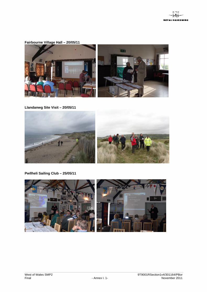
Fairbourne Village Hall – 20/05/11
Llandanwg Site Visit – 20/05/11
Pwllheli Sailing Club – 25/05/11

West of Wales SMP2 9T9001/RSection1v4/301164PBor Final - Appendix B. 25- November 2011
Annex III Attendance Record

No. Name Organisation Email Address1 Emlyn Jones Gwynedd Consultancy [email protected] Huw Davies Gwynedd Consultancy [email protected] Rowland Thomas Anglesey County Council [email protected] Christian Branch Anglesey County Council [email protected] Dylan Jones Anglesey County Council [email protected] Simon Philips Anglesey County Council [email protected] Alun Owen Anglesey County Council [email protected] Richard Evans Conwy County Borough Council [email protected] Barbara Owsianka Conwy County Borough Council [email protected] Ceri Thomas Conwy County Borough Council [email protected] Michael Lloyd Powys County Council [email protected] Claire Seddon Powys County Council [email protected] Gareth Lloyd Snowdonia National Park [email protected] Kathryn Beard Dept for the Economy & Transport WAG [email protected] Iwan Huws Environment Agency Wales [email protected] Emyr Gareth Environment Agency Wales [email protected] Deborah Hemsworth Environment Agency Wales [email protected] Ruth Prichard Environment Agency Wales [email protected] Gareth Thomas Environment Agency Wales [email protected] Neil Taunt Environment Agency Wales [email protected] Greg Guthrie Royal Haskoning [email protected] Victoria Clipsham Royal Haskoning [email protected] Mike Willis Countryside Council for Wales [email protected]
The Welsh Assembly Government are undertaking a review of TAN 14 and 15 and wish to consult the relevant people. It therefore seemed a good start if they began with those officers who have attended this seminar as they will be aware of the issues raised by climate change and sea level rise. If you agree, by initialing the box, your email address as held by the organisers will be sent to James Morris who is undertaking the review for the Welsh Assembly Government.
West of Wales Shoreline Management Plan
Seminar for Planners - 18/05/11

No. Name Organisation/Resident Contact Details (Address/Email/Phone)1234567891011121314151617181920212223
Council Chambers, Llangefni - 17/05/11

No. Name Organisation/Resident Contact Details (Address/Email/Phone)1234567891011121314151617181920212223
Swimming Centre, Llandudno - 18/05/11

No. Name Organisation/Resident Contact Details (Address/Email/Phone)1 Hugh Knott Amnog Environmental, Menrr Mon Parc Bryn Cefni, Llanciefni LL77 7XA hugh@??? 01248 7257242 Nick Lowe [email protected]
Plas Menai - 19/05/11

No. Name Organisation/Resident Contact Details (Address/Email/Phone)1 Gill Smith2 Chris Tutton3 John Ball4 Harry Ikin5 Tim Bush6 Ned Thomas7 Graham Tottle8 Graham Bennett9 Simon Jones [email protected]
Site Meeting, Llandanwg - 20/05/11

No. Name Organisation/Resident Contact Details (Address/Email/Phone)1 Rebecca Greenau Cambrian News [email protected] M Ford Resident 01341 2500693 E Doyle Resident 01341 2508554 Joyce Woolley Resident 01341 2505225 Bryan Woolley Resident 01342 2505226 R Edwards Resident 01341 2502917 A Ware Resident 01341 2512998 J Ware Resident 01342 2512999 (Illegible signature) Resident 01342 25065010 G Batthsey Resident 01343 25065011 Sandra Glentrep Resident 01341 25088712 Armel Viera GCC Portfolio Lender 01654 71147013 Eric Wilding Arthog Community Council 01341 25037614 Lynn Walford Resident 01341 25008615 M Peach Resident16 G Grundy Resident 01341 25042217 Peter Cole Resident 01341 25127018 Janet Mobley Resident 01341 25085119 Mick Mobley Resident 01341 25085120 Jean Pike Resident 01341 25078121 Ivy Williams Resident 01341 25001022 J E R Smith Resident 01341 25107223 M Smith Resident 01341 251072
Village Hall, Fairbourne - 20/05/11

No. Name Organisation/Resident Contact Details (Address/Email/Phone)1 V Whitehouse Resident 2 Innes Estate, Lon Golff, Pwllheli2 Cynl Peter Bead Resident Abererch3 HS Roberts Resident Castell, Penrhos4 Emyr Roberts Resident Coed Bodfell, Llamor, Pwllheli5 R F Davies Resident 62 Erwenni, Hia Rd, Pwllehli6 D J Jones Resident 33 Cardiff Rd, Pwllehli7 R E Bridges Resident 89 Cefn-y-Gader, Morfa Bychan8 S E Williams Resident Penbryn Neuadd, Abersoch, Pwllehli9 Bill Partington Resident Swenolfa, Nefryn, LL53 6ED10 Glyn Roberts Resident Tyddyn Isa, Sorn, Pwllehli11 Richard & Cerys (Illegible signature) Resident 22 Glan Cymeran, Pwllehli12 Stephen Cooper Resident 8 Lon Ceredigan13 Iain Roberts Resident Gwesty Tynewynn, Aberdalon, Pwllehli LL53 8BE14 I R Williams Resident 76 Lon Ceredigion, LL53 5RA
15 David Brown Organisation Rowlands Marling Electronics, Pwllehli Marine Centre, Glan Dow, Pwllheli
16 Pamel Parker Resident 2 tai Baladenlyn, Nantle, Caemarfon, LL54 6BL17 Marilyn Lewis Resident 53 Lon Ceredigion, Pwllheli, LL53 5PP18 Alun Roberts Resident Penawrydd Aodal Dwyfor, Gasanaeth Riff yodd a Bordenloefod, Cygn
Goyedd19 G E Owen Resident Ger y Garw, Ewenni Est, Ala Road, Pwllheli20 Averel Pierce Resident Llan y grig, Bwynny, Tywyn21 David Evans Resident Bryntyfryd, Caenarfon Road, Pwllheli22 K J Dunn Resident Aborsoch Sands, Holiday Centres, Pwllehli23 G E (Illegible signature) Resident Bryctherion, Bryplosag
Pwllheli Sailing Club, Pwllheli - 25/05/11

No. Name Organisation/Resident Contact Details (Address/Email/Phone)1 (Illegible signature) Powys CC Parry Abercegin, Macynlleth2 Michael Wiele Powys CC 5 Bryn-y-Gog, Machynlleth3 Melanie Biffin Machynlleth TC y Plas, Machynlleth4 Graham Astley Powys CC County Hall, Llandrindod Well, LD1 5LG, [email protected] S Nicholls Machynlleth TC 94 Tragartn Machynlleth, Powys, SY20 8NY, stpnllerbtinternet.com6 B Walker Derwenlas Community Centre Rose Cottage, Derwenlas, SY20 8TN7 Nick Powell DYFI and Mawddach, Wildfowlers Association 2 Red House, White Grit, Minsterley, Shroprshire, SY5 0JL891011121314151617181920212223
Y Plas, Machynlleth - 26/05/11
No. Name Organisation/Resident Contact Details (Address/Email/Phone)
1 Nick Newland Afon Teifi Fairways Ltd Nant-y-ferwig, Gwbent Rd, Cardigan, SA73 1PN 01239 615140, [email protected]
2 Chris Evans Resident Bryneos, Llangoedmor, Cardigan, SH43 2LB 01239 612247
3 Jim Marsden Resident Island View, Gwbert-on Sea, Cardigan, SA43 1PR [email protected]
4 Carol Bainbridge Community Council Sandy Nook, Ynysley Bach, [email protected] 01470 871692
5 Jo Jones Community Council Rockside Borth, SY24 5LJ 01470 871411 [email protected] Anthony Morris Community Council Glaneifion, Borth, SY24 5HZ (01970) 8710227 Ray Jones Bam Nuttall Ltd 07876 3320128 Alice Johnson Resident Glat 8, Grand Hotel, Borth9 Ray Quant Borth Local Member Pinecroft Llandre, SY24 5BS10 Thomas Evan Visitor 01970 82060311 Ron Scattergood 07794 46277312 David Brindley Resident Mayfield, High Street, Borth 01970 87103813 D Hadfield Bowater14 Ann Budge Resident 01970 87120315 Graham Taylor Borth Website (resident) 33 Heolaberwennol, Borth16 Rona Dalton York House Borth17 Pat Mares Resident Borth18 Richard Edwards Surfer19 Caroline Jones Visitor Borth20 Rob Jones Visitor Borth21 D W Hildich Home owner 07808 77672722 Pat Horels Home owner 01970 87161123 Jackie Lawrence Resident/Comm Council 871308
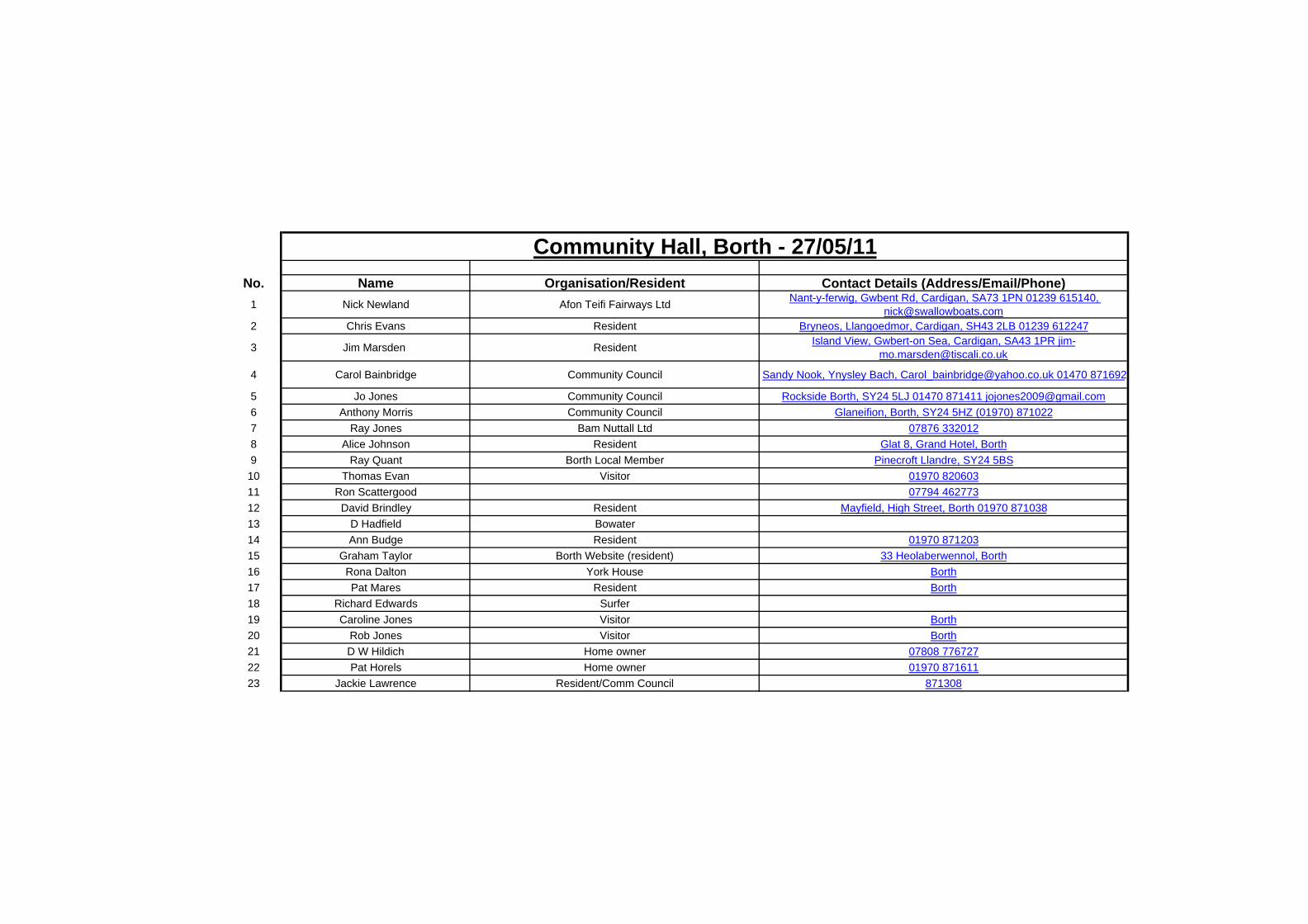
Community Hall, Borth - 27/05/11

Name Organisation Signature Email Address
Dr. Stephen Jones Pembrokeshire C.C. [email protected]
Emyr Williams Pembrokeshire C.C. [email protected]
Bob Smith Pembrokeshire C.C. [email protected]
Charlotte White Pembrokeshire C.C. [email protected]
Martin Allen Pembrokeshire C.C. [email protected]
Lara Lawrie Pembrokeshire C.C. [email protected]
Richard Staden Pembrokeshire C.C. [email protected]
Chris Payne Pembrokeshire C.C. [email protected]
Rhodri Llwyd Ceredigion C.C. [email protected]
Llinos Quelch Ceredigion C.C. [email protected]
Sarah Middleton Pembrokeshire Coast N. P. [email protected]
Richard James Pembrokeshire Coast N. P. [email protected]
James Morris Welsh Assembly Government [email protected]
Suzanne Waldron Environment Agency Wales [email protected]
David Watkins Environment Agency Wales [email protected]
Louise Edwards Environment Agency Wales [email protected]
Sharon Luke Environment Agency Wales [email protected]
Jenny Dickinson Environment Agency Wales [email protected]
Sid Howells CCW [email protected]
Greg Guthrie Royal Haskoning [email protected]
Victoria Clipsham Royal Haskoning [email protected]
The Welsh Assembly Government are undertaking a review of TAN 14 and 15 and wish to consult the relevant people. It therefore seemed a good start if they began with those officers who have attended this seminar as they will be aware of the issues raised by climate change and sea level rise. So your email address as held by the organisers will be sent to James Morris who is undertaking the review for the Welsh Assembly Government unless you object?
West of Wales Shoreline Management Plan
Seminar for Planners - 06/06/11
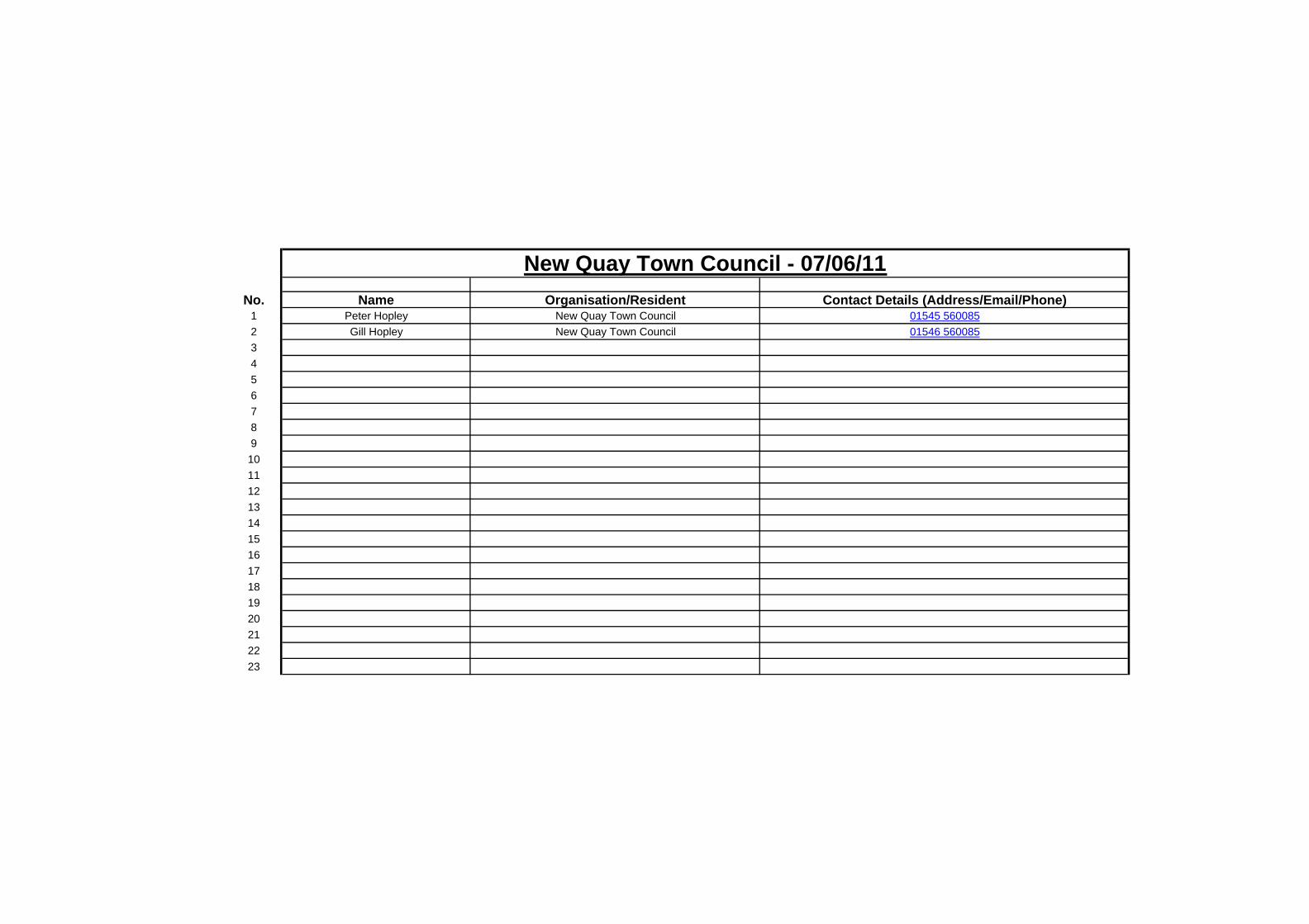
No. Name Organisation/Resident Contact Details (Address/Email/Phone)1 Peter Hopley New Quay Town Council 01545 5600852 Gill Hopley New Quay Town Council 01546 56008534567891011121314151617181920212223
New Quay Town Council - 07/06/11

No. Name Organisation/Resident Contact Details (Address/Email/Phone)1 Catrin Miles Cardigan Town Mayor [email protected] Jackie Biggs Tnyside Aon jackie.biggs@gw?3 John Adams Lewis Cyngor Sir Ceredigion Cyngor Tref Aberteif [email protected] Michael James Pembrookeshire Coast NPA/Pemb CC [email protected] Peter Lowe Patch Caravan Park 01239 6158586 Hayden Lewis 6120157 Richard Edwards 01570 4807448 Ray Quant Cardigan CC 01870 82060391011121314151617181920212223
Guildhall, Cardigan - 07/06/11

No. Name Organisation/Resident Contact Details (Address/Email/Phone)1 I Page Resident 01239 6546272 J Page Resident 01240 6546273 M Bulloch Resident 01239 6546164 Roy Tarbutt Welfare 01239 6545575 Annette Davies Resident 01239 6540016 Paul Dawes Resident 01239 6540017 Alun Lewis Resident Rep 01239 6543718 (Illegible signature) Llangrannog County Council 01239 6543429 Martin Gring Resident / Llangrannog Welfare 01239 65425710 S M Dobson Resident 01239 65457811 G M Palframaw Resident 01239 65450212 G&J Little Resident 07904 81589813 Simon Griffiths Regular visitor Griffiths Challet SA44 6SP14 Mike Rutherford Pentre Arms 01239 654345151617181920212223
The Beach Hut Cafe, Llangrannog - 08/06/11
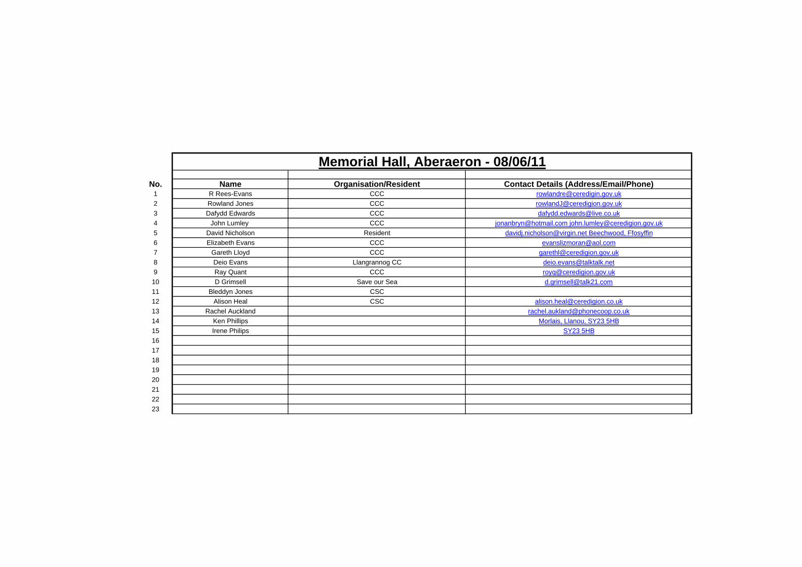
No. Name Organisation/Resident Contact Details (Address/Email/Phone)1 R Rees-Evans CCC [email protected] Rowland Jones CCC [email protected] Dafydd Edwards CCC [email protected] John Lumley CCC [email protected] [email protected] David Nicholson Resident [email protected] Beechwood, Ffosyffin6 Elizabeth Evans CCC [email protected] Gareth Lloyd CCC [email protected] Deio Evans Llangrannog CC [email protected] Ray Quant CCC [email protected] D Grimsell Save our Sea [email protected] Bleddyn Jones CSC12 Alison Heal CSC [email protected] Rachel Auckland [email protected] Ken Phillips Morlais, Llanou, SY23 5HB15 Irene Philips SY23 5HB1617181920212223
Memorial Hall, Aberaeron - 08/06/11

No. Name Organisation/Resident Contact Details (Address/Email/Phone)1 S Gardener 17 Atlantic Drive, B Haven (resident) Com Cllr 01437 781827 [email protected] C Jessop Marlves & St Brides Comm Council 01646 636789 greatwestern@st??.com3 Kelly Robertson Bridge Manne Science Group [email protected] 075456 966164 Rod Penrose UK CSIP 01259 6824055 Charles Mathieson Penpot67891011121314151617181920212223
Broad Haven Village Hall, Broad Haven - 09/06/11

No. Name Organisation/Resident Contact Details (Address/Email/Phone)1 Richard Ellis National Trust [email protected] B R Morse Town Cllr 01348 8744133 C Price Town Council 72 High St, Fishguard
4 Cllr R Davies Town Mayor Min-yr-Ochr, Maesgwyn Rd, Fishguard2 The Paddock, Fishguard
5 C Clements Trefin Resident [email protected] Christopher Taylor Mayor of St Davids St Davids City Council7 R D Richardson Visitor - volunteer at Trefin hostel Ipswich, Suffolk [email protected] Cllr Moira Lewis PCC [email protected] Tom Jones The Pheonix Centre [email protected] K Worthing Community Fishguard11 I Davies Stenalink, Fishguard Port [email protected] Cllr Myles Peppa PCC PCC mail1314151617181920212223
Town Hall, Fishguard - 10/06/11

No. Name Organisation/Resident Contact Details (Address/Email/Phone)1 Mr & Mrs R Davies Resident Morfa Bychan2 D C Brown Resident Morfa Bychan3 R S Brown Resident Morfa Bychan4 Gwyn Davies Resident Morfa Bychan5 G Davies Resident Morfa Bychan6 Mary Frankum Resident Morfa Bychan7 Ray Frankum Resident Morfa Bychan8 Bill Fazawerley Resident Talsarnan9 R H Gould Resident 36 S Snowdon Wharf10 Helen Prichard Resident11 Jean Lane Resident Morf Bychan12 B Laycock Resident Tremadog13 C M Hartlebury Resident Penmorfa14 (Illegible signature) Resident Resident15 A M Oliver Resident Morfa Bychan16 B Roqaber Resident Morfa Bychan17 M Mackenzie Resident Morfa Bychan18 Linda Scriven Resident Morfa Bychan19 Jeff Scriven Resident Morfa Bychan20 L & F Coghlem Resident Morfa Bychan21 C J Free Resident Morfa Bychan22 G Davies Resident Borth-y-Gest23 D S Woodhouse Resident Morfa Bychan24 M A Hamilton Resident Morfa Bychan25 J Boott Resident Morfa Bychan26 Jill Smith Resident Llanbeder27 D Ornett Resident Morfa Bychan
Y Ganolfan, Porthmadog - 14/06/11

No. Name Organisation/Resident Contact Details (Address/Email/Phone)1 W Bracewell Aberdyfi Partnership 01654 7676402 D George Neuadd Dyfi 01654 767251 Nenceddyfi.co.uk
3 B S Bates Aberdyfi 01654 [email protected]
4 Dewi Owen Aberdyfi Council 01654 7672675 Angela Sykes Tywyn 01654 7119316 Ray Brooks Resident 41 FF Dyfrig Tywyn7 Mick Smyth Resident LL37 2JP8 Alun Wyn Evans Penllyn Farm, Gwynedd LL36 0DP9 Andrew Currie Abergynolwyn LL36 9YE10 H E James Aberdyfi Golf Club 41 Faenolisaf, Tywyn11 Nigel Pearson Aberdyfi LL35 0NR12 Olwen Bate Aberdovey Golf Club LL35 0SE13 H Mettrop Aberdovey, Cortref Sloterhade 33B, 1058 HE Amsterdam14 Ivan Hulsteijn Visitor to Cartref Guest House 1181 JH Amsterdam15 John Bate Aberdovey Resident LL35 0SE -01654 76735916 Dogald Camrron SO Coastguard, Aberdyfi [email protected] Paul Edwards Resident LL35 0EE18 Peter Saunders Twywn Partnership Cynefin LL36 9SE19 Dave Williams Aberdyfi LL35 0NB20212223
Neuadd Dyfi, Aberdyfi - 15/06/11

West of Wales SMP2 9T9001/RSection1v4/301164PBor
Final - Appendix B. 26- November 2011
Annex IV Consultation Responses
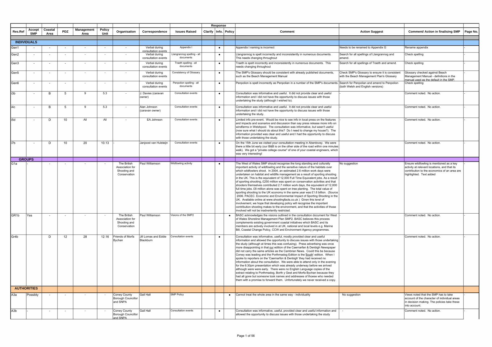
Gen1 - - - - - - Verbal during consultation events
Appendix I ● Appendix I naming is incorrect Needs to be renamed to Appendix G Rename appendix -
Gen2 - - - - - - Verbal during consultation events
Llangrannog spelling - all documents
● Llangrannog is spelt incorrectly and inconsistently in numerous documents. This needs changing throughout
Search for all spellings of Llangrannog and amend.
Check spelling -
Gen3 - - - - - - Verbal during consultation events
Traeth spelling - all documents
● Traeth is spelt incorrectly and inconsistently in numerous documents. This needs changing throughout
Search for all spellings of Traeth and amend. Check spelling -
Gen5 - - - - - - Verbal during consultation events
Consistency of Glossary ● The SMP's Glossary should be consistent with already published documents, such as the Beach Management Manual
Check SMP's Glossary to ensure it is consistent with the Beach Management Plan's Glossary
Glossary checked against Beach Management Manual - definitions in the manual used as the default in the SMP.
-
Gen6 - - - - - - Verbal during consultation events
Penpolion spelling - all documents
● Penpolion is spelt incorrectly as Penpolian in a number of the SMP's documents. Search for Penpolian and amend to Penpolion (both Welsh and English versions)
Check spelling -
i3b - B 5 9 5.3 - J. Davies (caravan owner)
Consultation events ● Consultation was informative and useful. It did not provide clear and useful information and I did not have the opportunity to discuss issues with those undertaking the study (although I wished to).
- Comment noted. No action. -
i4c - B 5 9 5.3 - Alan Johnson (caravan owner)
Consultation events ● Consultation was informative and useful. It did not provide clear and useful information and I did not have the opportunity to discuss issues with those undertaking the study.
- Comment noted. No action. -
i5d - D 10 All All - EA Johnson Consultation events ● Limited info pre-event. Would be nice to see info in local press on the features and impacts and scenarios and discussion than say press release more info on windfarms in Welshpool. The consultation was informative, but wasn't useful (now sure what I should do about this? Do I need to change my house?). The information provided was clear and useful and I had the opportunity to discuss with those undertaking the study.
- Comment noted. No action. -
i7b - D 10 20 10.13 - Janjoost van Hulsteijn Consultation events ● On the 15th June we visited your consultation meeting in Aberdovey. We were there a little bit early (our B&B is on the other side of the road within one minutes walk). We got a "private college course" of one of your coastal engineers, which was very interesting!
Comment noted. No action. -
G1a - - - - - The British Association for Shooting and Conservation
Paul Williamson Wildfowling activity ● The West of Wales SMP should recognise the long standing and culturally important activity of wildfowling and the sensitive nature of the habitats over which wildfowlers shoot. In 2004, an estimated 2.6 million work days were undertaken on habitat and wildlife management as a result of sporting shooting in the UK. This is the equivalent of 12,000 Full Time Equivalent jobs. As a result of sporting shooting, £250 million was spent on conservation activities and that shooters themselves contributed 2.7 million work days, the equivalent of 12,000 full time jobs. £8 million alone was spent on tree planting. The total value of sporting shooting to the UK economy in the same year was £1.6 billion. (Source 2006. PACEC. Economic and Environmental Impact of Sporting Shooting in the UK. Available online at www.shootingfacts.co.uk ) Given this level of involvement, we hope that developing policy will recognise the important contribution shooting makes to the environment, and that the activities of those involved will not be inadvertently restricted.
No suggestion Ensure wildfowling is mentioned as a key activity at relevant locations, and that its contribution to the economics of an area are highlighted. Text added
-
GR1b Yes - - - - The British Association for Shooting and Conservation
Paul Williamson Visions of the SMP2 ● BASC acknowledges the visions outlined in the consultation document for West of Wales Shoreline Management Plan SMP2. BASC believes this process complements existing government coastal initiatives which BASC and its members are actively involved in at UK, national and local levels e.g. Marine Bill, Coastal Change Policy, CCW and Environment Agency programmes.
- Comment noted. No action. -
Gr4b D 12 28 12.16 Friends of Morfa Bychan
Jill Lomas and Eddie Blackburn
Consultation events ● Consultation was informative, useful, mostly provided clear and useful information and allowed the opportunity to discuss issues with those undertaking the study (although at times this was confusing). Press advertising was once more disappointing in that our edition of the Caernarfan & Denbigh Newspaper did not carry the same articles as the Cambrian News. Could this be because Conwy was leading and the Porthmadog Edition is the 'South' edition. When I spoke to reporters on the 'Caernarfon & Denbigh' they had received no information about the consultation. We were able to attend only in the evening for the 6:30pm presentation which was already underway before we arrived although were were early. There were no English Language copies of the extract relating to Porthmadog, Borth y Gest and Morfa Bychan because they had all gone but someone took names and addresses of thoese who needed them with a promise to forward them. Unfortunately we never received a copy.
- Comment noted. No action. -
A3a Possibly - - - - Conwy County Borough Councillor and SNPA
Gail Hall SMP Policy ● Cannot treat the whole area in the same way - individuality No suggestion Views noted that the SMP has to take account of the character of individual areas in decision making. The policies take these into account.
-
A3b - - - - - Conwy County Borough Councillor and SNPA
Gail Hall Consultation events ● Consultation was informative, useful, provided clear and useful information and allowed the opportunity to discuss issues with those undertaking the study
- Comment noted. No action. -
ClarifyPolicy
Unit
GROUPS
Info.
Response
Policy
INDIVIDUALS
Res.RefAccept
SMP Issues RaisedOrganisation Page No. Comment/ Action in finalising SMPComment Action Suggest
AUTHORITIES
CorrespondenceCoastal
AreaPDZ
Management Area
Page 1 of 56

A5 - - - - - Fishguard Town Councillor
B.R.Morse Consultation events ● Consultation very good. Consultation was informative, useful, provided clear and useful information and allowed the opportunity to discuss issues with those undertaking the study
- Comment noted. No action. -
A6b - - - - - Powys County Councillor and Machynlleth Town Councillor
J.M.Williams Consultation events ● A very thoughtful and detailed presentation. I now have a greater understanding of a number of important issues and the impact on certain communities. Well done.
- Comment noted. No action. -
A1.2a - - - - - CCW Dr David Worrall (Regional Director West)
Action Plan ● We note that the main Action Plan (Section 7) is due to be completed following the public consultation. We also note that the suggested actions within the Coastal Area sections of the plan are limited. This does not fully take account of a number of inferred actions within the rationale which ultimately support the choice of a preferred policy. In our view it is essential that a detailed action plan is prepared in order to ensure that the SMP2 can be implemented coherently. There are a number of sections within the SMP2 that require detailed planning to enable the preferred approach to management change. These include the Teifi, Dyfi, Mawddach and ArtroEstuaries, as well as areas such as Newgale and Aberieddy. Additionally, where a shift from HTL (hold the line) in the first epoch to MR (managed realignment) in the second is proposed, it is important that the action plansets out what is required to prepare for that change during the first epoch. There is also a need to ensure comprehensive cross referencing between the prevention and mitigation measures identified in the HRA and SEA and the action plan itself.
Comment noted. To be taken up in Action Plan.
-
A1.2b - - - - - CCW Dr David Worrall (Regional Director West)
Definition of HTL and MR ● In a number of places within the plan it is unclear what the HTL policy will mean in practice, i.e. whether the standard of protection is expected to be maintained or will decline over time; or what specific sections of a policy unit the HTL will apply to. Whilst we appreciate that it is not the role of the SMP to specify the detail of HTL implementation, we feel that the plan would benefit from the inclusion of an introductory section to provide further clarification. We recommend that you refer to the Severn Estuary draft SMP2 for a good example. In particular, we are concerned about the transition between HTL and MR for a number of policy units. We feel that MR policy ought to be applied earlier rather than later in some instances to ensure that planning for change can begin earlier, and that where relevant some measures can be taken at the start of the retreat period. This would fit better within a MR policy than HTL. Some specific examples (e.g. Borth) are provided in our detailed comments.
Comment noted. Address in Section 1 and include, where relevant, in Action Plan.
-
A1.2c - - - - - CCW Dr David Worrall (Regional Director West)
Shift from HTL to NAI/MR ● It should be noted that in situations where the policy changes from HTL to NAI (no active intervention) or MR) in subsequent epochs, any reduction in adverse effects, or anticipated positive impacts on features, is likely to depend on the removal or adaptation of any existing defences. We appreciate that the nature of any effects will depend on individual site specific conditions and the nature and location of any features present and, therefore, accept that they will need to be assessed at strategy or project level when sufficient detail is available. However, we strongly recommend that the potential need to remove ‘old’ defences is clearly acknowledged in the relevant sections of the plan and, where appropriate, within the Action Plan itself.
Comment noted. To be taken up in Action Plan.
-
A1.2d - - - - - CCW Dr David Worrall (Regional Director West)
Maps and summary of policies
● A number of the maps which show the policy units are difficult to see in detail. In some instances, such as the Teifi, the units shown on the map do not make sense when compared to the policy units referred to in the associated tables. In other examples some of the policy units are outside the boundaries of the map and are not shown. We recommend that the maps are thoroughly checked and amended. Further, it would be of use for the proposed policies to be displayed on the maps.
Comment noted. Maps to be checked to ensure that they provide full policy units. An overview map will also be provided to show policy.
-
A1.2e - - - - - CCW Dr David Worrall (Regional Director West)
Railways ● A significant proportion of this SMP2 is constrained by the presence of the Cambrian Coast Railway. The implementation of the SMP2 policies is heavily dependent upon the ability of Network Rail to relocate the line, and the views of the Department for Transport and Welsh Government regarding the future strategic management of this part of the rail network. Though recognising the resolution of this matter is outside the scope of the SMP2, it does present a significant risk to the implementation of the plan. Reassurance from Welsh Government/Network Rail that it will be possible to implement the plan is essential. Strategic level discussion regarding the rail network asset would also provide the opportunity to clarify the flood and coastal erosion defence role that these assets may have as well as the impact they may cause, and any associated compensatory habitat which may be required.
Comment noted. Action Plan to include strategic level issues.
-
A1.2f - - - - - CCW Dr David Worrall (Regional Director West)
Beaches ● A number of beaches are noted for their importance as part of the defence function, as well as for tourism/recreation, e.g. Newquay, Aberystwyth, Clarach and Llanrhystud in Coastal Area C. However, the beach is not always clearly recognised as being part of the solution (e.g. Newquay and Aberystwyth). We recommend that the action plan includes specific reference to sections where the need for management of the beach is required to deliver the recommended policy.
Comment noted. With reference to New Quay, the significance of the beach is recorded on page 4C.26. As with Aberystwyth, page 4C.112.
This has been reviewed and the issue will be picked up in the Action Plan
-
Page 2 of 56

A1.2g - - - - - CCW Dr David Worrall (Regional Director West)
Landscape and summaries ● CCW welcomes consideration of the impact that SMP2 policies can have on landscape character and visual amenity. Landscape impacts are already an issue and will be even more so in future. While CCW would agree that sensitive and appropriate design of HTL actions can help to reduce the scale of any impacts associated with SMP2 policies, we would encourage use of a land/seascape assessment approach. Further information on this topic can be found in CCW (2003) Guidance for coastal defence design in relation to their landscape and visual impacts. CCW Contract Report 531.We note that the High Level Principles outlined in “Section 4 – Introduction” refers to ‘maintain or enhance the high quality landscape’, but that the Overall Objectives as summarised in 4A7 and corresponding pages in other sections, only refers to ‘avoid damage to the natural landscape’ and ‘ maintain the human landscape and character of communities’. We therefore recommend that the objectives are amended to reflect the need to enhance where possible. There are some specific examples e.g. near Beaumaris and Pen y chain where ad hoc defences tend to degrade the coastal landscape.
The objectives were agreed in discussion with the Steering Group and they have agreed that they should not be changed at this stage.
"Enhance" would be covered in Planning as this is taken forward.
Therefore no action.
-
A1.2h - - - - - CCW Dr David Worrall (Regional Director West)
Coastal geology ● Descriptions of the geology of the coastline and geomorphological processes are often rather limited or too generalised to be of any real value. Some descriptions are incorrect and statements about processes often seem to be broad assumptions with no reference to source data/publications. It is recommended that, especially for sections of coastline where NAI is not the preferred policy, these aspects are more thoroughly researched and presented to support the case that the preferred policy can be delivered sustainably. It is recommended that Geological Conservation Review (GCR) Sites and Regionally Important Geological Sites (RIGS) are listed in summary tables and shown on maps. Possible implications of these designations for preferred policy should be outlined, where possible, or it should be at least highlighted that this will need thorough investigation and adequate liaison with CCW before action plans can be formulated. Where NAI is expected to involve loss of geological features of SSSI or important components of those features (e.g. some unconsolidated Quaternary deposits and associated landforms) the implications should be stated for each relevant policy unit. It is also essential that the requirement for adequate funding for specialist scientific recording before and during any unavoidable erosion and/or other modification of geological/geomophological features is highlighted, as has already been done for archaeological/heritage features that are at risk.
It should be noted that where GCR Sites have been identified as being SSSIs, these have been included in the SEA. However, further investigation and adequate liaison with CCW has been highlighted as an action to be undertaken to ensure sustainable delivery of the SMP in regards to further considerations of the RIGS and GCR Sites. Further information on RIGS and GCR Sites is provided in the SEA Scoping Report for West of Wales.
-
A1.2i - - - - - CCW Dr David Worrall (Regional Director West)
Appendix C &Appendix D
● Appendix C- Preface- We note the comment within the first paragraph that this Appendix is aimed at a non-technical audience. However, we are surprised that this is the approach taken given that the Coastal Area documents summarise the coastal processes and therefore serve to provide a non-technical summary. We had expected that Appendix C would contain the technical detail which underpins the summaries provided elsewhere, and therefore, in our view, the audience for this document is incorrect. For example the focus within much of section C.2 (General Coastal Description) is on attempting to describe basic hydrodynamic processes such as waves rather than providing an adequate description of the wave climate for the region covered by the Plan. We strongly recommend that this section is rewritten, refocused on a more technical audience, with clear and consistent references to key data sources and relevant documents.Appendix C- Annexes- We welcome the approach to the consideration of future sealevels provided in Annex 1. In addition, Annex 2 provides an appropriate level of detail for each coastal section, however it would benefit from better referencing throughout.Appendix D- We welcome the information provided regarding estuaries within this document. However, there are a number of discrepancies between this Appendix and the Coastal Area documents. These need to be checked and clarified. Specific examples are provided in our detailed comments in relation to the Mawddach Estuary.
Comment noted. This was discussed with the CSG. It was felt that the structure was appropriate, given the different audience that the SMP is dealing with .
-
A1.2j - - - - - CCW Dr David Worrall (Regional Director West)
Description ofcoastalprocesses withinCoastal AreaDocuments
● Further to our comments on Appendix C and D above, we are concerned that the description of coastal processes within the Coastal Area documents is difficult to follow and inaccurate in places, e.g. Section 4.3.2 Physical interaction. The document refers to the influence of tidal currents and wave energy in influencing sediment transport, but fails to mention fluvial currents. The document refers to a hard slowly eroding rocky shoreline limiting longshore transport. The description fails to mention large offshore glacial deposits which are a source of material in this area.The description of coastal processes in PDZ 9 refers to beaches being well orientated to net wave energy. This does not align with CCW’s understanding of the beaches in this area, therefore this statement needs to be reconsidered and supported with appropriate references.The whole section on coastal processes is difficult to follow in Coastal Area D. We therefore strongly recommend that this section is re-written to improve clarity.
The discussion was reviewed by CCW and we are somewhat surprised by the comment. The CSG agree that the SMP has investigated this to a sufficient level. All sections to be reviewed to ensure they are clear. CSG confirmed no full re-write of Appendix C.
-
A1.2k - - - - - CCW Dr David Worrall (Regional Director West)
SSSI and otherdesignations recognition
● The listing of SSSI’s is incomplete, and in some cases incorrect. Marine Nature Reserves (MNR’s) are also not recognised. It is therefore recommended that, in addition to those highlighted below, the presence of SSSI’s are clearly indicated in a consistent manner.
Check and amend accordingly. -
Page 3 of 56

A1.2l - - - - - CCW Dr David Worrall (Regional Director West)
HRASummaries
● The HRA summaries in the Coastal Area documents do not always present the data on predicted habitat loss. Unfortunately, this leads to a lack of transparency and means that further cross checking with the HRA is required. Where the predicted losses are presented, the figures are very specific (correct to 2 decimal places in some instances) which seems inappropriate given the uncertainty in the predictions. Furthermore whilst some assumptions are stated, it is not clear here what sea- level rise predictions have been used. Depending whether 1m or 2m sea level rise over 100 years is assumed, some consideration should be given to providing a range of values when considering habitat loss. We recommend that predicted habitat losses are fully reported in the Coastal Area HRA summaries. We also recommend that the predicted loss figures are provided in a manner which is appropriate to the confidence in their accuracy and that consideration is given to providing a range of figures which represent the uncertainty associated with the predicted rates of sea level rise.
Summary tables are taken from the HRA. We will check for any additional information, but recognise that this is a summary and should not attempt to repeat all information contained within the HRA.
-
A1.2m - - - - - CCW Dr David Worrall (Regional Director West)
Publicconsultation
● CCW is aware that some of the public consultations were poorly attended, and many coastal landowners/residents may be unaware of or have poor understanding of the implications of SMP2 policy. Every effort should be made to ensure that the next stage of public consultation makes provision for dissemination of information that is particularly relevant in a format that can be easily understood (e.g. annotated air photos). It is essential that there is adequate liaison at an early stage in the development of any plans to implement preferred policy of HTL or MR, particularly in relation to designated sites.
Comment noted. To be addressed in Action Plan.
-
A2a - - - - - Conwy CBC - General spellings, typos and sentence changes
● General spelling, typo and sentence changes. See full response for details. See full response for details and suggested changes.
Changes made as suggested. Various
A2j - - - - - Conwy CBC - Section 6 ● Table - 20.10: Suggest policy should be as for 20.9, allowing for potential modest re-alignment during epochs 2 and 3.
No significant scope for realignment due to railway. Any adjustment forward of the shoreline is included as HTL. CSG confirmed no policy change
6.4.1
A4a - - - - - Isle of Anglesey CC Dylan J Williams (Acting Head of Service, Economic Development)
Presentation of analytical information
● ● We believe that further thought needs to be given to the way in which the analytical information is presented in the Management Plan. The scale of the document is such that the amount of information is difficult to digest and comprehend and some sections should be summarised more concisely to make the Management Plan more reader friendly.
Councils will have GIS of core information.
Changes to format of SMP was discussed with CSG. CSG confirmed that no changes to the format are required.
-
A4b - - - - - Isle of Anglesey CC Dylan J Williams (Acting Head of Service, Economic Development)
Relationship between SMP and other national strategic planning documents
● It is unclear whether the relationship between the SMP and other national strategic planning documents is sufficiently defined. We appreciate that the SMP is a non statutory coastal defence policy document, however there is clear value and significance to the information it contains. The Management Plan should also be seen as an appropriate framework through which future opportunities for broader coastal management issues could be considered - something which we feel is currently lacking in Wales.
Additional 'discussion' text to be included Section 1 to set out this interaction. NB there is also discussion of this in Section 3.
Action to be included in Action Plan, assigned to Welsh Government, to re-look at integrated coastal zone management.
-
A4c - - - - - Isle of Anglesey CC Dylan J Williams (Acting Head of Service, Economic Development)
● Given the timescales associated with the identification and assessment of the anticipated erosion and flooding risks on Anglesey (into the 22nd century) it has been difficult to fully appreciate the associated challenges and opportunities; as well as comment on the appropriateness of the proposals and recommendations. In addition, it is disappointing that the SMP does not recognise the significant socio-economic challenges and opportunities that are facing the island. This suggests that recommendations are being made without a full and complete understanding of current and future issues.
Issues have been developed based on information provided by Councils. We recognise that not all issues will have been captured. The SMP should be seen as an appropriate framework through which future opportunities for broader coastal management could be taken forward. No action.
-
A7a - - - - - Isle of Anglesey CC Alun Morgan Owen (Countryside and AONB officer)
Data presentation ● I would suggest that the considerable data that is within the entire West of Wales Shoreline Management Plan №2 documents are formulated in a way that can be easily and quickly read for comparative and analytical purposes.
Quick summaries of information can be misleading. This is an issue for further development on a case by case basis, taking forward the findings of the SMP.
-
A9a - - - - - Snowdonia National Park
Gareth Lloyd (Senior Planning Officer Policy)
General SMP ● The strategy broadly follows that outlined original North Cardigan Bay SMP, although it encompasses a broader time period and sets out preferred management policies over 3 epochs up until 2105. The new SMP acknowledges the need to adapt to, and mitigate against, potential sea level rise in the future and as a result recognises that during the later epochs difficult decisions will have to be made in respect of changing policies of "holding the line" (HTL) to one of "managed realignment" (MR) or "no active intervention" (NAI) in certain areas.
Comment noted. No action. -
Page 4 of 56

A9b - - - - - Snowdonia National Park
Gareth Lloyd (Senior Planning Officer Policy)
Relocation of properties and businesses and loss of agricultural land
● The implementation of these policies will, in the later epochs, undoubtedly have profound implications for certain coastal locations and communities and in some cases there will be a need to re-locate domestic and business properties, most notably at Fairbourne and along the Ardudwy coastline. Agricultural land, including previously reclaimed land, will also be lost.
Comment noted. No action. -
A9c - - - - - Snowdonia National Park
Gareth Lloyd (Senior Planning Officer Policy)
Relocation of properties and businesses
● There will also be implications for the National Park as coastal caravan park operators would seek to relocate pitches landward through the extension of site boundaries. Similarly, property owners in Fairbourne (outside the Park boundary) would probably seek to relocate in the immediate vicinity and this could lead to pressure on the Authority to release or allocate land to accommodate this need. This would require planning permission, with applications determined in accordance to the policies set out in the development plan in operation at the time.
Comment noted. No action. -
A9d - - - - - Snowdonia National Park
Gareth Lloyd (Senior Planning Officer Policy)
Eryri Local Development Plan
● The Eryri Local Development Plan (ELDP) was formally adopted on 13 July 2011. It sets out the Authorities policies on the development and change of use of land in the National Park until 2022. There is a requirement to monitor and review the plan on a regular basis and these future reviews will have to take into account changes arising due to climate change and sea level rise.
Comment noted. No action. -
A9d - - - - - Snowdonia National Park
Gareth Lloyd (Senior Planning Officer Policy)
Managed realignment in estuaries
● Returning estuaries, such as the Dyfi and Mawddach, to a more sustainable natural state through management realignment could have benefits in terms of improvements to landscape quality and biodiversity and an increased flood prevention role by increasing their capacities.
Comment noted. No action. -
Page 5 of 56

A1.2n PDZ1 CCW Dr David Worrall (Regional Director West)
As previously mentioned in the comments above, the MNR designation is absent from the consultation. This potentially raises questions as to whether all the data available has been used to reach the policy recommendations within the consultation.
To be checked and included as appropriate. A4A.10
A1.2o PDZ1 CCW Dr David Worrall (Regional Director West)
Please note the reference to “Woolpack”, should instead read as “Wooltack”
Comment noted and text changed. 4A.11
A1.2p PDZ1 CCW Dr David Worrall (Regional Director West)
PDZ 1.1: Martins Haven – the preferred policy here is for NAI. However the area is a well visited tourist area, in part due to the embarkation point for the boat to Skomer Island. Whilst the NAI policy covers the entire PDZ 1.1 management area, specific focus should be given to this area, primarily in relation to access issues and implications to impacts on the local tourism dependant economy. An important component of the geological feature of the SSSI lies directly under the existing embarkation point for Skomer Island. Any modifications required must not damage, obscure or restrict access to the geological interest.
Comment included in the SMP on access to island. Clarify issue in relation to SSSI.
4A.11 and 4A.19
A1.2q PDZ2 CCW Dr David Worrall (Regional Director West)
PDZ 2.5: An important component of the geological feature of the SSSI lies adjacent to the existing seawall and under the coast road. Any modifications required for HTL or maintaining the road must aim not to damage, obscure or restrict access to the geological interest.
Introductory text to be included in Action Plan to outline general issues/aspects that need to be considered when taking forward individual schemes (such as not damaging, obscuring or restricting geological interests).
4A.36-4A.37
A1.2r PDZ2 CCW Dr David Worrall (Regional Director West)
PDZ 2.8 It is noted that the policy for the area would potentially involve nourishment with imported materials. It will be essential that a full technical specification (including size, shape and lithology of any imported materials) and evaluation of the expected performance of the scheme is provided at an early stage in development of plans to be submitted for statutory consultation. There should also be provision for detailed monitoring during the lifetime of the scheme.
No reference is specifically made to nourishment in the SMP. This would be an issue at a more detailed level.
4A.39-4A.40
A1.2s PDZ2 CCW Dr David Worrall (Regional Director West)
PDZ 2.11: The policy indicates that the realignment of the road is the preferred option, but the consultation lacks details of how this is to be achieved. We seek to make the planners aware that the area behind the shingle ridge (Newgale Marsh) is a proposed SSSI, and as such any plans to protect or realign the road will require adequate consultation to avoid any adverse impacts. Additionally the shingle ridge itself represents an iconic visual feature, as such any plans need to be developed sympathetically to ensure that the landform is allowed to respond naturally to predicted changes. Additionally the road itself represents the main arterial route into St. David’s, indicating that its loss would likely result in a major development of a new road. Any plans to undertake this should be considered within the first epoch to allow proper consultation with the relevant statutory bodies and if required mitigation measures to be developed.
The realignment of the road goes beyond the scope of the SMP. The SMP has highlighted the significance with respect to the route. To be included in Action Plan as an item for information.
4A.43
A1.2t PDZ3 CCW Dr David Worrall (Regional Director West)
PDZ 3.2 :The Solva estuary and adjacent Gwadn Valley are geomorphological features of an SSSI. HTL policy at Lower Solva should seek to avoid significant changes to landforms or coastal processes. Similar considerations will apply if the sewage works at Gwadn Valley (and any access to it) is to be protected.
To be included in Action Plan as an item for information.
4A.79
Page No. Clarify Info. Policy CommentCorrespondence Issues Raised Action Suggest Comment/ Action in finalising SMP
GROUPS
AUTHORITIES
Response
Res.RefAccept SMP
PDZManagement
AreaOrganisationPolicy Unit
Page 6 of 56

A1.2u PDZ3 CCW Dr David Worrall (Regional Director West)
PDZ 3.4 to 3.5: These management units contain areas of geological interest and historical interest. Early consultation regarding the HTL policy will allow potential issues to be avoided. Caerfai Bay - the current access is over landslide debris and marine erosion has removed the toe of this debris. The steps (where the path joins the beach) are another potential problem (having previously been repaired). It should be noted that areas of exposed bedrock adjacent to and between the two areas have significant geological interest and any plan to maintain access should seek to avoid damage, obscuring visual or otherwise restricting access to these components of the geological feature of the SSSI. Porth Clais - there is significant geological interest on the slope adjacent to the eastern slipway access track. Any proposal to modify this area should not damage, obscure or restrict access to these components of the geological feature of the SSSI. It may be possible to create alternative exposures higher up the slope, but this can only be confirmed by removal of existing scrub vegetation cover. Ogof Golchfa (west of entrance to Porth Clais inlet) -marine erosion and slumping will result in loss of important components of the Quaternary sequence (one of the geological features of the associated SSSI). Specialist scientific recording should be considered prior to loss of these components.
To be included in Action Plan as an item for information.
4A.79
A1.2v PDZ3 CCW Dr David Worrall (Regional Director West)
PDZ 3.6: There is a query regarding the consented plans for a new RNLI station, and what implications this has for the policy choices in the area in relation to the old station and any plans for its future use. In essence clarity is needed regarding potential liability issues, in relation to coastal protection, if the old station were to be sold for future use.
SMP highlights management to be subject to normal approvals.
4A.85
A1.2w PDZ3 CCW Dr David Worrall (Regional Director West)
PDZ 3.8: Whitesands Bay: There is a lack of clarity with HTL policy for this area. Any proposal to modify this area should not result in damage, or obscure or restrict access to the geological feature of the SSSI, or damage the biological interest of the SSSI/SAC. Further details can be provided on request.
SMP defines policy level. Subsequent managed realignment would need to be addressed through agreement. Information to be included in Action Plan.
4A.86
A1.2x PDZ3 CCW Dr David Worrall (Regional Director West)
PDZ 3.9: It is CCW’s understanding that there is already work underway for the policy implementation in this management unit and CCW has some concerns with respect to the designated interest. We therefore recommend a fully informed assessment of the area prior to determination of any final plans.Consultation on the materials used to HTL needs careful consideration. Large boulders, for example, have the potential to come adrift and damage the GCR/SSSI wave cut platform interest. Aside from the impact, this raises the issue of liability and identification of the responsible person or body.At the flooded quarry known as the Blue Lagoon there have previously been problems with access (erosion under footbridge). Stability of rock faces and slate waste may also be an issue that needs consideration. Whatever solutions are proposed, these must not damage, obscure or restrict access to the geological features of the SSSI.
HTL is not the policy in PU3.9. 4A.89-4A.90
A1.2y Yes PDZ3 CCW Dr David Worrall (Regional Director West)
PDZ 3.12 We would like to commend the approach taken to acquire the information required to determine future impacts.At Abermawr, NAI will result in loss of Quaternary sequence and landform which are components of the geological feature of an SSSI. Whilst there is currently some scope for reducing the erosion rate and associated landward movement of the shingle ridge (e.g. by better management of access to the beach, re-routing of drainage, and possibly an experimental trial of beach nourishment) this is unlikely to be effective in the longer term.
Policy is NAI. We note that CCW concur with this policy.
4A.96
Page 7 of 56

i3a No 5 9 5.3 - J. Davies (caravan owner)
Patch Caravan Park ● Shoreline around Patch Caravan Park should remain HTL. This is an important leisure site which should be retained for people's enjoyment. It brings much needed revenue to this area.
Shoreline should be retained as HTL basis. A lot of people enjoy walking out to this point with the shoreline as it is.
Further clarification to be provided in the SMP to ensure that policy cannot be mis-interpreted. Text to provide a better expression of intent, rather than changing the intent. Amended text to be approved by CSG and sent directly to consultees (Patch Caravan Park and Teifi Estuary).
Substantial changes to text on pages 4B- 89 to 90, plus additional edits eslewhere in text. Also edits made to relevant management statement for the area.
-
i4a No 5 9 5.3 - Alan Johnson (caravan owner)
Patch Caravan Park ● I recently purchased plot F2 on the frontage of the Patch Caravan Park. I purchased my caravan for the sum of £33k and then additional costs of £3.5k for decking around the caravan. I now understand that the policy regarding the shoreline is to change from HTL to MR and the effect of this may well cause my caravan pitch to be moved from its current position. I am led to believe that if the Patch Caravan Park are unable to re-site me or the or the costs of building new pitches are found to be cost restrictive then I may be asked to leave the site at a substantial cost to myself.
I have read the findings of the consultation of your web pages and to me they appear to be "knee jerk" reactions to what is happening all over the UK. Unfortunately I and many others may find ourselves having to pay the cost.
As with comment i3a -
i4b No 5 9 5.3 - Alan Johnson (caravan owner)
Patch Caravan Park ● In addition to the purchasing costs and the annual ground rent, I visit my caravan very regularly throughout the season, I visit the local hotels for meals and pubs and local boat club and bowling club in Cardigan town. I buy goods from the local shops in Cardigan and local farmers markets. We are also visited regularly by family and friends and they also make a substantial contribution to the local economy. I have also been making enquiries about purchasing a boat and a mooring at the Teifi Boat Club, I have now decided not to do this until the SMP is decided. As you can see, I and my family make a substantial contribution to the local economy and if I and others on the frontage of the Patch Caravan Park are asked to leave then this will be lost forever. I made the decision to buy my caravan with a view to being there for a long time however this is causing my family and I some considerable stress due to the uncertainty of the future.
As above. As with comment i3a -
i10a No 5 9 5.3 - Stephen Timms (caravan owner)
Patch Caravan Park ● I write regarding the Shoreline Management Plan (SMP2) and the proposed change of Status of Patch Pen-Yr-Ergyd from HTL to MR which I believe would allow for a loss of part of the Patch Caravan Park. I would strongly object to this proposal .
There are over 100 caravans sited on the park that are well used by the owners. These people use the local shops, public houses, restaurants and café’s as well as other amenities such as the Theatre Mwldan. They also use local services such as milkman, electricians, plumbers and others to repair and service the caravans bringing wealth and prosperity to the local area.
I am well aware that the sea has claimed part of the Patch over the years the place where my wife’s parents had a caravan is now part of the beach. The council had to build a large sea wall to safe guard the Gwbert Road as the dunes were washed away over the years. The Patch Caravan Park has carried out work on its own sea defences which have managed to put a stop to the worst ravages of the sea as far as erosion of the Park is concerned. I believe that the only sewerage outlet is situated in part of the Park that would be lost if this proposal was allowed and that if that was the case the whole of the site would be likely to close due to the loss.
If the Park is lost then also the Teifi Boat Club would be in grave danger which would also impact on the economy of the area with many sailors being displaced to other areas of the
I believe that it should remain as it currently is and the Patch Caravan Park be allowed to continue to maintain and or improve its sea defences .
I strongly believe that the Patch Caravan Park should be allowed to carry on its work in maintaining the existing Sea Defences and where necessary adding to them to protect the Park and what lies behind it. If the Park is not allowed to carry on its work and the Park and Boat Club falls into the sea then this will not only be a sad loss to the many caravan owners and sailors that use these but also a loss to the economy of the area with these people moving elsewhere away from the area and also an even greater cost to the Council having to build its own defences in years to come.
As with comment i3a -
Response
Res.RefAccept SMP
PDZManagement
AreaOrganisationPolicy Unit
INDIVIDUALS
Page No. Clarify Info. Policy CommentCorrespondence Issues Raised Action Suggest Comment/ Action in finalising SMP
Page 8 of 56
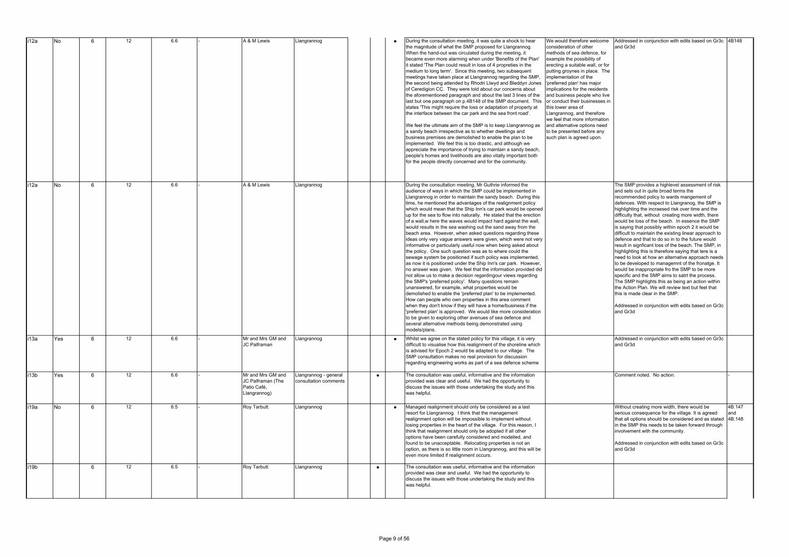
i12a No 6 12 6.6 - A & M Lewis Llangrannog ● During the consultation meeting, it was quite a shock to hear the magnitude of what the SMP proposed for Llangrannog. When the hand-out was circulated during the meeting, it became even more alarming when under 'Benefits of the Plan' it stated 'The Plan could result in loss of 4 propreties in the medium to long term'. Since this meeting, two subsequent meetings have taken place at Llangrannog regarding the SMP, the second being attended by Rhodri Llwyd and Bleddyn Jones of Ceredigion CC. They were told about our concerns about the aforementioned paragraph and about the last 3 lines of the last but one paragraph on p.4B148 of the SMP document. This states 'This might require the loss or adaptation of property at the interface between the car park and the sea front road'.
We feel the ultimate aim of the SMP is to keep Llangrannog as a sandy beach irrespective as to whether dwellings and business premises are demolished to enable the plan to be implemented. We feel this is too drastic, and although we appreciate the importance of trying to maintain a sandy beach, people's homes and livelihoods are also vitally important both for the people directly concerned and for the community.
We would therefore welcome consideration of other methods of sea defence, for example the possibility of erecting a suitable wall, or for putting groynes in place. The implementation of the 'preferred plan' has major implications for the residents and business people who live or conduct their businesses in this lower area of Llangrannog, and therefore we feel that more information and alternative options need to be presented before any such plan is agreed upon.
Addressed in conjunction with edits based on Gr3c and Gr3d
4B148
i12a No 6 12 6.6 - A & M Lewis Llangrannog During the consultation meeting, Mr Guthrie informed the audience of ways in which the SMP could be implemented in Llangrannog in order to maintain the sandy beach. During this time, he mentioned the advantages of the realignment policy which would mean that the Ship Inn's car park would be opened up for the sea to flow into naturally. He stated that the erection of a wall,w here the waves would impact hard against the wall, would results in the sea washing out the sand away from the beach area. However, when asked questions regarding these ideas only very vague answers were given, which were not very informative or particularly useful now when being asked about the policy. One such question was as to where could the sewage system be positioned if such policy was implemented, as now it is positioned under the Ship Inn's car park. However, no answer was given. We feel that the information provided did not allow us to make a decision regardingour views regarding the SMP's 'preferred policy'. Many questions remain unanswered, for example, what properties would be demolished to enable the 'preferred plan' to be implemented. How can people who own properties in this area comment when they don't know if they will have a home/business if the 'preferred plan' is approved. We would like more consideration to be given to exploring other avenues of sea defence and several alternative methods being demonstrated using models/plans.
The SMP provides a highlevel assessment of risk and sets out in quite broad terms the recommended policy to wards mangement of defences. With respect to Llangranog, the SMP is highlighting the incraesed risk over time and the difficulty that, without creating more width, there would be loss of the beach. In essence the SMP is saying that possibly within epoch 2 it would be difficult to maintain the existing linear approach to defence and that to do so in to the future would result in signficant loss of the beach. The SMP, in highlighting this is therefore saying that tere is a need to look at how an alternative approach needs to be developed to managemnt of the fronatge. It would be inappropriate fro the SMP to be more specific and the SMP aims to satrt the process. The SMP highlights this as being an action within the Action Plan. We will review text but feel that this is made clear in the SMP.
Addressed in conjunction with edits based on Gr3c and Gr3d
i13a Yes 6 12 6.6 - Mr and Mrs GM and JC Palframan
Llangrannog ● Whilst we agree on the stated policy for this village, it is very difficult to visualise how this realignment of the shoreline which is advised for Epoch 2 would be adapted to our village. The SMP consultation makes no real provision for discussion regarding engineering works as part of a sea defence scheme
Addressed in conjunction with edits based on Gr3c and Gr3d
i13b Yes 6 12 6.6 - Mr and Mrs GM and JC Palframan (The Patio Café, Llangrannog)
Llangrannog - general consultation comments
● The consultation was useful, informative and the information provided was clear and useful. We had the opportunity to discuss the issues with those undertaking the study and this was helpful.
Comment noted. No action. -
i19a No 6 12 6.5 - Roy Tarbutt Llangrannog ● Managed realignment should only be considered as a last resort for Llangrannog. I think that the management realignment option will be impossible to implement without losing properties in the heart of the village. For this reason, I think that realignment should only be adopted if all other options have been carefully considered and modelled, and found to be unacceptable. Relocating properties is not an option, as there is so little room in Llangrannog, and this will be even more limited if realignment occurs.
Without creating more width, there would be serious consequence for the village. It is agreed that all options should be considered and as stated in the SMP this needs to be taken forward through involvement with the community.
Addressed in conjunction with edits based on Gr3c and Gr3d
4B.147 and 4B.148
i19b 6 12 6.5 - Roy Tarbutt Llangrannog ● The consultation was useful, informative and the information provided was clear and useful. We had the opportunity to discuss the issues with those undertaking the study and this was helpful.
Page 9 of 56

i19c 6 12 6.5 - Roy Tarbutt Llangrannog ● ● The previous SMP(1), undertaken by Posford Duvivier, concluded that, even in the face of rising sea levels , Hold the Line would be the appropriate policy for Llangrannog, since this would be the only way to defence the assets behind the defences (SMP1 August 2000 5.68/69 and 5.70). We now have 2 reports, 10 years apart, coming to very different conclusions.
SMP1 looked forward 50 years and said Hold the Line. This SMP review is consistent with this in that it is not until epoch 2 (between 20 to 50 as of now) that the policy would change to MR. Our understanding of potential sea level rise has improved since SMP1 and SMP2 is looking further forward in time. The role of the SMP is to set out the longer term risks so that actions can be planned in an appropriate way.
i19d 6 12 6.5 - Roy Tarbutt Llangrannog ● The SMP2 does not make clear whether or not managed realignment at the car park end of the beach would mean that no changes would be needed to the present defence of the sea front road.
The SMP highlights the risk and the long term need for change. There will be an action in the Action Plan and this will highlight the needs for detailed planning.
i19e 6 12 6.5 - Roy Tarbutt Llangrannog ● The report does not make clear what is meant by "loss of beach". Will sand be lost down to the low water line, just from the top of the beach, be replaced by pebbles, or what?
For clarification there would be an increasing impact over the whole beach face. This would be most severe at the sea wall.
i19f 6 12 6.5 - Roy Tarbutt Llangrannog ● ● I note that the private sea defences (Patio Café) causes the beach to build in front of it (mainly pebbles, sometimes sand). Would extending this across the car park be an advantage?
The accumulation at this point in the bay is a result of the shape of the bay, rather than the type of defence behind. No action.
i20a No 5 9 5.3 - Clive and Rita Bradshaw (Patch caravan owners)
Patch Caravan Park ● We write to add our voice to the overwhelming number of owners of caravans on Patch, fishermen and other boat owners, members of the Cardigan Boat Club and other nearby residences, that want to Hold the Line (HTL) with the current position of sea defences. Although a very complex issue with so many papers to consider, in simple terms, not to HTL would invalidate and ultimately undermine the rock revement defences installed to prevent erosion of the sand dune adjacent to the B4548 Cardigan to Gwbert on Sea road - Coronoation Drive. This main access road leads from Cardigan Town to the Cardigan Boat Club, Patch Caravan Park, Cliff Hotel & Spar, The Gwbert Hotel (Flat Rock), the coastguard station, adn the residents of Gwbert on Sea and onward.
Cleary the prospect a few years ago prompted the authorities to strengthen the sea defences to prevent a real threat of the road being cut or undermined. To the right of this (looking from the sea) is Patch Caravan Park and the shingle spit. Patch management have, at their own expense, reinforced the gabions places in the '60s, with similar large natural rock revetment and rock groynes to dissipate the wave energy, and additionally co-operated to enable shingle and small stone dredgings to be placed on the seaward side of the shingle spit (Pen yr Ergyd). These three elements combine to protect the lower inner estuary moorings for leisure, fishing boats and commercial craft, and recently installed floating landing jetty. Also a much lower and longer section of the B4548 running directly alongside the inner estuary. See report PDZ 5 4B.P69.
To move away from the current HTL policy would be to risk all this. Tourism would be adversely affected as the sea would ultimately first breach and then undermine the aforementioned defences before cutting through the B4548 road with all the problems associated with that. As tourism is one of the main economic drivers within this area, we consider it a huge backward step for the local community, Patch Caravan management and owners, to allow the HTL strategy to lapse. Over the years there has been a significant investment in our caravans and the tourism industry generally has benefited hugely from Patch and the boat club etc. and for that reason we would urge you to reconfirm the HTL policy for the Teifi Estuary Coast Erosion/SMP2.
As with comment i3a -
i21a No 5 9 5.3 - John Morris (Holiday caravan owner/Patch Caravan Park)
Patch Caravan Park ● It is not realistic to change the Teifi policy from HTL to MR if this outcome will eventually see the loss of part of the frontage of the Patch Caravan Park. There are serious financial implications if in the future holding the line is no longer an option. This will adversely affect tourism in the area, and the local economy. Caravan owners make a tremendous contribution to the local economy.
As with comment i3a -
Gr3a - 6 12 6.6 Llangrannog Welfare Committee
Roy Tarbutt Wording relating to Llangrannog
● The community has expressed concern about some of the wording relating to Llangrannog, and notes that certain viable options seem to have been dismissed. The community wishes to remain fully involved in the process, and would like to see some changes in the final SMP document, to take account of its concerns (see Gr3c and Gr3d below).
Comment noted. Actions see below.
GROUPS
Page 10 of 56
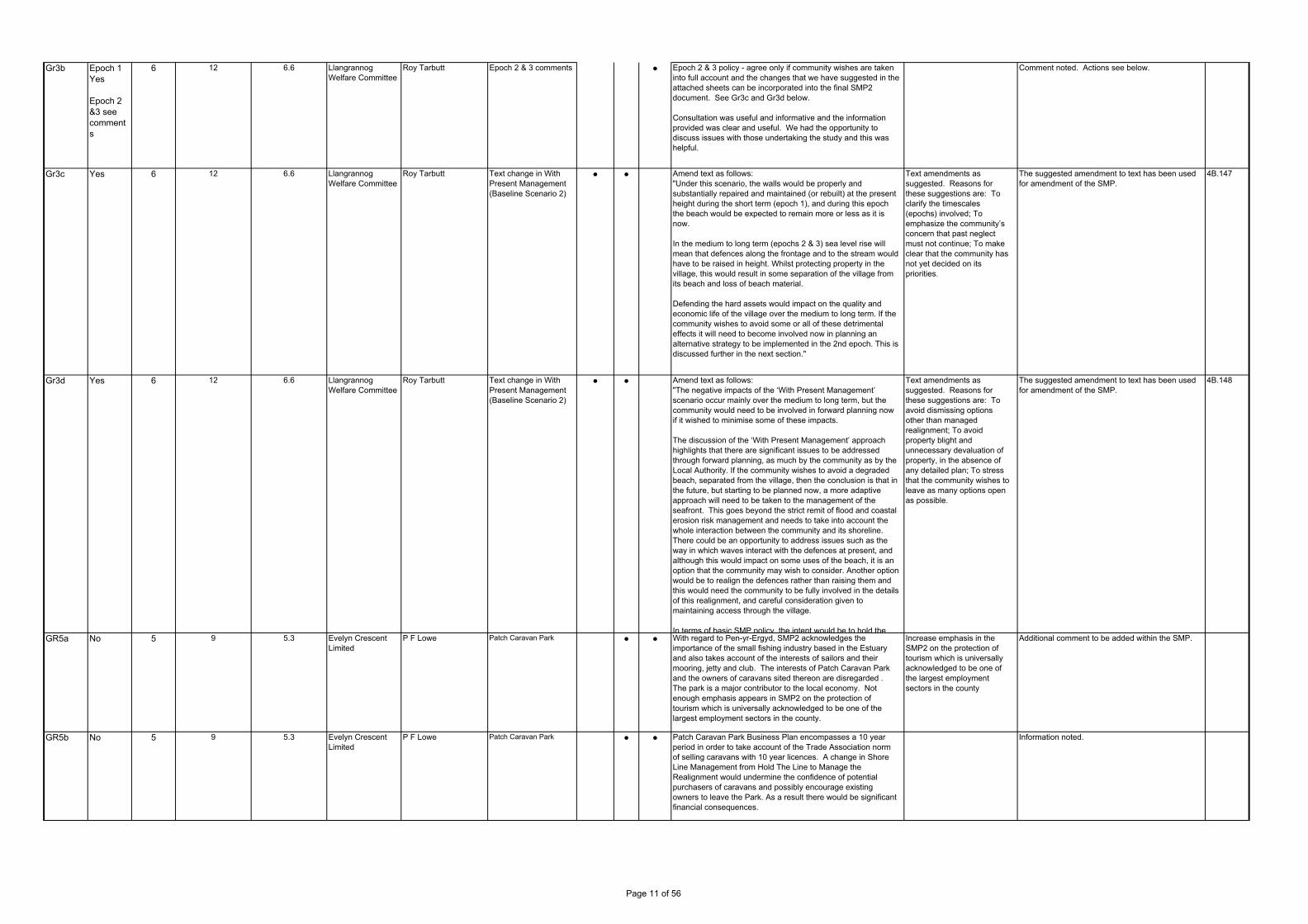
Gr3b Epoch 1 Yes
Epoch 2 &3 see comments
6 12 6.6 Llangrannog Welfare Committee
Roy Tarbutt Epoch 2 & 3 comments ● Epoch 2 & 3 policy - agree only if community wishes are taken into full account and the changes that we have suggested in the attached sheets can be incorporated into the final SMP2 document. See Gr3c and Gr3d below.
Consultation was useful and informative and the information provided was clear and useful. We had the opportunity to discuss issues with those undertaking the study and this was helpful.
Comment noted. Actions see below.
Gr3c Yes 6 12 6.6 Llangrannog Welfare Committee
Roy Tarbutt Text change in With Present Management (Baseline Scenario 2)
● ● Amend text as follows: "Under this scenario, the walls would be properly and substantially repaired and maintained (or rebuilt) at the present height during the short term (epoch 1), and during this epoch the beach would be expected to remain more or less as it is now.
In the medium to long term (epochs 2 & 3) sea level rise will mean that defences along the frontage and to the stream would have to be raised in height. Whilst protecting property in the village, this would result in some separation of the village from its beach and loss of beach material.
Defending the hard assets would impact on the quality and economic life of the village over the medium to long term. If the community wishes to avoid some or all of these detrimental effects it will need to become involved now in planning an alternative strategy to be implemented in the 2nd epoch. This is discussed further in the next section."
Text amendments as suggested. Reasons for these suggestions are: To clarify the timescales (epochs) involved; To emphasize the community’s concern that past neglect must not continue; To make clear that the community has not yet decided on its priorities.
The suggested amendment to text has been used for amendment of the SMP.
4B.147
Gr3d Yes 6 12 6.6 Llangrannog Welfare Committee
Roy Tarbutt Text change in With Present Management (Baseline Scenario 2)
● ● Text amendments as suggested. Reasons for these suggestions are: To avoid dismissing options other than managed realignment; To avoid property blight and unnecessary devaluation of property, in the absence of any detailed plan; To stress that the community wishes to leave as many options open as possible.
The suggested amendment to text has been used for amendment of the SMP.
4B.148
GR5a No 5 9 5.3 Evelyn Crescent Limited
P F Lowe Patch Caravan Park ● ● With regard to Pen-yr-Ergyd, SMP2 acknowledges the importance of the small fishing industry based in the Estuary and also takes account of the interests of sailors and their mooring, jetty and club. The interests of Patch Caravan Park and the owners of caravans sited thereon are disregarded . The park is a major contributor to the local economy. Not enough emphasis appears in SMP2 on the protection of tourism which is universally acknowledged to be one of the largest employment sectors in the county.
Increase emphasis in the SMP2 on the protection of tourism which is universally acknowledged to be one of the largest employment sectors in the county
Additional comment to be added within the SMP.
GR5b No 5 9 5.3 Evelyn Crescent Limited
P F Lowe Patch Caravan Park ● ● Patch Caravan Park Business Plan encompasses a 10 year period in order to take account of the Trade Association norm of selling caravans with 10 year licences. A change in Shore Line Management from Hold The Line to Manage the Realignment would undermine the confidence of potential purchasers of caravans and possibly encourage existing owners to leave the Park. As a result there would be significant financial consequences.
Information noted.
Amend text as follows: "The negative impacts of the ‘With Present Management’ scenario occur mainly over the medium to long term, but the community would need to be involved in forward planning now if it wished to minimise some of these impacts.
The discussion of the ‘With Present Management’ approach highlights that there are significant issues to be addressed through forward planning, as much by the community as by the Local Authority. If the community wishes to avoid a degraded beach, separated from the village, then the conclusion is that in the future, but starting to be planned now, a more adaptive approach will need to be taken to the management of the seafront. This goes beyond the strict remit of flood and coastal erosion risk management and needs to take into account the whole interaction between the community and its shoreline. There could be an opportunity to address issues such as the way in which waves interact with the defences at present, and although this would impact on some uses of the beach, it is an option that the community may wish to consider. Another option would be to realign the defences rather than raising them and this would need the community to be fully involved in the details of this realignment, and careful consideration given to maintaining access through the village.
In terms of basic SMP policy, the intent would be to hold the
Page 11 of 56

GR5c No 5 9 5.3 Evelyn Crescent Limited
P F Lowe Patch Caravan Park ● ● The Plan states that to maintain the integrity of the Patch Caravan Park, the land levels along the most vulnerable frontage would need to be raised to avoid regular flooding under normal tide levels. The road on the seaward side of this frontage is at a height of between 5 and 6mOD, well above today’s maximum predicted tide height of 2.86ODm. Flooding of the road does not occur under normal tidal conditions. It also states that the current policy of Holding The Line would require full encasement along the Patch frontage in future. This statement is made without scientific basis or evidence. Simply maintaining the existing frontage defences would probably prevent any flooding for the next decade at least. DEFRA is quoted in the SMP as suggesting that sea level rise in the area between now and 2025 would be 3.5mm/year, 52.5mm in 15 years or about 2 inches. The existing frontage with regular maintenance should be able to cope with this change. Therefore, there is no reason why the present Hold The Line Policy should not be maintained until 2025 at least. Maintaining the existing defences can be achieved at relatively low cost by replacing any large boulders which may be washed away and topping up from time-to-time the smaller stone which binds the structure. Ideally smaller stone can be sourced from any works carried out in shortening the Spit as proposed by the ATFL.
Further clarification of processes and interaction with defences in this area. Further clarification to be provided in the SMP. Review potential HTL at caravan park over Epoch 1 with CSG. Changes to SMP to be discussed with various interested parties in this area.
Actioned in line with comment i3a
GR5d No 5 9 5.3 Evelyn Crescent Limited
P F Lowe Patch Caravan Park ● ● The Plan states that a Hold The Line policy for Pen-yr-Ergyd is not considered desirable or sustainable whereas the Fishing community and recreational boat use of the area should be sustained. No reasoned argument is made as to why certain interests should be sustained and others ignored. We do not accept that there needs to be any adjustment of Patch Caravan Park frontage in the period to 2025.
We have had a recent meeting with the Countryside Council for Wales who support us in our aim to have the draft policy of Managed Realignment changed back to the SMP (1) policy of Hold The Line to the period up to 2025. We are supported by our existing caravan owners who wish to maintain their cherished holiday homes for the foreseeable future.
Clarification to be provided in the context of response to GR5c above.
A1.2z PDZ4 CCW Dr David Worrall (Regional Director West)
PDZ 4.2: We seek to clarify if the granted outline planning permission for the new marina, as defined in the deposit LDP, has been considered when determining the policies for this area. The latest plans for the marina itself appear to require land claim and regular maintenance dredging.
The policy for PU4.2 includes the potential for ATL in epoch 3. Should the opportunity arise in association with any marina development to bring this forward to allow a more resilient approach to defence within the harbour, then this would be compatible with the Plan. The SMP identifes the need for a collaborative approach to be taken to development within the harbour. This would include the need for assessing the impact on nature conservation.
4B.14
A1.2aa PDZ4 CCW Dr David Worrall (Regional Director West)
PDZ 4. 7: A HTL policy has been determined for this management unit. Consideration of the implications of this policy need to be clarified in relation to the adjacent GCR features.
To be included in Action Plan as an item for information.
4B.15
A1.2ab PDZ4 CCW Dr David Worrall (Regional Director West)
PDZ 4.10:Clarity regarding implications for the proposed HTL policy need to be resolved. CCW would suggest early engagement to avoid adverse impacts.
HTL is retaining existing defence, so requires no change to management practice.
4B.17 4B.38
A1.2ac PDZ4 CCW Dr David Worrall (Regional Director West)
PDZ4.10: Pwll Gwaelod lies at the western end of the Dinas Meltwater Channel. This landform and its associated deposits are the principle feature of the Cwm Dewi SSSI. The potential impact of any plan to implement HTL must be carefully considered in the context of this SSSI including visual impact. As for features of archaeological or heritage interest, measures and funding to recover the maximum amount of information from deposits within the valley floor should be in place before the area is threatened by sea level rise. The developed frontage of the dune system is adjacent to a Quaternary sequence and landform which constitute the geological feature of an SSSI. The potential impact of any plan to implement HTL must be carefully considered and visual impact should be minimised.
Implementation will be maintaining existing defence. The area is not significantly threatened by sea level rise. No change required.
4B.38
AUTHORITIES
Page 12 of 56
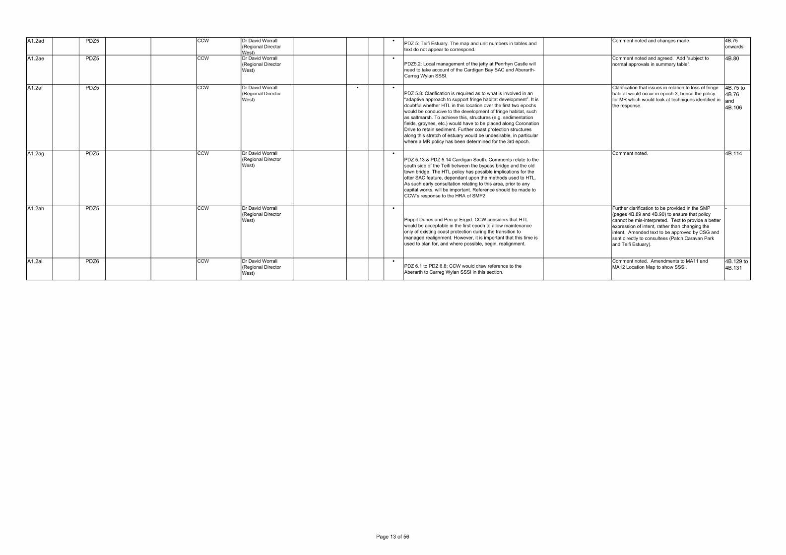
A1.2ad PDZ5 CCW Dr David Worrall (Regional Director West)
PDZ 5: Teifi Estuary. The map and unit numbers in tables and text do not appear to correspond.
Comment noted and changes made. 4B.75 onwards
A1.2ae PDZ5 CCW Dr David Worrall (Regional Director West)
PDZ5.2: Local management of the jetty at Penrhyn Castle will need to take account of the Cardigan Bay SAC and Aberarth-Carreg Wylan SSSI.
Comment noted and agreed. Add "subject to normal approvals in summary table".
4B.80
A1.2af PDZ5 CCW Dr David Worrall (Regional Director West)
PDZ 5.8: Clarification is required as to what is involved in an “adaptive approach to support fringe habitat development”. It is doubtful whether HTL in this location over the first two epochs would be conducive to the development of fringe habitat, such as saltmarsh. To achieve this, structures (e.g. sedimentation fields, groynes, etc.) would have to be placed along Coronation Drive to retain sediment. Further coast protection structures along this stretch of estuary would be undesirable, in particular where a MR policy has been determined for the 3rd epoch.
Clarification that issues in relation to loss of fringe habitat would occur in epoch 3, hence the policy for MR which would look at techniques identified in the response.
4B.75 to 4B.76 and 4B.106
A1.2ag PDZ5 CCW Dr David Worrall (Regional Director West)
PDZ 5.13 & PDZ 5.14 Cardigan South. Comments relate to the south side of the Teifi between the bypass bridge and the old town bridge. The HTL policy has possible implications for the otter SAC feature, dependant upon the methods used to HTL. As such early consultation relating to this area, prior to any capital works, will be important. Reference should be made to CCW’s response to the HRA of SMP2.
Comment noted. 4B.114
A1.2ah PDZ5 CCW Dr David Worrall (Regional Director West)
Poppit Dunes and Pen yr Ergyd. CCW considers that HTL would be acceptable in the first epoch to allow maintenance only of existing coast protection during the transition to managed realignment. However, it is important that this time is used to plan for, and where possible, begin, realignment.
Further clarification to be provided in the SMP (pages 4B.89 and 4B.90) to ensure that policy cannot be mis-interpreted. Text to provide a better expression of intent, rather than changing the intent. Amended text to be approved by CSG and sent directly to consultees (Patch Caravan Park and Teifi Estuary).
-
A1.2ai PDZ6 CCW Dr David Worrall (Regional Director West)
PDZ 6.1 to PDZ 6.8; CCW would draw reference to the Aberarth to Carreg Wylan SSSI in this section.
Comment noted. Amendments to MA11 and MA12 Location Map to show SSSI.
4B.129 to 4B.131
Page 13 of 56

i1a No 7 13 7.3 - Beryl Brookes Coastal erosion causing problems to the community of New Quay
● ● In the very near future the coastal erosion will affect my property known as Gorwel Bell. Gorwel Bell is a piece of land with a static caravan sited upon it, a caravan has been on the site since 1972. The land is situated across the road from Ffynonn Feddyg and was originally a garden to that property. Further down the road is a sewerage works serving New Quay residents; a large sewerage pipe runs through my land to the sewerage works. In recent reports I and the residents within the local area have been informed that the coastal erosion will seriously affect our properties to the point that they may be lost to the sea. The affect to the local community will be devastating personally, financially and historically.
The simple and cost effective way of stopping further problems is to invest in sea defence and coastal protection along the immediate coastal area, this was carried out in recent years at Cei Bach which is now protected. The problem of coastal erosion will not disappear but with the financial, historical, ecological and personal reasons dictate that action needs to be taken
now.
Comments noted. Additional information will be added to SMP where appropriate. There is no change in policy since SMP1. Issues will be discussed with CSG.
i1b No 7 13 7.3 - Beryl Brookes Coastal erosion causing problems to the community of New Quay
● ● Financially New Quay as a village relies on tourism to survive, which is mainly provided by people staying in holiday accommodation such as Quay West Caravan Park, properties offering Bed and Breakfast such as FFynonn Feddyg and Llanina Mansions. Without these New Quay has no tourism industry and will not survive as a community. There are very large financial implications when the Sewerage pipe and works have to be re sited let alone the ecological implications. The financial effect of erosion on the immediate properties in question is immense; the long term effect is devastating.
As above As with i1a above.
i1c No 7 13 7.3 - Beryl Brookes Coastal erosion causing problems to the community of New Quay
● ● Historically the local area is rich with information dating from 7th century AD. The Church of St Ina, Llanina, Llanllwchaiarn near New Quay. This lovely little church is dedicated to St Ina, a King of Wessex who reigned from 688 to 726 AD. He built the first church here. That church was lost to coastal erosion and this is at least the third, possibly the seventh on or near the site. Dylan Thomas moved to New Quay in September 1944, eager to escape from both the war and from London. After staying for a while in Bosham in Sussex and then at Beaconsfield with his friend Donald Taylor, he moved to the little bungalow called 'Majoda' just along the coast road. Thomas' nearest neighbours at the time were William and Vera Killick who lived at a house called 'Ffynnon Feddyg' a hundred yards from 'Majoda'. Vera was formerly Vera Williams, a close neighbour of Thomas when he was at school in Swansea and with whom Dylan and Caitlin had previously stayed at Talsarn. Charles, Prince of Wales landed by helicopter on the field adjacent to Majoda on his way to be inaugurated as Prince of Wales.
As above As with i1a above.
i1d No 7 13 7.3 - Beryl Brookes Coastal erosion causing problems to the community of New Quay
● ● Ecologically the resident bottlenose dolphins use New Quay Bay, within the Cardigan Bay candidate Special Area of Conservation, any re siting of the sewerage pipe which currently runs from the sewerage works out to sea would have major effect on the habitat.
As above To be included in Action Plan as an item for information.
Page No. Clarify Info. Policy CommentCorrespondence Issues Raised Action Suggest Comment/ Action in finalising SMP
Response
Res.RefAccept SMP
PDZManagement
AreaOrganisationPolicy Unit
INDIVIDUALS
Page 14 of 56

i2 No 7 13 7.3 - Joe and Louise Bugeja (Ffynnon Feddyg B&B)
Coastal erosion causing problems to the Ffynnon Feddyg property
● ● We have owned this property for 16 years and its value has increased throughout that time. In a report written for the counci in 2007 by High Point Rendel the value of our house was estimated at £320,000, and for the purposes of all the calculations, this valuation was used - we don‘t think the substantial extension to the property made in 1996 were taken into consideration. We do not actually agree with that estimate and if we’d known at the time that these reports were being written, we would have challenged the figures being used. We were offered £600,000 in 2004 to sell the property, and a local estate agent advised us not to sell for any less. We have just had the property valued again, and without the current problems, it is now valued at £800,000. This does not take into account the fact that the view is priceless and would be impossible to put a value on. We understand that the value of the properties to be defended has to exceed the cost of the work, but we feel that, as incorrect figures were used, this wasn’t an accurate calculation.
We have been advised by our engineers that unless something is done to halt the slippage at the foot of the cliffs, there is no point in undertaking any other work to support the house. This leaves us in an extremely difficult position and we would urge the council to re-consider its position with regard to this section of the coast. We would never wish to leave this slice of heaven on earth unless there were no alternative. The house is unique in both its location and its history, and it very much deserves to remain here for the next two hundred years. It is very much loved and its potential loss is unbearable.
As with i1a above.
i9 7 13 7.3 - E Wilson Coastal slope in New Quay Bay, extending from New Quay to Llanina Point.
● ● Coastal erosion is occurring slowly, but this could be controlled relatively easily by the application of rock armour along the toe of the coastal slope. I appreciate that this is an extensive option, but the economic impact on New Quay of the loss of the Quay West Holiday Park would be catastrophic. Potential loss of the main sewerage pipe line and/or the New Road is also a vital consideration in the cost benefit analysis. Any equally very important issue is the possibility of broke, blocked or inadequate land drainage undercutting, or otherwise compromising the integrity of the coastal slope. This may also have been exacerbated by the reinstatement of thepond in the recently completed woodland walk area. One location where this is very evident is adjacent to the Brongwyn cottage, where the coastal path has slumped. On investigation this appears to be due to uncontrolled discharges from Quay West undercutting the path. There are also other areas where this is occurring. These isues could resolved by installing catch pits and piping the discharges down the slope in a controlled manner.
Obviously, living in Brongwyn Lane, I have to declare an interest, but I do believe that if action was taken now, the coastal slope could be satisfactorily stabilised at possibly a significant, but manageable cost. Delaying action will surely result in significantly more coast to be expended in future.
As with i1a above.
i11 No 7 13 7.3 - Adrian Ratcliffe Coastline between New Quay and Cei Bach
● ● I find it very amazing and highly regrettable that the SMP appears to allow for considerable work to be undertaken in most of New Quay and Cei Bach but there would seem to be no provision for any work between the two locations. I refer specifically to Brongwyn Lane and also Traethgwn area. Some years ago there was much pile driving and work around New Quay in order to stop slippage, but this work stopped at the junction of the New Road and Brongwyn Lane. I do not understand the reluctance of the authorities to do any work in this area. If work is not done in this area it would surely mean problems for the New Road; the only access to New Quay from the north.
As with i1a above.
i15a - 7 13 7.3 - Elin Jones AC / AM Cei Bach ●
I recently met with residents in the Cei Bach area. During the visit I was shown how the land close to the coast is showing signs of slippage, as well as photographic evidence of this land movement happening over time. It's evident that this slippage has grave implications for nearby houses and businesses, and that it is occurring at a relatively fast pace.
Comment noted. No action.
i15b - 7 13 7.3 - Elin Jones AC / AM Cei Bach ●Having studied the draft WoW SMP for the area in question, I am surprised at the indication that no local properties are deemed to be 'at risk' during the next 20 yr period. This is certainly not true given that a few houses in Cei Bach are already under threat.
Clarification to be provided in SMP.
Page 15 of 56

i15c - 7 13 7.3 - Elin Jones AC / AM Cei Bach ● I believe that this particular area of shoreline makes an important economic contribution to Ceredigion - the local beach and 2 of the houses under threat are of particular importance due to their connection with Dylan Thomas. I also understand that the main sewer runs behind the houses in question in the road, and it's clear that any local land movement due to coastal erosion will also have an effect on this pipe.
In light of comments i15a, i15b and i15c, I believe that it's necessary to have a clear decision which would involve clear guidance to house owners on what options are available to them should the ultimate decision be to keep to the current draft guidance that no action will be taken to protect their homes.
Comment noted. This will be provided within the Action Plan.
i16a - 7 13 7.3 - Mark Williams AS / MP New Quay - specific properties including Ffynnon Feddyg, Traethina at Traeth Gwyn and the area in front of Quay West Holiday Park
● Following two meetings in recent months at Ffynnon Feddyg, I was alarmed to see how coastal erosion is advancing and threatening several properties. In the summary document, under the section Flood and Erosion Risk Management, there is an acknowledgement of the loss of property in Rock Street and the Main Bay area. There would also be some loss of land occupied by the Holiday Park. Could you clarify what work has been undertaken on adjacent properties to the caravan park, and specifically what has been the assessment of the economic loss of New Quay, and to Ceredigion generally, of a potential reduced tourist sector, should defensive work not follow.
No specific action within SMP. Further detail has been added.
i16b - 7 13 7.3 - Mark Williams AS / MP New Quay - specific properties including Ffynnon Feddyg, Traethina at Traeth Gwyn and the area in front of Quay West Holiday Park
● I gather some significant investment has in recent years been undertaken south of Llanina Point by Dwy Cymru. What assessment has been made on the cost of realigning pipe work? Have these items been factored into your calculations?
Yes, in the context of sustainable management of the frontage. Further detail has been added.
i16c - 7 13 7.3 - Mark Williams AS / MP New Quay - specific properties including Ffynnon Feddyg, Traethina at Traeth Gwyn and the area in front of Quay West Holiday Park
● Your report acknowledges the critical route of George Street, the B4342 into New Quay, a route which has undergone significant capital investment over the last couple of years. Its economic significance cannot be understated, and therefore the need for greater management is self-evident.
Noted within SMP.
i16d - 7 13 7.3 - Mark Williams AS / MP New Quay - specific properties including Ffynnon Feddyg, Traethina at Traeth Gwyn and the area in front of Quay West Holiday Park
● The report also refers to landslumping within Cei Bach which has already affected properties in the area. Extensive work would not be economically justified. I question the loss of those properties and their wider contribution to the New Quay economy, as well as the personal loss to residents. Cei Bach defences and groynes have provided some protection over recent years, but seemingly this is not deemed sustainable into he longer term. I question what maintenance work has been undertaken on these defences in recent years.
Comments noted, and will be passed on to the Operating Authority. Further detail has been added.
i16e - 7 13 7.3 - Mark Williams AS / MP New Quay - specific properties including Ffynnon Feddyg, Traethina at Traeth Gwyn and the area in front of Quay West Holiday Park
● In a rapidly deteriorating situation, my constituents seek some assurance as to what constitutes "Holding the Line", vis-à-vis individual properties, and what the process of Managed Realignment actually amounts to.
No specific action within SMP. Response will be provided. Further detail has been added.
i16f - 7 13 7.3 - Mark Williams AS / MP New Quay - specific properties including Ffynnon Feddyg, Traethina at Traeth Gwyn and the area in front of Quay West Holiday Park
● New Quay remains one of the premier holiday locations on the West Wales Coastline. Tourism is New Quay, New Quay is tourism, and in so being contributes hugely to the Ceredigion Economy. One acknowledges a huge challenge environmentally and financially when rising sea level continue to hammer our coastline. I fully understand and appreciate the need to prioritise areas and properties along the coastline, but such is the significance of New Quay that I believe a fully holistic approach needs to be undertaken from New Quay Point and the Harbour Wall to the Cei Bach.
The significance of New Quay at a local and regional scale has been highlighted within the SMP documents. The SMP does take a broad based view of management of the shoreline. It is recognised that there are issues in relation to planning and land use that go beyond the remit of the SMP. However, the SMP provides an important structure for informing these other functions.
i17 - 7 13 7.3 - D.N. & P.A. Bettles Traethgwyn Bay, New Quay
● ●We are getting very concerned over the erosion on the Traethgwyn Bay at New Quay. The continuous building up of Brongwyn Lane and the receding of the cliff face below our property also the accelerated deterioration in front of the Quay West Holiday Park and round to the listed properties and land to Llanina Point. We have watched the erosion for over 50 years and have expressed concerns previously. If something had been done on one or more of the various investigations we would not be in the urgent situation of today and would have saved the cost of the many consultants employed over the years and some property would have been saved.
As with i1a above.
Page 16 of 56
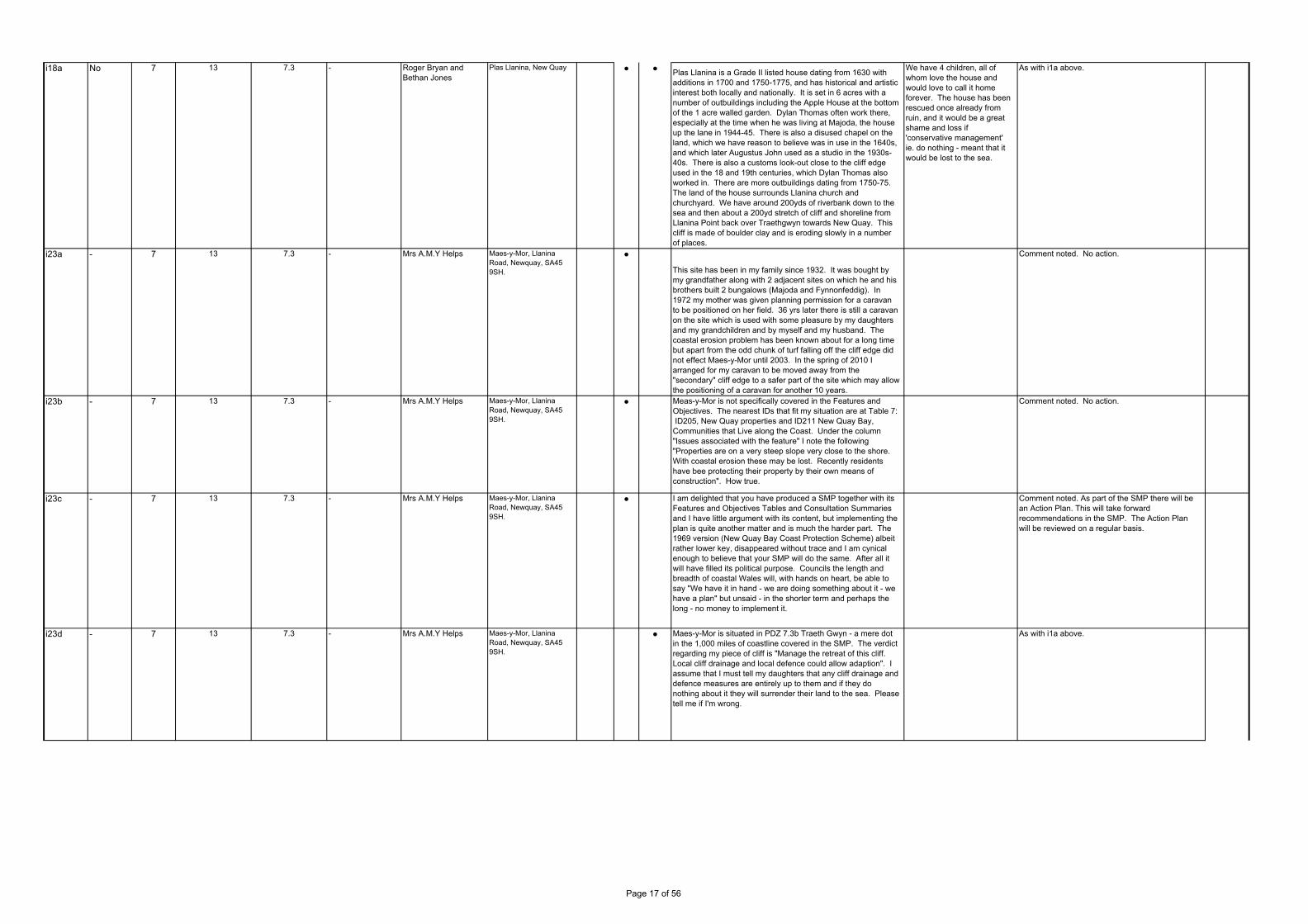
i18a No 7 13 7.3 - Roger Bryan and Bethan Jones
Plas Llanina, New Quay ● ● Plas Llanina is a Grade II listed house dating from 1630 with additions in 1700 and 1750-1775, and has historical and artistic interest both locally and nationally. It is set in 6 acres with a number of outbuildings including the Apple House at the bottom of the 1 acre walled garden. Dylan Thomas often work there, especially at the time when he was living at Majoda, the house up the lane in 1944-45. There is also a disused chapel on the land, which we have reason to believe was in use in the 1640s, and which later Augustus John used as a studio in the 1930s-40s. There is also a customs look-out close to the cliff edge used in the 18 and 19th centuries, which Dylan Thomas also worked in. There are more outbuildings dating from 1750-75. The land of the house surrounds Llanina church and churchyard. We have around 200yds of riverbank down to the sea and then about a 200yd stretch of cliff and shoreline from Llanina Point back over Traethgwyn towards New Quay. This cliff is made of boulder clay and is eroding slowly in a number of places.
We have 4 children, all of whom love the house and would love to call it home forever. The house has been rescued once already from ruin, and it would be a great shame and loss if 'conservative management' ie. do nothing - meant that it would be lost to the sea.
As with i1a above.
i23a - 7 13 7.3 - Mrs A.M.Y Helps Maes-y-Mor, Llanina Road, Newquay, SA45 9SH.
●
This site has been in my family since 1932. It was bought by my grandfather along with 2 adjacent sites on which he and his brothers built 2 bungalows (Majoda and Fynnonfeddig). In 1972 my mother was given planning permission for a caravan to be positioned on her field. 36 yrs later there is still a caravan on the site which is used with some pleasure by my daughters and my grandchildren and by myself and my husband. The coastal erosion problem has been known about for a long time but apart from the odd chunk of turf falling off the cliff edge did not effect Maes-y-Mor until 2003. In the spring of 2010 I arranged for my caravan to be moved away from the "secondary" cliff edge to a safer part of the site which may allow the positioning of a caravan for another 10 years.
Comment noted. No action.
i23b - 7 13 7.3 - Mrs A.M.Y Helps Maes-y-Mor, Llanina Road, Newquay, SA45 9SH.
● Meas-y-Mor is not specifically covered in the Features and Objectives. The nearest IDs that fit my situation are at Table 7: ID205, New Quay properties and ID211 New Quay Bay, Communities that Live along the Coast. Under the column "Issues associated with the feature" I note the following "Properties are on a very steep slope very close to the shore. With coastal erosion these may be lost. Recently residents have bee protecting their property by their own means of construction". How true.
Comment noted. No action.
i23c - 7 13 7.3 - Mrs A.M.Y Helps Maes-y-Mor, Llanina Road, Newquay, SA45 9SH.
● I am delighted that you have produced a SMP together with its Features and Objectives Tables and Consultation Summaries and I have little argument with its content, but implementing the plan is quite another matter and is much the harder part. The 1969 version (New Quay Bay Coast Protection Scheme) albeit rather lower key, disappeared without trace and I am cynical enough to believe that your SMP will do the same. After all it will have filled its political purpose. Councils the length and breadth of coastal Wales will, with hands on heart, be able to say "We have it in hand - we are doing something about it - we have a plan" but unsaid - in the shorter term and perhaps the long - no money to implement it.
Comment noted. As part of the SMP there will be an Action Plan. This will take forward recommendations in the SMP. The Action Plan will be reviewed on a regular basis.
i23d - 7 13 7.3 - Mrs A.M.Y Helps Maes-y-Mor, Llanina Road, Newquay, SA45 9SH.
● Maes-y-Mor is situated in PDZ 7.3b Traeth Gwyn - a mere dot in the 1,000 miles of coastline covered in the SMP. The verdict regarding my piece of cliff is "Manage the retreat of this cliff. Local cliff drainage and local defence could allow adaption". I assume that I must tell my daughters that any cliff drainage and defence measures are entirely up to them and if they do nothing about it they will surrender their land to the sea. Please tell me if I'm wrong.
As with i1a above.
Page 17 of 56

i24a - 7 13 7.3 - Geoff Purkis Eureka, Llanina Road, New Quayt, SA45 9SG
● I am writing to request that consideration be given to arresting the erosion at the above site and its neighbours. I would suggest that the following factors would justify the investment: The main sewer from the town crosses our field. Repairs and/or a diversion would be expensive; Llanina Road is an important route for access to Cei Bach and other local venues and facilities; The use of the site by ourselves and the friends and family who use the site brings in a good contribution to the local economy; and Our management and maintenance of the site contributes to the appeal of New Quay as a tourist attraction. I have been taking holidays most years at this location since 1948, and would be sad to see this lovely amenity slip into the sea. 'Eureka' is jointly owned by myself and my two brothers.
As with i1a above.
GR6a 7 13 7.3 The People of Newquay
- Impact on residents and businesses
● ●New Quay is described as a “nationally important tourist destination” which is the main industry in this area, providing the vast majority of the jobs available. It is of utmost importance that these jobs are protected by the maintenance of the area and its amenities - without tourism New Quay would die.
Commented noted. No action.
GR6b 7 13 7.3 The People of Newquay
- Impact on residents and businesses
● ● The report talks about the impact of predicted sea level rise and of all the sites which would be under threat, painting a very bleak picture for the future. Of particular concern are: Transport links, in particular the main road to New Quay and the access road to the fish factory from Rock Street, the fish factory being the only large employer in the area; The potential breach of the pier by a rise in sea levels; The potential loss of the harbour, then the beach; The potential loss of the Penpollian Jetty; The potential loss of the lifeboat station; Damage to properties in Glanmor Terrace; Severe damage to the centre of New Quay; Uncertainty about the future of properties on Rock Street; Loss of properties behind the lifeboat station; Accelerated damage to the holiday park and properties along the whole frontage of the bay, some of which are already suffering the effects of coastal erosion. This does not seem to leave very much with which to fashion a tourism industry - if there is no safe beach, no harbour, no jetty and no pier, that would take away all the reasons for which visitors come to New Quay - the area’s popularity rests on the blue flag beach, the opportunities to dolphin watch, the watersports available, the fact that New Quay is designated an SSSI and a Marine SAC. It is also a place famed by walkers for its coastal paths - how safe will these be?
The comments relate to description of a policy of NAI.
The SMP policy for the main area of New Quay is HTL. In other areas, in response to other consultee comments, as with i1a above.
GR6c 7 13 7.3 The People of Newquay
- Impact on residents and businesses
● ● As for the people who live here, New Quay is described as an “important residential centre and an important community in its own right”. There would be no community if many houses were under threat and the very centre of the town was considered unsafe. With no tourists providing the lifeblood to the area, there would be no jobs and no reason for anyone else to be here.
The comments relate to description of a policy of NAI.
The SMP policy for the main area of New Quay is HTL. In other areas, in response to other consultee comments, as with i1a above.
GR6d 7 13 7.3 The People of Newquay
- Impact on residents and businesses
● ● Worryingly, the concerns about the pier are beyond the remit of the report - who will take this matter forward? The report states “Even so, to maintain the Pier might not be economically justified purely in terms of FCERM funding. The intent is to continue to maintain this structure, but to do so there needs to be further examination of the broader benefits this structure brings to the town and there needs to be development of a New Quay Harbour Futures Plan, looking at the opportunity for collaborative funding”. What is the time frame for this and who will take it forward?
Comment noted. To be addressed in Action Plan.
GR6e 7 13 7.3 The People of Newquay
- Impact on residents and businesses
● ● There “would be no intent to provide additional defence to properties along the Rock Street frontage and any proposed private work would be subject to normal approvals, recognising that this could impact on the nature conservation values and may as a consequence not be allowed”. What will become of the people who live on Rock Street?
Comment noted. To be addressed in Action Plan.
GR6f 7 13 7.3 The People of Newquay
- Impact on residents and businesses
● ● The report states that “some 56 properties are potentially at risk, The plan would secure the future for some 26 of these properties”. What about the other 30? What will happen to householders who will end up with a property they cannot sell? How will they afford to buy another property?
To be reviewed and clarified in text.
Comment noted. To be addressed in Action Plan.
GROUPS
Page 18 of 56
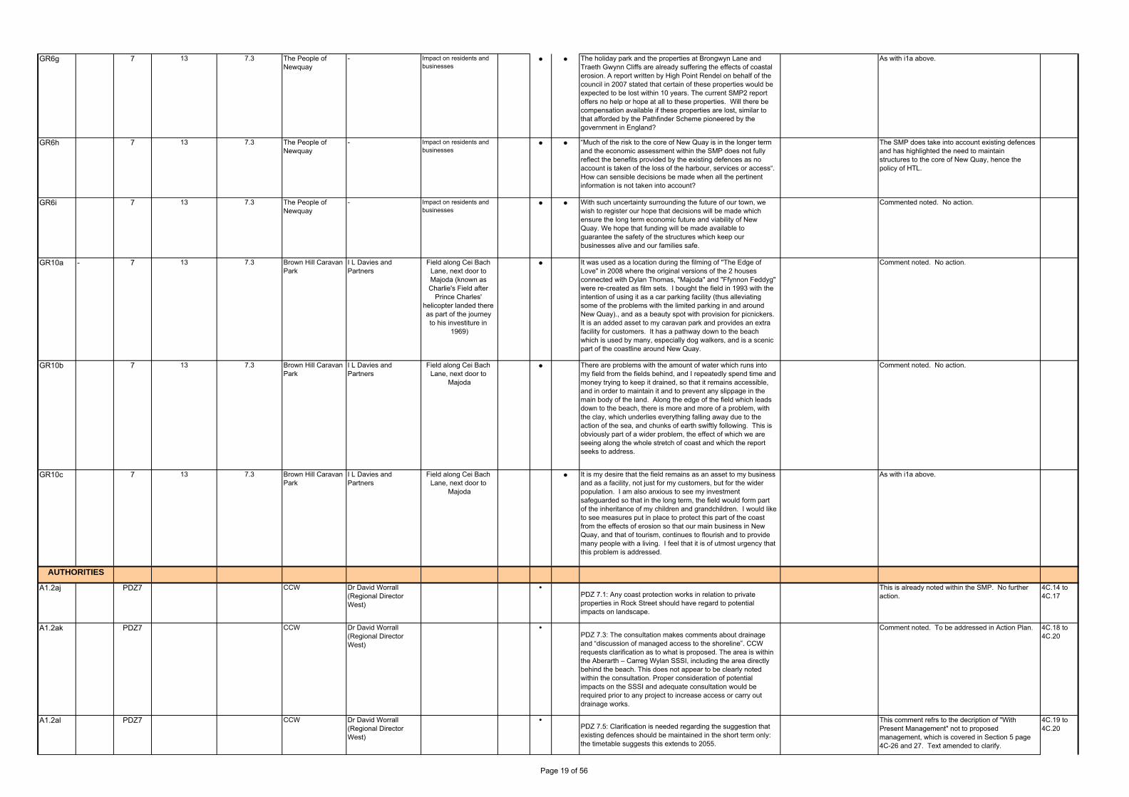
GR6g 7 13 7.3 The People of Newquay
- Impact on residents and businesses
● ● The holiday park and the properties at Brongwyn Lane and Traeth Gwynn Cliffs are already suffering the effects of coastal erosion. A report written by High Point Rendel on behalf of the council in 2007 stated that certain of these properties would be expected to be lost within 10 years. The current SMP2 report offers no help or hope at all to these properties. Will there be compensation available if these properties are lost, similar to that afforded by the Pathfinder Scheme pioneered by the government in England?
As with i1a above.
GR6h 7 13 7.3 The People of Newquay
- Impact on residents and businesses
● ● “Much of the risk to the core of New Quay is in the longer term and the economic assessment within the SMP does not fully reflect the benefits provided by the existing defences as no account is taken of the loss of the harbour, services or access“. How can sensible decisions be made when all the pertinent information is not taken into account?
The SMP does take into account existing defences and has highlighted the need to maintain structures to the core of New Quay, hence the policy of HTL.
GR6i 7 13 7.3 The People of Newquay
- Impact on residents and businesses
● ● With such uncertainty surrounding the future of our town, we wish to register our hope that decisions will be made which ensure the long term economic future and viability of New Quay. We hope that funding will be made available to guarantee the safety of the structures which keep our businesses alive and our families safe.
Commented noted. No action.
GR10a - 7 13 7.3 Brown Hill Caravan Park
I L Davies and Partners
Field along Cei Bach Lane, next door to Majoda (known as Charlie's Field after
Prince Charles' helicopter landed there as part of the journey to his investiture in
1969)
● It was used as a location during the filming of "The Edge of Love" in 2008 where the original versions of the 2 houses connected with Dylan Thomas, "Majoda" and "Ffynnon Feddyg" were re-created as film sets. I bought the field in 1993 with the intention of using it as a car parking facility (thus alleviating some of the problems with the limited parking in and around New Quay)., and as a beauty spot with provision for picnickers. It is an added asset to my caravan park and provides an extra facility for customers. It has a pathway down to the beach which is used by many, especially dog walkers, and is a scenic part of the coastline around New Quay.
Comment noted. No action.
GR10b 7 13 7.3 Brown Hill Caravan Park
I L Davies and Partners
Field along Cei Bach Lane, next door to
Majoda
● There are problems with the amount of water which runs into my field from the fields behind, and I repeatedly spend time and money trying to keep it drained, so that it remains accessible, and in order to maintain it and to prevent any slippage in the main body of the land. Along the edge of the field which leads down to the beach, there is more and more of a problem, with the clay, which underlies everything falling away due to the action of the sea, and chunks of earth swiftly following. This is obviously part of a wider problem, the effect of which we are seeing along the whole stretch of coast and which the report seeks to address.
Comment noted. No action.
GR10c 7 13 7.3 Brown Hill Caravan Park
I L Davies and Partners
Field along Cei Bach Lane, next door to
Majoda
● It is my desire that the field remains as an asset to my business and as a facility, not just for my customers, but for the wider population. I am also anxious to see my investment safeguarded so that in the long term, the field would form part of the inheritance of my children and grandchildren. I would like to see measures put in place to protect this part of the coast from the effects of erosion so that our main business in New Quay, and that of tourism, continues to flourish and to provide many people with a living. I feel that it is of utmost urgency that this problem is addressed.
As with i1a above.
A1.2aj PDZ7 CCW Dr David Worrall (Regional Director West)
PDZ 7.1: Any coast protection works in relation to private properties in Rock Street should have regard to potential impacts on landscape.
This is already noted within the SMP. No further action.
4C.14 to 4C.17
A1.2ak PDZ7 CCW Dr David Worrall (Regional Director West)
PDZ 7.3: The consultation makes comments about drainage and “discussion of managed access to the shoreline”. CCW requests clarification as to what is proposed. The area is within the Aberarth – Carreg Wylan SSSI, including the area directly behind the beach. This does not appear to be clearly noted within the consultation. Proper consideration of potential impacts on the SSSI and adequate consultation would be required prior to any project to increase access or carry out drainage works.
Comment noted. To be addressed in Action Plan. 4C.18 to 4C.20
A1.2al PDZ7 CCW Dr David Worrall (Regional Director West)
PDZ 7.5: Clarification is needed regarding the suggestion that existing defences should be maintained in the short term only: the timetable suggests this extends to 2055.
This comment refrs to the decription of "With Present Management" not to proposed management, which is covered in Section 5 page 4C-26 and 27. Text amended to clarify.
4C.19 to 4C.20
AUTHORITIES
Page 19 of 56

A1.2am PDZ8 CCW Dr David Worrall (Regional Director West)
PDZ 8.2 /8.3/8.4: It is unclear how interlinked and integrated management would be achieved over the management units. The proposed MR for the South and HTL for the Harbour and North sections would result, over time, in the Harbour acting as a stub-groyne affecting sediment transport in the region.
Further clarification to be provided in text. 4C.49 to 4C.55
A1.2an PDZ8 CCW Dr David Worrall (Regional Director West)
PDZ 8.9: Consideration should be given to the wording of “time limited private defence”. It should be clear to landowners what they can realistically expect; this will reduce the risk of future legal issues.
Further clarification to be provided in text. 4C.51 to 4C.52
A1.2ao PDZ9 CCW Dr David Worrall (Regional Director West)
PDZ 9.2: It is advised that local land owners are fully informed of the policies within this consultation. The SSSI has biological interest as well as geological interest. Further private defences should be discouraged (as at Clarach) because of their possible impact on the SSSI habitats. One of the SMP actions is to undertake a study/strategy of managed realignment at Tanybwlch. The report by Professor J. Pethick, 2003 ‘Allt Wen a Traeth Tanybwlch SSSI and Aberystwyth Frontage Nature Conservation Strategy’ is relevant here. Managed realignment should include options for the coastal path as well as opportunities for habitat creation.
Comment noted. To be addressed in Action Plan. 4C.99
A1.2ap PDZ9 CCW Dr David Worrall (Regional Director West)
PDZ 9.11: CCW should be added as a partner to adaptation planning at Clarach. In terms of the plan it is advised that the local land owners are fully informed of the policies within this consultation.
Comment noted. To be addressed in Action Plan. 4C.113
A1.2aq PDZ9 CCW Dr David Worrall (Regional Director West)
Aberystwyth area PDZ9.1-9.9 We welcome the recognition of the need for a planned response throughout this area to increased flood risk and the need for this to be addressed in strategic spatial planning and transport policy. CCW suggests that further consideration is required of the interrelationships between the policy units. The majority of Aberystwyth would be held over all three epochs; however there are two units where MR would be applied and one where advance would be considered. The consequences for these policy units and any effects on adjacent units require further consideration in the light of Pethick (2003). In particular, advance in PDZ9.9 is contrary to the advice of Pethick. To reflect the need for a long term plan, Managed Realignment may be a more appropriate option for epoch 3 for PDZ 9.6, 9.7, 9.8 and 9.9. With regard to PDZ 9.7 and 9.9 it should noted that beach recharge should not be considered a remedy for flooding, as it does not affect extreme water levels.
Comment noted. The SMP does consider a coherent plan for the whole frontage developed as a series of policies specific to Policy Units. There is little scope for MR - this will be discussed with the CSG, hence the opportunity identified for ATL. Under certain circumstances, beaches will provide flood defence. CSG confirmed no change to policy. Further text has been added to clarify.
4C.111-4C.114
Page 20 of 56

i7a Yes 10 20 10.13 - Janjoost van Hulsteijn Aberdovey ● ● We're amazed at the easy access to the dunes from the beach outside the public footpaths. Don't you think more protection of the vulnerable dunes is necessary? More protection of the overgrowth and less human activity by fencing some parts of the dunes along the beaches as we do in Holland? Because that is the only protection from the sea.
Access is considered an important aspect of the frontage and the recommendation of the SMP is that this needs to be managed. To be included in Action Plan.
-
i22a Yes 10 19 10.7 Tamsin Davies Specific to the Ysgubor y Coed area (The communities of Ffwrnais, Eglwysfach and Glandyfi)
● The Community Council agrees that maintaining the railway and the A487 road in the location is necessary, although not necessarily in the same place in which they are currently located.
Comment noted. No action
i22b Yes 10 19 10.7 Tamsin Davies Specific to the Ysgubor y Coed area (The communities of Ffwrnais, Eglwysfach and Glandyfi)
● The information that was given in the consultation was useful but it was not clear to me – much of the terminology was difficult. It is easier for the lay person if things are written out in full rather than using acronyms.
It is recognised that use of Acronyms are a persistent problem in technical documents of this nature. The Glossary has been reviewed to ensure that all acronyms are included. Furthermore, without making the text even more difficult to read due to full terms being used, where sensible the full words have been added.
Gr2a 10 20 10.14 and 10.15 First City on behalf of Aberdovey Golf Club
Christopher Bywater Aberdovey Golf Club and the Penllyn areas
● The plan for the area is one of managed realignment which seems to represent some progress over the previous policy within SMP1 which is one of retreat.
- Comment noted. No action. -
Gr2b 10 20 10.14 First City on behalf of Aberdovey Golf Club
Christopher Bywater Aberdovey Golf Club ● The Plan identifies significant risk to the Golf Club in the long term from flooding. We have had particular regard to page 4D.52 of section 4. Significant importance is placed on maintaining the width and integrity of the natural functioning dune system. There is reference to the need to agree a local management function however we note at the beginning of the penultimate paragraph it suggests that management of the dunes to the west of Aberdovey would be dependent on the management of the flood plain within the estuary. Clearly this is outside the control of the Golf Club and the key question for us is how the Golf Club can participate in, or at least be aware of how, management of the flood plain would be undertaken to ensure it is consistent with supporting the dunes.
- Comment noted. To be included in Action Plan. -
Gr2c 10 20 10.14 First City on behalf of Aberdovey Golf Club
Christopher Bywater Aberdovey Golf Club ● In the final paragraph of section 4 there is discussion about the risk of flooding from the Penllyn marsh area through onto the golf course. There is reference to developing a "retired flood bank" which is directly linked to managed realignment of the dune line at the northern end of the golf course. It again seems to us that developing a retired flood bank is beyond the control of the Golf Club and it will be necessary to engage with other agencies to bring about this.
- Comment noted. To be included in Action Plan. -
Gr4a Yes 12 28 12.16 Friends of Morfa Bychan
Jill Lomas and Eddie Blackburn
Management and protection of dune system at Black Rock Beach
● ● I am particularly concerned about management and protection of the dune system at Black Rock Beach, Morfa Bychan, which is regularly damaged by vehicles and fires and 'partying'. I agree that management should encourage the natural development of the Dunes, but this does mean that relevant bodies MUST SOMEHOW tackle the matter of preventing the regular damage inflicted on the dunes from vehicles, inappropriate behaviours and fire. Still supervision is inadequate, signage which is effective is inadequate. Verbally we have been assured that they have, but the relevant authorities and agencies seem lacking in resources. We hope the SMP can help to press for resources for Gwynedd Council and their partners to do more.
- These issues are already identified within the SMP. To be included in Action Plan.
-
Gr7a Yes 12 28 12.16 Friends of Morfa Bychan
Maureen Mackenzie (Hon. Secretary)
Morfa Bychan ● ● There appear to be four easy access points for potential flooding from the sea - Lon Gwydryn, Ffordd Morfa Bychan and the 2 streams which flow through Greenacres and alongside Lon Gwydryn. Lon Gwydryn would seem to be particularly vulnerable.
What measures could be put in place to prevent this?
The SMP provides policy for the frontage. Specific issues would be addressed at Strategy level. To be considered as an action in the SMP's Action Plan.
-
Page No. Clarify Info. Policy CommentCorrespondence Issues Raised Action Suggest Comment/ Action in finalising SMP
GROUPS
Response
Res.RefAccept SMP
PDZManagement
AreaOrganisationPolicy Unit
INDIVIDUALS
Page 21 of 56
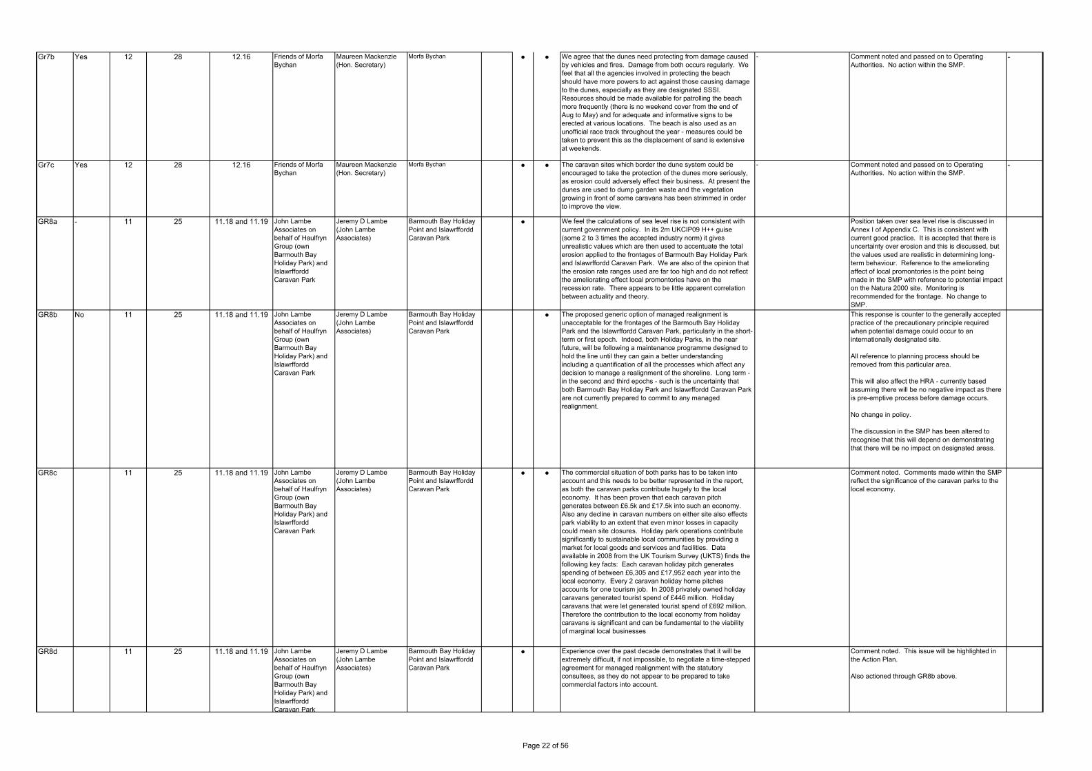
Gr7b Yes 12 28 12.16 Friends of Morfa Bychan
Maureen Mackenzie (Hon. Secretary)
Morfa Bychan ● ● We agree that the dunes need protecting from damage caused by vehicles and fires. Damage from both occurs regularly. We feel that all the agencies involved in protecting the beach should have more powers to act against those causing damage to the dunes, especially as they are designated SSSI. Resources should be made available for patrolling the beach more frequently (there is no weekend cover from the end of Aug to May) and for adequate and informative signs to be erected at various locations. The beach is also used as an unofficial race track throughout the year - measures could be taken to prevent this as the displacement of sand is extensive at weekends.
- Comment noted and passed on to Operating Authorities. No action within the SMP.
-
Gr7c Yes 12 28 12.16 Friends of Morfa Bychan
Maureen Mackenzie (Hon. Secretary)
Morfa Bychan ● ● The caravan sites which border the dune system could be encouraged to take the protection of the dunes more seriously, as erosion could adversely effect their business. At present the dunes are used to dump garden waste and the vegetation growing in front of some caravans has been strimmed in order to improve the view.
- Comment noted and passed on to Operating Authorities. No action within the SMP.
-
GR8a - 11 25 11.18 and 11.19 John Lambe Associates on behalf of Haulfryn Group (own Barmouth Bay Holiday Park) and Islawrffordd Caravan Park
Jeremy D Lambe (John Lambe Associates)
Barmouth Bay Holiday Point and Islawrffordd Caravan Park
● We feel the calculations of sea level rise is not consistent with current government policy. In its 2m UKCIP09 H++ guise (some 2 to 3 times the accepted industry norm) it gives unrealistic values which are then used to accentuate the total erosion applied to the frontages of Barmouth Bay Holiday Park and Islawrffordd Caravan Park. We are also of the opinion that the erosion rate ranges used are far too high and do not reflect the ameliorating effect local promontories have on the recession rate. There appears to be little apparent correlation between actuality and theory.
Position taken over sea level rise is discussed in Annex I of Appendix C. This is consistent with current good practice. It is accepted that there is uncertainty over erosion and this is discussed, but the values used are realistic in determining long-term behaviour. Reference to the ameliorating affect of local promontories is the point being made in the SMP with reference to potential impact on the Natura 2000 site. Monitoring is recommended for the frontage. No change to SMP.
GR8b No 11 25 11.18 and 11.19 John Lambe Associates on behalf of Haulfryn Group (own Barmouth Bay Holiday Park) and Islawrffordd Caravan Park
Jeremy D Lambe (John Lambe Associates)
Barmouth Bay Holiday Point and Islawrffordd Caravan Park
● The proposed generic option of managed realignment is unacceptable for the frontages of the Barmouth Bay Holiday Park and the Islawrffordd Caravan Park, particularly in the short-term or first epoch. Indeed, both Holiday Parks, in the near future, will be following a maintenance programme designed to hold the line until they can gain a better understanding including a quantification of all the processes which affect any decision to manage a realignment of the shoreline. Long term - in the second and third epochs - such is the uncertainty that both Barmouth Bay Holiday Park and Islawrffordd Caravan Park are not currently prepared to commit to any managed realignment.
This response is counter to the generally accepted practice of the precautionary principle required when potential damage could occur to an internationally designated site.
All reference to planning process should be removed from this particular area.
This will also affect the HRA - currently based assuming there will be no negative impact as there is pre-emptive process before damage occurs.
No change in policy.
The discussion in the SMP has been altered to recognise that this will depend on demonstrating that there will be no impact on designated areas.
GR8c 11 25 11.18 and 11.19 John Lambe Associates on behalf of Haulfryn Group (own Barmouth Bay Holiday Park) and Islawrffordd Caravan Park
Jeremy D Lambe (John Lambe Associates)
Barmouth Bay Holiday Point and Islawrffordd Caravan Park
● ● The commercial situation of both parks has to be taken into account and this needs to be better represented in the report, as both the caravan parks contribute hugely to the local economy. It has been proven that each caravan pitch generates between £6.5k and £17.5k into such an economy. Also any decline in caravan numbers on either site also effects park viability to an extent that even minor losses in capacity could mean site closures. Holiday park operations contribute significantly to sustainable local communities by providing a market for local goods and services and facilities. Data available in 2008 from the UK Tourism Survey (UKTS) finds the following key facts: Each caravan holiday pitch generates spending of between £6,305 and £17,952 each year into the local economy. Every 2 caravan holiday home pitches accounts for one tourism job. In 2008 privately owned holiday caravans generated tourist spend of £446 million. Holiday caravans that were let generated tourist spend of £692 million. Therefore the contribution to the local economy from holiday caravans is significant and can be fundamental to the viability of marginal local businesses
Comment noted. Comments made within the SMP reflect the significance of the caravan parks to the local economy.
GR8d 11 25 11.18 and 11.19 John Lambe Associates on behalf of Haulfryn Group (own Barmouth Bay Holiday Park) and Islawrffordd Caravan Park
Jeremy D Lambe (John Lambe Associates)
Barmouth Bay Holiday Point and Islawrffordd Caravan Park
● Experience over the past decade demonstrates that it will be extremely difficult, if not impossible, to negotiate a time-stepped agreement for managed realignment with the statutory consultees, as they do not appear to be prepared to take commercial factors into account.
Comment noted. This issue will be highlighted in the Action Plan.
Also actioned through GR8b above.
Page 22 of 56

GR8e No 11 25 11.18 and 11.19 John Lambe Associates on behalf of Haulfryn Group (own Barmouth Bay Holiday Park) and Islawrffordd Caravan Park
Jeremy D Lambe (John Lambe Associates)
Barmouth Bay Holiday Point and Islawrffordd Caravan Park
● We are of the opinion that the West of Wales SMP2 is severely flawed by the application of a 2m sea level rise and understand that this scenario has not been included in other SMP2s. We would therefore respectfully ask that this whole matter of the factual basis of the plan is referred to the Quality Review Board for adjudication. Both Barmouth Bay Holiday Park and Islawrffordd Caravan Park have tried over the years to implement schemes to manage the risk on their shorelines. It is our opinion that this draft report is flawed and should be re-visited to do as it states - to represent a realistic way forward in managing the shoreline.
As with comment GR8b above.
GR9a - 11,12 and 13
- - John Lambe Associates on behalf of Haulfryn Group (own Gimblet Rock Holiday Park, Pwllheli and The Warren Holiday Park, Abersoch) and Cardigan View Holiday Park, Morfa Bychan
Jeremy D Lambe (John Lambe Associates)
Gimblet Rock Holiday Park, Pwllheli, The Warren Holiday Park, Abersoch, and Cardigan View Holiday Park, Morfa Bychan
● The "Local Description" section of the SMP2 document refers to the fact that "The whole area is very important for coastal tourism with significant holiday villages". This comment is supported. Data available in 2008 from the UK Tourism Survey (UKTS) finds the following key facts: Each caravan holiday pitch generates spending of between £6,305 and £17,952 each year into the local economy. Every 2 caravan holiday home pitches accounts for one tourism job. In 2008 privately owned holiday caravans generated tourist spend of £446 million. Holiday caravans that were let generated tourist spend of £692 million. Therefore the contribution to the local economy from holiday caravans is significant and can be fundamental to the viability of marginal local businesses. In 2008 the holiday parks industry accounted for 19.7% of total UK tourist bed nights which equates to 74.41 million nights and also 12.3% of the total UK tourist spend equating to £2.6 billion. Based on data from research undertaken in Wales in 2003 (and applying RPI) the most cautious calculations indicates that caravan holiday homes and lodges, privately owned and let by holiday parks, contribute £1,507 million to coastal communities in the UK. It is therefore vital that the contribution that holiday parks make is taken into consideration in the SMP2 document.
Comment noted. Comments made within the SMP reflect the significance of the caravan parks to the local economy.
GR9b No 13 32 13.11 John Lambe Associates on behalf of Haulfryn Group (own Gimblet Rock Holiday Park, Pwllheli and The Warren Holiday Park, Abersoch) and Cardigan View Holiday Park, Morfa Bychan
Jeremy D Lambe (John Lambe Associates)
The Warren Holiday Park, Abersoch
● The Warren, Abersoch, is a significant Holiday Park with over 540 holiday homes. Any loss of holiday pitches would have a significant impact on the regional economy and on tourism to the area. Therefore it is vital that the "Hold the Line" policy is maintained - it is welcomed that this policy is not seen as presenting significant problems over the short to medium term (up to 30yrs). Managed realignment (rollback of holiday pitches) would cause significant issues and there would have to be a spirit of co-operation with the Planning Authority for any relocation of pitches outside the existing Planning Unit boundary and also additional Holiday pitches granted planning consent to help fund the relocation of existing pitches. The reason many holidaymakers choose the Warren is the beach location and for the watersport activities. A policy of progressive retreat for The Warren is not supported.
A policy of progressive retreat for The Warren is not supported.
We note that the beach is considered an essential feature of the Holiday Park. It is for this reason that a policy of MR is recommended. This is confirmed by the CSG. Other issues in terms of planning will be identified in the Action Plan. Text has been added to clarify that the policy aims to work with the value of the Holiday Park.
GR9c Yes 13 31 13.3 and 13.4 John Lambe Associates on behalf of Haulfryn Group (own Gimblet Rock Holiday Park, Pwllheli and The Warren Holiday Park, Abersoch) and Cardigan View Holiday Park, Morfa Bychan
Jeremy D Lambe (John Lambe Associates)
Gimblet Rock Holiday Park, Pwllheli
● Gimblet Rock, Pwllheli is a large Holiday Park with over 130 Holiday Home pitches and is therefore a major tourism provider in the area. The policy of HTL is supported, as long as this does not adversely affect the Holiday Park at Gimblet Rock or lead to increased flood risk on the Holiday Park.
Comment noted. No action.
GR9d - 12 28 12.16 John Lambe Associates on behalf of Haulfryn Group (own Gimblet Rock Holiday Park, Pwllheli and The Warren Holiday Park, Abersoch) and Cardigan View Holiday Park, Morfa Bychan
Jeremy D Lambe (John Lambe Associates)
Cardigan View Holiday Park, Morfa Bychan
● Cardigan View Holiday Park, Morfa Bychan is a large Holiday Park with 208 Holiday Home pitches and is therefore a major tourism provider in the area. The comment on page 172 "that the area is very important for tourism and this tourism and the caravan parks, help sustain essential services to the village beyond the tourist season" is welcomed.
Comment noted. No action.
Page 23 of 56

GR9e - 12 28 12.16 John Lambe Associates on behalf of Haulfryn Group (own Gimblet Rock Holiday Park, Pwllheli and The Warren Holiday Park, Abersoch) and Cardigan View Holiday Park, Morfa Bychan
Jeremy D Lambe (John Lambe Associates)
Cardigan View Holiday Park, Morfa Bychan
● Although Cardigan View Holiday Park is not specifically referred to in the SMP2 document, the document refers on page 207 to "residual flood risk at present to areas of the village, but principally to areas of the Holiday Parks…there may be scope for reducing the flood risk through landscaped defences over the areas of the Holiday Park...there needs to be longer term consideration of building in greater resilience to properties and more adaptive use of the Holiday Park area". It is not clear which Holiday Park the SMP2 document is referring to and this should be clarified, as there are a number of Holiday Parks in Morfa Bychan.
Text will be changed to reflect that there are several Holiday Parks. Management of the frontage has the potential to impact on several areas.
GR9f - 12 28 12.16 John Lambe Associates on behalf of Haulfryn Group (own Gimblet Rock Holiday Park, Pwllheli and The Warren Holiday Park, Abersoch) and Cardigan View Holiday Park, Morfa Bychan
Jeremy D Lambe (John Lambe Associates)
Cardigan View Holiday Park, Morfa Bychan
● A policy of Managed Retreat is likely to result in a loss of Holiday Home pitches, which would have a significant economic impact on the local economy and therefore is not supported. The original policy contained in SMP1 of "Hold the Line" regarding managing the risk in such a manner to ensure the Holiday Parks and Village are sustained and is supported.
Holding the line through positive intervention at the edge of the dune would result in damage to the dune and the beach. This is why a policy of MR is recommended.
Additional text has been added to clarify that managed realignment is to support the front line defence provided by the dunes. Local flood defence, behind the dunes would be considered as part of this policy.
A6a 10 19 and 20 All Powys County Councillor and Machynlleth Town Councillor
J.M.Williams Specific to Machynlleth, Dovey Bridge, the Dovey floodplain, sewage disposal works, Machynlleth to Pwllheli railway line
● General comment - we need to move forward to address (as far as we can) highly important issues.
-
Comment noted. The SMP's Action Plan will be the main mechanism whereby the issues raised within the SMP are taken forward and addressed. No action.
-
A1.2ar CCW Dr David Worrall (Regional Director West)
Introduction Typo correction: “Lleyn / Llŷn peninsula” not “Llyn peninsula” Comment noted. Text amendments made. 4D1
A1.2as CCW Dr David Worrall (Regional Director West)
Introduction There are currently no commercial freight trains on the Cambrian Line.
Comment noted. Our understanding is that it is being developed as a freight line. No action.
4D2
A1.2at CCW Dr David Worrall (Regional Director West)
Introduction Typo correction: “..well established links golf courses” not “..well establishes links golf courses”
Comment noted. Text amendments made. 4D3
A1.2au CCW Dr David Worrall (Regional Director West)
Introduction Typo correction: “Porthmadog” not “Porthmadoc”The Lleyn Peninsula and the Sarnau SAC does not extend over all sand dune areas. Some areas are part of the Morfa Harlech a Morfa Dyffryn SAC.
Comment noted. Text amendments made. 4D4
A1.2av CCW Dr David Worrall (Regional Director West)
Introduction We would strongly endorse the statement: “The man made constraint within the upper part of the estuaries can increase tidal locking of freshwater flows, potentially leading to increased flood risk beyond the tidal limits.” However we are surprised that Appendix D (Estuary Assessment), section 8.1.2, page 29 states that: “No historic information could be found documenting any flood events in the Mawddach as a result of tidal locking although the CFMP describes Fairbourne as being at risk from this type of flooding.” Recent modelling of the Mawddach estuary (undertaken by the Centre for Applied Marine Sciences, Bangor University, commissioned by CCW) indicates that constraints act to raise tidal flood heights due to the reduced flood plain. [Robins, P.E. 2011. Development of a morphodynamic model of the Mawddach Estuary to inform future management decisions. CCW Science Report No. 898c, CCW, Wales.]
The SMP is based upon information that was available at the time and the 2011 report referred to here was published after the draft was completed.
We have highlighted that this would need further study in the SMP and this would be included in the Action Plan. The 2011 report discussed has therefore already completed this action. To be included in Action Plan as a completed action.
It is suggested that HTL needs to remain the preferred policy until hydraulics are further investigated and potential impacts are understood.
4D13
AUTHORITIES
Page 24 of 56
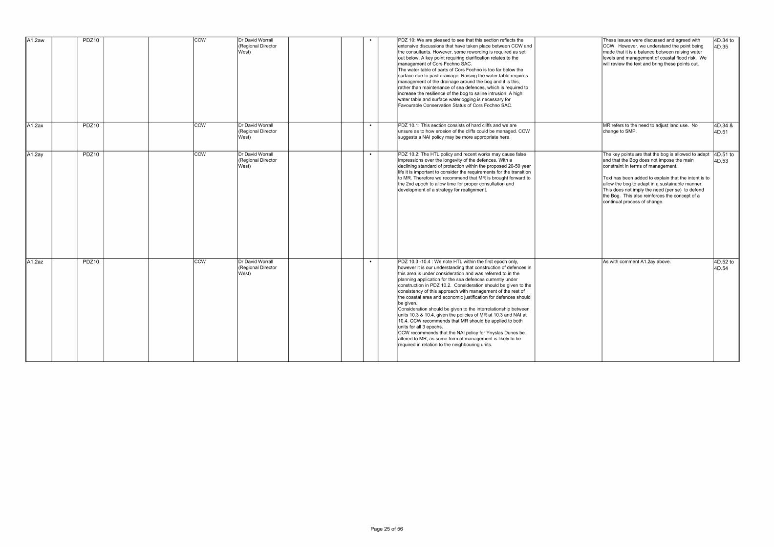
A1.2aw PDZ10 CCW Dr David Worrall (Regional Director West)
PDZ 10: We are pleased to see that this section reflects the extensive discussions that have taken place between CCW and the consultants. However, some rewording is required as set out below. A key point requiring clarification relates to the management of Cors Fochno SAC.The water table of parts of Cors Fochno is too far below the surface due to past drainage. Raising the water table requires management of the drainage around the bog and it is this, rather than maintenance of sea defences, which is required to increase the resilience of the bog to saline intrusion. A high water table and surface waterlogging is necessary for Favourable Conservation Status of Cors Fochno SAC.
These issues were discussed and agreed with CCW. However, we understand the point being made that it is a balance between raising water levels and management of coastal flood risk. We will review the text and bring these points out.
4D.34 to 4D.35
A1.2ax PDZ10 CCW Dr David Worrall (Regional Director West)
PDZ 10.1: This section consists of hard cliffs and we are unsure as to how erosion of the cliffs could be managed. CCW suggests a NAI policy may be more appropriate here.
MR refers to the need to adjust land use. No change to SMP.
4D.34 & 4D.51
A1.2ay PDZ10 CCW Dr David Worrall (Regional Director West)
PDZ 10.2: The HTL policy and recent works may cause false impressions over the longevity of the defences. With a declining standard of protection within the proposed 20-50 year life it is important to consider the requirements for the transition to MR. Therefore we recommend that MR is brought forward to the 2nd epoch to allow time for proper consultation and development of a strategy for realignment.
The key points are that the bog is allowed to adapt and that the Bog does not impose the main constraint in terms of management.
Text has been added to explain that the intent is to allow the bog to adapt in a sustainable manner. This does not imply the need (per se) to defend the Bog. This also reinforces the concept of a continual process of change.
4D.51 to 4D.53
A1.2az PDZ10 CCW Dr David Worrall (Regional Director West)
PDZ 10.3 -10.4 : We note HTL within the first epoch only, however it is our understanding that construction of defences in this area is under consideration and was referred to in the planning application for the sea defences currently under construction in PDZ 10.2. Consideration should be given to the consistency of this approach with management of the rest of the coastal area and economic justification for defences should be given.Consideration should be given to the interrelationship between units 10.3 & 10.4, given the policies of MR at 10.3 and NAI at 10.4. CCW recommends that MR should be applied to both units for all 3 epochs.CCW recommends that the NAI policy for Ynyslas Dunes be altered to MR, as some form of management is likely to be required in relation to the neighbouring units.
As with comment A1.2ay above. 4D.52 to 4D.54
Page 25 of 56

A1.2ba PDZ10 CCW Dr David Worrall (Regional Director West)
PDZ10.5 and 10.6 Cors Fochno has grown up and developed as a domed ‘raised bog’ on the floodplain of the Dyfi estuary with tidal saltwater influence around its northern and western margins. This has influenced the character of the site and contributes towards the scientific interest as the ‘locus typicus’ of estuarine raised bog possessing rare, albeit modified, salinefreshwater mire transitions.Prior to c1960 when the Leri floodbanks were extended southwards, high tides regularly inundated the south-west corner of the SAC, and a unique saline bog community existed. This could be restored without jeopardising the SAC features.Water levels around the margins of the bog are an important factor in determining the vegetation condition and peat growth of the central ‘active raised bog’ SAC feature. Flooding of the margins, which have subsided due to drainage and peat cutting, would bebeneficial to the hydrology and ecology of the SAC. It is relatively unimportant if this water is saline or fresh. Renewed inundation of the margins may also be beneficial in increasing surface elevation through siltation.Uncontrolled tidal flooding (e.g. via a floodbank breach) is potentially damaging if erosion scour is allowed to proceed down to low water mark in the artificial drainage channel of the Leri. Old drains currently blocked with peat dams could then effectively become tidal channels extending well into the bog.Restoration of high water levels to the margins of the bog are important in:1. restoring the SAC to favourable status2. increasing robustness to climate change by preventing further shrinkage subsidence of drained peat; encouraging maximum peat growth; encouraging siltation.EA h tl i i d t d i t th diti f
As with comment A1.2ay above. 4D.53
A1.2bb PDZ10 CCW Dr David Worrall (Regional Director West)
PDZ 10.7: The delivery of MR policy (and reintegration of the estuary and bog) is also dependent on the future management of the railway line.
Comment noted. No action. 4D.52
A1.2bc PDZ10 CCW Dr David Worrall (Regional Director West)
We would strongly support development of a local management plan to address issues of dune management in the vicinity of the Aberdyfi Golf Course and Penllyn. A naturally functioning dune ecosystem will provide a sustainable coastal flood defence in this location.
Comment noted. This needs to be taken forward in response to comment Gr2c.
4D.52
A1.2bd PDZ10 CCW Dr David Worrall (Regional Director West)
CCW and EAW are actively working on a sustainable strategy for the management of the Penllyn Fields. CCW supports the overall strategy as outlined in the first paragraph. However, CCW advocates retreat of the whole coastal zone rather than just the frontage. Coastal and transitional habitats of national significance need to be able to migrate inland and not suffer coastal squeeze against structures or incompatible land uses.
Comment noted and full agree that it is the management of the whole area of the Penllyn Marshes that needs to be considered. This will be highlighted in the Action Plan.
4D.53
A1.2be PDZ10 CCW Dr David Worrall (Regional Director West)
The presence of a Priority SAC Habitat (Percolation Saline Lagoon), the only example in Wales, present within the shingle bank south of the Dysynni Railway Bridge, will significantly influence any future artificial coastal defence works in this area.
Comment noted. No action. 4D.53
A1.2bf Yes PDZ10 CCW Dr David Worrall (Regional Director West)
We would strongly support Managed Realignment of defences in the Dysynni
Comment noted. No action. 4D.53
A1.2bg PDZ10 CCW Dr David Worrall (Regional Director West)
Policy units for this table should be “10.1 to 10.9” not “10.1 to 10.19”
PDZ10 contains Pus 10.1 to 10.19 as recorded in the HRA. No change.
4D.64
A1.2bh PDZ10 CCW Dr David Worrall (Regional Director West)
Add EAW as partner for the action “Assess opportunities and plan for habitat creation”.
Comment noted. To be included in Action Plan 4D.70
A1.2bi PDZ10 CCW Dr David Worrall (Regional Director West)
Please provide a justification for delaying the Managed Realignment of golf course structures i.e. the 12 green, until the medium term. CCW advocates commencing realignment in the short term into the medium and longer terms.
Comment noted. Text changed to clarify. 4D.71
A1.2bj PDZ10 CCW Dr David Worrall (Regional Director West)
Policy units for this table should be “10.10 to 10.19” not “10.1 to 10.19”
PDZ10 contains Pus 10.1 to 10.19 as recorded in the HRA. No change.
4D.73
A1.2bk PDZ10 CCW Dr David Worrall (Regional Director West)
Typo correction: “Potentially move defences landward where feasible” not “Potentially move defences landward were feasible”. “Speed of erosion” not “speed to erosion”.
Comment noted. Text amendments made. 4D.74
A1.2bl PDZ11 CCW Dr David Worrall (Regional Director West)
Typo correction: “areas of coarse sand” not “areas of course sand”.
Comment noted. Text amendments made. 4D.81
Page 26 of 56

A1.2bm PDZ11 CCW Dr David Worrall (Regional Director West)
Typo correction: “This natural constraint has been reinforced by the reclamation” not “this natural constraint has possibly been reinforced by reclamation”.
Comment noted. Text amendments made. 4D.82
A1.2bn PDZ11 CCW Dr David Worrall (Regional Director West)
Typo correction: “to the Y Perch” not “to The Y Perch”. Comment noted. Text amendments made. 4D.83
A1.2bo PDZ11 CCW Dr David Worrall (Regional Director West)
Typo correction: “extensive build up” not “extensive built up”. Comment noted. Text amendments made. 4D.83
A1.2bp PDZ11 CCW Dr David Worrall (Regional Director West)
The marine SAC does not extend inland to incorporate Morfa Dyffryn. The Dyffryn and Harlech dune systems are designated as part of the Morfa Harlech a Morfa Dyffryn SAC.
Comment noted. Text amendments made. 4D.85
A1.2bq PDZ11 CCW Dr David Worrall (Regional Director West)
Llanbedr Airfield is also seen as a potential source of employment opportunities.
Comment noted. Text amendments made. 4D.85
A1.2br PDZ11 CCW Dr David Worrall (Regional Director West)
Delete “These defences reinforce the slight headland created by the ridge of higher ground running to the shoreline to the south of the Ysgethin”. No evidence has been presented to confirm the presence of any natural headland at this point. CCW considers the rock armour defence is the mostly likely reason this land stands out from the adjacent coast line. This is only relevant because it has been argued in favour of the recent proposal that this is a natural hard point and that hard sea defences would have little extra effect.
Text to be amended to reflect the fact that defences are constructed in an area where higher ground comes to the coast. Further discussion will be added to address the point raised.
All reference to planning process should be removed from this particular area.
4D.85
A1.2bs PDZ11 CCW Dr David Worrall (Regional Director West)
General description includes: “…the Marine SAC extends in land to include the Dyffryn dune system.” Replace with reference to the Morfa Harlech a Morfa Dyffryn SAC, because the marine SAC does not extend inland. There is the separate SAC for the dunes.
Comment noted. Text amendments made. 4D.85
A1.2bt PDZ11 CCW Dr David Worrall (Regional Director West)
Typo correction: “Ynys y Brawd” not “Ynys Brawd”. Comment noted. Text amendments made. 4D.86
A1.2bu PDZ11 CCW Dr David Worrall (Regional Director West)
The statement that “there are no major areas of reclamation which would substantially alter the estuary’s tidal prism” is not supported by the data which indicates that there has been substantial areas of reclamation around the Mawddach, indeed in Appendix D (Estuary Assessment), section 8.1, page 28, it says: “Anthropogenic intervention has also caused some constraint at both the Barmouth viaduct and the Penmaenpool Bridge. Large amounts of reclamation has been undertaken along the south bank of the estuary for the now dismantled railway and up-estuary of Penmaenpool there has also been some reclamation for agricultural purposes (Gwynedd Council, 1998). The largest land loss occurred during the reclamation of Morfa Fairbourne and with an area estimated at some 360ha, this amounts to a loss of 27% of the former estuary area (CGP, 2000). Barmouth Harbour is situated on the northern side of the estuary near the mouth. OS maps pre 1969 show evidence of a second channel leading into the estuary which was subsequently closed off by the construction of the harbour wall between the breakwater and Barmouth (Gareth White Partnership, 1986), this would have significantly reduced the cross sectional area of the estuary mouth”.
References being made to areas of reclamation rather than significance in terms of tidal prism (volume). We recognise that further study has been undertaken by CCW that was not available to the SMP. The comment made in the SMP has been reviewed.
4D.95
A1.2bv PDZ11 CCW Dr David Worrall (Regional Director West)
Please clarify and provide evidence to support the following statement:“…the various defences may influence tidal locking of the rivers, although this is possibly not that significant”. Appendix D (Estuary Assessment), section 8.1.2, page 29 states that “…no historic information could be found documenting any flood events in the Mawddach as a result of tidal locking although the CFMP describes Fairbourne as being at risk from this type of flooding.” CCW recommends that further investigations should be carried out on tidal locking and the degree to which defences influence the phenomenon.
Reference is being made quite clearly to the upper part of the estuary, and not to Fairbourne at the mouth of the estuary. At Fairbourne, it is not the Mawddach that is being tidally locked. Text has been reviewed and edited as appropriate.
4D.95
A1.2bw PDZ11 CCW Dr David Worrall (Regional Director West)
Please provide evidence to support the following statement or clarify by stating that it is conjecture - “…there is the possibility that the defences and more probably the area around the toll road might actually reduce the effect of the tidal wave on more extreme surge conditions”.
The word 'possibility' highlights the fact that this is conjecture. In discussion with CCW, it was agreed that this area needed further examination. This will be picked up in the Action Plan.
4D.95
Page 27 of 56
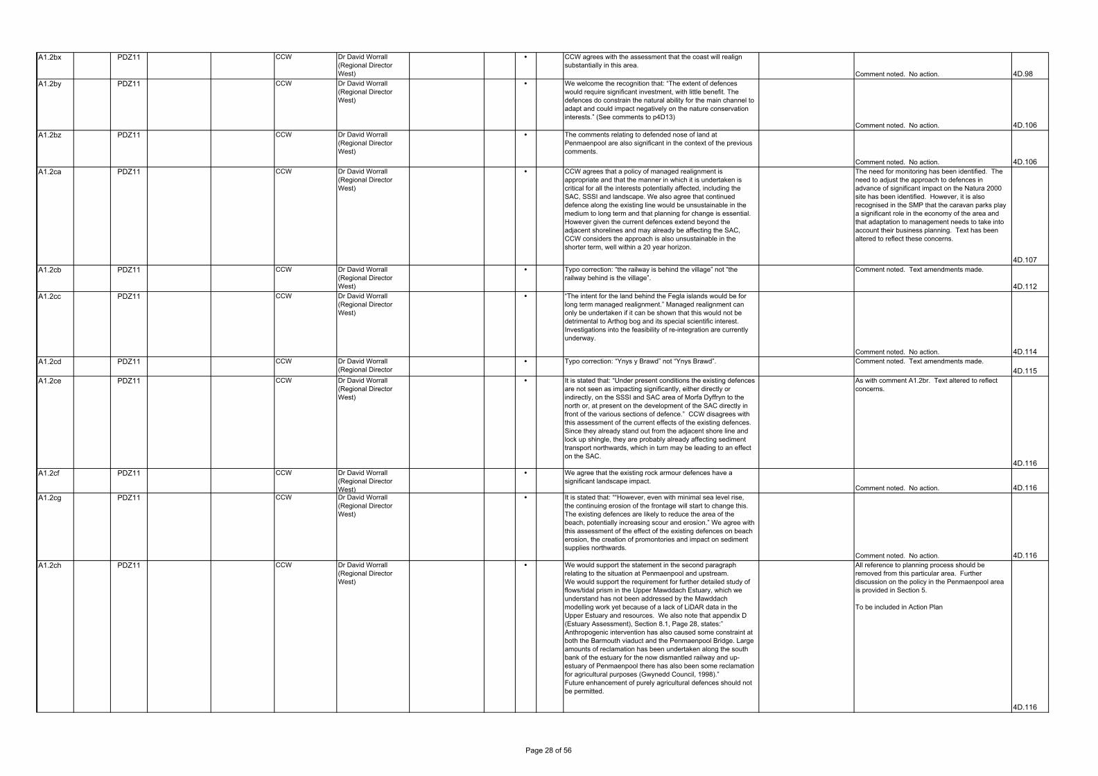
A1.2bx PDZ11 CCW Dr David Worrall (Regional Director West)
CCW agrees with the assessment that the coast will realign substantially in this area.
Comment noted. No action. 4D.98A1.2by PDZ11 CCW Dr David Worrall
(Regional Director West)
We welcome the recognition that: “The extent of defences would require significant investment, with little benefit. The defences do constrain the natural ability for the main channel to adapt and could impact negatively on the nature conservation interests.” (See comments to p4D13)
Comment noted. No action. 4D.106A1.2bz PDZ11 CCW Dr David Worrall
(Regional Director West)
The comments relating to defended nose of land at Penmaenpool are also significant in the context of the previous comments.
Comment noted. No action. 4D.106A1.2ca PDZ11 CCW Dr David Worrall
(Regional Director West)
CCW agrees that a policy of managed realignment is appropriate and that the manner in which it is undertaken is critical for all the interests potentially affected, including the SAC, SSSI and landscape. We also agree that continued defence along the existing line would be unsustainable in the medium to long term and that planning for change is essential. However given the current defences extend beyond the adjacent shorelines and may already be affecting the SAC, CCW considers the approach is also unsustainable in the shorter term, well within a 20 year horizon.
The need for monitoring has been identified. The need to adjust the approach to defences in advance of significant impact on the Natura 2000 site has been identified. However, it is also recognised in the SMP that the caravan parks play a significant role in the economy of the area and that adaptation to management needs to take into account their business planning. Text has been altered to reflect these concerns.
4D.107A1.2cb PDZ11 CCW Dr David Worrall
(Regional Director West)
Typo correction: “the railway is behind the village” not “the railway behind is the village”.
Comment noted. Text amendments made.
4D.112A1.2cc PDZ11 CCW Dr David Worrall
(Regional Director West)
“The intent for the land behind the Fegla islands would be for long term managed realignment.” Managed realignment can only be undertaken if it can be shown that this would not be detrimental to Arthog bog and its special scientific interest. Investigations into the feasibility of re-integration are currently underway.
Comment noted. No action. 4D.114A1.2cd PDZ11 CCW Dr David Worrall
(Regional Director W t)
Typo correction: “Ynys y Brawd” not “Ynys Brawd”. Comment noted. Text amendments made.
4D.115A1.2ce PDZ11 CCW Dr David Worrall
(Regional Director West)
It is stated that: “Under present conditions the existing defences are not seen as impacting significantly, either directly or indirectly, on the SSSI and SAC area of Morfa Dyffryn to the north or, at present on the development of the SAC directly in front of the various sections of defence.” CCW disagrees with this assessment of the current effects of the existing defences. Since they already stand out from the adjacent shore line and lock up shingle, they are probably already affecting sediment transport northwards, which in turn may be leading to an effect on the SAC.
As with comment A1.2br. Text altered to reflect concerns.
4D.116A1.2cf PDZ11 CCW Dr David Worrall
(Regional Director West)
We agree that the existing rock armour defences have a significant landscape impact.
Comment noted. No action. 4D.116A1.2cg PDZ11 CCW Dr David Worrall
(Regional Director West)
It is stated that: ““However, even with minimal sea level rise, the continuing erosion of the frontage will start to change this. The existing defences are likely to reduce the area of the beach, potentially increasing scour and erosion.” We agree with this assessment of the effect of the existing defences on beach erosion, the creation of promontories and impact on sediment supplies northwards.
Comment noted. No action. 4D.116A1.2ch PDZ11 CCW Dr David Worrall
(Regional Director West)
We would support the statement in the second paragraph relating to the situation at Penmaenpool and upstream.We would support the requirement for further detailed study of flows/tidal prism in the Upper Mawddach Estuary, which we understand has not been addressed by the Mawddach modelling work yet because of a lack of LiDAR data in the Upper Estuary and resources. We also note that appendix D (Estuary Assessment), Section 8.1, Page 28, states:” Anthropogenic intervention has also caused some constraint at both the Barmouth viaduct and the Penmaenpool Bridge. Large amounts of reclamation has been undertaken along the south bank of the estuary for the now dismantled railway and up-estuary of Penmaenpool there has also been some reclamation for agricultural purposes (Gwynedd Council, 1998).”Future enhancement of purely agricultural defences should not be permitted.
All reference to planning process should be removed from this particular area. Further discussion on the policy in the Penmaenpool area is provided in Section 5.
To be included in Action Plan
4D.116
Page 28 of 56

A1.2ci PDZ11 CCW Dr David Worrall (Regional Director West)
Typo correction: In first paragraph delete second “more as”. Comment noted. Text amendments made.
4D.117A1.2cj PDZ11 CCW Dr David Worrall
(Regional Director West)
It is stated that: ““The solution potentially lies somewhere between these approaches of defining a retreat zone or that of slowing erosion. It would therefore be suggested that a more discrete, time-limited approach is taken. That private defence measures should be accepted but that they should be approved over an agreed time period or impact threshold.”This description appears similar in parts to the responsive elements of the recently withdrawn planning application.It seems unlikely that a solution could comply with the Conservation of Habitats and Species Regulations 2010 unless it realigns in advance of possible effects emerging. The SMP2’s dismissal of a pre-emptive approach and the suggestion of a “trigger” for adjustment of defences appear to be putting off the action that is required very soon.There is not enough clarity of intent to pre-empt adverse effects on the integrity of the SAC for the SMP2 to conclude no adverse effect on the integrity of the Morfa Harlech a Morfa Dyffryn SAC.
The SMP clearly makes the point that monitoring should be established such that action for stepping back defences would pre-empt damage. This was included following previous comments by CCW through the CSG. We do not agree that present defences significantly impact on Morfa Dyfryn at present. Text has been altered to reflect concerns.
4D.117A1.2ck PDZ11 CCW Dr David Worrall
(Regional Director West)
Table for MA21 Southern Cliffs, PU11.3 Friog Cliffs, Comment column refers to Dinas Dinlle, presumably the area near Caernarfon. The text is not relevant to the Friog Cliffs area and may have been pasted in, in error.
Comment noted. This will be replaced with text from 4D.126.
4D.118A1.2cl PDZ11 CCW Dr David Worrall
(Regional Director West)
The policy recommendation for the upper estuary (PU 11.12) in the first epoch should be Managed Realignment and not Hold the Line. The selection of HTL in the 1st Epoch may preclude the implementation of habitat / flood storage creation in the upper estuary in the next 20 years (see HRA comments). The Welsh Government’s agri-environment scheme Glastir Targeted Element and the Environment Agency Wales have identified the upper Mawddach estuary as providing excellent opportunities for both flood storage and inter-tidal habitat creation. Investigations into the role of the toll bridge and defended road could be carried out using the recently developed Mawddach estuary mathematical model commissioned by CCW.
The SMP is based upon information that was available at the time and the 2011 report referred to here was published after the draft was completed.
We have highlighted that this would need further study in the SMP and this would be included in the Action Plan. The 2011 report discussed has therefore already completed this action. To be included in Action Plan as a completed action.
It is suggested that HTL needs to remain the preferred policy until hydraulics are further investigated and potential impacts are understood.
4D.118A1.2cm PDZ11 CCW Dr David Worrall
(Regional Director West)
Sabellaria alveolata reefs are present in this unit. (see HRA comments) Commented noted. No impact on the reef was
found to occur in reposne to SMP policy. 4D.129A1.2cn PDZ11 CCW Dr David Worrall
(Regional Director West)
Snowdonia National Park are the planning authority for parts of these policy units and should therefore be included as partners where appropriate.
Commented noted. Text amendments made.
4D.133 & 4D.141
A1.2co PDZ11 CCW Dr David Worrall (Regional Director West)
Sabellaria alveolata reefs are present in this unit. (see HRA comments)
Commented noted. No impact on the reef was found to occur in reposne to SMP policy. 4D.137
A1.2cp PDZ11 CCW Dr David Worrall (Regional Director West)
We welcome the statement: “The initial policy of Hold the Line in this area is more specifically in relation to the management of the Toll Road with the intent to allow time for further investigation into estuary behaviour and with the intent of allowing development of a coherent management plan throughout the area.” … The initial policy would not preclude opportunities for managed realignment … However, any such realignment needs to have regard to the uncertainties associated with management of the toll road”. A Mawddach Environmental Project Board (CCW, EAW, SNPA and GC) has recently been set up to draw up a strategy for the estuary and take forward the necessary investigations.
Comment noted. Include Mawddach Environmental Project Board in Action Plan
4D.141A1.2cq PDZ11 CCW Dr David Worrall
(Regional Director West)
We support the statement: “the intent would be to encourage the natural dynamic behaviour of the dune system, allowing this system to roll back, potentially occupying land behind.” This intent is seen as essential to the continued future existence of this part of the Morfa Harlech a Morfa Dyffryn SAC.
Commented noted. 4D.157
Page 29 of 56

A1.2cr PDZ11 CCW Dr David Worrall (Regional Director West)
It states that: “Morfa Harlech a Morfa Dyffryn SAC: no adverse effect on the integrity of the SAC.” CCW disagrees with this conclusion. Such a conclusion requires a pre-emptive element to be included more firmly in the SMP2’s proposal for a responsive approach to managed realignment. The pre-emptive element triggers the need to respond very soon.
The SMP clearly makes the point that monitoring should be established such that action for stepping back defences would pre-empt damage. This was included following previous comments by CCW through the CSG. We do not agree that present defences significantly impact on Morfa Dyfryn at present. Text has been altered to reflect concerns.
4D.161A1.2cs PDZ12 CCW Dr David Worrall
(Regional Director “Porthmadog” not “Porthmadoc”.
Commented noted. Text amendments made.
4D.167 & 4D.171
A1.2ct PDZ12 CCW Dr David Worrall (Regional Director West)
Typo correction: “more generally this scenario is otherwise sensible” not “more generally this scenario is other sensible”. Also: “delvers” presumably should be “delivers”.
Commented noted. Text amendments made. 4D.204A1.2cu PDZ12 CCW Dr David Worrall
(Regional Director West)
In view of the SAC designation of both the Artro Estuary and Morfa Dyffryn Dune system we would welcome the suggestion to re-examine the behaviour of the whole estuary and develop a sustainable development plan. Apart from our regulatory/advisory role with respect to SSSIs & SACs in the immediate vicinity, we also have a direct legal interest in the National Nature Reserve at Morfa Dyffryn
Commented noted. No action 4D.205A1.2cv PDZ12 CCW Dr David Worrall
(Regional Director West)
Again, in view of the sensitive nature of the Morfa Harlech SSSI/ NNR & Morfa Dyffryn a Morfa Harlech SAC, we would welcome a long term spatial approach to planning and water level management in the Lower Harlech area, and consideration of some degree of saline intrusion into the valley. In addition, this area has considerable landscape/historic landscape value.
Commented noted. No action 4D.206A1.2cw Yes PDZ12 CCW Dr David Worrall
(Regional Director West)
Pulling back of flood banks on the Upper Dwyryd would give the estuary a more natural look, provide fluvial flood capacity and benefit biodiversity.
Commented noted. No action 4D.206A1.2cx PDZ12 CCW Dr David Worrall
(Regional Director West)
The presence of Sabellaria reef (Penlyn a’r Sarnau SAC feature) in this area will have to be considered in relation to any proposed works resulting in sand recharge and associated vehicular use of the foreshore.
Comment noted. To be included in Action Plan.
4D.208A1.2cy PDZ12 CCW Dr David Worrall
(Regional Director West)
Typo correction: Delete “and estuary” (second paragraph)
Commented noted. Text amendments made. 4D.215A1.2da PDZ12 CCW Dr David Worrall
(Regional Director West)
Sabellaria alveolata reefs are present in this unit. (see HRA comments) Commented noted. No impact on the reef was
found to occur in response to SMP policy. 4D.219A1.2db Yes PDZ12 CCW Dr David Worrall
(Regional Director West)
CCW welcomes the proposed realignment along the Talsarnau frontage and the benefits to inter-tidal and transitional habitats.
Commented noted. No action 4D.225A1.2dc PDZ12 CCW Dr David Worrall
(Regional Director West)
CCW supports the suggestion of mitigation measures for the Morfa Harlech a Morfa Dyffryn SAC, including integrated management of the dunes to allow them to migrate inland.
Commented noted. No action 4D.229A1.2dd PDZ13 CCW Dr David Worrall
(Regional Director West)
CCW is an active partner in the Pwllheli Pilot Scheme (Climate Change Adaptation Strategy). We generally agree with the analysis of issues as stated.
Commented noted. No action 4D.291A1.2de PDZ13 CCW Dr David Worrall
(Regional Director West)
Though recognising that creation of new outlet for the Afon Penrhos may have an adverse impact on the current golf course, there is scope for significant landscape-scale habitat creation in this area. Development of a sustainable solution to both the coastal and fluvial flooding issues of Pwllheli must be considered in combination with habitat and landscape enhancement.
Commented noted. No action 4D.292
Page 30 of 56

GROUPS
AUTHORITIES
Response
Res.RefAccept SMP
PDZManagement
AreaOrganisationPolicy Unit Page No. Clarify Info. Policy CommentCorrespondence Issues Raised Action Suggest Comment/ Action in finalising SMP
Page 31 of 56

A3c Possibly 20 59 20.2 Conwy County Borough Councillor and SNPA
Gail Hall Beach access ●I would be thrilled if beach access could be included in your plans at my village of Dwygyfylchi, near Penmeanmawr. The only way of accessing the beach is pedestrian either over a footbridge or actually running over the A55 itself. By vehicle access is by going into Penmaenmawr and driving over the A55 (3 mile detour). Neither is really acceptable.
Note access issues in general text and include item in action plan to address issues.
Access issues to be noted in general text and item to be included in action plan to address issues.
-
A2b - - - - Conwy CBC - General ●Estuaries review (App D) suggests SMP boundary in the Conwy should be just upstream of Glan Conwy. Actual SMP considers estuary upstream to Llanwrst. I can understand why the estuaries review was ignored but document should provide a rationale for the decision.
Text has been added in the introduction to Coastal Area F.
A2c - 16 - - Conwy CBC - ●Second to last paragraph: line 6: "cuts"; line 7 - "the area to the west" should be "to the east". Also the defences between Nant-y-Felin and Llanfairfechan was breached in 2010 and whilst I agree that the potential for setback across the Llanfairfechan headland would have to be considered in Epoch 3, I would suggest that it would be appropriate to consider setback across the section to the west earlier given that the defences are historic, are not providing defence in their present position to anything of significance and earlier realignment here could be overall beneficial to the regime applying. Potentially therefore, this section would sit more appropriately in PU16.32 rather than 16.33.
Will correct text and correct numbers of policy units on page 4F.97.
We agree to changing the position of the policy unit boundary. This has been confirmed by the CSG.
4F.94
A2d - 16 - - Conwy CBC - ●If overtopping risk not evaluated then flood risk is potentially greater than stated.
Comment noted. No action. 4F.150
A2e - 16 - - Conwy CBC - ●Table refers to "Achievement of Any South East RBMP Mitigation measures. What is this? Has the column heading inadvertently been transferred from another document or other parts of this SMP document. I can't see how a South East RBMP can be relevant geographically! Note this heading occurs on other WFA tables in the document.
Comment noted. 4F.153
A2f - 20 - - Conwy CBC - ●4th para. - How does the breakwater provide protection to the road to the north, apart from locally trapping southerly sediment drift? This section is generally protected by a linear rock armour toe; Properties at Gogarth are generally protected by variable, intermittent, local defences; remains of Bishop's Palace are suffering on-going erosion.
We agree that the protection is provided by the rock toe but that the breakwater also maintains a beach. Text has been reviewed and edited accordingly.
4F.161
A2g - 20 - - Conwy CBC - ●No reference to the Conwy Estuary Managed Re-Alignment Study (Faber Maunsell, 2006) or the Conwy Tidal Flood Risk Assessment (HR Wallingford, 2004-07)
These reports were not provided but discussion as to their content was incorporated in the thinking. They have been acknowledged in Appendix C
4F.165 - 8
A2h - 20 - - Conwy CBC - ●There is little reference to the impacts on Deganwy Marina here. 1m SLR would certainly increase the flood risk and cause major disruption, whilst 2m SLR would swamp the area.
We will review text and amend to include comment. 4F.177
A2i - 20 - - Conwy CBC - ●2nd to last para. – According to the maps the boundary between policy units 20.11 (HTL) and 20.12 (NAI) is not at the northern breakwater but where Marine Drive moves inland. This appears sensible otherwise maintaining the access would be the responsibility of the property owners on Marine Drive, although it could be argued that they should make some contribution to maintaining this access as they and other land owners on the Orme are the primary beneficiaries. Some form of public/private partnership might be appropriate in the future. Text needs amending to recognise where boundary is.
This was deliberate as the access to the Great Orme would be significantly affected. Will include comment on this and we will raise the issue in the Action Plan to consider joint funding.
4F.186
A1.2df CCW Dr David Worrall (Regional Director
Introduction ●Typo correction: “Canovium” not “Kanovium”
Comment noted. Text amendments made. 4F.3
A1.2dg PDZ16 CCW Dr David Worrall (Regional Director West)
●Typo correction: “Traeth” not “Treath” (line 10 and bottom line)
Comment noted. Text amendments made. 4F.54
Page No. Clarify Info. Policy CommentCorrespondence Issues Raised Action Suggest Comment/ Action in finalising SMP
GROUPS
AUTHORITIES
Response
Res.RefAccept SMP
PDZManagement
AreaOrganisationPolicy Unit
Page 32 of 56
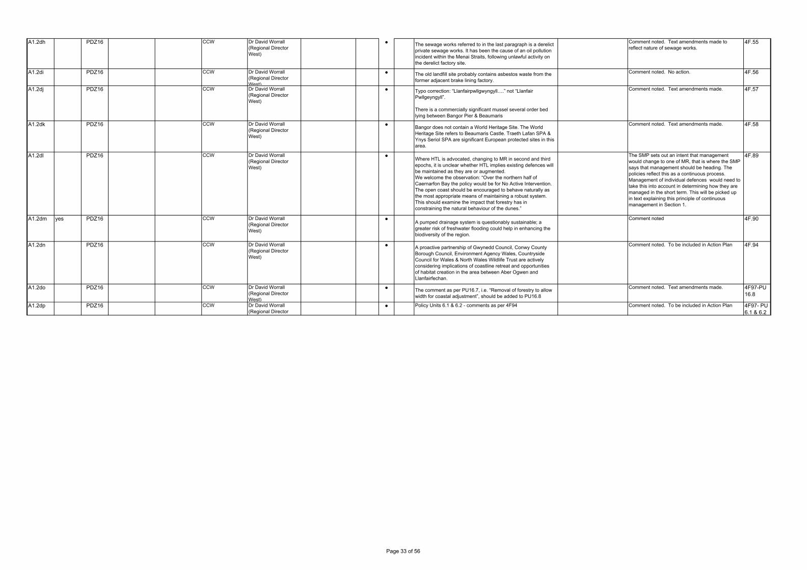
A1.2dh PDZ16 CCW Dr David Worrall (Regional Director West)
● The sewage works referred to in the last paragraph is a derelict private sewage works. It has been the cause of an oil pollution incident within the Menai Straits, following unlawful activity on the derelict factory site.
Comment noted. Text amendments made to reflect nature of sewage works.
4F.55
A1.2di PDZ16 CCW Dr David Worrall (Regional Director West)
● The old landfill site probably contains asbestos waste from the former adjacent brake lining factory.
Comment noted. No action. 4F.56
A1.2dj PDZ16 CCW Dr David Worrall (Regional Director West)
● Typo correction: “Llanfairpwllgwyngyll….” not “Llanfair Pwllgeyngyll”.
There is a commercially significant mussel several order bed lying between Bangor Pier & Beaumaris
Comment noted. Text amendments made. 4F.57
A1.2dk PDZ16 CCW Dr David Worrall (Regional Director West)
●Bangor does not contain a World Heritage Site. The World Heritage Site refers to Beaumaris Castle. Traeth Lafan SPA & Ynys Seriol SPA are significant European protected sites in this area.
Comment noted. Text amendments made. 4F.58
A1.2dl PDZ16 CCW Dr David Worrall (Regional Director West)
●Where HTL is advocated, changing to MR in second and third epochs, it is unclear whether HTL implies existing defences will be maintained as they are or augmented.We welcome the observation: “Over the northern half of Caernarfon Bay the policy would be for No Active Intervention. The open coast should be encouraged to behave naturally as the most appropriate means of maintaining a robust system. This should examine the impact that forestry has in constraining the natural behaviour of the dunes.”
The SMP sets out an intent that management would change to one of MR, that is where the SMP says that management should be heading. The policies reflect this as a continuous process. Management of individual defences would need to take this into account in determining how they are managed in the short term. This will be picked up in text explaining this principle of continuous management in Section 1.
4F.89
A1.2dm yes PDZ16 CCW Dr David Worrall (Regional Director West)
●A pumped drainage system is questionably sustainable; a greater risk of freshwater flooding could help in enhancing the biodiversity of the region.
Comment noted 4F.90
A1.2dn PDZ16 CCW Dr David Worrall (Regional Director West)
● A proactive partnership of Gwynedd Council, Conwy County Borough Council, Environment Agency Wales, Countryside Council for Wales & North Wales Wildlife Trust are actively considering implications of coastline retreat and opportunities of habitat creation in the area between Aber Ogwen and Llanfairfechan.
Comment noted. To be included in Action Plan 4F.94
A1.2do PDZ16 CCW Dr David Worrall (Regional Director West)
● The comment as per PU16.7, i.e. “Removal of forestry to allow width for coastal adjustment”, should be added to PU16.8
Comment noted. Text amendments made. 4F97-PU 16.8
A1.2dp PDZ16 CCW Dr David Worrall (Regional Director
● Policy Units 6.1 & 6.2 - comments as per 4F94 Comment noted. To be included in Action Plan 4F97- PU 6.1 & 6.2
Page 33 of 56
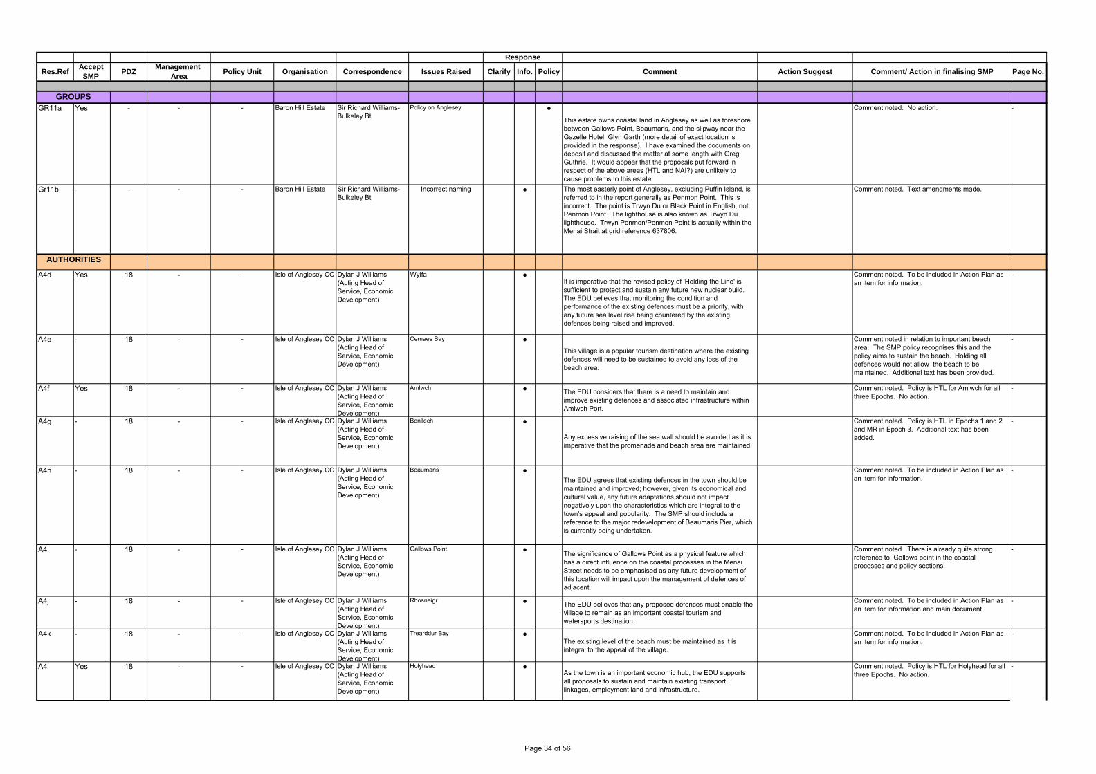
GR11a Yes - - - Baron Hill Estate Sir Richard Williams-Bulkeley Bt
Policy on Anglesey ●
This estate owns coastal land in Anglesey as well as foreshore between Gallows Point, Beaumaris, and the slipway near the Gazelle Hotel, Glyn Garth (more detail of exact location is provided in the response). I have examined the documents on deposit and discussed the matter at some length with Greg Guthrie. It would appear that the proposals put forward in respect of the above areas (HTL and NAI?) are unlikely to cause problems to this estate.
Comment noted. No action. -
Gr11b - - - - Baron Hill Estate Sir Richard Williams-Bulkeley Bt
Incorrect naming ● The most easterly point of Anglesey, excluding Puffin Island, is referred to in the report generally as Penmon Point. This is incorrect. The point is Trwyn Du or Black Point in English, not Penmon Point. The lighthouse is also known as Trwyn Du lighthouse. Trwyn Penmon/Penmon Point is actually within the Menai Strait at grid reference 637806.
Comment noted. Text amendments made.
A4d Yes 18 - - Isle of Anglesey CC Dylan J Williams (Acting Head of Service, Economic Development)
Wylfa ●It is imperative that the revised policy of 'Holding the Line' is sufficient to protect and sustain any future new nuclear build. The EDU believes that monitoring the condition and performance of the existing defences must be a priority, with any future sea level rise being countered by the existing defences being raised and improved.
Comment noted. To be included in Action Plan as an item for information.
-
A4e - 18 - - Isle of Anglesey CC Dylan J Williams (Acting Head of Service, Economic Development)
Cemaes Bay ●
This village is a popular tourism destination where the existing defences will need to be sustained to avoid any loss of the beach area.
Comment noted in relation to important beach area. The SMP policy recognises this and the policy aims to sustain the beach. Holding all defences would not allow the beach to be maintained. Additional text has been provided.
-
A4f Yes 18 - - Isle of Anglesey CC Dylan J Williams (Acting Head of Service, Economic Development)
Amlwch ● The EDU considers that there is a need to maintain and improve existing defences and associated infrastructure within Amlwch Port.
Comment noted. Policy is HTL for Amlwch for all three Epochs. No action.
-
A4g - 18 - - Isle of Anglesey CC Dylan J Williams (Acting Head of Service, Economic Development)
Benllech ●
Any excessive raising of the sea wall should be avoided as it is imperative that the promenade and beach area are maintained.
Comment noted. Policy is HTL in Epochs 1 and 2 and MR in Epoch 3. Additional text has been added.
-
A4h - 18 - - Isle of Anglesey CC Dylan J Williams (Acting Head of Service, Economic Development)
Beaumaris ●The EDU agrees that existing defences in the town should be maintained and improved; however, given its economical and cultural value, any future adaptations should not impact negatively upon the characteristics which are integral to the town's appeal and popularity. The SMP should include a reference to the major redevelopment of Beaumaris Pier, which is currently being undertaken.
Comment noted. To be included in Action Plan as an item for information.
-
A4i - 18 - - Isle of Anglesey CC Dylan J Williams (Acting Head of Service, Economic Development)
Gallows Point ●The significance of Gallows Point as a physical feature which has a direct influence on the coastal processes in the Menai Street needs to be emphasised as any future development of this location will impact upon the management of defences of adjacent.
Comment noted. There is already quite strong reference to Gallows point in the coastal processes and policy sections.
-
A4j - 18 - - Isle of Anglesey CC Dylan J Williams (Acting Head of Service, Economic Development)
Rhosneigr ● The EDU believes that any proposed defences must enable the village to remain as an important coastal tourism and watersports destination
Comment noted. To be included in Action Plan as an item for information and main document.
-
A4k - 18 - - Isle of Anglesey CC Dylan J Williams (Acting Head of Service, Economic Development)
Trearddur Bay ●The existing level of the beach must be maintained as it is integral to the appeal of the village.
Comment noted. To be included in Action Plan as an item for information.
-
A4l Yes 18 - - Isle of Anglesey CC Dylan J Williams (Acting Head of Service, Economic Development)
Holyhead ●As the town is an important economic hub, the EDU supports all proposals to sustain and maintain existing transport linkages, employment land and infrastructure.
Comment noted. Policy is HTL for Holyhead for all three Epochs. No action.
-
GROUPS
AUTHORITIES
Response
Res.RefAccept SMP
PDZManagement
AreaOrganisationPolicy Unit Page No. Clarify Info. Policy CommentCorrespondence Issues Raised Action Suggest Comment/ Action in finalising SMP
Page 34 of 56
A4m No 18 - - Isle of Anglesey CC Dylan J Williams (Acting Head of Service, Economic Development)
Penrhos Bay ●
Given the scale and impact of a proposed tourism development (of significant importance from an economic and social perspective) the EDU disagrees with the Management Plan's recommendation and considers that there is a need for more active intervention (ie. raising existing defences) at this location.
The SMP recommends for a set back flood defence in the area, subject to more detailed study. The SMP has identified that the natural bay should be allowed to behave naturally and that by setting back the defence line this would provide a more sustainable approach to management. This is not seen as being in conflict with development and would provide a more attractive beach area compatible with use.
Text has been added to explain the application of the MR policy in relation to potential development.
-
A7b - - - - Isle of Anglesey CC Alun Morgan Owen (Countryside and AONB officer)
Anglesey's AONB - Context/Background
●The Isle of Anglesey AONB has one of the most distinctive, attractive and varied landscapes in the British Isles. Anglesey was designated as an AONB in 1966 (confirmed in 1967) in order to protect the aesthetic appeal and variety of the island’s coastal landscapes and habitats from inappropriate development. Anglesey’s AONB is predominantly a coastal designation; covering most of Anglesey’s 201 kilometre coastline. The total coverage of the AONB on Anglesey is approximately 221sq kms (21,500 hectares) and is currently the largest AONB in Wales. Anglesey’s AONB also contains many habitats which have statutory protection because of their nature conservation value. These designations include: Special Areas of Conservation (SAC); Special Protection Areas (SPA); A National Nature Reserve (NNR); Sites of Special Scientific Interest (SSSI); Local Nature Reserves (LNRs).
Comment noted. No action. -
A7c - - - - Isle of Anglesey CC Alun Morgan Owen (Countryside and AONB officer)
Anglesey's AONB Management Plan - 2009-2014
●
In relation to Anglesey, the West of Wales Shoreline Management Plan №2 should ensure it takes into account the statutory and adopted AONB Management Plan for Anglesey, 2009 – 2014 www.anglesey.gov.uk and subsequent AONB Management Plans as directed by the Countryside and Rights of Way (CRoW) Act, 2000. Anglesey’s AONB Management Plan 2009-2014 is strongly embedded within Anglesey County Council’s Service Delivery Plans and Corporate Business Plan
This is covered in the SEA in Appendix. AONB is recognised within text.
-
A7d - - - - Isle of Anglesey CC Alun Morgan Owen (Countryside and AONB officer)
Anglesey's AONB Management Plan - 2009-2014
●It is vital that any engineering works emanating from the West of Wales Shoreline Management Plan №2 takes into account Section 85 of the CRoW Act, 2000. ‘’In exercising or performing any functions in relation to, or so as to affect, land in and area of outstanding natural beauty, a relevant authority shall have regard to the purpose of conserving and enhancing the natural beauty of the area of outstanding natural beauty’’. The following are relevant authorities for the purpose of this section – any Minister of the Crown, any public body, any statutory undertaker and any person holding public office.
The SMP sets out policy. The AONB is clearly identified as a significant influence on management and it is agreed that it would have to be taken into account in relation to specific works along the shoreline.
This is covered by consideration of these issues in setting overall objectives agreed with the CSG. Specific reference to AONB is also now made in the introduction to Coastal Area G
-
A7e - - - - Isle of Anglesey CC Alun Morgan Owen (Countryside and AONB officer)
Planning Policy Context (Planning Policy Wales 2010)
●
The primary objective for designating AONBs is the conservation and enhancement of their natural beauty. Development plan policies and development control decisions affecting AONBs should favour conservation of natural beauty, although it will also be appropriate to have regard to the economic and social well-being of the areas. Local authorities, other public bodies and other relevant authorities have a statutory duty to have regard to AONB purposes.
Comment noted. No action. -
A7f - - - - Isle of Anglesey CC Alun Morgan Owen (Countryside and AONB officer)
Planning Policy Context (Planning Policy Wales 2010)
●5.3.6 National Parks and AONBs are of equal status in terms of landscape and scenic beauty and both must be afforded the highest status of protection from inappropriate developments. In development plan policies and development control decisions National Parks and AONBs must be treated as of equivalent status. In National Parks and AONBs, development plan policies and development control decisions should give great weight to conserving and enhancing the natural beauty, wildlife and cultural heritage of these areas.
Comment noted. No action. -
Page 35 of 56

A7g - - - - Isle of Anglesey CC Alun Morgan Owen (Countryside and AONB officer)
Planning Policy Context (Planning Policy Wales 2010)
●
The duty to have regard to National Park and AONB purposes applies to activities affecting these areas, whether those activities lie within or outside the designated areas.
Comment noted. No action. -
A1.2dq CCW Dr David Worrall (Regional Director West)
Introduction ● There is no reference to Liverpool Bay/Bae Lerpwll SPA which extends south of Point Lynas.
This will be included as appropriate 4G2
A1.2dr CCW Dr David Worrall (Regional Director West)
Introduction ●At present Wylfa power station is the only functioning nuclear power station in Wales and a potential site for a new generation site.
Comment noted. No action. 4G2
A1.2ds PDZ 19 CCW Dr David Worrall (Regional Director West)
●Mention should be made of Liverpool Bay/Bae Lerpwll SPA which lies below MLWM from Point Lynas to the boundary with Traeth Lafan SPA.
This will be included as appropriate 4G.178
A1.2dt PDZ 19 CCW Dr David Worrall (Regional Director West)
● Ynys Seriol/Puffin Island is a SSSI & SPA, but not SAC. It is totally surrounded by Y Fenai a Bae Conwy SAC and Liverpool Bay/Bae Lerpwll SPA
Comment noted and text will be amended accordingly. The policy in this area is unlikely to be affected.
4G.180
A1.2du PDZ 19 CCW Dr David Worrall (Regional Director West)
● We would welcome development of a local management plan for policy unit 19.14, which should also include 19.15
Comment noted. No action. 4G.200
A1.2dv PDZ 20 CCW Dr David Worrall (Regional Director West)
● The Fisheries Research Laboratory is no longer a functional unit Comment noted. Text amendments made. 4F.158
A1.2dw PDZ 20 CCW Dr David Worrall (Regional Director West)
● There are two SSSIs in the tidal Conwy Valley: Aber Afon Conwy (which includes Morfa Conwy Dunes) and Morfa Uchaf Dyffryn Conwy
This will be included as appropriate 4F.160
Page 36 of 56

Policy Unit
GROUPS
AUTHORITIES
Comment/ Action in finalising SMPOrganisation
Response
Res.RefAccept
SMP Coastal
AreaPDZ
Management Area
Page No. Clarify Info. Policy CommentCorrespondence Issues Raised Action SuggestSection
Page 37 of 56

Issues RaisedManagement
Area Comment/ Action in finalising SMPOrganisation Page No. Clarify Info. Policy CommentCorrespondence
Policy Unit
Action SuggestSection
GROUPS
AUTHORITIES
Response
Res.RefAccept
SMP Coastal
AreaPDZ
Page 38 of 56

Policy Unit
GROUPS
AUTHORITIES
Comment/ Action in finalising SMPOrganisation
Response
Res.RefAccept
SMP Coastal
AreaPDZ
Management Area
Page No. Clarify Info. Policy CommentCorrespondence Issues Raised Action SuggestSection
Page 39 of 56

Gen4 - D - - - - Afon Teifi Management Board
- Typo ● Appendix D refers to a "rail/railway bridge" at Cardigan on page13 Section 5.1 and again on page 17 in the table, Stage 1 and section 5.3 Discussion.
Amend to "road/railway bridge" Amend to "road/railway bridge" Various
Issues RaisedManagement
Area Comment/ Action in finalising SMPOrganisation Page No. Clarify Info. Policy CommentCorrespondence
Policy Unit
Action SuggestSection
GROUPS
AUTHORITIES
Response
Res.RefAccept
SMP Coastal
AreaPDZ
Page 40 of 56

A1.3b CCW Dr David Worrall (Regional Director West)
1.2.1 The SMP context for SEA
● This document is incorrectly referred to as the draft Environment Report.
Noted. 1
A1.3c CCW Dr David Worrall (Regional Director West)
1.4 Scope and structure of report
●This should refer to chapter seven (not chapter Severn). Noted.
4
A1.3f CCW Dr David Worrall (Regional Director West)
Table 2.2 Context and Methodology
●In considering the SEA Objective for Biodiversity, Flora and Fauna, reference is made to BAP habitats but there is no specific mention of BAP species. While we accept that there can be data gaps with respect to BAP species, implementation of SMP2 policy must take these into account. As such, we urge the Plan-makers to ensure that all relevant species data has been sought. The network of Local Record Centres will be a vital source of information for this topic.We very much welcome the renaming of the SEA Receptor ‘Earth Heritage, Soils and Geology’ with ‘Geology and Geomorphology’. However, this title has not been applied consistently throughout the document.For landscape character and visual amenity, the SEA objectives are “to conserve and enhance nationally designated landscapes”. The target for this Receptor, however, is “no adverse impacts on landscape character”. All intention to ‘enhance’ seems to have been lost in moving from ‘objective’ to ‘target’. CCW strongly recommends that opportunities to restore or enhance landscape quality are taken (and recommended by the Plan) through the implementation of HTL. With respect to landscape, there is particular concern about those stretches of coastline subject to NAI policy which have a clause stipulating “does not preclude landowners doing their own defences”. We have concerns that this option could result in significant environmental effect on landscape character and visual amenity. For the assessment of these sites, the potential for significant negative effects on landscape should be recorded.
In regards to BAP species, these are more transient compared to fixed BAP habitats and the level detail for site specific BAP species was not known for all sites. However, based on the assessment of the SSSI interest features at the higher level of assessment would have a cascading influence on the overall management of the BAP species for the West of Wales SMP2.
A1.3g CCW Dr David Worrall (Regional Director West)
4 SEA General comment ●In some instances where HTL has been identified as the preferred policy option, this is currently recorded as having neutral impact even though it may result in coastal squeeze and loss of intertidal habitat. Wherever coastal habitat is being lost because of a HTL policy, this will need to be classified as a negative impact and compensated for. Furthermore, it should be noted that in situations where the policy changes from HTL to NAI (or MR) in subsequent epochs, any reduction in adverse effects, or anticipated positive impacts on features, is likely to depend on the removal or adaptation of any existing defences. We appreciate that the nature of any effects will depend on individual site specific conditions and the nature and location of any features present and, therefore, accept that they will need to be assessed at strategy or project level when sufficient detail is available. However, we strongly recommend that the potential need to remove ‘old’ defences is clearly acknowledged in the relevant sections of this HRA and, where appropriate, within the Action Plan itself depending on the conclusions of more
A major generic assumption of HTL is an adverse impact on such features as intertidal habitat through coastal squeeze. We have assessed HTL and all other management options at the policy unit level take into account the specific interest features, location and surrounding influences (e.g. built environment). However, the major environmental interest feature for PU 5.7 is the watercourse associated with the Afon Teifi SSSI which would not be influenced by a policy of HTL including associated fluvial processes. In regards to NAI and existing defences, the level of impact will depend on the nature conservation interests behind the defences.
A1.3h CCW Dr David Worrall (Regional Director West)
4.2.3 PDZ1 St Anns Headland
● There is no reference to Skomer Marine Nature Reserve (MNR) for this PDZ. As such, CCW is concerned that impacts on the MNR have not been considered during the SEA process. We recommend a reassessment for this PDZ, taking account of the MNR and incorporating any resulting change into the relevant sections of the document.
Skokholm and Skomer SPA was addressed in detail (see Appendix E) in which no adverse effect is anticipated for the policies of NAI, NAI, NAI. As such for the MNR, it is also anticpated that no effects will occur as a result of intervention, with the those if occuring based on natural processes.
A1.3i CCW Dr David Worrall (Regional Director West)
4.2.122, 4.2.137, 4.2.162, 4.2.215 and 4.2.270 PDZs 10, 11, 12, 16 and 20
● Throughout CCW’s involvement in the SEA process for the West of Wales SMP2, we have raised concerns about the constraints that rail infrastructure places on the optimal management of the coastline. As raised in our accompanying Plan response, the Coastal Group needs to acknowledge that
The SMP is the start of a long-term discussion that will require legislative change, however the constraints that rail infrastructure places on the optimal management of the coastline and its environment will be a priority of the Action Plan.
Policy Unit
GROUPS
AUTHORITIES
Comment/ Action in finalising SMPOrganisation
Response
Res.RefAccept
SMP Coastal
AreaPDZ
Management Area
Page No. Clarify Info. Policy CommentCorrespondence Issues Raised Action SuggestSection
Page 41 of 56
A1.3k CCW Dr David Worrall (Regional Director West)
4.5.4 Earth Heritage, Soils and Geology
●This section should be renamed ‘Geology and Geomorphology’ in order to be consistent with the renamed SEA receptor.CCW believes the assessment of neutral impact on geology to be incorrect – the SEA objective is “to support natural processes and maintain geological exposures throughout nationally designated geological sites”. CCW feels strongly that such exposures would not be maintained if they are subject to erosion and thus the impact would be a negative one. This could also apply to areas where sea level rise may result in geological exposure no longer being accessible.This Report states that “The main area where there is the potential for loss of geological exposure and damage to the geological component is in the Glannau Tonfanau / Friog SSSI where erosion rates may be reduced as a result of SMP policy intended to protect the nationally important railway line”. The Geological Conservation Review (GCR) Report for this site indicates that the construction of sea walls and other stabilising structures has already led to the concealment of some of the exposures and further construction could lead to further concealment. The GCR recommends that rock bolting stabilisation techniques could be employed and would be less detrimental to the geological interest.
The continued natural exposure of geological sites is of extreme importance to the SMP2, and those sites in which NAI will allow continued exposure has been classified as neutral as it will maintain the `status quo' as SMP policy has not influenced the outcome / integrity of the interest feature. For those sites, which may be impacted upon by sea level rise, this may only occur along the toe of cliffs etc and not impacting upon the whole geological interest feature. Glannau Tonfanau will be considered in more detail at implementation stge and included in mitigation and the Action plan.
A1.3l CCW Dr David Worrall (Regional Director West)
4.5.6 Landscape character and visual amenity
●CCW welcomes consideration of the impact that SMP2 policies can have on landscape character and visual amenity. HTL policies will require more substantial coastal protection in the future. Landscape impacts are already an issue and will be even more so in future. While CCW would agree that sensitive and appropriate design of HTL actions can help to reduce the scale of any impacts associated with SMP2 policies”, we would encourage use of a land/seascape assessment approach. Further information on this topic can be found in CCW’s report on the impact of sea defences on landscape.
Noted.
A1.3m CCW Dr David Worrall (Regional Director West)
4.5.13 Conclusion ●This section states that mitigation and management measures have been devised to address these effects where possible. CCW would like to see reference to what will happen where such measures are not possible.
Check to see if there are any policies that cannot be mitigated and if so, state what will happen. If there aren't, change text to remove "where possible"
A1.3r CCW Dr David Worrall (Regional Director West)
Annex A – Assessment Tables for Material Assets and Built Heritage
●
There are many mistakes in this regarding location references and the annex needs to be thoroughly checked. As an example, many Pembrokeshire site names are given for PDZs in Gwynedd.
The majority of sites will be mitigated, however for those few sites that may not be possible, then these will be noted in the Action Plan and continued monitoring undertaken to ensure no further impact on the integrity of sites. If so, further action will be undertaken at for site specific locations. However, it should be noted mitigation measures have been provided in Tables 4.3 to 4.22 for those sites which have major negative impacts.
A1.3s CCW Dr David Worrall (Regional Director West)
Annex B – Assessment Tables for Natura 2000 Sites
● CCW finds that there are too many cases where specific details of mitigation are either vague or missing entirely. At this stage, there should be sufficient detail for the mitigation measures to be meaningful and the mitigation should be cross-referenced with the Action Plan.
These concerns have subsequently been addressed in this SoEP (see Section 7) and the SMP Action Plan.
A1.3t CCW Dr David Worrall (Regional Director West)
Annex C – Assessment Tables for Sites of Special Scientific Interest
● CCW has significant concerns as to how the level of impact on PUs has been recorded for some management policies. As one example, PUs 5.5 and 5.7 (Afon Teifi) have a HTL policy for all three epochs that will result in coastal squeeze and loss of intertidal habitat. This is currently recorded as a neutral impact. CCW feels strongly that an impact resulting in loss of an SSSI feature or BAP habitat should not be considered neutral.
As previously noted, a major generic assumption of HTL is an adverse impact on such features as intertidal habitat through coastal squeeze. We have assessed HTL and all other management options at the policy unit level take into account the specific interest features, location and surrounding influences (e.g. built environment) associated with SSSIs and BAPs. However, the major environmental interest feature for PU 5.7 is the watercourse associated with the Afon Teifi SSSI which would not be influenced by a policy of HTL including associated fluvial processes. However, for BAP habitats such as sandflat and mudflats could be directly impacted upon by coastal squeeze along the same policy units.
A1.3w CCW Dr David Worrall (Regional Director West)
Other comments ● CCW would expect to see some reference to uncertainties and risks which may impact on the SEA process.
These concerns have subsequently been addressed in the SoEP.
A1.3x CCW Dr David Worrall (Regional Director West)
4.2.126: PDZ 10,Upper Borth toTonfanau
● The MR policy in PU 10.15 (Penllyn) could result in the loss of BAP habitats and species: Sand Dune, Coastal and Floodplain grazing marsh, breeding Lapwing Vanellus vanellus, Dactylorhiza purpurella subsp. cambrensis,Oenanthe fistulosa.
The level of impact associated with MR will depend on the design and scope of the planned managed realignment for this site which is currently unknown. However, any adverse impact to BAP habitats and species for this site would be mitigated and thus reduce the level of impact.
Page 42 of 56
A1.3y CCW Dr David Worrall (Regional Director West)
4.2.139: PDZ 11,Tonfanau to Mochras
● The MR policy for PU 11.9 (Fegla) may result in the loss of the SSSI interest and estuary SAC feature of Arthog bog (BAP habitat Lowland Raised Bog).This should be made clear.
The level of impact associated with MR will depend on the design and scope of the planned managed realignment for this site which is currently unknown, this is reflected in the minor negative impact for this site. However, appropriate mitigation will be implemented to reduce major adverse impacts.
A1.3z CCW Dr David Worrall (Regional Director West)
Annex C: PU 3.2 and3.3, Solva
● This area is designated as an SSSI for geological and geomorphological interest. It is also part of the SAC. The implementation of HTL policies needs to be assessed in the context of these designations to ensure that issues are avoided. CCW seeks reassurance that this assessment has taken place.
As noted in Annex C for PU: 3.3 - HTL could result in loss of intertidal communities / habitats. Thus major negative impact will occur. It is acknowledged that the policy may also cause erosion rates associated with the geological interest feature of this SSSI to occur at a relatively slower rate and this will be addressed through monitoring and the Action Plan. Noted in SoEP.
A1.3aa CCW Dr David Worrall (Regional Director West)
Annex C: PU 3.5,Porth Clais
● This area is a GCR site and we recommend that CCW is consulted in relation to the implementation of the HTL policy in order to ensure that issues are avoided. This should also be reflected in the Action Plan.
Comment noted, no action required
A1.3ab CCW Dr David Worrall (Regional Director West)
Annex C: PU 4.10,Pwllgwaelod Bay &Cwm Dewi SSSI
● This area is designated as an SSSI for geological and geomorphological interest. The implementation of HTL then NAI/NAI policies needs to be assessed in the context of this designation to ensure that issues are avoided.CCW seeks reassurance that this assessment has taken place.
Local maintenance will occur for the first epoch prior to removal of defence and thus is acknowledged that the policy may also cause erosion rates associated with the geological interest feature of this SSSI to occur at a relatively slower rate and this will be addressed through monitoring and the Action Plan. However, the policy of NAI for the remainder of the epcohs will provide ongoing natural exposure fore the geological and geomorphological interests. Noted in SoEP.
A1.3ac CCW Dr David Worrall (Regional Director West)
Annex C: PU 5.9,Gwbert Road, AfonTeifi SSSI
● Afon Teifi SSSI does not extend into this unit. The SSSI is Aberarth – Carreg Wylan.
Noted.
A1.ad CCW Dr David Worrall (Regional Director West)
Annex C: PU 5.10,Gwbert Cliffs, AfonTeifi
● Incorrect reference cited: this should be Aberarth – Carreg Wylan SSSI.
Noted.
A1.ae CCW Dr David Worrall (Regional Director West)
Annex C: PU 5.15,Upstream of Bypassbridge north Aberarth– Carreg Wylan SSSI
● Incorrect reference cited: this should be Afon Teifi SSSI. Noted.
A1.af CCW Dr David Worrall (Regional Director
Annex C: PU 6.8,Cwmtydu
● The reference in the first two epochs to Aberporth is incorrect. Aberporth is included in PU 6.2 (6.8 is Cwmtydu).
Noted.
A1.ah CCW Dr David Worrall (Regional Director West)
Annex C: PU 10.15,Penllyn
● The assessment table should record a major negative impact on the SSSI because the MR policy could result in the loss of fixed dune grassland, marshy grassland and breeding Lapwing (all SSSI interest).
The level of impact associated with MR such as erosion will depend on the design and scope of the planned managed realignment for this site which is currently unknown. If a breach was to occur then there would be possible inundation of the marshy grassland which may result in a moderate adverse impact. However, this would be mitigated and thus reduce the level of impact associated with inundation.
A1.ai CCW Dr David Worrall (Regional Director West)
Annex C: PU 10.18,Glannau Tonfanau IFfriog
● For PU 10.18 (Dysynni Estuary) Broadwater SSSI the MR policy in epochs 2 and 3 could have a negative impact on the existing SSSI interest.
Within the Dysynni, the plan intent would be for Managed Realignment (MR) of defences for the second and third epochs, however the level impacts (either positive or negative) will depend on the scope and design of MR. If taking the long-term erosion line as potential MR extents, than with the exception of two locations, MR would not significantly impact upon the SSSI extents. Those areas in which erosion lines extend significantly past the SSSI boundary (both associated with open / unconstrained landscapes), there may be potential for habitat creation as part of MR.
A1.aj CCW Dr David Worrall (Regional Director West)
Annex C: PU 11.1-11.3, GlannauTonfanau I Ffriog
● A potential negative effect should be recorded here for Biodiversity, flora and fauna (impacts to Sabellaria reef are possible).
Impacts to reefs are through natural causes and not the SMP actions
A1.ak CCW Dr David Worrall (Regional Director West)
Annex C: PU 11.2,Fegla
● PU 11.2 is Llwyngwril (not Fegla). Fegla is PU 11.9. Noted.
A1.al CCW Dr David Worrall (Regional Director West)
Annex C: PU 11.5,Mawddach Estuary
● For PU 11.5 (Ro Wen Spit) Aber Mawddach SSSI, MR could result in the loss of SSSI features.
A HTL policy has been suggest for the first epoch to enable the protection of the railway followed by MR for the second and third epochs. However, the level of impact associated with MR on the Ro Wen Spit and Aber Mawddach SSSI is currently unknown. However, appropriate mitigation (e.g. habitat creation) will be implemented to reduce major negative adverse impacts on the SSSI for this site.
Page 43 of 56

A1.am CCW Dr David Worrall (Regional Director West)
Annex C : PU 11.9,Mawddach Estuary
● For PU 11.9 (Fegla) Aber Mawddach SSSI, MR could lead to the loss of SSSI interest (Arthog bog) therefore negative impact.
The level of impact associated with MR will depend on the design and scope of the planned managed realignment for this site which is currently unknown, this is reflected in the minor negative impact for this site. However, appropriate mitigation will be implemented to reduce major negative adverse impacts.
A1.an CCW Dr David Worrall (Regional Director West)
Annex C: PU 12.5,Morfa Dyffryn
● For PU 12.5 (Llandanwg Dunes) Morfa Dyffryn SSSI, MR may result in the loss of SSSI Sand Dune interest.
MR for this site will specifically avoid further extension of hard defence along this frontage with the aim to allow some control but also natural roll back of the dune system so that present management avoids future commitment to extending of hard defence and allowing natural processes to prevail. Thus, the policy will have more of positive impact than a negative as reflected in Appendix C of the SEA.
Page 44 of 56

Issues RaisedManagement
Area Comment/ Action in finalising SMPOrganisation Page No. Clarify Info. Policy CommentCorrespondence
Policy Unit
Action SuggestSection
GROUPS
AUTHORITIES
Response
Res.RefAccept
SMP Coastal
AreaPDZ
Page 45 of 56
A1.1a - 2 - - - - CCW Dr David Worrall (Regional Director West)
HRA Assessment Methodology - 2.8 Stage 4: Approval or refusal of the Plan
●CCW welcomes this clear and concise discussion of the process involved in taking the Plan forward in the event that the HRA can not conclude that adverse effects can be ruled out. However, it should also be noted that the process of testing for less damaging alternatives, making a case for Imperative Reasons of Over-riding Public Interest (IROPI) and developing a package of compensatory measures is not always straightforward and there are often advantages to separating it from the ‘appropriate assessment’ element of the HRA process.
While the discussion of this element of the HRA process is not necessarily incorrect, it is a simplification of this process and should be identified as such.
Text added to section 4.8.3 to state that this is not straightforward
A1.1b - 3 - - - - CCW Dr David Worrall (Regional Director West)
Table 3.1 ● We welcome the removal of the non-qualifying features from this table but a number of qualifying (albeit not the primary reason for site selection) features have also been removed.
All qualifying features should be listed for completeness and not just primary qualifying features, though we note that most, if not all, of the relevant features have been included in the detailed assessment tables in annex IV.
A1.1c - 4 - - - - CCW Dr David Worrall (Regional Director West)
Consideration of plans and other projects
● We welcome the clarifications made to this section of the assessment
Comment noted. No action.
A1.1d - 5 - - - - CCW Dr David Worrall (Regional Director West)
Section 5.3 ● We welcome the additional clarification of the methodology used to calculate potential impacts, particularly those relating to potential habitat losses resulting from ‘coastal squeeze’. We reiterate, however, the importance of considering all the potential impacts of the Plan proposals on qualifying features. This should include any impacts which may result from changes to coastal and sediment processes as a result of implementation of the Plan policies. This is particularly relevant to features such as Sabellaria reefs, sea grass beds and other inter-tidal and lower-littoral reef features. These may not be obviously impacted by compression of the foreshore against hard defences, but the opportunities for them to adapt/expand may be limited by factors such as increased wave refraction/reflection, changes to sediment supply/distribution or removal of ecological niches.
See Final HRA.
We are therefore pleased to note that the production of the HRA has clearly involved efforts to identify possible impacts in the widest context with suitable monitoring and mitigation measures proposed in many cases. It should be noted that CCW have commissioned a detailed study (Marine habitat creation, recovery and restoration in Wales, Project No: WCB002) to look at this issue in greater detail. This should help to further inform any mitigation measuresidentified by the Plan, the development of lower tier strategies and project implementation as well as any package of compensation measures that may be necessary should a case for Imperative Reasons of OverridingPublic Interest be made. Finally, it should be noted that in situations where the policy changes from HTL to NAI (or MR) in subsequent epochs, any reduction in adverse effects, or anticipated positive impacts on features, is likely to depend on the removal or adaptation of any existing defences. We appreciate that the nature of any effects will depend on individual site specific conditions and the nature and location of any features present and, therefore, accept that they will need to be assessed at strategy or project level when sufficient detail is available. However, we strongly recommend that the potential need to remove ‘old’ defences is clearly acknowledged in the relevant sections of this HRA and, where appropriate, within the Action Plan itself depending on the conclusions of more detailed assessment.
A1.1e - 5 - 5 - - CCW Dr David Worrall (Regional Director West)
Section 5.4 - PDZ4 ● We welcome the clarifications and amendments made to the assessment of the policy proposals in this PDZ.
Comment noted. No action.
Comment/ Action in finalising SMPOrganisation
Response
Res.RefAccept
SMP Coastal
AreaPDZ
Management Area
Policy Unit
Correspondence Issues Raised Action SuggestSection
GROUPS
AUTHORITIES
Page No. Clarify Info. Policy Comment
Page 46 of 56

A1.1f - 5 - 5 - - CCW Dr David Worrall (Regional Director West)
Section 5.4 - PDZ5 (5.4.14 - 5.4.19) - Cardigan Bay SAC
●Whilst we acknowledge many of the points made in the additional clarification of the conclusion of ‘No likely significant effect’ made in the assessment and accept that potential impact of the combined policy proposals on the reef and sandbank features is uncertain, we still feel that the potential loss of sandbanks within the area of the outer Teifi Estuary, as a result of implementing HRA policies, should be acknowledged in the assessment. In addition, a commitment should be made to monitoring the predicted changes and, if necessary, addressing any issues identified at project level, either through appropriate mitigation measures or by amending the Plan. However, we accept that the potential changes to the hydrography and alterations to the chemical and biological interactions, as a result of implementing the combination of HTL and MR policies are unlikely to have a significant effect on any reef features present, given the nature of the site.
No change to document. We feel that the commitment to recharging the spit will sustain the feature. There is an uncertainty regarding deposition/ accretion on sandflats in the estuary but the sand will remain in the system, therefore there will be no LSE.
A1.1g - 5 - 7 - - CCW Dr David Worrall (Regional Director West)
Section 5.4 - PDZ7 (5.4.34 - 5.4.41)
●We welcome the clarification and additional assessment carried out to address our previous comments. We largely accept the justifications put forward for significant effects on the reef features being unlikely at Cei Bach (PU 7.5) and Newquay (PU 7.2), given the location of the features, nature and location of the defences and geography at both locations. We also welcome the clarification regarding the relationship between the defences and reef features at Newquay (i.e. they are part of the existing harbour defences and would be expected to re-colonise any new defences), the clear requirement for project level assessment and the need for mitigation to avoid, cancel or reduce any potential adverse effects that could occur as part of project implementation. To support this we strongly recommend that monitoring of the existing reef features, particularly any that occur on existing FRM structures, is carried out to ensure sediment supply is being maintained (particularly given the likelihood of restriction to the supply of boulder clay, boulders, cobbles and sediments to the intertidal zone at Cei Bach) and that thehydromorphology and dynamics are not being altered (such as increasing wave refraction/reflection) in such a way that they may begin to impact the reef features.
Monitoring requirements to be added to HRA and Action Plans.
Text also added to clarify that monitoring would be required if structures were to affect reefs.
A1.1h - 5 - 8 - - CCW Dr David Worrall (Regional Director West)
Section 5.4 - PDZ8 (5.4.44)
●We welcome the additional clarification given here and in Annex IV in relation to the potential impacts of the HTL policies, particularly those in PUs 8.2, 8.4 and 8.6 around Aberaeron, on the reef features of the Cardigan Bay SAC. This section of the Cardigan Bay SAC has extensive areas of biogenic reefs (Sabellaria) in the lower littoral zone and the potential impacts of coastal defence works could, therefore, be significant. We largely accept the justifications given for significant effects being unlikely, namely; sediment supply is likely to be maintained from units where NAI and MR are the preferred policies where the defences are at the top of the foreshore, often behind existing beach structures, while the reef features are mainly in the lower littoral zone. We also acknowledge that MR is the preferred policy for Aberaeron south beach and Aberarth in the 3rd epoch, which should limit any potential impacts in the latter stages of the Plan. However, we still feel that there is sufficient uncertainty over the potential effects of the inevitable narrowing of the inter-tidal area (as acknowledged in the assessment) to warrant a more precautionary approach being adopted in this assessment. We strongly recommend, therefore, that a monitoring programme is implemented for these policy units to ensure sediment supply is being maintained and that the hydromorphology and dynamics are not being altered (such as increasing wave refraction/reflection) in such a way that they may begin to impact the reef features. We also recommend that the need for detailed project level HRA is emphasised in the Action Plan.
See Final HRA.
Page 47 of 56

A1.1j - 5 - 15 - - CCW Dr David Worrall (Regional Director West)
Section 5.4 - PDZ15 (5.4.66)
●We note the additional clarification given here and the justification detailed in Annex IV. As we stated in our previous response, we accept that the potential losses of inter-tidal habitats resulting from implementing the HTL policy at Porth Dinllaen (PU 15.2) in the first epoch are unlikely to be significant alone, but should be considered in combination with all the other possible losses resulting from the Plan, in which case, the cumulative impact would be significant. While we appreciate that any loss would be difficult to separate from the natural tidal fluctuations over the first epoch and that MR is proposed for the following epochs, given the uncertainty (and the potential that the MR policy may not be implemented until the end of the 2nd epoch) we still feel a precautionary approach should be adopted within this policy unit, and adverse impact recorded and the potential losses included in the overall figures for the Plan. It may be that monitoring would indicate that losses ultimately are ‘de minimis’ and no action would be required but at this stage a precautionary approach should be pursued.
Cumulative impacts in Table 6.1 state that there is a cumulative significant impact to the SAC. No action
A1.1k - 5 - 17 - - CCW Dr David Worrall (Regional Director West)
Section 5.4 - PDZ17 (5.4.74)
● We welcome the additional clarification given here and in Annex IV in relation to potential impacts on the Abermenai to Aberfraw Dunes SAC. We feel that these have addressed the majority of our concerns over the potential impact of the HTL policy at PU 17.3 for the 1st epoch on the dune features. We still feel that it would be prudent to monitor the situation, particularly in relation to the potential impacts of HTL policy units in adjacent PDZs on sediment supply to the site, though we accept that there are unlikely to be any significant effects as a direct result of the policy options in PDZ 17 itself.
See Final HRA.
A1.1m - 5 - 19 - - CCW Dr David Worrall (Regional Director West)
Section 5.4 - PDZ19 (5.4.89 - 5.4.91)
●We welcome the additional clarification in relation to the location and intended management of the HTL policy in PUs 19.5, 19.10 and 19.12. Given that the location is outside the site boundary of the Menai Straits and Conwy Bay SAC and the intention, both in these units and elsewhere, is primarily to manage natural features and allow MR in the long term, we feel that there is sufficient justification for no likely significant effect. However, we would strongly recommend that a monitoring requirement is also included in the Action Plan linked to a commitment to review the management options should the monitoring show that adaptation of the features is not progressing as anticipated.
See Final HRA.
A1.1n - 5 - 2 - - CCW Dr David Worrall (Regional Director West)
Section 5.5 - PDZ2 (5.5.4 - 5.5.13)
●CCW welcomes the thoroughness of this element of the assessment and the precautionary approach adopted in relation to potential impacts on the inter-tidal mud and sand-flat features of the Pembrokeshire Marine SAC due to ‘coastal squeeze’ resulting from implementing HTL policies. We recognise that this is a ‘worst case scenario’ and individual scheme implementation may be able to reduce this loss, however, due to the level of uncertainty, we largely agree with the assessment conclusion that it is not possible to determine that there will not be adverse effects on this feature from implementing the Plan. We would recommend that, due to the presence of inter and sub-tidal reefs, particularly near the HTL policy units in PU2.2, 2.5 and 2.8, that an additional monitoring element is included to ensure that the changes to hydromorphology and hydrodynamics are as predicted (ie only immediately in front of defences) and are not likely to impact on these features in the mid and lower littoral zones. This should be combined with a clear commitment to review the SMP2 recommendations in light of the monitoring results. We also agree that there are unlikely to be significant effects on the other sites/features in this PDZ as a result of implementing the individual policy units.
See Final HRA.
Page 48 of 56

A1.1o - 5 - 3 - - CCW Dr David Worrall (Regional Director West)
Section 5.5 - PDZ3 (5.5.15 - 5.5.23)
●CCW welcomes the thoroughness of this element of the assessment and the precautionary approach adopted in relation to potential impacts on the inter-tidal mud and sand-flat features of the Pembrokeshire Marine SAC due to ‘coastal squeeze’ resulting from implementing HTL policies. We recognise that this is a ‘worst case scenario’ and individual scheme implementation may be able to reduce this loss, however, due to the level of uncertainty, we largely agree with the assessment conclusion that it is not possible to determine that there will not be adverse effects on this feature from implementing the Plan. We recommend that, due to the presence of inter and sub-tidal reefs, particularly near the HTL policy units in PU3.3, 3.4 and 3.8, that an additional monitoring element is included to ensure that the changes to hydromorphology and hydrodynamics are as predicted (ie only immediately in front of defences) and are not likely to impact on these features in the mid and lower littoral zones. This should be combined with a clear commitment to review the SMP2 recommendations in light of the monitoringresults. We also agree that there are unlikely to be significant effects on the other sites/features in this PDZ as a result of implementing the individual policy units.
See Final HRA.
A1.1p - 5 - 10 - - CCW Dr David Worrall (Regional Director West)
Section 5.5 - PDZ10 (5.5.25. 5.5.26 and 5.5.30)
●CCW welcomes the thoroughness of this element of the assessment and the precautionary approach adopted in relation to potential impacts on the inter-tidal mud and sand-flat features of the Pen Llyn a’r Sarnau SAC due to ‘coastal squeeze’ resulting from implementing HTL policies. We also welcome the acknowledgement that the proposed policies also have the potential to adversely affect the other estuarine and inter-tidal features due to changes in coastal processes leading to impacts on the structure and function of these features and ‘underachievement of the conservation objectives’. This should be linked to the development of an effective monitoring strategy and the requirement for appropriate action or modification of the Plan as necessary should indications be that changes in estuarine and coastal processes are changing as a result of policy implementation.
See Final HRA.
A1.1q - 5 - 10 - - CCW Dr David Worrall (Regional Director West)
Section 5.5 - PDZ10 (5.5.27 and 5.5.28)
●We welcome the additional clarification in relation to the location and intended management of the HTL and MR policy in PUs 10.17 and 10.18 and how the potential impacts of these options on the lagoon feature present in PU 10.17 may be addressed. While we still have some concerns over the ability of project level mitigation to adequately address the likely significant effects identified, we accept that this is a complex issue and that further detailed assessment is not possible at this strategic level. Given the uncertainty over the final nature of implementation of the policy options in these units, and the commitment to carry out more detailed study and assessment combined with the production of a strategy to determine how any long term coastal process issues would affect the lagoon extent; we feel that ensuring that appropriate management and maintenance measures are in place to maintain the lagoon feature, is likely to be adequate mitigation in this case. These measures should be clearly indicated in the final Action Plan as should the need for detailed project level assessment and the need to review the plan/policy following production of the strategy.
See Final HRA.
A1.1r - 5 - 10 - - CCW Dr David Worrall (Regional Director West)
Section 5.5 - PDZ10 (5.5.29 )
●We recommend that, due to the presence of inter and sub-tidal reefs, particularly near the HTL policy units in PU 10.18, that an additional monitoring element is included in the strategy proposed as mitigation above to ensure that the changes to hydromorphology and hydrodynamics are as predicted (ie would not effect the movement of material) and are not likely to impact on these features in the mid and lower littoral zones. This should be combined with a clear commitment to review the SMP2 recommendations in light of the monitoring results.
See Final HRA.
Page 49 of 56

A1.1s - 5 - 10 - - CCW Dr David Worrall (Regional Director West)
Section 5.5 - PDZ10 (5.5.31 )
● We welcome the additional clarification in relation to the implementation of the HTL and MR policies around the area of Cors Fochno SAC and the Dyfi Ramsar (PUs 10.5 – 10.7). We largely agree with the assessment of the impacts on the Raised Bog feature, but emphasise the importance of considering the re-integration of the raised bog feature into the estuarine system as early as possible to minimise the potential impact of a catastrophic failure of any of the defences, as highlighted in the assessment. We welcome the commitment to further study and the development of a strategy and agree that this is largely in line with the conservation objectives for the site, but would recommend that this is also clearly linked to the on-going development of the Water Level Management Plan for this area as water levels around the margins of the bog are an important factor in determining the vegetation condition and peat growth of the central ‘active raised bog’ feature (see also comments on this section in the response to the Plan itself). All these actions should also be highlighted in the Action Plan.
See Final HRA.
A1.1t - 5 - 11 - - CCW Dr David Worrall (Regional Director West)
Section 5.5 - PDZ11 (5.5.43, 5.5.44 and 5.5.51 )
●
Monitoring requirements to be added to HRA and Action Plans. Sea Caves to be added to assessment of PU 11.1 and 11.3
We welcome the additional clarification in relation to the assessment of the potential impacts of the HTL policy in PUs 11.1, 11.3 and 11.4 on the inter and sub-tidal reef features and the further proposals for management and mitigation. While we largely accept that, due to the nature of the shoreline in these sections (steeply sloping hard rock) that impacts due to implementing a HTL policy are likely to be limited in nature in terms of coastal squeeze effects, we still feel that there is sufficient uncertainty over the potential effects of the inevitable narrowing of the inter-tidal area (as now acknowledged in the assessment) to warrant the precautionary approach being adopted. In addition to more detailed survey being carried out prior to any project implementation, we also strongly recommend that a monitoring programme is implemented for these policy units to ensure sediment supply is beingmaintained and that the hydromorphology and dynamics are not being altered (such as increasing wave refraction/reflection) in such a way that they may begin to impact the reef features. This will particularly need to consider the potential impacts of hard defences preventing the erosion of the hard rock shoreline and altering the direct supply of material to the features in the mid and lower littoral zones. The on-going research work by CCW discussed above in section 5.3 should further inform any mitigation work. The need for monitoring, the necessity for detailed project level HRA and possible need for mitigation should also be clearly identified in the Action Plan. Submerged or partially submerged sea caves - we note that the detailed assessment (annex IV) states that the submerged or partially submerged sea caves feature is not likely to be impacted. However, it should be noted that in PUs 11.1 and 11.3 the sea caves are within the boundary of the SAC and, while some may be technically above mean high tide, they are still qualifying features. There is potential, therefore, for the HTL policies in these units, largely intended to protect the rail infrastructure, to have adverse effects on this feature depending on how they are implemented and this should be acknowledged in this assessment.
Page 50 of 56

A1.1u - 5 - 11 - - CCW Dr David Worrall (Regional Director West)
Section 5.5 - PDZ11 (5.5.45 and 5.5.52)
●
No assessment of plans for new defence has been made, as this would be outside the remit of the SMP. The SMP sets a policy to be supported by monitoring which would provide an assessment in advance of any potential impact. We do not however consider that the existing defences are having a significant impact.
Amendments made in the main text to discuss the issues. Monitoring is recommended and will be taken forward to the Action Plan
A1.1v - 5 - 11 - - CCW Dr David Worrall (Regional Director West)
Section 5.5 - PDZ11 (5.5.42, 5.5.26 - 5.5.48 and 5.5.50)
●
See Final HRA.
We welcome the further clarification of the implications of the MR and NAI policy options in the PU units at and to the south of the Morfa Harlech and Morfa Dyffryn SAC. We largely accept the justification given in Annex IV for the assessment of the NAI policy in PU 11.20. We also appreciate that assessing the implications of the MR option on the sediment supply to the dune systems complex at the level of the SMP2 and will need to be carried out in more detail at lower strategy or scheme level. However, assessment of a recent planning application concluded that existing defences in PU 11.19 are probably already having an effect on the sediment transport processes along this stretch of coast, restricting the supply of sand to the Morfa Harlech and Morfa Dyffryn SAC. Therefore, while we welcome the commitment to producing a strategy to inform the implementation of these policies andensure they are implemented in such a way as to ensure sediment supply is maintained along the coast, the implications of this approach must be made clear, particularly where the SMP2 is advocating support for ‘time limited defences’. Such defences, for example those in front of Islawffordd and Barmouth Bay holiday camps, would be unlikely to be able to demonstrate ‘no adverse effect’ and, therefore, if the SMP2 policy is supporting this approach, it must also conclude that it can not rule out an adverse effect on the Morfa Harlech and Morfa Dyffryn SAC. However, provided it is made clear in the Plan and this HRA that the SMP2 does not support such an approach, and the MR options proposed for the policy units along this stretch of coast will be started early in the 1st epoch, then it should be possible to conclude no adverse effect. As identified in the detailed assessment in annex IV, the implementation strategy should also include an element of monitoring to ensure coastal and sediment transport processes are behaving as expected and that any managed realignment stays ahead of any potential impacts. Finally, it should also be made clear that any specific projects that proposed building new, or maintaining existing, defences would not be in accordance with this Plan and would require a separate project specific HRA. The above approach should be clearly identified within the Action Plan.
CCW welcomes the thoroughness of this element of the assessment and the precautionary approach adopted in relation to potential impacts on the inter-tidal mud and sand-flat features of the Pen Llyn a’r Sarnau SAC due to ‘coastal squeeze’ resulting from implementing HTL policies. We also welcome the amendment to the potential loss figures for PU11.8 for the first epoch and the acknowledgement that the proposed policies also have the potential to adversely affect the other estuarine and inter-tidal features due to changes in coastal processes leading to impacts on the structure and function of these features and ‘underachievement of the conservation objectives’. This should be linked to the development of an effective monitoring strategy and the requirement for appropriate action or modification of the Plan as necessary should indications be that estuarine and coastal processes are changing as a result of policy implementation. We note that there is an inconsistency between the text in section 5.5.46 (“no measurable decrease in habitat extent in epoch 1”) and the figures given for such losses for this period in table 5.4 and the detailed assessment in Annex IV, but assume that this is an error in the text and the figures given in the table and Annex IV for potential losses are correct. See also ourcomments on section 5.3, on considering the implications of moving from an initial HTL policy to MR or NR in later epochs, which is particularly relevant to the policy units in the upper Mawddach.
We also welcome the clarification in relation to Arthog bog, which is a component of the Pen Llyn a’r Sarnau estuary feature, in PU 11.6. While we largely agree with the assessment conclusions we would, ideally, wish to see a similar
Page 51 of 56

A1.1w - 5 - 11 - - CCW Dr David Worrall (Regional Director West)
Section 5.5 - PDZ11 (5.5.49, 5.5.53 and 5.5.55)
● We welcome the further clarification of the implications of the MR policy option in PU 11.13 on the woodland and heathland features of the Meirionnydd Oakwoods and Bats SAC and the amendments to the mitigation required. Providing this clearly identified in the Action Plan we largely agree that this should effectively avoid or cancel any adverse effects resulting from the Plan.
See Final HRA.
A1.1x - 5 - 12 - - CCW Dr David Worrall (Regional Director West)
Section 5.5 - PDZ12 (5.5.58 and 5.5.59)
● CCW welcomes the thoroughness of this element of the assessment and the precautionary approach adopted in relation to potential impacts on the inter-tidal mud and sand-flat features of the Pen Llyn a’r Sarnau SAC due to ‘coastal squeeze’ resulting from implementing HTL policies. We also welcome the acknowledgement that the proposed policies also have the potential to adversely affect the other estuarine, large shallow inlets and bays and inter-tidal features due to changes in coastal processes leading to impacts on the structure and function of these features and ‘underachievement of the conservation objectives’, though we accept that it is important not to ‘double count’ any potential losses to these features in the calculations. This should be linked to the development of an effective monitoring strategy and the requirement for appropriate action or modification of the Plan as necessary should indications be that estuarine and coastal processes are changing as a result of policy implementation. In addition, it should be noted that the partially submerged sea caves feature may also be present in PU 12.8 and may be affected by the HTL policies proposed for this PU depending on how they are implemented and this should be acknowledged in this assessment.
See Final HRA.
A1.1aa - 5 - 12 - - CCW Dr David Worrall (Regional Director West)
Section 5.5 - PDZ12 (5.5.64)
● We welcome the additional clarification given in Annex IV in relation to the assessment of the potential impacts of the HTL policy in PUs 12.18, 12.20 and 12.24 on the inter and sub-tidal reef features and the further proposals for management and mitigation. Please note that sub and inter-tidal reef features also occur in PUs 12.2, 12.6 and 12.8. While we largely accept that the location of the defences in these sections (behind shingle ridges) may serve to naturally mitigate the impacts due to implementing a HTL policy in terms of coastal squeeze effects, we still feel that there is sufficient uncertainty over the potential effects of the inevitable narrowing of the inter-tidal area (as now acknowledged in the assessment) to warrant a strongly precautionary approach being adopted, particularly in PU12.24. In addition to more detailed survey being carried out prior to any project implementation, we also strongly recommend that a monitoring programme is implemented for these policy units to ensure sediment supply is being maintained and that the hydromorphology and dynamics are not being altered (such as increasing wave refraction/reflection) in such a way that they may begin to impact the reef features. The on-going research work by CCW discussed above in section 5.3 should further inform any mitigation work. The need formonitoring, the necessity for detailed project level HRA and possible need for mitigation should also be clearly identified in the Action Plan.
See Final HRA.
assessment conclusions we would, ideally, wish to see a similar approach to the re-integration of this component of the estuary feature into the system as is being taken with Cors Fochno in PDZ 10, including potential opportunities for earlier integration in the first epoch. This is particularly important as its water management is indirectly connected to Fairbourne Embankment via a drainage channel which exits through the embankment, and it is integral to the management of this whole section of the estuary. In addition, the assessment for the MR and NAI policy options proposed for epochs 2 and 3 may be somewhat simplistic given the complex relationship of this component with the estuary feature as a whole and we would strongly suggest a more precautionary approach is adopted. With this in mind, we would recommend that a detailed monitoring regime, and development of a management strategy is developed alongside more detailed project level assessment.
Page 52 of 56

A1.1ab - 5 - 13 - - CCW Dr David Worrall (Regional Director West)
Section 5.5 - PDZ13 (5.5.72 and 5.5.73)
● See Final HRA.
A1.1ac - 5 - 16 - - CCW Dr David Worrall (Regional Director West)
Section 5.5 - PDZ16 (5.5.79 - 5.5.81)
● We welcome the further clarification of the implications of the HTL and MR policies in PUs 16.4 and 16.5 on the Abermenai and Aberfraw Dunes SAC. We particularly welcome the commitment to develop a management plan and strategy in relation to Morfa Dinlle dune system and surroundings in order to ensure that MR proposals and actions appropriately enhance and allow the development of the dune habitats. We feel this should enable suitable mitigation measures to be identified and implemented as necessary as part of the Plan delivery.
Comment noted. No action.
A1.1ad - 5 - 16 - - CCW Dr David Worrall (Regional Director West)
Section 5.5 - PDZ16 (5.5.82 - 5.5.85)
● See Final HRA.
A1.1ae - 5 - 16 - - CCW Dr David Worrall (Regional Director West)
Section 5.5 - PDZ16 (5.5.86)
● We welcome the further clarification of the implications of the HTL and MR policies in PU 16.33 on the supporting habitats of the Lavan Sands and Conwy Bay SPA and the precautionary approach taken in the assessment of potential habitat loss due to coastal squeeze.
Comment noted. No action.
CCW welcomes the thoroughness of this element of the assessment and the precautionary approach adopted in relation to potential impacts on the inter-tidal mud and sand-flat features of the Pen Llyn a’r Sarnau SAC due to ‘coastal squeeze’ resulting from implementing HTL policies. We also welcome the acknowledgement that the proposed policies also have the potential to adversely affect the large shallow inlets and bays and other inter-tidal features due to changes in coastal processes leading to impacts on the structure and function of these features and ‘underachievement of the conservation objectives’, though we accept that it is important not to ‘double count’ any potential losses to these features in the calculations. This should be linked to the development of an effective monitoring strategy and the requirement for appropriate action or modification of the Plan, as necessary, should indications be that estuarine and coastal processes are changing as a result of policy implementation. We also welcome the additional clarification in relation to the assessment of potential impacts from HTL policy options onthe sub and inter-tidal reef features. While we largely accept the justifications made, we would strongly encourage that in addition to more detailed survey being carried out prior to any project implementation, amonitoring programme is implemented for these policy units to ensure sediment supply is being maintained and that the hydromorphology and dynamics are not being altered (such as increasing wave refraction/reflection) in such a way that they may begin to impact the reef features. The on-going research work by CCW discussed above in section 5.3 should further inform any mitigation work. The need for monitoring, the necessity for detailed project level HRA and possible need for mitigation should also be clearly identified in the Action Plan.
CCW welcomes the thoroughness of this element of the assessment and the precautionary approach adopted in relation to potential impacts on the inter-tidal mud and sand-flat features of the Menai Strais and Conwy Bay SAC due to ‘coastal squeeze’ resulting from implementing HTL policies. We also welcome the acknowledgement that the proposed policies also have the potential to adversely affect the other inter-tidal features (reef) due to changes in coastal processes leading to impacts on the structure and function of these features and ‘underachievement of the conservation objectives’, though we accept that it is important not to ‘double count’ any potential losses to these features in the calculations. We particularly welcome the commitment to develop an effective monitoring strategy and the requirement for appropriate action or modification of the Plan as necessary should indications be that coastal processes are changing as a result of policy implementation. We also welcome the additional clarification in relation to the assessment of potential impacts from HTL policy options on the sub and inter-tidal reef features, particularly in relation to PU 16.14. We particularly welcome the recognition of the high level of uncertainty in the assessment of this policy unit and the commitment to implementing a monitoringprogramme to ensure sediment supply is being maintained and that the hydromorphology and dynamics are not being altered (such as increasing wave refraction/reflection) in such a way that they may begin to impact the reef features. The on-going research work by CCW discussed above in section 5.3 should further inform any mitigation work. The need for monitoring, the necessity for detailed project level HRA and possible need for mitigation should also be clearly identified in the Action Plan.
Page 53 of 56

A1.1af - 5 - 20 - - CCW Dr David Worrall (Regional Director West)
Section 5.5 - PDZ16 (5.5.97 - 5.5.99)
● We welcome the additional clarification, given in Annex IV, in relation to the assessment of the potential impacts of the HTL policy in PU 20.1 on the Menai Straits and Conwy Bay SAC and the further justification for the mitigating effects of the NAI policies in PUs 20.12 and 20.13 and long term MR policies in 20.3, 20.9 and 20.11 maintaining natural coastal and estuarine processes. We particularly welcome the acknowledgement that the proposed policies also have the potential to adversely affect the large shallow inlets and bays feature of the above site due to changes in coastal processes leading to impacts on the structure and function of the feature and ‘underachievement of the conservation objectives’. The clear commitment to monitoring the coastal processes and implementation of the policies to ensure no loss of range occurs as a result (including the subtidal sandbank and reef features) further supports this assessment and both should be clearly identified in the Action Plan.
See Final HRA.
A1.1ai - 6 - - - - CCW Dr David Worrall (Regional Director West)
Section 6.3 The cumulative assessment
● We welcome the clarification and amendments made to this section and included in table 6.1. We would recommend that where monitoring has been identified as a precautionary measure in the detailed policy assessments, or where the uncertainty is such that detailed strategy or project level assessment will be required (for example in relation to reef features) then this should also be identified in this section/table. We also remind you that the assessment has focussed on HTL and MR policies when considering likely significant effects and when calculating the potential adverse effects. While this is not incorrect, as the purpose of the assessment should only be to consider the potential impacts of ’the Plan’, there is a potential risk where policies may not be implemented as set out in the Plan. This is particularly important where the Plan itself indicates that an alternative approach may be permissible, such ‘time-limited’ defences in areas which otherwise have been assessed as being NAI or MR. In these instances, the alternative policies or individual projects will not have been assessed by this HRA and if adverse effects may result, for example as a result of coastal squeeze , then these will have to be addressed by the individual projects or strategies as they come forward. This should not be seen as criticism of thisassessment or the Plan itself but we strongly recommend that it is clearly set out in the report so that coastal group partners or individual project proposers are made aware of the context and constraints involved in preparing the Plan and carrying out this HRA.
See Final HRA.
A1.1ak - 7 - - - - CCW Dr David Worrall (Regional Director West)
7.1.5 ● We acknowledge that the assessment has tried to identify appropriate mitigation measures, to avoid, cancel or reduce the impact of the Plan proposals where potential adverse effects have been identified, including a clear commitment for more detailed assessment at strategy or scheme level where the impacts can not be meaningfully assessed at the level of the Plan. In some instances, we have recommended that a more precautionary approach is followed, particularly where sub or inter-tidal reef features may be affected, usually involving more detailed monitoring of the effects of implementing a particular policy combined with a commitment to address any issue at that time or review the plan if necessary. While we accept that in these instances a ‘no adverse effects’ conclusion can be made, this should be strongly caveated, particularly where the uncertainty has been passed down to the lower tier strategy or scheme or depends on on-going or future implementation of a monitoring programme. In all instances the mitigation measure should be clearly identified in the Action Plan and we welcome the commitment to incorporate them in the implementation strategy. We would suggest that this section of the report is re-worded, however, to express these points more clearly, particularly the requirement for review.
Despite the efforts to identify appropriate mitigation measures, we acknowledge the conclusion that adverse effects can not be ruled out for a number of features on the Pembrokeshire Marine SAC, Pen Llyn a’r Saranau SAC, Dyfi Estuary SPA, Traeth Lavan and Conwy Bay SPA, Menai Straits and Conwy Bay SAC and Anglesey Coast Saltmarsh SAC.
See Final HRA.
Page 54 of 56

A8 Yes H - - - - Environment Agency Wales (Environmental Planning Team)
Wendy Price (via Sarah Vincent-Piper)
WFD Assessment ● I've only had time to look at Annex H on WFD but it seems alright. I haven't had time to double check every single WFD reference with the RBMP but the ones that I did manage are accurate. They have addressed all the relevant issues as far as I can see - i
No action. Comment noted. No action. -
Issues RaisedManagement
Area Comment/ Action in finalising SMPOrganisation Page No. Clarify Info. Policy CommentCorrespondence
Policy Unit
Action SuggestSection
GROUPS
AUTHORITIES
Response
Res.RefAccept
SMP Coastal
AreaPDZ
Page 55 of 56
West of Wales SMP2 9T9001/RSection1v4/301164PBor
Final - Appendix B. 27- November 2011
Annex V Quality Review Panel Comments

1 of 21 SMP Review_No21 West of Wales27Sep12 Review
1. Steve Jenkinson
2. Jim Hutchison
3. Marcus Phillips
4. Dave Harris
5. Adrian Philpott
Wales
6. Nicola Rimington
7. Karl Fuller
8. Liz Galloway
Item
N
um
ber
Sh
ow
sto
pp
er
Date Matter raised
Criteria Heading
Criteria sub heading
Document Reference
Comment Action RequiredComment provided by:
ResponseSection Amended (New para nos and Table nos used in this column)
Review of ResponseComment provided by:
Date comment provided
1.1
11-M
ar-1
1
Railways: a significant proportion of the coast for this SMP is constrained by the presence of the railway network at the coastline. Whilst the SMP identifies the most sustainable solutions, the implementation of those solutions is heavily dependent upon Network Rail (NR) and Welsh Assembly Government (WAG) regarding the future strategic management of this part of the rail network. Currently, whilst it is acknowledged that resolution of this matter is outside the scope of the SMP it does present a big risk to the implementation of the plan. [NR]
It appears that delivery of this plan is strongly linked to future management of the railway. [SJ]
Recommend that the Client Steering Group (CSG) seek some reassurance from WAG/Network Rail to build confidence in the ability to implement the plan. In addition this would assist in raising issues regarding responsibilities both for management of strategic assets and the flood defence role that these assets may have as well as the impact they may cause. Associated with this is the potential responsibilities forprovision of compensatory habitat. Currently there does not appear to be a mechanism or resources for Network Rail to retreat its assets to implement a number of the policies identified. [NR]
Could the CSG comment on the extent of engagement with Network Rail during the development of the plan, the scale of uncertainty that remains, and clarify what future actions have been flagged (and will be included in the Action Plan) to ensure that delivery risks are minimised? [SJ]
Nicola RimingtonSteve Jenkinson
The SMP recognsies this to be a signficant issue. Network Rail has formed part of the steering group. Separate meetings have been held with John Dora, who is collating responses generally to SMPs. Network Rail's final response is very positive in working with relevant organisations to achieve sustainable approach to management of the railway. In terms of their statutory responsibility to mainatin the existing line they feel obliged to object to any policy other than HLT, but this has to be set in the broader context that they are comitted to examining alternative approaches as highlighted by the SMP. It is recognsied that actions looking to the future will require strong involvement with Welsh Governnment and Rail regulator and this has been identified. It is proposed to include within the Action Plan a section for strategic responses. The SMP sets out the consequences of differnet decisions with respect to the critical fronatges.
Action Plan
1.2
14-M
ar-1
2
To clarify- has the plan changed from MR to HTL where NR has objected?? If so does this require amendments to the HRA/SEA? (NR)
I can see that the Action Plan reflects a lot of proposed engagement with Network Rail, and I am content with the response. The SMP has clearly recognised the need to engage withNR.I am assuming that the reference to a section for strategic responses being included in the Action Plan relates to a section not yet drafted, and which will include engagement with NR at a strategic level. Satisfied. [SJ]
If the plan has not changed then the efforts made and suggested way forward is noted and welcomed. If the plan has been amended the CSG needs to check that the amendments have been picked up in the HRA and SEA. (NR)
Nicola Rimington
National Rail accepted that while they have a duty to protect the existing railway, the SMP has provided a sound basis for review of this. As such, we are pleased to confirm that policies have not changed as a result of the NR response.
No Action SatisfiedNicola Rimington 28-Jun-12
A wide range of sources have been used in compiling the data set, drawing from NFCDD,
With respect to management scenarios, we are generally taking a broader view of management, looking at how a whole frontage responds. Under any scenario, management in one area my influence the residual life of defences in another area. We have used the data recorded in the table and where necessary taken a view on the probable residual life of critcial defence lengths based on our inspection and knowledge ofthe coast. As part of our work we have fed this into FCERM such that an assessment can be made of the probable extents of erosion. We have discussed this in the main document on the basis that the appendicies are there to support the arguement and iscussion of mangement in the main document.
3
11-M
ar-1
1
TechnicalBaseline
Scenarios & Policy Options
Coastal Area D
Borth Bog/Dyfi Estuary- the proposed policies of hold the line (HTL) in epochs 1 and 2 and managed realignment (MR) in epoch 3 are noted, along with the difficulties in taking forward this direction of change. In terms of the railway issues, we also note that this is beyond the scope of the SMP. (see other NR/SJ comment re railways issue). I would like to query whether a MR policy in epoch 2 may still be more appropriate than HTL, given the need to gradually reintegrate Borth Bog with the Estuary, and to give more weight to the need to plan for this direction of change within the next 50 years. This does seem to be recognised in the table on page 4D.62, but doesn't seem to quite match up with the policies for the 3 epochs.
Recommend further consideration of whether an MR policy would be more appropriate in the second epoch.
Nicola Rimington
This issue is to be discussed by the CSG. There will be a section added to section 1 of the report emphasising that the SMP is a continuous plan of action, that the policies are broadheadlines and that it is actually the plan that is being delivered. The way in which one implements management in epoch 1 should be influenced by the broader long term approach to management. The issues raised over Borth Bog have been addressed in further text in PDZ10.
Add a section in section one explaining how the plan need sto be implemented. Text altered in PDZ 10
SatisfiedNicola Rimington 14-Mar-12
4
11-M
ar-1
1
TechnicalBaseline
Scenarios & Policy Options
Coastal D, Fairbourne
pages 4D.104 and 4D.113
The proposed policy options are noted and would appear to be the most sustainable option, ensuring that the flood risk (likelihood and consequences) to the people and assets do not dramatically increase with time. However, it is not clear what is proposed in terms of MR- would this include restoration of the area (i.e. removal of structures and assets) to reinstate the section of coast and retain the high landscape quality?
I think it is worth thinking through and stating what the intention is as far as possible, as this is going to be a very significant change for those affected and key messages such as this need to be communicated as clearly as possible.
Nicola Rimington
We have tried to be quite explicit in saying that MR would mean that there would be substantial loss of property (not just increased flood risk). That at this stage we cannot be definitive as to when this might occur but that this needs thinking about now. How this would be managed goes beyond the remit of the SMP. The SMP does, however, emphasise what is important for the area in terms of objectives and constraints. The SMP must not be seen as doing the job of the planners. The intent of the SMP is that we do not commit to continued defence of these fundamentally unsustainable areas.
Discussed with CSG and agreed no changed but is highlighted in action plan, with action to monitor opportunity for removal of defences. Comment also added to section 1.
SatisfiedNicola Rimington 14-Mar-12
Marcus Phillips 05-Mar-12Appendix C,
Annex 3There appear to be many gaps in the assessment of defence residual life in this table.
Provide additional data in the table or confirm how this lack of information has been overcome to inform the development of No Active Intervention (NAI) and With Present Management (WPM) baseline scenarios?
Marcus Phillips
This is covered in the action planidentifying the need for monitoring.
Satisfied
Sh
ow
sto
pp
er
TechnicalBaseline
Scenarios & Policy Options
All Coastal Areas
QRG Review continues on next line in column G
2
11-M
ar-1
1
TechnicalBaseline
Scenarios & Policy Options
Pembrokeshire Council
Region:
Countryside Council for Wales (CCW)
Environment Agency
Environment Agency
SMP Title SMP No 21 - West of Wales: Cardigan Bay and Ynys Enlli to the Great Orme Coastal Groups Lead Contact: Emyr Williams
Reviewers
Environment Agency
Environment Agency
Halcrow
Approval Required by
Welsh Government
Lead Authority:
Monmouthshire County Council
Environment Agency
Website tbc
11/10/2012
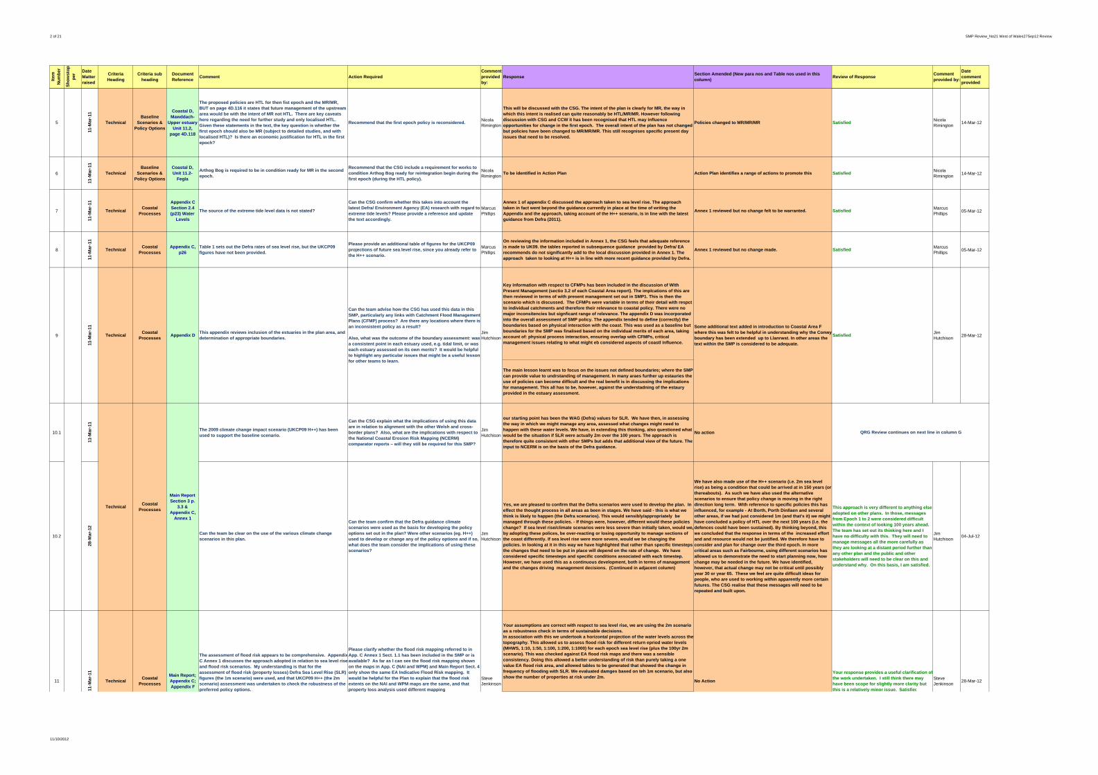
2 of 21 SMP Review_No21 West of Wales27Sep12 Review
Item
N
um
ber
Sh
ow
sto
pp
erDate Matter raised
Criteria Heading
Criteria sub heading
Document Reference
Comment Action RequiredComment provided by:
ResponseSection Amended (New para nos and Table nos used in this column)
Review of ResponseComment provided by:
Date comment provided
5
11-M
ar-1
1
TechnicalBaseline
Scenarios & Policy Options
Coastal D, Mawddach-
Upper estuary Unit 11.2,
page 4D.118
The proposed policies are HTL for then fist epoch and the MR/MR, BUT on page 4D.116 it states that future management of the upstream area would be with the intent of MR not HTL. There are key caveats here regarding the need for further study and only localised HTL. Given these statements in the text, the key question is whether the first epoch should also be MR (subject to detailed studies, and with localised HTL)? Is there an economic justification for HTL in the first epoch?
Recommend that the first epoch policy is reconsidered. Nicola Rimington
This will be discussed with the CSG. The intent of the plan is clearly for MR, the way in which this intent is realised can quite reasonably be HTL/MR/MR. However following discussion with CSG and CCW it has been recognised that HTL may influence opportunities for change in the first epoch. The overall intent of the plan has not changed but policies have been changed to MR/MR/MR. This still recognises specific present day issues that need to be resolved.
Policies changed to MR/MR/MR SatisfiedNicola Rimington 14-Mar-12
6
11-M
ar-1
1
TechnicalBaseline
Scenarios & Policy Options
Coastal D, Unit 11.2-
Fegla
Arthog Bog is required to be in condition ready for MR in the second epoch.
Recommend that the CSG include a requirement for works to condition Arthog Bog ready for reintegration begin during the first epoch (during the HTL policy).
Nicola Rimington To be identified in Action Plan Action Plan identifies a range of actions to promote this Satisfied
Nicola Rimington 14-Mar-12
7
11-M
ar-1
1
TechnicalCoastal
Processes
Appendix C Section 2.4 (p23) Water
Levels
The source of the extreme tide level data is not stated?
Can the CSG confirm whether this takes into account the latest Defra/ Environment Agency (EA) research with regard to extreme tide levels? Please provide a reference and update the text accordingly.
Marcus Phillips
Annex 1 of appendix C discussed the approach taken to sea level rise. The approach taken in fact went beyond the guidance currently in place at the time of writing the Appendix and the approach, taking account of the H++ scenario, is in line with the latest guidance from Defra (2011).
Annex 1 reviewed but no change felt to be warranted. SatisfiedMarcus Phillips 05-Mar-12
8
11-M
ar-1
1
TechnicalCoastal
ProcessesAppendix C,
p26Table 1 sets out the Defra rates of sea level rise, but the UKCP09 figures have not been provided.
Please provide an additional table of figures for the UKCP09 projections of future sea level rise, since you already refer to the H++ scenario.
Marcus Phillips
On reviewing the information included in Annex 1, the CSG feels that adequate reference is made to UK09. the tables reported in subsequence guidance provided by Defra/ EA recommends do not significantly add to the local discussion provided in Annex 1. The approach taken to looking at H++ is in line with more recent guidance provided by Defra.
Annex 1 reviewed but no change made. SatisfiedMarcus Phillips 05-Mar-12
Key information with respect to CFMPs has been included in the discussion of With Present Management (sectio 3.2 of each Coastal Area report). The implcations of this are then reviewed in terms of with present management set out in SMP1. This is then the scenario which is discussed. The CFMPs were variable in terms of their detail with respct to individual catchments and therefore their relevance to coastal policy. There were no major inconsitencies but signficant range of relevance. The appendix D was incorporated into the overall assessment of SMP policy. The appendix tended to define (correctly) the boundaries based on physical interaction with the coast. This was used as a baseline but boundaries for the SMP was finalised based on the individual merits of each area, taking account of: physical process interaction, ensuring overlap with CFMPs, critical management issues relating to what might eb considered aspects of coastl influence.
The main lesson learnt was to focus on the issues not defined boundaries; where the SMP can provide value to undrstanding of management. In many araes further up estauries the use of policies can become difficult and the real benefit is in discussing the implications for management. This all has to be, however, against the understadning of the estaury provided in the estuary assessment.
10.1
11-M
ar-1
1
The 2009 climate change impact scenario (UKCP09 H++) has been used to support the baseline scenario.
Can the CSG explain what the implications of using this data are in relation to alignment with the other Welsh and cross-border plans? Also, what are the implications with respect to the National Coastal Erosion Risk Mapping (NCERM) comparator reports – will they still be required for this SMP?
Jim Hutchison
our starting point has been the WAG (Defra) values for SLR. We have then, in assessing the way in which we might manage any area, assessed what changes might need to happen with these water levels. We have, in extending this thinking, also questioned what would be the situation if SLR were actually 2m over the 100 years. The approach is therefore quite consistent with other SMPs but adds that additional view of the future. The input to NCERM is on the basis of the Defra guidance.
No action
10.2
28-M
ar-1
2
Can the team be clear on the use of the various climate change scenarios in this plan.
Can the team confirm that the Defra guidance climate scenarios were used as the basis for developing the policy options set out in the plan? Were other scenarios (eg. H++) used to develop or change any of the policy options and if so, what does the team consider the implications of using these scenarios?
Jim Hutchison
Yes, we are pleased to confirm that the Defra scenarios were used to develop the plan. In effect the thought process in all areas as been in stages. We have said - this is what we think is likely to happen (the Defra scenarios). This would sensibly/appropriately be managed through these policies. - If things were, however, different would these policies change? If sea level rise/climate scenarios were less severe than initially taken, would we, by adopting these polices, be over-reacting or losing opportunity to manage sections of the coast differently. If sea level rise were more severe, would we be changing the policies. In looking at it in this way we have highlighted that rather than specific timesteps the changes that need to be put in place will depend on the rate of change. We have considered specific timesteps and specific conditions associated with each timestep. However, we have used this as a continuous development, both in terms of management and the changes driving management decisions. (Continued in adjacent column)
We have also made use of the H++ scenario (i.e. 2m sea level rise) as being a condition that could be arrived at in 150 years (or thereabouts). As such we have also used the alternative scenarios to ensure that policy change is moving in the right direction long term. With reference to specific policies this has influenced, for example - At Borth, Porth Dinllaen and several other areas, if we had just considered 1m (and that's it) we might have concluded a policy of HTL over the next 100 years (i.e. the defences could have been sustained). By thinking beyond, this we concluded that the response in terms of the increased effort and and resource would not be justified. We therefore have to consider and plan for change over the third epoch. In more critical areas such as Fairbourne, using different scenarios has allowed us to demonstrate the need to start planning now, how change may be needed in the future. We have identified, however, that actual change may not be critical until possibly year 30 or year 65. These we feel are quite difficult ideas for people, who are used to working within apparently more certain futures. The CSG realise that these messages will need to be repeated and built upon.
This approach is very different to anything else adopted on other plans. In those, messages from Epoch 1 to 2 were considered difficult within the context of looking 100 years ahead. The team has set out its thinking here and I have no difficulty with this. They will need to manage messages all the more carefully as they are looking at a distant period further than any other plan and the public and other stakeholders will need to be clear on this and understand why. On this basis, I am satisfied.
Jim Hutchison 04-Jul-12
Your assumptions are correct with respect to sea level rise, we are using the 2m scenario as a robustness check in terms of sustainable decisions.In association with this we undertook a horizontal projection of the water levels across thetopography. This allowed us to assess flood risk for different return epriod water levels (MHWS, 1:10, 1:50, 1:100, 1:200, 1:1000) for each epoch sea level rise (plus the 100yr 2m scenario). This was checked against EA flood risk maps and there was a sensible consistency. Doing this allowed a better understanding of risk than purely taking a one value EA flood risk area, and allowed tables to be generated that showed the change in frequency of flooding with SLR. We evaluated damges based on teh 1m scenario, but also show the number of properties at risk under 2m. Steve
Jenkinson 28-Mar-12
The assessment of flood risk appears to be comprehensive. AppendixC Annex 1 discusses the approach adopted in relation to sea level riseand flood risk scenarios. My understanding is that for the assessment of flood risk (property losses) Defra Sea Level Rise (SLR) figures (the 1m scenario) were used, and that UKCP09 H++ (the 2m scenario) assessment was undertaken to check the robustness of the preferred policy options.
Please clarify whether the flood risk mapping referred to in App. C Annex 1 Sect. 1.1 has been included in the SMP or is available? As far as I can see the flood risk mapping shown on the maps in App. C (NAI and WPM) and Main Report Sect. 4 only show the same EA Indicative Flood Risk mapping. It would be helpful for the Plan to explain that the flood risk extents on the NAI and WPM maps are the same, and that property loss analysis used different mapping.
Steve Jenkinson No Action
Your response provides a useful clarification ofthe work undertaken. I still think there may have been scope for slightly more clarity but this is a relatively minor issue. Satisfied
11
11-M
ar-1
1
TechnicalCoastal
Processes
Main Report;Appendix C;Appendix F
TechnicalCoastal
Processes
Main ReportSection 3 p.
3.3 &Appendix C,
Annex 1
QRG Review continues on next line in column G
Can the team advise how the CSG has used this data in this SMP, particularly any links with Catchment Flood Management Plans (CFMP) process? Are there any locations where there is an inconsistent policy as a result?
Also, what was the outcome of the boundary assessment: was a consistent point in each estuary used, e.g. tidal limit, or was each estuary assessed on its own merits? It would be helpful to highlight any particular issues that might be a useful lesson for other teams to learn.
Jim Hutchison
Some additional text added in introduction to Coastal Area F where this was felt to be helpful in understanding why the Conwyboundary has been extended up to Llanrwst. In other areas the text within the SMP is considered to be adequate.
SatisfiedJim Hutchison9
11-M
ar-1
1
TechnicalCoastal
Processes28-Mar-12Appendix D
This appendix reviews inclusion of the estuaries in the plan area, and determination of appropriate boundaries.
11/10/2012

3 of 21 SMP Review_No21 West of Wales27Sep12 Review
Item
N
um
ber
Sh
ow
sto
pp
erDate Matter raised
Criteria Heading
Criteria sub heading
Document Reference
Comment Action RequiredComment provided by:
ResponseSection Amended (New para nos and Table nos used in this column)
Review of ResponseComment provided by:
Date comment provided
This highlights the trend of risk into the future, which is impoartnt in looking at sustainability. The attitude taken was that a greater risk in the future suggested unsustainability in terms of defence, rather than incresed justifcation for defence.The Appendix maps however show the more general EA flood risk mapping. In the main text, it is highlighted that the EA maps are the base infromation for people wishing to have infromation on flood risk.The numbers in section five are derived from the 1m scenario.
12
11-M
ar-1
1
TechnicalData and Mapping
Appendix CAnnex 3
Looking at Annex 3 it is clear that National Flood and Coastal Defence Database (NFCDD) has been referenced, but is not clear whether all of the data is drawn from NFCDD or, if not, what other data sources have been used. [SJ]
This annex provides a very comprehensive set of data on the condition of defences. [JH]
Could the CSG please clarify what defence data sources were used? Also, please clarify the note that appears in the “Description” column “Environment Agency so NFCDD applies”. [SJ]
Can the CSG clarify whether all this data is on NFCDD, and if not whether it should be? [JH]
Steve JenkinsonJim Hutchison
A wide range of sources have been used in compiling the data set, drawing from NFCDD, local authority databases and assessments of defence, the Welsh Assembly Data base. The table collates all available information. The table includes natural or semi-natural defences. Not all information is in NFCDD. The data is held in a database and this annex is a printout of relevant fields. It is understood that NFCDD is to be updated and as such at present it would not be sensible to input new local data.
No Action
Satisfied. [SJ]
Suggest that the Council updates CAMC [replacement for nfcdd] as soon as practically possible. [Satisfied] (JH)
Steve JenkinsonJim Hutchison
28-Mar-12
13
11-M
ar-1
1
TechnicalData and Mapping
Coastal D, page 4D.90
A very interesting series of aerial photos. Not sure why more recent ones have not been included (e.g. 2000/2006/2009)? These are all available to Countryside Council for Wales (CCW) and could be made available.
Recommend use of more recent aerial photos that are available to complete the description of change in this area.
Nicola Rimington
All sources of air photography was requested at the start of the SMP. It is understood that later data was not available. We will recommend addressing access to all air photography in the Action Plan
Action Plan in coordinating with the monitorng centre SatisfiedNicola Rimington 14-Mar-12
14
11-M
ar-1
1
TechnicalData and Mapping
GeneralI have not seen any reference to strategic coastal monitoring in the Plan.
Could the CSG advise whether any strategic monitoring data was available for the SMP, and whether the Action Plan will include actions to extend current strategic monitoring?
Steve Jenkinson
Each authority has been undertaking its own monitoring (supported by WG) and this information has been considered in discussion with the various authorities. A national programme is being developed to collate results of monitoring. The Action Plan will support this.
Action Plan tied in to the monitoring centre SatisfiedSteve Jenkinson 28-Mar-12
15
11-M
ar-1
1
TechnicalData and Mapping
Main ReportCoastal A
Page 4A-27Reference is made to Critical Services but they are not identified. It would be helpful to identify the critical assets.
David Harris
The table referred to is a brief summary of the SEA assessment. Critical infrastructure in this case (with reference to Coastal Area A) is the road network. This is highlighted and discussed in the main text and is specifically referenced in the Appendix covering the SEA. It is felt that to be specific within this summary table would be unbalanced. The tableis in effect a flag to highlight this is an issue in this area.
A note signposting where further detailed information can be found has been added to all tables in section 4
Satisfied David Harris 19-Mar-12
16
11-M
ar-1
1
TechnicalDecision Making
Main ReportSect. 4
My understanding is that the use of Management Areas is intended to ensure that any dependencies between Policy Units (PU) are identified and considered. In Sect. 4 the intent of management is generally explained for each area but I have not seen any examples of explicit dependencies between PUs set out.
Could the CSG briefly comment on how the decision-making process ensures that any dependencies between PUs are taken into account, and what flags are in the SMP should any individual PU Policy Option with a dependency change in the future?
Steve Jenkinson
The whole area of a PDZ was considered and discussed. From this discussion provided in the main text, the interaction between sections of the coast are highlighted and the coast broken down and discussed by areas. From the discussion and stated briefly in section 6 of each PDZ document the reason why units have been grouped is explained. In section 3 of the introduction to the SMP (section 3.5.2) it states that policy units within an MA need to be viewed as a whole.
No Action
Response noted. My point was simply whether there was an opportunity to flag explicitly links between Policy Units, but I accept that the SMP does explain the need to consider PUs as part of an MA. Satisfied.
Steve Jenkinson 28-Mar-12
17
11-M
ar-1
1
TechnicalDecision Making
Main Report;Appendix C
There appears to be a range of cliff types covered by this Plan, from highly resistant to erodable. Sect. 4 of the Main Report includes some notes in the Potential Baseline Erosion Rates tables, but it's not clear if the risk is actually erosion (as defined by the Coast Protection Act), or whether other external factors such as groundwater are the cause.
Has the CSG been able to define, in simple terms, which areas of cliffs are impacted by erosion and where the primary drivers are other mechanisms, and where known, what these are? This would be significant in establishing, for example, which funding sources might be appropriate where actions are required.
Steve Jenkinson
Yes, this is discussed in the main text with respect to specific frontages. Also in each erosion summary table, the description given (although only a few words) does try and highlight these differences, between rock falls, instability, slumping etc. This would be taken forward in looking at potential funding streams. For example at New quay, it is clearly stated that the recession of the coastal slope is due both to erosion of the toe support and slope instability.
In some areas as new Quay, PDZ8, additional text has been added to provide further explanation.
That's good. Satisfied.Steve Jenkinson 28-Mar-12
18
11-M
ar-1
1
Technical Engagement GeneralThere are a number of other operators dealt with in the plan, e.g. Docks and Port Authorities, National Park Authority, Railway and Highways.
Can the CSG clarify how these organisations have been engaged to date, and how any actions for these authorities that are required for the successful implementation of preferred policy options will be promoted and monitored?
Jim Hutchison
As identified in response to item 1 above, one of the major players is Network Rail. They have been closely involved with the plan as have the National Parks through representation of the CSG. Highway authorities have been involved through the councils. The port or harbour authorities have been less involved apart from where the LAs are also the port authority, however private harbour authorities have been specifically asked to comment.
Where possible based on responses we have included comets inthe action plan
It will be important for the team to work closely with all third parties to ensure good implementation of the plan. The Group that monitors the action plan will be important to deliver all aspects of the plan. [Satisfied]
Jim Hutchison 28-Mar-12
19
11-M
ar-1
1
Technical LinkagesMain Report
General
The discussions in Sect. 4 of the report have done a good job in my view of integrating both CFMP and SMP1 policy issues into the discussion, as opposed to simply acknowledging their existence. Having not read all of the text in detail I am not sure whether there are any policy compatibility issues, for example.
Also, I would have expected some reference to CFMPs in the report prior to Sect. 4, or in Sect. 4 Introduction. [SJ]
Cross referencing to CFMPs is good and good to see that the different drivers of the CFMPs are acknowledged, i.e it was not their intention to consider direct tidal/coastal flooding.
Not sure it is necessary to include such large verbatim extracts from the CFMPs however this is a decision for the Coastal Group (CG) to make. [APh]
Could the CSG advise whether any actions will be required to resolve any issues arising from CFMP policies eg. any lack of compatibility or boundary issues?
Further, include a list of CFMPs, preferably a map showing their locations, early in the report? [SJ]
Can the CSG ensure that references to draft CFMPs are amended to Final CFMPs, and that text is from the Final CFMPs. [APh]
Steve JenkinsonAdrian Philpott
There seems to be a conflict of opinion here between members of the QRG. That taken, it was decided that where relevant text should be verbatim rather than summarised. There has been no significant incompatibility or boundary issues. It is recognised, however, that there is significant variability in the level of detail addressed by the CFMP in terms of policy. The whole of Anglesey is covered by one policy. The SMP has attempted to summarise the attitude as much as the policy from the CFMP in defining the With Present Management scenario. The SMP has then built upon what in many areas is quite generic drivers and recommendations in developing the SMP. The CFMP information was that available at the time of doing this analysis. It would however be a major task to update to text of final CFMPs at this stage.
No Action
Firstly, I do not see any conflict between QRG comments here!Helpful to get clarification that there have been no significant compatability or boundary issues.Finally, I assume that CSG has decided not to include a map or list of relevant CFMPs. Satisfied. [SJ]
Satisfied (AP)
Steve JenkinsonAdrian Philpott
28-Mar-12
20
11-M
ar-1
1
Technical LinkagesMain Report
Sect. 1.3
The report notes changes to legislation and guidance since SMP1 and lists some of those that are relevant. [SJ]
It is unclear what other strategic documents have been used to assist this document. For example the additional WAG advice prepared for SMPs in 2008. [JH]
Could the CSG comment on whether there are others that have influenced the SMP (or may well influence its implementation) and also warrant some reference eg. Flood and Water Management Act; Marine and Coastal Access Act; the Convergence Programme? [SJ]
Can the CSG explain what coastal strategies, habitat plans asset plans, etc have been used. Please clarify where this is dealt with in the plan? [JH]
Steve JenkinsonJim Hutchison
In general where there have been strategies done since SMP 1 these are recorded in the tables showing SMP 1 policy. These are also referenced in terms of coastal processes in Appendix C. There was consideration of adding and an appendix setting out the Welsh Government New approach, however, this has now been developed further through the development of the Welsh Strategy which is to be launched in November 2011 (this is in response to the FWM Act. The difficulty of including other Acts is that there has been quite a rapid succession of Acts some of which were not enacted at the time of writing sections of the SMP. A brief inclusion is made in section 1.
include within section 1Additional text noted. Satisfied. [SJ]
Satisfied (JH)
Steve JenkinsonJim Hutchison
28-Mar-12
21
11-M
ar-1
1
TechnicalManagement
ToolsMain Report
General
The Main Report notes (eg. Sect. 1.1) that one of the aims of WAG's New Approaches Programme 2007 is to encourage the provision of adequate and cost effective flood warning systems. Flood risk is clearly a significant issue for some areas covered by this SMP, but I am not clear on how flood warning and contingency planning have been considered.
Could the CSG please comment on whether flood (or coastal) warning and contingency planning issues have influenced the recommended policy options at specific locations? Will actions be included in the Action Plan to consider these specifically, or will they form possible components of wider implementation activities?
Steve Jenkinson
A list of flood warning areas has been used and is in the process of being updated based on the SMP Action Plan.
Action Plan
I see that the Action Plan includes actions in a number of Management Areas to develop, maintain or investigate the benefits of implementing flood warning. Satisfied. [SJ]
Steve Jenkinson 28-Mar-12
p p y p
I would be grateful for clarification on a couple of issues relating to data and mapping.
p p y y pp g
Also, could the CSG clarify the criteria which generate the numbers of properties at risk set out in the Main Report Sect. 5 Overview?
y
11/10/2012

4 of 21 SMP Review_No21 West of Wales27Sep12 Review
Item
N
um
ber
Sh
ow
sto
pp
erDate Matter raised
Criteria Heading
Criteria sub heading
Document Reference
Comment Action RequiredComment provided by:
ResponseSection Amended (New para nos and Table nos used in this column)
Review of ResponseComment provided by:
Date comment provided
22
11-M
ar-1
1
TechnicalRisks and Impacts
Main Report Sect. 1.1.3
This section discusses HtL but does not clarify the impact of sea level rise on Standard of Protection (SoP).
Consider the inclusion of a statement to clarify that even though a policy of HTL has been recommended this may still result in an increased risk of flooding, due to lowering of SoP over time as a result of sea level rise.
Marcus Phillips This is now included in section 1 section 1 Satisfied
Marcus Phillips 05-Mar-12
23
11-M
ar-1
1
TechnicalRisks and Impacts
Main ReportSection 4
There are several locations with landfill sites.
Can the CSG clarify whether any of these sites are imposing a constraint on the selection of preferred policy option, and if so what measures are proposed to identify the bodies responsible and to appraise future management options?
Steve Jenkinson
Not significantly, there is an area at Borth, Morfa Harlech and at Morfa Conwy and along the north Llyn coastline. . These areas have been considered in relation to their aspects influencing policy. Furyehr work is being doe on this at a local level and will form part of the action plan
This is under review and there is opportunity to add to action plan.
Noted. Satisfied. Steve Jenkinson 28-Mar-12
24
11-M
ar-1
1
Technical Sustainability GeneralIt would be helpful for the plan to summarise the biggest risks to achieving a sustainable coast in the plan area.
Can the CSG please comment on this and confirm that there is nothing that can be done in the first epoch towards a more sustainable position?
Jim Hutchison
This was considered throughout the SMP. The attitude taken within the plan is that it is setting a pathway for change. Where HTL is recommended the way in which this would be implemented would take account of future policy and intent. Where there may be scope, depending on the development of long term plans for MR/NAI the attitude would be that if this could be achieved earlier then the intent for change would be brought forward.
Add section to section 1 that discusses this continuous process in relation to policy.
I believe that the team are claiming they have a plan that has sustainability at its heart and that working towards a sustainable coast will be considered as soon as it can be. [Satisfied]
Jim Hutchison 28-Mar-12
25.1
11-M
ar-1
1
The guidance recommends the inclusion of the following appendices: Appendix E - Issues and Objectives Evaluation; Appendix F- Shoreline Interaction and Responses; Appendix G - Preferred Policy Appraisal; and Appendix I - Metadatabase and Bibliographic Database. [MP]
Some of the recommended appendices have not been included, and appendix numbering is not aligned to the Guidance Note, e.g. Economics not Appendix H, but Appendix F. [JH]
Please provide additional appendices or provide a summary of why the arrangement of the information in this SMP2 differs from the guidance. [MP]
Can the CSG explain why they have opted for a different set of appendices and advise whether the documents are missing any of the development process information normally includedin the appendices? The CSG should consider whether more consistency with the guidance would not be a benefit for all those involved in shoreline management? [JH]
Marcus PhillipsJim Hutchison
It was agreed that the SEA, and with respect to the natural environment the HRA and WFD directives, should be undertaken as an integral process in developing the Plan. Issues andObjectives were seen very much part of this SEA process. As such Appendix E includes Issues and Objectives. Due to the scale of the plan it was felt more sensible and practical to move the discussion of Interactions and responses, and the appraisal process into the main text. It has been commented upon that the manner in which information, analysis and discussion is presented provides the reader a far more easily navigated document, with a logical and understandable storyline towards the decisions that have been made. This also allows the appendices to be reference documents.
No Action
25.2
28-M
ar-1
2
Satisfied (MP)
I am all for having a readable document. However, this plan is the only one in the second round of SMPs that does not follow the Guidance Note on Appendices and it is a shame that all 22 cannot be consistent. Not worth amending now, but need a comment in the early part of the text to explain why this is for readers that will look at all plans, e.g. for research purposes. (JH)
Can the team add a comment early in the plan to explain the statement in Col J.(JH)
Jim Hutchison
The CSG understand the concern and will look at how this may be addressed as suggested. Purely for information, the CSG did also have to consider using the Welsh Alphabet for Appendices. Within those letters used would have been DD and FF, in addition to D and F. Although this would have been more correct, it was agreed that from a broader perspective this might raise problems.
As agreed with the CSG, a paragraph has been added into section 1 before the list of appendicies.
Satisfied as the team will do what they can to allow all parties to find their way through all 22 SMPs in a consistent way.
Jim Hutchison 04-Jul-12
26
11-M
ar-1
1
Social Engagement Appendix BAppendix B sets an objective on attaining “consensus” among stakeholders. This can set up unrealistic expectations and it's unclear how the CSG will manage this where difficult decisions are required.
Could the CSG clarify the process on this?
Also, can the CSG confirm that they have followed the necessary consultation exercises as set out in the SMP Guidance Note?
Jim Hutchison
Pleased to confirm that all consulation has been carried out in line with the guidance. Ulitmately the proof has been in the pudding. There has been a significant level of consultaion undertaken throughout the SMP with individuals and organsiations encouraged to speak to the consultants through the development process. There has been a good response during the consulation on the draft docuement that have raised other issues which are currently being examined for inclusion. It has been made very clearthat in certain areas objectives will not be met and that delivery of the plan will be through discussion. In areas such as Fairbourne, and in other communiteis where major change is proposed, this message has been presented honestly and has been received with concern but with realism. The response from Network Rail has agreed with the proposed attitudes taken within the SMP, with support for developing partnerships to examine future action.
Appendix B has been added to include reference to the public consultation.
SatisfiedJim Hutchison 28-Mar-12
27
11-M
ar-1
1
SocialResilience/Ada
ptationGeneral
I am unclear if there are any areas where property is impacted by a no active intervention policy option and where adaptation measures may need to be considered?
Can the CSG provide an indication to the number impacted? Also, can the CSG please clarify any such locations in the planarea? Will there be a need to move assets, for example, caravan parks in the future?
Jim Hutchison
Page 5.11 sets out the principal areas where there will be major impacts as a result of the preferred plan. In each of these areas there is already in the document reference to the need for adaptation planning. In terms of caravan parks, there is on-going discussion in relation to the Teifi. North of Barmouth it is highlighted that there will be a need for set back of the caravan parks.
Inclusion of all areas in Action Plan SatisfiedJim Hutchison 28-Mar-12
28.1
11-M
ar-1
1
Has Cadw been approached for input at this strategic level? There appears to be potential for extensive impacts on heritage and archaeology but Cadw are not listed as consultees.
"Given that it is uneconomic and not sustainable to protect the whole of the West of Wales coastline the loss of historic features through natural coastal erosion is inevitable". [4.5.8.] This is probably true but should not Cadw (or delegated authority), be involved at the same stage as CCW to give a perspective on relative significance of impacts at this strategic level?
"Within the SMP Action Plan therefore, Cadw will.." [p.116] ... this is the first reference found to Cadw ... were they not involved in the decision-making process?
Please clarify engagement with Cadw, that they have been involved in the impact assessment reported in the Environmental Report (ER), and ensure that they are fully signed up to this plan. This all needs to be made clear in the text.
Liz Galloway
Cadw have been a key stakeholder throughout the process. The inclusion of Cadw within the action plan does not imply that they have not already been involved.
No Action
Sh
ow
sto
pp
er
Environmental EngagementER Ch 4 and
Scoping Report
QRG Review continues on next line in column G
Technical Various Appendices
QRG Review continues on next line in column G
11/10/2012

5 of 21 SMP Review_No21 West of Wales27Sep12 Review
Item
N
um
ber
Sh
ow
sto
pp
erDate Matter raised
Criteria Heading
Criteria sub heading
Document Reference
Comment Action RequiredComment provided by:
ResponseSection Amended (New para nos and Table nos used in this column)
Review of ResponseComment provided by:
Date comment provided
28.2
14-M
ar-1
2
If Cadw have been involved throughout, then this should be noted for the benefit of those interested parties who may be looking to see what input Cadw have made.
Please add their name to the list of national and local consultees on page 2 of the NTS to the Environmental Report. A similar reference is required in the main text of the ER
Liz Galloway
Cadw have been a key stakeholders throughout the West of Wales SM2 process as associated members of the CSG which also included Cambria Archaeology, Gwynedd Archaeology and The Royal Commission for Ancient and Historic Monuments in Wales (please see Annex A of the SMP). Future involvement of Cadw in particular will be instrumental in establishing what the specific nature of losses there may be regarding the historic environment, and where losses are known, a figure for investigation established so that this funding can be sought from Government. The intent of addressing this matter within the SMP Action Plan will be to ensure that Cadw and partners are provided with funds, in advance to investigate threatened sites.
Please see final SoEP dated February 2012 (Section 1; and Section 7) for reference to Cadw and Annex A of the West of Wales SMP2.
Satisfied Liz Galloway 02-Jul-12
29.1
11-M
ar-1
1
I have searched in vain for feedback on consultation from the 'Final' Scoping Report "Key issues raised through the consultation process on this scoping report will be fed back into the SEA (as an iterative process). Key issues from this consultation exercise will be detailed in the Environmental Report." [Scoping Report 16.2.1/2] Annex F of the ER is blank. The ER talks only about future consultation (on the ER). A brief summary of the feedback would be helpful in the ER rather than having to refer to Appx F even for a basic understanding of interests gained through consultation.
Please add a paragraph to the ER to summarise the main issues raised in consultation. Has the ER been published and if so, for how long and is there any feedback? If already published, either a revised ER can be produced or an Addendum and this should be published for a period of between three and six weeks.
Liz Galloway This comment is being addressed alongside CCW comments on SEA, HRA and WFD
Consultation feedback regarding the main issues raised concerning the ER are provided in the Statement of Environmental Particulars (SoEP). It should be noted that Appendix F of the ER issued for consultation as part of the final West of Wales SMP2 documents was not blank.
29.2
14-M
ar-1
2 The majority of Appendix F reproduces comment from CCW with a fewpoints from EA and two County Councils. Is this all the consultation which arose from scoping stage and therefore informed the ER? In the previous item, Cadw are said to have been involved throughout. What did they contribute?
Please reconsider the reporting of consultation and make a clearer statement of feedback received. This should be seen to have influenced the development of the Plan.
Liz Galloway
Direct consultation that arose from the Scoping Report has been provided in Appendix F of the ER, while consultation during the wider West of Wales SMP2 processes has been incorporated in Appendix B of the main SMP report. A clearer statement of key feedback received during the SEA consultation stages and how these have influenced the development of the SMP and SEA is provided in the SoEP. Consultation with Cadw during their involvement with the CSG in the development of the West of Wales SMP2 was instrumental as their feedback centred on the development of objectives for the SMP and option development to ensure elements/features of the historic environment were fully considered. As noted, future involvement of Cadw in particular will be instrumental in establishing what the specific nature of losses may be regarding the historic environment, and where losses are known.
Please see final SoEP dated February 2012 (Section 6 including Table 6.1 and Table 6.2).
29.3
02-J
ul-
12
I have followed up the references you give and accept the points made in column J. However, I am still puzzled, as I believe other readers will be, that there is no reference to a fuller list of consultees with environmental interests and some explanation for the lack of formal response. There is a need to state whether ... or not, there was any interest shown in the Plan by bodies who might be expected to have environmental interests. In some cases this can be explained by ongoing involvement in the development of the Plan but the ER/SoEP should make this clear.
Please indicate in the SoEP, who was consulted and who responded. If there was no 'targeted' consultation, then please say that there was no response to the public consultation from any other environmental body.
Liz Galloway
Thank you for your comment. As stated in the SoEP (Section 6, Page 70), the overall SMP’s consultation and stakeholder engagement process including a full list of consulteesis described in detail in Appendix B of the main SMP report. As part of the wider consultation process, all those on the consultee list were invited to provide feedback on the development of the SEA. Those consultees that have provided feedback on the SEA process have been taken into consideration in the final Environment Report (ER) and their comments provided in Annex F of the ER and summerised in the SoEP (Section 6, Table 6.1, Page 70). As such, there were no other responses to the SEA other than those taken into consideration and highlighted in the ER.
Please see Appendix B of the SMP – Stakeholder Engagement; and Annex F of the SEA ER.
29.4
30-J
ul-
12
I am still concerned that significant aspects of environmental comment do not appear in Annex F to the SEA Report and although this has been extended in the SoEP, it still doesn't cover the range of environmental comment received. It is not enough to assure the reader that all comments have been taken on board or that they have been covered 'elsewhere'. SEA process requires that all comments are reported transparently in the ER (therefore accessible to the reader for reference) and evaluated in relation the developing Plan. Explaining how the comments/issues have been dealt with is a key part of the process. A close look at Appx B of the Plan reveals that there is a significant amount of comment, much of which has an environmental implication, but this is not all directly accessible to or reported in the SEA report. To give just two examples: G1.a; A7.b, d and e of Appx.B. The information exists in several different places but is fragmented and It is not easily accesible to the reader of the ER.
The best way that this can be remedied at this late stage is to make it clear where the reader of the ER can find additional background on consultation. Please add a prominent note to the effect that the balanced environmental appraisal reported in the ER has been made in consideration of the comments received in consultation to three separate document stages. The reader is recommended to view appendices to the ER, the SoEP and also Appendix B of the SMP to achieve a balanced appreciation of all relevant environmental comment pertinent to the development of the Plan.
Liz Galloway
It is stated in the SoEP (Section 6, Page 70, paragraph 4) that the overall SMP’s consultation and stakeholder engagement process, including a full list of consultees, is described in detail in Appendix B of the main SMP report. The comments specifically relating to the ER received from consultees have been, as noted in our previous response, identified and the issues summarised and description of how they were addressed is stated in Page 70 paragraph 3 of the SoEP. The comments that were received which were made specifically with respect to the SMP and not the ER, are addressed in the SMP consultation Appendix (B, Annex IV). However, the SoEP considered these in relation to the subsequent changes and comments incorporated into the SMP policies and actions (or not if considered inappropriate or unnecessary) and re-assessed any changes within the SoEP. Whilst there is reference to this in the SoEP, we will make a final revision to the last two paragraphs in Section 6 on Page 70 of the SoEP, which make this statement clearer and provide the clarity you require.
The altered paragraph is as follows: "The Environmental Report underwent a 3 month public consultation period, starting in November 2010, as part of the public consultation for the Draft SMP for the West of Wales. All consultation and stakeholder responses are described in the SMP (Appendix B of the SMP – Stakeholder Engagement: Annex IV – Consultation Responses), and these were considered both in relation to the SMP and any alterations to it and subsequent re-assessment in this SoEP. Table 6.2 summarises the key consultation responses specific to the ER and sets out how these have influenced the SMP and any re-assessment within this SoEP due to changes to the SMP policies or clarifications. These are further detailed depending on the level of complexity of the responses in Annex Ia and Annex Ib of this SoEP and thus the reader is referred to these Annexes for more information."
Satisfied Liz Galloway 27-Sep-12
30.1
11-M
ar-1
1
The options chosen for PDZ11 appear to carry significant risk and particularly to material assets. 4.2.7 sets out very clearly how effects can be avoided and successfully mitigated. However, other mitigation is vague or uncertain, e.g. "It may be possible to mitigate impacts to the footpath at Ro Wen through realignment of the line inland." [my underlining]. The reader needs to know whether these risks will be manageable and whether the Plan owns the measures to manage them.
Please make it clear in the text whether management of these risks is feasible. What are the implications of taking these options forward with significant impacts attached and what are the risks?
Liz Galloway
This comment is being addressed alongside CCW comments on SEA, HRA and WFD. However, in general it is nit always possible to define the position of managed realignment. Indeed, the SMP has clearly stated that in several areas, the SMP should not pre-empt the detailed discussion necessary with stakeholders. It is not, therefore, possible to address this beyond highlighting the need to take this issue into account.
No Action
QRG Review continues on next line in column G
QRG Review continues on next line in column G
Sh
ow
sto
pp
er
Environmental SEA/AA
QRG Review continues on next line in column G
1.7.4 and Annex F
QRG Review continues on next line in column G
11/10/2012
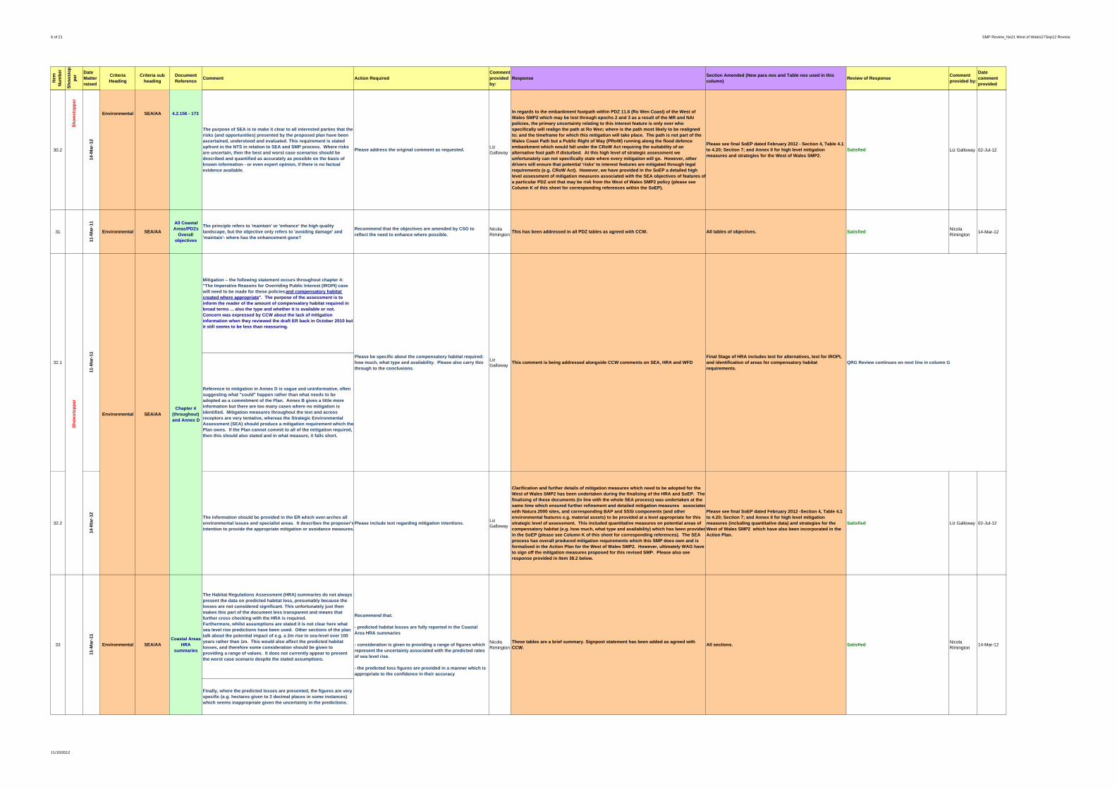
6 of 21 SMP Review_No21 West of Wales27Sep12 Review
Item
N
um
ber
Sh
ow
sto
pp
erDate Matter raised
Criteria Heading
Criteria sub heading
Document Reference
Comment Action RequiredComment provided by:
ResponseSection Amended (New para nos and Table nos used in this column)
Review of ResponseComment provided by:
Date comment provided
30.2
14-M
ar-1
2
The purpose of SEA is to make it clear to all interested parties that the risks (and opportunities) presented by the proposed plan have been ascertained, understood and evaluated. This requirement is stated upfront in the NTS in relation to SEA and SMP process. Where risks are uncertain, then the best and worst case scenarios should be described and quantified as accurately as possible on the basis of known information - or even expert opinion, if there is no factual evidence available.
Please address the original comment as requested.Liz Galloway
In regards to the embankment footpath within PDZ 11.6 (Ro Wen Coast) of the West of Wales SMP2 which may be lost through epochs 2 and 3 as a result of the MR and NAI policies, the primary uncertainty relating to this interest feature is only over who specifically will realign the path at Ro Wen; where is the path most likely to be realigned to; and the timeframe for which this mitigation will take place. The path is not part of the Wales Coast Path but a Public Right of Way (PRoW) running along the flood defence embankment which would fall under the CRoW Act requiring the suitability of an alternative foot path if disturbed. At this high level of strategic assessment we unfortunately can not specifically state where every mitigation will go. However, other drivers will ensure that potential 'risks' to interest features are mitigated through legal requirements (e.g. CRoW Act). However, we have provided in the SoEP a detailed high level assessment of mitigation measures associated with the SEA objectives of features of a particular PDZ unit that may be risk from the West of Wales SMP2 policy (please see Column K of this sheet for corresponding references within the SoEP).
Please see final SoEP dated February 2012 - Section 4, Table 4.1 to 4.20; Section 7; and Annex II for high level mitigation measures and strategies for the West of Wales SMP2.
Satisfied Liz Galloway 02-Jul-12
31
11-M
ar-1
1
Environmental SEA/AA
All Coastal Areas/PDZs
Overall objectives
The principle refers to 'maintain' or 'enhance' the high quality landscape, but the objective only refers to 'avoiding damage' and 'maintain'- where has the enhancement gone?
Recommend that the objectives are amended by CSG to reflect the need to enhance where possible.
Nicola Rimington This has been addressed in all PDZ tables as agreed with CCW. All tables of objectives. Satisfied
Nicola Rimington 14-Mar-12
Mitigation – the following statement occurs throughout chapter 4: "The Imperative Reasons for Overriding Public Interest (IROPI) case will need to be made for these policies and compensatory habitat created where appropriate". The purpose of the assessment is to inform the reader of the amount of compensatory habitat required in broad terms ... also the type and whether it is available or not. Concern was expressed by CCW about the lack of mitigation information when they reviewed the draft ER back in October 2010 but it still seems to be less than reassuring.
Reference to mitigation in Annex D is vague and uninformative, often suggesting what "could" happen rather than what needs to be adopted as a commitment of the Plan. Annex B gives a little more information but there are too many cases where no mitigation is identified. Mitigation measures throughout the text and across receptors are very tentative, whereas the Strategic Environmental Assessment (SEA) should produce a mitigation requirement which the Plan owns. If the Plan cannot commit to all of the mitigation required, then this should also stated and in what measure, it falls short.
32.2
14-M
ar-1
2
The information should be provided in the ER which over-arches all environmental issues and specialist areas. It describes the proposer'sintention to provide the appropriate mitigation or avoidance measures.
Please include text regarding mitigation intentions.Liz Galloway
Clarification and further details of mitigation measures which need to be adopted for the West of Wales SMP2 has been undertaken during the finalising of the HRA and SoEP. The finalising of these documents (in line with the whole SEA process) was undertaken at the same time which ensured further refinement and detailed mitigation measures associatedwith Natura 2000 sites, and corresponding BAP and SSSI components (and other environmental features e.g. material assets) to be provided at a level appropriate for this strategic level of assessment. This included quantitative measures on potential areas of compensatory habitat (e.g. how much, what type and availability) which has been providedin the SoEP (please see Column K of this sheet for corresponding references). The SEA process has overall produced mitigation requirements which this SMP does own and is formalised in the Action Plan for the West of Wales SMP2. However, ultimately WAG have to sign off the mitigation measures proposed for this revised SMP. Please also see response provided in Item 38.2 below.
Please see final SoEP dated February 2012 -Section 4, Table 4.1 to 4.20; Section 7; and Annex II for high level mitigation measures (including quantitative data) and strategies for the West of Wales SMP2 which have also been incorporated in the Action Plan.
Satisfied Liz Galloway 02-Jul-12
The Habitat Regulations Assessment (HRA) summaries do not always present the data on predicted habitat loss, presumably because the losses are not considered significant. This unfortunately just then makes this part of the document less transparent and means that further cross checking with the HRA is required. Furthermore, whilst assumptions are stated it is not clear here what sea level rise predictions have been used. Other sections of the plan talk about the potential impact of e.g. a 2m rise in sea-level over 100 years rather than 1m. This would also affect the predicted habitat losses, and therefore some consideration should be given to providing a range of values. It does not currently appear to present the worst case scenario despite the stated assumptions.
Finally, where the predicted losses are presented, the figures are very specific (e.g. hectares given to 2 decimal places in some instances) which seems inappropriate given the uncertainty in the predictions.
Coastal Areas HRA
summaries
Recommend that:
- predicted habitat losses are fully reported in the Coastal Area HRA summaries
- consideration is given to providing a range of figures which represent the uncertainty associated with the predicted rates of sea level rise.
- the predicted loss figures are provided in a manner which is appropriate to the confidence in their accuracy
Nicola Rimington
These tables are a brief summary. Signpost statement has been added as agreed with CCW.
All sections. Satisfied
Please be specific about the compensatory habitat required: how much, what type and availability. Please also carry this through to the conclusions.
Liz Galloway This comment is being addressed alongside CCW comments on SEA, HRA and WFD
Final Stage of HRA includes test for alternatives, test for IROPI, and identification of areas for compensatory habitat requirements.
QRG Review continues on next line in column G
Nicola Rimington 14-Mar-1233
11-M
ar-1
1
Environmental SEA/AA
32.1
Sh
ow
sto
pp
er
11-M
ar-1
1
Environmental SEA/AAChapter 4
(throughout) and Annex D
Sh
ow
sto
pp
er
Environmental SEA/AA 4.2.156 - 173
11/10/2012

7 of 21 SMP Review_No21 West of Wales27Sep12 Review
Item
N
um
ber
Sh
ow
sto
pp
erDate Matter raised
Criteria Heading
Criteria sub heading
Document Reference
Comment Action RequiredComment provided by:
ResponseSection Amended (New para nos and Table nos used in this column)
Review of ResponseComment provided by:
Date comment provided
34
11-M
ar-1
1
Environmental SEA/AACoastal Areas
HRA summaries
These sections mention roll back of defences as a mitigation measure,but it is not clear whether this is the predicted loss that is left after instigation of MR policies (i.e a residual loss)? Furthermore, the predicted losses seem quite low and seem to be veryrestricted in terms of the features affected. For example, often the predicted loss is associated with Intertidal Sand and Mud (ISM) feature, but not for adjacent saltmarsh, or related to the estuary feature. Examples include, but are not restricted to the Mawdachh which reports only impacts on ISM but not Saltmarsh or estuary, and also Angelsey saltmarsh Special Area of Conservation (SAC) focuses on is very much ISM loss rather than saltmarsh. I recommend that this is checked again with reference to potential impacts on all features.
Finally, to note that any habitat creation through managed realignmentwhich is outside the existing boundary of the designated sites would be compensation rather than mitigation.
Please clarify whether the figures for predicted losses represent total loss or residual loss following implementation of mitigation measures.
Also check and clarify whether the full range of features that could be affected either directly or indirectly (e.g. due to wider morphological change) have been included in the HRA. Further explanation of the rationale should be provided if the CSG is happy that full consideration has been made.
Nicola Rimington As above but also addressed in appendices.
In regards to figures for predicted losses, they are all total loss prior to any mitigation measures.
SatisfiedNicola Rimington 14-Mar-12
35
11-M
ar-1
1
Environmental SEA/AA
Coastal D, Afon Wen, Policy Unit
12.24
There are sensitive intertidal habitats in this location (Sabellaria reef) which is already under threat due to the ongoing erosion. As we currently have no practical experience of recreating this habitat it is important that we take appropriate measures to manage it in situ. In this instance the policy is HTL and then MR/MR. This is probably OK, but does add weight to the need to relocate the railway line and pursue the MR policy in the medium and longer term. (See other comment on railway issues).
Recommend that the need to pursue the MR policy in the medium and longer term is strengthened with reference to the need to sustain this sensitive habitat.
Nicola Rimington This is n9ow considered in the HRA as agreed with CCW HRA Appendix Satisfied
Nicola Rimington 14-Mar-12
36
11-M
ar-1
1
Environmental SEA/AAEnv. Report
3.3.7. page 34.
Chapter 3 provides a very well illustrated and straightforward description of risks within the study area until 3.3.7. Community Assets. Graphic illustration of the problem areas would have been useful here to give a perspective on how extensive these risk zones are.
Please consider adding a plan to give context and scale to the text.
Liz Galloway
This is difficult given the scale of the Plan as it would make section 3 a very large disjointed section. Although it is agreed in principle it has been considered by the CSG to be impractical. It is considered that there are adequate plans in section 4 and in appendices.
No action Satisfied Liz Galloway 14-Mar-12
37.1
11-M
ar-1
1 Definitions - "The SEA will form a component of the wider assessment mechanisms for the SMP which also includes:" Is this an accurate statement in view of the fact that SEA encompasses and reports impacts on all aspects of the environment, including HRA and WFD? Also, what is meant by "a simple SEA based assessment" in 1.9.4?
Please reconsider text relating to SEA.Liz Galloway
The SEA takes into account the findings of the HRA and WFD. All work undertaken in the SEA has been considered in the Main SMP development.
No action
37.2
14-M
ar-1
2
SEA process should encompass all environmental issues and provide an over-arching assessment to include WFD, HRA and any other specialised environmental appraisals.
Please reconsider current text and amend wordingLiz Galloway
The SEA examines all the environmental parameters identified within the relevant guidance, whilst the detail presented in the WFD Assessment and HRA undertaken for the West of Wales SMP2 (and provided as appendices to the SMP alongside the SEA), their findings have been summarised in the SEA Report and conclusions presented in the SoEP (please see Column K of this sheet for corresponding references). Unfortunately the use of the word 'simple' does not reflect the complex and detailed nature of the SEA, and is intended to mean clear and transparent. However, the breadth and depth of detail of the assessment carried out in the SEA is clearly evident within the ER and its supporting annexes, and the use of these words in introductory statements is not considered to be undermining the achievement of relevant criteria for which the SEA is intended.
Please see Chapter 4.3 of the SEA Report (WFD Assessment) and Chapter 5 of the SEA Report (conclusions of HRA) regarding the inclusion of other environmental assessments in the SEA, with outcomes of these assessments also noted in the SoEP (please see Section 4 & 7) and Action Plan.
As the SoEP route has been chosen there is probably little point in pursuing this comment. Satisfied.
Liz Galloway 02-Jul-12
38.1
11-M
ar-1
1
Compensatory Habitat – 4.5 only presents conclusions to the assessment of impacts and stops at this point. An ER is required to specify the amount and type of compensatory habitat or avoidance measures which are required. An assumption is made in 4.5 that this habitat/these measures will be available/feasible but evidence of the existence of suitable habitat or land is needed. The significance of this potential impact is high and more reassurance needs to be given to show that compensation is a viable proposition. Does the available compensatory habitat and that created through MR add up to the requirement due to negative impacts?
Please explain how and where and in what quantity sufficient habitat will be found to satisfy Habitats Directive (HD) requirements. If there is uncertainty in terms of gain by MR, then please give best and worst case scenarios.
Liz Galloway This comment is being addressed alongside CCW comments on SEA, HRA and WFD
Final Stage of HRA includes test for alternatives, test for IROPI, and identification of areas for compensatory habitat requirements.
QRG Review continues on next line in column G
Environmental SEA/AAEnv. Report
1.8.1
QRG Review continues on next line in column G
11/10/2012

8 of 21 SMP Review_No21 West of Wales27Sep12 Review
Item
N
um
ber
Sh
ow
sto
pp
erDate Matter raised
Criteria Heading
Criteria sub heading
Document Reference
Comment Action RequiredComment provided by:
ResponseSection Amended (New para nos and Table nos used in this column)
Review of ResponseComment provided by:
Date comment provided
38.2
14-M
ar-1
2 Yes, your response is understood, but the purpose of SEA is to assess objectively the environmental risk which the Plan poses. Some measure of the range of risk needs to be expressed. Please also see response to Item 30.
Please indicate what the likely or feasible mitigation measures are.
Liz Galloway
Please see final SoEP dated February 2012 -Section 4, Table 4.1 to 4.20; Section 7; and Annex IIA,B for high level mitigation / compensation measures (including quantitative data) and strategies for the West of Wales SMP2 which have also been incorporated in the Action Plan.
Satisfied Liz Galloway 02-Jul-12
39.1
11-M
ar-1
1
IROPI procedure – the next stage of establishing 'no alternative' before presenting an IROPI case is reported in 4.5.2 as a straightforward progression. 7.2.1 of Appendix I (HRA report) suggests that alternatives do exist but are too costly or technically difficult to be acceptable. My understanding is that to prove a case for 'no alternative' there must be no alternatives of any kind before the IROPI case can be made, otherwise the case is likely to be rejected. Is this correct because if so, there is surely considerable risk attached to achieving approval to create such extensive negative impacts on HD sites?
Please consider the two texts and present them in such a way that: a) the HRA Report in the ER makes it clear that there are no alternatives (if this is the case to be made), b) the risks of the case being made are presented in the ER. At present the process is stated, but any risks/implications are not.
Liz Galloway This comment is being addressed alongside CCW comments on SEA, HRA and WFD See Final HRA.
39.2
14-M
ar-1
2
The essence of this balance needs to be expressed in the ER. It is not acceptable to refer the reader to another document where the issue is so central to environmental risk.
Please add text which explains the current situation vis a vis the IROPI process and the abiulity to mitigate.
Liz Galloway
The policy development stage of the West of Wales SMP2 examined the four potential strategic policy options (HTL,ATL, MR, NAI) with respect to coastal management measures. At this strategic level this is the considered to be the examination of alternative options (please see SMP Appendix A), with those identified in consultation with the West of Wales Coastal Group and Partners the only feasible options for this revised SMP. However, due to the conflicting and mutually exclusive requirements of this SMP (in both a socio-economic and environmental context), or due to the very nature that policy to protect a site, could have adverse effects on the Site in question or other nearby Sites, it has not been possible for the SEA or HRA to conclude no adverse effect on the integrity of the International Sites. As such we have identified IROPI and potential compensation available within the study area of this SMP, presented and clarified in detail in Appendix G of the HRA and the SoEP (please see Column K for corresponding references within the SoEP). In addition as stated in Item 38.2 (above), initial examination of the potential compensatory habitat areas and types has been undertaken and based on available land bank, there is large potential areas available for compensatory habitat to be provided for the West of Wales SMP2.
Please see final SoEP dated February 2012 -Section 4, Table 4.1 to 4.20; Section 7; and Annex IIA,B for high level mitigation / compensation measures (including quantitative data) and strategies for the West of Wales SMP2 which have also been incorporated in the Action Plan.
The SoEP text (s.7) gives a clearer explanation of issues and risks. Satisfied.
Liz Galloway 02-Jul-12
40.1
11-M
ar-1
1 Alternative Options – Chapter 4 is a readable and informative chapter -potential impacts are reported under each Policy Development Zone (PDZ) but the availability of alternatives is not clear - some informationon why alternatives were not chosen is needed in the ER to explain SMP policy decisions.
Please indicate why alternative policy options were not chosenand explain how the environment was taken into account in the decision-making.
Liz Galloway Reported in main text of SMP See Final HRA.
Subject to approval from WAG to the test for IROPI, where habitats and species are being adversely affected, compensatory measures must be identified to ensure the ecological coherence of the Natura 2000 (and Ramsar sites) network is protected. An initial examination of the potential compensatory habitat areas and types in regards to that of intertidal and transitional habitat is presented in detail in Appendix G of the HRA and discussed in the SoEP (please see Column K of this sheet for references within the SoEP). Annex G of the HRA also indicates that the intertidal and transitional habitats will be created from the MR policy locations within the West of Wales SMP2 study area, however freshwater and terrestrial habitats would also need to be compensated for as a result of the potential intertidal habitat compensation areas. Annex IIA of the SoEP thus provides an initial examination of the potential compensatory habitat required based on total SSSI / BAP habitat and policy unit locations where MR is proposed. Annex IIB of the SoEP then provides a strategic review of potential sites and available land bank which indicates giventhe large bank of potential areas available for compensatory habitat there is no doubt as to the ability of compensatory habitats to be provided for the West of Wales SMP2 (please see Column K of this sheet for corresponding references). Mitigation and preventative measures to reduce major impacts on habitats has also been provided in the SoEP along with potential risks associated with achieving mitigation / compensation habitat for such features as Natura 2000 sites for the West of Wales SMP2 ( see Section 7 of the SoEP). Furthermore risk of implementation is avoided both through the measures inclusion in the SMP Action Plan as well as at the Strategy and Site level project development.
QRG Review continues on next line in column G
Sh
ow
sto
pp
er
Environmental SEA/AA
Env. Report 4.5.2, page 110 (and
Table 4.24).
Environmental SEA/AAEnv. Report 4.5.2, page
110.
QRG Review continues on next line in column G
11/10/2012
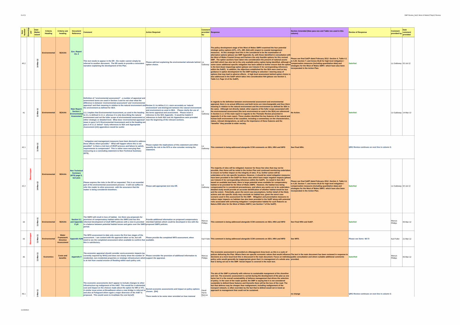
9 of 21 SMP Review_No21 West of Wales27Sep12 Review
Item
N
um
ber
Sh
ow
sto
pp
erDate Matter raised
Criteria Heading
Criteria sub heading
Document Reference
Comment Action RequiredComment provided by:
ResponseSection Amended (New para nos and Table nos used in this column)
Review of ResponseComment provided by:
Date comment provided
40.2
14-M
ar-1
2
This text needs to appear in the ER - the reader cannot simply be referred to another document. The ER needs to provide a consistent narrative explaining the development of the Plan.
Please add text explaining the environmental rationale behind option choice.
Liz Galloway
The policy development stage of the West of Wales SMP2 examined the four potential strategic policy options (HTL, ATL, MR, NAI) with respect to coastal management measures. At this strategic level this is the considered to be the examination of alternative options (please see SMP Appendix A), with those identified in consultation with the West of Wales Coastal Group and Partners the only feasible options for this revised SMP. The option sections have taken into consideration the present of national assets and H&S which has also led to the only available policy option being identified, although in some cases additional specific mitigation has been added to further ensure that the optionis the best (least impacting) option (please see Column K for corresponding references within the SoEP). In addition, the objectives established for the SEA were used as key guidance in option development for the SMP leading to selection / steering away of options that may lead to adverse effects. A high level assessment behind option choice is also addressed in the SoEP which takes into consideration NAI (please see Section 3, Table 3.2, Page 13 of the SoEP).
Please see final SoEP dated February 2012 -Section 4, Table 4.1 to 4.20; Section 7; and Annex IIA,B for high level mitigation / compensation measures (including quantitative data) and strategies for the West of Wales SMP2 which have also been incorporated in the Action Plan.
Satisfied Liz Galloway 02-Jul-12
41
11-M
ar-1
1
Environmental SEA/AA
Main Report: Section 2
Environmental Assessment
Definition of “environmental assessment” - a number of appraisal and assessment terms are used in Section 2 and its not clear what the difference is between 'environmental assessment' and 'environmental appraisal' and their meaning in relation to the natural environment andthe environment as defined for SEA.
2.1.1 implies that Environmental Assessment, as used in the heading to 2.1, is defined in 2.1.1. whereas it is only describing the natural environment and not the fuller scope of environmental assessment at either strategic or detailed level. What does 'environmental appraisal' mean in para 3 of 2 Environmental Assessment and in the heading andpara 2 of 2.1.2. below? Early references to SEA and Appropriate Assessment (AA) appendices would be useful.
Review 2.1 to define 2.1.1. more accurately as 'natural environment' and distinguish between the natural environmentand environment as used in SEA. Please clarify the use of the terms appraisal and assessment. Please insert a reference to the SEA Appendix. It would be helpful if references to both SEA and AA Appendices were provided near the beginning of the relevant sections.
Liz Galloway
In regards to the definition between environmental assessment and environmental appraisal, there is no actual difference and both terms are interchangeable and thus there meaning in relation to the natural environment and the environment as defined for SEA is the same. Although not directly stated, other aspects of the fuller scope associated with the environmental assessment (the term environment as used in the SEA) are referenced in Section 2.1.1 of the main report in regards to the Thematic Review presented in Appendix E of the main report. These studies identified the key features of the natural and human built environment of the coastline, including a commentary on the characteristics, status, relevant designations, as well as the importance of these features and the “benefits” they provide to wider society.
No Action. Satisfied Liz Galloway 14-Mar-12
42.1
11-M
ar-1
1
"mitigation and management measures have been devised to address these effects where possible." What will happen where this is not possible? Is there a risk here of IROPI process and failure to satisfy requirements to compensate? This is rather more worrying than reassuring as a concluding statement to Non-Technical Summary (NTS).
Please explain the implications of this statement and either quantify the risk in the NTS or else consider revising the statement.
Liz Galloway This comment is being addressed alongside CCW comments on SEA, HRA and WFD See Final HRA.
42.2
14-M
ar-1
2 Please express the risks in the ER as requested. This is an essential part of the environmental assessment process - it will not suffice to refer the reader to other processes with the assurance that the matter is being considered elsewhere.
Please add appropriate text into ER.Liz Galloway
The majority of sites will be mitigated, however for those few sites that may not be possible, then these will be noted in the Action Plan and continued monitoring undertaken to ensure no further impact on the integrity of sites. If so, further action will be undertaken at for site specific locations. However, it should be noted mitigation measures have been provided in the SoEP for those sites which have major negative impacts (pleasesee Column K for corresponding references within the SoEP). As noted in Item 38.2 based on available land bank, there is large potential areas available for compensatory habitat to be provided for the West of Wales SMP2. However, the habitat loss being compensated for is considered precautionary, and where any works are to be undertaken detailed study would provide an accurate identification of whether habitat would be lost and the extent. Potentially, given the worst case assumptions, further detail of the likely actions and site specific study may conclude no habitat loss, given the worst case scenario used in this assessment for the SMP. Mitigation and preventative measures to reduce major impacts on habitats has also been provided in the SoEP along with potential risks associated with achieving mitigation / compensation habitat for such features as Natura 2000 sites for the West of Wales SMP2 ( see Section 7 of the SoEP).
Please see final SoEP dated February 2012 -Section 4, Table 4.1 to 4.20; Section 7; and Annex IIA,B for high level mitigation / compensation measures (including quantitative data) and strategies for the West of Wales SMP2 which have also been incorporated in the Action Plan.
Satisfied Liz Galloway 02-Jul-12
43
11-M
ar-1
1
Environmental SEA/AASection 5.1
and Appendix E p5
The SMP2 will result in loss of habitat. Are there any proposals for provision of compensatory habitat within the SMP2 and has this informed development of draft SMP2 policies with a view to provided in a balance between potential habitat losses and gains over the SMP2period.
Provide additional information on proposed compensatory intertidal habitats which could be developed in line with the proposed SMP2 policies.
Marcus Phillips This comment is being addressed alongside CCW comments on SEA, HRA and WFD See Final HRA and SoEP. Satisfied
Marcus Phillips 05-Mar-12
44
Sh
ow
sto
pp
er
11-M
ar-1
1
Environmental
Water Framework Directive
Assessment
Appendix K(H)
The WFD assessment to date only covers the first two stages of the assessment. I am content with the approach taken so far, but will need to see the completed assessment when available to confirm that this is satisfactory.
Please provide the completed WFD assessment, when available.
Karl Fuller This comment is being addressed alongside CCW comments on SEA, HRA and WFD See WFD. Please see items 68-72 Karl Fuller 21-Mar-12
45
11-M
ar-1
1
EconomicsCosts and benefits
Appendix F
The economic appraisal should consider socio-economic impacts (as currently required by WAG) and does not clearly show the number of residential, non-residential properties or strategic infrastructure whichis at risk from coastal erosion of flooding within each policy unit.
Please consider the provision of additional information to support the appraisal.
Marcus Phillips
The economic assessment is provided at a Management Area level, as this is a suite of polices delivering the Plan. Where there are specific economic values that would influence decisions at a more local level this is discussed in the main document. Focus on individuapolicy units would generally be inappropriate given that it is management of a whole area that is being set out in the SMP. Social impact is covered in the main text.
The text in the main document has been reviewed in response to public consultation and where suitable additional comments provided.
SatisifiedMarcus Phillips 05-Mar-12
The aim of the SMP is primarily with refernce to sustainable mangement of the shoreline and risk. The economic assessment is carried during the development of the plan as one factor but it is the overall sustainability of defence managemnet that drives the selection of policy. In the case of the roads quoted, the SMP is saying that it is not considered sustainble to defend these features and thereofre there will be the loss of the road. The fact that defence may be cheaper than realignement, including realignement of the transport network, is often overriden by the fact that to defend would set in trend an approach to management that could not be sustained.
The economic assessments don't appear to include changes to other infrastructure eg realignment of the A487. This would be a substantial cost and impact on the choices made about the option for MR or HTL. A similar issue arises at Broadhaven where a new bridge is referred to and also at Fishguard where again a major diversion of the A487 is proposed. This would seem to invalidate the cost benefit
t d th t h i f ti [DH]
Revisit economic assessments and impact on policy options chosen. [DH]
There needs to be some steer provided on how regional
David HarrisMarcus Philli
no change QRG Review continues on next line in column G46.1
1-M
ar-1
1
Environmental SEA/AAEnv. Report
Ch. 4
Sh
ow
sto
pp
er
Environmental SEA/AA
Non Technical Summary
(NTS) page 5, last para
QRG Review continues on next line in column G
11/10/2012

10 of 21 SMP Review_No21 West of Wales27Sep12 Review
Item
N
um
ber
Sh
ow
sto
pp
erDate Matter raised
Criteria Heading
Criteria sub heading
Document Reference
Comment Action RequiredComment provided by:
ResponseSection Amended (New para nos and Table nos used in this column)
Review of ResponseComment provided by:
Date comment provided
The loss and need for change is a consequence that has to be accepted to achieve the plan. It is not within the remit of the SMP to undertake transport planning, as it not the role of the SMP to set planning policy. There is however, an important role for the SMP in identifying the need for other authorities to plan for adaptation. Section 5 of the main text (page 5.17) highlights both the approach taken to economics and the need for consideration at a regional and national level. This will be identifed in the Action Plan.
46.2
19-M
ar-1
2
Satisified I'm glad to see that this key issue has now been included in the action plan since the intention is for the SMP2 to inform planning policy and transport policy. (MP)
This implies that the economic assessment was not carried out and the decision has been based on sustainability factors other than economics? It may well be economically sound for others, such as the Highway Authority, to maintain the defences but your policy option would presumably not support this because of other sustainability issues. I feel that is somewhat perverse and am surprised that other sustainability issues would be strong enough to override a sound economic case. (DH)
Can CSG provide an overview to explain the approach further, and to demonstrate its validity? (DH)
Dave Harris No further change to SMP document
Comments noted and accepted. It will be a matter for future reviews to consider whether to keep the beach or the community. Satisfied.
Dave Harris 16-Jul-12
47
11-M
ar-1
1
Economic Affordability General
The SMP2 correctly makes many and strong references to the importance of tourism and the local economy. Adequate local defences and flood risk management measures are a critical part of the local infrastructure and therefore the viability of local communities.
Can the CSG explain how the plan recognises the importance of the local economy and deals with this in terms of drawing together alternative sources of funding and local regeneration initiatives? Some text to support economic summary tables is an opportunity to localise these messages.
Adrian Philpott
This will be addressed in the Action Plan but the SMP cannot set planning policy or economic regeneration. The need for this will be identified in the Action Plan.
Action Plan SatisifiedAdrian Philpott 14-Mar-12
48
11-M
ar-1
1
Economic AffordabilityMain ReportSect. 1.1.3
The HTL discussion includes the important caveat regarding funding risks. Whilst MR approaches may be less certain they will also requirefunding and will be subject to similar budget pressures.
CSG to consider inclusion of funding caveat for MR.Steve Jenkinson Comment noted and text will be added. section 1
Text reviewed – no change added yet but content that this will be done. Satisfied.
Steve Jenkinson 28-Mar-12
EconomicMain ReportSect. 4
There are a number of Policy Units where the economic assessment does not readily support the preferred policy option, because the benefit cost ratio is low. The policy summaries generally seem to flag the fact that there are funding issues which is helpful, nonetheless there are some Policy Units where the economic assessment raises a question about the likelihood of delivery, and whether the SMP is raising expectations unduly.
No initial discussion have taken place as to this funding. The SMP is seen as the starting point of this process, raising the issues and ensuring through the Action Plan that they are taken forward. Where there is concern as to funding it has generally been recorded what the default policy is.
Action Plan
For example, - MA. 12 Aberporth and Villages and MA.13 New Quay Bay both note that additional damages have not been taken into account, but also that there may be a need for funding from other sources. - MA 23 Mawddach Estuary has a very low benefit cost ratio, and notes that alternative funding needs to be investigated. - Likewise MA. 26 Artro Estuary notes that it is unlikely that Flood and Coastal Risk Management (FCRM) funding could be relied upon as a major source of funding, and - MA. 14 Cei Beach, which has an estimated cost of PV £0.25m and zero estimated benefits, notes that future maintenance would be subject to further justification with respect to properties at risk. [SJ]
I think that key actions in the Final Plan will involve identification of funding sources and development of broader local (sub-regional) partnerships and linkage to economic viability, regeneration and growth - this will be applicable throughout but particularly in the "un-economic" MAs. As an indicator I think some 17 of the 62 MAs have a BCR<1 based on the total PVb/PVc of the preferred plan policies (approx. 22% of the total plan PVc). [APh]
The SMP is setting policy that has to take account of economics, social and environmentalfactors. The SMP guidance quite clearly states that the economic assessment is an important consideration in development of the plan but is to be used as one factor in decision making. The issues in relation to the transport network is difficult. If one takes the line through the Dyfi Estuary, the SMP has made an initial assessment that with sea level rise there would be the need to substantially raise the embankment by end of epoch2. This will require substantial investment. As sea level rises further, there would be the need to further raise the embankment. This would require further investment then and in the future. In retaining the embankment, it has significant impact on the natural functionof the estuary and over time it creates a situation where there are assets and people whose life and livelihood is totally dependent on maintaining the railway embankment as a flood defence. The SMP is considered by the CSG to have duty to highlight all these issues and to make a non-statutory recommendation for policy in dealing with these issues. It may be economically justified to undertake the initial raising of the embankment and this argument would have to be examined by Network Rail. However, the SMP is saying that to meet broader objectives and to start the process of change necessary to meet future challenges, this would actually be the point in time when it would be recommended that the railway was relocated. In other areas, such as Broadhaven, the concerns identified as more towards the sustainability of village. Holding the line to the road will result in loss of beach, in addition to incurring significant additional cost. The loss of the beach would have a major impact on the village and community. The point at which significant change will be informed by monitoring but the SMP needs to identify the issues now so that this can be planned for.
Steve JenkinsonAdrian Philpott
QRG Review continues on next line in column G
In each case where there are low benefit cost ratios, this has been highlighted and there have been discussion as to the likelihood that some other funding may be available. One of the key issues highlighted in the Plan is the potentially high cost and consequence of adaptation. This is a relatively new issue identified by SMPs generally. However, such funding issue in relation to change (such as the loss of whole villages) cannot be addressed through the SMP.In section 5 of the main document (page 5.17) these issues are highlighted. Locally this will be picked up in the Action Plan.
Action Plan. This conversation has already been started on the back of the draft SMP. Dicussions have been held with Llnagranog, New Quay, Artro and on the Tiefi. These have all been prompted following consultation a demonstrate the value ofthe SMP in intitating such actions.
assessments and the consequent choice of option. [DH]
Brief statement with regard to regional transport system, how will this be considered at regional and national level? [MP]
There needs to be some steer provided on how regional transport will be considered. [MP]
Phillips
49.1
11-M
ar-1
1
Affordability
Could the CSG clarify their approach to cases where public funding looks very unlikely, and funding from other sources will almost certainly be required to support the preferred option? Have any initial discussions or enquiries been made with potential alternative funding providers, for example? If there is not a reasonable expectation at this stage that funding will be available to support the preferred option (and there are not other overriding factors) then should it be re-considered in these cases? [SJ]
There is a need to be realistic about potential to attract significant FCRM public funding and set out alternative ways forward. [APh]
Sh
ow
sto
pp
er
11
Economic Affordability General
11/10/2012
11 of 21 SMP Review_No21 West of Wales27Sep12 Review
Item
N
um
ber
Sh
ow
sto
pp
erDate Matter raised
Criteria Heading
Criteria sub heading
Document Reference
Comment Action RequiredComment provided by:
ResponseSection Amended (New para nos and Table nos used in this column)
Review of ResponseComment provided by:
Date comment provided
49.2
28-M
ar-1
2
Excellent that the SMP is initiating discussions on future management and getting stakeholders engaged.I am not quite clear what you mean by recording the default policy. My residual concern is simply that in some cases where funding is clearly going to be an issue the preferred policy headline will skew the engagement process. [SJ]
Satisfied (AP)
Can the CSG confirm that they are content with the policy options adopted for units with high funding risks? (SJ)
Steve Jenkinson
There CSG confirm that they are content and that all such areas have been discussed and debated. The CSG fully accept the residual point that unrealistic expectation would be counter productive to good engagement. However, due consideration has been given to the prospect that communities can be sustained technically and financially. It is only in such areas where policy of continued management is promoted. In some areas, the argument is that defences cannot realistically be maintained. In this the idea of a default policy is quite important. In effect it is saying that if appropriate funding mechanisms are not put in place then the community would need to accept a policy of say NAI. Policy is to do everything possible and sensible to sustain the community. If it is found that this were not possible the policy would be for NAI. It is important the remember we are dea\ling with policy and intent.
No action
Comments noted. Bear in mind this discussionpoint arises from the expectation that SMPs would identify likely sources of funding to enable policy implementation. Satisfied.
Steve Jenkinson 18/06/12
50.1
11-M
ar-1
1
Sect. 5 Overview Box 3 - I like the way the data is presented here and would have liked to have seen other plans do similar. However, there are expectations being set up with this and it’s not clear how much of the at risk area can be protected using known funding routes and how many from external funding sources. I have not seen any assessment of overall affordability. [JH]
p. 5.17 - the overall logic with regard to funding is unclear. Is this just assuming HtL and not really dealing with the difficult issue of the future availability of public funding for coastal erosion and flood risk management? [MP]
I believe that adequate and realistic consideration of the funding issues associated with the preferred plan policies - by this I generally mean affordability rather than positive benefit cost - is a critical factor in terms of plan deliverability and setting realistic expectations for readers and communities. The setting of and management of expectations within communities and professional partners is a critically important factor. [APh]
Can the CSG explain whether they consider the plan is affordable? If not, how will the team manage the affordability question given the large number of requirements highlighted in the plan? Also, if funding was an issue in the future, what are the resulting risks?
In addition, what are the proposals for managing private defences – is there a section in the SMP that deals with these? [JH]
Please clarify the logic and reconsider the messages being given in this section with regard to funding.
Also, "In the more populated areas.." should be updated to include strategic infrastructure and significant assets. [MP]
Can the CSG comment on the extent to which funding sources and affordability have influenced preferred plan policies and the extent this has been discussed with communities, or whether this is largely to be addressed by subsequent activities that will be set out in the Action Plan? [APh]
Jim HutchisonMarcus PhillipsAdrian Philpott
The messages on page 5.17 have been reviewed by the CSG.However, the SMP has been developed strongly with reference to the aims and objectives set out in the Wales Spatial Plan and the objectives identified from local plans. This has been highlighted to the various planning authorities. Where it is considered that expectations presented in these plans is felt to be unrealistic in terms of impacts or overall sustainability, the plan has made this very clear. Where, to achieve planning objectives there is likely to be a shortfall in funding this has also been highlighted. In term s of strategic infrastructure we have to be careful, because the SMP highlights the need to realign railways and roads. There is no one approach to private defences and this issue has to be dealt with at the local level and is discussed with the main document.
Some amendment to section 5
50.2
05-M
ar-1
2
Response noted, but I'd suggest further text re funding. [MP]
Satisfied (AP)
I assume that the Action Plan will set out a satisfactory method to work with private defence owners and at what time in order to achieve a sustainable plan. [Satisfied] (JH)
CSG to consider including the following key points in this section and the action plan: (1) Following completion of the SMP2 and guidance from WAG (wrt potential future FCRM funding and prioritisation) CSG to review the affordability of the plan (2) For key locations lead partner/s to investigate the potential for local partnerships and alternative sources of funding. (MP)
Marcus Phillips
Yes, CSG will consider this. We propose to have a short introduction to the Action plan. This can be used to highlight briefly issues of funding.
suggest a short introduction to the Action plan covering this SatisfiedMarcus Phillips 18-Jun-12
51.1
11-M
ar-1
1
This section makes no reference to the values used for Agricultural land that are used (hopefully) in the cost benefit assessments.
The values used in assessments should be included.David Harris
Generally agricultural loss due to erosion is quite low and in areas where there is already a policy of NAI. The main loss of agricultural land is within the estuaries, where the issues are complex, not least in that the standard of defence is poorly defined. The critical issues tend to be in sustaining defences and impact in relation to the natural environment. Economic valuation in such areas has not been undertaken as this was not felt to be useful at the level of the SMP. The potential impact on agriculture has been discussed, however.
No action
51.2
19-M
ar-1
2 Economic asessment is a key part of the process in policy development so it seems odd that it has not been done. There will be a cost for replacement habitat which is being lost and it must have some agricultual value. If you wanted to purchase it there would be a cost and a valuer can provide this.
Review the lack of an economic assessment and its role in the policy decision
David Harris
Fully agree that economics is a key factor in assessing policy and this has been included in the assessment. However, this has to be balanced against the argument with respect to sustainability and the potential impact on habitat. It has to be recognised that the SMP is defining policy, not specific schemes for management. In many areas where the SMP calls for managed realignment, the SMP is quite specifically not defining the exact line of realignment. The SMP recognises that in many of these areas there are discussions already in hand examining the specific needs for change. It would not be appropriate for the SMP to be trying to do this detailed planning. What the SMP does do is highlight that where defences would be abandoned there would be the need for things such as habitat recreation and that in part this would need to be addressed through the EAW programme. We recognise that there needs to be a balance achieved within the SMP to explain the issues without dictating, from a high level specific management. the CSG has reviewed this and feels that the SMP achieves the correct balance.
No action Comments accepted. Satisfied. Dave Harris 16-Jul-12
52
11-M
ar-1
1
EconomicCosts and Benefits
Appendix FI recall guidance from WAG on how they would generally deal with economic appraisal.
It would be helpful for the CSG to include a copy of WAG's guidance in the SMP documents.
Jim Hutchison
Discuss with CSG. This was considered as an annex to Appendix F, however, the WG is in the process of launching its new strategy. It 8is now considered that inclusion of other statements might lead to confusion.
No actionI suggest this point is made clear to WG when they are asked to approve the plan. [Satisfied]
Jim Hutchison 29-Mar-12
53
11-M
ar-1
1
EconomicCosts and Benefits
Main ReportSection 4
Some of the Present Value Costs in the economic summary tables in the Management Summaries instinctively look to be "low". As a couple of examples MA28 - Porthmadog and MA31 – Pwllheli.
I appreciate that this may be a reflection of both the size of the assumed investment needed and its timing (and therefore the discount factors applied). However it is important that the assumed costs are realistic and reasonable at this level of analysis. In particular the cost to deliver HTL, MR and the transition between different policies.
Can the CSG confirm that it is satisfied that all assumed costs are realistic and reasonable at this level of analysis.
Adrian Philpott
Where sensible and clear the costs allowed are based on appropriate rates, applied to measured lengths of defence. In other areas this approach has been compared to that presented in more detailed studies and found to be compatible. In other areas it is recognised that only rough estimates may be made, particularly where the policy is MR and the precise line and length of defence cannot be defined. It is believed that the costs are representative, but the intent of the SMP is not to provide a definitive investment plan.
No change SatisfiedAdrian Philpott 14-Mar-12
EconomicCosts & Benefits
Appendix F
QRG Review continues on next line in column G
Sh
ow
sto
pp
er
Economic Affordability
Main ReportSect. 5
Overview & General
QRG Review continues on next line in column G
11/10/2012
12 of 21 SMP Review_No21 West of Wales27Sep12 Review
Item
N
um
ber
Sh
ow
sto
pp
erDate Matter raised
Criteria Heading
Criteria sub heading
Document Reference
Comment Action RequiredComment provided by:
ResponseSection Amended (New para nos and Table nos used in this column)
Review of ResponseComment provided by:
Date comment provided
54.1
11-M
ar-1
1
MA. 16 Llanrhystud Bay and MA. 21 Southern Cliffs both include MR policy options but do not appear to have any costs associated with them?
Could the CSG please clarify?Steve Jenkinson These re area where defences are local and private. The SMP clearly makes this statement Text reviewed but No change
54.2
28-M
ar-1
2
I am not sure that the approach is entirely correct. For MA 21 in particular an economic benefit is being presented as a result of HtL and MR policy options for zero cost.
Can the CSG please confirm its approach to assessing activity costs in the SMP – all privately funded actions counted as zero?
Steve Jenkinson
A difficult one! In this area the driver for management is the railway line. Defences along the frontage are quite intermittent with sections of cliff supported by short sections of defence. Because the defence is focussed solely on the railway the CSG felt that it was appropriate to indentify this but not to define a value.
The notes in the appenodx have been reviewed but no change recommended.
Policy options should take into account the management of the whole frontage by all operators. In the absence of any changes to the current SMP I would encourage the CSG/implementation bodies to engage further with private landowners regarding future management approaches and funding requirements in these areas. Pleased to see that at least the Action Plan includes actions re MA 16 (discuss possible adaptation) and MA 21 (discussion with Network Rail and WG over long term planning for the railway). Satisfied.
Steve Jenkinson 16-Jul-12
55
11-M
ar-1
1
EconomicData and Mapping
Appendix F
Section F2 notes that a number of coastal strategy studies have been prepared and that information from these has been adapted for use in the SMP. [SJ]
Where Modelling Decision Support Framework (MDSF) has been used, I am not entirely clear on the extent to which other assets not included in this tool have been included in the appraisals. [JH]
Could the CSG briefly clarify how strategy study data was used – directly in MDSF or in lieu of MDSF? Also please advise where the studies used to inform the SMP are referenced? [SJ]
Can theCSG please clarify whether they have attempted to value assets not covered by MDSF eg. roads etc? If not, how has the CSG approached the economics in such cases and what messages has it offered stakeholders in this assessment? [JH]
Steve JenkinsonJim Hutchison
Within each Management area table, where there is additional information this is identified under "other information". This information has been reviewed and where appropriate and consistent with the SMP, values are taken from the more detailed study. An example of this is for MA17 Aberystwyth, where costs identified in the strategy are included, together with notes on how this has changed in relation to the SMP.
No change Satisfied
Steve JenkinsonJim Hutchison
28-Mar-12
56
11-M
ar-1
1
EconomicData and Mapping
Sect. F3.1.2 This section helpfully sets out key rates for different defence types.
Whilst recognising that for the SMP costs estimates are very broad brush, it would nonetheless be useful for the report to record the source of the cost rates and the rate of optimism bias that has been applied.
Steve Jenkinson This will be added. Optimism bias is included in the rates. add to appendix Addtion to App. F text noted. Satisfied
Steve Jenkinson 28-Mar-12
The main sensitivity is in relation to the potential change in SLR and in relation to what might actually be done on specific frontages. This is discussed in some detail in the main text. Playing around with the economics is not felt to be that useful, as decisions taken are based much more strongly on the argument of sustainability. One aspect noted, in comparison to the approach taken in some other SMPs, is that often identifying higher damages for an area as a result of possible increase in erosion or flooding tends to argue for NOT defending in the WoW SMP, rather than for defence. This has been discussed in section 5, and argues that if in the future there is greater risk, then there is a stronger argument for the need for adaptation as we are obviously heading down a line where there is increasing dependence on defences and higher residual risk..
This is where consideration of the 2m scenario has been so useful. The SMP is asking that longer term question of whether defence in the long term is sensible. This is coupled to the concept that management in any epoch needs to consider any change recommended in subsequent epochs. The SMP has highlighted the future uncertainties, tothe extent that even for major towns such as Aberystwyth, Aberaeron or Pwllheli the SMP is saying that while it is considered sensible to defend these towns over the next 100 years, this has to take a view to planning where it will become increasingly difficult beyond100 years; That planning for this needs to be in the through process even now.
57.2
02-M
ar-1
2
I note your comments, and in my view some of this could have been used to explain the approach to sensitivity more effectively than the current text in Appendi x F. This could also have included an explanation of why other issues have not been tested for sensitivity. Ideally the text at Sect. F5 would be amended, but at this stage it may be a case of leaving your response here to support the SMP text. Satisfied. [SJ]
Satisfied (JH)
None of the issues outlined in your response are mentioned in the economic appraisal appendix.
Section F5 does not refer to (or quantify) uncertainty wrt the future rate of slr. There is no support provided for the statement "..As such these aspects tend to balance in the economics" (MP)
Can the CSG comment on this and consider amending the text at Section F5? [MP]
Marcus Phillips
We accept that there could possibly have been a more extensive explanation of this in the Appendix. However, the feeling was that the balance between economics, sustainability issues, social, environment and future risks and pressures is developed in relation to individual areas within the main text, where we believe this discussion is appropriate. Because these issues are very location specific, it was felt that a more generic discussion in the Appendix could confuse rather than help. The appendix is properly an Appendix in which basic information is set out. How this information is used is set out in the main text.
Text reviewed and felt that no real benefit in changing the text in the appendix at this stage.
SatisfiedMarcus Phillips 18-Jun-12
The discussion on sensitivity here is in my view very limited and not particularly informative for stakeholders. Whilst I think there is a challenge in undertaking meaningful sensitivity analysis as part of a broad-brush economic assessment, I feel that there could have been more here on the range of key variables that might impact on preferred policy options. There are likely to be a number of generic variables (erosion rates, flood areas, residual defence life etc), along with some uncertainties that are specific to individual areas. [SJ]
It is unclear what sensitivity calculations if any have been made on theeconomic assessment. [JH]
What assumptions have been made with regard to future sea level rise? Has any sensitivity analysis been undertaken for example with regard to H++ SLR scenario? [MP]
Could the CSG consider re-working this section to explain more clearly what the significant economic uncertainties are, their potential impacts and how they have been or will be dealt with? [SJ]
Can the CSG please clarify? [JH]
Please clarify how this has been dealt with in the plan and if not adequately covered include a sensitivity analysis. [MP]
Steve JenkinsonJim HutchisonMarcus Phillips
No Change QRG Review continues on next line in column G57.1
11-M
ar-1
1
Economic Sensitivity Appendix F
EconomicCosts and Benefits
Sect. 4
QRG Review continues on next line in column G
11/10/2012

13 of 21 SMP Review_No21 West of Wales27Sep12 Review
Item
N
um
ber
Sh
ow
sto
pp
erDate Matter raised
Criteria Heading
Criteria sub heading
Document Reference
Comment Action RequiredComment provided by:
ResponseSection Amended (New para nos and Table nos used in this column)
Review of ResponseComment provided by:
Date comment provided
58
11-M
ar-1
1
AdministrativeData and Mapping
General
A significant volume of data has clearly been collected to inform development of this SMP, and it is important that as much as possible of this data is retained and is readily accessible to inform requests for data and to support the SMP decision-making.
The report notes that information is collated in a database linked to a geographical information system (GIS) – this should be really useful.
Could the CSG please clarify who will have access to the data, and what plans if any are in place to utilise the database and GIS in the future?
Steve Jenkinson
The information is collated in GIS and databases. Each authority will have, in addition to all this information based on a full GIS platform, information presented in a GIS reader format. Each Authority will decide how this information could be made available.
No change SatisfiedSteve Jenkinson 28-Mar-12
59
11-M
ar-1
1
Administrative Engagement Appendix BI do not recall seeing in this appendix, or elsewhere in the documents, any specific reference to engagement with spatial planners.
Can the CSG advise the extent to which planners were involved in the SMP development process and are aware of the likely outcomes and impacts upon their own work? Also, what actions will be included in the Action Plan to ensure that an appropriate level of future engagement is in place, and that the SMP is integrated as far as possible into the planning system?
Steve Jenkinson
There has been a continuous dialogue with several of the planning departments. Two Planning seminars were held as part of the consultation on the draft SMP. Response from planning authorities have been addressed individually as part of the on-going process. The SMP took as the baseline principles the Wales spatial plan and local plans. This was further discussed with individual planners during the stage 1 consultation.
Appendix B amended
Response noted. Unable to read the current App. B files. I see however that the Action Plan includes discussions with council planning depts. for a number of management activities. Satisfied.
Steve Jenkinson 28-Mar-12
60
11-M
ar-1
1
Administrative EngagementMain Report Sect. 1.2.3;Appendix B
Appendix B sets out the consultation process and stakeholder engagement materials, but does not include any record of comments and feedback received to date. The Main Report notes that data relating to the responses and issues which were raised during the consultation process is recorded in the issues, features and objectives database used for developing and appraising policy.
Could the CSG please clarify how they plan to record and publish stakeholder comments received from the start of the SMP development process through to finalisation of the plan, including how the comments influenced the plan?
Steve Jenkinson
All comment back from consultees have been recorded and changes in terms of the features and issues table were fully recorded. All comments on the draft plan are included as part of Appendix B in a similar manner to the response to the QRG.
Appendix B amendedAppendix B is now far more comprehensive, and I see this includes Annex IV is the collation of comments and responses. Satisfied.
Steve Jenkinson 28-Mar-12
61
11-M
ar-1
1
Administrative GeneralOverall
comment
This Shoreline Management Plan covers a large geographical area andas a consequence is a very large and detailed document. Generally I like the way the document is laid out. It enables the local information/detail to be readily found but sets this within the broader SMP2 context.
Overall I think there is a great deal of very good information within this SMP2 and I like the approach and key messages around adaptation, climate change, funding and flood risk management.
No action – CSG to NoteAdrian Philpott Comment appreciated. Satisfied
Adrian Philpott 14-Mar-12
62.1
11-M
ar-1
1
I am not clear how many strategic actions have been carried out in response to recommendations arising from SMP1 prior to this review.
Can the CSG please clarify how SMP1 was used by the partner operators and how many actions have been carried over from SMP1 to SMP2?
Jim Hutchison
In several areas the SMP 1 has been identified as being the first document referred to in looking at specific areas. All strategy refer to the SMP1 as their baseline. It is less certain to what degree the SMP1s were used by planning. This has been a focus of attention during SMP2 with meetings held with planners from stage 1. The final responses from planners on the draft SMP have been responded to individually. In terms of other operators, a similar approach has been taken with the highway authorities. With reference to Network rail, in addition to their role on the key stakeholders an specific meeting was held with John Dora and this helped shape their positive response.
62.2
28-M
ar-1
2
It is unclear if this response has caused a change to the text or not? Can the team confirm please?Jim Hutchison
Apologies! The response was addressing the query "can the CSG confirm how SMP1 was used…." Rather than the more specific question how many strategic actions have been taken forward from SMP1. In terms of monitoring, The SMP1 actions have been advanced through setting up of the monitoring centre. This is carried forward developing this further through SMP2 recommendations.In many areas the SMP1 strategic approaches were based on lower predictions of SLR and wre only looking forward 50 years. Therefore there has been quite a significant shift in policy. In other areas the strategic approaches have been in effect taken forward but changing over the later epoch. An example of this is at Borth, where the approach is for HTL epoch 1 and 2 (as recommended by SMP1) but changing now in epoch 3. Similar changes are seen in terms of Pwllheli and in many of the smaller villages. In some areas the ideas promoted in SMP1 have been taken forward slightly more definitively. During consultation there were some comments, such as at New Quay where people did make reference to the change in policy. Where this has been identified it was often discussed during the consultation meetings, explaining this change. We have amended the draft SMP to try and capture this change in places such as the Teifi, New Quay, Borth.
Changes have been made between the Draft SMP and the Final to clarify where chnages have been made from SMP1. Confirmed
SatisfiedJim Hutchison 04-Jul-12
Administrative Linkages General
QRG Review continues on next line in column G
11/10/2012

14 of 21 SMP Review_No21 West of Wales27Sep12 Review
Item
N
um
ber
Sh
ow
sto
pp
erDate Matter raised
Criteria Heading
Criteria sub heading
Document Reference
Comment Action RequiredComment provided by:
ResponseSection Amended (New para nos and Table nos used in this column)
Review of ResponseComment provided by:
Date comment provided
63.1
11-M
ar-1
1
At this stage there is no Action Plan available for review (to be developed for final SMP following consultation). [SJ]
No Action Plan provided with the consultation version of the SMP. [JH]
A key issue for me will be how many of the good ideas and outline actions highlighted in the current plan are carried forward to and expressed in the Final Action Plan.
I like in principle many of the actions outlined such as (for example) MA17-"Long term adaptation planning for Aberystwyth Harbour and Trefechan" and MA19 "Adaptation planning for the whole area" - However I believe the wording of these and other actions must be much more specific and detailed when expressed in the Final Action Plan. [APh]
No Action Pan included with documents. [DH]
Could the CSG comment on whether the Action Plan will be developed to include: - broad cost estimates and indicative funding sources to help assess overall affordability- links to the MTP for the first epoch?- a process for incorporating revised data, guidance or policies?- a format and process for readily monitoring and reporting progress with actions and success criteria?- actions relating to habitat creation, flood warning, contingency planning, adaptation measures? [SJ]
Will the Action Plan, or elsewhere in the SMP, highlight the keyurgent actions? Also, will the lead on actions be made very clear? [JH]
It is essential that the purpose, scope and required outcomes underlying the actions are fully expressed - the reader from the organisation tasked with delivering the actions must be given a clear steer and direction as to what they are expected to do and what the action is intended to achieve/deliver. [APh]
Please advise position with regard to the Action Plan. [DH]
Steve JenkinsonJim HutchisonAdrian PhilpottDavid Harris
Each Action will be assessed in relation to the list in the response. The format of the Action Plan is under discussion within the CSG.
Action plan
63.2
28-M
ar-1
2
The Action Plan is a key part of the implementation process. Currently we have a draft plan which sets out Lead Partners, other partners and the target timetable, and covers a number of actions. This is all to the good but does not deal with all of my queries. [SJ]
It would be good to know that the Action Plan will be developed in line with other SMP2s, especially given the different approach to dealing with Appendices in this plan? (JH)
Response accepted on the basis that my comment will be considered and addressed in the Action Plan (AP)
Satisfied (DH)
Can the CSG pls. advise any updates on the AP and respond to my original queries please? [SJ]
Can the team please clarify? (JH)
Steve JenkinsonJim Hutchison
There are within the action plan several overarching actions including, "the need to review the SMP and produce an annual update on actions and progress." this action is led by the Coastal Group with co-operation from all other members. It is recognise that the SMP has to be continuously reviewed and a mechanism for doing this will be developed as an one of the actions. In terms of SJ comments - The Action plan has identified the need to develop and review issues of affordability, this does work differently in Wales compared to the English Outcome measures and is being reviewed by WG.- there is not the same MTP in Wales this is under development.- see above the action on the WoW group to review actions annually.- habitat recreation is being developed through EAW and CCW.- Flood warning both present, proposed and recommended are identified in action plan..
No action
Satisfied (JH)
Your response has not addressed all of the points raised by me, but I am content that the CG understands the range of activities that need to be considered as the Action Plan is developed and implemented, including the need to link in to WG spending plans and priorities. Satisfied. [SJ]
Steve Jenkinson 18-Jun-12
64
11-M
ar-1
1
Action Plan Delivery Issues General
Generally I think the SMP2 has adequately considered flood risk management measures and the requirement for a wide range of actions by many parties to manage current and future flood risks. However the ideas and actions outlined in the current Plan must be carried forward into the Action Plan.
Can the CSG clarify how the Plan will reinforce the critical role that Local Planning Authorities have both in terms of new development and also in terms of supporting longer term strategic decisions and 'exit strategies' from particularly vulnerable locations?
Adrian Philpott process for annual review. Produce SMP review report Action plan
Response accepted. Would suggest that CSG may wish to consider periodically contacting the LPAs in the future, to remind then of the SMP2 and the important role that they (LPAs) have in local delivery and adaptation.
Adrian Philpott 14-Mar-12
65
11-M
ar-1
1
Action Plan Delivery Issues General
I think the issues of Strategic Planning, adaptation and sustainability are well covered by the Plan. In particular I like the frequent reference to the trigger for change being dependent on sea level rise, which is inherently uncertain, but recognition that this must not stop us planning and acting now. We must plan and make decisions in the context of this uncertainty and not to use this as an 'excuse' not to plan or act.
Similarly it is clear from the SMP2 that impacts on transport infrastructure and in particular the roads and railways are a very important issue in this Plan. The Action Plan must include appropriateand specific actions to address these and to set out a future direction of travel and adaptation - some of these actions may need to be local, sub regional or considered in a national (Wales) context.
The key for me will be how the many good messages and outline actions in this SMP2 are carried forward to and expressed in the final Action Plan. Can the CSG comment on this please?
Adrian Philpott and collate update notes. Action plan Satisfied
Adrian Philpott 14-Mar-12
66
11-M
ar-1
1
Action Plan Engagement General
Consistency and integration of community communications is an area where all professional partners need to improve so that we do not just talk to communities about our individual local activities and investments but set this within a consistent strategic framework with some common shared messages.
I would like to see the importance of this highlighted in the final ActionPlan together with appropriately worded actions to take this forward. This will inevitably require more cooperation and communication between professional partners and sharing of individual investment programmes and workplans. I think this is a good thing and is aligned to direction of travel of Wales FCRM National Strategy.
Can the CSG comment on this please?Adrian Philpott Fully agree and the Action Plan will be developed on this basis. Action plan Satisfied
Adrian Philpott 14-Mar-12
67
11-M
ar-1
1
Action PlanMonitor/ review
All Coastal Areas
The importance of beaches is noted for a number of beaches for a variety of reasons (tourism/recreation, cliff protection/defence function), e.g. Newquay, Aberystwyth, Clarach and Llanrhystud in coastal area C). However, the beach is not always recognised as beingpart of the solution (e.g. Newquay and Aberystwyth). This also applies to other coastal areas.
Recommend that the actions are expanded where relevant to include specific reference to the need to manage the beaches.
Nicola Rimington
This has been reviewed and generally this point is made in the SMP where appropriate. It will also be highlighted in the action plan. We are conscious that the final CCW document on the use of beach recharge has not been able to be fully reviewed in the SMP. However, it is felt this is a good example of how shoreline management has to be seen still as a continuous process adding in information and that the action plan will need to be kept alive as new information is included.
Action plan SatisfiedNicola Rimington 14-Mar-12
Sh
ow
sto
pp
er
Action Plan Delivery Issues General
QRG Review continues on next line in column G
Items following submission of complete WFD Assessment
11/10/2012

15 of 21 SMP Review_No21 West of Wales27Sep12 Review
Item
N
um
ber
Sh
ow
sto
pp
erDate Matter raised
Criteria Heading
Criteria sub heading
Document Reference
Comment Action RequiredComment provided by:
ResponseSection Amended (New para nos and Table nos used in this column)
Review of ResponseComment provided by:
Date comment provided
68
20-M
ar-1
2
WFDAppendix K
Table 4
The entry for Dysynni transitional water body refers to the Operational and structural changes to locks mitigation measure as 'not feasible'.
Please clarify whether this is referring to the fact that it is not feasible for the SMP to deliver this mitigation measure, or whether it has been identified that the mitigation is not feasible to implement at all.
Karl Fuller
The red mitigation measures mean that they have not been achieved within the remit of the SMP, and though it is a feasible mitigation measure, it is not one that is implemented as part of the SMP. The Assessment provided in the SMP wished to highlight the full range of potential impacts but recognised that some issues fell outside the remit of SMP policy. It could be implemented independently of the SMP if it was felt appropriate and by highlighting this the SMP is raising the issue for other mechanisms to address.
No action Satisfied Karl Fuller 29-Jun-12
69
20-M
ar-1
2
WFDAppendix K
Table 4Table 4 identifies where a summary statement is required, but the reasons for this are not clear.
It would be helpful if the table could be adapted to indicate the reason why the SMP policy is considered to conflict with WFD objectives.
Karl Fuller
Table 4 is meant to be a summary of Assessment Table 4, and it identifies which PDZ and Management Unit are the cause to fail the WFD Objectives. The reasons for why a summary statement is required is given in Assessment Table 3 - and if the reader jumps toTable 4 rather than reading all through Table 3 (in the Appendices due to the length and detail of the assessment), then they can go back and look up that particular failure. The document was reviewed by EAW and the CSG and this approach was considered sensible, highlighting where issues where discussed. At this stage no change is recommended as this would require significant editing, repetition of information already included in the document and the possible need for further consultation.
No actionSatisfied - I accept that significant additional editing at this stage would not be good value for money.
Karl Fuller 29-Jun-12
70
Sh
ow
sto
pp
er
20-M
ar-1
2
WFDAppendix K
Table 5
Each summary statement (Table 5a) includes an indication of other potential mitigation measures. In some cases these are studies to further consider how potential conflicats between the SMP policies and WFD can be resolved. In some cases these are important, particularly where they are aimed at resolving the issue of deterioration being caused in other water bodies. However, there is no indication of how these actions are being taken forward.
Please clarify whether the "Other potential mitigation measures…" are to be included in the action plan arising from the SMP. Or otherwise, indicate how these measures are to be taken forward.
Karl Fuller
For areas where there is potential mitigation measures identified this tends to be incorporated within broader scale review of management within specific areas. The 'other potential mitigation measures' could be included more specifically in the Action Plan. Actions will be reviewed and if necessary addition actions will be included if present actions provide insufficient detail.
As agreed with the CSG, a number of actions have been added to the Action Plan - to be confirmed by CSG The process by which the mitigation will be developed only has been indicated at this stage, Any more detail would encroach intothe Stategy or scheme level of detail
71
Sh
ow
sto
pp
er
20-M
ar-1
2
WFDAppendix K
Table 5
Where the summary statements have indicated that the SMP policies will potentially cause a deterioration in other water bodies. Given that there are no conditions within the WFD that allow such an effect to occur, it is important to seek a resolution.
The statement needs to clarify whether the proposed "Other potential mitigation measures.." would address the issues of effects on other water bodies (refer to above question on action relating to these). If not, then an action is required to consider the additional work required to resolve the potential conflict.
Karl Fuller
We can confirm that the mitigation measures do consider the 'other water bodies' since this was part of the assessment. It is not considered necessary to add further cross-referencing in, since the reader will have just read the 'mitigation measures' and would seethe connection. The issues are already included in the report, and further cross-referencing will result in repetition. In addition, the document was reviewed by EAW and the CSG and this approach was considered sensible. As stated in the point above, while it is important to address issues within the remit of the SMP, the SMP cannot impose actions beyond this remit. The Action Plan identifies where detailed management plans need to be developed. It has to be anticipated that in adding further reference, this would require significant work going beyond the level of the SMP with subsequent additions to the report and the possible need for resubmitting the document for consultation.
As agreed with the CSG, a number of actions have been added to the Action Plan - to be confirmed by CSG The process by which the mitigation will be developed only has been indicated at this stage, Any more detail would encroach intothe Stategy or scheme level of detail
72.1
20-M
ar-1
2
There are some instances where the assessment of the effects on other water bodies does not reach a conclusion, but only states that it has been assessed. For example, Cymyran Bay and Holyhead Bay.
Please review the text for each of the summary statements to ensure that it provides a clear indication of whether the policy could cause a deterioration in other water bodies.
Karl Fuller
For Cymyran Bay - this other water body is the underlying groundwater body, which could be affected if the Tywyn Trewan Landfill (PU17.8), as well as a historic landfill were flooded due to the NAI policy. The action plan recognises that this area requires development of a detailed management plan. The potential effects, highlighted by the SMP would need to be included in such an assessment. This is the level to which the SMP can go. The SMP can guide and highlight where there are issues that need to be resolved but cannot, and should not, attempt to go into detail of how the policy is implemented. Since whether the ground water body is effected would depend on specific detailed study the SMP cannot go beyond the level of assessment undertaken. The document was reviewed by EAW and the CSG and this approach was considered sensible, Holyhead Bay - there are no discharging rivers and the groundwater bodies are not at risk. The text could be revised to state more clearly there is no risk. However, this is not felt to be critical at this stage.
No action
72.2
29-J
un
-12
Perhaps the question wasn't clear. There is no suggestion that additional detail is required on how the policy is implemented.
The text provided in response to the question relating to Cymyran and Holyhead Bays provides the required information. The entries in Table 5, as it stands, does not answer the question posed in the summary statement checklist (adjacent column) and is inconsistent with all of the other entries with Table 5, which do set out the nature of the problem. The relatively minor addition of the text provided to these two enries would resolve the issue.
Please update the text for Cymyran and Holyhead Bays Karl FullerNoted. The text relating to the affect on other water bodies in Table 5 for Cymyran Bay and Holyhead Bay have been updated to reflect the response provided above and to ensure consistency with the other entries with Table 5.
Text updated. Satisfied Karl Fuller 27-Jul-12
All matters are now satisfied.
Date Received : 12 June 12
Date Collated review circulated: 17July 12
Summary of Review: There are 2 items outstanding. Please address these and resubmit the review sheet and any amended docuements to Raahil Javaheri.
Date Received : 23-Feb-11
Date Collated review circulated: 17-May-11
Summary of Review:There are a total of 67 items listed on the review sheet, of which 11 have been identified as showstoppers. There are a further 39 Quality and Presentation matters. Please contact Raahil Javaheri if you would like a teleconference arranged to clarify any items raised and to discuss the next steps.
Date Received : 21-Feb-12
Date Collated review circulated: 24-Apr-12
Summary of Review:There are 25 items outstanding. This includes 5 items that have been added following a review of the completed WFD assessment. There are also 11 Q&P items left to address. Please address these and resubmit the review sheet and any amended docuements to Raahil Javaheri.
Satisfied Karl Fuller 29-Jun-12
Sh
ow
sto
pp
er
WFDAppendix K
Table 5
QRG Review continues on next line in column G
21-Sep-12
11/10/2012

16 of 21 Quality and Presentation Issues arising from QRG Review - SMP Review_No21 West of Wales27Sep12 11/10/2012
Ite
m
Nu
mb
er
Date Matter raised
Document Reference (click arrow to select
from list)
Table/Appendix and/or Sub Para
numberMatters Identified by Members Action Required
Comment provided by:
Response from CSG Section Amended (New para nos and Table nos
used in this column)SMP Review
Comment provided by:
Date comment provided
1.1
11
-Ma
r-1
1
This national SMP map is very out of date.At this stage I suggest you remove this map. If EA are able to provide a version which they are content to have published they will advise.
Steve Jenkinson
The map used is still that active on the Defra Web site. It is recognised that it is out of date but has been included as a general scene setting.
1.2
28
-Ma
r-1
2
I shall see if EA can provide a more up-to-date version. CSG to replace map when available.Steve Jenkinson
Thank you! This was looked at and replacement would be considered if available in time to finalise the SMP.
No actionI have discussed internally and an updated map is being sent to you. Satisfied.
Steve Jenkinson 16/07/12
2.1
11
-Ma
r-1
1
Both Defra's MSfW and WAG's New Approaches Programme are referenced, but almost as discrete entities.
This may also be a good place to confirm (this is my understanding) that WAG are content for Welsh SMPs to follow Defra 2006 guidance, noting their own supplementary guidance. Should we be referencing Defra PAG here – will the reader understand what this is and its relevance?
Suggest that the CSG re-words existing text to explain that Defra and WAG are promoting similar strategies.
Also consider adding reference to SMP guidance and amending ref. to PAG.
Steve Jenkinson Words added in section 1
2..2
28
-Ma
r-1
2
Amended text does not address my comments that I can see? Please consider further.Steve Jenkinson
The WG new approahes was still being developed when concluding the SMP. This was considered by the CSG but it was decedied that we needed a cut off. This also includes tha WG approch to funding and PAG
No action Satisfied.Steve Jenkinson 18-Jun-12
3
11
-Ma
r-1
1
Main Report Fig. 1.2
I like the map but St Ann's Head and Great Orme not shown. [SJ]
Figure 1.2 does not correctly show the boundary of the SMP2 at St Ann's Head and Great Ormes Head refer to Figure 3.5 and App E, Figure 1.3 (p7) which do show the boundary correctly. There are a number of other versions of this figure throughout the document. [MP]
Would be helpful to add these as they are the boundary points. [SJ]
Provide a consistent map which shows the SMP2 boundaries correctly in all SMP2 documents. [MP]
Steve JenkinsonMarcus Phillips
Edits made to Figure 1.2 Satisfied
Steve JenkinsonMarcus Phillips
28-Mar-12
4
11
-Ma
r-1
1
Main ReportSection 1.1.1
1st para.Last sentence regarding what happens following adoption is misleading.
I suggest this is reworded to explain that strategy studies are one of a number of implementation activities.
Steve Jenkinson Done Satisfied
Steve Jenkinson 28-Mar-12
5
11
-Ma
r-1
1
Main ReportSection 1.1.1
3rd para. & poss. elsewhere
Current preference is not to use “SMP2” term, simply “SMP”. Amend text.Steve Jenkinson
SMP 2 has been used where there is the need to distinguish this from SMP1
SatisfiedSteve Jenkinson 28-Mar-12
6
11
-Ma
r-1
1
Main Report Sect 1.1.3 Some long chunks of text. Some para. breaks would help readers.Steve Jenkinson This has been reviewed but no change Satisfied
Steve Jenkinson 28-Mar-12
7.1
11
-Ma
r-1
1 Table 1.1 is a very useful summary, but it prompted a couple of further questions. What is meant by West of Wales in this context – does this include any designatedarea that is on or includes the coast? Also, presumably some of these areas overlap?
I suggest a couple of notes to clarify or references to mapping elsewhere to help explain.
Steve Jenkinson Noted
7.2
28
-Ma
r-1
2
Action? Please clarify.Steve Jenkinson
Appologies for not clarifying. This was considered and it was felt that the table really aims to give an introduction or cntext, and more detailed infromation elsewhere moves into the detail of the individual site. As such it was felt that additional text was not really helpful.
No action Satisfied.Steve Jenkinson 18-Jun-12
8
11
-Ma
r-1
1
Main Report Sect 3.2Para. 4 references the NCERM system, noting that it has been updated, but I am not sure what readers will know of NCERM at this stage.
Could the CSG clarify the position with regard to NCERM for this stretch of coast and consider whether discussion about an update needs further clarification?
Steve Jenkinson
Text added. Throughout the WoW SMP we been collaborating with the NCERM team to ensure consistency.
SatisfiedSteve Jenkinson 28-Mar-12
Main Report Sect 2.1.1
QRG Review continues on next line in column E
Main ReportSect 1.1
SMP map
QRG Review continues on next line in column E
Main ReportSect 1.1
p 1.2
QRG Review continues on next line in column E
17 of 21 Quality and Presentation Issues arising from QRG Review - SMP Review_No21 West of Wales27Sep12 11/10/2012
Ite
m
Nu
mb
er
Date Matter raised
Document Reference (click arrow to select
from list)
Table/Appendix and/or Sub Para
numberMatters Identified by Members Action Required
Comment provided by:
Response from CSG Section Amended (New para nos and Table nos
used in this column)SMP Review
Comment provided by:
Date comment provided
9
11
-Ma
r-1
1
Main Report Section 4.3.3
Section 3.5 introduces PDZs as high level divisions of the coast, and within these nest Management Areas and Policy Units. Section 4 presents Coastal Areas. There is some risk of confusion here. [SJ]
The text structure in the Coastal Sections is based on PDZ's not PU's where the policy management option is determined. This makes it difficult to relate the relevant text to the PU and its Policy Option. This structure then changes in PDZ6 where it is structured to match the PU. There is a lack of consistency here as well. [DH]
The CSG should consider taking out the “Coastal Area” label and simply discuss each area by name eg. West Pembrokeshire, Cardigan and so forth. [SJ]
Reconsider text structure for final version so links between text and PU's are clear at PU level. [DH]
Steve JenkinsonDavid Harris
Yes all very difficult. However, it would require a major revision throughout the document and the appendices. There was not obvious confusion and no negative response to the approach taken during public consultation. In fact the way in which the document has been structured has met generally with approval. With respect to the links to PUs, this seems to miss the point that the PUs are only identified at the end of the process. The whole intent has been to consider the coast as far as possible as coherent units, not split it up initially.
Added text in section 3 SatisfiedSteve JenkinsonDavid Harris
28-Mar-12
10
11
-Ma
r-1
1
Appendix CAnnex 1
FiguresSome of these figures could do with enlarging eg. Figure 1 warrants a page to itself in my view to aid readability.
Consider enlarging figures.Steve Jenkinson
There is a recognised problem with the scale of the plan in this respect. This has been discussed and no change.
SatisfiedSteve Jenkinson 28-Mar-12
11.1
11
-Ma
r-1
1
The NAI and WPM maps present erosion lines, flood risk areas, conservation areas and scheduled monuments. I do not recall seeing any maps showing agricultural land classification areas or critical infrastructure?
Has any consideration been given to including mapping showing agricultural areas, critical infrastructure – these would be useful enhancements?
Steve Jenkinson All this is included within the GIS.
11.2
28
-Ma
r-1
2
Good. As I recall this will be available to all Steering Group members? Please confirm.Steve Jenkinson
Pleased to confirm. The CSG did discuss the scls of maps shown.
No action Satisfied.Steve Jenkinson 18-Jun-12
12
##
##
# Appendix C Annex 1
Figure 2 Refers to “current observations” in the key. It would be helpful to clarify that this is UKCP09 H++.Steve Jenkinson
This was discussed and the values taken are correctly termed.
SatisfiedSteve Jenkinson 28-Mar-12
13
11
-Ma
r-1
1
Appendix F Footer Footer reads “Appendix H”. Amend.Steve Jenkinson Done Satisfied
Steve Jenkinson 28-Mar-12
14.1
11
-Ma
r-1
1 This section summarises the SEA and HRA, but I did not see anything covering the WFD assessment. Also, with respect to the HRA, it would be helpful to summarise the conclusion of the Appropriate Assessment and any follow on actions.
When the final report is prepared I suggest that a section on WFD is added, and that the key outcomes from all of the assessments are summarised in this section of the report.
Steve Jenkinson
Brief summaries have been provided at the end of each PDZ in Section 4.
No Action
14.2
28
-Ma
r-1
2
Not satisfied. Please advise why no reference to WFD in Sect. 2?Steve Jenkinson
Section 2 of the docuemnt is there summarising the process/elements of work undertaken as part of the SMP2 develpment, setting out why this has been done and what key isuses have been addressed. We will add a short section covering the WFD. We would not propose toput a summary of results into Section 2 however, as this would introduce repetition of the results summarised and undertaken elsewhere.
As agreed with the CSG, a short paragraph has been added to Section 2 summarising why this has been done and what key issues have been addressed
Extra text noted. Satisfied.Steve Jenkinson 18-Jun-12
15
11
-Ma
r-1
1
SEA Report 4.2.190For the camp site on Shell Island (PU 12.1) there is likely to be some plots that may be affected by flooding.
Plural? Need to correct. Liz GallowaySoEP does not include this text, therefore edit of minor grammar error cannot be undertaken. Does not change the significance of the impacts/SMP.
No Action Satisfied Liz Galloway 14-Mar-12
16
11
-Ma
r-1
1
SEA Report 4.5.8. These include many schedules(d) monuments Typo – need to correct. Liz GallowaySoEP does not include this text, therefore edit of minor grammar error cannot be undertaken. Does not change the significance of the impacts/SMP.
No Action Satisfied Liz Galloway 14-Mar-12
17
11
-Ma
r-1
1
Main ReportCoastal D,page 4D.92
The flood risk maps shown do not cover all of the area being described. Given the risks described this would have been helpful.
Recommend that additional flood risk maps are inserted to cover all areas at increased future risk.
Nicola Rimington This has been reviewed, but no change made. Ok - not critical
Nicola Rimington 14-Mar-12
18.1
11
-Ma
r-1
1
The NAI erosion maps in Annex 4 have a 2m erosion line in addition to the 20/50/100 scenarios. It’s unclear what the purpose of this is? Also it doesn’t help clarify the maps given the scale of these and now having 4 lines.
Can the CSG please clarify? And does the team consider the scale of maps are satisfactory and will allow correct interpretation by other stakeholders, especially as the WPM map looks very similar?
Jim Hutchison
The difficulty of scale. It has been discussed and rather than several smaller maps these maps are considered sensible. Mapping is provided within the GIS.
Main Report Section 2
QRG Review continues on next line in column E
QRG Review continues on next line in column E
Appendix CAnnex 4
Maps
QRG Review continues on next line in column E

18 of 21 Quality and Presentation Issues arising from QRG Review - SMP Review_No21 West of Wales27Sep12 11/10/2012
Ite
m
Nu
mb
er
Date Matter raised
Document Reference (click arrow to select
from list)
Table/Appendix and/or Sub Para
numberMatters Identified by Members Action Required
Comment provided by:
Response from CSG Section Amended (New para nos and Table nos
used in this column)SMP Review
Comment provided by:
Date comment provided
18.2
28
-Ma
r-1
2
Recognise the difficulty here but no very satisfactory. Can CSG explain who will have access to the GIS mapping?Jim Hutchison
The GIS generated by the SMP is provided to all operating authorities and layers from the GIS would be incorporated within each authorities GIS as appropriate. This will be a matter for each authority to decide how bestthis is achieved to ensure that information is available to departments within any authority. The SMP GIS mapping will however, also be retained. It is not the intention, however, for the SMP GIS to be available at present on the web site as information contained within the GIS on issues such as flood extents and erosion lines is presented in a different way (although still in a manner compatible with) nationally available data sets. The more detailed information would however be available to a wider audience on request. The CSG, alongside the Wales Monitoring Centre is looking at how information essential to understanding the coastal system can be made available to members of the councils and to the wider public.
No action
The public and other stakeholder are of paramount importance on being able to understand this data. I have made the point and trust that the CSG understands this.
Jim Hutchison 4-Jul-12
19
11
-Ma
r-1
1
Appendix F Annex 1 The last column reads “MDFS”. Presumably this should be “MDSF”; if so please correct.Jim Hutchison Changed Satisfied Jim Hutchison 28-Mar-12
20
11
-Ma
r-1
1 Various locations, particularly at the
start of new sections
General
Photos have been used in a number of places throughout the document and it would be useful if a caption could be provided to confirm the location for all photos (in particular where photos are included at the start of new sections of the document). [MP]
Photographs between sections are good but should be annotated with location - think readers generally like to know the photograph location. [APh]
Provide captions for all photos. [MP]
Suggest annotate photographs with location. [APh]
Marcus PhillipsAdrian Philpott
Done
Satisifed, however captions have still not been provided for all images included in the report for example: Report title sheets for Sections 1/2/3, 4 and 5; Section 2 p (ii), Section 3 p (ii) and Section 5 p(i) (MP)
Satisfied (AP)
Marcus PhillipsAdrian Philpott
05-Mar-12
21
11
-Ma
r-1
1
Main Report Section 5Unfortunate use of the vague headings such as 'erodable frontages' and 'coastal sediment features'
Suggest using more appropriate technical headings.Marcus Phillips No change Satisfied
Marcus Phillips 05-Mar-12
22
11
-Ma
r-1
1
Main Report Section 5
The following statement 'The SMP delivers a plan for the management of risk from tidal flooding and erosion, setting policy solely for coastal defence' should be updated to refer to coastal erosion and flood risk management not defence. Also poorly worded second paragraph.
Update text.Marcus Phillips Changed Satisfied
Marcus Phillips 05-Mar-12
23
11
-Ma
r-1
1
Main Report Section 5 Typo in title for Box 5.1 p5.7. Amend.Marcus Phillips Changed Satisfied
Marcus Phillips 05-Mar-12
24
11
-Ma
r-1
1
Main Report
Economics summary tables
p4A.104 and Table 6.4 onwards
In a number of locations the timescale for the three epochs is quoted as 'now through to 2025', '2025 to 2055' and '2055 to 2105'. Surely these should read '2011 to 2031', '2031 to 2061' and '2061 to 2111'. HRA refers to Epoch 1, 2 and 3 (p 4A.70).
Update text which needs to be consistent throughout the SMP2 document.
Marcus Phillips
It was agreed in the guidance that there should be a consistency for all SMPs, we have tried however to talk quite loosely about actual time periods because this is a continuous process. From this perspective the text seems appropriate. No change.
SatisfiedMarcus Phillips 05-Mar-12
25
11
-Ma
r-1
1
All
Document Approval Page
(prior to contents page)
The “Checked by” and “Approved by” sections are blank.
Also, the client for the SMP is stated as Pembrokeshire County Council, as opposed to the Coastal Group?
Please clarify the status of these documents.
Also please clarify the client.
Marcus Phillips
The client for the contract is Pembrokeshire. Status of documents has been updated.
SatisfiedMarcus Phillips 05-Mar-12
26
11
-Ma
r-1
1
Various Various
The spelling of St Ann's Head varies throughout the documents (and figures) between 'St Ann's Head' and 'St Annes' Head' for example on the flow chart, Section 4 Introduction, p4A.1, p4A.8, Section 5 p 5.2, p6.1, p6.4, pA.15 and elsewhere
Use consistent spelling throughout.Marcus Phillips
Corrected to St Ann's Head for consistency with OS 50k mapping.
SatisfiedMarcus Phillips 05-Mar-12
27
11
-Ma
r-1
1
Main ReportSection 4
p4A.1"Further detail in Appendix ****'
Provide appendix reference and check for missing references throughout the SMP2 documents.
Marcus Phillips Amended Satisfied
Marcus Phillips 05-Mar-12
Appendix CAnnex 4
NAI Maps

19 of 21 Quality and Presentation Issues arising from QRG Review - SMP Review_No21 West of Wales27Sep12 11/10/2012
Ite
m
Nu
mb
er
Date Matter raised
Document Reference (click arrow to select
from list)
Table/Appendix and/or Sub Para
numberMatters Identified by Members Action Required
Comment provided by:
Response from CSG Section Amended (New para nos and Table nos
used in this column)SMP Review
Comment provided by:
Date comment provided
28
11
-Ma
r-1
1
Main ReportSection 4
p4A.i an p4.1
Provide legends for all figures for example Figure on p4A.1 and elsewhere. Boundaries of PDZ are not clearly shown on Figure on p4Ai (in particular northern boundary of PDZ3). Figure on p4A.90 is not level (confirm level of beach crest, reference needs to be provided for 'the recent study').
Update figure/s provide additional information.Marcus Phillips
All figures are produced from consistent mapping with GIS. This may have changed during the SMP and will be addressed in the final.
SatisfiedMarcus Phillips 05-Mar-12
29.1
11
-Ma
r-1
1
The scale of this (and other) figures does not make it easy to read. The extent of the Policy Units is not clear. No reference to PU 3.2 or 3.5 (cf Figure on p4A.73). [MP]
Maps lose resolution when zooming in to view detail that is referred to in text making it difficult to comment on the issues raised or to validate the options beingproposed. I can't see how the public could have been clear how the choices really affected them. [DH]
Suggest improving the legibility of figures and adding any missing references. [MP]
Resolve resolution issues and confirm this has not affected consultation responses. [DH]
Marcus PhillipsDavid Harris
There have been no comments back from the public on this. Mapping is provided in the GIS to all partners.
29.2
19
-Ma
r-1
2
Satisifed, provided that the CSG are happy with these figures, however I remain concerned that for future users of the SMP2 the figures do not clearly show the SMP2 policies. (MP)
Its good to know the public didn't raise issues, although they may not have been able to read it. When you say its in GIS does that overcome the resolution issue? Please respond to resolution query. (DH)
David HarrisPleased to confirm that resolution has not affected consulation reponses. Yes the GIS can zoom in to different areas and the mapping adjusts accordingly.
No actionNoted and accepted. Satisfied.
Dave Harris 16-Jul-12
30
11
-Ma
r-1
1
Appendix C p26 last para Typo 'Ordinance Datum' should read 'Ordnance Datum.' Spellcheck documents.Marcus Phillips Corrected Satisfied
Marcus Phillips 05-Mar-12
31
11
-Ma
r-1
1
Appendix K GeneralThere is a discrepancy in the labelling of the appendices – I think the CSG is aware of this. (The WFD assessment is identified as Appendix H on the CD, but when the documents are opened, refer to Appendix K).
Please check and rationalise the labelling of the appendices. Karl Fuller Yes aware and altered. Satisfied Karl Fuller 20-Mar-12
32
11
-Ma
r-1
1
Main Report Section 5
I think the issues of funding and affordability are considered by the plan and I particularly like Section 5 page 5-17. However I think this general overview of the issue may be overlooked by the reader who only looks at the local information. I think the plan would be improved by adding some explanatory text below the Economic Summary tables in the Management Summaries. Even strongly economically positive locations will have to compete for limited FCRM public funding, weaker economic cases are realistically unlikely to be prioritised for public funding....so what does this mean for local delivery of the plan policies? We need to ensure we set realistic and achievable local expectations.
Consider the addition of explanatory text to explain what the Economic summary table means, what is it saying to the reader?...what does it mean in terms of the timing of investment....what are the critical/key assumptions feeding this....what is the implication for attracting public FCRM funding...there is the opportunity here to "localise" the funding message.
Adrian Philpott
This is a brief summary with the intention that it highlights issues in the text. There is concern throughout such a large document that we could be repeating everything again. We recognise the problem.
Understand the concern, but do think there is an opportunity to "localise" the funding messages. Happy for CSG to consider and to amend the text or not as they consider appropriate
Adrian Philpott 15-Mar-12
33
11
-Ma
r-1
1
Main ReportSection 4
Coastal Area - A - Page 4A.23
Should this be labelled as PDZ1? Check and amend if necessary.Adrian Philpott Yes, amended. Satisfied Adrian Philpott 15-Mar-12
34
11
-Ma
r-1
1
Main ReportSection 4
Coastal Area - A - Page 4A.32
Appears to be a problem with the formatting of the photos here.Amend photo formatting here - review and amend as necessary throughout the documents.
Adrian Philpott Adjusted Satisfied Adrian Philpott 15-Mar-12
35
11
-Ma
r-1
1
Main ReportCoastal Area - C -
Page 4C.6-5th Para
Typo - There are not There area. Amend typo.Adrian Philpott Amended Satisfied Adrian Philpott 15-Mar-12
36
11
-Ma
r-1
1
Main ReportSection 4
Coastal Area - C - Page 4C.8
Are the chainages for PDZ7,8 and 9 correct? They are the same as PDZ1,2 and 3. Review and amend if required.Adrian Philpott Amended Satisfied Adrian Philpott 15-Mar-12
Main ReportSection 4p4A.101
QRG Review continues on next line in column E
20 of 21 Quality and Presentation Issues arising from QRG Review - SMP Review_No21 West of Wales27Sep12 11/10/2012
Ite
m
Nu
mb
er
Date Matter raised
Document Reference (click arrow to select
from list)
Table/Appendix and/or Sub Para
numberMatters Identified by Members Action Required
Comment provided by:
Response from CSG Section Amended (New para nos and Table nos
used in this column)SMP Review
Comment provided by:
Date comment provided
37
11
-Ma
r-1
1
Main ReportSection 4
Coastal Area - C - Page 4C.116
Labelled as MA19 and MA20 should these be MA17 and MA18? Review and amend if required.Adrian Philpott Amended Satisfied Adrian Philpott 15-Mar-12
38
11
-Ma
r-1
1
Main ReportSection 4
Coastal Area - D - Page 4D.78
Should this figure include MA21? Review and amend if required.Adrian Philpott Yes, amended. Satisfied Adrian Philpott 15-Mar-12
39.1
11
-Ma
r-1
1
The map on page 4B - 161 has a problem with PU numbering - some repetition of numbering occurs.
Please correct map. David HarrisNumbering is correct - PU6.3 is the Aberport to Ynys-Lochtyn cliffs. No change.
39.2
19
-Ma
r-1
2
If PU6.3 covers the whole length why are there four other PU's with in it numbered 6.2, 6.4, 6.5 and 6.6?? If these are sub units they should be numbered differently to avoid confusion. The amp should also show PU6.3 covering the whole section-if that’s what it does and not interspersed with other PU numbers. The map does need to be changed. For some reason no map now shows on Page 4B-161 or 162 but are on Pages 4B-165 and 166, maybe thats just the CD copy.
Amend Map David Harris
We will check in the final draft that the map is there. The text makes it clear that PU6.3 covers the overaching intent for the area and that the local units sit within this. This is discussed more fully in the main text, reinforcing the overall significance of the natural environment. The approach was discussed with the CSG and the presentation in the map was agreed by the CSG.
The map is now included in the final version
Noted and accepted. Satisfied.
Dave Harris 16-Jul-12
40
21
-Ma
r-1
2
Appendix K K1.1.3This section states that the purpose of the document is to agree the scope of the water bodies to be assessed. However, the purpose of this document is to report on the assessment of the compliance of the SMP with the requirements of WFD.
Please amend this section to reflect the current status of the report.
Karl Fuller To be amended (this is now Appendix H) This has been amended. SatisfiedRaahil Javaheri pp Karl Fuller
17-Jul-12
41
21
-Ma
r-1
2
Appendix KAssessment
Table 4The title to this table refers to the Isle of Wight. Please amend the title of the table to refer to West of Wales Karl Fuller To be amended (this is now Appendix H) This has been amended. Satisfied
Raahil Javaheri pp Karl Fuller
17-Jul-12
42
21
-Ma
r-1
2
Appendix KAssessment
Table 4The column that refers to mitigation measures appears to use a colour coding for the measures. A key to this would be useful.
Please provide a key for the colour coding used in Table 4. Karl Fuller Agreed, a colour code key will be provided. This is now Appendix H.
A colour code key has been provided with Table 4.
SatisfiedRaahil Javaheri pp Karl Fuller
17-Jul-12
Items following submission of complete WFD Assessment
Main ReportSection 4
Coastal Area B - Page 4B-161
QRG Review continues on next line in column E

Criteria Headings Criteria Sub-Headings Criteria Criteria Headings Criteria Sub-Headings Criteria Criteria Headings Criteria Sub-Headings Criteria Criteria Headings Criteria Sub-Headings Criteria Criteria Headings Criteria Sub-Headings Criteria Criteria Headings Criteria Sub-Headings Criteria
Technical BoundariesAppendices E and F of the SMP Guidance have been used to establish boundaries of the SMPs on the coast taking into account the interaction of estuary processes and the CFMP process
SocialConsultation Model/Process
An appropriate consultation model was specified and used on the SMP2 Economic Tools
Either the MDSF [Modelling Decision Support Framework] was used where no benefit data was available, or additional information [e.g. from Highways or Sewrage Agencies] were presented and used.
Environmental Conservation The SMP has identified potential biodiversity oppportunities Administrative Lessons LearnedClear evidence is given where the lessons learnt from the pilot plans have been taken on board
Action Plan LinkagesAspects from the 4 above criteria will have been translated and clearly set out in the Action Plan.
Data and Mapping NFCDD and/or up-to-date monitoring data has been used to assess the existing defence assets. Residual life is adequately addessed, high risk assets clearly identified and used in the NAI appraisal.
The consultation process has been clearly documented and the method for dealing with issues raised clearly set out.
Costs and BenefitsCosts and benefits are clearly set out in the economic assessments and the preffered policy options chosen to suit.
The policy appraisals have taken due account of all environmental factors and potential impacts on SSSIs and European Sites have been assessed, including high level Habitats Regulations Assessment, justification for IROPI clearly set out, including clear demonstration of alternative options having been considered where NAI impacts on biodiversity and proposals to meet any requirement to compensate for direct loss and coastal squeeze identified.
Data IssuesWhere thereis a gap in having the right data, this has been set out, together with the impacts of nor using it in the plan.
All funding requirements over the 1 st epoch are translated into the Action Plan. [It is suggested that the 20 year MTP for each OA is combined and is appended to the Action Plan.]
Where mathematical models have been used, their purpose, assumptions made and outputs are clearly reported.
The public consultation process is transparent and auditable.
The basis of the long-term costing (capital and maintenance as set out in Economic Appraisal Appendix H) is adequate for any likely increased expenditure resulting from a changing coast and its processes.
Appropriate links are made to the EA's Regional Habitats Plans. Adoption/ApprovalWhere non-operating authorities are key parties in the area (e.g. Natural England/English Heritage) it should be clear in the plan where they were an active member of the steering group, and that they adopt the Plan.
Monitor/ReviewThe lead OA for co-ordinating the AP is clear and how they intend to monitor the delivery of actions addressed.
Key uncertainties, e.g. due to gaps in data, knowledge or modelling is clearly set out in the plan and where appropriate sensitivity analysis has been undertaken to appraise the impact of uncertainties on policy decisions.
EngagementThe documents record the responses to consultee concerns and identify if and how these have been taken account of (or reasons why not) in the final policy decisions
The preferred policy to deliver improvements is achievable for reasonable cost. [A subjective opinion may be required if private funding of costs are proposed.]
Culture & HeritageThe preferred policy option in each epoch provides a balanced plan and is considered environmentally acceptable with regard to geological, ecological, heritage and other cultural sited.
If there are nay landowners with coastal assets [e.g. National Trust] unlikely to support the findings of the SMP, this should be clearly recorded in the plan.
The AP sets out what, why and at what cost in each case, covering a sufficient geographical area and has an owner and timetable for each action linked to the MTP process.
All mapping is clear and understandable to all parties, including the public. The public have had ample opportunity to have its say, all stakeholder comments are adequately dealt with and the plans amended accordingly.
If the economics in any location is marginal, more detail has been sought and analysis been undertaken to allow for a robust decision to be made.
In covering SSSIs, adequate attention has been given to earth heritage features as well as biological/ecological features.
The final plan has been approved/adopted by all the operator authority and the relevant RFDC.
Connectivity to adjacent action plans is clear, together where there are likely cost savings in working with others, etc.
Coastal Processes
Futurecoast been used as the basis of the coastal process assessment, updated as appropriate with coastal monitoring data and any more recent Coastal Management Strategies. The coastal processes in the area are sufficiently understood and uncertainty documented. [Including climate change.]
Decision MakingWhere social reasons override the environmental or economic factors to support the preferred policy option, the decision process and any impacts are clearly set out
SensitivityAppropriate scenario testing was undertaken with appropriate sensitivity assessments and all uncertainties clearly set out.
SEA/AAWhere an Appropriate Assessment is required, then the plan needs to clearly identify any impacts on SACs/SPAs, as well as identify what needs to be done to address the issues arising.
The process for completing the final version of the SMP2 and Action Plan for submission to the EA Regional Director clearly set out with a timetable.
Timetable for AP review is set out.
Thematic ReviewsThematic reviews, reporting on human, historic, and natural environmental features and issues, should clearly identify the key issues to be considered by the SMP.
Clear statements set out where stakeholder aspiratioons have driven the preferred policy options
The preferred policy options are economically robust and where it is not the case, the document should make this clear
The SEA and AA are prepared to “Best Practice” advice and are acceptable to Natural England. The SMP should clearly identify how it meets SEA and AA requirements.
Conflict/Resolution All areas of conflict are set out with clear methodology for resolutionLinkages with the Coastal Groups, Coastal Forum, and other National Fora set out with reasons for these.
Baseline Scenarios & Policy Options
Baseline scenarios of no active intervention and with present management have been appraised and predicted shoreline change mapped. Appraisals should include consideration of climate change and should discuss shoreline response (both in terms of how the shoreline will look and where it will be) for the three epochs. Any interactions and independencies along the coast should be considered. Assumptions made regarding defences should be clear for each location under each epoch, e.g. timing of defence failure.
An economic assessment has been prepared for the preferred policy option, and economics is confirmed as not the only driver in setting the preferred policy options
Where public funding of coastal defences is no longer economically justified, alternative proposals should be set out, e.g. for health and safety
The AA has been approved by DEFRA FM as arbiter where the EA and NE cannot agree on how to deal with any negative impacts
AffordabilityAn affordable 20 year programme been transferred into the Action Plan. [Where proposals are inspirational any funding requirements should be clear together with how the Coastal Group will pursue these and by when]
Recommendations to others, e.g. Defra, CLG, etc are clearly set out, with actions and review dates.
Hold the line policies should not automatically be adopted. Likewise no frontages should have 2 proposed policy options in the same epoch.
Resilience/AdaptationWhere there is a need to introduce the developing "Adaptation Toolkit" [as set out in Defra's Making Space for Water Strategy] then this is clear and actions set out in the Action Plan.
LinkagesThe outputs of the plan can be readily reused for any coastal strategies and/or the collection of any National data
Details on links with the connectivity of national data sets are identified, e.g. NFCDD.
The preferred policy option is clearly set out for all 3 epochs along the whole frontage, including any privately managed frontages, with appropriate mapping to support statements. The basic assumptions made regarding how the policy will be implemented should be clear.
SustainabilityThe long-term plan does not appear to be driven by any short-term policy options.
Any proposals for the SMP3 is clearly set out with timings.
The impact of policy scenarios have been compared, e.g. no active intervention against with present management.
The management of any social impacts is translated into the Action Plan.This plan links in with the findings of adjacent plans and the process for ongoing liaison between adjacent groups is set out.
The preferred policy option meets the standard sustainable criteria [see Glossary in the Guidance Note]
The non-statutory SMP2 is meshed with the Statutory Planning system [e.g. LDF’s] in the area together with any actions transferred to the Action Plan.
The justification (or rejection) of policies is clearly defined in terms of processes, environment, social and economic parameters both in the short and long-term.
Where appropriate any links to the coastal “adaptation toolkit” set out with requirements clearly set out in the Action Plan.
The preferred policy option in the 1 st epoch can be delivered at reasonable/affordable cost. If unlikely to be supported by Government funding, alternative funding sources should be identified.
All plans indicate where they can contribute to ongoing OM targets [and delivery mechanisms transferred to the Action Plans].
The SMP should be challenging the coastal management options in the third [50-100 year] epoch.
Risks and Impacts Both the flood and erosion risks are clearly set out in the plan in map format.
Impacts of policies on both coastal processes and coastal features (as identified by the Theme Review) are adequately addressed in both the plan summary in main document and the supporting appendices.
Has the SMP adopted a holistic approach to policy appraisal, i.e. have cumulative impacts of the polices on adjacent shorelines been considered?
Decision Making The decision process is logical and is there a clear audit trail for decisions.
Local PoliticsAny policy choices that have been politically influenced are clearly set out with a statement from the relevant owner as how it intends to deliver the alternatives