WCRP CLIVAR Upper Ocean Panel (UOP), fourth session
87
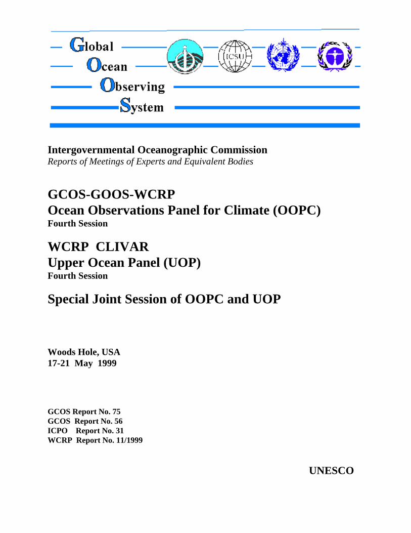
Intergovernmental Oceanographic Commission Reports of Meetings of Experts and Equivalent Bodies GCOS-GOOS-WCRP Ocean Observations Panel for Climate (OOPC) Fourth Session WCRP CLIVAR Upper Ocean Panel (UOP) Fourth Session Special Joint Session of OOPC and UOP Woods Hole, USA 17-21 May 1999 GCOS Report No. 75 GCOS Report No. 56 ICPO Report No. 31 WCRP Report No. 11/1999 UNESCO
-
Upload
khangminh22 -
Category
Documents
-
view
0 -
download
0
Transcript of WCRP CLIVAR Upper Ocean Panel (UOP), fourth session
Intergovernmental Oceanographic CommissionReports of Meetings of Experts and Equivalent Bodies
GCOS-GOOS-WCRPOcean Observations Panel for Climate (OOPC)Fourth Session
WCRP CLIVAR Upper Ocean Panel (UOP)Fourth Session
Special Joint Session of OOPC and UOP
Woods Hole, USA17-21 May 1999
GCOS Report No. 75GCOS Report No. 56ICPO Report No. 31WCRP Report No. 11/1999
UNESCO
Intergovernmental Oceanographic CommissionReports of Meetings of Experts and Equivalent Bodies
GCOS-GOOS-WCRPOcean Observations Panel for Climate (OOPC)Fourth Session
WCRP CLIVAR Upper Ocean Panel (UOP)Fourth Session
Special Joint Session of OOPC and UOP
Woods Hole, USA17-21 May 1999
GCOS Report No. 75 GCOS Report No. 56ICPO Report No. 31WCRP Report No. 11/1999
UNESCO

GCOS-GOOS-WCRP/OOPC-IV/3Paris, 3 November 1999
English only
SC-2000/WS/6
GCOS-GOOS-WCRP/OOPC-IV/3
FOREWORD
As a one-time event, the chairs of the Ocean Observations Panel for Climate (OOPC) andthe CLIVAR Upper Ocean Panel (UOP) agreed to schedule their 4th sessions at a common date andplace to make possible three days of a joint session of the two Panels as well as single-day separatesessions during the same week.
The joint session was scheduled to conduct a preliminary run-through of the full programmeplanned by the OOPC and the UOP for the OCEANOBS99 Conference. If the Conference wasto succeed, it was considered vital to have this exercise to obtain feedback from the large group ofmembers and invited guests on cohesion weaknesses, flaws, gaps, etc., with enough lead time toplan and reach agreement on revisions to the programme.
The separate sessions addressed normal Panel business. It was agreed that the separate andjoint sessions would appear within a single document, appropriately titled and numbered withstandard report numbers consistent with the parentage of these Panels. This document is thus thereport of the 3-day joint and two separate 1-day sessions of the OOPC and the UOP, held 17-21May 1999 at the Woods Hole Oceanographic Institution.
GCOS-GOOS-WCRP/OOPC-IV/3page (i)
TABLE OF CONTENTS
FOREWORD
SUMMARY REPORTS
Page
1. OPENING 1
2. REVIEW AND ADOPTION OF THE AGENDA 1
3. REVIEW OF INTERSESSIONAL ACTIVITIES 1
3.1 GOOS STEERING COMMITTEE AND OTHER 1OOPC REPRESENTATIONS
3.2 PANEL MEMBER ROTATION 23.3 FOUR THEMES OF OOPC ACTIVITIES 23.4 GODAE 23.5 GCOS AND THE UNFCCC AND COP-4 AND 5 33.6 ARGO (THE GLOBAL ARRAY OF AUTONOMOUS 4
PROFILING FLOATS)3.7 PARTNERSHIP FOR OBSERVATION OF THE GLOBAL 5
OCEANS (POGO)3.8 FIRST INTERNATIONAL CONFERENCE ON THE OCEAN 5
OBSERVING SYSTEM FOR CLIMATE
4. WORKSHOPS AND OOPC INITIATIVES 6
4.1 SEA SURFACE TEMPERATURE WORKSHOP 64.2 DATA MANAGEMENT ISSUES 64.3 TIME-SERIES AND OCEAN OBSERVATORIES 74.4 STUDY OF UPPER OCEAN THERMAL NETWORK 7
5. JCOMM AND THE ACTION PLAN 8
6. OTHER INTERACTIONS AND LIAISON 8
6.1 SEA ICE ELEMENTS OF THE OCEAN OBSERVING 8SYSTEM (OOS)
6.2 COASTAL PANEL 96.3 UPDATE ON SATELLITE GRAVITY MISSIONS 96.4 ATMOSPHERIC PANEL 106.5 GLOBAL OBSERVING SYSTEM, SPACE PANEL (GOSSP) 116.6 CAPACITY BUILDING 12
7. CLOSING AND NEXT MEETING 12
A. OCEAN OBSERVATIONS PANEL FOR CLIMATE (OOPC) -FOURTH SESSION
GCOS-GOOS-WCRP/OOPC-IV/3page (ii)
PageINTRODUCTION 12
1. USERS, APPLICATIONS AND OVERVIEW (First Session) 13
1.1 INTEGRATED SYSTEM OVERVIEW 131.2 APPLICATION OF SEASONAL-TO-INTERANNUAL PREDICTION 141.3 SOUTHERN HEMISPHERE PERSPECTIVE 151.4 DIVIDEND FROM INVESTING IN OBSERVATIONS, 15
A EUROPEAN PERSPECTIVE1.5 OPERATIONAL OCEANOGRAPHY AND PREDICTION, GODAE 151.6 ACTION PLAN FOR GOOS/GCOS AND SUSTAINED 15
OBSERVATIONS FOR CLIVAR1.7 DECADAL-TO-CENTENNIAL VARIABILITY 161.8 GENERAL DISCUSSION/REACTIONS ON SESSION 1 17
2. REGIONAL AND PHENOMENOLOGICAL APPROACHES 17
2.1 ENSO OBSERVING SYSTEM – AN UPDATE 172.2 TROPICAL ATLANTIC OBSERVING SYSTEM 182.3 OCEANIC BOUNDARY CURRENTS 192.4 PACIFIC BASIN EXTENDED CLIMATE STUDY 202.5 ATLANTIC CLIMATE VARIABILITY EXPERIMENT (ACVE) 222.6 INDIAN OCEAN 222.7 HIGH-LATITUDE PROCESSES AND THE ICE-COVERED OCEAN 242.8 WIND WAVES AND GOOS 252.9 HEAT AND WATER CYCLES 252.10 CARBON CYCLE AND TRACERS 26
3. DATA FLOW, PROCESSING AND PRODUCTS 27
3.1 OCEAN OBSERVATIONS FOR THE NEXT MILLENNIUM: ASSEMBLY, 27QUALITY CONTROL, ARCHAEOLOGY AND MANAGEMENT
3.1a DISTRIBUTED OCEAN DATA SYSTEM 283.2 DEVELOPING A NEW PARADIGM FOR OCEANOGRAPHY 283.3 ROUND TABLE NO. 1: A NEW ERA FOR OCEANOGRAPHIC DATA 30
SHARING AND AVAILABILITY3.4 PARTNERSHIP FOR OBSERVATIONS OF THE GLOBAL OCEAN 30
4. SPECIFIC CONTRIBUTIONS TO THE OBSERVING SYSTEM 31
4.1 CURRENTS AND OCEAN CIRCULATION 314.1a UTILIZING HISTORICAL DATA: A NEW PERSPECTIVE FOR UOT 324.2 ARGO, THE ARRAY OF PROFILING FLOATS 324.3 TIME-SERIES STATIONS 334.4 HYDROGRAPHIC SECTIONS 344.5 SAMPLING THE OCEAN WITH ACOUSTICS 35
B. SPECIAL JOINT SESSION OF OOPC AND UOP
GCOS-GOOS-WCRP/OOPC-IV/3 page (iii)
Page
4.6 UPPER OCEAN NETWORK 354.7 ROUND TABLE NO. 2 - TOWARDS AN INTEGRATED IN SITU NETWORK 374.8 SURFACE TOPOGRAPHY AND SEA LEVEL 374.9 SURFACE WINDS AND SURFACE STRESS 374.10 SEA SURFACE TEMPERATURE AND SALINITY 384.11 ROUND TABLE NO. 3 - TOWARDS AN INTEGRATED LONG-TERM 39
REMOTE NETWORK
5. EVOLUTION AND THE FUTURE – EMERGING TECHNOLOGIES 39
5.1 NEW PLATFORM TECHNOLOGY FOR SUSTAINED OBSERVATIONS 395.2 EMERGING EARTH OBSERVATION FOR SUSTAINED APPLICATION 40
6. SYSTEM-WIDE PERSPECTIVES AND SYNTHESIS 42
6.1 GLOBAL OCEAN MODELING AND STATE ESTIMATION 42IN SUPPORT OF CLIMATE RESEARCH
6.2 ENSO FORECAST SYSTEMS 436.3 ROUND TABLE NO. 4 - OVERALL DISCUSSION OF PROGRAMME 43
SUMMARY DISCUSSION 44
1. INTRODUCTION 46
1.1 WELCOMING 461.2 OCEANOBS99 461.3 CLIVAR-UOP MEETING PARTICIPANTS 46
2. IMPLEMENTING THE GLOBAL SYSTEM 46
3. CLIVAR SSG-8 ISSUES 47
4. MODELLING ISSUES 47
5. PROFILING FLOATS 47
6. SYSTEM INTEGRATION AND CALIBRATION ISSUES 47
7. TIME-SERIES MEASUREMENTS 48
8. INDIAN OCEAN OBSERVATIONS WORKSHOP 48
9. UPPER OCEAN THERMAL WORKSHOP 48
10. MEMBERSHIP 48
11. NEXT MEETING 48
C. CLIVAR UPPER OCEAN PANEL (UOP) - FOURTH SESSION
GCOS-GOOS-WCRP/OOPC-IV/3page (iv)
I. AgendasII. Lists of ParticipantsIII. Terms of Reference for Sea Surface Temperature Working Group (SST WG)IV. The Upper Ocean Thermal ReviewV. GOSSP Report to GOOS SC IIVI. Tabulated Observational Data Requirements for GOOS/GCOS: Table AVII. Ocean Remote Sensing Requirements: Table BVIII. List of Acronyms
ANNEXES
GCOS-GOOS-WCRP/OOPC-IV/3
1. OPENING
The Chair opened the meeting and asked Dr Weller, on behalf of the hosts to make a few remarks.Dr Weller welcomed Ocean Observations Panel for Climate (OOPC) to Woods Hole OceanographicInstitution and offered their assistance for both the OOPC and the joint OOPC-UOP meeting. The Chairthanked WHOI for hosting the Panel and, in particular, Mary Ann Lucas for the sterling work with locallogistics. The Chair welcomed four new members of the Panel, Joel Picaut, Johnny Johannessen, BobKeeley and Dick Reynolds as well as the new GCOS Director, Alan Thomas, and Mike Johnson fromNOAA OGP. A full attendance list is included at Annex II.
2. REVIEW AND ADOPTION OF THE AGENDA
The Chair introduced the Agenda (see Annex I) noting the joint sessions with the CLIVAR UpperOcean Panel (UOP) to prepare for the ocean observations Conference. Many of the detailed scientificdiscussions would be delayed until the joint session. This meant the agenda for Day 1 was very busy andsome business might need to be discussed out of session. The Agenda was adopted without modification.
3. REVIEW OF INTERSESSIONAL ACTIVITIES
3.1 GOOS STEERING COMMITTEE AND OTHER OOPC REPRESENTATIONS
The Chair noted that the GOOS Steering Committee had its first two sessions since the OOPC lastmet (GSC-I in Paris, April 98, and GSC-II in Beijing, April 99; reports to the latter meeting had beencirculated to Panel members). At those meetings the GSC were briefed on the activities of the Panel,including developments associated with the Global Ocean Data Assimilation Experiment (GODAE), Argoand plans for the 1st Conference on Ocean Observations for Climate. The Chair delivered reports to theGCOS SC (February 99) and the Joint Scientific Committee (March 99). He represented the OOPC at thesecond planning meeting (November 1998) for the development of the Implementation Action Plan forExisting Bodies and Mechanisms for Global Physical Ocean Observations for GOOS/GCOS (hereafterreferred to as the Action Plan), and at an exploratory meeting for a possible Partnership for Observationof the Global Ocean (POGO; see item 3.7 ). The Chair noted that the Panel's activities were encouragedand endorsed, where appropriate. The Panel was thanked for their considerable enthusiasm and leadershipand encouraged to continue their excellent work.
No major redirection of effort was suggested by the parent scientific bodies. The ever-broadeningremit of the panel is, in part, due to GODAE. The lack of progress with carbon and sea-ice aspects wasnoted. Moreover, the GSC noted that surface waves may also have to be considered by the panel.
With respect to carbon, Art Alexiou, (IOC) stated that the members of the IOC-JGOFS AdvisoryPanel on Ocean CO2 strongly recommended that the OOPC add a member with ocean carbon expertise.Ed Harrison added that the US is planning a Carbon Cycle Science Initiative for FY 2000 as part of the USGlobal Change Research Programme. The programme will integrate CO2 modelling, observational andprocess research to identify and quantify regional to global scale sources and sinks as well as seek answersto how these will change in the future.
A. OCEAN OBSERVATIONS PANEL FOR CLIMATE (OOPC) FOURTH SESSION
17-20 May 1999
GCOS-GOOS-WCRP/OOPC-IV/3page 2
3.2 PANEL MEMBER ROTATION
The parent bodies agreed that some rotation of membership was desirable, as suggested by OOPC-III. John Field, Michel Lefebvre and Christian Le Provost subsequently stepped down from the Panel andwere replaced by Richard Reynolds, Johnny Johannessen and Joël Picaut. An additional member RobertKeeley was added to strengthen links in the area of data and information management as suggested by bothGCOS and GOOS.
The Chair noted that further rotation of membership was desirable over the next 18 months.However there was no immediate pressure to act (and nothing in the terms of reference to compel suchaction) so there was likely to be no change over the coming 12-18 months.
3.3 THE FOUR THEMES OF OOPC ACTIVITIES
The Chair noted the "drivers" for OOPC activities could now be broken into 4 themes:
(i) ENSO and related seasonal-to-interannual prediction;(ii) Climate change, including elements of the carbon cycle and sea-ice;(iii) Short-range ocean (and marine) prediction and fields for meteorology; and(iv) General requirements for the climate database and climatologies.
Although each of these themes involved complex phenomena and interactions, there was broadagreement on the initial set of requirements and needed enhancements.
The elements of a strategy for responding to these plans/design are:
- Seek effective implementation mechanisms; e.g., the Joint Technical Commission forOceanography and Marine Meteorology (JCOMM), and the Partnership for Observation of theGlobal Ocean (POGO).
- Establish integrating "frontier" pilot projects; e.g., the Global Ocean Data Assimilation Experiment,and Argo, the global array of profiling floats.
- Initiate focussed activities (work and renovation); e.g., workshops (SST, Time-Series and SeaLevel), cooperative projects (reference sites and WGNE) and dedicated studies such as the ThermalNetwork Study.
- Exploit international "movements" using natural and other events to garner interest andinvolvement (1997/98 El Niño, UNFCCC COP and the Report on the Adequacy of GlobalObserving Systems).
- Encouraging partnerships, consensus (Cooperation with CLIVAR UOP, OCEANOBS99).
Neville Smith noted that the Initial (ocean) Observing System as recommended by GCOS/GOOSwas now within reach. The prospects for implementing many of the recommended enhancements are nowvery good (e.g., via Argo). This is an opportunity that has been provided by many different events anddevelopments. It is an unprecedented opportunity and one which we should endeavour to exploit, but toexploit in such a way that we put in place an observing system that will stand the test of time. TheConference, COP-5, JCOMM and POGO, and GODAE provide excellent avenues to ensure this is so.
3.4 GODAE
The Chair reported that the International GODAE Steering Team (and Patrons) had met twicewithin the last 12 months (a report on GODAE had been circulated prior to the meeting). The chair notedthat Argo had been the main focus through the last 12 months. The objectives of GODAE had been revisedto the following:
GCOS-GOOS-WCRP/OOPC-IV/3page 3
- The application of state-of-the-art ocean models and assimilation methods for short-range open-ocean forecasts, for boundary conditions to extend predictability of coastal and regionalsubsystems, and for initial conditions of climate forecast models.
- To provide global ocean analyses and re-analyses for developing improved understanding of theoceans, improved assessments of the predictability of ocean systems, and as a basis for improvingthe design and effectiveness of the global ocean observing system.
There has been good progress with national initiatives. Harrison reported that the US will establisha server dedicated to GODAE data at FNMOC. This is a significant and important commitment. It willinclude:
• Significant real-time capacity• Distributed data handling capability• Holdings of GTS and other data• Residency time > 30 days
Other specific GODAE actions agreed were:
(i) Establish a data team for GODAE to:
- Help determine [in consultation with US GODAE scientists and "pilot projects"] datarequirements for the centralized data server;
- Identify and implement resources to populate data server; establish archive of RT data;design, develop, and test data pathways; and establish/coordinate GODAE servers (satelliteproducts,…)
- Identify resources to develop products, and derived products for GODAE.
(ii) Form a small internal task group in IGST to examine possible metrics (methods of measuring system performance) for GODAE.
(iii) Form a GODAE Linkages Action Team to assure GODAE products are defined to meet the needs of mesoscale, regional, coastal, and other non-global partners.
(iv) Form a modelling and assimilation working group to focus on generic issues from the global setof regional activities (e.g., product and data set intercomparisons).
(v) Establish a WG for high-resolution SST products. Its tasks will include:
• A feasibility and scoping analysis; • To request a preferred methodology (data sets to use, processing, scientific issues) ;• An implementation plan; • To report to the IGST; • Links to the AOPC/OOPC SST WG (see later item).
3.5 GCOS AND THE UNFCCC AND COP-4 AND 5
Alan Thomas, the new Director of the GCOS Project Office reported on developments with respectto GCOS and, in particular, the Report on the Adequacy of Global Observing Systems and the responsefrom COP-4. Thomas reminded the members that GCOS received the mandate to initiate an
GCOS-GOOS-WCRP/OOPC-IV/3page 4
intergovernmental process for action (probably via GCOS and friends). It was asked to identify fundingprocesses using UN and other mechanisms and to identify a long-term intergovernmental mechanism foraddressing observation issues. The COP-4 urged nations to support the implementation of atmospheric,oceanographic and terrestrial observing systems and to develop and report national observing plans. GCOShas prepared an initial draft of national reporting guidelines (distributed to OOPC members at the meeting).Thomas noted that the AOPC had provided detailed comments on the guidelines at their most recentmeeting (these comments were copied to OOPC).
The OOPC, through the Chair, had provided significant input to the Report on the Adequacy ofGlobal Observing Systems and, again through the Chair, had corresponded with the Chair of the GCOS SCwith respect to the draft guidelines. The OOPC had no problems with the comments provided by AOPC,regarding them as sensible adjustments for consideration. Stan Thomas stated that the response fromSBSTA to this draft was the next important step. He also reported that Peter Price (from BoM) had beenappointed to work on the GCOS response at the GPO in Geneva.
The Chair noted that GCOS now has a level of credibility within the UNFCCC process and thatit is being entrusted with developing an appropriate mechanism; initial indications are that this challengeis being met well. This process provides an additional mechanism for nations to leverage support forclimate observations and so is important as part of the OOPC strategy. George Needler agreed to check thedraft guidelines for consistency with the present version of the Action Plan. The OOPC, in particularNeville Smith and George Needler, would continue to work closely with the GCOS Secretariat and theGCOS Chair.
3.6 ARGO (THE GLOBAL ARRAY OF AUTONOMOUS PROFILING FLOATS)
The Chair briefly reported on progress with Argo, noting that Dean Roemmich (Scripps Institutionof Oceanography, USA) would provide a more detailed report under agenda item 6. At the previous OOPCmeeting, the Chair reported that GODAE had recommended a major deployment of profiling floats, ~ 3000,based on a proposal by Dean Roemmich. Subsequently, the CLIVAR Upper Ocean Panel also affirmedsupport, including provision for salinity measurements as promoted by the Ray Schmitt proposalGOSAMOR. The GODAE Chair prepared a prospectus on behalf of GODAE and, indirectly, OOPC andthe UOP, and circulated this for community comment in May 1998. An Argo Workshop was organized aspart of the IGST-II meeting in Tokyo, and supported by the OOPC Secretariat and GOOS. This Workshopconcluded that Argo was most definitely worth doing and feasible. Initial estimates suggested the perprofile cost (T and S to 2000 m) could be as low as US$100. Certain technical challenges were identifiedbut none appeared insurmountable. The Workshop emphasized Argo was not an observing system solutionin itself and that the OOPC would need to provide advice and guidance on the total balanced ObservingSystem.
An Argo Science Team was formed, with Dean Roemmich as Chair, and requested to draft aninitial plan. This draft was circulated for non-advocate review in October and drew around 30 responses.None questioned the need for Argo nor the technical feasibility. The majority of the comments targettedthe scientific and operational rationales, deployment, sampling and the need for integration within theglobal observing system. The GODAE Office published the Initial Plan in early November. It wasdistributed at the CLIVAR Conference in December. There has been an energetic, parallel campaign tosolicit international participation, led by NOAA. The first meeting of the Argo ST was held in Easton, MDin March 1999, again with the GODAE Steering Team. The Team concluded, based on national (informal)estimates, that it was realistic to expect on the order of 600 float deployments per year by around 2001.Global distribution was a top priority. The Southern Ocean was poorly subscribed in initial estimates.There had been considerable technical progress in float development and 200 cycles were now thought tobe feasible. The deployment strategy was discussed in detail as was the preferred parking depth. The
GCOS-GOOS-WCRP/OOPC-IV/3page 5
OOPC agreed to formally endorse Argo as a pilot project and to endorse the present arrangements wherebythe Argo Science Team is sponsored by GODAE.
3.7 PARTNERSHIP FOR OBSERVATION OF THE GLOBAL OCEANS (POGO)
Bob Weller reported on a recent initiative to create a partnership among world oceanographicinstitutions in support of, among other things, the ocean observing system for climate. An exploratorymeeting was convened by WHOI, SIO and SOC to explore feasibility of, and opportunities for, such apartnership. The meeting was held at IOC in Paris (March 1999) and was attended by BobWeller andNeville Smith from OOPC. The meeting concluded that such a partnership was needed, in part becauseoceanography in the modern era required investments of resources that were beyond any single institution.The participants agreed that Argo and GODAE should be leading priorities for the partnership. Theadopted charter states:
"The participants agree to proceed with the establishment of a partnership of institutions (andconsortia thereof) which have demonstrated capability to undertake basin-scale oceanographicobservations and research together with such associated members and affiliated entities as maysubsequently be agreed. Representation will be at the level capable of committing theirinstitutions."
The mission statement reads as follows:
"A Partnership for Observation of the Global Oceans (POGO), composed of major institutionsinvolved in research and observation in global ocean science, will work with the ocean, earth, andatmospheric science communities to promote global oceanography, including especially thedevelopment of an integrated global observing strategy. POGO will play a leading role inimplementation of an international and integrated global ocean observing system."
As a specific initiative, the meeting recognized the importance of rapidly developing a project forocean time series/observatories. The meeting requested OOPC to develop a plan for consideration at thenext meeting of the participants (scheduled for Dec 1-3 1999 at SIO). This plan should consider theeffective sharing of information, technology and experience among participants in the project. Bob Weller(OOPC) and Uwe Send (CLIVAR UOP) have agreed to lead the drafting of such a plan.
The Chair noted that the participants had gone to some lengths to emphasise that they wished towork with, and within, existing structures and did not wish to create unwanted, additional mechanisms.The GOOS SC did raise some issues in relation to the mission and charter but these were not likely todiminish the resolves of the institutions to form such a partnership. The Chair suggested that the Partnershipmay well provide an additional, much needed implementation mechanism in areas which required highlevels of scientific and/or technical expertise (e.g., hydrographic sections). The OOPC agreed that POGOoffered considerable potential for enhancing the observing system. Both Smith and Weller were likely toattend the first formal POGO meeting at which time a plan for ocean time-series observatories should beready.
3.8 FIRST INTERNATIONAL CONFERENCE ON THE OCEAN OBSERVING SYSTEM FORCLIMATE
The Chair stated that much of this meeting’s agenda was being devoted to this Conference, knowninformally as OCEANOBS99. He noted that its genesis was in several discussions that had taken placesince OOPC-III concerning the balance of the observing system and, in particular, the perceived potentialfor Argo to distort this balance due to its high level of visibility. OOSDP had discussed a Conference at thetime of publication of its report but it was thought at the time that such a Conference would not be effective.
GCOS-GOOS-WCRP/OOPC-IV/3page 6
However in recent years implementation has gathered pace to the point where it was now desirable to getbroad community consensus on the blend of techniques/methods that should be adopted. This includes bothremote and direct/in situ systems. After discussions with leading members of the community, it was decidedthat a conference involving all those involved with the implementation and maintenance of the systemshould be convened and that, in order to ensure full cooperation among the operational and researchcommunities, the conference should be jointly convened by OOPC and the CLIVAR UOP.
All the major sponsors agreed and an initial Scientific Organizing Committee was formed withNeville Smith and Chet Koblinsky as co-Chairs. The first announcement was released in March and thesecond announcement in mid-May. Around 30 papers had been solicited, using the format of IPCCAssessment papers as a guide. The joint meeting of OOPC-UOP was the first chance to see just what mightbe covered by the papers and to adjust the programme so that the ultimate aim of the Conference, an agreed,balanced observing system for climate, was met. Further actions can be found under Item 6 whichaddresses the Conference in detail.
4. WORKSHOPS AND OOPC INITIATIVES
4.1 SEA SURFACE TEMPERATURE WORKSHOP
Dick Reynolds gave a brief report on the recent (Nov. 98) Sea Surface Temperature (SST)Workshop which was jointly convened by OOPC and AOPC. He referred to OOPC-III which exposedproblems with analyses at high latitudes whereby different systems seemed to give different long-termtrends. This seemed to be due to the way sea-ice was handled.
The Workshop concluded that climate change detection requirement is the most stringent in termsof precision and accuracy for SST (0.1°C). Differences in "global" SST can arise because of uncorrectedsatellite biases and the improper use of sea-ice "data". Data assembly remains a problem.
Dick Reynolds emphasized we are still hampered by data gaps, particular in southern high latitudes.There are several important issues related to skin versus bulk temperatures. The WS also noted the demandfor high resolution (in space, time) is growing.
After consultation with the AOPC and OOPC it was decided that the excellent work of theWorkshop should be built on with a Working Group, co-sponsored by OOPC and AOPC. Dick Reynoldsagreed to Chair the WG. The initial terms of reference are in Annex III. The OOPC commended theWorkshop participants, and its Chair Phil Arkin, for the excellent work that was done. The Workshop reportidentified several important issues and the OOPC believed these should be looked at as soon as possible.The OOPC thanked Dick Reynolds for agreeing to Chair the WG and endorsed the terms of reference asa suitable starting point for the group. Ed Harrison and Neville Smith would continue to provide input, asrequired.
Neville Smith noted that GODAE was about to initiate a working group to look at high-resolutionproducts, nominally at around 10 km spacing and including diurnal resolution (see GODAE above.) Thisgroup would need to work closely with the climate SST WG to ensure common understanding of issuessuch as skin/bulk SST parameterizations and the use of data from microwave and geostationary instruments.
4.2 DATA MANAGEMENT ISSUES
Bob Keeley led a brief discussion on data management issues. It was noted that the formation ofthe JCOMM implied that guardianship for these issues would mostly transfer to that body. OOPC werereminded that, as part of the action plan, several issues related to data assembly, quality control and data
GCOS-GOOS-WCRP/OOPC-IV/3page 7
and product distribution were identified. For sub-surface data, Keeley would be working the Upper OceanThermal data study to provide more explicit guidance on the operational requirements for assembly, etc.
The SST WS devoted considerable attention to the assembly and quality control (QC) of SST data,again an issue that was identified in the development of the Action Plan for JCOMM. Keeley noted thatJDIMP had developed a "G3OS Data and Information Management Plan". They had also developed a globalobserving system information centre (GOSIC) through the University of Delaware which describes whereinformation might be held. Ron Wilson has also developed a GOOS Draft Plan which was discussed atGOOS SC. Neville Smith noted that this was likely to undergo considerable revision as a result of thediscussions at Beijing. He further noted that CLIVAR was developing its CLIVAR Data Information andProducts Service and had formed a task team to look at issues, many of which are in common with OOPCand AOPC. There were, in addition, activities being undertaken within GODAE (e.g., the development ofthe GODAE server) and Argo which were presently outside these other considerations. The Conferencewould provide one opportunity to reach some consensus on who was doing what and how. Clearly, at themoment, there was not a good understanding of the way forward.
The OOPC concluded that a more focussed effort was going to be required, and that this wouldrequire the development of a deeper interest and involvement from the research community (research inD&IM). For high-quality data sets, involvement of research is mandatory. For the short-term, the JCOMMand other studies (SST, UOT) would provide focus for OOPC activities. The development of the GODAEserver might serve as a basis for developing an Ocean Climate Data server.
4.3 TIME-SERIES AND OCEAN OBSERVATORIES
As noted above under POGO, OOPC have been requested to develop a plan for time-seriesstations/observatories and to present plans for surface reference sites to POGO. Weller noted that he andUwe Send (Kiel) had agreed to take on this task. The mode would be similar to that taken by Argo. A draftplan would be prepared in collaboration with those with a key interest in this technology. This plan wouldthen be circulated for non-advocate review, probably mostly from the UOP and OOPC panels. A revisedplan would be presented to the OCEANOBS99 Conference. This document would then be published underthe auspices of OOPC and UOP and provided to POGO for their consideration.
Weller also noted that there had been good progress with development of a joint project with theWorking Group for Numerical Experimentation (WNEG) of CAS/WCRP. Weller had made a presentationat the last meeting of WGNE (November 98) and they agreed to develop a project which would use high-quality data from surface reference sites to test and improve operational numerical weather predictionmodels. Peter Gleckler (PCMDI) is the principle contact within WGNE. Weller agreed to continue to bethe lead contact within OOPC for this project.
4.4 STUDY OF UPPER OCEAN THERMAL NETWORK
Smith described an initiative to examine the upper ocean thermal network and, in particular, thescientific rationale for and design of the ship-of-opportunity network. Smith noted that at the previousOOPC meeting an outline of relevant actions was presented (drafted by R. Bailey) and that, at that time,it was decided that no action would be taken until the response of the UOP was obtained. The most recentUOP meeting failed to make any progress so it was decided to initiate actions out of session. A descriptionof the proposed study is included as Annex IV. Smith, Harrison and Keeley are the principal contactswithin OOPC. Smith noted that the work programme is consistent with the Action Plan for JCOMM andthe conclusions of the planning meetings in Sydney and Paris in 1998. For OOPC, it should provide arenovated/revised plan for the SOOP and provide recommendations for long-term support (or not) offrequently repeated and high-density lines. It should also give advice on how best to integrate the SOOPin the presence of altimetry, TAO and Argo (and other contributions). Smith noted that the approach was
GCOS-GOOS-WCRP/OOPC-IV/3page 8
similar to that used for the sea level workshop.
A study was being undertaken at BMRC through the Joint BMRC/CMR Australian Facility forOcean Observing Systems using a consultant and the advice of Rick Bailey. A Workshop was planned forAugust and the initial conclusions would be presented to OCEANOBS99.
The OOPC endorsed the work plan for the study and concluded that it would go a significantdistance toward the aims of the Action Plan for JCOMM. A full discussion of the study would be includedon the agenda for the next OOPC meeting.
5. JCOMM AND THE ACTION PLAN
Needler reported that the section of the Action Plan relating to ocean climate observationalrequirements had been updated and revised. The most recent version had been made available to OOPCmembers via the Web. He noted that other changes to the Plan had resulted from an Interim Action Groupmeeting in Paris last December. Needler noted that the Action Plan was the substantial basis for theCLIVAR Implementation Plan, enhanced as appropriate with sustained observations for the CLIVARPrincipal Research Areas (PRAs). Together these plans formed the foundation for the upcomingOCEANOBS99 Conference. To the extent possible, the detailed sampling requirements reflected the mostrecent decisions of the OOPC. These requirements are summarized in tabular form in the Action Plan andare reproduced in Annex VI, Table A.
Needler further stated that the Joint (Technical) Commission for Oceanography and MarineMeteorology had been endorsed by the executives of both WMO and IOC and that in May and July of 1999,it would be proposed to the WMO Congress and IOC Assembly (it was endorsed by the former whileOOPC was in session). A "Transition Planning Meeting for JCOMM" is scheduled for St Petersburg, 19-23July. The Chair of OOPC will attend. Assuming successful adoption of JCOMM by IOC, this transitionmeeting will look at the issues relating to transition of the existing mechanisms into a Joint Commission.The task for OOPC is to ensure that requirements are well articulated and that, where doubts or uncertaintyarise, that adequate scientific guidance is developed (e.g., as with SST).
The Chair further noted that many elements of the OCEANOBS99 Conference are directly relatedto JCOMM (e.g., Surface Waves, upper ocean thermal, SST, surface fluxes, etc.).
OOPC re-iterated the importance it attached to the formation of JCOMM and thanked GeorgeNeedler for undertaking important redrafting.
6. OTHER INTERACTIONS AND LIAISON
6.1 SEA ICE ELEMENTS OF THE OCEAN OBSERVING SYSTEM (OOS)
Smith noted that little progress had been made since OOPC-III. That meeting suggested severalmodifications to published requirements most of which have been accommodated. However, this alone hasnot enhanced support for long-term measurements. The SST WS did examine several issues related to sea-ice but only in the context of SST analyses for climate. Drawing lessons from other areas of the observingsystem, OOPC concluded that a more substantial project would have to be developed, perhaps incooperation with ACSYS. The Chair noted that informal discussions had taken place with the Chair ofACSYS, Howard Cattle. An ACSYS Products group had been formed and it was suggested that perhapsOOPC should try to link up with this group.
GCOS-GOOS-WCRP/OOPC-IV/3page 9
6.2 COASTAL PANEL
The third meeting of the Coastal Panel (C-GOOS) had been held at Accra, Ghana during 13-15April 1999 and Needler reported on the progress that had been made, on plans for the future, and on mattersof joint concern for the OOPC requiring co-operation. The intention is to provide an initialimplementation plan for C-GOOS after the next 2 meetings of the Panel. It is envisioned to have 2 parts;one describing a global network of required observations and the other a set of pilot projects that may onthe longer term be included in the global network. An initial draft of the global network was prepared forthe Accra meeting and was extensively reviewed. At present it includes satellite observations, a tide gaugenetwork, an enhanced network of off-shore buoys and platforms (mostly focussed on surface meteorologicalconditions), observations on critical sections, and a coastal watch of near-shore properties allowing localinput and contributions to the global data set. A revised version of the global network will be availablewhen the Panel meets in Beijing in November.
Regarding the pilot projects, several possibilities were presented by Panel members and discussedat C-GOOS-III. Before the next meeting these will be developed further and a more comprehensive and,to some extent, prioritized list will be prepared. C-GOOS has mostly been developing a system of physicaland biological observations and is working with the expectation that in the longer-term there will be anamalgamation with the LMR and HOTO modules requirements for coastal observations.
Needler also briefed the OOPC on the subject of OOPC/C-GOOS co-operation which had also beenaddressed at C-GOOS-III. It is well recognized by C-GOOS that the coastal observing system requireselements of the OOSC for coastal problems. These include, for example, the provision of the large-scalewind and SST fields, sea level in the context of the large-scale geocentric framework, and forcing by theENSO/tropical wave guide of the western coast of the Americas. Interest was expressed in what GODAEmight provide regarding dynamical forcing of the coastal seas and in what profile data might be providedby Argo within the EEZs.
C-GOOS can also provide benefits for the OOSC. For example, 'coastal' observations of winds andSST can provide data of higher resolution for the OOSC that will sometimes be in regions of poor globalcoverage because of persistent local fog. The use of coastal tide gauges for the global determination ofchanging ocean volume requires information on the coastal tidal regimes and the dynamical adjustment ofthe coastal circulation to changes in off-shore forcing; these are coastal problems. Some C-GOOSobservations will likely provide higher resolution observations of importance to global climate change andvariability. Examples are observations of the poleward flowing eastern boundary currents and of shelftransports such as by the Labrador Current and through the Canadian Archipelago. These are importantaspects of the global climate system but they are of a higher resolution than has been included in the initialdesign of the OOSC.
Given the above and the fact that common mechanisms, such as JCOMM, will be used toimplement both the OOSC and coastal observations, C-GOOS recognized that there is a need forconsistency and co-operation in the design of the global and coastal aspects of GOOS. The OOPCconcurred. OOPC noted that sea level was a high-priority requirement for the coastal community and that,for implementation, it would be sensible to extend the remit of the proposed sea level working group toexamine this issue. This had been discussed by GOOS SC and was due to be raised at the GLOSS meetingin Toulouse the previous week.
6.3 UPDATE ON SATELLITE GRAVITY MISSIONS
Johnny Johannessen provided an update on recent developments for gravity missions, particularlyfor the GOCE. (Gravity Field and Steady-State Ocean Circulation Explorer) mission. He stated that the
GCOS-GOOS-WCRP/OOPC-IV/3page 10
decision on whether to go with a GOCE mission would be made by 7 June. He noted that GRACE givesocean bottom pressure variations, order of 10's of mb, which reflect the Gulf stream and Kuroshiomeanders with signals of the order of 20-50 mb. This suggests that a bottom pressure sensor array wouldbe required for validation.
Johannessen reported that a study was completed since OOPC-III that compares GOCE with twoother relevant missions, CHAMP (Challenging Mini-satellite Payload for Geophysical Research andApplication) and GRACE (Gravity Recovery and Climate Experiment). The study concludes that GOCEwould be a unique gravity field mission that would open a completely new range of spatial scales toresearch. In particular, it would for the first time provide a precise reference surface at a wavelength ofabout 100-200 km for unification of height systems, levelling of GPS and for the determination of absoluteocean topography from data delivered by satellite altimetry. The latter is a major deficit in currentknowledge which undermines estimates of absolute ocean circulation and its transport of heat andfreshwater.
The study also demonstrates that GRACE is complementary to GOCE in that it will provide thetemporal variations of the Earth’s gravity field with high precision in the long to medium wave lengthrange, i.e., 500 km and longer. GRACE will measure gravity changes due to mass changes or mass motionrelated to sea level, hydrology, glaciology and solid Earth. At intermediate scales, both missions providerelevant information to advance the knowledge of the Earth’s gravity field and its reference equipotentialsurface, (geoid). The report of the study, titled European Views on Dedicated Gravity Field Missions:GRACE and GOCE was published by the European Space Agency (ESA) as an Earth Sciences DivisionConsultation Document, ESD-MAG-REP-CON-001, May 1998.
6.4 ATMOSPHERIC PANEL
Ed Harrison provided a brief report on the most recent AOPC meeting, noting that the discussionof the Report on the Adequacy of Global Observing Systems and the SST Workshop were significantagenda items. Harrison summarized as follows:
(i) Francis Bretherton, the new chair of GOSSP was in attendance. He is pushing for using oceansatellite observations for an end-to-end activity, including merging satellite and in situobservations. It is important for OOPC to review the CEOS ocean surface data requirements tableand to keep it updated. CEOS uses these requirements.
(ii) With respect to the GSN (Global Surface Network) and GUAN (Global Upper Air Network), it hasbeen decided to seek daily observations as well as monthly means. It was agreed that the GSN datashould consist of the following:
• Mean daily temperature (calculated using current national practice);• Maximum daily temperature;• Minimum daily temperature;• Total daily precipitation;• Daily mean wind speed;• Daily mean sea level and station pressure ( calculated using current national practice.
Harrison emphasized that the politics of data exchange of daily data and cost issues are non-trivial.There is a new CLIMAT format for reporting, but much remains to be done to get all nations reporting inthis format. Efforts continue, to try to increase the number of GSN and GUAN stations actually reportingdata. Some discussion occurred about how best to make the GSN and GUAN information available tointerested users. The move to establish a US-GODAE data and products server/browser was noted;perhaps it will provide a model that could help.
GCOS-GOOS-WCRP/OOPC-IV/3page 11
(iii) Discussions took place on how best to interact/relate with SBSTA (Subsidiary Body {of theConference of the Parties for the UNFCCC} for Scientific and Technological Advice).
(iv) The GOSIC (Global Observing Systems Information Center) at the University of Delaware<http://www.gos.udel.edu> serves as a central site to help people find information about theG3OS programmes, data requirements, observing systems and data sets and products. AOPC wasinvited to participate in GOSIC.
(v) A review of the GPCP (Global Precipitation Climatology Project) was presented. Ocean valuesremain quite uncertain. There is little in situ information to help calibrate satellite information.Work continues to improve the processing of satellite information and to improve the quality ofin situ ocean measurements.
(vi) A report of the jointly sponsored AOPC/OOPC workshop on global SST and sea ice was presented.Differences between different products are uncomfortably large over many regions of the ocean,relative to the climate signals of interest to GCOS. The need for more in situ data in data sparseregions is clear. Such data would greatly facilitate improved bias corrections of satellite IR data.There remains uncertainty about how best to process satellite sea-ice information. Questions alsoremain about the uncertainties in historical reconstructions of global SST and sea ice fields.
Dick Reynolds has agreed to chair a working group to carry out more detailed intercomparison ofSST and sea ice products, to identify the sources of differences between them and to recommend steps toimprove the quality of future analyses and of retrospective analyses.
(vii) Preliminary results about the level of uncertainty in sea level pressure analyses were presented.In the tropics and in high latitudes (especially high southern latitudes) the RMS differencesbetween daily analyses can be a significant percentage of the signal. It was recommended thatfurther exploration of the state of knowledge of sea level pressure be carried out and reported onat the next meeting of AOPC.
The OOPC agreed that a study of sea level pressure fields on climate scales (trends, long-termvariability) was needed. Harrison volunteered to provide input. It was also noted that precipitation (netfreshwater flux) was a significant issue. Discussion at AOPC suggested little progress had been made withocean measurements.
6.5 GLOBAL OBSERVING SYSTEM, SPACE PANEL (GOSSP)
The Chair briefed the Panel on recent activities related to satellite requirements and the Space Panel(GOSSP), now chaired by Francis Bretherton. He noted that a report had been submitted to GOOS SC(circulated to OOPC prior to the meeting) asking for their endorsement of requirements for the oceans(principally those of OOPC and GODAE). This Report to GOOS SC is included as Annex V. Theapproved Table of Requirements is in Annex VII Table B. The GOOS SC, while noting that it itself doesnot have the expertise to judge the veracity of the stated requirements, concluded that GOSSP (with the helpof GODAE and OOPC) had attended to this request in a scientifically sound manner and that it wasappropriate for them to be regarded as definitive GOOS requirements.
GOSSP had raised several issues for the attention of GOOS SC, particularly with respect to oceancolour and biology, but the SC was not in a position to provide advice. Smith also noted that GOSSP, incooperation with the IGOS Partners, were formulating a position paper for the Oceans Theme of CEOS.The priority measurements are:
GCOS-GOOS-WCRP/OOPC-IV/3page 12
(i) Surface topography/altimetry• T/P-Jason-like quality altimetry – at least one in orbit at all times• High-resolution altimeter (e.g., an ENVISAT or better instrument in orbit at all times) • 3rd altimeter in orbit desirable
(ii) Sea surface irradiance • Need improved methods for assembly, validation• Trend toward higher resolution products (GODAE) and use of multiple platforms, including geostationary and microwave data
(iii) Surface Wind Vectors• At least one NSCATT scatterometer (or an equivalent) is essential• Strong multi-application case emerging for a second scatterometer
(iv) Ocean Colour• Consensus that ocean colour is a priority measurement
The OOPC endorsed the suggested priorities but noted that the Conference would provide a moreappropriate forum for endorsement. Smith also noted the need for surface short-wave radiation products.An outline for a possible project had been circulated after IGST-II and was discussed again at the lastGODAE meeting. It was believed that carriage of this project was probably better done within OOPC. TheChair reported there had been some correspondence with GEWEX but that, as yet, no decision had beenmade on a project. This will be pursued inter-sessionally.
6.6 CAPACITY BUILDING
The Chair noted that a capacity building effort was to be mounted by GOOS. Bob Wellervolunteered to provide input on OOPC's behalf. Needler volunteered to act as back-up. POGO alsosuggested it might provide some help in this area.
7. CLOSING AND NEXT MEETING
Johnny Johannessen and Peter Haugan volunteered to investigate locations in Norway for the nextmeeting, possibly early June 2000. The date and place were subsequently set as Bergen, 20-23 June 2000.
INTRODUCTION
This 3-day joint session of the OOPC and the UOP, was conducted as a preliminary run-throughof the programme planned by the OOPC and the UOP for the OCEANOBS99 Conference. It was essentialto have this exercise to have all the speakers have a common understanding of the Conference, theobjectives and the philosophy underlying its design, and the relationship sought between their papers andall the others on the programme. It also provided the only real opportunity to obtain feedback from thelarge group of members and invited guests on cohesion weaknesses, flaws, gaps, etc. with enough lead timeto plan and reach agreement on revisions to the programme.
B. SPECIAL JOINT SESSION OF OOPC AND UOP18-20 May 1999
GCOS-GOOS-WCRP/OOPC-IV/3page 13
The session was co-chaired by N. Smith and C. Koblinsky, the respective chairs of OOPC andUOP, The co-Chairs introduced each item by briefly describing its background to the Conference.(Participants had been circulated the first and second Announcements, the annotated programme and aguideline for authors.)
The scientific basis was provided by the OOSDP Report and subsequent modifications by OOPCto the design and plans, and the CLIVAR Science Plan and Implementation Plan. A fundamental principlewas that the ocean observing system (for climate) will be multiple purpose and serve a broad community.There will be just one and it will need support and consensus on its structure and the blend of observations.This First International Conference on the Ocean Observing System for Climate was conceived to get thisagreement.
The Conference, otherwise known as OCEANOBS99, was sponsored by GCOS/GOOS,WCRP/CLIVAR through the OOPC + UOP. It enjoyed a wide institutional and organizational support andwas held in Saint Raphaël, France, 18-22 October 1999.
Smith opened with some remarks that provided background to this joint session. OCEANOBS99is for the ocean community rather than a showcase for individual interests. The Scientific OrganizingCommittee agreed on an approach. It is not unique or superior. For the purposes of the Conference,"Climate" is treated as the ensemble of environmental realizations, not average weather or everything slowand large (scale). An immediate implication is that we will consider short-range forecasts, etc.
The ocean community is moving beyond a "research versus operational" stance and developing thenotion of sustained observing systems with broad patronage and application. The key questions to be askedfor prospective elements are: Can it be sustained? Is it worth sustaining? Do we know how?
The answers are inevitably a function of resources, people, knowledge; there will be no simpledefinition of observations to be include in or out of the system. The primary task is reaching agreement onthe rationale and the blend of observations. We are not seeking the “latest and greatest”; nor consideringsatellite versus in situ; nor surface versus upper ocean; nor mid-latitudes versus tropics; etc.
Smith concluded his opening remarks by stating that integration and synthesis is not just aboutmodels and data assimilation; complementarity and integration must be sought at all levels. The Conferenceis seeking consensus, not prescribing or imposing. Attaining this consensus cannot be done just at theConference. We must seek it initially in specialist areas, then for broader constituencies and regions, andfinally within the larger ocean community. We have an opportunity to decide on what the future will looklike; to seek a robust, sustainable future for the ocean observing system; let us use this opportunity wisely.
This session discussed the papers in roughly the same order as in the 2nd Announcement. Thediscussion was referenced against the annotated programme for OCEANOBS99. Numbering correspondedto that draft programme. Comments, criticisms, suggestions are included here in abbreviated note form.
1. USERS, APPLICATIONS AND OVERVIEW (First Session)
1.1 INTEGRATED SYSTEM OVERVIEW (by Needler for Nowlin et al.) 1.1.1 Outline of the Paper
Start with science base. What led to TOGA and WOCE, Namias, possibility of global altimeterand scatterometer, recognition of the ocean's role in climate (Stream 3 of WCRP) etc. TOGA, - firstattempts at climate prediction. WOCE’s first goal was a global ocean description. WOCE had a second
GCOS-GOOS-WCRP/OOPC-IV/3page 14
goal: to leave a climate observing system behind it. Greenhouse gas concerns, leading into the IPCC, andto FCCC, and observing system requirements.
Formation of GCOS and GOOS in 1992. Describe relevant goals and objectives. Origin ofOOSDP (before GCOS and GOOS in 1990). Saw opportunity of funding for systematic observations andmoved goal 2 of WOCE forward. Optimism that TOGA prediction would work and need observations.Give general goals and approach of OOSDP.
The challenge of implementation. Research to implementation. Limited regions to globalperspective. Reason for formation of JCOMM (integration, etc.). The need for broad internationalinvolvement (a few nations did most of the field work of WOCE and TOGA).
The most recent COP-4 push of the GEF. The recognition of the need for repeated assessmentsfor the IPCC, by SBSTA of the OOSC for the FCCC .
The advent of CLIVAR. Climate research on decadal scale has overlapping considerations withOOSC design. But research objectives can be different than for operational systems. Also funding sourcescan be different.
End upbeat on future. New technologies in use (altimeter, scatterometer, Argo). Existing effort(North Atlantic profiling floats for example). Funding: example of operational funding in tropical Pacific.Improved recognition of governments and public of climate issues
1.1.2 Discussion/Reactions
There were no detailed concerns with the content of the paper. There was concern that the openingmight be too "dry". Neither the CLIVAR IP nor the OOSDP/OOPC plans are filled with excitingschematics. Yet it is background and detail that is needed. Some expressed the view that this paper mightwork best after the papers dealing with specifics. Since it effectively deals with the integrated, globalsystem – the end-point of the Conference rather than the beginning.
One option might be to take some of the background material and develop it as one or two posters– the posters at the CLIVAR Conference were one of the highlights. Many participants thought suchdisplays might be the most effective way of providing detailed designs. If it is still to be used as a talk atthe front, then we will need to develop schematic links into the rest of the programme.
1.2 APPLICATION OF SEASONAL-TO-INTERANNUAL PREDICTION – (by Ants Leetmaa)
1.2.1 Summary of the Paper
The northern hemisphere experiences climate variations on seasonal and decadal time scales.Trends are also important. A few modes, ENSO, ENSO-Decadal, Arctic Oscillation (AO), produce muchof this. (This does not preclude the existence of other modes). In general, explanations for regional climatevariations require consideration of several of these modes.
The next "easy plum" for adding to predictability is the ENSO-Decadal mode. There is noconsensus yet that the AO is a distinct mode. It might be the sum of North Pacific and NAO contributions.A better understanding of the AO/NAO is critical for further enhancements of predictability.
1.2.2 Discussion/Reactions
Many participants agreed that this was exactly the sort of presentation needed to motivate
GCOS-GOOS-WCRP/OOPC-IV/3page 15
subsequent presentations. It gave a nice discussion of the "fundamentals" (modes) and provided concreteexamples of how a global observing system could enhance the quality and range of climate forecastproducts. The societal impacts figure and the discussion of relevance to the energy industry seemed to betwo highlights. Leetmaa suggested the title may change because of the rather broader coverage.
The discussion on modes of variability suggested these should be used as links to subsequent talksso that the audience at the Conference was able to explicitly link back the detail to the applications.
After the presentation on 1.1 and 1.2 it was also concluded that a similar talk focused on climatechange was also needed.
1.3 THE SOUTHERN HEMISPHERE PERSPECTIVE (not discussed at the meeting)
1.4 THE DIVIDEND FROM INVESTING IN OBSERVATIONS, A EUROPEAN PERSPECTIVE(Not discussed at the meeting)
1.5 OPERATIONAL OCEANOGRAPHY AND PREDICTION, GODAE (not discussed at the meeting)
1.6 THE ACTION PLAN FOR GOOS/GCOS AND SUSTAINED OBSERVATIONS FOR CLIVAR(by George Needler)
1.6.1 Outline of the Paper
Reference back to paper 1.1. Give OOSDP terms of reference to show design aim. Addressdifficulty of optimization around subgoals, or variables, or fields. Give OOSDP choice of subgoals.OOSDP set priorities, show priorities. Illustrate observation mix with one or two impact-feasibilitydiagrams (SST, ENSO?). Give sequence through first Action Plan draft to CLIVAR sustained observationsto final Action Plan.
Increasing specification of space-time scales and accuracy of observations. Refer to detailed OOSCas given in paper. Give one or two examples, perhaps SST and upper ocean T.
Changes since OOSDP. Design may not show full impact of precision altimeter. Scatterometeryet to be routinely used. Profiling floats are in OOSDP but in a sense are a pilot project. Design willevolve with understanding of environment and new technology.
For future consideration. New technology. Acoustics (ATOC). Strategy of Argo deployment.
Autonomous underwater vehicle (Autosub).
Revised design. Changed mix of observations to optimize system based on new knowledge.
Implications of GODAE . Better techniques for in situ / satellite blended products.
New areas of coverage. Mediterranean. Arctic. Higher resolution for critical elements. Western boundary currents. Poleward flowing eastern undercurrents.
1.6.2 Discussion/Reactions
The discussion here followed that with paper 1.1; while this material was extremely important, a"dry" introduction early in the Conference may not be the best way forward. Many people favoured the

GCOS-GOOS-WCRP/OOPC-IV/3page 16
development of posters which would be on display for the duration of the Conference and which could beused as a "connector" for detailed talks. If we followed this option (and also introduced a "primer"Conference talk) the first few papers would be: Conference "primer" (why the Conference, what it hopesto achieve, etc.); Leetmaa talk; Climate Change; Operational Oceanography and Prediction; The Dividendfrom Investment; and Gary Meyers’ Southern Hemisphere Perspective. The Action Plan would bepresented as 2 or 3 posters.
In the closing session we would then have Nowlin et al., which could then work off all the previoustalks and make the connection, finally, into GCOS, GOOS, CLIVAR and the integrated system. As anoption it could be preceded by a presentation on the detail by Needler. 1.7 DECADAL-TO-CENTENNIAL VARIABILITY (by Vikram Mehta)
[This paper was shifted from its position in the announcement (6.2) to earlier in the meeting toprovide further motivation and context].
1.7.1 Outline of the Paper (Convening authors: Mojib Latif, Vikram Mehta)
Introduction
Decadal-multidecadal climate variations over oceans influence climate over continents.Understanding and predictability of decadal-multidecadal climate variations very important in itself, andcrucial for predicting interannual climate variations and anthropogenic climate change. A global view ofocean observations; permanence and continuity of data streams; accuracy and stability of instruments andtechniques. Development of new technologies to meet challenges; data management and dissemination.Synergistic deployment of satellite-based sensors, in situ sensors, and satellites for data relay. Developmentof data assimilation systems as an integral component of the ocean observing system for decadal-centennialclimate variability studies .
Observed decadal-centennial climate variability phenomena; comparison with models.- Decadal and longer timescale variations in interannual ENSO characteristics and in
interannual ENSO predictability.- Decadal-multidecadal variations in the Pacific climate.- Decadal variations in the tropical-subtropical Atlantic, especially South Atlantic,
climate.- "Decadal" timescale, NAO-AO-sea ice variations in the North Atlantic.- Decadal and longer timescale variations in the Asian-Australian monsoons.- Multidecadal-centennial timescale THC variations.
Important oceanic features/processes. "Red noise" response to atmospheric forcings. Subtropicaland subpolar gyres. Meridional "overturning" circulations. Tropical and extratropical ocean-atmosphereinteractions. Non-linear dynamics of gyres and coupled ocean-atmosphere systems. Direct and indirectresponse to solar variability.
Data requirements. Which data do we need to understand the phenomena described earlier? SST,surface stress, upper-ocean heat content, surface salinity. Subtropical gyres. Meridional ‘overturning’circulations. Are the data we need to study dec-cen variability the same as those to study global warming?Perhaps yes. The major oceanographic impact of global warming is supposed to be on the THC. So, weneed to measure THC-related variables for studies of both. Which data are most useful for decadalpredictions? What is the role of data assimilation in understanding and predicting dec-cen andanthropogenic climate phenomena? Are accurate surface flux measurements needed? Are the fluxesproduced by operational NWP centres adequate? Do we need any changes in the meteorological observingsystem?
GCOS-GOOS-WCRP/OOPC-IV/3page 17
Challenges. To think, plan, and implement observing systems on decadal-century timescale and‘global’ space scales; to design observing systems that are flexible enough to incorporate ‘coursecorrections’; etc.
1.7.2 Discussion/Reactions
This talk covered a lot of territory and provided an essential link into the coupled modellingcommunity. The question of where it was best placed was not totally resolved; its scientific content doesnot fit with the opening talks (that is, it discusses specifics rather than generalities and fundamentals). Itdraws out the links with terrestrial and atmospheric components, e.g. precipitation, river run-off, etc. Someoverlap with Leetmaa. The talk must draw out the key dependencies; long consistent records; relative valueof Time Series (spot measurements) versus shorter global records; whether integrating measurements (e.g.,sea level, thermometry) might be more useful than other measurements; whether calibration and testingof model processes is more important than testing and validation of the coupled model fields themselves.
How do we build decadal elements? Develop the right focus? It is not enough to say we needeverything.
1.8 GENERAL DISCUSSION/REACTIONS ON SESSION 1
UNFCCC and climate change needs to be covered explicitly. Understanding and attribution needto be discussed. Dependence of trends on natural variability. Pick it up so that it directly taps into theprominent issues of today. Useful to build an image of important modes of variability and use these images(schematics) as touch-stones for later talks.
2. REGIONAL AND PHENOMENOLOGICAL APPROACHES (Second Session)
2.1 THE ENSO OBSERVING SYSTEM – AN UPDATE (by William Kessler)
2.1.1 Outline of the Paper
Purpose: Review status of ENSO observing system, with emphasis on performance during the1997-99 El Niño/La Niña cycle. This article can be considered an addendum to the McPhaden et al. (1998)review article on the TOGA observing system, but with a focus primarily on the tropical Pacific.
Introduction. Brief review of the 1997-99 El Niño/La Niña cycle. This was the first warm/coldevent that the observing system was fully in place. Definition of what we mean by the ENSO observingsystem: TAO, VOS/XBT, drifting buoys, tide gauges, satellites (most notably AVHRR, TOPEX/Poseidon,NSCAT, ERS, etc.). Note that since 1997, the US has been providing operational support for the in situelements of the ENSO observing system based on the need for sustained support of climate forecastingefforts.
How did we benefit by having the ENSO observing system in place? Near real-time data allowedfor blow-by-blow account of ENSO evolution. The 1997-1999 El Niño/La Niña cycle was the best everdocumented, compared to last major El Niño in 1982-1983 which was not detected until nearly at its peak.High resolution in space and time underscored the importance of high frequency forcing associated withthe Madden-Julian Oscillation (MJO) (and other synoptic forcings) on the evolution of the ENSO cycle.SST and Subsurface thermal field data were critical for initializing ENSO forecasts of tropical Pacific.SSTs, which in turn were of great value in long range weather forecasting. Real-time validation of ENSOforecasts in early 1997 built confidence in those models that were predicting a warm event (as compared
GCOS-GOOS-WCRP/OOPC-IV/3page 18
to the Lamont model, heretofore the most successful forecast model, which was predicting a weak coldevent in 1997). The wealth of data from the tropical Pacific greatly heightened public awareness aboutENSO and its global consequences on climate and marine ecosystems. Combined with model forecasts, thisawareness lead to mitigation efforts in many countries around the world.
What measurement issues were highlighted? Salinity may be important for optimizing assimilationof temperature and altimetry data in ocean models, for initializing ENSO forecasts, and for a completeunderstanding of processes at work in the coupled system of the tropical Pacific. Strength of the 1997-98El Niño raises questions about relation to decadal time scale basin-wide variations involving higherlatitudes (i.e., the Pacific Decadal Oscillation (PDO); and about possible interactions with global warmingtrends. This argues for more systematic in situ observational efforts in the higher latitudes of the North andSouth Pacific. Responses to ENSO forcing in tropical Indian and Atlantic Oceans were pronounced, andMJO originates over the Indian Ocean, emphasizing need for more systematic measurements in othertropical oceans.
Future directions. More salinity data are needed in the tropical Pacific to improve skill of ENSOforecasts. Technology exists, and progress is being made on developing observational strategies(TAO/TRITON, VOS, Argo, possibly satellites in the future). Japanese TRITON buoy programme is amajor new observational initiative that will help secure long-term support for the moored component of theENSO observing system in the Pacific (complementing operational support by the US for TAO), withplanned expansion into the Indian Ocean in 2000. More coverage of drifters in data sparse regions suchas the Indian Ocean and Southern Ocean is being implemented for improved global SST analyses. Importantfor understanding both causes and consequences of ENSO. Continuation of TOPEX/Poseidon qualityaltimeters for ENSO studies is essential; NSCAT quality winds hold promise for future observational andforecasting efforts. Integration with efforts to develop a basin scale Pacific observing system (Niiler/Davispresentation) is essential.
2.1.2 Discussion/Reactions
No problems of any substance with the outline/content. It will be important to emphasise theresearch (understanding) requirements versus "operational" usage. Issue of whether and when to do thistalk; it is probably good as a foundation block. Subsurface data is essential (reference NEG report). Salinityappears to be important (for research this is one of the key issues) .
2.2 A TROPICAL ATLANTIC OBSERVING SYSTEM (by Gilles Reverdin)
2.2.1 Outline of the Paper
Preface Why the Tropical Atlantic (TA)? Themes
Theme 1: SST/Surface fluxes Theme 2: Sea Level/Subsurface Thermal Structure Theme 3: Circulation Theme 4: Modelling and Data Assimilation
Status of the Observing System Recommendation
2.2.2 Discussion/Reactions
The presentation was based on discussions at the recent Climate Observing System for the NorthAtlantic meeting in Miami (COSTA) [in practice this presentation followed both PBECS/N Pacific and
GCOS-GOOS-WCRP/OOPC-IV/3page 19
ACVE]. PIRATA have agreed to extend the "pilot" another 5 years; there has been around 80 % return ofdata; also discussed extensions to 200S, 200N. Team should be encouraged to address how they arrivedat justification for various arrays.
Were Observing System Simulation Experiments conducted (PIRATA - yes, others?). How done?Utility?
The point was made that all talks need to stratify/order their requirements in terms of (a) what isgoing now, (b) what is a practical enhancement, and (c) extra data needed for regional interests and/orprocess studies. The latter are strictly speaking not of direct concern to the Conference but for presentationssuch as this must be included to emphasise the coherency of the plans.
This presentation emphasized the need to get generic global elements on the table early in theConference so that subsequent talks do not need to introduce them. So, for example, it is best to get globalSST, winds, etc., presented early as these are fundamental to everything. The ENSO OS is an essentialelement of Pacific studies. Perhaps Argo has to go early if the Pacific and Atlantic (and Southern ocean)presentations are going to depend upon it.
It will be important that the "ACVE" and TA talks are consistent. Participants agreed that a separateS. Atlantic presentation is needed to complement the TA and ACVE aspects.
2.3 OCEANIC BOUNDARY CURRENTS (by Walter Zenk, Matsui Kawabe and Dean Roemmich)
2.3.1 Considerations for a Paper to be Prepared
This topic was introduced by Roemmich. He noted that the path forward was far from clear. Hesuggested the following aspects should be considered:
Crucial: - geostrophic estimates versus direct; frequency (minutes, hours, days, ..).
Less Crucial: - depth; horizontal resolution; salinity; distance offshore. Given: - narrow boundary currents are numerous; suggestion that for meridional
overturning, boundary currents are high priority; enhanced measurements rapidlyramp up the cost; there remain many outstanding issues (which implies it is amajor research issue but, perhaps, not yet at the point where we know whatshould be implemented long term); and some nations have already madesignificant commitments.
Roemmich added that there may be a generic, cost-effective global approach that could be agreed,but it was not going to come easily. As an example, he showed the data from the HD XBT line intoBrisbane: it is relatively easy data to collect. The data provide a measure of mean and variability. Thequestion arises as to how much should be invested in supplementary direct measurements? Harrisonsuggested we need to address fundamentals: what measurements do we need to get, say, the budget towithin 10%? These issues would need to be considered in the context of other measurementprogrammes/elements.
Zenk presented a table on classification of boundary currents which quite neatly showed thediversity. It is easy to conclude that there can hardly exist a universal method for observing boundarycurrents in the general view of the Conference. In order to demonstrate their key role in various parts of theworld ocean we may restrict ourselves, say, to one surface boundary current system like the Kuroshio andpossibly one subsurface case as the Northern Intermediate Boundary Current or the Deep WesternBoundary Current in the Brazil Basin.
GCOS-GOOS-WCRP/OOPC-IV/3page 20
Kawabe presented some results of research on the Kuroshio current and its transport. He noted thatheat storage in the Kuroshio region was large when the volume transport was large. This in turn led to largelatent and sensible heat release in winter and, perhaps, a strong Aleutian Low/PNA Pattern and small N.Pacific Index. He noted that Kuroshio meanders are decadal (typically ~ 21 years). He went on to discussthe deep flow of lower central Pacific water and the fact that northward penetration of this water massinvolved deep, bathymetry controlled boundary currents.
2.3.2 Discussion/Reactions
It was clear from these three presentations that the issue of boundary currents was a complex onein terms of the integrated observing system. For the Conference, a reasonable target might be to come tosome agreement on the preferred method and sampling rates, at least as far as transports are concerned.Global heat and volume transport is not the only issue. For places like the Kuroshio there is a strongregional interest and there is an interest in short-range ocean forecasts.
Zenk and Roemmich agreed to work with Imawaki on this paper. The meeting agreed that it wasan important aspect and must be addressed at the Conference as part of the global, integrated system. Thefollowing further notes were compiled by Zenk:
There was also a high degree of consensus that the Indonesian Throughflow belongs to the classof Western Boundary Currents which deserves attention in a future sustained observational system. Adiscussion of methods would be helpful: repeat sections (XBT, XCTD, ADCP...) versus integratingmethods (cable, P/IES, tomography, satellite altimetry, etc.), moored instrumentation versus Lagrangianmethods. Minimum requirements for sustained observations in boundary currents should be discussedincluding the need for a cost-effective way. Also a cartoon showing the boundary current problem as anobservational technique with its global impact could be very helpful for the audience of the Conference.The minimum case we need to stress is the importance of boundary current measurements for integralquantities like heat and fresh water fluxes with their long-term impact on the global climate. Also moreshort-term effects with respect to marine forecasting were mentioned. In summary, a primary aim of thepresentation in St. Raphaël would be to suggest a cost-effective way of sustained monitoring of the mostimportant boundary currents.
2.4 THE PACIFIC BASIN EXTENDED CLIMATE STUDY (by William Kessler)
2.4.1 Abstract of the Paper
P-BECS is directed at understanding and modelling the phenomena that are observed to constituteinterannual and decadal variability of climate in the Pacific basin: the ENSO cycle (especially its decadalmodulation) and other low-frequency, signals such as the Pacific Decadal Oscillation (PDO). The focusof P-BECS is the upper 1000 m of the ocean and the processes that lead to seasonal through decadalanomalies of SST, upper ocean heat, salt and freshwater transport and stratification. P-BECS grows fromthe success of the ENSO observing system, i.e., a broadscale sustained observing network; embeddedintensive process studies and enhanced measurements in important areas (e.g., boundary/equatorialcurrents); closely tied to exploiting assimilating models.
P-BECS is based on the perception that the next step in understanding climate variability beyondthe ENSO cycle involves more than the tropics; longer timescales imply broader meridional scales.P-BECS will make ocean and air-sea flux measurements to describe this variability, integrate thesemeasurements with other ocean observations, satellite and meteorological data, and develop and testdata-assimilating models to understand the impacts of the tropical-extratropical interaction on the climateof the Pacific.
Regarding decadal variability of the Pacific, five hypotheses are offered:
GCOS-GOOS-WCRP/OOPC-IV/3page 21
- Subtropical air-sea interaction produces ocean temperature anomalies that are advected alongisopycnal surfaces to the equator, where they upwell and result in equatorial SST anomalies (years todecades). This produces a rapid negative feedback via atmospheric teleconnections. (Gu and Philander,1997)
- Advection of SST anomalies from the Sub-Arctic Frontal Zone (SAFZ), (primarily in the southernhemisphere) to the equator via the eastern limbs of the subtropical gyres (one decade). Then a rapidnegative feedback through atmospheric teleconnections. (White and Cayan, 1998).
- Excitation of Rossby waves similar in pattern to, but less equatorially-confined than, ENSO. Thesubsequent slow propagation of these waves to the western boundary and their reflection along the equatorchanges the sign of equatorial thermocline depth and thus SST (decades). Then a rapid negative feedbackas atmospheric teleconnections change the sign of extra-tropical wind stress curl, forcing waves of oppositesign. (Zhang, Wallace and Battisti, 1997).
- SST meridional gradient anomalies in the North Pacific subtropical gyre alter jet stream intensity,then the gyre circulation adjusts through the propagation of wind-forced Rossby waves (decades). Thesechange the poleward advection of heat by the Kuroshio which provides a negative feedback to the SSTgradient. (Latif and Barnett, 1994. Jin, 1997).
- Or is it just noise in the tropical ENSO system?
Some issues for discussion. North versus South Pacific (stopping at southern sub-tropical; gyre).Improvement in OGCM thermohaline structure (will assimilation do this?). How to measure subtropicalwater mass formation? Winter mixed layer; effect of winter storms. Air-sea heat/water fluxes.
Takeuchi presented some information on the Frontiers research programme and observations. Floatsand WBC measurements were important components. ADCP measurements were a strong interest.
2.4.2 Discussion/Reactions
It was emphasized that the ENSO OS is a fundamental part of the OS for Pacific decadal modes.Argo and eastern and western boundary measurements are also fundamental parts; surface fluxmeasurements were also considered a high priority. Salinity observations are critical. What is the role foracoustic tomography? Several people commented on the fundamental need for good winds with resolutionadequate to estimate curl forcing. There is faith that long time scales equate to broad space scales, but thereneed to be intense (process) measurements somewhere to verify this.
This discussion (along with that which followed the Atlantic presentations) convinced the meetingthat the original order of the papers needed to be changed. The regional interests like PBECS havefundamental dependencies on global components and/or operational elements, like SST, ENSO OS,altimetry and Argo, so it made sense that these global components be presented first. This would simplifythe task since then they would only need concentrate on the enhancements which are driven by the regionalinterest.
These papers also emphasized the importance of providing some level of standardization amongthe papers. If we are to build an image of a coherent, global integrated system we must take care that it isconstructed in an orderly way (i.e., the foundations 1st), with components of agreed "standard". ForOCEANOBS99 this means explicit consideration of the feasibility of an element – is it ready now? Adoable enhancement, with relatively certain subscription? Or more dream like and requiring substantialresearch? What is the level of investment required? If the audience can seem some level of disciplinethrough the papers they are more likely to buy into the global system with trust that it is not skewed bysectional/self/local interest.

GCOS-GOOS-WCRP/OOPC-IV/3page 22
2.5 ATLANTIC CLIMATE VARIABILITY EXPERIMENT (ACVE) (by Detlef Stammer)
2.5.1 Abstract of the Paper
ACVE Implementation Aspects. The philosophy of the ACVE is to adopt a basin wide perspectivein an intensive study of climate variability in the Atlantic sector on intraseasonal to decadal time scales,closely connected with a lower level effort on the meridional overturning circulation and Arctic variability.Specific objectives include understanding of phenomena (e.g., NAO) and the processes that are involved;and determination of sensitivities and interactions of Atlantic and with other processes (e.g., ENSO)primarily through modelling and paleoclimate studies. Priority Items include:
- Further development and analysis of historical and proxy data. - Design and process studies to design the best system.- Modelling studies to better understand the Atlantic interaction with land, atmosphere and ice.- Ocean state estimation through data assimilation of the time evolving ocean state.
Many technical challenges with regard to ocean observations, data flow and details as how to dealwith all the new observations (e.g., PALACE data) are common to both the Atlantic and Pacific basins andshould be handled in a similar manner to minimize efforts and costs. The Atlantic committee suggests thatin terms of products, two levels are required:
- A near-realtime product for a seasonal-to-interannual forecast purpose: this product will be of"quick-look" quality with primary intend to provide initial conditions for climate forecast runs.
- A high-quality science product: this product is a re-analysis effort, which will be updated everycouple of month and will be available with several month's delay. The purpose here is to provide acontinuous estimate of the global time-evolving ocean over a 10-15 year time frame and with a spatialresolution of up to 1/4 degree. Regionally enhanced approaches will be embedded in the global estimatefor the Atlantic and Pacific separately to enhance regional science and data aspects there.
2.5.2 Discussion/Reactions
Discussion of connection of tropical Atlantic variability to NAO: is it passive or coupled? At whattime scale does the atmosphere "feel" the ocean? [Point was made again that it would be nice to have acommon schematic of, say, the NAO, so that people immediately recognized when that mode was beingdiscussed.] Presentation was based on US ACVE plan; we do not think the (International) CLIVAR focuswill be much different. The comments on the readiness/feasibility of needed elements followed those ofthe PBECS presentation. Stammer argued they were "subscribed" but the definition here might be differentfrom elsewhere. The mooring arrays were emerging as another "commonality". There is a strongconnection to COSTA/tropical Atlantic paper. The more "established/mature" should come first.
Agreement that a separate South Atlantic paper would be useful.
2.6 THE INDIAN OCEAN (by Susan Wijffels) [This paper was shifted from its first session position (1.3) in the announcement]
2.6.1 Outline of the Paper
Characteristics of the Indian Ocean. Strong hydrological cycle. Warm pool with strong barrierlayers. Dominant seasonal cycle. Interannual: ENSO (ocean and atmospheric teleconnections) plus other?Strong MJO variability in both the atmosphere and ocean. Decadal variability seen in SST/SLP. Little
GCOS-GOOS-WCRP/OOPC-IV/3page 23
known about subsurface. One of strongest signatures of secular SST increase in global ocean. Large sourceof heat and moisture for global atmosphere
Major in situ observing activities now. JASMINE: intensive COARE-like work in Bay of Bengal.Extension of TRITON. XBT monitoring (France, US, Japan, Australia). T/S programme - sparse. Indianmooring programme? Subtropical gyre - not really monitored in situ.
Co-operative Ocean Observing Experiment (COOE) pilot projects (Australia) 1999-2001. Tenprofiling STP floats at ARGO resolution: NW Australia and Java. T/S/F on VOS around Australia and toSingapore.
Observing requirements. Salinity is key. Argo - at high enough sampling frequency to averagethrough MJO ? TRITON Array. Expand T/S network. How to monitor the subtropical gyre/WBC?
Conference for GCOS/GOOS proposed for planning/implementing an Indian Ocean observingsystem - 2000 Perth, WA, IOC Office.
2.6.2 Discussion/Reaction
Participants were happy that this paper combined the motivational part (as in Leetmaa) with somedetail on requirements. This would suggest however that we should carefully arrange the programme so thatit suits the rest of the talks. The image is that we are near zero, with the exception of marine and some XBTlines. There is a strong need to get regional coordination and motivation, hence the enthusiasm for anobservations conference. Argo would make a relatively big impact if implemented according to plan.
Following on from the "modes" discussion, this paper will introduce intra-seasonal modes in abigger way than they have been introduced elsewhere. We probably need to get some South Americaninput as well via VAMOS.
At this point in the exercise some further consolidation of the main reactions was sought. The mainconclusion that surfaced was that we needed to transfer the commonalities (cross- interests) up front. Thestructure might then be roughly like:
- Global sustained, long-term aspects - Regional sustained measurements- Sustained observing system pilot projects where we have a solid plan to fill gaps - Then integrated systems which include all aspects of the above for a region plus selected process-oriented arrays, or, have a strong reliance on the above aspects.
So the up-front contributions might include:
- Global wind estimates (remote, NWP and in situ) - Surface topography (ALT and in situ) - SST (remote and direct) - Surface waves - Argo - Perhaps one talk on modelling and assimilation (GODAE?) - Perhaps a talk on the generic aspects of data management, etc. - Perhaps surface heat flux/reference sites also
The next level would be non-global basic and sustained observations:
GCOS-GOOS-WCRP/OOPC-IV/3page 24
- The ENSO OS - Initial time-series station/observatory arrays - Pacific - Atlantic - Hydrography - Boundary measurements, etc.
There was no conclusion on this discussion other than a change was needed to ensure all papers hadthe impact we desire.
2.7 HIGH-LATITUDE PROCESSES AND THE ICE-COVERED OCEAN (by Peter Haugan)
2.7.1 Initial Outline
Introduction. General relevance of the polar oceans to climate; differing nature of Arctic andAntarctic, including ocean circulation; great salinity anomaly; thermohaline circulation etc.
Key high latitude processes. Atmospheric driving; sea ice and its interactions with the ocean; deepconvection; role of freshwater (especially Arctic); hydrographic structure; shelf processes; connectivityto the world ocean (Arctic, Antarctic), etc.
Recent climatic trends and variability. E.g., Arctic halocline 'warming' and potential link toNAO/Arctic oscillation, etc.; changes in sea ice extent (Arctic/Antarctic). Greenland Sea and Labrador Seaconvection, etc. Antarctic circumpolar wave; links to ENSO.
Current observing system in high latitudes and historical datasets. Including Arctic Ocean BuoyProgramme, Arctic Sea Ice Thickness Programme; monitoring of flow in key locations (e.g. VEINS);counterparts in Southern Hemisphere; hydrographic section data; satellite remote sensing ( i.e., sea ice).
Needs and key variables for measurement and monitoring. Key datasets and systems (e.g., iceextent, concentration and thickness; heat and freshwater flux into/out of Arctic; atmospheric driving, etc.);relevance to climate and operations (e.g Arctic Ocean Buoy Programme); synergy with wider globalobserving system (e.g., relevance to/of e.g., Argo); cost-benefit appraisal; needs for process studies;required investment. Relevant international programmes (SCAR, WCRP, ACSYS, VEINS; GOOS, etc.).Future programme developments (e.g., WCRP CLIC). Relationship to measurement needs.
2.7.2 Discussion/Reactions
General agreement that the direction outlined is a good one. The remit was very broad which meant:(a) there was a lot to cover and (b) there was a danger of losing the good among all the (necessary)speculation. The Atlantic paper will draw into the sub-polar gyre (Labrador Sea) so this is perhaps an areawhich can be down-played.
The above-mentioned primary goal of a global integrated system suggests that we should not beletting scientific maturity and level of interest (size of the community) dictate the paper distribution. Theparticipants agreed that bundling the Southern Ocean (which was becoming everything south of thesub-tropical gyres) was not in the best interest of developing a global system. The SOC agreed to explorethe options for a Southern Ocean paper. As with other papers, but perhaps even more so, it would beimportant to clearly state what is there now (the existing "system") for climate related observations of thehigh latitude and ice-covered oceans, and then state what is worth maintaining long-term. Then we wanta clear statement of feasible, realistic enhancements for which there should be broad consensus. One gotthe impression that there may be a resource deficit for the things that needed to be done, though that waswhen the Southern Ocean was being included.
GCOS-GOOS-WCRP/OOPC-IV/3page 25
Will the high latitude and ice-covered oceans part of GOOS/GCOS benefit from Argo? The answeris: probably "very little" in which case careful consideration should be given to an approach that willcomplement the impact of Argo elsewhere. The SOC would explore the possibility of a paper just onsea-ice if the authors of this paper thought that necessary.
2.8 WIND WAVES AND GOOS (outline from Neville Smith)
2.8.1 The Topics
The topics that are planned to be addressed in this paper are:
- Operational wave forecasting - Wave observations needed to adequately define the global wave climate - Wave measurements and remote sensing - Waves and regional/mesoscale oceanography and meteorology - Waves and air-sea exchange
The approach might cover science support, observing networks, data and information flow,archives/standards, quality assurance, resources, regulatory powers, technical support, administrativestructures, capacity building, affiliated drivers, products, and special issues. There are strong links tosurface fluxes and wind stress papers as well as links into many other OCEANOBS99 papers. The paperwill be "outed" at Marine Conference in Vancouver mid-September. 2.8.2 Discussion/Reactions
No one had any particular problem with the brief outline. Smith noted that only very preliminarydiscussion had taken place on the content of the paper. Agreement on the Convening authors was reachedonly recently. Weller noted that McWilliams and others (including Mark Donelan) are suggesting thatmodification of surface current fields by surface waves may be a significant effect, thus becoming a factorin heat and freshwater transport. The WMO Vancouver meeting would provide an opportunity to test thesupport for recommendations (the desired observing system). That same meeting will also look at othermarine data. Because of the timing this paper may have to be fast-tracked on a delayed schedule.
2.9 HEAT AND WATER CYCLES (by Susan Wijffels)
2.9.1 Synopsis of Presentation
Ocean budget approaches. Transport measuring hydrographic sections: WOCE one-time survey-> decadal means, limited spatial resolution, but relatively accurate large areal integrals for heat, silicaconservation is a key constraint. Example - 30oS in Pacific.
Results out so far.Most intriguing - small net freshwater flux divergence diagnosed at 400S in theAtlantic. Historically, the Atlantic has been considered a large source of atmospheric moisture. Hemisphericasymmetry in ocean heat transport is large and is now being confirmed in some of the new flux products.Global and basin results will be available in the next year or two Aliasing errors? Transport of measuringXBT/XCTD lines - e.g., high resolution Tasman Box (Sprintall and Roemmich, 1998). Flux is a residualof advection and storage (from altimeter). Seasonal to interannual timescales? Only effective where heatflux is carried in the upper ocean (< 800 m)?
Use seasonal cycle of storage to ‘calibrate’ flux estimates [pointwise]? Moisan and Niiler (1998).Done for heat in North Pacific - can it be done elsewhere? Ignores seasonal advection of heat - where valid?What about salt storage? Seasonal freshwater fluxes?
GCOS-GOOS-WCRP/OOPC-IV/3page 26
Repeat transport-resolving hydrography. How important to measure the western boundary flow?Repeat cycle that is logistically feasible? [Monitors deep tracer storage as well.] Transport resolvingXBT/XCTD - more feasible, more frequent. End point dynamic height moorings (MP). Heat fluxassociated with MOC - not horizontal gyre heat flux, nor freshwater fluxes. Storage monitoring forassimilation into models.
Roemmich presented some material on HDX lines and contrasted the information derived fromhydrographic one-time surveys and the HDX. The former get the deep and a full suite of variables includingtracers. The latter are much cheaper, can be done regularly (each season) and can resolve the variabilitywhich is likely of the same amplitude as the mean. An option would be to target deeper probes (~ 2000 m)which would be a modest additional cost for HDX and forgo the extra detail that might be afforded byhydrography: the one-time surveys need to be "registered" against HDX repeats. The priorities might be:quality, high-resolution temporal sampling, ensuring no gaps (minimizing).
2.9.2 Discussion/Reactions
At the time of the meeting the SOC had been unable to draw a commitment to author this paper.This was in part because it was an aspect that was extremely well covered at the WOCE Conference andnot a lot could be added to that. It was noted that most of the important elements (surface fluxes, boundaryHD sections, hydrography, etc.) would be covered elsewhere. For the observing system, however, it wascritical that the major sources of error be targeted. There is still work to be done on existing data: are wepremature in seeking a consensus on the correct approach? The strategy that seemed to be emerging was:
` Combine HDX with 1-time surveys and/or surface fluxes; ` HD sampling of the boundaries (But where? How often?); ` Do storage monitoring from models.
2.10 CARBON CYCLE AND TRACERS (by Ed Harrison)
2.10.1 Topics for Consideration
At short notice, Harrison agreed to provide some discussion points based on his knowledge of USplanning. Rana Fine and Liliane Merlivat have agreed to be Convening Authors. Among the key questionsare:
- What has happened to the CO2 already emitted by human activity? (Global budget; spatialdistribution of sources and sinks; terrestrial, ocean, atmospheric roles),
- How will atmospheric CO2 concentration change in the future? (Processes, prediction).
A goal is to establish accurate estimates of the oceanic carbon sink, including understanding itsinterannual variability, spatial distribution and the mechanisms that regulate it. (2 Gton/year ± ?? where?Why? )
A document on the US initiative is available through OGP. It is a new initiative with FY00 startupsand FY01 for first major efforts. It includes terrestrial, ocean and atmospheric components.
The in situ ocean needs include air-sea carbon flux (year-to-year variation); repeat hydrography(inventory change); process studies (understanding parameters); time-series stations (understandingparameters, modelling). Harrison agreed that ocean colour measurements were a key aspect of their plan.Smith noted that JGOFS intended to stimulate guidance in this area.
GCOS-GOOS-WCRP/OOPC-IV/3page 27
2.10.2 Discussion/Reactions
In the absence of the Convening Authors or a well-qualified stand-in, the meeting was limited inwhat it could add. Smith noted that there had been some correspondence offline about the importance ofincluding the tracer measurements in the hydrographic plans. The importance of tracer measurements hadarisen several times.
As they stand both Sessions 2 and 1 are very diverse, perhaps too diverse, and not well enoughglued together. The author guidelines will need to be fleshed out even further if the papers are to be"integrated" - that is, to reflect some of the discussion points above in the guidelines. There was unanimousagreement about turning Session 2 and 4 about (pending the presentations in Session 4); see commentsabove.
GENERAL DISCUSSION/REACTIONS ON FIRST TWO SESSIONS
The most significant gaps in the first two Sessions to emerge thus far are:
` The Southern Ocean ` The South Atlantic ` Climate change.
We need to provide "standards" for proposed elements (i.e., making clear what is "now"; soon tobe; and dependent on further research). Need to balance regional pull versus global objective. All talksin this group should address the following:
S What can we do now, and what will we be able to do with the global integrated observationsystem that this conference seeks? Why do we need it?
S Global background system vs regional enhancements, evolution, etc. S Aspects of measurement requirements (errors, resolution): how well do we need to
measure various variables to have impact on science phenomena of interest? Do we know?Would OSSE's help? Can this be articulated? If not, why not?
Evolution of the system is important so somewhere, reasonably early on, this will need to beaddressed/flagged: another paper in Session 3? The lack of a commitment to the heat and water budgetpaper suggests we should look for alternate approaches (see later discussion with hydrography forconclusion). Need to be careful of areas where we are perhaps seeking sustained measurement networksprematurely. Should consider a (shorter) paper on Indian/W. Pacific.
Ocean intraseasonal phenomena. Temporal sampling (the inadequacy of snap-shots) is a "gap" thatmust be filled. New techniques: how do we anticipate? Maintain continuity? Two modes of construction:the global foundation, then sub-elements, OR, region by region. We need prioritization of the requestedenhancements. At this point the role of models and assimilation has been barely touched. Should considerposter displays as a way of gluing the parts together with detail.
3. DATA FLOW, PROCESSING AND PRODUCTS [Additional invited presentations here]
3.1 OCEAN OBSERVATIONS FOR THE NEXT MILLENNIUM: ASSEMBLY, QUALITYCONTROL, ARCHAEOLOGY, AND MANAGEMENT (by David Legler)
GCOS-GOOS-WCRP/OOPC-IV/3page 28
3.1.1 Outline of the Paper
Introduction (by Holliday, Bindoff): motivation; elements of a successful DM system; historicalcontext and current capabilities; why DM is needed; what works, what does not.
Assembly: review capabilities, approaches (Freitag, Keeley, Michida, Le Traon, Gérard); modelsof data assembly; ocean data assembly; real-time and delayed mode and operational; climate.
Quality review (Keeley, Holliday, Legler): Why it is necessary.
Data archaeology (Levitus, Kohnke): motivation, capabilities, strategic plans.
Data access/distribution (Michida, Freitag, Zlotnicki, Legler): Issues and approaches. Currentmodels of data access/distribution methodologies. Future approaches.
Data management (Webster, Wilson, Keeley, Legler): Information centre. Coordination. Systemsmonitoring. Interaction with operational and research units.
Data management model for future ocean observing systems (Legler, Bindoff): Scope, structure,management, needed resources, participants, sustainablity.
3.1.2 Discussion/Reactions
A view that seemed to be generally held was that cramming all the mentioned aspects into one paperwas going to be too much. If the rule of thumb is that 10% of the effort needs to be devoted to this area,then we should have at least one more paper. The present structure draws greatly on WOCE experience.The operational oceanography and seasonal forecast systems which exist now (e.g., the JCOMM) need tobe increased attention. Things like the GODAE server at Monterey, practices being developed for JCOMM,handling of satellite data, and "proven" systems like TAO should probably be the core since we are lookingtoward the sustained components, not the experimental/research components. Also the DODS-like future.Things like data flow rates versus existing capabilities, the cost of telemetry and other informationtransmission, etc. need to be brought out.
Just as for other papers, we are trying to show what parts we believe are invaluable and exist now;what parts should be the immediate enhancements; and what needs to be developed. This is a huge task forone paper.
Metrics, system evaluation and monitoring, etc. need to be considered also. Where are thebottlenecks? Where is investment warranted? Metrics - some specific examples should be mentioned - e.g.tide gauge data, satellites, upper ocean thermal, hydrographic, etc. Model products; satellite data. Perhapsone option is to have one focus on the preferred structure of a fast route, and one paper focus on the slowroute (archaeology, scientific QC, etc.).
3.1a DISTRIBUTED OCEAN DATA SYSTEM (by Peter Cornillon) [not discussed]
3.2 DEVELOPING A NEW PARADIGM FOR OCEANOGRAPHY(by Neville Smith and Chet Koblinsky)
3.2.1 Topics for Consideration
Smith offered the following topics around which a paper would be developed.
GCOS-GOOS-WCRP/OOPC-IV/3page 29
Oceanography is entering a new era. Seasonal-to-interannual predictions now; decadal effects beingcontemplated; impact of climate variability on various sectors, e.g., energy industry, acknowledged. Allthese suggest a maturing oceanographic sector. The ENSO OS is under sustained funding and attracts manyusers: operational, long-term, continuing. Research programmes are more multi-disciplinary, multi-faceted:sophisticated observational requirements. New ways are emerging for accessing information, both forresearch (e.g., Distributed Ocean Data System (DODS) and operations (e.g., the GODAE server).Post-WOCE, JGOFS era: Argo, Carbon initiative. New partnerships and implementation mechanisms areemerging: the JCOMM and POGO; a more effective relationship with CEO and remote sensing agencies.
Science versus and Applications/Operational. Science "works off" the basic plus the sustainedobserving system: system is there for all, not just specific projects/programmes. Science provides guidance,direction and discipline. Science and operational oceanography are foundering new partnerships of mutualbenefit. All contribute to a sustained OS of wide and general benefit. The OS enjoys wide support andconsensus from the community (we hope). But it is not a fixed partnership: science and operations worktogether and their respective roles evolve and change.
All have a role to play. Originators (of data), assemblers, processors (models, assimilation,forecasts), users, resource managers, all have important roles. It is a "classless" community: credit shouldbe, and be seen to be, attributed to all involved in the observing system. All should feel ownership andenjoy credit, not just the last in the line. The users will often be "middlemen", groups who had value andwork with the real customers. That is their business – ours is the oceanographic system.
Circulating information. Making information freely and widely available. Better and smarter dataassembling strategies and interfaces, e.g., Distributed Ocean Data System (DODS). Centralized, enhancedcapability data servers (e.g., the GODAE data server).
Changing modes of operation. Those agencies concerned with direct and indirect observation of theocean are changing their mode of operation. For example, CEOS is actively trying to adjust tooceanography as a key theme. Lindstrom, Fellous and others have been looking at the likely issues for thenext decade; these include:
- Developing mandates to operate and maintain long-term ocean and climate observations; - National and international policies guiding the timeliness and necessity for transition of
measurements; - User groups for operational ocean products must be cultivated and consulted;- Consideration of the constituency in the coastal zone; - Technological development for ocean research vs. potential future as operational
instruments; - Data systems must be reconfigured to optimize delivery of data and data products; - Every effort to enable wide availability of data; - An operational system design to minimize single points of failure within the system; - The relative roles of the government and commercial sectors; - Personnel and skill requirements for maintaining an ocean observing system; - Developing a new paradigm. Sensitivities and the history of debate about free and open exchange of data has a long, long history. WMO Resolution 40 provides one element; Principles
of GOOS. History of oceanography and the new demands.
It will require unprecedented cooperation and good-will to establish a new paradigm. But, there isa rich array of examples where such a mode has been effective including TAO, the sea level network,real-time and delayed mode data from TOPEX/Poseidon.
GCOS-GOOS-WCRP/OOPC-IV/3page 30
From the product side, the examples include Reynolds' SST from NEP. ECMWF re-analyses andthe Levitus analyses. Ready access to operational products suggests that the community has accepted, andenjoys, the wide benefits of working in this way.
3.2.2 Discussion/Reactions
The meeting participants were comfortable with this approach (with the caveat that the authors mayhave different emphases from those chosen by Smith and Koblinsky). The meeting agreed that this wasan important paper for the Conference. Was its present scheduled location (just before the first of the roundtables) appropriate? Most thought not, though the D&IM papers were probably the most relevant. With theprobable rearrangement of Sessions 4 and 2 it may be this discussion will fall on Thursday anyway, whichwould be good.
The essential issue as far as the Conference is concerned is making data and product access as openas possible. The outline above did not discuss resource management; the new paradigm will include achange in the way resources are managed and allocated for ocean observations, e.g., on addressingconversion of some satellite systems from research to operational mode. Do we need to differentiatebetween public observations that are part of global integrated array and research measurements that areproprietary?
3.3 ROUND TABLE NO. 1 - A NEW ERA FOR OCEANOGRAPHIC DATA SHARING ANDAVAILABILITY
For the participants at this joint UOP/OOPC meeting at least, the "new paradigm" was not an issuethat required long debate. All agreed that cost must be addressed by the Conference. In the Guidelines"needed investment" was mentioned but all authors will need to be encouraged to treat this in a similarmanner. The Conference is not after detailed costs but indicative numbers. For systems like TAO and Argo,reasonable estimates are available. Where a resource is shared, or only partly utilized (e.g., a ship formooring service or a satellite that does more than oceanography), a pro rata estimate will suffice. The mainpurpose is NOT to target areas for cost cuts but to build up a reasonable image of the investment that isbeing sought. Everyone needs to appreciate that this investment is considerable and that investments largeand small are all important for maintaining the global system.
The D&IM section does not bring out system evaluation very clearly, particularly intercomparisonof model output. The power and value of metadata needs to be explicit. Maintenance of goodmeta-databases does not come free. We need to emphasise even more the power of integrated data sets.Perhaps we cannot wait until Session 6 for this to emerge.
The overall coherency remained an issue, something the SOC will just have to address. Need moreattention on the products/outputs of the system and their sensitivity to the D&IM system. Errors on data– how are they to be handled?
We have greatly expanded what is being asked of the D&IM paper. Options include (a) adding a2nd paper, (b) coordinating the presentation with demonstrations and posters, (c) splitting the paper intothe "fast" and "delay/scientific" elements.
Is session 3 in the right place (probably not). Metrics/evaluation need to be there. Paradigm papershould be toward the end of the Conference.
3.4 PARTNERSHIP FOR OBSERVATIONS OF THE GLOBAL OCEAN (by Lisa Shaffer)
At an exploratory meeting March 8-10, 1999 in Paris at IOC, participants agreed to create a new
GCOS-GOOS-WCRP/OOPC-IV/3page 31
forum, called the Partnership for Observations of the Global Oceans (POGO). The Partnership bringstogether major marine research institutions in the world, at the level of decision-makers who can commitresources, to join forces to ensure that implementation of global programmes is done efficiently andeffectively. By considering the needs of multiple disciplines, including climate and biodiversity, and byworking across international boundaries and with existing international organizations and scientificprogrammes, global ocean observing programmes can be implemented in a way that increases the societalreturn on the investment in ocean observing infrastructure.
There are many international groups and organizations that participate in oceanographic researchand coordination. POGO is unique in that it brings together the implementing institutions at the level of theDirector (i.e., the senior decision-making authority). POGO participants will be able to make commitmentson behalf of their organizations and give new direction to their programmes in response to common needsand collaborative strategic planning. POGO is not a group of governmental institutions addressing policymatters. It is not a group of scientists debating research or establishing scientific priorities. It is a group ofinstitutions that receive the funding and the obligation to make things happen. These institutions designsensors, invent technology, build climate models, study marine biodiversity, conduct research on the globalcarbon cycle, operate ships, and teach students. They deploy buoys and floats, they maintain mooredplatforms, they collect specimens, they operate experimental aquariums, and they operate laboratories.They are not constrained by the political processes that control formal intergovernmental deliberations inthe United Nations system. POGO will be a place for informal, but structured dialog and an emphasis ondecisions and actions. The group agreed to convene its first formal meeting in December 1999, at whichtime participants would agree on the Charter, Mission, and Terms of Reference, along with an initial planof action. The outcome of the meeting in Saint Raphaël will be an important input for the first POGOmeeting. The hope is that POGO can contribute to the efficient implementation of the observing capabilitiesbeing defined and debated within OOPC, UOP, and other groups.
As the nature of scientific inquiry and the capability for global monitoring expand and evolve,institutional structures and relationships need to change as well. POGO is meant to facilitatecommunication and coordination among the various participants, focusing on concerted action andimplementation issues, without regard to the institutional character of the participating entities. POGO alsohas obtained and will continue to seek funding from non-government sources for global ocean observing.These resources can provide important support for elements not easily funded within existing governmentalmechanisms. POGO offers its services to UOP and OOPC and the Saint Raphael meeting participants aswell move toward achieving an integrated, sustained capability to observe and understand the world’soceans.
4. SPECIFIC CONTRIBUTIONS TO THE OBSERVING SYSTEM
4.1 CURRENTS AND OCEAN CIRCULATION (by P. Niiler)
4.1.1 Topics
In Niiler’s absence, Koblinksky went through the topics to be included in this paper. They fellunder two categories.
Present Situation. Direct observations of basin scale circulation were made in WCRP in 1988-99with drifters, floats and ships. ADCP and moorings – techniques are well developed. Mean sea surfacecurrents and surface eddy energy estimates exist for about 80% of the globe. Seasonal and interannualvariability for the tropical Pacific. Indian and Atlantic observations will continue. Basic assumptions ofcirculation theory can be tested – such as Sverdrup vorticity balance in the tropical Pacific. Absolute sealevel can be estimated for the Pacific Ocean from momentum balance to 1-2 cm uncertainty with model ofwind momentum convergence that is derived from vorticity balance. Eddy heat convergence on Pacific
GCOS-GOOS-WCRP/OOPC-IV/3page 32
equator is comparable to mean convergence. Altimeter eddy energy is equal to observed energy only ifsatellite data is filtered over an increasing length scale toward the tropics.
The Future Needs. Global survey of circulation must be completed: tropical Atlantic and IndianOceans and sub-polar Pacific not yet done. Observations of circulation, together with altimeter data, aremost cost effective way for determination of the geoid or the reference level. Model testing is at infancy.Simulation of circulation is the "acid" test of models. Decadal climate phenomena are inadvection-diffusion balances for conservation of energy and material. Correct advection (and diffusion)tests of models are crucial for correct climate models. Circulation observations are the basis. Circulationobservations can be utilized with ancillary data. These must be part of observations of the mass and fluxfields. New technology is emerging, e.g., MiniMet, Gliders. Ideal surface circulation, SST, SSS, "Flux"array is 1000 drifters. About 700 now in the global ocean.
4.1.2 Discussion/Reactions
The outline as presented was perhaps too focused on the surface circulation. It will be importantto pick up aspects related to moorings, floats (ALACE, etc.,), indirect estimates from altimetry), and so on.There was some disquiet about emphasizing the possibility of absolute sea level determinations fromsurface drift 2000-3000 floats and/or gravity measurements. There would unlikely be consensus if this wasfloated.
Weller noted that McWilliams and others (including Mark Donelan) are suggesting thatmodification of surface current fields by surface waves may be a significant effect, thus becoming a factorin heat and freshwater transport. It was not immediately clear when in the Conference this topic shouldbe covered. The surface drift part is close to a global fundamental/needed network. The subsurfacemeasurements (advection) might be best placed next to discussion of budgets and transports. The SOCshould consider this.
Where are we headed with global synthesis of ocean currents (WOCE work, potential futuredirection with global obs.)? Emphasize importance of circulation estimates for climate. What are errorsanticipated? Highlights to emphasize: Ekman currents, tropical maps and fields; What have we learned,what will we learn on larger scale?
Short-range ocean forecasting is a significant user for upper ocean current data; this non-climateaspect could be a strong selling point. For climate, the measuring the contribution of Ekman currents intransport of heat and freshwater is a clear priority; this did not emerge strongly from the outline.
4.1a UTILIZING HISTORICAL DATA: A NEW PERSPECTIVE FOR UOT (by Syd Levitus)[An invited presentation here]
4.2 ARGO, THE ARRAY OF PROFILING FLOATS (by Dean Roemmich)
4.2.1 Outline of the Paper
What is Argo? The Argo network is a global broad-scale array of profiling floats. Its primary aimis to measure the physical state of the ocean (T, S, u) on climate-relevant scales and for data assimilationand initialization of seasonal-to-interannual forecasts. All data will be reported in real-time.
The design of the Argo (Why?). Draft Plan will have salinity section enhanced. Salinitymeasurements are critical for understanding the climate-relevant dynamics and thermodynamics of theocean and for assimilation of altimetric (surface topography) information.
GCOS-GOOS-WCRP/OOPC-IV/3page 33
Implementation issues and national plans. There are several outstanding deployment and technicalissues. Argo is not a complete ocean observing system. It will not measure, WBCs, deep ocean, air-seafluxes, geochemical tracers, etc.
The anticipated accomplishments of Argo.
Argo’s role in the integrated global observing system. Argo is the binding glue for the globalsystem.
4.2.2 Discussion/Reactions
It is clear that Argo is being considered as a fundamental aspect of regional and global plans(Pacific, Atlantic, ...). Like the ENSO OS, it should perhaps go out front to allow dependent talks to workoff it.
4.3 TIME-SERIES STATIONS (by Robert Weller, Send et al.)
4.3.1 Outline of the Paper
What is this paper covering? - Moorings: surface, subsurface - Repeat occupation, shipboard AUV - Bottom mounted (OBS, electric field, float park, ...) - Relationship to remote sensing (satellite, acoustic)
Why are TS important? - An essential element of a comprehensive integrated ocean observing system - Attributes – high temporal and vertical resolution, capable of supporting many
concurrent, colocated measurements - Rationale – surface forcing, water mass transformation, transport, and the resolution,
understanding and parameterization of ocean processes. - Heritage – Ocean Weather Stations, BATS, HOTS, etc. - Technologically mature: communication, mooring technology
How to do? - Mooring types, moored sensors – salinity, T, V, biogeochem - Data delivery – satellite communications, inductive modems - Bottom mounted - Acoustic - Comparative costs
Where? - CLIVAR: transport, water-mass transformation, process study, interior ocean,
surface flux - TAO, PIRATA - GOOS - Coastal / WBCs.
4.3.2 Discussion/Reactions
The biggest challenge seems to be to convince the community that such approaches are costeffective and scientifically defensible. For surface reference sites there does not appear to be any dispute.
GCOS-GOOS-WCRP/OOPC-IV/3page 34
For subsurface T-S there is some doubt. The major issue is cost, so this cannot be ducked at theConference. The Atlantic seems to be the first priority: the integrated plan for Atlantic variability seemsto mount a very appealing case for the inclusion of several time series stations. Several of these alreadyhave strong national commitments. Outside these areas there are also good cases put for particular sites:PAPA and the subtropical site in the N. Pacific. KERFIX near Kerguelen. And so on. This paper shouldcarefully build from these solid "bases".
A critical point will be whether you can mount a convincing case for a long-time series at a singlepoint is a good method for capturing temporal variability on long-time and large space scales. It is anapproach Levitus used to good effect in his talk.
Cost of surface reference sites is an issue. Cost/benefit ratio appears to be too high (foroceanography alone). What can be done to reverse this? What studies would this team recommend?
This paper is an excellent example where we need to get the order right. The time-seriespresentation needs to come in after we have the global-spanning pieces in place. T-S approach the task froma very different angle so we need to ensure the complementarity is obvious and appreciated.
4.4 HYDROGRAPHIC SECTIONS (by John Toole)
4.4.1 Topics
Time-series data. The traditional approach was ship-based hydrographic casts. The new approachuses moored instrumentation (with ship-based measurements at times of mooring- service cruises).
Repeated sections. To complement moored instruments and profiling floats. Done by traditional,high-resolution hydrographic casts coast-to-coast and high-resolution XBT/XCTD lines from VOS.
Repeated basin-scale surveys. Full-depth hydrographic casts with extensive water sample analysis.
4.4.2 Discussion/Reactions
The meeting concluded that we should merge the relevant parts of the heat and freshwater cyclepaper with this paper. The break-up would now be:
- Boundary current paper to cover transports in W/EBCs, - Large-scale transports to be covered in hydrography paper which would now be
grouped with the measurements papers, - Inventories to be the focus of the carbon/tracers papers.- Argo, TS papers also to cover important measurements of the heat and water cycles
At this point, there is not a consensus on what we should be doing now; as needed enhancements;or in the future. We have only imperfect notions of the way hydrography will contribute to the globalintegrated system. This is a major challenge for the authors with the time remaining before the Conference.There is also a big challenge to make the benefits of hydrography tangible; what does it bring to thesustained observing system that is important enough to demand long-term commitments? There are obviousstrong links with the boundary currents and carbon/tracer inventory papers. This then raises the questionof the best spot for the paper so that it is able to have greatest impact.
As has been emphasized many times before, we will only get consensus if the rationale andcost-effectiveness arguments are strong. It is in no one’s interest to over-play or under-play the role ofcontributions. If it is over-played we run the risk of not getting any support. If it is under-played the global
GCOS-GOOS-WCRP/OOPC-IV/3page 35
system is weakened. Both OOPC or UOP are keen to have a strong hydrographic component. The climatechange connection may be very important for establishing this role. George Needler has volunteered to actas a go-between for the hydrography, carbon/tracer and BC papers.
4.5 SAMPLING THE OCEAN WITH ACOUSTICS (by Carl Wunsch)
4.5.1 Main Points
- Combined with upper ocean measurements (XBTs, PALACE, etc.), tomography is exceptionalin its ability to detect changes in the abyss. A danger for global oceanography is that the observationsystems will by fiat declare the abyss to be either unmeasurable and/or uninteresting. It can become aself-fulfilling prophecy (as did occur in the Pacific hydrography).
- Acoustic sources become a public resource for either anyone who wishes to listen to dotomography of their own, or to track floats. The tomography community is being encouraged to try andproduce an integrated strategy, e.g. with the float community.
- Tomography is not the only technology where one can anticipate that further engineeringdevelopment will occur. A danger for global semi-operational systems is that they freeze their technologyand are unable to take advantage of improvements as they occur.
4.5.2 Discussion/Reactions
Wunsch focused on the large-scale, low-frequency variability. He did not cover the many otherapplications of acoustics. Everyone seemed content with this focus. The Conference will open with the"primers" which will identify the important drivers as far as GCOS/GOOS and CLIVAR are concerned.The links to these goals need to be clear and easily appreciated. In the present CLIVAR IP, only links toregional arrays are given any prominence. In OOSDP it is mentioned as an emerging technology.
Both OOPC and UOP believe acoustic tomography should be considered. But how should this bedone? The most likely way is to find an increment to the existing observing system that is feasible (i.e.,there is likely to be someone who wishes to do it) and makes sense in terms of the overall plans. Wunschsuggested the Labrador Sea (for convection); the Indian Ocean (because of regional interest); under sea-ice(one of the few methods available).
There remains considerable skepticism about the cost-effectiveness of global sampling. Whetheror not this is justified, we certainly do not wish to go to OCEANOBS99 with a stance that is not going toattract support. If the authors believe global tomography is ready, either for doing now (i.e., people arealready committed to it) or as a near-term enhancement, then the cost-effectiveness will have to beaddressed explicitly. Otherwise, we are better off putting strong support behind regional enhancementslike, say, the Labrador Sea, and being content to get the technique operating as part of the sustainedobserving system (rather than risking all on the global approach).
What observations could be delivered as public data to user community? How timely/fast couldthese obs be made and delivered? The meeting reached no conclusions on the above – the challengeremains with the authors to provide a convincing case. This is the same challenge that faces all papers. Weneed to decide how acoustic methods are to be included in the network
4.6 UPPER OCEAN NETWORK (by Neville Smith)
4.6.1 Outline of an Upper Ocean Study
Smith reported on a study to be supported by OGP and BoM on behalf of OOPC, UOP and IGOSS
GCOS-GOOS-WCRP/OOPC-IV/3page 36
SOOP. He addressed the following topics.Why measure the UOT&S? Why this study? - The ship-of-opportunity programme was developed by TOGA, WOCE; - Operating in the presence of TAO, altimetry and improved models and assimilation ;- Argo; - More mature understanding of contributions by HDX; - It is time to renovate the design.
The approach to the study - Compile consolidated account of UOT database; - Produce consolidated "maps" of information content; - Document practices: assembling, quality control and distribution; - Document "value adding" processes; - Provide quantitative assessment of all SOOP lines against scientific objectives; - Provide a renovated SOOP (UOT) plan; - Produce a Report for a Workshop (for OCEANOBS 99).
Scientific issues - Transition of broadscale in the presence of Argo; - Future of frequently repeated lines; - Future of high-resolution lines; - Altimetry and UOT sampling; - Data for initialization, e.g. ENSO; - Salinity; - Data assembly, value adding, etc.; - Retrieving and renovating the UOT and salinity database.
The objectives - Mean and monthly climatology of heat content, upper ocean structure; - Variability of the upper ocean; - Initialization of operational/experimental S-to-I (seasonal to interannual) models; - Understanding tropical variability, predictability; - Heat and mass transport; - Trends and climate change; - Ocean state estimation and model testing.
Where might we be headed? - More selective SOOP; it remains an effective tool; - Extra focus on frequently repeated lines in boundary regions and across zones of
greater variability; - Build in HDX as a strategy for transports; consider making frequently repeated
HDX; - De-emphasize broadcast in regions of expected good Argo coverage;- Streamlined data assembly, QC, .. System; - Put case for high level of scientific QC for climate change applications; - Be conservative to preserve integrity of climate data set.
4.6.2 Discussion/Reactions
Some thought the study was (too) ambitious; others thought not. This paper was one of the firstto begin addressing the integration and complementarity explicitly. It had been positioned in the programmenext to the round-table with this in mind. Several people emphasized how critical it was that the Conferencebe seen to address such issues. There are obvious strong links through the HDX lines to boundary currents(BCs) and heat and freshwater transport. The Argo and T-S papers are also important. Use the thermal
GCOS-GOOS-WCRP/OOPC-IV/3page 37
study to indicate how SOOP might be adjusted in the presence of TAO, Argo and other measurements.4.7 ROUND TABLE NO. 2 - TOWARDS AN INTEGRATED IN SITU NETWORK
The theme of this round table is integrated in situ networks with a focus on upper oceanmeasurements (the papers above) and emerging technologies.
To assure an appropriate focus for this round table, it is extremely important that this sessionconvey the benefits of integration and the global system: satellites (for x and y); Argo, TAO, etc. give usT, S(z); other elements cover the edges (BC arrays), deep (hydrography), etc. We must explain the benefitsof complementary systems; not just gaps, but the fact that the sum (benefit) of x and y together is greaterthan the sum of the benefits of x and y alone. We must encourage inclusiveness and allow for importantredundancy where resources permit. Models and assimilation are a critical "glue"; without the assimilationpapers the round table here might lack key information. Cartoons were suggested to show the globalsystem before and after each "part". Summarizing, the preferred structure for papers is:
- Short introduction on WHAT this paper is and is not concerned with; - For global (cross-cutting) need explicit links into a subset of the "drivers"; try to avoid
representing the same driver in different ways;- A discussion of WHY this element/area/perspective is relevant and important;- HOW this area/element/perspective is going to be done/enacted/implemented; - Specifics of WHERE/WHEN observations will be taken; - SCHEDULE: what to be done now; enhancements; future needs and evolution (the
latter is the link into the evolution session); - Links into system: what does this part do for the global system; what dependencies does
it have on other parts of the global system;- Focus on contribution to global network; integrated; sustained; - Forego comprehensiveness to increase focus on the "winners"/gems.
4.8 SURFACE TOPOGRAPHY AND SEA LEVEL
4.8.1 Outline
The outline for this paper will be a product of the sea level workshop.
4.8.1 Discussion
Sea level pressure is needed to get the best out of altimetry. G. Mitchum is likely to use the sealevel workshop as the starting point. Where remote sensing is concerned, we need to have very clearstatements on the preferred initial system (e.g., Jason, + ENVISAT), the desired enhancements (e.g.,ERS-like + B/U Jason?), and, most importantly, the future evolution.
4.9 SURFACE WINDS AND SURFACE STRESS (by David Legler)
4.9.1 Outline - Mike Freilich
Brief summary of required data characteristics. Emphasis on space-time resolution and classes ofclimate phenomena problems that can (or cannot) be addressed given various resolutions/accuracies.
Potential remote sensing approaches. Active vs passive. C-band scatterometers and Ku-band.Scalar (magnitude) vs vector wind.
GCOS-GOOS-WCRP/OOPC-IV/3page 38
Overview of entire suite of planned missions.
Point measurement accuracies. Neutral wind velocity and direct stress from scatterometers. Basicaccuracies, magnitude and direction. Subsidiary effects and associated errors (e.g., waves and rain).Validation Techniques.
Sampling errors and effective resolution. Individual mission capabilities. Joint missioncapabilities - multiple co-orbiting instruments are required to produce statistically valid, accurate fields withrequired high space-time resolution.
Real and potential roles of international operational agencies.
4.9.2 Discussion
Remember to fold in situ considerations, e.g., TAO.
4.10 SEA SURFACE TEMPERATURE AND SALINITY (by Richard Reynolds and Gilles Reverdin)
4.10.1 Topics to be covered
Present In Situ Data. VOS, Drifting and Moored Buoy (does NOT report SSTs each synopticperiod to save ARGOS costs).
Present Satellite Data. NOAA-14 - satellite-skin tuned to buoy-bulk temperature. Separatealgorithm for day and night.
Seasonal/Interannual SST Analyses (operational) (Analyses included in OOPC/AOPC SST workinggroup). Resolution: time: weekly, space: 1o; accuracy in tropics: 0.3 - 0.5 o C. Present Status: (1) requirescontinuation of buoy network (especially TAO); (2) bulk-tuned satellite data with real-time bias correctionneeded to maintain full 1o resolution.
Decadal/Centennial SST Analyses (operational) (Analyses included in OOPC/AOPC SST workinggroup). Resolution: time: monthly, space1 to 5o; accuracy: 0.1oC on 10o grid. Present Status: observationalsystem has gradually improved over the historic period; accuracy problems with system in extratropics.Limited in situ data in Southern Hemisphere extratropics. Uncertainties in the processing procedure forin situ data. Difficult to correct bulk-tuned satellite data due to sparse in situ data. Improved satellite biascorrection procedure being computed at NEP. Inadequate accuracy in high latitudes. Limited in situ dataand satellite data in high latitudes. Augmentation of SST obs using sea ice concentrations has problemsbecause ice concentrations are uncertain and the model for climatological conversions is statistical andbased on climatology.
Daily SST Analyses (under development at NEP). Resolution: time: daily, space: ½ o; accuracy:0.5 - 1.0oC. Present Status: diurnal signal is noise. Differences in depth of bulk SSTs is ignored. Daytimesatellite data can show strong diurnal signal. Tuning between bulk and skin T breaks down. One satellitecannot properly resolve daily diurnal signal. Daytime satellite Ts are eliminated when wind speed < 3 m/s.Present satellite bias correction must be computed on a minimum of a weekly time scale. FutureImprovements: Add morning polar orbiter (NOAA-15); add US GOES satellites (coverage much better,diurnal signals can be resolved, diurnal biases, present), future versions will not have required dualchannels. Add additional satellites: ATSR (dual look can eliminate biases, algorithm is skin not bulk),TRMM (microwave, low latitude orbit), and other planned satellites.
GCOS-GOOS-WCRP/OOPC-IV/3page 39
GODAE SST Analyses (planned). Resolution: time: 3 hours, space:10 km; accuracy 0.1 - 0.2o C.Present Status (not operational). Future Improvements: Diurnal signal is CRITICAL; In situ data: all in situdata (especially buoys) must reports at least 8 times daily and metadata (including error characteristics)must be available. Satellites: all geostationary satellite needed; multiple Polar-orbit data needed (IR +microwave). Conversions: accurate global SST algorithm needed to convert between bulk and skin; bulkconversions needed [i.e., ship (2m) and buoy (0.5m)]. Additional procedures: work directly with satelliteradiances. Use model for skin vs. bulk, aerosols dynamics.
4.10.2 Discussion/Reactions
We wish to focus on the positive contributions from SST measurements to a whole range of climateand other oceanographic problems; we should not take for granted that SST will be given high priority.This is probably not the forum to leave a whole lot of technical issues on the table (they will not be resolvedby the Conference) nor to discuss in detail future plans, like GODAE. The GODAE SST Analyses and theDaily SST Analyses sections (above) can probably be combined and have only the really clear (and mostpromising) developments alluded to. Conversely, where the issues have to do with the "system" they shouldbe discussed in the mode of "opportunities for collaboration or integration”. The remote sensing of sea-iceis an important link.
4.11 ROUND TABLE NO. 3 - TOWARDS AN INTEGRATED LONG-TERM REMOTE NETWORK
Should we consider inserting an integrating (model) paper to encourage consideration of (focus on)the whole rather than the parts? Re: cost: what is the most effective way to incorporate consideration ofneeded investment without diverting attention away from the value delivered? Do not need preciseaccounting but should provide something indicative. For the SOC: Do we have the right balance? Thecontributed papers give us an opportunity to increase the focus in certain areas. How do we ensure thatfocused/process work is advertised as a critical element of the evolution of the sustained system.
How do we ensure continuity with the technology sessions and the main business? How shouldwe position the discussion of regional implementation relative to measurement discussions, e.g., ENSO OS,PBECS, ACVE, etc.? How should we position satellite observations relative to in situ, again to ensure weare presenting the global system as the target, not the individual bits?
5. EVOLUTION AND THE FUTURE – EMERGING TECHNOLOGIES
Presentations considered here consist of potential papers -- papers to be encouraged.
5.1 NEW PLATFORM TECHNOLOGY FOR SUSTAINED OBSERVATIONS (by Gwyn Griffiths et al.)
5.1.1 TopicsThe topics covered in this presentation are:
- Moore’s Law applied to AUVs? - 2D - 4D AUVs - a family of platforms - Industry drivers for low cost observations - Science Drivers: Long sections - Process studies - Polar oceanography - Observatories - Sensors
GCOS-GOOS-WCRP/OOPC-IV/3page 40
- Communications, Energy - Costs and Legal Issues
Summary: Rapid pace of technological advance in vehicles & communications; sensordevelopment slower. Propelled vehicles energy cost per km of order $0.50 likely to be achievable in nextdecade. Glider cost-per-profile similar to XBT if amortized over 5000 profiles. Jury still out on thereliability of vehicles, feasibility of commercial builds, operational overheads, long-term data quality.Continuing engineering trials and process study experiments will provide more experience. By 2003:powered AUV range > 2000 km; depth > 3000 m; gliders proven to 5000 km; docking routine.
5.1.2 Discussion/Reactions
The meeting participants seemed happy with the content. It did focus on Autonomous UnderwaterVehicles (AUVs) rather than some other areas such as moorings, acoustics, marine measurements, etc. ButAUVs do seem to represent the new direction. At the end of his talk Griffiths mentioned the float-park ideapresently pursued by the float group in Kiel. They have developed and successfully tested RAFOS floatsthat can be preliminarily moored at the bottom where they "hibernate" until their mission starts by releasefrom the anchor and the ascend to their observational depth. The principle, featuring dual-release floats,allows individually delayed starts of Lagrangian observations at identical sites. This cost-effective methodcan build up Lagrangian time-series of temperature and currents at remote or temporarily ice-coveredregions, if adequate insonification is available.
Computing and infrastructure are missing. It is important that the technology discussion does notstart too far away from the proposed sustained elements. That is, the Conference is looking for an indicationof where the next generation enhancements might come from. Griffiths’ own view was that gliders mightprovide this which does connect nicely with the Argo presentation.
Referring to the research ship fleet: is this a strategy that is disappearing or is it emerging (e.g., forsustained hydrographic sections). At present a single session on emerging technologies is scheduled. Thisis going to limit what can be presented. Yet it is an area of immense interest. Can demonstrations andposters fill the gap? The SOC should consider options.
5.2 EMERGING EARTH OBSERVATION FOR SUSTAINED APPLICATION(by Johnny Johannessen)
5.2.1 Overview of the Paper
The presentation started with an overview of Earth Observation capabilities divided into thefollowing categories: kinetic, thermal, hydrological, biological and cryospheric. It pointed to strengths andweaknesses within each of the categories. Some examples:
Thermal. The lack of passive microwave observations of SST at relatively high spatial resolution(i.e., 25 to 50 km) with the advantage of being cloud independent;
Hydrological. The lack of surface salinity observation as well as precipitation at higher latitudesand subsequent possibility to better constrain the evaporation minus precipitation budget;
Kinetic. The lack of knowledge of a precise and high resolution marine geoid that would lead tonew and advanced opportunities for utilizing satellite altimetry to estimate the “steady-state” mean sea-surface topography as well as the time varying component, and in turn provide better ways for determiningthe ocean mass and heat transports;
GCOS-GOOS-WCRP/OOPC-IV/3page 41
Cryosphere. The lack of sea-ice thickness retrievals which would allow more accurate estimatesof the sea-ice-volume fluxes and associated importance of the fresh water flux for the thermohalinecirculation at higher latitudes.
Disregarding the above limitations of the currently operating satellites and those which areapproved for the next 5-7 years, continuity seems likely for observations of some fundamental quantitiessuch as:
- sea surface topography from altimeter; - near surface vector wind and associated wind stress; - sea surface temperature; - sea-ice extent and concentration; - ocean color (and surface Chlorophyll A); - surface wave spectra.
As Earth observations from satellites are limited to surface observations, the importance forintegration with in situ (surface and sub-surface) observations and coupling with models and assimilationtools was EMPHASISE in the context of the Ocean Observing System. The presentation continued withsome review of future plans for new Earth Observation methods. In particular, this included thecomplementary gravity field observing satellites (ESA-GOCE, and NASA/German GRACE). These couldprovide new and important observations of the marine geoid to 100 km resolution and 1 cm accuracy, aswell as temporal changes of the bottom pressure over about 500 km regions at 30-60 days time intervals.Ice thickness retrievals from radar altimetry may prove practical using along track synthetic apertureprocessing and across track interferometry (two antennas) aiming at vertical precision of about 5-10 cmaveraged over 50 km cells. An interesting opportunity for complementarity, between NASA’s ICESAT(GLAS) to fly in 2001 and ESA’s CRYOSAT to fly in 2003, was also addressed. Efforts toward seasurface salinity retrievals using passive microwave L-band (1.2 GHz) are aiming at an accuracy of 0.1 to0.2 psu over 200 km cells at 10-20 days interval. As such, this would meet the requirements specified inGODAE. Such a system now seems feasible (ESA’s SMOS mission), although there are challengesassociated with corrections for SST diurnal variations as well as diurnal and daily wind speed variations.
In this context it was also mentioned that the Indian Space Agency is about to launch Oceansat 1flying a passive microwave system (6.6, 10, 18 and 23 GHz both V- and H- polarization). As this gives veryimportant data for SST observations (as discussed above), it would be very timely if the Indians wouldallow the scientific community to access these data. It was therefore suggested that perhaps an officialrequest for regular access to these data should come via OOPC to CEO.
In closing, the continuity aspect of Earth observations was again EMPHASISE. In this context theimportance of the collaboration of EUMETSAT and NOAA with ESA and NASA was mentioned as theyare responsible for the transfer from an experimental satellite system to an operational system. Theobservations of the quantities or parameters such SST, sea surface topography, vector wind, ocean colourand sea-ice extent and concentration seems to be secured with regard to the continuity aspect (for about thenext 10 years). However, the scientific community have an important role in near future to come up withprecise requirements for the minimum numbers of satellites and sensors and their corresponding repeatorbits and choice of coverage. As correctly pointed out by the workshop participants, this should alsoinclude redundancy issues as well as plans and strategies for inter-calibration and drift monitoring.
5.2.2 Discussion/Reactions
In terms of enhancements, the comments above for in situ are equally applicable here; we need tofocus on the most likely next generation of enhancements. Smith noted that the Conference Statement(conclusions) did not directly depend on the papers in the "emerging" session. The important role theyplayed was to convey an image of where the system might be evolving to.
GCOS-GOOS-WCRP/OOPC-IV/3page 42
6. SYSTEM-WIDE PERSPECTIVES AND SYNTHESIS
6.1 GLOBAL OCEAN MODELLING AND STATE ESTIMATION IN SUPPORT OF CLIMATERESEARCH (By Detlef Stammer )
6.1.1 Outline of the paper
Introduction. Why do we need ocean state estimation? Is it feasible now? What can we expect tolearn? What is needed for climate research?Global Modelling Efforts. Process-oriented Studies. Model development. Surface forcing. Status of Ocean State Estimation. Model-Data Synthesis. Error Evaluations. Coupled Ocean-Atmosphere Models. Model Initializations. Towards Coupled Estimates. Outlook. What are the gaps in our knowledge? What is required for the future? How will we fitall pieces together?
6.1.2. Discussion/Reactions
The participants unanimously agreed that this type of paper was critical for the goals of theConference. It demonstrated how an integrated, global system could be exploited. Enhanced estimates ofthe ocean state were obtained by interpreting the combined data set within the framework of a model,ensuring a level of dynamic and physical consistency through the field estimates. This immediately posedthe question: Do we have enough of this type of paper spread through the programme? Most people thoughtNO! Need to emphasize the importance of starting the global integrated observing system early to benefitfuture more sophisticated models.
The covariance matrices contain the recipe for using the observed information: the weights andestimates of influence spread. There is thus an immediate and crucial need to work on the development ofthese parameterizations. This cannot be done by modellers or data gatherers or assemblers in isolation.There is also an immediate connection to the metrics of the observing system. Insofar as the influence ofdata on model field estimates, initial conditions and forecasts is used as a guide for the importance of data,decisions on covariance matrix parameterizations and/or weights will directly impact the metrics.
Smith commented that, as with other papers, the assimilation synthesis papers have a "Why, What,How, Where/When" characteristic. These need to be very clear so that the links through to the observationalelements are fully appreciated. Treating modelling and assimilation as such a system component, there areseveral reasons for such use:
Integration and understanding. Learning about the dynamics and physics; understanding modes.As a component of the "operating" system for:
- Producing an initial condition and forecast (ENSO, short-range ocean, wave forecast); - Producing consistent ocean estimates (climate assessments; commercial users; science); - Inferring the un-observed information (e.g., salinity from ALT, T; heat flux); - Filling gaps in space-time (re-analyses; using dynamics to transfer information in EWG); - Observing system design/sensitivity studies.
This paper focuses on the consistent estimation aspect and contributes to the integration andunderstanding part. It also has good measures of the gap filling aspects. The following Stockdale, Andersonpaper is an example of the forecasting aspect. The Latif, Mehta et al. paper picks up the understanding partfor longer time scales. But we do not have a paper focused on observing system design/sensitivity studiesand we are probably lacking in papers demonstrating how the integrated data set is exploited. (TheGODAE paper in session 1 will do this to some extent; perhaps it should be moved to another place in theprogramme?)
GCOS-GOOS-WCRP/OOPC-IV/3page 43
Smith added that, as with other papers, we want the modelling aspects to produce clear images ofwhat is available now, what are likely or needed enhancements, etc. We also want clear images of whichdata are ready to be used now in real-time (in delayed mode; in climate assessment); what data might beused in the enhanced system, and so on. If we do not know how to use, say, subsurface salinity, it is betterto say so explicitly and encourage research.
6.2 ENSO FORECAST SYSTEMS (by Tim Stockdale for D. Anderson et al.)
6.2.1 Outline of the Paper
Where we are now. ECMWF/NEP. data usage. Data requirements for accurate analyses (verylarge). Forecast skill versus data (poorly understood).
Where we expect to be in 10 years. Incremental improvements in seasonal forecasts – model errorsreduce only slowly. Not just seasonal – e.g., 30-day forecasting. Improvement and change in dataassimilation. "Optimum" data requirements will change. Rate of improvement unknown. Calibration ofseasonal forecasts in the presence of decadal/long-term variability. 30 year + reference periods.
Data issues. Forcing fields, esp. Wind stress (model/data interaction). Global picture of T, Simportant, accurate SST. High accuracy in equatorial wave-guide. High frequency/synoptic view important(NWP forcing, altimeter, in situ data). Long period analyses, historical data.
6.2.2 Discussion/Reactions
The intra-seasonal aspects are emerging as a gap in the Conference papers. The Meyers et al paperdoes have this as a remit in part but this will not pick up issues of data assimilation and short-range (1-3month) climate forecasts. It is not immediately obvious whether the data are needed for improved oceanestimates (initial conditions) or to improve models so that they make better use of present class of estimates.The fact that models such as ECMWF have significant bias suggests it may be more of the former.
6.3 ROUND TABLE NO. 4 - OVERALL DISCUSSION OF PROGRAMME
This discussion was relatively brief and concentrated on the form the Conference Statement wouldtake (the last Round Table is intended to focus on endorsement of the Conference Statement). What wewant conveyed is a strong vision: it’s global, it’s integrated, it’s a system, it serves a broad operational andscientific community.
Why a global ocean observing system? The jewels and gems; the dominant modes:- ENSO forecasts; - Tropical Atlantic Dipole; Indian equatorial Dipole;- Short-range ocean and marine forecasts; - Climate change and carbon inventory; - Understanding decadal models and mining useful predictability (Arctic Osc., PDO,
NAO, ACW).
What are the primary elements of the system? What exists now + enhancements.
The global fundamental elements:- Sea surface temperature measurements from space and direct; - Wind measurement from space, direct and from NWP; - Surface topography/sea level from altimetry and gauges; - An integrated upper ocean temperature (and salinity) network comprising:
` Argo, the global array of profiling floats,
GCOS-GOOS-WCRP/OOPC-IV/3page 44
` Ship-of-Opportunity measurements focused in the perimeters and with increased effort on HDX and frequently repeated,
` Selected time-series stations. Surface wave and other global marine measurements including surface drift.Specific phenomenological and/or regional enhancements:- The ENSO OS; - Tropical Atlantic measurements; - Hydrography and other deep measurements; - Regional tomography (?); - Boundary Current monitoring.
The glue: assembly centres, processing, models, assimilation:- Centres active in data assembly and distribution, including operational centres; - Facilities for data serving (e.g., GODAE data server);- Operational and other centres providing regular model products (for CLIVAR these are
not necessarily at operational centres).
How to make it happen? The needs:- Evaluation: metrics, monitoring data and product flow ;- Investment existing and required;
Where/When? – The schedule: - Image of where we are intending to measure; - Summary of what exists now; - Immediate enhancements (many are underway/planned); - Major issues and challenges; major gaps;- Major issues for consideration by research community.
Integration and implementation - The strategy:- How to turn it into an integrated system; - The role of models and assimilation;- Regional/basin actions; - Key partnerships; - The new paradigm; - Science as a guardian;- Reporting; - Evolution.
SUMMARY DISCUSSION
With this type of format it seems more logical to shift the Nowlin et al. paper toward the end. It isgoing to address the integrated system and give the big picture view.
Wijffels noted that it would be extremely useful if authors could see the Conference Statementoutline. (Done!) We do not have a paper developing a view from the resource side. Speakers should tryto emphasize connections to other papers that will be presented during the conference. Especially, regardingthe integrated observing system. The Statement might grow into a lengthy executive summary; perhaps itshould comprise a paper outline like the above and a 1-page statement? Need to consider the audiencecarefully.
The SOC would be asked to consider the major conclusions from this meeting and adjust theprogramme accordingly. These include:
GCOS-GOOS-WCRP/OOPC-IV/3page 45
- One paper has been dropped (heat, water cycles), to be covered by BC, hydrographyand inventory papers.
- The overview and plan papers from Session 1 are likely to be moved (and perhapscombined) to the concluding session.
- A 15-minute "motivational" primer likely to be inserted at start; a paper on climatechange needs to be added.
- The programme flow now may more closely resemble the outline given under section 3 ofthe Conference Statement outline.
- Papers on the South Atlantic and Southern Ocean are needed (perhaps shorter). - Extra attention is needed for D&IM and for observing system studies, perhaps also for
sea-ice.
[Implication for programme is probably an extra hour in all for these additional papers, if they are shorter. Will they go through the same review process?]
- Make use of posters (as at CLIVAR Conference) to add additional "glue" betweenpresentations.
- Consider using visual and short cameo presentations to retain focus on the global,integrated characteristics of the observing system, e.g., maintain images of the global system,incremented as each paper is presented, so that the construction/building is evident to all.
- Consider establishing a web page with summary of costs. - Need for simple cartoons of process studies/basin experiments - role of each
observation system, background vs. regional, e.g., ENSO Observing System diagram. Sameneeded for observation components. Plan was to ask CNES/Toulouse artists to work on this.

GCOS-GOOS-WCRP/OOPC-IV/3page 46
1. INTRODUCTION
1.1 WELCOMING
The CLIVAR Upper Ocean Panel (UOP) met at the Woods Hole Oceanographic Institution inWoods Hole, Massachusetts from May 18 to 21, 1999. Dr. Robert Weller, a member of both the CLIVARScientific Steering Group (SSG) and the OOPC hosted the meeting. The UOP wishes to thank Dr Wellerand his staff for providing excellent facilities and support for this meeting.
1.2 OCEANOBS99
From May 18 to 20, the UOP and the OOPC met jointly to discuss in detail the co-sponsoredconference that will be held this fall, October 18-22, in Saint Raphael, France. This conference, entitled:"The First International Conference on Ocean Observations for Climate" (OCEANOBS99) will seek toestablish a consensus on the global ocean observing system for climate research and applications. Theconference is described further at the following Web sites: http://www.bom.gov.au/oceanobs99/,http://www.oceanobs99.cls.fr/ . The agenda, participants, and minutes from the joint meeting are attached.
1.3 CLIVAR-UOP Meeting Participants
On May 21, the UOP met in a short session to conduct CLIVAR business. Panel members inattendance included: Chet Koblinsky, chair; Tim Stockdale, Billy Kessler, Susan Wijffels, Neville Smith,Gilles Reverdin, Kensuke Takeuchi, and Andreas Villwock (IOPC). Ants Leetmaa and Dean Roemmichwere unable to attend. Invitees included: Dave Behringer (NOAA/NCEP), Brech Owens (WHOI), RaySchmitt (WHOI), and Bob Weller (WHOI). The topics covered in the abbreviated agenda are addressed inthe following sections.
2. IMPLEMENTING THE GLOBAL SYSTEM
The primary goal of the Upper Ocean Panel is to insure the implementation of a global oceanobserving system. Members expressed concern that the plans for the Atlantic and Pacific are limited to themore northern parts of these oceans. Coverage of the Southern Oceans below 30o S is sparse. Methods toalleviate this problem were discussed throughout the meeting. The Panel agreed to be vigilant inencouraging projects for the implementation of Argo into the Southern Oceans.
Model sensitivity studies are needed to examine the impact of inadequate observations in theSouthern Hemisphere (see below). It was pointed out that it is important for CLIVAR to have adequateglobal observations from the onset so that in the future more sophisticated models will have a global basisto study many scales of variability. In addition, the panel discussed methods to facilitate capacity buildingwith Southern Hemisphere nations. Partnerships with VAMOS and AAMonsoon panels may be helpful.Invitations and support for members of Southern Hemisphere countries to OCEANOBS99 were encouraged.
C. CLIVAR Upper Ocean Panel (UOP)Fourth Session
21 May 1999
GCOS-GOOS-WCRP/OOPC-IV/3page 47
3. CLIVAR SSG-8 ISSUES
Koblinsky noted issues from the CLIVAR SSG-8 meeting relevant to the UOP. He mentioned thatthe SSG was looking to the UOP to facilitate the global synthesis and data assimilation of the CLIVAR observations, in addition to the global integrated observing system. The SSG had also mentioned the needfor the UOP to interact with the other panels within CLIVAR, especially the Working Group on Seasonalto Interannual Predication (WGSIP). These issues were discussed during the meeting and a few action itemshave been established as described below.
4. MODELLING ISSUES
The Panel discussed the observing system sensitivity model studies described by Dr Detlef Stammerduring the preview of the OCEANOBS99 conference. It was decided to learn more about these tools at thenext UOP meeting. In addition, membership with this expertise was addressed. The panel discussed howspecific studies could be carried out, such as: the impact of inadequate Southern Hemisphere observations;the impact of Argo horizontal and vertical (parking depth) distribution, the impact of unobserved sub-gridscale phenomena, the impact of boundary current processes, and the role of point time series measurements.These analyses should also include an examination of the accessability of relevant data sets. A joint meetingwith the GODAE SSG may be the best way to facilitate progress in these studies.
5. PROFILING FLOATS
Ray Schmitt of WHOI presented some early results from a profiling float deployment in the tropicalAtlantic. He displayed temperature and salinity measurements from several months of data. He describedsome difficulties with the salinity profiles that resulted in full profile biases from time to time. Fouling ofthe flushing pump with organisms is thought to be the cause. Methods to correct these offsets weredescribed.
He showed horizontal fields of T and S from interpolating the sparse float coverage. Goodagreement with climatology was apparent. The impact of small-scale features in the salinity field that aliassome of the maps was described. Koblinsky mentioned some of the developments in surface salinitymeasurements with airborne radiometers and satellites.
Future airborne mapping missions over large float deployments should be considered to examinethe role of high resolution sea surface salinity observations to detect small-scale salinity structures. Theapparent success of the European Space Agency Soil Moisture Ocean Salinity (SMOS) proposal was noted.It was suggested that the UOP should work with the NASA Salinity Sea Ice Working Group and ArgoScience Team to develop a workshop on in situ salinity measurement technology.
Action Item: Koblinsky will discuss the potential for a UOP/SSIWG-sponsored salinity-measurement-technology workshop with Gary Lagerloef, Chair of the SSIWG, andUS funding managers.
6. SYSTEM INTEGRATION AND CALIBRATION ISSUES
Bob Weller discussed the development of the Global Eulerian Observing (GEO) system and thesurface flux reference sites. The panel discussed the various plans for these systems and how they couldbe relevant to CLIVAR. The panel endorsed the inter-calibration of IMET and TAO flux measurements.
GCOS-GOOS-WCRP/OOPC-IV/3page 48
7. TIME-SERIES MEASUREMENTS
The panel discussed the potential use and needs for long-time series measurements in the ocean forCLIVAR. A plan for specific sites was encouraged for the OCEANOBS99 conference. Documents are tobe produced this year describing the plans for these systems. It was decided that the UOP and OOPC wouldhelp to vet these documents with the science community. It was agreed that the Partnership for Ocean GlobalObservations (POGO) should take the lead in developing these systems. The UOP will review the statusof these systems at its next meeting.
8. INDIAN OCEAN OBSERVATIONS WORKSHOP
Susan Wijffels described a workshop on Indian Ocean Observations for Climate that will be heldin Perth, Australia next year. Gary Meyers of CSIRO, and former UOP member, is a convenor. NevilleSmith mentioned that an office of the IOC would be set up in Perth to facilitate the Indian Ocean observingsystem.
Action Item: The UOP agreed to get a synopsis of the conference from Meyers and discuss withhim whether or not the UOP could help facilitate the conference.
9. UPPER OCEAN THERMAL WORKSHOP
Action Item: The UOP and OOPC will co-convene a special workshop on the Upper OceanThermal Programme in Melbourne, August 7-10, 1999. (see attached notes fromjoint UOP/OOPC meeting for details).
10. MEMBERSHIP
It was agreed at UOP-III that the nominal term of membership would be 3 years. Charter membersagreed to rotate off in groups of three. This year, Leetmaa, Reverdin, and Stockdale will rotate off the panel.In addition, a slot remained open from our previous meeting because P.-Y. LeTraon was unable to acceptan appointment. In selecting new members, we sought to maintain strength on the panel in model/dataassimilation and near-surface observations. In addition, we sought to add members to the panel who couldaddress arising issues in decadal variability, acoustics, time series, and polar oceanography.
The Panel acknowledges the excellent work of Ants Leetmaa as the initial chair of the UOP, wethank him for setting the tone and vision for this component of CLIVAR. The panel also acknowledges andthanks Gilles Reverdin and Tim Stockdale for their outstanding work on the Panel over the past three years.
The Panel nominated new members to replace Leetmaa, Stockdale, Reverdin and D. Luther. Inaddition, the panel felt that it was necessary to add two additional members to the panel who could addressissues on polar oceans and decadal problems that are important to CLIVAR and the global perspective butnot currently represented on the UOP. Consequently, two additional individuals were recommended to bringexpertise for these aspects.
11. NEXT MEETING
Based on the discussions of this meeting and the interests of the SSG, the panel agreed to considerthree topics for the coming year: synthesis and observing system design studies, the integrated observationof boundary currents, and the potential impact of acoustic tomography on CLIVAR.
GCOS-GOOS-WCRP/OOPC-IV/3page 49
It was agreed that the panel members attending OCEANOBS99 would meet on Saturday morning,October 23 in Saint Raphaël, France at the Bleu Marine Hotel to review the discussions at the conference.At St. Raphaël, the panel will review its plans for 1999/2000 and its agenda for the 5th meeting of the UOP.There was general agreement that the 5th meeting of the UOP would probably be most appropriate in theJuly-September time frame of 2000. Potential meeting sites included a joint meeting with the internationalGODAE SSG at a site TBD, a joint meeting with the African and AA Monsoon panels and, possibly TAOimplementation panel at the Indian Ocean Observing System conference in Perth, or a separate meeting ofthe UOP only, probably in a European location. We will finalize these plans at OCEANOBS99.
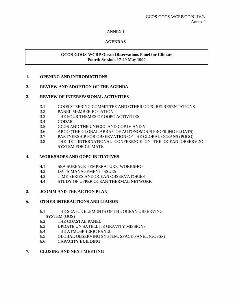
GCOS-GOOS-WCRP/OOPC-IV/3Annex I
ANNEX I
AGENDAS
1. OPENING AND INTRODUCTIONS
2. REVIEW AND ADOPTION OF THE AGENDA
3. REVIEW OF INTERSESSIONAL ACTIVITIES
3.1 GOOS STEERING COMMITTEE AND OTHER OOPC REPRESENTATIONS3.2 PANEL MEMBER ROTATION3.3 THE FOUR THEMES OF OOPC ACTIVITIES3.4 GODAE3.5 GCOS AND THE UNFCCC AND COP IV AND V3.6 ARGO (THE GLOBAL ARRAY OF AUTONOMOUS PROFILING FLOATS)3.7 PARTNERSHIP FOR OBSERVATION OF THE GLOBAL OCEANS (POGO)3.8 THE 1ST INTERNATIONAL CONFERENCE ON THE OCEAN OBSERVING
SYSTEM FOR CLIMATE
4. WORKSHOPS AND OOPC INITIATIVES
4.1 SEA SURFACE TEMPERATURE WORKSHOP4.2 DATA MANAGEMENT ISSUES4.3 TIME-SERIES AND OCEAN OBSERVATORIES 4.4 STUDY OF UPPER OCEAN THERMAL NETWORK
5. JCOMM AND THE ACTION PLAN
6. OTHER INTERACTIONS AND LIAISON
6.1 THE SEA ICE ELEMENTS OF THE OCEAN OBSERVING SYSTEM (OOS)
6.2 THE COASTAL PANEL6.3 UPDATE ON SATELLITE GRAVITY MISSIONS6.4 THE ATMOSPHERIC PANEL6.5 GLOBAL OBSERVING SYSTEM, SPACE PANEL (GOSSP) 6.6 CAPACITY BUILDING
7. CLOSING AND NEXT MEETING
GCOS-GOOS-WCRP Ocean Observations Panel for ClimateFourth Session, 17-20 May 1999
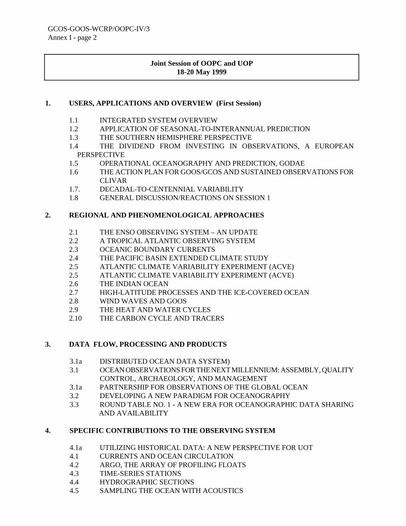
GCOS-GOOS-WCRP/OOPC-IV/3Annex I - page 2
1. USERS, APPLICATIONS AND OVERVIEW (First Session)
1.1 INTEGRATED SYSTEM OVERVIEW 1.2 APPLICATION OF SEASONAL-TO-INTERANNUAL PREDICTION 1.3 THE SOUTHERN HEMISPHERE PERSPECTIVE1.4 THE DIVIDEND FROM INVESTING IN OBSERVATIONS, A EUROPEAN
PERSPECTIVE1.5 OPERATIONAL OCEANOGRAPHY AND PREDICTION, GODAE 1.6 THE ACTION PLAN FOR GOOS/GCOS AND SUSTAINED OBSERVATIONS FOR
CLIVAR1.7. DECADAL-TO-CENTENNIAL VARIABILITY 1.8 GENERAL DISCUSSION/REACTIONS ON SESSION 1
2. REGIONAL AND PHENOMENOLOGICAL APPROACHES
2.1 THE ENSO OBSERVING SYSTEM – AN UPDATE2.2 A TROPICAL ATLANTIC OBSERVING SYSTEM2.3 OCEANIC BOUNDARY CURRENTS2.4 THE PACIFIC BASIN EXTENDED CLIMATE STUDY2.5 ATLANTIC CLIMATE VARIABILITY EXPERIMENT (ACVE)2.5 ATLANTIC CLIMATE VARIABILITY EXPERIMENT (ACVE) 2.6 THE INDIAN OCEAN2.7 HIGH-LATITUDE PROCESSES AND THE ICE-COVERED OCEAN2.8 WIND WAVES AND GOOS2.9 THE HEAT AND WATER CYCLES2.10 THE CARBON CYCLE AND TRACERS
3. DATA FLOW, PROCESSING AND PRODUCTS
3.1a DISTRIBUTED OCEAN DATA SYSTEM) 3.1 OCEAN OBSERVATIONS FOR THE NEXT MILLENNIUM: ASSEMBLY, QUALITY
CONTROL, ARCHAEOLOGY, AND MANAGEMENT3.1a PARTNERSHIP FOR OBSERVATIONS OF THE GLOBAL OCEAN3.2 DEVELOPING A NEW PARADIGM FOR OCEANOGRAPHY3.3 ROUND TABLE NO. 1 - A NEW ERA FOR OCEANOGRAPHIC DATA SHARING AND AVAILABILITY
4. SPECIFIC CONTRIBUTIONS TO THE OBSERVING SYSTEM
4.1a UTILIZING HISTORICAL DATA: A NEW PERSPECTIVE FOR UOT4.1 CURRENTS AND OCEAN CIRCULATION4.2 ARGO, THE ARRAY OF PROFILING FLOATS4.3 TIME-SERIES STATIONS4.4 HYDROGRAPHIC SECTIONS4.5 SAMPLING THE OCEAN WITH ACOUSTICS
Joint Session of OOPC and UOP18-20 May 1999
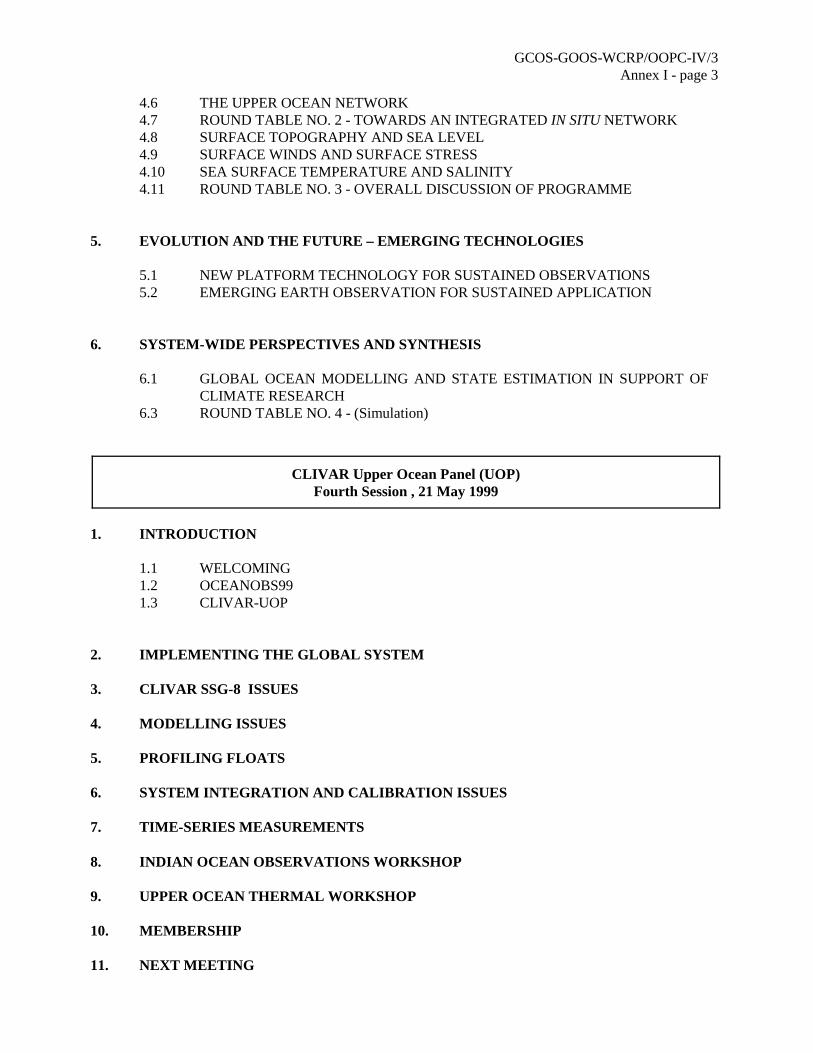
GCOS-GOOS-WCRP/OOPC-IV/3Annex I - page 3
4.6 THE UPPER OCEAN NETWORK4.7 ROUND TABLE NO. 2 - TOWARDS AN INTEGRATED IN SITU NETWORK4.8 SURFACE TOPOGRAPHY AND SEA LEVEL 4.9 SURFACE WINDS AND SURFACE STRESS4.10 SEA SURFACE TEMPERATURE AND SALINITY 4.11 ROUND TABLE NO. 3 - OVERALL DISCUSSION OF PROGRAMME
5. EVOLUTION AND THE FUTURE – EMERGING TECHNOLOGIES
5.1 NEW PLATFORM TECHNOLOGY FOR SUSTAINED OBSERVATIONS 5.2 EMERGING EARTH OBSERVATION FOR SUSTAINED APPLICATION
6. SYSTEM-WIDE PERSPECTIVES AND SYNTHESIS
6.1 GLOBAL OCEAN MODELLING AND STATE ESTIMATION IN SUPPORT OFCLIMATE RESEARCH
6.3 ROUND TABLE NO. 4 - (Simulation)
1. INTRODUCTION
1.1 WELCOMING1.2 OCEANOBS991.3 CLIVAR-UOP
2. IMPLEMENTING THE GLOBAL SYSTEM
3. CLIVAR SSG-8 ISSUES
4. MODELLING ISSUES
5. PROFILING FLOATS
6. SYSTEM INTEGRATION AND CALIBRATION ISSUES
7. TIME-SERIES MEASUREMENTS
8. INDIAN OCEAN OBSERVATIONS WORKSHOP
9. UPPER OCEAN THERMAL WORKSHOP
10. MEMBERSHIP
11. NEXT MEETING
CLIVAR Upper Ocean Panel (UOP)Fourth Session , 21 May 1999
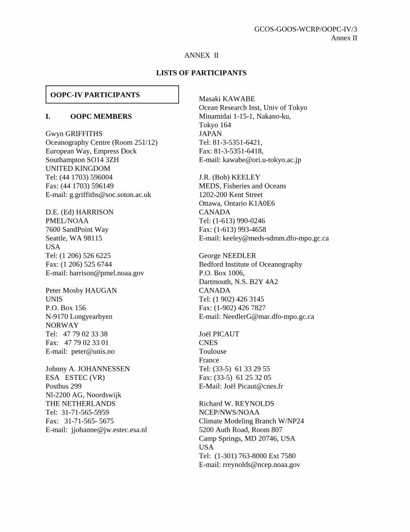
GCOS-GOOS-WCRP/OOPC-IV/3Annex II
ANNEX II
LISTS OF PARTICIPANTS
I. OOPC MEMBERS
Gwyn GRIFFITHSOceanography Centre (Room 251/12)European Way, Empress DockSouthampton SO14 3ZHUNITED KINGDOMTel: (44 1703) 596004Fax: (44 1703) 596149E-mail: [email protected]
D.E. (Ed) HARRISONPMEL/NOAA7600 SandPoint WaySeattle, WA 98115USATel: (1 206) 526 6225Fax: (1 206) 525 6744E-mail: [email protected]
Peter Mosby HAUGANUNISP.O. Box 156N-9170 LongyearbyenNORWAYTel: 47 79 02 33 38Fax: 47 79 02 33 01E-mail: [email protected]
Johnny A. JOHANNESSENESA ESTEC (VR)Postbus 299Nl-2200 AG, NoordswijkTHE NETHERLANDSTel: 31-71-565-5959Fax: 31-71-565- 5675E-mail: [email protected]
Masaki KAWABEOcean Research Inst, Univ of Tokyo Minamidai 1-15-1, Nakano-ku, Tokyo 164JAPAN Tel: 81-3-5351-6421, Fax: 81-3-5351-6418, E-mail: [email protected]
J.R. (Bob) KEELEYMEDS, Fisheries and Oceans1202-200 Kent StreetOttawa, Ontario K1A0E6 CANADATel: (1-613) 990-0246Fax: (1-613) 993-4658E-mail: [email protected]
George NEEDLERBedford Institute of OceanographyP.O. Box 1006, Dartmouth, N.S. B2Y 4A2CANADATel: (1 902) 426 3145Fax: (1-902) 426 7827E-mail: [email protected]
Joël PICAUTCNESToulouseFranceTel: (33-5) 61 33 29 55Fax: (33-5) 61 25 32 05E-Mail: Joël [email protected]
Richard W. REYNOLDSNCEP/NWS/NOAAClimate Modeling Branch W/NP245200 Auth Road, Room 807 Camp Springs, MD 20746, USAUSATel: (1-301) 763-8000 Ext 7580 E-mail: [email protected]
OOPC-IV PARTICIPANTS
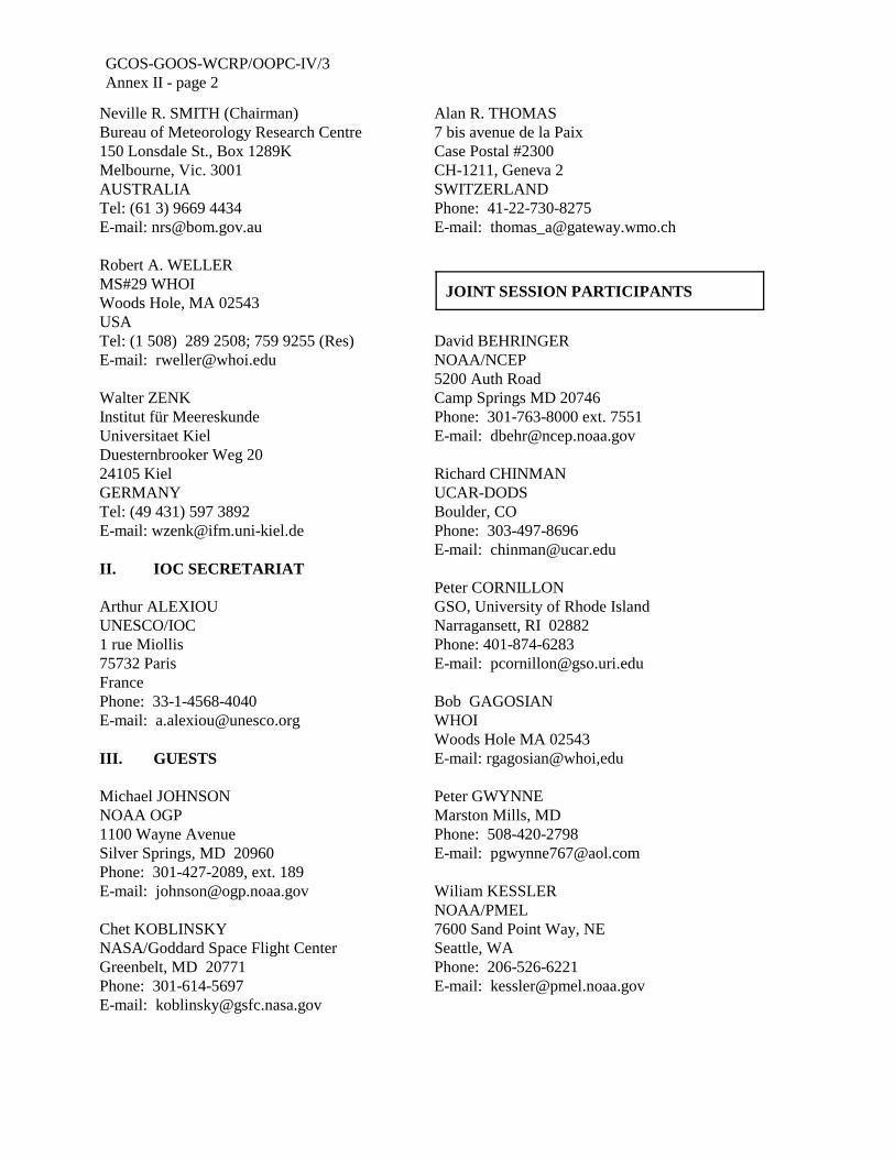
GCOS-GOOS-WCRP/OOPC-IV/3Annex II - page 2
Neville R. SMITH (Chairman)Bureau of Meteorology Research Centre150 Lonsdale St., Box 1289KMelbourne, Vic. 3001AUSTRALIATel: (61 3) 9669 4434E-mail: [email protected]
Robert A. WELLERMS#29 WHOIWoods Hole, MA 02543USATel: (1 508) 289 2508; 759 9255 (Res)E-mail: [email protected]
Walter ZENK Institut für MeereskundeUniversitaet KielDuesternbrooker Weg 2024105 KielGERMANYTel: (49 431) 597 3892E-mail: [email protected]
II. IOC SECRETARIAT
Arthur ALEXIOUUNESCO/IOC1 rue Miollis75732 ParisFrancePhone: 33-1-4568-4040E-mail: [email protected]
III. GUESTS
Michael JOHNSONNOAA OGP1100 Wayne AvenueSilver Springs, MD 20960Phone: 301-427-2089, ext. 189E-mail: [email protected]
Chet KOBLINSKYNASA/Goddard Space Flight CenterGreenbelt, MD 20771Phone: 301-614-5697E-mail: [email protected]
Alan R. THOMAS7 bis avenue de la PaixCase Postal #2300CH-1211, Geneva 2SWITZERLANDPhone: 41-22-730-8275E-mail: [email protected]
David BEHRINGERNOAA/NCEP5200 Auth RoadCamp Springs MD 20746Phone: 301-763-8000 ext. 7551E-mail: [email protected]
Richard CHINMANUCAR-DODSBoulder, COPhone: 303-497-8696E-mail: [email protected]
Peter CORNILLONGSO, University of Rhode IslandNarragansett, RI 02882Phone: 401-874-6283E-mail: [email protected]
Bob GAGOSIANWHOIWoods Hole MA 02543E-mail: rgagosian@whoi,edu
Peter GWYNNEMarston Mills, MDPhone: 508-420-2798E-mail: [email protected]
Wiliam KESSLERNOAA/PMEL7600 Sand Point Way, NESeattle, WA Phone: 206-526-6221E-mail: [email protected]
JOINT SESSION PARTICIPANTS
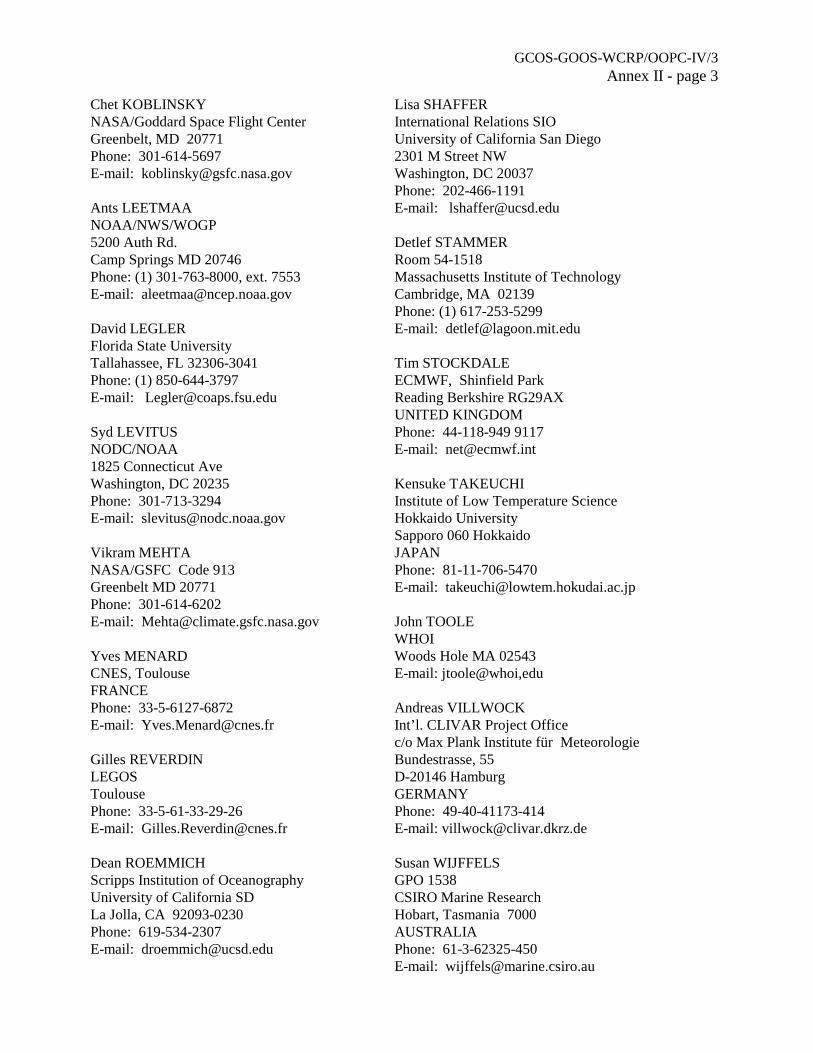
GCOS-GOOS-WCRP/OOPC-IV/3Annex II - page 3
Chet KOBLINSKYNASA/Goddard Space Flight CenterGreenbelt, MD 20771Phone: 301-614-5697E-mail: [email protected]
Ants LEETMAANOAA/NWS/WOGP5200 Auth Rd.Camp Springs MD 20746Phone: (1) 301-763-8000, ext. 7553E-mail: [email protected]
David LEGLERFlorida State UniversityTallahassee, FL 32306-3041Phone: (1) 850-644-3797E-mail: [email protected]
Syd LEVITUSNODC/NOAA1825 Connecticut AveWashington, DC 20235Phone: 301-713-3294E-mail: [email protected]
Vikram MEHTANASA/GSFC Code 913Greenbelt MD 20771 Phone: 301-614-6202E-mail: [email protected]
Yves MENARDCNES, ToulouseFRANCEPhone: 33-5-6127-6872E-mail: [email protected]
Gilles REVERDINLEGOS ToulousePhone: 33-5-61-33-29-26E-mail: [email protected]
Dean ROEMMICHScripps Institution of OceanographyUniversity of California SDLa Jolla, CA 92093-0230Phone: 619-534-2307E-mail: [email protected]
Lisa SHAFFERInternational Relations SIOUniversity of California San Diego2301 M Street NWWashington, DC 20037Phone: 202-466-1191E-mail: [email protected]
Detlef STAMMERRoom 54-1518Massachusetts Institute of TechnologyCambridge, MA 02139Phone: (1) 617-253-5299E-mail: [email protected]
Tim STOCKDALEECMWF, Shinfield ParkReading Berkshire RG29AXUNITED KINGDOM Phone: 44-118-949 9117E-mail: [email protected]
Kensuke TAKEUCHIInstitute of Low Temperature ScienceHokkaido UniversitySapporo 060 HokkaidoJAPANPhone: 81-11-706-5470E-mail: [email protected]
John TOOLE WHOIWoods Hole MA 02543E-mail: jtoole@whoi,edu
Andreas VILLWOCKInt’l. CLIVAR Project Officec/o Max Plank Institute für MeteorologieBundestrasse, 55D-20146 HamburgGERMANYPhone: 49-40-41173-414E-mail: [email protected]
Susan WIJFFELSGPO 1538CSIRO Marine ResearchHobart, Tasmania 7000AUSTRALIAPhone: 61-3-62325-450E-mail: [email protected]
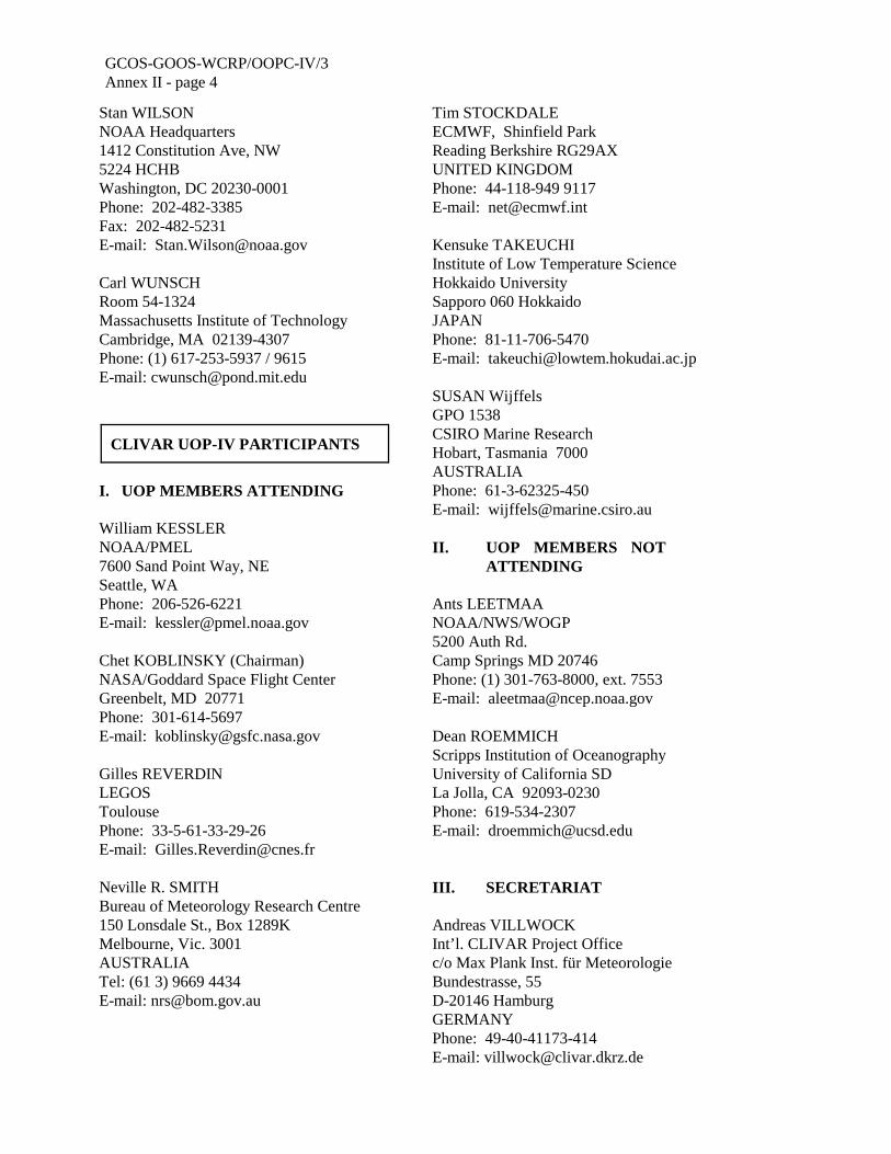
GCOS-GOOS-WCRP/OOPC-IV/3Annex II - page 4
Stan WILSONNOAA Headquarters1412 Constitution Ave, NW5224 HCHBWashington, DC 20230-0001Phone: 202-482-3385Fax: 202-482-5231E-mail: [email protected]
Carl WUNSCHRoom 54-1324Massachusetts Institute of TechnologyCambridge, MA 02139-4307Phone: (1) 617-253-5937 / 9615E-mail: [email protected]
I. UOP MEMBERS ATTENDING William KESSLERNOAA/PMEL7600 Sand Point Way, NESeattle, WA Phone: 206-526-6221E-mail: [email protected]
Chet KOBLINSKY (Chairman)NASA/Goddard Space Flight CenterGreenbelt, MD 20771Phone: 301-614-5697E-mail: [email protected]
Gilles REVERDINLEGOS ToulousePhone: 33-5-61-33-29-26E-mail: [email protected]
Neville R. SMITHBureau of Meteorology Research Centre150 Lonsdale St., Box 1289KMelbourne, Vic. 3001AUSTRALIATel: (61 3) 9669 4434E-mail: [email protected]
Tim STOCKDALEECMWF, Shinfield ParkReading Berkshire RG29AXUNITED KINGDOM Phone: 44-118-949 9117E-mail: [email protected]
Kensuke TAKEUCHIInstitute of Low Temperature ScienceHokkaido UniversitySapporo 060 HokkaidoJAPANPhone: 81-11-706-5470E-mail: [email protected]
SUSAN WijffelsGPO 1538CSIRO Marine ResearchHobart, Tasmania 7000AUSTRALIAPhone: 61-3-62325-450E-mail: [email protected]
II. UOP MEMBERS NOT ATTENDING
Ants LEETMAANOAA/NWS/WOGP5200 Auth Rd.Camp Springs MD 20746Phone: (1) 301-763-8000, ext. 7553E-mail: [email protected]
Dean ROEMMICHScripps Institution of OceanographyUniversity of California SDLa Jolla, CA 92093-0230Phone: 619-534-2307E-mail: [email protected]
III. SECRETARIAT
Andreas VILLWOCKInt’l. CLIVAR Project Officec/o Max Plank Inst. für MeteorologieBundestrasse, 55D-20146 HamburgGERMANYPhone: 49-40-41173-414E-mail: [email protected]
CLIVAR UOP-IV PARTICIPANTS
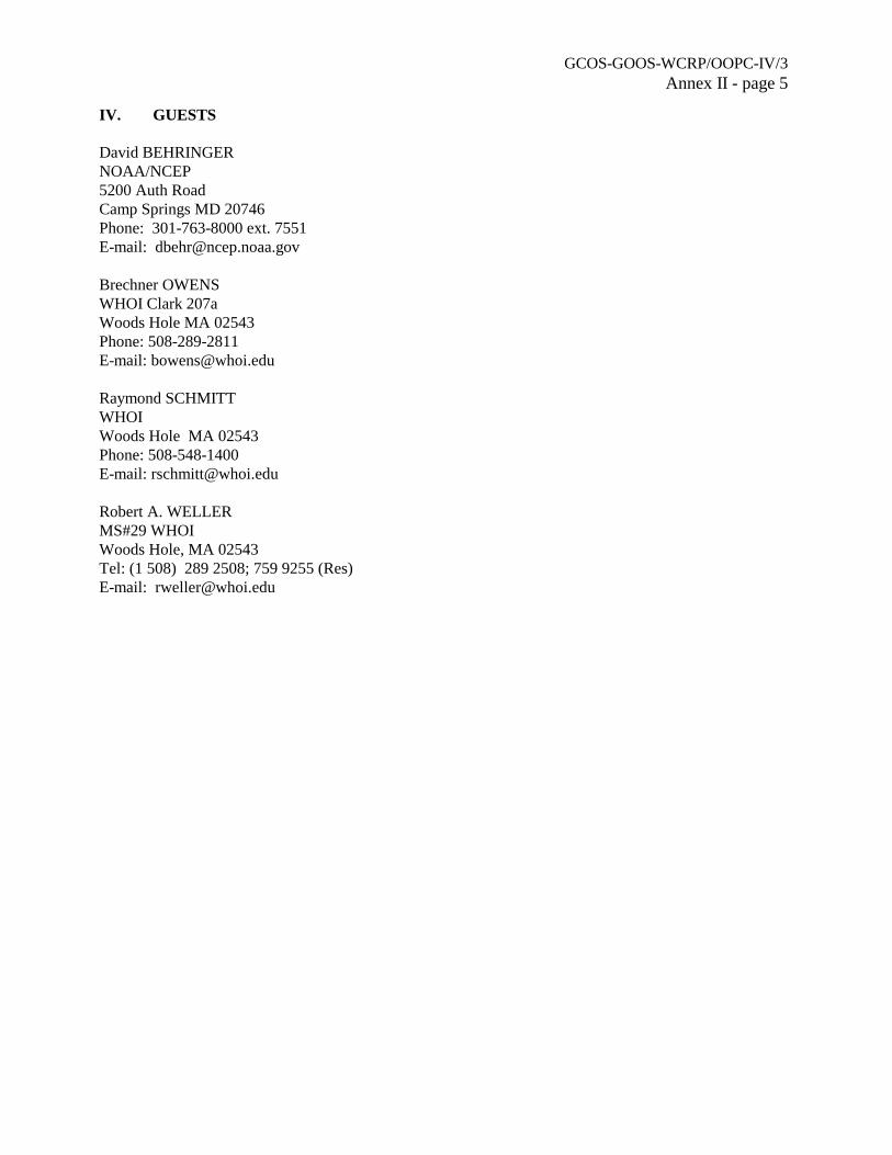
GCOS-GOOS-WCRP/OOPC-IV/3Annex II - page 5
IV. GUESTS
David BEHRINGERNOAA/NCEP5200 Auth RoadCamp Springs MD 20746Phone: 301-763-8000 ext. 7551E-mail: [email protected]
Brechner OWENSWHOI Clark 207aWoods Hole MA 02543Phone: 508-289-2811E-mail: [email protected]
Raymond SCHMITTWHOIWoods Hole MA 02543Phone: 508-548-1400E-mail: [email protected]
Robert A. WELLERMS#29 WHOIWoods Hole, MA 02543Tel: (1 508) 289 2508; 759 9255 (Res)E-mail: [email protected]
GCOS-GOOS-WCRP/OOPC-IV/3Annex III
ANNEX III
TERMS OF REFERENCE FORSEA SURFACE TEMPERATURE WORKING GROUP (SST WG)
1. Record and evaluate the differences among historical and near-real-time SST analyses and SSTSeasonal to Interannual (SI) analyses.
(a) Identify a standard data set for the intercomparisons of different products, e.g., COADS.
(b) Select several standard difference products as a minimum comparison set (i.e., defineregions and time periods; compute biases, standard deviations, and rms differences, etc.).
2. Identify the sources of difference in the analyses.
3. On the basis of comparison of those differences with the expected climate signals in the SSTpatterns, recommend actions needed to ensure the quality and consistency of SST and SST/SIanalyses.
4. Establish criteria to be satisfied by SST and SST/SI analyses to ensure the quality and consistencyrequired by GCOS.
5. Report annually to AOPC and OOPC on progress and recommendations.
GCOS-GOOS-WCRP/OOPC-IV/3Annex IV
ANNEX IV
THE UPPER OCEAN THERMAL REVIEW
BACKGROUND
The TOGA and WOCE programmes used ships-of-opportunity to deploy XBTs along selected shiproutes known as SOOP XBT lines. These lines, first established in the North Pacific, and then extended tothe tropics and other mid-latitude regions, provided the data for observing network design and forfundamental studies of ocean variability and predictability. The tropical network was critical for developingmodels of ENSO and continues to be an important contribution to the initialization of prediction models.SOOP thermal data also constitute the bulk of the global upper ocean thermal data and so represent our"knowledge" of the seasonal cycle and interannual variability.
The Tropical Atmosphere-Ocean array (TAO) was an initiative of TOGA. At present, it constitutesthe core of the (operational) ENSO observing system. Until now, it has been argued that TAO and SOOPare complementary and that any redundancy that does exist could not be removed without significant effortand loss of capability.
In the early 1990's the US and France launched the TOPEX/Poseidon altimeter. This instrumentdelivered, and continues to deliver, estimates of sea surface topography changes to an accuracy of around2 cm. This capability, plus the development of skillful model and data assimilation systems, has foreverchanged the way we gather and interpret ocean data. With such information available it does not make senseto design and evaluate networks in isolation. Networks must be considered as a contribution to a larger,integrated in situ and remote system, with consequences for sampling and design.
There is now also a developing plan for a future global array of profiling floats (Argo). In principle,Argo will deliver T and S profiles of the upper ocean (to around 1500-2000m) every 10 days or so fromaround 3000 floats. This will revolutionize traditional upper ocean observing methods and thus networkdesign. It is timely then to re-consider the upper ocean sampling network, particularly the SOOP XBTcontribution, including, where possible, salinity sampling.
The rationale for the observing network is provided by the CLIVAR Implementation Plan (IP), TheOOSDP Design (1995) plus the Action Plan for the Ocean Observing System for Climate (SydneyWorkshop, GOOS publ.)
A STUDY OF THE UPPER OCEAN THERMAL NETWORK
The GCOS/GOOS/WCRP Ocean Observations Panel for Climate (OOPC), CLIVAR Upper OceanPanel (UOP) and the Ship-of-Opportunity Programme of the IOC/WMO Integrated Global Ocean ServicesSystem (IGOSS SOOP) have agreed to convene a study of the upper ocean network with the support ofNOAA and the Bureau of Meteorology. The aims of this study are to:
(i) to compile a consolidated account of the existing Upper Ocean Thermal data base, using WOCE,Levitus and whatever other data bases that are available. The attributes that we seek to quantify are:
(a) the sampling as a function of space and time, extending back to at least the early 1980's.These statistics should be by longitude-latitude bins (2 x 2 °?) as well as by traditionallines/regions (as defined in WOCE). The statistics should give some measure of verticalsampling and depth;
GCOS-GOOS-WCRP/OOPC-IV/3Annex IV - page 2
(b) a measure of the continuity for specific lines/regions, including the relative informationcontent of low-density, frequently repeated and high-density lines;
(c) a measure of the quality (level of QC that the data have been subjected to);
(d) availability - delayed mode versus real-time; gaps in delivery systems; public versusprivate; etc. permanent archives;
(e) availability of metadata;.
(f) logistical considerations with regard to particular tracks;
(g) any other political/technical attributes which might impact/qualify the attributes.
The analysis should include all forms of sampling (broadcast, high-density, frequently-repeated, adhoc, etc.).
(ii) Produce consolidated "maps" of information level/content based on the dominant scales of climatesignals. The raw distribution statistics do not take account of the actual information content so itis useful to seek some consolidation of the information in (1) even if it does depend on certainassumptions. The SOOP contribution should be identified.
(iii) Document the existing practices for assembling, quality control and distribution of upper oceandata, working from existing material of GTSPP, WOCE UOT/DPC and IGOSS SOOP.
(iv) Document to the extent possible the "value adding" of thermal data process chains, be theyautomated assimilation (e.g., NCEP, BMRC, UKMO, ECMWF), quick-look/semi-automated qualitycontrol (e.g., GTSPP, AOML), or higher-level scientific quality control and assembly (e.g., CSIRO,AOML, Levitus, NODC).
(v) Provide quantitative assessment of all SOOP lines. This should include an assessment ofrelevance/impact against scientific objectives including seasonal-to-interannual prediction,environmental/ocean prediction, improved climatologies and climate change monitoring, scoresagainst key attributes (continuity, quality, etc.), notes on extenuating circumstances, and theexistence of proxies in the event of gaps/discontinuities in the lines. The broad-scale samplingshould also be assessed as a precursor to Argo with a view to maintaining the temporal and spatialintegrity of resolved signals such as the global ENSO wave, the Antarctic Circumpolar Wave,decadal variability, etc.
(vi) Provide, on the basis of 5 (above), a renovated SOOP plan including broad cost and high-densitystrategies, taking account of, as far as is practical: the existence (or potential) of other directsampling networks (e.g., TAO, Argo); the indirect information available from remote sensing,particularly altimetry; and the indirect information available from models (e.g., wind-forced,equatorial).
(vii) Produce a Report based on the above which will form the background for a workshop to beconvened in the 3rd quarter of 1999. The Executive Summary from this process will constitute akey paper for the OCEANOBS 99 Conference, 18-22 October 1999. The Report will be publishedjointly under the joint auspices of the GCOS/GOOS/WCRP OOPC, CLIVAR UOP and IOC/WMOIGOSS SOOP IP.
GCOS-GOOS-WCRP/OOPC-IV/3Annex IV - page 3
SCIENTIFIC ADVISORY COMMITTEE (SAC)
A SAC is to be formed to oversee the study. Nominated members are:
N. Smith (BMRC Aust., Chair) R. Molinari (AOML, USA)E. Harrison (PMEL, USA)T. Delcroix (IRD/ORSTOM, Fr.)D. Roemmich (Scripps, USA)K. Hanawa (Tohoku U., Japan)O. Alves (ECMWF/UKMO, UK) R. Bailey (CMR/BMRC JAFOOS)R. Keeley (MEDS, Can.)
This committee will be supported by a consultancy led by R. Bailey with input from R. Keeley (bothwill be members of the SAC). In addition, several key scientists, data users and SOOP practitioners willregularly be consulted and given the opportunity to provide advice. These include:
A. LeetmaaM. JiG. MeyersG. ReverdinW. WhiteS. LevitusK. TakeuchiP. RualA. Sy
S. Thurston (NOAA OGP), M. Johnson (NOAA OGP) and E. Charpentier (SOOP Coordinator) willprovide organisational and technical support and be included in SAC deliberations and in otherorganisational matters.
TERMS OF REFERENCE
The Terms of Reference for the SAC are:
(i) to provide scientific advice on the conduct of the study and to the consultancy;
(ii) to provide advice and guidance on the preparation of the study Report and a solicited paper for theOCEANOBS99 Conference;
(iii) to provide guidance on the consolidation of views from the study Workshop;
(iv) to report to, and frame recommendations for the consideration of the GCOS/GOOS/WCRP OOPC,CLIVAR UOP and IOC/WMO IGOSS SOOP, as appropriate, with regard to future implementationand scientific advice.
CONSULTANCY
A consultancy will be contracted to gather the information for the study under the direction of R.Bailey, particularly for the study aims 1 through 5 above. To the extent possible the information will bequantitative. S. Thomas has been contracted for two months to undertake the initial collation of information,
GCOS-GOOS-WCRP/OOPC-IV/3Annex IV - page 4
principally from existing data sources. R. Keeley will provide additional expertise and input for datamanagement issues. The consultancy will be responsible for the drafting of the Report. Final scientific andtechnical judgements will come via the workshop and the SAC.
WORKSHOP
An international workshop will be held at BMRC in the 3rd quarter of 1999 to consider the initialreport and its recommended upper ocean thermal strategy. It will be held over 3-4 days with as much of theeditorial and technical amendments being undertaken on-site as is practical. The final report should beavailable in electronic form by the time of the OCEANOBS 99 Conference. An executive summary willbe produced which will form the basis of a Conference paper. This paper should be subjected to non-advocate review prior to Conference. Members of the OOPC and UOP might be able to provide this input.
FUNDING
The consultancy, report preparation and publication and workshop will be sponsored by the NOAAOffice of Global Programmes and BMRC.
GCOS-GOOS-WCRP/OOPC-IV/3Annex V
ANNEX V
GOSSP REPORT TO GOOS SC-II(An interpretation by Neville Smith on behalf of the
Chair GOSSP, Dr F. Bretherton)
1. BACKGROUND
GOSSP is responsible for facilitating communications between the G3OS and the CEOS agencies.The statement of user requirements is an essential part of this interface, relied upon by the agencies to definewhat is expected of them. It is thus very important that these statements be clear, accurate, and up to date.However, GOSSP does not set these requirements, they are set by the G3OS's themselves.
The CEOS/WMO database is the official record of these statements. It is maintained by DonHinsman of WMO, and is accessible by an on-line server, or on a distributed CD ROM. The existing entriesraise several questions, some of which will be addressed here. More specifically, there is a need for GOOSto endorse a set of ocean requirements. In this paper, a set of requirements is given (based on drafts byOOPC and GODAE) and the GOOS SC is asked to endorse both the Table and the comments attached whichdirectly address several key issues. The stated requirements do not fully embrace all the modules of GOOS.
The CEOS through its Strategic Implementation Team (SIT) has recommended that requirementsbe referenced in future against a set of Themes. The Chair of GOSSP has drafted a position paper relativeto this request and this is discussed below. The CEOS have also requested updated statements ofrequirements and input on needed actions. A draft discussion paper has been circulated with a view towardthe input to the IGOS Partners meeting in Rome this coming June.
2. THE REQUIREMENTS AND THE WMO DATABASE
Because of the history of GODAE as a Pilot Project of CEOS the requirements discussed herereflect, in the first instance, needs of GODAE. The more general requirements of the OOPC (i.e., the climatemodule) are mostly less stringent than GODAE in terms of spatial and temporal sampling but more stringentin terms of quality and continuity. There are also several requirements that must be considered jointly withthose of numerical weather prediction (e.g., SST, surface winds). Whereas climate requirements are oftenless stringent than those for NWP (space, time), GODAE's are in general more stringent. The surface marinerequirements are mostly covered by the combination of these two with the exception of surface wavemeasurements (these are covered in the WMO requirements ; this table entry is new).
In terms of the characteristics of the required ocean fields, we are generally interested in two typesof products/requirements. For climate, mesoscale variability is generally averaged in both time and spacebefore data are assimilated into models and/or analysis systems. Examples include SST and sea surfacetopography. For GODAE, where attention is on much higher resolution estimates, the plan is to resolve suchvariability. This variability must also be resolved for biological applications. For the coastal zone, the spatialrequirements may be even more severe. In most cases we expect the relevant data to be combined withinmodel data assimilation systems.
Table 1 provides a revised version of the requirements originally developed by GODAE and OOPCfor the CEOS Analysis Group and GOSSP. Some attempts were made to take account of knownrequirements beyond the climate module of GOOS. In the present version the "optimal" requirement forprecise altimetry has been reduced to 1 cm in accordance with comments from GOSSP members and the
GCOS-GOOS-WCRP/OOPC-IV/3Annex V - page 2
recent SIT meeting. Gravity measurements have been included explicitly, noting that OOPC (OOPC III,Grasse) concluded that one-off missions like GRACE and GOCE could well satisfy the long-termrequirements. The original sea surface temperature entry has been renamed "Sea Surface Radiative" for tworeasons. First, a new entry for net downward short-wave radiation has been included. Second, there isconsiderable debate about defining the relationship between the measured signal (a radiance) and therequired field (SST) - either bulk or skin translations can be used.
With regard to the data in the existing WMO data base (WDB), the Chairman of GOSSP has raisedseveral issues which need clarification. There is also the issue of ownership of and responsibility for thenumbers in the data base.
First, I expected to find the GODAE requirements under the AG Projects. This is not so. Second,the database contains a group of entries attributed to IOC and GOOS. These entries were tabled at GCOSJSTC VII (Eindhoven) I believe and rejected in the strongest possible terms. Unless they can be traced backto one of the GOOS Module Panels (which I believe they cannot) they should be removed immediately andthe Panel Chairs requested to make specific suggestions. [Some of these requirements do not make senseand some are clearly undoable for the global domain.] Some requirements may originate from the IGOSLong-Term Marine Biology Pilot Project (I think labelled Marine Biology - Open Ocean in my database)but I could not verify the credentials. There are also entries attributed to AOPC for ocean fields. GCOS hasformally requested that OOPC take responsibility for sea-ice so this entry against AOPC should be removedin favour of entries under GOOS. A similar remark applies to SST though in this case OOPC and AOPC aresharing scientific oversight. Surface wind vectors should also be the responsibility of OOPC in the firstinstance.
It remains then to clarify the OOPC (GCOS) and GOOS Climate entries. (I am ignoring all theentries attributed to IOC with the exception of one JGOOS III entry for the geoid).
Ocean topography/sea level. Table 1 attempts to give some « texture » to this requirement sincethere are very distinct drivers (A, B and C). An entry for sea level (change) should be added (Application).The cycle time entries under OOPC/GCOS are silly. There are errors in the « Time » entry for large-scaleapplications and the Accuracy details should be 1 cm and 2 cm respectively for optimal and threshold.
Geoid. This was missing from the original GODAE submission. An entry under «JGOOS-III / IOC»exists. I would leave out the cycle time since it is providing a base measurement rather than a field thatvaries with time (this aspect though is under consideration). OOPC III is the definitive reference in ourliterature. The accuracy and resolution entries should be amended. Surface wind vectors. As with otheraspects, there are nuances and subtleties that are just not captured in the WDB. Table 1 does little better.The entry labelled « Wind vector over the sea-surface (horizontal) » by GOOS is consistent with Table 1;the others should be discarded. Note that the direction requirements for accuracy are missing.
Sea surface radiative/SST. We do have to begin being more careful about these entries, not onlybecause of the many different applications, but also because there is not a unique definition of SST in thecontext of these requirements. There may be a good case for having several application entries (includingwithin Table 1; in the Action Plan the climate requirements are discussed in more detail). The OOPC/AOPCSST Workshop suggests 0.1o K as the bias and rms target for climate products. The 2.0o K figure wouldseem useless for most climate and GODAE applications. I would suggest a bias (absolute) range of 0.1o -0.5o. The entries under GCOS Climate/GOOS are closest to those of Table 1. There are regional andnon-physical applications that may influence the requirements in a significant way.
GCOS-GOOS-WCRP/OOPC-IV/3Annex V - page 3
Sea surface radiative/shortwave. This is a new identification of a requirement. OOPC will probablytake lead responsibility among OOPC, AOPC and GODAE.
Sea surface salinity. This is a requirement for the future. The OOPC/GODAE (and GOSSP) positionhas been to encourage exploration of the possibilities for remote measurements. The entry under GOOSClimate is correct.
Sea-ice cover. This requirement has not received the same attention as some of the others, at leastby OOPC. OOPC III did not find any reason to make substantial changes. The Table reflects what I believeare agreed optimal and threshold requirements. Both entries are close to this.
Ocean Colour. The ocean colour Pilot Project has had prime responsibility for developing theserequirements. The GOOS SC should decide how it wishes to coordinate that input with that of the modules.GOSSP has noted discrepancies between the chlorophyll and yellow-substance entries in terms of spacesampling. The GODAE/OOPC requirements are similar to those for surface short-wave radiation sinceocean colour (transparency) information will be used with surface radiation data.
Surface Waves. Oversight for this aspect is not clear. J-GOOS requested a background paper(Komen and Smith) but this did not look at requirements in detail. The Table entry reflects some publishedrequirements but should be considered preliminary for the time being. OCEANOBS99 intends to look at thisin more detail.
Summary. We ask the GOOS SC to endorse the requirements as given in Table 1 and request thatthe WDB be updated to reflect this. Some expansion of the Application entries in the data base is warrantedparticularly for SST. All entries should be attributable (sourced back) to GOOS and its ScientificCommittee. Perhaps the relevant field value is now « Oceans Theme ». It is GOSSP's responsibility to seethat the wishes of the GOOS SC are reflected in published requirements. It is the responsibility of the Panelsand Projects to ensure that entries for particular applications are current and accurate. There should be atable reflecting these lines of responsibility. No other entries should appear under IOC or GCOS Ocean. Forfields/applications where there is shared guidance (e.g., AOPC, OOPC) the relevant oversight body (e.g.,GCOS SC) should endorse a line of responsibility. The present format cannot easily account for regionalnuances, e.g., coastal or El Niño. This needs attention.
3. PRIORITIES AND SCIENTIFIC AND TECHNICAL ISSUES
Some of these have been noted in Section 2 and in the Table. However some further discussion iswarranted. For climate applications and GODAE, remotely sensed (inferred) SST, surface topography andsurface wind vector capabilities are considered mandatory. Key applications will be severely compromisedin the absence of any one of these data streams. Surface wave information and sea ice extent are at a similarlevel of priority though the rationale is more to do with weather and marine forecasting than oceanography.There is also general agreement that remotely sensed ocean colour should be given a high level of priority.However, with respect to detail, there remain several outstanding issues and these are expanded upon below..
Surface topography/Altimetry. TOPEX/Poseidon has demonstrated in the 1990's that precisionsatellite altimetry may be utilized in a wide body of ocean research (planetary waves, tides, global sea levelchange, etc.) and practical allocations (e.g., seasonal-to-interannual climate prediction). The follow-onmission Jason-1 aims to further demonstrate and insinuate altimetry's operational potential and utility.Jason-1 will strive to meet the challenge of a 1 cm RMS error budget.
It had been hoped that T/P would allow the complete description of ocean tides, such that they could
GCOS-GOOS-WCRP/OOPC-IV/3Annex V - page 4
be removed completely from future altimetric measurements. The orbit for the satellite was carefully chosento enable this goal. Unfortunately, it has been found that a random component of the tides (RMS 2 cm)remains unresolvable in models (e.g., from solar tides) and would be aliased into the mean sea level signalfrom altimeters in polar orbit. This suggests at least one non-sun synchronous orbit altimeter is required.
It is the view of the scientific community that the T/P-Jason-like precision altimetry mission willbe required indefinitely to monitor and understand global sea level variability. Other altimetry missionsin polar orbit (ERS, ENVISAT, GEOSAT) are needed to provide operational altimetry coverage formesoscale ocean circulation applications. The community judgement at this time is that 2 altimeters areessential. A third is deemed highly desirable but, as yet, there is no consensus on what is best for long-termapplications.
The complementarity between the proposed global profiling float array Argo (and other sources ofin situ information) and altimetry is only now being explored. It is difficult to be definitive without gooddata records and, for the subsurface ocean, these do not exist. The results of this research will in time impactthe case for multiple altimeters.
Surface wind vectors. High resolution vector winds at the sea surface are required to force oceanmodels and as constraints in atmospheric and surface wave applications. The best methodology of remotelyestimating vector winds remains a matter of scientific debate. The need for and utility of accurate,high-resolution winds is, however, widely recognized. One proven method to estimate wind vectors isscatterometry (Ku or C band). Examples include NSCAT on ADEOS-1, Sea winds on ADEOS-2, andASCAT on METOP. Polarimetric radiometry also shows some promise as a less expensive alternative andhas been extensively tested in airborne experiments. The spaceborne test of such an instrument is to beflown by the US Navy/NPOESS "Windsat" mission in 2002. Its simultaneity with the Sea windsscatterometer on ADEOS-2 will allow a direct comparison of the different methods.
OOPC and GODAE have concluded that at least one scatterometer (or an equivalent) is essential.The case for a second is strong, particularly if the broad range of likely applications is considered. For justGODAE and climate applications alone the case is difficult to make simply because the existing records areshort (e.g., 9 months of NSCAT) though more data clearly will deliver higher quality climate products. Asustained (operational) commitment to a 2nd instrument needs more justification. This I believe comes fromregional/mesoscale oceanographic, marine and weather applications. Wave prediction at both global andregional /local scales is moving toward coupled (wave-NWP) configurations. Predictions of storm andcyclone/hurricane movements are increasingly utilizing coupled atmospheric-marine-ocean models. Severalrecent events (e.g., the Sydney-Hobart yacht race tragedy of Boxing Day 1998) highlighted the need forhigh-resolution (at least 25 km), frequent (daily) wind samples. Good NWP models can fill part of this gapbut present configurations do not come close to delivering wind fields at this resolution.
There are several other sources of information for surface winds including direct measurementsfrom arrays like TAO and estimates of wind speed from radars, passive microwave and other instruments.NWP, at both global and regional levels, also provides important proxy information. It remains unclear atthis time just how significant these other contributions are in terms of the case for a 2nd instrument. Thelaunch of QSCAT may begin to give some answers.
Sea surface temperature. GODAE at least has clearly stated that the present suite of operationalglobal SST products is inadequate for future operational applications. Both spatial and temporal resolutionis lacking. Under the GODAE agenda item a project for developing high resolution products is discussed.One of the issues that must be faced (and this is a major concern for climate) is the definition of SST.Satellites actually measure surface irradiance and an algorithm is used to derive an estimate of seatemperature. The most directly-related sea temperature is that of the surface skin since it is this temperature
GCOS-GOOS-WCRP/OOPC-IV/3Annex V - page 5
which determines the long-wave irradiance. However for many applications, including atmosphericboundary layer parameterizations, the bulk SST has been used. The algorithms for AVHRR, then, areattuned to bulk sea (surface) temperature rather than the skin. Just how this issue should be approached isundergoing considerable debate at this time. The need (or not) to resolve the diurnal cycle is intimatelyconnected to this debate. Many operational products work off night-time data to minimize this problem.However such strategies are biasing the climate record to some extent.
The recent OOPC/AOPC SST Workshop also highlighted the need for improved collaborationbetween the (operational) sea-ice and SST communities. Improved standards for the utilization of sea-icedata to infer SST need to be developed.
SST requirements beyond GODAE and OOPC can stretch the requirements further both in termsof spatial resolution and temporal resolution. The coastal community needs are likely more stringent thanthose of GODAE but they are also likely to be more regional. This may also be true of the biological/LMRcommunity. The present WDB contains requirements for 0.1o K accuracy which seems an order ofmagnitude too severe for biological applications. Again, unless a reliable scientific source can be identifiedfor these entries they should be omitted.
Table 1 and the discussion above make a start at identifying these issues. The WMO DB is probablynot well-suited to take account of these nuances, and likely never will be. The GOOS SC should considerwhere the top priority issues lay and make appropriate recommendations to GOOSP and the module Panels.
Ocean Colour. Since the start of the OCTS and POLDER missions on ADEOS-1 in November1997, there has been a nearly uninterrupted data stream of global ocean colour measurements. After a briefinterruption, measurements were resumed in September 1997 by the SeaWiFS instrument on the OrbView-2satellite. Within the next 3-5 years, ocean colour measurements will be provided by MODIS instrumentson the EOS Terra satellite and EOS-PM1, MERIS on ENVISAT, and GLI on ADEOS-2. Beyond theseresearch missions, the U.S. NPOESS Programme Office has plans to develop a visible and infrared sensor(VIIRS) that could fulfill the observation needs of both scientific and operational users. An NPOESSpreparatory programme (NPP) is being planned to deploy prototypes of this and other future operationalNPOESS sensors on a joint NASA- NPOESS bridging mission that will be launched in the 2004-2005 timeframe to ensure continuity of moderate resolution global productivity measurements.
The Long-Term Ocean Biology Project initiated by the CEOS SIT is being coordinated by theInternational Ocean Colour Coordinating Committee (IOCCG), an affiliate of SCOR. Its goal is toimplement a strategy for understanding ocean biogeochemical and ecosystem processes by combininglong-term ocean colour and other remote sensing satellite data with in-situ measurements. While there maystill be some debate about how ocean colour measurements are translated into useful fields, there is a strongconsensus that ocean colour is the preferred strategy for building an image of spatial and temporal globalvariability and change related to upper ocean biology.
The requirements in the WDB which may have in fact originated from this project need to beconsidered by the GOOS SC and relevant module Panels. For example, there is a disparity in requiredspatial scale for yellow substance and chlorophyll. There is also a listed requirement for specific humiditywhich seems unjustified; we recommend its removal or reference to an appropriate expert panel. Otherentries for SST and surface winds, both of which went beyond those supported in Table 1, need to beclarified. The existence of such unsubstantiated entries can be harmful.
General. As GOOS moves to applications where the emphasis is regional (even though theapproach is global) the case for « local » remote sensing becomes an issue. Even in the case of global SST,it is clear that geostationary satellites stand a better chance of avoiding diurnal aliasing and capturing
GCOS-GOOS-WCRP/OOPC-IV/3Annex V - page 6
windows of opportunity to view the sea surface. For mesoscale applications one might also considerwhether high-resolution geostationary systems might be of greater utility.
We ask that the GOOS SC make a statement on these general issues and consider appropriatestrategies to address them. The GOSSP Chair undertakes to convey these messages to the Partnershipmeeting in June and, later, to the CEOS Assembly.
4. CEOS AND THE OCEAN THEME
At the January meeting of the CEOS CIT it was agreed that a more coherent focus for defining thespace component of an IGOS would be to adopt "Themes" in place of the existing 6 "pilot" projects. The"Oceans" were adopted as one of the Themes with the intention of subsuming GODAE, IOCCG andGOOS/GCOS requirements. Because of the progress made with GODAE it was decided that the OceansTheme should be given priority in terms of the development of specific requirements and needed actions.Three tasks were assigned at that meeting:
(i) A restatement of the requirements derived in the first instance from those of GODAE (undertakenby P. Bahurel on behalf of GODAE);
(ii) A list of themes to be drafted by the GOSSP Chair (attached);(iii) A discussion of needed actions (E. Lindstrom/NASA to lead).
The input from (i) is incorporated in the discussion above as is the preamble/background from (iii)(provided in draft form by E. Lindstrom). In their wisdom CEOS have decide to retain the term "Themes"for the purposes of their discussion (GCOS SC endorsed the ideas put forward by Bretherton). While CEOSrecognize the desirability of addressing a broad range of themes, it also sees that it is only practical toaddress a subset, where there is a visible political will to exploit global observations or where there isalready a strong core of activity. The list as it stands at present is :
Domain ThemesOceans; Terrestrial (including global NPP); Atmospheric chemistry and climate;Weather predictions;Coastal zones; andDisaster management.
Cross-Cutting ThemesCarbon storage and cycling (sources and sinks) ;Climate variability and change ; Climate inputs ; andWater Cycle.
There has been general agreement that the Oceans work should start at once, with the aim ofcompleting the IGOS component by the end of 1999. In order to facilitate progress, the Chairman of GOSSPhas agreed to hold an early meeting of this group devoted primarily to Oceans. The Oceans team will be ledby NASA, supported by CNES, ESA, ISRO, NASDA, and NOAA with GOOS as co-leader. It is clear thatthe team will be able to take advantage of several on-going initiatives with high political profile. Thistheme will be able to incorporate the work of the ocean biology and GODAE projects begun as IGOS pilotprojects under SIT. The NASA team leader has already started to make contacts and an action plan will becompleted in time to share at the June IGOS Partners Meeting.

GCOS-GOOS-WCRP/OOPC-IV/3Annex V - page 7
5. ACTIONS TO BE CONSIDERED BY CEOS
Eric Lindstrom (NASA) has produced a nice paper leading to a recommended set of actions thatmight be considered by IGOS partners and CEOS. A substantial part of the background to that paper isincorporated in the above. However to round out this discussion, I have provided below a copy of theactions put forward in that paper. There is no formal action requested of GOOS SC but I think feedbackwould be appreciated.
Excerpted from Lindstrom's paper:
It is the intention of (the) action plan to provide some critical ideas for an ocean strategy andactionable items for the IGOS Partners. These ideas and actions will need to be developed furtherby the global observing community and carried forward to the highest levels of government. OceansTheme activities in the context of an IGOS will benefit from linkage to dedicated meetings on theoceans topic planned in the summer and fall of 1999 by GOSSP, the CEOS SIT, the OceanObservations Panel for Climate (OOPC) and other sponsors, with a potential linkage also to the5th meeting of the Conference of the Parties for the Framework Convention on Climate Change.
The following are ten specific items that must be addressed en route to realization of an operationaloceanography capability. Their priority order has not been established. Each could be expanded into a"white paper" by a small group and discussed internationally.
(i) To enable operational oceanography, governments must provide where needed, within the charterof environmental monitoring, research and space agencies, the mandate to operate and maintainlong-term ocean and climate observations.
(ii) National and international policies guiding the timeliness and necessity for transition ofmeasurements from development as research tools to operational longevity for practical benefitmust be derived and implemented. [Useful section in US IOOS report discussing transition couldbe used here]
(iii) User groups for operational ocean products must be cultivated and consulted. User "pull" andresearch "push" will both be necessary and equal partners in development of operationaloceanographic capabilities. A "needs assessment" is required as well as a "capabilitiesassessment."
(iv) The existing strengths in ocean observing from space and in global in situ observing systems arein the open ocean. However the constituency for ocean products and a significant fraction ofhumanity live in the coastal zone. The issue of how best to use the existing global observationalcapabilities to address coastal problems must be the subject of focussed study.
(v) Technological development of instruments for ocean research aimed at delivery of data of premiumquality need to also take account of their potential future as operational instruments. The need isto target development of capable, cost-effective, sensors for future operational deployment.
(vi) Data systems must be reconfigured to optimize delivery of data and data products in a timelymanner. The data latency for required products must be defined.
(vii) Every effort must be made to enable wide availability of data for development of superior products.An assessment of restrictions to data access and its impact on oceanography is required.
GCOS-GOOS-WCRP/OOPC-IV/3Annex V - page 8
(viii) An operational oceanography system should be built so as to minimize single points of failurewithin the system. This aspect of design has yet to be considered and will likely requireunprecedented international cooperation to be realized.
(ix) What will be the relative roles of the government and commercial sectors in global operationaloceanography? Products of an operational oceanographic system should be assessed for theircommercial value and for their value as a public good.
(x) What will be the ongoing personnel and skill requirements for maintaining an ocean observingsystem and delivering products derived from it? Education, training and outreach requirementsshould be assessed as a long-lead time element needed to successfully implement the system.
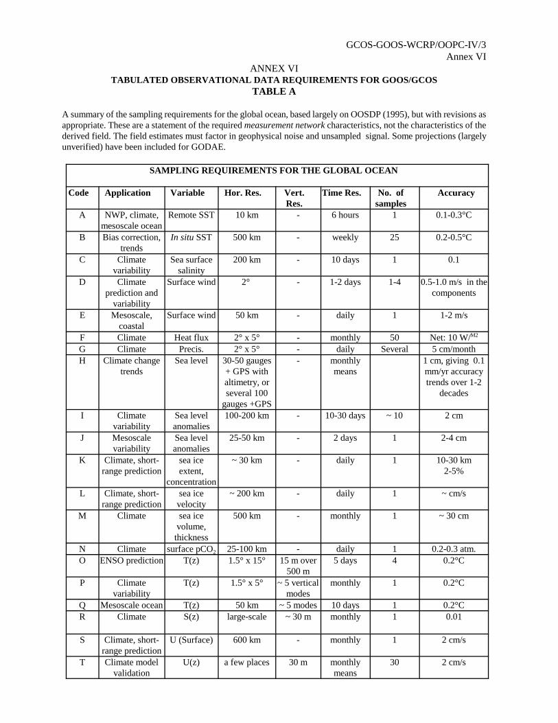
GCOS-GOOS-WCRP/OOPC-IV/3Annex VI
ANNEX VITABULATED OBSERVATIONAL DATA REQUIREMENTS FOR GOOS/GCOS
TABLE A
A summary of the sampling requirements for the global ocean, based largely on OOSDP (1995), but with revisions asappropriate. These are a statement of the required measurement network characteristics, not the characteristics of thederived field. The field estimates must factor in geophysical noise and unsampled signal. Some projections (largelyunverified) have been included for GODAE.
SAMPLING REQUIREMENTS FOR THE GLOBAL OCEAN
Code Application Variable Hor. Res. Vert.Res.
Time Res. No. ofsamples
Accuracy
A NWP, climate,mesoscale ocean
Remote SST 10 km - 6 hours 1 0.1-0.3°C
B Bias correction,trends
In situ SST 500 km - weekly 25 0.2-0.5°C
C Climatevariability
Sea surfacesalinity
200 km - 10 days 1 0.1
D Climateprediction and
variability
Surface wind 2° - 1-2 days 1-4 0.5-1.0 m/s in thecomponents
E Mesoscale,coastal
Surface wind 50 km - daily 1 1-2 m/s
F Climate Heat flux 2° x 5° - monthly 50 Net: 10 W/M2
G Climate Precis. 2° x 5° - daily Several 5 cm/monthH Climate change
trendsSea level 30-50 gauges
+ GPS withaltimetry, orseveral 100
gauges +GPS
- monthlymeans
1 cm, giving 0.1mm/yr accuracytrends over 1-2
decades
I Climatevariability
Sea levelanomalies
100-200 km - 10-30 days ~ 10 2 cm
J Mesoscalevariability
Sea levelanomalies
25-50 km - 2 days 1 2-4 cm
K Climate, short-range prediction
sea iceextent,
concentration
~ 30 km - daily 1 10-30 km2-5%
L Climate, short-range prediction
sea icevelocity
~ 200 km - daily 1 ~ cm/s
M Climate sea icevolume,
thickness
500 km - monthly 1 ~ 30 cm
N Climate surface pCO2 25-100 km - daily 1 0.2-0.3 atm.O ENSO prediction T(z) 1.5° x 15° 15 m over
500 m5 days 4 0.2°C
P Climatevariability
T(z) 1.5° x 5° ~ 5 verticalmodes
monthly 1 0.2°C
Q Mesoscale ocean T(z) 50 km ~ 5 modes 10 days 1 0.2°CR Climate S(z) large-scale ~ 30 m monthly 1 0.01
S Climate, short-range prediction
U (Surface) 600 km - monthly 1 2 cm/s
T Climate modelvalidation
U(z) a few places 30 m monthlymeans
30 2 cm/s
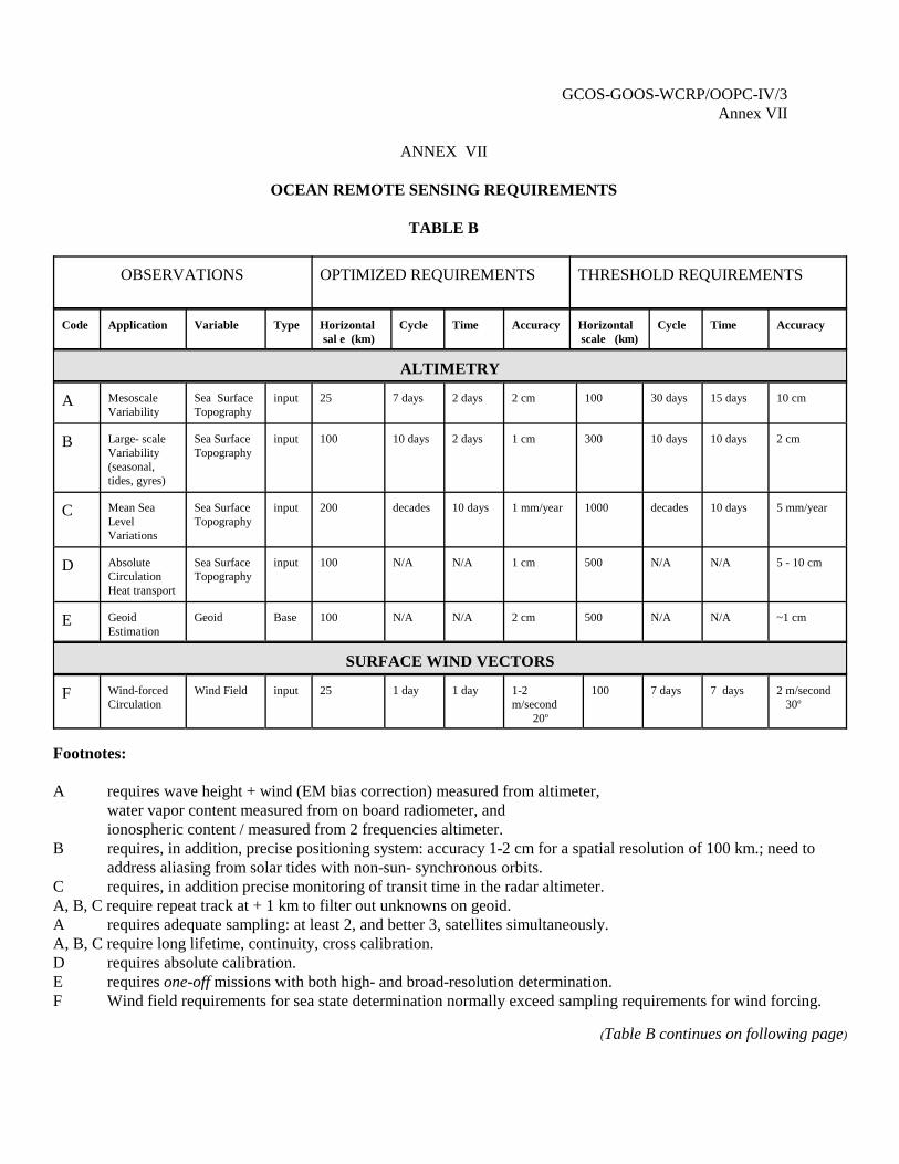
GCOS-GOOS-WCRP/OOPC-IV/3Annex VII
ANNEX VII
OCEAN REMOTE SENSING REQUIREMENTS
TABLE B
OBSERVATIONS OPTIMIZED REQUIREMENTS THRESHOLD REQUIREMENTS
Code Application Variable Type Horizontal sal e (km)
Cycle Time Accuracy Horizontal scale (km)
Cycle Time Accuracy
ALTIMETRY
A MesoscaleVariability
Sea SurfaceTopography
input 25 7 days 2 days 2 cm 100 30 days 15 days 10 cm
B Large- scaleVariability(seasonal,tides, gyres)
Sea SurfaceTopography
input 100 10 days 2 days 1 cm 300 10 days 10 days 2 cm
C Mean SeaLevelVariations
Sea SurfaceTopography
input 200 decades 10 days 1 mm/year 1000 decades 10 days 5 mm/year
D AbsoluteCirculationHeat transport
Sea SurfaceTopography
input 100 N/A N/A 1 cm 500 N/A N/A 5 - 10 cm
E GeoidEstimation
Geoid Base 100 N/A N/A 2 cm 500 N/A N/A ~1 cm
SURFACE WIND VECTORS
F Wind-forcedCirculation
Wind Field input 25 1 day 1 day 1-2m/second 20o
100 7 days 7 days 2 m/second 30o
Footnotes:
A requires wave height + wind (EM bias correction) measured from altimeter, water vapor content measured from on board radiometer, and ionospheric content / measured from 2 frequencies altimeter.
B requires, in addition, precise positioning system: accuracy 1-2 cm for a spatial resolution of 100 km.; need toaddress aliasing from solar tides with non-sun- synchronous orbits.
C requires, in addition precise monitoring of transit time in the radar altimeter.A, B, C require repeat track at + 1 km to filter out unknowns on geoid.A requires adequate sampling: at least 2, and better 3, satellites simultaneously.A, B, C require long lifetime, continuity, cross calibration.D requires absolute calibration.E requires one-off missions with both high- and broad-resolution determination. F Wind field requirements for sea state determination normally exceed sampling requirements for wind forcing.
(Table B continues on following page)
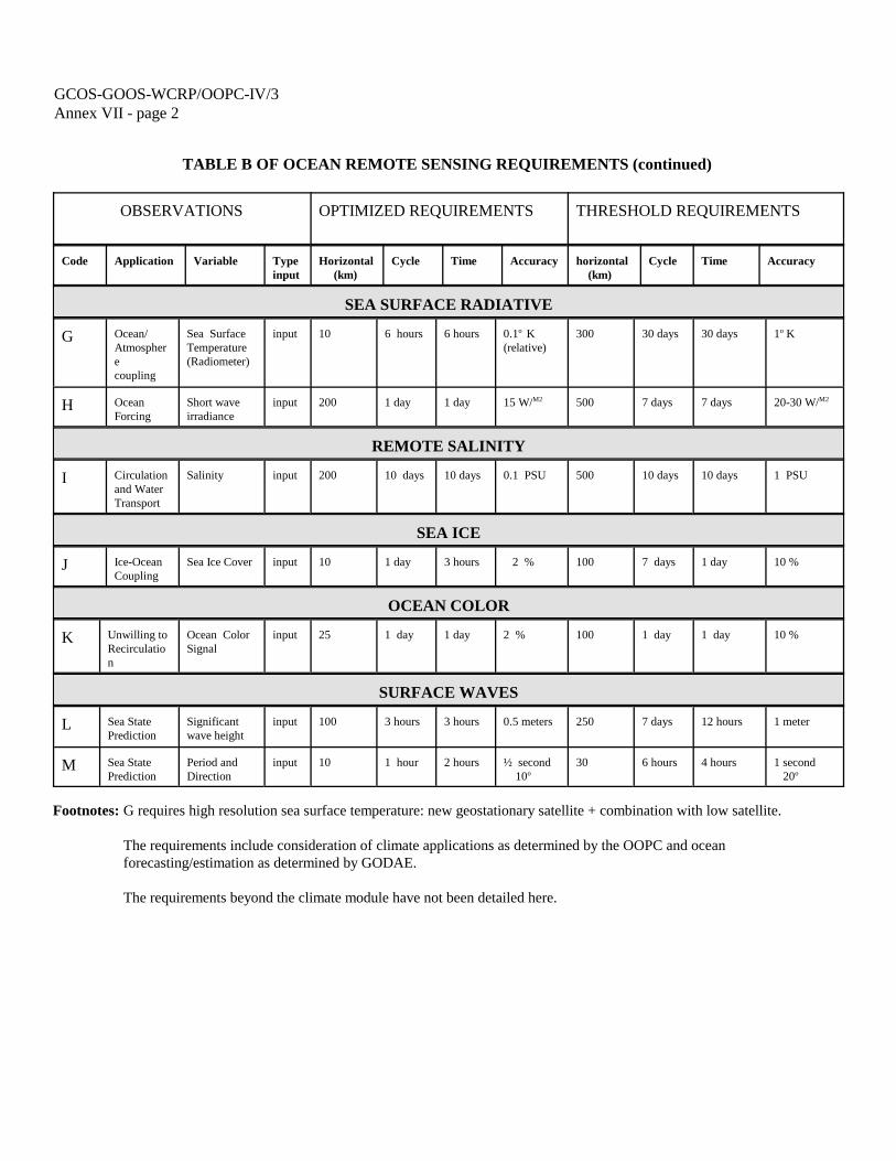
GCOS-GOOS-WCRP/OOPC-IV/3Annex VII - page 2
TABLE B OF OCEAN REMOTE SENSING REQUIREMENTS (continued)
OBSERVATIONS OPTIMIZED REQUIREMENTS THRESHOLD REQUIREMENTS
Code Application Variable Typeinput
Horizontal (km)
Cycle Time Accuracy horizontal (km)
Cycle Time Accuracy
SEA SURFACE RADIATIVE
G Ocean/Atmospherecoupling
Sea SurfaceTemperature(Radiometer)
input 10 6 hours 6 hours 0.1o K(relative)
300 30 days 30 days 1o K
H OceanForcing
Short waveirradiance
input 200 1 day 1 day 15 W/M2 500 7 days 7 days 20-30 W/M2
REMOTE SALINITY
I Circulationand WaterTransport
Salinity input 200 10 days 10 days 0.1 PSU 500 10 days 10 days 1 PSU
SEA ICE
J Ice-OceanCoupling
Sea Ice Cover input 10 1 day 3 hours 2 % 100 7 days 1 day 10 %
OCEAN COLOR
K Unwilling toRecirculation
Ocean ColorSignal
input 25 1 day 1 day 2 % 100 1 day 1 day 10 %
SURFACE WAVES
L Sea StatePrediction
Significantwave height
input 100 3 hours 3 hours 0.5 meters 250 7 days 12 hours 1 meter
M Sea StatePrediction
Period andDirection
input 10 1 hour 2 hours ½ second 10o
30 6 hours 4 hours 1 second 20o
Footnotes: G requires high resolution sea surface temperature: new geostationary satellite + combination with low satellite.
The requirements include consideration of climate applications as determined by the OOPC and oceanforecasting/estimation as determined by GODAE.
The requirements beyond the climate module have not been detailed here.
GCOS-GOOS-WCRP/OOPC-IV/3Annex VIII
ANNEX VIII
LIST OF ACRONYMS
ACSYS Arctic Climate System StudyACVE Atlantic Climate Variability ExperimentADCP Acoustic Doppler Current ProfilerADEOS Advanced Earth Observing Satellite (Japan)ALACE Autonomous Lagrangian Circulation ExplorerAOML Atlantic Oceanographic and Meteorological Lab (NOAA)AOPC Atmospheric Observing Panel for ClimateASCAT Advanced ScatterometerATOC Acoustic Thermometry of Ocean ClimateATSR Along Track Scanning RadiometerAUV Autonomous Underwater VehicleAVHRR Advanced Very High Resolution RadiometerBC Boundary CurrentBECS Basin-Wide Extended Climate StudyBMRC Bureau of Meteorology Research Center (Australia)BODC British Oceanographic Data CentreBSH Bundesamt für Seerschiffahrt und Hydrographie (Germany)CAS Commission for Atmospheric SciencesCDS Computerized Documentation SystemCLIC Climate and CryosphereDODS Distributed Ocean Data SystemCEOS Committee for Earth Observation SatellitesCGOM IOC Consultative Group on Ocean MappingCLIMAT Report of Monthly Means and Totals from Land Stations CLIVAR Climate Variability and Predictability ProgrammeCMR Centre Météorologique RegionalCNES Centre Nationale d’Etudes Spatiales (France)COOE Co-operative Ocean Observing ExperimentCOP Conference of the Parties for the UN FCCCCRYOSAT Ice Observing Satellite (ESA)CSIRO Commonwealth Scientific and Industrial Research Organization (Australia)DODS Distributed Ocean Data SystemECMWF European Centre for Medium-Range Weather ForecastingEEZ Exclusive Economic ZoneENSO El Niño-Southern OscillationENVISAT Environmental SatelliteEOS Earth Observation Satellite (US)ERS Earth Resources SatelliteESA European Space AgencyESD Earth Sciences DivisionEUMETSAT European Organization for Exploitation of Meteorological SatellitesFNMOC Fleet Numerical Meteorology and Oceanography Center (US NAVT)GCOS Global Climate Observing SystemGEBCO General Bathymetric Chart of the OceansGEF Global Environmental Facility (World Bank-UNEP-UNDP)
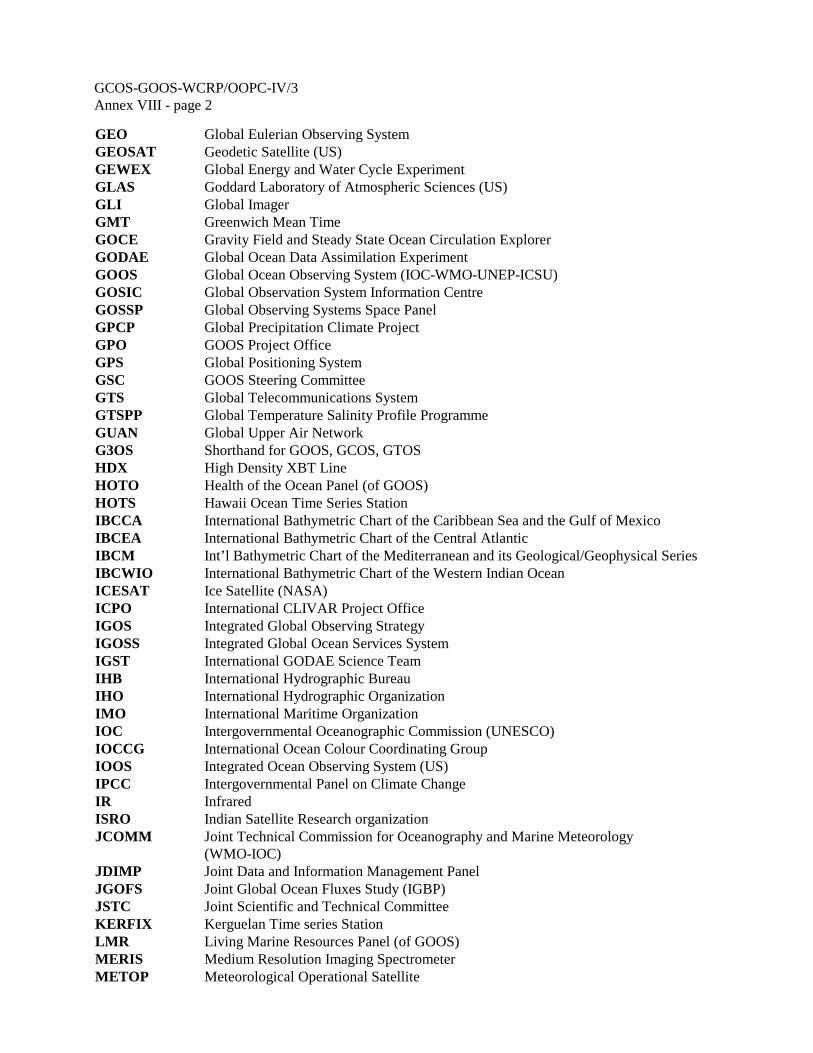
GCOS-GOOS-WCRP/OOPC-IV/3Annex VIII - page 2
GEO Global Eulerian Observing SystemGEOSAT Geodetic Satellite (US)GEWEX Global Energy and Water Cycle ExperimentGLAS Goddard Laboratory of Atmospheric Sciences (US)GLI Global ImagerGMT Greenwich Mean TimeGOCE Gravity Field and Steady State Ocean Circulation ExplorerGODAE Global Ocean Data Assimilation ExperimentGOOS Global Ocean Observing System (IOC-WMO-UNEP-ICSU)GOSIC Global Observation System Information CentreGOSSP Global Observing Systems Space PanelGPCP Global Precipitation Climate ProjectGPO GOOS Project OfficeGPS Global Positioning SystemGSC GOOS Steering CommitteeGTS Global Telecommunications SystemGTSPP Global Temperature Salinity Profile ProgrammeGUAN Global Upper Air NetworkG3OS Shorthand for GOOS, GCOS, GTOSHDX High Density XBT LineHOTO Health of the Ocean Panel (of GOOS)HOTS Hawaii Ocean Time Series StationIBCCA International Bathymetric Chart of the Caribbean Sea and the Gulf of MexicoIBCEA International Bathymetric Chart of the Central AtlanticIBCM Int’l Bathymetric Chart of the Mediterranean and its Geological/Geophysical SeriesIBCWIO International Bathymetric Chart of the Western Indian OceanICESAT Ice Satellite (NASA)ICPO International CLIVAR Project OfficeIGOS Integrated Global Observing StrategyIGOSS Integrated Global Ocean Services SystemIGST International GODAE Science TeamIHB International Hydrographic BureauIHO International Hydrographic OrganizationIMO International Maritime OrganizationIOC Intergovernmental Oceanographic Commission (UNESCO)IOCCG International Ocean Colour Coordinating GroupIOOS Integrated Ocean Observing System (US)IPCC Intergovernmental Panel on Climate ChangeIR InfraredISRO Indian Satellite Research organizationJCOMM Joint Technical Commission for Oceanography and Marine Meteorology
(WMO-IOC)JDIMP Joint Data and Information Management PanelJGOFS Joint Global Ocean Fluxes Study (IGBP)JSTC Joint Scientific and Technical CommitteeKERFIX Kerguelan Time series StationLMR Living Marine Resources Panel (of GOOS)MERIS Medium Resolution Imaging SpectrometerMETOP Meteorological Operational Satellite
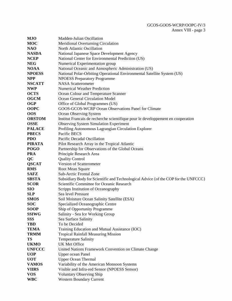
GCOS-GOOS-WCRP/OOPC-IV/3Annex VIII - page 3
MJO Madden-Julian OscillationMOC Meridional Overturning CirculationNAO North Atlantic OscillationNASDA National Japanese Space Development AgencyNCEP National Center for Environmental Prediction (US)NEG Numerical Experimentation groupNOAA National Oceanic and Atmospheric Administration (US)NPOESS National Polar-Orbiting Operational Environmental Satellite System (US)NPP NPOESS Preparatory ProgrammeNSCATT NASA Scatterometer NWP Numerical Weather PredictionOCTS Ocean Colour and Temperature ScannerOGCM Ocean General Circulation ModelOGP Office of Global Programmes (US)OOPC GOOS-GCOS-WCRP Ocean Observations Panel for ClimateOOS Ocean Observing SystemORSTOM Institut Francais de recherche scientifique pour le developpement en cooperationOSSE Observing System Simulation ExperimentPALACE Profiling Autonomous Lagrangian Circulation ExplorerPBECS Pacific BECSPDO Pacific Decadal OscillationPIRATA Pilot Research Array in the Tropical AtlanticPOGO Partnership for Observations of the Global OceansPRA Principle Research AreaQC Quality ControlQSCAT Version of ScatterometerRMS Root Mean SquareSAFZ Sub-Arctic Frontal ZoneSBSTA Subsidiary Body for Scientific and Technological Advice {of the COP for the UNFCCC}SCOR Scientific Committee for Oceanic ResearchSIO Scripps Institution of OceanographySLP Sea level PressureSMOS Soil Moisture Ocean Salinity Satellite (ESA)SOC Specialized Oceanographic CentreSOOP Ship of Opportunity ProgrammeSSIWG Salinity - Sea Ice Working GroupSSS Sea Surface SalinityTBD To be DecidedTEMA Training Education and Mutual Assistance (IOC)TRMM Tropical Rainfall Measuring MissionTS Temperature SalinityUKMO UK Met OfficeUNFCCC United Nations Framework Convention on Climate ChangeUOP Upper ocean PanelUOT Upper Ocean ThermalVAMOS Variability of the American Monsoon SystemsVIIRS Visible and Infra-red Sensor (NPOESS Sensor)VOS Voluntary Observing ShipWBC Western Boundary Current
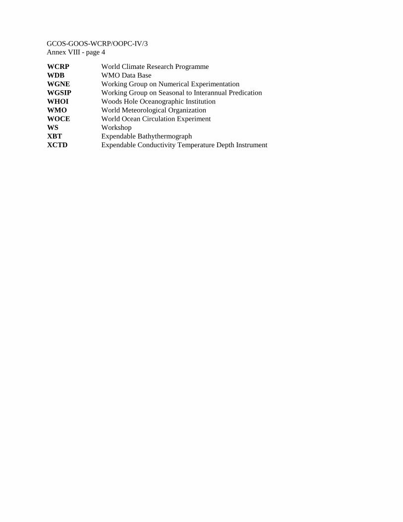
GCOS-GOOS-WCRP/OOPC-IV/3Annex VIII - page 4
WCRP World Climate Research ProgrammeWDB WMO Data BaseWGNE Working Group on Numerical Experimentation WGSIP Working Group on Seasonal to Interannual PredicationWHOI Woods Hole Oceanographic InstitutionWMO World Meteorological OrganizationWOCE World Ocean Circulation ExperimentWS WorkshopXBT Expendable BathythermographXCTD Expendable Conductivity Temperature Depth Instrument
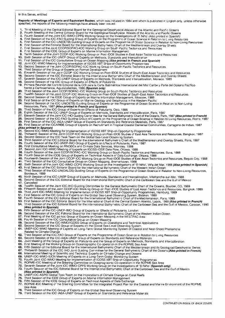
In this Series, entitled
Reports of Meetings of Experts and Equivalent Bodies, which was initiated in 1984 and which is published in English only, unless otherwise specified, the reports of the following meetings have already been issued:
:: 3.
2: 6. 7.
:: 10. Il. 12. 13. 14.
Third Meeting of the Central Editorial Board for the Geological/Geophysical Atlases of the Atlantic and Pacific Oceans Fourth Meeting of the Central Editorial Board for the Geological/Geophysical Atlases of the Atlantic and Pacific Oceans Fourth Session of the Joint IOC-WMO-CPPS Working Group on the Investigations of ‘El Niiio’ (Also printed in Spanish) First Session of the IOC-FA0 Guiding Group of Experts on the Programme of Ocean Science in Relation to Living Resources First Session of the IOC-UN(OETB) Guiding Group of Experts on the Programme of Ocean Science in Relatron to Non-Living Resources First Session of the Editorial Board for the International Bathymetric Chart of the Mediterranean and Overlay Sheets First Session of the Joint CCOP(SOPAC)-IOC Working Group on South Pacific Tectonics and Resources First Session of the IODE Group of Experts on Marine Information Management Tenth Session of the Joint CCOP-IOC Working Group on Post-IDOE Studies in East Asian Tectonics and Resources Sixth Session of the IOC-UNEP Group of Experts on Methods, Standards and Intercalibration First Session of the IOC Consultative Group on Ocean Mapping (Also printed in French and Spanish) Joint IOC-WMO Meeting for Implementation of IGOSS XBT Ships-of-Opportunity Programmes Second Session of the Joint CCOPISOPAC-IOC Working Group on South Pacific Tectonics and Resources Third Session of the Grouo of Exoerts on Format Develooment
15. Eleventh Session of the Joint CC’OP-IOC Working Group on Post-IDOE Studies of South-East Asian Tectonics and Resources 16. Second Session of the IOC Editorial Board for the International Bathymetric Chart of the Mediterranean and Overlay Sheets 17. Seventh Session of the IOC-UNEP Group of Experts on Methods, Standards and Intercalibration, Monaco, 1985 18. Second Session of the IOC Group of Experts on Effects of Pollutants 19. Primera Reunion del Comite Editorial de la COI para la Carta Batimetrica lnternacional del Mar Caribe y Parte del Ocean0 Pacific0
frente a Centroamerica. Aguascalientes, 1986 (Spanish on/y) 20. Third Session of the Joint CCOPKOPAC-IOC Working Group on South Pacific Tectonics and Resources 21. Twelfth Session of the Joint CCOP-IOC Working Group on Post-IDOE Studies of South-East Asian Tectonics and Resources 22. Second Session of the IODE Group of Experts on Marine Information Management, Moscow, 1986 23. First Session of the IOC GrOuD of Exoerts on Marine Geoloov and Geoohvsics in the Western Pacific 24. Second Session of the IOC-U’N(OETB) Guiding Group of Experts on the Pr&amme of Ocean Science in Relation to Non-Living
Resources, Paris, 1987 (Also printed in French and Spanish) 25. Third Session of the IOC Group of Experts on Effects of Pollutants, Oslo, 1986 26. Eighth Session of the IOC-UNEP Group of Experts on Methods, Standards and Intercalibration, Paris, 1987 27. Eleventh Session of the Joint IOC-IHO Guiding Committee for the General Bathymetric Chart of the Oceans, Pans, 1987 (Also printed in French) 28. Second Session of the IOC-FA0 Guiding Group of Experts on the Programme of Ocean Science in Relation to Living Resources, Rome, 1987 29. First Session of the IOC-IAEA-UNEP Group of Experts on Standards and Reference Materials, Paris, 1987 30. First Session of the IOCARIBE Group of Experts on Recruitment in Tropical Coastal Demersal Communities, Cartagena de Indias. 1987 (Also printed in Spanish) 31. Second IOC-WMO Meeting for Implementation of IGOSS XBT Ship-of-Opportunity Programmes 32. Thirteenth Session of the Joint CCOP-IOC Working Group on Post-IDOE Studies of East Asia Tectonics and Resources, Bangkok. 1987 33. Second Session of the IOC Task Team on the Global Sea-Level Observing System 34. Third Session of the IOC Editorial Board for the International Bathymetric Chart of the Mediterranean and Overlay Sheets, Paris, 1987 35. Fourth Session of the IOC-UNEP-IMO Group of Experts on Effects of Pollutants, Paris, 1987 36. First Consultative Meeting on RNODCs and Climate Data Services, Wormley, 1988 37. Second Joint IOC-WMO Meeting of Experts on IGOSS-IODE Data Flow, Ottawa, 1988 38. Fourth Session of the Joint CCOP/SOPAC-IOC Working Group on South Pacific Tectonics and Resources, Suva. 1988 39. Fourth Session of the IODE Group of Experts on Technical Aspects of Data Exchange, Ottawa, 1988 46. Fourteenth Session of the Joint CCOP-IOC Working Group on Post-IDOE Studies of East Asian Tectonics and Resources, Baguio City, 1988 41. Third Session of the IOC Consultative Group on Ocean Mapping, Bremerhaven, 1988 42. 43.
Sixth Session of the Joint IOC-WMO-CCPS Working Group on the Investigations of ‘El NiRo’, Viha del Mar, 1988 (Also printed in Spanish) First Session of the IOC Editorial Board for the International Bathymetric Chart of the Western Indian Ocean
44. Third Session of the IOC-UN(OALOS) Guiding Group of Experts on the Programme of Ocean Science in Relation to Non-Living Resources, Bordeaux, 1989
45. Ninth Session of the IOC-UNEP Group of Experts on Methods, Standards and Intercalibration, Villefranche-sur-Mer, 1988 46. Second Session of the IOC Editorial Board for the International Bathymetric Chart of the Caribbean Sea and the Gulf of Mexico 47. Cancelled 46. Twelfth Session of the Joint IOC-IHO Guiding Committee for the General Bathymetric Chart of the Oceans, Boulder, CO, 1989 49. Fifteenth Session of the Joint CCOP-IOC Working Group on Post-IDOE Studies of East Asian Tectonics and Resources, Bangkok, 1989 50. Third Joint IOC-WMO Meeting for Implementation of IGOSS XBT Ship-of-Opportunity Programmes, Hamburg, 1989 51. First Session of the IOC Group of Experts on the Global Sea-Level Observing System, Bidston, 1989 52. Fourth Session of the IOC Editorial Board for the International Bathymetric Chart of the Mediterranean, Pans, 1989 53. First Session of the IOC Editorial Board for the International Chart of the Central Eastern Atlantic, Lagos, 1989 (A/so printed in French) 54. Third Session of the IOC Editorial Board for the International Bathymetric Chart of the Caribbean Sea and the Gulf of Mexico, Caracas, 1990
(Also printed in Spanish) 55. Fifth Session of the IOC-UNEP-IMO Grouo of Exoerts on Effects of Pollutants. London
Second Session of the IOC Editorial Board for the international Bathymetric Chart of the Western Indian Ocean First Meeting of the IOC ad hoc Group of Experts on Ocean Mapping in the WESTPAC Area
56.
Z: 59.
:::
Fourth Session of the IOC Consultative Group on Ocean Mapping - Second Session of the IOC-WMOIIGOSS Group of Experts on Operations and Technical Applications Second Session of the IOC Group of Experts on the Global Sea-Level Observing System UNEP-IOC-WMO Meeting of Experts on Long-Term Global Monitoring System of Coastal and Near-Shore Phenomena Related to Climate Change
Z: 66. 67. 68. 69. 70. 71. 72. 73.
;: 76: 77.
78. 79.
Third Session of the IOC-FA0 Group of Experts on the Programme of Ocean Science in Relation to Living Resources Second Session of the IOC-IAEA-UNEP Group of Experts on Standards and Reference Materials Joint Meeting of the Group of Experts on Pollutants and the Group of Experts on Methods, Standards and Intercalibration First Meeting of the Working Group on Oceanographic Co-operation in the ROPME Sea Area Fifth Session of the Editorial Board for the International Bathymetric Chart of the Mediterranean and its Geological/Geophysical Series Thirteenth Session of the IOC-IHO Joint Guiding Committee for the General Bathymetric Chart of the Oceans (A/so printed in French) International Meeting of Scientific and Technical Experts on Climate Change and Oceans UNEP-IOC-WMO-IUCN Meeting of Experts on a Long-Term Global Monitoring System Fourth Joint IOC-WMO Meeting for Implementation of IGOSS XBT Ship-of-Opportunity Programmes ROPME-IOC Meeting of the Steering Committee on Oceanographic Co-operation in the ROPME Sea Area Seventh Session of the Joint IOC-WMO-CPPS Working Group on the Investigations of ‘El NiAo’ (Spanish on/y) Fourth Session of the IOC Editorial Board for the International Bathymetric Chart of the Caribbean Sea and the Gulf of Mexico (Also printed in Spanish) UNEP-IOC-ASPEI Global Task Team on the Implications of Climate Change on Coral Reefs Third Session of the IODE Group of Experts on Marine Information Management Fifth Session of the IODE Group of Experts on Technical Aspects of Data Exchange ROPME-IOC Meeting of the Steering Committee for the Integrated Project Plan for the Coastal and Marine Environment of the ROPME Sea Area Third Session of the IOC Group of Experts on the Global Sea-level Observing System Third Session of the IOC-IAEA-UNEP Group of Experts on Standards and Reference Materials
CONTINUED ON /NS/DE OF BACK COVER
88. Fourteenth Session of the Joint IOC-IHO Guiding Committee for the General Bathymetric Chart of the Oceans 81. Fifth Joint IOC-WMO Meeting for Implementation of IGOSS XBT Ship-of-Opportunity Programmes 82. Second Meeting of the UNEP-IOC-ASPEI Global Task Team on the Implications of climate Change on Coral Reefs, Mrami. FL, 1993 83. Seventh Session of the JSC Ocean Observing System Development Panel, Lisbon, 1993 84. Fourth Session of the IODE Group of Experts on Marine Information Management, Washington, D.C.. 1993 85. Sixth Session of the IOC Editorial Board for the International Bathymetric chart of the Mediterranean and its Geological/Geophysical Series,
Jerusalem, 1993 88. Fourth Session of the Joint IOC-JGOFS Panel on Carbon Dioxide, Plymouth, 1993 87. Frrst Session of the IOC Editorial Board for the International Bathymetric Chart of the Western Pacific, Tianjin, 1993 88. Eiahth Session of the JSC Ocean Observina Svstem Develooment Panel. Dartmouth. NS. 1993 89. Ni&h Session of the JSC Ocean 0bserving”System Development Panel, ‘Melbourne, ‘1994 90. Sixth Session of the IODE Group of Experts on Technical Aspects of Data Exchange, Geneva, 1994 91. First Session of the IOC-FA0 Group of Experts on OSLR for the IOCINCWIO Region, Mombasa, 1994 92. Fifth Session of the Joint IOC-JGOFS CO, Advisory Panel Meettng 93. Tenth Session of the JSC Ocean Observina Svstem Develooment Panel. Paradise. TX. 1994 94. First Session of the Joint CMM-IGOSS-IODE Sub-group on’ Ocean Satellites and Remote Sensing, Paris, 1994 95. Third Session of the IOC Editorial Board for the International Chart of the Western Indian Ocean, Zanzibar, 1994 98. Fourth Session of the IOC Group of Experts on the Global Sea Level Observing System, Bordeaux, 1995 97. Joint Meeting of GEMSI and GEEP Core Groups, Bermuda, 1993 98. First Session of the Joint Scientific and Technical Committee for Global Ocean Observing System, Nantes, 1994 99. Second International Meeting of Scientific and Technical Experts on Climate Change and the Oceans, Valletta, 1994
100. First Meeting of the Officers of the Editorial Board for the International Bathymetric Chart of the Western Pacific, Bali, 1994 101. Fifth Session of the IOC Editorial Board for the International Bathymetric Chart of the Caribbean Sea and the Gulf of Mexico. San Jose, 1994 102. Second Session of the Joint Scientific and Technical Committee for Global Ocean Observing System, Paris, 1995 103. Fifteenth Session of the Joint IOC-IHO Committee for the General Bathymetric Chart of the Oceans, Monaco, 1995 104. Fifth Session of the IOC Consultative Group on Ocean Mapping, Bremerhaven. 1995 105. Fifth Session of the IODE Group of Experts on Marine Information Management, Athens, 1996 106. IOC-NOAA Ad hoc Consultation on Marine Biodiversity. Paris, 1995 107. Srxth Joint IOC-WMO Meeting for Implementation of IGOSS XBT Ship-of-Opportunity Programmes, Ottawa, 1995 108. Third Session of the Health of the Oceans (HOTO) Panel of the Joint Scientific and Technical Committee for GOOS, Bangkok, 1995 109. Second Session of the Strategy Subcommittee (SSC) of the IOC-WMO-UNEP Intergovernmental Committee for the Global Ocean
Observing System I IO. Third Session of the Joint Scientific and Technical Committee for Global Ocean Observing System 111. First Session of the Joint GCOS-GOOS-WCRP Ocean ObSeNatiOnS Panel for Climate, Baltimore, Md, 1997
I 112. Sixth Session of the Joint IOC-JGOFS CO, Advisorv Panel Meetina. Mavaouez. 1996 / 113. First Meeting of the IOC/WESTPAC Co-ordinating Committee far the NahhrEast Asian Regional - Global Ocean Observing System !
(NEAR-GOOSI I 1 114. Eighth Session of the Joint IOC-WMO-CPPS Working Group on the Investigations of “El NiRo”, Cancepcion. 1996 (Spanish on/y)
115. Second Session of the IOC Editorial Board of the International Bathymetnc Chart of the Central Eastern Atlantic, Paris, 1996 (Also printed in French)
116. Tenth Session of the Offices Committee for the Joint IOC-IHO General Bathvmetric Chart of the Oceans (GEBCO), USA, 1996 117. IOC Group of Experts on the Global Sea Level Observing System (GLOSS), Fifth Session, USA, 1997 118. Joint Scientific Technical Committee for Global Ocean Observina Svstem (J-GOOSE. Fourth Session. USA. 1997 119. First Session of the Joint IOC-WMO IGOSS Shop-of-Opportunity-Programme Implementatron Panel, South Africa, 1997 120. Report of Ocean Climate Time-Series Workshop, Joint GCOS-GOOS-WCRP Ocean Observations Panel for Climate, USA, 1997 121. IOCWESTPAC Co-ordinating Committee for the North-East Asian Regional Global Ocean ObSeNing System (NEAR-GOOS). Second
Session, Thailand, 1997 122. First Session of the IOC-IUCN-NOAA Ad hoc Consultative Meeting on Large Marine Ecosystems (LME), France, 1997 123. Second Session of the Joint GCOS-GOOS-WCRP Ocean Observations Panel for Climate (OOPC), South Africa, 1997 124. Sixth Sessron of the IOC Editorial Board for the International Bathymetric Chart of the Caribbean Sea and the Gulf of Mexico, Colombia, 1996
(Also printed in Spanish) 125. Seventh Session of the IODE Group of Experts on Technical Aspects of Data Exchange, Ireland. 1997 126. IOC-WMO-UNEP-ICSU Coastal Panel of the Global Ocean ObSeNlnQ Svstem (GOOS), First Session, France, 1997 127. Second Session of the IOC-IUCN-NOAA Consultative Meeting on Lange-Marine Ecosystems (LME), France, 1998 128. Sixth Session of the IOC Consultative Group on Ocean Mapping (CGOM). Monaco, 1997 129. Sixth Session of the Tropical Atmosphere - Ocean Array (TAO) Implementation Panel, United Kingdom, 1997 130. First Session of the IOC-WMO-UNEP-ICSU Steering Committee of the Global Ocean ObSeNing System (GOOS), France, 1998 131. Fourth Session of the Health of the Oceans (HOTO) Panel of the Global Ocean ObSt?Ning System (GOOS), Singapore, 1997 132. Sixteenth Session of the Joint IOC-IHO Guiding Committee for the General Bathymetric Chart of the Oceans (GEBCO),
United Kingdom, 1997 133. First Session of the IOC-WMO-UNEP-ICSU-FA0 Living Marine Resources Panel of the Global Ocean Observing System (GOOS),
France, 1998 134. Fourth Session of the IOC Editorial Board for the InternatIonal Bathymetric Chart of the Western Indian Ocean (IOC/EB-IBCWIO-IV/3),
South Africa, 1997 135. Thrrd Session of the Joint GCOS-GOOS-WCRP Ocean Observations Panel for Climate (OOPC), France, 1998 136. Seventh Session of the Joint IOC-JGOFS COn Advisory Panel Meeting, Germany, 1997 137. lmolementation of Global Ocean ObSeNatiOnS for GOOS/GCOS. First Session. Australia. 1998 138. Implementation of Global Ocean Observations for GOOS/GCOSI Second Session, France, 1998 139. Second Session of the IOC-WMO-UNEP-ICSU Coastal Panel of the Global Ocean Observing System (GOOS), Brazil, 1998 140. Thrrd Session of IOCNVESTPAC Co-ordinating Committee for the North-East Asian Regional -Global Ocean Observing System
(NEAR-GOOS). China, 1998 -
141. Ninth Session of the Jornt IOC-WMO-CPPS Working Group on the lnvestrgations of ‘El Nirio’, Ecuador, 1998 (Spanish on/y) / 142. Seventh Session of the IOC Editorial Board for the international Bathymetric Chart of the Mediterranean and its Geological/Geophysical
Series. Croatia, 1998 143. Seventh Session of the Tropical Atmosphere-Ocean Array (TAO) Implementation Panel, Abidlan, C&e d’lvoire, 1998 144. Srxth Session of the IODE Group of Experts on Marine Information Manaqement (GEMIM), USA, 1999 145. Second Session of the IOC-WMO-UNEP-ICSU Steering Committee of the Global‘Ocean bbserving System (GOOS), China, 1999 146. Third Session of the IOC-WMO-UNEP-ICSU Coastal Panel of the Global Ocean Observing System (GOOS), Ghana, 1999 147. Fourth Session of the GCOS-GOOS-WCRP Ocean Observations Panel for Climate (OOPC); Fourth Session of the WCRP CLIVAR Upper
Ocean Panel (UOP); Special Joint Session of OOPC and UOP, USA, 1999