Wayfinding and environmental cognition in the designed environment
20
68.1 Proceedings . 4th International Space Syntax Symposium London 2003 68 Keywords Wayfinding, Cognitive mapping, Sketch Map variables, Intelligibility, Topological variables [email protected] [email protected] Ability and intelligibility: Wayfinding and environmental cognition in the designed environment Saif Haq and Sara Girotto Texas Tech. University, USA Abstract There seems to be a growing consensus in the literature that topological variables, both in the environment and in sketch maps, are reliable indicators of wayfinding performance. Additionally, there are other suggestions regarding the use of topological variables to characterize and measure overall environments. In this regard, it has been reported that topologically derived configurational measures may provide a better sense of the ease or difficulty that each environment may present to an immersed and moving subject within it. A clarification of such claims is an important focus of this paper. Regarding the externalization of cognitive understanding, the technique of sketch mapping has a long tradition. However, there are many ways by which these maps have been analysed. The inclusion of Space Syntax methods provides a new dimension. A comparison of Space Syntax with some other tools of sketch map analysis is a secondary focus here. These and other similar issues are explored through an experiment conducted in two complex hospital buildings in the US, where ninety-six volunteers, completely unfamiliar with the two environments, participated. They explored the setting, completed wayfinding tasks, pointed to unseen destinations, estimated distances between them and drew sketch maps from memory. The environment was analyzed through existing Space Syntax methods and some additional theoretically derived techniques. Two datasets were eventually produced: one by person and the other by corridor. The first one included sketch map variables, wayfinding performance indicators and cognitive tasks. The dataset by corridor included two kinds of data: independent values of the corridors themselves that was derived from Space Syntax analysis and wayfinding use of those corridors. An important conclusion from the analysis is that intelligibility of settings is an important measure that is predictive of wayfinding and environmental cognition within environments. However, geometric and metric relations cannot be ignored and there may be certain instances when those factors may become overwhelming.
-
Upload
independent -
Category
Documents
-
view
1 -
download
0
Transcript of Wayfinding and environmental cognition in the designed environment

68.1
Proceedings . 4th International Space Syntax Symposium London 2003
68KeywordsWayfinding,Cognitive mapping,Sketch Map variables,Intelligibility,Topological variables
[email protected]@ttu.edu
Ability and intelligibility:Wayfinding and environmental cognition in the designed
environment
Saif Haq and Sara Girotto
Texas Tech. University, USA
AbstractThere seems to be a growing consensus in the literature that topological variables,both in the environment and in sketch maps, are reliable indicators of wayfindingperformance. Additionally, there are other suggestions regarding the use of topologicalvariables to characterize and measure overall environments. In this regard, it hasbeen reported that topologically derived configurational measures may provide abetter sense of the ease or difficulty that each environment may present to an immersedand moving subject within it. A clarification of such claims is an important focus ofthis paper.
Regarding the externalization of cognitive understanding, the technique ofsketch mapping has a long tradition. However, there are many ways by which thesemaps have been analysed. The inclusion of Space Syntax methods provides a newdimension. A comparison of Space Syntax with some other tools of sketch mapanalysis is a secondary focus here.
These and other similar issues are explored through an experiment conductedin two complex hospital buildings in the US, where ninety-six volunteers, completelyunfamiliar with the two environments, participated. They explored the setting,completed wayfinding tasks, pointed to unseen destinations, estimated distancesbetween them and drew sketch maps from memory. The environment was analyzedthrough existing Space Syntax methods and some additional theoretically derivedtechniques. Two datasets were eventually produced: one by person and the other bycorridor. The first one included sketch map variables, wayfinding performanceindicators and cognitive tasks. The dataset by corridor included two kinds of data:independent values of the corridors themselves that was derived from Space Syntaxanalysis and wayfinding use of those corridors.
An important conclusion from the analysis is that intelligibility of settings isan important measure that is predictive of wayfinding and environmental cognitionwithin environments. However, geometric and metric relations cannot be ignoredand there may be certain instances when those factors may become overwhelming.
Ability and intelligibility
68.2
Introduction
Many researchers in environmental perception and cognition subscribe to the theory
that people acquire and store information about their surroundings in some
schematized but structured form, which is known, among other terms, as ‘cognitive
map’. This ‘cognitive map’ is shaped by the environment within which it evolves,
and, in turn, has some impact on the behaviour of the person in that environment, or
in similar ones. In turn, this behavior results in a ‘better’ cognitive map (see Golledge
& Stimson, 1997; Hart & Moore, 1973; and Tversky, 2003 for detailed reviews).
Studies into the relationships between environmental properties and cognitive
map characteristics were a natural extension of cognitive mapping research. In this
regard, the most important observation was the identification of three classes of
spatial relations that was thought to form the content of spatial cognition; those
being topological, projective and Euclidian, or metric relations. From an ontogenetic
perspective, the understanding of topological relations precedes the understanding
of projective and Euclidian relations. Later, Shemyakin (1962) distinguished between
two fundamentally different types of topological representations: route maps and
survey maps. Route maps are constructed by mentally tracing the route of locomotion
through an area and survey maps are representations of the general configuration of
the mutual disposition of local objects. Therefore the distinction was made between
local topological variables and ideas about topologically derived overall
configuration.
Topological variables in cognitive maps and mapping
There seems to be a growing consensus in the literature that topological variables,
both inthe environment and in sketch maps, are reliable indicators of cognitive
mapping and of wayfinding performance. Best (1970) studied one hundred and thirty
five wayfinding people in a large town hall of a major UK city and reported high
correlations between ‘lostness’, i.e. deviations from the most direct routes, and the
number of choices in that route (r = .93). He termed them ‘choice points’, but they
are similarly described as Space Syntax ‘connectivity’.
Rovine and Weisman (1989) conducted a study to explore the relationship
between the environment as represented in sketch maps and resultant behavior within
that environment. Forty-five participants (21 males and 24 females) were individually
taken to the downtown area of Bellefonte, Pennsylvania, and given a tour of it.
During the tour, the experimenter pointed out twenty buildings. After the tour was
completed, each participant was asked to draw a map of the area including everything
remembered and was told to include the buildings pointed out. Subsequently, a
wayfinding task was performed in which the participants had to find eight of the
68.3
Proceedings . 4th International Space Syntax Symposium London 2003
twenty buildings. The researchers analyzed the sketch maps through frequency of
landmarks, path segments, nodes, and topological accuracy of placement of buildings.
A series of correlational analyses indicated that topological accuracy of local
placement of buildings was the best predictor of wayfinding performance, accounting
for 62.4% of the variance.
The most difficult tasks that these researchers faced was coming up with
analytical techniques of identifying and collecting topological information and finding
means of comparing between settings. Of course the development of Space Syntax
techniques addressed this need and it quickly became a tool of choice for some
environmental cognition researchers.
The first direct use of Space Syntax techniques in wayfinding research was
undertaken by Peponis, Zimring, & Choi (1990). This study is significant for a number
of other reasons. They considered both open exploration and directed searches as
two kinds of wayfinding and also proposed the methodological construct of
‘redundant node use’. In Space Syntax terms, they only considered integration-max
and reported that both exploration in novel settings and errors in searches were
biased towards spaces with greater integration-max (r = -.757 and r = -.754
respectively). In a later study Haq (1999a) supported those findings.
Later Choi (1999) tracked people in museum settings and found that line
integration-max was the highest predictor of people who visited it (r = -.508), while
connectivity was highest when repeat visits were considered (r = .623). hoi did not
consider integration-3, but this was found important in subsequent studies.Working
with novice wayfinders in three urban hospitals, Haq and Zimring (2001) reported
that total use of a space, i.e. one that considered repeat visits was also best predicted
by connectivity (r = .768, .884 and .786). Earlier, Haq (2001) had showed that the
number of people who visited a space was more correlated with integration-3 (r =
.692, .859 and .814). The subjects were also asked to draw sketch maps of two
settings and the appearance of lines in their sketch maps correlated highly (r = .556
and .678) to connectivity. (Haq, 2001; Haq & Zimring, 2001) In another study, Kim
(2001) had residents of a suburb in London sketch the map of their home area and
found that the lines drawn were highly correlated to integration-3 (r = .708).
In another series of papers, Haq (1999a, 1999b, 2003) and Haq and Zimring
(2001) have reported the importance of connectivity in predicting wayfinding use of
spaces and in cognitive maps. Also, the author has asserted that wayfinding was
more successful when started from spaces of lower topological depth.

Ability and intelligibility
68.4
Configurational characteristics in wayfinding and cognitive mapping
Another important aspect was of course the development of ways and means by
which overall spatial complexity could be quantified and studied with regards to
environmental cognition and wayfinding. Braaksma and Cook (1980) described
terminal buildings as a node-link network where origins and destinations were nodes
and the visibility between them, either directly or through signs, the link. By
measuring the connectivity of such a graph, indices for visibility between locations
inside ten airports were developed. Informal interviews with patrons in two airports
showed that wayfinding problems were associated with areas with low visibility
indices.
In 1981, Weisman used seventy-three self reports regarding wayfinding in
ten university buildings and found that ‘simplicity’ of floor plan configuration, as
rated by 100 judges, was a strong predictor of self reported wayfinding performance.
Later, in 1989, he considered wayfinding from both perceptual and cognitive points
of view and proposed four kinds of environmental information as important: signs
and numbers, architectural differentiation, perceptual access and plan configuration.
Michael O’Neil (1991) measured layout complexity as the average number
of topological connections per choice point in a floor plan. He called this ‘Inter-
Connection Density’ (ICD). This was used as dependent measure to test both
wayfinding and environmental cognition. For the experiment O’Neill used sixty
sixty-three student volunteers and three independent sections of a library building.
Using sketch mapping, photograph sorting and actual wayfinding tasks he found
that as topological floor plan complexity increases, people tended to experience
greater cognitive mapping and wayfinding difficulty.
Later, Kim (2001) investigated the role of intelligibility on the relationship
between spatial configuration in reality and its cognitive representation. Two adjacent
areas in Hampstead Garden Suburb in North London, one more intelligible than the
other (r = .284 and .680), were investigated. Correlational research indicated that
there is a better relationship between spatial configuration and spatial cognition for
the residents of the intelligible area. He concluded that residents living in the more
intelligible areas do indeed produce maps that are better correlated to Space Syntax
variables.
What emerges from such studies is an unclear relationship between the higher
and lower order topological variables or, in Space Syntax terms, between the local
and global variables, especially as they relate to environmental cognition and
wayfinding. In this regard, two questions become paramount. What topological

68.5
Proceedings . 4th International Space Syntax Symposium London 2003
variables are more significant? And, what role does the overall characteristics of the
layout play in cognition and wayfinding? Both of them raises interesting Space
Syntax issues that simultaneously challenge current assumptions and proposealternate
ways of environmental analysis.
This paper will be more concerned with the second question, the one regarding
the characteristics of overall layouts and its relationship between wayfinding and
environmental cognition. It takes a more critical look at the criteria of analysis of
both physical environment and sketch maps. Specifically it deals with the interaction
between the following issues: procedures of sketch map analyses and their
comparisons, considering both traditional methods and Syntax analysis, and the role
of configuration between wayfinding and spatial cognition.
Sketch maps, their analysis and comparison
Sketch maps are one tool frequently used in research as a method of externalizing
the cognitive understanding of an environment. By their very nature they present
characteristics that make them very different from ‘conventional maps’: they do not
provide reliable metric information, they are incomplete and distorted representations
and are drawn differently from person to person. In spite of this, sketch maps are a
valuable source of data and can provide information such as the number of features
included on the map, indication of dominant functions as perceived by the sketcher
and other types of information, like the sequence of cues along routes or the sequence
of segments and turns along routes.
Kevin Lynch (1960), one of the pioneers in the study regarding the acquisition
of spatial knowledge, hypothesized that people have in their mind an image of the
environment in which they live and so he used sketch maps as an important tool in
his research.
According to Tversky (2003), “people act in different spaces, depending on
the task at hand”. She identifies four different categories of space: the space of the
body, the space around the body, the space of navigation, and the space of graphics.
Space of navigation is the space that surrounds us and that we explore when we
move from place to place. Thus, space of navigation is the space we interact with
during wayfinding. Space of navigation is a mental construction and is schematized:
it is this schematization that is graphically expressed by means of sketch maps. She
further noted that critical elements of the space of navigation are landmarks and
paths, links and nodes.
Ability and intelligibility
68.6
Rovine and Weisman (1989) analyzed sketch maps taking into consideration
not only the elements reported, but also their local topological relations. Starting
from the idea of Kaplan & Kaplan (1982), that people may not require Euclidean
accuracy in their representation of environments, they developed a new way to look
and analyze sketch maps. Rovine & Weisman suggest that sketch map may be
composed of different parts, some containing accurate information and some with
missing information. Thus, the solving of wayfinding problems depends on the fit
between accurate information required for a task and available information. The
map can be broken up into small units, centered on a landmark. Accuracy of placement
of the landmark is determined by its relationships with the elements located around
it. Accuracy of placement is thought to be related with wayfinding performance.
It seems that sketch maps have been analyzed mainly in three ways (Kim,
2001). First, a certain number of researchers tried to investigate how local
configurational elements are perceived in different environments and then compared
the pattern reported in sketch maps to the real pattern. For example, Sadalla and
Montello (1989) focused on the effects of the number of turns in a path on its perceived
length. Their findings supported the idea that the perceived length is proportional to
the number of turns. Evans (1980) focused on distortion presented by sketch maps.
He found that the most common ones are the straightening of gradual curves and the
aligning of non-parallel streets. Moreover, in sketch maps people tend to draw streets
that intersect as closer to 90 degrees and familiar streets as parallel, even when they
are not (Tversky, 1981). Among the studies investigating global aspects of spatial
configuration, O’Neill (1991) put evidence on the fact that settings characterized by
an easier configuration are associated with better wayfinding performances. Second,
the contents of sketch maps have been treated as dependent variables in relation to
factors such as socio-economic status, length of residence and mobility characteristics,
and activity patterns (Appleyard, 1970). Third, researchers investigated the frequency
of the appearance of various features in sketch maps (Lynch, 1960; Haq & Zimring,
2001; Haq, 2003; and Kim, 2001).
One aim of this research is a comparison between some of the sketch map
variables that were undertaken by previous researchers and their relationship with
Space Syntax variables. It is hoped that, since Syntax uses topological variables and
provides indications of overall configurations based on such topological
characteristics, it may turn out to be a reliable indicator of cognitive performances,
specifically as understood by sketch mapping.

68.7
Proceedings . 4th International Space Syntax Symposium London 2003
The Research
Tasks
This research was conducted in two complex hospital buildings in a major US city.
96 volunteers, 47 females and 49 males (mean age=19.5; S.D. = 1.51), completely
unfamiliar with the two environments and screened so that none of them had visited
a large hospital complex more than once in the 12 months prior to the study,
participated. The sample was 64.6% White, 10.4% African American, and the
remainder other minorities. The two complex settings will be referred to as University
Hospital and City Hospital (see Figure 1 and Figure 2).
Figure 2: Plan of City Hospital:three building are connected to-gether to form a continuousmass. A north- western part, asouth- western part and an east-ern wing. The connecting centralpart also houses different func-tions.
Figure 1: Plan of University Hos-pital: although different buildingsform an interconnected mass, acentral corridor creates a strongsense of orientation.
Ability and intelligibility
68.8
In the floor that was accessible from the street entrance, the participants
completed the following tasks: open exploration, directed searches, pointing to unseen
but previously visited locations, estimating distances and sketch mapping. The first
two tasks were used consecutively by Peponis et al. (1990) in their pioneering study
of wayfinding and Space Syntax. In open exploration, the participants were asked to
explore the setting within a specific time period. This was started from one of the
pre-selected entry points of the hospital and the subjects were told not to talk to
anyone but to try and fulfill their tasks making reference to the environmental cues
only. It should be noted that most of the participants used less time than was allotted
and insisted that they had become familiar with the building. During directed search,
i.e. wayfinding, the subjects were required to find specific destinations. They were
taken to one of four pre-selected locations within the building and were asked to
walk to another one. When the destination was found, they were asked to find the
next one. If the participants could not find their destination in the preset time period,
estimated during pilot studies as sufficient, they were escorted to the destination by
the researcher. The procedure was repeated until each participant had found, or
unsuccessfully attempted to find, his/her way to and from all the selected locations.
The searches were counterbalanced such that each task was completed in all possible
orders to control for fatigue and learning effects. After each directed search, the
subject was asked to face a common cardinal direction and was asked to point to the
out of sight locations that he/she had reached before. Each subject performed 13
pointing tasks at different times and with increasing familiarity with the setting. The
tasks were performed using a circular cardboard with angles marked on it in 10-
degree intervals and a pointer attached to the center. The angular deviations from
the actual location were recorded and then averaged. Additionally, the participants
were asked to estimate the distance between their current location and the locations
that they were pointing to. After all the tasks were done, each subject was asked to
draw the plan of the hospitalwhere he/she had performed the experiment. They were
instructed to draw all the paths/corridors that they could remember and to indicate
all the locations that they could recall.
Data generation
Two datasets were produced: one by person and the other by corridor. Since the
interiors of the hospitals have a ‘maze-like’ quality made up of many corridors,
these were the spatial units considered for the study. For this dataset (by corridors),
two kinds of data were generated: independent values of the corridors themselves
and wayfinding use of those corridors. Space Syntax techniques were used to compute
integration-max, integration-3 and connectivity values of the corridors. Data for
wayfinding included total use as well as the number of people who used a line.

68.9
Proceedings . 4th International Space Syntax Symposium London 2003
Additionally ‘redundant use’ of lines was calculated for directed searches. This
considered use of a line that was not in the shortest route between destinations, i.e.
use of a line when one was not required to do so.
The dataset by person included wayfinding performances, sketch map analyses
and cognitive tasks. The researcher traced on a map the path taken by each participant
from one location of the hospital to the other as they did their directed search tasks.
Participants’ wayfinding performance was measured by the following: (1) ‘Coefficient
of success’, which was computed as the number of times each subject reached the
required destination divided by the total number of searches that they were asked to
perform. (2) ‘Total line use’, which is the total number of lines used by each subject
during directed search tasks. (3) ‘Total node use’ in directed searches, where nodes
were considered to be the intersections of corridors. (4) ‘Redundant node use’, which
considered the total number of nodes not required to complete the wayfinding task
but used by the subjects. And (5) ‘Repeat Node visits’ that considered the number of
times each subject used a node more than once during wayfinding (without
distinguishing between required and not required nodes).
Six different measures were derived from the sketch maps drawn by the
subjects. (1) Number of lines drawn. (2) Number of nodes included in each sketch
map. (3) Number of locations indicated in the map. (4) A composite grade of sketch
maps, which was assessed byaveraging the grades given to each of two criteria,
concept and layout, separately. Composite grade was computed by an independent
researcher not familiar with the real settings. This was obtained by comparing the
sketches with an actual map. The concept grade reflected the overall perception of
planning, including distribution of buildings. The layout grade depended on the
similarities with the actual plan. Both these criteria obviously relied on an
understanding of correct geometry. Composite grade ranged from a minimum of 0
to a maximum of 100. (5) Each sketch map’s ‘intelligibility’ was computed using
Space Syntax analysis of each individual sketch map. This task was done by a separate
rater, following some of Kim’s (2001) method. (6) Topological accuracy, which was
determined in terms of local topological accuracy of placement, in the sketch maps,
of the locations that were the destinations of the different wayfinding tasks. This
was assessed using a modification of the procedure developed by Rovine & Weisman
(1989). A location was considered accurately placed if two different criteria were
satisfied: (a) for any three locations on the sketch map, their relative position to each
other coincided with that on the real map; and (b) the path connecting the locations
reflected the turns that a person had to make when traveling from the preceding to
the following location. The grade for Topological accuracy ranged from a minimum
of 0 to a maximum of 10.

Ability and intelligibility
68.10
Finally, average pointing error and distance estimation error were recorded
as measures of cognitive tasks.
Results and Discussion
Comparison between the two hospitals
Since the participants in the experiment were allowed to navigate only in the public
areas of the hospitals, only those environmental variables computed from the public
corridor system were used in this study.
UNIVERSITY CITY
SETTING CHARACTERISTICS
1 No. of lines 32 24
2 No. of nodes 33 28
3 Intelligibility .837 .557
4 Intelligibility(3) .927 .970
5 Int-(Max) 2.317 1.263
6 Int(3)Max 3.462 2.2
7 Conn-(Max) 8 4
8 Int_Av 1.05 .779
9 Int(3)_Av 1.25 1.347
10 Conn_Av 2.188
COGNITIVE TASKS t-test
1 Mean Pointing Error 23.30 37.85 p = .0042
2 Mean Distance Est. Error 167.86 152.03 Not Significant
DIRECTED SEARCH
1 Coeff. of Success .80 .74 Not Significant
2 Total line use 58.79 65.07 Not Significant
3 Total Node Use 81.98 76.00 Not Significant
4 Redundant Node Use 61.56 38.84 p < .0001
5 Repeat Node Visits 44.25 27.28 p <.0001
SKETCH MAP VARIABLES
1 # of lines drawn 14.63 13.33 Not Significant
2 # of nodes 9.18 6.74 Not Significant
3 # of locations 18.26 15.24 Not Significant
4 Composite grade 74.63 69.64 Not Significant
5 Sketch Map Intelligibility .830 .640 p < .0001
6 Topological Accuracy 6.18 3.27 p = .0003
Table 1 shows a comparison between the two settings. University Hospital
has a very high intelligibility value (r = .831) compared to City Hospital (r = .557).
Consideration of the total axial system gave different results: much less variation
was found between the intelligibility of the two settings (0.435 for University Hospital
and 0.412 for City Hospital). This seems to indicate that the overall axial system of
the two hospitals is similar, but there is a significant variation in the way in which
public spaces are organized. Also, it has to be pointed out that the integration-max
core of University Hospital is arranged along a long corridor that connects almost
all the destinations (see figures 1, 2, 3, 4, 5 and 6). The core of City Hospital is ‘T’
shaped and serves to join two detached areas. Integration-3 core clarifies this
distinction: whereas University Hospital’s core remains similar, City Hospital’s core
gets further separated into two ends of the hospital. This observation matches the
actual situation. University Hospital is a series of buildings arranged along a very
long corridor. This is the heart of the complex and leads to almost all the departments
that are available in this floor. City Hospital, on the other hand, is a collection of
Table 1: Comparison between set-tings with respect to configurationalcharacteristics, cognitive tasks, di-rected search, and sketch map vari-ables.
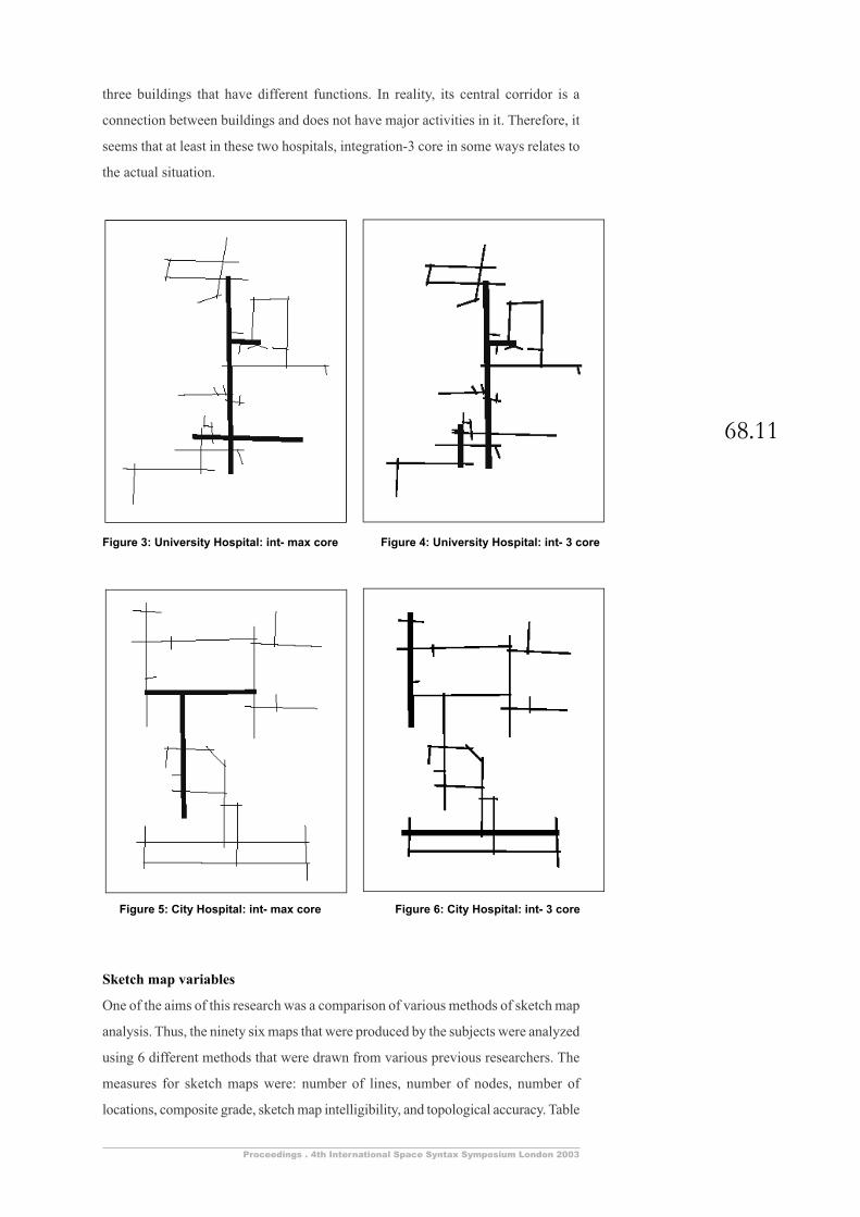
68.11
Proceedings . 4th International Space Syntax Symposium London 2003
three buildings that have different functions. In reality, its central corridor is a
connection between buildings and does not have major activities in it. Therefore, it
seems that at least in these two hospitals, integration-3 core in some ways relates to
the actual situation.
Sketch map variables
One of the aims of this research was a comparison of various methods of sketch map
analysis. Thus, the ninety six maps that were produced by the subjects were analyzed
using 6 different methods that were drawn from various previous researchers. The
measures for sketch maps were: number of lines, number of nodes, number of
locations, composite grade, sketch map intelligibility, and topological accuracy. Table
Figure 4: University Hospital: int- 3 coreFigure 3: University Hospital: int- max core
Figure 5: City Hospital: int- max core Figure 6: City Hospital: int- 3 core
Ability and intelligibility
68.12
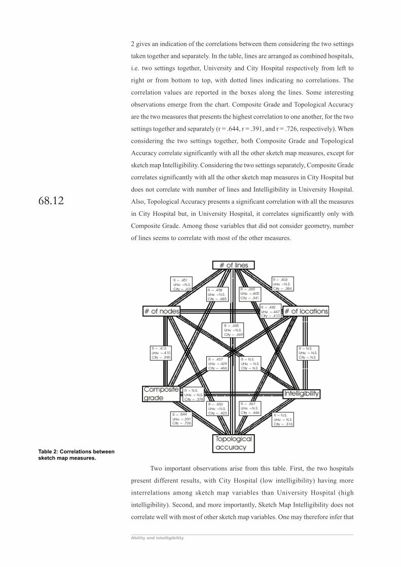
2 gives an indication of the correlations between them considering the two settings
taken together and separately. In the table, lines are arranged as combined hospitals,
i.e. two settings together, University and City Hospital respectively from left to
right or from bottom to top, with dotted lines indicating no correlations. The
correlation values are reported in the boxes along the lines. Some interesting
observations emerge from the chart. Composite Grade and Topological Accuracy
are the two measures that presents the highest correlation to one another, for the two
settings together and separately (r = .644, r = .391, and r = .726, respectively). When
considering the two settings together, both Composite Grade and Topological
Accuracy correlate significantly with all the other sketch map measures, except for
sketch map Intelligibility. Considering the two settings separately, Composite Grade
correlates significantly with all the other sketch map measures in City Hospital but
does not correlate with number of lines and Intelligibility in University Hospital.
Also, Topological Accuracy presents a significant correlation with all the measures
in City Hospital but, in University Hospital, it correlates significantly only with
Composite Grade. Among those variables that did not consider geometry, number
of lines seems to correlate with most of the other measures.
Two important observations arise from this table. First, the two hospitals
present different results, with City Hospital (low intelligibility) having more
interrelations among sketch map variables than University Hospital (high
intelligibility). Second, and more importantly, Sketch Map Intelligibility does not
correlate well with most of other sketch map variables. One may therefore infer that
Table 2: Correlations betweensketch map measures.
68.13
Proceedings . 4th International Space Syntax Symposium London 2003
the nature of the setting itself may contribute to what characteristics of a sketch map
might be a reliable indicator. This suggestion, if verified, may have far reaching
consequences on cognitive mapping research.
Moreover, when sketch map variables were correlated with cognition
variables, Average Pointing Error was inversely correlated, negatively as expected,
to both Topological Accuracy and Composite Grade (r = -.567 and r = -.640
respectively). It seems that, at least according to the r-values emerging from our
analysis, Composite Grade and Topological Accuracy are those sketch map measures
that give a better indication of cognitive qualities. The same analysis, when split by
hospitals produced a fine grained difference between the settings. The values were
much higher for City Hospital (r = .701 and .603 for Composite Grade and Topological
Accuracy respectively) than for University Hospital (r = .119 and .180). Sketch map
Intelligibility does not have any correlation in the combined data but correlates at
.303 for City Hospital. It seems that prediction of cognitive capabilities from sketch
map variables is high in settings of lower intelligibility.
A similar pattern, but with weaker r-values, emerges from the results of
correlations between Average Pointing Error and number of lines, number of nodes,
and number of locations in sketch maps respectively (r = -.435, r = -.327, and r = -
.361). When split by hospital, no significant correlation emerges for University.
Therefore, the setting which has a higher intelligibility actually displays a lower
relationship between cognition and sketch variables.
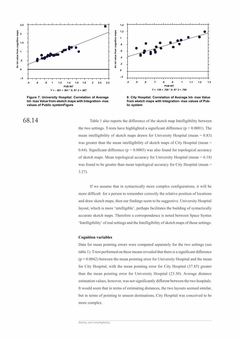
Interestingly, we see a reverse effect when Space Syntax variables are
considered. Syntax analysis of the 96 sketch maps provided an opportunity to get an
integration-max value of each line from each sketch map. An average of these values
provided an indication of the integration characteristic of each line that was to be
found in cognitive representations. The average integration-max value from sketch
maps or the ‘cognitive integration-max’ was then correlated to the real integration-
max value that was derived from the real setting. This provided an encouraging
result. As shown in Figure 7 and Figure 8 the correlation for University and City
Hospital is .931 and .876 respectively. The scatter also shows that the points are
tightly clustered along the regression line. Data similarly derived from an urban
setting earlier (Kim, 2001) yielded a lower correlation (r = .486). This result will be
discussed later, but at the moment it suffices to say that Space Syntax variables in
sketch maps are found to be highly correlated to similar variables in real settings,
especially in the context of complex hospital settings. Also, the correlation values
depend on the intelligibility of the settings themselves.
Ability and intelligibility
68.14 Table 1 also reports the difference of the sketch map Intelligibility between
the two settings. T-tests have highlighted a significant difference (p < 0.0001). The
mean intelligibility of sketch maps drawn for University Hospital (mean = 0.83)
was greater than the mean intelligibility of sketch maps of City Hospital (mean =
0.64). Significant difference (p = 0.0003) was also found for topological accuracy
of sketch maps. Mean topological accuracy for University Hospital (mean = 6.18)
was found to be greater than mean topological accuracy for City Hospital (mean =
3.27).
If we assume that in syntactically more complex configurations, it will be
more difficult for a person to remember correctly the relative position of locations
and draw sketch maps, then our findings seem to be suggestive. University Hospital
layout, which is more ‘intelligible’, perhaps facilitates the building of syntactically
accurate sketch maps. Therefore a correspondence is noted between Space Syntax
‘Intelligibility’ of real settings and the Intelligibility of sketch maps of those settings.
Cognition variables
Data for mean pointing errors were computed separately for the two settings (see
table 1). T-test performed on these means revealed that there is a significant difference
(p = 0.0042) between the mean pointing error for University Hospital and the mean
for City Hospital, with the mean pointing error for City Hospital (37.85) greater
than the mean pointing error for University Hospital (23.30). Average distance
estimation values, however, was not significantly different between the two hospitals.
It would seem that in terms of estimating distances, the two layouts seemed similar,
but in terms of pointing to unseen destinations, City Hospital was conceived to be
more complex.
8: City Hospital: Correlation of Average Int- max Valuefrom sketch maps with Integration- max values of Pub-lic system
2.5
2
1.5
1
.5
0
-.5
.4 .6 .8 1 1.2 1.4 1.6 1.8 2 2.4 2.2
PUB INT
Y = -. 081 + .901 * X; R^ 2 = .867
.4 .5 .6 .7 .8 .9 1 1.1 1.2 1.3
PUB INT
Y = .138 + .769 * X; R^ 2 = .768
1.4
1.2
1
.8
.6
.4
.2
0
-.2
Figure 7: University Hospital: Correlation of AverageInt- max Value from sketch maps with Integration- maxvalues of Public systemFigure
Av
int
valu
e fr
om
co
gn
itiv
e m
aps
Av
int
valu
e fr
om
co
gn
itiv
e m
aps
68.15
Proceedings . 4th International Space Syntax Symposium London 2003
This dichotomous result was clarified by literature survey. Although distance
estimation is a widely used procedure to study orientation, (Golledge, 1977) yet in
many cases it is found to be untrustworthy. For example Hirtle and Hudson (1991)
found no difference in distance estimation, but a substantial difference in orientation,
when they were comparing between a group that studied maps and a group that
looked at slides of the same environment. Garling, Book, Ergezen, & Lindberg (1981)
also found a similar distinction in their work where distance estimates were less
accurate than direction estimates.
In this case then, considering the results of the pointing tasks, City Hospital
can be taken to be understood as more complicated than University Hospital. The
public intelligibility of these two, as independently determined were .557 and .831
(see table 1). Therefore there is some cause to believe that intelligibility may reflect
the ease or difficulty of learning about a layout, especially as determined by pointing
tasks of subjects within that environment.
Wayfinding variables
Finally, data concerning the five measures derived from participants’ directed search
task (coefficient of success, total line use, total node use, redundant node use, and
repeat node visits) were tested to see the differences between the two settings (see
table 1). T-tests revealed significant difference in two of the five tasks: redundant
node use and repeat node visits. There was a significant difference (p < 0.0001)
between the means of redundant node use, with the mean for University Hospital
(61.56) being greater than the mean for City Hospital (38.84). For repeat node visits
a difference (p < 0.0001) was found, with the mean for University Hospital (44.25)
being greater than the mean for City Hospital (27.28). Both redundant node use and
repeat visits are indicators of less efficient wayfinding, that is, those subjects using
more redundant nodes and making repeated visits wander more while finding their
way to the required destination. Surprisingly, it seems that settings of higher
intelligibility produce more wayfinding errors.
Conclusions
The results that were reported in this paper give rise to a number of serious factors
that have consequences to both environmental cognition research and Space Syntax.
The most important one is perhaps the relationship of the overall characteristics of a
setting with cognition and wayfinding. It is well known that, despite isolated attempts
at coming up with ways and means of describing the characteristics of the overall
quality of the setting, much remains to be done. Space Syntax, being based on rigorous
methodology and having a sustained research tradition, still remains the most
significant method available that provides a quantitative description of overall

Ability and intelligibility
68.16
characteristics of settings. Therefore it is imperative that research meticulously studies
the relationship between Space Syntax variables and cognitive characteristics. This
study was more concerned with ‘Intelligibility’ and its cognitive and wayfinding
correlates.
Space Syntax analysis is devoid of metric or geometric properties. Its values
are derived from the connectivity of each space and the connectivity of each
successive space. Therefore, it is possible for two (or more) layouts to have different
geometries and shapes, and yet share similar syntactic characteristics (intelligibility).
To the immersed and moving observer, this is an understanding of (1) the number of
connections in each space (2) the spaces to which each space is connected to, and
(3) the spaces to which those in turn are connected to. In short, this is knowledge of
‘ordering of spaces’ and indicates if it is possible to travel from one location to
another and what spaces one would pass through en-route to a distance destination.
This kind of knowledge is perhaps devoid of both a ‘sense of distance’ and ‘a sense
of direction’. Kaplan and Kaplan (1982) noted that topological information is a
natural byproduct of the natural learning process as one moves within the
environment, and later Kuipers, (1983) suggested that it is the minimum type of
mental representation possible under time constraints.
An implicit assumption in this research was that Intelligibility may be a good
predictor of success in various wayfinding tasks, sketch maps, and cognitive tests.
In support of this assumption it was found that average integration-max of the lines
taken from the ninety-six sketch maps correlated very well to the integration value
obtained from the real settings. On top of that, the building that had a higher
Intelligibility produced higher correlations (compare figures 7 and 8). An additional
Figure 10: City Hospital: Correlation of line valueswith their appearance in cognitive maps.
.4 .5 .6 .7 .8 .9 1 1.1 1.2 1.3
PUB INT
Y = 8.103 + 28.24 * X; R^ 2 = .161
50
45
40
35
30
25
20
15
10
5
0
AP
PE
AR
S IN
CO
G M
AP
S
Figure 9: University Hospital: Correlation of linevalues with their appearance in cognitive maps.
2.5
2
1.5
1
.5
0
-.5
.4 .6 .8 1 1.2 1.4 1.6 1.8 2 2.4 2.2
PUB INT
Y = .962 + 11. 645 * X; R^ 2 = .18
AP
PE
AR
S IN
CO
G M
AP
S

68.17
Proceedings . 4th International Space Syntax Symposium London 2003
investigation was conducted to examine this a bit further. Using the dataset by lines,
a correlation analysis was carried out to examine the relationship between lines that
appeared in cognitive maps and their integration values. Figures 9 and 10 show that
Integration-max significantly correlate with appearance of lines in sketch maps (r =
.424 and .401), and that the values are slightly higher in University Hospital which
also has a higher intelligibility value. Another previous finding is pertinent here.
Kim (2001) had showed that correlations are higher when integration-3 was
considered. Time constraints prevented analysis of integration-3 for this study, but
other results reported elsewhere indicate that integration-3 has indeed more cognitive
presence (Haq, 2003). Also, Intelligibility of sketch maps and their local topological
accuracy was also higher for the setting with higher intelligibility.
Even for cognitive tests we have similar results: the pointing errors were
significantly more in settings that have a lower intelligibility value (see table 1).
Moreover, when Intelligibility of the real setting was higher, the mean value for
sketch map Intelligibility was also higher. From all these findings, one may definitely
support the value of intelligibility as a characteristic of the overall layout that should
be given serious consideration in studies of cognition, and wayfinding, and sketch
mapping.
However, there were also inconsistencies in some of the results, especially
those relating to wayfinding. It was found that redundant node use and repeat node
visits were significantly different and higher in University Hospital, which has a
higher intelligibility value. This is a surprising result because it seems that in more
intelligible settings wayfinding becomes more difficult. Compounded to this mystery
is the fact that, as was expected, the participants sketch maps were topologically
correct and more intelligible in the setting with a higher Intelligibility value. Perhaps,
people who were lost spent more time wandering the halls and so had built up a
better map of the environment. Additionally, a critical study of the actual layouts
was undertaken to help shed some light in this matter. University Hospital is arranged
along an extremely long corridor beside which most of the destinations are located.
On top of that, this corridor has a large number of nodes: actually double the number
of nodes in the longest line in City Hospital. Therefore movement in University
Hospital is predominantly along this long line. Any small wayfinding error would
force a person to come back to this path which, in turn, would result in the use of
more nodes. Greater studies of actual movement paths of individuals could have
provided more clues. However, time constraints prevented it. The lesson to be learned
here is that research into wayfinding need to integrate actual conditions of layout
with Space Syntax analysis. Human wayfinders obviously rely on many aspects of
Ability and intelligibility
68.18
the environment and every one of them has the potential of being important. (For
example, this study did not take into consideration other significant variables such
as ambient light, landmarks, surface finishes, signs and such other physical qualities.)
Contrasting results emerge also from the comparison of the different methods
of sketch map analysis. A cursory glance at table 2 shows the following: sketch map
intelligibility does not correspond well with most of the other measures of sketch
map analysis. Curiously, there seems to be more correspondence between the various
measures for City Hospital than for University Hospital (note more solid lines in the
third position than the central position). Thus, in settings of lower intelligibility
various measures of sketch maps have a better convergent validity. It would perhaps
be presumptuous to comment on the difference of intelligibility based on only two
settings, especially because it has been pointed out that University Hospital has a
unique characteristic of having an extremely long corridor whose integration value
is very high.
Final Comments
It was previously noted that, as cognition of environments develop, it seems to
incorporate an understanding of relationships that gradually considers larger and
larger systems as well as connectivities of greater and greater depth in its scope. In
this manner, local information is assimilated into a global understanding (Haq 1999a;
Haq 1999b). The study reported here seems to indicate a distinct role of geometric
characteristics in the process. In the two hospitals studied, although a variation of
intelligibility, a measure of the overall setting that is topologically derived could
account for cognitive tasks, yet it could not do so for the variations in the wayfinding
exercises. If we assume a relationship between movement and cognition, as many
theorists emphasize, then our conclusions become an important issue.
It seems that research such as the one reported here should move along two
directions. First, more settings should be incorporated, so that more information is
attained regarding overall geometry and configuration, as well as cognition and
wayfinding in those environments. Using immersive virtual environments would
seem to be a direction to pursue. Second, the development of cognitive maps needs
to be studied in detail. This, along with a comparison of the routes taken during
initial and later wayfinding tasks might shed some light of the relationship between
topological and geometrical configuration. The first task is being undertaken by the
researchers, and a careful analysis of existing data may be sufficient for beginning
the second one. Hopefully they will lead to a better understanding of the various
aspects of environmental cognition.

68.19
Proceedings . 4th International Space Syntax Symposium London 2003
Aknowledgements
The authors are grateful to Madaswamy M. Kumar of the College of Architecture, Texas Tech University
for the careful reevaluation and compilation of some of the data.
References
Appleyard, B., 1970, Styles and methods of structuring a city. Environment and Behavior, 2, 100-117
Best, G., 1970, “Direction Finding in Large Buildings”, in D. V. Canter (ed.), Architectural
Psychology, pp. 72-75, London, RIBA
Braaksma, J. P. and Cook, W. J., 1980, Human Orientation in Transportation Terminals.Transportation
Engineering Journal, 106, March, No. TE2, 189-203
Choi, Y. K., 1999, “The morphology of exploration and encounter in museum layouts”, Environment and
Planning B, 26, 241-250
Evans, G., Fellows, J., Zorn, M. and Dotty, K., 1980, “Cognitive Mapping and Architecture”, Journal of
Applied Psychology, 65(4), 474-478
Garling, T., Book, A., Ergezen, N. and Lindberg, E., 1981, “Memory for Spatial Layout of the Everyday
Physical Environment: Empirical Findings and their Theoretical Implications”, Environmental
Design Research Association, 12, 69-77
Golledge, R. G., 1977, “Multidimensional analysis in the study of environmental behavior and
environmental design”, in I. Altman and J. F. Wohcwill (eds.), Human Behavior and Environment
Advances in Theory and Research, Volume 2, pp. 1-42, New York and London, Plenum Press
Golledge, R. G. and Stimson, R. J., 1997, Spatial Cognition, Cognitive Mapping, and Cognitive Maps,
Spatial Behavior A Geographic Perspective, pp. 224-266, New York, The Guilford Press
Haq, S., 1999a, “Can Space Syntax Predict Environmental Cognition”, in F. Holanda (ed.), Proceedings
of the 2nd International Symposium on Space Syntax, Volume 2, pp. 40.41-40.14, Brasilia, Brazil,
Fundacao de Apoio a Pesquisa do Distrito Federal - FAP/DF
Haq, S., 1999b, “Expectation of Exploration: Evaluating the Effects of Environmental Variables on
Wayfinding”, in T. Mann (ed.), The Power of Imagination, Volume 1, pp. 84-94, Orlando,
Florida, EDRA
Haq, S., 2001, Complex Architectural Settings: An Investigation of Spatial and Cognitive Variables through
Wayfinding Behavior, Unpublished PhD Dissertation, Georgia Institute of Technology, Atlanta
Haq, S., 2003, “Romancing the Syntax Line: Configurational Properties and Cognitive Correlates”,
Environment and Planning B, forthcoming
Haq, S. and Zimring, C., 2001, “Just down the road a piece: The development of topological knowledge
in building layouts”, in J. Peponis, J. Wineman and S. Bafna (eds.), Proceedings of the 3rd
International Symposium on Space Syntax, pp. 48.41-48.17, Ann Arbor, A. Alfred Taubman
College of Architecture and Urban Planning, Later republished in 2003, Environment and
Behavior, 35(1), 132-160
Hart, R. A. and Moore, G., 1973, “The Development of Spatial Cognition: A Review”, in R. M. Downs
and D. Stea (eds.), Image and Environment, pp. 246-288, Chicago, Aldine Publishing Company
Hirtle, S. C. and Hudson, J., 1991, “Acquisition of spatial knowledge for routes”, Journal of Environmental
Psychology, 11(4), Dec., pp. 335-345
Kaplan, l. and Kaplan, S., 1982, Cognition and Environment: Functioning in an Uncertai World, New
York, Praeger
Kim, Y. O., 2001, “The role of Spatial Configuration in Spatial Cognition”, in J. Peponis, J. Wineman
and S. Bafna (eds.), Proceedings of the 3rd International Symposium on Space Syntax, pp. 49.41-
49.21, Atlanta, A Alfred Taubman College of Architecture and Urban Planning
Kuipers, B., 1983, “The Cognitive Map: Could it Have been any other way?”, in H. L. Pick and L. P.
Acredolo (eds.), Spatial Orientation: Theory, Research and Application, pp. 345-359, New York
and London, Plenum Press
Lynch, K., 1960, The Image of the City, Cambridge, Joint Center for Urban Studies
O’Neill, M. J., 1991, “Evaluation of a conceptual model of architectural legibility”, Environment &
Behavior, Volume 23(3), pp. 259-284, May 1991

Ability and intelligibility
68.20
Peponis, J., Zimring, C. and Choi, Y. K., 1990, “Finding the building in wayfinding”,Environment and
Behavior, 22, no.5, pp. 555-590
Rovine, M. J. and Weisman, G. D., 1989, “Sketch-map variables as predictors of way-finding performance”,
Journal of Environmental Psychology, Volume 9(3), Sep., pp. 217-232
Sadalla, E. K. and Montello, D. R., 1989, “Remembering changes in direction”, Environment & Behavior,
21(3), May, pp. 346-363
Shemyakin, F. N., 1962, “Orientation in Space”, in Ananyev, B. G. et al., (eds.), Psychological Science in
the USSR., Volume 1, Washington, Office of Technical Services, Report # 62-11083, 186-225.
Cited in Hart, R. A. and Moore, G., 1973, “The Development of Spatial Cognition: A Review”,
in R. M. Downs and D. Stea (eds.), Image and Environment, pp. 246-288, Chicag, Aldine
Publishing Company
Tversky, B., 1981, “Distortions in memory for maps”, Cognitive Psychology, 13, pp. 407-433
Tversky, B., 2003, “Structures of Mental Spaces: How People think About Space”, Environment and
Behavior, 35(1), pp. 66-80
Weisman, G. D., 1981, “Evaluating architectural legibility: Wayfinding in the built Environment”,
Environment and Behavior, 13, pp. 189-204
Weisman, G., 1989, “Designing to Orient the User”, Architecture: the AIA journal, 78, no.10, pp. 113-
114