Wandsworth Draft Local Plan - PDF Version
416
-
Upload
khangminh22 -
Category
Documents
-
view
2 -
download
0
Transcript of Wandsworth Draft Local Plan - PDF Version

Wandsworth Draft local Plan
41 Introduction
102 Strategic Context, Vision and Objectives
343 Placemaking – Area Strategies
464 Area Strategy for Wandsworth Town
865 Area Strategy for Nine Elms
1116 Area Strategy for Clapham Junction and York Road/Winstanley Regeneration Area
1287 Area Strategy for Putney
1418 Area Strategy for Tooting
1529 Area Strategy for Roehampton
16310 Area Strategy for Balham
17211 Area Strategy for Wandsworth's Riverside
19312 Area Strategy for the Wandle Valley
20113 Site Allocations Outside the Spatial Areas
20814 Achieving Design Excellence
23015 Tackling Climate Change
26016 Providing for Wandsworth's People
27617 Providing Housing
30418 Building a Strong Economy
33319 Ensuring the Vitality, Vibrancy and Uniqueness of the Borough's Centres
35220 Sustainable Transport
36421 Green and Blue Infrastructure and the Natural Environment
38322 Implementation, Delivery and Monitoring
38723 Appendices
Policies
31SS1 Spatial Development Strategy43PM1 Area Strategy and Site Allocations Compliance53PM2 Wandsworth Town Place Based Policy92PM3 Nine Elms115PM4 Clapham Junction and York Road/Winstanley Regeneration Area132PM5 Putney
1

145PM6 Tooting156PM7 Roehampton Regeneration Area167PM8 Balham177PM9 Wandsworth's Riverside196PM10 The Wandle Valley209LP1 Urban Design211LP2 General Development Principles213LP3 The Historic Environment216LP4 Tall Buildings222LP5 Residential Extensions and Alterations223LP6 Basements and Subterranean Developments224LP7 Small Sites Development226LP8 Shopfronts227LP9 Advertisements230LP10 Responding to the Climate Crisis235LP11 Energy Infrastructure238LP12 Water and Flooding249LP13 Waste Management254LP14 Air Quality, Pollution and Managing Impacts of Development260LP15 Health and Wellbeing262LP16 Public Houses and Bars263LP17 Social and Community Infrastructure266LP18 Arts, Culture and Entertainment269LP19 Play Space270LP20 New Open Space271LP21 Allotments and Food Growing Spaces272LP22 Planning Obligations273LP23 Utilities and Digital Connectivity Infrastructure277LP24 Provision of New Homes280LP25 Affordable Housing287LP26 Housing Mix289LP27 Protecting the Existing Housing Stock291LP28 Conversions292LP29 Housing Standards293LP30 Purpose Built Student Accommodation295LP31 Housing with Shared Facilities297LP32 Build to Rent299LP33 Specialist Housing for Vulnerable People300LP34 Gypsy and Traveller Accommodation301LP35 Visitor Accommodation307LP36 Promoting and Protecting Offices311LP37 Managing Land for Industry and Distribution318LP38 Mixed Use Development on Economic Land321LP39 Railway Arches322LP40 Requirements for New Economic Development
2

325LP41 Affordable, Flexible and Managed Workspace329LP42 Local Employment and Training Opportunities330LP43 Protected Wharves337LP44 Wandsworth's Centres and Parades339LP45 Development in Centre343LP46 Out of Centre Development345LP47 Local Shops and Services348LP48 Evening and Night-Time Economy349LP49 Markets350LP50 Meanwhile Uses354LP51 Sustainable Transport355LP52 Transport and Development357LP53 Parking, Servicing, and Car Free Development360LP54 Public Transport and Infrastructure367LP55 Protection and Enhancement of Green and Blue Infrastructure371LP56 Open Space, Sport and Recreation373LP57 Biodiversity376LP58 Tree Management and Landscaping378LP59 Urban Greening Factor379LP60 River Corridors379LP61 Riverside Uses, Including River Dependent, River-related, and River Adjacent Uses381LP62 Moorings and Floating Structures
3
1 Introduction
Setting the Scene
1.1 The Council’s new Local Plan will set outpolicies and guidance for the development ofthe borough over the plan period of 2023 to2038. The development of this Local Plandocument forms an important stage in theprocess in developing a new Local Plan knownas the Regulation 18 stage or pre-publicationversion. Its development has been informed bya public consultation which was undertaken inDecember 2018 on a Local Plan issues scopingdocument. This draft Local Plan sets out theCouncil’s proposed vision, objectives and spatialstrategy. It includes a number of area strategies,policies and site allocations which will supportthe delivery of the Plan’s Vision and Objectivesand spatial strategy. It identifies wheredevelopment will take place and how placeswithin the borough will evolve through theapplication of placemaking principles to guidechange and support smart growth over thenext 15 years. Whilst facilitating development,the new Local Plan will also protect and enhancewhat is good and special about Wandsworthincluding its culture, sense of community,heritage, neighbourhood character, open spaces,quality parks, schools and community facilities,and thriving small businesses.
1.2 The new Local Plan will form part of thedevelopment plan for the borough. Followingthis consultation, the Council will make changesto the Plan, where appropriate, and will thenpublish the Regulation 19 version of the Planthat it intends to submit to the Secretary ofState for Examination, and seek representationson it. An Examination in Public will then beundertaken by an independent Inspectorappointed by the Secretary of State before itcan be adopted by the Council. The emergingLondon Plan, prepared by the Mayor of London,also forms part of the development plan, andthe new Local Plan has to be in generalconformity with it.
1.3 The role of the development plan is to guidedecision making on planning applications andinform investment in social and physicalinfrastructure. The Planning and Compulsory
Purchase Act 2004 requires that “... for thepurpose of making any determination under theplanning Acts, the determination must be madein accordance with the plan unless materialconsiderations indicate otherwise”.
1.4 This draft Local Plan is in accordance withnational policy by applying a presumption infavour of sustainable development and thepolicies contained within it show how this isexpressed locally. The Council will ensure thatplanning applications that accord with policiesin the adopted Local Plan and the London Planwill be approved without delay, unless materialconsiderations indicate otherwise.
1.5 The draft Local Plan has been prepared withinthe context of a hierarchical framework ofplanning legislation and policy for England. Atthe top of the hierarchy are a number ofplanning related Acts of Parliament andStatutory Instruments, the National PlanningPolicy Framework 2019 (NPPF) which sets outGovernment’s planning policies for England andhow these should be applied, and the PlanningPractice Guidance (PPG). Local authorities musttake the NPPF into account when preparingLocal Plans. This means in practical terms thatthe Council should follow national policy unlessthere is local evidence and circumstances thatwould justify a different approach.
1.6 Below national policy sits the London Plan,which is prepared by the Mayor of London. TheGreater London Authority (GLA) Act 1999requires the Local Plan to be in ‘generalconformity’ with the London Plan. This meansthat the Local Plan should be in line with theLondon Plan, unless there is local evidence andcircumstances that would justify a differentapproach. The London Plan forms part of thedevelopment plan for the borough and providesthe spatial development strategy for GreaterLondon. The emerging London Plan was subjectto Examination in Public in 2019 and issued tothe Secretary of State. In March 2020 theSecretary of State wrote to the Mayor settingout his consideration of the ‘Intend to PublishLondon Plan 2019’. At the time of writing, theMayor was working with the Secretary of Stateto agree revisions to parts of the emergingLondon Plan to overcome a number of focusedissues that the Secretary of State has directed
4
on. The Mayor will then be able to take thestatutory steps to formally publish the finalversion of the emerging London Plan.References to the emerging London Plan withinthis draft relate to the Mayor of London’s‘Intended to Publish London Plan 2019’ unlessspecifically mentioned otherwise.
1.7 This is the first statutory consultation on thenew Local Plan (known as the pre-publicationversion). A second statutory stage will then beundertaken on what is known as the Local Planpublication version. The publication version willbe prepared having considered the responsesmade to this draft of the new Local Plan andthe Council will seek representations to it.These representations will then be sent to theIndependent Inspector to inform theExamination in Public of the new Local Plan.
1.8 The new Local Plan, once adopted will fullyreplace the policies and site allocations withinthe current adopted Local Plan which consistsof:
Core Strategy (2016)Development Management PoliciesDocument (2016)Site Specific Allocations Document (2016)Local Plan Employment and IndustryDocument (2018)
1.9 Smart Growth – The Council has developeda Recovery Plan in response to the Covid-19pandemic. The Smart Growth Plan looks tosupport and build a Wandsworth wherebusinesses and town centres thrive, wheresocial mobility is high and residents aresupported to achieve their potential, where thesense of community and place that has thrivedin the past months is embedded and theborough is green and carbon neutral. In short,a borough, which is a first-class destination tolive, visit, work and study. The Smart GrowthPlan has five overarching objectives:
To be the greenest inner London borough.To deliver the best start in life.To promote aspiration for everyonethrough sustainable, ambitious growth andregeneration.
To ensure businesses thrive and towncentres are vibrant and culturally richplaces to go, shop and enjoy.Enabling people to get on in life.
1.10 The new Local Plan is a key Council documentas it sets out the Council’s vision, objectivesand policies for securing delivery of theCouncil’s ambitions forWandsworth. The draftLocal Plan embeds these objectives as a goldenthread throughout the document.
Preparing the Pre-Publication LocalPlan
1.11 Between December 2018 and February 2019,the Council undertook a consultation on thescope for the updating the adopted Local Planin the form of an ‘issues document’. This wasan additional stage of consultation by theCouncil (not prescribed by the Town andCountry Planning (Local Planning) (England)Regulations 2012) to provide the opportunityfor early engagement with the borough’scommunities, businesses, key stakeholders,neighbouring local authorities and statutorybodies. The key themes of housing,employment, transport, open space and theenvironment, community services, andinfrastructure were explored.
1.12 The Council received 48 responses (whichincorporated some 760 individual comments)to the issues document consultation. All ofthese responses have been considered as partof the preparation of the Pre-Publication versionof the Local Plan. A record of all the responsesreceived and a summary of the comments madeare available to view on the Council’s websiteat: www.wandsworth.gov.uk/local-plan-full-review
1.13 Alongside the consultation on the IssuesDocument, the Council undertook what isknown as a ’Call for Sites’. This invited anyonewith an interest in land, potential sites andbroad locations for development to submitthese to the Council for consideration forinclusion within the new Local Plan. Theinformation provided through the ‘Call for Sites’as well as an analysis of developmentopportunities by the Council using othersources of information have been assessed to
5
inform the identification of sites which theCouncil considers are suitable for allocationwithin this new Local Plan.
1.14 In January 2020 the Council undertook a LocalPlan Engagement Event at the Battersea ArtsCentre which was attended by some 50voluntary/community groups and businesses inattendance.
1.15 The workshop discussion identified a numberof key issues that were felt the new Local Planshould address, as follows:
A need to provide a clear focus for theborough’s town centres and main spatialareas to enable the enhancement of thepublic realm; to encourage a variety ofshops and services; and to promote apositive range of experiences for visitorsincluding dining and enhancement of thenight time economy.A need to recognise the valuable role thatindustrial land in the borough plays andthe need to maintain a sufficient supply ofland to provide for a range of employmentoptions. In addition, the need for theprovision of flexible affordable workspacewas identified including for a variety ofspecial types and locations with morescope for the provision of workspaces intown centres and the high street, withmixed use developments favoured.That affordable community facilities andsocial infrastructure should be welldesigned and provide for multifunctionalspaces and be provided throughout theborough as part of new development.That ambitious climate change mitigationand adaptation policies should beprioritised, and sustainable greeninfrastructure should be integrated intodevelopment. Green and open spacesshould be protected and increased in newdevelopment to support health andwellbeing objectives.The need to give careful consideration todesign, character, landscape, public realm,green space, wind levels and accessibilitywhen planning for tall buildings.
1.16 The NPPF requires Local Plans to includestrategic policies to address priorities for thedevelopment and use of land. The strategicpolicies of this Local Plan are as follows:
SS 1 Spatial Development StrategyPM 1 Area Strategy and Site AllocationsCompliancePM 2 to 10 – Place based policies for eachArea StrategyLP 3 The Historic EnvironmentLP 10 Responding to the Climate CrisisLP 12 Water and FloodingLP 13 Waste ManagementLP 15 Health and WellbeingLP 17 Social and CommunityInfrastructureLP 18 Arts, Culture and EntertainmentLP 22 Planning ObligationsLP 23 Utilities and Digital ConnectivityInfrastructureLP 24 Provision of New HomesLP 25 Affordable HousingLP 36 Promoting and Protecting OfficesLP 37 Managing Land for Industry andDistributionLP 43 Protected WharvesLP 44 Wandsworth Centres and ParadesLP 51 Sustainable TransportLP 55 Protection and Enhancement ofGreen and Blue Infrastructure
1.17 Public consultation on this Pre-Publicationversion is to be carried out from 4 January 2021to 1 March 2021 for an extended 8-weekperiod. This is in accordance with therequirements of Regulation 18 of the Town andCountry Planning (Local Planning) Regulations2012 and the Council’s adopted Statement ofCommunity Involvement.
1.18 The timetable for the development of the newLocal Plan is set out in the Council’s LocalDevelopment Scheme and is summarised in thetable below:
6
WhenWhat
3 December 2018 – 28 January 2019 (completed)Consultation on the scope of the review of the LocalPlan – Issues Document
4 January 2021 – 1 March 2021Regulation 18 consultation on the draft Local Plan(‘Pre-Publication’)
Autumn 2021Publication under Regulation 19 of the draft Local Planthat the Council intends to submit to the Secretaryof State
Early Spring 2022Submission of the ‘Publication’ version of the newLocal Plan to the Secretary of State
Summer/Autumn 2022Independent Examination in Public
Spring/Summer 2023Adoption
Table 1.1 Indicative Timeline
White Paper - Planning for the Future
1.19 On 6 August 2020 Government published aWhite Paper on ‘Planning for the Future’ forconsultation. The White Paper contains a widerange of proposals for the reform of theplanning system. The Paper includes a numberof measures which aim to streamline andmodernise the planning system, improveoutcomes on design and sustainability, reformdeveloper contributions and ensure more landis available for housing where it is needed.
1.20 The Council is fully aware of Government’sproposals to reform the planning system, which,if introduced, could lead to fundamental changesas to how Local Plans are prepared.Nevertheless, the Council is mindful of theadvice recently provided to local planningauthorities by the government’s Chief Plannerthat they should not let the uncertainties thatare understandably created stop them fromprogressing on the development of Local Plans.This is particularly important in making surethat strong plans are in place which facilitaterecovery from the impacts of the COVID-19pandemic.
Current Planning System Changes
1.21 On 6 August 2020, Government published aconsultation setting out proposals to improvethe effectiveness of the current planning system.These included changes to the standard methodof assessing housing need, a new requirementfor first homes to be delivered as a percentageof affordable housing, as well as temporarychanges to the threshold at which developersdo not need to contribute to affordable housingand proposals to increase the threshold forPermission in Principle by application to covermajor sites. As these are only proposals at thisstage which may be subject to change they havenot been taken into account in the preparationof the draft Local Plan.
1.22 Government also introduced through legislationa number of changes to the Planning Systemwhich came into effect on 1 September 2020.These included changes to PermittedDevelopment Rights and the Use Classes Order(UCO) to assist with handling the impact of theCovid-19 pandemic. This draft Local Plan hastaken these changes into account in itsdevelopment.
1.23 A significant amount of the evidence basedeveloped to support the policies in this draftLocal Plan was prepared prior to the COVID-19pandemic and the introduction of the changes
7
to the UCO. The long term implications andconsequences of these are not yet clear.Therefore, we would like to particularly hearfrom our local communities, stakeholders,partners and organisations if and how anypolicies or area strategies should be amendedto reflect these changes in circumstance.
Consultation on this Plan and associatedDocuments
1.24 The following documents are available on theCouncil's website atwww.wandsworth.gov.uk/local-plan-full-review.
1. Pre-Publication Local Plan (thisdocument): this sets out the draft AreaStrategies, Site Allocations and PlanningPolicies. It sets out why we are updatingeach policy and what the evidence says.The Plan is structured into three mainparts; Vision, Objectives and the SpatialStrategy; Placemaking; and Policies. ThePlacemaking section contains nine AreaStrategies; seven relate to the borough’stown centres and regeneration areas andtwo cover theWandsworth Riverside andthe Wandle Valley areas. This section alsocontains the Site Allocations central tothe delivery of the Plan and are set outunder each corresponding Area Strategyor at the end of the section where sitesare located outside these areas. ThePolicies have been grouped into relatedpolicy areas such as Housing, Economyand Climate Change. Both the Placemakingand Policies sections have been drafted inaccordance with the Vision, Objectivesand Spatial Strategy which is contained inthe introduction to the Plan.
2. Sustainability Appraisal of thePre-Publication Local Plan: this setsout how the economic, environmental andsocial effects that may arise from thispre-publication Local Plan, including forthe Area Strategies, Policies and SiteAllocations have been assessed and takenaccount of.
1.25 The draft Local Plan sets out a 15-year strategicvision, objectives and the spatial strategy forthe borough as well as the area strategies and
planning policies that will guide futuredevelopment in the borough. It looks ahead to2038 and identifies where development will takeplace, and how places within the borough willevolve, or be protected from change, over thatperiod. In addition, the draft Local Plan identifiesthe site allocations that are considered willsupport the delivery of the vision and strategyof the Plan.
1.26 We would like your views on the Council’sproposed approach including whether theproposed site allocations, together with theproposed development considerations anddesign requirements, are deliverable anddevelopable and if there are any otherconsiderations that should be taken intoaccount. This is of particular importance forensuring that there is sufficient land foremployment, retail, housing and socialinfrastructure. We would like to hear the viewsof our local communities, businesses and keyorganisations on the draft Plan.
1.27 The following supporting documents andbackground papers, which are available on theCouncil's website at:www.wandsworth.gov.uk/local-plan-full-review arealso made available alongside the mainconsultation documents:
Equalities ImpactNeedsAssessment:this assesses the draft Local Plan againstprotected equalities characteristics. Theassessment has been undertaken to ensurethat any potential equalities consequencesarising out of the draft Local Plan havebeen considered and, where possible,removed or minimised so thatopportunities for promoting equality anddiversity are maximised.Health Impact Assessment: this setsout the findings of the assessment of thehealth and wellbeing impacts of the draftpolicies and site allocations.Issues Document statement ofconsultation: this provides a record ofall of the responses received together witha summary and analysis of thoseresponses.Updated local evidence: This includesnew updated evidence on the EmploymentLand and Premises Study (2020), Retail
8

Needs Assessment (2020), Local HousingNeeds Assessment (2020) and UrbanDesign Study (2020). Other relevant LocalPlan evidence is published on the Council'swebsite atwww.wandsworth.gov.uk/local-plan-full-review.
9
2 Strategic Context, Vision andObjectives
Spatial Portrait and Key Strategic Issues
2.1 This chapter provides the context within whichthe draft Local Plan has been developed inresponse to the main issues and needs of theborough. The Vision and Objectives and SpatialStrategy show how the Plan aims to respondto these issues.
Population increase and the demand forhousing
2.2 Wandsworth’s population has continued togrow significantly. The estimated residentpopulation of the borough is 329,700 based onONS Mid-2019 Estimates and represents anincrease of 27% since 2001. This is projectedto rise to around 353,100 by 2030. The maindrivers for this population growth are anincreased birth rate, longer life expectancy andchanging migration patterns; however, it isworth emphasising that the ONS estimate wasprepared prior to the COVID-19 pandemic,and therefore does not necessarily reflectpotential changes in relation to internal andexternal migration patterns. It is anticipated thatmuch of this population growth will occurwithin the investment and growth areas of theborough. This will result in a need for morehomes, jobs, services and community facilities,such as schools and healthcare.
2.3 The population of Wandsworth is relativelymobile with a growing number of residents intheir twenties and thirties. A significantproportion of the population are from ethnicminority backgrounds and there are a range offaiths. 30% of the population is Black Asian orMinority Ethnic, an increase of 8 percent since2001. 70% of the population is of whiteethnicity, a reduction of 8% since 2001.
PopulationYear
320,9002015
332,5002020
343,7002025
353,1002030
365,2002035
377,3002040
Table 2.1Wandsworth Population Projections (GLA 2018-BasedHousing-Led)
2.4 As a result of improvements to life expectancythe number of elderly residents is increasing.The estimated percentage of older persons(65+) resident in the borough was 9.5% (basedon 2018 ONS population estimates). This isprojected to increase to 12.5% by 2036 (GLA2018-Based Housing-Led). Given the higherincidence of disability and health problemsamongst older people, there is likely to be anincreased requirement for specialist housingoptions, and health and social care servicesmoving forward. The number of older personshouseholds that will arise over the plan period;what proportion of this group’s housing needscould be addressed through mainstream housing(allowing for both lifetime homes and the scopefor adaptations); and what the residual need islikely to be for specialist housing for olderpeople are all important considerations for theLocal Plan. The percentage of under 16 peoplein the population is projected to decrease from17.8% in 2018 to 15.9% in 2036 (GLA2018-Based Housing-Led). This is lowerproportion than London as a whole which, bycomparison, is projected to decrease from19.9% to 18.1% over the same time-period.
2.5 The borough’s shifting demographics underliechanges in the housing market and a growth inhousing demand. Almost a third (31.2%) ofresidents rent privately, which is higher thanthe proportion in inner London (29%). Themedian monthly rent of around £1,650 is similarto the median monthly rent in Inner London(£1,700), but higher than the median monthlyrent in London (£1,495), and more than double
10

that of England (£695). The median monthlyrent is estimated to be approximately 40% ofthe median household income, which makes alot of private sector housing unaffordable topeople on lower incomes. There is a strongrecord of affordable housing provision in theborough with 885 new affordable homesdelivered between 2016/17 and 2018/19.
2.6 Wandsworth has a number of social housingestates, particular in the more denselypopulated areas of Battersea and in some of themore deprived areas of Roehampton andQueenstown. InWandsworth there are around40 housing associations and between them theyown over 9,000 affordable homes in theborough. Although social housing accounts for20.3% of all properties in Wandsworth, thereremains a need for low-cost rented productsas there are some 8,800 households on theWandsworth’s Housing Register. In terms ofhousing type, a large majority of the boroughis comprised of terraced houses, flats,maisonettes or apartments. Housing estatescover only 10% of the area of the borough.
2.7 The median house price at the end of 2019 was£622,563 (2019 ONS House Price Statistics forSmall Areas) which represents an increase of77% since the end of 2009. House priceincreases have continued to make access tohousing for first time buyers in particularincreasingly difficult, creating a demand forsmaller sized dwellings. Much of the demandfor new homes has been met on vacantbrownfield sites, including underutilised formeremployment land, where it has acted as thecatalyst for the regeneration of these sites,however there remains pressure on otherfunctional employment land.
2.8 The emerging London Plan sets a target forWandsworth of 19,500 additional homes to beprovided over a ten year period (2019/20 to2028/29). This represents an annualised averagetarget of 1,950 new homes per year andrepresents a 7.5% increase over the 2015London Plan target of 1,812 and a 70% increaseover the 2011 London Plan target of 1,145. Theemerging London Plan also introduces a newrequirement setting out that 4,140 of theseunits (414 per year) should be delivered fromsmall sites to maximise regeneration of empty
or poorly developed plots and to protect othervalued areas, such as open spaces andMetropolitan Open Land.
2.9 Wandsworth is now within the 50% leastdeprived local authorities in England, whereasin 2015, it was amongst the 50% most deprived.The most deprived areas in the borough arelocated in Roehampton, Putney Health,Battersea (Winstanley, Doddington, Rollo,Savona and Patmore Estates) and parts ofTooting. However, there are no local areas inWandsworth that are in the top 10% mostdeprived in England. A minority of local areasare in the top 10-20% or 20-50% of areas.Wandsworth ranks amongst the least deprivedauthorities in England for four of the sevenindices of deprivation (Income; Employment;Education, Skills and Training and HealthDeprivation and Disability). It performsparticularly well in relation to Education, Skillsand Training when compared to 2015, and itsrank and score for Income have improved. Inline with many other London boroughs,Wandsworth ranks amongst the more deprivedauthorities in England in relation to the Barriersto Housing and Services and Crime indices.
Economy
2.10 The borough generally benefits from relativelyhigh levels of employment, and areas with highemployment rates are relatively well spreadacross the borough. Areas with a particularlyhigh employment rate include WandsworthTown, Balham and areas around ClaphamJunction. Despite this, higher average incomesare not spread consistently across the borough,and in the more deprived areas, employmentrates are comparatively lower than they are inthe less deprived areas of the borough.Wandsworth has a highly skilled residentialpopulation which is well educated with higherincome earnings when compared to London asa whole. Over 70% of residents hold a degree(compared to 53% in London) and medianweekly earnings for residents in Wandsworthare £690 (compared to £575 in London). Thenumber of jobs in the borough is set to rise by12% by 2041, to 401,600 (GLA Economics 2017Employment Projections) with many of theselocated in the new emerging town centre atBattersea Power Station, Nine Ems.
11
2.11 There is a socio-economic disparity betweenthe borough’s residents and its workforce. Morethan two thirds (68.9% 2011 ONS) of allresidents work in managerial or professionaloccupations, while employment data shows thatthe office sector is proportionally quite smallin the borough. Recent travel-to-work datashows that some 25.7% of working residentstravel to Westminster and the City of Londonto work. There is a strong outflow ofcommuters: of the 179,400 residents inemployment, 107,200 leave the borough towork elsewhere. This represents a netout-commuting flow of 36% (defined as the totalnumber of daily workers in the boroughregardless of where they live as a proportionof the total number of employed residents).
2.12 The proportion of employment in the office andindustrial sectors is significantly lower inWandsworth (41.5%) that in London (54%).This is primarily due to the borough havingcomparatively small proportion of businessesin the office-based sector. The proportion ofemployees in industrial sectors is also slightlylower than the London average. The wholesaleretail sector is the only sector which has agreater proportion of total employment inWandsworth than in London as a whole.
2.13 The borough’s main employment areas arefunctioning well, with high occupancy ratessupporting a diverse range of business types.However, there is an identified need for officespace and industrial land (Employment LandPremises Study 2020). In recent years, newflexible workspace has been developed in theborough, providing space for small businessesand start-ups, alongside a good supply of newhigh-grade offices suitable for larger companies.There is an identified demand for furthersmaller flexible workspaces, including affordableworkspace, to meet the needs of SMEs and inparticular the borough’s creators, makers andinnovators.
Retail/town centres
2.14 Wandsworth does not currently have one singledominant retail centre; rather it has five existingtown centres and one emerging town centre(the Battersea Power Station emerging CAZretail cluster). These serve six distinct parts of
the borough and are supported by nine localcentres. The five-existing town centres all playan important role as the focus for theirrespective areas by providing a wide range ofservices including retailing, leisure andentertainment, community facilities and businessfloorspace.
2.15 When comparing the retail needs of theborough with current capacity, retail floorspaceprojections indicate that there is likely to be anoversupply of convenience, comparison andfood and beverage uses up to 2030. The levelof current vacancies are predicted to not befilled until later in the Plan period when somegrowth in the market (primarily inWandsworthTown) may return. The existing designatedcentres (including local centres) have an averagevacancy rate of around 10.9%, which is justbelow the national average of 12.4%. However,these vacancy rates are expected to increaseas a result of the impact of the Covid-19pandemic recognising that some shops and cafesmay have closed permanently as a result. Thevacancy rate is only slightly lower (9.7%) withinthe five town centres. The healthiest centresgenerally have a vacancy rate of around 5%,reflecting the fact that there will always be anumber of vacancies as a result of the normalchurn of occupiers.
Climate change and sustainable development
2.16 Climate change impacts are increasingly affectingthe day-to-day lives of people who live in, workin and visit Wandsworth. From the ‘urban heatisland effect’ to extreme winter temperatures,this threatens the health and wellbeing of bothpeople and the physical fabric of the borough.In July 2019, the Council declared a ClimateEmergency and has pledged to work towardsmaking the Council carbon neutral as anorganisation by 2030 and carbon zero by 2050.To achieve this, it has set out a series of actionsas part of its Environment and SustainabilityStrategy.
2.17 Wandsworth is one of the most desirable anddynamic places to live and work in London andis experiencing growth. This places hugedemands on its infrastructure, includingtransport. In 2017 there were 124m passengersusing Wandsworth's railway stations alone.
12
Sustainable transport initiatives will be key toreducing carbon emissions from transport use,improving air quality and supporting a transportnetwork with a low carbon future.
2.18 Air quality is a significant issue for the borough,primarily due to the daily volume of traffic usingthe strategic road networks and from areas ofhigh industrial activity. A boroughwide AirQuality Management Area has been in placesince 2001 due to air quality levels exceedingnational standards. In response the Council hasproduced an Air Quality Action Plan to achieveimprovements by reducing polluting emissionsthrough measures such as reducing the need totravel by car, setting out criteria for sustainabledesign, and promoting sustainable demolitionand construction working practices ondevelopment sites. Heathrow airport is lessthan ten miles away from Wandsworth and itsproposed expansion is highly likely to affect theborough in a number of ways, includingimpacting on air quality due to additionalpassenger and freight journeys.
2.19 Most carbon emissions come from buildings ofan inefficient design and with poor energyperformance. To address this, improvementsmust be made to existing, as well as newbuildings, to effectively reduce carbon emissions.
Places and Townscape
2.20 Wandsworth is one of the largest inner-Londonboroughs, stretching from central London atVauxhall to the edge of Richmond Park, withone of the longest riparian frontages to theRiver Thames. The borough includes a diverserange of communities and many distinctneighbourhoods. A third of the borough's landarea is occupied by residential properties, manywithin one of the 46 conservation areas. Aquarter of the borough's land area is openspace, much of which is in the form of largeareas of heath and common. The five towncentres (Balham, Clapham Junction, Putney,Tooting and Wandsworth), the Nine ElmsOpportunity Area and nine local centresprovide points of focus and identity to thecommunities that make up the borough. Thequality of much of the townscape together withthe close proximity to central London, theabundance of green space, range of popular
schools and good distribution of high streetshas shaped Wandsworth into one of the mostsought after places to live in London, placinghuge pressure on housing availability.
2.21 Over the last decade there has been afundamental shift in policy regarding the density,design and characterisation of newdevelopment. Nationally there has been agrowing focus on the central role of designwhich is reflected in the latest version of theNPPF and through the publication of theNational Design Guide. The emerging LondonPlan also promotes a design-led approach, withgreater consideration of character, design,accessibility as well as existing and proposedinfrastructure.
Transport
2.22 There are approximately 440km of roads in theborough, the majority of which are managed bythe Council as the local highway authority. Theremainder are managed by Transport forLondon (TfL) as part of the Transport forLondon Road Network (TLRN) and on behalfof the Secretary of State for Transport inrelation to Strategic Roads. As an inner Londonborough many of the people using its roadstravel through it to get to either central orouter London.
2.23 The road network is constrained by the RiverThames and RiverWandle, the rail network andareas of protected open space. There are fiveThames road bridges, two of which - PutneyBridge and Wandsworth Bridge - are theresponsibility of the Council. Chelsea Bridgeand Albert Bridge are managed by the RoyalBorough of Kensington and Chelsea. BatterseaBridge is part of the TLRN and is theresponsibility of TfL. The River Wandle, whichruns north to south, has only four roadcrossings in the borough, restricting movementeast to west. Road freight is encouraged to usethe Strategic Road Network during the daytime,and the night-time and weekend London LorryControl Scheme operates on most roads in theborough, helping to limit noise pollution inresidential areas.
13

2.24 Wandsworth’s public transport network ismanaged by a number of agencies including TfL,train operating companies and Network Rail.While the borough is generally well served bybus services, limited areas are relatively remotefrom the bus network and some journeys aredifficult to make directly by bus (includingbetween Balham and Wandsworth Town). Thelack of nearby rail or London Undergroundservices makes Roehampton in particulardependent on buses for public transport.
2.25 The borough is served by national rail links toVictoria and Waterloo via Clapham Junction,the busiest railway station in the country.London Underground services are provided bythe Northern and District lines, and theOverground runs via Clapham Junction,clockwise through Willesden Junction toStratford and anti-clockwise through Peckhamand east London.
2.26 Wandsworth has already seen the biggest dropin vehicles of any of the 32 London boroughs,with 33% fewer vehicles licensed inWandsworth in 2017 than there were in 2001.Only 8 boroughs showed a decrease while inthe other 24 boroughs the number of vehicleswent up over the same period. While this maybe considered encouraging in terms ofWandsworth’s ability to reach the 2041 targetsset in the Mayor of London’s TransportStrategy, there is likely to be less scope in thefuture for further reductions in Wandsworththan in other parts of London – including innerLondon – where traffic levels and vehicleownership have hitherto not been falling or havedone so to a lesser degree. Wandsworth’ssuccess in reducing car ownership and roadtraffic levels is particularly remarkable given ithas come against a backdrop of the overallgrowth in residents in the borough, over thesame timeframe.
2.27 Cycling levels have increased. The cycling modeshare for the borough stands at 4.2% (LondonTravel Demand Survey (LTDS)2014/15-2016/17), up from 2.7% since the lastLocal Implementation Plan (LIP) was preparedfor the borough (LTDS 2006/07-2008/09),representing an increase of more than 50%. Thetarget for cycling as a mode share is to increaseit to 7% of all trips by 2026 from the 2008/09baseline of 2.7% of all trips. Taking into accounttrip origins and destinations, more than 400,000trips per day are considered to be cyclable, withabout half of these trips currently being madein private vehicles. There is also scope for manypublic transport trips to be switched to cycling.
2.28 The borough includes an extensive network offootpaths adjacent to the highway network andnumerous public footpaths using greencorridors. Two of the six London strategicwalking routes, the Thames Path and the CapitalRing, pass through the borough. Othertraffic-free walking opportunities are affordedby the Wandle Trail and routes passing throughthe borough’s parks and commons.
14
Links with the Council Vision and otherKey Strategies
2.29 The new Local Plan sets out the strategicplanning framework for the borough for thenext 15 years and contains the strategic visionand objectives for the borough as well as thepolicies, area strategies and site allocations thatwill guide the future development in theborough.
2.30 The new Local Plan takes account of other plansand strategies of the Council, and is the maindelivery mechanism for the spatial elements ofthe Council’s Corporate Business Plan.
Corporate Plan and Objectives
2.31 The Corporate Business Plan reflects residentpriorities, as well as significant policydevelopments or commitments of the Council.The six strategic objectives in the Plan reflectthe Council's priorities and its ongoingcorporate ambition to deliver high quality, valuefor money services, as follows:
Providing the best start in life - Byinvesting in early years' provision, familysupport, school improvements, mentoring,apprenticeships and skills training.Cleaner, safer, betterneighbourhoods - By working with ourcommunity to combat climate change andimprove our environment and ourneighbourhoods – keeping them green,clean and safeMore homes and greater housingchoice - By delivering a range of homesto suit different needs for people who liveor work in the borough, particularly forthose on lower incomes, while providingmore help and support to people whorent either from the Council or privatelyHelping people get on in life - Byhelping people secure new jobopportunities and encouraging investmentin the boroughEncouraging people to live healthy,fulfilled and independent lives - Byhelping young and old stay safe, active andin control of their lives
Value for money - By maintaining thelowest possible council tax, making everypound go further and ensuring that welive within our means
2.32 Further information can be found on theCouncil's website at:www.wandsworth.gov.uk/corporate-business-plan-2019
Smart Growth – Wandsworth’s Recovery Plan
2.33 The Council has produced a recovery plan inresponse to the Covid-19 pandemic and long-term vision It aims to support and build aWandsworth where businesses and towncentres thrive, where social mobility is high andresidents are supported to achieve theirpotential, where the sense of community andplace that has thrived during the pandemic isembedded and the borough is green and carbonneutral. In short, a borough, which is a first-classdestination to live, visit, work and study.
2.34 The Council’s Smart Growth programme hasfive overarching objectives:
To be the greenest inner London borough.To deliver the best start in life.To promote aspiration for everyonethrough sustainable, ambitious growth andregeneration.To ensure businesses thrive and towncentres are vibrant and culturally richplaces to go, shop and enjoy.Enabling people to get on in life.
Wandsworth Environment and SustainabilityStrategy
2.35 Responding to the climate change crisis is oneof the key long-term challenges for localauthorities. As the level of government closestto local communities, it is essential that theCouncil’s strategies promote the protectionand sustainable management of the environmentand identify opportunities to achieveimprovement in outcomes for our residentsthrough partnerships, activities and advocacy.
2.36 Having a clean and healthy environment has asignificant impact on people’s health andwellbeing, with poor air quality identified as acause of cardiovascular and respiratory diseases
16
as well as lung cancer, while access to greenopen space can increase people’s overall healthand wellbeing.
2.37 The first Wandsworth Environment andSustainability Strategy (WESS) sets out thevision for the borough, what has been achievedso far, challenges, and actions to address thesechallenges over the short, medium and longterm. The WESS will improve the overallsustainability of our borough, improve thehealth and wellbeing of residents, as well asreduce future costs for the Council, residentsand businesses.
2.38 The WESS vision is for the Wandsworthcommunity to be able to live within itsenvironmental limits in an attractive, high qualitylocal environment and to be the greenestCouncil in inner London by 2030.
2.39 The Council is committed to being carbonneutral as an organisation by 2030 and zerocarbon by 2050.
2.40 The WESS identifies specifications that theCouncil will take including:
making Wandsworth the greenest innerLondon borough by committing ourselvesto urban greening, planting trees,encouraging biodiversity, protecting andenhancing our existing parks and open andgreen spaces;ensuring that its planning and developmentapproach is robust in relation torequirements around climate change andenvironmental issues so that developmentin the borough is low carbon, sustainable,and does not negatively impact on theenvironment;drastically reducing the amount of wasteit produces as an organisation andenhancing its community leadership roleto help and support residents andbusinesses to reduce, reuse and recyclein their everyday lives;improving its fleet of vehicles by firstmaking sure they are Ultra Low EmissionZone (ULEZ) compliant, before thenmoving the fleet to electric and otherrenewable fuel sources. It will supportresidents to make a shift in their transport
choices and will encourage micro-mobility,such as car sharing, electric scooters andcargo bikes and fulfil its commitment toimprove the borough’s electric vehicleinfrastructure to make Wandsworth theeasiest place in the country to run anelectric car;improving the borough’s air quality, withactions on transport, planning anddevelopment all contributing to improvingair quality, including tackling pollution andemissions from engine-idling;reducing the amount of energy that it usesas an organisation, improving the energyefficiency of the housing stock and helpingresidents to become more energyefficient. The refurbishment ofWandsworth Town Hall will be a flagshipbuilding for energy efficiency, whilstrespecting its listed status, highlighting theCouncil’s eco-credentials;reducing pollution entering the Thames,especially plastics, and ensuring the shoreof the Thames is clean; andreducing the environmental impact of thepurchasing and consumption of theCouncil, staff and contractors. TheCouncil will build the principles ofsustainability into the way it procuresgoods and services and encourages itssuppliers to improve their ownenvironmental performance.
Housing andHomelessness Strategy 2019-2022
2.41 The Council’s Housing and HomelessnessStrategy sets out the plans for its housing andhomelessness services for the period2019-2022.
2.42 The Strategy focusses on five key themes, eachof which plays an integral part in providinghousing for the borough:
Building more homesProud of our council housingImproving standards for private rentersTackling homelessness and rough sleepingSupporting vulnerable residents
2.43 The Strategy aims to meet and, if possible,exceed the Council’s house building targets,including for affordable housing within the
17
adopted Local Plan. As part of meeting thesetargets the Council has put in placedevelopment and regeneration programmes toaccelerate affordable housing provision todeliver 5,500 homes. This includes estateregeneration projects at York Road/Winstanleyand Roehampton and the delivery of new homeson Council owned land.
Local Implementation Plan
2.44 The Local Implementation Plan (LIP) sets outthe Council’s vision for transport in theborough to 2041. The LIP sets out long termgoals and transport objectives in accordancewith the Mayor's Transport Strategy (MTS)goals of: ‘Healthy Streets’ and healthy people,a good transport experience and supporting thedelivery of new homes and jobs. Theoverarching aim of the MTS is for 80% of alltrips in London to be made on foot, by cycleor using public transport by 2041, compared to63% in 2019.
Active Wandsworth Strategy 2017 – 2022
2.45 The vision for the ActiveWandsworth Strategyis to enable Wandsworth to be the most activeborough in London by 2022.
2.46 The strategy contains a number of objectiveswhich support the following outcomes:
Remove the access barriers to increasethe use of existing facilities for physicalactivity.Provide facilities that are maintained to ahigh standard, including parks and openspaces.Influence and increase the opportunity anduptake of active travel in the borough.Increase influence over local, regional andnational policy makers, ensuring thatphysical activity and sport is at theforefront of their policies and that thereis a collective responsibility to make adifference.
Joint Health and Wellbeing Strategy 2015-20,theWandsworthHealth andCare Plan and theemerging Wandsworth Estates Strategy
2.47 The Health and Social Care Act 2012 made ita requirement for local authorities to developHealth and Wellbeing Boards. The aim of theWandsworth Health and Wellbeing Board(HWB) is to improve the health and wellbeingof the local population and reduce inequalitiesin health by ensuring that the key leaders inhealth and the care system work together. TheJoint Health and Wellbeing Strategy’s vision isto make Wandsworth the healthiest place tolive in London by reducing the difference inhealth and life expectancy between thewealthiest and the most deprived people. It setsout three key priorities: healthy places, targetedinterventions and mental health.
2.48 The HWB is an executive arm of theWandsworth Health and Care Board and hasalso produced the borough’s Health and CarePlan 2019-2021. The Plan sets out health andcare areas where, over the next two years, theCouncil can have the greatest impact byworking collaboratively with its partners. ThePlan is founded on the premise that widerdeterminants such as housing, environment,open spaces, transport fundamentally affect thehealth and wellbeing of residents and the focusmust therefore be on ‘prevention’ – includingby creating environments where the healthierchoice is the easier choice. The Plan has threethemes based on the key stages in people’s lives:Start Well, Live Well, Age Well. Each themehas identified health and care priorities theHWB would like to ensure are taken intoaccount in the Local Plan to reduce healthinequalities.
2.49 The National Health Service (NHS) is facingunprecedented challenges. Part of the approachto addressing these is by reviewing estaterequirements so that they reflect new clinicalapproaches, the changes arising from theCovid-19 pandemic and what may be neededin the future. This includes the challenge ofoptimising the redevelopment of health sites toimprove provision and, where appropriate,contribute more widely to the area. Thecontribution of new residential and mixed usedevelopments to provide sustainable and
18

enhanced capacity of the health infrastructureis essential. The NHS London Healthy UrbanDevelopment Unit (HUDU) PlanningObligations Model estimates that the capitalcost of providing additional infrastructurecapacity (such as new buildings, expansion, andprovision of major equipment) to meet thegrowth expected over the Local Plan periodcould be as much as £34m. There is also a needto address the issue of existing properties thatare in poor repair or which are not capable ofmeeting future requirements.
2.50 There are 42 General Practitioner (GP)surgeries in the borough offering a range ofservices including asthma care, contraceptiveplanning and advice and management of longterm conditions such as diabetes. The primarycare estate consists of a variety of premises interms of their size, type and condition frommodern, purpose built to older convertedresidential premises. A total of 9 Primary CareNetworks (PCNs) were formed in 2019 toserve populations of between 30,000 – 50,000people with significantly varied populationdemographics.
2.51 The PCNs incorporate a broad mix of clinicians,including physiotherapists and pharmacists.PCNs are reviewing their estate requirementsfor the longer term in light of the impact of theCovid-19 pandemic on working practices,including seeing priority patients and introducingone-way patient flows. In addition, PCNcontractual arrangements for accommodatingnew members into the workforce in generalpractice is causing additional space pressuresthat needs to be addressed as part of the PCN’sstrategic approach.
Emerging Arts and Culture Strategy
2.52 The Council is undertaking a Joint CulturalNeeds Assessment and developinga 10-year Arts and Culture Strategy, theambition of which is to encourage and grow athriving arts and cultural offer for Wandsworththat is open to all.
2.53 The Arts and Culture Strategy will be informedby the Council’s creative partners, localresidents, stakeholders, critical friends and theborough’s young people, students,creative innovators and future place-makers.
2.54 Key priorities in the Plan focus on the builtenvironment and creating opportunities throughthe provision of arts and culture infrastructure,maker spaces, studios, and incubator spaces.The Strategy will review the existing offer andarticulate how inward investment can beactivated, as well as how the Council willsupport new creative industries to encouragenew ideas to grow and flourish in theborough through working with developers andcreative partners.
2.55 The Plan also considers the role culture playsin health and wellbeing; working across formaland informal education to develop creativetalents; developing pathways and access intothe creative industries; and making positiveplaces for engagement and participation in artsand culture.
Spatial Vision and Strategic Objectives
2.56 The Council’s Vision and Strategic Objectivesfor the new Local Plan have been developedwithin the context of the Council’s long termambitions for the borough as a place.
Vision
2.57 ‘By 2038 Wandsworth borough will havemaintained its special character, connectivityand neighbourhood distinctiveness, and achievedhigher levels of growth in a sustainable andenvironmentally friendly way, bringing benefitsand opportunities for all.’
2.58 Our new Local Plan plays a crucial role in ourjourney to achieve this – providing a once in ageneration opportunity to shape our places andmake them fit for the future. Building on theCouncil’s strong reputation of delivery andimprovement, the Plan sets out a series of boldambitions, designed to enable us to go furtherand faster in delivering sustainable smart growthand regeneration. The Plan will secure thecreation of safer, connected and communityfocused neighbourhoods with a greater choice
19

in the type, size and tenure of housing,particularly for families, through the delivery ofnew homes. Active travel will play a key role inmaking our vision of a healthier and happierlocal community and a greener borough a realityand will be secured by providing theinfrastructure needed to create safe, high qualitynetworks for all. Like all boroughs, we are facingchallenges but are committed to addressingthese through the implementation of this Planas well as other Council and partner plans andstrategies. We need to bridge the gap betweenhousing demand and supply, and diversify thehousing offer available to our residents and thelocal workforce. We need to respond to climatechange by delivering on our commitment tobecome inner-London’s greenest borough andto be a carbon neutral Council by 2030. We
need to maximise the potential of our town andlocal centres and commercial areas to supportall our businesses, create local jobs and providethe services and infrastructure needed tosupport our growing population. We need tosupport the creation of connected, cohesiveand inclusive communities and recognise thedistinctiveness of local neighbourhoods andplaces including the contribution that theirheritage and public places make. Our Local Planwill support us in tackling these challenges andsupporting our ambitions by putting placemakingat the heart of what we do. This will allow usto maximise the potential to makeWandswortha truly inspirational borough where people canlive healthy, fulfilled and independent lives indistinctive but connected communities, andwhere businesses and services can thrive.
By 2038
Wandsworth will be a borough of opportunity supported by its attractive and distinctiveneighbourhoods, connected by parks, commons, open spaces and its riverside. There will be anenhanced range of local services which increase opportunities for social interaction, with people livingactive, healthy, safe, fulfilled and independent lives. The five existing distinct town centres at ClaphamJunction, Wandsworth, Putney, Tooting, Balham, together with the new town centre at BatterseaPower Station, will play a key role supported by the borough’s local centres.We will have made significant progress towards achieving carbon neutrality and responded to theclimate crisis through climate change avoidance and mitigation in new development and regenerationas well as through the adaptation of existing buildings.Social integration, supporting social mobility and enabling all of the borough’s residents to achievetheir potential will be at the heart of everything we do. We will have tackled pockets of deprivation,including in Battersea, Tooting and Roehampton, through regeneration activities and secured newemployment and training opportunities for local people.We will have created vibrant new mixed use quarters, opened up Wandsworth’s riversides, andensured that these are connected to existing communities and facilities by safe and attractive localwalking and cycling networks. Our ambitious growth goals for the town centres and their hinterlands,including within the Nine Elms Vauxhall, the new emerging town centre at Battersea Power Stationand the Battersea Design and Technology Quarter will have been realised through the successfulimplementation of comprehensive masterplanning and sustainable placemaking strategies that havereduced the need to travel. Our Area Strategies will guide the sustainable growth, change andenhancement of these places.Wandsworth Town Centre and the adjacent Wandle Delta area will, through its Area Strategy, beregenerated and revitalised, with ambitious proposals implemented for the Town Hall and surroundingland, providing much needed new homes and jobs. Wandsworth Town will be a great place for peopleto live, study and work in and a destination for borough residents, with excellent facilities for leisure,walking and cycling. The town’s historic core will have been enhanced through heritage-led designand development and the town centre environment will have responded flexibly and adapted to thechanging retail and other service-led needs. Wandsworth Town Centre will be a vibrant place withexcellent connectivity and a high quality public realm, supported by all the necessary social infrastructurethat our residents need.
20
We will have responded to the housing, environmental, service and infrastructure needs ofWandsworth’s existing and new residents and businesses by balancing certainty with flexibility withinthe Plan, recognising that these needs will change over its lifetime.We will have reduced existing barriers and spatial inequalities as well as increased the performanceof buildings through optimising regeneration opportunities. Together with other landowners, we willhave invested in regeneration and re-provision options to provide the high quality homes and facilitiesthat our residents need and deserve. Local residents, businesses and other stakeholders will be engagedduring the lifetime of this Plan to develop and realise improvements where regeneration plans arenecessary.The borough’s important stock of family-sized homes will have been retained and their localneighbourhoods enhanced. We will have supported the delivery of a significant number of new homesof high quality and sustainable design to meet the needs of local people. We will have delivered arange of homes, including a diversity of affordable home offers, to suit the needs of a diverse rangeof households, from young professionals to older people, families of all ages, and valued key workerswho will be looking to either rent or buy so that they can live in the borough.The borough’s local economy will continue to be successful. This will be achieved by providing a rangeand choice of employment opportunities and premises to support existing local businesses andencourage entrepreneurship. Affordable and flexible premises for start-ups and small enterprises,particularly in the creative and technology industries, will have been created providing jobs for localpeople. Employment space will have diversified and town centres and other growth areas will haveaccommodated those jobs including by the creation of shared workspaces and hubs, supported byexcellent digital connectivity so they can thrive.We will have supported all our residents to get on in life, and we will have built successfully on ourAspirations Programme and innovative services such as Work Match, ensuring that residents continueto benefit from the local training and employment opportunities that new development and regenerationwill create.Wandsworth will be the best digitally connected borough, benefitting from innovative digital andcommunications infrastructure, which will enable our businesses, including the high levels of SMEs,those who are self-employed and/or working from home, to be able to respond efficiently and effectivelyto the demands and needs of customers to provide a competitive economy within the wider Londoncontext and beyond.We will have protected key industrial land in the Wandle Valley and parts of Nine Elms and north-eastBattersea to ensure we have a strategic reservoir for industry, warehousing, distribution and wastemanagement facilities which are better located away from residential areas. We will have promotednew and intensified light industrial facilities as part of mixed use developments in appropriate locationsboth within and outside these areas, including in the Wandle Delta and the Battersea Design andTechnology Quarter.Working with key partners, such as the NHS and TfL we will have significantly invested in publicservices throughout the borough to enhance our social, health, education, digital, transport and publicrealm infrastructure which supports wellbeing needs and are inclusive and accessible to all.Wandsworth will be the best place to live in inner London as a result of the enhanced quality of thebuilt environment, which puts the health and wellbeing of local residents at its heart. Our public spacesand public realm, such as those within the Wandle Valley and Thames riverside environments will beof a high quality, making them attractive, enjoyable, safe places where people want to visit and stay.The borough’s heritage assets, such as the iconic Battersea Power Station, Ram Brewery and SpringfieldHospital will have been protected and enhanced.Through our successful placemaking approach, our residents will have increasingly adopted active andhealthy lifestyles, enjoying the borough’s attractive, safe and well-connected cycling and walkingnetworks and improved air quality.Our public transport network and interchanges will have been enhanced and a successful public realmcreated, including through the removal of the Wandsworth One Way System and opening of the
21
Northern Line Extension, to provide choice to residents, workers and visitors in how they make theirjourneys. This will have helped support wider opportunities for residents to travel sustainably outsideof the borough for jobs and services, particularly to those in central London.We will have achieved our longstanding goal of being the greenest inner London borough. We willhave protected and enhanced our parks and open spaces, habitats and biodiversity, particularly alongthe Thames andWandle Valley corridors, supported by an enhanced and connected network of greenand blue infrastructure assets within the borough and the wider area.Residents will have choice in, and access to, the infrastructure required to support their daily needsand lead healthier lifestyles. They will benefit from a range of exceptional educational and trainingfacilities as well as community, social and health facilities. We will have created an environment whichsupports an ageing population, including through the provision of adaptable and accessible homes, anddementia friendly neighbourhoods. We will have made our streets and public places walkable, navigableand attractive places through the rationalisation and enhancement of street furniture and signage, andprovision of places to sit and contemplate to improve physical and mental wellbeing. We will havecontinued to make and enhance provision of infrastructure and housing for vulnerable residents livingin the borough, including those with disabilities where adaptation and adjustments are required. Allour residents will enjoy a strong sense of community and inclusiveness.
Objectives
Environmental Objectives
1. Secure sustainable development and area improvement by avoiding, minimising or mitigating the effectsof climate change, protecting and enhancing quality of life and improving environmental opportunities.
2. Protect and enhance open spaces and the natural environment, to support people’s health and wellbeingand the borough’s habitat and biodiversity objectives.
3. Secure the provision of low or zero carbon development through increased energy efficiency, cuttingcarbon dioxide emissions, and increase the proportion of energy generated locally and from renewablesources. Encourage the use of sustainable construction methods and sustainable water resources.
4. Protect and enhance the borough’s built environment including its heritage assets and public realm.5. Minimise the vulnerability of people and property, by ensuring that environmental impacts are not
detrimental to the health, safety, amenity of existing and new users or occupiers of development orinhibit the operation of existing or future site activities.
6. Reduce and mitigate environmental impacts including from pollution (such as air, noise, light, odour,fumes, water and soil), and secure improvements in air quality.
7. Protect and enhance the River Thames and its tributaries, recognising the multiple opportunities theyprovide for recreation, wildlife and river-based transport.
8. Require development to be fully resilient to the future impacts of climate change, including managingthe risks and consequences of flooding.
9. Enable sustainable waste management through reducing, reusing, recycling and recovering energy fromwaste and reducing the amount of waste to landfill, in accordance with strategic targets.
10. Reduce the need to travel by ensuring centres provide a full range of facilities and amenities andsupport employment; reinforced by digital infrastructure that sustains home working or local businesshubs that allow people to work close to where they live.
Social Objectives
1. Ensure that new homes meet the different needs and demands of existing and future residents, includingfor affordable housing, for key workers, for those looking to downsize to enable the release of family
22
accommodation in the private and public sectors, specialist housing and catering for people who wishto either rent or buy. This will include affordable housing products and typologies that may enablehouseholds to live closer to where they work.
2. Reduce poverty and social exclusion, support social mobility and enable all the borough’s residentsto achieve their potential through supporting local businesses, improving housing and the environmentand securing regeneration in areas of deprivation.
3. Review poorly performing buildings, including those in the ownership of the Council and other publicbodies, and improve them through retrofitting where this is possible. Explore opportunities forreplacement and regeneration to bring buildings and distinct areas such as estates up to modern dayexpectations in terms of the environment and building standards including better quality design andsustainable construction and the lowering of carbon emissions.
4. Put placemaking for people at the heart of what we do by developing Area Strategies that build oneach community’s unique heritage, contribute to the development of local community identity, createand sustain distinctive places that reflect and support the expectations and aspirations of residents interms of access to homes, jobs, facilities, culture, active travel and design. This will facilitatemulti-destination trips.
5. Ensure the proper provision of community and social facilities that are important for the quality oflife of residents and which support the growing and ageing population, helping them to remainindependent and active for longer.
6. Ensure there is sufficient provision of facilities and services for education and training for all ages,helping to reduce inequalities and supporting social mobility.
7. Ensure the creation of healthy environments and support healthy and active lifestyles, including throughmeasures to reduce health inequalities. This includes ensuring there is an appropriate range of healthfacilities which meet local needs.
8. Promote equality of opportunity, ensuring that new development is accessible for all, including forpeople with disabilities.
9. Respond to the future demands created for leisure, entertainment, sport and cultural activity, all ofwhich will contribute to developing a successful community life.
10. Facilitate the diversification of our town centres, high streets and local parades to provide a focus forlocal communities and people to live, meet, shop, work and spend leisure time, helping to reduce theneed to travel.
Economic Objectives
1. Maximise the economic potential of land in the borough by safeguarding land and buildings for businessand industrial use. Development for employment purposes will be supported in order to increase joband business opportunities, and to ensure that new and intensified business and industrial facilities areavailable to meet need and are provided in the most appropriate accessible locations.
2. Secure the provision of flexible business space, including affordable and managed workspace, to meetthe needs of the borough’s significant number of small and medium enterprises, and provide successfulbusinesses with the opportunity to grow and expand.
3. Ensure that the scale of development is related to the area’s infrastructural and environmental capacityincluding its public transport and active travel infrastructure.
4. Increase the viability and vitality of town and local centres, including those proposed at BatterseaPower Station and Vauxhall, to create a network of resilient places that successfully and demonstrablymeet the shopping, employment, community leisure and housing needs of the borough’s residentsand visitors.
5. Support development proposals that contribute to a safe, green, accessible and integrated transportsystem and proposals that contribute to the safe and efficient operation of London's overall transportsystem, with improved access by foot, bicycle or public transport to and from surrounding areas,particularly central London.
23
Spatial Strategy
2.59 The following sets out how the main elementsof the Local Plan’s strategic vision and strategicobjectives for the borough are to be deliveredover the plan period between 2023 and 2038.It defines the Council’s proposed spatial strategyto deliver its place, ambitions, accommodategrowth and put people first by:
Being Responsive: by continuing to valuethe borough’s built and natural heritageand take inspiration from it as part of theCouncil’s Placemaking ambitions.
Working Collaboratively: to grow, renewand regenerate Wandsworth to helpsecure smarter environmental, social andeconomic outcomes and by emphasisingthe delivery of open space, housing choiceand good jobs – the Council’s SmartGrowth ambition.
Being Inclusive: by prioritising the creationof resilient and connected communitiesand accessible centres that promote theuse of sustainable travel and which arepeople-centric – the Council’s People Firstambition.
2.60 Effective planning can help minimise theborough’s contribution to climate change andensuring that its impacts can be effectivelymitigated. The Council will continue to requirehigh levels of sustainable design andconstruction and remains committed to workingtowards zero carbon standards for all newdevelopments, including the introduction ofmore stringent standards for smaller sites,ensuring that opportunities to tackle climatechange are optimised. This will help to buildresilience in place, promoting inclusion andfacilitating sustainable travel.
2.61 Many areas of Wandsworth are undergoingchange, and it is important to plan these areasin a way that optimises the effective use of landto deliver high quality homes and employmentopportunities, delivers high quality streetscapesand open spaces, supports sustainable transport,mitigates climate change impacts and values the
natural and built environment. In other words,planning for development that contributes tothe quality of life for all.
2.62 To this end, the Local Plan requiresdevelopment to be sustainable. In assessingwhether development proposals representsustainable development, the Council will seekto ensure that positive economic, social andenvironmental gains are all delivered.
2.63 The Council will expect development to be fullyresilient in order to minimise vulnerability ofpeople and property. Development will needto be located and designed so it can adapt to,and cope with, the potential impacts andconsequences of climate change such as heatwaves and more frequent storms. This alsoincludes ensuring that development is locatedaway from areas considered to be at high riskof flooding and incorporating sustainabledrainage systems. The borough's greeninfrastructure network needs to be maintainedand enhanced so that it will contribute to theborough’s resilience, protect water resourcesand water quality and also help to ensure thatbiodiversity can adapt.
2.64 The Spatial Strategy seeks to ensure that theenvironmental impacts of development do notlead to detrimental effects on peoples’ health,safety and amenity. Consequently, considerationwill be given to a range of potential impacts,including, but not limited to, air pollution, noiseand vibration, light pollution, odours and fumesand land contamination. In addition, the Strategyseeks to ensure that waste is managed inaccordance with the waste hierarchy, which isto reduce, reuse or recycle waste, as close aspossible to where it is produced.
2.65 The Local Plan provides a policy frameworkthat brings together a deep understanding ofthe values, character and sensitivity of differentparts of the borough to guide development sothat adverse impacts are mitigated and multiplebenefits are secured. In this way, the Plan willallow the borough to make the best use of theland available and provide creative solutions forhow development schemes can enhance theirsurroundings, ensure necessary infrastructure
24
is provided and protect existing cherishedfeatures; resulting in sustainable developmentthat puts the community at its heart.
2.66 Despite significant growth and change in theborough in recent times, there is still a need toprovide more housing, employment, education,leisure and other community and infrastructureservices to support continued growth,regeneration and renewal. In accommodatingthis, the Plan establishes that the town centrehierarchy will be maintained and that there isno single dominant town centre in the borough.Each will have its own characteristics and playan important role as an economic, social andenvironmental hub for their respective areas.
2.67 To ensure the most is made of these significantopportunities the Plan contains Area Strategiesfor each of the borough’s town centres andregeneration areas that will steer developmentand growth by taking a coherent placemakingapproach. The Plan identifies seven‘Placed-based’ Area Strategies and twooverarching Area Strategies. The ‘Place-based’strategies include Site Allocations and are thekey spatial areas of change and/or strategicfocus. The Area Strategies and overarching AreaStrategies are expected to provide 15,200homes or 74% of the ten-year housing supply.Outside these areas, the small sites windfallaccounts for 20% of the ten-year supply withpermissions and allocations and other identifiedsites accounting for the remaining supply.
2.68 The Site Allocations are identified as the keysites that are considered to assist with thedelivery of the Spatial Strategy. This is ofparticular importance for ensuring there issufficient land for employment, retail, housingand social infrastructure. Not all present andfuture needs will be met by allocating new sites– needs will also be met through:
better and more efficient use of existingpremises and sites;new development opportunities emergingthroughout this Plan’s period; anddevelopment opportunities at smaller sitesthat have not been included in the Planand where planning applications can beconsidered in the light of other policies inthis Plan.
Placemaking
Traffic and Public Transport
2.69 Effective management of traffic and providinggood public transport connectivity is a criticalcomponent for the success of a place. The LIPencourages a move towards the use ofsustainable transport modes (active travel andpublic transport) through reducing car andvehicle dependency, which – in turn – willreduce problems for other road users. Forexample, road congestion can act to delaybuses, while the speed and volume of traffic candeter active travel modes on perceived roadsafety grounds. Busy roads also have a severanceeffect, reducing connectivity and adverselyimpacting on amenity. In recent years, thegrowth of private hire vehicles and smallerdelivery vans has further contributed tocongestion. The LIP includes targets for trafficreduction and supporting objectives underOutcome 3 of the Mayor’s Transport Strategy(MTS).
2.70 A key challenge in delivering modal shift willinvolve managing competing demands on thestreet. For example, providing more safe spacefor cycling could, without careful design, conflictwith the desire to create a better environmentfor walking. Giving pedestrians more time atcrossings could delay buses, making them lessattractive. There are also potential conflicts withother modes, including freight and deliverieswhich often require access across footpaths orloading at kerbsides that might otherwise offerbus or cycle priority. Imaginative responses tothese challenges that use the highway moreequitably, recognising the priority hierarchy formovement, will be required.
2.71 Crowding is a common issue on publictransport services within the borough.Population and employment growth, and theambitions to reduce car use, are likely to putincreased pressure on the network. TheNorthern Line extension, serving Nine Elmsand Battersea Power Station, is scheduled toopen in Autumn 2021, thereby improving raillinks in the north east of the borough. In thelonger term, Crossrail 2 has the potential toease crowding on some local routes, with theCouncil’s preferred option being for new
25
stations at Clapham Junction and Tooting,though a final decision is awaited on whetherthe route would run via Balham instead ofTooting. However, these improvements willonly cater for some journeys. Across theborough, bus and rail services will need to offermore capacity and better reliability. Along theRiver Thames, there is also scope forenhancements to existing riverbus services tosupport the growing population in riversidedevelopments. The river is also used for somefreight transport, notably the transport ofwaste.
Open Space
2.72 Open space provides multiple benefits. It isextremely important for residents’ health andwellbeing. It provides space for recreation andplay, supporting the development of achild-friendly borough. It can also act as a spacefor mental relief and a place to escape. Parts ofthe borough experience issues withovercrowded housing, therefore the availabilityof green and open spaces, however small, canbe an important resource for these residents.In addition, it protects and enhances biodiversityand ecological habitats, reduces flood risk,improves air quality and helps with mitigatingthe impact of climate change. The Council willrequire effective open space provision andurban greening that creates an integrated andconnected network of green and blueinfrastructure.
Built Identity
2.73 The borough’s identity is, in part, created bythe value of its heritage. Its 46 conservationareas and the many other heritage assetsprovide a valuable resource which protect –and have the potential to enhance – itscharacter and distinctiveness. Character areaappraisals informed by the Council’s UrbanDesign Study will help to maximise the benefitsof the borough’s heritage and establish how thiscan be enhanced. Further, new developmentcan take inspiration from the borough’s heritagethrough a design-led approach that provides acontemporary interpretation of it.
Design and Built Form
2.74 Ensuring that new development supports thecreation of a coherent and high quality builtenvironment is a key component the Local Plan.Through a deep understanding of the values,character and sensitivity of different parts ofthe borough, the Council will expectdevelopment proposals to demonstrate positivedesign outcomes that can bring benefits forhealth, wellbeing and quality of life.
2.75 Tall buildings have always had a place in thetownscape of Wandsworth. Buildings withcommunity significance, such as churches, datingback to the earliest times, and from theVictorian and Edwardian times, schools, townhalls and libraries have always providedprominent landmark buildings that contrast withthe form of traditional residential dwellings.Many of these early buildings remain and a largeproportion are designated heritage assets. Morerecently, the borough has seen the developmentof tall buildings in its key spatial areas includingin the Vauxhall/Nine Elms/Battersea (VNEB)Opportunity Area, town centres and focalpoints of activity. These buildings have beensubject to the application of rigorous designcriteria and location specific guidance. It isimportant that this continues as part of a moretransparent approach to ensure tall buildingsare developed in the right locations, at anappropriate scale and massing, and that theyprovide investment that is vital to supportexisting businesses and encourage new ones.When designed and located correctly, tallbuildings can play a vital role in meeting theborough’s housing needs and enhance thecharacter of the borough through being opento positive change and securing well-planneddelivery.
Smart Growth
Economic Development
2.76 Providing for an active local economy thatsupports local businesses, and delivers workand opportunity for all, is critical. The structureof business has changed radically over the lastthirty years. Utility-based and heavy industryhave left large parts of theWandsworth Thamesriverside. Residential development is leading the
26
regeneration of the brownfield sites theyoccupied and large stretches of the riversidehave now been opened up for public access.Elsewhere in the borough manufacturing haslargely disappeared, and has been replaced bylogistics, catering and other service industries.In some places these have in turn been replacedby new high density mixed developments suchas in Nine Elms. Consequently, there is pressureon the remaining industrial employment land inthe borough to be used to accommodateresidential development. However, theindustrial land that has been left has the lowestvacancy rates in inner London. Wandsworthhas a thriving and successful small businesseconomy, with the professional, scientific andtechnical sector a key strength. This activity isassociated with the town centres and newdevelopments on the Thames riverside as wellas the industrial areas. Despite this, there is ashortage of premises suitable for small, growingand start-up businesses in locations well servedby public transport. The promotion of theeconomy and local employment is a mainobjective for the Council and this Plan.
2.77 The borough’s main employment areas arefunctioning well, have high occupancy rates andsupport a diverse range of business types. Thereis a need for office space, both to cater forhigh-specification users in the Vauxhall NineElms Battersea area and for the local /sub-regional market; and a need for additionalindustrial land / floorspace, catering in particularfor the logistics, distribution, and technologysectors. There are some recent examples ofthe creation of new flexible workspace,providing space for small businesses andstart-ups and new high-grade offices suitable forlarger companies. These are encouraged tosupplement the existing supply in this sectorand to meet a continued demand for smallerflexible workspaces and affordable workspaceto meet the needs of SMEs – which make up99% of the borough’s businesses – as well asfor the borough’s creators, makers andinnovators. Consequently, core to the strategyis the need to maintain and protect thereservoir of industrial land and premises acrossthe borough to ensure that these needs anddemands can be accommodated. We willachieve this by resisting the pressure for
redevelopment particularly for housing or byensuring that new development on such sitesre-provides at least the same level ofemployment floorspace.
Housing
2.78 With the projected population growth in theborough, providing a sustainable and balancedstock of housing in terms of type, tenure andaffordability to meet Wandsworth’s needs is animportant component of the new Local Plan’sstrategy. This requires a housing stock thatprovides a range of housing choice for a variedrange of households; from young professionalsto older retired people, for families, to thoserequiring low cost rented housing and thosewith specialist needs. This will be required toensure that the borough remains attractive forresidents at all stages of their lives.
2.79 All housing needs to support healthy lifestyles,be well-maintained and fit within its communityor neighbourhood. Where there is a need forongoing management, such as for Build to Rentand student accommodation schemes, thisneeds to be properly secured to ensure thatthe specific housing need, the character ofcommunities, and residents’ expectation thatamenity is protected are all met. If done wellsuch development can co-exist harmoniouslywith its neighbours and contribute to thedelivery of mixed and balanced communities.
2.80 The provision of affordable housing, includingfor families, is a strategic priority, and thereforenew residential development will need torespond to this. The COVID-19 pandemic maylead to changes in relation to internal andexternal migration patterns, which could affectthe type and size of homes needed. As such,there is a need for the Council to maintainflexibility in its approach to the market housingmix in order to be able to be responsive tochanging circumstances. Co-living will bediscouraged unless it would be provided onsites that are not suitable for development forconventional units, and it would not result inan over-concentration of single personaccommodation in the neighbourhood to whichit relates. This is to ensure that the dwelling
27
stock supports the creation of settled andblended communities, and that the boroughremains an attractive place for families.
2.81 In order to support the delivery ofWandsworth’s housing and affordable housingrequirements, the Council is building 1,000homes as part of its ‘Housing for all’programme. This programme aims to helppeople of all backgrounds living or working inthe borough to secure a home through a varietyof tenures. The programme will not only bringforward affordable homes, but also provideimproved public spaces and children’s playfacilities, new community rooms, new cyclingand pedestrian connections and improved greenspaces including tree planting. Smaller, privatelyrented units which are often the only feasibleoption for residents faced with the high costsof housing and the shortage of affordableproperties will also be provided.
Responsive Development – AccommodatingGrowth, Renewal and Regeneration
2.82 The main opportunities to accommodategrowth, and support renewal and regenerationexist within the VNEB Opportunity Area,Wandle Delta area, Wandsworth Town Centreand at Clapham Junction Town Centre(including the York Road/Winstanley EstateRegeneration Area). These areas include largesite allocations and a number have associatedmasterplans or other strategic significantdevelopment proposals, and the opportunitythat these areas therefore present isconsiderable compared to the rest of theborough. This requires responsive developmentthat addresses local social, environmental andeconomic need to be promoted.
2.83 The borough’s town centres will provide a focusfor new development. Although some of thecentres, such as Putney and Balham, areexperiencing higher vacancy levels than in thepast (each centre has the capacity toaccommodate growth and investment to helpfill current vacancy levels and create additionalor new floorspace). Redevelopment will alsoinclude environmental, health and wellbeingbenefits including through the provision of newpublic open space and sustainable buildingdesign.
Mixed Use
2.84 Promoting and supporting mixed usedevelopment, particularly in town centrelocations, is important as it bring with it a rangeof planning benefits. The way people shop anduse their town and local centres has changedand will continue to change. Although resilient,the town centres would benefit from furtherredevelopment and the modernisation of retailfloorspace to provide a rebalancing of provisionbetween retail and other town centre uses. Thisrebalancing of uses has already started ascentres increasingly need to compete withonline shopping. Town and local centres needa mix of businesses that makes them attractiveto and valued by those who use them and whichextends activity throughout the daytime andinto the evenings. This can be achieved bypromoting development and investment in theborough’s town centres to create a vibrant andsustainable network of centres.
2.85 A priority of the Plan is to concentrate, wherepossible, new town centre uses within theborough’s centres, ensuring growth anddevelopment is located in highly accessiblelocations and contributes to the revitalisationof the borough’s high street, rather than beinglocated out of centre locations as far as possible.The aim in the short to medium term of thePlan period is to fill the existing vacantfloorspace, which will provide significantcapacity to be able to accommodate theprojected increase in retail and food/beveragefloorspace needed to support the borough’sgrowing population and which will support thecentre’s vitality and viability. In addition, thePlan seeks to take a flexible approach in orderto respond to new investment opportunitiesthat cannot be accommodated in vacant units.Redevelopment, refurbishment and expansionmay be required within designated centres andparades and this is likely to be in the form ofhigher density mixed use development, includingthrough the provision of residentialaccommodation on upper floors. In the longerterm, as vacant units are filled, development willbe aimed at revitalising the existing centresthrough redevelopment.
28

People First
Active Travel
2.86 The LIP shows that there has been an increasein active travel across the borough in recentyears. It is important that this progress iscontinued to provide benefits ranging fromsupporting healthy lifestyles, reducing trafficlevels, improving air quality and supportingeconomic productivity by reducing traffic delays.In particular, the analysis in the LIP indicatesthat the largest concentrations of potentialwalking trips tend to be in and around the towncentres.
2.87 Opportunities for cycling are increasing. Inaddition to the highway network, there aremore than 8km of off-road cycle routes andpaths in the borough, passing through parks andalong the riverside. NewQuietway cycle routesare being delivered as part of a London-widenetwork, and Cycle Superhighway routes 7 and8 run through the borough to central Londonfrom Tooting and Wandsworth respectively.
2.88 Cycling has grown from a low base level. Thereis significant scope for more trips to be madeby bike. According to Transport for London(TfL), there are 37,200 existing cycling trips and302,400 potentially cyclable trips per day thatcould be made by Wandsworth residents.Addressing this potential through the provisionof safe and direct dedicated routes, appropriatesecure cycle parking (including changingfacilities) and provision of shared space is criticalto ensure this growth continues. Investment innew infrastructure such as new pedestrian andcycle bridges between Pimlico and Nine Elms,and between Battersea and Fulham (theDiamond Jubilee Bridge), as identified in the LIP,will be delivered over the course of this Planto contribute to this ambition. A keyintervention which will not only support activetravel opportunities but also public realmimprovements and improved air quality is theproposed removal of the Wandsworth OneWay System. The Council will continue to workwith TfL to secure its early delivery.
15-Minute Neighbourhood
2.89 Ensuring that day-to-day facilities are accessiblefor all is important to ensure Wandsworthremains an attractive borough to live and workin. The borough’s town centres will provide thefoundation for this.
2.90 There are significant opportunities toregenerateWandsworth Town Centre throughthe redevelopment of Southside ShoppingCentre and the regeneration of the Town Hallsite. The regeneration of theWandle Delta areawill improve links between the riverside andthe town centre, provide new public openspace, improve the setting of the River Wandleand provide new homes and new employmentfloorspace through mixed use developments tomeet the needs of residents and businesses byproviding affordable homes and workspace. Atan early phase, serving as a signal for positivechange, will be the redevelopment of the widerTown Hall complex and improvements to theTown Hall itself. The Local Plan will incorporateplacemaking and place-shaping initiatives tomaximise the opportunities that exist withinWandsworth Town Centre, the Wandle Deltaarea and through the remodelling of theone-way system as well as other emergingdevelopment proposals. The Local Plan will beused as the impetus to drive change to secureand create a high quality and vibrant destinationand supported by a residential and businessquarter that reflects a sustainable, greener wayof living and working so that the centre is fit forthe 21st Century.
2.91 At Clapham Junction the Council will work withits delivery partners, including TfL and NetworkRail, to secure the implementation of the longterm redevelopment and improvement plansfor Clapham Junction station. This would be aspart of a broader strategy for attractinginvestment to Clapham Junction Town Centreand delivering wider benefits including new jobs,homes and business growth and linked intodelivery of Housing Zone objectives agreed withthe GLA. A comprehensive office, retail andresidential mixed use redevelopment of landaround the station will enable substantialimprovements to be made to the station andaccess to it. The potential scale of developmentat Clapham Junction will be dependent on the
29
delivery of Crossrail 2; but the Plan providessufficient flexibility to be able to accommodateopportunities that could come forward in theshorter term whilst ensuring that a futureCrossrail 2 scheme is not compromised.
2.92 VNEBOpportunity Area has been the focus forconsiderable new development since itsdesignation as an Opportunity Area. TheCouncil’s vision for the Nine Elms area is beingrealised through the development of asustainable, distinctive, world-class businessdistrict with community, culture and creativityat its heart, attracting new residents, employeesand visitors to the area.
2.93 The Battersea Power Station site is emergingas a new Central Activity Zone (CAZ) retailcluster that will ultimately perform the samefunction as a town centre. The OpportunityArea Planning Framework gave an originalhousing target of 14,000 homes and jobs targetof 20,000 forWandsworth. This target has nowbeen changed in the emerging London Plan to18,500 homes and 18,500 jobs to reflect theknown development potential of the area andwhat has successfully been built. Developmentis expected to continue with an intenseconstruction period in the years immediatelyfollowing the opening of the Northern LineExtension in Autumn 2021. Alongside thelonger-term aspirations for the Battersea Designand Technology Quarter (BDTQ), the area thatsurrounds Kirtling Street and Cringle Street areamong the least developed of the whole VNEBOpportunity Area. This is as a result of theongoing occupation of the area by the ThamesTideway Tunnel Kirtling Street works whichare estimated to be finished by 2024. As such,there is significant scope to shape this areathrough a place-based approach. A keycomponent in the realisation of this will be theprovision of the new Nine Elms-Pimlicopedestrian and cycle bridge, that will connectthe community on the north bank of theThames in Pimlico with Nine Elms and the widerarea. The bridge also provides the opportunityto establish a world-class public realm with openspace as part of the approach to the bridge.
2.94 There are significant opportunities to capitaliseon the investment that is being made within theVNEB Opportunity Area and in parts of the
Strategic Industrial Location (SIL) composed ofHavelock Terrace, Ingate Place, and SilverthorneRoad that will be transformed into the BDTQ.This includes through maximising the ‘Appleeffect’ and building on the existing creativeeconomy within the wider area to establish acreative and technology hub in Battersea.
2.95 Putney and Tooting will see developmentimprove their high streets throughenhancements to Putney’s high street andimproved connections and use of the riversidefrontage, and through the enhancement ofTooting Market and significant developmentwithin the St Georges Hospital estate.
Choice
2.96 The Local Plan can improve lifestyle choices forthe residents of the borough: of transport,housing, recreation and work opportunities,with an emphasis on active travel and publictransport, creating a more balanced housingstock, increasing open space provision andmaintaining a reservoir of industrial land andpremises. The strategic approach to supportingtown centres across the borough will alsocontribute significantly to the ambition ofmaximising choice for the borough’s residents.
2.97 In addition, the benefits to the local economyof creating a vibrant cultural sector aresignificant, particularly in the borough’s fivetown centres where cultural activities willincreasingly complement retailing and serviceactivities. The proximity to central London withits wealth of museums, galleries and concertvenues, along with the many opportunities forparticipating and engaging in culture and sportmakes Wandsworth an attractive place to live.Area specific cultural guidance that willemerge from the Council’s Joint Cultural NeedsAssessment and Arts and Culture Strategywhich will inform the expectations on,and cultural obligations required of, developers.
Health and Wellbeing
2.98 Improving physical and mental health andwellbeing is a critical objective of the Local Plan.In order to contribute to this, the local strategicapproach will enable improvements to premisesand increased capacity to meet the demands of
30
existing and new residents. In doing so accountwill be taken of the significant variation in thecharacteristics of the borough’s population andthe ambitions of the NHS Long Term Plan(LTP). Planning Obligations will be expectedfrom new residential and mixed usedevelopments to provide for a sustainable healthinfrastructure with enhanced capacity inaccordance with the NHS LTP.
2.99 St George's Hospital provides the main acutefacility for local residents and requiresinvestment and expansion to meet the demands
of a growing and changing population. Mentalhealth, community and intermediate care arealso facing similar challenges.
2.100The quality of the built environment can havea significant impact on health and wellbeing. TheLocal Plan recognises that there are significantbenefits to be gained by promoting active travel,encouraging community cohesion, supportingthe creation of settled housing, ensuring theprovision of new attractive open space andpublic realm and supporting biodiversity. TheLocal Plan Spatial Development Strategyprovides the overarching framework forstimulating the delivery of these benefits for all.
SS1 Spatial Development Strategy
A. The Local Plan will promote growth to deliver the Council’s vision by directing new developmentincluding new homes, shops, economic activity, facilities, services and infrastructure to:
1. the borough’s Investment and Growth Areas of:
a. Nine Elms Opportunity Areab. Wandle Delta area
2. the borough’s main town centres, where proposed development is compatible with theircharacter, function and scale; and
3. Site Allocations, that will accommodate development whilst protecting and enhancing the existingneighbourhood character of the area.
B. The Local Plan will promote the regeneration and estate renewal of the York Road and WinstanleyEstate in Clapham Junction and the Alton Estate in Roehampton to improve the quality of life forexisting residents by upgrading the ageing housing stock, addressing overcrowding and providing animproved public realm and local amenity. The Council will also promote regeneration initiatives inTooting.
C. The Local Plan will prioritise the redevelopment of brownfield land, vacant and underused buildingsfor new housing and workspace, along with optimising the development of both strategic and smallersites across the borough, including through their intensification.
Implementation
D. The Council will prepare and facilitate the production and updating of Supplementary PlanningDocuments, Masterplans, and Planning Briefs for the key Area Strategies and Site Allocations asrequired. In particular, masterplanning frameworks have been prepared and are being implementedfor the regeneration estate renewal areas of York Road and Winstanley Estate in Clapham Junctionand the Alton Estate in Roehampton. The VNEB Opportunity Area Planning Framework continuesto be implemented along with associated Masterplans.
E. The Council will continue to work in partnership with strategic transport authorities such as TfL andNetwork Rail to deliver Crossrail and invest in renewing transport infrastructure and public realm.
F. The Council will utilise the Community Infrastructure Levy (CIL) and seek developer contributionsthrough S106 agreements towards the provision of new infrastructure.
31


3 Placemaking – Area Strategies
Introduction
3.1 In the borough, the five town centres(Wandsworth, Clapham Junction, Putney,Tooting and Balham) and the Vauxhall NineElms Battersea (VNEB) Opportunity Area arethe principal hubs for jobs and communityservices; each of which has a unique identity.The quality of much of the townscape,abundance of green space, range of popularschools and thriving high streets has shapedWandsworth borough into one of the mostsought-after places to live and work.
3.2 Today in planning policy, there is a focus on thecentral role of design and place-making whichis reflected in the National Planning PolicyFramework (NPPF), the National Design Guideand the emerging London Plan. This emphasison a design-led approach has allowed greaterconsideration of character, design, accessibilityand existing, as well as proposed, infrastructureto be taken. In this context, with many areas ofWandsworth undergoing change, it is importantto plan for smarter growth to promote efficientuse of land, deliver high quality streetscapes,open spaces and encourage development thatcontributes to wellbeing and quality of life forcommunities.
3.3 The Spatial Vision and Strategic Objectives ofthis Local Plan set out the overall strategy ofhow and where growth, renewal andregeneration will be distributed across theborough. To deliver this, Area Strategiesprovide detail on how different areas of theborough will accommodate change in line withthe core planning principles of Placemaking,Smart Growth and People First (presentedbelow).
3.4 Area Strategies are prepared for:
Wandsworth Town (including theWandleDelta Area)VNEB Opportunity Area (IncludingBattersea Design and TechnologyQuarter)Clapham Junction and YorkRoad/Winstanley Regeneration AreaPutney
TootingRoehampton Regeneration AreaBalham
3.5 In addition, covering broader areas, AreaStrategies have also been prepared for:
Wandsworth’s RiversideWandle Valley
3.6 The Area Strategies identify the features thatshould steer the design and planning of futuredevelopment; outlining a series of growth,renewal and regeneration priorities tailored toeach of the areas.
3.7 The purpose of this part of the Local Plan is tocomplement the borough-wide policies. Assuch, proposals for new developments will alsoneed to take account of borough-widepolicies, supplementary planning documents,masterplans and opportunity area planningframeworks.
A place-based approach
3.8 Wandsworth’s place-based approach builds onan understanding of the distinctive characterand evolution of different areas of the borough,complementing the borough-wide policies withproposals that are tailored to the specificcircumstances and dynamics of each place andcommunity. A place-based approach that putspeople first is critical to creating cohesive,well-connected and healthy communities andensuring that growth and regeneration respondsto the characteristics that make the borough agreat place to live, work and visit.
3.9 Our place-based approach is an integratedframework founded on Placemaking, SmartGrowth and People First. These themescombine to allow the communities ofWandsworth to thrive and offer opportunity,health and quality of life for all.
34
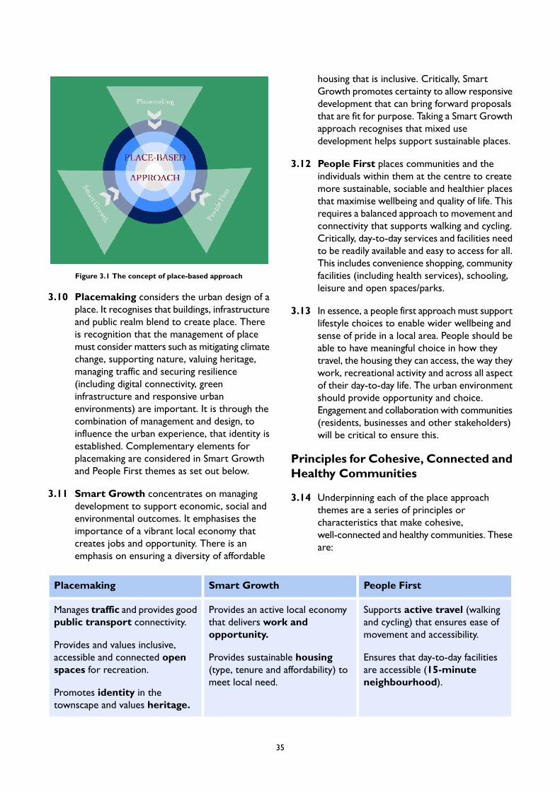
Figure 3.1 The concept of place-based approach
3.10 Placemaking considers the urban design of aplace. It recognises that buildings, infrastructureand public realm blend to create place. Thereis recognition that the management of placemust consider matters such as mitigating climatechange, supporting nature, valuing heritage,managing traffic and securing resilience(including digital connectivity, greeninfrastructure and responsive urbanenvironments) are important. It is through thecombination of management and design, toinfluence the urban experience, that identity isestablished. Complementary elements forplacemaking are considered in Smart Growthand People First themes as set out below.
3.11 Smart Growth concentrates on managingdevelopment to support economic, social andenvironmental outcomes. It emphasises theimportance of a vibrant local economy thatcreates jobs and opportunity. There is anemphasis on ensuring a diversity of affordable
housing that is inclusive. Critically, SmartGrowth promotes certainty to allow responsivedevelopment that can bring forward proposalsthat are fit for purpose. Taking a Smart Growthapproach recognises that mixed usedevelopment helps support sustainable places.
3.12 People First places communities and theindividuals within them at the centre to createmore sustainable, sociable and healthier placesthat maximise wellbeing and quality of life. Thisrequires a balanced approach to movement andconnectivity that supports walking and cycling.Critically, day-to-day services and facilities needto be readily available and easy to access for all.This includes convenience shopping, communityfacilities (including health services), schooling,leisure and open spaces/parks.
3.13 In essence, a people first approach must supportlifestyle choices to enable wider wellbeing andsense of pride in a local area. People should beable to have meaningful choice in how theytravel, the housing they can access, the way theywork, recreational activity and across all aspectof their day-to-day life. The urban environmentshould provide opportunity and choice.Engagement and collaboration with communities(residents, businesses and other stakeholders)will be critical to ensure this.
Principles for Cohesive, Connected andHealthy Communities
3.14 Underpinning each of the place approachthemes are a series of principles orcharacteristics that make cohesive,well-connected and healthy communities. Theseare:
People FirstSmart GrowthPlacemaking
Supports active travel (walkingand cycling) that ensures ease ofmovement and accessibility.
Provides an active local economythat delivers work andopportunity.
Manages traffic and provides goodpublic transport connectivity.
Provides and values inclusive,accessible and connected openspaces for recreation.
Ensures that day-to-day facilitiesare accessible (15-minuteneighbourhood).
Provides sustainable housing(type, tenure and affordability) tomeet local need.
Promotes identity in thetownscape and values heritage.
35
Improves and maximises lifestylechoice (in transport, housing,leisure and work).
Responsive development,through site allocations, thatpromote contextual developmentto meet local social, environmentaland economic need.
Ensures good and lasting urbandesign and architectural practiceto create a coherent built form.
Delivers efficient infrastructure andbuilt resilience (including digitalconnectivity).
Improves and maximises physicaland mental health andwellbeing.Promote and support mixed use
development.Engages with nature to supportbiodiversity and climate changemanagement through blue/ greeninfrastructure and sustainabledrainage.
Table 3.1 Place Approach Themes and Principles
These 14 principles establish the characteristics for successful places. It is important to understand the keydrivers for each. These are presented below.
Placemaking
Manages traffic and provides good public transport connectivity – A balanced approach that recognisesthe need for car free development and the convenience of the private car whist ensuring access to facilities,servicing and parking is well managed. Access to public transport is prioritised and limits from the impactsof car use are applied. People do not need to rely on the car for everyday journeys, including getting toworkplaces, shops, schools, etc. In a well designed place, all modes of transport are positively accommodatedand appropriately balanced.
In areas of high PTAL, there is a preference for development to be car free, subject to disabled parkingprovision. Where car parking is provided, how it is arranged has a fundamental effect on the quality of aplace or development. Car parking associated with a development, including car club parking where required,should normally be accommodated within the curtilage of the site in order to avoid on-street problemssuch as pavement parking or congested streets. Well designed car parking is safe, attractive, landscapedand sensitively integrated so that it does not dominate. Provision for servicing off-street should also beintegrated into a development, including for refuse collection, deliveries and removals.
Public transport access should be high and well connected to the active travel network. PTAL scores of 4or over represent good outcomes.
Provides and values inclusive, accessible and connected open spaces for recreation – Open space integratesinto a wider hierarchy (ranging from large and strategic to small and local spaces including parks, squares,greens, pocket parks and shared spaces) that provides for active and passive recreation. This includes welllocated open spaces that are readily accessible. These spaces support a wide variety of activities andencourage social interaction, promote health, wellbeing and inclusion. Where appropriate, open spaces arewell landscaped with trees and other planting for people to enjoy, whilst also providing shading, air qualityand climate change mitigation. They are safe, inviting and well maintained.
36
Promotes identity in the townscape and values heritage – Identity is local character that makes placesdistinctive. This helps create belonging that sustains communities. There is a positive and coherent identitybuilding on heritage (reflected in designated conservation areas and listed buildings) for successful places.These places have a character that suits the context, its history, how we live today and how we are likelyto live in the future; post the Covid-19 pandemic.
Local identity is made up of typical characteristics (such as the pattern of housing, coherent shopping paradesand/or access to cultural facilities and services). It can include special features that are prominent in theirsurroundings such as public squares and significant heritage features (e.g. listed buildings). These specialfeatures can be distinguished by their uses and activity, their social and cultural importance, and/or theirphysical form and design providing a positive and coherent identity that local communities identify with.
Ensure good and lasting urban design and architectural practice to create a coherent built form – Builtform is the inter-relationship of development blocks, streets, buildings and open spaces. Together theycreate the built environment. It creates a coherent framework that forms a basis for the design of individualdevelopments within a place. Well designed places:
have compact form that are permeable and walkable;are accessible for public transport, services and facilities;have definition and cohesion; andare memorable with features or groupings of buildings, spaces, and uses that aid orientation are easyto navigate and are legible.
Density is appropriate reflecting context, accessibility, building types, form and character. Well designedplaces use the right mix of building types, forms and scale of buildings and public spaces to create a coherentform.
Integrated tall and/or significant buildings have the potential to play a positive urban design role in the builtform. They act as landmarks, emphasising important places and making a positive contribution to views andthe skyline. They are located in suitable locations, guided through a plan-led approach. They can contributepositively to local character, views and sight lines. Their architectural composition and environmentalimpacts (such as sunlight, daylight, overshadowing and wind) need to be carefully and sensitively considered.
Delivers efficient infrastructure and built environment resilience (including digital connectivity) – Welldesigned places are robust and take account of local environmental conditions; prevailing and forecast. Theycontribute to community resilience and climate adaptation by addressing the potential effects of temperatureextremes in summer and winter, increased flood risk, and more intense weather events such as storms.Land is used efficiently to help adaptation. The layout, form and mix of uses minimises resource requirements,including for land, energy and water.
Buildings are to be adaptable over time, reducing the need for redevelopment. Energy efficiency particularlythrough renewable energy infrastructures, such as photovoltaic arrays and district heating networks, reduceslong term resource needs.
The Covid-19 pandemic illustrated the need for resilience in the public realm. The adaptation of publicspaces and streets to allow flexibility for people to implement social distancing, outdoor eating and drinkingand active travel show this necessity.
Utilities services and infrastructure include water supply, sewerage, drainage, gas, electricity, broadbandand digital infrastructure are well sited to minimise their visual impact.
37
Smart technologies, sustained by digital infrastructure, help improve resilience and efficiency as well assupporting movement and orientation. Digital infrastructure also allows for increased business efficiencyto support local employment and opportunity.
Engages with nature to value biodiversity and support climate change management through blue/greeninfrastructure and sustainable drainage – natural features are foundational; integrated into the builtenvironment and maximise the use of watercourses and rivers. They include natural and designed landscapes,public open spaces, street trees, watercourses, embankments, etc. Biodiversity and water management,climate change mitigation and resilience are supported. Wildlife corridors are evident using green chains,rail and watercourses.
A coherent blue/green infrastructure system helps improve air quality, contribute to biodiversity and supporthealth and wellbeing. It needs to be effectively maintained and managed.Well designed places have sustainabledrainage systems to manage surface water, flood risk and significant changes in rainfall. The urban environmentmakes use of sustainable drainage systems and natural flood resilience.
Smart Growth
Provides an active local economy that delivers work and opportunity – There is a network of diverse,responsible businesses and enterprises. They show a commitment to a place and growing the local economy.They provide employment opportunities for local people.
Provision is made to ensure sufficient and affordable employment land and floorspace of the righttype/specification, and in the appropriate location is available for office, retail, industrial, workshops (includingcreative and research & development (R&D) space) and community sectors. This is reflected in an appropriatevacancy rate to accommodate churn and change.
An active local economy provides employment opportunities, enabling people to get ahead in life. Employmentrates for places matches or exceeds borough averages.
The digital infrastructure is supportive of local businesses and allows people flexibility in their approach towork.
Provides sustainable housing (type, tenure and affordability) to meet local need – Houses are functional,accessible and sustainable. Housing is provided to meet the diverse needs of the community, consideringfactors such as the ageing population and promoting inclusion. The housing stock is adequate in size, fit forpurpose and adaptable. There should be a range of housing to meet requirements across the life-cycle(including family housing, apartments and build-to-rent) presented in different styles (e.g. terraces, townhouses, apartment buildings, conversions, living over the shop, duplex, etc). Density needs to be appropriateto housing typology and context. There should be a variety of tenure to meet local needs with housingdistricts that are balanced, inclusive and encourage social interaction.
Responsive development through site allocations that promote contextual development to meet localsocial, environmental and economic need – Clear allocations to provide development opportunities tomeet housing, economic and community needs across a range of sites are available.
Site allocations demonstrate a sound understanding of the features of the site and the surrounding context.The allocation promotes physically, socially and visually responsive development. The allocation informslayout, form and scale.
The allocation establishes development and design requirements including anticipated public benefits. Theallocations do not need to replicate their surroundings. It is appropriate to introduce contemporary elements,including innovations or changes such as increased densities and to incorporate new sustainable featuresor systems.
38
The allocations promote certainty, provide flexibility and create the opportunity for a range of developersand investors; particularly where they are local.
Promote and support mixed use development – Well designed new development makes efficient use ofland with an amount and mix of development and open space that optimises density and reduces the needto travel by providing facilities and amenities.
There is a mix of uses that support everyday activities, including to live, work and play. New developmentreinforces existing places by maximising their potential use. Buildings and developments can accommodatea variety of uses over time.
Mixed use developments create vitality and vibrancy that feels like a centre or destination. In well designed,mixed use development, the inter-relationship between different uses is designed to cater well for all users.The ground floor uses are occupied successfully and access arrangements to upper floors, especially tohomes are clear, safe and dedicated.
People First
Supports active travel (walking and cycling) that ensures ease of movement and accessibility – Patternsof movement for people through active travel are integral. Success depends upon a movement networkthat makes connections to destinations, places and communities.
A good people first movement network defines a clear pattern of streets that:
is safe and accessible for all;takes account of the diverse needs of all its potential users;provides a genuine choice to use active travel;manages and controls the impacts of car use; andtakes opportunities to improve air quality.
This requires a network of active travel routes with a clear structure and hierarchy.
Ensures that day-to-day facilities are accessible (15-minute neighbourhood) – Local facilities are withinwalking distance. A place has proximity for its community to access facilities and amenities by active travelreducing the need to commute long distances; particularly for work. Densities support the provision ofsupply (of facilities and amenities) and demand (by residents and workers). Diverse places that can respondto this need, particularly post the Covid-19 pandemic , are best equipped. Successful places support living,working, supplying, caring, learning and enjoying. Needs are met closer to home.
Maximises lifestyle choice (in transport, housing and work) – Successful places offer real and meaningfullifestyle choices for their communities. The choice in movement to use active travel modes for local needsis available. Longer distance commutes can be accommodated by public transport that is reliable, efficientand safe. Public transport hubs (bus, rail and tube) are accessible. The private car offers alternatives; whereit is appropriate.
Choice extends to living. There is not a predominance of a particular housing type or tenure. A balancepresents that allows people to adapt their housing choices to reflect their requirement. People do not haveto search further afield for housing to meet their needs.
The opportunity to make choices in work is available. Opportunities are readily available locally. Placessupport enterprise and innovation and incubator space is readily available. Working from home or in localhubs is presented.
39
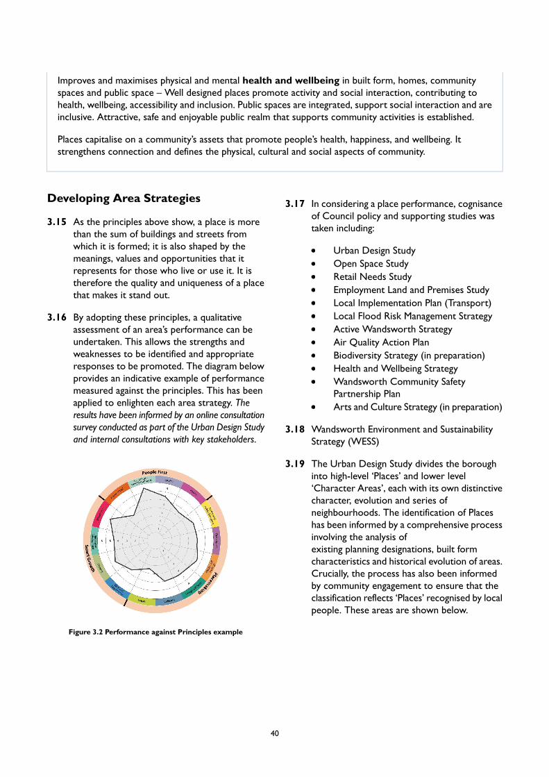
Improves and maximises physical and mental health and wellbeing in built form, homes, communityspaces and public space – Well designed places promote activity and social interaction, contributing tohealth, wellbeing, accessibility and inclusion. Public spaces are integrated, support social interaction and areinclusive. Attractive, safe and enjoyable public realm that supports community activities is established.
Places capitalise on a community’s assets that promote people’s health, happiness, and wellbeing. Itstrengthens connection and defines the physical, cultural and social aspects of community.
Developing Area Strategies
3.15 As the principles above show, a place is morethan the sum of buildings and streets fromwhich it is formed; it is also shaped by themeanings, values and opportunities that itrepresents for those who live or use it. It istherefore the quality and uniqueness of a placethat makes it stand out.
3.16 By adopting these principles, a qualitativeassessment of an area’s performance can beundertaken. This allows the strengths andweaknesses to be identified and appropriateresponses to be promoted. The diagram belowprovides an indicative example of performancemeasured against the principles. This has beenapplied to enlighten each area strategy. Theresults have been informed by an online consultationsurvey conducted as part of the Urban Design Studyand internal consultations with key stakeholders.
Figure 3.2 Performance against Principles example
3.17 In considering a place performance, cognisanceof Council policy and supporting studies wastaken including:
Urban Design StudyOpen Space StudyRetail Needs StudyEmployment Land and Premises StudyLocal Implementation Plan (Transport)Local Flood Risk Management StrategyActive Wandsworth StrategyAir Quality Action PlanBiodiversity Strategy (in preparation)Health and Wellbeing StrategyWandsworth Community SafetyPartnership PlanArts and Culture Strategy (in preparation)
3.18 Wandsworth Environment and SustainabilityStrategy (WESS)
3.19 The Urban Design Study divides the boroughinto high-level ‘Places’ and lower level‘Character Areas’, each with its own distinctivecharacter, evolution and series ofneighbourhoods. The identification of Placeshas been informed by a comprehensive processinvolving the analysis ofexisting planning designations, built formcharacteristics and historical evolution of areas.Crucially, the process has also been informedby community engagement to ensure that theclassification reflects ‘Places’ recognised by localpeople. These areas are shown below.
40
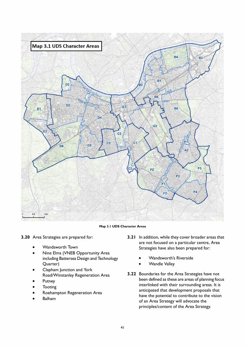
Map 3.1 UDS Character Areas
3.20 Area Strategies are prepared for:
Wandsworth TownNine Elms (VNEB Opportunity Areaincluding Battersea Design and TechnologyQuarter)Clapham Junction and YorkRoad/Winstanley Regeneration AreaPutneyTootingRoehampton Regeneration AreaBalham
3.21 In addition, while they cover broader areas thatare not focused on a particular centre, AreaStrategies have also been prepared for:
Wandsworth’s RiversideWandle Valley
3.22 Boundaries for the Area Strategies have notbeen defined as these are areas of planning focusinterlinked with their surrounding areas. It isanticipated that development proposals thathave the potential to contribute to the visionof an Area Strategy will advocate theprinciples/content of the Area Strategy.
41
3.23 The understanding of these places (andassociated character areas) has allowed astrategy for growth and intensification to bedeveloped for different parts of the borough.Within this framework some locationscan support a greater intensity of growth byfacilitating opportunities to re-examine theexisting character. The Urban Design Studyhas identified that there are areas wherecharacter is fragmented and in need ofenhancement, and where there are detractorsthat weaken the sense of place. These areasare considered appropriate for their characterto change or evolve, which will be assisted bythe targeted Area Strategies.
3.24 As such, the Area Strategies focus on key areasof growth and regeneration in the borough,utilising opportunities where increased capacityand density presents significant opportunitiesto enhance places and bring benefits tocommunities. The Area Strategies directdevelopment towards the most accessible andwell-connected places, focussing on towncentres, making the most efficient use of theexisting and future public transport, walking andcycling networks. The Area Strategies promoteresponses for greener and healthier areas thatcan help improve quality of life. Throughpromoting choice (in housing, travel, work andlifestyle) the Area Strategies foster resilienceand adaptability. Each Area Strategy willconsider context and character, assessperformance and identify key issues andinfluences. A place specific vision andplacemaking policy will be determined. Siteallocations, to include specific considerationsand requirements, will be highlighted.Consequently, the Area Strategies should notbe considered in isolation as they build fromthe broader policy foundation related to theplan as a whole.
3.25 The parts of Wandsworth not covered by AreaStrategies will still experience change, but it isnot expected to be at the same scale as thedefined areas. borough-wide policies will applywhere proposals come forward in these partsof the borough.
3.26 Within each Area Strategy, site allocations havebeen identified as particularly important fordelivery. These will accommodate new homesand jobs alongside necessary infrastructure, suchas open space, health and education facilities.The Area Strategies set out more detailedrequirements for these to ensure that theydeliver their strategic objectives. Whendetermining planning applications, considerationof principles applied to site allocations will beimportant, subject to an up-to-date assessmentof need and the agreed viability position of thescheme. This approach will ensure that siteallocations remain deliverable.
3.27 Each site allocation will come with DevelopmentConsiderations and Design Requirements.These will be unique to each site and set outthe Council's requirements for any developmentproposals on the site. The DevelopmentConsiderations are prerequisites which aproposal will need to provide or show in anysupporting document. The considerationscomprise the inclusion of certain uses, provisionof access onto the site, and land assembly, etc.The Design Requirements are specific to thedesign of any development and they includesubjects such as how people and traffic willmove through and around the site, the massingand site layout, and if there are any featuresimportant to the identity of the area.
3.28 Site allocations will only include DevelopmentConsiderations and Design Requirements thatare specific to the site. All sites will be subjectto the Spatial Area Policies and Local PlanPolicies which should be read in conjunctionwith the site allocations.
3.29 Like the borough-wide policies, the AreaStrategies have been prepared in the contextof the NPPF emerging London Plan. There area wide range of other corporate initiatives andstrategies, including those related todevelopment and regeneration, transport,housing, education, cultural development andclimate change that have also influenced theevolution of strategy. Further, placemakingpolicies (PM) need to be interpreted in thecontext of the broad policy framework (LPpolicies) and considering the Plan as a whole.
42
PM1 Area Strategy and Site Allocations Compliance
A. Development proposals must accord with Area Strategies and Site Allocations. Planning permissionwill be granted where the proposed development positively addresses the Placemaking, Smart Growthand People First principles and the detailed requirements and considerations set out in the Siteallocations and Area Strategy.
B. Proposals which do not comply with the Area Strategy and Site Allocations will be resisted unlessmaterial considerations clearly indicate that an alternative type of development is appropriate andwhere the development would be in accordance with all other relevant development plan policies. Insuch circumstances, the development must not prejudice the delivery of the plan’s vision and objectives,the objectives of the Area Strategy, or the objectives of Site Allocations on neighbouring sites.
C. Development proposals must demonstrate how they are in accordance with the Area Strategies andSite Allocations. Specific opportunities, objectives, considerations and requirements are establishedfor these Areas and Allocations and shall be delivered through development.
D. Where further or updated information and guidance is given in a Supplementary Planning Documentor other planning strategy document for an Area Strategy or Site Allocation, this will be a materialconsideration in determining applications.
E. Planning Obligation contributions will be sought via S106 agreements to support the place makingobjectives and Site Allocation requirements.
3.30 Compliance with the Area Strategies and SiteAllocations is a key feature for the successfuldelivery of this plan. The form and character ofdevelopment must be appropriate for theirlocation, fit for purpose, respond to changingneeds, be inclusive, and make the best use ofland. The efficient use of land requiresoptimisation of density. It is important to beclear on expectations in this regard. AreaStrategies provide a framework for this.
3.31 The Area Strategies are grounded in anunderstanding and assessment of their definingcharacteristics related to Placemaking, SmartGrowth and People First. Area Strategies setout the performance and character of an area.They provide a framework for creatingdistinctive places and, alongside the policies ofthe Plan, promote a consistent and high qualitystandard of design.
3.32 Site Allocations (as distinct from policydesignation areas or zones) ensure that growth,renewal and regeneration at defined sites orprescribed locations come forward withdevelopment proposals that meet need, addressidentified development considerations anddeliver identified design requirements.Developers should work closely with thoseaffected by their proposals to evolve designs
that take account of the views of the communityto enhance their proposal. Early, proactive andeffective engagement with the communityresults in sympathetic and supportableproposals.
3.33 Development proposals for Site Allocations thatdo not improve the quality of an area throughaddressing the appropriate place performanceprinciples will not be supported. Great weightshould be given to contemporary, superior orinventive designs which are proven to promotehigh levels of sustainability and fit in with thesurrounding form and layout. Developmentshould be designed to respond to local urbanismthat can include vernacular architectural styles,materials, urban form, distribution of density &heights and heritage. Developments that showa clear understanding of, and relationship with,the distinctive urbanism of a place are morelikely to be successful.
3.34 Successful places need to blend Placemaking,Smart Growth and People First considerations.Development proposals at Site Allocations needto demonstrate how these aspects have beenconsidered and the priority afforded to each.This will allow the benefits to be clearlyarticulated and related to need.
43

3.35 Key clusters of sites have been identified withinthe Nine Elms Opportunity Area and theWandle Delta area. Each cluster brings togethera logical geographical grouping of sites. Wherepossible, proposals should be progressedcomprehensively with a view to realising theprinciples and aspirations set out in the AreaStrategy, Supplementary Planning Document(SPD) or other planning strategy document ina co-ordinated manner. Proposals shoulddemonstrate how they realise the variousarea-wide and site specific priorities andprinciples within these documents.
3.36 Due to ownership constraints, some clusterswill come forward as individual sites. TheCouncil will expect developers to be proactivein ensuring that site specific proposals futureproof wider place-making and regenerationaspirations for the cluster and area as a whole.This should be clearly demonstrated as part ofplanning applications, with discussions initiatedwith the Council early in the design process. Inthis context, development proposals mustdemonstrate how adjacent sites could beprogressed as subsequent phases.
44

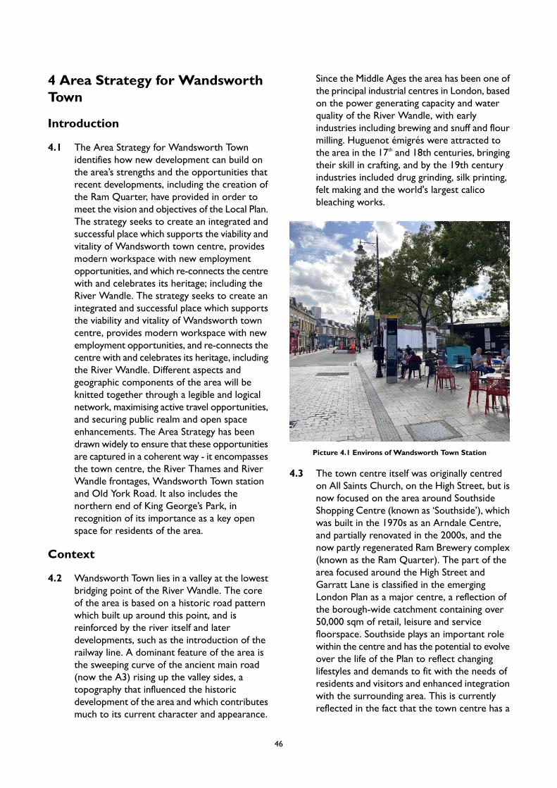
4 Area Strategy for WandsworthTown
Introduction
4.1 The Area Strategy for Wandsworth Townidentifies how new development can build onthe area’s strengths and the opportunities thatrecent developments, including the creation ofthe Ram Quarter, have provided in order tomeet the vision and objectives of the Local Plan.The strategy seeks to create an integrated andsuccessful place which supports the viability andvitality of Wandsworth town centre, providesmodern workspace with new employmentopportunities, and which re-connects the centrewith and celebrates its heritage; including theRiver Wandle. The strategy seeks to create anintegrated and successful place which supportsthe viability and vitality of Wandsworth towncentre, provides modern workspace with newemployment opportunities, and re-connects thecentre with and celebrates its heritage, includingthe River Wandle. Different aspects andgeographic components of the area will beknitted together through a legible and logicalnetwork, maximising active travel opportunities,and securing public realm and open spaceenhancements. The Area Strategy has beendrawn widely to ensure that these opportunitiesare captured in a coherent way - it encompassesthe town centre, the River Thames and RiverWandle frontages, Wandsworth Town stationand Old York Road. It also includes thenorthern end of King George’s Park, inrecognition of its importance as a key openspace for residents of the area.
Context
4.2 Wandsworth Town lies in a valley at the lowestbridging point of the River Wandle. The coreof the area is based on a historic road patternwhich built up around this point, and isreinforced by the river itself and laterdevelopments, such as the introduction of therailway line. A dominant feature of the area isthe sweeping curve of the ancient main road(now the A3) rising up the valley sides, atopography that influenced the historicdevelopment of the area and which contributesmuch to its current character and appearance.
Since the Middle Ages the area has been one ofthe principal industrial centres in London, basedon the power generating capacity and waterquality of the River Wandle, with earlyindustries including brewing and snuff and flourmilling. Huguenot émigrés were attracted tothe area in the 17th and 18th centuries, bringingtheir skill in crafting, and by the 19th centuryindustries included drug grinding, silk printing,felt making and the world's largest calicobleaching works.
Picture 4.1 Environs of Wandsworth Town Station
4.3 The town centre itself was originally centredon All Saints Church, on the High Street, but isnow focused on the area around SouthsideShopping Centre (known as ‘Southside’), whichwas built in the 1970s as an Arndale Centre,and partially renovated in the 2000s, and thenow partly regenerated Ram Brewery complex(known as the Ram Quarter). The part of thearea focused around the High Street andGarratt Lane is classified in the emergingLondon Plan as a major centre, a reflection ofthe borough-wide catchment containing over50,000 sqm of retail, leisure and servicefloorspace. Southside plays an important rolewithin the centre and has the potential to evolveover the life of the Plan to reflect changinglifestyles and demands to fit with the needs ofresidents and visitors and enhanced integrationwith the surrounding area. This is currentlyreflected in the fact that the town centre has a
46
relatively high proportion of comparison goodsrelative to convenience goods, much of whichis located within Southside. However, it isacknowledged that this may change over timewith structural shifts in retail. Smallerindependent shops and other town centre usesare located primarily west of Garratt Lane alongWandsworth High Street, and the Old YorkRoad provides an important and attractiveparade of restaurants, coffee bars and shopswhich provide a contrasting offer to thatfocused in the town centre. New commercial,cultural and leisure floorspace has also beencreated within the Ram Quarter, includingapproximately 4,000 sqm of food/beverage offer.The emerging London Plan classifies itsnight-time economy as NT3 – or, of “more thanlocal” significance. The town centre also hassignificant leisure, service and civic functions, aswell theWandsworth Campus of South ThamesCollege, which provides Further and HigherEducation facilities. Employment floorspace inthe town centre is concentrated in large officeblocks, generally of a poorer quality and whichare underutilised considering Wandsworth’sposition as a vibrant town centre with excellentpublic transport. There is evidence of recentprovision of office space, including at The LightBulb (the commercial component within TheFilament mixed use development on BuckholdRoad) and at Jessica House (a 930 sqm officedevelopment currently under construction).The ongoing redevelopment of poor qualityoffice blocks is key in ensuring that theemployment offer remains competitive.
4.4 King George’s Park lies to the south west ofthe town centre and forms a significant asset,which extends southward toward Earlsfield andlies within the Wandle Valley Regional Park.The northern tip of King George’s Park is setto incorporate a surface-based infrastructureaccess/new public realm point to the ThamesTideway Tunnel which will improve thefunctionality of that part of the park. The towncentre is also served by the Garratt Lane OldBurial Ground which located opposite Southsideand links to St Ann’s Hill, providing an importantgreen lung within the town centre, offeringsome respite from its hustle and bustle – andthe one-way traffic – on Wandsworth HighStreet.
4.5 To the north of the town centre, betweenArmoury Way and Old York Road and theRiver Thames lies the Wandle Delta whichcurrently forms an extensive industrialhinterland, as well as sites occupied byout-of-town retail. The northern edge of theWandle Delta, on the banks of the Thames, isdominated by the Western Riverside WasteAuthority (WRWA) site and Household WasteRecycling Centre. The WRWA site has wastedelivered to it by the London boroughs ofWandsworth, Lambeth, Hammersmith andFulham and Kensington and Chelsea and istherefore an important strategic resource. BoththeWRWA site and a concrete batching centreon the north eastern edge of the area haveProtected Wharf status. Key infrastructurefacilities which are also accommodated withinthis area include an energy switch house andenclosed headhouse building located just northof Causeway Island, a further energy headhouseon the Hunt’s Truck site and Thames TidewayTunnel surface-based infrastructure accesspoints at Dormay Street.
4.6 The area as a whole has seen, and will continueto see, change through the introduction ofresidential and commercial mixed use schemes.This change began through the development ofareas on the riverside, including land locatedtowardsWandsworth Bridge, and the area nowknown as the Wandsworth Riverside Quarter,located on the west bank of the confluence ofthe River Wandle and the tidal River Thames.This area previously contained a 4-hectare ShellOil terminal, and subsequently a brownfieldindustrial site. Wandsworth Park is locatedimmediately to the west of the WandsworthRiverside Quarter (and lies outside of thestrategy area). As well as the completion of thefirst phase of the regeneration of the RamBrewery site and South Thames College / 23-27Garratt Lane, the out-of-town retail sitescontaining the Homebase and B and Q storeshave now been granted planning permission forresidential-led mixed use schemes.
4.7 Large parts of the area benefit from good accessto public transport; it is served byWandsworthTown Rail Station, as well as being easilyaccessible to East Putney and Clapham JunctionStations, as well as a number of bus routes,which offer access to a wide range of
47
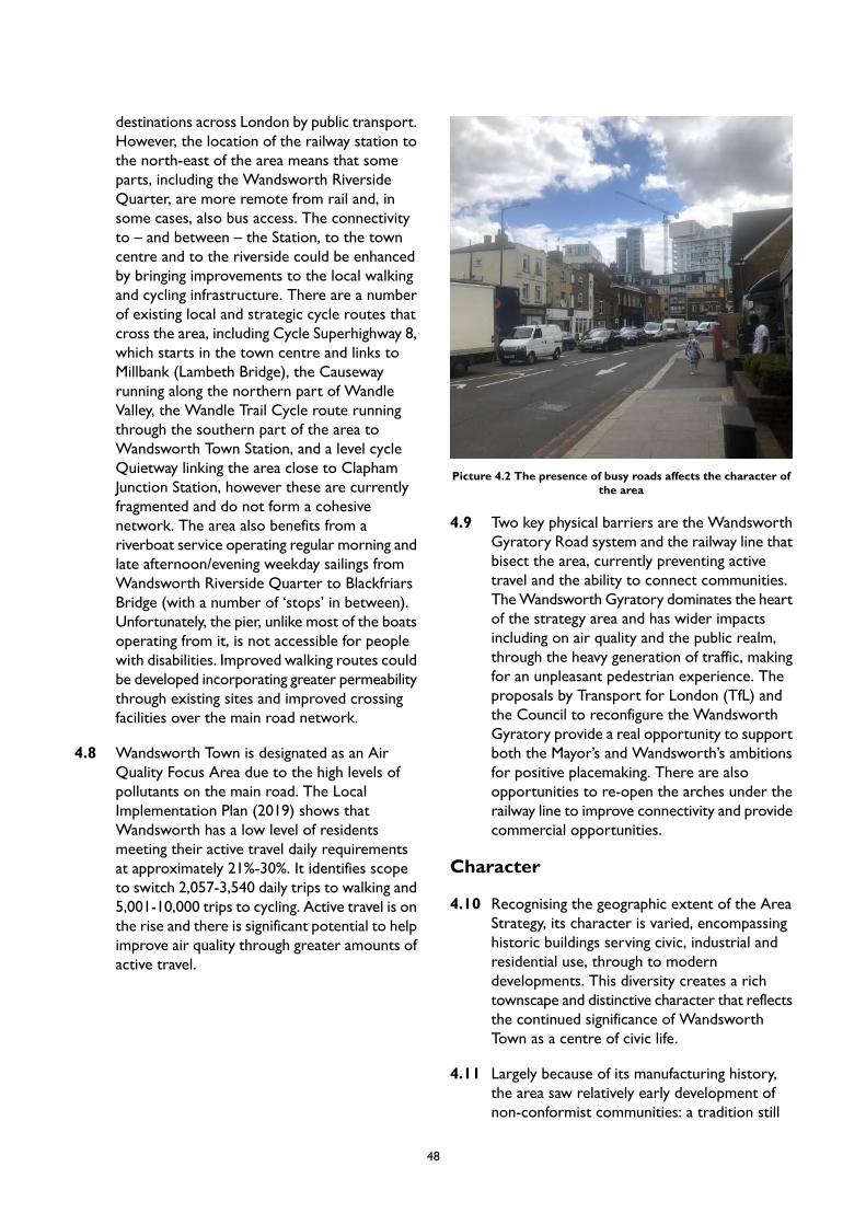
destinations across London by public transport.However, the location of the railway station tothe north-east of the area means that someparts, including the Wandsworth RiversideQuarter, are more remote from rail and, insome cases, also bus access. The connectivityto – and between – the Station, to the towncentre and to the riverside could be enhancedby bringing improvements to the local walkingand cycling infrastructure. There are a numberof existing local and strategic cycle routes thatcross the area, including Cycle Superhighway 8,which starts in the town centre and links toMillbank (Lambeth Bridge), the Causewayrunning along the northern part of WandleValley, the Wandle Trail Cycle route runningthrough the southern part of the area toWandsworth Town Station, and a level cycleQuietway linking the area close to ClaphamJunction Station, however these are currentlyfragmented and do not form a cohesivenetwork. The area also benefits from ariverboat service operating regular morning andlate afternoon/evening weekday sailings fromWandsworth Riverside Quarter to BlackfriarsBridge (with a number of ‘stops’ in between).Unfortunately, the pier, unlike most of the boatsoperating from it, is not accessible for peoplewith disabilities. Improved walking routes couldbe developed incorporating greater permeabilitythrough existing sites and improved crossingfacilities over the main road network.
4.8 Wandsworth Town is designated as an AirQuality Focus Area due to the high levels ofpollutants on the main road. The LocalImplementation Plan (2019) shows thatWandsworth has a low level of residentsmeeting their active travel daily requirementsat approximately 21%-30%. It identifies scopeto switch 2,057-3,540 daily trips to walking and5,001-10,000 trips to cycling. Active travel is onthe rise and there is significant potential to helpimprove air quality through greater amounts ofactive travel.
Picture 4.2 The presence of busy roads affects the character ofthe area
4.9 Two key physical barriers are the WandsworthGyratory Road system and the railway line thatbisect the area, currently preventing activetravel and the ability to connect communities.TheWandsworth Gyratory dominates the heartof the strategy area and has wider impactsincluding on air quality and the public realm,through the heavy generation of traffic, makingfor an unpleasant pedestrian experience. Theproposals by Transport for London (TfL) andthe Council to reconfigure the WandsworthGyratory provide a real opportunity to supportboth the Mayor’s and Wandsworth’s ambitionsfor positive placemaking. There are alsoopportunities to re-open the arches under therailway line to improve connectivity and providecommercial opportunities.
Character
4.10 Recognising the geographic extent of the AreaStrategy, its character is varied, encompassinghistoric buildings serving civic, industrial andresidential use, through to moderndevelopments. This diversity creates a richtownscape and distinctive character that reflectsthe continued significance of WandsworthTown as a centre of civic life.
4.11 Largely because of its manufacturing history,the area saw relatively early development ofnon-conformist communities: a tradition still
48

visible within the ecclesiastical landscape inbuildings such as Chapel Yard (16th Century,rebuilt 19th Century) and the Quaker MeetingHouse (18th Century). The connection betweenmanufacturing and non-conformity wasassociated with a desire to live, work andworship close together. As a result, most of thehistoric buildings are grouped and sited in veryspecific relationships, with houses and industrycheek-by-jowl, for example at the Ram Breweryand 70 High Street, and at Wentworth Housein Dormay Street. This is further reflected inthe network of alleys and small roads linkingthe central area with its industrial hinterland.The historic character of the area, created bylocating homes and workplaces close together,can be enhanced through the redevelopmentof a number of sites within the area which havepreviously been in principally industrial andcommercial use, such as in Ferrier Street.
4.12 The area has an array of high quality historicbuildings (designated and non-designated), whichinclude Church Row (grade II*), Ram Brewery(grade II*), those in the Putney Bridge Road area(including Prospect Cottages), the Arts andCrafts group in Oakhill Road, andWandsworthBus Garage. Historic buildings are often locatedat key junctions, which is highly important tothe legibility and framework of the area. TheRam Brewery complex, with its distinctivechimney, serves as a prominent feature withinthe town centre, as do the grand civic buildingsof the Wandsworth Town Hall complex. TheTown Hall and nearby South Thames Collegemark the transition from East Hill to the HighStreet. Book House/Mount Nod triangle on EastHill and St Thomas's Church (grade II listed) onWest Hill form gateway markers to the town(and the Wandsworth Town ConservationArea). Other historic landmarks include AllSaints Church and Church Row, the Brewer'sInn, with its distinctive turret, and the SpreadEagle public house.
4.13 Building heights across the area range frombetween 2-4 storeys through to towers up to27 storeys, the latter of which have morerecently become a feature of the skyline.Southside Shopping Centre (formerly anArndale Centre), which opened in 1971, andthe associated residential tower blocks whichrise to 27 storeys form a distinctive feature to
the northern end of Garratt Lane and itsjunction with Wandsworth High Street, as wellfrom the northern end of King George’s Park.Old York Road, which is within a recentlydesignated Conservation Area, forms a 'minihigh street'. Its consistent 2-3 storey Londonstock terraces create a human scale streetscape,whilst the high quality parade of shops andrestaurants create a lively street scene with adistinctive character and sense of place.
4.14 The area’s location within a valley gives rise tointeresting, sweeping and long-ranging views,particularly into the area from outside includingfrom East Hill. Other views into and across thearea include from the north bank of the RiverThames and from Wandsworth Bridge. TheRiver Thames creates a sense of opennessthrough the extent of views across and alongit, whilst the local boat traffic and the piers andmoorings provide vibrancy and interest. Thedevelopment of the Wandsworth RiversideQuarter has created a place which hassupported greater public access to thesepositive attributes and enhanced part of theThames Path which is valued for its leisureopportunities. Crucially, the importance of theRiver Thames, not just for recreational but also,for industrial purposes is reflected in thedesignation of two Protected Wharves withinthe area. The River Wandle, a tributary of theThames running north to south, is also apositive contributor to the local character,however its potential remains underutilised.The completion of Phase One of the RamQuarter has begun to increase its visibility andthe public benefit. Future planned developmentwill provide further opportunities tore-integrate the river into the area as well andsupport improvements in biodiversity.
4.15 Industry and infrastructure have been animportant part of the area’s development andhave shaped much of today’s character. Thisincludes the ancient main road (the current A3),which rises up the valley sides, alongside theloop of roads comprising the A3 (WestHill/Wandsworth High Street/East Hill),Wandsworth Plain, Frogmore and Putney BridgeRoad, which mark the historic road layout. TheLondonWaterloo to Reading railway line, whichis elevated above railway arches, bisects thearea from west to east. The industrial role of
49

the Thames is also present in the contemporarylandscape, with two Protected Wharves.Although, these infrastructure assets continueto play an important role in the area’s future,they also can negatively impact on the area’scharacter. The busyness, noise, clutter andpollution caused by traffic detracts from theattractiveness of the area, whilst, whencombined with the railway line and ProtectedWharves creates obstacles to safe movementwithin an attractive environment. This isexacerbated by the functional appearance ofmany of the industrial buildings in the area andby features such as security fencing, and heavygoods vehicles and waste trucks. All of thesefactors detract from the positive attributes ofthe area creating the need for a strategy whichcontributes to creating greater integration andcohesion across the area, including maximisingthe opportunities for creating greater access tothe River Wandle and making better use of thearea’s network of alleys and small roads.
50
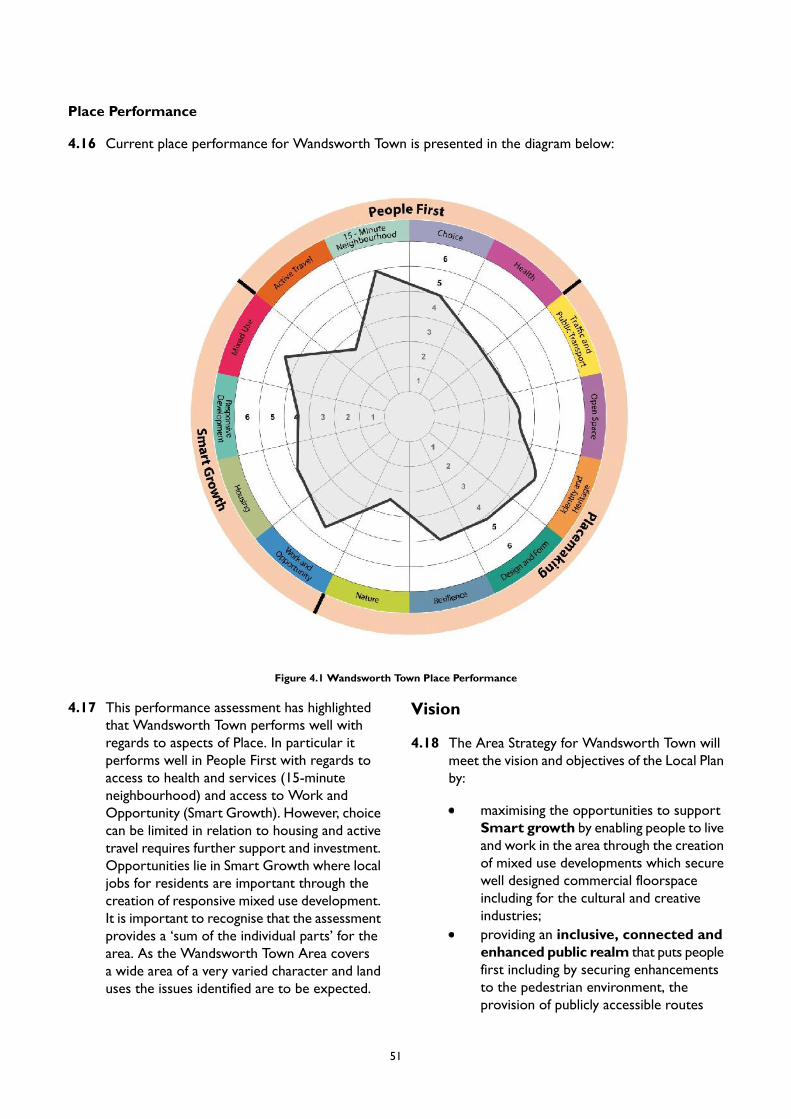
Place Performance
4.16 Current place performance for Wandsworth Town is presented in the diagram below:
Figure 4.1 Wandsworth Town Place Performance
4.17 This performance assessment has highlightedthat Wandsworth Town performs well withregards to aspects of Place. In particular itperforms well in People First with regards toaccess to health and services (15-minuteneighbourhood) and access to Work andOpportunity (Smart Growth). However, choicecan be limited in relation to housing and activetravel requires further support and investment.Opportunities lie in Smart Growth where localjobs for residents are important through thecreation of responsive mixed use development.It is important to recognise that the assessmentprovides a ‘sum of the individual parts’ for thearea. As the Wandsworth Town Area coversa wide area of a very varied character and landuses the issues identified are to be expected.
Vision
4.18 The Area Strategy for Wandsworth Town willmeet the vision and objectives of the Local Planby:
maximising the opportunities to supportSmart growth by enabling people to liveand work in the area through the creationof mixed use developments which securewell designed commercial floorspaceincluding for the cultural and creativeindustries;providing an inclusive, connected andenhanced public realm that puts peoplefirst including by securing enhancementsto the pedestrian environment, theprovision of publicly accessible routes
51

through developments to key destinationsincluding the town centre andWandsworth Town Station. Theseimprovements will be well landscaped andprovide places for people to rest andsocialise, and will build on the benefits thatthe changes to theWandsworth Gyratorysystem offer;increasing active travel by creating a safeand coherent pedestrian and cyclingnetwork which strengthen links includingbetween the town centre and theWandleDelta through the enhancement of existingassets, by minimising conflicts with vehiclesincluding on the Wandsworth Gyratory,the provision of signage, and making betteruse of existing alleys and small roads;delivering improvements to the RiverWandle and Bell Lane Creek through thesensitive provision and management oflandscaping and connected open spacesto support the health and wellbeing ofexisting and future residents and toenhance local biodiversity;supporting the long term vitality andviability of the town centre, recognisingits important retail role, but supportingchange and allowing for flexibility in termsof the mix of uses and buildings wherethese provide active frontages. Whereappropriate, conditions will be applied to
planning permissions to restrict futurechange within the Class E Use Class, forexample to retain retail use in keylocations. Enhance the important role ofSouthside, embracing potentialredevelopment opportunities which wouldallow for its improvement and of thesurrounding environment. Enhance thecivic role and physical connectivity ofWandsworth Town Hall, re-providingmodern office facilities and ensure thatsupporting uses in other parts of the areacomplement rather than compete with itsimportant function;creating a greater sense of place throughthe enhancement and celebration of itsheritage; .andsupporting development whichincorporates space which can be usedflexibly, in order to maximise theopportunities that the area provides torespond to changing lifestyles and ways ofworking to support the area’sresponsiveness and resilience. Thisincludes providing residential uses atground floor level in appropriate locationsaway from key traffic routes where adefensible space is provided, or can beprovided in the future, between thebuilding frontage and the public realm.
Anchor for Change – Changes to the Wandsworth Gyratory
The TfL proposals for the Wandsworth Gyratory, including its associated public realm improvements,provide an anchor for change. Its implementation will provide a range of benefits including:
removing the dominance of vehicles providing the opportunity to create a more ‘people’ friendlyenvironment including between the Ram Quarter and Southside, and along Wandsworth High Streetand East Hill;
providing new opportunities for safe crossing points allowing for the creation of enhanced pedestrianand cycle links between the northern parts of the area and the town centre and Wandsworth TownStation, particularly considering the significant increase in residents that developments north of theGyratory will introduce;
acting as a catalyst in promoting economic regeneration of the town centre;
significant improvements to the public realm at key locations through the implementation of supportingstreetscape and planting enhancements and rationalisation of signage which will support enhancementsto the area’s historic character and attractiveness as a place;
52

a healthier environment through improvements to air quality; and
improvements in accessibility for people with physical impairments and for young families through therelocation and rationalisation of street infrastructure.
The Council has a strong ambition to see its delivery recognising the wider placemaking, economicregeneration and health benefits that the scheme will provide to the area and its residents – both existingand future. To this end the Council has committed to partially fund the scheme and will continue to workwith TfL to secure its delivery so that the benefits that development within the area will be fully maximised.
PM2 Wandsworth Town Place Based Policy
Placemaking
A. Wandsworth Town has the potential to promote and accommodate sustainable development.Development will be supported where:
1. an appropriate mix of uses is proposed with an emphasis on residential and commercialdevelopment that can provide services and amenities locally to reduce unnecessary journeys;
2. height and massing are appropriate and conform to the approach for tall buildings.3. active travel is promoted and challenges for broader connectivity are addressed that help improve
safety and make routes direct and attractive to key destinations within Wandsworth Town andbeyond;
4. heritage and landmark buildings are incorporated into, or enhanced by, development proposalsto secure their contribution to place identity;
5. views and vistas, established in the Urban Design Study (2020), are respected and enhanced;6. public realm which supports the creation of ‘Streets for All’ and open space provision, which is
accessible to all, is created;7. high quality green features will be incorporated into new developments to help facilitate connected
green and blue infrastructure throughout the borough; and8. infrastructure can take advantage of district heating, sustainable urban drainage and digital
connectivity;
B. Six key clusters of sites have been identified across the Wandle Delta area, including:
1. Frogmore Depot2. Hunts Trucks / Gasholder site3. Feather’s Wharf and Smuggler’s Way4. Wandsworth Bridge5. Ferrier Street6. Swandon Way
C. Each cluster brings together a logical geographical grouping of sites. Proposals should demonstratehow they realise the various area-wide and site-specific priorities and principles within this AreaStrategy. This is particularly important in relation to public realm, connectivity and environmentalelements of the proposals which must be balanced with new homes and workspace.
D. Development proposals for sites within theWandle Delta area should create opportunities to embracethe Wandsworth Gyratory proposals in terms of connectivity. Creating a more connected area willsupport the achievement of the wider ambitions for the Wandsworth Town area in both diversifying
53
and enhancing the historic and retail/service centre of the area, in particular, in linking the town centrewith the Delta area.
E. The completion of the first phase of the redevelopment of the Ram Quarter has made a significantcontribution to the quality of place and on supporting the unveiling of part of the River Wandle. Thenext stages in its redevelopment should ensure that the enhancement of this part of the River Wandleis completed in recognition of the contribution that the site will make to the area and by acting as acatalyst for further regeneration and improved connectivity in the area.
F. Development proposals for sites north of Armoury Way and Swandon Way should provide furtheropportunities to reveal the River Wandle, create publicly accessible green spaces and contribute to‘greening’ and the enhancement of biodiversity. The use of appropriate railway arches as pedestrianroutes to enhance the connectivity across the area will be expected.
G. Development proposals for the redevelopment of the Wandsworth Town Hall site should achieveenhancements to the setting of the Town Hall, which is a Grade II listed building, as well as to provideattractive pedestrian routes connecting between Fairfield Street and the Ram Brewery complex, andthe provision of public spaces.
H. Southside has the potential to respond to the changes in how people shop and work as a result of itsflexible floorspace configuration. Development proposals for Southside should support the creationof greater links between King George’s Park and Garratt Lane, and improving the Centre’s relationshipwith the public realm through enhancements to the pedestrian environment and public realmimprovements which integrate it with the Ram brewery complex.
I. Proposals are supported for sites other than Site Allocations that provide housing or employmentuses that take advantage of the area’s connectivity and do not undermine the area’s vitality and viability.
J. The Urban Design Study has identified appropriate locations for tall buildings in Wandsworth. Thebroad locations are identified in Appendix 2. Any proposal for a tall building will be subject to addressingthe requirements of Policy LP 4 (Tall Buildings) as well as other policies in the Plan as applicable.
K. Developments which provide large roofplates should maximise the opportunity for creating habitatto support biodiversity and publicly accessible open spaces which are capable of year- round use andwhich provide the opportunity to appreciate views over the area and beyond by local people.
L. New development will be expected to protect important views and vistas in the area, including:
1. from East Hill towards the town centre;2. from West Hill towards the town centre;3. from the terraced residential streets towards the town centre and towards industry by the river;4. west along the Thames Path towards the green edge of Wandsworth Park ;5. from Wandsworth Bridge across the area to the ridgeline to the south; and6. from the north bank of the Thames.
M. Developments with lengthy frontages will be expected to provide an articulation of elevations tocreate a positive relationship with the street and to avoid the creation of visually overbearing publicfrontages; particularly along Garratt Lane, King George’s Park, Armoury Way and Swandon Way.
N. Opportunities to enhance the experience and quality of the public realm through carefully considered,well-designed proposals that can create interesting, dynamic, accessible, and inclusive public spacesare encouraged. These should provide elements that encourage dwell time, such as seating, whichfacilitate community and cultural use, and which incorporate public art.
O. The Council supports the provision of enhanced public realm or parklet provision within the towncentre on private plots (where this is adjacent to the pavement and can be accessed directly). Onhighway play space provision may also be appropriate where this can be accommodated withoutadversely impacting on people’s safety and traffic management.
P. Development proposals will be expected to maintain and increase the quantity of native street treesas part of a site’s public realm provision and along key movement corridors including Armoury Way,Swandon Way and Garratt Lane.
54

Q. Where pavement space is considered inadequate when considering the volume and speed of traffic,development proposals will be required to set back building lines to increase space for people andstreet planting by providing for a widened pavement environment.
R. Development must be sensitive to local character by maintaining and respecting proportions, scaleand coherence of, in particular, terraced streets and shop frontages. Where possible, the Council willexpect proposals to reinstate traditional shop fronts to support the character and appearance of thearea and its conservation areas; particularly along Wandsworth High Street.
S. Advertisements will be expected to respond to the proportions of the host building. Internally litsignage will not be supported within the conservation areas.
Smart Growth
A. New residential accommodation in Wandsworth Town will help meet the borough’s housing target,as set out in Local Plan Policy LP 24. Development within this area is expected to provide at least4,199 homes by 2037/38 (the entire plan period), of which 3,490 homes are expected to be providedby 2032/33 (10-year housing supply). These figures reflect the projected completions on large, smalland windfall sites.
B. The Council will support proposals which add to the vitality and viability of Wandsworth Town,allowing for change and flexibility while retaining retail in key areas where appropriate, and where theCouncil has powers to do so. To promote this:
1. proposals for larger format retail and leisure should be prioritised in Southside;2. smaller-scale retail should be focused on Wandsworth High Street (primarily between
Wandsworth Plain and Broomshill Road) and Old York Road and should contribute to thedistinctive independent character of those locations. In particular, proposals will be supportedwhich provide improvements to the pedestrian environment or the public realm. Theamalgamation of small units to create larger units will not be supported in these locations; and
3. smaller-scale retail provision will be acceptable on development sites where it will support theday-to-day retail needs of residents, particularly for convenience shopping, and can bedemonstrated that it would not impact on the vitality and viability of Wandsworth Town Centre.
C. Proposals for leisure and night-time economy uses in the town centre (such as cinemas and bars) willbe supported where they would not result in, or would adequately mitigate, any material adverseimpacts on residential amenity.
D. New provision of commercial floorspace will be supported as part of the mixed use redevelopmentof allocated sites. The re-provision of, or increase in, the quantum of existing economic floorspacewill be expected on sites currently in economic use. These are identified in the Site Allocations andwill deliver new flexible economic floorspace, including affordable workspace targeted at SMEsparticularly in the cultural and creative industries subject to Policy LP 41 (affordable workspace).Planning applications for mixed use schemes will need to demonstrate that the residential andcommercial uses can be integrated in such a way as to not result in any material adverse impact onresidential amenity or the proper operation of the commercial premises.
E. Proposals for office space, including the provision of managed or ‘touchdown’ space, outside of thetown centre boundary will need to demonstrate that it would not undermine the role and functionof the town centre.
F. All new development should seek to make provision to connect to a future district heat network,and the Council will work with development partners to promote the necessary strategic sustainableenergy infrastructure to realise this. Significant development at growth locations should presentproposals for sustainable urban drainage that can mitigate the impacts from climate change.
G. Urban Logistics Hubs are used for last mile deliveries by electric vans or cargo bikes which can helpreduce congestion and pollution. These will be supported in the right location in accordance with theobjectives of Policy LP 51 – Sustainable Transport.
55

People First
A. The Council will continue to work with TfL, including through contributions towards its cost, tosecure the early implementation of the Wandsworth Gyratory System and its supporting public realmimprovements.
B. The Council will work with Network Rail and TfL to bring forward the opening of a northern accessto Wandsworth Town Station.
C. In conjunction with development opportunities, the Council will promote the development of a newpublic square and pedestrian access routes within the Wandsworth Town Hall proposals, togetherwith a series of pocket and linear parks and more natural green spaces focused along the RiverWandleand Bell Lane Creek. These should support nature through encouraging biodiversity and providingappropriate habitat, as well as making animated riverside spaces which encourage users ‘to dwell’.
D. The Council will seek to improve connectivity and permeability for pedestrians and cyclists. Measuresto improve connectivity will be complemented by the provision of additional cycle parking in keylocations and in association with development at growth locations including through the use of signage.
E. The Council will seek to create more space for pedestrians in key locations as identified in the SiteAllocations. General improvements to the public realm should create a safer and better qualityenvironment for pedestrians and cyclists. All new development proposals, transport and other publicrealm schemes, must contribute towards this.
F. Existing cultural, creative and arts uses will be safeguarded, and proposals for their expansion, renewaland modernisation will be encouraged. Appropriate proposals for the change of use in the town centreto accommodate additional cultural offerings will be supported.
G. New development proposals will be expected to contribute towards providing jobs, training andapprenticeship places forWandsworth residents in the construction and end-use phases of development.The Council will seek a range of jobs to be provided as part of new development proposals.
H. In bringing forward significant residential accommodation; particularly for families it is important thatan assessment of community facilities related to health and schooling is undertaken. Developmentproposals at growth locations will need to provide flexibility to accommodate these facilities; particularlywhere the need arises in association with particular schemes. The Council will ensure that this provisionis addressed equitably across the growth locations (in terms of requirement and its provision) andwill work with developers and the community to consider this.
56
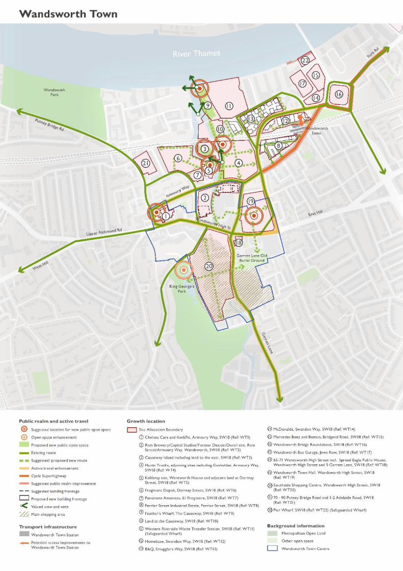
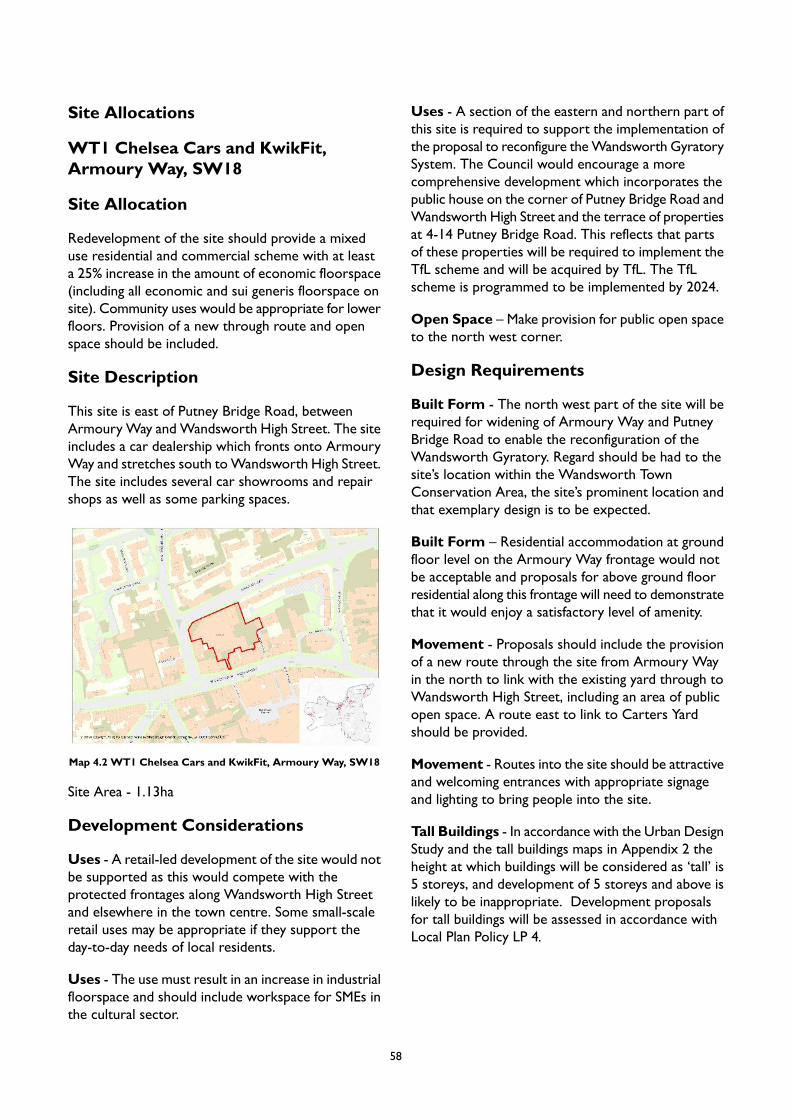
Site Allocations
WT1 Chelsea Cars and KwikFit,Armoury Way, SW18
Site Allocation
Redevelopment of the site should provide a mixeduse residential and commercial scheme with at leasta 25% increase in the amount of economic floorspace(including all economic and sui generis floorspace onsite). Community uses would be appropriate for lowerfloors. Provision of a new through route and openspace should be included.
Site Description
This site is east of Putney Bridge Road, betweenArmouryWay andWandsworth High Street. The siteincludes a car dealership which fronts onto ArmouryWay and stretches south toWandsworth High Street.The site includes several car showrooms and repairshops as well as some parking spaces.
Map 4.2 WT1 Chelsea Cars and KwikFit, Armoury Way, SW18
Site Area - 1.13ha
Development Considerations
Uses - A retail-led development of the site would notbe supported as this would compete with theprotected frontages along Wandsworth High Streetand elsewhere in the town centre. Some small-scaleretail uses may be appropriate if they support theday-to-day needs of local residents.
Uses - The use must result in an increase in industrialfloorspace and should include workspace for SMEs inthe cultural sector.
Uses - A section of the eastern and northern part ofthis site is required to support the implementation ofthe proposal to reconfigure theWandsworth GyratorySystem. The Council would encourage a morecomprehensive development which incorporates thepublic house on the corner of Putney Bridge Road andWandsworth High Street and the terrace of propertiesat 4-14 Putney Bridge Road. This reflects that partsof these properties will be required to implement theTfL scheme and will be acquired by TfL. The TfLscheme is programmed to be implemented by 2024.
Open Space – Make provision for public open spaceto the north west corner.
Design Requirements
Built Form - The north west part of the site will berequired for widening of Armoury Way and PutneyBridge Road to enable the reconfiguration of theWandsworth Gyratory. Regard should be had to thesite’s location within the Wandsworth TownConservation Area, the site’s prominent location andthat exemplary design is to be expected.
Built Form – Residential accommodation at groundfloor level on the Armoury Way frontage would notbe acceptable and proposals for above ground floorresidential along this frontage will need to demonstratethat it would enjoy a satisfactory level of amenity.
Movement - Proposals should include the provisionof a new route through the site from Armoury Wayin the north to link with the existing yard through toWandsworth High Street, including an area of publicopen space. A route east to link to Carters Yardshould be provided.
Movement - Routes into the site should be attractiveand welcoming entrances with appropriate signageand lighting to bring people into the site.
Tall Buildings - In accordance with the Urban DesignStudy and the tall buildings maps in Appendix 2 theheight at which buildings will be considered as ‘tall’ is5 storeys, and development of 5 storeys and above islikely to be inappropriate. Development proposalsfor tall buildings will be assessed in accordance withLocal Plan Policy LP 4.
58
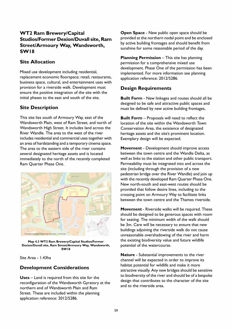
WT2 Ram Brewery/CapitalStudios/FormerDexion/Duvall site, RamStreet/Armoury Way, Wandsworth,SW18
Site Allocation
Mixed use development including residential,replacement economic floorspace; retail, restaurants,business space, cultural, and entertainment uses withprovision for a riverside walk. Development mustensure the positive integration of the site with theinitial phases to the east and south of the site.
Site Description
This site lies south of Armoury Way, east of theWandsworth Plain, west of Ram Street, and north ofWandsworth High Street. It includes land across theRiver Wandle. The area to the west of the riverincludes residential and commercial uses together withan area of hardstanding and a temporary cinema space.The area to the eastern side of the river containsseveral designated heritage assets and is locatedimmediately to the north of the recently completedRam Quarter Phase One.
Map 4.3 WT2 Ram Brewery/Capital Studios/FormerDexion/Duvall site, Ram Street/Armoury Way, Wandsworth,
SW18
Site Area - 1.43ha
Development Considerations
Uses – Land is required from this site for thereconfiguration of the Wandsworth Gyratory at thenorthern end of Wandsworth Plain and RamStreet. These are included within the planningapplication reference: 2012/5286.
Open Space - New public open space should beprovided at the northern nodal point and be enclosedby active building frontages and should benefit fromsunshine for some reasonable period of the day.
Planning Permission – This site has planningpermission for a comprehensive mixed usedevelopment. Phase One of the permission has beenimplemented. For more information see planningapplication reference: 2012/5286.
Design Requirements
Built Form - New linkages and routes should all bedesigned to be safe and attractive public spaces andmust be defined by new active building frontages,
Built Form – Proposals will need to reflect thelocation of the site within the Wandsworth TownConservation Area, the existence of designatedheritage assets and the site’s prominent location.Exemplary design will be expected.
Movement - Development should improve accessbetween the town centre and the Wandle Delta, aswell as links to the station and other public transport.Permeability must be integrated into and across thesite (including through the provision of a newpedestrian bridge over the River Wandle) and join upwith the recently developed RamQuarter Phase One.New north-south and east-west routes should beprovided that follow desire lines, including to thecrossing point on Armoury Way to facilitate linksbetween the town centre and the Thames riverside.
Movement - Riverside walks will be required. Theseshould be designed to be generous spaces with roomfor seating. The minimum width of the walk shouldbe 3m. Care will be necessary to ensure that newbuildings adjoining the riverside walk do not causeunreasonable overshadowing of the river and harmthe existing biodiversity value and future wildlifepotential of the watercourse.
Nature - Substantial improvements to the riverchannel will be expected in order to improve itshabitat potential for wildlife and make it moreattractive visually. Any new bridges should be sensitiveto biodiversity of the river and should be of a bespokedesign that contributes to the character of the siteand to the riverside area.
59

Tall Buildings - In accordance with the Urban DesignStudy and the tall buildings maps in Appendix 2 theheight at which buildings will be considered as ‘tall’ is5 storeys, and development of 5 storeys and above islikely to be inappropriate. Development proposals fortall buildings will be assessed in accordance with LocalPlan Policy LP 4.
60

HUNTS TRUCKS/ GASHOLDERCLUSTER
The Hunts Trucks/ Gasholder Cluster comprisesmultiple sites and one site allocation. In order tosupport the implementation of the policies of the planand the vision and objectives of the WandsworthTown Area Strategy, development should be broughtforward in accordance with a masterplan for thiscluster area which is endorsed by the Council. Suchan approach does not preclude the delivery ofdevelopment coming forward in a phased manner butensures that in doing so the proper planning of thispart of Wandsworth Town is not prejudiced.
The Cluster contains one site allocation:
WT4 Hunts Trucks, adjoining sitesincluding Gasholder, ArmouryWay, SW18
Site Allocation
Redevelopment of the site should provide at least a25% increase in the amount of industrial (use classesE/B2/B8/SG) and office (use class E) floorspace,providing a mix of uses and typologies includingclusters of economic uses and cultural workspacemeeting the requirements of the Economic UseIntensification Area (EUIA) designation. Proposalsshould provide a linear park that incorporates theriverside walk and a substantial quantity of housingand help realise the spatial aims for the wider area.Innovative use of yard spaces and incorporation ofpublic-facing elements is encouraged. In calculating thefloorspace to be replaced, the gas holder itself and thesupporting infrastructure should be excluded. The sitemay be suitable for some smaller scale town centreuses falling within the E Class use, which meet a localneed and where these do not harm the vitality andviability of Wandsworth town centre. Any separatedevelopment in the short term would need to betemporary and should not prejudice the satisfactoryachievement of the full development potential andurban design objectives for the site as a whole.
Site Description
This site is located to the west of Wandsworth TownStation and north of Wandsworth Town Centre. It isto the north west of the junction of the A3 and theA217 and is bounded to the north by railway tracksand, to the west, by the River Wandle. The site iscurrently used for industrial and commercial uses withparking to the north of the site.
Map 4.4 HUNTS TRUCKS/ GASHOLDER CLUSTER
Site Area – 2.81ha
Development Considerations
Uses - Proposals on this site must be brought forwardin such a manner as to achieve a comprehensive andintegrated approach that supports the urban design,active travel, open space and public realm objectivesfor the Area Strategy.
Uses – The replacement (or additional) economicfloorspace should include light industrial workspacefor cultural SMEs.
Landowner Assembly - This site has six privateowners and several long leaseholds. Proposals shouldseek to bring forward development comprehensively.Where ownership necessitates a phased approach, aco-ordinated approach that future proofs the overallplacemaking and regeneration benefits should beprogressed. The Council may need to consider theuse of its statutory powers in bringing forwardcomprehensive redevelopment.
Open Space - There should be an area of open spacedesigned as a linear park provided along the Wandleriverside (incorporating a riverside walk) designed asa place with distinctive character and identity for the
61
public to enjoy. Publicly accessible ground floor usesshould be concentrated around this open space unlessit can be demonstrated that residential accommodationcan be provided with an appropriate level of privacyand amenity for its occupiers. 24/7 natural surveillanceof the park would happen with residential developmentin close proximity to the open space.
Access - Suitable vehicular access onto ArmouryWayand/or Smugglers Way that supports the access andservicing needs of the site as a whole and whichreduces the number of vehicular access points intothe site will be required.
Parking - The site is suitable for the development ofa car-free development. Car Club provision to supportthe residential and commercial uses on the site andthe surrounding area should be provided.
Movement - Development should not prejudice theachievement of reconfiguration of the WandsworthGyratory.
Active Travel - The feasibility of providing apedestrian and cycle bridge link across SmugglersWayto the Ferrier Street Cluster should be considered.New connections to the River Wandle riverside walk,including a bridge crossing to The Causeway, will berequired. Walking/cycling route links to WandsworthTown Centre will also be required.
Design Requirements
Built Form – Proposals should help create of a morelegible series of safe and secure streets and blocks.The proposed riverside walks and frontage toArmoury Way, Smugglers Way and Swandon Waymust be defined by active building frontages.Development should reflect the cheek-by-jowl urbanform of Wandsworth; yet imbue its own distinctivetownscape to create a strong sense of place. Legibleelements to the built form should be created toinclude a rationale that underpins a location, thoughthe junction of Ram Street and Armoury Way, for anew north-south street. A view through the site toFerrier Street along the axis of a new street isrequired. Residential use will not be appropriate atground floor level along these frontages.
Built Form - Part of the south east edge of the sitewill be required for the Wandsworth Gyratoryimprovements. The site should be designed in a waythat complements the planned public realm
improvements at the junction of Old York Road,Fairfield Street, SwandonWay and ArmouryWay thataim to civilise the street making it two-way and morepedestrian/cycle friendly.
Movement - The layout of buildings must allow fornew connections providing public access through thesite aligned with Ferrier Street from Swandon Waywest through to the riverside walk; and also furthersouth linking Swandon Way west through to theriverside walk; from Armoury Way opposite RamStreet north through the site; and a connection toSmugglers Way by a new access passing under the railtrack; a new bridge over the Wandle to the DormayStreet area and a new footbridge over the Wandlefurther north near the railway.
Context - Proposals should respond to constraintsassociated with existing utilities restrictions, easementsor Health and Safety Executive (HSE) guidance. Thesite contains a former gas holder and significantinfrastructure that supported its former use, includinga gas mains and gas ‘governor’. Development will needto carefully consider the impact this infrastructure willhave on any proposal.
Identity and Architectural Expression – Theproposed development will be located between thetown centre and the riverside and the identity for thisnew quarter will need to embrace the sense ofmovement and change between these two locationswhist imposing its own distinctiveness. The groundfloor commercial/business uses together with theactivities within the public spaces will contribute tothe identity and expression, together with the designand materiality of the buildings. The new routes withinthe site and the linear park and riverside walk, shouldbe designed to be safe and attractive public spacesand, where appropriate, must be defined by new activebuilding frontages, i.e. frontages that contain entrancedoors and windows.
Site Layout - The site should be broken down intoa number of small urban blocks to create a distinctiveneighbourhood that promotes permeability and legibleconnections to the wider area. Proposals shouldincorporate lower elements allowing daylight intoperimeter block courtyards. Economic uses should beclustered together in order to create a distinctive hubof businesses and to help minimise potential conflictswith residential uses. Cultural and creative industriesworkspace should include yard space and should bepublic-facing in order to enliven the public realm. The
62
potential for a public-facing commercial aspect (suchas communal gallery space or individual micro-sizedretail units) should be explored. All new developmentwill be required to have frontages on to the existingstreets and new streets with entrances.
Massing - Proposals should include buildings withvaried height, scale and massing with a focus oncourtyard typologies. Low-rise buildings to make aninner spine route to provide a human scale, as well aslow-rise buildings facing railway arches to achieve thesame effect should be proposed. There is potentialfor towers marking prominent/ gateway locations innorth-west and south-east corners of site. Buildingsshould rise along Swandon Way to a gateway locationin the southeast corner. Massing along the Wandleriverfront can be varied.
Nature - Works to the banks of the River Wandlewill be expected to contribute to the biodiversity ofthe area. Consideration should be given to the specialecological and wildlife habitats and allowance for thesensitivity of these should be made in the siting, heightand design of the buildings and the riverside walkdimensions.
Tall Buildings - In accordance with the Urban DesignStudy and the tall buildings maps in Appendix 2 thesite is located in an area which has opportunities fortall buildings within town centres and along strategicroutes, and the height at which buildings will beconsidered as ‘tall’ is 5 storeys. Developmentproposals for tall buildings will be assessed inaccordance with Local Plan Policy LP 4.
63
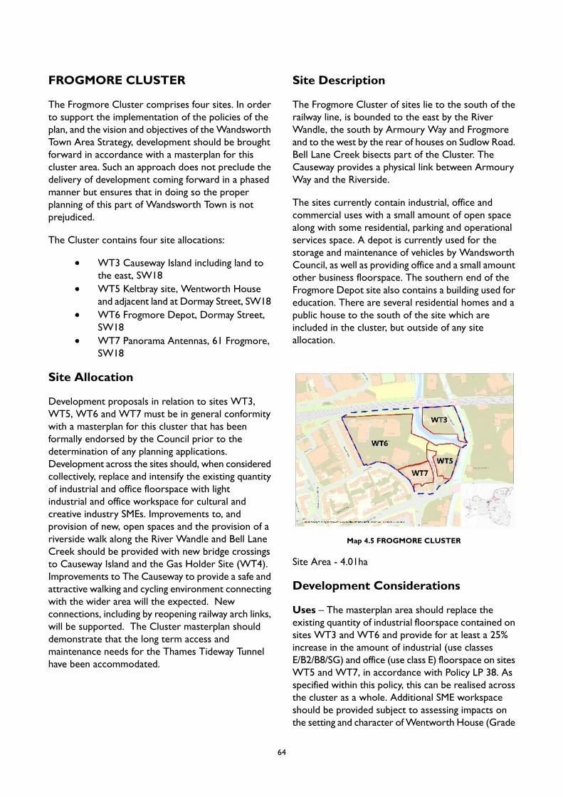
FROGMORE CLUSTER
The Frogmore Cluster comprises four sites. In orderto support the implementation of the policies of theplan, and the vision and objectives of theWandsworthTown Area Strategy, development should be broughtforward in accordance with a masterplan for thiscluster area. Such an approach does not preclude thedelivery of development coming forward in a phasedmanner but ensures that in doing so the properplanning of this part of Wandsworth Town is notprejudiced.
The Cluster contains four site allocations:
WT3 Causeway Island including land tothe east, SW18WT5 Keltbray site, Wentworth Houseand adjacent land at Dormay Street, SW18WT6 Frogmore Depot, Dormay Street,SW18WT7 Panorama Antennas, 61 Frogmore,SW18
Site Allocation
Development proposals in relation to sites WT3,WT5, WT6 and WT7 must be in general conformitywith a masterplan for this cluster that has beenformally endorsed by the Council prior to thedetermination of any planning applications.Development across the sites should, when consideredcollectively, replace and intensify the existing quantityof industrial and office floorspace with lightindustrial and office workspace for cultural andcreative industry SMEs. Improvements to, andprovision of new, open spaces and the provision of ariverside walk along the River Wandle and Bell LaneCreek should be provided with new bridge crossingsto Causeway Island and the Gas Holder Site (WT4).Improvements to The Causeway to provide a safe andattractive walking and cycling environment connectingwith the wider area will the expected. Newconnections, including by reopening railway arch links,will be supported. The Cluster masterplan shoulddemonstrate that the long term access andmaintenance needs for the Thames Tideway Tunnelhave been accommodated.
Site Description
The Frogmore Cluster of sites lie to the south of therailway line, is bounded to the east by the RiverWandle, the south by Armoury Way and Frogmoreand to the west by the rear of houses on Sudlow Road.Bell Lane Creek bisects part of the Cluster. TheCauseway provides a physical link between ArmouryWay and the Riverside.
The sites currently contain industrial, office andcommercial uses with a small amount of open spacealong with some residential, parking and operationalservices space. A depot is currently used for thestorage and maintenance of vehicles by WandsworthCouncil, as well as providing office and a small amountother business floorspace. The southern end of theFrogmore Depot site also contains a building used foreducation. There are several residential homes and apublic house to the south of the site which areincluded in the cluster, but outside of any siteallocation.
Map 4.5 FROGMORE CLUSTER
Site Area - 4.01ha
Development Considerations
Uses – The masterplan area should replace theexisting quantity of industrial floorspace contained onsites WT3 and WT6 and provide for at least a 25%increase in the amount of industrial (use classesE/B2/B8/SG) and office (use class E) floorspace on sitesWT5 and WT7, in accordance with Policy LP 38. Asspecified within this policy, this can be realised acrossthe cluster as a whole. Additional SME workspaceshould be provided subject to assessing impacts onthe setting and character ofWentworth House (Grade
64

II listed). Proposals should include a mix of uses andtypologies including residential and workspace,supporting cultural and creative clusters, in line withthe requirements of the EUIA designation. This shouldalso include the restoration and re-population of therailway arches.
Uses - Proposals should consolidate depot uses aswell as provide residential and economic uses. As partof the proposed consolidation of the Council depotuse on the Old Sergeant’s site on Garratt Lane, theopen storage of vehicles should be removed from theCauseway Island part of the cluster in order tomaximise the wider public benefits that thedevelopment of this cluster can achieve.
Uses – The Roche School currently uses one of theCouncil owned buildings for educational purposes.Opportunities to continue this on the FrogmoreDepot site or elsewhere in the masterplan area shouldbe explored with the Council. There is the opportunityto accommodate this use in the future developmentand to ensure its longevity, any building should bedesigned to accommodate a range of uses should theRoche School wish to relocate.
Landowner Assembly - Development of this clustershould come forward as part of a masterplan thatconnects the site to the rest of the Wandle Delta andtoWandsworth Town Centre. The masterplan shouldinclude a phasing plan for bringing developmentforward.
Open Space - The existing open area adjacent tothe River Wandle on Causeway Island (WT3) shouldremain open and undeveloped and the site’s potentialto contribute to the biodiversity of the river shouldbe enhanced. Causeway Island, west of the Causeway,should be considered for public open space. SUDsshould be used to avoid large expanses of paving. Itshould prioritise biodiversity, utilise river frontage anddaylight from southerly aspect. Another area of openspace should be created at the northern end ofDormay Street adjoining Bell Lane Creek (WT5), witha new bridge linking this to the proposed open spaceon Causeway Island.
Access - Loading and servicing requirements for thepremises should be carefully considered to ensurethat the premises can be serviced on site, as Frogmoreand Dormay Street are narrow and have accessconstraints.
Access - The Keltbray site (WT5) includes access toa Thames Tideway shaft site and access will berequired including for maintenance.
Access - Improving the access from the NorthPassage would be beneficial to the site layout for theFrogmore Depot site (WT6) to potentially providevehicular access routes off Frogmore to serve the areaas well as accommodating improved walking andcycling links to Putney Bridge Road
Parking - Car Club provision for any commercial useand the surrounding area should be delivered.
Design Requirements
Built Form - The site is large enough to provide aseries of urban blocks and streets based on desirelines and connections. Buildings should line the newroutes and provide active frontages to strengthennatural surveillance of streets. Any public spacescreated should be bound by buildings that strengthenand enhance the character of the area. New buildingsadjoining Bell Lane Creek should be set back to allowfor a riverside walk of minimum 3m with provisionfor parklets along the route. Business floor spaceshould be focussed around the centre of the clusterand the open space created at the northern end ofDormay Street and along Dormay Street, to contributeto a critical mass of economic uses around DormayStreet and to provide active frontages to this part ofthe area. New development should consider theThames Tunnel structures and easements and thesetting of Wentworth House.
Movement - A riverside walk incorporating provisionfor cyclists will be required on both sides of Bell LaneCreek. The new walk should incorporate riverbankimprovements to enhance biodiversity. Newconnections to the riverside walk, in particular accessunder the railway bridge and bridge crossing toCauseway Island will be sought. Walking/cycling linksto Wandsworth town centre and the Thames will berequired, including through improvements to TheCauseway.
Movement - Provision should be made for theinstallation of a bridge to cross Bell Lane Creek fromthe northern end of Dormay Street to the CausewayIsland site. Provision should be made for anotherfootbridge crossing Bell Lane Creek immediately southof the railway viaduct to Causeway Island. Thisfootbridge will then lead to the riverside walk and
65
then north, under the viaduct, to the Thames Path. Afinal footbridge should be added on the eastern edgeof the site next to the proposed open space at thenorthern end of Dormay Street (WT5) whichconnects to the Gas Holder cluster to the east (WT4).
Movement - Urban realm and wayfindingimprovements are required to the southern end ofthe site in order to enhance legibility and providebetter level access to the pavements along ArmouryWay (WT5, WT7).
Movement - Provision should be made at the northboundary of the cluster (WT6), next to the westernbank of the Bell Lane Creek for the creation of a newroute passing under the rail tracks connecting the landto the north, Wandsworth Riverside Quarter and theWandle estuary with the site.
Nature - Causeway Island forms a key part of theWandle Trail and the Cluster has the potential tosignificantly contribute to the aims of the WandleValley Regional Park. Development proposals shouldrespond appropriately.
Context - The scale of development should considerthe immediate context, particularly the scale of thehousing on the west side of Frogmore (WT6), thelocally listed Crane Public House, the conservationarea, and Wentworth House.
Identity and Architectural Expression - It isdesirable to retain the existing industrial buildingsimmediately north and adjacent toWentworth House(WT5). Any alterations to these buildings shouldinclude improvements to enhance active frontages andthe contribution that can be made to the safety andattractiveness of Dormay Street.
Identity and Architectural Expression - Anybuildings required as part of the consolidation of depotuses should relate well to the housing that backs onto the site along Sudlow Road and considerationshould be given to residential amenity for theseresidents and those to the south of Frogmore.
Site Layout - The consolidation of the depot usesshould be concentrated on the western part of thecluster (WT6), allowing for the eastern part to bedeveloped for residential and economic uses and thecreation of riverside public realm along the Wandle.
Tall Buildings - In accordance with the Urban DesignStudy and the tall buildings maps in Appendix 2 partof the site is located in an area which has opportunitiesfor tall buildings within town centres and alongstrategic routes, and the height at which buildings willbe considered as ‘tall’ is 5 storeys. Developmentproposals for tall buildings will be assessed inaccordance with Local Plan Policy LP 4.
66
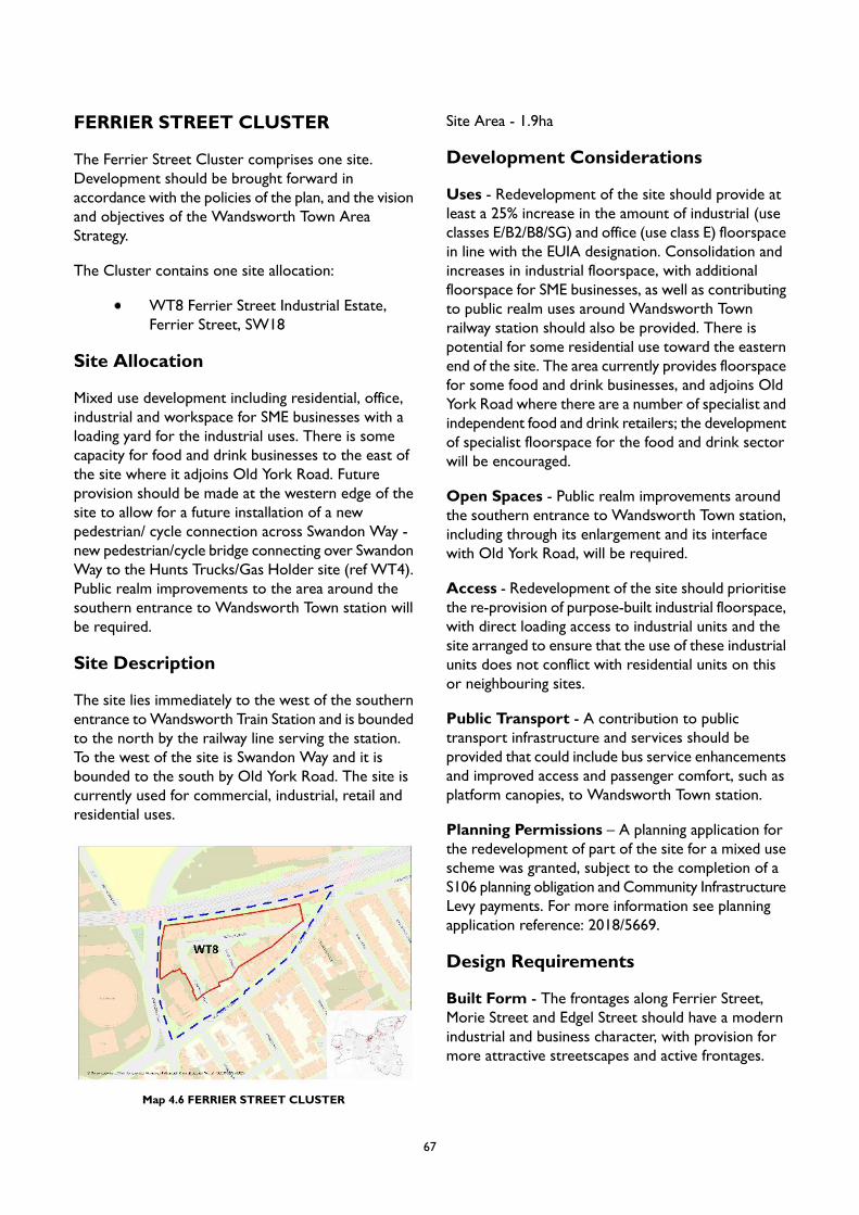
FERRIER STREET CLUSTER
The Ferrier Street Cluster comprises one site.Development should be brought forward inaccordance with the policies of the plan, and the visionand objectives of the Wandsworth Town AreaStrategy.
The Cluster contains one site allocation:
WT8 Ferrier Street Industrial Estate,Ferrier Street, SW18
Site Allocation
Mixed use development including residential, office,industrial and workspace for SME businesses with aloading yard for the industrial uses. There is somecapacity for food and drink businesses to the east ofthe site where it adjoins Old York Road. Futureprovision should be made at the western edge of thesite to allow for a future installation of a newpedestrian/ cycle connection across Swandon Way -new pedestrian/cycle bridge connecting over SwandonWay to the Hunts Trucks/Gas Holder site (ref WT4).Public realm improvements to the area around thesouthern entrance to Wandsworth Town station willbe required.
Site Description
The site lies immediately to the west of the southernentrance toWandsworth Train Station and is boundedto the north by the railway line serving the station.To the west of the site is Swandon Way and it isbounded to the south by Old York Road. The site iscurrently used for commercial, industrial, retail andresidential uses.
Map 4.6 FERRIER STREET CLUSTER
Site Area - 1.9ha
Development Considerations
Uses - Redevelopment of the site should provide atleast a 25% increase in the amount of industrial (useclasses E/B2/B8/SG) and office (use class E) floorspacein line with the EUIA designation. Consolidation andincreases in industrial floorspace, with additionalfloorspace for SME businesses, as well as contributingto public realm uses around Wandsworth Townrailway station should also be provided. There ispotential for some residential use toward the easternend of the site. The area currently provides floorspacefor some food and drink businesses, and adjoins OldYork Road where there are a number of specialist andindependent food and drink retailers; the developmentof specialist floorspace for the food and drink sectorwill be encouraged.
Open Spaces - Public realm improvements aroundthe southern entrance to Wandsworth Town station,including through its enlargement and its interfacewith Old York Road, will be required.
Access - Redevelopment of the site should prioritisethe re-provision of purpose-built industrial floorspace,with direct loading access to industrial units and thesite arranged to ensure that the use of these industrialunits does not conflict with residential units on thisor neighbouring sites.
Public Transport - A contribution to publictransport infrastructure and services should beprovided that could include bus service enhancementsand improved access and passenger comfort, such asplatform canopies, to Wandsworth Town station.
Planning Permissions – A planning application forthe redevelopment of part of the site for a mixed usescheme was granted, subject to the completion of aS106 planning obligation and Community InfrastructureLevy payments. For more information see planningapplication reference: 2018/5669.
Design Requirements
Built Form - The frontages along Ferrier Street,Morie Street and Edgel Street should have a modernindustrial and business character, with provision formore attractive streetscapes and active frontages.
67
Built Form – The massing and scale of developmentshould be well integrated with its surroundings andprovide articulation and variety to create visual reliefalong key frontages.
Movement - Proposals should allow for a connectionover Swandon Way to the Hunts Trucks/Gas Holdersite (WT4) with a new pedestrian/ cyclist crossing thatwould provide a direct and safe connection to OldYork Road andWandsworth Town rail station. Carefuldesign of proposals adjacent to Swandon Way will berequired to accommodate this street level pedestrianconnection towards the Hunts Trucks site, potentiallyarranged as an archway to maximise workspaceaccommodation and act as a natural buffer to vehiclenoise from Swandon Way.
Context - The scale of development should take intoaccount the historic character of the buildings frontingOld York Road and the setting of the Old York RoadConservation Area and should consider the residentialamenity of these properties, with any tallerdevelopment located towards the northern parts ofthe site.
Massing - A taller element would be appropriate inthe north-western corner of the site adjacent to therailway line.
Nature – There is an opportunity to use any roofspaces in new development as green spaces that shouldenhance biodiversity.
Tall Buildings - In accordance with the Urban DesignStudy and the tall buildings maps in Appendix 2 thesite is located in an area which has opportunities fortall buildings within town centres and along strategicroutes, and the height at which buildings will beconsidered as ‘tall’ is 5 storeys. Developmentproposals for tall buildings will be assessed inaccordance with Local Plan Policy LP 4.
68
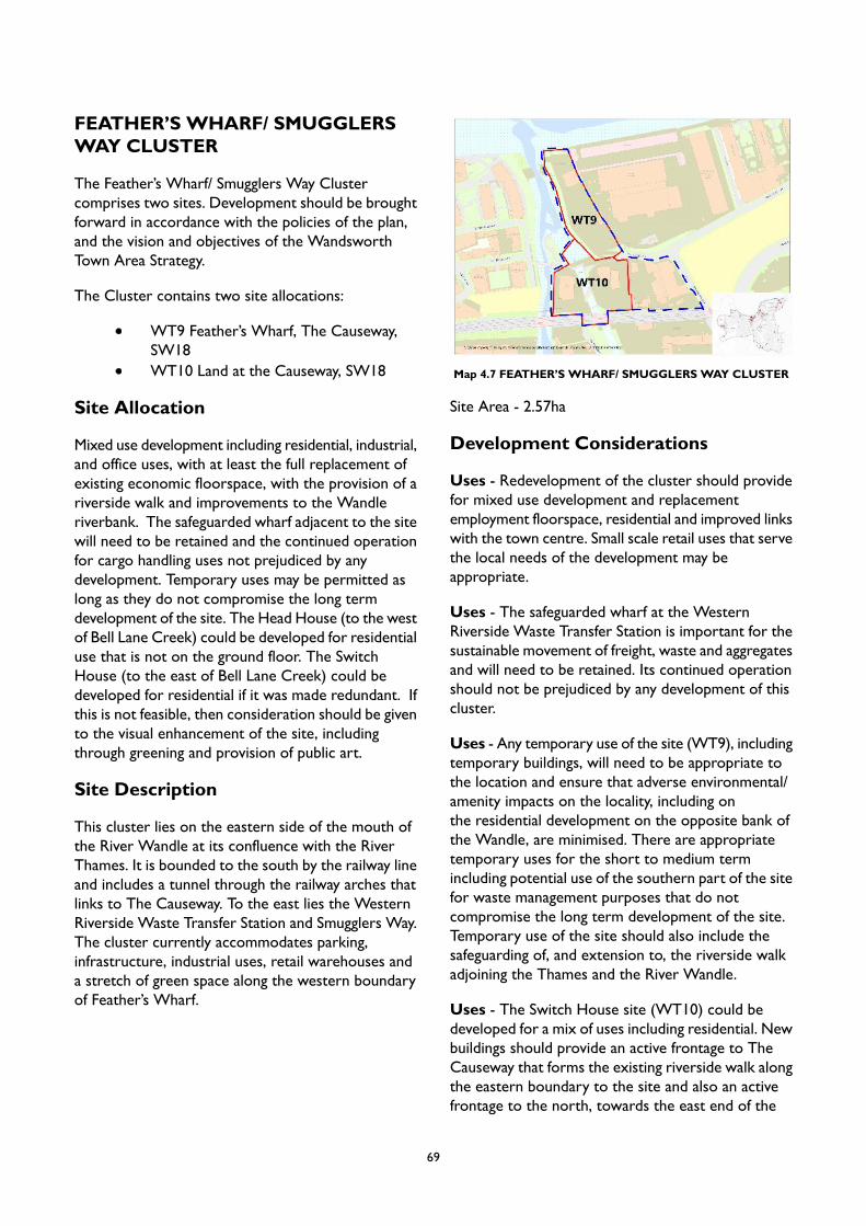
FEATHER’S WHARF/ SMUGGLERSWAY CLUSTER
The Feather’s Wharf/ Smugglers Way Clustercomprises two sites. Development should be broughtforward in accordance with the policies of the plan,and the vision and objectives of the WandsworthTown Area Strategy.
The Cluster contains two site allocations:
WT9 Feather’s Wharf, The Causeway,SW18WT10 Land at the Causeway, SW18
Site Allocation
Mixed use development including residential, industrial,and office uses, with at least the full replacement ofexisting economic floorspace, with the provision of ariverside walk and improvements to the Wandleriverbank. The safeguarded wharf adjacent to the sitewill need to be retained and the continued operationfor cargo handling uses not prejudiced by anydevelopment. Temporary uses may be permitted aslong as they do not compromise the long termdevelopment of the site. The Head House (to the westof Bell Lane Creek) could be developed for residentialuse that is not on the ground floor. The SwitchHouse (to the east of Bell Lane Creek) could bedeveloped for residential if it was made redundant. Ifthis is not feasible, then consideration should be givento the visual enhancement of the site, includingthrough greening and provision of public art.
Site Description
This cluster lies on the eastern side of the mouth ofthe River Wandle at its confluence with the RiverThames. It is bounded to the south by the railway lineand includes a tunnel through the railway arches thatlinks to The Causeway. To the east lies the WesternRiverside Waste Transfer Station and Smugglers Way.The cluster currently accommodates parking,infrastructure, industrial uses, retail warehouses anda stretch of green space along the western boundaryof Feather’s Wharf.
Map 4.7 FEATHER’S WHARF/ SMUGGLERS WAY CLUSTER
Site Area - 2.57ha
Development Considerations
Uses - Redevelopment of the cluster should providefor mixed use development and replacementemployment floorspace, residential and improved linkswith the town centre. Small scale retail uses that servethe local needs of the development may beappropriate.
Uses - The safeguarded wharf at the WesternRiverside Waste Transfer Station is important for thesustainable movement of freight, waste and aggregatesand will need to be retained. Its continued operationshould not be prejudiced by any development of thiscluster.
Uses - Any temporary use of the site (WT9), includingtemporary buildings, will need to be appropriate tothe location and ensure that adverse environmental/amenity impacts on the locality, including onthe residential development on the opposite bank ofthe Wandle, are minimised. There are appropriatetemporary uses for the short to medium termincluding potential use of the southern part of the sitefor waste management purposes that do notcompromise the long term development of the site.Temporary use of the site should also include thesafeguarding of, and extension to, the riverside walkadjoining the Thames and the River Wandle.
Uses - The Switch House site (WT10) could bedeveloped for a mix of uses including residential. Newbuildings should provide an active frontage to TheCauseway that forms the existing riverside walk alongthe eastern boundary to the site and also an activefrontage to the north, towards the east end of the
69
footbridge across Bell Lane Creek. If such developmentis not feasible then consideration should be given tothe enhancement of the Switch House with a publicart project that responds to the historic and naturalcharacter of the Wandle.
Uses - The Smugglers Way area (WT10) contains anelectricity substation facility (the Head House) and anumber of businesses to the east (an extension of thecurrent site allocation). The Head House is neededfor the foreseeable future and will make feasibility andviability challenging. The area could therefore be apotential longer-term opportunity if the infrastructurebecomes surplus to requirements or a developer canfind a viable solution to relocating or reprovision. TheHead House could be developed for a mixture of usesincluding residential. There should be no residentialuse on the ground floor and any new buildings shouldprovide an active frontage to Smugglers Way and tothe proposed connection, east of the Head House, tothe Hunts Trucks site (WT4). Proposals would requirefurther discussions with the landowner EDF Energyand UK Power Networks. Subject to these furtherdiscussions, the site could come forward in the longerterm (11+ years).
Open Space - The area at the northern end of thesite (WT9) by theWandle mouth should be specificallydesigned to provide a generous open space and be aplace with distinctive character and identity for thepublic to enjoy. Development must include measuresthat contribute towards enhancement of theriverbanks. These will include improved biodiversity;restoration of historic riverbank features and theremoval of redundant pipe/cable bridges that currentlycross the Wandle from these sites.
Parking - Provision of a car club should be consideredas well as improvements to public transport.
Active Travel – Proposals will be expected tocontribute towards the cost of providing improvedsecurity to the pedestrian and cycle link through theWestern Riverside Waste Transfer Station to link tothe Riverside walk. Improvements to pavement widthand quality on The Causeway/Smuggler's Way are alsoneeded.
Design Requirements
Built Form - The proposed riverside walks and thefrontage to The Causeway must be defined by newactive building frontages. Any design must ensure thatan acceptable living environment is created for futureresidents and does not inhibit the proper operationof the adjacent Western Riverside Waste TransferStation.
Built Form - Proposals will need to ensure theyprotect sensitive views of Feather's Wharf fromWandsworth Park, from the wider Thames andWandle Riverside, including Wandsworth Bridge, theDeodar Road footbridge and from the opposite bankof the Thames, particularly Hurlingham Park.
Movement - There should be provision for ariverside walk adjoining the river Thames andWandle.Buildings should be set back from the riverbanks toallow for a riverside walk of at least 3 m and 6m onthe Wandle and Thames river frontages respectively.The Wandle Path should include unobstructedconnections to the Thames Path.
Movement - New development on WT9 should bedesigned to facilitate a safe and secure connection tothe high-level bridge taking the riverside walk acrossthe refuse transfer station site to the west of theWandle.
Movement - New connections through the site(WT10) and funding for environmental improvementsto the River Wandle will be required. Improvementsto the width and quality of the footway on TheCauseway and Smugglers Way will be sought.
Movement - Provision should be made for a newroute along the eastern boundary of the head housetransformer station that would extend the new routeunder the railway viaduct from the Hunt Trucks site(WT4) through to Smugglers Way. For securityreasons, it may not be possible to extend the Wandleriverside walk along the western boundary of theSwitch House site and the western boundary of theHead House site. However, if these can be overcome,it would be desirable to secure public access alongthese two banks of theWandle in the form of riversidewalks.
Movement - Improvements to pavement width andquality on The Causeway/Smuggler’s Way will also berequired.
70

Context - Although site surveys are not available,these sites are likely to have contamination andservices running through them, due to their currentuse and adjacency to the recycling facility. These sitesare adjacent to the River Thames and Wandle whichcould cause engineering challenges that will need tobe resolved.
Context - Proposals should consider the impact onsafeguarded wharf, in terms of the ongoing operationalrequirements including movement of freight, wasteand aggregates. Context - Proposals should considerthe impact on safeguarded wharf, in terms of theongoing operational requirements including movementof freight, waste and aggregates.
Site Layout - At Feathers Wharf, detailed designwork will need to be undertaken to ensure that thereis appropriate buffering and orientation of theresidential units away from the recycling facility(WT11). Any ground floor food and beverage useshould face west, away from the recycling facility, withservicing arrangements to the rear.
Massing - The site offers potential for taller elements,although diversity in height should be encouragedadjacent to the River Wandle.
Nature - Both the Wandle and Thames riverbanksand river channels are particularly sensitive ecologicaland wildlife habitats. Consideration in relation todesign, siting and massing of buildings, recognising thevalue of the banks, and the need forassessment/mitigation of impact. Developments mustnot cause unreasonable harm to these habitats by theirproximity or overshadowing and opportunities forenhancement should be pursued.
Nature - A contribution towards the improvementof riverbanks to enhance wildlife habitats andbiodiversity which do not have a detrimental impacton navigation or river regime will be sought.
Tall Buildings - In accordance with the Urban DesignStudy and the tall buildings maps in Appendix 2 partof the site is located in an area which has opportunitiesfor tall building clusters and/or landmarks, and theheight at which buildings will be considered as ‘tall’ is5 storeys. Development proposals for tall buildingswill be assessed in accordance with Local Plan PolicyLP 4.
71

WT11 Western Riverside WasteTransfer Station, SW18
Site Allocation
Safeguarded Wharf.
Site Description
The site lies to the north of Smugglers Way adjacentto the bank of the River Thames. To the west of thesite is Feather’s Wharf and to the east a civic amenitysite. The site is used as a Waste Transfer Station. Thesite is operated by the Western Riverside WasteAuthority (WRWA) which is the statutory bodyresponsible for the management of the waste deliveredto it by the London boroughs of WandsworthLambeth, Kensington and Chelsea and Hammersmith& Fulham. The site is used as a Waste Transfer Stationwhich utilises its riverside position and wharf facilitiesfor bulk transportation of waste to an Energy fromWaste Facility at Belvedere in the London Boroughof Bexley. The current use of the site provides animportant strategic role.
Map 4.8WT11Western RiversideWaste Transfer Station, SW18
Site Area - 2.49ha
Development Considerations
Uses - There is potential for the redevelopment ofthe Western Riverside Waste Authority facility whichis arranged perpendicular to the River Thames. Thefacility could be reprovided in a similar location withpotential addition of residential uses above a wastefacility. This would offer an opportunity to betteraddress Waterside Path and the Riverside Westdevelopment to the east. Any proposal would needto demonstrate that the addition of residential
dwellings would not compromise the operation of theadjacent wharf uses. Proposals would need to considerhow edge conditions and access to adjacent wastefacilities are managed.
Planning Permissions – The site has multiplepermissions for waste management uses. For moreinformation see planning references 1. (2015/4784).2. (2016/4287) 3. (2016/5531) 4. (2014/1184).
Design Requirements
Build Form - High quality design is required for anynew development to minimise adverseenvironmental/amenity impacts on the locality.
Movement - The existing pedestrian route shouldfacilitate a safe and secure connection to the high-levelbridge taking the riverside walk across the refusetransfer station site. Should this use change then anew riverside walk of 6m will be required as part ofany new development.
Site Layout – Should the safeguarded wharf bedecommissioned then a mixed use residential schemecould come forward with built frontages on to theRiver Thames and The Causeway.
Tall Buildings - In accordance with the Urban DesignStudy and the tall buildings maps in Appendix 2 thesite is located in an area which has opportunities fortall building clusters and/or landmarks, and the heightat which buildings will be considered as ‘tall’ is 5storeys. Development proposals for tall buildings willbe assessed in accordance with Local Plan Policy LP4.
72
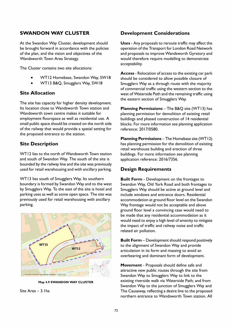
SWANDONWAY CLUSTER
At the Swandon Way Cluster, development shouldbe brought forward in accordance with the policiesof the plan, and the vision and objectives of theWandsworth Town Area Strategy.
The Cluster contains two site allocations:
WT12 Homebase, Swandon Way, SW18WT13 B&Q, Smugglers Way, SW18
Site Allocation
The site has capacity for higher density development.Its location close to Wandsworth Town station andWandsworth town centre makes it suitable foremployment floorspace as well as residential use. Asmall public space should be created on the north sideof the railway that would provide a spatial setting forthe proposed entrance to the station.
Site Description
WT12 lies to the north of Wandsworth Town stationand south of Swandon Way. The south of the site isbounded by the railway line and the site was previouslyused for retail warehousing and with ancillary parking.
WT13 lies south of Smugglers Way. Its southernboundary is formed by SwandonWay and to the westby Smugglers Way. To the east of the site is hotel andparking uses as well as some open space. The site waspreviously used for retail warehousing with ancillaryparking.
Map 4.9 SWANDONWAY CLUSTER
Site Area – 3.1ha
Development Considerations
Uses - Any proposals to reroute traffic may affect theoperation of the Transport for London Road Networkand proposals to improve Wandsworth Gyratory andwould therefore require modelling to demonstrateacceptability.
Access - Relocation of access to the existing car parkshould be considered to allow possible closure ofSmugglers Way as a through route with the majorityof commercial traffic using the western section to thewest of Waterside Path and the remaining traffic usingthe eastern section of Smugglers Way.
Planning Permissions – The B&Q site (WT13) hasplanning permission for demolition of existing retailbuildings and phased construction of 14 residentialblocks. For more information see planning applicationreference: 2017/0580.
Planning Permissions – The Homebase site (WT12)has planning permission for the demolition of existingretail warehouse building and erection of threebuildings. For more information see planningapplication reference: 2016/7356.
Design Requirements
Built Form - Development on the frontages toSwandon Way, Old York Road and both frontages toSmugglers Way should be active at ground level andinclude windows and entrance doors. Residentialaccommodation at ground floor level on the SwandonWay frontage would not be acceptable and aboveground floor level a convincing case would need tobe made that any residential accommodation as itwould need to enjoy a high level of amenity to mitigatethe impact of traffic and railway noise and trafficrelated air pollution.
Built Form – Development should respond positivelyto the alignment of Swandon Way and providearticulation in its form and massing to avoid anoverbearing and dominant form of development.
Movement - Proposals should define safe andattractive new public routes through the site fromSwandon Way to Smugglers Way to link to theexisting riverside walk via Waterside Path; and fromSwandon Way to the junction of Smugglers Way andThe Causeway, reflecting a desire line to the proposednorthern entrance to Wandsworth Town station. All
73
buildings should be designed to address these linkswith active frontages. Improvements to pavementwidth and quality on The Causeway/ Smuggler's Waywill also be required.
Movement - Proposal should show improved accessto the northern part ofWandsworth Town to enhanceaccessibility and reduce walking times from thenorthern part of theWandle Delta area. The feasibilityof providing an elevated footway linking the stationto the Homebase site (WT12) and to futuredevelopments on the north side of Swandon Wayshould be considered.
Context - Care will be necessary to ensure that anyresidential accommodation withinWT13 overlooking,or in close proximity to, theWestern RiversideWasteTransfer Station and refuse processing site onSmugglersWay is designed in such a way that residentswill enjoy a satisfactory level of amenity.
Site Layout - As part of the improvements withinWT12 to create a northern access to WandsworthTown Station, a significant up-grade in the public realmof the Old York Road frontage would be expectedwith improved public transport infrastructure andprovision of a car club.
Nature - Tree planting will be required on theSwandon Way frontage and the retention of existingtrees should be facilitated.
Tall Buildings - In accordance with the Urban DesignStudy and the tall buildings maps in Appendix 2 thesite is located in an area which has opportunities for‘tall building clusters and/or landmarks’ (Site WT13)and opportunities for ‘tall buildings within towncentres and along strategic routes’ (Site WT12), andthe height at which buildings will be considered as ‘tall’is 5 storeys. Development proposals for tall buildingswill be assessed in accordance with Local Plan PolicyLP 4.
74
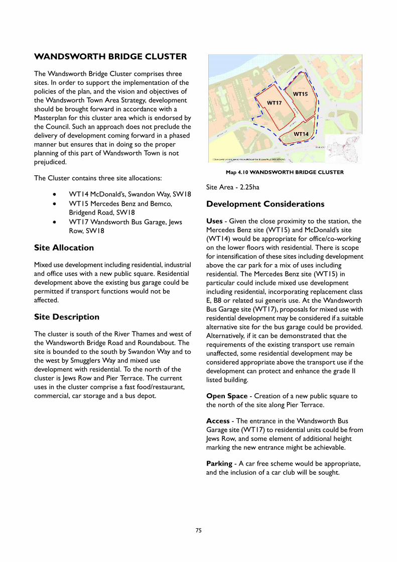
WANDSWORTH BRIDGE CLUSTER
The Wandsworth Bridge Cluster comprises threesites. In order to support the implementation of thepolicies of the plan, and the vision and objectives ofthe Wandsworth Town Area Strategy, developmentshould be brought forward in accordance with aMasterplan for this cluster area which is endorsed bythe Council. Such an approach does not preclude thedelivery of development coming forward in a phasedmanner but ensures that in doing so the properplanning of this part of Wandsworth Town is notprejudiced.
The Cluster contains three site allocations:
WT14 McDonald’s, Swandon Way, SW18WT15 Mercedes Benz and Bemco,Bridgend Road, SW18WT17 Wandsworth Bus Garage, JewsRow, SW18
Site Allocation
Mixed use development including residential, industrialand office uses with a new public square. Residentialdevelopment above the existing bus garage could bepermitted if transport functions would not beaffected.
Site Description
The cluster is south of the River Thames and west ofthe Wandsworth Bridge Road and Roundabout. Thesite is bounded to the south by Swandon Way and tothe west by Smugglers Way and mixed usedevelopment with residential. To the north of thecluster is Jews Row and Pier Terrace. The currentuses in the cluster comprise a fast food/restaurant,commercial, car storage and a bus depot.
Map 4.10 WANDSWORTH BRIDGE CLUSTER
Site Area - 2.25ha
Development Considerations
Uses - Given the close proximity to the station, theMercedes Benz site (WT15) and McDonald’s site(WT14) would be appropriate for office/co-workingon the lower floors with residential. There is scopefor intensification of these sites including developmentabove the car park for a mix of uses includingresidential. The Mercedes Benz site (WT15) inparticular could include mixed use developmentincluding residential, incorporating replacement classE, B8 or related sui generis use. At the WandsworthBus Garage site (WT17), proposals for mixed use withresidential development may be considered if a suitablealternative site for the bus garage could be provided.Alternatively, if it can be demonstrated that therequirements of the existing transport use remainunaffected, some residential development may beconsidered appropriate above the transport use if thedevelopment can protect and enhance the grade IIlisted building.
Open Space - Creation of a new public square tothe north of the site along Pier Terrace.
Access - The entrance in the Wandsworth BusGarage site (WT17) to residential units could be fromJews Row, and some element of additional heightmarking the new entrance might be achievable.
Parking - A car free scheme would be appropriate,and the inclusion of a car club will be sought.
75
Design Requirements
Built Form – Secure active frontages to SwandonWay, theWandsworth Bridge Roundabout, Marl Road,Bridgend Road, Jew’s Row, Pier Terrace and NormansPassage at ground level to include windows andentrance doors. On Swandon Way, the WandsworthBridge Roundabout, Marl Road and Normans Passageresidential accommodation at ground floor level wouldnot be acceptable and residential accommodationabove ground floor level would require a convincingcase to demonstrate that any such use would enjoy asatisfactory level of amenity. Achievement of high levelof amenity for all residential accommodation includingmeasures to mitigate the impact of traffic noise.
Built Form – The Wandsworth Bus Garage site(WT17) could include some limited additionalfloorspace, limited to 2 storeys of accommodation,that could be added above the western range of thebuilding – which is largely workshop space. Theproposal could be a clearly modern, simple rectilinearform, superimposed over the existing structure andbroadly mirroring an element of the north-southmultiple roof array over the bus garage proper.
Movement – Provision for short and medium termenhancements to lighting, wayfinding signage and anactive travel route via the roundabout includingconnections to the planned new entrance toWandsworth Town station.
Movement – An active travel link through archesbeneath Bridgend Road linking into Jews Row will berequired.
Context – There will be a need to future-proof thepotential longer-term redevelopment of roundaboutsite through the removal of the western arm of theroundabout.
Context – Development should not harm the settingof the adjacent listed Bus Garage. Sensitive infilldevelopment and intensification adjacent to the listedbuilding could be possible. Subject to ongoingoperation of the current occupier, proposals torejuvenate the bus garage for leisure or flexibleworkspace should be considered.
Context – Achievement of a high level of amenityfor all residential accommodation including measuresto mitigate the impact of traffic noise.
Context – The importance of the safeguarded wharfat Pier Wharf (WT22) for the sustainable movementof freight, waste and aggregates will require itsretention and continued operation for cargo handlinguses must not be prejudiced by any development.
Identity and Architectural Expression – It wouldbe beneficial to restore the architectural integrity oftheWandsworth Bus Garage (WT17) building, i.e. theoriginal building front on the south side that wasunsympathetically altered. Proposals could achievethis by reinstating this principal elevation to match thequality of the surviving north and east elevations.
Nature – Tree planting will be required on theSwandon Way and Bridgend Road frontage.
Tall Buildings – In accordance with the Urban DesignStudy and the tall buildings maps in Appendix 2 thesite is located in an area which has opportunities fortall building clusters and/or landmarks, and the heightat which buildings will be considered as ‘tall’ is 5storeys. Development proposals for tall buildings willbe assessed in accordance with Local Plan Policy LP4.
76

WT16WandsworthBridgeRoundabout,SW18
Site Allocation
Mixed use development including residential andeconomic uses with elevated active travel routesconnecting the site to neighbouring development.
Site Description
This site comprises the centre of the WandsworthBridge Roundabout. To the north is WandsworthBridge Road, to the east A3025/ York Road, to thesouth A214/ Trinity Road and to the west A217/Swandon Way. The site is currently used for openspace and public art and also contains a largeadvertising structure. It is connected to the wider areaby access ramps, stairs and underpasses.
Map 4.11 WT16 Wandsworth Bridge Roundabout, SW18
Site Area - 0.7ha
Development Considerations
Uses – The removal of the western arm of theWandsworth Bridge roundabout could enable theredevelopment of the current roundabout site andmight also establish an additional area of public realmadjacent to the development sites identified in theWandsworth Bridge cluster (WT14, WT15 andWT17). This opportunity would require more detailedstudies and assessments across a range of disciplines.It is likely that any such proposals would need to becoordinated with a broader strategy of sustainablemodal shift towards active travel and public transport.
Public Transport – Part of the site may need to besafeguarded for transport/highways improvements andimprovements to public transport will be required.
Active Travel – Elevated pedestrian/cycle routeshould be considered linking the roundabout toneighbouring developments around the roundabout,across Swandon way to Wandsworth Town Station.
Design Requirements
Built Form - This site represents a gateway toWandsworth from north of the River Thames andviews north and south as well as east and west areimportant.
Movement - It is imperative that the layout anddesign of the development pays special attention tothe need to ensure a very high level of public safetyand security to those accessing the new building andthose moving through the site. Connections to thesurrounding streets could be achieved by using theexisting subway tunnels under the surrounding roadsor with a new system of connections at grade, or newbridge links over the surrounding roads.
Context - A convincing case will need to be madeto show how the design will ensure a high level ofpublic safety and security. A satisfactory level ofamenity for all residential accommodation would beexpected and the design of the buildings should includemeasures to mitigate the impact of traffic noise. Giventhe prominent, pivotal location of this site, adevelopment of very high architectural quality will berequired.
Context - Any proposals would need to beconsidered in the context of emerging proposals fortheWandsworth gyratory, which is now being activelypursued by TfL and the Council.
Identity and Architectural Expression – Thedevelopment should draw upon the local context andrepresent a striking architectural composition.
Site Layout – The site needs to be considered in thecontext of any road proposals that may facilitate are-configured development site in discussion with TfL.Given the strategic importance of the site it would besuitable for a competition.
77
Tall Buildings - In accordance with the Urban DesignStudy and the tall buildings maps in Appendix 2 thesite is located in an area which has opportunities fortall building clusters and/or landmarks, and the heightat which buildings will be considered as ‘tall’ is 5storeys. Development proposals for tall buildings willbe assessed in accordance with Local Plan Policy LP4.
78
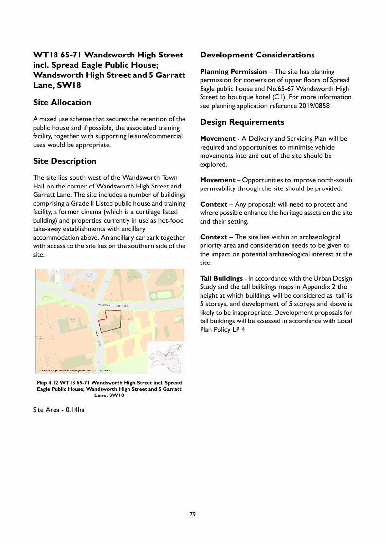
WT18 65-71 Wandsworth High Streetincl. Spread Eagle Public House;Wandsworth High Street and 5 GarrattLane, SW18
Site Allocation
A mixed use scheme that secures the retention of thepublic house and if possible, the associated trainingfacility, together with supporting leisure/commercialuses would be appropriate.
Site Description
The site lies south west of the Wandsworth TownHall on the corner of Wandsworth High Street andGarratt Lane. The site includes a number of buildingscomprising a Grade II Listed public house and trainingfacility, a former cinema (which is a curtilage listedbuilding) and properties currently in use as hot-foodtake-away establishments with ancillaryaccommodation above. An ancillary car park togetherwith access to the site lies on the southern side of thesite.
Map 4.12 WT18 65-71 Wandsworth High Street incl. SpreadEagle Public House; Wandsworth High Street and 5 Garratt
Lane, SW18
Site Area - 0.14ha
Development Considerations
Planning Permission – The site has planningpermission for conversion of upper floors of SpreadEagle public house and No.65-67 Wandsworth HighStreet to boutique hotel (C1). For more informationsee planning application reference 2019/0858.
Design Requirements
Movement - A Delivery and Servicing Plan will berequired and opportunities to minimise vehiclemovements into and out of the site should beexplored.
Movement – Opportunities to improve north-southpermeability through the site should be provided.
Context – Any proposals will need to protect andwhere possible enhance the heritage assets on the siteand their setting.
Context – The site lies within an archaeologicalpriority area and consideration needs to be given tothe impact on potential archaeological interest at thesite.
Tall Buildings - In accordance with the Urban DesignStudy and the tall buildings maps in Appendix 2 theheight at which buildings will be considered as ‘tall’ is5 storeys, and development of 5 storeys and above islikely to be inappropriate. Development proposals fortall buildings will be assessed in accordance with LocalPlan Policy LP 4
79
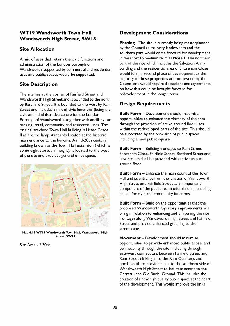
WT19 Wandsworth Town Hall,Wandsworth High Street, SW18
Site Allocation
A mix of uses that retains the civic functions andadministration of the London Borough ofWandsworth, supported by commercial and residentialuses and public spaces would be supported.
Site Description
The site lies at the corner of Fairfield Street andWandsworth High Street and is bounded to the northby Barchard Street. It is bounded to the west by RamStreet and includes a mix of civic functions (being thecivic and administrative centre for the LondonBorough of Wandsworth), together with ancillary carparking, retail, community and residential uses. Theoriginal art-deco Town Hall building is Listed GradeII as are the lamp standards located at the historicmain entrance to the building. A mid-20th centurybuilding known as the Town Hall extension (which issome eight storeys in height), is located to the westof the site and provides general office space.
Map 4.13 WT19 Wandsworth Town Hall, Wandsworth HighStreet, SW18
Site Area - 2.30ha
Development Considerations
Phasing - The site is currently being masterplannedby the Council as majority landowners and thesouthern part would come forward for developmentin the short to medium term as Phase 1. The northernpart of the site which includes the Salvation Armybuilding and the residential area of Shoreham Closewould form a second phase of development as themajority of these properties are not owned by theCouncil and would require discussions and agreementson how this could be brought forward forredevelopment in the longer term.
Design Requirements
Built Form – Development should maximiseopportunities to enhance the vibrancy of the areathrough the provision of active ground floor useswithin the redeveloped parts of the site. This shouldbe supported by the provision of public spacesincluding a new public square.
Built Form – Building frontages to Ram Street,Shoreham Close, Fairfield Street, Barchard Street andnew streets shall be provided with active uses atground floor.
Built Form – Enhance the main court of the TownHall and its entrance from the junction ofWandsworthHigh Street and Fairfield Street as an importantcomponent of the public realm offer through enablingits use for civic and community functions.
Built Form – Build on the opportunities that theproposed Wandsworth Gyratory improvements willbring in relation to enhancing and enlivening the sitefrontages alongWandsworth High Street and FairfieldStreet and provide enhanced greening to thestreetscape.
Movement – Development should maximiseopportunities to provide enhanced public access andpermeability through the site, including througheast-west connections between Fairfield Street andRam Street (linking in to the Ram Quarter), andnorth-south to provide a link to the southern side ofWandsworth High Street to facilitate access to theGarratt Lane Old Burial Ground. This includes thecreation of a new high quality public space at the heartof the development. This would improve the links
80
between open spaces of the adjacent Ram Brewery,and the town centre to create a green network anda more pedestrian focussed environment.
Movement – Explore opportunities to reduce thelevel of vehicle movements into the site, includingthrough the removal of on-site car parking provisionexcept for that necessary to support the properfunctioning of the uses on the site and for those withdisabilities.
Context – Any proposals, including in relation tobuilding heights and the location of taller buildings, willneed to respond to the site’s location within theWandsworth Town Conservation Area and adjoininghistoric sites including those located within the RamQuarter. Any proposals should maximise theopportunity to celebrate the heritage of the site andprotect and enhance the building’s setting andsignificance.
Tall Buildings - In accordance with the Urban DesignStudy and the tall buildings maps in Appendix 2 theheight at which buildings will be considered as ‘tall’ is5 storeys, and development of 5 storeys and above islikely to be inappropriate. Development proposals fortall buildings will be assessed in accordance with LocalPlan Policy LP 4.
81
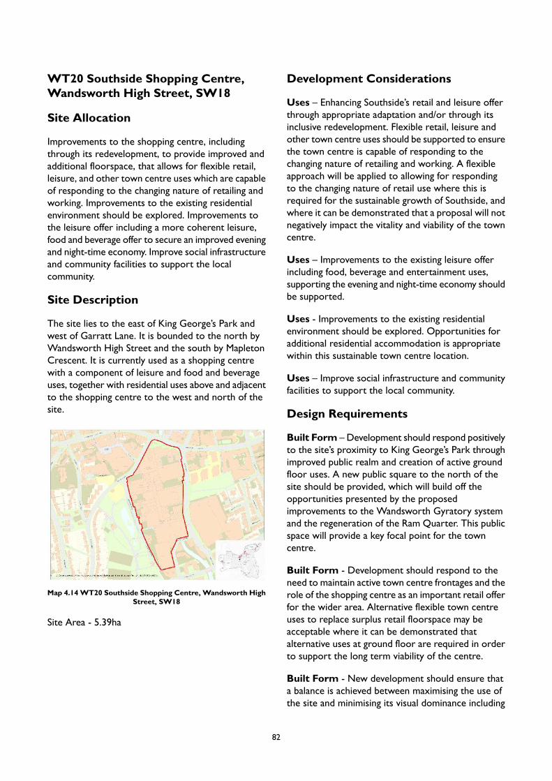
WT20 Southside Shopping Centre,Wandsworth High Street, SW18
Site Allocation
Improvements to the shopping centre, includingthrough its redevelopment, to provide improved andadditional floorspace, that allows for flexible retail,leisure, and other town centre uses which are capableof responding to the changing nature of retailing andworking. Improvements to the existing residentialenvironment should be explored. Improvements tothe leisure offer including a more coherent leisure,food and beverage offer to secure an improved eveningand night-time economy. Improve social infrastructureand community facilities to support the localcommunity.
Site Description
The site lies to the east of King George’s Park andwest of Garratt Lane. It is bounded to the north byWandsworth High Street and the south by MapletonCrescent. It is currently used as a shopping centrewith a component of leisure and food and beverageuses, together with residential uses above and adjacentto the shopping centre to the west and north of thesite.
Map 4.14WT20 Southside Shopping Centre, Wandsworth HighStreet, SW18
Site Area - 5.39ha
Development Considerations
Uses – Enhancing Southside’s retail and leisure offerthrough appropriate adaptation and/or through itsinclusive redevelopment. Flexible retail, leisure andother town centre uses should be supported to ensurethe town centre is capable of responding to thechanging nature of retailing and working. A flexibleapproach will be applied to allowing for respondingto the changing nature of retail use where this isrequired for the sustainable growth of Southside, andwhere it can be demonstrated that a proposal will notnegatively impact the vitality and viability of the towncentre.
Uses – Improvements to the existing leisure offerincluding food, beverage and entertainment uses,supporting the evening and night-time economy shouldbe supported.
Uses - Improvements to the existing residentialenvironment should be explored. Opportunities foradditional residential accommodation is appropriatewithin this sustainable town centre location.
Uses – Improve social infrastructure and communityfacilities to support the local community.
Design Requirements
Built Form – Development should respond positivelyto the site’s proximity to King George’s Park throughimproved public realm and creation of active groundfloor uses. A new public square to the north of thesite should be provided, which will build off theopportunities presented by the proposedimprovements to the Wandsworth Gyratory systemand the regeneration of the Ram Quarter. This publicspace will provide a key focal point for the towncentre.
Built Form - Development should respond to theneed to maintain active town centre frontages and therole of the shopping centre as an important retail offerfor the wider area. Alternative flexible town centreuses to replace surplus retail floorspace may beacceptable where it can be demonstrated thatalternative uses at ground floor are required in orderto support the long term viability of the centre.
Built Form - New development should ensure thata balance is achieved between maximising the use ofthe site and minimising its visual dominance including
82
for pedestrians using Garratt Lane. This includes givingcareful consideration to building heights across thesite and ensuring that street frontages are articulatedto minimise its bulk, scale and massing.
Movement – Development should improvepermeability through the site to strengthen links andintegration with the locality including east-westbetween King George’s Park and Garratt Laneincluding to the Old Burial Ground, and north-southto integrate the site with the Ram Quarter. TheWandle is a natural asset which should be conserved,improved and enjoyed. Opportunities to use designsolutions that articulate the location of the culvertedRiver Wandle through the site and open up access,or provide a connection, to the river should beexplored. New pedestrian routes at grade level shouldbe provided.
Movement – An increase in the width of thepavement along Garratt Lane will be sought in orderto provide for an improved pedestrian environmentand support opportunities for street planting.Improved links to Wandsworth High Street, GarrattLane, Buckhold Road, Mapleton Crescent and NevilleGill Close should be provided as part of any scheme.
Context – Development should maximiseopportunities to enhance the living conditions ofexisting and future residents within and adjacent tothe site. This could include opportunities to makebetter use of roof areas for amenity space designedfor all year-round use. Opportunities to provide somepublicly accessible space that allows views across thearea to be enjoyed by local people will be supportedif such uses do not cause harm to the living conditionsof residents through noise and disturbance.
Massing – The scale, form and density of developmentshould embrace its sustainable town centre location.Development should minimise its visual dominancefrom the surrounding Wandsworth TownConservation Area. This includes giving carefulconsideration of building heights across the site andensuring that street frontages are articulated tominimise its bulk, scale and massing. New developmentshould carefully consider the site’s location adjacentto the Conservation Area including the uses, locationof entrances and contribution to the adjacent streetscene.
Tall Buildings - In accordance with the Urban DesignStudy and the tall buildings maps in Appendix 2 partof the site is located in an area which has opportunitiesfor ‘tall buildings within town centres and alongstrategic routes’ or ‘tall building clusters and/orlandmarks’, and the height at which buildings will beconsidered as ‘tall’ is 6 storeys. Developmentproposals for tall buildings will be assessed inaccordance with Local Plan Policy LP 4.
83
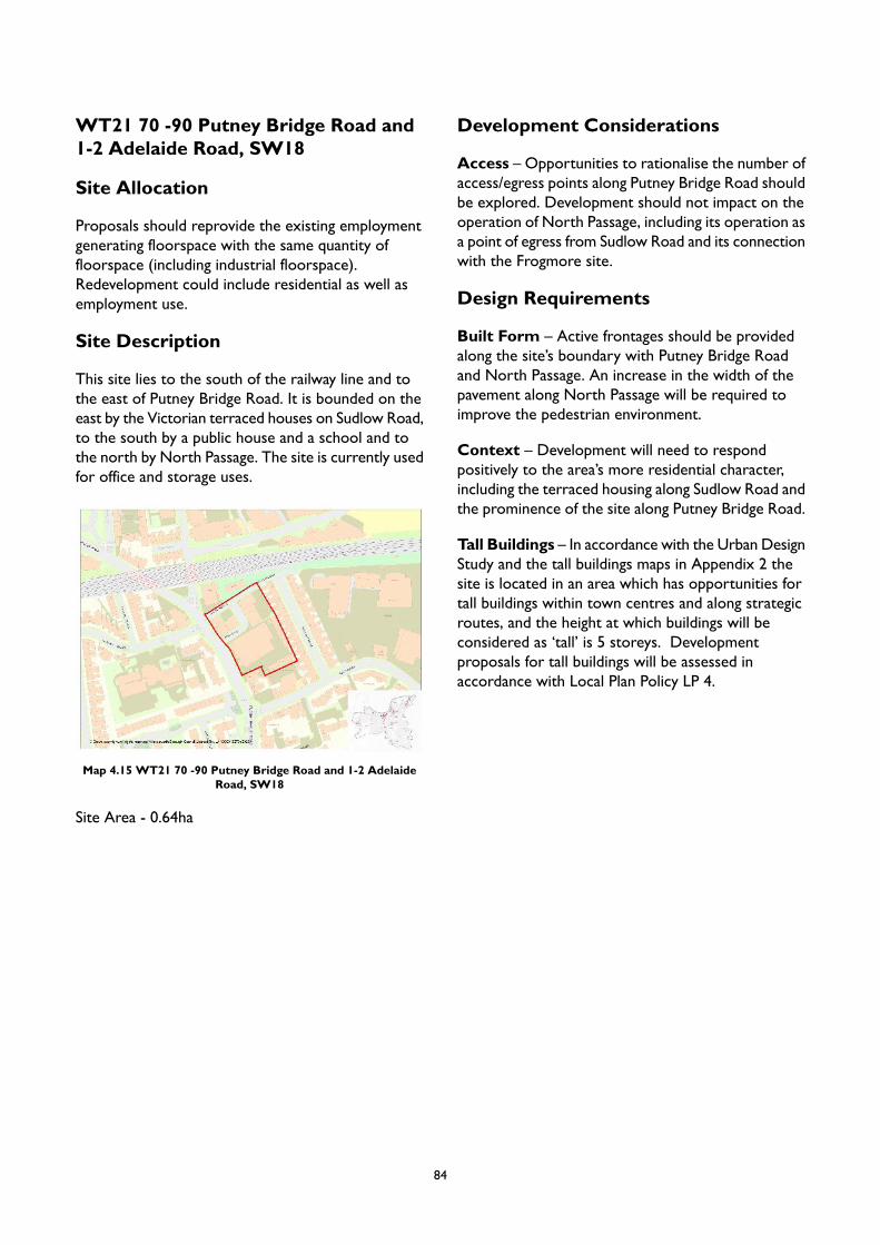
WT21 70 -90 Putney Bridge Road and1-2 Adelaide Road, SW18
Site Allocation
Proposals should reprovide the existing employmentgenerating floorspace with the same quantity offloorspace (including industrial floorspace).Redevelopment could include residential as well asemployment use.
Site Description
This site lies to the south of the railway line and tothe east of Putney Bridge Road. It is bounded on theeast by the Victorian terraced houses on Sudlow Road,to the south by a public house and a school and tothe north by North Passage. The site is currently usedfor office and storage uses.
Map 4.15 WT21 70 -90 Putney Bridge Road and 1-2 AdelaideRoad, SW18
Site Area - 0.64ha
Development Considerations
Access – Opportunities to rationalise the number ofaccess/egress points along Putney Bridge Road shouldbe explored. Development should not impact on theoperation of North Passage, including its operation asa point of egress from Sudlow Road and its connectionwith the Frogmore site.
Design Requirements
Built Form – Active frontages should be providedalong the site’s boundary with Putney Bridge Roadand North Passage. An increase in the width of thepavement along North Passage will be required toimprove the pedestrian environment.
Context – Development will need to respondpositively to the area’s more residential character,including the terraced housing along Sudlow Road andthe prominence of the site along Putney Bridge Road.
Tall Buildings – In accordance with the Urban DesignStudy and the tall buildings maps in Appendix 2 thesite is located in an area which has opportunities fortall buildings within town centres and along strategicroutes, and the height at which buildings will beconsidered as ‘tall’ is 5 storeys. Developmentproposals for tall buildings will be assessed inaccordance with Local Plan Policy LP 4.
84
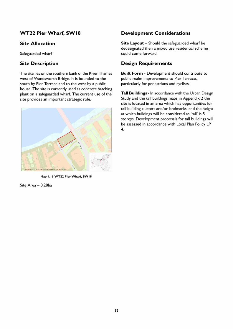
WT22 Pier Wharf, SW18
Site Allocation
Safeguarded wharf
Site Description
The site lies on the southern bank of the River Thameswest of Wandsworth Bridge. It is bounded to thesouth by Pier Terrace and to the west by a publichouse. The site is currently used as concrete batchingplant on a safeguarded wharf. The current use of thesite provides an important strategic role.
Map 4.16 WT22 Pier Wharf, SW18
Site Area – 0.28ha
Development Considerations
Site Layout – Should the safeguarded wharf bededesignated then a mixed use residential schemecould come forward.
Design Requirements
Built Form - Development should contribute topublic realm improvements to Pier Terrace,particularly for pedestrians and cyclists.
Tall Buildings - In accordance with the Urban DesignStudy and the tall buildings maps in Appendix 2 thesite is located in an area which has opportunities fortall building clusters and/or landmarks, and the heightat which buildings will be considered as ‘tall’ is 5storeys. Development proposals for tall buildings willbe assessed in accordance with Local Plan Policy LP4.
85
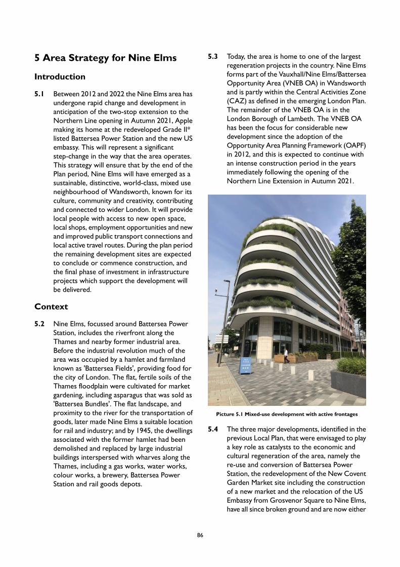
5 Area Strategy for Nine Elms
Introduction
5.1 Between 2012 and 2022 the Nine Elms area hasundergone rapid change and development inanticipation of the two-stop extension to theNorthern Line opening in Autumn 2021, Applemaking its home at the redeveloped Grade II*listed Battersea Power Station and the new USembassy. This will represent a significantstep-change in the way that the area operates.This strategy will ensure that by the end of thePlan period, Nine Elms will have emerged as asustainable, distinctive, world-class, mixed useneighbourhood of Wandsworth, known for itsculture, community and creativity, contributingand connected to wider London. It will providelocal people with access to new open space,local shops, employment opportunities and newand improved public transport connections andlocal active travel routes. During the plan periodthe remaining development sites are expectedto conclude or commence construction, andthe final phase of investment in infrastructureprojects which support the development willbe delivered.
Context
5.2 Nine Elms, focussed around Battersea PowerStation, includes the riverfront along theThames and nearby former industrial area.Before the industrial revolution much of thearea was occupied by a hamlet and farmlandknown as 'Battersea Fields', providing food forthe city of London. The flat, fertile soils of theThames floodplain were cultivated for marketgardening, including asparagus that was sold as'Battersea Bundles'. The flat landscape, andproximity to the river for the transportation ofgoods, later made Nine Elms a suitable locationfor rail and industry; and by 1945, the dwellingsassociated with the former hamlet had beendemolished and replaced by large industrialbuildings interspersed with wharves along theThames, including a gas works, water works,colour works, a brewery, Battersea PowerStation and rail goods depots.
5.3 Today, the area is home to one of the largestregeneration projects in the country. Nine Elmsforms part of the Vauxhall/Nine Elms/BatterseaOpportunity Area (VNEB OA) in Wandsworthand is partly within the Central Activities Zone(CAZ) as defined in the emerging London Plan.The remainder of the VNEB OA is in theLondon Borough of Lambeth. The VNEB OAhas been the focus for considerable newdevelopment since the adoption of theOpportunity Area Planning Framework (OAPF)in 2012, and this is expected to continue withan intense construction period in the yearsimmediately following the opening of theNorthern Line Extension in Autumn 2021.
Picture 5.1 Mixed-use development with active frontages
5.4 The three major developments, identified in theprevious Local Plan, that were envisaged to playa key role as catalysts to the economic andcultural regeneration of the area, namely there-use and conversion of Battersea PowerStation, the redevelopment of the New CoventGarden Market site including the constructionof a new market and the relocation of the USEmbassy from Grosvenor Square to Nine Elms,have all since broken ground and are now either
86
complete or well on their way to completion.Current development trajectories show mostdevelopments completing from 2022, althoughas part of a phased approach, the developmentof land around the Power Station will continuedbeyond that.
5.5 Alongside this the Council has been investingin the delivery of the individual infrastructureprojects required to support the development,including two district heat networks: theEmbassy Quarter Heating Network (EQHN)with an energy centre housed within the USEmbassy, and the Battersea Power StationHeating Network powered from an energycentre within the grounds of the power station.The objectives of the heat network projectsare to integrate decentralised energy such asDistrict Heating and CHP (Combined Heat andPower) into the area’s major regeneration sitesin order to help with the reduction of carbonemissions. The EQHN will provide low carbon,cost effective heat to new developments by Q12021 and this network alone will provide savingsof 12,000 tonnes of CO2 compared totraditional energy supply. This first phase of thescheme will serve planned development withinan area of Wandsworth in close proximity tothe US Embassy and EcoWorld Ballymore’sEmbassy Gardens; but is being built to enableexpansion to serve surrounding areas in thefuture. This is not only applicable to newdevelopment, where there is an obligation toconnect, but also to existing properties whichcould switch from their existing boiler plant andconnect to the network. The two heatnetworks have the potential to maximise theefficiency of energy systems within the area, andto realise long term sustainability benefits.
5.6 The regeneration of Nine Elms is already seeingthe area transformed into a high quality, highdensity international quarter with a diverserange of residential, commercial, retail, officeand cultural uses. The emerging London Planhas identified potential new Central ActivitiesZone (CAZ) retail clusters focused around theredevelopment of the power station, as well asat Vauxhall (predominantly located within LBLambeth), running from Vauxhall Cross alongWandsworth Road. It is the Council’s ambitionthat, for the former, the transformation of aheritage asset of London-wide importance will
create a unique and vibrant retail and leisurevenue, which will attract visitors fromthroughout London (and beyond), and willsupport an emerging evening economy withinthe area. Unlike other CAZ clusters withinLondon – recognised within the emergingLondon Plan as being the equivalent of thecapital’s other ‘major’ or ‘district’ centres – thepower station is to be comprised of retail andleisure and dense residential uses. As such, thisemergent area should focus on the early evening– the ‘twilight’ economy – rather than a ‘latenight’ economy.
5.7 In recent years, the area’s emerging reputationas a prime office location has begun to beestablished: it now represents a new part of theCentral London office market, with high qualityoffice floorspace that is providing a draw forglobal companies, as envisaged by the inclusionin – and the extension of – the CentralActivities Zone (CAZ). In 2016, Appleannounced their intention to make BatterseaPower Station their new London campus andare expected to move in 2021. The US Embassyopened in 2018, attracting the permanent staffworking in the building as well as approximately1000 visitors per day. Penguin Random Househave moved into their new office at EmbassyGardens in 2020 and in late 2019/early 2020 anumber of sites converted permissions tocommercial space, including Phase 3b ofBattersea Power Station, Royal Mail GroupPhase 7 and Embassy Gardens Phase 3,demonstrating the appetite for commercialspace in the area.
87
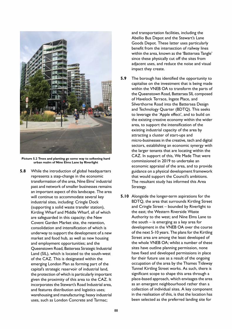
Picture 5.2 Trees and planting go some way to softening hardurban realm of Nine Elms Lane by Riverlight
5.8 While the introduction of global headquartersrepresents a step-change in the economictransformation of the area, Nine Elms’ industrialpast and network of smaller businesses remainsan important aspect of this landscape. The areawill continue to accommodate several keyindustrial sites, including: Cringle Dock(supporting a solid waste transfer station),Kirtling Wharf and Middle Wharf, all of whichare safeguarded in this capacity; the NewCovent Garden Market site, the retention,consolidation and intensification of which isunderway to support the development of a newmarket and food hub, as well as new housingand employment opportunities; and theQueenstown Road, Battersea Strategic IndustrialLand (SIL), which is located to the south-westof the CAZ. This is designated within theemerging London Plan as forming part of thecapital’s strategic reservoir of industrial land,the protection of which is particularly importantgiven the proximity of this area to the CAZ. Itincorporates the Stewart’s Road Industrial area,and features distribution and logistics uses;warehousing and manufacturing; heavy industrialuses, such as London Concrete and Tarmac;
and transportation facilities, including theAbellio Bus Depot and the Stewart’s LaneGoods Depot. These latter uses particularlybenefit from the intersection of railway lineswithin the area, known as the ‘Battersea Tangle’since these physically cut off the sites fromadjacent uses, and reduce the noise and visualimpact they create.
5.9 The borough has identified the opportunity tocapitalise on the investment that is being madewithin the VNEB OA to transform the parts ofthe Queenstown Road, Battersea SIL composedof Havelock Terrace, Ingate Place, andSilverthorne Road into the Battersea Designand Technology Quarter (BDTQ). This seeksto leverage the ‘Apple effect’, and to build onthe existing creative economy within the widerarea, to support the intensification of theexisting industrial capacity of the area byattracting a cluster of start-ups andmicro-businesses in the creative, tech and digitalsectors, establishing an economic synergy withthe larger tenants that are locating within theCAZ. In support of this, We Made That werecommissioned in 2019 to undertake aneconomic appraisal of the area, and to provideguidance on a physical development frameworkthat would support the Council’s ambitions.The resultant study has informed this AreaStrategy.
5.10 Alongside the longer-term aspirations for theBDTQ, the area that surrounds Kirtling Streetand Cringle Street – bounded by Riverlight tothe east; the Western Riverside WasteAuthority to the west; and Nine Elms Lane tothe south – is emerging as a key area fordevelopment in the VNEB OA over the courseof the next 5-10 years. The plans for the KirtlingStreet area are among the least developed ofthe whole VNEB OA; whilst a number of thesesites have outline planning permission, nonehave fixed and developed permissions in placefor their future use as a result of the ongoingoccupation of the area by the Thames TidewayTunnel Kirtling Street works. As such, there issignificant scope to shape this area through aplace-based approach, which envisages the areaas an emergent neighbourhood rather than acollection of individual sites. A key componentin the realisation of this, is that the location hasbeen selected as the preferred landing site for
88
the Nine Elms Pimlico Bridge, which wouldconnect the community on the north bank ofthe Thames in Pimlico with the wider area, andpresents the opportunity to establish aworld-class public realm / open space as partof the bridge approach.
5.11 The moderate Public Transport Access Level(PTAL) in Nine Elms will improve with theopening of the Northern Line Extension toBattersea Power Station, with an intermediaryNine Elms Station on Wandsworth Road alsoopening. The Wandsworth LocalImplementation Plan (2019) shows that NineElms has a low level of residents meeting theiractive travel daily requirements atapproximately 21%-30% and there is scope toswitch 915-2,056 daily trips to walking and2,001-5,000 trips to cycling. The close proximityto many popular destinations in central London,together with the Thames Path andimprovements to the walking and cycling routesalong Battersea Park Road and Nine Elms Lane,as well as through the new Linear Park, allowsfor active travel journeys and indicates goodpotential for car-free living. This is reflected inthe Nine Elms on the South Bank CyclingStrategy produced by Transport for London(TfL), which indicates that the area hassignificant capacity for greater active travel ifappropriate infrastructure is put in place. Thestudy originally identified 16 routes that wouldhelp achieve the ambition for a step-change inlevels of cycling, including smaller local routes,as well as segregated cycle corridors. Three ofthe 16 routes proposed are within theneighbouring borough of Lambeth and of the13 within the borough boundary 11 areexpected to be delivered in the Local Planperiod. Improving permeability through NineElms, in particular across train tracks, will beimportant to encouraging active travel. This alsoapplies to the potential Nine Elms PimlicoBridge, which provides a huge opportunity forimproved active and public transport options,as well as potentially relieving demand forwalking and cycling on the neighbouring Vauxhalland Chelsea Bridges. The improvedinfrastructure for cyclists also has potential tocontribute to alleviating traffic congestion along
the A3205 Battersea Park Road/Nine Elms Lane,a major route that is integral for the movementof residents, commuters, goods and services.
Character
5.12 Nine Elms is an area undergoing a significantchange and evolution: at the time of writing, in2020, the character of the area is dominated byconstruction sites, empty spaces, poor legibility,a lack of public green open spaces anddiscontinuity of the Thames Path. However, thisis a temporary state and emerging newdevelopment will itself bring about newcharacter through the creation of a high quality,high-density neighbourhood with a diverse rangeof residential, commercial, retail, office andcultural uses. Chelsea Bridge Wharf (14storeys), Riverlight Nine Elms (up to 20storeys), the American Embassy and BatterseaExchange (18 storeys) are some of the recentlycompleted large-scale buildings. In addition, thedevelopments at One Nine Elms (42 to 56storeys) and Phase 1 of Nine Elms Square (36to 54 storeys) are under construction and willalso contribute to the evolving cluster of tallbuildings, in line with the intent of the VNEBTall Buildings Strategy. The overall result is anemerging urban skyscraper/city-type character.
5.13 Industry and infrastructure have left an imprintof huge-scale features, and whilst their scale isin balance with the surrounding environment,they have left a legacy of an incoherent layout,inconsistent pattern and poor connectivity. Amore legible street network at ground level willemerge as more developments complete,creating new routes. However, there are issuesof poor connectivity between new and existingneighbourhoods. The latter includes the threeresidential estates to the south of Nine ElmsLane, bordered by Stewarts Road industrialestate and Thessaly Road to the east, that arepoorly connected to each other and thesurrounding areas. Improved links between newand existing communities are vital to enhancingthe sense of place. There are also issues of hightraffic volumes and a lack of active frontagealong Nine Elms Lane as buildings and activitiestend to turn to the river, or in towards theemerging park, rather than facing Nine ElmsLane. As part of the Nine Elms infrastructurepackage, the Council is funding a TfL scheme
89
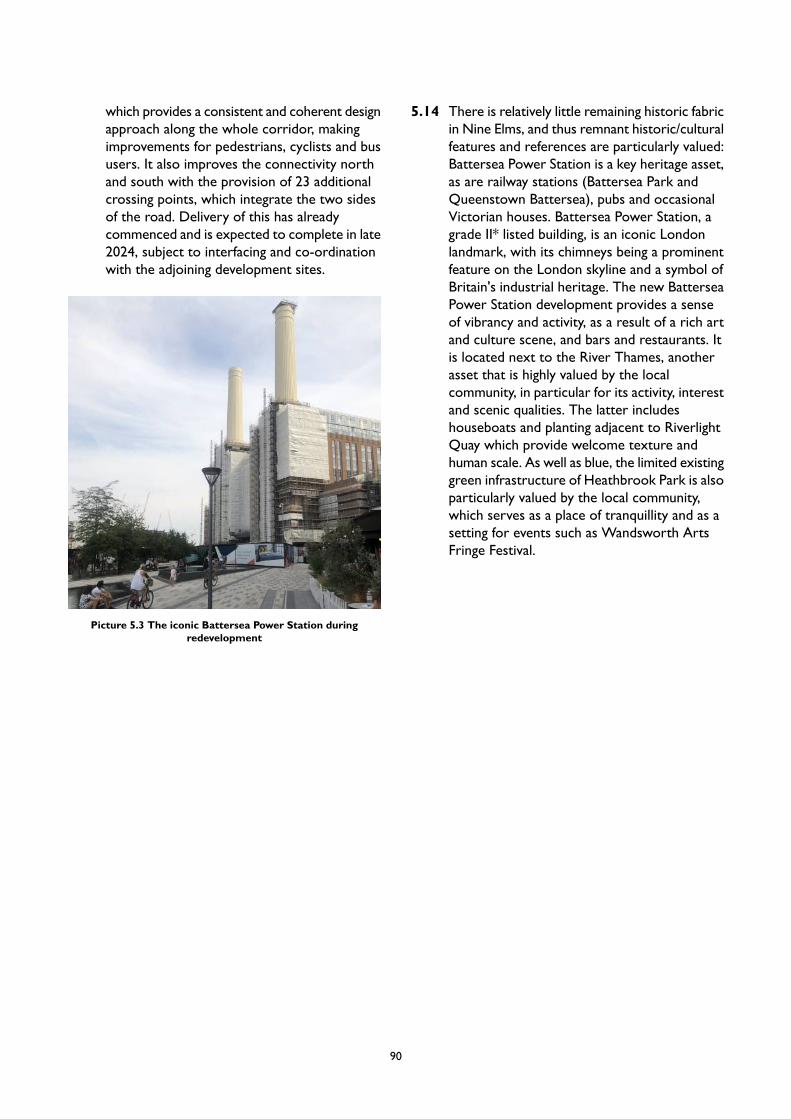
which provides a consistent and coherent designapproach along the whole corridor, makingimprovements for pedestrians, cyclists and bususers. It also improves the connectivity northand south with the provision of 23 additionalcrossing points, which integrate the two sidesof the road. Delivery of this has alreadycommenced and is expected to complete in late2024, subject to interfacing and co-ordinationwith the adjoining development sites.
Picture 5.3 The iconic Battersea Power Station duringredevelopment
5.14 There is relatively little remaining historic fabricin Nine Elms, and thus remnant historic/culturalfeatures and references are particularly valued:Battersea Power Station is a key heritage asset,as are railway stations (Battersea Park andQueenstown Battersea), pubs and occasionalVictorian houses. Battersea Power Station, agrade II* listed building, is an iconic Londonlandmark, with its chimneys being a prominentfeature on the London skyline and a symbol ofBritain's industrial heritage. The new BatterseaPower Station development provides a senseof vibrancy and activity, as a result of a rich artand culture scene, and bars and restaurants. Itis located next to the River Thames, anotherasset that is highly valued by the localcommunity, in particular for its activity, interestand scenic qualities. The latter includeshouseboats and planting adjacent to RiverlightQuay which provide welcome texture andhuman scale. As well as blue, the limited existinggreen infrastructure of Heathbrook Park is alsoparticularly valued by the local community,which serves as a place of tranquillity and as asetting for events such as Wandsworth ArtsFringe Festival.
90

Place Performance
5.15 Current place performance for Nine Elms is presented in the diagram below.
Figure 5.1 Nine Elms Place Performance
5.16 Nine Elms is an area in transition. Currently,there are challenging place performanceconsiderations across Placemaking, SmartGrowth and People First. The opportunity tobuild on the area’s resilience can be grasped.Investment in Nine Elms is addressing many ofthe 14 principles discussed above and significantprogress has been made. In time, Nine Elms willperform considerably better and assessment
will show substantial improvement as it emergesas a significant district for the borough andLondon offering economic, environmental, socialand cultural benefits.
Vision
5.17 The Area Strategy for Nine Elms will meet thevision and objectives of the Local Plan by:
91
providing a range of homes of differenttenures, sizes and types, contributing tothe borough’s objectives for mixed andbalanced communities;
continuing to promote the economicdevelopment and regeneration of theVNEB OA within the CAZ to ensure thatit becomes a strategic employment hubcreating world class office facilities; and todevelop the BDTQ to leverage thisinvestment to enhance and intensify thisadjacent industrial area through attractingcreative, design and digital SMEs toestablish an economic cluster;
continuing to put culture and communityat the heart of Nine Elms, working withpartners to create a sense of place and anintegrated neighbourhood, establishing asustainable cultural eco-system that fosterscommunity cohesion and supportsresidents’ aspiration for access to highquality facilities, culture and design,including securing affordable space forcultural and community uses and thecreation of three creative clusters in linewith the vision set out in the Nine ElmsCultural Strategy;
supporting the completion of the visionfor a successful, sustainable, mixed useneighbourhood in Nine Elms, by ensuringongoing investment, delivery andco-ordination of infrastructure projectswithin the Opportunity Area, includingutilities, digital communications, transportand public realm, and social infrastructureincluding education and health facilities,through direct delivery and by working inpartnership with internal and externalpartners, working to a 5-10 yearProgramme to completion;
supporting the creation of a low carbondistrict with extensive green infrastructureand new public space for leisure andrecreation, including a new 12-acre linearpark linking Battersea Power Station toVauxhall, and the implementation of twodistrict heat networks; and
supporting the delivery of the Nine ElmsPimlico Bridge, for walking and cycling,connecting communities on the northbank of the Thames to Nine Elms, creatinga world-class public realm and open spaceat the gateway landing site; and paving theway for improvements in active travel,which collectively serves as the final ‘jigsawpiece’ in the area’s transformation.
PM3 Nine Elms
Placemaking
A. The Council will promote the development of the Battersea Design and Technology Quarter (BDTQ),and development proposals within this location should deliver and/or fund placemaking improvementswhich will support the public realm strategy set out within the BDTQ Economic Appraisal and DesignFramework. These include: the provision of amenity yards and working yards; enhanced public realmin tunnels and underpasses to create attractive thresholds; improvements to walking and bicycle accesswithin the area, including through lightweight bridges; the introduction of signage and wayfindingfeatures to create a legible identity; and temporary amenities.
B. The Council will promote the development of Kirtling/Cringle St Riverside site, the preferred landingsite for the Nine Elms Pimlico Bridge. Development proposals within this location should maximisethe opportunity for the creation of green/open space that the Tideway Tunnel access shaft presents,contribute to the creation of a positive arrival experience for pedestrians and cyclists using the bridge,and improve walking and cycling connectivity in line with the VNEB Cycling Strategy.
C. The Urban Design Study has identified appropriate locations for tall buildings in Nine Elms. The broadlocations are identified in Appendix 2. Any proposal for a tall building will be subject to addressingthe requirements of Policy LP 4 (Tall Buildings) as well as other policies in the Plan as applicable. All
92
development proposals involving tall buildings should have regard to the Tall Buildings strategy forVNEB.
D. New or changed development proposals will be expected to protect and enhance important viewsand vistas in the area, including:
1. the views of the Battersea Power Station and its setting (See Local Views SPD); and2. views from/of the Westminster World Heritage Site (WWHS);
E. Key gateways present a strategic opportunity to provide an attractive welcome to the area and todraw attention to its cultural richness and vibrancy. Where appropriate, future development will beexpected to provide an attractive gateway space to frame the main entrance to the area.
F. The introduction of meanwhile uses on development sites, to mitigate the impact of construction andboost the area in the interim period, will be supported. These should enhance the vitality and vibrancyof the area and should seek to promote arts and cultural uses for the benefit of local communities inline with the Nine Elms Cultural Strategy.
G. Development proposals will be expected to maintain and increase quantity of street trees, as well asenhance experience and quality of the public realm through carefully considered, well designed proposalsthat can create interesting, dynamic, accessible, and inclusive spaces by offering elements such asseating, spaces with potential for community or cultural use, and public art/sculpture.
H. High quality green features will be incorporated into new developments to promote biodiversity andhelp promote a connected green and blue infrastructure throughout the borough.
Smart Growth
A. New residential accommodation in Nine Elms will help meet the housing target set out in theOpportunity Area Planning Framework, and the borough’s housing target, as set out in Local PlanPolicy LP 24. Development in this area is expected to provide at least 6,912 homes by 2037/38 (theentire plan period) of which 6,855 homes are expected to be delivered by 2032/33 (10-year housingsupply). These figures reflect the projected completions on large, small and windfall sites rather thantotal capacity of site allocations.
B. Development proposals as part of the Council’s Housing For All project, a Council-led initiative whichaims to deliver 1000 homes to buy or rent are supported in principle which will provide new homesand community and play facilities, and will increase access within the Savona, Patmore and CareyGardens Estates.
C. Development proposals should support the emerging CAZ retail clusters at Battersea Power Stationand at Vauxhall, as follows:
1. The Battersea Power Station CAZ retail cluster should provide a unique shopping and leisuredestination that serves London as a whole, whilst also meeting the needs of the local community.
2. The Vauxhall CAZ retail cluster is primarily located within LB Lambeth, and the Council willwork with the borough to deliver their ambitions for this cluster, as well as to ensure thatdevelopment caters for local residents and workers within Nine Elms.
D. Outside of the Battersea Power Station and Vauxhall CAZ retail clusters, limited retail developmentwill be appropriate to support the day to day needs of residents and workers. Such developmentshould be of a small scale and must not negatively impact on the viability of development within theCAZ retail clusters.
E. Proposals for cafes, restaurants, pubs or drinking establishments, and take-away facilities which servethe needs of residents, workers and visitors will generally be acceptable, particularly where locatedwithin the focal points of activity, and where these support the ‘twilight’ economy, subject to theimpact on adjacent uses. In order to mitigate this, conditions may be used to control the hours ofoperation.
93
F. The Council will continue to promote the economic development and regeneration of the VNEB OAwithin the CAZ to ensure that it becomes a strategic employment hub, which provides a range ofemployment floorspace typologies, from workspace for small and early stage businesses to large-scalefloorspace for high-value occupiers. This provision will be located in the power station and theVauxhall/Embassy district, and should also seek to incorporate provision of affordable workspaceon-site where possible. In instances where this is not possible, it should contribute to this provisionelsewhere within the VNEB OA, such as in the BDTQ.
G. The Council will promote the development of the BDTQ to support creative, design and technologySMEs in Wandsworth. Proposals within this location:
1. must not adversely impact the operation of the industrial businesses within the QueenstownRoad, Battersea SIL;
2. should provide a mix of uses and scale of development that is consistent with the BDTQ EconomicAppraisal and Design Framework (EADF), including providing industrial uses on the ground floor;
3. must deliver intensified industrial floorspace;4. must provide affordable workspace in line with the requirements of Policy LP 41; and5. must support the objectives of the Nine Elms Cultural Strategy and the BDTQ EDAF.
H. To support the important economic function of the Stewart’s Road Industrial Estate, the Council willsupport proposals which enhance and/or intensify the industrial provision, including through improving,whether directly or through the provision of funding, the condition of the road within the industrialarea, the condition of Stewart’s Road bridge, and the proposed walking/cycling underpass to connectthe area to the power station.
I. Proposals for smaller scale office floorspace, as appropriate ground and lower floor uses, includingaffordable workspace and managed or ‘touchdown’ space, will be supported in the development areanorth of the Vauxhall to Queenstown Road railway line.
J. Proposals for new ancillary retail market pitches open to the general public will be permitted withinthe New Covent Garden Wholesale Market, where these do not adversely impact the primarywholesale operation of this site.
K. All new development should make provision to connect to District Heat Networks, and the Councilwill support existing development retrospectively connecting to this infrastructure.
L. Urban Logistics Hubs are used for last mile deliveries by electric vans or cargo bikes which can helpreduce congestion and pollution. These will be supported in the right location in accordance with theobjectives of Policy LP 51 – Sustainable Transport. Hubs are suited to areas connected to the widerroad, rail and river networks, river wharves and railway stations, and the CAZ.
People First
A. Existing cultural, creative and arts uses will be safeguarded, and proposals for the expansion, renewaland modernisation of the existing cultural offer will be encouraged. Appropriate proposals for thechange of use of existing non-retail units to accommodate additional cultural offers will be supported.
B. A new Health Centre at Sleaford Street, secured as part of Battersea Power Station Phase 4a andfunding agreement with NHS Property Services, will provide new primary health care facilities tosupport the predicted new population of c.34,700 and the existing residents, thereby contributing tothe health and wellbeing of local communities. In addition, the Council will work in partnership withthe NHS to deliver additional health care at Nine Elms Square.
C. The new linear park will form the heart of the area, surrounded by the development plots of NineElms Parkside, Nine Elms Square and Embassy Gardens. The park will play a vital role as a connectorelement in creating a new sense of place. Development proposals to reduce the size of the park orundermine its quality will be strongly resisted.
D. The continuity of the Thames Path along the riverside is key to enhancing active travel in the area andease of movement. This will need to be achieved in the context of the uses around Kirtling St and
94
Cringle St, where there are servicing roads for the power station and the waste transfer station, andin a manner that protects the safe-guarded wharfs. Riverside continuity should be complemented bythe creation of high quality and generous public realm, achieving a balance of open space and builtform, and making provision for mature/established trees.
E. In the context of avoiding unnecessary travel, the Council will seek to improve connectivity andpermeability for pedestrians and cyclists. This will be achieved by delivering additional cycle routes,in line with the Cycling Strategy for Nine Elms, particularly the viaduct route crossing the CoventGarden Market Authority (CGMA) access road, and bringing forward the proposals for the Nine ElmsPimlico Bridge at the chosen location. In addition, the Council will continue to work with partnersand TfL to deliver the Nine Elms Lane/Battersea Park Road scheme which will create more space forwalking and cycling and better waiting areas for bus passengers. All new development proposals,transport and other public realm schemes, must contribute towards achieving these priorities.
F. The Council will work with Network Rail to bring forward plans for improved access to BatterseaPark Station which better integrates and connects with the surrounding area.
G. Bring forward enhanced primary school provision at the identified site C1 of Nine Elms Parkside intime to meet the need arising from development and ensure the provision is made for potentialexpansion in future years.
H. To ensure that Battersea Park Station is able to cater for a future extension of the London Overgroundto provide an all-day service to Battersea Park Station.
I. To provide better connectivity between Queenstown Road Station and Battersea Park Station thoughthe Battersea Exchange development with a new entrance to Queenstown Road station.
95
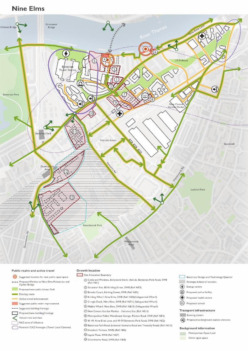
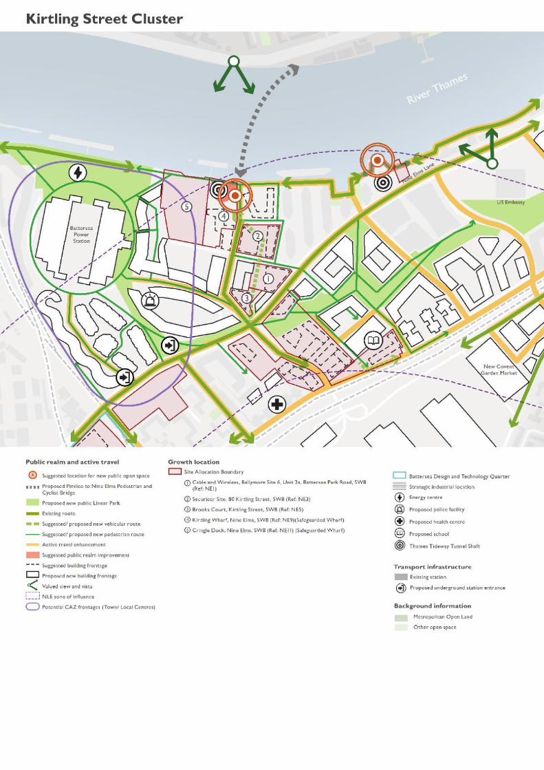
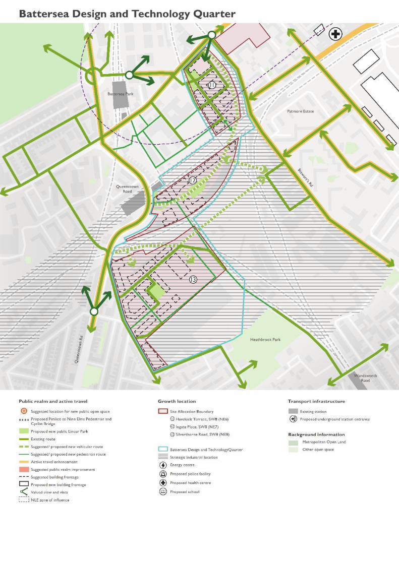

Site Allocations
KIRTLING STREET CLUSTER
The Kirtling Street Cluster comprises five sites. Inorder to support the implementation of the policiesof the plan and the vision and objectives of the NineElms Area Strategy this cluster has been identified asa group of sites where the development should bebrought forward together where possible.
The Cluster contains five site allocations:
NE1 Cable and Wireless, Ballymore Site6, Unit 2a, Battersea Park Road, SW8NE3 Securicor Site, 80 Kirtling Street,SW8NE5 Brooks Court, Kirtling Street, SW8NE9 Kirtling Wharf, Nine Elms, SW8NE11 Cringle Dock, Nine Elms, SW8
Site Allocation
The cluster is appropriate for a mixed usedevelopment with business uses on the ground floorand residential use to upper floors. Any proposals formixed use development will need to ensure that theydo not have a negative impact on the operation of thesafeguarded wharfs (i.e. the sustainable movement offreight, waste and aggregates as well as cargo handling),including maintaining appropriate access arrangementsand that the operational capacity of the wharfs isretained or enhanced. Open space will be required tothe north of the cluster, maximising the space createdby the access required to the Thames Tideway shaft.
Site Description
The site is north of the junction where Kirtling Streetmeets Nine Elms Lane. It is east of Battersea PowerStation and west of the Riverlight Apartments. Thesite is bounded by Kirtling Street and Cringle Streetto the west and the site includes the ThamesWaterfront and part of the river where the newPimlico Footbridge is expected to land on theWandsworth side. The site is used as a ThamesTideway Tunnel worksite (until 2024), a waste transferstation, and has commercial uses. The land in the northof this site will become open space to facilitate theongoing maintenance access to the Thames Tidewayshaft.
Map 5.4 KIRTLING STREET CLUSTER
Site Area – 5.52ha
Development Considerations
Uses - The cluster is appropriate for a mixed usedevelopment with business uses on the ground floorand residential uses to upper floors due to theproximity to heavily trafficked streets and flood zoneparameters. The site of the existing temporary buildingsupply (sub-station) on the Cable and Wireless site(NE1) will need to be relocated in order to implementthe proposed changes to the highway layout at thisjunction. Entrances to ground floor and upper flooruses to be directly from the street frontages of NineElms Lane, Kirtling Street, and Cringle Street.Proposals should encourage independent shops andbusinesses, emphasising local makers and artisans.Maximising the potential for the Kirtling Wharf andCringle Dock sites (NE9, NE11) will require furtherdiscussions with relevant parties, in particular the Portof London Authority (PLA), the Greater LondonAuthority (GLA) and ThamesWater. The constructionof the Thames Tideway Tunnel site at Kirtling Streetis estimated to complete in early 2024 and the Councilwill continue to work with Tideway to ensure apositive lasting legacy.
Open Space – Proposals to the north of the clusterin the Kirtling Wharf and Cringle Dock sites will berequired to provide open space that connects to theproposed Nine Elms-Pimlico Footbridge and the openspace above the Thames Tideway Tunnel access shaft.
Access - Any improvements to the Kirtling Street orCringle Street junction should maintain appropriatehighway access for commercial vehicles to thesafeguarded wharves i.e. Cringle Dock and KirtlingWharf (NE9, NE11). This can be achieved through
99
implementation of the design proposals for TfL’s NineElms corridor scheme. Proposals will need to provideland which ensures all turning movements at thejunction can be facilitated alongside the bus, cycle andpedestrian infrastructure along the corridor. Theoverarching issue for the cluster is the total numberof vehicle trips generated by its activity. It isinescapable that high levels of goods vehicle traffic willremain due to the nature of the activities taking placeon the wharfs and the necessity to use road transportto deliver waste from its source and deliver ready mixconcrete to its users. The possibility of transferringfurther quantities of aggregates to water should beconsidered and whether there is a likelihood ofcement deliveries to also resume by this means, astogether this would remove approximately 10 morelorry movements from the site per day. But this shouldnot prevent the provision or facilitation of safe walkingand cycling routes from the river south to Nine Elmslane. Additionally, the Kirtling Wharf site (NE9)includes access to a Thames Tideway shaft site andongoing maintenance access will be required. The shaftmaintenance regime and associated necessary accessshould be considered as part of any developmentproposal.
Parking - A car club will be sought on the forresidential/commercial use and surrounding area.
Public Transport - Opportunities should be takento enhance bus journey times especially on BatterseaPark Road-Nine Elms Lane and Queenstown Roadcorridors, taking into account the proposed openingof the Northern Line extension in Autumn 2021.Proposals will be required to provide road space alongwith financial contributions to design and constructTfL’s Nine Elms Corridor proposal which will deliverconsistent bus infrastructure.
Active Travel - Improve north-south active travellinks including to the Thames riverside. Developmentsshould ensure pedestrian and cycling movements aresafe and connected to the cycling network as set outin the VNEB Cycling Strategy and support the potentialfor future onward connection to the proposed NineElms Pimlico Footbridge. A riverside walkincorporating provision for cyclists will be requiredunless an alternative route of an equivalent width andequal amenity value around or through the site isnecessary for safety or operational reasons.
Relevant Management Plans – Developmentsshould ensure pedestrian and cycling movements aresafe and connected to the cycling network as set outin the VNEB Cycling Strategy and support the potentialfor future onward connection to the proposed NineElms Pimlico Footbridge.
Design Requirements
Built Form – Proposals are required to improvefrontages, streetscape, public realm and signage alongCringle Street, Kirtling Street, Battersea Park Road,and Nine Elms Lane with entrances directly onto thestreet and towards the River Thames. At Cringle Dock(NE11), buildings should front on to Cringle Streetand the River Thames above the waste transfer stationor around the dock basin if another river-related dockuse is proposed. A high quality public realm should beprovided to the riverside walk drawing upon theprinciples established at Riverside Gardens and BourneValley Wharf and areas further west and east.Proposals should draw upon the principles set out inthe Nine Elms Public Realm Design Guide.
Movement – Proposals will need to create atransport environment that integrates public andprivate transport with active travel towards and withinBattersea Power Station. Similar consideration shouldbe given to creating a safe connection between NineElms Lane and Cringle Street, the safeguardedpavement at Riverlight that could potentially be used.
Movement - This site will be adjacent to theproposed Nine Elms - Pimlico Footbridge landing siteand will need to consider the public realm and walkingand cycling connections to the bridge, the riversidewalk and street frontages, as well as onwardconnections to Nine Elms Lane.
Movement - A riverside walk should be provided,and options include taking a high level walkway abovea boxed-in wharf if the site is used as a waste transferstation, or around the edge of the dock if other usesof the dock are proposed. Consideration should alsobe given to how this integrates with the proposedNine Elms Pimlico Footbridge. Discontinuity of thewalk, as a result of construction sites and the CringleDock Waste Transfer Station should be mitigated.
Context - Taking a place-based approach, it isnecessary to consider the area as a ‘neighbourhood’,rather than on a project by project or individualdevelopment basis.
100
Identity and Architectural Expression - This sitewill be adjacent to the proposed Nine Elms - PimlicoFootbridge and would be appropriate for a landmarkbuilding to be located here as a gateway intoWandsworth.
Site Layout – Consideration should be given to sitelayout and permeability of the Cable andWireless andBrooks Court sites (NE1, NE5) as they will front onto the main access to Battersea Power Station andthe pedestrian/cycle route to the proposed NineElms-Pimlico Footbridge. Proposals should aim totransform the entrance into a more pleasant placewhere all users can be accommodated in a balancedway. Proposals will need to create a layout where thetransport environment integrates vehicle, foot andcycle movements as well as public transport withBattersea Power Station. Similar consideration shouldbe given to creating a safe connection between NineElms Lane and Cringle Street, the safeguardedpavement at Riverlight could potentially be used.
Massing - The massing of the proposed developmentshould act as a gateway to Wandsworth.
Tall Buildings - In accordance with the Urban DesignStudy and the tall buildings maps in Appendix 2 thesite is located in an area which has opportunities fortall building clusters and/or landmarks, and the heightat which buildings will be considered as ‘tall’ is 8storeys. Development proposals for tall buildings willbe assessed in accordance with Local Plan Policy LP4.
101
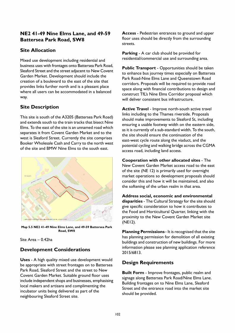
NE2 41-49 Nine Elms Lane, and 49-59Battersea Park Road, SW8
Site Allocation
Mixed use development including residential andbusiness uses with frontages onto Battersea Park Road,Sleaford Street and the street adjacent to New CoventGarden Market. Development should include thecreation of a boulevard to the east of the site thatprovides links further north and is a pleasant placewhere all users can be accommodated in a balancedway.
Site Description
This site is south of the A3205 (Battersea Park Road)and extends south to the train tracks that bisect NineElms. To the east of the site is an unnamed road whichseparates it from Covent Garden Market and to thewest is Sleaford Street. Currently the site comprisesBooker Wholesale Cash and Carry to the north westof the site and BMW Nine Elms to the south east.
Map 5.5 NE2 41-49 Nine Elms Lane, and 49-59 Battersea ParkRoad, SW8
Site Area – 0.42ha
Development Considerations
Uses - A high quality mixed use development wouldbe appropriate with street frontages on to BatterseaPark Road, Sleaford Street and the street to NewCovent Garden Market. Suitable ground floor usesinclude independent shops and businesses, emphasisinglocal makers and artisans and complimenting theincubator units being delivered as part of theneighbouring Sleaford Street site.
Access - Pedestrian entrances to ground and upperfloor uses should be directly from the surroundingstreets.
Parking - A car club should be provided forresidential/commercial use and surrounding area.
Public Transport - Opportunities should be takento enhance bus journey times especially on BatterseaPark Road-Nine Elms Lane and Queenstown Roadcorridors. Proposals will be required to provide roadspace along with financial contributions to design andconstruct TfL’s Nine Elms Corridor proposal whichwill deliver consistent bus infrastructure.
Active Travel - Improve north-south active travellinks including to the Thames riverside. Proposalsshould make improvements to Sleaford St, includingensuring a usable footway width on the eastern side,as it is currently of a sub-standard width. To the south,the site should ensure the continuation of theeast-west cycle route along the viaduct, and thepotential cycling and walking bridge across the CGMAaccess road, including land access.
Cooperation with other allocated sites - TheNew Covent Garden Market access road to the eastof the site (NE 12) is primarily used for overnightmarket operations so development proposals shouldconsider this and how it will be maintained, and alsothe softening of the urban realm in that area.
Address social, economic and environmentaldisparities - The Cultural Strategy for the site shouldgive specific consideration to how it contributes tothe Food and Horticultural Quarter, linking with theproximity to the New Covent Garden Market site(NE12).
Planning Permissions– It is recognised that the sitehas planning permission for demolition of all existingbuildings and construction of new buildings. For moreinformation please see planning application reference2015/6813.
Design Requirements
Built Form - Improve frontages, public realm andsignage along Battersea Park Road/Nine Elms Lane.Building frontages on to Nine Elms Lane, SleafordStreet and the entrance road into the market siteshould be provided.
102
Movement - Establish a wayfinding strategy,connecting and promoting active use of new publicspaces through integrating facilities and events.Enhance the pedestrian crossing between Nine ElmsLane and on to the riverside. Proposals should alsoimprove pedestrian connections between the newlinear park and the existing residential estates to thesouth west.
Movement - This scheme will be expected tocontribute TfL’s Nine Elms Corridor scheme whichprovides a holistic approach to transforming Nine ElmsLane.
Context - The north-east corner of the site is thetransition between Thessaly Road and Park Sideneighbourhoods. It has the potential to act as the‘entrance’ to the park for people coming from theThessaly area to the west and to the Thessalyneighbourhood for those travelling from the Park.
Nature – Tree planting and other green featuresshould be incorporated to the eastern edge of the siteto help create green corridors from the linear parkto other green and blue infrastructure.
Tall Buildings - In accordance with the Urban DesignStudy and the tall buildings maps in Appendix 2 thesite is located in an area which has opportunities fortall building clusters and/or landmarks, and the heightat which buildings will be considered as ‘tall’ is 8storeys. Development proposals for tall buildings willbe assessed in accordance with Local Plan Policy LP4.
103
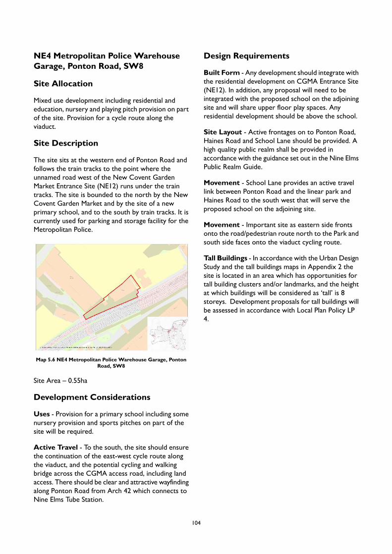
NE4 Metropolitan Police WarehouseGarage, Ponton Road, SW8
Site Allocation
Mixed use development including residential andeducation, nursery and playing pitch provision on partof the site. Provision for a cycle route along theviaduct.
Site Description
The site sits at the western end of Ponton Road andfollows the train tracks to the point where theunnamed road west of the New Covent GardenMarket Entrance Site (NE12) runs under the traintracks. The site is bounded to the north by the NewCovent Garden Market and by the site of a newprimary school, and to the south by train tracks. It iscurrently used for parking and storage facility for theMetropolitan Police.
Map 5.6 NE4 Metropolitan Police Warehouse Garage, PontonRoad, SW8
Site Area – 0.55ha
Development Considerations
Uses - Provision for a primary school including somenursery provision and sports pitches on part of thesite will be required.
Active Travel - To the south, the site should ensurethe continuation of the east-west cycle route alongthe viaduct, and the potential cycling and walkingbridge across the CGMA access road, including landaccess. There should be clear and attractive wayfindingalong Ponton Road from Arch 42 which connects toNine Elms Tube Station.
Design Requirements
Built Form - Any development should integrate withthe residential development on CGMA Entrance Site(NE12). In addition, any proposal will need to beintegrated with the proposed school on the adjoiningsite and will share upper floor play spaces. Anyresidential development should be above the school.
Site Layout - Active frontages on to Ponton Road,Haines Road and School Lane should be provided. Ahigh quality public realm shall be provided inaccordance with the guidance set out in the Nine ElmsPublic Realm Guide.
Movement - School Lane provides an active travellink between Ponton Road and the linear park andHaines Road to the south west that will serve theproposed school on the adjoining site.
Movement - Important site as eastern side frontsonto the road/pedestrian route north to the Park andsouth side faces onto the viaduct cycling route.
Tall Buildings - In accordance with the Urban DesignStudy and the tall buildings maps in Appendix 2 thesite is located in an area which has opportunities fortall building clusters and/or landmarks, and the heightat which buildings will be considered as ‘tall’ is 8storeys. Development proposals for tall buildings willbe assessed in accordance with Local Plan Policy LP4.
104
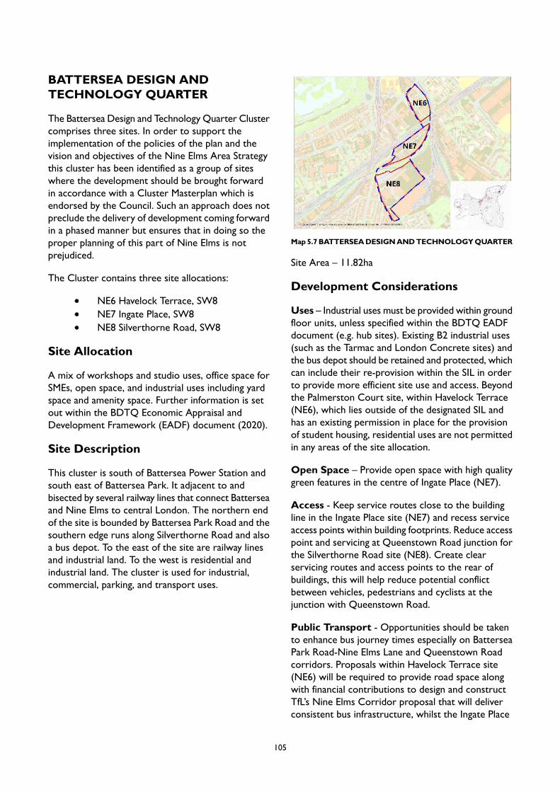
BATTERSEA DESIGN ANDTECHNOLOGY QUARTER
The Battersea Design and Technology Quarter Clustercomprises three sites. In order to support theimplementation of the policies of the plan and thevision and objectives of the Nine Elms Area Strategythis cluster has been identified as a group of siteswhere the development should be brought forwardin accordance with a Cluster Masterplan which isendorsed by the Council. Such an approach does notpreclude the delivery of development coming forwardin a phased manner but ensures that in doing so theproper planning of this part of Nine Elms is notprejudiced.
The Cluster contains three site allocations:
NE6 Havelock Terrace, SW8NE7 Ingate Place, SW8NE8 Silverthorne Road, SW8
Site Allocation
A mix of workshops and studio uses, office space forSMEs, open space, and industrial uses including yardspace and amenity space. Further information is setout within the BDTQ Economic Appraisal andDevelopment Framework (EADF) document (2020).
Site Description
This cluster is south of Battersea Power Station andsouth east of Battersea Park. It adjacent to andbisected by several railway lines that connect Batterseaand Nine Elms to central London. The northern endof the site is bounded by Battersea Park Road and thesouthern edge runs along Silverthorne Road and alsoa bus depot. To the east of the site are railway linesand industrial land. To the west is residential andindustrial land. The cluster is used for industrial,commercial, parking, and transport uses.
Map5.7BATTERSEADESIGNANDTECHNOLOGYQUARTER
Site Area – 11.82ha
Development Considerations
Uses – Industrial uses must be provided within groundfloor units, unless specified within the BDTQ EADFdocument (e.g. hub sites). Existing B2 industrial uses(such as the Tarmac and London Concrete sites) andthe bus depot should be retained and protected, whichcan include their re-provision within the SIL in orderto provide more efficient site use and access. Beyondthe Palmerston Court site, within Havelock Terrace(NE6), which lies outside of the designated SIL andhas an existing permission in place for the provisionof student housing, residential uses are not permittedin any areas of the site allocation.
Open Space – Provide open space with high qualitygreen features in the centre of Ingate Place (NE7).
Access - Keep service routes close to the buildingline in the Ingate Place site (NE7) and recess serviceaccess points within building footprints. Reduce accesspoint and servicing at Queenstown Road junction forthe Silverthorne Road site (NE8). Create clearservicing routes and access points to the rear ofbuildings, this will help reduce potential conflictbetween vehicles, pedestrians and cyclists at thejunction with Queenstown Road.
Public Transport - Opportunities should be takento enhance bus journey times especially on BatterseaPark Road-Nine Elms Lane and Queenstown Roadcorridors. Proposals within Havelock Terrace site(NE6) will be required to provide road space alongwith financial contributions to design and constructTfL’s Nine Elms Corridor proposal that will deliverconsistent bus infrastructure, whilst the Ingate Place
105
and Silverthorne Road sites (NE7, NE8) will beexpected to contribute to any proposals to improvebus journey times along Queenstown Road.
Active Travel - Contributions to upgrade pedestrianroutes to/from Battersea Park Station andQueenstown Road Stations and improve accessibilityto the new Northern Line station at Battersea PowerStation, currently expected to open in Autumn 2021.
Relevant Management Plans – The BDTQEconomic Appraisal and Design Framework (2020)provides detailed guidance for this cluster of siteallocations, which proposals should adhere to.
Planning Permissions – It is recognised that theHavelock Terrace site (NE6) has planning permissionfor a mixed use development on the northern part ofthe site. For more information see planning applicationreference 2016/5422.
Design Requirements
Built Form - For the Havelock Terrace site (NE6),proposals should provide active frontage to HavelockTerrace and positive frontage to working yards andamenity spaces. Building frontages should be providedon to Bradmead, Palmerston Way and HavelockTerrace. Locate working yards by the railway lines tocreate amenity spaces at the centre of large plots.
Built Form - For the Ingate Place site (NE7),proposals should position frontages of workshops,studios and light industrial spaces to support andactivate a shared amenity space.
Built Form - For the Silverthorne Road site (NE8),building frontages will be required on to SilverthorneRoad, the access road off Silverthorne Road and newstreet frontages. Entrances to buildings should bedirectly accessible from streets. Blocks structuredaround working yards and amenity spaces with activeand positive frontage to amenity spaces andQueenstown Road
Built Form - A high quality public realm is requiredin accordance with the Nine Elms Public Realm DesignGuide and the BDTQ Economic Appraisal and DesignFramework (2020).
Movement - A permeable network of streets needsto be formulated using perimeter block principles. TheHavelock Terrace site (NE6) lies opposite theBattersea Power Station underground station andconnections to this site across Battersea Park Roadshould be enhanced. Future development will need toimprove accessibility and connections to QueenstownRoad Station. The Council will support the creationof a pedestrian and cycling tunnel between HavelockTerrace (NE6) and Ingate Place (NE7), subject tofeasibility.
Identity and Architectural Expression - Thebuildings fronting on to Battersea Park Road will needto be distinctive in architectural expression to act asa marker or gateway to the BDTQ and shouldincorporate a hub space to invite permeability.Proposals will need to deliver well designed markerbuildings at the junction of Queenstown Road andIngate Place to improve legibility and navigation to theBDTQ. Architectural Expression should denote theuse of the quarter as a place for production, creativityand innovation.
Tall Buildings - In accordance with the Urban DesignStudy and the tall buildings maps in Appendix 2 thesite is located in an area which has opportunities fortall buildings within a local context, and the height atwhich buildings will be considered as ‘tall’ is 8 storeys.Development proposals for tall buildings will beassessed in accordance with Local Plan Policy LP 4.
106
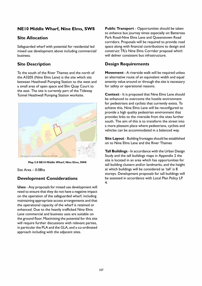
NE10 Middle Wharf, Nine Elms, SW8
Site Allocation
Safeguarded wharf with potential for residential ledmixed use development above including commercial/business.
Site Description
To the south of the River Thames and the north ofthe A3205 (Nine Elms Lane) is the site which sitsbetween Heathwall Pumping Station to the west anda small area of open space and Elm Quay Court tothe east. The site is currently part of the TidewayTunnel Heathwall Pumping Station worksite.
Map 5.8 NE10 Middle Wharf, Nine Elms, SW8
Site Area – 0.08ha
Development Considerations
Uses - Any proposals for mixed use development willneed to ensure that they do not have a negative impacton the operation of the safeguarded wharf, includingmaintaining appropriate access arrangements and thatthe operational capacity of the wharf is retained orenhanced. Due to the heavily trafficked Nine ElmsLane commercial and business uses are suitable onthe ground floor. Maximising the potential for this sitewill require further discussions with relevant parties,in particular the PLA and the GLA, and a co-ordinatedapproach including with the adjacent sites.
Public Transport - Opportunities should be takento enhance bus journey times especially on BatterseaPark Road-Nine Elms Lane and Queenstown Roadcorridors. Proposals will be required to provide roadspace along with financial contributions to design andconstruct TfL’s Nine Elms Corridor proposal whichwill deliver consistent bus infrastructure.
Design Requirements
Movement - A riverside walk will be required unlessan alternative route of an equivalent width and equalamenity value around or through the site is necessaryfor safety or operational reasons.
Context - It is proposed that Nine Elms Lane shouldbe enhanced to overcome the hostile environmentfor pedestrians and cyclists that currently exists. Toachieve this, Nine Elms Lane will be reconfigured toprovide a high quality pedestrian environment thatprovides links to the riverside from the sites furthersouth. The aim of this is to transform the street intoa more pleasant place where pedestrians, cyclists andvehicles can be accommodated in a balanced way.
Site Layout - Building frontages should be establishedon to Nine Elms Lane and the River Thames
Tall Buildings - In accordance with the Urban DesignStudy and the tall buildings maps in Appendix 2 thesite is located in an area which has opportunities fortall building clusters and/or landmarks, and the heightat which buildings will be considered as ‘tall’ is 8storeys. Development proposals for tall buildings willbe assessed in accordance with Local Plan Policy LP4.
107

NE12 New Covent Garden Market -Entrance Site, SW8
Site Allocation
Residential-led mixed use development withindependent shop and business emphasising localmakers and artisans. Improved transport capacity, anew permeable network of streets and urban spacesincluding amenity space.
Site Description
The site is to the east of the junction of the A3205(Nine Elms Lane) and the unnamed road whichseparates this site and 41-49 Nine Elms Lane, and49-59 Battersea Park Road site (NE2). It is boundedto the south by the Metropolitan Police WarehouseGarage site (NE4). The site is currently used as atemporary flower market with space for access andservicing.
Map 5.9 NE12NewCovent GardenMarket - Entrance Site, SW8
Site Area – 1.43ha
Development Considerations
Open Space – The entrance to the linear park shouldinclude a civic space to welcome people into the area.High quality green features should be incorporated tohelp create green corridors towards and from thepark.
Access - Access to the NCGM site from BatterseaPark Road will be retained and should be integratedinto a wider network of streets that offer choice inmoving around Nine Elms, including active travel linksto Ascalon Street to the west and Ponton Road tothe south.
Active Travel - Improve north-south active travellinks including to the Thames riverside and under therailway to Wandsworth Road.
Public Transport - Opportunities should be takento enhance bus journey times especially on BatterseaPark Road-Nine Elms Lane and Queenstown Roadcorridors. Proposals will be required to provide roadspace along with financial contributions to design andconstruct TfL’s Nine Elms Corridor proposal whichwill deliver consistent bus infrastructure. NewNorthern Line station to open within close proximityto site in Autumn 2021.
Co-operation with other allocated sites – If theneighbouring site to the west (NE2) changes use toresidential, the road between should be made morepedestrian friendly. The footpath and public spaceshould be widened to create a much more attractivegateway into CGMA.
Planning Permissions – The site has planningpermission for part outline and part detail planningpermission for: (a) demolition of existing wholesalefruit and vegetable and flower market and ancillarybuildings and structures, and residential building onNine Elms Lane (apart from the existing multi storeycar park); (b) construction of mixed useredevelopment. For more information see planningapplication reference 2014/2810.
Design Requirements
Built Form – The site forms the main access to NewCovent Garden Market, and the western entrance tothe linear park. It is essential that the treatment of thesite provides a sense of the park continuing acrosswhat will continue to be a major junction.
Movement - Establish a wayfinding strategy,connecting and promoting active use of new publicspaces through integrating facilities and events.Enhance access to the riverside and across to NineElms Lane.
Context - Improve frontages, public realm and signagealong Nine Elms Lane.
Identity and Architectural Expression – NineElms Lane will be reconfigured to provide a high qualitypedestrian environment that provides links to theriverside from the sites further south.
108

Site Layout - Pedestrian entrances to alldevelopment (ground floor and upper floor uses)should be directly on to streets, and active groundfloor frontages will be sought to contribute to a safe,vibrant public realm.
Tall Buildings - In accordance with the Urban DesignStudy and the tall buildings maps in Appendix 2 thesite is located in an area which has opportunities fortall building clusters and/or landmarks, and the heightat which buildings will be considered as ‘tall’ is 8storeys. Development proposals for tall buildings willbe assessed in accordance with Local Plan Policy LP4.
109
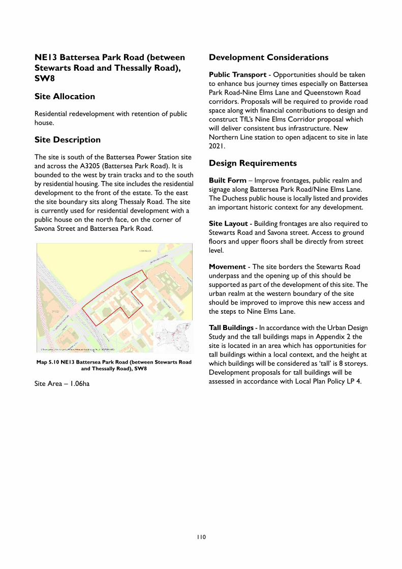
NE13 Battersea Park Road (betweenStewarts Road and Thessally Road),SW8
Site Allocation
Residential redevelopment with retention of publichouse.
Site Description
The site is south of the Battersea Power Station siteand across the A3205 (Battersea Park Road). It isbounded to the west by train tracks and to the southby residential housing. The site includes the residentialdevelopment to the front of the estate. To the eastthe site boundary sits along Thessaly Road. The siteis currently used for residential development with apublic house on the north face, on the corner ofSavona Street and Battersea Park Road.
Map 5.10 NE13 Battersea Park Road (between Stewarts Roadand Thessally Road), SW8
Site Area – 1.06ha
Development Considerations
Public Transport - Opportunities should be takento enhance bus journey times especially on BatterseaPark Road-Nine Elms Lane and Queenstown Roadcorridors. Proposals will be required to provide roadspace along with financial contributions to design andconstruct TfL’s Nine Elms Corridor proposal whichwill deliver consistent bus infrastructure. NewNorthern Line station to open adjacent to site in late2021.
Design Requirements
Built Form – Improve frontages, public realm andsignage along Battersea Park Road/Nine Elms Lane.The Duchess public house is locally listed and providesan important historic context for any development.
Site Layout - Building frontages are also required toStewarts Road and Savona street. Access to groundfloors and upper floors shall be directly from streetlevel.
Movement - The site borders the Stewarts Roadunderpass and the opening up of this should besupported as part of the development of this site. Theurban realm at the western boundary of the siteshould be improved to improve this new access andthe steps to Nine Elms Lane.
Tall Buildings - In accordance with the Urban DesignStudy and the tall buildings maps in Appendix 2 thesite is located in an area which has opportunities fortall buildings within a local context, and the height atwhich buildings will be considered as ‘tall’ is 8 storeys.Development proposals for tall buildings will beassessed in accordance with Local Plan Policy LP 4.
110

6 Area Strategy for ClaphamJunction and YorkRoad/Winstanley RegenerationArea
Introduction
6.1 The Area Strategy for Clapham Junction andYork Road/Winstanley Regeneration Areaprovides a framework for how newdevelopment in the area should be designedand planned for in order to meet the vision andobjectives of the Local Plan. The strategy takesa design-led approach, encourages sustainabletransport, contributes to tackling climate changeand enabling places to support the health andwellbeing of their communities. The ClaphamJunction and York Road/WinstanleyRegeneration Area is identified in the emergingLondon Plan as a nascent Opportunity Areareflecting the significant growth opportunitiesoffered by the Crossrail 2 project and/or thepotential for upgrading the existing station atClapham Junction. Whilst at this time a masterplanning exercise for the area is consideredpremature, the Area Strategy would be used toinform any future masterplan or developmentproposals that come forward in the near-term.
Context
6.2 Clapham Junction Town Centre, framed by thetwo main crossroads of St. John’s Hill/St. JohnsRoad and Northcote Road/Battersea Rise, is atthe heart of this Area Strategy. The centrerapidly developed after the opening of therailways in the mid-19th century, growing into akey commercial and cultural destination. Today,it has a bustling and active streetscape populatedby local residents, shoppers, commuters, andworkers. There is a good selection ofcomparison and convenience shopping, withseveral high quality ‘national multiple’retailers, and four large food storescomplemented with a number of ‘top up’alternatives.
Picture 6.1 The landmark Arding & Hobbs department storeand its distinctive clock tower lends gravitas to the primary focal
point of the town centre
6.3 The centre has a reputation for having a livelyevening and entertainment offer, includingpubs, clubs and restaurants with a diverse foodscene, much of which is clustered on NorthcoteRoad and Battersea Rise and along LavenderHill and St John’s Hill. The emerging LondonPlan classifies night-time activity in ClaphamJunction as ‘NT2’, indicating that it hasregional/sub-regional significance. The area alsohosts a number of cultural organisations andlarge venues, including the Battersea ArtsCentre and the Clapham Grand, and is alsorenowned for its artists’ studios on LavenderHill, many of which are located in the BatterseaBusiness Centre. Due to its excellent transportand growing cultural offer, Clapham Junctionpresents a desirable location fornational cultural organisations.
6.4 Reflecting the retail and leisure focus ofClapham Junction, there is limited officeprovision within the centre – with the exceptionof PCS House and the 7-11 St John’s Hillbuilding. Given the high levels of connectivityto the town centre, and the opportunity thatClapham Junction station offers, it is anticipatedthat there could be further potential for offices.
6.5 Clapham Junction Station is oneof Europe's busiest rail interchanges; before theCovid-19 pandemic it was operating at close to
111
capacity in terms of rail services and passengernumbers and suffered from over-crowding atpeak times. Reconfiguration of the futurerail infrastructure and the station is needed toincrease capacity and substantially improvepassengers’ public transport experience. Partsof it are safeguarded as a Crossrail 2 stationsite, and it is correspondingly recognised as anascent Opportunity Area within the emergingLondon Plan. The Council recognises this asunique opportunity both to deliverimprovements to the station and to bringforward residential and commercialdevelopment as part of the rationalisation ofsurrounding land, and is working with the Mayorof London and Government to deliver on thispotential. Notwithstanding, the longer-termimpact of the Covid-19 pandemic on the projectis yet to be determined, and as such this AreaStrategy takes a pragmatic view, outlining howopportunities can also be promoted in theshorter-term by facilitating developmentchanges in and around the Station, were theCrossrail 2 project or other stationimprovements not to come forward within thetimescales of the Local Plan.
6.6 Despite its excellent public transportconnections, the area suffers from significantthrough-traffic, especially east-west on theLavender Hill - St John’s Hill and Battersea Risecorridors, which negatively impacts thepedestrian experience of the area. This issueis exacerbated by the limited width of thepavement in some parts ofthe centre. There are a lack offoot/cycle connections within thecentre, and to adjacent locations, such as theThames riverside, including to the proposedDiamond Jubilee Bridge at NorthBattersea, and to theWinstanley and York RoadEstates, located to the north of this spatialarea. Clapham Junction is designated as an AirQuality Focus Area due to the high levels ofpollutants on the main road .The WandsworthLocal Implementation Plan (2019) shows thatClapham Junction has a high level of residentsmeeting their active travel daily requirementsat approximately 51%-70% and there is scopeto switch 2,057-3,540 daily trips to walking and2,001-5,000 trips to cycling.
6.7 To the north of Clapham Junction Station is theWinstanley and York Road Regeneration Area.This regeneration project is expected to deliverup to 2,550 new homes, with 35% affordablehousing provision, including for social rent,affordable rent and low-cost home ownershipoptions as well as shared equity units for allexisting resident leaseholders. The new homeswill be supported by a new park, a leisure andcommunity centre, a library and a nursery. ThisArea Strategy supports the existing Masterplanfor the area.
Character
6.8 The tight-knit urban form of ClaphamJunction creates a high quality townscape givingenclosure to streets, and the frequency ofintersections facilitates wayfinding around thetown centre, instilling a feeling of safety. Thecharacter of the area is derived from itssurviving Victorian and Edwardian townscape, asexemplified by the terraced shops along StJohn's Road, St John's Hill and Lavender Hill,which remain the centre’s focus forretail. There are a number of landmark andlisted buildings that contribute to scenicstreetscapes, including the Arding & Hobbsbuilding, the octagonal cupola of which marksthe focal point of the centre and is a cherishedheritage asset providing a strong sense of place.Other valued heritage assets, such as theClapham Grand, former Granada Cinema andthe Falcon public house, all within the ClaphamJunction Conservation Area, contributedistinctive character to the area. Due to thehighly urban character and development of thearea, there are very few trees and very littlegreen space, although Clapham Common andWandsworth Common serve the area, beingonly some 300 metres away. Although limited,there are some public open spaces which softenthe urban character of the streets.
112
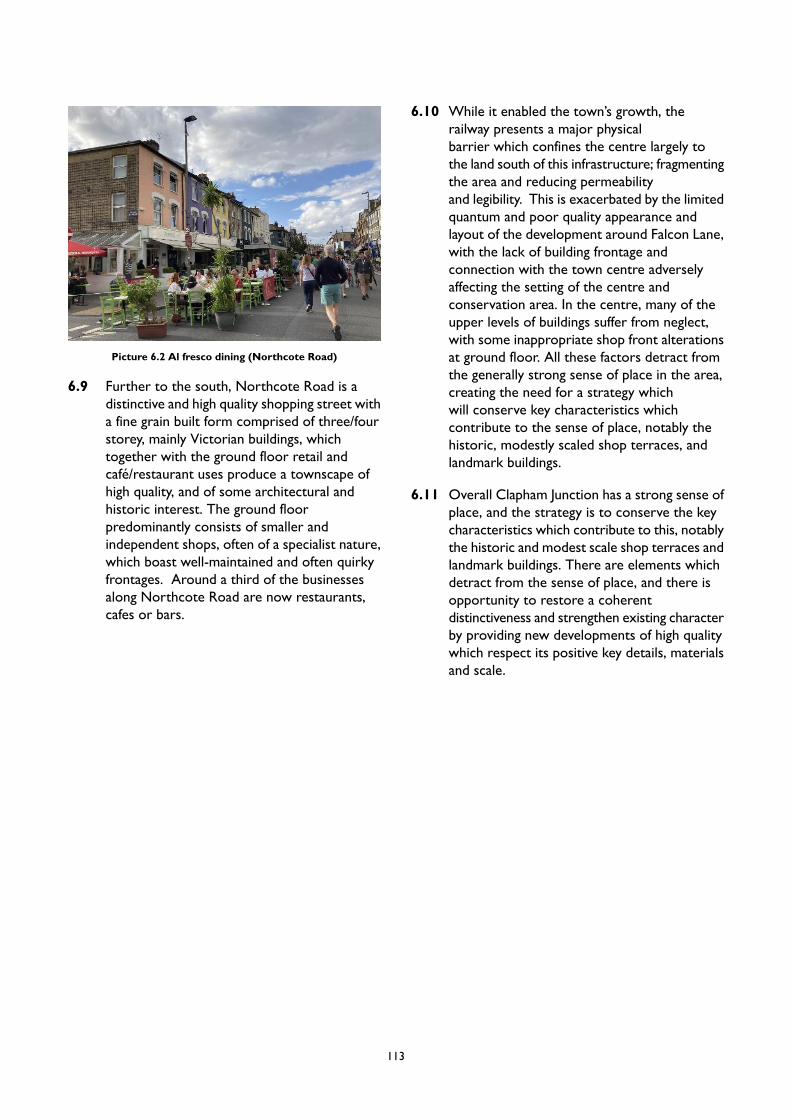
Picture 6.2 Al fresco dining (Northcote Road)
6.9 Further to the south, Northcote Road is adistinctive and high quality shopping street witha fine grain built form comprised of three/fourstorey, mainly Victorian buildings, whichtogether with the ground floor retail andcafé/restaurant uses produce a townscape ofhigh quality, and of some architectural andhistoric interest. The ground floorpredominantly consists of smaller andindependent shops, often of a specialist nature,which boast well-maintained and often quirkyfrontages. Around a third of the businessesalong Northcote Road are now restaurants,cafes or bars.
6.10 While it enabled the town’s growth, therailway presents a major physicalbarrier which confines the centre largely tothe land south of this infrastructure; fragmentingthe area and reducing permeabilityand legibility. This is exacerbated by the limitedquantum and poor quality appearance andlayout of the development around Falcon Lane,with the lack of building frontage andconnection with the town centre adverselyaffecting the setting of the centre andconservation area. In the centre, many of theupper levels of buildings suffer from neglect,with some inappropriate shop front alterationsat ground floor. All these factors detract fromthe generally strong sense of place in the area,creating the need for a strategy whichwill conserve key characteristics whichcontribute to the sense of place, notably thehistoric, modestly scaled shop terraces, andlandmark buildings.
6.11 Overall Clapham Junction has a strong sense ofplace, and the strategy is to conserve the keycharacteristics which contribute to this, notablythe historic and modest scale shop terraces andlandmark buildings. There are elements whichdetract from the sense of place, and there isopportunity to restore a coherentdistinctiveness and strengthen existing characterby providing new developments of high qualitywhich respect its positive key details, materialsand scale.
113
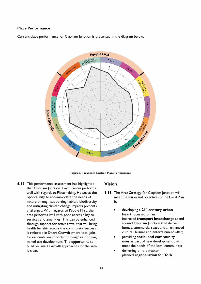
Place Performance
Current place performance for Clapham Junction is presented in the diagram below:
Figure 6.1 Clapham Junction Place Performance
6.12 This performance assessment has highlightedthat Clapham Junction Town Centre performswell with regards to Placemaking. However, theopportunity to accommodate the needs ofnature through supporting habitat, biodiversityand mitigating climate change impacts presentschallenges. With regards to People First, thearea performs well with good accessibility toservices and amenities. This can be enhancedthrough support for active travel that will bringhealth benefits across the community. Successis reflected in Smart Growth where local jobsfor residents are important through responsive,mixed use development. The opportunity tobuild on Smart Growth approaches for the areais clear.
Vision
6.13 The Area Strategy for Clapham Junction willmeet the vision and objectives of the Local Planby:
developing a 21st century urbanheart focussed on animproved transport interchange at andaround Clapham Junction that delivershomes, commercial space and an enhancedcultural, leisure and entertainment offer;providing social and communityuses as part of new development thatmeet the needs of the local community;delivering on the masterplanned regeneration for York
114

Road/Winstanley to deliver housing,including affordable housing and improvedcommunity facilities;
providing inclusive and connected publicrealm/open space and urbangreening for Clapham Junction towncentre that puts people first;
Anchor for Change - Clapham Junction Transport Interchange
The redevelopment of Clapham Junction station capitalises on the area’s excellent existing and potentialpublic transport connectivity to catalyse growth and regeneration focusing on delivering new homes andcreating jobs. The opportunity to create inclusive areas that are attractive across the community is clear.This can provide social and environmental benefits, as well as, economic development outcomes. This willallow a foundation for the development of Clapham Junction that offers successful place outcomes that cancontribute to addressing the wider challenges around housing, employment and resilience. The Area Strategyprovides a framework to grasp these opportunities to create an enhanced urban heart to deliver an improvedstation, and mixed use development led by residential, commercial and cultural uses. The provision ofcommunity facilities such as schools, health centres and community hubs needs to be promoted. The AreaStrategy presents an opportunity to bring forward the aims of the Council’s Arts and Culture Strategy andto enhance the leisure and night- time economy by development bringing forward such uses.
This highly accessible area can accommodate higher density and promote connectivity through facilitatingactive travel. Development must respect heritage and landmark buildings (as well as views and vistas)incorporating these into schemes to support identity. The development opportunities set out within thisArea Strategy offer the prospect for inclusive public realm and open space provision to reinforce connectivity,support wellbeing and contribute to quality of life.
PM4 Clapham Junction and York Road/Winstanley Regeneration Area
Placemaking
A. Clapham Junction, a nascent Opportunity Area, has the potential to promote and encourage sustainabledevelopment. Development, at identified growth locations, will be supported where:
1. mixed use is proposed with an emphasis on residential, commercial development and towncentre uses;
2. height and massing are appropriate and conform to the approach for tall buildings;3. active travel is promoted and challenges for broader connectivity are addressed that help improve
safety and make routes direct and attractive to Clapham Junction;4. public transport interchange is facilitated and promoted;5. heritage and landmark buildings are incorporated into development proposals to enhance their
contribution to place identity;6. views and vistas, established in the Urban Design Study (2020), are respected and enhanced;7. public realm and open space provision, accessible to all, complements the hierarchy within the
Area Strategy;8. high quality green features will be incorporated into new developments to help connected green
and blue infrastructure throughout the borough; and9. infrastructure can take advantage of district heating, sustainable urban drainage and digital
connectivity.
115
B. Proposals on sites other than Site Allocations, that take advantage of their proximity to ClaphamJunction Station that can provide housing, employment and appropriate town centre uses, are supported.
C. The Council will work with Network Rail and Transport for London (TfL) to prepare a vision forClapham Junction Station in improving its role as a major rail and public transport interchange in orderto realise the development potential at the station, to better integrate it with the town centre and toYork Road/Winstanley. This will seek to upgrade the quality of its appearance, functionality and facilities.This will unlock the barriers to access to the north of the station.
D. In conjunction with development opportunities that take advantage of the Clapham Junction Stationproposals, the Council will promote the development of a new public square and entrance to ClaphamJunction Station, and a series of pocket parks/parklets within the town centre. Where appropriate,these should support nature through encouraging biodiversity and providing appropriate habitat.
E. Action to reduce the impact of through-traffic in and around the town centre will be supported;particularly on and adjacent to Northcote Road. This will be achieved by introducing appropriatetraffic calming and other traffic management proposals.
F. The Urban Design Study has identified appropriate locations for tall buildings in Clapham Junction andYork Road / Winstanley Regeneration Area. The broad locations are identified in Appendix 2. Anyproposal for a tall building will be subject to addressing the requirements of Policy LP 4 (Tall Buildings)as well as other policies in the Plan as applicable.
G. Tall buildings in Clapham Junction and York Road / Winstanley Regeneration Area will be supportedwhere they are in locations identified as appropriate for tall buildings in Appendix 2, subject toaddressing the requirements of Policy LP 4 (Tall Buildings).
H. Opportunities to enhance the experience and quality of the public realm through carefully considered,well designed proposals that can create interesting, dynamic, accessible, and inclusive public spacesare encouraged. These should provide elements that encourage dwell time, such as seating, whichfacilitate community and cultural use, and which incorporate public art. Imaginative landscape designcan contribute to the greening of these spaces.
I. The Council supports the provision of enhanced public realm and parklet provision within the towncentre on private plots (where this is adjacent to the edge of footway and can be accessed directly).On-highway provision may also be appropriate where this can be accommodated without adverselyimpacting on the traffic management, particularly of St John’s Road and Northcote Road.
J. Development proposals will be expected to increase quantity of native street trees.K. New development will be expected to protect important views and vistas in the area, including:
1. vistas across mature open green spaces, including the unfolding view of Clapham Junction fromthe railway from Waterloo, with the view of the towers in the Clapham Grand signalling arrivalat the station;
2. north along Northcote Road to the Northcote Road Baptist Church;3. from the railway bridge in St John's Hill to the buildings stepping up Lavender Hill indicating the
valley of Falcon Brook;4. to the landmark St Mark's Church (withinWandsworth Common character area) from Battersea
Rise looking west, and from the railway; and5. from the overbridge at Clapham Junction station towards central London landmarks including
Battersea Power Station, the London Eye and the Palace of Westminster World Heritage Site.
L. Development must be sensitive to local character by maintaining and respecting proportions, scaleand coherence of terraced streets, shop frontages and their settings. Where possible, the Councilwill expect proposals to reinstate traditional shop fronts to achieve consistency in appearance withthe setting of the town centre and the conservation area; particularly for St John’s Road and NorthcoteRoad.
Smart Growth
116
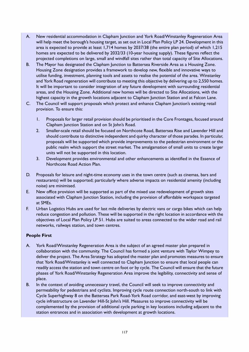
A. New residential accommodation in Clapham Junction and York Road/Winstanley Regeneration Areawill help meet the borough’s housing target, as set out in Local Plan Policy LP 24. Development in thisarea is expected to provide at least 1,714 homes by 2037/38 (the entire plan period) of which 1,215homes are expected to be delivered by 2032/33 (10-year housing supply). These figures reflect theprojected completions on large, small and windfall sites rather than total capacity of Site Allocations.
B. The Mayor has designated the Clapham Junction to Battersea Riverside Area as a Housing Zone.Housing Zone designation provides a framework to develop new, flexible and innovative ways toutilise funding, investment, planning tools and assets to realise the potential of the area. Winstanleyand York Road regeneration will contribute to meeting this objective by delivering up to 2,550 homes.It will be important to consider integration of any future development with surrounding residentialareas, and the Housing Zone. Additional new homes will be directed to Site Allocations, with thehighest capacity in the growth locations adjacent to Clapham Junction Station and at Falcon Lane.
C. The Council will support proposals which protect and enhance Clapham Junction’s existing retailprovision. To ensure this:
1. Proposals for larger retail provision should be prioritised in the Core Frontages, focused aroundClapham Junction Station and on St John’s Road.
2. Smaller-scale retail should be focused on Northcote Road, Battersea Rise and Lavender Hill andshould contribute to distinctive independent and quirky character of those parades. In particular,proposals will be supported which provide improvements to the pedestrian environment or thepublic realm which support the street market. The amalgamation of small units to create largerunits will not be supported in this location.
3. Development provides environmental and other enhancements as identified in the Essence ofNorthcote Road Action Plan.
D. Proposals for leisure and night-time economy uses in the town centre (such as cinemas, bars andrestaurants) will be supported; particularly where adverse impacts on residential amenity (includingnoise) are minimised.
E. New office provision will be supported as part of the mixed use redevelopment of growth sitesassociated with Clapham Junction Station, including the provision of affordable workspace targetedat SMEs.
F. Urban Logistics Hubs are used for last mile deliveries by electric vans or cargo bikes which can helpreduce congestion and pollution. These will be supported in the right location in accordance with theobjectives of Local Plan Policy LP 51. Hubs are suited to areas connected to the wider road and railnetworks, railways station, and town centres.
People First
A. York Road/Winstanley Regeneration Area is the subject of an agreed master plan prepared incollaboration with the community. The Council has formed a joint venture with Taylor Wimpey todeliver the project. The Area Strategy has adopted the master plan and promotes measures to ensurethat York Road/Winstanley is well connected to Clapham Junction to ensure that local people canreadily access the station and town centre on foot or by cycle. The Council will ensure that the futurephases of York Road/Winstanley Regeneration Area improve the legibility, connectivity and sense ofplace.
B. In the context of avoiding unnecessary travel, the Council will seek to improve connectivity andpermeability for pedestrians and cyclists. Improving cycle route connection north-south to link withCycle Superhighway 8 on the Battersea Park Road-York Road corridor, and east-west by improvingcycle infrastructure on Lavender Hill-St John’s Hill. Measures to improve connectivity will becomplemented by the provision of additional cycle parking in key locations including adjacent to thestation entrances and in association with development at growth locations.
117
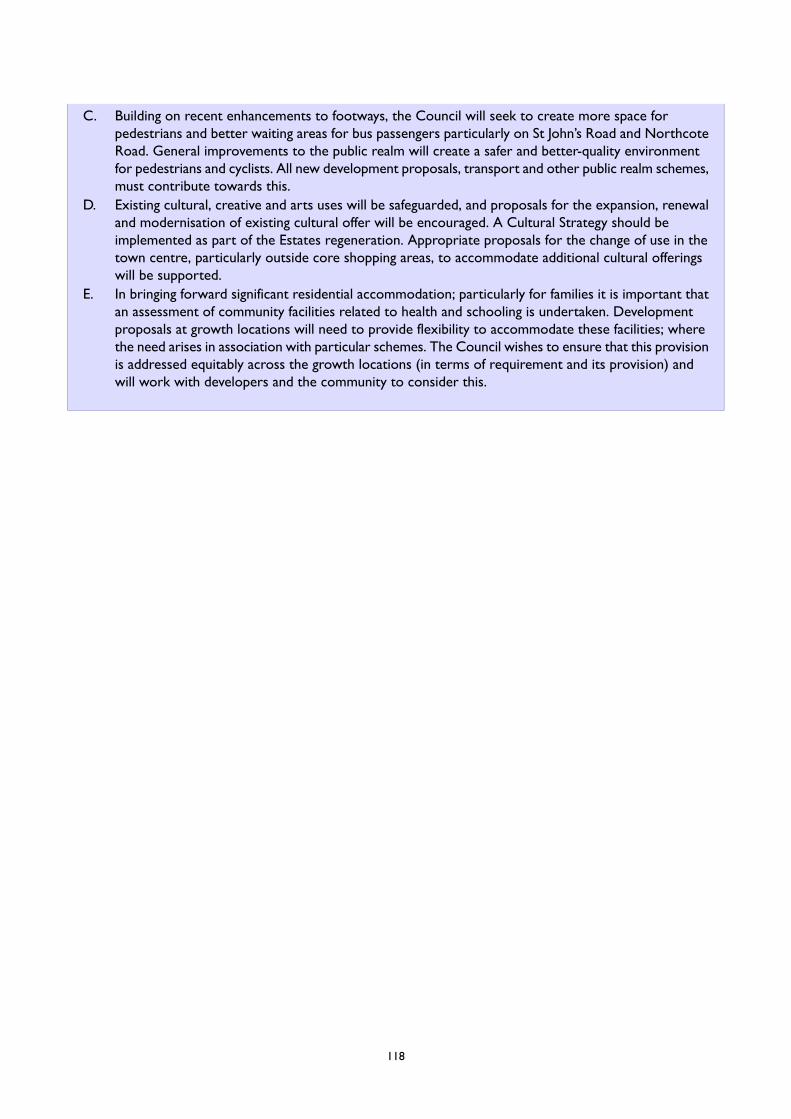
C. Building on recent enhancements to footways, the Council will seek to create more space forpedestrians and better waiting areas for bus passengers particularly on St John’s Road and NorthcoteRoad. General improvements to the public realm will create a safer and better-quality environmentfor pedestrians and cyclists. All new development proposals, transport and other public realm schemes,must contribute towards this.
D. Existing cultural, creative and arts uses will be safeguarded, and proposals for the expansion, renewaland modernisation of existing cultural offer will be encouraged. A Cultural Strategy should beimplemented as part of the Estates regeneration. Appropriate proposals for the change of use in thetown centre, particularly outside core shopping areas, to accommodate additional cultural offeringswill be supported.
E. In bringing forward significant residential accommodation; particularly for families it is important thatan assessment of community facilities related to health and schooling is undertaken. Developmentproposals at growth locations will need to provide flexibility to accommodate these facilities; wherethe need arises in association with particular schemes. The Council wishes to ensure that this provisionis addressed equitably across the growth locations (in terms of requirement and its provision) andwill work with developers and the community to consider this.
118
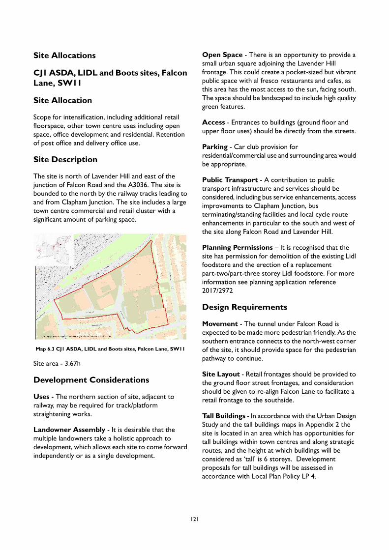
Site Allocations
CJ1 ASDA, LIDL and Boots sites, FalconLane, SW11
Site Allocation
Scope for intensification, including additional retailfloorspace, other town centre uses including openspace, office development and residential. Retentionof post office and delivery office use.
Site Description
The site is north of Lavender Hill and east of thejunction of Falcon Road and the A3036. The site isbounded to the north by the railway tracks leading toand from Clapham Junction. The site includes a largetown centre commercial and retail cluster with asignificant amount of parking space.
Map 6.3 CJ1 ASDA, LIDL and Boots sites, Falcon Lane, SW11
Site area - 3.67h
Development Considerations
Uses - The northern section of site, adjacent torailway, may be required for track/platformstraightening works.
Landowner Assembly - It is desirable that themultiple landowners take a holistic approach todevelopment, which allows each site to come forwardindependently or as a single development.
Open Space - There is an opportunity to provide asmall urban square adjoining the Lavender Hillfrontage. This could create a pocket-sized but vibrantpublic space with al fresco restaurants and cafes, asthis area has the most access to the sun, facing south.The space should be landscaped to include high qualitygreen features.
Access - Entrances to buildings (ground floor andupper floor uses) should be directly from the streets.
Parking - Car club provision forresidential/commercial use and surrounding area wouldbe appropriate.
Public Transport - A contribution to publictransport infrastructure and services should beconsidered, including bus service enhancements, accessimprovements to Clapham Junction, busterminating/standing facilities and local cycle routeenhancements in particular to the south and west ofthe site along Falcon Road and Lavender Hill.
Planning Permissions – It is recognised that thesite has permission for demolition of the existing Lidlfoodstore and the erection of a replacementpart-two/part-three storey Lidl foodstore. For moreinformation see planning application reference2017/2972
Design Requirements
Movement - The tunnel under Falcon Road isexpected to be made more pedestrian friendly. As thesouthern entrance connects to the north-west cornerof the site, it should provide space for the pedestrianpathway to continue.
Site Layout - Retail frontages should be provided tothe ground floor street frontages, and considerationshould be given to re-align Falcon Lane to facilitate aretail frontage to the southside.
Tall Buildings - In accordance with the Urban DesignStudy and the tall buildings maps in Appendix 2 thesite is located in an area which has opportunities fortall buildings within town centres and along strategicroutes, and the height at which buildings will beconsidered as ‘tall’ is 6 storeys. Developmentproposals for tall buildings will be assessed inaccordance with Local Plan Policy LP 4.
121
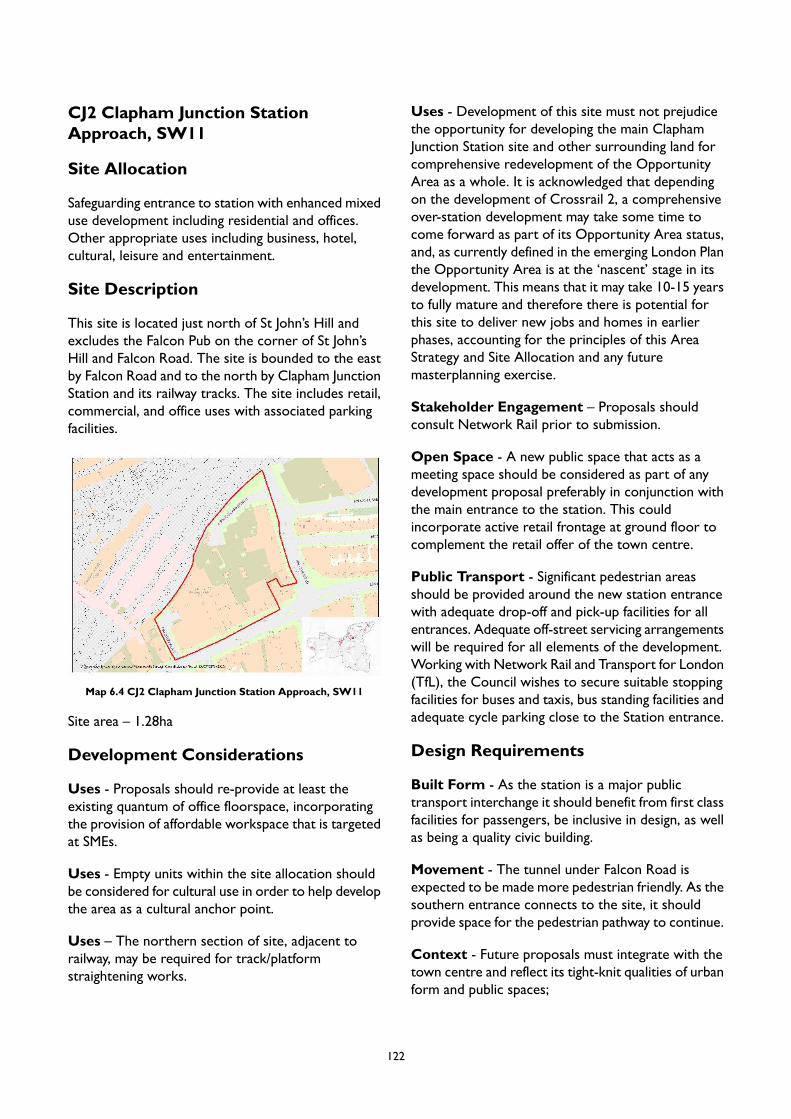
CJ2 Clapham Junction StationApproach, SW11
Site Allocation
Safeguarding entrance to station with enhanced mixeduse development including residential and offices.Other appropriate uses including business, hotel,cultural, leisure and entertainment.
Site Description
This site is located just north of St John’s Hill andexcludes the Falcon Pub on the corner of St John’sHill and Falcon Road. The site is bounded to the eastby Falcon Road and to the north by Clapham JunctionStation and its railway tracks. The site includes retail,commercial, and office uses with associated parkingfacilities.
Map 6.4 CJ2 Clapham Junction Station Approach, SW11
Site area – 1.28ha
Development Considerations
Uses - Proposals should re-provide at least theexisting quantum of office floorspace, incorporatingthe provision of affordable workspace that is targetedat SMEs.
Uses - Empty units within the site allocation shouldbe considered for cultural use in order to help developthe area as a cultural anchor point.
Uses – The northern section of site, adjacent torailway, may be required for track/platformstraightening works.
Uses - Development of this site must not prejudicethe opportunity for developing the main ClaphamJunction Station site and other surrounding land forcomprehensive redevelopment of the OpportunityArea as a whole. It is acknowledged that dependingon the development of Crossrail 2, a comprehensiveover-station development may take some time tocome forward as part of its Opportunity Area status,and, as currently defined in the emerging London Planthe Opportunity Area is at the ‘nascent’ stage in itsdevelopment. This means that it may take 10-15 yearsto fully mature and therefore there is potential forthis site to deliver new jobs and homes in earlierphases, accounting for the principles of this AreaStrategy and Site Allocation and any futuremasterplanning exercise.
Stakeholder Engagement – Proposals shouldconsult Network Rail prior to submission.
Open Space - A new public space that acts as ameeting space should be considered as part of anydevelopment proposal preferably in conjunction withthe main entrance to the station. This couldincorporate active retail frontage at ground floor tocomplement the retail offer of the town centre.
Public Transport - Significant pedestrian areasshould be provided around the new station entrancewith adequate drop-off and pick-up facilities for allentrances. Adequate off-street servicing arrangementswill be required for all elements of the development.Working with Network Rail and Transport for London(TfL), the Council wishes to secure suitable stoppingfacilities for buses and taxis, bus standing facilities andadequate cycle parking close to the Station entrance.
Design Requirements
Built Form - As the station is a major publictransport interchange it should benefit from first classfacilities for passengers, be inclusive in design, as wellas being a quality civic building.
Movement - The tunnel under Falcon Road isexpected to be made more pedestrian friendly. As thesouthern entrance connects to the site, it shouldprovide space for the pedestrian pathway to continue.
Context - Future proposals must integrate with thetown centre and reflect its tight-knit qualities of urbanform and public spaces;
122
Identity andArchitectural Expression - Proposalsshould include a considered, landscape-led public realmthat provides spaces for people in transit, and thosewho work/live on-site. These environments shouldprovide comfortable, safe, inclusive, accessible, andinviting spaces for travellers, workers, and residentsalike.
Tall Buildings - In accordance with the Urban DesignStudy and the tall buildings maps in Appendix 2 thesite is located in an area which has opportunities fortall buildings within town centres and along strategicroutes, and the height at which buildings will beconsidered as ‘tall’ is 6 storeys. Developmentproposals for tall buildings will be assessed inaccordance with Local Plan Policy LP 4.
123

CJ3 Land on the corner of Grant Roadand Falcon Road, SW11
Site Allocation
A mixed use development with commercial on theground floor and residential use to upper floors isrequired. Any new development will need to considerthe current and future arrangements for the busturnaround.
Site Description
Located north of Clapham Junction and to the westof Falcon Road. The site is bounded by the railwayarches to the south, and the Winstanley Estate to thenorth and west. The site is used for commercial,residential and ecclesiastical uses as well as being abus station.
Map 6.5 CJ3 Land on the corner of Grant Road and Falcon Road,SW11
Site area - 0.9ha
Development Considerations
Uses - A significant part of this site is safeguarded forthe provision of a surface worksite for Crossrail 2.Changes to the safeguarding are expected in 2020/21.There may be potential for meanwhile uses on someor all of this site following confirmation of the likelybuild programme for Crossrail 2.
Stakeholder Engagement – Any proposal will needto engage with the bus operator.
Public Transport - Improvements to the footwayand carriageway of Grant Road will be sought includinga contribution towards the cost of the works anddedication of land at the corner of Grant Road withWinstanley Road. Contributions towardsimprovements to public transport includingimprovements to Grant Road bus stand will be sought,along with contributions to improved pedestrian andcycle access routes to the northern entrance toClapham Junction
Co-operation with other allocations - The siteneeds to be explored in conjunction with adjacentsites on improving the permeability between the northentrance to Clapham Junction Station and theWinstanley Estate (CJ5).
Design Requirements
Movement - The tunnel under Falcon Road isexpected to be made more pedestrian friendly. As thenorthern entrance connects to the site, it shouldprovide space for the pedestrian pathway to continue.
Context - Redevelopment proposals of the area willbe required to strengthen the links to the town centreand provide updated bus terminal facilities. The siteis closely linked to the Falcon Estate and anydevelopment will need to integrate into that site. Thecurrent public realm is quite poor and permeabilitywith the surrounding area should be improved as partof any proposal.
Tall Buildings - In accordance with the Urban DesignStudy and the tall buildings maps in Appendix 2 thesite is located in an area which has opportunities fortall buildings within a local context, and the height atwhich buildings will be considered as ‘tall’ is 5 storeys.Development proposals for tall buildings will beassessed in accordance with Local Plan Policy LP 4.
124

CJ4 Land at Clapham Junction Station,SW11
Site Allocation
Safeguarding station with enhanced mixed usedevelopment including residential.
Site Description
The site is to the north of St John’s Road and the eastof Plough Road behind a row of houses. The site canbe accessed from the north west of the site alongPlough Road. To the east and north of the site arerailway tracks and Clapham Junction Station. The siteis used as a railway yard and The Station Master’shouse is used for office use.
Map 6.6 CJ4 Land at Clapham Junction Station, SW11
Site area - 3.07ha
Development Considerations
Uses – Site is within 200m buffer surface interest areafor Crossrail 2 and is safeguarded as a worksite. Areview of the safeguarding is expected in 2020/21. Aspart of Crossrail 2, the site will be a significant worksite for the duration of the Clapham Junction works.
Active Travel – Improvements to the cyclinginfrastructure are expected along St John’s Road tothe south of the site which should be considered alongwith any proposal.
Co-operation with other allocations – Given theinter-relationship with the adjoining Clapham JunctionApproach (CJ2) there is a strong case for consideringboth sites as part of a coherent approach for a mixeduse sustainable development. Future development willneed to consider how to integrate the existing railwaymarshalling yards and their facilities with newdevelopment.
Design Requirements
Movement – A permeable network of routes willneed to be incorporated to link with St. John’s Hill,Plough Road and the ambition for a barrier-free routefrom the town centre to the north of the station asset out in the design principles for the adjoining site(CJ5).
Identity and Architectural Expression – Targetedchange may enhance character, legibility and the senseof arrival at this site due to the presence of moredetracting features.
Tall Buildings – In accordance with the Urban DesignStudy and the tall buildings maps in Appendix 2 thesite is located in an area which has opportunities fortall buildings within town centres and along strategicroutes, and the height at which buildings will beconsidered as ‘tall’ is 5 storeys. Developmentproposals for tall buildings will be assessed inaccordance with Local Plan Policy LP 4.
125
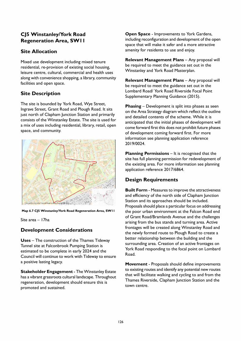
CJ5 Winstanley/York RoadRegeneration Area, SW11
Site Allocation
Mixed use development including mixed tenureresidential, re-provision of existing social housing,leisure centre, cultural, commercial and health usesalong with convenience shopping, a library, communityfacilities and open space.
Site Description
The site is bounded by York Road, Wye Street,Ingrave Street, Grant Road and Plough Road. It sitsjust north of Clapham Junction Station and primarilyconsists of the Winstanley Estate. The site is used fora mix of uses including residential, library, retail, openspace, and community.
Map 6.7 CJ5 Winstanley/York Road Regeneration Area, SW11
Site area – 17ha
Development Considerations
Uses – The construction of the Thames TidewayTunnel site at Falconbrook Pumping Station isestimated to be complete in early 2024 and theCouncil will continue to work with Tideway to ensurea positive lasting legacy.
Stakeholder Engagement - TheWinstanley Estatehas a vibrant grassroots cultural landscape. Throughoutregeneration, development should ensure this ispromoted and sustained.
Open Space - Improvements to York Gardens,including reconfiguration and development of the openspace that will make it safer and a more attractiveamenity for residents to use and enjoy.
Relevant Management Plans – Any proposal willbe required to meet the guidance set out in theWinstanley and York Road Masterplan.
Relevant Management Plans – Any proposal willbe required to meet the guidance set out in theLombard Road/ York Road Riverside Focal PointSupplementary Planning Guidance (2015).
Phasing – Development is split into phases as seenon the Area Strategy diagram which reflect the outlineand detailed contents of the scheme. While it isanticipated that the initial phases of development willcome forward first this does not prohibit future phasesof development coming forward first. For moreinformation see planning application reference2019/0024.
Planning Permissions – It is recognised that thesite has full planning permission for redevelopment ofthe existing area. For more information see planningapplication reference 2017/6864.
Design Requirements
Built Form - Measures to improve the attractivenessand efficiency of the north side of Clapham JunctionStation and its approaches should be included.Proposals should place a particular focus on addressingthe poor urban environment at the Falcon Road endof Grant Road/Bramlands Avenue and the challengesarising from the bus stands and turning area. Activefrontages will be created along Winstanley Road andthe newly formed route to Plough Road to create abetter relationship between the building and thesurrounding area. Creation of an active frontages onYork Road responding to the focal point on LombardRoad.
Movement - Proposals should define improvementsto existing routes and identify any potential new routesthat will facilitate walking and cycling to and from theThames Riverside, Clapham Junction Station and thetown centre.
126
Context - Consideration of developmentcapacity/density in identified locations across the area,including taking account of context in terms of therelationship to existing development and good publictransport.
Housing and Buildings – Proposal should considerhousing types and options which: deliver quality homesthat address residents' expectations and needs; andaim to meet a diverse range of needs withconsideration given to providing a range of tenuresincluding low cost rent and home ownership housing,market housing for sale, and structured private renthousing tailored to meet local residents' needs.Consultation with the existing community surroundingthese options will be expected.
Housing and Buildings - New housing developmentsshould strive to utilise innovative buildings methodssuch as PassivHaus to achieve high quality, highlyenergy efficient buildings. Technologies that allow forfuture flexibility, and overall sustainability through theimplementation of a circular economy strategy andoff-site manufacturing are also encouraged for housingproposals.
Tall Buildings - In accordance with the Urban DesignStudy and the tall buildings maps in Appendix 2 thesite is located in an area which has opportunities fortall buildings within a local context, and the height atwhich buildings will be considered as ‘tall’ is 5 storeys.Development proposals for tall buildings will beassessed in accordance with Local Plan Policy LP 4.
127
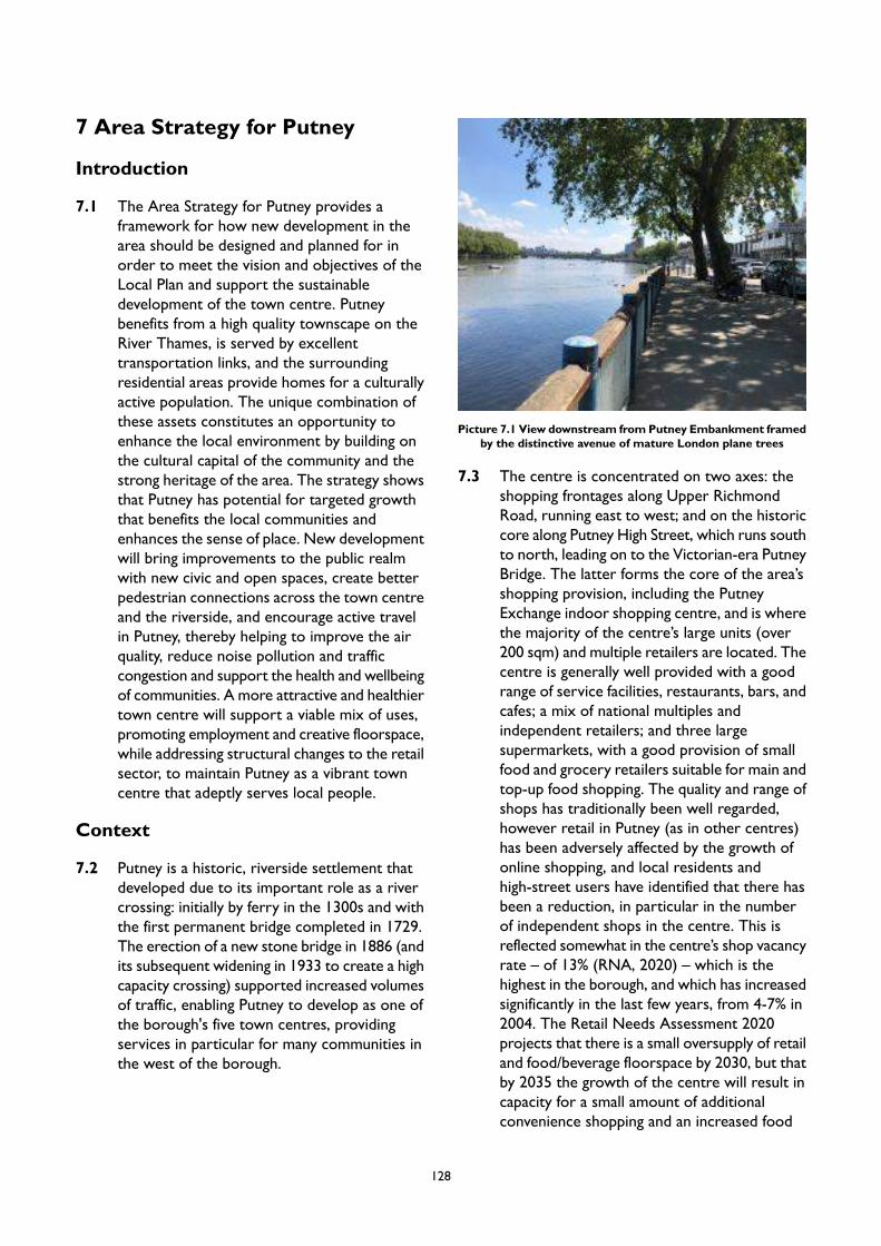
7 Area Strategy for Putney
Introduction
7.1 The Area Strategy for Putney provides aframework for how new development in thearea should be designed and planned for inorder to meet the vision and objectives of theLocal Plan and support the sustainabledevelopment of the town centre. Putneybenefits from a high quality townscape on theRiver Thames, is served by excellenttransportation links, and the surroundingresidential areas provide homes for a culturallyactive population. The unique combination ofthese assets constitutes an opportunity toenhance the local environment by building onthe cultural capital of the community and thestrong heritage of the area. The strategy showsthat Putney has potential for targeted growththat benefits the local communities andenhances the sense of place. New developmentwill bring improvements to the public realmwith new civic and open spaces, create betterpedestrian connections across the town centreand the riverside, and encourage active travelin Putney, thereby helping to improve the airquality, reduce noise pollution and trafficcongestion and support the health and wellbeingof communities. A more attractive and healthiertown centre will support a viable mix of uses,promoting employment and creative floorspace,while addressing structural changes to the retailsector, to maintain Putney as a vibrant towncentre that adeptly serves local people.
Context
7.2 Putney is a historic, riverside settlement thatdeveloped due to its important role as a rivercrossing: initially by ferry in the 1300s and withthe first permanent bridge completed in 1729.The erection of a new stone bridge in 1886 (andits subsequent widening in 1933 to create a highcapacity crossing) supported increased volumesof traffic, enabling Putney to develop as one ofthe borough's five town centres, providingservices in particular for many communities inthe west of the borough.
Picture 7.1 View downstream fromPutney Embankment framedby the distinctive avenue of mature London plane trees
7.3 The centre is concentrated on two axes: theshopping frontages along Upper RichmondRoad, running east to west; and on the historiccore along Putney High Street, which runs southto north, leading on to the Victorian-era PutneyBridge. The latter forms the core of the area’sshopping provision, including the PutneyExchange indoor shopping centre, and is wherethe majority of the centre’s large units (over200 sqm) and multiple retailers are located. Thecentre is generally well provided with a goodrange of service facilities, restaurants, bars, andcafes; a mix of national multiples andindependent retailers; and three largesupermarkets, with a good provision of smallfood and grocery retailers suitable for main andtop-up food shopping. The quality and range ofshops has traditionally been well regarded,however retail in Putney (as in other centres)has been adversely affected by the growth ofonline shopping, and local residents andhigh-street users have identified that there hasbeen a reduction, in particular in the numberof independent shops in the centre. This isreflected somewhat in the centre’s shop vacancyrate – of 13% (RNA, 2020) – which is thehighest in the borough, and which has increasedsignificantly in the last few years, from 4-7% in2004. The Retail Needs Assessment 2020projects that there is a small oversupply of retailand food/beverage floorspace by 2030, but thatby 2035 the growth of the centre will result incapacity for a small amount of additionalconvenience shopping and an increased food
128
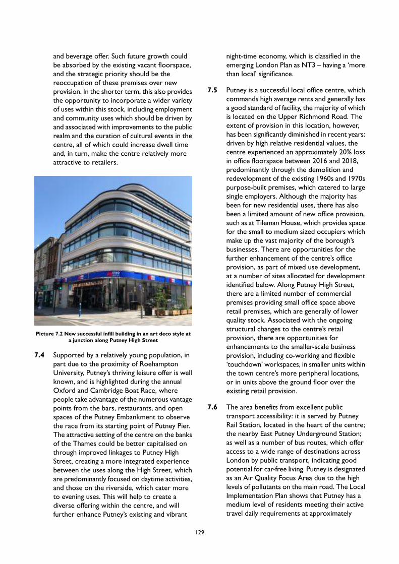
and beverage offer. Such future growth couldbe absorbed by the existing vacant floorspace,and the strategic priority should be thereoccupation of these premises over newprovision. In the shorter term, this also providesthe opportunity to incorporate a wider varietyof uses within this stock, including employmentand community uses which should be driven byand associated with improvements to the publicrealm and the curation of cultural events in thecentre, all of which could increase dwell timeand, in turn, make the centre relatively moreattractive to retailers.
Picture 7.2 New successful infill building in an art deco style ata junction along Putney High Street
7.4 Supported by a relatively young population, inpart due to the proximity of RoehamptonUniversity, Putney’s thriving leisure offer is wellknown, and is highlighted during the annualOxford and Cambridge Boat Race, wherepeople take advantage of the numerous vantagepoints from the bars, restaurants, and openspaces of the Putney Embankment to observethe race from its starting point of Putney Pier.The attractive setting of the centre on the banksof the Thames could be better capitalised onthrough improved linkages to Putney HighStreet, creating a more integrated experiencebetween the uses along the High Street, whichare predominantly focused on daytime activities,and those on the riverside, which cater moreto evening uses. This will help to create adiverse offering within the centre, and willfurther enhance Putney’s existing and vibrant
night-time economy, which is classified in theemerging London Plan as NT3 – having a ‘morethan local’ significance.
7.5 Putney is a successful local office centre, whichcommands high average rents and generally hasa good standard of facility, the majority of whichis located on the Upper Richmond Road. Theextent of provision in this location, however,has been significantly diminished in recent years:driven by high relative residential values, thecentre experienced an approximately 20% lossin office floorspace between 2016 and 2018,predominantly through the demolition andredevelopment of the existing 1960s and 1970spurpose-built premises, which catered to largesingle employers. Although the majority hasbeen for new residential uses, there has alsobeen a limited amount of new office provision,such as at Tileman House, which provides spacefor the small to medium sized occupiers whichmake up the vast majority of the borough’sbusinesses. There are opportunities for thefurther enhancement of the centre’s officeprovision, as part of mixed use development,at a number of sites allocated for developmentidentified below. Along Putney High Street,there are a limited number of commercialpremises providing small office space aboveretail premises, which are generally of lowerquality stock. Associated with the ongoingstructural changes to the centre’s retailprovision, there are opportunities forenhancements to the smaller-scale businessprovision, including co-working and flexible‘touchdown’ workspaces, in smaller units withinthe town centre’s more peripheral locations,or in units above the ground floor over theexisting retail provision.
7.6 The area benefits from excellent publictransport accessibility: it is served by PutneyRail Station, located in the heart of the centre;the nearby East Putney Underground Station;as well as a number of bus routes, which offeraccess to a wide range of destinations acrossLondon by public transport, indicating goodpotential for car-free living. Putney is designatedas an Air Quality Focus Area due to the highlevels of pollutants on the main road. The LocalImplementation Plan shows that Putney has amedium level of residents meeting their activetravel daily requirements at approximately
129

31%-40% and there is scope to switch2,057-3,540 daily trips to walking and5,001-10,000 trips to cycling. Putney alsobenefits from its riverboat service providingaccess to the City and beyond. The centre,however, is constrained by significantthrough-traffic running east-west along UpperRichmond Road and north-south along PutneyHigh Street, the mitigation of which wouldsupport a move to increased active travel, aswell as realising environmental benefits. Recentinitiatives, including the introduction of cleanerand less polluting buses, have brought someimprovements to air quality on Putney HighStreet, which will be further enhanced by theintroduction of the expanded Ultra LowEmission Zone (ULEZ) in October 2021;however, it still remains a pollution hotspot dueto a canyon effect, position at the foot of PutneyHill and traffic levels.
Character
7.7 Putney High Street is framed by three/fourstorey period terraces with shops at groundfloor and generally well maintained upperstoreys, mostly providing residential space, butwith limited office and other uses (e.g.recreational). The retention of architecturaldetails illustrates that the underlying historicfabric remains in place, making a goodcontribution to the sense of place of the area.The latter is further reinforced by landmarkbuildings including a five storey Zeeta House,which together with other buildings at thesouthern junction of Putney High Street, createsa distinct gateway to the town centre. Anothervalued feature of the area are its views; locallyinto the attractive adjacent residential areas andalso extensive long views towards and acrossPutney Town Centre from many viewpoints tothe south as the land rises gradually away fromthe Thames up Putney High Street to the UpperRichmond Road.
7.8 The area enjoys an extensive frontage to theRiver Thames, which is within the PutneyEmbankment Conservation Area. The groupingof boathouses, boat clubs and chandlers’premises at Putney Embankment give it a uniquecharacter that is unrivalled in London. It isinternationally famous as the starting place ofthe University Boat Race, and is also host to a
full calendar or other events. Due to itsattractive location, such facilities can bevulnerable to redevelopment pressures fromcompeting land uses, and thus requireprotection to preserve the character of the areaand to ensure the continued sporting andrecreational use of the river itself. The riversidealso offers attractive public spaces with a varietyof amenities, including seating, planting, cafesand restaurants. The public square created aspart of the Putney Wharf scheme is one of themost attractive, best used and well regardedopen spaces in this area. This part of Putneyalso contains a number of listed buildings, whichare all in particularly sensitive locations directlyon or visible from the riverside.
7.9 While the underlying historic built fabric, thehuman-scale proportions and proximity to theriver give Putney a sense of place, heavy traffic,coupled with a lack of planting and narrowpavements along Putney High Street, detractsomewhat from the local character, and theresulting poor air quality and high noise levelsdiminish the quality of the townscape for itsusers including pedestrians and cyclists. Despiterecent improvements to permeability andconnectivity of the area, Putney High Streetfeels separate from the scenic and naturalriverside environment. Putney High Street alsosuffers from a number of units having garish,poorly maintained and inconsistent shoppingfrontages, as well as the disproportionatelyscaled Putney Exchange, which both detractfrom the otherwise high visual quality of thearea.
130
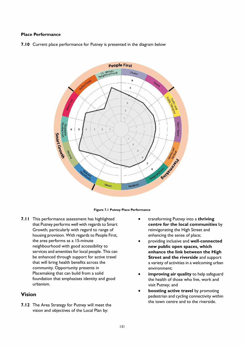
Place Performance
7.10 Current place performance for Putney is presented in the diagram below
Figure 7.1 Putney Place Performance
7.11 This performance assessment has highlightedthat Putney performs well with regards to SmartGrowth; particularly with regard to range ofhousing provision. With regards to People First,the area performs as a 15-minuteneighbourhood with good accessibility toservices and amenities for local people. This canbe enhanced through support for active travelthat will bring health benefits across thecommunity. Opportunity presents inPlacemaking that can build from a solidfoundation that emphasises identity and goodurbanism.
Vision
7.12 The Area Strategy for Putney will meet thevision and objectives of the Local Plan by:
transforming Putney into a thrivingcentre for the local communities byreinvigorating the High Street andenhancing the sense of place;providing inclusive and well-connectednew public open spaces, whichenhance the link between the HighStreet and the riverside and supporta variety of activities in a welcoming urbanenvironment;improving air quality to help safeguardthe health of those who live, work andvisit Putney; andboosting active travel by promotingpedestrian and cycling connectivity withinthe town centre and to the riverside.
131
PM5 Putney
Placemaking
A. The Urban Design Study has identified appropriate locations for tall buildings in Putney. The broadlocations are identified in Appendix 2. Any proposal for a tall building will be subject to addressingthe requirements of Policy LP 4 (Tall Buildings) as well as other policies in the Plan as applicable.
B. New development will be expected to protect important views and vistas in the area, including:
1. views from Putney High Street to the adjacent residential areas;2. long views towards and across Putney Town Centre from many viewpoints to the south; and3. views of Zeeta House and St. Mary's Church.
C. Proposals for upward extensions along Putney High Street will be supported where the extensionwould be subordinate to the host building, respecting the scale, detailing and materials of existingbuildings and adjoining townscape. Development proposals for upward extensions should exploreopportunities to enhance the appearance of the building façades.
D. Where appropriate, the Council will expect development proposals to remove any visually unappealingand/or confusing signage to improve legibility and to reinstate the shop fronts to their original designto achieve consistency in appearance with the setting of the town centre, particularly on Putney HighStreet.
E. Where possible major development proposals, including the identified Site Allocations, should providenew pedestrian priority public space as a key element in the design of the development which shouldbe linked to the surrounding street network with safe and attractive new routes.
F. The Council will support measures that provide new green features, modernise street furniture, anddeclutter Putney High Street. These enhancements will build on the success of improvements to theUpper Richmond Road opposite to East Putney Station, where recent development brought publicrealm improvements and contributed to improving access by enhancing pedestrian links to East PutneyStation.
Smart Growth
A. New residential accommodation in Putney will help meet the borough’s housing target, as set out inLocal Plan Policy LP 24. Development in this area is expected to provide at least 189 homes by 2037/38(the entire plan period) of which 182 homes are expected to be delivered by 2032/33 (10-year housingsupply). These figures reflect the projected completions on large, small and windfall sites rather thantotal capacity of Site Allocations.
B. To retain a strong retail core within Putney, proposals for comparison retail uses will be supportedin ground floor units within the centre’s Core Frontages, including the Putney Exchange. Proposalsthat diversify the existing shopping offer, and which support independent retailers, will also beencouraged within the town centre.
C. Proposals for leisure and night-time economy uses will be supported, and should be on Putney Wharfand the riverside. All development in this location should make improvements to the public realm tohelp facilitate connections to this location and to better facilitate outdoor eating and drinking, whiletaking appropriate measures to mitigate against the impact on neighbouring uses, including residential.
D. Proposals for the mixed use redevelopment of sites containing economic floorspace should fullyre-provide and enhance this provision, and the provision of additional new office floorspace isencouraged. This should fully replace existing or provide new affordable workspace that is appropriatefor SMEs.
E. Urban Logistics Hubs are used for last mile deliveries by electric vans or cargo bikes which can helpreduce congestion and pollution. These will be supported in the right location in accordance with the
132
objectives of Policy LP 51 – Sustainable Transport. Hubs are suited to areas connected to the widerroad, rail, and river networks, river wharves and railway stations, and town centres.
People First
A. The Council will continue to work in partnership with Positively Putney and other key stakeholdersto develop a cultural programme for Putney as reflected in engagement to support the Future HighStreets Fund business case. The programme will build on existing successful programmes in theborough, such as the Wandsworth Arts Fringe, and will be expected to engage, excite and inspire allsections of the community to come to Putney. All new development proposals will be expected tocontribute to the priorities set out in the new Arts and Culture strategy.
B. The Council will support proposals to enhance Putney Library, as identified in the Future High StreetFund business case. Future proposals will be expected to develop the primary library facilities into amulti-purpose hub which supports an increased range of community activities, and which includes theprovision flexible and affordable workspaces for local people.
133
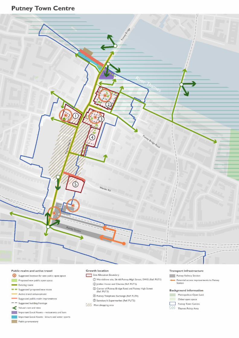

Site Allocations
PUT1 Wereldhave site, 56-66 PutneyHigh Street, SW15
Site Allocation
Mixed use development including residential, and retailfloorspace with open space and other town centreuses. All existing office floorspace on the site must befully replaced to provide facilities suitable for SMEs,including affordable floorspace.
Site Description
The site is to the west of Putney High Street, betweenLacy Road and Felsham Road and east of Walker’sPlace. The site fronts on to the Putney High Streetand is currently used for retail and office space withparking in the south west corner.
Map 7.2 PUT1Wereldhave site, 56-66 Putney High Street, SW15
Site Area – 0.31ha
Development Considerations
Open Space - Provide a substantial new, publicsquare at street level where pedestrians have priorityover vehicles, in the location of the existing serviceyard.
Access - Consideration should be given to bring thecarriageway adjacent to Walkers Place up to anadoptable standard and dedicate it as a public highway.
Parking - Consider provision of public car parkingon the site with 2-hour limit and improve access tothe site. Car club provision for residential/commercialuse and surrounding area would be appropriate.
Public Transport - Consideration should be givento incorporating bus terminating/standing facilities tomeet need for the town centre.
Active Travel - Local cycle route enhancements aredesirable to the north, south, and east of the site.
Planning Permissions – It is recognised that thesite has planning permission for demolition of existingbuilding and erection of a new mixed use development.For more information see planning applicationreference 2014/7344.
Design Requirements
Site Layout - Provide new active building frontagesto Putney High Street, Walkers Place, Lacy Road andFelsham Road with improved townscape.
Tall Buildings - In accordance with the Urban DesignStudy and the tall buildings maps in Appendix 2 partof the site is located in an area which has opportunitiesfor tall buildings within town centres and alongstrategic routes, and the height at which buildings willbe considered as ‘tall’ is 6 storeys. Developmentproposals for tall buildings will be assessed inaccordance with Local Plan Policy LP 4.
135
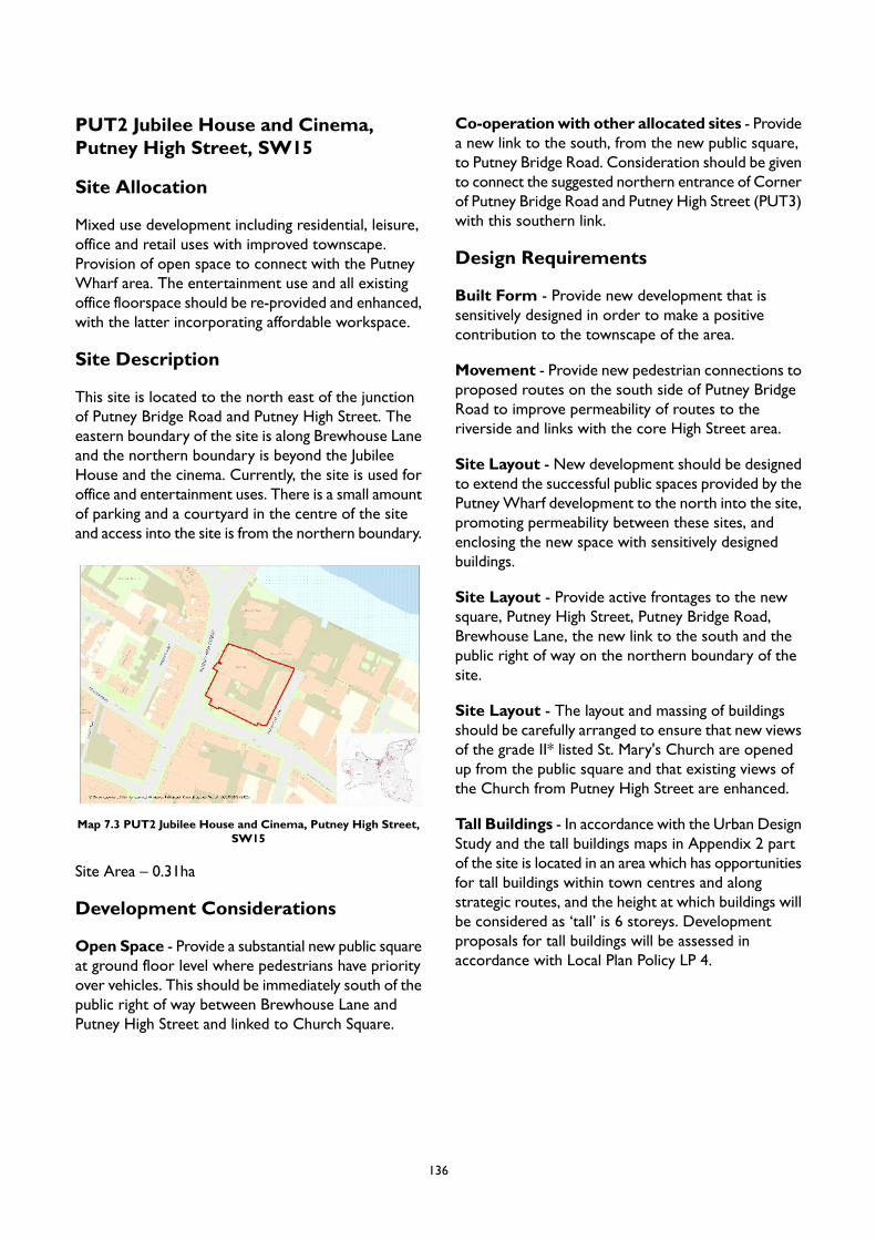
PUT2 Jubilee House and Cinema,Putney High Street, SW15
Site Allocation
Mixed use development including residential, leisure,office and retail uses with improved townscape.Provision of open space to connect with the PutneyWharf area. The entertainment use and all existingoffice floorspace should be re-provided and enhanced,with the latter incorporating affordable workspace.
Site Description
This site is located to the north east of the junctionof Putney Bridge Road and Putney High Street. Theeastern boundary of the site is along Brewhouse Laneand the northern boundary is beyond the JubileeHouse and the cinema. Currently, the site is used foroffice and entertainment uses. There is a small amountof parking and a courtyard in the centre of the siteand access into the site is from the northern boundary.
Map 7.3 PUT2 Jubilee House and Cinema, Putney High Street,SW15
Site Area – 0.31ha
Development Considerations
Open Space - Provide a substantial new public squareat ground floor level where pedestrians have priorityover vehicles. This should be immediately south of thepublic right of way between Brewhouse Lane andPutney High Street and linked to Church Square.
Co-operationwith other allocated sites - Providea new link to the south, from the new public square,to Putney Bridge Road. Consideration should be givento connect the suggested northern entrance of Cornerof Putney Bridge Road and Putney High Street (PUT3)with this southern link.
Design Requirements
Built Form - Provide new development that issensitively designed in order to make a positivecontribution to the townscape of the area.
Movement - Provide new pedestrian connections toproposed routes on the south side of Putney BridgeRoad to improve permeability of routes to theriverside and links with the core High Street area.
Site Layout - New development should be designedto extend the successful public spaces provided by thePutneyWharf development to the north into the site,promoting permeability between these sites, andenclosing the new space with sensitively designedbuildings.
Site Layout - Provide active frontages to the newsquare, Putney High Street, Putney Bridge Road,Brewhouse Lane, the new link to the south and thepublic right of way on the northern boundary of thesite.
Site Layout - The layout and massing of buildingsshould be carefully arranged to ensure that new viewsof the grade II* listed St. Mary's Church are openedup from the public square and that existing views ofthe Church from Putney High Street are enhanced.
Tall Buildings - In accordance with the Urban DesignStudy and the tall buildings maps in Appendix 2 partof the site is located in an area which has opportunitiesfor tall buildings within town centres and alongstrategic routes, and the height at which buildings willbe considered as ‘tall’ is 6 storeys. Developmentproposals for tall buildings will be assessed inaccordance with Local Plan Policy LP 4.
136
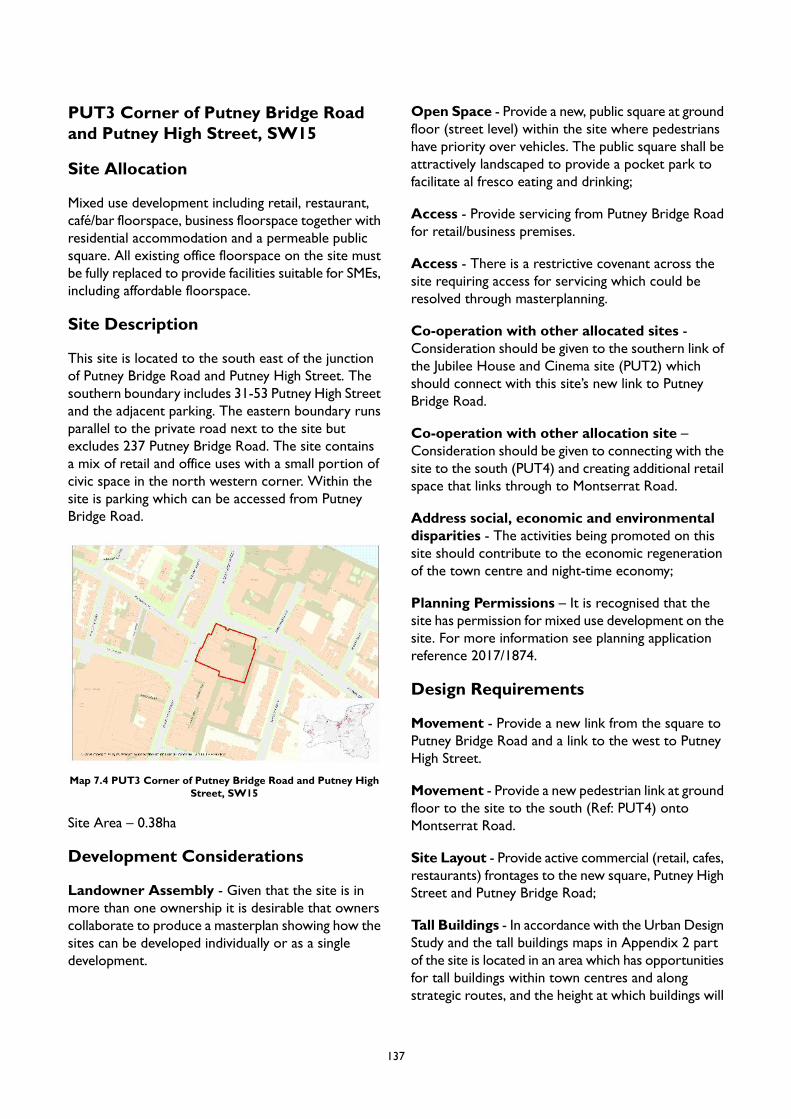
PUT3 Corner of Putney Bridge Roadand Putney High Street, SW15
Site Allocation
Mixed use development including retail, restaurant,café/bar floorspace, business floorspace together withresidential accommodation and a permeable publicsquare. All existing office floorspace on the site mustbe fully replaced to provide facilities suitable for SMEs,including affordable floorspace.
Site Description
This site is located to the south east of the junctionof Putney Bridge Road and Putney High Street. Thesouthern boundary includes 31-53 Putney High Streetand the adjacent parking. The eastern boundary runsparallel to the private road next to the site butexcludes 237 Putney Bridge Road. The site containsa mix of retail and office uses with a small portion ofcivic space in the north western corner. Within thesite is parking which can be accessed from PutneyBridge Road.
Map 7.4 PUT3 Corner of Putney Bridge Road and Putney HighStreet, SW15
Site Area – 0.38ha
Development Considerations
Landowner Assembly - Given that the site is inmore than one ownership it is desirable that ownerscollaborate to produce a masterplan showing how thesites can be developed individually or as a singledevelopment.
Open Space - Provide a new, public square at groundfloor (street level) within the site where pedestrianshave priority over vehicles. The public square shall beattractively landscaped to provide a pocket park tofacilitate al fresco eating and drinking;
Access - Provide servicing from Putney Bridge Roadfor retail/business premises.
Access - There is a restrictive covenant across thesite requiring access for servicing which could beresolved through masterplanning.
Co-operation with other allocated sites -Consideration should be given to the southern link ofthe Jubilee House and Cinema site (PUT2) whichshould connect with this site’s new link to PutneyBridge Road.
Co-operation with other allocation site –Consideration should be given to connecting with thesite to the south (PUT4) and creating additional retailspace that links through to Montserrat Road.
Address social, economic and environmentaldisparities - The activities being promoted on thissite should contribute to the economic regenerationof the town centre and night-time economy;
Planning Permissions – It is recognised that thesite has permission for mixed use development on thesite. For more information see planning applicationreference 2017/1874.
Design Requirements
Movement - Provide a new link from the square toPutney Bridge Road and a link to the west to PutneyHigh Street.
Movement - Provide a new pedestrian link at groundfloor to the site to the south (Ref: PUT4) ontoMontserrat Road.
Site Layout - Provide active commercial (retail, cafes,restaurants) frontages to the new square, Putney HighStreet and Putney Bridge Road;
Tall Buildings - In accordance with the Urban DesignStudy and the tall buildings maps in Appendix 2 partof the site is located in an area which has opportunitiesfor tall buildings within town centres and alongstrategic routes, and the height at which buildings will
137

be considered as ‘tall’ is 6 storeys. Developmentproposals for tall buildings will be assessed inaccordance with Local Plan Policy LP 4.
138

PUT4 Putney Telephone Exchange,Montserrat Road, SW15
Site Allocation
Mixed use development to include retail andcommercial uses at ground floor; other town centreuses such and residential above ground floor.
Site Description
The site lies immediately to the east of 85-93 PutneyHigh Street, with access off Montserrat Road. It isbounded to the east and south by residentialproperties on Montserrat Road and Burstock Roadand is currently used as a telephone exchange. Thesite contains a small amount of parking in the centreof the building.
Map 7.5 PUT4 Putney Telephone Exchange, Montserrat Road,SW15
Site Area – 0.28ha
Development Considerations
Access - Access and servicing should be fromMontserrat Road.
Co-operation with other allocated sites - Ifdeveloped for new mixed uses in conjunction withthe site to the north (PUT3) any development will beexpected to make a contribution to the extension ofthe public realm and public rights of way and to createnew retail/business floorspace on ground floor withmultiple floors of residential above.
Design Requirements
Built Form - Potential to extend adjoining retail unit(PUT3) with frontage to Putney High Street on groundand first floors with potential for multiple floors ofresidential use above.
Built Form - The layout, massing and design ofbuildings should be carefully arranged to ensure thatthe amenities of neighbouring residents are protectedfrom unreasonable harm.
Movement - Contribute to increased pedestrianpermeability, breaking the linearity of the High Street.
Tall Buildings - In accordance with the Urban DesignStudy and the tall buildings maps in Appendix 2 theheight at which buildings will be considered as ‘tall’ is6 storeys, and development of 6 storeys and above islikely to be inappropriate. Development proposals fortall buildings will be assessed in accordance with LocalPlan Policy LP 4.
139

PUT5 Sainsbury's Supermarket, 2-6Werter Road, Putney, SW15
Site Allocation
Mixed use development including residential, retailand other town centre uses with public open space.
Site Description
The site is south of Werter Road and behind the rowof buildings fronting onto Putney High Street. It isbounded to the south by a library and to the east byresidential uses. The site contains a supermarket andan associated loading/ parking area to the south of thesite. The site can be accessed from Werter Road.
Map 7.6 PUT5 Sainsbury's Supermarket, 2-6 Werter Road,Putney, SW15
Site Area – 0.28ha
Development Considerations
Open Space - The northern frontage on WerterRoad should provide open or civic space with theflexibility to be used for al fresco dining or provide aplace for sitting and socialising.
Design Requirements
Built Form - Provide a mixed use redevelopmentwith an active retail frontage and entrances to theground floor facing onto Werter Road withresidential/business use to upper floors.
Tall Buildings - In accordance with the Urban DesignStudy and the tall buildings maps in Appendix 2 theheight at which buildings will be considered as ‘tall’ is6 storeys, and development of 6 storeys and above islikely to be inappropriate. Development proposals fortall buildings will be assessed in accordance with LocalPlan Policy LP 4.
140
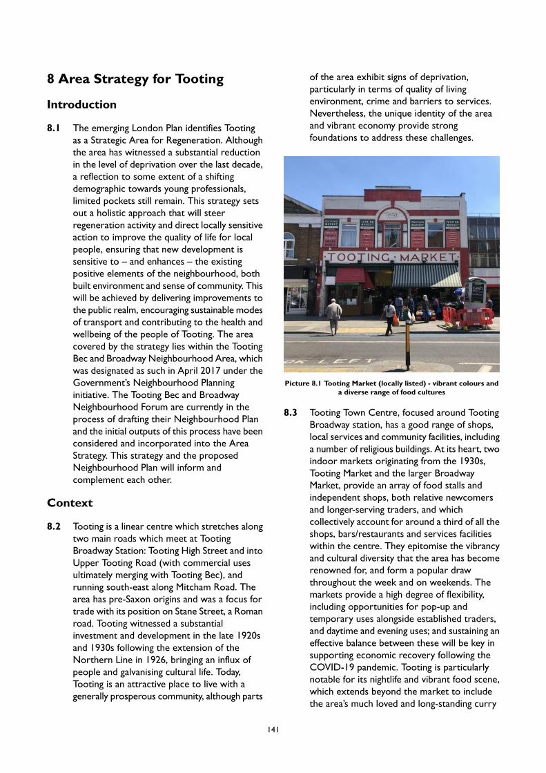
8 Area Strategy for Tooting
Introduction
8.1 The emerging London Plan identifies Tootingas a Strategic Area for Regeneration. Althoughthe area has witnessed a substantial reductionin the level of deprivation over the last decade,a reflection to some extent of a shiftingdemographic towards young professionals,limited pockets still remain. This strategy setsout a holistic approach that will steerregeneration activity and direct locally sensitiveaction to improve the quality of life for localpeople, ensuring that new development issensitive to – and enhances – the existingpositive elements of the neighbourhood, bothbuilt environment and sense of community. Thiswill be achieved by delivering improvements tothe public realm, encouraging sustainable modesof transport and contributing to the health andwellbeing of the people of Tooting. The areacovered by the strategy lies within the TootingBec and Broadway Neighbourhood Area, whichwas designated as such in April 2017 under theGovernment’s Neighbourhood Planninginitiative. The Tooting Bec and BroadwayNeighbourhood Forum are currently in theprocess of drafting their Neighbourhood Planand the initial outputs of this process have beenconsidered and incorporated into the AreaStrategy. This strategy and the proposedNeighbourhood Plan will inform andcomplement each other.
Context
8.2 Tooting is a linear centre which stretches alongtwo main roads which meet at TootingBroadway Station: Tooting High Street and intoUpper Tooting Road (with commercial usesultimately merging with Tooting Bec), andrunning south-east along Mitcham Road. Thearea has pre-Saxon origins and was a focus fortrade with its position on Stane Street, a Romanroad. Tooting witnessed a substantialinvestment and development in the late 1920sand 1930s following the extension of theNorthern Line in 1926, bringing an influx ofpeople and galvanising cultural life. Today,Tooting is an attractive place to live with agenerally prosperous community, although parts
of the area exhibit signs of deprivation,particularly in terms of quality of livingenvironment, crime and barriers to services.Nevertheless, the unique identity of the areaand vibrant economy provide strongfoundations to address these challenges.
Picture 8.1 Tooting Market (locally listed) - vibrant colours anda diverse range of food cultures
8.3 Tooting Town Centre, focused around TootingBroadway station, has a good range of shops,local services and community facilities, includinga number of religious buildings. At its heart, twoindoor markets originating from the 1930s,Tooting Market and the larger BroadwayMarket, provide an array of food stalls andindependent shops, both relative newcomersand longer-serving traders, and whichcollectively account for around a third of all theshops, bars/restaurants and services facilitieswithin the centre. They epitomise the vibrancyand cultural diversity that the area has becomerenowned for, and form a popular drawthroughout the week and on weekends. Themarkets provide a high degree of flexibility,including opportunities for pop-up andtemporary uses alongside established traders,and daytime and evening uses; and sustaining aneffective balance between these will be key insupporting economic recovery following theCOVID-19 pandemic. Tooting is particularlynotable for its nightlife and vibrant food scene,which extends beyond the market to includethe area’s much loved and long-standing curry
141

houses and South Asian restaurants, which areclustered to the southern end of Tooting HighStreet and on Upper Tooting Road. MitchamRoad, to the south-east, features a cluster ofpubs and entertainment venues, including theformer Granada Theatre (now a Gala Bingo),which provides a link, along with the RACSbuilding, to Tooting’s past entertainment offerof music concerts and dancing shows. Theemerging London Plan classifies the centre asNT3, meaning that its evening economy has a‘more than local’ significance.
8.4 The centre accommodates a good range ofnational multiples and, in particular,smaller-scale and independent shops, includingspecialist provision, which contribute positivelyto the identity of the area. To the northern endof the High Street, approaching Tooting BecStation, there is some evidence of mixedmanagement and maintenance of shop frontages,including some blank facades and thedegradation of historic features on upperstoreys, which is detrimental to the overallshopping experience. There is an opportunityto address this through the small scaleintensification of upper floors to provideresidential or office units, the latter of whichforms the mainstay of the centre’s dedicatedeconomic floorspace.
8.5 The Retail Needs Assessment 2020, undertakenbefore the COVID-19 pandemic, has identifiedthat there are limited requirements foradditional retail and food/beverage by 2030,with a very limited amount of demand foradditional convenience shopping which iscapable of being absorbed within existing vacantunits. By 2035, there is a cumulative identifieddemand for retail and food and beveragefloorspace (of c. 1,300 sqm), however this couldbe accommodated within the centre’s vacantfloorspace. As such, it is not necessary toidentify new sites for retail/town centredevelopment, rather that the short tomedium-term strategy should be the protectionand improvement of the existing provision toensure that the facilities are suitable to meetmodern retailing requirements.
8.6 Tooting has excellent public transportaccessibility, with Northern Line stations atTooting Bec and Tooting Broadway, as well as
a national rail line at nearby Tooting trainstation (located just outside of Wandsworth inthe Borough of Merton). The area, however,suffers from heavy traffic, which combined withnarrow pavements, creates a busy and noisyenvironment. The ‘ladder’ formation of UpperTooting Road, with frequent intersections,further prioritises cars over pedestrians,creating an interrupted walking experience.Tooting is designated as an Air Quality FocusArea due to the high levels of pollutants on themain road The Wandsworth LocalImplementation Plan (2019) shows that Tootinghas a high level of residents meeting their activetravel daily requirements at approximately51%-70% and there is scope to switch5,885-10,750 daily trips to walking and20,001-45,000 trips to cycling. Although Tootingis located on the CS7 cycle superhighway,offering local people a faster and safer routeinto the City; certain sections of the bicycle linkare of poor-quality and require an upgrade, andissues of cars parking on this amenity are alsoprevalent. Local residents and visitors are alsofaced with the absence of public open space, alack of well positioned or attractive benchesand resting places, and a tendency for streetclutter, all of which further diminishes thequality of the townscape.
Picture 8.2 Mitcham Road
142
8.7 Tooting Broadway tube station is beingconsidered as a potential station on the futureCrossrail 2 link. In addition to relievingcongestion on the Northern Line, this wouldprovide Tooting with a rapid and directconnection to major London stations such asClapham Junction, Victoria, Tottenham CourtRoad and Euston. However, it also bringschallenges to the functioning of the town centreas the new station would require the demolitionof a significant central space on the High Street.
Character
8.8 Tooting benefits from distinctive architectureand landmarks, including numerous listedbuildings, both nationally and locally, particularlyin Tooting Broadway. Most buildings are ofbalanced proportions, with heights between 2and 4 storeys, which provides a human scale atthe street level, and ensures the landmarkbuildings remain legible. Tooting's mostimportant listed buildings include bothunderground stations (grade II listed), the KingsHead pub (grade II listed), the Churches of StBoniface and St Nicholas (both grade II) andtheir green churchyard settings, and the BuzzBingo Club (formerly the Granada Cinema) onMitcham Road which is classed as Grade I.Although some architectural gems along UpperTooting Road are a little neglected, resulting ina fragmented feel to the streetscape, many ofTooting’s best built assets continue to thrive innew and unexpected ways, and are still valuedby a much-diversified community. The survivalof these iconic buildings, coupled with Tooting’sstrong sense of community, creates anopportunity to accommodate new developmentthat restores the character by building on thestrong heritage and culture of the area.
143
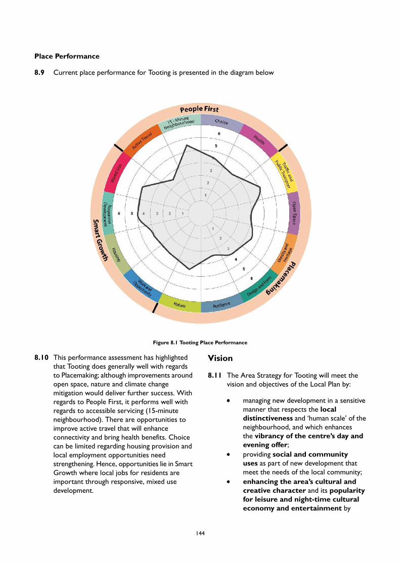
Place Performance
8.9 Current place performance for Tooting is presented in the diagram below
Figure 8.1 Tooting Place Performance
8.10 This performance assessment has highlightedthat Tooting does generally well with regardsto Placemaking; although improvements aroundopen space, nature and climate changemitigation would deliver further success. Withregards to People First, it performs well withregards to accessible servicing (15-minuteneighbourhood). There are opportunities toimprove active travel that will enhanceconnectivity and bring health benefits. Choicecan be limited regarding housing provision andlocal employment opportunities needstrengthening. Hence, opportunities lie in SmartGrowth where local jobs for residents areimportant through responsive, mixed usedevelopment.
Vision
8.11 The Area Strategy for Tooting will meet thevision and objectives of the Local Plan by:
managing new development in a sensitivemanner that respects the localdistinctiveness and ‘human scale’ of theneighbourhood, and which enhancesthe vibrancy of the centre’s day andevening offer;providing social and communityuses as part of new development thatmeet the needs of the local community;enhancing the area’s cultural andcreative character and its popularityfor leisure and night-time culturaleconomy and entertainment by
144
ensuring development makes provisionfor cultural, creative, visual and performingarts and other forms of communityinnovation;protecting and enhance Tooting andBroadway Markets to maintain its thrivingday and night-time operations and diverseretail and leisure offer;helping in preserving the setting andcontribution of landmark buildings tothe skyline;
supporting measures to reduce thedominance of cars and improveopportunities for active travel; andcontributing to tackling deprivation bycreating safe, secure and appropriatelyaccessible environments where thefear of crime does not undermine qualityof life.
PM6 Tooting
Placemaking
A. New development will be expected to:
1. respect the proportion, scale and material quality of the remaining period buildings;2. preserve the setting and contribution of landmark buildings to the skyline; and3. reinforce the function of the streetscape as a shopping and leisure destination.
B. The Urban Design Study has identified appropriate locations for tall buildings in Tooting. The broadlocations are identified in Appendix 2. Any proposal for a tall building will be subject to addressingthe requirements of Policy LP 4 (Tall Buildings) as well as other policies in the Plan as applicable.
C. Proposals should protect and enhance Tooting and Broadway Markets, and the important placemakingrole they play through providing a balance of pop-up evening and leisure uses alongside traditional,day-time traders. Affordable market stalls should be included as part of the development in order toensure that the rich diversity of existing, independent traders can be retained within the markets.Development proposals should seek to address issues relating to crime and poor environmentalconditions to support the enhancement of an asset which contributes to the unique feel of the area.
D. Opportunities to repair, improve and unify existing frontages on Tooting High Street are encouraged.New development should provide a frontage which engages positively with local character and thestreet scene. Where historic shopfronts and features are present, these must be retained.
E. Proposals for upward extensions along Tooting High Street will be supported where the extensionwould be subordinate to the host building, respecting the scale, detailing and materials of both existingbuildings and adjoining townscape. Development proposals for upward extensions should exploreopportunities to enhance the appearance of the building façades.
F. Measures to provide new planting, modernise street furniture and declutter Tooting High Street willbe supported. Where appropriate, development proposals should make provision for new streettrees.
G. Public realm improvements should aim to improve the legibility of pubs and civic building landmarks.H. Demolition of locally listed buildings and other local landmarks will be resisted. Applicants will be
expected to give due consideration to the retention and incorporation of these important local assetswithin any new development, which should enhance their setting.
Smart Growth
A. New residential accommodation in Tooting will help meet the borough’s housing target, as set out inLocal Plan Policy LP 24. Development in this area is expected to provide at least 820 homes by 2037/38(the entire plan period) of which 502 homes are expected to be delivered by 2032/33 (10-year housing
145
supply). These figures reflect the projected completions on large, small and windfall sites rather thantotal capacity of Site Allocations.
B. To retain a strong retail core within Tooting, proposals for comparison retail uses will be supportedin ground floor units within the centre’s Core and Secondary Frontages, including the indoor markets.Proposals that diversify the existing shopping offer, and which support independent retailers, will alsobe encouraged within the town centre.
C. Proposals for leisure and night-time economy uses will be supported, including those which help toenhance and improve Tooting’s diverse and vibrant nightlife. Such development should take appropriatemeasures to mitigate against the impact on neighbouring uses, including residential.
D. The re-provision and enhancement of existing office floorspace, as part of the mixed use redevelopmentof allocated sites is expected. This should replace or provide new affordable workspace that isappropriate for SMEs.
E. With its strong community and heritage offer, and diverse food scene, Tooting is a recogniseddestination in its own right. We will support proposals to develop a tourism strategy for the area thatsupports local businesses and the local cultural sector.
People First
A. Bus speeds are slow on links through Tooting Broadway, as shown in the Local ImplementationPlan. New development will be expected to provide loading and servicing off street where possible, andon side roads where not, in order to reduce congestion and improve bus speeds. Improvements tobus standing facilities, especially on routes to Tooting Broadway station and St George’s Hospital, willalso be encouraged aiming to create more space for pedestrians and minimise impact on pedestrianflows.
B. The Council’s Local Implementation Plan indicates that a large number of trips could be switched towalking and cycling. To facilitate this modal shift, permanent improvements to CycleSuperhighway 7 on A24 corridor and other local cycle lanes will be supported.
C. Measures to widen pavements along Tooting High Street, and introduce further traffic managementincluding changes to Upper Tooting Road – Garratt Lane – Mitcham Road will be supported. Thesewill reduce the dominance of cars, improve opportunities for active travel and help integrate publicrealm improvements such as tree planting.
146
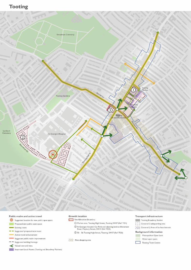
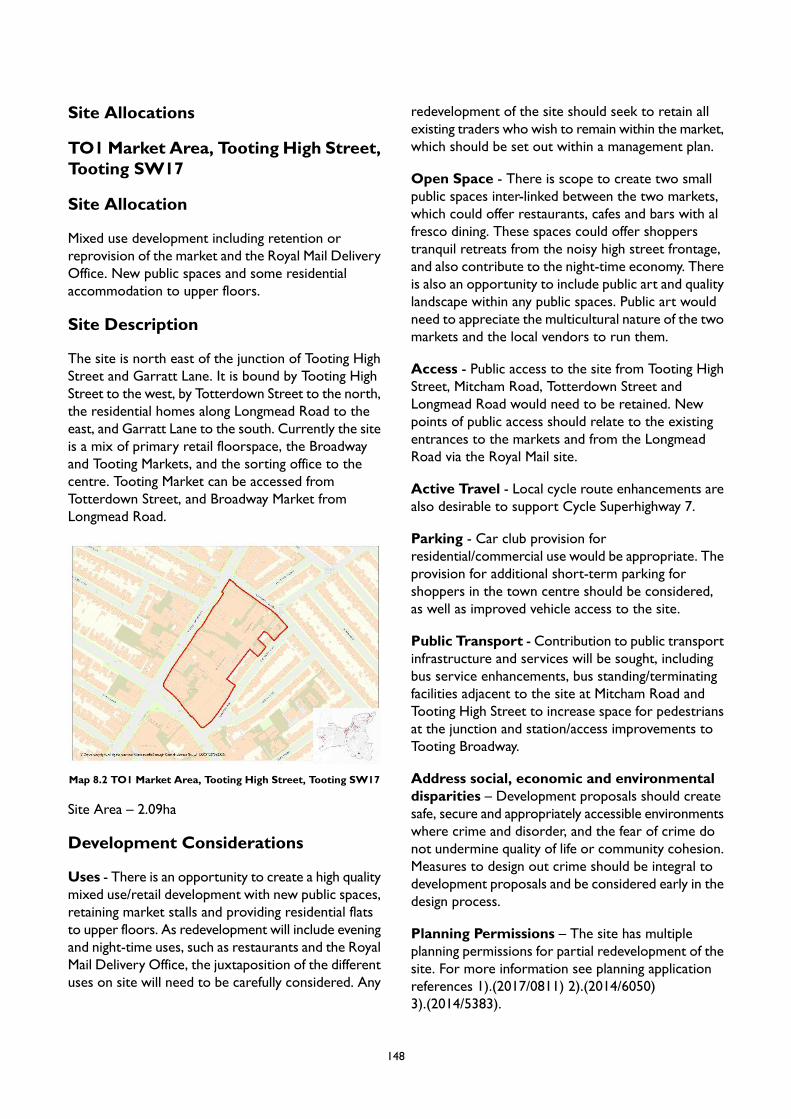
Site Allocations
TO1Market Area, Tooting High Street,Tooting SW17
Site Allocation
Mixed use development including retention orreprovision of the market and the Royal Mail DeliveryOffice. New public spaces and some residentialaccommodation to upper floors.
Site Description
The site is north east of the junction of Tooting HighStreet and Garratt Lane. It is bound by Tooting HighStreet to the west, by Totterdown Street to the north,the residential homes along Longmead Road to theeast, and Garratt Lane to the south. Currently the siteis a mix of primary retail floorspace, the Broadwayand Tooting Markets, and the sorting office to thecentre. Tooting Market can be accessed fromTotterdown Street, and Broadway Market fromLongmead Road.
Map 8.2 TO1 Market Area, Tooting High Street, Tooting SW17
Site Area – 2.09ha
Development Considerations
Uses - There is an opportunity to create a high qualitymixed use/retail development with new public spaces,retaining market stalls and providing residential flatsto upper floors. As redevelopment will include eveningand night-time uses, such as restaurants and the RoyalMail Delivery Office, the juxtaposition of the differentuses on site will need to be carefully considered. Any
redevelopment of the site should seek to retain allexisting traders who wish to remain within the market,which should be set out within a management plan.
Open Space - There is scope to create two smallpublic spaces inter-linked between the two markets,which could offer restaurants, cafes and bars with alfresco dining. These spaces could offer shopperstranquil retreats from the noisy high street frontage,and also contribute to the night-time economy. Thereis also an opportunity to include public art and qualitylandscape within any public spaces. Public art wouldneed to appreciate the multicultural nature of the twomarkets and the local vendors to run them.
Access - Public access to the site from Tooting HighStreet, Mitcham Road, Totterdown Street andLongmead Road would need to be retained. Newpoints of public access should relate to the existingentrances to the markets and from the LongmeadRoad via the Royal Mail site.
Active Travel - Local cycle route enhancements arealso desirable to support Cycle Superhighway 7.
Parking - Car club provision forresidential/commercial use would be appropriate. Theprovision for additional short-term parking forshoppers in the town centre should be considered,as well as improved vehicle access to the site.
Public Transport - Contribution to public transportinfrastructure and services will be sought, includingbus service enhancements, bus standing/terminatingfacilities adjacent to the site at Mitcham Road andTooting High Street to increase space for pedestriansat the junction and station/access improvements toTooting Broadway.
Address social, economic and environmentaldisparities – Development proposals should createsafe, secure and appropriately accessible environmentswhere crime and disorder, and the fear of crime donot undermine quality of life or community cohesion.Measures to design out crime should be integral todevelopment proposals and be considered early in thedesign process.
Planning Permissions – The site has multipleplanning permissions for partial redevelopment of thesite. For more information see planning applicationreferences 1).(2017/0811) 2).(2014/6050)3).(2014/5383).
148

Design Requirements
Movement – A new route should be establishedfrom the Tooting and Broadway Markets to MitchemRoad via an entrance at 19-21 Mitchem Road.
Identity and Architectural Expression - Thecharacter of the place should be very distinctive witha tight knit development comprising small scaleindependent retail/cafe units. Future developmentmust maintain the legibility, character anddistinctiveness of Tooting Market from views alongTooting High Street.
Tall Buildings - In accordance with the Urban DesignStudy and the tall buildings maps in Appendix 2 thesite is located in an area which has opportunities fortall buildings within town centres and along strategicroutes, and the height at which buildings will beconsidered as ‘tall’ is 5 storeys. Developmentproposals for tall buildings will be assessed inaccordance with Local Plan Policy LP 4.
149

TO2 St Georges Hospital Car Park andadjoining land on Blackshaw Road,Maybury Street, SW17
Site Allocation
Mixed use development including residential andexpansion of healthcare facilities.
Site Description
The site is located on the southern end of the StGeorge’s Hospital campus. It includes the car park tothe south east, the area between Perimeter Road andBlackshaw Road to the south of the site and isbounded by Kilm Mews and Hepdon Mews to thenorth west. To the north east is the main hospitalbuildings but this site does not extend into that area,rather only as far north east as Perimeter Road. Theland is currently used for a mix of medical, hotel,parking, and temporary medical facility uses.
The eastern part of the site is used as a car park forthe hospital. It is surrounded to the east and south bytwo-storey residential houses and to the west by athree-storey building used in conjunction with St.Georges Hospital. The surrounding residentialdevelopment exhibits a fine grain with plots toindividual terrace houses at around 5 metres in width.
Map 8.3 TO2 St Georges Hospital Car Park and adjoining landon Blackshaw Road, Maybury Street, SW17
Site Area – 2.8ha
Development Considerations
Uses - The site is suitable for hospital-related andresidential uses. Any proposal that results in the lossof staff accommodation will need to ensure it is
reprovided. Existing on-site medical uses must bere-provided on-site unless it can be demonstrated thatthere is justification for loss or off-site provision inaccordance with the NHS Estates Strategy.
Stakeholder Engagement – Developmentproposals should be prepared through a collaborativeapproach with engagement from the hospital and localcommunity.
Open Space - Opportunities to improve the publicrealm around the hospital perimeter should beexplored including additional public art. A small pocketpublic space/parklet should be provided at the mainpublic entrance to the hospital for visitors as well asstaff. Hospital staff and patients should be consultedon the public art.
Access - Any proposal that will significantly alteraccess to the site or generate additional trips to thesite will need to assess the impact to employment landand the additional medical capacity.
Parking - Reprovision of car parking to serve thehospital site will be required.
Design Requirements
Built Form - New development should generallyconform to perimeter urban blocks to develop linkageswith the existing urban grid. Any new streets shouldbe formed by extending existing streets to improveconnectivity and legibility of built form. The frontageon to Maybury Street should be residential with directaccess to residential entrances.
Movement - Proposals will be expected to createmore space for pedestrians especially on routes toTooting Broadway station and St George’s Hospital.
Context - Future redevelopment proposals will needto demonstrate how to successfully integrate newresidential development with the existing hospital useon adjacent site.
Tall Buildings - In accordance with the Urban DesignStudy and the tall buildings maps in Appendix 2 thesite is located in an area which has opportunities fortall buildings within a local context, and the height atwhich buildings will be considered as ‘tall’ is 5 storeys.Development proposals for tall buildings will beassessed in accordance with Local Plan Policy LP 4.
150
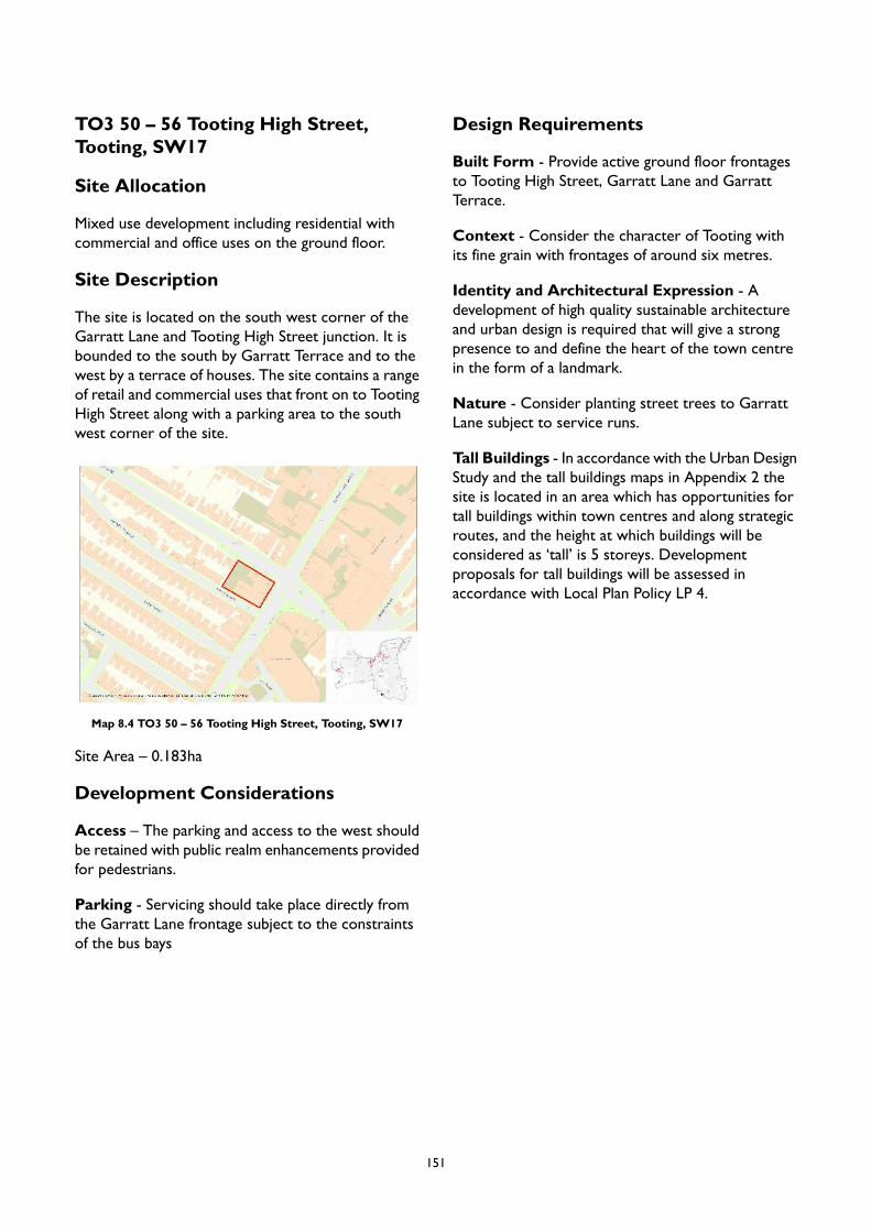
TO3 50 – 56 Tooting High Street,Tooting, SW17
Site Allocation
Mixed use development including residential withcommercial and office uses on the ground floor.
Site Description
The site is located on the south west corner of theGarratt Lane and Tooting High Street junction. It isbounded to the south by Garratt Terrace and to thewest by a terrace of houses. The site contains a rangeof retail and commercial uses that front on to TootingHigh Street along with a parking area to the southwest corner of the site.
Map 8.4 TO3 50 – 56 Tooting High Street, Tooting, SW17
Site Area – 0.183ha
Development Considerations
Access – The parking and access to the west shouldbe retained with public realm enhancements providedfor pedestrians.
Parking - Servicing should take place directly fromthe Garratt Lane frontage subject to the constraintsof the bus bays
Design Requirements
Built Form - Provide active ground floor frontagesto Tooting High Street, Garratt Lane and GarrattTerrace.
Context - Consider the character of Tooting withits fine grain with frontages of around six metres.
Identity and Architectural Expression - Adevelopment of high quality sustainable architectureand urban design is required that will give a strongpresence to and define the heart of the town centrein the form of a landmark.
Nature - Consider planting street trees to GarrattLane subject to service runs.
Tall Buildings - In accordance with the Urban DesignStudy and the tall buildings maps in Appendix 2 thesite is located in an area which has opportunities fortall buildings within town centres and along strategicroutes, and the height at which buildings will beconsidered as ‘tall’ is 5 storeys. Developmentproposals for tall buildings will be assessed inaccordance with Local Plan Policy LP 4.
151
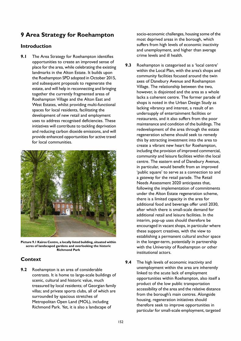
9 Area Strategy for Roehampton
Introduction
9.1 The Area Strategy for Roehampton identifiesopportunities to create an improved sense ofplace for the area, while celebrating the existinglandmarks in the Alton Estate. It builds uponthe Roehampton SPD adopted in October 2015,and subsequent proposals to regenerate theestate, and will help in reconnecting and bringingtogether the currently fragmented areas ofRoehampton Village and the Alton East andWest Estates, whilst providing multi-functionalspaces for local residents, facilitating thedevelopment of new retail and employmentuses to address recognised deficiencies. Theseinitiatives will contribute to tackling deprivationand reducing carbon dioxide emissions, and willprovide enhanced opportunities for active travelfor local communities.
Picture 9.1 Kairos Centre, a locally listed building, situated withinacres of landscaped gardens and overlooking the historic
Richmond Park
Context
9.2 Roehampton is an area of considerablecontrasts. It is home to large-scale buildings ofscenic, cultural and historic value, muchtreasured by local residents; of Georgian familyvillas; and private sports clubs, all of which aresurrounded by spacious stretches ofMetropolitan Open Land (MOL), includingRichmond Park. Yet, it is also a landscape of
socio-economic challenges, housing some of themost deprived areas in the borough, whichsuffers from high levels of economic inactivityand unemployment, and higher than averagecrime levels and ill health.
9.3 Roehampton is categorised as a ‘local centre’within the Local Plan, with the area’s shops andcommunity facilities focused around the twinaxes of Danebury Avenue and RoehamptonVillage. The relationship between the two,however, is disjointed and the area as a wholelacks a coherent centre. The former parade ofshops is noted in the Urban Design Study aslacking vibrancy and interest, a result of anundersupply of entertainment facilities orrestaurants, and it also suffers from the poormaintenance and condition of the buildings. Theredevelopment of the area through the estateregeneration scheme should seek to remedythis by attracting investment into the area tocreate a vibrant new heart for Roehampton,including the provision of improved commercial,community and leisure facilities within the localcentre. The eastern end of Danebury Avenue,in particular, would benefit from an improved‘public square’ to serve as a connection to anda gateway for the retail parade. The RetailNeeds Assessment 2020 anticipates that,following the implementation of commitmentsunder the Alton Estate regeneration scheme,there is a limited capacity in the area foradditional food and beverage offer until 2030,after which there is small-scale demand foradditional retail and leisure facilities. In theinterim, pop-up uses should therefore beencouraged in vacant shops, in particular wherethese support creatives, with the view toestablishing a permanent cultural anchor spacein the longer-term, potentially in partnershipwith the University of Roehampton or otherinstitutional actors.
9.4 The high levels of economic inactivity andunemployment within the area are inherentlylinked to the acute lack of employmentopportunities within Roehampton, also itself aproduct of the low public transportationaccessibility of the area and the relative distancefrom the borough’s main centres. Alongsidehousing, regeneration initiatives shouldtherefore seek to improve opportunities inparticular for small-scale employment, targeted
152

at the provision of incubator space for localstart-up businesses. There is an opportunity tocapitalise on the proximity of RoehamptonUniversity, which could provide institutionalsupport for these ventures.
9.5 The low public transport accessibility, as wellas affecting accessibility to businessopportunities, results in Roehampton feelingdisconnected to other parts of London and withcorrespondingly high journey times. Inparticular, the area is poorly connected by rail,and Transport for London (TfL) PTAL scorefor the area, ranging from 1b to 3, reflect this.The area also suffers from substantial trafficlevels, with the two main generators of travel:Roehampton University and Queen Mary'sHospital. Traffic flows through two main routes,east-west along the A3 and north-south alongRoehampton Lane. These roads experiencesevere congestion, which is due in part to thelack of mass transit stations and lack of adequatecycling infrastructure. This is, however,compensated, to some extent, by the relative
proximity of Richmond Park and Wimbledon/Putney Commons, which offer residents theopportunity to make journeys by foot or bicyclein traffic-free or traffic-light environments. TheWandsworth Local Implementation Plan (2019)shows that Roehampton has a low level ofresidents meeting their active travel dailyrequirements at approximately 20%-30%, andthere is scope to switch 915-2,026 daily tripsto walking and 2,001-5,000 trips to cycling.
9.6 There are significant level changes across thewhole estate, the result of which is the currentlack of visual and physical connectivity. Themost compromised pedestrian routes are thenorth-to-south connections - betweenRoehampton Lane, Harbridge Avenue, DanburyAvenue and Laverstoke Gardens; the majorityof which involve a combination of ramped andstepped access. There is therefore a need toprovide improved pedestrian routes, creatingan accessible, step-free and coherent networkof paths that open the estate both internallyand knit it into the surrounding area.
Picture 9.2 The listed concrete estates of the post war era are a key characteristic of Roehampton
153
Character
9.7 Roehampton is a mixed area, with someremnant large Georgian and Victorian mansions,20th century housing estates and the universitycampus. The area is characterised by apalimpsest landscape, made up of different layersof historic developments from the Georgian,Victorian and post-war eras. Historically, thearea was occupied by Georgian country estatesreflecting Roehampton's popularity as adestination for aristocratic summer residencesclose to Richmond Park. Several of the countryestates in their landscaped parkland settings stillsurvive (notably Mount Clare, grade I listed,Parkstead House, also grade I and DownshireHouse, grade II*), although many have beenaltered, extended or part demolished. TheVictorian era saw development of villas insubdivided estate plots.
9.8 The character of the area changed significantlyin the mid to late 1950s with the introductionof the Alton Estate, said to be one of the finestexamples in London of the post-WWII idealismof designing residential buildings within acherished landscape setting. The Alton Estateis one of the largest council estates in the UK.The design vision for the Alton Estate was forelegant and harmonious clusters of residentialaccommodation to form distinctive landmarkelements on the skyline in views from RichmondPark, and set within generous parkland, withthe aim to give residents the impression of'living in the park'. Mature trees and undulatinglandform create a distinctive landscape.However, much of the areas have becomeovergrown, with sections of impermeablewilderness, and spaces which are dark, unsafeand unusable.
9.9 Although the atmospheric landscaping, historiclayout and architectural quality of the buildingsis valued by local communities, the Alton Estateis cut off from its surroundings, by the A3 andRoehampton Lane and continuous fences alongRichmond Park/golf course. These featurescontribute to poor circulation and connectivity,which is confusing for visitors. The area has alsosuffered from additions and demolitions overthe years, obstructing views, and infilling 'spare'bits of land with poor quality developments.The incremental change has eroded the overallvision and sense of place, compromised theopenness, harmony and connectivity of theestate, and resulted in a confused place. Thesealterations have also created dead ends andretaining walls, which contribute to theperception of a lack of safety and lack of naturalsurveillance. In addition, the character of thearea suffers from poor quality frontages alongDanebury Avenue. All these factors have led tomuch of the area being identified in the LocalPlan as an area for regeneration.
154

Place performance
9.10 Current place performance for Roehampton is presented in the diagram below:
Figure 9.1 Roehampton Place Performance
9.11 Roehampton faces challenges regarding trafficmanagement and public transport accessibilitythat weaken its performance in Placemaking. Itsstrengths are focused around open spaceprovision and accessibility which supportsnature and biodiversity. With regard to SmartGrowth, Roehampton offers a range of housing.However, local employment opportunity isweaker as is a diversity of use. Developingpeople centric approaches for the area aroundactive travel and 15-minute neighbourhood tosupport health and choice outcomes offersopportunity to significantly improve placeperformance for Roehampton.
Vision
9.12 The Area Strategy for Roehampton will meetthe vision and objectives of the Local Plan by:
promoting the replacement of poor-qualitybuilding stock of with well considerednew buildings of high architecturaldesign, contributing to climate changemitigation;
supporting the adoption ofa placemaking approach whichprotects, strengthens and repairs thespecial qualities of the estate;
promoting the creation ofnew pedestrian friendly, greenstreets, and reconnect the currently
155

fragmented areas of Roehampton Villageand the Alton East and West Estates;
creating local economicopportunities through the provision ofincubator space and revitalised commercial
premises to address relative deprivationwithin the area; and
helping in facilitating new cultural andcommunity facilities to draw in bothlocal and wider audiences.
Anchor for Change - The Alton Estate Regeneration
The vision for the regeneration of the Alton West Estate is to blend this iconic post-war estate with theplacemaking and streetscape lessons that have been learnt since its formation - creating a great place tolive that includes a wide choice of housing suitable for new and existing tenants who regard it as amongstthe best locations in the borough. The redevelopment can provide:
a variety of replacement and new affordable homes;new multi-purpose community buildings offering flexible, adaptable and inspiring spaces;improved shops and new business floorspace, bringing vitality and vibrancy to the area;well designed architecture and public realm, supported by a cultural strategy for the project, whichfocuses on celebrating the special qualities of the estate;good quality and sympathetic design, to better reveal and enhance the character and setting of heritagebuildings on the Estate and complement the existing townscape;enhanced connections across the estate, with improved road junctions, safer streets, improvementsto public transport links and additional pedestrian and cycling routes; andhigh quality and improved green open space, including lots of new tree planting.
PM7 Roehampton Regeneration Area
Placemaking
A. Future development should conserve and enhance the parkland setting, historic character and heritageassets. Development must not diminish the openness and harmonious balance of buildings and openspaces.
B. Development along Danebury Avenue must provide active frontages and entrances directly onto newand existing streets and spaces. Future proposals must contribute to improving pedestrian amenity,safety and the vibrancy of the area.
C. Development along Roehampton Lane must provide building frontage with a strong edge, whileretaining the trees and greenery (where these exist) that provide separation from traffic.
D. The Urban Design Study has identified appropriate locations for tall buildings in Roehampton. Thebroad locations are identified in Appendix 2. Any proposal for a tall building will be subject to addressingthe requirements of Policy LP 4 (Tall Buildings) as well as other policies in the Plan as applicable.
Smart Growth
156

A. New residential accommodation in Roehampton will help meet the borough’s housing target, as setout in Local Plan Policy LP 24. Development in this area is expected to provide at least 1,145 homesby 2037/38 (the entire plan period) of which 996 homes are expected to be delivered by 2032/33(10-year housing supply). These figures reflect the projected completions on large, small and windfallsites rather than total capacity of Site Allocations.
B. Development should create new commercial, community, leisure and cultural facilities withinRoehampton local centre, anchored by a cultural facility, to create a civic square which provides alocus for community life, and connects Alton West, East and Roehampton Village.
C. Development should provide new job and training opportunities for local people, targeted towardsthe provision of incubator space to support start-up businesses. The flexible use of these facilities tosupport different users in the area, including local people and institutional partners, will be encouraged.
D. The temporary use of vacant shopping units will be supported, especially where this provides culturalfacilities or space that promotes the area’s Cultural Strategy.
People First
A. Future redevelopment of the Alton Estate should aim to provide a multi-functional central parkland.The new open space should integrate a range of different uses in a sensitively re-landscaped terraininvigorated by a new planting and activity strategy. This landscape should provide a conceptual linkthrough the area from Roehampton Lane to Richmond Park.
B. Future development should ensure that biodiversity, scenic and recreational amenity function of thegreen and public open spaces are enhanced, and the provision of public realm and spaces for sittingand socialising are improved.
C. The Council’s Local Implementation Plan indicates that a large number of trips could be switched towalking and cycling. To facilitate this modal shift, opportunities to create a new connection forpedestrians and cyclists between Tunworth Crescent and Richmond Park, as well as other local cyclelanes, will be supported.
D. Improvement at junction between Danebury Avenue and Roehampton Lane will be supported.
E. Measures to improve public transport facilities by relocating existing bus stops in lay-bys along DaneburyAvenue into the carriageway, and creating additional bus stops will be supported.
157

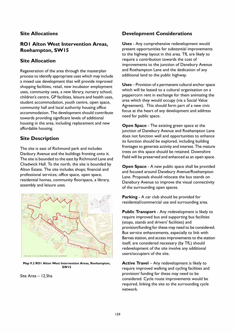
Site Allocations
RO1 Alton West Intervention Areas,Roehampton, SW15
Site Allocation
Regeneration of the area through the masterplanprocess to identify appropriate uses which may includea mixed use development that will provide improvedshopping facilities, retail, new incubator employmentuses, community uses, a new library, nursery school,children’s centre, GP facilities, leisure and health uses,student accommodation, youth centre, open space,community hall and local authority housing officeaccommodation. The development should contributetowards providing significant levels of additionalhousing in the area, including replacement and newaffordable housing.
Site Description
The site is east of Richmond park and includesDanbury Avenue and the buildings fronting onto it.The site is bounded to the east by Richmond Lane andChadwick Hall. To the north, the site is bounded byAlton Estate. The site includes shops; financial andprofessional services; office space, open space,residential homes, community floorspace, a library,assembly and leisure uses.
Map 9.2 RO1 Alton West Intervention Areas, Roehampton,SW15
Site Area – 12.5ha
Development Considerations
Uses - Any comprehensive redevelopment wouldpresent opportunities for substantial improvementsto the highway layout in this area. TfL are likely torequire a contribution towards the cost ofimprovements to the junction of Danebury Avenueand Roehampton Lane and the dedication of anyadditional land to the public highway.
Uses – Provision of a permanent cultural anchor spacewhich will be leased to a cultural organisation on apeppercorn rent in exchange for them animating thearea which they would occupy (via a Social ValueAgreement). This should form part of a new civicfocus at the heart of any development and addressneed for public space.
Open Space - The existing green space at thejunction of Danebury Avenue and Roehampton Lanedoes not function well and opportunities to enhanceits function should be explored, including buildingfrontages to generate activity and interest. The maturetrees on this space should be retained. DownshireField will be preserved and enhanced as an open space.
Open Space - A new public space shall be providedand focused around Danebury Avenue/RoehamptonLane. Proposals should relocate the bus stands onDanebury Avenue to improve the visual connectivityof the surrounding open spaces.
Parking - A car club should be provided forresidential/commercial use and surrounding area.
Public Transport - Any redevelopment is likely torequire improved bus and supporting bus facilities(stops, stands and drivers' facilities) andprovision/funding for these may need to be considered.Bus service enhancements, especially to link withBarnes station, and access improvements to the stationitself, are considered necessary (by TfL) shouldredevelopment of the site involve any additionalusers/occupiers of the site.
Active Travel – Any redevelopment is likely torequire improved walking and cycling facilities andprovision/ funding for these may need to beconsidered. Cycle route improvements would berequired, linking the site to the surrounding cyclenetwork.
159
Relevant Management Plans - Proposals shouldmake reference to the Alton Area Masterplan.
Natura 2000 Sites Impact - Assessment of theimpact of emissions from traffic (construction andoccupation) on Richmond Park Natura 2000 site todetermine appropriate mitigation. Promoteintroduction or enhancement of Stag Beetle habitatsin consultation with Natural England’s DiscretionaryAdvice Service (DAS).
Design Requirements
Built Form - Development of the site shouldconform with the regeneration principles outlined inthe Alton Area Masterplan. Relevant to this site arethe following principles: retain and/or provide a newpublic space as a focal point for the community andimprove the area's appearance and enhancecommunity safety.
Built Form - All new development shall have builtfrontages to Danebury Avenue, Roehampton Lane,Laverstoke Gardens and Holybourne Avenue.Development fronting onto Danbury Avenue shouldinclude retail/commercial uses at ground floor withresidential above.
Movement – Proposals should seek to improveconnectivity throughout the site and the areas adjacentto its boundary, in particular Queen Mary's Hospitalon Roehampton Lane.
Movement - The existing bus turnaround should berelocated to a less prominent location
Context - Redevelopment of other housing estatesand developments close to the proposal area such asthose on Fontley Way and Bessborough Road shouldbe considered. Their redevelopment will form animportant part of the wider regeneration ofRoehampton.
Identity and Architectural Expression - Thearchitectural style of new buildings should complementthe modernist context.
Site Layout - New development would also bewelcomed at the rear of the shops on DaneburyAvenue where the existing rear service yards offer anunsatisfactory and unattractive edge to the street,compromising public safety and security in this area.
Tall Buildings - In accordance with the Urban DesignStudy and the tall buildings maps in Appendix 2 thesite is located in an area which has opportunities for‘tall buildings within a local context’ or ‘tall buildingswithin town centres and along strategic routes’, andthe height at which buildings will be considered as ‘tall’is 6 storeys. Development proposals for tall buildingswill be assessed in accordance with Local Plan PolicyLP 4.
160
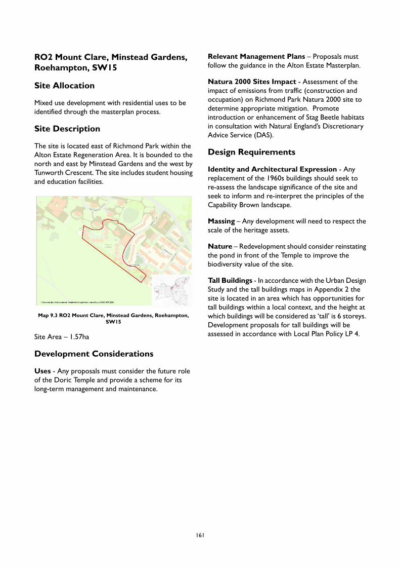
RO2 Mount Clare, Minstead Gardens,Roehampton, SW15
Site Allocation
Mixed use development with residential uses to beidentified through the masterplan process.
Site Description
The site is located east of Richmond Park within theAlton Estate Regeneration Area. It is bounded to thenorth and east by Minstead Gardens and the west byTunworth Crescent. The site includes student housingand education facilities.
Map 9.3 RO2 Mount Clare, Minstead Gardens, Roehampton,SW15
Site Area – 1.57ha
Development Considerations
Uses - Any proposals must consider the future roleof the Doric Temple and provide a scheme for itslong-term management and maintenance.
Relevant Management Plans – Proposals mustfollow the guidance in the Alton Estate Masterplan.
Natura 2000 Sites Impact - Assessment of theimpact of emissions from traffic (construction andoccupation) on Richmond Park Natura 2000 site todetermine appropriate mitigation. Promoteintroduction or enhancement of Stag Beetle habitatsin consultation with Natural England’s DiscretionaryAdvice Service (DAS).
Design Requirements
Identity and Architectural Expression - Anyreplacement of the 1960s buildings should seek tore-assess the landscape significance of the site andseek to inform and re-interpret the principles of theCapability Brown landscape.
Massing – Any development will need to respect thescale of the heritage assets.
Nature – Redevelopment should consider reinstatingthe pond in front of the Temple to improve thebiodiversity value of the site.
Tall Buildings - In accordance with the Urban DesignStudy and the tall buildings maps in Appendix 2 thesite is located in an area which has opportunities fortall buildings within a local context, and the height atwhich buildings will be considered as ‘tall’ is 6 storeys.Development proposals for tall buildings will beassessed in accordance with Local Plan Policy LP 4.
161
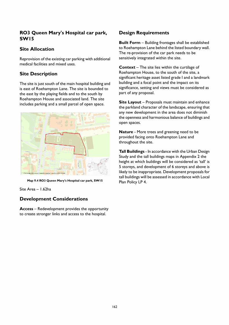
RO3 Queen Mary's Hospital car park,SW15
Site Allocation
Reprovision of the existing car parking with additionalmedical facilities and mixed uses.
Site Description
The site is just south of the main hospital building andis east of Roehampton Lane. The site is bounded tothe east by the playing fields and to the south byRoehampton House and associated land. The siteincludes parking and a small parcel of open space.
Map 9.4 RO3 Queen Mary's Hospital car park, SW15
Site Area – 1.62ha
Development Considerations
Access – Redevelopment provides the opportunityto create stronger links and access to the hospital.
Design Requirements
Built Form – Building frontages shall be establishedto Roehampton Lane behind the listed boundary wall.The re-provision of the car park needs to besensitively integrated within the site.
Context – The site lies within the curtilage ofRoehampton House, to the south of the site, asignificant heritage asset listed grade I and a landmarkbuilding and a focal point and the impact on itssignificance, setting and views must be considered aspart of any proposal.
Site Layout – Proposals must maintain and enhancethe parkland character of the landscape, ensuring thatany new development in the area does not diminishthe openness and harmonious balance of buildings andopen spaces.
Nature - More trees and greening need to beprovided facing onto Roehampton Lane andthroughout the site.
Tall Buildings - In accordance with the Urban DesignStudy and the tall buildings maps in Appendix 2 theheight at which buildings will be considered as ‘tall’ is5 storeys, and development of 6 storeys and above islikely to be inappropriate. Development proposals fortall buildings will be assessed in accordance with LocalPlan Policy LP 4.
162
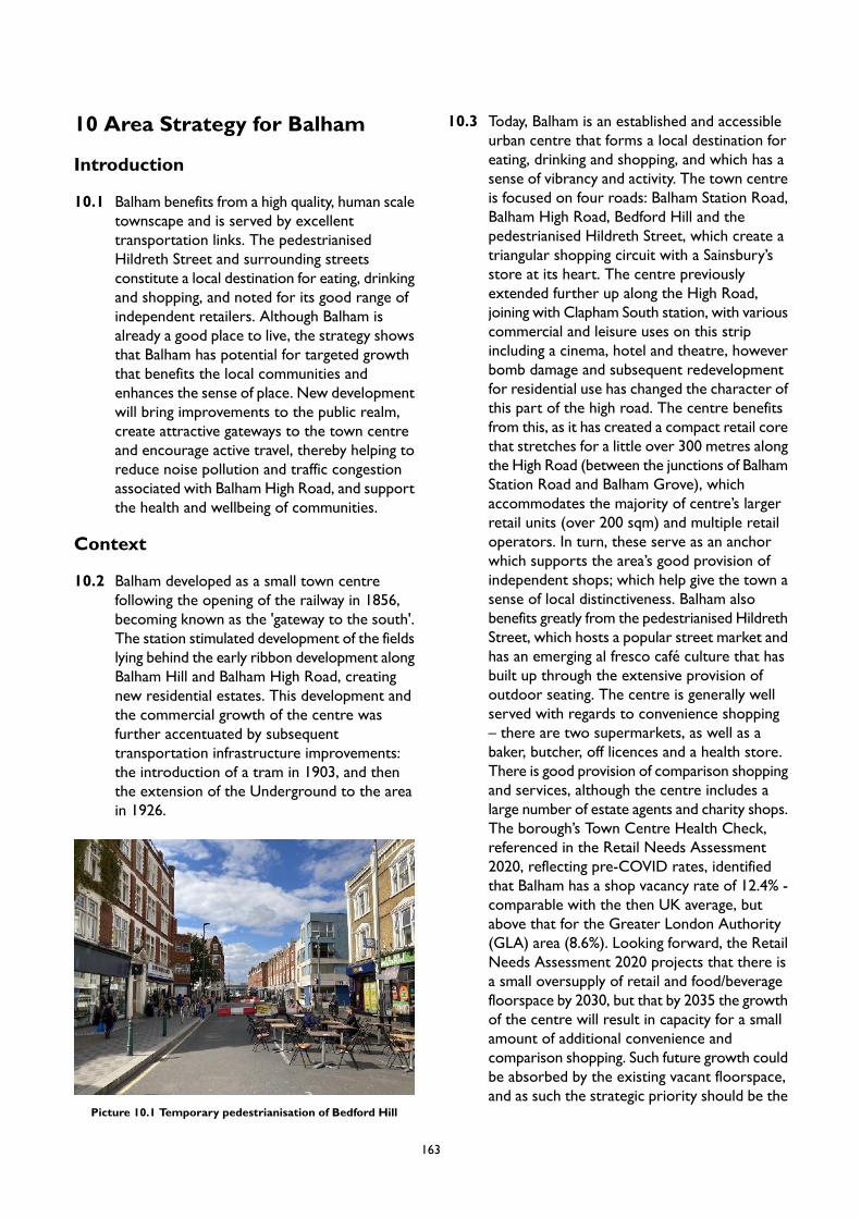
10 Area Strategy for Balham
Introduction
10.1 Balham benefits from a high quality, human scaletownscape and is served by excellenttransportation links. The pedestrianisedHildreth Street and surrounding streetsconstitute a local destination for eating, drinkingand shopping, and noted for its good range ofindependent retailers. Although Balham isalready a good place to live, the strategy showsthat Balham has potential for targeted growththat benefits the local communities andenhances the sense of place. New developmentwill bring improvements to the public realm,create attractive gateways to the town centreand encourage active travel, thereby helping toreduce noise pollution and traffic congestionassociated with Balham High Road, and supportthe health and wellbeing of communities.
Context
10.2 Balham developed as a small town centrefollowing the opening of the railway in 1856,becoming known as the 'gateway to the south'.The station stimulated development of the fieldslying behind the early ribbon development alongBalham Hill and Balham High Road, creatingnew residential estates. This development andthe commercial growth of the centre wasfurther accentuated by subsequenttransportation infrastructure improvements:the introduction of a tram in 1903, and thenthe extension of the Underground to the areain 1926.
Picture 10.1 Temporary pedestrianisation of Bedford Hill
10.3 Today, Balham is an established and accessibleurban centre that forms a local destination foreating, drinking and shopping, and which has asense of vibrancy and activity. The town centreis focused on four roads: Balham Station Road,Balham High Road, Bedford Hill and thepedestrianised Hildreth Street, which create atriangular shopping circuit with a Sainsbury’sstore at its heart. The centre previouslyextended further up along the High Road,joining with Clapham South station, with variouscommercial and leisure uses on this stripincluding a cinema, hotel and theatre, howeverbomb damage and subsequent redevelopmentfor residential use has changed the character ofthis part of the high road. The centre benefitsfrom this, as it has created a compact retail corethat stretches for a little over 300 metres alongthe High Road (between the junctions of BalhamStation Road and Balham Grove), whichaccommodates the majority of centre’s largerretail units (over 200 sqm) and multiple retailoperators. In turn, these serve as an anchorwhich supports the area’s good provision ofindependent shops; which help give the town asense of local distinctiveness. Balham alsobenefits greatly from the pedestrianised HildrethStreet, which hosts a popular street market andhas an emerging al fresco café culture that hasbuilt up through the extensive provision ofoutdoor seating. The centre is generally wellserved with regards to convenience shopping– there are two supermarkets, as well as abaker, butcher, off licences and a health store.There is good provision of comparison shoppingand services, although the centre includes alarge number of estate agents and charity shops.The borough’s Town Centre Health Check,referenced in the Retail Needs Assessment2020, reflecting pre-COVID rates, identifiedthat Balham has a shop vacancy rate of 12.4% -comparable with the then UK average, butabove that for the Greater London Authority(GLA) area (8.6%). Looking forward, the RetailNeeds Assessment 2020 projects that there isa small oversupply of retail and food/beveragefloorspace by 2030, but that by 2035 the growthof the centre will result in capacity for a smallamount of additional convenience andcomparison shopping. Such future growth couldbe absorbed by the existing vacant floorspace,and as such the strategic priority should be the
163
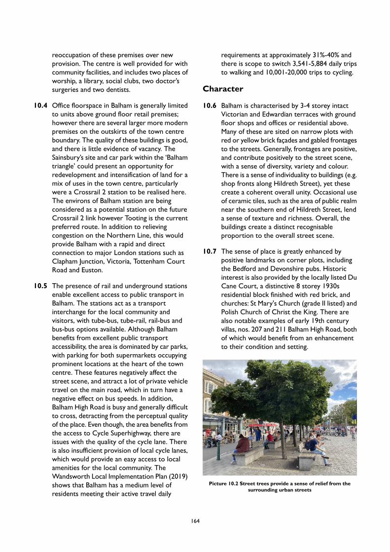
reoccupation of these premises over newprovision. The centre is well provided for withcommunity facilities, and includes two places ofworship, a library, social clubs, two doctor’ssurgeries and two dentists.
10.4 Office floorspace in Balham is generally limitedto units above ground floor retail premises;however there are several larger more modernpremises on the outskirts of the town centreboundary. The quality of these buildings is good,and there is little evidence of vacancy. TheSainsbury’s site and car park within the ‘Balhamtriangle’ could present an opportunity forredevelopment and intensification of land for amix of uses in the town centre, particularlywere a Crossrail 2 station to be realised here.The environs of Balham station are beingconsidered as a potential station on the futureCrossrail 2 link however Tooting is the currentpreferred route. In addition to relievingcongestion on the Northern Line, this wouldprovide Balham with a rapid and directconnection to major London stations such asClapham Junction, Victoria, Tottenham CourtRoad and Euston.
10.5 The presence of rail and underground stationsenable excellent access to public transport inBalham. The stations act as a transportinterchange for the local community andvisitors, with tube-bus, tube-rail, rail-bus andbus-bus options available. Although Balhambenefits from excellent public transportaccessibility, the area is dominated by car parks,with parking for both supermarkets occupyingprominent locations at the heart of the towncentre. These features negatively affect thestreet scene, and attract a lot of private vehicletravel on the main road, which in turn have anegative effect on bus speeds. In addition,Balham High Road is busy and generally difficultto cross, detracting from the perceptual qualityof the place. Even though, the area benefits fromthe access to Cycle Superhighway, there areissues with the quality of the cycle lane. Thereis also insufficient provision of local cycle lanes,which would provide an easy access to localamenities for the local community. TheWandsworth Local Implementation Plan (2019)shows that Balham has a medium level ofresidents meeting their active travel daily
requirements at approximately 31%-40% andthere is scope to switch 3,541-5,884 daily tripsto walking and 10,001-20,000 trips to cycling.
Character
10.6 Balham is characterised by 3-4 storey intactVictorian and Edwardian terraces with groundfloor shops and offices or residential above.Many of these are sited on narrow plots withred or yellow brick façades and gabled frontagesto the streets. Generally, frontages are positive,and contribute positively to the street scene,with a sense of diversity, variety and colour.There is a sense of individuality to buildings (e.g.shop fronts along Hildreth Street), yet thesecreate a coherent overall unity. Occasional useof ceramic tiles, such as the area of public realmnear the southern end of Hildreth Street, lenda sense of texture and richness. Overall, thebuildings create a distinct recognisableproportion to the overall street scene.
10.7 The sense of place is greatly enhanced bypositive landmarks on corner plots, includingthe Bedford and Devonshire pubs. Historicinterest is also provided by the locally listed DuCane Court, a distinctive 8 storey 1930sresidential block finished with red brick, andchurches: St Mary's Church (grade II listed) andPolish Church of Christ the King. There arealso notable examples of early 19th centuryvillas, nos. 207 and 211 Balham High Road, bothof which would benefit from an enhancementto their condition and setting.
Picture 10.2 Street trees provide a sense of relief from thesurrounding urban streets
164

10.8 Although many landmarks remain in place,Balham suffered a substantial damage during theWorld War II, with the loss of Royal DuchessPalace theatre, and extensive losses to theVictorian terraces around the High Road,Caistor Road and the area around the station.As a result, there is a high incidence of post-warinfill development, some of which areunsympathetic to the period character andproportions. There is also evidence of gradualdeterioration of the built form towards TootingBec underground station, where improvedmaintenance in needed. Some of these buildingsproviding a poor welcome into the town centre,which highlights a need for a more definedgateway to the town centre at its southern end.The area also suffers from the lack of streettrees, which perceptually add to the feeling ofnoise and pollution. Where street trees doexist, such as the two mature trees in front ofthe row of shops north of Caistor Road, theseare valuable in providing a sense of relief fromthe heavy traffic and hard streetscape.
165
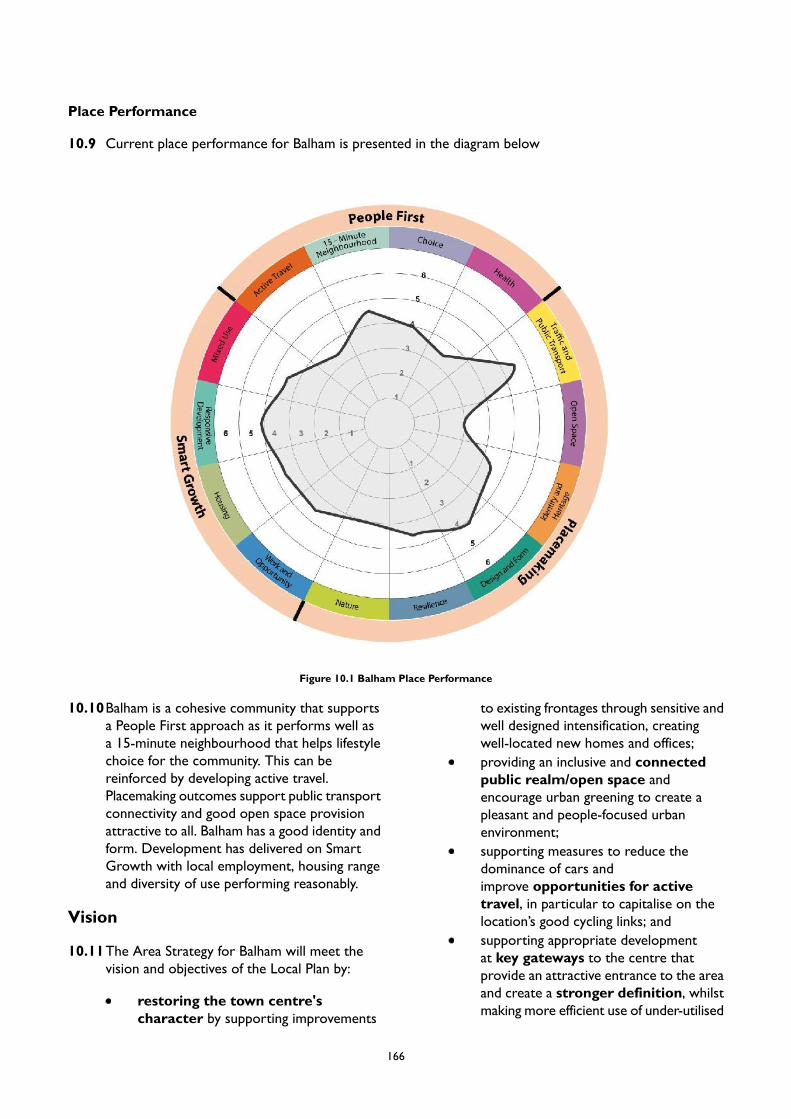
Place Performance
10.9 Current place performance for Balham is presented in the diagram below
Figure 10.1 Balham Place Performance
10.10Balham is a cohesive community that supportsa People First approach as it performs well asa 15-minute neighbourhood that helps lifestylechoice for the community. This can bereinforced by developing active travel.Placemaking outcomes support public transportconnectivity and good open space provisionattractive to all. Balham has a good identity andform. Development has delivered on SmartGrowth with local employment, housing rangeand diversity of use performing reasonably.
Vision
10.11The Area Strategy for Balham will meet thevision and objectives of the Local Plan by:
restoring the town centre'scharacter by supporting improvements
to existing frontages through sensitive andwell designed intensification, creatingwell-located new homes and offices;providing an inclusive and connectedpublic realm/open space andencourage urban greening to create apleasant and people-focused urbanenvironment;supporting measures to reduce thedominance of cars andimprove opportunities for activetravel, in particular to capitalise on thelocation’s good cycling links; andsupporting appropriate developmentat key gateways to the centre thatprovide an attractive entrance to the areaand create a stronger definition, whilstmaking more efficient use of under-utilised
166

spaces given over to cars in the allocated site at the eastern end of the town centre.
PM8 Balham
Placemaking
A. Appropriate development that creates a stronger definition to the northern, southern and easternends of the town centre will be supported. Any such proposal should provide an attractive gatewayspace to frame the main entrance to the area. Development proposals to the eastern end of the towncentre should aim to reduce the dominance of existing surface car parking. Development proposalsto the southern end of the town centre should aim to distinguishing between the identities of TootingBec and Balham.
B. The Urban Design Study has identified appropriate locations for tall buildings in Balham. The broadlocations are identified in Appendix 2. Any proposal for a tall building will be subject to addressingthe requirements of Policy LP 4 (Tall Buildings) as well as other policies in the Plan as applicable.
C. Opportunities to repair, improve and unify existing frontages are encouraged, particularly to the southof Balham High Road. New development should provide a frontage that engages positively with localcharacter and the street scene. Where historic shopfronts and features are present, these must beretained.
D. Appropriate development that restores the consistent building line along Balham High Road, increasingthe height of existing 1/2/3 storey buildings to tie in with adjacent 4 storey terraces, will be supported.Office and residential uses will be particularly encouraged.
E. Measures to provide new planting and modernise street furniture along Balham High Road will besupported. Where appropriate, development proposals should make provision for new street trees.
F. Proposals on Hildreth Street should contribute to the pedestrian environment and the public realmto support the operation of street market that takes place here, and must not negatively impact this.
G. Loss of open space will be resisted and opportunities to create additional open space and public realmenhancements will be supported, particularly where biodiversity and ecological improvement can alsobe realised.
Smart Growth
A. New residential accommodation in Balham will help meet the borough’s housing target, as set out inLocal Plan Policy LP 24. Development in this area is expected to provide at least 130 homes by 2037/38(the entire plan period) of which 63 homes are expected to be delivered by 2032/33 (10-year housingsupply). These figures reflect the projected completions on large, small and windfall sites rather thantotal capacity of Site Allocations.
B. To retain a strong retail core within Balham, proposals for comparison retail uses will be supportedin ground floor units within the centre’s Core Frontages, which is focused on the area of Balham HighRoad to the north of the station. Proposals that diversify the existing shopping offer, and which supportand enhance the centre’s good provision of independent retailers, will also be encouraged within thetown centre.
C. Proposals for cafes, restaurants and ‘twilight’ evening uses will be encouraged in particular on thepedestrianised Hildreth Street in order to enhance the emerging ‘al fresco’ café culture. Suchdevelopment should take appropriate measures to mitigate against any potential negative impact onneighbouring uses, including residential.
D. The protection of existing and provision of new office floorspace, as part of the mixed useredevelopment of allocated sites is expected. This should replace or provide new affordable workspacethat is appropriate for SMEs.
167
People First
A. Bedford Hill Place and areas adjacent to Balham Library present desirable locations for the expansionof existing cultural offer. Any such proposals should aim to make provision for cultural, creative, visualand performing arts and other forms of community innovation.
B. Development should promote active travel by creating more space for pedestrians especially on routesto Balham Station and by providing better waiting areas for bus passengers on Balham High Road tominimise impact on pedestrian and cycle flows.
C. Bus speeds are slow on Balham High Road, as shown in the Local Implementation Plan. Newdevelopment will be expected to provide loading and servicing off street where possible, and on sideroads where not, in order to reduce congestion and improve bus speeds.
D. The Council’s Local Implementation Plan indicates that a large number of trips could be switched towalking and cycling. To facilitate this modal shift, permanent improvements to Cycle Superhighway 7on A24 corridor and other local cycle lanes will be supported.
E. Measures to widen pavements along Balham High Road will be supported. These should integrate highquality public realm and street trees in order to improve the pedestrian experience and reduce theperceived dominance of vehicle traffic.
F. Proposals should deliver and/or fund additional cycle parking provision in the town centre and nearthe station, where there is an existing deficiency.
168

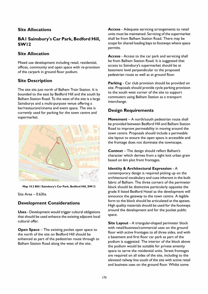
Site Allocations
BA1 Sainsbury's Car Park, BedfordHill,SW12
Site Allocation
Mixed use development including retail, residential,offices, community and open space with re-provisionof the carpark in ground floor podium.
Site Description
The site sits just north of Balham Train Station. It isbounded to the east by Bedford Hill and the south byBalham Station Road. To the west of the site is a largeSainsburys and a multi-purpose venue offering abar/restaurant/cinema and event space. The site iscurrently used for parking for the town centre andsupermarket.
Map 10.2 BA1 Sainsbury's Car Park, Bedford Hill, SW12
Site Area – 0.63ha
Development Considerations
Uses - Development would trigger cultural obligationsthat should be used enhance the existing adjacent localcultural offer.
Open Space – The existing pocket open space tothe north of the site on Bedford Hill should beenhanced as part of the pedestrian route through toBalham Station Road along the west of the site.
Access - Adequate servicing arrangements to retailunits must be maintained. Servicing of the supermarketshall be from Balham Station Road. There may bescope for shared loading bays to footways where spacepermits.
Access - Access to the car park and servicing shallbe from Balham Station Road. It is suggested thataccess to Sainsbury’s supermarket should be atbasement level perpendicular to the proposedpedestrian route as well as at ground floor.
Parking - Car club provision should be provided onsite. Proposals should provide cycle parking provisionto the south west corner of the site to supportcommuters using Balham Station as a transportinterchange.
Design Requirements
Movement – A north/south pedestrian route shallbe provided between Bedford Hill and Balham StationRoad to improve permeability in moving around thetown centre. Proposals should include a permeablesite layout to ensure the open space is accessible andthe frontage does not dominate the townscape.
Context – The design should reflect Balham’scharacter which derives from a tight knit urban grainbased on 6m plot front frontages.
Identity & Architectural Expression - Acontemporary design is required picking up on thearchitectural vocabulary and cues inherent in the builtfabric of Balham. The three corners of the perimeterblock should be distinctive particularly opposite thegrade II listed Bedford Hotel as the development willannounce the gateway to the town centre. A legibleform to the block should be articulated at the apexes.High quality materials should be used for the footwaysaround the development and for the pocket publicspace.
Site Layout - A triangular-shaped perimeter blockwith retail/business/commercial uses on the groundfloor with active frontages to all three sides, and witha basement and first floor car park as part of thepodium is suggested. The interior of the block abovethe podium would be suitable for private amenityspace to serve the residential units. Street frontagesare required on all sides of the site, including to theelevated railway line south of the site with active retailand business uses on the ground floor. Whilst some
170
retail/business use could be accommodated at firstfloor level, upper floors could accommodateresidential units and pedestrian links along the westernedge from north to south. Frontages to the east shouldreplicate the retail and commercial uses opposite iton Bedford Hill.
Massing - Taller elements should be located close tothe west frontage to face the existing Sainsbury’sbuilding. Heights should reduce towards the existinglow rise development along Balham Station Road andBedford Hill. Massing should be considerate of themodest buildings on all sides of the site and theexisting local detailing and materials when preparingproposals. The frontages on to Bedford Hill andBalham Station Road should be broken down subjectto daylight/sunlight impacts on Bedford Hill properties.
Nature - Green roofs should be provided to the builtform to enrich biodiversity and trees should be plantedto frontages.
Tall Buildings - In accordance with the Urban DesignStudy and the tall buildings maps in Appendix 2 partof the site is located in an area which has opportunitiesfor tall buildings within a local context, and the heightat which buildings will be considered as ‘tall’ is 5storeys. Development proposals for tall buildings willbe assessed in accordance with Local Plan Policy LP4.
171
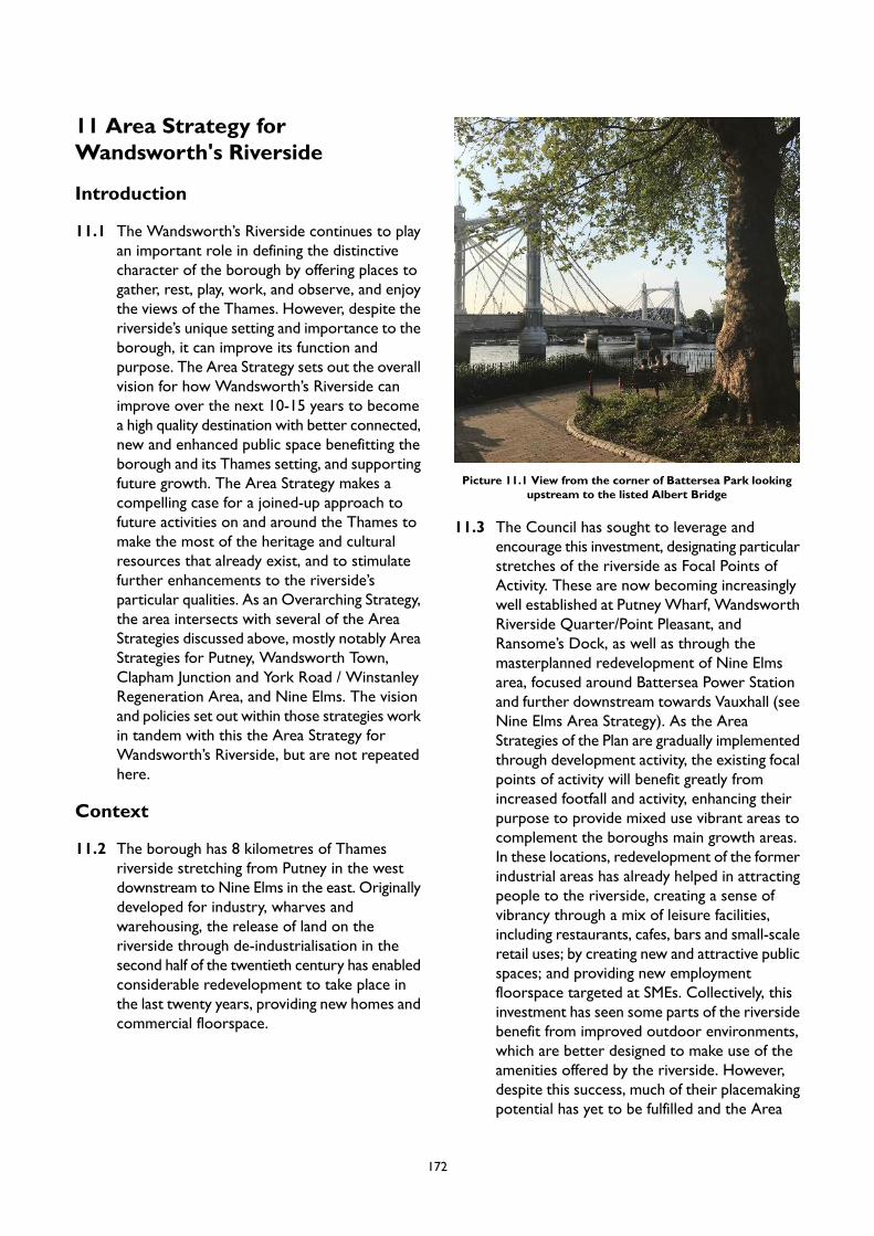
11 Area Strategy forWandsworth's Riverside
Introduction
11.1 The Wandsworth’s Riverside continues to playan important role in defining the distinctivecharacter of the borough by offering places togather, rest, play, work, and observe, and enjoythe views of the Thames. However, despite theriverside’s unique setting and importance to theborough, it can improve its function andpurpose. The Area Strategy sets out the overallvision for how Wandsworth’s Riverside canimprove over the next 10-15 years to becomea high quality destination with better connected,new and enhanced public space benefitting theborough and its Thames setting, and supportingfuture growth. The Area Strategy makes acompelling case for a joined-up approach tofuture activities on and around the Thames tomake the most of the heritage and culturalresources that already exist, and to stimulatefurther enhancements to the riverside’sparticular qualities. As an Overarching Strategy,the area intersects with several of the AreaStrategies discussed above, mostly notably AreaStrategies for Putney, Wandsworth Town,Clapham Junction and York Road / WinstanleyRegeneration Area, and Nine Elms. The visionand policies set out within those strategies workin tandem with this the Area Strategy forWandsworth’s Riverside, but are not repeatedhere.
Context
11.2 The borough has 8 kilometres of Thamesriverside stretching from Putney in the westdownstream to Nine Elms in the east. Originallydeveloped for industry, wharves andwarehousing, the release of land on theriverside through de-industrialisation in thesecond half of the twentieth century has enabledconsiderable redevelopment to take place inthe last twenty years, providing new homes andcommercial floorspace.
Picture 11.1 View from the corner of Battersea Park lookingupstream to the listed Albert Bridge
11.3 The Council has sought to leverage andencourage this investment, designating particularstretches of the riverside as Focal Points ofActivity. These are now becoming increasinglywell established at Putney Wharf, WandsworthRiverside Quarter/Point Pleasant, andRansome’s Dock, as well as through themasterplanned redevelopment of Nine Elmsarea, focused around Battersea Power Stationand further downstream towards Vauxhall (seeNine Elms Area Strategy). As the AreaStrategies of the Plan are gradually implementedthrough development activity, the existing focalpoints of activity will benefit greatly fromincreased footfall and activity, enhancing theirpurpose to provide mixed use vibrant areas tocomplement the boroughs main growth areas.In these locations, redevelopment of the formerindustrial areas has already helped in attractingpeople to the riverside, creating a sense ofvibrancy through a mix of leisure facilities,including restaurants, cafes, bars and small-scaleretail uses; by creating new and attractive publicspaces; and providing new employmentfloorspace targeted at SMEs. Collectively, thisinvestment has seen some parts of the riversidebenefit from improved outdoor environments,which are better designed to make use of theamenities offered by the riverside. However,despite this success, much of their placemakingpotential has yet to be fulfilled and the Area
172
Strategies aim to establish these places as betterdestinations that are accessible to a wider rangeof local residents and visitors by supportingtheir local economy. The continued structuredregeneration of these places is therefore ofcritical importance to ensure thatWandsworth’s Riverside fulfils its potential. Thearea with the greatest opportunity for changelies to the north of Wandsworth Town, in theWandle Delta. The transformation of this areais being cohesively planned through theWandsworth Town Area Strategy.
11.4 There also remains a stretch, focused aroundLombard Road/York Road, where regenerationis an ongoing process – with some sites recentlycompleted, underway or planned for, and othersyet to be redeveloped. The concentration ofriverside site allocations within this locationreflects this opportunity, and the area willcontinue to see transformation throughresidential-led mixed use development, includingwith the scope for some tall buildings. As inother Focal Points, these uses should seek tocreate activity and vibrancy on the ground-floor,with uses such as restaurants, cafes, bars andcultural spaces in order to optimise the vibrancyof this riverside location. Some localconvenience provision, serving the newresidential populations, will also be appropriate.Reflecting the changing fortunes of town centres– facing structural challenges as a result of therise in internet shopping, as well as the stillunknown full impact of the COVID-19 pandemic– the scale of these uses should be limited toserving local needs only. As such, thisdevelopment should work to enhance theborough’s overall offer, rather than to competewith town and local centres.
11.5 A grouping of nationally and internationallysignificant cultural institutions are located withineasy reach of the Lombard Road/York Road
Focal Point area. These include the RoyalCollege of Art, Tavaziva Dance, BBO Danceand the Royal Academy of Dance (which willrelocate to York Road in 2020). This culturalprovision and its employment, education andeconomic dimensions, give the area a strategicsignificance which opens an opportunity to builda cluster of cultural and creative activity in andaround the focal point area. This should focuson three strands: the provision of public artsand creative engagement; encouraging pathwaysto creative and cultural employment; and theprovision of affordable workspace to supportcreative industries. The redevelopment of thenearby Winstanley and York Road Estatesshould be integrated as part of this initiative(see the Area Strategy for Clapham Junctionand York Road/Winstanley Regeneration Area).
11.6 While much of the larger industrial land alongWandsworth’s riverside has now beenredeveloped, the economic function of the arearemains present. Redevelopment has alsobrought forward areas of new office floorspace– often in the form of managed or co-workingspace, which serves the contemporaryemployment needs of the borough. In the sitesallocated for development, the retention ofexisting employment floorspace should beprioritised for this market. Where there areexisting industrial facilities, such as the tradingestate off Gwynne Road and the industrial landsouth of Chatfield Road, redevelopment couldprovide intensified industrial and modernindustrial facilities uses, such as maker-spacefacilities. This type of provision would sit morecomfortably alongside new residentialdevelopment, and would generate vitality andcreate new economic opportunities which meetthe borough’s identified need.
173

Picture 11.2 View upstream fromWandsworth park framed by the distinctive avenue of mature London plane trees
11.7 The River Thames itself also continues toprovide an important economic function: fiveworking wharves, Western Riverside WasteTransfer Station and PierWharf inWandsworthand Cringle Dock, Kirtling Wharf and MiddleWharf at Nine Elms are safeguarded for thetrans-shipment of waterborne freight,particularly waste and aggregates. Themovement of goods by water rather than roadcan help relieve traffic congestion and air andnoise pollution, and is consistent with theprinciple of sustainable development. Thesewharves are located in the main areas forchange identified at theWandle Delta and NineElms, and it is important to minimise the conflictbetween new and old land uses to continuetheir important function to Wandsworthborough and London (see Area Strategies forWandsworth and Nine Elms).
11.8 One of the largest sewer infrastructure projectsin Europe, the Thames Tideway Tunnel, iscurrently being built with its main shaft sitelocated in the riverside area of Kirtling StreetNine Elms. Due for completion in 2024 thesewer will replace London’s 150-year-old sewernetwork and prevent tens of millions of tonnes
of that currently pollutes the River Thamesevery year. The project, which has six largeconstruction sites mainly located in the riversidearea, will provide positive lasting legacy whichprovides environmental improvements, jobs,skills and economic investment. The sites willbe transformed into new public open spaces,including a new promontory in the Thames atPutney embankment and Nine Elms (HeathwallPumping Station), new public realm enhancingthe setting of King Georges Park including newtree planting, and opening up new areas ofriverside walk in Nine Elms. The Council willcontinue to work with Tideway to ensure itslegacy is sustainable, enhances the relationshipbetween the sites and their surroundings anddeveloped in partnership with residents andcommunity groups.
11.9 Leisure activity is a valuable element that addsto the character and the appeal of the riverside.Rowing and boating activity on the river is partof the Wandsworth’s heritage. There is scopeto promote and enhance river relatedrecreational activities along the stretch of theRiverside, but particularly at PutneyEmbankment, where there is a concentration
174
of boat servicing and repair facilities, moorings,boathouses, slipways, steps, stairs and landingplaces used in connection with river sports andgeneral recreational use of the river (see theArea Strategy for Putney). The River Thamesand its tributaries are also a major ecologicalresource providing an important ecologicalcorridor across London and supporting a hostof habitats and species. As a major linear openspace of strategic importance, the Thames actsas the backbone of the green chain networkwhich spreads out through Wandsworth andadjoining boroughs. Future development shouldaccount for this, seeking to enhance anddevelop these linkages and the ecological andnature conservation value.
11.10Past development along the riverside hassecured the provision of a riverside path forpedestrians and cyclists, and it is now possibleto walk or ride along almost the entire stretchof the riverside. These connections have alsolinked many of the features associated with theriverside: an example of where this has beendone successfully is at Ransome’s Dock, whereimproved pedestrian access to the Dock hasbeen achieved by way of a new colonnadeconnection to Elcho Street. The ultimate aim isthe completion of the Thames Path, which is aNational Trail. Enhancement to Thames Pathwill be complemented by the erection of newbridges (Pimlico-Nine Elms and Diamond JubileeBridge) providing improved linkages with theneighbouring boroughs; and by improvingconnectivity and legibility between theWandsworth’s Riverside and Putney,Wandsworth Town and Clapham Junction towncentres. In addition, there is scope forenhancements to existing riverbus services toserve the growing population in riversidedevelopments.
Character
11.11The Area Strategy encompasses the entirety ofWandsworth’s Riverside. Recognising thegeographic extent of the area, its character isvaried, ranging from human-scale activefrontages with boathouses in Putney, throughlarge-scale modern residential development andindustrial buildings inWandsworth, through the
outstanding landscape interest of Battersea Park,to an area undergoing a significant change andevolution – Nine Elms.
11.12Putney Riverside is defined by the distinctsweeping bend of the River Thames. The areais punctuated by Leader's Gardens, which,together with mature trees along a substantialportion of the riverside, create a green settingcharacterised by busy public spaces with leisureusers on the river. The large number ofpedestrians and cyclists lend a promenade feelto the riverside, reinforced by consistent useof natural materials and well considered streetfurniture. Although busy, the river and maturevegetation lend a feeling of calm and tranquillity,creating a strong perception of nature. Muchof the area sits within Putney EmbankmentConservation Area, recognised for theimportance of its 19th century boathouses. TheConservation Area contains some of the oldestsurviving buildings in Putney, including Victorian,Edwardian and Georgian properties withgenerous set back from the riverside. Althoughthe area has a strong sense of place, some publicrealm elements along Putney Embankmentrequire repair. Further, there is a need toenhance the connection of the riverside withPutney High Street. These matters areaddressed in the Area Strategy for Putney.
11.13Downstream of Putney Bridge, the DeodarRoad Conservation Area creates a greenfrontage formed by private gardens to Victorianhouses backing onto the Thames. This providesa distinct suburban feel immediately behind thebusy Putney High Street, with the specialinterest created by the houses' relationship tothe river. Looking further west, WandsworthPark marks a distinct change to the more urbanand denser frontage of Wandsworth Town. Theriverside north of Wandsworth Town ischaracterised by a mixture of tall residentialbuildings and remaining industrial sites. The areabenefits from the openness of the RiverThames, local boat traffic, and the interest ofthe piers and moorings. Similar to PutneyEmbankment, there are, however, issues of lackof clear, legible routes connecting the towncentre to the River Thames and Wandle River.There are also issues of inappropriate landscapetreatments, including areas that feel overly
175
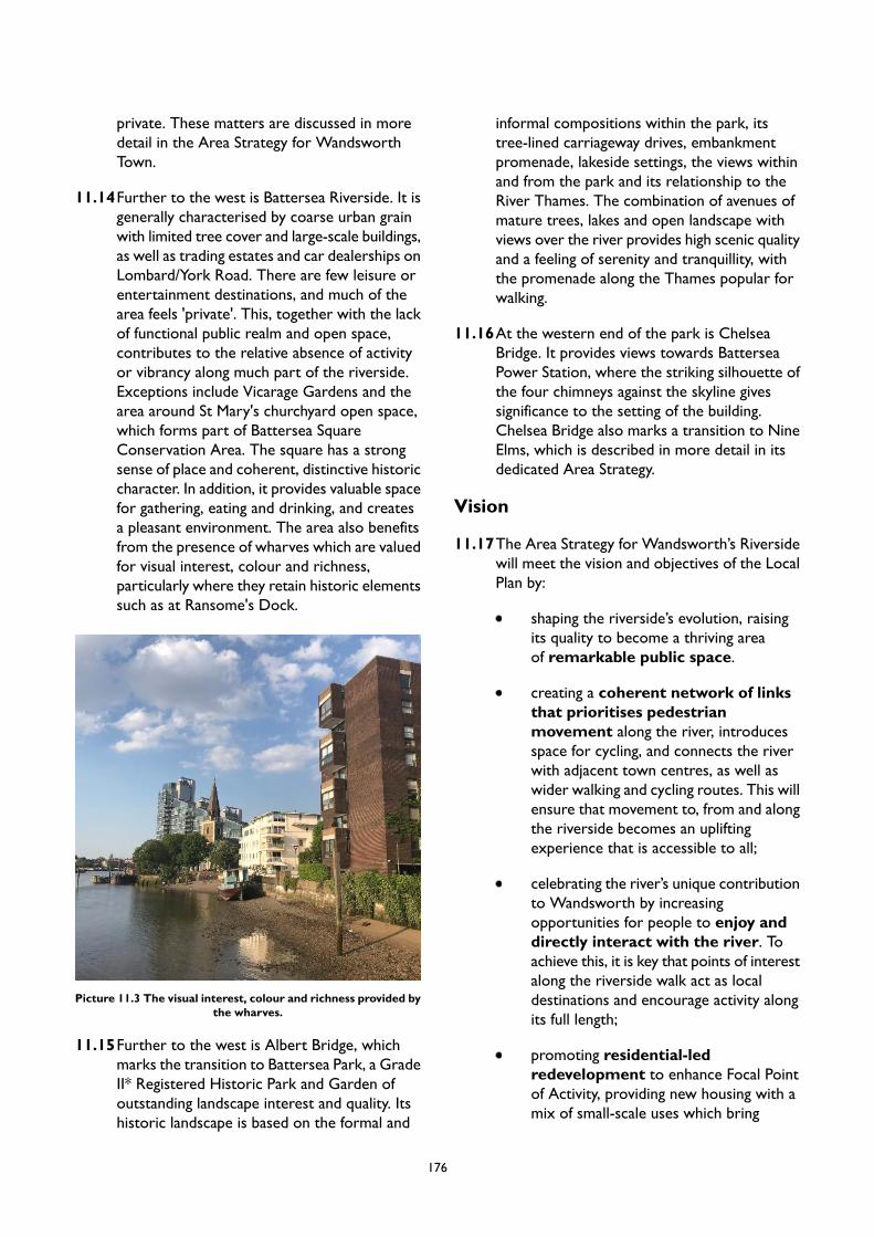
private. These matters are discussed in moredetail in the Area Strategy for WandsworthTown.
11.14Further to the west is Battersea Riverside. It isgenerally characterised by coarse urban grainwith limited tree cover and large-scale buildings,as well as trading estates and car dealerships onLombard/York Road. There are few leisure orentertainment destinations, and much of thearea feels 'private'. This, together with the lackof functional public realm and open space,contributes to the relative absence of activityor vibrancy along much part of the riverside.Exceptions include Vicarage Gardens and thearea around St Mary's churchyard open space,which forms part of Battersea SquareConservation Area. The square has a strongsense of place and coherent, distinctive historiccharacter. In addition, it provides valuable spacefor gathering, eating and drinking, and createsa pleasant environment. The area also benefitsfrom the presence of wharves which are valuedfor visual interest, colour and richness,particularly where they retain historic elementssuch as at Ransome's Dock.
Picture 11.3 The visual interest, colour and richness provided bythe wharves.
11.15Further to the west is Albert Bridge, whichmarks the transition to Battersea Park, a GradeII* Registered Historic Park and Garden ofoutstanding landscape interest and quality. Itshistoric landscape is based on the formal and
informal compositions within the park, itstree-lined carriageway drives, embankmentpromenade, lakeside settings, the views withinand from the park and its relationship to theRiver Thames. The combination of avenues ofmature trees, lakes and open landscape withviews over the river provides high scenic qualityand a feeling of serenity and tranquillity, withthe promenade along the Thames popular forwalking.
11.16At the western end of the park is ChelseaBridge. It provides views towards BatterseaPower Station, where the striking silhouette ofthe four chimneys against the skyline givessignificance to the setting of the building.Chelsea Bridge also marks a transition to NineElms, which is described in more detail in itsdedicated Area Strategy.
Vision
11.17The Area Strategy for Wandsworth’s Riversidewill meet the vision and objectives of the LocalPlan by:
shaping the riverside’s evolution, raisingits quality to become a thriving areaof remarkable public space.
creating a coherent network of linksthat prioritises pedestrianmovement along the river, introducesspace for cycling, and connects the riverwith adjacent town centres, as well aswider walking and cycling routes. This willensure that movement to, from and alongthe riverside becomes an upliftingexperience that is accessible to all;
celebrating the river’s unique contributionto Wandsworth by increasingopportunities for people to enjoy anddirectly interact with the river. Toachieve this, it is key that points of interestalong the riverside walk act as localdestinations and encourage activity alongits full length;
promoting residential-ledredevelopment to enhance Focal Pointof Activity, providing new housing with amix of small-scale uses which bring
176
vibrancy to the area, meeting the needsof local residents;
connecting the riverside withWandsworth Town and Wandle Delta,
and promote its use and setting for eatingand drinking, cultural and leisure uses; and
supporting river relatedactivity including for sport, leisure,business and transport uses.
PM9 Wandsworth's Riverside
Placemaking
A. The existing character of Putney Riverside is strong, with a distinctive sense of place and high qualitytownscape. Therefore, the strategy is to conserve the character, elements and features whilst enhancingexisting features where appropriate. New development proposals should:
1. respect the scale and proportions of the existing period buildings and streetscape which isfundamental to the character of the area;
2. protect the openness and framing of vistas towards the river, along Putney Embankment;3. maximise use of natural materials to integrate with the quality and natural feel of the existing
townscape - including stone, timber, period brickwork and planting;4. ensure good maintenance of building façades, particularly where they present an active frontage
to the Thames Path;5. provide high quality public realm, including street furniture which is distinctive to the area; and6. contribute to the valued leisure functions, including water uses, walking and cycling.
B. Much of the riverside between Wandsworth and Battersea Parks has been redeveloped. However, anumber of sites present opportunities for targeted growth. These are mainly located to the north ofWandsworth Town (see Site Allocation in the Area Strategy forWandsworth Town) and in the vicinityof Lombard Road (see Site Allocations in the Area Strategy for Wandsworth’s Riverside). Newdevelopment in these locations should:
1. create a positive front to the water, with active ground floor uses and continuation of the publicriverside walk;
2. have distinctive character that creates remarkable landmarks;3. provide excellent and inviting public realm as part of a coherent strategy rather than spaces
between buildings;4. provide active frontages to the Thames Path;5. preserve linear views along the river; and6. create references to historic pattern, uses and elements where possible to bring coherence,
legibility and integrity;
C. Development proposals should retain, respect and restore (where appropriate) the historic elementsof St Mary's Church, Battersea, and surrounding green space.
D. Development proposals should enhance the sense of place and focus at PlantationWharf to aid legibilityand quality of experience at this part of the river.
E. The Urban Design Study has identified appropriate locations for tall buildings in Wandsworth’sRiverside. The broad locations are identified in Appendix 2. Any proposal for a tall building will besubject to addressing the requirements of Policy LP 4 (Tall Buildings) as well as other policies in thePlan as applicable.
177
F. New development along the riverside should conserve and enhance the quality of the built and naturalenvironment as identified through the designated heritage status of the area, the architectural qualityof its buildings and preserve important local views and vistas, as identified in the visual plan.
G. Opportunities to enhance the experience and quality of the public realm through carefully considered,well designed proposals that create interesting, dynamic, accessible, and inclusive public spaces areencouraged. These should provide elements that encourage dwell time, such as seating, which facilitatecommunity and cultural use, and which incorporate public art. Imaginative landscape design cancontribute to the greening of these spaces.
H. Development proposals will need to take account of the ecological value of the River Thames andopportunities will be sought by the Council, either as the local planning authority when determiningrelevant planning applications or through its own corporate activity, to enhance and improve theecological value where appropriate.
I. Development on the riverside should have regard to the aims of the All London Green Grid (ALGG)and the opportunities identified in the area frameworks (Arcadian Thames, Wandle Valley, & CentralLondon).
J. Support the Thames Tideway Tunnel project through to completion in 2021 and beyond to create asustainable and lasting legacy. For each site this will mean the protection and enhancement of thesetting and character of the surrounding area, improvement of the environment both on site and itssetting and providing economic and social benefits such as jobs and skills, and opportunities for thecreation of public art and event space to allow for inclusive and varied use.
Smart Growth
A. New residential accommodation in Wandsworth’s Riverside will help meet the borough’s housingtarget, as set out in Local Plan Policy LP 24. Development in this area is expected to provide at least3,210 homes by 2037/38 (the entire plan period), of which 2,917 are expected to be delivered by2032/33 (10-year housing supply). These figures reflect the projected completions on large, small andwindfall sites rather than total capacity of Site Allocations. Projected completions on sites located inother Area Strategies but also covered as part of this overarching Area Strategy are included.
B. Promote the mixed uses including restaurants, cafés and pubs around Battersea Square to maintain asense of activity and vibrancy.
C. Promote residential-led development in the Focal Points of Activity, alongside a mixture of uses toincrease activity and vibrancy along the riverside. These should be of a small-scale which is appropriateto serving local needs, and should not detract from the vitality or viability of town centres. Towncentre uses will be required to pass a sequential test to ensure this. Where Focal Points of Activityare established, these should be supported and enhanced to sustain a critical mass of local activity.
D. Sports use of the river and water-based leisure will be supported recognising the importance of theseactivities to the vibrancy and spectacle of the corridor. Opportunities to improve facilities and encouragefurther use of the river for recreation will be supported.
E. The use of the river for transport purposes will be supported.
People First
A. Development proposals should contribute to creating a continuous, connected and legible ThamesPath route along the river to avoid pedestrians and cyclists from having to divert from the riverside.
B. Opportunities will be sought to increase public access to the waterfront across the length of theriverside, especially to Putney, Wandsworth Town and Clapham Junction Town Centres. Theimprovements should prioritise pedestrian and cyclists, and form part of a coherent movement networklinking with the wider pedestrian and cycle networks.
C. Opportunities will be sought to improve crossings over Lombard and York Roads.D. The cultural heritage of the river will be celebrated as an intrinsic part of Wandsworth’s story. Future
Development proposals should accord with the recommendations set out in the Cultural Planning
178
Guidance for Lombard Road/York Road Riverside Focal Point Area, as well with the recommendationsoutlined in the forthcoming River Thames Cultural Vision. The development of Arts and CultureStrategy to create a sense of coherence between the many different elements along the riverside willbe supported.
E. Opportunities to enrich the experience of the river through public art and interpretation will besought and supported along the length of the riverside.
F. Development / renewal proposals affecting Battersea Park or its setting should refer to Managementand Maintenance Plan, which sets out actions to conserve and enhance the park. In particular, thefollowing measures have potential to improve the quality of King George's Park for local communities:
1. Conserve and enhance valued features including the listed and non-listed elements.2. Retain and manage existing trees, particularly mature trees.3. Preserve and reinstate original features in the public realm such as paving slabs, granite kerbs
and setts.4. Preserve the openness of the park and the riverside by resisting development which would affect
this perception.5. Continue the programme of facilities and events in the park to maintain its vibrancy and
importance as a destination.
G. Opportunities for increased water-based travel and use of the water for business will be supportedin line with requirements of the emerging London Plan. The Council will support improvements toWandsworth Riverside Quarter pier and access to Putney Pier.
179
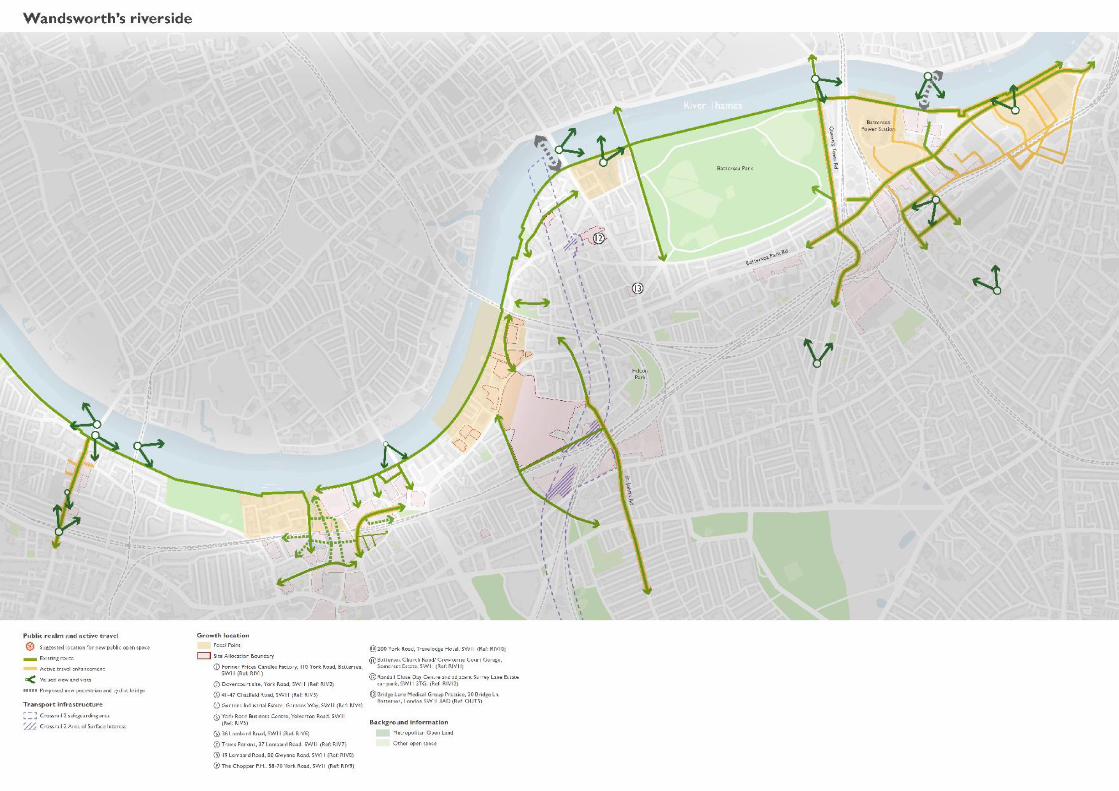
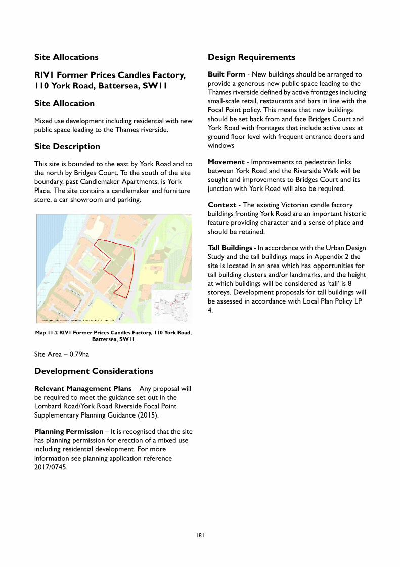
Site Allocations
RIV1 Former Prices Candles Factory,110 York Road, Battersea, SW11
Site Allocation
Mixed use development including residential with newpublic space leading to the Thames riverside.
Site Description
This site is bounded to the east by York Road and tothe north by Bridges Court. To the south of the siteboundary, past Candlemaker Apartments, is YorkPlace. The site contains a candlemaker and furniturestore, a car showroom and parking.
Map 11.2 RIV1 Former Prices Candles Factory, 110 York Road,Battersea, SW11
Site Area – 0.79ha
Development Considerations
Relevant Management Plans – Any proposal willbe required to meet the guidance set out in theLombard Road/York Road Riverside Focal PointSupplementary Planning Guidance (2015).
Planning Permission – It is recognised that the sitehas planning permission for erection of a mixed useincluding residential development. For moreinformation see planning application reference2017/0745.
Design Requirements
Built Form - New buildings should be arranged toprovide a generous new public space leading to theThames riverside defined by active frontages includingsmall-scale retail, restaurants and bars in line with theFocal Point policy. This means that new buildingsshould be set back from and face Bridges Court andYork Road with frontages that include active uses atground floor level with frequent entrance doors andwindows
Movement - Improvements to pedestrian linksbetween York Road and the Riverside Walk will besought and improvements to Bridges Court and itsjunction with York Road will also be required.
Context - The existing Victorian candle factorybuildings fronting York Road are an important historicfeature providing character and a sense of place andshould be retained.
Tall Buildings - In accordance with the Urban DesignStudy and the tall buildings maps in Appendix 2 thesite is located in an area which has opportunities fortall building clusters and/or landmarks, and the heightat which buildings will be considered as ‘tall’ is 8storeys. Development proposals for tall buildings willbe assessed in accordance with Local Plan Policy LP4.
181
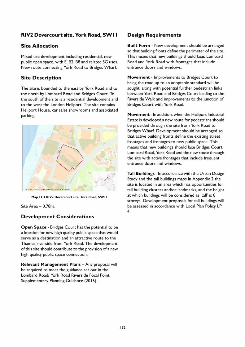
RIV2Dovercourt site, York Road, SW11
Site Allocation
Mixed use development including residential, newpublic open space, with E, B2, B8 and related SG uses.New route connecting York Road to Bridges Wharf.
Site Description
The site is bounded to the east by York Road and tothe north by Lombard Road and Bridges Court. Tothe south of the site is a residential development andto the west the London Heliport. The site containsHeliport House, car sales showrooms and associatedparking.
Map 11.3 RIV2 Dovercourt site, York Road, SW11
Site Area – 0.78ha
Development Considerations
Open Space - Bridges Court has the potential to bea location for new high quality public space that wouldserve as a destination and an attractive route to theThames riverside from York Road. The developmentof this site should contribute to the provision of a newhigh quality public space connection.
Relevant Management Plans – Any proposal willbe required to meet the guidance set out in theLombard Road/ York Road Riverside Focal PointSupplementary Planning Guidance (2015).
Design Requirements
Built Form - New development should be arrangedso that building fronts define the perimeter of the site.This means that new buildings should face, LombardRoad and York Road with frontages that includeentrance doors and windows.
Movement - Improvements to Bridges Court tobring the road up to an adoptable standard will besought, along with potential further pedestrian linksbetween York Road and Bridges Court leading to theRiverside Walk and improvements to the junction ofBridges Court with York Road.
Movement - In addition, when the Heliport IndustrialEstate is developed a new route for pedestrians shouldbe provided through the site from York Road toBridges Wharf. Development should be arranged sothat active building fronts define the existing streetfrontages and frontages to new public space. Thismeans that new buildings should face Bridges Court,Lombard Road, York Road and the new route throughthe site with active frontages that include frequententrance doors and windows.
Tall Buildings - In accordance with the Urban DesignStudy and the tall buildings maps in Appendix 2 thesite is located in an area which has opportunities fortall building clusters and/or landmarks, and the heightat which buildings will be considered as ‘tall’ is 8storeys. Development proposals for tall buildings willbe assessed in accordance with Local Plan Policy LP4.
182
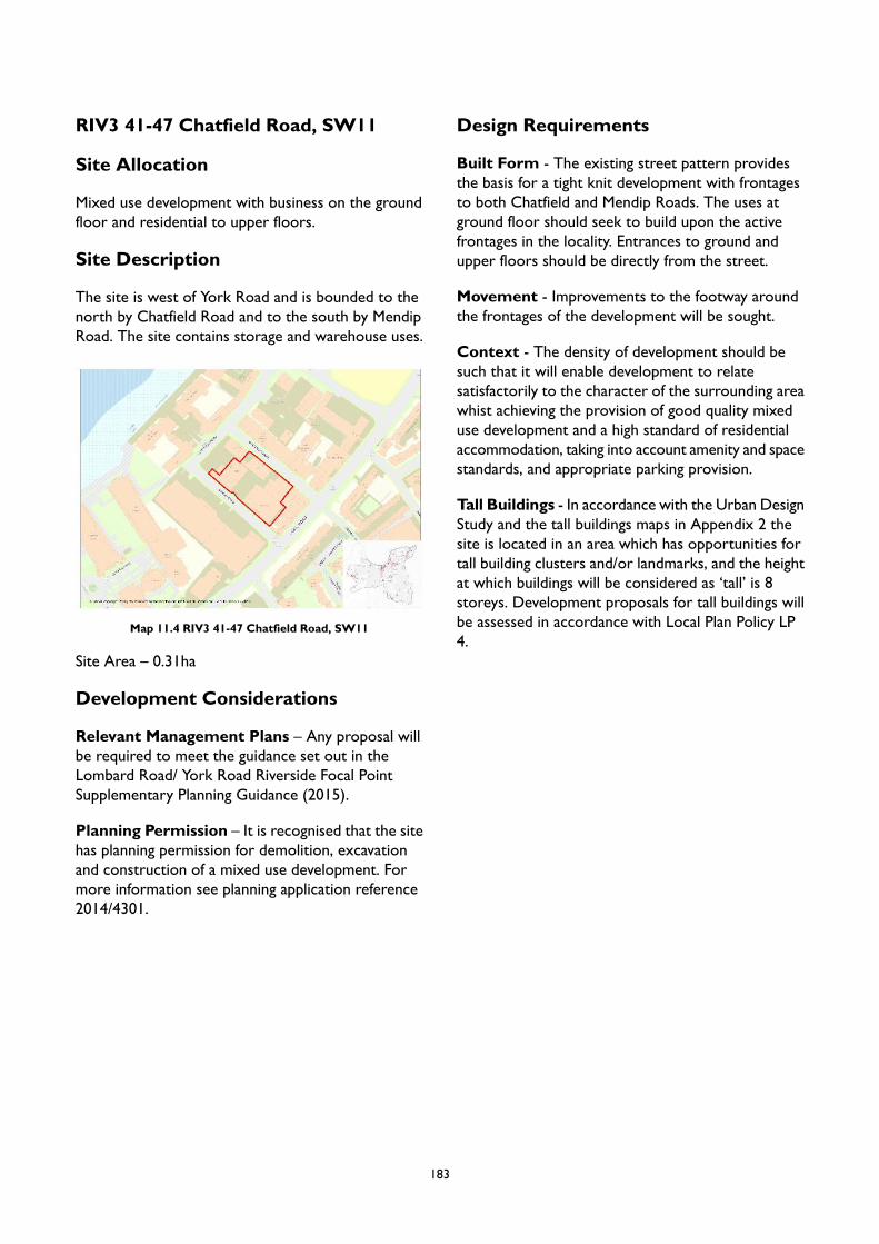
RIV3 41-47 Chatfield Road, SW11
Site Allocation
Mixed use development with business on the groundfloor and residential to upper floors.
Site Description
The site is west of York Road and is bounded to thenorth by Chatfield Road and to the south by MendipRoad. The site contains storage and warehouse uses.
Map 11.4 RIV3 41-47 Chatfield Road, SW11
Site Area – 0.31ha
Development Considerations
Relevant Management Plans – Any proposal willbe required to meet the guidance set out in theLombard Road/ York Road Riverside Focal PointSupplementary Planning Guidance (2015).
Planning Permission – It is recognised that the sitehas planning permission for demolition, excavationand construction of a mixed use development. Formore information see planning application reference2014/4301.
Design Requirements
Built Form - The existing street pattern providesthe basis for a tight knit development with frontagesto both Chatfield and Mendip Roads. The uses atground floor should seek to build upon the activefrontages in the locality. Entrances to ground andupper floors should be directly from the street.
Movement - Improvements to the footway aroundthe frontages of the development will be sought.
Context - The density of development should besuch that it will enable development to relatesatisfactorily to the character of the surrounding areawhist achieving the provision of good quality mixeduse development and a high standard of residentialaccommodation, taking into account amenity and spacestandards, and appropriate parking provision.
Tall Buildings - In accordance with the Urban DesignStudy and the tall buildings maps in Appendix 2 thesite is located in an area which has opportunities fortall building clusters and/or landmarks, and the heightat which buildings will be considered as ‘tall’ is 8storeys. Development proposals for tall buildings willbe assessed in accordance with Local Plan Policy LP4.
183
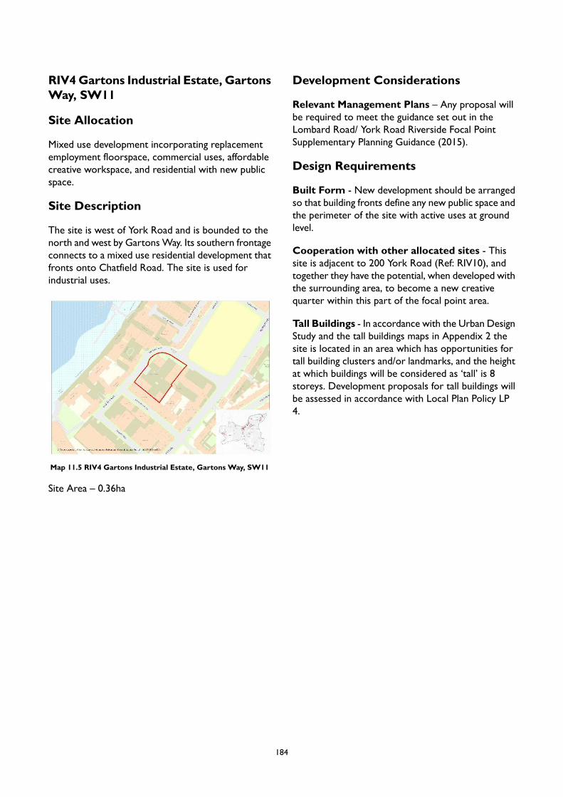
RIV4Gartons Industrial Estate, GartonsWay, SW11
Site Allocation
Mixed use development incorporating replacementemployment floorspace, commercial uses, affordablecreative workspace, and residential with new publicspace.
Site Description
The site is west of York Road and is bounded to thenorth and west by GartonsWay. Its southern frontageconnects to a mixed use residential development thatfronts onto Chatfield Road. The site is used forindustrial uses.
Map 11.5 RIV4 Gartons Industrial Estate, Gartons Way, SW11
Site Area – 0.36ha
Development Considerations
Relevant Management Plans – Any proposal willbe required to meet the guidance set out in theLombard Road/ York Road Riverside Focal PointSupplementary Planning Guidance (2015).
Design Requirements
Built Form - New development should be arrangedso that building fronts define any new public space andthe perimeter of the site with active uses at groundlevel.
Cooperation with other allocated sites - Thissite is adjacent to 200 York Road (Ref: RIV10), andtogether they have the potential, when developed withthe surrounding area, to become a new creativequarter within this part of the focal point area.
Tall Buildings - In accordance with the Urban DesignStudy and the tall buildings maps in Appendix 2 thesite is located in an area which has opportunities fortall building clusters and/or landmarks, and the heightat which buildings will be considered as ‘tall’ is 8storeys. Development proposals for tall buildings willbe assessed in accordance with Local Plan Policy LP4.
184
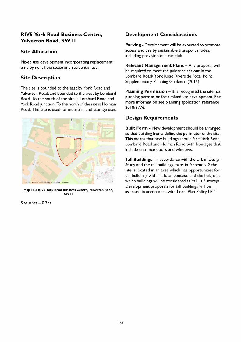
RIV5 York Road Business Centre,Yelverton Road, SW11
Site Allocation
Mixed use development incorporating replacementemployment floorspace and residential use.
Site Description
The site is bounded to the east by York Road andYelverton Road; and bounded to the west by LombardRoad. To the south of the site is Lombard Road andYork Road junction. To the north of the site is HolmanRoad. The site is used for industrial and storage uses
Map 11.6 RIV5 York Road Business Centre, Yelverton Road,SW11
Site Area – 0.7ha
Development Considerations
Parking - Development will be expected to promoteaccess and use by sustainable transport modes,including provision of a car club.
Relevant Management Plans – Any proposal willbe required to meet the guidance set out in theLombard Road/ York Road Riverside Focal PointSupplementary Planning Guidance (2015).
Planning Permission – It is recognised the site hasplanning permission for a mixed use development. Formore information see planning application reference2018/3776.
Design Requirements
Built Form - New development should be arrangedso that building fronts define the perimeter of the site.This means that new buildings should face York Road,Lombard Road and Holman Road with frontages thatinclude entrance doors and windows.
Tall Buildings - In accordance with the Urban DesignStudy and the tall buildings maps in Appendix 2 thesite is located in an area which has opportunities fortall buildings within a local context, and the height atwhich buildings will be considered as ‘tall’ is 5 storeys.Development proposals for tall buildings will beassessed in accordance with Local Plan Policy LP 4.
185
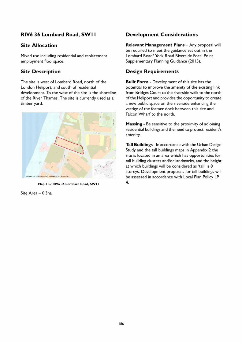
RIV6 36 Lombard Road, SW11
Site Allocation
Mixed use including residential and replacementemployment floorspace.
Site Description
The site is west of Lombard Road, north of theLondon Heliport, and south of residentialdevelopment. To the west of the site is the shorelineof the River Thames. The site is currently used as atimber yard.
Map 11.7 RIV6 36 Lombard Road, SW11
Site Area – 0.3ha
Development Considerations
Relevant Management Plans – Any proposal willbe required to meet the guidance set out in theLombard Road/ York Road Riverside Focal PointSupplementary Planning Guidance (2015).
Design Requirements
Built Form - Development of this site has thepotential to improve the amenity of the existing linkfrom Bridges Court to the riverside walk to the northof the Heliport and provides the opportunity to createa new public space on the riverside enhancing thevestige of the former dock between this site andFalcon Wharf to the north.
Massing - Be sensitive to the proximity of adjoiningresidential buildings and the need to protect resident'samenity.
Tall Buildings - In accordance with the Urban DesignStudy and the tall buildings maps in Appendix 2 thesite is located in an area which has opportunities fortall building clusters and/or landmarks, and the heightat which buildings will be considered as ‘tall’ is 8storeys. Development proposals for tall buildings willbe assessed in accordance with Local Plan Policy LP4.
186
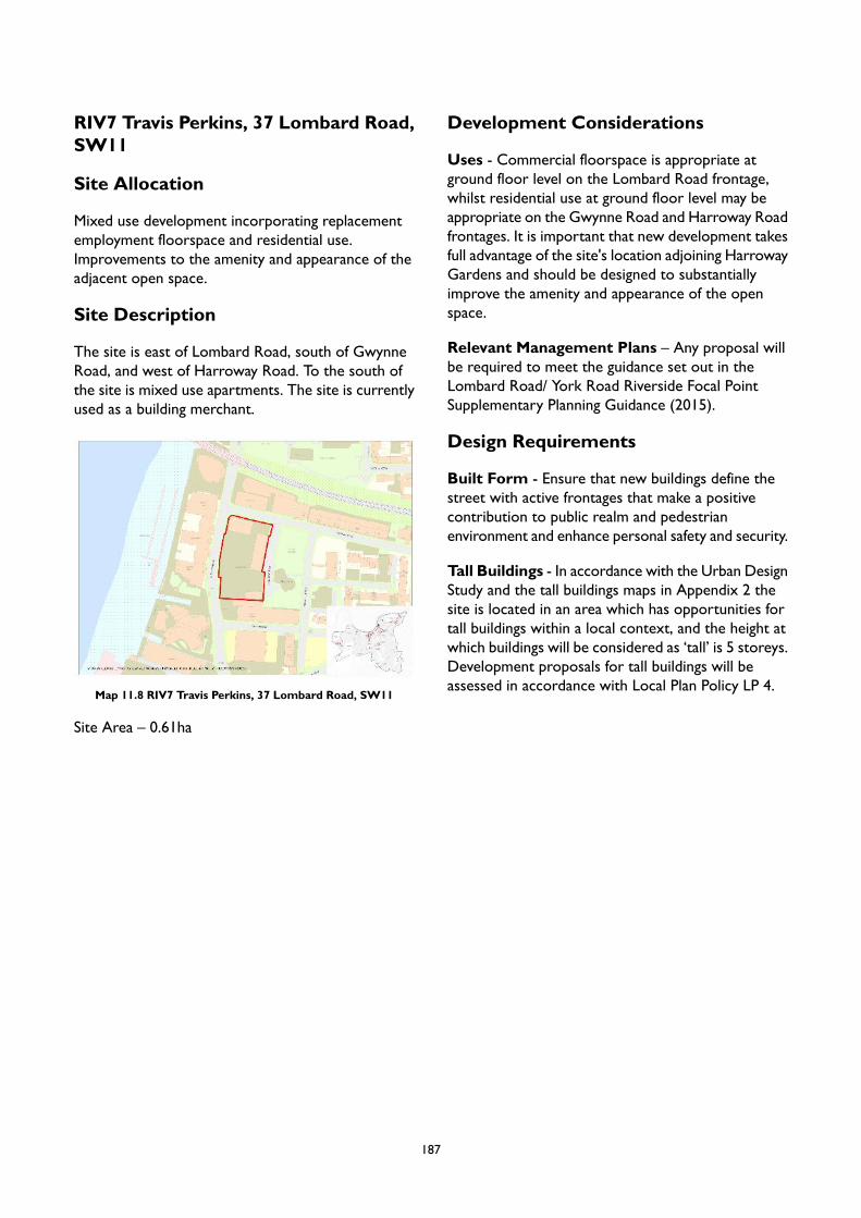
RIV7 Travis Perkins, 37 Lombard Road,SW11
Site Allocation
Mixed use development incorporating replacementemployment floorspace and residential use.Improvements to the amenity and appearance of theadjacent open space.
Site Description
The site is east of Lombard Road, south of GwynneRoad, and west of Harroway Road. To the south ofthe site is mixed use apartments. The site is currentlyused as a building merchant.
Map 11.8 RIV7 Travis Perkins, 37 Lombard Road, SW11
Site Area – 0.61ha
Development Considerations
Uses - Commercial floorspace is appropriate atground floor level on the Lombard Road frontage,whilst residential use at ground floor level may beappropriate on the Gwynne Road and Harroway Roadfrontages. It is important that new development takesfull advantage of the site's location adjoining HarrowayGardens and should be designed to substantiallyimprove the amenity and appearance of the openspace.
Relevant Management Plans – Any proposal willbe required to meet the guidance set out in theLombard Road/ York Road Riverside Focal PointSupplementary Planning Guidance (2015).
Design Requirements
Built Form - Ensure that new buildings define thestreet with active frontages that make a positivecontribution to public realm and pedestrianenvironment and enhance personal safety and security.
Tall Buildings - In accordance with the Urban DesignStudy and the tall buildings maps in Appendix 2 thesite is located in an area which has opportunities fortall buildings within a local context, and the height atwhich buildings will be considered as ‘tall’ is 5 storeys.Development proposals for tall buildings will beassessed in accordance with Local Plan Policy LP 4.
187

RIV8 19 Lombard Road, 80 GwynneRoad, SW11
Site Allocation
Mixed use development incorporating replacementemployment floorspace and residential use.
Site Description
The site is north of Gwynne Road, east of LombardRoad, and south of train tracks that cross from theRiver Thames. To the east of the site are apartments.The site is currently used for industry and warehouse/storage.
Map 11.9 RIV8 19 Lombard Road, 80 Gwynne Road, SW11
Site Area – 0.3ha
Development Considerations
Relevant Management Plans – Any proposal willbe required to meet the guidance set out in theLombard Road/ York Road Riverside Focal PointSupplementary Planning Guidance (2015).
Design Requirements
Built Form - Buildings fronting Lombard Road andGwynne Road should define the street frontages withactive uses at ground floor level. There is potentialfor new public realm on the Lombard Road frontage,especially at the junction with Gwynne Road.
Movement – There is potential to improvepedestrian and cyclist crossing facilities at the junctionof Gwynne Road and Lombard Road to allow foraccess to the Thames riverside.
Context – The development of the adjoining site at12-15 Lombard Road has enhanced access to theriverside and provided new public realm. This siteshould be developed to coordinate with and extendthese improvements.
Identity and Architectural Expression -Enhancement of the appearance of the brick railwaybridge / viaduct will be sought and mature trees onthe south facing railway embankment adjoining thesite should be retained.
Tall Buildings - In accordance with the Urban DesignStudy and the tall buildings maps in Appendix 2 thesite is located in an area which has opportunities fortall buildings within a local context, and the height atwhich buildings will be considered as ‘tall’ is 5 storeys.Development proposals for tall buildings will beassessed in accordance with Local Plan Policy LP 4.
188
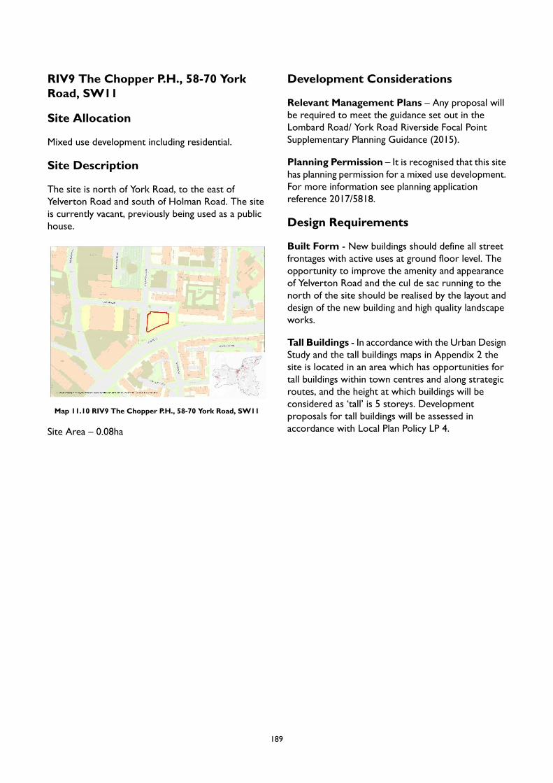
RIV9 The Chopper P.H., 58-70 YorkRoad, SW11
Site Allocation
Mixed use development including residential.
Site Description
The site is north of York Road, to the east ofYelverton Road and south of Holman Road. The siteis currently vacant, previously being used as a publichouse.
Map 11.10 RIV9 The Chopper P.H., 58-70 York Road, SW11
Site Area – 0.08ha
Development Considerations
Relevant Management Plans – Any proposal willbe required to meet the guidance set out in theLombard Road/ York Road Riverside Focal PointSupplementary Planning Guidance (2015).
Planning Permission – It is recognised that this sitehas planning permission for a mixed use development.For more information see planning applicationreference 2017/5818.
Design Requirements
Built Form - New buildings should define all streetfrontages with active uses at ground floor level. Theopportunity to improve the amenity and appearanceof Yelverton Road and the cul de sac running to thenorth of the site should be realised by the layout anddesign of the new building and high quality landscapeworks.
Tall Buildings - In accordance with the Urban DesignStudy and the tall buildings maps in Appendix 2 thesite is located in an area which has opportunities fortall buildings within town centres and along strategicroutes, and the height at which buildings will beconsidered as ‘tall’ is 5 storeys. Developmentproposals for tall buildings will be assessed inaccordance with Local Plan Policy LP 4.
189
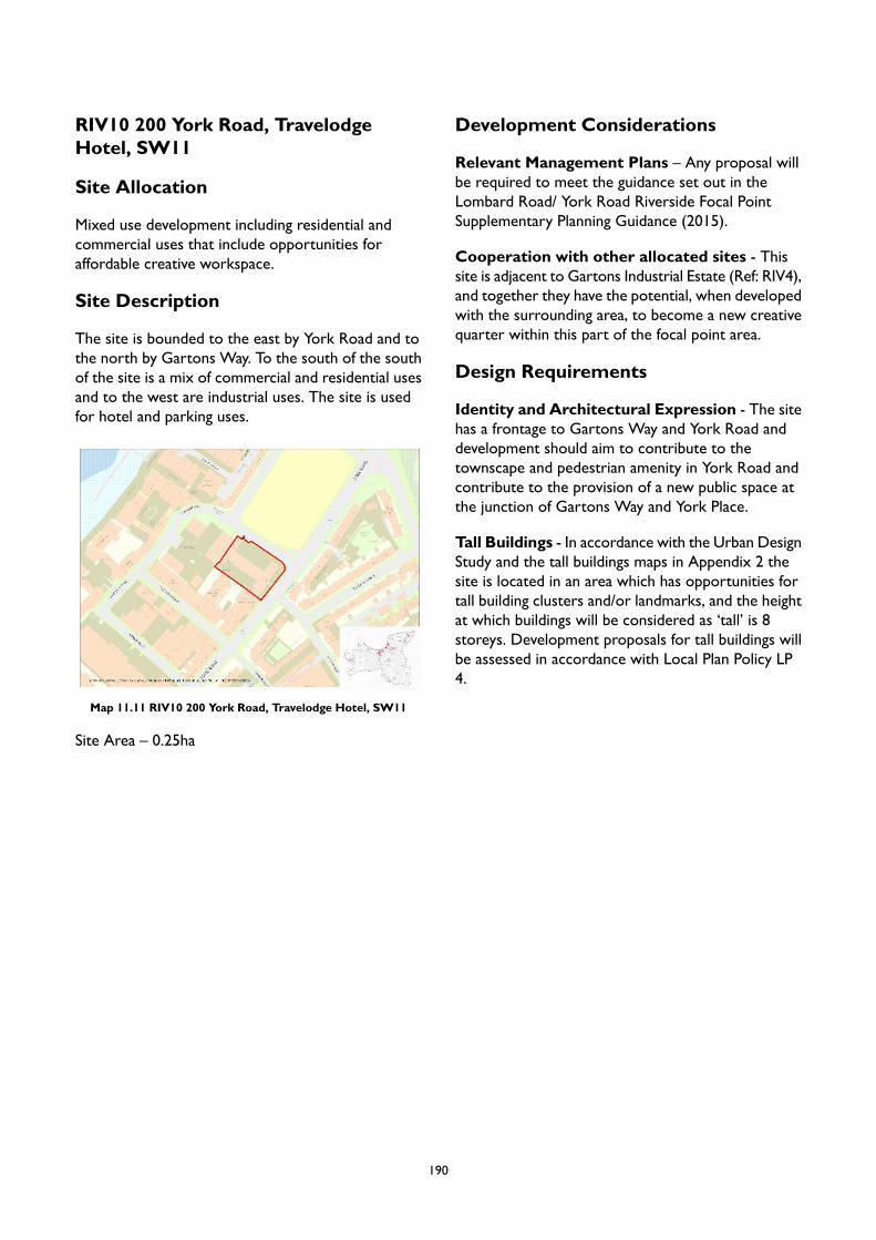
RIV10 200 York Road, TravelodgeHotel, SW11
Site Allocation
Mixed use development including residential andcommercial uses that include opportunities foraffordable creative workspace.
Site Description
The site is bounded to the east by York Road and tothe north by Gartons Way. To the south of the southof the site is a mix of commercial and residential usesand to the west are industrial uses. The site is usedfor hotel and parking uses.
Map 11.11 RIV10 200 York Road, Travelodge Hotel, SW11
Site Area – 0.25ha
Development Considerations
Relevant Management Plans – Any proposal willbe required to meet the guidance set out in theLombard Road/ York Road Riverside Focal PointSupplementary Planning Guidance (2015).
Cooperation with other allocated sites - Thissite is adjacent to Gartons Industrial Estate (Ref: RIV4),and together they have the potential, when developedwith the surrounding area, to become a new creativequarter within this part of the focal point area.
Design Requirements
Identity and Architectural Expression - The sitehas a frontage to Gartons Way and York Road anddevelopment should aim to contribute to thetownscape and pedestrian amenity in York Road andcontribute to the provision of a new public space atthe junction of Gartons Way and York Place.
Tall Buildings - In accordance with the Urban DesignStudy and the tall buildings maps in Appendix 2 thesite is located in an area which has opportunities fortall building clusters and/or landmarks, and the heightat which buildings will be considered as ‘tall’ is 8storeys. Development proposals for tall buildings willbe assessed in accordance with Local Plan Policy LP4.
190
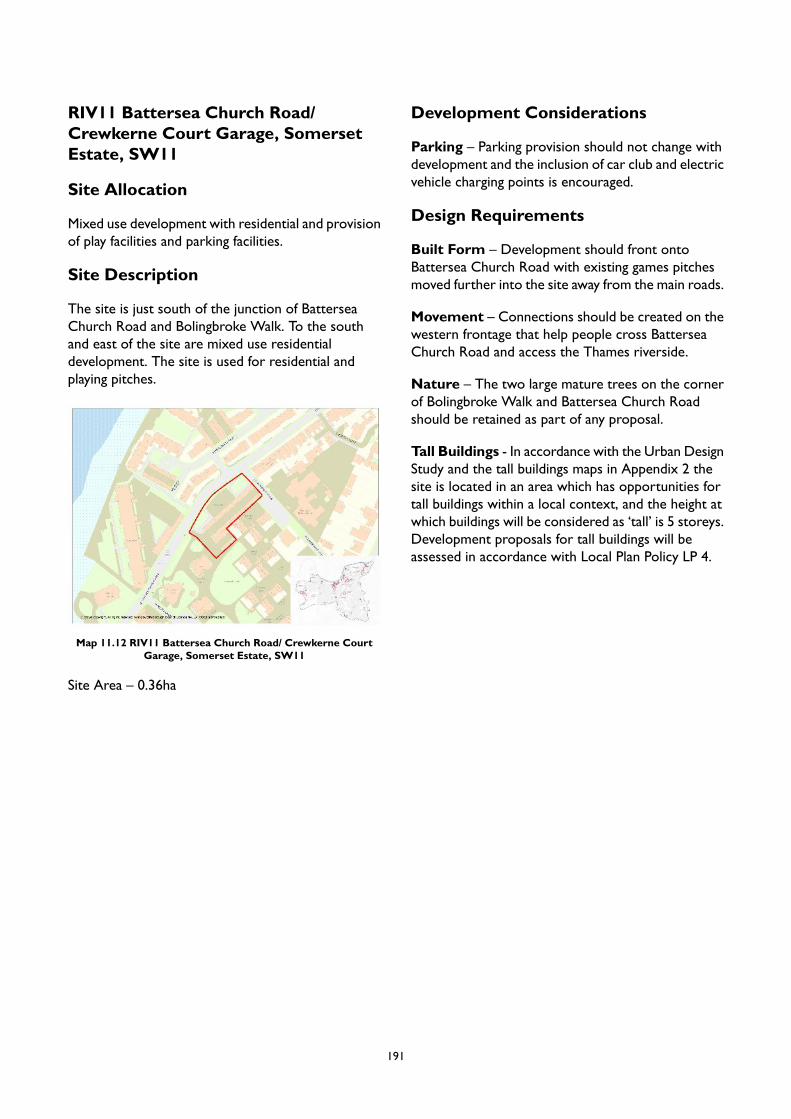
RIV11 Battersea Church Road/Crewkerne Court Garage, SomersetEstate, SW11
Site Allocation
Mixed use development with residential and provisionof play facilities and parking facilities.
Site Description
The site is just south of the junction of BatterseaChurch Road and Bolingbroke Walk. To the southand east of the site are mixed use residentialdevelopment. The site is used for residential andplaying pitches.
Map 11.12 RIV11 Battersea Church Road/ Crewkerne CourtGarage, Somerset Estate, SW11
Site Area – 0.36ha
Development Considerations
Parking – Parking provision should not change withdevelopment and the inclusion of car club and electricvehicle charging points is encouraged.
Design Requirements
Built Form – Development should front ontoBattersea Church Road with existing games pitchesmoved further into the site away from the main roads.
Movement – Connections should be created on thewestern frontage that help people cross BatterseaChurch Road and access the Thames riverside.
Nature – The two large mature trees on the cornerof Bolingbroke Walk and Battersea Church Roadshould be retained as part of any proposal.
Tall Buildings - In accordance with the Urban DesignStudy and the tall buildings maps in Appendix 2 thesite is located in an area which has opportunities fortall buildings within a local context, and the height atwhich buildings will be considered as ‘tall’ is 5 storeys.Development proposals for tall buildings will beassessed in accordance with Local Plan Policy LP 4.
191
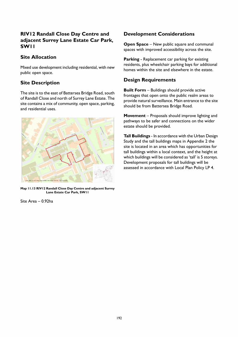
RIV12 Randall Close Day Centre andadjacent Surrey Lane Estate Car Park,SW11
Site Allocation
Mixed use development including residential, with newpublic open space.
Site Description
The site is to the east of Battersea Bridge Road, southof Randall Close and north of Surrey Lane Estate. Thesite contains a mix of community, open space, parking,and residential uses.
Map 11.13 RIV12 Randall Close Day Centre and adjacent SurreyLane Estate Car Park, SW11
Site Area – 0.92ha
Development Considerations
Open Space – New public square and communalspaces with improved accessibility across the site.
Parking - Replacement car parking for existingresidents, plus wheelchair parking bays for additionalhomes within the site and elsewhere in the estate.
Design Requirements
Built Form – Buildings should provide activefrontages that open onto the public realm areas toprovide natural surveillance. Main entrance to the siteshould be from Battersea Bridge Road.
Movement – Proposals should improve lighting andpathways to be safer and connections on the widerestate should be provided.
Tall Buildings - In accordance with the Urban DesignStudy and the tall buildings maps in Appendix 2 thesite is located in an area which has opportunities fortall buildings within a local context, and the height atwhich buildings will be considered as ‘tall’ is 5 storeys.Development proposals for tall buildings will beassessed in accordance with Local Plan Policy LP 4.
192
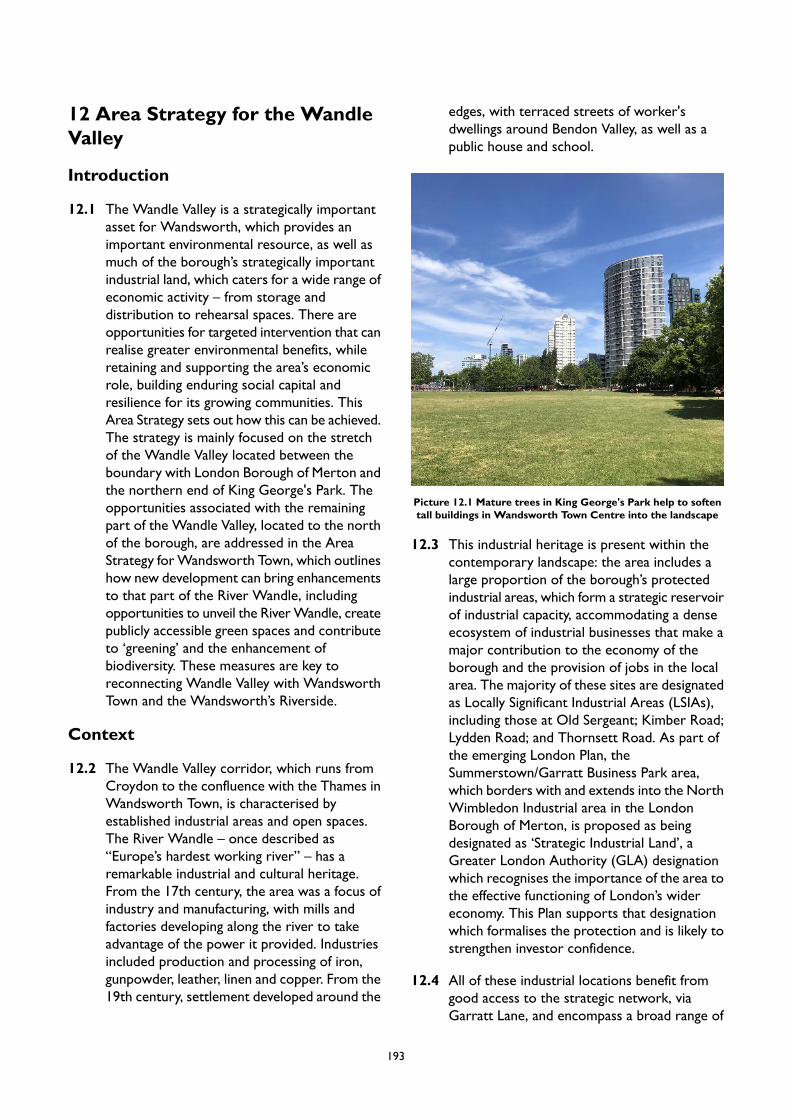
12 Area Strategy for the WandleValley
Introduction
12.1 The Wandle Valley is a strategically importantasset for Wandsworth, which provides animportant environmental resource, as well asmuch of the borough’s strategically importantindustrial land, which caters for a wide range ofeconomic activity – from storage anddistribution to rehearsal spaces. There areopportunities for targeted intervention that canrealise greater environmental benefits, whileretaining and supporting the area’s economicrole, building enduring social capital andresilience for its growing communities. ThisArea Strategy sets out how this can be achieved.The strategy is mainly focused on the stretchof the Wandle Valley located between theboundary with London Borough of Merton andthe northern end of King George's Park. Theopportunities associated with the remainingpart of the Wandle Valley, located to the northof the borough, are addressed in the AreaStrategy forWandsworth Town, which outlineshow new development can bring enhancementsto that part of the River Wandle, includingopportunities to unveil the RiverWandle, createpublicly accessible green spaces and contributeto ‘greening’ and the enhancement ofbiodiversity. These measures are key toreconnecting Wandle Valley with WandsworthTown and the Wandsworth’s Riverside.
Context
12.2 The Wandle Valley corridor, which runs fromCroydon to the confluence with the Thames inWandsworth Town, is characterised byestablished industrial areas and open spaces.The River Wandle – once described as“Europe’s hardest working river” – has aremarkable industrial and cultural heritage.From the 17th century, the area was a focus ofindustry and manufacturing, with mills andfactories developing along the river to takeadvantage of the power it provided. Industriesincluded production and processing of iron,gunpowder, leather, linen and copper. From the19th century, settlement developed around the
edges, with terraced streets of worker'sdwellings around Bendon Valley, as well as apublic house and school.
Picture 12.1 Mature trees in King George's Park help to softentall buildings in Wandsworth Town Centre into the landscape
12.3 This industrial heritage is present within thecontemporary landscape: the area includes alarge proportion of the borough’s protectedindustrial areas, which form a strategic reservoirof industrial capacity, accommodating a denseecosystem of industrial businesses that make amajor contribution to the economy of theborough and the provision of jobs in the localarea. The majority of these sites are designatedas Locally Significant Industrial Areas (LSIAs),including those at Old Sergeant; Kimber Road;Lydden Road; and Thornsett Road. As part ofthe emerging London Plan, theSummerstown/Garratt Business Park area,which borders with and extends into the NorthWimbledon Industrial area in the LondonBorough of Merton, is proposed as beingdesignated as ‘Strategic Industrial Land’, aGreater London Authority (GLA) designationwhich recognises the importance of the area tothe effective functioning of London’s widereconomy. This Plan supports that designationwhich formalises the protection and is likely tostrengthen investor confidence.
12.4 All of these industrial locations benefit fromgood access to the strategic network, viaGarratt Lane, and encompass a broad range of
193
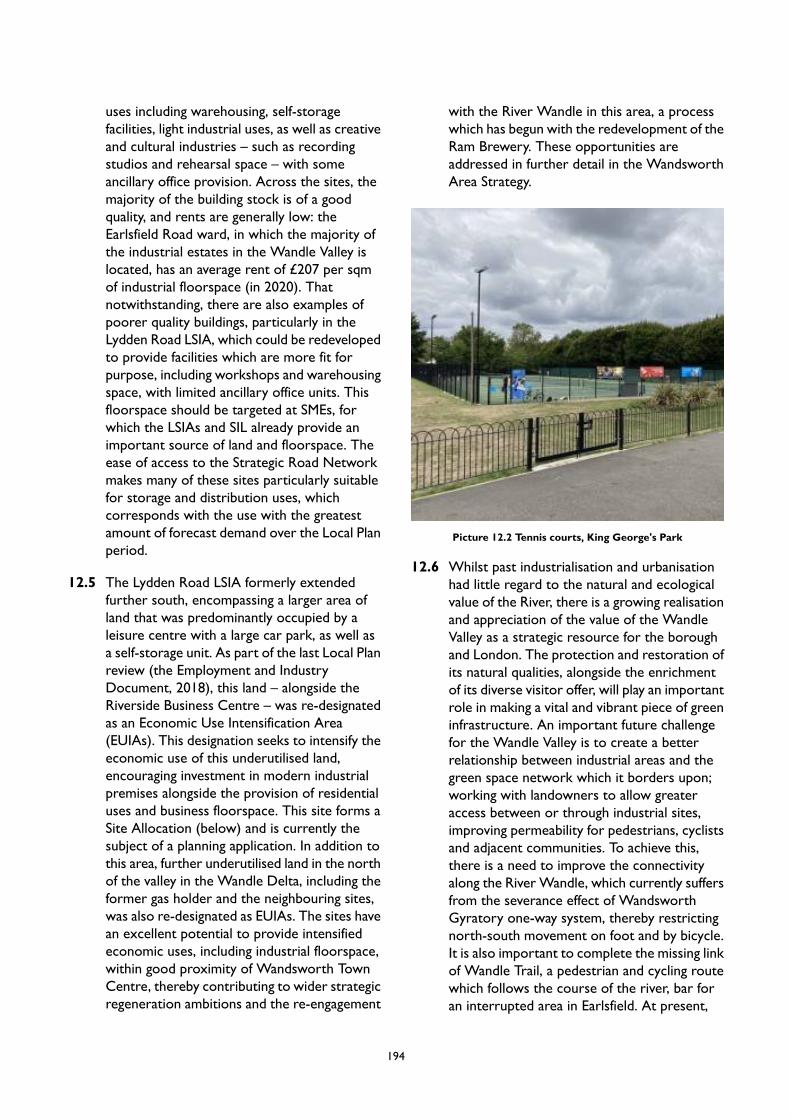
uses including warehousing, self-storagefacilities, light industrial uses, as well as creativeand cultural industries – such as recordingstudios and rehearsal space – with someancillary office provision. Across the sites, themajority of the building stock is of a goodquality, and rents are generally low: theEarlsfield Road ward, in which the majority ofthe industrial estates in the Wandle Valley islocated, has an average rent of £207 per sqmof industrial floorspace (in 2020). Thatnotwithstanding, there are also examples ofpoorer quality buildings, particularly in theLydden Road LSIA, which could be redevelopedto provide facilities which are more fit forpurpose, including workshops and warehousingspace, with limited ancillary office units. Thisfloorspace should be targeted at SMEs, forwhich the LSIAs and SIL already provide animportant source of land and floorspace. Theease of access to the Strategic Road Networkmakes many of these sites particularly suitablefor storage and distribution uses, whichcorresponds with the use with the greatestamount of forecast demand over the Local Planperiod.
12.5 The Lydden Road LSIA formerly extendedfurther south, encompassing a larger area ofland that was predominantly occupied by aleisure centre with a large car park, as well asa self-storage unit. As part of the last Local Planreview (the Employment and IndustryDocument, 2018), this land – alongside theRiverside Business Centre – was re-designatedas an Economic Use Intensification Area(EUIAs). This designation seeks to intensify theeconomic use of this underutilised land,encouraging investment in modern industrialpremises alongside the provision of residentialuses and business floorspace. This site forms aSite Allocation (below) and is currently thesubject of a planning application. In addition tothis area, further underutilised land in the northof the valley in the Wandle Delta, including theformer gas holder and the neighbouring sites,was also re-designated as EUIAs. The sites havean excellent potential to provide intensifiedeconomic uses, including industrial floorspace,within good proximity of Wandsworth TownCentre, thereby contributing to wider strategicregeneration ambitions and the re-engagement
with the River Wandle in this area, a processwhich has begun with the redevelopment of theRam Brewery. These opportunities areaddressed in further detail in the WandsworthArea Strategy.
Picture 12.2 Tennis courts, King George's Park
12.6 Whilst past industrialisation and urbanisationhad little regard to the natural and ecologicalvalue of the River, there is a growing realisationand appreciation of the value of the WandleValley as a strategic resource for the boroughand London. The protection and restoration ofits natural qualities, alongside the enrichmentof its diverse visitor offer, will play an importantrole in making a vital and vibrant piece of greeninfrastructure. An important future challengefor the Wandle Valley is to create a betterrelationship between industrial areas and thegreen space network which it borders upon;working with landowners to allow greateraccess between or through industrial sites,improving permeability for pedestrians, cyclistsand adjacent communities. To achieve this,there is a need to improve the connectivityalong the River Wandle, which currently suffersfrom the severance effect of WandsworthGyratory one-way system, thereby restrictingnorth-south movement on foot and by bicycle.It is also important to complete the missing linkof Wandle Trail, a pedestrian and cycling routewhich follows the course of the river, bar foran interrupted area in Earlsfield. At present,
194
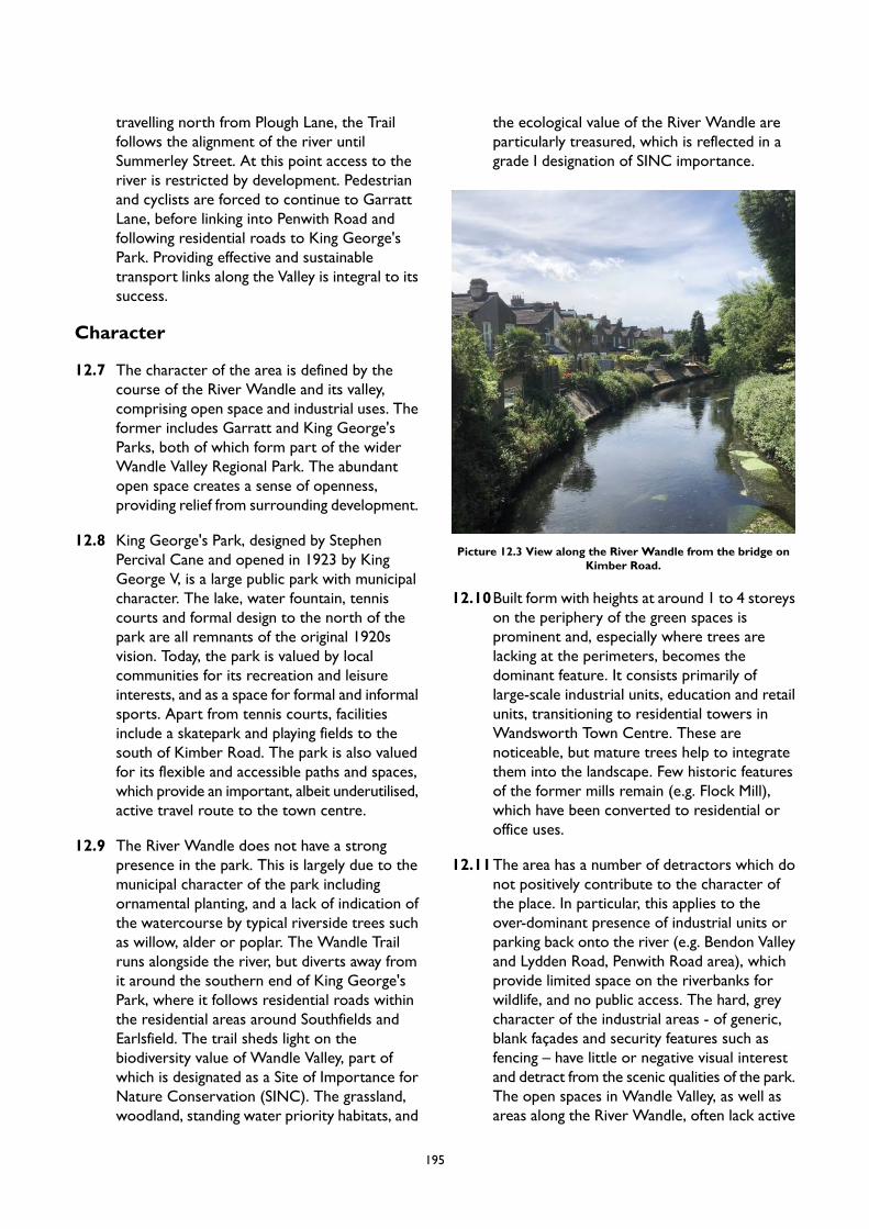
travelling north from Plough Lane, the Trailfollows the alignment of the river untilSummerley Street. At this point access to theriver is restricted by development. Pedestrianand cyclists are forced to continue to GarrattLane, before linking into Penwith Road andfollowing residential roads to King George'sPark. Providing effective and sustainabletransport links along the Valley is integral to itssuccess.
Character
12.7 The character of the area is defined by thecourse of the River Wandle and its valley,comprising open space and industrial uses. Theformer includes Garratt and King George'sParks, both of which form part of the widerWandle Valley Regional Park. The abundantopen space creates a sense of openness,providing relief from surrounding development.
12.8 King George's Park, designed by StephenPercival Cane and opened in 1923 by KingGeorge V, is a large public park with municipalcharacter. The lake, water fountain, tenniscourts and formal design to the north of thepark are all remnants of the original 1920svision. Today, the park is valued by localcommunities for its recreation and leisureinterests, and as a space for formal and informalsports. Apart from tennis courts, facilitiesinclude a skatepark and playing fields to thesouth of Kimber Road. The park is also valuedfor its flexible and accessible paths and spaces,which provide an important, albeit underutilised,active travel route to the town centre.
12.9 The River Wandle does not have a strongpresence in the park. This is largely due to themunicipal character of the park includingornamental planting, and a lack of indication ofthe watercourse by typical riverside trees suchas willow, alder or poplar. The Wandle Trailruns alongside the river, but diverts away fromit around the southern end of King George'sPark, where it follows residential roads withinthe residential areas around Southfields andEarlsfield. The trail sheds light on thebiodiversity value of Wandle Valley, part ofwhich is designated as a Site of Importance forNature Conservation (SINC). The grassland,woodland, standing water priority habitats, and
the ecological value of the River Wandle areparticularly treasured, which is reflected in agrade I designation of SINC importance.
Picture 12.3 View along the River Wandle from the bridge onKimber Road.
12.10Built form with heights at around 1 to 4 storeyson the periphery of the green spaces isprominent and, especially where trees arelacking at the perimeters, becomes thedominant feature. It consists primarily oflarge-scale industrial units, education and retailunits, transitioning to residential towers inWandsworth Town Centre. These arenoticeable, but mature trees help to integratethem into the landscape. Few historic featuresof the former mills remain (e.g. Flock Mill),which have been converted to residential oroffice uses.
12.11The area has a number of detractors which donot positively contribute to the character ofthe place. In particular, this applies to theover-dominant presence of industrial units orparking back onto the river (e.g. Bendon Valleyand Lydden Road, Penwith Road area), whichprovide limited space on the riverbanks forwildlife, and no public access. The hard, greycharacter of the industrial areas - of generic,blank façades and security features such asfencing – have little or negative visual interestand detract from the scenic qualities of the park.The open spaces in Wandle Valley, as well asareas along the River Wandle, often lack active
195
frontage. For instance, the urbanised part of theWandle Valley near Wandsworth Town hashigh hard edges and is faced by backs ofbuildings, whereas the open spaces west of theHenry Prince Estate are separated from theriver with high walls with little relationship tothe river. As a result, much of the river todayis characterised by a backland quality, and issomewhat hidden within its urban environment.
Vision
12.12This Area Strategy will meet the vision andobjectives of the Local Plan by:
balancing the demands for formal andinformal recreation with the need toconserve features of nature conservationand cultural heritage importance;
enhancing the green space network,creating a place, rich in heritage, wherepeople are proud to live, work andplay;
maximising opportunities for healthy livingby improving access and quantity of goodquality public realm and greenspace;
enhancing the local economy by usingthe environment to encourageemployment, training, apprenticeshipsand enterprise; and
protecting the strategic reservoir ofindustrial land and premises withinthe area, while creating opportunities tointensify this provision.
PM10 The Wandle Valley
Placemaking
A. The area has the potential to incorporate targeted growth and new development as long as this:
1. does not reduce the quantity or quality of open space;2. respects the setting of the parks; and3. respects the recreation and leisure function of the area.
B. The Urban Design Study has identified appropriate locations for tall buildings in Wandle Valley. Thebroad locations are identified in Appendix 2. Any proposal for a tall building will be subject to addressingthe requirements of Policy LP 4 (Tall Buildings) as well as other policies in the Plan as applicable.
C. New development along the Wandle Valley should respect the small scale of the river corridor, offerpublic access and provide positive frontage to the riverside. Future proposals must ensure a highdegree of permeability for pedestrians and cyclists, which promotes heritage and natural trails andencourages linkages along the watercourse.
Smart Growth
A. New residential accommodation in Wandle Valley will help meet the borough’s housing target, as setout in Local Plan Policy LP 24. Development in this area is expected to provide at least 4,716 homesby 2037/38 (the entire plan period), of which 3,935 are expected to be provided by 2032.33 (10-yearhousing supply). These figures reflect the projected completions on large, small and windfall sitesrather than total capacity of Site Allocations. Projected completions on sites located in other AreaStrategies but also covered as part of this overarching Area Strategy are included.
B. Designated industrial land within the Wandle Valley will continue to provide a strategic reservoir ofland for economic uses, including logistics, services and industry, and land for waste management, andwill be protected in this capacity. The intensification of industrial uses within such locations, throughthe more efficient use of space and the development of multi-storey schemes, is supported.
196
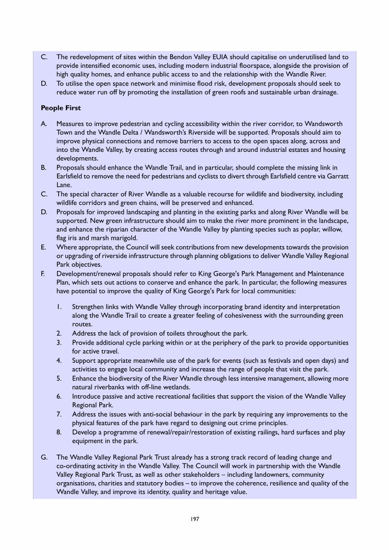
C. The redevelopment of sites within the Bendon Valley EUIA should capitalise on underutilised land toprovide intensified economic uses, including modern industrial floorspace, alongside the provision ofhigh quality homes, and enhance public access to and the relationship with the Wandle River.
D. To utilise the open space network and minimise flood risk, development proposals should seek toreduce water run off by promoting the installation of green roofs and sustainable urban drainage.
People First
A. Measures to improve pedestrian and cycling accessibility within the river corridor, to WandsworthTown and the Wandle Delta / Wandsworth’s Riverside will be supported. Proposals should aim toimprove physical connections and remove barriers to access to the open spaces along, across andinto the Wandle Valley, by creating access routes through and around industrial estates and housingdevelopments.
B. Proposals should enhance the Wandle Trail, and in particular, should complete the missing link inEarlsfield to remove the need for pedestrians and cyclists to divert through Earlsfield centre via GarrattLane.
C. The special character of River Wandle as a valuable recourse for wildlife and biodiversity, includingwildlife corridors and green chains, will be preserved and enhanced.
D. Proposals for improved landscaping and planting in the existing parks and along River Wandle will besupported. New green infrastructure should aim to make the river more prominent in the landscape,and enhance the riparian character of the Wandle Valley by planting species such as poplar, willow,flag iris and marsh marigold.
E. Where appropriate, the Council will seek contributions from new developments towards the provisionor upgrading of riverside infrastructure through planning obligations to deliver Wandle Valley RegionalPark objectives.
F. Development/renewal proposals should refer to King George's Park Management and MaintenancePlan, which sets out actions to conserve and enhance the park. In particular, the following measureshave potential to improve the quality of King George's Park for local communities:
1. Strengthen links with Wandle Valley through incorporating brand identity and interpretationalong the Wandle Trail to create a greater feeling of cohesiveness with the surrounding greenroutes.
2. Address the lack of provision of toilets throughout the park.3. Provide additional cycle parking within or at the periphery of the park to provide opportunities
for active travel.4. Support appropriate meanwhile use of the park for events (such as festivals and open days) and
activities to engage local community and increase the range of people that visit the park.5. Enhance the biodiversity of the River Wandle through less intensive management, allowing more
natural riverbanks with off-line wetlands.6. Introduce passive and active recreational facilities that support the vision of the Wandle Valley
Regional Park.7. Address the issues with anti-social behaviour in the park by requiring any improvements to the
physical features of the park have regard to designing out crime principles.8. Develop a programme of renewal/repair/restoration of existing railings, hard surfaces and play
equipment in the park.
G. The Wandle Valley Regional Park Trust already has a strong track record of leading change andco-ordinating activity in the Wandle Valley. The Council will work in partnership with the WandleValley Regional Park Trust, as well as other stakeholders – including landowners, communityorganisations, charities and statutory bodies – to improve the coherence, resilience and quality of theWandle Valley, and improve its identity, quality and heritage value.
197

198
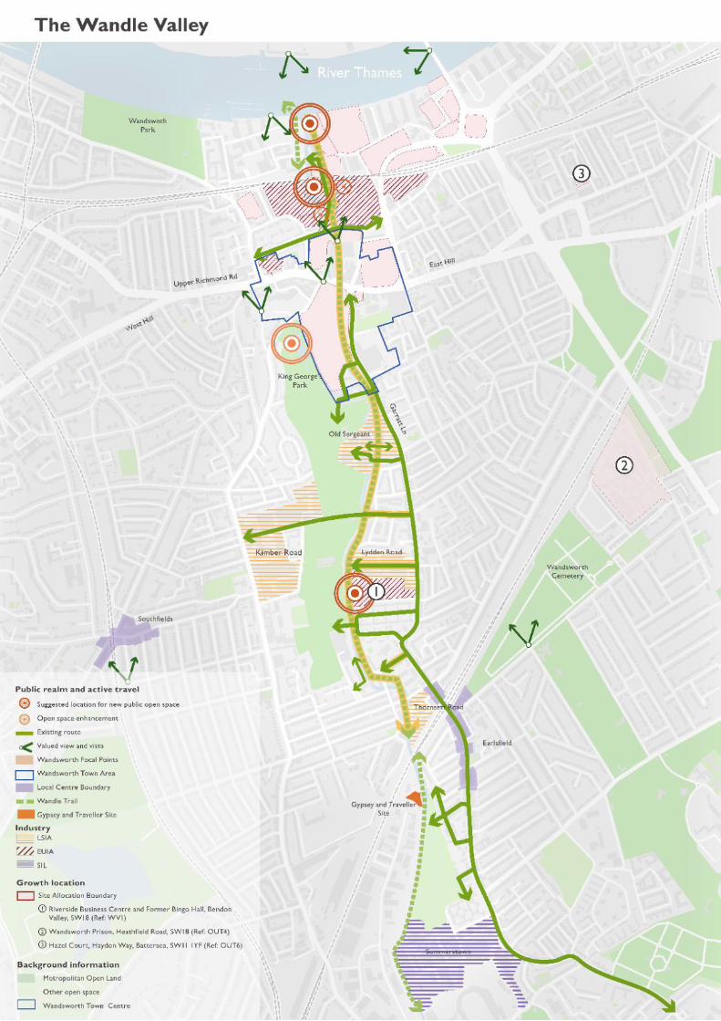
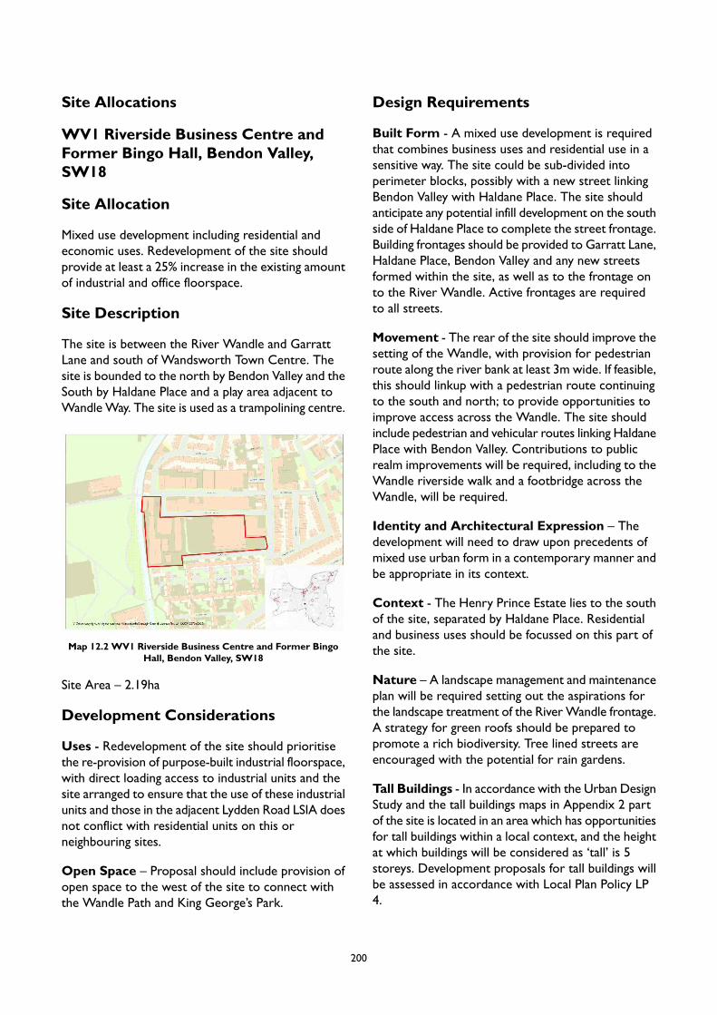
Site Allocations
WV1 Riverside Business Centre andFormer Bingo Hall, Bendon Valley,SW18
Site Allocation
Mixed use development including residential andeconomic uses. Redevelopment of the site shouldprovide at least a 25% increase in the existing amountof industrial and office floorspace.
Site Description
The site is between the River Wandle and GarrattLane and south of Wandsworth Town Centre. Thesite is bounded to the north by Bendon Valley and theSouth by Haldane Place and a play area adjacent toWandleWay. The site is used as a trampolining centre.
Map 12.2 WV1 Riverside Business Centre and Former BingoHall, Bendon Valley, SW18
Site Area – 2.19ha
Development Considerations
Uses - Redevelopment of the site should prioritisethe re-provision of purpose-built industrial floorspace,with direct loading access to industrial units and thesite arranged to ensure that the use of these industrialunits and those in the adjacent Lydden Road LSIA doesnot conflict with residential units on this orneighbouring sites.
Open Space – Proposal should include provision ofopen space to the west of the site to connect withthe Wandle Path and King George’s Park.
Design Requirements
Built Form - A mixed use development is requiredthat combines business uses and residential use in asensitive way. The site could be sub-divided intoperimeter blocks, possibly with a new street linkingBendon Valley with Haldane Place. The site shouldanticipate any potential infill development on the southside of Haldane Place to complete the street frontage.Building frontages should be provided to Garratt Lane,Haldane Place, Bendon Valley and any new streetsformed within the site, as well as to the frontage onto the River Wandle. Active frontages are requiredto all streets.
Movement - The rear of the site should improve thesetting of the Wandle, with provision for pedestrianroute along the river bank at least 3m wide. If feasible,this should linkup with a pedestrian route continuingto the south and north; to provide opportunities toimprove access across the Wandle. The site shouldinclude pedestrian and vehicular routes linking HaldanePlace with Bendon Valley. Contributions to publicrealm improvements will be required, including to theWandle riverside walk and a footbridge across theWandle, will be required.
Identity and Architectural Expression – Thedevelopment will need to draw upon precedents ofmixed use urban form in a contemporary manner andbe appropriate in its context.
Context - The Henry Prince Estate lies to the southof the site, separated by Haldane Place. Residentialand business uses should be focussed on this part ofthe site.
Nature – A landscape management and maintenanceplan will be required setting out the aspirations forthe landscape treatment of the RiverWandle frontage.A strategy for green roofs should be prepared topromote a rich biodiversity. Tree lined streets areencouraged with the potential for rain gardens.
Tall Buildings - In accordance with the Urban DesignStudy and the tall buildings maps in Appendix 2 partof the site is located in an area which has opportunitiesfor tall buildings within a local context, and the heightat which buildings will be considered as ‘tall’ is 5storeys. Development proposals for tall buildings willbe assessed in accordance with Local Plan Policy LP4.
200

13 Site Allocations Outside theSpatial Areas
OUT1BalhamHealth Centre, 120 - 124Bedford Hill, London, SW12
Site Allocation
Mixed use development including residential andexpansion of healthcare facilities.
Site Description
The site is south of Balham Spatial Area and is westof Bedford Hill. The site is south of Larch Hill andnorth of Elmfield Road. To the north of the site is achildren's home and to the west are residential homes.The site is used as a health centre, electrical substationand associated parking.
Map 13.1 OUT1 Balham Health Centre, 120 - 124 Bedford Hill,London, SW12
Site Area – 0.25ha
Design Requirements
Built Form - Development will be required toprovide active frontages onto Bedford Hill.
Nature - Existing trees and green space must bereprovided on site.
Tall Buildings - In accordance with the Urban DesignStudy and the tall buildings maps in Appendix 2 theheight at which buildings will be considered as ‘tall’ is5 storeys, and development of 5 storeys and above islikely to be inappropriate. Development proposals fortall buildings will be assessed in accordance with LocalPlan Policy LP 4
201
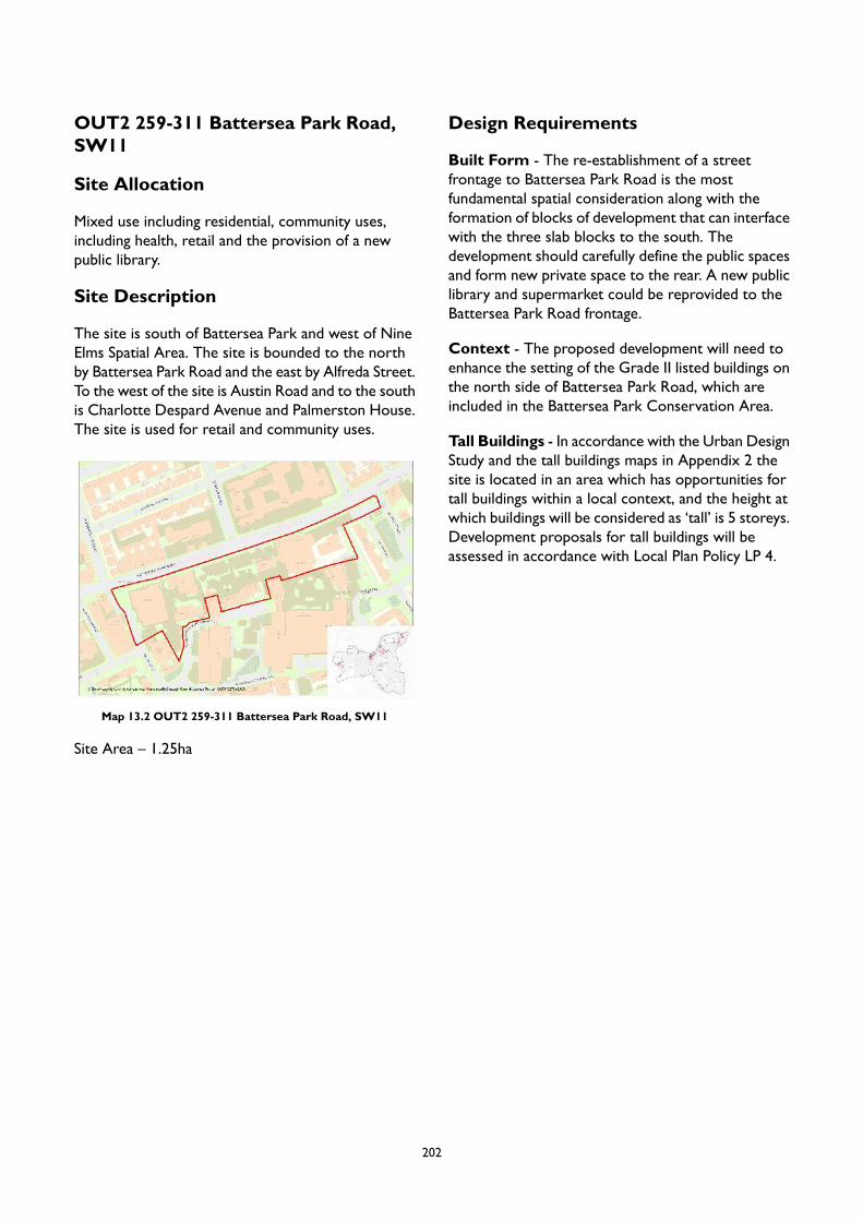
OUT2 259-311 Battersea Park Road,SW11
Site Allocation
Mixed use including residential, community uses,including health, retail and the provision of a newpublic library.
Site Description
The site is south of Battersea Park and west of NineElms Spatial Area. The site is bounded to the northby Battersea Park Road and the east by Alfreda Street.To the west of the site is Austin Road and to the southis Charlotte Despard Avenue and Palmerston House.The site is used for retail and community uses.
Map 13.2 OUT2 259-311 Battersea Park Road, SW11
Site Area – 1.25ha
Design Requirements
Built Form - The re-establishment of a streetfrontage to Battersea Park Road is the mostfundamental spatial consideration along with theformation of blocks of development that can interfacewith the three slab blocks to the south. Thedevelopment should carefully define the public spacesand form new private space to the rear. A new publiclibrary and supermarket could be reprovided to theBattersea Park Road frontage.
Context - The proposed development will need toenhance the setting of the Grade II listed buildings onthe north side of Battersea Park Road, which areincluded in the Battersea Park Conservation Area.
Tall Buildings - In accordance with the Urban DesignStudy and the tall buildings maps in Appendix 2 thesite is located in an area which has opportunities fortall buildings within a local context, and the height atwhich buildings will be considered as ‘tall’ is 5 storeys.Development proposals for tall buildings will beassessed in accordance with Local Plan Policy LP 4.
202
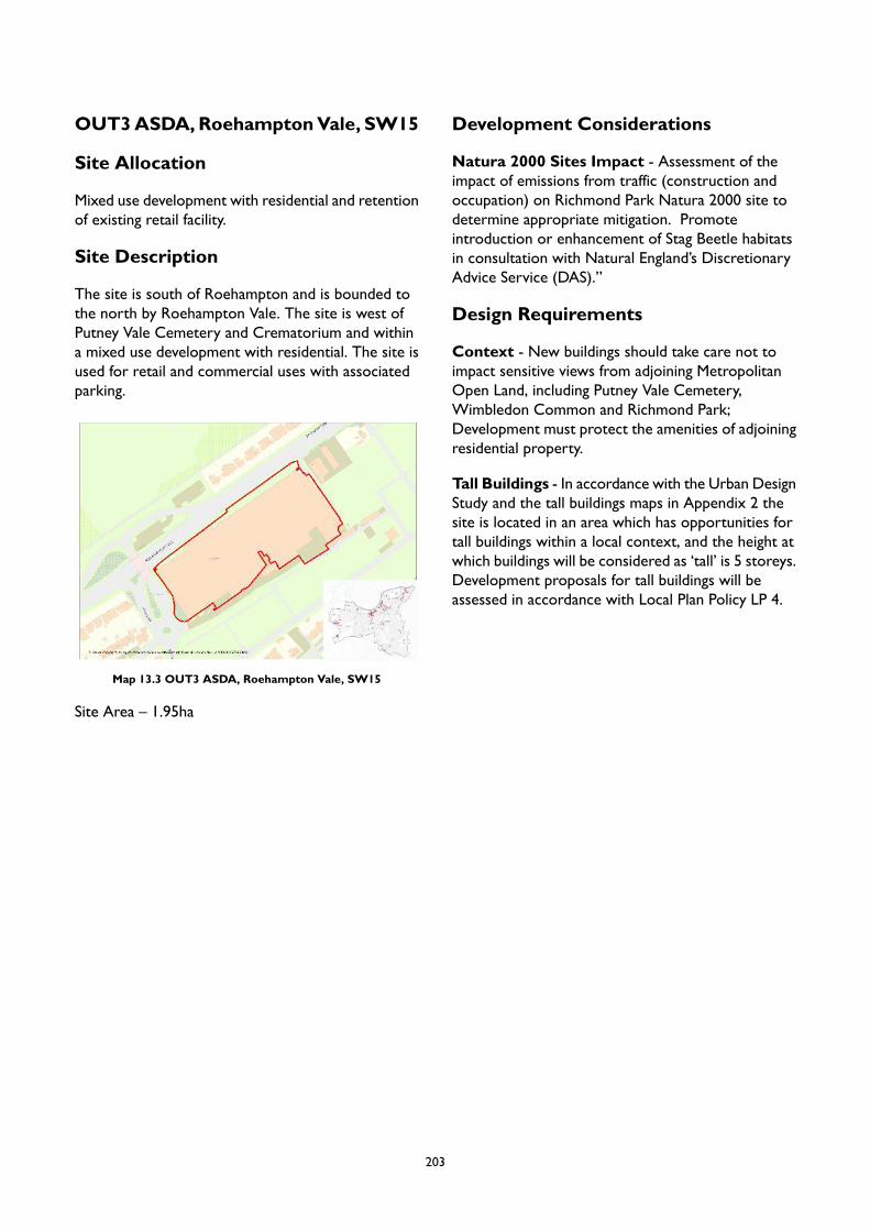
OUT3ASDA,RoehamptonVale, SW15
Site Allocation
Mixed use development with residential and retentionof existing retail facility.
Site Description
The site is south of Roehampton and is bounded tothe north by Roehampton Vale. The site is west ofPutney Vale Cemetery and Crematorium and withina mixed use development with residential. The site isused for retail and commercial uses with associatedparking.
Map 13.3 OUT3 ASDA, Roehampton Vale, SW15
Site Area – 1.95ha
Development Considerations
Natura 2000 Sites Impact - Assessment of theimpact of emissions from traffic (construction andoccupation) on Richmond Park Natura 2000 site todetermine appropriate mitigation. Promoteintroduction or enhancement of Stag Beetle habitatsin consultation with Natural England’s DiscretionaryAdvice Service (DAS).”
Design Requirements
Context - New buildings should take care not toimpact sensitive views from adjoining MetropolitanOpen Land, including Putney Vale Cemetery,Wimbledon Common and Richmond Park;Development must protect the amenities of adjoiningresidential property.
Tall Buildings - In accordance with the Urban DesignStudy and the tall buildings maps in Appendix 2 thesite is located in an area which has opportunities fortall buildings within a local context, and the height atwhich buildings will be considered as ‘tall’ is 5 storeys.Development proposals for tall buildings will beassessed in accordance with Local Plan Policy LP 4.
203
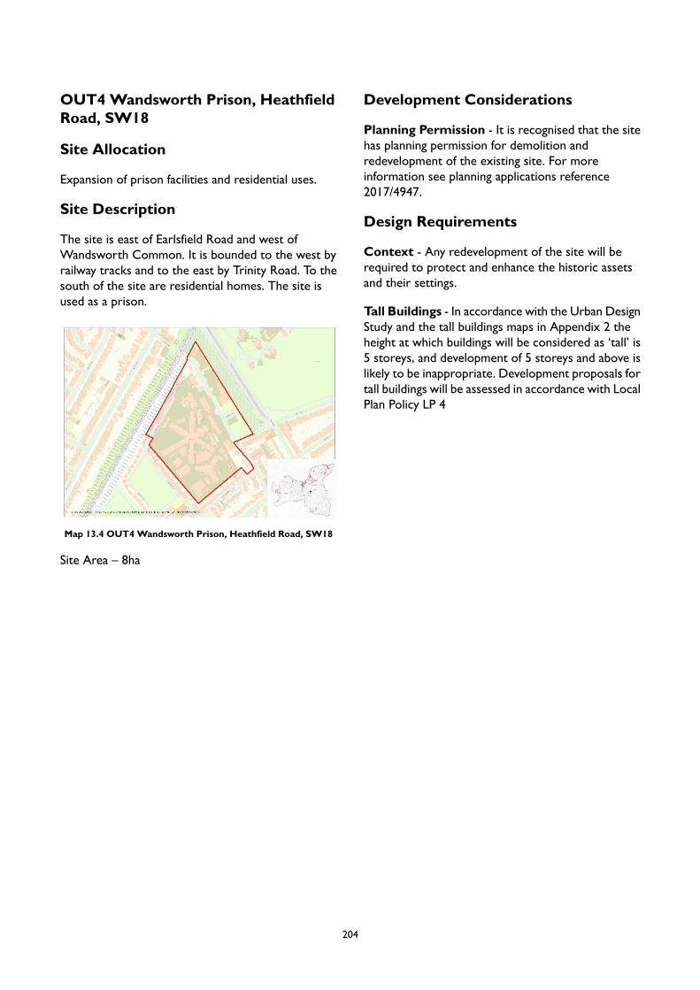
OUT4 Wandsworth Prison, HeathfieldRoad, SW18
Site Allocation
Expansion of prison facilities and residential uses.
Site Description
The site is east of Earlsfield Road and west ofWandsworth Common. It is bounded to the west byrailway tracks and to the east by Trinity Road. To thesouth of the site are residential homes. The site isused as a prison.
Map 13.4 OUT4 Wandsworth Prison, Heathfield Road, SW18
Site Area – 8ha
Development Considerations
Planning Permission - It is recognised that the sitehas planning permission for demolition andredevelopment of the existing site. For moreinformation see planning applications reference2017/4947.
Design Requirements
Context - Any redevelopment of the site will berequired to protect and enhance the historic assetsand their settings.
Tall Buildings - In accordance with the Urban DesignStudy and the tall buildings maps in Appendix 2 theheight at which buildings will be considered as ‘tall’ is5 storeys, and development of 5 storeys and above islikely to be inappropriate. Development proposals fortall buildings will be assessed in accordance with LocalPlan Policy LP 4
204

OUT5 Bridge Lane Medical GroupPractice, 20 Bridge Ln, Battersea,London SW11 3AD
Site Allocation
Mixed use development including residential withreprovision and expansion of healthcare facilities andparking.
Site Description
The site is south west of Battersea Park and to thewest of the junction of Cambridge Road, Bridge Lane,and Battersea Bridge Road. To the north of the siteis Shuttleworth Road and the south is Banbury Street.To the west is are multi storey apartments. The siteis used as a medical centre.
Map 13.5 OUT5 Bridge Lane Medical Group Practice, 20 BridgeLn, Battersea, London SW11 3AD
Site Area – 0.2ha
Development Considerations
Planning Permission - It is recognised that the sitehas planning permission for a two storey extensionwith other uses. For more information see planningapplications reference 2010/0260
Design Requirements
Built Form - Development will be required toprovide active frontages onto Bridge Lane andCambridge Road.
Nature - Existing trees and green space must bereprovided on site.
Tall Buildings - In accordance with the Urban DesignStudy and the tall buildings maps in Appendix 2 theheight at which buildings will be considered as ‘tall’ is6 storeys, and development of 6 storeys and above itis likely to be inappropriate. Development proposalsfor tall buildings will be assessed in accordance withLocal Plan Policy LP 4
205

OUT6 Hazel Court, Haydon Way,Battersea, SW11
Site Allocation
Mixed use development including residential and openspace.
Site Description
The site is east of Wandsworth Town Centre andwest of Clapham Junction. It is north of St John's Hilland is bounded to the east and north by HaydonWay.The site is adjacent to a variety of residential andcommunity uses and is used as a care home.
Map 13.6 OUT6 Hazel Court, Haydon Way, Battersea, SW11
Site Area – 0.2ha
Development Considerations
Open Space – The existing trees and open space onsite should be reprovided fronting onto Haydon Way.
Design Requirements
Context – Proposals will be required to integrateinto the existing residential area in terms of style andmassing.
Tall Buildings - In accordance with the Urban DesignStudy and the tall buildings maps in Appendix 2 theheight at which buildings will be considered as ‘tall’ is5 storeys, and development of 5 storeys and above islikely to be inappropriate. Development proposals fortall buildings will be assessed in accordance with LocalPlan Policy LP 4
206
14 Achieving Design Excellence
Introduction
14.1 Over the last decade there has been afundamental shift in policy regarding density,design and characterisation. Nationally there isa focus on the central role of design which isreflected in revision of the National PlanningPolicy Framework (NPPF) and the publicationof the National Design Guide, the latter ofwhich outlines ten characteristics of welldesigned places to help illustrate how this canbe achieved. Regionally, the emerging LondonPlan also focuses on a design-led approach, withgreater consideration of character, design,accessibility, and existing as well as proposedinfrastructure.
14.2 Within this context, many areas ofWandsworthare undergoing change, and it is important toplan for growth in these areas in a way thatoptimises capacity, delivers high qualitystreetscapes, open spaces and wheredevelopment contributes to the quality of lifeof communities. The quality of much of thetownscape together with the abundance ofgreen space, vibrancy and the diverse range ofcommunities give Wandsworth a uniquecharacter. It is therefore also crucial that localdistinctiveness and character are cherished andreinforced through new development.
14.3 Wandsworth is an ambitious and proactiveborough that desires to drive positive changewith a focus on appropriate, well-planneddelivery. The Council has recently placed agreater emphasis on high quality design,recognising the value it brings in improvingquality of life and creating successful places tolive. Good design encourages the formation ofsocial fabric, human interactions at street level,mitigates climate change and contributes tomental health and wellbeing.With these benefitsin mind, the Council promotes the use ofmasterplans for large scale developments tosecure coherent development strategies, andrequires the use of a design review panel forcomplex development schemes. The Councilhas led the regeneration of the Nine ElmsOpportunity Area, and more recently theregeneration of Winstanley and York Road
estates, and Roehampton Alton Area. Theseprojects have sought to improve housing qualityand standards, and deliver accessible andinclusive places.
14.4 The Council also commissioned an UrbanDesign Study, which brought together a deepunderstanding of the values, character andsensitivity of different parts of the borough withthe reality of future development pressures.The study provides a robust evidence base toinform future planning and assess the potentialfor delivering more housing on both largeredevelopment sites and small individual plotsin more established areas. The guidanceprovided by the study has been embedded inArea Strategies, which directdevelopment towards the most accessible andwell-connected places, focussing on centres,making the most efficient use of the existing andfuture public transport, walking and cyclingnetworks. In addition, the Urban Design Studyhas identified locations where tall buildings willbe an appropriate form of development inprinciple, and place-based design principles fordifferent areas of the borough. This is to ensurethat tall buildings fit into the skyline and respectthe area they sit within. The Council envisagesthat the findings of the Urban Design Study willalso be used to develop design codes (asadvocated by the emerging London Plan) forsome parts of the borough to provide cleardesign guidance for development in those areas.
14.5 This chapter aims to outline general designprinciples on a borough-wide scale, with highquality design being at the heart of this strategy.This does not only include the physical designof buildings and their surrounds, but also theirlayout and access arrangements, sustainabledesign and construction methods, and designwhich responds to local constraints such asflood risk. It builds on the spatial vision set outin this Local Plan, setting out detailed policieson general development principles, urban design,protection of the historic environment, tallbuildings, residential extensions, basements, infilldevelopment, advertisements and shopfronts.These policies are also supplemented by a rangeof Government publications relating to the builtenvironment.
208

LP1 Urban Design
A. Development proposals must reflect and demonstrate that the following principles have been followedhaving had regard to their relevance within the context of the scale and nature of the developmentproposed:
1. Use a design-led approach to optimise the potential of sites so that the layout and arrangementof buildings ensure a high level of physical integration with their surroundings.
2. Ensure that the scale, massing and appearance of the development provides a high quality,sustainable design and layout that enhance and relate positively to the prevailing local characterand the emerging character (where the context is changing).
3. Ensure the urban grain and site layout take account of, and improve, existing patterns ofdevelopment and movement, permeability and street widths in order to, contribute positivelyto wellbeing and enhance active travel.
4. Provide recognisable, permeable and legible street networks, and other spaces with their edgesdefined by buildings, making it easy for anyone to find their way around, and to promoteaccessibility, social interaction, health and wellbeing.
5. Include well-located public spaces that support a wide variety of activities, and provide a highquality public realm, satisfying the criteria set out in the emerging London Plan Policy D8.
6. Ensure that the proposed finishing materials and façade design (such as the degree of symmetry,variety, the pattern and proportions of windows and doors, materiality and their details)demonstrate an appreciation and understanding of vernacular, local character and architecturalprecedents in the local area.
7. Provide a mix of uses including local services and facilities to support daily life.8. Maximise active frontages / ground floor uses facing main pedestrian routes, having regard to
the location of the site.9. Ensure that the service access including for regular maintenance, waste collection, deliveries is
separated from the primary access locations and screened away from key public areas. Groundfloor design should consider the access and egress requirements for all types of users includingpedestrians, cyclists, public transit users, private vehicles as well as service vehicles and personnel.
10. Integrate existing, and incorporate new, natural features into a multifunctional network thatsupports quality of place, biodiversity and water management, and addresses climate changemitigation and resilience. Proposals should be designed and constructed to achieve highsustainability standards, including by seeking to maximise opportunities for urban greening, havingregard to Policy LP 59 (Urban Greening Factor).
11. Minimise opportunities for crime and antisocial behaviour including terrorist activities in asite-specific manner, based on an understanding of the locality and the potential for crime andsafety issues.
12. Achieve the highest standards of accessible and inclusive design, in accordance with the emergingLondon Plan Policy D5.
13. Provide high quality public art as an integral part of the design of new major developments,particularly around gateway locations and where they benefit legibility. The Council will onlypermit development for artworks, statues or memorials where they protect and enhance thelocal character and historic environment and contribute to a harmonious and balanced landscapedesign.
B. The Council will promote good urban design by encouraging:
1. use of its pre-application service;2. developer-led public engagement in advance of the submission of a planning application;
209
3. the design review of appropriate major schemes; and4. the development of masterplans.
14.6 This policy requires a high quality of design forall buildings and spaces in the borough, makingWandsworth a healthier and an even moreattractive place to live, work and visit.Development should be mindful of andsympathetic to the character of the borough,but also able to create new places which reflectcurrent times and needs, and which are fit forthe future.
14.7 The NPPF makes it clear that creating highquality buildings and places is fundamental towhat the planning and development processshould achieve. This is complemented by theNational Design Guide, which illustrates howwell designed places that are beautiful, enduringand successful can be achieved in practice.Recognising the increasing role of design, theCouncil has commissioned an Urban DesignStudy to provide an up-to-date and thoroughunderstanding of the local character in variousareas across the borough. All these documentsand frameworks have helped in informing thispolicy.
14.8 The Local Plan seeks to create buildings andplaces of high quality that will be appreciatedby future generations. High quality design isboth visually interesting and attractive andshould enhance local character. It is not justabout what things look like; it is also about howplaces function and how individual buildings andthe spaces around them contribute to the publicrealm and community wellbeing: the design ofthe places and buildings that make up our localenvironment affects everyone and the qualityof life.
14.9 Achieving a high quality public realm is a keycomponent of the emerging London Plan. Thisfocusses on an extensive range of factorsinfluencing the quality of our environment.These include designing the public realm topromote active travel, decluttering, properpublic access and good management, anappropriate balance of space for differentmodes, promoting health and wellbeing,
balancing the place and movement function ofstreets and spaces, ensuring active frontagesand natural surveillance and ensuring parking iswell integrated into streets and spaces.
14.10Another key component of this policy is publicart. It can help to create a sense of place,enhance civic pride, animate public space, addvalue and enhance the visual quality of an area.Public art can take many forms and can vary inboth scale and approach, ranging fromtraditional methods such as sculpture and otherart forms to more contemporary media, andcan be conceived in a number of ways, such asa garden, creative interventions into the publicrealm, the façade of a building or lightinginstallations and can be temporary orpermanent. Public art can help in the processof regeneration, fostering social inclusion andcommunity involvement and can also contributeto the borough’s streetscape. Newlycommissioned artworks, statues and memorialsshould commit to environmental good practice(in terms of the environmental impacts ofmaterials, sourcing, construction andtransportation) and support the characteristicsand sense of place (as set out in the Placemakingchapter) that work towards cohesive,well-connected and healthy communities. Inassessing applications for artworks, statues andmemorials the Council will take into accountmatters set out in forthcoming corporateguidance for Artworks, Statues and Memorials.
14.11Development will be expected to maximiseopportunities to deliver ground floor activefrontages with a focus on non-residential uses,particularly in town centre locations. An activefrontage/use is one which allows some kind ofmovement or visual relationship between theperson outside and the activity inside. In caseof residential uses, an active frontage maximisesthe amount, size or visibility of windows ofhabitable rooms, and avoids garage doors,ground floor bathroom windows. In case ofnon-residential uses, the most interactivefrontages are usually those of retail services,
210

restaurants, cafes, pubs, health and socialfacilities. Development should ensure an activefrontage/use towards public routes and spaces,and avoid blank walls and inactive frontage.Buildings on street corners should be dualfronted, with active and attractive facades toboth streets.
14.12The successful application of this policy willrequire that proposals use a design-ledapproach, which must begin with anunderstanding of the site context. This contextincludes the distinctive character of the sitealong with its wider setting, including theneighbourhood within which it is situated. TheUrban Design Study (2020) should be referredto as a useful starting point for consideringdevelopment proposals, and will assist inproviding insight into the key features of theborough’s historical, built and naturalenvironment. This is only one point ofreference, however, and proposals will beexpected to clearly articulate how thedevelopment has been designed to respond tothe local context in a positive way.
Consequently, applicants will need to submit aDesign and Access Statement to demonstratethe consideration of design options at the earlystage of the development process informed byan understanding of the local context, includingthrough effective engagement with the localcommunity. These design options should thenbe used to determine the most appropriateform of development that responds to the localcontext, along with the optimal use of land tosupport the delivery of the spatial strategy forthe borough, also taking into account existingand planned infrastructure capacity.
14.13We will work positively and proactively withdevelopment industry partners and other keystakeholder to secure the delivery of highquality design in Wandsworth. Applicants areencouraged to engage with the Council at theearly stages in the planning and design process.This will help to ensure that developmentproposals are appropriate for their location,positively respond to the local context andcontribute to the delivery of the spatial strategyfor the borough.
LP2 General Development Principles
A. Development proposals must not adversely impact the amenity of existing and future occupiers orthat of neighbouring properties or prevent the proper operation of the uses proposed or ofneighbouring uses. Proposals will be supported where the development:
1. avoids unacceptable impacts on levels of daylight and sunlight for the host building or adjoiningproperties (including their gardens or outdoor spaces);
2. avoids unacceptable levels of overlooking (or perceived overlooking) and undue sense ofenclosure;
3. is not visually intrusive or has an overbearing impact as a result of its height, scale, massing orsiting, including through creating a sense of enclosure;
4. would not compromise the visual amenity of adjoining sites; and5. would not lead to detrimental effects on the health, safety and the amenity of existing and new
occupiers, and the amenity of occupiers/users of nearby properties through unacceptable noise,vibration, traffic congestion, air pollution, light pollution, odours, land contamination, disturbancesduring construction and demolition, in accordance with Policy LP 14 (Air Quality).
B. Development must ensure how it takes account of existing or planned social and transportinfrastructure and contributes to the provision of additional infrastructure where necessary, so thatdevelopment is adequately served by public transport and a range of community facilities.
C. Development must take into account the operational needs of existing businesses and not prejudicethe activities of existing uses/operations.
211

D. Development must be adequately serviced with utility infrastructure related and appropriate to thedevelopment, including in relation to water supply, sewerage, drainage, waste management,telecommunications, broadband, heat, power and cooling.
E. Development must include waste and recycling storage facilities on-site unless there are exceptionalcircumstances, in which case off-site provision will be sought. Waste and recycling storage facilitiesshould be provided in accordance with the Council’s adopted ‘Refuse and recyclables in developmentsSPD’.
14.14Most new development in Wandsworth resultsin an intensification of uses. It is thereforeessential that amenity considerations are at thefore when designing at higher residentialdensities for a growing population. Amenityshould be central to the design-led process,with careful consideration given to the layout,design, construction and operation of buildingsand spaces, including the public realm.Development proposals must provide asufficient level of information to demonstratethat potential impacts have been avoided orappropriately mitigated.
14.15This policy covers all development, includingextensions, alterations and changes of use. Theaim is to protect the living conditions andamenity of occupants of new, existing, adjoiningand neighbouring buildings as far as possiblefrom the impacts of new development. TheCouncil will support proposals for developmentthat protect the amenity of both its futureoccupiers and the occupiers of adjoiningproperties. The term 'property' encompassesboth the building as well as its curtilage.
14.16 In assessing whether sunlight and daylightconditions are good, both inside buildings andin gardens and open spaces, the Council willhave regard to the most recent BuildingResearch Establishment guidance, both for newdevelopment, and for properties affected bynew development. In some circumstances,mathematical calculations to assess daylightingand sunlighting may be an inappropriatemeasure, and an on-site judgement will oftenbe necessary. An overbearing, overpoweringor over-dominant development can alsosignificantly reduce the quality of livingconditions both inside and outside, in new as
well as existing developments. The impact onthe sense of enclosure will often be dependenton on-site judgement.
14.17Privacy is another key consideration and newdevelopment should not cause significant orunreasonable harm in terms of overlooking.Balconies or terraces on roofs of main buildingscan be visually intrusive and result in seriousintrusion into the privacy and quiet enjoymentof neighbouring residential properties. Thedegree of overlooking depends on the distanceand the horizontal and vertical angles of view.Privacy of gardens and courtyards is alsoimportant. However, public spaces andcommunal amenity areas will benefit from adegree of overlooking due to the increased levelof surveillance it can provide.
14.18Outlook is the visual amenity enjoyed byoccupants when looking out of their windowsor from their garden; how pleasant an outlookis depends on what is being viewed. Loss ofdaylight/sunlight (based on Building ResearchEstablishment guidance), overshadowing, lossof outlook to the detriment of residentialamenity are material planning considerations;however, the loss of a private view from aproperty is not protected.
14.19Future development will also be expected toavoid potentially conflicting uses. The Local Plansets out how the borough will develop in thefuture and provides the framework for managinguses in identifying areas for business, mixed use,waste management, industry, and town centreswhere ambient noise levels tend to be higherand which tend to be located away from familyhousing. It identifies particular types ofdevelopment that could be suitable in theselocations. Operations that are likely to give riseto noise, dust, vibration or other pollutants are
212
also controlled by the licensing regimeimplemented by the Council's EnvironmentalServices Division.
14.20The Council will seek to ensure that there isadequate infrastructure available to serve allnew developments, including social andtransport infrastructure and utility infrastructure(water supply, sewerage, waste management,telecommunications, broadband, heat, powerand cooling). Developers will be required todemonstrate that there is adequate capacity toserve the development and that it would notlead to problems for existing users. In somecircumstances this may make it necessary fordevelopers to carry out appropriate studies toascertain whether the proposed developmentwill lead to overloading of existinginfrastructure. Where there is a capacity issue,the developer will be required to liaise with theinfrastructure provider and/or the Council toagree required improvements.
14.21Good design and layout are also important inachieving opportunities for sustainable wastemanagement, including incorporation of
recycling facilities. New developments shouldintegrate waste management facilities withoutadverse impact on the streetscene and/orlandscape. The National Planning Policy forWaste provides more details for applicants anddevelopers on best practice in this respect.Further guidance is provided in the Council’sadopted ‘Refuse and recyclables indevelopments SPD’.
14.22All development proposals will be assessedagainst this policy. It is acknowledged that notall elements of this policy will be relevant forevery development, however applicants mustconsider the relevance of all criteria to theirproposal as they may be asked to justify whythey consider a specific element is not relevantto their application. These policies are alsocomplemented by advice and guidance containedin the Government's NPPF, National PlanningPractice Guidance, the emerging London Plan,and the Council's corporate plans and strategieswhich will inform much of the detailed aspectsof development.
LP3 The Historic Environment
A. Development proposals will be supported where they sustain, preserve and, wherever possible,enhance the significance, appearance, character, function and setting of any heritage asset (bothdesignated and non-designated), and the historic environment. The more important the asset thegreater the weight that will be given to its conservation. Proposals should demonstrate thatconsideration has been given to the following:
1. The conservation of features and elements that contribute to the heritage asset's significanceand character. These may include: chimneys, windows and doors, boundary treatments, originalroof coverings, shopfronts or elements of shopfronts in conservation areas, as well as internalfeatures such as fireplaces, plaster cornices, doors, architraves, panelling, walls and historicplanform in listed buildings.
2. The reinstatement of features and elements that contribute to the significance of the heritageasset which have been lost.
3. The conservation and, where appropriate, the enhancement of the space in between and aroundbuildings including front, side and rear gardens.
4. The removal of additions or modifications that are considered harmful to the significance of anyheritage asset. This may include the removal of pebbledash, paint from brickwork, non-originalstyle windows, doors, satellite dishes or other equipment.
5. Securing the optimum viable use for the heritage asset (being that which is likely to cause theleast harm to its significance.
213
6. Historical information discovered during the application process shall be submitted to the GreaterLondon Historic Environment Record by the applicant.
7. Adaptations to allow people with disabilities access to, or use of, a heritage building or asset andthat these have been sensitively and appropriately designed.
B. The significance of the Outstanding Universal Value (OUV) of the Westminster World Heritage Site(WWHS) will be protected. Development will only be permitted where its OUV, including its setting,is sustained and enhanced. Views in, across and from the WWHS will be protected.
C. Development proposals should protect, and whenever possible enhance strategic and locally importantviews. Development proposals should provide appropriate supporting evidence to demonstrateacceptable visual impact on protected views.
D. The substantial or total demolition of buildings in conservation areas will be resisted unless it can bedemonstrated that the tests set out in Part E below have been fully complied with.
E. Development proposals involving substantial harm to (or total loss of significance of) designatedheritage assets will be resisted unless it can be demonstrated that the substantial harm or total lossis necessary to achieve substantial public benefits that outweigh that harm or loss and has been clearlyand convincingly demonstrated in accordance with national policy and guidance.
F. Proposals for development involving ground disturbance in Archaeological Priority Areas (as identifiedon the Policies Map), or heritage assets of archaeological interest will need a desk based archaeologicalassessment and may also require appropriately supervised field evaluation. The recording and publicationof results will be required and in appropriate cases, the Council may also require preservation in situ,or excavation.
G. Proposals affecting non-designated heritage assets (including locally listed buildings) will be assessedon the scale of the harm relative to the significance of the asset, in accordance with national policyand guidance.
H. Where there is evidence of deliberate neglect of, or damage to, a heritage asset, any consequentialdeteriorated or damaged state will not be taken into account in any decision.
14.23The Council has a duty to conserve and enhancethe significance, character and appearance ofthe borough's historic environment whencarrying out its statutory functions and throughthe planning system. It is recognised that thehistoric environment contributes to theenjoyment of life in the borough and providesa unique sense of identity.
14.24Wandsworth has a wide range of heritage assetsacross the borough. Our 46 conservation areasinclude town centres, such as Clapham Junctionand Wandsworth town; planned philanthropicVictorian housing at the Shaftesbury Park Estate;pioneering early twentieth century ‘cottageestates’ such as the Dover House Estate andTotterdown Fields; and many other areas ofspecial character such as the Heaver Estate,Battersea Park and Putney Embankment. Theborough has also over 500 statutory listedbuildings which include former Georgiancountry houses in Roehampton, bridges across
the Thames, the Grade II* listed BatterseaPower Station, many churches, former municipalbuildings such as Wandsworth's Court House(now Wandsworth Town Library), the 1930sTown Hall itself and many houses; all buildingsthat are of recognised interest to the nation.Wandsworth also has eight Parks and Gardensof Special Historic Interest and among thesedesignated heritage assets includes BatterseaPark (grade II*) designed and laid out in the1850’s that today is a cherished amenity forresidents.
14.25Wandsworth's heritage also includesnon-designated heritage assets, and it isimportant that we recognise the value andsignificance of these assets as part of the historicenvironment in planning for the future. TheCouncil recognises this and maintains a LocalList of heritage assets which may includebuildings, structures, historic parks and gardens,street furniture, war memorials, public art and
214
more if it is of significance to the borough.There were over 1000 locally listed heritageassets in 2020. Wandsworth also has a numberof Archaeological Priority Areas, many of whichhave revealed important finds.
14.26The importance of the historic environment isconfirmed in the NPPF, which is material to allapplications affecting the historic environment.The NPPF requires local authorities to take intoaccount:
the desirability of sustaining and enhancingthe significance of heritage assets andputting them to viable uses consistent withtheir conservation;the wider social, cultural, economic andenvironmental benefits that conservationof the historic environment can bring;the desirability of new developmentmaking a positive contribution to localcharacter and distinctiveness; andopportunities to draw on the contributionmade by the historic environment to thecharacter of a place.
14.27The historic environment is a non-renewableresource and once harmed, buildings and placescan lose their character and their significance.A sustainable environment is one in whichfuture generations will have the sameopportunity as people today to enjoy, study andmake use of our heritage assets. There are manyalterations that can needlessly harm what isspecial about Wandsworth's historicenvironment and these will be strongly resisted.
14.28The Council maintains a Heritage at RiskRegister in conjunction with Historic Englandto monitor and find solutions for designatedheritage assets that are at risk of losing theirsignificance through decay or unsympatheticalteration. The Council works with owners tohelp them restore their buildings (or areas) sothat they can be removed from the register.Grant assistance may be available forconservation and enhancement from theCouncil, and officers can advise on other grantgiving bodies. Where new uses are found, thesewill only be approved if they are compatiblewith the conservation of the building or area.There can often be a positive relationshipbetween the use of historic buildings for arts
and culture uses and these will be encouragedsubject to the satisfaction of town centre andcommunity facilities policies.
14.29The emerging London Plan stipulates thatboroughs should develop evidence thatdemonstrates a clear understanding of the localhistoric environment. In line with the emergingLondon Plan, the Council adopted the HistoricEnvironment SPD and commissioned aborough-wide Urban Design Study. ThisHistoric Environment SPD investigates thechallenges that we face today in protecting,cataloguing, managing and celebrating our builtand natural heritage. It sets out a vision formanaging heritage assets in ways that facilitatethe preservation of a rich tapestry of heritageassets as a legacy for future generations tounderstand and enable the interpretation of thesocial, cultural and economic history of theborough. The Urban Design Study provides anup-to-date and thorough understanding of thelocal character in various areas across theborough, taking into account a number ofconsiderations including relevant heritagedesignations.
14.30The Council may from time to time makeArticle 4 Directions to protect parts of thehistoric environment that, if lost, would harmthe significance, appearance, character andsetting of a heritage asset or the surroundinghistoric environment. The Council will collateinformation on the borough's historicenvironment including maintaining up to dateConservation Area Appraisals and ManagementStrategies; a Local List of heritage assets ofsignificance to the borough of Wandsworth,and make this publicly available through thewebsite and the Historic Environment Record.
14.31War memorials are an important part of ourheritage. They provide insight into the changingface of commemoration and military, social andart history. The UK National Inventory of WarMemorials records 237 memorials inWandsworth at May 2009, some of which arelisted heritage assets and others undesignated.Given the importance of war memorials incommemorating those who gave their lives forpeace, development involving their demolitionis considered inappropriate.
215
14.32Battersea Park, Wandsworth Park, Putney ValeCemetery, Wimbledon Park and part of thegrounds of the Grove House, Roehampton andSpringfield Hospital are included in the Registerof Historic Parks and Gardens under theNational Heritage Act 1983. These areas havehistoric layouts and features of landscapesignificance which make them of special historicinterest. Development should aim to conserveand enhance the character and appearance ofhistoric parks and gardens.
14.33The historic environment is particularly sensitiveto tall buildings. Policy LP 4 (Tall buildings),contains detailed criteria for the assessment oftall buildings, which include an assessment ofthe impact on the existing historic environmentto demonstrate how, the surrounding area'scharacter or appearance or the setting of alisted building will be preserved or enhanced.Important local views to be protected are listedin the Local Views Supplementary PlanningDocument (SPD). Policy LP 5 (ResidentialExtensions and Alterations) is also relevantbecause of the impact these can have on thehistoric environment.
14.34Wandsworth is a stakeholder borough alongwith adjacent boroughs to protect and managethe Outstanding Universal Value (OUV) of theWestminster World Heritage Site (WWHS)including its setting. New development will beassessed and scrutinised in terms of any impactthrough the London View ManagementFramework (LVMF) and 3D digital analysis.
14.35All applications affecting a heritage asset or itssetting must be accompanied by a Design &Access Statement and a Statement of HeritageSignificance and Impact (Heritage Statement),either as a separate document or as part of the
Design and Access Statement. This shall beproportionate in detail to the value of the assetaffected and the impact of the proposal. TheHeritage Statement should be carried out by aspecialist historic environment consultant whereapplications involve substantial change ordemolition of a heritage asset or new buildingswhich may impact on a heritage asset.
14.36Heritage Assets covered in this policy include:
listed buildings (designated HA);locally listed buildings (undesignated HA);conservation areas (designated HA);war memorials (undesignated ordesignated HA);registered Historic parks and gardens(designated HA);registered historic parks and gardens oflocal interest (undesignated HA);scheduled ancient monuments (designatedHA);archaeological priority areas (designatedHA); andany other building, monument, site, place,area or landscape positively identified ashaving a degree of significance warrantingconsideration in planning decisions(undesignated HA).
14.37The Council will balance the requirement toprovide inclusive design with the interests ofconservation and preservation. When dealingwith historic buildings and heritage assets,careful consideration will be given to inclusivedesign at an early stage. This is essential tosecuring successful schemes that will enable asmany people as possible to access and enjoythe historic environment now and in the future.Development proposals will need to haveregard to the emerging London Plan Policy D5.
LP4 Tall Buildings
A. Proposals will trigger assessment against the detailed criteria in this policy where they meet or exceedthe local definitions of tall buildings as set out in Appendix 2 [Table 1].
B. Proposals for tall buildings may be appropriate in locations identified in Appendix 2 [Figures 2-10] asbeing ‘Opportunities for tall building clusters and/or landmarks’ and ‘Opportunities for tall buildingswithin town centres and along strategic routes’, where the development would not result in anyadverse visual, functional, environmental and cumulative impacts, having regard to and complying with
216
the criteria set out in Parts C and D of the emerging London Plan Policy D9. In addition, proposalsfor tall buildings should address the following criteria:Visual Impacts
1. The design of tall buildings should respect key view corridors towards strategic landmarks acrossthe borough and in neighbouring boroughs, including distinctive roof line features. Tall buildingsshould not obscure important views of nearby heritage assets, and should avoid altering theskyline by becoming features of the backdrop.
2. The location of tall buildings should avoid substantial visual interruptions in areas with otherwisevery consistent building and/or roof lines.
3. In case of landmark tall buildings, the development should successfully respond to the analysisof key view corridors towards the site to ensure the location, form and detailing accentuate itsprominence within the wider context. In case of other tall buildings, the development shouldrespect the surrounding context and preserve the hierarchy of existing prominent view corridors.
4. In case of landmark tall buildings, proposals should consider the design of the lower, middle andupper parts of the tall building and how they work together and with the surrounding area andmid-range and long-range views.
5. Proposals should be supported with graphic 3D modelling to assess the individual and cumulativeimpact of the proposal on both the existing and emerging skyline. The 3D modelling must alsoincorporate buildings with extant planning permission to ensure that the future nature of viewsis considered in a holistic way.
6. In case of tall buildings located near to or within existing tall building clusters, the proposal shouldfollow the established principles of group composition including through the provision ofnoticeable stepping down in height around cluster edges.
Spatial Hierarchy
7. The massing of tall buildings should respect the proportions to their local environment, includingthe consideration of the width of adjacent streets as well as public open spaces, parks andwatercourses, and should be designed so as not overwhelm the street and adjacent context.
8. In case of landmark buildings, the design and location of development should consider their rolein wayfinding, such as, acting as landmarks or gateway features marking town centres or localcentres.
9. In case of tall buildings located close to the street edge, proposals should incorporate measuresto soften their edges and provide positive public spaces at their base through the use of generouswalkways and mature planting.
Tall Buildings Near the River Thames Frontage
10. Tall buildings should strike a careful balance between achieving optimal riverfront views withoutcreating a dense wall of development that blocks visibility from buildings and public spaces behindit.
11. Where appropriate, the massing of tall buildings should consider their landward facing orientationand step down appropriately to provide a transition towards smaller building types. In suchinstances, finishing materials should transition from the river frontage where views are cherished,towards the more traditional natural materials of housing stock within the borough.
12. Tall buildings should be appropriately set back to ensure the Thames Path continues to act likea welcoming public route without heavy overlooking from adjacent riverside residences.
Microclimate and Lighting
217
13. The design should avoid lighting features which negatively impact on surrounding buildings(particularly residential), as well as on night-time vistas and panoramas.
14. The building façade design and glazing should consider the building use at night and minimiselight spill that can exacerbate light pollution, and should avoid any harsh solar glare onto anypublic areas as well as surrounding development.
15. The choice of building materials should mitigate the contribution to urban heat island effectthrough thermal radiation as well as release of anthropogenic (waste) heat, having regard toPolicy LP 10 (Responding to the Climate Crisis).
16. Where required, shade analysis should be carried out to ensure that the building shadow doesnot adversely impact solar gain and thermal comfort in key public spaces during times of busyuse.
Ground Floor Uses and Public Realm
17. The main access to the building should be provided along the frontage facing primary streetsand should provide an engaging arrival experience.
18. The base of tall buildings building should provide pedestrian weather protection (such ascolonnades) along the main frontages of the building; and, should use high quality materials andhuman-scale detailing that encourage social interaction and animate the ground floor environment.
19. Where practicable, buildings with ground floor non-residential use should supplement the existingpublic realm through the incorporation of public spaces such as plazas at their entrance.
20. Where required, the building design should maintain through access for ease of pedestrianmovement and permeability.
C. Proposals for tall buildings in areas identified in Appendix 2 as ‘Opportunities for tall buildings withina local context’ may be appropriate where the proposal respects the building proportions and prevailingheight of the character area or sub-area within which it is proposed to be located (as identified in theCouncil’s Urban Design Study). In addition, proposals should demonstrate that they accord with thecriteria set out in Part B.
D. Outside the locations identified in Parts B and C, proposals for tall buildings are likely to beinappropriate unless:
1. the site forms part of a strategic masterplan area which has identified that the principle ofaccommodating tall buildings is acceptable; or
2. a convincing justification is provided to demonstrate the appropriateness of the site toaccommodate a tall building(s).
In such circumstances, proposals should demonstrate that they accord with the criteria set out in PartB, and should demonstrate how any adverse impact on the visual amenity of the relevant characterarea or sub-area (as identified in the Council’s Urban Design Study) has been mitigated.
E. Proposals for tall buildings should be guided by the height identified in the Council’s Urban DesignStudy.
14.38Tall buildings can make a crucial, positivecontribution to good urban design as well asproviding densities supporting scheme viability,maximising the delivery of affordable housingand optimising the use of land. Height is onlyone element of a development when consideringits acceptability and whether it is of good design.
Nevertheless, it is a significant one in terms ofincreasing the visibility of a development and itspotential wider impact on an area’s character.The emerging London Plan Policy D8 requiresthe Local Plan to provide a definition of a tallbuilding and identify areas where tall buildingsare appropriate. To fulfil this requirement, the
218
Council’s Urban Design Study identified localdefinitions of ‘tall’, taking into account factorssuch as those identified in the emerging LondonPlan Policy D1 (London’s form, character andcapacity for growth).
14.39The borough of Wandsworth has a hugelyvaried character from the major talldevelopments of the Nine Elms OpportunityArea in the east through to the more suburbancharacter of Roehampton and Putney Heath inthe west. This diversity of built form means thatthe capacity for tall buildings varies across theborough. It also means that the height of abuilding for it to be considered "tall" varies.Recognising this, the Urban Design Study hasdeveloped a number of local definitions, whichare based on an assumption that tall buildingsin Wandsworth are those that are 8 storeys ortaller; or are 50% higher than the prevailingheight of the local context [characterarea/sub-area]. Consequently, the definition of50% higher than the prevailing context heightdictates a tall building for the majority of theborough. For example, in an area of generally2-3 storey buildings a new development of 5storeys or more would be considered "tall". Inareas which are already characterised by tallbuildings (existing prevailing height of 5 storeysor more), the definition of 8 storeys will applyto ensure clustering of tall buildings is carefullyplanned and considered. The local definitionsof tall buildings are set out in Appendix 2.
14.40Wandsworth has capacity for tall buildings in anumber of strategic and more local locations.Opportunities for tall building clusters aregenerally concentrated on the River Thamesfrontage where, until recently, commercial andindustrial uses have dominated (Wandsworth,Battersea and Nine Elms). These clustersrespond to the large scale and width of theriverside. However, the impact of riversidedevelopment goes well beyond the boroughboundaries and therefore must continue to becarefully planned to protect the character ofthe northern bank and the overall historic andcultural importance of the Thames as a globallyrecognised characteristic of London.
14.41Crucially, the designation of a location as likelyappropriate for tall buildings does not precludeother forms of developments. Locations
identified as being ‘Opportunities for tall buildingclusters and/or landmarks’ and ‘Opportunitiesfor tall buildings within town centres and alongstrategic routes’ can also accommodate highdensity mid-rise or mansion-block styledevelopment rather than only standalonehigh-rise towers.
14.42Within town centres and along key strategicroutes there are further locations for tallbuildings identified where the acceptability ofindividual plots will depend on specificcharacteristics of the site. The tall buildingguidance provided in Appendix A of the UrbanDesign Study is intended to help steer selectionof appropriate sites and development of suitablebuilding proposals.
14.43Further, there are locations across the boroughwhere there is potential for local tall buildings(which may generally only be up 5-6 storey high)in response to the proportions of thetownscape, the nature of existing buildingheights and the overall sensitivity of the area.The cumulative impact of tall buildings withinthese zones requires very careful considerationas they are not identified as having the capacityto receive distinct clusters of densedevelopment.
14.44Outside these locations, there is nopresumption in support of tall development.Whilst identifying locations that areunacceptable for tall buildings, the Council doesnot want to stifle opportunities for gooddevelopment elsewhere that might be tall butnot necessarily inconsistent with good designand other desired policy outcomes. The Councilrecognises that it does not yet know all sitesthat will be developed over the lifetime of theplan. Extensive areas might come forward forredevelopment (e.g. as part of a masterplan)that might not be subject to an allocation. Thepolicy therefore provides for some flexibility,where it can be justified, to allow for tallbuildings outside areas identified in the Plan,such as in the case of development forming partof a strategic masterplan vision. Where it isproposed to bring forward proposals underPart D of the policy, the verified technicalevidence supporting that approach and theproposal should be independently reviewed by
219
the Design Review Panel (DRP) and again atdetailed design stage during the pre-applicationprocess.
14.45The heights identified in the Urban Design Studyare based on a high level of analysis, rather thanin many cases considering a detailed buildingdesign. They indicate the heights likely to begenerally acceptable/unacceptable. There mighthowever be circumstances where the qualityof design of a development and its impact oncharacter is such that taller buildings in theselocations could be shown by applicants to beacceptable.
14.46Any reference within the Local Plan or theUrban Design Study to number of storeys is forresidential storeys. Proposals for commercialpremises should be consistent with theparameters set by the height in metres for theidentified number of residential storeys. Theheights expressed in all parts of the Local Planare expressed as storeys and assume an averagestorey height of 3 metres. Applications for tallbuildings will be required to express the heightof buildings in storeys and metres in order fora robust assessment of their effects to becarried out. Where applications involve theaddition of storeys on a building that wouldalready be classed as 'tall' or the additionalstoreys would cause the building to beconsidered 'tall' in accordance with Policy LP 4(Tall buildings), an assessment against thecriteria of this policy will be carried out.
14.47 In all cases the tall buildings element must beof such a design quality that it enhances thecharacter of the place within which it is set. Theemerging London Plan Policy D8 (Tall buildings)sets out detailed requirements and criteriaagainst which tall building proposals will beassessed. These include consideration of thevisual, functional, environmental and cumulativeimpacts of development. The criteria outlinedin the emerging London Plan are complementedby additional criteria in Part B of Policy LP 4.This policy should be read in conjunction withother Local Plan policies, including Policy LP 1(Urban Design), which set the requirements fordelivering high quality, design-led developmentacross the borough. Other relevantconsiderations are provided by HistoricEngland’s Advice Note 4 on Tall Buildings 2015.
The final set of criteria for tall buildings will befurther informed by the outcomes of theRegulation 18 consultation.
14.48A number of criteria in Part B of Policy LP 4make a reference to ‘landmark tall buildings’,which will generally only apply to buildings of 8storeys or more, or buildings which areconsidered to act as a ‘landmark’. The latterapplies to a building or structure that standsout from its background by virtue of height, sizeor some other aspect of design. Landmarkbuildings, in townscape terms effectively act asa pointer to guide people around the boroughand makes a significant contribution to localdistinctiveness.
14.49Applicants will be required to submit technicalinformation and graphic 3D modelling tosupport the analysis (e.g. enabled by VU.CITY).Through the design-led process all proposalsfor tall buildings will need to provide a sufficientlevel of information to demonstrate thatpotential impacts have been suitably identifiedand adequately addressed. Proposals will bestrongly resisted where they would result inunacceptable visual, functional, environmentaland cumulative impacts that cannot be avoidedor appropriately mitigated.
220
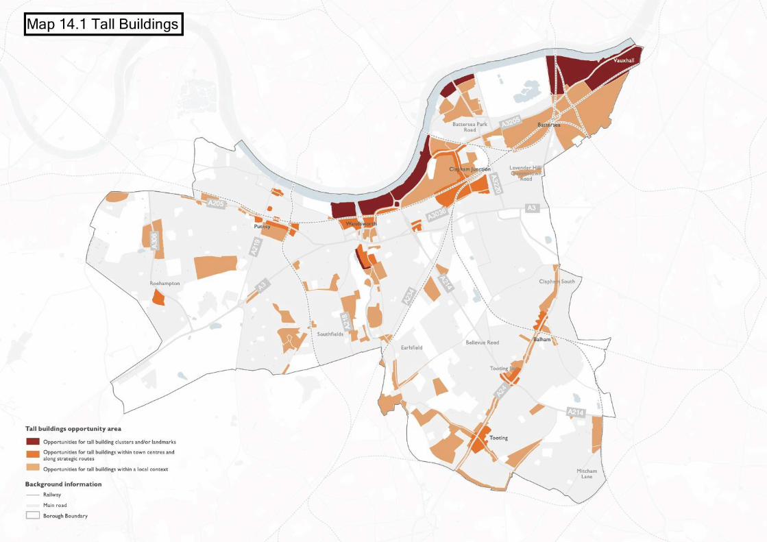

LP5 Residential Extensions and Alterations
A. Proposals for extensions and alterations to existing residential properties will be supported where:
1. an extension is well designed, uses appropriate materials and is not so large that it dominatesthe original building;
2. an extension, dormer window or other alteration to a roof is confined to the rear of the building,and where it is visible from the street scene, it would be sympathetic to the style of the buildingand would form part of the character of the locality;
3. side extensions would not cause a terrace effect as a result of in-filling the spaces betweenbuildings;
4. extensions are not erected to the front of houses where they would be visible from the highway;5. modifications to the front elevations are of a minor scale such as a small porch, and any
free-standing structures including for cycle storage, are appropriate in terms of their scale anddesign and have had regard to the size of the original front garden within which it would belocated such as to avoid creating an obtrusive feature within the street scene;
6. refuse and bike storage enclosures are sited unobtrusively and do not detract from the appearanceof the building or amenity;
7. rear extensions would be subservient to the original host dwelling and its setting, would not beoverly dominant, and ensure that a substantial depth of the original rear garden would remainfree of buildings and structures including lightwells;
8. the provision of lightwells would retain at least 50% of the original front garden depth, and withinconservation areas ensure that a minimum depth of 2m of front garden is retained; and
9. hardstandings would be constructed of permeable materials, and would not dominate theappearance of a front garden or cause harm to the character or appearance of the dwelling orthe street scene. In conservation areas, hardstandings will be resisted where they would becontrary to the relevant Conservation Area Appraisal Strategies (CAAS) or where they wouldnot be characteristic of the area or would result in harm to the appearance of the street scene.
B. Proposals for residential extensions and alterations should have regard to the Council's adoptedHousing SPD.
C. The use of green roofs and other ways to secure biodiversity net gain such as the integration of birdboxes will be strongly encouraged for flat roofs which are not used or proposed to be used as amenityspace.
14.50The Council is committed to ensuring that allresidential alterations and extensions delivergood design. Architectural unity, detailing andcompositional harmony are essentialcharacteristics of local distinctiveness andshould be respected when residential extensionsare being undertaken.
14.51Recognising the strong local interest from thelocal community with respect to this type ofdevelopment, the Council have prepared aHousing SPD. This guidance document sets outclear principles and development guidelines thathelp to support implementation of the Local
Plan. All proposals for residential extensionsand alterations will be expected to refer to theSPD (and any future updates to this).
14.52Extensions to residential buildings shouldnormally be subordinate in scale to the originalbuilding. This is in order to ensure that newdevelopment does not dominate existing andwell-established features of the building orsetting, or result in disproportionate additionsthat detract from local character. Alterationsand extensions must also respect thearchitectural qualities and coherence of theurban grain, for example, by taking into account
222
the distinctive qualities of blocks or terraces ofbuildings and not undermining their establisheduniformity.
14.53 Innovative, high quality and creativecontemporary design solutions that positivelyrespond to the site context will be supportedin principle, so long as the design carefullyconsiders the architectural language andintegrity of the original building and avoids anyawkward jarring building forms.
14.54The Urban Design Study discusses how the localcharacter of places varies greatly across theborough. It is therefore crucial thatdevelopment proposals are well thought out,using the design-led approach to ensure aplace-based response to the specificcharacteristics of a site. This stresses theimportance of ensuring that alterations andextensions are sensitive to their local andhistorical context.
LP6 Basements and Subterranean Developments
A. Proposals for subterranean and basement developments will be required to comply with the following:
1. Extend to no more than a maximum of 50% of the existing garden land or more than half of anyother undeveloped garden area (this excludes the footprint of the original building).
2. Use natural ventilation and lighting where habitable accommodation is provided.3. Include a minimum of 1 metre of naturally draining permeable soil above any part of the basement
beneath the garden area, together with a minimum 200mm drainage layer, and provide for asatisfactory landscaping scheme.
4. Respect the architectural character of the building, the character and amenity of the area, andthe significance of heritage assets including conservation areas and listed buildings.
5. Demonstrate that the scheme will not increase or otherwise exacerbate flood risk on the siteor beyond, in line with policy LP 12 (Water and Flooding).
14.55Basement developments are becoming anincreasingly popular way for householders toadapt their homes to changing lifestyles andneeds, for example, to create more amenityspace or accommodate larger families. Theyalso offer opportunities for businesses andorganisations to make a more optimal use ofland and space in a highly urbanised area likeWandsworth, for instance, by accommodatingadditional workspace or operational space.Whilst recognising the role that basements canplay in meeting the needs of the localpopulation, it is important that developmentdoes not adversely impact on local characterand the environment or harm the amenity ofneighbouring properties, whether during theconstruction or occupation phases. Not all newbasements will require planning consent as thereare permitted development rights coveringsome types of development. Where planningpermission is required, we will consider
proposals against the Local Plan policies toensure new basement developments areappropriately integrated into the site and localarea.
14.56While basements may not have a detrimentalimpact on the openness of an area, they canintroduce a degree of artificiality into the gardenarea and restrict the range of trees and otherplanting. Therefore, this policy requires theretention of at least half of each garden toenable natural landscapes and the character tobe maintained. In addition, this enables thetreatment of surface water as close to its sourceas possible by retaining the infiltration capacityof the un-excavated area of the garden, thusensuring that proposals do not increase surfacewater flows onto adjoining properties.
14.57To support appropriate planting and vegetationas well as to allow for sustainable drainage, theCouncil will require a soil depth over any part
223
of the basement beneath a garden of a minimumof 1 metre, together with a minimum 200mmdrainage layer. This will allow for both areduction in the amount as well as speed ofsurface water runoff, whereby the surface waterdrainage regime above the basement should beconnected to the unaffected part of the gardenarea.
14.58All basement and subterranean developmentshould be installed with a pumped seweragesystem to prevent flooding from back flow inpublic sewerage system as recognised in Part
H of the Building Regulations. Issues ofgroundwater ingress to basement levels shouldbe addressed by property owners. In areas atrisk of flooding, Policy LP 12 (Water andFlooding) will be applied, which restricts certaintypes of basements and uses in accordance withthe relevant flood zones. In addition, basementsare vulnerable to groundwater entering throughthe walls and floors as well as service entries.Applicants should follow the BSI Code ofPractice for protection of below groundstructures against water from the ground (BS8102:2009).
LP7 Small Sites Development
A. The Council will support proposals for infill and backland development and for the redevelopmentor upward extension on small sites in existing residential areas to provide additional housing. Inaccordance with the emerging London Plan, intensification is encouraged on small sites with goodpublic transport accessibility (PTAL 3-6) and on sites within 800m of a Tube, rail station or Major orDistrict town centre boundary (as defined in the London Plan).
B. Development proposals for infill and backland development, and for the redevelopment or upwardextension on small sites should:
1. demonstrate how the proposed development ensures a high level of physical integration withits surroundings, in accordance with Policy LP 1 (Urban Design);
2. protect and should not adversely impact on local amenity, in accordance with Policy LP 2 (GeneralDesign Principles);
3. be designed to a high quality standard with accommodation that meets the relevant standardsfor private internal and outdoor space, having particular regard to Policy LP 29 (HousingStandards);
4. ensure that all main entrances to houses, ground floor flats and communal entrance lobbies arevisible from the public realm and clearly identified;
5. protect and enhance biodiversity and green and blue infrastructure, and maximise opportunitiesfor urban greening;
6. retain or re-provide features important to the character and appearance of the area or whichsupport biodiversity, in accordance with policy LP 58 (Tree Management and Landscaping);
7. retain similar spacing between new buildings and that which is characteristic of the locality;8. provide adequate servicing, recycling and refuse storage as well as cycle parking; and9. not result in the net loss of family sized homes (as originally built).
C. There is a presumption against loss of back gardens due to the need to maintain local character,amenity space and biodiversity. Back garden land which contributes either individually or as part of alarger swathe of green space to amenity of residents or provides wildlife habitats must be retained.In some cases a limited scale of backgarden development may be considered acceptable if it complieswith the requirements set out in Part B above. Development on back garden sites must be moresympathetic in scale and lower than frontage properties.
D. Proposals involving demolition and redevelopment of existing residential properties will generally beresisted in conservation areas and areas with high sensitivity to change. The council will prepare and
224

make available a supplementary planning document to identify these areas and assist with theimplementation of this policy.
14.59The NPPF places a strong emphasis on the roleof small sites in supporting housing delivery.This is also reflected in the emerging LondonPlan, which introduces a significant step changein the strategic approach to meeting housingneed across London. As part of this approach,it seeks to increase the rate of housing deliveryfrom smaller sites. This is particularly relevantin highly accessible residential areas, wherethere are considered to be key opportunitiesto intensify sites. All boroughs are expected tohelp facilitate the development of small sites ina positive and proactive way. To fulfil thisambition, Wandsworth will be pro-active inpromoting opportunities for new housingdevelopment on all suitable sites, includingwindfall sites and small sites.
14.60The emerging London Plan sets out a ‘smallsites’ housing target for every borough. Smallsites are defined as those that are less than 0.25hectares. The targets are based on trends inhousing completions on sites of this size. ForWandsworth, the small sites target for theten-year period from 2019/20 is 4,140 nethousing units, or 414 units per year. This isbroadly in line with our monitoring of ‘windfall’development on small sites in the Borough.
14.61Our approach to housing development on smallsites is expected to facilitate the incrementalintensification of existing residential areas,particularly where sites have a good PublicTransport Accessibility Level (PTAL 3-6) and/orthey are within 800 metres of a station orMajor/District town centre, as defined in theLondon Plan. This policy recognises that smallsites development can plan an important rolein increasing the number and variety of dwellingsin the borough, and provide attractive localdownsizing options; however, it important toensure that the creation of additional dwellingsis not achieved at the expense of family-sizedaccommodation. As such, where existing housesare redeveloped, development proposals willbe required to reprovide a family sized unit (asoriginally built).
14.62 In addition, it is imperative that future growthand development occurs in a way that respectsand enhances local character, with thedistinctive features of Wandsworth’scommunities at the heart of the design-ledprocess. The Urban Design Study identifiesareas that are positioned to facilitate an upliftin small housing development, recognising thatthe physical character of some areas may needto evolve gradually over time, for example, toaccommodate new housing and investment ininfrastructure. The Urban Design Study definesareas on a spectrum of sensitivity to change,based on local character, taking into accountfactors such as existing urban grain, historicevolution, building typologies, and spatialstrategic growth and regeneration prioritiesacross the borough. All proposals for smallhousing development will be expected to referthis document, as a starting point, to understandthe scope for intensification in a given area andto gain an appreciation of the key features oflocal character.
14.63There are a variety of opportunities and typesof small sites that can support new housingdevelopment. Vacant and underused brownfieldsites along with redundant ancillary facilities,such as garages or residential storage units,present relatively straightforward options forredevelopment. However, these types of sitesare limited in availability and are oftenconstrained, such as by irregular plot forms, siteaccess issues or land-use designations (includingthose that protect land for commercial uses).It is therefore expected that the majority ofsmall sites development will occur in existingresidential areas, where new homes can besensitively integrated. Housing development onsmall sites can take a number of forms including:infill and backland development, demolition andredevelopment or extension of existing buildings(including upward, rear and side extension, andbasement development).
14.64 In many cases, backland development in theborough involves loss of garden land. Inresponse to concerns over the cumulative effect
225
of infill and backland development on gardenland, the emerging London Plan clarifies thatpreviously developed land excludes privateresidential gardens. In general the Council willnot accept proposals for developments on backgarden land, but proposals for a limited scale ofback garden development may be acceptable,subject to the criteria in Part B of this policyand other relevant policies. The restrictiveapproach reflects the direct and indirect valueof gardens contributing to local character,providing safe and secure amenity and playspace, supporting biodiversity, helping to reduceflood risk and mitigating the effects of climatechange including the heat island effect. TheCouncil will restrict garden development wheregardens make a significant contribution to localcharacter, ecology and/or the generalenvironment. In assessing local ecological valuethe Council will take into account the lengthand overall size of the gardens and value ofadjacent land as larger areas support a widerrange and number of species.
14.65 In considering new infill development the widthof the remaining and the new plot should besimilar to the prevailing widths in the immediatearea, and the established spacing betweendwellings, building line and prevailing heightshould be respected. This recognises the factthat the character of streets has often beenweakened by infilling space between dwellings.
14.66Proposals for ‘demolition and redevelopment’intensification will generally be limited to areaswith adequate public transport accessibility(PTAL 3-6), poorly defined character and lowsensitivity to change (as set out in forthcomingsupplementary planning guidance). Thisrecognises the fact that a high concentration ofdemolitions is likely to lead to a situation whereheritage-rich places lose their unique visualinterest and become generic in architecturalterms. Housing demolitions will generally beunacceptable in conservation areas given thatsuch development can detract from the positivecohesion of residential streets. Where‘demolition and redevelopment’ intensificationis considered acceptable in principle, proposalswill be required to demonstrate how thedevelopment would enhance the character andappearance of the area.
14.67To help facilitate the appropriate developmentof small sites for housing, including through theincremental intensification of existing buildingsand sites, the Council will aim to prepare asupplementary planning document (1) identifyingareas that have the potential to facilitate anuplift in small housing development, and (2)setting out design codes for those areas. Thesupplementary planning document will be inturn informed by the Urban Design Study.Development proposals will be expected tohave regard to this planning guidance, whererelevant, and demonstrate how it has been usedto inform the development through thedesign-led process.
LP8 Shopfronts
A. Proposals for new or refurbished shopfronts should:
1. relate to the scale, proportion and appearance of the building;2. respect the local street scene, character and appearance of the locality;3. use robust, carefully detailed materials for aesthetic and weathering purposes;4. enhance natural surveillance and activate the frontage;5. permanently display the property numbers of the shop and any accommodation at the entrances;6. avoid solid or perforated roller shutters; and7. retain, and where practicable provide, a separate entrance to upper floor accommodation where
this is separate from the ground floor use.
226
B. Proposals for shopfronts in conservation areas should demonstrate an appreciation of the significanceof the Conservation Area and serve to preserve or enhance the character and appearance of thatarea.
C. Proposals for shopfronts will be required to retain shopfronts of architectural or historic interest orany features of interest that survive on the premises (including historic shop signage), particularlywhere these make a positive contribution to the distinctive visual or historic character of a building,townscape or area. Such shopfronts or features should be retained, refurbished and sympatheticallyincorporated into any new proposal.
D. Shops that are converted to residential or non-residential uses (including through permitteddevelopment) should retain the existing shopfront fenestration and provide natural surveillance of thestreet.
14.68Shopfronts within the borough play a key partin establishing and defining the visual characterof our high streets and shopping parades. Anattractive shopping environment is offundamental importance to the economic healthand retail vitality of the Wandsworth’s townand local centres, as well as areas of specialcharacter. In all areas, the design of shopfrontsand the appropriateness of signs must reflectlocal context. The borough has many fineexamples of shopfront design ranging from themid-nineteenth century through to today. Thepreservation of early examples is important formaintaining our highly valued built heritage andlinks with the past, however emphasis shouldalso be placed on ensuring high standards ofdesign for all new shopfronts.
14.69The architectural merit of buildings and thecollective townscape qualities of the street canbe eroded by poor quality alterations or theunsympathetic replacement of shopfronts. Thispolicy is intended to require greater care to betaken in shopfront design in order to maintainthe character and appearance of traditionalshopfronts, and to improve the quality of newshopfront designs so they respect and enhancetheir surroundings. To assist implementation ofpolicy, detailed design guidance is set out in theSPG on Shopfronts, and the Council hasproduced a good practice advice note coveringSecurity for Shops.
LP9 Advertisements
A. New advertisements (including shop signage) and hoardings must:
1. be of high quality in terms of appearance;2. be well integrated with their context, including having regard to the design of new or existing
buildings;3. respect local context, including in relation to listed buildings and conservation areas. Internally
illuminated signs will not normally be permitted within conservation areas or on listed buildings;4. not contribute to a proliferation or clutter of signage either on the host building or site or in
the locality;5. avoid material harm to public amenity by way of excessive illumination and visual intrusion of
light pollution; and6. avoid causing material harm to public or highway safety.
227
14.70Advertisements are important to commercialareas, being both informative and sometimesadding interest and vitality to the street scene.Although they play a role in providinginformation, control of signs and advertisementsis important as they can have significant impactson the quality and appearance of the streetscene and upon the building on which they aredisplayed. In particular, the architecturalintegrity of individual buildings and groups ofbuildings may be damaged by insensitiveadvertisements. A balance has to be metbetween commercial requirements and theprotection of the environment, includingpedestrian and vehicular safety.
14.71Properly planned, executed and managed,advertising can enhance peoples’ experience ofthe public realm. We will work with theapplicants to find ways of ensuring the most ismade of the positive aspects. Carefulconsideration will be given to the size, location,materials, details, and method of illumination ofproposed signs and advertisements togetherwith the impact they will have on thearchitectural features of the building upon whichthey are fixed.
228

15 Tackling Climate Change
Introduction
15.1 Strategically addressing climate change is animportant challenge for Wandsworth, ensuringthat the growth of the borough is sustainablydelivered, both through a robust approach tothe protection and effective management of theborough’s environment and natural resources,but also by identifying opportunities for growthto support the development of more sustainablebuildings and neighbourhoods that are designedto minimise their contribution to, and tomitigate the effects of, climate change – therebycontributing to an overall improvement in thequality of life of the borough’s residents.
15.2 Recognising the scale of the challenge, in July2019, Wandsworth Council declared a ClimateEmergency; resolving to become a carbonneutral organisation by 2030, a zero carbonorganisation by 2050, and to establishWandsworth as the greenest borough ininner-London. To reach these ambitious targets,the Council has developed a detailed roadmapoutlining actions that it will take to tackleclimate change within the borough – theWandsworth Environmental and SustainabilityStrategy (WESS). Planning, and the policies setout within this Local Plan, will play a key rolein delivering many of these actions.
15.3 Reflecting the cross-cutting nature of climatechange, the WESS encompasses a broad rangeof themes: sustainable transport; air quality;energy management; urban greening and openspaces; waste management; water managementand flood resilience; and sustainabledevelopment. These topics aptly reflect manyof the different chapters and policies within thisLocal Plan, reinforcing the importance of takinga holistic approach to tackling climate change.The management of and adaptation to climatechange should be seen as a golden thread whichruns throughout the entire Local Plan; howeverthis chapter sets out a number of policiescovering key issues which sit at the core of this:sustainable design and construction and energyefficiency; zero and low carbon development;the increased use of renewable energy;decentralised energy networks; the managementof water and building resilience to flooding; themanagement of waste; and mitigating the impactof development on the borough’s air quality andother pollutants.
15.4 In delivering the WESS, the Council hascommitted to producing an annual Action Planto ensure that it remains on track to meet thetargets. The policies established within thischapter – and within the Local Plan as a whole– will be kept under review, and the Councilwill seek to revise these in accordance with theAction Plan, where necessary, to ensure thatthis document continues to effectivelycontribute to tackling climate change.
LP10 Responding to the Climate Crisis
Sustainable Construction and Design
A. Developments will be required to achieve high standards of sustainable design and construction inorder to mitigate the effects of climate change, and to realise the Council’s ambition of becoming zerocarbon by 2050. This will include, but is not necessarily limited to the:
1. Incorporation of Sustainable Drainage Systems (SuDS) or demonstration of alternative sustainableapproaches to the management of surface water (see Policy LP 12 (Water and Flooding)).
2. Use of sustainable construction methods, such as the use of sustainably sourced and recycledmaterials.
3. Use of demolished materials from the development site where practicable, in order to minimisethe transportation of waste and reduce carbon dioxide emissions.
230
4. Incorporation of water conservation measures, setting maximum water usage at 110 litres perperson per day for homes (including an allowance of 5 litres or less per person per day forexternal water consumption) under the optional national technical standard.
5. Incorporation of living roofs and walls where feasible (See Policy LP 59 (Urban Greening Factor)).
B. Applicants will be required to meet the following:
1. New non-residential buildings over 100 sqm will be required to meet BREEAM ‘Outstanding’standard, unless it can be demonstrated that this would not be technically feasible. New buildingsshould be designed for the climate they will experience over their lifetime.
2. Proposals for change of use to residential will be required to meet BREEAM DomesticRefurbishment ‘Outstanding’ standard, unless it can be demonstrated that this would not betechnically feasible.
3. Residential buildings will be encouraged to meet the BRE Home Quality Mark or Passivhaus.
C. Development, including the re-use or extension of existing buildings, should achieve the maximumfeasible reductions in carbon emissions and support in achieving the strategic carbon reductions targetin this Plan, while protecting the heritage and character of the buildings.
Reducing Carbon Dioxide Emissions
D. Developers are required to incorporate measures to improve energy conservation and efficiency, aswell as contributions to renewable and low carbon energy generation. Proposals will be required tomeet the following minimum reductions in carbon dioxide emissions, where targets are expressed asa percentage improvement over the target emission rate (TER) based on Part L of the 2013 BuildingRegulations:
1. All new major development should achieve zero carbon standards, as set out in the emergingLondon Plan, with a minimum on-site reduction of 35%.
2. All other new residential buildings should achieve a minimum on-site reduction of 35%.
3. Residential development should achieve a 10% reduction and non-residential development shouldachieved a 15% reduction through energy efficiency measures alone.
4. In exceptional circumstances, where it is clearly demonstrated that the on-site percentagethreshold targets listed in Parts D.1 and D.2 cannot be fully achieved, any shortfall must beprovided through a cash in lieu contribution to the borough’s Carbon Offset Fund.
The Energy Hierarchy
E. All development is required to follow the energy hierarchy set out within the emerging London Plan(Policy SI 2) with respect to its design, construction, and operation.
Energy Assessments
F. All new residential development and major non-residential development proposals are required tosubmit an energy assessment, and minor non-residential development proposals are strongly encouragedto provide one.
Compliance and Monitoring
231
G. Conditions may be used to ensure the principles outlined within this Policy are adhered to throughoutthe lifetime of the development. In addition, major development proposals may be required to fundpost-construction monitoring of renewable and low-carbon equipment to demonstrate full compliancewith the commitments identified within the permission, up to a 4-year period.
Adapting to Climate Change
H. The Council will promote and encourage all development to be fully resilient to the future impactsof climate change in order to minimise vulnerability of people and property. Retrofitting of existingbuildings, through low-carbon measures, to adapt to the likely effects of climate change should bemaximised and will be supported.
Overheating
I. New development, in their layout, design, construction, materials, landscaping and operation, shouldminimise the effects of overheating, mitigate the urban heat island effect, and minimise energyconsumption in accordance with the following cooling hierarchy set out in the emerging London Plan,Policy SI 4.
15.5 ‘Carbon’ is used in this chapter as shorthandfor all greenhouse gases. London’s carbonaccounting is measured in carbon dioxideequivalent, which includes the conversion ofother greenhouse gases into their equivalentcarbon dioxide emissions.
Sustainable Design and Construction
15.6 There are a wide range of measures whichdevelopers can incorporate, where appropriate,to make their developments more sustainable,during both the construction and theoperational phases. These may include passivesolar design, natural ventilation, green andbrown roofs, sustainable drainage systems(SuDS) and rainwater harvesting, the sustainableuse of building materials and the managementof construction waste.
15.7 The national technical standards relate to waterefficiency, space and accessibility for newhousing developments. Where feasible,developers are encouraged to use acceptedstandards, such as the Home Quality Mark orPassivhaus, to demonstrate that higher designand operational aspects over and above thoserequired by the Building Regulations have beenincorporated. The Building ResearchEstablishment Environmental AssessmentMethod (BREEAM) is a sustainability standardwhich can be applied to non-residential
developments. It is expected that developmentsbrought forward within the borough shouldmeet the criteria to be recognised as‘Outstanding’. In all instances where assessmentmethods are changed or superseded, theappropriate replacement standards should beused.
15.8 The existing building stock in Wandsworthmakes a significant contribution to theborough’s carbon dioxide emissions. As such,conversions, extensions and refurbishment ofexisting buildings, including for a different use,present an opportunity to reduce carbondioxide emissions through retrofitting. Whereapplicable, development should considersynergies with new build elements on sites anddevelopments should seek to achieve the zerocarbon target across the site. Where conflictbetween climate change objectives and theconservation of heritage assets is unavoidable,the public benefit of mitigating the effects ofclimate change will be weighed against any harmto the significance of the heritage asset, inaccordance with national, the emerging LondonPlan and the Council's planning policies. Theremay be opportunities to improve the energyefficiency of existing heritage buildings throughmeasures such as improved insulation anddraught-proofing, and these measures shouldbe considered by applying energy generating
232
technologies. When retrofitting renewableenergy technologies to listed buildings orbuildings within Conservation Areas, careshould be taken to choose appropriatetechnologies and to position equipment in theleast visually harmful location. Guidance canalso be found in Historic England's advice on'Energy efficiency and Historic Buildings'. Furtherinformation is also available in the Council’sConservation Area Appraisal and ManagementStrategies.
15.9 The Mayor’s Sustainable Design andConstruction SPG provides further technicalguidance on the operation and implementationof these principles in new development. Thestandards set out in the SPG, or any futurereplacement, should be addressed in planningapplications. The Mayor of London intends topublish further guidance on whole life-cyclecarbon assessments, and applicants areencouraged to have regard to this.
Reducing Carbon Dioxide Emissions
15.10The Council requires developments tocontribute towards the Mayor of London’scommitment of making London a zero-carboncity by 2050.
15.11All development proposals should apply thefollowing Energy Hierarchy, as set out in theemerging London Plan: to be lean; be clean; begreen; and to be seen. The priority is tominimise energy demand, and then address howenergy will be supplied and renewabletechnologies incorporated. An important aspectof managing demand will be to reduce peakenergy loadings.
15.12The Council will require an assessment ofenergy demand and carbon dioxide emissionsfrom the proposed development, which shoulddemonstrate the expected energy and emissionssavings from energy efficiency and renewableenergy measures incorporated into thedevelopment. Renewable technologies such asphotovoltaic cells, solar panels, ground and airsource heat pumps and other forms ofrenewable energy are likely to be appropriatein many parts of the borough, subject to otherpolicies within this Plan. The Energy Statement
must demonstrate how the energyrequirements will be met in line with the EnergyHierarchy.
15.13All major developments (residential andnon-residential) should achieve zero carbonstandards, as set out in the emerging LondonPlan. A zero carbon development is consideredto be one where at least 35% of regulated CO2emissions reductions, expressed as minimumimprovement over the Target Emission Rate(TER) outlined in the national BuildingRegulations (2013), are achieved on-site, withthe remaining emissions (up to 100%) to beoffset through a contribution into the Council'sCarbon Offset Fund. All other new residentialschemes (of one unit or more) should achievea minimum 35% on-site reduction in carbondioxide emissions. Developments are expectedto achieve carbon reduction beyond Part L (ofthe regulations) from energy efficiency measuresalone to reduce energy demand as far aspossible. Where development is broughtforward as part of a phased application, therelevant policy threshold should be applied onthe basis of the cumulative impact ofapplications on the site.
15.14The Council recognises that there may beexceptional circumstances where it is nottechnically feasible for a development to achievea 35% reduction in carbon dioxide emissionsover Building Regulations (2013). In such cases,the applicant will have to demonstrate in theEnergy Statement why the carbon dioxideemissions reduction target cannot be meton-site. Any justifiable shortfall in on-sitereductions will need to be met through acash-in-lieu contribution to the Council'sCarbon Offset Fund, agreed through a Section106 legal agreement in line with the PlanningObligations SPD.
15.15The Council has adopted the price of carbonof £95 per tonne x 30 years, equalling £2,850per tonne of carbon. This pricing is consistentwith the recommendations made within theemerging London Plan, although it may besubject to amendment in the future to ensurethe Council’s stepped approach to realising zerocarbon. Where development viability is aconcern, affordable housing will be prioritisedover zero carbon contributions. Future changes
233
to energy efficiency standards will be kept underreview, and policy requirements will be updatedwith the prevailing standards if required.
Energy Assessment
15.16To ensure that development proposals complywith the policies set out in the localdevelopment plan, the approach to energysupply on development sites should be clearlyset out in an energy assessment, which showshow various options have been considered andincludes the provision of sufficient and robustdetail to demonstrate an achievable energystrategy. All new development and all applicablemajor non-residential development shouldsubmit any relevant BREEAM pre-assessments.
Compliance and Monitoring
15.17Where permission is granted, conditions maybe included as part of this to ensure theprovision of evidence that the approved energystrategy is implemented on site and to requirefinal certification and/or evidence of theproposed national technical standards andBREEAM levels. Design stage andpost-construction reviews will generally berequired by conditions.
15.18 In order to become zero carbon in line withthe Council’s ambitions, it is essential that thedevelopment continues to deliver the energydemand and carbon emissions commitmentsonce operational. In line with the fourth pointof the Mayor’s energy hierarchy (‘be seen’), theCouncil may require the developer, through as106 agreement, to make a contribution tocover the cost of the ongoing (over a period of4 years) monitoring of the building’s energyefficiency through the use of smart meters anda web-based platform. This will requirepayments to cover the cost of the equipment,as well as Officer time to review the outputs.Monitoring will also provide the Council witha robust evidence base against which to setfuture revised targets as part of a longer-term‘stepped approach’ to the realisation of zerocarbon.
Climate Change Adaptation
15.19Climate change is already having – and willcontinue to have – a profound impact on ourenvironment. These are likely to be realised invaried ways which pose risks to people’swellbeing and to the built environment: throughextreme weather events; increasedtemperatures; greater levels of rainfall andincidences of floor events; rising sea levels andthe threat of storm surge; among others. It isessential that the location and design ofdevelopment appropriately considers this inorder to reduce vulnerability and increaseresilience. This should be realised holistically,taking account interconnected factors such asflood risk, sustainable drainage, greeninfrastructure, trees, water resources, waterconservation and water consumption targets,which are dealt with in more detail in separatepolicies within this Plan.
15.20Retrofitting existing properties, particularlyresidential buildings, presents a significantopportunity to help meet the carbon emissionreduction target. Adapting and retrofittingexisting homes provides the opportunity tomake them more comfortable, marketable,resource efficient, and fit for purpose in thepresent and the future. The sensitivity ofexisting developments, in particular heritageassets, in terms of their historic fabric andsignificance, should be considered beforedeveloping methods in which to retrofit higherstandards of energy and water efficiency.
Overheating
15.21 It is predicted that London’s summers will getprogressively warmer, with an increasedlikelihood of extreme high temperatures. As aninner London borough, Wandsworth isparticularly vulnerable to such events due tothe urban heat island effect, which is the relativehigher temperature witnessed in urban areasas a result of the high capacity of buildings,roads, and other urban infrastructure to absorband retain heat.
15.22Development should be designed in such a wayto account for, and appropriately mitigate thepotential overheating of a building. Variousmeasures can be taken to achieve this, which
234

should follow the emerging London Plan’scooling hierarchy (set out in Policy SI 4(Managing heat risk)), as follows:
1. Reduce the amount of heat entering abuilding through orientation, shading, highalbedo materials, fenestration, insulationand the provision of green infrastructure.
2. Minimise internal heat generation throughenergy efficient design.
3. Manage the heat within buildings throughexposed internal thermal mass and highceilings;
4. Provide passive ventilation.5. Provide mechanical ventilation.6. Provide active cooling systems.
15.23 In this policy, 'new development' applies to newbuild development of 1 dwelling unit or moreas well as to new build (including extensions)of 100sqm or more of non-residential floorspace.
LP11 Energy Infrastructure
A. New development will be expected to connect to any existing decentralised energy network (DEN).Where networks do not exist, developments should make provision to connect to any future networkthat may be developed, having regard to the possibility for this to come forward.
B. Where no decentralised heat energy networks are planned, or in exceptional circumstances whereit can be sufficiently demonstrated that it is not technically feasible and/or economically viable toconnect to an existing network, major developments should incorporate on-site DEN, such as combinedheat and power.
C. Where applicable, applicants are required to consider the installation of low, or preferably ultra-low,NOx boilers to reduce the amount of NOx emitted in the borough.
15.24Heat that is created as a by-product oftraditional energy generation is normally wasted;however in decentralised energy networks(DEN) this waste heat can be used instead toheat local homes and businesses through asystem of pre-insulated underground pipes.Decentralised energy can therefore play asignificant role in reducing both carbonemissions, both by eliminating power lost intransmission over the national grid, but also byreducing the reliance of local development onthis grid. DENs are commonly based on gas-fireCHP but have the potential to switch torenewable energy sources in the future such asbiogas, which could further reduce carbonemissions and improve energy security.
15.25The Council expects all development tomaximise opportunities to incorporatedecentralised energy to support furtherreductions in energy use and emissions. Newdevelopments should therefore be designed ina manner fully compatible with any existing,planned or future decentralised energy network(DEN) – including appropriate design of building
systems to minimise return temperatures – inaccordance with any relevant energy masterplan,the District Heat Manual for London (GLA,2014), or equivalent replacement document.Map X (map to be inserted) shows theborough’s decentralised energy opportunityareas.
15.26There are two DENs in Nine Elms: the EmbassyQuarter Heating Network (EQHN), with anenergy centre housed within the US Embassy;and the Battersea Power Station HeatingNetwork, powered from an energy centrewithin the grounds of the Power Station. Thereare particularly good opportunities to createnew and/or expand existing DENs in largemixed use developments in the areas of majorchange, such as central Wandsworth and theWandle Delta and Clapham Junction.
15.27The Council will work with developmentpartners to promote necessary strategicsustainable energy infrastructure. This mayinclude developers identifying land and accessfor Energy Centres, DEN plant and district
235

heating connections as well as making financialcontributions towards establishing or expandingnetworks where works on-site or in the vicinityare necessary to mitigate the impact ofdevelopment, or to enable the delivery of thesite, as detailed in the Council’s PlanningObligations Supplementary Planning Document.Developers will be expected to contributetowards the costs of the DEN in line with theavoided costs of their own plant installation.Applicants will be expected to demonstrate thelow air quality impacts of any decentralisedenergy network.
236
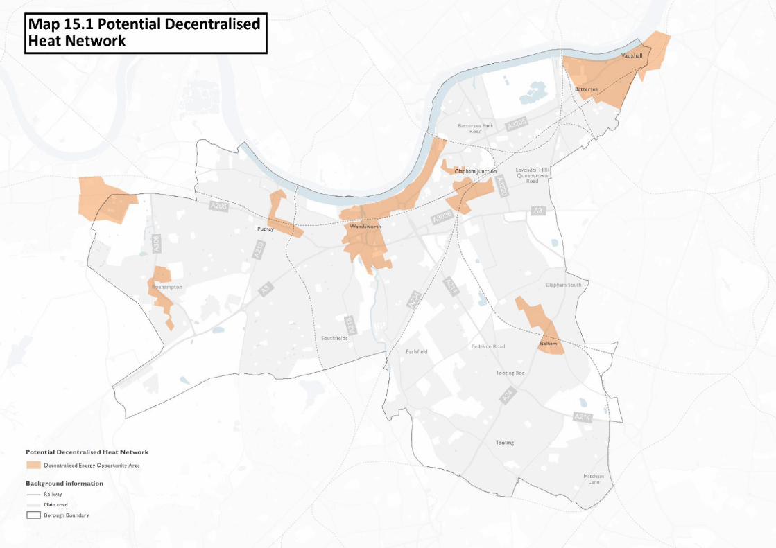
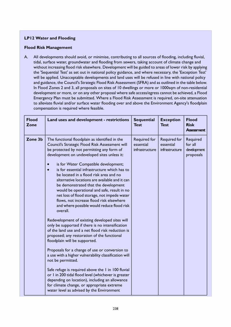
LP12 Water and Flooding
Flood Risk Management
A. All developments should avoid, or minimise, contributing to all sources of flooding, including fluvial,tidal, surface water, groundwater and flooding from sewers, taking account of climate change andwithout increasing flood risk elsewhere. Development will be guided to areas of lower risk by applyingthe 'Sequential Test' as set out in national policy guidance, and where necessary, the 'Exception Test'will be applied. Unacceptable developments and land uses will be refused in line with national policyand guidance, the Council's Strategic Flood Risk Assessment (SFRA) and as outlined in the table below.In Flood Zones 2 and 3, all proposals on sites of 10 dwellings or more or 1000sqm of non-residentialdevelopment or more, or on any other proposal where safe access/egress cannot be achieved, a FloodEmergency Plan must be submitted. Where a Flood Risk Assessment is required, on-site attenuationto alleviate fluvial and/or surface water flooding over and above the Environment Agency's floodplaincompensation is required where feasible.
FloodRiskAssessment
ExceptionTest
SequentialTest
Land uses and development - restrictionsFloodZone
Requiredfor alldevelopmentproposals
Required foressentialinfrastructure
Required foressentialinfrastructure
The functional floodplain as identified in theCouncil’s Strategic Flood Risk Assessment willbe protected by not permitting any form ofdevelopment on undeveloped sites unless it:
Zone 3b
is for Water Compatible development;is for essential infrastructure which has tobe located in a flood risk area and noalternative locations are available and it canbe demonstrated that the developmentwould be operational and safe, result in nonet loss of flood storage, not impede waterflows, not increase flood risk elsewhereand where possible would reduce flood riskoverall.
Redevelopment of existing developed sites willonly be supported if there is no intensificationof the land use and a net flood risk reduction isproposed; any restoration of the functionalfloodplain will be supported.
Proposals for a change of use or conversion toa use with a higher vulnerability classification willnot be permitted.
Safe refuge is required above the 1 in 100 fluvialor 1 in 200 tidal flood level (whichever is greaterdepending on location), including an allowancefor climate change, or appropriate extremewater level as advised by the Environment
238
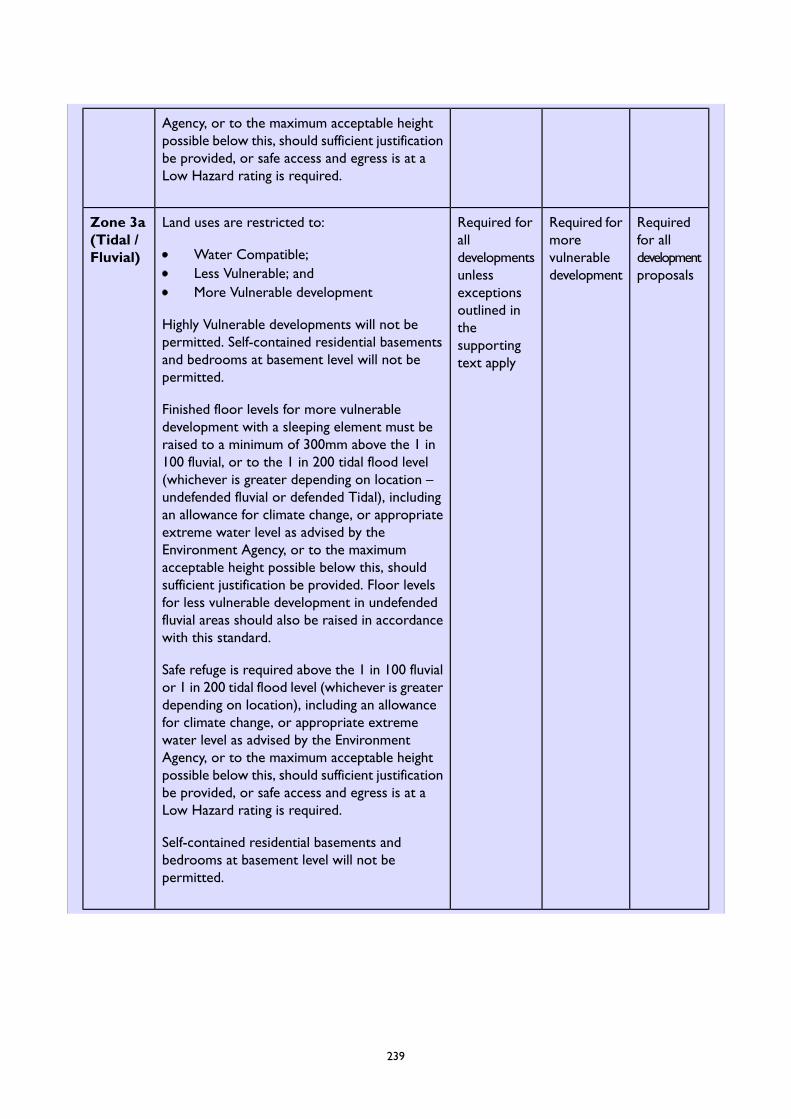
Agency, or to the maximum acceptable heightpossible below this, should sufficient justificationbe provided, or safe access and egress is at aLow Hazard rating is required.
Requiredfor alldevelopmentproposals
Required formorevulnerabledevelopment
Required foralldevelopmentsunless
Land uses are restricted to:Zone 3a(Tidal /Fluvial) Water Compatible;
Less Vulnerable; andMore Vulnerable development exceptions
outlined inHighly Vulnerable developments will not bepermitted. Self-contained residential basementsand bedrooms at basement level will not bepermitted.
thesupportingtext apply
Finished floor levels for more vulnerabledevelopment with a sleeping element must beraised to a minimum of 300mm above the 1 in100 fluvial, or to the 1 in 200 tidal flood level(whichever is greater depending on location –undefended fluvial or defended Tidal), includingan allowance for climate change, or appropriateextreme water level as advised by theEnvironment Agency, or to the maximumacceptable height possible below this, shouldsufficient justification be provided. Floor levelsfor less vulnerable development in undefendedfluvial areas should also be raised in accordancewith this standard.
Safe refuge is required above the 1 in 100 fluvialor 1 in 200 tidal flood level (whichever is greaterdepending on location), including an allowancefor climate change, or appropriate extremewater level as advised by the EnvironmentAgency, or to the maximum acceptable heightpossible below this, should sufficient justificationbe provided, or safe access and egress is at aLow Hazard rating is required.
Self-contained residential basements andbedrooms at basement level will not bepermitted.
239
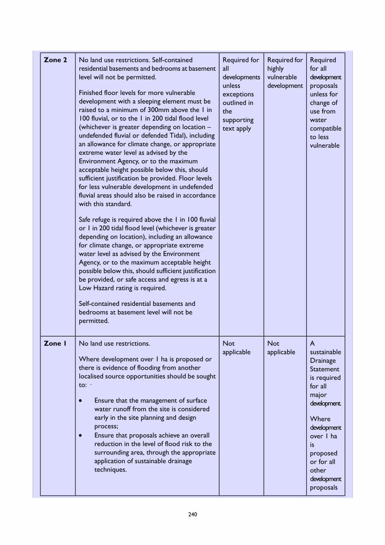
Requiredfor alldevelopment
Required forhighlyvulnerabledevelopment
Required foralldevelopmentsunless
No land use restrictions. Self-containedresidential basements and bedrooms at basementlevel will not be permitted.
Finished floor levels for more vulnerabledevelopment with a sleeping element must beraised to a minimum of 300mm above the 1 in
Zone 2
proposalsunless forchange ofuse from
exceptionsoutlined inthesupportingtext apply
100 fluvial, or to the 1 in 200 tidal flood level(whichever is greater depending on location –undefended fluvial or defended Tidal), including
watercompatibleto lessvulnerablean allowance for climate change, or appropriate
extreme water level as advised by theEnvironment Agency, or to the maximumacceptable height possible below this, shouldsufficient justification be provided. Floor levelsfor less vulnerable development in undefendedfluvial areas should also be raised in accordancewith this standard.
Safe refuge is required above the 1 in 100 fluvialor 1 in 200 tidal flood level (whichever is greaterdepending on location), including an allowancefor climate change, or appropriate extremewater level as advised by the EnvironmentAgency, or to the maximum acceptable heightpossible below this, should sufficient justificationbe provided, or safe access and egress is at aLow Hazard rating is required.
Self-contained residential basements andbedrooms at basement level will not bepermitted.
AsustainableDrainage
Notapplicable
Notapplicable
No land use restrictions.
Where development over 1 ha is proposed orthere is evidence of flooding from anotherlocalised source opportunities should be soughtto: ·
Zone 1
Statementis requiredfor allmajordevelopment.Ensure that the management of surface
water runoff from the site is consideredearly in the site planning and designprocess;
Wheredevelopmentover 1 haEnsure that proposals achieve an overall
reduction in the level of flood risk to the issurrounding area, through the appropriate proposedapplication of sustainable drainagetechniques.
or for allotherdevelopmentproposals
240
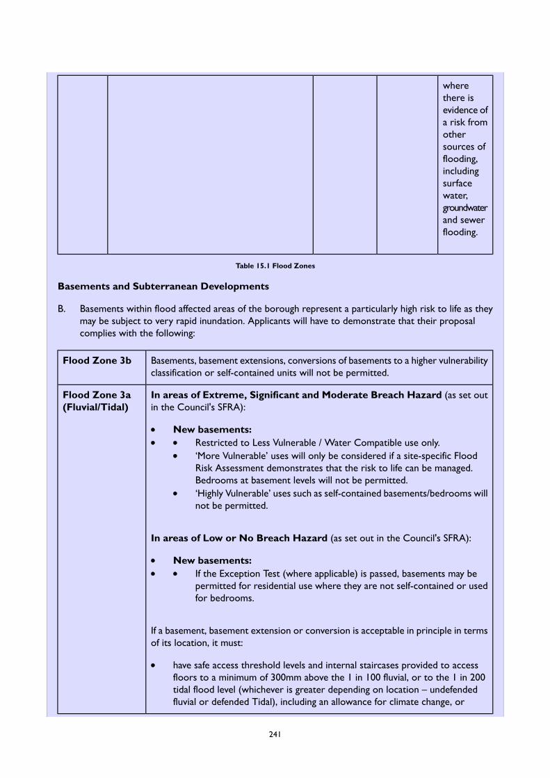
wherethere isevidence ofa risk fromothersources offlooding,includingsurfacewater,groundwaterand sewerflooding.
Table 15.1 Flood Zones
Basements and Subterranean Developments
B. Basements within flood affected areas of the borough represent a particularly high risk to life as theymay be subject to very rapid inundation. Applicants will have to demonstrate that their proposalcomplies with the following:
Basements, basement extensions, conversions of basements to a higher vulnerabilityclassification or self-contained units will not be permitted.
Flood Zone 3b
In areas of Extreme, Significant and Moderate Breach Hazard (as set outin the Council's SFRA):
Flood Zone 3a(Fluvial/Tidal)
New basements:Restricted to Less Vulnerable / Water Compatible use only.‘More Vulnerable’ uses will only be considered if a site-specific FloodRisk Assessment demonstrates that the risk to life can be managed.Bedrooms at basement levels will not be permitted.‘Highly Vulnerable’ uses such as self-contained basements/bedrooms willnot be permitted.
In areas of Low or No Breach Hazard (as set out in the Council's SFRA):
New basements:If the Exception Test (where applicable) is passed, basements may bepermitted for residential use where they are not self-contained or usedfor bedrooms.
If a basement, basement extension or conversion is acceptable in principle in termsof its location, it must:
have safe access threshold levels and internal staircases provided to accessfloors to a minimum of 300mm above the 1 in 100 fluvial, or to the 1 in 200tidal flood level (whichever is greater depending on location – undefendedfluvial or defended Tidal), including an allowance for climate change, or
241

appropriate extreme water level as advised by the Environment Agency. Theonly exception to this is where the applicant has demonstrated that apermanent fixed barrier is in place to prevent floodwater from entering anysleeping accommodation that is located below the extreme water level inaccordance with the hazard advice above. Flood resistant and resilient designtechniques must be adopted.
In areas at risk of surface water flooding, basements, basement extensions andbasement conversions must be protected by appropriate mitigation such as raisingfloor level thresholds, providing storage for surface water or other SuDS proposal.
Basements should not be permitted in areas of high surface water risk withoutappropriate mitigation.
In areas of Extreme, Significant and Moderate Breach Hazard (as set outin the Council's SFRA):
Flood Zone 2
New Basements:1. If the Exception Test (where applicable) is passed, basements may be
permitted for residential use where they are not self-contained or usedfor bedrooms
If a basement, basement extension or conversion is acceptable in principle in termsof its location, it must:
have safe access threshold levels and internal staircases provided to accessfloors to a minimum of 300mm above the 1 in 100 fluvial, or to the 1 in 200tidal flood level (whichever is greater depending on location – undefendedfluvial or defended Tidal), including an allowance for climate change, orappropriate extreme water level as advised by the Environment Agency. Theonly exception to this is where the applicant has demonstrated that apermanent fixed barrier is in place to prevent floodwater from entering anysleeping accommodation that is located below the extreme water level inaccordance with the hazard advice above. Flood resistant and resilient designtechniques must be adopted.
In areas at risk of surface water flooding, basements, basement extensions andbasement conversions must be protected by appropriate mitigation such as raisingfloor level thresholds, providing storage for surface water or other SuDS proposal.
In areas at risk of surface water flooding, basements, basement extensions andbasement conversions must be protected by appropriate mitigation such as raisingfloor level thresholds, providing storage for surface water or other SuDS proposal.
Flood Zone 1
Table 15.2 Requirements for Basements in Flood Zones
Sustainable Drainage
C. The Council will require the use of Sustainable Drainage Systems (SuDS) in all development proposals.Applicants will have to demonstrate that their proposal complies with the following:
242
A reduction in surface water discharge to greenfield run-off rates wherever feasible.1.2. Where greenfield run-off rates are not feasible, this will need to be demonstrated by the applicant,
and in such instances, the minimum requirement is to achieve at least a 50% attenuation, aimingfor 100% attenuation of the existing (undeveloped) site's surface water runoff at peak timesbased on the levels existing prior to the development.
3. Where minor development is proposed, schemes should not affect floodplain storage or flowroutes through the incorporation of mitigation measures in line with CIRIA guidance on SuDS.
D. The Council will seek planning obligation contributions towards flood protection measures and SuDSin accordance with the Planning Obligations SPD.
Flood Defences
E. Applicants will have to demonstrate that their proposal complies with the following:
1. Retain the effectiveness, stability and integrity of flood defences, river banks and other formaland informal flood defence infrastructure.
2. Ensure the proposal does not prevent essential maintenance and upgrading to be carried out inthe future.
3. Set back developments from river banks and existing flood defence infrastructure where possible(16 metres for the tidal Thames and 8 metres for other rivers).
4. Take into account the requirements of the Thames Estuary 2100 Plan, and demonstrate howthe current and future requirements for flood defences have been incorporated into thedevelopment.
5. The removal of formal or informal flood defences, is not acceptable unless this is part of anagreed flood risk management strategy by the Environment Agency.
6. Proposals should assess the opportunities to undertake river restoration and enhancement andimplement natural flood management measures as part of a development to make space forwater. Enhancement opportunities should be sought when renewing assets (e.g. de-culverting,the use of bio-engineered river walls, raising bridge soffits to take into account climate change).
7. Further culverting and building over culverts should be avoided.
The Sequential Test
F. Future development in Zone 3a and Zone 2 will only be considered if the 'Sequential Test' has beenapplied in accordance with national policy and guidance. However, there are some exceptions to this.The Sequential Test is considered to have been passed and will not be required if is not a majordevelopment or at least one of the following applies:
1. Is located within an Area Strategy area as identified in this Local Plan; including within the 400mbuffer around the town centre based strategies*:
a. Vauxhall Nine Elms Battersea Opportunity Area (including Battersea Design and Technologyquarter)
b. Roehampton Regeneration Areac. The Wandle Valleyd. Wandsworth’ s Riversidee. Balham*f. Clapham Junction and York Road/Winstanley Regeneration Area*g. Putney*
243
h. Tooting*i. Wandsworth Town, including the Wandle Delta Area*
2. It is a Local Plan Site Allocation, unless the proposed use is not in accordance with the allocationsof the Local Plan.
3. Redevelopment of an existing single residential property or its ancillary uses.4. Minor development, conversions and change of use.5. For development sites falling outside of these areas, the default area of search for the Sequential
Test to be applied will be the borough administrative area, unless justification is provided for asmaller area as described in the Strategic Flood Risk Assessment.
Multifunctional Benefits
G. In addressing flood mitigation opportunities to bring other benefits including recreational, habitatcreation to support biodiversity and urban greening will be encouraged.
15.28Managing the risk of flooding is a keycomponent of mitigating the effects of andadapting to climate change. Significant areas ofthe borough are at risk of some form of floodingand it is important to ensure that new andexisting development responds to this riskwhich is will become more likely in the futuredue to the effects of climate change. This Policysets out what is expected of development toensure flood risk has been understood andmanaged effectively.
15.29Development which is built during the LocalPlan period will be expected to have a life tothe end of the century and beyond, andtherefore it must be designed and built toaccommodate potential future flooding events.The National Planning Policy Framework(NPPF)requires a sequential risk-based approach tosteer development to areas of low flood riskboth at the plan making and applications stagesof the development cycle. Due to the need toaccommodate growth in the borough as set outin the spatial strategy, it is not reasonable forfuture development within the borough’s keygrowth and investment areas to be locatedwithin areas of lower flood risk elsewhere. Inorder to sustain the continuing role of theseareas, development is therefore considered tosatisfy the Sequential Test and a site specificapplication of the Sequential Test is notrequired as part of an application. Instead,development within these areas will need tomeet the requirements of the Exception Test
to manage and reduce flood risk on site andwithin these areas, and developments will needto follow a sequential approach for the finallayout and design where possible.
15.30The NPPF outlines that Local Plans should besupported by a Strategic Flood Risk Assessment(SFRA) and LPAs should use the findings toinform strategic land use planning. The Councilhas updated its Strategic Flood Risk Assessment(2020); including incorporating a review of itsSurfaceWater Management Plan, to both informthe Local Plan and guide development withinthe borough. The SFRA sets out the most upto date readily available flood risk informationfor all sources of flooding, to provide anoverview of flood risk issues across theborough. The SFRA has been used to informthe content of this Policy and used to undertakethe Sequential Test of the Site Allocations ofthe Plan, including the setting out of specificflood risk mitigation measure for each site ascontained in the ‘level two’ SFRA.
15.31The Environment Agency produces Flood Mapsfor Planning with a nationally consistentdelineation of “high” (Flood Zone 3), “medium”(Flood Zone 2) and “low” (Flood Zone 1) floodzones, which are updated and published on aquarterly basis. In addition, the Council’sStrategic Flood Risk Assessment, sub-dividesthe Environment Agency's Flood Zone 3 into“high probability” (Zone 3a) and the “functionalfloodplain” (Zone 3b). The areas of Flood Zone
244
3 associated with the River Thames are alsodefined as ‘Areas Benefitting from Defences’(ABD), i.e. they are shown to benefit from thepresence of flood defences during a 0.5% AEPflood event. The Thames Tidal Defence (TTD)system includes both the raised flood defencewalls along the River Thames frontage, as wellas the Thames Barrier located downstream atWoolwich. The risk of tidal flooding to thesenorthern parts of Wandsworth (along the RiverThames and theWandle Delta area) is thereforea residual risk, in the event of a breach orovertopping of the flood defences. Breachmodelling and associated hazard and depthmodelling is set out within the SFRA and hasbeen used to develop this policy and should beused by applicants in their assessment of floodrisk. The modelling also shows that flood zone3b is mainly constrained to within the river bankof the Thames, Wandle and the Wandle Deltaarea, meaning that there would be extremelylimited circumstances where the policy criteriarelating to flood zone 3b would apply unlessdevelopment was to encroach into the river.There have been few instances of the defendedand undefended areas of the river Thames,Wandle, and Beverly Brook flooding; however,the EA flood maps show the extent of floodingin the event of a 0.5% AEP flood event which iswhat the policies are fundamentally based uponand Flood Risk Assessments need to mitigateany risks.
15.32Applicants need to use both flood maps toidentify the flood risk relevant to their site.Explanations for the flood zones, land uses andtheir flood risk vulnerability, are set out innational policy and guidance. Applicants anddevelopers are also encouraged to use theEnvironment Agency’s Flood Risk StandingAdvice for planning applicants and their agents,and early pre-application discussions with theCouncil and the Environment Agency areencouraged.
15.33Land within high risk zones accounts for arounda quarter of the borough’s area and includesland within the borough’s main investment andgrowth areas. There are not enough sites withinthe low flood risk area to accommodate thenew housing targets that have been identifiedfor the borough, and therefore it will benecessary to develop in these areas toaccommodate growth, which includes theregeneration and enhancement of the borough’stown centres and regeneration sites for a rangeof uses including significant forecast growth inhousing and employment.
245
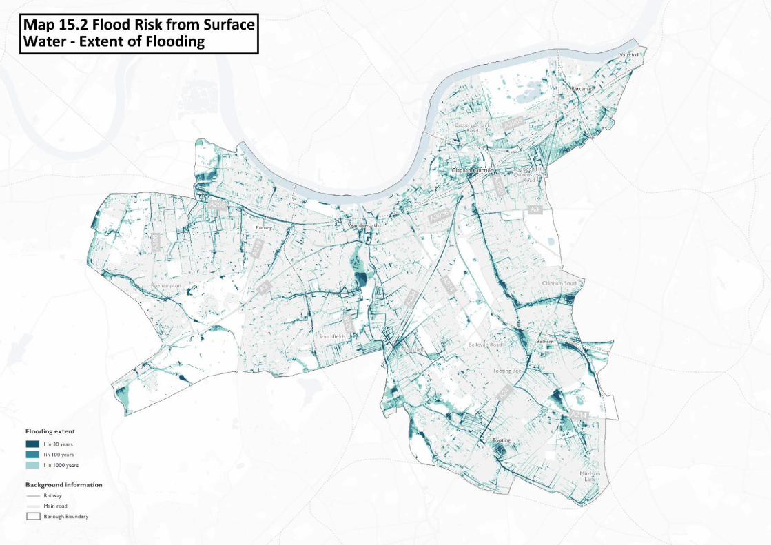
Basements
15.34Basements within flood affected areas of theborough represent a particularly high risk tolife, and it is essential that careful considerationis given to their design and use. Basements maybe subject to very rapid inundation offloodwater and it is essential that the minimumdesign requirements as set out in this policy aswell as in the Council's SFRA are rigorouslyadhered to.
15.35This policy restricts basement developments inareas of Extreme, Significant and ModerateBreach Hazard, as set out in the Council's SFRAand ‘More Vulnerable’ (such as residential) useswill only be considered if a site specific FloodRisk Assessment can demonstrate that the riskto life can be managed. An applicant will needto confirm with the Council whether adevelopment proposal is located within a breachhazard area in accordance with the SFRA.
15.36No essential services or storage space for keyprovisions and equipment should be located atbasement level where they need to remainoperational during a flood event. By virtue ofthe low lying nature of basements, they arevulnerable to many types of flooding and inparticular sewer flooding. Therefore, all newbasements with a waste outlet (such as toilets,bathrooms, utility rooms) will need to beprotected from sewer flooding through theinstallation of a suitable (positively) pumpeddevice, which will need to be shown in drawingssubmitted with a planning application.
15.37The Council's SFRA sets out further guidanceon basements, including how to assess groundfloor level and internal access levelrequirements for basements.
15.38 In addition to a Flood Risk Assessment (FRA),a Flood Emergency Plan will be required as setout in part A of the Policy. The main aims of aFlood Emergency Plan are to reduce the risk tolife, mitigate damage, and enable a safe and wellorganised evacuation of occupants of premisesduring a flood event.
15.39 It is necessary in some instances to identifywhether adequate flood warnings would beavailable and that people using the development
will act on them to keep safe. Depending onthe nature of a development and the severityof flooding on a site, a flood emergencyprocedure may entail retreating to a safe placeof refuge within the development, leaving thedevelopment by a signed safe access route todry ground beyond the flooded area, orpreparing for rescue by the emergency servicesto safe locations previously identified in a FloodEmergency Plan. More information is providedin the Council's guidance on producing a FloodEmergency Plan.
Surface Water Flooding
15.40The borough is very susceptible to surfacewater flooding. Surface water flooding happenswhen the ground and rivers cannot absorbheavy rainfall and when man-made drainagesystems have insufficient capacity to deal withthe volume of rainfall. Typically this type offlooding is localised and happens very quickly,making it very difficult to predict and givewarnings. With climate change predicting morefrequent short-duration, high intensity rainfalland more frequent periods of long-durationrainfall, coupled with an ageing Victorian sewersystem and increasing pressure from growingpopulations, surface water flooding is likely tobe an increasing problem.
15.41Therefore, to reduce the risk of surface waterand sewer flooding, all development proposalsin the borough that could lead to changes to,and have impacts on, surface water run-off arerequired to follow the emerging London Plandrainage hierarchy:
Store rainwater for later use.Use infiltration techniques, such as poroussurfaces in non-clay areas.Attenuate rainwater in ponds or openwater features for gradual release to awatercourse.Attenuate rainwater by storing in tanksor sealed water features for gradualrelease to a watercourse.Discharge rainwater direct to awatercourse.Discharge rainwater to a surface waterdrain.Discharge rainwater to a combined sewer.
247
15.42 If discharging surface water to a public sewer,developers are required to provide evidencethat capacity exists in the public seweragenetwork to serve their development in the formof written confirmation.
15.43The Council’s SFRA identifies reducing the rateof discharge from development sites togreenfield runoff rates as one of the mosteffective ways of reducing and managing floodrisk within the borough. Greenfield run-off isthe surface water drainage regime from a siteprior to development. To maintain the naturalequilibrium of a site, the surface water dischargefrom a developed site should not exceed thenatural greenfield run-off rate. Where greenfieldrun-off rates are not technically feasible,applicants will be expected to clearlydemonstrate how all opportunities to minimisefinal site runoff, as close to greenfield rate aspractical, have been taken. In such instances,the minimum requirement is to achieve at leasta 50% attenuation of the site's surface waterrunoff at peak times, based on the site'sperformance prior to development.
15.44Applicants and developers will need to submitevidence, as part of Flood Risk Assessments,that the above drainage hierarchy has beenfollowed and SuDS have been utilised wherefeasible.
15.45Borough-specific guidance on SuDS is set outin the Council's SFRA and CIRIA guidance.Flood resilient and resistant measures shouldbe incorporated into the design of developmentproposals in any area susceptible to flooding tominimise and manage the risk of flooding. Allparties involved on the design and developmentof buildings are expected to apply BS85500:2015, which provides guidance todevelopers and designers on how to improvethe flood resistance and resilience of buildingsto reduce the impacts of flooding from allsources.
15.46Existing developments in areas susceptible toflooding are encouraged to include floodresistant and/or resilient measures to mitigatepotential flood risks. Retrofitting properties byintegrating flood resilient and resistant measures
could help to reduce the consequences offlooding and would ultimately contribute topositively managing flood risk in the borough.
15.47 In addition to the above requirements, underthe Flood and Water Management Act 2010,the local planning authority has to consult theLead Local Flood Authority on SuDS for allmajor development proposals. Therefore,applicants have to submit drainage and surfacewater management designs as part of theplanning process. The satisfactory performanceof SuDS depends not only on good design butalso adequate maintenance, and provision foradoption and maintenance must be made fromthe outset. The Council will use planningconditions or obligations to make sure thatarrangements are in place for ongoingmaintenance over the lifetime of thedevelopment.
Flood Defences
15.48The protection of people, properties andinfrastructure from the risk of fluvial and tidalflooding is essential in this borough and theintegrity of the flood defence infrastructuremust therefore be maintained. Flood defenceinfrastructure includes formal and informal flooddefences and such defences may not always berecognisable and can include mounds, buildingsand walls.
15.49There is a statutory requirement for theCouncil to consult the Environment Agency forany development that could affect flood defenceinfrastructure; as a guide, this requirementapplies to proposals within an area of 20 metresfrom the top of the bank of a main river.
15.50Proposals for redevelopment should seekopportunities to set back the development fromexisting flood defences. The Council, inconjunction with the Environment Agency, willrequire a buffer zone of 8 metres on theborough's rivers, and 16 metres for the tidalThames. This is to allow for the maintenanceand future upgrading of the flood defences aswell as for improvements to flood flow andflood storage capabilities. Applicants arestrongly encouraged to liaise with theEnvironment Agency for any development that
248
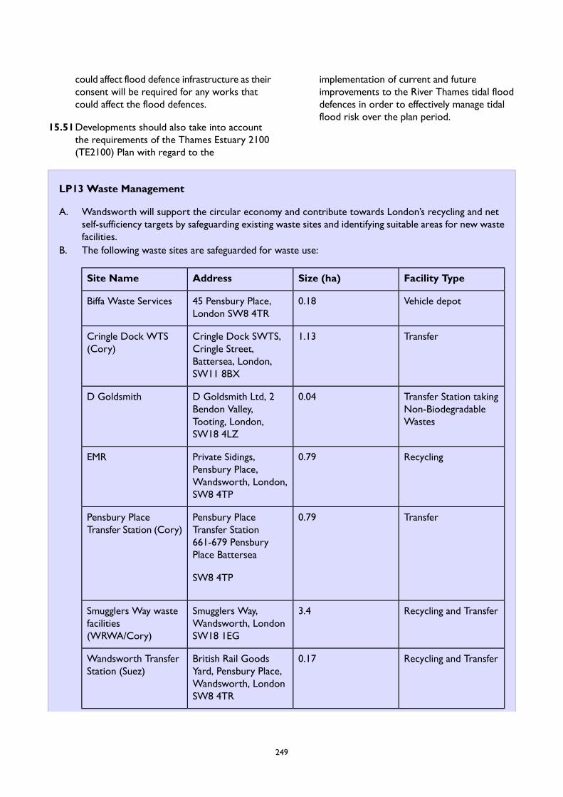
could affect flood defence infrastructure as theirconsent will be required for any works thatcould affect the flood defences.
15.51Developments should also take into accountthe requirements of the Thames Estuary 2100(TE2100) Plan with regard to the
implementation of current and futureimprovements to the River Thames tidal flooddefences in order to effectively manage tidalflood risk over the plan period.
LP13 Waste Management
A. Wandsworth will support the circular economy and contribute towards London’s recycling and netself-sufficiency targets by safeguarding existing waste sites and identifying suitable areas for new wastefacilities.
B. The following waste sites are safeguarded for waste use:
Facility TypeSize (ha)AddressSite Name
Vehicle depot0.1845 Pensbury Place,London SW8 4TR
Biffa Waste Services
Transfer1.13Cringle Dock SWTS,Cringle Street,Battersea, London,SW11 8BX
Cringle Dock WTS(Cory)
Transfer Station takingNon-BiodegradableWastes
0.04D Goldsmith Ltd, 2Bendon Valley,Tooting, London,SW18 4LZ
D Goldsmith
Recycling0.79Private Sidings,Pensbury Place,Wandsworth, London,SW8 4TP
EMR
Transfer0.79Pensbury PlaceTransfer Station661-679 PensburyPlace Battersea
Pensbury PlaceTransfer Station (Cory)
SW8 4TP
Recycling and Transfer3.4Smugglers Way,Wandsworth, LondonSW18 1EG
Smugglers Way wastefacilities(WRWA/Cory)
Recycling and Transfer0.17British Rail GoodsYard, Pensbury Place,Wandsworth, LondonSW8 4TR
Wandsworth TransferStation (Suez)
249
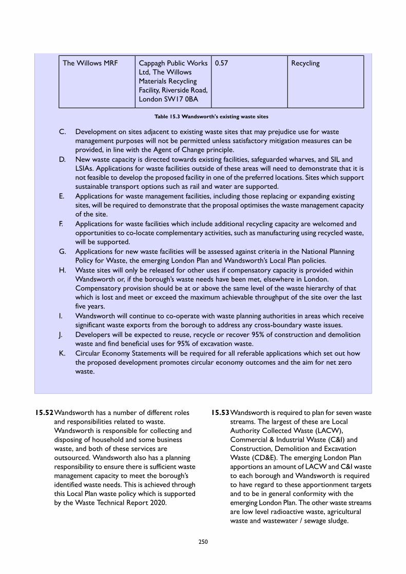
Recycling0.57Cappagh Public WorksLtd, The WillowsMaterials RecyclingFacility, Riverside Road,London SW17 0BA
The Willows MRF
Table 15.3 Wandsworth's existing waste sites
C. Development on sites adjacent to existing waste sites that may prejudice use for wastemanagement purposes will not be permitted unless satisfactory mitigation measures can beprovided, in line with the Agent of Change principle.
D. New waste capacity is directed towards existing facilities, safeguarded wharves, and SIL andLSIAs. Applications for waste facilities outside of these areas will need to demonstrate that it isnot feasible to develop the proposed facility in one of the preferred locations. Sites which supportsustainable transport options such as rail and water are supported.
E. Applications for waste management facilities, including those replacing or expanding existingsites, will be required to demonstrate that the proposal optimises the waste management capacityof the site.
F. Applications for waste facilities which include additional recycling capacity are welcomed andopportunities to co-locate complementary activities, such as manufacturing using recycled waste,will be supported.
G. Applications for new waste facilities will be assessed against criteria in the National PlanningPolicy for Waste, the emerging London Plan and Wandsworth’s Local Plan policies.
H. Waste sites will only be released for other uses if compensatory capacity is provided withinWandsworth or, if the borough’s waste needs have been met, elsewhere in London.Compensatory provision should be at or above the same level of the waste hierarchy of thatwhich is lost and meet or exceed the maximum achievable throughput of the site over the lastfive years.
I. Wandsworth will continue to co-operate with waste planning authorities in areas which receivesignificant waste exports from the borough to address any cross-boundary waste issues.
J. Developers will be expected to reuse, recycle or recover 95% of construction and demolitionwaste and find beneficial uses for 95% of excavation waste.
K. Circular Economy Statements will be required for all referable applications which set out howthe proposed development promotes circular economy outcomes and the aim for net zerowaste.
15.52Wandsworth has a number of different rolesand responsibilities related to waste.Wandsworth is responsible for collecting anddisposing of household and some businesswaste, and both of these services areoutsourced. Wandsworth also has a planningresponsibility to ensure there is sufficient wastemanagement capacity to meet the borough’sidentified waste needs. This is achieved throughthis Local Plan waste policy which is supportedby the Waste Technical Report 2020.
15.53Wandsworth is required to plan for seven wastestreams. The largest of these are LocalAuthority Collected Waste (LACW),Commercial & Industrial Waste (C&I) andConstruction, Demolition and ExcavationWaste (CD&E). The emerging London Planapportions an amount of LACW and C&I wasteto each borough and Wandsworth is requiredto have regard to these apportionment targetsand to be in general conformity with theemerging London Plan. The other waste streamsare low level radioactive waste, agriculturalwaste and wastewater / sewage sludge.
250

15.54London is working towards a circular economy.A circular economy is an economic model inwhich resources are kept in use at the highestlevel possible for as long as possible in order tomaximise value and reduce waste, moving awayfrom the traditional linear economic model of‘make, use, dispose’. To achieve this, theLondon Environment Strategy and the emergingLondon Plan set out targets for waste reduction,recycling and landfill diversion. In particularboroughs are expected to work in collaborationwith the Mayor and industry to ensure thatthere is zero biodegradable or recyclable wasteto landfill by 2026, and meet the 65% recyclingtarget for municipal waste by 2030, meet the95% reuse/recycling/recovery targets for C&Dwaste and meet the 95% target of beneficial usefor excavation waste. A negligible amount ofWandsworth’s LACW, C&I and C&D wastegoes to landfill so Wandsworth is alreadyachieving the target of zero biodegradable orrecyclable waste to landfill by 2026.Wandsworth is also already achieving over 95%recycling or recovery of C&D waste anddevelopers are expected to continue this highstandard and seek opportunities to putexcavation waste to beneficial use.
15.55Wandsworth is one of four London boroughs(along with Wandsworth, Hammersmith &Fulham and Kensington & Chelsea) for whichthe Western Riverside Waste Authority(WRWA) is the statutory waste disposalauthority for household waste. A thirty yearWaste Management Service Agreement(WMSA) was established between WRWA andCory Environmental Ltd to dispose of WRWAwaste, which ends in 2032. Some ofWandsworth’s household waste is managedwithin the borough, with recyclable materialgoing to a Materials Recovery Facility (MRF) atSmugglers’ Wharf. Only around 22% ofWandsworth’s Local Authority CollectedWasteis currently recycled. The majority of Residual(“black bag”) waste is taken to Smugglers WayTransfer Station in the borough and thentransported down river to the Belvedere energyrecovery facility in the London Borough ofBexley.
15.56The Mayor’s Environment Strategy containsambitious targets for municipal wastecomprising 50% of LACW by 2025 and 75% of
C&I waste by 2030. This is a challenging targetfor an inner London borough and the barriersto increasing household recycling rates are wellknown, for example the high proportion offlatted developments and low number ofgardens. The Council is required to be “ingeneral conformity” with the waste chapter ofthe Mayor of London’s Environment Strategywhich contains these targets. The Council’swaste Reduction and Recycling Plan (RRP) seeksto demonstrate this conformity.
15.57Household waste recycling (sorting/bulking) isthe responsibility of the Western RiversideWaste Authority (WRWA) and Wandsworthwill continue to work with the WRWA toincrease recycling and support delivery of thewaste management strategy. It is more difficultfor Wandsworth to directly influence businessrecycling rates and therefore partnershipworking with the London Waste and RecyclingBoard will be key to increasing business wasterecycling. In 2019/20, Wandsworth recycled23.7% of household waste.
15.58Design will be important in raising recyclingrates in Wandsworth, both at construction andend user stages. The emerging London Planrequires developers to submit ‘CircularEconomy Statements’ for all referableapplications which set out how the proposeddevelopment promotes circular economyoutcomes and the aim for net zero waste. Akey element of increasing municipal wasterecycling is to ensure there is sufficient spacefor the separation and storage of recyclablesfor collection and this will be assessed inaccordance with Policy LP 2 (GeneralDevelopment Principles).
15.59Wandsworth will contribute to the emergingLondon Plan target of net self-sufficiency by2026 by planning for capacity to manage theborough’s waste apportionment targets set outin the emerging London Plan, and the equivalentof 100% of C&D waste arisings, includinghazardous waste. Wandsworth will also seekopportunities for the beneficial use ofexcavation waste within the borough.Wandsworth’s waste needs over the planperiod are set out in the table below.
251
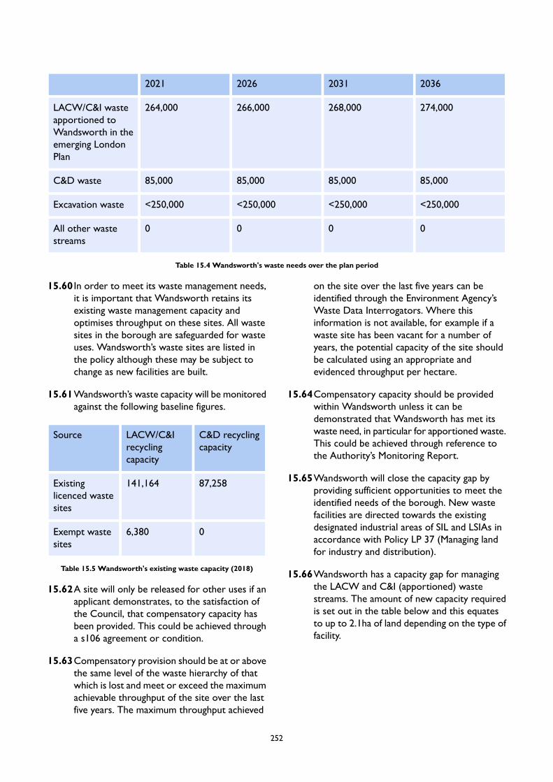
2036203120262021
274,000268,000266,000264,000LACW/C&I wasteapportioned toWandsworth in theemerging LondonPlan
85,00085,00085,00085,000C&D waste
<250,000<250,000<250,000<250,000Excavation waste
0000All other wastestreams
Table 15.4 Wandsworth's waste needs over the plan period
15.60 In order to meet its waste management needs,it is important that Wandsworth retains itsexisting waste management capacity andoptimises throughput on these sites. All wastesites in the borough are safeguarded for wasteuses. Wandsworth’s waste sites are listed inthe policy although these may be subject tochange as new facilities are built.
15.61Wandsworth’s waste capacity will be monitoredagainst the following baseline figures.
C&D recyclingcapacity
LACW/C&Irecyclingcapacity
Source
87,258141,164Existinglicenced wastesites
06,380Exempt wastesites
Table 15.5 Wandsworth's existing waste capacity (2018)
15.62A site will only be released for other uses if anapplicant demonstrates, to the satisfaction ofthe Council, that compensatory capacity hasbeen provided. This could be achieved througha s106 agreement or condition.
15.63Compensatory provision should be at or abovethe same level of the waste hierarchy of thatwhich is lost and meet or exceed the maximumachievable throughput of the site over the lastfive years. The maximum throughput achieved
on the site over the last five years can beidentified through the Environment Agency’sWaste Data Interrogators. Where thisinformation is not available, for example if awaste site has been vacant for a number ofyears, the potential capacity of the site shouldbe calculated using an appropriate andevidenced throughput per hectare.
15.64Compensatory capacity should be providedwithin Wandsworth unless it can bedemonstrated that Wandsworth has met itswaste need, in particular for apportioned waste.This could be achieved through reference tothe Authority’s Monitoring Report.
15.65Wandsworth will close the capacity gap byproviding sufficient opportunities to meet theidentified needs of the borough. New wastefacilities are directed towards the existingdesignated industrial areas of SIL and LSIAs inaccordance with Policy LP 37 (Managing landfor industry and distribution).
15.66Wandsworth has a capacity gap for managingthe LACW and C&I (apportioned) wastestreams. The amount of new capacity requiredis set out in the table below and this equatesto up to 2.1ha of land depending on the type offacility.
252
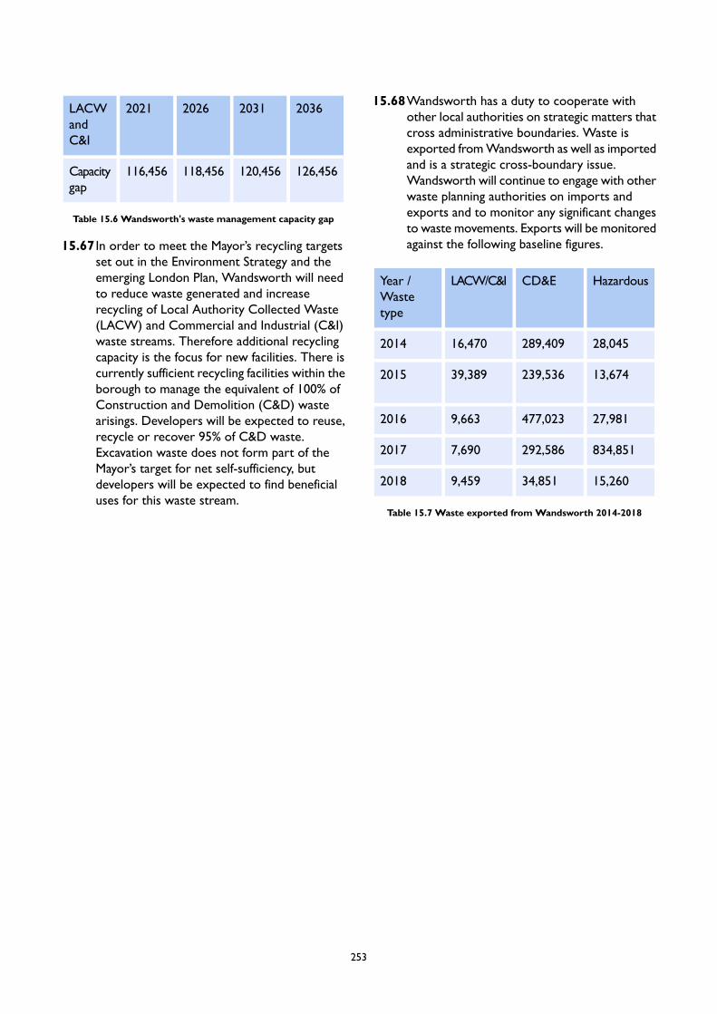
2036203120262021LACWandC&I
126,456120,456118,456116,456Capacitygap
Table 15.6 Wandsworth's waste management capacity gap
15.67 In order to meet the Mayor’s recycling targetsset out in the Environment Strategy and theemerging London Plan, Wandsworth will needto reduce waste generated and increaserecycling of Local Authority Collected Waste(LACW) and Commercial and Industrial (C&I)waste streams. Therefore additional recyclingcapacity is the focus for new facilities. There iscurrently sufficient recycling facilities within theborough to manage the equivalent of 100% ofConstruction and Demolition (C&D) wastearisings. Developers will be expected to reuse,recycle or recover 95% of C&D waste.Excavation waste does not form part of theMayor’s target for net self-sufficiency, butdevelopers will be expected to find beneficialuses for this waste stream.
15.68Wandsworth has a duty to cooperate withother local authorities on strategic matters thatcross administrative boundaries. Waste isexported fromWandsworth as well as importedand is a strategic cross-boundary issue.Wandsworth will continue to engage with otherwaste planning authorities on imports andexports and to monitor any significant changesto waste movements. Exports will be monitoredagainst the following baseline figures.
HazardousCD&ELACW/C&IYear /Wastetype
28,045289,40916,4702014
13,674239,53639,3892015
27,981477,0239,6632016
834,851292,5867,6902017
15,26034,8519,4592018
Table 15.7 Waste exported fromWandsworth 2014-2018
253

LP14 Air Quality, Pollution and Managing Impacts of Development
A. The Council will seek to ensure that local environmental impacts of all development proposals do notlead to detrimental effects on the health, safety and the amenity of existing and new users or occupiersof the development site, or the surrounding land. These potential impacts can include, but are notlimited to, air pollution, noise and vibration, light pollution, odours and fumes, solar glare and solardazzle as well as land contamination.
B. Developers should follow any guidance provided by the Council on local environmental impacts andpollution as well as on noise generating and noise sensitive development. Where necessary, the Councilwill set planning conditions to reduce local environmental impacts on adjacent land uses to acceptablelevel
Air Quality
C. The Council promotes ‘air quality positive’ design and the use of new technologies. Developmentproposals must be at least ‘Air Quality Neutral’, and should not contribute to a decrease in air qualityduring the construction or operation stage, in line with the emerging London Plan Policy SI 1.
D. To consider the impact of introducing new developments in areas already subject to poor air quality,the following will be required:
1. An air quality impact assessment, including modelled data, where necessary.2. Mitigation measures to reduce the development's impact upon air quality, including the type of
equipment installed, thermal insulation and ducting abatement technology.3. Measures and appropriate design to protect the occupiers of new developments, and in particular
vulnerable people and users such as children and the elderly, from existing sources.4. Strict mitigation for developments to be used by sensitive receptors such as schools, hospitals
and care homes in areas of existing poor air quality; this also applies to proposals close todevelopments used by sensitive receptors.
Noise and Vibration
E. The Council encourages reduction, management, and mitigation of noise and vibration resulting fromdevelopments to ensure that the health and quality of life of residents, especially within noise sensitivebuildings, is protected. Development proposals should have regard to the emerging London Plan PolicyD14, and following will be required, where necessary:
F. A noise assessment of any new plant and equipment and its impact upon both receptors and thegeneral background noise levels.
1. Mitigation measures where noise resulting from a development needs to be controlled andmanaged, including through the promotion of good acoustic and site design and use of newtechnologies.
2. Time limits and restrictions for activities where noise cannot be sufficiently mitigated, includingthrough the use of conditions.
3. Measures to protect the occupiers of new developments from existing sources, without harmingthe successful continued operation of existing uses in line with the Agent of Change principleset out in the emerging London Plan Policy D13.
Light Pollution
G. The Council will seek to ensure that artificial lighting in new developments does not lead tounacceptable impacts by requiring the following, where necessary:
254
1. An assessment of any new lighting and its impact upon any receptors.2. Mitigation measures, including the type and positioning of light sources.3. Promotion of good lighting design and use of new technologies.
Odours and Fume Control
H. The Council will seek to ensure that any potential impacts relating to odour and fumes from commercialactivities are adequately mitigated by requiring the following:
1. An impact assessment where necessary.2. The type and nature of filtration to be used.3. The height and position of any chimney or outlet.4. Promotion and use of new abatement technologies.
Land Contamination
I. Where development is proposed on contaminated or potentially contaminated land, a desk study andsite investigation in line with the most up-to-date guidance will be required. Proposals for theremediation of any contamination identified will need to be agreed with the Council before developmentproceeds.
J. Development proposals that involve hazardous processes, or which are located in proximity tohazardous installations, will need to ensure that the potential risk of adverse impacts on people andthe environment has been assessed, and that suitable mitigation measures are proposed. These shouldbe agreed with the Council in advance of the development taking place.
Construction and Demolition
K. The Council will seek to manage and limit environmental disturbances during construction anddemolition. To deliver this the Council requires the submission of Construction Management Statements(CMS) for the following types of developments:
1. All major developments.2. Developments of sites in confined locations or near sensitive receptors.3. If substantial demolition/excavation works are proposed.
L. Developments of sites in confined locations or near sensitive receptors.M. If substantial demolition/excavation works are proposed.
15.69Developers should explore ways to minimiseany harmful and adverse environmental impactsof development, including during constructionand demolition. The design and layout of newdevelopment should minimise conflict betweendifferent land uses, taking account of users andoccupiers of new and existing developments.Therefore, any noisy or polluting activities orfeatures, such as plant equipment, should bepositioned away from sensitive areas wherepossible to ensure any detrimental impacts onhealth, living conditions or amenity are kept toacceptable levels. Where possible, development
that is likely to generate pollution should belocated away from sensitive uses such ashospitals, schools, care homes and wildlife sites.
15.70Where there are already significant adverseeffects on the environment, amenity or livingconditions due to pollution, sensitive usesshould ideally be steered away from those areas.However, given the limited availability of landfor development in this borough, this will notalways be possible. New developments,including changes of use, should therefore
255
mitigate and reduce any adverse impactsresulting from air and light pollution, noise,vibration and dust to acceptable levels
Air Quality
15.71Air pollution has a significant impact on climateand on people’s quality of life and health. It isessential that exposure to atmosphericpollutants is minimised across the borough.There are a number of areas in the boroughthat do not comply with the air quality targetsand action must be taken to control, minimiseand reduce the contributing factors of poor airquality.
15.72The borough has been an Air QualityManagement Area since 2001 due toconcentrations of pollutants exceeding nationalair quality standards. As such, any newdevelopment and its impact upon air qualitymust be considered very carefully. Strictmitigation will be required for any developmentsproposed within or adjacent to ‘Air QualityFocus Areas’. An ‘Air Quality Focus Area’ is alocation that has been identified as having highlevels of pollution (i.e. exceeding the EU annualmean limit value for nitrogen dioxide) andhuman exposure. Air Quality Focus Areas aredesignated by the Greater London Authority(GLA). The Council has produced a revised AirQuality Action Plan for 2016-2021. Thiscontains measures to improve air quality acrossthe borough helping to reduce the keypollutants of concern within the borough –Nitrogen Dioxide (NO2) and Particulate Matter(PM10). It sets out several key measures,ranging from minimising emissions from Councilactivities, promoting alternative modes oftransport to the car, for both journeys to workand business related journeys, to encouragingwalking and cycling and the use of publictransport, and discouraging people driving tostations.
15.73 In accordance with the emerging London Plan,Policy SI 1 air quality assessments will berequired for major developments, developmentsassociated with sensitive uses/receptors, suchas schools, and where considerable demolitionwill occur. The GLA have committed toproducing further guidance on Air QualityNeutral and Air Quality Positive approaches,
as well as guidance on how to reduceconstruction and demolition impacts, andapplicants should have regard to this guidance.
15.74The consideration of existing air quality issuesshould be addressed at the planning applicationand design stage, with solutions identified inorder to appropriate mitigate against potentialrisk. This will reduce the need for post-designor retro-fitted mitigation measures.Developments are encouraged to take a holisticair quality positive approach, using multi-facetedmeans such innovative design solutions, urbangreening, and energy masterplanning and othermitigation strategies to improve air quality inall developments.
15.75Measures to improve air quality should beimplemented on-site, however where it can bedemonstrated that on-site provision is notfeasible, off-site measures to improve local airquality may be acceptable, provided thatequivalent air quality benefits can bedemonstrated. The Council will seek financialcontributions through the use of PlanningObligations towards air quality measures wherea proposed development is not air qualityneutral or mitigation measures do not reducethe impact upon poor air quality.
15.76The GLA have committed to producing furtherguidance on Air Quality Neutral and AirQuality Positive approaches, as well as guidanceon how to reduce construction and demolitionimpacts, and applicants should have regard tothis guidance, as well as the stipulations of theemerging London Plan Policy SI 1.
Noise and Vibration
15.77Noise pollution can have a harmful effect onpeople’s health and wellbeing. Wandsworth’surban setting and character means that thereare multiple contributors to noise and vibration,as well as the more localised impact of factorswhich can intensify this, such as busy roads,major railway lines, aircraft flight paths (includingthat from the London Heliport), and as aproduct of certain commercial and industrialuses. The Council will seek to reduce as muchas possible, the harmful impact of noise and
256
vibration through effective management andmitigation measures, in line with London PlanPolicy D14.
15.78Applicants need to consider acoustic design atan early stage of the planning process to ensureoccupiers of new and existing noise sensitivebuildings are protected.
15.79The Council will protect existing businesses andindustrial uses in line with the economic landpolicies set out in this Plan (Chapter 19).Businesses should not have unreasonablerestrictions put on them because future noisesensitive uses are subsequently permittedadjacent to the business or within thesurrounding area; this also includes changes ofuse. Therefore, proposed new noise sensitivedevelopments should follow good acousticdesign principles and incorporate adequatemitigation measures to ensure appropriateacoustic conditions in new developments. TheAgent of Change principle, set out in theemerging London Plan Policy D13, will apply.
Light Pollution
15.80Though an important part of the urbanenvironment, artificial lighting when notcontrolled, is poorly designed or positionedincorrectly can have a detrimental effect uponoccupiers and residents. As part of thedevelopment process steps must be taken toensure that the impact of artificial lighting isconsidered carefully. This related to therequirements of Policy LP 2 (GeneralDevelopment Principles).
Odours and Fume Control
15.81Some commercial activities can have an impactupon the local environment; these impacts caninclude such things as odours, fumes, dust andsteam. As part of the development processsteps must be taken to ensure that any impactis considered carefully and that mitigation is inplace to manage these types of emissions.
Land Contamination
15.82There are sites within Wandsworth boroughthat have previously, or are currently, occupiedby industrial activities and utilises which couldhave resulted in the contamination of the land.
Where development is proposed on such sites,the Council promotes the remediation of suchcontaminated land to ensure that future usescan safely be accommodated on site. To deliverthis, the Council will:
require a desk top study and preliminaryassessment, including of the site’s history,potential contamination sources, pathwaysand receptors;where necessary, require a siteinvestigation and detailed risk assessmentin line with current best practice guidance,including where appropriate physicalinvestigations, chemical testing andassessments of ground gas risks and risksto groundwater;where necessary, require a remediationstrategy that sets out how any identifiedrisks from the reports above are going tobe addressed; andwhere necessary, require a validationreport once remediation has taken place,including evidence that demonstrates thatrisks from contamination have beencontrolled effectively.
15.83The location of development involvinghazardous substances and processes will needto be carefully considered. It will not beappropriate in many locations, and where it is,all risks to either people or the environmentwill need to be assessed and appropriatelymitigated.
15.84The Council will apply the Health and SafetyExecutive’s land use planning methodology inthe event of a proposal being located near to ahazardous installation. In combination withadvice provided by the Health and SafetyExecutive, consideration will also be given tosite-specific circumstances and any proposedmitigation measures. If the Health and SafetyExecutive advise against development, planningpermission will only be granted in circumstanceswhere it can be demonstrated that the benefitsarising from the proposed development wouldsignificantly outweigh the potential risks tohealth and the local environment.
Construction and Demolition
257
15.85 In addition to the operational phase of adevelopment, there is a need to ensure thatoccupiers are protected from environmentaldisturbances during the construction anddemolition phases.
15.86The Council requires the submission ofConstruction Management Statements (CMS)for the types of developments as set out in thepolicy. In addition, in certain circumstances, theCouncil may also require a ConstructionLogistics Plan (CLP), in areas that are subjectto high traffic congestion to ensure that vehiclesentering the site do not adversely impact onlocal traffic; and a management plan that setsout how developers monitor dust, noise andvibration, and where necessary take theappropriate action if issues arise.
15.87To limit the impact of construction anddemolition, it will also be necessary to controlthe hours of operation for noisy site works, aswell as the processes that would need to befollowed in order to work outside these hourswhen and if required.
15.88As part of the Council's commitment to betterair quality, the Council will also request, throughplanning conditions, that the GLA Regulationrelating to Non Road Mobile Machinery(NRMM) is imposed where necessary.
15.89 In applying this policy, developers should haveregard for the guidance as set out in the Mayorof London's 'The Control of Dust and EmissionsDuring Construction and Demolition'Supplementary Planning Guidance (SPG).
258
16 Providing for Wandsworth'sPeople
Introduction
16.1 Wandsworth is more than just a place to liveand work. A wide range of facilities such ashealth, education, culture, sports, leisurefacilities, places of worship, emergency servicesare required to meet the borough’s needs. Thebuilt environment can help influence changes inlifestyle and help achieve positive healthoutcomes. The Council will seek to secure alocal environment which promotes physicalactivity and mental wellbeing through newdevelopment, and seek to improve people’seconomic, social and environment conditions.Given the projected population growth inWandsworth and the change in the profile offuture residents, there will be a need to protect,improve and provide new social and communityfacilities to ensure adequate provision andenhancement to meet the changing needs ofWandsworth’s community. The Council willwork with the relevant stakeholders toencourage the provision and design of flexiblecommunity facilities that can accommodate arange of needs, where appropriate.
16.2 The Council will continue its strong stance forthe protection of pubs. The Government hasnow amended the Use Classes Order (UCO)
and removed pubs from the General PermittedDevelopment Order which helps prevent theirloss where local policy exists to protect pubs.Wandsworth took a leading role in protectingits pubs and continues to do so which nowreflect the Government’s ambition to protectpubs underlining their importance to thecommunity and this borough.
16.3 The contribution of arts, culture andentertainment is significant to Wandsworth’scommunity needs, economic development,vitality and regeneration. There are a significantnumber of artists, designers, and other creativeprofessionals, and the creative industriescontribute strongly to the local economy.
16.4 Recent times have highlighted more than everthe importance of a reliable, extensivebroadband network for all residents andbusinesses to enable access to technology.Getting such a network for the borough’sresidents and tackling digital exclusion as wellas building on the boroughs excellent trackrecord for encouraging investment in theborough and through the creation of localopportunities for residents to enhance socialmobility. The Plan will support the provisionand improvement of utilities and digitalinfrastructure to ensure capacity meets demand.
LP15 Health and Wellbeing
A. The Council will promote and support development, particularly for priority neighbourhoods inTooting Battersea, Queenstown and Roehampton, which enables healthy and active lifestyles andincludes measures to reduce health inequalities through the provision of:
1. access to sustainable modes of travel including safe cycling routes, attractive walking routes andeasy access to public transport to reduce car dependency;
2. access to green infrastructure, including to river corridors, open spaces and leisure, recreationand play facilities to encourage physical activity;
3. access to local community facilities, services and shops which encourage opportunities for socialinteraction and active living, as well as contributing to dementia-friendly environments;
4. access to local healthy food opportunities, allotments and food growing spaces;
260
5. an inclusive development layout and public realm that considers the needs of all, including theolder population and disabled people; and
6. active Design which supports wellbeing and greater physical movement as part of everydayroutines.
B. Planning Applications will be required to demonstrate that:
1. health benefits have been maximised through the submission of a Health Impact Assessment forall development proposals which include 50 or more residential units;
2. proposals for fast food takeaways would not result in an over-concentration of such uses locatedwithin 400 metres of the boundaries of a primary or secondary school;
3. existing health facilities will be retained where these continue to meet, or can be adapted tomeet, residents’ needs; and
4. new or improved facilities or loss of health and social care facilities accord with the requirementsof Policy LP 17.
16.5 Health and wellbeing is a cross-cutting theme,which has links to many other parts of the LocalPlan.
16.6 The environment in which we live is a keydeterminant in people's health and wellbeing.The planning system plays an important role ininfluencing the built and natural environmentand therefore plays a key role in the physicaland mental wellbeing of the population. Ahealthy environment can promote wellbeingand healthy lifestyles for all and can contributeto a reduction in health inequalities.
16.7 The health and wellbeing of individuals andpopulations is affected by the built and naturalenvironment within which they areencompassed. Good or bad health is not simplythe result of individual behaviours, genetics andmedical care. A substantial part of the differencein health outcomes is down to a diverse rangeof social, economic and environmental factorsthat shape people’s lives which are oftenreferred to as the ‘wider determinants of health’or ‘social determinants’.
16.8 The Joint Strategic Needs Assessment (JSNA)for the borough identifies that a high proportionof the population have unhealthy lifestyles.Unhealthy lifestyles, influenced by theenvironments in which we live, are contributingto a rise in preventable illnesses such asdiabetes, obesity and cardiovascular andrespiratory diseases. Prevention of ill-health by
helping people to live healthier lives in order toprevent avoidable illness, is a major focus of thehealth services.
Picture 16.1 Settlement Health Map (Barton and Grant, 2006)
16.9 Healthy and active people tend to be lessdependent on health and social care servicesso there are tangible economic benefits inencouraging and making it easy for thepopulation to lead healthy lifestyles. Planningcan play a part in facilitating the creation ofhealthy environments. Development shouldresult in a pattern of land uses and facilities thatmake the healthy choice the most convenientand attractive option for residents, helping them
261

to lead healthier lives more easily. Some factorsthat determine our health, such as age, genderand genetics cannot be modified. Other factors,such as health behaviours or impact of socialor economic situations, can be modified ormitigated through individual and collectiveaction and effective programs and policies. Inthis Local Plan health is referred to in itsbroadest sense which is a person’s level of goodphysical and mental health, and the extent towhich individuals are enabled to live healthy andflourishing lives.
16.10There is an emerging obesity issue in theborough, particularly in children. Childhoodobesity amongst school age children is aconcern as evidence suggests that obesechildren are more likely to be obese adults andare at an increased risk of developing furtherhealth difficulties. Access to fast food takeawayscan influence the ability of individuals to adopthealthy lifestyles and have the potential toundermine healthy eating initiatives that may bein place at the school. Therefore, this policyfocuses on overconcentration of these uses inclose proximity to schools in line with theemerging London Plan.
LP16 Public Houses and Bars
A. The loss of public houses and bars will be resisted. Public Houses and bars of historic or architecturalinterest and/or community value will be protected from demolition and/or change of use.
B. Proposals involving the loss of public houses and bars must demonstrate that:
1. no historic or architectural interest would be lost; and2. the public house/bar has no community value and is not viable as a pub/bar or that it could not
be used for another social or community use by requiring a full and proper marketing exercisefor a period of at least 24 months in line with the requirements set out in Appendix 1.
16.11Public houses (including bars) play an importantrole and social function in the local communityand add to the local character of the area, oftenbeing buildings of historical or architecturalinterest. Therefore, the Council will protectpubs where they are of historic or architecturalinterest and will require satisfactory marketingevidence to establish that the pub is firstly notviable and secondly that it is not viable as analternative social or community use. The listingof a pub as an Asset of Community Value willalso be a material planning consideration. TheCouncil would assess the historic andarchitectural interest including for example;whether the pub is a listed building, locallylisted, located within a conservation area or hasother significance as a heritage/architecturalasset in accordance with the National PlanningPolicy Framework (NPPF).
16.12The Council places great importance on keepingpubs at the heart of the community. In 2015the Town Centre Uses SPD was adopted which
considered both the historic and architectural,and community value of pubs to plan positivelyfor their protection. The information set outin this SPD may now be out of date andtherefore consideration of these criteria wouldneed to be re-assessed at the time of anapplication in accordance with the above policy.In 2015 the Council introduced an Article 4Direction to ensure pubs could be protected.Since September 2020 Public Houses are classedas a ‘Sui Generis’ use which underlines theirimportance to the community and this policyseeks to ensure that the Council has a strongpolicy basis to reflect the Government’sambition to protect pubs. The positive changeto the UCO for pubs somewhat supersedes theCouncil’s pubs Article 4 Direction in respectof a change of use, however it still continues tohave importance for particularly demolition andalterations, including painting.
262
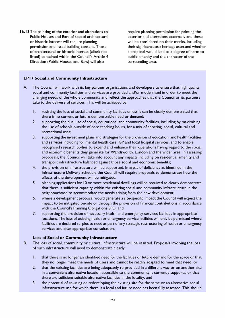
16.13The painting of the exterior and alterations toPublic Houses and Bars of special architecturalor historic interest will require planningpermission and listed building consent. Thoseof architectural or historic interest (albeit notlisted) contained within the Council’s Article 4Direction (Public Houses and Bars) will also
require planning permission for painting theexterior and alterations externally and thesewill be considered on their merits, includingtheir significance as a heritage asset and whethera proposal would lead to a degree of harm topublic amenity and the character of thesurrounding area.
LP17 Social and Community Infrastructure
A. The Council will work with its key partner organisations and developers to ensure that high qualitysocial and community facilities and services are provided and/or modernised in order to meet thechanging needs of the whole community and reflect the approaches that the Council or its partnerstake to the delivery of services. This will be achieved by:
1. resisting the loss of social and community facilities unless it can be clearly demonstrated thatthere is no current or future demonstrable need or demand;
2. supporting the dual use of social, educational and community facilities, including by maximisingthe use of schools outside of core teaching hours, for a mix of sporting, social, cultural andrecreational uses;
3. supporting the investment plans and strategies for the provision of education, and health facilitiesand services including for mental health care, GP and local hospital services, and to enablerecognised research bodies to expand and enhance their operations having regard to the socialand economic benefits they generate for Wandsworth, London and the wider area. In assessingproposals, the Council will take into account any impacts including on residential amenity andtransport infrastructure balanced against those social and economic benefits;
4. the provision of infrastructure will be supported. In areas of deficiency as identified in theInfrastructure Delivery Schedule the Council will require proposals to demonstrate how theeffects of the development will be mitigated;
5. planning applications for 10 or more residential dwellings will be required to clearly demonstratethat there is sufficient capacity within the existing social and community infrastructure in theneighbourhood to accommodate the needs arising from the new development;
6. where a development proposal would generate a site-specific impact the Council will expect theimpact to be mitigated on-site or through the provision of financial contributions in accordancewith the Council’s Planning Obligations SPD; and
7. supporting the provision of necessary health and emergency services facilities in appropriatelocations. The loss of existing health or emergency service facilities will only be permitted wherefacilities are declared surplus to need as part of any strategic restructuring of health or emergencyservices and after appropriate consultation.
Loss of Social or Community InfrastructureB. The loss of social, community or cultural infrastructure will be resisted. Proposals involving the loss
of such infrastructure will need to demonstrate clearly:
1. that there is no longer an identified need for the facilities or future demand for the space or thatthey no longer meet the needs of users and cannot be readily adapted to meet that need; or
2. that the existing facilities are being adequately re-provided in a different way or on another sitein a convenient alternative location accessible to the community it currently supports, or thatthere are sufficient suitable alternative facilities in the locality; and
3. the potential of re-using or redeveloping the existing site for the same or an alternative socialinfrastructure use for which there is a local and future need has been fully assessed. This should
263
include evidence of completion of a full and proper marketing exercise of the site for a periodof at least 18 months in line with the requirements set out in Appendix 1;
4. that it can be shown that the proposal does not constitute the loss of a service of particularvalue to the local community which may impact the vitality of the area; and
5. if B (2) applies, adequate replacement floorspace must be of equal or improved capacity, designand layout as that being lost through development and must be in accordance with C below.
New, improved and replacement social and community infrastructureC. Proposals for new or extensions to existing social and community infrastructure will be supported
where:
1. it provides for an identified need, particularly in areas of regeneration or growth and investmentareas;
2. it is close or accessible to the community it is intended to serve by a range of transport modesincluding walking, cycling and public transport and is designed to be accessible for all, includingfor people with disabilities;
3. are contained in buildings which are of a high quality and inclusive design, are flexible, adaptable,capable of multi-use and makes provision for potential future expansion where possible;
4. a maintenance and funding plan has been submitted which demonstrates that sufficient fundingcan be secured to provide for its on-going maintenance and that service charges will be affordable;
5. it is in a location that would not result in an over-concentration of similar facilities in anyresidential area;
6. it would not result in a loss of residential units;7. would support the co-location of activities and services where practical;8. innovative ways of addressing constrained sites are promoted including through the use of shared
facilities, meanwhile provision, off-site and multi-storey provision and that the use of any buildingsare maximised in the evenings and at weekends; and
9. planning permission is granted, conditions may be used in order to protect this provision in thelong term.
16.14Wandsworth has a range of community facilitieswhich includes uses for; education and training,health, social, leisure, places of worship, burialspaces, community spaces including publichouses and bars where these are of communityvalue, cultural and civic uses and provisionrelated to community safety such as police andemergency services. The provision of theseessential community facilities plays a vital rolein creating and sustaining liveableneighbourhoods through providing valuableservices.
16.15 In determining whether there is a need ordemand for community facilities in the contextof these policies, reference should be made toCouncil publications including but not limitedto the following documents, subsequent updatesor versions and any other relevant material
Draft Cultural Strategy for WandsworthCultural Strategy for Nine Elms andBatterseaWandsworth Children and Young People’sPlanWandsworth Adult and CommunityLearning and Development PlanWandsworth Joint Strategic NeedsAssessmentWandsworth Teaching Primary Care TrustCommissioning Strategy Plan(The Council is also preparing a culturalfacilities map, which will include acomprehensive stock-take of communityfacilities in the borough and will be madeavailable on the Council's website):
264
16.16An Infrastructure Delivery Plan (IDP) willprovide an infrastructure assessment for theborough which links into the Local Plan. TheIDP sets out what is needed, where it is neededand when it is needed. It will also provide anupdate on the delivery of the requiredinfrastructure to date. It also sets out the rangeof plans, programmes and strategies, includingthose of partner organisations and agencies.
16.17Each infrastructure type will be accompaniedby an Infrastructure Delivery Schedule table (aspart of the IDP) which provides further detailon delivery, funding sources, costs and identifieswhether there are any funding gaps.
16.18Funding to support the development of theborough in relation to public facilities willgenerally be provided through the Council aspart of the standard CIL charge. However,where a development generates a site-specificimpact this can be mitigated through the use ofdeveloper contributions, subject to theRegulation 122 tests. The Infrastructure FundingStatement will set out the year’s income andexpenditure relating to the communityinfrastructure levy (CIL) and section 106 (S106)agreements.
16.19The cost of land and the impact of theCOVID-19 pandemic on community groups haseffected the ability of facilities to continue torun in the short term in Wandsworth whichmeans that community facilities may comeunder pressure from uses which attract higherland values. Without protection against this, thecommunity may lose an accessible facility orthose suitable for voluntary and ethnic minoritycommunity groups. Once these sites are lostto other uses it can be very difficult to findalternative sites or return to their previous use,especially for use by voluntary groups. Wherepossible and in accordance with other LocalPlan policies vacant or underutilised facilitiesshould be brought into use, to help addressthese needs.
16.20The use of a building and the needs ofcommunities can change over time. In somecases, change might be inevitable or desirable,to meet the variable needs of users or throughthe efficient use of land through dual-use offacilities. Therefore, new community facilities
should be designed to be flexible and adaptableto changing circumstances including beingcapable of multi-use and expansion.
16.21Where appropriate, new and existing social andcommunity infrastructure will be encouragedto offer and use space for art and cultural eventspace in line the principles of co-location toensure efficient use of land. Additionally, theservice providers through co-location will beable to share spaces and services and to reducecapital and revenue costs. Innovative approachesto the land should be employed and the Councilpromotes the use of solutions which mayinclude meanwhile provision to enableredevelopment of an existing site. Othersolutions could include multi-storey provision,such as roof top playgrounds.
16.22The Council aims to promote innovativeinnovative ways of addressing constrained sitessuch as the use of shared facilities, meanwhileprovision, off-site and multi-storey provision;and maximising use of buildings in evenings andat weekends. All new community facilitiesshould be accessible, welcoming, inclusive andopen and available to all members of the localcommunity with sufficient capacity and flexibilityto meet a range of local needs. A smallerquantity of floorspace may be acceptable whereit is demonstrated to the satisfaction of thecouncil that the new accommodation can beused more effectively.
16.23To assess the loss of community facilities orfloorspace, the Council will require evidenceto justify the loss. The Council must be satisfiedthat either an adequate replacement facility isprovided, or there are no reasonable prospectsof reuse by an alternative community use. Thepremises/site should be marketed to theCouncil's satisfaction for at least 18 months.Where a development proposal involves eithera new or loss to a community facility it shouldnot have a detrimental effect on the design,character, significance and setting of buildingsor areas of acknowledged heritage value.
16.24The emerging London Plan states that socialinfrastructure should be easily accessible bywalking, cycling and public transport inaccordance with the Healthy Streets Approachand LP51 Sustainable Transport. Where
265
practicable new community facilities should belocated so that they are close to schools, localshopping facilities and public transport and othercommunity services to reduce the number oftrips people need to make to access them.However, it is acknowledged that there may becircumstances where the needs of a particulargroup or client base mean that it does not needto be located close to other services. In suchinstances, applications would need to besupported with information demonstrating howthe lack of access to other services will not have
a negative impact on the end users of the newcommunity facility and the amenity of thesurrounding area.
16.25Where possible services will be co-located soas to enable multipurpose trips, reduce the needto travel and for the convenience of the user.
16.26 It is noted that changes of use between useswithin Class E of the UCO do not requireplanning permission, which limits the scope ofthis policy’s application. Where planningpermission is required the Council may imposeconditions to restrict further change of use inthe future.
LP18 Arts, Culture and Entertainment
A. Proposals for new cultural space will be supported where:
1. new provision or extensions to arts, culture and entertainment provision will attract significantnumbers of visitors into the borough’s town centres and the emerging centres at BatterseaPower Station and Nine Elms within the Central Activities Zone;
2. it is located in an area which is accessible by public transport, walking and cycling routes includingby those that are likely to use the facility from outside the local area, including in Focal Pointareas, Winstanley and Lombard Road/York road areas designated as a Creative Enterprise Zoneby the GLA; and within the Hubs in the area designated in Nine Elms as a Design and TechnologyQuarter which must support the creative/cultural workspace;
3. it involves Meanwhile cultural uses within parks, highly accessible areas and town centre locations.Meanwhile cultural uses focused around maker spaces and creative workspaces will be permittedin vacant buildings within areas of lower footfall;
4. it makes provision for Arts, culture and entertainment activities as part of enhanced and newpublic realm; and
5. it supports placemaking; accounting for the Area Strategies of this Plan and the Council’s emergingArts and Culture Strategy
B. The loss of accommodation used for arts, culture or entertainment purposes will be resisted.C. In assessing the suitability of proposals, the following criteria will be taken into account:
1. whether the building has been purpose built or specifically adapted;2. the adaptability of the building for other arts, culture and entertainment purposes;3. the availability of other facilities locally to meet existing and future demand;4. access by public transport;5. the relationship with adjoining uses;6. the impacts of the re-provision on existing occupiers and users of the facility;7. changes in the mix of uses arising from the loss of the existing cultural/leisure facility;8. the loss of cultural heritage;9. the affordability of the proposed new facility; and10. where a replacement facility is proposed, it should be at the same or better standard than the
facility which is lost and continue to be accessible to its existing users.
266
D. In accordance with the Council’s adopted Planning Obligation SPD, in circumstances agreed by theCouncil where an applicant is unable to provide an Arts and Culture Action Plan, it is not appropriatedue to the scale and nature of the scheme, or is located within the Nine Elms Design and TechnologyQuarter (where there are proposed creative incubator hubs) or Garratt Lane area then a commutedsum will be sought to enable the Council to meet the requirements for such provision within in thelocal area.
E. As part of the planning application where applicable, as detailed in the Planning Obligation SPD theapplicant will be required to produce and realise a robust Arts and Culture Action Plan to enhancethe range of arts and cultural opportunities in the area.
16.27The emerging Arts and Culture Strategy is theCouncil’s commitment to creating a long termcreative vision for the borough, and to helpachieve its placemaking objectives, to helpimprove the lives of residents, supporteconomic growth and local jobs, and createthriving local neighbourhoods. It takes a broadview of culture and arts, and its vital link toheritage. This can include: dance, music, theatre,visual arts, combined arts, architecture, crafts,fashion, film, literature, museums, collectionsand culinary art, libraries and heritage, but notsports or parks.
16.28Arts, Culture and Entertainment (ACE) usesare main town centre uses which should belocated within town centres and the CAZ. TheNPPF and the National Planning PracticeGuidance (NPPG) set out the approach toassessing proposals for new ACE uses. Theemerging London Plan recognises and promotesa diverse range of uses to support the vitalityand viability of town centres and encouragesthe repurposing/redevelopment of surplus retailspace for alternative main town centre uses.The importance of the visitor/tourism sectorto London’s economy is highlighted and isexpected to grow.
16.29The emerging London Plan sets out a hierarchyof town centres and confirms policy supportfor a diverse range of arts, culture sport andentertainment provision and enhancement. TheMayor's Cultural Strategy seeks to promoteLondon's cultural and arts facilities as visitorattractions. This was taken into account in theborough's Retail and Town Centre NeedsAssessment (2020) which did not identify a needfor substantial growth in the borough for such
uses but did identify potential growth and maybe potential to improve certain facilities by2040.
16.30As identified in the Retail Needs Assessment,the proximity and wide range of ACE useswithin Central London and within the largercentres in south and south west London suchas Croydon and Kingston, contribute to meetingthe needs of the borough. The Council's draftArts and Culture Strategy seeks to promoteand encourage participation in the borough'sarts, culture and entertainment facilities.Integrating art in the public realm withindevelopment opportunities contributes to thecreation of unique, high quality environmentswhich people want to be in, as well assupporting crime reduction and communitycohesion objectives.
16.31High densities and activity levels in theborough's town centres mean that thecombination of higher ambient noise levels andhigh public transport accessibility identify themas being the most suitable and sustainablelocations for ACE uses. Whilst the borough isclose to the West End, the borough's ACEfacilities have much to offer with key providerssuch as Battersea Arts Centre, the RoyalCollege of Art and the Pump House Gallery,Putney School of Art and Design, BackyardCinema and Turbine Theatre, and someimportant annual events such as the Putney BoatRace, Wandsworth Arts Fringe and BatterseaPark Fireworks Display. Arts, Culture andEntertainment uses can make an importantcontribution to the vitality and viability of thetown centres, to the regeneration andemployment generating objectives of the focalpoints and to create and maintain vibrant activeplaces along the riverside as visitor attractions.
267

The Council expects the siting of new facilities,including the expansion of existing provision,to consider its associated impacts.
16.32As such, large scale facilities which will attractsignificant numbers of people into the area andmake use of public transport to get there maynot be appropriate in out-of-centre locations(including Focal Points which are not in a towncentre). The Council will expect any suchproposals to be accompanied by an impactassessment, as set out in the NPPF and NPPG,to the specification of the Council andproportionate to the scale of developmentproposed.
16.33The symbiosis between the cultural sector andcreative industries, in effect existing as a distinctecosystem, is recognised and supported,especially the amplifying effect they have onwages, productivity and innovation. Therefore,smaller facilities or large facilities that do notattract significant numbers of visitors could beappropriate in other areas of the boroughproviding they do not have an adverse impacton the surrounding area or the local communityand are in accordance with other Local Planpolicies. This is particularly the case in areaswhere there are already embryonic clusters ofcreative industries (design, music, publishing,architecture, film and video, crafts, visual arts,fashion, TV and radio, advertising, literature,computer games and the performing arts) suchas around the Battersea Design and TechnologyQuarter, Wandle Delta, Wandle Valley and theWandsworth Riverside.
16.34With the advancement of technology, a largerrange of services are now delivered onlinewhich can result in vacant retail units. Thisallows opportunities for a broader and morediverse range of town centre uses, includingarts and cultural uses to be introduced into theborough’s town centres making them the hubsof local life. The temporary use of buildings forexample, may offer the opportunity forcommunity uses, thereby helping to enliventown centres, where vacancy is an issue.
16.35The assessment of other cultural and arts eventssuch as sculpture and heritage trails andexhibitions will be assessed on an individualbasis taking account of the NPPF, the emerging
London Plan policies, design policies, andcontrols exercised by other legislation includingthe entertainment licensing regulations. Underthe Licensing Act 2003, small-scale one-offevents which involve licensable activities cantake place with a Temporary Event Notice,provided certain criteria are met. New andtemporary events, including those in parks andcommons, which require planning permissionwill also be considered in light of policiescovering sustainable development, open space,and transport.
16.36Existing indoor sports and recreation facilitiesplay an important role in meeting the needs ofthe community. National Guidance and theemerging London Plan confirm that these typesof facilities, including indoor bowling, snookerand bingo halls, should be located in town orlocal centres, which benefit from high publictransport accessibility.
16.37Where appropriate, a planning obligation in theform of a commuted sum will be secured tomeet the requirements in the local area inaccordance with the planning obligation tests.The Council has identified within the Nine Elmsarea a design and technology quarter which willhost two creative incubator hubs. The focus forany development within this quarter will be toimprove the hubs and therefore the Councilwould prefer to seek a commuted sum towardsthe enhancement of these areas. The WandleDelta and Garratt Lane have also been anidentified as embryonic creative hubs whichwould benefit from enhancement, as set out inthe emerging cultural strategy.
268

LP19 Play Space
A. The Council will protect existing play and recreation facilities and support the development of newformal and informal play facilities or the enhancement of existing facilities
B. New major residential developments and mixed use schemes with a residential component will berequired to make on-site provision for 10sqm of dedicated play space per child.
C. Where it has been clearly demonstrated that the provision of on-site play space would not be feasibleor appropriate, the council will require a financial contribution towards the provision of new facilitiesor the enhancement of existing facilities in the locality which have, or are capable of having, sufficientcapacity to accommodate the needs of the proposed development.
D. New play spaces should:
1. be inclusive to all;2. provide a range of different types of play facilities and experiences for children of different ages
and abilities;3. be of a sustainable construction, support placemaking principles, and be easy and cost effective
to maintain; and4. be designed to allow for use in differing weather conditions including the need for shelter and
protection from lightning.
16.38For children and young people, the key featureof a successful space for play is its ‘playability.’A playable space is one where children’s activeplay is a legitimate use of the space. Playablespace typically includes some design elementsthat have ‘play value’: they act as a sign or signalto children and young people that the space isintended for their play. The creation of playvalue through fixed equipment, informalrecreation activities or engaging landscapingfeatures should be a key requirement.
16.39For a detailed list of playable space typologiessee the Mayor of London ShapingNeighbourhoods: Play and InformalRecreation Table 4.6 Playable Space Typology.
16.40Play space provides a range of benefits to youngpeople and the built environment as a whole.They help to address health inequalities in theborough as areas deprived of play space typicallyhave higher rates of health problems and / orlower life expectancy. Play space is key tochildren and young people’s wellbeing anddevelopment. Safe and stimulating playimproves young people’s mental and physical
health and providing appropriate play facilitiesincreases the likelihood of children beingactive.
16.41Well located and properly designed play spacealso plays an important role in placemakingand adding to the character of an area. Theycan allow for social inclusion, communitycohesion and promote sustainabledevelopment.
16.42The total amount of play space required can becalculated using the Council’s Population YieldCalculator. More detail on play spacerequirements can be found in the Council’sPlanning Obligations SPD. Developments shouldconsult with children and young people as partof any play space proposal to ensureadequate consultation has been completed. Fora detailed list of play provision facilities see theMayor of London Shaping Neighbourhoods: Playand Informal Recreation Table 4.7 Play provisionin new developments.
16.43Proposals affecting play space should haveregard to the Council's Play Strategy, ActiveWandsworth Strategy, Open Space Study, andPlaying Pitch Strategy.
269
LP20 New Open Space
A. Major developments will be required to provide new public open space on site and make improvementsto the public realm and/or provide a financial contribution toward the enhancement of existing publicopen space and the public realm in the locality if it can be clearly demonstrated that on-site provisionis not feasible or appropriate. Proposals for new public open space will need to demonstrate that:
1. convenient public access points are provided which are open at all times;2. it would be accessible to all ages and abilities;3. it would be maintained in perpetuity;4. the design reflects best practice in terms of environmental sustainability;5. placemaking principles have been adopted;6. it forms an integral part of the wider scheme;7. that it would maximise biodiversity benefits; and8. privately-owned public open spaces (POPs) which meet the Draft Public London Charter and
future drafts will be considered.
B. Funding for open space and sports provision required as a result of incremental growth will be providedthrough the Community Infrastructure Levy as set out in the Council's Infrastructure FundingStatement.
16.44Open space and green and blue infrastructureare defined in the supporting text for Policy LP55 (Protection and Enhancement of OpenSpace).
16.45 It is important to the borough that new openspace or public realm enhancements are a partof every new major development and especiallyin areas of open space deficiency (see OpenSpace Study 2020). Accessible and useable openspaces have been shown to improve mental andphysical wellbeing as well as promoting socialinclusion and cohesion. Creating new openspaces is a great opportunity to establish a senseof place in the borough and build on the existingcharacter. They also have significant biodiversityvalue and even small open spaces can act as agreen corridor for important species.
16.46Any proposals that will require new open space,that are in areas of Open Space Deficiency, willbe required to provide open space on site orpublic realm enhancements to the area of openspace deficiency.
16.47The Open Space Study sets out all the areas ofOpen Space Deficiency in the borough. Thestudy also outlines ways that open space andthe public realm can be improved. The Councilwill resist strongly developments that will leadto the loss of any open space. Any proposalresulting in the creation of new open spaceshould consider the interconnectedness of itwith amenity and play space and how thesespaces can benefit from one another. New openspace should be green space such as a localpark, however, civic spaces can be considered.Proposals should also consider the managementand maintenance of any proposed open space.
16.48Further information regarding requirements forthe provision of open space are set out in thePlanning Obligations SPD. For more informationon new open spaces, the Open Space Study andthe Active Wandsworth Strategy providedetailed information on the borough’s existingopen spaces.
270
LP21 Allotments and Food Growing Spaces
A. The Council will protect existing allotments and support the creation of community spaces for growingfood. Food growing spaces will be required in major new developments, particularly where there isa known demand for food growing space in the vicinity of the application site, unless it is clearlydemonstrated that such provision is neither feasible nor appropriate.
B. The Council will support the temporary use of vacant or derelict land or buildings and incidental openspace on housing estates for food growing spaces, where this does not conflict with other policyobjectives or land use priorities.
C. The inclusion of productive trees and plants in landscaping proposals for new developments will beencouraged where appropriate to the development.
16.49Allotments, food growing spaces, and land usedcommunally to produce food contributes to theborough’s overall amount of green and openspace and plays a role in tackling climate changeand its effects. This policy also extends to foodproductive trees or plants that are growncommunally in the borough.
16.50Allotments and food growing spaces have beenshown to improve the quality of biodiversity,wildlife, and the landscape value of an area.Additionally, they can help define the characterof new or existing places and act as a form ofplacemaking.
16.51Allotments have been shown to successfullyprovide recreational value and improveindividuals physical and mental wellbeing. Theyhelp build healthy communities and promotehealthy living that is active, sustainable andsocially inclusive. They help foster a sense ofpride and achievement along with theproduction of fresh food. Allotments contributeto local communities as an open space resourcethat focuses on educating people on agriculture,social solidarity and community engagement.Food growing spaces typically have a wide socialreach, with family members and friends takingpart in the production and enjoyment of theproduce. The benefits of allotments can oftenspread past the individual plot holder toneighbours and the entire community.
16.52Wandsworth is lacking in terms ofallotment provision with a total of 9 allotments(7ha in total) currently available in the boroughwith waiting lists on average 5 years long.Ravenslea allotments have the longest waiting
list which is 16 years long. Using the NationalSociety of Allotments and Gardens calculations,based on the current population figures, theborough should provide 82ha of allotments. Asan inner London Borough, finding the additionalspace to overcome the existing deficit will bedifficult but providing greater provision will beencouraged. To do this the Council willpromote the creation of new allotments insustainable locations which consider thefollowing guidance.
16.53New developments should consider creativeuses of roofs walls and balconies for helpinggrow food productive plants. Limited spaceshould not be seen as an automatic deterrentto food growing spaces. They should ensurethat they are structurally stable and canincorporate sustainable landscape principles andpractices, including effective water management,efficient energy use and the use of sustainablematerials.
16.54The Council will support the use of incidentalopen space on housing estates that may notrequire planning permission. This would dependon its scale and form and the extent to whichit would change the character and function ofthe area.
16.55Proposals should consider the impact allotmentsand food growing spaces can have, even thosethat are on vacant land. Food growing spacesdo have the potential to have an unacceptableimpact on amenity of adjoining spaces from thescale and nature of the activity through noise,disturbance or noxious smells.
271
16.56For more information on allotments and foodgrowing spaces in Wandsworth please consult
the Open Space Study.
LP22 Planning Obligations
A. The Council will use the Community Infrastructure Levy to fund strategic infrastructure necessary todeliver the vision set out in the Local Plan, including the ambitions outlined within the Area Strategies,where appropriate, and with the priorities identified in the Council’s Infrastructure Delivery Plan.
B. Planning obligations will be sought on a site-by-site basis to secure the provision of affordable housingin development schemes and to ensure that development proposals provide or fund local improvementsto mitigate the specific impact of development and/or additional facilities made necessary by theproposal, subject to the three tests set out in the CIL Regulations and the principles set out in theCouncil’s Planning Obligations SPD.
16.57Planning obligations under Section 106 of theTown and Country Planning Act 1990 (asamended), commonly known as S106agreements, are a mechanism which make adevelopment proposal acceptable in planningterms, which would otherwise be unacceptable.The common uses of planning obligations areto secure affordable housing and/or financialcontributions to provide infrastructure oraffordable housing. These are not the only usesfor a planning obligation, which can also:
restrict the development or use of theland in any specified way;require specified operations or activitiesto be carried out in, on, under or overthe land;require the land to be used in any specifiedway; orrequire a sum or sums to be paid to theauthority on a specified date or dates orperiodically.
16.58Planning obligations will be sought asappropriate to mitigate the impact ofdevelopment, and are negotiated. The followingthree statutory tests for the use of planningobligations will be applied (in line with theCommunity Infrastructure Levy Regulations2010, as amended), and it will have to bedemonstrated that that the obligation is:
necessary to make the developmentacceptable in planning terms;
directly related to the development; andfairly and reasonably related in scale andkind to the development.
16.59The Community Infrastructure Levy (CIL)provides the main means of addressing theinfrastructure requirements arising out ofdevelopments. It was introduced under thePlanning Act 2008, and provides a fixed charge(or set of charges) that can be levied on mostnew development. The levy is charged on thearea of floorspace (a ‘£ per square metre’ basis),and therefore provides more certainty thanplanning obligations. The Council's CIL will bespent on local strategic infrastructure inaccordance with the Council's InfrastructureDelivery Plan which will be set out in theCouncil’s Infrastructure Funding Statement. TheWandsworth Local Fund (WLF), theneighbourhood contribution of the CommunityInfrastructure Levy (CIL), also pays for localcommunity and social infrastructure needed tosupport development. CIL applicableinfrastructure includes: roads and othertransport facilities; flood defences; schools andother educational facilities; medical facilities;sporting and recreational facilities; and openspaces. It does not include the provision ofaffordable housing. Where policies in the LocalPlan, including the Area Strategies, requireconsideration of direct assessment forinfrastructure provision, such as for transport,utilities and green infrastructure, the impact onexisting infrastructure and the infrastructurerequirements arising from new developmentwill need to be clearly established within an
272
application. Mechanisms will need to be securedto ensure delivery in conjunction with thetimetable expected for development. Since 2014all of the CIL raised in the Nine Elms area,including the Neighbourhood CIL, has beenring-fenced to fund and support the widerdevelopment programme being undertaken inNine Elms. This provides the programme withthe maximum resources to meet the largeinfrastructure needs in the area, as well as theflexibility to quickly respond to local priorities.
16.60A separate CIL is also charged by the Mayor ofLondon. In February 2019, the Mayor adopteda new charging schedule (MCIL2), which cameinto effect on 1 April 2019. Wandsworth ismostly listed as a ‘Zone 1’ borough, assigning a£80 charge per square metre of development.The majority of the Nine Elms area is in thecentral London zone with higher rates for retail,office and hotel uses.
16.61The emerging London Plan Policy DF1 identifiesthat where it has been demonstrated thatplanning obligations cannot viably be supportedby a specific development, applicants anddecision-makers should firstly apply priority to
affordable housing and necessary transportimprovements. The Plan identifies the role oflarge sites in delivering health and educationinfrastructure, and the importance of affordableworkspace, culture and leisure facilities.
16.62Development will be expected to contribute toany additional infrastructure and communityneeds generated by the development, takingaccount of the requirements set out in this Plan,the Council's Planning Obligations SPD, and theborough and Mayoral Community InfrastructureLevy.
16.63The Government’s White Paper, ‘Planning forthe Future’, published in August 2020, makesvarious proposals which could potentiallychange the means by which developercontributions are collected. These include thescope for a consolidated infrastructure levy; theextension of the levy to cover permitteddevelopment rights; the use of the levy todeliver additional affordable housing; and givingLPAs greater flexibility over how this levy isspent. These may impact the operation of thispolicy.
LP23 Utilities and Digital Connectivity Infrastructure
A. The provision and improvement of infrastructure including for utilities, digital connectivity (includingin areas with gaps in connectivity and barriers to digital access), communications (including for priorapproval under Part 16 of the General Permitted Development Order), waste, heat, recycling facilities,water and sewerage capacity will be supported in appropriate locations.
B. The provision of the infrastructure necessary to support development, including those identified inthe Council’s Infrastructure Delivery Plan, will be sought. The availability and capacity of existing andproposed infrastructure or the potential of its enhancement through investment will be taken intoaccount when assessing planning applications.
C. The Council will support the installation of required utility and digital connectivity apparatus that:
1. supports an enabling approach to the provision of public services. Services will be incorporatedwithin proposals as they are brought forward by partner organisations, with funding supportedby the Community Infrastructure Levy and/or Section 106 planning obligations. Where apparatusis required as part of a proposal or needed to mitigate the impact of development, it should beprovided on-site or within the vicinity of the development site, in accordance with the Council’sadopted Planning Obligations SPD;
2. would have no significant impact on the character or appearance of the building on which, orspace within which, the equipment is located, or detract from the character and appearance ofthe surrounding area. Utility apparatus must minimise its visual impact on the street scene,camouflaging its appearance wherever possible, and must not lead to an over accumulation ofvisual clutter, be located in such a way as to impact on the usability of the pedestrian environment
273

including for those with disabilities and for families, and must not cause harm to the appearanceof heritage assets;
3. maximises the opportunity for co-location / mast-sharing on existing taller buildings and sites.Where such an approach has been explored and is not possible this should be clearly evidencedas part of any submissions to the Council for its consideration; and
4. does not create any unacceptable risks to the health, wellbeing and amenity of residents andusers of the host site or surrounding and nearby sites. All masts and additions to existing mastsare self-certified to meet International Commission on Non-Ionizing Radiation Protection(ICNIRP) standards.
D. The Council will work with Thames Water and Bazalgette Tunnel Limited to support the timelyimplementation of the Thames Tideway Tunnel project, including the connection of the combinedsewer overflows in the borough in accordance with The Thames Water Utilities Limited (ThamesTideway Tunnel) Order 2014 as amended.
16.64A digital connection is now widely seen as aneveryday essential alongside traditional utilitiessuch as water, recycling, telecommunications,heat, energy, and waste management. Animpressive network of utilities and digitalconnectivity infrastructure already exists acrossthe borough in the form of masts, cabinets,piping and other apparatus essential to thecontinued operation of important services.
16.65The Council’s new Smart Growth Programmeaims to provide access to technology in orderto take advantage of online training,employment and business opportunities.Building a comprehensive digital network isimportant for tackling digital exclusions,encouraging investment in Wandsworth, andpromoting social mobility.
16.66The continued expansion of high quality andreliable utility and digital connectivityinfrastructure is essential for economic growthand social wellbeing. There has also been a risein businesses operating out of homes and morepeople working remotely which highlights theimportance of affordable digital connectivityand reliable utility infrastructure to theeconomy. This policy seeks to ensure that allnew developments enable next-generationmobile technology (such as 5G) and full fibrebroadband connections to the premises areincorporated.
16.67The Council will support initiatives for theprovision of utility and digital connectivityinfrastructure (including high quality 5Ginfrastructure) which support businesses andresidents alike, but this must be carried out ina way that is sensitive to the local environment.In conservation areas and on metropolitan openland there will be greater consideration givento the visual impact of new utility anddigital connectivity infrastructure.
16.68Where utility and digital connectivityinfrastructure proposals sit outside the GDPO(General Permitted Development Orders) theCouncil recommends using existing masts fornew apparatus but in cases where the mast willgrow by more than a third, the proposalshould consider the visual impact of the entiremast. The Council recommends that mastsshould not be enlarged above 15m as they willbegin to detrimentally impact upon thecharacter of an area.
16.69Applications for new digital connectivity mastsmust include a statement that self-certifies theequipment will meet International Commissionon Non-Ionizing Radiation Protection (ICNIRP)standards as per Government Guidance. Subjectto this, the Council may not determine healthsafeguards when assessing applications for digitalconnectivity equipment. However, allapplications should include the outcome ofpre-submission consultations with residents andother organisations with an interest in thedevelopment, in particular where a mast is tobe installed near a school or college.
274
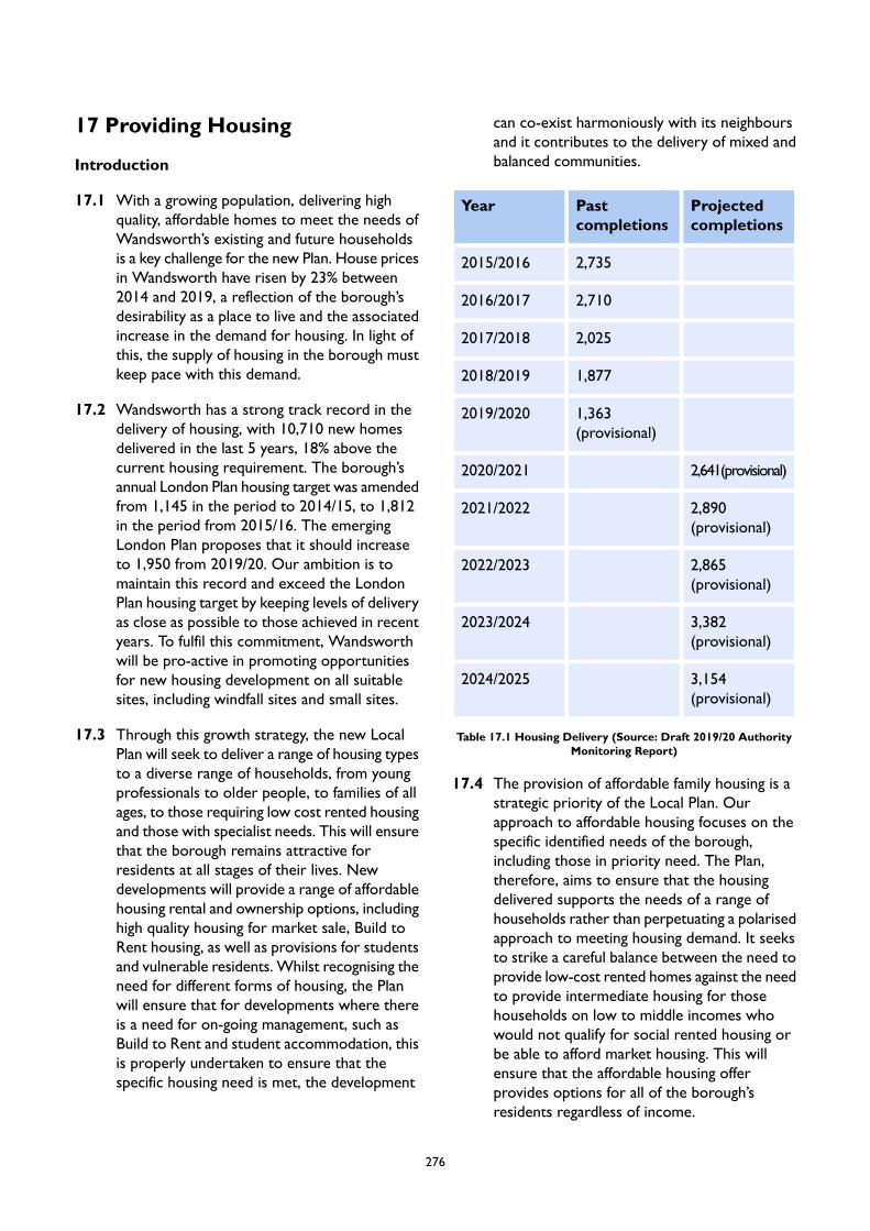
17 Providing Housing
Introduction
17.1 With a growing population, delivering highquality, affordable homes to meet the needs ofWandsworth’s existing and future householdsis a key challenge for the new Plan. House pricesin Wandsworth have risen by 23% between2014 and 2019, a reflection of the borough’sdesirability as a place to live and the associatedincrease in the demand for housing. In light ofthis, the supply of housing in the borough mustkeep pace with this demand.
17.2 Wandsworth has a strong track record in thedelivery of housing, with 10,710 new homesdelivered in the last 5 years, 18% above thecurrent housing requirement. The borough’sannual London Plan housing target was amendedfrom 1,145 in the period to 2014/15, to 1,812in the period from 2015/16. The emergingLondon Plan proposes that it should increaseto 1,950 from 2019/20. Our ambition is tomaintain this record and exceed the LondonPlan housing target by keeping levels of deliveryas close as possible to those achieved in recentyears. To fulfil this commitment, Wandsworthwill be pro-active in promoting opportunitiesfor new housing development on all suitablesites, including windfall sites and small sites.
17.3 Through this growth strategy, the new LocalPlan will seek to deliver a range of housing typesto a diverse range of households, from youngprofessionals to older people, to families of allages, to those requiring low cost rented housingand those with specialist needs. This will ensurethat the borough remains attractive forresidents at all stages of their lives. Newdevelopments will provide a range of affordablehousing rental and ownership options, includinghigh quality housing for market sale, Build toRent housing, as well as provisions for studentsand vulnerable residents. Whilst recognising theneed for different forms of housing, the Planwill ensure that for developments where thereis a need for on-going management, such asBuild to Rent and student accommodation, thisis properly undertaken to ensure that thespecific housing need is met, the development
can co-exist harmoniously with its neighboursand it contributes to the delivery of mixed andbalanced communities.
Projectedcompletions
Pastcompletions
Year
2,7352015/2016
2,7102016/2017
2,0252017/2018
1,8772018/2019
1,363(provisional)
2019/2020
2,641(provisional)2020/2021
2,890(provisional)
2021/2022
2,865(provisional)
2022/2023
3,382(provisional)
2023/2024
3,154(provisional)
2024/2025
Table 17.1 Housing Delivery (Source: Draft 2019/20 AuthorityMonitoring Report)
17.4 The provision of affordable family housing is astrategic priority of the Local Plan. Ourapproach to affordable housing focuses on thespecific identified needs of the borough,including those in priority need. The Plan,therefore, aims to ensure that the housingdelivered supports the needs of a range ofhouseholds rather than perpetuating a polarisedapproach to meeting housing demand. It seeksto strike a careful balance between the need toprovide low-cost rented homes against the needto provide intermediate housing for thosehouseholds on low to middle incomes whowould not qualify for social rented housing orbe able to afford market housing. This willensure that the affordable housing offerprovides options for all of the borough’sresidents regardless of income.
276
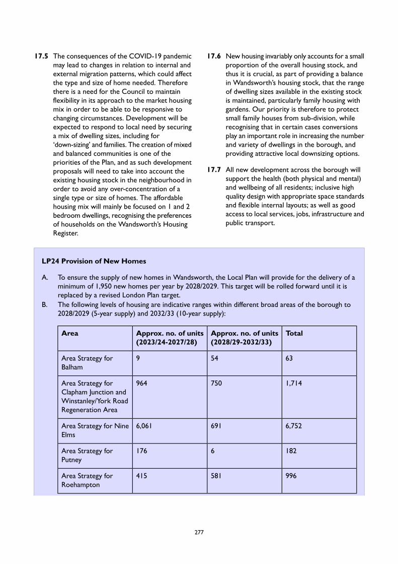
17.5 The consequences of the COVID-19 pandemicmay lead to changes in relation to internal andexternal migration patterns, which could affectthe type and size of home needed. Thereforethere is a need for the Council to maintainflexibility in its approach to the market housingmix in order to be able to be responsive tochanging circumstances. Development will beexpected to respond to local need by securinga mix of dwelling sizes, including for‘down-sizing’ and families. The creation of mixedand balanced communities is one of thepriorities of the Plan, and as such developmentproposals will need to take into account theexisting housing stock in the neighbourhood inorder to avoid any over-concentration of asingle type or size of homes. The affordablehousing mix will mainly be focused on 1 and 2bedroom dwellings, recognising the preferencesof households on the Wandsworth’s HousingRegister.
17.6 New housing invariably only accounts for a smallproportion of the overall housing stock, andthus it is crucial, as part of providing a balancein Wandsworth’s housing stock, that the rangeof dwelling sizes available in the existing stockis maintained, particularly family housing withgardens. Our priority is therefore to protectsmall family houses from sub-division, whilerecognising that in certain cases conversionsplay an important role in increasing the numberand variety of dwellings in the borough, andproviding attractive local downsizing options.
17.7 All new development across the borough willsupport the health (both physical and mental)and wellbeing of all residents; inclusive highquality design with appropriate space standardsand flexible internal layouts; as well as goodaccess to local services, jobs, infrastructure andpublic transport.
LP24 Provision of New Homes
A. To ensure the supply of new homes in Wandsworth, the Local Plan will provide for the delivery of aminimum of 1,950 new homes per year by 2028/2029. This target will be rolled forward until it isreplaced by a revised London Plan target.
B. The following levels of housing are indicative ranges within different broad areas of the borough to2028/2029 (5-year supply) and 2032/33 (10-year supply):
TotalApprox. no. of units(2028/29-2032/33)
Approx. no. of units(2023/24-2027/28)
Area
63549Area Strategy forBalham
1,714750964Area Strategy forClapham Junction andWinstanley/York RoadRegeneration Area
6,7526916,061Area Strategy for NineElms
1826176Area Strategy forPutney
996581415Area Strategy forRoehampton
277
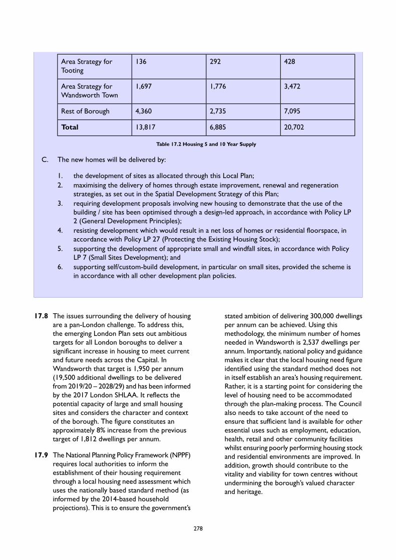
428292136Area Strategy forTooting
3,4721,7761,697Area Strategy forWandsworth Town
7,0952,7354,360Rest of Borough
20,7026,88513,817Total
Table 17.2 Housing 5 and 10 Year Supply
C. The new homes will be delivered by:
1. the development of sites as allocated through this Local Plan;2. maximising the delivery of homes through estate improvement, renewal and regeneration
strategies, as set out in the Spatial Development Strategy of this Plan;3. requiring development proposals involving new housing to demonstrate that the use of the
building / site has been optimised through a design-led approach, in accordance with Policy LP2 (General Development Principles);
4. resisting development which would result in a net loss of homes or residential floorspace, inaccordance with Policy LP 27 (Protecting the Existing Housing Stock);
5. supporting the development of appropriate small and windfall sites, in accordance with PolicyLP 7 (Small Sites Development); and
6. supporting self/custom-build development, in particular on small sites, provided the scheme isin accordance with all other development plan policies.
17.8 The issues surrounding the delivery of housingare a pan-London challenge. To address this,the emerging London Plan sets out ambitioustargets for all London boroughs to deliver asignificant increase in housing to meet currentand future needs across the Capital. InWandsworth that target is 1,950 per annum(19,500 additional dwellings to be deliveredfrom 2019/20 – 2028/29) and has been informedby the 2017 London SHLAA. It reflects thepotential capacity of large and small housingsites and considers the character and contextof the borough. The figure constitutes anapproximately 8% increase from the previoustarget of 1,812 dwellings per annum.
17.9 The National Planning Policy Framework (NPPF)requires local authorities to inform theestablishment of their housing requirementthrough a local housing need assessment whichuses the nationally based standard method (asinformed by the 2014-based householdprojections). This is to ensure the government’s
stated ambition of delivering 300,000 dwellingsper annum can be achieved. Using thismethodology, the minimum number of homesneeded in Wandsworth is 2,537 dwellings perannum. Importantly, national policy and guidancemakes it clear that the local housing need figureidentified using the standard method does notin itself establish an area’s housing requirement.Rather, it is a starting point for considering thelevel of housing need to be accommodatedthrough the plan-making process. The Councilalso needs to take account of the need toensure that sufficient land is available for otheressential uses such as employment, education,health, retail and other community facilitieswhilst ensuring poorly performing housing stockand residential environments are improved. Inaddition, growth should contribute to thevitality and viability for town centres withoutundermining the borough’s valued characterand heritage.
278
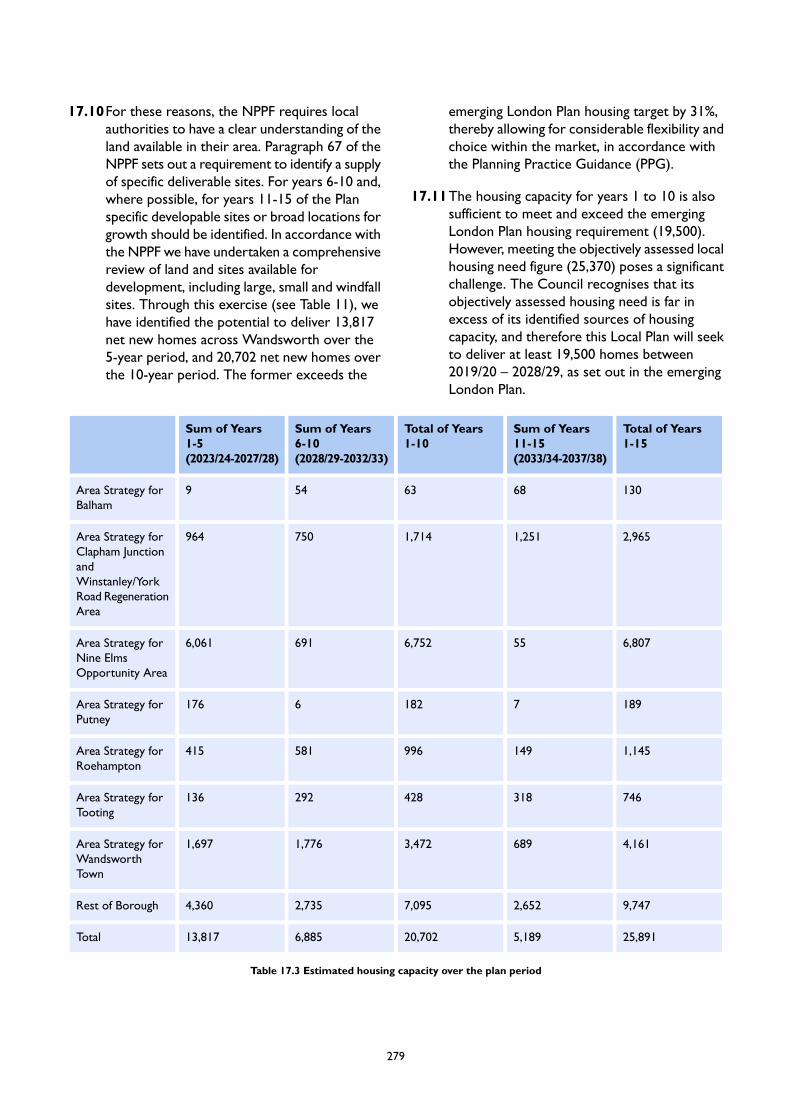
17.10For these reasons, the NPPF requires localauthorities to have a clear understanding of theland available in their area. Paragraph 67 of theNPPF sets out a requirement to identify a supplyof specific deliverable sites. For years 6-10 and,where possible, for years 11-15 of the Planspecific developable sites or broad locations forgrowth should be identified. In accordance withthe NPPF we have undertaken a comprehensivereview of land and sites available fordevelopment, including large, small and windfallsites. Through this exercise (see Table 11), wehave identified the potential to deliver 13,817net new homes across Wandsworth over the5-year period, and 20,702 net new homes overthe 10-year period. The former exceeds the
emerging London Plan housing target by 31%,thereby allowing for considerable flexibility andchoice within the market, in accordance withthe Planning Practice Guidance (PPG).
17.11The housing capacity for years 1 to 10 is alsosufficient to meet and exceed the emergingLondon Plan housing requirement (19,500).However, meeting the objectively assessed localhousing need figure (25,370) poses a significantchallenge. The Council recognises that itsobjectively assessed housing need is far inexcess of its identified sources of housingcapacity, and therefore this Local Plan will seekto deliver at least 19,500 homes between2019/20 – 2028/29, as set out in the emergingLondon Plan.
Total of Years1-15
Sum of Years11-15(2033/34-2037/38)
Total of Years1-10
Sum of Years6-10(2028/29-2032/33)
Sum of Years1-5(2023/24-2027/28)
1306863549Area Strategy forBalham
2,9651,2511,714750964Area Strategy forClapham JunctionandWinstanley/YorkRoad RegenerationArea
6,807556,7526916,061Area Strategy forNine ElmsOpportunity Area
18971826176Area Strategy forPutney
1,145149996581415Area Strategy forRoehampton
746318428292136Area Strategy forTooting
4,1616893,4721,7761,697Area Strategy forWandsworthTown
9,7472,6527,0952,7354,360Rest of Borough
25,8915,18920,7026,88513,817Total
Table 17.3 Estimated housing capacity over the plan period
279
17.12The draft in-house housing capacity assessmentalso considered the capacity of land and sitesavailable for development in years 11 to 15.This identified a potential capacity toaccommodate 5,189 net new homes. Althoughthe figure indicates that the Council would notbe able to meet its housing requirement if it isrolled forward for years 11 – 15 of the Planperiod, it is expected that sites that are notdeliverable or developable now will have thepotential to become so as the supply of easilydeveloped sites reduces over time. Recognisingthat during the lifetime of this Plan, the supplyof developable land available for residentialdevelopment is likely to become much morelimited, the Plan takes a pro-active approach tohousing delivery, which is embedded in anumber of policies. These include a positiveapproach to housing delivery on small sites,optimising site capacity through a design-ledapproach and identifying opportunities tomaximise delivery through estate improvement,renewal and regeneration. In addition, we intendto prepare a supplementary planning documentsetting out design codes for key areas withcapacity for growth. All these measures willcreate strong foundations to meet and exceedthe housing requirement during the lifetime ofthis Plan.
17.13The government has recently put forwardproposals in its consultation on ‘Changes to thecurrent planning system’, which, among otherthings, proposes changes to the standardmethod for assessing local housing need. TheGovernment’s proposed approach puts a
greater emphasis on affordability and removesthe cap which exists under the currentapproach. The proposed new Standard Method,as consulted on, would result in a housing needfigure of 3,059 dwellings annually forWandsworth borough. Nevertheless, theconsultation makes it clear that this figurecontinues to provide the ‘starting point’ forestablishing the housing requirement for a LocalPlan. At the time of writing it is unknown if andwhen these will be implemented and whetherthere will be a transitional period. It is alsoworth noting that the figure derived throughthe Standard Method is based on an algorithmthat does not take into account constraints,unlike the figure set by the emerging LondonPlan. The Council will monitor developmentsregarding the proposed changes.
17.14For the purpose of monitoring housingcompletions, we will take into account netchanges in both conventional and morespecialist forms of housing in line with theguidance set out in the emerging London Plan.For the avoidance of doubt, non-self-containedaccommodation for students will be countedon a 2.5:1 ratio, with two and a halfbedrooms/units being counted as a single home.Non-self-contained accommodation for olderpeople will be counted on a 1:1 ratio, with eachbedroom being counted as a single home. Allother net non-self-contained communalaccommodation will count towards meeting theCouncil’s housing requirement on the basis ofa 1.8:1 ratio, with one point eightbedrooms/units being counted as a single home.
LP25 Affordable Housing
A. The Council will seek to secure the Mayor’s strategic target of 50 per cent of all new homes to beaffordable, having regard to the character and context of individual development proposals and toviability considerations.
B. Development that creates 10 or more dwellings (gross) must provide affordable housing on-site inaccordance with the threshold approach set out in emerging London Plan Policy H5. The thresholdlevel of affordable housing based on the gross number of new homes to be provided, having had regardto the most up-to-date viability evidence, must equate to at least:
1. 35% on individual sites outside of the Vauxhall/Nine Elms/Battersea Opportunity Area (VNEBOA);.
2. 15% on individual sites within the VNEB OA;.
280
3. 50% for public sector land on individual sites outside the VNEB OA where there is no portfolioagreement with the Mayor;.
4. 50% in Strategic Industrial Locations, Locally Significant Industrial Sites and Non-DesignatedIndustrial Sites where the inclusion of residential uses is considered appropriate in accordancewith the emerging London Plan Policy E7 (, where the scheme would result in a net loss ofindustrial capacity.
C. The Council will require an affordable housing tenure split of 50% low-cost rent products and 50%intermediate products. The low-cost rent products should be Social Rent or London Affordable Rent.The intermediate products should maximise the provision of London Living Rent and London SharedOwnership units. The Council will consider the provision of other intermediate products (such asShared Equity, Discounted Market Sale, Intermediate Rent) where it has been demonstrated to theCouncil’s satisfaction that any alternative intermediate products would meet local housing need, havingregard to the Council’s latest relevant Housing Strategy.
D. Affordable housing will be required on site. Off-site provision of affordable housing will only be acceptedin exceptional circumstances where it can be clearly demonstrated that affordable housing cannot bedelivered on-site or where it can be demonstrated that offsite provision on another site in the boroughwould better deliver the creation of mixed and balanced communities than through on-site provision.Applicants will be required to identify a site(s) which would be acceptable for the development ofaffordable housing. In exceptional circumstances when it is clearly demonstrated to the Council’ssatisfaction that an alternative site cannot be identified will the payment of a financial contribution tosupport the delivery and supply of affordable housing on another site in the borough be considered.The provision of affordable housing on another site(s) will be at least equivalent to the increaseddevelopment value if affordable housing is not provided on-site and will be provided prior to, or tiedto, the completion of the on-site market housing, subject to such a contribution being viable. Furtherguidance is provided in the Council's adopted Planning Obligations SPD.
E. The Council requires viability assessments to be submitted in line with London Plan Policy H5. Anyviability assessment must follow criteria set out in the Council’s Planning Obligations SPD. The Councilwill undertake an independent review of that assessment for which the applicant will bear the cost.
F. The management of the affordable housing homes provided will be undertaken by a Registered Providerwhich is a Preferred Partner of the Council unless otherwise agreed by the Council. Any relevantscheme will need to demonstrate that the design, siting and phasing of affordable homes provides forits proper integration and timely provision as part of the wider development.
G. The application of the Vacant Building Credit (VBC) is not appropriate in Wandsworth. The use ofVBC will only be considered in limited circumstances, where applicants clearly demonstrate there areexceptional reasons why it is appropriate and all of the following criteria are met:
1. the building is not in use at the time the application is submitted;2. the building is not covered by an extant or recently expired permission;3. the site is not protected for alternative land use;4. the building has not been made vacant for the sole purpose of redevelopment.
H. The Council will expect the design, type, size and mix of the affordable homes to be such that thedevelopment is ‘tenure blind’ in respect of its character and appearance. Proposals will be requiredto demonstrate that this approach has been considered from the outset of the design process.
I. The provision of affordable housing or financial contributions will be sought from any developmentmaking provision for new dwellings or the provision of residential accommodation with shared facilities.
281
17.15National and regional guidance indicates thatbeing able to access decent affordable homesis a major contributing factor in improvingpeople’s quality of life. Accommodationstandards and affordability have a stronginfluence on health, education and skills, all ofwhich contribute to a person’s quality of life.
17.16There is a significant London-wide and localneed for genuinely affordable housing. Table 12shows that the median house price inWandsworth was over 18 times that of themedian salary in 2019. In addition, median houseprices in Wandsworth increased by 23%between 2014 and 2019. During the same timeframe there was a 9% change in the median costof rents. Consequently smaller, privately rentedproperties are often the only feasible optionfor residents faced with the high costs ofpurchase and a shortage of affordableproperties. Nevertheless, despite a loweroverall percentage increase in private rents theyare equally high and rising, with median rentsin 2019 at £1,650, and average rents at £1,855.
282

201920182017201620152014
£622,563£628,653£651,125£616,000£543,750£507,500Median price
23%24%28%21%7%0%Change inrelation to 2014
£752,828£760,673£770,224£734,247£690,303£652,355Average price
15%17%18%13%6%0%Change inrelation to 2014
£1,650£1,650£1,659£1,649£1,615£1,507Median rent
9%9%10%9%7%0%Change inrelation to 2014
£1,855£1,873£1,870£1,854£1,815£1,664Average rent
11%13%12%11%9%0%Change inrelation to 2014
18.4417.9019.8418.7117.0516.57Affordabilityratio
Table 17.4 Housing cost in Wandsworth between 2014 and 2019
17.17The need for affordable homes is significant inthe borough, as evidenced by the Council’sLocal Housing Need Assessment (LHNA)(2020). The LHNA estimates a net need for2,327 affordable rented and 1,248 affordablehome ownership dwellings per annum to beprovided over the plan period. This issignificantly above the overall housingrequirement that the borough canaccommodate as established in Policy LP 24(Provision of New Homes) above.Consequently, the Council will be unable tosatisfy this level of need recognising that nationalpolicy requires the Council to set affordablehousing targets that are realistic, including inrelation to development viability and achievingmixed and balanced communities.
17.18The emerging London Plan Policy H6 sets astrategic target for 50% of all homes to begenuinely affordable, and introduces a thresholdapproach which removes the need for individualapplications to be supported by a viabilityassessment as long as the proposed provisionof affordable housing meets that threshold. TheCouncil acknowledges the Mayor’s long term
ambition to secure 50% affordable housingprovision. However, even achieving the currentadopted Local Plan target of 33% on sitesoutside of the VNEB OA and 15% on siteswithin the VNEB OA based on a 60% social rent/ 40% intermediate tenure split has been inmany cases challenging as a result of, primarily,viability considerations. Despite this, the Councilwill continue to seek to support theachievement of the Mayor’s strategic targetwhere possible.
17.19Based on the most up-to-date evidence availableit is proposed to adopt a borough-specificthreshold approach as a starting point forinforming individual applications, rather thanthat set out in the emerging London Plan. Thislocally-specific approach reflects the particularcircumstances of the borough, including withinthe VNEB OA, where significant investment ininfrastructure (such as funding the NorthernLine Extension) is required to support thedevelopment of the area. The proposedproportion of affordable homes on sites withinthe VNEB OA will maintain the approach takenin the current adopted Local Plan. Nevertheless,
283

the Council will be updating its Local PlanViability Assessment and DevelopmentInfrastructure Funding Study (DIFS) to ensurethat it has taken account of any changes in orderto strike a balance between meeting itsaffordable housing needs, whilst ensuring thatthe total cumulative costs of Local Planrequirements do not threaten the delivery ofmuch needed development as a result ofscheme viability. Depending on the outcomesof this work, the Council may need to establisha different affordable housing target which seeksto optimise the delivery of affordable housingin the borough in line with the emerging LondonPlan, in order to meet as much as possible ofits local need based on the most up-to-dateevidence.
17.20The emerging London Plan requires that aminimum of 30 per cent of affordable housingis provided as low cost rented products, 30 percent as intermediate products, with theremaining 40 per cent to be determined by theborough. There is a presumption that the 40per cent to be decided by the borough willfocus on Social Rent and London AffordableRent given the level of need for this type of
tenure across London. Social Rent and LondonAffordable Rent dwellings are generally intendedfor low-income households. The GreaterLondon Authority’s (GLA) Housing in London(2019) report indicates that households movinginto social housing (including Affordable Rent)have by far the lowest incomes, with half ofthem on less than £13,000 a year and the vastmajority (approximately 90%) on less than£25,000 a year. Locally, there is a significantnumber of households on Wandsworth’sHousing Register (8,800 as of 31st March 2020),which indicates the high levels of need for socialhousing in the borough. Yet, the acute need forthese tenures and the distribution of incomeamong households moving into social housingalso mean that low-cost rented products willonly be available to a small proportion ofresidents in Wandsworth. Taking into accountthe number of households on Wandsworth’sHousing Register, it is reasonable to assumethat low-cost rented products will generally beavailable to households with income notexceeding £25,000 a year. Figure 1 indicatesthat this represents approximately 10-15% ofthe borough’s households.
Figure 17.1 Estimated distribution of Household Income in LBW in 2018 (Source: LHNA)
284
17.21Although there is a substantial need forlow-cost rented homes in Wandsworth, theprovision of this affordable housing productmust be balanced against the need to provideintermediate housing for those households onlow to middle incomes who would neither havepriority for social housing or be able to affordmarket housing. This relates to households withincomes between £25,000 and £90,000 a year,which equates to some 55-60% of the totalnumber of households in the borough. PolicyLP 25 (Affordable Housing) therefore seeks toensure that the affordable housing offerprovides options for a wide range of theborough’s residents. The LHNA (2020) indicatesthat intermediate tenures, such as LondonShared Ownership and London Living Rent, areboth viable options that can assist in fulfillingthis aspiration. The income required to affordLondon Living Rent and Affordable Renteddwellings (within Local Housing Allowancelimits) starts at around £24,000, rising to around£33,600 for a 3-bedroom home. As such,household incomes within the approximaterange £24,000 to £60,000 will be eligible forLondon Living Rent. London Shared Ownershipis more expensive, with a required income ofaround £38,400 for the smallest size of home,increasing to approximately £58,000 for largerdwellings. It will therefore be available tohouseholds in Wandsworth within theapproximate income range of £38,400 to£90,000. The Council will require that LondonShared Ownership or Shared Equityaccommodation is priced so that a significantmajority of the units can be purchased byhouseholds with low to medium incomes withina range to be determined by the Council, whichwill be updated annually to reflect changes inincomes and house prices, with upper incomethresholds being determined with reference toany revised figures in the emerging London PlanAnnual Monitoring Report. Intermediate housingfor rent such as London Living Rent,Intermediate Rent, and Discounted Market Rentwill be required to meet the Council’saffordability criteria with upper incomethresholds for rent being determined withreference to any revised figures in the emergingLondon Plan Annual Monitoring Report.
17.22Based on recent experience of the difficultiesof achieving the adopted Local Plan affordablehousing tenure split of 60% affordable rent and40% intermediate products, primarily forscheme viability reasons, the Council has alsoconsidered whether changing the balance ofprovision would help to improve the deliveryof much needed affordable homes. It recognisesthat there is a difficult balance to be struck andthat there is a significant need to secure homesfor affordable rent. The Planning PracticeGuidance (PPG) of February 2019 confirms awidening definition of those to be consideredas in affordable need including “households fromother tenures in need and those that cannotafford their own homes, either to rent, or toown, where that is their aspiration.” Theaccepted understanding of this requirement isthat plan-makers now need to quantify need fortenures that offer an affordable route tohome-ownership. However, there is currentlyno guidance about how this may be done.Having reviewed the most up-to-date evidencethe approach that the Council proposes to takereflects the role that London Living Rent homescan play across both the intermediate andaffordable rented sectors but which is definedin the emerging London Plan as an intermediateproduct. It also reflects the growing interest inthe borough of Build to Rent schemes and theMayor’s ambition that the discounted marketrent provision within this type of developmentshould be at London Living Rent levels.
17.23For the reasons outlined above, the Councilconsiders that an equal split of 50% low-costrented housing and 50% intermediate housingis the best approach to improving housingoptions in the borough. This approach will helpto bridge the housing offers available to a rangeof households rather than perpetuating apolarised approach to meeting housing needwhich fails to consider the importance ofcreating mixed and balanced communities. Itshould, however, be noted that the preferredbalance of tenures may change as a result of theCouncil’s updated Local Plan ViabilityAssessment.
17.24The emerging London Plan requires thataffordable housing provision is focused on‘genuinely affordable’ tenures, including low costrented products (London Affordable Rent or
285
Social Rent) and intermediate products (LondonLiving Rent and London Shared Ownership).Policy LP 25 (Affordable Housing) seeks toprioritise these tenures; however, it alsorecognises that genuinely affordable homes canin certain cases cover a broader spectrum ofaffordable housing types as defined in the NPPF. For example, a Pocket Living housing schemein Mapleton Crescent (Wandsworth TownCentre) delivered over 50 per cent homes forlocal first-time buyers at a discount of at least20 per cent. The scheme was affordable tohouseholds with an income of between £45,000and £66,000, and the homes were sold tohouseholds with an average household incomeof circa £45,000, with the majority being soldto households living or working in the borough.Therefore, it is clear that alternativeintermediate products can work in particularcircumstances where it has been demonstratedto the Council’s satisfaction that any alternativeintermediate products would meet local housingneed.
17.25The Council’s adopted Planning Obligations SPDsets out that the Council’s expectation is thatdelivery is through on-site provision. Thissupports the maintenance or creation of mixedand balanced communities. Affordable housingdelivery will only be considered by way ofoff-site provision in exceptional circumstances,where it can be clearly demonstrated thataffordable housing cannot be delivered on-siteor where it can be clearly demonstrated thatoff-site provision would better achieve theobjective of creating mixed and balancedcommunities than through on-site provision.Financial contributions will only be acceptablein very exceptional circumstances, and onlywhere this is supported by detailed viabilityevidence to demonstrate that the provision ofon-site affordable housing is not deliverable,that off-site provision has been explored but isnot deliverable, and that accepting a financialcontribution will not be detrimental to thedelivery of mixed and balanced communities.
17.26Where applications are not considered to bemaximising the level of affordable housing orwhere it is proposing a tenure mix which is notpolicy compliant, the Council will consider theappropriateness of requiring review mechanismsat appropriate stages / milestone(s) of the
construction period. The majority of schemeswill have an early stage review to incentivisethe implementation of planning permissions.Where reviews are required they will beexpected to will follow the formula set out inthe emerging London Plan, as updated, unlessagreed otherwise by the Council.
17.27The emerging London Plan sets out that thepercentage of affordable housing in a schemeshould be measured by habitable rooms toensure that a range of sizes and affordablehomes can be delivered, including family sizedhomes, having taken account of relevant policieson the appropriate local mix and having regardto site specific circumstances. However, theCouncil considers that it is more appropriateto continue to measure affordable housing byunits. That notwithstanding, applicants shouldpresent affordable housing figures as apercentage of the total residential provisionproposed by habitable rooms, by dwelling, andby floorspace to enable comparison.
17.28The Council supports the approach of theMayor's Affordable Housing SupplementaryPlanning Guidance and considers that theapplication of the Vacant Building Credit (VBC)is unlikely to bring forward more development.The Vacant Building Credit (VBC) is a materialconsideration in the determination of relevantplanning applications but in Wandsworth, it islikely that the acute need for affordable housingwill outweigh the application of the VBC in allcases. The aim of the VBC is to incentivisedevelopment on brownfield sites, but this is anunnecessary incentive in Wandsworth giventhat all development sites are brownfield, andthat housing delivery has been and is likely toremain strong. Applicants looking to justify theapplication of the VBC will need to clearlydemonstrate exceptional circumstances andensure that they meet all of the criteria listedin Policy LP 25 (Affordable Housing).
17.29 In line with other Local Plan policies, all newaffordable housing must be of a high qualitydesign and incorporate durable materials,adhering to the same space and amenitystandards as market housing. To promoteinclusive communities it is imperative thataffordable housing is designed to be ‘tenureblind’, so that it is indistinguishable from other
286
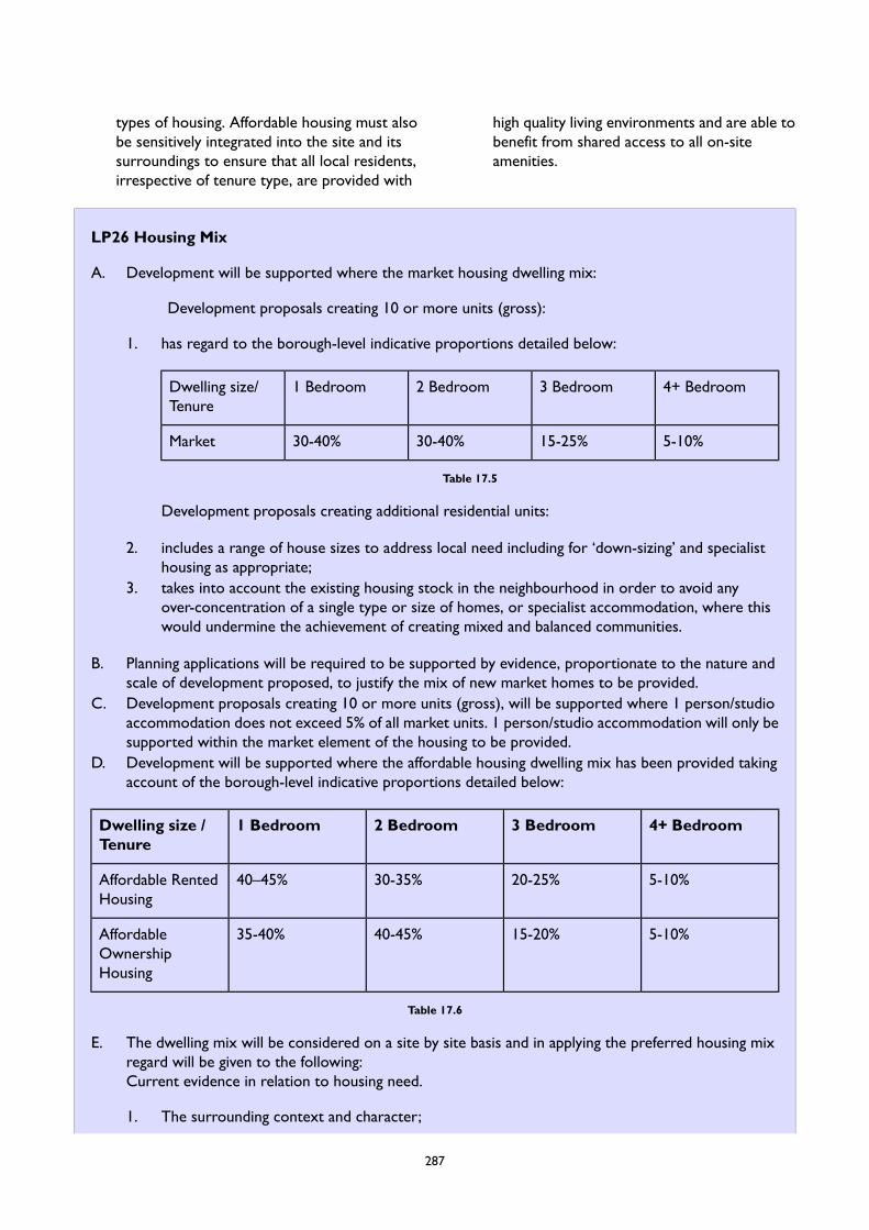
types of housing. Affordable housing must alsobe sensitively integrated into the site and itssurroundings to ensure that all local residents,irrespective of tenure type, are provided with
high quality living environments and are able tobenefit from shared access to all on-siteamenities.
LP26 Housing Mix
A. Development will be supported where the market housing dwelling mix:
Development proposals creating 10 or more units (gross):
1. has regard to the borough-level indicative proportions detailed below:
4+ Bedroom3 Bedroom2 Bedroom1 BedroomDwelling size/Tenure
5-10%15-25%30-40%30-40%Market
Table 17.5
Development proposals creating additional residential units:
2. includes a range of house sizes to address local need including for ‘down-sizing’ and specialisthousing as appropriate;
3. takes into account the existing housing stock in the neighbourhood in order to avoid anyover-concentration of a single type or size of homes, or specialist accommodation, where thiswould undermine the achievement of creating mixed and balanced communities.
B. Planning applications will be required to be supported by evidence, proportionate to the nature andscale of development proposed, to justify the mix of new market homes to be provided.
C. Development proposals creating 10 or more units (gross), will be supported where 1 person/studioaccommodation does not exceed 5% of all market units. 1 person/studio accommodation will only besupported within the market element of the housing to be provided.
D. Development will be supported where the affordable housing dwelling mix has been provided takingaccount of the borough-level indicative proportions detailed below:
4+ Bedroom3 Bedroom2 Bedroom1 BedroomDwelling size /Tenure
5-10%20-25%30-35%40–45%Affordable RentedHousing
5-10%15-20%40-45%35-40%AffordableOwnershipHousing
Table 17.6
E. The dwelling mix will be considered on a site by site basis and in applying the preferred housing mixregard will be given to the following:Current evidence in relation to housing need.
1. The surrounding context and character;
287
2. The overall level of affordable housing proposed; and3. The financial viability of the scheme.
17.30The NPPF and the emerging London Planrequire boroughs to achieve a mix of housingto reflect the current and future needs of theborough's population, including for families withchildren, for both affordable and market housingover the Plan period. The proportions areexpected to be informed by a Local HousingNeed Assessment (LHNA).
17.31The LHNA 2020 provides the latest publishedhousing needs evidence in relation to the likelyquantum, type, size and tenure of new homesneeded across the borough over the planperiod. It recommends that the focus of newmarket housing provision should be on1-bedroom (30-40%) and 2-bedroom (30-40%)properties and to a smaller extent on3-bedroom (15-25%) and 4-bedroom (5-10%)dwellings. The recommended proportion of 3and 4 bedroom dwellings (20-35%) would beslightly higher than the proportion of 3 and 4bedroom dwellings that have recently beendelivered (21% of market housing deliveredbetween 2016/17–2018/19 was 3 and 4bedroom dwellings). Recognising this, the policyapproach to market housing should strike abalance between meeting needs and providingenough flexibility for developers to makeschemes viable. Crucially, the LHNA 2020 wasprepared prior to the COVID-19 pandemic,and therefore does not necessarily reflectpotential changes in relation to out-migrationand how this may affect the type and size ofhome needed. Whilst the market dwelling mixof development proposals creating 10 or moreunits (gross) will need to be informed by theborough-level indicative proportions set out inthe policy, there is a need for the Council tomaintain a certain level of flexibility in itsapproach to the provision of market housing inorder to respond to changing circumstances.
17.32Within this context, there will continue to bea need to consider the most appropriatelocation for new homes and the characteristicsof those locations, the type and size ofproperties to be provided in different areas,
making best use of land, and the characteristicsof the population in terms of its relative mobilityand the effect this has on neighbourhoods. Inregard to these latter points it will thereforebe important to ensure that developmentproposals support the delivery of self-containednew homes, which is where there is the greatestidentified need including for families and thosewanting to downsize (which would itself helpto release more family sized housing back intothe supply chain).
17.33 In addition, new homes should contribute tosupporting the creation of stable localneighbourhoods and cohesive communities.Preference will therefore be given to largerhomes, because proposals which provide morethan a small proportion of studios are unlikelyto achieve this objective and therefore will notnormally be supported. Although the increasingproportion of single person households isforecast to continue, this does not necessarilyresult in a proportionate increase in demandfor small studios as many people would like aspare bedroom for visitors or to use as astudy/office. However, in a borough such asWandsworth, where land values and propertyprices are high, undue restriction againstprovision of small units may have an impact onaffordability. The LHNA (2020) identified thatthe average monthly cost of a studio flat is£950pcm, as against £1,250pcm for a1-bedroom dwelling, which is a substantialdifference. Taking this into consideration, it isimportant that applicants are able to respondappropriately to the demand for homes of thissize. Therefore, a realistic approach is to allowfor a proportion of new developments tocontain studios up to a maximum limit. Amaximum proportion of studios and 1 bedroomone person units has only been set for markethousing as this type of accommodation will notbe supported as part of the affordable housingelement of a scheme.
288
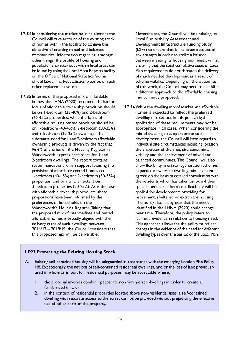
17.34 In considering the market housing element theCouncil will take account of the existing stockof homes within the locality to achieve theobjective of creating mixed and balancedcommunities. Information regarding, amongstother things, the profile of housing andpopulation characteristics within local areas canbe found by using the Local Area Reports facilityon the Office of National Statistics ‘nomisofficial labour market statistics’ website, or suchother replacement source.
17.35 In terms of the proposed mix of affordablehomes, the LHNA (2020) recommends that thefocus of affordable ownership provision shouldbe on 1-bedroom (35-40%) and 2-bedroom(40-45%) properties, while the focus ofaffordable housing rented provision should beon 1-bedroom (40-45%), 2-bedroom (30-35%)and 3-bedroom (20-25%) dwellings. Thesubstantial need for 1 and 2-bedroom affordableownership products is driven by the fact that96.6% of entries on the Housing Register inWandsworth express preference for 1 and2-bedroom dwellings. The report containsrecommendations which support focusing theprovision of affordable rented homes on1-bedroom (40-45%) and 2-bedroom (30-35%)properties, and to a smaller extent on3-bedroom properties (20-25%). As is the casewith affordable ownership products, theseproportions have been informed by thepreferences of households on theWandsworth’s Housing Register. Taking thatthe proposed mix of intermediate and rentedaffordable homes is broadly aligned with thedelivery rates of such dwellings between2016/17 – 2018/19, the Council considers thatthis proposed mix will be deliverable.
Nevertheless, the Council will be updating itsLocal Plan Viability Assessment andDevelopment Infrastructure Funding Study(DIFS) to ensure that it has taken account ofany changes in order to strike a balancebetween meeting its housing mix needs, whilstensuring that the total cumulative costs of LocalPlan requirements do not threaten the deliveryof much needed development as a result ofscheme viability. Depending on the outcomesof this work, the Council may need to establisha different approach to the affordable housingmix currently proposed.
17.36While the dwelling mix of market and affordablehomes is expected to reflect the preferreddwelling mix set out in this policy, rigidapplication of these requirements may not beappropriate in all cases. When considering themix of dwelling sizes appropriate to adevelopment, the Council will have regard toindividual site circumstances including location,the character of the area, site constraints,viability and the achievement of mixed andbalanced communities. The Council will alsoallow flexibility in estate regeneration schemes,in particular where a dwelling mix has beenagreed on the basis of detailed consultation withthe residents which has taken on-board theirspecific needs. Furthermore, flexibility will beapplied for developments providing forretirement, sheltered or extra care housing.The policy also recognises that the needsidentified in the LHNA (2020) could changeover time. Therefore, the policy refers to‘current’ evidence in relation to housing need.This approach allows for the policy to reflectchanges in the evidence of the need for differentdwelling types over the period of the Local Plan.
LP27 Protecting the Existing Housing Stock
A. Existing self-contained housing will be safeguarded in accordance with the emerging London Plan PolicyH8. Exceptionally, the net loss of self-contained residential dwellings, and/or the loss of land previouslyused in whole or in part for residential purposes, may be acceptable where:
1. the proposal involves combining separate non family-sized dwellings in order to create afamily-sized unit, or
2. in the context of residential properties located above non-residential uses, a self-containeddwelling with separate access to the street cannot be provided without prejudicing the effectiveuse of other parts of the property.
289
B. Where the loss of existing affordable housing dwellings is proposed, the Council will follow theapproach set out in London Plan Policy H8.
C. Proposals for the change of use of residential accommodation to short-term holiday lets will not besupported.
17.37Existing properties are an important source oflarger and family accommodation, as newhousing only accounts for a small proportionof the overall housing stock in the borough. TheLocal Plan sets out the importance ofmaintaining the range of dwelling sizes availablein the existing stock, especially family-sizedhousing. Therefore, whilst the provision of newhomes is required to meet the borough’shousing requirement, it is also important toensure that existing residential properties andland last used for housing are afforded sufficientprotection. The emerging London Plan requiresboroughs to meet or exceed targets for newhousing and to prevent the loss of housing,including loss of affordable housing.
17.38The Local Housing Need Assessment (LHNA)identifies a need for family-sizedaccommodation. In the private sector this canbe assisted through the de-conversion of flatsto create family-sized houses. There is thereforescope for de-conversion of smaller flats tocontribute to meeting the identified need forfamily accommodation. This type ofdevelopment can also contribute towardsproviding greater variety and choice in thehousing stock. However, de-conversion activityis not usually appropriate in other circumstanceswhere this would prejudice existing identifiedneeds, such as supported housing, or where itwould not contribute to meeting identifiedfamily housing needs, such as the combining ofmore than one house. The circumstances in thepolicy where loss of units through combiningsmaller flats to provide a family-sized homeapplies primarily to dwellings that havepreviously been subdivided to enable them tobe converted back to a single dwelling as
originally built. In addition, the policy allows forcombining small units in purpose-built flats andmaisonettes. Applications to convert purposebuilt non-family flats into larger flats or housesfor families will be considered on their meritsand account will be taken of the suitability ofthe unit created in terms of meeting the needfor family accommodation.
17.39The use of residential premises in London astemporary sleeping accommodation involves amaterial change of use requiring planningpermission by virtue of the Greater LondonCouncil (General Powers) Act 1973 (asamended), unless it benefits from the newexception introduced by the Deregulation Act2015 which came into force on 26 May 2015.This provides that the use of temporary sleepingaccommodation of any residential premises inLondon does not constitute a change of use (forwhich planning permission would be required)if certain conditions are met, including the useof the premises as temporary sleepingaccommodation for no more than 90 nights. Ifthe conditions are not met, use as temporarysleeping accommodation of residential premisesinvolves a material change of use requiringplanning permission. The policy protects existinghousing from change of use to non-permanentaccommodation (including timeshare,short-term lets, and temporary sleepingaccommodation, as well as C1 uses whichinclude hotels, guest houses and boardinghouses, and hostels and bed and breakfastpremises). Demand for short-term andtemporary sleeping accommodation of thesetypes in the borough should be met fromappropriate sites in non-residential use, ratherthan sites used for permanent housing.
290
LP28 Conversions
A. The conversion of dwellings with less than 150sqm or less will only be permitted where it can beclearly demonstrated that the property is unsuitable for families.
B. Conversions of dwellings of 150sqm or more of existing habitable floorspace (prior to any extensionscarried out since the end of 2008) will only be permitted where the following criteria are satisfied:
1. at least one family-sized unit is provided with direct access to a dedicated rear garden; or2. where four or more units are being provided, at least two are family-sized units (one of which
must have direct access to a dedicated garden); and3. the provision of 1 bedroom/studio accommodation is limited to one unit, or 1 in 5 units in larger
conversions.
17.40Conversions play an important role in increasingthe number and variety of dwellings in theborough; however, it is important that thecreation of additional dwellings is not achievedat the expense of family-sized accommodation.The Council’s monitoring informationdemonstrates that the vast majority of recentnew build residential development has been forflats or apartments, mainly 1- and 2-bedroomunits, and it is anticipated that this trend willcontinue into the future. Recognising that theLHNA (2020) sets out that there will be anincreasing need for family accommodation, wewill seek to ensure that existing family sizedunits are not lost through conversion. Thispolicy is not considered to undermine thepotential for the provision of smaller dwellings,as proposals will continue to be supportedwhere the scheme makes adequate provisionfor family sized homes through retention orre-provision.
17.41 In order to protect family-sized dwellings fromconversion, the Council has had a long-standingpolicy approach of protecting houses,family-sized flats and maisonettes. Previouslythis protected properties below 120sqm fromconversion into smaller dwellings. This policywas subsequently updated in the currentadopted Local Plan, by raising the size thresholdfor conversion of all dwellings from 120sqm to150sqm. The change was supported by ananalysis of residential conversions in 2008,which estimated that 69% of houses in theborough's existing stock are above 120sqm insize, including 44% between 120sqm and
149sqm, and 25% over 150sqm. It found thatthe proportion of existing flats and maisonettesover 120sqm was limited, 91% of which is below120sqm. Raising the size threshold forconversion from 120sqm to 150sqm hastherefore had a significant impact on the levelof protection afforded to family sized dwellings,in particular those suitable for use by familieswith children. The protection of smallerdwellings also contributes to the provision of agreater choice of dwelling sizes and prices. Smallhouses and larger flats, in addition tomaisonettes, can also provide for the needs ofprofessional sharers, families, and for peoplewho work from home. Taking into account thatthe vast majority of homes delivered since theadoption of the existing Local Plan has been for1- and 2-bedroom dwellings, we propose toretain this policy, and consider that therecommendations of the 2008 analysis are stillrelevant.
17.42Permitted Development Rights (PDR) enablemany residential extensions to take placewithout the need for planning permission.Raising the threshold for conversion of dwellingswill help to prevent the loss of smaller houseswhere extensions carried out under PDR wouldbring the floorspace up to the minimumthreshold for conversion. Extensions carriedout since the end of 2008 (the date theconversions analysis was carried out) will notbe included in the calculation of existinghabitable floorspace.
291
17.43The 150sqm threshold will apply except wherethe property is considered to be unsuitable forfamilies. In determining whether a property issuitable for families account will be taken of itslocation. For example, properties above shopsor offices, in town centres or along busy mainroads may not be suitable for families andtherefore the principle of conversion is likelyto be acceptable, subject to compliance withother policies of the Plan, including as set outbelow.
17.44Where properties above 150sqm are converted,this policy requires the provision of a familysized unit(s) and the number of 1bedroom/studio units is limited in line with theapproach to new build accommodation set outin Policy LP 26 (Housing Mix), in order toensure good standards of residentialaccommodation are provided and to contributeto the mix of homes needed across theborough.
LP29 Housing Standards
A. All new residential development, including new-build dwellings, conversions and change-of-use schemeswhere new dwellings are created, will be expected to:
1. comply with the Nationally Described Space Standard;2. meet all requirements for housing standards set out in the emerging London Plan Policy D6;3. meet all requirements for accessible housing set out in the emerging London Plan Policy D7;4. be designed to be inclusive, accessible and safe to all, having regard to the requirements of
emerging London Plan Policy D5; and5. achieve the highest standards of fire safety, having regard to the requirements of emerging London
Plan Policy D12.
B. All new residential development will be expected to provide dual-aspect accommodation, unlessexceptional circumstances can be clearly demonstrated. Where such circumstances are demonstrated,all single aspect units must:
1. provide a good level of daylight for each habitable room, and optimise opportunity for directsunlight;
2. ensure that the aspect is not predominantly north-facing;3. does not face onto main roads or other significant sources of air pollution and/or noise and
vibration, and odours which would preclude opening windows;4. provide a good level of natural ventilation throughout the dwelling via passive/non-mechanical
design measures; and5. ensure that future occupiers have a good level of privacy and do not experience adverse impacts
from overlooking.
C. Residential developments and mixed-use schemes incorporating a residential element will be expectedto provide an appropriate amount of communal amenity space in accordance with London Planstandards and children’s play space in accordance with Policy LP 19 (Play Space) of this Plan.
D. Residential conversions will be supported where family-sized dwellings are each provided with adedicated garden of at least 15sqm. Where the overall quality of accommodation is acceptable inaccordance with A (1) and A (2) above and there is no potential for the provision of a dedicated reargarden of at least 15sqm, the provision of balconies and/or roof gardens may be acceptable wherethey do not cause harm to the amenity of neighbouring properties as a result of overlooking.
292

17.45Housing plays an important role in the safety,health and wellbeing of individuals andcommunities and in the shaping ofneighbourhoods. It must therefore be designedto a high quality. This is particularly importantin Wandsworth given the growing need forhousing driving higher density developments.The design of new development therefore mustbe people-focused to ensure that the needs ofindividuals and families are the heart of housingthat is developed in Wandsworth. This focuson high quality housing will contribute to thedevelopment of mixed and balancedcommunities.
17.46Through the emerging London Plan the GLAhas set minimum housing design and accessibilitystandards as well as standards for the provisionof private amenity space for new homes in allLondon boroughs. This, together with therequirements identified in Building Regulations,access to outdoor amenity space and ensuringthat new buildings are well-insulated andsufficiently ventilated to avoid the healthproblems associated with damp, heat and cold,will help provide healthier living environmentsfor Wandsworth residents. In addition, theemerging London Plan sets out criteria forhousing development in relation to fire safetyand inclusive design, the latter of which willensure that developments provide suitablehousing and genuine choice for Wandsworth’sdiverse population, including for disabled people,older people and families with young children.
17.47Dual aspect dwellings have multiple ‘comfort’and wellbeing benefits, particularly bymaximising levels of natural light and enablingcross ventilation (and therefore reducing theneed for mechanical ventilation). All residentialdwellings should be dual aspect. There may belegitimate circumstances where the provisionof a dual aspect is unachievable or inappropriate,but this should be clearly demonstrated in linewith the policy requirements. Provision of agreater quantum of residential units is notconsidered adequate justification for theprovision of single aspect units.
17.48External amenity space of all kinds must also befit for purpose, have sufficient privacy, preferablybe of a regular shape and receive as much asdaylight and sunlight as possible. Furtherguidance is set out in Policy LP 19 (Play Space).Communal amenity space provides breathingspace between buildings and an opportunity forneighbours to meet and socialise. The design ofcommunity amenity space will therefore be akey consideration in assessing planningapplications.
17.49The policy acknowledges that in conversions,the provision of amenity space can be moredifficult to achieve. Where family units areprovided through conversion, Policy LP 29(Housing Standards) will apply, and flexibility inthe provision of amenity space may beappropriate within the overall context of thestandard of accommodation being proposed.
LP30 Purpose Built Student Accommodation
A. Proposals for Purpose Built Student Accommodation will be supported where the development:
1. meets all requirements for student accommodation, including affordable provision, as set out inthe emerging London Plan Policy H15;
2. has access to good levels of public transport, and to shops, services and leisure facilitiesappropriate to the student population;
3. would not result in an over-concentration of similar uses at the neighbourhood level;4. meets the need for such accommodation as identified in the Wandsworth Local Housing Need
Assessment or in any Accommodation Strategy of a recognised educational institution whichhas been agreed by the Council;
5. provides a high quality living environment, including the provision of good-sized rooms,well-integrated internal and external communal areas, and a high level of amenity (providing goodlevels of daylight and sunlight, and natural ventilation);
293
6. provides at least 10% of student rooms which are readily adaptable for occupation by wheelchairusers; and
7. is accompanied by a site management and maintenance plan which demonstrates that theaccommodation will be managed and maintained over its lifetime so as to ensure an acceptablelevel of amenity and access to facilities for its occupiers and would not give rise to unacceptableimpacts on the amenities of existing residents in the neighbourhood.
B. The loss of existing student accommodation will be resisted unless it is demonstrated that the facilityno longer caters for current or future needs and the floorspace is replaced by another form ofresidential accommodation that meets other Local Plan housing requirements.
17.50London’s higher education providers make asignificant contribution to its economy andlabour market. The Planning Practice Guidance(PPG) emphasises that local planning authoritiesneed to plan for a sufficient supply of studentaccommodation whether it consists ofcommunal halls of residence or self-containeddwellings, and whether or not it is on campus.
17.51There are two Wandsworth-based HigherEducation Institutes, being the University ofRoehampton and St. George’s, University ofLondon. In addition, there are a number ofother Higher Education Institutes with some oftheir campuses located in the borough, includingthe Royal College of Art’s Battersea Site andthe Kingston University’s Roehampton Valecampus. The University of Roehampton and St.George’s, University of London, currently haveplans to expand by 2024/2025, adding around1100 additional students in total. In addition,Kingston University aims to relocate its existingteaching facilities from Roehampton Vale to theRoyal Borough of Kingston upon Thames anduse the site Roehampton Vale site for studentaccommodation.
17.52The Council supports the provision of newstudent accommodation as long as suchprovision responds to a clearly identified need..While the LHNA highlights an acute need forconventional housing, insufficient provision foruniversity students could place additionalpressure on the lower end of the private rentedsector (PRS), and therefore it is important thatprovision is made for new facilities close to theirplaces of study in order to cater for existingand projected increases in demand. Inadequatelocal provision, with students having to travellong distances to attend college, would also be
contrary to sustainable development principles.Planning policies also need to take into accountpressure for speculative student housing, wherethe developer has not partnered with aneducational institution, as this could provide aloophole bypassing the need to comply withaffordable housing and general housing amenitystandards.
17.53To balance the demand for studentaccommodation against the demand for othertypes of housing in the borough, all new studenthousing must be linked to a recognised highereducation institution. In addition, purpose-builtstudent accommodation should be limited tolocations with good accessibility by publictransport, and sites where the provision of suchaccommodation would not lead to anover-concentration of similar uses. Where thescale and/or concentration of student housingis likely to harm local amenity, the Council willresist such proposals or seek a range ofmeasures to ensure that the effects ofdevelopment are appropriately mitigated. Thismay include planning contributions for anyadditional infrastructure provision required tosupport the development.
17.54Purpose-Built Student Accommodation shouldbe directed to well-connected locations withgood level of access to public transport (PTAL4 or higher), including those supported by goodwalking and cycling infrastructure. It is alsoimportant that Purpose-Built StudentAccommodation is sited so student residentshave access to a wide range of services andfacilities within a 15-minute walking distance.Purpose-Built Student Accommodation will alsobe supported where the development is capableof having good access to public transport and
294
facilities as a result of proposed transportimprovements, including through a package ofmeasures that the proposal would deliver.During the site selection process applicantsshould give priority to locations in proximity tothe institutions that the development will serve.
17.55We will seek to protect against the loss ofexisting student accommodation. This isparticularly to ensure that such loss does notadversely impact on existing capacity or existingresidents, whose displacement could createadditional pressure on the conventional housingmarket. However, flexibility will be applied
where it can be clearly demonstrated thatdemand for the provision in question no longerexists.
17.56To ensure conformity with the emergingLondon Plan, proposals for Purpose-BuiltStudent Accommodation will be required toprovide functional living spaces and layouts, aswell as adequate proportions of affordable andwheelchair accessible/easily adaptable studentaccommodation. In addition, all proposals willbe required enter into a Section 106 planningobligation to secure a student management planto guarantee the protection of residentialamenity for neighbours and for the occupiersof the accommodation.
LP31 Housing with Shared Facilities
A. Development proposals for new residential accommodation with shared facilities in the form of Housesin Multiple Occupation (HMOs) which are defined as a ’sui generis’ use will be supported where they:
1. do not result in the loss of existing larger dwellings suitable for family occupation;2. do not result in an overconcentration of HMOs at the neighbourhood level;3. do not give rise to adverse impacts on the amenity of the surrounding properties and the character
or the neighbourhood, including as a result of cumulative impacts having regard to the numberof other HMOs in the area;
4. have access to good levels of public transport, and to shops and services appropriate to theneeds of the intended occupiers; and
5. are well designed and provide high quality accommodation that satisfies the requirements setout in Policy LP 29 (Housing Standards).
B. Development proposals that result in the loss of an HMOwill be resisted unless it can be demonstratedthat:
1. the existing building does not meet the appropriate standards for an HMO and has no realisticprospect of meeting the standards; or
2. adequate replacement provision can be secured within the borough, having regard to therequirements of Part A above, such that there would be no net loss in HMO floorspace.
C. Large-scale purpose-built shared living accommodation which is defined as being a ‘sui generis’ usewill generally be resisted. Such accommodation will only be supported where it is clearly demonstratedthat:
1. such development meets all of the criteria set out in the emerging London Plan Policy H16;2. it can be clearly demonstrated that there is an identified local need for the type of accommodation
proposed;3. it would not lead to an overconcentration of single-person accommodation at the neighbourhood
level;4. it can be clearly demonstrated that the site is not suitable for development for conventional
units;
295

5. it would not give rise to adverse impacts on the amenity of neighbouring properties, the characterof the neighbourhood or would not support the creation of mixed and balanced communities;
6. it can be demonstrated that the development would be capable of adaptation to alternativeresidential use should there no longer be a need for such accommodation;
7. it has been demonstrated through the submission of a management plan that the developmentwill be managed and maintained over its lifetime so as to ensure an acceptable level of amenityand access to facilities for its occupiers and would not give rise to unacceptable impacts on theamenities of existing residents in the neighbourhood; and
8. a financial contribution has been secured towards the provision of affordable dwellings in theborough in accordance with the emerging London Plan policies and those contained in this Plan.
17.57Some forms of shared housing can play animportant role in supporting diversity inLondon’s housing offer, meeting distinct needsand reducing pressure on other parts of thehousing stock. They can provide flexible andrelatively affordable accommodation throughthe private rented sector (PRS). They can alsoplay an important role in providing labourmarket flexibility in London. Shared housingtherefore has a part to play in supporting arange of offers within Wandsworth’s housingstock provided, as with all other residentialdevelopment, they are designed well and of agood quality.
17.58 It is permitted to change a Use Class C4 HMOproperty to a Use Class C3 dwelling housewithout the need for planning permission, andvice versa. Planning permission is howeverrequired for the use of land and buildings forlarger HMOs which are defined as being a ’suigeneris’ use. Therefore, Policy LP 31 (Housingwith Shared Facilities) only relates to HMOsand other ‘sui generis’ shared accommodationi.e. those which do not fall within Use Class C4.
17.59New HMOs should contribute positively totheir neighbourhoods by supporting themaintenance or creation of mixed and balancedcommunities. Therefore proposals mustdemonstrate that any such development willnot result in a harmful overconcentration ofHMOs at a neighbourhood level. This is toensure an appropriate distribution of differenttypes of housing provision across the borough,along with the protection of the amenity ofneighbouring properties and the character ofthe neighbourhood. The spatial extent of whatcomprises a neighbourhood will be considered
on a case-by-case basis, owing to the significantvariances in the character, urban structure andmix of uses across the borough. Furthermore,as with other forms of higher densitydevelopment, housing with shared facilitiesshould be located in well-connected locationswith good level of access to public transport(PTAL 4 or higher), including those supportedby good walking and cycling infrastructure. It isalso important that HMOs are sited so futureoccupiers have access to a wide range ofservices and facilities within a 15-minute walkingdistance.
17.60Good quality HMOs make an importantcontribution to local housing provision,particularly for vulnerable groups and those onlower incomes. For this reason, the loss of goodquality shared living accommodation will beresisted. We will seek to protect HMOs wherethere is good reason to believe they could beimproved to a decent standard.Where a changeof use or re-development is acceptable inprinciple, we will seek appropriate re-provisionof residential floorspace giving priority to HMOor other accommodation to meet priority needsin the borough, including genuinely affordablehousing.
17.61London has very recently experienced a rise inthe development of large-scale purpose-builtshared living accommodation, including co-livingschemes. The value that co-living can create forthe occupier, if properly designed and managed,can be one of convenience, social interactionand a good quality living environment in termsof access to facilities and accommodation. Theemerging London Plan defines this type ofshared living accommodation as generally
296
comprising developments of 50 units or more.However, in Wandsworth this will beconsidered on a case-by-case basis, owing tothe significant variances in the character, urbanstructure and mix of uses across the borough,the need to ensure development of this scaleis appropriate to its location, and having regardto the quantum of single-person accommodationand HMOs in an area.
17.62Whilst it is recognised that sharedaccommodation can be an increasingly valuableform of accommodation, it is clear from theCouncil’s LHNA (2020) that self-containedresidential dwellings (and in particular affordabledwellings) should be the priority focus for theborough as this is the type of accommodationfor which there is the greatest need. Crucially,large-scale purpose-built shared livingaccommodation which is defined as a ‘suigeneris’ use does not provide an alternativeroute to affordable housing to people on lowerquartile incomes. Also, it is not necessarily aviable alternative to affordable housing. Firstly,it can be substantially more expensive in rentalterms, on a square metre basis, than affordablerented accommodation and, secondly, becausethe private space provided by mostdevelopments consists solely of bedrooms andtherefore does not cater for the needs ofresidents who wish to continue to live withinthe borough, but rather for a more transientoccupier. For this reason, proposals forlarge-scale purpose-built shared livingaccommodation will usually be resisted on sitescapable of providing conventional housing.
17.63Where it is demonstrated that the site is notcapable of providing conventional housing, wewill support proposals for large-scalepurpose-built shared living accommodationwhere there is an identified local need for suchprovision. Applications will be required toprovide a clear justification for developments
of this type which demonstrate there is a localneed for it. This is to ensure that developmentdoes not compromise opportunities for moreconventional forms of self-contained housingto be delivered on larger sites, and to preventagainst speculative development which does notadequately respond to local need.
17.64Proposals will also need to demonstrate thatthe development will not result in a harmfulover-concentration of single-personaccommodation at the neighbourhood level.The spatial extent of what comprises aneighbourhood will be considered on acase-by-case basis, owing to the significantvariances in the character, urban structure, mixof uses across the borough and the size of thescheme. Single-person accommodation includesall types of non-self-contained dwellings andself-contained studios. This requirementrecognises that Policy LP 26 (Housing Mix)seeks to limit the proportion of bedsits withinmarket housing, and therefore it is importantthat Policies LP 26 (Housing Mix) and LP 31(Housing with Shared Facilities) take a holisticapproach to achieving this.
17.65Given their nature and scale, proposals forlarge-scale purpose-built accommodation willbe expected to contribute to the delivery ofaffordable housing, in line with the emergingLondon Plan policies. However, because theaccommodation provided does not normallymeet minimum space standards for conventionalhousing, and generally consists of bedroomsrather than self-contained dwellings, it is notconsidered as a suitable form of affordablehousing in itself. Therefore financialcontributions will be required, to be securedon a case-by-case basis having regard to viability,in accordance with the level of financialcontributions sought by the policies within theemerging London Plan.
LP32 Build to Rent
A. Development proposals for purpose built self-contained, private rented homes must:
1. meet all criteria set out in emerging London Plan Policy H11;
297
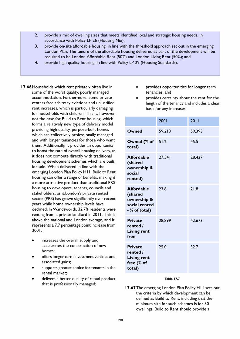
2. provide a mix of dwelling sizes that meets identified local and strategic housing needs, inaccordance with Policy LP 26 (Housing Mix);
3. provide on-site affordable housing, in line with the threshold approach set out in the emergingLondon Plan. The tenure of the affordable housing delivered as part of the development will berequired to be London Affordable Rent (50%) and London Living Rent (50%); and
4. provide high quality housing, in line with Policy LP 29 (Housing Standards).
17.66Households which rent privately often live insome of the worst quality, poorly managedaccommodation. Furthermore, some privaterenters face arbitrary evictions and unjustifiedrent increases, which is particularly damagingfor households with children. This is, however,not the case for Build to Rent housing, whichforms a relatively new type of delivery modelproviding high quality, purpose-built homeswhich are collectively professionally managedand with longer tenancies for those who wantthem. Additionally, it provides an opportunityto boost the rate of overall housing delivery, asit does not compete directly with traditionalhousing development schemes which are builtfor sale. When delivered in line with theemerging London Plan Policy H11, Build to Renthousing can offer a range of benefits, making ita more attractive product than traditional PRShousing to developers, tenants, councils andstakeholders, as it:London’s private rentedsector (PRS) has grown significantly over recentyears while home ownership levels havedeclined. InWandsworth, 32.7% residents wererenting from a private landlord in 2011. This isabove the national and London average, and itrepresents a 7.7 percentage point increase from2001.
increases the overall supply andaccelerates the construction of newhomes;offers longer term investment vehicles andassociated gains;supports greater choice for tenants in therental market;delivers a better quality of rental productthat is professionally managed;
provides opportunities for longer termtenancies; andprovides certainty about the rent for thelength of the tenancy and includes a clearbasis for any increases.
20112001
59,39359,213Owned
45.551.2Owned (% oftotal)
28,42727,541Affordable(sharedownership &socialrented)
21.823.8Affordable(sharedownership &social rented- % of total)
42,67328,899Privaterented /Living rentfree
32.725.0Privaterented /Living rentfree (% oftotal)
Table 17.7
17.67The emerging London Plan Policy H11 sets outthe criteria by which development can bedefined as Build to Rent, including that theminimum size for such schemes is for 50dwellings. Build to Rent should provide a
298
proportion of low-cost and London Living Renthomes, which are designed to help householdson average income levels to save for a depositto buy their own home. The covenant periodfor Build to Rent schemes in Wandsworth willbe at least 15 years to ensure they make a longterm contribution to meeting housing need inthe borough across all tenures. A claw-back
mechanism will be applied in accordance withthe policies of the emerging London Plan andnational Planning Practice Guidance (PPG) onBuild to Rent, in order to protect the value ofthe affordable housing provision that iswithdrawn if affordable housing units in Buildto Rent blocks are converted to another tenureafter the expiry of the covenant period.
LP33 Specialist Housing for Vulnerable People
A. Existing specialist and supported housing will be protected where it is considered suitable for its useand meets relevant standards for this form of accommodation. The redevelopment of any site whichincludes specialist and supported housing is only considered acceptable where:
1. there is no longer an identified need for its retention in its current format;2. the needs met by this form of housing will be re-provided elsewhere within the borough, resulting
in no net loss of overall provision;3. re-provision as part of a development proposal would result in improved standards and quality
of accommodation; and4. new accommodation meets the criteria in Part B below.
B. Proposals for the development of specialist and supported housing will be supported where theaccommodation:
1. meets an identified need, having regard to the evidence set out in the Council’s most up-to-dateLocal Housing Need Assessment;
2. is of a high quality and meets relevant best practice guidance for this type of accommodation;3. has access to good levels of public transport, and to shops, services and leisure facilities
appropriate to the needs of the intended occupiers; and4. includes provision of affordable units, in accordance with the emerging London Plan.
17.68The Council is committed to protecting andempowering the most vulnerable residents inthe borough. Our priority is to help localresidents to remain in their own home throughadditional support and adaptations. This includesthrough the provision of new homes which areeither accessible and adaptable or wheelchairaccessible in accordance with Parts M4(2) andM4(3) of the Building Regulations. However,the Council recognises that care needs cannotalways be met through conventional housingand therefore the provision of specialistaccommodation is required. This policy aims toensure that there is a sufficient supply ofappropriate housing available for older people,
homeless people, disabled people and vulnerablepeople to live as independently as possible.Examples of specialist housing include:
Sheltered housing – commonlyself-contained homes with limited on sitesupport.Residential care homes – commonly bedsitrooms with shared lounges and eatingarrangements.Nursing homes – similar to residentialcare, but accommodating ill or frail elderlypeople, and staffed by qualified nursingstaff.
299

Dual-registered care homes – residentialcare homes where nursing care isprovided for those residents who need it.Extra-care homes – combinations of theabove providing independent livingalongside care and support, and sometimesalso offering support for older people inthe wider community.Staff accommodation ancillary to a relevantuse will also be appropriate.
17.69The LHNA indicates that there are a numberof housing options available for older peopleand vulnerable groups in the borough, includingsome 2,346 units of housing with integratedelements of support or care. This provision ishelping to meet the varying types of need, butit is recognised some additional capacity willneed to come forward given the expectedfuture growth in the borough’s vulnerablepopulation. The emerging London Plan sets anindicative annual benchmark for the boroughof 120 units of specialist older persons housing,and this should be considered in the context ofmore detailed local assessments of specific typesof need. Proposals for the development ofspecialist housing (including older personshousing) should clearly demonstrate that thereis a local need for such accommodation, havingregard to the evidence set out in the LHNA.
17.70This policy seeks to resist the loss of variousforms of specialist accommodation so that thelevel of provision in the borough is not reduced.However, the Council recognises the changingnature of care provision for older, vulnerableand homeless people. Where existing specialistaccommodation does not meet modernstandards, the Council will support itsre-provision or modernisation to ensure theprovision of high quality specialistaccommodation which better meets the needsof older, vulnerable and homeless residents.
17.71Older, vulnerable and homeless people aregenerally more reliant on public transport, andwithout good access, living on their own canlead to isolation and loneliness. The location ofspecialist accommodation in accessible locationsis therefore important to ensure occupants areable to be as independent as possible and haveeasy access to key local services such as healthfacilities and local shops (within a 15-minutewalking distance), which is key to their generalhealth and wellbeing. Specialist Housing forVulnerable People will therefore be directed towell-connected locations with a good level ofaccess to public transport (PTAL 4 or higher),including those supported by good walking andcycling infrastructure.
LP34 Gypsy and Traveller Accommodation
A. The Council will safeguard the existing Gypsy and Traveller site at Trewint Street to meet the identifiedneeds over the Plan period. Should any additional need arise over the Plan period, the Council willidentify a new site(s) for additional permanent facilities within the borough to meet the needs ofGypsies and Travellers.
B. Proposals for new sites should meet the following criteria:
1. transport services and sustainable transport options.2. Appropriate landscaping and planting can be accommodated in order to enable the proper
integration of the site with the surrounding environment.3. Appropriate essential services including water and waste disposal can be provided.4. The site has reasonable access to local services with capacity, including education establishments,
health and welfare services, together with shops and community facilities.5. The number of pitches and design of the site is in keeping with local context and character.6. The site is not located in an area at high risk from flooding, including functional floodplains.7. The proposed use would not harm neighbours’ living conditions and would be compatible with
surrounding uses, including as a result of potential disturbance from vehicular movements andon site business activities.
300
17.72The Council has a long-established Gypsy andTraveller site at Trewint Street which currentlyaccommodates 11 residential pitches, one ofwhich is vacant. Regular visits are undertakenby Council officers to inspect the condition ofthe site and check on communal areas. Recentsite works have included improvements to thelocal amenities, including the utility blocks, andto ensure safety on site, gas meters have beenremoved and new electrical meters have beeninstalled, with regular electrical checks carriedout.
17.73The government’s policies for meeting thehousing needs of gypsies and travellers are setout in ‘Planning Policy for Traveller Sites’ (2015).Further guidance is contained in Policy H14(Gypsy and Traveller accommodation) of theemerging London Plan. The Mayor has adopteda definition for Gypsies and Travellers, whichrecognises those who have ceased to travelpermanently due to a lack of availablepermanent pitches, those who currently live inbricks and mortar accommodation due to thelack of caravan site provision, as well as those
who have ceased to travel due to their own ortheir family’s or dependants’ educational orhealth needs or old age.
17.74The effect of these different definitions has beento some extent considered as part of theCouncil’s Gypsy and Traveller AccommodationNeeds Assessment (2019). While it does notfully account for the needs of those who haveceased to travel due to their own or theirfamily’s or dependants’ educational or healthneeds or old age, it identifies that there hasbeen a significant decrease in demand fortraveller pitch licences in the borough. Due tothe low turnover rate and relatively settledstatus of the occupying households, the vacantpitch, and low number of applicants on thewaiting list for the site (1 household as of July2020), there is currently no evidencedrequirement or need for additional pitches tobe provided on the Trewint Street site orelsewhere in the borough. Nevertheless, shoulddemand exceed supply in the future, the Councilwill actively explore options to identify anadditional site(s), in accordance with Policy LP34 (Gypsy and Traveller Accommodation).
LP35 Visitor Accommodation
A. Proposals involving the development, redevelopment and/or intensification of visitor accommodationwill be supported where they are appropriately located within the Central Activity Zone (CAZ), withinor on the edge of town centres, in Focal Points of Activity, or other locations with good levels ofpublic transport accessibility (PTAL 4 or higher).
B. Proposals which result in the net loss of bed spaces will be resisted unless appropriate marketingevidence demonstrates that there is no longer a demand for the visitor accommodation.
C. All proposals involving visitor accommodation must fully address the following requirements:
1. The scale of the proposal would be proportionate to its location and its function.2. It would not result in an over-concentration of visitor accommodation at the neighbourhood
level.3. It would be inclusive and accessible, in line with Policy E10 of the emerging London Plan.4. It would not significantly compromise the supply of land for new homes on either allocated
housing sites or sites capable of providing new homes and the Council’s ability to meet its housingrequirement.
5. It would provide ancillary facilities which are open for public use and create employmentopportunities for local residents including restaurants, gyms and conference facilities.
6. It would be managed appropriately as short-term accommodation, with stays not exceeding 90consecutive days.
301
17.75Visitor accommodation refers to any buildingor place that provides temporary or short termaccommodation on a commercial basis. Thisincludes hotels, hostels, bed and breakfasts,apart-hotels and any other visitoraccommodation model that meets thisdefinition.
17.76The emerging London Plan identifies a targetfor the provision of an additional 58,000bedrooms of serviced accommodation by 2041,with a focus on both leisure and businessvisitors. The Council recognises the value ofthe visitor economy both to the local andLondon economy, and the role it can play inassisting the emerging London Plan in achievingits ambition.
17.77 In line with the emerging London Plan, thispolicy seeks to ensure that new hotel provisionis focused on accessible locations. Outside theCentral Activity Zone (CAZ), provision shouldbe focused on town centres, Focal Points ofActivity, and other areas with good access topublic transport. Within the CAZ, strategicallyimportant hotel provision should be focusedwithin the VNEB OA, with smaller scaleprovision in CAZ fringe locations with goodpublic transport accessibility.
17.78While the benefits of visitor accommodationare recognised, it is important to ensure thatan appropriate mix and balance of uses ismaintained in individual neighbourhoods toavoid an overconcentration of visitoraccommodation. As such, any proposal forvisitor accommodation will need todemonstrate that it is of an appropriate scaleto the function of the location, and that it wouldnot lead to an overconcentration of similar usesin the area.
17.79 In addition, a key priority of the Local Plan isthe maximisation of employment floorspace anddevelopment of new conventional housing,including affordable housing. Therefore,development proposals for new visitoraccommodation will be assessed within thecontext of the need to secure the delivery ofother uses which are considered a greaterpriority. When considering whether a proposalfor visitor accommodation would compromise
capacity to meet the need for conventionaldwellings in the borough the council will haveregard to:
whether a proposal would displaceexisting residential accommodation;whether a site has been allocated forhousing;whether a site has been identified in theLocal Plan housing trajectory as havingcapacity for conventional housing; andwhether a site has an extant or historicplanning permission for housing.
17.80An Inclusive Design Statement shoulddemonstrate new visitor accommodation ismeeting the requirements of the emergingLondon Plan policies E10 and D5. The needs ofthose requiring additional access facilities andassistance should be considered alongside therequirements for wheelchair accessible rooms.
17.81To ensure that hotels provide facilities forbusiness visitors, new hotels will be encouragedto provide ancillary business facilities such asmeeting rooms and flexible working areas.Where there is an identified shortage of leisurefacilities in the location of the proposal(particularly swimming pools, gyms and otherindoor or outdoor sports facilities), the Councilwill explore the potential for any leisure facilitiesof this type provided as part of the hotel to bemade available for use by the general public attimes to be agreed with the Council. Thisprovision and associated maintenancerequirements of both business and leisurefacilities will be secured through a Section 106planning obligation.
17.82Apart-hotels often display characteristicsassociated with conventional housing, meaningthat such accommodation may therefore fallwithin the C1 or C3 Use Classes, depending onits characteristics. Where apart-hotels areconsidered to fall within the C3 Use Class,proposals will be assessed against relevanthousing policies in the Local Plan. For proposalswithin the C1 Use Class, the Council will ensurethat units would not be occupied as permanentaccommodation. Conditions will therefore beused to limit the maximum lease lengths forsuch accommodation.
302
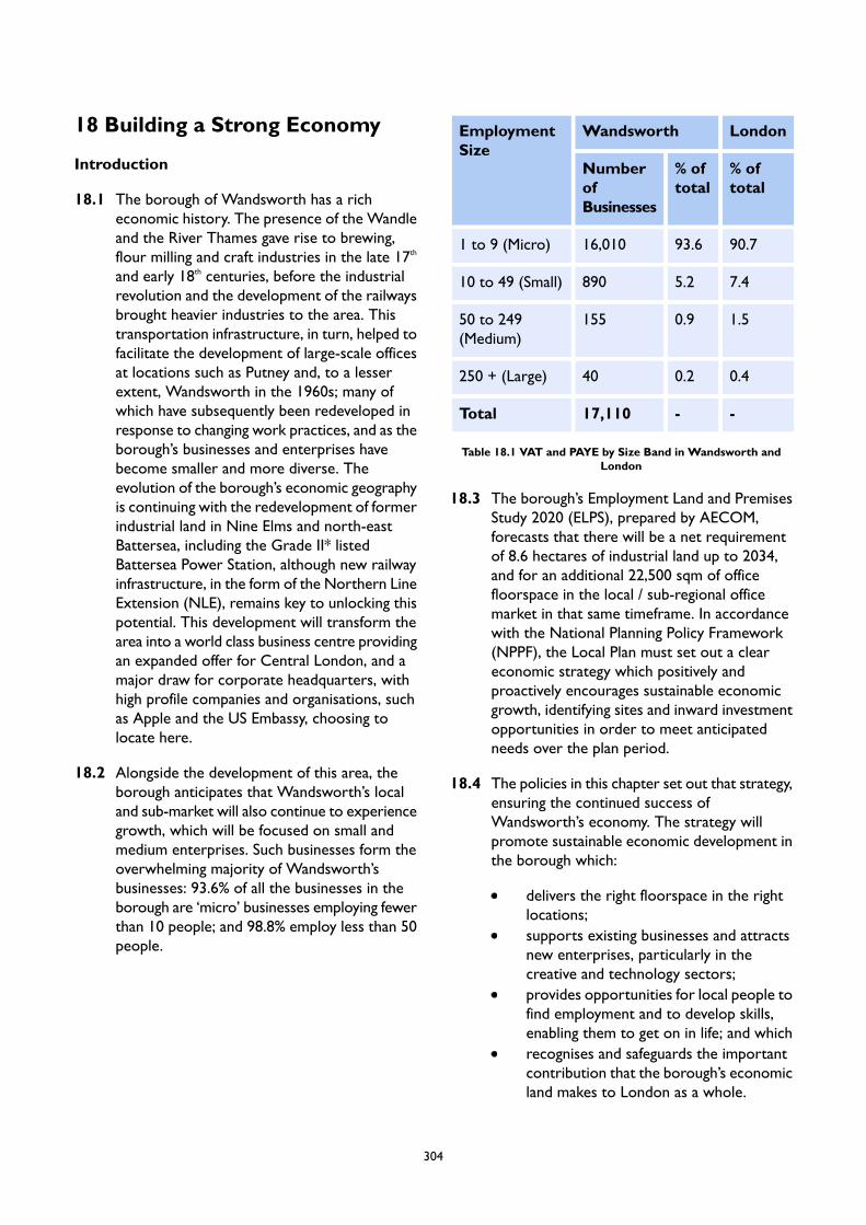
18 Building a Strong Economy
Introduction
18.1 The borough of Wandsworth has a richeconomic history. The presence of the Wandleand the River Thames gave rise to brewing,flour milling and craft industries in the late 17th
and early 18th centuries, before the industrialrevolution and the development of the railwaysbrought heavier industries to the area. Thistransportation infrastructure, in turn, helped tofacilitate the development of large-scale officesat locations such as Putney and, to a lesserextent, Wandsworth in the 1960s; many ofwhich have subsequently been redeveloped inresponse to changing work practices, and as theborough’s businesses and enterprises havebecome smaller and more diverse. Theevolution of the borough’s economic geographyis continuing with the redevelopment of formerindustrial land in Nine Elms and north-eastBattersea, including the Grade II* listedBattersea Power Station, although new railwayinfrastructure, in the form of the Northern LineExtension (NLE), remains key to unlocking thispotential. This development will transform thearea into a world class business centre providingan expanded offer for Central London, and amajor draw for corporate headquarters, withhigh profile companies and organisations, suchas Apple and the US Embassy, choosing tolocate here.
18.2 Alongside the development of this area, theborough anticipates that Wandsworth’s localand sub-market will also continue to experiencegrowth, which will be focused on small andmedium enterprises. Such businesses form theoverwhelming majority of Wandsworth’sbusinesses: 93.6% of all the businesses in theborough are ‘micro’ businesses employing fewerthan 10 people; and 98.8% employ less than 50people.
LondonWandsworthEmploymentSize
% oftotal
% oftotal
NumberofBusinesses
90.793.616,0101 to 9 (Micro)
7.45.289010 to 49 (Small)
1.50.915550 to 249(Medium)
0.40.240250 + (Large)
--17,110Total
Table 18.1 VAT and PAYE by Size Band in Wandsworth andLondon
18.3 The borough’s Employment Land and PremisesStudy 2020 (ELPS), prepared by AECOM,forecasts that there will be a net requirementof 8.6 hectares of industrial land up to 2034,and for an additional 22,500 sqm of officefloorspace in the local / sub-regional officemarket in that same timeframe. In accordancewith the National Planning Policy Framework(NPPF), the Local Plan must set out a cleareconomic strategy which positively andproactively encourages sustainable economicgrowth, identifying sites and inward investmentopportunities in order to meet anticipatedneeds over the plan period.
18.4 The policies in this chapter set out that strategy,ensuring the continued success ofWandsworth’s economy. The strategy willpromote sustainable economic development inthe borough which:
delivers the right floorspace in the rightlocations;supports existing businesses and attractsnew enterprises, particularly in thecreative and technology sectors;provides opportunities for local people tofind employment and to develop skills,enabling them to get on in life; and whichrecognises and safeguards the importantcontribution that the borough’s economicland makes to London as a whole.
304

18.5 In accordance with national policy, theborough’s town centres and the strategicreservoir of industrial land will remain the focusfor accommodating office and industrial uses,respectively. It is recognised, however, that thecapacity of these locations is insufficient toaccommodate the scale of demand, identifiedabove. As such, this Plan sets out provisions forthe strategic transformation and intensificationof two areas – the Wandle Delta and theBattersea Design and Technology Quarter –through mixed use redeveloped of underutilisedland to provide new flexible economicfloorspace, creating jobs and stimulatingentrepreneurship, alongside the delivery ofhomes and local facilities. This is supported bytargeted growth at other key sites within theborough, such as around Clapham JunctionStation, ensuring that the benefits ofdevelopment are sustainably deliveredthroughout the borough.
18.6 That notwithstanding, it is important torecognise that the forecast demand should betreated as indicative. Predicting future economictrends and corresponding employment landrequirements is not an exact science, and theassessment of need is based on a series ofassumptions, including the future performanceof individual business sectors, the proportionof employment in each sector that correspondswith different types of use classes, and thefuture employment densities and plot rationsfor each use class. In turn, the future economicperformance of Wandsworth’s economy, inrelation to external factors, such as theCOVID-19 pandemic, increases uncertainty.The long term impact of the pandemic onworking practices is not yet known, withindustry experts predicting different potentialoutcomes: the increased incidence ofhomeworking; a trend towards distributedworking practices, from local centre hubs overa centralised office; or the return to the officebut with new formats and layouts. The NPPFrequires that Local Plans are flexible enough toaccommodate needs not anticipated throughforecasting, which this plan seeks to achieve.That notwithstanding, it will be important forthe Council to monitor the impacts of suchfactors and to update the demand forecasting,and the policy position, if considered necessary.Further detail on the impact of the pandemic isincluded within the following sections.
305

LP36 Promoting and Protecting Offices
Locations for New Office Space
A. The Council will support the development of new office space within the emerging centres at BatterseaPower Station and Nine Elms, near Vauxhall, in the Central Activities Zone (CAZ). These areas willbe the focus for the provision of predominantly large-scale office floorspace for high-value occupiers,to support their potential as strategic employment hubs.
B. Outside of the CAZ, new office development will be supported in the following locations, subject tocompliance with any applicable area-specific criteria:
1. Primary Locations:
a. Town and Local Centres
2. Secondary Locations:
a. Appropriate edge-of-centre sites, as identified in the Site Allocationsb. The Battersea Design and Technology Quarter (BDTQ) (see Policy LP 37, Part B - Managing
Land for Industry and Development)c. Economic Use Intensification Areas (EUIAs)d. Economic Use Protection Areas (EUPAs)
C. Office development in these locations will be expected to cater primarily for the local and sub-regionaloffice market, and should provide appropriate workspace suitable for small and medium enterprises(SMEs). Within town centres, the provision of flexible and touchdown space will be encouraged. Allproposals for office development must be of a scale and size that is compatible with its intendedlocation or, where relevant, the vision set out for that location contained within the relevant AreaStrategy and/or through guidance provided as part of the relevant Site Allocation.
D. Applications for new office development located outside of the areas identified in Parts A and B willonly be supported where this has been clearly justified and would not undermine the function of thesequentially preferable locations identified in Part B.
Protecting Existing Office Space
E. Existing office floorspace located in the areas identified in Parts A and B will be protected.Redevelopment proposals requiring planning permission in such locations will only be supported if:
1. they would result in no net loss of office floorspace and the criteria of the relevant designationand/or site allocation has been met (Policies LP 38 - Mixed Use development); or
2. it has been clearly demonstrated that there is no demand for the use of the premises as officesthrough the submission of evidence that a full and proper marketing exercise of the site for aperiod of at least 18 months has been undertaken in line with the requirements set out inAppendix 1 (Marketing Requirements).
18.7 The total stock of office premises inWandsworth is 460,700 sqm – approximatelythe equivalent floorspace of seven and a half‘Walkie Talkie’ buildings combined. In
Wandsworth, this provision is distributed acrossthe borough, however it is possible to identifytwo distinct property markets which cater fordifferent users, each of which needs to be
307
planned for accordingly. One is the emergingoffice market located within the Vauxhall NineElms Battersea Opportunity Area (VNEB OA),in London’s Central Activities Zone (CAZ). Thiscomprises of modern office space, much likethat found in the Walkie Talkie or The Shard,and which caters for businesses operating at aregional, national or international scale. Theother, and larger – comprising over 80% of theborough’s total office floorspace – is a local /sub-regional market which primarily caters forsmall and medium-sized businesses servingcustomers within the borough and in areasacross the south and west of London.
Vauxhall Nine Elms Battersea OpportunityArea (VNEB OA) / Central Activities Zone(CAZ)
18.8 The VNEB OA Planning Framework, whichstraddles both Wandsworth and Lambeth, wasdeveloped in 2012 through a collaborationbetween these boroughs and the Mayor ofLondon. It set out the spatial strategy for thetransformation of this area, identifying thepotential for new development to create 25,000new jobs, of which 20,000 would be located inWandsworth, alongside 20,000 new homes, anew linear park, new social and communityinfrastructure and substantial public realmimprovements. This is supported by major newinfrastructure in the form of the Northern LineExtension (NLE), which is intended forcompletion by Autumn 2021 and which willgreatly improve the accessibility andconnectivity of the area.
18.9 The borough has been working to realise thevision set out within this Planning Framework,with approximately 205,000 sqm of officefloorspace expected to be developed by 2024in the part of the VNEB OA located inWandsworth. This is focused around theemerging centres at Battersea Power Stationand at Nine Elms, near to Vauxhall. Much of thisoffice floorspace is already built or underconstruction, including the US Embassy whichopened in 2018, the new headquarters ofPenguin at Embassy Gardens and BatterseaPower Station. The majority of this floorspaceis of large template and a high quality design, ona par with central London offices, and willattract occupiers of national and international
significance, as shown by Apple’s intention toopen its London HQ at Battersea PowerStation. Rental rates are expected to be in theregion of £700 / sqm (late 2019 prices), whichis approximately the equivalent other CAZlocations such as on the South Bank. Thisrepresents a significant divergence from thetype, size and cost of office floorspaceelsewhere in the borough, where average rentalrates are approximately £360 / sqm (late 2019prices).
18.10The planned spatial redevelopment of the VNEBOA is creating a step change in office provisionin the borough, and is expected to realise thisarea as a new functional part of the CentralLondon office market. The CAZ market hasshown a good appetite for large schemes of highquality specification in new mixed use businesslocations with complementary retail and leisureprovision, with successful examples includingLondon Bridge, More London, King’s Cross andPaddington. Analysis within the EmploymentLand and Premises Study (ELPS) has indicatedthat the VNEB OA will likely capture a criticallevel of demand from the wider central Londonoffice market, which will therefore meet theplanned supply of approximately 205,000 sqmof office floorspace. This demand is consideredto be distinct from that identified throughforecasting based on future economic growthprojections on a sector-by-sector basis, whichis addressed below.
18.11The Local Plan supports this approach, and willcontinue to promote the economicdevelopment and regeneration of the VNEBOA to ensure that it becomes a strategicemployment hub providing large-scale officefloorspace for high-value occupiers. Key toensuring this is the creation of a sense of placethrough improvements to infrastructure andpublic realm provision. This is already occurringon sites such as the redevelopment of BatterseaPower Station, and should be required of futuredevelopment within this area.
Wandsworth’s Local / Sub-Regional OfficeMarket
18.12The local / sub-regional office market inWandsworth accommodates approximately382,000 sqm of floorspace. Premises are mostly
308
small and are found dispersed along the RiverThames in Focal Points, Wandsworth TownCentre, and – to a lesser extent – within theQueenstown Road SIL and the borough’sLocally Significant Industrial Areas (LSIAs); withsome medium-sized premises also located inPutney Town Centre. Occupiers are generallysplit between the more traditional SMEs andsole traders, such as legal, accountancy andsmall consultancy firms, creative and culturaloccupiers, and public organisations.
18.13The forecasting exercise undertaken as part ofthe borough’s ELPS 2020 suggests that there isa net additional requirement for 22,500 sqm ofoffice floorspace up to 2034, once vacantfloorspace and frictional vacancy have beenfactored in. While this figure represents demandin the borough as a whole, evidence of demandin the property market assessments, includingvery low (2.8%) vacancy rates and recentpositive net absorption rates for smaller units,indicate that a considerable proportion of thisdemand is likely to be for office premises in thelocal/sub-regional market. As such, the LocalPlan assumes that this demand will correspondto areas of the borough that are outside of theVNEB OA.
18.14 In contrast the new office developmentoccurring within the VNEB OA, projections ofthe supply pipeline show that, if all approvedplanning applications concerning office space inareas outside of the VNEB OA were to comeforward for development, the size of the localoffice market would reduce by 12,200 sqm. Thisprojected loss of supply, should it comeforward, will exacerbate the need to identify aclear strategy for the provision of officefloorspace within the borough.
18.15External factors, such as the COVID-19pandemic, have the potential to substantiallyimpact existing working behaviours, andcorrespondingly, to affect the demand for boththe type and the quantity of office developmentin the future. This Local Plan recognises thatimpact, and the Council will remain particularlyresponsive to emerging trends and data thatprovide more clarity with respect to thelonger-term impacts. That notwithstanding, thepolicy for office development outlines a broadlypreferential approach to the location of new
office development, ensuring that it is targetedin the most sustainable locations, therebyaccommodating a strongly or poorly performingoffice market, whilst creating the necessaryflexibility in order to account for the individualrequirements of different businesses.
Town Centre First Approach
18.16Given the diverse and changing economicgeography of the borough, it is important thatthe right type of new office floorspace isdeveloped in the right places. The NPPF, theemerging London Plan, and the spatial strategyfor this borough all recognise the importanceof town centres as the primary location forbusinesses. This policy follows that approach,directing new office development within thelocal / sub-regional market to the borough’s fivetown centres, and, where there is limitedcapacity in these locations, to appropriateedge-of-centre sites. Local centres will also beappropriate for new office development, wherethis is of a scale compatible with the size andcapacity of the local centre.
18.17 It is expected that this floorspace will primarilycater to SMEs, and should be designedaccordingly (see Policy LP 40 (New EconomicDevelopment)). Mixed use development, withoffice floorspace brought forward alongsideother town centre uses, will be appropriate inthese locations. In line with Policy LP 45(Development in Centres), it is expected thatground floor uses should present an activefrontage in order to promote the vibrancy andvitality of the centre, and office uses shouldtherefore generally occupy upper floor levels,in particular in the Core and SecondaryFrontages, where retail uses are expected topredominate, and should maintain separateaccess arrangements where feasible.
18.18 It is recognised that certain office uses, such asco-working spaces or ‘touchdown’ spaces,provide a more flexible model of office delivery,which can potentially be accessed by a widerrange of users across a longer time period andwhich can contribute to wider town centredevelopment objectives (such as increasing thedaytime population). Touchdown workspacesare an emerging type of office provision whichseek to provide a local alternative for employees
309

to use instead of travelling to a regional centreor a large centralised office space. Where usespresent an active frontage, and are otherwisepermitted in line with the Council’s policies,they will be acceptable in Core and SecondaryFrontages.
Beyond the Centres
18.19The draft Economic Land AvailabilityAssessment (ELAA) undertaken by the Councilhas identified a reasonable supply of land foroffices in town centres, however both thisassessment and the ELPS recognise that thiscapacity will nonetheless fall short of theprojected demand for new office floorspace.For this reason, the Local Plan identifies anumber of other areas where the provision ofoffice floorspace, as part of mixed useredevelopment schemes, is appropriate. Thesesites are based on an assessment of theborough’s local office market to identifypremises which can be intensified orredeveloped to accommodate demand. As wellas meeting an identified need for officefloorspace, redevelopment in these locationshas the potential to realise the Council’s otherstrategic ambitions: both economic, such as theintensified provision of industrial floorspace;and social, through the provision of new homesand accompanying uses to support vibrant andresilient communities. Further information oneach designation is included within the PolicyLP 38 (Mixed Use Development).
18.20As part of the place-based approach on whichthis Local Plan is founded, sites that areparticularly suitable for office development havebeen identified in individual Site Allocations,outlined in the Area Strategies chapter of thisdocument. The majority of the site allocationswhich include the provision of office floorspaceare located within the other spatial designationsidentified above, and within Part B of the policy.There are a small number which lie outside ofthese areas, however none include the provisionof office uses as part of the allocation.
18.21Outside of the locations identified above, inaccordance with the NPPF, applications for theprovision of new office floorspace will need to
be justified by a sequential test to ensure thatit does not have a detrimental impact on theprioritised areas.
Protecting Existing Office Floorspace
18.22Given the positive forecast for office floorspacedemand to 2034, it will be important for theCouncil to not only promote and nurture theprovision of new space in the local officemarket, but to ensure that fit for purpose spaceis retained so that it can contribute to the netincrease in demand. The redevelopment of suchspace, where this is in sustainable locations,should therefore be resisted unless theredevelopment provides at least fullreplacement provision of an equal or greaterstandard. For appropriate areas and premises,the policy allows a change of use subject todemonstrating that there is no demand forpremises through a robust and meaningfulmarketing exercise. Appendix 1 sets out therequirements for establishing redundancy ofoffice premises.
18.23From 1 September 2020, the Government hasintroduced significant changes to the UseClasses Order (UCO), with the introductionof the new Use Class E, which collatescommercial, business and service uses. For thepurposes of economic land: Use Classes B1a(office other than a use within Class A2 –financial and professional services, not includingmedical); B1b (Research and development ofproducts or processes); and B1c (industrialprocesses which could be carried out in anyresidential area without causing detriment tothe amenity of the area) have all been removedand incorporated within Use Class E, alongsideother uses. Changes of use within the same useclass are not considered to be development,and therefore do not require planningpermission, nor does the Local PlanningAuthority have the ability to exercise controlover such changes of use. It is recognised thatthis could potentially compromise the ability ofthe Council to protect existing office space inline with the ambitions of Part E of this policy,as well as with the requirements of paragraphs80 and 81 of the NPPF. That notwithstanding,given the need for office floorspace identifiedwithin the borough’s ELPS, and reflecting thestrategic recommendations of that document,
310
the Council consider that this requirementremains important where the redevelopmentproposal does not meet the criteria of newpermitted development rights introduced bythe new Use Class Order, or where it seeks tointroduce uses, such as residential, which wouldrequire the obtaining of planning permission.
18.24The legislation that has introduced the changesto the UCO has also identified that, for thepurposes of permitted development rights, useclasses prior to 1 September 2020 will remainin effect until 31 July 2021. In 2018, the Councilconfirmed an Article Four direction to excludethe conversion of offices to residential use,through permitted development rights (PDR)in certain parts of the borough. The areas
included in the Article 4 direction wereprimarily town centres, parts of the WandleValley and the VNEBOA, although specific sitesthat make important contributions to theborough’s office floorspace were also included.The direction has had a considerable positiveimpact on the borough’s ability to retain itsoffice floorspace: of the borough’s pipelineposition in 2020, all but 1,900 sqm of the totalanticipated reduction in office floorspace of31,000 sqm was granted prior approval underPDR before the Article 4 direction came intoeffect in May 2018. It is the Council’s intentionto continue to enforce its Article 4 directionto require development involving the loss ofoffice floorspace in key employment locationsto go through planning permission.
LP37 Managing Land for Industry and Distribution
Protecting Industrial Land and Premises
A. The Council will support the use of land and premises for industry and distribution in appropriatelocations, falling within the following uses:
1. Light industry (falling within Use Class E, part (g)(iii), and which would have been identified asUse Class B1c prior to 1 September 2020);
2. General industry (B2);3. Storage and logistics/distribution (B8);4. Flexible hybrid industrial space;5. Secondary materials, waste management and aggregates;6. Utilities infrastructure;7. Land for suitable transport functions, including intermodal freight interchanges, rail and bus
infrastructure;8. Research and development of industrial and related products or processes (falling within Use
Class E, part (g)(ii), and which would have been identified as Use Class B1b prior to 1 September2020); and
9. Sui generis uses that relate to, and support, the industrial nature and operation of the area.
Strategic Reservoir of Industrial Land
B. A strategic reservoir of industrial land, comprised of the borough’s Strategic Industrial Locations (SILs)and Locally Significant Industrial Areas (LSIAs), will be protected and retained. In these locations:
1. Uses identified in Part A will be supported. Where necessary, proposals may be subject to theuse of conditions in order to protect the industrial function of the land in perpetuity.
2. The redevelopment of sites must provide at least the full replacement of existing industrialfloorspace, in accordance with those uses identified in Part A.
311
3. The intensified use of sites for industrial purposes, through increased floorspace, operating hoursor other methods, will be strongly encouraged. Where appropriate, landowners should workwith adjacent sites in order to make the most efficient use of land.
4. Developments proposals for other uses in these locations will not be supported, except in thefollowing circumstances:
a. Office uses will only be supported where they are ancillary to the use of the site or premisesfor one or more of the industrial uses identified in Part A. This does not apply to the areaof the Queenstown Road Battersea SIL designated as the ‘Battersea Design and TechnologyQuarter’ as set out in Part B.4.c.
b. In limited instances, non-industrial uses may be appropriate in these locations if they aresmall-scale and cater to the local needs of people working the area.
c. In the Battersea Design and Technology Quarter, SME office accommodation and researchand development uses will be appropriate on upper floors, provided that the use does noterode the effective operation of the industrial function of the SIL, and that it would resultin the intensification of industrial uses on the site in accordance with the Area Strategy andrelevant Site Allocation. If the existing use of the site is solely or predominantly for officeuse, redevelopment must provide for new industrial uses on the ground floor, unless thiswould result in harm to a heritage asset or would cause material harm to the amenity ofneighbouring occupiers or the operations of neighbouring uses.
Industrial Land and Premises in Other Locations
C. In order to meet the identified need for industrial land and premises, the Council will seek to retainthese where they are located outside of the strategic reservoir (SILs and LSIAs). The redevelopmentof such sites, including former industrial land, to provide intensified or new industrial premises willbe supported in the following locations:
1. Economic Use Intensification Areas (EUIAs).2. Economic Use Protection Areas (EUPAs).3. Focal Points of Activity.4. On sites allocated for industrial use in the Area Strategies and/or Site Allocations.5. Existing industrial land and premises that are not otherwise designated.
D. Proposals for mixed use developments, including residential, on sites within the locations identifiedin Part C will be supported, where:
1. the provision of industrial floorspace will be fully re-provided or intensified, in accordance withPolicy LP38 (Mixed Use Economic Development), and where all other relevant criteria of thispolicy have been met; or
2. it can be demonstrated that suitable alternative land and/or premises is available in reasonableproximity (including accessibility to the same bus route and rail/underground station(s)) to theapplication site and where it can be demonstrated that appropriate arrangements to supportthe relocation of existing businesses have been put in place prior to the commencement of thedevelopment; or
3. there is no reasonable prospect of the site being used for the industrial and related purposesset out in Part A of this policy, as demonstrated through the submission of evidence that a fulland proper marketing exercise of the site, for a period of at least 18 months, has been undertakenin line with the requirements set out in Appendix 1 (Marketing requirements).
312
New Covent Garden Market
E. The primary function of New Covent Garden Market, and the railway arches adjacent to it, as awholesale retail facility will be protected. The principle of the consolidation and reconfiguration ofNew Covent Garden Market will be supported, subject to it being clearly demonstrated that theoperational requirements of the market as a whole would continue to be met.
18.25 Industrial activity in Wandsworth is focusedalong two main axes. The first runs east-westfrom remnant areas in Nine Elms and theQueenstown Road, Battersea SIL through tothe Lombard Road / York Road Focal Point, andalong the River Thames as far west as theWandle Delta. The second extends south fromthis location along the Wandle Valley toWandsworth’s boundary with Merton. Thesesites encompass a wide variety of importanteconomic functions, from bus depots andconcrete batching plants to car repair, hi-techmanufacturing, breweries, self-storage facilitiesand builder’s yards. The borough’s industrialland also provides premises for culturalworkplaces, including workshops, studios andstorage space for creative manufacturing andproduction. Many cultural and other businessesin the borough’s industrial areas are locatedhere in order to be in close proximity to theCentral Activities Zone (CAZ) and theestablished institutions and businesses that helpto make London unique.
18.26There is a total of 133.6 hectares of landcurrently in industrial or related uses in theborough. Of this, 68.9 hectares is occupied bycore industrial and warehousing uses, and 63.3hectares is occupied by wider industrial uses,such as for waste management, utilities, land fortransport, and wholesale markets. Theremaining 1.4 hectares is vacant, although thisis to some extent reflective of expected churnin industrial properties, and is indicative of abuoyant market with high levels ofdemand. Such demand has, in part, been drivenby the large-scale reduction of industrial landsince the new millennium, both at the local andthe regional scale. Over the period of 2001 to2015, more than 1,300 hectares of industrialland in London were released to other uses –well in excess of the monitoring benchmarksthat had been established within the relevantLondon Plan. In Wandsworth, the ELPS 2020
identifies that industrial stock has fallen by 14.7%between 2010 to 2019, equivalent to 65,600sqm of industrial floorspace.
18.27Driven in part by this decreasing supply, rentalvalues for industrial floorspace have increasedsignificantly in recent years, from £129/sqm in2009 to £209/sqm in 2019 (an increase of 62%).Rental values for industrial land inWandsworthare higher than the averages for the functionaleconomic market area (£186), a reflection ofthe proximity of the Queenstown Road,Battersea SIL to the CAZ, and of the generallygood standard of the premises.
18.28 Industrial businesses operating within theborough are mostly SMEs with a local /sub-regional market reach, and their land andpremises requirements reflect this scale ofoperation. Larger premises are found primarilywithin the Queenstown Road SIL and in NineElms, including both medium to large storageand warehouse units and traditional industriessuch as cement / concrete works and lightmanufacturing. There are some examples oflarger premises elsewhere, for example, in theEUPAs and the EUIA near to CentralWandsworth, such as the waste transfer stationon Smuggler’s Way and a Council depot atFrogmore, however typically the premises inCentral Wandsworth and the Wandle Valleyare smaller.
18.29The ELPS 2020 indicates that there is a netrequirement for 8.6 hectares of industrial landbetween 2019 and 2034. The assessmentpredicts that approximately 5.5ha of land willbe required to accommodate demand for coreindustrial uses, which arises primarily from aneed for additional storage and distribution uses(B8 use class), although there is also an increasein demand anticipated for light industrial andresearch and development facilities (E useclasses). Up to 2.1ha of land will be needed to
313
accommodate additional demand for widerindustrial uses, including waste management(see Policy LP 13, Waste Management), whilethe remaining 1ha of this requirement is toensure that the borough has an optimal amountof ‘frictional vacancy’ to allow for the efficientchurn of occupiers.
18.30The forecast increase in demand for industrialland contrasts with a projected loss in supply,as identified within the Council’s monitoringreports, which record that if all approveplanning applications were to come forward thenet supply of industrial land in the boroughwould reduce by 7.6ha. The majority of this land(5ha) is located within the VNEB OA, whereinthe loss of industrial land should not be seen asa market response (i.e. a contracting industrialeconomy), but rather results from the Counciland the Greater London Authority’s (GLA)vision for the regeneration of the area, whichseeks to prioritise other needs, includinghousing the development of higher value-addedsectors.
18.31That notwithstanding, it is clear from theeconomic projections that there is not asufficient supply of industrial land in the boroughto meet the total forecast demand, and that theanticipated contraction of the existing supply,if realised, would exacerbate this need. Theimportance of retaining and protecting theborough’s existing remaining industrial landwithin that capacity, and the need to provideintensified industrial floorspace in locationswhere this is appropriate, is paramount. Thispolicy sets out the approach for how this willbe realised.
18.32For clarity, references to ‘industrial’ land andpremises within this chapter and the Local Planshould be read as those uses identified withinPart A of this policy, unless otherwise stated.
Strategic Reservoir of Industrial Land
18.33 In line with the principles of the NPPF, theidentified demand for additional land forindustrial uses over the Local Plan period shouldbe accommodated within the most appropriatelocations for these uses. The Planning PracticeGuidance (PPG) states that Councils shouldidentify a future supply of land which is suitable,
available and achievable for economicdevelopment uses. The borough’s existingindustrial land designations, Strategic IndustrialLand (SIL) and Locally Significant Industrial Land(LSIA), remain the most suitable locations forindustrial and related uses, and it is theCouncil’s intention to therefore protect themin this capacity to form a strategic reservoir ofindustrial land.
18.34Strategic Industrial Land (SIL) is identified withinthe emerging London Plan, Policy E5, as formingLondon’s main reservoir of land for industrial,logistics and related uses, and is given strategicprotection because these sites are consideredcritical to the effective function of London’seconomy. Sites that are designated as SIL in theborough are:
Queenstown Road, BatterseaSummerstown (as part of the ‘NorthWimbledon / Garratt Business Park(Summerstown)’ SIL that is sharedbetween Merton and Wandsworthboroughs)
18.35 In the currently adopted Local Plan(Employment and Industry Document, 2018),Summerstown was identified as a LSIA. Theemerging London Plan has proposed that thisis redesignated to become a SIL. This Local Plantakes forward that proposition, as the site isconsidered to perform the functions and todemonstrate the characteristics of the SIL. Thisdesignation will enhance the protection of theindustrial uses within the site, and providesgreater confidence to developers interested inproviding intensified industrial uses.
18.36The borough’s Locally Significant IndustrialAreas (LSIAs) comprise of land in Wandsworththat have a particular local importance forindustrial and related functions, and whichcomplement the SIL provision. These are theequivalent of the Locally Significant IndustrialSites (LSIS) as identified within the emergingLondon Plan, Policy E6. Sites that are designatedas Locally Significant Industrial Areas in theborough are:
Old SergeantKimber Road
314
Lydden RoadThornsett Road
18.37 Intensification of industrial uses in both theborough’s SILs and LSIAs is encouraged in orderto meet the identified demand. This could berealised through: the introduction of smallerunits; the development of multi-storey schemes;the addition of basements; and the moreefficient use of land through higher plot rations,although this must also ensure that sufficientyard space is retained in order to meetoperational requirements and that any negativeimpacts on the transportation network areappropriately mitigated. To support the mostefficient use of sites, it is strongly encouragedthat landowners work with adjacent sites inorder to promote a coordinated approach, andit may be beneficial to realise this through amasterplan. This can achieve efficiencies inparticular in relation to access and servicingarrangements.
18.38Proposals for new delivery or distributionfacilities are encouraged in the borough’s SILsand LSIAs, particularly where these help to meetan identified demand (as forecasted within theELPS 2020). Any proposals for new delivery ordistribution facilities must pay particular regardto the relevant Local Plan and emerging LondonPlan policies regarding transport, traffic, publicrealm and amenity in order to ensure anyincrease in vehicle movements or changes tooperation does not have a significantly negativeimpact on the local area. Opportunities to takeadvantage of emerging technologies anddistribution organisation practices will beencouraged where this would assist in reducingand consolidating deliveries, take vehicles offthe roads, improve air quality, and reducedisturbance.
18.39The nature and by-products of industrialactivities, which can include the generation ofnoise, odours, dust, emissions, traffic (includingHGVs) and the requirement for operationacross at 24 hour period, often result inconflicts being raised with other uses, and inparticular residential. The encroachment ofresidential uses into these industrial areas canharm their operation and limit their capacityand, in order to protect the strategic reservoir,the SILs and LSIAs in the borough are therefore
not appropriate locations for any sort ofresidential use. Other non-industrial uses willalso be restricted, other than where they areeither:
ancillary to the primary industrial function(e.g. a small amount of office floorspace,with the exception of the Battersea Designand Technology Quarter, where astrategic decision to intensify economicuses has been taken, see below); orwhere they provide services to peopleworking in the SILs and LSIAs and supportthe businesses in this area. Examplesinclude small-scale cafes, creche facilities,or training centres that relate to industrialor transportation businesses.
18.40Through protecting a strategic reservoir of landthat is dedicated for industrial use, this policywill enable a rich diversity of local businessesto thrive both now and in the future, as itaffords a greater ability to respond flexibly todemand without the risk of impacting – or beingimpacted by – other non-industrial uses. Thisapproach corresponds with the principles setout in the emerging London Plan Policies E4,E5, and E6. and reflects the recommendationmade within the ELPS 2020.
Battersea Design and Technology Quarter(BDTQ)
18.41The Battersea Design and Technology Quarter(BDTQ) is an area of the Queenstown Road,Battersea SIL – comprised of Havelock Terrace,Ingate Place, and Silverthorne Road – that theCouncil has identified as having the potential toestablish as a creative and technological cluster.The concept seeks to leverage the investmentin the wider VNEB OA and to build upon thearea’s existing creative economy to deliverintensified economic uses: by bringing new SMEjobs to the area which complement theanticipated digital cluster at the Battersea PowerStation Development; and by promoting theintensification of the existing industrial activitieswithin the SIL. In support of this, We Made Thatwere commissioned in 2019 to undertake aneconomic appraisal of the area, and to provideguidance on a physical development frameworkthat would support the Council’s ambitions.This is published as the Battersea Design and
315
Technology Quarter Economic Appraisal andDevelopment Framework (BDTQ EADF) andhas been used to inform this policy approachas well as that set out in the Nine Elms AreaStrategy in the Placemaking chapter.
18.42The BDTQ builds upon the policy approachestablished within the previous Local PlanEmployment and Industry Document (LPEID),which was adopted in 2018. In this document,this area was designated as an IndustrialBusiness Park (IBP), a designation permittedunder the London Plan (2016, consolidated withalterations). The Council has been workingproactively with landowners and developerswithin the area on the basis of this designation,and the BDTQ initiative therefore representsthe continuation of this work. Landowners wereextensively involved in theWe Made That study,and the Council is keen to continue workingclosely with all landowners in the area to deliverthis vision.
18.43The BDTQ designation seeks to reinforce area’sSIL designation, and as such any developmentwithin this location should protect and enhancethe industrial character of the area, whichsupports heavy industry, large scale distributionand logistics, warehousing and manufacturing.The Council recognises that the BDTQ isparticularly suitable for a wide range of culturalindustries including workshops, studio andstorage space for creative manufacturing andproduction, all of which would benefit from theclose proximity to central London and its manycultural institutions (See Policy LP 41, AffordableWorkspace). The continued development ofthe VNEB OA will also result in a furtherincrease in demand for warehousing and studiospace for businesses in industries which directlysupport the CAZ, including catering suppliersand printers. The needs of these businessesshould also be considered as part of the BDTQredevelopment proposals.
18.44Development proposals should thereforeprovide intensified industrial uses, but may alsoprovide office floorspace targeted at SMEs onthe upper floors. To help protect the industrialcharacter of the area, and to optimise theefficient use of the land in this capacity, newindustrial uses should be introduced on theground floor as part of the redevelopment of
existing wholly or predominantly officedevelopments. All proposals should beconsistent with the Area Strategy for Nine Elmsand associated Site Allocations, and informedby the BDTQ EADF. It is identified in the ELPS2020 that this area represents a goodopportunity both to increase the floorspaceavailable in the local office market, which willhelp to meet the identified demand outlined inrelation to Policy LP36 (Offices), while alsocapitalising on the transformation of the VNEBOA to stimulate new demand (i.e. that whichis unlikely to be captured within the ELPSprojections based on population data), andwhich will cater to high-value tenants whichrequire good access to the CAZ, such as SMEsin the digital and technology subsectors.
18.45The BDTQ EADF outlines that, under theproposed redevelopment, the quantity of landin industrial uses in the cluster would increaseby approximately 24,000 sqm, providing a totalof 92,000 sqm, which would primarily be as aresult of an increase in premises classified as‘small’. Alongside this, the area has the potentialto deliver a potential increase of 77,840 sqm ofoffice floorspace.
18.46To ensure that proposals for new mixed useeconomic development (i.e. incorporating officefloorspace) do not negatively impact on the longterm viability and effective operation of the SIL,consideration will need to be given to theimpact of the development with regard toaccess arrangements, layout and design, theability to operate on a 24 hour basis, and thecompatibility with existing and potential useswithin the wider area of the Queenstown Road,Battersea SIL. In particular, the BDTQ areaencompasses a transportation depot and aconcrete plant, and the redevelopment of thearea should ensure that it does not adverselyimpact the operation of these uses.
18.47 In the VNEB OA, and in the surroundingQueenstown Road area, rents for both officeand industrial space are high. In order to attractpotential start-ups and to support larger SMEsin the technology focused and creativeindustries, it is essential that a provision ofaffordable workspace is maintained. In particularin the context of the prime office floorspacebeing delivering as part of the transformation
316
of Nine Elms, the intensification of the BatterseaDesign and Technology Quarter represents anexcellent opportunity to maximise affordableworkspace provision, which should apply toboth new SME office premises and industrialpremises. This will support longer termclustering and job creation as well as wider goalsfor economic and social inclusion in theQueenstown area and wider borough. Foraffordable workspace to work effectively in thislocation, the discount on rent will thereforeneed to be substantial, given that prevailingmarket rents are high. The borough needs totake a proactive approach to encourage highvalue start-ups and SMEs from the technologyand creative industries to locate here, and willtherefore seek the provision of affordableworkspace at a discount rate of 50% belowprevailing market rates for comparableprovision. This is set out in more detail in PolicyLP 41 (Affordable Workspace).
18.48The BDTQ builds on the unique opportunityoffered by the location of the SIL within theVNEB OA, and permits the introduction of usesnot commonly allowed in such designations,however the area is not considered appropriatefor residential uses of any kind, nor for othernon-economic uses besides those identified inPart B(4)(b) of this policy.
Industrial Land Outside of the StrategicReservoir
18.49 In addition to the strategic reservoir ofindustrial land located within the borough’s SILsand the LSIAs, there are smaller clusters ofindustrial uses elsewhere in the borough. Thesepredominantly fall within other designatedeconomic land within the borough, includingEconomic Use Protection Areas (EUPAs) andEconomic Use Intensification Areas (EUIAs), aswell as the borough’s Focal Points, althoughthere are also parcels of industrial land, typicallyunder 0.25ha, which are dispersed across theborough and do not fall within any of the abovedesignations.
18.50 It is recognised that the projected demand forindustrial land is greater than the availablesupply, including the potential additionalindustrial floorspace which could come forwardthrough the intensification of industrial uses
within the SILs and LSIAs through smaller-scaleintensification, and through larger regenerationinitiative such as the BDTQ. As such, existingindustrial land and premises outside the SILsand LSIAs, including former industrial land, willalso be protected and, where possible,intensified.
18.51The areas of the borough designated asEconomic Use Intensification Areas (EUIAs), inparticular, have the potential to accommodatean increase in industrial land demand, as well assome select sites within the Focal Points. TheELPS 2020 identifies that there is approximately10ha of land within the Focal Points and EUIAs,primarily consisting of vacant and under-utilisedland or with poor-quality building, which hasthe potential to be redeveloped or intensifiedto accommodate new industrial floorspace,alongside other uses. This is explicated furtherin Policy LP38 (Mixed Use Development onEconomic Land).
18.52For appropriate areas and premises, the policyallows a change of use to non-industrial usesonly where it can be demonstrated that thereis no demand for the industrial use through arobust and meaningful marketing exercise.Appendix 1 (Marketing) sets out therequirements for establishing redundancy ofindustrial premises.
New Covent Garden Market
18.53One of only five wholesale markets withinLondon, New Covent Garden Market is a keysite for both the borough and the capital, andsignificantly contributes to employment in thearea both directly, and through associated foodsand drinks businesses and the Local Plantherefore seeks to protect it. The market hasbeen undergoing redevelopment to consolidateits operation, and the Local Plan supports thisprovided that it does not adversely impact onthe operational function of the site.
18.54The Council is supportive, where possible, ofopportunities to utilise the borough’ssafeguarded wharves to facilitate thetransportation of wholesale market goods byriver, as this would contribute to the reductionof traffic congestion in the area, realisingenvironmental benefits.
317
LP38 Mixed Use Development on Economic Land
A. Proposals for mixed use development, including residential, will be supported where it meets thecriteria for the relevant economic land designation within which it is located, as set out below:
1. Economic Use Protection Areas (EUPAs): Proposals which would result in the existingquantum of office and industrial floorspace both being fully replaced will be supported. Increasedprovision through the intensification of such uses is supported, where it would not give rise toany material harm to the character of the area, the operation of neighbouring uses or theamenities for neighbouring residents. If it can be clearly demonstrated that there is no demandfor the existing industrial use (where applicable) through the submission of evidence that a fulland proper marketing exercise of the site has been undertaken for a period of at least 18 monthsin line with the requirements of Appendix 1 (marketing requirements) then preference will begiven to the provision of office space.
2. Economic Use Intensification Areas (EUIAs): Proposals which would result in theintensification of existing economic floorspace will be supported. Where the site accommodatesan existing industrial use, or where the site previously accommodated industrial uses, the proposalmust provide for an increase in industrial floorspace. It is appropriate for existing office floorspaceto be replaced by industrial floorspace as part of the re-provision of economic floorspace. Theextent of the intensification required is set out within the relevant Site Allocation. Where astrategic approach is been taken to the redevelopment of an area, such as through an areamasterplan, and it has been demonstrated that the overall requirements of this designation canbe realised at an aggregated scale, certain individual sites could be exempt from theserequirements.
3. Focal Points of Activity: Proposals which would result in the existing quantum of office andindustrial floorspace both being fully replaced will be supported. Where the site accommodatesexisting industrial uses, proposals should seek to provide for an intensification in industrialfloorspace. Proposals in the Lombard Road/ York Road Riverside, Ransomes Dock, andWandsworth Riverside Quarter Focal Points (excluding sites within the Wandle Delta area) thatwould result in a net increase in office floorspace will normally be resisted, unless it can bedemonstrated that this is required in order to support the intensification of industrial uses onthe site, or where it provides for a limited amount of co-working space and/or managed workspacewhich meets the needs of local residents. Proposals for the provision of new office floorspacein these locations will be assessed in accordance with Policy LP36.B (Promoting and ProtectingOffices).
B. All proposals for mixed use redevelopment must ensure that the mix of uses can be appropriatelyaccommodated on site, in accordance with Policy LP40 (Requirements for New EconomicDevelopment). Regard will be had to the design and layout of the proposal in order to ensure thatany potential conflicts between economic and non-economic uses are adequately mitigated, and thatproper consideration has been given to: safety and security; layout, orientation, access, servicing anddelivery arrangements, including in relation to hours of operation; vibration and noise; and air quality,including in relation to dust, odours, and emissions.
C. Where proposals provide for the replacement of existing industrial land and premises, the Agent ofChange principle, as set out in the emerging London Plan Policy D13, will apply, and appropriatemitigation measures should be implemented.
D. Details of the phasing of the proposed development will be required to be submitted as part of anyplanning application in order to demonstrate that the completion and operation of the economiccomponents of the scheme will be provided prior to the first occupation of the remaining non-economicuses.
318
18.55The mixed use redevelopment of economic landprovides an excellent opportunity to protectand enhance the borough’s economic landsupply, and in particular to provide intensifiedindustrial uses, whilst also meeting theborough’s other needs with respect toresidential delivery, the enhancement ofcommunity and local facilities, and theregeneration of under-utilised areas throughimprovements to the public realm andplacemaking. Suitable uses for a mixed useredevelopment scheme include residential uses(Use Class C3); non-economic uses falling withinClass E (Commercial and service uses); pubs,drinking establishments and takeaway (fallingwithin Use Class SG); social and communityinfrastructure uses (Class D1); leisure andrecreational uses (SG); and other uses that willserve the needs of the occupiers of thedevelopment; all of which are subject tocompliance with other policies within thisdocument, the relevant Area Strategy,Masterplans, and Site Allocations.
18.56The mixing of economic and non-economic useswithin close proximity could potentially createconflicts between the two uses, such as harmcaused to residential amenity as a result ofby-products of industrial use (such as noise,dust, odours, and vibrations), and the impedingof normal business conduct as a result of this.If the uses are poorly designed, this can alsodisincentivise uptake and investment in bothuses. As such, all developments must ensurethat they are suitable designed to mitigate suchconflicts. The Agent of Change principle, as setout in emerging London Plan Policy D13, placesthe responsibility for this mitigation on newdevelopment uses which may be more sensitiveto it, which in this instance would be residentialor other non-economic uses. Mitigationmeasures should be incorporated within thedesign from the outset, and will be securedthrough planning obligations. It is essential thatbusinesses (where retained or replaced as partof the redevelopment) do not haveunreasonable restrictions placed on thembecause of the new uses.
18.57To safeguard the use, ensure the effectivefunction and operation of economic uses in amixed use scheme, and to minimise disruptionto existing businesses which will be retained as
part of the scheme (see Policy LP 40), it isimportant that the economic use is completedand in operation prior to the completion of thenon-economic use provision.
Economic Use Protection Areas (EUPAs)
18.58Established industrial and office premisesprovide a substantial amount of floorspace forlocal businesses and are crucial in supportingthe both borough’s economy, and that ofLondon as a whole. Outside of the primarylocations for offices and industry activities –town centres and the strategic reservoir ofindustrial land, respectively – economic usesare grouped into clusters. Such clustering canbring substantial benefits. Given the identifiedneed for economic premises of the Local Planperiod, it is essential that the Council protectand retain these economic clusters within anyforthcoming redevelopment proposal, and tointensify them where possible, through thedesignation of Economic Use Protection Areas(EUPAs).
18.59Sites that are designated as Economic UseProtection Areas (EUPAs) are as follows:
Smugglers Way, Jews Row and BatterseaReachBattersea Business Centre, 99-109Lavender HillJaggard WayWimbledon Sewing Centre, Balham Cars,Balham High RoadIrene House, 218 Balham Road, 25Boundaries RoadCollege Mews, St Ann’s Hill and 190-194St Ann’s HillHillgate Place, Balham HillPrinceton Court, Felsham Road116 & 118 Putney Bridge RoadEagle House, Armoury Way57 Putney Bridge Road, 88-92 PutneyBridge Road and 2-3 Adelaide Road70 Upper Richmond Road and 5 ManfredRoadSmiths Yard, Earlsfield7A Putney Bridge Road, Triangle House,2 Broomhill Road and Spencer Court,140-142 Wandsworth High Street
319

Royal Victoria Patriotic Building, JohnArcher WayThe Old Imperial Laundry, 71-73WarrinerGardens124 Latchmere Road and 187-207Lavender HillCloisters Business Centre (new)Culvert House, Culvert Road and TheView, Battersea Park Road (new)
18.60The economic land survey undertaken insupport of the ELPS 2020 identified two clusterswhich should also be supported by thisdesignation within this Local Plan: CloistersBusiness Centre, in Nine Elms; and CulvertHouse, Culvert Road and the View, BatterseaPark Road, in Battersea.
18.61Cloisters Business Centre currently comprisesof SMEs, many of them in the creative andcharity industries, which benefit from the goodaccess to the CAZ. As the VNEBOA continuesto be redeveloped, the demand for this type ofspace will increase as SMEs in these sectors, aswell as in higher-value subsectors such as digitaland tech, look for space closely located to thearea. It is therefore important that, as well asencouraging the development of new space toaccommodate the latter, as in the BTDQ,adequate existing space such as the CloistersBusiness Centre is protected and retained.
18.62Culvert House and The View, currently catersfor SMEs in the local office market. CulvertHouse is in the same building as a school, andthe View is a mixed use development currentlyunder construction. While there is noimmediate prospect of the redevelopment ofthese sites for other uses, both currently orwill soon comprise good quality office spaceappropriate for SMEs looking for good accessto the CAZ, and should be protected throughthe EUPA designation.
Economic Use Intensification Areas (EUIAs)
18.63The EUIA designation was introduced in theprevious Local Plan, Employment and IndustryDocument (2018), and sought to balance theplanned release of under-utilised industrial landthat was previously designated within theborough’s strategic reservoir, in order topromote investment in modern industrial
premises alongside the provision of businessfloorspace for SMEs to support the borough’seconomy, and residential uses to meet theborough’s housing needs. The designationtherefore requires intensified industrial usesand increased business floorspace and/ormanaged workspace for SME businesses.Residential uses will be appropriate where theyassist in developing more intensive economicuses, and are compatible with the spatialobjectives set out in the relevant Area SpatialStrategy and/or Site Allocation.
18.64Site that are designated as Economic UseIntensification Areas (EUIAs) are as follows:
Bendon Valley
Riverside Business Centre and formerBingo Hall
Wandsworth Delta
Panorama AntennasCauseway Island, including land to the eastKeltbray Site, Wentworth House andadjacent land at Dormay StreetFerrier StreetFrogmore DepotHunts Trucks, and adjacent land at theGasholder siteChelsea Cars and Kwikfit
18.65The further re-designation of the borough’sstrategic reservoir of industrial land is notconsidered to be appropriate, and so noadditional sites have been designated as EUIAs.This builds on the recommendation set outwithin the ELPS 2020, and reflects the need forthe protection of existing industrial land, whichis well suited to accommodating the anticipatedincrease in demand for storage and distributionuses (which, due to the nature of theiroperation, are typically less compatible withresidential and other non-economic uses).
Focal Points of Activity
18.66Focal Points of Activity are areas along the RiverThames in Wandsworth which permit tallbuildings and encourage mixed usedevelopment, including residential (as set outin more detail in the Wandsworth’s Riverside
320
Area Strategy). There are a range of differentuses located within the borough’s designatedFocal Points of Activity, with some areas beingemployment hubs and others being primarily ofresidential character. As above, given theidentified demand for economic uses, wherethese exist in Focal Points of Activity, theyshould be retained. There are also potentialopportunities for redevelopment of poor-qualityspace and buildings within these areas toaccommodate intensified industrial uses, whichare likely to be focused on small industrial unitsand maker-space facilities, given their existingand potential for proximity with residential uses.These include:
the redevelopment of older industrialpremises within poor environmental andbuild quality in the Lombard Road/YorkRoad Focal Point, including the tradingestate off Gwynne Road and industrial landsouth of Chatfield Road; andthe redevelopment of industrialwarehousing units on Osiers Road whichare of poor quality and are single-storey.
18.67Limited new office development will beacceptable within Focal Points of Activity,however in accordance with the NPPF and theprinciples set out within Policy LP 36 (Office),it is considered that there are other preferablelocations in which new office developmentshould be located. As such, any new officefloorspace should cater primarily to localresidents, including those introduced as part ofthe mixed use development, in the form ofco-working or small-scale managed workspace.This should provide additional flexibility for howlocal people work, and must be open to passingmembers of the public. It will be stronglyencouraged that memberships are provided toparticular groups as nominated by the Council’sEconomic Development Office. Proposals whichresult in a net increase in office floorspace willbe subject to a sequential test, as outlined inPolicy LP 36.B (Office). Restrictions onlarger-scale office development do not applywithin the Focal Points located in the VNEBOA, where a strategic vision for thetransformation of economic land has beenoutlined.
LP39 Railway Arches
A. In order to maximise the contribution that railway arches and viaducts, and adjacent land, can maketo the provision of industrial and other economic floorspace within the borough, existing uses will beprotected and new uses supported in appropriate locations as follows:
1. The use of railway arches within town and local centres and the CAZ (excluding the QueenstownRoad, Battersea SIL area) for town centre uses and storage and distribution uses (B8) will besupported. Certain B2 uses, such as microbreweries, will be supported in these locations, subjectit being demonstrated that such uses would not cause harm to the amenity of users of adjoiningsites or the proper operation of neighbouring uses.
2. Within areas identified as providing for the borough’s strategic reservoir of industrial land, onlyindustrial uses will be supported in accordance with Policy LP 37, Part A. The use of planningconditions may be applied to permissions in order to protect the long term industrial functionof such sites.
3. The use of railways arches adjacent to the New Covent Garden Market site will be required tosupport or complement the wholesale retail function of the market.
4. In all other locations, the use of railway arches for economic uses will be supported. Applicationsfor the change of use to non-economic uses will not be supported, unless it can be clearlydemonstrated that there is no demand for any economic use of the premises through thesubmission of evidence that a full and proper marketing exercise of the site has been undertaken
321
for a period of at least 18 months in line with the requirements set out in Appendix 1 (marketingrequirements).
5. Railway arches that provide for public access under the railway lines must maintain such access.The opening up of railway arches and surrounding land to facilitate new public access and improvepermeability and place-making will be supported.
B. Where a proposal involves the use of railway arches, evidence will need to be submitted whichdemonstrates that any existing biodiversity value will not be harmed by the use or that appropriatemitigation measure will be provided in line with Policy LP 57 (Biodiversity).
18.68Wandsworth contains good supply of railwayarches which accommodate a range of economicuses, including important industrial, storage, andcar-related sui-generis uses. These areprincipally concentrated along theWaterloo toReading / South Western Railway from NineElms through to Putney / Earlsfield, with somefurther examples on the London Overgroundrailway in the Queenstown Road, Battersea SILand on the District Line Viaduct in Putney. Manyrailway arches have open land or adjacentbuildings around them that are used inconjunction with the arch itself, often forservicing the business or for vehicle storage andmaintenance. The use of any such land shall besubject to this policy.
18.69These sites often form low-cost premises forWandsworth’s businesses. Given the continueddemand for economic, and in particularindustrial functions, where economic uses areestablished, or are located within the borough’sstrategic reservoir of industrial land, they willbe protected in this capacity. In the instance ofthe latter, this must be retained in perpetuity.
18.70That notwithstanding, it is recognised that thereis also demand for such spaces from otheroccupiers, such as gyms. The design limitationsand siting of railway arches (e.g. typically oncul-de-sacs) can also make servicing of thesepremises difficult for certain economic uses,
and vacancy rates are higher for these premisesthan is typical for small/medium industrialpremises. In the borough’s town and localcentres, and in the CAZ (excluding theQueenstown Road, Battersea SIL), there is anopportunity to provide a broader mix of useswithin arches that contribute to the vitality andvibrancy of the area, and which promoteresilience through introducing a diversity ofuses. Railway arches along the north westernboundary of the main New Covent GardenMarket site should be protected in usessupporting the wholesale function of themarket, such as for access requirements, toprovide storage, distribution and operationspace for the wholesale business. It may beappropriate to introduce some wider towncentre uses within the arches toward the northeastern tip of the market, in order to contributeto the vibrancy and vitality of this part of thereconfigured market.
18.71Railways can present barriers to a permeableurban environment, and the use of arches toestablish connections and improve thepedestrian experience will be supported and,where existing, protected. Where proposalsseek to introduce new connections, theseshould be derived from a larger vision for thesite, for example as established within amasterplan or design framework.
LP40 Requirements for New Economic Development
A. Proposals for the provision or re-provision of economic uses must provide for a high standard ofworkspace which is capable of being used flexibly, which incorporates a range of unit sizes, and whichis of a design that enables use by a variety of different occupiers. Proposals for economic uses will besupported where:
322
1. adequate floor-to-ceiling heights are provided which are sufficient for the operation of theintended use as well as for the provision of servicing requirements such as ventilation, heating,lighting, electricity and cabling;
2. adequate doorway and corridor widths are provided together with clear and flexible floorplateswith few supporting columns, to allow for ease of movement and facilitate the efficient use ofthe floorspace;
3. thresholds are level and that access throughout the building is accessible to all;4. adequate kitchen and toilet facilities are provided;5. adequate facilities that promote cycle usage, including workplace showers, changing rooms, and
lockers are provided, and are of a scale proportionate to the scale of the development and thequantity of cycle parking provided (see Policy LP 53, Parking, Servicing and Car Free Development);
6. natural light and ventilation are provided. Windowless and basement economic floorspace willbe resisted, unless considerations specific to the use prevent this;
7. good telecommunications connectivity is facilitated, including for super-fast broadband connectionsand support for improved mobile phone connectivity; and
8. Active Design opportunities are incorporated to encourage wellbeing and greater physicalmovement as part of everyday routines.
B. In addition to the requirements in Part A, proposals for industrial uses must ensure:
1. the provision of adequate servicing and loading facilities including access bays and service yards;2. floor to ceiling heights of 3.35 metres (or as appropriate to the specific use, where this can be
justified);3. that sufficient space is provided on site for the servicing and parking of commercial vehicles; and4. goods lifts for multi-storey developments, with a minimum loading of 500kg.
C. In mixed use developments, including those that incorporate an element of residential use, the designand layout of the development must ensure that the proposed uses can successfully co-exist, havinghad regard to the amenity of future residents and the operational requirements of existing and futurebusinesses, and that any conflicts are adequately mitigated. Proposals will also need to demonstratethat unacceptable harm would not be caused to the amenity of the occupiers of neighbouring sites ofthe proper operation of neighbouring sites. Regard will be had to:
1. the location of windows, doors and amenity spaces in relation to the uses proposed in differentparts of the scheme;
2. the positioning of servicing facilities (including bin stores, loading bays, vehicle and cycle parking);3. the potential for noise, vibration, dust, light and other pollutants resulting from the proposed
uses;4. the potential requirement to operate 24 hours a day and at weekends;5. the security requirements of any uses;6. overlooking, privacy and visual disturbance;7. access arrangements, including pedestrian, cycle and vehicle routes. Separate street front access
for different uses should be incorporated within the design; and8. compatibility with uses within the wider area;9. Agent of Change principles, in accordance with emerging London Plan Policy D13.
D. Where practicable, economic uses should be stacked vertically rather than spread across an area inorder to make the most efficient use of the site, create separation between uses, simplify management
323
and access arrangements, create agglomeration benefits for businesses, and create a distinctive visualcharacter.
E. Any planning application will need to be supported by sufficient details to identify how the developmentwould be managed in accordance with the Council’s Local List of Validation Requirements.Redevelopment of existing economic uses should, where viable, seek to retain existing businesses onsite, should those businesses wish to return. The phasing of development should be planned in orderto minimise the need for existing businesses to relocate or be disrupted, both during and afterconstruction, unless it can be demonstrated that this would be unfeasible. Where this is not feasibleevidence should be provided which demonstrates that existing businesses will be given priority shouldthey wish to return and that account has been taken of existing spatial requirements, lease terms andrent levels, and any other reasonable business requirements. If retention is not possible, this shouldbe demonstrated through a viability appraisal in accordance with the requirements of the Council’sadopted Planning Obligations SPD.
18.72Any proposal that includes new economicfloorspace must ensure that the design of thedevelopment is suitable for modern businessneeds and could provide space for a broadrange of potential occupants with minimalintervention to the fabric of the building. Inmixed use development, where residential usesare provided alongside economic uses, it isparticularly important to ensure that the designof the development enables these uses tocomplement one another, rather than creatingconflicts between the different uses. In designingproposals, regard should be had to the GLA’s‘Industrial Intensification and Co-location Study:Design and Delivery Testing’ document.
18.73Full fit-out of the premises beyond shell andcore will be encouraged in order to ensure thatnew development is fit for purpose, does notremain vacant for extended periods, andprovides floorspace to meet the needs ofbusinesses without incurring avoidable delays.In some instances, where a specific end user oroccupant has been agreed, the occupyingbusiness may prefer to fit out the premisesthemselves, for example by a cultural workspaceor other managed workspace provider (SeePolicy LP 41, Affordable Workspace). Rentlevels that are projected as part of any viabilityassessment should reflect the intended fit-outof the premises.
18.74Poorly designed workplaces can pose potentialpathways to potential health risks, whetherleading to asthma as a result of sustainedexposure of indoor pollutants, or to increased
obesity and fatigue as a result of a lack ofphysical activity. Traditionally, many people willspend a significant proportion of their livesworking in buildings that impact their health.Even if there it manifests that there is a reducedamount of office-based working as a long termoutcome of the COVID-19 pandemic, it remainscritical that proposals for new economicdevelopment fully consider the impacts on thehealth and wellbeing of employees. Positiveexamples of this consideration include goodaccess to natural daylight and locating staircasesthat are convenient and attractive for use on aregular basis. By incorporating Active Designopportunities into employment environments,employers stand to benefit from employees’increased productivity and an overall improvedquality of life.
18.75Given the significant increase in rent levels forbusinesses in the borough in recent years, andthe affordability implications for many businesses– including the SME firms that make up themajority of the borough’s business base, it isconsidered appropriate to seek realistic rentsfor existing businesses and to take intoconsideration existing space requirements andany other reasonable business needs followingredevelopment. This will allow the borough tosupply a range of workspace provision forbusinesses at all stages of development, butespecially early stage and innovation orientedbusinesses whose contribution to the localeconomy might be constrained due to a lack ofworkspace at an affordable price point.
324
LP41 Affordable, Flexible and Managed Workspace
A. All development for economic uses will be expected to be leased at reasonable rents and under flexibleleasing arrangements taking account of the Code for Leasing and Business Premises in England andWales 2007.
B. All development that provides economic floorspace will be expected to contribute to the provisionof affordable, flexible and managed workspace, in perpetuity, which will be secured by way of s106planning obligation and/or conditions. Planning applications will be assessed in accordance with thefollowing:
1. Developments that would provide less than 1,000 sqm of economic floorspace will be expectedto provide a range of unit sizes, unless a specific end user has been identified and that there issufficient certainty regarding their occupation at the time of submitting the application, or if theproposed development is for a co-working space (or similar ‘open workspace’ models).
2. Developments that would provide more than 1,000 sqm of economic floorspace will be expectedto:
a. Provide a proportion of ‘open workspace’, equivalent to 10% of the gross economicfloorspace and no less than 400 sqm (whichever is greater), which includes a wide rangeof features that minimise overhead and upfront investment costs and provide businesssupport for micro- and small-businesses, especially early stage businesses; or
b. Provide a proportion of economic floorspace at an affordable rent, in perpetuity, subjectto scheme viability as follows:
i. Development in the VNEB OA: at least 10% of gross economic floorspace must beprovided at a capped rate of 50% less than the prevailing market rate for comparablepremises.
ii. Development in the Wandle Valley: at least 10% of gross economic floorspace mustbe provided at a capped rate of 25% less than the prevailing market rate for comparablepremises.
iii. Development in all other locations: at least 10% of gross economic floorspace mustbe provided at a capped rate of 20% less than the prevailing market rate for comparablepremises.
3. The redevelopment of existing affordable, flexible and managed workspace must re-provide themaximum viable quantum of such employment floorspace in perpetuity, at equivalent rents (takinginto account service charges). These should be suitable for the existing or equivalent uses, subjectto current lease arrangements and the expressed desire of existing businesses to remain on-site(see LP 40, Part F). For sites over 1000 sqm, where this re-provision would result in lessfloorspace than is provided under Part B.2, additional provision to at least this amount is required.
C. Development proposals for affordable, flexible and managed workspace will be supported in orderto meet the specific needs of SMEs in the local economy, including for those in specialist sectors wherethe borough demonstrates, or has the potential to develop, local specialisation. In particular, theCouncil will support workspace that meets the specific needs of the cultural, creative, digital, and foodand drink industries; which accommodates sectors that have social value or which improve educationaloutcomes; or that provides for disadvantaged groups wishing to start up in any sector. Opportunitiesfor the clustering of sites will be encouraged. To support this, the provision of cultural workspacewill be:
1. Required on sites in:
325
Nine Elmsa.b. The Wandle Delta areac. The Battersea Design and Technology Quarterd. The Lombard Road / York Road Focal Point of Activity
2. Encouraged on sites in:
a. Town Centresb. Local Centresc. Other Focal Points of Activity
D. Affordable workspace should be made available for occupation at the same time as, or prior to, thefirst occupation of the remainder of the economic floorspace in the development.
18.76Average rental rates for both offices andindustrial uses have increased significantly inrecent years in Wandsworth, and for manybusinesses the affordability of employmentpremises is a significant concern. This isparticularly the case for start-up businesses andother SMEs. In addition, recent years have seensignificant expansion of managed workspaces,with these premises providing a wide range ofleasing arrangements, flexible practices, businesssupport and other features which combine tomake premises more affordable and reduce therisk for entrepreneurs starting or expanding abusiness. This policy seeks to ensure thatbusinesses are able to afford to operate fromthe borough and that the premises they useprovide the flexibility that businesses need inorder to flourish. It accords with the approachset out in Policy E3 of the emerging LondonPlan.
Managed, Open and Affordable Workspace
18.77Managed and open workspace providers offeropportunities for affordability, flexibility and theclustering of a number and range of businessesin one location, as well as to incorporatebusiness support features. These combine togive more certainty, diminish risk, providefinancial flexibility, encourage entrepreneurialismand reduce overhead and investment costs foremerging and growing businesses. Thefeatures vary depending on the business modelof the workspace provider and the sector theyfunction within, but tend to include some or allof the following:
Business support, advice and mentoring.Networking spaces and events.Direct access to financial institutions andinvestors.Shared spaces, facilities, and/or specialistequipment.Pay-as-you-go rent models.Flexible leasing arrangements giving accessto both short-term and long termcontracts depending on business needs.Flexible spaces with easily removablepartition walls or spaces of different sizesthat can be modified as businesses growor consolidate and allow for peak-timeoperation.Cross-subsidy from more establishedbusinesses to emerging firms or thoseoperating in low-income sectors such asthe cultural industry or third sector.Direct support or rent subsidies forbusinesses that provide or undertakevolunteering for the local community.
18.78Managed or Open workspace providers havedifferent business models and seekdevelopments of different sizes, from small unitsproviding desk space to very large developmentsproviding a broad range of office sizes or largefloorplate co-working space. In order to achievea critical mass of businesses, and secure thelocal economic benefits set out above,developments that are required to provide asignificant element of managed/open workspaceas per Part B of Policy LP 41 (AffordableWorkspace) should provide a minimum of 400
326

sqm or a minimum of 10% of gross economicfloorspace (whichever is greater). Generallymanaged workspace providers seek larger areasthan 400 sqm, although some will operate withthis amount, particularly if it is part of a widercluster of workspaces that support similar orcomplementary sectors. If less than 1000 sqmof managed workspace is to be provided,applicants should set out clearly how the smalleramount of managed workspace will prove tobe viable and contribute to wider policyobjectives. If provision of affordable space is notviable for reasons of scale, then off siteprovision may be considered, as set out below.The Council will expect that a managed/openworkspace provider should be identified at theapplication stage in order to ensure that themanaged/open workspace is deliverable.
18.79Larger quantities will be strongly encouraged,particularly in the designated EUIAs, includingwithin the Wandle Delta area, in Nine Elms,and in Battersea Design and TechnologyQuarter part of the Queenstown Road, SIL.This will be subject to negotiation dependingon the amount and mix of floorspace use in thewider development, the degree to which spaceis focused upon specific sectors (see below) andthe type and extent of business support andaffordability features that would be provided.In such locations, an area wide approach maybe more appropriate to create larger scaleclusters of managed/open workspaces througha co-ordinated approach.
18.80 If an applicant wishes to manage the spacethemselves, they will need to demonstrate howthey will meet the requirements of Policy LP41 (Affordable Workspace), and how they willaccommodate the features of managedworkspace set out above.
18.81 If the development does not propose providingmanaged/open workspace with sufficientaffordability and business support features, aproportion of floorspace will alternatively besecured at an affordable rent in perpetuity,subject to scheme viability. The extent to whichworkspace is deemed ‘affordable’ variesconsiderably based on the type of businesswhich the workspace is provided toaccommodate but the focus should be on rentsor charges which are accessible for early stage
businesses. The ELPS 2020 identified that thereare particular types of affordable workspacewhich should be provided to satisfy the needsof a range of businesses in Wandsworth, whichhas informed this policy position. These arereflected in the place-specific requirements formodern office and small studio space close tothe VNEB OA, and for light industrial spacewith good strategic road access. In the VNEBOA and in the surrounding Queenstown Roadarea, including the BDTQ, rents for both officeand industrial space are high. Businesses likelyto benefit from affordable workspace here arehigh growth potential start-ups and larger SMEsin the creative industries. These types ofbusinesses require high quality office spaceand/or modern studio spaces, and the locationof premises is particularly important for themas this can determine the right labour and clientbase. The BDTQ lies in and proximate topriority areas for regeneration and can helpsupport economic and social inclusion. Foraffordable workspace to work the discount onrent will need to be substantial considering thatmarket rents are high in what is now arecognised part of the central London officemarket, and the policy requires this discountto be 50%. This policy sets a proactive approachto encourage high value start-ups and SMEsfrom the creative industries to locate here, aswell as supporting economic and social inclusiongoals, and takes account of the discounted rentsthat are required in adjacent areas withinneighbouring boroughs, such as Lambeth. Thisis considered necessary to ensure thatWandsworth’s economy stays competitive andcontinues to be diverse.
18.82There is an opportunity to provide good qualityaffordable workspace with access to thestrategic road network, primarily catering forlight industrial activities, although which mayalso include some office provision. The analysisof rent levels across the borough indicates thatthe most appropriate location to provide thisspace is within industrial land in the WandleValley. Industrial and formerly industriallocations in the area have excellent links to thestrategic road network via Garratt Lane andthe A218, and would be suitable for usesbusinesses yet to become financially proven andinvolved in the ‘crafting’ industry and/or physical
327
design and production, but which do not requirelocation adjacent to the CAZ. To deliver asupply for this type of workspace, 10% of theeconomic floorspace (gross) should be deliveredat 25% of the prevailing market rent forcomparable premises. Where the provision isfor large-floorplate premises which might beoccupied by a single tenant, for example as withsome logistics and distribution uses, alternativeprovision, including through payment-in-lieufinancial contributions may be appropriate.
18.83Elsewhere in the borough, developments whichmeets the threshold are intended to provideaffordable workspace should delivery 10% ofgross economic floorspace capped at a rate of20% less than the prevailing market rate forcomparable premises.
18.84New affordable workspace should normally beprovided on-site. Only in exceptionalcircumstances where it can be demonstratedrobustly that it is not appropriate or feasible todo so, or whether it supports clear provisionsin area strategies, the Council will consideralternative interventions that will achieveequivalent value and impact through an off-sitecontribution. This is like to take the form of afinancial contribution towards new provision ofinvestment in similar workspace in nearbyfacilities, or pooling of investment towards keyareas designated for economic spacedevelopment or intensification, or through aco-ordinated or masterplanned approach forthe area agreed by the Council.
18.85The discounted rental values identified in PartB of this policy are targets. These will beachieved through S106 negotiations, and theCouncil recognises there will be site specificconsiderations, depending on the location, sizeand type or premises, and the viability of thescheme. See the Planning Obligations SPD formore details.
18.86 In a number of cases, particularly in high valueareas, the ability to offer capped affordable rentsrisks being undermined by the cost of fitting outthe space. Applicants should thereforedemonstrate that fit out costs (to Category 1)do not pose a barrier to achieving affordable
rents, or – where they do – to deliver fit outof the space direct or via a financialcontribution.
18.87Some workspace providers, particularly thoseoperating in the cultural industries or otherspecialist sectors, will prefer to undertake thefit-out themselves and may have access tofunding to achieve this. This can reducedevelopment costs and ensure that theworkspace is fit-for-purpose. In some cases,therefore, applicants may identify a namedworkspace provider with whom they will workin partnership to deliver the objectives of thispolicy. Workspace providers should be giventhe opportunity to take a long lease on newdevelopments, in order to encourageinvestment.
Specialist Sectors
18.88The ELPS 2016 identified that sectors withinthe creative and digital economies are bothgrowing strongly inWandsworth. The wholesaleand food sectors are also areas where theborough specialises and employ a high share ofpeople working in the borough, which reflectsthe location of numerous businesses withinNew Covent Garden Market. There are furtherfood and drink manufacturing and distributionbusinesses throughout the borough, particularlywithin industrial areas. Businesses operatingwithin these sectors will often require specialistfacilities on premises, from high-speedbroadband for the digital sector totemperature-controlled storage for foodmanufacturing businesses or access to industrialkitchen/food preparation facilities. Specialistsectors will often benefit significantly fromclustering, with a mix of complementarysuppliers in a particular location providingagglomeration benefits for those businesses aswell as helping to give the area a distinct andrecognisable character.
18.89Businesses in the cultural sector in particularcan struggle to find affordable premises, andthere have been significant losses of culturalworkspaces across London in recent years.Creative businesses also make a particularlyvaluable contribution to the cultural life of theborough and their local area, and can beinstrumental in place-making and regeneration
328
initiatives. The cultural sector also makes asubstantial contribution to the local economy.There are numerous cultural businesses in theborough, many of which are located here inorder to have good access to the culturalinstitutions and events that are located in theWest End and other parts of central London.The 84% increase in rents for industrialfloorspace in the borough between 2010 and2019 may also have priced out some culturalbusinesses, particularly those who requireworkshop-type spaces. In accordance with theborough’s wider strategies, the clustering ofcultural activities are required/encouraged inparticular locations. Further information isincluded with respect to each area: TheLombard Road / York Road Focal Point SPDsets out the spatial vision for the area, includingthe provision of cultural facilities and creativeworkspace, and a Cultural Planning GuidanceNote has been produced. The cultural visionfor Nine Elms is set out within the Nine Elmsand Battersea Cultural Strategy. An Arts and
Cultural Strategy for the borough as a whole isalso being produced. In many cases, there islikely to be a strong interaction between theprovisions of this policy and cultural strategyrequirements. This relationship is encouraged,noting that the affordability requirements ofcultural operators are likely to be greater thanthat of other businesses.
18.90The emerging digital and design cluster focusedon the Battersea Power Station area will beencouraged, with developments that providefloorspace for digital SMEs supported in thisarea and on surrounding sites, such as withinthe Battersea Design and Technology Quarter.Such development should ensure that the needsof these operators are met, including for highquality digital connectivity infrastructure. Thefood and drink sector will be particularlysupported, in particular through theredevelopment of New Covent Garden Marketand the provision of floorspace for a wide rangeof food and drink manufacturing businesseswithin the redeveloped site.
LP42 Local Employment and Training Opportunities
A. All new major development will be required to enter into a Local Employment and EnterpriseAgreement, as part of a Section 106 planning obligation, which will set out how the proposal will:
1. provide, where appropriate, jobs, enterprise, training and apprenticeship places forWandsworthresidents, focusing on disadvantaged groups and those under-represented within the workforceby working with the Council’s Workmatch service; and
2. ensure, where possible, that opportunities are afforded for the use of existing borough businessesfor the supply of local goods, services, and supplies as part of the construction and operation ofthe development.
18.91New development brings myriad economicbenefits to the borough, and the Council willensure that such benefits are also realised forlocal residents and existing businesses, helpingeveryone to ‘get ahead in life’. The Council willpromote an inclusive economy in Wandsworthby ensuring that new development generatesemployment, enterprise and trainingopportunities for borough residents and usesthe services of existing businesses within the
borough throughout both the construction andthe operational (end-use) phases of newdevelopment.
18.92The use of local suppliers supports themaintenance of a sustainable local economy byproviding further employment opportunitiesfor local labour. This, in turn, encouragesgreater spend locally and thus benefits a widerrange of businesses. Large-scale developmentprovides commercial opportunities for existingWandsworth based businesses through the
329

operation of a local supply chain, for example,through supplying goods and services duringthe construction phase. This is likely to realisebenefits for the developer, through ease ofaccess and purchasing, and will help to realiseenvironmental benefits through reducedtransportation requirements, thereby alsoaddressing Policy LP 10 (Climate Change).
18.93This policy approach is consistent with theemerging London Plan Policy E11, whichrequires that development proposals shouldsupport employment, skills development,apprenticeships, and other education andtraining opportunities in both the constructionand end-use phases.
LP43 Protected Wharves
Safeguarding Wharves
A. The borough’s five wharves will be safeguarded for the transhipment of freight, including waste andaggregates, and for freight-related activities. The loss of safeguarded wharves will not be permittedunless it is demonstrated that the wharf is no longer viable nor capable of being made viable for cargohandling, in accordance with the emerging London Plan Policy SI 15.
B. Proposals for mixed use development on safeguarded wharf sites must be designed to retain orimprove the long term operation of the safeguarded wharf, including the retention of adequate accessarrangements and ensuring that the operational capacity of the facility is not reduced. Furtherconsiderations for each wharf are set out within the relevant site allocation.
C. Development proposals on sites adjacent or in close proximity to safeguarded wharves should bedesigned to minimise the potential conflicts of use and disturbance, in line with the Agent of Changeprinciple set out within the emerging London Plan Policy D13. The efficient operation of the wharveswill be supported through the protection of routes to the main road network serving protectedwharves.
18.94There are five working wharves within theborough:
Wandle Delta
Western RiversideWaste Transfer Station(WT11)Pier Wharf (WT22)
Nine Elms
Cringle Dock (NE11)Kirtling Wharf (NE9)Middle Wharf (NE10)
18.95The wharves provide an important economicfunction to both the borough and to Londonthrough the trans-shipment of waterbornefreight, in particular waste and aggregates, andtheir long term operation in this capacity willbe safeguarded. The Safeguarded Wharves
Review 2018-2019 recommended that thisstatus is retained for all of Wandsworth’swharves.
18.96The movement of goods by water furtherprovides a sustainable alternative to the use oflorries, reducing traffic congestion and itsimpacts, and the continued operation of thewharves there also makes an importantcontribution to borough’s ambitions to realisesustainable development.
18.97Only in circumstances in which it can bedemonstrated that a wharf is not economicallyviable, nor could it be made viable, will theredevelopment of a wharf for other land usesbe permitted. Factors that must be consideredin assessing the viability of a safeguarded wharfare outlined in the emerging London Plan PolicySI 15 and in paragraph 9.15.8.
330
18.98The wharves are located within areas ofopportunity within the borough, where thereis high demand for other uses, includingresidential. Development of sites that areadjacent or in close proximity to the wharvesmust be designed to minimise the potential forconflicts between the effective operation of thewharves and the new land use, and the Agentof Change principle will apply, as set out in theemerging London Plan Policy D13.
18.99Proposals for the mixed use redevelopment ofthe wharf sites are acceptable where the longterm water freight use of the site is secured,and the operational capacity is either improvedor retained. Proposals must be designed tomitigate any potential conflict between thedifferent uses, and should be consistent withthe specific developmental and designconsiderations set out within the relevant siteallocation. Such proposals should be broughtforward in collaboration with the GLA and thePLA, and any other relevantparties. Development proposals relating eitherto the wharf site itself or those adjacent to thesite must ensure that appropriate highwayaccess to the wharves for commercial vehiclesis maintained.
331
19 Ensuring the Vitality, Vibrancyand Uniqueness of the Borough'sCentres
Introduction
19.1 The five existing town centres in the borough– of Balham, Clapham Junction, Putney, Tooting,and Wandsworth Town – as well as the ninelocal centres, each serves to connect, give focusto, and embody the vibrancy and identity of thediverse range of communities that make up theborough. The centres provide a range ofopportunities for the borough’s residents, fromemployment, leisure activities, socialising,shopping, and housing, and are the focus ofWandsworth’s cultural and community life –both during the day and in the evening. As partof the transformation of the Vauxhall Nine ElmsBattersea Opportunity Area (VNEB OA), twoemerging ‘Potential Central Activities Zone(CAZ) Retail Clusters’ will function as newcentres, providing further opportunities withinthe borough for shopping and leisure, as wellas housing.
19.2 In line with the National Planning PolicyFramework (NPPF) and the emerging LondonPlan, this chapter sets out the policies for themanagement, growth and adaptation of theborough’s centres, in order to ensure that thevitality, vibrance and uniqueness of each ismaintained and strengthened, and that theycollectively form an effective and resilientnetwork which meets the needs of theborough’s residents and visitors, both now andin the future.
19.3 The approach outlined within these policies isinformed by Wandsworth’s Retail NeedsAssessment (RNA) 2020, undertaken byLichfields, which comprises an assessment ofthe quantitative and qualitative needs for landand floorspace for retail and leisuredevelopment over up to 2040. This assessmentindicates that there is no clear need to identifyor plan for an increase in retail andfood/beverage floorspace provision over themajority (up to 2035) of the Local Plan period,as the short to medium term growth isexpected to be absorbed by the implementationof commitments, the repurposing or take up of
existing vacant floorspace, and by increases inturnover efficiency. As such, the priority shouldbe to direct new main town centre uses to theborough’s centres. The assessment doesindicate, however, that in the long term (by2040), there is scope for new development,including as an element of residential oreconomic-led mixed use development. The Planrecognises the need for flexibility, andencourages local development opportunitiesfor retail and other main town centre uses inindividual centres where they are able tomaintain and enhance the overall health of acentre, such as through the redevelopment,refurbishment or the expansion of sites. Suchintensification is likely to be realised alongsideresidential uses, which can also play animportant role in ensuring the vitality of centres.
19.4 As with all projections, there is a degree ofuncertainty associated with long term floorspacecapacity forecasts (especially beyond 10 years).This is particularly pertinent given the ongoingimpact of the Covid-19 pandemic (and theGovernment’s subsequent counter-measures),which is not reflected in the research (publishedin February 2020) on which these assumptionsare based. The long term impact of thepandemic is not fully known. It is critical thatthe Council continues to monitor the impactsof the pandemic. The Council intends to updatethe demand forecasting at an appropriate time.
19.5 That notwithstanding, the likely impact of thepandemic – both on the many businesses whomrely on the dense bustle of urban living, as wellas on the individuals for whom mobility andaccess has been substantially curtailed –reinforces the Council’s policy position,established in this chapter, which emphasisesthe importance in providing greater flexibilityin the planning of town centres (a trendunderway already in light of structural changesin the industry), whilst also ensuring that localprovision of goods and services remainaccessible. This approach is considered essentialto ensuring the long term health and resilienceof the borough’s network of centres andparades.
19.6 The policy approach to the borough’s centresalso needs to adapt to a changing legislativecontext. From 1 September 2020, the
333
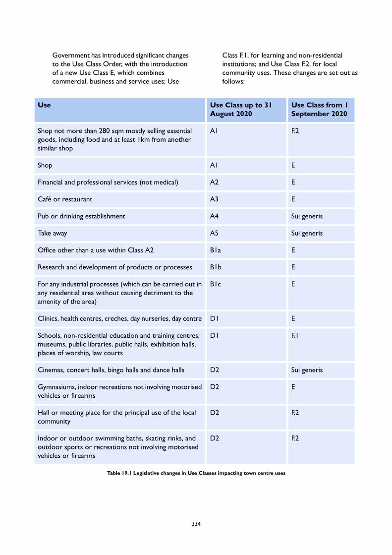
Government has introduced significant changesto the Use Class Order, with the introductionof a new Use Class E, which combinescommercial, business and service uses; Use
Class F.1, for learning and non-residentialinstitutions; and Use Class F.2, for localcommunity uses. These changes are set out asfollows:
Use Class from 1September 2020
Use Class up to 31August 2020
Use
F.2A1Shop not more than 280 sqm mostly selling essentialgoods, including food and at least 1km from anothersimilar shop
EA1Shop
EA2Financial and professional services (not medical)
EA3Café or restaurant
Sui generisA4Pub or drinking establishment
Sui generisA5Take away
EB1aOffice other than a use within Class A2
EB1bResearch and development of products or processes
EB1cFor any industrial processes (which can be carried out inany residential area without causing detriment to theamenity of the area)
ED1Clinics, health centres, creches, day nurseries, day centre
F.1D1Schools, non-residential education and training centres,museums, public libraries, public halls, exhibition halls,places of worship, law courts
Sui generisD2Cinemas, concert halls, bingo halls and dance halls
ED2Gymnasiums, indoor recreations not involving motorisedvehicles or firearms
F.2D2Hall or meeting place for the principal use of the localcommunity
F.2D2Indoor or outdoor swimming baths, skating rinks, andoutdoor sports or recreations not involving motorisedvehicles or firearms
Table 19.1 Legislative changes in Use Classes impacting town centre uses
334
19.7 Changes of use within the same use class arenot considered to constitute development andtherefore do not require planning permission.The Local Planning Authority’s ability toexercise control over changes of use hastherefore been significantly reduced. Thisimpacts the Council’s long-standing policyposition on the protection of retail (formerlyA1) floorspace within designated Core andSecondary Shopping Frontages, as well asParades of Local Importance. A revised policyapproach is set out within LP 45 (Developmentin Centres), however it is acknowledged thatthis may be further revised as the implicationsof the new legislation are clarified, includingthrough revisions to the NPPF and/or thePlanning Practice Guidance (PPG).
335

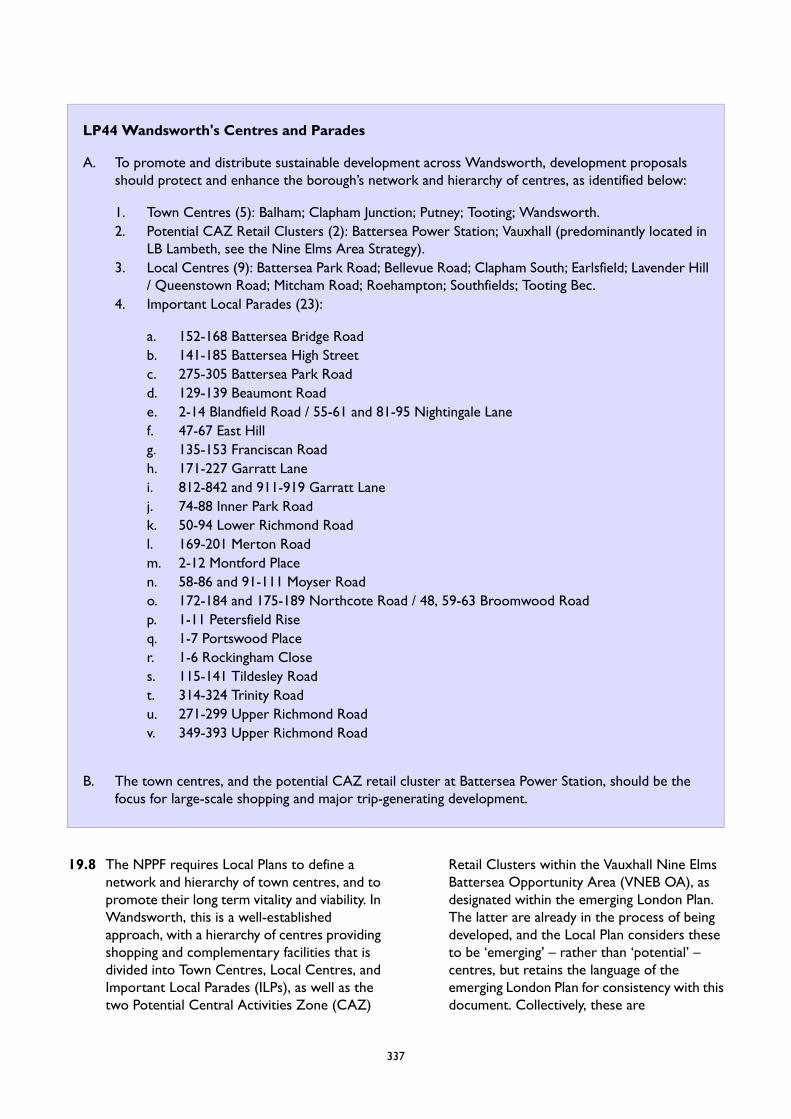
LP44 Wandsworth's Centres and Parades
A. To promote and distribute sustainable development across Wandsworth, development proposalsshould protect and enhance the borough’s network and hierarchy of centres, as identified below:
1. Town Centres (5): Balham; Clapham Junction; Putney; Tooting; Wandsworth.2. Potential CAZ Retail Clusters (2): Battersea Power Station; Vauxhall (predominantly located in
LB Lambeth, see the Nine Elms Area Strategy).3. Local Centres (9): Battersea Park Road; Bellevue Road; Clapham South; Earlsfield; Lavender Hill
/ Queenstown Road; Mitcham Road; Roehampton; Southfields; Tooting Bec.4. Important Local Parades (23):
a. 152-168 Battersea Bridge Roadb. 141-185 Battersea High Streetc. 275-305 Battersea Park Roadd. 129-139 Beaumont Roade. 2-14 Blandfield Road / 55-61 and 81-95 Nightingale Lanef. 47-67 East Hillg. 135-153 Franciscan Roadh. 171-227 Garratt Lanei. 812-842 and 911-919 Garratt Lanej. 74-88 Inner Park Roadk. 50-94 Lower Richmond Roadl. 169-201 Merton Roadm. 2-12 Montford Placen. 58-86 and 91-111 Moyser Roado. 172-184 and 175-189 Northcote Road / 48, 59-63 Broomwood Roadp. 1-11 Petersfield Riseq. 1-7 Portswood Placer. 1-6 Rockingham Closes. 115-141 Tildesley Roadt. 314-324 Trinity Roadu. 271-299 Upper Richmond Roadv. 349-393 Upper Richmond Road
B. The town centres, and the potential CAZ retail cluster at Battersea Power Station, should be thefocus for large-scale shopping and major trip-generating development.
19.8 The NPPF requires Local Plans to define anetwork and hierarchy of town centres, and topromote their long term vitality and viability. InWandsworth, this is a well-establishedapproach, with a hierarchy of centres providingshopping and complementary facilities that isdivided into Town Centres, Local Centres, andImportant Local Parades (ILPs), as well as thetwo Potential Central Activities Zone (CAZ)
Retail Clusters within the Vauxhall Nine ElmsBattersea Opportunity Area (VNEB OA), asdesignated within the emerging London Plan.The latter are already in the process of beingdeveloped, and the Local Plan considers theseto be ‘emerging’ – rather than ‘potential’ –centres, but retains the language of theemerging London Plan for consistency with thisdocument. Collectively, these are
337

well-distributed and cover much of the borough,with few areas that are not within reasonablewalking distance (considered to be 400m) ofone of these designations. In such locations,very localised provision exists throughnon-designated parades and local shops, suchas those located in petrol filling stations and aspart of the riverside developments (See PolicyLP 47 (Local Shops)).
19.9 Wandsworth does not have one single strategicretail centre, but rather five town centres whichserve five distinct areas of the borough. Themain centres have an important role to play,providing shops, services, employmentopportunities, housing, and functioning as thefocus for community and cultural life. The maincentres, and the Potential CAZ retail cluster atBattersea Power Station, should be the focusfor large-scale shopping and majortrip-generating development. The centres areall highly accessible by public transportation andare recognised within the emerging LondonPlan’s Town Centre Network. Accommodatingmain town centre uses in locations wherecustomers are able to undertake linked tripscontributes to sustainability objectives byreducing the need to travel, as well as providingfor improved customer choice and competition.In this way, the benefits of new developmentwill serve to reinforce the vitality and viabilityof the existing centre. The inclusion of largescale community facilities within town centrescan realise benefits, including enhancing socialcohesion, creating vibrancy and reinforcing theimportance of the centres. The Council alsorecognises the contribution of culture to theidentity of the centres, and proposals toenhance cultural activities and provision aresupported. Each of the centres have distinctivequalities and strengths, as well as opportunitiesfor growth and enhancement. These arediscussed in more detail within the AreaStrategy, which outlines a place-based approachfor each of the five town centres.
19.10Local centres provide a focus for localcommunities, providing a range of facilities forfood and household goods shopping as well asservice and other employment, leisure andrecreational functions. They are generally wellserved by public transportation (with theexception of Roehampton). The variation in
size, role and character of individual centresreflects the catchment population – some mayprovide a wide range of shops whilst othersmay have a more limited offer. There is scopefor residential-led development in some of thesecentres, in particular Roehampton, which isdiscussed in more detail in the RoehamptonArea Strategy.
19.11 Important Local Parades comprise a smallgrouping of shops within one or two parades,often including the newsagent, a general grocerystore, a post office, and occasionally a pharmacy,hairdresser or other small shops of a localnature. These parades serve immediate localneeds only and provide primarily conveniencegoods within residential, commercial and mixeduse areas.
19.12The designation of the Vauxhall Nine ElmsBattersea Opportunity Area (VNEB OA), in thenorth-east of the borough, provides the basisfor the large-scale regeneration of this formerlow-density industrial area to include newhomes, employment, and retail floorspace. Theemerging London Plan identifies potentialCentral Activities Zone (CAZ) Retail Clustersat Battersea Power Station and at Vauxhall(which is predominantly located within LBLambeth). These are recognised as significantmixed use clusters, with a predominant retailfunction, which – in terms of scale – are broadlycomparable to the GLA’s designations of Majoror District centres outside of the CAZ. ThePotential CAZ Retail Cluster at BatterseaPower Station reflects this, and is comparablein scale and type with the borough’s other maincentres. Further information on both centresis included within the Nine Elms Area Strategy.
338
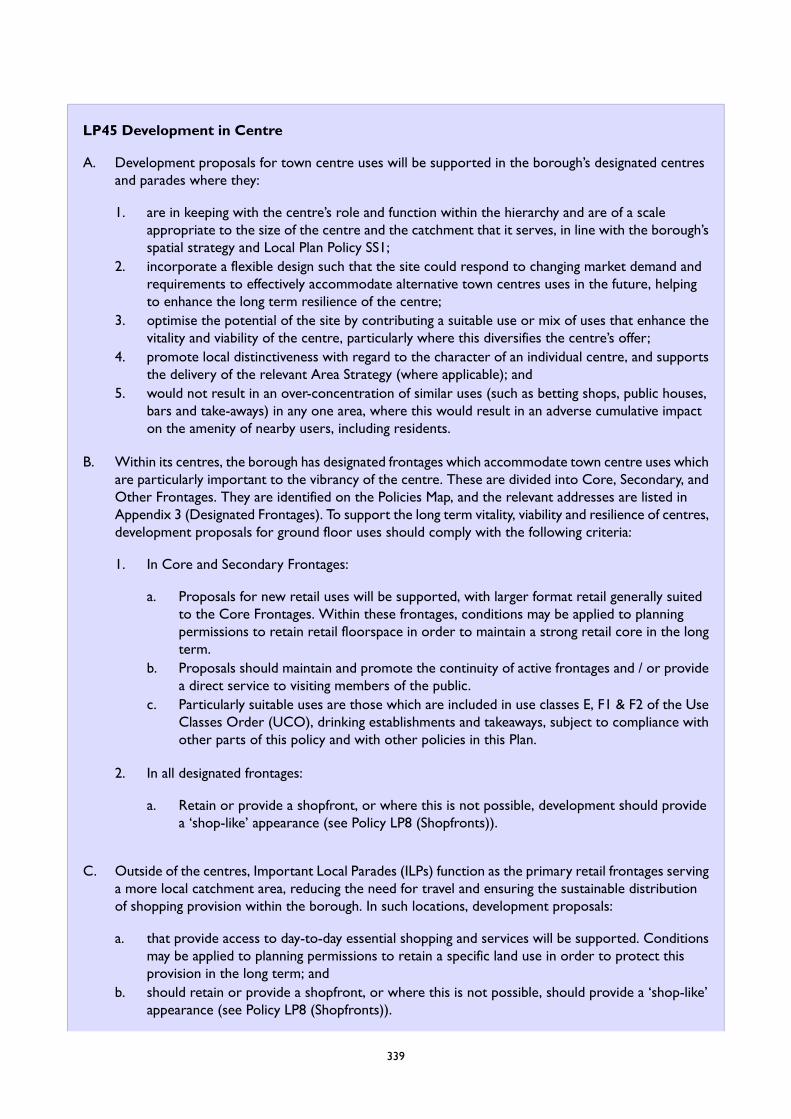
LP45 Development in Centre
A. Development proposals for town centre uses will be supported in the borough’s designated centresand parades where they:
1. are in keeping with the centre’s role and function within the hierarchy and are of a scaleappropriate to the size of the centre and the catchment that it serves, in line with the borough’sspatial strategy and Local Plan Policy SS1;
2. incorporate a flexible design such that the site could respond to changing market demand andrequirements to effectively accommodate alternative town centres uses in the future, helpingto enhance the long term resilience of the centre;
3. optimise the potential of the site by contributing a suitable use or mix of uses that enhance thevitality and viability of the centre, particularly where this diversifies the centre’s offer;
4. promote local distinctiveness with regard to the character of an individual centre, and supportsthe delivery of the relevant Area Strategy (where applicable); and
5. would not result in an over-concentration of similar uses (such as betting shops, public houses,bars and take-aways) in any one area, where this would result in an adverse cumulative impacton the amenity of nearby users, including residents.
B. Within its centres, the borough has designated frontages which accommodate town centre uses whichare particularly important to the vibrancy of the centre. These are divided into Core, Secondary, andOther Frontages. They are identified on the Policies Map, and the relevant addresses are listed inAppendix 3 (Designated Frontages). To support the long term vitality, viability and resilience of centres,development proposals for ground floor uses should comply with the following criteria:
1. In Core and Secondary Frontages:
a. Proposals for new retail uses will be supported, with larger format retail generally suitedto the Core Frontages. Within these frontages, conditions may be applied to planningpermissions to retain retail floorspace in order to maintain a strong retail core in the longterm.
b. Proposals should maintain and promote the continuity of active frontages and / or providea direct service to visiting members of the public.
c. Particularly suitable uses are those which are included in use classes E, F1 & F2 of the UseClasses Order (UCO), drinking establishments and takeaways, subject to compliance withother parts of this policy and with other policies in this Plan.
2. In all designated frontages:
a. Retain or provide a shopfront, or where this is not possible, development should providea ‘shop-like’ appearance (see Policy LP8 (Shopfronts)).
C. Outside of the centres, Important Local Parades (ILPs) function as the primary retail frontages servinga more local catchment area, reducing the need for travel and ensuring the sustainable distributionof shopping provision within the borough. In such locations, development proposals:
a. that provide access to day-to-day essential shopping and services will be supported. Conditionsmay be applied to planning permissions to retain a specific land use in order to protect thisprovision in the long term; and
b. should retain or provide a shopfront, or where this is not possible, should provide a ‘shop-like’appearance (see Policy LP8 (Shopfronts)).
339
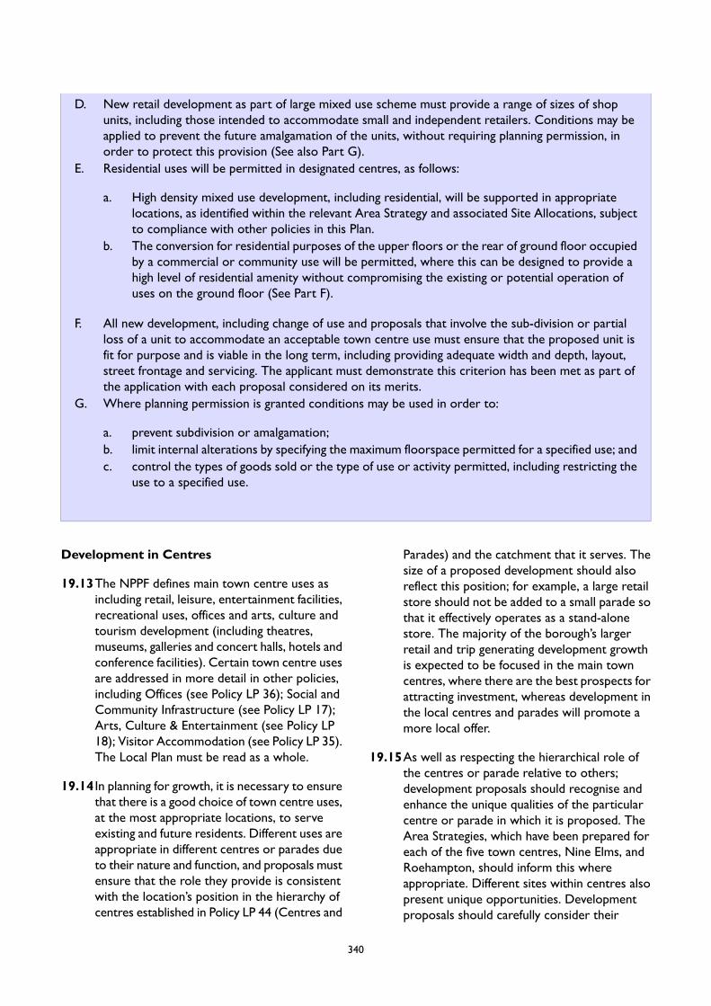
D. New retail development as part of large mixed use scheme must provide a range of sizes of shopunits, including those intended to accommodate small and independent retailers. Conditions may beapplied to prevent the future amalgamation of the units, without requiring planning permission, inorder to protect this provision (See also Part G).
E. Residential uses will be permitted in designated centres, as follows:
a. High density mixed use development, including residential, will be supported in appropriatelocations, as identified within the relevant Area Strategy and associated Site Allocations, subjectto compliance with other policies in this Plan.
b. The conversion for residential purposes of the upper floors or the rear of ground floor occupiedby a commercial or community use will be permitted, where this can be designed to provide ahigh level of residential amenity without compromising the existing or potential operation ofuses on the ground floor (See Part F).
F. All new development, including change of use and proposals that involve the sub-division or partialloss of a unit to accommodate an acceptable town centre use must ensure that the proposed unit isfit for purpose and is viable in the long term, including providing adequate width and depth, layout,street frontage and servicing. The applicant must demonstrate this criterion has been met as part ofthe application with each proposal considered on its merits.
G. Where planning permission is granted conditions may be used in order to:
a. prevent subdivision or amalgamation;b. limit internal alterations by specifying the maximum floorspace permitted for a specified use; andc. control the types of goods sold or the type of use or activity permitted, including restricting the
use to a specified use.
Development in Centres
19.13The NPPF defines main town centre uses asincluding retail, leisure, entertainment facilities,recreational uses, offices and arts, culture andtourism development (including theatres,museums, galleries and concert halls, hotels andconference facilities). Certain town centre usesare addressed in more detail in other policies,including Offices (see Policy LP 36); Social andCommunity Infrastructure (see Policy LP 17);Arts, Culture & Entertainment (see Policy LP18); Visitor Accommodation (see Policy LP 35).The Local Plan must be read as a whole.
19.14 In planning for growth, it is necessary to ensurethat there is a good choice of town centre uses,at the most appropriate locations, to serveexisting and future residents. Different uses areappropriate in different centres or parades dueto their nature and function, and proposals mustensure that the role they provide is consistentwith the location’s position in the hierarchy ofcentres established in Policy LP 44 (Centres and
Parades) and the catchment that it serves. Thesize of a proposed development should alsoreflect this position; for example, a large retailstore should not be added to a small parade sothat it effectively operates as a stand-alonestore. The majority of the borough’s largerretail and trip generating development growthis expected to be focused in the main towncentres, where there are the best prospects forattracting investment, whereas development inthe local centres and parades will promote amore local offer.
19.15As well as respecting the hierarchical role ofthe centres or parade relative to others;development proposals should recognise andenhance the unique qualities of the particularcentre or parade in which it is proposed. TheArea Strategies, which have been prepared foreach of the five town centres, Nine Elms, andRoehampton, should inform this whereappropriate. Different sites within centres alsopresent unique opportunities. Developmentproposals should carefully consider their
340
context, and seek to optimise the potential ofthe site by providing an appropriate mix of uses,with respect both to the broader areas andwithin individual buildings. This will promotethe vitality and viability of the centres bycontributing to a good range of shops, servicesand other uses, a factor that has been identifiedas particularly desirable by the borough’sresidents. Where proposals result in thediversification of the offer, or where theyincrease the dwell time of a visitor within acentre, this can have a knock-on positive impacton other town centre uses.
19.16Equally, it is important the proposed use doesnot result in over-concentration of a particularuse within an area which, as a result of theircumulative impact, could negatively affect theamenity of nearby users. Examples includebetting shops, public houses, bars andtakeaways. The latter should also have regardto the emerging London Plan Policy E9, on thelocation of takeaways in the proximity ofschools (see Policy LP15 on Health andwellbeing).
19.17All proposals should be designed with futureflexibility in mind, ensuring that the proposaldoes not prevent an alternative acceptable useof the site coming forward in response topotentially rapidly changing markets anddemand. This is particularly relevant in the wakeof the COVID-19 pandemic, and is essential toensuring the long term resilience of centres toaccommodate future uncertainties.
Designated Frontages
19.18The designation of frontages seeks to ensurethe vitality and vibrancy of the town centres,through the promotion of attractive andengaging streetscapes, whilst also promoting acompact retail core.
19.19The policy approach of limiting the change ofuse away from retail (i.e. that which fell underUse Class A1 prior to 1 September 2020) is along-established one. The introduction of thenew E Use Class removes the distinctionbetween retail and other non-retail commercial,business and services uses within the UCO,making the implementation of this approachchallenging in practice. As a result, many town
centres uses are now within the same use classand planning permission is therefore no longerneeded for that change the use. This is afundamental change.
19.20 It is recognised that where planning permissionis required developers may seek flexibility ofuse. To some extent, this reflects a trend thatis already present in the borough, whereapplications for new commercial uses mightseek a variety of use classes encompassing retail(formerly A1), restaurants (formerly A3), andsocial infrastructure uses (formerly D1 and D2).This Local Plan embraces the flexibility that thenew Use Class E provides to town centres,particularly in light of the potentially damaginglong term impact of the Covid-19 pandemic onthe viability of many of the borough’sbusinesses. That notwithstanding, the Local Planrecognises the benefit of maintaining aconcentrated retail core, and therefore retainsthe frontage designations as the preferredlocation for shops within ground floor units,encouraging retail development to locate withinthese. Where appropriate, conditions will beimposed to protect specific uses.
19.21The frontages are divided into three categories:
Core Frontages: These are located inthe most central areas or the ‘prime pitch’retail locations (such as main high streetsor shopping centres), and are where retailuses, including large format and nationalmultiples, already predominate.
Secondary Frontages: These areassupport the core frontages, and includeretail provision as well as a diversity ofother appropriate town centre uses. Retailwithin these locations will typically includesmaller units, and often supportindependent businesses.
Other Frontages: These areas aregenerally more peripherally located, andprovide complementary uses to theshopping function of the core andsecondary frontages. All town centre usesare appropriate in these frontages,including retail. Their peripheral locationcan offer potential for more affordablerents, and will be attractive to small
341
businesses that cannot compete with thelarger chains or more desirable secondaryfrontage locations.
19.22 In addition to the general distribution ofdifferent types of retail units within thedesignated frontages, the Area Strategies withinthis document provide further guidance, whereplanning permission is needed, on the suitablelocation of retail, including the protection ofparticular parades which exhibit a successful orunique local character, such as Northcote Roadin Clapham Junction.
19.23As recognised in Policy LP 36 (Promoting andProtecting Offices), certain types of provision,such as co-working spaces or ‘touchdown’spaces, provide a more flexible model of officedelivery and are encouraged in town centrelocations. Where uses present an activefrontage, and are otherwise permitted in linewith the Council’s policies, they will beacceptable in Core and Secondary Frontages,where planning permission is needed.
19.24 In addition to designated frontages within thecentres, the Council has designated ImportantLocal Parades (ILPs), which have a key role incontributing to sustainable development,providing access to day-to-day necessities(including food, newsagents, pharmacies andpost offices) within walking distance from home.This policy seeks to protect and enhance themin that capacity, particularly where they serveless accessible or deprived areas where carownership levels are low. There is considerablevariation in their size, vacancy rates andshopping function, however, and some paradeshave a significant evening economy role. Forthe purposes of clarity, references to ‘centre’within sections 1 to 6 of Part A of this policyshould also be considered applicable to theborough’s ILPs. All the protected frontages inthe borough’s town and local centres and theILPs are treated as primary shopping areas forthe purpose of the NPPF, and as key shoppingareas for the purposes of the General PermittedDevelopment Order.
19.25The Council undertakes annual monitoring ofthe shopping frontages within the town andlocal centres, as well as the Locally ImportantParades. Data are collected on the number of
retail units and other ground floor occupiers,from which the vacancy rate of the centres canbe calculated. This data will be invaluable to theCouncil in assessing the impact of both theCovid-19 pandemic, as well as theGovernment’s new legislation. If necessary, theCouncil will use conditions to limit the uses thatwill be permitted in these locations to protecta strong retail core and to ensure the provisionof necessary amenities in ILPs.
19.26The physical continuity and visual appearanceof a parade is important to ensuring theborough’s centres are attractive locations forinvestment. In all of the borough’s frontages,including parades, the retention of a shopfront,or a ‘shop-like’ appearance, is thereforerequired (See Policy LP 8 (Shopfronts)).
Small and Independent Shops
19.27The borough’s many small and independentshops contribute to the special character andidentity of its centres and parades, as well asproviding important economic opportunitiesfor smaller businesses and traders. Residentsoften highlight the presence of small andindependent shops as a key reason for visitingtheir local centre. Recognising the challengesthat smaller traders will face as a result of theCovid-19 pandemic, combined with thereduction in control over the change of usefrom retail units to other uses, the borough isrequiring that where retail development isincorporated within larger mixed usedevelopments, a range of shops units, includingsmall shops, must be provided to increase thesupply and provide opportunities for smallerand independent retailers. These will beprotected in perpetuity through the use ofconditions preventing the future amalgamationof small units to create a larger unit, unlessplanning permission to do so is sought andgranted.
Residential Uses in Town Centres
19.28The NPPF encourages boroughs to recognisethe role that residential uses can play incontributing to the overall health and vitality ofa centre, both by increasing footfall within thatcentre, as well as contributing to the borough’shousing target. There are opportunities within
342
the borough’s town centres – and in particularin Wandsworth, Clapham Junction, and theemerging CAZ Retail Cluster at BatterseaPower Station – to accommodate residentialuses as part of large, transit-orientateddevelopment. This should optimise the highpublic transit accessibility of these locationswhilst contributing to placemaking through theprovision of active ground floor uses and welldesigned public spaces. Further detail onappropriate locations, as well as developmentand design guidance, is included within the AreaStrategies and Site Allocations section of thisdocument.
19.29 In all of the borough’s centres, but particularlyin Balham, Putney, and Tooting, the RNA 2020identifies the scope for the small-scaleintensification through introducing newresidential units (as well as offices, see Policy
LP 36 (Offices)) on the upper floors of existingcommercial and community uses. The Councilalso recognises that is a growing trend toconvert the rear of premises for commercialand community uses to residential use. Bothtypes of development are supported, providedthat: the new residential development meetsthe necessary standards; does not lead to anunacceptable loss of commercial or communityspace, and that the resulting unit on the groundfloor remains of a viable size for current andfuture occupiers (see Part F). This shouldconsider a range of factors, including whetherthe unit is of adequate width and depth, layout,has a suitable frontage to the street, andwhether adequate servicing is provided. Whereconversion is acceptable, the access to theresidential unit(s) should be from the frontrather than the rear, where practicable.
LP46 Out of Centre Development
A. Where planning permission is required, development proposals for town centre uses, includingextensions to existing retail and leisure developments of more than 200 sqm (gross), that are locatedoutside of the borough’s Town and Local Centres or the Important Local Parades (‘out-of-centre’),will not be permitted unless they have been clearly justified and would not undermine the functionof the borough’s designated centres, as follows:
1. They have passed the sequential test as set out in national policy (NPPF) and guidance (PPG).2. For retail and leisure uses over 400 sqm (gross), including as a result of an extension, they have
passed the impact assessment as set out within national policy (NPPF) and guidance (PPG).
B. There are limited circumstances in which the provision of certain new town centres uses inout-of-centre locations are identified within the Local Plan in order to contribute to wider strategicinitiatives. In these instances, the Sequential Test set out in Part A.1. will not apply:
1. New town centre uses will be acceptable on sites identified for those uses within Site Allocations,and as set out in the Vauxhall Nine Elms Battersea Opportunity Area (VNEB OA) Framework,where the scheme is compliant with the requirements included within those documents.
2. In Economic Use Protection and Intensification Areas (EUPAs and EUIAs) the provision ofintensified office floorspace, as part of the mixed use redevelopment of the site, will be permittedwhere this complies with Policy LP 38 (Mixed Use Redevelopment). All other main town useswill be subject to a sequential test as set out in Part A.
3. In the Focal Points of Activity and edge of centre locations, proposals for new visitoraccommodation uses will be acceptable, and will not be subject to the sequential test, wherethey comply with the requirements of Policy LP 35 (Visitor Accommodation). Further informationon Focal Points of Activity is included in the Area Strategy for Wandsworth’s Riverside and inPolicy LP 56 (Riverside Uses).
C. If planning permission is granted, in line with the PPG, conditions may be used to:
343
1. prevent amalgamation of small units to create large out-of-centre units;2. limit internal alterations by specifying the maximum floorspace permitted; and3. control the type of goods sold or type of use or activity.
19.30The borough’s centres and parades are thepreferential location for retail, leisure and othermain town centre uses. This is emphasises inthe context of the relatively modest long termgrowth identified within the Retail NeedsAssessment, as well as the likely damagingimpact of the Covid-19 pandemic on the viabilityof the borough’s centres. As such, proposalsrequiring planning permission for town centreuses that are located outside of these locationswill be required to pass a sequential test and(in certain instances) an impact test, as set outwithin the NPPF and the PPG, as well as theemerging London Plan. It is noted that theintroduction of the combined commercial class,Use Class E will result in many changes of useno longer requiring planning permission andthus the Council’s ability to control theirlocation and impact is reduced.
19.31The impact assessment test applies only toproposals for retail and leisure uses. TheCouncil has outlined a local threshold of 400sqm (gross), which is consistent with the Sundaytrading threshold (280 sqm net). This is areduction from both the previous policyposition, and considerably lower than themandatory threshold that is set out in the NPPF(of 2,500 sqm gross). This higher threshold isnot considered appropriate in Wandsworthbecause the relative density of the borough’surban context means that such a scale ofprovision could have a substantial impact on thefunction of neighbouring centres. It is noted inthe RNA 2020 that vacancy rates are relativelyhigh in Balham, Putney, andWandsworth Town,and some of the borough’s Important LocalParades are performing poorly. Retailcommitments are expected to exceedexpenditure growth up to and beyond 2030,and a significant over-supply of retail and food/ beverage floorspace is envisaged in most areasof the borough at 2030 and 2035. A cautiousapproach is therefore required in all areas inrelation to new retail and food / beveragefloorspace in the short to medium term.
Cumulatively with commitments, additionalretail/leisure developments under 2,500 sqmcould have a significant adverse impact oncentres and parades, and a lower threshold istherefore proposed. The Sunday tradingthreshold is widely accepted as the limit wherea retail store becomes more significant in termsof its shopping role and catchment area.
19.32Recent mixed use developments within theborough have proposed flexible retail andleisure floorspace, and several phases ofdevelopment with different but related planningapplications. The impact threshold shouldtherefore apply to retail and leisure usescombined, and also combined floorspace acrossdifferent phases of the development.
19.33Sequential tests and impact assessments willneed to be proportionate to the scale of thedevelopment proposed. Compliance with thesequential and impact tests does not guaranteethat permission will be granted; all materialconsideration, and compliance with the otherpolicies within the development plan, will needto be considered in reaching a decision.
19.34 In order to meet wider strategic objectivesassociated with the Local Plan’s broaderambitions, there are a number of circumstancesin which the sequential test will not be requiredas part of a mixed use proposal. These relateto areas that have been thoroughly considered,including in the context of nearby centres, aspart of a masterplanned approach, and for uses,such as offices, where the capacity of towncentres is insufficient to meet the identifiedneed. In Focal Points of Activity, visitoraccommodation has been identified asappropriate uses to optimise the riversidelocation. This waiver from the sequential testis subject to the various requirements of PolicyLP 35 (Visitor Accommodation) or siteallocation being otherwise met. Given therelatively limit scope for independent retail andleisure uses to be located outside of the
344
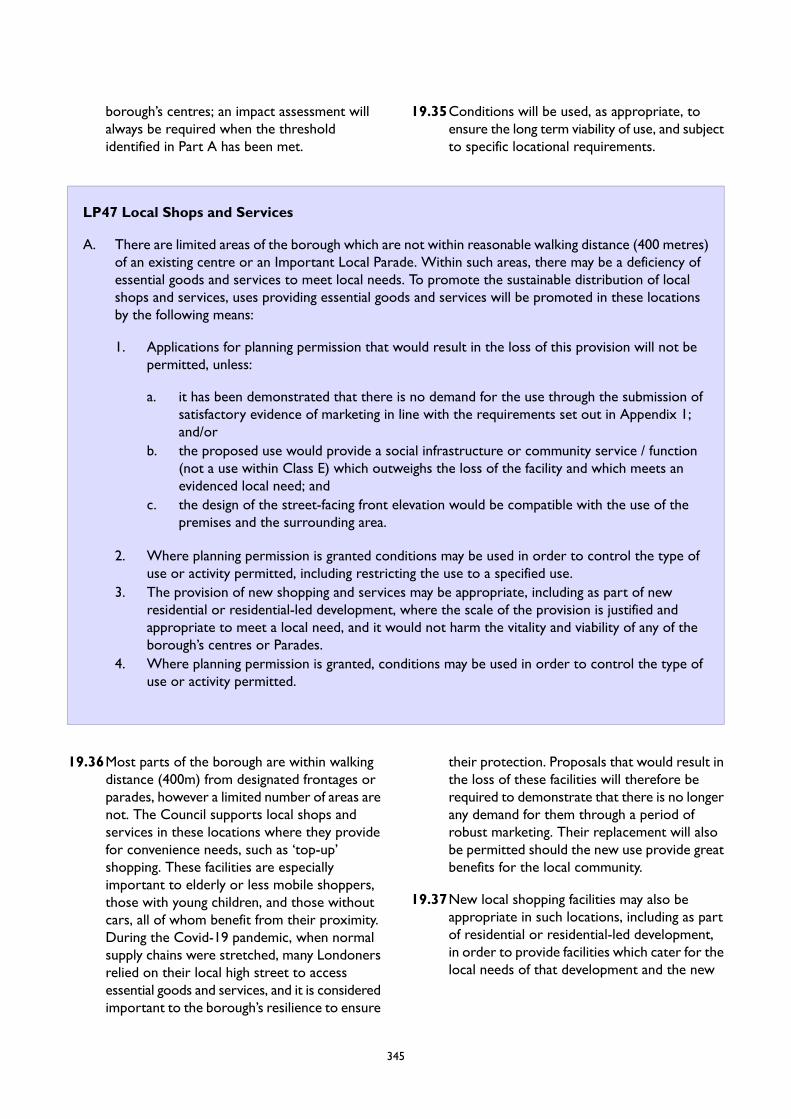
borough’s centres; an impact assessment willalways be required when the thresholdidentified in Part A has been met.
19.35Conditions will be used, as appropriate, toensure the long term viability of use, and subjectto specific locational requirements.
LP47 Local Shops and Services
A. There are limited areas of the borough which are not within reasonable walking distance (400 metres)of an existing centre or an Important Local Parade. Within such areas, there may be a deficiency ofessential goods and services to meet local needs. To promote the sustainable distribution of localshops and services, uses providing essential goods and services will be promoted in these locationsby the following means:
1. Applications for planning permission that would result in the loss of this provision will not bepermitted, unless:
a. it has been demonstrated that there is no demand for the use through the submission ofsatisfactory evidence of marketing in line with the requirements set out in Appendix 1;and/or
b. the proposed use would provide a social infrastructure or community service / function(not a use within Class E) which outweighs the loss of the facility and which meets anevidenced local need; and
c. the design of the street-facing front elevation would be compatible with the use of thepremises and the surrounding area.
2. Where planning permission is granted conditions may be used in order to control the type ofuse or activity permitted, including restricting the use to a specified use.
3. The provision of new shopping and services may be appropriate, including as part of newresidential or residential-led development, where the scale of the provision is justified andappropriate to meet a local need, and it would not harm the vitality and viability of any of theborough’s centres or Parades.
4. Where planning permission is granted, conditions may be used in order to control the type ofuse or activity permitted.
19.36Most parts of the borough are within walkingdistance (400m) from designated frontages orparades, however a limited number of areas arenot. The Council supports local shops andservices in these locations where they providefor convenience needs, such as ‘top-up’shopping. These facilities are especiallyimportant to elderly or less mobile shoppers,those with young children, and those withoutcars, all of whom benefit from their proximity.During the Covid-19 pandemic, when normalsupply chains were stretched, many Londonersrelied on their local high street to accessessential goods and services, and it is consideredimportant to the borough’s resilience to ensure
their protection. Proposals that would result inthe loss of these facilities will therefore berequired to demonstrate that there is no longerany demand for them through a period ofrobust marketing. Their replacement will alsobe permitted should the new use provide greatbenefits for the local community.
19.37New local shopping facilities may also beappropriate in such locations, including as partof residential or residential-led development,in order to provide facilities which cater for thelocal needs of that development and the new
345

population. To ensure that these locations arepreferential, such applications are required topass the sequential test.
19.38 It is noted that changes of use between useswithin Class E of the UCO do not requireplanning permission, which limits the scope ofthis policy’s application. Where planningpermission is required the Council may imposeconditions to restrict further change of use inthe future.
346
LP48 Evening and Night-Time Economy
A. Proposals that enhance or diversify Wandsworth’s evening and night-time economy will be supportedwhere they:
1. are located within the borough’s designated centres, CAZ Retail Clusters, Focal Points of Activity,and are of a size and type that reflects the role and function of the centre or location, takingconsideration of the Night-Time Economy Classification within the emerging London Plan;
2. do not result in a negative impact on the amenity on the surrounding residential andnon-residential uses, as a result of the use itself or from those travelling to and from the use.Conditions may be used, including limits on hours of operation, in order to ensure this; and
3. do not detract from the character of the surrounding shops and services during the day-time bycreating an agglomeration of blank frontages.
B. Where new development is proposed in locations in which there are existing uses that positivelycontribute to the borough’s night-time economy, and where the development includes uses that arepotentially sensitive to the noise and other nuisances generated by those uses, the Agent of Changeprinciple will apply, as set out in the emerging London Plan Policy D13.
19.39The evening and night-time economy inWandsworth makes an important contributionto the borough’s social and economicprosperity, creating opportunities for businessesas well as providing opportunities for socialising,integration, and fun. The borough’s pubs, bars,cinemas, theatres, comedy clubs, live musicvenues, nightclubs, and other cultural venuesattract people to the town centres, increasingfootfall, and extending the role of the centreinto the evening. In addition, many of thesebuildings contribute positively to the builtenvironment and to the area’s sense of place.Much night time employment takes place inother sectors, for example healthcare,wholesale and transport and the night timeeconomy will both include and serve theseworkers, providing essential services.
19.40To promote the benefits of clustering, and toconcentrate the impacts such uses generate(such as noise), evening and night-time economyuses should be located in the borough’s centres,including the proposed CAZ retail clusters inNine Elms, which are well served by late nightpublic transportation. In centres, considerationshould be given to the appearance of the useduring the day-time, for example where thismight create a blank frontage in a primarylocation. To help create a sense of place andvibrancy, such uses will also be permitted at
Focal Points of Activity, where the provision ata more limited scale which caters only to localusers, and does not harm the viability of nearbycentres (See Policy LP 46 (Out of CentreDevelopment)). Night time economy uses canalso serve the large numbers of night timeworkers and provide a safer environment forthem in these centres.
19.41 In some of these areas, residential andcommercial uses exist side by side, and whilstambient noise levels within the town centresare inevitably higher than the rest of theborough – an aspect that, where successful, cancontribute to the sense of vibrancy – it is stillnecessary to consider the effect of increasedconcentrations of evening uses. Applications foruses must therefore demonstrate that they donot harm the amenity of surrounding uses,including by those travelling to or from the use,and whether as a result of the individualbusiness of the cumulative impact of theproposed use in relation to the number,capacity and location of other night-timeeconomy uses in the area. To ensure this, suchuses might be controlled through conditionsattached to planning applications, as well as therequirements outlined within the Council’sWaste Services and the Statement of LicensingPolicy. New business premises should also bedesigned to incorporate waste storage and
348
collection from within the premises, and furtherdetails are available in the Refuse andRecyclables in Development SPD.
19.42Conversely, where new development is broughtforward near to existing uses which positivelycontribute to the evening and night-timeeconomy, the Agent of Change principle willapply. This principle places the responsibilityfor mitigating the impact of noise and othernuisances firmly on new development. Thismeans that where new developments areproposed close to existing noise-generating
uses, it is the responsibility of the applicant todesign that development in an appropriatelysensitive way in order to protect the amenityof the new occupiers, and which ensures thatthe existing uses, such as theatres, concert halls,pubs, live-music venues, and night-clubs, remainviable and can continue in their present formwithout the prospect of licensing restrictionsor the threat of closure due to noise complains.Such mitigation measures do not necessarilyneed to be limited to the new development; forexample, they could include paying forsoundproofing for an existing use.
LP49 Markets
A. Proposals to introduce new markets within town centres, or to enhance or extend existing marketswill be permitted, particularly where they will increase the variety of the market offer in the borough;subject to appropriate servicing and delivery arrangements, and provided that they will not causeindividual or cumulative harm to the local area in terms of residential amenity, pedestrian and highwaysafety, and parking congestion.
B. Proposals involving the loss of market pitches will only be permitted if the redevelopment of the siteincludes replacement market facilities, to an equal or enhanced standard, including environmentalimprovements. Measures should be put in place to retain existing traders, where they wish to remain,which should be set out within a Management Plan.
C. Temporary permissions and/or planning conditions may be used to assess or regulate the impact ofmarkets, including proposals for farmers markets, temporary markets or car boot sales.
D. Proposals for new ancillary retail market pitches open to the general public will be permitted withinthe New Covent Garden Wholesale Market, where these do not adversely impact the primarywholesale operation of this site.
19.43Wandsworth’s markets – whether long standinghistoric features, such as those in Tooting;temporary streets markets, such as the popularHildreth Street Market in Balham or NorthcoteRoad in Clapham Junction; or the large-scalewholesale New Covent Garden Market –contribute significantly to the economic, culturaland social life of the borough, whether throughcontributing to the vitality and localdistinctiveness of town centres, offering greaterconsumer choice; or by supporting local andLondon-wide businesses – or all of the above.Existing markets will be protected and additionaland expanded markets within appropriatelocations will be supported, in accordance withthe NPPF and the emerging London Plan (PolicyE9), and where potential negative impacts can
be appropriately mitigated. The Area Strategiesprovide further guidance on the markets, andshould inform planning applications.
19.44Where development proposals intend tore-provide markets, these must do so to acomparable or enhanced standard. To ensurethat the rich diversity of existing, independenttraders can be retained within this provision, amanagement plan – including maintainingaffordability of pitches – should set out meansto enable this.
19.45 It is important that street trading provides anattractive environment and makes a positivecontribution to the quality of the town centre.Sunday markets and car boot sales may give riseto environmental issues and the use of
349
temporary permissions and/or planningconditions may be relevant to assess or regulate
their impact.
LP50 Meanwhile Uses
A. Proposals for meanwhile uses will be supported where they:
1. mitigate the impact of construction or optimise under-utilised capacity during the phasing ofdevelopment; and/or
2. can demonstrate that they will enhance the vibrancy and vitality of the area, including through:
a. promoting arts and cultural uses; orb. providing community space or facilities; orc. providing employment opportunities for local people and independent businesses, such as
an incubator hub; ord. providing affordable workspace; ore. providing food growing spaces; orf. otherwise meeting the ambitions of the relevant Area Strategy.
B. Temporary permissions and/or planning conditions will be used to assess or regulate the impact ofthe meanwhile use to a particular length of time.
19.46Meanwhile uses – sometimes referred to aspop-ups – are those which introduce a use fora temporary period of time. These can play abeneficial role in bringing vacant premises backto use; in providing space for small andindependent businesses to trail their model ortest a location; or simply to accommodate a usethat is only intended to a limit period, such asan artistic or cultural event.
19.47Meanwhile uses can also provide an importantmechanism to bring positive activity and tomitigate against the negative impacts associatedwith large-scale developments, which mayinvolve long-periods of construction or havevacant premises as a result of particular phasingplans. Meanwhile uses will be supported in suchinstances.
19.48Through occupying temporary land, buildingsor units, meanwhile uses can be low cost andlow risk, making them ideal locations forsupporting arts and culture, the provision ofcommunity space, and as incubator hubs orother affordable workspace. These uses will beparticularly supported, and applicants areencouraged to consider how the meanwhile use
of space might contribute to the ambitions setout in the relevant Area Strategy, whereapplicable.
19.49For all meanwhile uses, it is important to ensurethat the activity does not result in anunacceptable impact on neighbouring amenity,in particular for residential uses, and that thesites do not prevent development from beingbrought forward in a timely fashion. To ensurethis, the Council will use conditions and/or thegranting of temporary permissions to regulatethe impact of the use or to control the lengthof time that it can endure.
350

20 Sustainable Transport
Introduction
20.1 Ensuring that transport in Wandsworth issustainable and efficient is a key priority for thisLocal Plan and forWandsworth’s Smart GrowthProgramme. The Council’s detailed transportpolicies and proposals are set out in itsstatutory Third Local Implementation Plan (LIP)of the Mayor of London’s Transport Strategyand should be read with the Local Plan as partof a holistic understanding of how the transportenvironment in Wandsworth will evolve.
20.2 This chapter will set out how land used fortransport functions should be protected anddeveloped to ensure it achieves the mostsustainable results and how proposals can helpcreate a healthier more sustainableWandsworth.
20.3 Sustainable travel means, such as walking andcycling, are good for our physical and mentalhealth and in Wandsworth, the proportion ofresidents regularly undertaking travel by activemethods is higher than the London average.
20.4 The Council will be champions for the deliveryof sustainable travel initiatives and projects toencourage walking, cycling, use of publictransport and car sharing and to reduce carbonemissions from transport, improve air qualityand create a transport network which supportsa mobile, affordable low-carbon future andensure that the transport network operatessafely and efficiently to meet the needs of allusers.
20.5 Reducing the need to make unnecessaryadditional journeys is an objective for theCouncil with this Local Plan and should beconsidered when bringing forward developmentproposals. This can be achieved throughco-location of uses, through mixed usedevelopment, provision of suitableaccommodation to support home working,development of new local business hubs thatsupport local working and ensuring digitalconnectivity. Nevertheless, the Council willexpect developments to support sustainabletransport modes.
20.6 The Council supports the principle of furtherextending the Northern Line to ClaphamJunction and the routing of Crossrail 2 throughClapham Junction, Tooting and otherregeneration areas of the borough, potentiallyconnecting north-east London andHertfordshire to south-west London andSurrey.
20.7 Development proposals will need to ensurethey create spaces that encourage the efficientmovement of pedestrians and cyclists overprivate cars. This should manifest itself in theform of active travel infrastructure such as clearand well designed cycle lanes, cycle parkinginfrastructure, and improvements to the mainpedestrian thoroughfares.
20.8 Together, these policies and the LocalImplementation Plan will create a moresustainable and efficient road network inWandsworth that helps grow the borough intoa well-connected, and healthy place to live,work and play.
352
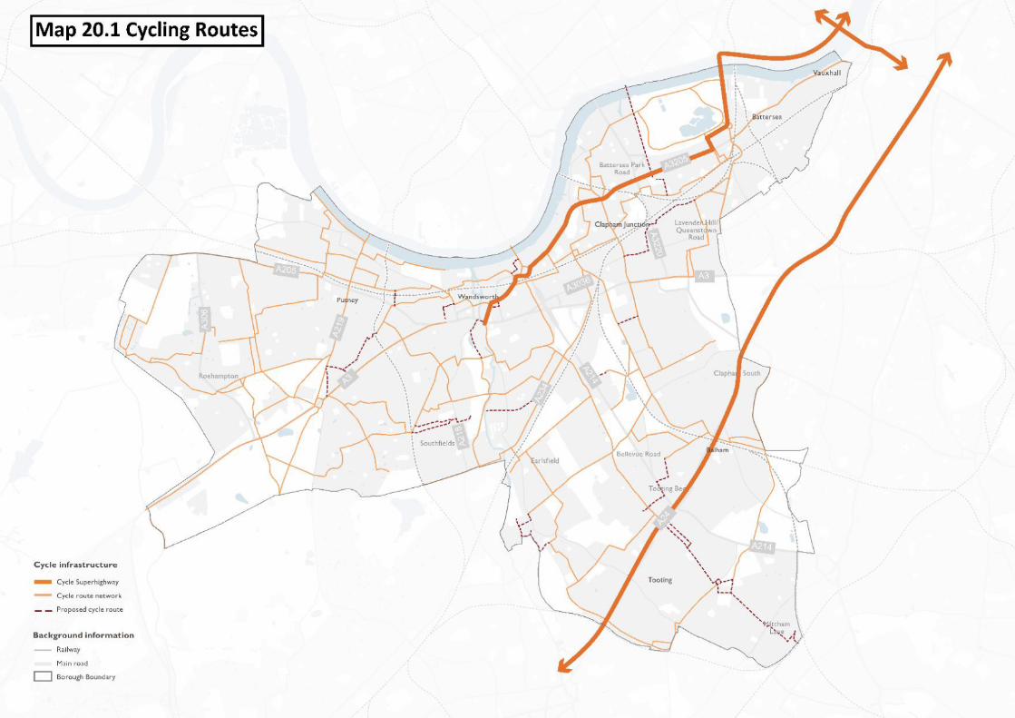
LP51 Sustainable Transport
A. The Council will support proposals that reduce the need to travel and will work to promote safe,sustainable and accessible transport solutions for all users, which minimise the impacts of developmentincluding congestion, air pollution and carbon dioxide emissions, and maximise opportunities for healthbenefits and providing access for all to services, facilities and employment.
B. Development proposals, including for a change of use, will be expected to be people focused andmeet the Healthy Streets objectives which put human health and wellbeing at the centre of transportplanning, especially by providing for active travel (walking and cycling) and multi-destination trips.Proposals will be supported where:
1. the proportion of trips made by walking, cycling and public transport is high, and local connectionsby these modes are improved;
2. car dominance is reduced, and active use of streets and public spaces is increased;3. neighbourhood environments are made safer, including reducing road danger and improving
personal security (see Policy LP 15 Health and Wellbeing);4. freight movement is made safer, less polluting and more efficient;5. air quality, and green and blue infrastructure are improved to create more attractive
neighbourhoods for people (see Policy LP 59 Urban Greening Factor);6. the public realm is improved in terms of quality and resilience e.g. introduction of parklets;7. placemaking, that promotes accessibility to existing and/or proposed mixed use areas that provide
a range of local facilities and amenities, is considered from the initial design stages;8. accessibility to public transport is not negatively affected at a neighbourhood level; and9. wider projects to improve access on foot or by bicycle are considered along with the individual
street or junction proposals .
20.9 Reducing the need to make unnecessarynon-active travel journeys is the mostsustainable outcome and this is encouraged.Sustainable transport modes include anyefficient, safe and accessible means of transportwith overall low impact on the environment,including walking and cycling, low and ultra lowemission vehicles, car sharing and publictransport. The council will, through this policy,help promote the use of these types of modesof transport over private car use.
20.10Wandsworth is one of the most desirable anddynamic places to live and work in London andis experiencing growth and expansion ofdevelopments. This places huge demands onour transport infrastructure, in 2017 there were124m passengers at Wandsworth's railwaystations alone, not including bus andunderground usage. The Council’s key transportchallenge is therefore to ensure the provisionof the additional sustainable transport capacity
that is needed to support its housing objectivesand deliver economic recovery, regenerationand growth.
20.11The Active Wandsworth strategy highlightssome of the many benefits sustainable transport,along with the important role it plays in helpingWandsworth function as a place to live, play,and work. Sustainable transport modes such aswalking and cycling are good for our physicaland mental health and in Wandsworth, theproportion of residents regularly undertakingtravel by active methods is higher than theLondon average. Sustainable transport has alsobeen shown to have less impact on theenvironment including reducing the amount ofair and noise pollution in an area. It can be animportant factor in combating social isolationand reducing congestion making for a morepeaceful and safer Wandsworth.
354

20.12For more information on how Wandsworthwill promote sustainable transport developmentplease see Wandsworth Council’s Third LocalImplementation Plan (2019).
20.13The Healthy Streets Approach is the system ofpolicies and strategies to help Londoners usecars less and walk, cycle and use publictransport more. It can also encourage theoverall amount of travel in the borough.
20.14The Healthy Streets approach provides a widevariety of benefits as developments will berequired to provide spaces that suit all types ofpedestrians and allow everyone to walk, spendtime and engage with community life. Walkingand cycling are the healthiest and mostsustainable ways to travel, either for whole tripsor as part of longer journeys on publictransport. A successful transport systemencourages and enables more people to walkand cycle more often. This will only happen ifwe reduce the volume and dominance of motortraffic and improve the experience of being onour streets. This policy will help reduce air andnoise pollution which benefits everyone by
creating a more peaceful environment andreduces unfair health inequalities. The HealthyStreets approach promotes footpaths and roadsthat people feel safe in.
20.15Walking can be encouraged with small changessuch as the introduction of easy places to cross,places to stop and rest and areas with shadeand shelter. Along with providing more thingsto see and do on prominent road andthoroughfares, the Healthy Streets approachcan create a more people centred environment.
20.16Developers should consider the impact theirproposal will have on the transport environmentfrom the initial design stages of anydevelopment. They should consider theimportance healthy streets can have and ensurethat their proposal meets and exceeds theexpectations set out in this policy.
20.17For more information on the Healthy Streetsapproach, refer to “Healthy Streets for LondonPrioritising walking, cycling and public transportto create a healthy city” by the Mayor ofLondon (Feb, 2017).
LP52 Transport and Development
A. Development that will generate a large volume of trips must:
1. have good public transport access levels (PTALs) i.e. 4 or higher;2. be in an area with sufficient public transport capacity, or be capable of supporting improvements
to provide good public transport accessibility and capacity, taking account of local character andcontext;
3. be safe, avoid harm to highway safety, and provide suitable access to the site which can beachieved for all people; and
4. ensure improvements can be undertaken within the transport network that cost-effectively limitthe significant impacts of the development, when required. Development will normally only beprevented or refused on transport grounds where the residual cumulative impacts of developmentare severe.
B. Planning application will need to be supported by Transport Assessments (TAs) to demonstrateacceptable impact of the proposal on traffic. Transport Assessments and Travel Plans should beprepared if development proposals meet the thresholds set out in the National Guidance from 2007which would be subject to change if the Greater London Authority (GLA)/Transport for London (TfL)change their guidance. TAs and Travel Plans may be required for smaller developments where thetransport impact is expected to be significant or to affect sensitive locations.
C. Smaller scale developments that fall below the thresholds but could give rise to transport impacts willbe required to demonstrate transport impacts in a transport statement.
355

D. The River Thames is considered a major transport route for freight and construction and will beprotected for these uses, any development that impacts these uses will need to be supported byTransport Assessments (TAs) to demonstrate how the impacts will be mitigated.
E. For developments, including developments that require new or additional crossovers or vehicle access,it will need to be demonstrated they would not cause a road safety hazard or interfere with the safeoperation of buses, particularly bus stops. Further guidance is provided in the Council's Housing SPD(2016).
20.18To ensure that the road network inWandsworth can run smoothly and thatcongestion is kept to a minimum it is importantthat any new proposal does not add undueadditional strain to the network. This policy willensure the safe movement of people and goods,and encourages the use of sustainable transportmodes over private cars. To do this, proposalswill be required to meet certain guidance as isset out in the policy and the PlanningObligations SPD (2020).
20.19Developments which will generate a largevolume of trips should be focused in areas withhigh Public Transport Access Levels (PTALs) tohelp create the most sustainable transportenvironment. These give consideration to thewalking distance to public transport and therelative level of service provided. PTALs are auseful tool for determining where high tripgenerating developments are best located;however, they do not take into account theavailable public transport capacity on theimmediate and extended network, or thedestinations served by thelocally-accessible network. High trip generatingdevelopments should be located in areas withboth high PTAL and capacity on the existingnetwork, or alternatively the public transportnetwork should be improved to provide theadequate capacity They should also consideran approach that can reduce the number of tripsmade.
20.20All proposals which generate a large volume oftrips will be required to meet certain criteriawhich are set out in the policy. They will showhow their proposal meets the criteria andpromotes sustainable development bysubmitting a transport assessment (TA), a travelplan or in some smaller proposals a transportstatement.
20.21A TA is an inclusive process that should coverall aspects of movement by people and vehicles.It should be able to demonstrate how adevelopment affects demand for travel (includingreductions in the need to travel) and how alltravel demands and servicing requirements willbe met. All developments of sufficient scale orin particularly sensitive locations should beaccompanied by TAs, even for developmentsbelow the thresholds set out current Nationalor London/ GLA Guidance. TransportAssessments (TAs) should be produced inaccordance with TfL's best practice guidance.
20.22A Travel Plan is a long term managementstrategy for an organisation or site that seeksto deliver sustainable transport objectivesthrough action and is articulated in a documentthat is regularly reviewed. A travel plan involvesidentifying an appropriate package of measuresaimed at promoting sustainable travel, with anemphasis on reducing reliance on singleoccupancy car journeys
20.23Notwithstanding planning considerations, theCouncil has guidance for construction ofvehicular access from the highway andcrossovers (dropped kerbs for vehicle accessto driveways) will not be permitted in areaswhere they would cause a road safety hazardor affect the operation of buses (e.g. in thevicinity of bus stops). TfL also have assessmentcriteria to assess the acceptability of proposedvehicle crossovers on the Transport for LondonRoad Network (TLRN). Further guidance oncrossovers is provided in Section 5 Frontgardens and hardstandings for cars in theCouncil's Housing SPD. Much of this guidanceis also appropriate to other developmentsinvolving crossovers.
356

LP53 Parking, Servicing, and Car Free Development
Development will be supported where:
A. Cycle Parking is provided in accordance with the minimum levels set out in the emerging London Planwith reference to Table 10.2 and any subsequent amendments. The parking must be easily accessible,secure, and well-located to the unit it is associated with.
B. Off Street Car Parking is provided and does not exceed the maximum requirements set out in theemerging London Plan with reference to Table 10.3 and any subsequent amendments, and it can bedemonstrated that parking on site is the minimum necessary. On mixed use developments car parkingspaces should be allocated to the specific uses proportionally.
C. Car Parking in new shopping and leisure developments in town centres must provide short stay parkingand serve the town centre as a whole rather than being reserved solely for use in connection withthe proposed development;
D. Car Club Parking and memberships are provided in all residential developments that require travelplans, in accordance with LP52 Transport and Development (b).
E. Adequate off-street servicing arrangements are made for commercial vehicles and general servicing.F. Minimum numbers of disability-friendly car parking spaces are provided in accordance with the emerging
London Plan and any subsequent amendments.G. Electric Vehicle Charging capacity is provided in accordance with the emerging London Plan and any
subsequent amendments.H. Office Parking provision should be provided in accordance with the emerging London Plan and any
subsequent amendments.I. On-street Parking:
1. New developments must comply with the emerging London Plan’s guidance regarding on-streetcar parking and any subsequent amendments. The council will encourage applications fordevelopment that require less on-street parking in areas well-connected to public transport.
2. Developers will need to show that their proposal does not lead to an unacceptable amount ofon-street parking. This will include showing acceptable motorcycle and scooter parking provisionin town centre locations which does not detract from the character of the area.
3. For residential conversions, the council will encourage replacement of existing general on-streetparking with other kerbside uses to encourage more sustainable transport.
J. The council will support the redevelopment of existing car parks for alternative uses where it can beshown that the provision of car parks is being met now and into the future.
K. Car-free development will be required where:
1. The PTAL is 5 or higher.2. Public transport interchanges are close by.3. A transport assessment can demonstrate that through a combination of walking, cycling, public
transport, car club parking, travel plans and other relevant measures that further private carparking is not required. The transport assessment shall demonstrate how reductions in the needto travel can be achieved.
4. The appropriate minimum number of disability friendly parking spaces are provided in accordancewith the emerging London Plan and any subsequent amendments.
L. Low Car development will be required where:
1. The PTAL is 3 or 4.2. Public transport stops are close by.
357
3. A transport assessment can demonstrate that through a combination of walking, cycling, publictransport, car club parking, travel plans and other relevant measures minimal car parking is allthat is required. The transport assessment shall demonstrate how reductions in the need totravel can be achieved.
4. The appropriate minimum number of disability friendly parking spaces are provided in accordancewith the emerging London Plan and any subsequent amendments.
M. No additional parking permits will be issued to any occupiers of additional housing units created inmajor residential or mixed use developments anywhere in the borough or through conversions inexisting or future Controlled Parking Zones (CPZ).
N. Where development includes both affordable and market units, parking should be allocated equitablybetween market and affordable units. If the level of parking proposed for affordable units is less thanthat proposed for market units the disparity will need to be justified taking account of estimateddemand and information on relative levels of car ownership.
20.24Parking and servicing is an important piece ofthe transport environment in Wandsworth.There must be sufficient parking and servicingto ensure that essential needs are met butbeyond that, it should be restricted. In orderfor Wandsworth to promote sustainabletransport the amount of parking and servicingshould be as efficient and lean as possibleotherwise valuable land that could be used forbetter uses will be lost.
20.25The allocation of car parking should considerthe needs of disabled people, both in terms ofquantity and location. In town centres and otherlocations with good public transport accessibilitythere is less need for off-street car parking. Forretail and leisure developments in town centres,where PTALs are generally high, car parking willbe considered more favourably if it is managedto encourage short-stay use and is available forgeneral town centre use. Car parking in towncentres should be convenient, safe and secure,including appropriate provision for motorcycles.Due to the increase since the previous LocalPlan in the gig economy, Wandsworth’s towncentres have seen an increase in scooters andmotorcycles. Development proposals shouldprovide adequate parking but not excessivespace that allows for loitering. Parking chargesshould be set at a level that does not underminethe vitality of town centres. Parkingenforcement should be proportionate.
20.26Developments should seek to provide theminimum realistic amount of car parking for thesite, without undue risk of overspill parkingonto surrounding streets
20.27With regard to servicing, the provision ofoff-street servicing is encouraged, in order toreduce impacts on the safe operation of theroad network. Where appropriate, a Deliveryand Servicing Plan and Construction LogisticsPlan should be submitted in line with guidancein the London Freight Plan.
20.28Car club parking can help reduce the overalldemand for car parking space, by givingresidents, visitors and employees access to acar without the need for individual carownership. The provision of car club parking isparticularly useful in larger residential or mixeduse developments, but may also be an attractiveoption for smaller developments, where asmaller provision of off-street car parkingincluding a car club may cater for the demandfor travel by car more effectively than a largerprovision of off-street car parking. Where carclub parking is provided it should normally bewithin the curtilage of a development site butaccessible to the wider community, to assistviability of the car club.
20.29The provision of cycle parking is a crucialfactor in encouraging more sustainable travelto and from developments. Cycle parking shouldbe in sufficient supply to cater for demand andalso encourage further use over time. Minimumcycle parking standards will be applied to
358
achieve this. Simply providing a number of cycleparking spaces is not sufficient in itself to ensurethat the parking will be used by cyclists. Cycleparking should be designed and located inaccordance with best practice guidance, so thatit is fully accessible, convenient and secure. TheCouncil has invested in expansion of theMayor’s Cycle Hire scheme to Wandsworthand in certain cases it may be appropriate foradditional cycle hire docking stations orequivalent access to cycling to be provided inlieu of under-utilised private cycle parking. Thedemand for motorcycle parking should beidentified in the TA, and an appropriate level ofparking provided.
20.30Where development includes both affordableandmarket units, and where parking is to beprovided, it should be allocated equitablybetween market and affordable units. If the levelof parking proposed for affordable units is lessthan that proposed for market units the Councilwill expect the disparity to be justified inrelation to estimated demand. Relative demandmay be estimated using information on carownership on similar completed and occupiedschemes, such as through Census data orWandsworth's New Housing Surveys (2004,2007 and 2017 (Nine Elms only)). The Councilrecognises that residents in social housing forrent do not have the same degree of choiceover where they live as those in market unitsand other types of affordable housing. Wheresocial housing for rent units are proposed withzero parking the residents may not be able tochoose to live elsewhere and therefore couldbe unfairly disadvantaged. For this reason limitedparking may be required for such housing. Somevery limited parking space should be providedfor essential parking in connection withemergency health access for schemes providingfor specialised need, such as supported housingunits.
20.31Where significant provision of car parking atretail development can be justified, provisionof rapid electric vehicle chargingfacilities should be made. The provision ofnew EV charging infrastructure is encouragedprovided it is sympathetic to the public realmand does not hinder pedestrian movement orobstruct visually impaired people or those usingwheelchairs or buggies. Provision off street, for
example in the car parks of new developments,leisure centres, community facilities etc isespecially encouraged.
20.32Parking associated with offices has the potentialto generate car travel in the morning andevening peaks when streets are the mostcongested. In many parts of Wandsworth thismeans that bus travel is less reliable and activetravel is less attractive. Office parking alsohas the potential to induce habitual car traveleven where alternatives to the car exist,impacting on the ability for the Council to meetits mode share target for 82% per cent of tripsto be made by public transport and active travelor reduce the need to travel by 2041. For thesereasons, offices should be located in places thatare accessible by public transport, walking andcycling and car parking provision should be keptto a minimum.
20.33The Council has a long standing policy wherebyfuture occupants of any development that isgranted planning permission for residential unitsabove a certain thresholds (within a CPZ orfuture CPZ) are automatically restricted fromapplying for on-street parking permits. Thecumulative impact of additional residentialdevelopments is causing pressure on on-streetparking to escalate, and it is considered that 10units or more should automatically be restrictedfrom CPZs in order to address this issue. Insome parts of the borough the level of existingon-street parking stress may be such thatdevelopments of less than 10 units couldexacerbate the problem. It may therefore alsobe necessary to have the ability to exclude somesmaller developments from existing or futureCPZs. The policy needs to take account of theimpact of cumulative applications on sites toensure that subsequent extensions or phaseddevelopments below the 10 unit threshold arecovered by the policy. It is important thatresidents are made aware that they are not ableto apply for an on-street parking permit. Formajor applications above 10 units, a legalagreement will normally be required toformalise affordable housing provision. Inthese cases a formal commitment will bewritten into the legal agreement to ensure thatany lease or tenancy document notifies thepotential occupant of the restriction from theCPZ. In addition, the Council will make use of
359
an Informative on the decision notice tohighlight the restriction and any other means
that may be deemed necessary to provide therequired notification.
LP54 Public Transport and Infrastructure
A. The Council will promote major transport infrastructure schemes including Crossrail 2, ClaphamJunction expansion, the Northern Line Extension to Battersea, improved rail links between SouthLondon and Heathrow, and new pedestrian and cyclist bridges to be delivered by other parties includingcentral government, TfL, public transport companies and private developers.
1. Development of sites that would compromise land used or safeguarded for transport functions,will only be permitted where:
a. there is no current or future strategic or operational need; orb. alternative provision is made; andc. consultation has been undertaken with operators, owners and stakeholders.
2. Land will be safeguarded for future transport functions where necessary. New and additionalland for transport functions and infrastructure will be sought to address deficiencies in provisionand/or to accommodate expected future demand. Financial contributions to public transportimprovements and other transport infrastructure can be made in lieu of provision in specialcircumstance.
3. The Thames and Wandle riversides will be protected as they are key routes for walking andcycling in Wandsworth but also important natural resources.
B. Development will be expected to meet all healthy street objectives (see Policy LP 51 SustainableTransport) and:
1. provision is made for riverside walks and access at least 6 metres wide (Thames) or at least 3metres wide (Wandle), and appropriate to the scale of development, along the entire riverfrontage except for safety, operational or nature conservation reasons;
2. any new accesses linking the riverside walk to the surrounding area are at least 3 metres wide;3. riverside walks should where possible allow for provision of cycling, ensuring pedestrian safety;
and4. the Environment Agency has been consulted.
C. Commercial heliport facilities will be restricted to the existing heliport site. Further new commercialheliport sites will not be permitted.
D. Due to the growing digitisation of the private vehicle hire industry, the provision of new minicab(private hire) offices will not be allowed however redevelopment of existing offices will be allowedprovided they:
1. do not adversely impact traffic congestion, local parking problems, residential amenity, safety,or footways; and
2. “At any time” stopping restrictions are already in place.
360

20.34The Council will ensure that the land andinfrastructure needed for theWandsworth andLondon transport environment to operateefficiently now and into the future is securedand provided for. This policy outlines the majortransport projects that will be supported by theCouncil; the criteria for when land used orsafeguarded for transport functions can bedeveloped on; how additional land to be usedor safeguarded for transport functions will beacquired; and specific areas or uses that requireadditional detail. Together they ensure that theland for current and future transport functionsis secured and there are means to secureadditional land if needed.
Major Projects
20.35The Council will support the provision of majortransport infrastructure schemes, where theseare shown to offer a sustainable improvementto local accessibility, improve placemaking andsupport the reduction of private car trips. Theseinclude the Northern Line Extension toBattersea, Clapham Junction expansions,improved rail links between South London andHeathrow, pedestrian and cyclist bridges, andCrossrail 2, together with local stationinterchange improvements. This may requirethe safeguarding of land for the future provisionof transport schemes, proposals for which willbe considered on their individual merits. Withthe exception of the potential improvementsin Nine Elms, all of the major transportinfrastructure projects listed add to thecapacity/connectivity of the local transportnetwork rather than being necessary to unlockmajor development potential in the borough
Financial Contributions
20.36Where possible, the Council will contributefunding (including that secured via LIP fundingsubmissions to TfL) to deliver transportinfrastructure improvements in the borough.However, delivery of the larger infrastructureprojects will be heavily dependent on theactions and investment of third parties such asrail companies, national government and TfL.The Council will use its lobbying power to helpinfluence and shape these improvements. TheCommunity Infrastructure Levy will be used tocontribute to the provision of strategic
infrastructure as identified in the Council’sInfrastructure Delivery Statement. Furthercontributions may be secured by planningand/or highway legal agreement(s) where workson-site or in the vicinity are necessary tomitigate the impact of development, or toenable the delivery of the site, as detailed in theCouncil’s Planning Obligations SupplementaryPlanning Document. Contributions may also besecured for specific off-site improvements, suchas enhanced bus services where these arenecessary, through Section 106 agreements,pooled within the limitations of the CILRegulations
River Thames
20.37The River Thames serves an importantrecreational, environmental and transport asset.The use of the river for the transportation offreight, including construction and demolitionmaterials to and from developments, will beencouraged where practicable, in accordancewith the emerging London Plan.
20.38 In the case of riverside developments, one ofthe Council’s objectives is to secure a riversidewalk along the River Thames to open up theriverside to the public. To encourage cycling,provision for cyclists along the Thames riversideis also now required. Cycle routes should bedesigned in a way that ensures pedestrian safety.The minimum width of the riverside route alongthe Thames shall be at least 6 metres althoughthe Council expects a more generous provisionin most cases, with additional adjacent publicopen space opening off the walk, particularlyon larger sites. The path and other public areasshould be designed so as to be safe andaccessible to people with disabilities. Integratingart into the public realm also adds quality andusability of riverside walkways through theprovision of welldesigned elements such aswaymarking, seating or lighting and public artcommissions. The preference is for the path tobe located directly alongside the river in allcases, however in exceptional circumstances,where there are safety or operationalconsiderations, such as at Battersea Heliport,where the river is used for the transport offreight requiring riverside loading/unloadingfacilities, or where significant impact on natureconservation interest would be caused,
361

alternative safe and attractive routes around orthrough sites may be acceptable, providing theylink with and do not prejudice the long termimplementation of the continuous path.
Heliports
20.39The London Heliport is based at BridgesWharf.The Heliport maintains notional approach anddeparture surfaces which slope away from theHeliport landing platform, for which they ensurethat no buildings or structures penetrate. Anypenetration of those surfaces could restrict theheliport in how it operates, and affect the safetyof both people in aircraft or people andproperty on the ground. These areas areprotected under what the Civil AviationAuthority refer to as 'unofficial safeguarding'.The London Heliport will be notified ofdevelopments affecting these safeguarded areas.Information on whether a property may beaffected can be obtained from the Council.
Taxis
20.40Since the last Local Plan, the private vehicle hireindustry has been revolutionised with the adventof car sharing apps. Taxis and ride sharingvehicles play an important role in accessibility,particularly for movements to and from stations,airports and shops, as well as serving night-timeleisure and entertainment trips. Taxis and ridesharing vehicles provide an important servicefor disabled people, with wheelchair accessiblevehicles and the taxicard initiative. Easyinterchange between public transport and taxisand ride sharing vehicles is important and theCouncil will seek adequate facilities where thiscan be done safely and without increasing trafficcongestion or parking stress, obstructingpedestrians or resulting in adverse impacts onthe residential environment. The borough hasa limited number of taxi ranks, and some ofthese are located inconveniently. Wheredevelopment opportunities arise and taxi usehas been identified in the Transport Assessment,new taxi ranks will be sought off-street.
362
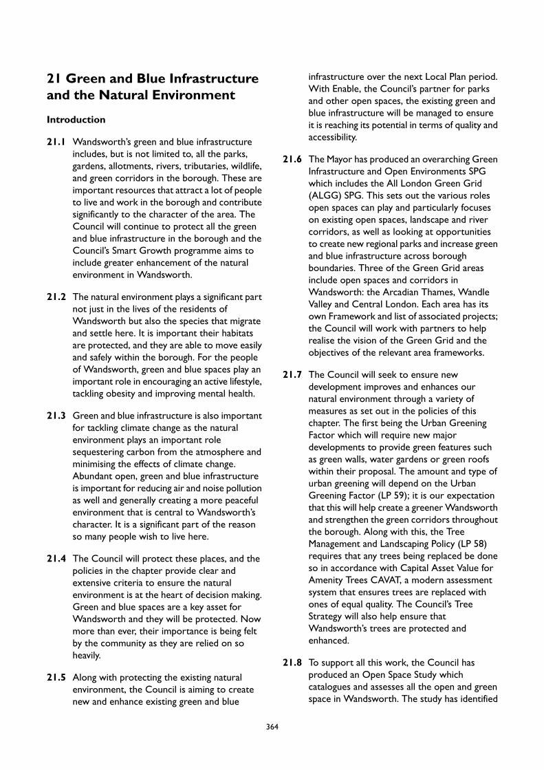
21 Green and Blue Infrastructureand the Natural Environment
Introduction
21.1 Wandsworth’s green and blue infrastructureincludes, but is not limited to, all the parks,gardens, allotments, rivers, tributaries, wildlife,and green corridors in the borough. These areimportant resources that attract a lot of peopleto live and work in the borough and contributesignificantly to the character of the area. TheCouncil will continue to protect all the greenand blue infrastructure in the borough and theCouncil’s Smart Growth programme aims toinclude greater enhancement of the naturalenvironment in Wandsworth.
21.2 The natural environment plays a significant partnot just in the lives of the residents ofWandsworth but also the species that migrateand settle here. It is important their habitatsare protected, and they are able to move easilyand safely within the borough. For the peopleof Wandsworth, green and blue spaces play animportant role in encouraging an active lifestyle,tackling obesity and improving mental health.
21.3 Green and blue infrastructure is also importantfor tackling climate change as the naturalenvironment plays an important rolesequestering carbon from the atmosphere andminimising the effects of climate change.Abundant open, green and blue infrastructureis important for reducing air and noise pollutionas well and generally creating a more peacefulenvironment that is central to Wandsworth’scharacter. It is a significant part of the reasonso many people wish to live here.
21.4 The Council will protect these places, and thepolicies in the chapter provide clear andextensive criteria to ensure the naturalenvironment is at the heart of decision making.Green and blue spaces are a key asset forWandsworth and they will be protected. Nowmore than ever, their importance is being feltby the community as they are relied on soheavily.
21.5 Along with protecting the existing naturalenvironment, the Council is aiming to createnew and enhance existing green and blue
infrastructure over the next Local Plan period.With Enable, the Council’s partner for parksand other open spaces, the existing green andblue infrastructure will be managed to ensureit is reaching its potential in terms of quality andaccessibility.
21.6 The Mayor has produced an overarching GreenInfrastructure and Open Environments SPGwhich includes the All London Green Grid(ALGG) SPG. This sets out the various rolesopen spaces can play and particularly focuseson existing open spaces, landscape and rivercorridors, as well as looking at opportunitiesto create new regional parks and increase greenand blue infrastructure across boroughboundaries. Three of the Green Grid areasinclude open spaces and corridors inWandsworth: the Arcadian Thames, WandleValley and Central London. Each area has itsown Framework and list of associated projects;the Council will work with partners to helprealise the vision of the Green Grid and theobjectives of the relevant area frameworks.
21.7 The Council will seek to ensure newdevelopment improves and enhances ournatural environment through a variety ofmeasures as set out in the policies of thischapter. The first being the Urban GreeningFactor which will require new majordevelopments to provide green features suchas green walls, water gardens or green roofswithin their proposal. The amount and type ofurban greening will depend on the UrbanGreening Factor (LP 59); it is our expectationthat this will help create a greenerWandsworthand strengthen the green corridors throughoutthe borough. Along with this, the TreeManagement and Landscaping Policy (LP 58)requires that any trees being replaced be doneso in accordance with Capital Asset Value forAmenity Trees CAVAT, a modern assessmentsystem that ensures trees are replaced withones of equal quality. The Council’s TreeStrategy will also help ensure thatWandsworth’s trees are protected andenhanced.
21.8 To support all this work, the Council hasproduced an Open Space Study whichcatalogues and assesses all the open and greenspace in Wandsworth. The study has identified
364

all the areas that are deficient in open space inthe borough and ways for them to be improved.The Open Space Study is accompanied by theOpen Space Strategy which sets aims andtargets for all underperforming green spaces inWandsworth and helps guide the boroughtowards its goal of becoming the greenest innerLondon borough.
365

LP55 Protection and Enhancement of Green and Blue Infrastructure
A. The Council will protect the natural environment, enhance its quality and extend access to it. Inconsidering proposals for development the Council aims to create a comprehensive network of greenand blue corridors and places, appropriate to the specific context. In doing so, it seeks to connectand enrich biodiversity through habitat improvement and protection at all scales, including priorityhabitats and extend access to, and maximise the recreation opportunities of, our urban open spaces.
B. The Council will protect and extend access to existing public and private green and blue infrastructurein the borough and where appropriate secure its enhancement, including Metropolitan Open Land,major commons, wetlands, rivers, ponds, parks, allotments, trees and playing fields as well as smallerspaces, including play spaces.
C. Areas of open space, including those identified on the Policies Map, and smaller areas not identifiedon the Policies Map will be protected, enhanced and made more accessible. Green chains and openspaces along them will be protected, made more accessible, and, where appropriate, enhanced inaccordance with opportunities identified in the relevant All London Green Grid Area Framework.
D. New development on or affecting public and private green and blue infrastructure will only be permittedwhere it does not harm the character, appearance or function of the green or blue infrastructure. Inassessing proposals, any impacts of the cumulative effect of development will be taken into account.
E. Any development which results in a reduction of green or blue infrastructure assets including protectedopen space as set out in (B) and (C) above will not be supported unless adequate replacement isprovided for. In determining the amount, form and accessibility of open space provided for within anew development scheme account will not be taken of the proximity and adequacy of existing openspace.
21.9 As an inner London borough Wandsworthbenefits from having a wide variety of differentscales and types of green and blue infrastructureand open space including parks, commons,
heaths, green chains, rivers, historic parks andgarden, urban squares, allotment and manyother smaller spaces.
Definitions
Open Space: All land inWandsworth that is predominantly undeveloped other than by buildings or structuresthat are ancillary to the open space use. The definition covers the broad range of types of open space inWandsworth, whether in public or private ownership and whether public access is unrestricted, limited orrestricted. It includes land designated as open spaces, such as Metropolitan Open Land, as well asnon-designated land.
Green and Blue Infrastructure: Comprises the network of parks, rivers, water spaces and green spaces, aswell as the green features of the built environment, such as street trees, green roofs and sustainable drainagesystems, all of which provide a wide range of benefits and services.
Green Space: All vegetated open space of public value (whether publicly or privately owned), includingparks, woodlands, nature reserves, gardens and sports fields, which offer opportunities for sport andrecreation, wildlife conservation and other benefits such as storing flood water, and can provide an importantvisual amenity in the urban landscape.
Green Features: Green and sustainable design elements that mitigate climate change, improve the characterof an area, and are part of the urban greening factor.
367
Green Corridor: Relatively continuous areas of open space leading through the built environment, whichmay link to each other and to the Green Belt or Metropolitan Open Land. They often-consist of rivers,railway embankments and cuttings, roadside verges, canals, parks, playing fields and extensive areas of privategardens. They may allow animals and plants to be found further into the built-up area than would otherwisebe the case and provide an extension of the habitats of the sites they join.
21.10Green and blue infrastructure and open spacesprovide a variety of benefits for Wandsworth’senvironment. They can address and mitigate theeffects of climate change, reduce the impact offlooding and improve air quality. They arebeneficial to the people of Wandsworth as theyprovide visual amenity both in their larger parksand with trees along neighbourhood streets.Green and blue infrastructure used for physicalactivity can help encourage active lifestyles,address health problems, increase socialinclusion and improve community cohesion.Access to parks has been shown to improvepeople’s mental wellbeing and new andimproved facilitates will aim to support thesebenefits. In the Open Space Study (2020), whenmembers of the public were asked what thebenefits of visiting open space are, the two mostcommon answers included better mental health(96% of responses) and better physical health(95%). All types of green and open spacesincluding small sections of landscaping and frontgardens all provide opportunities forbiodiversity which benefit Wandsworth’swildlife.
21.11Green and blue infrastructure often relatedirectly to place-making and enhancing localcharacter. At a wider scale, they can contributeto local identity and landscape character.Wandsworth’s green and blue infrastructure, inparticular its street trees, soft landscaping, roofgardens, green/brown roofs and walls, andthe Wandle Valley, form a green corridorperforming a range of functions and deliveringa wealth of benefits for the local population andwildlife.
21.12 In addition to the National Planning PolicyFramework (NPPF) and the emerging LondonPlan, the following documents, and subsequentupdates and reviews should also be referred toin relation to the policies in this section:
London Environment Strategy
Wandsworth Open Space StudyActive Wandsworth StrategyWandsworth Parks Management StrategyWandsworth Arts and Culture StrategyWandsworth Playing Pitch StrategyNatural Capital Accounts for Public GreenSpace in London Report
21.13Wandsworth has large areas of MetropolitanOpen Land (MOL) which is important to thewhole of London, as well as the borough, andprovides attractive, visual breaks to the built-uparea, keeping land permanently open. The policyapproach for proposed development in MOLis broadly equivalent to that in the Green Belt,meaning development is only permitted in veryspecial circumstances.
21.14Wandsworth commissioned consultants tocarry out an Open Space Study in 2020, whichundertook a quantitative and qualitative auditof open spaces and an assessment of currentand future needs, including evaluating thestrategic role of the borough’s open spaces.Given the limited potential for urban areas suchas Wandsworth to provide new open spaces,the study assessed the potential forimprovements and increased access to existingopen spaces to better meet the needs of users.This has helped inform the Council’s ParksManagement Strategy and has informed therequirements for open space provision set outin the Planning Obligations SPD.
21.15There are several important sites forbiodiversity identified in the borough.Greenspace Information for Greater London(GiGL) produces maps showing areas of Londonthat are identified as areas of deficiency inaccess to nature and this includes parts ofcentral Wandsworth, north Battersea andTooting. New development will be expectedto improve habitats and increase access to
368

nature, with priority to the deficiency areas andto achieving the targets set out in the localBiodiversity Action Plan.
369
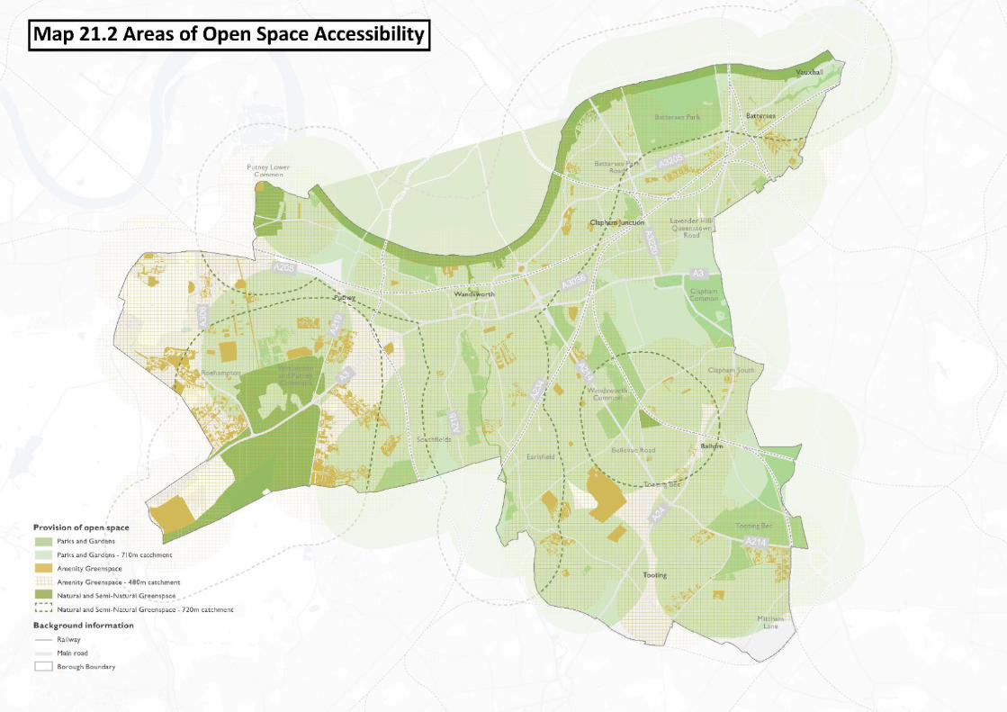

LP56 Open Space, Sport and Recreation
A. Any proposal that would result in a loss of sports pitches, playing fields, or land last used for outdoorsport, or which would prejudice the land's future use for sport in terms of quality or quantity offacilities, will not be permitted unless it can be clearly demonstrated that:
1. it would provide open space and/or secure public access to private facilities in areas identifiedas deficient in open space, play space or sport and recreation facilities; and
2. it would meet the priorities identified in the Council's Playing Pitch Strategy, Open Space Study,Active Wandsworth Strategy, Parks Management Strategy or the relevant All London GreenGrid (ALGG) Area Framework.
B. Any proposal involving the loss of indoor sports facilities and recreation facilities will not be permittedunless it can be clearly demonstrated that:
1. there is no current or future need or demand for the facility, either in its current use or for anyalternative sports or recreation use; or
2. replacement provision of an equivalent or better quantity and quality which supports any identifiedcurrent and future need will be provided in an appropriate location.
C. Proposals for new, or improvements to existing, sports facilities and indoor recreation and leisuredevelopments should:
1. increase or enhance the provision of facilities in accessible locations, well-connected to publictransport and link to networks for walking and cycling;
2. maximise the multiple use of facilities, and encourage the co-location of services between sportsproviders, schools, colleges, universities and other community facilities; and
3. support the provision of sports lighting within reasonable hours, where there is an identifiedneed for sports facilities, and lighting is required to increase their potential usage, unless thelighting gives rise to demonstrable harm to the local community, open space, local amenity orbiodiversity.
D. Public access to open space and sports and recreation facilities on private land will be supported,particularly in areas with an identified deficiency in open space.
E. Proposals involving a loss of children's play facilities will not be permitted unless it can be clearlydemonstrated that there is no identified need for the facilities or if the facilities will be replaced by anequivalent or better quality and quantity of provision in an appropriate location.
21.16Open spaces, play areas, and sport andrecreation facilities are important naturalresources in Wandsworth. The extensiveprovision of play areas and open spaces in theborough, including formal and informal land andfacilities for sport and recreation, close tohomes and places of work, will contribute toencouraging healthier lifestyles as well asincreased walking and cycling with positivehealth benefits. Play areas and open spaces areparticularly important in promoting activity inyoung children, and their provision helps to
counter the increasing childhood obesity levelsin the borough. Easy access for all residents tohigh quality Public Open Space, play space andother land for formal or informal recreation isimportant, particularly within identified areasof deficiency.
21.17Open spaces can be beneficial as tranquil spaceswhere unwelcome noise is low. Opportunitiesto interact with the natural environment canbe key to protecting and improving quality oflife in urban areas. 'Quiet Areas' may be formally
371
identified in the future and are likely to includethe borough's open spaces. New developmentnear quiet and tranquil areas should be sensitiveto this and not cause an increase inenvironmental noise.
21.18This policy seeks to maintain, and wherepossible improve, the quality and provision of,Public Open Space, sports fields and pitches andplay areas in the borough, particularly in areasidentified as deficient.
21.19The Council is also in the process of producinga Playing Pitch Strategy (to be completed in2021), which will catalogue and assess thequality of all playing pitches and sports groundsin Wandsworth and will provide a strategic planfor the maintenance, improvement and creationof playing pitches in the borough. The PlayingPitch Study is being developed with SportEngland and will support the Local Plan Policies.
21.20National policy and guidance, states that existingopen spaces, sports and recreational buildingsand land, including playing fields, must not bebuilt on unless:
an assessment has been undertaken whichhas clearly shown the open space,buildings or land to be surplus torequirements; orthe loss resulting from the proposeddevelopment would be replaced byequivalent or better provision in terms ofquantity and quality in a suitable location;orthe development is for alternative sportsand recreational provision, the needs forwhich clearly outweigh the loss; orthe proposal is ancillary to andcomplements the functioning of openspace and recreation facilities, such aschanging rooms and flood lighting, whichmay be appropriate subject to its effecton the character and appearance of theopen space and impacts upon biodiversity.
21.21Proposals that could affect the loss or thequality of a playing pitch or playing field will beassessed against the emerging WandsworthPlaying Pitch Strategy (to be published in 2021),the criteria as set out in the NPPF as well asthe Sport England’s Planning for Sport Guidance.
Early engagement with Sport England will berequired where a proposal affects a playing fieldor sports pitch.
21.22Proposals which replace outdoor open spacefor largely indoor recreation facilities will notbe permitted due to the loss of open space.
21.23Proposals for new sports facilities areencouraged to promote multiple uses to meetthe needs of the local community.
21.24For all proposals affecting areas of open or usedfor sport or recreation the following will beimportant considerations with any applicationand the assessment of whether the proposeddevelopment is suitable.
21.25Metropolitan Open Land (MOL) is strategicallyimportant open space as described in theemerging London Plan which affords it the sameprotection as the Green Belt. The Local Planidentifies MOL in the borough and this includesareas of public open space, allotments andcommon land, as well as private sport clubs andnursery gardens. The emerging London Planmakes it clear that there is a presumptionagainst development unless the proposalprovides essential facilities for appropriate usesand that very special circumstances can bedemonstrated. Engineering and other operationsare classed as inappropriate development onMOL unless they maintain the openness and donot conflict with the purposes of including landin the Green Belt. The definition of appropriateuses and strict criteria for determining planningapplications in the Green Belt, which by virtueof the emerging London Plan also applies toapplications on MOL, are listed in the NPPF.
21.26The emerging Arts and Culture Strategy andaccompanying Action Plan recognises theborough would benefit from additional culturalfacilities to offer high quality arts experiencesand participation to the growing population. Inaddition, the Action Plan encourages the use ofoutdoor spaces for cultural activity such asappropriate public art, commissions, festivals,music and performance work. The Council’sArts Service and Enable Leisure and Cultureare delivering these objectives.
372

21.27Proposals affecting sports facilities or play spaceshould have regard to the WandsworthEnvironment and Sustainability Strategy 2019,
Council's Play Strategy, and ActiveWandsworthStrategy.
LP57 Biodiversity
A. The Council will protect and, where appropriate, secure the enhancement of the borough’s priorityspecies, priority habitats and protected sites as well as the connectivity between such sites. Thisincludes but is not limited to Special Areas of Conservation, Sites of Special Scientific Interest, LocalNature Reserves, Local Wildlife Sites.
B. Development proposals will be required to protect and enhance biodiversity, through:
1. ensuring that it would not have an adverse effect on the borough's designated sites of habitatand species of importance (including buffer zones), as well as other existing species, habitats andfeatures of biodiversity value;
2. The incorporation and creation of new habitats or biodiversity features on development sitesincluding through the design of buildings and use of Sustainable Drainage Systems whereappropriate. Major developments will be required to deliver a net gain in biodiversity, throughthe incorporation of ecological enhancements;
3. ensuring that new biodiversity features or habitats connect to the existing ecological and greenand blue infrastructure networks and complement surrounding habitats;
4. enhancing wildlife corridors for the movement of species, including river, road and rail corridors,where opportunities arise; and
5. maximising the provision of ecologically functional habitats within soft landscaping.
C. Development which would have an adverse impact on priority species or priority habitat(s) will onlybe permitted where:
1. it has been demonstrated that there is no alternative site layout or site that would have a lessharmful impacts;
2. the benefits of the development would outweigh the harm; and3. the impact has been adequately mitigated either through on or off site site measures.
21.28Wandsworth has a high level of biodiversity,with a total of 1,600 different species recordedwithin 27 different habitat types. We host sixspecies of bats, have badger sets and severalrare and endangered species can be found inWandsworth, including peregrine falcons, blackredstarts and stag beetles. Wandsworth’s areasof biodiversity importance include Special Areasof Conservation (SAC), Sites of Special ScientificInterest (SSSI), Local Nature Reserves (LNR)and Sites of Importance for NatureConservation (SINC), which also includes twosubcategories of borough and local importance.Most of these sites are also displayed on thePolicies Map as areas of open space. The RiverThames and its tributaries, Beverley Brook and
the RiverWandle, and railway land not includedin other sites are also protected biodiversityareas in Wandsworth. A variety of smaller sitesalso exist but are not large enough to bemapped.
21.29Biodiversity does not only enhance and enrichthe borough's landscapes and wildlife, but it alsomakes a significant contribution to thedistinctiveness of Wandsworth, providing asense of place and enhancing cultural heritage.Vegetation provides a cooling effect, which helpsto reduce the impact of the urban heat islandeffect through transpiration. In addition,protecting and enhancing biodiversity, includingthe provision of new habitats and features,
373

increases the resilience of our ecosystems andhelps the physical environment to change andadapt to different stresses. Biodiversity,including the wider ecological and green andblue infrastructure networks, play a crucial rolein adapting to the effects of climate change. IntheWandsworth Environment and SustainabilityStrategy (WESS), one of the key opportunitiesidentified was ‘biodiversity conservation’ whichidentified that climate change is a major threatto biodiversity, ecosystem services and humanwellbeing. The WESS outlines that mitigatingand adapting to the effects of climate change onliving organisms and societies is increasingly atthe heart of environmental managementstrategies
21.30Guidance on the use of native species andclimate change can be found in theWandsworthOpen Space Study, the Mayor of London'sBiodiversity Strategy and the London Tree andWoodland Framework. Information on areasof deficiency in access to nature in London ismanaged and updated by GiGL (GreenspaceInformation for Greater London) and will bemade available via theirwebsite www.gigl.org.uk .
21.31The protection and enhancement of biodiversityshould be treated as integral to any newdevelopment scheme, not as an ‘add-on’. Layout,design, buildings, external lighting andlandscaping schemes should take account ofexisting biodiversity features and habitats. Newdevelopment should include new or enhancedfeatures and habitats, design (such as greenroofs) and landscaping (including trees) thatpromote biodiversity, including provision fortheir management. Proposals should giveconsideration to the need for species to movebetween habitats and therefore seek to connectwith existing green corridors where it isappropriate to do so. All these features mustalso be protected during construction works,and this may be secured by a planning condition,as will subsequent maintenance and monitoring.
21.32This policy will be updated in light of progresson the Environment Bill, which will mandate forBiodiversity Net Gain in developments.Biodiversity Net Gain is a new approach todevelopment and will require developers toensure habitats for wildlife are enhanced. It willrequire a demonstrable increase in habitat valuecompared to the pre-development baseline.
374
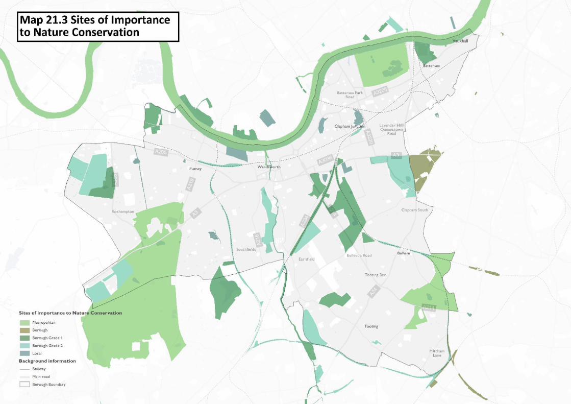
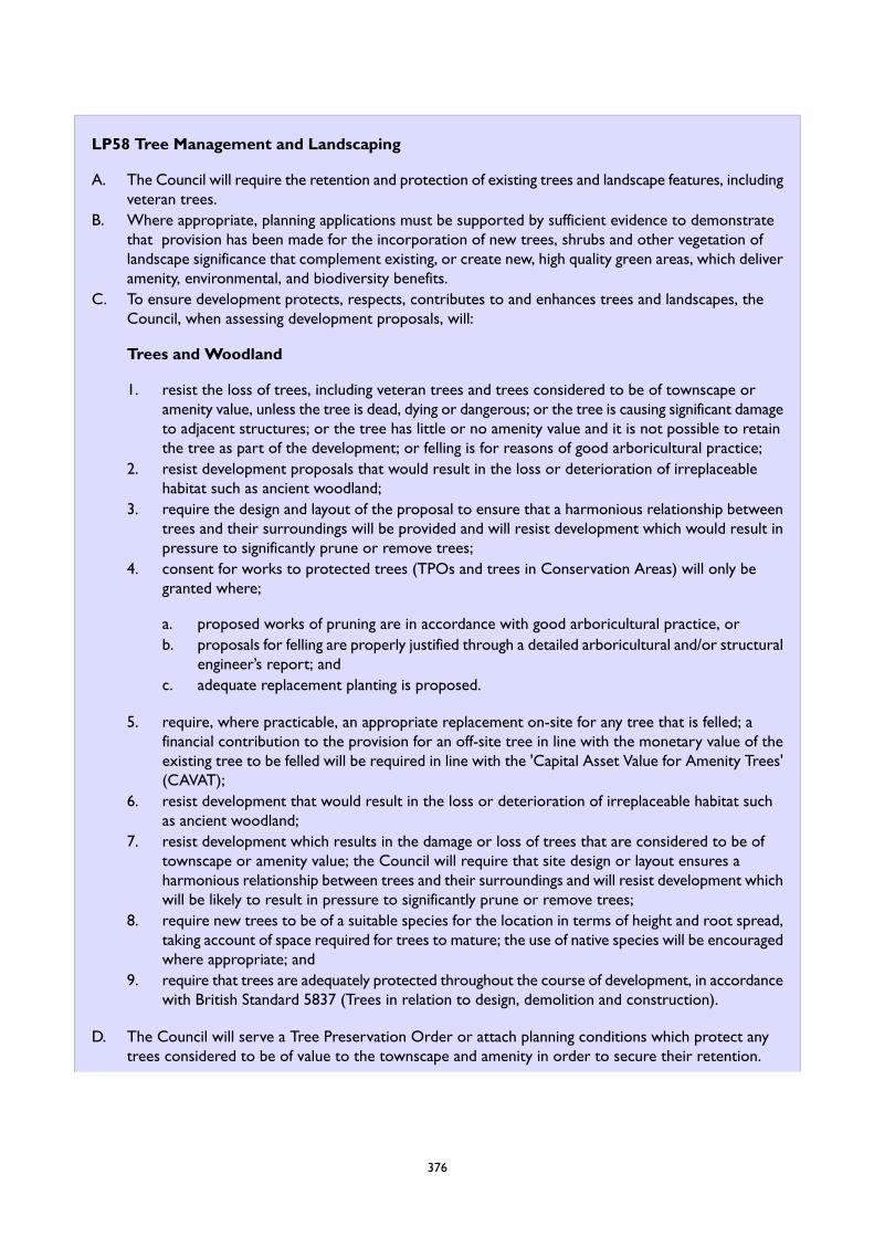
LP58 Tree Management and Landscaping
A. The Council will require the retention and protection of existing trees and landscape features, includingveteran trees.
B. Where appropriate, planning applications must be supported by sufficient evidence to demonstratethat provision has been made for the incorporation of new trees, shrubs and other vegetation oflandscape significance that complement existing, or create new, high quality green areas, which deliveramenity, environmental, and biodiversity benefits.
C. To ensure development protects, respects, contributes to and enhances trees and landscapes, theCouncil, when assessing development proposals, will:
Trees and Woodland
1. resist the loss of trees, including veteran trees and trees considered to be of townscape oramenity value, unless the tree is dead, dying or dangerous; or the tree is causing significant damageto adjacent structures; or the tree has little or no amenity value and it is not possible to retainthe tree as part of the development; or felling is for reasons of good arboricultural practice;
2. resist development proposals that would result in the loss or deterioration of irreplaceablehabitat such as ancient woodland;
3. require the design and layout of the proposal to ensure that a harmonious relationship betweentrees and their surroundings will be provided and will resist development which would result inpressure to significantly prune or remove trees;
4. consent for works to protected trees (TPOs and trees in Conservation Areas) will only begranted where;
a. proposed works of pruning are in accordance with good arboricultural practice, orb. proposals for felling are properly justified through a detailed arboricultural and/or structural
engineer’s report; andc. adequate replacement planting is proposed.
5. require, where practicable, an appropriate replacement on-site for any tree that is felled; afinancial contribution to the provision for an off-site tree in line with the monetary value of theexisting tree to be felled will be required in line with the 'Capital Asset Value for Amenity Trees'(CAVAT);
6. resist development that would result in the loss or deterioration of irreplaceable habitat suchas ancient woodland;
7. resist development which results in the damage or loss of trees that are considered to be oftownscape or amenity value; the Council will require that site design or layout ensures aharmonious relationship between trees and their surroundings and will resist development whichwill be likely to result in pressure to significantly prune or remove trees;
8. require new trees to be of a suitable species for the location in terms of height and root spread,taking account of space required for trees to mature; the use of native species will be encouragedwhere appropriate; and
9. require that trees are adequately protected throughout the course of development, in accordancewith British Standard 5837 (Trees in relation to design, demolition and construction).
D. The Council will serve a Tree Preservation Order or attach planning conditions which protect anytrees considered to be of value to the townscape and amenity in order to secure their retention.
376
Landscape
E. The Council will:
1. require the retention of important existing landscape features;2. require landscape design and materials to be of a high quality and be compatible with the
surrounding landscape and character; and3. require the provision of planting, including new trees, shrubs and other significant vegetation
where appropriate.
21.33One of the distinctive qualities of Wandsworthis its well-treed landscape, green and openspaces, as well as its streets and residentialareas. The council looks after more than 60,000trees in its parks, commons and open spaceswhile around 16,000 grow in residential streetsand on the borough’s housing estates.Wandsworth Council have planted over 1,200trees in the last two winters and are activelyexploring new areas to plant street trees. In2019/20 it is expected the Council will plant400 more trees.
21.34Conservation Areas cover around 50% of theborough and all trees are generally protectedin these areas by the provisions of the Townand Country Planning Act (1990). In addition,the Council has made around 400 TreePreservation Orders (TPO) to protect individualtrees and groups of trees of high amenityvalue.
21.35The term 'landscape' is taken to refer to thedesign of all space between buildings andincludes walls and boundaries, paving as well asplanting. It refers to both 'soft' as well as 'hard'landscape and materials.
21.36Trees and landscaping are key components ofWandsworth’s ecological and green and blueinfrastructure network. They soften thehardness of buildings and streets, help createthe amenity, add to place-making and characterof the street scene, add life, colour andcharacter to the urban landscape and enhanceopen spaces and the riverside landscape. Treesand other planting, including contiguous gardensand green oases, deliver multiple benefits: theyprovide an important habitat for wildlife; reducelevels of carbon dioxide and airborne pollutants
(such as nitrogen dioxide) and harmfulparticulates (such as PM10's and PM2.5's);dampen noise from traffic and congestion;increase the supply of oxygen; and provideshade for streets, open areas and parks as wellas for buildings. Trees and other landscapefeatures can help areas to adapt to the likelyeffects of climate change; for example, they havea cooling effect and contribute to the reductionof urban heat islands by regulating localtemperature extremes, which is important dueto projected future increases in temperatureas a result of climate change. In addition, theycan assist in reducing surface water run off ratesand flash floods during heavy rainfall eventsthrough absorption and infiltration.
21.37Development proposals are required to retainand protect existing trees, and minimise anyimpacts on trees, landscaping, shrubs and othersignificant vegetation, including through theprovision of sufficient space for the crowns androot systems of existing and proposed trees,including their future growth. Developercontributions towards trees within the publicrealm may be required where appropriate.
21.38With all proposals, particular attention shouldbe given to the use of tree planting in enhancingpublic areas within developments and views intosites from surrounding viewpoints, taking intoaccount the need to ensure that clear sightlinesand open outlook are maintained as necessaryto ensure community safety is not adverselyaffected. Guidance on the retention and plantingof trees in new development can be found inthe report Residential Development and Trees:a guide for planners and developers published(Jan 2019) by the Woodland Trust.
377
21.39The Council will protect these trees, and othermature trees that contribute to the quality ofthe local environment and promote measuresthat protect the health and visual amenity oftrees. Wandsworth have produced a TreeStrategy that provides additional guidance for
all proposals that will impact trees andlandscaped areas. While not all streets in theborough are able to sustain trees, we arecommitted to review the opportunities forplanting more trees when works are beingcarried out on streets.
LP59 Urban Greening Factor
A. All development proposals should contribute to the greening of Wandsworth borough by includingurban greening as a fundamental element of site and building design, and by incorporating measuressuch as high quality landscaping (including trees), green roofs, green walls and nature-based sustainabledrainage.
B. Development proposals will be required to:
1. follow the guidance on the Urban Greening Factor in the emerging London Plan for calculatingthe minimum amount of urban greening required as well as for the thresholds different types ofdevelopment will be required to meet; and
2. incorporate as much soft landscaping and permeable surfaces as possible;3. take into consideration the vulnerability and importance of local ecological resources (such as
water quality and biodiversity) when applying the principles of the Urban Greening Factor.
C. If it can be clearly demonstrated that meeting the thresholds would not be feasible, in exceptionalcircumstances a financial contribution may be acceptable to provide for the improvement of biodiversityand green and blue infrastructure assets within the locality.
21.40The emerging London Plan sets out newexpectations for the amount and type of urbangreening measures that will be required of allnew major proposals. Urban greening aims toinclude from the initial design stages streettrees, rain gardens, green walls etc. into thelayout of a proposal for (See Table 8.2. of theemerging London Plan for a complete list ofurban greening features).
21.41Wandsworth has committed itself to becomingthe greenest Inner London borough bypromoting urban greening, planting trees,encouraging biodiversity, protecting andenhancing our existing parks and open andgreen spaces. We expect all new developmentsto contribute to greening the borough. Fromthe Nine Elms development process,Wandsworth has learned a lot about urbangreening including best practice methods,important considerations for the managementand maintenance, and what measures best suitthe character of Wandsworth.
21.42Urban greening can help to meet other policyrequirements and provide a range of benefitsincluding amenity space, enhanced biodiversity,addressing the urban heat island effect,sustainable drainage and visual amenity. Formajor development proposals in particular,applicants will be expected to discuss at thepre-application stage(s) with the Council whattheir intentions for urban greening are and ifthere are likely to be any complicationsproviding the required amount.
21.43Wandsworth has chosen to adopt the emergingLondon Plan’s calculations and targets for theperiod of this Local Plan but is committed toreviewing these in the future. Developmentproposals should consider the information inthe emerging London Plan along with the UrbanGreening Factor for London research report(2017).
378
LP60 River Corridors
A. The natural, historic and built environment of the River Thames corridor and watercourses withinthe borough will be protected and, where appropriate, enhanced to ensure the achievement of a highquality and accessible environment including through the provision of connections to existing and newcommunities and to maximise biodiversity benefits.
B. The biodiversity value of the borough’s blue infrastructure assets will be protected and enhancedincluding that of the River Thames, River Wandle and Beverley Brook.
C. Measures to protect and enhance rivers as a valuable resource for wildlife and biodiversity, includingwildlife corridors and green chains, will be supported, in particular at the mouth of the River Wandle.
D. Existing river infrastructure that provides access to the river and the foreshore, such as piers, jetties,drawdocks, slipways, steps and stairs will be protected. New and enhanced infrastructure, includingpiers for riverbuses and the provision of enhanced services, will be supported.
E. Development which encroaches onto the river foreshore will not be supported. Opportunities willbe taken, in consultation with partner agencies including Natural England, the Port of London Authorityand the Environment Agency, to create new habitats and reduce flood risk in accordance with therequirements of the Thames Estuary 2100 Plan.
21.44The River Thames and River Wandle are keyfeatures of the borough and fulfil importantamenity, biodiversity, transport (people andcargo), leisure and recreational roles amongstother benefits. The River Thames performsimportant functions in relation to transport andthe trans-shipment of freight. The River Thamesis a major ecological resource, it provides animportant ecological corridor across London.The habitats and species supported by the riverand its tributaries, especially at the mouth ofthe River Wandle, are important to ecology inthe borough. The river, riverbanks and rivercourse provide habitats for a diverse range offlora, fauna, invertebrates and birdlife. Anydevelopment which causes harm to thebiodiversity value of the borough’s blueinfrastructure assets will not be permittedunless appropriate mitigation measures areprovided.
21.45The All London Green Grid (ALGG) aims topromote and protect green and blueinfrastructure (including rivers) in London.There are three areas in Wandsworth (theArcadian Thames, Wandle Valley and CentralLondon) and each area framework includessections of the River Thames and/or RiverWandle. Development on the riverside shouldhave regard to the aims of the ALGG and theopportunities identified in the area frameworks.
21.46The Marine Management Organisation (MMO)is responsible for issuing marine licences underthe Marine and Coastal Access Act 2009. Amarine licence may be needed for activitiesinvolving a deposit or removal of a substanceor object below the mean high water springsmark or in any tidal river to the extent of thetidal influence, and early consultation with theMMO is advised. Applicants should also referto the Marine Policy Statement for guidance onany planning activity that includes a section oftidal river.
LP61 Riverside Uses, Including River Dependent, River-related, and River Adjacent Uses
A. New development on sites adjoining the River Thames and River Wandle will be supported whereit:
1. provides sustainable transport choices including through the provision of access to public transportroutes and incorporates public riverside walks and cycle-paths;
379
2. protects identified strategic and local views;3. provides for new or enhanced open spaces and other community based facilities and amenities;4. protects and enhances the habitat value of the river and shoreline, promotes the naturalisation
of the riverbanks where feasible, and does not cause harm to the operation of the river regime,or its environment, biodiversity or archaeology (including to its banks, walls and foreshore);
5. does not adversely impact on neighbouring sites and uses, including to docks, safeguarded wharvesor other river-based infrastructure;
6. does not cause harm to the special recreational character and function of Putney Embankment,including in connection with river sports. Facilities and activities which contribute to PutneyEmbankment’s special recreational character will be protected and new facilities that make apositive contribution will be supported; and
7. does not harm the stability or continuity of tidal or flood defences.
B. Where appropriate, the Council will seek financial contributions towards the provision, or upgrading,of riverside infrastructure including to achieve the objectives of the Wandle Valley Regional Park.
C. The Council will resist the redevelopment of existing river-dependent or river-related industrial andbusiness uses to non-river related employment uses or residential uses, unless it can be clearlydemonstrated that neither this nor any other river-dependent or river-related use is feasible or viable.
D. An assessment of the effect of the proposed development on the operation of existing river dependentuses or riverside gardens and their associated facilities on and off-site will be required by the Council;or an assessment of the potential of the site for river-dependent uses and facilities if there are noneexisting will be required.
Thames Policy Area
E. Along the riverside within the Thames Policy Area, mixed use development will be supported whereit would create safe attractive environments, provide new homes, leisure, social and culturalinfrastructure facilities, provide public spaces, incorporate riverside walks and cycle ways and increasedpublic access to the river.
F. Within Focal Points of Activity uses including restaurants, cafes, bars, cultural space and small-scaleretail uses will be permitted, subject to compliance with Policy LP 46 (Out of Centre Development).Attractive public spaces with good access to them should be provided to form new destinations whichare designed to make full use of the amenities offered by the riverside. A limited amount of workspacesufficient to serve the needs of the development will be permitted, subject to compliance with therelevant Area Specific policies and the requirements of Policies LP 36 (Offices) and LP 38 (Mixed UseDevelopment on Economic Land). Where a Strategic Area, such as the VNEB Opportunity Areaoverlaps with a Focal Point then the associated Framework, masterplan, or other document will haveprimacy over this Policy. The Focal Points of Activity are located at:
1. Wandsworth Riverside Quarter and Wandle Delta2. Lombard Road/ York Road Riverside3. Ransomes Dock4. Battersea Power Station5. Nine Elms near Vauxhall
21.47New development on the riverside should bedesigned to a high standard in line with urbandesign best practice. New development will beexpected to provide high quality public realm
that is safe and attractive and should, whereverpossible, improve access and provideopportunities for the public to enjoy the rivers.Requirements for riverside walks and cycle
380

paths are set out in Policy LP 54 (PublicTransport and Infrastructure). Developmentshould attain a high standard of architecturaldesign that contributes to the character of itsriverside location and has regard to its impacton local and longer distance views. The Thamesand Wandle riversides have a rich history andnew development should acknowledge this andcontribute to the heritage of the rivers.Measures to improve the riverscape, such asthe restoration of habitats and the removal ofobsolete structures, are outlined in the ThamesRiver Basin Management Plan.
21.48 Infrastructure currently linked to sports andphysical activities on the River Thames servesan important role in open space and sportsprovision and is identified in the ActiveWandsworth Strategy. These facilities will beprotected and enhanced where appropriate.Putney Embankment's special recreationalcharacter and function, particularly inconnection with river sports, will continue, withfacilities and activities which contribute to thischaracter supported and protected (See theArea Strategy for Putney).
LP62 Moorings and Floating Structures
A. River-related development which enhances the river infrastructure and increases access to the Thamesincluding short-stay visitor moorings and piers and jetties for river-based recreation, passenger orgoods transport will be permitted in appropriate locations where:
1. the residential amenity of occupiers of adjoining sites is not harmed;2. the operation of docks and safeguarded wharves is not harmed;3. the navigation of the channel is not adversely affected;4. views of the river are not harmed;5. the development does not form a barrier which would impede views of the river from
the riverside or prevent physical access to it;6. the stability or continuity of tidal or flood defences is not adversely affected; and7. the proposal would protect and/or enhance the habitat value of the river and shoreline and
would not cause unacceptable harm to the operation of the river regime, or the environment,biodiversity or archaeology of the river (including its banks, walls and foreshore).
B. Proposals for floating structures, including houseboats and moorings for permanent vessels will beassessed in accordance with the criteria in Part A. In addition, proposals will need to demonstratethat:
1. adequate servicing can be provided;2. the character and open nature of the river and riverside would not be harmed;3. the proposed mooring or floating structure would be sited near a Focal Point of Activity as
identified on the Policies Map;4. the size and appearance of the vessel to be moored is identified and is appropriate to the proposed
location; and5. there would be no interference with the recreational use of the river, the riverside and to the
navigation of the river.
C. The culverting of river channels and watercourse will not be permitted and the naturalisation of riverchannels and watercourses will be sought as part of development proposals where appropriate andfeasible.
381
21.49Moorings and other river infrastructure cancreate interest and encourage activity on theThames riverside, particularly at riverside focalpoints of activity. Short-stay moorings canprovide important recreational facilities andsupport greater leisure uses on the Thames.However, permanently moored vessels can alsopotentially form a barrier between the river andpeople on the banks and can affect the opennature of the riverside and harm neighbouringresidents' amenity; particularly large floatinghomes, buildings or structures which aresignificantly different in terms of mass andcharacter to typical houseboats. Residentialmoorings also require adequate land-basedservicing including power, water, waste andsewerage facilities. However, providing thatresidential moorings are safely accessible, andcomply with the Council’s Refuse andRecyclables in Developments SPD, facilities forstoring waste do not necessarily have to be landbased. The cumulative impact of developmentin the river will be taken into account to ensurethat the character and open nature of the riveris not harmed.
382

22 Implementation, Delivery andMonitoring
Introduction
22.1 This section provides an overview of the waysthe Council will deliver and monitor the deliveryof the Local Plan’s vision, objectives, areastrategies and policies.
Implementing the Spatial Strategy
22.2 The Spatial Strategy set out by this plan hasbeen articulated through the Area Strategies,Site Allocations and the policies of the plan. TheVision and Objectives of the Plan have beenarticulated through the vision of each AreaStrategy and place-based policies. Togetherthese set out the framework for thedevelopment of each area. The implementationof the Council's own strategies and plans as wellas those of key partner organisations will beessential to the delivery of the Strategic Vision.More detailed guidance in the form of SPDs andother key strategic documents will be broughtforward over the life-time of the Plan to bringforward development. The Nine ElmsOpportunity Area continues to progress in linewith the Opportunity Area Planning Frameworkand the Council has in place the Nine Elmsdelivery team which aims to: ‘Ensure that NineElms emerges as a sustainable, distinctive,world-class, mixed use neighbourhood ofWandsworth, known for its culture, communityand creativity, contributing and connected towider London.‘
22.3 The Areas Strategies include detailed proposalsfor all the key town centre sites and show howeach area is connected through the overarchingArea Strategies of the Wandle Valley and theWandsworth Riverside; including guidance onimprovements to transport links and the widerpublic realm in support of the LocalImplementation Plan.
22.4 The Local Plan will be implemented anddelivered through a combination of privatesector investment, the work of other agenciesand bodies and the Council's own strategiesand initiatives. The majority of newdevelopment identified in the Plan's site
allocations, particularly investments in newinfrastructure, housing and jobs, will bedelivered by the private sector.
22.5 In addition, other public bodies and agencies,such as Transport for London (TFL), have a keyrole to play in delivering the required transportimprovements that are necessary toaccommodate the anticipated growth in theborough and to implement the Spatial Strategy.The community and voluntary sector will playa key role in implementation. The Council willtherefore continue to work with all its partnersand use all its relevant powers and programmesto ensure that essential infrastructure will bedelivered.
22.6 At least 1,950 new homes per year will needto be delivered by 2028/2029. This target willbe rolled forward until it is replaced by a revisedLondon Plan target. These new homes willlargely be delivered by the private sector inresidential-led mixed use schemes. The mainlocations for new housing across the boroughare identified in the Spatial Strategy and therelevant Housing policies of this Plan. Affordablehousing will be secured through PlanningObligations, by private developers andRegistered Providers (RPs) of affordablehousing. The Council will support the deliveryof further affordable housing that will beprovided by RPs' own schemes and through itsown land and estate regeneration schemes inaccordance with the Council’s ‘Housing for all’scheme. The Council's approach to securingaffordable housing through Planning Obligationsis set out in its Planning Obligations SPD.Detailed monitoring of the overall housingprovision and the delivery of affordable housingtakes place as part of the Council's annualAuthority Monitoring Report.
22.7 The provision of employment space includingaffordable and managed workspace to meet theanticipated growth in the local economy will bedelivered by the private sector as part ofemployment-only or mixed use schemes inlocations identified in the Spatial Strategy andEmployment policies of this Plan. The provisionof flexible, small units to serve the particularneeds of the borough's local economy will besecured through Planning Obligations inappropriate locations. The Plan forests out a
383
positive approach to growth, including additionalrequirements for office and industrial floorspace,identifying sites and inward investmentopportunities in order to meet anticipatedneeds over the plan period. However, theCouncil will be monitoring growth forecasts toconsider the effects that external factors suchas the Covid-19 pandemic and Brexit has oneconomic trends as it is recognised that thereis much uncertainty at this current time.
22.8 The Spatial Strategy highlights that there is nogrowth forecast for retail as any short tomedium term growth is expected to beabsorbed by the implementation ofcommitments, take up of vacant floorspace andincreases in turnover efficiency. As such, thepriority is to direct new main town centre usesto the borough’s centres, where possible. Thepolicy approach recognises the need forflexibility in accommodating more uses at thistime, particularly in reaction to the Covid-19pandemic and in light of the changes to the UseClasses Order Class ‘E’ development.
22.9 Improvements to transport infrastructure,particularly to public transport as well as cyclingand walking, will be essential to the delivery ofthe Spatial Strategy. The emerging London Plansets out strategic schemes and proposals forLondon, a number of which are of relevance tothe borough, such as Crossrail 2, Londonunderground improvements and Southwest Railten car capacity. The Council will supportimprovements to public transport, includingenhanced capacity as well as improved bus andrail services and accessibility opportunities andto address the longstanding problem of thethrough traffic to Wandsworth Town Centreby reconfiguring the one-way system Theseimprovements will largely be delivered byGovernment, TfL and other public transportoperating companies. Funding for improvementswill be provided in part through the CommunityInfrastructure Levy, and where appropriate,developer contributions through PlanningObligations will also be sought from relevantdevelopment sites.
22.10A key challenge for the borough over thelifetime of this Plan will be the delivery ofsufficient school places to meet the needs ofthe existing and growing population. The
Council will work with partners, including theEducation Funding Agency as well as educationalproviders, to ensure the provision of thequantity and diversity of school places neededwithin the borough. Further work to evidenceneed will be reflected in the InfrastructureDelivery Plan (IDP) which will inform the nextversion of the draft Local Plan (Regulation 19version).
22.11The Council will work with service providersand developers to ensure the adequateprovision of community services and facilities,especially in areas where there is an identifiedneed or shortage. New community and socialinfrastructure facilities are also expected to bedelivered on a variety of sites as identified inthis Plan. Improvements to open spaces as wellas play facilities will be required in line withpolicy LP 19 (Play Space) and LP 20 (NewOpenSpace).
22.12The activities of other key partner agencies andbodies, such as the Wandsworth ClinicalCommissioning Group (CCG), andNHS partnerorganisations, who are responsible for deliveringhealth services in the borough, will alsocontribute to delivering the Strategic Vision andSpatial Strategy.
Site Delivery
22.13The site allocations in the Local Plan are thekey delivery mechanism for achieving theidentified housing, employment, retail andinfrastructure needs set out in the Local Plan.It is therefore crucial to the delivery of thespatial strategy that development sites deliverthe allocated uses – and vital that the Council,landowners and developers engage as soon aspossible in the development process.
22.14Work on site specific planning documentsfocuses on early engagement with landownersand developers as key stakeholders to recogniseand address any issues that may impact on thedeliverability of development. The Council willalso seek to work cooperatively withcommunities in the preparation of area-basedplans and proposals.
384
Viability
22.15Following consultation of the draft Local Plan(Regulation 18 stage) the Council will carry outa full financial viability of the Plan to inform thenext version of the draft Local Plan (Regulation19 Stage). This will be an assessment of thecumulative impact of the Council’s Local Planin line with the requirements of the NationalPlanning Policy Framework (NPPF).
22.16 It is recognised that the housing and commercialproperty markets are inherently cyclical andthat the Plan is being prepared when the marketis experiencing a period of uncertainty due tothe effect of the Covid-19 pandemic and Brexit.Forecasts for future house prices are uncertainwith forecasts pointing towards a short termfalls with recovery of return to pre-pandemiclevels not expected until 2023. This will betaken into account in the sensitivity testing ofthe Viability Study and the flexibility of policies.
Infrastructure Delivery
22.17Delivery of infrastructure is critical to thedelivery of the Strategic Objectives, Vision andSpatial Strategy of the Local Plan. Futuredevelopment, as set out in this Local Plan, willneed to be enabled and supported by the timelydelivery of infrastructure. Infrastructure planningensures that physical and nonphysicalrequirements for an area or development canbe delivered in a timely manner. This includesworking in partnership with physical, social andgreen infrastructure providers to establish whatinfrastructure provision there is in the borough,and identifying any gaps or capacity issues withinthe existing provision, in order to supportsustainable growth in the borough.
22.18The NPPF sets out that planning shouldproactively drive and support sustainableeconomic development to deliver the homes,business and industrial units, infrastructure andthriving local places that the country needs. Inaddition, local authorities should work withneighbouring authorities and transportproviders to develop strategies for the provisionof viable infrastructure necessary to supportsustainable development. The NPPF in
paragraph 162 states that local planningauthorities should work with other authoritiesand providers to:
assess the quality and capacity ofinfrastructure for transport, water supply,wastewater and its treatment, energy(including heat), telecommunications,utilities, waste, health, social care,education, flood risk and coastal changemanagement, and its ability to meetforecast demands; andtake account of the need for strategicinfrastructure including nationallysignificant infrastructure within their areas.
22.19Changes in the population and in particular anypopulation increases and growth as well aschanges in needs and demands will influencewhat community infrastructure is required inthe borough. In addition, new development andpopulation growth will require an appropriatelevel of additional infrastructure to ensure thatexisting as well as new communities andbusinesses have the necessary infrastructure,such as school places, health centres and leisurefacilities.
22.20To enable sustainable growth in the borough,the infrastructure requirements of newdevelopment will need to established, and theneed for any new infrastructure should beplanned in conjunction with new development;this includes for example transport or utilitiesinfrastructure requirements.
22.21Planning, through the use of the CommunityInfrastructure Levy and Planning Obligations, isa prime way that the Council can gain thenecessary resources to assist in the delivery ofthis vital infrastructure.
22.22An Infrastructure Delivery Plan (IDP) willprovide an infrastructure assessment for theborough which links into the Local Plan. TheIDP sets out what is needed, where it is neededand when it is needed. It will also provide anupdate on the delivery of the requiredinfrastructure to date. It also sets out the rangeof plans, programmes and strategies, includingthose of partner organisations and agencies.
385

22.23Each infrastructure type will be accompaniedby an Infrastructure Delivery Schedule tablewhich provides further detail on delivery,funding sources, costs and identifies whetherthere are any funding gaps.
22.24The Infrastructure Delivery Plan (IDP) willinform part of the evidence base to inform thenext version of the draft Local Plan (Regulation19 version). An Infrastructure FundingStatement is currently being prepared in tandemwith the IDP to show how the anticipatedfunding from developer contributions, and thechoices the Council has made about how thesecontributions will be used to support the visionand objectives of the Local Plan.
Monitoring Indicators
22.25Once adopted the Local Plan will be monitoredto enable the understanding of the extent towhich the Local Plan policies deliver theCouncil’s vision and objectives forWandsworth.Changing circumstances means that themonitoring of policies is required to deliver.Manage, and if necessary, adapt or bring forwardan alternative planning approach toWandsworth’s growth and meeting theborough’s needs for homes, jobs, services andinfrastructure.
22.26The Council will monitor the effectiveness ofthe Local Plan by regularly assessing itsperformance against a series of quantitateindicators. The performance of the Local Planwill be reported in the Authority MonitoringReport (AMR).
386

23 Appendices
Appendix 1 Marketing Evidence
23.1 A number of policies in this Local Plan requiremarketing evidence to be submitted withapplications to justify that those sites orpremises are no longer required for theirexisting uses. These policies are:
Policy LP 17 - Social and CommunityInfrastructurePolicy LP 18 - Arts, Culture andEntertainmentPolicy LP 35 - Visitor AccommodationPolicy LP 36 -Promotion and protectingofficesPolicy LP 37 - Managing land for industryand distributionPolicy LP 38 - Mixed use development oneconomic landPolicy LP 39 - Railway ArchesPolicy LP47 - Local Shops
23.2 This appendix sets out the details that shouldbe provided to enable officers to assess theacceptability or otherwise of the marketingundertaken. The Council’s assessment willconsider the overall length, type and quality ofthe marketing. If the applicant/agent putsforward justification for any shortcomings inthe marketing (e.g. the use of only one specialistwebsite rather than a range of generic websitesdue to the nature of the existing employmentuse, or that a marketing board was not usedbecause of advertisement controls) these willbe considered. However the expectation is thatthe requirements below should be fullyaddressed.
23.3 Marketing of the site and premises must alwaysinvolve a robust and active campaign that wouldhave to :
be ongoing for a minimum period of 18months (24 months for public houses);be through a commercial agent;be marketed on property databases,search engines and other relevant websiteswhich focus on the sale or letting ofcommercial premises, that are free to view
and easily accessible by prospectivepurchasers / tenants; andpriced commensurate with the existingquality and location of the premises.
23.4 A marketing report must be submitted beforethe planning application is made and include thefollowing details:
Identify the last occupier including name,address, nature of business and floorspace.If the land/buildings are vacant, state thedate they were last occupied.The date when marketing began andceased (if relevant) for each agent, if morethan one used.Which land uses the property/site is beingmarketed for, identifying the dates ofmarketing for each land use.Identify the agents used for marketing anda copy of the agent’s particulars, includingany amended particulars to be supplied.The price the site has been marketed atand whether the price was reduced,stating the date that it was reduced (ifrelevant). Marketing should always be ata price that genuinely reflects the marketvalue of the property in its current useand current quality.The marketing methods used must beprovided. The report should include:The marketing particulars. In particular,which websites or press the property/sitewas advertised on, identifying dates whenfreely available to be viewed, and in thecase of websites, the number of 'hits'. Alsoprovide details of direct marketing usedincluding a copy of the marketingbrochure, details of who the marketingparticulars were circulated to (includingthe size of the database) and whether thedatabase used is mainly aimed at potentialoccupiers based locally or nationally.Distribution of marketing material shouldbe on a quarterly basis.Whether a marketing board has been usedand the dates it was displayed. The use ofa marketing board is advised; wheneverpossible.Marketing outcomes to include any (a)expressions of interest; and (b) offersmade. In both cases the interested parties
387
should be identified and where thepremises were rejected the reasons fordoing so should be stated.
23.5 All marketing undertaken must meet therequirements set out above and a marketingreport must be submitted.
23.6 More specific marketing requirements will berequested for different types of uses, as set outbelow.
Social andCommunity Infrastructure (includingCultural and Entertainment uses)
23.7 For applications involving any loss of a socialand community infrastructure, it is veryimportant that the potential of re-using orredeveloping the existing site for the same oran alternative social infrastructure is fullyconsidered in line with Policies LP 17 (Socialand Community) and LP 18 (Arts, Culture andEntertainment).
23.8 Marketing must also include:
Evidence that the facility is no longerneeded. Evidence of meaningfulengagement with service providers or apublic disposal process would be requiredto demonstrate this.Evidence that the loss of the facility wouldnot have a detrimental impact on socialand community service provision. Forexample, a marketing report could providedetails of alternative facilities in closeproximity and provide evidence thatexisting users have all been successfullyrelocated and that this has not resulted inany shortfall in provision.Consideration should be given to thepotential for adapting the site/premises tomeet community needs either now or inthe future.Evidence should be provided to show thatpremises have been offered at areasonable charge to appropriate usergroups; for example at a discounted rateto community groups or voluntaryorganisations.Viability evidence that considers the abilityof the site to continue to accommodatean alternative community or cultural use.
Where the site is an existing health facility,consideration should first be given tore-using the site for other health facilities,before other social infrastructure uses.Applicants should contact NHS PropertyServices and Wandsworth ClinicalCommissioning Group (CCG) to discusstheir needs for health floorspace in thearea.Evidence that the local community hasbeen notified, in writing, of the intentionto close the facility and details ofrepresentations received.
Visitor Accommodation (C1 Use classes)
23.9 Where the loss of visitor accommodation isproposed, marketing must demonstrate:
The business is no longer viable asevidenced by a forward business plan andhas no reasonable prospect of continuing.If the business has not operated recently,then a forward business plan must bepresented with a clear demonstration thatan attempt has been made to implementit.There has been a serious and sustainedeffort to run a tourism business in thepremises using available business supportservices.The business has been actively marketedto potential purchasers of the businesswith a guide price reflecting the goingconcern value of the accommodationbusiness (or its hotel/ self-catering marketvalue if not currently trading) normally fora minimum 18 months and that noreasonable offers have been receivedduring this time. The guide price mustreflect the potential earnings of thebusiness and the cost of essential works.Alternative visitor accommodationbusiness models have been tested anddiscounted.Marketing of the accommodation on atleast three well-known holidayaccommodation websites. Such asAirbnb.co.uk and booking.com. Reasonableprice charged per night, available for avariety of time periods (for example 1
388
night, 2 nights, etc) and good qualitymarketing photos are required.
Retail (E(a) use class)
23.10Where a proposal involves a change of use fromretail, that is not supported by policy withindesignated and non-designated shoppingfrontages, marketing must also include:
A comparison of rents achieved for othercomparable E(a) uses relevant to theapplication site, considering the size of theunit and other matters such as locationand servicing.Marketing evidence where there is a totalloss of an E(a) use or where the loss(including ancillary floorspace) is verysubstantial.
Public Houses (Sui generis)
23.11The Council will resist the loss of public houses,which are considered to be a valuablecommunity facility and/or of historic orarchitectural interest. Where the loss of a publichouse, or substantial reduction in floorspace isproposed, marketing must also include:
Details of the operation of the publichouse (including at the time of closure, ifvacant) such as the turnover, tradingaccounts for the last 24 months, thepercentage split between wet sales andfood and whether the premises is used asa music venue, etc.Public houses should be marketed via anestate agent specialising in the leisureindustry. Where this is not the case, theapplicant should explain why.Applicants should also have regard to theCampaign for Real Ale’s (CAMRA) PublicHouse Viability Test or show how asimilar objective evaluation method hasbeen used to assess the viability of thebusiness.Consideration should be given to a fullrange of other social and communityinfrastructure uses.
Offices (E(gi)use class)
23.12Where a proposal involves a change of use orredevelopment resulting in a loss of office space(outside of the protected Office Areas asidentified in Policy LP 36), marketing mustclearly demonstrate that there is no longerdemand for an office use and that there is notlikely to be. Marketing must also include:
Evidence that the premises has beenmarketed for the existing office use andother types of office-based uses such asflexible, start-up or co-working space.Offices should be marketed at a pricecommensurate with their existing qualityor condition based on the local officemarket, by reference to comparables inthe locality.The lease term should not be undulyrestrictive and should include the potentialfor a short-term lease in appropriatecases. Details of the lease terms offeredshould be included in the marketingreport.Alternatively, the potential of upgradingthe building or adapting the building tomeet modern office requirements shouldbe explored. This may include a viabilityassessment addressing the feasibility ofrefurbishing or modernising the existingoffice space.
Industry, Storage and Distribution (B2, B8,E(gii), E(giii) use classes)
23.13Where a proposal involves a change of use orredevelopment resulting in a loss of industrialand/or storage and distribution space, marketingmust clearly demonstrate that there is no longerdemand for an industrial based use in thislocation and that there is not likely to be.Marketing must also include:
Attempts to market poorer qualitypremises should be on the basis of theirpresent condition, and not on theirpotential for redevelopment to otheremployment uses, or proposing housingas the only viable option.
389

Appendix 2 Tall Building Maps
23.14Figures 2 to 10 should be read in conjunctionwith Parts B, D and E of Policy LP 4 (TallBuildings). The maps show the locationsidentified as ‘Opportunities for tall buildingclusters and/or landmarks’, ‘Opportunities fortall buildings within town centres and alongstrategic routes’, and ‘Opportunities for tallbuildings within a local context’.
390
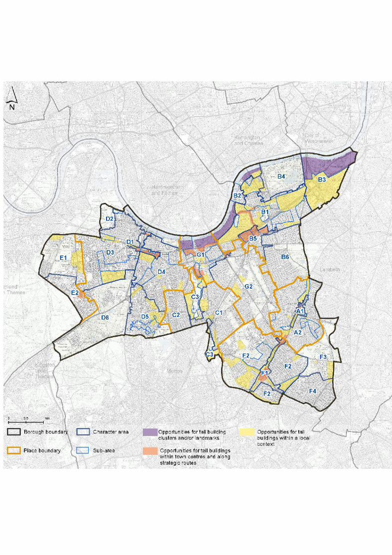
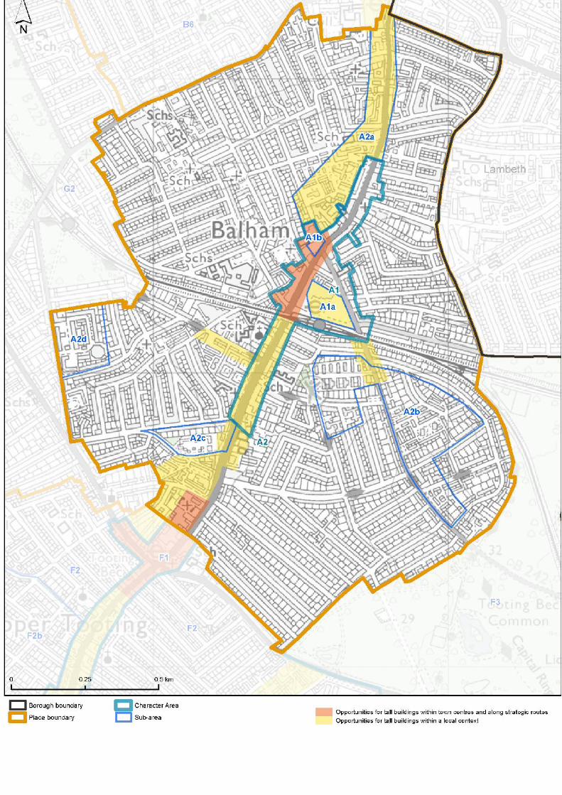


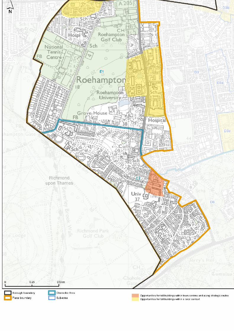
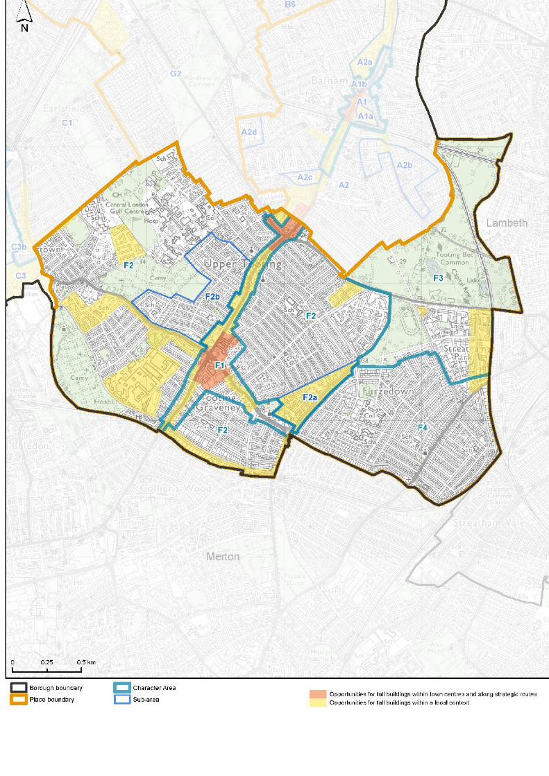
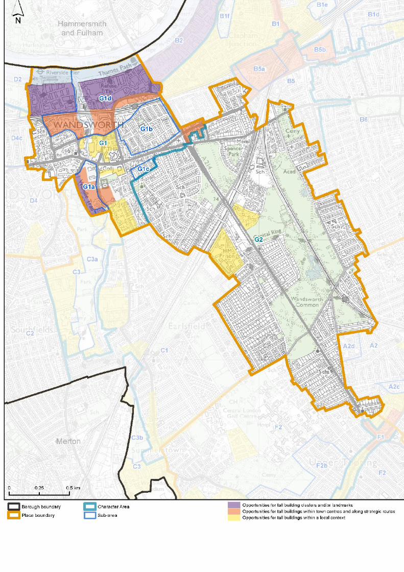

23.15The below should be read in conjunction withPart A of Policy LP 4 (Tall Buildings). The tableidentifies local definitions of ‘tall’, which arebased on the prevailing height of the characterareas/sub-areas shown on the above maps.
23.16Buildings which are either 8 storeys or taller;or are 50% higher than the prevailing height ofthe character area/sub-area within which theyare proposed to be located will be consideredas ‘tall’ (whichever is the smaller).
23.17Each area (e.g. A1) has been split up into anumber of sub-areas (A1a, A1b).
Tall buildingdefinition
Prevailing height(storeys)
Sub-Area code
63-4A153A1a53A1b52-3A264A2a52-3A2b52-3A2c52-3A2d52-3B163-4B1a52-3B1b52-3B1c52-3B1d52-3B1e52-3B1f52-3B1g52-3B2a52-3B252-3B2a86-8B352-3B3a52-3B463-4B563-4B5a63-4B5b52-3B652-3C152-3C251-4C3
N/AN/AC3aN/AN/AC3b63-4D188-9D1a52-3D252-3D352-3D3a63-4D3b85-6D3c
399

85-6D3d52-3D463-5D4a52-3D4b52-3D4c62-6D552-3D5a52-3D652-3E164E252-4F152-3F253F2a52-3F2b52-3F352-3F452-4G163-4G1a52-3G1b52-3G1c53-4G1d53-3.5G2
Table 23.1 Local definitions table
400
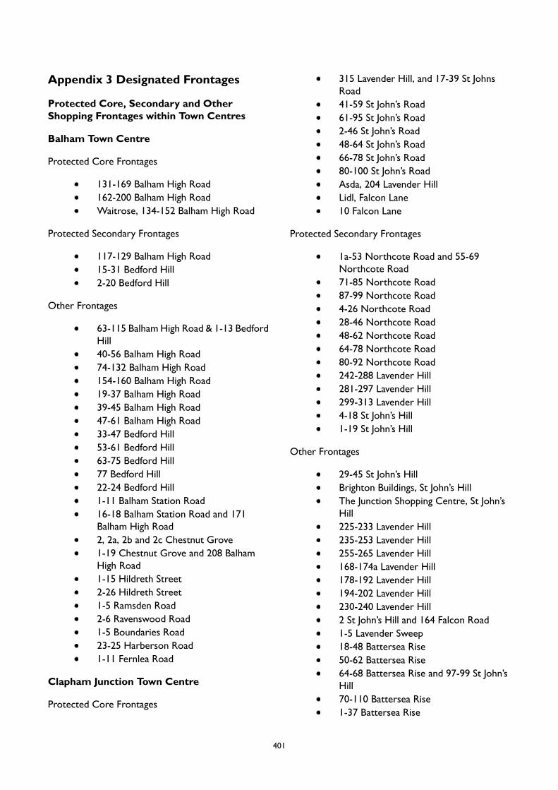
Appendix 3 Designated Frontages
Protected Core, Secondary and OtherShopping Frontages within Town Centres
Balham Town Centre
Protected Core Frontages
131-169 Balham High Road162-200 Balham High RoadWaitrose, 134-152 Balham High Road
Protected Secondary Frontages
117-129 Balham High Road15-31 Bedford Hill2-20 Bedford Hill
Other Frontages
63-115 Balham High Road & 1-13 BedfordHill40-56 Balham High Road74-132 Balham High Road154-160 Balham High Road19-37 Balham High Road39-45 Balham High Road47-61 Balham High Road33-47 Bedford Hill53-61 Bedford Hill63-75 Bedford Hill77 Bedford Hill22-24 Bedford Hill1-11 Balham Station Road16-18 Balham Station Road and 171Balham High Road2, 2a, 2b and 2c Chestnut Grove1-19 Chestnut Grove and 208 BalhamHigh Road1-15 Hildreth Street2-26 Hildreth Street1-5 Ramsden Road2-6 Ravenswood Road1-5 Boundaries Road23-25 Harberson Road1-11 Fernlea Road
Clapham Junction Town Centre
Protected Core Frontages
315 Lavender Hill, and 17-39 St JohnsRoad41-59 St John’s Road61-95 St John’s Road2-46 St John’s Road48-64 St John’s Road66-78 St John’s Road80-100 St John’s RoadAsda, 204 Lavender HillLidl, Falcon Lane10 Falcon Lane
Protected Secondary Frontages
1a-53 Northcote Road and 55-69Northcote Road71-85 Northcote Road87-99 Northcote Road4-26 Northcote Road28-46 Northcote Road48-62 Northcote Road64-78 Northcote Road80-92 Northcote Road242-288 Lavender Hill281-297 Lavender Hill299-313 Lavender Hill4-18 St John’s Hill1-19 St John’s Hill
Other Frontages
29-45 St John’s HillBrighton Buildings, St John’s HillThe Junction Shopping Centre, St John’sHill225-233 Lavender Hill235-253 Lavender Hill255-265 Lavender Hill168-174a Lavender Hill178-192 Lavender Hill194-202 Lavender Hill230-240 Lavender Hill2 St John’s Hill and 164 Falcon Road1-5 Lavender Sweep18-48 Battersea Rise50-62 Battersea Rise64-68 Battersea Rise and 97-99 St John’sHill70-110 Battersea Rise1-37 Battersea Rise
401
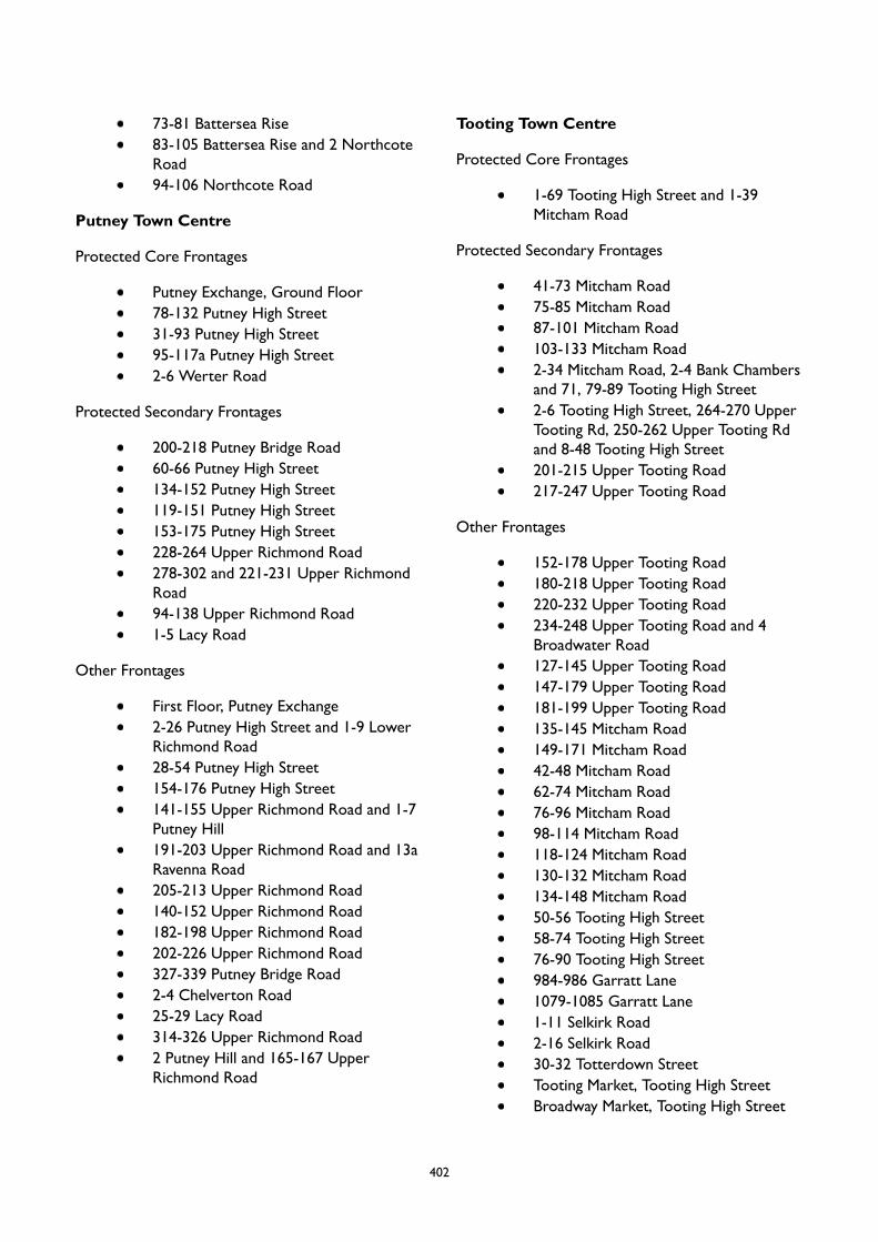
73-81 Battersea Rise83-105 Battersea Rise and 2 NorthcoteRoad94-106 Northcote Road
Putney Town Centre
Protected Core Frontages
Putney Exchange, Ground Floor78-132 Putney High Street31-93 Putney High Street95-117a Putney High Street2-6 Werter Road
Protected Secondary Frontages
200-218 Putney Bridge Road60-66 Putney High Street134-152 Putney High Street119-151 Putney High Street153-175 Putney High Street228-264 Upper Richmond Road278-302 and 221-231 Upper RichmondRoad94-138 Upper Richmond Road1-5 Lacy Road
Other Frontages
First Floor, Putney Exchange2-26 Putney High Street and 1-9 LowerRichmond Road28-54 Putney High Street154-176 Putney High Street141-155 Upper Richmond Road and 1-7Putney Hill191-203 Upper Richmond Road and 13aRavenna Road205-213 Upper Richmond Road140-152 Upper Richmond Road182-198 Upper Richmond Road202-226 Upper Richmond Road327-339 Putney Bridge Road2-4 Chelverton Road25-29 Lacy Road314-326 Upper Richmond Road2 Putney Hill and 165-167 UpperRichmond Road
Tooting Town Centre
Protected Core Frontages
1-69 Tooting High Street and 1-39Mitcham Road
Protected Secondary Frontages
41-73 Mitcham Road75-85 Mitcham Road87-101 Mitcham Road103-133 Mitcham Road2-34 Mitcham Road, 2-4 Bank Chambersand 71, 79-89 Tooting High Street2-6 Tooting High Street, 264-270 UpperTooting Rd, 250-262 Upper Tooting Rdand 8-48 Tooting High Street201-215 Upper Tooting Road217-247 Upper Tooting Road
Other Frontages
152-178 Upper Tooting Road180-218 Upper Tooting Road220-232 Upper Tooting Road234-248 Upper Tooting Road and 4Broadwater Road127-145 Upper Tooting Road147-179 Upper Tooting Road181-199 Upper Tooting Road135-145 Mitcham Road149-171 Mitcham Road42-48 Mitcham Road62-74 Mitcham Road76-96 Mitcham Road98-114 Mitcham Road118-124 Mitcham Road130-132 Mitcham Road134-148 Mitcham Road50-56 Tooting High Street58-74 Tooting High Street76-90 Tooting High Street984-986 Garratt Lane1079-1085 Garratt Lane1-11 Selkirk Road2-16 Selkirk Road30-32 Totterdown StreetTooting Market, Tooting High StreetBroadway Market, Tooting High Street
402
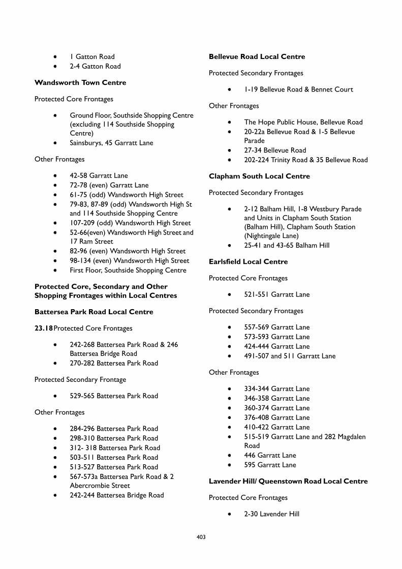
1 Gatton Road2-4 Gatton Road
Wandsworth Town Centre
Protected Core Frontages
Ground Floor, Southside Shopping Centre(excluding 114 Southside ShoppingCentre)Sainsburys, 45 Garratt Lane
Other Frontages
42-58 Garratt Lane72-78 (even) Garratt Lane61-75 (odd) Wandsworth High Street79-83, 87-89 (odd) Wandsworth High Stand 114 Southside Shopping Centre107-209 (odd) Wandsworth High Street52-66(even)Wandsworth High Street and17 Ram Street82-96 (even) Wandsworth High Street98-134 (even) Wandsworth High StreetFirst Floor, Southside Shopping Centre
Protected Core, Secondary and OtherShopping Frontages within Local Centres
Battersea Park Road Local Centre
23.18Protected Core Frontages
242-268 Battersea Park Road & 246Battersea Bridge Road270-282 Battersea Park Road
Protected Secondary Frontage
529-565 Battersea Park Road
Other Frontages
284-296 Battersea Park Road298-310 Battersea Park Road312- 318 Battersea Park Road503-511 Battersea Park Road513-527 Battersea Park Road567-573a Battersea Park Road & 2Abercrombie Street242-244 Battersea Bridge Road
Bellevue Road Local Centre
Protected Secondary Frontages
1-19 Bellevue Road & Bennet Court
Other Frontages
The Hope Public House, Bellevue Road20-22a Bellevue Road & 1-5 BellevueParade27-34 Bellevue Road202-224 Trinity Road & 35 Bellevue Road
Clapham South Local Centre
Protected Secondary Frontages
2-12 Balham Hill, 1-8 Westbury Paradeand Units in Clapham South Station(Balham Hill), Clapham South Station(Nightingale Lane)25-41 and 43-65 Balham Hill
Earlsfield Local Centre
Protected Core Frontages
521-551 Garratt Lane
Protected Secondary Frontages
557-569 Garratt Lane573-593 Garratt Lane424-444 Garratt Lane491-507 and 511 Garratt Lane
Other Frontages
334-344 Garratt Lane346-358 Garratt Lane360-374 Garratt Lane376-408 Garratt Lane410-422 Garratt Lane515-519 Garratt Lane and 282 MagdalenRoad446 Garratt Lane595 Garratt Lane
Lavender Hill/ Queenstown Road Local Centre
Protected Core Frontages
2-30 Lavender Hill
403
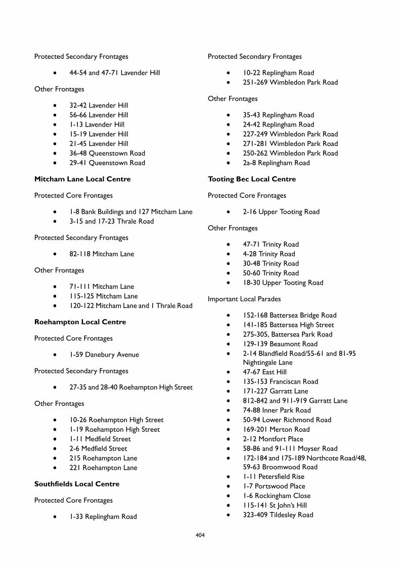
Protected Secondary Frontages
44-54 and 47-71 Lavender Hill
Other Frontages
32-42 Lavender Hill56-66 Lavender Hill1-13 Lavender Hill15-19 Lavender Hill21-45 Lavender Hill36-48 Queenstown Road29-41 Queenstown Road
Mitcham Lane Local Centre
Protected Core Frontages
1-8 Bank Buildings and 127 Mitcham Lane3-15 and 17-23 Thrale Road
Protected Secondary Frontages
82-118 Mitcham Lane
Other Frontages
71-111 Mitcham Lane115-125 Mitcham Lane120-122 Mitcham Lane and 1 Thrale Road
Roehampton Local Centre
Protected Core Frontages
1-59 Danebury Avenue
Protected Secondary Frontages
27-35 and 28-40 Roehampton High Street
Other Frontages
10-26 Roehampton High Street1-19 Roehampton High Street1-11 Medfield Street2-6 Medfield Street215 Roehampton Lane221 Roehampton Lane
Southfields Local Centre
Protected Core Frontages
1-33 Replingham Road
Protected Secondary Frontages
10-22 Replingham Road251-269 Wimbledon Park Road
Other Frontages
35-43 Replingham Road24-42 Replingham Road227-249 Wimbledon Park Road271-281 Wimbledon Park Road250-262 Wimbledon Park Road2a-8 Replingham Road
Tooting Bec Local Centre
Protected Core Frontages
2-16 Upper Tooting Road
Other Frontages
47-71 Trinity Road4-28 Trinity Road30-48 Trinity Road50-60 Trinity Road18-30 Upper Tooting Road
Important Local Parades
152-168 Battersea Bridge Road141-185 Battersea High Street275-305, Battersea Park Road129-139 Beaumont Road2-14 Blandfield Road/55-61 and 81-95Nightingale Lane47-67 East Hill135-153 Franciscan Road171-227 Garratt Lane812-842 and 911-919 Garratt Lane74-88 Inner Park Road50-94 Lower Richmond Road169-201 Merton Road2-12 Montfort Place58-86 and 91-111 Moyser Road172-184 and 175-189 Northcote Road/48,59-63 Broomwood Road1-11 Petersfield Rise1-7 Portswood Place1-6 Rockingham Close115-141 St John’s Hill323-409 Tildesley Road
404

314-324 Trinity Road271-299 Upper Richmond Road349-393 Upper Richmond Road
405
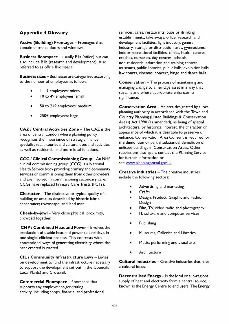
Appendix 4 Glossary
Active (Building) Frontages – Frontages thatcontain entrance doors and windows.
Business floorspace – usually B1a (office) but canalso include B1b (research and development). Alsoreferred to as office floorspace.
Business sizes – Businesses are categorised accordingto the number of employees as follows:
1 – 9 employees: micro10 to 49 employees: small
50 to 249 employees: medium
250+ employees: large
CAZ / Central Activities Zone – The CAZ is thearea of central London where planning policyrecognises the importance of strategic finance,specialist retail, tourist and cultural uses and activities,as well as residential and more local functions.
CCG / Clinical CommissioningGroup – An NHSclinical commissioning group (CCG) is a NationalHealth Service body providing primary and communityservices or commissioning them from other providers,and are involved in commissioning secondary care.CCGs have replaced Primary Care Trusts (PCTs).
Character – The distinctive or typical quality of abuilding or area; as described by historic fabric;appearance; townscape; and land uses.
Cheek-by-jowl – Very close physical proximity,crowded together.
CHP / Combined Heat and Power – Involves theproduction of usable heat and power (electricity), inone single, efficient process. This contrasts withconventional ways of generating electricity where theheat created is wasted.
CIL / Community Infrastructure Levy – Levieson development to fund the infrastructure necessaryto support the development set out in the Council’sLocal Plan(s) and Crossrail.
Commercial Floorspace – floorspace thatsupports any employment-generatingactivity, including shops, financial and professional
services, cafes, restaurants, pubs or drinkingestablishments, take aways, office, research anddevelopment facilities, light industry, generalindustry, storage or distribution uses, gymnasiums,indoor recreational facilities, clinics, health centres,creches, nurseries, day centres, schools,non-residential education and training centres,museums, public libraries, public halls, exhibition halls,law courts, cinemas, concert, bingo and dance halls.
Conservation – The process of maintaining andmanaging change to a heritage asset in a way thatsustains and where appropriate enhances itssignificance.
Conservation Area – An area designated by a localplanning authority in accordance with the Town andCountry Planning (Listed Buildings & ConservationAreas) Act 1990 (as amended), as being of specialarchitectural or historical interest, the character orappearance of which it is desirable to preserve orenhance. Conservation Area Consent is required forthe demolition or partial substantial demolition ofunlisted buildings in Conservation Areas. Otherrestrictions also apply, contact the Planning Servicefor further information orsee www.planningportal.gov.uk
Creative industries – The creative industriesinclude the following sectors:
Advertising and marketingCraftsDesign: Product, Graphic and FashionDesignFilm, TV, video radio and photographyIT, software and computer services
Publishing
Museums, Galleries and Libraries
Music, performing and visual arts
Architecture
Cultural industries – Creative industries that havea cultural focus.
Decentralised Energy – Is the local or sub-regionalsupply of heat and electricity from a central source,known as the Energy Centre to end users. The Energy
406
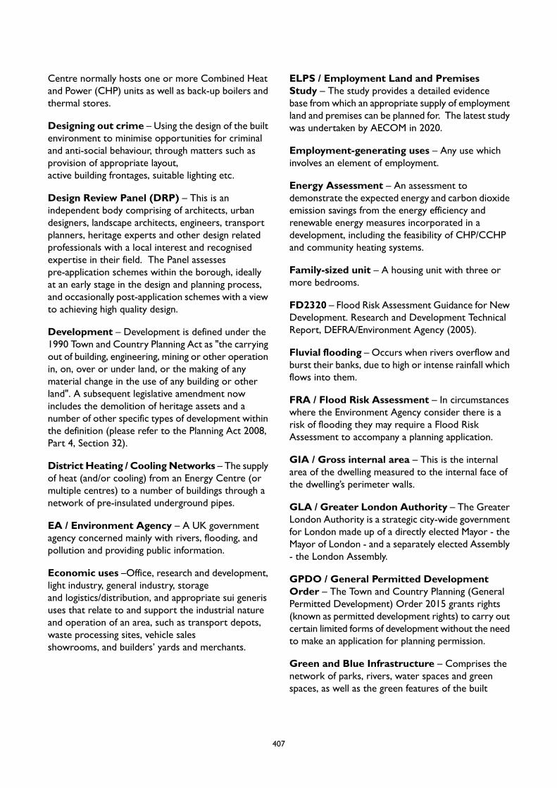
Centre normally hosts one or more Combined Heatand Power (CHP) units as well as back-up boilers andthermal stores.
Designing out crime – Using the design of the builtenvironment to minimise opportunities for criminaland anti-social behaviour, through matters such asprovision of appropriate layout,active building frontages, suitable lighting etc.
Design Review Panel (DRP) – This is anindependent body comprising of architects, urbandesigners, landscape architects, engineers, transportplanners, heritage experts and other design relatedprofessionals with a local interest and recognisedexpertise in their field. The Panel assessespre-application schemes within the borough, ideallyat an early stage in the design and planning process,and occasionally post-application schemes with a viewto achieving high quality design.
Development – Development is defined under the1990 Town and Country Planning Act as "the carryingout of building, engineering, mining or other operationin, on, over or under land, or the making of anymaterial change in the use of any building or otherland". A subsequent legislative amendment nowincludes the demolition of heritage assets and anumber of other specific types of development withinthe definition (please refer to the Planning Act 2008,Part 4, Section 32).
District Heating / CoolingNetworks – The supplyof heat (and/or cooling) from an Energy Centre (ormultiple centres) to a number of buildings through anetwork of pre-insulated underground pipes.
EA / Environment Agency – A UK governmentagency concerned mainly with rivers, flooding, andpollution and providing public information.
Economic uses –Office, research and development,light industry, general industry, storageand logistics/distribution, and appropriate sui generisuses that relate to and support the industrial natureand operation of an area, such as transport depots,waste processing sites, vehicle salesshowrooms, and builders’ yards and merchants.
ELPS / Employment Land and PremisesStudy – The study provides a detailed evidencebase from which an appropriate supply of employmentland and premises can be planned for. The latest studywas undertaken by AECOM in 2020.
Employment-generating uses – Any use whichinvolves an element of employment.
Energy Assessment – An assessment todemonstrate the expected energy and carbon dioxideemission savings from the energy efficiency andrenewable energy measures incorporated in adevelopment, including the feasibility of CHP/CCHPand community heating systems.
Family-sized unit – A housing unit with three ormore bedrooms.
FD2320 – Flood Risk Assessment Guidance for NewDevelopment. Research and Development TechnicalReport, DEFRA/Environment Agency (2005).
Fluvial flooding – Occurs when rivers overflow andburst their banks, due to high or intense rainfall whichflows into them.
FRA / Flood Risk Assessment – In circumstanceswhere the Environment Agency consider there is arisk of flooding they may require a Flood RiskAssessment to accompany a planning application.
GIA / Gross internal area – This is the internalarea of the dwelling measured to the internal face ofthe dwelling’s perimeter walls.
GLA / Greater London Authority – The GreaterLondon Authority is a strategic city-wide governmentfor London made up of a directly elected Mayor - theMayor of London - and a separately elected Assembly- the London Assembly.
GPDO / General Permitted DevelopmentOrder – The Town and Country Planning (GeneralPermitted Development) Order 2015 grants rights(known as permitted development rights) to carry outcertain limited forms of development without the needto make an application for planning permission.
Green and Blue Infrastructure – Comprises thenetwork of parks, rivers, water spaces and greenspaces, as well as the green features of the built
407

environment, such as street trees, green roofs andsustainable drainage systems, all of which provide awide range of benefits and services.
Green Chains – A series of linked open spaces andriver corridors forming extended parkways for thepublic and wildlife corridors in natural surroundings.These can cross borough boundaries.
Green Corridor – Relatively continuous areas ofopen space leading through the built environment,which may link to each other and to the Green Beltor Metropolitan Open Land. They often-consist ofrivers, railway embankments and cuttings, roadsideverges, canals, parks, playing fields and extensive areasof private gardens. They may allow animals and plantsto be found further into the built-up area than wouldotherwise be the case and provide an extension ofthe habitats of the sites they join.
Green Features – Green and sustainable designelements that mitigate climate change, improve thecharacter of an area, and are part of the urbangreening factor.
Green Space – All vegetated open space of publicvalue (whether publicly or privately owned), includingparks, woodlands, nature reserves, gardens and sportsfields, which offer opportunities for sport andrecreation, wildlife conservation and other benefitssuch as storing flood water, and can provide animportant visual amenity in the urban landscape.
Gypsies and Travellers – See emerging LondonPlan policy H14.
Gyratory – A type of road junction at which trafficenters a one-way stream around a central island.
Habitable floorspace – All floorspace used for livingpurposes with a floor to ceiling height of 1.5m or overwithin a habitable room. Floorspace within habitablerooms with a floor to ceiling height of between 0.9mand 1.5m is counted as 50 per cent of its floor areaand any floor area with a floor to ceiling height lowerthan 0.9m is not counted as habitable floorspace.
Habitable rooms – Includes all separate living roomsand bedrooms, and kitchens with a floor area of 13sqmor more. Heritage Asset – A building, monument, site,place, area or landscape positively identified as havinga degree of significance meriting consideration inplanning decisions. Heritage assets are the valuedcomponents of the historic environment. They include
designated heritage assets (as defined in the NPPF)and assets identified by the local planning authorityduring the process of decision-making or through theplan-making process (including local listing).
HIA /Health Impact Assessment – A combinationof procedures, methods and tools by which a policy,program or project may be judged as to its potentialeffects on the health of a population, and thedistribution of those effects within the population.
Historic environment – All aspects of theenvironment resulting from the interaction betweenpeople and places through time, including all survivingphysical remains of past human activity, whethervisible, buried or submerged, and landscaped andplanted or managed flora. Those elements of thehistoric environment that hold significance are calledheritage assets.
Historic Environment Record – Historicenvironment records are information services thatseek to provide access to comprehensive and dynamicresources relating to the historic environment of adefined geographic area for public benefit and use.Typically, they comprise databases linked to ageographic information system (GIS), and associatedreference material, together with a dedicated staffingresource.
HMA / Housing Market Assessment – Ananalytical assessment of local housing markets acrosstenures.
HMO / Housing in MultipleOccupation – Dwellings which are shared by threeor more tenants who form two or more householdsand share a kitchen, bathroom or toilet. HMOs forbetween three and six people are classed as C4whereas HMOs for more than six people are SuiGeneris.
Human scale – scale and form suitable for peopleto interact with and where pedestrians feelcomfortable by the scale and massing of buildings andopen spaces making up the public realm.
ILP / Important Local Parade – A shopping paradeproviding for day to day necessities. This is adesignation within the Local Plan.
Industrial uses – Light industry , generalindustry, storage andlogistics/distribution uses, research and development
408
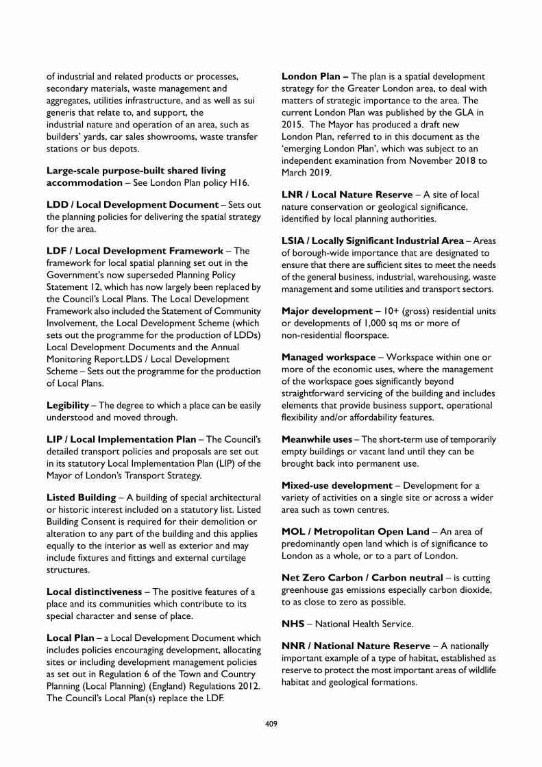
of industrial and related products or processes,secondary materials, waste management andaggregates, utilities infrastructure, and as well as suigeneris that relate to, and support, theindustrial nature and operation of an area, such asbuilders’ yards, car sales showrooms, waste transferstations or bus depots.
Large-scale purpose-built shared livingaccommodation – See London Plan policy H16.
LDD / Local Development Document – Sets outthe planning policies for delivering the spatial strategyfor the area.
LDF / Local Development Framework – Theframework for local spatial planning set out in theGovernment's now superseded Planning PolicyStatement 12, which has now largely been replaced bythe Council’s Local Plans. The Local DevelopmentFramework also included the Statement of CommunityInvolvement, the Local Development Scheme (whichsets out the programme for the production of LDDs)Local Development Documents and the AnnualMonitoring Report.LDS / Local DevelopmentScheme – Sets out the programme for the productionof Local Plans.
Legibility – The degree to which a place can be easilyunderstood and moved through.
LIP / Local Implementation Plan – The Council’sdetailed transport policies and proposals are set outin its statutory Local Implementation Plan (LIP) of theMayor of London’s Transport Strategy.
Listed Building – A building of special architecturalor historic interest included on a statutory list. ListedBuilding Consent is required for their demolition oralteration to any part of the building and this appliesequally to the interior as well as exterior and mayinclude fixtures and fittings and external curtilagestructures.
Local distinctiveness – The positive features of aplace and its communities which contribute to itsspecial character and sense of place.
Local Plan – a Local Development Document whichincludes policies encouraging development, allocatingsites or including development management policiesas set out in Regulation 6 of the Town and CountryPlanning (Local Planning) (England) Regulations 2012.The Council’s Local Plan(s) replace the LDF.
London Plan – The plan is a spatial developmentstrategy for the Greater London area, to deal withmatters of strategic importance to the area. Thecurrent London Plan was published by the GLA in2015. The Mayor has produced a draft newLondon Plan, referred to in this document as the‘emerging London Plan’, which was subject to anindependent examination from November 2018 toMarch 2019.
LNR / Local Nature Reserve – A site of localnature conservation or geological significance,identified by local planning authorities.
LSIA / Locally Significant Industrial Area – Areasof borough-wide importance that are designated toensure that there are sufficient sites to meet the needsof the general business, industrial, warehousing, wastemanagement and some utilities and transport sectors.
Major development – 10+ (gross) residential unitsor developments of 1,000 sq ms or more ofnon-residential floorspace.
Managed workspace – Workspace within one ormore of the economic uses, where the managementof the workspace goes significantly beyondstraightforward servicing of the building and includeselements that provide business support, operationalflexibility and/or affordability features.
Meanwhile uses – The short-term use of temporarilyempty buildings or vacant land until they can bebrought back into permanent use.
Mixed-use development – Development for avariety of activities on a single site or across a widerarea such as town centres.
MOL / Metropolitan Open Land – An area ofpredominantly open land which is of significance toLondon as a whole, or to a part of London.
Net Zero Carbon / Carbon neutral – is cuttinggreenhouse gas emissions especially carbon dioxide,to as close to zero as possible.
NHS – National Health Service.
NNR / National Nature Reserve – A nationallyimportant example of a type of habitat, established asreserve to protect the most important areas of wildlifehabitat and geological formations.
409
NPPF / National Planning PolicyFramework – TheNational Planning Policy Framework sets out theGovernment’s Planning Policies.
NPPG / National Planning PracticeGuidance – The Government’s detailed planningguidance. Also referred to as Planning PracticeGuidance (PPG).
Open Space – All land in Wandsworth that ispredominantly undeveloped other than by buildingsor structures that are ancillary to the open space use.The definition covers the broad range of types of openspace in Wandsworth, whether in public or privateownership and whether public access is unrestricted,limited or restricted. It includes land designated asopen spaces, such as Metropolitan Open Land, as wellas non-designated land.
Open Workspace – Places where businesses andprofessionals share space, facilities, and/or specialistequipment, in order to reduce costs. Examples includeco-working spaces, incubators, artists’ studiosand maker-spaces.
Other Site of Nature Importance – Locallyimportant site of nature conservation, identified bythe local authority for planning purposes, which has asignificant value on account of its flora and/or faunacontent.
Parklet (Pocket park) – A small seating area orgreen space created as a public amenity on oralongside a pavement.
Permeability – The degree to which an area has avariety of pleasant, convenient and safe routes throughit.
Planning Condition – A condition imposed on agrant of planning permission (in accordance with theTown and Country Planning Act 1990).
Policies Map – A Local Development Documentillustrating geographically the application of policies inthe Council’s Local Plan(s). The Policies Map replacesthe Proposals Map. Prior to the Town and CountryPlanning (Local Planning) (England) Regulations 2012the Proposals Map was not previously a Local PlanDocument in its own right.
Previously developed land – Land which is or wasoccupied by a permanent structure, including thecurtilage of the developed land and any associatedfixed surface infrastructure. Does not includeresidential gardens.
PTAL / Public Transport Accessibility Level – Ameasure of the relative accessibility of buildings anduses by public transport. The higher the PTALscore (between zero to six), the better theaccessibility.
Public Open Space – This includes parks, recreationgrounds and gardens provided by the local authorityor central government for public use even if they areclosed at certain times. Public open space does notinclude school playing fields or the amenity areasassociated with the development of homes or flats orpedestrian precincts. The River Thames path to whichthe public have unrestricted access is also consideredlocally to be public open space.
Public Realm – The space between and withinbuildings that is publicly accessible, including streets,squares, forecourts, parks and open spaces.
Renewable Energy / Renewables – Energygenerated from sources that are non-finite or can bereplenished, e.g. solar power, wind energy, powergenerated from waste, biomass.
Retrofitting – The addition of new technology orfeatures to existing buildings in order to make themmore efficient and to reduce their environmentalimpacts.
S106 / Section 106 Agreement – Refers to Section106 (S106) of the Town and Country Planning Act1990 allows a local planning authority to enter into alegally-binding agreement or planning obligation witha landowner in association with the granting ofplanning permission. The obligation is termed a Section106 Agreement.
SA / Sustainability Appraisal – A SustainabilityAppraisal is used by planning authorities to assesswhether proposed plans and policies meet sustainabledevelopment objectives, and is mandatory under thePlanning and Compulsory Purchase Act 2004. The aimis to promote sustainable development through theintegration of social, environmental and economicconsiderations into the preparation of new or revisedDevelopment Plan Documents (DPD) and
410
Supplementary Planning Documents (SPD). It is similarto a SEA, but includes assessment of social andeconomic inputs, in addition to environmental inputs.
SAC / Special Area of Conservation – Areasdesignated to protect the species listed in annex I andII of the European Union's Habitats Directive(92/43/EEC) which are considered to be of Europeaninterest following criteria given in the directive.
SAP / Standard Assessment Procedure – usedto assess the energy performance of residentialdwellings.
SEA / Strategic Environmental Assessment – Anassessment of the effects of certain plans andprogrammes on the environment, known as theStrategic Environmental Assessment or SEA Directive,required by the European Directive 2001/42/EC.
Self/custom-build development – The Housingand Planning Act 2016 defines self-build and customhousebuilding as “the building or completion byindividuals, associations of individuals, or personsworking with or for individuals or associations ofindividuals, of houses to be occupied as homes bythose individuals... [but] does not include the buildingof a house on a plot acquired from a person whobuilds the house wholly or mainly to plans orspecifications decided or offered by that person.”
Sense of place – The unique perception of a placecreated by its local buildings, streets, open spaces andactivities. The more distinctive the place the greaterthe sense of it being special. A character which isgreater than the sum of the constituent parts.
SFRA / Strategic Flood Risk Assessment – anassessment of flood risk in Wandsworth based onmaps produced by the Environment Agency showingwhich areas are most likely to be affected by flooding.The maps show three different zones referring to theprobability of river and sea flooding, ignoring thepresence of flood defences. The Strategic Flood RiskAssessment will also take into account other types offlooding, to produce more detailed flood risk mapsthat can be used to help guide land use allocationswithin the borough.
Short Term Lettings – these can also includeholiday lets and require specific planning consent underthe Greater London Council (General Powers) Acts1973 and 1983.
Significance (of heritage) – The value of a heritageasset to this and future generations because of itsheritage interest. That interest may be archaeological,architectural, artistic or historic.
SIL / Strategic Industrial Location – Sites ofLondon-wide importance designated to ensure thatLondon provides sufficient sites, in appropriatelocations, to meet the needs of the general business,industrial, warehousing, waste management and someutilities and transport sectors.
SINC / Site of Interest for NatureConservation – A site generally identified for specialprotection because of its local importance for floraor fauna.
SME / Small and Medium sizedEnterprises – This includes all micro, small andmedium sized businesses (see Business Sizesdefinition).
Solar Glare / Dazzle – Glare or dazzle that canoccur when sunlight is reflected from a glazed façade.For vertical facades this problem usually occurs onlywhen the sun is low in the sky.
SPDs / Supplementary Planning Document – Adocument expanding polices set out in Local Plans(Development Plan Documents) or providingadditional detail.
Specialist Housing for Vulnerable People – Itbrings together a range of dwelling types (andassociated services and care services) that enable arange of people to access suitable housing as well aslive safely and securely in their own home.While olderpeople are a prominent user group in the form ofextra-care and sheltered housing, other groups includevictims of domestic violence, the homeless, peoplewith mental health needs and those with people withlearning disabilities.
SPGs / Supplementary Planning Guidance – Asabove, being replaced by SPDs at the borough-level,but will continue to be produced by the Mayor ofLondon.
SSSI / Site of Special ScientificInterest – Protected area of land considered worthyof protection and of special interest by reasons of anyof its flora, fauna or geological features, under theWildlife and Countryside Act 1981.
411
SUDS / Sustainable Drainage Systems – Asequence of management practices and controlstructures designed to drain surface water frombuildings and hardstandings in a sustainable way.
Sui Generis – Uses which do not fall within any UseClass.
Sustainable Communities – Communities whichare economically and socially safe, vibrant, and thriving,whilst finding a balance with the surroundingenvironment.
Sustainable Community Strategy – Localauthorities were required by the Local GovernmentAct 2000 to prepare these, with aim of improving thesocial, environmental and economic well being of theirareas. In Wandsworth, the objectives in the SCS havebeen reviewed and updated in the Council’s CorporateBusiness Plan.
TA / Transport Assessment – A documentproduced in support of a planning application wherethe development will have significanttransport implications, and taking into account themeasures which are required to improve road safetyand promote walking, cycling and the use of publictransport. The scope and content of the Assessmentis determined by the scale, travel intensity and travelcharacteristics of the proposal. Transport Assessmentsreplace Traffic Impact Assessments.
Temporary Uses – Uses falling within classes A1,A2, A3, A4, A5, B1, D1 and D2 are permitted tochange to A1, A2, A3, or B1 for a period up to 2 years- (interchangeable with notification). Changes of usefrom A1 are limited to 150 sq ms.
TfL / Transport for London – a statutory bodywith a duty to develop and implement policies topromote and encourage safe, integrated, efficient andeconomic transport facilities and services to, from andwithin London; to provide or secure the provision ofpublic passenger transport services, to, from or withinGreater London; to regulate the way in which thepublic uses highways and is also the licensing authorityfor both hackney carriages (taxis) and private hirevehicles (minicabs).
TLRN / Transport for London RoadNetwork – A road that forms part of the Transportfor London Road Network, comprising 550km ofLondon's red routes and other important streets.
Touchdown Space – An agile and local laptopcentric, informal setting such as a privateconcentration room, lounge, presentation room, ora collaborative area. An appropriate town centre use.
Town Centre Uses – The NPPF defines main towncentre uses as including retail development; leisure,entertainment and more intensive sport and recreationuses (including cinemas, restaurants, drive-throughrestaurants, bars and pubs, nightclubs, casinos, healthand fitness centres, indoor bowling centres and bingohall); offices; and arts, culture and tourismdevelopment (including theatres, museums, galleriesand concert halls, hotels and conference facilities).
TP / Travel Plan – A travel plan (sometimes referredto as a green travel plan) is a package of actionsdesigned by a workplace, school or other organisationto encourage safe, healthy and sustainable traveloptions.
TPA / Thames Policy Area – Defined in theLondon Plan as a special policy area to be defined byboroughs in which detailed appraisals of the riversidewill be required.
TPO / Tree Preservation Order – A treepreservation order is an order made by a localplanning authority in respect of trees or woodlands.The principal effect of a TPO is to prohibit the cuttingdown, uprooting, topping, lopping, wilful damage, orwilful destruction of trees without the LPA's consent.
Urban Logistics Hubs – These are microhubs forlogistics facilities which are used for last mile deliveriesby electric vans or cargo bikes which serve a limitedspatial range. They are located in sustainable urbanlocations, in areas that are connected to the widerroad and rail networks, railway stations and towncentres.
UDP / Unitary Development Plan – Statutoryplans produced by each borough which integratedstrategic and local planning responsibilities throughpolicies and proposals for the development and useof land in their area. These were replaced by LocalDevelopment Frameworks, which in turn have beenreplaced by Local Plans.
Visitor Accommodation – Leisure and businessaccommodation that provides temporary overnightaccommodation on a commercial basis, includingserviced accommodation such as hotels, bed and
412
breakfast, guesthouses, hostels and campusaccommodation, and non-serviced accommodationsuch as self-catering apart-hotels, caravans andcamping.
Vulnerable people – Someone who is or may be inneed of care and / or support by reason of disability,age or illness; and is, or may be unable to look afterthemselves against significant harm or exploitation.
Waste Hierarchy – This establishes a preferentialcategorisation based on the environmental and qualityof life impacts, as follows: prevention or reduction;reuse and preparing for reuse; recycling; otherrecovery; and disposal.
Workspace – A generic term that refers to any spaceused for an economic/employment use. It is sometimesused in other documents to refer to SME workspaceor managed workspace specifically; that is not how itis used in this document.
Zero Carbon – describes an activity where nocarbon was produced in the first place. For example, ahouse that’s off the grid and is completely poweredby renewable energy would be zero carbon.
413

For more information write to:Planning Policy and Design,
Environment and Community Services,Town Hall,
Wandsworth High Street, London SW18 2PU
Telephone: (020) 8871 6649 / 6650 / 7218 / 7420email: [email protected]
or visit our website: www.wandsworth.gov.uk/planning
Designed and produced by Wandsworth Design & Print. [email protected] EC.523 Main doc (12.20)