Village & Town Directory, Barddhaman, Part XIII-A, Series-23 ...
579
CENSUS OF INDIA 1981 SERIES-23 WEST BENGAL DISTRICT CENSUS HANDBOOK PART XIII-A VILLAGE & TOWN DIRECTORY BARDDHAMAN DISTRICT N. GHOSH of the Indian Administrative Service Director of Census Operation r!"7estBengal
-
Upload
khangminh22 -
Category
Documents
-
view
1 -
download
0
Transcript of Village & Town Directory, Barddhaman, Part XIII-A, Series-23 ...

CENSUS OF INDIA 1981 SERIES-23
WEST BENGAL
DISTRICT CENSUS HANDBOOK
PART XIII-A
VILLAGE & TOWN DIRECTORY
BARDDHAMAN DISTRICT
N. GHOSH of the Indian Administrative Service
Director of Census Operation r!"7estBengal

Price : (Inland) Rs. 15.00 paise
( Foreign ) £ 1'75 or 5 $ 40 cents
PUBLISHED BY THE CONTROLLER
GOVERNMENT PRINTING~ WEST BENGAL AND
PRINTED BY APARAJITA PRINT HOUSE
91-A~ BAITH~KKHANA ROAD,

CONTENTS
1. Foreward
2. Preface
3. ACknowledgements
4. Important Statistics
5. Analytical Note
(i) Census Concepts: Rural and urban areas, Census House/Household, ~cheduled Castes/Scheduled Tribes, Literates, Main workers, Marginal workers, Non-workers etc.
(ii) Brief History of the District Census Handbook.
(iii) Scope of village Directory
(iv) Scope of Town Directory.
(v) Brief History of the District
(vi) Physical Aspects
(vii) Major Characteristics
(viii) Places of religious, Historical or ArchaeologicaJ importance in the villages
Ilnd Places of Tourists interest.
(ix) Brief Analysis of village Directory and Town Directory Data.
Section I ViJlage Directory
1. Chittaranjan Police Station.
(i) Alphabetical List of Villages
(ii) Village Directory Statemeat
2. Salanpur Police Station.
(i) Alphabetical List of Villages.
(ii) Village Directory Statement.
3. Kolti Police Station.
(i) Alphabetical List of Villages.
(ii) Village _Directory Statement.
Page
VII
IX
XI
XII
1
3
5
6
12
16
16
17
22
23
43
44
46 48
57
58

4. Hil'apor ponce StatioD.
(i) Alphabetical List of Villages-~
(ii) Village Directory Statement.
5. Asansol police Station.
(i) Alphabetical List of ViII ages.
(ii) Village Directory Statement_
6. Barabani Police Station.
(i) Alpha.betical List of Villages.
(ii) Village Directorv ~tatement.
7. Jamuria Police Station.
(i) Alphabetical List of Villages.
(ii) Village Directory Statement.
8. Raniganj Police Station.
(j) Alphabetical List of VilJages.
(in Village Directory Statement.
9. OndaI Police Station.
(i) Alphabetical List of Villages
(ii) VilIllge Directory Statement.
10. Faridpur Police Station.
(i) Alphabetical Tjst of Villages.
(ii) Village Directory Statement.
11. Dur~apur Police Station
(i) Alphahetical List of Villages.
(ii) Villa.ge Directory Statement.
12. New TOWD~hip Police Statoin.
(i) Alpbabetic~l List of Villages.
(ii) Village Oirectorv Statement.
13. K aksa Police Station.
(i) Alphabetical List of Villagei.
(ii) Village Directory Statement.
14. Bud-Bud Police Station.
(i) Alphabetical List of Villages.
(ii) Village Directory Statement.
( iv )
65
66
71
72
77
78
84
86
95
96
JOI
102
J08
110
117
JI8
121
124
12fi
128
139
140

( ,v _)
15. Ausgram Police Station.
(i) Alphabetical List of Villagcs. 149 (ii) Village Directory Statement. 152
16. Galsi Police Station.
(i) Alphabetical ~ist of Villages. 16'8 (ii) Village Directory Statement. 170
17. Khandaghosh Police Statement.
(i) Alphabetical List of Villages. 184 (ii) Village Directory Statement. 186
181. Raina Police Station.
(i) Alphabetical List of Villages. 198 (ii) Village Directory Statement. 202
19. JamaIpur Police Station
(i) Alphabetical List of Villages. 226 (ii) ViIla(\"e Directory Statement. 228
20. Memari Police Station.
(i) Alphabetical List of Villages. 242 (ii) Village Directory Statement. 246
21. Barddhaman Police Station.
(i) Alphabetical List of Villages 271 (ii) Village Directory Statement. 274
22- Bhatar Police Station.
(i) Alphl\betical List of Villages. 292 (ii) Village Directory Statement. 294
23. Mangalkote Police Station.
(i) Alphabetical List of Villages. 306
(ii) Yillage Directory Statement. 308
24. Ketugram Police Station.
(i) Alphabetical List of Villages. 322
(ii) Village Directory·Statement. 324
25. Katwa Police Station.
(i) Alphabetical List of Villages. 239
(ii) Village Directory Statement. 342

26. Manteswar Police Station.
(i) Alphabetical List of Villages.
(ii) Village Directory Statement.
27. Purbasthali Police Station.
(i) Alphabetical List of Villages.
(Ii) Village Directory Statement
28. Kalna Police Station.
(i) Alphabetical List of Villages.
(ii) Village Directory Statement
( vi )
Appendix-I Police Stationwise Abstract of Amenities
Appendix-II Land utilisation data in respect of Non-Municipal Towns.
Appendix-III Police Stationwise List of Villages where no amenities are available.
<Appendix-IV List of Villages according to the proportion of Scheduled Castes and
Scheduled Tribes to the total population by ranges.
Statement-I
Statement - II
SECTION-II TOWN DIRECTO RY
Status and growth history
Physical Aspects and location of Towns, 1979
Statement-III Municipal Finance, 1978·79
Statement-IV Civic and other amenities 19i9
Statement-IV A Civic and other amenities in notified Slums 1979
Statement-V Medical, Education~l, Recreational and cultural FacilitieS 1979
Statement-VI Trade, Commerce, Industry and Banking, 1979
Appendix Towns Showing Their outgrowth with Population.
359
362
379
382
402
406
428
432
434
439
508
520
528
536
M6
548
562
570

FOREWORD
The district census hand book (DCH), compiled by the Census Organisation on behalf of the State Govern
ments, is one of the most valuable products of the Census. The DCH is constantly referred to by planners,
administrators, academicians and researchers. It is inter alia used for delimitation of constituencies, formu
lation of local level and regional plans and as an aid to District administration, The district census hand.
book is the only publication which provides Primary Census Abstract (PCA) data upto village level for the
rural areas and wardwise for each city or town. It also provides data on infrastructure and amenities in villages and towns, etc.
The d;strict census handbook series was initiated during the 1951 Census. It contained important census
tables and FeA for each village and town of the district. During 1961 Census the scope of the DCH was
enlarged and it contained a descriptive account of the district, administrative stati~tics, census tables and
a village and town directory. including PCA. The 1971 DCH series was planned in three parts. Part-A
related to village and town directory, Part-B to village and town PCA and Part-C comprised analytical
report, administrative statistics, district census tables and certain analytical tables based on PCA and amenity
data in respect of villages. However, in some states it was confined to district census tables and in a few
cases altogether given up due to delay in compilation and printing.
While designing the format of 1981 DCH series some new features along with the restructuring of the
formats of village and town directory have been attempted. At the same tIme, comparability with the 1971
da.a has also been kept in view. All the amenities except power supply in the village have been brought
together in the village directory with the instruction that in case an amenicy is not available in the
referrent village the distance in broad ranges from the nearest place where the amenity is available may be
given. The restructuring of the format of the village directory and incorporating more exhaustive data on
infrastructure aspect particularly in relation to amenities and land-use pattern is expected to further meet
the need of micro level planning for rural areas. It is expected to help not only in local area planning but
regulating the provision of goods and services as well so as to minimise the regional imbalances in the
process of developme.lt. A· few new items of in~ormation have also been introduced to meet some of the
requirements of the Revised Minimum Needs Programme. Such new items of information as adult literacy
centres, primary health sub-centres, and community health workers in the village have been introduced in
the village directory with this objective in mind. The new item on approach to the village is to have an idea
about the villages in the district which are inaccessible. A new column, "total population and number of
househ.olds" has been introduced to ex'amine the correlation of the amenities with the population and
number of households they serve. Addition of two more appendices listing the villages where no amenities
are available and according to the proportion of scheduled caste and scheduled tribe population to the total
population has also been made wl,h t;.js view in mind.

VIII
The formats of the town directory have also been modified to meet the requirements of the.Minimum,Needs
Programme by. providing information on a f~w new items. A new, statement on civic and other amenities
in slums in Class-I and Class-II towns (Statement IV-A) bas been introduced with this objective in ~ind. ( I I •
I~ is e;xpected that ,this Will"p.elp the plan~ers to chalk out pro~ammes on provision,' of civic am~nities for . . I',. . (:',
the improvement of slums, The columns on Scheduled Castes and Scheduled Tribes'population in statement , ( . ,
IV relating to',9ivic and 'ot~er amenities ~d adult liter8;cy clfl-sses/cejttres ~der educational facilities in , I ' .' .• ) ! . ~"
statement Vare also add~ inter, alia with this view. A significant addition is Class of town in an the seven . • , t. ..,' ,', ' 'y, !,
statements of the town directory. The infrastructure of amenities in urban areas of the' couritry can be best
analysed by taking the class of town into consideration. The addition of the collins on civic administration
status and poptdatlon in a few statementSalso serVes 'this putpose:
The, format ~f the, primary ce,nsus, abstract for th~ villages and to~ns has been formulated'in the light of
changes in the economic and other questions canvassed thro~gh the individual slip of 1981 Census. ~ . . ' ,
In order to avoid delay in publication;of 1981, DCH series it has been so designed that Part""7\A of the .' _. • 'I • \.
volu,me contains village and town direct<:>ry and Part ..... B, ,the PCA of villages and ,~owns including the
S~4~u.1ep Cl;l.st,es and Sche4-u~ Tribes PGA, up~o ~olice S~ati?n/Town levels. At, the beginnin~ of the
DCH a detailed analytical note supported by a nl,l.mber of inset tables based on PCA and non census data in ".' •••• • I , .,
relation to the infrastructure has been introduced to enhance its value. The District and Police Station jevel } " "', ' . , :. ;' , ' . ' .' "
maps depicting the boundaries and other Impotant features have been insl1rted at appropriate places, to
further enhance the value of the publication. ' ,
l'hls ,publication ,is a joint venture of the State 9overnm~nt and "tqe Cen~s Organisation. The ,data have .' . , , ,
been. coll~ted and compiled in .the state under the direct~on of ~Shd s.., N~ . G;osh, I.A.S. tl,le Director of
<;:ensus operations, West Bengal on behalf of the State Go'Ve~ment~ich ~as bo~e the cps! of pri~ti:q.g.
The task of planning, designing. andco .. ord#nation of this publica~on ~as carr~d outl by S~ri N. G. Nag,
Deputy Registrar General (S9cial S~udies) of ~y ~ffi~e. D,r. B. K. Roy, Oep~ty Registrar Genaral (Map)
provided the technical guidance in the preparat~on. of ;the maps ... Data receive~ from Census I;lirectofates
have been scrutinised in the Social studies Division at the headq\1l,l.rters under \the guidance of Shri M. M. - •• • ,. 1
Dua, Senior Researeh officer. 1,am thankful to all who have contributed in this project.
P. PADMANABHA
New Delhi \ ,
Re~istrar General, India \
the 26th April,,1982

PREFACE
The Di~triC1i Census Handbook chmpiled by the Census Directorate, West Bengal, on beh~lf of the·Govt.' of i . , t r I' " :; .' r···. .
W~t Bengal, containing Census Statistics b~sides'other invaluable data of importance for use by the State
Govt., district admi~is~ration, research schollm: and various other data-users owes its origin to I9St-'Census. , ! ., . ,
The present publication of 1981 Census is fourth in the series. ~ .' .
i The Cen,sus of 1981 was conducted in February,. 1981 with sunrise of] st March, 1981 as, reference date
under the stewardship of Shir S. N. Ghosh, Director ofCenslls Operations, West ,Bengal. The credit. for
the success of the operation goes entitely to Shri Ghosh. However, before the report could be finalised,
Shri Ghosh had to resume hi~ . duties under the Govt. of. West Bengal in public' interest. The presnt
publication is the p~oduct of his dedicated labour, immaculate planning and sterling administrative :capabili
ties. Without the active inv~lvernent and'inspiring leaderShip ofShd Ghosh, the present publication would
bave bee~ a still birth,
The Census' St~ti~t'ics in the form of 'VIllage and Town Directory indued in the publication relate to the
district of'Barddhaman. A' brief analytical note with a number of inset tables based on Census. data, included
in' this publication, will' hopefully meet the requirements of the readers.
As mentio~ed earlier, the 1981 Census operation in West Bengal was conducted by Shri S. N. Ghosh, as
Director of Census Operations under the inspiring captaincy of Shrf:P. Padnianabh,' former Regis'trar
General and ex-officio Census Commissioner of India whose imaginative planning, enthu:siastic support and
elec'trifying guidLnceled us to successful completion of an undoubtedly difficult operatIon .. We silently recall
the contribution of Shri Padmanabha. ,
Shri V. ,So Verma, the present Resistrar General, India has been guiding us soon after his assumption of
office in 1983 to oversee the timely completion of the proJect. Without his aClive support~ d~ep underst
anding and mature guidance, the publication would not have progressed much. We are gr~teful to
Shri Verma.
We gralefully recall the help, guidace and advice received from Shri V. P. Pandey, Joint Registrar General,
India in technical and adll'inistrative matters relating to this project.
Dr. N. G. Nag, Deputy Registrar General (Social Studies) and his colleagues has pro-vided us technical
guidance and scholarly assistances right from the start of the project. We acknowledge our debt to him
and his colleagues.
We are also indebted to Shri K. K. Chakraborty former Deputy Registrar General (C & T) and Shri N.
Rama Rao, Asstt Registrar General, for their helpful suggestions. Dr. B. K. Roy, Deputy Registrar General
(Map) had provided us excellent support and guidance in cartographic matters. We are indebted to him.

x The data presented in the volume were collected at grass-root level by the District Magistrate, Barddhaman
(principal Census Officer) and his innumerable colleagues including the Charge Superintendents. We
acknowledge their contributions ~o the preparations of this valume.
'Jbe ,final 'tabulation. and compilation of datf\ have been done by the Central :rab,ul~t,jon 'Quit of ,this office
under the superv:isiol;' of SriS. K. Guha, 'Investigator, first· under, the guidance ,!lnd i . supervision of .Shri
M. N. Sarkar, :Asstt. pjr~~to:r of Census Oper~tion~ (since retired) and later under Shd A. K. ~tta, Dep;uty
Director of Census Operations, West Bengal. Without their tlincere efforts .the data could not have been
finalised,. Thel ~ll~ly~ica~ llot~ :flas prepared ,by, Shri ~. K' G!1ha, I?vestigator and ,sc~tinised, edited and
fin~lised by' S~ri A K. Dutta, Deputy Directo! of Census OperatIons, West Bengal. The publication is a t ,., '
silent te~tin;l.OnY to their labour and lov,e .
. The priIltingwork was superviseQ,very efficiently ~y Sliri S~ K. Guha, Investigator, unper the able guidance
Qf .Sri A; K. Dutta, Deputy Director without whose ~irect involvement the publication could not have seen'
t~ Ught of the day. ' We recall Shri Datta's effecti:ve contribution with admiration;
There were also officials who had contributed to the project from behind the curtatin. Alnong ofticials of
the State Govertililent who h~d helped us in v~Fious stages .of the publication are ;S,.ri K. J. Basu Roy . .
. £Mlldhury, WBCS. and Shti :B. Bhattacharyya, WBcS~ 80th Deputy Secretaties to the Govt. of West Bengal
Home (C & E) Department, Write($' Buildings, Calcutta and their colleagues to ;wholp we pay our tribute.
Mention should. also be made ~f the Controller pf Stationery, Govt. of West Bengal, for kindly providing {. " , , us the necessary printin~ materials.,
Lastly, we mus.t e;'tpress our appreciation toApar~j(ta Print Housti, 91/Pf.~ Ba;ithakkhana Road, Ca1~~tta-
7i)O 009' for the printing of this Publication,
Calcutta
~ukumar Sinha Joint njr~tor of CensllS OperatiQns,
~est Bengal

No.
1. ~t., 2. ti 3. :.)
4. H
5. Sri
6. "
7. •• 8. Snn. 9. ..
10. ,. 1 I. ," 12, ~
13. .~"
14. " .. ]5. '. ) 6. ')
'. , "
] 7. f)
" ) 8. "
'I'
19. '1',
20. ,,, 21. , 's'
22. n'
23. Sri
24. ., "
2$. Smt. 26. 'Sri
27. "
28. " "
29. "
30. Smt.
31. ~,
AC K N O:WL B D:.O EiMR~T.S
Name
~jali DaB,]
Sucheta DW',a'
Gita Chatterjee ~: .) r' -
Kiran Biswas , r'·' ~ikbil Bag,e~i Maoas Mitra '
SamareslJ Banerjee( Banani Ghosh. Nira Chakr'lilfohy'
Mira Baneric=c ' , I ~ , " i
Kalpana CM:\Vdhury
Pravati Muna.hi , l, '~, ,
Nandita Dutta (, \',; ,': 1.
Renukana Chatterjee
Dipti Chatterjee
Anita MuItUerjee
Sabba &rdban
Bandana S'eil:Chowdhury
Atashi D~gupta
Sabita B~a:~<:o
Namitta Chatterjee
Dipali Roy, Cbowdbury
Gouri Sankar Chatterjee
Pr2Santa Kumar Burman
Supti Ch,attetjee ,
Bibs R~y
SushiI Dutta
Sajjat Alit
Umasankar· illhattacharya
Mill Bhowmick
Manjusht;ee r~aha Chowdhury I
Designation
Statistical Asistant
-do-
-do-
-do-
:omputor
-do-
-do-
~cfo
-do-
-do-
-do-
-de-
-®-'-4Q;' , -do-1',0,,'
-do-
-do
-do-
-db.
-do-
-do-
Proof reader:
.~~-,
,-dq-do-
-do-
-do-" '
'~o-
.. do
--do·

IMPGBTANJ' SUDSl1CSJ
WESTBBNGAL BARDDHAMAN
Population Total Persons 54,580,647 4,835,388 Males 28,560,9(n: I ~S48, {)(J!'
Females 26,019:7'" 2,286;185 """,' -. ,i)
Rural Persons 40,133;926 3,414,219 Males 20,617,489 rl~765,~~7
IL'''' Females 19.5J6,431 1.648,522
Urban Persons 1+,446,72.:1 ,P,42J,169 Males 7,943,412, 782,~.
Femals 6,5QI,309- , 638,2~3
Decennial P9~\l~lation Growth Rate 1971·81 Total +2~~i7 . +23'47 Rural -+f ~O~'16;, +12'90 Urban +3f"'~I' +59--33
Area in (Sq.-Kms ) ~~,,752'u , 7,024'0 Density of Population (Per Sq. Kms) 615 688
Sex-ratio (Nu~ber of Females Per 1,000 Males) Total . '9l'1' ,897 Rural 948· 9.~4 Ui-ban '&9< ,815
Letcracy Ra\f>~ Perso~s 40'94 42'43 Males 'gb'67 . '1'29 Females 30'25 32'56
Percen~U~ Population to Total Pbpulation 26:47 29'39
Perccntage to 'Total Population:
(1) 'Main Worken Persons ;It~fi 28'20 Males 48'72 47'91 Females S'8,1 6.24 r,., '
(ii) ,Marginal Workers Persons J'91 . .2.41 Males 'l'SS:> 2'10 Females 2'26 '.r'l·15
(iii) Non-Workers Persons 69'-S-3 69'39 "
Males 49'70 49'99
Females 91'93 91'01

XUi
. Break up of Main W9Tkers :
Percentage among Main Workei'&
(i) Cultivaters Persons 29·76 23-26';: Males 31'40 25'26 Females 14'6; 6'17
{ii: :JurCfS Persons 25'23 30'56 Males 23'69 2671
Females 39'43 63'54
(iii) Household Industry Persons 3'52 S'21 Males 3'09 2'90 Females 7'50 5'79
(iv) Other Workers Persons 41-4·9 32'97 Males 41'82 45'13 Females 32'40 24'50
Percentage of Scheduled Castes
Population to Total P\)pulation Persons 21'99 25'09 Males 21'82 24'59
Females 22'17 25'66 Percentage of Scheduled Tribes
Population to Total Population Persons 5-63 5'75 Males 5'46 5'58 Females 5'81 5'94
Number of Occupied Residential Houses 9.591.501 882.754
Number of Villages Total 41.112 2,679 Inhabited 38,024 2,570 Uninhabited 3,088 109
Number of Towns 291 49


ANAL YTICAL NOTE


I
ANAL¥TICAL NOTE It has been the traditidn of the InJia~ C-ensus to present the census data under the two broad divisions teTmed
I
urban and rural.
The definition of an utpan unit at the 1981 C~nsus is as follows:
(a) All places ")Nith a Corporation, Municipality, Town Committee, Notified Area, Cantonment.
(b) All ~ther pl<ices which satisfied the following criteria:
( i) A population of 5,000 as the minimum,
(ii) Density per square kilometre would be a minimum of 400, and
(iii) At least 75% of the male working force should be engaged in non-agricultural pursuits.
Apart from town/city the 1971 concept of urban agglomeration is also adopted for the 1981 Census.
An urban agglome~ation meanS a stretch of "urban area covering more than one municipality/town/urban
outgrowth within a geographically contiguous urban continuum. An urban agglomeration shows how a
particular area has had geographically continuous urbanisation.
Mention may be made in this connection of urban outgrowths. The concept of urban outgrowth has come
into fO,rce for the first time in 1981 Census. The outgrowth, which must necessarily be contiguous to an urban
area, is itself an urban area in so far as it fulfills the last two criteria of being an urban unit, but it falls
short on the population front, i. e. it would have a population ofless than 5,000 but more than 600.
All other areas which are not covered hy the definition of urban as stated above will be treated as Rural.
Census House :
We defined the Census house in the following manner: "A census house is a building or part of a building
, having a'iepaiate main entrance from the road or common courtyard or staircase etc. used or recognised
as a separate: unit .. It may be occupied or vacant. It may be used for a residential or non-residential
purpose or both". A~tually to make the concept understandable and applicable in field we had to introduce
the "concept of singleness of use. What, as per the above definition, would be a census house otherwise
niighr not be so if there is no single?ess of use.
Household:
We defined household as follows: "The household is a group of persons who commonly live together and
would take their meals from a common kitchen unless the exigencies of work prevente~ any of them frqm
doing so. There may be a household of persons related by blood or household of unrelated persons or
having a mix 'of both".
Scheduled Castes/Scheduled Tribes:
We have our own list of scheduled castes and scheduled tribes notified for our state only. If the person
I elonging to a scheduled caste or scheduled tribe returns his caste or tribe by a synonym or generic name of

4
a caste or a. tribe, the information was noted if it found place in the notified list. All efforts were given to
ascertain the correct name of the scheduled caste or tribe as found in the notified list. For a household
belonging to scheduled castes or scheduled tribes, r~ligion of the head of household was also examined.
Scheduled caste. population are found only among the Population belonging to Hindu and Sikh religions but
the scheduled tribe population may belong to any religion.
Literates: In the census terminology, a person who can both read and W~'ite with understanding in any language is to be
taken as literate. A man who can merely read but cannot write is not a literate. It is not necess::ry that a
person who is literate should have received any formal education or should have passed any minimum
education standard. All the children of the age of four years or less were treated as illiterate even if the child
was attending a school or might have picked up reading and writing.
Careful attention was also given while collecting information on educational atainment of individuals.
The highest education level attained by the person enumerated was recorded. This information is vital for
manpower planning.
Main Workers:
The definition of worker difference between 1971 and 1981 and the system of dividing the entire population
by application of the concept of worker has also undergone a very important change. Earlier in 1961 and
then in 1971 the total population was divided, into two categories mu~ually exclusive of each other
They were workers and non-workers respectively. But in 1981, ,this dichotomy has bee~ replaced by a
trichotomy with three categories mutually exclusive of each other, viz. main workers, mat;ginal worker
and non-workers.
The 1961 Census definition of worker was as follows:
"The ba.'3is of work will be satisfied in the case of seasonal work lik~ cultivation, livestock, dairying,
household industry etc., if the person has had some regul\lr work of more than one hour' a day throughout
the greater part of the working sea'lon. In th'~ case of regular employment \ in any trade, profession, service,
business or commerce the basis of w:lrk wilf be satisfied if the person was erkployed during any of the' fifteen , \
days preceding the day on which you (Enumerator)' visited the "Hous~hold". In 1971, the following
definition was applied: "A worker is a person whose main activity is partit,ipation in any economically
productive work by his physical or mental activity. Work involves not dnly actual work but effective
supervision and direction of work. The reference period is one week prior to th~ date of enumeration in the
case of regular work in trade, profession, service or business. If a person had an~ such regula! work on any
one of the days during this reference period and this has been returned as his main activity the person will be
categorised accordingly ........... There are cd,.tain types of work which are not carried on throughout the year
such as cultivation, livestock keeping, plan~ation work, some types of household industry etc. A person's main
activity should be ascertained with reference to such work in last one year even if he was not economically
active in the week prior to enumeration".

Further, those who did not do any work in the manner. described above, yet did some work to come under
the category of secondary work~r. As per 1971 definition, it was to cover "cases 'like persons performing.
household duties or students who may not be engaged in any other economically productive work at all,.
as also those who, though basicallY. are performing household duties or students etc., for the purpose of their I ,
main activity, still participate~ in som<\other economic activity such as helping the household in several
items of work, as in cultivation~ or in hO'\.l'!t~old industry, or in looking after the cattle, in attending to family
business etc., but n6t to the extent as a full time work. Such participation will be considered as secondary
work ofthQse persons ........... participation of work that goes to augment the income of the househQld will only
be treated as economic activity".
In 1981 Census anyone who has done any work at all during the last one year is a worker. The definition of
work as pa.rticipation in any economically productive activity either in physical or metltal way remain more
or less the same as in 1971. But this time the population has been classified into three main groups, each
mutually exclusive of the others. The main workers are those who have worked major part of the year
preceding the enumeration. In other w~rds, the main worker is somebody who has done economically
productive work for at least 183 days during the year preceding enumeration. All workers have been
categorised in four distinct parts viz. <i) Cultivators, (iiI Agricultural Labourers, (iii) Household Industries
and (iv) Other Workers in 1981 Census. This is a major departure from the 1971 categories of workers.
In 1971 Census the workers were divided in nine categories.
Marginal Workers: The marginal workers are those who have worked any time at all in the year precding enumeration but
have not worked for a major part of the year. ~n other words, marginal workers are thqse who participated
in economically productive work for less than 183 days during the year precding Enumeration.
Non-Workers: .Non-~orkers are those who have not done any economically productive work at all during the last one year
All non-workers have been divided into seven categories in 1981 Census. They are (i) Students, (ii) Household
duties, (iii) Rentiers{Retired persons, (iv) Beggers etc., (v) Inmates of Institutions, (vi) Dependents and
(vii.) Others.
District Census Handbook..: The District Census Handbook was started printing from 1951 census. The Government and the Develop
ment agencies felt necessity· of the data at micro-level for the social and economic development all over
the country during the post independence era. Until then, the compilation of data was limited fo ditsrict,
police station and town levels only. In 1951, it was extended to the mouza level.
The publication programme of district census handbook of 1951 continued undisturbed in 1961 also and it was
enlarged with the introduction of official statistics.

6
The major changes in the District Census Handbook publication were introduced in 1971. The District
Census Handbook 1971 was divided into three parts viz. Part XA, Part XB and Part XC. The first part
dealt with village and town directories. In Village Directory the villagewise data on amenities available was
given and information in respect of each town was given in the Town Directory. The Part XB consists of
Village and Town wise (Ward wise for municipalities, town conimittes, and 'all statutory towns) Primary Census
Abstract of the concerned district. I
The third part i. e. Part XC dealt with the non-census data and social, economic and cultural tables. All the
three parts were printed either in two valumes i. e. Part XA & XB and part XC or in three valumes part XA,
part XB and part XC separately according to size of the districts.
The scope of District Census Handbook 1981 has been enlarged considerably specially in relation to the
amenities available in the villages and towns and landuse pattern in villages and non-municipal towns The
collection of data on recognised slums of Class I and Class II towns of the state is a new addition of 1981 in
the Town Directory portion of the District Census Handbook. The format of the primary census abstract
have been restructured due to the change of econ6mic questions. The data on marginal workers collected
through the canvassing of individual slips is an important addition. Workers have been categcri~ed in four
sectors instead of nine in 1971.
Scope of Village Directory t
A twenty column format was canvassed during 1981 census period for collecti,on of data from each and- every ,
mouza within each police station. This is called village directory, The mouzas within a polic'e station have
been represented in order of their location codes. This twenty column .format has been divided in four parts.
The column nos. 1·4 repNsent general information, column nos. 5-14 regresent amenities available, column
nos. 15 to 19 are meant 'for landuse pattern and the column 20'6ontains Jpecial information in respect of
historical, archaeological and religious interest about the mouza. At the{ndoffach police station, the totahing
has been done for column nos. 3 to 6 and 15 to 19. If any amenit~ is! not avaVable Tn the village a das¥ (_)
has been marked in the relevant column and nezct to it the distance of·tne ne4rest place' where the facility is
available has been given i~ the broad ranges.
The following systems were followed for indicating educational institutions, if any, located within the villages.
The abreviations used for the educational institutions are also given below :-
1. Primary or Elementary School (P)
All nursery, kindergarten, pre-basic, pre-primary, Junior Basic School'upto Class\ V a.r.d Primary School
uptq Class IV have been included in this group. \
2. Junior Secondary or Middle School (M)
All schools from Class V to Class VIn \Dcluding Junior Madrasa upto Class VIII have been noted in
this group.

3\ 'Secondary School (H)
All schools upto' Class X ~cluding the schools providing Senior Cambridge Course and Higb Mad}
upto dass X hav'e(!jeen 'treafed 'a~ high school. I "
J r J. T
4. Higb,er Secon~ary School (PuC)
All educationalllinsiitutions'~h~re the""edu~ation is imparted for Class XI and XII have been marked for '1. t i ~ \
thi~ group. \' !
While collecting the data accordil).g to the pattern,as stated· above certain limitatio.n,s were, imposed, We
h~X~. consip,cr,ed only those, institutiQns which are recognised by any competent authority and the specific I, t I I I "
classes of a scbool' upto which recognition has been given. In Fase of composite schools like secondary
schools with middle classes and primary classes or middle schools with primary classes, the relevant groups
of classes have been treated separately~ e. g., a composite school having classes upto XII (Twelve) has been
divided as follows:- .
'. Classes from I to IV (P)
" V to VIII (M)
" IX to X (H)
" XI to XII (PUC)
It is to be noted that by dint of the. above kind of division, we are not going by how many educationa
institutions physically exist within a village. but by occupying of classes each grOOp being treated as a school
of its kind. It is also to' be noted that the said groupings will hold true irrespective of the educational
institution they belortg td. For example, the grouping 'marked as I:UC i. e. Class XI and Class XII may
physically belong to a college, but for the. purpose of the Village Directory, these two classes taken together
has,consti4Ited,one unit of PUC .• the. rest of the .. classes has been treated as a collegr. 5. College (C),
,Any college witl}. the disaiplihes of'Arts, Science a'na Commerce baverbeen grouped here.
6: Industrial Scnool (I)
7, Training School (Tr)
8: Adult literacy Class/Ct!ntre (Ae)
9. Other Educational 'Institutions (0)
(Sanskrit tole', senior basic-school, Makhtab etc. have been noted as others).
It is needless to mention once again ,that in s1. no. 5 to 9 the institutions having recognition from any • • I, 'I
competent authority ~ave been taken into ,account.
In case of more than one institution of a type in the village, the number of institutions have been indicated

s
in brackets. If any of the educational institutions as stated above is located in a village, the existence of
other types of educational institutions located in nearest village (S) have not been collected. Suppose, a
primary school is functioning in the village, but there is no middle or high school in the village und
reference, in this case we have not indicated the distance of the nearest place ~here a middle school for
high school exi~ts. ~imilarly, if there is a high school o~ly in a particul¥, village, no efforts are given or
collecting distance of a ne~est place where a primary or middle school exists. The distance by range of
nearest place where educational facility is available have been collected from villages having no facility I
of any of the above mentioned nine categories of educational institutions.
In the medical fields there ~re a variety of amenities. Thes()-are indicated with abbreviations w1ie~her within
the village exists any of the following medical institutions ;-
Hospital
Maternity Home
Child Welfare Centre
Health Centre
Primary llealth Centre
Primary Health Sub-centre
Dispensary
Faplily Planning Centre
TB Clinic
Registered Private Practitioner
Communit~ Health Worker
Others
H
MH
CWC
He PHC
PHS
D
FPC
TB
RP
CHW o
The information have been colleeted in respect of those institutions only whi~h are organised and/or aided I 1
by Government/Semi-Government/Publ~ bodies/Local bodies/Social Seiv1«e A!\encies like the missioner/es.
The institutions run by private 'ihdividuals, have not been covered~ But the information on Regist¢red
Private Practitioners of any branch have been note~. If there are mpre than Qne facility in the village~ the,
same have been indicated in a ppropriate abbrev~ation. In case of more institut!ons of a type in the villages
the number of institutions have been indicated against the abbreviations in bi{lcket. Where no amenity is
available within the village. a dash (-) has been shown in relevant column and al;ly of the facilities as give~
above available in a nearest place have been noted showin~ the distance in broad ranges. \
The sources of drinking water available within the village'have been indicated by code~ as (ollows;-
Tap T Fountatin \ F
Well W Canal ,C
Tank TK Lake L
Thbewell •• TW Spring S

Hand Pump
River water
HP
R
9
Nallah
Others
N
o
Ifthere are more than one sourcb of drinking water in the village,'the same have been indicated in appro
P,fiate abbreviations in the relyvant column. In absence of any source of drinking water in the village, a
dash has been given in the relev*nt column and next to it the distance in broad ranges of the nearest place
where any of the aforesaid facilities is available has been given. \
The Post & Telegrl}ph amenities availabfe within the village have been collected by codes as given below.
The Post O&ice includes Branch and Sub Post Offices also. The villages having no facilities in respect of
Post & Telegraph, have been marked by dash (-) in the relevant column and next to it the distance in
broad ranges of the nearest place where any of the facilities as given below is available has been noted.
Post Office PO
Telegraph Office
Post & Telegraph Office
Teleph?n,e connection
, : TO
PTO
Phone
The information on hat, market have been collected for each village. The day(s) of the week on which
market/hat is held have been taken into account. Where the market/hat is held daily in a village, it has
been recorded as "daily'. In absence of hat/market in the village, the distance in broad ranges of the
nearest place have been shown where it is held.
It has been looked whether the village is served by any mode of public transport like bus, rail and waterways 1
and the abbreviations adopted for this purpose are given below :-
Bus BS
Railway Station
Navigable waterways
(including river, canal etc.)
RS
NW
It there is more than one facility in the village, these have been indicated separately by individual codes
as given above. If no facility is available within the village, a dash is shown in the column and next
to it in brackets, the distance in broad ranges of the nearest place where the facility is available is given.
Approach to the village refers to the state of roads leading to the village from the communication centre. . , The approach to village have been indicated by following abbreviations :-. .
Pucca Road PR
Kuccha Road KR
Navigable River NR
Navigable Canal NC
Navigable Waterway (other than river or canal) NW

10
If there is more than one approach to a viliage, the same has been given by appropriate codes in the relevant
column.
The name of the nearest town and its distance in kilometers from the village has been collected. The nearest
town so indicated may not be located within the state of West Bengal, this m~y be located_in the neighbou
ring state also. The operational conveniences have only been taken into consideration while collecting this
information. Only those towns have been considered, which have been declared urban according to 1981
~ensus.
The facilities of power supply have been collected from the village where it is available in the foHowing
codes :-
Electricity for Domestic consumption
Electricity for Agricultural consumption
Electricity for other purposes like industrial, commercial etc.
Electricity for all purposes listed above
ED
E. Ag.
EO
EA
Where the power is consumed for more then one purpose, this has been indicated accordingly.
The staple food, only in terms of grains, consumed by the majority population of the village during the
major portion of the year have been recorded. The grains may be rice, wheat, jawar, maize etc. Sometimes
a combination of these grains have b::en consumed by the villagers as the staple food. In that case, it has
been indicated as reported.
The landuse pattern of the village has b~en presented in five broad' categories. These are as follows:-
1. Forest: -This includes all lands classed.as forests under any legal eriactlflen(dealing with forests. This
may be owned by the stat~ or by any private individuab Lrnd maintained as potential
forest land have also been treated as (orests. Any ar~a 'used for any other purpose bu~ , \
situated within the forest so defined, is treated as 'forest'.
2. Irrigated land :-It relates to the land which ha~ actually been irrigated undCr ~ifferent types of irrigation
for the purpose of cultivatiolt. The sourcewise break-up o'{ area in hecta~es under
different systems of irrigation has been given. The codes in res~ect of sources have been.
noted as under:-
Government Canal
Private Canal
Well (without electricity)
Well (with. electricity)
Tube well 6vithout electricity)
Tubewell (with electricity)
Tank
.. GC
PC
W
WE
TW
TWE
TK

Lake
River
Waterfall
"'pthers
II
L
R
WF o
3. Unirrigated land :-All areas under t~infall crops or under dry rice cultivation h.ave been classified as
unirrigated areas.
4. Culturable Waste :-It is defined as the lands withfn cultivated holds have not been cultivated during
the current year and last five years or more in succession. Such lands may be either
fallow or covered with shrubs and jungles. Land under thatching grasses, bambooJ
bushes and other groves for fuels etc., which are not included under orchards or forests
and land 'grazing, meadows have also been included in this category.
5. Area not available for cultivation :-This stands for barren, uncultivable land and land put to non-agricul
tural use. Barren and unculturable lands cover land within cultivable holdings which
cannot be brought under cultivation without incurring a high cost. Land put to non
agricultural use stands for all lands occupied by buildings, roads and railways or under
water, e.g. rivers and canals etc.
Any important place of religious, historical and archaeological interest within the village have also been
mentioned in the village· directory. Information on the number of copies of newspapers corning in the
village, and motor cycles / scooters J cars / Jeeps and tractors available in the village have been mentioned
accordingly and denoted the following codes .:-
Newspapers
Motor cycles/scooters
Cars/Jeeps
Tractors
M
C
T
In addition to the information that have been collected through Block Development Office, the following four
appendices to the Village Directory have also been compiled:
I. Police Stationwise abstract @f educational, medical and other amenities,
II. Land utilisation data in respect of non-municipal (non-statutory) Census Towns,
III. Police Stationwise list of villages where no amenities are available .
.IV. Police Stationwise list of villages according to the proportion of scheduled castes/scheduled tribes popula
tion by ranges.
The first two appendices have been provided for obtaining actual position regarding various amenities available
in the police station and as well in the district and the land utilisation pattern in the non-municipal

12
census towns which have been treated urban by virtue of the criteria prescribed for urban units. Appendix nf has been devised for planning input in areas where basic infrastructure is lacking. Appendix IV has been pre
pared for the purpo<;e of planning of welfare programmes for scheduled castes and scheduled tribes at micro
level, particularly in relatidn to the area development oriented programmes.
Scope of Town Directory:
The Town.Directory has been prepared for all the statutory towns like, Municipal Corporation (MC), Muni
cipalities (M), Notified Areas (NA), Town Committees (TC) and Cantonment areas as well as the non
statutory census towns (NM) including the outgrowths. The particulars about each town have been
presented in seven statements each dealiI~g with a particular set of information. The information so
'Collected in the ,seven statements is independent of each other. The statement IV A is a new addition in
town dir~ctory statements. It covers the information regarding demographic) civic and other amenities
available in the notified or recognised slums having a population of 50,000 or mor~.
The towns having outgrowths have b:!en' identified with the asterisk mark (*) and information
available 0:1 outgrowths for each statement have been included with the information of core town. In
some cases we have failed to give information as detailed in the statements. In that case information
not available (NA) has been quoted in the respective column.
The population of each town during 1981 Census has been considered for determining the class of
towns. All the towns have been divided into six classes according, to the, range of popUlation. They
are as follows:
1.
2.
3.
4.
Population one lakh and above
Population from 50,000 to 99,999
Population from 20,000 to 49,999
Pupulation from 10,000 to 19,999
5. Population from 5,000 to 9,999
6. Population less than 5,000
A brief discussion on seven statements is given below:
Statement I
Class I I
" III'
" IjI
" IV'
" " VI
This statement provides some basic data based on the primary census Abstract. It deals with the status \
and growth history of the town. The column 1103. 1 to y give information on class, \:ivic status, name of
the town and its location code with the police station the town belongs to. The area <\f the town il1 square
kilometer has also been given. The column 11os.,6 to 19 give demographic information of the town-. Where
the town did not have any urban status for the ret,erence year (s), a 'dash' (-) has been given under these
column(s). The decadal growth in percentage has ~een shown below the population figures from column nos.
S to 15. The status of the statutory towns has been fixed as on April 1980.

13
"Statement II
Ihe statement deals with the physical aspects and loeation of the town as on April 1980. This. statement is
divided'into two. First dealing with the cliqtatological data which include rainfall and maximum-minimum
temper~ture. The information on c1im'atological aspects are not available in respect of some of the towns. III I
ihat cas~ the jnformation noted from tlie nearest ~~ace where it is available. This alternative however. could
not be followed uniformly due to the fact that the data are not available for the nearest place even. In such
"(;ases the information not available (NA) has been stated. In the second part i. e. in column nos. 6 to 12
the Ioeational particulars have been stated for the referrent town.
~Statement III Data on municipal finances for the y~ar 1978-79 have been presented· relating to the civic administration of the
statutory bodies. The information in respect of the non-municipal census towns have also been collected
wherever available and pave been shown in the st,tement. The information on finances have been collected
from the concerned local body. In case of non-municipal census towns, the information has been collected from.
the panchayat. The non-municipal census town having no information has been lllarked with informa~ion not
.available (N. A.).
Statement IV
This statement contains 19 columns. The column nos. 1 to 5 provide general information of the town and the
-column nos. 6 to 19 deal with the amenities having in the referrent town. Where the town is not served by the
fife fighting services of its own, the name of the nearest place from where the referrent town gets services has
.been given. In absence of any of the public amenities as referred to in col. 6 to 19 the relevant column has \
.been depicted suitably like dash (-) which means amenities not available and information not available I
.{NA) respect~vely. '\
.statement IV AI
In.formatiol1 about notified Or recognised slums have been given in this statement. The information is limited
to the slums foeated'in class, I and class II towns only. The civic and other amenities that are being availabla
to the slum-dwellers have been given in this statement. In case of more than one slum in a town, it has beeIl
spelt-out separately and the information have been submitted separately for e!lch slum .
. Statement V
This statement deals with the medical, educational, recreational and cultural feciiities existed in the town as on
lC}19. If there is m,ore than one institution of any type, it has been indicated within bracket in number. In I
,-case of medical institutions, the institutions run by the private doctors have not been taken into account. The
institutions run by or aided by G.Jvernm;:nt, Semi-G.Jvernmellt, Local Bodies, Charitable Institutions., Social
':service Agencies like Missionaries etc. have been counted. Where these facilities were not available, the

14
distance of the nearest place where these facilities are available has been noted. The Family Planning Centres.
attached to hospitals or Maternity and Child Welfare Centres or Primary Health Centres have been treated
as separate units. The Maternity and Child Welfare Centres, Venereal Disease Clinic, Chest Clinic and
Leprosy Clinic etc. have been treated as independent institutions and indicated in "Others" category of medical.
institutions.
While presenting the data on educational institutions, the same procedure as in village directory has been'
foHowed in respect of the school and college education. The column 6 includes educational institution like
Teachers' Training Collage, Basic Training College etc. The information on short hand, typewriting and other
vocational training institutions have been given in column 10. In this case only the recognised institutions have
been considered. The "rocognised" means recognised by any statutory authority- like the education depart
ment, commerce department, labour department etc. of the Government or Semi-Government or autonomous
bodies, Public secto:c projects like municipality, corporation etc.
The vocational institutions like Music/Dancing School, Art College, Painting/Clay-modelling. institutions etc.
llave been covered under column 10. The Institutions which are not included in cols. 6 to 14 have been taken in_
col. no. 15 under 'Others'. The columns 17-20 deal with the recreational and cultural facilities of the town_
Statement VI
This statement contains particulars of Trade, Commerce and Industry of the town. It also depicts information,
on Banking institutions like Banks, Agricultural Credit Societies and non-agricultural credit societies.
'The details of abbreviations used in different statements of Town Directory are given below :-.".-
Statement II
Col. 12 _,_ Navigable River/Canal
i) River
ii) Canal
Statement IV
Col. 6 - Road Length
i) Pucca Road
it) Kuccha Road
Col. 7 - System of Sewerage
i) Sewer
ii) Open Surface Draim
iii) Box Surface Drain
iv) Cesspool Method
v) Pit System
R
C
PR
KR
S
OSD
BSD
CD
Pt

-Col. 11 - Method of Disposal of ~ight Soil
i) Head Loads
ii) Baskets
iii) Wheel Barrows
iv) Septic Tank Latrines
v) Sewerage
-Col. 12 - Protected Water supply sourc",
/
i) Tubewell,water
ii) Tap water
-iii) Well water
iv) Timk water
-Col. 13 - Protected water supply capacity
i) Overhead Tank
ii) Service Reservoir
iii) River infiltration Gallary
iv) Borewell pumping- system
v) Pressure T,ank
:Statement V
-Col. 4 - Medical Institutions
i) Hospital \
ii) Dispensary
iii) Health Centre
jv) Faniily Planning Centre
v) Nursing 110me
vi) Tuberculosis Clinic
-vii). Others
15
HL
B
WB
ST
S
TW
T
W
TK
OHT
SR
IG
BWP
PT
H
D
HC
FC
NH
TB
o
.col. 6 - Educational Institutions (college only)
i) Arts only A
ii) Science oniy
Iii) Arts & Science
iv) Commerce
v) Arts & Commerce
-vi) Arts, Science & Commerce
S
AS
C
AC
ASC

vii) Law
viii) Others
Cot. 10 - Vocational Training Institute
i) Shorf-hand /
ii) Typewriting
iii) Shorthand & Typewriting
iv) Others
Col. 20 - Recreational & Cultural Institutions
i) Public Library
ii) Reading Room
Brief bistor:v of the district
16
L
o
SH
Type
Sh. Type
o
PL
RR
Barddhaman derives its name from the sanskrit word Vardhamana implies a place which is growing and
prospering. East India Company took over the district of Barddhaman in 1760. The present area of the
district, was carved out from an area which aIsp included the present district of Bankura. Formerly
Bankura was known as Western Barddhaman, sans the parts of Hugli I and Birbhum. In 1805, a new.
district came into being named as Jungle Mahals comprising, the western parganas of Senpahari and Sergarh
which are now in the Asansol subdivision of the district Barddhaman together with the territory now "-
included in Bankura. The parganas were afterwards restored to Barddhaman when the district of
Bankura was formed in 1833. In 1820, the District HugH was form~d Mto a separate district. This also I
resulted in the variation in the areas and boundaries of Barddh'amarl ~nd Hugli", In 1827, the <frea of
the district increased again from 7316.72 sq. kms. to 9292.88 sq. kms. Jith the transfer of areas' from
Manbhum, Bankura and HugH to this district. In 1872, the police st~tions of Sonamukhi, Notalpur
and Indus were retransferred to Bankura from Barddhaman and the Jahanabad subdivision was transferred •
to Medinipur. The district assumed more or less .its present boundaries \ in that year ~lthough minor
transfers to and from the district continued to occur. The sub-divisions\ of Kalna and Katwa have
rema.ined more or less constant in their area and qonfiguration since 1820, "Vhile the sadar subdivision
assumed i~s present shape about the year 1879. The Asansol subdivision took'. shape towards the end of
the nineteenth Century. Its headquarters used'to be at &aniganj from where ic was transferr<;d to Asansol
in 1906.
Physical Aspects :
The district Barddhaman is situated between 22°56' and 23.53.' north latitude and between 86°48' and
811 0 25' east longitude. The distriet Gontains an area of 7024.0 sq. kms.

17
The district. lies between the AjQY and Bhagirathi or Hugli rivers. It is bounded on the north by the
Santal Parganas of Bihar, Birbhulp an~ Murshidabad districts, on the east by Nadia; on the south by
Hugli and Bankura, and on the West by Puruliya. Ajoy separates the district on the North from Birbhum
and 'Murshidabad districts formiJg a nataral boundary line till shortly before its j unction with the I \
Bhagirathi, while on t,he south the Damodar, running parallel to the Ajoy for a considerable portion
of its course, forms the main boundary. On the west, the Barakar passes along the north-western
boundary for a few kilometres before its confluence with the Damodar and divides th:) district from
Puruliya. On the east, the HugH or Bhagirathi forms the main boundary with Nadia but Nabadwip
town on the right bank of the river belongs to Nadia district. The south-western boundary marches with
the Bankura district. The narural boundaries formed by the rivers to the north, east and south are
fairly constant and there have b'een no major changes over the period.
Major characteristics of the district.
1. In the district Barddhaman 30, 949 hectares of the total land were covered by forest in 1912-73.
These forest areas are broadly classified into Reserved Forests, Protected forests and unclassified state , forests and lands. 329 hectares of land were under reserved forests, 21,359 hectares were under protected
forests and 9261 hectares were covered by uncla.ssified statelforests and lands during the same reference
period.
2. The district Barddhaman has the pride of having as many as 107 coal mines within its juristdiction.
The coals are being mined in Raniganj Coalfield since the year 1800. It has been estimated that the
Coking Coal has been reserved in Raniganj Coalfield about 82 million tonnes upto the tonnes of 304'8
metres and 250 million tonnes upto the tonnes 609.6 metres. Besides there are vast reserves of superior
non-coking and inferior quality coals iq these areas.
The total out-put of coal In Raniganj coalfield during the year 1981 was 20.4 thousand tonnes which was
16'03 percent of the I all-India output. In 1981, the total raising of coal in Raniganj Colfield was 19,.
951, 251 tonnes, the total value of which were 3,337,2B3 thousand rupees. During the same year the
coal despatched to the extent of 18, 129,407 tonnes for 597, 360 tonnes. Of the 107 mines in Barddhman.
6 had no output in 1981, 32 had the output of 120, 001 to 180, 000 tonnes. 15 mines raised 180, 001
to 240, 000 tonnes, 10 mines raised 240001 to 300. 000 tonnes and 19 mines produced coal from 300,
001 to 600, 000 tonnes. On the lower side, the output of 3 mines ~as 7201 to 30, 000 tonnes 5 mines
had 'tbe output of 30001 to 60, 000 tonnes, 8 mines produl:ed 60001 to 84000 and 9 mines raised coal from
84001 to 120000 tonnes in 1981. Regarding the production, despatches and stock etc. 'of soft coke made
at collieries in 1931,5 mines raported that they made 288643 tonnes coke during the year 19.81 and
despatched coke 275460 tonnes. The total value of the coke worked out 43548 thousand rupees.
Raniganj coalfield also contains large reserves of iron ore occurring chiefly as nodules. Good quality
fire clay occurs in the Barljlokar stage of the Raniganj coalfield. The clay occurs in the form of seams

18
very much like coal. Such days are found both above and below the coal, seams, as bands ill coallleams
and also separately in the sand stone sequence.
Besides the fire clays, various other_types of useful clays occur at several places in the Ranil{anj coalfield
belt, of which, the pottery clays of the Ronei and the light coloured brick cJay~' of Durgapur deserved
special mention.
Inexhaustible deposits of sand, well suited for the purpose of sand-3towing in the collieries are found Oil
the beds of the Demodar, Barakar and the Ajay.
g. The entire district deriyes its power from West Bengal State Electricity Board, All the '49 towns
in the. district have been electrified a.nd out of 2570 inhabited villages, 966 villa,ges have been provided
with electricity which accounts for 37.59 percent. The information in this regard for 7 villages of Bud
Bud police station are not available.
4. The cla~sification of land use area in district Barddhaman as in 1976·77 is given below :-
A) Net cropped area 4- 72.63 thousand hectares
B) Land put to non-agricul tural uses J20.83 "
C) Barren and unculturable waste 0.79 "
D) Permanent pasture and other grazing land 0.09 "
E) Miscellaneous tree orops and groves 8.21 "
F) Cultura ble' waste 47.39 "
G) Other Fallow land 4.29 "
H) Current Fallow 15.37 "
5. After the proqlulgation of the West Bengal Land Reform's[Act~951 the Zamindary system has b~en
abolished and tenancy system has ultdergone a radical changes keeping ~n line ~ith the agrarian r~forms.
The interests of the Bargadars, (share croppers) are primarily looked'. into a,nd their lawful claims are
'up,held.
6. The di'strict Barddhaman is predomina~tly an agricultural district Which is properly known as the
granary of West Bengal. According to 1981 Census 53.82 percent 'of the total \workers of the district depends
on agriculture (i.e~ cultivators and agricultural la.bo'urers). 'In the year 197t77, the total area covered
under the production of foodgrains .. was 553.5 thousand hectares. Rice was ~ultlvated in 493.1 thousand
hectares of land, wheat fn 36.7 thousand hectares, pulses in 23.4 thousa,nd\ hectares, oiIseeds in 8'4
thousand hectares and the miscellaneous crops like potato, sugarcane etc. in 2~5 'hectares of land. In
respect of fibrecrops, jute and maita were cultivated in 14'3 thousand hectares of land . . The total fo()dgrains produced during th'~ year 1976-77 were 857.0 thouSCind tonnes, of which cereals
I.
produced to the extent of 845.2 thousand 'fonnes. Of the cereals, 765.3 thousand tonnes were rice and
79.7 thousand tonnes wheat. The fibres produced during the same year i.e, 1976·77 were 145.1 thousand
bales, of which jute produced was 136.8 thousand bales (180 kgs. in each thousand bale) masta.and 7.4.

19
thousand bales. A small quantity of sunhemp ie 0.9 thousand bales was also produced in the district
the during reference year.
The yields per hectare of land during the year 1976-77 were 1552 kgs. for rice and 2172 kgs. for wheat.
The, district has a very good net w~k of irrigation facilities. The main sources of irrigation are
Governmant canals, Tanks, wells! and tub~wells. The Mayurakshi canals- a major irrigation project,
covered an area of 15081 hectares in the district in 1976·77. 254657 hectares of land were irrigated by I
Damodar Valley Barrage - another major irrigation project of the state.
7. The Asansol subdivision of the district is one of the major industrial regions in the state of West
Bengal. The most important of which is Durgapur which has been built up as an industrial complex
of the state. A large number of large sized industries has come up in the Durgapur township. Besides, three
important steel works are found at Kulti, Hirapur and Burnpur. Likewise, locomotive works at Chitta ran
jan, a big alluminium works at J. K. Nagar, a large paper mill at Raniganj are the important industries
that deserve mention. Till 1977. the following registered factories were found in the district, the Dames of
which are given below:
Name of Industries
1. M,mufacture of pasturised milk in bottles
2. Bread making
3. Manufacture of edible oils and fats e.g. Mustared oil,
groundnut oil, til oil etc:
4. Manufacture of ice
5. Distilling, rectifying and blending of spirits
6. Production of country liquor and toddy
7. Cotton spinning and weaving
8. Weaving of cotton textiles in powerlooms
9. Man~facture of custom made wearing apparel
10. Sawing and planning of wood (other than plywood)
11. Manufacture ·of wooden boxel barrels etc. except of plywood
12. :Manufacture of Itr,uctural 'Wooden goods
(including treated timber)
13. Manufacture of wooden furniture & iixture
14. Manufacture of paper
IS. Manufacture of paperboards and strawboards (machine made)
Number
1
15
3
1
4
1
7
2
16. Printing, publishing and allied activities like envelop printing, ~
picture postcard printing, embossing etc . •
17. Plastic moulded ind ustrial accessories
(like knoIs, radio cabinet fixtures etc)

20
\ 8. Manufacture of other ,coal and coaltel" products
19. Manufacture of basic heavy inorganic chemicals
20. Manufacture of basic heavy organic chemicals
21. Manufacture of organic fertilisers
22. Manuracture ofindi2'o
23. Manufacture of fire bricks
21. Manufacture of refractories
25. Manufacture of furnace linning bricks
(acidic, basic and neutral)
26. Manufacture of hJUow glassware (bottles, jars etc)
27. Manufacture of sheet and plate glass
23. Manufacture of glasswood
29. Manufaoture of optical glass
30. Manufacture of cement
31. Manufactur:e of lime
32. Stone dressing and stone crussing
33. Manufacture of hume pipes and other cement and,
concrete products (including slabs, poles, piUars and screen.)
'34. Manufacture of graphite products such as electrodes
crucibles etc.
35. Manufacture of iron and steel
35. Manufacture of special steel
37. Manufacture of casting and forgings
38. Manufacture of structurals
39. MJ.nufacture of ot4ers (foundl'ies for casting anq forgin~, iron and st~el)
40. Melting and refining of metel (copper)
41. Wire drawing
42. Making of brass and rolling into basic form
43. Manufacture of others (fabricated metal products) .I f
44. Manufacture of structural metal p),oducts
45. M mufacture of furniture and fixtures primarily of metal
46. Manufacture of bolts and nuts '\
47. Manufacture of utensils\ I
48. Manufacture of springs \
49. Manufacture of light agricultural machinery and equipment
50. Manufacture of earth moving machinery
3
5
I
I
1
3
3
2
1 ]
1
1
1
I
21
1
2
1
14-2
2
1
I
8
4
I
1
1
I

51.
52.
53.
54.
..55.
56.
'57.
58.
59. "60.
«61.
-62.
,63.
~4.
·t;)5.
66.
97.
<68.
21
Manp.facture of pl:..rts and Jlccessories of heavy machinery etc.
Manufacture of 90ilers and steam .s~nerating plant
Ma'1ufacture ,of sbgar machinery
Manvfacture pf ~eI\eral items of nc;>n-el\!ctrical machinery etc. I
J\.fanufa.cture of ,ize s~~ra.tion uJlitlil-screen~ classi,fiers etc.
Mapufacture of! others inG_luding general jobbery engins::ering
Map,ufacture of switch gears
Maq.ufacture of insulated wires and cables
Manufacture of othel's under elect;rifal machinery, ~pparatul?: etef.
Manufacture of electric 10con;lOtiye~
Ma;nufacture of railway wagons
Manufacture' of parts and accessories o{ railway wagons
and coaches
,Manufacture of others uqder rail road !!quipments
Manufactur$3 of parts and' acc~sories of moto~ vehicles and parts
Manufacture of bicycl~
M~nufac1iure Of forklifts anq. other matc;:rial having equipment
.Qeneration of transmJssion of electric enctrgy
Distribution of electric energy to household inqustrial and
commercial and other users
.. 69. Manufacture of gas in g~sworks and distribution through
mains to 'household, industrial, commercial and other users
70. Wa~er supply·i.e. collection, purification and
distribution of water
-71.
72.
-73.
74.
75.
Pipeline t'ransport
Cold Storage
Storage and warehousing not' elsewhere classified
F~our milling (by power machine)
Rice Milling (by power machine)
Manufacture o£ automatic, capstans, turrets and lathes
7:]. Sanitation connected with public Health e.g. garbage
cl earance etc.
78. Education services rendered by technical or vocational colleges,
schools and other institutions
79. Laundry, launary services, dyeing and plants
~O. Electrical repair shop
.,8 1. Repair of motor. vehicles and motor cycles
.83. Repair of enterprises not elsewhere classified
1
1
1
2
I
5
1
2
\ 1
~
1
1
1
I
I
6
6
1
5
2
8
I
2
87 1
2 I
1
3
2
7
3

22
Apart from the aforsaid registered.factories, registered small scale industrial/units numberirlg 7649 (as on,
31.3.77) have also been located in the different parts of the district.
(8) The principal commodity for trade in the district is rice. Rice is exported from the district to other
districts of the state. Jute, potato and green vegetables are also exported in varrying quantities.
(9) The district is well connected by rail and road. The district headquarters Barddhaman is connected..
by rail and road with the state headquarters Calcutta. Tbe District headquarters Barddhaman and the
subdivisional headquarters Asansol-both are being railway junctions. The main line of Eastern Railway
traverses the district, as well as the loop and chord lines, branching north at Khana junction and Sitaram
pur. At Ondal, a branch of the B astern Railway main line connects Suri, the district headquarters or Birbhum. The Grand Trunk Road passes through the district from Calcutta. The road traverses the
district of 160 kilometers running parallel with the Eastern Railway main line. There is another Ion&" road
connecting the district headquarters Barddhaman with Katwa-the subdivisional headquarters of the
district. The length of the road is about 56 kilometers. The road from Barddhaman to Kaln,a which i~
about 55 kilometers in the length generates from the district headquarters Barddhaman. The road from.
Barddhaman to Bankura is about 17 kilometers. As in 1977, the district had 1408 kilometers Extra
Municipal Roads maintained by public works and public works (Roads) departments. During the same
reference yea.r the district Barddhaman possessed Z364 kms Extra Municipal Roads which was being
maintained by the Zilla Parishad. Whereas, as per 1976 records the municipalities of the district of
Ba.rddhaman owned 319'01 kms road length.
Places of Religious, Historical or Archaeological and Tourist Interest.
The district has several important ancient monuments and temples. Amons; the temples. a group of 108
aivlI.lingam temples were found in Nawabhat (J. L. No. 16) which wert'! bui.lt\in 1788. A very fine spe1imen.
of brick temple of Bengal hut type tradition with superb terl'acotta clay liles i,s fouq_d in the village , I
Kanchannagar (J. L. No. 26). Both the temples are in the sadar police \sta tion. Likewise, Sivanidevi
temple, the temple of Gopeswar Mahadeva, th~ temple of Gopinath and the ,temple of Madan-Gopal Jiu
are all located in the village Kulingram (J. L. No. 118) under the police statio~Jamalpur. Deuliya temple
is situated in the village Deule (J. L. No. 137) in the police station Memari. The stOne temple at Ganrui \
(]. L. No.3) is another i~portant temple is found in police station Asansol, fine stone temples at Begunia.,
in Barakar town and the temple Kalyaneswari in the viU~ge Debipur (J. L. No.1) afe situated in, Kulti police
station, Wherens the Pandeveswar temple in the village Baidyanatbpur (J. L. No. 5J of the poljce station
Ondal, the beautifully built brick temple known as the temple of Ichhay Ghosh in the village Gourangapur
(J. L. No. 213) of the police st,ation Kaksa, tIle Gopeswar temple situated at Uttar Goara (J. 1:. No. 93) in
Kalna police station, a few ver;y old temples.\one of wJ:lich dedicated to Siva in Manteswar police station~ the pithasthans in the villages Khirgram and Kogram (J. L. Nos. 128 and 58 respectively) in the police
station Mangalkot and the temple of Billeswar or Billana.th in Mouza. Charkhi (J. L. No. 76) in the police
station Ketugram are the other temples deserving particular mention.
In Barc;ldhaman town, the tombs ofSher Afgan, Kutb-ud-din Pir Bahram Sekha and Khoja Anwar Shah
are places of historical importance. The remains of the fort of Ramananda Thakur in the village Kulin
gram (J. L. No. 118) in the police station Jamalpur are the relics of the part. The remnant of an ancien~

23 I
"(omb at Bhalki villa.ge (1. L. Np. 101) in Ausgram police station, a rui,ned stone fort known as Raja
Narottam fort in the village Churulia (J. L. No.6) of Jamuria police station, the remains of the tiny fort ill.
" \Kaksa town, the Rajgarh fort lin the viilage Rajgarh of the police station Kaksa, the old muslim fort, the
!tomb of MajIis Saheb in Kalna town are the other important places in the district, The remains of the \
Rajas ofBarddha~an from Abu Raj to Jagat Ram Rai are preserved in a building called Samajbari ill.
Dainhat town.
ANALYSIS 0' DATA
It is a Census tradition to' analyse certain data on Social and demographic information collected during
·census enumeration and from ancillary project like Town Directory and village Directory. The- District
-census Handbook 1951 and 1961 were decorated with such analysis which vlete most attractive to the
ilchoJars. The District Census Handbook 1981 follows the same manner as in 1951 and 1961. A large
I!mmber of inset tables has been prepared on Town Directory, Village Directory and primary Census Abstract
>to make the analysis more scientific and acceptable.

24-
Ta.IJle-l DISTltIBVTION OF VILLAGES ACCORDING TO THE AVAILABILITY
OF DIFi'ERENT AMENITIES
No. (V(ith percentage) of Villages haviing one or mgrc at the following amcaniei r-- -"-- ----_
No. of . Approched SI. Name of Inhabited Drinking Post and Maketl Communi- by Pucca Power No. Police Station Villages ' Education Medical Water Telegraph Hat tion Road Supply
1 2 3 4 5 6 7 8 9 10 11
1 ChittaranjllD 2 2(100'00) 2(100'00) 2 Salanpur 65 33(50'77) 10(15'38) 65(100'00) 6( 9'23) 5(7-69) 3i(56'92) 35(53'85) 21 (32'31) 3 Kulti 39. 20(51'28) 5(12'82) 38(97-44) 6(15-38) 1(2'56) 27(69'23) 29(74'36) 22(56.41) 4 Hirapul 20 17(85'00) -2(10'00) 20(100'00) 4(20'00) 1(5'00) 1(5'00) 8(40'00) 6(3000) 5 Asansol 32 2S(87-50) 3(28-13) 32(100-00) 4(12'50) 2(6-25) 20(62-50) 22(68-75) 9(2S']3),
6 Barabani 50 39(78-00) 11(22-00) 50(100-00) 10(20-00) 2(4'00) 37(74'00) 36(72-00) 16(32-PO).
7 ramuria 57 52(91-23) 10(17-54) 57(100-00) 14(24'56) 7(12)'~8) 22(38:60) 21(36-84) 10(17'54)
8 Raniganj 20 18(90'00) 5(25-00) 19(95'00) 3(15-00) 1(5-00) 9(45-00) 9(45-00) 12 (60-00)
9 OndaJ 39 34(87118) 7(17'95) 39(100-00) 11 (28-21) 4(10'26) 16(41'03) 17(43-59) 10(25'64)...
10 Faridpur 47 -37(78-72) 3(6-38) 47(100-00) 3(6'38) 4 (8'51) 1 (2-13) 10(21'28)
11 Durgapur 2 2(100-00) 2(100-00) .. 12 New-Township 5 5(100-00) 5(100-00) 1(20-00)
13 Coke-Oven Population included in Durgapur (NA)
14 Kaksa 83 60(72-29) 10(12-05) SO(96-39) 13(15-66) 8'(9-64) 16(19'28) 23(27-71) 5(6'02)-
15 Bud-Bud 56 39(69'64) 7(12'50) 48(85'71) 11(19'64) 6-~10-7l) 9(16-07) 10(17-86) 8(14'19)
16 Ausgram 142 119(83'80) 47(33-10) 140(98'59) 33(23-24) 10(7-04) 64(45'07) 62(43'66) 16(11'27)
17 Galsi 125 104(83-20) 13(10-40) 125(100''{)0) 33(26'40) 7(5/60) ~S(38-40) 35(28'00) 30(24_00)_
18 Khandaghosh 106 91(85-85) 8(7-55) 105(99-06) 22(20-75) 8~7'55) ~8(26'42) 28(26-42) 4S(45'2~)
19 Raina 195 167(8.5'64) 41(21'03) 195(100.00) 45(23-08) 15(7'69) ~O(25'64) 42(21'54) 90(46-15}
20 Jamalpur 121 109(90'OS) 22(1S-18) pO(99·17) 33(27'27) 19(15.70) ~9(57'02) 49(40'50) 65(53-:72), \
21 Memari 218 169(77'52) 37(16-97), 215(98-62) 35(16-06) 14(6-42) 64(29-36) 88(40-37) • 117(53'67)'
22 BarddhamaB 143 110(76-92) 21(14'69) 142(99-30) 40'27-97) 14(9-79) 51(39'S6) 71(49'65) 81(56'64} .~
23 Bhatar 105 99(94-29) 28(26-67) 104(99-05) 37(35'24) 1I{IO'4S) 56(53-33) 43(40-95) 34(32-31).
24 Mongalkote 129 118(91'47) 6(4'66) 129(100-00) 27(20-93) 2(1'55) 51(3~53) 7(5-43)
25 Ketugram 117 116(99'15) 8(6'84) 117(100'00), 31(26'50) 17(14-53) 30(25~64) 22(18'80) 6(5'13) I \
26 Katwa 122 111(90-98) 1,7(13:93) 119(97-54) 34(27-S7) 9(7-38) 28(22-9~) 30(24'59) 55(45-08). , 2(1'47) 105(77'21), 27 Monteswar 136 120(88-24) 7(5-15) 134~9~-53) 34(25-00) 6(4'41) 33(24-26)
28 Purbasthali 184 158(85-87) 1115'88~ 184(100'00) 30(16-30) 20(10-87) 37(20'11) 19(10'33) 147(79'89)
29 Kalna 210 147(70-00) 10(4'76)\ 210(100-00) 31(14-76) 11(5'24) 54(25-71) 39(18'57) 54(25-71)-
Total 2,570 2122(82'57) 355(13-81)' 2543(98-95) 551(21-44) 204(7'94) 86 4(33'62) 759(29-53) 967(37-63)"-
Note-Information from Seven Villages of Bud Bud Police Station are not available

25
TABLE-I
Table 1 deals with the distribution be villages according to the availability of different amenitiell. Looking
at 'the district as a whole 82.57 perxent of the inhabited villages of the district are served with educational
facilities. Police Stationwise the h,ighe~ percentage of villages having educational facility is in Ketugram
(99.15). This percentage is found;lowest i~alanpur Police Station i.e. 50.77 percent. \
Regarding medical fa,cilities in the villages of the district 13.81 percent of the inhabited villages are
provided with medical facilities of any type or the other. The highest percentage of the inhabited villages
sl1I;ved with medical facilities is in Ausgram Police Station i.e. 33.10 percent. This percentage is-found
lowell. in Mongalkote followed by Kalna (4.65 and 4.76 percent).'
98.95 percent of the inha1?ited villages of the district are covered by the drinking water facilities. There are
16 Police Station in the district where all the villages have drinking water facilities.
There are 21.44 percent of the inhabited villages of the district served with either Postal or Postal & Tele
graph both within the limits of the villa.ges: The highest percentage of villages served with Postal &
Telegraph facilities is in Bhatar Police Station i.e. 35.24 percent.
7.94 percent of the inhabited villages of the district have markets/Hats.
It is seen frpm the table that 33.62 percent of the inhabited villages of the district have got
communication facilities. The highest percentage of such villages is found in Barabani i,e. 74.00
percent.
29.53 percent of the inhabited viUages of the district are approachable by Puce a Road. The highest percen
tages 'of inhabited villages approachable by Pucca Road from the neatest communication point are found
74.36 an~ 72.00 percent of the villages of Kulti and Barabani Police Stations.
37.63 per 'cent of the inliabited villages of the district have electricity, It may be llpted here that 79.89 per
cent of the inhabited villages of Purbasthali Police Sta.tion and 71.21 percent inhabited villages of Monteswar
Polic,e Station have the. privilege of having power Supply.

Table-2
26
PROPORTION OF RURAL POPULATION SERVED BY
DIFFERENT AMENITIES
Proportion of Rural Population Se"ved liy the different amenity of Total Population of
Inhabited Villages
_..A.. ... _......::... ____________ • __ ""'
Sl, No.
1
1
2
3
4
S
6
7
S
9
10
Name of Police Station
2
Chittlranjan
Sal\lnpur
Kulti
Hirapur
Asansol
Barabani
Jamuria
Raoiganj , I
Ondal
Faridpur
11 Durgapur
12 New-Town~lip
13 Coke-oven
14 iaksa'
1S BUd-Bud
16
17
18
19
20
21
22
23
24
25
26
27
28
29
Ausgram
Galsi
Khandaghosh
Raina
Jam'alp~r I
Memari
Barddhaman
Bhatar
Mongalkote
Ketugram
Katwa
Monteswar
Purbasthali
Kaina
Total
in the P.S.
3
1,695
56,584
55,131
23,578
57,506
67,359
95.683
47.159
97,275
62,690
1,515
5,976
87,459
87.046
161.596
173,592
123,569
227,120
171,223
258.902
194,049
179,233
177,140
185,836
196'099
157,071
235,345
226,482
3,414,219
Education
4
69'46
79'23
88'37
95'41
90'47
96'91
99-46
97'67
93'62
100'00
lQO'OO
91-75
80'45
93'84
96.26
90'12
94'78
95.84
90'63
87'01
97'58
97'96
99'92
98.33
95-49
95-14
81'80
91'70
Post Approch Drinking aod Mark,etl Commu- by Pucea
Medical Water Telegraph Hat nicatiotl Road
5
19'76
21'06
16'23
42'07 j
I 48'12
33-05
35'96,
31'44
6-73
6
100"00
100'00
99'91
lO{)·OO
100'00
100'00
10J'00
99'50
100'0,0,
tOO'OO
100'00
100'00
7 8
24'79 17'l3
31'49 6'53
29'16 11-45
41'49 12'68
40'98 . 15'02
48'97 23'69
27'32 11,55
44'43 25'94
6'&8 14·17
54·i5
9
61'95
86'91
5'69
69'55
8N6
42'02
48'99
50-63
3'05'
Population are incl,u1ed in DurgapuJ; (NM
30'25
29'23
46.03'\
22'02
15'26
36'07
~G'41
30'09
23"10
41'56
7'01
14'76
27'90
12'69
11'54
6'~7
24-50
99'30
86'00
99'84
100'00
99.95, '
100.00 I
99'87
;9,9'4.7
99'64
99'97
~QO'OO
/100'00
99-~1
99'70
100'00
100'00
99'47
37'~8 29'59
36'71 26'54
\" I' '40'28
47.S£
40.47
40;85
39'59
35'26
45'85
58'53
38'85
49'45
55'24
43'36
36.61
2-7'81
40'86
15156 r .
11\62
1:;Y6
22"~ 18'83\
19'16
20'98
5'57
32'27
21-39
14'29
23'SS
13'96
18'64
28'06
28'97
56'58
55-68
,28'72
33-61
64'4?
:7'68
~6-83
56:04
~5-75
4.60
3P'46 31'47
36'01
35-83
43'55
10
ldo·oo 6['36
90'40
,41'39
68'57
80'51
4t\OI
58'26
51'22
33'73
35'50
33'07
55'81
40'44
23'64
30'21
49'03
52'05
59'84
53'34
9'31
27'67
32'93
5'39
16'35
26'54
38'50
Notes: Information from Seven Villages of Bud Bu:l Police Station are no: available
Power Supply
11
'46"33
78'67
34'28
20'52
49'41
29'69
77'97
35'86
13'77
23.56
17'78'
?iJ'71 49.21 I
;'\)2'92
,6:1;)1
6~t17
66'91
40.97
57'21
85'02
88'21l
29'45

27
TABLE-2
Table 2 presents data in respec1t of~he proportion of rural population served by different ameniti~s. It i!
sec!n from the table that 91.70 percent of the rural population of the district have been provided with educa-I
tional opportunities. Among tIle Police ~ations, Durgapur and New Township provide education to the
100 percent of their population. In the poli'ce stations of Ketugram and Raniganj, the proportions of rUfal I
population served ~Y the education facilities to the extent of 99.92 & 99'46 percent respectivly.
24.50 percent of the rural population of the district of Barddhaman have medical facilities. Among the
police stations this percentage is highest in Barabani by 48.12 rercent & lowest, in Kalna by 6.47 percent.
There are 16 Police Stations in the district where entire rural population are enjoying the facilities of
drinking water. At the district level 99.47 percent of the total rural popUlation are served with the drinking
water. The lowest proportion of 86.00 percent of rural population in Bud Bud police station have the fad
Ii ties of the drinking water.
Regarding, the post & telegraph facilities in the rural area of the district, 40.86 percent to the total rural
population arc served with post & telegraph facilities. MarketlH80t comprises 18.64 percent of the total
rural popUlation. Communication facilities lead to 43.55 percent. 38'50 percent of the total rural popula
tion of the district have the privilege of having approach by Pucca Road. At the district level 46'41 percent
of the rural population are equiped with electricity. Police stationwise Bhatar tops the list by 58.53 percent
in respect of the post & telegraph. Ketugtam with the proportion of 32.27 percent,in respect of Marketl
Hat and Kulti with preportion of 86.91 percent for cpmmunication, sl1persede the proportions of other
police stations.
Table-3 DISTRIBUTION OF VILLAGES NOT ,HAVING CERTAIN AMENITIES
AR~ANGED BY DISTANCE RANGES FROM THE PLACES WHERE
THESE ARE AVAILABLE
Number of Villages where the amenity is not available and available at distance of Villages not
,-___________________ .A.
having the -Skms. 5-10 kms. 10+kms, Total (eols 2 to 4) amenity of
1 2 3 4 5
Education 437 4 441
Medical 1,614 456 138 2,208
Dinking Water 20 20
Post and Telegraph 1,896 106 10 2,012
Market/Hat ,1,901 344 114 2,359
Communication 784 451 464 1,699
Note: Information (rom Seven villages of Bud Bud Police Station are not available.

28
TABLE-3
Table 3 provides intnrmations 0 those villages which do not have one or ,the other amenitie in the villages
but they are available at a distance by different ranges, It is seen from the table that 17.16 percent of the
total inhahited villages of the district do not have any type of educational in!!_titutions in the villages, ,but the
educational facilities are available within 5 Kilometers for 99,09 percent.qf them. 85.91 percent. of the total
inhabited villages of the district are deprived of medical facility, 73.10 percent of such villages have it
within a. radious of 5 Kilometers only. Among the rests 20.65, and 86,25 percent a_re served by the medical f
facilities available it tl\e distance beyond 5 Kilometers and above 10 Kilometers respectively. There are only
O.78'percent of the· inhabited villages which have no drinking water facilities but these villages get such
facility of drinking water within 5 Kilometers of distance.
2012 inhabited villages which worked o,ut to 78,29 percent, of the inhabited. villages have no postal & tele~
graph facilities, but 94.23 percent of them enjoy such facilities within a radious of.5 Kilometers only. The
facilities like MarketfHat and communication are not available in 9J .79 and 66.1] percent of the tota.l j j ,
inhabited villages respectidy, It may be noted here that 80,58 percent of the villages without any
MarketlHat get this facility within 5 Kilometers from their respective jurisdiction, In case of commu;-, .
nication 46'.14 percent of the villages without communication facility g~t it within 5 Kilometers only.
Table-4 DISTRIBUTION OF VILL<\GES ActbRDING TO ,THE DISTANCE
FROM l'HE NEAREST TOWN ANn AVAILABILITY OF DIFFERENT AMItNITItS
Number of No. (with Percentage) of Villages having amenity of Distance Inhabited ~------------------~---'--~-~------------~ range from. Villages
Ma~ketl Approched
the nearest in each Drinking Post and Commu- by Pucca po~er Town (in km.) range Education Medical Water Telegraph ''Hat nication Road Sup Iy
1 2 3 .f 5 6' 7 S 9 ,
]'0
0-5 366 280 48 363 72 28 185 184 1"43
(76'50) (13'11) (~9'18) (19-67) (7'65) (50'55) (52'27) (39'07)
6-15 1,075 887 154 ],067 217 89 353 332 394
(82'51) (14'33) (99'26) (20-19) (8-28) ('$2'84) (30'88) (36'65)
16-'--50 1,108 942 152 1,099 259 86 ~5 243 418 (35'02) (13-72) (99'19)
\ (23-38) (7'7'> (29'33) (21'93) (37'73)
51+ 14 13 14 3 1 1 12 (92'86) (7'14) (100'00) (21'43) (7'14) (H4) (85'71)
'l'"nspecified
Total 2,563 2,122 355 l2.543 551 204 864 759 967 (82'79) (13-85) (99'22) (21-50) (7'96) (33'71) (29'61) (37-73)

29 TABEL-4
-Table 4 shows the distribution of vlllager according to the distance from the nearest town and availability
-'Of different amenities. It is observed fr<;>m the table that 14 villageR are lhcated at a distance of 51 kilometers
'or more from the nearest town. 13 of thei'n,which accounts for 92.86 percen~ have the educational institu
tions. It is observed from the hble th~t a uniform pattern has been followed in respect of percentage of
medical institutions situated at a different range of distances from the town except 51 plus. The lowest I
-proportion of medical facilities i.e. 7.14 percent of the villages is found atla distance 51 kilbmeters: or more.
It has already been narrated in the foregoing analysis that the drinking water facilities are highly satisfactory
in the villages of the district. Further to note that' 100 percent of the inhabit~d villages beyond 51 kilometers
,-or more from the nearest town have drinking water sources. The major proportion of villages which have
Post & Telegraph facilities, 'MarketfHat and communication opportunities in the villages fall in the distance
"l'ange of 16-50, (23.38%) 6·15 (8.28) and upto 5 kilometers (55.55%) respectilvey. The highest proportion
,(52.27%) of villages ap:r;>roachable by Pucoa Road fall in the distance range of 0-5 kilometers. The villages
having power supply have been concentrated to a largest extent in the distance range of 5l i plus (85.71 %).
Table-5
Number of inhabited
'Population Villages in range each range
1 2
-499 610
500-1,999 1,477
=2,000-4,~99 424
':5,000+ 59
'Unspecified
Total 2,57'
DiSTRI8UTION OF VILLAGES ACCORDING TO POPULATION RANGE AND AMENITIES .. V AILABLE
Number (with Percentage) of VilI~ges havin~ the amenity of ~ _____________________ ~; I
Drinking Post and Market! Commu-Approehed by Pucca
Education Medical Water Telegraph Hat nication litoad
3 4 5 6 7 8 9
333 22 592 Hi 4 143 126
(54'59) (3"61) (97'05) (2'62) ( '66) (~N4) (20'66)
1,314 170 1,469 246 62 470 408
(38'96) (11'51) ('9'46) (16'66) (4'20) (31~82) (27'62)
419 131 423 240 102 207 183
(98'82) (30'90) (99'76) (56'60) (24'06) (48'82) (43'16)
56 )2 5' 4!) 36 44 42
, (94'92) (54'24) (lOO'OO) (83'05) (61'0,2) (74"58) (71'19)
/2,122 355 2,543 5Sl 204 864 75'
(82'57) (13'81) ('8'95) (2l'44) (7'9~) (33'62) (29'53)
TABLE-5
----. Pwoer
Supply
10
151 (24'75)
557
(37'71)
221
(52'12)
38
(64'41)
, .. 967
(31'63)
'Table 5 gives distribution of villages according to population ranges and amenities available. The table 'shows that the largest number of villages have been concentrated ill the population range of 500-1~99. 88.96 percent of tHe"villages in this range ha~e educational facilities. o'f the villages with the population of 5000 .;and above, 54.24 percent of them have medical facilities. 100 percent of the villages in this range have -drinking water facilities. It would be observed from the table that larger the size of the villages greater the ..amenities available.

30 ,
Table-6
MAIN STAPLE FOOD IN THE MAJORITY OF VILLAGES
IN EACH POLlCE STATION
Sl. Name of Main Staple food. No. Police Station 1 2 3
1 Chittaranjan Rice and Wheatt
2 Salanpur Rice and Wheat
3 Kulti Rice and.Wheat
4 Hirapur Rice and Wheat
S Asansol Rice and Wheat
6 Barabani Rice and Wheat
7 lamuria Rice and Wheat
S Raniganj Rice and Wheat
9 Ondal Rice and Wheat
10 Faridpur Rice and Wheat
11 Durgapur Rice and Wheat
12 New Township Rice and Wheat
U Coke Oven
14 :Kiaba Rice and Wheat.
15 Bud Bud Rice and Wheat
16 Ausgram Rice and Wheat
17 Galsi Rice and Wheat
18 Khandaghosh Rice and Wheat
19 Raina Rice and Wheat
20 lamalpur Rice and Wheat
21 Memari Rice and Wheat
22 Barddhaman I Rice and Wheat
23 Bhatar \ Rice and Wheat
24 Mongalkote Iice and Wheat
25 K-etugram ice and Wneat
26 Katwa Ri'qe and Wheat
27 Monteswar ~ic~ and Wheat
28 Purbasthali Rice \lind Wheat
29 Kalna Rice alld Wheat
TABLE-6
Table 6 pr~sents data on sta1?le,food of majo~ity inhabitants living in the different police stations of the::
district. It reveals from the table ~hat Rice \{k Wheat flre the main staple food of the people of the-:
distriot.

31
Table-7 DISTRIBUTION OF VILLAGES ACCORDING TO LAND USE ,
St. Name of :')to'r Police Station
I 2
N~. of I
Percentage of Percentage of Cultivable (rrigated area
Inhabited area to total. to total cultivable ViO~ges ' Teta} Area area are,a
3, 4 5 6
1 Chittaranjan 2 217-33 18'62
! Salanpur 65 9,653-22 34'79 2-28
3 Kulti 39 4,691'25 62'05 4'66
4 Hirapur 20 3,600'52 57'30 12'83
5, Asansol 32 5,657-65 47'58 52-84
C; Barabani 50 14,96,1'51 158'04 18.62
., Jamuria 57 18,173'55 77'29 5-38
8 Raniganj 20 5,261'30 15'54 21'58
9 Ondal 39 12,Jo'13 ·68'25 5'80
19 Faridpnr 47 ·13,362'03 81'37
11 Durgapur 2 607'08 86'66, ,"
12. lIooTew Townshill' 5 1,266'72 45'21 28'27
'13 Cokebv~n
H Kaksa.' 83 26,494'43 60-16 14'54
15 Bud Bud 56 17,283'04 64'85 43-14
1. Ausgram 142 49,222'15 72·06 56'32
IT Galsi 125 37,114'01 81-85 81-08
11 Khandaghosh. 106 26,280'94 71'55 81'22
'19 Raina 195 48,145'01 80'47 74'96
:20 Jamalpur 121 26,173'59 80'38 65'69
21 Uemari 213 42,109'69 82'55 80'S3
22 Barddhamall 143 38,333'55 80'48 78'81
23 Bhatar 105 41,105'62 83'03 87'10 24 'Mongal Kete 129 36,170'5' 84'56 57'23 25 Ketugram 117 35,094'24 80'60 49'32 2. Katwa, 122 31,797-90 82'61 58'00
-27 Monteswar 13. 29,826'15 81'09 80'94 21 Purbasthali 184 33,570'73 75'26 37'59 29 Kalna 210 33,884'87 75'72 61.87
Total: 2,570 642378'7' 75'74 59·35
TABLE-7
'Table 7 relates the distribution of villages of Barddhaman district a.ccording to land use. Out of a total -area of 642378.79 hectares for inhabited villages of the district, the cultivable area is 75.74 percent of which 59.35 percent is irrigated. The percentage of the total irrigated area among the police stations of the ditrict isfound highest in Bhatar i,e. 87.10 followed by Khandaghosh (81.22) & Galsi (81.00). Sal an pur Police :~tation has recorded the lowest irrigated area among the potice stations of the district i.e 2.28 percent. The percentage of cultivable area to total area is remarkable ,in Mongalkote (84.56) police station while the dowest has been recorded in the police station Raniganj (15.54).

S2
c;aO"'JH, DENSIT'V AND SEX-RATIO OF URBAN POPlJLATION
DlSTRIcr Total Urban %Urban Decadal Percentage Density Sex.retio (No._
CeDBYI Year Populatioll PopulatioD Pepu1ation Variation on"Urban (Population of Fem.le pel""" Population Per Sq. K.M.) 1,000 Males)
1 :2 3 .. S 6 1
1951, 2,191,667 323,941 1·1-41 +45'16 3,215 777
1961 3,082,146 561,078 18'20 +73'20 2,569 699
1971 3,916.174 191,990 22'1& +53'9& 2,851 785
1981 4,83S,38. 1,·421,169 29'3' +59'33 2,989 8)5
TABLE-8
Table 8 gives information of growth, density, sex-ri.tio of Urban population in the district in relation to the'
statc. The p~rccntage of urb~ population works out to 29.39 percent in 1931 which is the highest in.
relation to the three previous pensusel. It may be noted here that 27 new towns hav~ ,come into existance in
the district of Barddhaman OYer 1971. Considering the decadal veriation of urban population, 1961 recorded.
the highest variation (73.20). The deca.dal varia.tion in 1981 is 59.33 percent which is obviously higher than-
1971.

33
IN THE DISTlUCT IN RELATIqN :rO THE STATE
STATE WEST BENGAL
Total Urban . %Urban Decadal Percentage Density Sex-ratio (No. 'opulation Population t>opulation Variation of Urban (Population of Female per
Population P"'f Sq. K.M. 1,000 Males)
S 9 1(\ 11 12 13
26,299,980 6,281.642 23'88 +32'52 5,180 660
34,926,279 8,540,84.1 24'45 +35'97 5,009 701
44,312,011 10,967,033 24'75 +28·41 5.624 751
54,580,647 14,446,721 26'47 +31'73 5,462 819
The density per Sq. Km. and sex-ratio of the district in 1981 are 2989 & 815 respectively. On the other
hand the state has lower proportion of urban population (26.47) and the lower proportion of decadal I
variation (31.73) in comparison to the distriC:t. But the density of urban population per Sq. Km and sex-
ratio at the state level are higher than the diltrict. The figures are 5462 and 819 respectively.

34
Table-9 NEW TOWNS/TOWNS DECLASSIFIED IN 1981 CENSUS
Name of Towns POpulation 19&1 Census I 2
(a) Added
1 Amkula n,581
2. Bagra 13,962
3 Bahula 9,818
4 Ballavpur 6,606
5 Bhanowara 11,572
6 Chak Bankola 6,726
7 . Chhora 11,322
8 Chinakuri 17,282
9 Dignala 6,976
10 Kajora 14,474
11 Kaksa 90434
12 Kenda 11,671 n Keota 9,997
14 Khandra 4;649
15 La)bazar 4.720
16 Nimcha 2,329
17 Ninga 9,635
18 Panuhat 1.500 19 Parashkol 11,169
20 purasia 4,823
21 Pariharpur 7,101
22 Petana 7\940 23 Raghunath Chak 51161
24 Ramnagar 3,~72 25 Siarso) 16,336
"
26 Sitalpur 12,O~5
27 Sukdal 6,9~ (b) Declaasijiecl NIL\,
TARI;,E-9
Table '9 gives information about creation of new townlland declassification of old 'towns in 1981 Census.
There are as many as 27 new towns have been added in the district of Barddhaman. There is no decla,si
iication of towns in the district in census I ~81.

Table-IO
SI. I Class name &. Civic No.. status of the Towo
1
1 IV Amkula (NM)
2 I Asansol (M)
3 IV Bagra (NM)
4 V' Bahula (NM)
5 V BaIlavpur (NM)
6 IV Barakar (NM)
7 I Barudhaman (M)
8 IV Bhanwara (Nl\{)
9 III Burnpur (NM)
10 V Chak Bankola (NM)
11 IV Chhora (NM)
12 IV Chinakuri (NM)
13 II Chittaranjan (NM)
14 IV Dinhata eM)
15 V Dignala (NM)
16 IV Dishergarh (NM)
17 I I Durgapur (NM)
18 IV Guskara (NM)
19 IV Hindusthan '\ Cables Town (NM)
20 IV Jampria (NM)
21 V Jemari (NM) (J, K. Nagar)
22' IV Kajora (NM)
23 V Kaksa (NM)
24 III Kalna (M)
25 III Katwa (M)
26 IV Kenda (NM)
27 VI Khandra (NM)
28 III Kulti (NM)
29 VI Lat Bazar (NM)
30 IV Memari (MM)
31 IV Niamatpur (NM)
32 VI Nimcha (NM)
35
PER C~PITA RECEIPT ANI} EXPENDITURE IN TOWNS
Tota~ i
2
NA 50'27
0'14
NA NA
0·11
42'54
25'32
0'90
NA
NA NA
45'57
NA
NA 35'64
49'02
NA 'NA
NA
NA
0'95
5'94
79-23
NA NA
0'07
NA 3·99
NA NA
!
Receipt
" R.~jpt through
taxes
3
NA 17'47
0'14
NA NA
0'11
12'48
0'17
NA
NA NA
2-08
NA
NA 17-68
1'76
NA NA
NA
NA 0-85
1'40
9-69
NA
NA 0-05 .
NA 1'72
NA . NA
Receipt from all
other sources
4
NA 32'80
NA NA
3\)'06
25'15
0'90
NA
NA NA
Total Expenditure
5
NA 44'77
0-14
NA
NA
0'11
39-91
18-92
0'87
NA
NA NA
PER CAPITA Expenditure
General administration
6
NA 1-01
NA NA
5'95
0'52
NA
NA
NA
Expenditure on public
health and convenience
7
NA
22-14
0-07
NA NA
17-78
16'51
0'30
NA
NA NA
Public works
8
NA 6'57
NA NA
0'11
6'68
0'42
NA
NA NA
Under Railway management
43'41
NA
NA 17'96
47'27
NA NA
NA
NA 0'11
4'54
69'54
NA NA
0'02
NA 2-27
NA NA
19'31
NA
NA 15·06
48'70
NA NA
NA
NA 0-95
7'48
60'57
NA NA
0-07
-NA 3'26
NA
NA
2'65
NA
NA 2'33
2'08
NA NA
NA
NA 0-21
4'23
3'30
NA NA
0'05
NA 1'23
NA
NA
2'46
NA
NA • 2-95
0'08
NA NA
NA
NA 0'11
0'37
15'00
NA NA
NA
012
NA
NA
3'53
NA
NA 6'79
45'27
NA NA
NA
NA 0'11
1'68
6'12
NA NA 0'02
NA:
1'90
NA NA
Expendi-' , ture on Other
public ins- aspects titutions
9 10
NA
5'99
NA
NA
2'07
1'90
0'09
NA
NA NA
NA
NA
0'03
0'16
NA
NA
NA
NA
NA NA
NA
NA NA
NA
9'06
,0'01,
NA
NA
0'06.
NA
.NA. NA
19'61
NA
NA 2'96
1'12
NA NA
NA
NA 0'53
1'09
22'15
NA
NA
NA
NA 'NA

Table-tO
st. Class name Ill. Civic No. status of the Town
33 V Ninga (NM)
14 IV Ondal (NM)
35 1I Outer Burnpur (NM)
36 V Panuhat (NM)
37 IV Paraskol (NM)
38 VI Parasia (NM)
39 V Pariharpur (NM)
40 V Potana {NM)
41 V Raghunath Chak (NM)
42 'YJ Rantnagar (NM)
43 11 Ranisaoj (M)
44 V Sarakadi-Nadiha (NM)
45 IV Sitalpur (NM)
46 IV Siarsol (NM)
41 IV Sripur (NM)
48 V SUledai (NM)
49 ·tV Ukhra (NM)
Total
36
PER CAPITA RECEIPr AND EXPENDITURE IN TOWNS
Total
2
0'10
NA 0-07
9-87
NA NA NA NA
NA
NA
56-19
NA NA
NA 0'08
NA NA
32'93
Receipt
Receipt through
taxes
3
0'10
NA 004
0'27
NA NA NA NA
NA
NA
18'19
NA NA
NA 0'08
NA NA
ti'43
Receipt from all other
sources 4
NA ·0'03
9'60
NA NA NA
NA
NA NA
38'00
NA
N-\
NA
NA NA
Total Expen-diture
S
0'10
NA 001
7'07
NA NA NA NA
NA NA
50-4
NA NA
NA 0'08
NA NA
24-26
TABLE-lO
PER CAPITA
General adminis-tration
6
0'10
NA 0'01
}'07
NA NA NA NA
NA NA 6-31
NJI NA
N'" 0'08
NA NA
6',43
lIxpt.1Uliture
EX!1enditure on public
health and coDvenience
'7
NA
0-13
NA NA NA NA
NA NA 7-17
NA NA
NA
~~. I
NA \ \
&'~6
Public works
B
NA
5'07
MA
NA NA
NA
NA
NA 15'61
NA lilA
NA
NA NA
5-82
Expendi-ture on Other
public ins- aspect. titutions
9
NA
0-6'1
NA ,NA NA
NA
NA NA
3-08
NA 'NA
NA
NA NA
10
NA
0-13
NA NA NA NA
NA NA
18'19
NA NA
NA
543
The pel' capita receipt &. expend!ture in the urban units of the dist~ict have beci\ worked out in the table 10.
Of the 49 tawns in the district, the information of 29 towm are Dot available.' The receipt & expenditure or Ckittaranjan-a Railway town-is maintained by the Ra~lway anthority for the ent~e RaHway establishment,
so, the sepltate accounts for the town area.is not available. Per capita receipt & \~xpenditure have been
.calculated on 19 towns only from where tb~se information are available. Among the 19 towrls the per
(:~pita receipt (79'23) is noticed highest in ~atw& municipality followed by Raniganj municipality (56.19).
The lowest per capita receipt is found in Kulti and Outer Burnpur-both non-munioipal towns, Katwa muni-\
.cipality tops in respect of the per capita expenditure among the 19 towns (60.57). Raniganj ranks second witb
50,42 per capita expenditure. The lowest per capita expenditure is observed in the town Kulti and Outer
Bllrnpur with 0.07.

17
Taltle-ll SCHOOLS! PElt TEN THOUSAND POPULATION IN TOWNS
)(0. per ten thousand population
31. C)a5S, Name and Civic Hiper Secondary! Secondary! ,JuniorjScoondary I "No. status (\f ToWll PUcf)ll~iQr Collcao Matriculation Middl. Primary
1 2 3 4 5
1 IV Amkula (NM) 1'47
! I Asansol (M) 1-18 1'18 1'60 4'54
3 IV . Bagra (NM) 0'72 0'72 1'43
·4 V Bahula (NM) 1'02
.5 V Ballavpur (NM) 4'54
·6 IV Barakar (NM) 1'14 1'14 4'01 " I Barddhaman (M) 0'36 1'20 1'49 6'39
a iv Bhanwara (NM) 2'59
9 III Burnpur (NM) 0'60 1'51 1'51 2'71
110 V Chak Bankola (NM) N9 1'49 1'49 1-49
11 IV Chhora (NM) 0'88
12 IV Chinakuri (NM) 2'31
;13 II Chittaranjan (NM) 0'39 1-77 1'97 6'11
H IV Dainhat (NM) 0'63 0'63 1'26 10'73
;15 V Dianala (NM) 1'43 4'30
.16 IV Dishergarh (NM) 1'43 1'43 5'00
11 I Durgapur (NA) 0'58 0'67 0'96 3'85 -
n IV Guskara (NM) 0'80 1-60 1'60 3'99
19 IV HIDdusthan Cable Town (M) 3'S8 3-88 "'7' .
:20 IV Jam,uria (NM) 1'07 1'07 2'68
.21 V' Jemari (J. K, NaIaD) (NM) 1'04 1'04 1-04 2'08
.22 IV Kajora (NM) 0'69 0·69 2'07
23 V ~aksa (NM) 2'12 2'l2 S'30
~24 III Kalna (M) 0'86 0'57 0'86 S'28
.25 III Katwa (M) f)' it 0'81 1-35 6'23
:2~ IV Kenda (NM) 0'86 0'86 1'71
7.7 VI Khandra (NM) 2'15 2'15
28 III Kulti (NM) 0'24 0'97 1-21 2'4Z
.29 VI Lal Bazar (NM) 4'24
.30 IV Memori (NM) 0-61 1'23 1-23 2'46
:31 IV Nimatpur (NM) 1"13 1-69 5'06
32 VI Nimcha (NM) 4·29
33 V Njnaa (NM)
.34 IV Ondal (NM) 0'67 0'67 0'67 4'02

51. No,
35 II
31S V
37 IV
38 IV
39 V 40 Y
41 V
42 VI 43 11.
44 :v 45 IV
46 IV
47 IV
48 V
49 IV
38,
Table-l1 SCHOOLS PER TEN THOUSAND POPULATION IN TOWNS
Class, Name and Civic status of Town
1
Outer Burnpur (NM)
paaubat (NM)
Parashkol (NM)
Parasia (NM)
Pariharpur (NM)
Petana (NM)
Raghunath Chak (NM)
Ramnagar (NM)
Raniganj (M)
Sarakdi_;Nadiha (NM)
Sitaipl!r (NM:
Siarsol (NM)
Sripur (NM)
Sukdal (NM)
Ukhra (NM)
Total
Higher Secondaryl Puc/Junior Coll~e
:a
0'58
0'39
0'79
0'65 ,
No. per ten thousand population Secondary I Junior/Secondary I
Matriculation Middle
3
1'36
1-04
0-83
0'81
l'45
0'79
1'05
4
2'07
1'41
1'74
1'04
0·83
0'61
1'62
1'45
0'79
1'35
TABLE-ll
Primal.
5
0-90'
2 .. 07
2-82
1'26·
1'98
5'60
4'07
1'04
1'66
3'67
1'62
4'35
3'95
Table 11 gives information on schools per ten thousand population III tne to"fns 01 me OlstrlCt, ~nerel are
in a111421169 inhabitants in the urban areas of the district and they have ~een provided with the HIgher
Secondary/PUC institutions to the extent of O.6~ per ten thousand pop.uIatio'n, \ The highest number of such· \ ,'\ ..
institutions per ten thousand population comes to 1.49 in Chak Uankola w~le the lowest is in Kulti with-
0,24, In ca.se of Secondary the over all position of the district per ten thousan~. population works out to-
1.05, Townwise, the hig~est numbet' of Secondary institutions is noticed in Hindustan Cables town (3,88)~. , \
Likewise, Junior Secondary/Middle and Primary institutions per ten thousand population are also highest in . ., Hindustan Cables town.· The district fig'Qres for Junior Secondary/Middle and Pri~ary institutiOns per ten.
, \
thousand population in the urban sectors of the distriotare 1'35 & 4,17 respectively, ,

39
'Table-12 I' NO. 9F BEDS IN I MEDICAL INSTITUTIONS IN TOWN
:81. I Claas, Name and Civic No. of beds in medical'institutioI3 No status of tbe Town, per 1,000 Population
1 2 3
1 IV Am~ula (NM) " . .2 1 Asansol (M) 2-69
l \V nagra (NM) 2-44
4 V Babula (NM)
5 V Ballavpur (NM)
6 IV Barakar (NM) 0'86
7 1 Barddhaman (M) 3'76
8 IV Bhanwara (NM)
9 111 I Burnpur /(NM) 14~69
to V Chak Bankola (NM)
11 tV Chhora (NM) 1'77
12 IV Chioakuri (NM)
13 11 ChittaranjaD (NM) 2'96
.14 IV Dainhat (M)
15 V Digna}a (NM)
,16 IV Dishergarh (NM) 3'57
17 I Durgapur (NA) 3'39
18 IV Guskara (NM) 0'80
U IV Hindusthan Cables Town (NM) 0'97
20' IV Jilmuria (NM) ..
.21 V lemari (J. K. Nagar) (NM) 1'25
22 tv Kl}jora (NM)
23 "V lea'ksa (NM)
24 III I, K.almi '(M) 3'43
. '2.S 111 Kiltwa: I ,(M), 2'71
26 IV Kenda (NM)
27 VI K.handra (NM) 2-15
.28 111 KuIti (NM) 1'81
2' VI Lal Bazar (NM)
.30 IV Memari (NM)
.31 IV Niamatpur (NM)
32 VI Nimcha (NM)
.33 V Ninga (NM)

SI. No. 1
34
35
36
37
38
39
4O
41
42
43
44
45
46
47
48
49
40
Table-ll NO. O. BEDS IN MEDICAL INSTITUTIONS IN TOWN
Class, Name and Civic statUI! of the Town
1
tV Onda
11 Outer Burnpw.r
<If Panuhat
IV Paraskol
VI Parasia
V Pariharpur
V Petana
V Raghunath Chak
IV Ramnagar
II Raniganj
V Sarakdi-Nadiha
IV Sitalpur
IV Siarsol
IV Sripur
V Sukdal
IV Ukhra
Total
(NM)
(NM)
(NY)
(NM)
(NM)
(NM)
(NM)
(NM)
(NM)
(M)
(NY)
(NM)
(NM)
(NM)
(NM)
(NM)
TABLE-12
No. of beds in medical instit1itio~ per 1,000 Population
3
3'18
3'42·
Table 12 depicts the picture of number or beds in medical institutionS per one thousand population in the
towns of the district. Of the 49 towns of the district only 19 towns r~e t4e privilege of having. medi~al insti.·
tutions with beds. Number of beds in medical institutions per 1000 popull;ltion comes to 3.42 at disttict level. i' \'
Townwise, the highest number of beds per 1000 population is noticed in Qurnpur town ( 14.69). Tjle second
position in respect of the beds in medical. institutions goes to B~rddh~man with 3.76. Guskata-a non-. . mnnicipal town of the district bas 0.80 beds for every 1000 inhahitants of ~e district which' is the lOwest 0,"
all the towns.

41
PR.OPORTION OF SLUMS pOPULATION IN TOWNS
Class. Nanle and Civi Proportion of the slums Density in slums. SI. status of: the Town population to tatal popu- (per Sq. Km.) No. lation in the town
2 3 4
1 I Asansol (M) 48'12 11,583
:2 II Dursapur (NA) 38'49 2.317
Total 42"10 3,525
TABLE-13
Table 13 gives information on slum population in class I and Class II towns_ of the district of Barddhaman.
Slum areas have been identified in two class I towns of the district, Viz, Alonsol and Durgapur. 48.12 per
cent of the total population of Asansol town is slum dwellers. On the other hand 38.49 percent of the people
of Durgapur town live in slums. The density in slums per Sq Kilometer is as high as 11583 persons in
A~ansol while Dur~apur shows 2317 persons per Sq Kilometres.
Sl. No.
1
2
3
4
5
6
7
8,
:9
Ip 11
,12
13
14
15
16
17
18
19
Table-14 MOST IMPORTANT COMMOQITY MANUFACTURED, IMPORTED'
AND EXPOR.TED IN TOWNS
MOBt important OommIJdit)' Class, Name and Civic
status of the Town Manufactured Exported Imported
1 2 3 4
IV Amkula (NM) Coal Kero$ine oil
I Asansol(M) Glasll Glass ~ce
IV Bagra (NM) Coal ' Rice
V Babula (NM) Engineering goods Coal Food grains
'"V Ballavpur (NM) Paper Paper Bamboo
IV , Barakar (NM) Soap Mustard oil Wheat
I Barddh~man (M) Mustard oil Rice Gloth
IV Bhanwata (NM) Coal cutt<:r Coal ~ce
III Bumpur(NM) Saleable steel Saleable Steel Spe~ter :
V Chak Bankola (NM) Coal Foo4.rains
IV Cbhora, (NM) Coal Food grains
IV Chinakuri (NM) Coal ~ice I
II Chittaranjan (NM) Eleetric Locomotives Steam locomotives 4oco Cqtp,ponents.
IV Dainhat(M) Brick!> &:, tiles Jute Potato
V Dignala (NM) Mustard oil Ink <ood grains
IV : DishersarD.(NM) Country liquor Coal Rice
I Durgapur (NA) ,Iron &:, Steel Steel proqucts ~ IlIOn ore
)IV Guskal'a (NM) Irpn grills Rice ~ustard oiL
IV ~udll6than Under ground Under ground Copper Cables Twon (NM) telephone cablts telephone 'cables

42
Table-13 MOST IMPORTANT COMMODITV MANUFACTURED, IMPORTED
AND EXPORTED IN TOWNS
SI. Class. Name and Civic MOB' important Commodity
No. status of the Town Manufactured 'Exported Imported
1 2 3 4 5
20 IV Jamuria (NM) Bake~y produets Coal produets Rice
21 V Jemari(J. lC.Mgar) (N~ Aluminium Sheet Aluminium Sheet Food grains
22 IV lCajora (NM) Condie Coal Food graiDll
23 V Kaksa(NM) Engineering equipment Engineering equipment Coal
24 III Kalna(~ Handbom textiles Paddy Harq.wares
25. 1Il lCatwa (M) Bricks Bricks Puddy ,. 26 . IV Kcnda(NM) Coal Rice
27 VI lChan'dra (N.M.) Coal F(I~ graia
28 III lCulti (NM) Spun pipe Spun pipe Grocerie~
29 VI Lal Bazar (NM) Coal Coal Rice
30 IV Memari lNM) Iron grill Patato Wheat
31 IV Nimatpur (NM) Spareparts & Rice Coal mining machinery
32 VI Nimcha (NM) Coal Kerosine ()il
33 V Ninga(NM) Coal ~al Rice
34 IV Ondal(NM) icks Foodgrajns
35 n Outer Burnpur (N~ Bricks Nutsand Bolts R.ice
36 V panuhat (NM) Handloom cloth FJandloom cloth Cotten. yam
37. IV Parashkol (NM)
~J p()()d Brains
3& VI Parasia (NM) Bricks 0:1 Food gfains
39 V Pariharpur (NM) Coal al ~ice 40 V Pctana(NM) " .. ... lRiee
! ,41 V Raghunath Cbak (NM) M~tard oil }.1ustatd oil MUstard oil
42 VI Ramnagar (NM) Co~ Rice \
43 II Raniganj (M) Mustard oil Coa~ Petrotium
44 V Sarakd Nadiha (NM) Bicycles Bicycle, Steel
4S IV Sitalpur (NM) Coal Rice
46 IV Sianol (NM) Coal Food grains
47 IV Sripur (NM) Coal Rice
48 V SukdaJ(NM) Bidi Rice Mustard oil
49 tv Ukhra Coal FoQd grains
TABLE-14
Table 14 deals with the most important commodities manufactured and imported in the towns and exported
from. the towns of the district of Barddhaman. Barddhaman is a district of industries &: mines, 10 the manu-
factured & exported materials obviously be that of the industrial &: mining products. Of the imported
articles of the district, food grains and Rice are important. A few typel of minerals which are essential for
the industries are also imported.

43
;ALPHABETICAL LIST OF VILLAGES
1 P. S. Chittaranjan
Names of Villa~$ ~urisdictioD
Sl. Names of Villages Sl. List No. No. No.
1 2 '~ 1 2
1 Amladihi 5 5 Namakeshia
2 Barmwi 6 6 Simjuri
3 Durgadi 4 7 Sundar Pahari
'4 Fatepur 3 8 Uparkeshia

;};1. Ml.
J
Name or Village
:I
1 P. S. Chittaranjan
-6 Barmuri
, Uparkeshia
8 Namakeshia
Total area
ortbe village
(in hectares)
3
NA
NA
Total nUmDef of Households
and PopUlation
Total No. Total of Popu- House-lation bold 4(a) 4(b)
44
VILLA" A~IGNm.B AND
Amenitie,'l available [If not available within the Village, dlst8llCe (rom the viliallc where available in broad ranges in bracket ia
Kms. i.e ... "(-5 Kms.)" "(5-10 Kms.) ··(IO+Kms.)"J
Educational Medical S 6
Drinking water
(Potable) 7
Post aDd Telegraph (Including
Branch post Ollice or Sub-Post
office) 8
Day or day. of tbe
market/ha~ if any
9
Com mum. cations
(Bus-stop. rail statio.
water ways) 10
284 63 (-SKms) (-5 Kms) w (-5 Kms) (-5 Kms) (-5 KIDs)
217,32 1,411 (-5 Ktns) (-5 Kma) w (-5 Kms) (-5 Kms) (-5 Kms)

OIREcrORY LANI? usm
..:Approcb to
Village
11
,PR.n
n
Nearest TOWft and distance
(in Kdls) J2
Cilittaranjan 1
Chittaranjan 1
Power Supply
13
Staple food 14
Rice and Wheat
Rice and Wheat
45
Land use (i.e. area under differeftt types or I. ad lite io hectares. recorded to the llearel& Unit)
Culturable Area not waste availablo
(iDcludin, for Irrigated by Unirrj. aaocher culli· .
Forest source pted alld grOWl) •• tioa IS 16 11 It 19
NA MA. MA NA NA
NA NA NA NA NA.
40·4' 1'16.1S
Remarks inclndl_ anyplace of
religious. hiStori£81 01 archaeological
interest 10
Partiyin ClUttaranjan (NM)
NA
NA

46'
ALPHABETICAL LIST OF VILLAGES
2 P. S. SalanpuT
1urisdiction 1urisdictioD' Sl. Nantes of Villages List 81. Names of Villages List No. No. No, No. 1 2 3 1 2 3
1 Achhara S6 37 Kalisanko 48
2 .t\lkusha 58 33 Kalya 4S
3 AlJadi 16 39 Kankurkunda 55
4 Amjharia 34 40 Keshardi 51
5 Amgaria 77 41 Khudka 28
(; _ Banbird. ' 30 42 Kjrtansbala 47
7 Blnstatia 6 43 Kusumkanali 40
S Batabar 21 44 Lahat 61
9 Bara Paltabara n 45 MadhaiChak 69
10 Barbakpur 68 46 Maheshpur 24
11 Basudebpur 31 47 ' Mahesbmura 71
12 Batbanbari 4 48 Majhladi 13
13 Benagarya 37 49 Matbahal 39
14 Bolkunda 67 50 Maliyakola 73
15 Brindabani 9 51 Malladih S4
16 Chayonpur ' 49 S2 Manahara 53,
17 Dabar 57 53 Mohanp~r 65
18 Damdaha 10 S4 ~uchidi 14
19 Dandua 20 S5 Nekr~juria 26
20 Dhaminbetia 33 S6 pab,~rgar, 64
21 Phaaguri 11 S7 p~pur \ S2
22 Dhanudi 22 S8 ~arbbatPu, 66t
23 Dbaraspur 50 59 Batal 7Q
Dbarmma ,I , r
24 74 60 rhu1berya 59
25 Dhundabad 29 61 Pithakiari 12 r
26 Etbora 76 62 Pratappur 15-
27 Gamarkuri 2 63 RadhabaJlinp~ 62
28 Ghatkul 1 64 Ramchandral?~, 7
29 Ghiadoba 42 65 Ramdi 19
30 gadla 23 66 Rangameta 38
31 IIarisbadi 35 67 RupnarayanpUf 36-
32 Jemari 32 \ 68 Sodhna 6()"
33 Jitpur 44 69 Sarkuri 3
34 Jorebari 41 70 ' Seakulberia 46-
3S Kaladabar 17 71 Salanpur 27
36 Kalipathar S 72 Shrishberya Is..

ALPHABETICAL LIST OF VILLAGES
2 p. S. SaJanpur
JurlsdiCtiOD JurisdictiOil SL Name of Villasea Ust SI. . Name of VDlages List
tio. No. No. No. t 2 3 1 1 3
73 Shyamdi 63\ 76 Talberiy. 75
74 Sidhabari S 17 Uttar Rampur 43
15 Srirampur 2S

-48
VILLAGIt AMIINmBS AND
Amenities available (it DOl available witbin tbe \lmaae. dlstaoc:e from the village where available in broad ranJ" in bracket in
Total DUmber or Kma. i,e ... "(-5 Kms.)" "(S-IO Kms.) ·'(10+Kms.)·')
Households Post and Total lad PopularioD Telegrapb Commuof. ar. (includin, cations of aile TotllNo, Branch 'Day or days (BlIHtOP.
Namool' wlap Total of DriDiina post Office . of the rail statiOD
I.t. (iD POPUr ilPl,lsc. water or Sub-Post. markCtJbat:. water No. ViU .. IIoctares) latioD bold Educational Medical (Potable) office) ifaDY ways)
I ! .~ , 4(a) 4(b) , (; 7 8 9 10
2 P. S. Salanpur-contd
1 Ghatkul 147'08 Uninhabited
2 Gamarkuri 208.84 Uninhabited
3 Sarmri 343'16 Uninhabited
4 Bathanbari 226'57 561 87 (-) (-) W (-) (-) Salam pur (-5 Kros) (5-10 Kms) (5-10 Kms) (5-10 Kms) (10+Kms)
5 Sidhabari 213-61 432 67 P (-) TW (-) (-) Salampw (5-10 Kms) (5-10Kms) (5-10 Kms) (]O+~ms)
6 Banskatil 106'91 402 68 P (-) TW (-) , (-) Salampur' (5-10 Kros) (-5 Kms) (5-10Kms) (10+Kms)
7 RamchaDdrapur 146'82 776 127 (-) 0 TW . (-) ~) Salanipur (-sKIDs) (~5Kms) (-5 ~) (5-10 <K1llS)
8 Kalipathar 179'13 810 116 P D TW (-) (-) \ SalalnPur-(-5 Kms) (-5 Kms) (5-IOKms)
9 Brindabani 86'79 320 52 (-) (-) tw (-) (-) Sallimpur (-5Kms) (-5 Kms) (-;-5 Kms) (-5 Kms) (IO+Kms)
J
10 Damdaha 136'88 551 108 (-) (-) TW ! (-) (-) Salampur (-5KmS) (-5 KIDS) (\"5Kms) (-SKIDS) (IP+KDls) ,
11 Dhanguri 235-92 944 142 P (-) T~ Js) I '(-) talampor
\ (-5 KIDS) ( Kms) (-5 Kms) IO+Kms)
I
12 Pitbakiari 205'22 1,125 193 (-) PRe TW (':-) (-) . BS (-S~s) , (-iKms) (-5 Kms)
\ I .
13 Majhladi 105'91 127 24 (-) (-:-) l'W (-\.) (-) BS (-5 KIDs) (-5 KIDS) (-5 Kms) (-5Kms)
14 Muchidi 106'88 616 112 (-) (-) TW (.-:.), (-) Salamplil" . (-5 Kms) (-5 Kms) (-5 J(tns) (-5Kms) (5-10 Kms).
15 Pratappur 53'37 263 63 ' (-) , (-) TW (.;_~ (-) BS (-5 Kms) (-SKIDS) (-5 , (-5Kms)
16 AUadi 81'22 1,056 159 P (-) TW (-) ". (-) BS \
(-5 KIDS) (-5 Kms) " (-5 KIDS)
Kaladabar 83'69 \
17 371 64 \ (-) (-) TW (-) (-) BS (~5 Kms) (-5 Kms) (-5 Kms) (-5 Kms)
18 Shirishberya 71'82 255 42 \(-) (-) TW (-) (-) BS (-S Kms) (-5Kms) {-5 Kms) (-5 Kms) 19 Ramdi 56'01 773 160 (-) (-) TW (-) (-) BS (-5 Kros) (-5 Kms) (-5 Kms) (-5 KIDS) 20 Dendua 106.34 1,121 204 P H TW (-)
(-5 Kms) DailY Market BS

DIRECTORY LAND USB
AlII'tocll to
VillalC 11
KR
KR
KR
K.R
KR
KR
KR
KR
PR
PR
KR
PR
PR
PR
PR
PR
PR
&'IIe8resl IOWil and dislan I.,
(in Kms) 12'
Chittaranjan 16Kms
Chittaranjan ISKms
Chittaranjan lSKms
Chittaranjan 14Kms
Chittaranjan 12Kms
Cbittaranjan II} KIDS
Chittaranjan SKIns
Chi,ttaranjan : 7Kms
Hindustban cables Town 4Kms
Hindusthan Cables Tow D 5 K.ms
Hindusthan Cables T()wn 4Kms
Hindusthan Cables Tow n 3Kms
Hindusthan Cables Town 4Kms
Hiudusthan Cables Town 6 Kms
Hindusthan Cables Town 7Kms
Niamatpur 8Kms
Niamatpur 6Kms
Power Supply
13
Staple food 14
Rice and Wheat
Rice and Wheat
Rice and Wheat
Rice and Wheat
Rice and Wheat
Rice and Wheat
Rice and Wheat
Rice and Wheat
Rice and Wheat
Rice and Wheat
Rice and Wheat
Rite and Wheat
Rice and Wheat
Rice and Wheat
Rice and Wheat
Riceaud Wheat
Rice and Wheat
49
Land use (i.e. area under different types of land use in bectare.recorded 10 lho nearest Unit)
Cuiturable Areallot waste availablo
(including for Irrigated by Unirri· gaucher culCi-
Forest source gated and groves) vatioD
IS 16 17 ·18 19
147'08
208'84
343'16
22'26 W 2'02 8'09 6'48 187'72
W 2-02 19'83 8'90 182-86
TK 0-40 9-71 4'05 92-75
14-16 2-43. 130'23
TK 0'40 62-32 3'24 113'17
66-77 6-07 13'95
TK. 0'40 80-53 10-12 45'83
W 2'02 58'68 0'80 174'42
20'23 1-62 183'37
62'73 8'09 35'09
50'59 7'28 49'01
14'l6 O'SO 38-41
W 2'43 19-83 2-02 56'94
TK 0'40 17'81 2'02 I 23'46
10'12 6'07 55'63
2'02 14-16 4'05 35-78
4'05 W 2'43 8'90 2'43 88'53
Remarks includlDi any place of
religious, historiCal or archaeological
interest 20
N8, M2
N5., M
N 12, MC
N5. M2
Nl
Nl
N5 M
N 1, M
N2
N2
N 17' MS, C

50
VlLtAGa A~BNm1C8 .AND
Amenities available [If 1I0t available within tbe Village. distance from tbe village whe,e available ill broad ranges in bracket iD
Total numt;er of Kms. {.t •• , "(-5 Kms.)" "(5-10 KIns.) "(10+ Kms.) ")
Households Post and Total aDd Population Telegraph Communi. area (including calions
aflbe TOlaiNa. Branch Day or day. (Bus-stop. village Total of Drinking post 08ice of tbe rail slatlo.
~.J.. Name of (in Popu. House- water or Sub-Post market/hat water No. Village hectares) Jation bold Educatiooal Medical (Potable) office, iCany ways)
I 1 3 4(a) 4(b) S 6 7 S ,,,.
9 10
1 P. S. Salanpur-coDtd
21 Barabai' 206'9S 640 120 P (-) TW (-) (-) Salanpur (-SKms) (-5 Kms) (S-Kms) (S-10Kms)
22 Dhanudi 100'09 202 32 (-) (-) TW (-) (-) SaJanpu
(-S Kms) (5-10 Kms) (5-10 Kms) (S-10 Kms) (S-10 Kmr
23 Hadla 37S'38 1,430 265 PMH (-) TW (-) (-) Salanpur (5-10 Kms) (-5 Kms) (-5 Kms) (S-lOKms)
24 Maheshpur 168'51 593 131 P (-) TW (-) (-) Salaopur (5-10 Kms) (S-10Kms) (-5; KIDs) (-SKIDs)
25 Srirampur 73'72 303 47 (-) (-) TW (-) I(_:) Salanpur (-5 Kms) (-5 Kms) (5-10 Kms) (-SKInS;) (-5 Kms)
26 Nekrajuria 221'04 939 152 P (-) TW (-) ; (-) BS (-5 Kms) (5-10Kms) (-SKIns)
27 SaJanpur 379'96 2,505 476 PM (-) TW PO ,(-) :as (-5 Kms) (S-10 KIllS) RS
!8 Kbudka 345'06 2.584 452 P (-) TW" (-) 1(-'-)" :8S (-5 Kms) (-5 KIDs) (5-10 Ktns)
29 Dhundabad 167'59 997 ISS P (-) TW (-) (-) Salanpur (S-10Kms) (S-10 KIns) (5-10 Kms) (5-10 Kms)
30 Banbirdi 55'27 929 130 P (-) TW 1(-) (,.-) . Salanpur (5-10 Kms) , , (-5 Kms) (-5.,Krns) (5-10Kms)
'\
31 Basudevpur 161'S7 2,069 298 P (-) TW ~) Thursd$y+Sunday Salanpur (5-10 KIDs) (-5 Kms) (-;+-5 Kms)
32 Jemari 150'75 3,388 787 P (-) TW PO Thur$day +Sunday BS (5-10 Kms) .
\
33 Dhaminberia IONS 4 (-) (-) TW (-} (~) US (-5Kms) (5-10Kms) (-5 KillS) -(-S Kms)
34 Amjharia 75'40 Uninhabited
35 Harishadi 137'69 927 117 (-) , (-) TW PO (-l' BS (-5 Kms) (-5 Kms) (_:__S KIns)
36 Rupnarayanpur 76-84 406 69 P DRP TW (-) Daily Market BS (-5 Kms) RS
37 Benagarya 47'42 Outgrowth of HindusthaD
38 Rangameta 144'47 Included in Hindusthan
39 Malbahal 86'20 Includ~d in Hindusthan
40 Kusumkanali 92-94 476 86 (-) (-S Kms)
(-) TW (-) (-) BS (-5'Kms) (-5 Kms) (-5 Kms)

DIRECTORY LA.ND USB
Apptoclt Nearest Tow ttl and distan to,
V1Uaae (inKms) II 12
K.R Niama1pur 9Kms
K.R NiaI1latpur 10Kms
KR Barllpr 10Kms
KR Barakar 12Kms
1C.R Barakar 12Kms
PR ·Baralplr 10Kms
PR Niamatpur 7Kms
PR Niamatpur 6Kms
KR Niamrtpur 8Kms
KR Niamatpur 10 Kms
KR Niama1pur 11
PR Hindusthan Cables TO,wn 4 Kms
PR l{industhan Cables TQwn 3Kms
PR Hindusthan Cables Town 2 Kms
PR Hindusthan Cables Town 3Kms
Cables Town (Non Municipality)
Cables Town (Non Municipality)
~~bles Town (Non Municipality)
PR Hinduathan Cable Town 1 KIllS
Power Stapte Suppl1 food
J3 14
Rice and Wheat
Rice and Wheat
ED Rice and EO Wheat
I
Rice and Wheat
Rice and Wheat
Rice and Wheat
ED Riceaod W~eat
ED Rice and Wheat
ED Rice and Wheat
ED Rice and Wheat
ED Rice and Wheat
ED Rice and Wheat
Rice and Wheat
ED Rice and Wheat
ED Rice and Wheat
:Rice and Wheat
51
Land use ( •. ~. area under different types of land use in hectares. recorded to the nearest Unit)
Culturable Area not Remarks includlq waste availabl. any place of
(iocluding for religious, historiCal Irrigated by Unirri· gaucher cutti· or a~chaeo)ogical
Porest source eated and groves) vatloD mtercst IS 16 17 'lS 19 20
17'40 6'48 183'07 N·],M •
6'07 1'62 92-40
161'87 4r'28 4'05 168'18
2'02 61-51 4"86 100'12
8'09 49'78 2'02 13'83
40-47 5-26 175-31
10-12 TK 4-05 36-42 4-05 325'32 N 10, M2, C
W 4-05 40-47 2'02 298'52 One Mandir N5.M2
4-86 60'70 6'07 95-96 N4,M2
42'49 5'67 7'Jl NM
51-40 7-28 102'89 N3,M3.C
41-68 4'86 104-21 N 1l,M10,C 3
64'75 7'28 31'62
16'19 4-05 55-16
W 2'OZ 12-14 3-24 120_29 N20,MS.C
7'28 2-43 67'13 N25,M lO.C
1&-21 14'16 60-57

52
VILLA" AJlICNITlB8 AND
Amenities available [if not avanable within tbe Village, distanc.:o from the village where available ib broad ranges in bracket io
Tolal numfier of Kms. i.e." "(-5 Kms.)" "(5-10 Klns.) ··(IO+Kms.)·'J
Households Post and Total and Population \ Telegraph CommUDf.. area (including cations
ofthc TotliNo. Branch Day or days (Bus-stop, village Total of Drinking post Oftice of the raihtatioa
oJ;L. Name or (in Popu. House. water or Sub-PQSI market/hat water ,No. Village hectares) lation hold Educational Medical (Potable) office, iraDY ways)
• 1 3 4(a) 4(b) S 6 7 8 9 10
Z p. S. Salanpur-contd
41 Jorcbari 158'23 ' InclUded iJt Hindusthan
42 Ghiadoba 158'74 '63 ' 140 p (-) TW (-) (-) BS (- SKms) (-SKms) (-SKms)
43 Uttar Raml'ur 115'47 844 136 P (-) TW (-) (-) BS (-5 Kms) (-5 Kms) (-5 Kms)
44 Jitpur (Part) 275'81 846 130 P (-) (-5Kms)
TW (-) (-) BS (-SK.ms) (-5Kms) "
45 Kalya 86'70 394 62 (-) (-) TW (-) (-) Salanpur (-5 Kms) (-5 Kms) (",-S Kins) (-5 Kms) (10+Km.&)
• 46 Seakulberia 72'18 298 51 P (-) TW (-) (-) BS
(-S KIDs) (S-KIDs) (-5 Kms)
(-) (-) TW (-) (-) BS 47 Kirtanshala 103'83 540 17 (-5 Kms) (-$ Kms) (-S Kms) (-SKms)
(-) (-) TW ;(-) (-) \ BS 48 Kalisanko 149'67 602 85 (-SKIDS) (-S Kms) (S-10 Kltls) (-5 Kms)
(-, (-) TW (-) (-) BS 49 Cltayenllur 83042 468 78 ", (-5 Kms) (-S Kms) (-5 Kms) (-5 Kms)
HC TW ' (-) (-) BS 50 Dharaspur 106'80 530 73 (-) (-$ Kms) (-S Kms) (-5 Kms)
\ (-) Jalanpur 69'69 241 42 (-) (-) TW ~-) 51 Keshardi
(-S KIns) (-5 Kms) (-SIKmS) (-SKIDS) (S-itO Kms)
Paharpur 85'99 395 46 (-), (-) TW (::_) (-) ,Salanpur 52 (-S Kms) (-5 KIDS) (-Sl:Cms) (-5 Kms) (5.:.-10 Kms)
\ <
Manahara 186'66 57S 82 (~ (-) VI (1 (-) BS 53 (-5 KIDS) (-5 KIDs) (5-10 ,ms) (S-lOKms)
323 47 (-) (-) TW (-)! (-) BS 54 Malladih 103'35 (-5 Krns) (-5 Kms) (-S~) (5-10 Kms)
44'43 29 (-) (-) w (-) (-) BS 5S Kankur Kunda 171 (-5 Kms) (-"-5 Kms) (-5 ~msl, (S-10Kms)
261'29 1,104 164 PMH 0 TW PO (-) BS 56 Achbra (-5 Kms) I ,
57 Dabar 256'29 1,977 452 '. P He TW (-) "
(-5 K,ms (-) BS
(:....S Kms)
58 Alkusha 126'S6 1,135 241 (L) (-) W (-) (-) Salanpur (-5\Krns) (-5 Kms) (-5 Kms) (-5 Kms) (S-10 Kros)
59 Phulberya 88'48 1,2S9 204 P (-) TW (-) (-) Salanpur (-5 Kms) £-5 Kms) (...,.5 Krns) (5-10.Kms)
(i0 Sadhna 94'94 183 30 (-) (-) w (-) (-) BS (-5 Kms) (-5 KIDs) (-5 Kms) ! (-5 Kms)

.,IRECfORlr LAND US.
~Ptlroch to
Village
Nearest TOWft and distance
(in KIllS)
11 J2
-Cables To.n (Non Municipality)
KR. Hindusthan Cables Town 1
KR. Hindusthan Cables :T""n 3
~KR. Chittaranjan 3
K:I. Chittaranjan 8
PI Chittaranjan 10
Pit Chittaranjan II
PR Hindusthan Cables Town 5
l'R Hiftdusthan Cables To"n 6
Fit Hindusthan Cables Town 7
~Xll Chittaranjan to,
KR. Chittaranjan 12
PR Hin'dusthan Cables Towa 8
."PR Hindullthan Cables To.n 3
PR Hindusthan Cables Town 2
PR Hindusihan Cables Town 3
PR Hindusthan Cables Town 4
KR Hindusthan Cables Town S
.KR Hindusthan Cables Town 8
l'R Iliadusthaa Cables Town 8
Power Suppiy
13
ED
flD
ED
ED
ED
ED
ED
ED
Staple fGOO 14
Rice and Wheat
Rice and Wheat
Rice and Wheat
Rice and Wheat
Rice and Wheat
Rice and Wheat
Rice and Wheat
Rice and Wheat
Rice and Wheat
Rice and \ Wheat
Rice and Wheat
Rice and Wbeat
Rice and Wheat
Rice and Wheat
Rice and Wheat
Rice and W,.eat
Rieeand Wheat
Rieeand Wheat
Rice and Wheat
53
(.and use (i.e. area under different types of land use in hectares. recorded to the nearest Unit)
2'S3
4'05
1'21
Irriaated by SOUtct
l'
TK 2'02
W 4'05
R 0'40
TK 2-43
W 4'05
W 2'02
TK 2'02
TWE 6'07
TK 2'02
W 4'05
TK 2'02
Unirri· pled 11
48'56
30'35
7'69
80'94
6Q'70
66'77
40'47
3·64
54'63
10'12
60'70
18'21
28'33
18'21
91'05
12-14
S'09
26'31
52-61
Culturable Area not waste availablo
(illCluding for gaucber culti·
and grove.) 'Iation 18 19
6'48 103'70
35'61 49'51
4'86 263'26
5'76
0'80 5-83
O'SO 32-21
1-62 107'l&
5'26 72'09
0'40 47-7Z
0'80 58'77
1'21 20'03
1'21 165'2Z
0'80 72'20
o·so 25"42
1'21 169'03
0'80 237'28
2'02 113'22
O'SO 57"32
6'07 34'24
Remarks il1Cl~ any place of ,
religious, hiswrica' or archaeological
iDtcTcst 20
N 2, M I, Cl
N 5. M 2,
N I, M 1,
N3,Ml
Nt
N2. M2
N2,M2
Nl
N2.Ml
N1
N12,M
NS,M3. C
Nl,M2
N2.MS
N,t

54
VILLAGIt AMIINmB8 AND
Amenities available (if Dot available witbin the VnJage, distance rrom tbe village where available in broad faDges in braclcet in
Total number of Kms. i.e_" "(-5 Kms_)" "(5-10 Kms.) ··(lO+K.ms.}~')
Tg'al Households Post and
,lid Populatioll Telegraph CommunI. .rea (lncludins
-Dayordaya cations
OfJbc Total No. Branch (BUs-stop, \'iUaae Total of Driolina post Office of the rail Btatiop,
6L_1/t Namoot (iii Popu- House- water or Sub-Post market/hat water 110. Villaao ' _tares) lation hold Educationa) Medical (Potable) offu;~J oaDY Ways)
• ! 3 4(a) 4(b) , f5 7 S , 10
2 P. S. Salo1lpur-ccncld
Q Labat 88'55 634 128 (-) (-) w (-) . (-) BS (-SKms) (S-1O Kms) (-5 Kms) (-5Kms)
Q RadhabaIlavpur 60-30 1,810 595 (-) (-) W (-) (-) Sall!llpur (-5 Kms) (-5 Kms) (-5 Kms) (-5 Kms) (-5 Ktns),
fil Sbyamdi 162'99 2,708 573 P 0 TW PO n'\ily M;Il'ket BS
64 Pahargara 164-09 510 106 P ('-) w (-) (-) Salanpur (-5 Kroll) (-5 Kroll) (-5 Ktn&) (S-lOKmll}
fiS Mobanpur 109'6S 768 182 (-) (-) TW (-) (-) SaiallPUl': (-S Kills) (-5 Kms) (-5 Kms) (-5 Kms) (5-10Kms)
" Parbatpur 124'52 623 96 P He TW (-) (-) BS (-5 Kms) (-5 Kms)
67 Bolk:unda 320'33 1,297 187 P (-) TW (-) (-) BS (-5 Kms) ~-5Kms) (-5Kms)
" Barbakpur 118'83 Uninhabited
69 MadhaiChak 83'12 202 36 P (-) TW (-l (-) ~S, (5-10Kms) (-5 Kms);' (-SKma)
70 Patal 211'89 855 115 (-) (-) W (-) (-) Sl!ianpyt:' (-S Kms) (S-IPKms) (TSKms) (-5 Kms) (5~10K.ms)
I
(-) W' I ISalal)Pur 11 Mahismura 143'S3 643 81 P , (-) (-),
(10+~s) (S-\-10 Km~) (S-IOKms) (5,;..,10 lGns}
72 Bara Pattabar. 86-68 Uninhabited
73 Maliyakola 125-33' 937 144 P (-) W (-) (-) SalanpllJ; (S-10 Kms) (-S\Kms) (-5K.ms) (S-;lO Kms)
74 Dbarmma 108'35 Uninhabited ,
75 Talberiya 143'96 Uninhabited
76 Ethora 515'54 3,395 561 PMH (-) TW PO' (-) BS, (-5 Kms) (-5~)
77 Angarya 92-98 653 96 p (-) TW (-) (-) BS. (-5 Kms) (-5Kms) (-5 Kms)
Tetal 10,885'52 565-84101'70 P-33 H-l M-4 HC-3 H-3 n-2
PHC-l 0-3 RP-l

.lDlREcrORY I.AND USB
4\pprocb Nearest Tow to and distance
Village (in Kms)
11 12
Pit Hindusthan Cables Towll 9
Pit Hindustban Cables Towll 10
PR Hindusth:m Cables Town 8
PR Hindusthan Cables Town 10
.. KR. Hindusthan Cables Town 12
PR Asansol 15
.PR Asansol '1
KR Niamatpur 8
KR Niamatpur 8
KR Asansol 1i
~.KR Niamatpur 3
?PR Asansol 12
.PR Asansol 13
Power Staple Supply food
13 J4
Itice and Wheat
Rice and Wheat
ED Rice and Wheat
ED Rice and Wheat
Rice and Wheat
ED Riccand Wheat
ED Rice and Wheat
Rice and Wheat
Rice and Wheal
Rice and Wbeat
Ricerand Wheat
Rice and Wheat
Rice and Wheat
15
Land use (i_e. area under different types ofland VIe ill hectares, recorded tQ the neareu Unit)
Culturable Arcanot Remarks ide ..... waste available any place of
(including for religious, historical Irriaated by Uoirri· gaucher c:uUi· or archaeoJosical
Forest source .ted and groves) vatioo interest IS l' 17 18 19 20
TJ.: 2-02 16'1' 1-0% 6S'32 Nl
14'16 2-S3 43-31 NS
'N 2-43 87'00 O'SO '12-'16 N6, MS.CI
30-94 31'56 51-59 N'l,Ml
6O-TO 11-33 37-62 N2
101-17 11'40 5'95 Nl.Ml
101-IT 4'86 214'3() N 2,M5
114'53 4'30
60'70 4-45 17'97
TW 10'12 50'59 0'80 150'38 Nl
n:. 8'09 93-07 1'62 40'75
81'75 4'93
llS'34 6-07 3-92 NS.M2
58'68 23-47 26-20
135'17 8-79
242-81 10-12 262-61 Two Temlpes N 15. M 3.C
52-20 32'78 8'00 N4, M4,C
22'338 TIt-26-27 4,03-163 TW-IO·12
40'155 6,lS{2S1 N 213, M 90, C 14
TW-6'07 W-3.3-S9 R-040


57
ALPHABETICAL LIST OF VILLAGES
3 P. S. Kulti
Jurisdiction Jurisdiction SI. Names of Villages List SI. Names of Villages List No. No. No. No. t 2 3 1 2 3
1 Aldihi 54 31 Kendua 14
2 Asanbani 45 32 Kuldi 26 3 Badir'Chak 23 33 Kullara 21
4 Balitara 13 34 Kulti 16
5 Bamandiha 53 35 Kumardiha 51 6 Barakar 30 36 Lachhipur 50 7 Barira 9 37 Lachhmanpur 17 8 Bejdihi 58 38 Lalba'Zar 10
9 Belrui 49 39 Mahatadi 32 10 Bhanrra 46,119 40 Mahutdi 24
11 Boldi 33 41 Manberia 12
12 Chalbalpur 19 42 Manohar Chak 41
13 Chanptaria 6 43 Methani 55
14 Chhota Dhemua 42 44 Namagarara 27
15 Chinakunri 60 45 Narayan Chak 34
16 Chungari 31 46 Niamatpur 52 11 Damagaria 4 47 Paidi 59'
18 Debipur 48 Parra 36
19 Dedi 20 49 Pet ana 15
20 Digari 7 50 Punuri 22
21 Dishergarh 39 51 Radhanagar 44
22 Duburdi 2 52 Ramnagar 11
23 Gangutia 28 53 Rampur 18
24 Hatinal 35 54 Raydi 29
25 Henrelgaria 57 55 Sabanpur 8
26 Indkata 3 56 Sanktorya 38
27 Jamaldi 5 57 Shipur 25
28 Jasaidi 37 58 Sitalpur 40 29 Kalikapur 47 59 SitarampUI 48
30 Kamalpur 56 60 Sodepur 43

58
VILLAGIl AM1i1NlTIIlS AND
Amenities available [If not available within the Village, distance from the village where available ill broad ranges in bracket in
Total number or Kms. i.e ... "(-5 Kms.)" "(5-10 Kms.) ··(lO+Kms.)"]
Households' Post aod Total and Population Telegraph CommunI-area (including cations
oftbe Total No. Branch Day or days (Bus-slop. village Total of Drinking post Office of the ra\1 staliOI1
.. ,t. Name or (in Popu- House- water or Sub-Post market/hat waler 'foH. Village hectares) lation hold Educational Medical (Potable) office) if any , ways)
J 1 3 4(8) 4(b) S , 7 8 , 9 10
3 P. S. Kulti
1 Debipur 26051 1,402 272 P (-) TW PO (-) BS (-5 Kms) (5-lOKms)
2- Duburdi 87-26 225 37 (-) (-) TW ~ (-) BS (-5 Kms) (-5 KIns) (-5 s) (5-10 Kms)
Indkata 117'12 83 20 (-) (-) TW ~ (-) KuId 3 (-5 Kms) (-S Kms) (-5 s) (S-IOKIns) (-S Kms)
Damagaria 76.53 1,252 322 (-) D TW (-) (-) , Kulti 4 (-S Kms) (-5 Kms) (5-10K~s) (-5 Kms)
Jarnaldi ,51'87 51 24 (-) (-) (-) ~ (-) , Kuld 3 (-5 Kms) (-5 Kms) (-5 Kms) (-5 ) (5-10 Kms) (-5 Kms)
43-44 146 58 (-) (-) TW (-) (-) Kulti (i Chanptaria
(-5 Kms) (-SKms) (-5 Kms) (5-10 Kms) (-s l\.IIlS)
57'65 302 92 (-) (-) TW (-) (-) , Kl1Iti 7 Digari
(-5 Kms) (-5 Kms) (,.-5 Kms) (5-10 Kms) (-SKIDS)
75'78 814 145 P (-) TW (-) (-) , BS 8 Sabanpur (-5 Kros) (+5 Kms) (-5 K~)
201'85 2,375 407 P (-) TW (-) (-) , BS 9 Barica (-5 Krns) (-5Km~) (-5 KIns)'
10 Lalbazar lncluded in Lalbazar
Ranmagar IncIud~ in Ramnagar
11 '/ J
C TW ~-) , !) BS 12 Manberia 54'23 4,168 778 P(~H,H, (- KIDS)' (- Kms)
lIC D TW ~H (-) BS
13 Balitara 61'93 4,437 880 P (- ',Kms) (-5~ "
Included in Kul ti 14 Kendua
15 Patana Included in P'etana
Included: in Kulti 16 Kulti
(-) TW (-) (-) I Kulti
17 Lachhmanpur 237'62 1,327 189 P (-5 Kms) (-5Kms) (-SKms) (-SKms)
\ (-) w (-) ~ BS 18 Rampur {i1'69 11 1 \(-)
(~Kms) (-5 Kms) (-5 KIDS) (-5 )
Chalbalpur 286'36 1,234 214 " P (-) TW (-) (-) BS 19 \ (-5 Kms) (-5 Kms) (-5 Kms)
20 Dedi 135'11 335 5S ~ (-) TW (-) (-) BS (-5 s) (-5 KIDs) (-5 Kms) (-5Kms)

59
J)IRECTORY LAND USB
Land use (i.g , area under different types of land use in beet ares. recorded to the nearest Unit)
CulCurable Area Dot Remarks includflll waste available anyplaeeof
Ap't,OCb Nearest TowlJ . (iJ)cluding for religious, historital and distan toe Power Staple Irrigated by Uoirri· laucher cult,. or archaeological
Village (inKms) Supply toad Foteat :source gated and groves) vatio. intercst
11 12 '" 14 IS 16 17 '18 t, 20
PR,KR Lalbazar ED Rice and 108-46 60'70 91-35 3 Wheat
PR Ramnagar Rice and 39'66 .20-03 27-37 l Wheat
PR Ramnagar Riceaod 43-30 20'21 53-59 2 Wheat
KR Ramnagllt ED,EO Rice l41d 38'44 14'16 23-93 1 Wheat
KR Ramnagar Rice and 32'37 19'50 2 Wheat
KR Ramnagar ED Rice and 18'21 40S 21-18 1 Wheat
KR Ramoagar Rice and 26-30 12·14 19-21 4 Wheat
PR,KR Lalbazar ED Rice and 57'46 405 14-27 4 Wheat
PR Lalbazar ED Rice and 99'15 36-42 ~'28 3 Wheat
(Non-¥uniclpality)
(Non-Monicipaliiy)
PR,KR Borakar ED Riceaod 34"40 10-12 9.71 \ 1 Wheal
PR Borakar ED Rice and 2Hl 4-05 30'77 1 Wheat
(NQn~MuDiclpality)
(Non-Municipality)
(Non-Municipality)
KR Kuili ED Rice and TK 16-19 82·96 40·47 '8-00 3 Wheat
PR,KR Kulti. Rice and 41'28 20'41 3 Wheat
PR,KR Niamatpur Rice and TK 2023 125'45 20'23 120'45 2 Wheat
PR,KR Niamatpur Rice and 121"41 23'70 1 Wheat

EO
VILLA~
AMENITIES ~D
Amenities available [if not available within the Village, distance from the villale where available ill broad ranges in bracket in
Total numb"er of Kms. i.e." "(-5 Kms.)" "(5~10 Kms.) ··(IO+Kms.)"J
Households Post and Total and Population Telegraph Communi. area (including cations
of the TOlaiNo. Branch Day or days (Bus-stop, village Total of Drinking post Office of the rail slatiOIf
oJ.f.. Name or (in Popu. House. water or Sub·Post market/hat water .No. Village hectares) lation hold Educational Medical (Potable) office) irany ways)
I l! 3 4(a) 4(b) S 6 7 8 9 lO
3 P. S4 Kulti
21 Kultara 123'72 2,077 378 P (-) TW (-) (-) B (-5 Kms) (-5 Kms) (-SKms)
22 Punuri Included in Kulti
23 BadirChak 129'94 Uninhabited
24 Mahutdi. 126'42 984 205 (-) (-) W (-) (-) Kulti (-5 Kms) (-5 Kms) (-5Kms) (-5 Kms~ (-5 KillS)
25 Shipur 69'36 935 139 P (-) TW (-) (-) Kulti (-5 Kms) (-5 Kms) (-5 Kms) (-5 Kms)
26 Kuldi Included in Kulti
27 Nama Gorara Included in Kulti
28 Gaugutia 336'76 3,635 615 P (-) TW PO (-) 11S , (-5 Kms) (~5 K~s)
29 Raydi 64-94 878 237 (-) (-) T~ l-) (-) BS (-5 Kms) (-S Kms) (-5 Kms) (-5 Kms)
30 Barakar Included in Bar .. ka~
31 Chungari 68'01 702 99 p (-) TW \"(-) (-) BS (-5 Kms) (~Kms) (-5 Kms)
32 Mahatadi 173"08 128 25 (-) (-) W ') , (..:...) BS (-5 Kms) (-5 Kms) ~;.-JKms) (-5 Kms)
33 Baldi 81'94 285 46 pI (-) W (~) (-) , ' Kulti
(-5 Kms) (-5 ms) (-5 KrnS) ("':'5 Kms) I
34 Narayan Chak 67-45 204 27 (-) \ (-) ,W (L) (-) Kulti
(-5 Kms) (-5 Kms) (-5 Kms) (-5 Kms) (-5 Kms)
35 Hatinal 227'93 . J,550. 261 P (-) TW,R (~ (-) . Kwti (-5 Kms) (-5lC~s) . (-5 Kms) (-5Kms) ,
36 Parra Outgrowth of pjshergar~
37 Jasaidi 126'44 2,194 373 P (-) TW (-) (-) BS (-5 Kms) (-5 Kms) (-5 Kms)
38 Sanktorya Included in Dishergarh
39 Dishergarh Included in Dishergarh
40 Shitalpur Included in Sitalpur

'DIREClORY LAND USB
.Approcb: to
Village 11
PR,KR.
Nearest ToWft and distance
(in Krus)
12
Niamatpur 2
,(Non Municipality)
PR,KR Niamatpur 2
PR,KR Kulti 1
·{Non Municipality)
(Non Municipality)
PR.KR Kulti 2
PR,KR Kulti 1
-(Non Municipality)
FR B')akar
PR,KR- Barakar 2
KR· Barakar 3
KR Barakar 3
KR Deshergorh 2
(NOll Municipality)
PR,KR Deshergarh 1
(Non Municipality)
~Non Municipality)
(Non Municipality)
Power !)upply
J3
ED
ED,EO
ED,EO
ED
EO
ED
Staple , food J4
Rice and Wheat
Riceand! Wheat
Rice and Wheat
Rice and Wheat
Rice and Wheat
Rice and Wheat
Rice and Wheat
Rice and Wheat
Rice and Wheat
Rice and Wheat
Rioe and Wheat
61
Land use (i.t. area under different types orland use in hectares. recorded to the Jlearest Unit)
Culturable Areallot waste available
(including (or Irrigated by UniTTi- gaucher culti·
Forest source sated and groves) vatioD
IS 16 17 18 19
78'91 20'23 24'58
105'62 '24-32
59'08 ' 12'l4 55'20
TW 16-19 41'68 11-49
TW 20-23 167-94 40'47 87'89 TK 20-23
TK 20'23 40-47 4'24
47'35 20-66
133-18 39-90
43'30 38'64
40'47 26'98
TW 12'14 135'57 8'50 69'70
TK 2'02
0 8'09 52'61 65'74
.Remarfcs ~ any place of
religious, historical or archaeoloP:d
iJlterCSt 20

62
VILLAG& AlllifNITIB8 AND
Amenities available (if Dot available within the Village, distance from tbe village where available in broad raDges in brackel in
Total Dumber or Kms. i.e .•• "(-5 Kms.)" "(5-10 Kms.) ··{lO+Kms.)"}
Households Post and Communi. Total and Population relegrapb
area ~ (lncludina cations Grlbe TotalNa.
Driating Branch Dayorda,. (Bus-stop,..
village Total of post Office of tbe rail statio .. ~.t.. Name 01 (in ,"opu- House. water or Sub-Post JJ1arket/hat water. ... Villago boctares) lation hold Educational Medical (Potable) offie'.)) if an), ways~
• Z· .!'\ 3' 4(a) 4(b) S (; 7 8 9 10
.3 P. S. Kult/-COflcld
411 Monahar Chat 4HS 216 44 (-) (-) TW (-) (-) BS (-5 Kms) (-5 Kms) (-5 Kins) (-5 Kins)
412 Chhota Dhemua 112'79 1.278 222 P (-) TW (-) ~) BS (-5 Kms) (-5 Kms) (-5 ms)
43 SodePut 165'67 1,583 302 P,M,H (-) W (-) (-) BS (-5 Kms) (-SKms) (-5 Kms)
'" Radhanagar 180'75 3,601 733 P (1. TW ( ...... ) Wednesday & BS (-5 ms) (-S Kms) Sunday
4' Asanbani Outgrowth of Sitatpur
46 Bbanta Included in Niamat~ur
(-) (-) TW (-) (-) Rulti' ..., Kalikapur 45'71 95 20 (-5 Kms) (-5 Kms} (-5 KmS) (-5Kms) (-5 Kms) ..., Sitarampur Outatowth of ~iamatpur
49 Belrui 119'02 4,350 814 P (-) T PO (--) Bs (-5Kms) (-5 Knis) ~ Lachhipur 126'19 2,747 723 (-) , (-) TW (-) (-) DS (-5Kms) (-SKms) . . (-5 Kms) (-SKIns)
~1 Kumardiha !
Included in lj{iamaipU1"'
:52 Niamatpur Included jn/NiamatPu~
:53 Baroandiha 78'21 2,243 479 (~) (-) tw PO (-bus BS (-5 Kms) (-5 Kms) (-5 ) S4 Aldihi 205'61 4,208 781 P (-) 'TW PO (-) BS·
(-SKms) (-S Kms) :55 Methani 101\22 1,524 340 P,M.H. D TW fO (-) BS PUC (-5Kms)
SCi Kamalpur 110'69 918 1S9 (-) (-) TW (-) (-) BS (-SKms) (-5 KIns) (-5 ~s) (5-10Kms) :57 Heurelgaria 72'47 404 66 (-) (-) TW (-) \ (-) ; BS (-SKms) (-S Kms) (-5Km~) (S-1O Knis) -'8 Bejdihi
Out~Qwth of Chinakuri
Paid! 56'77 230 74 ...
~ . (-) D TW ~ ~-) BS (+SKms) (-5 s) (- Kms) .., Cbinaturi Included io Chinakuri

DIRECfOay LAND U811
.Approch 10
Village
11
PR,Kll
PR,KR
PR,KR.
PR,KR
Nearest TOWD and distance
(in Kms) 12
Sultanpur 1
Sultaopur 2
Sultan pur 3
Chinakuti 2
·«Non Municipality)
.(Non Municipality)
KR Niamatpur 3
-(Non MUnicipality)
PR,KR Niamatpur 2
PR,KR ~iamatpur 2
-{Non Municipality)
«Non Municiprlity)
PR,KR Hiamatpur 2
PR Hiamalpur 5
.PR,KR Hiamatpur 6
PR,KR Niamatpnr , PR,KR Niamatpur
6
'(Non Municipality)
PR Chinakuri 2
«Non Municipality)
Power Supply
]3
ED.EO
ED,EO
BD,EO
ED
ED,EO
ED,EO
ED,EO
EO,EO
Staple food J4
Riceaod Wheat
Rice and Wheat
Rice and Wheat
Rice and Wheat
Rice and Wheat
Rice and Wheat
Rice and Wheat
Rice and Wheat
Rice and Wheat
Rice and Wheat
Rice and Wheat
Riceaod Wheat
Rice and Wheal
6S
Land use (i.e, area under different types of land use iD hectares_ recorded to tbe neareaa Unit)
Cutturable JUeanot waste available
(including for Irrigated by Unirri- gaucher colti-
\Forest source gated and groves) vatioD JS ]6 17 ]8 19
22-26 ]8-89
66'77 46'02
87-01 78'66
87"41 93'34
., 22-66 23'05
51'SO 67'22
54'63 71'56
30'76 47'45
i4'IT 121'44
45'32 S?'90
50-99 59'70
27'11 45'36
39-66 17-11
Remarb ..... . any place.,
religious. biItodIal or archaeolotPal
interest 20


65
~LPHA8ETICAL LIST OF VILLAGES
4 P. S. Hirapur
, ~urisd.iction Ndmes of Villages
Jurisdiction SI. Names of Villages List Sl. List No. No. No. No. 1 2 3 1 2 j
.1 Aluthiya (; 15 Junut 2
2 Bangram 17 16 Kalajhariya 26 , 3 Baradigari 10 17 Kuliapur 14
4 Barathol 24 18 Lakrasata 1~
5 Bhaladi 3 19 Nabagl}anadi 25
4!l Bharat Cb~k . 7 20 Namabara 4
7 Bidyanandapur 9 21 Narashingaband 21
8 Chapradi' 5 22 Patmobana 8
9 Chhota digari H 23 Purushottampur 13
10 Dbenua 27 24 Santa 20
11 Dibika IS 25 SlIamrama t2 12 Hirapur 18 26 Shyamdihi 16
J3 Ismail 22 27 Talkunri 23
H lamdiha 1

l1:t. -No.
I
Name or Village
1
4 P. S. Hirapur-CfJDcld
1 Jamdiha'
:2 )unut
.3 Bhaladi
4 Namabara
\ .5 Q!apraifi
~ Aluthiya
7 Bharat Chak
~ Patmohana
'9 Bidyanandapm
to Bara Digari
J I Chhota Digari
12 Shamrama
13 Purushottampur
14 Kuilapur
15 Dihika
16 Shyamdihi
17 Bangram
18 Hirapur
t 9 Lakrasata
20 Satna
Total area
oftbe village
Tolal numoer or Households
and Population , ., Total No.
Total of Popu- ' House-
65
VltLAGB AMENITIES .AND
Amenities available [if not available within tbe Village, distance from the village where available in -broad ranges in bracket in I
Kms. i.e, .. "(-5 Kms.)" "(5-10 Kms.) ·'(lO+Krns.)")
Post and Telegraph (including
(in hectares) lation bold Educational Medical
Drinking water
(Potable)
Branch post Office
or Sub-Post office)
Day or days of the
market/haC if any
CommunIcations
(Bus-stop, rail sladoll
water ways)
3 4(a) - 4(b) S C; 7 8 9 10
91-46 660 lOCi P
131'52 1,031 150 p
75'68 1,347 231 P
78.10 Uninhabited
329'01 1,75t) 314 P.M.H
71.23 1,669 270 P
77'70 380 69 (-) (-5 Kms)
204'77 2,700 736 P
129'90 1,127 198 P
210'84 544 88 P
76'49 368 58
231 '89 )'292 185 P,M,H
71'23 470 76 P,M,H
365-84 2,341 425 P,M
288-54 1,148 145 P
115'74 238 40 p
146'09 1.361 202 (-) (-5 Kms)
(-) (-5 Kms)
(-) (-5 Kms)
(-) (-5 Kms)
w
W
W
(-) TW (-5 Kms)
(-) TW (-5 Kms)
(-) W (-5 Kms)
RP TW
(-) (-5 Kms)
(-) (-5 Kms)
(-) (-SKms)
PO
(-) (-5 Kms)
i (-)
(1-5 Kms)
PTO, Phone
(-) (-5 Kms)
(-) (-5 KIns)
(-) (-5 Kms)
(-) (-5 Kms)
(-) (-5 Kms)
(-) (-:--5 Kn.)s)
Daily Markl't
Hirapur ( ..... 5 Kms)
Hirapur (-5 Kms)
Hirapur (-5 Km$)
Hirapur (-5 Kms)
Hirapur (-5Kms)
Hi~apur (-5 KJns)
Hirapur. (-5 Kms)
HC rW / "PO (-) Hirapur /'. I (-SKms) (-SK~s)
(-) TW / \ (-) (-) ~irapur (-5 Kms) (-\5 KmS) (-5 Kms) -(is Kms)
• \ I j
Part Incl~de~ in Burn pur (Non Municipality) & rpmaining
(-) TW (-5 Kms)
(-), TW (-5 Kms)
(-) TW (-5 Kms)
'.(-) TW (-5 Kms)
(-) W (-5 Kms)
(-) W (-5 Kms)
(r) (-5~S)
p(>
(~~ (-5lCt\ls)
(;_) \ (-5 Km;)
(-) . (-5 Kms) .
. (-) (-5 Kms)
(-) . (-5 Kms)
(-) (-5 Kms)
(-) (-5 Kms)
(-) (-5 Kms)
(-) (-5 Kms)
(-) (-5 Kms)
Hirapur (.....;5 Kms)
Hirapur (-5 Kms)
Hirapur (-5Kms) .
Hirapur (-5 Kms)
Hirapur (-5 KillS)
Hirapur (-5 Kms)
Part Included in Bumpur (Non Municipality) & remaining
(-) TW (-5 Kms)
(-) . (-5 Kms)
(-) (-:--5 Kms)
HiTapur (-5 Kms)
Part.lncluded in Burnpur (Non Municipality), Part Included in Outer Burn!)ur (Non MunicipalilY)

DIRECTORY LAND USB
Apptoeb to,
ViDaae II
KR
KR
KR
KR
KR
KR
PR
PR
PR
Nearest Town and distan G~
(inKms) 12
Burnpur 10
Burnpur 10
Burnpur 8
Burnpur 7
Burnpur 7
Bumpur 7
Bumpur &
Burnpur 6
Burnpur 3
Power Supply
13
ED,EO
Stapte food 14
Rice and Wheat
Rice and Wheat
Rice and Wheat :
Rice and Wheat
Rice and Wheat
Rieeand Wheat
Rice and Wheat
Rice and Wheat
Rice and Wheat
Part Included j'n outer Burnpur (Non Municipality)
PR Bumpur ED Rice and 2- Wheat
PR Burnpur ED Rice and 3 Wheat
KR Buranpur ED Rice and 4 Wheat
PR Burnpur Rice and 5 Wheat
PR Burnpur Rice and 3 Wheat
PR Burnpur Rice and 2 Wheat
Part Included in outer Burnpur (Non Municipality)
KR Burnpur ED Rice and 1 Wheat
remaining Part Included in Asansol (Municipality)
67
Land use (i.e. area under different types or land use in hectares. recorded to the nearest Ullil)
Culturablc Area not waste availaW.
(including for Irrigated by Unirri- gaucher culti-
Forest source sated and groves) vatioD IS 16 17 'IS 19
TK 6'07 22"66 50'59 12'14
TK 14·16 38-45 36'42 42-49
TK 8'09 6'48 25'09 36'02
TK 3-24 70'82 4'04
TK 24'28 189'80 30'76 84'17
TK 20'23 10'12 8'09 32'79
TK 10'12 7'69 4'45 55'44
TK 16'19 74'87 30-35 83"36
TK 36-42 16'19 20-23 57-06
TK 6-07 28-33 1ll'29 65'15
W 2'02 39'25 3-24 11'75 TW 20-2.3
TK 30-35 110'48 1-21 89'85
TK 9'71 6'48 26'30 28-74
TK 2-02 99·15 8'09 256'58
TK 10'12 91'05 80-94 106'43
TK. 4'05 36'42 34'80 40'47
TK 12'l4 8'09 26'30 99'56
Remarks includlna anyplace'of
religious, historial ' Or archaeological
interest 20
..

oJ:L. ·No.
I
Name of Village
1
4 P. S. Hirapur-coocld
21 Narsinghaband
22 Ismail
23 Talkunri
24 Barathol
2S N abaghanadi
26 J.alajhariya
27 Dhenua
Total area
oftbe village
(in hectares)
3
Total numoer of Households
and Population r---'---o
Total No. Total of Popu~ House. ration bold 4(a) 4(b)
63
VILLAGK AJilENmE8 AND
Amenities available (If n01 available within the Village, distancc from the village where available ill broad ranges in bracket io
Kms. i.e ... "(-5 Kms.)" "(5-10 Kms.) ··(10+Kms.)"J
Educational Medical S 6
Drinking water
(Potable) 7
POlland Telegraph (including
" Branch post Office or Sub-Post
office, 8
Day or days of the
market/hat if any
9
Communications
(BuMtoP. rail statiOil
water ways) 10
Part Included in Bumpur· (Non Municipality).Part Included in Burnpur (Non MUnicipality)
Part Included. in Outer Burnpur (Noo Muhicipality) & remaining Part Included in AsaDsol
235'53 1,001 145 (-) (-SKms)
(-) (-5Kms)
w (-) (-5 Kms)
(-) (-SKms)
Hitapur (-5 Kms)
186'16 913 116 p
252'S3 1,341 206 P
308'37 1,891 243 P
(-) (-5 KmS)
(-) (S-10 Kms)
(-) (S-lO Kms)
w
w
w
(-) (-SKms)
(-) (5-10 Kms)
(-) (5-1~ Kms)
(-) (-SKms)
Hitapur (-S Kms):
Out Growth of Burnpur
(-) BS. (5-10 Kms)
'" (-) Hirapur (5-10 Kms) (-5 Kms)

DlRECfORY .LAND USB
.Approch Nearest TOWD to and distan~
Village (in Kms)
11 12
Power Staple Supply food
13 14
.& remaining Part Included in Asansol (Mllnicipality)
(Municipality)
KR Burnpur .. Rice and 3 Wheat
KR Burnpur Rice and 2 Wheat
«Non Municipality)
KR Burnpur Rice and 2 Wheat
.KR Burnpur ED Rice and 8 Wheat
69
Land use (i.t. area under different types of land use in hectares. recorded to the nearest Unit)
\
Culturable Area not Remarks includfoa waste availablo any placc of
(including for religious, historial
f:or~t Irrigated by Unirrj. gaucher culti· or archaeological
source sated and groves) vatiOD interest 15 16 17 18 19 20
TKl 8'09 32'37 119'38 75·69
TIC 8'09 113-31 24'28 40·48
TK 4·05 12-84 107·24 124'35 R 4'05
TK 4·86 93·08 12'41 194'78 R 3'24
TK-251'58 1,]07-93 765'50 1,537'30 W-2'Ol R-7'29


71 i
ALPHABETICAl. LIST OF VILLAGES
5 P. S. Asansol
:81. ' lTames of Villages Jurist::ioD Juriaclictioe !L SI. Names of Village. Lila
No.! No> No. No.. I 2 3 1 2 :J
I; Asansol 35 21 Kankhaya 30
2 Sanbishnupur 31 22 Keshabganja 33
3 Bansarakdi ! 22 23 Kotaldihi 38
4 Bara Chak 11 14 Kumarpor 19
S BaraDhemo 5 25 Mahujuri 23
6 Bara pukhuriya 24 26 Marichkata 2
'7 Bartaria 8 27 Mohishi.a. 37
8 Chak Keshabagaj 34 28 Nadiha f6
I) Dakshin Dhaelkai 27 29 Narasan1uda !)
.10 Damra 40 30 Nischinta 32
11 Ganrui 12 31 Palashdiha 17
12 Garparira 25 32 Phatepur 7
13 Ghoshik 39 33 Raghunathbati 3
14 Gobindapur 18 34 Ramjibanpur .. ·J5 Gopalpur 10 35 Sarkadi 1S
16 Gopalpur 14 36 Satpuldluria '. i •
29
. 17 Hatgarui 13 37 Shitala 21
18 Jagatdi , 38 Sudi I,
19 IOtlipahari 3' 39 Uttar Oha4ka Z6
20 J(alla 28

72,
VILLAGBt AMENITIES .4.ND
Amenities available (it nOI available within the Village, distaDcc from tbe village where available in broad laDges in bracket in
Toral number or Kms' l ;,.e • .,; "(/1~ Kms.)" "(5-10 Kms.) ··(IO+Krns.)"')
Households Post and total aad PopulatioQ Telegraph Communi. area ~ {lncludillJ
Dayordaya cations
oftbe Total No. Branch (BtJs.stoP.
_01 villap Tota' of Drinlioa post Ot1lcc of tho rail statioa
I.J.. (in Pbptl- "ouse- water or Sub-Post mark.t/hat .ater No. Vibao <; boetares) lat~oD Ilold < ~ducatjonaJ Medical (Potable) office, ifaoy ways)
I ;J i 3 4(~) 4(1) , , , 1 a , 10 ,
, P. S. Asoilsol
1 Sudi 192"49 J!¥i 138 P (-) W (-) , (-) BS (-5Kms) (-5 Kms) , (to+Kms)
I 2 Mariclikota 159'81 803 124 P He TW (-) (-) BS
. I (-5 Kms). (!o.+KmS)
3 RaghUftllthbati 85'54 1,531 291 P . (-) TW (-) J ~-) Asanso}!
• (-5Kms) (-5 Kms)! (Ib Kms) (-S\Kms)
4 • RamjiballPur 90'22 299 S3 P He TW (.:...) , ) 'Asanso. (-5 Kms) (10+~S) (-~ Kms)
S BaraDhemo 339'13 7,632 1,892 P Be,RP W PO (Ilms .BS t5- 10 ' )
l 6 Iaptdi; 48-80 634 95 P (-) W (-) (-) pS
(-5 KInS) . (-SKInS) (5:""10 KI11s)
7 Phatep\1l; 7S'SO 878 142, P (-) (-5 Kms)
'W (-) , (-1 us (-5 Kms) (~~OKw)
S Bartaria: 171'07 1,505 283 P (-) W (-) , (-) J)S (-5Km~) (-5 KIDs) (5-IOKms)
9 Narasaq,wda 151'51 1,390 242 P,M (-) W (-) (-), ns (-5 Kms) (-5 Kms) (.,...5 Knta)
10 Gopalpur 150'39 698 114 P (-) w ~ ~ ~S (-5 Kms) (-5 ) (-5 s) I
(
11 Barachak 104'81 1,105 207 (-) W 1(_) (~) j, RS (-SKIns) (-5 Kms) (S-lO~)
I 12 Ganrui InclVded in,Sarakdi Nadiha
13 Hatgarui Included in Sarakdi Nadiha
14 Gopalpur (Part) 67·57 300 35 P RP TW (-) kJw BS i lCl'1lS) (-5 )
lS Sarakdi Included in Sarakdi Nadiha
'.16 Nadiba Included In Sarakdi ,Nadiba
11 Palasdiba 123-97 633 It, P (-) W (.:....) (-) BS (-5 KIDs) (-5 Kms) (5-10Kms)
I,
18 Gabindapur 164'86 1.016 1951 P (-) w ~ (-) BS (-5 Kms) (-5 s) (5-10 Kms)
J9 Kumarpur 87'6S 6S3 82 P (-) w ~' (-) BS (-SKIDs) (-5 s) (-SKms)
zt Shitala 181.72 1,432 222 P (.-) w (-) (-) Asansol (5-10 KIDs) (-5KInS) (5-10 Kms) (-SKIns)

DIRECTORY LAND USB
Apptoclt Nearest TowlI to and distan \. ~
ViR-ae (in KIllS) II 12
PR Sarakdi Nadiha . 3
PR Sarakdi Nadiha 2
PR,KR Sarakdi Nadiha 2
PR,KR Sarakdi Nadiha 1
PR . Sarakdi Nadiha 4
PR Asansol 6
;PR Sarakdi Nadiha 4
PR Asansol 6
PR AsansoJ 5
PR Sarakdi Nadiha 2
~ Sarakdi Nadiha , 2
Power Suppl,
J3
ED
ED
ED
ED
ED
ED
)No!" Municipality (Sen Raleigh Town Ship)
(Non Municipality (Sen Raleigh Town Ship)
PR Sarakdi Nadiha ED 1
(Non Municipality) (Sen Raleigh Town Ship)
(Non Municipality) (Sen Raleigh Town Ship)
·PR,KR Sarakdi Nadhia 1
PR,KR Asansol 6
PR,KS Asansol 3
PR Asansol 5
Staple food 14
RiCe and Weeat
Rice and Wheat
Rice an~ Wheat
Rice and Wheat
Rice and Wheat
Rice and Wheat
RiCe and Wheat
Rice and Wheat
Rice and Wheat
Rice and Wheat
Rice and Wheat
Rice and Wheat
Rice and Wheat
Rice and Wheat
Rice and Wheat
Rice and Wheat
73
Land use (i.e, area under different types of land USe in hectares. recorded to the nearest Unit) .
CulturabJe ..... Area not
Waste (including Irrigated by Unirri-Forest source gated gaucher
and groves}
availablo for
cultivation 15 16 17 '18 19
TK 119.79 12'14 60'56
TK 70'82 8'09 80'96
14'16 6'07 65'31
TK 3-64 18'21 12'14 56'23
TKo 114'12 22'26 202'75
TK 1'62 16'19 6'07 24'92
TK 18'21 6'88 50'41
TK 90'25 10'12 10'12 60'58
TK " 63'54 14'97 8'09 64'91
TK 40'47 4'86 12'14 92'92
TK 28'33 12'55 63'93
TK 33'18 4'0.5 30'34
TK 16'99 16'19 9'71 I 81'08
TK 79'32 10'12 75-42
.. TK 6,07 2'02 79'56
TK 37-23 16'99 14,16 1I3'34
Remarks includllll anypJaceof
religious, histOriCal or archaeological
interest 20
Partly in Alamo] (M)
Pai'tlyin .Asansol (M)

74
VILLAG& A1I!ENlTl1DS ANI)
Amenities available (if not available within the Village, distanco from the village where available in broad ranges in bracket in
Total number of Kms. i.e." "(-5 Krns.)'· "(5-10 Kms.) ··(JO+Kms.)"J
Households Posland Total and Population Telegraph Communi-area (including cations
of the Total No. Branch Day or days (Bus-stop. village Total of Drinking post OftIce of the rail statio.
~.t.. Name of (in Popu- House- water' or Sub-Post market/ba& water Bo. ViIla&o hectares) lation bold Educational Medical (Potable) office). irany ways)
• 1 3 4(a) 4(b) S ~ 7 & 9 to
j p. S. ~sanIOI-~Jllcld
22 Bansarakdi 77'59 577 103 (-) (-) W (-) , \-) BS (-5 Kms) (S-lOKms) (-S Kms) (S':_ 0 Kms)
23 Mahujuri 78,04 1,420 281 (-) (-) W (-) (-) BS (-S KIns) (S-10 Kms) (-S Kms) (5-10Kms)
14 Bara Pukhuriya 161'20 540 124 P (-) W (-) (-) AsansoI (-5 Kms) (-5 Kms) (S--10Kms) (-?Kms)
2S Garpaira 171'64 2,145 376 P (-) W (-) (-) :as (-5 Km.s) (-5 Km,) (-5 Kma),
26 Uttar Dhadka 91'24 1,386 274 P RP W (-) (-) BS (-5Kms) (;_S Kms)
28 Kalla 260'45 4,373 806 P,M,H H,RP W PO Daily BS
29 Sat Pukhuria 181·33 1,215 177 P (-) , (-5 KIns)
TW (in ~-) AsanSol ("":'5 s) (..,.,5 Kms) (-5Kms)
30 Kankhaya 274'35 8,792 2,034 P (-) TW , PO (-), liS (5-10Kms) (-S Km~),
31 Ban Bisbnupur 65'28 826 149 P (-) W (-) (-) Asansol (5-10 Kms) (-5 Kms) (-5 Kms) (5-10KIns)
32 Nischinta 398'39 3,258 508 P RP TW (-) (-) BS (-t5 KIns) ,(-5 Kms)
I I
33 Keshabganj 60'14 354 67 (-) (-) W \<-) (-) lI\sansQl (-5 Kms) (5-1~,Kms)
w/ (""'\'5 Kms~ (-5 Kms) (f5Kms)
34 Chak Keshabganj 69'79 289 53 (-) (-) " (-) (-) i Asansol (-5 Kms) (5-10 Kms) I (-? Kms) '(_5.K.ms) (S..:t...10 Kms)
36 Kalipahari Jut Growth of
I. 37 Mohishila 543-88 3.063 481 P (-)' TW PO (-) Asansol
(5-10 Kms) \
(-5 KIns) (S-IOKms)
38 Kotaldihi 420'53 1,821 262 P l-)' TW (-) , (-) Asansol I ' , , (5-10 Kms) (-5Kms) ;(-5~) (5-10 Kms) ,
I " \
39 Ghoshik ' RP TW (-) I. (-) Asansol
264'05 3,225 994 P (-5 Kms) I (-5 KIDs) (5-10 Kms). , r
40 Damra 344'65 2,917 583 P RP TW (-) 3 days Asansol
(-5 Kms) ", T~es. Sat, Sun (S-lOKms)
Total 5,657'65 57-506 11'516 P(Z8) RP(7)
M(l) Hel3) " Hlll H(l)

bIRECfORY LAND USB
AI'Ptoclt to
Vilage
II
PR'
PR
PR
PK,KR
PR
PR
KR
PR
KR
KR
KR
KR
Nearest Town and distaa 1;,
(inK.Jm) J2
Asansol 5
Asansol 3
Asansol 5
Asansol 6
Asansol 5
Asansol 4
Asansol 4
Asaosol 7
Asansol 8
Asansol 9
' .(\sanaol 4
A.sanso] 5
Asansol (Municipality)
KR AsaDsol 8
K.R Asansol 10
K.R AsansoJ I
KR Asansol 10
Power ~uppl,
U
ED
ED
ED
Stapl,,' food J ..
Rice and Wheat
Rice and Wheat
Rice and Wheat
Rice and Wheat
Rice and Wheat
Rice and Wheat
Rice and Wheat
Rice and Wheat
Rice and Wheat
Rice and Wheat
Rice and Wheat
Rice and Wheat
Rice and Whea'
Rice and Wheat
Rice and Wheat
Rice and Whea\
75
Land use (i.e. area under different types of land use in hectares_ recorded to the nearest Unit)
Culturable Area not waste availablo
(including fot Irrigated by UDirri. gaucber cultj.
Forest source aaled and groves) vatioD
IS 16 17 '18 .,
TK 16'59 6'07 54'93
TK 60-70 17'34
TK 20'23 26'30 19'83 94'84
TK 59-89 16'19 95'56
TK 54'63 4-05 32'56
TK 93-08 20-23 147-14
TK 10-52 32'37 138'44
TK 4-05 99'15 16'99 154-16
TK 34'40 6-07 24'81
TK 190'20 20'23 14-16 173-'0
TK 10'12 30-35 4'05 1_5'62
SO-S9 19-20
TK 41'68 181'30 21'04 299-86
TK 60'70 142'04 20-23 197'56
TK 17'81 61'92 38'04 146-28
TK 24'28 141'64 28'33 150'40
TK 1,422-46 877-76 391-71 ( 2,965'72
Remarks includiq any place of
religious, historital or archaeological
interest 20
Partly in AsaDSO) (M)


77
ALPHABETICAL LIST OF VILLAGFS
6 P. S. Barabani
Names of Villages Juris(iction .Jurisdi~
SI. List 51. Names of Villagea Liat No. No, No. No. 1 ~ 3 1 2 3
1 Aliganja. 11 27 Kanyapur 32 2 Alipur 8 28 Karrabaid' 39
3 Amdiha 24 29 Kapistha I!> 4 Amlala 26 30 Kelejora 46
5 Amulia 15 31 Khaerbad (;
6 Baliapur ,. 25 32 Khamra 48
7 Barabani 45 33 Khoshnagar 47 8 Baradang 7 34 Lalganja 30
9 Bhanowara 44 35 Madanpur 17
'10 Bhaskajuri 42 36 Majiyara 43
11 Bijari 37 37 Monoharbalhal 35
12 Bila 23 .38 Napara 40
13 Charanpur 52 39 Nuni 33
14 Chhotkara 5 40 Panch Gechhiya 34
15 Chinchuriya 36 41 Paniphala 38
16 Daskiari 3 42 Panuria 16 .17 Domohani 50 43 Parulbaria 1
18 Gopalbaid 49 44 Puchra 21
19, Gour Bazar 14 45 Palulia 13
20 Hosenpur 12 46 Raghunath Cbat 28
21 Itapora 22 47 Raniganja 27
22 Jamgram 20 48 Rasunpur 1(;
23 Janardan 'Sair 31 49 Roshna 2 24 Jayramdanga 41 50 Sarshalati 18
25 Kanskuli 4 51 Shyamsundarpur 51 .26 Kanta Pabari 9 52 Taldadga 29
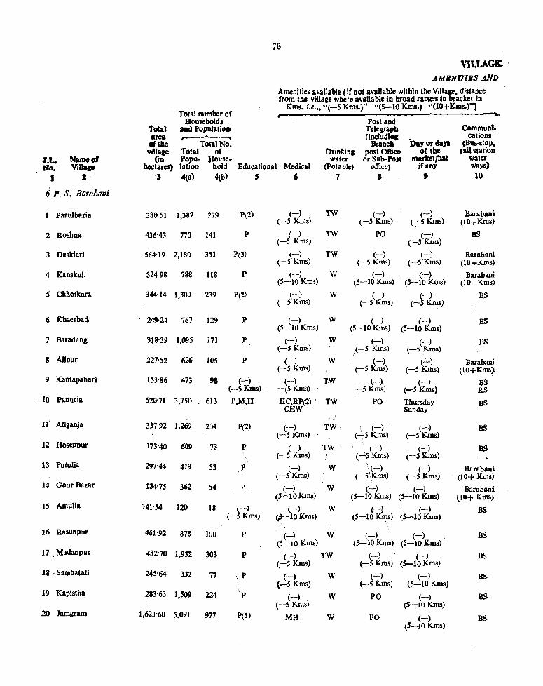
78
VILLAGE. ' AMICNmlGS .4ND
Amenities available {if Dot available witbin tbe Village, distance from tM village where available in broad ranges in bracket in
Total number of Kms. i.e." "(-5 Kms,)" "(5-10 Klns.) ·'(IO+Kms.)"]
Households Post and CommunI. Total aDd PopulatioD Telegraph
area ,...---'----. (tncludinc cations oftbc Total No. Branch Day or da,. (BU$-Stop, village Total of Drinltina post 0t1k:e oftbe rail s1 arioD
l.t. Name 01 (iD 'opu- House- water or Sub-Post market/hat water No. Vill" hectares) lation bold Educational Medical (Potable) oftkc, if any ways)
I I 3 4(a) 4(b) , 6 1 8 , 10
6 p, S. Barabilni
Parulbaria .38o.s1 1,387 279 P(2) (-) TW (-) (-) Barabani (-5 Kms) (-5 Kms) (-sKms) (lO+Kms)
2 Roshna 436'43 770 141 P (-) TW PO (-) BS (-5 Kms) (-S Kms)
3 Daskiari 564'19 2~180 351 P(3) (-) TW (-) (-) Barabani (-5 Kms) (-S Kms) (-5 Kms) (lO+Kms)
4 Kanskuli 324'98 788 118 P (-) w (-) , (-) Barabani (S-IOKmS) (5-10Kms) (S-lOKms) (10+Kms)
5 Chhotkara 344-14 1,309 239 P(2} (-) (-5 Kms)
W (-) (-) BS (-5 Kms) (-sKms)
6 Khaerbad 249-24 767 129 P (-) W (-) (-) BS (S-JOKmsJ (5-10Kms) (5-10 Kms)
7 Baradang 318'39 1,095 ]71 P (-) W (-) (-) BS (-5 Kms) (-5 Kms) (-S,Kms)
8 Alipur 227'52 626 105 P (-) W (-) (..:....) Barabani (-,5 Kms) (-5Km~ (-5 Krhs) (lO+KiUS)
9 Kantapahari 153'86 473 98 (-) (-) TW (-) (-) BS .(-SKms) . -(5Kms) :-5 Kms) (-5 Kms) RS
10 Panuria 520'71 3,750 • 613 P,M,H HC,RP(2) , TW PO Thursday BS CHW Sunday
11' {
Aliganja 337'92 1,269 234 P(Z) (-) TW \ (-) (-) BS (-5 Kms) (~5 Kms' (-5 Kms)
12 Hosenpur 17)'40 609 73 P (-) TW ' i. (_) (-) BS (-5 Kms) (-15 Kms) (-5~)
13 Putulia 297'44 419 53 P (-) W \(-) (-) Barabani (-5 Kms) (-S\~ms) (-5 Kms) (10+ Kms)
14 Gour Bazar 134'75 362 54 P (-) W (...::..) (-) Barabani (5-10Kms) (5-10 l\:ms) (S-10Kms) (10+ Kms)
15 Amulia 141'.54 120 18 (-) (-) W (~) (-) BS (-5 Kms) ,5-10 Kms) (S--10~) (5-10 Kms)
\
16 Rasunpur 461'92 878 100 p (-) W (-) '. (-) BS (5-10 Kms) (5-10Kms) (5-10 Kms)
17 • Madanpur 482'70 1,932 303 P (-) TW (-) (-) BS (-5 Kms) (-5 KIDs) (5-10Kms)
18 • Sarshatali 245'64 332 77 i P (-) W (-) (-) BS (-5 Kres) (-5 Kms) (5-10 Kms)
19 Kapistha 283-63 1,509 224 l
P (-) W PO (-) BS. (-5 Kms) (5-10Kms)
20 Jamgram 1,623'60 5,091 977 PeS) MH W PO (-) (5-10Kms)
BS

.,IRECfORY I.~ND USB
...Approcb to
Village
11
KR
;'PR,KR
KR
KR
FR
]>R
Nearest Town and distance
(in KmsJ 12
Hlndusthan Cables 16
Hindusthao Cables IS
Hindusthao Gables 14
Hindusthan Cables 8
Hindusthan Cables 10
Hindusthan Cables 15
PR Hindusthan Cables 15
KR Hindus than Cables 16
PR Bhanawara • 14
PR Hiodusthan Cables 15
~PR KR Hindusthan Cables , 17 '
l'R KR Hindusthan Cables , :, 18
.KR H1ndusthan Cables 19
. KR Bhanwara 16
PR Bhanwara J3
PR Bhanwara' 12
·'PR,KR Bhanwara 10
PR,KR Bhanwara 9
PR,KR Bhanwara 10
lPR,KR Bhanowra 12
Power Supply
13
EO
.,
EO
ED,EO
ED
ED
ED
ED,EO
Staple food 14
Rice and Wheat
Rice and Wheat
Rice and Wheat
Rice and Wheat
Rice and Wheat
Rice and Wheat
Rice and Wheat
Rice and Wheat
Rice and Wheat
Rice and Wheat
Rice and Wheat
Rice and Wheat
Rice and Wheat
Rice and Wheat
Rice and Wheat
Rice and Wheat
Rice and Wheat
Rice and Wheat
Rice and . Wheat
Rice and Wheat
97
Land use (i.t, area under different types or land use ia hectares. recorded to the Dearest UDit)
Porest IS
4'05
81-74
.3'09
12-14
2'02
4,05
12-14
8'09
40'47
20'23
30-'4
Irrigated by source
16
TW 40'47 TK 16'19
TK 60'70 R 60'70
TK 182'11
TK 31'S7
TK 20'23
TK 2'43
TK 28'33
TK 20'23
TK 16-19
TK 80-94
TK 40-47
TK 24'28
TK 40'47
TK 15'38
TK 60'70
TK 20'23
TK 40'47
TK 8'09
TK 40-47
TK 40'47
Unirri· pled 17
222'58
182'11
230-67
91'05
161-87
93'74
141-64
84'98
28-33
101'17
141-64
80-94
101-17
30'35
60'70
121'41
121'41
32-37
121'41
364-22
Culturable Area Dol waste availablo
(including for gBucher culti·
and groves) vatioD
18 19
6'07 91'15
2-43 48'75
93'08 S0-24
0'80 201'S6
60'70 101'34
80'94 7,%'13
20'23 128-19
10-12 112'19 ,
4-05 105'29
40'47 285'99
40'47 113'32
12-14 51'99
6-07 137-S9
4'05 76'88
12'14 8'00
40'47 194'34
6-07 314-75
32-37 152'58
8'09 113'66
161-87 976-10
Remarlcs iocIucliDi anyplace of
religio us, histori£lll or archaeological
jntere~t
20
N2
NS.M2,Ct
N7,M3
N2
N3,M2
N5,MI
N2,Ml
NS,M2
N 30, M 15.C 6
N5,M2
N2
NI
NIOM2
N2, M J,Cl
N6,M2
N 15, M8,CZ

80
YILLAG& AMIINITIBS AND
.. -.lenities available (if not available within the Vi~lage, dista~ce from the village where available in broad ranges ID bracket 10
Total n"\1l1l~r pf Kms. i.e.,. "(-5 Kms.)" "(5-10 Kms.) ·'(lO+Kms.)··)
Holfseholds Post and CommUDl. fotal and 'opulalioD 'relegrapll
area (including cations .of tbe ... TotalNo • Branch Day or daya (Bus-stop, 'rilla&e. Total of Drinling post Office of the rail statioD
~.t. Namoot (in· Popu· House- water or Sub· i'eal market/hat water 110. ViUaao llec:tares) lation bold Educatjonal Medical (Potable) officeJ irllDY ways)
I Z 3 4(a) 4(b) 5 6 7 8 9 10
6 1'. S. FeTe t(ni
21 Plichra 811'87 2,718 412 P(2) (-) TW (-) (-) Barabani: (-5 Kms) (-5 Kms) (-51<Iijs) (-5 Krns)
22 Itapora 46'65 ],078 190 P (-) TW (-) (-) BS (5-10 Kms) (-5 Kms) (5-10 Kms)
23 Bila 148-19 835 212 ~ PHS TW (-) (-) Barabani (-5 s) (5-10 Kms) (5-10 Krns) (5-10 Krns) 24 Amdiha 172-97 535 148 ~ (-) TW (-) (-) BS (-5 s) (-5 Kms) (5-10 Kms) (5-10 Kms) 25 Baliapur 293'09 1.628 272 P (....;..) TW (-) (-) BS
(-5 Kms) (-5 Krns) (5-10 Kms)
2~ Amlala 195'44 762 135 P (-) TW (-) (-) Barabam (-5 Kms) (-5Kms) (S-10 Kms) (S-lOKms)
rt Raniganja 217'31 922 144 P (-) TW (-) (-) BS (-5 Kms) (-5 Kms) (5-10 Kms)
28 Raghunath Chak 104'26 559 93 (-) (-) TW PO (-) BS (-5 KIDs) (-5 Kms) (IO+Kms) 29, Taldanga 184-68 325 49 P (-) TW (-) (-) BS
(-S Kms) (-5 Kms) (IO+Krns) 30 Lalganja . 216'91 1.557 267 p. D TW (-) h-) BS
(-5 Kms) (I +Kms)
31 Janardan Sail 82-96 203 44 P (-) TW (-) (-) BS (-S Kms) (-5 Krns) (5-10 Kms)
32 Kanyapur 198'51 1,220 183 P(2) (-) TW PO (-) BS (-SKms) (-5 Kms)
33 NWli 296'91j 2.273 377 P He TW (-) (-) BS (-5 Krns) (-5 Kms)
34 Panch Gechhiya 122-49 2,805 628 P(3)M(3) D TW (-) (-) BS H(2) (-5 Kms) (-5 Kms) 35 Manoharbahal 252-44 2.125 568 P D TW (-) (-) BS
(-5 Kms) (-5 Kms)
36 ChinchuriYa 332'11 1,946 320 (-) (-) TW (-) (-) \ RS (-5 Kms) (-5 Kms) (-5 Kms) (-5 Kms) 37 Bijari 164'09 ~41 105 <J<) (-) TW (-) (-) Barabani (-5 ms) (-5 Kms) (-5 Krns) (-5 Kms) (-5 Kms) 38 Paniphala 116'65 244 38 P (-)
, W (-) (-) BS
(5-10 Kms) (5-10 Kms) (S-10Kms) 39 Karrabaid 85-35 381 SO (-) (-) W (-) (-) BS (-5 Kms) (5-10 Krn (5-10 Kms) (S-10Kms) '4(r-Napara 233-54 463 " 1S (-) PHS W (-) (-) Barabant f-5 Kms) (-5 Krns) (;-10 KrnS) (-5 KrnS)

DIRECTORY r.4.ND USB
Apptocb Nearest Town to and distan ~c
Village (in Kms)
11 12
KR Bhanwora 7
PR,KR Bhanwora' 15
PR Sen Releigh 17
PR Sen Releigh 15
PR,n Sen ReJeigh 12
KR Sen Rcleigb 15
pa .. Sen Rel~.i~ 10 ., .... "
PR Sen Releigtr 8
PR.,KR Sen Releigh S
PR SenReJ~j~ 10 .'
Kk. Sen Releip 8
PIt,KR Son Reilegb 3
PR.KR Sen Reieigb 5
PR Sen Reieigh 5
PR,KR Sen Reieiab 5
KR Sen Releigb 5
KR Sen Releigh 5
PR Bhanwora 10
PR Bhanwora .9
KR Bhanwora 6
Power Supply I)
lW.,JO
ED,EO
ED,EO
~""-.~ ":-
-ED,EO
ED,EO
.. ,
81
Land use (i.e, area under different types of land use in hectares, recorded to tho nearest Un;,)
Culturablc Area lIot Remarks ineludlq waste availablo any place of
(including for religious, historiCal Staptc Irrigated by Unirri· gaucher tulti- or a~chaeologiqll food Forest source sated and groves) vation loterest ' 14 IS 16 17 '18 19 ~
Rice and TJ,< 8Q'~ 222'58 40'47 467'88 N8. M2 Wheat
Rice and TK 4'05 12'14 0'80 29'66 NS. M2 Wheat
Rice and TK 10'12 80'94 12'14 44'99 N 4.M4. CZ Wheat
Rice and TK 8'09 121'41 8'09 35'38 N5,M4.C2 Wheat
Rice and TK 40'47 121'41 40'47 90'74 N 5, M2. Wheat \
Rice and T~ 40'47 121'41 4'05 29'51 N2 Wheat
,. "32'31 Riot and ,"0 ••• -- TK 12Hl 12'14 51'39 N2
Wheat ~'-'
Rice and T~ 20'23 40-47 20'23 23'33 N4,M I Wheat
Rice and TK 40'47 101-17 4'05 38'99 N 1. MI' Wheat
." , ",.II
Rice and TK 40'47: 80''94 40'47 55-03 NS, M2 Wheat
Rice and TK 20'23 40:47 12-14 10'12 N2.:~U Wheat
Rice and TJ': S-09 70-82 10'12 109'48 N 5,M 3, C I Wheat
Rice and TK 20'23 161'S7 114'81 N9,M 4 Wheat
Rice and TK 8'09 57'87 56'53 N 32, M 10, C 3-Wbeat
Rice and TK 8'09 141'64 20'23 82'48 N 12' M 2,C 1 Wheat
Rice and TI< 20'23 182'11 8'09 121'68 N:! Wheat
R.ice and TK 26'30 60'70 4'05 73'04 Wheat
Rice and TK 1:z.t4 40'47 8'09 55'95 Wheat
Rice and TK 1'21 72'84 11'30 Wheat
RiCe and TK -8-09 121'41 4'05 99'99 Wheat

J:t. ND.
I
Name 0' Vilbge
2
Total area
oftbe village
(in hectares)
3
6 P. S. Barabani-concld
41 JayramdlUlp 104'63
42 Bbaskajuri 116'47 (
41 ' Majiyara 718'83
.l 44 Bhanowara
45 :B;tr;llla~i 294'70
46 Kelejora 677'31)
47 KhoshDagar 115'61
4S Khamra 117'84
49' Gopalbaid 81'03
SO'Doinohani 637'89
51 Shyamsundarpur 163-19
52 Cbaninpur
TOlal numlier of Households
aDd Population ,.------'---,
Total No. Total ,of Popu. House-
32
VlLLAGK A~1ilNlT1EB .AND'
Amtr:it1cs available [if D'ot ayailable within the Village, distance from the villa.e where ayailable jo'broad ranges in bracket in
Kms. i.e ... "(-S Kms.)" "(S-IO Kms.) ··(10+K.ms.)"J
Post::md Telegraph (including
lation bold Educational Medical
Drinking water
(Potable)
Branch post OtIIce
Or Sub,POSI office)
Day or days of the
market{hat if any
Communi. cations
(Bus-stop, rail stalioll
water ways)
4(a) 4(b) S 6 7 & 9 10
400 171 (-) (-) w (-) (-) Barabani (-SKms) (-SKins) (-SKms) ( .... 5 Kms) (-SKms)
965 148 P (-) TW (-) " (~) BS I' (-5 Kms) (-SKIns) , (-5 Kms) ,
3,794 632 P(2) PHS TW (PO, (-) (-S KmS)
BS
~ncluded In Bhanowara
1,191 208 P (-) , TW PO (-) BS (-5 Kms) (-5 Kms)
3,356 523 P(3) PHC TW PO (-) BS (-5 Kms)
~,134 167 P(2) (-) W ~ (-) .BS (-5 Kros) (-5 ) (-SKms)
64 10 ~ (-) W, (-) (-) B& (:;-5 s) (-5 :&ms) (-5Kms) (-5Kms) 233 34 P (-) W (-) ~ B~banf
(-5 Kros) (-5 Kms) (-5 $) (~S Kms) 6.365 'J,023 P(4)M(2)H HC. D(2) TW PO WedJlesday BS
Saturday
971 158 P (-) TW (:-) (-) liS
~-5 Kms) 1-5 Kms) (-5 Kms)
N Out/Growth of ~hanoWar~':
Total 14,961-51 67,3?9 11,741 P-59 PHC-l M-4i HC-3 H-4 D-S PHS~3 CHO-l RP-I MH"':"l

83
rmu:cro\:!y LAND (lSlt
Land !2e (i.-. are:l' under different types of land me in hect::,'cs. recorded to Ihe nearest Unit)
Clltturablc Are!) Dot Remarks iru:ludlll waste availabio any pJaceof
Approcll Nearest Town (including , for religious, histol'ita \ to and distan .. " 'ower Staple Irrigated by UniTri- gaucher cu1ti· Or archaeological 1 Villase (in Kms) upply \ food Forest sourc;c galed and grove!) vatioa iD~rest
II 12 13 '14 IS 16 11 '18 19 20
KR :bhanwara Rkeand TK 8'09 . 64'75 8'09 23'70 4 Wheat
PR Bhanwara Rice and TK 20'23 60'70 8'09 27-45 N4 Z Wheal
PR. Bhanwara Rice aDd TW 20'23 414'80 8'09 275'71 N lO, C 1 3 Wheal.
(Non MUnicipality)
PR,KR Bhanwara ED Rice and TK g,O",· 194'25 8'O~ 84-27 NS 4 Wheat
PR Bhanwara ED Rice and TK 40'47 161'87 12l'41 353-64 N 10,M2 4 Wheal
PR Bbanwara ED Rieeand. TK 20'23 6O'7\) 8-09 26-59 N4,M2 S Wheat
PR,KR Bhanw8Ia Rice and TK 6-07 40'47 71-30 4 Whea'·
KR Bhanwara R¥:e and TK 10-12 50'59 20-32 3 Wheat
PR,KR Bbanwara ED.EO .Rice and TK 121-41 404-69 40-47 71'32 N 8S;M 18, CS 2 Wheat
ri,KR Bhanwara Rice and TK zo.2l 20'23 12-14 110-59
2 Wheat
(Non M\1nicip~lity)
TK.-I,454'110 5,966-89 1,106'78 6,003-%1 N326, MIOt. C2S-TW~O'70 GC-40'47 R-60'7(1

8.
ALPHABETICAL LIST OF VU,LAGES
7 P. S. Jamuria-COlltd.
Jurisdiction Jurisdiction Sl. Names of Villa,es Ust SI. Names of Villa ... List No. No. No. No. 1 2 3 1 2 3
1 Andhaira 1 36 Jhila 17 ! Bagdiba 64 37 .Joba 126
3 Bagra 30 38 Jote Janald 5S 4 BaguJJ 2 39 Kaithi 22 5 Baha~urpur 57 40 Katagaria 34 i) 8alampur 36 41 Kenda 73 ., BamahbiiJid 71 42 khllInarsol 62 8 Baoafi 31 43 Khash Khula 27 9 Barul 43 44 K;umardiha 41
10 hataapur 61 4S "undalia H' 11 Benasol 63 46 , Kurustara 54 12 Bhatmdiha 60 47 llilbazar 46 13 Bhuri 6S 48 .:Madantor 8 !t4 Bljo1n1tl&r 49 49 l\tadbabpur 3 15 Bijpur 35 ~ Madhudanll ' 7
" 16 Birkulti IS SI Mamudpur 51 Chakditfa sk' ',. n S2· 'Mandalpur 37
is Chalt4a 29. 53 MlnPur 12 l' Chhatrishsanda 67 S4 Wthapur , 32
S5 Nandi \
19 10; j, Chicfn'irbU S'
"11 Chichuria 69 S6 Na!kapur I)
-22 I.,
6 d,
,.Nfmsa/ ~~. ChuruIia 57 '23 Daliuka 70 sa NiDga i21J 24 DamodafJ'uf 20 S9 Para~ 74
::!S (I,)ar~dauaa .'44 60 Paviharpur 23 26 Desher Mohan l~ 61 PMharebur 4S '27 Dhasala ,,:
62 Rakhakura 14 28 Dbasna so 63 Sarakdihi 51) 21) Dobrana n 64 Sarthakpur 52 30 Hijalgara 40 65 8atgram 33 31 Jkra 38 66 Satar 10 32 Jamsol 48 67 Sekpur 39 33 Jamuria 21 68 Semalya '66 "34 Jayantipur 11 69 Shamkheri 42 3S laynagar 13 70 8ibpur 18

85'
ALPHABETICAL LIST OF VILLAGES
7 P. S. Jamuria-concld.
81. Jurlsdi~ioD JUrisdictioa
Names of Villages List 81. Names of Villages Lia. No. No. No. No. t 2 ~ 1 12 3
i
'71 .Sidhpar 41 \ I
13 Toltor l' .,,2 • Sripur /l4 '4 Tapasi j3

8&"
VILLAG& .AMICNlTtE,8.AND
Amenities available {if not available within the Village, distance (rom lbe village where available in broad langes in bracket in
TOlal ~umbcr of, Kms. i.e ... "(-S, Kms.)" "(5-10 Kms.) ··UO+Kms.)"J
Households Posland 1'otal aDd Populatioli , Telegraph Communf.. area (Iocludinc cations
oflbe TOlaiNo. Branch Day or da,. (BUS-SIOp.
NlmO~. village Total of Drifllinl post OftIce of the rai\ statiOD
~.t. (in Popu- }fouse. water or Sub-Post mer':etJbat water No. Vin. lIIctares) lation ~old • Educalional Medical (Potable) office) ifaDY • ~ays)
I Z 3 4(a) 4(b) , 6 1 8 !il 10
" P. S. Jamuria
1 Andharia 304'32 899 153 P(2) (-) W,TK ~) (-) Jamuria (-SKms) (-5 mB) (-SKms) (10+Kms)
2 BaguIi 188'58 192 27 (-) (-) w (-) (-) Jamuria (-5 Kms) (-5Kms) (-5 Kms) (-5 KIlls) (lO+Kms}
3 Madhabpur 96'32 276 40 P (-) W (-) (-) Jamuria (-SKms) (-SKms) (-SKms) (lO+Kms).
4 Rakhatrura 233'91 678 92 P (-) W (-) (-) . BS (-S Kms) (-5 Kms) t-S Kms)
5 Chlnchnrbil 487'65 794 1.52 P (-) W (-) (-) ,BS (-SKms) (-S Kms) (-5 Kms)
6 Churulia 1,042'07 5,1119 894 P(3)MH HC W,TK Po, Phone Sunday BS PUC 'Thursday RS
7 Madhudanga 98'34 608 109. P (-) W (-) (-) BS (-5Kms) (-5 Kms) (-5Kms)
8 Madantor 617'96 2,380 367 P (-) W,TK (-) (-) Jamuria (-5Kms) (-5 Kms) (-S Kms) (.5-10Klns)
9 Nayakapllr 203'S6 498 88 P (-) W.TK (-) (-) lamuria (-5Kms) (-S Kms) (-SKms) (-5 Krns>
10 Sattar 261'85 1,294 203 PM (-) W,TK (-) (-) lam~ria (-SKIDs) (-S Kms) (-5 Kms) (-SKms)
11 Jayantipur 197'OB Uninhabited
12 Manpur 83-77 Uninhabited
I
13 laynagar 95'10 993 ISS P (-) w;m \ (-) (-) , Jamuria. (5-10 Kms) (.l-S KmS) (5-lOKms) ,':_5 Knis)
14 Desher Mohall 195'06 1,303 299 'R (-) W.rK (-) (-) / Jamuria (5-10 Kms) . (_jS Kms) (S-lOKms) (;SKms)
\ <
IS Birkulti 649'93 2,466 469 PMH HC TW \PO (-) 'lamuria \ (-SKmS) (-SKms,
16 Taltor G63'28 2,378 397 PM (-) (-5 Kms)
W,TKi Pp (-) Jamuria (-S Kms) (-SKms)"
17 Jmla 69'20 Uninhabited
18 Shibpur 665-72 4,641 751 P (-) W.TK PO (-) BS (-SKIns) (-SKms) \
19 Nandi 810'59 5,170 895 PMH HC,D W,TK. PTO (-) lamuria PUC (-5 Kms) (-5 Kms}
.20 Damodarpur 129'90 Out Growth of Jamuria

DIRECTORY r.,AND US/6
.Approch Neares~ Town to and distance
VillaSO tin KillS)
11 12
eKR Ja~uria
18
KR Jamuria I
16
KR Jamliria 15
,PR Jamuria 14
PR; Jamuria 15
RR., Jamurla 15
PR; Jamuria , 141
:KR Jl1muria S
KR Jamuria 8
iKR , Jamuria 8
'FR Jamuria 20
OCR Iamuria 20
KR Jamuria 5
KR Jamuria 5
KR Jamuria 3
KR Jamuria 2
(Npn M\inicipality)
Power Staple Supply fo04
13 J4 ;
Rice and Wheat
Rice and Wheat
Rice and Wheat
Rice and Wheat
Rice and Wheat
Rice and Wheat
Rice and Wheat
Rice and Wheat
Rice and Wheat
Rioeand Wheat
Rice and Wheat
Riceaod Wheat
Rice and Wheat
'~ Rice at'td
Wheat
Rice and Wheat
1- Rice and Wheat
87
Land use (i.e. area under different types of land use iD hectares. recorded to the nearest Unit)
Culturable Area not Remarks iocludllW waste available anyplace of
Irrigated by Unirri· (including for religivus, historial
Forest gaucher CUlli· or archaeological
source &Cited and groves) vation interest JS -16 17 18 19 20
46'13 TK 41'28 48'97 \ .. 167'94 \ .. TK 16'51) 8'90 1.21 161'88
TK 14'16 18'21 13'76 50'19
TK 65'96 110'88 .'2'02 55'05
]X 72'44 ' 67'58; 21'45 326'18 1M!
TK 221'77 538'24 4'05 278'01 N50. Nll.C s-
TK 38'Q4 33'18 2'02 25'10 (,
TK. 13'36 264'26 10'S2 329"82 -,
TK 11-33 : 136'38: i 9'31 46'54 ..
TKo 48'97 111-69 1'83 9S'36
IX. 10'52 '180'49 6'07
TK 6'07 '72'84 4'86 (
TK 8'09 63'94 4-45 18'62
TK2HS 99'96 4'05 6H7
605"41 40'47 4'OS N15,M3
TL 40-S7 346"41 124'24 151'76 N6M2
TK 8'1)0 54'23 6-07 ,. TK 21'85 200'32 191'42 252-13 N4. M2, Cl
,. TK 19'42 369"88 184'94 236'35 N34. M5, Cl-

88
VILLAGIt AMlINI71Jl8 .tNli~
Amenities available ( iF DOt available within the Villa&, distance from the "illage where ayailable in broad I'aoaca in aeket in
Total number of Kms. i.e .• , "(-S KIn •. )" "(s.;.-IO Kms.) ·'(IO+K.ms.)·')
HO\lseholds Post and Commuaf. &O'al aod l'opuIatiOJl relegrapla
.rea (lncludiftl DaYorda,.
cations orille Total No. DraDC" (BlJs.Stop. orillace Total of DJiDlins postOlllc:e oftbc rail station
~.t.. Name 01 (in Popu- House. water or Sub-Post III4lrket/h8t water JIo. Vina. _tares) lation bold Educational Modit,1 (Potable) office) irany ways)
• I 3 4(a) 4(b) , 6 1 8 , 10
'7 P. S. lamuria-contd.
21 Jamuria 621'20 Out Growth of Jamuria.
12 Kaithi 219'74 Out Growth of Jamuria
23 Pariharpur 528'S2 Included in Pariharpur
24 Sripur 411'57 Included in Sripuz>
2S -Kundalia 12N3 27S 44 P (-kn W (-) (~ BS (-5 S) (-s KIDs) (-5' )
2.6 loba 135'97 961 174 P (-) W,TRl (1ms (~ Jamuria (-SKms) (-5 ) (-5 s) (-5 Kms) g.7 KhoshKhula 119'38 874 199 (-) - (-) W (-) (-) BS (-5 Kms) (-SKIDs) (-5 Kins) (-SKIns) ~ Ninga 386·" Included in Ninga
~ Chanda 115'34 1,732 332 f. RP(2) W,TK (-) Sulldg as (-5 KmS) Thursday 30 -'Bagra 340~34
Included in Bagra.
31 Banali 340'34 5,534 %9 ..P .. M RP(2) W,TK PO Wednesday Jamuria.
Friday
32 Mithapur ~'71 960 . 243 (~ (-) W (-) (-) BS (-S - s) <-SKms) (-SKms) (-SKmS) 33 Satgram 9'5.8
Out Growth of Bagrll-
34 Katagaria 163-61 91S 129 , P (-) W,TK (-} (-) . Jamuria (-SKms) (-SKIns) (-SKms) (-SKms) 35 Bijpur 2eil '43 2~374 537 P,M,H (-) W PO Sunday BS (-5 Kms) Thursday
36 Balanpul 168'3S 741 126 P (-) W (1m (-) DS (-5 Kms) (-5 s) (-5Kms)
37 Mondalpur S84-37 3.842 624 P (-) W PO (-) BS (-5 Kms) (-SKms)
3S Ikra 359'77 2,587 414 P,M,H DRP W PO (-) BS (-SKmS)
3, Sekpur. 63054 40S 88 P (-) W (-) (-:-) BS (-5 Kms) (-5 Kms) (-SKms)
40 Hijalgura 869'27 2,979 513 P(2) (-) W PO Twice in a Jamuria ~_C v_*-\ Week (-S Kms)

DIRECTORY
LAND USB
Approc:b Nearest Town to and distan ,-=
Village (inKms) 11 12
(Non Municipality)
(Non Municipality)
(NOD Municipality)
(Non MUnicipality)
PR Sripur 2
KR Sripur 2
PR Ninga 2
(Non I... ...... .:ipality)
PR,KR Ninga 2
(Non Municipality)
KR Bagra 2
KR Bagra 3
(Non Munipality)
KR Bagra 5
PR Bagra 5
PR Bagra 5
PR Jamuria 2
PR Jamuria 4
PR Jamuria 4
KR Jamuria 5
Power Staple Supply food
13 14
Rice and Wheat
Rice and Wheat
Rice and Wheat
Rice and Wlleat
Rice and Wheat
Rice and Wheat
Rice and Wheat
Rice and Wheat
Rice and Wheat
Rice and Wheat
Rice and Wheat
Rice and Wheat
Rice and Wheat
89
Land use (i.e, area under different types of land use in bectares. recorded to the nearest Unit)
,. • , ,
Culturable Area not Remarks includi.,. waste available anyplaeeef
(including for religious,'historieel Irrigated by Ullirri- gaucher cutti- or archaeological
Forest source gated and groves, vat ion interest 15 16 17 '18 19 20
TK 8'09 60'70 2'02 52'62
TK 4'45 48'56 2'02 80'94 Nl
44'11 0'40 74.ft7 N34,M4
49'37 0'40 65'57 N32. MI. C4
TK 35'21 161'07 1'21 142'85 N35, M7. C6
14'1"6 0,81 51'80 N9. Ml
TK 18'21 78'51 1'21 75'68 N1(l, M9. C3-
TK 4-86 110'07 1'21 145'29 hI2S. MIa. Cl
TK 4'86 122'61 O'S! 40'06 N12. MZ.
TK 6'07 283'18 (j'07 289'05 N33. M1G
TK 10'12 199'51 4'86 145'28 N26. MIS
TK 2'02 18'21 1'21 42'10 N6. M6
824'76 18'21 26'30 NlO. M8. Cz.

90
VlLLAGB AJIlIJJNITlES AND
Amenities available (If not available within tbe Village, distaoce from the village where available in broad ranges in bracket io
Total Dumb"er of Kms. i.e." "(-5 Kms.)'· "(5-10 Kms.) ·'OO+Kms.)"]
Households Post and Total and Population Telegraph Communi-area (including cations
oftbc TOlaiNo. • Branch Day or days (Bus-stop, village Total of Drinking post Office of the rail statiod
.J.t. Nf!meof (in Popu. House. water or Sub· Post marketJhat water No. Village hectares) fation bold Educational Medical (POtable, Office) ifaoy ways}
I Z 3 4(a) 4(b) S (i 7 8 , 10
7 P. S. Jamuria-contd
Kaumardiha 128'69 623 100 (-) (-) W (-) (-) Jamuria 4L (-5 Kms) (5-10 Kms) (-5 Kms) (-5 Kms) (-5 Kms)
Sankheri 219'74 496 76 P (-) W .(-) (-) Jamuria 42 (5-10 Kms) (-5 Kms) (-5 Kms) (-5 Kms)
217'72 1,265 207 P (-) W (-) (-) Jamuria 43 Barul (5-10 Kms) (-5 Kms) (-5 Kms) (5-10 Kms)
535'40 819 140 P (-) W (-) (-) Jamuria 44 Dabardanga (5-10 Kms) (5-10 Kms) (-5 Kms) (5-10 Kms)
342'36 1,570 244 P (-) W (-) (-) Jamuria 45 Patharchur (5-10 Kms) (-5 Kms) (-5 Kms) (5-10Kms)
134'76 695 108 P (-) W (-) (-) Jamuria 46 Lalbazar (-5 Kms) (5-10 Kms) (-5 Kms) (10+Kms)
51H2 1,519 227 P,M He W (-) (-) Jamuria 47 Sidhpur (-5 Kms) (-5 Kms) (10+Kms)
365'84 1,786 292 peZ) (-) W (-) (-) Jamuria 48 Jamsal (-5 Kms) (-5 Kms) (-5 Kms) (10+Krns)
903 127 P (-) W (-) (-) BS 49 Bijoynagar 92'67 (-5 Kms) (-5 Kms) (-5 Kms)
285 49 P (-) W (-) (-) BS 50 Dhasna 147'71 (-5 Kms) (-5 Kms) (-5 Kms)
312 54 (-) (-) W (-) (-) Jamuria .51 Mamudpur 148'92
(-5 Kms) (-5 Kms) (-5 Kms) (-5 Kms) (5-10 Kms)
732 131 P (-) W (-) (-) Jamuria 52 Sarthakpur 89'03 (5-10 Kms) {-5 Kms) (-5 Kms) (5-01 Kms)
216'91 2,753 724 P (-) TV{ PO Bi.Weekly BS 53 Tapasi (5-IOKms) Hat
317'68 3,408 1,039 P (-) . TW (-) (-) BS 54 Kunuslara (5~10Kms) (-5 Kms) ,-5 Kms)
l,111 542 P (-) .TW (-) Bi.Weekly BS 55 . Jote Janaki 275'59
(-5 Kms) (-5 Kms) Hat
416·43 1,795 471 P (-) W (-) (-) BS 56 Dhasala (-5 Kms) (-5 Kms) (-5 Kms)
249'69 1,376 254 P,M,H PHC W PO (-) BS 57 Bahadurpur (-5 Kms)
426·38 1,871 436 P (-) TW (-) (-) BS 58 Chakdala (-5 Kms) (-5 Kms) (-5 Kms)
155'80 107 18 P (-) W (-) (-) Jamuria .59 Sarakdihi (-5 Kms) (-5 Kms) (-5 Kms) (10+Kms)
295'83 1,208 176 P (-) W (-) (-) Jamuria (;0 Bhaterdaha (-5 Kms) (-5 Kms) (-5 Kms) (lO+Kms)

DIRECTORY LAND USB
Apptocb to Vm.,a 11
KR
KR
KR
KR
KR
KR
KR
KR
PR
PR
.KR
KR
PR
PR
PR
PR
PR
PR
KR
KR
Nearest Tow~ and distan c.
(inKms) J2
Jamuria 5
lamuria 5
lamuria 8
Jamuria 10
lamuria 10
Jamurla 12
lamuria 16
Jamuria 10
Jamuria 8
Jamuria 6
Jamuria 6
Jamuria 6
lalPuria 8
lam,uria 7
1amuria 2
Jamuria 3
lamuria 4
Jamuria 3
lamuria 5
Jamuria 8
Power Suppl,
13
ED
ED
ED
ED
Staple food 14
Rice and Wheat
Rice and Wheat
Rice aud Wheat
Rice and Wheat
Rice and Wheat
Rice and Wheat
Rice and Wheat
Rice and Wheat
Rice and Wheat
Rice and Wheat
Rice and Wheat
Rice and Wheat
Rice and Wheat
Rice and Wheat
Rice and Wheat
Rice and Wheat
Rice and Wheat
Rice and Wheat
Rice and Wheat
Rice aDd Wheat
SI
Land use (i,e, area under different types of 'Ind use iD hectares, recorded to the nearest Uail)
CulturabJe Area Aot waste availablo
(including for Irrigated by Unirri. gaucher culli·
Forest source gaced and groves) vatioD 15 16 17 '18 19
121'00 2-83 04'86
214'89 2'02 2'S3
210'84 2-83 4'05
527'31 2'02 6'07
336'29 3'14 2'93
128'69 2'02 4'05
498'98 4'76 7'38
332'65 2'83 30'36
SO'S3 2'02 10'12
133'14 2'43 12'14
10'52 TK 2'02 72'S4 3'64 59'90
0'40 TK 1'21 62'73 1'21 23'48
7'28 198'70 4'05 6'88
J6'19 292'99 3'24 5'26
253'33 2'02 20'24
373'93 2'02 40'48
242'41 1'21 6'07
382'43 1'62 42'33
148'92 2'83 4'05
285'71 4'05 Ci'07
Remarks includina any place of
religious, historiCal Or archaeoJogic:ai
interest 20
N3, Mr
N2
Nl0, MI
N5, Mt
N3, M':"
N2:
N5, C3
N6
N3, MI
N2
N4
Nl0, M2, C6
Nl1,M3, CT
NIO, M2, Cs.
NS, Ml
NIO, M3
NIO, M4, Cs.

92
VILLAGB A~ENITIE8 AND
Amenities available [Ir Dot available within the Village, distance from the village whe.e available in broad ranges in bracket in
Total numb"er or Kms. i.e." "(-5 Kms.)" "(5-10 Kms.) ··(10+Kms.)"J
Households Post and Total and Population Telegraph Communi. area (including cations
oftbe Total No. Branch Day or days (Bus.stoP. village Total of Drinking post Oftlce of the rail station
ol':t. Name 0' (in PapUa House. water or Sub·Post market/hat water No. ViHage hectares) lation bold Educational Medical (Potable) officel if any ways)
I 2 3 4(a) 4(b) 5 6 7 8 4.1.' 9 10
, P. s. lamuria-concld
~1 Bataspur 126'26 Uninhabited
-62 Khanarsol 107.24 Uninhabited
-63 Benasol 48'97 Uninhabited
~ Bagdiha 122'62 1.568 269 P,M (-) W (-) (-) Jamuria (-5 Kms) (-5 Kms) (-5 Kms) (IO+Kms)
-ci5 Bhuri 512'34 2,148 320 P (-) W (-) (-) Jamuria (S-IOKms) (-5 Kms) (-5 Kms) (lO+Kms)
66 Semaly 496'55 2,495 577 P (-) TW PO (-) Jamuria (5-10 Kms) (lO+Kms) (10+Kms)
-67 Chhatrishganda 210'44 2,336 489 P (-) TW ~) (-) Jarnuria (lO+Kms) (-5 ms) (-5 Kms) (10+Kms)
(is Nimza 402'66 2,518 417 P,M,AC (-) W (-) (-) Jamuria (lO+Kms) (-5 Kms) (-5 Kms) (IO+Krns)
fi9 Chichuria 753'53 3,072 540 P,MAC HC W PO (-) Jamuria (-5 Kms) (IO+Kms)
70 Dah~ka 195'06 444 80 P (-) W (-) (-) Jamuria (-5 Krns) (-S Krns) (-SKms) (10+Kms)
~l Bamanband 59·89 Uninhabited
12 Dobrana 196'27 1,530 320 ;p (-) w (-) (-) Jamuria
(-5 Kms) (-5 Kms) (-3 Kms) (+10Kms) 73 Kenda 794'SI
Included in Kenda
74 Parasia 449'61 rncluded in Parasia
Total 18,86S'96 956'83 179'10 P-S7 D-2 M-13 HC-6 H-7 PHC-l
PUC-2 RP-5 AC-2.

DIRECTOR.Y LAND USB
..:.t.pproch to
Village 11
.XR
.KR
KR
KR
KR
KR
,KR
KR
Nearest Town and distance
lin Kms) 12
Jamuria 14
Jamuria 12
Pandebeswar 8
Pandebeswar 7
Pandebeswar 8
Kenda 4
Kenda 5
Kenda 2
«Non Municipality)
.;(Non Municipality),
Power Supply
13
ED
ED
Staple food 14
Rice and Wheat
Rice and Wheat
Rice and Wheat
Rice and Wheat
Rice and Wheat
Rice and Wheat
Rice and Wheat
Rice and Wheat
93
Land use (i.e_ area under different types ofland use in hectares. recorded to the nearest Unit)
Cutturable Ateaoot waste availablo
(including for Irrigated by Unirri· gaucher culti·
Forest source gated and groves) \'atioo IS 16 17 18 19
121'41 4'85
101'98 5'26
42'90 6'01
112-10 4-45 6'01
324'15 82-86 10S-3?o
476'32 6-07 ]4'16
176'85 16-19 17'46
383'24 10'12 9'30
643'46 49'37 60'70
171'18 9'71 14'11
54'22 5'67
165'92 12'14 18'21
80'52 TK-780'62 13,018'64 939'73 4,046'45
Remarks iocludioa any place of
religious, historical or archaeological
interest 20
N2,M 1
NS, M4. C3
N 15, M I,
N 20, M 5, C6
N 10, M 4, C 1
N 10,M6,C7
N2,Ml
N 5, M I, C 1
N-514 M-142
C-69


95
ALPHABETICAL LIST OF VILLAGFS
8 P. S. Raniganj
Jurisdiction I urisdictioa .st. Names of VUlages List SI • Names of Villa .. Lilt iNo. No. No. No.
I 2 3 1 2 3
I Amkula 14 17 Kumardiha 4
2 Amrasota 18 18 Mangalpur 22 3 Baktarnagar 30 19 Murgathaul IS 4 BalJavpur 27 20 Napur 31 S Banshra 20 21 Narankuri 12 6 Belebathan 9 22 Nimeha 16 7 Chak Brindabanpur 29 23 Raghunath Chak 26 8 Chak Janadhara 19 24 Raniganj 24 9 Chalbalpur 7 25 Ratibati 2
10' Chapui 3 26 Ronai 23-
11 Chelad 5 27 Sahebganj 2S
12 Damalia 11 28 Saora 1
13 Egara 13 29 Siarsol 1.7
14 Harabhanga 10 30 Sonachora 21
15 Jemeri 8 31 Tirat b
H Kumarbazar 28

'6 VILLAGIt
AMENITIBS AND
Amenities available (if Dot available within the Village, distance (rom the village where available in broad ranges in bracket in
Total number of Kms. i.e .•• "(-5 Kms.)" "(5-10 KIlls.) ··(10+Kms.)·')
Households Post and Total and PopulalioIl Telegraph Commun'. area (lncludilll cations
uflbe Total No. Branch D,yordays (BUs-stop, village Total of Dlinling post 0ftIcc of the rail sladOD
I.t. Name of (in Popu- Rouse- water or Sub-Post market/blt water No. Villap bectares) lalion hold Educational Medical (Potable) office} if any ways)
I Z 3 4(a) 4(b) , 6 7 8 9 10
8 P. S. Raniganj
1 Saora 21"35 1,757 414 P (-) W (-) (-) BS (S-lOKms) (-5Kms) (-5 Kms)
2 Ratibati 138'21 4,070 757 P D,RP W,TW PO (-) (-5Kms)
BS
3 Chapui 118'33 4,211 966 P D,RP W,TW (-) (-) Raniganj. (-5 Kins) .(-5 Kms) (5-10 KmS)
4 Kumardiha 81'93 1,399 368 P (-) W,TW (-) (-) BS (S-10Kms) (-5 Kms) (-5 Kms) S Chelad 392'82 5,481 1.137 P,M (-) W PO Sunday BS (-5 Kms) Tuesday
6 Tirat 394'53 3,030 595 P HC W (-) (-) BS (-5 Kms) (-5Kms)
7 Chalbalpur 221'52 2,342 635 P D W (-) (-) BS (-5 Kms) (-5 Kms)
8 Jemari Included in Jemari
9 Belebathan 295'30 3,001 638 P (-) W (-) (-) (-) (5-lOKms) (-5 Kms) (-S KmS) (-5 Kms) 10 Harabhanga 262'70 1,396 267 P (-) W (-) (-) (-) (-5 Kms) (-5 Kms) (-:5 KmS) (-5 KmS)
11 Damalia 212'64 567 101 P (-) W (-) (-) (-) (-SKms) (-S Kms) (-S Kms) (-5Kms) 12 Narankuri 115'32 1,368 219 P (-) W (-) (-) (-) (S-lOKms) (-SKms) (-S Kms) (-5Kms) 13 Egara 371'71 5,238 911 P(2) (-) W . (-) (-) (-) (-5 Kms) ( ...... 5 KmS) (-5 Kms) (-SKms) 14 Amkula
Included in Amkola
15 Murgathaul Out Growth of Amkula
Hi Nim~ha Included in Nimeha
17 Siarsol Included in Siarsol
18 Amrasota 305-53 1.988 442 P (-) W (-) (-) BS (-S Kms) (-5 Kms) (-5K.ms)
19 Chak Janadbara 38-13
20 Banshra 300'88 ~298 804 P (-) W (-) (-) (-) (-5 Kms) (-5 Kms) (-5Kms) (-5 Kms)

, DIRECTORY LAND USB
Apptoch to
Village II
PR
PR
KR
PR
PR
PR
PR
Nearest Town and distaD 0,
(inKms)
12
A,amo] 6
Asansol 5
Asaoso] 7
Asansol 5
Asansol 6
Asansol 8
Jamari 5
Power SUpply
U
ED EO ED EO ED EO ED EO ED EO
liD EO
(Non Municipality) (1_ K. Nag.r Township)
KR Raniganj 5
KR Raniganj 8
KR Raniganj 7
KR RaDiganj 6
PR Raniganj ED 2 EO
(Non Municipality)
(Non Municipality)
(Non Municlpality)
(Non Municipality)
KR Raniganj ED 3 EO
KR Raniganj ED 3 EO
Staple . (ood
14
Rice and Wheat
Rice and Wheat
Rice and Wheat
Rice and Wheat
Rice and Wheat
Rice and Wheat
Rice and Wheat
Rice and Wheat
Rice and Wheat
Rice and Wheat
Rice and Wheat
Rice and Wheat
Rice and Wheat
Rice and Wheat
97
Land use (i,~. area under djfferent types of land use in hectares. recorded to 1M nearest Unit)
Culturable Area not waste available
(including (or Irrigated by Ullirri- gaucher culti·
Porest source gated and groves) vatioD 15 16 17 '18 19
38'45 180'90
39'66 98'55
50'59 67'74
34'40 47'S3
2'02 o 16'18 33'18 341'44
1'21 o 26'30 40'47 326'55
0040 0 4'05 24'33 192-74
38'8S 256'45
32'78 229'92
8'09 R 11-33 20'23 17:1'99
0'40 R 22'26 11'33 81'33
0'81 40'47 330'43
2'02 41'28 262'23
2'02 18'21 17'90
2'02 o 12']4 39-25 247'47
Remarks includf .. any place 01
religious, historieal or archaeological
interest 20
N4,M2
N3.M2
N3,M6
l!i7,M2
N6.M~
N4,Ml
N3,MI
NI
NI
N9.M2
NIO,M7,C3
N4,M6

9a VILLAGB
AMENITIES AND
Amenities available [If not available within tbe V:Jlage, distance from the village where available ill broad ranges in bracket in
Total numtier of Kms. i.e." "(-5 Kms.)" "(5-10 Kms.) ·'OO+Krns.)"J
Hcuseholds Post and Total and Populatioll Telegraph CommunI. area ~ {includin, cations
oftbe Total No. Branch Day or days (Bus-stoP. village Total of Drinking post Office. of the rail statiOlI
J.t. Name of (in Popu- House- water or Sub-Post market/hat water No. Village hectares) lation bold Educational Medical (Potable) office) ifaoy ways)
I 1 3 4(a) 4(b) S 6 7 8 9 10
~ P. S. Raniganj
21 Sooachora 111-87 19 14 (-) (-) w (-) (-) (-) (-5 Knls) (-SKms) (-5 Kms) (-5 Kms) (-S KmS)
22 Mangalpur 487-60 839 204 P (-) W (-) (-) BS (-sKms) (-5 Kms) (-5 Kms)
23 Ronai 213'67 2,345 402 P (-) W (-) (-) BS (-5~) (-~Kms) (-5 Kms) ,
Included in Raniganj 24 Raniganj
, I
25 . Sahebganj Out Growth of Ranigaoj
26 Raghunath Chat. Included in Raghunath Chak
; 27 Ballavpur Ineluded in Ballavpur
28 Kumarbazar Included in Raniganj
29 Chak Brindabanpur 62'32 236 63 (-) (-) (-) (-) (~) Raoiganj (-5 Kms) (-5 Kms) (-S Kms) (-S Kms) (-5 Kms) (-S Kms)
30 Baktarnagar 421'69 3,414 575 P HC W PO (-) Raniganj
1, (S-Kms) (-5 Kms)
31 Napur 533'38 2,460 467 P,M (-) W (-) (-) Raniganj (-5 Kms) (-5 Klns) (-5 Kms) (-5 Kms)
Tota. 5,299'43 470452 9"79 P-19 HC-l
M-2 D-3 ItiP-l

, nmECTORY LAND USE
Land use (i.e. area under different types or land use in bectares. recorded to tbe nearest Unit)
,--Culturable ArtaRot Remarks i[lcludina
waste availablo any place of Apptocb Nearest Town (including for religious, historical
to and distllJlc" Power Staple Irrigated by Uoirri. gaucher cultj. or archaeological Village (in Kms) Supply food For~t source gated and groves) vatioD interest
11 12 )3 14 15 16 17 '18 19 20
KR Raniganj Rice and 0'81 18'62 92"44 3 Wheat
KR Raniganj Rice and 0'81 24'69 462'l0 3. Wheat
PR Raniganj ED Rice and 26'64 187'03 N2 2 Wheat
(Non Municipality)
(Non MuniCipality)
(Non Municipality)
(Non Municipality)
(Non Municipality)
KR Raniganj Rice and 27'43 34'89 2 Wheat
KR Raniganj ED Rice and R 12'55 28'84 380'30 NS. ¥2 4 EO Wheat
KR Raniganj ED Rice and R 71'c)3 29'63 432'12 N7 3 EO Wheat
20'61 R-1l7'77 659'33 0-58'67
4,443'05 MlS, N70. C5.


101
ALPHABETICAL LIST OF VILLA.GES
9 p. S._Ondal
81, Name of Villas-JUrisdiction Jurisdic:tio.
LiS\ Sl. Name of Villagce Lisa 'No. No, Ho. No. 1 :1 3 1 2- 3
1 AmJanJka ~1(P) 31 Haril'ul: 24
~ Al'ldal 52 12 Rarimpur 44
3 Arati S4(P) 33- labuna 5.'i(P)
4 Babuisol 4& 34 Joalbhanp 12 5 BabUla 30 3S Kajora 41
-6 Baio)'anathpur 5 36 Kendra Kaottam 1
7 Bajari 23 37 Khandra 32
a Bansu.ti S2(F) 3S KonaTdihi 14
9 Banbalral 26 39 Konda 7
10 Baska 50 40 Kumar Kka.la 25
11 Bhadur 42 41 Madanpur .... 8
12 Bbaluka 21 42 Madhabpur 40
13 Br.atmura 13 43 Madbusudhanpur -34
14 Bilpahari 2 44 Mabal 10
15 Chak Banbahal 17 .. 5 Mahira 35
16 Chak Bankola 19 oKi Mukundapuf 33-
17 Chak Jllaria 15 41 Nabagram 20
18 Cbak. Karala 11 48 Palaahban 47
19 Chat Rambs.ti 45 49 P'waohkol 38
20 Chhora 29 50 Patsaora 53(F)
21 Dakshin Khanda 36 51 Ramnagar ~
22 Dalurbad 4 52 Ram PrasadPUf .51
-23- Danya 9 53- Sankarpur 28
24 Deshlopa 11: 54 SnymsUDdarpUf 16
25 Dban<1adi~i 39 5~ Siduli 31
.26 Dignala 43 56 SOllpllr 22
21 Qubchururia 55 57 Srirampur 56
.28 Gaidhoba 37 5& TamIa 53
29 Gobindapur 6 59 Tirrmana 49
30 Hansdiba 21 60 Vkhra 18
..._'II ett8 ;-( l) J. L. No. 51. (F) to 55 (F) included in Faridpur P.S •
(2) J. L. No.1 to 16 aDd 20 to 27 Transferred. fr<;»m F.ddpur (".S.

102
VILLAGE; AM1i1Nmrcs ANI)
Amenities available (if not available within tbe Village, distance from the village where available in broad ranges in bracket in
Total number of Kms. i.e.,. "(-5 Kms.)" "(5-10 Kms.) "(lO+Kms.),')
Households Post and total and PopulafioD Telegraph Communi. area ~ (Includinl cations
ofrlle TOlalNo. Branch Day or days (Bus-stoP. villag~ Total of Drinling post Office of the rail slation.
#.t. Name 01 (in Popu- House. waler or Sub· Pest market/bat water No, Village bectares) lation hold Educational Medical (Potable) office) if any . ways)
I : 3 4(a) 4(bJ S 6 7 8 9 10
9 P.S. Ondal
1 Kendra KhoItadi .826'40 6,087 1,302 P,M,H D,RP W PO Sunday BS Phone Saturday
2 Bilpahari 407'83 3,984 914 P (-) (-5 Kms)
w (-) (-) Ondal l-S Kms) (-5 Kms) (-S KIDs).
3 Ramnagar 594'13 3,535 883 P (-) w PO (-) Ondal (-5 KmS) (-SKms) (-SKms}
4 Dalurband 795'17 S'S67 1,957 P RP W (-) (-) Ondal (-5 Kms) (-5 Kins) (-S KIDs).
5 BaidYaDathpur 242'00 7,689 1,521 P,M,H HC,D W (-) Monday BS RP (-SKIns) Wednesday RS
6 Oobindapur 90'65 1,164 215 P (-) w (-l (-) BS (-5 Krol) (-5 Kms) (-SKmS)
7 Konda 133'14 862 130 P (-) w (-) (-) BS (-5 Kms) (-5 Kms) (-5 Klnl)
8 Deshlopa ,m·os S09 77 (-) (-) w (-) (-) BS (-SKms) (-5 Kms) (-5 Km.) (-5 Kros)
9 Donya 163'l8 2,876 710 P D w (-) (-) Ondal (-5 Kms) (-SKms) (-5 Kms) (-5 Kms)
10 Mahar 355-32 2'115 361 P (-) W (-) (-) ODdal (-5 KIDs) (-SKms) (-SKIDs) (-S Km.)
11 ChakKarda 192'06 819 260 (-) (-) w (-) (-) Ondal (-SKms) (-5 Kms) (-5 Kms) (-5 Kma) (-5 KIDs)
]2 Joalbhanga 405'63 1,392 225 P (-) w (-) (-) Ondal (-SKms) (-5Kma) (-5 Kml) (-5.KIna)
13 Bhatmura 126'13 317 S5 P (-) W (-) (-) Ondal (-5 KIlls) (-5 Kma) (-5 Kms) (-5Kma)
14 Konardihi 710'65 5,706 1,497 P RP W PO (-) Ondal (-5Kms) (-SKms)
15 ChakJharia 139'43 99 20 (-) (-) 'fj (-) (-) Ondal (-5 Kms) (-5 Kms) .(-5 KIna) (-SKms) (-S KIDs)
16 Shyamsundarpur 94'87 366 49 P (-) W (-) (-) Codal (-SKms) (-5 Km.) (-5 Kms) (-SKms)
]7 Chak BanbahaJ InCluded in Ukbra
18 Ukhra Included in Okhra.
19 Chak Bankola Included In Chat Bankola
20 Nabagram 450'75 1,860 372. P (-) W PO (-) Ondal (-S Kms) (-5 Kms) (-5Km.

D!RECTO"."·
LAND USE
J\pproch Nearest Town to and distance
Village (in Kms)
11 12
PR. Chhora 10
KR Chhora 12
PR Chhora 13
KR Chhora 12
,PR,KR Chhora 12
KR Chhora 15
PR,KR Chhora 20
KR Chhora 20
KR Chhora 20
KR Asansol 20
KR Ukhra 12
PR Ukhra 8
KR Ukhra q
.KR Ukhra 3'
.KR Ukhra 3
KR Ukhra 3
(Non Municipality)
.(Non Municipality)
(Non Municipality)
KR Ukhra 2
Power Staple Supply fOod
13 14
' ED Rice and Wheat
Rice and 'Wheat
Rice and Wheat
Rice and Wheat
ED Rice and Wheat
Rice and Wheat
Rice and Wheat
Rice and Wheat
Rice and Wheat
Rice and Wheat
Rice and Wheat
Rice and Wheat
Rice and Wh~at
Rice and Wheat
Rice and Wheat
Rice and Wheat
Riceaod Wheat
Land use (i.e, area under different types o~ hod u~e in hectares. recorded to the nearest Unit)
Culturable Area nol Remarks illCludi". waste available any place of
(including for religious, historieal Irrigated by Unirri· gauchcr cultj· or archaeological
forest source aat~d and groves) 'Yation interest 15 16 t1 is 19 ZO
TK 20'23 3'4'57 70'82 340'78
TK 11'14 151'76 ~O'~9 193'34
TK 24'28 258'59 101'17 210'09
TK 28'33 352-89 11l'29 302-73
12-14 W 8'09 78'51 42-09 80'94 TK 20'2]
TK 8'09 36'42 11'74 34'40
TK 12'14 42'09 32,37 46'54
TK\ S'09 101'58 40'47 80'94
TK 6'07 80'13 30'35 46'63
TK 12'14 169'16 52'61 121'41
TK 10'12 80'94 32'37 68'63
TK 14-16 162'28 84'98 144'21
TK 6'07 4H2 28'33 46'41
TK20'23 322'13 123'43 244'86
TK 6'07 59'89 24'28 49'19
TK 6'07 36'83 14'97 37'00
TK 12'14 204'77 78'51 155'33

104
VILLAGIt AMBNlTtES .AND
. Amenities available (If not available within the Village. distance from the village where available in broad ranges in bracket in
Total number of Kms. i.e, •• "(-5 Kms,)" "(5-10 Kms.) "(10+Kms.)")
Households Post and Total aDd PopulaliolJ Telegraph CommunI-area ~ (includinl
bayarda,. catioDS
oflbe Total No. Branch (BUs-stop, village Total of DrillliDI postOlDce of the rail S1adOD .r.L Name 01 (in Popu- House- water Or Sub·Post market/hat water
No. Villago hectares) lation hold Educatjonal Medical (Potable) office) ifaDY ways) I I 3 4(a) 4(b) , 6 1 8 9 10
9 P. S. Ondal-contd
21 Bhaluka 95'07 408 83 P (-) w (-) (-) ODdal (-5Kms) (~5 Kms) (-5 Kms) (-5 Kms)
22 Sonpur 516'16 1.525 232 P (-) W PO (-) BS (-SKms) (-SKms) 23 Bajari 394'97 840 151 P (-) w (-) (-) Ondal (-5 KIns) (-SKms) (-5 Kms) (-5 Kms 24 Haripur 250'21 4,610 1,013 P D(4) W :PO Sunday BS RP(S) Thursday 25 Kumarkhola 76'19 704 159 (-) (-) w (-) (-) BS (-5 Kms) (-5 Kms) (-SKms) (-5 Kms)
26 Banbabal 229'20 1,184 217 P (-) W (-) (-) BS (-5Kms) (-~Kms) (-S KIns) 27 Hansdiha 177'21 342 45 P (~) w (-) (-) BS (-5 KIns) (-S Kms) (-SKms) 28 Shankarpur 331-11 Outgrowth of ChhoTa
29 Chhora 563'74 Included In Chhora
30 Bahula 358'95 Included in Bahula
31 Siduli 185'30 Outgrowth of Bahula
32 Khandra 743'55 Included in Khandra
33 Mukundapur 155'90 Outgrowth .of Paraskhot
,4 MadhU8udanpUf 146'16 OutrgoWI~ of Paraskhot
35 Mahira 134-42 2,389 713 P.M (....:.) W (-) (~) BS (-SKms) (-S Kma) (-SKms)
36 Dakshin Kharda 781'23 6,851 1,224 P (-) w PO Monday BS (-5Kms) Friday
37 Jaidhoba 158'82 Out Grouth of Kajora
38 Parashkol 679'54 Included iD Paraskho}'
39 Dhandadihi 349'38 2.763 585· P (-) W PO (-) Ondal (-S Kms) (-SKms) (~S Kms) 40 Madhabpur 114'37 138
, 42 (-) (-) w (-) (-) Ondal (-5 Kml) (-S Kma) (-5 Kms) (-5 KIns) (-5 Kms)

DIRECTORY LAND USB
Appl'ocb to
Village
II
KR
PR,KR
KR
PR
PR
PR
KR
Nearest ToWll and distan oc
(inKms)
12
Ukhra .3
Chhora 5
Chhora 5
Chhora 5
Chhor. S
Babula 5
Bahula S
(Noo Municipality)
(Noo Municipality)
(Non Municipality)
(Non Municipality)
(Non Municipality)
(Non Municipality)
(Non Municipality)
PR Ukhta S
PR Ondal 4
(Non Municipality)
(Non MUDicipality)
PR Oodal 5
KK. Ondal (;
Power Supply
13
ED
ED
ED
ED
ED
Staple food H
Rice and Wheat
Rice and Wheat
. Rice and Wheat
Rice and -Whea'
Rice and Whea~
Rice and Wheat
Rice and Wheat
Rice and Wheal
Rice and Wheat
Rice and Wheat
Rice and Wheal
lOj
Land use (i.e, area under different types or land use in hectllfes. recorded to the nearest Unit) .
Culturablc Area lIot waste available
(including for Irrigated by Unirri- gaucher CUlli-
Forest source gated and groves) vatioD IS 16 J7 '18 19
TK 6'07 37'64 16'19 35'17
TK 16'19 239'98 83'71 17622
W 8'09 249'29 60'70 56'66 TK 22'23
TK 12'14 138'81 40'47 58'79
TK 4'05 20'64 25'09 26'4J
36'42 TK 8'09 67'18 16'19 101'32
TK 6'07 80'13 40'47 40'54
TK 12-14 43'30 32-37 46'61
TK 28'33 509'90 80'93 162'07
TK 12'14 165-11 50'59 121'54
TK 22'26 37'64 18'21 36'26
Remarks includf.,. anyplace,,!
religious, historical or archaeological
interest 20

106
VILLAGB .U!Jl1NITIB8 mD
Amenities available (If not available within tbe Village, distance [wm tbe villaae where available ill broad 1aOF' in bracket in
Total numoer or Kms. i.e ... "(-5 Kms.)" "(5-10 Kms.) ··(10+Kms.)")
Households Post and Total and Population Telegraph Communi-area {Including cations
oftbe Total No_ Branch Day or days (Bus-stop. village Total of Drinking post Otllce of the rail statiotl
<J.t. Name 0' (in Papu. House- water or Sub-POSI market/hat water No. ViUa:;e hectares) lation hold Educational Medical (Potable) office) if aoy ways)
I 1 3 4(a) 4(b) S 6 7 8 ~ 9 10 .. .• .h~"'
9 P. S. Ondal-concld
41 Kajoa 1,032-63 Included in Kojora
42 Bhadur 160'42 2,095 329 P (-) w (-) (-) BS (-5 Kms) (-5 Kms) (-5 Kms)
43 Digoala 364-29 Included in Dignala
44 Harishpur 244'44 3,647 1,060 P (-) w (-) (-) BS (-5 Kms) (-5 .Km&) (-5 Kms)
45 Chakrambati 66'13 1,2H 362 P (-) w (-) (-) OndaI (-5 Kms) (-5 Kms) (-5 Kms) (-5 Kms)
46 Babnisol 334'13 1.253 310 P (-) w (-) (-) Ondal (-5 Kms) (-5 Kms) (-5 Kms) (-5 Kms)
47 Palashbon 283·05 4,236 694 P (-) w (-) (-) Ondal (_5 Kms) (-5 Kms) (-5 Kms) (-5 KIDs)
48 Madanpur 381'94 3,315 523 P,M,H (-) W PO (-) Ondal (-5 Kms) (-5 Kros) (-5 Kms)
49 Tiarmana 49-94 Uninhabited
SO Baska 194'61 5,011 l.O33 P (-) w (-) (-) Ondal
(- 5Kms) (-5 Kms) (-5 Kms) (-5 Kms)
51 Ramprasadpur Included in Ondal
51 Andal 883-96 3,887 652 P,M HC W PO (-) BS
53 Tamla 121'47 804 170 P (-5 Kms)
(-) w ~ (-) Ondal
55 Dubcharuria 128'69 1.968 330 P (-5 Kms) (-5 s) (-5 Kms) (-5 Kms)
(-) W,TK PO (-) Ondal
.56 Shrirampur 444-46 3,084 508 P (-5 Kms) (-5 Kms) (.....;.5Kms)
(-) W \ (-) (-) OndaJ
Total 12,370'07 97,275 20,978 . P-34 (-5 Kms) (-5 Kms) (-5 Kms) (-5 Kms)
M-5 D-7 H-3 RP-9
HC-3

DIRECTORY LA.ND USB
Appl'ocb Nearest Town to and distan c.
ViJlage (in'Kms)
11 12
(Non Municipality)
PR Ondal 2
(Non Municipality)
PR Ondal 4
PR Asansol 12
PR Asanso\ 4
KR Onda1 6
KR Ondal 2
KR Ondal 2
(Non Municipality)
KR Ondal 3
KR Olida) 3
KR Ond!11 2
PR,KR Ondal 1
Power Staple Suppl, fOod I) 14
Rice and Wheat
Rice and Wheat
ED Rice and Wheat
ED Rice and Wheat
Rice and Wheat
Rice and Wheat
ED Rice nnd Wheat
Rice and Wheat
Rice and Wheat
Rice and Wheat
Rice and Wheat
Ii7
Land use (i.e. area under different types 0118nd use in bectare!!. recorded to the nee rest Unit)
Culturable Area not Remarks includiq waste avaitable any place 01
Irrigated by Unirri-(including (or religious. historial gaucher culti· Or archaeological
Foreat source gated and groves) vatioll interest IS 16 17 ,18 19 20
TIC 6'07 73'25 26'30 54'80
TK 12'14 153'38 34"40 44'52
TK 4'05 19-42 20·23 22'43
S·()~ TK 12'l4 154-19 66'77 101'01
TK 14'16 177'66 40·47 50'76
TK 12'14 202'34 101'17 58'20
40'47 9'47
TIC 6-07 113'72 34"40 40'42
TK 8'09 485-62 218-94 171'31
TK 6'07 56'66 20'23 38'51
W 4'05 229'86 80-94 117'47 TK 12'14
- 40'47 8'09 80'13
56'25 Tit 455'24 5,914-52 2,056'76 3,854-53 W 32-37

10.
ALPHABETICAL LIST OF VILLAGES
10 P. S. Faridpur
Jurisdiction lurisdictioa 81. Name of Villages Lis. SI. Name of ViUaaea List No. No. No. No. 1 2 3 1 rz 3
1 Amdahi 2.5 36 Jaaannathpur 26
! Amlarika 51 31 Jamgara 23
3 Arati 54 38 Jhanjra 33
4 Baidyanathpur 5(0) 39 Joalbhanga 12(0)
5 Bajari 23(0) 40 Jote Balaram S
6 Balijuri 16 41 Katikapur 30
7 Banbabal 26(0) 42 Kalina~ar 27
! Bangram I 43 Kamardanga 6
9 Bashgara 38 44 Katabera 42
10 Banguri 52 45 Kandra Khottara teO)
11 Bangia 31 46 Kendua 3ii
12 Bansol 49 47 Kendula 28
13 Bwagaria 41 48 Khatgaria 29
14 Benebandhf 11 49 Konardihi 14(0)
IS Bhaburia 5 50 Konda 7(0)
Hi Bhadrapur 34 51 Kumarkhala 25(0)
17 Bhaluka 21(0) 52 Laskarbandh 13
18 Bhatmura 13(0) 53 Laudoha 21
19 Bilpahari 2(0) 54 Modhaiganja 24
~O Chak Jharia 15(0) 55 Madh,aipur .. 21 Chak Karala 11(0) 56 Mahal 10(0)
~2 Chak Laudoha 22 57 Maheshpur 12
23 Chapabandi 37 58 Mandarbani 1S 24 Dularband 40) 59 Nabaahana;ur 19
2S Danya 9(0) 60 Nabilgram .UO(O)
26 Dcshlopa 8(0) 61 Nachan 39
27 Dhabani 43 62 Nakrakonda 1.
:28 GobindapPf 6(0) 63 Nutandanga 2
.29 Gogla 14 64 Pansiuli 3 30 Gopidanga 94 65 Patsaora 53 -31 Hansdiha 27(0) 66 Pratappur 40 32 Hazipur 24(0) 67 Ramnagar 3(0) j3 Hetedoba 48 68 Ramgamatia 10
34 Ichhapur 50 69 Sarpi 35
.35 Ia,buna S5 70 Shyampur 32

109
ALPHABETICAL LIST OF VILLAGES
10 P. S. Faridpur-concld.
1urisdiction '51. Name of VilIagcs ·List Sl. Name of Villagcl No. No. No.
I 2 3 1 2
71 Shyamsundarpur 7 74 Sonpur
72 Shyamsundarpur 16(0) 75 Srikrishnapur
73 Siraha 17 76 Tilabani
.Na148 :-(1) J. L. No. 43, 49 Transferred to Durgapur P.S.
(2) J. L. No. 1(0) to 16(0) and 20(0) to 27(0) Transferred toO ndal P.S.
(3) J. L. No- 51 to S5 Transferred from Ondal P.S. in 1981.
Jurisdiiction List No.
3
21(0)
9
20

110
VILLAGJt AMENITIES .4ND
Amenities available (it' Dot available witbin tbe Village, distance from the village where available in broad ranges in bracket in
Total number of Kms. i.e .•• "(-5 Kms.)" "(5-10 Kuls.) .1(10+Kms.)"]
Households Post and Total and Populatioll 'relegrapb Communi. area (Includins cations
Oftbe Total No. Branch Day or da,. (Bus-stop, village Total of DrinRioc post Office of tbe rail statio~
I,L Name 01 (in Popu- House. water or Sub-Post marketfhat water No. VilIa&O hectares) lalion hold Educatjonal Medical (Potable) officeJ if any ways)
I ! 3 4(a) 4(b) , (j 7 a 9 10
10 P. S. FaridplJr-contd.
1 Bangram 219'S6 4,408 1,001 P (-) w (-) (-) Faridpur (-5 Kms) (-5 Klns) (-5 Kms) (-5 Kms)
2 Nutandanga 146'22 1,915 395 P D W PO Daily BS Market
3 Pansiuli 252'29 1,436 294 P.M,H (-) W (-) (-) FaridpuF • PUC (-5 Kms) (-5 Kms) (-5 Klns) (-5 Kms)
4 Madhaipur 529'77 4.111 1,027 P (-) w (-) (-) Faridpur (-sKms) (-5 Klns) (-5 Kms) (-S Kms)
S Bhaburia 271'38 1 1 (-) (-) w (-) (-) Faridpur (-S Kms) (-S Kms) (-5 Klns) (-5 Kms) (-S Kms)
6 Kamardanga 99.63 Uninhabited
7 Shyamsundarpur 350'05 5.224 1,001 P,M,H (-) W (-) Monday Faridpur (lO+Kms) (-5 Kms) (-S Kms)
8 Jote BaJaram 133'50 576 95 (-) (-) w (-) (-) Faridpur (-SKms) (lO+Kms) (-SKms) (-S Kms) (-S Kms~
9 Srikrishnapur 654'67 1,254 194 P (-) w (-) (-) Faridpur (lO+Kms) (-5 Klns) (-5 Kms) (-5Kms)
10 Rangamatia 146'79 896 168 P (-) w (-) (-) Faddpur (-5 Kms) (-5 Kms) (S-Kms) (-5Kms),
II Benebandhi 88'48 411 60 (-) (-) w (-) (-) Faridpur (-5 Kms) (IO+Kms) (-S Kms) (-5 Kms) (-SKmS)
12 Mahespur 6S'l4 236 35 P (-) w (-) (-) Faridpur (10+K.ms) ~-SKms) (-5 Kms) (-5 Kms)
13 Laskarbandh 236'66 2,492 732 P (-) w . (-) (-) Faridpur (lO+Kms) (:--5 Kms) (5-10Kms) (-S Kms),
I . 14 GogJa 191'80 1,261 306 P (-) w (-) (-) Faridpur-
(lO+Kms) (';_5 Kms) (S-10Kms) (-5 Kms)-15 Mandarbani 386'50 5,124 1.424 P.M (-) W . (-) (-) FaridPur
(IO+Kms) (-;5 Kms) (-5 KmS) (-5 KIDs)
16 Baliguri 515'30 1,570 278 P (-) w (-) ~ Faridpur (-5 Kms) (-Sl{ms) (-5 ) (-5 KIDS).
17 Sirsba 540'86 1,446 233 P (-) w (-) (-) Faridpur , (-5 Kms) (-5 K~s) (-5 Kms) (-5 Kms)
18 Nakrakonda 148'39 652 165 (-) (-) W (-)\ (-) Faridpur (-5 Kms) (-5 KIDs) (-5 Kms) (-5 Kros) (-5 Kms)
19 Nabagbanapur 310'86 1.205 206 P (-) W ~ ~ Faridpur (lO+Kms) (-5 s1 (-S ) (-5 Kms)
20 Tilabani 198'04 920 174 P (-) w (-) 'K) Faridpur (10+Kms)'- (-5 Kms) (-5 ms) (-S Kroi)

DIRECTORY .J:,AND USlD
.l\pproch 10
Village
11
'PR
:PR
'KR
KR
:KR
PR
KR
.KR
.KR
.:KR
.KR
KJl
.KR
KR
.KR
KR
.KR
.KR
KR
Nearest TOWD and distance
(in Kms)
J2
Ondal 18
Ondal 20
Ondal 20
Ondal 18
Kaksa 12
Kaksa 10
Kaksa 10
Kaksa 12
Kaksa 14
Kaksa 16
Kaksa 14
Kaksa 15
I(aksa 18
Ondal 15
Ondal 18
Ondal 16
Ondal 15
Ondal 10
Ondal 12
Power Supply
J3
Staple food J4
Rice and Wheat
Rice and Wheat
Rice and Wheat
Rice and Wheat
Rice and Wheat
. Rice and Wheat
Rice and Wheat
Rice and Wheat
Rice and. Wheat
Rice and Wheat
Rice and Wheat
Rice and Wheat
Rice and Wheat
Rice and Wheat
Rice and Wheat
Rice and Wheat
Rico and Wheat
Rice and Wheat
Rice and Wheat
III
Land use (i.e, area under different types of land use in bectares. recorded to the nearest Unit)
Culturable Area not wasle available
tiocluding for Irrigated by Uoirri· gaucher culti·
Forest source ~ted and groves) vatioD IS 16 17 18 19
192'23 13-76 13'57
1011'05 12'55 25'62
114.93 10.12 27'24
403-88 12'14 llJ07S
189'56 81'58
73'25 26'38
218'53 30'35 101'1'7
99'15 34'35
101'17 410·35 24'28 118'87
12-14 126'65 8'00
10-12 66'36 12'00
45'13 9'31 10'19
189'80 20'23 26'63
179'68 12'12
287-33 14'16 85.01
472'67 22-26 20'31
16-19 437'47 14'16 73'04
95'51 18'21 34'67
40·47 242'00 14-16 14'23
12'l4 166'73 8'09 11-08
Renarks iDClu~ .. any place of
religious. historkal or archaeological
interest 20

112
VILLAGIt. AMICNfTtICS AND
Amenities available (ir not available within tbe Village, diSlance from tbe village where available in broad ranges in bracket in
TOlal number of Krns. j.e .• , "(-5 Kms.)" "(5-10 Kms.) ··(lO+K.ms.)")
Households Post and Communi. Total and Popufatioll Telegrapb
area ~ (Including • cations oftbe Total No. Branch b,yordays (Bus-stoJ). YilJage Total of DriDting post Office of the rail slatioD
6.L. Name 01 (in Popu- House· water or Su~,· Post market/hat water No. Village llectares) ration hold Educalional Medical (Potable) office} if any ways)
I Z 3 4(a) 4(b) , 6 7 8 9 10
10 P. S. Faridpur-contd.
21 Laudoha 197'58 947 163 P,M,H PHe W <J<:) (-) Faridpur PUC (-5 ms) (-S Kms) (-5 Kms)
22 Chak Laudolia 116'93 Uninhabited
23 Jamgara 582-20 1,722 302 P (-) W PO (-) Farfdpur (-5 Krns) (-S Kms) (-S Kms),
24 Madhaiganja 717'02 818 138 P (-) w (-) (-) FaridpUIi (-5Kms) (-5 Kms) (-SKms) (-5 Kms)
2S Amdahi 1791JO 674 126 P (-) W PO (-) Faridpur (-5Kms) (-5 Kms) (-5 Kms}
26 Jagannathpur 409'41 1,582 289 P (-) . W (-) (-) Faridpur (-5 Kms) (-5 Kms) (-5 Kms) (-5 Kms)
27 Kalinagar 48'95 124 21 P (-) w (-) (-) Faridpur (-5 Kms) (..,..5 Kms) (-sKms) (-5 Kms)
!8 Kcndula 154'92 176 29 (-) (-) w (-) (-) Faridpur (-SKms) (-5 Kms) (-SKms) (-5 Kills) (-5 Kms)
29 Kbatgaria 160'77 206 41 P (-) W ~) (-) Faridpur (-5 Kms) (-5 rna) (-5 Kms) (-5 Kms}
30 Kalikapur 218'04 683 116 P .(-) w (-) (-) Faridpur (-5 Krns) (-5 Kros) (-SKIDS) (-SKms}
31 Bansia 446'96 1.267 250 (-) (-) w (-) (-) . Faridpur (-5 Kms) (-5 Kms) (-SKms) (-SKms) (-5Kms) 32 Shyampur 65'44 22 5 (-) (-) w (-) (-) Faddpur (-5Kms) (5-Kms) (-SKms) (-5 Kms) (-SKms) 33 Jbanjra 382'21 1,511 240 P (-) w (-) (-) Faridpur (-5 Kms) , (-5 Kms) (-5 Kms) (-5 Krns} 34 Bbadrapur 100.65 Uri:inhabited
3S Sarpi 543'04 4,595 853 r,M (-) w (-) (-) Faridpur (-5 KIDS) (-5 Kms) (-SKms) (-5 Kms)
36 Kendua 70'21 314 5S (-) (-) w (-) (-) Faridpur (-5 Kml) (-5 Kms) (-5 Kms) (-SKms) (-5Kms)
37 Chapabandi 134'64 46 12 -) , (-) w . (-) ('-) FaridpllL' (_:'5~s) (-5 Kms) (-5 Kros) (-5 Kms) (-5 Kms),
38 Banshgara 485'30 386 64 P (-) w (-) (-) Faridpur (-5 Kms) (-5 Kms) (-5,Kms) (-5 KmS)
39 Nachan 220'15 80S 15~ P (-) w (-) (-) Faridpur (-5 Kmll) (-5 Kms) (-5Kms) (-5 Kms}
40 Pratappur 291'08 1,272 217 P (-) W (-) ~) Faridpur (-5 Kms) (-5 Kms) (-5 IDS) (-5 Kms).

DIRECTORY LAND USB
Approcb Nearest TOWD te) and distan 0,
Village <in .K.!m)
II )2
PR Ondal 15
KR . Durgapur 18
PR Durgapur 20
KR Durgapur 22
KR Durgapur 25
KR Kaksa 8
KR Kaksa 8
PR Durgapur 15
KR Durgapur 10
KR Durgapur 10
KR Durgapur 18
KR Durgapur 12
PR Ondal 10
KIt Ondal 10
KR Ondal 12
KR Durgapur 8
PR Durgapur 6
KR Durgapur 5
Power Staple Supply food
Jl 14
Rice and Wheat
Rice and Wheat
Rice and Wheat
Rice and Wheat
Rice and Wheat
Rice and Wheat
Rice and Wheat
Rice and Wheat
Rice and Wheat
Rice and Wheat
Rice and Wheat
Rice and Wheat
Rice and Wheat
Rice and Wheat
Rice and Wheat
Rice and Wheat
Rice and Wheat
Rice and Wheat
lIS
Land use (i,e. area under different types ofland use in hectares, recorded to the nearest Unit)
CulturabJe Area not Remarks includioa waste avaiJabio any place of
Irrigated by Unirri-(including for religious, bistorial
Forest gaucher cUlti- Or a~chaeoJogical
source gated and groves) vation Interest IS 16 17 '18 19 20
131'52 22'26 43-80
110'88 6'05
20'23 481'58 30'76 49'63
141'64 427'75 46'54 101'09
163-49 6'07 !N4
251'71 42-49 115'21
36'83 4'05 S'07
118'57 8'09 28'26
84'98 14'97 60'82
16'19 161'87 10'12 29-86
50'59 291'78 22'26 82'33
43'30 22'14
20·23 238'77 8'09 115'12
90'65 10'00
340'34 34'40 168,30
52'20 2'02 15'99
119'38 2'02 13'24
390'52 3'64 91-14
12'14 179'68 14'16 14'17
20'23 250'91 10'12 9'82

114
VILLAGB
A~liJNITIES AND
AmenWes available (If oot available witbin tbe Village. distancc from the village where available iD broad ranges in bracket in
Total number of Kms. i.e.,. "(-5 Kms.)" "(5-10 Kms.) "(10+Kms:)")
Households Post and TOlal and PopuialioD Telegraph Communi.. area (including cations
of the Total No. Branch Day or days (Bus-stop. village Total of Drinking post Office of the rail station
<7.!.. Name or (in Popu. House- water or Sub· Post market/hat water Mg, Vi!la;zc hectares) lation bold Educational Medical (Potable) office) ifaoy ways)
I 1 3 4(a) 4{b) S 6 7 8 9 10
10 P.S. Faridpur-concld.
41 Baragaria 366'74 871 148 P (-) W (-) (-) Faridpur (-SKms) (-S Kms) (-5 Kms) (-5 Kms)
42 Katabera 247'17 1,354 239 P PHS W Monday (-) Faridpur (-5 Kms) (-5 Kms)
43 Hetedoba 368'72 4S6 82 P (-) W (-) (-) Faridpur (-5 Kms) (-5 Kms) (-5 Kms) (-5 Kms)
SO Ichhapur 253'24 2,670 457 P,M,H (-) W (-) (-) Faridpur PUC (-5 Kms) (-5 Kms) (-5 Kms) (-5 KIns)
51 Amlanka (0) , 160'19 808 153 P (-) W (-) (-) Faridpur (-5 KIns) (-S Kms) (-SKms) (-5 Kms)
S2 Barguri (0) 172'63 476 77 P (-) W (-) (-) Faridpur (-5 KillS) (-5 KIns) (-5Kms) (S-lOKms)
53 Patsaora (0) 414'19 1.313 220 P (-) W (-) (-) Faridpur (-5 KIns) (-5 Kms) (-5 Kms) (5-10 Kms)
"54 Arati (0) 259'62 1.466 257 P (-) W (-) (-) Faridpur (-5 Kms) (-5 KIns) (-5 Kms) (5-10 Kms)
5S Jabuna (0) 165'19 535 82 (-) (-) W (-) (-) Faridpnr (-5 Kms) (-SKIns) (-5 Kms) (-5 KmS) (5-10 Kms)
'94 Gopedanga 361-16 393 71 P (-) W (-) Sunday Faridpur (-5 Kms) (-5"l<ms) Wednesday (5-10 KIDs)
Iotal 13,679'24 62,690 ll,647 P-37 PHC-l H-4 D-l M-6 PHS-l
PUC-3

DIRECTOR'll LAND USN
Apptocb to
Village II
PR
PR
KR
KR
KR
KR
KR
KR
KR
KR
Nearest Town and distan o.
(inKms) 12
Durgapur 7
Durgapur 6
Durgapur 3
Ondal 4
Durgapur 8
Durgapur 6
Durgapur 6
Durgapur 7
DurgapuI 5
Durgapur 15
Power Supply
1~
Staple food 14
Rice and Wheat
Rice and Wheat Rice and Wheat
Rice and Wheat
Rice and Wheat
Riee and Wheat
Rice and Wheat
Rice and Wheat
Rice and Wheat
Rice and Wheat
115
Land use (i.B. area under different types 01 land use in bectare~. recorded to the ne::lre$t Unit)
Culturable Area not waste available
(including for Irrigated by Unirri· gaucher culti·
Forest source gated and groves) vatioD IS 16 17 '18 19
·24'28 326-18 10'12 6'16
22'26 156'21 14'l6 54'54
66-77 244-84 30'35 26'76
7-28 164'30 7'28 74-38
142'05 18'14
154'19 18-44
353-29 19'83 41-07
225'41 14,16 20'05
141'24 16-19 7-76
310-39 18'21 32'56
594'07 10,304-91 885'34 1,894'91
Remarks includiol any place 01
religious, historiCal Or archaeological
interest 20


117
ALPHABETICAL LIST OF:!VILLAGES
11 P. S. Durgapur
Jurisdiction IUrisdictioa SI. Name of Villages List SI. Name of ViUages List
No. No. No. No. 1 2 3 1 12 3
1 BanlOl 4g 2 Dhablni 43
.Nol. :-1. L. No. 43, 49 Transferred from Faridpur P.S. in 1981.

Name 01 ViIIago
!
Total area .'tbe "ilia go
(in .tares)
3
11 P. S. Durgapur-COD!d
., Dhabani 466'01
44 Parulia
45 Chak Gopaldebpur 1 41 Sobhapur
j 41 Kamalpur
,. Bansol 141.07
54 Gopalmath
55 Dubchururia
56 Kururia
57 Bijupora
,. Amrai
". . Kaursar
. • ~ChakAgar
-(jl - Mohanpur
6Z lugurband
63 Sajara
61 Waria
'" Mejidihi
•• Dhandabog
61 Benachiti
!
TOlal number of Households
aDd PopulaliolJ ~
Total No. Total of Popu- House-lation hold 4(a) 4(b)
770 134
745 778
I \ I I I I
I
I I J
11a
VILLAGE ~MICNITIES ~N1)
Amenities available ( if" not available within the Village, distance from the village where available in broad ranges in bracket in
Kms. i.e .•• "(-5 Kms.)" "(5-10 Kms.) ··(IO+Kms.)"J
postaod Telegrapb (Includinc
Educational Medical
DlioRin; water
(Potable)
Branch pos t,Pftice or"'Post
office}
Day or days of the
market/hat if any
Communieadons
(BUs-stop, rail station.
water ways)
, 6 7 S 9 10
P (-) w (-) (-) Durgapur
• (-5 Kms) (-5 Kms) (-SKms) (-5 Kms)
Included in
P W (-) (-) Durgapur (-)
(-SKIDs) (-S Kms) (-5Kms) (-5 Kms)'
Incl"d~ ill'

DIRECTORY LA.ND usm
.. ~pprocb to
Village
11
"KR
Nearest Towll and dista •• cc
(in KillS)
J2: -
Durgapur 5
Durgapur (NA)
Durgapur 5
Durgapur ,(NA)
Power Supply
13
Staple food 14
Rice and Wheat
Rice and Wheat
119
Land use (i.e. area und~r different types of land use in hectares. recorded ~(\ the nearest Unit)
Culturable Area !lot waste available
(i:lcluding for Irrigated by Unirri· gaucher tulti·
Forest source gated anc groves) vatioa 15 16 17 18 J9
404'69 151'32
19'66
Remarks itId~ allY pI\aIJe fJIf. .
religious. ~~ orarc~'
interest 2Il

I.t.. No.
I
Name 01 Village
%
Total .rea
oflbe .iJIage
(in hectares)
3
1/ P.S. Durgapnr-Concld.
68 Bhiringi
62 Puna bad
70 Dhunara
71 Pursha
72 Arjunpur
73 Banagram
74 Faridpur
75 Mahishkhapuri
88 Par R'ldharnadhabpur
,
Total number of Households
aDd Population ~
TOlaiNo. Total of Po;>u. House-lation hold 4(a) 4(b)
, .
j
]20
VJLLAGJt. ~MENlTrE8 ,AND
Amenities available (ir ftOt available within the Village, distance from the village where available in broad ranges in bracket in
Kms. i.e .• , "(-S Kms.)" "(5-10 Kms.) ·'(JO+Kms.)"J
Post and Telegraph (Jllcludina
Educational Medica'
Drinfina water
(Potable)
Branch post Office or Sub-Post
office, , Dayordaya
of the JJlIlrket/hat
ifaoy ,
Communi. cations
(Bns-stop. rail statio"
water ways)
, 6 7 10
Included in
Graod Total 607'08 1,515 312 P(2)

DmECfOIlY LAND usm
Approcb to
Village 11
Nearest TOWD and distan co
(in KIllS)
12
Durgapur (NA)
Power Supply
13
Staple food 14
121
Land use (i.e. area under different types of land use in hectares. recorded to the nearest Unit)
CulturabJe Area not waste availablo
lincluding for Irrigated by UnirTi. gaucher culti·
Forest source pted and groves) vadoD IS 16 17 18 J9
Remarks incllllliDl anyplaoeof
religious, historin' or archaeological
iDterest 20


SL Name of Villages No.
I 2
i Jamua
2 E!a1iganj
3 Puranganj
Not. :-Newly created P.S. (1980
123
ALPHABETICAL LIST OF VILLAGES
12 p. S. New Township
Jurisdiction List No.
3
80
83
79
SI. Name ot Villages No. 1 2
4 Santarpul'
S Tctikhala
Jurisdiction List No.
3
95
96

124
Tota' numt;er of Household.
Total and PopulatiOn area
Oflbo TotalNo. villago Total of
ll.L. Name of (in Popu- House. lfe. Vii!a&C hectareS) lation hold Educational
I Z 3 4(a) 4(b) S
12 P. S: New TOlVnship-Concld.
." Pardai
" Chak Dbabani
78 Goalara
"19 Parangaaoj ]01'79 T67 135 P
80 lemna 799'86 3,236 S68 P
8( Haribazar
82i Pbuljhari
13 Kaliganj 198'60 1,2"9 217 P
16 Marma
95 Sankarpur J02'60 460 III P
'6 Tetikhala 51'17 264 61 P
Grall4 Total 1,266'72 5,'76 J,062 P(5)
VILLAGK d~lCNn7m8 ~D
All'!en~tles ava~table [If DOllvanable witbin tbe Village, distance frGIIl tbe viRile wile,e available iD broad rUlIt' in bracket io
Kma. 1.,.,. "(-s Kms.)" "(5-10 Kms.) ·'(JO+Kins.)")
Post 'ad Tcl~'pb Communl. (Includinl . catiot15
Brancb DaY or day. (Bus-stop' Drinking post OtBco of tile rail statf01l
water or Sub,Posi CIlarket/ba& water Medica~ (Potablet office) ir~y , ways) .. 7 8 '- 10
lacluded in
Inoluded in
IncludediD
(-) w -(5 Kms)
(-) (-5Kmt)
(-) New Towoship (-5 Knls) (-5 Kms)
(-) w PO (-) New Townsbip (-SKms) (-SKms) (-SKms)
Included in
Inoluded in
(-) w (-) (-) New Township (-5 Kms) (-SKmI) (-5Kms) (-5 Kms)
Included in
(-) w (-) (-) New Township (-SKms) (-5Kms) (-5Kms) (-5 Kms)
(-) w (-Jm <-bn. New Townsbil' (-SKmt) (-5 .) (-5 ) (-5K.ms)

125
DIRECTORY .LAND USB
Land use (i.Il, area under different types of land use ~ bectares. recorded to tho nearest Udi&) .
Culturable ArtaAot Remarks incladle8 waste available any plac:o of
..ApptocJt Nearest Town (includins for religious. hist«ital 10 and disl811 lie Power Staple Irrigated by Unirri- gaucher culti· or archaeolOgieaI
ViR.,e: (inKms) Supply (ood Porese source gated and groves) vatioD interest 11 12 1) 14 15 16 11 '11 ,. 20
.Durgapur, (NA)
Durgapur' (NA)
Durgapur (NA)
KR Durgapur Rice and 12'55 67.1t! 28'06 4 Wheat
KR Durgapur Rice and 202-34 TW 161'87 54'63 381'01 5 Wheat
,Durgapur (NA)
.Durgapur (NA)
KR Durgapur Rice and 161'81 36'73 13 Wheat
Durgapur (NA)
KR Durgapur Rice and ""2'56 4'05 15'99 S Wheat
KR Durgapur Rice and -40'41 17'40 2 Wheat
ZI4-59 TW 161'87 406'71 <C'05 47~'2' -

126
ALPHABETICAL LIST OF VILLAGES
14 P. S. Kaksa
Jurisdiction J urisdiiction, 51. Name of Villages List SI. Name of Villages List No. No. No. No. I 2 3 I 2 3
1 Akandara 47 37 Hariki 50
:z Amlajora 64 38 Ijjatganj 7l
3 Anandapur 89 39 Jamban 18
4 Arra 91 40 Jamdoba 40
5 Ayman Biswanathpur 82 41 Jatgaria 19
6 Babnabera 63 42 Kajladibi 26-
7 Bamunara 58 43 Kancilanpur 2
8 Banagram 29 44 Kandarkona 51
9 Bandra 74 45 Kanksa 86
10 Bankati 33 46 Keshabpur 66
11 Banskopa 61 47 Khatpukur 59
12 Basudebpur 5 48 Kotalpukur 30
13 Basudha 35 49 Krisnapur 23
14 Beharpur 62 SO Kuldiha 53
15 Benodpur 6 51 Mahalchandni 84
16 Dhobarao 94 52 Majhidaoga 10
17 Bhagabanpur 45 53 Malandighi 43
18 Bidbihar l.2 54 Manikara 77
19 Birudiba 76 55 Masna 31
20 Bistupur 44 56 Mob~raksanja 80
21 Brahmangram 38 57 Nabagram 22
22 Brindabanpm 75 58 Napara 81
23 Chak Bishnupur 17 59 Natung~am 78
24 Chak Narayanpur 60 60 Nimtikr.i 32
25 Chua 43 61 Pan agar 85
26 Chuamudafa 46 62 Panchpukhuria 55
27 Dandeshwar Il 63 Paschim Gangarampul' 92
28 Dehipur 87 64 Pathardiha 52
29 Dihibeta 21 65 Phuljhuri 15
30 Domra 68 66 Piriganj 93
31 Dubrajpur 9 67 Prayagpur 88
32 Gangbil 83 68 RadhamohanpU'f 36
33 Garadaha 70 69 Radhanagar 24
34 Garkilla Kberobari 27 70 Raghunathpul' 39 .
35 GopaJpur 65 71 Rajhat 7 .'
36 Gaurangapur 28 72 Rajkusum 72

127
ALPHABETICAL LIST OF Vn.LAGES
It P. S.-Kaksa
IUrisdictiOD Names of.illages
,J'urisdictioa ,81. Names ot VUlaaes List Sl. List ·No. No. No. No. 1 2 3 1 2 3
-'3 Rakshitpm 42 83 SiJampur 901 '14 Ranipur 13 84 Sokna 7' VS Rautpur 2S 85 Srirampur I 76 Rupganj S4 86 Sundiara -67 77 Sodhumara 73 87 Sundipur .. 78 Saraswatiganja 49 88 Talbahari 3 79 Sasipur 8 89 Telipara 41 80 Satkahania 34 90 ThakuraDi Bazar 14 81 Shyambazar 37 91 Tilakchandrapl1l7 09 ·82 Sibpur 20

128
VILLAGIt. AMIINITTICS AND
, Arinities available (if aot available within tbe VilIaf:. distance from tbe .ilIage where available io broad raoges in acket in
Total number of Kms. i.e ••• "(-S Krns.)" "(5-10 KIDs.) ··(IO+Kms.)·'J
Jr~sehQlds Post~ 10tal a opulalioll Telegrapb Communi. area (lncludinc cations
urlbe TOlaiNo. Branch Dayorda,. (BUs-stop. village Total of Drinling postOl'llce of tbe rail statioOo
I.t. Nameol (in Popu- Hp),Ise. water or Sub-Post JWlil'''C;\Jbat water No. ViUaac hectares) lation hold Educational Medical (Potable) office} uanf ways)
I J 3 4(a) 4(b) , 6 7 8 , JO
14 P.S. Kaksa-Contd.
Srirampur 203'56 140 27 (-) (-) TW (-) (-) Kaksa (-5 KIns) (5-10 KIns) (-SKIns) (-SKIns) (lO+Kms):,
" 2 Kanchanpur 38'63 651 109 P(2) (-),
(S-lO'Kms) W.TW (-) (-) Kaksa
(5-10Kms) (-5 Kms) (10+Kms)
3 Talbahari 101'17 61 11 (-) (-) TW (-) (-l Kaksa (-5 Kms) (5-10 KIns) (S-10Kms) (-SKms) (10+Kms)
4 Sundipur 83'77 71 10 (-) (-) TW (-) (-) Kaksa (-5 KIns) (5-10Kms) (5-l0Kms) (-5 Kms) (1 0 +Kms)
5 Basudebpur 135'17 979 144 P (-) W.TW (-) (-) Kaksa (5-10 Kms) (5-l0Kms) (-sKIDs) (10+Kms).
6 Bcnodpur 129'50 413 71 ~ (-) W.TW (-) (-) Kaksa (-5 ) (5-10 Kms) (5-10 Kms) (-SKms) (10+Kms}
7 Rajhat 236'74 459 75 (-) (-) W.TW (-) (-l Kaksa (-5 Kms) (-5 Kms) (5-l0KIns) (-5 Kms) (10+Kms)
8 Sasipur 64'35 676 137 ~) (-) W.TW (-) (-) Kaksa (-5 ms) (S-lOKms) (5-l0Kms) (-5 Kms) (10+ Kms)
9 Dubrajpur 61'51 100 18 (-) (-) TW (-) (-) Kaksa (-SKms) (5-10 Kms) (5-l0Kms) (-S Kms) (10+Kms)
10 Majhidanga 48'S6 63 13 ~ (-) W (-) (-) Kaksa (-S s) (-5 Kms) (5-l0Kms) (0-5 Kms) (10+Kms)
11 Dandeshwar 45'32 602 121 P (-) W,TW (-) (-) Kaksa (-5 Kms) (-SKms) (-5 Kms) (10+Kms)
12 Bidibihar 44'11 101 16 ~) (-) W (-) (-) Kaksa (-S ms) (-SKIns) (-SKms) (-S Kms) (10 + Kms},
13 Ranipur 87'41 Uninhabited
14 Thakurani Bazar 94'70 486 78 P (-) W,TW (-) (-) Kaksa (-SKms) (-5Kms) (-S Kms) (lO+Kms)
15 Phuljhuri 138'81 410 70 P (-) W,TW ' (-) (-) Kaksa (-5 K.ma) (-S Kms) (-5 Kms) (10+Kms)-
17 Chak Bishnupur 102'39 Uninhabited
18 Jamban 154'S9 382 66 P (-) W.TW (;_) (-) Kaksa (-5 Kms) (-S~) (-5 Kms) (lO+Kms)
19 Jatgaria 288'14 1,800 322 p (-) W,TW (-) (-) Kaksa (-S Kms) (-5 KIns) (-S Kms) (lO+Kms)
20 Sibpur 216'91 1.213 209' P PRC W,TW PO Daily BS Market
21 Dihibeta 145'69 451 93 P (-) W,TW (-) , (-) Kaksa (-5 Kms) (-5 Kms) (-5 Kms) (10+K.tns)
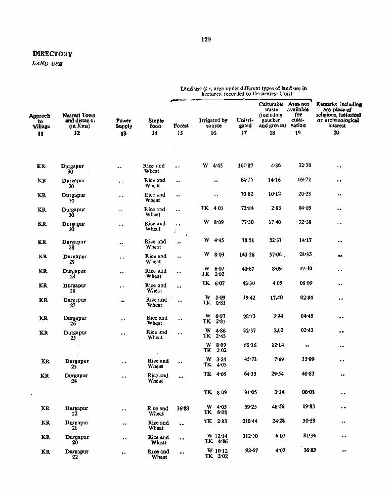
DIRECTORY LA.ND USB
Apptocb to
Village II
KR
KR
KR
KR
KR
KR
KR
KR
KR
KR
K.R
KR
KR.
KR
KR
KR
K.R
KR
Nearest Town and distan e,
(inKms) J2
Durgapur 30
Durgapur 30
Durgapur 30
Durgapur 30
Durgapur 30
Durgapur 28
Durgapur 29
Durgapur 24
Durgapur 28
DUrgwur 27
Durgapur 26
Durgapur 25
Durgapur 25
Durgapur 24
Durgapur 22
Durgapur 21
Durgapur 20
Durgapur 22
Power Supply
13
Staple fooa 14
Rice and Wheat
Rice and Whellt
Rice and Wheat
Rice and Wheat
Rice and Wheal
Rice and Wheat
Rice and Whe~t
Rice and Whellt
Rice and Wheat
Rice and Wheat
Rice and Wheat
Rice and Wheat
Rice and Wheat
Rice and Wheat
Rice and Wheat
Rice and Wheat
Rice and Wheat
Rice and Wheat
129
Land use (i.e, area under different types of land use in hectares. recorded to the Dearest Unit)
Culturable Ar~llot waste availabf.
(including for Irrigated by Unirri- gaucher culti·
Forest source gated and groves) vatioll
15 16 17 '18 19
W 4'45 161-87 4'86 32-38
64'75 14"16 09'72
70'82 10'12 20'23
TK 405 72'84 2'83 04'05
W 8'09 77'30 11'40 32'38
W 4-45 78'51 32-37 14-17
W S'09 143-26 57-06 _ 28·33
W 6-07 40'87 8'09 07'30 TK. 2'02
TK 6-07 43'30 4-05 08-09
W 8-09 19-42 17.40 02'84 TK 0-81
W 6-07 28-73 3-24 04'45 TK. 2-83
W 4-86 32-37 2.02 02'43 TK 2-43
W 8-09 65-16 12-14 TK 2'02
W 3'24 45-73 7'69 33·99 TK 4-05
TI<! 4-05 64'35 29-54 40-87
TK 8'09 91'05 3-24 00-01
36'83 W 4-05 39-25 48-56 19'83 TK 6-02
TK 2-83 210-44 24-28 50-59
W 12-14 112-50 6-07 81·34 TK 4-86
W 10'12 92-67 4-05 36-83 TK 2'02
Remarks includln. any place oJ
religious. bistoriu' or archaeological
interest 20
-

13e VILLAC&
AMENITIES AND
A ';1enitic:; ;j\'aiJable [if not available within tbe Village. distanco from the village where available ill broad ranges in bracket in
Total !!umo~r of Kms. i.e.,. "(-S Kms.)'· "(S-lO Kms.) ·'(IO+Kms.)")
Households Po~~ and Total aDd Population Telegraph CommunI-area ......----'--.. (including cations
oftbe Total No. Brancll Day or days (Bus-stoP. village Total of Drinking post Office of the rail statioll
J:1.. N:'.meof (in Popu. House. water or Sub-Post market/hat water ,N~. V~l!~ge hc=tares) lation ho:d Educational Medical (Potable) office) ifany ways)
I ! 3 4(a) 4(b) 5 6 7 8 9 10
14 P. S. Kaksa-Contd.
12 Nabagram 124'64 403 64 (-) (-) W,TW (-) (-) Kaksa (-SKms) (-5 Kms) (-SKms) (-SKms) (IO+Kms)
23 Krishnapur 102'79 223 40 P (-) TW (-) (-) Kaksa (-SKms) (-5 KIDs) (-SKIDs) (1 0 +Kms)
24 Radhanagar 67'99 240 63 (-) (-) W,TW (-) (-) Kaksa (-5 Kms) (-SKms) (-5 Kms) (-SKIDs) (10+Kms)
25 Rautdihi 126'26 653 13S (-) (-) W,TW (-) (-) Kaksa (-5 Kms) (-5 KIDs) (-SKms) (-5Kms) (lO+Kms)
26 Kajladihi 167'54 963 204 P(2) (-) W,TW (-) (-) Kaksa (-S Kms) (-S Kms) (-SKms) (10+Kms)
27 Garkilla Kherobani 131'SZ 215 37 P (-) W,TW (-) (-) Kaksa (5-10 Kms) (5-10 Kms) (5-10 KIDs) (10+Kms)
28 Gourangapur 123'43 S3 8 (-) (-) W,TW (-) (-) Kaksa (-SKms) (-S Kms) (-5 Kml) (-S Kms) (10+Kms)
2' Banagram 97-83 361 64 P (-) W,TW (-) (-) Kaksa (-5 Kms) (-5 Kms) (-5 Kms) (IO+K.ma)
30 Kotalpur 14S'28 117 29 (-) (-) W.TW (-) (-) Kaksa (-SKms) (-S Kms) (-S.Kms) (-5 Kms) (IO+Kms)
31 Masna 201'94 60 13 (-) (-) , W,TW (-) (-) Kaksa (-SKms) (-SKIDs) (-5Kms) (-S Kms) (IO+Kms)
3% Nimtikri 186'56 347 76 P (-) W,TW (-) (-) Kaksa .(-5 Kms) (-5 Kms) (-5 Kms) (lO+Kms)
33 Bankati 148'52 69S 132 P (-) (-5 Kms)
W,TW PO (-) Kaksa (-5 KIDs) (lO+Kms)
34 Saikahania 208'01 388 88 P (-) W,TW ~ ~) Kaksa (-5 Kms) (-5 ) (-5 ms) (10+Kms)
35 Basudha 790'76 3,210 654 P(3) (-) , w;rw (-) (-) BS (-S Kms) , (-5Kms) (-S KIDs)
36 Ratlhamohanpur 99'15 105 2S (-) (~) (-) , (-) (-) BS (-SKms) (-5 Kms) (-SKIDs) (-"-5 Kms) (-SKms)
37 Shyambaz:ar 587'61 2,152 412 PM D W,TW (:-) Monday BS (-5 Kms) Friday
38 Brahmangram 10t'58 357 SI P (-) W,TW (-) (-) BS '(-~ Kms) (-SRIns) (-5 Kms)
39 Raghunathpur 547'14 592 )01 P D W,TW (-) (-) Kaksa (-5Kms) (-5 Kms) (5-10 Kms)
40 Jamdoba 34277 88 16 P (-)' , W.TW (-) (-) Kaksa (-5 Kms) (-5 Kms) (-5 Kms) (5-10 Kms)
41 Telipara 335'89 935 181 P PHS W,TW (-) (-) Kaksa (-5 ~ms) (-5Krns) (S-1O Kms)

DiRECTOill' LAND USE
Approcb Nearest Town to and distan ".
Village (inKms)
II 12
KR Durgapur 25
KR Durgapur 20
KR Durgapur 22
KR Durgapur 25
KR Durgapur 20
KR, Durgapur 25
KR Durgapur 2l
KR Durgapur 25
KR Durgapur 24
KR Durgapur 20
KR Durgapur 25
KR Durgapur 27
PR Dursapur 28
PR Durf8pur
PR Durgapur 32
PR Duragpur 35
PR Durgapur 30
PR Durgapur 28
KR Durgapur 29
KR Djlrgapur 30
Power Staple Supply (ood
J3 J4
Rice and Wheat
Rice and Wheat
Rice and Wheat
Rice and Wheat
Rice and Wheat
Rice and Wheat
Rice and Wheat
Rice and Wheat
Rice and Wheat
Rice and Wheat
Rice and Wheat
Rice and Wheat
Rice and Wheat
Rice and Wheat
Rice and Wheat Rice and Wheat
Rice and Wheat
Rice and Wheat
Rice and Wheat
Rice and Wheat
Hli
Land use (i.e, aTea under different types of land use in hectares. recorded to the D<:ar!::s! Unit)
Culturable Arcanot Remarks includfa. wastc availablo anyplaccQ(
(including for religious, bistoriQll Irrigated by Unirri- gaucher cuIti- Or archaeological
Forest source sated and groves) valion interest J5 J6 J7 ·18 J9 20
W 10'12 78'10 4'05 32'37
W 8'09 79'72 2'02 06'89 TK 6'07
W 4"86 53'82 0'81 06'47 TK 2'43
W 6'07 104'41 6'07 8'09 TK 1'62
WI2-14 84-98 29'95 36'42 TK 4'05
70'82 TK 2-43 45'73 12'54
66'77 TK 6'07 45'73 8'09 24'29
70'80 12'14· 14'87
30'35 W 1,21 64'75 ·47'76 TK 1'21
W 6'88 71'63 65'55 53'83 TK 4'05
50'59 W 1'62 106'43 26'36 TK 162
W 5'26 74'06 17"81 41-27 R 10'12
32'37 R 10'12 53'42 49'37 62'73
81'34 TK 132'33 456'49 74'S7 45'73
20'23 GC 2'02 67'99 1'91
20'23 GC 12'14 324'56 141'64 82'97 TK 6'07
GC 56'25 31'16 10'12 TK 4'05
284'90 TK 4'05 94'29 74'g7 89'03
110'07 GC 6'07 149'73 12-55 62'33 TK 2'02
3'64 TK 2'43 128-69 170'78 30'35

132
VILLAGB AMENITIES AND
Am:::nifcs fivailable [if nOI available within the Village, distance from tbe village where available ill ·broad ranges in bracket in
Tota' "l1mh'er of Kms. j.e." "(-5 Kms,)" "(5-10 Kms.) "OO+K.ms.)"']
Households Po~t and Total and Population Telegraph Communi-area (including cations
of the Total No, Branch Day or days (Bus-stop. village Total of Drinking post Office of the railstatioa
.J,t. Name or (in Popu. House. water or Sub·Posl market/hat water ·No. V;Ilq~e hf;tares) lation hojd Educational Modical (Potable) cffice) if any ways)
J .z 3 4(a) 4(b) j (j 7 8 'J~' , 10
14 P. S. Kaksa-Gontd.
42 Rakshitpur 480'37 1,132 192 P,M (-) W,TW PO (-) Kaks3 (-5 Kms) (-5 Kms) (5-10Kms)
43 Chua 248'88 445 89 ~) (-) W,TW (-) (-) Kaksa (-5 m.s) (-5 KmS) (-5 Kms) (-5 Kms) (5-10 Kms)
44 Bistupur 3,488'02 1,879 383 P (-) W,TW (-) (-) Kaksa (-5 Kms) (-5 Kms) (-5 Kms) (5-10Kms)
45 Bhagabanpur 98'34 Uninhabited
-46 Chuamudafa 218'53 Uninhabited
47 Akandara 318'89 1,314 207 P (-) TW (-) (-) Kltksa (-5 Kms) (-5 Kms) (-5 Kms) (10+Kms)
48 Malandighi 698'90 1.505 322 P,M,H PHC W,TW PO Twice in a Kaksa Week (10+Kms)
49 Saraswatiganja 133'55 279 62 P (-) W,TW (-) (-) Kaksa (-5 Kms) (-5 Kins) (-5Kms) (to+Kms)
50 Hariki 82'56 279 57 (-) (:-) W,TW (-) (-) Kaksa (-5Kms) (-5 Kms) (-5'Kms) (-SKins) (10+Kms)
51 Kandarkona 269'12 724 135 P (-) W,TW (-) (-) Kaksa (-SKins) (-5 Kros) (-5 Kms) (lO+Kins)
52 Pathardiha 103'61 144 20 P , (-) W,TW (-) (-) Kaksa (-5 KIllS) (-5 Kms) (-5 KIllS) (lO+Kms)
53 Kuldiha 583'56 1,924 354 P PHS W,TW PO (--) Kaksa (-5 Kms) (10+Kms)
54 Rupganj 463'77 866 123 P (-) W,TW (-) (-) Kaksa
(-5 Kms) ,
(-5 Kml) (-5Kms) (lO+Kms) 55 Panchpukhuria 109'27 Unj~habHed
58 Bamunara 496'15 2,484 470 P (-) W,TW (-) (-) Kaksa (~5 Kms) '(-SKms) (-5 Kms) (10+Kms)
59 Khatpukuf 188'99 476 63 P (-) W,TW '. (-) (-) BS (-5 Kms) (-'-5 Kina) (-5 Kms)
{i0 Chak Narayan 67'58 Uninhabited
{it Banskopa 394'97 1,773 268 P (~) W,TW (-) (-) Kaksa (-5 Kms) (-5 KmS) (-SKms) (lO+Kms)
.c>2 Beharkur 252'53 1,219 189 P (-) W,TW· (-) (~) Kaksa \
(-5 Kms) (-5Kms) (5-10 KmS) (5-10Kms) {i3 B:tbnabera 218'13 2,J40 329 ' P (-) W,TW (.;_) (-) Kaksa
(-5 Kms) (-5 Kms) (5-10 Kms) (5-10 Kms)

DIRECTORY LAND USlC
IApprocb r-.;earest Town to and distance
Village (in Kms)
11 12
KR Durgapur 25
KR. Durgapur 30
KR Durgapur 30
KR Durgapur 16
PR Durgapur 18
KR Durgal?ur 16
KR Durgapur 16
.KR Durgapur 12
l<.R DurgaRur 3
KR Durgapur 10
.KR Durgapu, 10
;.PR Durgapur 8
KR Durgapur 12
KR Durgapur 10
.KR Durgapur 16
.KR Durgapur 18 ,
\KR Durgapur 18
Power S~aple Supply food
]3 ]4
Jtice and Wheat
Rice and Wheat
Rice and Wheat
Rice and Wheat
Rice and Wheat
Rice and Wheat
Rice and Wheat
Rice and Wheat
Rice and Wheat
Rice and Wheat
Rice and Wheat
Riee and Wheat
Rice and Wheat
Ri.ce ,nd Wheat
Rice and Wheat
Rice and Wheat
ED Rice and Wheat
13'
Land use (i.e, area under different types or land use in hectares. recorded to the ncurest Unit)
Culturable Area Dot Remarlcs ~ waste available any place of
(including for religious, rustoticd Irrigated by Uoirri· gaucher CUlli· er archaeological;
Forest source gated and groves) vatioD interest
15 16 17 18 J9 20
10'12 GC 72-44 30S'S7 36'42 .42-40 TK 10'12
TK 8'90 203'96 21'45 14-51
3,046'50 TK 10-12 324-56 50'18 56'66
27'92 TK 9'31 53'82 7'28 00'01
GC 80'94 121·41 16'18
TK 8'09 15S'23 90'65 51'SO R 10'12
244'84 TK 12-14 285'30 91'46 60'71 R 4'45
TK I(H2 . 75'68 28'73 19-02
TK 6-07 63'94 5'26 7'29
etC 28'32 188'18 28'33 12'15 TK 12'l4-
35'21 TK 15'38 21-85 12'95 18'22
171-99 TK 24'28 274'38 81'35 31'56
143'6' TK 18'62 177'00 100'47 24'02
TK 19'02 43'71 46'54 00'00
TK 80'13 166'73 128'69 120'60
TK 80'13 16'19 7'28 S5'39
GC 40'47 174'02 14'57 129-49 TK 36'42
R 20'23 121'41 22-26 88'63
TK 4-05 121'41 66'37 26'~O
GC 40'47 321'73 16'19 302'70 TK 50-59

1304-
VILLA-GIt: .tMIGNlTIES .dND
Amenitles available [if not available within tbe VilIaf:' distance from the village where available in broad ranges in acket in
Telal number of Kms. i.e_ .. "(-S Kms,)" "(5-10 Kms.) "(10+Kms,)"J
Households Past and Total and Populatioll Telegrapb Communi. area ~ (Includinl cations
oflbe Total No. Branch Dayordaya (Bus-stop. "mage Total of Drinling post Office of the rail statio!) ,.r.. Name of (in Popu. House. water or Sub-<'ost market/hat water
No. VillaS~ hectares) ration bold Educatjonal Medical (Potable) office) ifa:ay ways) I Z 3 4(<1) 4(b) 5 6 7 a 9 iO
14 P.S. Kaksa-~ontd.
M Amlajora 731-68 2,812 506 P,M,H (-) W,TW PO Monday Kaksa (-SKIM) Friday (5-1{) Kms}
65 Gopalpur 1,411'96 9,579 1,673 P,M,H D W,TW PO Daily Kaksa Market (5-10Kms)
66 Keshabpur 439'49 438 75 P (-) (-5 Kms)
W,TW (-) ~ Kaksa (-SKms) (-S s) (5-10 KIDs)
61 Sundiara 30S'54 711 132 P (-) W (-) (-) Kaksa (S-lOKms) (-5 KIn.) (-5 Kms) (-5 Kms)
68 Domra 553'61 1,320 272 P (-) W (-) (-) BS (5-10 Kms) (-5 Kms) (-5 Kms)
69 Tilak Chadrapur 578-30 1,291 244 PM (-) W PO (-) BS, (5-10 Kms) (-5 l(ms)
70 Garadaha 325'37 484 92 P (-) W,TW (-) ( ...... ) BS (5-10 Kms) (-5 KIns) (-SKms)
71 Izzatganj 469'44 1,822 365 P (-) W,TW (-) ~ BS (-SKmS) (-5 Kros) (-5 s)
72 Rajkusum 461'75 1,158 211 P,M (-) W,TW (,.-.) (-) Kaksa (-5 Kms) (-5 Kms) (-5 Kms) (5-10Kms)
73 Sadhumara 56·25 Uninhabited
74 Bandra 428'91 1,582 277 P (-) W,TW (-) (-) KakBa (-5 KmS) (-5 Kms) (-5 Kms) (5-IOKms)
75 Brindabonpur 106'02 301 65 (-) (-) W,TW ~ (-) Kaksa (-5 K.ms) (-5 Kms) ~5 ) (-SKIDs) (-SKIDs)
V6 Birudiha 756'36 2.225 426 P(2),M (-) w;rvi PO (-) BS (-5 Kms) (-5Kms)
"17 Manikara 421'28 786 144 (-) (-) W,TW (-) (-) Kaksa (-SKIns) S(-lOKms) (-SKIDs) (-SKIDs) (-5 Kms) 18 Nutangan 246-45 i,I82 184 (-) (-). W,TW (-) (-) Kakla (-SKIDs) (5-10 Kms) (---1 KIDs) (-SKms) (-5 Kms).
19 Sokna 304-73 826 1-48 P (-) W,TW (-) (-) Kaksa (5-10Kms) (-5~) (-5 KIns) (-5 Kms)
tiO Mobarak&anja 173'21 1.080 177 P (-) W,TW (-) (-) !Caksa (lO+Kms) (5-10 Kms) (S-10Kms) (5-10Kms)
81 Napara 225-82 1.380 239 P (-) W,TW (-) (-) Kaksa (10+Kms) (5-10 Kms) (5-10 Kms) (5-10Kms);
82 Hynan Biswanathpur 123'43 1,333 225 P (-) W,TW (-) (-) Kaksa (-5 Kms) (-5 Kms) (5-10 KIns) (5-lOKms)-
13 Gangbil 498'5& 924 142 P (-) W,TW (-) (-) li:aksa (-5 Kms) (-5 Kms) (-5 Kms) (-5Kms)

135
DIRECTORY L.4ND USE
Land use (i,e, area under different types of !and usc in hectai;:s_ rc~oId~L tc' the .:::carest Unit)
Culturable Area not Re llarb inclu:dktc waste available l:IlY place of
iApprocb Nearest Towo {including for religious, hi3tctiu.& to and distance Power St~ple Irrigated by U[Jirrj. p,aucher culti· CT ;.lfchaeologicaPi
Village (in Kms) Supply (oo_d Forest source gated and groves) vatioD interest
11 .12 J3 14 IS 16 17 18 19 :If)
KR Durgapur ED Rice and GC 40'47 321'73 16'1' 302'70 18 'Wheat R 50'59
XR Durgapur Rice and 121'41 TK 48-92 415'62 531'76 294'20 14 Wheat
.KR . Durgapur Rice and 141-64 TK 24'28 110'88 95-51 67-18 15 Wheat
.KR Durgapur Rice and 97'53 TK 157'83 19'02 8'90 22'20 12 Wheat
PR Durgapur Rice and 46-94 GC 220'55 197-0& 34'40 50-59 18 Wheat TK 4'05
PR Durgapur ED Rice and 20S'58 GC 89-03 155'00 26'30 84'18 18 Wheat TK 18-21
PR Durgapur Rice and 84-58 TK 42'49 155'80 6·07 36'43 17 Whea.
PR Durgapur Rice and 71'51 TK 31'57 36'42 9-71 313-23 12 Wheat
KR Duragpur Rice and 129'10. GC 15'38 196'68 INO 82'96 15 Wheat TK 20'23
33"18 GC 2-83 17'00 1-21 2'01
,KR Durgapur Rice and GC 44-92 132'33 56-66 195'06 13 Wheat
.KR Durgapur Rice and TK 14-57 2-83 43·71 44'91 , 15 Wheat
.PR Durgapur ED Rice and , GC 20·23 319-70 381'21 14-99 16 Wheat R 20,23
PR Durgapur Rice and GC 51-40 194-25 8'50 14"71 10 Wheat TK 19'42 KR D'lrgapur Rice and R 16-19 17&-06 5Q'59 1'61 14 Wheat
KR Durgapur Rice and TK 4'05 163'09 12S'05 2'42 - 16 Wheat R 10-12 KR Durgapur , RicI) and TK 4-86 109'27 8'09 50'99 10 Wheat
KR Durgapur Rice and TK 9-71 89-03 120-60 0'4& 11 Wheat
KR Durgapur Rice and TK 4'45 88-22 25-9Q 4-86 12 Wheat
. .KR Durgapur Rice and TK 9-71 7S·10 25-90 374'75 15 Wheat R 10-12

136
VILLAG& AMENITIES AND
Amenities available (iF !lot available within the Village, distance from the village where available in broad raoges in bracket in
Total number of Kms. i.e ... ",-5 Kms.)" "(5-10 Kms.) ·'(JO+Kms.)")
Households Post and Total aDd Population Telegrapb Communi. area ~ (lncludinc cations
oflbe Total No. Branch Day or days (Bus-stop. Yil1age Total of Drinling post Office of the rail station
'.L Namool (in Popu- House- water or Sub-Post marketfhat water No. Villaao llectares) lation hold Educational Medical (Potable) officeJ if any ways)
• Z 3 4(a) 4(b) 5 6 7 <> , 10 .. 14 P.S. Kaksa-Concld.
14 Mahal Chandni 114'93 150 41 (-) (-) (-) (-) (-) Kaksa (-5 Kms) (-5Kms) (-5Kms) (-5 Kms) (-5 Kms) (-5 Kms)
15 Pangar 6'06'22 2'905 527 P,M,H PRC W,TW PO Daily BS RS Market
86 ICaksa Included in Kaksa
117 Debipur 87041 3,446 596 P,M,H :0 W,TW (-) Twice in BS PUC (-5 Kms) a Week
18 Prayagpur 258'59 2.269 338 P (-) W,TW PO Daily BS (-5 Kms) Markel
., Anandapur 107'65 884 113 P (-) W,TW (-) (-) Kaksa (-5 Kms) (-5 Kms) (-SKms) (-5 KIDs)
!IO Silampur 391'33 2,207 410 P,M,H PHS W,TW PO (-) Kaksa (-5Kms) (-5 Kms)
PI Ana 373"12 2.936 555 P (-) (-5 Kms)
W,TW PO (-) Kaksa (-5 Kms) (-5 Kms)
,2 Paschim GangaJampur 337"91 361 70 (~ (-) (-b (-) - (-) Kaksa (-5 ) (S-Kms) (-S s) (-SKms)· (-S Kms) (S-10Kms)
J3 Piariganj'i 127"07 823 ]57 P (-) W,TW (-) (-) BS (10+Kms) (-5 Kms) (-5Kms)
94 Bhagabanbati Dhobarao 187'77 440 103 P (-) TW (-) (-) BS (-5 Kms) (-5 Kms) (-5Kms)
TNJ 27,234-20 874'59 157-58 P-65 PHC-3 M-U PHS-~ H-6 D-4
PUC-l

137
DU:?fCTORY LAND USB
Land use (i.e. area under different types of land use in bectareS. recorded to the nearest Uoit)
Culturable Area not Remari<s ineludial waste available anyplace of
Apptoch Near~st Towll {including for religious, historical to and distan 0, Power Staple Irrigated by Unirri· gaucher culli· Or archaeological
Village (in KillS) Suppiy . food' Forest source g~~ed :lnd groves) vation interest
11 J2 13 14 IS 16 17 '18 19 21J
PR Durgapur Rice and NA NA NA ~A 16 Wheat
PR Durg~pur Rice and 2'43 R 80'94 153-78 16'59 352'48 12 Wheat
(Non Municipaiity)
PR Durgapur ED Rice and TK 4'05 30'35 4'86 48'15 10 Wheat
PR Durgapur ED Rice and GC 44'52 109'27 5'26 71-21 12 Wheat TK 28'33
PR Durgapur Rice and GC 16'19 62'73 3'64 21'04 13 Wheat TK 4'05
PR Durgapur Rice and GC 80'94 199'51 42'49 24'28 13 Wheat R 44'1l
KR Durgapur Rice and TK 11'00 205'58 42'49 108'05 14 Wheat
KR Durgapur Rice and 188'18 TK 11'33 63'13 65'15 10'12 24 Wheat
PR Durgapur Rice and 61-11 TK 41lS 35'61 14'57 1-61 26 Wheat R 10'12
PR Durgapu Rice and 32'78 42-90 48'56 63'53 20 Wheat
5.182'17 2,447-58 10,339'57 3,760'44 4,721-93


139
ALPHABETICAL LIST OF VILLAGES
15 P. S. :Iud Bud
Jurisdiction Jurisdiction Sl. Name;of Villages Lis{ SI. Name or Villages List
No. No. No. No. 1 2 3 1 2 3
1 Amur 13(0) 32 Khamdari 84(A) \
2 Arjunpur 8(0) 33 Komarband 24(0)
3 Balarambati 35(A) 34 Kota Chandipur 80(A)
4 BaJarampur SI(A) 35 Krishnarampuf 18(0)
5 Banagram 14(0) 36 Lachhminarayaopur Chak 66(A)
6 Bara Chafra 28(0) 37 Mallikpara 38(0)
7 Bara Doba 67(A) 38 Mankar 37(0)
8 Bhagabanpur 36(0) 39 Maro 9(G)
9 Bhatkunda 34(A) 40 Maugram 19(G)
10 Bharatpur 2(0) 41 Mokota 33(A)
11 Bilaspur 70(A) 42 Narayaopur 27(G)
12 Budbud 11(0) 43 Naskarbandh 1 (G)-
13 Chak Piargan; 24(A) 44 Paduma 69(A)
14 Chak Tentul 16(0) 45 Pardaha 33(0)
15 Chandra 7(G) 46 Parisa 30(A)
16 Chandra Chat 15(G) 47 Paschim Chandipur 26(A)
17 Dakshin Khara 34(0) 48 Patihar 5(G)
18 Debsala 27(A) 49 Pondali 77(A)
19 Daharala 78(A) 50 Raghunath pur 79(A)
20 Durgapur 32(G) 51 Raipur 10(0)
21 Fatepur 17(G) 52 Ramnagar Chak 76(A}
22. oobindapur 71(A) 53 Randiha 4(G)
23 Oopalnath 83(A) 54 Saldanga 3(G)
24 Hansoa 6(0\ 55 Sandhipur 31(0)
25 Haora 12(G) 56 Sodpur 23(0)
26 Jaykrishnabati 21(0) 57 Sonai 73(A)
27 Jinjra 68(A) 58 Sonai Aima 74(A)
28 - Kalyanpur 43(0) 59 Sonai Aima Purbba 75(A)
29 Kakra 25(A) 60 Sukdal 35(G)
30 Kasba 20(G) 61 SyamsuDdarpur 82(A)
31 Kenduatikuri 22(G)

140
VILLAGB
AMENITIES AND
Alli~nities lIvailable [if notavailablc within the Viilage. distance from the village where available in broad ranges in bracket in
Totar num':ier of Kms. i.e." "(-5 Kms.)" "(5-10 K.ms.) ··(IO+Kms.)")
Households PC$t and Total and POP1.O:'1Iion Telegraph Communi-area r--'------. (including cations
oftlle Total No. Branch Day or days (Bus-stop* village Total of Drinking post Office of the rail statio ..
,,!.L. l\l'2Me or (in Popu- HOI!~e-H'£i', V::;:l:;: he ~tares) latiOrl LoIJ Educational
water or Sub-Post market/ha~ water Medical (Potable) office) ifaDY ways)
I 2 3 4(a) I.;b) 5 6 7 S 9 10
15 P. S. Bud Bud
Naskarbandh (g) 129'55 1,576 267 P (-) TW,W (-) (-) Bud Bud (-5 Kms) (-5 Kms) (5- Kms) (-5 Kms)
2 Bharatpur (g) 580'72 3,670 617 p PRe TW,W (-) Twice in Bud Bud (-5 Kms) a Week (5-10Kms)
3 Saldanga (g) 419'78 2,488 415 PMH (-) TW,W (-) (-) Bud Bud (-5 Kms) (-5 Kms) (-5 Kms) (-5 Kms)
4 Randiha (g) 322'08 1,568 273 P (-) TW,W PO (-) Bud Bud (-5 Kms) (-5 Kms) (5-'-10 Kms)
*5 Patihar (g) 1 111'75 3,001 551
*6 Hansoa (g)
f 396'34 1,517 243 Not Available
·7 Chandra (g) 173-10 967 199
"'8 Arjunpur (g) I 224-57 1,549 327 J
9 Maro (g) 743-80 2,576 437 P (-) TW,W (-) (-) BS (-5 Kms) (-5 Kms) (-5 Kms)
10 Raipur (g) 359'94 3,933, 715 P ~-) W (-) (-) BS (- Kms) (-5 Kms) (-5 Krns)
11 Bud Bud (g) 396-31 3,375 619 P,M,H DRP TW PO Daily BS
12 Haora (g) 630'37 1,768 282 P (-) TW,W (-) (-) Bud Bud (5-10 Kms) (-5 KI\1s) ~-5 Kms) (-5Kms)
*13 Amur (g) ) 198'61 1,204 98 / ,
14 Banagram (g) I >-
121'30 2,162 573 Not AVI111abie
I 15 Chandra Chak(g j 134'10 1,782 197
16 Chak Tentul (g) 518-93 3,881 686 P,M,H (-) TW,W PO Tuesqay & Friday Bud Bud (5-10 Kms) (5-10 Kms)
17 Fatepur (g) 290'91 1,039 187 (-) (-) TW (-) (-) Bud Bud (-5 Ktp,s) (5-10 Kms) (-5 Kms) (-5 Kms) (5-10 Kms)
18 Krishnarampur (g) 229'43 2,420 419 P,M\H (-) TW (-) (-) Bud Bud (5-10 Kms) (-5 Kms) (-5 Km$) (5-10 Kms}

LAND USr::
.c\\pproch N"arest Town to and distance Power Str.p!e
Village (in Kms) Supply food
J1 12 13 14
KR Sukdal Rice and 12 Wheat
KR Sukdal Rice and 12 Wheat
KR Sukdal Rice and 14 Wheat
.KR Sukdal Rice and 10 Wheat
Not Available
PR Sukdal Rice and 6 Wheat
PR Sukdal ED Rice and 5 Wheat
PR Sukdal ED Rice and 2 BAg Wheat
KR Sukdaf Rice and 3 Wheat
Not Available
(J'R,KR Sukdal Rice and 10 Wheat
KR Sukdal Rice and 12 'Wheat
KR Sukdal Rice and 10 Wheat
141
Land use (i.e. a,,;:a under different types of land use in hect<::res. reco;-c.:d to the Dca,:.>: Unit)
-----"-----.---~.___.......
Cui,arable Area Dot waste available
Irrigated by (including iot
Udrri - 2ll.:chcr cUlti-r"Ofcst source c."·wd .. ;::~ _;;oves) vutioD
IS 16 17 11> )9
0'80 GC 80'94 24'28 6'07 17-46
0'80 GC 337'91 147'71 20'23 74'07
1'21 GC 239'57 124'64 10'12 44'24
0'40 GC 161'87 79'32 20'23 60'26
GC 223'79 40'47 25'09 454'45
GC 217'72 9'71 39'25 93'26
GC 141'64 125'05 13'76 115'86
O'SO GC 283'28 80'94 22'66 242'69
1'21 GC 296'23 121'41 32'37 67'71
GC 162'68 80'94 6'88 40'41
GG 153'38 49'37 26'68
R.emarks iDCf", any place ~tlf
religious, historicai or archaeologjcai
i::ltere!>t 20
Bharat Ra,iq Dhibi

.142
VILLAGIt AMICNlTlICS .AND
Amenities available {if Dot available within tbe Vi~lage, disla~ce from the village where available in broad ranges ID bracket ID
TOlal number of Kms. i.e." "(-5 Kms.)" "(5-10 Knls.) ·'(JO+Kms.)"J
HC',,-,seholds Post and Communi. 10tal and Population T'elegrapb
area ~ (including cations oftbe Total No. Branch Day or days (Bus-stop, village Total of Dtinling post Office of the rail statiol}
market/hat water 1.1.. Name 01 (in POJ}u- House- water or Sub-Post ways) Mo. Vil!~':"J hectares) l.,tion hold Educatjonal Medical (Potable) office} ifaoy
I " 3 4(a) 4(b) ,., S 6 7 S 9 10
UP.S. Bud Bad
19 Maugram (g) 172'20 938 180 P (-) TW (-) (-) Bud Bud (5-10Kms) (-5 KmS) (-5 Kms) (5-10Kms)
20 Kasba (g) 349.78 1,890 374 P,M (-) TW PO Twice in a Bud Bud ,5-10 Kms) Week (5-l0Kms}
21 Joykrishnabati (g) 110'22 843 146 P (-) TW (- (-) Bud BUd (5-10 Kms) (-5Kms) (-5 Kms) (5-10 Kms} 22 Kenduati Kuri (g) 145'07 684 127 (-) (-) TW (-) (-) Bud Bud
(-5 Kms) (5-10 Kms) (-5 Kms) (-5 Kms) (5-10Kms) 23 Sodpur (g) 165-81 355 62 P (-) TW (-) (-) Bud Bud (5-1() Kms) (-5 Kms) (-5 Kms) (5-JOKms)
24 Komarband (g) 101'46 22 6 (-) (-) TW (-) (-) Bud Bud (-5 Kms) (5-10 Kms) (:-5 Kms) (-SKms) (5-lOKms) 27 Narayanpur (g) 97'57 774 136 P (-) TW (-) (-) Bud Bud (5-10 Kms) (-5 Kms) (-5 Kms) (5-10 Kms) 28 Bara Chatra (g) 126'40 722 140 (-) (-) TW (-) (-) Bud Bud (-5 Kms) (5-10 Kms) (-5Kms) (-5 Kms) (5-10Kms) 31 Saudhipuf (g) 449'45 1,859 317 P (-) TW . (-) (-) Bud Bud
(-5Kms) (-5 Kms) (-5 Kms) (5-lOKms) 32 Durgapur (g) 469'91 97 12 P (-) TW ~ (-) , Bud Bud (-5 KIns) (-5 ) (-5 Kms)i (-5Kms)
33 Pardaha (g) 266'71 1,039 180 P (-) TW (-) (-) Bud Bud (-5 Kms) (-5 Kms) (-5 Kms) (5-IOKms)
34 Dakshin Khara (g) 258'77 Uninhabited
35 Sukdal (g) 456'75 Iucluded in
36 Bhagabanpur (g) 167'06 1,432 271 P (-) TW '(-) (-) BS (-5 Kms) (-5 Kma) (-5KmS)
37 Mankar (g) 747-67 6,564 1,226 P(3),M,H PHC W PTO Daily BS.RS PUC Market
\
38 Mallikpara (g) 124'65 1,017 192 (-) (-) W (-) (-) BS (-5 Kms) (-5 Kms) (-5 Kms) (-5 Kms)
43 Kalyanpur (g) 148'51 1,656 309 P (-) TW (-) (-) BS (-5 Kms) (-5 Kms) (-5 Kms)
I 24 Chak Piariganj (A) 64'50 59 9 (-) (-) TW (-) (-) Bud Bud:
(-5Kms) (5-10 Kms) (-5 Kms) (10+ Kms) (10+Kms) 25 Kakra (A) 84'89 983 184 (-) (-) W (-) (-) Bud Bud
(-5 Kms) (5-10 Kms) (-5 Kms) (10+Kms) (10+Kms) 26 Paschim Chandipur (A) 105'70 166 31 P (-) W (-) (-) Bud Bud
(5-10 Kms) (-5 KIllS) (5-10 Kms) (10+Kms)

DIRECTORY LAND USB:
.Approcb to
Village
11
KR
KR
KR
KR
KR
.KR
KR
KR
KR
K.R
KR
Nearest Town ane cl!sta:lcc
(in Kms)
12
Sukdal 12
Sukdal 14
Sukdal 10
Sukdal 12
Sukdal 13
Sukdal 14
Sukdal 11
Sukdai 8
Sukdal .6
Sukdal ,5
Sukdul 8
Sutdal (Non Municipality)
KR. Sukdal 2
PR,KR Sukdal 4
PR,KR Sukdal 2
KR Sukdal 2
KR Kaksa 12
KR Kaksa 10
KR Kaksa 11
Power Supply
13
ED
ED
Staple
143
[,and use (i_e. area under different types of land use in hectare,_ recorded to the nearest Unit)
Culturable Area Dot waste available
(including for Irrigated by Unirri- gaucher culti-
Remarks i'ldudial!f miY place of
religious, historiali or archaeological
food forest source gated aDd groves) valioD interest
14 15 16 17 18 19 ZO
Rice and GC 141-64 12-14 6'48 11-94 Wheat
Rice and .40'47 GC 242-81 36'42 2-02 28-06 Champainagar Capit., Wheat of Chand Saod .....
Rice and GC 68-80 29'14 S'09 4'19 Wheat
Rice and GC 117'36 g'90 2'43 16'38 Wheat
Rice and GC 121'41 12'14 2'02 30'24 Wheat
Rice and GC 78-51 8-90 14-05 Wheat
Rice and GC 72'84 12'14 8'50 4'Y9 Wheat
Rice and GC 80'94 2023 25'23 Wheat
Rice and GC 16'19 394'97 38'29 Wheat
Rice and GC 323'75 24-28 8'90 112'98 Wheat
Rice and GC 186'16 28'33 52'22 Wheat
GC 121'41 131'52 5'84
Rice and GC 99'15 40'47 6-07 21'37 Wheat
Rice and GC 46'13 507'48 16'1' 177'87 Wheat
Rice and GC 452 49-31 0,81 19'95 Wheat
Rice and GC 4'05 99'15 45'31 Wheat·
,
Rice and 4'45 R 4-05 36-02 4-05 9-86 ~hea. 0 6'07
Rice and 14'57 TK 8'09 36'83 12'l4 9-21 Wheat 0 4-05
Rice and 6'07 TK 12-14 72'84 8'09 6'56 Wheat

H4
VJLLAGIt. .4MENlTfES AND
Amenities available [if not available within the Village, distance from the village where available in broad ranges in bracket in
Total number of Kms. i.e." "(-5 Kms.)" "(5-10 Kms.) ·'(lO+Kms.)"]
Hou:;ci.olds Post and Communi_ Total and Population Tt;;legraph
area ~ (iDcludin, cations ofltle To("INo. Branch 'Day or days (BUs-stoP. village Total of Dllo!!:ing post Office of tbe rail statiOlt
/lJ... Name or (in Popu- Rouse- water or Sub-Post market/hat water '110. Village hectares) latio:i 'hold Educational Medica! (ro~ab~e) officeJ if an;, ways)
• 2 3 4(a) 4(v) S 6 7 S 9 10
J5 P.S. Bud Bad
27 Df.'bsala(A) 968'31 3,070 564 P(2), M RP W,TW PO, Phone (-) Bud Bud (lO+Kms) (lO+Kms)
30 Parisa (A) 258'76 898 183 P (-) W PO (-) Bud Bult (5-10 Kms) (10+Kms) (lO+Kms)
33 Mokela (A) 586'94 959 185 P (-) W,TW (-) (-) Bud Bud (5-10 Kms) (-5 Kms) (10+Kms) (lO+Kms)
34 Bbatkuncla (A) 526'38 2,215 451 PM HC W,TW PO, Phone (-) Bud Bud (10+Kms) (lO+KmsJ
35 Balaramhti (A) 256'58 Uninhabited
66 Lachmi[\arayanpur 306'78 22 7 (-) (-) W (-) (-) Bud Bud Chak (A) (-5 Kms) (5-10 Kms) (-5 Kms) (10+Kms) (lO+Kms)
67 Bara Doba (A) 878'34 1,163 218 P(Z) (-) W,TW (-) . (-) Bud Bud (5-'10Kms) (-5 Kms) (lO+Kms) (10 + Kms)
68 Jinjra (A) 231'74 898 163 P,M,H,AC (-) W,TW (-) (-) Bud Bud (5-10 Kms) (-5 Krns) (10+Kms) (10+ Kms}
69 Paduma (A) 297'l5 933 185 P(Z) (-) w. (-) (-) Bud Bud (5-]0 Kms) i (-5 Kms) (lO+Kms) (lO+Kms) 70 Bilaspur (A) 371-89 350 62 P (-) W,TW (-) (-) Bud Bud (5-]OKms) (-5 Krns) (5-10 Kms) (5-10Kms)
71 Gobindapur (A) 388'54 378 78 P (-) W,TW (-) (-) Bud Bud (5-10 Kms) (5-10 Kms) (5-10 Kms) (5-10 KIDS) 73 Sonai (A) 696-28 2,825 512 P CHW W.TW PO (-) Bud Bud
(-5 Kms) (5-10Kms) 14 Sooai Aima (A) 53-03 2 (-) (-) (-) (-) (-) Bud Bud
(-5 Kms) (-5 Kms) (-5 Kms) (-5 Kms) (-5 Kms) (5-10Kms) 15 Sonai Aima Purbba (A) 107'71 Uninhabited
76 Ramnagar Chak (A) 19'78 Uninhabited
17 Pondali (A) 499'48 1,229 214 P (-) W,TW (-) ~ Bud Bud' (-5 Krns) (-5 Kms) (-5 s) (-5 Kms)
18 Dharala (A) 216'77 941 1851 P (-) W,TW (-) (-) BS (-5 Kms) (-5 KIns) (-5 Kms)
79 Raghunathpur (A) 135'68 1,170 228 P (-) W,TW (-) (-) Bud Buct (-5Kms) (-5 Kms) (-5 Kms) (-5 Kms}
10 Kota Chandipur (A) 817-82 3,724 673 P CHW W,TW PO Tuesday BS Saterday

, DIRECTORY LAND USB
Apptoeb to
village
11
KR
KR
KR
PR,KR
KR
KR
KR
KR
KR.
KR
KR
KR
KR
PR,KR
KR
PR,KR
Nearest Tow" and dis!a.'ll; ~
(inKms)
J2
Kaksa 13
Kaksa 17
Kaksa 19
Kaksa 20
Kaksa 18
Kaksa 17
Kaksa 15
Kaksa 14
Kaksa 8
'Kaksa 4
Kaksa 7
Kaksa 6
Kaksa 12
Kaksa 12
Kaksa 13
Sukdal 10
Power Supply
l3
E,Ag
F,AS
B.Ag
BD
Staple food 14
Rice and Wbeat
Rice and Wheat
Rice and_ Wheat
Rice and Wheat
Rice and Wheat
RIce and Wheat
Rice and Wheat
Rice and Wheat
Rice and Wheat
Rice and Wheat
Rice and Wheat
Rice and Wheat
Rice and Wheat
Rice and Wheat
Rice and Wheat
Rice and Wheat
Land use (i.e, area under different types of land us. in hectares. recorded to the nearest Vail)
Culturable Area oot waste available
(including for frrigated by Unirri· gaucher culli-
Forest source gated and groves) vatioD
15 16 17 '18 19
46'94 TK 80'94 242'81 36'42 460'03 R 80 94 0 20'23
43'30 TK 20'23 121'41 36'42 37'40
385-67 TWE 109'27 40'47 19'02 20·37 TK 6'07 R 6'07
157-83 TK 32'37 242'81 40'47 44-81 R 8'09
221-36 TK 4'05 19'02 6'08 It 6'07
243'22 20'23 080 42'53
561'71 IW 1'21 182'11 20'23 72'61 TK 40-47
73'25 TWE 64-75 4047 8'09 28'99 TK 16'19
80'53 TK 40'47 141'64 10'12 24'39
233'50 TW 4'86 96'32 2'02 14'96 TK 20'23
237'15 TK 40'47 80'94 13'36 16'62
103'20 GC 20'33 330'22 40'47 190'02 TK 12'14
9'71 39'25 4'07
39'66 30'99 17'07
11'33 6'88 1'57
GC 28'33 364-22 8'09 94'79 TK 4'05
GC 28'33 142'85 12'l4 21'31 TK 12'14
GC 80'94 36'42 2'83 15-49
24'28 GC 20'23 295,83 191 '01 266'24 TK 20'23
Remarks iocludiDI any place of
religious, historical Or archaeological
interest 20
NS, Ml
N2
NIS, Ml
MI
1';7
Nl,Ml
N',M2
N2
N2
N2
NIO, N7,Cl

ll:t. .... I
Name of Village
J
Total area
oftbe village
(in hectares)
3
IS P. S. Bud Bttd -coneld.
81 180'89
TOlal number of Households
aDd Population
TOlaiNo. Total of Popu- House-lation bold 4(a) 4(b)
2117 64
146
VILLAGa A~1J1NITI1G8 4NO
Amenitiell available [If not available within the Village, distance ff'()ft'\ the villasc where aVllilable in broad ranges in bracket in
Kms. I.e . ., "(-S Kms.)" "(S-10 Kms.) ··OO+Kms.)"J
Post and Telegraph (Including
Educational Medical
Drinking water
(Potable)
Branch posl Office, or Sub-Post
office)
Day or days of tbe
market/ha~ if any
CommUDJ. calions
(Bus-stop, rail statioa
water ways)
.s 6 7 8 9 10
(-) (-) W (-) (-) Bud Bud BaIarampur (A) (-5 Kms) (5-10 Kms) (-5 Kms) (-5 J(ms) (S-IOKms)
a2 83
84
Shyamsundarpur (A) 355'95 1,909 371
Gopalmath (A) 249'00 557 110
Khandari (A) 743-93 1,941 358
Grad Total 19,742-41 87,046 15,819
• Villages are under Panagarh Military Area
(A) Villages transferred from Ausgram P. S.
(0) Villages transferred from Galsi
P
P
P(2)
P-4,5 M-9 H--6
AC-l PUC-l
(-) W.TW (5-10 Kms)
(-) <-t Bud Bud (-5 Kms) (-5 ms) (5-10Kms)
(-) w;rw (-5 Kms)
(-) -) Bud Bud (-5 Kms) (-SKms) (5-10 Kms)
(-) W.TW (-5 Kms)
PO (-) Bud Bud (-5 Kms) (S-10 Kms)
PHC-l 0-1 RP-l HC-l CHW-l

DIRECTORY LAND USB
Apl'tocb to
Village 11
KR
KR
KR
KR
Nearest Town and dist311
(inKms) J2
SUkdal 10
Sukdal 10
Sukdal 10
Sukdal 8
Power Supply
U
Staple food 14
Rice aDd Wheat
Rice aod Wheat
Rice and Wheat
Rice and Wheat
147
Land use (i.e. area under different types of land use in bectares. recorded to the nearest Unit)
Culturable Area not waste availablo
(including for Irrigated by Uoirri· gaucher culti·
Forest source gated and grOIlCS} vatiotl IS 16 J7 '18 19
57.87 W 0'40 40'47 59'89 20'64 rK 1'62
125.05 TKS'09 174'02 S'SO 40'29
12.55 TKg'09 96'72 52'6l 79'03
121.41 TK20'23 303'51 177'25 121'053
2,860'30 TK-408'31 555'72 1,056'82 3,486'94 TW-6'07 THR-17"Ol W-'40 R-I05 0-30'35 GC-4,U2'74
Remarks includlq anypJaceol
religious, historiCal Or archaeoJogiCII
interest ZO
N2 Ml
N3
N4


,4.9,
ALPHABEnCAL LIST OF VILLAGIB
16 P. S. Ausbgram
Jarildiction larisdictioa SI. Name of Villages Li$, 81. Name:of Villages List No. No: No. No. 1 2 3 1 2 3
I Abbirampur 98 37 Bijaypur 91
2 Aduria 14 38 Bilsbanda 127
3 Akulia 3 39 Bishnupl1r 8
4 Abjnagar 58 40 Brahmandihi 130
-5 Aligram 165 41 Brajapul 174
6 Alutia 154 42 Budra 132 ., Amarpur 15 43 Chak Radhamohaopur 108
8 Amrargar 8& 44 Chak Tilang 31
9 Aogram 134 45 Chaodipur 100
1e Arjuri 28 46 Chandradwip 124
U Asinda 173 47 Chhora 6
12 Ausgram III 48 Chhota Ramchaodrapar 20
13 Ausgram Chak 56 49 Chonari 172
"14 Babuisol 63 50 Deasa 166
15 Baburbandll liS 51 Dbantor 21
16 Bagbati 135 52 Dharanip.r 145
17 Bahadurpur 99 53 Dhonkora 41
18 Babmanpur 59 54 Digba 144
19 Baksibad Pogram 129 55 Dignagar 169
20 Bankara 50 56 Dombandi 89
21 Bankul 49 57 Donaipul 1" .22 Ban-Nabagram 40 58 D~ariapU1' 162
23 Bara 178 59 Eral 93
24 Bara Chatra 37 60 GangaramPlu 140
2S . Batagram 139 til Genrai 9
.26 :fIetari 177 62 Goalpota 106
27 lklgram 168 63 Gobindapur Purba 142
28 Beluti 121 64 Gobalara 10
:29 :Beranda 122 ~5 Gonna 163
30 Bhada 175 66 GopaJpur 46
31 Bhalki 101 67 Goswamikhanda Mallikpar 42
.32 Bhatgonna 164 68 Guskara 158 33 Bhedia 131 69 Harinarayanpur 19
_34 Bhiti 136 70 ~arinathpur
'" 35 Jlhota 170 '71 Harispur 2
.36 Bhuyera 1 72 Hedogarya 12

150
ALPHABETICAL LIST OF VILLAGES
It' P. S.-A,whgram-Contd.
Jurisdiction JurisdictioD' 81. Names 01 Villaae_ List 51. Names of _ ViIlaa •• Lis' No. No. No. No.
1 2 3 1 2 3
73 Itachanda 159 109 Pancha Mahali 87
74 Jadabganj 104 110 Panduk 52
75 Ja)alpur 53 111 Parasurampur 151
76 Jalikandar 11 112 Phanri Janga) 16
77 Jamtara 91 113 Piehkuri 149
78 Jaykrishnapur 123 114 Pratappur 61
79 Jayrampur 92 115 Pramganja 65
80 Kairapur 179 p6 Pubar 51
81 Kataijhuti 96 116(a) Punnagar 146
82 Ka)yanpur 138 117 Purbatati 39'
83 Kamalnaear 157 118 Purneha 126
84 Kantatikuri ]55 119 Radhaballabhpur 86-
85 Karanji 176 1'Z0 Radhamohanpuli .60"
86 Karada 109 121 Ramchandrapur 38 87_ Ke)eti 147 122 Ramharipur 36 88 Khatnagar 44 123 Ramnagar 85
89 Khorda Dwariapur 54 124 Ramnagar Uttar 43 90 Kuldiha 64 125 Rangakhila 29' 91 Kwnarganj 105 126 Reora 128 92 Kunjanagar 112 127 Sahap~r 117 93 Kural 45 128 . Salko I
13-94 Kurumba 113 129 Samantapara 102 95 Lachhminarayanpur 62 130 Sur /95 96 Lakshmigaoj 153 131 Satla 133-97 Madan Mohanpur 107 132 Sibada 161 98 Majbergram 110 133 Sibbati 143 99 Majuria 18 134 Silut 119'
100 Malaeha 48 135 Sita!aram 141 101 Maliara 47 136 Siuli 94 102 Mallikpur 120 137 Soara 148 103 Maukhira 1 138 Somaipur 152 104 Nabagram 116 139 Srichaodrapur 17 105 Naoda 167\ 140 Srikrishnapur 114 106 Nawapara 5 141 Sri nagar S5 107 Nripatigram 115 142 Suata 90
108 Nrlsinhapur 125 143 Sundalpur 137

Sl. Name of Villages . blo.
1 2
144 Takipur
145 Telata
146 Tilang
151
ALPHABETICAL LIST OF VILLAGES
16 P. S. Aushgram-Concld.
JurisdictioD LiSl Sl.iC,Name:of Villasca No. No.
3 1 2
171 147 Tu(ukdaDl8
103 148 Ukta
32 149 Warispllr
Jurisdictio. LiSl No •
3
160
150
57


DIRECTORY £.4.ND USB
.Apptocb Nearest Town to and diStan ~ ~
Villaae (inKms)
11 J2
fR,KR Guskara 22
KR Gushra 24
fR,KR Ouskara 20
PR,K.R Guskara 18
KR Guskara 17
PR,KR Guskara 15
KR Guskara 20
PR Guskara 20
PR Guskara 20
KR Guskara 22
KR Guskara 24
PR Guslc:ara 20
KR Guskara 2;;
KR Guskara 24
PR Gu,kara 25
PR Gusakra <20
PR,KR Guskara 10
KR Guskara 10
Power Staple Supply rood
13 14
B,AI Rice and Wheat
B,AS RIce and Wheat
Rice and Wheat
Rice and Wheat
Rice and Wheat
Rice and Wheat
Rice and Wheat
Rico and Wheat
Rice and Wheat
Rice and Wheat
Rice and Wheat
Rice and Wheat
Rice and Wheat
Rice and Wheat
Rice and Wheat
Rice and Wheat
Ril:e and Wheat
Rice and Wheat
153
Land use (i,~. area under different .ypes of lanc! use ill hectares, recorded to the Dearest Uail)
CulturabJe Area not Remarks illCludl ... w8ste- available any plaecof
(iocluding for religious, historical Irrigated by Unirri- gaucher culti- or a~chaeoJogicaJ
Porest source gated and groves) vatioD mteres! 15 16 17 ·18 19 20
INO TWE 8'09 547'94 4'05 25'35 N4, M~
2-43 TWE 40'47 133'14 2'02 4'24 N2
24'28 161'87 1,21 23-46 N
72'84 nV 6'07 364'22 52-61 79'72
GC 18'21 12]'41 48'56 71'25 TW 6'07
153-78 GC 109'27 364'22 39'25 21'41 M,c
GC 40'47 511'93 4'05 64'68 Nl 167'54
GC 190'20 2'S3 3'24 57'02 N 41'28
GC 8'09 121'41 3;23 37'74 N2,M} 7'28
68'80 2'02 44'36 10'S2
276"00 2'02 50'63 205'18
GC 390'12 4'05 4'05 48'78 N2. C 401'85
120'02 ]O'S2
32-37 GC 60'70 240'19 4'05 S2'55 N4.
91'46 GC 40'47 298'25 4'05 53'23 N3,
20'23 422'09 0'81 35'33
GC 16'19 74'46 2'02 26'l5 NS,M
.. 251'71 3'24 8'20 M3t4
24'28 283'21
17'81 137'59 29'46

lSi
VILLAGIt Ali!TiJNITIE8 ~D-
Amenities available (If not available witbin tbe Village, distance rrom the village where available in broad ranges in bracket iu
Total number of Krtls. i.e,., "(-5 Kms.),· "(5-10 Kms.) "(IO+Kms,}"l
r-Housd:olds Post aDd
Total and Population Telegraph CommunJ. area (including cations
oftbe Total No. Branch Day or days (BUS-SlOp, village Total of Drinking post Office of the rail statioa
!J,t. Name of (in Popu- House- water or Sub-Post market/hat water He. Village hectares) lation hold Educational Medical (Potable) office) if any ways)
I J 3 4(a) 4(b) S 6 7 S 9 10
16 P. S. Aushgram -contd.
51 Pubar 228"47 1,650 30" P CHW TW (-) (-) Ausgram (-5 Kms) (-5 Kms) (-5 Kms)
52 Panduk 482'10 1,865 356 P(2) M,H D,RP W,TW PO Wednesday BS Saturday
53 Jalall'lIf 50'02 184 35 (-) (-) (-) (-) (-) BS (-5 Kms) (-5 Kms) (-5 Kms) (-5 Kms) (-5 Kms)
54 Kkorda Dwariapur 200.58 636 116 P (-) WTW (-) (-) BS (-5 Kms) (-5 Kms) (-5 Kms)
55 Sriugar 61'62 Uninhabited
56 AU5gram Chak 40-42 Uninhabited
57 Warispur 245'43 1,428 247 P (-) TW (-) (-) Ausgram (-5 Kms) (-5 Kms) (-5Kms) (-SKrns)
58 Alefnagar 1,013'12 1,497 281 P (-) TW (-) (-) BS (-5 Km~) (-5 Kms) (-5 Kms)
59 Bahmanpur 230'97 211 53 (-) (-) TW (-) (-) Ausgram (-5 Kms) (-5 Kms) (-5 KIns) (-5 Kms) (.....,.5 Kms)
~O Radhantohanpur 390'72 76 13 (-) (-) (-) (-) (-) Ausgralll (-5 Kms) (-5 Kms) (-5 Kms) (-5 Kms) (-5 Kms) (-5Kms)
'1 Pratappar 656'44 1,199 221 P(3) (-l W PO (-) Ausgralll (5-10 Kms) (5-10 Kms) (5-10Kms)
~2 Lachhminarayanpur 364'13 321 68 P (-) W ' (-) (-) Ausgralll (5-10 Kms) (5-10 Kms) (5-10 Kms) (5-10 Kms)
63 Babuisol 447'01 504 100 P (-) W (-) (-) AUSgflllll (5-10 Kms) (5 ...... 10 Kn1&) (5-10 Kms) (5-lOKms)
64 Kttldiha 457'87 4.01 69 P (-) w PO (-) , Ausgram (5-1.0 Kms) (5-1.0 Kms) (5-10 Kms) ..
65 Premganja 276'50 479 92 P (-) W (--) (-) Ausgram , . (5-10 Kms) (5-t.o Kms) (5-10 Kms) (5-10 Kms)
85 Ramnagar 42594 796 151 P (-) W (-) (-) Ausgram (5-10 Kms) (5-10 Kms) (5-10 Kms) (5-10 Kms)
~6 RldhabalIabbpur 620'69 4.00 75 P , (-) W,TW (-) . (-) Ausgaam (5-10 Kms) (5-10 Iqns) (5-10Kms) (5-10 Kms)
,87 Panchamahali 83'37 564 79 P (-) W (-) (-) Ausgram (5-10 Kms) (5--;-1.0 Kms) (5-1.0 Kms) (5-1.0 Kms)
:88 Amrargar 1,169-66 3,649 678 P,M,H (-) W,TW PO (-) BS (-5 Kms) (-5 Kms)
:89 Dombandi 288'99 232 48 P (-) W (-) (-\ Ausgram (-5 Kms) (-5 Kms) (-5 Kms) (5- Kms)

DIRECTOity LAND USE
.Approcb Nearest ToWft to and distanCl:
Village (in Kms)
11 12
leR. Goskara 20
PR.,Kll Guskara 16
PR.,KR. Guskara 20
'PR,KR. Guskara 19
KR. Guskara. 18
PR Guskara 16
K.R Guskara 24
KIt. Guskara 19
. :Kit 15ukdal 10
Kit Sukdal 10
KR. Sukda! 10
.KIt Su~da) 10
KIt Sukdal 10
.KIt Sukdal 10
KR Sukdal 10
KR Sukdal 10
;I'R,KR Sukdal 8
KR Sukdal 9
Power Staple Supply food
13 1.4
lUce and Wheat
Rice and Wheat
Rice and Wheat
Rice and Wheat
Rice and Wheat
Rice and Wheat
Rice and Wheat
Rice and Wheat
Rice and Wheat
Rice and Wheat
Rice and Wheat
Rice and Wheat
Rice and Wheat
Rice and Wheat
Rice and Wheat
Rice and Wheat
ED Rice and Wheat
Rice and Wbeat
157
Land Use (i.e, area under different types ofland use in hectares. recorded to the nearest Unit)
Culturable Area not R.emarts iocludiae waste available any place of
(including for religious, h_istOriAI Irrigated by Unirrj. gaucber cultj· or arcilaeological
Forest source sated and groves) vation interest IS 16 17 IS 19 20
GC 123'01 24'28 2-43 V8'74 )f2. M2
GC ISI'30 121-41 11'40 161'99 N.M
GC 20'23 12"1-4 3'64 14'01
GC 137'59 32-31 ,""5 26'[1
1'0% 034"40 19'02 6'l8
32'37 1'05
12'95 TW 20'23 79'32 5-67 46'32 !'ill R ~0'94
201'1'4 TW 20'23 399'43 111'69 126'86 N3 R. 152'97
17"&1 TW 16'19 114'53 10·12 31'15 R 40'47
6S'S5 T~ ]'02 295'42 12'l4 15'59
74'4' T~ 71"63 323'75 40-47 146'13 Nt
2g3"~ T~ 8·09 20·23 S'09 44·03
6U~ TK: 40'47 256'98 6·07 74'69 :fIl3
176·&5 TK. 4'05 97·13 SO·94 98'90 )11"1
146'0' TIC 12·95 36'42 40'47 40'57 N4
93'&~ TK 35'61 40'47 202'34 53'63
539'85 TK 2~'28 40'47 8'50 7·59 N2
20'23 TK 9·31 28"33 12'14 13'3' N3
109'67 GC 404-69 404'69 129'10 81'04 NIl, M3, T TK 40'47
225'00 W 1'21 36'42 12'14 14'22

158
VILLAGE: ~MICNlTrES .AND
Amenities available (if DOt available within tbe Village, distance from the village where available in broad ranges in bracket in
Total number of Kms. i.e •• , "(-5 Kms.)" "(5-10 KIDs.) ·'(IO+Kms.)"]
Households Post and Total aDd Population Telegraph Communi. area ~ (lncludins cations
oftbe Total No. Branch Dayordaya (Bus·stoP. viJlaae Total of Drinling post Office of the rail station
~.t. Name 01 (in Popu- House. water or Sub-Post market/hat water No, ViUago IIcctares) lation bold Educational Medical (Potable) ofEce} ifuDY ways)
I Z 3 4(a) 4(b) S 6 7 8 9 10
16 p.s. Aushgram
90 Suata 355"40 1,276 259 P (-) W PO (-) BS (-5 Kms) (-5 Kms)
91 Jamtara 357-69 2,004 369 P,M,H PHC W,TW (-) (-) BS (-S Kms) (-5 Kms)
92 Jayrampur 324'41 1,219 199 P CHW W,TW (-) (-) Ausgram J (-S Kms) (5-10 KmS) (-S Kms)
93 Eral 813'85 3,362 600 P(3) CHW W,TW PO (-) Ausgram (-5 Kms) (-5 Kms)
94 Siuli 149'93 428 76 P (-) W,TW ~ ~ BS (-5 Kms) (-5 s) (-5 s)
9S Sar 539'74 2,977 527 P CHW W,TW PO (-) AUsgram' (-S Kms) (-5 Kms)
96 Kalaijhuti 226'64 939 136 P (-) W,TW (-) (-) BS (-5 Kms) (-5 Kms) (-5 Kms)
97 Bijaypur 111'36 418 86 (-) (-) W,TW (-) (-) Ausgrum (-5 Kms) (S-1O Kms) (-5 Kms) (-5 KmS) (-5 Kms), 98 Abhirampur 290'9S },014 198 P,AC RP W,TW PO Monday BS
CHW Thurrday 99 Bahadurpur 4S900 1.801 288 P,AC HC W,TW (-) '1<) BS
(-5 Kms) (-5 ms)
100 Chandipur 419'25 1,265 219 P(2) (-) W,TW (-) (-) BS (-SKms) (-5 Kms) (-5 Kms)
101 Bhalki 945"15 1,696 309 P(2) (-) W (-) (-) AUsgram (-5 Kms) (-SKms) (-5 Kms) (5-10 Kms)
102 Samantapura 466'03 880 174 P CHW W,TW PO \-) Ausgram. (5- OKms) (5-10 Kms)
103 Jelata 23}'20 1.128 207 P(2) (-) TW ~ (-) Auskram (-5 Kms) (-5 s) (-5 Kms) (-SKms
104 Jadabganj 683'74 1.828 333 P(4) (-) W,TW \ (-) ~ AUsgram (-5 Kms) (--S KIDS) (-5 s) (-5 Kms)
105 Kumarganj 52'44 228 40 P (-) W,TW (-) (-) Ausgram (5-IOKms) (....:.S Kms) (5-10 Kms) (-5 Kms)
106 Goalpota 130'87 326 64 (-) (~) W,TW (-) (-) Ausgram. (-5 Kms) (5-10 Kms) (-S\Kms) (S-10 Kms) (5-10 Kms) 107 Madanmohanpur 67-24 Uninhabited
108 Chak Radha Mohanpur 142-99 523 92 P,AC CHW W.TW (-) (-) Anggram (5-10 Kms) (5-10Kms) (-SKms)
109 Karatia 923-67 2,434 446 ' P RP TW PO (-) BS (-5 Kms)

DIRECTORY LAND usm
'pprocb to
Village
11
o.KR
PR,KR'
KR
KR
°J>R,KR
KR
KR
KR
PR
PR~KR
PR
KR
KR
KR
.KR
.KR
.KR
KR
.PR
Nearest Town and distance
(in Kms)
12
Sukdal 9
Sukdal 7
Guskara 18
Guskara 14
Guskara 15
Guskara 13
Guskara 10
Guskara I)
Guskara 12
Guskara 13
Guskara 13
Guskara 9
Guskara 16
Gu,kara ]5
Guskara 14
Gu,kara 15
qu,kara 15
Guskdra 20
Gmkara 16
Power Supply
13
'ED
ED
ED
~ • .1ple food 14
Rice at::d Wheat
Rice and Wheat
Rice and Wheat
Rice and Wheat
Rice and ° Wheat
Rice and Wheat
Rice and Wheat
Rice and Wheat
Rice and Wheat
Rice and Wheat
Rice and Wheat
Rice and Wheat
Rice and Wheat
Rice and Wheat
Rice and Wheat
Rice and Wheat
Rice and Wheat
Rice and Wheat
Rice and Wheat
159
Land use (io". area under different types of land use iu hectareso recorded to the nearest Unit)
Culturable Area not Remarks inclndf.-waste available any place of
(including for religious, historial Irrigated by UDirri· gaucher culli· or archaeological
Forest source gated and groves) vatioD interest
15 16 17 18 19 20
14°51 GC 166'73 101°17 20°23 40°56 N9 TK 12'14
8°09 GC 232°29 32°37 32°37 40°43 N7,M TK 12'14'
GC 178'47 121'41 4-45 20-08
GC 596°9] 48-97 6-07 161°90 N20,M
GC 93-89 36°83 283 U)'38 N4
GC 346°82 20°23 10°52 162017 NlS
GC 155'40 17-&1 2-43 51.00 N6
GC 11°74 67°18 12'14 20°30 N%
GC 213-67 36'42 4°05 36°81 N25, M2
GC 318"48 21°04 2'43 I1N5 N1S
GC 147-31 65°55 10°12 161'87 N4 TW 34'40
357°14 TK 52'61 202-34 16-19 316'27 N8. (1) Bhanurja Dhebi (2) Machantala
88°63 GC 61-S1 93°03 121'41 101-40 N4
1°21 GC 161-87 3°24 3'24 19-13 N,M TW 12°14 TK 32'37
249-29 GC 242°81 TW 10°52 TK 36°42
27'52 40'07 71"Il N2
8-90 GC 30°35 1-21 5'l0 N2 TW 6°1)8
TK 4°05 41'68 60°70 24-44
50°]8 TK 2'02 10°12 4-92
1-62 TK 10°12 78°51 40-47 12-27 N
244-43 TK 60'70 458°91 6'07 105'00 W 8°09 R 40-47

160
YlLLAG&:. .tJ,.Nm.a .AND
Amenities available (if Dot available within tbe VilIaC' dill8nce from the village whefe available iD broad raoaes in ackel in
TOlal number of Kms. i,I, .. .. (-, Km •• )" "('-10 KmI.) ·'(JO+Kms.)"]
Households Post and Commual-Total aDd population T~leCfl!pla
.rea (foclud."I CAtiollS • rtbe Total No • Branch 'Dayorda,. (B\Js.stoP. wllaac Total o( DrinliDa post Office of the rail sf atio ..
'.1.. N.mool (in Popu- House- water or Sub-Post marketfhat water
110. ViD. kctarcs) lation bold Educational Medical (Potable) otlke) i(any ways)
I Z 3 4(a) 4(b) 5 6 1 8 9 10
16 P.S. Aushgram.
110 Majhurgram 356'18 1,435 268 P (-) TW (-) (-) BS (S--10 Kms) (-5 Kms) (5-10 Kms)
111 Ausgram 1,032'13 3,378 635 P.M,H,AC D,RP TW PO. Phone Tuesday BS Sunday
112 Kunjanagar 93'30 Uninhabited
113 Kuromba 703-20 J,972 337 P,M (-) TW PO (-) BS (5-10 Kms) (-5Kms)
114 Sritrishnapur 257'26 1.198 224 P D,RP TW (-) (-) BS (-,Klns) (-5Kn1S)
115 Nrpatigram 84'09 426 75 P (-) TW (-l (-) BS (5-10 Kms) (-5 Kms) (-SKIDs)
116 Nabagram 118'81 317 S2 P,M (-) TW (-) (-) Ausgram (S-IO Kms) (-5 KIDs) (-SKIDs) (-5 Kms)
)17 Sahapur 126'14 1,079 21'7 P (-) TW PO (-) Ausllram ('-10 Kms) (10+Kms) (5-Kms)
118 Baburbandb 224'51 404 77 P (-) TW (-) (-) Auser8.m (lO+Kms) (-5 Krol) (lO+K.ms) (-SKIns)
119 Silut 182-85 1,229 225 P (-l TW (-) (-) Ausgran:l (10+Kms) (- SKIDs) (10+Km.) (-5 Kms)
120 Mllllikpur 1~'35 224 37 (-) (-) TW (-) (-) Ausgram (-5 Kros) (lO+Kms) (-S~) (-5 Knis) (-5 Kms).
121 Behuti 231'79 880 140 P (-) TW (-) (-l BS (10+Kms) (-5 Kms) (-5 Kms)
122 Beranda 271'2J 1,628 290 P D,RP TW PO (-) BS (-5 Kms)
123 Joykrisnapur 41S'53 I,S09 278 P (-) TW (-) (-) BS (JO+Kms) (-5 Knis) (-5 KIDS)
124 Chandradrip 215-27 Uninhabited
125 Nrisinhapur 179'88 744 153 P CHW TW PO (-) Ausgram (S-IOKms) (5-10 KmS)
126 Purucha 16(;'83 339 68 (-) (-) TW (-) (-) &usgram-(-5 Kms) (IO+Kms) <,-10KmB) ('-10 Kms) (5-IOKlns)
127 Bilsbanda 195'l2 870 159 P (-) TW (-) (-) Ausgram (IO+Kms) (-5 Kms) (5-10 KIna) (5-IOKIns)
123 Reora 136·10 599 96 P CHW TW <-ims (-) Ausgram (-5 ) (-5 Knis) (-5 Kms)
129 Baksibad.Po-gram 360'15 352 169 P CHW W,TW (-) (-S KIDs)
(-) Ausgram (-5 Kms) (-5 Kms)

DIRECTORY
LA.ND USB
Approcb Nearest Town to and distan ~,'
Village (inKms)
II 12
PR Guskara 12
PR Guskara 10
PR Guskara 12
PR Guskara 10
PR Guskara 12
KR Guskara g
KR Guskara 7
KR Guskara 9
KR Guskara 8
Kit Guskara 10
PR,KR Guskara 11
PR,KR Guskara 21
PR,KR Guskara 21
KR Bolpur 14
KR Bolpur 16
KR BoJpur 16
KR Bolpur 13
KR Bolpur 14
Power Staple Supply food
J3 14
Rice and Wheat
Rice and Wheat
Rice and Wheat
Rice and Wheat
Rice and Wheat
Rice and Wheat
Rice and Wheat
Rice and Wheat
Rice and Wheat
Rice and Wheat
Rice and Wheat
Rice and Wheat
Rice and Wheat
Rice and Wheat
Rice and Whea,
Rice and Wheat
Rice and Wneat
Rice and Wheat
]61
Land use (i.e, area under different types of land use in hectares. recorded to the nearest Unit)
Culturable Area not Remarks includ!aa waste availabll anyplace of
(ilJ\;luding for religious, historical Irrigated by Unirri. gauchcr culti· Or ar.chaeologica1
Forest source gated and groves) vatioD IDterest
15 16 17 ·18 19 20
\
6'07 GC 91'05 184'13 1-21 49'84 N,4M TK 23'88
7-28 TK 121'41 55-44 1'62 684'51 o 161'87
GC 6'47 80·94 5'89
3"24 GC 579'51 1'62 2'02 116'81 N4
GC 214'48 080 1'62 40'36 N3. M,C
GC 65'15 18'94 N2
GC 101-17 17'63 N3
TK 14'97 405 0'80 25'38 N2,M R 80'94
R 5'26 203'15 16'16 N2,M
R 5'26 151'76 O'8U 25'03
GC 80'94 0'80 24'61 N
GC 202'34 1'21 28'24 N3
GC 206'39 2'02 4'05 58'75 N2,M
GC 364'22 3'24 51'07 N2.M
GC 192'20 23'07
GC 86'60 36'S3' 7'69 44'71 N3 TK 4'05
GC 27'11 51'80 20'23 63'71 TW 4'05
GC 64'75 33·59 8'09 S4'64 1W 4'05
GC 113'31 14'70 TW &'U~
GC 64'75 231'48 53'81 TW 8.09 TK 2'02

162
VILLA-G. AJiiENITIE8 AND
Amcr.i~jcs ~vtilable [if not available within the Village, distance from W~, vlI,age where available in broad ranges h.1.lrackct io
Total num~jer of Kms. I.e, .. "(-5 Kms.)" "(5-10 KIDs.) ··OO+Kms·)"l
r--Households Post and
Total and Popul :.ion Telegraph CommunI-area ,.....---'----. (including cations
ortbe Total No. village Total of
Branch Day or days (Bus-stop,
iI.t. Nameot (in Popu. House· Drinking post Office of the rail statioll
Ph. Village hectares) lation bold Educational water or Sub-Post market/hat water
Medical (Potable) office) if any ways)
I 2 3 4(a) 4(b) S 6 7 8 9 10 .----_.,,"'.--... _
)9 P. S. Aushgram -contd.
130 Brahmandihi 214-22 2,288 439 P CHW TW (-) (-) Ausgram . (-5 Kms) (-5 Kms) (-5 Kms)
131 Bhedia 628-39 3,931 7114 P(2) M(2) RP(3) TW PO, Phone Monday BS,RS
I H,AC CHW,O Friday
132 Budra 187'19 399 71 (-) (-) TW (-) (-) BS
(-5 Kms) (10+Kms) (-5 Kms) (-5 Kms)
133 SatJa 114'07 848 156 P ( ..... ) TW (-) (-) Ausgram (IO+Kms) (-5 Kms) (-5 KIns) (-5 Kms)
134 Aogram 151-99 407 73 (-) (-) TW (-) (-) Ausgram
(-5 Kms) (10+ Kms) (-5 Kms) (-5 Kms) (-5 Kms)
135 Bagbati 61-80 395 69 P D,RP TW (-) (-) BS CHW (-5 Kms) (-5 Kms)
136 Bhiti 215'90 936 158 (-) (-) W,TW (-) (-) BS
(-5 Kms) (lO+Kms) (-5 Kms) (-5 Kms)
137 SundaJpur 76'87 332 62 P (-) TW (-) (-) BS (-5 Kms) (-5 Kms) (-5 Kms)
138 Kalyanpur 302'94 1,318 241 P (--) TW (-) (-) BS (-5 Kms) (-5 Kms) (-5 Kms)
139 Batagral1l 722-63 2,434 434 P (-) TW (-) (-) BS (-5 Kms) (-5 Kms) (-5 Kms)
1-+0 Gangarampur 403,34 1,735 289 P(3) (--) TW (-) (-) BS (-5 KIDs) (-5 Kms) (-5 KnlS)
141 Sitalgram 131-31 480 71 l' (-) TW (-) . (-) BS
(5-10.K!ns) (/5 Kms) (-5 Kms)
142 Gobindapur Purba 196'12 758 113 (-) HC TW (-) (-) BS
(-5 Kll1s) (-5 Kms) (5-10 Kms)
143 Sippati 92-57 386 68 P (-J TW . (-) (-) BS
(-5 Kms) (__;"S Krns) (-5 Kms)
144 Digha 176'61 1,000 174 P (-! TW PO (-) BS
(-5 Kms) (-5 Kms)
145 Dharampur 51-25 1,140 217 (-) (__:) TW (-) (-) BS
(-5 Kms) (-5 Kms) (-5 ~ms) (lO+Kms)
146 Puonagar 44-78 228 37 P (-) TW (-) (-) Ausgram
,(-5 Kms) (-5 Kms) (10+ K01s) (-5 Kms)
147 Keleti 118'91 276 55 (-) (-) TW PO (-) Ausgram
(-s Kms) (-5 Kms) (5-10 Kms (5--10 K01s)
148 Saara 227-85 418 75 P (-) TW (-) (-) Ausgram
(-5 Kms) (-5 Kms) (5-10 Kms) (5-10 Kws)
149 Pichkuri 203'52 1,693 296 P He TW PO (-) Ausgram (5-10 Kms) (-5 Kms)

163
DmECTORY
LAND USB
Land use (i,e. area under different types f)f land \lie in hectareS, recorded to the IlCI!TeSI Unit)
Cultllrable ArenilOI Remarks includilll waste availaolo aayplaceof
Approcb Nearest TOWD (inc!uding for religiou;, hi;ltoried
to and distan Co, Power Staple Irrigated by Uoirri- gaucher culti· or arcb"coloj;icai
Village (inKms) Supply food Forest source gated and groves) vaHoo interest
11 J2 I) 14 15 16 17 ,HI 19 2()
KR Ilolpur Rice and GC 146'90 607 45-06 :- 5, M2,C
11 Wheat TW 4-05 TK 12'14
PR,KR Bolpur ED Rice and GC 325'77 74'06 &'09 202'16 N5, M2,C
8 Wheat TW 6'07 TK 12'14
PR,KR Be!pur Rice and GC 20'23 9308 20'23 45'56
4 Wheat TW 2'02 IK 4'05 0 2'02
KR Bolpur Rice and GC 16'19 40'87 890 4C'02
5 Wheat TW 6'01 TK 2'02
KR Eolpur Rice anll GC 40'47 50'59 12'95 39.29 N
9 Wheat TW 601 TK 202
PR,KR Bolpur ED Rice and GC 32'78 14'51 O'SO 8'39 NID,MJ:
9 Wheat TW 4'05 TK 1'21
PR,KR Ilolpur Rice and GC 161'87 21'45 2·02 22'41 N,M
10 Wheat IK &'09
PR,KR Guskara Rice and GC 48'56 3'23 12'94 N2
16 Wheat 0 12'14
PR Guskara Rice and GC 16l'87 S'50 10'12 61'75 N5,M
15 Wheat TW 40'47 IX 20'23
PR,KR Gu,kara Rice and GC 60703 20'23 75'14 N15.M
15 Wheat TK 20'23
PR Guskara Rice and GC 182'11 50'59 6'07 14029 NI5
10 Wheat TK 24·28
PR Guskara Rice and GC ' 80'94 20,23 O'SO 29'34 N3
11 Wheat
PR,KR Gu"kara ED Rice and IX 40'47 ]0]'17 54'48 N3,M
6 EO Wheat
PR.KR Guskara ED Rice and IW 20'23 23'01 29'04 N
5 Wheat TK 20'2.3
PR,KR Guskara ED Rice and TW 20·23 76'89 4'05 55'21 N2
4 Whea~ IK 20'23
PR.KR Guskara Riccand 5 Wileat TK 5'67 24-28 21'30 N
KR Gmkara Rice and TW 4-05 22'26 U'S9
5 Wheat TK 4'05
KR Guskara Rice and TW 8'09 66'77 2'83 29'S9 N
6 Wbeal TK 12'J4
KR Guskara Rice and PC 10117 4'05 2'02 3NiO
S Wheat TW '07 R 80'94
KR Guskara Rice and "PC 70'82 6S'80 3-21 24'25 N2
6 Wh<:at TW 16'19 IK 20'23

IIH
VILLAGE d.]I[ENlTIE8 AND
Amenities available {if not available within tbe Village, distance from the village where available in broad range3 in bracket in
Total num~,er of Kms. i.e ... "(-5 Kms.)" "(5-10 Krns.) ··(1<H-Kms.)"J
Households Post and Total and Population Telegraph Communi-area (including cations
oftbe Total No. Branch Day or days (Bus-stoP. village Total of Drinking post Office of the rail-statioa
,,:t. Name 0' (in Popu- House- water or Sub-Post market/hat water ~. Village hectares) lation hOld Educational Medical (Potable) office) ifany ways)
I Z 3 4(a) 4(b) S (; 7 8 51 10
J6 P. S. A.ushgram-contd.
150 Ukta 355'15 2.083 380 P,M,H (-) TW SZ) (-) AusgraIIl (-5 Kms) (-5 ms) (lO+Kms) (S-lOKmS)
lSl Parasurampur 94,71 231 40 (-) (-) TW (-) (-) AusgraIIl (-5 Kms) (-5 Kms) (-5 Kms) (5-10 Kms) (5-10 Kms)
152 Sontaipur 645'93 1,739 3B P (-) TW PO (-) BS (5-10 Kms) (5-IOKms)
15J Lakshmiganj 337'72 1,400 245 P(2) (-) (5-10 Kms)
TW (-) (-) BS (5-10 Kms) (5-10 Kms)
154 Aiutia 466-34 l,H7 300 P(2) (-) TW (-) (-) BS (-5 Kms) (-5 Kms) (-5 Kms)
155 Kantatikuri 134'61 517 88 (-) (-) TW (-) (-) AusgraIIl (-5 KIDs) (5-10 Kms) (-5 Kms) (-5 Kms) (-5 Kms)
J56 Donaipur 73'73 648 105 P (-) TW (-) (-) Ausgram (-5 Kms) (-5 Kms) (-5 Kms) (-5 Krns)
157 Kamalnagr 88-25 731 149 P (-) TW (-) (-) BS (-5 :Kms) (-5 Kms) (-5 Kms)
158 Gusk:ara 486'02 Included in Guskara
159 Itachanda 209'00 1,276 242 P (-) TW (:_) <jz) BS (-5 Kms) (-5 Kms) (-s ms)
160 Turukdanga 58-13 496 87 (-) (-) TW (-) (-) BS (-S Kms} (- 5 Kms) (-5 Kms) (-5 Kms)
161 Sibada 775'71 2,651 481 P(2) (-) TW PO (-) BS (5-10 Kms) (5-10 Kms)
1,016'89 3·516 664 P(3) ,
162 Dwariapur (-) W.TW (-:-) (-) BS (-5 Kms) (-5 Kms) (-5 Kms)
163 Gonna 423'80 1.149 188 P (-) TW (-) (-) BS (-5 Kms) (-5 Kms) (-5 Kms)
164 Bhatgonna 166'78 459 91 P (-) (-sKms)
W,TW (-) (-5 Kms)
(-) (-5 Kms)
BS
165 Aligram 354'64 1,196 223 P (-) TW (-) (-) Ausgram (5-16 Kms) (-5 Kms) (5-10 Kms) (-5 Kms)
,166 Deasa 333'17 1,741 337 P,M,H RP TW .PO (-) Ausgram (5-10 Kms) (-5 Kms)
167 Naoda 97'10 1,534 285 P (-) TW (..;...) (-) RS (5-10 Kms) (-5 Kms) (-5 Kms)
168 Beigram J,026'80 3,090 512 . P,M,H (-) TW PO (-) Ausgram (5-10 Kms) (-5 Kms) (-5 Kms)
169 Dignagar 1,570'52 5,738 974 P(3), M He W,TW PO. Phone Monday BS H(2) Satarday

165
DIRECTORY LAND USE
Land use (i.e. area under differerit types ofland use in hectares. recorded to the Dearest Unil)
Culturable Area not Remarks loct,... waste available aoyplaceof
..t.pprocb Nearest ToWft (including for religious, historicd 10 and distance Power Staple Irrigated by Unirri- gaucher culli- or archaeologicai
Village (in Kms) Supply food Forest source gated and groves) vatioD interest
11 12 13 14 IS 16 17 18 19 20
KR Guskara Rice and PC 101'17 162'28 O'SO 54-48 N,C, 7 Wheat TW 16'19 TK 20'23
KR Guskara Rice and PC 30'35 24'28 16'20 6 Wheat TW 10'12 TK 13'76
PR,KR Gmkara Rice and GC 111'69 433'27 0'80 94'37 N4,lI 5 Wheat
PR Guskara Rice and GC 123'02 43'71 20'23 69"42 NI0.M
4 Wheat
PR,KR Guskara Rice and GC 202'34 116'95 3'64 81'50 Ns,M.C .. T 3 Wheat TW 40'47 TK 20'23
KR Guskara Rice and TW 8'09 84'98 1'21 32'24 N5
3 Wheat TK 8'09
KR Guskara Rice and TW 6'07 34-80 0'40 20'32 N2
2 Wheat TK 12-14
PR,KR Guskara ED ,EO Rice and TW 6'07 48'56 0'40 27-l5 N2 2 Wheat TK 6'07
,(Non-MuniCip2.1ity)
PR,KR Guskara ED,EO Rice and TW 45'32 10'52 S'26 135'76 N5, M,e .. ., 3 Wheat TK 2'02 010'12
PR Guskara Rice and. , TW 2'02 26'30 4'05 15'64 N2.T 2 Wheat TK "07 0 4'05
PR Guskara Rice and 4 Wheat
GC 202'34 TK 86'94 0 171'99
127'07 30'35 163'02 N2S,M
.PR,KR Guskara ED Rice and 40'41 GC 526'09 137'59 7'28 224'52 N2.M 5 Wheat TK 80'94
PR,KR Gu~kara ED. EO Rice and GC 283'28 1'21 12'14 55'14 N2 8 Wheat TK 72"03
KR Guskara Rice and 1'62 GC 109'27 3'09 3'64 44'16 N2,M. T y Wheat
KR Guskara Rice and GC 252'93 2043 1-62 26'03 NIO.T 8 Wheat TW 50'59 0 21'04
KR Guskara Rice and GC 161.87 56'25 6'48 67'29 N15 10 Wheat TW 36'4204'86
KR Guskara Rice and GC 40'47 3-24 0'80 46'12 N12 11 Wheat TW 647
KR Guskara Rice and GC 910'54 0'80 91,18 NI2,M,T ]2 Wheat TW 24'28
':PR,KR Guskara ED,EO Rice and GC 849'84 204'37 40'47 148'04 NI2, M. T 15 Wheat TW 242'81 TK 80'94

166
VILLAGK: AMENITIES AND
Amenities available (ir Ilot available within the Village, distance (rom the village where available in broad ranges in bracket in
Total number of Kms. i.e." "(-5 Kms.)" "(5-10 Kms.) ··(10+Kms.)"J
Households Post and Total aDd Population Telegrapb Communi. area ~ (Includine cations
oftbe Total No. Branch 'Dayordaya (BUs-stop, Yillage Total of DrinRing post Office of tbe rail statiOD
.~ Name of (in Popu- House- ·N,'!.tcr or Sub· Post market/hat water ... Villap llectares) lation hold Educational Medical {PDl <:. ill e) effice} if any ways) I Z 3 4(a) 4(b) 3 6 7 8 9 10
IIP.S. Aushglam-conc Id.
170 Bhota 468'58 2,888 444 P,M (-) TW (-) (-) Ausgram (5-10 Kms) (-5 Kms) (-5 Kms) (-5 Kms)
171 Takipur 424'04 1.741 332 P (-) TW PO (-) Ausgram (5-10 Kms) (-5 Kms) (-5 Kms)
171 Chonari 159'72 391 68 (-) (-) TW ~-) (-) Ausgram (-5 Kms) (5-10 Kms) (- Kms) (-5 KmS) (-5 Kms)
1'13 Asinda 181'21 772 117 P (-) TW (-) (-) Anfrarn (5-10 Kms) (-5 Kms) (-5 Kms) (-5 Kms)
174 Jlrajapur 146'00 639 97 P (-) TW (-) (-) Ausgram (5-10 Kms) (-5 Kms) (-5 Kms) (-5 Kms)
ITS Bhada 234'69 907 180 P (-) TW (-) (-) Ausgram (10+Kms) (-5 Kms) (-5 Kms) (-5 Kms}
J76 Xaranji 175'21 690 120 P (-) TW (-) (-) Ausgram (5-10 Kms) (-5 Kms) (-5 Kms) (-5 Kms)
177 Belari 518'58 2,344 351 P(2)M D,RP W,TW PO Monday BS,RS Friday
m tiara 113-94 542 102 P. (-) TW (-) (-) BS (-5 Kms) (-5 Kms) (-5 Kms)
.~ .Kairapur 521'75 1.587 285 P(2) M RP TW (-) (-) BS (-5 Kms) (-5 Kms)
Total SO,138'30 1,61S'96 2.93'71 P-149 CHW-31 M-21 HC-6 H-14 RP-16 AC-6 D-6
PHC-2

DIRECTORY LAND USE
..:i\pproch Nearest Town to and distance
Village (in Kms)
11 J2
KR Guskara 18
KR Guskara 20
iKR Guskara 22
KR Guskara 18
KR Gukara 19
.KR Barddhaman 15
KR Barddhaman 15
PR,KR Barddhaman 18
PR,KR Barddhaman 14
.l'R Barddhaman 15
'ower :upply
13
Staple food J4
Rice and Wheat
Rice and Wheat
Rice and Wheat
Rice and Wheat
Rice and Wheat
Rice and Wheat
Rice and Wheat
Rice and Wheat
Rice and Wheat
Rice and Wheat
167
Lacd use (i,e. area under different tYll'~S of land use in hectares, recorded to the ll<:arest Unit)
Culturable Area not waste available
(including for Irrigated by Unirri· gaucher cuJtj·
Forest source gated and groves) vatioD 15 16 17 18 19
GC 384'45 3'64 48'52 TW 20'23 TK 11'74
GC 303'51 2'43 97'06 TW 21'04
GC 50'59 20'23 1'21 76'76 TW 10'93
GC 101'17 24'28 S'09 24'1S TW 10'12 TK 13'37
GC 80'94 S'()9 2'02 28'24 TW 12'14 TK 14.57
Remarbi~ an,plaoe of
religious. iUst~ or archaeolOlJ,it:ail
interest 20
NIB
NIO
N3
Nl
Nl
GC 174'01 16'19 0'80 43'6' N4.T
GC 127"48 1'62 47-11 N5. T
GC 407'92 2'83 107'83 Nlo_T
GC 94'70 0'80 18"44 N2.T
GC 42006 3'24 98"45 NIO. T'
4,969"3 GC-16,15S'79 14,083"4) 1,870'29 9,003-12 NSW. Moll. TWE-48'56 CIO.TI4 Tw-963'14 TK-l.610'22 0-431'40 R-689'l8 W-9'30 PC-303'Sl

168
ALPHABETICAL LIST OF VILLAGES
17 P. S. Galsi
Jurisdiction Jurisdictio!lo Sl. Name of, Villages List Sl.mName!of Villages Lin
No. No. No. No. 1 2 3 1 2 3
Adra 78 37 Garamba 113
2 Amarpur 25 38 Garbbati 29
3 Askaran 91 39 Ghagra 30
4 Atusi 118 40 Ghosh Kamalpul' 156
5 Babla 98 41 Gohagram 70
6 Bahirghanya 96 42 Golgram 89
7 Bakta 112 43 Gomai 106
8 Balna 132 44 Gopalpur 121
9 Bamunara 59 45 Gopdal 69
10 Banautia 79 46 Haripar 102
11 Bansujapur 90 47 Hitta 147
12 Belan lOS 48 Irkona 103
13 Balgram 152 49 Itaru 127
14 Bharichha 104 50 JaguJpara 55
15 Bhasapur 84 51 J aykrishnapur 142
Hi Bhimsara 50 52 Jharul 46
17 Bhuri 129 53 Jotkolkol 47
18 Bikrampur 66 54 Jujuti 158:'
19 Bhirampur 61 55 Kaitara 74
20 Bolpur 52 56 K~na 131
21 Brindabanpur 94 57 Karakdal 53
22 ChakAlam 126 58 Karkona 58
23 Chat Khandar Juli 71 59 Kaspur 64
24 Chak Muria 138 60 Ketna 157
25 Chandan pur 151 61 Khamargram 39'
26 ChaD1la 146 62 Khanha~i 109
27 Chhota Mure 140 63 Kbano 139
28 Dadpur 123 64 Khanpara 40
29 Dakshin Bbasapur 114 65 Khanarju'li n 30 Daltmgarya 130 66 Khetura 101
31 Dalpur 135 67 Khuraj 82
32 Darbarpur 105 68 Kisorkona 148
33 Dayalpur 100 69 Kolkol 86
34 Dharmpur 57 70 Konarpur 161
35 Dumur ,120 71 Kondaipur 4J
36 Ga)si ' 99 72 Kurkuba 97

169
ALPHABETICAL LIST OF VILLAGES
17 P. S. Galsi -Cone/d.
Jurisdiction lurlsdictioa
SI. Name of Villages List SI. Name of Villages List l'o. No. No. No.
1 2 3 1 2 3
73 Kurmuna 150 toO Rakona 45
74 Kutruki 93 101 Ramgopalpur 63
7S Loa S6 102 Rampur 80
76 Loapur 26 103 Ranadi 51
77 Mahara 110 104 Sanota 133
78 Mahulara 92 105 SaI)ko 154
79 Mallasarul 76 106 Sankrai 145
80 Mallatikari 54 107 Sarul 136
81 Mallikpur 111 108 Sasanga 153
82 Maizidpur 119 109 Satinandi 149
83 Mauri 144 110 Sihigram 49,
84 Merua] 159 III Sikaapur 117
85 Mlthapur 115 112 Silla . 62
86 Mohanpur 155 113 eSimasimi 65
87 Nabagram 125 114 simnari 44
88 Nabakhanda 60 115 Sirarai 77
89 Naldanga 67 116 Sonda 116
90 Nuakona 42 118 Sridharpur 134
91 Omarpur 124 119 Sriaampur 95
92 paraj 48 120 Sujapur 83
93 Parsuru 128 121 Sundalpur 73
94 Patrahati 75 122 Syamsundarpu r 160
95 Pilgram 141 123 Taharpur 122
96 Potna 81 ]24 Taranagar 143
97 Purandargar 87 125 Tentulmuri 107
98 Puran&ar 68 126 Uchchagram 88
99 'Pursha 85 127. Ura 131

170
VILLAGB AlI!ENITIE8 AND
Amenities available [If nal available within the Village, distance froAl the village where available in broad ranges in bracket in
Total numoer of Kms. i.e ... "(-5 Kms.)" "(.5-10 Kms.) "(JO+Kms.)"J
Households Post and Total and Population Telegraph Communi-area (including cations
oftbe Total No. Branch Day or days (Bus-stop. village Total of Drinking post Office of the rail slatiOD
~_1.. Name 0' (in Popu- House- water or Sub-Post market/hat water ,Rtt. Villale hectares) laUon bold Educational Medical (Potable) office) ifaDY ways)
J Z 3 4(a) 4(b) S 6 7 '8 9 10 ~~'j.
Ii -P. S. Galli -contd.
lS Amar~ur 219'36 1,322 206 P (-) TW (-) (-) BS (-5 Kms) (-S Kms) (-S Kms)
26 Loapur 206-08 1.600 292 P (-) TW (-) (-) BS (-5 Kms) (-5 Kms) (-5 Kms)
29 Garib Bati 206-56 ],120 200 P (-) TW PO (-) Galsi (-5 Kms) (-5 Kms) (IO+Kms)
30 Gbagra 203-25 1,158 200 P (-) TW (-) (-) Galsi (-SKms) (-5 Kms) (-5 Kms) (IO+Kms)
39 Khamargram ]60-27 393 80 (-) (-) TW (-) (-) Galsi (-5 KIns) (-5 Kms) (-5 Kms) (-5 Kms) (lO+Kms)
40 Kbanpara 92-90 709 140 P (-) TW (-) (-) Galsi . (-5 Kms) (-5 Kms) (-SKms) (IO+Kms)
~1 Kondaipltr 230-38 915 173 -p (-) TW (-) (-) Galsi (-5 Kms) (-5 Kms) (-5 Kms) (1 0 + KIDs)
42 Nurleona 220-20 774 138 P,M (-) TW PO (-) BS (-5 Kms) (-5 KIDs)
44 Simnari 405-13 2,244 391 P (-) TW (-) (-) BS (JO+Kms) (-5 Kms) (-5 Kms)
45 Rakona 247-70 60S 119 P (-) TW (-) (-) BS (-5 Kms) (-5 Kms) (-5Kms)
46 Jharul 300.59 1,190 199 PM (-) TW PO (-) BS (-5 Kms) (-5 Kms)
47 lotkolkol 192-06 Uninhabited
48 Paraj 952-27 3,820 683 P,M,H D TW PO Twicein a BS Week
49 Sihigram 150-26 567 96 P (-) TW (-) (-) Galsi (-5 Kms) (-5 Kms) (-5 Kms) (10+Kms)
SO Bbimsara 104-26 3(9 55 (-) (-) TW , (-) (-) Galst (-SKms) (-5 Kms) (-5 Kms) (-SKms) (10+Kms)
51 RaDadi 73'09 241 60 (-) (-) TW (-) (-) GaJsi (-5 Kms) (-SKIDs) (~5 Kms) (-SKms) (lO+Kms)
S2 Balpur 72-18 523 82 (-) (-) TW (-) (-) BS (-5 Kms) (-5 Kms) (-5 Kms) (-5 Kms)
"S3 Korakdal 167-34 583 112 P (-) (-5 Kms)
TW (~) (-) BS (-5 Ktns) (-5 Kms)
"54 Mallatikuri ION7 295 44 (-) (-) TW (-) (-) Galsi , (-5 Kms) (-5 Kms) (-5 Kms) (-5 Kms) (10+Kms)
:55 lagulpara 312'08 2-005 352 P (-) TW (-) ~) BS (-5 Kms) (-5 Kms) (-5 ms)

171
om ECTORY
LAND USB
Land use (i.~. area under different types ollanel use in hectares. recorded to tho nearest tJoil)
Culturablc Areallot Remarks iocJuclilll waste available anypJaceof
Apptocb Nearest Town (iocludins for religious, bistoriCal tet and Uistan, Power StaDl:: Irrigated by Unirri- gaucher culti- or archaeological
Villasc (in Kms) Supply food Forest source gated and groves) vatioD in:erest
11 11 J) 14 15 16 17 '18 19 20
PR Sukdal Rice and GC 182'11 16'19 21'06 15 Wheal
PR Sukdal ... Rice and 14 Wheat
GC 76'&9 101'17 28'02
KR Sukdal Rice and GC 178"47 8'09 20'00 13 Wheat
KR Sukdal Rice and GC 161-87 35'21 06'17 10 Wheat
KR Sukdal .. Rice and GC 50'59 42'49 67'19 10 Wheat
KR Sukdal Rice and GC 44'52 4'45 43-93 12 Wheat
KR Sukdal Rice and GC 32-37 116-95 81-06 13 Wheat
PR Sukdal ED Rice and GC 159'04 14'97 46'19 10 Wheat
PR Snkdal ED Rice and GC 319'70 22'66 62'77 ]0 Wheat
PR Sukdal ED Rice and GC 168'75 12'95 66'00 12 Wheat
PR Sukdal ED Rice and GC 230-52 40'07 30'00 15 Wheat
GC 66'70 131'36
PR Sukdal EO,ED Rice and GC 676'64 40'47 225'16 20 Wheat
KR SUkdal Rice and GC 129'90 3'24 17'l2 15 Wheat
KR Sukdal Rice and GC 93'89 8'09 02'28 20 Wheat
KR Sukdal Rice and GC 63'OQ 10'09 18 Wheat
PR Sukdal Rice and GC 23'07 S'50 40'61 18 Wheat
KJt Sukdal Rice and GC 123043 6'07 38'04 20 Wheat
KR Sukdal Rice and GC 36'42 S'05 61'00 21 Wheat
KR Sukdal Rice and GC 40'47 80'94 190'67 23 Wheat

172
VILLAGB AJJiENITIES AND
Amenities available [If nol available within the vi!l!!gc, distance from the village where available in broad rangea in br8ckd iu
Total numtier of Kms. i.e ... "(-5 Kms.)" "(5-10 Krus,) ·'(Io+Kms.)")
Households Post and Total and PopulatiolJ Telegraph CommuoL area ~ (including cations
oftbe Total No, Branch Day or days (Bus-stoP. village Totlll of Drinking post Office of tbe rail statioD
l.};'f •• Name 0' (in Popu. House. water or Sub-Post marketlhat water Mt. Viii ago hectares) lation bold Educaliooal Medical (Potable) office) iCany ways)
I 1 3 4(a) 4(b) . S 6 7 8 II 10
17 P. S. Galsi -coo.td.
56 Loa 748'52 2,416 424 P,M (-) TW (-) (-) ns (-5 Kms) (-5 Kms) (-5 Kms)
57 Dharmapur 294'91 2,699 432 P (-) (-5 Kms)
TW (-) (-5 Kms)
(-) (-5 KmS)
BS
~8 Karkona 393'49 1,755 303 P,M (-) TW (-) (-) BS (-5 Kms) (-5 Kms) (-5 Kms)
59 Bamunara 217'11 930 156 P (-) TW (-) (-) Galsi (-5 Kms) (-5 Kms) (-5 Kms) (1 0+ KmS)
60 Nabakhanda 248'81 879 131 P (-) TW (-) (-) Galsi (-5 KInS) (-5 Kms) (-5 Kms) (10+Kms)
'(51 Biringpur 60'12 261 41 P (-) TW (-) (-) Galsi (-5 KIns) (-5 Kms) (-5 Kms) (10+.Km5)
-62 SilIa 164'22 876 145 P (-) (-5 Kms)
TW (-) (-) BS (-5 KIns) (-, Km~
63 Ramgopalpur 356'34 2.992 525 P(2) M,H He 1W PO Twice in a BS Week
.,4 Kaspur 113'38 491 82 (-) (-) TW (-) (-) GlIlsi (-5.Kms) (-5 Kms) (-5 KIDS) (-5 Kms) (10+Kms)
.,5 Simasimi 150'02 494 97 P (-) TW (-) (-) Galsi (-5 Kms) (-'5 Kms) (-5 Kms) (10+Kms)
-66 Bikrampur 111 '28 477 92 P (-) TW (-) (-) Galsi (-5 KIns) (-5 Kms) (-5 Kms) (IO+K.tns)
-67 Naldanga 44-98 89 20 (-) (-) TW (-) (:-) Galsi (-5 Kms) (-5 Kms) (-5 Kms) (-5 KmS) (IO+K.tns)
68 Purangan 353-28 1,821 318 P,M (-) TW PO (-) Galsi (-5 KmS) (-5 Kms) (10+Kms)
-69 Gopdal 52'25 92 18 P (-) . TW (-) (-) Galsi (-5 Kms) (-5 l(ms) (-5 Kms) (""':5 Kms)
70 Gohagram 666'17 3,238 596 P(2) D TW PO (-) as Phone (-5 Kms)
71 Chak Khandaju!i 76'20 78 15 (-) (-) TW (-) (-) as (-5 Kms) (-5 KIDs) (-5 Km.) (-5 Kms)
12 KhandajuJi 108-60 346 80 (-) (-) TW (-) (-) Galsi (-5 Kms (-5 Kms) (-5 Kms) . (-5 Kms) (lO+Kms)
73 Sundalpur 159'79 1,775 301 P (-) TW (-) (-) BS (-,--5 KIDs) (-5 Kms) (-5 Kms)
74 Kaitara 381'94 2,366 386 P (-) TW (-) (-) Galsi (-5 Kms) (-5 Kms) (-5 Kms) (10+Kms)
75 Patrahati 93-42 585 102 P (-) TW 'K) (-) BS (-5 Kms) (-5 ms) (-5 KmS)

DIRECTORY LAND USi!
..Approch Nearest Town to and distance
Village (in Kms)
11 J2
KR Sukdal 2S
KR Sukdal 27
PR SukdaJ 22
KR SUkdal 20
.KR Sukdal 22
KR Sukdal 25
PR Sukdal 27
PR,lCR Sukdal 26
KR Sukdal 30
.KR Sukdal 31
KR Sukdal 30
KR Sukdal 32
KR Sukdal 30
KR Sukdal 31
PR Sukdal 30
PR Sukdal 30
PR Sukdal 26
PR Sukdal 25
KR Sukdal 32
.PR Sukdal 27
Power Staple Supply food
13 14
Rice and \\- heat
Rice and Wheat
Rice and Wheat
Rice and Wheat
Rice and Wheat
. Rice and Wheat
Rice and Wheat
Rice aad Wheat
Rice and Wheat
Rice and Wheat
Rice and Wheat
Rice and Wheat
Ric;) and Wheat
Rice and Wheat
E,Ag Rice and Wheat
Rice and Wheat
Rice and Wheat
Rice and Wheat
BD,E,Ag Rice and EO Wheat
Rice and Wheat
173
Land use (i,f, area under different types of land use in hectares_ recorded to the nearest Unit)
Culturable AreaDoa Rematbi~ waste availablo any placeof'
{including for religious, biStorir1:al Irrigated by Unirri· gaucher culli· or arc~lociaII
Forest source gated and groves) vatioo mtereu IS 16 17 IS 19 2a
.- GC 229-05 42-09 3'24 474-14
GC 212'46 31-16 5'26 46-03
GC 245'24 86-60 4-05 57'60
GC 96-32 70'08 1'21 43-50
GC 33'18 97'53 2-83 115'21
GC 40'47 g-90 1-21 09-54
GC 26-71 18-21 4-05 115'ZS
GC 203-56 sz.S6 3-24 66-98
GC 79-32 '-88 1,21 25-91
GC 88-63 36-02 7'28 18-09
GC 25-50 59'49 9-71 16'58
GC 32-37 9-31 1'21 32-09
GC 70-01 69-2() 1-62 21NS
40-87 3-24 08'14 N(l)
GC 445-16 140-02 36-42 44'57 NJ.Ml..D
GC 68-39 0-40 2'43 4-986
GC 74-87 23-81 2'43 07'42 .. ' GC 110-48 28-15 2-02 18-56
GC 36'42 228-65 6-07 46-05 NIO TWE 64'75
GC 71-23 HZ 20'57 N4

174
VILLAGJt. lfMICNlTllCS A.ND
Amenities available (iF Dot a\lailable within the Village. distance from the village where available in broad ranges in bracket in
Total number of Kms. i.e ... "(-5 Kms.)" "(5-10 Kms.) ··(IO+Kms.)"J
Households Post and CommunI. Total aDd Pepulalioo Telegrapll
.rea (lncludin, cations • 'tbe Total No • Branch DayordaYi (Bus·stoP. Yillagc Total of DrinlUnl post Office of the rail slatiOD
~.t. Nameo' (in Popu· House- water or SUb,POSl market/hat water No. ViD. bectares) lation hold Educational Medical (Potable) office} if any ways)
• Z 3 4(a) 4(b) , 6 7 8 9 10
17 P.S.~ Galsi-conW.
16 MallaSarul 834'49 3.111 557 P D TW PO (-) BS (-5 Kms)
'17 Sirarai 844'05 4,792 901 P(4) M (-) TW PO (-) GalSi (-5 Kms) (-5 Kms) (10+Kms)
78 Adra 661'27 2.503 474 P,M,H (-) TW PO (-) RS (-5 Kms) Phone (-5 Kms)
19 Bandutiya 204'06 2,269 416 P,M,H (-) TW (-) (-) Galsi (-SKms) (-S Kms) (-5 Kms) (lO+Kms}
80 Rampur 485'60 2,302 326 P.M,H ~-) TW (-) (-) Galsi (- Kms) (-5 Kms) (-5 Kms) (5-10Kms)
81 Patna 460'97 1,484 242 P (-) TW (-) (-) GaIsi (-5 Kms) (-5 Kms) (-5 Kms) (S-10Kms)
82 Khuraj 320'95 726 123 P (-) TW (-) (-) Galsi (-5 Kms) (-5 Kms) (-5 Kms) (-5Kms}
83 Sujapur 178'63 I,S76 286 P (-) TW PO (-) Galri (-5 Kms) (-5 Kms) (-5 Kms)
84 Bhasapur 99'31 454 91 P (-) TW (-) (-) Galsi (-5 Kms) (5-1,() Kms) (-5 Kms) (-5 Kms)
85 Pursha 128'63 3,957 717 P(3) M,H He TW PO (-) BS Phone (-5 Kms)
86 Kolkol 521-90 2,466 48b P (-) TW PO Twiceina BS,RS (-5 Kms) Week
87 Purandargar 269'66 875 151 P (-) TW (-5£~S) (-) BS (-5 Kms) (-5 Kms)
88 Uchchagram 794'25 2,773 529 P,M (-) TW PO (-) BS (-5 Kms) ,
(-SKms) '. 89 Golgrllm 1,286'54 3,983 CHW TW PO 755 P (-) BS
Phone (-5 Kms)
90 Bansujapur 146,42 1,047 197 P,M 0 TW ~) (-) BS (-S ms) (-5 Kms)
91 Askaran 64'80 1,282 224 P (-) TW (-) . (-) BS (-5 Kms) (-5 Kms) (:-5 Kms)
92 Mahulara 143-65 545 79 (-) (-"-) TW (-) (-) BS (-5 Kms) (-5 Kms) (-5 Kms) (-5 Kms)
93 Kutruki 402-42 1.172 174 P (-) TW (-) (-) BS (-5 Kms) (-5 Kms) (-5 Kms)
94 Brindabanpur 169·16 838 150 P (-) TW (-) (-) Galsi (--:-5 KUlS) (-5 Kms) (-5 Kms) (-5Kms
95 Srirampur 202'85 324 50 P (-) TW (-) (-) Galsi (-5 Kms) (-5 Kms) (-5Kms) (lO+Kms)

DIREClORY LAND usm
.Approcb to
Village 11
PR
KR
PR
KR
KR
KR
KR
KR
KR
·PR,KR
FR
PR
PR.KR
PR,~
PR,KR
PR
.KR
PR,KR
KR
.KR
Nearest TOWD and distance
(in Kms) 12
Sukdal 24
Sukdal 25
Sukdal 30
Sukdal 32
Sukdal 28
Sukdal 25
Sukdal 20
Sukdal 24
Sukdal 20
Sukdal 20
Sukdal 18
Sukdal 20
Sukdal 22
Sukdal 25
Sukdal 26
Barddhaman 22
Barddhaman 29
Barddhaman 28
Barddhaman 26
Barddhaman 24
Power Supply
J3
ED,BAg EO
EO,E,Og
El,Og
EO
EO
Staple food 14
ice and Wheat
Rice and Wheat
Rice and Wheat
Rice and Wheat
Rice and Wheat
Rice and Wheat
Rice and Wheat
Rice and Wheat
Rice and Wheat
Rice and Wheat
Rice and Wheat
Rice and Wheat
Rice and Wheat
Rice and Wheat
Rice hnd Wheat
Rice and Wheat
Rice and Wheat
Rice and Wheat
Rice and Wheat
Rice and Wheat
175
Land use (i.e. area under different types of land use in hectares. recorded to the nearest Unit)
Culturable Area not waste available
(including for Irrigated by Unirri· gaucher culti·
Forest source pted and groves) vatioD IS 16 17 IS J9
GC 671'38 72'0) 5-67 85-41
GC 701'33 3764 6'88 98'20
GC 497'77 0'81 162-69
GC 20'23 38'45 7'28 138'10
GC 384'05 20'23 12'14 69-18
GC 408'33 16'19 4-86 31'59
GC 107'65 35'61 177'69
GC 81'75 20'23 6'07 70'58
GC 8S'39 1'24 10'68
GC )6'19 72'03 40'41
GC 473'49 42'49 4'05 1'87
GC 229'05 28'33 12'28
GC 290'56 50'S9 4S3'10
GC 1,165'10 80'94 40'50
GC 121-41 25'01
GC 50'99 0'81 13'00
GC 121'41 21'45 00'79
GC 356'12 22'26 24'04
GC 121'41 28'33 1942
GC 192·23 0:81 09'81
Remarks fllCl'll_diaa anyplace or
religious, hiltorkal or archaeological
interest ZO
N50
N2
N4.Ml
N3

176
VILLAGIt AM£NITIICS .AND
Amenities available {if DOt !l"aila~le within the Vi~lage, dista~ce from the village where available ID broad ranges JO bracket 10
TOlal number or Kms. i.e ... "(-S Kms.)" "(5-10 Kms.) ·'(10+Kms.)")
Households Post and CommunI. Total and Populalioll Tj:legraph
area (Iocludin, calions oflhe TolalNo. Branch Day or days (Bils-stop, ~Ilaio Total of DriDlinJ post Office of the rail statioll
.. .t.. Namool (in PCllU- House- water or SUb-Post market/hat water Mo. Village llel:tares) iation hold Educational Medical (Potable) office, if any ways)
J I 3 4(a) 4(0) S 6 7 S 9 10
11 ".S. Galli- (ODld,
!~ r th:tthr r ga 715'98 3,E65 6&7 P(2) (-) (-5 KIllS)
TW PO (-) Galsi (-5 Kms) (-SKms}
fI7 Kurkuba 236'88 1,539 263 P (-) TW Phone (-) BS (-5 KIllS) (-5 KillS)
98 BabIa 232'48 1,480 273 P (-) TW Phone (-) Galsi (-5 KmS) (-5 Kms) (-5 Kms}
99 Galsi 878'08 6,344 1,159 P(3) FPC TW PO Daily BS M,H,PUC Phone Markat 100 Dayalpur 106'80 852 137 P (-) TW (-) (-) BS
(-5 Kms) (-5 Kms) (-5 Kms)
JOl Khelura 268'09 1,887 346 P (-) TW Phone Weekly BS (-5 KIns) Catl1eHat
102 Haripur 62'79 779 93 P 0 TW (-) (-) Galsi (-5 Kms) (-5 Kms) (-5 Kms)
ID3 Irkena 421-35 1.366 272 P,M,H (-) TW PO (-) BS (-J Kms) Phone (-5 Krns)
104 Bharichha 106-00 799 128 P (-) TW (-) (-) GaIsi (-5 KIns) (-5 Kms) (-j Kms) (-SKIns)
lOS Durbarpur 177'35 849 129 P (-) TW l-) (-) Galsi (-) Kms) (-5 Kms) (-5 Kms) (S-luKms)
106 Gomai 250'35 1,229 225 P (-) TW (-) (-) Galsi (-5 Kms) (-5 Kms) (-:i Kms) (-JKms)
107 Tentulmuri 139'21 633 112 P,M,H (-) TW (-) (-) Galsi ,-.:i Kms) (-5 Kms) (-5 Kms) (-5 Kms) lOS Belao 497-63 1,980 355 P,M (-) TW PO (-) Galsi (-j Krns) (-5 Kms) (10 + KIns} 109 Khanhati 112'64 284 49 (-) PHe TW (-) (-) Galsi
(-5 Kms) (-5 Kms) (-5 Kms). (-5 KIlls) 110 Mahala 259'75 1,587 266 P (-) TW (-) (-) GaJsi (-~ Kms) (-5 Kms) (-5 Kms) (-5 Kms)
111 Mallikpur 24265 B80 {60 p (-) TW (-) (-) Galsi (-5 Kms) (-5 Kms) (-5 Kms) (-5 Kms) JJ2 Bakla 132"53 1,1l4 204 P (-J TW PO Thursday Galsi (-5 Kms) Phone Saturday (-5 KIns) 113 Garamba 132'43 1,137 218 P (-) TW . (-) (-) GaJsi (IO+Kms) (-5 Kms) (-5 Kms) (-5 Kms) 114 Dakshin Bhasapur 455'77 282 45 P(2) (-) TW (-) (-) Galsi (5-10 Kms) (-5 Kms) (-5 Kms) (1 0 +KIns) J1S Milhapur 232-42
I 993 186 P,M,H (-J TW (-) (-) Galsi (-5 Kms) (-5 Kms) (-5 Kms) (IO+Kms)

DIRECTORY
LAND USB
Apptocb to
Village
II
KR
KR
KR
PR
PR
PR
KR
PR
KR
KR
KR
KR
KR
KR
K.R
KR
KR
Klil
KR
KR
Nearest Town and l:1is!~nc~
(idKms)
12
Barddhaman 26
Barddhaman 22
Barddhaman 20
Barddhaman 22
Barddhaman 24
Barddhaman 24
Barddhaman 27
Barddhaman 28
Barddhaman 30
Barddhaman 26
Barddhaman 31
Barddhaman 33
Barddhaman 35
Barddhaman 38
Barddhaman 38
Barddhaman 28
Barddhaman 28
Barddhaman 28
Barddhaman 29
Barddhaman 45
Power Supply
J3
EO. ED
ED, EAg EO
ED,EAg EO
ED,EO
ED,EAg EO
ED,EAg EO
li:Ag, ED
ED
ED, EAg
Star'e rQOd 14
Rice and Wheat
Rice and Wheat
Rice and Wheat
Rice and Wheat
Rice and Wheat
Rice and Wheat
Rice and Wheat
Rice and Wheat
Rice and Wheat
Rice and Wheat
Rice and Wheat
Rice and Wheat
Rice and Wheat
Rice and Wheat
Rice and Wheat
Rice and Wheat
Rice and Wheat
Rice and Wheat
Rice and Wheat
Rice and Wheat
177
Land use (i.e, area under different types of Jand usc ill bectares. recorded to tho Dearest Unit)
-----~~---_,._____----...
Forest IS
Irrigated bY' source
16
GC 643'OS
GC 202'34
GC 268'01
GC 85'81
GC 98'34
GC 251'31
GC 42'49
GC 323'75
GC 75-68
GC 159'85
GC 220-15
GC 90-65
GC 305'54
GC 40'47
GC 161'87
GC 210'03
GC 116-15
GC 50'18
GC 121'41
Unirrigated 17
36'42
65'55
40'47
422'90
101'98
Culturablc waste
(including gaucher
and groves) '18
4'05
1-62
0040
0'81
1'62
1'21
0'81
0-81
0'81
0'40
0'81
ArtmRot available
for cuitivatioD
19
68-88
34'54
24'47
24'59
08'46
16'38
20'30
75'34
28'70
16'29
47'75
192'09
34'94
32'33
32'62
16'38
40'97
32"47
08-22
Remarks includlq any placcof
religious, historieal or archaeological
interest -20
N8
N4,C2
N5,
N80, MS, CS. T1
NI0
NIO, Cl, T1
N40, Ml, C2, T3
NS, MI, Cl
N4
N3
N4, T1
NS, MI, Tl
N2
NS
Nl,Ml
Nl
Nt
Nl
N5

178
VJLLAGB AMENITIES ,u{D
Amenities available [If Dot available within the Vmage, dj~taoce from the village where available in broad ranges in bracket in
Total number or Kms. i.e." "(-5 Kms.)" "(5-10 Kms.) "(lo+Kms.)"J
HO;lscholds Post aud Total and Population Telegraph Communi. area ,----'------.. (including cations'
oftbe Total No, Branch Day or days (Bus-stop, village Total of Drinking post Office of the rail statior
lJ;L. Nameot (in Popu- House. water or Sub-Post market/hat water .".. Village hectares) lation bold Educational Medical (Potable) office) if any ways)
1 1 3 4(a) 4(b) S 6 7 8 9 10
17 P. S. Galli -contd.
116 Sonda 98'61 910 199 p (-) (-5 Kms)
TW (-) (-) Galsi (10+Kms) (-5 Kms) (-5 Kms)
117 Sikarpur 476'36 604 115 P (-) TW (-) (-) Galsi (-5 Kms) (5-10 Kms) (-5 Kms) (-5 Kms)
118 Atusi 111'52 142 32 (-) (-) TW (-) (-) Galsi (-5 Kms) (-5 Kms) (5-10 Kms) (-5 Kms) (-5 Kms)
119 Maszidpur· 432'00 1.427 243 P (-) TW PO (-) Galsi (-5 Kms) (-5 Kms) (-5 Kms)
120 Du!Our 206'51 351 80 P (-) TW (,-) (-) Galsi (IO+Kms) (-5 Kms) (-5 Kms) (-5 Kms)
121 Gopalrrr 16-1'14 237 46 (-) (-) TW (-) (-) GaIsi (-5 Kms) (lO+Kms) (-5 Kms) (-5 Kms) (-5 Kms)
122 Taberpur 227'60 450 86 P (-) TW (-) (-) Galsi (-5 Kms) (-5 Kms) (-5 Kms) (-5 Kms)
J23, Dadpur 400'91 678 125 (-) (-) TW (-) (-) Galsi (-5 Kms) (-5 Kms) (lO+Km~) (-5 Kms) (-5 Kms)
124 Omarpur 136'17 702 128 (-) (-) TW (-) (-) GaIsi (-5 Kms) (-5 Kms) (-:-5 Kms) (-5 Kms) (-5 Kms)
125 Naoagram 74'18 322 57 (-) (-) TW (-) (-) Galsl (-5 Kms) (-5 Kms) (-5 Kms) (-5 Kms) (-5 Kms)
126 Chak Alam 80'04 29 7 (-) (-) TW (-) (-) Galsi (-5 Kms) (-5 Kms) (-5 Kms) (-5 Kms) (-5 Kms)
127 Itaru 135-50 678 109 P (-) TW , (L) (-) Galsi (-5 Kms) (-5 Kms) (-5 Kms) (-5 Kms)
12~ Parpura 392-63 1,377 243 P (-) TW P9 (-) Galsi (5- Kms) (-5 Kms) (-5;Kms)
129 Bhuri 347'69 1,760 346 P,M,H PHC TW Phope . (-) 6alsi (-5 Kms) (-5 Kms)
130 Dalimgarya 43'52 514 110 P (-) TW (-r) (-) Galsi (IO+Kms) (-5 Km.) (-5 Kms) (-5 Kms)
13l Kalna 223-45 580 112 P (-) TW (-) " (-) GaIsi
(10+ Kms) (-5 Kms) (-5 Kms) (-5 Kms) 432 Balna 67'55 302 61 (-)
, (_:..) TW (-) (-) Galsi (-5 Kms) (-5 Kms) (-5 Kms) (-5 Kms) (-5 Kms)
133 Sanota 59'38 287 54 (-) (-) TW (-) (-) Galsi (-5 Kms)
(-5 Kms) (-5 Kms) (-5 Kms) (~5Kms)
134 Sridharpur 135'26 617 128 P¥ (-) TW (-) (-) Galsi (-5 Kms) (-5 Kms) (-5 Kms) (-5 Kms)
135 Dalpur 95'62 117 20 . (-) (-) TW (-) (-) GaIsi (-5 Kms) (-5 Kms) (-5 KIl1i) (-5 Kms) (-5 Kms)

DIRECTORY
LAND USE
Apl'(ocb Nen,;~t Towil to and ciisll'llh.
Village (,;-, Kms)
11 12
KR Barddhaman 46
KR Barc1dhaman 47
KR Barddhaman 45
KR Barddhaman 40
KR Barddhaman 40
KR Barddhaman 39
KR Barddhaman 38
KR Barddhaman 37
KR Barddhaman 47
KR Barddhaman 48
KR Barddbaman 50
KR Barddhamao 45
KR Barddhaman 41
KR BardGlhaman 22
KR Barddhamao 20
KR BarC:dhamall 25
KR Barddhaman 26
KR Barddhaman 22
KR Barddhaman 24
KR Barddhaman 2S
Power Staple Supply food-
U 14
Rice and Wheat
Rice and Wheat
Rice and Wheat
Rice and Wheat
Rice and Wheat
Rice and Wheat
Rice and Wheat
Rice and Wheat
Rice and Wheat
Rice and Wheat
Rice and Wheat
Rice and Wheat
Rice arid Wheat
Rice and Wheat
Rice and Wheat
Rice and Wheat
Rice and Wheat
Rice and Wheat
Rice and Wheat
Rice and Wheat
179
Land use (i.e, area under different types or land use in bectares. recorded to the nearest Unit)
Cullurable Area not Remarks includiq waste available any piaecof
(including for religioL.', historital Irri'la~d by Unirri· gaucher culli- or archaeological
Forest source gated and groves) vation interest
15 16 17 '18 19 20
GC 4047 40'07 1'62 16'45 N2.MI
GC 242'81 156'61 4'05 72'89 N2,Ml
GC 40'47 31'57 1'62 37'86 NI
GC 12141 279'83 2"43 28'33 N3,n
133·35 72-96 N2
139'62 24'52 Nt
207'20 20'40 Nt
376'36 24'55 N2
102·79 0'81 32'57 Nt
50'99 2'02 21-17
63'94 16'10
109'27 0'81 25-42 Nl
334·27 1'62 ,S6'74 N2
GC 295'42 1·62 50'65 N4,Ml
GC 29·14 14'38
GC 186'97 36-48 Nl
GC 53-42 14'13
GC 47'75 1'62 10'01 N2,C,.
GC 111'29 23'97 NS
GC 8()'94 14'68 Nt

180
VILLAGB .tUi~ENITIES .AND
Amenities available [If not available within the Village, distance from the village wbete aVllilable ill broad raoges in bracket ill
Total Dumtier of Kms. i.e ... "(-5 Kms,)" "(5-10 Kms.) ·'OO+Kms.)"J
Households Post and Total and Population Telegrapb CommunI-area (including cations
of the Total No, Branch Day or days (Bus-stoP. village Total of Drinking post Office of- the rail statio.
<J;L. Name 0' (in Popu- House. water or Sub-Post market/hal water .No. Village hectares) lation hold Educational Medical (Potable) office~ if any ways) J 1 3 4(a) 4(b) 5 6 7 S 9 10
~,,,:,: ,..:._
J1.' P. S. Galsi-contd.
136 Sarul 330'53 1.445 229 P (-) TW (-) (-) BS (-S Kms) (-S Kms) (-S Ktns)
137 Ura 465-46 2,504 465 P (-) TW PO (-) BS (lO+K.rus) (-5 Kms)
138 ChakMuria 73'S4 2,694 396 P (-) TW PO (-) BS (-5 Kms) (-5 Kms)
139 Khano 970'98 3,861 690 P,M,H (-) TW PO, Phone (-) BS (-5 Ktns) (-5 Kms)
140 Chhota Mure 185'76 834 117 P (-) TW (-) (-) BS (-5 Kms) (5-10 Kms) (-5 Ktns)
141 Piigram 227'98 1,249 195 P(Z) (-) TW (-) (-) Galsi (5-10 Kms) (-5 Ktns) (-5Kms) (5-10 Kms)
1.42 Jayk~ishnapur 590'94 2,860 550 P(3),M (-) TW PO (-) Galsi (-5 Kms) (-SKms) (S-10 Ktns)
143 Taranagar 164'62 567 107 P (-) (-5 Kms)
TW (-) (-) Galsi (-S Kms) (-5 Ktns) (5-10 Ktns)
144 Mauri 54'32 28 12 (-) (-) TW (-) (-) BS (-5Kms) (-5 Kms) (-S Kms) (lO+Kms)
145 Sankrai 309·15 1,121 182 P (-) (-5 Ktns)
TW (-l (-) BS (10+Kms) (-S Kms)
146 Channa 556'12 1,492 277 P (-) TW (-) (-) Galsi (lO+Kms) (-5 Kms) (-sKIns) (-5 Kms)
I 147 Hitta 384'58 1,985 336 P(2) (-) TW (-) (-) Galsi
(-5Kms) (..LS Kms) (-5 Kms) (-SKIDs)
148 Kisorkona 426'80 1,958 375 P,M,H PHC TW ~-) . (-) Galsi PUC (-5 Kms) (-5Kms) (lq'+KIDs)
149 Satinandi 963·31 4,946 855 P(2) M,Il He TW PO,Phone (-) .' BS (5-10 Kms)
150 Kurmuna 198'66 1,635 251 P (-) TW (...:,) (-) BS (-5 Knis) (-5 Kms) (-SKms)
151 Chandanpur 99'59 ],140 198 P (-) TW (-)" (-) BS (5-;-10 Kms) (-5 Kms) (-5 Kms)
152 Belgram 482·93 2,395 409 P (-) TW (-) \ (-) BS (-5 Kms) (-5 Kms) (10+Kms)
153 Sasanga S7'53 1,084 200 P (-) TW (-) (-) BS (-5 Kms) (-S Kms) (5-10 Kms)
154 Sanko 1084·27 6,194 1,111 . P(5)~M,H (-) TW (-) (-) BS p C (-5 Kms) (-5 Kms) (-5 Kms)
ISS Mohanpur 421'22 1,'242 214 ~ (-) TW (-) (-) Galsi (-5 Kms) (-5 Kms) (-5 Kms) (-5 KIDs)

DIRECTORY
LAND usm
;Approcb Nearest Towa to and distanCO
Village (in Krns)
11 12
PR Barddhaman 20
PR Barddhaman 18
KR Barddhaman 18
KR Barddhaman 17
KR Barddhaman 18
KR Barddhaman 24
KR Barddhaman 27
KR Barddhaman 22
KR Barddhaman 20
KR Barddhaman 22
KR Barddhamal1 15
KR Barddhaman 17
KR Barddhaman 15
KR Barddhaman 14
PR Barddhaman 10
KR Barddhaman 10
KR Barddhaman 15
PR Barddhaman 10
PR Barddhaman 12
KR Barddhaman 16
Power Staple Supply food·
13 14
ED Rice and Wheat
ED,BAg Rice and EO Wheat
ED,EO Rice and Wheat
ED,EO Rice and Wheat
Rice and Wheat
Rice and Wheat
Rice and Wheat
Rice and Wheat
Rice and Wheat
Rice and Wheat
EAg Rice and Wheat
Rice and Wheat
EO Rice and Wheat
ED Rice and Wheat
" Rice and Wheat
Rice and Wheat
Rice and Wheat
ED,EO Rice and Wheat
ED,EO Rice and Wheat
Rice and Wheat
181
Land use (i.e, area under different types of land usc in hectares_ recorded to the nearest Unit)
CuJturabJe Area not Remarks ioclu4fac waste availablo any place of
lincluding for religious, historical Irrigated by Uoirri· gaucher culti- or alchaeoJop:.I
Forest source gated and groves) vatioo Interest
15 16 11 18 19 20
GC 283'28 0'81 46-44 N20
GC 404'69 1-62 59-IS N20. Cl. T4
GC 61'51 12-03 N5, T1
GC 890-32 0'81 79-85 N15, MI. Tit
GC 161 .. 28 23'48 NlS, T3.ML
GC 182-11 45-87 N5
GC 526·10 64-84 N4
GC 121-41 2'83 40-38 N2
GC 40-47 13-85 Nt
GC 238-77 4'05 66·33 N2, T1
GC 473'49 82-63 N4, Ashram a' SoUndra Mohaa
GC 313'63 69'95 N3, TI
G(; 356-12 10-12 60-56 N7
GC 861-99 101-32 N8
GC 161-87 36-79 NfO, MI. n,
GC 80'94 18-65 N4, Ml
GC 404-69 78'24 N8. Tl
GC 40'47 17-06 N2,Cl
GC 971-25 20-23 3-64 89-15 N8, M2, Ct. Tl
GC 364-22 57'00 Nl

u. ... I
n r.8. Ga/Ji- concld.
],56 JhosbkamaJpur
157 Ketna
lSI lujuti
139 Mew.
.liO Sh,yamsundarpur
361 Kanarpur
Total area
or I lie village
Total number of Households
aad Populatioo ~
Total No. Total of Popu- House-
162
VILLAGE AMBNITIICS AND
menities available (ir DOt available within the Village, distance from the village where available in broad ranges in bracket in
Kms. i.e .•• "(-5 Kms.)" "(5-10 Kms.) ·'(10+Kms.)")
Post and T&:legrapb (fncludin.
(in ~tares) lation hold Educational Medicil
Dti!1!ina water
(Potable)
Branch post Office or Sub-Post
office}
Dayordaya of the
market/hal if any
Communi_ cations
(BUs-stop. rail stadoD
water ways)
3 4(a) 4(b) S 6 7 I) 9 10
270'95 761 130 P (-) TW (-) (-) Galsi (-5 Kms) (-5 Kms) (-5 Kms) (-5 Kms)
213045 l,l3.2. 227 P (-) TW (-) (-) Galsi (-5 Kms) (-SKms) (-5 Kms) (-5 Kms)'
515'55 1,105 205 P (-) TW PO (-) Galsi (-5 Kms) (-5 Kms) (-5 Kms)
387-66 1,549 298 P(3) M (-) TW (-) Weekly Hat Galsi (-5 Kms) (-5 Kms) (-5 Kms)
387'31 1_047 190 P (-) TW PO (-) Gald (-~ Kms) (-5 Kms) (-5 Kms)
287-97 1,419 262 P ~-) TW (-) (-) Galsi (- Kms) (-5 KmS) (-5 Kms)- (-5 Kms}
Total 37,306-07 1,7359-92 309-03 P-126 D-3 M-27 HC-3 H-16 PHC-3
PUC-3 FPC-l CHW-l 0-2

'DIRECTORY i.AND usm
."-pprocb to
Villag. 11
KR
KR
KR
KR
.KR
J{R.
Nearest ToWft and distance
(in Krns)
12
Barddhaman 13
Barddhaman 12
Barddhaman 12
Barddhaman 15
Barddhaman 13
Barddhllman 10
Power Supply
J3
Staple food ; J4
Rice and Wheat
Rice and Wbeat
Rice and Wheat
Rice and Wheat
Rice and Wheat
Rice and Whaat
183
Land use (i_e, area under different types of land use iD hectares_ recorded to the nearest Unit)
Culturable Area not waste availablo
(including for Irrigated by Unirri- gaucher culti-
Forest source pted and groves) vatioo 15 16 17 18 J9
GC 242'81 28'14
182-11 31'34
GC 242-81 141'64 8'09 123'01
GC 392'96 94'70
GC 323'75 10-93 52'63
23~'OO 48'97
GC-5,131'00 582-98 3l'78 990-14
Rem3Ib~ any plaoeaf
religious. lliSttVial or~
interest 20
NI
Nl
N2.lB
N2
Nl._
NZ
N66. M7. To\.Q

184
ALPHABETICAL LIST OF VILLAGES
18 P. S. Khandaghosh
Jurisdiction Jurisdictio ... SI. Name of ViJJages Lis, S). Name of ViJ]agea List No. No. No, No, 1 2 3 1 2 3
1 Aimakheger 71 37 Gopalpur 87
2 Aladipur 82 38 GQpinathpur 97
3 Alipur 52 39 Guir 86
4 Amba 98 40 Hamirpur 17
5 Amilia 93 41 Huria 73
6 Amra 109 42 Iduti 105
7 Amral 31 43 Jaml 92
8 Angram 88 44 Jot Dharmadas 44-
9 Aradanga 16 4S Jot Newazi 21
10 Arin 101 46 Jubiia 76·
11 Atkulya 64 47 Kaiar 96
12 BaduIia 79 48 Kalma 28
13 Balabati 100 49 Kamaldebpur 95
14 Baman Ari 24 50 Kamalpur 74
15 Banamalipur 5 51 Kantapukur 94
16 Bura Gopinathpur 102 52 Karimpur 41'
17 Barisiali 23 53 Kapsit 20
18 Bayda 27 54 Keleti s: 19 Beldanga 55 Kendur 111
20 Berugram 26 56 Kesabpur 6tr
21 Bichkhara 6 57 Keudia 75 22 Bonwai 35 58 Khandaghosh 18
23 Chagram 84 59 Khanfikar 41
24 Chak Badulia 77 60 Khejurhati 15 25 Chak Sultan 61 61 Khud~uri 69 26 Chandipur 55 62 Krishnanagar 51
27 Chintamanipur 89 \ 63 Krishnapurkukra 83 28 Daiyar 30 64 Kulcha~ra 72 29 Dharmapur 11 65 Kule 39 30 Doargam 108 66 Kumirkola 9-
31 Dubrajhat 2S 67 Lodna 4
32 Enayetnagar 47 68 MaladharpUl; 14-33 Gaitanpur 65 69 MasUa 57 34 Gayespur 46 70 Maur 53
35 Gharkura 12- 71 Metodanga 2 36 Gopalbera 1,01 72 Muidhara 10&

185
ALPHABETICAL LIST OF VILLAGES
18 P. S. Khandaghosh
Jmisdiction Jurisdiction 81. Name of Villages List SI. Name of Villages Lis. No. No. No. No. 1 2 3 1 2 3
73 Munsabpur 43 93 Salun 6~
74 Nabagram 7 94 Sankari 7()
75 Napara 56 95 Sankarpur 103
76 Narayanpur 38 96 Saranga 85
77 Narayanpur Chat 36 97 Sarifpur 19
78 Naricha 13 98 Sasanga 58
79 Nikunjapur 3 99 Sibrambati 34
80 Nischintapur 54 100 Sikarpur 50
81 Onari 45 101 Sultanpur 29'
82 Padua 62 102 Sunia 91
83 Palashdanga 60 103 Syamadanga 22
84 Pitambarpur 99 104 Tarapash 81
85 Punia 80 lOS Tarui 37
86 Punsur 33 106 Te)ua 49'
87 Puriha 90 107 Tildanga 66
88 Rautara 110 108 Torkona 104-
89 Raypur 67 109 Ukhrid 40
90 Rupsa 10 110 Ulkunda 48
91 Sadhanapur 32 111 Wania 59-
92 Sagrai 78
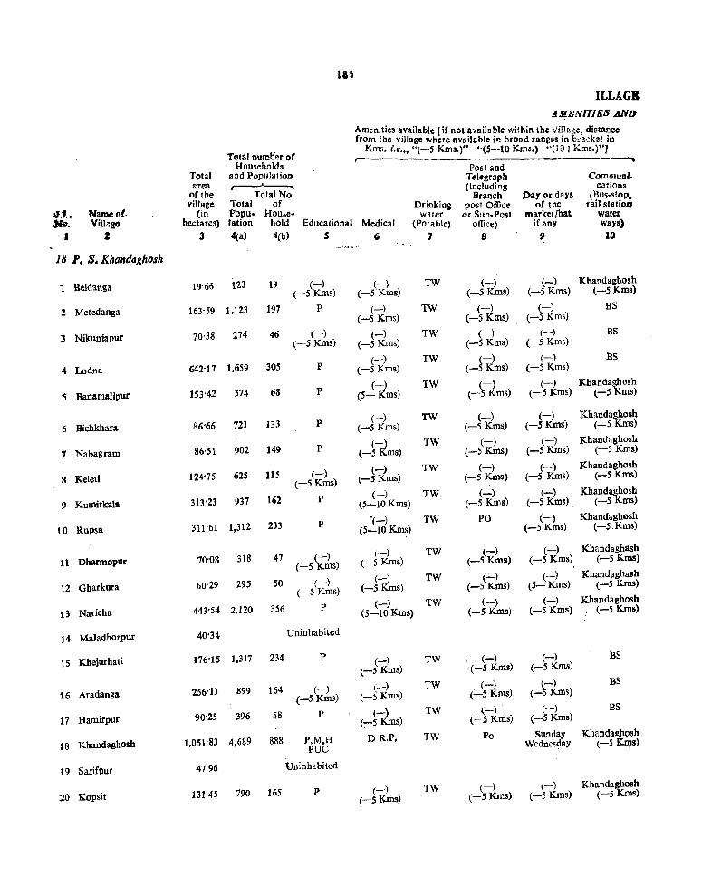
Iail
ILLAG&
AlJI,ENITIE8 AND
~menitjes lI;vailable (if not avaibblc wi!hin the Villag.:!, distance r~ the vIllage where available ill broad ranees in bI'2i'k~t in
Total numher of ms. i.e ... "(-5 Kms.)" "(5-10 Kms.) '·(IO-:-Krrls.)"J
Households Post and Total and Population erea
Telegraplt CommunI..
oflbe Total No. (including cations
village Total of Branch Day or days (BUS-SlOp.
'lo};l. Name 0(· (in Popu- House-Drinking post Oftice of tbe rail slatioD
-:He. Villago hectares) lation bold Educational water or Sub· Post market/hat water
Medical (Potable) office) ifaDY ways)
I Z 3 4(a) 4(b) S 6 7 8 51 10
18 P. S. Khandaghosh
1 Beldanga 19'66 '123 19 (-) (-) TW (-) (-) Khandaghosh (-5 Kms) (-5 Kms) (-5 Kms) (-5 Kms) (-5Kms)
2 Metedanga 163'59 1,123 197 P (-~ TW (-) (-) BS (-5 Kms) (-5 Koos) (-5 Kms)
3 Nikunjapur 70·38 214 46 (-) (-) TW (-) (-) (-5 KIDs)
BS (-5 Kms) (-5 Kms) (-5 Kms)
4 Lodna 642'11 1,659 305 P (-) TW (-) (-) BS
(-5 Kms) (-5 Kms) (-5 Krns)
5 Banamalipur 153'42 374 68 P (-) TW (-) (-) Khanda~osh
(5- Kms) (--5 KIDs) (-5 Koos) (-5 oos)
6 Bichkhara 86'66 721 133 P (-) TW (-) (-) Khandaghosh
(-5 Krns) (-5 Kms) (-5 Koos) (-5 Kms)
1 Nabagram 86·51 902 149 P (-) TW (-) (-) Khandaghosh
(-5 Kms) (-5 KIDs) (-5 Kms) (-5 Koos)
8 Keleti 124'75 625 115 (-) (-) TW (-) (-) Khandaghosh
(-5 Kms) (-5 Kms) (-5 Kms) (-5 Kms) (":"5 Kms)
9 Kumirkala 313'23 937 162 p (-) TW (-) (-) Khandaghosb (5-10 Kms) (-5 Kms) (-5 Kms) (-5 Kms)
10 Rupsa 311'61 1,312 233 P '(-) TW PO (-) Khandaghosh (5-10 Krns) (-5 Krns) (-5.Kms)
11 Dbarmopur 70'08 318 47 (-) (-) TW (-) (-) Khandaghash
(-5 KOOs) (-5 Kms) (-5 Kms) (-5 Koos) (-5 Koos)
12 Gharkura 60'29 295 50 (-) (-) TW (..:..) (-) Khandaghash
(-5 Kms) (-5 Kms) (-5 Kms) (5- Kms) (-5 Kms)
13 Nai'icha 443'54 2.120 356 P (-) TW (-) (-) Kbandaghosh (5-10 Kms) (-5 Koos) (-5 Kms) . (-5 Kms)
14 Maladhorpur 40'34 Uninhabited
15 Khejurhati 176'15 1,317 234 P (-) TW (-) (-) BS
(-5 Krns) (-5 Koos) (-5 Kms)
16 Aradanga 256''l3 899 164 (-) (-) TW (-) (-) BS
(-5 KIDs) (-5 Kms) (-5 Kms) (-5 KIDs)
17 Harnirpur 90'25 396 58 P l-) TW (-) (-) BS
(-5 KIDs) (-5 KIDs) (-5 KIDs)
is Khandaghosh 1,051'83 4,689 888 P.M,H DR.P. TW Po Sunday Khandaghosh
PUC Wednes4ay (-5 K~s)
19 Salifpur 47'96 Uninhabited
20 Kopsit 131-45 790 165 P (-) TW (-) (-) Kbandaghosh
(-5 KIDs) (-5 Kms) (-5 Krns) (-5 Koos)

DIRECTORY LAND USB
Apptocb Nearest Town to an',_: di~t2.:1'
Village (in Kms)
11 12
KR Barddhaman 20
PR Barddhaman 24
PR Barddhaman 24
PR Barddhaman 24
KR Barddhaman 24
KR Barddhaman 2t
KR Barddhaman 22
KR Barddhaman 25
KR Barddhaman 26
KR Barddbaman 26
KR Barddhaman 26
KR Barddhaman 20
KR Ba(ddhaman 20
PR Barddhaman 20
PR Barddhaman 22
PR Barddhaman 22
KR Barddhaman 23
KR Barddhaman 24
Power Staplo Supply food
U 14
Rice and Wheat
Rice and Wheat
Rice and Wheat
Rice and Wheat
ED Rice and Wheat
ED Rice and Wheat
EO Rice and Wheat
ED Rice and Wheat
BAg Rice and Wheat
HAg Rice and Wheat
EAg Rice and Wheat
EAg Rice and Wheat
Rice and Wheat
EAg Rice and Wheat
EAg Rice and Wheat
EAg Rice and Wheat
FAg Rice and Wheat
Rice and Wheat
187
Land use (i.~. llrea under different types or land use in Declares, r;:corded to the nearest Unit)
Culturable Area not Remarks incladI88 waste availablo any pJaceof
Irrigated by Unirrl-(including for religiol's, historICal gaucher culti- Or archaeological
Forest source gated and groves) vation ir.:erest 15 16 17 '18 19 20
TK 19'66
GC 112'91 50'68
GC 36'42 14'16 19'80
GC 364'22 40'87 237"08
GC 44'11 40'47 40'47 28'37
GC 40'47 12'14 8'09 25-96
TWE 4087 20'23 25'41
TWE 41'23 34"40 40'47 8'60
TWE 90'65 141'64 40'47 40'47
TWE 100'77 130'31 20'23 60'30
57"81 12'21
46'13 10'12 4'04
TWE 202'34 73-25 101'17 66'78 Sbibamandir
39'25 109
GC 40'47 31'37 10'12 12'25 TWE 80'94
GC 64'75 53'42 40'83 TWE 97'13
GC 40'47 16'19 9'31 TWE 24'28
GC 485'62 20'23 505'51 'IWE 40'41
GC 44'52 3'44
GC 121·41 10'74

188
VILLAGB A~ENIT1111B AND
Amenities available [If nol available within tbe Village, distanco from the village wbere available in broad ranges in bracket in
Total number of Kms. i.e,., "(-5 Kms,)',' "(5-10 Kms.) ··(IO+Kms.)"J
Households Posl aDd Total aDd Population Telegraph CommunI-area ~ (including cations
of the Total No. Branch Day or days (Bus-stoP. village Total of Drinking post OftIcc of the rail st atioll
".1.. Name of (in Popu- House- water or Sub-Post market/ha~ water
•• Villa .. hectares) lation bold Educational Medical (Potable) office) if any ways)
J J 3 4(a) 4(b) S (i 7 8 9 10
J8 P. S. Khandaghosh- contd.
21 latNewyzi 42'76 U niob abited
'11 Syamadall&B 110'81 504 111 P (-) TW (-) (-) Khandaghosh (-5 Kms) (-SKIns) (-S Kms) (-S Kms)
-23 Barisiati 465'96 1.851 304 P (-) TW (-) (-) Khandaghosh (-5 Kms) (-5 Kms) (-5 Kms) (-S Kms)
1.4 Baman Ari 32'84 976 199 P (-) TW (-) (-) Khandaghosh (S-IOKms) (-5 Kms) (-5 Kros) (-5 Kms)
15 Dubrajhat 401'98 2,213 408 P (-) TW '(-) - (-) Khandaghosh (5-10 Kms) (-5Kms) (5-10 Kros) (-SKIns)
'16 BerugraOl 1,412'SO 4,193 726 P (-) TW PO (-) Khandaghoslt (5-IOKms) (5-10 Kms) (-SKIns)
21 Bayda 123-02 231 41 P (-) (5-tO Kms)
TW (...;.) (-) Khandaghosh (-5 Kms) (-s Kms) (-5 KIns)
18 Kalna 413'23 1,138 182 P (-) TW (-) (-) Khandaghosh (5-IOKms) (-5 Kms) (-5 Kms) (-S Kms)
:29 Sultanpttr 195'84 893 136 P (-) TW (-) (-) Khandaghosh (5-HlKrns) (-SKms) (-5 Kms) (-5 Kms)
10 Daiyar 42'71 384 64 P (-) TW . (-) (-) BS (5-10 Kms) (-5 Kms) (-5 Kms)
31 Amrol 220'10 1,574 246 P (-) _.TW (-) (-) BS (5-10 Kms) (-5 Kms) (-S Kms)
.32 Sadhanpur 214'58 813 131 P (-) TW (.:...) i(-) BS (5-10 Kms) (-5 Kms)' (..--5 Kms)
.31 Punsur 145-85 845 135 P (-) TW (-) '(-) BS (-5Kms) (-5 Kms) (5'IKIns)
34 Sibarambati 67'44 499 79 P (-) TW (-) (-) BS (-S Kms) (-5 Kms) (----5 Kms)
35 Bonwai 555'14 1,737 418 P,M,H (-) TW PO Tuesday BS PUC (-5 Kms) Sdpday
.36 Narayanpurchak 55'S5 Uninhabited
37 Torul 84-65 382 70 P (-) TW (-) ( -) Khandaghosh (-5 Kms) \
(-5 KIns) (-5 Kms) (5-10 Kms) 38 Narayanpur 61'95 650 113 P (-) TW (-) (-) " Khandagbosh
(-5 Kms) (-SKms) (-5 Kms) (5-10 KInS) 39 Kule 225'69 1,089 165 P ,(-) TW (-) (-) ·Khandaghosh
("":5 Kms) (-5 Kms) (-5 Kms) (5-10 Kms) 40 Ukhrid 585'64 3,655 P,M,H
\. 680 (>-) TW PO (-) Khandaghosh
PUC (5-10 Kms) (-5 Kms) (5-10KIns)

lag
DIRECTORY LAND usm
Land use (i.e. area under different types of land use 10 hectares. recorded to the nearest U Dil)
Culturable Area not Remarlcs ioel .... waste available any pia(:C of
~pprocb Nearest Town (including for religious, bistoriea1 to and distance Power Staple Irrigated by UDirri- gaucher culti- or archaeological
Village (in Kms) Supply food Fo~t source gated aDd groves) vatioD int{1ccst 11 12 13 14 '1 16 17 18 19 20
TW 42'76
KR Barddhaman Rice and GC 80'94 29'87 24 Wheat
.KR Barddhaman Rice and GC 404'69 , 62'27 24 Wheat
KR Barddhaman Rice and GC 24'28 8'56 27 Wheat
KR Barddhaman Rice and GC 364'22 37'76 27 Wheat
KR Barddbaman Rice and GC 1,214'06 198'44 :;0 Wheat
KR Barddhaman Rice and GC 9308 14'16 15'78 34 Wheat
KR Barddhaman Rice and GC 283'28 129'95 Kalapahar Temple; 32 Wheat
KR Barddhaman Rice and GC 161'87 33'97 32 Wheat
PR Barddhaman Rice and TK 24'69 18'02 35 Wheat
:PR Barddhaman Rice and TK 17928 40'82 3S Wheat
PR B:trddhaman Rice and GC 202'34 72-24 35 Wheat
PR Barddhaman Rice and GC 101'17 20'23 24'45 35 Wheat
l'R Barddhaman Rice and GC 40'47 26-97
30 Wheat
.PR Barddhaman Rice and GC 404-69 150'45 BawaichandimaUl;
30 Wheat Temple
TW 55-55
KR Barddhaman Rice and GC 60-70 23'95 24 Wheat
KR 'Barddbaman Rice and GC 40'47 21-48 33 Wheat
KR Barddhaman Rice and GC 161-87 63-82 24 Wheat
_1{R Barddhaman Rice and GC 404-69 180-95 25 Wheat

190
VILLAGJt. AMENITIES AND
Amenities available {if not available within tbe Village, distance from the village where available in broad ranges in bracket in
Total number or Kms. i.e ... "(-5 Kms.)" "(5-10 Kms.) ·'(IO+Kms.)"]
Households Post arid Total aDd Population Telegrapb Communi_ area ~ {Includins cations
• rtbe TOlaiNo • Branch Dayordaya (Bus-stoP. village. Total of DrinlinB post Office of the rail statio".
6,J.. Namool (in Popu- House- water or Sub· Post market/hat water •• Village bectares) lation hold Educational Medical (Potable) office) if any ways)
• ! 3 4(a) 4(b) S 6 7 8 09 10
18 '.S. Khandaghosh-contd.
41 Khantikar 86'98 130 270 P (-) TW (-) (-) Khandoghosh (-5 Kms) (-5 Kms) (-5 Kms) (-5 Kms)
42 Karimpur 95'10 492 101 P (-) TW PO (-) KhandhghosB (-5 Kms) (-5 Kms) (-5 Kms)
43 Munsabpur 131'68 334 62 P (-) TW (-) (-) Khandaghosh. (-5 Kms) (-5 Kms) (-5 Kms) (-5 Kms)
44 Jot Dhamodar 46'78 111 24 P (-) TW (-) (~) Khandagbosh (-5 Kms) (-5 Kms) (-5 Kms) (-5 Kms)
45 Onari 770'10 4,184 743 P,M,H RP TW PO Tuesday Khandaghosh PUC Saturday (-SKms)
46 Goyespur 236'12 695 112 P (-) TW (-) (-) Khandaghosh. (5-10 Kms) (-5 Kms) (-5 Kms) (-5 Kms)
47 Enayetnaga 97-14 621 89 P (-) TW (-) (-) KhandagbosB (S-lOKms) (-5 Kms) (-5 Kms) (-5 Kms)
48 Ulkunda 43-69 704 ]26 P (-) TW (-) (-) Khandagbosh (-5 Kms) (-5 Kms) (-5 Kms) (-5 Kms)
49 Tolna 186'97 999 188 P (-) TW (-) (-) Khandagbosn (-5 Kms) (-5 Kms) (-5 Kms) (-5 Kms)
SO Sihrpur 111'97 519 96 P (-) TW (-) (-) Khandaghosh. (-5 Kms) (-5 Kms) (5-Kms) (-5Km$)
51 Krishnanagar 309"40 90S 150 P (-) TW (-) ~ KhandaghQsn (-5 Kms) (-5 Kms) (-5 s) (-5 KIns)
52 Allpur 164'17 1,039 19'3 P (-) TW ! PO (-) BS (-5 Kms) (-5 Kms)
53 Maur 54'08 255 S4 (-) (-) TW ' (-) (-) Kbandaghosb. (-5 Kms) (5-10 Kms) (-5 Kms). (5- Kms) (-f5 KIns)
54 Nischintapul 76'78 737 137 P (-) TW PO (-) . BS (-5 Kms) (5-KIns)
55 Cbandipur 147'46 325 62 P (-) TW (-) (-) BS (-S Kols) (-5 Kms (-5 Kms)
'" 56 Napara 247"67 1,249 24~ P (-) TW h) (-) Khandagbosb· (-5 Kms) (-5 K.ms) (-5 Kms) (-5 Kms).
57 Masila 17303 849 162 P , (K_k TW (-) (-) BS (-5 s) (-5Km~) (-5Kms)
58 Susauga 373"64 1,213 198 P,M,H RP TW PO (-) BS PUC (-5 Kms)
59 WaDia 77'31 781 114 ,(-) (-) TW (-) (-) Khandaghosh (,5 kIDs) (-5 Kms) (-5 Kms) (-5 Kms) (-5 Kms)
60 Pa]asdanga 61'92 675 120 P (-) TW (-) (-) Khandagaosh. (-5 Kms) (-5 Kms) (-5 Kms) (-5 Kms).

DIRECTORY LAND USE
;'pprocb Nearest Town to and distance
Village (in Kms)
11 12
KR Barddnaman 24
KR Barddhaman 2l
KR Barddhaman 22
.KR Barddhaman 23
.KR Barddhaman 23
KR Barddhaman 22
XR Barddhaman 22
KR Barddnaman 23
KR Barddhaman 24
.KR Barddhaman 24
.KR Barddhaman 20
PR Barddhaman 22
.KR Barddhllman 20
.PR Barddhaman 30
1'R Barddhaman 33
.KR Barddhaman 30
iPR Barddhaman 22
PR Barduhaman 32
KR Barddhaman 20
_KR Barddhaman 22
Power Stllple Supply food
13 14
Rice and Wheat
ED Rice and Wheat
Rice and Wheat
Rice and Wheat
ED Rice and Wheat
Rice and Wheat
Rice and Wheat
Rice and Wheat
Rice and Wheat
Rice and Wheat
Rice and Wheat
ED Rkeand Wheat
Rice and Wheat
E,Aa Riee and Wheat
E,Ag Rice and Wheat
E,A~ Rice and Wheat
E,Ag Rice and Wheat
E,Ag Rice and Wheat
ED Rice and Wheat
ED Rice and Wheat
191
Land use (i.e. area under diffef(.nt types of land use in hectares. recorded to the nearest Unit)
Cullucable Area Dot Remarks iod ..... waste availablo any I'I:lce of
Irrigated by UDirri-(including for religious, histotied
Poreat gaucher culti- or archaeologicd
source: gated and groves) vatioD interest IS 16 17 18 19 20
GC 56·66 30·32
GC 80'94 14'16
GC 80·94 50·74
GC 40·47 6·31
GC 607·03 163·07
GC 161'81 74·25
GC 80·94 16'20
GC 20·23 2-83 20·63
GC 121'41 12'95 52·61
GC 80·~4 31.03
GC 80·94 161·87 66·59
GC 121·41 4·05 38'71
GC 4'05 36·42 INl
TWE 24·28 16'19 36·31
TWE 38-45 31-97 77-04
TWE 40'47 75·91 111'29
TWE 40'47 80'04 51·62
TWE 80·94 151'87 140·93
GC 20'23 20·23 56·85
40·47 21-45

192
VlLLAGIt AMBNlTlES AND
Amenities available (if not available within the Village, distance from the village where available in broad rangel in bracket in
Total number of Kms. i.e." "(-S Kms.)" "(5-10 Kms.) ··(JO+Kms.)")
Households Post and Total aad population Telegr~ph Commun'. area {Includln, cations
• ftbe Total No. Branch Day or days (Bus-stoP • village Total of Drinlinl post Office of the rail station
I.t. Name 0' (in Popu- House- water or Sub-Post market/hat water Mo_ ViiI. IIc<:tares) lation hold Educational Medical (Potable) officeJ iran), ways)
• I 3 4(a) 4(b) , (; 7 8 9 10
18 P.S. Khandaghosh -eoncld.
til Chak Sultan 54'39 163 32 (-) (-) TW (-) r-) Kbandaghosb (-5 Kms) (-SKmS) (-S Kms) (-5 Kms) (5-10Kms)
62 Padua 106'88 348 58 P (-) TW (-) (-) Khandaghosb (-5 Kms) (-S Kros) (-5 Kms) (S-IO Kms)
63 Salun 279'98 2.003 318 p (-) TW (-) (-) BS (-5 Kms) (-Huns) (-5 Kms)
64 Atkulya 275'S9 449 89 P (-) TW (-) (-) Khandaghosh (-5 Kms) (-5 Kms) (-5 Kros) (5-10 Kms)
65 Gaitanpur 373'93 1,534 254 P (-) (-5 KIns)
TW (-) (-) Khandaghosh (-S Kms) (-5Kms) (lO+Kms)
66 Tildaoga 74'46 484 73 P (-) TW (-) (-) Khandaghosh (-5 KIns) (-5 KIDs) (-5 Kms) (lO+Kms)
67 Roypur 57'73 156 33 P (-) TW (-) (-) Khandaghosh. (5-10 KIns) (-5Kros) (-5 Kms) (lO+Kros)
68 Kesabpur 110'08 1,608 273 (-) (-) TW (-) (-) Khandaghosh (-5 Kms) (-5 Kms) . (-SKros) (-SKros) (lO+Kms)
69 Khudkuri 402-36 96S 180 P HC TW (-) (-) Khandaghosh (-5 Kms) (-SKms) (S-IOKms)
70 Sankori 1,081'67 3,331 542 P,M,H RP TW PO Tuesday Kbandaghosh PUC Saterday (5-10KIns).
'11 Aimabheger 55'18 Uninhabited
72 Kulchaura 45'90 729 130 (-) (-) I
TW (-) , (-) Khandaghosh (-5 Kms) (-5 KIns) (":"5 KID$) (;_S Kms) (5-10 Kms)
.,3 Huria 77'49 1,206 204 P,M,H (-) TW PO (-) Khandaghosh (-5 Km!) ("":'5 Kms) (5-10Kms)
74 Kantalpur 1,020.21 5,384 891 (-) (-) TW (-) (-) Khandaghosh (-5 Kms) (-S KIns) (-5 Kms) (-5 Kms) (10+KJ:D.s)
vs Keudia 139'84 1,131 202 P (-) TW (-) (-) Khandaghosh (5-10 Kms) (-5 KIDs) (S-1O Kms) (-S KIns)
76 Juhila 855'46 4,230 692 P (-) (5-10 KIns)
TW PO (-) Khandaghosh (-5 Kms) (5-10Kms)
V1 Cbak BaduIia 49.77 65 4 (--') (-) , TW (-), ~ BS (-5 Kms) (-5 KIDs) (-S KIDs) (':""'5 )
118 Sagrai 207'OS 993 181 P (-) TW PO .(-) BS (5-10 KIns) (-S KIDs)
79 Badulia 365'67 2,715 419 P (-) TW (-) Monday BS (S-lOKms) (-5 Kros) Tuesday
ao Puma 59'91 274 38 P (-) TW (-) (-) Khanda&hosll (S-10Kms) (-SKms) (-SKms) (I 0 +Krns)

r DIRECTORY
LA.ND USB
Apptoc:b to
Village
11
KR
PR
PR
KR
KR
KR
KR
PR
KR
KR
KR
KR
KR
KR
KR
PR
PR
PR
KR
Nearest Towli ami distan ell
(inKms)
12
Barddhaman 21
Barddhaman 27
Barddhaman 28
Barddhaman 28
BarJUhaman 22
Barddhaman 27
Barddhaman 9
Barddhaman 9
Barddhaman 10
Barddhaman 20
Barddhaman 11
Barddhaman 9
Barddhamall 5
Barddhaman 12
Barddhaman 15
Barddhaman 12
Barddhaman 12
Barddhaman 13
Barddhaman 14
Power Supply
13
E,Ag
E,Ag
E,Ag
ED
E,Ag
E,Ag
E,Ag
Staple food 14
Rice and Wheat
Rice and Wheat
Rice and Wheat
Rice and Wheat
Rice and Whea\
Rice and Wheat
Rice and Wheat
Rice and Wheat
Rice and Wheat
Rice and Wheat
Rice and Wheat
Rice and Wheat
Rice and Wheat
Rice and Wheat
Rice and Wb.eat
Riclil and Wheat
Rice and Wheat
Rice and Wheal
Rice and Wheat
193
Land use (i,e. area under different types of land use in bectares, recorded to tho nearest Vllil)
Culturable Artallot Remarks includllll waste avaiJabJo any place 01
(including for religious, historieal Irrigated by Voirri· gaucher culti· or archaeological
Forest source gated aod groves) vatioR interest
IS 16 17 '18 19 20
54'39
TWE 40'47 25'90 40'51
TWE 40'47 121'41 118'10
204,37 71'22
TWE 202'34 130'71 40'88
TWE 12'14 49'78 12'54
TW 45'73 ' 12'00
TW 77'70 32'38
TW 202'34 200'02
GC;404'69 TW 191'42
121'41 364'15
GC 55'18
GC 25'50 20'40
GC 57'06 20'43
GC 809'37 202'34 8'50
GC 97'13 42'71
GC 45'73 202'34 607'39
GC 49-71
GC 174-82 J2'23
GC 305'13 60'54
GC 40 -47 19'44

1!j4
VILLAG& d~ENITIE8 ~D
Amenities available (Ir nOl availabl.e within the Village, distance from tha village where available in broad ranges in bracket in
Total number or Kms. i.e." "(-S Kms.)" "(5-10 Kros.) "{I0+Kms.)"]
Households Post and Total and Population Telegraph CommunI-area .-------..-.. (including cations
oftbe Total No. Branch Day or days (Bus-stop. village Total of Drinking post Office of tbe rail sladoD
~;l. Name 01 (in Popu- House- water or Sub· POll market/hat water ,,,.,. Viilaso hectares) lation hord Educational Medical (Potable) offiC£) iCany ways)
I 1 :1 4(a) 4(b) 5 6 7 8 9 10
18 P. S. Khand«ghosh
81 Taraposk 165'88 516 92 P (-) TW (-) (-) Khandaghosh (lC+Kms) (-5 Kms) (-SKms) (l 0+ Kms)
82 Aladipur 180·53 823 134 P (-) TW (-) (-) Kbandaghosh (IO+Kms) (-5 Kms) (5-10 Krns) (IO+Kms)
83 Krishnapur Kurkura 160'25 803 131 P (-) TW (-) (-) Khandaghosh (5-JO Kms) (5-10 Kms) (5-10 Kms) (IO+KIps)
84 Chagram 854'78 2,110 359 P (-) TW PO (-) Khandaghosh (5-10 Kms) (-5 KIDs) (I 0+ Kms)
85 Saranga 282'90 1,943 306 P,M,H RP TW PO (-) RS PUC (5-10 Kros)
86 Guir 598·27 2,763 469 P (-) TW PO (-) RS (S-10 Kros) (5-10 Kms)
87 Gopalpur 77·26 546 82 P (-) TW (-) (-) Khandaghosh (-5 Kms) (-5 Kros) (5-10 Kms) (I 0 +Kms)
88 Augram 82'36 657 82 P (-) TW (-) (-) Khandaghosh (-5 KIDs) (-5 KIDs) (-S Kros) (IO+Kms)
89 Cbintamanipur 126'11 419 64 P (-) TW (-) (-) Khandaghosh (10+Kms) (-5 Kms) (-5 Kms) (10+Kms)
90 Puriha 81'13 612 94 P (-) (IO+Kms)
TW (-) (-5 Kms)
(-) Khandaghosh (-5 Kms) (lO+Kms)
91 Sunia 133'79 567 107 P (-) TW (-) (-) Khandaghosb (IO+Kms) (-5 Kms) (-5 Kms) (lO+Kms)
92 Jarul 105'99 72S 121 P (-) TW I (_) (-) Khandaghosh (IO+Kms) (-5 Krns) (-5 Krns) (IO+Kros)
93 Amilia 79·36 569 95 (-) (-) TW PO (-) BS (-S Kms) (I0+Krns) (-5 Kms)
94 Kantapakur 71·67 1,353 939 P (-) TW (IO+Kms)
(-) (-5 Kms)
Tuesday RS
95 Kamadebpur 242'65 694 114 P (-) TW ~) (-) Khandaghosh (10+Kms) (':"'5 ms) (-5 Kms) (IO+Kms)
96 Kaiar 33'2-78 2178 369 P (-) TW PO (-) RS (-5 Kms) (-S Kms)
97 Gopinathpur 92'01 380 77 P (-) TK,TW (-) (-) Khandagbosh (-5 Kms) (-5 Kms) (5-10 Krns) (IO+Kms)
98 Amba 120'46 968 183 P (-) TK.TW ("'7) (-) Khandaghosh (-5 Kms) (-5 Kms) (5-10 Kms) (10+Kms)
99 Pitambarpur 10S'50 118 23 (-) (-5 Krns)
(-) (-5 Kms)
TK,TW (-) (-5 Krns)
(-) Khandagbosh (5-10 Kms) (IO+Krns)
100 Balabati 67'92 460 75 P (-) TK,TW (-) (-) Khandaghosq (-5 Kms) (-5 Kms) (5-10 Kms) (10+Kms)

DIRECTORY LAND USg
Approeh Nearest ToWII to and distad 0;
Village (in Kens)
11 12
KR Barddhaman 15
KR Barddhaman 18
KR Barddhaman 20
KR Barddhaman 22
KR Barddhaman 22
KR Barddhaman • 24
KR Barddhaman 20
KR Barddhaman 22
KR Barddhaman 20
KR Barddhaman 20
KR Barddhaman 21
KR Barddhaman 17
PR Barddhaman 16
PR.KR Bardqhaman 17
KR Barddhaman 20
KR Barddhaman 22
KR Barddhaman 2S
KR Barddhaman 25
KR Barddhaman 25
KR Barddbaman 25
Power Slap!;, . Supply rood
J) 14
Rice and Wheat
Rice and Wheat
Rice and Wheat
Rice and Wheat
Rice and Wheat
ED Rice and Wheal
Rice and Wheat
Rice and Wheat
Rice and Wheat
Rice and Wheat
Rice and Wheat
Rice and Wheat
ED Rice and Wheat
'ED Rice and Wheat
Rice and Wheat
ED Rice and Wheat
ED Rice and Wheat
ED Rice and Wheat
ED Rice and Wheat
ED Rich and Wheat
195
Land use (i.e. area under different types of lind use in bectareS. recorded to Iha nearest Uail)
Culturable Arfano' Remarks ill£JudJ .. waste availablo anypJaceof
(including for religious, histod ... lrr;g::lted by Uoirri- gaucber tutti- or archaeological
Forest source gated and groves) vatioa mterest 15 16 17 '18 19 20
GC 129'50 36'38
GC 137'99 42'54
GC 119'79 40'46
GC 429'78 50 404,77
GC 181'70 101'20
GC 39578 202·49
GC 56'66 20'60
GC 49'78 33-58
GC 89'44 36'67
GC 56-66 24'47
GC 103-20 30-59
GC 75'27 30-72
GC 40'47 38-89
GC 47-35 24-32
GC 191'82 50'S3
GC 241-60 91-18
GC 61:11 30'90
GC 72'84 47'62
GC 76'89 28'61
GC 47'75 20'17

195
VILLAGB
d!J!ENITIE8 .4ND
Amenities available (If not available within the Village, distancc rrom the village where available in broad ranges in bracket in
.. Total numb"er ot Kms. i.e ... "(-5 Kms.)" "(S-10 Kms.) ·'(lO+Kms.)"J
Households Post aDd Total and Population Telegraph Communi. area (including cations
Oftbe Total No. Branch Day or days (Bus-stop, village Total of Drinking post Office of the rail statiOD ".1.. Name ot (in Popu- House- water or Sub· Post market/hat water
.He. Village hectares) lation bold Educational Medical (Potable) office) if any ways) , .J 3 4(a) 4(b) S 6 7 8 9 10 ~~:.r";"'" ,
18 P. S. Khandaghosh-Concld
101 Arin 195'69 608 lOS P (-) TW (-) (-) Khandaghosh (-5 Kms) (-5 KIDS) (-5 Kms) (10+ Kms)
102 Baragopinathpur 244"44 1,307 237 P D TW (-) (-) BS (-5 Kms) (-5 Kms)
103 Sonkarpur 220'89 924 136 P (-) TW (-) (-) Khandaghosh (-5 Kms) (-5 Kms) (-5 Kms) (10-Kms)
104 Torkona 288-05 1,224 191 P.M,H HC TW PO (-) Khandaghosh PUC (-5 Kms) (10+Kms)
105 Induti 527-06 3,029 461 P (-) TW (-) (-) Kbandaghosh (-5 Kms) (-5 Kms) (-5 Kms) (10+Kms)
106 Muidbara 202'21 1,156 176 P (-) TW (-) (-) Khandaghosh (5-10Kms) (-5Kms) (:-5 Kms) (10+Kms)
107 GopaIbera 766'02 2,170 325 P.M,H (-) TW PO (-) Kbandaghosh PUC (5-10 Kms) (-5 Kms) (10+Kms)
lOS Doaragan 128'06 383 72 P (-) TW (-) (-) Khandaghosh (5-10Kms) (-5 Kms) (-5 Kms) (10+Kms)
109 AMra 127'85 938 126 P (-) TW (-) (-) Khandaghosh (5-lOKms) (-5 Kms) (5-10 Kms) (lO+Kms
110 Rautara 390'57 728 113 P (-) TW (-) Wednesday Khandaghosh (lO+Kms) (-5 Kms) (lO+Kms)
III Kindur 425'31 3.042 375 P,M.H (-) TW PO Tuesday BS PUC (5-10 Kms)
Total Z6,522'73 1,235-69 20,988 P-91 D-2 M-ll HC-:-2 H-11 RP-S
PUC-I0

DIRECTORY l-AND USII
.ApprocD to
Villtge 11
KR
PR
KR
PR
:K.R
KR
KR
~R
Kit
KR
KR
Nearest Towr. and distanc::o
(in Kms)
lZ
Barddhaman 18
Barddhamaa 21
Barddhaman 23
Barddhaman 28
Barddhaman 25
Barddhaman 27
Barddhamall 35
Barddhamall 36
Barddhamu 43
Barddhaman 4S
Barddhaman 40
Power Supply
J3
ED
ED
ED
E,Ag
E,Ag
ED
E,AS
ED
ED
ED
ED
Staple foilii 14
Rice and Wheat
Rice and Wheat
Rice and Wheat
Rice and Wheat
Rice and Wheat
Rice and Wheat
Rice and Wheat
Rice and Wheat
Rice and Wheat
Ricc and Wheat
Rice and Wheat
197
Land use (i.e. area under different types of land use ID hectares. recorded to the nearest Unit)
Culturable Area not Recnarks inc" .... waste availablo nnyplaceof
lincluding for. religious, historical Irrigated by Unirri· gaucher culti· or archaeological
Forest source cated and groves) vatioD interest 15 16 17 18 }9 20
GC 134-76 60'93
GC 169.56 74'88
OC 155-80 65'09
GC 164'30 83'28 TWE 40'47
GC 308'37 !0'Z3 157'99 TWE 40'47
GC 50'18 40'41 111'56 "
GC 404'69 137'59 ]86'51 TWE 37'23
GC 20-23 68'SI) 39-03
GC 28'33 56'66 42'86
GC 87'01 102'34 101-22
GC 84'1)8 178-0, 161-27
GC 13,274'" l,300'35 171'23 7,479-70 TIC. 223'63 TW,15'SG TWE 1,356'9J

1~8
ALPHABETICAL LIST OF VILLAGES
19 P. S. Raina
Jurisdiction Jurisdictio II 81. Name of VillaPI' List SI. Name of Villages List No. No. No. No. 1 '2 3 1 2 3
1 Adampur 112 34 Belsar 11
2 Agarpara 133 35 Belur 89
3 Ahladipur 21 36 Bendua 61
4 Akhina 175 37 Bhadiara 158
5 AlaJpur 101 38 Bhagabatipur 123
6 Alampur 183 39 Bhaojapur 179
7 Anguna 87 40 Bhimpur 23
8 Arui 182 41 Bburkunda 150
9 Astikur 86 42 Bidyanidhl 98
10 Atapur 207 43 Bijipur lOS
11 Ausara 69 44 Binodpur 170 12 Babarakpur 2 45 Birampur 105
13 Babla 137 46 Birpur 189-
14 Baharampur 50 47 Bisweswarbati 119
IS Baidypur 196 48 Bokra 96
16 Baira 102 49 Bora 83
17 Baithari 66 50 Bora 57
18 Bajiawarpur 154 51 Borajpo1a 165
19 Bajitpur 60 52 Brahmandanga 162
20 Balagar 84 53 Bujrukdighi 62
21 Baliarpur 45 54 Bulcban9rapur 144
22 Balla 43 55 Borar 51
23 Bamunia 32 56 Chabukpur 192
24 Banagram 34 57 Chak Basanta Bati 181
25 Bandgachha 5 58 Cbak Bhrua 161
26 Bansa 122 59 Chak Chandan 64
27 Bantir 30 60 Chak Pakirpur 153
28 Bara Bainan 195 61 Chak Kaiti 125
29 Barati 198 62 Chak Kiampur 76
30 Barpur 188 63 Chak Mastafa 157
31 Basudebpur 24 64 Cbak NaraSinhapur 204
32 Bataspur 20~ 65 Cbak Purohit
33 Belar 149 66 Cbaodipur 54

HI9
ALPHABETICAL LIST OF VILLAGES
19 P. S. Raina-Contd.
1urisdiction .iurisdiijctiol1.. ~1. Name of Villages List SI. Name of Village. Lst No. No. No. No. 1 2 3 1 2- 3
61 Chhata Dighi 176 100 Hijalna 33 . 68 Chhota Bairam 167 101 Ibidpur 95
69 Chhota Fakirpur 171 102 Jagatpur 81 70 Chhota ,Kairapur 8 103 Jakta 6
71 Chuadanga 145 104 Jamaipota 79
72 Dakshin Gopalpur 177 105 Jamna 4
73 Dakshinkul 82 106 Jamui 17 74 Dakshin Mohanpur 169 107 Jasapur 197 75 Damirya 200 108 Jot Raghab tao 76 Darbespur 151 109 Jot Rajaram t07
77 Debibarpur 49 110 Jot Ram 25 78 Deno III 111 Jot Sadi 10 79 Deriapur 85 112 Jot Silam 9 80 Dhanas 39 113 Kaiti 164 81 Dhamoari 113 114 Kalui 141
82 Dharan 124 115 Kamargaria 193 83 Dishra 190 116 Kamarhati 174 84 Durgabati 163 117 Kanaichatra 148 85 Eklakshmi 135 118 Klantabil 129 86 Fakirpur 18 119 Keunta 142
87 Patepur 110 120 Khalina 75 88 Gobindapur 126 121 Khemta 19 .89 Goigram 29 122 Konakrishnapur 56 90 Golgram Nurpur 47 123 Konarpur 186 91 Gopalpttr 13 124 Kotsimul 208
92 Gopinathpur 52 125 Kukra 16 93 Gotam 202 126 Kulia 46 94 Guagare 156 127 Kutchigara 166 95 Gunar 91 128 Lohai 185 96 Hakrishnapur 93 129 Machhkhara 3
97 Hariharpur 109 130 Madanagar 78 98 Haripur 36 131 Madhabdihi 184 '99 Hatpushkarini 146 132 Mahesbati «06

100
ALPHABETICAL LIST OF VILLAGES
19 P. S. Raina
Jurisdiction J urisdi ctio lls
SI. Name of Villages List 51. Name of Villages Lisa No. No. No. No. 1 2 3 1 2 3
133 Makarkola 134 166 Pirijpur 3S
134 Mandarpur 143 167 Pursuna 20
135 Maniari 138 168 Ramanandpur 42
136 Maszidpur 127 169 Rambati 121
137 Math Nurpur 70 170 Ramchandrapur 6J.
138 Meral 80 171 Ramkrishnapur i53
139 Mirpur 130 172 Rampur 140
140 Mirzapur 73 173 Rasuikhanda 100
141 Mogalmari S9 174 Rasulpur 77
142 Momrejpur 168 175 Rayna 104
143 Mugura 88 176 Raynagar 11S-
144 Muktipur 74 177 Rupsara 17J
145 Nale 178 178 Rupsona 10.3-
146 Nandal 22 179 Sahajpur 99-
147 Nandanpur 132 180 Sakita 90
148 Narasinhapur 206 181 Saknara 117
149 Narayanpur 97 182 Salgachha 7
150 Narottambatl 136 183 Samaspur 12
151 Narugram 14 184 Sankarpur 26
152 Nasipur -28 185 Sanko Narayanpur 139-
15.3 Natu 37 186 Sehara S5
154 Near 116 187 Sekhpur 44
ISS Netrakhanda 120 188 Serpur 155
156 Nilut 191 189 Sibrampur 48-
157 Nizampur 199 190 Sibpur 31
158 Pahalanpur 172 191 Singarpur 205
159 Painta 159 192 Sipta 15-
160 Palasan 71 193 Sri pur 27
161 Paschimpara 68 194 Srirampur 6S
162 Pashanda 187 195 Subaldaha 194
163 PaSIa 115 196 Sukur 41
164 Pipila 94 197 Sundarpur 152
165 Pipuldaha 114 198 Sundhipur 160

201
ALPHABETICAL LIST OF VILLAGES
l~ P. S.-Raina-Concld.
JurlsdictioD Jurisdiction SI. Names of Villages List SI. Names of~VU1a&.8 List No. No. No. No.
1 2 3 1 2 3
199 Syamdasbati 28 204 Uchitpur 92
200 Syamsundar 72 205 Udgara 61
201 Tailara 201' 206 Ujirhati !Is.
202 Teandul 40 207 Uttar Mohanpur 3&
203 U~halaD 131

2tl2
VILLAG. A~ENITIE8 AND
Amenities availahle (If not available within tbe Village, distance from the village where available in broad ranges in bracket io
Total numtier of Kms. i.e." "(-5 Kms.)" "('-10 Kms.) ··(lO+Kms.j"]
Households Post and Total and Popuialion Telegraph Cr;mmunl-area ~ (including cations
oftbc Total No. Branch Day or days (Bus-stoP. village Total of Drinking post Office or tbe tail statioll
";1... Name or (in Popu- House- water or Sub-Post market/hat water ·No. Viii ago hectares) lalion bold Educational Medical (Potable) office) if any ways)
I J 3 4(a) 4(b) S 6 7 8 9 10
19 P. S. Raina-Contd.
Chak Purohit 178'71 402 136 (-) (-) TW (-) (-) BS (-5 Kms) (5-10 Kms) (-5 Kms) (5-10 KmS)
2 Babarakpur 230'17 707 256 P (-) TW (-) (-) BS (5-10 Kms) (-5 Kms) (5-10Kms)
3 Machhkhara 410'41 2'053 730 P,M,H (-) TW PO (-) Raina (5-10 Kms) (5-10 Kms) (10+Kms)
4 Jamna 65-49 367 109 P (-) TW (-) (-) Raina (5-10Kms) (-5 Kms) (5-10 Kms) (lO+Kms)
j Bandgachha 380,75 1,991 577 P(2) (-) TW (-) (-) Raina (5-10 Kms) (-5 Kms) (5-10Kms) (IO+Kms)
6 Jakta 45'75 404 100 P (-) TW (-) (-) R'llina (5-10Kms) (5-10 Kms) (5-10 Kms) (lO+Kms) ., Salgachha 117'77 290 93 (-) (-) TW (-) (-) Raina
(-5 Kms) (5-10 Kms) (5-10Kms) (5-10 Kms) (10+Kms)
8 Chhota Kairapul' 53'29 350 107 (-) (-) TW (-) (-) Raina (-5 Kms) (IO+Kms) (5-10 Kms) (10 + Kms) (1 0 +Kms)
9 Jot SHan 99'95 311 100 P (-) TW (-) (-) Raina (10+Kms) (5-10 Kms) (10+Kms) (lO+Kms)
10 Jot Sadi 296'55 3,226 928 P,M,H (-) TW (-) (-) Raina (10+Kms) (-5 Kms) (10+Kms) (lO+Kms)
U Belsar 443'01 2,073 738 P (-) TW PO (-) Raina (S-10 Kms) (1 0 +Kms) (l 0+ Kms)
12 Samaspur 47'26 1,677 379 P (-) TW (-) (-) Rail1a (S-lOKms) (-5 Kms) (lO+Kms) (lO+Kms)
13 Gopalpur 420'32 1,303 345 P(2) (-) TW (-) . (-) BS (-5 Kms) (-5 Kms) (5-10 Kms)
14 Narugram 921'89 2,180 688 P,M,H HC TW PO (-) BS (5-IOKms)
15 Sipta 158'26 929 232 P (-) TW (-) (-) BS (S-10 Kms) (-5 Kms) (-5 Kms)
16 Kukra 110'89 1,301 358 P (-) TW (-) (-) BS (5-10 Kms) (-5Kms) (-5 Kms)
t7 Jamui 56-16 352 80 (-) (-) TW (-) (-) BS. (-5 Kms) (5-10 Kms) (-5 Kms) (-5 Kms)
18 Pakirpur 171'26 833 247 P (-) TW (-) (-) Raina (lO+Kms) (5-10 Kms) (-5 Kms) (5-10 Kms)

ImlEC'r01l:::r
LAND usn
Apptocb to
Villa,e II
PR,KR
PR,KR
PR,KR
KR
KR
KR
KR
KR
KR
KR
KR
KR
KR
PR,KR
KR
PR,KR
KR
KR
Nearest Town and distanc,·
(in Kms) 12
Bard·Jhaman 8
Barddhaman 10
Barddhaman 10
Barddhaman 7
Barddhaman 8
Barddhaman 11
Barddhaman 11
Barddhaman 10
Barddhaman 10
Barddhaman 10
Barddharnan 10
Barddhaman 10
Barddhaman 10
Barddhaman 12
Barddhaman 11
Barddhaman 14
Barddhaman 15
Barddhaman 12
Power Suppl),
,3
B,Ag
E;Ag
B,Ag
E,Ag
B,Ag
E,AS
ED
ED,B.Ag
EOtE,Ag
ED,B.Ag
ED,E,Ag
Staple food 14
.lice and Wheat
Rice and Wheat
Rice and Wheat
Rice and Wheat
Rice and Wheat
Rice and Wheat
Rice and Wheat
Rice and Wheat
Rice and Wheat
Rice and Wheat
Rice and Wheat
Rice and Wheat
Rice and Wheat
Rice and Wheat
Rice and Wheat
Rice and Wheat
Rice and Wheat
Rice and Wheat
203
Land use (i.e. area under different types or land use in hectares_ rfcordeu 'v tIle nearest Unit)
Cullurable Area 1I0t waste availabl.
(iorluding for Irrigated by Uoirrl· gaucher culti·
Forest source gated aod groves) vation
IS 16 17 '18 19
TWE 40'47 42'49 T 20'23
36'83 38'69
GC 146'50 40-47 43-20
GC 190-20 TWE 41-28
41'28 137-65
GC 17-81 16'19 11'26 TWE 20-23
GC 129-45 TWE 84-98
102-79 67'53
GC 21-04 12'57 TWE 12'14
GC 40'47 58'68 18-62
GC 28'33 12'01 TWE 12-95
GC 16-19 36'85 25'46 PC 21'45
GC 80'94 149-73 65'88
GC 263'05 114'93 65-03
GC 39'25 8'01
GC 364'22 56'10
GC 849-45 72'44
GC 129'50 28'76
GC 40'47 55'44 14'98
GC 20'23 15'38 20'55
GC 145'28 25-98
Remarks iacludiq anypJaacal
religious, bi~1 Or archaeoJogica)
interest
20

20'
VILLAGa
4~BNIT1B:8 AND
Amenities available (If not available within the Village, distance from the village where available in broad lanses in bracket in
Tolal numt;er of Kms. i.e." "(-5 Kms.),' "(5-10 KIna.) ·'(lO+Kms.)"'j
Households Post and Total and Population Telegraph CommunI-area (including cation&
of the Total No. Branch Day or day. (Bus-stop. village Total of Drinking post Office of the rail statiOIl
~.f.., Name 01 (in Popu- House- water or Sub· Post market/haC water JIlo. Village ectares) lation bold Educational Medical (Potable) Office) irany ways)
I Z 3 4(3) 4(b) S , 7 8 5' 10
19 P. S. Raina-Contd.
19 Khemta 289'SO 836 2S2 P (-) (10+Kms)
TW (-) (-) Raina (5-10 Kms) (-5Kms) (5-10 Kros)
10 Puruna 110'92 429 114 P (-) TW (-) (-) BS (-5 Kms) (-5 Kms) (-5Kros)
:11 Ahladipur 72'00 573 189 ~) (-) TW (-) (-) Raina (_;.5 ms) (-5 Kms) (-5 Kms) (-5 Koms) (5-10 Kms)
:22 Nandal 106'41 837 272 (-) (-) TW (-) (-) BS (-S Kms) (-5 Kms) (5-10 Kms) (-5Kro.)
23 Bhimpur 42,74 210 60 (-) D TW (-) (-) BS (-5 Kms) (-5 Kms) (-5 Kms)
24 Basudebpur 100'55 499 136 P (-) TW (-) (-) Raina (-5 Kms) (-5 Kms) (-5 Kms) (S-10 Kms)
.as Jot Ram 80'68 Uninhabited
16 Sankarpur 104'28 304 118 P (-) TW (-) (-) Raina (-5 Kms) (-5 Kms) (-5 Kms) <'-10 Kms)
I
17 Sripur 149'33 570 169 P (-) TW (-) (-) Raina (-5 Kms) (-SKms) (-5 KIDs) (lO+Kms)
28 Syamdasbati 158'83 654 189 P (-) TW PO ~-) Raina (-SKms) (~ Kms) (10+Kms)
29 Goigralll 300'13 1,036 352 P,M,H (-) TW Pq ~-) Raina (5-10 Kms) (- Kms) (lO+Kms)
30 Bantir 659'01 3,281 1182 P(3) M (-) TW PO (-) Raina (IO+Kms) (-5 Kms) (5-10 Kms)
31 Sibpur 131'22 175 51 (-) (-) TW (-) (-) Raina (-5 Kms) (5-10 Kml) (-5Kms) (-5 Kms) (lO+Kms)
32 Bamunia 245'76 1.451 488 P,M,H (-) TW (-) (-) Raina (5-10 Kms) (-5 Kms) (lO+Kms) (lO+Kms)
33 Hijalna 311-12 1,207 365 P D TW (-) (-) Raina (-5 Kms) (10+Kms) (10+Kms)
34 Banagram 340'62 1,094 320 P(2) (-) TW PO (-) Raina (lO+Kms) (lO+Kms) (lO+Kms)
35 Pirijpur 125'33 290 89 P (-) TW (-) (-) Raina (lo+Kms) (-5 Kms) (IO+K.ms) (10+Kms)
36 Haripur 643'02 3,088 920 P(3)1 D TW (-) (-) Raina (-5 Kms) (IO+Kms) (5-10 Kms)

DIRECTORY IIAND USB
.liApprocli Nearest Town to and distance
Village (ill Kms) 11 12
KR :Qarddhaman 15
PR,KR Barddhaman 16
KR Barddhaman IS
KR Barddhaman 16
XR Barddhaman 10
KR. Barddhaman 12
'KR Barddhaman 13
.KR Barddhaman 10
KR Barddhaman t1
KR Barddhaman 10
KR Barddhaman 9
KR Barddhaman 8
XR Barddhaman 6
.'KR Barddhamal!. 6
KR Barddhaman 8
KR Barddhaman 9
'.J<R Barddhaman (;
Power Staple Supply food
J3 14
Riccand Wheat
Rice and Wheat
Rice and Wheat
Rice and Wheat
ltice and Wheat
Rice and Wheat
Rice and Wheat
Rice and Wheat
ED Rice and Wheat
Rice and Wheat
BD,E,AS Rice and Wheat
Rice and Wheal
E.Ag Rice and Wheat
ED,E,Ag Rice and Wheat
Rice and Wheat
Rice and Wheat
ED,E,Ag Rice and Wheat
203
Land use (i.e, area under different types or JaD~ use 10 hectares, reeorded La the Deareat Unit)
Culturable Area not R.emarks f~ waste availablo any place or
lincludilll for religious, historial Irrigated by Unirri- gaucher culli- or archaeological
Forest source &a ted and groves) \'ation interest IS 16 17 II 19 20
GC 253'33 36'17
GC 86'60 24'32
GC 43'71 .. 28'29
GC 248'88 57'53
GC 31'16 11'58
GC 18'91 21'64
GC 40'41 40'07 0'14
GC 85'79 18'49
GC 118'17 31-16
GC 126'61 32'16
GC 198'30 101-83
GC ISS'SO 395'38 11.6'89 TWE 80'94
101'58 29'64
GC 161'87 63-25 TWE 2064
GC 121'41 34'80 124'56 TWE 30'35
GC 60'70 219'34 60'51
101'11 24'16 •.. GC 141'64 1)2'25 35'58 TWE 133'55

206
VILLAGIt: AMENITIES AND
Amenities available {if not available within the Villate, distance from the village where available in broad ranges in racket in
Total number of Kms. i.e ... "(-5 Kms.)" "(5-10 Kms.) "(lO+Kms.)")
Households Post and Communi. Total aad PepulalioIJ Telegraph
area ~ (Includine cations • f tile TolalNo • Branch Day or days (Bus-stoP. "mage Total of Drinlina post Office of the rail station.
I.t. Mameol (in Popu- House- water or Sub-Post market/hat water 11o. Villago IIcctares) lation hold Educational Medical (Potable) office} if any ways)
I Z 3 4(a) 4(0) , 6 7 IS 9 10
19 '.S. Raina-contd.
37 Natu 136'92 1,072 336 P (-) TW PO (-) Raina (lO+Kms) (lO+Kms) (5-10 KIns)
38 Uttar Mohanpur 399·85 1,330 412 P (-) TW (-) (-) Raina (lO+Kms) (-5 Kms) (lO+Kms) (5-10Krns}
39 Dhamas 206·68 1,747 463 P(2) (-) TW (-) (-) Raina (IO+Kms) (-5Kms) (lO+Kms) (5-10 Kms)
40 TeandaI 579'31 1.846 563 P D TW PO (-) Raina (lO+Kms) (5-10 Kms)
41 Sukur 267'46 947 311 P D TW (-) (-) Raina (-5Kms) (5-10Kms) (5-10 Kms}
42 Ramanandapul' 39'62 120 34 (-) (-) (~5 Kms) TW
~ (-) Raina (lO+Kms) (-5 s) (lO+Kms) (S-10Kms}
43 Balla 267'49 1,112 427 P(2) (-) TW (-) (-) Raina
(IO+Kms) (5-lOKms) (5-10 Kms) (lO+Kms) 44 Sekhpur 79-l4 92 16 (-)
(-) TW (-5 Kms) ('-) (-) Raina (IO+Kms) (5-10 Kms) (lO+Kms) (IO + Kms}
45 Baliarpur 312'76 941 298 P (-) TW (-) (~) Raina
(lO+Kms) (5-10 Kms) (lO+Kms) (5-10 KIns) 46 Kulia 109'29 429 129 P
(-) TW (-) (-) Raina (5-10 KIns) (-SKms) (-S Kms) (5-10 KmS)
47 Golgram Nurpul' 137'49 596 172 (-) I
(-) TW (-) (-) Raina (-5 Kms) (5-10 KIns) (-5 Kms) (-5 Kms) (5-10 Kms} 48 Sibarampur 202'21 736 240 P (-) TW (L) (-) Raina
(-5 Kms) (-5 kIns) (-5 Kms) (S-19 Kms) 49 Debibarpur 160'82 720 243 p (-) TW (-) (-) BS
(-5 Kms) (-5~S) (-5 Kms) 50 Baharampur 214'04 1,646 487 P (-) TW (-) <jz) BS
(-5 Kms) (-5 Kms) (-5 ms) 51 Burar 183-76 949 285 P D TW PO (-) Raina
(-5 Kms) (5-10 Kms)
52 Gopinathpur 306'49 1,449 425 p (-) TW (-) (-) BS (5-10 Kms) (-5 Kms) (-5 Krns)
53 Ramkrishnapur . 287'08 577 178 p (-J. TW (-) (-) Raina (5-10 Kms) (-5 Kms) (S-lOKms) (S-lOKms)
I. 54 Chandipur 115'59 385 105 (-) D TW (-) (-) Raina
(-5 Kms) (-5 Kms) (5-10 Kms) (S-10Kms)

DIRECTORY LdND USB
.Approch Nearest Towo to and distance
Village (in Kms)
11 12
KR Barddhaman 7
KR Barddhaman 9
KR Barddhaman 10
KR Barddhaman 12
KR Barddhaman 12
KR Barddhaman 12
KR Barddhaman 13
KR Barddhaman 14
KR Barddhaman 18
KR Barddhaman 17
KR Barddhaman 16
KR Barddltaman 20
PR,KR. Barddhaman 19
1>R,KR Barddhaman 22
KR Barddhaman 21'
KR Barddhaman 23
KR Barddh5m:ln 25
J(R Barddhaman 22
Power Staple Supply food
13 14
ED,EAg Rice and Wheat
Rice and Wheat
Rice and Wheat
Rice and Wheat
Rice and Wheat
Rice and Wheat
Rice and Wheat
Rice and Wheat
Rice and Wheat
Rice and Wheat
Rice and Wheat
ED Rice and Wheat
ED Rice and Wheat
ED Rice and Wheat
ED Rice and Wheat
ED Rice and Wheat
ED Rice and Wheat
Rice and Wheat
207
Laad use (i.e_ area under different types orland use in hectares. recorded to the nearest Unit)
Culturable Area not R.emarks locludlnt waste available any place of
(including for religious, histonal Irrigated by Uairri- gaucher culti- or archaeological
Forest source gated and groves) vatioD interest IS 15 17 18 19 20
GC 50-59 , 16-19 14'29 TWE 55-85
GC 40-47 214-08 76-50 TWE 68-80
oC 101'17 61-11 44'40
GC 222-58 269-52 87'21
GC 184-54 40-47 42-45
31-97 7-65
OC 101-17 111-29 55'01
GC 21-85 40-47 16,82
GC 155'00 121-41 36'35
GC 85'80 23'49'
GC 85-80 51-6~
GC 136'38 23'47 42-36
GC 129-90 30'92
GC 171-99 42'05
GC 139-21 44'55
GC 234-72 71'77
GC 242'81 44'27
GC 104·00 11'59

208
VlLLAGlt AJUNmMS .4ND
Amenities available (ihol available within tile Villap. cUstance from the village where avanable in broad ranges in bracket in
Total number of Kms. i.e ••• "(-S Kms.)" "(5-10 KIDs.) "(10+Kms.)")
Households Post and Total aull P.pu!atiolJ Telegraph CommunI.-area (Includinl cations
Gflile Total No. Branch Dayordaya (Bus.stop. \'iJlap Total of DriDlinl post Oftlce of the rail statioa-
#.1. Namool (in Popu· House- water or Sub· Post market/hat water Mo. ViUap boetares) lation bold Educational Medical (Potable) officeJ if any ways)
J Z 3 4(a) 4(b) , 6 1 I 9 10
19 '.S. Raina-contd.
5S Sehara 568'98 5.112 1.652 P(3)M.H RP TW PO, Daily BS Phone Market RS
S6 Kona Krishnapur 300'91 936 276 P (-) (lO+Kms)
TW (-) (-) Raina (-5 KIDs) (-5 Kms) (S-lOKms)
57 Bora 114'44 793 247 P (-) TW \j) (-) RaJna (IO+Kms) (5-1 Kms) (-5 KIDs) (S-lOKms)
58 Ujirhati 83'06 202 S4 (-) (-) TW (-) (-) Raina (-SKIns) (10 + K.ms) (5-10 Kms) (-5.K.m!l) (-SKIns)
59 Mogalmari 200'05 863 178 P (-) TW (-) (-) BS (-5Kms) (5-10 Kms) (-5 Kms)
60 Bajitpur 450'71 1,584 474 p(2) (-) TW (-) (-) Raina (-5 Kms) (5-10 Kms) (5-10 Kms) (S-lOKms>
61 Bendua 90'42 679 203 P (-) TW (-) (-) Raina (-5 Kms) (5-10 Kms) (5-10Kms) (5-10Kms).
62 Bajrakdighi 413'76 1,321 390 P(2)M.H (-) TW PO (-) BS (-5 Kms) (S-lOKms)
63 Ramchandrapur 196'85 336 82 P (-) TW (-) (-) Raina (-5 Kms) (-5 KIDs) (-SKIns) (1 ()+KIDs)
64 Cbak Chandao 334'66 1,544 479 P(2)M.H (-) TW PO (-) BS (-5Kms) (-SKms)
65 Srirampul 424-16 1,285 356 P(2) TW (-) (-) BS , D (-5 Kms) (-SKms)
66 Baithari 11%6 1,012 301 P (-) TW (-) (-) Raina (-SKIDS) (-5 Kms) (-5 KIDS) (lO+Kms}
67 Udgara 291·94 925 263 P(3)M,H (-) TW PO (-) Raina (lO+Kms) (5-10Kms) (S-lOKms}
68 Paschimpara 205'69 807 269 P.M,H (-) TW pro (-) Raina PUC (-SKms) (-5 Kms) (S-lOKms)
69 Ausara 207-69 840 253 (-) D TW '(-) (-) Raina (-SKms) (-5Kms) (-5Kms) (-SKms)
70 Math Nurpur 112'13 689 187 P (-) TW (-) (-) Raina (-5 Kms) (-5 Kms) (-SKms) (-5 Kms)
71 Palasan 539'15 2'995 895 P D TW (-) (-) BS (-5 Kms) (-SKms)
72 Syam 757'30 2,564 850 P,M,H D TW PO (-) BS . PUC Phone (.,...5 Kms)

DIRECTORY
LAND USB
Apptocb to
Village
11
PR,KR
KR
KR
KR
PR,KR
PR,KR
KR
KR
KR
PR,KR
PR,KR
KR
PR,KR
PR,KR
KR
KR
KR
PR
Nearest Town and distan c·'
(inKms) J2
Barddhaman 25
Barddhaman 27
BardJhaman 28
Barddhaman 30
Barddhaman 31
Barddhaman 32
Bartldhaman 33
Barddhaman 30
Barddhaman 32
Barddha(!lan 30
Bard4haman 33
Barddhaman 32
Barddhaman 20
Barddhaman 21
Bard dham an 20
Barddhaman 21
Barddhaman 22
Barddhaman 18
Power Supply I)
EA
ED
ED,EAg
ED
EO
ED,EO
ED
ED,EAC
ED
Staple food 14
RiCe and Wheat
Rice and Wheat
Rice and Wheat
Rice and Wheat
Rice and Wheat
Rice and Wheat
Rice and Wheat
Rice and Wheat
Rice and Wheat
Rice and Wheat
Rice and Wheat
Rice and Wheat
Rice and Wheat
Rice and Wheat
Rice and Wheat
Rice and Wheat
Rice and Wheat
Rice and Wheat
209
Land use (i.e, area under different types of land usc ill hectareS. recorded to tho Dearest UII!.') .
Culturablc Area not Remarks iaa,,·., waste availablo anY~lII
(including for religious,lJ~ Irrigated by Unirri· gaucher culti- or archae&logical
Forest source gated and groves) vatioD interest 15 16 17 '18 19 20
GC 391'33 80'94 96'71
GC 238'77 62'14
GC 91-86 22'58
GC 67:58 15'48
GC 141'24 58'81
GC 308'37 81'75 60·60
GC 62-32 28'10
GC 313-63 100'13
GC 141'64 TW 6-07 TK 688
20'23 3'24 18-79
GC 222'58 50'59 TW 7'69 TK 6'07
4'05 43'68 N4.M
GC 291-37 72'03 4-86 37'29 NS TW 14'16 TK 4-45
GC 70'72 TW 3'64 TK 2-83
20-23 6'07 16-17
GC 210'03 81'91
GC 116'15 38'45 51'09
GC 178'47 29'22
GC 146-09 26'04
GC 409-14 12'55 117'46
GC 611'08 19-02 127'20

2H)
VILLAGB Al1f!ENITIE8 AND
Amenities available [if not available within the Village, distance from the village where available in broad ranges in bra-::ket in
Total numboer or Kms. i.e." "(-5 Kms.)" "(5-10 Kms.) "(IO+Kms.)"J
Households Post and Total and Population Telegraph CommunI. area .---'---. (including cations
oftbe Total No. Branch Day or day. (Bus-stop. village Total of Drinking post Office or the rail statioa
oJ:t. Nameot (in Popu- House- water or Sub·Post marketJha~ water oNo_ Villase hectares) lation hold Educalional Medical (Potable) office) ifany ways)
I 1 3 4(a) 4(b) .s (; 7 8 Il 10
19 P. S. Raina-Contd.
73 Mirzapur 42'89 199 65 (-) (-5 KIDs)
(-) TW (-) (-) BS (5-10 Kms) (-5 Kms) (5-10 Kms)
74 Muktipur 107°26 669 241 P (-) TW PO (-) Raina (5-10 Kms) (5-lOKms) (5-10 Kms)
75 Khatina 121'71 484 151 P (-) TW (-) (-) Raina (5-10 Kms) (-5 Kms) (5-10 Kms) (5-10 Kms)
76 Chak Kianpur 49'84 Uninhabited
77 Rasulpur 94°86 381 102 P (-) TW (-) (-) Raina (-S Kms) (-S Kms) (5-10 Kms) (5-lOKms)
78 Madanagar 166°43 1,754 548 P D TW (-) (-) Raina (-5 Kms) (5-10 Kms) (5-10 Kms)
79 Jamaipota 153°18 172 49 P,M,H (-) TW (-) (-) Raina (-5 Kms) (-5 Kms) (5-10Kms) (5-10 Kms)
80 Meral 276°18 2,553 722 P,M,H PUC
D TW PO (-) Raina (-5 Kms) (10+Kms)
81 Jogatpur 166°08 577 156 P (-) TW (-) (-) RaIna (-5 Kms) (-sKmS) (5-10 Kms) (5-10 Kms)
82 Dakshinkul 201°91 818 249 P (-) TW (-) (-) Raina (-5 Kms) (-5 Kms) (S-lOKms) (5-10Kms)
83 Bora 286'70 2,021 615 P,M,H (-) TW PO (-) Raina (-5 Kms) (S-10 Kms) (5-10 Kms)
84 Balagar 22.9'28 1,593 470 P (-) TW (-) (-) Raina (-5 Kms) (-5 Kms) (5-10 Kms) . (10+K:ms)
85 Deriapur 196°77 1,210 336 p D TW PO (-) BS (-SKms)
86 Astikur 104'83 468 133 P (-) TW (-) (-) BS (-5 Kms) (-5 Kms) (-5 Kms)
87 Anguna 964'85 2,588 748 P,MH (-) TW PO (-) BS (-5 Kms) (5-10Kms)
88 Mugura 339'40 2,105 557 P (-) TW (-) , (-) Raina (-5 Kms) (-5 KIDs) (S-lOKms) (S-10Kms)
89 Betur 12270 572 161 P (-) TW (-) (-) Raina (-5 KmS) (-5 Kms) (-5 Kms) (-5 Kms)
90 Sakita 139'78 1,561 385 P\M.H (-) TW PO (-) BS (-5 Kms) (-S Kms)

DIRECTORY
LA.ND U~B
Apptocb to
Village ]J
PR
K.R
KR
KR
KR
KR
KR
KR
KR
KR
KR
PR
PR,KR
PR,KR
KR
KR
PR,KR
Nearest TOWll and distan Ci e
(in KIlls)
12
BarddhBmBn 16
Barddhaman 20
Barddhamarr 22
Barddhaman 16
Barddhaman 20
Barddhamaa 16
Barddhaman 15
Barddhaman 1&
Barddhaman 15
Barddhaman 20
Barddhamao 22
Barddhaman 24
Barddhaman 2.3
Rarddhaman 18
Barddhaman 20
Barddhaman 20
Barddbaman 22
Power Supply
J3
ED
ED,EAg
ED
ED,EAg
ED,EAg
ED,EAg
Staple food 14
Rice and Wheat
Rice and Wheat
Rice and Wheat
Rice and Wheat
Rice and Wheal
Rice and Wheat
Rice and Wheat
Rice and Wheat
Rice and Wheat
Rice and Wheat
Rice and Wheat
Rice and Wheat
Rice and Wheat
Rice and Wheat
Rice and Wheat
Rice and Wheat
Rice and Wheat
211
Land use (i.e. area under differeftt types 01 nnd use in bectares. recorded to tho nearest VIIi\)
Culturable AreanOl waste availaW.
Irrigated by (including for
Unirri. ~aucber culti-Porest source gated and grolles) lIatiol1
]5 16 17 'IS 19
GC 30-76 12'13
GC 85-79 21'47
GC 80'53 23-47 17'77
GC 49'84
GC 80'94 13-92
GC 143'26 23017
GC 121'SI 31'37
GC 161'87 44'52 69'79
GC 70'82 60-70 34-:;6
GC 81'34 80'94 39'69
GC 12Nl 105'22 60'07
GC 10]'58 101'58 26'12
141'64 5;'23
GC 40'47 40'47 23'89
G(; 290'56 48'56 552-&9 l'WE 72'ls4
GC 2"4'37 80'94 54'09
GC 68'80 2'09 45'81
GC 80'94 30'51 PC 28'33
Remarks iaduM ... any JIIIaCe"
religions, b~1 or arch<:eologicaJ
interest ZO

212
VILLA" A~ENmESAND
Amenities available (If Dot available within tbe Village, distance (rom the village where available in broad ranges iil bracket in
10tal Dumb"er or Kms. i.~ ... "(-5 Kms.),· "(5-10 Kms.) ··{lO+Kms.)"J
Households Post and Total and Population Telegraph CommunI-area (including cations
oftbe Total No. Branch Day or days (Bus-slop' village Total of Drinking post Office of the rail statiOIl
"".1.. Name 0' (in Popu- House- water or Sub· Post market/hat water :Mo, Village hectares) Jalion hold Educational Medical (Potable) office) if any ways)
I 1 3 4(a) 4(b) 5 6 7 8 9 I()
19 P. S. Raflla-Contd.
91 Gunar 179'84 1.113 280 P (-) TW (-) (-) BS (-5 Kms) (-5 Kms) (5-10 Kms)
~2 Ucltitpur 835'86 1.341 389 P (-) TW (-) (-) Raina (-5 Kms) (-5 Kms) ~5-10Kms) (-SKms)
~3 Harikrishnapur 539'97 1.148 289 P (-) TW (-) (-) Raina (-5 Kms) (-5 Kros) (-5 Krns) (-5 Kros)
94 Pipiia 92'96 494 154 (-) (-) TW (-) (-) Raina (-5 Kms) (-5 Kms) (-5 Kms) (-5 Kms) (-5 Krns)
95 Ibidpur 97'42 606 180 P D TW (-) (-) Raina (-5 Kms) (-5 Kms) (-5~s)
96 Bokra 211'28 1.637 488 P (-) TW (-) (-) BS (-5 Kms) (-5 Kms) (-5 Kms)
4)7 )l{arayanpur 91'28 680 181 P (-) TW (-) (-) Raina (-5 Kms) (-5 Krns) (5-10 Kms) (-5Kms)
98 Bidyanidhi 134-65 563 165 P (-) TW (-) (-) Raina (-5 Kms) (-5 Kms) (-5 Kms) (-5 Kms)
99 Sahajpur 195'86 1,213 367 P (-) TW PO Twice in Raina (-5 Kms) a Week (-5 Kms)
100 Rasuikhanda 320'55 1.374 463 P (-) TW (-) (-) Raina (-5 Kms) (-5 Kms) (-5 Kms) (-5 Krns)
101 Alatpur 63'90 379 113 P (-) TW (-) (-) Raina (-5 Kms) (-5 Kms) (-5 Kms) (-5 Kms)
102 Baira 93'83 1,065 290 P (-) TW (-) (-) BS (-5 Kms) (-5 Kms) (-5 Kms)
103 Rupsona 1209'78 1,555 453 P (-) TW (-) (-) BS (-5 Kms) (-5 Kms) (-5 Kms)
104 Rayna 348"29 3.199 989 P(2)M,H D,RP TW PTO Twice in BS,RS PUC Phone a Week
105 Birampur 83'51 316 85 P (-) TW (-) (-) BS (-5 Kms) (-5 Kms) (-5 Kms)
106 Mahesbati 86'13 474 189 (-) P,H,C TW (-) (-) BS (-5 Kms) (-5 Kms) (-5 Kms)
107 Jot Rajaram 77'33 581 185 (-) (-) TW (-) (-) Raina (-5 Kms) (-5 Kms) (-5 Kms) (-5 Kms) (-5 Krns)
f08 Bijipur 121'48 599 153 \. (-) (-) TW (-) (-) Raina (-5 Kms) (5-10 Kms) (5-10 Kms) (-5 Kms) (lO+Kms)

DIRECTORY LAND USB
.-Approcb to
Village 11
PR.KR
KR
KR
KR
KR
PR,KR
KR
KR
.KR
KR
Kit
PR
PR,KR
PR,KR
PR,KR
PR,KR
KR
KR
Nearest Town and distanCO
(in Kms) 12
Barddhaman 21
Barddhaman 24
Barddhaman 25
Barddhaman 21
Barddhaman 2S
Barddhaman 21
Barddhaman 20
Barddhaman 22
Barddhaman 24
Barddbaman 26
Barddhaman 24
Barddhaman 2S
Barddhaman 25
Barddhaman 26
Barddhaman 24
Barddhaman 24
Barddhaman 25
Barddhaman 30
Power Supply
13
ED, EAg
ED
ED
ED
ED
ED
ED
ED
Staple food 14
Rice and Wheat
Rice and Wheat
Rice and Wheat
Rice and Wheat
Rice and Wheat
Rice and Wheat
Rice and Wheat
Rice and Wheat
Rice and Wheat
Rice and Wheat
Rice and Wheat
Rice and Wheat
Rice and Wheat
Rice and Wheat
Rice and Wheat
Rice and Wheat
Rice and Wheat
Rice and Wheat
213
Land use (i.t. area uRder different types or land use in hectares. recorded to the nearest Unil)
Culturable Area Bot Remarb illClUQIIIIII: waste availablo anyplsccof
{including for religious. histOJ1aI Irrigated by Unirri· gaucher culti· or archaeological
Forest source &<lted and groves) vatioD interest IS 15 17 1& 11) 20
GC 76'89 52'77 TWE 50'13
GC 159'85 125'45 550'56
GC 134'36 344'79 60'82
GC 40'41 30'35 22'14
GC 54-53 27'92 14'87
GC 101'11 80'94 29'17
GC 64'75 11'3] 15'20
GC 94'70 12'55 27'40
GC 161'87 33-99
GC 263045 57'10
GC 53'01 10'89
GC 73'25 20'58
GC 186'56 23'22
GC 242'81 56'66 48'82
GC 52'61 12'55 18'35
GC 46'54 12'14 27'45
GC 33'99 23'07 20'27
GC 93'08 7'36 N4 TK 21'04

214
VILLAG~
AMENITIES AND
Amenities available (iF nol available within the VillallC. distance from the village where available in broad raages in bracket in
TOlal number of Kms. i.e." "(-5 Krns.)" "(5-:-10 Kms.) "(10+Kms.)")
Households Post and 10tal aBel PopulatiolJ Telegraph Communi. area ,----A----. (Inc!udinS cations
oftbe Total No. BraBch D.yordays (BUs-sto,,~ Yillaic Totm of Orinting post Office of the rail station,
,..L Name 01 (in Popu- House- water or Sub-Post market/hat water tre. ViUap llectares) lation hold Educational Medical (Potable) office, if any ways)
J 2 3 4(a) 4(b) ~ 6 1 8 9 10
19 '.S., Raina- cODtd.~
109 Hariharpur 47'87 846 232 P (-) TW (-) (-) Raina (-5 Krns) (-5 Kms) (-5 Kms) (-5 Kms)
110 Fatepur 45'08 194- 53 (-) (-) TW (-) (-) Raina (-5 K.ms) (-5 Kms) (-5 Kms) (-5 Kms) (-5 K.ms}
Jll Deno 255'44 1,204 350 P(2) (-) TW (-) (-) Raina (5-10 Kms) (5-10 Kms) (-5 Kms) (10+Kms)
112 AdampUt 481-44 1,577 430 P (-) TW (-) (-) Ratna (5-10 Kms) (5-10 Kms) (5-10 K.rns) (S-10 Kms)
113 Dbamnari 209'95 1,093 350 P (-) TW (-) (-) Raina (5-10 Kms) (-S Kms) (5-10 Kms) (10+Kms)
114 Pipuldaha 158'94 S55 165 P (-) TW (-) (-) Raina (5-10 Kms) (-5 Kms) (5-10 Kms) (10+Kms)
115 Pasra 85'49 786 202 P (-) TW (-) (-) Raina (5-10 Kms) (-5 Kms) (5-10 Kms) (10+Kms)
116 Neor 286'87 960 338 P,Ac (-) TW (-) (-) Raina (-5 Kms) (-5 Kms) (-5 Kms) (5-10 Kms)
117 Saknara 77'14 405 114 P.M,H D TW PO (-) Raina (5-10 Kms) (5-10 Kms)
US Raynagar 265,57 1,267 390 P D TW (-) - (-) BS (-5 Kms) (-5 Kms)
119 Bisweswarbati 49'47 233 58 (-) (-) TW i (1ms (-) BS (-5 Kms) (-5 Kms) (-5 ) (-5 Kms)
120 Netra Khanda 522'69 ),454 399 P (-) TW (-) (-) Raina (5-10 Kms) (-5 Kms) (5-10 Kms) (-5 Kms)
J21 Rambati 305'47 2,007 566 P (-) TW PO (-) Raina (lO+Kms) (-5 Kms) (-5 Kms)
12l Bansa 127'89 1,161 334 P (-) TW (-) (-) Raina (10+Kms) (-S Kms) (-SKms) (-5 Kms)
111 Bbagabatipur 169'14 437 113 P (-) TW (-) (-) Raina (10 + Kms1 (-5 Kms) (-5 Kms) (-SKIns)
124 Dharan 787'59 2,962 846 P (-) TW ("1 (--) BS (lO+Kms) (-5 ms) (-5 ),(ms)
125 Chak Kait 98'31 Uninhabited
12S Oobindapur 276'93 378 114 P,M (-) TW (-) (-) Raina (-5 Ktns) (-5 Kms) (-5 Kms) (5-10Kms)

DIRECTORY LAND USB
.;I\pproch to
Village
11 '
KR
KR
.KR
KR
KR
KR
.KR
.KR
.KR
KR
.KR
KR
.KR
KR
KR
KR
.KR
Nearest Town and distance
(in Kms) 12
Barddhaman 26
Barddhaman 26
Barddhaman 30
Barddhaman 30
Barddhaman 35
Barddhaman 35
Barddhaman 35
Barddhaman 28
Barddhaman 30
Barddhaman 26
Barddhaman 28
Barddahman 31)
Barddhaman 27
Barddhaman 28
Barddbaman 28
Barddhaman 27
Barddhaman 32
Power Supply
13
E,Ag
E,Ag
E,Ag
ED
ED
:staple . food
J4
Rice and Wheat
Rice and Wheat
. Rice and Wheat
Rice and Wheat
Rice and Wheat
Rice and Wheat
Rice and Wheat
Rice and Wheat
Rice and Wheat
Rice and Wheat
Rice and Wheat
Rice and Wheat
Rice and Wheat
Rice and Wheat
Rice and Wheat
Rice and Wheat
Riccand Wheat
215
Land use (i.e, area un4er different types of lani! usc in hectares, recerded to the nearest Unit)
Culturable Area not waste available
(including for Irrigated by Unirri- gaucher culti-
Forest source &<Ited and groves) vation IS 16 17 18 19
GC 15'38 12'14 20'35
GC 40'47 4'61
GC 141'64 45'73 2'83 65'24
TWE GC 141'64 182'11 12'14 a4'lS 101"1'7 0 20'23
GC 113'51 28'73 O'SO 26'64 TWE 40'47
GC 32'38 97'13 2'83 26'60
GC 60'70 12'14 12'65
GC 166'33 32'37 71'17 TK 83'24 0 13'76
GC 56'66 4'45 16'03
GC 176'04 20'23 69'30
GC 35'21 6'07 8'19
GC 333'87 99'96 88'86
GC 205'13 49'78 50'51
GC 80'94 21'85 25'10
GC 121'41 47'73
GC 614'31 76,49 96'79
GC 93'08 TK S'23
GC 157'83 30'94 6'07 32'09
Remarks i~ any pla:;c of
religious, historiUl or archaeological
interest 20
N5
N3
N2.T2
H2
Nl
Nt)
Nt

216
VILLAG& .JMENlTtR1S .ntD
Amenities available (if not available within the Villafr' distance from the village where available in broad ranges in racket in
Total number or Kms. i.e .•• "(-5 Kms.)" "(5-10 Kms.) "(10+Kms.)"')
Households Post and 'total lad POpUI.lioll T~legrapll Communi-area ~ (includine cations .r lile Total No. Brallch Day or days (Bus-stol'. \'illage Total of Drinling post Office of the rail slatioll ..... .... amooJ (in Popu- House- water or Sub-Post market/hat water ... Village IIcctares) lation bold Educational Medical (Potable) office} ifaoy ways)
• 2 3 4(a) 4(b) , 6 7 S 9 10
19 ,.S. Ra;no- cOlltd.
127 Ma~zidpur 93·05 789 236 : I:: (-) TW (-) (-) Raina (-5 Kms) (-5 Kms) (-SKms) (S-lOKm$
128 Noaipur 165·00 806 214 P (-) TW (-) (-) Raina (-5 Kms) (-5 Kms) (-5 Kms) (5-10 Kms)
129 Kantabll 214·05 597 143 P (-) TW (-) (-) Raina (-5 Kms) (-5 Kms) (-5 Kms) (5-10 Kms)
130 Mirpur 173"93 1.039 305 P (-) TW (-) (-) Raina (-5 Kms) (-5 Kms) (-5 Kms) (-5 Kms}
131 Uchalan 861·56 4,627 ],440 P(2 D,RP TW PO Daily BS M,H,PUC
132 . Nandanpur 915·96 2,881 723 P)M D TW (-) (-) BS (-5Kms) (-5Kms)
133 Agarpara 213·50 518 ISO P (-) TW (-) (-) Raina (S-lOKms) (-5 Kms) (-5 Kms) (10+Kms)
134 Makarkola 67·38 285 65 (~) (-5 Kms)
D TW (-) (-) Raina (-5 Kms) (-5 Kms) (lO+Kms)
135 Eklakshmi ]39·89 1,318 369 P,M,H (-) TW PO Monday Raina (-5 Kms) ]!'riday (lO+Kms)
136 Narattambati 851·28 1.753 519 P(2 (-) TW (-) (-) Raina (5-10 KIDS) (-5 Kms) (-5Kms) (10+Kms)
137 Babla 268-40 570 138 P(2) (-) TW (-) (-) Raina
(5-10 Kms) (-5 Kms) (-5 Kms) (lO+Kms)
138 Maniari 132·24 452 134 P (-) TW (-) (-) Raina (5-10 Kms) (-5 Kms) (-5 Kms) (10+Kms)
139 Sanko Narayanpur 318·18 941 280 P (-) lW . (-) (-) Raina (S-lOKms) . (-5 Kms) (-5 Kms) (10+Kms}
140 Rampur 45·87 559 160 PO (-) ·TW (-) (-) Raina (5-10Kn!s) (-5 Kms) (-5 Kms) (10+Kms)
HI Kalni 115-49 371 111 P (-) TW (-) (-) BS (5-10 Kms) (-5 Kms) . (-5 Kms)
142 Keunta 481·49 3,087 884 P(2)M D TW PO (-) BS (5-10 Kms)
143 Mandarpur 143·03 326 91 (-) (-) TW (-) (-) BS \ (-5 Kms) (-5 Kms) (-5 Kms) (5-10 Kms)
J44 Bulchandrapur 322-44 1,495 454 P(2)Ac (-) TW (-) (-) . BS (-SKmS) (-5 K.ms) (-5 Kms)

DIRECTORY LAND USl/J
ApJ)tocb to
Village 11
PR,KR
PR,KR
KR
KR
PR,KR
K.R
KR
KR
KR
KR
KR
KR
K.R
K.R
KR
PR,KR
KR
PR,KR
Neares~ Town and distan~c
(in Kms) 12
Barddharman 30
Barddhaman 29
Barddhaman 31
Buddhaman 30
Barddhaman 32
Barddhaman 16
Barddhaman 20
Barddhaman 20
Barddhaman 20
Rarddhaman 19
Barddhaman J6
Barddhaman 11
Barddhaman 16
Barddhamaa 14
Barddhaman 13
Barddhamao 14
Barddhaman 14
Barddhaman 10
Power Supply
13
ED,EO
ED,EO
ED,EO,EAg
ED,EO
ED,EAg
ED,EAg,EO
ED,EO
ED
EO
ED
EA
Staple rood 14
Rice and Wheat
Rice and Wheat
Rice and Wheat
Rice and Wheat
Rice and Wheat
Rice and Wheat
Rice and Wheat
Rice and Wheat
Rice and Wheat
Rice and Wheat
Rice and Wheat
Rice and Wheat
Rice and Wheat
Rice and Wheat
Rice and Wheat
Rice and Wheat
Rice and Wheat
Rice and Wheat
217
[.aDd use (i,e. area under different types of land use in hectares, recorded to tbe nearest Unil)
Culturablc Area l10t waste available
(includins for Irrigated by Unirri- caucher cutti-
Porest source gated and groves) vat ian
15 16 17 -IS 19
GC 62-'13 8'90 21'42
GC 68'80 68'80 27'40
GC 161'87 1'21 50'97
GC 87'41 52'61 4'45 29"46
.- GC 724-39 50'59 6-88 79'70
GC 647'50 202'34 66'12
GC 190'20 23'30
GC 54'63 12'75
80'94 4'05 54'90
25'09 GC 80'94 60-70 80-13 531'88 TWE 36-42 R 36'42
22'06 GC 121'41 63'54 6'07 34'41 R 26'23
GC 80'94 12'14 39'16
GC 271'14 4-05 42'99
GC 32-27 13-50
GC 72'89 12'14 30'51
GC 41>4'69 7680
GC 121-41 21'62
GC 182'11 97'13 43'20
Remarks i8~ anypJace.r
religious, bi~1 Or afchaeologiru
interest 20
Nt
N2,Ml
Nl
N2
N60,M} C7, Ta
N7
Nl()'
N2
NZ
Nt
NIO.Ml.Cl
N6

~18
VILLAGa A~ENlTIE8 AND
Amenities available (if 1I0t available within the Village, distance from the village where available in broad ranges in bracket in
Total number of Kms. i.e ... "(-5 Kms.)" "(5-10 Kms.) ·'(I0+Kms.)"j
Households Post and Total and Population Telegraph Communi-area (including cations
oftbe Total No. Branch Oay or day. (Bus-stop, village Total of Drinking post Oftlce of the rail statiOil
(f:L. Name 0' (in Popu. House. water or Sub· Post market/hat water No. Village hectares) lation hold Educational Medical (Potable) office) ifany ways)
I 1 3 4(a) 4(b) S Ci 7 8 9 10
19 P. S. Raina-Contd.
145 Chuadanga 59'76 819 229 (-) (-) TW (-) (-) Raina (-5 Kms) (-5 Kms) (-5 KmS) (-5Kms) (10+Kms)
146 Hatpushkarini 49'42 Uninhabited
148 Kanai Chatra 97'79 Uninhabited
149 Belar 198'28 2,214 672 P(2) (-) 5-( Kms)
TW PO (-) Raina (-5 Kms) (lO+Kms)
150 Bhurkunda 46'21 550 lSI M (-) (-5 Kms)
TW (-) (-) Raina (-5 Kms) (-5 Kms) (IO+Kms)
151 Darbespur 58'54 637 154 P (-) TW (-) (-) Raina (-5 Kms) (-5 Kms) (-5 Kms) (10+Kms)
152 Sundarpur 110'22 330 89 P (-) TW (-) (-) Raina (-5 Kms) (-5 Kms) (-5 Kms) (10+Kms)
153 Chak Fakirpur 57'65 Uninhabited
154 Baje Kawarpur 276'26 2,626 717 P(2)M,H D TW PO (-) Raina (-5 Kms) (+IOKms)
155 Serpur 1241'42 1,788 514 P D,RP TW PO (-) Raina (-5 Kms) (IO+Kms)
156 Guagare 63']4 Uninhabited
157 Chat, Mastafa 134'71 361 96 P (-) TW (-) (-) , Raina (-5 Kms) (-5 Kms) (-5 Kms) (10+Kms)
158 Bhadiara 135'0& 376 109 P (-) TW (-) (-) Raina (-5 Kms) (-5 Kms) (-5 Kms) (lO+Kms)
159 Painta 428'75 2,854 915 P(3)M,H HC TW PO Sunday Raina PUC Thursday (-5 Kms)
160 Sundhipur 184'44 596 172 P (-) TW (-) (-) Raina (-5 Kms) (-5 Kms) (-5 Kms) (10+Kms)
161 Cahk Bhura 163'75 1,055 270 P (-) TW (-) (-) Raina (-5 Kms) (-5 Kms) 1.-5 Kms) (IO+Kms)
162 Brahmandanga 113'32 616 lSI P (-) TW (-) (-) Raina (-5 Kms) (-5 Kms) (-5 Kms) (IO+Kms)
Durgabati \
163 72'84 695 241 (-) HC TW (-) (-) BS (-5 Kms) (-5 Kms) (-5 Kms)

DIRECTORY LAND USC
Apptocb to
ViHage
II
KR
KR
KR
KR
KR
KR
KR
KR
KR
PR,KR
KR
KR
KR
PR,KR
Nearest TOWG and distan Co
(inKms)
J2
Arambag 10
Arambag 11
Arambag 10
Arambag 9
Arambag 12
Arambag 9
Arambag 12
Arambag 14
Ararobag 15
Atambag 15
Arambag ]5
Barddhaman 32
Barddhaman 33
Barddhaman 31
Power Supply
Il
ED,EO
EO
ED,EO
ED,EO
Staple fOod 14
Rice and Wheat
Rice and Wheat
Rice and Wheat
Rice and' Wheat
Rice and Wbeat
Rice and Wheat
Rice and Wheat
Rice and Wheat
Rice and Wheat
Rice and Wheal
Rice and Wheat
Rice and Wheat
Rice and Wheat
Rice and Wheat
219
Land use (i,e, area under different types of land use in hectares, recorded to the nearest Uoit)
CuIturable Area not waste availabl.
(iocluding for Irrigated by Uoirri- gaucher culli-
Forest source gated and groves) vatioD
IS 16 17 '18 19
GC 40'47 7'28 12'01
GC 32'37 17'00 0'5
GC 72-84 24'28 0'67
GC 121'41 36'42 4'05 36'40
GC 24'28 12'14 9'79
GC 30'35 17'00 11'19
GC 56'66 22'26 9'71 21'59
GC 48-56 6'48 2'61
GC 144'88 78'10 4'05 49'23
GC 133'95 53-01 4'05 50'41
GC 46'94 5-67 10'52 0·1
GC 66'77 39'25 28'69
GC 77'30 33'99 23'79
GC 283'28 80'94 4'05 60'48
GC 121'4L 27'11 35'92
GC 80'94 40'47 42'34
GC 78,91 2,02 32'39
GC 20'23 30'35 .22'26
Remarks inclu4iDl any plaac 01
religious, bistoriCal or archaeological
interest 20
N3
N6
N3
N3
N3
N16
N5
N6
N6Ml
N5
N3
Nt

220
VILLAGB AJII!ENITIIC8 dlio
Amenities availablc [If Dot available within the Village, dislanc:o from the vilialC whcle available io broad ranges in bracket in
Total number of Kms. i.e ... "(-5 Kms.)" "('-10 Kms.) ··(IO+Kms.)"J
Households Post and Total and Population Telegraph Communi-area ~ (including <:alions
orlbe TalalNo. Branch Day or days (Bus-stop. village Total of Drinking post Qftice or tbe rail stadoll
":L. Name or (io Popu· House- water or Sub·Post market/ha' water
""'. Villago hectares) lalion bold Educational Medical (Potable) office) ifany ways~
I Z 3 4(a) 4(b) S 6 7 8 "- 9 10 '- <,,__:.~,
/9 P. S. Raina-Contd.
164 Kaiti 207'6t 1,719 572 P(2)l'UC D TW PO Tuesday Raioa MH,AC,O Saturday (10+Kms)
165 Borajpota 198'49 718 207 P,M,H (-) TW (-) (-) Raina (-5 Kms) (-.5 Kms) (-5 Kms) (1 0+ Kms)
166 Kurchigare 95·03 384 89 P (-) TW (-) (-) Raina (-5 Kms) (-5 Kms) (-5 Kms) (lO+Kms)
167 Chhota Bainan 608·78 4,545 1,406 P(2)O D,RP TW PO Daily BS H,Ac Market
163 Momrejpur 163·37 755 225 P D TW (-) (-) BS (-5 Kms) (5- Kms)
169 Dakshin Mohanpur 3<:d·SS 1,017 261 P,M (-) TW (-l (-) BS (5-10 Krils) (-5 KIns) (-5 Kms)
170 Binodpur 298·84 1,485 454 P,O (-l (5-10 Kms)
TW (-l (-) BS (-5 KIns) (-5 Kms)
171 Chhota Fakirpur 171·77 Uninhabited
172 Pahalanpur 455·88 3,381 899 P(2)M,H D TW PO Daily BS Market
173 Rupsara 133·13 748 256 P (-) TW (-) (-) Raina (-5 Kms) (-5 Kms) (-5 KIns) (10 + K.ms)
Kamarhati 735'15 2,923 987 P(2)M,H D TW PO (-) Raina
174 (-5 KIDS) (10+KIns)
175 Akhina 230·99 1,261 347 P (-l TW (-) (-) Raiua
(-5 Kms) (-SKms) (-5 Kms) (-5 Kms)
176 Chhakdighi 121·28 Uninhabitad
177 Deokshin Gopalpur 168·94 1441 403 P (-) 'fW (-) Daily BS
(-5 Kms) (-S Kms) Market
178 Nale 70'24 941 309 P,Ac (-) 'fW PO Daily BS (-5 Kms) Market
(-) 'fW (-) (-) Raina 179 Bhanjapur 146'85 749 247 P (-5 Kms) (-5 ~) (-5 Kms) (IO+Kms)
180 Jot Raghab 244·10 Uninhabited
181 Ch~.k Basantabati 80·92 Uninhabited

DIRECTORY Z,AND USB
.#.pprocb Nearest Town to and distanc:.e
'ill age (in Kms)
II 12
KR Barddhaman 31
KR Barddhaman 32
KR Arambag 15
PR,KR Arambag 26
KR Arambag 16
KR Arambag 12
PR,KR Arambag 14
PR,KR Arambag 12
PR Arambag 13
KR Arambag 25
KR Arambag 20
l'R.KR Arambag 20
PR,KR Arambag 21
KR Arambag 20
Power Staple Supply food
13 14
BD,EO Rice and Wheat
Rice and Wheat
Rice and Wheat
EA Rice and Wheat
ED,EAg Rice and Wheat
EAg Rice and Wheat
ED,EAg Rice and Wheat
EA Rice and Wheat
Rice aDd Wheat
EO,ED Rice and Wheat
EO Rice and Wheat
ED,EO Rice and Wheat
ED,EO Rice and Wheat
Rice and Wheat
221
Land use (i.t. area under different types or land use iD hectares. recorded to the nearest Unit)
Culturable Area not Remarks i~ waste available anyplacecf
(including for religious, his,orial (rrigated by Unirri· gaucher cultj· or archaeoJoaical
Forest source gated and groves) vatioD interest IS 16 17 18 19 20
GC 99'15 60'70 4'05 43·.,1 N5
GC 126~67 20'23 4'05 47'54 N2,Ml
GC 50'99 23-88 20'16 Nl(}
GC 426'54 121'41 60'83 N15, M3. Ct. TI
GC 121'41 4-05 37'91 N5. TI
GC 283-28 3!-31 4-05 49-18 N7
GC 250-50 8'09 40'25 N6
GC 137'59 9.31 24-87 N8
GC 367-46 40·41 3'24 44'71 NIO. M~. T1
GC 105"22 4'05 23086 N8
GC 404-67 182'92 20'23 110'77 NS TW 40'47 TK 6'07
GC 186'16 8'09 28'33 8'41 N4
GC 62'73 30-35 28-20
GC 112-91 7'28 48'75 N6,Tl
GC 57"06 0'81 12'37 N~
GC 110'07 4-05 32'73
GC 230'67 7'69 4-05 0'07 TK 1·62
GC 72'84 4'05 3'22 TK O·Sl

222
VILLAGIt AMIINmBS .4ND
Amenities available (iF nOl available within the Village, distance rrom the village where available in broad rallges in bracket in
TOlal number of Kms. i.e .• , "(-S Kms.)" "(5-10 Kms.) ··(10+Kms.)")
Households Post and Total aael PopulalioD Telegrapb Communi. area ~ (jDcludi III cations
oflbe TolalNo. Branch Day or days (Bus-stop. village Total of Driulin, post Office of the rail slalioll
I.t. Name 01 (in Popu- House- water or Sub-Post ll1atketJhat water No. ViUap bectares) lation hold Educational Medical (Potable) office} if any ways)
I 2 3 4(a) 4(b) , 6 7 8 !J 10
19 P.S. Raina- cOlltd.
182 Arui 612-68 2.322 773 P (-) TW (1 (-) Raina (-5 Krns) (-5 rns) (-5 Krns) (5-10 Kms}
183 Alampur 229'50 471 149 P,M,H (-) TW (-) (-) Raina (-5 Kms) (-5 Kms) (-5 Krns) (5-10 Kms)
184 Madhabdihi 157'28 1,648 572 P,M,H PHC TW PO (-) Raina (-5 Kms) (-5 Kms}
185 Lohai 434'56 1,301 378 P,M,H (_;) TW (-) (-) BS (-5 Kms) (-5 Kms) (-5 Kms)
186 Konarpur 134'57 77S 223 P (-) TW (-) (-) Raina (-5 Kms) (-5 Kms) (-5 Krns) (5-10 Kms)
187 Pashanda 283"77 1,352 427 P D TW PO Monday Raina Tb.usday (5-10 KIns)
188 Barpur 102'96 222 74 (-) (-) TW (-) (-) Raina (-5 Kms) (-5 Kms) (-5 Kms) (-5 Kms) (5-10Kms)
189 Birpur 229'76 277 93 P l-) TW (-) (-) Raina (-5 Krns) (-5 Kms) (-5 Krns) (5-10Kms)
190 Dighra 74'57 692 22.3 (-) (-) TW (-) (-) Raina (-5 Kms) (-5 Krns) (-5 Kms) (-) Kms) (5-JO KIDs)
191 Nilut 166·36 628 218 (-) (-) TW (-) (-) K.aina (-5 Kms) (-5 Krns) (-5 Krns) (-5 Kms) (5-10 Kms)
192 Chabukpur 169'97 624 143 P (-) TW (-) (-) Raina (5-10 Kms) (-5 Kms) (-5 Kms) (IO+Kms}
193 KamargaIia 166'03 1,201 343 PM PHC TW PO (-) Raina (5-10 Kms) (10+Kms)
194 Subaldaha 379'04 1,809 563 P,M,H (-) TW (-) (-) Raina PU-": (5-10Kms) (-5 Kms) (-5 Kms) (10+K.ms)
195 Bara Bainan 969·39 4,660 1,4H P(3)M,H D,RP TW PO Tuesday Raina Saturday (10 + Krns}
196 Baidyapur 351"25 987 278 P (-) TW PO (-) Raina (-5 Kms) (-5 Kms) (10+Krns}
196 Jasapur 218'24 1,270 399 P (-) TW (-) (-) Raina (-5 Kms) (-5Kms) (-5 Kms) (1 0 +Kms)
198 Barati 168'39 682 216 P (-) TW (-) Monday Raina (-5 Kms) (-5 Krns) Thursday (10+Kms)
199 Nizarnpur 276'19 1,167 408 P(2) (-) TW (-) (-) Raina
(-5 Kms) (-5 Kms) (-5 Krns) (+10Kms)

DIRECTOR\' l.AND USB
"",pprocb (0
Village
11
KR
.KR
PR,KR
PR.KR
KR
KR
KR
KR
.KR
KR
KR
KR
KR
KR
KR
KR
KR
J<R
Nearest Towa and distanCCl
(in Kms) 12
Arambag 20
Arambag 20
Arainbag 21
Arambag 23
Arambag 22
Arambag 18
Arambag 11
Arambag 20
Arambag 2S
Arambag 25
Arambag 22
Arambag 25
Barddhaman 45
Barddhaman 50
Arambag 2'
Arambag 25
Arambag 2S
Arambag 20
Power Supply
)3
ED,EO
ED,EO
E,Ag
E,Ag
E,Ag
E,Ag
E,Ag
EA
ED,EO •
Staple food J4
Rice and Wheat
Rice and Wheat
Rice and Wheat
Rice and Wheat
Rice and Wheat
Rice and Wheat
Rice and Wheat
Rice and Wheat
Rice and Wheat
Rice and Wheat
Rice and Wheat
Rice and Wheat
Rice and Wheat
Rice and Wheat
Rice and Wheat
Rice and Wheat
Rice and Wheat
Rice and Wheat
223
Land use (i.e. area under different types or lani use in hectares. reconled te the nearest Unit)
Forest 15
Irrigated by source
16
GC 40469
GC 161'81
GC 93'08 TW 1'62 TK 16.19
GC 271-14 TK 1'62
GC 80'94 TWE 14'16
GC 182'32 TW 10'12
GC 81'34
GC 164'71 TK 14-57
GC 50'59
GC 46'54 TK 27'52
GC H75
GC 76'89 TWE 40'47
GC 76'89
Voirrigated
17
161-87
32'37
20'23
113"31
8'09
44'52
6'07
10'11
12'14
5989
12-84
2'02
222'58
Culturable Area not waste availablo
{including for gaucher culti-
and groves) vatioD
18 19
46'U
35'26
26'16
48'49
31'38
46'81
15'55
40'37
l1'S4
32'41
32'38
46'65
55'29
Remarks loclucn. anyplJccof
religious, historinl or archaeological
i:ltcreSI
20
N9, M2, Tl
N5,
N6, M2,Cl
N8,MI
N4
N9,MI
N5
N4
N8
N5,Cl
N3
N6, T2
N5 BIrth Place of TWE 24'28 Biplabi Rash Behar! Basu
GC 647'50 18009 70'12 75'02 NLO, T1 TW 40'47 R 16'19
GC 254-95 27'52 10'12 4038 N4 TW 20'23 TK 4'05
OC 40"47 71'63 4'05 41'39 N6 TW 40 47 TK 20'23
GC 46'94 12-84 4'37 35'65 N6 TW 4'05 TK 4'05
GC 56'66 91'32 25'50 69'39 N3 TW 20'23 TK 8'09

224
VILLAG& .UIICN1I'1ICS AND
Amenities available «it not available within the VUI:fr' distance rrom the village where available in broad ranges in racket in
Total number of Kms. i.e .• , "(-5 Kms.)" "(5-10 Kms.) ··(JO+Kms.)")
Households Post and Total aDd Population Telegraph Communi. area ~ (Includine cations
ofille Total No. Branch Day or days (Bus.stop~ \'illag= Total of Driolillg postOftlce of the rail statioo
.. .I.. Name 01 (in Popu· House. waler or Sub· Post market/hat water ICe. ViUaao IIcctares) lation hold Educational Medical (Potable) office) if any ways)
• I 3 4(a) 4(b) , 6 1 8 , 10
19 ,.S.~ Raina- contd.
200 Daminya 419"46 2,365 716 P(3)M D TW PO (-) Raina (-S Kms) (IO+Kms)
201 Tailara 159'08 836 252 P D TW (-) (-) Raina (-5 Kms) (-S Kms) (IO+Kms)
202 Galam 406'30 2,590 895 P(2)M,H HC TK PO Monday Raina Thursday (lO+Kms)
203 Bataspur 98'12 972 281 P,M,H (-) TW (-) (-) Raina (5-10 Kms) (-5 Kms) (-5 Kms) (10+Kms)
204 Chak Narasingapul 75-25 Uninhabited
205 Singarpur 62-33 567 158 P (-) TW (-) (-) Raina (5-10 Kms) (-5 Kms) (-S Kms) (10 + Kms)
206 Nareslnbapur 93"48 832 276 P (-) TW (-) (-) Raina (5-10 Kms) (-SKmS) (-5 Kms) (lO+Kms)
fJJ11 Atapur 413'35 1,550 432 P(2) (-) TW (-) (-) Raina (-5 Kms) (-5 Kms) (-5Kms) (10+Kms)
~08 Kot Simul 305'83 1,251 392 P,M (-) TW (-) (-) Raina (-5 Kms) (-SKms) (-SKms) (lO+Kms)
Total 49,335'16 22.7'l20 6,.,01 P-207 HC-4 M-42 D-33 H-34 RP-7 AC-S PHC-3
PUC-8 0-3

DIRECTOliZY LAND USE
Apptoc!i to
Village
II
KR
KR
KR
KR
KR
KR
KR
KR
Nearest Towll and distan Co,
(inKms) 12
Barddhaman 15
Arambag 13
Arambag 18
Barddhaman 50
Barddhaman 60
Barddhaman 65
Arambag 25
Arambag 25
Power Supply
13
EA
EAg
EAg
EAg
EAg
I Staple food 14
'{ice and Wheat
Rice and Wheat
Rice and Wheat
Rice and Wheat
Rice and Wheat
Rice and Wheat
Rice and Wheat
Rice and Wheat
225
Land usc (rt. ~,:ca under differcnt typcs ofland use in hee r,:,~s. recorded to the nearest Unit)
Culturable Areauot waste available
(including for Irrigated by Unirri- gaucher culti-
Forest source gated and groves) vatioD IS 16 17 '18 1'"
GC 68'80 273'13 10'52 50'80 TW 8'09 TK 8'09
Remarks includlllll any pJace 01
religious. historiCal or arci1aeological
interest 20
Birthplace of 'Kabi Kankan' (Mukunda
Ram Chakraborty) Nl() 112-50 46'58 N3
GC 8'09 145'28 67'58 93'49 NIO, Tl TW 62'54 TWE 8'09
TK 20'23 OC 50'59 22'26 25'27 N7
GC 48'56 10'12 4'05 4'43 TW 8'09
GC 32-37 6'07 7-70 N8 TWE 16'19
GC 40'47 10'12 18'61 N9 TWE 2428
GC 40'47 206'79 42'49 56'S3 N3 TW 12-14 R 20'23
TW 34-40 86'20 35'61 111-19 N3 R 20'23 0 20'23
47'75 GC-Z8,17Z'09 !J,364'89 513'15 9,418'29 N458 T13 TW-280'84 M21 cn TWE-l,071'20 T-21)'13 TK-182'88 R....,..113·30 0-100'76 PC-49'78

226
ALPHABETICAL LIST OF VILLAGES
20 p. S. Jamalpur-Contd.
1urisdiction JurisdictioD 51. Name of Villages List SI. Name at Villages List
No. No. No. No. t 2 3 1 2 3
1 Abujhati 111 34. Dogachbia lOS
2 Ajapur 120 35 Dumo 81 -
3 Ajhapur 20 36 Paimpur 25 4 Amarpur 73 37 Gangarambati tl9 5 Amra 112 38 Gohaldaha 94
6 Antpara 76 39 Gopalpur 113 7 Astai 106 40 Gopikantapur 56 8 Bagkalapahar 98 41 Gureghar :83 9 Bahadurpur 95 42 Habaspur 10
10 Balarampur 33 43 Haibatpur 4
11 BalIabbbati 12 44 Halara 50 12 Baratikra 63 45 Haragobindapur 40 13 Basantapur 54 46 Harekrishnapur 53 14 Basisbtapur 17 47 Hiranyagram 28 IS Berugram 32 48 Ilampur 91
16 Betragar 51 49 I1sara 116 17 Bhairabpur 92 SO Itla 99 18 Bidyabatipur 82 51 1ajanpur 115 19 Bishnubati ) 88 52 Jamdaha 3 20 Biswambbarpur 14 53 Janakibati '96
.21 ChakDighi 59 54 Jargrllm 61 22 Chak Muzafarpur 121 5S . Jaugram 114 23 Chakshanjadi 2 56 Jot Dakshin 38 24 ChalbalfJur 5 57 Jot Raghab 46 25 Chauberia 11 58 Jat Sriram 37
.26 Dadpur 9 59 Jot Subal 57 27 Dakshin Mohanpur 14 60 Kalera 34 28 Daspur 75 61 KaIDa 43
29 Dastanpur 108 62 Kamalpur 123 30 Dattapara 122 63 Kanakpur 6
31 Dattapur 23 64 Kansra 44 .32 Dtapdhara 64 65 Keliri 18 33 Dhuluk 24 66 Keotara 109

227
ALPHABETICAL LIST OF VILLAGES
20 P. S. Jamalpur-Collcld.
lurisdiction Jurisdiction 81. Name of Villages List SI. Name of Villages I,st No. No. No. No. 1 2 3 1 2 3
67 Khanpur 45 96 Ramchandrapnr 58
68 Khord Palasi 97 97 Ramkrishnapur 77
69 Kora 71 98 Rasalatpur 70
70 Krishnuchandrapur 29 99 Ruda 27
71 Krlshnapur 8 100 Ruppur 15
72 Kubajpur 41 101 Sadarpur 100
73 Kulingram 118 102 Sadipur 1
14 Madabpur 80 103 Sahapur 102
15 Mahindra 104 104 Sah Hosenpur 39
76 Mahishgaria 85 105 Sajipur 52
18 Mama 117 106 Salmula 2Z
'79 Masagram 13 lO7 Sambhupur 1
80 Mathurapur 87 108 Sanchra I?
81 Mirzapur 78 109 Sarangpur 31
82 Muidipur 67 110 Satgharia 62
83 Nabagram 16 111 Selimabad 30-
84 Nandaopur 68 112 Siali 72
85 Napara 101. 113 Siptai 90
86 Narayanpur 86 114 Siromani 110
87 Paikpara 66 115 SitaJpur 10!
88 Panchsimul 107 116 Sonargaria 65
89 Paratal ~5 117 Srikrishna pur 36
90 Parbbatpur 26 118 Srimanpur 89
91 ,Pirijpur 93 119 Sukpur 60
92 Paranballabhpur 79 120 Sura 44
121 Tilkuria 84
93 Purbba Sadipur 21 122 Ujirpur 69-
94 Radaballabubati 47 123 Uttar Mohllnpur 4~
95 Rajarampnr 35

228
VJLLAGK A~ENITIIC8 AND
Amenities available (If not availabl: within tbe Village, distanco from the village where available in broad ranges in bracket in
TOIZI numb-er or Kms. i.e . ., "(-5 Kms.)" "(5-10 Kms.) ·'(IO+Kms.)")
Households Post and Total and Population Telegraph Communi-area (including cations
of the Total No. Branch Day or days (Bus-stop. village Total of Drinking post Office of the rail statiOIl
IoJ.L. Name 0' (:,j Popu- HOllse- water or Sub-Post market/haC water -No. Village hectares) !ution bold Educational Medical (Potable) o"ffice) if any ways)
1 :z 3 4(a) 4(b) S 6 7 8 , 10
20 P. S. Jamalpur-Contd.
1 Sombhupur 253'88 J,420 242 P (-) TW (-) Sunday BS,NW (-5 Kms) (-5 Kms) Wednesday
2 Chak Shanjadi 496,19 1,825 321 P,M,H HC TW PO (-) NW (-5 Kms)
3 Jandaha 391'23 J,706 259 P(2) (-) TW (-) (-) NW (-S Kms) (-5 Kms) (-5 Kms)
4 Haibatpur 139-17 560 88 P (-) TW (-) (-) NW (-5 Kms) (-5 Kms) (-5 Kms)
5 Chalbalpur 121'07 354 49 P (-) TW (-) (-) NW (5-10 Kms) (-S Kms) (-S Kms)
6 Kankpur 39~-92 1,077 181 P(2) (-) TW (-) (-) NW (5-10 Kms) (-5 Kms) (-S Kms)
1 Sadipur 239'38 1,754 297 PM (-) TW PO ~ NW (5-10 Kms) (-5 s)
8 Krishnapur 115'25 740 88 P (-) TW (-) (-) NW (10 + Kms) (-S Kms) (-5 Kms)
9 Dadpur 131'47 719 111 P (-) TW PO (1ms Jamalpl11' (1 0 +Kms) (-5 ) (5-lOKms)
10 Habaspur 361'80 866 144 P (-) TW PO -(-) Jamalpur (lU+ Kms) (-S Kms) (5-10 Kms)
11 Chanberia 135-35 S87 114 P (-) TW , Phone Sunday BS
) (10+Kms) Thursday
12 Ballabhbati 69-20 181 S2 (-) (-) TW (-) (-) Jamalpur (-5 Kms) (10+Kms) (-5 Kms) (-5 Kms) (5':_10 Kms)
13 Masagram 382-09 3,115 656 PM (-) TW PO (-) BS,RS (10+Kms) (-5 Kms)
14 Biswambhorpur 43-50 202 47 PMH (-) (-5 Kms)
TW {-) (-) BS (-SKms) (-S Kms)
848 P TW PO (-) BS
15 Ruppur 797'01 4,576 D Phone (-SKms)
P.H.C TW Po. Saturday BS
16 Nabagram 459-76 4-083 749 P(4)M,H Wednesday
(-) TW (-) (-) BS 17 Basishtapur 91-25 823 151 P (-SKms) (-5 Kms) (-5 Kms)
Keliri (-) TW (-) (-) BS.
18 73'36 873 IS2 PM (-S Kms) (-S Kms) (-5 Kms)

DIRECTORY LAND US/C
IiApprocb to
Village 11
KR
KR
KR
KR
KR
KR
KR
KR
KR
.KR
PR
KR
PR,KR
l'R,KR
l'R,KR
PR,KR
,PR,KR
PR,KR
Nearest Town and distance
(in Kms)
Barddharnan 20
Barddhaman 22
Mernari 20
Memari 18
Mernar; 17
Mernari 13
Mernari 14
Mernari 13
Mernari 16
Memari 16
Mernari 7
Mhrnari 15
Mernari 7
Mernari 8
Mernari 8
Memari 9
Mernari 8
Mernari 8
Power Sup Diy
13
ED
ED,EAg
EAg
EAg
EAg
EAg
ED,EAg
ED.EAg
EAg
ED,EAD
ED
ED
Staple food 14
Rice and Wheat
Rice and Wheat
Rice and Wheat
Rice and Wheat
Rice and Wheat
Rice and Wheat
Rice and Wheat
Rice and Wheat
Rice and Wheat
Rice and Wheat
Rice and Wheat
Rice and Wheat
Rice and Wheat
Rice and Wheat
Rice and Wheat
Rice and Wheat
Rice and Wheat
Rice and Wheat
229
Land use (i,e. area under differ~nt types of land use in hectares. recorded lu the ncl:.resI Unit)
Culturable Area Dot waste availablo
{including for Irrigated by Unirri- gaucher cult;-
Forest source gated aDd groves) vatioD -15 16 17 18 19
TW 6'48 85'39 10'12 70'95 40'47 TK 40'47
TW 12'95 308'37 16'19 105'26 TWE 53-42
TW 12·95 163'09 12-14 109-16 40-47 TWE 53'42
TW 8'09 33'99 6'07 50'55 TWE 40-47
TW 8'09 68'39 4-05 40-54
TW 24-28 157'83 123-83 88'98
TW 12'95 88'63 52'61 44·72 TWE 40'47
TW 16'19 42'49 11'33 4-n R 4Q'47
32'37 99'10
GC 72'84 99'15 113-18 TW 71'63
GC 93'89 22'66 18'80
TWE 46-54 9'71 12'95
TWE 212'05 103'60 66-44
TWE 4'45 32'37 6·68
GC 302'30 288'14 206'57
GC 278'83 83'3(; 5'66 91-91
GC 38'85 30-76 0'40 21'24
GC 43-71 17'81 0'80 11-04
Rem:u!<s i~clu.::n. any place of
relii!!ious. fli~wrb::&>l or crchaeologicaJ
interest 20

230
VILLAGIt AMBNmE8 AND
Amenities available (if DOt available within the Village, distance (rom the village where available in broad ranges in bracket in
TOlal number of Kms. i.e ... "(-S Kms.)" "(S-10 Krns.) "(10+Kms.)")
Households Post and Total aDd roputation Telegrapb Communi. area (Includinc cations
oftbe Total No. Branch Dayordaya (Bus·stoP. 1'illagc Total of DrintinJ post Office of the rail Slatioa,
I.t. Name 01 (in Popu. House. water or Sub-Post market/hat water No. Villaao _tares) 'alion bold Educational Medical (Potable) office} if any ways)
• Z 3 4(a) 4(b) S 6 7 S 9 10
20 P.S. Jamalpur-contd.
19 Sanchra 502'71 2,170 391 P(2)M (-) TW (-) (-) Iamalpur (10+Kms) (-5 Kms) (-5 Kms) (5-10 Kms)
20 Ajhapur 650'77 4,742 862 PMH ewe TW PO Tuesdy BS pue Saturday
21 Purbba Sadipur 106'85 223 36 (-) (-) TW (-) (-) Iamalpur (-5 Kms) (-5 Kms) (-5 Kms) (-5 Kros) (5-10 Kms)
22 Salmula 415'86 2,268 434 P(3) PHe TW (-) ~-) Iamalpur (-5 Kms) (- KmS) (-5 Kms)
23 Dattapur 205'84 1,520 256 (-) (-) TW (-) (-) Jamalpur (-5 Kms) (-5Kros) (-5 Kms) (-S Kros) (5-10Kms)
24 Dhuluk 4S8'16 1,882 340 P (-) TW (-) (-) Jamalpur (-SKms) (-5 Kms) (-5 Kms) (S-10Kms)
25 Faimpur 81'28 398 56 P (-) TW (-) (-) Jamalpur (-5 Kms) (-5 Kms) (-S Kms) (S-10 Kms)
26 Parbbatpur 335'56 1,583 256 PMH RP TW PO (-) Jamalpur-(-5 Kros) (5-10Kms)
27 Ruda 95'34 758 141 P (-) W,TW (-) (-) Jamalpur (-5 KmS) (-5 Kms) (-5Kms) (5-10 Kms)
28 Hiranyagram 236'55 1.986 371 P (-) W,TW (-) (-) Iamalpur (-5 Kms) (-5 Kms) (-5 Kms) (-5Kms)
29 Krishnachandrapur 125'8S 602 114 P (-) TW (-) (-) BS (-5 Kms) (-5 Kms) (-S Kms)
30 Selimkbad 342'21 3,304 553 P(2)M (-) TW (-) (-) BS (-5 Kms) (-5 Kms) (-5 Kms)
31 Sorangpur 262.83 1,239 224 P (-) TW (-) (-) Jamalpur-(-5 Kms) (-5 Kms) (-5 Kms) (-5 Kms)
32 Berugram 348'10 1.830 269 P(2)MH (-) (-5 Kms)
TW PO (-) (-SKms)
NW
33 Balarsmpur 432-91 3.249 543 P(2} (-) TW (-) (-) NW (-5 KIDs) (-5 Kms) (-S Kms)
34 Kalera 723'20 3,738 635 P (-) TW ( ...... ) (-) BS (-5 Kms) (-5 Kros) (-5 Kros)
35 Rajarampur 330'62 1,302 208 P D TW (-) (-) NW (-5 Kms) (-5 Kms)
36 Srjkrishnapur 299'02 1,666 286 ' P D TW (-) (-) NW (-5 Kms) (-5 Kms)

'DIRECTORY £AND USE
\pprocb to
Village
11
KR
PR,KR
PR,KR
KR
KR
KR
KR
KR
KR
KR
PR
PR
TR,KR
KR
. KR
KR
KR,NW
KR,NW
Nearest Towo and distance
(in Krns) 12
Memari 9
Memari 5
Memari 12
Mernari 6
Memari 2
Memari 10
Mernari 15
Mernari 18
Memari 17
Mcrnari 15
Memari 14
Memari 16
Memari 12
Mernar! 16
Memari 16
Memari 18
Memari 20
Memari 20
Power Supply
13
ED
EA
EA
EA
ED
ED,EAg
EAg
EAg
ED,EAg
EAg
EAg
Staple food J4
Rice and Wheat
Rice and Wheat
Rice and Wheat
Rice and Wheat
Rice and Wheat
Rice and Whea,
Rice and Wheat
Rice and Wheat
Rice and Wheat
Rice and Wheat
Rice and Wheat
Rice and Wheat
Rice and Wheat
Rice and Wheat
Rice and Wheat
Rice and Wheat
Rice and Wheat
Rice and Wheat
231
Land use (i.t, area under dirrerent types or land use in hectares. recorded to the ncarczt Unit)
Culturable Area not waste available
linciuding for Irrigated by Unirri. gaucher culli·
Forest source gated and groves) valioD IS 16 17 18 19
GC 169'16 126'67 18'21 188'67
GC 372'31 i 40'87 18'21 219'38
GC 44'51 55-85 1'21 5'28
GC 171'99 61'92 15'19 165'76 TW
GC 76'89 80'53 2'83 45'59 TK
GC 272'35 52'20 24'28 109'33
GC 50'18 20'23 0'81 10'06
GC 286'92 8'09 40'S5
GC 70'01 4'05 20'28
GC 185'75 10'12 40'66
GC 97'12 4'04 10'12 TW 14'57
GC 99'55 121'41 [0'12 70'66 TW 40'47
GC 70'41 67'18 125'24
GC 24'28 213'27 19'42 50'66 TW 40'47
TW 24'28 156'21 311'01 80'94 R 40'47
TW 55'44 161'87 20'23 80'97 R 404'69
GC 64'15 182'll 0'80 82'96
TWE 80'94 122'21 20'23 35'11 R 40'47
Remarks icclocfiaG any place of
religious, hiStori6:ai or archaeological
interest 20

232
VILLAGE: AMliN mBS A.ND
Amenities available (if not available within the Village, distance from the vill~e where available in broad ranges in bracket io
Tt'tal number or Kms. i.e . ., "(-5 Krns.)" "(S-10 ~s.) ··UO+K.rns.)"J
Households Post and Total aDd ,.pulatioo T~legrapb Communi. area ~ {Including cations
ofille Total No. Branch Day or days (Bus-stop, "mage Total of Drinling post Office of the rail statiOD
I.t.. Name 0' (in PODU- House- water or Sub-Post market/hat water
No. ViDago bc<:tares) latfon bold Educational Medical (Potable) office} if any ways)
I Z 3 4(a) 4(b) S 6 7 S 9 10
£0 P.S. Jamalpur -concld.
37 Jot Sriram 141·S7 1,217 227 P(2)M (-) TW PO (-) NW (-5 Kms) (-5 Kms)
38 Jot Dakshin 191°77 1,194 196 P(2) (-) TW (-) (-) NW (-5 Kms) (-5 Kms) (-5 Kms)
39 Sah Hosenpur 338·71 2,692 473 PM (-) TW PO (-) JamalpUT (-5 Kms) (-5 Kms) (5-10 Kms)
40 Haragobindaput 116-48 1.031 151 P (-) TW (-) (-) Jamalpur (-5Kms) (-5 Kms) (-5 Kms) (5-10 Kms)
41 Kubajpur 125°77 592 92 P (-) TW (-) (-) Jamalpur (-5 Kms) (-5 Kms) (-5 Kms) (5-10Kms)
42 SUfa 419°86 4,600 792 P(2) D,RP TW PO (-) BS
(-5 Kms)
43 Kalna 219"68 2,290 382 PMH RP TW PO Daily Market BS
44 KaDsra 250'80 2,155 407 P (-) TW (-) (-) BS (-5 Kms) (-5 Kms) (-5 Kms)
45 Kbanpur 179°67 1,713 286 P(2) PRC TW (-) (-) BS
(-5 Kms) (-SKms)
46 Jot Raghab 75'36 2,136 360 P (-) TW (-) Tuesday BS
(-5Kms) (-5 Kms) Saturday
47 Radhabllabhbati 58°80 1,223 225 PMR PRC TW PTO Tuesday BS
PUC Phone Saturday
48 1al Krishtai 116'75 624 102 AC (-) TW (-) (-) Jamalpur-(-S Kms) (-5 Kms) (-5 Kms) (-5Kms)
49 Uttar Mohanpur 98°97 250 51 P(2) (-) TW (-) (-) Jamalpur-(-5 Kms) , (-;-5 Kms) (-5 Kms) (-5 Kms)
50 Halara 60·98 855 135 P (-) TW (-) (-) BS (-5 Kms) (-5Kms) (-5 Kms)
51 Betragar 199°83 1,404 208 P (-) TW (-) (-) Jamalpur-(-5 Kms) (-5 Kms) (-SKms) (-5 KIDs)
52 Sajipur 46·66 284 58 P (-) TW (-) (-) Jamalpur (-5 Kms) (-5 Kms) (-S Kms) (-SKms)
53 RarekrishDapUl' 131·10 747 120 P (-) (-S Kms)
TW (-) (-) Jamalpur (-SKms) (-S Kms) (-SKIDs)
54 Basantapur 185·54 1,277 236 P , (-) TW (-) (-) Jamalpur-(-5 Kms) (-SKms) (-SKms) (-SKIDs)

DIRECTORY LAND USB
Apl'toch to
Village
11
KR,NW
KR,NW
KR
KR
KR
PR,KR
PR
PR,KR
KR
PR
PR
KR
KR
PR
PR
PR
KR
KR
Nearest Tow .. and distan 01
(in Kms) 12
Memari 20
Memari 25
Tarakeswar 20
Tarakeswar 20
Tarakeswar 20
Tarakeswar 18
Memari 22
Memari 22
Memari 18
Memari 18
Memari 18
Me~ari 18
Memari 19
Memari 17
Memari 16
Memari 17
Memari 20
Memari 18
Power Supply
11
EAg
EAg
ED
ED,EAg
ED
ED
ED
ED
EAg
ED,EAg
ED
~A
Staple ,food
14
Rice and Wheat
Rice and Wheat
Rice and Wheat
Rice and Wheat
Rice and Wheat
Rice and Wheat
Rice and Wheat
Rice hnd Wheat
Rice and Wheat
Rice and Wheat
Rice and Wheat
Rice and Wheat
Rice and Wheat
Rice and Wheat
Rice and Wheat
Rice and Wheat
Rice and Wheat
Rice and Wheat
233
Land use (i,p, axea under different types of land use in be,~areS, reconkd to the nearest Unit)
Culturable Area not waste availaWo
(iocluding for Irrigated by Unirri- gaucher cuJti-
Forest source g::!ted and groves) vat ion 15 16 11 '18 19
TWE 48'55 40'47 12'14 28,26 R 12'14
TWE 48'56 54'23 4'05 24'23 R 60'70
R 113-31 178'06 3'23 44'11
R 32'37 52'61 3'64 27-86
GC 80'94 23'08 2'43 19'32
WE 64'J5 277'21 77'90
GC 60'70 97'13 4'04 33'53 TW 24'28
GC 80'94 80'94 60'59 24'28 TK 4'05
GC 74'46 84'98 20'23
GC 22'66 40'47 12'23
GC 12'14 28'33 12'26 TW 6'07
GC 80'94 16'19 19'62
GC 37'23 40'47 13'18 TW 8'09
GC 32'78 10-12 ZO()2 16'06
GC 98'74 40'47 4'05 36'34 12-14 TK 8'09
GC 26'91 2'02 7'41 TK 10'52
TWE 29'95 80-94 20'21
GC 162'29 24'26
Remarks includlna anypJaceof
religious, historied Or archaeological
Interest ZO
N5
N3
NZ
NZ
N3-
N2

234
VlLLAGB Al1!ENITIB8 AND
Amenities available [If 1101 available within the Village, distance from the villa&e where available ill broad ranges in bracket iu
Total numoer of Kms. i.e ... "(-5 Kms.),' "(3-10 Klns.) ··(10+Kms.)"1
Households Post and Tolal and Population Telegrapb Communi.. area (including cations
oftbe Total No. Branch Day or days (Bus-stop. village Total of Drinking post Oftlce of the rail statioa
<J;L. Narneof (in Popu- House- water or Sub-Post market/ha, water ·Nil, Vmago hectares) lation bold Educational Medica! (POtable) office) if any ways)
I I 3 4(a) 4(b) S 6 7 S 9 III
20 P. S. Jamalpur-Contd.
55 Paratal 322·03 1,692 319 PM RP TW PO ~ Jamalpur (-5 s) (-5 Kms)
56 Gopikantapur 332·01 1.671 299 P (-) (-SKms)
TW (-) (-) BS (-5 Kms) (-5 Kms)
57 Jot Subal 164"49 923 156 P (-) TW (-) (~) Jamalpur (-5 Kms) (-5 Kms) (-5 Kms) (-5 Kms)
58 Ramchannrapur 98·74 390 69 P (-) TW (-) (-) Jamalpur (-5 Kms) (-5 KIDs) (-S Kms) (-5 Kms)
59 Chak Dighi 78·51 1,207 214 PM(2)H(2) HC TW PO (-) BS (-5 Kms)
.(i0 Sukpur 82·02 887 168 PM (-) TW (-) (-) BS (-5 Kms) (-5 Kms) (-5 Kms)
.(il Jargram 243-78 1.S09 259 P D W,TW PO (-) (-5Kms)
BS
~2 Satgharia 89·30 254 39 P (-) TW (..:...) (-) Jamalpul' (-5 Kms) (-5 Kms) (5-lOKms) (5-10 Krns)
~3 Baratikra 157·72 1.182 160 P (-) TW (-) (-) Jamalpur (5-10 Krns) (-5 :Kms) (-5 Kms) (-5 Kms)
~4 Dhapdhara 150·64 1,200 197 P (-) TW (-) (-) BS (-5 Kms) (-S:Kms) (-SKms)
65 Sonargaria 143·96 1.408 201 PM (-) TW (-) (-) Jamalpus (-5Kms) (-5 KIDs) (-5 KIDs) (-5 Kms)
.(i6 Paikpara 61-95 418 65 P(2) (-) TW (-) (-) NW (-SKms) (-5 Kms) (-5 Kms)
67 Mudipur 189·50 1,306 221 P (-) TW PO (-) NW (-5Kms) (5-Kms)·
68 Nandanpur 165'13 1,505 243 P (-) TW (-) (-) Jamalpuli (5-10 Kms) (-;-5 Kms) (5-10 Kms) (5-10 Krns)
.(i9 U;irpur 90·15 592 110 P(2) (-) TW (-) (-) NW (-5 Kms) (-5 Kms) (-5 Kms)
10 Resalatpur 228·80 1,451 244 P(2) (-) TW (.:..-) (-) NW (-5 Kms) (-5Kms) (-5 K,ms) I
71 Kora 74·46 634 106 P (-) TW (-) (-'-) NW \ (-5 Kms) (-5 Kms) (5- I¥ns)
72 Siali 228·73 1,526 250 P(2) (-) TW (-) (-) NW (-5 Kms) (-5 Kms) (-5l{ms)

'DIRECTORY
LAND US»
Approcb to
Village II
KR
PR
KR
KR
PR
PR
PR,KR
PR,KR
PR,KR
KR
KR
KR
KR.NW
PR,KR
PR
PR
PR
KR
Nearest Town Ind d:st.an 10,
(inKms) 12
Mernari 18
Tarakeswar 20
Tarakeswar 20
Tarakeswar 18
Tarakeswar 17
Tarakeswar 16
Tarake,war 15
Tarakeswar 18
Tarakeswar 20
Tarakeswar 20
Tarakeswar 20
Memari 28
Memari 28
Mernari 28
Memari 28
Memari 28
Mernari 25
Mernari 2S
Power Supply
13
EA
ED
ED
ED
ED
ED
ED
ED
Stapl¢ food 14
Rice and Wheat
Rice and Wheat
Rice and Wheat
Rice and Wheat
Rice and ~eat
Rice and Wheat
Rice and Wheat
Rice and Wheat
Rice and Wheat
Rice and Wheat
Rice and Wheat
Rice and Wheat
Rice and Wheat
Rice and Wheat
Rice and Wheat
Rice and Wheat
Rice and Wheat
Rice and Wheat
295
Land use (i_~. area under different types of lind usc in hectares_ recorded to the nearest Unil)
Culturable Areallot waste available
(including for Irrigated by Uoirri· gauc;her culti·
Forest source gated and groves) vation IS 16 17 '18 19
TK 273'57 8'09 40'37
GC 283'28 1'62 37'11
GC 136'78 2'02 25'69
GC 80'94 17'80
GC 60'30 1'21 17'00
GC 73'24 S'78
GC 28'33 115'32 3'24 58'42 TW 40'47
GC 22'26 34'80 7-96 TW 24'28
GC 125'45 16-19 16'08
GC 101'17 28'33 21'14
TWE 10'12 113'31 1·62 18'91
R 48'56 }3'39
TW 20'23 R 121'41
47'~6
W 80-94 60-70 23-49 T
TWg 20'23 17'31 R 52'61
TWE 64-75 80·94 4'05 79'06
TWE 44'52 2'02 15'78 R 12-14
TWE 20'23 2'02 24'37 R 8'09
Remarks inclu4lut any place 01
religious, bistori4lll Or archaeological
interest 20

236
VILLAGB A~ENITIE8 AND
)._ m~njties av~ilab!e (if not available within the Village, distance from the village where aVlIilablc in broad ranges in bracket in
Total num!'~" or Kms. i.e." "(-5 Kms.)" "(5-10 Kms.) ··OO+Kms.)")
Households Post and Total and Population Telegraph Communi. area (including cations
oftbe Total No. Branch Day or day. (Bus-stop. village Total of Drinking post Office of the raU statioll
,,:t. Name 0' (in Popu- House- water or Sl~b· Post market/hat water ·No. Vm;~gc hectares) lation bold Educ~tional Medical (Polable) office) if any ways)
I 2 J 4(a) 4(b) S Ci 7 a !J 10
:to P. S. Jamalpur-Contd.
73 Amarpur 130'00 1.312 235 PMH puc D TW PO (-) NW
(-5 Kms)
74 Dakshin Mohanpu~ 174'31 1,761 305 P(3) (-) TW (-) (-) Jamalpur (-5 Kms) (-5 Kms) (-5 Kms) (5-10Kms)
75 Daspur 208'05 1,621 249 (-) (-) TW (:-) (-) Jamalpur (-5 Kms) (-5 Kms) (-5 Kms) (-5 Kms) (5-10 Kms)
76 Artpara 213'96 2;068 320 P (-) TW \-) Friday BS (-5 Kms) (-5 Kms) Monday
77 Ramkrishnapur 302'57 1,543 263 P (-) TW (~) (-) Jamaipur (5-10Kms) (-SKms) (S-10Kms) (S-lOKms)
78 Mirjapur 113'99 SI8 SS P (-) TW fO Wedoesday Friday BS (-S Kms) Sunday
79 Pranballabpur 377'17 2,660 461 P(2) (-) (-S Kms)
TW (-) Tuesday BS (-5 kIDs) Satarday
80 Madbabpur 263'11 1,592 276 P (-) TW (-) (-) BS (-5Kms) (-5 Kms) (-5 Kms)
81 DlIUllo 48'39 394 65 (-) (-) TW (;-) (-) BS (-5Kms) (-5 Kms) (-5 Kms) (-5 Kms)
~2 Bdyabatipul 115'51 646 116 (-) (-) TW PO (-) BS (-5 Kms) (-5 Kms) (-S Kms)
83 Gareghar 169'27 1.241 219 PM (-) TW '(-) (-) NW (-5 Kms) (-5 Kms) (-S Kms)
84 Tilkuria 6383 498 95 P (-) (10+Kms)
TW (-) (-5 Kms)
(-) (-S Kms)
BS
85 Mahishgaria 144'24 1,5S4 264 P (-) TW PO (-) BS (lO+Kms) (-S Kms)
86 Narayanpur 167'00 614 128 P (-) TW Pp, Monday .liS (-5 Kms) Thursday
t,7 Mathurapur 122'67 674 107 P (-) TW (-) (-) BS (-5 Kms) (-S Kms) (-5 Kms)
88 Bishnubati 62'07 662 116 P (-) TW PO (-) Jamalpur (-5 Kms) (-SKms) (-SKms)
89 Srimanpur 124'65 762 106 P (-) TW (-) (-) BS (-5 Kms) (-5 Kms) (-5 Kms)
90 Siptai 140'68 1.253 277 PMH RP TW PO (-) BS (-S Kms)

1JIR ECTO RY l"fND usm
,Approch to
Village
II
PR
PR,KR
PR,KR
PR,KR
J>R,KR
PR,KR
J'R
PR,KR
.. IR,KR
PR.KR
PR,KR
PR,KR
PR.KR
FR,KR
PR
KR
KR
.PR
Nearest Town and distance
(in Kms)
J2
Memari 28
Tarakeswar 20
Tarakewar 20
Terakewar 18
Tarak'swar 20
Tarakeswar 6
Tarakeswar 16
Tarakeswar 5
Tarakeswar 4
Tarakeswar 13
Tarakeswar 17
Tarakeswar 15
Tarakeswar 15
Tarakeswar 15
Memari 18
Tarakeswar 18
Memari 22
Memari 20
Power Supply
J3
ED
ED
ED
ED
EA
EA
Staple food 14
Rice and Wheat
Rice and Wheat
Rice and Wheat
Rice and Wheat
Rice and Wheat
Rice and Wheat
Rice and Wheat
Rice and Wheat
Rice and Wheat
Rice and Wheat
Rice and Wheat
Rice and Wheat
Rice and Wheat
Rice and Wheal
Rice and Wheat
Rice and Wheat
Rice and Wheat
Rice and Wheat
237
Land use (i.e. area under different types of land use in hectares_ recorded to the nesrest Unit)
Culturable Area not waste availablo
lincluding for Irrigated by Unirri- gaucher CUlli-
Forest source gated and groves) "atioD IS 16 17 18 J9
TW 8-09 6-07 22-82 64-75 R 28-33
GC 35'61 56'25 2-83 47'25 TW 32'37
GC 40'47 60-70 1'62 48'60 TW 56-66
GC 141-64 23-08 4-86 44-38 TW
GC 242-81 3-24 4-05 SN1
GC 52-20 40'47 21'32
GC 323'34 HS 48'38
GC 177-25 33'18 4.05 48'63
GC 32-37 1'21 O'Sl 14'00
GC 60-70 16'19 4'05 34'S7
GC 104-00 17'40 9-31 38'56
GC 40-47 16'19 7-17 TW
GC 30-94 40'47 22-83 TW
GC 101'17 36-42 3-24 26.17
GC 51'87 40'47 4'05 20'28
GC 50-59 1l'48
GC 49-78 40'47 4-05 30-35
GC 96'32 20-23 24'13
R.emarks includbrc any place or
religious, hlsloria' or archaeologiQI
iI'.tereu 20

238
VILLAGIt AMBN lTTB:8 ,AND
Amenities available (if not avaHab1e witbin the Village, distance flom the village where available ia broad ranges in bracket in
Total number of Kms. i,e .• , "(-5 Kms.)" "(5-10 Kms.) ·'(10+Kms.)'·]
Households Post and Total aad Populalioll Telegrapb Communi. .rea (lncludi"l cations
oftbc Total No. Branch bayordaya (Bus-stop. 'rilJa~ Total of DriBlin, post Office of the rail statioa
• .1. Namoo' (in Popu- House. water or Sub-Post market/hat water Ro. ViUap ~arC$) lation bold Educational Medical (Potable) office) ifaoy ways)
I Z 3 4(a) 4{b) , 6 7 8 9 10
20 P.S. Jama/puT -coDcld.
91 IIIampur 72'06 687 131 P RP TW (-) (-) Jamalpur (-5 Kms) (-5 Kms) (S-10Kms)
92 Bhairabpur 125'99 863 152 P (-) TW (-) (-) Jamalpuf (-S Kms) (-5 Kms) (-5 Kms) (S-10 Kms)
93 Porijpur 63'15 430 90 P (-) TW (-) (-) Jamalpur (-5 Kms) (-5 Kms) (-5 Kms) (S-lOKms)
94 Gobaldaha 131'08 485 98 P (-) TW (-) (-) Jamalpur (-5 Kms) (-5Kms) (-5 Kms) (5-10 KIDS)
95 Bahadurpur 92'08 1,390 316 P (-) TW (-) {-) Jamalpur (-5 Kms) (-5 Kms) (-5 KIDS) (S-10 Kms)
96 Janakibati 10s'SI 561 83 P (-) TW (-) (-) JamaJpllJ' (-5 Kms) (-5 Kms) (-5 Kms) (S-lOKms)
97 Khord Palasi 70'31 134 41 (-) (-) TW (-) (-) JamaJpur (-5 Kms) (-5 KIDs) (-5 KIDS) (-SKIDs) (5-10Kms)
98 Bagkalapabar 115'27 505 98 (-) (-) TW (-) (-) JamaJpllJ' (-5 Kins) (-5 Kms) (-5 Kms) (-5 KIDs) (5-10Kms)
99 ItIa 330'95 2.165 428 P (-) TW (-) (-) BS (-5 KIDs) (-5 Kms) (-5 KIDs)
100 Sadarpur 47'82 Uninhabited
101 Napara 76'36 376 74 PMH (-) TW (-) Monday BS PUC (-5 Kms) (-SKIDs) Friday
102 Sahapur 315'64 1.644 281 p PP TW (-) (-) BS (-SKIDs) (-S Kms)
103 Sitalpur 77-48 Uninhabited
104 Mahindar 314'66 1,742 316 P RP TW \ (-) (-) Jamalpur (-5Kms) (-5 KIDs) (S-JOKIDs)
lOS Dogachhia 188'09 1.895 326 P (-) TW (-) Monday BS (-5 KIDs) (-5 KIDs) Friday RS
106 Astai 223'90 1.413 264 PMH RP TW ~-) Sunday BS. (-5 ms) Wednesday
107 pancbsinrul 139'02 1.388 277 PMH (-) TW (-) Monday BS PUC (S-10 KIDS) (-SKIDs) Friday
108 Dastanpur 186·31 906 162 '. PMH (-) TW (-) (-) JamalplW (S-10Kms) (-5 Kms) (-5 KIDs) (5-10Kms)

DIRECTOR·Y LAND USB
.Approcb to
Village 11
PR
KR
KR
PR
KR
KR
PR
.KR
~PR
.KR
;PR
KR
.PR,KR
:KR
KR
.KR
Nearest Towll and distan ce
(in K!I'!S)
12
Memari 30
Tarakeswar 20
Mernari 31
Mernari 23
Memari 21
Memari 18
Memari 22
Memari 22
Mamari 17
Memari J1
Memari .15
MemaIi 13
Memari 7
Memari 11
Memaai 11
Memari 13
Power Supply
13
EA
EA
EA
ED
EA
EA
ED,EAg
ED,EAg
ED,EAg
Staple food 14
Rice and Wheat
Rice and Wheat
Rice and Wheat
Rice and Wheat
Rice and Wheat
Rice and Wheat
Rice and Wheat
Rice and Wheat
Rice and Wheat
Rice and Wheat
Rice and Wheat
Rice and Wheat
Rice and Wheat
Rice and Wheal
Rice and Wheat
Rice and Wheat
239
Land use (i.e. area under different types ofland usc in hectares. recorded to the nearest Unit)
Cuhurable Area not waste availablo
(including for Irrigated by Unirri· gaucher culti·
Forest source caled and groves) vatioD IS 16 17 18 19
GC 47'75 4'05 20'26
GC 72'84 26'31 5'26 21'58
GC 28·73 20·23 14·19
GC 105'22 2'02 23-84
GC 63·54 4·05 24·49
GC 53·01 20'23 2·02 30'55
GC 49·37 0'80 20'14
GC 93·08 2'02 20·17
GC 161·87 80'94 4·05 43'62 TWE 40·47
GC 39'20 4·05 4·05 0·46
GC 16·19 37'23 1'21 9'59 TK 12'14
0 141'04 129'50 4'05 40·45
0 40'47 32'37 4'64
o 161·87 121·41 31"33
GC 125"45 24'28 38'36
GC 37"64 108·05 25'60 TWE 52'61
GC 32·37 44'11 2'02 40'29 TWE 20'23
TW 6'07 91'05 2'02 56'82 28'33 TK 2'02
Remarks iocl'lllllaa any place of
religious, bistoriat or archaeological
intercst 20

240
VILLAGg AMENm1J:8.AND
Amenities available [it not available within the vntagc, distancc rrom the village where available io broad ranges in bracket in
Total number or Kms. i.e .• , "(-5 Kms.)" "(5-10 Kms.) ··(lO+K.ms.)")
Households Post and Total and Population 'relegrapb Communi.-area (lnc1udinc cations
.fthe Total No. Branch D70YOtdays (BUS-lltop, -'Village Total of Drinlina post Office of tbe rail statiolt
I.L. Namool (in Popu- House- water or Sub-Post matketfhat water Mo. Vill. .tares) !atioD bold Educatjonal Medical (Potable) office) if any ways)
• Z 3 4(a) 4(b) 5 6 1 S 9 10
20 P.S. Jama1pur-concld.
109 Keotara 80'68 930 171 PMH (-) TW PO Monday Jamalpur PUC (5-10 Kms) Friday (5-10 KIDs)
110 Siromoni 51'10 702 133 PMH (-) TW (-) (-) JamaJpur (5-10 Kms) (-5 Kms) (-5 Kms) (S-10Kms)
III Abujhati 510·32 3,044 557 PMH (-) TW PO Monday Jamalpur PUC (5-10 KIDs) Friday (5-10 Kms).
112 Amra 229.75 2,342 432 P (-) (-5 Kms)
TW (-) (-) BS,RS (-5 Kms) (-5 Kms)
113 GopaJpur 276'72 1.628 215 PMH (-) TW PO (-) BS PUC (-5 Kms) (-5 Kms)
114 Janrarn 889'01 6,095 1,089 PMH (-) TW PO Monday BS,RS (-5 KIDs) Friday
• 115 Jajanpur 101'08 425 71 (-) (-) TW (-) (-) BS
(-5 Kms) (-5 Kms) (-5 Kms) (-5 Kms)
116 IIsar8 227'86 891 141 PMH PHC TW PO (-) Jamalpur-(-5 Kms) (5-10 Kms)
117 MaiDa 192'76 1,204 216 P (-) TW (-) Monday BS (-5 Kms) (-5 Kms) Friday
118 Kuliogram 802-94 5,237 882 PMH (-) TW PO (-5 Kms)
(-) (-5 Kms)
BS
119 Gangarambati 109'90 299 55 (-) (-) TW ~ (-) (-) Jamalpur-(-SKms) (5-10 Kms) (-5 Kms) (-5 Kms) (5-10 Kms)
120 Ajapur 239·26 1,901 311 PMH (-) TW (-) (-) _ JamaJpur
(5-10 Kms) (-5 Kms) (-5 KIDs) (S-10Kms)
121 Chak Mujaforpur 195"67 979 171 (-) (-) TW (-) (-) Jamalpur (-5 Kms) (5-10 Kms) (-:-5 ~s) (-5 Kms) (5-10Kms)
122 Dattapara 197'51 1,440 272 PMH (-) TK (-) (-) JamaJpua-PUC (S-lOKms) (-5Kms) (-5 Kms) (5-10 Kms)
123 Kamalpur 70'08 148 25 )-) (-) TW (:....) (-) Jamalpur' (5- Kms) (S-lOKms) (-5 Kms) (5-10Kms) (5-10Kms),
Total 26,298'S9 1,712'23 299'33 P-131 M-36
HC-2 CHW-l
H-ZS PHC-S PUC-9 D-6
AC-I RP-9

241
DIRECTORY £.A.ND USN
taDd VIe (;.6. area under different types of land ute in beetares. recorded to tho Dcarest Unla)
Culturable Ar&!lot Remarks illCl~ waste availablo anyplaceot
Apptoc~ Nearest Tewa (including for religiolls, histotiAl to and diSllIIl 0< Power Staple. Irrigated by Unlrri- gaucher culli- Or a~chaeoIO&I'"
VIDaS! (inKms) Supply food Forest source gated and groves, vatioD Interest 11 II 13 14 IS 16 17 '18 19 20
KR Mernari ED Rice and GC 20-23 19'83 4'45 27-27 12 Wheat 4'05 TK 4-85
KR Mernari Rice and GC 25'50 12-95 2-43 16'22 12 Wheat
KR Mernari Rice and GC 299-47 104'41 8'09 53-84 12 Wheat 12·14 TK 32-37
PR,KR Mernari Rice and GC 161·47 19'83 13-76 34'69 7 Wheat
PR,KR Mernari Rice and 9 Wheat
GC 141-64 64'75 32-37 TK 12_14
5'26 20'56
PR,KR Mernari Rice and GC 83972 10'52 3877 6 Wheat
PR Mernari Rice and GC 32'37 40'47 8-01 9 Wheat 1W 20'23
KR Mernari Rice and GC 125'86 20'23 21'07 8 Wheat TW 60'70
PR_KR Mernari Rice and GC 121-81 32-37 4'45 34'13 5 Wheat
PR,KR Mernari Rice and GC 303-51 161"87 18'21 145'33 9 Wheat 121'41 TK 24-28
KR Mernari Rice and GC 67'18 13'77 0'80 16'01 10 Wheat 4'05 TK 8'09
KR Mernari BD,EAg Rice and GC 101'17 48'56 6'48 32'46 It Wheat 10-12 TK 16'19
KR Mernari ED Rice and GC 93'48 46'54 3'64 29'75 11 Wheat 6'07 TK 16'19
KR Mernari ED Rice and GC 89'03 40·47 3'64 24'71 11 Wbeat 24-87 TK 15'38
KR Mernari Rice aud GC 4'05 40'47 1'21 19-49 13 Wheat TK 4'86
J3,9oo'49 6,610-95 65l'65 5,135'80

242
ALPHABETICAL LIST OF VILLAGES
21 P. S. Memari
Jurisdiction Jurisdiction SI. Name of Villages List SI. Name of Villages Us, No. No. No. No. I 2 3 1 2 3
1 Adityapur 166 34 Belui 69
2 Abira 80 35 Belu! 54
3 Akalia 63 36 Benapur 220
4 Alipur 216 37 BhagabaDpur 2
5 Amadpur 128 38 Bhaita 40
6 Amadpur 206 39 Bhandul 17
7 ADdur 168 40 Bharpota 51 , 8 Asapur 70 41 Bijra 164
9 Ausa 28 42 Bijur 12
10 Bagila 154 43 Bilbari 75
11 Bahabpur 159 44 Birsimul 221
12 Bahara 140 45 Bishnupur 84
13 Baharampur 156 46 Biskopa 72
14 Baidyadanga 135 47 Bilra 89
IS Baje Rasulpur 59 48 Bodhpur 27
16 Balidanga 113 49 Bohar 93
11 Bamuna 3 SO Brahmanpara 129
18 Bamunpukur 79 51 Chat Balaram 95 19 Banagram 16 52 Chaknara 134 20 Baneswarpur 96 53 Cbak NaraYan 106
21 Bansipur 183 54 ChakuJdi 22 22 Baragram 60 55 Chanctiai 46 23 Bara Palasan 8 56 Chandipur 64 24 Barar 148 57 Cbanpir~ , 194 25 Barari 14 58 ChhiIindlt 185
26 Barasat 184 59 Cboia Dhamas 192 27 Blrea 126 60 Chotkhandlt 215 28 Barkona 21 61 Dadpuf 44 29 Barsua 25 62 Dakbalpur 74 30 Barwar 99 63 Dakshin Radbakantapur 130
31 Basatpur 32 64 Daluibazar 55 .32 Begunia '73
\, 65 Dandur 149 33 Begut 30 66 Debipur 193

243
ALPHABETICAL LIST OF VILLAGES
21 p. S. Memari-Contd ..
Jurisdiction Jurisdictioll 51. Name:of Villages Ust 81. Name ot Villages List
fio. No. No. No.
I 2 3 1 2 3
67 Debpur 118 100 Jabui 66
68 Deha 174 101 Jakra 100
69 Deu1e 137 102 Jayrampur 203
70 Dharma Simla 199 103 Jhikra 78
71 Dhunai 68 104 Joanpur 153
72 Dihi Palasan 9 105 Jot Chaitanya 191
73 DiJaJpur 150 106 Jot Kanu 142
74 Durgadanga 160 107 Kabastikri 65
75 Durgapur 214 108 Kabirpur 204
76 Farakpur 83 109 Kailaspur 147
77 Gaggeswar 67 110 Kaleswar 20
78 Gandhapur 119 111 Kali Bale 196
79 Gangua 24 112 Kalsi 208
SO Gantar 167 113 Kalyanpur 13
81 Ganti 121 114 Kamalpur 110
82 Gauripur 198 115 Kanpur 120
83 Genraghta 47 116 Kantabari 10
84 Ghosh 175 117 Kanthalgachhi 143
85 Ghoshpur 11 118 Kantipur 15
86 Goaldingi 102 119 Karanda 36
87 Gobindapur 195 120 Kasiara 108
88 Gopinathpuf 131 121 Kasipur 125
89 Gorapur 11 122 Katapur 219
90 Harigram 26 123 Kathalia lOS
91 ' Haladharpur 5 124 Katua 114
92 Harirambati 117 125 Keja 132
93 Harkala 103 126 Kenna 139
94 Hat Baksa 176 127 Khanargram 38
95 Hingalgaria 145- 128 Khanro lSI
96 Ichhabacha 189 129 Khayerpur 181
97 Ichhapur 161 130 Kiskinda 158
98 Ilamdanga 212 131 Kole 107
99 Iswarpur 163 132 Konarpara 41

244
.LPHABETICAL LIST OF VILLAGES
21 P. S. Memari-Contd.
JarlsdictioD JurisdictiOD Si. Name :of Villages Ust SI. Name ot' Villages List
No. No. No. No. 1 .2 3 1 2 3
133 Krishnajibanpur 222 166 Nisiragar 200 134 Krishnapur 157 167 Nudipur 209 135 Kuehut 33 168 Paikara 35 136 Mabarakpur 201 169 Palla 45 137 Madhupur 123 170 Paisa 29
138 Maglampur 218 171 Pals" 39 139 Magta 173 172 Palta 190 140 Mahesdanga 141 ]73 Parehkhea 172 141 Mahispur 205 174 Parbati 122 142 Mahishdanda 85 175 Paltona 171
143 Mahishpur 86 176 Paschim Cbandipur 37 144 Makra 92 177 Pasebim Memari 42 145 Malamba 1 178 Pasehim Srirampur 62 146 MaJIikpur 109 179 Paschim Tajpur 56 147 Mahmudpur 50 180 Patra 116
148 Mandalgram 7 181 Pingur 43 149 Mandaljana 169 182 Punyagram 202 150 Masagaria 34 183 Purbba Kasiara 187 151 Melna 19 184 Purbba Srirampur 115 152 Memari 152 185 Ranihati 82
153 Merua 162 186 Rasulpur 136 154 Mosra 94 187 Raybati 101 155 Mutra 96 188 Rean 18 156 Nabagram 52 189 Rokanpur 117 157 Nabastha 31 190 Rukaspur . 87
158 Nagarkona 48 191 Sabanagar 112 159 Nalsara 197 192 Sahapur 49 160 Nandiara 178 193 SahazadplI;f 90
161 :{fanna 77 194 Salda 138 162 Naohati 61 195 Saligram 23
163 Naopara 76 196 Sankarpur 165
164 Nihsanka 127 197 Sanui 133
J65 Nimo 144 198 Sargacbhi 4 \

245
ALPHABETICAL LIST OF VILLAGES
21 P. s. Memari-Concld.
Jurisdiction J urisdictioa "81. Name of Villages List SI. Name of Villages Us. No. No. No. No.
t 2 J 1 2 3
199 Sarra 180 211 Sura il1J 200 Sasinara 207 212 Syamnagar 217 201 Satgachhia 81 213 Taharpur 188 202 Sekhpur 53
214 Tajpur 124 203 Senpur 97
215 Talchini 155 204 Siddharia 91 216 Tantibakoa 179 205 Sikarpur 88 217 Taralpur 182 206 Simla 210 218 Tatarpur 146 207 Sitarambati 18' 219 Tetsara 58 208 Sonara 111
220 Ulara 57
209 Sridharpur 104 221 Unta 6 210 Sriharipur 170 222 Uttar Radhakantapur 111

".L. No.
Namool ViUap
• 2
21 P. S. Mem4ri-Contd.
1 Malamba
2 Bhagabanpur
3 Bamuna
4 Sargachhi
5 Haladharpur
6 Uota
7 Mandalgram
8 Bara Palasao
9 Dihi Palasan
10 Kantabari
11 Gorapur
12 Bijur
13 Kalyanpur
14 Barari
15 Kantipur
16 Baoagram
17 Bhandul
18 Reau
19 Melna
20 Kaleswar
Total number or Households
and Populalioo ~
Total No. Total of Popu- House-
246
VILLAG& AMEN 171E8 AND
Amenities available {iF aot available within the VUlage. distance from the village where available in broad ranges in bracket in
KIllS. i.e", "(-S Kms.)'· "(5-10 Kms.) "(10+Kms.)"J
Post and T~egrapb (Including
Total aroa
oftlle village
(in bectares) lation hold Educational Medical
Drillling water
(Potable)
Branch post Office or Sub·Post
cilkq
Day «days of the
market[bat if any
Communi. cations
(Bus-stolJ. rail station
water w~ys)
3 4(a) 4(b) , . 6
209-04 1,l09 162 P
84-32 503 86 P
237-55 461 69 P(2),M,H
44·11 1,317 255 PM
167'60 876 123 P
191'96 1,435 206 P
1324'12 6,730 1,185 P.M,H
914-47 4,549 842 P(2),M(2). H(2)
137'54 712 104 P
170'78 381 55 P
62·77 302 67 (-) (-SKms)
717·55 3,793 653 P(2)
151·67 544 81 p(l)
276'76 1,388 197 PM
76'49 568 76 P
244·34 627 106 p
55'38 249 48 PeS)
108'88 739 117 p
239·54 672 125 . p
356'61 985 174 p
(-) (5-10 Kms)
(-) (-5 Kms)
(-) (-SKms)
(-) (-5Kms)
(-) (-5 Kms)
(-) (-SKms)
D,RP
P.H.C
(-) (-5Kms)
(-) (-5 Kms)
(-) (-5Kms)
D,RP
(-) (-5 KIDs)
(-) (-S Kms)
(-) (-5Kms)
RP
, (-) (-SKms)
D,RP
(-) (-5 Kms)
(-) (-SKms)
1
TW
TW
TW
TW
TW
TW
TW
TW
TW
S
PO
(-) (-5 Kms)
(-) (-5 Kms)
(-) (-5 Kms)
(-) (-5Kms)
PO
PO Telephone
PO
(-) (-S Kms)
9
Twice in a week
(-) (-SKms)
(-) (-S Kms)
(-) (-5Kms)
(-) (-5 Kms)
(-) (-5Kms)
Monday Friday
(-) (-SKms)
(-) (-5Kms)
10
BS
BS
Memarh (10+Kms)
Memari (lO+Kms)
Memari· (IO+Kms)
Merhari~ (10+Kms)
BS
BS
Memari: (10+Kms)
TW (-) (-) Memary (-5 Kms) (-5 Kms) (lO+Kms)
TW (-) (-5 Kms)
(-) (-5 Kms)
TW PO Monday Friday
TW (_) (-) (-5 Kms) , (-5 Kms)
TW (-) (-SKms)
(-) (-5 Kms)
TW . (-) (-) (-5 Kms) , (-5 Kms)
TW . (-) (-) (~5 Kms) (-5 Kms)
TW (-) (-) (-~ Kms) (-5 Kms)
TW (-) (-) (-5 Kms) (-5 Kms)
TW (-) (-) (-5 Kms) (-6 Kms)
TW (-) (-) (-5 Kms) (-S Kms)
Memari< (IO+Kms)
BS
BS
BS
Memarf (10+ Kms)
Memari (10+Kms)
BS
Memari' (lO+Kms)
Memar .. (lO+Kms)·
BS

247
"IRECrORY LAND US»
Land use (i.e. area uRder different types orland use in hectares. fMOfded to tile Jreat'cst UDil)
Culturable Area nol Remarks iochtilfGa waste availablo any placc of
Approcb Nearest Town (including for religious, bistorteal to and distant!'. Power Stapl'l' Irrigated by Unirri· gaucher c:ulti· or archaeoloaiCal
Village (in Kms) Supply food Forest source pted and groves) valion interest
11 12 J3 14 IS 16 11 18 19 20
PR,KR Memari ED,EAg Rice and GC 76,89 5'26 5·67 40'28 NI0 26 Wheat TWE 80'94
KR Memari Rice and GC 40'47 7-28 2'43 19'57 N5 25 Wheat TIC 14"51
KR Memari ED Rice and GC 202'34 5'26 1'21 28'74 22 Wheat
KR Memari Rice and GC 34'40 3'24 6'41 23 Wheat
.KR Memari Rice and GC 141'64 8'09 1'21 16'66 N2 22 Wheat
KR Barddhaman Rice and GC 90'65 24'28 4'05 32'51 30 Wheat TK 40'41
PR Barddhaman ED,EAg Rice and GC 1194'23 12'14 117'7S N20,M2,Cl 35 Wheat Jagat go uri TemplO'
PR Barddhaman ED,EAg Rice and GC 76890 34'40 3'64 67'06 25 Weat TWE 40'41
PR Barddhaman ED,EAg Rice and TWE 101'11 1'28 1'21 27-88 27 Wheat
KR Memari Rice and GC 141'64 3'64 O'SI 24'69 15 Wheat
KR Memari Rice and GC 48'36 1"2 O'SI 11'78 IS Wheat
PR,KR Memari ED,EAg Rice and 12 Wheat
GC 161-87 32'78 ,TW 202'34 TIC 202'34
4'86 113'36 N25,Cl,TS
l'R Memari ED,EAg Rice and TWE 101'17 25'50 2-01 21-98 14 Wheat
PR Meman ED,EAg Rice and GC 202'34 4'45 1'21 28'29 20 Wheat TWE 4047
KR Mcmari Rice and GC 22-26 17'40 2'02 12'55 N3,T1 14 Wheat TK 22'26
KR Mcmari Rice and GC 200'34 13-76 28-24 Nl 14 Wheat
l'R,KR Memari Rice and GC 24'23 10'93 12-08 '6,Ml,Tl 15 Wheat TK S'09
KR Memari Rice and GC 80'94 7"69 20'25 NI 16 Wheat
KR Memari ED Rice and GC 198'70 8-50 32'34 NZ 17 Wheat
l'R,KR Barddhaman ED,EO Rice and GC 161'87 52'20 18'21 74-96 N8,n 20 Wheat R 49'37

248
VILLAG&. AMICNlTfES AND
Ameniti .. available ( it DOl available within the vmarr' distance from tbe villa&e where available in broad ranges in racket in
Total number or Kms. i.e .• , U(_S Kms.)" "(5-10 Kms.) ·'(lO+Kms.)")
Households Post and Communl_ "total aDd Population Telegrapb
area ~ (lncludina cations eftbe TotalNa. Branch 'oayordaya (BUs-stop, .iIIago Total of Olinlin. post Office of the rail station
•• 1.. Namool (in Popu- House- water or Sub-Post marketJhat water No. ViU.., _tares) lation bold Educational Medical (Potable) office} if any ways)
• I 3 4(a) 4(b) , 6 7 S 9 10
211'. S. Memari-Contd.
121 Bar Kana 309'18 773 111 P (-) TW (-) (-) Memari (lO+Kms) (-5 Kms) (-5 Kms) (10+Kms)
22 Chakundi 207'96 1,406 244 PM (-) TW (-) (-) Memari (IO+Kms) (-5 Kms) (-5 Kms) (10+Kms)
23 Saligram 222'48 1,402 229 PM (-) TW (-) (-) BS (10 + Kms) (-5 Kms) (-5 KIllS)
24 Gangua 184'37 165 37 (-) (-) TW (-) (-) Memari (-5 Kms) (10+Kms) (-5 Kms) (-5 Kms) (10+Kms),
25 Barsua 313'65 1,102 182 P (-) TW (-) (-) BS (10+Kms) (-5 Kms) (-5 Kms)
26 Hairgram 388'72 1,295 237 P (-) TW (-) (-) BS (10+Kms) (-SKms) (-5Kms) 27 Bodhpur 121'18 393 83 (-)
(-5 Kms) RP TW (-)
(-5 Kms) (-)
(-5 Kms) BS
28 Ansa 367'52 1,124 198 P RP TW (-) (-) BS (-5 Kms) (-5 Kms)
29 Paisa 231'77 1,173 202 P,M,H RP TW (-) (-) BS (-5 Kms) (-5 KIns)
30 Begot 325'88 1,774 283 P (-) TW (-) (-) Memarj, (HJ+Kms) (-5 Kms) (-5 Kms) (10+Kms)
31 Nabastha 300'94 1,589 290 PM PRC TW PO, Phone (-) BS (-5 Kms)
32 Basatpur 285'51 975 190 P (-) W . (-) (-) BS (lo+Kms) (-5 Kms) (-5 Kms) 33 Kubhut 695'66 2,435 437 PMH (-) TW . PO Tuesday BS PUC (S-lOKms) Phone Saturday 34 Masagorla 361'92 1.579 275 P(2) (-) TW (-) (-) Memart (lo+Kms) (-5 Kms) (-5 Kma) (5-10 Kms) 35 Paikara 64'86 348 63 (-) (-) TW (-) (-) Memari. (-5 Kms) (10+K.ms) (-5 Krns) (-5 Kms) (5-10 Kms)
36 Karanda 684-44 1,961 320 P (-) TW PO (-) Memari. (lO+Kms) (-5 Kms) (5-10 Klll8) 37 Paschim Chandipur 51'69 123 18 (-) (-) TW (-). (-) Memari (-5 Kms) (10+Kms) (-5 Kuis) (-5 KIns) (5-10Kms). 38 Khargram 527'30 1,989 343 P RP TW (-) (-) Memari (-5 Kms) (-SKms) (5-10Kms), 39 Palsit 406'97 2,160 401 P D,RP TW PO Tuesday
Phone Saturday BS,RS
40 Bbaita 200'02 1,218 206 P,M,H (-) TW PO (-) (lO+Kms) (-5 Kms) BS

DIRECTORY LAND USB
Apptocb to
Village
II
KR
PR,KR
PR,KR
KR
PR,KR
PR,KR
PR
PR,KR
PR,KR
KR
PR,KR
PR,KR
PR,KR
KR
KR
KR
KR
KR
PR,KR
PR
Nearest Town ami distaa v.
(inKms)
12
Barddhaman 18
Barddhaman 15
Barddhaman 12
Barddhaman 10
Barddhaman 10
Barddhaman 17
Barddhaman 18
Barddhaman 19
Barddhaman 19
Barddhaman 15
Barddhaman 16
Barddhaman 1S
ilarddhamaD 1&
Memar! 10
Memari 10
Memari 14
Memari 15
Memari 15
Memari 15
Memari 16
Power Supply
I)
ED,EAg
ED.EAg
EA
ED,EAg
EA
EA
ED,EAg
ED,EAg
EO
EA
EA
ED,EAg
ED
ED,EO
ED,EO
ED
Staple food 14
Rice and Wheat
Rice and Wheat
Rice and Wheat
Rice and Wheat
Rice and Wheat
Rice and Wheal
Rice and Wheat
Rice and Wheat
Rice and Wheat
Rice and Wheat
Rice and Wheat
Rice and Wheat
Rice and Wheat
Rice and Wheat
Rice and Wheat
Rice and Wheat
Rice and Wheat
Rice and Wheat
Rice and Wheat
Rice and Wheat
249
Land usc (i.r., area under different types of land use in hectare s. recorded to tbe oearest Uoit)
Culturable Artallot Remarks illdu_m.. waste available any placc4)f
(including for religious, histo~ Irrigated by Uoirri- gaucher c:ulti- or archaeologi
Porest source gated aod groves) vatloll interest
IS 16 17 ·18 19 20
GC 202'34 24'28 8'09 34-00 Nl TK 40'47
GC 12I-41 4'05 4'86 37-07 N18,Ml,Cl,T3 TK 40'47
GC,TW 188-58 243 3-24 28'23 N20,M4 TK,R Cl,n
GC,TW 141'64 12'95 3-24 26'54 TK,R
GC,TW 242'81 1619 6'07 48'58 N2,Ml TK,R
GC,TW 283-28 24'28 3-64 1752 N16,M3~ TK C2,Tt
GC,TW 404'00 0'40 TWE,TK
1'21 15'57 N6
GC,TW 242'81 38'45 4'05 82-21 NI2,M~ TWE,TK
GC,TW 169'56 26-30 35'91 N14,M2,C2, T3 TK
GC,TW 275-19 6-88 2-S3 40'98 N30,M2,TI TWE,TK
GC,TW 237-15 14'57 2'02 47'20 N22,M2.C4, 'l'2 TWE,TK
GC,TW 202'34 40-47 2-43 40-27 N3,M3 TK
GC, TW 566'56 10'12 8'09 ltO 89 NIO,M2.T4> TK
TW,TK 3ll5'13 16'19 40'60 R
TW,TK 41'28 8-09 15-49 R
TWB 80'94 494'53 3-64 105'33 N20,T1
TW,TK 20'23 21-45 2-02 7'99 N2 R
TWE 121'41 318'08 87'81 N25,Tl
TWE 80'94 270'33 S'09 47'61 N20,T1
TW,TK 38-45 129'10 4'05 28-42 NlS. R

2~O
VILLAGa AltIlCNITIEB AND
Amenities available (If not available within the Village, distanco (rom the village where availabie in broad ranges in bracket io
Total number or Kms. i.e." "(-S Kms.)" "(5-10 Km!.) ··(IO+Kms.)"J
Household~ Post aDd Total and Population Telegraph Communi. s.r~a (Including cations
oftbe Total No. Branch Day or days (Bus-stop. village Total of Drinking post OfIice of tbe rait st atiOIl ., .. t. Name of ('il Popu. Hcu3e. water or Sub· Post market/hat water
,Mit. Villagc hectares) lalion hold Educ:!tional Medical (Potable) office) if any ways)
• 1 3 4(a) 4(b) S 6 7 8 9 10 --.:0,
11 P. S. Memari-Contd.
41 Konarpara 221"1 1.009 172 P (-) TW (-) (-) BS (5-10 Kms) (5-10 Kms) (S-IO Kms)
42 Paschim Memari 99'02 576 102 P (-) TW (-) (-) Memari (5-10 Kms) (5-10Kms) (5-10 Kms) (5-10Kms)
43 Piogur 48'78 308 58 (-) (-5 Kmli)
(-) (5-10 Kms)
TW (-) (-) Memari (S-IO Kms) (S-10Kms) (5-10 Kms)
44 Dadpur 203048 1,751 318 P(2)MH D TW PO, Phone (-) BS PUC (5-10 Kms)
45 Palla 363'33 4,585 855 PI,2)MH D TW PO Daily Memari (S-lOKms)
46 Chanchai 643·99 6,129 1,236 Pl.:» (-) TW PO (-) Memari (S-1O Kms) (5-10 KmS) (S-IOKms)
47' Genraghat 148'S9 555 104 (-) (-) TW (-) (-) Memari (-5 Kms) (5-10 Kms) (-5 Kms) (5-10 Kms) (S-10 Kms)
48 Nagarkona 97'79 439 79 P (-) TW (-) (-) Memari (S-10 Kms) (-5 Kms) (S-lOKms) (5-10Kms)
4~ Sahapur 54'15 298 70 P (-) TW (-) (-) Memari (-5 Kms) (-5 KIns) (5-10 Kms) (lO+Kms)
50 Mamudpur 45'80 552 105 (-) (-) TW (-) (-) Memari (-5 Kms) (-5 Kms) (-5 Kms) (5-10 KmS) (IO+Kms)
51 Bharpota 92'23 518 100 l-) (-) TW (-) (-) Memari (-5 Kms) (-5 Kms) (-5 Kms) (S-loKms) (IO+Kms) '52 Nabagram 306'74 1,424 280 P (-)
(-5 Kms) TW (-) I (-) BS
(-5 Kms) (-5Kms) 53 Sekhpur 115'02 987 183 (-) (-) TW (-) (-) BS (-5 Kms) (S-10Kms) (-5 Kms) (-5 Kms) 54 Belut 279'83 1,340 265 (-) (-) TW (-) (-) Memari (-5 Kms) (5-10 Kms) (-5 Kms) (-5 Kms) (1 0 +I<ms) 55 Daluibazar 130' 37 2,526 502 PMH (-) TW PO Twice in Memari PUC (S-10Kms) Phone a week (10+Kms)
56 Paschim Tajpur 7-1'58 681 llJ (-) (-) TW (-) (-) Memari (-.) KIns) (5-10 Kms) (-5 Kms) (-5 Kms) (1 0 +Kms) 57 U1ara 246'24 1.809 327 P (-)
(5-IOKms) TW (-) . (-) Memari
(-5 Kms) (-5 Kms) (IO+Kms) 56 Telsara 40'88 442 89 (-) (-) lW (-) (-) Memari
(-5 Kms) (5-10 Kms) (-5 Kms) (-5 Kms) (IO+Kms) 59 Baje Rasulpul.' 65']5 252 48 (-) (-) TW (-) (-) Memari
(-5 Kms) (lO+Kms) (-5 Kms) (-5 Kms) (10 + Kms) 60 Baragram ItA'l1 4Y5 77 P (-) TW (-) (-) Memari
(-5 Kms) (-5 Kms) (-5 Kms) (lO+Kms)

231
DIRECTORY
LAN.rJ USB
Land use (l,~. area under different types or Jlnel use ill bectares, recorded to the DCarest Uail)
Culturable Area nOI Remarks incllldlq waste available any plalle4)1
Approc.lJ Ne<,'~st Town (iocluding for religious, hist0t!l' to and t!istanc. Power Staple Irrigated by Uoirri· gauchcr culti· or archaeologi
Villaee (iih Kms) Supply food Forest source gated and groves) vatioD interest II 12 J3 14 15 16 17 ,IS 19 20
PR Barddhaman ED Rice and GC 134'76 46'54 40'21 N3 10 Wheat
KR Memari Rice and GC 5!1'ZS 20'64 20'10 11 Wheat
KR Memari ED Rice and GC 28'73 8'09 ,. 11'96 Nl 11 Wheat
PR Memari ED Rice and GC 94'29 48'56 60'63 NlS, Tl 8 Wheat
KR Memari ED Rice and GC 235'12 19'02 109'39 N6, Tl 14 Wheat
KR Memari ED Rice and GC 354'91 106'84 182'24 N6. T3 16 Wheat
KR Memari Rice and GC 125'45 2'83 1'21 ]9'10 N3, Tl 14 Wheat
KR Memari ED Rice hnd GC 57-47 2'43 2-43 35'46 N8, Ml 16 Wheat
KR Memari ED Rice and GC 21-45 21-04 2'02 9'64 Nl, M2, Tl 24 Wheat
KR Memari ED Rice and GC 19'02 8'90 2'83 15'05 N2 25 Wheat
KR Memari Rice and GC 37'64 22'66 2'02 25'86 26 Wheat TK 4'05
PR,KR Memari ED Rice and GC 176'85 48'97 80'92 N6, PI 24 Wheat
PR Memari ED Rice and GC 68'SO 18'21 2'8} 25'18 N4. Ml 28 Wheat TN'. 157'83
PR,KR Memari ED Rice and GC HO 51'28 4'05 53'60 N6, SI, T1 24 Wheat TW 6'07
PR,KR Memari ED,EAg Rice and GC 40,47 63'94 5'67 20'29 N1l, Ml, T1 15 Wheat
KR Memari ED Rice and GC 40'47 21'04 0'81 12-26 NJ2, M1. Tt 8 Whe~t
KR Memari ED Rice and GC 157'83 33-99 4'05 4(i"32 NU, SI 9 Wheat TK 4'05
KR Memari EAg Rice and GC 24'28 2'43 9'31 11 Wheat TK 4-86
KR Memari Rice and TK 41'68 8'09 3'24 12'14 11 Wheat R KR Memari Rice and TK ]23'83 16'19 24'09 13 Wh~at R

252
VILLA" A~.N"1.8 AND
Amenities available [If not available within the Village, distance from the village where available ill broad caoses in bracket iD
TOlal numoer of Kms. i.e ... "(-5 Kms.)'· "('-lO Kms,) ·'(JO+Kms.)")
Households Post aDd Total aDd PopulatioD Telegraph CommunJ. area (including cations
oftbe Total No. Branch Day or day. (Bus-stop, village Telal of Drinking post OlBce of the rait statloll
d:f.. Name 0' (in Popu- House- waler or Sub-Post market/hat water Me. Village bectares) lation hold Educational Medical (Potable) office) ifaDY ways)
I J 3 4(a) 4(b) S 6 1 8 9 10 .. '.,-.'"
11 P. 8. Memari-Contd.
61 Naohati 274'63 2,096 326 P(3)MH (-) TW (-) (-) Memari (-5 Kms) (-5 Kms) (-5 Kms) (lO+Kms)
62 Paschim Srirampur 70'34 Uninhabited
«J Akalia 4899 240 43 P (-) TW (-) (-) Memari (5-1~Kms) (-5 Kms) (-5 Kms) (IO+Kms)
tJ4 ChaDdipur 137'94 781 104 (-) (-) TW (-) (-) Memari (-S Kms) (5-]0 Kms) (-5 Kms) (-5 Kms) (10+Kms)
6S Kabastikri 16"'12 648 97 P (-) TW (-) (-) Memari (-5 Kms) (-5 Kms) (-S Kms) (10+Kms)
~6 labui 587'44 2,369 411 P(3) RD TW PO (-) BS (-SKms)
61 Gaggeswar 84'39 473 94 PMH (-) TW (-) (-) BS (-5 Kms) (-S Kms) (-5 Kms)
68 Dhunai 117'28 702 137 P (-) TW (-) (-) BS (-5 Kms) (-5 Kms) (-5 KIDs)
69 Belui 75'6S 447 83 (-) (-) TW (-) (-) BS (-5 Kms) (-5 Kms) (-5 KIDs) (-5 KIDs)
70 Asapur 71'44 282 43 P (-) TW (-) (-) BS (-5 Kms) (-5 Kms) (-5 Kms)
71 Ghoshpur 67'97 295 S8 P (-) TW (-) (-) BS (-S Kms) (-5 Kms) (-S KIDs)
12 Biskopa 106'88 1,213 20B PMH D,RP TW (-) (-) BS (-S Kms) (-5 Kms)
73 Begunia 401'12 3,443 625 P(4) (-) TW (-) (-) BS (-5 Kms) (-5 Kms) (-5 Kt;ns)
74 DalchaJpur 84'94 407 62 P (-) TW (-) (-) BS (-5 KIDs) (-S Kms) (-5 Kms)
75 Bilbari 47'S5 425 74 P (-) TW (-) (-) Memari (-5 Kms) (-5 Kms) (~5Kms) (10+Kms)
16 Naopara 56'06 373 63 P (-) TW (-) (-) Memari (-5 Kms) (-SKIDs) (-5 Kms) (IO+K.ms)
17 Nanna" 152'64 916 148 P (-) TW (-) (-) BS (-5 Kms) (-S Kms) (-SKms)
18 . Jhikra 70'97 463 84 P (-) TW (-) (-) BS (5-10 Kms) (-5 Kms) (-S Kms)
79 Bamunpukur 116'86 1,16S 232 PM RP TW (-) (-) BS (-5 Kms) (-5 KJDs)
80 Abira 197'47 746 131 P (-) TW (-) (-) Memarj (-5 Kms) (-5 Kms) (-5 Kms) (l0+Kms)

DIRECTORY LAND US/C
;'pprocb ~earest ToWil to and distance
Village (in KmsJ
11 12
KR Memari 13
KR Memari 11
KR Memari 11
KR Memari 9
PR,KR Memari 13
PR,KR Memari 10
'PR,KR Mel1'ari 11
PR,KR M"mari 12
PR,KR Memaai 14
PR.KR Memari 15
PR,KR Memari 14
PR,KR Memari 14
,PR.KR Memari 14
KR Memari 16
PR Memari 18
KR Memari 20
PR,KR Memari 21
.PR,KR Memari 22
KR Memari 15
Power 5t&".'1:1 Suppt~ food
13 14
Rice and Wheat
Rice and Wheat
Rice and Wheat
Rice and Wheat
ED Rice and Wheat
EO Rice and Wheat
Rice and Wheat
Rice and Wheat
ED Rice and Wheat
ED Rice and Wheat
Rice and Wheat
ED.EA Rice and Wheat
Rice and Wheat
Rice and Wheat
Rice and Wheat
ED,EAg Rice and Wheat
ED,EAg Rice and Wheat
EA Rice and Wheat
BAg Rice and Wheat
253
Land use (i,~. area under different types of land uao fa hectares. recorded to the nearest Unit)
Culturable Area not Remarb loctucJ.a waste availablo anyplaccol
(including for relisious. biltortal Irrigated by UDirri- gaucher culti- or arcbaeoloaicat
Forest .source pted and craves) vatioo interest IS 16 17 18 19 20
TK 202'34 60'70 3'64 7-9S R
TK 48'56 20-23 1'55 R
GC 38'04 0'40 2'43 8-12
113'31 2'02 22'61
140'81 20'29
,GC 469-44 11'40 2'83 97'17 TWE,TK
R 40'47 28'33 2,02 13'51
88'22 29'06
61'51 2'02 12'12
TK 46'54 14'16 0'81 9'93 R
GC 40'47 15'78 1'62 10'10 TK
GC 82'56 14'16 2'02 8·14 Ml.Cl,TI TK
GC 326'18 46'94 8'09 19'91 Tl TW
GC 60'70 8'09 15'25 TW
GC 211'33 12'14 2'83 4'25 Nl,MI,T3 TW,R
GC 20'1.3 28'33 3'64 3'86 TWE,TK
GC 99'96 40'47 2'02 10'19 N6,M3,C2,Tl TWE,TK
GC.R 52·61 5'67 0,40 22'29 Nl TWE,TK
GC,R 76'08 19"42 1'21 20'15 NS,M4,T2 TWE,TK
GC 141'64 4'05 3'24 48·54 NS,T1 TWE,TK

251
VlLLAGlr~
AMENm1l8 AND
Amenities available [iF not available within the Village. distance from Ihe village where available in broad ranges in bracket in
Total number of Kms. i.e ... "(-5 Kms.)" ,"(5-10 Kma.) "(IO-l:Kms.)"]
Households Post and cOmmuni. Total aDd PopulalioD Telegrapll
arta ~ (Includilll cations • ftbe TOlalNo. Brarsch Day or daya (Bus-stop • ";1I:p Total of DrinRin; post Office of the rail statioD
#.t.. "'01 (iD Po"u- House- water or Sub·Pos! marketfhat waler ... Village bcctares) lation hold Educational Medical (Potable) omcej if any ways)
J J 3 4(a) 4(b} , 6 7 a 9 10
Rl P. S. Memari-Contd.
11 Satgachhia 663'29 5,518 1,072 P(3) D,RP3 TW PO Saturday BS Phone Tuesday
11 Ranihati 184'97 600 99 P (-) TW (-) r) Memalic (5-10 Kms) (-5 Kms) (- Kms) (10+K.ms)
13 Farakpur 42'87 317 42 P (-) TW (-) (~) Memari (5-10 Kfls) (-:-5 Kms) (-5 Kms) (10+Kms)
14 Bishnupur 470'22 2,302 403 P (-) TW PO (-) Memari (5-10 Kms) (-5 Kms) (lO+Kms)
IS Mahishdanga 226'59 1.457 299 P D,RP TW (-) (-) Memari (-5 Kms) (-5 Kms) (10+Kms)
" Mahishpur :ZOO'OI 435 69 PM (-) TW (-) (-) Memari (5-10 Kms) (-5 Kms) (-5 Kms) (-5 Kms}
87 Rukaspur 70'13 362 59 (-) (-) TW (-) (-) Memari (-5 Kms) (5-10 Kms) (-5 Kms) (-5 Kms) (-5 Kms)
88 Sikarpur 70'37 222 33 (-) (-) TW (-) (-) Memari (5- Kms) (5-10 Kms) (-5 Kms) (-5 Kms) (-5 Kms)
19 Bitra 253'02 1,436 240 PMH He TW PO (-) Memari (-5 Kms) (10+Kms)
IJO Sahazadpur 83'82 653 139 P (-) TW (-) (-) Memari (-5 Kms) (-5 Kms) (-5 Kms) (10+Kms)
91 Siddharia 160'07 588 103 P (-) TW (-) (-) Mem3ri (-5 Kms) (-5 Kms) ( ..... 5 Kms) (10+Kms}
92 Makra 172'03 1,432 252 t-) (-) TW (-) (-l Memari (-5 Kms) (-5 Kms) (-5 Kms) (-5 Kms) (IO+Kmsj
93 Bobar 896'68 6,232 1,105 PM D,RP TW PO Tuesday BS Phone Saturday
94 Mosra 80'05 443 81 (-) ~-) TW (-) (-) memari (-5 Kms) (- Kms) (-5 Kms) (-5 Kms) (IO+Kms)
95 Chak Balaram 47l'57 1.994 378 P D TW ' (-) (-) Memari (-5 Kms) (-5 Kms) (lO+Kms)
96 Balleswarpur 92'79 538 100 P (-) TW (-) (-) Memari (-5 Kms) (-5 Kms) (-5 Kms) (IO+Kms)
97 Senpur 235'10 1,Q93 175 P FPC TW (-) (-) Memari (10+Kms) (-5 Kms) (10+Kms)
98 Mutra 236'73 1,169 189 P (-) TW (-) (-) Memari (5-10 Kms) (-5 Kms) (5-10Kms) 110+Kms}
99 Barwa 353.72 2,300 382 P (-) TW (-) (-) Memari (5-10Kms) (lO+Kms) (-5 Kms) (lO+Kms)
100 Jatra 213'29 1.282 218 P D.RP TW (-) (-) Mem ri (10+Kms) (S-Kms) (10+Kmsa)

. DIRECTORY LANZ» USB
.. #.pproch to
Village
11
PR,KR
KR
KR
KR
KR
KR
KR
KR
PR
KR
KR
KR
.PR,KR
KR
.PR,KR
KR
.KR
KR
KR
.KR
Nearest Town and distance
(in Kms) 12
Mernari 12
Memari 22
Mernari 25
Mernari 25
Kalna 15
Kalna 14
Kalna 16
Kalna 12
Kalna 10
Kalna 12
Kalna 14
Kalna 10
Kalna 12
Kalna 10
Kalna 12
Kalna 12
Kalna 10
Kalna 12
Kalna 14
Memaai 13
Power Supply
13
EA
ED,EAg
ED,EAg
ED
EA
ED
ED
ED
ED
Staple food 14
Rice and Wheat
Rice and Wheat
Rice and Wheat
Rice and Wheat
Rice and Wheat
Rice and Wheat
Rice and Wheat
Rice and Wheat
Rice and Wheat
Rice and Wheat
Rice and Wheat
Rice and Wheat
Rice and Wheat
Rice and Wheat I
Rice and Wheat
Rice and Wheat
Rice and Wheat
Rice and Wheat
Rice and Wheat
Rice and Wheat
!IS
Land use (i.e, area under different types or land 1110 iG heclares. recorded to the nearest Unit)
Culturable Area Dot waste available
(including for Irrigated by Unirri. gaucher culti·
Forest source gat~d anti ['oves) vatioD IS 16 17 18 19
GC,R 526'09 32'37 3'64 101'19 TWE,TK
GC 87·00 80'13 2'02 15'8% TK
GC 33-39 6'S8 0'49 2'20 TK
GC 286'92 86'60 4'05 92'65 TK
GC 157'42 19'83 7'28 42'06 TK
GC 133'55 29'14 2'43 3H9 TW,TK
GC 29'54 8'90 3'24 28'45 . TK
GC 38'85 2'83 1-21 27'40 TK
GC 201'53 2'43 4'86 44'20 TW,TK
GC 56'25 4'86 1'62 21'09 TK
GC 75'27 74'87 2'43 7'50 TK
GC 8700 49·78 9'71 25'54 TK
GC 607'03 185'.35 3-24 97'01 TWE,TK 4'05
GC 48'56 20'23 0'81 10'45 TWE,TK
CG 343"98 42'49 7'28 77"82 lWE.TK
GC 60'70 16'19 4'05 H'85 TU,TK
GC 161'87 30·76 2'02 40'45 TW,TK
GC 161'87 27'52 4·05 42'69 TW,TK
GC 242'81 58'28 2·02 50'61 TW,TK
GC tOl'17 80'94 2"43 28'75 TW,TK
Remark,loct", any place or
religious, uistoOaal or archaeological
inlerest 2()
N150,MS C4, T4
M2_Tl
MI,Tl
Ml,T!
M2
M2, Tl
Tl
Cl, T5

256
VILLACE: AMBNmB8AND
Amenities available {iF Dot available witbin the Village, distance from tbe 'Village where anllable in broad ranges in bracket in
Total number of Kms. i.I . ., "(-5 Kms.)" "(5-10 KmI.) ·'(10+Kms.)")
Households Post and Total aDd ropulation Telegraph Communi. area (Includins cations
• rtbe Total No. Branch bayorda,. (Bus-stop • YiJ!agc Total of Drialinl post Office oftbc rail station .L Name 01 (in Pooo- House. water or Sub· Post ma,ket/hat water .... ViII. boetares) latian bold Educational Medical (Potable) office) ifasy ways)
• Z 3 4(a) 4(b) , 6 7 S 9 10
Rl P. S, Memari-Contd.
10. Raybati 110'29 631 109 (-) (-) TW (-) (-) BS (-5 Kms) (-5 Kms) (-5 Krns) (-5 Kms)
102 Gdaldingi 65'63 384 58 P (-) TW (-) (-) Memari (-5 Kms) (5-10 Kms) (-5,Kms) (IO+Kms)
103 HarkaIa 251'36 1,277 214 P (-) TW (-) (-) Memari (-5 Kms) (-5 Kms) (-5 Kms) (10+Kms)
104 Slidharpur 380'25 2,233 431 PMH D,RP TW (-) Tuesday Memari, PUC (-5 Kms) Saturday (10+Krns)
lOS Kathalia 72'14 201 33 (-) (-) TW (-) (-) Memari (-5 Kms) (-5 Kms) (-5 Kms) (-5 Kms) (IO+Kms)
106 Chak NarayaD 54'39 84 18 (-) (-) TW (-) t-) BS (-5 Kms) (-5 Kms) (-5 Kms) (-5 Kms)
107 Kole 95'57 493 91 P (-) TW (-) (-) Memari (10+Kms) (-5 Kms) (-5 Kms) (IO+Kms)
108 Kasiara 129'80 1,265 234 PM (-) TW (-) (-) Memari (5-10 Kms) (-5 Kms) (-5 KIDs) (1 o + KIDs)
10' Mallikpur 93'02 808 136 PM (-) TW (-) (-) BS (5-IOKms) (-5 Kms) (-5Kms)
110 KarnaJpur 58'87 375 72 (-) (-) TW (-) (-) BS (-5 Krns) (5-10Kms) (-5 Kms) (-5 Kms)
111 Uttar Radhakantapur 119'29 2.104 373 P RP W,TW PO, Phone (-) BS (-5 Kms)
112 Sahanagar 76'32 96 20 (-) (-) TW (..:..) i (-) Mernari (-5 Kms) (IO+.Kms) (-5 Kms) (-5 Kms) (5-10 Krns)
(-) TW (-) (-) BS 113 Balidanga 70'85 85 51 P (10 + Kms) (-5 Kms) (-SKIDs)
114 Katna 91'52 664 124 P (-) TW (-) (-) Memari
(1(J+.Kms) (-5 KIDs) (-j KInS) (IO+Kmsj
115 Purba Srirampur 41'46 189 32 (-) (-) TW (-) (-) BS
(-5 Kms) (lll+Kms) (-5 Kms) (-5 KIns)
116 Patra 65'00 392 69 (-) (-) TW Phone (-) . Mernar.
(-5 Kms) (10+Kms) (-5 Kms) (IO+Kms}
117 Rokanpur 94'21 600 116 (-) (-) . TW (-) (-) ~emar1
(-5 Kms) (-5 Kms) (-5 Kms) (-5 Kms) (lO+Kms)
U8 Debpur 145'28 1,124 205 P (-) TW (-) (-) Mernari (IO+Kms) (-5 Kms) (-5 Kms) (lO+Kma)
III Gandbapur 188'36 721 128 P (-) TW (-) (-) Memari (-5 Kms) (-5 Kms) (-5 KIDs) (10+Kms)
110 Kanpur 125'83 547 85 P (-) TW (-) (-) Memari (5- Kms) (-5 Kms) (-10 Krns) (-5 Kms)

tm_~~CTO;~:¥
LANJ USE
Ap!'to~b Nearest Town to and distan,",
ViDage (i~ Kms) 11 12
PR,KR Memari 12
KR l\Iemari 14
KR Merari 10
KR Memari 8
KR Mernari 10
PR,KR Mem~ri fl
KR Memari 9
KR Memari 8
PR.KR .M~mari 8
PR,KR Mcmari 9
PR,KR Memari 8
PR,KR Memar.i 10
PR,KR Memari 10
PR,KR Mernari 11
PR,KR Memari 12
PR,KR Memari 13
KR Memari 9
PR,KR Memari 13
KR Memari 7
KR Memari 7
Power Staple Supply food ., 14
ED,EAg Rice and Wheat
Rice and Wheat
Rice and Wheat
ED Rice and Wheat
ED Rke and Wheat
Rice and Wheat
ED Rice and Wheat
ED Riee and Wheat
ED,EAg Rice and Wheat
Rice and Wheat
ED,EAg Rice and EO Wheat
Rice and Wheat
ED Rice and Wheat
ED Rice and Wheat
Rice rnd Wheat
ED Rice and Wheat
Rice and Wh(at
ED,EAg Rice and Wheat
ED Rice and Wheat
EE Rice and Wheat
257
Land use (i.'. area under ciffcrent types of land t!~c in hC(t;:;~~3_ recordee to the nearest Unit)
Culturable Art!lt not Remarks includfna waste available anyplaccof
(including for religious, historiCal Irrigated by Unirri- gaucher curti- Or archaeological
Porest source gated and groves) "at ion interest 15 16 17 -18 19 20
GC 50'99 35-21 486 19-23 TW,TK
GC 46'94 445 2'02 12'22 N4, Tl TK,ST
GC 176'04 23'47 6-48 45-37 TW,TK
GC 276'40 17'00 21'45 65'40 TW
GC 47-75 S-90 2-43 13-06 Nl, Ml TWE,TK
GC 36'42 7"28 1'62 9'07 'IWE,TK
GC 63-13 1>14 4-05 8-16 NIO TK 8-09
GC 63-94 3268 N7, Tl, MJ 'IK
GC 77'84 20-18 M7
GC 33'18 7-28 18-41 Tl, M2
GC 53'42- 27-52 4'05 16-19 N15, M6, C6, T4 TK 18'21
GC 34'80 33·59 7-93 Nl,Tl
GC 36-42 13'76 8'53 N3 TK 11'14
GC 56-66 14·13 N3 TK 20-23
GC 31'57 4-86 3'01 TK 3'02
Gr.: 53,59 11-99 Nl TW 0'40 TK 2'02
GC 74'06 486 2'43 12'86 TK
GC 106'03 33 18 NI, T2 TK 6-07
GC 142-45 8'90 4'45 32-56 TW,TK
GC 89-44 9-71 4'86 21'82 TW,TK

235
VILLA" AJlfli:NlTlBB .AND
Amenities available [If not available within the Village, distanco (rom the villag~ where available ill -broad rangel in bracket in
Total number 01 Kms. i.e .• , "(-5 Kml.)" "(5-10 Kms.) ··(IO+Kms.)"J
Households Post and Total and Population Telegrapb Communi. area ~ (including cations
oftbe Total No. Branch Day or days (BUS-SlOP. village Tatal of Drinking post Office or tbe rail slalioll
4J~t. Name of (in Popu- House- water or Sub-Post market/hat water -NIt. Village lcctares) lalion bold Educational Medical. (Potable, Office) if any ways)
I 1 3 4(a) 4(b) S 6 7 8 9 10 j~':.'
21 P. 8. Memari-Contd.
12l GaDti 135'02 1,061 167 P (-) TW (-) (-) BS (-5 Kros) (-5 Kms) (-10 Kms)
122 Parhati 120'86 1,270 215 PMH FPC TW PO. Phone (-) BS PUC (-5 Kms)
123 Madhupur 87'98 571 117 P (-) TW (-) (-) Memari (-5 Kms) (-5 Kms) (5-10 Kms) (5-10 Kms)
124 Tajpur 142'77 883 130 P (-) TW t) . (-) Memari (-5 Kms) (-5 ms) (5-10 Kms) (5-10 Kms)
125 Kasipur 229'10 1.995 276 P (-) W,TW (-) (-) Memari (-5 Kms) (-5Kms) (5-10 Kms) (5-10 Kms)
126 Barea 130'64 375 66 P (-) TW (-) (-) Meniari (-5 Kms) (-5 Kms) (-5 Kms) (5-10 Kms)
127 Nitsanka lINO 1,156 215 P (-) W,TW Phone (-) Memari (-5 Kms) (-5 Kms) (5-10 Kms)
128 Amadpur 464'71 3,952 666 P2,N2,H2 RP W,TW PO, Phone Weekly Memari (-5 Kms)
129 Brahmanpara 46'19 195 36 (-) (-) TW (-) (-) Memary (-5 Kms) (-5 Kms) (-5 Kms) (-5 Kms) (-5 Kms,
130 Dakshio Racihakantapur 85'21 2,951 577 (-) (-) T,TW PO, Phone Daily Memari (-5 Kms) (-5 Kms) (-5 Kms)
131 Gopinalhpur 75'66 317 66 c-) (-) TW (-) (-) Memari (-5 Kms) (-5 Kms) (-5 KillS) (-5 Kms) (-5 Kms)
132 Keja 274'71 1,964 357 p RP TW (-) (-) Memari (-5 Kms) (-5 Kms) (-5 Kms)
133 Sanul 232-15 211 397 p (-) W,TW (-) (-) Memari (-5 Kms) , (S-IOKms) (-5 Km~) (-5 Kms)
134 Chaknara 135'61 2,029 388 P (-) TW (-) Daily BS (-5 Kms (-5 Kms)
135 Baidyadanga 73'28 1,120 212 P H (-) TW (-) (-) Memari (5 ...... ,10 Kms) (":"'5 Kms) (-5 KIDS) (-5 Kms)
136 Rasulpur 283'34 2,445 455 P (-) W,TW (-) (-l RS (5-10 Kms) (-5 Kms) (-S Kms)
137 Deule 303'30 2,66~ 461 P , (-) W,TK (-) (-) Mcmari (-5 Kms) TW (-SKms) (-5 Kms) (5-10 Kms)
138 Salda 119'85 2,108 403 P (-) W,TW (-) (-) Mem .. ri (-5 Kms) (-5 Kms) (-5 Kms) (-5 Kms)
139 Kenna 378'82 2,573 48~ P (-) W,TW (-) (-) Memari (-5 Kms) (-5 Kms) (-5 Kms) (-5 Kms)
.140 Bahara 206'14 1,739 347 P (-) W (-) (-) Memari (-5 Kms) (-5 Kms) (10+Kms) (-5 Kms)

DIRECTORY LAND USE
Approcb Nearest Town to and distan CO ;
ViRage (in Kms)
II 12
PR,KR Mcmari 7
PR,KR Memari 7
KR Memari 7
KR Memari 7
KR M~mari 13
PK.KR Mernari 5
PR,K.R Memari 5
PR,KR Mcmari 4
PR Memari 1
PR Mernari 1
KR Memari 2
KR Mernari 7
PR Mernari 4
PIl,KR Mernari 7'
PR,KR Memari 7
PR Memari 8
KR Memari 8
KR Memari 6
PR Memari 4
KR Memari 4
Power Staple Supply (ood
13 14
ED Rice and Wheat
EO Rice and Wheat
Rice and Wheat
Rice and Wheat
ED Rice and Wheat
Rice and Wheat
ED Rice and EO Wheat
ED Rice and EO Wheat
ED Rice and Wheat
ED Rice and Wheat
Rice and Wheat
Rice and Wheat
EAg Rice and Wheat
EAg Rice and Wheat
EAg Rice and Wheat
ED Rice and Wheat
Rice and Wheat
Rice and Wheat
ED Rice and Wheat
ED Kichand Wheat
259
LaDd use (i,e. area under Gifferent types of land \lie in bectan:s. recorded to the Dearest Unit)
Culturablc Areallot Remarks im:1u4bta waste availablo anyplaccof
(including fQr religious, bistoriCal Irrigated by Unirri- gaucher culti- or archaeological
Forest source gated and groves) vatioD intercst
15 16 17 ·18 19 20
GC 101'58 7'28 2-43 23'73 TK
GC 91'46 4-81) 3'24 21'30 ~K
GC 67'58 2'02 2'43 15'95 TK
GC 105'62 7'28 1'62 28'25 TK
GC 17S'6J 8'90 4'05 40'52 TW,TK
GC 76'49 40'47 0'81 12'87
GC 91'46 0'40 20'3l NlS, Ct. T~
GC 312-82 1'21 150'74 N27, MI. T5
GC 34'80 4'05 1-21 6'13 N20, MI, Tl
GC 58'68 8'09 4'05 14'39 N25, M2, T4
GC 60'70 1·21 0-81 12'94 N5
GC 105'62 46'54 16'99 105'59 N2, Tl
GC 117-36 27'11 4'45 73-11 TK 10,12
GC 68'80 26'30 2'02 22'30 TW 16'19
GC 38'85 14'57 )'62 10'14 TW 4'05 TK 4'05
GC 204'37 6'07 2'83 22'32 TK 47'75
GC 71'63 16'99 0'40 142-65 N5. TS' TK 71'63
GC 50'99 44'98 TK 23'88
GC 157'S3 11'40 2'02 84'21 N5, T~ TK 117'36
GC 117-76 30'91 TK 51"47

260
VILLAC& AMENITIES AND
Amenities available [if not available within the Village, distance from the village where availablc in broad ranges in bracket in
TOlal DumI;cr of Kms. i.e.,. "(-5 Kms.)" "(5-10 Kms.) ··(IO+Kms.)"l
Household3 Post and Total aDd Population Telegraph Communi. area .. (including cation •
oi tbe Total No. Branch Day or day! (Bus-stop. viliagc T,)tsl of Drinki!1g post Oftlce of the rait SI adOIl
;J.L. Name 0' (in Popuo House- water or Sub· Post market/haC water ~. Yma~!I hectares) lation bold Educatiooal Medical (Potable) office) ifaoy ways)
J Z 3 4{a) 4(0) S 6 7 8 9 10
21 P. S. Memari-Contd.
141 Mahesdanga 186.91 2.257 41~ P (-) TW (-) (-) Mernari (-5 Kms) (-5 Kms) (10+Kms) (-SKms)
142 Jot Kanu 132'28 487 9{ (-) (-) TW (-) (-) Mernari (-5 Krns) (5-10 Kms) (-5 Krns) (IO+Kms) (-5 Kms)
143 Kan!hal Gachhi 139'38 1,733 296 P (-) (-5 Kms)
TW (-) (-) Mernari (-5 Kms) (IO+Kms) (-5 Kms)
144 Nimo 267"66 2.094 370 P {-) (-5 Kms)
TW (-) (-) BS, RS (-5 Kms) (IO+Kms)
145 Hinga\ Garia 50'\6 56 12 (-) (-) TW (-) (-) Mernari (-5 Kms) (-5 Kms) (-5 Kms) (IO+Krns) (-5 Kms)
146 Tatapur 224'92 1,562 270 P (-) TW (-) (-) .BS (-5 Kms) (-5 Kms) (IO+Kms)
147 KaiJaspur 19N7 1,015 199 p (-) TW (-) (-) Memari (-5 Kms) (-5 Krns) (IO+Kms) (-5 Kms)
148 Barar 364'27 2,124 401 P D TW PO (-) Mernari (lO+Kms) (-5 Kms)
149 Dandur 76'14 360 49 P (-) TW (-) (-J Memari (-5 Kms) (-~ Kms) (IO+Kms) (-5 Kms)
150 Dilalpur 268'34 1,".14 207 P (-) TW (-) (-) Mernari (-5 Kms) (-5 Kms) (10+Kms) (-5 Kms)
151 Khanro 416 1 I
152 Mernari 877 ! InclUded in t 153 Joanpur 166 I
J 154 Bagila 240'16 2,145 400 P(2) (-) TW PO (-) BS, RS
(-5 Krns) (lO+Kms)
155 Talchini 92'98 991 179 P (-) TW (--') (-) Memari (-5 Kms) (-5 Kl;ns) (10+Krns) (-5 Kms)
156 Bahararnpur 90·77 919 159 P (-) TW (-) (-) Mernari (-5 Kms) (-5 Kms) (IO+Kms) (-5 Kms)
157 Krishnapur 76'99 621 111 P MH TW (-) (-) Memari (-5 Kms) (IO+Kms) (-5 Kms)
158 KiskiDda 166'16 1,711 :\91 P (-) TW (-) (-) BS (-5 Kms) (-5 Krns) (IO+Kms)
159 Blhabpur 171'79 976 ]63 ',p (-) W.TW PO (-) BS (-5 Kms) (10 + Krns)
160 Durgadanga 89']5 927 146 P (-) TW (-) (-) Mernari (-5 Kms) (-5 Kms) (10+Kms) (-5 Kms)

2<91
DIRECTORY LAND usm
Laud use (i.~, area under different types of land usc in hectares, recorded to til. nearc:at Unh)
Culturable Area not Remarb lo<::~ waste availablo 81lYpbceof
.,.Approcb Nearest TOWD (including for religious, Illuorial to and distance Power Staple Irrigated by UnirTi· gaucher culti· or archaeological
Village (in Kms) Supply food Forest source 'SSteJ and .,;roves) vatioD inteco=st 11 12 13 14 15 15 17 1& 19 20
PR,KR Memari ED Rice and GC 123'84 2'02 57'00 T1 5 Wheat TK 4'05
PR,KR Memari ED Rice and GC 88'77 22'26 1'62 20'58 6 Wheat TK 4'65
KR Memari Rice and GC 8l'34 58'04 T2 4 Wheae
PR Mcmari Rice and GC 235'53 32-13 N8 3 Wheat
KR Memari Rice and GC 48'55 1'60 1 Wheat
KR M~mari Rice and GC 156'21 68'71 T2 1 Wheat
PR Mernari Rice and GC 105'22 28'33 2'02 39-62 TJ 3 Wheat TK -24'28
PR Memari ED Rice and GC 202-75 28'33 6'07 46'18 NI0, Tl 3 Wheat TK 80'94
KR Mcmari Rice and GC 60'70 2'02 13-42 2 Wheat
KR Memari Rice and GC 149'70 6880 5'26 44'55 N2, T2 2 Wheat
M.:mari (Non Municipality)
PR Memari ED Rice and GC 129'50 64-35 10'12 36'19 N5 4 Wheat
KR Memari ED Rice and GC 80'94 12'04 M2 6 Wheat
KR Memari Rice and GC 68'80 1'62 20'35 N2. M2'TZ 6 Wheat
KR Memari ED Rice and GC 60-70 6-07 10'22 N6. Tt 4 Wheat
PR M<!mari ED Rice and GC 141'64 3'64 20'88 N4,M2 2 Wheat
PR Memari ED Rice and GC 101-17 2'33 47'56 NS 4 Wheat TW 12-14 TK 8'09
KR Memari ED Rice and GC 60'70 6·60 N4 3 Wheat TWE 21'85

262
VIRAG&; AMENITflIS AND
Amenities available (if' nOI available within tbe Village, dialanc:e (rom the 'Village where available in broad ranges in bracket in
TOIal Dumber of Kms. i.e ... "(-5 Kms.)" "(5-10 KJns.) ··(IO+Kms.)"J
Households Post and total and Population Telegrapb Communi. .rea (iocludinl cations
• (tbe Total No • Branch bayordaya (Bus-stop, villas. TOlal of Drialinl post Office of the rail statioD
.J.. Nemeol (in Popu. House- water or Sub· Post market!bat water ..... ViUap hectares) lation hold Educatjonal Medical (Potable) offi(;eJ if any ways) I J 3 4(8) 4(b) , 6 7 8 9 10
Zl P. S. Memari-Contd.
161 Ichhapur 185·35 2,693 530 P (-) TW (-) (-) Memari (-5 Kms) (-5 Kms) (10+Kms) (-5 Kms)'
162 Merua llZ'03 634 114 P (-) TW (-) (-) Memari (-5 Kms) (-5 Kms) (IO+Kms) (-5 Kms)
163 Iswampl1l' 45·58 334 51 (-) (-) W,TW (-) (..2.) Memari (-5 Kms) (-5 Kms) (-5 Kms) (5-10 Kms) (-5 Kms)
164 Bijra 223·01 1,910 335 P (-) (-5 Kms)
W,TW (-) (-) BS (-5 Kms) (5-10 Kms)
165 Sankarpur 321·70 1,130 Z07 P (-) W,TW (-) (-) BS (5-10 Kms) (-5 Kms) (5-10 Kms)
166 Adityapur 51·94 50 (-) (-) TW (-) (-) Memari· (-5 Kms) (5-10 Kms) (-5 Kms) (5-10 Kms) (-5 Kms)
167 Gantar 125'92 2,004 329 P,M,H (-) W,TW PO (-) BS PUC (-5 Kms) Phone (5-10Kms)
168 Andur 200·14 723 130 P (-) W,TW (-) (-) Memari (5-10 Kms) (-5 Kms) (5-10 Kms) (-SKms)
169 Mandaljana 203"47 1,733 302 P (-) W,TW (-) (-) Memari (5-10 Kms) (-5 Kms) (5-10 Kms) (-5 Kms),
170 Sriharipur 41'28 303 54 P (-) TW (-) (-) Memari (5-10 Kms) (-5 KillS) (5-10 Kms) (-SKms)
171 Prutona 42'29 320 54 (-) (-) W,TW (-) (-) Memari (-S Kms) (-5Kms) (-SKms) (5-10 Kms) (-5 Kms)
172 Panchkhea 101-53 424 63 P (-) TW (-) ! (-) Memari (5-10Kms) (::,""5 Km$) (5-10 Kms) (-5 Kms)
173 Magra 65"43 942 192 P RP(2) W,TW (-) '. (-:0) BS (-5 Kms) (5-10 Kms»
174 neha 227-49 624 119 P (-) W,TW (-) (-) BS (lO+Kms) (-5 Kms) (5-10 Kms)
175 Ghosh 169"49 1,065 195 P D W.TW (-) (-) Memari (-5 Kms) (5-10 Kms) (-5 Kms)
176 Hat Baksa 87·89 618 61 P (-) W,TW (-) (-) Memari (5-10 Kms) (-5Kms) (5-10Kms) (-5 Kms)
177 Harirambati 39·57 270 43 P (-) , TW (-) (-) Memari (5-10 Kms) (-5 Kms) (5-10 Kms) (5-10Kms)
178 Nandiara 164"36 683 116 P (-) W,TW (-) . (-) Memari (-5 Kms) (-5 Kms) (5-10 Kms) (5-10Kms)
179 Tantibaksa 52·29 362 36 P (-) W,TW (-) (-) Memari (-5 Kms) (-5 Kms) (-5 Kms) (5-10Kms)
180 Sarra 6444 447 62 (-) (-5 Kms)
(-) TW (-) (-) Memari (-5 Kms) (-5 Kms) (-5 Kms) (5-10Kms)

21f3
DIRECTORY LAND USia
Land use (i.t. area under diCCerent type, or land \110 In hectares, recorded to the Dearest Unit)
Culturable ArelDOt Remarks I~ waste availablo anyplaccot
...Iopprocb Nearest TOWD (including for religious, biltodal to and distanco 'ower Staple Irrigated by Uoirri. gaucher tulli· or archaeoJoa,icll
Village (in KIllS) .uppty food FOl'C$t source pted and {;Coves) vatioD interest
II 12 13 14 IS 16 11 18 19 20
KR Memari ED Rice and GC 39'62 22'26 18'21 4'05 N22. Tl 3 Wheat TW 1'21
KR Memari ED Rice and GC 85'79 4'05 0'40 21·79 N.5,Tl 4 Wheat
KR Mem:lri Rice and GC 36'42 9'16 T2 3 Wheat
KR Memari ED Rice and GC 191'42 0'40 31'19 NIl, Ct. n 4 Wheat
PR Memari ED,EAg Rice and GC 141'64 43"71 14'16 41'as NS,Nl. n 6 Wheat TW 40'47 TK 40'47
l'R Memari Rice and 43'71 8'23 9 Wheat
KR Memari Rice and GC 83'37 2'02 31'44 NlS, Ml, T3 7 ED, EO Wheat TK 11'09
PR Memari ED Rice and GC 105'61 42'09 SN3 N4 7 Wheat
KR Memari Rice and GC 131'52 51'72 N8, Tl 12 Wheat TW 8'09 TK 12-14
KR Memari Rice and GC 28'33 S'90 Nt 10 Wheat TK 405
KR Memari Rice and GC 29·54 10'73 Nt JO Wheat TK. 2·02 ,
:KR Memari Rice and GC 50'59 20'23 10'48 N3 7 Wheat TK 20·83
.KR Memari ED,EAg Rice and GC 3037 8'90 14'04 N4, Tl 7 Wheat TWE 70'12
PR Memari ED.EAg Rice and GC 61'92 39·25 41'38 NZ,Tl 8 Wheat TWE 84'94
.PR Memari Rice and GC 97'13 36'02 24'20 NS, T1 9 Wheat TK 12'14
·KR Memari Rice and GC 20-23 4'1'35 20'31 . N4. MI. Tl 10 Wheat
KR Memari Rice and GC 8'90 14·57 3"96 10 Wheat TK 12'14
.RR Memari ED Rice and GC 9834 31'16 34-86 13 Wheat TK •
KR Mem:ari ED Rice and GC 40'47 4'05 7'77 14 Wheat TK
XR Memari ED Rice and GC 40·47 7·28 243 14·26 21 Wheat TiC

264
VILLAGK~
AMENM1I8 AND
Amenities available {irnot available within tbe vntage. distance (rom the village where available in broad ranges in bracket in
Toral number of Kms. i.e, .. .. ,-5 Kms,)" "(5-10 Kals.) ··(lO+Kms.)"]
Households Post and total and Populatioll Telegraph Communi. area (Includillj cations
oftbe Total No. Branch Dayordaya (Bug.stop, \'i!!!1~ Total of DrinP;ing post Croce of the rail station
•. t. Name 01 (in Po!'u. House. water or g\l~·P<)!)t marketJhat water No. ViUago IIcctarcs) lation bold Educational Medical (Pvtar.le) offie.;) ifal'lY ways)
I 2 3 4(a) 4(b) , 6 7 :3 !II w 21 P. S. Memari-Contd.
181 Khayerpur 85-87 297 52 (-) (-) W,TW (--) (-) Mcmari (-5 Kms) (-5 Krns) (-5 Kms) (-5 Krns) (5-10 Kms)
182 Taralpur 70'41 331 57 P (-) W,TW (-) (-) Memari (5-10 Kms) (-5 Krns) (5-10 Kms) (5-10 Kms)
183 Bansipur 79'12 536 )03 P (-l TW (-) (-) Mem2ri (5-10 Kms) (-5 Kms) (-5 Kms) (IO+Kms)
184 Barasat 96'20 258 47 (-) (-) TW (-) (-) Memari (-5 Kms) (5-111 Kms) (-5 Kms) (-5 Kms) (IO+Kms}
185 Chhilinda 84'49 688 112 P (-) TW (-) (-) Memari (5-10 Kms) (-5 Kms) (5-10 Kms) (lO+Kms}
186 Sitarambati 7Q'93 352 51 P RP TW (-) (-) Mfmari-(-5 Kms) (5-10 Kms) (lO+Kms)
187 Purbba Kasiara 64'08 297 45 P (-1 TW (-) (-l Memari (-5 Kms) (-5 Kms) (5-10 Kms) (lO+Kms)
188 Taharpur 94'95 691 113 (-1 (-) TW (-) (-) Memari (-5 Kms) (-5 Kms) (-5 Kms) (5-10 Kms) (lO+Kms)
189 lchhabacha 105'64 651 108 P (-) TW (-) (-) Memari (--5 Kms) (-5 Kms) (5-10 Kms) (10+Kms)
190 Palla 239'95 974 159 P (-) TW (-) (-) BS (-5 Kms) (-5 Kms) (5-10 Kms)
191 - Jot Chaitanya 52'28 219 35 (-) (-) TW (-) (-) BS (-5 Kms) (-5 Kms) (-5 Kms) (5-10 Kms)
192 Chhota Dhamas 101'68 457 64 (-) (-) TW (-) (-) Memars (- SKms) (-5 Kms) (-SKms) (5-10 Kms) (5-]0 Kms)
193 Debipur 333'60 1,960 326 P,M,H (-) TW PO (-) Memari (-5 Kms) (5-10 Kms) (5-IOKms)
194 Chaupira 93'73 148 23 (-) (-) TW (-) (-) Memari (-5 Kms) (-5 Kms) (-5 Kms) (-5 Kms) (5-10 Kms)
195 Gobindapur 94'92 1,364 225 P,M (-) TW (-) (-) Memari (5-10 Kms) '(-5 Kms) (-5 Kms) (5-10 Krns)
196 Kali Bele 187'85 1.255 210 P (-) TW PO (-) Memari (5-10 Kms) (5-]0 Kms) (5-10 KmS)
197 Nalsara 111'50 703 106 P (-) TW (-) (-) Memari (5-10 Krns) (-5 Kms) (-5 Kms) (5-10 Kms)
198 Gouripur 208'10 1.333 23(_) P (-) TW (-) (-) Memari (-5 Kms) (-5 Kms) (-5 Kms) (5-10 Kms}
]99 Dharmasimla 103'66 427 70 " (-1 (-) TW (-) (-1 ' Memari , (-5 Kms) (-5 Kms) (-5 Kms) (-5 Kms) (5-10 Kms)
200 Nisiragar 250'27 1,658 320 P D,RP TW (-) ~) Memari (-5 Krns) (-5 ms) (S-10Kms)

265
DIRECTORY
£A.ND USB
Land use (i.~. area under different types of land usc in bectares. recorded to tho DeareSt Uoit)
C~lturabl~ Area "ot Remarks iocludt .. J waste available any plaecol
AppJ'>;~1t Nearest Tow. (including for religious, historital 'to and distan v. Power Staple Irrigated by Uoirri· aaueher culti- Or archaeological
ViRage (inKlN) Supply rood Porest source pted and groves) vation interest 11 11 I) 14 15 16 17 ·18 19 20
KR Memari Rice and GC 59-49 12-95 13'43 12 Wheat TK
KR Memari Rice and GC 48'56 8'09 13'76 13 Wheat TK
KR Kalna Rice and GC 54'63 8'50 15'99 10 Wheat TK
KR Kalna Rice and GC 64'75 14'16 11'29 12 Wheat TK
KR Kalna Rice and GC 48'56 IZ'14 0'40 11'Z5 NZ, M2, T2 10 Wheat TK 12'14
KR Kalna Rice and GC 40'47 S'09 19'23 Nl, CI, T1 12 Wheat TK 4'05 R 8'09
KR Kalna Rice and R 36'42 4'05 10'67 Ml 10 Wheat TK 12'94
KR Kalna Rice and TW So 0') 40'47 OAO 13'62 M,T 12 Wheat TK 38'37
KR Kalna Rice and GC 45-32 23'88 28'35 10 Wheat TW 8'09
PR Kalna Rice and GC 80'94 117'36 41'65 N3 8 Wheat
PR Kalna Rice and GC 24'28 5'67 13'43 10 Wheat rw 93'64 TK 5'26
PR Memari Rice and GC 72'80 12'54 16'34 N2,Tl 10 Wheal
KR Memari ED,EAg Rice and GC 111'69 TW 10'1244'42 8'09 58'11 N15, M4, T2 10 EO Wheat TWE 40'47 TK 60'70
KR Memari Rice and GC 68"SO 4"45 20'48 12 Wheat
KR Meroari Rice and GC 69'75 4'05 26'12 Tl 15 Wheat
KR Memari ED Rice and GC 1Il'79 42'49 2-43 31'64 12 Wheat TK
KR Memari Rice and GC 80'94 8'50 11'94 N2, T1 13 Wheat TW 4'05 TK 602
KR Memari EAg Rice and GC SO'94 78'51 4'05 33'48 10 Wheat TWE 10'12
KR Memari EAg Rice and GC 41'68 13'36 0"81 27'58 N2 10 Wheat TWE20'23
KR Memari ED Rice and GC 182'11 39'66 28'50 N10, Ml 12 EAg Wheat

256
VILLAGB A~EN1TIES AND
Amenities available (If ftot available witbin tbe Village, dislallCO from the village where available in "broad raDies in bracket iD
Total numb·er or Kms. i.e ... "(-5 Kms.)" "(S-lO Kms.) "OO+Kms.)")
Households Post and Total and Population Telegraph Communi. area ~ (including cations
orlbe TolalNo. Branch Day or days (Bus-stop. village: Total of Drinking post Office of tbe rail sl atioll
\Y.!.. Nameot (in Popu- House- water or Sub-Post market/hat water ·No. Village hectares) latiaD hold Educational Medical (Potable, office) if any ways)
I 1 3 4(a) 4(b) \
S G. 7 & 9 10-
21 P. S. Memari-Contd.
201 Mabarakpur 258·85 2,520 476 P(2) (-) TW (-) (-) Memari (-5 Kms) (-5 Kms) (-5 Kms) (5-10 Kms)
202 Punyagram 306'33 2,235 390 P(2) (-) TW (-) " (-) Memari (-5 Kms) (-5 Kms) (-5 Kms) (10+Kms)
203 Ja)rampur 121-60 693 122 P (-) TW (-) (-) Memari (5-10 Kms) (-5 Kms) (-5 Kms) (5-10 Kms)
204 Kabirpur 128·76 467 91 P (-) TW (-) (-) Memari (5-10 Kms) (-5 Kms) (-5 Kms) (5-10 Kmg)
205 Mahespur 76'56 536 101 P (-) TW (-) (-) Memari (-5 Kms) (-5 Kms) (-5 Kms) (5-10Kms)
206 Amudpur 289'17 1,504 246 P(2) (-) TW (-) (-) Memari (-5 Kms) (-5 Kms) (-SKms) (5-10 Kms)
201 Sasibara 189'76 1.981 372 P,M,H (-) TW PO (-) Mhmari (-5 Kms) (-5 Kms) (5-10 Kms)
20& Kalsi 220'34 1.737 343 P,M,H (-) TW PO (-) Memari (-5 Kms) (-5 Kms) (5-10Kms)
209 Nudipur 294-18 1,975 341 P,M,H D TW . (-) (-) Mcmari (-5 Kms) (-S Kms) (-5 Kms)
210 Simla 361·93 1.943 304 P (-:-) TW (:-) (-) Memari (-5 Kms) (-5 Kms) (-5 Kms) (-SKms)
211 Sonara 106'14 483 95 (-) (-) TW (-) (-) Memari (-5 Kms) (-SKms) (-5 Kms) (-5 Kms) (-$ Kms)
212 I1amdanga 42·99 422 S9 (-l (-) TW i (-) (-) Memari (-5 Kms) (-5 Kms) (1-5 Kms) (-5 KIDs) (-5 Kms)
~13 Sura 99'55 770 143 (-) (-) TW ' ~-) (-) Memari (-5 Kms) (-5 Kms) (.I- Kms) (-5 Kms) (-5 Kms)
214 Durgapur 322·82 1.423 269 PM D TW (-) (-) Memari (-5 Kms) (-5 Kms) (-S Kms)
215 Chotkhanda 447-49 2.748 467 P (-) TW 'PO (-) BS (-5 Kms) (-5 Kms)
216 Alipur 183'61 2.501 481 P.M,H (-) TW PO Daily BS PUC (-5 Kms) PhOne
217 Syamnagar 142·09 824 138 P , (-) (5-10Kms)
TW (-) (-5~)
(-) BS (-5 Kms)
218 Maglampur 233'02 1.010 185 (--) (-) TW (-) . (-) Memar -5 Kms) (5-10 Kms) (-5 KIDs) (-SKms) (-5 Kms
219 Katapur 306·16 1.730 285 P (-) TW (-) (-) MemaI (5-10 Kms) (-5 Kms) (-SKms) (-5 Kms
220 Benapur 193'31 814 138 P RP TW (-) (-) Memal (-5 Kms) (-5 Kms)

267
DIRECTORY LAND USB
Lancl use (i_8, area under different types of lind use in hectares_ recorded to tbo nearest Uail)
Culturable Areallot R.emarks includflll waste availaW. any place 01
A.,ptoclt Nearest TOWD (including for religious, historial to and distan G ~ Power Staple Irrigated b, Unirri- aaucher culti- or a~chaeo)ogic:al
ViRage (inKms) Suppl, food Porest source gated and gro'YCs) vatioD Interest
11 12 I' . 14 ' IS 1"6 17 -18 19 20
PR Memari ED,EAg Rice and GC 161-87 25-90 30-61 NI0, MI, T2 10 EO Wheat TW 40-47
KR Memari EAg Rice and GC 178-47 10-12 4-45 52'59 N5,M4, T2 18 Wheat TWE 60'70
KR Memari Rice and GC 78-91 32'51 N3 12 Wheat TW 8-09 TK 8'09
K.R Memari Rice and GC 36-42 24-28 31-64 N4 9 Wheat TW 36'42
K.R Memari ED Rice and GC 40-47 4'05 11-81 N5, Ml, T2 10 E.Ag Wheat TWEZO'23
KR Mernari ED Rice and GC 161'87 20'23 2'02 64-58 NIO, M4, TJ 10 E.AS Wheat TWE 40'47
~R Memari ED Rice and GC 80'94 80.94 27'88 N4,01 Tl 8 Wheat
PR Memari Rice and GC 193'04 27'30 N6, M2, T1 4 Wheat
PRo Mlimori ED Rice and GC 241-19 52'99 T6, Tl 4 Wheat
KR Memari Rice and GC 283'28 36'42 1-62 40-61 MIS, Tl 8 Wheat
PR Memari Rice and GC 60'70 16-19 1'21 28'04 N5, Ml, Tl 8 Wheat
KR Memari Rice and GC 32-37 10'62 N4 5 Wheal
KR Memari Rice and GC 67'99 15-38 16-18 li3, Ml, T1 10 Wheat
PR Memari Rice and GC 191'42 49.78 4'05 77'57 NoS, Cl 10' Wheat
PR Memari Rice and GC 386-07 33'99 27'43 NI5, M3. Tl '1 Wheat
PR Memari ED Rice and GC 60'70 20'23 0-81 92-16 NI50, M3. Kl. T2 10 Wheat TK 9'71
PR Memari Rice and GC 113'31 1'21 21'50 M4.T3 11 Wheat TK 6-07
KR Memari Rice and GC 101-17 O'SI 112-83 N2, MI, T3
10 Wheat TK 18'21
KR Memari Rice and GC 101-17 141-24 0'81 42-71 N5. MI, C2, T4
12 Wheat TK 20'23
KR. Memari Rice and GC 60'70 87'01 1-21 44,39 N5
12 Wheat

.:t. ,Ho.
• Name 01 Villago
1
Total area
oftbo village
(in hectares)
3
11 P. 8. Memari-CoDcld. i
221 ;Sirsimul 234-31
174'37
Total numb"er of Households
and Population
Total No. Total of Popu· House-lation bold 4(a) 4(b)
1,110 213
645 117
268
VlLLAG& A~BNITIES AND
Amenities available [If Dot available within the Village, distance Crom the village where available ill broad raDges in bracket io
Kms. i.~ .•• "(-5 Kms.)" "(5-10 Kms.) ··OO+Kms.)"J
Educational Medical
Drinking water
(Potable)
Post aDd Telegraph (including
Branch post OtIIC6
or Sub· Post office)
Day or daya of tbe
market/hat iCany
CommunJ. cations
(Bus-stoP. rail. statio.
water ways)
5 6 1 & 9 10
P (-) TW (-) . (-) Memari (5-10 Kms) (-s Kms) (-S Kms) (-5 Kms)
(-) TW (-) Memari 222 K.rishnajibanpur (-) (-5 K.ms) (IO+Kms) (-s Kms)
(-) (-SKms) (-s Kms)
Grand Total 42,180-03 2,589'32 458'62 P-I96 M-37 H-2S
PUC-7
D-18 RP-27 MH-l FPC-2 HC-l PCH-Z

DIRECTORY ~AND usm
..t\pproch to
Village
11
K.R
KR
Nearest Towa and distance
(in Kms) 12
Memari 12
Memari 12
Power Supply
13
Staple food 14
Rice and Wheat
Rice and Wheat
269
Land usc (i.e, area .under different types or land usc in hectares. recorded to the nearest Unit)
Forest IS
4'05
irrigated by source
16
R 101-17
GC 46'S4 R 20'23
18,145'91
Unirrj. gated
17
62-73
17-81
6,1'2'J3
Cuhurable Area not R.emarks 1ac:J1ICffue waste available anyplace of
(including fo, religiOUS. hi~toriea. gaucher culli· or archacoJoaicai
and groves) vatioo interest 18 19 20
70'41 N2
4'05 85'74
492'07 7,345'67
R-336'69, GC-14917'89, TK.-1169·Sl. TWE-997'l1.
TW-36H9. TW.TK,R-40S'09, GC.TW.TK-2976·04.
TWE TK-469'44, GC TK.-21IH6. TK R-462'95, GC,
TWE, TK, R-796'42, GC, TWE ,TW, TK-859'1S, GC.
TW, R-28'33. GC, TW. TIC R-573'03. GC, TW-663'28.
GC, TWE, TK-I014·13.


271
ALPHABETICAL LIST OF VILLAGES
22 P. S. -Barddhaman
Jurisdiction .lurisdictloa Sl. Name; of .. Villages Ust Sl. Name or Villages List
Jio. NO. No. No.
t 2 .3 2 3
1 Alamgaoj 31 34 Birutikri 1.7
2 Alampur 9 3S Burdwan 30
3 Alisa fJ7 36 Chait pur 84
4 Amar 13 37 Chak Dhalia 119
5 Amra 85 38 Chamardighi 56
~ Amra 156 39 Chandul 14
7 Aswathagaria 92 40 Chandutia 102
S Ataghar 149 41 Chhola Beluo 101
9 Baburbag 40 42 Dakshin Gopalplll1 165
10 Baghar 11 43 Dangaebha 73
11 Baharpur 22 44 Daspur 59
12 Babir Sarbamangala 42 45 Debagram 132
13 Baikunthapur 91 46 Diuri 48
14 Baje Salepur 161 47 Durgabati 90
15 BakaIsa 128 48 EkbaIpur 99
16 BaIgana 133 49 Fakirpur 25 17 Balidanga 35 50 Faridpur 127 111 Bamao Sirajpur III 51 Gangpur 88
19 Bamchandaipur 74 52 Gbatsila 153
20 Banagram 137 53 Goda 41
21 Bandul 113 S4 Gopalbati 51 22 Bangpur 32 5S Gopalnagar 78 23 BarariChak 140 56 GopaIpur 7
24 Barasati 57 57 Haldi 4
25 Barsul 163 58 Hariharpur Chak 124
26 Basatpur 96 59 Hat Gobindapur 136 27 Becharbat 79 60 Hat Kanda 138
28 Bclkas 21 61 Hat simul 81
.29 Belna 157 62 Iehharambati 108 30 Bhandar Dihi 114 63 lehbalabad 75
.3J Bhatehhala 37 64 Idilpur 24 32 Bhita 63 65 Isujabad 11
.33 Bidebhala 45 66 Jajrabad 159

272
ALPHABETICAL LIST OF VILLAGES
22 p. S. Barddhaman-Contd.
Jurisdiction Jurisdictloo 51. Name:of'VUlages List SI. Name of Villages List
110. No. No, No.
I 2 3 1 2 3
67 Iagadabad 2 100 Krishnapll1' 43
68 Iagetber 34 101 Kurman 106
69 Iamalpur 100 102 Kusa 97
70 lamar 67 103 Lakurdi 29
71 larur 151 104 Mahinagar 3
72 Ihinguti 15 105 Malipal 142
73 Jiara & 106 Malkita 54
74 Iotgoda 44 107 Manikhata 158
75 Iotram 89 108 Matial 19
76 Kadigachha 62 109 Mirchboba 33
77 Kadra 121 110 Mirzapur 6&
78 Kaligram 103 111 Nabahat 1&
79 Kalinagar 160 112 Nabagram 112
80 Kalyanpur 71 113 NaIa 20
81 Kamarkita 11& 114 Nandara 72
82 Karonara 49 115 Nandur 87
83 Kanainat Sol 76 116 Naopara 94
84 Kanchannagar 26 117 Nari 7(}
85 Kandarsona 86 118 Nathpur 125
86 Kanthalgachhi 83 119 Neragohalia 115
87 Kentia 9S 120 Nityanan~apur 116
88 Karori 129 121 Nutangram 12
89 Kashtakuremba 123 122 Palasi 105
90 Kasiora 5 123 Palitpur 41
91 Kashnpur 1& 124 Pamra 82
92 Katrapota 28 125 Parui 10+
93 Khaldya 64 126 Patikirtpur 6
94 Kbajeanwarber 36 127 Pilkhuri
9S Khargeswar 23 128 Purba Kasiara 147
96 Kharjuli 55 129 Purba KrishnapUr 145-
97 Khetia 52 130 Purba Malkita 134 98 Korar 98 131 Pure Balisa 117
99 Korar Chak 129 132 Putunda 154

273
ALPHABETICAL LIST OF VILLAGES
22 p. S. Barddhaman-Concld.
Jurisdiction lurisdictiO!1 SI. Name. of Villages Ust SI. Name 01 Villages List
No. No.; No. No. 1 2 j 1 2
133 Radhanagar 39 150 Sialdaha 126
134 Raipur 141 151 Simdali 50
135 Ramchandrapur 109 152 Sirajpur 110
136 Ramnagar 148 153 Sonakur 144
137 Rayan 68 154 Sonpur 61
138 Raypur 65 155 Srirampur 80
139 Sodhanpur 69 156 Suhari 150
140 Sadya 130 157 Sukur 135
141 Sahapur 131 158 Syamsundarpur 94
142 Saiadpur Chak 152 159 Tajpur 146
143 Saktigar 155 160 Talit 10
144 Samanti 122 161 Tatkhanda 164
145 Samanti Chak 120 162 TenttaI 53
146 Sankhari Pukur 38 163 Tentulia 60
147 Sapur 101 164 Totpara 162
148 Schara 133 165 TubgralU S8
149 Saraitikar 46

274
VlLLAGB A,.BNITIICII AND
Amenities available (If not available within the Village, dist&o(O rrom the village where available ill broad ranges in bracket io
Total numb'er o. Kms. i.e ... "(-5 Kms.)" "(5-10 Kms.) "(lO+Kms.)"]
Households Post and Total and Population Telegraph Communi. area (including cations
oftbe Total No. Branch Day or days (Bus-stop' village Total of Drinking post O1Bce of the tait stadoll ".1.. Name 0' (i[J Popu- House- water Or Sub·PoSI market/haC water
Me. Villago hectares) lation hold Educational Medical (Potable) office) lfaoy ways)
• 1 3 4(a) 4(b) S 6 7 8 , 10 ~
22 P. S. Barddhaman-Contd,
PilkhuIi 208.29 948 164 P (-) TW (-) (-) Barddhaman (-5 Kms) (-5 Ktns) (-5 Kms) (10+Kms)
2 Jagadabad 410'00 2522 463 P,M,H (-) TW,R,O PO (-) Barddhaman (-5 Kms) (-5 Kms) (10+Kms)
3 Mahinagar 328'33 1,266 236 P (-) TW (-) (-) BS (-5 Kms) (-5 Kms) (-5 Kms)
4 Haldi 347'58 1,789 296 P D TW (-) (-) BS (-5 Kms) (-5 Kins)
5 Kasiara 292'78 1,278 219 P (-) TW PO (-) BS (-5 Kms) (lO+Kms)
6 Patikirtipur 80'99 166 28 (-) (-) TW (-) (-) Barddhaman (-5 Kms) (-5 Kms) (-5 Kms) (10+Kms) (lO+Kms)
7 Gopolpur 375"66 1,451 285 P (-) TW (-) (-) Barddhaman (-5 Kms) (-5 Kms) (-5 Kms) (5-10Kms)
8 Jiara 459'28 1,954 367 P l 2) (-) TW (-> ~-) Barddhaman (-5 Kms) (-5 Kms) (5- 0 KIDs) (10 + Kms)
9 A!ampur 175'65 1,488 233 P (-) (-5 Kms)
TW (-) (-) as ' (-5 Kms) (lO+Kms)
10 TaUt 704'90 3,238 579 P,M,H RP TW PO (-) BS,RS (-S Kms)
11 Boghar 382"49 2,323 396 P PHC TW PO (-) Barddhaman (-5 Kms) (10+Kms)
12 Nutangram . 228'07 1,240 223 P(2) (-) TW (-) (-) Barddhaman (-5 Kms) (-5 Kms) (5-10 Kms) (5-10 Kms)
13 Amar 486'82 1,770 310 P(4) (-) TW PO (-) BS (-5 Kms) (10+Kms)
14 Chandul 366'33 1.365 227 P RP TW PO (-) (-5 Kms)
BS
15 Jhinguti 83"93 613 101 P (-) TW '~ ) (-) BS (-5 Kms) (- Kms) (-5 Kms)
16 Nababhat 68'56 541 93 P (-) (-5 Kms)
TW (-) (-) BS (-5 KIDs) (-5 Kms)
17 Isujabad 315-41 2.532 429 P(3) RP TW PO (-) (5-10 KIDs)
BS
18 Kasimpur 91'76 466 85 P (-) TW (-) (-) BS (-5 Kms) (-5 Kms) (5-10Kms)
19 Matia! 84'37 853 143 P (-) TW (-) (-) Barddhaman (-5 Kms) (-5 Krns) (S-10 Kms) (5-10 Kms)
20 Nala 734'20 2,626 436 P RP TW (-) (-) Barddhaman (-5 Kms) (-5 Kms) (-5 Kms)

DIRECTORY LAND USB
Apptoclt Nearest Towil to and distan ~y
ViDaae (in Ktns)
n 12
KR Barddhaman 25
KR Barddhaman 22
PR Barddhaman 20
PR Blrddhaman 20
PR Barddhaman 18
KR Barddhaman 22
KR Barddhaman 21
KR Barddhaman 19
PR Barddhaman 15
PR Barddhaman 12
PR Barddhaman 15
KR Barddhaman 8
PR Barddhaman 10
PR Barddhaman 9
PR,KR Barddbaman 7
PR Barddhaman 5
PR Barddhaman 6
PR Barddhaman 9
PR Barddhamam 8
PR Barddhaman 7
Power Staple Supply food
.3 14
ED Rice and Wheat
ED Rice and Wheat
ED Rice and Wheat
EA Rice and Wheat
ED Rice and Wheat
Rice and Wheat
ED Rice and Wheat
ED Rice and Wheat
... R.ice and Wheat
EA Rice and Wheat
EA Rice and Wheat
Rice and Wheat
ED Rice and Wheat
Rice and Wheat
ED Rice and Wheat
ED Rice and Wheat
ED Rice and Wheat
ED Rice and Wheat
ED Rice and Wheat
ED Rice and Wheat
275
Land use (i.~, area under differenl types 01 land use in bectarcs_ recorded to Ih. nearest Uni,)
Culturable Area Rot Remarks illCl1lcJlq waste available anyplace"
(iocludilll for religious. historial [rrigated ." Unirrl. ,aucher cutti· or archaeological
Forest source sated and groves) vatioD ioterest
15 16 17 -18 19 20
GC 131-52 3'24 1'6:2 71'91 TK
GC 254-55 131-55 0-81 81-09 N6 TK
GC 185-35 84'17 1'21 57'60 N3,M:2 T1<.
GC 25Z-12 4299 0-40 52'57 1'1<.
GC 20}'22 42·90 40-66 N5 TK
GC 40-47 21'45 0-81 18'26 TK
GC 278-83 43'71 1'21 51-91 Ml, T2 T1<.
GC 339'94 42-49 3-24 73'61 N2 TK
GC 148'52 0'81 0-40 25'92 N2 TK
GC 537'83 64-75 1'21 101-11 TK
GC 244'02 84'l7 2-02 52215 NS TK
GC 176-,4 15-78 36'25 TW,TK
GC 364·22 60'70 4-05 57-85 Nio. TK
GC 301-5' 3'24 61-53 TW
GC 67-'s8 16'35 TW
GC 49-37 2-43 16-76 Nl TK
GC 182·11 84'17 0-81 48'38 N6,M]. TW, TK.
GC 79-72 12'04 T3 TK
(iC 60'70 .. 23'67 N4. M1, TI TK
GC 564'13 51-61 2-02 115'44 N6,MS. Tl TW,R

;J;l. Ho.
I
Name 01 Vlllago
1
Total area
oflbe village
(in hectares)
3
TOlal numoer of Households
and Population ~
Total No. Total of Popu. House. lation hoid 4(a) 4(b)
276
VILLAGa AJfllN ITI &8 AND
Amenities available (If nOl available within the Village, distance from the village where available in broad ranges in bracket in
Kms. i.eo .. U(_S Kmso)" "(5-10 Kms.) ··(10+Kms.)")
Pose and Telegraph (including
Educational Medical
Drinking water
(Potable)
Branch post Office.
or Sub·Post office)
Day or day. of the
market/bat jeany
CommunIcations
(Bus-stop. railstatio.1I
water ways)
5 (j 7 8 9 10
22 P. S. Barddhaman-Contd.
~l Dellcas
22 _Baharpur
23 Khargeswar
24 Idilpur
25 Fakirpur
26 Kanchannagar
27 Birutikri
28 Katrapota
29 Lakurdi
30 Burdwan
31 Alamganj
32 Bangpur
33 Mirchhoba
?4 Jagatber
3S Balidanga
36 Khajeanwarber
37 Bhatchhala
38 Sankharipukur
39 Radhanagar
40 Baburbag
410°15 1,326 233
634"86 1,392 243
165-82 64 13 Part in Barddhaman (M)
221-69 133 20 Part in Barddharnan (M)
164 0 21 620 106 Part in Barddharnan (M)
319°39 1,251 242 Part in Barddaman (M)
147°76 630 106
P,M
P
(-) .
(-5 KIDs)
(-) (-5 Kms
p
P,M
p
74°84 21 6 (-) Pllrt in Barddhaman (M) (-5 KIDs)
1 I J
272-67 1.390 261 (-) Part in Barddhaman (M) (-5 Krns)
137:19 Uninhabited Part m Barddhaman {M)
128 "\
376
126 I 120 r 175 I
3471
101 j
(-) TW PO Tuesday Barddhaman (5-10 Kms) Saturday (5-10 Krns)
(-) TW (-) (-) BS (5-10 Kms) (-5 Krns) (-5 Krns)
(-) TW (-) (-) Barddharnan (-S Kms) (-5 Krns) (-5 KIDs) (-SKIDs)
\.-) TW (-) (-) Barddhaman (-5 Kms) (-5 KIDs) (-5 Kms) (-5Kms)
(-) TW (-) (-) Barddhaman (-5 Krns) (-5 Kms) (S-Krns) (-S Krns)
(-) TW PO Daily Barddhaman (-5 Krns) market (-5Kms)
(-) TW (-) (-) BS (-5 KIDs) (-5 KIDs) (-5 Kms)
(-) , TW (-) (-) Barddharnan (-5 KIDs) (-5 Kms) (-5 KIDs) (-5 Kms)
Included in
(-) TW (-5 Kms)
i (_) (-)
e-5 Kms) (-5 Krns) BS
Included in

DIRECTO~Y
LAND usm
d\pprocb 1 ... t;dIC:SL I uwu to and distan~f.
Village (in Kms)
11 12
KR Barddhaman 6
PR Barddhaman 4
KR B:uddhaman 2
KR Barddhaman 2
,PR,KR Barddhaman 1
PR,KR Barddhaman 1
PR Barddhaman 2
KR Barddhaman 3
'Burdwan (Municipality)
;PR,KR Barddhaman 2
'Burdwan (Municipality)
Power Supply
13
ED
ED
ED
ED
Staple food ),4
Rice and Wheat
Rice and Wheat
Rice and Wheat
Rice and Wheat
Rice and Wheat
Rice and Wheat
Rice and Wheat
Rice and Wheat
Rice and Wheat
277
Land use (i.e. area under different types orland use In h~ctares. recorded to the nea.est Unil)
Culturable Area nOI Remarks inclucfiau waste available anypl<lce or
(including for religious, hi~toriQllI Irrigated by Uoiui· gaucher culti· or arcilaeologiQal
Porest source aated and groves) vatioD inte,est
IS 16 17 18 19 20
GC 265'07 62'73 1'21 81'14 N2. T1 TK
GC 384'45 204'77 1'21 104'43 N4, T1 TKl
GC 12'14 3'64 150'04
GC 8'09 12'54 201'06
GC 41!'16 19'83 2'02 94'20 TK
GC 40'47 11'33 267'59 N9 TK
GC 91'05 27'52 29'19 Nl.Ml TK
GC 42-90 10'93 21'01 TK
GC 51'80 TK
60'70 160'17 N2
GC 96'72 40'47 Part by included in Barddhaman (M)

278
VILLAG~
AMICNITfES AND
Amenities available ( ir !lOt available wit bin tbe Village, distancc from tbe village wbere .vailable in broad ranges in bracket in
Tora. number of Kms. i.t .• , "(-5 Kms.)" "(5-10 KIn •• ) "(IO+Kms.)")
Households Post and CommunI-Total aod POpUI.lioli Tclegrapla
.rea (lDcludinl cations • rlbe Total No • Branch bay ar da,. (BUs-stop. bUap Total of Drinlin' post Ot'Bce of tbe fail statioa
#.t.. .... 01 (iD Popu- House- water or Sub· Post darketfha. water Ho. vm .. llec;tares) latioD bold Educational Medical (Potable) office, if any ways)
J Z 3 4(a) 4(b) , 6 7 8 9 10
22 P. S. Barddhaman-Contd.
41 Goda 454'80 2,025 379 P,O (-) TW (-) (-) BS fart in Barddhaman (M) (-5 Kms) (-5 Kms) (-5 Kms)
42 Bahir Sarbamangala 325'57 2,505 521 P(2) (-) TW (-) (-) BS Part in Barddhaman (M) (-5 Kms) (-5 Kms) (-5 Kms)
43 Krishnapur 56'71 1,349 273 P (-) TW (-) (-) Barddhaman (-5 Kms) (-5 Kms) (-5 Kms) (-5 Kms)
44 Gotgoda 52'94 807 150 P (-) TW (-) (-) Barddhamao. (-SKms) (-5 Kms) (-5 Kms) (-5 Kms)
45 Bidchhala 54'94 216 36 (-) (-) TW (-) (-) Barddhaman (-5 KIns) (-5 Kms) (-5 KIDs) (-5 Kms) (-5 Kms)
46 Saraitikar 414-86 1,287 272 (-) (-) TW (-) (-) Barddhaman (-5 Kms) (5-10 Kms) (-5 Kms) (-5 KmS) (-SKms) 47 Palitpur 492-99 1,387 232 P (-) TW (-) (-) Barddhaman
(5-IOKms) (-5 Kms) (-5 Kms) (5-10Kms) 48 Diuri 76'58 178 30 (-) (-) TW (-) (-) BS (-5Kms) (1 0 + Kms) (-5 Kms) (-5 KIDs) 49 Kamnara 426'28 1,442 216 P,M
(-) TW (-) (-) BS (-5 Kms) (-5 KIDs) (5-10 Kms)
SO Simdali 687-22 3,729 605 P,M,H RP TW PO (-) Barddhllman (-5 Kms) (10+Kins)
.51 Gopalbati 127-44 181 28 (-) (-) TW (-) (-) Barddhaman (-5 Kms) (-5 Kms) (-5 Kms) (5-10 KmS) (10+Kms) j2 Khetia 114-27 1,831 288 P,M,H (-) TW i (-) (-) Barddhaman
(5-10Kms) (-:-5 Kms) (5-10 Kms) (lO+Kms) 53 Tentral 146-19 620 103 P (-) TW (-) (-) BS,RS
(5-10 Kms) (...-5 Kms) (5-10 KIDs)
54 Malkita 255'93 1,566 205 P (-) TW (-) (-) BS (5-10 Kms) (5-10 Kms) (5-10 Kms)
55 Kharjuli 548'77 2.737 469 P RP TW .. (-) (-) BS (5~10 Kms) (5-10 KIDs)
.56 Chamardighi 94'08 437 89 P RP TW (-) (-) BS (5-10 Kms) (5-1U Kms)
57 Burasati 371'94 809 141 P(2) (-) TW (-) (-) Barddhaman -(10+Kms) (5-10 Kms) (10+ Kms) (lO+Kms)
S8 Tubgram 399'06 1,464 227 P(2) (-) TW (-) (-) Barddhaman (S-lOKms) (10+Kms) (10+Kms) (10+Kms}
39 Daspur 143'80 1,332 228 P (-) TW (-) (-) Barddhaman "
(10+Kms) (10+Kms) (10 + Kms) (5-10 Kms) ~ Tentulia 195'37 853 149 P
(-) < TW (-) (-) Barddhaman (lO+Kms) (-5 Kms) (10+Kms) (5-10Kms)

DIRECTORY l-AND USll
.#.pproch to
Village 11
PR
PR,KR
KR
KR
KR
KR
.KR
.PR
PR
;KR
J(R
KR
.PR'
,pR.
.PR
,KR
KR
KR
.KR
• ..KR
Nearest TOWD and distance
(in Kms) 12
Barddhaman 2
Barddhaman 2
Barddhama& 2
Barddhaman 3
Barddhaman 4
Barddhaman 5
Barddhaman 8
Barddhaman 8
Barddhaman 10
Barddhaman 12
llarddhaman 13
Barddhaman 11
Barddhaman 9
Barddhaman 8
Barddhaman 10
Barddhaman 12
Barddhaman 12
Barddhaman 16
Barddhaman 12
Rarddhaman 12
Power Supply
13
ED
ED
ED
ED,EA
ED
ED
BD
ED
Staple food 14
Rice and Wheat
Rice and Wheat
Rica and Wheat
Rice and Wheat
Rice and Wheat
Rice and Wheat
Rice and Wheat
Rice and Wheat
Rice and Wheat
Rice and Wheat
Rice and Wheat
Rice and Wheat
Rice and Wheat
Rice and Wheat
Rice and Wheat
Rice and Wheat
Rice and Wheat
Rice and Wheat
Rice and Wheat
RiCe and Wheat
27~
Land use (i.t, area under different types ofland usc 11. hectares. recorded to the nearest Unit)
Culturable Areanol waste available
(including for (rrigated by Unirri. gaucher cuUi·
Forest source gated aDd groves) vaHoD IS 16 17 18 19
GC 206'79 131'52 116'49 TK
GC 131'93 4'05 li9'59 TK
GC 29'54 27'17 TK
GC 32'78 20'16 TW,TK
GC 44'51 10'43 TW,TK
GC 352'48 62'38 TW,TK
GC 360'57 54'23 1'62 76'57 TW,TK
GC 55'85 9'31 0'81 10'61 TK
GC 353'29 36'83 0'81 35'35 TK
GC 494'93 85-79 202 104'48 TKl
GC 108'05 4'86 0'81 13'72 TK
GC 86'60 9'31 1'21 17'15 TK
GC 119'38 5'66 21'15 TK
GC 160'26 36'83 12'54 45-30 TK
GC 399'02 9'86 2'02 55'87 TK
GC 79'72 3'64 0'81 9'91 TK
GC 303'92 IS'38 1'62 51'02 TW,TK
GC 181'66 65-15 2'02 50'23 TK
GC 91'46 10'12 1'21 41'01 TW
GC 152'57 11'33 1'62 29'85 TW, R.
Remarks Incladlae allY place ot
religious, historical or archaeOlogical
interest 20
108 Shibmandfar N2
N18
N15
N5
:N5
Tl
N5, T1
N15, T2
NI, M1
N3, MI, Tl
Nl
Nl
Nl
NI
N4
N4
NI0
N4, MI. TI

280
VILLAGlt. AMBNn'l'BS .AND
Amenities available (if DOt available within tbe Village, distance from tbe village where available in broad raDges in bracket iD
Total number or Kms. i.e,., "(-5 Kms,)" "(5-10 KIllS.) "(lO+Kms.)"')
Households Post and 'tolal Bad Populatioll Telegrapb Commual-.rea (Includillt cations .'tbe Total No. Brauch Day or da,. (BUs-stop, "ilIago Total of DriDRio, post Office of the railstatioa
• .t. Wameof (in Popu- Nouse- water or Sub· Post markc:t/hal water No. ViU. _tares) lation hold Educational Medica' (Potable) office} ifaay ways)
• Z 3 4(a) 4(b) , 6 7 S , 10
22 P. S, BarddhumuTl-.:1ontd.
61 Soupur 281'22 1,060 150 P (-) TW (-) (-) BS (-5 Kms) (-5 Kms) (-5 Kms)
62 Kadigachha 97'55 453 79 P (-) TW (~) (-) Barddhaman. (5-10 Kms) (-5 J.(ms) (-5 Kms) (-5 Kms)
63 Bhita 229'33 1,398 216 P (-) TW PO (-) BS (-5.K.ms) (5-Kms)
64 Khaidya 123'42 464 70 (-) (-) TW (-) (-) BarddhamaD (-5 Kms) (-5 Kms) (-5Kms) (-5 Kms) (-5 Kms)
65 Raypur 81'87 438 60 (-) (-) TW PO,TO (-) BS (-5 Kms) (-5 Kms) (-5 KIDs)
66 Mirzapur 1162'21 4.421 783 P(2) (-) TW PO Daiiy make! BS (5-10 Kms)
67 Jamar 368'96 2.175 326 P,M,H RP TW (-) (-) l'larddhamau. PUC (-5 Kms) (-5 Kms) (5-10 Kms)
68 Rayan 1,086'36 9,258 1.523 P(3), M,H (-) TW PO (-) Barddhamao (-5 Kms) (-5Kms) (5-10 Kms)
69 Sadhanpur 194'90 700 128 (-) (-) TW (-) (-) BS Part in Barddhaman (-5 Kms) (-5 Kms) (-5 Kms) (-5 Kms)
70 Nari 482'56 2,468 488 P(2) (-) TW (-) (-) BS Part in Barddhaman (M) (S-IO.Kms) (5-10KmS) (5-10 Kms)
71 Kalyanpur 60'02 369 67 (-) l-) TW (-) (-) BS (-5 Kms) (-5 Kms) (-Si Kms) (5-10 Kms)
72 NaDdara 66'01 795 140 P RP TW (-) c-) BS (-5Kms) (-5 KIns)
73 Danaacbha 71'56 292 44 (-) (-) TW (-) (-) BS (-5 Kms) (-5 K.ms) (-5 Kms) (-5 Kms)
74 Bam ChaDdipul 321'07 1.870 359 P He TW (-) (-) BS (-5 Kms) (-SKIns)
75 Ichhlabad 268'30 Part in Barddhaman (M) (-) TW (-) (-) BS Part in I.L. No. 76 (-5 KIDs) (-5.Kms) (-5 Kms) (-5 Kms)
7J Kanainatsal 105'23 340 70 (-) (-) TW (-) (-) BS (-5 Kms) (-5 Kms) (-5 Kms) (S-lO.Kms)
77 Alisa 67'81 318 70 (-) (-) TW (-) (-) BS (-5 Kms) (-5Kms) (-5 Kms) (lO+Kms)
78 Gopalnagar 64'35 1.119 234 (-) (-) TW PO Daily market BS (-5KIns) (-;Kms)
79 Becharhat 377'60 1,262 235 P,,M (-) TW (-) (-) Barddhamao Part in Brrddhaman (M) (-5 Kms) (-5 Kms) (-5Kms) (-5 Kms)
80 Srirampur 225'50 418 57 (-) (-) TW (-) (-) Barddhamao (-5 Kms) (-5 KIDs) (-5 Kms) (-5 Kms) (5-10 Kma)

DIRECTORY
LA.ND U811
Apptocb Nearest Town to and distan c.
Village (inKms) II 12
PR,KR Barddhaman 10
KR Barddhaman 10
PR,KR Barddhamao 8
PR,KR Barddhaman 9
PR,KR Barddhaman 8
PR,KR Barddhaman 7
KR Barddhaman 15
PR,KR Barddhaman 8
PR Barddhaman 3
PR,KR Barddhaman 2
PR,KR Barddhaman 3
PR,KR Barrldhaman 5
PR Barddhaman 4
PR,KR Barddbaman 6
PR Barddhaman 4
PR Barddhaman 2
KR Barddhaman 4
PR Barddhaman 4
KR Barddhaman 4
PR Barddhaman 6
Power Staple Supply food
13 14
ED Rice and Wheat
Rice aod Wheat
ED Rice aod Wheat
Rice and Wheat
ED Rice and Wheat
EA Rice and Wheat
:Rice and Wheat
ED,EA ~ice and Wheat
BD,EA Rice aod Wheat
BA Rice and Wheat
Rice and Wheat
Rice aod Wheat
Rice and Wheat
Rice and Wheat
Rice and Wheat
ED RiCA and Wheat
Rice and Wheat
ED Rice and Wheat
ED Rice and Wheat
ED Rice and
231
Land use (;,~. area under different types 01 land usc in bectares, recorded to tbe Dearesl Ultia)
Cullurable Area Jlot Remarks inctudiq waste available any plaoc of
(including for religious. histcm..l Irrigated by Unirri· saucher culli· Or archaeological
Forest source gated and groves) vatioD interest IS 16 17 '18 19 20
GC J21"41 117'36 2'02 40'43 N5
GC 71'63 2'02 2330
GC 1'21'41 80'94 96'98 N4. M2, 11
GC 40'47 60'70 22'25
GC 40'47 20'23 21'17 N5, M3, 1'2
GC 789'14 282'07 TW,TK
4'05 86'95 N15,12
GC 121'41 202'34 1W,TK
4'86 40'35 N3
GC 660'45 183-32 TW,1K
16'19 226'40 NJ5, MIO, 1S
GC 121'41 48'56 2'02 22-91 N5, M3, 12 1K
GC 361'79 84'58 10'12 2,,'07 NIO, M2 TW,TK
GC 40'47 9'31 1K
2'02 8'22 N3
GC 36'42 9,31 6'07 14'21 N15, MI, T1 'IW
GC 23'07 40'47 TK
2'02 6'00 NI
GC 142'85 121'41 12'14 44'67 N6, Ml Tl
GC 202'34 61'92 4'04
GC 48'56 12-14 8'09 36'44 N2
GC 44'51 7'69 1'21 14-40 NI2
GC 21'85 10'52 6'07 35'91 NI2, M2, Tl
GC 238'76 53'82 4'05 80'97 N7,Ml
.. GC 56'66 40'47 20'23 108"14 N3

282
VILLAGIl A~ENIT1E8 AND
Amenities available [If not available within the Village, dist3nco from the village where available in broad fatl£es in bracket in
Total number of Kms. i.e ... "(-5 Kms.)" "(S-lO KIm.) ··(IO+K.ms.)"J
Households Post alld Total and Population Telegraph CommuoJ. area ~ (includinl cations
of the !.' TolalNo. Branch Dayarday. (Bus-stop. village Total of Drinking poslOffice of the rail slatioll
Il;t. Nllme 0' (in Popu· House- waler or Sub-Post market/bat water No. Vill:..gc hectares) lation hotu Educational Medical (Potable) office) IfaDY Y<aY6)
I 1 3 4(a) 4(b) oS (j 7 8 9 10
22 p. S. Barddhaman-Contd.
81 Hatsimul 309'17 828 144 (-) (-) TW (-) (-) Barddhaman (-5 Kros) (5-10 Kms) (-5 Kms) (-5 Kms) (5-10 Kms)
32 Pamra 185'97 849 166 P (-) TW (-) (-) Barddhaman (5-10 Kms) (-5 Kms) (5-10 Kms) (5-10 KIDS)
83 Kanthalgachhi 156'80 408 81 P,M (-) TW (-) (-) Barddhaman (5-10 Kms) (-5 Kms) (10+Kms) (5-10 Kms)
84 Chaitpur 199'35 119 177 P (-) TW (-) (-) Barddhaman (-5 Kms) (-5 KIDs) (-5 Kms) (5-10 Kms)
85 Amirpur 179'91 Uninhabited
£6 Kondarsona 264'26 1,939 355 P RP TW (-) (-) BS (-5 Kms) (-5 Kms)
87 Nandur 230'70 1,194 181 P (-) TW (-) (-) Barddhaman (-5 Kms) (-5 Kms) (-5 Kms) (5-10 KIDs)
88 Gangpur 280'72 2,546 466 P RP TW (-) Tuesday BS,RS (-5 Kms) (-5 Kms) Saturdvy
89 Jotgram 149'06 926 153 P(2), M,H RP TW PO (-) BS (-5 Kms)
90 Durgabati 175'84 919 168 P (-) (-5 Kms)
TW (-) (-) !Barddhaman (-SKms) (-5 Kms) (5-10 Kms)
91 Baikunthapur 291'28 1,715 322 P(2) RP TW FO (-) Barddhaman (-5 Kms) (5-10 KIDs)
92 Aswathagaria 6z.s8 412 73 P (-) TW (-) (-) Barddhaman (-5 Kms) (-5 Krns) (5- Krns) (5-10 KIDs)
93 Naopara 100'79 424 74 (-) (-) TW (-) (-) BS (-5 Kms) (-5ICms) (-5 Ktns) (-5 Km~)
94 Syamsundarpur 87'45 395 73 P (-) TW . (-) (-) BS (-5K111s) (-5 Kms) (-5 Kms)
95 Kantia 173'97 661 130 (-) RP TW (-) (-) BS (-5 Kms) (S-IOKms) (-5 Kms)
96 Basatpur 369'94 1,252 232 P (-) TW (-) H"t Barddhaman (-5 Kms) (-5 Kms) (5-10 Kms)
97 Kusa 117'17 439 63 P (-) TW (-) (-) Barddhaman (-5 KIns) (-5 Kms) (S-IOKms) (lO+Kms)
98 Korar 196'88 615 106 P,M,H (-) TW PO (-) Barddhaman (-5 KIns) (-5 Kms) (5-10 Kms)
99 Ekbalpur 80'66 Uuinhabi:ed
100 Jamalpur 126'64 373 72 (-) (-) TW (-) (-) Barddhaman (-5 Kms) (-HCms) (-5 Kms) (-5 Kms) (5-10Kms)

l)IRECT\)ilY
LAND USN
"'"procb Nearest TOWD to end distan c ..
Village (inKms)
11 J2
KR Barddhaman 7
KR Barddbaman 7
KR Barddhaman 9
KR Barddhaman 11
PR,KR Barddhaman 10
KR Barddhaman 9
PR,KR Bardlhaman S
PR,KR Barddhaman 7
KR B1Tddhaman 10
PR,KR Barddhaman 9
KR Barddhamau 6
PR.KR Barddhaman 6
PR,KR Barddhaman 7
PR,KR Barddhaman 6
PR,KR Barddhaman 8
KR Barddhaman 11
KR Barddhaman 10
KR Barddhaman 10
Power Staple Supply food
13 14
ED Rice and Wheat
ED Rice and Wheat
ED Rice and Wheat
ED Rice and Wheat
Rice and Wheat
BD Rice and Wheat
Rice and Wheat
ED Rice and WlJeat
ED Rice and Wheat
ED Rice and Wheat
Rice and Wheat
ED Rice and Wheat
Rice and Wheat
EA Rice and Wheat
Rice and Wheat
Rice and Wheat
Rice and Wheat
Rice and Wheat
283
Land use (i,e, area under different types 01 land use iD hectares, recorded to tho pearest Vail)
Culturable Area not Remarks includfq waste available any place 01
(including for religious, histo~ Irrigated by • Unirri- gaucber culti- Or a~chaeologlCll
Forest source gated and groves) vatioa IDterest IS 16 17 '18 19 20
GC 121'41 105'22 TK
&-09 74'45 N3, Tl
GC 89-03 60'70 6'07 30'17 N3. M2. T2
GC 37'23 33-03 4-05 26'49 N2,Ml
GC 33'99 80'34 8-09 3N8 N3 TK 38'85
GC 60'70 64'75 34-23 N3 TK 20'23
GC 10%7 6070 4-05 57'S7 N6,M2 TK 31-97
GC 131-93 20'23 4'05 24-31 N5, T1 TK 50'18
GC 68-80 101-17 '16'19 62-19 N7 1K 32'37
GC 70-82 32'37 2'02 33'73 NI2, Ml TK 10'12
GC 56'66 58-68 8-09 52"41 N5. T1
GC 127048 48-56 10'12 60-61 N16, Ml, Tl TK 44'51
G(' 2023 14-16 2·02 16'35 N3 TK 10'12
GC 40-47 27'92 4'05 20·26 N4,Ml TK 8'09
GC 34-80 8'09 4·05 20'28 Nll TK 20-23
GC 118-17 4-45 3-64 47-71 N5,M2
GC 278"42 40·47 2·02 49'03
GC 99'96 o-gl 15'19 TK 1'2l
GC 80'94 40-47 2-02 38-24 TK 35-21
GC 73'25 7'28 0']3
GC 80'94 25-49 20'21

284
VlLLAGa A~BNmg8~D
Amenities available [If not available witbin the Village, distance from tbe village wbe,e available in broad ranits in bracket iD
Total numb"er of Kms. i.e ... "(-5 Kms.)'· "(5-10 Kms.) '·(JO+Kms.)"J
Households Post and Total and Populatioll Telegraph CommunI. area (including cations
orlbe Total No. Branch Day or daya (Bus-stop. village Total of Drinking post OtIIce of the rail stati01l
";1.,. Name of (in Popu. House- water or Sub-Post market/hat water He. Village hectares) lation hold Educational Medical (Potable) office) if any ways)
J ! 3 4(a) 4(b) , 6 7 8 9 10 \, ",-_J;.o.< •
22 P. S. Barddhaman-Contd.
101 Sapar 165'19 848 151 P (-) TW (-) (-) Barddhamau (-SKIns) (-5 Kms) (-5 Kms) (5-10 KInS)
102 Chandutia 277'12 1,148 191 P (-) TW PO (-) Barddhaman (-5 Kms) (-5 Kms) (10+Kms)
103 Kaligram 697'59 2,353 361 P(2),M(2),H (-) TW PO (-) BS (-5 KIns) (-5 Kms)
104 Parui 345'20 1,604 234 P (-) TW (-) (-) BS (-5 Kms) (-5 Kms) (-5 KIns)
105 Palasi 591'23 2,257 376 P (-) TW PO (-5 KIns)
(-) BS (-5KIns)
106 Kurman 1,285'23 6,205 1,050 P(3),M,H PUC
PHC,RP(2) 'fW PO Wednesday Sunday
BS
107 Chhota Belun 557'46 2,112 398 P(2) (-) TW PO (-) BS (-5 Kms) (-5 Kms)
108 Sehharambati 53'31 17 5 (-) (-) TW (-) (-) Barddhaman (-5 Kms) (-5 Kms) (-.5 Kms) (-5 KIDs) (lO+Kms)
109 Ramchandrapur 436'05 1.543 234 P(2).M.H (-) TW PO (-) Barddhaman (-5 Kms) (-j KmS) (10+Kms)
110 Sirajpur 285'79 1,072 143 P (-) TW (-) (-) Barcidhaman (-5 Kms) (-j KIDs) (-jKIDs) (lO+Krns)
111 Baman Sirajpur 45'99 202 37 P (-) TW (-) (-) Barddhaman (-5 Kms) (-5 Kms) (-5 Kms) (10+.Kms)
112 Nabagram 82·23 489 81 P (-) TW . (-) (-) Barddbaman (-5 Kms) (-5 Kil!ls) (-5 Kms) (10+KIDs)
113 Bandul 169':n 1,264 215 P (-) TW (-) . (-) Barddhaman (5-10KIns) (-5 KIns) (-5 Kms) (-5Krns)
114 Bhandardihi 548'36 2,083 359 P,M,H (-) (-5 KmS)
TW PO' Tuesday BS
115 Neragohalia 208'79 1,885 285 P (-) (5-lOKms)
TW PO Daily market BS
116 Nityanandapur 116'85 655 113 P (-) (-5 K.ms)
TW (-) (-5 KInS)
(-) BS (-5 Kms)
117 Pure Balisa 172'25 1,358 236 P,M (-) TW (-) (-) B"rddhaman (5-]0 KmS) (-5 Kms) (-5 Kms) (lO+Kms)
118 Kamarkita 200'10 1,409 242 P (-) TW PO (-) Barddhaman (5-10 KInS) (-:-5 Kms) (IO+Kms)
119 ChakDhalia 70'72 Uninhabited
120 Samanti Chak 59'23 Uninhabite4

DIRECTOR.Y J;,AND USII
""pproch to
Village
11
KR
KR
PR,KR
KR
PR,KR
:PR,KR
.PR,KR
KR
K.R
KR
KR
KR
KR
;PR.,K.R
PR.KR
,PR,KR
KR
_KR
Nearest ToW1) and distance
(in Kms)
12
Barddhaman 4
Barddham:tn 14
Barddh1mln II
Barddhaman 14
Barddhaman 16
Barddhaman 13
Barddhaman 20
Barddhaman 21
Barddhaman 23
Barddhaman 23
Barddhaman 21
Barddhaman 22
Barddhaman 24
Barddha.,an 21
Barddhaman 23
Barddhaman 25
Barddhaman 24
Barddhaman 25
Power Supply
J3
ED
ED
ED
ED
ED
ED
ED
ED
ED
ED
ED
ED
ED
ED
Staple food 14
Rice and Wheat
Rice and Wheat
Rice and Wheat
Rice and Wheat
Rice and Wheat
Rice and Wheat
Rice and Wheat
Rice and Wheat
Rice and Wheat
Rice and Wheat
Rice and Wheat
Rice and Wheat
Rice and Wheat
Rice and Wheat
Rice and Wheat
Rice and Wheat
Rice and Wheat
Rice and Wheat
285
Lalld use (i." area under different types 01 land usc in . hectares. recorded to the nearest Unit)
Culturable Area not waste available
(including for Irrigated by Unirri- gaucher culU-
Forest source i2ted and groves) vation IS 15 17 18 J9
GC 113-31 24'28 27"60
GC l37'59 91'05 48'48
GC 496'14 70'01 1'21 127'80 TK 2'43
GC 204'37 61'51 1-62 31'57 TW 46'13
GC 404'69 111'29 5-66 69'59
GC 905'28 TK 53'82
188'18 12'14 125'81
GC 350'05 99'15 10'12 75'07 TK 23'07
GC 46'13 0'40 6'78
GC 335'89 7'28 10'93 53-62 TK 28'33
GC 188'99 55'44 0'81 40'55
GC 16'52 6'47 1'21 13'70 TK 8'09
GC 36'42 6'07 0'40 39'34
GC 99'96 22'26 0-81 46'34
GC 377'98 20'23 3-24 83-23 TK 58'68
GC 63-54 40'47 2'43 44'48 TK 57'87
GC 101'17 6'88 0'81 7'99
GC 30'76 64'75 0'40 52'06 TK 24'28
GC 12262 12'14 2-43 46'72 TK 16'19
GC 65-55 4'45 0'72
GC 57'87 1'21
Remarb Inciod'lac . anyplace of
religious, histolial or archaeo!ogical
interest 20
N25, M2. Tl
N6
NI05, M6
N15, M3
NS
NS. T1
NIO
Nl5
Nl5
N2
N5
N15, Tl

286
VILLAGIt AMBNI771lS .AND
Amenities available (ir DOt available within tbe vntage, distance from tbe village where available io broad tanges in bracket in
Totar number of Kms. i.e .• , "(-S Kms.)" "(5-10 KDls.) "(IO+Kms.)")
Household. Post and Toaal 8Dd ropuia'ioll Telegrapb Communi. area ~ (fncludillJ cations oflbe Total No. Brancb Dayordaya (Bus-stop, wllaac Total of DriDllnl post OffIce of the rail slatiOQ-'.1.. Wamool (in Popu. House. water or Sub,Posl market/hat water No. V'illap _tarcs) Jation bold Educational Medical (Potable) office) ifaoy ways)
I 2 3 4(a) 4(b) , 6 7 8 9 10 22 P. S. Barddhaman-Contd.
121 Kadr. 262'10 1,063 166 P,M (-) TW (-) (-) Barddhaman (-5 Kms) (5-10 Kms) (-5 Kms) (lO+Kms)
122 Samanti 787'13 3,189 497 P,M,H (-) TW PO (-) Barddhaman Pl,..C (-5 Kms) (-5 Kms) (10+Kms) 123 Kashla Kukumba 16007 1,522 228 P (-) TW PO (-) Barddhaman
(-5 Kms) (-5 Kms) (IO+Kms) 124 Harihar Chak 109'07 Uninhabited
125 Nathpur 117'80 Uninhabited
126 Sialdaha 76'59 150 22 (-) (-) TW (-) (-) Barddhaman (-5 Kms) (-5 Kms) (5-10Kms) (-5 Kms) (IO+Kms)
127 Faridpur 506'83 1,757 281 P(2),M,H (--) TW PO (-) Barddhaman (5-10 Kms) (-5 Kms) (10+Kms) 128 Bakalsa 238'77 1,131 195 P (-) TW (-) (-) Barddhaman (5-10 Kms) (-5 Kms) (-5 Kms) (IO+Kms) 129 Karori 326'97 2,328 363 P,M,H (-) TW PO (-) Barddhaman (lO+Kms) (-5 Kms) (IO+Kms) 130 Sadya 129r73 1,875 279 P (-) TW (~) Wednesday Barddhaman (-5 Kms) (-SKms) (lO+Kms)
131 Sahapur 75'42 Uninhabited
132 Debagram 262'03 1,192 201 P (-) TW (~) (-) Barddhaman (-5 Kms) (-5 Kms) (-5 Kms) (lO+Kms) 133 Balgana 533'90 2,416 390 ~P,M (-) TW PO (-) Barddhaman (-5 Kms) (-S Kms) (10+Kms) 134 Purba Malkita 167'51 676 103 P,M (-) TW PO (-) Barddhaman (-5 Krns) (-5 Kms) (10+Kms) 135 Sukur 257'40 1.228 187 P (-) TW PO (-) Barddhaman (-5 Kms) (-5 Kms) (10+.Krru»
136 Hat Gobindapur 672-40 3,750 671 P(3l,M,H PUC
(-) (-5 Kms)
TW PO Tuesday BS
137 Bana Gram 52'67 576 1)3 P (-) TW PO Hat Barddhaman (S-lOKms) Weekly (10+Kms) 138 Hat Kanda 165'60 742 119 (-) (-) TW (-) (-) Barddhaman (-S Kms) (-SKms) (-SKIDS) (-5 Kms) (10+Kms) 139 Korar Chak 49·68 Uninhabited
140 Barari Chak 52-56 Uni'nhabited

'DIRECTORY LAND usm
..Approch Nearest Tow to and distance
Village (in Kms)
11 12
KR Barddhaman 27
KR Memari is
KR M~mari 16
KR M<:mari 19
KR Memari 21
KR Memari 22
KR Memari 23
.KR Barddhaman 20
KR Barddhaman 23
PR.,KR Barddhaman 14
PR Barddhaman 15
KR Barddhaman 16
'PR,KR Barddhaman 12
.PR,KR Barddhaman 11
. .PR,KR Barddhaman 10
Power Staple Suppty food
1l 14
Rice and Wheat
Rice and Wheat
Rice and Wheat
Rice and Wheat
ED Rice and Wheat
ED Rice and Wheat
Rice and Wheat
ED Rice. and Wheat
ED Rice and Wheat
ED Rice and Wheat
Rice and Wheat
Rice and Wheat
Rice and Wheat
Rice 'and Wheat
Rice and Wheat
%87
Land use (i.e, ar~a under different types ofJand use in hc'tares. recorded to the pearest Unit)
Culturable Area Dol R.emarts iocltJdlnw waste availablo any plac:e d
(including for religious, W!oriall Irrigated by Unirri. gaucher (ulti· or arcitaeolcgiod
Forest source gated and groves) vadon interest
IS 16 Ii 18 19 20
GC 198'30 5'26 1'62 56'92
GC 626'86 101'17 4'05 55'05
GC 99'15 24'28 1'62 35'02
GC 88'22 17-00 3'85
GC 111'29 4'86 1'62 0'03
GC 51'87 10'12 8'60
GC 413-18 10'12 2'43 81'10 N15. T2
GC 200'32 16'19 1'21 6'S9 NI0, T1 TK 14'16
GC 242-81 10'12 2"43 71-61
GC 8S'22 14'16 27'35
GC 67'58 6'88 0'81 0'15
GC 214'48 9'31 38'24
GC 411'56 16'59 105'75
GC 137'19 6'07 3'24 21'01
GC 201'94 0'81 54'65
GC 459'72 48'56 12'86 141'55 TK 9'71
GC 8'90 27'52 5'66 10'59
GC 131'52 2·83 31'25
GC 46'94 1'12 TK 1-62
GC 46'94 5"62

288
VILLAGK. AMENlTfBS .4]{D
Amenities available (irDOt available witbin tbe Villae distance from tbe village wbere available in broad ranges in actet in
Totalllttmber or Kms. i.e •• , "(-$ Kms.)" "(5-10 KIDs.) "(10+Kms.)"j
Households Post and IlJIal aad Vopur.lion Telegrapll CommunI-area ~ (Includinc calions
oftbe Total No. Branch Day or daya (Bus-stop .. nllap Total of Driolina post OtBce of the rail statioD
• .J.. Namool (in Popu- House- water or Sub-Post markct/bat water 110. VinalO r.actares) lation hold Educational Medical (Potable) officeJ ifaoy ways)
J Z 3 4(a) 4(b) , 6 7 S 9 10
22 P. S. Barddhaman-Contd.
141 Raipur 248'55 1,075 169 P,M,H HC TW (-) (-) BS (-5 Kms) (-5 Kms)
142 Mahipal 117'49 266 52 (-) (-) TW (-) (-) Barddhamao. (-5 Kms) (-5 Kms) (-5 Kms) (-S Kms) (S-10 KmS)
143 Sehara 132'09 482 103 P,M,H HC TW (-) (-) Barddhamaa PUC (10+Kms) (-5Kms) (lO+Kms)
144 Sonakur 185-65 934 188 P (-) TW (-) (-) Barddhaman \-5 Kms) (-5Kms) (-5 Kms) (lO+Kms)
145 Purba Krishoapur 168'58 99S 188 P (-) TW (-) (-) Barddhamaa (-5 Kms) (lO+Kms) (-5 Kms) (10 + Kms}
146 Tajpur 65'51 354 66 P (-) TW (-) (-) Barddhaman (-S Kms) (-5 Kms) (-5 Kms) (IO+Kms)
147 Purba Kasiara 113'74 93S 179 P HC TW PO (-) (-S Kms)
BS
148 Ramnagar 125'25 300 68 P (-) TW (-) (-) BS (-S Kms) (S-10 Kms) (-5 Kms)
149 Ata Ghar 162'77 S60 100 P,O (-) TW (-) (-) BS (-5 Kms) (-5 Kms) (-5 Kms)
150 Suhali 59'46 997 162 P (-) TW PO (-) Barddhaman (-5 Kms) (-S Kms) (lO+Kms)
lSI Jarur 45'56 243 44 (-) (-) TW (-) (-) Barddhaman (-S Kms) (-5 Kms) (-S Kms) (-5 Kms) (lO+Kms)
152 Saiadpur Chat 66'77 Uninhabited
153 Ghatsiia 126'70 1,098 149 P,O (-) TW (-) (-) BarddhamaD
154 Putunda (-5 Kms) (-5 Kms) (-SKms) (10+Kms)
436'7S 3.034 S53 (-) (-) TW (-) (-) Barddhaman (-5 Kms) (-5 Kms) (-5 Kms) (-S Kms) (10+Kms) ISS Saktigar 238'16 S,741 1,110 (-) (-) TW PO Daily market BS,RS (-5 Kms) (-SKms)
156 Amra 338'81 2,45S 417 p (-) TW (-) (-) BS 157 Belua
(-5 Kms) (-5 KmS) (-5 Kms) 299'78 1.68S 305 P(2) (-) TW (-) (-) Barddhaman
158 Manikhati (-5 Kms) (-5 Kms) (-S.Kms) (lO+Kms)
208'32 451 75 P (~) TW (-) (-) Barddhamao
159 Iafarabad 173'24 (-S Kms) (-5 Kms) (S-1O Kms) (10+Kms)
278 43 P (-) TW (-) (-) Barddhaman
160 Kalinagar 96'89 (-S Kms) (-5 Kms) (-S Kms) (lO+Kms)
297 46 (-) -S Kms) (-) TW (-) (-) Barddhaman
(-S Kms (-SKms) (-5 Km) (10+Kms)

DIRECTORY LJ.ND USB
Appfoell to
Village
II
PR
KR
PR,KR
KR
PK,KR
PR
PR
PR
PR
KR
KR
KR
PR
PR
KR
KR
KR
KR
KR
Nearest T()wlS and distan(h
(inKms) 12
Barddhaman 10
llarddhaman 9
llarddhaman 13
Barddbaman 11
Harddhaman 15
Barddhamau 12
Barddllaman 13
Barddhaman 16
Barddhaman 14
Barddhaman 14
Barddhaman 15
Barddhaman 10
Barddhaman 13
Barddbaman 12.
Barddbaman 14
Barddhaman 18
Barddhaman 20
Barddharnan 19
Darddhaman 17
Power Supply
J3
ED
ED
ED
ED
ED
ED
ED
ED
ED
Stal'!" food 14
Rice and Wheat
Rice and Wheat
Rice and Wheat
Rice and Wheat
Rice and Wheat
Rice and Wheat
Rice and Wheat
Rice and Wheat
Rice and Wheat
Rice and Wheat
Rice and Wheat
Rice and Wheat
Rice and Wheat
Rice and Wheat
Rice and Wheat
Rice and Wheat
Rice and Wheat
Rice and Wheat
RiCe and Wheat
2&9
Land use (i.t. :lrea under different types of land use ill bcctarcs. r(Corded to Ibe nearest Ullil)
Cullurable Arcanot waste availabl.
(includins (or Irrigated '" UDirri· gaucher c:ultj.
Forest source gated aDd groves) ~atio!l
IS 16 17 '18 IIJ
GC 141'64 62'73 2"83 41-35
GC 5S'6S 20'23 1-21 37'37
GC 77'·29 2['85 0'81 24-45 TK H9
R 101' 17 20'23 0·81 63"44
R 10t'17 20'23 0'81 46'37
R 32'37 10'12 1'21 21'S1
R 511'59 18'21 0'81 44·13
GC 83'77 2'02 3,'77 TK 7'69
GC 57'06 40'47 2'02 53'51 TK 9'71
GC J3'59 4'05 2'02 21'01
GC 30'35 S'09 0'81 6'72
GC 47'35 10'12 6'47 2'iB
GC 9'23 20,23 2'02 35-65 R 59'4\)
R 215']9 93'08 4'05 64-43
R 93'08 91'05 2'43 51'60
GC 13-3'55 126'26 2-02 48-66 TK 8'09 R 20'23-
GC 143'66 20'23 20'23 115'66
GC 130-31 48'56 S'50 20'95
GC 92'27 4S'56 2'02 30"39
GC 26-30 SO'59 2'02 11'98
Remarks iIIdu4Iq anyplaee4lf
religiolls, histOliill cr a~chaeoJo~oaJ
mterest 20
N25,M2,Cl
N15. Cl
N50, M4, 08. TJ
N2, Cl
N25,M2T1
N2

IoJ.t.. .iAJ.
J
Namco( Vill.
1
Total area
oftbe village
(in hectares)
3
22 P. S. Barddhaman-fJoncld,
161 Baje Salepur 59-97
162 Totpara 222'93
163 Barsul 322'91
164 Tat Khanda 70-84
165 Dakshin Gopalpur 262'80
Total num~r or Households
and Population
TOlaiNo. Total of Popu- House-
290
VILLA" A~BNITl1l8 AND
Amenities available (If not available within the Village, distaoco from the villa,e wher, available ill broad ranges in bracket iD
Kms. i.e." "(-5 Kms.)" "('_IO Km •• ) ·'(JO+Kms.)"}
POlland Telegraph (Including
lation bold Educational Medica'
Drinking water
(Potable,
Branch post OtJice
or Sub-POSI office)
Day or day. of tbe
market/hat jeany
CommunL catioo.
(Bus-stop' rail statio.
water ways)
4(a) 4(b) .s 6 7 8 9 10
1,124 194 (-) (-) TW (-) (-) BarddhaJllan (-5 Kms) (-S Kms) (-SKIDs) (-S Kros) {I 0 +K.ms)
1,638 336 P (-) TW PO (-) Barddhaman (-SKms) (-SKros) (lO+Kms)
3,153 621 p(2), M,H, H. D(2) TW (-) Sunday BS PUC RP(4),O (-5 KIDs) Wednesday
1.643 332 (-) (-) TW (-) (-) Barddhaman (-5 Kms) (-5 Krns) (-5Kms) (-5 Kms) (lo+Kms)
1,570 421 (-) (-) TW (-) (-) Barddhaman (-5 Kms) (-5 Krns) (-5 Kms) (-S Kms) (lO+Kms)
Grand Total 39,600-86 194,()4.9 33,767 P-136 D-3 M-29 RP-18 H-19 HC-4
PUC-6 PHC-l1 0-3 8-1
0-1

DIRECTORY LAND USB:
Apptoc:b to
ViDaae II
KR
KR
PR
KR
KR
Nearest TowII and distan G"
(inKms)
12
Barddhaman 18
Barddhaman 16
Barddhaman 15
Barddhaman 16
Barddhaman 18
Power Supply
13
ED
ED
ED
Stapfe food 14
Rice and Wheat
Rice and Wheat
Rice and Wheat
Rice and Wheat
Rice and Wheat
291
Land use (i.~. area under different types of lind use I. hectares. recorded to the Dearest Unit)
Ciliturablc Areallot waste available
(ineludins (or Irrigated by Unirri· gaucher culti·
Forest source gated and groves) .. lion IS 16 17 '18 19
GC 23047 1'62 17'00 17'88
GC 106-03 64'75 11'73 40'42
GC 50-99 40'47 48'56 129'07 TK 52'82
R 49'78 8'90 2-02 10'14 \
R 133-55 44'51 13-76 70'98
GC-12,134'87 6,273'73 503'24 7,525-35 TK-734-47 GC I TW r716'7O R J GC1497'01 TW) R- 916-62
GC) TK 6,913-66
GC I TW r3,385'10 TK J
Remarks inc:ludf .. anyplaccol
religious, historial Or archaeological
Interest
20
N3
NIO, Tl
N50, Cl
N-B06, M-70 C-12, T-4!}

292
~LPHABETICAL LIST OF VILLAGES
23 p. li. Bhatar~
Jurisdiction Jurisdiction Sl. Name :of' Villages Ust SI. Name oJ Villages List
No. No. No. No. 1 2 3 1 2 3
1 Amarun 99 34 Eruar 38
2 Ambana 20 35 Gholoda 18
3 Arra 58 36 Ghugia 102
4 Balgana 71 37 Gopinathbati 70
5 Balsidanga 60 38 Gramdihi 17
{j Bamsor 67 39 Haurgram 98
7 Bamunara 27 40 Haribati 22 11 Banagram 9 41 Haripur 18
9 Banpas 21 42 Jaladgram ]
to Bara Belun 93 43 Jharul 34
11 Basatpur 1 44 Jhikardanga 50
12 Basuda 45 45 Jhujkadanga 44
13 Bazar Mahammadpur 53 46 Kachgarla 97
14 Bebenda 61 47 Kalapahari 14 15 Berana 4 48 Kanpur 6
16 Bharabpur '75 49 Kanpurhat 81
17 Bhatakul 82 50 Kapsor 40
18 Bhatar 66 51 Karjjana 56
19 Bigra 16 52 Kasigram 86
20 Bijaypur 105 53 Kasipur 31
21 Bijipur 52 54 Katari 96
22 Chandai 23 55 Rherur 91
23 Chandibati 94 56 Kilurul 46
24 Chandipur 41 57 Kubajpu 107
25 Chhatini 92 58 Kulchanda. ~5
26 Dangsara 2 59 Kulnagar 95
27 Daura 7 60 Kurumba 51
23 Debpur 35 61 Kumarun 28
29 Dhandalsa 24 62 Madhpur 88
30 Dhenria 85 63 Mahacbanda 49
31 Eora 57 64 Mahata 33
32 Eora Chak 59, 65 Mandarbati 14
.33 Erachya 104 66 Mandardihi 36

293
ALPHABETICAL LIST OF VILLAGFS
23 P. S.-Bhatar-Concld.
1urisdiction 'eriadictioa 51. Names of Villages List 51. Names of Villages List No. No. No. No.
1 2 3 1 2 3
(;7 Mitrapur t03 88 Pashala 76
(;8 Mohanpur 19 89 Poalkura 5
69 Mukundapur 83 90 Purba Ramchandrapur 80·
70 Muraripur 90 91 Rajipur 42
71 Muratipur 68 92 Ramchandrapur 8
72 Nabasta 55 93 Rampur 37
73 Narayanpur 25 94 Ratanpur 26
74 Narjja 54 95 Sulkuni 12
75 Nasigram 89 96 Salun 87
76 Nawada 100 97 Santoshpur 73
'17 Nityanandapur 72 98 Selenda 84
78 Nrisinhapur 29 99 Serua 39
~9 Nunari 48 100 Sikartor V7
80 Nurpur 32 101 Silakot 13
81 Nuta 10 102 Sonchalida IS .
82 Nutangram 62 103 Satkhali 64
83 Orgram 11 104 Sripur 30
84 Palar 63 105 Sunur 101
85 Palsana 106 106 Tulsidanga 79
86 Panoa 43 107 Usha 69
117 Parhat 41

294
VILLAGIt ~MEN ITflG8 .AND
Amenities available (if not available within tbe Village, distance from the village where available in broad range. in bracket in
Total number of Kms. i.e,., "(-S Kms,)" "(S-10 KIn... "(lO+Kms.)"J
Households . Post and Total aDd Population 1:clegrapb CommunI. .rea (lncludina cations
aftbe Total No. Branch Day or days (Bus-stop, yillage Total of DrinRina post Office of the rail siadolt
I.t. Name 01 (in POI'U- House- water or Sub-Post atarketJhat water Nit, VilJap _tares) lation bold Educational Medical (Potable) office} if any ways)
I 2 3 4(a) 4(b) , 6 7 8 9 10
IS P. S. Bhatar-
1 Basatpur 114'36 692 142 P (-) TW (-) (-) Bhatar (-5.Kms) (-S Kms) (-5 Kms) (-5 Kms)
2 Dangsara 88'50 396 70 P (-) TW (-) (-) Bhatar (-5 Kms) (-S Kms) (-S Kms) (-S Kms)
3 Jaladgram 117'5S 106. 20 (-) (-) TW (-) (-) Bhatar (-S Kms) (-5 Kms) (-S Kms) (-5 Kms) (-5 Kms)
4 Berana 12S'57 724 129 P (-) TW (-) (-) Bhatar" (-5 Klns) (-5 KIDs) (-5 Kms) (-5 Kms)
5 Poalkura 317'43 SOO 140 P (-) TW (-) (-) Bhatar (-5 KmS) (-5 Kms) (-S Kmg) (-5 Kms)'
6 Kanpur 86'28 45 9 (-) (-) TW (-) (-) Bhatar (-s Kms) (~SKms) (-5 KIDs) (-5 Kms) (-5Kms}
1 Daura 265'16 1,453 222 P (-) TW PO (-SKIns)
(-) (-5 Kms)
BS
8 Ramchandrapur 4S1'89 2,201 376 P,M (-) TW PO (-) BS (-5 Kms) (-5 Kms)
9 Banagram 52'82 349 56 (-) (-) TW (-) (-) Bhatar (-5 Kms) (-S Kms) (-5Kms) (-S Kms) (-S K.ms~
10 Nuta 136'54 123 20 P (-) TW PO (-) BS (-5 KIng) (-5 Kms)
11 Orgram 2,938'76 8.334 1,592 P(4),M,H D(2) TW PO Monday Friday
BS
12 Salku~i 252;63 1,193 203 P (-) TW (-) (-) Bhatar-(5-10 Kms) (-tS KmS) (-5 Kms) (-5 Kms
13 Silakot 233'12 1,125 167 P (-) TW (-) (-) Bhatar (-5 Kms) (-SKms) (-5 Kms) (-5 Kms)
14 Mandarbati 228'7S 839 138 P'M (-) TW PO (-) Bhatar (-SKms) (-5Kms) (-5 Kms)
15 Sonchalida 161'56 1,161 2Q7 P (-) TW PO (-) Bhatar (-SKInS) (-5 Kms) (5-1U Kms)
16 Bigra 306'64 1,376 254 P D TW / (-) (-) Bhatar (S-10Kms) (5-10 Kms) (-S Kms)
17 Gramdibi 405'81 1,390 263 P,M(2) D TW PO (-) Bhatar (5-10 Kros) (-5 Kms)
18 Gholada 141'90 1,040 178 PM (-) TW (-) (-) Bhatar (-5 Kms) (-S Kms) (5-10 KIDs) (-5 Kms)
19 Mohanpur 446'48 1.703 331 P.M.H (-) TW PO (-) Bhatar (-5 Kms) (-5 Kms) (-5 Kms)
20 Ambana 324'75 1.124 178 P D TW (-) (-) BS (-5 Kms) (-5 Kms)

DIRECTORY LAND US/J
#tpproch Nearest Town to and distanCo
Village (in Kms)
11 12
KR Guskara 2
•. KR Guskara 3
.KR Guskara 3
KR Guskara 5
KR Guskara 8
KR Guskara 6
PR Guskara 4
l'R Guskara 3
KR Guskara 4
PR Guskara 3
PR,KR.T Guskara 4
KR Guskara 10
])R,KR Guskara 8
KR Guskara 10
KR Guskara 12
KR Guskara IS
KR Guskara 10
KR Guskara 8
KR Guskara 14
PR,KR Barddhaman 15
Power Staplo Supply food
13 '4
Rice and Wheat
Rice and Wheat
Rice and Wheat
Rice and Wheat
Rice and Wheat
Rice and Wheat
Rice and Wheat
E,AG Rice and Wheat
!lice and Wheat
Rice and Wheat
E,AG Rice and Wheat
Rice and Wheat
Rice and Wheat
Rice and Wheat
Rice and Wheat
Rice and Wheat
Rice and Wheat
Rice and Wheat
Rice and Wheat
Rice and Wheat
295
Land use (i.e, area under different types o( land use iI hectares. recorded to the neareat Unit)
Culturable Area not Remarlcs Incla4foe waste available any place of
(including for religious, historleel Irrigated by Unirri- gaucher culli- or archaeolO&icU
Forest source aated and groves) valioD interest
IS 16 17 IS 19 20
TK 50'59 53'01 4'05 6'71
TK 80'94 7'56
TK H5'3,J 2'21
TK 121-41 4'16
GC 303-51 4'05 9'S1 TK
GC 84-98 1'30 TK
GC 202·34 40'41 22'35 TK
GC 404'69 47'20 TWE TK 40'47 12'35
TK 117'36 4'05 15'13 ..
237'96 GC 93'08 485'62 404'69 1.717'4,1 TWE
GC 161-87 60-70 10'12 19'94
GC 97'l2 80'94 55'06
GC 176'04 52'71
GC 153'78 3'78
GC 299-47 7'17
GC 286'52 119'29 TK
GC 107'65 34'25 TK
GC 364'22 40'47 O'SO 40'99 TK
GC 283'28 20'23 0'80 20'44 TK

296
VILLAG& AMIiJNmBS .fND
Amenities available (it not ayailable within tbe Village, distance rrom the village where available in broad ranges in bracket in
Torat mtmber of Kms. i.e .• , "(-; Kms.)" "(5-10 KIn •• ) ·'(IO+Kms.)"J
Households Post and 'total aDd Population rclegr~pb Communi. ar .. ~ (1lICludJIIt cations oflbe Total No. BrallCh Dayordaya (Bus-stop, ';11. Total of Drir:tltina post Office of the rail statiolt
~ .... Name of (in Popu- House- water or Sub-Post marketJhat water .... ViDage lIoctares) lation bold EdueatjoDaJ Medical (Potable) office} if an:! ways)
• 2 3 4(a) 4(b) , 6 7 S 9 10
13'. S. Bhator-CoDtd.
21 Banpa' 701'74 5,766 986· P(3),M,H HC TW PO (-) BS,RS (-5 Kms)
22 Haribati 292'88 522 77 P D TW (-) (-) Bhatar (-5 Kms) (-S Kms) (-S Kms)
113 Cbandal 159'52 520 89 P (-) TW (-) (-) Bhatar (-5 Kms) (-5 Kms) (-5 Kms) (-5 Kms)
24 Dhandalsa 253'27 969 173 P (-) TW (-) (-) BS (-5 Kms) (-S Kms) (-5 Kms)
IZS Narayanpur 486'57 1,508 268 P D TW (-) (-) BS (-5 Kms) (-5 Kms)
26 Ratanpur 93'41 1,016 171 P (-) TW PO (5-10 Kms)
(-) (-5 KIns)
BS
~ Bamunara 30624 2,021 233 P D TW (-) (5-10 Kms)
Thursday BS Saturday
28 Kumarun 253-62 775 147 P (-) TW (-) (-) BS (5-10 Kms) (S-IOKms) (5-10 KIDs)
29 Nrisinghapur 283'01 329 57 P (-) TW (-) (-) Bhatar (~5 Kms) (-5 Kms) (-5 Kms) (-5 Kms)
30 Sripur 451'75 2,412 453 P (-) TW (-) (-) Bhatar (-5 KIDs) (-5 KIns) (-5 Kms) (-5 Kms)
31 Kasipur 1.180'22 3,507 601 P,M,H CHW TW PO Sunday Bhatar PUC Thursday (5-lOKms) 32 NUrpUf 329'71 557 103 P (-) .
(5-10 Kms) TW ! (-)
1(-5 Kms) (-)
(-5 Kms) BS
33 Mahata 911'87 3,537 646 P,M D TW PO Wednesday BS Saturday
34 Jharul 215-75 1,618 297 P (-) TW (-) (-) Bbatar (-5 Kms) (-5 KIns) (-5 Kms) (-5 Kms)
35 Debpor 576'43 2,446 452 P (-) TW PO (-) BS (-5 Kms) (-5 Kms)
]6 Mandardihi 94-99 829 155 P (.:.._) TW .(-) (-) Bhatar (-5 Kms) (-5 Kms) (5-10 KIDs) (-S Kms)
37 Rampur 543'28 1,657 292 P (-) TW (-) (-) Bhatar (-S Kms) (-5 Kms) (-5 Kms) (-5 Kms)
'38 Eruar 2,063-45 6,633 1,207 P,M,H D,FPD TW PO Monday BS PUC Friday
39 Serua 577'49 1,565 236 P (-) TW (-) (-) Bhatar (-5 Kms) (-5 Kms) (-S Kms) (-5 Kms) .0 Kapsor 339'80 2,250 416 P (-) TW (-) (-) Bhatar (-5 Kms) (-5 Kms) (5-10 Kms) (5-10 Kms)

nIRECTORY L.A.ND USB
Approcb to
Village
11
PR,KR
KR
KR
KR
KR
KR
KR
KR
KR
PR,KR
KR
PR
PR
KR
PR,KR
KR
PR,KR
PR,KR
KR
KR
Nearest Town and distan I) ,
(inKms) 12
Guskars 18
Guskara 10
Guskara 12
Guskara 10
Guskara 11
Guskara 18
Guskara 20
Guskara 32
Guskara 24
Guskara 16
Guskara 12
Guskara 16
Guskara 15
Guskara 18
Guskara 16
Guskara 18
Guskara 20
Guskara 22
Guskara 20
Guskara 18
Power Supply
U
ED
ED
ED
ED
ED
ED
ED
ED
ED
ED
Stnpfe food 14
Rice and Wheat
Rice and Wheat
Rice and Wheat
Rice and Wheat
Rice and Wheat
Rice and Wheat
Rice and Wheat
Rice and Wheat
Rice and Wheat
Rice and. Wheat
Rice and Wheat
Rice aDd Wheat
Rice and Wheat
Rice and Wheat
Rice and Wheat
Rice and Wheat
Rice and Wheat
Rico and Wheat
Rice and Wheat
Rice and Wheat
297
Land use (i_~_ area under different types of land we ill bectares_ recorded to Ihl! nearest Unit)
Culturable Area not waste availabl.
(including for Irrigated by Unirri- gaucher culti-
Forest source gated and groves) vatioD 15 16 17 -1& 19
GC 647-50 0'80 5N4 TK
GC 283-28 O'SO 8-80
GC 145-69 13-83
GC 24Nl 10-46 TK
GC 465'39 TK
0'80 20'38
GC 60'70 TK
24'28 8-43
GC 182'11 TK
80'94 43·19
GC 153'78 60'70 39'14 TK
GC 242-41 40'60
GC 404'69 47-06
4'00 GC 445'15 566'56 20'23 144'~8 TK
4'50 GC 283'28 40'47 l'46
GC 849'84 62'03 TK
GC 202'34 13'41 TK
GC 485-62 1'62 89'19
GC 82·56 2'02 10·41
GC 404'69 20·23 118'36
GC 1578'27 4'05 481'13
GC 323'75 182'11 71'63 TK
GC 263'05 76'15
Remarks incl1lllJa.t anyplacoof
religiOUS, historWill or archaeological
interest 20-
..

298
VILLAGa A~BNITIB8 AND
\menities available [If nOl available within the Village, distaoco From the village where available ill 'broad ranges in bracket io
Total numb'er or Kms. i.e . ., "(-5 Kms.)" "(5-10 Kms.) ··(IO+Kn1s.)")
Household! Post and Total and Populalioo Telegraph CommuoJ. area (including cations
of the Total No. Branch Day ordaYI (Bus-stop. village Total of Drinking post Office of the rail statiOIl
I};1... Nlfmeof (in Popu- House- water or Sub-Pos\ matket/ba\ water ,Re. Village hectares) lation bold Educational Medical (Potable) office) if any ways)
• 2 3 4(a) 4(b) S 6 7 8 9 10
23 P. S. Bhatar-Conti.
41 Chandipur 475'64 989 177 P (-) TW PO (-) BS (5-10 Kms) (S-IOKms)
42 Rajipur 152'93 1,364 236 P (-) TW (-) (-) Bhatar (5-10 Kms) (-5 Kms) (S-lOKms) (-5 Kms)
43 Panoa 461'98 1,404 242 P,M,H (-) TW (-) (-) BS PUC (-5 Kms) (-5 KIns) (5-10 Kms)
44 Jhujkadanga 147'89 525 93 P (-) TW (-) (-) BS (5-10 Kms) (-5 KIns) (5-10 Kms)
45 Ba~uda 389-65 J,470 215 P,M,H HC TW PO (-) BS PUC (-5 Kms)
4' Khurul 697'75 1,933 351 P (-) TW PO (-) BS (-SKms) (-SKIDs)
47 Parhat 283'76 1,975 281 P (-) TW PO (-) BS (-S Kms) (-5 Kms)
48 Nunari 448'88 1,197 196 P (-) TW PO (-) BS (-5 Kms) (-SKms)
49 MahaChanda 765-80 2,506 420 P,M He TW PO (-) BS (-5 KIns)
SO Jhikardanga 107"40 466 78 P (-) (-5 KIns)
TW (-) (-) BS (-5 Kms) (-.5 KIDs)
51 Kurumba 265'09 896 133 P (-) (-5 Kms)
TW (-) (-:5 KIns)
(-) (-5 Kms)
BS
52 Bijipur 133-34 1,037 170 P D TW (-) (-) Bhatar (;-5Kms) (5-10 Kms) (-5 Kms)
53 Bazar Mahammadpur 235'91 SOl 79 P D TW (-) (-) Bhatali (....,.5 Kms) (-5 Kms) (-5 Kms)
S4 Narjja 397'26 998 111 P D TW (-) (-) Bhatar (-5 Kms) (-5 KIDs) (-5 Kms)
55 Nabasta 344'23 1,184 241 P (-) (-5 Kms)
TW (-) (-SKms)
(-) (-5 Kms)
BS
56 Karjjana 378'64 2,020 367 P,M,H (-) TW PO Sunday BS,:RS (-5 Kms) Thursday
57 Eora 134'68 924 152 P,M,H (-) TW (-) (-) BS,RS PUC (---;-5 Kms) (-S Kms) (-5 Kms)
58 Arra 510'90 1,799 278 P (-) TW (-) (-) BS (-5 Kms) (-5 Kms) (-5 Kms)
59 EoraChak 232'00 499 92. P (-) TW (-) (-) BS (-5 Kms) (-5 Kms) (-5 Kms)
60 Balsidanga 303'52 1,153 200 \,P (-) TW (-) (-) BS (-5 Kms) (-5 Kms) (-5 Kms)

DIRECTORY LAND USB
Apptoeb Nearest Tow .. to .nd diStanG.
Village <in Kms' 11 11
PR,KR Barddhaman 16
KR Barddhaman 15
KR Barddhaman 16
KR Barddhaman 20
KR Barddhaman 22
KR Barddhaman 25
KR Barddhaman 17
PR Barddhaman 14
PR,KR Barddhaman 10
KR Barddhaman 12
KR Barddhaman 15
KR Barddhaman 18
KR Barddhaman 10
PR,KR Barddhaman 18
PR,K.R Barddhaman 15
KR Barddhaman 12
PR,KR Bilrddhaman 15
KR Barddhaman 14
PR,KR Barddhaman IS
PR,KR Barddbaman 20
Power Staplo Suppl, food I) 14
ED Rice and Wheat
Rice and Wheat
Rice and Wheat
Rice and Wheat
Rice and Wheat
Rice and Wheat
Rice and Wheat
Rice and Wheat
E,Ag Rice and Wheat
Rice and Wheat
Rice and Wheat
ED Rice and Wheat
ED Rice and Wheat
ED Rice and Wheat
Rice and Wheat
E,Ag Rice and Wheat
E,Ag Rice and Wheat
ED Rice and Wheat
E,Ag Rice and Wheat
E.Ag Rice and Wheat
299
Land use (i.e. area under different types of land use in hectares. recorded to tho nearest Unit)
Culturablc Area not Remarks incluc1lq waste available any place 01
(iQctudins for religious, hi.t~ (rrigated by Unirri- gaucher cult;- or archaeologiQl
Forest source gated and groves) vatlon interest IS 16 17 '18 19 20
GC 364'2~ 93-08 18'34 TK
GC 117'36 20'23 0'80 14'54 TK
GC 367'46 60'70 16'59 17'23 TK
GC 101'17 40'47 6'25 TK
GC 242'18 113'31 O'SO 32'73 TK
GC 647'50 20'23 1'21 28'81
GC 263'05 0'80 19'91 TK
GC 425'73 0'80 22-35 TK
GC 615'93 80'94 2'02 66'91 TK
GC 80'94 10'12 0'80 15.54 TK
GC 242'81 0'40 21-88 TK
GC 93'08 28'33 11'93 TK
GC 141'64 80'94 13'33 TK
GC 206'39 161'87 29'00 TK
GC 303'51 0'80 39'92 TK
GC 348'03 1'21 29-40 TK
GC 121'41 0'40 12-87 TK
GC 445'911 23'47 1'21 40'26 TK
GC 141'64 80'94 9'42 TK
GC 242'81 4'05 56'66

300
VILLAGa A~8NITIE8 AND
Amenities available [If DOl available within tbe Village, distance rrom the village where available ill broad ranges in bracket io
Total numb"e: or Kms. i.e." "(-5 Kms.)" "U-1OKm •• ) ··(IO+Kms.)"J
Households Post and Total and Population Telegraph Communi. arca (including cations
oftbe Total No. Branch Day or days (Bus-stop. village Total of Drinking post Office of tbe rail statioa
IJ."L. Name 0' (in Popu- House- water or Sub-Post market/hat water x.. Villago hectares) lation hold Educational Medical (Potable) Office) if any ways)
\ I 1 3 4(a) 4(b) 5 6 7 8 9 10
23 Po S. Bhatar-'"'1oncld.
61 Balenda 410'98 2,496 410 P (-) TW (-) (-) BS (-5 Kms) (-5 Kms) (-5 Kms)
62 Nutangram 127'25 957 158 P (-) TW (-) (-) Bhatar (-5 Kms) (-5 Kms) (-5 Kms) (-5 Kms)
63 Palar 310'41 1,647 304 P (-) TW (-) (-) BS (-5 Kms) (-5 Kms) (-5 Kms)
~ Sotkhali 116'78 673 137 P (-) TW PO Daily Market BS,RS (-5 Kms)
65 Kulchanda 313'39 1.689 307 p,M (-) TW PO, TO Daily Market BS (-5 Kms) Phone
-66 Bhatar 257-57 2,103 385 P,M.H D.RP TW PO, TO Daily Make. BS,RS PUC Phone
~7 Bamsor 398·75 4,755 830 P,M D TW PO (-) BS (S-10Kms)
~8 Muratipur 322-97 4,11'7 696 P (-) TW PO (-~-Jms) BS (-5 Kms)
69 Usha 494'70 1,270 210 P (-) TW (-) (-) BS (-5 Kms) (-5 Kms) (-5 KmS)
70 Gopinathbati 202091 Uninhabited
71 Balgana 901'37 4,332 749 P(2),M,H (-) . TW PO Daily Market BS,RS PUC (-5 Kms)
72 Nityanandapur 313'03 2,746 427 P(2),M,H D TW PO,TO,Phone Daily Market BS PUC "
73 Santoshpur 239'14 1,324 225 P,M (-) TW PO (-5 Kms)
(-) BS (-5 KmS)
74 Kalapahari 423'48 2,313 388 P (-) TW .PO (-) BS (-5 KmS) (-5 Kms)
'5 Bhairabpur 365'19 697 121 P (-) (-5 Kms)
TW ' (-:-l (-) BS (-5 Kms) (-s Kms)
76 Pashala 452"42 1,395 209 P (-) TW PO (-) BS (-5 Kms) (-5 Kms)
77 Slkartor 189·73 1,513 255 P (-) TW (-) (-) BS (--,5 KmS) (-5 Kms) (-5 Kms)
78 Haripur 82'30 600 114 P 0 TW (-) (-) BS (-5 Kms) (-5 Kms)
79 Tulsidanga 363'11 1,633 272 P D TW (-) (-) Bhatar (-5 Kms) (-5Kms) (-5 Kms) (-5 Kms)
~O Purba Ramchandrapur 65'89 456 80 P (-) TW (-) (-) Bhatar (-5 Kms') (-5 Kros) (-5 Kms) (-5 Kms)

DIRECTORY LAN[) USE
"Approcb to
Village 11
PR,KR
PR
PR,KR
PR,KR
PR
PR,KR
KR
PR,KR
PR,KR
PK,KR
PR.KR
KR
KR
KR
.'PR,KR
PR,KR
PR,KR
PR,KR
KR
Nearest Town and distall co
(in Kms)
12
Barddhaman 20
Barddhaman 22
Balddhaman 22
Barddhaman 20
Barddhaman 20
Barddhaman 20
Barddhaman 25
Guskara 30
Guskara 28
Barddhaman 24
Barddhaman , 26
Barddhaman 30
Barddhaman 30
Barddhaman 35
Barddhaman 28
Barddhaman 26
Barddhaman 25
Barddhaman 2S
Barddhaman 27
Power Supply
13
'B,Ag
B,AS
ED
B,Ag
E,Ag
ED
ED
Staple food J4
Rice and Wheat
Rice and Wheat
Rice and Wheat
Rice and Wheat
Rice and Wheat
Rice and Wheat
Rice and Wheat
Rice and Wheat
Rice and Wheat
Rice and Wheat
Rice and Wheat
Rice and Wheat
Rice and Wheat
Rice and Wheat
Rice and Wheat
Riceaod Wheat
Rice and Wheat
Rice and Wheat
Rice and Wheat
SOl
Land use (i.t, area under different types ortand use in hectares, recorded to the nearest Unil)
Culturable Area not waste availablo
(including for Irrisated by Unirri. gaucher culli·
Forest source pted and groves) vation IS 16 11 18 19
GC 343'98 ' 4'05 62'95 TK
GC 113'31 1'62 12-32
GC 247-67 2'43 60'31
TK 93'03 1'21 22'49
GC 242'81 8'09 62"49
GC 222'58 2'02 32'97
GC 318'89 4'05 75'81
GC 283'28 2'02 37'07 TK
GC 453'24 1'21 40'25 TK
GC 202'34 0'57
GC 400'64 303'51 2'43 194'79 TK
GC 283'28 29'75 TK
GC 202'34 2'02 34'78 TK
GC 323'75 80'94 2-43 16'36 TK
GC 283'23 40'47 2-43 37'01 TK
GC 405'09 l'62 45'71 TK
GC 109'27 24'28 2'02 5416 TK
GC 40'47 2'02 1'21 38'60
GC 242'81 6'01 2'02 112'21 TK
GC 40'47 4'05 2'02 19'35
Remarks Incladlr~ any pJace of
religious, hiatoriaJ Or arc!laeoloaiclaJ
interest 20

302
VJLLAG& AMENITIBS AND
mrenities available ( ir DOt .vailable within tbe Village, distance from tbe "ilJage wbere available in broad ranges in bracket in
rotal number or Kms. i.e, .. "(-S Kms,)" "(5-10 Kms.) "UO+Kms.)··)
Households Post and Communi. Total and PopulatiOIl relegrapb
area , (lDcludins eations • ,... \
Day or da,. (BUs-stop, o(IlIe Total No, Branch Yillago Total of Drinlin& post ot1lce or the rail statioo
I,t. Name 01 (in Popu· House. water or Sub-Post market/bat water No, Villago _tares) lation bold Educational Medical (Potable) officeJ ifaoy ways)
I ! 3 4(a) 4(b) , Ci 7 8 9 10
R3 P. S. Bhatar-Contd,
81 Kanpurhat 68'01 587 91 P (-) TW (-) (-) Bhat aJ'-(-5 Kms) (-5 Kms) (-5 Kms) (5-10Kms)
82 Bhatakul 674'29 4,063 652 P,M (-) TW PO (-) Bhatar (-5 Kms) (-5 Kms) (5-10Kms)
83 Mukundapur 99'99 459 85 P (-) TW (-) (-) Bhatar (-5Kms) (-5 Kms) (S-10 Kms) (5-10 Kms)
84 Selenda 322'29 1,547 236 P (-) TW (-) (-) Bhatar (-5 Kms) (-5 Kms) (5-10Kms) (5-10 Kms)
85 Dhenria 354'66 1,605 236 P (-) TW PO (-) Bhatar (5-10 Kms) (5-IOKms) (5-10 KIDs)
86 Kasigram 245'45 878 143 P (-) TW (-) (-) Bhatar-(5-10 Kms) (-5 Kms) (5-10Kms) (5-10 Kms)
87 Salun 114'84 667 104 (-) (-) TW (-) (-) BS (-S Kms) (-5 Kms) (S-lOKms) (5-10 KIDs)
88 Madhpur 364'59 1,944 332 (-) (-) (-) (-) (-) BS (-5 Kms) (-5 Kms) (-5 Kms) (5-10Kms) (5-10 KIns)
89 Nasigram 2,281 6,956 1,083 P(3),M,H (-) TW PO (-) BS PUC (-S Kms) (10+Kms)
90 MUraripur 250'07 1,226 170 (-) (-) TW (-) (-) Bhatar (5-10 Kms) (-5 Kms) (-5 Kms) (IO+Kms) (-5 Kms)
91 Kherur 569'13 3,64 511 P,M (-) TW (-) (-) Bhatar (-5 Kms) (-5 Kms) (10+Kms) (-5 Kms) 92 Chhatini 221'02 969 J49 P D TW i (-) (-) Bhatar
(-5 KIDs) (IO+Kms) (-5 Kms) 93 Bara Belun 1,777'00 8,739 1,396 P(3),M,H D TW PO (-) BS
PUC (-5 Kms) (-5 Kms) (5-10 Kms) 94 Chandibati to!!'7!) 594 98 P (-) TW (-) (-) BS (-5 Kms) ( ..... 5 Kms) (-5 Kms) 95 Kulnagar 288-29 ],271 204 P (-) W,TW . (-) (-) BS
(-5 Kms) ("':'_5 Kms) (-5 Krns)
96 Katari 133-45 719 151 P HC TW t-) (-) BS (-5 Kms) (-5Kms)
97 Kachgaria 47-21 719 103 P . (-) TW (-) (-) BS (-5 kms) (-S Kms) (-5 Kms)
98 Haurgram 555'74 3,680 647 P(3),M D TW PO (-) BS (5-10 Kms)
99 Amarun 653'97 2,067 343 P D TW (-) (-) Bhatar-(-5 Kms) (-5 Kms) (-5 Kms)
100 Nawada 42'68 213 35 P (-) TW (-) (-) Bhatar (-5 Kms) (-5 KIDs) (S-10Kms) (-5 KIDS)

DIRECTOR.Y LAND usm
Approcb to
Village
11
KR
KR
KR
KR
KR
KR
PR
PR
.1'K,KR
KR
KR
KR
PR
PR
'PR,KR
.PR,KR
PR,KR
.KR
KR
J{K
Nearest Town and distance
(in Kms) J2
Barddhaman 28
Barddhaman 30
Barddhaman 31
Barddhaman 31
Barddhaman 32
Barddhaman 32
Barddhaman 28
Barddhaman 27
Barddhaman 25
Barddhaman 27
Barddhaman 26
Barddhaman 25
Barddhaman 22
Barddhaman 18
Barddhaman 20
Barddhaman 13
Barddhaman 18
Barddhaman 20
Barddhaman 16
Barddhaman 18
Power Supply
13
ED, B,Ag
E,Ag
ED
",u.ple food J4
Rice and Wheat
Rice and Wheat
Rice and Wheat
Rice and Wheat
Rice and Wheat
Rice and Wheat
Rice and Wheat
Rice and Wheat
Rice and Wheat
Rice and Wheat
Rice and Wheat
Rice and Wheat
Rice and Wheal
Rice and Wheat
Rice and Wheat
Rice and Wheat
Rice and Wheat
Rice and Wheat
Rice and Wheat
Rice and Wheat
S03
Land use (i.e. area under different types or land IlIe iD hectares. recorded to the neareat Unil)
Culturable Area not waste availablo
(inCluding for Irrigated by Unirri· gaucher cuJtj.
Forest source aated and groves) vatioo IS 16 11 1& 19
CC 46'54 1'62 1'21 18'64 TK
GC 406'71 20'23 4'05 243'30 TK
GC 76-89 2-43 2'02 18-65 TK
GC 242-81 6'07 1'21 72'20 TK
GC 269-12 4'05 3'23 78-26 TK
GC 202'34 3"24 2'02 37-85 TK
GC 60'70 20'23 4'05 29'86
GC 283-28 40'41 0'40 40'44
GC 1,618'74 404"69 40'47 217"62
GC 101'17 101'17 7'28 40'45 TK
GC 546'33 16'19 6-61 TK
GC 217-32 2'02 1-68 TK
GC 1,416'40 360'60 TK
GC 43-71 4'05 62'03 TK
GC 222'58 6'01 59-69 TK
GC 80'94 24'28 6-07 22-16 TK
GC 24'28 12'14 2-02 8'77 TK
GC 485'62 4-05 66'07 TK
GC 528'92 1'21 123'84 TK
GC 28'33 8'09 0'40 5'36 TK
Remarks locIodini anyplaccof
religious, hiltorieaa or arclllieolo&icU
interest 20

304
VILLAG&
AMENIT[1CS AND
""menities available (if DOt available within the Village, distance from tbe village where available in broad ranges in bracket in
TOlal number of KIDS. i.e.,. "(-5 Kms.)" "(5-10 Km •• ) ·'(IO+Kms.)",
Households Post and 1'otal and PopulatiolJ Telegrapb Communi. area ~ (lncludin. cations
ofille TotalNa. Branch bay or days (Bus-stop, villa~ Total of Drinting post Office of the rail statioll
.r.t.. Nemeo' (in Popu- House- water or Sub· Post merket/hat water No. Villa. llectares) lation hold Educational Medical (Potable) office} irany ways}
1 Z 3 4(a) 4(b) S 6 7 8 9 JO
'S P. S. Bhattll-Coatd.
101 Sunur 36'08 2,039 337 P D TW (-) (__:_) Bhatar (-5 Kms) (5-10Kms) (-5 Kms)
102 Ghugia 216'24 343 52 P (-) TW (-) (-) Bhalar (-5 Kms) (-5 Kms) (-5 Kms) (-5 Kms)
103 Mitrapur 132.67 Uninhabited
104 Erachya 310'12 1.639 328 P,M (-) TW (-) (-) Bhatar (5-10 Kms) (-5 Kms) (5-10Kms) (-5 Kms)
105 Bijoypul' 82'47 1,070 161 P,M,H (-) TW (-) (-) Bhatar PUC (5-10 Kms) (-5 Kms) (5-10Kms) (-5 Kms)
106 Palsana 108'95 1,603 271 P (-) TW (-) (-) BIlatar (5-10Kms) (-5 Kms) (5-10 Kms) (-5 Kms)
.107 KubajipUl' 526'56 2,208 387 P,M D TW PO (-) Bhatar (5-10 Kms) (-5 Kms)
Grand Total 41,441'20 179,233 30,569 P-1l2 D-24 M-30 HC-4 H-15 CHW-l PUC-ll FPC-l
RP-l

DIRECTORY ]JAND USB
Apptocll to
Village 11
KR
KR
KR
KR
KR
KR
Nearest TOWD and distan ~ (inK~)
12
Barddhaman 20
Barddhaman 20
Barddhaman 20
Barddhaman 18
Barddhaman 20
Barddhaman 22
Power Supply
13
ED
ED,EAg
Staple rood 14
Rice and Wheat
Rice and Wheat
Rice and Wheat
Rice and Wheat
Rice and Wheat
Rice and Wheat
305
Land use (i.e. area under dirrerent types of land USC iD btX~tares. recorded to tho nearest Unit)
Culturable Area not waste available
(including for Irrigated by Unirri- gaucher cutti-
Forest source gated and groves) vatioD 15 16 17 'IS 19
GC 281'47 O'SO 76'SI TK GC 16g'26 55-98 TK
GC J21'41 8'09 3'17
GC 242'81 40-47 12'14 14'70 TK
GC 75'27 1'21 5'79 TK
GC 101'17 6-48 1'30 TK
GC 505'86 14'16 2'02 4-52 TK
246'46 TK-619'l9 3,748'59 663'75 6,732'82 GC,TK-19,467'S2 GC, TWE-497'77 GC--9,464'80
Remarks iaclucll. aoyplacoot
religious. bistorial or archaeological
interest 20

306
ALPHABETICAL LIST OF VU,LAGES
24 P. S. Mangalkote ,
Jurisdiction ,JurisdictioD' SI. Names of Villages List Sl. Names of _ Villag. List ~o. No, No. No.
t 2 3 1 2. 3
1 Amdob 40 34 Durimut 106
2 Aogram 48 35 Dwarsini 45
3 Algbara 54 36 Galistha 32
4 Babladihi 68 37 Gobardhanpur 124
j Bakulia 83 38 Gobindapur 24
6 Balarampur 110 39 Gohagram 121
7 Balidanga 16 40 Gopalbera 26
8 Bamunara 44 41 Halimpur 61
9 Bamungram 126 42 Haripur 113
10 Bankapasi 107 43 lchhabargram 30
11 Banpara 63 44 Ita 130
12 Baruipara 28 45 Jabagram 125
13 BaruUa 20 46 Jagadishpur 118
14 Bebucha 71 47 Jageswardibi 111
15 Belgram 122 48 Jalpara 15
16 Bhalugram 94 49 Jartha 75
17 Bhatpara 72 50 Jaykrishnapur ~5
18 Bhimbhina 31 51 Jayrampur 29
19 Brahmapur 76 52 Jhilera 36
20 Buinchi 105 53 Jhilu ~2
21 Chaitanyapur 112 54 Kaichar 114
22 Chakdaha 39 55 Kalaipara 18
23 Chak Kharaga Kshirgram 127 56 Kalyanpur 53
24 Chak Parag 13 57 Kanaidanga 116
2S Chak Pratappur 57 S8 Kankora 84
26 Chakulia 90 59 Kasiara 33
27 Chanak 21 60 Keotsa 88
28 Chandra 47 61 Kesabpur 6
29 Chhotaposhla 120 62 Kharija Kobirgram 129
30 Debagram 5 63 Kherua 97
31 Daulia 51 64 Khudrur 79
32 Dhanyarukhi 100 65 Khurtuba 50
33 Dharsona 131 66 Kogram 58

301
.LPHABETICAL- LIST OF VILLAGES
24 p. S. Mangalkote- Contd.
JOrisdiction Jurisdiction 81. Name.of Villages List SI. Name of Villages List
1110. No. No. No. t 2 3 1 2 3
67 Konarpur 96 100 Pilso~n 46
68 Kotalghosh 37 101 Pindira 101
69 Krishnabati 77 102 Puratan Kurgram 5S
70 Krishnapur 25 103 Purbba Gopalpur 109
71 Kshirgram 128 104 Purbba Mayapara 65
72 Kulsuna 104 105 Radhanagar 42
73 Kunda 74 106 Ragunathpur 7
74 Lakhuria 35 107 Ramnagar 9
75 Lalcsmipuf 102 108 Sagira 55
76 Madhpur 86 109 Sakona 66
77 Mahartuba 49 110 Salanda 17
78 Majigram 91 111 Sal1karpur 67
79 Majkhanra 1 112 Saud 95
SO Maliara 89 113 Saota 123
81 MalJikpuf 10 114 Sarangapnr 11
82 Mangalkot 64 115 Sarulia 12
83 Masaru 119 116 Simulia 78
84 Mathrun 93 117 Singat 92
85 Mukha 82 118 Sinut 73
86 Murulia 108 119 Silahati 52
87 Nabagram 60 120 Sitalgram 115
88 Narayanpur 23 121 Siur 38
89 Nawapara Irsanda 19 122 Sukhpukhuria 43
90 Nayapara 30 1:23 Syambazar 99
91 Nigan 117 i24 Taldanga 34
92 Nutanhat 59 125 Tantbandi 3
93 Palasi 132 126 Thengapara 70
94 Paligram 21 127 Tikuri 22
95 Palisgram 81 128 Ujirpur 14
96 Pal para 8 129 Uma Tatarpur 4
97 Pa!sona 69 130 Uttar Banpara 87
98 Paschim Gopalpur 41 131 Uttar Belgram 103
99 Paschim Nabagram 2 132 Uttar Brahmapur 98

308
VILLAGB
d~ENITIES AND
Amenities available (If not available within tbe Village, distance rrom the village where available in broad ranges in bracket io
Total number or Kms. i.e." "(-5 Kms.)" "(5-:10 Kms.) ··(IO+Kms.)"J
Households Post and Total and Population Telegrapb Communi. area (including cations
oftbe Total No. Branch Day or days (Bus-stoP. village Total of Drinking post Office of the rail slatioa
•. 1.. Nameof (in Ponu- House- water or Sub-Post market/hat water ..... Villaao hectares) latfon bold Educational Medical (Potable) office) if any ways) I J 3 4(a) 4(b) S 6 '1 8 9 10
~" '
14 P. S. Mangalkote-Contd,
Majkhanra 421'00 2,125 382 P (-) TW (-) (-) Mangalkote (-5 Kms) (-5 Kms) (-5 Kms) (-5 Kms)
2 Paschim Nabagram 179'56 1,418 236 P (-) TW (-) (-) Mangalkote (-5 Kms) (-5 Kms) (-5 Kms) (-5 Kms)
3 Tantbandi 42'S7 Uninhabited
4 Uma Tatarpur 312'69 1,337 244 P (-) TW PO (-) Mangalkote (-5 Kms) (-5 Kms) (-5Kms)
j Debagram 120'55 890 136 P (-) (-5 Kms)
TW (-) (-) BS (-5 Kms) (-5 Kms)
6 Keshabpur 90'91 628 105 P (-) TW (-) (-) BS (-5 Kms) (-5 Kms) (-5 Kms)
1 Raghunathpur 72'75 298 58 P,M (-) TW (-) (-) BS (-5 Kms) (-5 Kms) (-5 Kms)
8 Palpara 201'03 1,250 225 P,M,H (-) TW PO (-) BS (-5 Kms) (-S Kms)
9 Ramnagar 257'7S 1,070 178 P (-) TW (-) (-) Mangalkote (-5 Kms) (-S Kms) (-5 Kms) (-5Kms
10 MaJlikpur 46'73 284 44 P (-) TW (-) (-) BS (-5 Kms) (-S Kms) (-5 Kms)
11 Sarangapur 64"14 463 107 P (-) TW (-) (-) BS (-S Kms) (-5 Kms) (-5 Kms)
I 12 Sarulia 169'52 906 174 P (-) TW (-) (-) BS
(-S Kms) (-SKms) (-5 Krus)
13 Char Parag 45'03 188 33 P (-) TW (~) (-) BS (-S Kms) (-S Kms) (~5 Kms)
14 Ujirpur 142'72 735 ISO P,M (-) TW (-) (-) Mangalkote (-5 Kms) (-S Kms) (-S Kms) (-5 Kms)
IS JaJpara 335'49 1,907 358 P (-) TW (-) (-) Mangalkote (-5 Kms) (-5 Kms) (-5 Kms) (-5 KmS)
16 Balidanga 235'67 847 148 P (-) TW (-) (-) Mangalkote (-S Kms) (-5 Kms) (-S Kms) (-5 Kms)
17 Salanda 189'13 697 120 P (_:') TW (-) (-) BS (-S Kms) (-5 Kms) (-5 Kms)
18 Kalaipara 6677 78 16 (-) (-) TW (-) (-) BS (-S Kms) (-5 Kms) (-5 Kms) (-5 Kms)
19 N:l"'apara Irsanda 263'2~ 1,318 234 P.M (-) TW (-) (-) BS (-5 Kms) (-5 Kms) (-S Kms)
20 Barulia 126'20 1.015 168 P (-) TW (-) (-) Mangalkote (-5 Kms) (-5 Kms) (-S Kms) (5-10 Kms)

DIRECTORY LAND USB
.Approch Nearest Town and distance to
~ Village (in Kms)
.:.. 11 12
KR Guskara 13
.KR Guskara 11
KR Guskara 9
.KR Guskara 6
KR Guskara 6
KR Guskara 5
KR Guskara 6
KR Guskara 2
KR Guskara 2
.KR Guskara 2
KR Guskara 2
KR Guskara 5
KR Guskara 5
KR Guskara 6
KR / Guskara 10
KR GUskara 10
.KR Guskara 8
KR Guskara 8
.KR Guskara 6
Power Staple Supply foqd
13 14
Rice and Wheat
Rice and Wheat
Rice and Wheat
Rice and Wheat
Rice and Wheat
Rice and Wheat
Rice and Wheat
Rice and Wheat
Rice and Wheat
Rice and Wheat
Rice and Wheat
Rice and Wheat
Rice and Wheat
Rice and Wheat
Rice and Wheat
Rice and Wheat
Rice and Wheat
Rioe and Wheat
Rice and Wheat
Lalld USC (i,e. area under different types or land UIC ID hectares, recorded to the neareu Unit)
Culturable Area not Remarks ..... wasle availablo anyplacaeC
(iocluding for religious ......... Irrigated by Unirri. gaucher culti· or arch"""ul
Forest source pted and groves) vatioD iotcnst IS 16 17 18 19 20
GC 96'32 133'55 46'94 144'19
GC 63'54 61'51 28'33 %6-18
GC 42'49 0'08
GC 202'75 6'88 54'23 48'83
GC 52'61 35'61 6'07 26'26
GC 41'68 30'76 2'43 16'04
GC 49'37 6'47 1'62 15'29
GC 16'19 106'43 32'78 45'63
GC 7'69 161'87 58'68 29'51
QC 4'45 28'33 8'09 5-86
GC 1'62 29'95 26;71 5'86
GC 6'07 8g.z2 60'70 14'53
GC 2'43 23'07 11'73 7'80
GC 13'36 84'98 20'23 24'15
GC 40'47 161'87 42'49 90'66
TK 7'69 114'12 87-82 26'04
GC 24'28 119'79 17'81 27'25
GC 17'40 40,47 1'21 7'69
GC 78'10 121'81 2'02 57'30 TK 4'05
GC 76'89 17"00 20'23 8'03 TK 4'05

310
VILLAGIt
AMENITIES AND
Amenities available (if nOl available within tbe Village. distance from the village where available in broad ranges in bracket in
Total number of Kms. i.e • ., "(-5 Kms.)" "(5-10 Kms.) "(IO+Kms.)"j
Households Post and Total aDd population Telegrapla Communi. area ~ (Includins cations
or I lie Total No. Branch Dayordaya (Bus.stop. \'illaao Total of Drinlins post Office of the rail statioD,
• .1. ....... 01 (in Popu. House- water or Sub-Post market/hat water ... VilIqo _tares) lation hold Educational Medical (Potable) office} if any ways)
• Z 3 4(a) 4(b) 5 6 7 8 9 10
., P. S. M angalkote-Contd.
21 Paligram 83001 2.667 413 P,M,H (-) TW PO (-) Mangalkote (-5 Kms) (-S Kms) (5-10 Kms)
Tikuri 50'19 184 36 P (-) TW (-) (-) Mangalkote 22 (-5 Kms) (-S Kms) (-5 Kms) (5-10 Kms)
fZ3 Narayanpur 80'99 379 73 P (-) TW (-) (-) Mangalkote (-S Kms) (-5 Kms) (-S Kms) (-5 Kms}
24 Gobindapur 60'72 154 22 P (-) TW (-) (-) BS (-5 Kms) (-5 Kms) (-5 Kms)
2S Krishnapur 123'2:J 695 136 P (-) TW (-) (-) BS (-5 Kms) (-5 Kms) (-5 Kms)
26 Gopal Bera 65'25 324 64 P,M,H PHC TW (-) (-) BS FPC (-S Kms) (-5 Kms)
27 Chanak 232'23 1.3S7 2S4 P (-) TW (-) (-) BS (-5 Kms) ,(-5 Kms) (-5 KIDs)
18 Baripara 98'57 1191 33 P (-) TW (-) (-) Mangalkote' (-5 Kms) (-S Kms) (-5 Kms) (5-10 Krns)
29 Jayrampur 131'31 610 99 P (-) TW (-) (-) M angalkote" (-5 Kms) (-5 Kms) (-S KmS) (5-10 Kms)
30 Nayapara 344'58 610 113 P,M (-) TW (-) (-) Mangalkote (-5 Kms) (-S Kms) (-5 Kms) (5-10 Kms)
31 Bbinbhina 71'S7 249 48 P (-) TW (-) (-) Mangalkote (-5 Kms) (-5 KfDs) (-5 Kms) (5-10Kms)
32 Gatistha 475'40 2,462 457 P (-) TW (~ (-) Mangalkote' (-5 Kms) (-5 Kms) (-S Kms) (S-I~ Kms)
33 Kasiara 186'19 1,570 282 P (-) TW PO (-) Mangalkote (-S Krns) (-5 Kms) (S-lOKms)
34 Taldanga 362'27 1,179 216 P (-) TW (-) (-) BS (-5 Kms) (-5 Kms) (-5 Kms)
3S Lakhuria 216'64 2,112 398 P.M,H (-) TW PO (-) Mangalkote PUC (-5 Kms) (-5 Kms) (IO+Kms)
3Ci Jhilera 131'00 558 106 P (-) TW (-) (-) Mangalkote (-5,Kms) (-SKms) (-5 Kms) (lO+Kms).
37 KotalGhosb 274'73 792 144 P (-) TW (-) ". (-) Man~alkote (-5 Kms) (-S Kms) (-S Kms) (10+Kms)
38 Siur 146'16 656 106 P (-) TW (-) (-) Mangalkote (-5 Kms) (-5 Kms) (-5Kms) (10+Kms)
19 Chakdaha 66'53 485 93 () I (-) TW (-) (-) Mangalkole, (-SRros) (-5 Kms) (-5 Kms) (-5 Kms) (10+Kms)
40 Amdale 238'00 797 IS3 P (-) TW (-) (-) Mangalkote (-SKms) (-5 Kms) (-5 Kms) (IO+Kms)

DIRECTORY I-AND U811
&\pprocb Nearest Towo to and distance
Villago (in Kms)
11 12
KR Guskara 11
KR Guskara 9
KR Guskara 9
KR Gttskara 2
K.R Guskara 2
KR Guskara 13
XR Guskara 10
KR Guskara 10
KR Guskara 12
KR Guskara g
KR Guskara 5
KR Guskara 12
_KR Bolpur 8
KR Bolpur 10
KR Bolpur 10
KR Bolpur g
KR Bolpur 10
KR Bolpur 12
KR Bolpur 14
KR Bo)pur 15
Power Staple Suppl~ food
13 J4
Rice and Wheat
Rice and Wheat
Rice and Wheat
Rice and Wheat
Rice and Wheat
Rice and Wheat
Rice and Wheat
Rice and Wheat
Rice and Wheat
Rice and Wheat
Rice and Wheat
Rice and Wheat
Rice and Wheat
Rice and Wheat
Rice and Wheat
Rice and Wheat
Rice and Wheat
Rice and Wheat
Rice and Wheat
Rice and Wheat
311
Land use (i.t, area under different types or land uae la hectares. recorded to the nearest Unit)
Culturable Area not Remarb fed •• waste availablo any pIIce f.II
c..inc!uding f9r religious. biItodIIII Irrigated by Unirri. gaucher cutti· orarc~
Forest source pted and groves) vatioo interest 15 16 17 18 19 20
GC 566'56 76'08 45'32 133'96 TK 8'09
(1C 20'23 6'47 10'11 12'98 TK 0'40
(1C 52'37 24'68 9'31 14'63
(1C 5-1;6 18-61 20'64 IH8 TK 2'43
GC 3'24 63'94 23'47 24'55 TK 8'09
TK 4'05 44'92 2'83 13'45
TK 8-09 126,26 36'42 61'46
TK 3'64 61'11 23'07 10'75
TK 8'09 82'56 24'68 15'98
TK 14'97 218'93 64'34 46'34
TK 8'09 53'01 10'47
(1C 107'56 55'44 18'61 77'65 TK 16'19
(1C 80'94 57'06 6'88 33'22 TK 8'09
GC 161'87 109'26 51'39 39'75
GC 16'19 121'41 12'95 62'85 TK 3'24
R 56'66 44'51 3'64 26'19
GC 20'23 144'88 18'21 82'91 TK 8'50
GC 60'70 61'51 2'43 21'52
TK 16'19 32'37 6'07 11'90
186'96 4'05 46'99

312
VILLAG~
AMENIT1ES AND
Amenities available (if not available within tbe Village, distance from tbo village where available in broad ranges in bracket in
To,al number of Kms. i.e ••• "(-S KIns.)" "(5-10 KIDs.) ··{JO+Krns.)"J
Households Post and 1'otal aDd Populaliol1 Telegraph Communl. Irea ~ (Inc1udifll cations
oftbe Total No. Branch DayordaYi (BUs-stop. ._.,..- ~lIap Total of Dlinlinl post OfIice of tbe rail slatiOtt
JIi!: WImool (in Popu- House- water or Sub-Post marketfhal water ViUa&e llectarcs) lation hold Educational Medical (Potable) office} if any ways) t J Z 3 4(a) 4(b) 5 6 1 S 9 to
M,. S. Mangalkote-Gontd.
41 Pascbim GopaJpur • . 340'04 1,070 201 P (-) TW (-) (-) Mangalkote (-5 Kms) (-5 Kms) (-5 Kms) ~lO+Kms)
42 Radhanagar 251-80 540 85 P (-) TW (-) (-) Mangalkote-(-5 Koos) (-5 Koos) (-5 Koos) (10+Kms)
43 SVkhpukuria 178-31 386 79 (-) (-) TW (-) (-) Mangalkote (-5 Kms) (-5 Kms) (-5 Koos) (-S Kms) (10+Kms)
44 Bamunara 76-08 485 76 (-) (-) TW (-) (-) Mangalkote (-5 Koos) (-5 Kms) (-5 Koos) (-S Kms) (10+Kms)
45 Dwarsini 60-33 302 42 P (--') TW (-) (-) Marigalkote (-5 KIDs) (-5 Kms) (-S Kms) (5-10 Kms)
46 PjJsoan 309-51 816 159 P (-) TW (-) (-) Mallgalkote· (-S KIDs) (-5 Kms) (-5 Kms) (5-10 Kms}
41 Qandra 52'l4 260 40 P (-) TW (-) (-) Mallgalkote (-5 Kms) (-5 Kms) (-S Kms) (S-10Kms)
48 Aogram 377-23 1,623 275 P (-) TW (-) (-) Mangalkote (-5 K008) (-5 Kms) (-5 K008) (-5 Kms)
49 Mahartuba 353-70 1.962 321 P (-) TW (-) (-) Mangalkote (-5 KIns) (-5 Kms) (-5 Kms) (-5 Kms)
50 &hurtuba 423-07 1,292 227 P (-) (-5Kms)
TW PO (-) (-5 Kms)
BS
" Oc:ulia 665'07 Z,265 386 P (-) TW (-) (-) Mangalkote (-5 KIng) (-5 Kms) (-S KIn8) (-S KmS)
52 Sitahati 339-31 1.294 224 P (-) TW PO (-) Maogalkote (-5 Krns) (-5 Kms) .(-S KIDS)
53 Kalyanpur l03-16 1,772 303 P (-) TW PO (-) Maogalkote (-5 Koos) (-S KIDS) (-5 Kms)
54 A~ara 199-72 ),116 202 P (-) TW (-) (-) , Maogalkote (-5 Kms) (-S Kms) (-5 Kms) (-5Kros)
'5S Puratan Kurgram 79'39 252 40 P (-) TW . (-) (-) Mangalkote (-5 Kms) (-5 Kms) (-5 Kms) (-5 Kms)
56 Sqira ISS-52 670 III P (-) TW (-) (-) Mangalkote (5-Kms) (-5 Kms) (-SKms) (-5 Kms)
57 Chat Pratappur 55_28 99 17 (-) (-) TW (-) (-) Mangalkote (-5 Kms) (-5Kros) (-S K008) (-5Kms) (-5 Kros) ,. K.o.cram 57'43 299 S2 (-) PHC TW (-) (-) as (~5 Kms) (-5 Kms) (-SKms)
59 Nutanhat 112'24 1,934 337 P (-) TW Pro Monday BS (-5K.ms) Friday ., Nabagram 93-01 U~inhabited

I
DIRECTORY LA.ND USB
A""toeh to
ViRage
II
KR
KR
KR
KR
KR
KR
KR
KR
KR
KR
KR
KR
KR
KR
KR
KR
PR
PR
PR
Nearest Town and distan "
(in Kim) 12
Bolpur 15
Guskara 17
Guskara 18
Guskara 16
Guskara 17
Guskara 18
Guskara 12
Guskara 10
Guskara 15
Guskara 20
,Gu,kara 22
Guskara 18
Guskara , 16
Gustara 20
Guskara, 18
Guskara 20
Guskara 16
BoJpur 15
BoJpur 16
Power Supply
.3
Staple food 14
Rice and Wheat
Rice and Wheat
Rice and Wheat
Rice and Wheat
Hice and Wheat
Rice and Wheat
Rice and Wheat
Rice and Wheat
Rice and Wheat
Rice and Wheat
Rice and Wheat
Rice and Wheat
Rice and Wheat
Rice and Wheat
Rice and Wheat
RiCe and Wheat
Rice and Wheat
Rice and Wheat
Rice and Wheat
313
Land use (i_ •• area under different types of land use in hectares_ recorded to tho Dearest Uail)
{ulturablc Artallot waste availabN
(including for Irrigated by Uoirri· gaucher culli·
Forest source gated and grove$) vatioa JS 16 17 '18 19
19910 87"41 5353
GC 12'95 170'37 21'35 42'58 TK 4'05
TK 8'09 13355 17"40 19-27
GC 10-93 52'61 2'43 lO,n
TK 4-05 44'51 2-43 9'34
GC 20'23 ' 192'23 40'07 49'29 TK 7'69
TK 2'83 36-83 7'28 5'20
GC ]61'87 161'87 ]4-97 33'26 TK 5-26
GC 283-28 25'49 2-43 42'50
GC 343'98 24'68 4,05 43'89 TK 6'47
TK 10-93 550-78 8-09 95'27
TK 7-69 268-31 23'47 39-84
212-46 42'49 48'21
]41'64 10'12 47'96
TK 6'88 39-66 23'07 9-78
TW 8'09 103'60 6'88 30'48 TK 6-47
51'80 1'21 2'27
2711 4'45 25-87
81'34 4'05 26'85
72'03 0'81 20'17
Remarks incluclfae anyp!accol
religious, bistorial or archaeological
iDterest 20

314
VILLAGB A~ENlTIE8 AND
Amenities available (If nOl avai1able within the Village, distance from the village where available ill broad ranges in bracket in
Total numb"er or Krns. i.e ... "(-S Kms.)" "<.5-10 Kms.) "(JO+K.ms.)"J '
Households Post and Total and Population Telegraph Communi-area (including cation;
oflbe Total No. Branch Day or days (BUS-slop. village Total of Drinking post Office of the rail st atiom ,,-, ... Name of (in Popu- House- water or Sub· Post market/ha, water
lie. Village hoctares) lation bold Educational Medical (Potal)le) office) if any ways) • J 3 4(a) 4(b) 5 6 7 S 9 l() ~
24 P. S. Mangalkote-Contd,
61 Halimpur 236'58 1,333 252 P (-) TW (-) (-) Mangalkote (-5 Kms) (-5 Kms) (-5 Kms) (-5 Kms)
~2 Jhilu 788'43 3,494 581 P,M (-) TW PO (-) Mangalkote (-5 Kms) (-5 Kms) (-5 Kms)
63 Banpara 66'74 1,40() 236 P (-) (-5 Kms)
TW (-) (-) Mangalkore (-5 Kms) (-5 Kms) (-5 Kms)
~4 Mangalkot 1,875'51 7,926 1,521 P,M,H PHC TW ·PO Daily BS
65 Purbba Nayapara 24~'93 3,154 493 P,M.H (-) TW PO (-) . BS (-5 Kms) (-5 Kms)
ii6 Sakona 6827 6S8 89 P (-) TW (-) (-) BS (-5 Kms) (-5 Kms) (-5 Kms)
67 Sankarpur 76'68 545 91 (-) (-) TW (-) (-) Mangalkote (-5 Kms) (-5 Kms) (-5 Kms) (5-10 Kms) (-5 Kms)
<i8 Babladihi 57'53 677 105 P (-) TW (-) (-) Mangalkote (-5 Kms) (-5 Kms) (5-10Kms) (-5 Kms)
69 Palsana 252'54 900 136 P (-) TW (-) (-) BS (-5 Kms) (-5 Kms) (5-10 Kms)
7() Thengapara 216'60 1.741 307 P (-) TW PO (-) Mangalkote (-5 Kms) (5-10 "Kms) (-5 Kms)
71 Bebucha 60'38 451 74 P (-) TW (-) (-) Mangalkote (-5 Kms) (-5Kms) (5-10 Kms) (-5K.ms)
I
72 Bhatpara 129'81 963 126 P (-) TW (-t-) (-) Mangolkote (-5 Kms) (-5 Kms) (5-10 Kms) (-5Kn,tS) ,
73 Sinut 119'1\ 1,010 153 P (-) TW (...,.) (-) BS (-5 Kms) (-5 Kms) (5-10 Kms)
74 Kunda 14562 1,014 163 P (-) TW PO (-) Mangalkote (-5 Kms) (5-10 Kms) (-5 Kms)
75 Jartha 96-88 22 2 P (-) TW (-). (-) Mangalkote (-5 Kms) (-;-5 Kms) (5-10 Kms) (-5 Kms)
76 Brahmapur 78'33 453 77 P (-'-) TW (-) (-) Mangalkote (-5 Kms) (-5 Kms) (5-10 Kms) (-5 Kms)
77 Krishnabati 19,'57 I
(-) (-) Mangalkote 2,068 310 P,M,H (-) TW (-5 Kms) (-5 Kms) (-5 Kms) (-5 Kms)
78 Simulia 540'00 3,Sl! 600 P,M,H (-) TW PO (-) Mangalkote (5-10 Kms) (-5 Krns) (-5 Kms)
79 Khudrun 428'17 1,731 262 P,M,H (-) TW (-) (-} BS (5-10 Kms) (-5 Kms) (-5 Kms)
S() Ichhabargram 498'41 1,936 290 P,M,H (-) TW (-) (-) Mangalkote (5-10 Kms) (-5 Kms) (-5 Kms) (5-10Krns)

DIRECTORY
L.AND USB
Apptocb to
Village
11
PR
PR
PR
PR
KR
KR
KR
KR
KR
KR
KR
KR
KR
KR
KR
KR
KR
KR
KR
KR
Nearest Towll and distan '
(inKms) 12
BoJpur 15
Bolpur 14
Bolpur 20
Katwa 18
Kalwa 20
Katwa 18
Katwa 20
Katwa 20
Katwa 18
Kalwa 20
Katwa 18
Katwa 20
Kalwa 22
Katwa 19
Katwa 25
Katwa 27
Katwa 26
Katwa 20
Katwa 15
Katwa 22
Power Supply
13
Staple food 14
Rice and Wheat
Rice and Wheat
Rice and Wheat
Rice and Wheat
Rice and Wheat
Rice and Wheat
Rice and Wheat
Rice and Wheat
Rice and Wheat
Rice and Wheat
Rice and Wheat
Rice and Wheat
Rice and Whea~
Rice and Wheat
Rice and Wheat
Rice and Wheat
Rice 'and Wheat
Rice and Wheat
Rice and Wheat
Rice and Wheat
315
Land use (i,ll, area under different types 01 land usc ill hectares, recorded to tho nearest Uail)
(ulturable Artanot waste available
(includinl ror Irrigated by Unirri- gaucher culti-
Forest sourco gate~ and groves) vatioo IS 16 17 '18 11)
GC 16'19 203'96 2'02 11'17 TK 324
GC 222'58 479'96 2-43 60'39 TK 23'01
GC 48'56 2'02 0'81 15-35
GC 1,456'87 90'24 287'93 TK 40'41
GC :0'23 1'21 1'62 27-62 TK 12'14
GC 56'66 2'02 0'S1 7'97 TK 0'81
GC 40'47 12'14 5'66 12'34 TK 6'07
GC 32'37 10'93 2'02 12'21
GC 166'73 37'63 7'28 40'90
GC 161'87 3'64 4'05 26'S1 lK 20'23
GC 50'59 2'43 1'36
GC 119'38 O'Sl 9'62
GC 94'29 6'07 IS'75
GC 100'36 2064 2'02 22-60
GC 46'94 1'21 48'73
GC 66'37 2,02 9'94
GC 161'87 J '21. 3'64 2}'76 TK 8'09
GC 445'15 35-61 7-69 51'55
GC 353-29 3'64 15'78 45'34 TK 10'U
GC 202-34 248-07 4'05 37'07 TK 6'8S
Remarks inclwllq , anypJaccol
religious, hiltorkll -or archaeological
iuterest 20

316
VlLLAG& A~ENITl1l8 AND I
Amenities available (If not available within the Village, distance from the villalC wbere aVlliiable in broad ranges in bracket in
Total number or Kms. i.e . ., "(-S Kms.)'· "(5-10 Kms.) ··(I0+Kms.)"J
Households Post aDd Total aDd Population Telegraph Communi-area (including cations
oftbe Total No. Branch Day or daYI (Bus-stoP. village Total of Drinking post Office or the rail stalioll
:;!: Name 0' (in Popu> House- waler or Sub· Post market/hat waler Village hectares) lation bold Educational Medical (Potable) office) jfaDY ways)
I a 3 4(a) 4(b) .s 6 1 8 9 lQ
24 P. S. Mangalkote-Contd.
81 Palisgram 414-69 4,180 724 P,M,H (-) TW PO (-) BS (5-10Kms) (-5 Kms)
82 Mukha 91'10 201 43 P (-) (5-10 Kms)
TW (-) (-) Maogalkote (-5 Kms) (-5 Kms) (5-10Kms)
83 Bakulia 111-84 988 177 P (-) TW (-) (-) MaDgalkote (5-10 Kms) (-5 Kms) (-5 Kms) (S-10 Kms)
84 Khankora 454'30 1,684 283 P (-) TW (-) (-) Maogalkote (5-10 KillS) (-5 Krns) (-5 Kms) (5-10 Kms)
85 ]aykishoapur 140'14 423 76 P (-) TW (-) (-) Maogalkote (5-10 Kms) (-5 Kms) (-5 Kms) (S-lOKms)
86 Madhpur 131'64 1,076 196 P (-) TW (-) (-) Maogalkote (~-lO Kms) (-5 Kms) (-5 Kms) (S-10Kms)
87 Uttar Banpara 96'07 39 10 (-) (-5 Kms)
(-) TW (-) (-5 Kms) (-5 Kms~
(-) BS (-5 Kms)
88 Keotsa 73'5, 425 73 P (-) TW (-) (-) BS (-5 Kms) (-5 Kms) (-5 Kms)
89 Maliara 174·68 184 36 (-) (-) TW (-) (-) BS (-5 Kms) (-5 Kms) (----'5 Kms) (-5 Kms)
90 Cbakulia 159'74 1,351 255 P (-) TW (-) (-) BS (-5 Kms) (-5 Kms) (-~ Kms)
91 ~.{ijigram 1,276'07 3,4j6 554 P,M,H (-) TW PO (-) . BS (-5 Kms) (-5 Kms)
92 Siogat 167'78 744 126 P FPC TW (-) (-) BS PHC (-5.Kqls) (-5 Kms)
93 Mathrun 626'14 2,105 358 P,M,H (-) TW PO (-) Mangalkote P,U,C (-5 Kms) (-5 Kms~. (5-lOKms)
94 Bhalugram 451-91 2,265 388 P (-) TW (-) (-> Maogalkote (-5 Krns) (-5 Kms) (-5 KillS) (5-10~)
95 Sanri 327'55 1,348 226 P (-J TW (-) (-), Maogalkote (-5 Krns) (-S Kms) (-5 Krrli) (5-10 Kms)
96 Konarpur 413'08 1,767 310 P,M,H (-) TW PO (-) Maogalkote (-5 Kms) . (-5 Kms) (10+ Kms)
97 Kh~rua 231'68 1,112 202 P (-) TW (-) (-) Maogalkote (--5 Kms) (-5 Kms) (-5 Kms) (lO+Kms)
98 Uttar Brahmapur 142'50 237 27 P (-) TW (-) (-) Mallgalkote (-5 Kms) (-:5 Kms) (-5 Kms) (JO+Kms)
99 Syambazar 300'36 1,957 316 P,M,H (-) TW PO (-) Maogalkote (-5 Kms) (-5 Kms) (10+ Kms)
100 Dhanya Mukhi 243'81 793 114 P (-) TW (-) (-) Mangalkote (-5 Kms) (-5 Kms) (-5 Kms), (10+Kms)

317
DIRECTORY LAND usm
Land use (i.t. area under diCferent types ofland use iD hectares. recorded to the nearest Unit) ,
Culturable Areaool Remarb lad ... ' waste availablo lUI'..... . 8pproch Nearest TOWD (including for religious. bill II I
to and distance Power Staple Irrigated by Unirri- gauciler culti- or arch_Ill Ii ;. Villas" (in Kms) Supply food Forest source pted and groves) vatioo iafenst
11 12 13 14 IS 16 17 18 19 20
KR Katwa Rice and GC 108"46 240'79 4'05 57-34 20 Wheat TK 4'05
KR Katwa Rice and 72'84 0'81 INS 21 Wheat·
KR Katwa Rice and 74'46 2'83 34'55 20 Wheat
KR Kaewa Rice and 308'77 12'54 132'99 ~ •. 21 Wheat
KR Katwa Rice and TK 4'05 91'05 4'45 40'59 18 Wneat
.KR Kalwa Rice and .97'53 4'86 29'25 21 Wheat
J(R Kalwa Rice and 51'80 4'05 40'22 25 Wheat
KR Katwa Rice and 51'80 0'40 21,36 27 Wheat
KR Kalwa Rice and 135'57 4'05 35'06 26 Wheat
oKR Kalwa Rice and 126'26 10'52 22'96 23 Wheat
IKR Kalwa Rice and GC 834'06 190'20 48'56 183'02 25 Wheat TK 20'23
oKR Katwa Rice and GC 107'24 14'57 2'83 28'98 22 Wheat TK 14,16
KR Katwa Rice and GC 524'07 4'45 16'19 64'84 20 Wheat TK 16'59
oKR Katwa Rice and GC 349'65 21'04 3'24 53'70 20 Wheat TK 24'28
oKR Kalwa Rice and GC 137'l9 118'57 11'33 30'11 25 Wheat TK 30'35
KR Kalwa Rice and 26 Wheat
TK 18'61 187'37 27'52 179'58
KR Kaewa Rice and TK 4'05 158'23 3'24 66'16 28 Wheat
KR Katwa Rice and lOS'05 2'02 32'43 20 ,Wheat
KR Katwa Rice and GC 121'41 70'82 7'28 95'19 15 Wheat TK 5'66
OCR Katwa Rice and GC 80'94 111'89 4'05 46'93 12 Wheat

318
VILLAGK. AMENITIES AND
Amenities available ( ir DOt available within the Village, distance r,om the village where available in broad ranges in bracket in
Total number of Kms. i.e .•• "(-5 Kms.)" "(5-10 Kms.. ·'(JO+Kms.)"j
Households Post and Communl-Total and Population Telegraph
.rea ~ (Includinl eations oflile TOlalNo. Branch i).yorda>" (Bus-stoP. YiIla&c: Total of Dliolin, post 08lce of .be rail 8tarioo,
aL _me or (in Popu- House-' water or Sub-Post JIIarket/hat waler ... ViUagc b;ctares) lation bold Educational Medical (Potable) office) if any ways)
• I 3 4(a) 4(0) , " 7 B 9 10
,~ P. S. Mangalkole-CorJtd.
101 Puedira 237'24 2,463 429 P,M (-) TW PO (-) Mangalkote (-5 Kms) (-5 Kms) (lO+Kms)
102 Latshmipur 533'72 2,258 42J P (-) TW (-) (-) Mangalkole (-5 Kms) (-5 Kms) (-5 Kms) (1 0+ Kms) 103 Uttar Belgram 25998 924 135 P (-) TW (-) (-) Mongalkole-(-s Kms) (-5 Kms) (-5 Kms) (lO+Kms) 104 Kulsuina 407'75 2,849 429 P (-) TW (-) (-) Mongalkote (-5 Kms) (-5 Kms) (-5 Kms) (10+Kms} lOS Buinchi 295'26 2,146 .342 P (-) TW (-) (-) BS (-5 Kms) (-5 KIDs) {-5 Kms)
J06 DWlllut 125-47 2,275 331 P (-) (-.5 Kms)
TW (-) (-5 Kms)
(-) (-5 Kms)
BS
107 Bankapasi 978'01 4,090 636 P,M,H (-) TW (-) (-) BS,RS (-5 Kms) (-5 Kms) '(-5 Kms) J08 Murulia 141'24 892 116 P (-) TW (-) (-) BS (-5 Kms) (-5 KIDs) (-5 KIDs) J09 Ptuba Gopalpur 523-88 4,613 737 P,M (-) TW PO (-) BS (-5 Kms) (-SKmS) JlO BalaI'l1mpur 247'03, 685 124 P (-) TW (-) (-) , BS (-5 Kms) (-5 Kms) (-S Kms)
tIl Jaaeswardibi 607'67 3,211 531 P (-) TW (-) (-) BS (-5 Kms) (-5 Kms) (-5 Kms) 112 Chaitanyapur 174'SO 991 179 P,M (-) TWI PO (-) Mangalkot~ (-5 Kms) (-SKms) (-5 Kms) 113 Haripur 155'53 532 100 P (-) TW' (-) (-) Mangalkot~ (-5 Kms) (-5 Kms) (-5Kms) (S-1O Kms) 114 Kalichar 852'27 4,394 752 P,M (-) TW (-) (-) BS,RS (-5 Kms) (-5 KIDS) (-S Kms) 115 Sitalgram 416'05 1,703 290 P (-) TW (-) (-) BS (-5 Kms) (-5 Kms) (-SKms)
116 Kanaldanga 168'04 1,685 249 P (-) TW • (-) (-) BS (-5 Kms) (-SKms) (-5 Kms) 117 Nigan 1,115'88 5,601 956 P. (-) TW PO (-) BS.RS (-5 Kms) {-SKms) JJ8 Jagadispur BS·IJ Uninhlbited
IJ9 Masaru 203'67 768 J27 P (-) TW (-) (-) BS (-5 KIDs) (-5Kms) (-5 Kms) 120 Chhota PoshIa 83'39 648 83 P (-) TW (-) (-) BS (-5 Kms) (-5 Kms) (-S Kms)

DIREctORY LAND USB
:.#tpprocb Nearest Town to and distan co
Village (in Kms)
11 J2
KR Katwa 10
KR Katwa 12
KR Katwa 11
KR Katwa 10
KR Katwa 8
KR Katwa 10
KR Katwa 12
KR Kalwa 11
KR Kalwa 10
KR Katwa 12
KR Katwa 10
"]{R Katwa 15
"KR Katwa 17
-KR Katwa 15
OCR Ka~wa 18
KR Katwa 16
KR Katwa 12
KR Kalwa 15
:.:KR Kafwa ]4
Power Staple Supply food
13 14,
Rice and Wheat
Rice and Wheat
Rice and Wheat
Rice and Wheat
Rice and Wheat
Rice and Wheat
Rice and Wheat
Rice and Wheat
Rice and Wheat
Rice and Wheat
Rice and Wheat
Rice and Wheat
Rice and Wheat
Rice and Wheat
Rice and Wheat
Rice and Wheat
Rice and Wheat
Rice and Wheat
Riceaod Whea~
319
La.od use (i.e, area under different types ot land usc iD hectares. recorded to the neareu Unit)
Culturable Area not Jtemarb ..... waste available any place 01 -
(including for reliaious. biItarI.1 Irrigated by Uoirri- gaucher CUlli- or arcbaeo~
Forest source gated and groves) vatioD interest . IS 16 11 18 J9 ZO
GC 161 '87 38'85 27'62 TK 8,90
GC 384'45 79'72 0'81 48'51 TK 20'23
GC 184'13 41'68 0'81 22-84 TK 10'52
GC 234'72 112-50 4'05 35'84 TK 20'64
GC 60'70 173'20 4'86 50'84-TK 5'66
GC 27'11 70'41 2-43 17'43 TK 8'09
GC 687"97 86'20 10'12 123'31 .. TK 70'41
GC 80'94 28'33 5-66 16'19 TK 10'12
GC 341'96 91'46 11'33 58'90 TK 20'23
GC 190'20 19-42 9'71 22'04 TK 566
GC 408'73 72"03 to'93 97'77 TK 18'21
GC 129'5) 8'09 3"64 21'84 TK 11-73
GC 1l3'72 18·21 2'02 17'53 TK 4'05
GC 664'09 50'99 9'31 112·10 TK 15'78
GC 305'13 SO'59 2-43 47'78 TK 10'12
GC 108'46 20'64 2"43 28'42 TK 8'09
GC 764'86 101'58 42'90 183"88 TK 22'66
GC 13J-55 47'75 12'78 TK 4'05
.. GC 125'45 45'73 0'40 16'02 TK 6'07
GC 40'47 9'71 0'40 32'SI

320
VILLAG1t
AMENITIES .AND
Amenities available {if not available within tbe Village, distance (rom tbe village where available in broad ranges in bracket in
Total number of KIllS. i.e." "(-5 Kms.)" "(5-10 Kms.) ·'(lO+Kms.)"J
Households Post and Communf. Tolal and Populatioll Telegrapb
area (Includins cations oftbe Total No. Branch Day or daY1 (Bus-stop, 'rillap Total of Drinlina post Office of Ibe rail statio .. ... ....... 01 (in Popu • House- water or Sub-Post merketfhal water .. ViUago lltetares) lation hold Educational Medical (Potable) office) if any ways)
• 2 3 4(a) 4(b) , 6 7 8 9 10
III r. S. Mangalkote-CoDcld.
121 GolUtgram 373'54 ]'528 257 P (-) TW (-) (-) Mangalkote (-5 Kms) (-5 Kms) (-5 Kms) (5-10 Kms}
122 1Jelgr~m 255'60 ~J,904 314 P,M,H (-) TW (-) (-) Mangalkote (-5 Kms) (-5 Kms) (-.5 Kms) (5-10 Kms)
123 Saota 374'97 1,138 188 P (-) TW (-) (-) Mangalkote (-5 Kms) (-5 Kms) (-5 Kms) (5-10 Kms)
J24 Gotardhanpur 825'10 2,986 478 P,M (-) TW (-) (-) Mangalkote-(-5 Kms) (-5 Kms) (-5 Kms) (5-IOKms)
J2S Jabagram 35j'23 2,206 370 P,M,H (-) TW PO (-) Mangalkote (-5 Km~) (-5 Kms) (5-10 Kms}
126 Bamangram 283'77 702 105 P (-) TW (-) (-) Mangalkote (-5 Kms) (-5 Kms) (-5 Kms) (5-10-ms)
]27 Cbak Khariga 47'31 341 55 (-) PHC TW PO (-) BS Kri5hnagram (-S Kms) (-5 Kms) 128 Ksbirgram 1,139"48 2,776 459 P.M,H PHC TW PO (-)
(-5 Kms) BS
129 Ksharija Kshirgram 81'24 676 105 (-) (-) TW (-) (-) BS (-5 Kms) (-5 Kms) (-5 Kms) (-5 Kms) no Ita 260'69 1,531 241 P (-) TW (-) (-) BS
(-5 Kms) (-5 Kms) (-SKms)
131 DlIarsena 135'93 1,812 290 P (-) TW (-) . (-) BS
(-5 Kms) (-5Kms) (-5 Kms) .132 Palasi 387'19 1,208 170 P
(-) TW (-) (-) B:' (-5 Kms) (-5 Kms) (-5 Kms)
Grand Total 36,504')0 177,140 29,906 P-1l8 PHC-6 M-Z9 FPC-2 H-19 PUC-2

DlREcroRY £AND UB/J
Appt· acb Nearest Town to and distar co
ViOage <in Kms) II 12
KR Katwa 13
KR Katwa 16
KR Katwa 18
KR Katwa 20
KR Katwa 15
KR Katwa 17
KR Katwa 15
KR Katwa 10
KR Katwa 8
KR Katwa 8
KR Kalwa 10
KR Katwa 12
Power Stapte Supply rood
IJ 14
Rice and Wheat
Rice and Wheat
Rice and Wheat
Rice and Wheat
Rice and Wheat
Rice and Wheat
Rice and Wheat
Rice and Wheat
Rice and Wheat
Rice and Wheat
Rice and Wheat
Rice and Wheat
111
Land use ("" area under different types of .anct UICI iD beetares. recorded to tho nearest Ullil)
CJlturablo Arta Rot Remarks iaeJudlai waste availa~ any place of
(ioctudina (or religious, hi3torjgl (rrigated bJ' Unfrrf- gaucher culti- or archaeological
Porest source gated aod groves) ntion interest
IS 16 17 '18 19 20
GC 263'05 30'35 1'21 72'86 TK 6·07
GC 170'78 40'47 283 32-62 TK 8-90
GC 169-97 142-04 5-26 411-20 TK 8'50
GC 518'00 210'03 14-57 74-41 TK 8'09
GC 16&'75 121-S1 4'05 52-50 TK 10'12
GC 174'01 82-96 5'26 14-2CS TK 7'28
21'04 26'27
GC 566-56 323-75 65"6 145'17 TK 38-04
GC 31'91 33-59 HI 14'47
GC 80'94 129-05 4'86 39-37 TK 6-47
TK 7-28 107'65 21'00
GC 202-34 127'48 "66 39'57 TK 1%-14
GC-16.749·12 11,481-35 l,11!Nl 5.618-01 TW-8'09 TK-871'61 R-S6'66

322
ALPHABETICAL LIST OF VILLAGES
25 P. S. Ketugram
JurisdIction .Jurisdiction SI. Name of Villages Ust Sl. Name of Villages List
No. No. No. No. I 2 3 1 2 3
1 Agardanga 19 34 Dakshindihi 69
2 Aiyapur Chak 49 35 Dattabatl 113
.1 Ambalgram 90 36 Ehiapu~ 46
4 Amgaria 30 37 Enayetpur 119
5 Anantapur 100 38 Ganful 62
6 Ankhona 11 39 Gangatikuri 95
1 Araun 44 40 Ghatkuria 61
8 Bahara 40 41 Gomai 88
9 Baharan. 98 42 Gopalpur 29
to Bakalsa 64 43 Gurpara ~O
11 Baluta 96 44 Haldi 6
11 Bamundi 38 4S Htapa,ra 71
13 Bankui 53 46 Ichhapur "11
14 Begunkola 121 47 Jamalpilr 60
IS Beninagar 28 48 Jamalpur Chak 59
Hi Berugram 14 49 Jhamatpur 99
11 Bhandargaria 63 50 Kachutia 21
18 Billeswar Rasui 7S 51 Kalyanpur 110
19 Bir. 52 52 Kamalabari 101
20 Birahimpur 97 53 Kanchra 47
21 Biruri 16 54 Kandanag 26
22 Bishnupur pI 5~ Kandara 36
13 Brahmadanga 84 56 Kankurhati 120
24 ChakDaha 55 57 Kantadihi 33
2S Chak Kharulia S9 53 Katandidanaa 24
26 Chakta 2 59 Kauri n 27 Charkhi 76 60 Kechunia 18
28 Char Narayanpur 104 61 Ketugram 85
29 Char Sujapur lOS 62 Keuguri 101
30 Chechuri . 1 63 Khalipur 67
31 Chinispur 15 64 Khanji 43
32 Chitahati 79 6S Khaspur 45
33 Dadhia 48 66 Khatundi 66

323
ALPHABETICAL LIST OF VILLAGES
25 P. s. Ketugr~m~ Contd.
Jurisdiction Jurisd1ction SI. Names of Villaaes " List SI. Names of Villagos List No. No. No. No.
1 2 3 1 2 3
67 Khenaibanda 73 95 Nlrol 27
68 Kojalsa 17 96 Noapara 56
69 Komarpur 37 97 Nutangram 103
70 Kondanga 77 98 Pachandi 86
71 Kopa 82 99 Palita 51
72 Kulai 65 100 Pandugram 58
73 Kulun 57 101 Panpara 8
'4 Kulutia 32 102 Panpara Chak 20
75 Kurmadanga 34 103 Paschim Sujapur 113
76 Kusutill 5 104 Purulia 83
77 Loharundi 2S 105 Raghupur 109
78 Mahula. 10 106 Railroan 42
79 Majhiun 4 107 Rajur 41
80 MalaBfam " 22 108 Sankhai 122
81 Maliha 78 109 Senpara 11
82 Masundi 39 110 Serandi 50
83 Maugram 102 111 Siblun 94
84 Mauri 3 112 Siruli 112
85 Mitratikuri 70 113 Sitahati 116
86 Morgram 13 114 Srigram 7
87 Murgram 23 115 Sripur 35
88 MUfundi 87 116 Srirampur 68
89 Murutia 12 117 Sujapuf 106
90 Nabagram 93 118 Taipur 81
!H Naihati 117 119 Talari 92
92 Naliapur 114 120 Teora 74
93 Narayanpur 108 121 Uddbaranpur US
94 Narcnga S4 122 Ujalpur 31

324
VlLLAGa a~JN1TIE8 4ND
Amenities avaitahle (If Dot avahable within tbe Village, distanco from the villa •• where available ill broad ranses in bracket in
TOlal mim!)er 0' Kms. i.e •• , "(-5 Kms.),· "(5-10 Kms.) ··(IO+Kms.)")
Households Past aDd Total and Population Telegraph Communi-area (including cations
oftbe TOlalNo. Branch Day or days (Bus-stoP. village Total of Drinking post Office of the rail statioa
11.1.. Name 0' (in Popu- House- water or Sub-Post markeljhal water ,No. Village hectares) lation bold Educational Medical (Potab1el office) if any ways)
J 1 3 4(a) 4(b) J 6 7 8 9 10 ~, ,.;::1J.i;;'.4(.
i5~ P. S. Ketugram-
1 Cbechuri 223-39 1,834 341 P (-) TW (-) (-) Ketugram (-5 Kms) (-5 Kms) (-5 Kms) (5-10 Kms)
2 ~Chakta 503'03 2,873 561 P,M,H (-) TW PO 2 days in a Ketugram PUC (-5 Kms) week (5-10 Kms)
3 Nauri 105'31 569 88 P (-) TW (-) (-) Ketugram (-5 Kms) (-5 Kms) (-5 Kms) (5-10 Kms)
4 Majhina 128'29 479 95 P (-) TW (-) (-) Ketugram (-5 Kms) (-5 Kms) (-5 Kms) (5-10 Kms)
5 Kusutia 180'89 736 125 P (-) TW (-) (-) Ketugram (-5 Kms) (-5 Kms) (-5 Kms) (5-10 Kms)
6 Haldi 153'78 34,9 61 P (-) TW (-) (-) Ketugram (-5 Kms) (-5 Kms) (-5 Kms) (S-lOKms)
7 Srigram 180'00 1,674 303 P,M,H (-) TW PO (-) Ketugram PUC (-5 Kms) (-5Kms) (S-10Kms)
8 Panpara 72'84 Uninhabited
9 Icahapur 107'24 810 142 P (-) TW (-) (-) KetuBram (-5 Kms) (-5 Kms) (-5 Kms) (5-10 Kms)
10 Mahuh~ 116'15 649 123 P (-) TW (-) (-) Ketugrlllll (-5 Kms) (-5 Kms) (-5 Kms) (5-10Kms)
11 Ankhona 597'32 4,073 713 P,M,H HC TW PO 2 days in a Ketugram PUC week (5-10 Kms)
12 MUrutia 306'75 1,182 183 P (-) TW !(-) (-) Ketugram
(-5 Kms) (-+5 Kms) (-5 Kms) (5-10 Kms) 13 Morgram 4SI'23 3,266 561 P
(-) TW (-) (-) Ketugram (-5 Kms) (-5 Kms) (-5 Kms) (-5 Kms)
14 Berugram 365'03 3,129 509 P,M,ll (-) TW l'O Friday :¢:'etugram PUC (-5 Kms) (-5 Kms)
15 Chinispur 241'60 1,431 235 P (-) TW (...,..) (-:-) Ketugram
(-5 Kms) (-5 Kms) (-5 Kms) (5-10 Kms)
16 Biruri 164'52 755 150 P (-) TW (-) (-) Ketuaram (S-10 Kms) (-5 Kms) (-5 Kms) (5-10 Kms)
17 Kojolsa 203'96 I.S81 258 P '(-) TW (-) (-) Ketugram (5-10 Kms) (-S Kms) (-5 Kms) (5-10 Kms)
18 Kechunia 310'39 1,870 311 P (-) TW (-) (-) Ketugram (S-10 Kms) (-5 Kms) (-5 Kms) (5-10Kms)
19 AgardaDga 293-80 1,961 334 P (-) TW PO 2. days in a Ketugram
(5-10 Kms) Week (5-10 Kms) 20 Panpara Chak 68'39 Uninhabited

DIRECTORY Z,AND USB
i.pprocb to
Village 11
KR
KR
KR
KR
KR
KR
:KR
"KR
KR
KR
KR
'PR
KR
KR,
KR
KR
KR
.1.<8
Nearest Towa and distance
(in Kms)
12
Kalwa 38
Kalwa 32
Katwa 35
Kalwa 36
Kalwa 32
Kalwa 30
Kalwa 28
Kalwa 31
Katwa 32
Kalwa 32
Katwa 31
Kalwa 26
Kalwa 25
Kalwa 26
Kalwa 24
Katwa 20
Kalwa 23(
Katwa 21
Power Supply
13
Staple food J4
Rice and Wheat
Rice and Wheat
Rice and Wheat
Rice and Wheat
Rice and Wheat
Rice and Wheat
Rice and Wheat
Rice and Wheat
Rice and Wheat
Rice and Wheat
Rice and· Wheat
Rice and Wheat
Rice and Wheat
Rice and Wheat
Rice and Wheat
Rice and Wheat
Rice and Wheat
Rice and Wheat
325
Land use (i,t, area under different types of land usc ID hectares, recorded to the nearest Unit)
Culturablc Arcaoot waste available
(including for Irrigated by Unirri· gaucher culti-
Forest source aated and groves) vatioD IS 16 17 18 19
GC 88'63 78'91 11'33 44'S2
GC 176'85 200'32 25'O!) 100'77
GC 69'20 9'71 5'26 21-14
GC 84'58 12,14 6'48 25'09
GC 133'U 10'52 9'31 27'92
GC 121'81 5'67 7'69 18'6\
GC 129'90 5'26 8'90 35'94
GC 32'37 40'47
GC 76'89 3-64 5'26 21-45
GC 97'13 2'43 5-67 10'92
GC 421'69 26'30 29'95 119'38
GC 244'03 6-07 15'38 41'27
GC 320-11 18'21 22'66 90'25
GC 255'36 18'62 18'21 72'84
GC 199'51 10'12 12'l4 19'83
GC 133-55 2'43 8'09 29-45
GC 169-16 4'05 2,02 28'73
GC 242'00 11-33 15'38 41'68
GC 94-70 125-86 14-57 58'67
GC 68'39 ,.
Rcmarb IochIdIIIa anyplacoof
religious, bistorial or arcbaeolop.l
interest 20

326
VILLAGIt
AMENITIES A.ND
Amenities available (if not available within tbe Village, distance from the village where available in broad ranges in bracket in
TOlal number of Kms. i.e . ., "(-5 Kms,)" "(5-10 Knls.) ··(lO+Kms.)")
Households Post and 1'otal and PopulatioD Telegrapb Communi. area (lncludinc cations
oftbe Total No. Branch Day or days . (Bus-stoP. Tillage Total of Drinling post Office of the rail St31ioll
'-1.. Namool (in Popu- House- water or Sub-Post matket/hal water No. Vitlap hectares) lation hold Educational Medical (Potable) elliceJ if any ways)
• 2 3 4('.1) 4(b) 5 6 7 8 9 to
UP. S. Ketugram-Contd.
21 Kachulia 202'75 2,301 321 P (-) TW (-) (-) Ketug!am (5-10 Kms) (-5 Kms) (-5 Kms) (5-10 Kms)
22 Mala gram 257-79 937 162 P (-) TW (-) (-) Ketugram (5-10 Kms) (-5 Kms) (-5 Kms) (5-10 Kms)
23 Murgram 622'41 3,442 854 P (-) TW PO 2 days in a Ketugram (5-10 Kms) weck (-5 Kms)
!l4 Katandidanga 94'70 524 76 P (-) TW (-) (-) Kelugram (5-10 Kms) (-5 Kms) (-5 Kms) (-5 Kms)
25 Loharundi 151'35 588 88 P (-) TW (-) (-) Ketugram (-5 Kms) (-5 Kms) (-5 Kms) (-5 Kms)
26 Kandanga 114'53 475 74 P (-) TW (-) (-) Ketugram (-S Kms) (-5 Kms) (-5 Kms) (-5 Kms)
27 Nirol 7l3'87 5,085 805 P,M,H (-) . TW PO Monday BS,RS PUC (-5 Km,) Friday
28 Beninagar 144'88 739 127 P (-) TW (-) (-) Ketugram (5-10 Kms) (-5 Kms) (-5 Kms) (-5 Kms)
29 GopaJpur 34l'86 2,672 478 P,M,H (-) TW PO Tursday KetugraOl PUC (5-10 Kms) Saturday (-5 Kms.
30 Atngaria 1,003'22 4,033 712 P,M.H (-) TW PO (-) KetugraOl PUC (5...;.10 KIns) (-SKIDs) (-5 Kms~
31 Ujalpur 265,88 1,333 228 P (-) TW (-) (-) Ketugram (-5 Kms) (-SKmS) (-5 Kms) (-5 Kms)
32 Kulutia 171.99 1,267 228 P (-) TW , (-J (-) KetugraOl (-5 Kms) (-5 Kms) (5- KIDs) (-SKIDs)
33 Kantadihi 312'02 1,476 245 P (-J (S-IOKms)
TW PO (-) (-5 Kms)
BS
34 Kurmadanga 632'12 2,124 347 P (-J TW (-) (-) BS (-5 Kms) (-5 Kms) (-S Kms)
35 Srip\lr 235'53 2,452 392 P (-) TW (-) (-) Ketugram (-5 KmS) (-SKms) (-5 Kms) (-5 KmS)
36 Kandara 1,102'37 6,852 1.198 P,M,fi PHC TW PTO Sanday BS,RS PUC Wednesday
37 Komarpur 617'96 2,769 475 P . (-) TW PO M"nday BS,RS (-5 Kms) Friday
38 Bamundi 212'06 1,589 290 P (-) TW PO (-) Ketllg/am (5-10 KIDs) (-5 Kms) (-5 Kms)
19 Masundi 419'15 2,490 464 P (-) TW PO (-) Ketugram (-5 Kms) (-5 Kms) (-5 Kms)
40 Bahara 201'94 745 125 p (-) TW (-) l-J Ke~ugram (-5 Kms) (-5 Kms) (-5 Kms) (-5 Kms)

81REcrORY I.AND us.
~pprocb to
Village 11
KR
KR
KR
KR
KR
KR
PR,KR
KR
KR
KR
KR
XR
PR
'PR
KR
,PR
PR
KR
KR
XR
Nearest ToWll and distan Cil
(in Krns, 12
Katwa 22
Katwa 15
Katwa 16
Katwa 18
Katwa 25
Katwa 24
Katwa. 23
Katwa 19
Katwa 22
Katwa 21
Katwa 24
Katwa 26
Kalwa 28
Katwa 2S
Katwa 26
Katwa 21
Katwa 20
Katwa 20
Katwa 30
Katwa 30
Power Supply
1)
Staple food J4
Rice and Wheat
Rice and Wheat
Rice and Wheat
Rice and Wheat
Rice and Wheat
Rice and Wheat
Rice and Wheat
Rice and Wheat
Rice and Wheat
Rice and Wheat
Rice'and Wheat
Rice and Wheat
Rice and Wheat
Rice and Wheat
Rice and Wheat
Rice and Wheat
Rice and Wh('at
Rice and Wheat
Rice and Wheat
Rice and Wheat
327
Land use (i.e. area under different types of land use la hectares. recorded to the nearest Unit)
Culturable Area not waste availablo
(including for Irrigated by UniTri· gaucher culti·
Forest, source pted and groves) vadoo JS 16 17 18 19
GO 69'20 82'96 10'12 40'47
GC 155'00 33'45 12'95 51'39
GC 503'03 7'28 31'57 80'53
GC 71.63 4'86 18'21
GC 117'36 4'45 7'28 22'26
TK. 10'12 66'77 5-67 31'99
GC 627-27 9'71 76'89
GC 101'98 6'47 7-28 29'lS
GC 222'17 33-99 17'00 68'40
GC 869'27 14'57 50'18 69'20 .. GC 21S-53 1'62 12-95 32'78
GC 121'40 6'88 8'50 l5'21
GC 245'24 8'90 15'78 42-10
GC 139-79 55'04 31'57 405'72
GC 191'41 6'48 4-45 33'19
GC 859'16 8'09 14'57 220'55
GC 381'62 97'94 14'57 J23-83
GC 40-87 118'17 8'09 44-93
GC 278'42 43'71 12'1)5 M'O"
GC 164'52 14'16 1-62 21'64
R.emarb i~ aD)' place at
religious, hiStorical or archaeolop:.a
micros! 20
N2
N2
N12

328
VILLAGE AMENITIES .AND
Amenities available (it not available within the Village, distance from the "mage where available in broad ranges in bracket in
Total number or Kms. i.I .• , "(-5 KIn •. )" "(5-10 !{mI.) ··(10+KIns.)"J
Households Post and Total aDd Populatioll Telegrapb Communl-area (Includilll cations
oflbe TOlalNo. Branch Dayordaya (Bus-stop, 'rillagc Total of Dtiolina post OftIce of the rail slatioll
,.1.. Namoof (in Popu- House- water or Sub· Post market/hat water teo. VIII .. hectares) lation hold Educational Medical (Potable) office} if any ways)
1 I 3 4(a) 4(b) S 6 7 S 9 10
1111. S. Ketugram-Contd.
41 Rajur 575'87 3,606 634 P.M,H (-) TW PO (-) Ketugram PUC (5-10 Kms) (-5 Kms) (-5 Kms~
42 Raikhan 114'12 1,353 255 P (-) TW (-) (-) BS (5-10 Kms) (-5 Kms) (-5 Kms)
43 Khanji 704'56 2,619 343 P,M,H (-) TW PO ~ BS PUC (S-10 Kms) (-5 5)
44 Argun 173-61 1,906 330 P (-) TW (-) (-) Ketugram .. (5-10 Kms) (-5 Kms) (-5 Krns) (S-10KIns)
4S Kbaspur 484'24 2,020 373 P (-) (5-10 Kms)
TW (-) (-) Ketugrarn (-5 KIDs) (-5 Kms) (5-10KIns)
oK Ehiapull 395'93 3,169 526 P,M (-) TW PO (-) BS (S-10 Kms) (-S Kms)
~ Kancbra 184'OS 1,236 216 P (-) TW (-) (-) Ketugram (-5 KIns) (-5 KIns) (-5 Kms) (S-10 KIns)
41 Dadhia 573'04 2,599 462 P,M,H (-) TW (-) Thursday Ketugrarn PUC (-5 Kms) (-S Kms) Satarday (5-10KIns)
49 Aiyapur Chat: 105'2l Uninhabited
'0 Serandi 325-93 2,161 380 P,M,H PUC
(-) TW PO (5-10 Krns)
(-) Ke.tugram (-5 KIDs) (5-10 Kms)
51 Palita 892'21 2,597 443 P,M,H (-) TW PO (-) BS PUC (lO+Kms) (-5 Kms)
51 Bira 61'57 798 144 P (-) TW f--) (-) BS (5-10Kms) (-5 KIDS) (-5 KIDs)
53 Bankuri 59'13 172 33 P (-) TW (-) (-) BS (5-10Kms) (-5 KIDs) (-5 Kms)
54 Narenga 101'02 476 84 P (-) TW (~) (-) ;SS (S-lOKms) (-S Kms) (-:; Kms)
" Cbakdaha 80'91 360 65 p (-) TW (-j (-) Kelugram (-S Kms) (-5 KInS) (-5 KIns) (lU+~S)
56 Noapara 109'38 314 43 P (-) TW (-J (-J Ke,ugram (-5 Kms) (-5 KIDs) (-5 Kms) (10+~)
57 Kulun 144'03 402 72 P (-) TW (-) (-) Ketuglam (-5 Kms) (-5 Kms) (.-5 Kms) (lU+K.ms)
58 Pandugram 877'33 3,023 485 P HC 'IW (-) (-) Kelug,arn (-S Kms) (-SKms) (S-10 KIDs)
59 JamaJpur Chak 45'73 Uninhjthited
60 Jamalpur . 71'28 341 S9 P (-) TW (-) (-) Ketugram (-5 Kms) (-5 Kms) (-5 KrnS) (lO+Kms)

DIRECTORY L,AND USB
Apptocb to
Village
n
KR
PR
PR
KR
KR
PR
KR
KR
KR
PR
PR
PR
PR
KR
KR
KR
KR
KR
Nearest TOWQ and di~tan c
(inKms) Jl
Katwa 29
Katwa 27
Kalwa 25
Katwa 26
Katwa 21
Katwa 29
Katwa 31
Katwa 35
Katwa 39
Katwa 16
Katwa 16
Katwa 16
Katwa 15
Katwa 19
Katwa 19
Katwa 19
Katwa 29
Katwa 20
Power Supply
13
Staple (ood 14
Rice and Wheat
Rice and Wheat
Rice and Wheat
Rice and Wheat
Rice and Wheat
Rice and Wheat
Rice and Wheat
Rice and Wheat
Rice and Wheal
Rice and Wheat
Rice and Wheal
Rice and Wheat
Rice and Wheat
Rice and Wheat
Rice and Wheat
!{ice and Wheat
Rice and Wheat
Rice and Wheat
Land use (i.e_ area under different types of land use tn bectares. recorded to tho ocarcat Unh)
Forest 15
Irrigated by source
16
CC 411-57
GC 63'13
GC 584-37
GC 135'97
GC 375'14
GC 276'81
GC 107'24
GC 254'95
GC SO-94
GC 122'22
GC 63-94
Unirrl· gated 17
28'33
22-26
16-59
10-52
36'S3
27'92
34,40
174'82
24'27
122'22
669'35
46'13
44'52
75'68
60'70
82'15
10S'OS
594'08
45·73
53'42
Culturable Area not waste availablo
(including, for gaueher culti
and groves) vatioD
'18 19
20-63 115-34
5'67 23'06
23'47 80'13
8'50 18-62
16-19 56'08
11-74 79'46
5'26 37'U
28'73 114'54
16'18 65'31
44'52 178'34
3'24 12-20
2-83 11'78
4'86 20'48
3'64 16'57
5'26 21'97
7-2S 28'70
43-71 175'60
3'64 14'22
Remarks includlBa anyplaccof
religiou3, historieal or archaeological
interest 20

330
VlLLAGK A~£NlTI&8 AND
Amenities available (if not available within the Village, distallCO from the villale where available ill broad laDgeI in bracket in
TOlal numb"er o( Kms. i.e ... "(-5 Kms.)" "(5-10 'Kms.) ·'OO+Kms.)")
Households PO$tand Total aad Population Telegraph CommunJ. area (including cations or tile Total No. Branch Day or day. (Bus-Slop'
village Total of Drinking post OfIicc of the rail statiom ~.f.. Nameo( (in Popu- House- water or Sub-Post market/haC water ..... Villaao hectares) lation hold Educational Medical (Potable) office) if any ways}
I J 3 4(a) 4(b) S 6 7 S 9 10 it
15. p, 8. Ketugram-Contd.
61 Ghat Kuria 51'55 225 35 P (-) TW . (-) (-) Ketugram (-5Kms) (-SKms) (-SKms) (lO+Kms)
62 Ganful 58'98 323 44 P (-) TW (-) (-) Ketugram (S-10Kms) (-S Kms) (-SKms) (10+ Kms)
63 Bhandargaria 72'77 427 69 P (-) (S-10~
TW (-) (-) Ketugram (-SKms) (-5 Kms) (10+Kms)
64 Bakalsa 237'34 915 172 P (.:...) TW ' (-) (-) Ketugram (S-10Kms) (-SKms) (-5 Kms) (to+Kms)
65 Kulal 301'09 1,707 278 P'M.H (-) TW PO (-) Ketugram PUC (S-10Kms) (-5 Kms) (10+Kms)
66 Khatundi 314'64 2,169 324 P,M,H (-) TW PO (-) Ketugram PUC (-5 Kros) (-S Kros) (5-10 Kms)
333 P,M (-) TW ' (-) (-) Ketugram
(57 Khalipur 220'27 1,910 (S-lOKms) (-5 Kms) (-S Kros) (-5 Kms)
255'58 2,399 428 P(3),M (-) TW PO (-) Ketugram 68 Srirampur (-5 Kros) (-5 Kms) (-SKms)
244'28 1,362 229 P (-) TW (-) (-) Ketugram 69 Dakshindibi (5-10 Kms) (-5 Kros) (-5 Kms) (-5 Kms)
Mitratikuri 201'61 904 162 P (-) TW . (-) ~ Ketugram
'0 (S-IO Kms) (-5 'Kms) (-S s) (lO+Kms)
245'01 492 79 P (-) TW ,.(-) (-) Ketugtam 11 Hatpara (S-10Kms) (;_5~) (-5 Kms) (lO+Kms)
72 Kauri 109'20 431 69 P (-) (-5 Kms)
TW ( ..... ) (-) Ketugram (-5~S) (5-10 Kms) (5-10Kms)
Khcnaibanda 257'94 1,313 211 P(2),M (-) TW (-) (-) Ketugram. 73 (-5Kms) (-SKms) (10+Kms) (-S Kms)
74 Teora 158'99 602 101 P (-) TW . (-) (-) Ketllgram (-S Kms) (-S KIDS) (IO+Kms) (-SKms)
75 Billeswar Rasui 639'61 3,704 645 P(4)M.H RP TW ·PO Weekly Kotugram
PUC (-5 Kms)
76 Charkhl 353-49 642 123 P (-) TW (-) (-) Ketugram (-5 Kms) (-SKms) (-5 Kms) (-SKmS)
7' Komdanga 61'82 208 39 P (-l TW (-) (-) Ketugram (-5 Kms) (-5 Kms) (-5 Kms) (-S Kms)
78 Maliha 26N7 1,438 226 ,P (-) TW (-) (-) Ketugram (-5 Kms) (-5 Kms) (-5 Kms) (S-lOKms)
79 Chitahati 81'57 123 16 \
P (-) (-5 Kms)
TW (-) (-) Ketugram (-S Kms) (-5 Kms) (-5 Kms)
80 Gurpara 313'24 t.4S2 253 P(2) (-l TW (-) (-) Ketugram (-5 Kms) (-5 Kms) (-5 Kms) (-SKms)

DIRECtORY £AND us.
ApJ)tocb to
Village II
KR
KR
KR
KR
KR
KR
KR
KR
KR
KR
KR
KR
KR
KR
KR
KR
KR.
KR
KR
KR
Nearest ToWll .nd distan c
(in KIllS)
lZ
Katwa 19
Katwa IS
Katwa 19
Katwa 17
Katwa 18
Katwa 25
Katwa 17
Katwa 23
Katwa 26
Katwa 18
Katwa 18
KalWa 15
Katwa 14
Katwa 13
Kalwa 10
Kalwa 8
Kalwa 12
Katwa 14
Katwa 16
Kalwa 26
Power Supply
J' Staple food 14
Rice and Wheat
Rice and Wheat
Rice and Wheat
Rice and Wheat
Rice and Wheat
Rice and Wheat
Rice and Wheat
Rice and Wheat
Rice and Wheat
:Rice and Wheat
Rice and Wheat
Rice and Wheat
Rice and Wheat
Rice and Wheat
Rice and Wheat
Rice and Wheat
Rice and Wheat
Rico and Wheat
Rice and Wheat
Rice and Wheat
331
Land use (i.8, area under different types 0' land USC iD hectares. recorded to tho nearest Vllil)
{ulturable ArellRot waste available
(including for Irrigated by Unirrl- gaucher c:ulti-
Forest source gated and groves) vatioD
IS 16 11 '18 19
38'85 2-43 10'27
44-11 2-83 12'04
54-63 3-24 14'90
GC 121'41 56-66 11-74 47-53
225-82 14-97 60'20
235-93 15'78 62-93
GC 84-98 82·15 8'90 44'24
GC 89'03 121'81 12'14 32'60
Remarks includfq anypJaccof
religious, historiCal Or arch~JogicaJ
interest 20
N7
TK 24'28 176-04 14-16 29'80 N2 Al1ahas ReligioUS place
137-59 12-95 51'07
183'73 12-14 _ 49-14
TW 10'12 72'44 Jo6S 22'99 Nl TK
'IX. 8'09 185'75 10-93 53'17 N3
R 12'l4 110'88 5'67 30'30 Nt
TK-'50-59 476-32 11'74 100'96 N8 R
TK 20-23 291'44 8-09 27'73 N2 R
39'66 1'21 20'95
TK 10-12 211'25 4-86 37'24 N2
67-18 1'21 13-18 .. TW 4'05 261-90 4'86 36-43 N2

SS2
VILLAG& .t~BNIT1E8 &Nil
Amenities available ( If !lot available within tbe Village, distance from the villa&e whofe available ill broad rances in bracket ill
Totat number of Kms. i.e ... "(-S Kms.)" "(5-10 Kms.) "OO+Kms.)"J
Households POSI and Total and Population Telegraph Communi. area ~ (Including catioDS
ortbe TOlaiNo. Branch Day or day. (BUHlop. vlllage Total of Drinking post Ot1lce of tbe rail st31ioa
ioU •• Name of (in Papu. House. water or SUb-POSl market/hat water Mo. Viilage hectares) lation bold Educational Medical (Potable) office) if any ways)
J 1 3 4(3) 4(b) S Ci 7 8 9 1()
15 P. 8. Ketugram-Contd.
81 Taipur 110'95 408 75 P (-) TW ' (-) (-) Kctugram (-5 Kms) (-5 Kms) (-5Kms) (-SKms)
82 Kopa 243'22 982 157 P(2) (-) TW (-) (-) , Ketugram (-5 KIDs) (-SKms) (-5 KIDs) (-SKIDs)
83 PuruUI 411'34 1.600 281 P.M RP TW PO (-) Ketugram (S-lOKms) (-SKInS)
84 Barbmadanga 84'80 220 29 P (-) TW (-) (-) Ketugram (-5 Kms) (-SKms) (-5 Kms) (-, Kms)
85 Ketugram 849'52 5,644 1,038 P(3).M,H PRC TW PTO Wednesday BS PUC Satarday
86 Pachandi 445'54 2,088 367 P (-) TW .(-) Thursday BS,RS (-5 Kms) (-5 KIDS)
17 MurUDdi 248'02 1.065 177 P (-) . (-5 KIDS)
TW (-) (-) BS (-5 KIDs) (-SKms)
SS Gomai 372'99 1,736 295 P (-) TW (-) (...::..) Ketugram (-5 Kms) (-SKms) (-5Kms) (-5 KIDs)
89 Cliak Kharulia 49'11 132 62 P (-) TW . (-) (-) Ketugram (-SKms) (-5 KIDs) (10+Kms) (-S Kms)
90 Ambalgram 338'03 1,531 259 P (-) TW (-) (-) ItS ~-5 KIDs) (-SKIDs) (10+KIDs)
91 Senpara 161'93 451 S4 P(2) (-) TW (-) (-) Ketugram (-5 Kms) (-:5 KIDs) (lO+Kms) (-5 KIDs)
91 Talati 232'44 509 83 P (-) TW ( ) (-) Ketugram (-5 KIDs) (":"'5 KIDs) (lO+K.ms) (-s Kms)
93 Nabagram 881'75 1,779 311 P (-) TW (-) . (-) Kotugram (-5 KIDs) (-5 Kms) (-5 KIDs) (-5 Kms)
94 Sihluil 510'87 1,846 332 P(2),M,H PUC
PHS T'N PO <K! BS (5-10 s)
95 Gangatikuri 609'37 2,591 449 P.M,H (-) TW PO ~ BS,RS PUC (-5 KIDs) (10+ s)
96 Baluna ~20'26 1,651 277 P (-) TW (-) (-) BS,RS (..,-5 Kms) (-5 KIDs) (IO+KIDs)
97 Birahimpur 330'32 2,442 376 P(2) (-) (-5 KIDs)
TW (-) (-) Ketugram (-5 Kms) (-5 Kms) (-5 Kms)
98 Baharan 87783 3,171 565 P(2).M,H (-) TW PO Weekly RS PUC (5-10 KIns)
'99 Jhamatpur 138'39 1,120 186 P (-) TW (-) (-) Ketugram (5-10 KIns) (-5 Kms) (-SKms) (-SKms)
100 Anantapur 93'09 624 95 P (-) TW (-) (-) Ketuiram (5-10 KIDS) (-5 KIDs) (-5 Kms) (-SKIDs)

OIREcrORY r.A.ND USB
~pprocb to
Village II
KR
.KR
KIt
KR
FR
PR
PR
XR.
.KR
KR
.KR
ICR.
.KR
'KR
KR
.KR
KR
KR
'KR
.KR
Nearest Towo and distance
(in KIllS)
12
Katwa 26
Kalwa 26
Katwa 12
Katwa 20
Kalwa 19
Katwa 17
Kalwa 14
Katwa 13
Kalwa 12
Katwa 10
Katwa is
Katwa 15
Kalwa 4
Kalwa 9
Kalwa 11
Katwa 11
Katwa 14
Kalwa 16
Kalwa 18
Katwa 18
Power Supply
13
ED
ED
ED
ED
ED
ED
Staple food J4
lice and Wheat
..uce and Wheat
Rice and Wheat
Rice and Wheat
Rice and Wheat
Rice and Wheat
Rice and, Wheat
Rice and Wheat
Rice and Wheat
ruce and Wheal
Rice and Wheat
Rice and Wheat
Rice and Wheat
Rice and Wheat
Rice and Wheat
Rice and Wheat
Rice and Wheat
Rice and Wheat
Rice and Wheat
Rice and Wheat
333
wd use (i,~, area under different types of land UIe III hectares, recorded to tbe nearet& Unit)
Cuhurable NeaDOt waite available
(Including for Uoirri· gaucher cUlti-Irrigated by
Porest source pled and groves) vatioD IS 15 17 18 19
TK 4-86 SNl 1'62 1'7'06
TKl16'19 198'30 2'43 26'30
TK. 52'61 2820()7 5-67 70'99
TK 21'04 42'0' 2'43 19'Z4
TWE 43'71 90'80 6'07 70S '94
GC 364'62 6'07 74'85
GC 218'94 ,'48 22'60
TK 6'4& 312'82 4'86 48'S3
40'47 0-81 7'83
" TW 18'21 270'33 12'95 36'54
137'59 4'86 19'48
TK 18'21 178'06 7'28 28'89
794'81 14-16 72'78
TWE 20'23 419'66 4'05 66'93 TK
TWE 24'28 491'70 12'55 SOlS4 TK
TWE 44'52 132'74 4'86 38'14 TK
TK 22'66 265'47 9'71 32'48
GC 7S0'29 30'35 97'19
18'20
N2
Nl
NS
N2
Nlii
NgI
NI
HI
N4
NI
N2
N4
NUl
N2
N2
N8
Nl 'Birth pid GC 114'12 6'07 of Krishna Das Kabiraj
GC 75"27 4-86 12'1)6 NI

334
VILLAGS
AMENITIES AN!)
Amenities :lvailable {if not avaHable within tbe Village, distance from the village where available in broad rangel in bracket in
Total number of Kms. i.e,,, "(-5 Kms.)" "(5-10 Kms.) ··(10+K.ms.)")
Households Post and Total aDd PopulatioB Telegraph CommunI. .rea (Includins
Day or days cations
of tile Total No. Branch (Bus~top.
Yillaae Total of DriDlin& post Office of the rail statio3
Ii!: "'01 (in Popu- House. water or Sub-Post lIlarket/hat water ,VII ... beetares) lation bold Educational Medica. (Potable) officeJ irany ways)
• I 3 4(a) 4(b) , 6 7 8 9 10
UP. 8. Ketugram-Coucld.
JOI Xeuauri 625'87 3,041 537 P(2).M (-) (-5 Kms)
TW PO Sunday Khtugram Wedne~day (S-10Kma}
102 Maugram 807'78 5,070 851 P,M,H (-) TW PO Sunday NW PUC (lO+Kms) Wednesday
103 Nutangram 288,63 2,2&9 380 P (-) TW (-) (-) NW (lO+K.ms) (-5 Kms) (-S Kms)
104 Char NarayanpUl' 40'87 Uninhabited
lOS Char Sujapur 318·73 2,600 470 p (-) TW (-) (-) Ketugram (5-10 Kms) (-5 Kms) (-5 Kms) (-5Kms)
106 Sujapur 194'73 2,446 325 P (-) TW (-). (-) Ketugram (S-lOKms) (-5 Kms) (-S KIDs) (-SKIDs)
107 Kamalabari 308'82 147 27 ~ (-) TW (-) (-) K.erugram (-S s) (S-10Kms) (5-IOKms) (S-10Kms) (--5 KIDs)
108 Narayanpur 131-16 776 lOS P (-) TW (-) (-) Ketugram (-S Kms) (-5 Kms) (-5 Kms) (-SKms)
109 Rashupur 126'61 604 S9 P (-) TW (-) (-) Ketugram (S-10Kms) (-S Kml) (-5 Kms) (-SKms)
110 Ka)J'anpur 56'87 364 61 P (-) TW (-) (-) NW (-5Kms) (-5 Kms) (-5 Kms)
:111 Bisbriupur 93'71 3SS 64 P (-) TW (-) (-) NW (5-10 Kms) (-S Kms) (lO+Kms)
112 Siruli 175·99 1,096 194 P (-) TW (l-) (-) NW (-5 Kms) (-5 Kms) (lO+Kms)
111 Dattabati 77'93 462 91 P (-) TW (.:...) (-) KetUgram (-5 Kms) (-5 Kms) (IO+Kms) (5-IOKmS)
114 Naliapur 159'96 1,103 222 P (-) (-5 Kms)
TW (-) (-) Ketugram (-5 KIDs) (lO+Kms) (S-10Kms)
liS Paschim Sujapur . 193·86 249 38 P (-) TW (~ (-) Ketugram (-S Kms) (-5 Kms) (5-10Kms) (-5 Kms)
116 Sitahati 69'92 686 113 P.M,H PHS TW PO (-) NW PUC (S-lOKms)
117 Naihati 40Q'23 1,668 305 P (-) TW (-) (-) Kelugarm (-5 Kms) (-5 KIDs) (5-10 Kms) (-5 Kms)
118 Uddharanpur 307'97 1,787 35S P (-) (-5 Kms)
TW (-) Daily BS,RS (-S Kms) Market
119 Enayetpur 104'00 . 344 60 r(2) (-) TW (-) (-) BS (-5 Kms) (-5 Kms) (-SKms)
120 Kankurhati 201·13 706 106 P (-) TW (-) (-) Ketugram (-5 Kms) (-5 Kms) (-5 Kms) (-5 Kms)

1)IREClOItY ZlAND USE
.Approcb to
Villa,,," 11
K.R.
KR
KR
KR
1{R
KR
KR
KR
KR
KR
KR
KR
°KR
KR
KR
FR
PR
PR
.KR
Nearest Tow and distanco
(in KIllS)
12
I':alwa 13
Katwa 22
Kalwa 24
Katwa 23
Katwa 24
Kalwa 26
Katwa 24
Katwa 24
Katwa 20
Kalwa 16
Katwa 14
Katwa 12
Katwa 10
Katwa 9
Katwa 8
Katwa 7
Katwa 5
Katwa 4
Kalwa 3
Power Supply
J3
Staple f004 14 ;
Rice and Wheat
Rice and Wheat
Rice and Wheat
Rice and Wheat
Rice and Wheat
Rice and Wheat
Rice and Wheat
Rice and Wheat
Rice and Wheat
Rice and Wheat
Rice and Wheat
Rice and Wheat
Rice and Wheat
Rice and Wheat
Rice and Wheal
Rice and Wheat
Rice and Wheat
Rice and Wheat
Rice and Wheat
535
LaDd use (i.e, area under different types of Jand ute iD bectares. recorded to the Dearest.pDit)
Culturable Area DOt waste available
(including fer Inisated by Uoirri. gaucher' culti·
Forest source pled aodgroves) vatioD 15 16 17 18 14)
GC 5S'69 16'19 550'99
GC 649'53 28'33 129'92 R
GC 4-04 115'70 6(j·:n 102'52
34'80 6-07
273'16 6'48 39'09
142'06 10-12 4Z'56
292'99 12'95 2'88
100'36 5'67 25'13
TK 20'23 93'48 6'48 6'42
TK 20'23 26-11 5'67 4'26
R 12'95 69'61 4'05 7'10
TK 6'07 132'74 11-33 25-85
R. 12'14 151'40 S-09 6'30
R 12'14 135'97 4-45 7'40
166'33 7'28 20'25
R 12'55 40-47 12'95 3-95
R 10-1S 339'53 12'55 37-97
R.cmarb fed .. anyplace'"
reli(lious. Ilistorlld orarchaeo~
interest 20
NS'
NlS
HI
Nl
NZ
N2
N2
NI
N4
N2
R 20'23 243'22 12'14 32'38 N4 'Uddbaranpur Ghat Religions plaQf
80'94 6'88 16'18 N2
168-35 14'16 18'62

~ •
...... ... 1
'total area
oftbc ~lIap
(in _tares)
3
"'.8. Kttugram-Concld.
111 Be&untola 233'09
112 SaDhtbai 186'16
TOlal number of Households
and PopulatioD
Total No. Total of Popu~ trouse. lation hold 4(a.) 4(b)
1,727 322
1,508 265
QDaTetal 35,417-28 11lS,836 32,013
336
VILLAGE: AMENlTfllS AND
Amenities available (if not available witbin tbe Village, distance trom ,be "illage wbere .".ilabJe in broad raogel ia bracket in
Kms. ;'r. o, "(-.5 Kms.)" "(5-10 Kms.) ·'(I0+Kms.)".
Posland Telegrapll (Includins
Educational Medical
Drilllina waler
(Potable)
Branch postOl!lce orSubaPost
office)
i>ayordaYl oftbe
..fkrt/bat ifaay ,
CornmUJI" cations
(Bus-stop, rail sralioD
water ways)
, 6 7 8 10
P(3) (-) TW (-) (-) NW (-5Kms) (-5 Kros) (-5Kms)
P(2) (-) TW (-> (-) BS (-5Kms) (-5Kms) (-5Kms)
P-14S HC-2 PO-%!» M-28 PHC-2 PTO-2 H-22 RP-2
PUC-21 PHC-2

DIRECfORY £AND USB
AppulI~h to
ViDagc II
KR
PR
NearCliTowa and diStaa c.
(in KIm) J2
Katwa 1
K.,,,a 2
Power Suppa"
13
Staple rood 14
Rice and Wheat
Rice and
Wheat
337
taad _ ( •. 8, area under difl'eront types 011&'""110 ia bectares. recorded to .. nearest UM)
(ulturable ArGlIOt waste • .,..w.
(i.c:tudins for Irrigated b1 Uoirri- gaucl:ler culli-
Forest source gated andcroves) .atioll .
15 16 17 '18 19
188'18 8'SO 36'41
R 20'23 125'4S 31'17
Remarks ~ any place fII
religious, billo"_' Or archaeolosiQI
interest 20
N6
N2
GC-12,S94'54 13,137'" I,JoG'" 6.807'59 N-171 TK-14H' R-112'56 TW-4'OS TWE-61'92
~KJ 70'82
TW) 10'12 TR TWE1 19'03 TK J ~C) 649-53


339
ALPHABETICAL LIST OF VILLAGES
26 P. So Katwa-Contd.
Juri6dJction 1urisdiction S1. Name of Villages ; Lis. S1. Name of ViUaga Lia. No, No. No. No. 1 2 J 1 2 3
1 Agradurlp 112 34 Chaudhaka 31 2 Akhra 99 3S Chhota Kulgachhl 114 3. Alampur 40 36 Chhota Meipc:hbi 119 4 Amdanga 17 31 Cburpuni 3 5 Amul 136 38 Dainhat 90 6 Arangabad 34 39 Doasln 102 1 Arjundihi 4S 40 Debagram 44 S Atuhat Chak 19 41 Debkunda 8 9 Auria 62 42 Depara SO 10 Baghtikar 87 43 Dcrlapur 68
11 Bagbtona 5 44 Dona 64 12 Baikunthopur 73 45 Durga 31t 13 Buinchi 58 46 Ekaihat 25" 14 Bandmura 39 47 Elgram '5 15 l3andra 16 48 Gafulia 41
16 Barakbanji 84 49 Garagacbha 116 17 BarakuJgachhi 115 SO Gaurdanga 131 18 Bura Meigachhi 130 51 Gazipur IU 19 Barampur 43 52 Ghoranas 122 20 Bauea 4 53 Ghoshhat 22 2,1 Benga 97 54 Ghumuria 138" 22 Bera 27 55 Gidhgram 51 23 Bbalsuni 46 56 Goai 15 24 Bhatrapekua 133 57 Gopkhanji 83 25 Bbausing 91 58 Gusuoba 42 26 Bikibat 26 59 Islampur 93 2.7 Bir Begun 96 60 Jagadanandapur 19 28 Bishoupur 100 61 Jaji;gram 11 29 ChnndpUI 135 62 Jamra 6() 30 Chandrapur 57 63 Jamunapatai 104
31 Chanduli 123 64 Kabirajpur 101) 32 Char Brajanathpur 94 65 Kaitham 4! 33 Char Pataihat 89 66 Kalikapur 111

341
ALPHABETICAL LIST OF 'VILLAGES
26 P. S' Katwa-Contd.
Jurisdiction lurisdiction Sl. Name of Villages Lis' Sl. JllIameof VWap u..
)Jo. No. No. lIIlo. 1 2 3 1 2 3
" Kalaa 50 100 Narsana S, 68 Kalyanbati 36 101 Nasipur 86
69 Kamal '9 102 Nawapara 91
70 Karajgram 37 103 Nutangram J25
71 Karui 49 104 O)tarsba 129
72 Karulia 47 105 Okidattapur 139
73 Kasigram 9 106 Pailcpara 92
74 Katari 52 107 Palasani 63
15 Katwa 21 loa Panchberia 16
76 Keria 20 109 Panchgbara 11
77 Kbajurdihi 28 110 Panj.a ~5
78 Kbancrhat 10 111 Panuhat 23
79 Kbaspur 118 112 Parasurampur 106
SO Kshetpur Palasi 110 113 Parulla 13
81 KUara 61 114 Paschim Bljnagar 34/1-40
82 Kumri 105 115 Pataibat 81
83 Kurchi 71 116 Postgram 124
84 Makhaltor 107 117 Puini 53
85 Malancha 120 118 Purbba Bijnagar 35
86 MaIlikpur 134 119 RadhalwishnapuJ 29
87 Mandalhat 24 120 Raghunathpur 101
18 MOjhiari 67 J21 Ramdaspur 103
89 Mera 32 122 Routara 14
90 Mostilfapul 33 123 Ronda 70
91 Mulgram 74 124 Sagarpur 128
92 Mulhi Krishnanagat 127 125 Sahapur 95 93 Musthuli 78 126 Sahapur 2
94 Musthuli Cbat 101 127 Sargram 54
95 Nahata 6 128 Sila 69
96 Nalabati 85 129 Simulgachhi 132
97 Nanagar q 130 Singi 121 98 Nandigrarn 72 131 Saibati 126
99 Narayanpur 31 132 Srikhanda 7

341
ALPHABETICAL LIST OF VD.LAGES
26 p. S. Katwa-Concld.
~GrlsdictioD larfldictloa SL Jiame:of VUlalCII Ust SL' Jiame of VUlalCII Lis.
No. ))10. No: ))10.
1 2 3j 1 :a 3
133 Srirampur 7S 137 SUDia 1
134 Srisurura 12 138 TaDtpara 137' 13S Suagachhi 11'7 139 Tikarkhanji 12 136 Sudpur 30 140 UIutikri "

342
VILLAGE. AMENmS8 .AND
Amenities available (ir lIot available within tbe Village, distance from the village whelc available ill broad raolles in bracket in
TOlal number of Krp.<, i,J!' ... "(-5 KIna,)" "(5-10 Kms.) "(10+Kms.)"J
Households Post and Total IDd PopulaliOlJ Telearapb CommunI-area (lncludinl cations
oftbe Total No. Branch 'o.yOlda,. (Bus-stop, 'rillap Total of Drinfin, post OtBco of the rail station
1.1.. Name 0' (in Popu- lIouse- waler or Sub-Post .rketthat water
No. VlUap llectares) latian bold Educational Medical (Potable) office} if allY ways)
• Z 3 4(a) 4(b) , 6 7 8 , 10
26 p. S. Katwa
Sonia 269'70 176 71 P (-) TW ~-) (-) Kalwa (-5 Kms) (- Kms) (-SKms) (-SKIDs}-
2 Sahapur 228'31 102 13 P (-) TW (-) (-) Kalwa (-s KIDs) (-SKms) (-SKIns) (-5 Kms)
3 Churpuni 628'35 3,659 567 P,M (-) TW PO (-) BS (-5 Kms) (-5 Kms)
4 Baura 338'63 1.255 215 P (-)' TW ~-) (-) Kalwa (-SKms) (- Kms) (-5 Kms) (-5 Kms)
S Baghtana 280'08 1.279 186 P (-) (-SKms)
TW (-) (-) Katwa (-SKIDs) (-SKoos) (-5 KIDs)
6 Nahata 10S'S4 623 88 P (-) TW (-) (-) BS (-5 KIDs) (-5 Kms) (-SKms)
7 Srikhanda 1,943'37 9,802 1,636 P.M,H He TW PTO Thursday BS,R::l PUC Sunday
8 Debkunda 127'44 852 125 P (-) TW (-) (-) Katwa (-5 KIDs) (-5 Kms) (-5 KIDs) (-5 Kmal
9 Kasigraoo 407'15 2,853 498 PM D,PHS TW PO (-) BS (-5 Koos)
10 Khanerhat 43'19 383 67 P (-) TW (-) (-) BS (-5 Kms) (-5Kms) (-5 Kms)
11 Nanagar 1112'34 1,462 223 P (-) TW (-) (-) BS (-5 Kms) (-SKms) (-SKIDs)
12 Srisnrara. 185'06 1,731 290 P (-) TW ~-) (-) Katwa (-5 Kms) (- Kms) (-5 KIDs) (-5Kms)
13 Parulia 83'94 225 38 P (-) TW (-) (-) Katwa (-.5 KIDs) (-SKIDs) (-5 Kms) (-5 Kms)
14 Rantara 76'44 Uninhabited
15 Goai 129·84 984 172 P (-) TW (-) (-) Kalwa (-5 KIDs) (-5 Kms) (-5Kms) (-SKoos)
16 Bandra 134'74 1.946 302 P (-) TW (-) (-) BS (-SKIDs) (-SKoos) (-SKms)
17 Jajigram 361'03 2,513 401 P (-) TW (-) (-) BS (-5 Kms) (-SKIDs) (-5 KIDs}
]8 Panchghara 138'85 1,178 205 P (-) TW (-) (-) BS (-S Kms) (-SKIDs) (-5 Koos)
19 AtuhatChak 72'43 Out growth of
20 Kesia 4iS'17 Out growth of.

343
'DIRECtORY IIA.ND U8/1
Land use (i.e. area under different types 01 land UIO ID hectares. recorded to the Deareat Unit)
C ulturablc Area not Remub IIICI1I6w waste available any pI8cla or
Approach Nearest Tow (including for religious, historical
to and distanl.'t Power Staple Irrigated by UDirri- gaucher culti- or an;haeolop.l
Village (in Kms) Supply food Forest source:: pled aDd groves) vatioD interest
11 12 J3 14 IS 16 17 18 19 2Q
KR Katwa Rice aDd R 43'71 137'59 88'40 5 Wheat
K.R Katwa Rice and GC 76'89 9'71 40'54
6 Wheat TK 89'03 R 12'14
PR Katwa ED Rice aDd .. GC 224'60 33'l8 81'22 N26,Ml
8 Wheat TWE 256'98 R 32'37
KR Katwa Rice and GC 50'59 110'88 126'17 MI 10 Wheat TW 50'99
KR Katwa Rice and 10 Wheat GC 45'32 111'69 77'75
TW 45'32
FR Katwa Rice and GC 18'21 44-11 24'60 10 Wheat TW 18'62
PR Katwa EA Rice and GC 815'44 283'28 3S9'O~ .. N26 11 Wheat TK 80'94 TW 404-69
KR Kalwa Rice and GC 10l'11 24'25 10 Wheat TK 2'02
PR Katwa EO Rice and GC 207'20 43'71 123'86 N26,M 8 Wheat TW 12'lOTK 20'23
PR IUtwa EO Rice and GC 32'37 10'82 8 Wheat
PR Katwa EO Rice and GC 67'18 60'70 40'70 Ml 6 Wheat TJ{ 13'76
KR Katwa EO Rice and GC 60'70 61'51 40'59 Ml 5 Wheat TK 22'26
KR Katwa Rice and GC 6'07 36'42 37-40 6 Wheat TK 4'05
GC 10'l2 65'96 0'36
KR Kalwa EA Rice and GC 4'86 6J'l1 29'07 3 Wheat TK 11-33 TWE 23'47
PR Katwa EA Rice and GC 24'28 76'89 28'31 2 Wheat TK 5'26
PR Katwa EO Rice aud GC 141'64 60'70 108'11 2 Wheat TK 20'23 TW 30'35
PR Kaiwa EO Rice and GC 80'94 57'91 3 Wheat
Katwa (Municipality)
Katwa (Municipality)

VlLLAGlt AMENl1l1CS gD
Amenities available (If DOt avaHabie within the Village. distance (rom tM village where available in broad ranges in bracket in
Total number of Km:;, i,e •• , "(-5 Kma.)" "(5-10 Kula.) ··(lO+Kms.)"J
Households Post and Total &ail Pop!!latiolJ 'reksrapla Commuaf.. area {lncludi"C cations
oflbe Total No. Brallc:h DayordaYi (Bus-stop. 1'illagc Tota) of Orinlinl post OfIice of the rail station
d.. .... 01 (in Popu- House- water or Sub-Post markct/bat waler .... ViHap bcc:tares) iation hold Educational Medical (Potable) office} ifaDY ways)
1- 3 4(a) 4(b) , 6 1 a , 10
-1' .•. Katwa-Cootd.
13 Panuhat 224'14 Included illc
24 Mondalbat 19l'99 1.681 341 P (-) TW (-) (-) BS (-5 Kms) (-5 Kms) (-5 Kms)
IS Baihat 57'23 750 136 P (-) (-S Kms)
TW (-) (-) BS (-5 Kms) (-5 KIDS)
.16 Bikihat 19'29 334 65 (-) (-) TW (-) (-) BS (-5 Kms) (-SKIDS) (-5Kms) (-5 Kms)
r1I Dela 131'51 Uninhabited
U Khajurdihi 474'78 5.996 995 P D TW PO Thursday BS Saturday
29 Radhakrisbnapuw 47'62 532 89 P (~)
(-5 Kms) TW (-) (-) BS
(-SKms) (-5 Kms)
JO Sudpur 469'37 4,352 739 P.M,H PUC
He TW PO (-) BS (-SKms)
31 C1audhak 64'49 386 68 P ( .... ) T\\I (-) (-) Katwa (-S Kms) (-SKms) (-5Kms) (-:-S Kma)
32 Mera 85'40 1.052 191 P (-) TW (-) (-) Katwa (-S Kms) (-S Kms) (-5Kms) {-SKala}
33 M'ostafapur 62-47 1,010 178 P (-) TW PO (-) Katwa (-5 KIDS) (-5 Kms) (-S KIDS)
34 Arangabad 37'86 517 77 P (-) TW (-) (-) Kalwa (-SKms) .. (-5 Kms) (-5 Kms) (-SKma)
.3S Purba Bijnagar 58'30 1.187 169 P (-) TW (-) (-) BS (-5 Kms) (-5 Kms) (-SKms)
3(; Kalyanbati 63'14 263 42 (-) (-) TW (-) (-) Katw. (-S Kms) (-5 Kms) ~-SKms) (-S Kms) (-5 Kms)
37 Karajgram 638'25 5,887 1,039 P,MH (--) TW \ PO Monday BS PUC (-SKms) Friday
38 Dugra 168'84 1,480 244 P (-) . TW (-) (-) Katwa (-SKms) (-S Kms) (-5 KIns) (-SKms)
39 Bandmura 845'61 S,243 851 P.M,H D TW PO Monday BS Priday
40 AIampur 359'65 2.129 385 P,M,H (-) TW PO (-) Katwa PUC (-5 Kms) (-SKms) (-5 Kms) 41 GanfuIia 411 '53 3.617 S9! P (-) TW (-) (-) Katwa
(-5 Kms) (-S Kma) (-5 Kms) (-S KIns) U Gusumba 288'59 3.659 571 P (-) TW (-) (-) Katwa
(-5 K.ms) (-:-S KIns) (-SKms) (-5 Kms)

DIRECTORY LAND USB
Appt(uh to
ViDase 11
Neartlt Tewa and disUut co
(inKms) J2
Panuhat (Non-Municipality)
PR Dainhat 3
PR Dainhat 3
FR Dainha1 2
PR Dainhat 3
PR Dainhat 5
PR Dainhat 6
KR Katwa 8
KR Katwa 8
KR Kalwa 9
KR Katwa 10
PR Klltwa 10
KR Katwa 10
PR Dainhat 6
KR Dainhat 7
PR Dainhat 10
KR Dainhat 11
PR Katwa 12
KR Katwa 14
\5ta.a*1 food 14
EA Rice and Whtat
EO Rice and Wheat
EO Rice and Wheat
ED Rice and Wheat
Rice and Wheat
ED Rice and Wheat
Rice and Wheat
Rice and \\-heat
Rice and Wheat
Rice and' Wheat
F.D Rice and Wheat
Rice and Wheat
ED Rice and Wheat
Rice and Wheat
Rice and Wheat
Rice and Wheat
Rice and Wheat
Rice and Wheat
345
Land use (i.8. area under cUffereL\t types oIlancl UIC ift hectares. recorded &0 aM Dearest U")
'. ulturable AJeallOt waste aV8ilabie
(i.cdudiol I'M Inigatedb1 . Uoini- aueber rulli-
Porest source cared and CloveS) vatioD
IS 16 17 '18 19
GC 28'33 12'14 70'59 TK 20'23 TWE 60'70
TK 8'09 12'14 16'77 TWE 2()O23
TW g'09 40'47 2g'59 TK 12-14
131'51
GC 87'00 188'99 117'45 TWE 60'70 TK 20'64
TK 22'26 12'14 13-22
GC 101'17 TWE 20'23 TK 40'47
191'42 116'08
TW 6'07 34'40 19'97 TK 4'05
TW 6'07 40'47 24'70 TK 14'16
TW 4-05 34-40 15'93 TK 8-09
GC 8'09 18'21 11'56
TW 5'67 28'33 12'16 TK 12'j4
TW 5·67 27'11 16-20 TK 14·16
GC 2g3-28 193-03 121'47 TWE 40'47
GC 40'47 24·28 81-02 TK 23'07
GC 359'36 161'87 202'57 TK 121'81
GC 8903 116'55 101-46 TW 12'14TK 40·47
GC 186'16 76'89 108-02 TW 14-14 TK 20'23
R6'07 GC 185-34 14'97 76'13 TK 12-15
Remarks illCludilaa any placc of
religious, historial or arc(laeOJogic:al
interest 20
N26,Ml
Nl,Ml
N26.M)
Nt
Nt
Nl

'.1.. ... I
Nanaeol ViIlaao
2
26 P. S. Katwa-Contd.
43 Barampur
44 Debagram
45 Arjundihi
46 Bhalsani
47 Karulia
48 Kaithan
49 Karui
50 Ka)sa
51 Gidhgram
52 Katari
53 Puioi
54 Sargram
55 Elgram
56 Narsana
57 Chandrapur
S8 Bainchi
59 Kamal
~ Jamra
61 Kuara
'2 Auria
Total area
oftbe village
Total numb'e:- of Households
aDd PopulatioD
Total No. Total of Popu- House-
346
VILLAC& AJ/fBNITI&8 AND
A meflities available [If I\ot available Mthin tbe Village, disla..'l:e from the villa Ie where available ia broad ranges in bracket in
Kms. i.e." "(-5 Kms.)" "('-10 K.mf.) ··(IO+Kms.)")
Post and Telegrapb (including
(in hectares) lation bold Educalional Medical
Drinking water
(Potable.
Branch post OtIIco
or Sub· Post Office)
Day or day. of the
marleet/hat if any
Communications
(Bus-stop' rail statiOll
water ways)
3 4{a) 4(b) S 6 7
161'95 1,783 317 p
221'92 951 171 p
99'00 1,119 170 P
389'97 1,344 164 P
280'51 1,297 201 P
561'69 4,420 727 P:'M
1,530'46 6,503 1,142 P,M,H
269'61 1,304 221
807'95 3,502 534
112'37 955 153
447'01 1,678 291
247.7 5 1,751 303
123'53 86 16
137'97 584 95
202'87 1,414 225
186'75 1,126 198
221'43 1,503 243
367'62 1,667 235
305'68 3,389 537
547'79 2,653 398
P
P
P
P,M
P
(-) (-5 Kms)
P
P,M,H PUC
P
P
P
P(2). \
P,M,H'
(-) TW (-5 Kms)
(-) TW (-5Kms)
(-) TW (5-10 Kms)
(_) TW (5-10 Kms)
(-) TW (S-lOKms)
(-) TW (5-10 Kms)
cwe TW
(-) TW (5-10 KIIII)
D TW
(-) TW (-5 Kms)
D
(-) (-5 Kms)
(-) (-5 Kms)
(-) (-5 Kms)
HC
(-) (-5 Kms)
(-) ,
(-SKms)
D
(-) (-S Kms)
(-) (-5 Kms)
TW
TW
(-) (-SKms)
TW
TW
TW
TW
TW
TW
TW
8 !II 10
PO (-) Katwa (5-10 Kms) (5-10 Kms)
(-) (-) Katwa (-5 Kms) (5-10 Kms) (5-10 Kms)
(-) (-5 Kms)
(-) (-5Kms)
(-) (-5 Kms)
PO
PO
PO
PO
(-) Katwa (5-10 KIDs) (-5 Kms)
(-) Katwa (5-10 Kms) (5-10 KmS)
(-) Katwa (-5 KIDs) (5-10 Kms)
Thursday Katwa Saturday (-5 Kms)
(-) Katwa (-5 Km&) (5-10 Kms)
(-) Katwa (-S KrAl) (5-10 Kms)
MOPlday Katwa Friday (-5 Kms)
(-) (-) (-5 Kms) (-5 KIDs)
Katwa (IO+Kms)
PO
(-)1 (-5 Kms)
(-) (-5 Kn\s)
(-) (-5 Kms)
PO
(-) (-5 Kms)
(-) (-5 Kms)
PO
PO
PO
(-) (-5 Kms)
(-) (-5 Kms)
(-) (-5 Kms)
Tuesday Saturday
(-) (-5 Kms)
(-) (-5 Kms)
(-) (-5 Kms)
, (-) (10+Kms)
(-) (lO+Kms)
(-) (-5 Kms)
Katwa (IO+Kms)
Katwa (IO+Kms)
Katwa (IO+KmI)
Katwa (IO+Kms)
Katwa (-SKms)
Katwa (-5 Kms)
BS
BS
Katwa (-5 Kms)
Katwa (-5 KmS)

DIRECTORY LA.ND USB
Apptcach to
ViDage II
KR
KR
PR
KR
KR
KR
KR
KR
KR
KR
KR
KR
KR
KR
KR
KR
PR
PR
KR
KR
Nearest Ton and distan ce
(inKms) 12
Katwa 15
Kalwa 16
Katwa 12
Katwa 14
Katwa 18
Katwa 16
Dainhat 13
Dainhat 14
Katwa 22
Katwa 22
Katwa 28
Katwa 3<1
Katwa 30
Dainhat 30
Dainhat 30
Dainhat 29
Dainhat 30
Dainhat 28
Dainhat 15
Dainhat IS
Powu SuppI,
13
ED,EO
BAg
EAg
Sta,le (ood 14
Rice aDd Wheat
Rice and Wheat
Rice and Wheat
Rice and Wheat
Rice and Wheat
Rice and Wheat
Rice and Wheat
Rice and Wheat
Rice and Wheal
Rice and Wheat
Rice and Wheat
Rice and Wheat
Rice and Wheat
Rice and Wheat
Rice and Wheat
Rice and Wheat
Rice and Wheat
Rice and Wheat
Rice and Wheat
Rice and Wheat
347
Land use (.08, area under different types ot land 1lIC ill hectareso recorded to tho nearest UBia)
( uiturablc Area.ot waste available
(iactudin. for Irrigated by Uuirri· pucher culti·
Porest source pled and ,roves) vatioD IS 16 17 011 19
GG 115°34 40'54 \ TK 6°07
GC 83°37 '7"18 52°75 TK 6°48 R J2'14
GC 28'33 TK 4°05 R 4'05
36°42 26'15
GC ]41°64 120']9 101'84 TW 6'07 TK 20·21
GC 101'17 TK 15-78
34'80 128'76
GC 202'34 163'90 157'02 TW 2'02 TK 16']9
R 20022 GC 1,011'72
TK 80°94 R 80°94 176°44 180'42
GC 101°41 40'47 87'26 TK 40'47
GC S15'9~ 80'94 160'44 TW ]0'12 TK 40°47
GC 56°66 24°28 31"43
GC ]82'11 80'94 123'31 TW 4'05 TK 16°19
R40'47 GC 32°37
TW g'09 TK 40'47 20°23 65'65
R 80'94 GC 60°70 40°47 22036
GC 20'23 TK 20°23
60'70 30°81
GC 40'47 40°47 40°99 R 80'94
TK 20°23 20'23 45'12 R 101'17
GC 20'23 40047 54°70 TK 4'86 R 101"17
GC 8094 10I-17 64'10 R 121°41
GC ]21'41 40°47 32-S1 TWE 70'82 R 40'47
GC 357°34 480-94 0'24 TWE 109°27
Remarks includJae any plaClC 01
religious, rustoriCal or archaeological
interest 20
N26.Ml
N1
Nl
N26,Ml
N26
N26

348
VILLA.Ga AIIl18Nm&S 4111)
Amenities available (U not available within tbe Village, diol1~oc", from tbe villaae where avaHable ill broad ranges in bracket in
Total number o( Km~. i.I!,., "(-5 Kml.)" "(5-10 Kms.) ··OO+Kms.)"]
Households POlland Total and Population Telegraph CommuuI. area . ..., (including catiollll
oftbe Total No. Branch Day or days (Bus-stop. village Total of Drinking post Oftic;e of the rail Etatioll
~.t.. Name of (in Poru- House- water or Sub-Post market/hat water .. , ViUa&c hectares) lation bold Educational Medical (Potable) offiC1:) ifaDY ways) I J 3 4(a) 4(0) ~ Ci 7 8 9 10
.~.
26 P • • S. Katwa-Contd.
Palasani 802'53 3,496 S64 P(2) (-) TW PO (-) Katwa ~3 (-S Kms) (-5 Kms) (-S Kms)
146'04 818 138 P RP TW (-) (-) Kalwa (;4 Dona (-5 Kms) (-5 Kms) (-5 Kms)
362-80 2,139 369 P 0 TW (-) (-) Kalwa iiS Panjoa (-5 Kms) (-5Kms) (-S Kms)
Ulastikuri 67-53 63 8 (-) (-) (-) (-) (-) Katwa Ci6 (-SKms) ~-5 Kms) (-5 Kms) (-SKills) (-5 Kms) (-5 Kms)
145'90 633 94 P,M,H RP TW (-) (-) Katwa fJ7 Mejhiari (-5 Kms) (-5 Kms) (lO+Kms)
72-46 260 43 P (-) TW (-) (-) Katwa fJ8 Deriapur (10+Kms) (-5 Kms) (-5 Kms) (-5 Kms) i
296'09 1,491 273 P (-) TW (-) (-) Katwa li9 Sila (lO+Kms) (-5Kms) (-5 Kms) (-5 Kms)
Ronda 81-77 1,387 198 P (-) TW (-) (-) Kalwa '70 (IO+Kms) (-5 Kms) (-5 Kms) (-5 Kms)
Kureni 365'09 2,277 341 P,M,H (-1 TW PO (-) Katwa n (-5 Kms) (-5 Kms) (-5 Kms) /
Nandigram 258-49 939 163 P (-) TW (-) (-) Kalwa 12 (5-10 Kms) (-5 Kms) (5-10 Kms) (-5 Kms)
13 Daikunthapur 165'10 Uninhabited
230'68 1,403 251 P (-) TW (_;.) (-) Katwa 14 Mulgram (5-10 Kms) (-5 Kms) (-5 Kms) (5-IOKms)
58'55 220 50 P (-) TW (-km (-) DS 15 Srirampur (-S Kms) (-5 s) (-5 Kms)
153-99 16 2 (-) (-) (-) (-) (-) Katwa 16 Panchberia
(-5 KmS) (-5 Kms) (-5 Kms) (-5 Kms) (-5 Kms) (S-lOKms)
(-) TW (-) '. (-) Katwa
'77 Amdanga 153' 35 980 158 P (-5 Kms) (-S Kms) (-5 Kms) (5-10 Kms)
78 Musthuli 209'59 2,519 456 P (-) TW PO (-) Kalwa (-5Kms) (S-Kms) (5-10 Kms)
19 J agadanandapur 155-86 1,006 169 P (-)' TW (-) (-) Katwa (5-10 Kms) (-5 Kms) (-5 Kms) (-5 Kms)
80 Depara 8S'86 862 117 P (-) TW (-) (-) DS (-5 Kills) (-5 Kms) (-S Kms)
81 Narayanpur 92'46 1,390 256 P (-) TW (-) (-) Katwa (-5 Kms) (-:5 Kms) (-5 Kms) (-5 Kills)
82 Tikarkhanji 126'34 1,3S4 191 P, (-) TW (-) (-) BS (-5 Kms) (-~Kms) (lO+Kms)

349
DIREcrORY 'z'AND USB
:..and use (i.t. area under different tYPeS of land '* ID hectares. recorded to the ncarcat Unit)
Culturable Areaoot !lt~arb""'" waste availablo anyplao:oI
....p.pproacb Nearest Town (including for religious. ta~~ to 'and distanl;~ Power Staple Irrigated by Unirri· gaucher culti· orat"c~
Village (in Kens) Supply food Forest ~ourCt: fc.L~d and groves) vatioD iotercst 11 n !3 14 15 t (, !'i IS 19 .lO
KR Dainhat Rice and GC 121'41 155-40 110'56 15 Wheat TK 80-94 R 364'22
KR Dainhat Rice and GC 89'03 20-23 16'55 15 Wheat TK 20'23
KR Dainhat Rice and GC 202'34 83'37 36'62 15 Wheat TK 40'47
KR Dainhat E,Ag Rice and GC 12'14 10'93 3-99 10 Wheat TWE 40'47
KR Dainhat Rice and GC 80'04 29'95 14'78 12 Wheat TK 20-23
KR Dainbat Rice and GC 32-37 11'74 8-12 15 Wheat TK 20'23
KR Dainhat Rice and GC 161'87 61-51 32'24 15 Wheat TK 40'47
KR Dainhat Rice and GC 40'47 12-95 8-12 12 Wheat TK 20'23
KR Dainbat E,Ag Rice and GC 202'34 41'28 40'53 10 Wheat TK 40'47 TWE 40-47
KR Dainhat ED,EO Rice and GC 121'41 70'01 26'60 10 Wheat TK 40'47
GC 91'05 55'85 "08 TK 11'12
KR Dainhat E,Ag Rice and GC 121-41 24'28 24'29 10 Wheat TWE 40'47 TK 20'23
PR Dainhat Rice and TK S'09 18'21 12'02 Nl 26 Wheat R 2(\'23
KR Dainhat Rice and GC 60'70 ~2-82 10 Wheat TK 40'47
KR Dainhat Rice and TK 40'47 96-72 16-16 5 Wheat
KR Dainhat Rice and TK 80'94 106-43 22'22 5 Wheat
KR Dainhat ED,EO Rice and TK 50'59 89'03 16'24 5 Wheat
PR Dainhat Rica and TWE 52'61 15'78 20-47 Nt 8 Wheat
KR Dainhat Rice and TK 30'35 33'59 28'52 4 Wheat
:PR Katwa Rice and 'l'W 40'47 29-95 35-69 ]0 Wheat ~ 20'23

350
VILLAGIt AMIINMIlS A.ND
Amenities available (irDOt available within the Village, distance from tbc village where available in broad raoges in bracket in
TOlal number of Kms. i.e .•• "(-5 Kms.)" "(5-10 KIDs.) "(JO+Kms.)"')
Households Post and Total aDd Populatioo Telegrapb Communi. area ~ (Includin. cations
orlbe Total No. Branch bayorda,. (Bu~sto". ftllage Total of Orinlins post Office of the rail slalion
IL ..... 01 (in Popu- House. water or Sub-Posl market/hat water .... ViIIago beetares) lation hold Educational Medical (Potable) office} if any ways)
3 4(a) 4(b) , 6 7 S 9 10
:. p. S. Kotwa- Contd.
U Gopkhaoji 183-61 622 110 P (-) TW (-) (-) BS (-5 Kms) (-5 Kms) (-5 Kms)
14 Barakhanji . 126'63 428 66 (-) (-) TW (-) (-) Kalwa (-5 Kms) (-5 Kms) (-S Kms) (-5 Kms) (-sKms)
IS Nalahali 106'53 970 184 P (-) TW (-) (-) BS (-5 Kms) (-S Kms) (-5 Kms) ., Nuipur 53'36 214 4S (-) (-) TW (-) (-) BS
(-SKms) (-SKms) (-S Kms) (-S Kms)
~ Baghtikari 62'72 Uninhabited
.. Pataihat 216'52 Uninhabited
19 Char Pataihat 664'48 ],302 231 p (-) TW (-) (-) BS
(-SKms) (-S Kms) (-5 Kms) !n Paitpara 91'S3 421 72 P
(-) TW ~-) (-) Kalwa (-SKms) (- Kms) (-SKms) (-SKms)'
n lalamrur 80-66 466 79 P,M,H (-) TW PO (-) Kat",a (-SKms) (S-Kms) (-SKms)'
!l4 Char Brajanatbpur 68'08 Uninhabited
~ Sahapur 241"S 1,591 230 P(2) (-) TW (-) (-) Katwa (-SKms) (-5 Kms) (-SKms) (-S KmS'
'6 Bir BeIUJl 21'76 151 22 P (-) TW i (-) (-) Katwa (-SKms) HS Kms) (-5 Kms) (-SKms)
'T1 BeDgo 160-4S 64S 101 P (-) (-5 KmS)
TW .. (-) (-) Katwa ( ...... 5 Kms) (-SKms) (..,....5 Kms)' ,. Nawapara 71'03 466 102 P(2) PHC TW (-) (-) Katwa (-S Kms) (-SKms) (..:...S Kms)
" Alhra 208'OS 2,469 386 P (-) TW (-) (-) lCatwa (-S Kms) (-5'Kms) (-S Kms) (-5Kms) -Bisbnupur 144'90 707 120 P.M (-) (-5 Kms)
TW (-) (-) Katwa (-S Kms) (-5 Kms) (-SKms)
JOt Musthuli Chak 83'33 Uninhabited
I.
102 DeaSin 304'82 1,743 308 P.M (-) (S-10 Kms)
(-) Kalwa TW PO (S-IO Kms) (-SKms)
103 Ramdaspur 106'65 1,221 191 P (-) TW (-) (-) Katwa (-sKms) (-5 Kms) (-SKms) (-:-5 Kms)
104 Jamunapatai 127'79 369 57 'p • (-) TW (-) (-) KatWa (-5Kms) (S-10 Kms) (S-lOKms) (5-10 Kms)

351
DIRECTORY LAND US.
Land use (i.e. area under different types 01 IIDcl1IIO" hectares. recorded to the ncarc:A UDk)
Culturable Area DOt RemllbW •• waste availablo IUlJpIIat.,
4\pproacb Nearest ToWli (including for reliJjo1Is.lIiII .....
to and dis(an~ Power Staple Irrigated by Vnirri- gaucher cutti- OJ' al'c"_". fl' Village (in Kms) Supply food Forest source illtcd andgrovea) vatioD iafenIII
11 J2 )3 J4 IS 16 11 18 19 20
PR Katwa Rice and TK. 12'14 5g'68 52-12 9 Wheat TWE 60'70
KR Dainhat ED,EAG Rice and TWE 40'47 53-32 12'61 5 Wheat TK ZO'Z3
PR Dainhat EO Rice and GC 40'47 34'80 3'24 19'93 NZ6 3 Wheat TK 8'09
PR Dainhat EO Rl.ce and TK. 6'07 10'12 16'94 N25 3 Wheat TWE 20'23
TK 14-16 40'41 S'O!J
TK 20-23 180-09 16-20
PR Dainhat Rice and TWE 20'23 566'56 77'69 0 Wheat
KR Dainhat E,Ag Rice and TWE 40'47 33-18 12-11 5 Wheat TK 6'07
KR Dainhat E,Ag Rice and TWB 40'47 32-31 Nl2 5 Wheat
L 4-05 59'89 4'14
'KR Dainhat EAG Rice and TWE 40'47 116-85 24'23 5 Wheat
KR Dalnhat Rice and 17'SI 3-9S S Wheat
KR Dainhat Rice and TK S'09 136'38 15'91 5 Wheae
KR Dainhat ED Rice and TK 8'09 55'04 7'90 S Wheat
KR Dainhat ED Rice and GC 60'70 82'56 24-32 5 Wheat TK 40'47
KR Dainhat Rice and GC 80'94 27'52 16'21 5 Wheat TK 20-23
GC 32'37 34'80 4'02 TK 12'14
KR Dainhat BAG Rice and TWE 24'28 201'60 32'48 1() Wheat TK 20'23 R 2()'23
KR Dainhat EAG Rice and TWE 40'47 42"09 11'95 10 Wheat TK 12-14
'KR Dainhat Rice and GC 60'70 48'97 14'07 10 Wheat TK 4'05

352
VJLLAGB:. AMBNITI&S AND
Amenities available (if DOl available within the Village, distance from tbe village where available iu broad raDses in bracket in
Total number of Krns. i.e ... "(-5 Kms.)'· "(5-10 KIDs.) ·'(IO+Kms.)"')
Households Post and Total aad PopulatiolJ Telearapll CommunI-area ~ (lncludins cations
oftbe Total No. Branch Dayordaya (BUs-stop, YiUap Total of Drinling post Office of the rail statiolt
a. .....,01 (in Popu- House- water or Sub-Post mnrketfhat water ... ViUap bectares) lation hold Educational Medical (Potabl!) office} if 3ll)' ways)
• Z 3 4(a) 4(b) ~ 6 7 3 9 10
26 p. S. Katwa- Contd.
IDS Kumri 49'42 426 77 P (-) TW (-) (-) Kalwa (-5KIns) (5-10Kms) (5-10 Kms) (5-10 KIns)
106 Parasurampur 44'87 362 66 (-) (-) TW (-) (-) Katwa (-5Kms) (-5 Kms) (5-10 Kms) (5-10Kms) (5-IOKms)
107 Makhaltor UNO 872 138 P.M,H (-) TW (-) (-) Kan,a (5-10Kms) (-5 Kms) (5-IOKms) (5-10KIns)
108 Raghunathpur 68'24 Uninhabited
109 Kabirajpur 32-90 250 43 (-) (-) TW (-) (-) Katwa (-5 Kms) (-5 Kms) (-5 Kms) (-5 Kms) (-S Kms)
110 Kshetpur Palasi 251'85 ],531 266 P (-) . TW (-) (-) Katwa (-5 Kms) (-5 Kms) (-5 Kms) (-5 Kms)
111 Kalikapur 604'71 2,438 450 P(2) (-) TW PO (-) Kata (-5 KIns) (-5 Kms) (~5 KIns)
112 Agradwip 1,340'56 6,755 1,098 P(5) (-) TW PO (-:-) Kawta (5-10 Kms) (5-10 Kms) (5-10 KIns)
JI) Gazipur 240'53 3,022 557 P,M,H HC TW PO Monday Katwa (-SKms)
114 Chhota Kulgachhi 116-63 828 153 P (-) TW (-) . (-) Katwa (-5 Kms) (-5 Kms) (-5Kms) (-5 KIns).
115 Bara Kulgachhi 250'80 1,448 239 P (-) TW (-) (-) Katwa (-5 Kms) (-5 Kms) (-5 Kms) (-5 Kms)
116 Garagachha 127'12 579 ]03 (-) (-) TW 1(_) (-) Katwa (-5Kms) (-5Kms) (__;'5 Kms) (-SKms) (-5. KIns)
117 Suagachbi 149'31 831 131 P (-) TW (-) (-) Katwa (-5 Kms) ~_:'5 Kms) (-5Kms) (-5 Kms)
)18 Kbaspur 99'90 1,444 256 p (-) TW ~-) (-) l(atwa (5-10 Kms) (- Kms) (S-10Kms) (-5 KIns)
119 Chhota Meigachhj 85"71 1,084 202 P (-) TW (-) (-) Katwa (-5 Kms) (-5Kms) (-SKInS) (-5 Kms)
120 MaJancha 180'64 4J6 74 P (-) TW (-) (-) Katwa (-5 KIns) (-5 Kms) (-SKms) (-5 Kms)
121 Singi 537-16 3,488 556 P(2) HC,RP TW PTO Wednesday Katwa Saturday (-5 Kms)
122 Ghoranas 153'37 2,027 358 P,M,H (-) TW (-l (-) Katwa PUC (-5 KIns) (-S Kms) (-5 KIns) (-5 Kms~
12· Chanduli 349'26 3,553 672 P,M.H (-) TW PO (-) Ka.wa PUC (5-10 Kms) (-5 KIns) (-S Kms) ,
124 Postgram 473'32 1,029 184 P (-) TW (-) (-) Katwa (-S Kms) (-5 Kms) (-5 Kms) (-5 KIns)

'DIRECTORY LA.ND US/I
Apptca~h to
Villase U
KR
KR
KR
KR
KR
KR
KR
KR
KR
KR
KR
KR
KR
KR
KR
KR
KR
KR
KR
Nearest Town and distaD ce
(inKms) 12
Dainhat 8
Dainhat 8
Dainhae 8
Dainhat 10
Dainbat 10
Dainhat 11
Dainhat 12
Dainhat 10
Dainhat 9
Dainhat 9
Dainhat 11
Dainhat 12
Dainhat 12
Dainhat 15
Dainhat 15
Dainhat 20
Dainhat 6
Dainhat 9
Dainhat IS
Power Supply
13
EAG
EAG
EAG
EAG
EAG
EAG
EAG
ED,EAG
ED EAG,EO
ED,EAG
ED,BAG
Staplo raojl 14!
Rice and Wheat
Rice and Wheat
Rice and Wheat
Rice and Wheat
Ric~ and Wheat
Rice and Wheat
Rice and Wheat
Rice and Wheat
Rice and Wheat
Rice and Wheat
Rice and Wheat
Rice and Wheat
Rice and Wheal
Rice and Wheat
Rice and Wheat
Rice and Wheat
Rice and Wheat
Rice and Wheat
Rice and Wheat
353
Land use (i.e. area under different types 01 Ian. use ill bectares_ recorded to Ih' nearest U.i,)
{ ulturablo Areaoot waste availaVio
(igcluding for Irrjgat~d by Uoirri- gaueller culti·
Porest source gated and groves) vatioD IS 16 11 '18 19
GC 12-14 25'09 6-12 TK 6'01
GC 12-14 23'88 4'80 TK 4'0!!
TWE 40-47 64'75 12'18
68'24
29'54 3-36
TWE 40'47 179'28 26'03 T~ 6·07
503'84 100-87
TWE 202'34 975'29 162'93
TWE 40'47 167'95 32'11
TWE 40'47 43'71 12'22 TK 20'23
TWB 80'94 113'31 26-20 TK 30'95
TWE 40-47 83'77 2'88
TWE 40'47 61'92 14'45 TK 32'37
R 32'37 26'31 S'S5 TK 32-37
TK 10'12 45'32 10-04 R 20'23
TK 12'14 91-46 56'87 R 20'23
TWE 40'47 399'43 56'79 TK 40-47
TWE 40'47 76'49 16'IS TK 20'23
TWE 40'47 248'07 36'44 TK 20'23
GC 161'87 242-81 4S'41 TK 20'23
Remarks illCludlq anypJaceol
religious. bistodCal or archaeological
interest 20
Gopinathmanda

354
VlLLAGa A~.NmIl8 AND
Amenities available [If not Ivanable within the Vinag, dislaoco (rom tbe "jlla,e whe,. available ill broad '.Rae- jn aeJeet jo
TOlal number or Kms. i.e." "(-S Km •• )" "(5-10 Kmt.) ·'(JO+Kms.}")
Households POI' aDd Total and population Telesrapb Commual. area (including cations
oftbe Total No. Brancb Day or days (Bus-stop' villa,e Total of Drinking post OtBco of the lail stadOil
~.1.. Nanaeor (in Popu. House- water or Sub·Posa market/hal water ... Villaao hectares) lation bold Educatioc" Medical (Potable) officc) if any ways)
I J 3 4(a) 4(b) S 6 7 8 9 10
26 P. 8. Katwa-Contd.
125 Nutangram 7.5-49 717 149 P (-) TW (-) (-) Katwa (-5 Kms) (-5 Ktns) (-SKms) (-SKIns)
126 Sribati 186'42 1,829 .331 P(2) (-) TW PO (-) Kalwa (-SKIns) (-S KIns) (-5 KIns)
Multi Krishnanagar 691'63 3,43l 603 P(2) (-) TW PO (-) Katwa 127 (-5 Kms) (-5 Kms) (-5 KIns)
12S Sagarpur 216'10 Uninhabited
129 Okarsha 141'53 1,131 19S P,M,H RP TW PO (-) Katwa PUC (-5 Kms) (-5 Kms)
130 Bara Meigachha 132'47 SS8 80 P (-) TW (-) (-) Katwa -5 Kms) (-;-5 Kms) (-5 Kms) (-5 Kms)
131 Gaurdanga 2111'69 1,527 231 P (-) TW PO (-) Katwa (-SKIns) (-5 Kms) (-5Kms)
132 Simulgachhi 130'67 516 89 P (-) TW (-) (-) Katwa (-5 Kms) h 5Kms) (-5 Kms) (5.;...10 Kms)
133 Bhatnapekur 266'15 1,980 340 P.M (-) TW (-) (-) . Katwa (5-10 Kms) (-5 Kms) (5-10 Kms) (5-10 Kms)
134 Mallikpur HJ4'83 464 84 P,M (-) TW (-) (-) Katwa (5-10 Kms) (-5Kms) (5-10 Kms) (5-1() Kms)
U5 Chand pur 236'17 1,633 288 P (-) TW 1 (_) (-) Katwa (5-10 Kms) (-5 Kms) (5-10 Kms) (5-10 Kms)
136 Amul 356'14 1,402 256 P (-) TW PO (-) Katwa (5-10 Kms) (5-10 Kms) (5-10 Kms)
137 Tantpara 54'16 Uninhabited
138 Ghumuria 152"88 549 lOS 'p (-) TW (-) (-) Katwa (5-10 Kms) (-5 Kms) (5-IOKms) (5-10 Kms)

DIRECTORY Jj~ND USB
Apptcach to
Village
II
KR
KR.
KR
KR
KR
KR
KR
KR
KR
KR
KR.
KR
Nearest TOWll and distal! co
(inKms) 12
Dainhat 12
Dainhat 18
Dainhat 22
. Dainhat 22
Dainbat 18
Dainhat 18
Dainhat 20
Dainhat 25
Dainhat' 25
Dainhat 25
Dainhat 24
Dainhat 25
Power Suppl),
13
EAG
ED,EAG
EAG
ED, EAO,EO
EAG
EAG
EAG
EAG
$laple, ffOd 14
Rice and Wheat
Rice and Wheat
Rice and Wheat
Rice and Wheat
Rice and Wheat
Rice and Wheat
Rice and Wheat
Rice and Wheat
Rice and Wheat
Rice and Wheat
Rice and Wheat
Rice and Wheat
355
Land use (i,ll, area under difrerent types of land UICIiD hectare!, reeorded to t{W ftC&rcsl Un)
( uJturabJc AreaJlot waste avaitable
(iaoludina for Irrigated by Uaim- pudler culti-
Porut $ourc:c pted aodJ!'eves) vatioD
IS 16 17 -18 19
TWE 40'47 27'11 7'91
GC 80-94 36'83 20'09 TWE 40'47 TK 8'09
GC 323'75. 252'52 60'66 TWE 60'70
.. TI<l20'23 155'40 R 40'47
GC 40'47 54'63 16'08 TWE 30'35
TW 40'47 57'87 13'90. T!( 20'23
TWE 40'47 152'16 28'36 TK Z[)'23 R 40'47
TWE 40-47 57'06 12'91 TK 20'23
TWE 32'37 185'35 28'20 TK 20'23
TK 12-14 82'56 10'13
TK 40'47 171'59 24'11
TK 60·70 259'00 36'44
TK 8'09 41'21 4'79
TK 40'47 96'32 16'09
Remarks i~ anyplaoeel
religious, hilto-' or archaeoJogiQl
interest 20

'.f.. He. I
Nanae 01 Villago
J
Total area
oftbe village
(in hectares)
3
26 P. 8. Katwa-Contd.
H9 Okidattapur 125'04
140 Pa!chm Bijnagar 51·34
Total 33,065'1£
Total numb'er 01 Households
and Population ~
Total No. Total of PQPUo House-
356
VILLA" A~lINmg8 4ND
Amenities available [If 1101 available within tbe Village, distance from the viliaae where available ill broad raoteS in bracket io
Kms. i.e ... "(-S Kms.)" "(5-10 Kms.) ··(IO+Kms.)")
Post aDd Tele~rapb (including
lation bold Educational Medical
Drinking water
(Potable)
Branch post OiBce, or Sub-Post
office)
Day or days of the
market Jh'" if any
Comm_ cations
(Bus-stop" rail statio. '
water ways)
4(a) 4(b) S 6
Uninhabited
603 76 (-) (-) (-5 Kms) (-S Kms)
196,099 32,769 P-l23 HC-S
M-%4 PHC-l
H-16 D-6
PUC-8 RP--4
PHS-l CWC-I
1-0
1
TW
8
(-) (-5 Kms)
9
(-) (-SKms)
10
BS

DIREcrORY Z.AND USB
,ltpproach to
Village 11
PR
Nearest Towft and distanc~
(in KIllS)
12
Katwa 11
Power Supply
J3
ED
Staple food J4
Rice and Wheat
351
Land use (i,e. area under different types ofJaDclusc ID hectares. recorded to tbe .oeareaa Unit)
Forest IS
Irrigated by Unirri-~Jurce gated
16 17
L 32"37 84-58
TK 16'19 20'23
GC 8,853-54 11,951'55
TIt 1,919'12
TW 1,248'07
TWE 1,137"6
R 1.336'(;6
L 36'42
Culturablc Area not waste availablo
lincluding for saucher culli-
and groves) vatioo 18 19
S,S8l'S!
Remuflsi ••• aay ....... ~ ........ 0' arch?,,' Ii .. ......
»
..


359
ALPHABETICAL LIST OF VILLAGES
27 P. S. Monteswar
lortsdiction .larfad ..... SI. Name:of Vlllases List Sl.~ Name oi VDlas_ LIst
:No. lSIo. No. Ho. I 2 3j 1 a 1
1 Akbarna&ar 143 34 Chak Dhabcri 8S
2 Asuri 121 3S Charkadanga 51
3 Ataspur 9 36 Chhota Dheria a 4 Ausgram 2 37 Daluipur :116
5 Baghasan 7 38 Daukadarga 4S
0 Balarampur 37 39 Debpur lC» V Balijuri 39 40 Denur 66
8 Bamunia 124 41 Dewangadi 142
9 Bamunpara 54 42 Dewani UZ .10 Baudhupur 88 43 Dhanya Kherur :119
11 Banpur 123 44 Dhenua <48
12 Banui 17 45 Dheur Chanda 91 .13 Barakalar 61 46 Dwari 82
14 Barandala 110 47 Fazalpur "100
·15 Baruna 91 48 Gabrupur "144
16 Basatpur 138 49 Galatun 49
17 Basudebpur 9S 50 qangania ill
.IS Belenda 3 51 Garguria 132
19 Bhadai 2S 52 Garsonadanga 87
20 Dhargar 104 53 Ghoradanga 15
21 Bhandarbati 143 54 Gohaildanga '90
22 Bandarpur 22 S5 Gopalnagar 13
23 Bharucha 44 56 Gulitadaspur -55
24 Bhelia 139 57 Hatdanga 75
25 Bheti 101 58 Hazrapur 84
26 Bhojpur 12 59 Hosenpur 16
27 Bhurkunda 47 60 Hurkadanga 58-
28 Bigha 65 61 Ibrambad 68
29 Bishnupur Cha" 106 62 Indrapur S
30 Brahmapur 80 63 Isna Buzruk 107
31 Dudhpur 34 64 Jamoa 103
32 Chak Basupur 118 65 Jaypur 10
33 Chak Brahmapur 76 66 jayrampur 40

360
A.LPHABETICAL LIST OF VILLAGES
27 P. S. MontclIwar-Contd.
Jurisdiction lurisdicUOD SL Name;of Villages List Sl.~ Name ot Villages List
No. lliIo. No. No. I 2 3; 1 2 3
67 Jhikra 30 100 Murulia 140
158 Kaigram 79 101 Nabagram 1 $ Kalswar 36 102 Nutangram 60
70 Kalui 13 103 Paikurimuri 6
7J Kamra 32 104 Panbarea 2l
72 Kanchandanga 74 105 Parulia 127
73 Karanda 103 106 Paschim KharampUl' 20
74 Kasa 56 107 Paschim Mamudpur 19
75 Katsihi 99 108 Patikhaldanga 43-
76 Khandra 125 109 Patun 46
77 Khanpur 11 110 Phulgram 4
V8 Kharampul' 29 111 Piagram 141 79 Khorad 134 112 Piplan 105 80 Khorda Isna 120 113 Prasadpur 137 81 Kule 113 114 Purbba BalarampUl' 63
82 Kuli 35 115 Purbba Khanpur 52
83 Kuljora 126 116 Purbba Milam 114
84 Kulut 72 117 Purguna 136 85 Kusumgram 71 118 Purunia 9Z
86 Laskarpur 112 119 Putsuri 64
87 Lohana 59 120 Putsuri Chak ' 51 88 Lohar 42 121 Raigram 93-
89 Mojhergram 133 122 Rautgram 81 90 Mamudpul7 97 123 RipiChak 102 91 Mangalpur 117 124 Ruigaria 70
92 Manleswa:r 41 125 Sajarda 96
93 Maraipiri 119 126 Sahapur 69
94 Masdanga 73 127 Sahazadpur SO
95 Mathura 83 128 Sainhati 94
96 Mausa 67 129 Samarpur 57
97 Mirgahar 89 130 Sele 115
98 Mitam 33 131 Sihigram 128
99 Mulgram rzs 132 Sinhali 38

36]
ALPHABETICAL LIST OF vu,LAGES
27 P. S. Monteswar-Concld.
IUrlsdictioD lurfadicdoa SL ~am.e:of VUla,. List, SJ.' l!IIamo ot VUJagcs List
No. NO: No: No, .& 2 31 1 2 l
133 Sirajpur 62 139 Tajpur 31
134 Sonagachhi 130 140 Temohani 131
135 Sijna 26 141 Tetulia 135
136 Susuna 14 142 Tulla 21
137 Susuni 24 143 Ujna 27
138 Sutra 86 a41 Uttrdihi 77

~62
VILLAGI All!ENlTIE8.uiD
Amenities available (If not available within tbe Village, distance from the villale where available ill broad raDges in bracket iD
Total number of Kms. i.e." "(-5 Kms.)" "(5-10 K.mt.) ··(I0+Kms.)")
Households Post and Total and Population Telegraph CommuoJ. area ~ (including cations
oftbe Total No. Branch Day or days (Bus-stop. village Total of Drinking post Office of the rail slatiOIl
~.t.. Name of (in Popu. House. water or Sub· Post market/ha~ water RI. Villago hectares) lation bold Educational Medical (Potable) office) ifaDY ways)
I Z 3 4(a) 4(b) S Ci 7 8 51 10 _,,~~,';:ry
27 P. S. Monteswar-Contd.
Nabagram 22H2 1,430 214 P (-) TW PO (-) Monteswal1 (5-10 Kms) (5-10 Kms) (5-10 KIDS,
\' 187-57 819 111 P (-) TW (-) (-) Monteswall 2 AUllgnim
(5-:-10 Kms) (-5 Kms) (5-10Kms) (5-10 KIDS)
3 Belenda 106-21 929 152 P,M (-) TW (-) (-) Monteswar (5-10 Kms) (-S Kms) (S-10Kms) (5-10 Kms)
4 Phulgram 189-80 1,168 202 P (-) TW PO (-) MODleswal1 (-5 Kms) (-5 K.ms) (-5 Kms)
S Indrapur 163-12 637 86 P (-) TW (-) (-) Montesw8I1 (-SKms) (-5 Kms) (-5 Kms) (-SKms)
" PaikurIDuri 109-68 764 125 P (-) TW (-) (-) Montesw817 (-5 Kms) (-5 Kms) (-5 Kms) (-5 KIDS)
7 Baghasan 463-18 3,281 540 P,M (-) TW (-) (-) BS (-5 Kms) (-5 Kms) (-SKms)
8 Chho!a Dheria 92'48 217 31 P (-) TW (-) (-) Monteswal" (-5 Kms) (-5 Kms) (-5 Kms) (-5 Kms)
9 Ataspur 141·89 924 149 P. (-) TW (-) (-) BS (-5 Kms) (-S.Kms) (-5 KIDS)
10 Jaypur 79·S1 223 36 P (-) TW (-) (-) BS (5-10 Kms) (-5 Kms) (-5 Kms)
11 Khanpur 290·40 1,735 277 P,M,H . (-) TW PO Monday Monteswar PUC (-5 Kms) Thursday (-SKms)
12 Bhojpur 280'83 1,942 337 P (-) TW (L) (-) Monteswar (-5 Kms) ~-5Kms) (-5 Kms) (-SKms)
13 Kalna 193'01 1,625 244- P,M D TW PO (-) Monteswar (-SKms) (-5 Kms)
14 Susuna 512-89 2,253 401 P,M (-) TW PO (-) BS (-5Kms) (-5 Kms)
15 Ghoradanga 138·39 997 154 P (-) TW (-) (-) BS (-SKIDs) (-5 Kms) (-SKms)
16 Hosenpur 256-97 711 112 P (-) TW PO (-) BS (-5 KIDS) (-5 Kms)
17 Banui 208S7 984 157 P,r.! (~) TW (-) (-) Monteswar (-5 KIDS) (-5 KmS) (-5 Kms) (-5 Kms)
18 Gopalnagar 383-22 1,300 227 P (-) TW (-) (-) Monteswar (5-10 Kms) (-5 Kms) (-5 Kms) (-5 KIDS)
19 Paschim Mamudpur 462'15 1,983 370 P,M (-) TW (-) (-) Monteswar (5-10 Kms) (-5 Kms) (-5 Kms) (-5 Kms)
20 Paschim Kharampur 120-19 1,089 182 P (-) TW PO (-) Monteswar (5-10 Kms) (-5 Kms) (-5 KIDS)

DIRECTORY LA.ND USB
~I'tcach to
Villase II
KR
KR
KR
KR.
KR.
KR.
KR
KR.
KR
KR
KR
KR
KR
KR
KR
KR
KR
KR
KR
KR
Nearest Town IUId dislM. Cil
(inKms) 11
Barddbaman 10
Barddhaman 38
Batddhaman 35
Barddhaman 37
Barddhaman 42
Barddbaman 41
Barddharoan 40
Barddhaman 38
Barddbaman 34
Barddbllman 35
Barddbamao 37
Barddhaman 45
Barddhaman 4.5
Barddhaman 34
Bar<ldhaman 34-
Barddhaman 34
Barddbaman 34
Batddharoan 25
Barddhaman 25
Barddhaman rn
Power Supply
13
ED.B,Ag
E,Ag
ED,B,Ag
ED
EO
ED
ED
363
tand use (i_~. area under dirierenl types of land use in hectare'- recorded to Iho nearest Ullit) . • : ulturable: Area 80C
waste availa~ (including for - gaucher cutti-Staple
fOod - Forest Irrigated by
source Unilrlpled and groves) vatioD
Remarks illClu4lq anyplacool
religious, biStorlCal or archaeological
in1crest
~4 IS 16 17 -18 19 20
Rice and GC 141'64 16-59 0'81 Z7'62 Wheat TW 20-23 TIC 20'23
Rice and GC 165'92 2-83 1'21 17'61 Wheat
Riceud GC 61-51 19'42 25'28 Wheat
Rice and GC 40'41 40-47 0-81 27'11 Wbeat TW 40'47 TKi 40'47
Rice and GC 109'61 21'45 32-00 Wheat
Rice and CC 72'03 23'07 14'58 Wheat
Rice and GC 326'53 40'47 2'83 52-83 Wheat TWE 40'47
Riccand GC 60,10 4'05 11'54 Wheat TWE 12-14 TK4-05
Rice and GC80'93 10-]2 10'38 Wheat TW 20'23 TK 20'23
Rice and GC 60'70 2'02 17-09 Wnea,
Riceaoo GC 183'32 40-41 66'61 Wheat
Rice aDd GC 161'37 40'47 57-85 Wheat TK 20'64
Rice and GC 60'70 43-30 2'02 22'30 Wheat TW 60'70 TK 4'OS
Rice and GC 32!H)() 60'70 2-02 96'89 Wheat TW 20·23 TK 4'05
Rice and GC 80'93 40'41 16'99 Wheat
Rice and GC 161'87 40,47 .26-31 Wheat TW 20'23 TK. 8'09
• Riuand GC 203'96 4'61 Wheat
Rice and GC 301'51 9'71 4'05 65'95 Wheal
Rice and GC 283.28 60'70 2'02 95-92 Wheat TK 20-23
~and \..c 83'77 2-02 2'02 32-38 Wheal

364
VlLLAGS A~ 18N mBS -'liD
Amenities available (I' Dot IvaBable within tbe Village, dislaoco rrom the villale where available ill broad ranaes in bracket iD
Total numt;er or Kms. i.t ... "(-5 Kms.)" "(5-10 Kma.) ·'UO+Kms.)"J
Households Post and Toeal and Population Telegraph CommUDL area ~ (including cations
oflbe Total No. Branch Day or days (Bus-sto.", village TOlal of Drinking post OIBce of the rail stadoD if.". Name 01 (in Popuo House- water or SUb·POSl market/hat water ... Villap hectares) lation bold Educational Medical (Potable) offi~) if any ways)
• 2 3 4(a) 4(b) S , 7 8 9 10
27 P. I. Monteswar-Contd.
21 Tulla 472"17 1,231 199 P (-) TW (-) (-) Monteswal1 (5-10 Kms) (-5 KIns) (-SKros) (-S Kms)
22 Bhandarpur 198'40 1,371 ~19 (-) (-) TW (-) (-) Monteswar (-SKms) (S-10Kms) (-S Kms) (-5 KmS) (-5 Kms)
23 Panbaria 185'99 974 146 P (-) TW (-) (-) Monteswar (IO+Kms) (-S Kms) (-5 Kms) (-5 Kros)
24 Susuni 260'17 1,854 301 P,M,H (-) TW PO (-) Monteswal1 PUC (-5 Kms) (-5 Kms) (-5Kros)
25 Mulgram 461'0) 2,354 444 P,M,H (-) TW (-) (-) BS PUC (-SKIns) (-5 Kms) (-SKIns)
26 Sijna 89'S6 1,682 280 P (-) TW (-) (-) BS (-5 Kms) (-5 KIns) (-5Kms)
27 Ujna 182'72 1,571 238 P,M,H (-) TW (-) (-) BS PUC (-5 Kms) (-5 Kms) (-5 Kms)
28 Bhadai 144'78 923 165 P (-) TW (-) (-) BS (lO+Kms) (-5 Kms) (-5 Kms)
29 Kharampur 136'33 473 68 P (-) TW (-) (-) Monteswar (--5 Kms) (-5~s) (-SKms) (-S Kms)
30 Jhibra 45'94 32() 61 P (-) TW PO (-) BS (-5 Kms) (-5 Kms)
31 Tajpur 96'95 867 141 P (-) TW (-) <K) BS (-5Kms) (-5 KD1s) (-S rus)
258 P,M I 32 Kamra 215'72 1,783 (-) TW . (-):. (-) Monteswar
(-5 Kms) (-S Kms) (-5 Kms) (-S Kms)
33 Milani 44'94 Uninhabited
34 Budhpur 96'04 620 111 P (-) TW (-) (-) Monteswal' (-5 Kms) (-5 Kms> (S-lOKms) (-5 Kms)
35 Kuli 169'84 1,141 147 P (-) TW (-) . (-) Monteswar (-5 Kms) (-5Kms) (5-10KIns) (-5Kms)
125'91 475 79 P (-) TW (-) (-) Monteswar 36 Kalswar (-5Kms) (-5 Kms) (-5 Kms) (-5Kms)
37 Bala!ampur 76·73 131 22 P,M,"- (-) TW (-) . (-) Monteswar PUC (-5 Kms) (-5 Kms) (':-5 Kms) (-5 Kms)
38 Sinhali 152'21 1,988 342 P (-) TW (-) (-) Monteswar (-5 Krus) (-5 Kms) (-5 Kms) (-5 Kms)
39 Balijuri 69'36 S05 82 (-) (-) TW (-) (-) . Monteswar (-5 Kms) (-5 Kms) (-5 Kms) (-5 Kms) (-5 Kms) ,
40 Joyramyur 107'97 767 122 P (-) TW (-) (-) Monteswar (-5 Kins) (-5 Kms) (-5 Kms) (-S Kms)

'DIREctORY LAND USB
#'pproacb to
Village
11
KR
KR
KR
KR
.KR
KR
KR
KR
KR
KR
KR
'KR
KR
KR
KR
KR
.KR
KR
KR
Nearesl Town and distan c.
(111 Km:;)
12
Barddhaman 30
Barddhaman 30
Barddhaman 25
Barddhaman 25
Barddhaman 20
Barddhaman 20
Barddhaman 25
Barddhaman 26
Barddhaman 20
Barddhaman 22
Barddhaman 24
Barddhaman 20
Barddhaman 21
Barddbaman 22
Barddhaman 27
Barddhaman 22
Barddhaman 30
Barddhaman 3S
Barddhaman 30
Power Supply
)3
ED
ED
ED
ED
ED,E,Ag
ED
ED
ED
ED
ED
ED
ED
ED
Staple food 14.
Rice and Wheat
Rice and Wheat
Rice and Wheat
Rice and Wheat
Rice and Wheat
Rice and Wheat
Rice and Wheat
Rice and Wheat
Rice and Wheat
Rice and Wheat
Rice and Wheat
Rice and Wheat
Rice and Wheat
Rice and Wheat
Rice and Wheat
Rice and Wheat
Rice and Wheat
Rice and Wheat
Rice and Wheat
365
Laad use (i,e_ aroa under different types of 1 .... __ hectares_ recorded to tho ocarCl& Unit)
I' uttura ble AreallOt waste available
(including for I rr igated by Un;rri. gaucher culli·
Forest source &ated and jp'OVOI) yatioo
15 16 17 18 19
GC 3M-2! 12-95 2'02 52'53 TW 20'23 TK 20'23
GC 121,40 28'33 28-43 TW 10'12 TK 10-12
GC 73'25 29,23 2,02 29-79 060-10
GC 161'87 40'47 8-09 35-17 014'57
GC 202-34 145,69 32-08 TW 40'41 TK 40'41
GC 60-70 8'93 TW£,20'23
GC 149'73 4'05 24'89 TK 4,05
GC 121-41 2'02 17'30 TK 4,05
GC 113-31 6'88 16,14
GC 34'40 7-49 TW 4'05
GC 70'82 26'13
GC 104040 20-23 2-02 48-60 o 40'47
GC 38'85 2-45 o 3,64
GC 4Z'49 20'23 25'23 o S'09
GC 101'17 10'12 38'32 o 20,23
GC ZO-2} 40'47 24-74 o 40'47
o 23'47 40'47 12'79
GC 60'70 40,47 30'81 o 20'23
GC S1'40 17'96
GC 80'94 12'86 o 14-16
, Remarta lad .... '
anyplacool religious, biStorlcal o,ar~
iotcrou
'1

366
VILLAGIt AMlCNU11C8 AND
Amenities available (if not available within tbe Village, distance frem the village where available in broad range, in bracket in
Total number of Y.ms, ioeo" "(--S Kmao)" "(5-10 Kala.) "(lO+Kmso)")
Households Post and Total and Population Telegrapll Communl-area ~ (Includ inc cations
'_' lbe Total t~uo Brl>llch Dayordaya (Bus-stoP. vill:l&c Total of Driotin, post Office of the rail sl a ti03
• .L Namool (in Popu- House- water or ~Ub·PCist marketfhat water ,'No. ViUap ~tares) lation bold Educational Medical (Potable) offi(;c) if any ways)
• 2 3 4(a) 4(b) S 6 7 8 9 10
Z7 p. S, Montes\Var- Contdo
41 MOZltc5war 791°48 6,162 1,0$$ P,M,H PHC TW PO Monday MonteswlU'" PUC PTO,Phone Thursday (-5 Kms)
42 Lohar 320°94 2,106 351 P (-) TW (-) (-) Monteswar (-5 Kms) (-5 Klns) (-S Kms) (-5 KmS)
43 Patikhaldanga 81°58 358 sa p (-) TW (-) (-) Monteswar (-5 Kros) (-S Klns) (-5 Kms) (-S Kms)
44 Bharncha 90°20 826 140 (-) (-) TW (-) (-) Monteswar (-5 Kros) (-5 Kms) (-5 Kms) . (-5 Kms) (-SKms)
45 Dankadanga 132'68 393 59 (-) (~ TW (-) (-) 1. onteswar' (-5 Kros) (-5 s) (-5 Kms) (-5 Kms) (-5 Kms)-
46 Palun 268°64 1,233 190 P (-) TW (-) (-) Monteswar (-5 Kms) (-S Kms) (-S Kms) (-SKms)
47 Bharkunda 51°26 464 73 P,M (-) TW (-) (-) Monteswar (-S Kms) (-SKms) (-SKms) (-5 Kms)
-(-) 48 Dhcnua 422'78 2.411 376 P TW (-) (-) Monteswar
(-5 Kms) (-5Kms) (-5 Kms) (-5 Kms)
49 Galatun 431°70 2,285 3011 P (-) TW PO (-) Monteswar (-5Kros) Phone (-SKms) (-5 Kmi)
!SO Sahazadpur 386°38 1,471 251 P (-) TW (-) (-) Monteswa~ (-S Kms) (-5 KIDs) (-5 Kms) (5-10 KIDs)
51 Putsuri Chak 253'63 Uninhabited
52 Purbba Khanpur 1530 36 416 76 (-) (-) TW PO ,
(-) Monteswar (-5 KIna) (-SKms) (-5 Kms) (5-10 Kms)
.'3 Charkadanga 41'9S Uninhabited
.54 Bamunpara 312097 2,911 565 P (-) TW (-) (-) Monteswar (-5 KIDs) (-SKIns) (-5 KIDs) (5-10 Kms)
55 GnlitadaJpur 93°61 673 116 P (-) TW (-) (-) Monteswar (-5 KIDs) (-5 Klns) (-5 KIDs) (5-10 Kms}
56 Kasa 382°00 1,422 233 P (-) TW PO (-) Monteswar (-5 Kms) (-5 KmS) (-5 Kms)
'7 Samaspur 171°66 582 79 P (-) TW (-) (-) Monteswar (-5 KIDS) (-5 Kmll) (~5 Kms) (S-IOKms)
~8 Hurkadanga 89°16 1,192 22i P <-hn TW (-) (-) Monteswar (-5 S) (-5 Kms) (-SKIDs) (5-10Kms)
59 Lohana 231'32 1.036 180 P (-) TW (-) (-) Monteswar (-SKroa) (-5 Kms) (-5 Kms) (S-lOKms)
-'0 Nutangram 114°78 718 107 P (-) TW (-) (-) Monteswar (-5 Kroll) (-5 Krol) (;_S Kms) (5-10Kms)

DIREcrORY l.AND USB
il\pproach to
Village
11
Nearest Town and distan~"
(in KIllS)
12
Power Supply
13
Staple food 14
367
La.ad use (i.e. area underdirrerent types orland usc la hectares. recorded to the nearest Unit)
C ulturahle Area not waste availablo
{including for Irrigated by UnirTi· gaucher culti·
Forest source gated and groves) vatioa 15 16 17 18 19
Remarks ~ sny piace 01 "
rcli,rous. bistortcd . or archaeoloaiall
interest ;:}

368
VILLAGlt 4MBNmBSgD
Amenities available (if DOC available within tbe Village, clislaacc from tbe 'Village where available in broad raO&el in bracket in
TOlal number ot Kms. ;.~ ... "(-5 KmI.)" "('-10 KmI.) "(IO+Kms.)"J
Households Posland Total and PopulatioQ telegrapla CommunJ.. area ,. ,
(1ncludil1l cations , Dayorda,. (;f lbe TolalNo. Branch (BUs-strA
~lIa&~ Total of Drintina postQmcc of the rail slat .~ tfamool (in Popu- House. water or Sub-POll I88fkct/haC water .... vmaae bectares) lation bold Educational Medicil (Potable) office) irany ways)
I Z 3 4(a) 4(b) , 6 7 8 , 10
" p. S, Monteswar- Contd,
(il Bara Kalmi 87'21 286 54 (-) (-) TW t-) (-) Monteswar-(-s Kms) (-SKms) (-5 Kms) (-SKms) (S-10Kms)
62 Sirajpur 46-76 142 27 P (-) TW (-) (-) Monteswar (-5 Kms) (-SKIDs) (-5 Kms) (5-IOKms)'
63 Purbha Balarampur 57-36 250 42 P (-) 1W (-) (-) Monteswar (-5 KIDs) (-5 KIDs) (-5 KIns) (S-10 KIDs)
64 Putsuri 846'55 3,90!I 776 P,M,H HC TW PO Tuesday BS PUC Saturday
6S Bigha fJ.72·67 1,327 245 P (-) TW (-) (-) Monteswar (-SKIns) (-5Kms) (-5 Kat8) (10+Kms}
66 Denur S37"20 2,348 381 P (-) TW PO (-) Monteswar (-5Kms) (-5 Kms) (5-10Knls)
67 MaUsa 112'15 J.491 235 P (-) TW (-) (-) Monteswar-(-SKIDs) (-S KIns) (-5 Kros) (S-lOKms)
68 Ibrambad r2J6-S5 2,490 408 P (-) TW (-) (-) Monteswar (-5 Kms) (-5 Kn1s) (-5.[{ms) (S-10 KIns)
69 Sahapul" 432-41 1,969 309 P (-kat 1W PO (-) Monteswar-(-5 s) (-S Kms) (5-10 Kms)
fO Ruigaria 154'89 667 122 P (-) TW (-) (-) Monteswar (-5 Kms) (-S .((ms) (-5 Knu) (S-10 KIns).
. 11 Kusumgram J,082'66 5,302 906 P.M.H PUC
D TW PO Daily BS
12 Kulut 471·87 3,955 712 P.M,H (-) 1W PO (-) BS PUC (-5Kms) (-5Kms)
13 Akbarnagar 67,15 700 130 P (-) TW (-) (-) Monteswar (-5Kms) (-5 KIns) (-5 Ktns) (-5 Kw)
14 Kanchandanga 53-33 286 37 P (-) TW (-) (-) Moateswar ("";,Kms) (-5Kros) (-SKrus) (-, Klps)
15 Hatdanga 86-48 134 22 P (-) TW (-) (-) BS (-5 Kms) (-5Kms) (-5 KIna)
16 Chak Brahmaput 172'47 1,034 155 P (-) TW (-l (-) Monteswar (-SKens) (-5 KIDs) (-5 Kms) (-5 KIDs}
77 Uttardihi 177-05 375 67 P (-) TW (-) (-) Monteswar (-5Knu) (-5 Kms) (-;:-5.Kms) (-5 Kms)
78 Masdanga 80-43 779 123 P (-) TW (-) (-) MODle8War (-5 KIna) (-5 KIns) (-5 KIDs) (-5 Kms)
79 Kaigram 220'08 1,073 197 PM,H D 1W PO Wednesday. Monteswar PUC Satlday (-SKms)
~ Brahmapur 68'56 698 125 P (-) 1W (-) (-) Monteswar (-SKms) (-5 Kms) (-SKms) (5-10 Kms)

DIRECTORY LAND USB
Appteach to
Village II
KR
KR
KR
KR
KR
KR
KR
KR
KR
KR
PR
PR
KR
KR
KR
KR
KR
KR
KR
, KR
Nearest TOWD and distan ce
(in Kms)
JZ
Barddhaman 60
Barddhaman 60
Barddhaman 58
Barddhaman 60
Barddhaman 6S
Barddhaman 51
Barddhaman 45
Barddhaman 45
Barddhaman 42
Barddhaman 40
Barddbaman 35
Memari 40
Memari 45
Memari 45
Memari 45
Memari 48
Memari 4S
Memari 40
Memari 45
Memari 48
Power Supply
1)
E,Ag
ED.E,Ag
E,AS
ED,E,AS
ED
ED,E,Ag
ED
ED
ED,EO
ED,EO
ED
ED
ED,S,Ag
ED
ED
ED,EO
ED,EO
Staple food 14
Rice and Wheat
Rice and Wheat
Rice and Wheat
Rice and Wheat
Rice and Wheat
Rice and Wheat
Rice and Wheat
Rice and Wheat
Rice and Wheat
Rice and Wheat
Rice and Wheat
Rice and Wheat
Rice and Wheat
Rice and Wheat
Rice and Wheat
Rice and Wheat
Rice and Wheat
Rice and Wheat
Rice and Wheat
Rice and Wheat
369
wd use (l.II, area under different types 01 Janel usc to bectares. recorded to tho DCarest Uoi,)
( ulturablc ArDRot waste availa*
(includiol (or Irrigated by UDirrf· gaucher culti·
Poreat source pted and groves) vatioD IS 16 17 '1& 19
75-27 2'83 9-11
020'23 16'19 10'34
GC 32'37 8'80 TWE 16'19
GC 482'30 182'11 16'19 84'92 TWE 80'94
GC 141'64 20'23 29'86 TWE 80'94
GC 364'21 20'23 2'02 81'13 TWE69'61
GC 60'70 2'02 2'02 36'48 o 10'93
GC 129',50 8-09 18'26 TWE 60'70
GC 316'46 8'09 107-86
GC 115'33 39'56
GC 794-88 101-17 186'61
GC 331'84 140'03
GC 50'99 16'16
GC 40'47 12'86
GC 40'47 31'97 14'04
GC 101'17 40'47 30'83
GC 80'94 20'23 27'32 o 48'56
GC 40-47 20-23 12'04 07'69
GC 121'41 58'28 40'39
GC 28'33 S'09 32'14
Remarks im:JudHw any place 01
religious. hiStorkal or archaeological
interesl 20

370
VlLLAGa A~ENlT1E8 AND
Amenities available [If not available within tbe Village, distan~ from the villalle where available i.D broad ranacs in bracket in
Total numt;er of Kms. i.e • ., "(-5 Kms.)" "(5-10 Kma.) "(I O+K.ms.) "J
Households Post and Total aDd Population Telegraph CommunL area (including cations
Oftbe Total No. Branch Day or day. (Bus-stop., village Total of Drinkinll post Office of the rail statio.
1l.1 •• Name of (in Popu. House- water or Sub·Post market/hi' water ... Village hectares) lation bold Educational Medical (Potable) office) ifaDY ways) 1 2 3 4(a) 4(b) 5 6 7 S II 10
27 P. S. Monteswar-Contd.
81 Rautgram 602'3Z 2,295 397 P (-) TW (-) (-) MODteswar (-5 Kms) (-5 KmS) (-5 KIns) (5-10 Kms)
8! Dwari 118-94 619 108 P.M,H (-) TW (-) (-) BS PUC (-S Kms) (-5 Kms) (-5 KIDs)
83 Mathura 130'24 S7l 101 (-) (-) TW (-) (-J Monteswar (-5 Kms) (-5 Kms) (-5 Kms) (-5 KIns) (-5 KIns)
84 Hazrapur 109'04 577 87 P (-) TW (-) (-) Monteswar (-5 Kms) (-5Kms) (-5 KmS) (-5 Kms)
85 Chat Dhabari 88'52 260 43 (-) (-) . TW (-) (-) Monteswar (-SKms (-5 Km~) (-5 Kms) (-5 KIns) (1 0 +Kms)
86 Sutra 558'56 2,243 417 P,M,H (-) TW PO (--) Monteswar (-5 Kms) (-5 Kms) (5-10 Kms)
87 Gar Sondanga 235-19 850 128 p (-) TW (-) (-) BS (IO+Kms) (-5 Kms) (-5 Kms)
88 Bandbupur 117-87 597 83 P (-) TW (-) (-) BS (1 0+ Kms) (-5 Kms) (-5Kms)
89 Mirllahar 228'33 1,069 183 P (-) TW (-) (-) BS (5-10 Kms) (-SKIDs) (-5 KIns)
90 Gohaidanga 117'09 642 111 (-) (-) (-5 Kms) (5-10 Kms)
TW (-) (-) Monteswar (-5 Kma) (-5 Kms) (-5 Kms)
91 Baruna 81'75 472 83 P (-) TW (-) (-) Monteswar (5-10 Kms) (-5 fCms) (-5 KIns) (-5 Kms)
91 Purunia 112·55 932 149 P (..:...) TW (~) (-) BS (5-10Kms) (-5 Kms) (-5 KIns)
93 Raigram 508'78 4,265 723 P,M,H (-) TW PO Twesday BS PUC (-5 Kms) Saturday
94 Sainhati 64'04 Uninhabited
95 Basudebpur 247'40 409 75 P (-) TW (-)\ (-) Monteswar (-5 Kms) (-5 Kms) (-5 Kms) (-5 Kms)
96 Sajarda 44'51 416 77 (-) (-) . (-) (-) , (-) Monteswar (-5 Kms) (-5 Kms) (-5 Kms) (-5 Kms) (-5 Kms) (-5 KIDs)
97 Mamudpur 464'93 1,705 321 P (-) TW PO (-) BS (-5 Kms) (-5 Kros)
98 Dheur Chanda 152,13 669 106 P (-) TW (-) (-) BS (-5 Kms) (-5 Kms) (-5 KIns)
99 Katsihi 119'52 390 78 P.M,H (-) TW PO (-) Monteswar PUC (-5 Kms) (-5 Kms) (-5 KIns)
too Fazalpur 283'04 1,461 245 P (-) TW (-) (-) Monteswar (-5 Kms) (-"'Kms) (-5 Kms) (-5 Kms)

DIRECTORY
LAND USB
Apptcach to
Villase JI
KR
KR
KR
KR
KR
KR
KR
KR
KR
KR
KR
KR
KR
KR
KR
. KR
KR
KR
KR
Nearest Towll and distaD Co:
(in Kms)
12
Mernari 45
Mernari 40
Mernari 40
Mernari 40
Mernari 35
Mernari 45
Mernari 45
Mernari 40
Mernari 25
Mernari 25
Mernari 26
Mernari 2S
M;:mari 2S
Mernari 20
Mernari 30
Mernari 25
Mernari 30
Mernari 35
Mernari 40
Power Supply II
ED EO,E,Ag
E,Ag
EO,E,Ag
ED
ED,E,AS
EO,E,AS
ED
ED
ED,E,Ag
ED
ED
ED
ED
ED
Staplo food , ..
Rice and Wheat
Rice and Wheat
Rice and Wheat
Rice and Wheat
Rice and Wheat
Rice and Wheat
Rice and Wheat
Rice and Wheat
Rice and Wheat
Rice and Wheat
Rice and Wheat
Rice and Wheat
Rice and Wheat
Rice and Wheat
Rice and Wheat
Rice and Wheat
Rice and Wheat
Rice and Wheat
Rice and Wheat
371
Land use (j.e. area under different types of land use ill hectares. recorded to tho nearest Uoid
( ulturable Artallot waste available
(iocludinl fM Irrigated by Uoirri. gaucher cul!j·
Porest source pled and groves, vatioD 15 16 17 '1' 19
GC 11Bl 26223 109'42 TWE 117'36
GC 59'89 40'47 18'58
125'05 5-19
90'65 18'39
67'99 20'53
TWE 80'94 319'70 36'51 R 121'41
TWE 133'95 60'70 40'54
TWE 60'70 36'53 020'64
TWE 60'70 54'22 32"47 080'94
TK 20'23 32'SI 064'35
GC 61'51 20'24
GC 97'13 15-42
GC 323'75 43'39 TWE 80'94 TK 60'70
GC 40'42 7'38 TWE 16'19
GC 121'41 10'12 50'72 065-15
GC 24'28 9'71 010'52
GC 20234 183'73 8'09 36'37 TWE 34'40
GC 80'94 48'53 022'66
GC 80'94 2'02 36'56
GC 161'87 3v'42 84'15
Remarks iocfudJq anypJaeeol
religious, historiCal Or archaeological
interest 20

372
VlLLAGa - .4Jlf1lN1T11&8 AND
Amenities available (If DO( available within the Village, distance from the viUaae where available ill broad raops in bracket iD
Total numb'er of Kms. I.e ... "(-' Kms.)" "('_lO Kma.) ··(IO+Kms.)·'J
Household. Pasland Total aod }l'opulatioD Telegrapb Communi. area (includin, cations
oftbc Total No. Branch Day ordaya (Bus-stop' villalO Total of Drinking post OftIco of tbe rail statio.
if.l.. Namcof (in Popu- House- water or Sub--PoSl market/haS water Mo. Villaao hectares) lation bold Educational Medical (Potablc, office) iCany ways)
• 2 3 - 4(a) 4(b) S 6 .. _ :';';i;~j/'N" ~
1 8 9 10
27 P • • f. Monteswar-Contd.
101 Bheti 89'50 122 21 P (-) TW (1m (-) BS (-5 Kros) (-5 s) (-5 Kms)
102 RipiCbak 50-48 Uninhabited
10] Karanda 624'77 1,944 301 P (-) TW PO (-) Monteswar (5-10 Kros) (5-10Kms) (-5 Kms)
104 Bhagra 138-20 2,725 449 P,M,H (-) TW PO (-) Monteswar PUC (-5 Kms) (-5 Kms) (-5 Kms)
105 Piplan 494'73 2,333 400 P (-) TW PO (-) BS (-5 Kms) (5-10 Klns)
106 Bisbnu pur Chak 78-02 186 32 (-) (-) TW (-) (-) MonteSWal (-5 Kms) (-5 Kms) (-5 Kros) (-5 Kms) (-5 Kms)
107 Isna Buzruk 74'04 573 96 (-) (-) TW (-) (~ MonteswaJ.! (-5 Kms) (-5 Kms) (-SKms) (-5 s) (-5 Kms)
108 lamna 112'51 830 156 P,M,H D TW PO (-) Monteswat PUC (10+Kms) (-5 Kms)
109 Debpur 514'22 1,337 243 P,M,H (-) TW PO (-) Monteswar PUC (-5 Kms) (lO+Kms) (-5 Kms)
110 Barandala 169'18 1,085 182 P (-) TW (-) (-) Monteswll' (-5 Kms) (-5 Knls) (10+Kms) (-5 Km~)
111 Gangania 147'45 556 107 P (-) TW . (-) (-) Monteswar (-5 Kms) (-S Kms) (-5 Kms) (-5 Kms)
112 Laskarpur 15z.t9 415 62 P (-) (5-10 Kms)
TW (-r) (-) Monteswar (-S:Kms) (-5 Kms) . (-5Kms)
113 Kuli 435'27 1,865 368 P (-) TW p,O (-) Monteswar (lO+Kms) (5-10 Kms) (-SKms)
114 Purbba Milani 41'45 325 59 (-) (-) TW (-) (-) Monteswar (-5 Kms). (10+Kms) (-5KmS) (10+Kms) (lO-fKms)
ll5 Sele 93-69 491 88 P (-) TW (-), (-) Monteswar (10+Kms) (-S Kl?s) (10+Kms) (10+Kms)
116 Daluipur 94'65 Uninhabited
117 Mangalpur 74'21 349 55 P (-) TW PO (-) Monteswar (10+Kms) (10+Kms) (5-10 Kms)
118 Chak Basupur 65'01 19 5 (-) (-) TW (-) (-) Monteswar (-5 Kms) (-5 Kms) (-5 Knls) . (10+Kms) (-5 Kmll)
119 Maraipiri 100'77 522 78 f (-) TW (-) (-) Montellwar (10+Kms) (-5 Knls) (lO+Kms) (-5 Kms)
120 Khorda Isna 65-29 243 41 (-j, (-) TW (-) (Il Monteswar (-5 Kms) (10+Kms) (-5 Kms) (10+ IDS) (-5 KmS)

DIRECTORY LAND US"
~pproach to
Village
11
KR
KR
KR
KR
KR
KR
KR
KR
KR
KR.
KR
KR
KR
KR
KR
KR
KR
KR
Nearest Town and distan '.
(in Kms, 12
Barddhaman 35
Braddhaman 30
Barddhaman 28
Barddhaman 30
Barddharoan 35
Barddharoan 28
Mernari 28
Mernari 30
Mernari 35
Kalna 30
Kalna 25
Kalna 30
Kalna 35
Mernari 25
Memciri 25
MemaTi 30
Mernari 25
Memari 25
Power Supply
J3
E,Ag
ED
ED
ED
ED
ED
ED E,Ag
ED
ED E,Ag
E,Ag
ED
ED
ED
ED
ED
ED
ED
Staple food .14
Rice and Wheat
Rice and Wheat
Rice and Wheat
Rice and Wheat
Rice and Wheat
Rice and Wheat
Rice and Wheat
Rice and Wheat
Rice and Wheat
Rice and Wheat
Rice and Wheat
Rice and Wheat
Rice and Wheat
Rice and Wheat
Rice and Wheat
Rice and Wheat
Rice and Wheat
Rice and Wheat
1"73
Land use (i_t. arca under different types oflanel .. Ia hectares_ recorded to the aearca& Unit)
Culturable Area DOl waste available
liocluding for Irrigated by Unirri- gaucher culti·
Forest source ga:ed and groves) vatioo 15 16 17 18 19
GC 54-23 6-07 0-40 28-80
GC 45-13 4-7S
GC 392-95 121"41 2-02 67'92 TWE 40'47
GC 97-83 40-37
GC 375-14 119-59
GC 51-39 26-63
GC 48-56 25-48
GC 60'70 38-05 o 13-76
GC 272-35 132'20 TWElO9-67
.. GC 123-43 45-75
GC 42-49 44'26 TWE 60-70
GC 40-67 8-50 42-32 TWE 60'70
GC 242-81 40-47 115'57 o 36'42
GC 32'37 9'80
GC 63'13 30'56
GC 93-89 0'76
GC 48'56 25'65
GC 44-92 20'09
GC 60'70 16'19 23'88
GC 42'49 22'80
............ ... __ tII ...,.. ...... , ....... or~[t r 'o"ad
at
-
----

NPIool VIUaiQ
!
Total area
oflilc village
(in hectares)
3
Total number of Households
and populafioll
Total No. Total of Popu- House-lation hold 4(1) d,\-)
37-4
VJ.LLAGIt. AMEN lTlES AND
Amenities available (if DOt available within tbe Village, distancc from the .,.mage where available in broad ranges in bracket iu ~ms. i.e,., "(-5 Kms.)" "(5-10 Kma.) "(JO+Kms,)")
Educational Medical S 6
Dliulinl water
(Potable) '7
Post and T~legraph (Including
Branch post Office
or Sub· Post office)
bayorda,. of tbe
market/hat irany
9
Communi. cations
(Bus--stop. rail statioD
water ways)
,1)
;0 p. S Monteswar- Ccntd_
121 Asuri 272'86 470
122 D(wani 533'35 2,518
123 B~.npur 54-25 893
J24 Bamunia 144'90 435
125 Khandra 167-44 1,356
126 Kuljora 545-89 1,905
127 Parulia 110-17 354
.:128 Sihigrzm 215-52 1,165
129 Dhanya Kherar 234']2 1,030
J3() Sonagachhi 143'77 482
131 T(mohani
132 Ganiuria 250'49 431
133 Vajhergram 575'17 2,375
134 Khorad 70'52 60
J35 Tentulia 45.18 260
136 Purgl;lna 185'82 841
137 Pra~adpur 54'77
138 Basatpur 93'20 532
139 Bhelia 153'78 632
J40 Murulia 118'95 954
85
404
158
61
251
331
64
201
171
84
p
p
p
p
P
P
P
P
P.M,H PUC
P
Uninhabited
89 P
405 P,M,H PUC
11 (-) (-5 Kms)
43 p
146
75
127
134
p
Uninhabited
P
P,M,H PUC
P
(-) (10+Kms)
TW
(-) TW (10+Kms)
(-) TW (5-10 Kms)
(-) TW (S-10 Kms)
(-) TW (5-10 Kms)
(-) TW (-5 Kms)
(-) TW (-5 Kms)
(-) TW (-5 Kms)
HC TW
(-) TW (-5 Kms)
(-) TW (-5 Kms)
(-) TW (-5 Krns)
(-) (-) (-5 Kms) (-5 Kms)
(-) 'IW (-5 Kms)
(-) TW (-5 Kms)
(-) TW (--5 Kms)
(-) TW (-5 Kms)
(-) TW (5-10 Kms)
(-) (-) Monteswar (-5 Kms) (IO+Kms) (S-1O Kms)
PO
(-5~S) (-)
(5- Kms)
PO
(-) (-5 Kms)
(-) (-5 Kms)
(-) (-5 Kms)
(-) (-5 Kms)
(-) (-5 Kms)
(-) i
(-:5 Kms)
PO
(-) (-5 Kms).
(-) (-5 Kms)
PO
(-) (-5 Kms)
(-) (-S Kms)
(-) (-5 Kms)
(-) Monteswar (lO+Kms) (5-10 Kms)
(-) Monteswar (5-10 Kms) (-5 Kms)
(-) BS (5-.0 Kms)
(-) BS (5-10 Kms)
(-) Monteswar (5-10 Kms) (-5 Kms)
(-) Monteswar (5-10 Kms) (-5 Krns)
(-) BS (5-10 Kms)
(-) as (5-10 Kms)
(-) Monteswar (-5 KIns) (-5 Kms)
(-) (-5 Kms)
(-) (-5 Kms)
(-) (-5 Kms)
(-) (-SKms)
(-) (-5 Kms)
BS
BS
BS
Monteswar (-5Kms)
Monteswar (-SKms)
(-) Monteswar (-;5 Kms) (-5 Kms)
(.,.-) Monteswar (-5 Kms) (-5 Kms)
(-) Monteswar (5-10 Kms) (10+Kms)

DIREcrORY J:.AND USB
{Approach Nearest Town to and distance
Village (in Kms)
11 12
KR Memari 20
KR Memari 15
KR Memari 20
KR Memari 25
KR Memari 15
KR Memari 20
KR Memari 15
KR Memari 15
KR Memar! 12
:KR Memari 10
KR Memari 10
KR Memari 12
KR Memari 10
KR Memari 10
.KR Memari 10
KR Memari 8
KR Memari 10
KR Memari 8
Power Staple Supply food
J3 14
ED Rice and Wheat
liD Rice and Wheat
ED,E,Ag Rice and Wheat
ED Rice and Wheat
ED Rice and Wheat
ED Rice and Wheat
ED Rice and Wheat
ED Rice and Wheat
ED Rice and Wheat
ED Rice and Wheat
ED Rice and Wheat
ED,EO Rice and Wheat
Rice and Wheat
Rice and Wheat
ED,E,Ag Rice and Wheat
ED Rice and Wheat
ED Rice and Wheat
ED Rice and Wheat
37)
Land use (i,e. area under different types 01 land 1IIC fa bC(;tares, recorded to tho ncarcal Unit)
Culturable Area not Jlemarb Iod~ waste availablo a!1yplltccof
(including for reJisjous, historical Irrigated by Unirri· gaucher cuUi- or arch8eoloaicll
Porest source gated and groves) vatioD interest 15 16 17 13 19 20
GC 155040 Z()'23 97'23
GC 342'77 190'58
GC 21'85 12'11 TWE 20'23
GC 111'29 33'61
GC 132'74 34'70
GC 404"69 12"95 128'25
GC 89'44 20'73
GC 163'09 5N3
GC 191'82 42'30
GC 112'10 31'67
GC 77'30 11'72
GC 20S'88 41'61
GC 413'13 40'41 121'52
GC 57"47 13-05
GC 33'18 12'00
GC 102'79 42-56 TWE 40'47
GC 45'32 9-45
GC 69'61 23-59
GC 112'10 41'68
GC 80'94 38'01

.... 01 ..... 1.
Total IIrea
0;"1110 Yillap
(in hectares)
3
• ,.. .. • lJIIlelwor- Cutd.
_I' J'iIpam 140'91
m Dc. ipdi 103'74
143 IUludcrhati 113-26
~. GafIIoapw- 95'64
TOlal number or Household,
and PopulllliolJ
Total No. Total of Popu- House-lation bold 4ia) 4(b)
370 69
385 6S
384 . 79
880 14'
376
VILLAGIt. AJllCNmBS AND
Amenities available (if DOl availablo within tbe VDlage, distance from tbe village where avalla'blc io broad raoJeI in brac:ket io
Kms. i.e . ., "(-5 Kms.)" "(5-10 KmI.) ··UO+Kms.)··)
Post and T~legrap" (Includinc
Educational Medical
Driatina water
(Potable)
Brauch post Office
or Sub-Post offitc)
Dayordaya of the
markct(hat if any ,
CommunI. cations
(Dus-stop. rail statioa
water ways)
, 6 7 a 10
P (-) TW (-) (-) Monteswar (-5 Klns) (-5Kms) (5-10 Klns) (lO+Kms)
P (-) TW (-) (-) Mooteswar (5-10Kms) (-S Kms) (S-lOKms) (-5 Kms)
P (-) TW (-l (-l Monteswar (S-lOKms) (-SKros) (5-10Kms) (-SKms)
P (-) TW (-) (-) Mooteswat (5-10 Kms) (-SKros) (5-10 Kms) (-SKms)
... T .... 30,519-6] 157,077 16,523 P-12G D-4 M-28 HC-2 8-20 PHC-l PUC-19

DIRECTORY LA.ND USB
API'tcach to
Vinage
II
KR
KR
KR
KR
Nearest Town and dist8n c~
(in Kms)
J2
Memari 10
Memari 10
Mernari 8
Mernari 10
Power Supply
13
ED
ED
ED
ED
Stapfe rood 14
Rice and Wheat
Rice and Wheat
Rice and Wheat
Rico and Wheat
377
Land use (1.8, area under different types 01 land usc in hectares. recorded to tho nearest Uni&)
'- ulturable Artallot waste available
(including for Irrigated by Unirrf· saucher CUlli·
Porest source pted and grovel) vatioD 15 16 17 ·18 19
GC 96'32 44-60
GC 64'75 38-99
GC 8S'79 27"47
GC 72'84 22'80
GC-16,478'91 4,816'61 TWE-l.788·31
77'23 5,688'87
TW-256'96 TK-301'S9 R-121'41 0-98lh'4
Remarks includiq any pJacc of
religious, historieal or archaeological
interest 20


379
ALPHABETICAL LIST OF VILLAGES
28 P. S. PurbasthaH-Contd.
lurisdictiQIl lvriadictioli $). Names 01 ViIlag.et. Lisl SI. l'iames of Villaget List No. No. No. No.
I 2 3 1 :2 3
J Akabpur 169 34 Cbandipur 34
2 Arjunpukur 152 35 ChandpLlc 134
3 .Atkadanga 1211 36 Chanpabati 136
4 Atpara. 36 37 CbarcbUlidanga 35
:5 Bachpur 147 38 Char lhaudang8 30
6 BagaehT'i\ 68 39 Chhatni 12
7 Bagiar8 158 40 Chupi 79 8 Bagiara Cha.t 16Q 41 Daarpota 26
9 Bagp'clf 117 4~ Dakshinbati 171
10 Bahara 43 Dakshin Cbandipur 144
11 Baidyapur 96 44 Damodarpara 127
1a B~larampur 9~ 45 Dampal 2Z
:l3 Bam angar ia 112 46 Da&tjpar~ 103
14 Banki 113 47 Dhamcie 159' 1S Baradhek ISS 4& Dbamas 39
16 Baraga\:hbi 67 49 Dharmlltala 125
17 Bararpara 56 SO Dhitpur 64 18 Barati 25 51 Dhoba 18~
19 Barea 28 52 Dirghapara 156-20 Bdgacbbi 82 S3 Dogachhia J07
2.1 I1elgaria 112 54 Doghari CiS 22 BetpuImr 131 5S Dubrajpm 61
23- Bhaidarpara 172 56 Ekdala 89 24 Bbandartikuri ('7 57 Fale$' 73 25 Bbatra 97 58 Gacbha ~
26 Bbatsala 129 59 Gagta 121 27 Bhaturia 111 60 Gilhak 16S 28 Bidyanagar 140 61 Ganganandapur 13!}
'29 Biswarambha 70 62 Ghola 175
3<l Bodhsah 47 63 Ghuni 32
31 Cbilk Bahara 3 64 GoaJpara ISS 32 Cbak Rahatpur 131 6S' Gobindapur 104
33 Chandanpur Simuldanga 1 65 Gokarna 123

380
ALPHABETICAL LIST OF VILLAGES
28 p. S. Purbaathali-Contd.
lortadiction lurlsdlctlon 81. Name:or Villages Ust 81.: Name or Vlllalos Us.
No. No. No~ No. t 2 3 1 2 3
67 Golahat 94 100 Khord Kaibati t,()3 68 Gopinathpur 185 101 Kobla 138 69 Gopipur 17 102 Kobls Chak 142 10 Haldipara 51 103 Konrapur 120 71 Hapania 6 104 Krishnabati 4
7l Haripur 102 105 Kubajpur 57 73 Harispur 10 106 KukSimla 60 74 Hat Simla 184 107 Kumirpara 83 15 Hat Siuri 9 108 Kundapara 161 76 Hrishi 72 109 Kurcha 115
T7 Isabpur 54 110 Kusagaria 126 '78 Islampur 163 III Kuturia 75 179 Jahaonaga! 91 112 Lakshmanpur 110 80 Jaineswarpur 41 113 Lakshmipara 170 81 Jakar 171 114 Lohachur 69
82 Jalahati 182 115 Madhuput 11 83 Jaluidanga 183 116 Mabadebpur 48 84 Jamalpur 46 117 Mahatapur 90 85 Jaykrishnapur 49 118 Mahesgaria 164 86 Jhaudanga 20 119 Majida - 31 87 Jialgaria 165 120 Malatipur 145 88 Kachua 118 121 Malgaria 148 89 Kaibati 106 122 Mamudpur Ht 90 Kamalapur 27 123 Mandra 98 91 Kamalnagar 32 124 Manganpur 132 92 Kamalpur 153 125 Maruidanga 150 93 Kanknal 13 126 Masgaria' 146 94 Kansaripur 176 127 Maudanga 93 95 Karail 124 ]28 Mertala 33 96 Kasipur 18 129 Minapur 119 97 Kashthasali 78 130 Moail 66 98 Kharashgram 157 131 Mudafar Palahari 109 99 Kbarda tta para 5 132 Muksimpara 55

381
ALPHABETICAL LIST OF VILLAGES
28 P. S. Purbasthali-Contd.
Jurisdiction JGrIadlcdaa .81. Names or Villages Lisa SI. Names of Vllla_ IJal No. No. No. No.
I :2 3 1 2 " 133 Muragachha 71 162 SaidpUt 108
134 Nagdanghat 166 163 Sajiara 74
135 Na]adaha 44 164 Samudragar lao 136 Nama Bhandartikuri 86 165 Sanghoshpara SI 131 Naopara 149 166 Sankra J62
138 Narayanpur 21 167 Saotosbpurpila 15
139 Nasaratpur 186 168 Sarangpur 42
140 Nawapara 24 169 Sardanga 65
141 Nimdaha ·43 170 Sarisba 19
.142 Ningra 181 171 Satgacllbi 114
143 Palasberia 4.5 172 Satgaria 154 144 Palaspuli 81 173 Satpota 53
,145 Panchlaki 190 174 Seoragaria 173
146 Paranpur 88 175 Sihipara 62
147 Paruldanga 187 176 Simla 76
148 Parulia 8.5 177 Sinbari 3S
149 Pathanaram 7 178 Siojuli 179
150 Patuli 11 179 Sooarudra 100
151 poJgram 101 180 Srirampur 135
152 Purbba,thali 80 181 Sulantu ~
153 Rahatpur 178 182 Sumuria 39
154 Rajapur 141 183 Syambati 95
155 Rajibpur 174 184 Syampur 13&
156 Rajyadharpara 133 18S Tegachhi 23
157 Ramchandrapur 116 J86 Teli Naopara ... 158 Ranjapurpati 161 187 Ukhra .fO
159 RukusPUf 29 188 Uttar Lakshmipur 37
160 Sahapur 143 }89 Uitar Naopara "SO
161 Sahazadpur lSI 190 Uttar Srirampul" 1"

382
VILLAG& AMENITIES .AND
Amenities available [ir 1I0t ~vaila~le within tbe Vi!lage, dista~ce from the "iIlage where avatlable In broad ranges In bracket 111
Total number of Kms. i.t .• , "<-5 Kms_)" "(5-10 KIns.) ··(10+Kms.)"]
Households Post and CommunI. Total aDd Population T~legraph
area (lncludina cations oftbe TOlal No. Branch Dayordaya (Bus-stop, YiUaae Total of DrioRini post Office of the rail station
f..L MaIM 01 (in PoI'u- House- water or Sub",POSl market/hat V!t\ter ... ViU • _tares) lation hold Educational Medical (Potable) emcej if any ways) 2 3 4(a) 4(b) , 6 1 3 9 1C
"P. S. Purbasthali-Contd.
J Bahara 341-05 1,471 274 P(2) (-) TW (-) (-) Kalwa (-S Kms) (-5 Kms) (-5 Kms) (IO+Kms)
2 Cbandanput Simuldanga 65'40 535 95 P (-) TW (-) (-) Kalwa (5-Kms) (-5 Kms) (-5 Kms) (lO+Kms)
3 Chair:: Bahara 14'12 389 78 (-) (-) TW (-) (-) Kalwa (-5 KIDs) (-SKIDs) (-5 Krns) (-5Kms) (IO+Kms)
4 Krishnabati 220-66 2,498 467 P (-) TW ~ (-) Kalwa (-SKms) (-5 s) (-5 Kms) (10+Kms)
5 Khardattapara 124-26 1,510 251 P (-) TW (-) (-) Katwa (-5 Kms) (-5 KIDs) (-5 Kms) (10+ Kms}
6 Rapania 230-80 1,524 318 P,M,B (-) TW PO (-) Katwa (-5 Kms) (5-10 Kms) (lO+Kms)
f Patbangram 80-05 765 143 (-) (-) TW (-) (-) Katwa (-5 Kms) (-5 Kms) ( ..... 5 KmS) (5-10Kms) (lO+Kms)
8 Gachh:a 134'51 1,132 191 (-) (-J TW (-) (-) . Kalwa (-5 Kms) (-5 Kms) (-5 Kms) (5-10 Kms) (lO+Kms)
9 Hat Siuri 172'98 1,268 257 P (-) TW (-) (-) Katwa (S-10Kms) (5-10 KIns) (5-10 Kms) (10 + Kms)
10 Harispur 53-81 466 93 P (-) TW (-) (-) Katwa (5-10 KmS) (5-10 Kms) (5-10 Krns) (IO-Kms}
II Madbupur 253'99 1,292 265 P (-) TW PO (-) Katwa (-5Kms) (5-10 Kms) (10+KIDs)
12 Chhatni 490'59 t.866 338 P (-) TW PO (-) BS (S-10Kms) (-5 Kms)
n Kanknal 11S-31 617 103 P (-) TW (-) Daily BS (-SKIDs) (-5 Kms) Market
14 Uttar Srirampur 355-10 2.755 493 P,M,H (-) TW (-) Daily BS (-5 Kms) (-5 Kms) Market RS
15 Santoshpur Pila 460-95 2,134 412 Pel) (-) TW PO (-) Katwa (-5 Kms) (-5 Krns) (10+Kmsl
16 Mamudpur 41-86 1,474 272 P(2) (-) TW (-) Daily Katwa (-5 Kms) (-5 Krns) Market (10+Kms) .. " Patuli 348-09 4,429 839 P(2)M,H HC TW PTa Daily BS PUCAC PHONE Market RS
18 Kasipur 216'64 939 181 P(2} (-) TW (-) (-) Katwa (-5 Kms) (-5 Kms) (-5 Kms) (IO+Kms)
19 Sarisha 324-11 527 92 P (-) TW (-) (-I Katwa (5-10 Kms) (-5 Kms) (-5 Kms) (1 0+ Kms)
20 Jhaudanga 326-81 2,455 436 P,M (-) TW PO (-) Kawta (-5 Krns) (-5 Krns) (IO+Kms)

DIREctORY "AND USIl
Approach Nearest Town to and distan "C
Village (in Kms) 11 12
KR Dainhat 10
KR Dainhat 10
KR Dainhat 12
KR Dainhat 10
PR,KR Dainhat 12
PR Dainhat 10
KR Dainhat 12
KR Dainhat 12
KR Dainhat 10
KR Dainhat 12
KR Dainhat 10
PR,KR Dalnhat 10
PR Dainhat 12
PR,KR Dainhat 14
KR Dainhat 10
PR,KR Dainhat 10
PR,KR Dainhat 12
KR Dainhat 14
KR Dainhat 12
KR Dainhat 15
Power Staple Supply food
13 14
B,Ag Rice and Wheat
E,Ag Rice and Wheat
E,AS Rice and Wheat
E,Ag Rice and Wheat
E,Ag Rice and Wheat
E,Ag Rice and Wheat
Rice and Wheat
E,Ag Rice and Wheat
Rice and Wheat
Rice and Wheat
EA Rice and Wheat
EA Rice and Wheat
ED.E,Ag Rice and Wheat
ED,E,Ag Rice and Wheat
EA Rice and Wheat
ED Rice and Wheat
EA Rice and Wheat
Rice and Wheat
Rice and Wheat
Fice and Wheat
383
Land use (i.t. area under different types of land use III hectares. recorded to the Dearea& Unit)
CulturabJe Area not Remarb ...... waste availablo any plaClO of
lincluding for relilious, biltodl:d Irrigated by Unirri- gaucher cuUi- or archaeolop,d
Forest source pted and groves} vatioD interest IS 16 17 18 19 20
TWE 20-23 242'81 12-14 65'87 NZ
R 20'23 32'37 S'09 4-71 N2
TWE S-09 6'03 Nl
TWa 40-47 121-40 30-35 28'44 N2
TWE 20'23 SO-94 23-09 N2
TWE 20-23 113-31 6-07 70'96 NZ TK 20'23
60'73 19-32 NZ
TWE 20-23 43-56 57'63 N2,Tl PC S'09
TK 4'05 11]'10 56'S3 N2
TK 3'24 31-97 18'60 NZ
TWE 121-81 71-63 60-55 N3
TWE 101'17 239-57 85-10 NS 0 64-75
TWE 20'23 56-66 38-42 N2
TWE 12-14 220'55 10-12 104'20 Nt, TI PC 8'09
TWE 40'47 243-62 4-86 172'00 NZ
8'09 12"14 21'63 N3
TWE 40-47 178-06 109'33 NS TK 20'23
TW 2'02 150'14 4'86 59-62
TW 36-42 190'61 8·09 88-99 Nl
TW 30'35 157'83 32·78 105-85 N3

384
ViLLAGJt.
AMENITIES AND
Amenities available {ifnot available within the Village, distance from the vilhage where available in broad rangea in bracket in
Total number of Kms. i.e ... "(-5 Kms.)" "(5-10 Kms.) ·'(lO+Kms.)··J
r"
Hou>eholds Post and Total and PopulatioD Telegraph CommunI-p.rea ,____ .. _-..,. (fneludinc eadom
oflbo Total No. Branch j)ayordayt (Bus-stop. viJlag= Total of DriDlin. post Office of tbe rail s.atiOb
~ ...... , (in Popu- House- water orSub-PoSl markct/b8t water .... llectarcs) lation hold Educational Medical (Potable) office} ifaoJ ways)
• I 3 4(a) 4(b) , 6 7 8 , 10
flB ". IJ hrbtDthali- Contd.
21 l'C"aJIayapur 140'50 2,392 440 P,Ac (-) TW PO (-) Kalwa (-5 Kms) t-5 Kms) (lO+Kms) ;;.
22 Dampa. 225'59 403 66 P (-) TW (-) (-) Katwa (-5 Kms) (-S Kms) (- 5Kms) (IO+Km&)
23 Tepebhi 44'52 448 82 P (-) TW (-) (-) Katwa (-5 Kms) (-5 Kms) (-5 Kms) (I0+Kms)
74 Nawapan 201'87 663 121 P (-) TW (-) (-) Kalwa (-5 Kms) (-5 Kms) (-5 Kms) (lO+Kms)
25 Barati 155"46 Uninhabited
26 Dafarpota 73-37 913 170 P (-) TW (-) (-) Kalwa (-5 Kms) (-5 Kms) (-5 Kms) (IO+Kms)
71 lCaanalapurr 60·33 306 62 P (-) TW (-) (-) Purbasthali (5-10 Kml) (-5 Kms) (-5 Kms (lO+Kms)
28 Barea 85'89 333 62 P (-) TW (-) (-) PUT bn s! hali (5-10 Kms) (-5 Kms) (-5 Kms) (lO+Kms)
29 lluklllP'*r 131,13 70~ 120 P.M,H (-) TW (-) (-) Purbasthaii (5-10 Kms) (-5 KIns) (S-10Kms) (5-10 Kms)
30 €har Jhaadaoga 16'18 Uninhabited
jl Majicla 1,218'71 5,793 996 P(4) (-) TW PO (-) Pur1:>asthalr (5-10 Kms) (5-10 Kms) (-5 Kms)
:J2 Kamalaapr 197'09 1,919 322 P(2) (-) TW (-) (-) Purbasthali (10+Kms) (-S Kms) (-S Kms) (IO+Kms)
l-3 MeJtala 404'94 2,226 373 P,M D TW PO (-) Purbasthali (-5 Kms) (5-10Kms)
34 Cliandip_ 373'72 938 168 P (-) TW (-) (-) Purbaslhali (-SKms) (-5 Kms) (-5 Kms) (S-10 Kms)
35 Cliac OWa<fallga 172'91 302 63 (-) (-) TW (-) (-) Purb&sthaJi (-5 Kms) (-5 Kms) (-5 Kms) (-5 Kms) (5-10 Kms)
3'6 Atpa_ 415-43 2,212 416 P (-) TW (-) (-) Pu r basthali (-5 Kms) (-5 Kms) (-5 Kms) (lO+Kms)
37 tJttllJ l.ablunipur 180'61 3,063 579 P (-) TW PO (-) Purbasthali (-5 Kms) (5-10 Kms) (10 + Kmsi
38 Sin_' 483'82 2,979 558 P,3),M He TW (-) (-) RS (-5 Kms) (-5 Kms)
3l) Dhamas 108'37 465 69 P (-) TW (-) (-) RS (-5 Kms) (-S KIns) (-5 Kms)
• fJlJlra 338'64 2,310 422 P,M (-) TW PO (-) RS (5-10 Kms) (-5 Kms)

385
DIRECTORY LAND USB
Land use (;.I!, area under different types of land use iD hectares, recorded to tbo nearest UIII&)
( ulturable AreaAOt Remarks iacludl. waste available any place of
Apptcach Nearest Town (iocluding for religious, biatoriCa) to and distance Power Stapie Irrigated by Unirri- saucher culli- Or archaeological
Village (inKms) Sup pi, food Porest source eated and groves) YatioD interest II 12 J) 14 IS 16 17 '18 19 20
KR Dainhat ED Rice and TW 4'45 101'17 16'19 18'69 N4 14 E,Ag Wheat
KR Dainhat ED Rice and TW 12'14 129'50 12'14 39'44 10 E,Ag Wheat TWE 32'37
KR Katwa Rice and TW 20'23 8'09 8'09 8'11 16 Wheat
KR Kalwa E,Ag Rice and R 44'52 121'41 8'09 27-85 N2 16 Wheat
97'53 6'07 51'86
KR Kalwa Rice and TW 10'12 30'35 4'05 28'85 21 Wheat
KR Nabadwip E,Ag Rice and 25 Wheat
TWE ll'33 30'76 18'24 Nl
KR Nabadwip E,Ag Rice and TWE 27'52 32'37 26'00 N2 2';: Wheat
KR Nabadwip E,A Rice and TWE 33'99 SN7 39'67 N2 25 Wheat
4'86 O'SO 10'52
KR Nabadwip E,A Rice and TWE 93'48 870'08 1'21 253'94 26 Wheat
KR Nabadwip E;Ag Rice and TWE 25'90 82'56 0'80 27'08 Famous Temple of 25 Wheat R 60'73 Burl Shib, N6
KR Nabadwip E,Ag Rice and TWE 20'23 252'93 30'35 89'29 N, 20 Wheat 0 12'14
KR Nabadwip E,Ag Rice and TWE 24'28 202'34 10'12 136'98 22 Wheat
KR Nabadwip B,Ag Rice and TWE 38'85 103'20 4'05 26'81 Nl, Tl 18 Wheat
KR Nahadwip E,Ag Rice and TWE 76'89 244'84 4'86 88'34 Nl 16 Wheat
KR Nabadwip E,Ag Rice and TWE 44'52 87'01 8'50 40'58 Nt. Tl 15 Wheat
KR Nabadwip E,Ag Rice and TWE 52'61 294'21 12'55 124'4' 14 Wheat
KR Nabadwip E,Ag Rice and TWE 32'37 48-56 2'02 2N2 NS 19 Wheat
KR Katwa ED Rice and TWE 131"2 93'48 113'64 N4 14 E,Ag Wheat

386
VILLAG. A 111 EN 'TIES mD
Amenities available {If lIot available within the Village. distance from the "illaac whele available i.n broad raoae! in bracket in
Total number of Kms. i.t . ., "(-5 Kms.)" "(S-lO Kms.) ··OO+Kms.)")
Households Post and Total and Population Telegraph Communi. area (including cations
of the Total No. Branch D-iy or day. (Bus-stop. village Total of Drinking post Oftice of the raHstatiou
Il.L Namoot (in Popu- House- waler or Sub·Post market/hal water ... Viii. hectares) lation bold Educational Medical (Potable) office) ifaDY ways)
J ! 3 4(a) 4(b) S 6 7 3 !I 10 _.,-<4 ,
28 P. S. purbasthali-Contd.
41 Jajneswarpur 140'48 1,253 246 P (-) TW (-) (-) Kahra (5-10 Kms) (-5 Kms) (-5 Kms) (lO+Kms)
42 Sarangpur 264'55 1,577 279 P (-) TW (-) (-) Katwa (5-10Kms) (-5 Kms) (-5 Kms) (10+Kms)
43 Nimdaba 639'31 3,773 748 P,M He TW (-) (-) Kalwa (-5 Kms) (-5 Kms) (to+Kms)
44 Nakadaha 128'97 1,314 223 P (-) TW (-) (-) Kalwa (S-10Kms) (-5 Kms) (-5 Kms) (10+Kms)
45 Palasberia 135'10 864 160 P (-) TW (-) (-) Kalwa (5-10 Kms) (S-10Kms) (-5 Kms) (1 0+ Kms)
46 Jamalpur 98-41 794 156 P (-) TW (-) (-) Katwa (-s K.ms) (5-10 Kms) (-S Kms) (10+Kms)
47 Bodhsah 297'3~ 715 125 P (-) TW (-) . (-) Purbastbali (-5 Kms) (-5 Kms) (-S Kms) (10 + Kms)
43 Mahadebper 182'42 1,700 291 P,M,H (-) TW *) .(-) Purbasthali (-5 Kms) (5- IDS) (-5 Kms) (lO+Kms)
49 Jaykrishnapur 108'91 954 178 P (-) TW (-) (-) Purbaslhali (-5 Kms) (-5 Kms) (-5 Kms) (lO+Kms)
SO Uttar Naopar 197'90 1,301 279 P (-) TW PO (-) Purbasthali (-S Kms) (-S Kms) (IO+Kms)
51 Haldipara 188'65 1,108 203 P,M,H (-) TW (-) (-) Purbasthali (-5 Kms) (-5 Kms) (-5 Kms) (lO+Kms)
5~ Ghuni 168' 36 655 110 p (-) TW (-) (-) Purbasthali (-5 Kms) (-5 Kms) (-5 Kms) (lO+Kms)
53 Satpota 113'26 984 165 P (-). TW (-) (-) Purbastbali (-5 Kms) (-S Kms) (-S Kms) (IO+Kms)
S4 Isabpur 223'02 531 88 P (-) TW (-) (-) Pilfbasthali (-,5 Kms) (-:-5 Kms) (-5 Kms) (10+Kms)
S5 Muksimpara 122-73 565 119 P (-) TW PO (-) Purbasthali (-5 Kms) (-5 Kms) (IO+KmS)
56 Bararpara 58'74 1.567 262 P (-) TW (-) (-) Purbasthali (-5 Kms) (-5 Kma) (-5 Kms) (10 + Kms)
57 Kubajpur 68'66 391 91 P He TW (-) (-) Purbasthali (-S Kms) (-5 Kms) (lO+Kms)
58 Sangbosbpara 205'70 562 94 P (-) TW (-) (-) Pur basthali (-5 Kms) (-5 Kms) (-5 Kms) (10+ Kms)
59 Sumuria 119'76 521) 89 P (-) TW (-) (-) Purbastbali (-5 Kms) (-5 Kms) (-5 Kms) (10+Kms)
60 Kuksimla 176'34 1,227 211 P (-) TW (-) (-) Purbasthali (-5 Kms) (-5 Kms) (-5 Kms) (lO+Kms)

DIRECTORY LAND USB
Appto.ach to
Village II
K.R
KR
KR
KR
K.R
KR
KR
KR
KR
KR
KR
KR
KR
KR
KR
KR
KR
KR
KR
Nearest Tow .. and distan ce
(in Kms)
J2
Katwa 14
Katwa 14
Katwa 17
Katwa 19
Katwa 21
Katwa 23
Nabadwip 30
Nabadwip 35
Nabadwip 35
Nabadwip 34
Nabadwip 36
Nabadwip 35
Nabadwip 37
Nabadwip 34
Nabadwip 34
Nabadwip 34
Nabadwip 34
Nabadwip 32
Nabadwip 30
Nabadw:p 30
Power Suppl,
J)
ED,E,Ag
ED,E,Ag
ED,E,Ag
E,Ag
E,Ag
E,A
E,Ag
E,Ag
E,AS
E,Ag
E,Ag
E,Ag
E,Ag
E,As
E,Ag
E,Ag
E,Ag
E,Ag
E,AS
E,Ag
Stapfe food 14
Rice and Wheat
Rice and Wheat
Rice and Wheat
Rice and Wheat
Rice and Wheat
Rice and Wheat
Rice and Wheat
Rice and Wheae
Rice and Wheat
Rice and Wheat
Rice and Wheat
Rice and Wheat
Rice and Wheat
Rice and Wheat
Rice and Wheat
Rice and Wheat
Rice and Wheat
Rice and Wheat
Rice and Wheat
Rice and Wheat
387
Land use (i.~, area under different types of land USC in bectares, recorded to tho nearest Vail)
, ulturable Artallot Remarks iw:ludfaa waste available any place 01
(including for religious. biltorial Irrigated by Uoirrf- Baucher culti- Or archaeological
Porcst source pted and groves) valioll Interest I.S 16 17 '18 19 20
R 40'47 53'01 47-G0 N2
TWE 82'96 92'27 89'32 N3, Ml
TWE 161'87 274-78 202'66 N2 Ml
TW 12'14 59'89 44'80 Nl TK 12'14
TWE 40'47 5382 40'81 Nl
TW 12'14 11'40 32'45 N3 TWE 36-42
TW 20'23 141-64 14-16 60-65 TWE 60'70
TWE 50'59 91-05 10'52 30'26 N2, Ml
TW 20'23 24-28 7'69 36'48 Nl, Ml R 20'23
TW 40'41 40'47 15'18 60-71 N2 TWE 4047
R 80'94 72'84 14'57 20'30 Nl
R 58'68 72'84 S'50 28-34
R 40-47 28'33 8-09 36'37 Nl
TWE 60'79 121-81 4'05 36'46
TWE 56-66 34'40 7-28 24'39 N2
TWE 24-28 18-21 16-25 NI
TWE 32'37 12'14 4'05 20'10 Nl
TE 20'23 60-70 11'40 26"43 TWE 80'94
TWE 40'47 44'52 6-48 28-29 Nl, T1
TWE 40'47 89-03 14-57 32-27 Nl

388
VILLAGS AJ1lENmm8 AND
Amenities available (If lIot avaDable witbin the Village, distaoc;:o from tbe village where available in broad ran&« in bracket io
Total numlier or Kms. i.e ... "(-5 Kms.)" "(5-10 K.m8.) ··(lO+Kms.)"J
Households Post and Total and Population Telegraph CommUDJ. area (including cations
of the Total No. Branch Day or day. (Bus-stop' village Total of Drinking post Olllce of the rail statioa
1#.1.. Name 0' (in Pcpu. House. water or SUb·POSl market/hat watcr ,No. VilIalO bectares) .ation bold Educational Medical (Potable) office) if any ways)
J Z 3 4(a) 4(b) j 6 7 8 9 10
28 P. So PurbasthaTi-Contd.
61 Dubrajpur 115'28 636 121 P (-) TW (-) (-) Purbasthali (-5 Kms) (-5 Kms) (-5 Kms) (to+Kms)
62 Sihipara 220'47 1,504 270 -P(Z) (-) (5-10 Kms)
TW (-) Daily BS (-5 Kms) Market
63 Dogbari 72'41 264 48 (-) (-) TW (-) (-) Purbasthali (-5 Kms) (5-10 Kms) (-SKms) (-5 Kms) (5-10 KmS)
64 Dhitpur 2t5'72 953 l59 P (-) TW (-) (-} Purbasthali (5-10 Kms) (-5 Kms) (-5 Kms) (5-10 Kms)
65 Sardanga 214'22- 1,594 291 P (-) TW (-) (-) Purbasthali (5-10 Kms) (-5 Kms) (-5 KmS) (5-10 Kms)
66 Moail 212'79 695 117 P (-) TW PO (-) Purbasthali (5-10 Kms) (-5 Kms) (5-10Kms)
67 Baragachhi 149-90 1,120 204 P (-) TW (-) (-) BS (-5 Kms) (-5 Kms) (-5 Kms)
68 Bagachra 98'78 448 83 P (-) TW (-) (-) BS (-5 Kms) (-5 Kms) (-5 Kms)
69 Lohachur 170'02 630 ItS P .(-) TW (-) (-) BS (5-10 Kms) (-5 Kms) (-5 Kms)
70 Blswarambha 701'69 2,737 507 P,M,H (-) TW PO (-) BS (S-lOKms) (-5 Kms)
71 Muragachha 162'86 791 135 P . (-) TW (-) (-) Purbasthali (-5 Kms) (-5 Kms) (-5 Kms) (5-10Kms)
72 Hrishi 418'90 2,284 387 P (-) TW t-) (-) Purbasthali (-5 Kms) (.....is Kms) (-5 Kms) (5-10 Kms)
73 Falea 328'75 3,166 559 P (-) TW (i--) (-) Purbasthali (-5 Kms) (-5 Kms) (-5 Kms) (5-10 Kms)
74 Sajiara 451'59 1,437 242 P (-) TW (-) (-) Purbasthali (-5 Kms) (-S'Kms) (-5 Kms) (to+Kms)
75 KUluria 84'11 355 70 P (-) TW (-) (-) Purbastbilli (-5 Kms) (-5 Kms) (-5 Kms) (lO+Kms)
76 S;mla 173-02 1,140 198 P He TW (-) (-) Purbasthali (-5 Kms) (-5 Kms) (IO+Kms)
77 Gopipur 337'20 752 128 P (-) TW (-) . (-) Purbasthali (-5 kms) (-5 Kms) (-5 Kms) (10+Kms)
78 Kasljthasali . 267-96 2,778 464 P(2).M,H (-) T,TW PO (-) Purbasthali (5-10 Kms) (-5 Kms) (5-10 Kms)
19 Chupi 208'23 4,669 875 P (-) T,TW PO (-) BS (-5 Kms) (-5 Kms)
110 Purbasthali 379·09 2,416 441 . P(2),M,H (-) T,TW (-) Daily BS PUC (-5 Kms) (-5 Kms) Market

DIRECfORY LAND USB
Approach to
Village 11
KR
KR
KR
KR
KR
KR
PR,K&
PR,KR
PR,KR
PR,KR
KR
KR
KR
KR
.KR
KR
XR
PR,KR
PR,KR
PR,KR
Nearest Town and distanilCi
(in Kms} 12
Nabadwip 30
Nabadwip 15
Nabadwip 15
Nabadwip 16
Nabadwip 18
Nabadwip 14
Nabadwip 13
Nabadwip 13
Nabadwip 15
Nabadwip 14
Nabadwip 15
Nabadwip 15
Nabadwip 14 .
Nabadwip 18
Nabadwip 16
Nabadwip 18
Nabadwip 13
Nabadwip 14
Nab:tdwlp 12
Nabadwip 10
Power Supply
J3
B,Ag
E,Ag
B.AS
E,Ag
ED,B,AS
B,Ag
E,Ag
ED,E,Ag
E,Ag
B,Ag
E,Ag
B,Ag
B,Ag
B,Ag
E,Ag
EA
EA
EA
itaple rood J4
Rice aDd Wheat
Rice and Wheat
Rice and Wheat
Rice and Wheat
Rice and Wheat
Rice and Wheat
Rice and Wheat
Rice and Wheat
Rice and Wheat
Rice and Wheat
Rice and Wheat
Rice and Wheal
Rice and Wheat
Rice and Wheat
Rice ancl Wheat
Rice and Wheat
Rice and Wheat
Rice and Wheat
Rice and Wheat
Rice and Wheat
389
!..aDd use (i.e, area under different tYpes ofland 1I8C Ia hectares. recorded to the oeares! Unit)
Culturable Area not waste available
(including for Irrigated by Uoirri. gaucher culti-
Foresl source aattd and groves) vatioo 15 16 11 18 19
TW 30'35 52'61 S'OC) 24'23
TW 16'59 9'31 12'14 61'02 TWE 121'41
TW 20'23 26'30 3'24 22'64
TWE 32'37 111'29 6'88 65'IS
TW 48'56 93:08 8'09 64'49
TWE 76'89 62'73 12-14 61'03
TWE 14'15 90'65 45'10
TWE 20'23 48'91 29'53
TW 6'07 &4'58 59'14 TWE 20'23
TW 101'17 263'05 40'47 195'S3 TWE 101'17
TW 20'23 54-63 14'97 40'61 TWB 32'37
TW 40-47 210-44 16'19 151'80
TWE 121'41 97'13 16'19 94'02
TW 30'35 121'41 6'01 172'36 TWE 101'17 0 20'23
TWE 8'09 40·47 4'05 31'50
TW 40'47 40'47 2'02 53'64 TWB 30·35 06'07
TW 12'14 105'22 28'33 163-18 R 28'33
TW 40'47 56'66 49-42 R 121'41
TW 20'23 89'03 74'69 TWE 24'28
TW 60-70 127'88 121'71 TWE 68'80
Remarb fad •• anypllOlulf" .
religious. biItIIffaII or arcbleOlo&icd
inter .. 20
Nl
Nt
Nt
NI
Nl
NZ
N3
N~
N3
N3
N4.Tf

390
VILLAGE AMlGNm1DS ,AND
Amenities available (if Dot available within tbe Villarr, distance from the village where available in broad ranges in racket in
Total Dumber of Kms. i.e.,. "(-S Kms.)" "(5-10 KmJ.. ·'(IO+Kms.)"J
Households Post and Communi. Total and PopulatioD T~legrapb
.rea ~ (Includinl cations oftbe Total No. Branch Dayorda,. (Bus-stop. vi1l3P Total of Drit1ling post Office of the rail statioD
I.t.. Narnool (in Popu- House. water or Sub-Post _tketfhat water
•• VlUap _tarcs) lation bold Educational Medical (Potable) office} ifaDY ways)
1 Z 3 4(a) 4(b) S 6 1 8 9 10
II P. S. Purbasthali-Contd.
81 PalaspuJi 1!15'50 2,689 512 P PHe T,TW PTO Daily BS,RS PHONE Market
B2 Belgachhi 121'43 712 135 P (-) TW (-) (-) Purbasthali (-5 Kms) (-5 K:ms) (-5 Kms) (-5 Kms)
81 Kumitpara &7-72 352 71 P (-) TW (-) (-) BS (-5 Kms) (-5 Kms) (-5 Kms)
14 Teli Naopara 83'87 1,431 251 P(2),M,H (-) TW (-) Daily Purbasthali (-5 Kms) (-5 Kms) Market (-5 Kms}
IS Parulia 22S'05 2,394 493 P (-) TW (-) Daily BS (-5Krus) (-5 Kms) Markel
" Nama Bbandartipuri 26'79 269 S2 P (-) TW (-) (-) Purbasthali (-5 Kms) (-5 Kms) (-SKms) (-s KIns)
87 Bhandartipuri 78-42 619 107 P (-) TW (-) (-) RS (-5 Kms) (-S KIns) (-S Kms)
18 Paranpur 6Z'67 767 146 P (-) TW (-) (-) Purbasthali (-5 Kms) (-5 Kms) (-5 Kms) (-sKins)
89 Ekdala 205-03 Uninhabited
90 Mabatapur 74'60 722 140 P (-) TW (-) (-) Purbasthali (-5 Kms) (-5 Kms) (-5 Kms) (-SKms}
91 Jahannagar 167'40 1,884 36& P,M,B (-) TW PO Thursday BS (-5 Kms) Saturday
'2 Sulantu 154'50 857 150 P (-) TW (-) (-) Purbasthali (-5 Kms) (-S Kms) (-5 Kms) (-5 Kms)
.3 Maudanga 88'78 818 146 J.> (-) TW (-) (-) Purbasthali (-5 Kms) (-S'Kms) (-5 Kms) (-5 Kms)
94 Golahat 184'\0 1,721 31& P (-) TW (-) (-) Purbaslhali (-5Kms) (-5 Kms) (-5 Kms) (-5 Kms)
95 Syambati 65'00 773 144 P (-) TW (icm (-) Purbasthali (5-10 Kms) (5-10 s) (-5 Kms) (-5 Kms)
96 Baidyapur 63'14 620 119 P (-) TW (-) (-) purbasthali (5-10 Kms) (5-10 Kms) (-5 Kms) (-5 Kms)
91 Bhalra 72'77 305 55 P (-) TW (-) (-) Purbasthali (-5 Kms) (-5 Kms) (-5 Kms) (-5 Kms)
98 Mandra 93'37 613 113 P (-) TW (-) (-) Purbasthali (-5 Kms) (-SKms) (-5 Kros) (-5 Kms)
99 Paicrampul 69 j2 337 57 (-) (-) TW (-) (-) Purbasthali (-5 K~s) (-5 Kms) (-5 Kms) (-5 Kms) (-5 KIDs) 100 Sonaluora 2(14"9 1.084 19~ p' (-I TW (-) (-) PurbasthaU
(-5 Kms) (-5 Kms) (-5 Kms) (-5 Kms)

392
VILLAG:& AMlGNlTI1IJS .AND
Amenities available (ir lIot available within the Village, distance from the village wherc avaihbl:: in broad ranges ill bracket in
Total number of Kills. i.e,., "(-5 Kms.)" "(5-10 KmJ.) ·'(JO+Kms.)")
Households Post and Tolal aDd Populatioo Telegrapb CommUDf. area (Includinl cations
of tho Total No. Branch Day or dayt (Bus-stop, Yillaj&c Total of DrillliDI post Office of the raillliatio ..
.a.. ....... 0' (in J'opu· House- water or Sub-Post market/bat water 'lilt. ViDa., lltec:tares) lation hold Educational Medical (Potable) office) if '9Y ways)
I 2 3 4(a) 4(b) , 6 7 8 , 10
• P. S. Purbasthali-· Contd.
1m Polgram 90'60 312 57 P (-) TW (-~ (-) Purbaslhali (-5 Kms) (-5 s) (-5 Kms) (-5 Kms)
102 Haripur 137.51 629 118 P (-) TW (-) (-) Purbasthali (-S Kms) (-5 Kins) (-5 Kms) (-S Kms)
103 Dastipara 86'88 401 80 (-) (-) TW (-) Thursday Purbasthali (-5 Kms) (-5 Kms) (-SKros) (-S Kms)
104 Gobindapur 100'51 449 94 P,M (-) TW (-) (-) purba,sthali (-5 Kms) (-S KIns) (-5 Kms) (IO+Kms)
lOS Khord Kaibati 73'06 397 78 P (-) TW (-) (-) Purbasth;lli (-S Kms) (-5 Kms) (-5 KmS) (lO+Kms)
lOCi Kaihati 210'02 931 16S P (-) TW (-) (-) PUI basthali (-5 Kms) (-S Kms) (-S Kms) (lO+Kms)
10'1 Dog:Jchhia 699·53 3,911 674 P,M,H He TW PO Monday Purbasthali Friday (5-lOKms)
lea Saidpur 67'47 183 40 (-) (-) TW (-) (-) Purbasthali (5- Kms) (-SKIllS) (-S Kms) (-SKms) (5-10 Kms)
109 Mudajat Falahari 265'82 1,666 295 P (-) TW (-) (-) Purbasthali (-SKms) (-S Kms) (-5Kms) t5-10Kms)
110 Lakshmanpur 62'79 413 73 (-) (-) TW (-) (-) Putbasthali (5-Kms) (-5Kms) (-SKros) (-5 Kms) (S-10 KIDs)
111 Bhatutia 131'62 1,134 212 P (-) TW (-) Sunday Purbasthali (-5 Kms) (-5 Kms) Wednesday (-5 Krus)
.112 Bamangaria 83'56 539 94 P (-) TW IpO (-) PUIba:sthali (-SKms) (-5 Kms) (-5 kms)
113 Banki 70·78 532 91 P (-) TW ,(-) (~) Purbasthali (-SKms) (-5 Kms) (-5Kms) (-5 Kms)
..114 Satgachhia 55'17 361 71 (-) , (-) TW (~) (-) Purbasthati (-5 Kms) (-5 Kms) (-5 Kms) (-5 Krns) (-5 Kms)
US Kurcha 107'04 810 140 P (-) TW (-) (-) Purbasthati (-5 Kms) (-5 Kms) (-S Kms) (-5 Kms)
.116 Ramchandrapur 52'43 214 42 (-) (-) TW (-) (-) PurbasthaH (-5 Krns) (-5 Kms) (-5 Kms) (-5Kms) l-S KmS)
117 Bagpur 337'32 1,010 173 P (.:...) TW (-J . (-) Purbasthali (-5 Kms) (-5 Kins) (-5 Krns) (-5 Kms)
118 Kachua 136'65 923 154 P l-) TW (-) (-) Purbasthali (-SKms) (-S Kms) (-S Kms) (5-lOKms
119 Mjn~pur 145'53 ],339 223 ,p (-) TW PO (-) Purbasthali (-5 Kms) (-5 Krus) (5-10 Krus)
120 Konrapur 148'98 63S 110 P (-) TW (-) (-) Purba,thali (-5 Kms) (-S Kins) (-5 Krus) (5-10 Kms)

DIRECTORY LAND US/I
.API'tr.ach Nearest ToWII to and distan co
Village (inKms)
II J2
KR Nabadwip 11
KR Nabadwip 12
KR Nabadwip 12
KR Nabadwip 32
KR Nahadwip 34
KR Nabadwip 34
KR Nabadwip 12
KR Nabadwip 14
KR Nabadwip 11
KR Nabadwip 12
KR, Nabadwip 10
KR Nabadwip 12
KR Nabadwip 12
KR Nabad\yip 14
KR Nabadwip 12
KR Nabadwip 12
KR Nabadwip 12
KR Nabadwip 13
KR Nabadwlp 16
KR Nabu1wip 17
Power Staplo Supply food
I) 14
E,Ag Rice and Wheat
Rice and Wheat
E,Ag Rice and Wheat
E,Ag Rice and Wheat
B,A, Rice and Wheat
E,Ag Rice and Wheat
E,Ag Rice and Wheat
Rice and Wheat
B,Ag Rice and Wheat
E.Ag Rice and Wheat
E,Ag Rice and Wheat
Rice and Wheat
BAg Rice and Wheat
Rice and Wheat
Rice and Wheat
E.Ag Rice and Wheat
E,Ag Rice and Wheat
E,Ag Rice and Wheat
E,AS Rice and Wheat
E.Ag Rice and Wheat
393
Land use (i.", area under different types 01 Jand usc In beetares_ recorded to clto nearest Udit)
( ulturable ArtaROt Remarks ladaclhta waste avai~ anyp!accol
(iocludlna for religious, bistorJeal Irrigated b)' Uoirrf· gaucher culli· or archaeological
Poreat source gated aod groves) vation interest IS Hi 11 -18 19 20
TW 14-16 23'88 2-02 10'07 TWE 40'41
TW 44'92 65-15 2N~
TWE 46-54 32-37 1-97
TWE 40-47 16'19 11'33 3l'S2 Nl
TWE 19'42 25'09 8-09 20-46 Nt
TWE 50'99 101-17 17'40 40'46 N2
TWE 295'83 323'75 79-95
TW 6-48 56'66 4'33
TWE 121'41 107-24 37'l7
TWE 52-61 8-09 2-09
TWE 40'47 80'94 10'21
TW 4,05 52'61 26-90
TWE 26-30 24'28 20'20
TW 4-05 42'49 8-63
TW 2-02 72-84 32'18
TWE 30'35 10-12 11'96
TWE 121-41 141-64 74"27
TWE 70-82 62-73 2'10
TWE 80-94 58'68 5'91
TWE 10]'17 40'47 7-34

394
VILLAG&
d~ENITIE8 lIND
Amenities available {if DOl available within ,be Village, distance from the viIlale where available in broad rallIes in bracket in
Total numb"er 01 Kms. i.e." "(-5 Kms.)" "(5-10 Km •• ) ··{lO+Kms.)"J
Households Post and Total and Population Telegraph Communi. area (including calions
orlbe Total No. Branch Day or days (BUS-SlOp., village Total of Drinking post Office, of the rail statios
•. 1.. Name 01 (in Popu. House- water or SUb·POSI market/hal waler .... Villap hectares) lation bold Educational Medical (Potable). Office) ifaDY ways) J J 3 4(a) 4(b) S 6 7 & 9 10 ..._
28 P. S. Purbasthali-Contd.
121 Gagra 115"76 597 99 (-) (-) TW (-) (-) Purbasthali (-5 I{ms) (-5 Kms) (-5 Kms) (-5 Kms) (5-10 Kms)
122 Belgaria 243-92 757 131 P (-) TW (-) Thursday Purbasthali (-5 Kms) (-5 Kms) (5-10 Kros)
123 Gokarna 127'38 700 117 P (-) TW (-) (-) Purbasthali (-5 Kms) (-5 Kms) (-5 Kms) (5-10 Kms)
124 Karail 77'23 406 74 (-) (-) TW (-) (-) Purbasthaii (-5 I{mS) (-5 Kros) (--.5 Kms) (-5 Kms) (-5 Kms)
125 Dharmatala 66'00 871 176 P (-) TW (-) (-) Purbasthali (-5 Kms) (-S Kms) (-S Kms) (-SKms)
126 Kusagaria 82-92 1,242 215 P (-) TW (-) (-) Purbasthali (-S Kms) (-S Kms) (-5 Kms) (-5 Kros)
127 Damodarpara 166'07 468 82 (-) (-> TW (-) (-) Purbasthali (-SKms) (-5 Kms) (-S Kms) (-5 Kms) (-5 Kms)
128 Atkadaoga 50'47 3S0 6S P (-) TW (-) (-) Purbasthali (-S Kms) (-5 Kms) (-5 Kms) (-5 Kms)
129 Bba(sala 210'31 1,740 344 P (-) TW (-) Monday Purbasthali (-5 Kms) (-5 Kms) Thursday (-5 Kms)
130 Syampur 123-17 487 91 (-) (-) TW (-) (-) Purbasthali (-S Kms) (-5 Kms) (-S Kms) (-S Kms) (-5 Kros)
131 Betpukur 70'17 922 159 P (-) TW (-) (-) Purbastbali (-5 Kms) (-S Kms) (-5 Kms) (-5 Kms)
132 Manganpur 161'62 1,266 253 P (-) TW i (-) (-) BS (-S Kms) (-5 Kms) (-5 Kms)
133 Rajyadharpur 80'82 373 80 (-) (-) TW '. (-) (-) Purbasthali
(-5 Kms) (-S Kms) (+-5 Km&) (-5 Kms) (-':'5 Kms)
134 Chandpur 93'54 852 173 P PHC TW (-) (-) BS ("",5 Kms) (-5 Kms)
135 Sri ram pur 443'23 1,789 1,734 P,M,H (-) (-S Kms)
TW 'PO Daily Market
BS
136 Champahati 284'06 4,172 817 P,M (-) TW PO (-) BS (5-10 Kms) (-5 Kms)
137 Cbak Rahatpur 42,OS 808 164 P (-) TW (-) (-) PUf bas thali (":"'5 Kms) (-5 Kuls) (-5 Kms) (-S Kms)
\
138 Kobla 238'08 2,719 559 p (-) TW (-) (-) Purbasthali (-5 Kms) (-5 Kms) (-i Kms) (-S Kms)
139 Ganganandapur 74'15 1,155 232 P (-) TW (-) (-) Pur basthaii (-5 Kms) (-5 Kms) (-5 Kms) (-5 Kms)
140 Bidyanagar 180'64 863 158 P.~,H (-) TW PO Daily BS PUC (-5 Kms) Market

DIRECTORY L.4.ND USB
Appt()acp Nearest TowII to and distaa ce
Vinaie (inKms)
II 12
KR Nabadwip 15
KR Nabadwip 15
KR Nabadwip 14
PR NabadWip 20
KR Nabadwip 19
KR Nabadwip 18
KR Nabadwip 13
KR Nabadwip 13
KR Nabadwip 8
KR Nabadwip 13
KR Nabadwip 7
K.R Nabadwip 5
K.R Nablldwip 5
KR NabaWdip 4
KR Nabadwip 2
KR Nabadwip 2
KR Nabadwip 5
PR Nabadw:p 3
K.R Nabadwip S
PR Nabadwip 5
Power Staple Supply food
J3 J4
E,Ag Rice and Wheat
E.Ag Rice and Wheat
E,Ag Rice and Wheat
Rice and Wheat
E.Ag Rice and Wheat
E,Ag Rice and Wheat
E,Ag Rice and Wheat
Rice and Wheat
E,Ag Rice and Wheat
E,Ag Rice and Wheat
Rice and Whea.
E,Ag Rice and Wheat
Rice and Wheat
ED,E,Ag Rice and Wheat
ED,E,Ag Rice and Wheat
E,Ag Rice and Wheat
E,Ag Rice and Wheat
Rice and Wheat
Rice and Wheat
ED,E,Ag Rice and Wheat
395
Land use (i.«. area under different types 01 Janel use ill bectareS. recorded to (no nearesl Unit)
(. ulturabJo Artallot Remarks illCludflll waste available any placc of
Irrigated by Uoirri· (iocludins for religious, historial gaucher culti· Or archaeological
Porest source eated and groves) vation mtcrost 15 16 17 '18 19 20
TWE 80'94 24'28 10'54
TWE 40'47 182'U 21'34
TWE 44'52 80-94 1'92
TW 16'19 48-56 .12-48
TWE 24-28 12-14 29-58
TW& 16'19 40'47 26'26
TWE 48-56 72-84 44'67
TW 4-45 32'37 13'65
TWE 40'47 111'29 58'55
TWE 16-19 80-94 26-04
TW 8'09 61'11 0-97
TWE 40'47 84'58 36'57
TW 20'23 52'61 7'98
TWE 40-47 42'09 10-98
TWE 101'17 220'96 12HO
TWE 109'27 152'97 21-82
TWE 28-33 9-71 4'01
TW 40'47 157'02 40-59
TW 20'23 23'47 30'45
TWE 40-47 37-64 30'53

396
VILUG& ~~Jl:NmE8 AND
Amenities available t if nol available within the Village, distaoc:o from the village wbere available ill broad ran,es in bracket iu
Total numlicr 0' Kms. I.e ... "(-5 Kms.)" "('-10 Kms.) "OO+Kms.)")
Household" Post aDd Total and Population Telegraph Communi-area (including cations
oftbe Total No. Branch Day or day. (Bus-sto,,-village Total of Drinking post Oflice of the rail statioa
"".1.. Name of (in Popu- House- water or Sub-Post market/hal water ' ..... Villap hectares) 'ation bold Educational Medical (Potable) office) iraoy ways)
I 2 3 4(a) 4(b) S 6 7 a 9 10 l.
28 P. ,. Purbasthali-Contd.
141 Rajapur 72'77 1,045 205 (-) (-) TW (-) (-) Purbasthali (-5 Kms) (-5 Kms) (-5 Kms) (-5 Kms) (-5 Kms)
142 Ko'!)laChak 47'35 uninhabited . 143 Saba pur 175'71 724 123 P (-) TW (-) . (-) Purbasthali
(-5 Kms) (-5 Kms) (-5 Kms) (-5 Kms)
144 Dakshin Chandipur 106'91 367 67 P (-) TW (-) (-) purbastbali (-5 Kms) (-SKms) (-5 Kms) (-5 KIns)
145 Malatipur 128'40 871 161 P (-) TW (-) (-) Purbasthall (-SKms) - (-!l Kms) (-5 Kms) (-5 Kms)
146 Masguria 80'71 123 29 (-) (-) TW (-) (-) PurbasthaIi (-5 Kms) (-5 Kms) (-5 Kms) (-5 Kms) (-5 Kms)
147 Bachpur 89·08 593 101 P (-) TW (-) (-) Purbasthali (-5 Kms) f (-5 Kms) (-SKms) (-5 Kms)
148 Malgaria 172:82 920 ISS P (-) TW (-) (-) Purba5thali (-5 Kms) (-5 Klns) (-S Kms) (-5Kms)
149 Naopara 217-66 2,291 383 P,M PHS TW PO (-) Purbasthali (-5 Kms) (-5 Kms)
150 Mamidallga 159'59 349 61 P (-) TW (-) (-) Purbasthali (-5 Kms) (-5 Kms) (-5KmS) (-SKIns)
151 Sahazadpur 119'20 268 55 (-) (-) TW (-) (-) BS (-5 Krns) (-5 Kms) (-5 Kms) (-5 Kms)
152 AjunpukUr 309'59 1,664 279 P (-) TW . (-)i (-) BS (5-10 Kms) (-5 Kins) (-5 Kms)
153 Kamalpur 222-23 490 84 P (-) TW (-) (-) BB (5-10 K01s) (-5 Kms) (-5 Kms)
154 Satgaria 113-53 S32 96 P (-) TW e-) (-) purbastbali (5-10 Kms) (-5 Klns) (-5 Kms) (-5 ICms)
155 Beadhuk 187-96 1,016 171 P (-) TW (-) . (-) BS (5-10 Kms) (-5 ICms) (-5 Kms)
156 Djrghapara 327-80 1,031 192 P,M (-) TW PO (-) purbasthali (5-10Kms) (-5 Kms) (-5 Kms)
157 Kharashgram 372'04 2,462 419 P,M (-) TW (-) (-) Purbasthali (5-10 Kms) (-5 Kms) (-5 Kms) (-5 Kms)
158 Bagiara 122'96 553 96 P (-) TW (-) (-) Purbasthali (5-10 Krns) (-5 Krm) (-5 Kms) (-5 Kms)
159 Dhamai 192'27 1,067 170 P (-) TW (-) (-) Purbasthali (5-10 Kms) (-5 Kms) (-5 Kms) (-5 Kms)
160 Bagiara Chak 40'81 Uninhabit~

DIREcrORY Z,AND USB
Approach to
Villago 11
KR
KR
KR
KR
KR
KR
KR
KR
KR
KR
KR ..
KR
KR
KR
KR
KR
KR
KR
Nearest Tow and distan z..
(in Kms) 12
Nabadwlp 6
Nabadwip 13
Nabadwip 13
Nabadwip 14
Nabadwip 22
Nabadwip 22
Nabadwip 22
Nabadwip 22
Nabadwip 16
Nabadwip 15
Nabadwip 16
Nabawdip 15
NabadwiP 15
KalnB 15
Kalna 18
Kalna 20
Kalna 14
Kalna 17
Power Supply
13
E,Ag
E,Ag
"
E,Ag
ED,E,Ag
E,Ag
ED,E,Ag
E,Ag
E,Ag
E,Ag
E,Ag
B,Ag
E,Ag
E,Ag
Stapla food 14
Rice and Wheat
Rice and Wheat
Rice and Wheat
Rice and Wheal
Rice and Wheat
Rice and Wheal
Rice and Wheat
Rice and Wheat
Rice and Wheat
Rice and Wheat
Rice and Wheat
Rice and Wheat
Rice and Wheat
Rice and Wheat
Rice and Wheat
Rice and Wheat
Rice and Wheat
Rice and Wheat
397
Laud use (i_e, area under different types of land use Ie bectares_ recorded to the Acarc:a& Un{,)
Culturable AreanOl 'Wute a'la\\ablo
(including for Irrigated by Unirri- gaucher COlli-
Forest source pted aodgroves) vatioD IS 16 11 18 19
TW 4-05 41-28 27-44
TK 12'14 35'21
TWE 49-37 so-n 46-26
TWE 52-61 2S-33 25'97
TW 10-12 74'87 43'41
TW 2-02 58-68 20'01
TW 4'05 64'75 20-28
TWE 80'94 60'70 31'18
TWE 88'63 73-25 55'78
" R 105'22 10'12 44'25
R 40'47 52-61 26-11
TWE 32-37 t(ll'S7 82'98 R 12-37
TWE 40'47 161'87 19'89
TWE 40-47 60'70 12'36
TWE 40-47 80'94 66'55
TWE 32'37 190'20 56-67 R 48'56
TWE 40'47 149'73 60'43 R 1Z1'41
101-17 21'79
TWE 40'47 129-50 22'30
40'07 3-74
ItemIrk ..... .., ...... '
r~"""11 oruc~'" ~
a

398
VILLAG& AMENITIES ,d}{D
Amenities available (if not available witbin the Villarr' djsta~ce from the village where available in broad raD!!;CS in racket In
Total Dumber or Kms. i.II . ., "(-5 Kms.)" "(5-10 Kms.) ··(IO+Kms.)"]
Households Post and CommunI. Tolal aDd PopulatiolJ Telegrapla
area (Iocludilll cations oflbe TOlalNo. Branch Dayorda,. (llns.stop, village Tota) or Drinlinz post Office of the rail BlatiOD ..... ...... 01 (in Popu. House • water or Sub-Post marketfhat water .... vm .. lIoctarcs) lation hold Educational Medicil (Potable) cfficeJ if anY ways)
• Z 3 4(a) 4(0) , 6 7 8 9 10
• P. S. Purbasthali-Contd.
.61 Ranjapur Pati 4921 Uninhabited
16Z Sankra 126'21 448 97 P (-) TW (-) (-) Purbasthali (s..:-10 Kms) (-5 Kms) (-5 Kms) (-5 Kms}
163 Islampur 137'01 932 167 P (-) TW (-) (-) Purbasthali (5-l0Kms) (-5 Kms) (-5 Kros) (-5 Kms)
164 Mahesgaria 110'48 648 136 (-) (-) TW (-) (i2m Purbasthali (-5 Kms) (S-lOKms) (-5 Kms) (-5 s) (-5 KIDs)
165 Jialgaria 85'99 289 5] (-) (-) TW (-) (-) Purbasthali (-5 Kms) (5-10 Kms) ( .... 5 Kms) (-5 Kms) (-S Kms)
166 Nadanghat 189'75 2.482 568 P,M,H D TW PO Sunday BS,NW PUC Wednesday J67 Kundapara- 70'22 596 124 P (-) TW (-) (-) Purbasthali
(5-10Kms) (-5 Kms) (-5 Kms) (-5 Kms) 168 Gahak 234'10 491 100 P (-) TW (-) (-) Purbasthali
(5-10 Kms) (-5 Kms) (-5 Kms) (-5 Kms) 169 Akabpur 269·02 1,006 181 P,M (-) TW (-) (-) Purbasthali
(5-10 Kms) (-5 Kms) (-5 Kms) (-5 Kms) 170 Lakshmipara 135'77 562 112 P (-) TW (-) (-) Purbasthali
(5-10 Kms) (-5 Kms) (-5 Kms) (-5 KIDs)
171 Jakar 245'12 951 171 P (-) TW (-) (-) Purbasthali (-5 Kms) (-5 Kms) (-5 Kms) (-5 Kms)
172 Bhaidarpara 118'23 472 ]01 (-) (-) TW (_.,) (-) Purbasthali (-5Kms) (-5 Kms) (-5 K:fus) (-5 KIDS) (-5 Kms)
173 Seoragaria 109'78 124 29 (-) (-) TW (-) (-:-) Purbasthaii (-5Kms) (-5 Kms) (-5 Kfls) (-5KmI) (-SKms) 174 Rajibpur 74'07 529 104 P (-) TW (-) (-) Purbasthali
(-5 Kms) (-5 Kms) (-5 Kms) (-5 Kms) IV5 Ghola 157'36 644 115 (-) (-) TW (-) . (-) Purbasthali (-SKms) (-5 Kms) (-5 Kms) (-5 Kms) (-5 Kms) 176 Kansaripur 74'G8 134 30 (-) (-) TW (-) (-) Purbasthali (-5 Kms) (-5 Kms) (-5 Kms) (-5 KIDS) (-5 Kms) 177 Daksbinbati 292'77 1,311 242 P (-) W,TW t!s (-) Purbasthali
(-5 Kms) (-5 ) .(-5 Krns) (-5 KIDS) 178 Rabatpur 89'62 596 120 (-) (-) W,TW (-) (-) Purbasthali
(-5 Kms) (-5 Kms) (-5 Kms) (-5 KmS) (-5 Kms) 179 Sinjuli 171'86 1,476 255 P (-) TW (-) (-) BS (-5 Kms) (-5 Kms) (-5 Kms) 180 Samudragar 421'74 4,537 820 P,M,H (-) W,TW PO Daily RS PUC (-5 Kms) Market

DIREcrORY LAND USB
Approach to
Village II
KR
KR
KR
KR.
KR
KR
KR
KR
KR
KR
KR
KR
KR
KR
KR
'KR
KR
KR
KR
Nearest Towo and distan ~e
(in Kms) 12
Kalna 18
Kalna 15
Kalna 20
Kalna 18
Kalna 20
Kalna 15
Kalna 15
Kalna 20
Kalna 13
Kalna 10
Nabadwip 15
Nabadwip 10
Nabadw;p 10
Nabadwip 11
Nabadwip 8
Nabadwil' 9,
Nabadwip 8
Nabadwip 8
Nabadwip 8
Power Supply
13
E,Ag
E,Ag
E,AS
ED,E,Ag
E,Ag
E,Ag
E,Ag
E,Ag
E,Ag
E,Ag
F,Ag
ED,E,Ag
ED,E,Eg
ED,E,Ag
E,Ag
ED,E,Ag
ED,E,Ag
Staple food 14
Rice and Wheat
Rice and Wheat
Rice and Wheat
Rice and Wheat
Rice and Wheat
Rice and Wheal
Rice and Wheat
Rice and Wheat
Rice and Wheat
Rice and Wheat
Rice and Wheat
Rice and Wheat
Rice and Wheat
Rice and Wheat
Rice and Wheal
Rice and Wheat
Rice and Wheat
Rice and Wheat
Rice and Wheat
399
Land use (i,t. area under different types or land use 10 hectares, recorded to the Dcarca& Unit)
Forest IS
Irrigated by source
16
R 41'28
TWE 32'37 R 48'56
R 80'94
TWE 8'09 R 72-84
TWE 8'09
TWE 40'47 R 80'94
TWE 4047
R 121'41
TWE 40'47 R 80'94
R 80'94
R 141'64
R 60'70
TWE 80'94
TWE 47·57
TWE 70'82
TW 10'12
TWE 40'47
TWE 60'70
TWE 48·56
TWE 40'47
Uoirri· eated
11
40'87
40'47
72'84
40'47
10'12
80'94
80'94
40'47
32'37
4'05
2'83
54-63
46'54
90'25
8'50
42'49
178'06
C uhurablc Area Dot waste availablo
(including for pucher culti-
and groves) valioD
18 '9
7·93
14'41
15-60
29'55
5'06
27'87
19'63
31'75
64'67
14'36
71'11
57 ";'3
24'79
23'49
31'91
18'02
162'05
20'42
80'81
203'21

400
VILLAG& AMICNlTTICS AND
Amenities available (if Dot available within the Village, distance from the viIlal!c where avaibble in broad ranges in bracket in
Total number or Kms. i.e.,. "'(-5 Kms.)" "(S-lO Kms.) ··(IO+Kms.)"J
Households Post and Total aDd Population T~legraph CommUDf. area ~ (Includine cations
ofebe Total No. Branch bayorda,. (BUs-stop. ~lIaae Total of D,ialinl post Office . of the rail slatioD
# .... ...... 01 (in Popu- House. water or Sub·Post markel/hat water ... ...... llectares) lation bold &laeational Medical (Potable) Office, if any ways)
• J 3 4(a) 4(b) , 6 7 , , 10
".8. PurbaatIJali--Contd. .. Nlqra 160'51 957 167 P (-) TW (-) (-) Purbasthali (5-10 Kms) (-S Kms) (-5 Kms) (-5 Kms)
112 .r.JIdlati 157'55 1,638 308 P (-) TW (-) (-) BS (5-10 Krns) (-S Kms) (-5 Kms)
IU JaJuidanga 170.06 3,445 613 P (-) TW (-) (-) BS (IO+Kms) (-5 Kms) (-5 Krns)
JM Hat Simla 211'40 2,774 462 P (-) TW (-) (-) BS (10+Kms) (-5 Kms) (-5 Kms)
liS Gopinathpur 189'34 2.402 401 P (-) TW (-) (-) Purbasthali (lO+Kms) (-SKms) (-SKmS) (-5 K.ms)
J16 Ntiaratpur 156'6S 7,412 1.238· P (-) TW PO Tuesday BS,RS (10+Kms) Saturday
:J87 1"IIruIdanga 54'01 1,249 239 P.M,H (-) TW (-) (-) BS (10+ Kms) (-SKms) (-S Krns)
lU GoaJpara 140'59 979 166 P (-) TW (-) (-) BS (lO+Kms) (-5Kms) (-5 Kms)
.., DJIoba 73'52 595 118 P (-) TW (-) (1 Purbasthali (IO+Kms) ("":"5 Kms) (-5 rns) (-5 Kms)
.. Pachlaki 65'03 372 79 P (-) TW (-) (-) Purbasthafi (10+Kms) (-5 Kms) (-SKms) (-S Kms)
CNDtITotal 34,087'77 235,345 4%,663 P-172 ,PHS-l M-28 HC-6 H-17 PHC-l
PUC-S D-2 AC-l

DIRECTORY ",AND USB
APJliCach to
Village II
KR
KR
KR
KR
KR
KR
KR
KR
KR
KR
Nearest Town and distan co
(inKms) 12
Kaina 7
Kalna 8
Kalna 10
Kalna '1
Kalna 9
Kalna 10
Kalna ]0
Kalna 6
Kalna 7
Kalna S
Power Supply
i3
E,Ag
E,Ag
ED,E,Ag
ED,EA,g
ED,E,Ag
ED,E,Ag
ED,E,Ag
B.Ag
B,Ag
E,Ag
Sta!'le foed 14
Rice and Wheat
Rice and Wheat
Rice and Wheat
Rice and Wheat
Rice and Wheat
Rice and Wheat
Rice and Wheat
Rice and Wheat
Rice and Wheat
Rice and Wheat
401
Laa4 use (i.e. area under differenllYJ7eS of lanel use 1ft hectares. recorded to the oear~t Ullil)
, lIlturablc Area IIOC waste available
(including for Irrigated by Unirri- gaucher cuUi-
Foresl source gated aDd groves) vatioD 15 16 17 '18 1<)
R 60'70 78'91 20'95
TWE 40-47 76'49 40-59
TWE 40"47 44'92 25'97 R 60·70
TWE 72'84 40'47 55'53 R 48'56
R 121'41 44'92 23'01
R 80'94 20'64 55'07
TWE 34-40 2-02 17'59
R 52'61 32'37 55'54
R 40'47 12'95 20'10
R 40'47 4-05 20'51
9550'91 15,S15-5~ 655-10 . 8,366'17 TW-l,O'70'34 TWE-6036'25 0-103-19 PC-1ft 18 TI<-74·t,S R-2,250'90
Remarks incJudlq anyplaccol
religious, bisto~1 Or archaeoJogieli
interest 20
N1S7,T7,M4

402
ALPHABETICAL LIS'l OF vu,LAGES
29 p. S. Kalna
JUdsdiction lurladicdott SI. Name of Villages Ust SL' Name oi Villages Ust
No. No. No; No. I 2 3 1 :I 3
1 Agradaha 109 34 Bha banandapur ISS
2 Akalpaush 106 35 Bhabanipur 89 3 Alagari 77 36 Bhatra 62 4 Amdabad 131 37 Bberua 21
5 Amakha 135 38 Bhurkenda 119
6 Angarson 213 39 Bijra 101
7 Anukhal 104 40 Biruha 116
8 Ara 17~ 41 Boalia 188
9 Arbelia 152 42 Briddhapara 54
10 Arjuna 209 43 Bundebaj 174
11 Atstaria 58 44 Burumpara 197
21 Atkatia 113 45 Chagram 149
13 Badhagachhi • 86 46 Chaksimla 185
14 Badia 148 47 Chugharia 22
15 Baghadanga 1 48 Chhota Baharkuli 207
16 Bahara 198 49 Datarpur 196
17 Baldyapur 128 50 Dakshin Durgaput' 203
18 Baitipura 75 51 Dakshin Ooara 150
19 Bajitpur 108 52 Dak~hin Krishnapur 202
20 Balia 105 53 Dakshin Nawapara 140
21 BaHndar 125 54 Damdama 120
22 Bansai 186 55 Dampara 204
23 Bara Baharkuli 143 56 Deara 79
24 BaraDhmas 122 57 Dhaleswar 23 '
25 Barasat 175 58 Dharmadanga· 9S
26 BardaIia 114 59 Dhatrigram 87
6 60 Digha 161 21 Baruha
76 61 Dupsa 40 28 Balaspur
29 Bazar Krishn"pur 190 62 Durgapur 44
Begpur IS 63 DWIIJiatan I!M 30
31 Beguni 183 . 64 Ekchaka 192
32 Belkuli 49 6S Paringgacbi 85
33 B.:sbati 7 66 Gbanasyampur 3

4{}3
ALPHABETICAL LIST OF VILLAGES
29 P • S. Kalna-Contd.
.Jurisdiction Jurisdiction SI. Names of Village. LISI SI. Names of VillagOl List No. No. No. No.
t . 2 3 1 2 3
67 Goda Gobindabati 156 100 Kani Baroni 215-
68 Gopaldaspur 118 101 Kaparpur 144
69 Gopalpur 71 102 Karpurd8nga 16
70 Gramkalna 48 103 Kasimpur 63 71 Guptipur 29 104 Kasipur 208:
72 Manspukur 170 105 Ke1enai 193· 73 Harsuna 26 106 Kesabpur 83 74 Hanshati 132 ]07 Khagrakur 182 75 Hat Dele 73 108 Khalispur 27 76 Hatgacbba 189 109 Kbanpur 42
77 Hat Iaena 92 110 Kharinan 37
78 Hjjli 184 111 Khaspur 84 79 Hosenabad 10 112 Khord Bitra 5
80 Hridaypur n 113 Kola 145·
81 lchbapur 200 114 Koyaldanga 162
82 Indrapur 8 115 Krishnadebpur 91
83 Isabpur 67 116 Krishnapur 51
84 Jaypur 154 117 Kulara 17
85 Jayrampur 12.4 118 KUledaha 169
86 Jbarubati 195 119 Kubpara 136
87 Jhero Jamirtala 187 120 Kulti 146
88 Jhikra 110 121 Kumarpara 138-
89 lindbara 167 122 Kusadanga 178
90 Jotsyam 13 123 Kutabpur 201
91 Jurepara 14 124 KUlirdanga 3~
92 Kadamba 158 125 Ku~ubpur 69
93 Kadlpara J53 116 Madanbasa 81
94 Kadlpur 36 117 Madhuban 166-
95 Kaigaria 210 128 Madhubati 157
96 Kakuria 30 129 Madhupur 55-
97 Kalna 164 130 M;;heswarpur 191
98 Kalyanpur 177 131 M .... inagari 68
99 Kandarpabati 61 132 Malatipur 45-

404
ALPHABEnCAL LIST OF Vll.LAGES
29 P. S, Kalna-Contd.
I urisdiction Jurisdiction 81. Names of Villages List SI. Names of ViJlape Liat No. No. No. No.
1 2 3 1 2 3
133 Manikhar 33 166 Potanai 121 134 Masidpur 11S 167 Purbba Sahapur 176 .uS Masalandapur 56 168 Radhanagar 78 136 Medgachhi 34 169 Rahatpur 181 137 Medgachhi Paikpara 172 170 Rajkhara 18
136 Mirhat 129 171 Ramanandpur 1~ J
P9 Mirpur 163 172 Rameswar 214 14(1 Mirzabati 90 173 Rameswarpur 165 . , 141 Mok~arpur 97 174 Rampur 11
1:42 Mrijapur 45 175 Ranggapara 94
l43 Muragachha 33 176 Rani band 2$ 144 Nagagachhi 47 177 Rasulpur 2S 145 Nandai 43 178 Rukaspur lO~
146 Naopara 3Z 179 Rustampur t02 !
147 Narayanpur 20 180 Sabidpur 112
.148 Narenga 107 181 Sadhpukharia 96 ~49 Narikeldanga 13!) 182 Saidpur 141 ISO Nawapara 65 . 183 Sakati 31 ;
lSI NepakuJi .159 184- Salgbara 82 152 Niralgacbhi 50 185 Santoshp~r 117
IS3 Nischintapur 60 186 Surgaria ,
53 . , 154 Noara 151 187 Saspuli' 168
" I 205 I5S Paharpur 188 Satapali 173 ~. : ,
156 Panch Deuli 199 189 Satgachhi 171 '151 Panchrakhi 133 190 Sehara 80
ISS Par Dupsa 38 191 Sibpur 123 '159 Par Sahapur 2 192 Sikarpur 100 160 P<'schim Sahapur 4 193 Simla 147 , 161 Pathardanga 9 194 Simlon 57 162 Patbarghata 206 19S Singa 137
163 Patidpara 142, 196 Singarkon 139 J64 Piarinagar 88. 197 Singrail 99 t6S Pindira 212 198 Sondalpur 52

405
.ALPHABETICAL LIST OF vn.LAGES
29 p. S. KaIaa-Coneld.
JarlidictioD JIII'fIdJdIon SI. Name of Villa ... List SL: Name or VIDales Lilt
No. No. No~ blo. 1 2 3 1 2 3
199 Srirampuf 180 208 Tola 126 200 Suipara 70 209 UdayPur 134 201 Sultan pur 66 210 Umarpur 160 202 Surjyapur 59 211 Uplati 64 203 Suya 211 212 Usmanpur III
204 Taipara 19 213 Utra 24 205 Tala 127 214' Uttar Goara 93
206 Tamasapur 98 215 Uttar Rameswarpur 41
207 Tehata 74

406
VILLAG& AMENmES-UiD
Amenities available ( if not available within tbe Village, distance from the village where available in broad ranges in bracket in
Totalllumber of Kms. i.e." "(-5 Kms.)" "(3;-10 KIDs.) ·,(IO+Kms.)") .
Households Post and Total aad Population T~legrapb Communi-.rea ~ (1lICluding cations
oflbe Total No. Branch Dayordaya (BUs-stop. Yillage Total of OriDlin& post Office of the rail statioD
1,1 .. Hameol {in Popu- House- water or Sub-Post marketJhaI water 'MIt. ViIIap _tares) lation hold Educational Medical (Potable) office, if any ways)
t 2 3 '(a) 4(b) S 6 7 8 ': 9 10
29 1'. S. Kc;lna- Contd.
1 Baghadanga 108'28 440 68 (-) (-) TW (-) (-) BS (-SKms) (-5 Kms) (-S Kms) (-5 Kms)
2 Par Sahapur 17'79 502 84 (-) (-) TW (-) (-) BS (-5 K,ms) (-5 KIns) (-5 Kms) (-S Kms)
3 Ghanasyampur 128'28 816 12S P (-) TW (-) (-) Kalna (-S KIns) (-5 Kms) (-5 KIns) (IO+Kms)
4 PtiChim Sahapur 114'24 468 77 P (-) TW (-) (-) Kalna (-5 Kms) (-SKms) (-5 Krns) (lO+KIns)
.s KhordBitra 98'51 554 102 (-) (-) TW (-) (-) Kalna (-SKIns) (-5 Kms) (-5 Krns) (-5 Krns) (lO+Kms)
6 Baruba 140'85 485 84 (-) (-) TW (-) (-) Kalna (-S Krns) (-5 Krns) (-S Kms) (-5 Krns) (lO+KIns).
1 Besbati 6608 217 40 (-) (-) TW (-) (-) KalDa (-5 Kms) (-5 Kms) .(-S KIns) (-5 Krns) (10+Krns)
I Iudrapur 19S'84 7S9 109 P (-) TW (-) (-) BS (-5 KIns) (-SKms) (-S Kms)
9 Pathardanga 188-42 1.389 24S (-) (-) TW (-) (-) Kalna (-SKms) (-S Krns) (-S Kms) (-S Krns) (1 0+ Kms)
10 Hoscnabad 70'93 629 104 t-) (-) TW (-) (-) Kalna (-S KIns) (-5 Kms) (-S Krns) (-S Kms) (IO+Kms)
U R.o.mpur 105'44 S18 79 (-) (-) TW PO (-) Kalna (-5 KIDs) (-S Krns) (-S Kms) (IO+Kms)
11 Ramanadapur 172-02 1,239 211 (-) (-) TW (-) (-) Kalna (-5Kms) (-5 Kms) (-S KIns) (-5 Kms) (lO+Krns).
13 JotSyam 82'04 433 6S (-) (-) TW (-) (-) Kalna (-5 Kms) (-S KIns) ("-5 Kms) (-S Kms) (10+Kms)
14 Jurepara 49-62 288 4!) (-) \ (-) TW (-) (-) Kalna (-S Kms) (-S Kms) (_;'_S Kms) (-5 Krns) (10 + Kms)
1S Ikgpur 58'25 1,143 173 P,M,H (-) TW PO (-) Kalna (-S KIns) (-5 Kms) (10+Krns)
16 Karpurdanga 8N5 750 122 (-) (-) TW (-:> (-) Kalna (-SKIns) (-5 Krns) (-5 Kms) (-5 Krns) (lO+KIns)
17 KuJara 116'83 S42 104 (-) '(-) TW (-) . (-) Kalna (-S Krns) (-5 Kms) (-5 K.n)s) (-5 Kms) (10+Kms)
II RaJkbara 10"90 482 9S (-) (-) TW (-) (-) Kalna (-S Kms) (-S KIns) (-5 Kms) (-5Kms) (10+Kms)
N Taipara 48'36 196 36 P (-) TW (-) (-) Kalna (-S Kms) (-SKIns) (-5 Kms) (lO+Kms)
20 NarayaDpur 134'28 664 109 (-) (-) TW (-) (-) Kalna (-5 Kms) (-S Kms) (-S Kms) (-5 Kms) (lu+Kms)

8DECfORY r.~ND (1ft
Approach to
Villago 11
KR
KR
KR
KR
KR
KR
KR
KR
KR
KR
KR
KR
KR
KR
KR
KR
KR
KR
KR
KR
Iilearest Tewa ami distlllce
(in Kms) I:!
Kalna 30
Kalna 34
Kalna 33
Kalna 32
KaJna 29
Kalna 27
Kalna !l
Kalna 33
Kalna 30
Kalna 32-
Kalna 25
Kalna 24
Kalna 25
Kalna 25
Kalna 27
Kalna 29
Kalna 25
Kalna 23
Kalna 25
Kalna 26
PGwt. Supply
J3
Staple f~
1'4
Rice and Wheat
Rice and Wheat
Rice and Wheat
Rice and Wheat
Rice and Wheat
Rice and Wheat
Rice and Wheat
Rice and Wheat
Rice and Wheat
Rice and Wheat
Rice and Wheat
Rice aDd Wheat
Rice and Wheat .
Rice and Wheat
Rice and Wheat
Rice and Wheat
Rice and Wheat
Rice and Wheat
Rice and Wheat
Rice and Wheat
407
Land use (i.~_ area uDder dirterent lypes .(lud tile ill heel areS. rec.rded to t.he aearest UIIit)
Culturaltle At_eol waste availablo
(iDcluding for Irrigated by UDirri- gaucher culti-
Forest source pled and groves) valioD IS 16 n 18 19
TWE 48-56 12-14 6'07 23'30 R 18'21
R 44'52 20'23 13-04
TK 60-70 40'41 27'11
GC 20'23 68'79 25'22
GC 45'73 33-59 19-19
GC 76-89 44'11 19'85
GC 40'46 16'19 ~N3
TWE 121'40 40'46 33-98
GC 70'82 60'70 46'78 TK 10-12
GC 42-49 6'07 22-37
GC 80'87 8'0' 24-11 TK 32-37
GC 10'12 7N5 47-78 TK 40-47
TK 29-14 40'47 12'43
TK 20-23 16-59 12-80
GC 24'28 6'07 21'83 TK 6'07
GC 64-75 8-09 15'61
GC 60-70 35'90 TK 20'23
GC 40-47 35"61 0'80 25-02
GC 30'35 4'05 O'SO 13-16
GC 80'94 25'01 TK 28'33
~
ReI8Ub hI •• IDJ""''' . reJjgioua. ....... otar~ ••
intenm 3)

408
VILLAGE: AMlCNITIES AND
Amenities available (if lIot available '''itnin the Village, distance rrom the village where available in broad ranges in bracket in
Total number or Kms. i.e, •• "(-5 KIns,)" "(5-10 Knls.) ··(lO+Kms.)"J
Households Post and Total aDd Population Telegrapb CommuDf. area ~ (Includinl cations
oftbc TotalNa. Branch Dayordall (Bus-stop, yiJIagc: Total of Dridinl post Office of the rail statioa
~ ...... (in Popu- House. water or Sub-Posl marketfbat water ... llletarcs) lation hold Educational Medical (Potable) office} if any ways)
• I 3 4(a) 4(b) 5 6 7 8 , 10
a P. s. Xalna- Contd.
tZ1 Bherua 51-97 537 101 (-) (-) TW (-) (-) Kalna (-5 Kms) (-5 Kms) (-5 Kms) (-5 Kms) (10+Kms) _,
22 Cbaugbaria 177-58 1,094 184 P (-J TW (-) (-) Kalna (-5 KIDS) (-5 KIns) (-SKms) (lO+Kms)
23 Dbalcswar 44-16 308 67 (-) (-5 Kms)
(-) TW (-) (-) BS (-5 Kms) (-5 Kms) (-5 Kms)
24 Utra 189'81 1,200 224 P (-) TW (-) (-) BS (-5 Kms) (-5 Kms) (-5Kms)
2S Ruulpur 198-94 1,107 173 (-) (-) TW (-) (-) BS (-SKms) (-5 Kms) (-5 Kms) (-5 Kms)
26 Hll1'Suna 173'52 777 128 (-) (-) TW (-) (-) Kalna (-5 Kms) (-5 Kms) (-SKms) (-5 Kms) (10+Kms).
(-) TW PO (-) .as 27 Khalispur 64-66 483 93 P (-5 KIDs) (-5 Kms)
28 ltaDiband 230'58 1,979 342 P (-) TW (-) (-) BS (-5 Kms) (-5 Kms) (-5 KIDS)
29 Guptipur 185'44 1,893 305 P (-) (-5 KIns)
TW (-) (-) Kalna (-5 KIns) (-5 KIDS) (IO+KIDS)
30 K.at.uria 319'99 2,544 480 P (-) TW (-) Biweekly Kalna (-5 Kms) (-5 Kms) (10 + Kms)
31 Saltati 121'85 1,381 256 P (-) (-SKIns)
TW (-) (-) Kalqa (-5 Kms) (-5 KIns) (5-loKms)
32 Naopala 196'66 1,089 204 (-) (-) TW , (-) (-) Kalna (-5 Kms) (-5 Kros) ('-5 KIDS) (-5 Kms) (5-10 Krns).
33 Muragachha 125-53 640 110 P (-) TW (-) ~-) Kalna (-5 KIDs) (-5 KIDS) (-5 KIDs) (IO+Kms)
34 Yed€achhi 407-05 1,460 271 P,M,H (-) TW PO (-) Kalna (-5 KIDs) (-5 KmS) (iO+Kms)
3' Manikhar 336-83 1,692 271 P (-) TW . (-) (-) K"Joa (-5.KIDS) (-5 KIDS) (-5 KIDS) (IO+KIDS),
~ Kadipur 185'31 737 134 (-) (-) TW (-) (-) BS (-5 Kms) (-SKIDs) (-5 Kms) (-5 Kms)
:71 Kbarinan 212'49 929 175 P ~-) (-5 Kms)
TW (-) (-) BS (-5 KIns) (-5 Kms)
18 ParDupsa 129-28 645 99 (-) (-) TW (-) (-) BS «-5 Kms) (-5 Kms) (-5 Kms) (-5 Kms)
J9 K.tirdanga 218'70 751 108 (-) (-) TW (-) (-) BS (--5 Kms) (-5 KIDs) (-5 Kms) (-5 Kms) ., Dapsa 197'20 771 155 ,(-) (-J TW PO (-) Kalna ,-) Kms) (-5 Kms) (-5 KIDS) (lO+Kma)

DIRECTORY £A.ND USB
Apprclllcb Nearest Towa to and diStaD co
Villase (inKms)
II 11
KR Kalna 27
KR .Raina 23
KR KaloB 22
KR Kalna' 25
KR. .Ralna 26
KR .RaIna 24
KR Kalna 22
KR .Raina 20
KR. Kalna 22
KR Kalna 23
KR Kalna 19
KR Kalna 21
KR Kalna 23
KR Kallia 22
KR Kalna 25
KR Kalna 33
KR Kalna 25
KR Kalna 23
KR Kalna 22
K.R Kaln8 20
Power Staplo Suppl, . rood I) 14
Rice and Wheat
Rice aod Wheat
Rice and Wheat
Rice and Wheat
Rice and Wheat
Rice and Wheat
Rice and Wheat
Rice and Wheat
Rice and Wheat
Rice and Wheat
Rice and Wheat
Rice and Wheat
Rice and Wheat
Rice and Wheat
Rice and Wbeat
Rice and Wheat
Rice and Wheat
Rice and Wheat
Rice and Wheat
Rice and Wheat
409
wei use (i.~, area under different types of Janel USC iD bectares. recorded to tho nearest Veil)
ulturablo Area not RcmarlcsIaeJuditw waste available any pIaec of
(includio, for religious, bist6JjCaI 'rrigated b, Unirri- gaucher cUlti- or archaeologicaJ
Porae sourc:c pled aod groves' "atioD interest IS 16 17 '18 19 20
GC 28-33 8-09 9"48 TK 6-01
GC 101'17 0-07 1-21 39'18 TK 29'95
GC 2(J-23 4-05 9-76 TK,10-12
TK 40'47 117-36 1'21 30'77
-. GC 32'37 80'94 O-So 42-34 TK42'49
GC 16'19 93'02 0-40 35'52 TK 28-33
GC 32-37 32'2,9
., GC 40'47 21'04 109'58 TWE 40'47 R 19'02
GC 121'41 1~'lo 0-80 49'07
GC 121'41 102'79 95'79
TK 40-47 54'63 2-02 24'73
TK 1214 89'03 95'49
TK 1\'09 64'75 52-69
TK 80'94 242-81 83'30
GC 214'48 25-90 96-45
GC 127'48 18-21 39-62
GC 40'47 24'28 2-02 64'7. TWE 80'94
TWE40'47 54'23 1'62 12'73 TK 20'23
TWB 40'47 74-87 0'80 62'09 R 411-47
1'K 20 2~ 60'70 O'SO 34-53 It 50'94

410
VlLUGa ~IINmIl8 411.
Amenities avallahlerlf DOl.vaila". withill ~ Village. dislanco from the village where available ial9road raqa lit bracket ia
Totalaumlier or Kms. i.e." "(-S Kml.)'· n('-Jg 1tmI.) "(Jt+Kma.)·, Households Posland
Total IDd PapulatioQ Telegraph CommuuJ. area (including catioos
oftbe Tot.INo. Branch Day or day. (Bus-stolJ, village Total of Drinking post OtIce of the raHstatioa
•. 1.. Name 0' (in Popu- House- water or Sub-Post market/haC waler .... Villaao hectares) lation bold Educational Medical (Potable, office, if any ways) I 2 3 4(a) 4(b) S 6 7 8 !il 1\)
19 P. S. Kalna-Contd.
41 Uttar Rameswarpur 201'13 1,'l15 249 P (-) TW (-) (-) BS (-5 Kms) (-5 Kms) (-SKms)
43 Khanpur 214-65 592 114 (-) (-) TW (-) (-) BS (-S Kms) (-5 Kms) (-SKms) (-S Kms)
43 Nandai 510'8' 3,926 717 P.M (-) TW PO (-) BS (-5 Kms) (-5 Kms)
44 Durgapur 186'82 738 129 P (-) TW (-) (-) BS (-SKms) (-SKIDs) (-SKms)
45 Mrijapur 341'61 1.884 326 P (-) TW (-) (-) Kalna (-5 Kms) (-5 Kms) (-5Kms) (5-10Kma)
Malatipur 104'30 1,246 218 (-) (-) ,
TW (-) (-) BS 4& (-5 Kms) (-5 Kms) (-SKms) (-SKIDs)
47 Nagargachhi 68'70 780 126 P (-) TW (-) (-) Kalna (-5 Kms) (-SKIDs) (-5 Kms) (5-10 Kms)
48 OramKalna 597'59 5,679 973 (-) (-) TW (-) (-) BS (-5 Kms) (-5 KIDs) (-SKms) (-SKms)
49 Belkuli 206'59 1,149 197 P (-) TW (-) (-) Kalna (-5 Kms) (.....,.5 Kms) (-5 Kmll) (S-10,Kms)
SO Niralgachhi 158'26 657 99 (-) (-) TW (-) (-) BS (-5 KIDs) (-SKms) (-SKms) (-SKms)
SI Krishnapur SO· 78 760 122 P (-) TW (-) (-) BS (-5 Kms) (-SKms) (-5 Kms)
! SZ Sondalpur 99'79 525 76 P (-) TW (-) (-) BS
(-5 Kms) (-5 KIDs) (-5 Kms) "
53 Sargaria 12H2 704 117 (-) (-) TW (-) (-) BS (-5 Kms) (-5 Kms) (-5,Kms) (-5 Kms)
54 Briddhapara 417'64 3,399 539 P,M (-) 1W (-) (-) Ieallla (-5 KIDs) (-5 ~ms) (-SKms) (S-10,Kms)
SS Madhupur ] 30'89 806 139 P He TW (---4 (-) BS (-5 Kms) (-5 Kms)
56 Mas)aodapur 122'28 1,045 164 P.M,H (-) TW (-) " (-) Kalna (-SKms) (-5 Kms) (-SKms) (5-10 Kms)
57 Simlon 403'05 2,880 497 P,M.H (-) TW PO (-) BS puc (~5KIDs) (-5 Kms) 58 Atgharia ]85'23 1,316 243 P (-) TW PO (-) Kalna
(-SKIDs) (-5 Kms) (5-10 Kms) S9 Surjyapur 223'37 966 154 (.:...) (-) TW (-) (-) Kalna
(-S{(ms) (-SKIDs) (-5 Kms) (-5 Kms) (S-lOKms) , 60 Nischintapur 125'10 637 101 (-) (-) TW (-) (-) Kalna
(-5 Kms) (-5 Kms) (-5 Kms) (-5 Kms) (5-IOKms)

DIRECI'ORY LAND 11811
KR Kalna 18
KR. Kalna 12
KR Kalna 17
KR Kalna 15
KR Kalna 19
KR Kaina 12
KR Kalna 12
KR Kalna 10
KR Kalna 12
PR Kalna 12
PR Kalna 12
PRo Kalna 13
PR Kalna 14
PR Kalna 16
P'R. K,alna 17
PR Kalna 18
KR. Kalna 21
PR Kalna IS
KR Kalna 16
KR. Kalna 20
Rice and Wheat
Rice and Wheat
Rice and Wheat
Rice and Wheat
Rice and Wheal
Rice and Wheal
Rice and Wheat
Rice and Wheat
:Rice and Wheat
Rice and Wheat
Rice and Wheal
Rice and Wheat
R.ice and Wheat
Rice and Wheat
Rice and Wheat
Rice and Wheat
Rice and Wheat
Rice and Wheat
R.ice and Wheat
Rice and Wheat
411
LaD4 use ('.s. area un~cr diffcreat ty~ oIlaDf 11IC iD beetarts. recorded to .. Dearest Ua)
..
TK 20'23 R 40'47
R 121"40
TWB 80"94 R 80'94
TWE 40'47 TK 26'30
R 101'11
R 6()'70
TWE 40"47 TK 8'09
R 161-87
TWB 40'47 TK 20'23
GC 60'70
GC 20'23 TWE 28'33
TWE 68'80
TWE 40'47 TK 20-23
.GC 76'89 TWB 4047
GC 16'19 TK 6070
GC 76'S9 TK 20-23
GC 16'111 TWE 80-94
GC 40'47 TK 60'70
GC 52-61
UoirrI· ptciS 11
94'29
88'22
116'14
80'94
182"11
16'19
5-26
283-28
103'60
60'70
11'74
8'SO
38'45
226'62
31'16
11"33
245'24
38'45
65'15 TWE 40'47 TK. 20'23
GC 8·09 62-73 TK 40'47
(. ulturablo Area 1IOt Waste available
(iocludinl fer .. adler CUIIi·
aDd &roves) •• uoa '1' .,
2'02 44'12
0'80 4-23
1'21 231'66
39'11
1-21 57-12
1'61 25''}9
14'88
2'02 150'42
()o80 41'49
0'40 36'46
1'21 19'27
22'49
1'21 27'26
4'05 69'61
1'21 21'63
0'80 13-03
0'80 59'88
6'07 39-54
2'43 42'48
0'40 13'41
Rematb jm:lu4t!la anypJacool
religious, ~isterlOd or archaeoJogQa
interest 20

412
VJLLAGS AJtlSNmBB 4ND
Amenities ~vailable [If COl avaitallfe ~ithin the Vi!lage, distaoco from the vlllagc whete available ill Iilroad ranees in brackel ill
Total number of Km •• i.e ... "(-5 Kms.)" "(5-10 ltma.) ··(IO+Km&.)"J
Households Post aad Total and Populatioft Telegraph CommunL area (including cations
oftbc TotalNo. Brancb Day or days {Bus-stoP. village Total of Drinking post OftIco of tke rail statio.
U ... Nadleof (in Popu- House- water or Sub-POIt market/hat water ... ViU .. bKtares) &ation hold Educational Medical (Potable) office) ifaDY way.) I I 3 4(8) 4(b) S 6 7 8 9 10
__,;t,' ~
!9 P.I.Kalna-Contd.
1St Kandarpabatt 56'79 179 30 (-) (-) TW (-) (-) Kama (-5 Kms) (-5 KmS) (-5 Kms) (-5 KIDS) (5-10.Kms)
62 Bhatra 250'70 1,257 226 P (-) TW (-) (-) Kalna (-5 Kms) (-5 Kms) (-S Kms) (S-10Kms)
153 Kasimpur 1 87'Ot 1,079 174 P (-) TW (-) (-) Kalna (-5 Kms) (-5 Kms) (-5 Kms) (5-10 Kms)
64 Uplati 223'99 1,152 225 P (-) 'TW (-) (-) Kalna (-5 Kmsl (-5 Kms) (-SKms) (S-JOKms)
6S Nawa\)ara 171'77 1,034 171 (-) (-) TW (-) (-) Kalna (-5 Kms) (-5 Kms) (-S Kms) (-S Kms) (5-10Krns)
66 Sultanpur 81'57 717 138 P,M,H He TW PO (-) Kalna PUC (-5 Kms) (IO+Kms)
67 Isabpur 81-53 1,141 218 P (-) TW (-) (-) Kalna (-5 Kms) (-5 Kms) (-5 Kms) (lO+Kms)
68 Mainagari 532'46 2,500 46t 'P,AC (-) TW (-) Daily Kalna (-5 Kms) (-5 Kms) (IO+Kms)
69 Kutu~pur 1B2'38 1,166 211 P,AC (-) TW (-) (-) Kalna (5-10 Kms) (-S Kms) (-5 Kms) (IO+Klps)
70 Suipara 83'16 303 53 P,AC (-) TW (-) (-) Kalna (-5 Kms) (-5 Kms) (-5 Kms) (10 + K.ms)
71 Oopalpur 251'39 2,023 344 P (-) TW (-) (-) Kalna (-5 Kms) (-5K.ms) (-5 Kms) (lO+Kms)
72 Hridaypur 86-63 425 65 (-) (-) TW (--) (-) Kalna (-5 Kms) (-5 KIDS) (...:..5 KplS) (-5 KIDS) (IO+~)
73 Hat Rele 190'68 1,758 274 P (-) TW ' (-) Tuesday Kalna (-5 Kms) (-5 KmS) Saturday (IO+Kms)
I 74 Tebatta 365'17 2,463 4\1 P,M,AC He TW PO' (-) Kalna
(-5 Kms) (IO+Kf11s)
'15 Baitipara 180'45 616 110 P,AC (-) (-5 Kms)
TW (-) (-) Kalna (-5 Kms) (-5 KIDS) (lO+Kms)
16 Basatpur 238'1 t 1,336 352 (-) (-) TW (-) (-) Kalna (-5 Kms) (-5 Kms) (-5 Kms) (-5 Kms) (5-10 Kms)
77 Alagari 202'85 1,540 27.1 P (-) TW (-) (-) Kalna (-5 Kms) (-5 Kms) (-5 Kms) (5-10 Kms)
78 Radhanagar 6()\'85 3,593 666 P,M,H (-) TW PO Daily Kalna PUC (-5 Kms) (5-10 Kms)
79 Deara 184'45 ,940 164 P (-) TW PO . (-) Kalna (':'-5 Kms) (......,.5 Kms) (5-10 Kms)
.sO Schara 46'38 123 41 (-) " (-) TW (-) (-) Kalna (-5 Kms) (-5 Kms) (-5 Kms) (-5 Kms) (lO+Kms)

GmECTORY .. "AND usm
~pprollcb to
Village 11
KR
,KR
KR
KR
KR
KR
'KR.
KR
.. KR
'KR
'KR
KR
KR
'KR
KR
KR
KR
KR
KR
KR
Nearest Towa and distan'"
(in Kms) J2
alna 27
.r..alna 22
Kalna 27
Kalna 20
Kalna 20
Kalna 20
Kalaa 20
Kalna 21
Kalna 18
Kalna 20
Kalna 18
Kalna: 18
Kalna 13
Kalna 16
Kalna 18
Kalna 22
Kalna 13
Kalna 16
KaJna 16
Kalna 18
Power SUtlPIy
Jl
Staple (opel J4
Rice and Wheat
:Rice and Wheat
Rice and Wheat
Rice and Wheat
Rice and Wheat
Rice and Wheat
Rice and Wheat
Rice and Wheat
Rice and Wheat
Rice and Wheat
Rice and Wheat
Rice and Wheat
Rice and Wheat
Rice and Wheat
Rice and Wbeat
Rice and Wheat
Rice and Wheat
Rice and Wheat
Rice and Wheat
Rice and Wheat
413
Laad use (i.e, area under ditferertC typeS 01 laud '* fa hectares. recorded to tbe neareal UIlf1.)
Cuhurable Area not waste available
(hscluding for Irrigated by Unirri· ,aucher culti·
Forest source pled and groves) vatioD 15 16 17 18 19
GC 12'14 17'81 6'61 TK 20'23
GC 101'17 48'56 TK 20':'B TWE 20'23
60'51
GC 80'94 38'04 ()040 47-40 TK 20'23
GC 148'52 J5'38 TK 809
0'80 51'20
GC 101'58 21'45 0'40 . 28'11 TK 20'23
GC 38'45 16'19 0'40 22'39 TK 12'14
GC 43'30 13-76 0'40 20'02 TK 4'0.5
GC 445'13 4'05 58'17 TWE 25'09
GC 13-76 0'40 168'22
" GC 70'82 12'34
GC 100'36 68'39 0'81 73'74 TK S-09
GC 40'47 16'19 0'40 21'48 TK 8'09
GC 97'93 23'47 0'40 56'74 TK 12'14
GC 284'09 81-08
GC J27"48 52'97
GC 80'94 93'OS 0'81 43'05 TK 20'23
GC 121'41 32-37 TK 8'09
0'80 40'18
GC (82'1l 210'44 TWE 80-94 TK 20-13
2-02 106'11
GC 60'70 26'30 77-22 TK 20'23
GC 24'28 8'09 O'SO 13'21
Remarb ........ anyplacoGl
religious, billOltal or arcbaeoJoaiclll
interest 20
N6,Ml
N2,Ml, T1
N2
N4, Tl
N2

414
VILLAGe ~Jl.NI71B8 .fND
AmeJlitiCII ... i1able (If aot ... ilable within the vmac,. distaacc from tM viUaae wbere aVfilabie io broad raoaes in aeket io
Toeal DWIber or Kms. i_~_ .. U(_, Kms.)" "(5-10 Kms.) ··(JO+KdIs.)")
tlouseboid. Posland 1"otal aad pO_1m rdeJrapta Commual. area .. • (tilc:ludinc cations ,
Da101'da,. Oflbc Total No. Brancb (BQ50stop •. Yillaa- Total of DrilliinJ post Office oftbe rail Italioa
fk ...... of (in Popu- tI~ water Or Sub-Post alarlcet fhat water VIUap ~rcs) Jation bold EdacatloDal Medical (Potablo) office) ifapy ways)
I I 3 4(tV 4(b) , 6 7 8 • , 10
a9 P_ S. Koina-Cont<i.
81 Madanhasa 204'08 84' 2J2 P PRC 1W (-) (-) Kalna (-5 Kms) (-SKms) (5-10Kms)
.12 Salghara 137'06 1.377 224 P (-) TW (-) (-) KaIDa (-5 Kms) (-S Kms) (-5 Kms) (5-10 Kms)
'3 Kesabpur 84-17 729 117 P (-) 1W (-) (-) Kalna (-5 Kms) (-5 Kms) (-5 Kms) (5-10 :Krns)'
S4 Khaspur 106-72 886 148 (-) (-) 1W (-) (-) Kalna (-S Kms) (-S Kma) (-5 Kma) (-5 Kms) (5-10 KIDs)'
,s FariDggachhi 100'64 6C7 97 P (-:-) TW (-) (-) Kalna (5- KJJls) (-, Krns) (-SKIllS) (5-IOKms)
86 Badhagacbhi 154'37 7]0 106 P (-) 1W (-) (_l Kalna (-5 Kms) (-5 Kms) (-SKros) (5-]0 Kros)
17 Dbatrigram 259-59 5,315 916 P,M,H (-) 1W PO TTi Weekly RS,BS PUC (-5 J{ms) (-S Kms)
_... Piarikagar 255-18 3,027 581 P (-) (-,Kml)
1W (-) (-5 Kms)
(-) (-SKros)
BS
89 Bbabanipur 19]093 1,lll 110 P (-) TW (-) (-) BS (-5 Km9) (-5Kms) (-SKIns) ,., Mirzabati 27-86 401 '7 P (-) TW (-) (-) BS: (-5'Kms) (-S Kms) (-SKms)
91 Krlshoadebpur 637'8] 7,605 1.53] (P)2 (-) 1W PO (-) BS M,H (-5 Kms) (-5 Kms)
92 Hat Kalna 58-SO 5.055 929 P,M (-) 1W (-5 KIDS)
PO Daily BS'
9) Uttar Goara 160'85 1,934 359 P (-) TW PO (-5 J{ms)
(-) (-5Krns)
BS
94 llangapara 71-30 1.313 248 P (-) TW PO (-) BS (\,5 J{ms) (-SKms)
" Dharmadanga 16'-27 '55 170 P (-) TW PO (-) BS (-5 KIDS) '.(-S Kms)
'96 Sadhpukharia 198-07 594 lOS P,AC (-) TW (-) (-) Kalna (-SKIDS) (-5 Kms) (--5 Kms) (-SKms)
91 Moktarpur 50-45 389 68 (-) (-) TW (-) (-) BS (-SKms) (-5 "ID.) , (-5Kms) (-5, Krol)
9S 'famasapur 59-77 2SS 37 (-) (-) 1W (-) (..:..) BS (-5 Kms) (-SKIDS) (-SKms) (-5 KDlS)
99 Singrail 70-75 535 70 (-) (-) TW .(-) (-) OS (-SKms) (-SKIDS) (-5 Kros) (-5 Kms)
100 Sikarpur 184'54 1,311 218 P \ , (-) TW (-) (-) OS (-5 Kms) (-5 Kros) (-5 Kms)

DIREcrORY ~AND us.
lftpproacb to
Village 11
KR
KR
KR
KR
KR
KR
'PR
PR
KR
KR
PR
:PR
PR
:PR,I1R
l'R,KR
:KR
.KR
.KR
KR
'PR.ICR
Nearest Towo and distan ~"
(in Kms) 12
Kalna 19
Kalna 17
Kalna j5
Kalna 16
Kalna 14
Kalna 13
Kalna 8
Kalna 6
Kalna 12
Kalna 6
Kalna 5
Kalna 3
Kalna 4
Kalna 2
Kalna 3
Kalna 4
Kalna 6
Kalna 6
Kaloa
Kalna 7
Power Suppty II
:0
ED
BD
ED
BD,EO
Staple food 14
Rice and Wbeat
Rice and Wbeat
Rice and Wheat
Rice and Wheat
Rice and Wheat
Rice and Wheat
Rice and Wheat
Rice and Wheat
Rice and Wheat·
Rice and Wheat
Rice and Wheat
Rice and Wheat
Rice and Wheat
Rice and Wheat
Rice and Wheat
Rice and Wheat
Rice and Wheat
Rice and Wheat
Rice and Wheat
Rice and Wheat
415
Land use (i.~_ area under different types or IUd Ole 18 hectares_ recorded to the nearest UDit)
C uhurable Area DOl Remarb'" 8.S waste available aDJpbceol
(including for reliIioaa. bill«*, Irrigated by Unirrj· aaucher culti· or~
Forest source pted and groves) YatioD interest IS 16 17 18 19 20
GC 80-94 40-47 1-11 4(}99 TK 40'47
GC 16-19 56-66 0-80 22-94 TK 40-47
TW 40'47 8-09 19'42 TK 16'19
TW 40'47 28'33 0-40 27040 TK 10'12
TW4O'46 22-66 0-40 29-03 TK S-09
TW 40-47 60'70 2-02 30'95 TK 20-23
TWE40-41 113'31 2-02 83'56 TK 20'23
R 20'23 182'11 0'80 52-04
TW 40'47 44-51 • 1-02 64'44 TK 41'49
20-64 0'40 6'82
TK 14-57 447'99 4'05 171'20
TK 12'14 30-76 15"90
TWE40'47 76'&9 0'80 42'69
TK 16-19 33'59 0'40 2H2
TK 20-23 95'10 0'80 49'14
GC 80-94 55-04 21'62 N4 TW 40'47
TK 12-14 29'95 8-36
TK 16'19 32-37 11-21
TK 20'23 29-95 0-40 2Q'17
GC 24'28 84-98 1'21 21'46 TWE 4{)'47 TK 12'14

416
VILLAGI. 1 AMENITIES mCA
Amenities available ( if not availll.ble ',l;ithli\ the Village, dist~ f1(.)1'1 the village where available in broad raeges in bracket m,
Total number of Kms. i.e .•• "(-5 Kms.)" "(5-10 K.m*.) ·'(lO+Kms.)"l
Households Post and Total aDd Population 'relegrapb " CommlJDl.;, Irea ,
" (l8cludifll cations "ftbe Total No. Brancb Dayorda,. (Bus-stop. villaac Total of OriDlina postOi'6ce of tbe rail slatioo
I.!.. _01 (in Popu- House- water or Sub-Post JIKIrkct/bat water .... ViUqe lIIctares) lation hold Educatioual Medical (Potablo • office) ifaoy ways)
I I 3 4(a) 4(\)) , 6 7 8 \ , 10
29 1'. S, KQln,_Contd.
101 Bijra 161'59 2 .. 050 474 P (-) TW (-) (-) BS; (-5 KIDs) (-5 KIDs) (-5 Kms)
102 Rustampur 54'54 398 57 P (-) TW (-) (-) BS, (-S Kms) (-S Kms) (-5 Kms)
103 Rukaspur 97"46 324 S4 (-J (-) TW (-) (-) Kalna (-SKIDS) (-S Kms) (-SKIDs) (-5 Kms) (-S Kms.)
104 Anukhal 227'12 1,382 241 P,M,H (-) TW PO (-) KaIna PUC,AC (S-10 Kms) (-S Kms) (-SKIDs)
lOS Balia 446'54 1,872 332 P,AC (-) (S-10 Kms)
TW (-) (-) Kalna (-S Kms) (-5 Kms) (-SKIns)
lOCi Akalpaush 304'16 1,674 330 P,M,H PUC,AC
HC TW PO Biweekly KaJoa (-5 Kms.)
107 Narcnga 237'16 1,276 223 p,AC (-) TW (-) (-) Kalna (-S Kros) (-5 Kma) (-S Kms) (-.5~
108 Bajitpur 54'73 2S9 49 P (-) TW (-) (-) Kalna • (-5 Kms) (-S Kms) (-S Kms) (-S Kms)
109 Agradaba 154'22 1,073 187 P,AC (-) TW (-) (-) Kalna (-5 Kros) (-5 KIDs) (-5 KIDs) (-5Kms)
110 Jhikra 49-06 6S1 117 P,AC (-) TW (-) (-) Kalna (-S KIDs) (-S KIDs) (-5 Kms) (-S Kms)
111 Usmanpur 174'48 1,128 197 P,AC (-) (10+Kms)
TW (-) (-) Kalna (-5 ~s) . ()O+Kms) (lO+Kms)
112 Sabidpur 262'6S 1,482 240 P,AC (-) TW (-) (-) Kalna (S-IO Kms) (5-10 Kms) (S-10Kms) (5-10 KIDs)
1)3 Atkatia 180'72 697 130 (-) (-) TW (-) (-) Kalna (-S Kma) (5-10 Kms) (5-.... 0 Kms) (5-10 Kms) (5-10Kms~
\
114 Bardalia 4622 222 40 P (-) TW (-) (-) Kalna (10+Kms) (-5Kms) (S-10Kms) (10+Kms)
115 Masidpur 104'77 345 53 P (-) TW (-) (-) Kalna (5-l0KmS) (-SKIns) (-SKIDs) (lO+Kms)
116 Biruha 229-92 1,425 238 P,M.H (-) TW PO (-) Kalna PUC,AC (I 0+ Kms) (5-10 Kms) (1 0+ Kms),
117 Santoshpur 71'56 Uuinhabited
U8 Gopaldaspur 98'70 206 41 P (-) TW (-) (-) Kalna (5-10 Kms) (5-10 Kms) (S-lOKms) (S-10Kros)
119 Bhurkunda 149-52 697 124 P,AC (-) TW (-) (-) Ka1na (S-IOKmS) (5-10 Kms) (5-10 Kms) (5-10 Kms)
120 Damdama 117'91 653 108 P,AC (-) TW (-) (-) Kalna (S-10Kms) (-S Kms) (5-10 Kms) (S-1O Kms)

DIRECTORY IJA.ND USB
ApptClilch Nearest Ton to and distan ce
ViDaae (inKms) II 12
KR Kalna 14
K.R Kalna 19
KR Kalna 4
KR Kalna 6
K.R Kalna 7
PR,KR Kalna 15
KR Kalna 13
KR Kalna 12
KR. Ka'na 12
KR Kalna 14
KR Kalna 23
KR Kalna 16
KR Kalna 20
K.R Kalna 2S
KR Kalna 25
KR Kalna 25
KR Memari 16
KR Memari 16
KR Memari 15
Power Slapts Suppl, food ., 14
Rice and Wheat
Rice and Wheat
Rice and Wheat
Rice and Wheat
Rice and Wheat
Rice and Wheat
Rice and Wheat
Rice and Wheat
Rice-and Wheat
Rice and Wheat
ED Rice and Wheat
ED Rice and Wheat
ED Rice and Wheat
ED Rice and Wheat
ED Rice and Wheat
ED Rice and Wheat
ED Rice and Wheat
ED Rice and Wheat
ED Rice and Wheat
417
Land use (i.e. area under different types 01 land usc in bectares. recorded 10 Ih. Dearest Unit)
<. ulturable ArelllloC R.emarks includlna waste avaitab .. any place 01
(ioctuding tor reli_gious, bistoljCal Irrigated by Unini- ,aucher culti- Or archaeological
Foreat source pled and groves) vatioD interest IS 16 17 '1& 19 2l)
TW 40'47 52-61 0'40 55-97 TK 12'14
TK 12'14 19'83 12'45 R 10'12
TW 36'83 43'71 16'92 N3
TW 38'45 148'11 40'56 N5. T2
TW 30'37 368'26 45'91 N4
TWE 161,87 59'33 N5 TK 82'96
TW 220'96 16'20 N4. Tl
GC 38'46 16'27 N4, T2
GC 119'38 34'84 MI. N4,T2
GC 36'83 12-23 N2,Tl
GC 41·28 60'70 32'03 NI,M4,n TK 40'47
GC 80'94 68'80 44'11 N2 TWE 40'47 TK 23'33
GC 84'18 44'52 52'02 H2
TWE 30'35 11'74 4'13 N2
TWE S6'66 30'42 11'69 NZ
TWE 40'47 139'62 15'43 N6. Tl TK 34-40
GC 54'63 12'14 O-SO 3-99
GC 20'23 16'19 27'89- NI TWE 20'2J TK 14-16
GC 40'47 12'14 0-40 47'95 N4. TJ TWE 4v47 TK 8'(;9
GC 40'47 6'07 10'67 NZ TWE 40'47 TK 20'23

418
VILLAGa AJI!IJ:Nm&8 AND
Amenities available [If nOl available within the Village, distance from the village wl1ere available ill ,"road ranp in bracket io
Total numb"er 01 Kms. I.e • ., "(-5 Kms.)" "(5-10 Itnu.) -'(10+Kms.)")
Households Post and Total aDd Population Telegraph Communi. area ~ (including catiollS
of the Total No. Bram:h Day or day. (Bus·stop' 'Village Total of Drinking post Office of the rail statio.
•. 1.. Nameo' (in Popu. House. water or Sub· Post market/hat water .... VilIaao hectares) lation bold Educational Medical (Potable) office) if any ways)
I J 3 4(a) 4(b) .s 6 7 8 9 III
29 P. 8.Kalna-Contd,
121 Potaoai 58-96 532 81 P,AC (-) TW (-) (-) Kalna (5-10 Kms) (-5 Kms) (5-10 Kms) (5-10 KIDs)
122 Bara Dhamas 287'92 1,,22 267 P,AC (-) TW (-) (-) Kalna (5-10 KIDs) (-5 Krns) (5-10 Kms) (5-10 Krns)
123 Sibpur 71'88 110 17 l-) (-) TW (-) (-) Kalna (-5 Kms) (5-10 Kms) (-5 Kms) (5-10 Kms) (5-10 Kms)
124 Jayrampur 64-04 182 35 (-) (-) TW (-) (-) Kalna (-SKIDs) (5-10 KIDs) (-5 KIDs) (5-10 Kms) (5-10 Kms)
125 Balikdar 259-89 1,750 318 P,AC (-) TW PO (-) Kalna (5-10 Kms) (5-10 Kms) (5-10 Kms)
J26 Tola 125-69 1,443 264 P,AC (-) TW (-) (-) Kalna (-5 Kms) (-5 Kms) (5-10 KIDs) (-5 Kms)
127 Tala 119'29 1,058 171 P (-;0) TW (-) (-) Kalna (-5 Kms) (-5 Kms) (-5 Kms) (-5 Kms)
128 ~aidyapur 2H37 3,436 631 P,M,H PRC, TW PO Daily BS PUC,AC D
129 Mirat 111'41 1,473 286 P,AC (-) TW (-) Daily BS (-5 Kms) (-5 KIns)
130 Narikeldanga 47'98 176 25 (-) (-) TW (.:...) (-) Kalna (-5 Kms) (-5 Kms) (-5 Kms) (-5 Krns) (-5 KIns).
131 Amdabad 86-66 558 109 P,AC (-) TW (-) (-) Kalna (-5 KIDs) (-5 Kms) (-5 Kms) (-5 Kms)
132 Hasanhati 229-07 1,035 171 P,AC . (-) TW H) (-) Kalna (-5 Kms) (-5 ~ms) (-5 Kms) (-5 Kms)
t33 Pancbrakhi 176'24 1.519 243 P.AC (-) TW (-;) (-) Kalna (-5 Kms) (-5 Kins) (-5 Kms) (-5 Kms)
134 Udaypur 105'66 597 109 P (-) TW (-) (-) Kalna (-SKms) (-5 Krhs) (-5 Kms) (-5 Krns)
135 Anakha 97'31 452 98 (-) (-} TW (-) , (-) Kalna (-5 KIDs) (-5 Kms) (-5 Kms) (-5 Kms) (-5 Kms)
136 Kulepara 94'66 663 116 (-) (-) TW (-) (-) Kalna (-5 KIns) (-5 Kms) (-S Kms) (~5 Kms) (-5 KInS)
137 Singa 1I4'l3 865 141 P (-) TW (-) , (-) Kalna (-5 Kms) (-5 Kms) ,(-5 KmS) (-5 Kms)
138 Kumarpara 70')9 569 103 P,AC (-) TW (-) (-) BS (-5 Kms) (-5 Kms) (-5 Kms)
139 Singarkon 300'4g 2,597 355 P,A'C D TW PO Monday BS Phone Saturday
140 Dak~hin Nowapara 46'28 205 38 (-) (:-) TW (-) (-) Kalna (-5 Kms) (-5 Kms) (-5 Kms) (-5 Kms) (-5 Kms)

419
DIRECTORY LA.ND USB
Land use (i.e, area under different types 01 land use in hectares. recorded to tho Dearest Uail)
( ulturablo ArcaAot Remarks iacludiq waste availaWe anypJacoof
API'to.ach Nearest Ton (including for religious. histElriCel to and distan ce Power S~apre Irrigated by Ullirri- gaueher CUlti- Or archaeologicaJ
Village (inKms) Supply food Porest source pted and gro~es) vation interest U J2 U 14 U 16 17 '18 19 20
KR Memari ED Rice and TWE 24'28 6'07 14-45 N,2Tl 16 Wheat TK 14'16
KR Memari ED Rice and GC 161'87 14'57 0'40 70'61 NS, Tl 18 Wheat TWE 80'94
KR Memm ED Rice and GC 46'54 8'09 17"25 15 Wheat
KR Memari Rice and GC 24'28 28'73 O'SO 10'23 16 Wheat
KR Memari ED Rice and GC 60'70 60'70 0'80 56'76 NS, Ml, Tl 18 Wheat 60'70 TK 20'23
KR Memari Rice and GC 44'52 18'21 22'50· N3, T1 15 Wheat 20'23 TK 20'23
KR Memari ED Rice and GC 40'47 19'42 35'12 N4,M,Tl 18 Wheat 20'23 TK 4 OS
PR,KR Memari ED Rice and GC 60'70 50'59 81'00 14 Wheat 32'37 TK 9'71
PR,m Kalna ED Rice and GC 60'70 34'80 21-91 M3, N25, Tl 14 Wheat
KR Kulna ED Rice and GC 31-16 6'07 10'75 N2 14 Wheat
KR Kalna ED Rice and GC 40'47 16'19 25'95 NI0 15' Wheat TK 405
KR Kalna ED Rice and GC 64'75 109'27 14'59 Nl, M15. T1 14 Wheat TWE 20'22 TK 20'23
KR Kalna Rice and GC 125'45 16'19 34'60 Ml, N3, Tl 15 Wheat
KR KaIna Rice and GC 79'32 26'34 Ml,N4 14 Wheat
PR,KR Kalna Rice and GC 48'56 16'19 33·16 N3 12 Wheat
KR Kalna Rice and GC 76'89 17'77 N4 12 Wheat
KR Kalna Rice and GC 81·17 32-39 N3 10 Vvheal
KR Kalna RiCe and GC 44'41 8'09 18'38 N5 9 Wheat
PR,KR ,Kalna ED Rice and GC i:lI'41 64·75 33'38 NI0 10 Wheat TWE 80·94
KR Kalna ED Rice and TWE 16'19 12'14 17'95 N3 11 Wheat

420
VlLLA«a .4ll!BNITlEB .4ND
Amenities available [If not available within the Village, distaoc:o from fhe \'iU~rt where available ill troad ranaea in bracket iD
Total numb'er or n.ws. i.e." "(-5 Km •• )" "(5-10 KmI.) ··(lO+kms.)"J Households Post and
Tota) and Populai ion Telcrraph CommuoJ. area (incluuing cations
ortbe Total No, Branch Dayordayt (Bu~srop' village Total of Drinking post Otlicc of the rail statiOil
17:1.. Name 0' (in Popu- House- water or Sub-Post marketfhat water , ..... VilJalo hectares) lation bold Educational Medical (Potable) office) ifaoy ways}
I 1 3 4(a) 4(b) S 6 7 8 , ~o
29 P • • Kalnt-Contd.
141 Saidpur 44'66 136 26 (-) (-) TW (-) (-) Kaloa (-s Kms) (-5 Kms) (-S KIllS) (-S KIllS) (-SKms)
142 Patilpara 167'12 877 159 P,AC (-). TW (-) (-) BS (-5 Kms) (-5 Kms) (-5 Kms)
10 Bara Baharkuli 523'48 2,065 412 P,AC (-) TW (-) (-) Kalna (-5Kms) (-S Kms) (-5 Kms) (-S Kms)
144 Kaparpur 43-62 Uninhabited
145 Kola 124'57 787 130 P (-) (-5 Kms)
TW (-) (-) Kaloa (-5 Kms) (-5 KIllS) (-5 Kros)
146 Kulti i08'66 1,553 106 P,AC RP TW PO (-) BS Phone (-5 Kms)
147 Simla 113'33 303 58 P,AC (-k_ TW (-) (-) Kalna (-5 ms) (-5 Kms) (-5 Kros) (-5 KIns)
148 BadIa 141'58 1,054 199 P.M,H PUC
(-) (-5 KIllS)
TW PO (-) (-SKIns)
BS
149 Chagram 162'94 2.135 363 P,AC HC TW PO (-) Kaloa (-5 KIDS) (-5 KIllS)
150 Dakshin Goara 87'74 302 53 (-) (-) TW (-) (-) Kalna (-5 Kms) (-5 Kms) (-5 KIDS) (-5 KIDS) (-5 KIns)
lSI Noara 150'62 1,081 195 P,AC (-) TW (~) (-) Kaloa (-5 Kms) (-5 Kms) (-5 Kms) (-5 Kros)
1~2 Arabe!-ia 188'96 1,414 240 P,AC (-) TW (-) (-) Kaloa (-5 Kros) (-5 Kms) (-5 KIllS) (-5 Kms)
153 Kadipara 226'09 1.081 J.9Z P,AC (-) TW ~-) (-) KaJna (~5 Kms) (-5 KIns) (-5 KIllS) (-5 KIllS)
154 Jaypur 58'80 686 115 P,AC . (-) (-5 Kms)
TW (-) (-) , Kaloa (-5 Kros) (-5 KIDS) (-5 Kms)
ISS Bhabanandapur 250'57 966 170 (-) (-) TW (-) (-) Kalna (-5 KmS) (-5 Kms) (-5 KIllS) (-5 Kms) (-5 KIna)
156 Goda 170'90 1,3U4 249 (-) (-) TW (-) (-) Kalna (-5 KIDs) (-5 Kms) (-5 Kms) (-5 Kms) (-5 Kms)
157 Madhubati 72'69 489 90 (-) (-) TW (-) (-) Kilna ~-j Kms) (5-10 Kms) (-, Kms) (5-10 Kms) (-5 Kms)
158 Kadamba 209'05 1,250 214 P (-) TW (-) (-) Kalna (-5 KIns) (-5 KIDS) (-5 Kms) (-5 Kn'IS)
159 Nepakuli 97'12 591 91. P (-) TW (-) (-) BS I
(-5 Kms) (-5 Kms) (-5 Kms)
160 umarpur 138'22 1,176 182 P (-) TW (-) (-) Kalna (-5 Kms) (-S Kms) (-5 Kms) (-5 KIDS)

DIRECTORY LAND UliB
.<!Approach
ViWa,o 11
KR
KR
KR
KR
KR
KR
PR,KR
KR
KR
KR
KR
KR
KR
J(R
KR
KR
KR
KR
'PR,KR
Nearest Towo and distanC'
(in Kms) 12
Kalna 12
Kalna 13
Pundua 8
Pundua 7
Pundua 6
Pundua 7
Pundua 8
Pundua 7
Pundua 8
Kalna 8
Kalna 8
Kalna 10
Kalna 10
Kalna 7
Kalna 5
Kalna 6
Kalna 3
Kalna 6
Kalna 3
Power Supply
13
ED
ED
ED
ED
ED
ED
ED
ED
ED
Staple food 14
Rice and Wheat
Rice and Wheat
Rice and Wheat
Rice and Wheat
Rice and Wheat
Rice and Wheat
Rice and Wheal
Rice and Wheat
Rice and Wheat
Rice and Wheat
Rice and Wheat
Rice and Wheat
Rice and Wheat
Rice and Wheat
Rice and Wheat
Rice and Wheat
Rice and Wheat
Rice and Wheat
Rice and Wheat
421
Land llSe (i.e. area under different types .t land ute lit b«tares, recorded to the aearest Unit)
C ulturable Areeael waste avellablo
(inclu4ins for Irrigated by Unirri- geucher culti-
Forest source sated and groves) vadon IS 16 17 18 19
GC 24'28 S'O' 12'29
GC 40'47 42'4!) 35'60 TWE 40'47 TK 8'09
GC 324'15 14'16 0'40 183''77
GC 36'42 4'05 3'15
GC 20'83 77-70 26'64
GC 20'23 109'27 4'05 54'88 TK 20'23
GC 32'37 4'86 59'91 TWE lti'19
GC 40-47 40'47 20'18 TWE 28'32 TK 12'14
GC 64'75 18'21 63'79 TKi 16-19
GC 44'52 20'23 22-99
GC SO'94 69'80
GC 125-86 63'10
GC 186'97 0'40 38'72
TK 211'33 10'93 19'54
GC 125'85 82'56 42'56
GC 80'94 33'18 56'78
GC 38'85 22'26 11'58
GC 80-94 105-62 22-49
TWE 64'75 n·3l
GC 76'89 33'18 18'03 TWE 10'12
Item ... ...... anypla_.,
reliJioua. hiItodeII or arcbaeolO&ical
interest }.')
N2
MI, N15, T1
M2, NIO, T2
Tl
CI, N25, Tl
N15, T1
Cl, M2. NI2, T4
N2
N4
N4
N2, N5. T1
N3
N2
N4
N1
N4
N4
N4

422
VILLAG& AMENlTlIDS AND
. Amenities available (if not available within the Villace. distance from the "illage where available in broad raDge. in bracket in
TOlal number of Kms, i.e.,. "(-5 KmS.)" "(5-10 Kms.) ··(10+Kms.)"J
Household, Post and Total aDd PopulatiolJ Telegrapb Communi. area (Jncludin, cations
ofille Total No. Branch Dayorda)'l (Bus-stoP. villaae Total of Dlin1tillg post Office of tbe rail statiOD.
I~ Name of (in Popu- House. water or Sub-Post market/hat water Mo. vruaao 1Ioctares) latian hold Educational Medical (Potable) office} ifaoy W8yfl) , Z 3 4(a) 4(b) S 6 7 S 9 10
R9 P. S. Kolna- Contd.
161 Digha 49'93 Uninhabited
162 KoyalDanga 60'23 S37 7S P (-) lW (-) (-) BS (-5 Krns) (-5 KIns) (-S Kms)
163 Mirpur 92'02 283 52 P (-) TW (-) (-) BS (-5 Krns) (-S Krns) (-5 Kms)
165 Rameswarpur 149'32 694 118 P (-) TW (-) (-) BS (-5 Kms) (-5 Kms) (-5 Kms)
166 Madhuban 67' II Uuinhabited
167 Jundhara 247'93 1,413 261 P,AC ("'7"") TW (-) (-) BS (-5 Kms) (-S Krns) (-5 Kms)
168 Saspur 242'49 1,804 337 P (-) TW (-) (-) Kalna (-S Kms) (-SKms) (-5 Krns) (-5Kms}
169 Kubdaha 63'12 S49 91 (-) (-) TW (-) (-) Kama (-5 Kms) . (~10 Krns) (-SKms) (-SKms) (-5 Kms)
170 Hanspukur 62'14 1,086 212 P,AC (-) TW (-) (-) Kalna (-5Kms) (-5Kms) (-5Kms) (-5 Kms)
171 Satgachhi 16'79' 2S9 37 P,M,H D TW PO (-) Kalna AC (-S Kms) (-5 Kms)
172 Medachhi Paikpara 61'58 1,670 308 P.AC (-) TW (-) Deily Kaina (-SKmS) . (-S;Kms) Mayket {-S Kms}
173 Satapati 160'98 3,315 543 P,AC (-) TW (-) (-) BS (-5 Krns) (-5Kms) (-S Kms)
174 Bundebaj 111'21 1,584 257 P,AC (-) TW ( ..... ) (-) Kalna (-5 Kms) (-SKms) (-5 Krns) (-SKms)
175 Barasat 96'04 319 57 (-) . (.-:) TW (...,..) (-) Kalna (-05 Kms) (-5 Kms) (-S Kms) (-S Kms) (-S Kms)
176 Purbba Sahapur 124'20 791 148 P,AC (-:) . (-5 Krns)
TW (-') (-) Kalna (-S KillS) (-5 Kms) (-SKms)
177 Kalyanpur 175'72 1,301 234 P,AC (-) (-SKms)
TW (-) (-5 Kms)
(-) BS (-5 Kms)
178 Kusadanga 231,66 1,268 182 P,AC (-) (-5 Kms)
TW (-) (-) Kalna (-5 KillS) . (-5 Krns) (-5 KIDs)
179 Ara 104'07 519 92 P,AC (-) TW (-) (-) Kalna (-5 Kms) (-5 Kms) (-SKms) (-5 KIDs)
180 Srirampur 109'53 300 54 (Vrn (-) TW (-) (-) Kofm (-5 s) (-5 KIDs) (-5 Kms) (-S KmS) (-5 Krns)
181 Rahatpur 100'69 654 88 p,AC (-) (-5 Kms)
TW (-) (-) Kalna (-5 Kms) (-S Kms) (-5 Kms)

423
DIRECTORY Z,AN/) USB
Land use (i.e, area "Under different typeS 01 laad 1110 ba heetares, recorded to the ncareal Unit)
( ulturable Area not Remub Iod~ waste availa~le any place of
Approach Nearest TOWD (including for religious, bistorlcal to and distanC6 Power Staple Irrigated by Unirri. gaucher culti· or archaeo .....
Village (in Kms' Supply food Forest source pled and groves) vation interest 11 12 13 l4 IS 16 17 18 19 20
GC 28'33 11-33 10'27
. PR,KR Kalna ED Rice and TWE 36'42 4-05 0'40 15'36
2 Wheat TK 4'05
PR,KR Kalna Rice and TK 28'33 46-54 0-40 16-75 4 Wheat
PR,KR Kalna ED Rice and TWE 40'47 53"82 4'45 18'21 2 Wheat TK 32'37
20'23 46·gB
PR,KR Kalna ED Rice and TWE 182'11 6-07 0'40 59'35 N7. T1 2 Wheat
KR Kalna ED Rice and TWE 111-29 58'68 72-52 NI0 2 Wheat
KR Kalna Rice and TK 12'14 29'95 21'03 N5 3 Wheat
PR,KR Kaina ED Rice and 2 Wheat
TWE 29'14 12-55 20'45 N15. Ml
.PR,KR Kalna ED Rice and TWE 2'02 14-77 NI0 6 Wheat
KR RaIna Rice and TK 40'87 20'23 0'48 MIO, Ml 6 Wheat
KR Kalna ED Rice and TWE 113-31 9'71 1'21 36'75 NI0, M3.Cl 6 Wheat
PR,KR Kalna Rice and TK 72'84 26'71 O'SO 50'86 NI0 4 Wheat
KR Kalna Rice and TKi 40'47 taN7 32-10 N5 4 Wheat
KR Kalna Rice and TWE 70-82 11'33 0·80 41'25 NIS 4 Wheat
KR Kaina Rice and R 80'94 60'70 34'08 NI0 3 Wheat
KR Kalna Rice and TK 141'64 40-47 49'55 TI, N1 3 Wheat
KR Kalna ED Rice and TWE 3(;042 33'18 34"47 NS 5 Wheat
·PR,KR Kalna Rice and TW 44'51 6'48 48'02 Nl~ 4 Wheat TK 10'52
.PR,KR Kalna Rice and TK 52'61 20'23 27'85 N2.Nl 4 Wheat

424
VILLAGIt AMENITIES AND
Amenities available (if Dot available within till: Village, distance from the village where available in broad ranges ill bracket in
Tota! number af Kms. j,e ... "(-5 Kms.)" "(5-10 Kms.) '·{lO+K.ms·)'1
Households Post and 'Teal and PopulalioD Telegrapia Communi. RClla ~ (lncludinc cations
oflhe Total No. Branch Day or daya (Bus-stop, village Total of Dliuiina post Office of the rail statiOD
4'4 n~'ne ~,f (in Papu- House- water or Sub-Post matket/hat water
~- Vm~i..';11 hoclar~s) lalian beld Educational Medical (Potable) office, if any ways)
I 1 3 4{a) 4(b) , 6 1 3 - 9 !Q
J9 P. S. Xa/na- Contd,
182 Khagrakur 96'39 628 107 P,AC (-) TW (-) (-) Kalna (-5 Kms) (-5 Kms) (-5 Kms) (-5 Kms)
183 Beguni 60'88 303 44 P,AC (-) TW ~) (-) Kalna (-5 Kms) (-5 ms) (-5 KIns) (-5 Kms)
184 HijIi 60'25 345 53 P (-) TW (-) (~) Kalna (-5 Kms) (-5 Kms) (-5 Kms) (-5 Kms)
185 ChakSimla 67'32 94 19 P,AC (-) TW (-) (-) Kalna (-5 Kms) (-5 KIDs) (-5 Kms) (-5 Kms)
186 Basai 157'82 959 148 P,AC (-) TW (-) (-) Kalna (-5 Kms} (-5 Kms) (-5 Kms) (-5 Kms)
187 lhero Jamirtaia 64'12 392 66 (-) (-) TW (-) (-) Kalna (-5 Kms) (-5 Kms) (-5 Kms) (S-lOKms) (-5 Kms}
188 Boalia 185'06 708 129 P,AC (-) TW (-) (-) Kalna (-5 Kms) (-5 Kms) (-5 KmS) (-SKIns}
189 Hatgachha 307'74 1.960 385 P,M,AC (-) TW (-) (-) Kalna (-5 Kms) (-5 Kms) (S-IOKms) (5-10 KIns)
190 Bazar Krisbnkpur 49-67 259 39 (-) (-) TW (-) (-) Kalna (-5 Kms) (-5 Kms) (-5 Kms) (-5 KIDs) (-5 Kms)
191 Maheswarpur 125'51 791 138 P,AC (-) TW (-) (-) KaJna (-5 Kms) (-5 Kms) (-S Kms) (-5 Kms)
192 Ekchaka 252'07 1,349 252 P,AC (-) TW (-) (-) Kalna (-5 Kms) (-5 Kms) (-5 Kms) (-5 Kms)
193 Kelenai 15535 688 119 P,AC (-) TW (-) (-) Kalna (-5 Km~) (-5 KIns) (-5 Kms) (-5 Kms)
194 Dwarjatan 259'98 894 148 P (-) (-5 Kms)
TW (-) (-) Kalna (-5 Kms) (-5 Kms) (-5 Kms)
195 Jharubati 'i~'80 638 32 P (-) TW (-) (-) Kalna, (-5 KIDs) (-5 KIns) (-5 Kms) (-5 Kms)
196 Dafarpur 235'93 1,078 235 P,AC (-) TW (-) (-) Kalna (-5 Kms) . (-5 Kms) (-5 Kms) (-5 Kms)
197 BUlumpara 123'79 215 31 (-) (-) TW (-) (-) Kalna (-5 Kms) (-5 Kms) (-5 Kms). (-5 Kms) (-5 KIDs)
198 Bahara 76'58 471 80 P (-) TW (-) (-l Kalna (-5 Kms) (-~ Kms) (-5 Kms) (-5 KIDs)
J99 Panch Deuli 115'79 . 154 29 (-) (-) TW (:--) (-) Katna (-5 Kms) (~s Kms) (-S KIns) (5-10 Kms) (-5 Kms)
200 lchhapur 84'43 769 139, P,M,H (-) TW (-) (-) Kalna AC (-5 Kms) (-5 Kms) (-S Kms) (-5 Kms)
201 Kutabpur 5'\'58 93 14 (-) (-i TW (-) (-) Kalna (-5 KIDs) (-5 Kn:s) (-5 Kms) (5-10 KIDs) (-5 Kms)

blRECl'ruty L.4.NB USB
4prt(.ath to
Village II
PR,KIt
PR,KR
PR,KIt
KR
KR
PR,KIt
PR.KR
PR,KR
KR
KR
KR
KR
KR
PR,KR
KR
KR
KR
KR
KR
KR
Nearest TOiVlI and distaa ~
(inKms) 12
Kalna 5
Kalna 5
Kalna 5
Kalna S
Kalna S
KaIoa 5
Kalna 10
Kalna 5
Kalna 6
Kalna 10
Kalna 6
Kaina 4
Kalna S
Kalna 5
Kaln a 7
Kalna 12
Kalna 13
KaIoa
Pundua 10
Pundua 9
POWCl SUJ,Wly
1)
ED
ED
S:apl" food FQresl 14 15
Rice and Wheat
Rice and Wheat
Rice and Wheat
Rice and Wheat
Rice and Wheat
Rice and Wheat
Rice and Wheat
Rice and Wheat " Rice and Wheat
Rice and Wheat
Rice and Wheat
Rice and Wheat
Rice and Wheat
Rice an'd Wheat
Rice and Wheat
Rice and Wheat
Rice and Wheat
Rice and Wheat
Rice and Wheat
Rice and Wheat
425
c uJ.turaWc Areaool Remarks~ wa$le availablo anypJ,a~d
(includirJs for religious, 'hisl~' (rrigated by Unir,ri- gaucher cu!li· Or archa~ologii:al
~ourcc gated ano groves) vatiaD interest 16 11 'IS )9 20
TK 56'66 7'69 32'04 Nl, }ifl
TK 38'45 4'05 18'38 MI,Nl
R 32.37 7'67 20'21 N2
GC 16'19 4-4S 2NO TI,N2 TK 24'28
GC 2S'33 65'96 39'25 N2 TW 24'28
GC 2023 22'66 21'23 Nl
WE 60'70 101'17 23'19 N2
TGC 32-37 161'87 101'36 T4.M4,NS TW 12'14-
TW31'16 2'02 16'49
GC 72-84 10'93 41'73 N2
TWSO'94 32'37 118'53 MJ,N2 TK 20'23
TW80'94 10'12 54'17 MI,N2 TK 10'12
GC 139'62 21-45 98'91 MI, Nt
GC4N9 32'3.7 19'94 N4.1'2
GC llI'29 46'54 78'10 N2
TK. 67'28 14'57 42'04
TK. '40'47 10'52 25'59
TK 78'51 12'14 25'14
TWE 36'42 22'26 25'75 Tl. N4.
TW 27'52 S'09 17"97

426
V1U.AGI A~'EJ.'9m" AN.
AmcftlticI :talta~ (If llOI.vaMfe wmu" fila ViJI1I~StaDCIt fr"tn me ae ~ aftftatlftl ID t!Iroa4 r .... 1b et i:J
Totalmrmlier o( Kms. i., ... uC-S Itms.)" 'i!-M Kms.) "(Je+Kes.)··J
H.aseholds Pesle. Total aDd Popular ion r~legral'h CommunI. area (including catj(1ns
of the Total No. Branch Day or liIaya (Bu~.s~(1l" village Total of Drinking post Office of tte rail statio"
•. 1.. Name of (in Popu- House- water or Sub· Post markt"tfhat Wala ... Vilia,,, hectares) Illlion bold Edu=al;onaJ Medical (P0!able, officel if i:lJY way.) I 1 3 4(a) 4(b) S 6 7 g 9 l()
29 ., S Kalna-Concld,
102 Dakshin Krishnapur 115'68 614 114 P.AC (-) TW (-) (-) BS (-5 Kms) (-5 Kms) (-5 Kms)
203 I 'Dakshin Durgapur 159'09 967 149 P,AC (-) TW (-) (-) Kalna (-5 Kms) (-5 Kms) (5-10 Kml) (-5 Kms)
204 Dampara 99'72 524 93 (-) (-) TW ' (-) (-) Kalna (-5 Kms) (-5 Kms) (-5 Kms) (5-10 Kms) (-5 Kms)
20S Paharpur 46'17 369 72 P,AC (-) (-5 KIDS)
TW (-) (-) Kolna (-5 Kms) (5-10 Kms) (-5 Kms)
206 Patharghata 329'57 1,825 320 P (-) TW (-) (-) Kolna (-5 Kms) (-5 Kms) (5-10 Kms) (-5 Kms)
207 Chhoto Baharkuli 251'86 1,495 245 P,AC (-) TW PO (-) Koloa (-5 Kms) (5-IOKmc) (-5 Kms)
208 Kasipur 249'37 1,223 206 P,AC (-) TW (-) (-) Kalna (-5 Kms) (-5 Kms) (5-10 Kms) (-5 Kms)
209 Arjuna 162'46 947 182 (-) (-) 1W PO (-) Kalna (-S Kms) (-5 Kms) (5-10Kms) (-SKIns)
210 'Kaigaria 110'22 283 68 P (-) TW (-) (-) Kalna (-5 Kms) (-5 Kms) (10+Kms) (-5 Kms)
211 Suye 80'47 202 35 P,AC (-) 1W (-) (-) Kalna (-5 Kms) (-5 Kms) (10+Kms) (-5 Kms)
212 Pindira 216'60 897 180 P,AC (-) TW PO (-) Kalna (-5 Kms) (10+Kms) (-5 Kms)
213 ' Angarsou 95'84 968 161 P,AC (-) TW (-) (-) Kalna (-5 Kms) (-5 Kms) (IO+Kms) (-5 KIllS)
214 ' Rameswar 141'31 651 137 P,AC (-) TW (-) (-) Kalna (-5 Kms) (-5 Kms) (lO+Kms) (-5 KIns)
215 KaniBamni 143-82 873 159 CP,A (-) TW )<) (-) Kalna (-5 Kms) (-5 ms) (10+Kms) (-5 KIllS).
Gruel Total 34,117'09 226,4.82 40,037 P-147 HC-5 M-20 PHC-2 H-15 RP-l PUC-9 D-3 AC-71

DIRECTORY LAN/:) USJI
KR Pundua 6
KR Pundu& 8
KR Pundua 9
K.R Pundua 9
KR. Pundua 9
KIt Pundua 8
KIt Pundua 10
KR Pundua 10
KR Pundua 10
K.R Pundua 8
KIt Pundus 10
PR,KR Pundua 10
FR Pundus 10
FR,KR Pundus 12
~ Sup~
13
ED
ED
ED
ED
ED
ED
ED
ED
t:r f!ofCIJ 14 IS
Rice and Wheat
Rice and Wheat
Rice and Wheat
Rice and Wheat
Rice and Wheat
Rice and Wheal
Rice and Wheat
Rice and Wheat
Rice and Wheat
Rice and Wheat
Rice and Wheat
Rice and Wheat
Rice and Wbeat
Rice and Wheat
427
(. ~llW'altlc Aro,ot Remarks j~ waste available !lCI.Y~'"
Ur:lol.iuliD8 "" .rdlaio!l~~~~ (r.r,jgatcd by flllkd· gaudlet CUlti· Or arcl1liCofOgiQ)
SOlllal &ated a(ldsmves) YaliOD interest 16 17 ·11 19 20
TWE 48·56 14"57 52·55 TJ, MI, Nt7
R 60'70 68'80 29'59 Tl, Cl
GC 28'33 30·)5 41-04 N2,
GC 24'28 14'16 7-73 Tl, Ml,Nl
R 135'17 125-45 68'95 N4
GC 121'41 60'70 69'75 N4
GC 64'75 93'08 91'54 T3,N2
GC 90'25 44'51 27'70 Tl, M2, Cl, N2
GC 27'52 79'72 2'98
GC 20'23 53'82 6'42
GC 60'70 115'34 40'56 N3
GC 44'52 36'42 14'90 T2, MI, Ct. 1514
GC 50'59 70'72 20-30 Nl\
GC 32'37 70'82 40-68 N2
GC--8,S63-98 974'11 91'06 8,291'00 N-~S.M-45 TWE-l.79S-97 C-8,T-6' TW-937'66 TK-l.587·04 )\-I,J09'24

428
APPENDIX (n VILLAGE
POLICE STATION WISE ABSTR.ACT OF BDUCATIONAL
Educational Villa.
~--------------------------~----------~------,--------~ ~
Primary School
SI. Name of ( , No. Police Station Viii. Inst.
1 z 3 4
BAItDDHAMAN DISTRIcr
,. Matricu.
Middle lation School Secondary
,..--A____, r- _.J"'--_ ViII. lnst. Viii. Inst.
s 7 8
Higher Secondary
PUCI Intermediatet
Junior College
Vill. Inst.
10
(Except P.S. 13) 2,118 2,396 446 455 303 308 129 129
1 Cbittaranjan
2 Salanpur 33 33 4 4 3
3
3
I
3
7
3 Kulti 20 22 3 3
4 Hirapur 17 17 4 4
S A9ansol 2& 28 2 2
6 Barabani 39 59 3 (j
7 Jamuria 52 57 13 13
8 Raniganj 18 19 2 2
9 Ondal 34 34 5 5 3
4 to Faridpur 37 37 6 6
11 Durgapur 2 2
12
14 15
16
17
18
l' 20
21
2:!
23 25
25
27
27
28 29
New Township 5
Kaksa 60
Bud Bud 39
Ausgram 118
Galsi 104
Khandaghosh 91
Raina 167
Jamalpur 108
Melllari 169
Barddhalllan 110
Bhatar 99
Mangalkote 118
Ketugram 116
Katwa • 111
Monteswar 120
Purbasthali 157
Kalna 146
5
65 11 11 6
45 9 9 6
149 20 21 13
126 27 27 16
91 11 11 11
207 42 42 34
131 35 36 24
196 35 37 23
136 28 29 19
112 29 30 15
118 29 29 19
145 28 28 22
123 24 24 16
120 28 28 20
172 28 28 17
147 20 2() IS
3
3
3
J
4
7
3
4
6
6
14
16
11
34
25 25
19
15 \
19
22
16
20
17
15
2
2
3
1
1
1
3
10
8
9
7
6
11
2
22
8
19
5
9
2
3
1
1
3
10
8
9
7
6
11
2
22
3
11)
S
9
College (Graduate
and above)
Adult literacy Classl
Centres ..__~ --..._--
Viii. lost.
11 12
1
ViII. lost.
13 14
88
2
1
6
s , 1
2
71
88
2
6
S
1
2
71
Others
Vill. Inst.
15 16
6 6
3 3
3 3
with no
edu. ca-
tionaI facilinea
11
441
2
32
19
3
4
1 t
5
2
S
10
23
10
23
.21
15
28
12.
49
33
6
11
1
11
16
26
63

429 DIRECTOltV
MEDICAL AND OTHER AMENITIES
Medical ,~
_______ ~._A..,~
Metemity and Child Welfare Primary Centre/Meter- Health
nity Homel Centre! Family Primary Community Villages Dispen Child Welfare Health Planning H",a!th Health with
sary· Hospital Ceotre Centre 'Centre Sub-Centre Workers Others DO .r-A.--.. r- .. , ,..--A.-.----,. ,...-A.--.. • . -, .-_"___' ¥edic¥
Viii. last. ViII. Inst. ViII. Inst. Vill. Inst. Vin. Inst. ViII. In.l. Vill. No. ViII, Inst. facility
18 19 20 2t 22 23 24 25 26 27 28 29 30 31 32 33 34
~36 toC 3 3 4 4 107 lCJ7 6 6 11 11 36 36 111 127 2,208
1
2 2 1 4 4 4 .. 5S
4 .. 1 1 34
1 1 1 1 IS
1 3 3 7 7 23
4 5 1 I 4 4 3 3 1 1 1 2 39
2 2 7 , 3 5 47
3 3 2 2 2 2 15
4 ., 2 2 5 9 32
1 1 1 1 1 1 44
2
5
4 4 3 3 3 3 73
1 3 3 2 2 2 2 42
9 9 8 8 31 31 14 16 95
3 3 6 6 1 1 1 1 2 2 112
" 2 2 2 2 5 5 98
.33 33 7 7 7 7 154
6 6 1 1 7 ., 9 9 99
18 18 1 3 3 2 2 24 27 181
2 3 1 1 6 6 15 19 122
23 24 4 4 1 1 1 77
6 6 2 2 123
4 4 2 2 2 2 109
6 6 1 6 6 1 1 5 5 lOS
4 4 3 3 129
2 2 8 8 1 173
.3 3 7 7 1 200

430
APPENDIX(~ VILLAGE
POLICE STATION WISE ABSTRACT OF EDUCATIONAL.
Drinking Wa t c r Villages witJi· r- no drinkin.
SI. Nllmeof Tube More than water facility . No. Police Station Tap Well Tank Well River Fountain Canal Others ODC source of any type
I 2 35 36 37 38 39 40 41 42 43 44
JlARDDHAMA."Il DISTRICT
(Except P.S. 13) 92 511 21 2,197 3 1 276 2Cl
1 Cbittaranjan 2
2 Salanpur 12 53 3 Kulti 32 34 1 28 1,
4 Hirapur 10
5 Asansol 12 32 12
(; Barabani 31 SO 31
1 Jamuria 7 57 14 1 20
8 Raniganj 19 3 3 1
9 Ondal 40 1 1
10 Faridpur 47 11 Durgapur 2
12 New TowDship 5
14 Kaksa 72 74 67 3
IS Bud Bud 31 39 22 1
16 Ausgram 61 1 119 41 2
17 Galsi 125
18 Khandagbosh 4 105 4
19 Raina 195
20 Samalpur 4 4 120 It I
21 Memari 1 28 1 214 28 3,
22 Barddhaman 143 1 1 1
23 Bhatar 1 104 1
24 Mangalkote 129
25 Ketugram 117
26 Katwa 119 ]..
27 Monteswar 134 2.
28 Purbasthali 4 3 184 .. 7
29 Kalna 210

431
DIRECTORY
MEDICAL AND OTHER AMENITIES
, Communications Power Supply ___.__,.____ r- _I.
TOe!!; " PO& PTO& Bus Railway Navigable Not PO TO ·PTO Phone Phonp Phone Phone Stop Station waterway Available available
45 46 47 48 49 SO 51 52 53 54 55 56
488 9 39 8 6 792 66 30 967 J,'96 :2
6 37 2 21 44
5 25 22 17
l 1 r 6 14
4 19 .1 9 23
10 36 3 16 34
12 1 22 10 47
3 9 12 8
.to 16 10 29
3 41
2
5
13 16 1 5 78
S 1 2 9 1 8 41
29 " 63 3 16 126
20 10 3 38 S 30 95
.22 24 S 48 58
41 1 3 49 3 90 lOS
30 1 1 47 4 22 6S 56
19 14 2 62 S 117 101
39 1 41 " 81 62
"34 3 57 6 34 71
26 1 S1 3 129
29 2 21 7 7 6 111
32 2 18 1 55 67
32 1 33 105 31
23 2 33 9 1 147 37
29 :2 54 54 1S6

4S2
APPENDIX (11)
VILLAGE DIRECTORY
LAND UTILISATION DATA IN RESPBCT OF NON-MUNlmPAL TOWNS (CENSUS TOWNS) Land use ( i.e. area under different types of land Ulle in hectares, rounded
to the nearest unit)
Culturable waste -Area lind including net
Name of town Irrigated glucher available aDd Police Station Total by and for
SLNo. within brakets area Forest lource Unlrrigated grove cultivatloll 1 2 3 4 5 6 7 II
BARDDHAMAN DISTRICT
1 Chittaranjan ( P .S. Chittaranjan )
1965'00 NA NA NA NA NA
2 "Hindusthan Cables Town 437'00 NA NA NA NA NA ( P.S. Salanpur )
3 Lalbazar 201'00 Nil Nil ~O·OO 10'()0 141'00 ( P.S. Kulti)
4 Ramnagar 167.00 Nil Nil ~O·OO 5'00 112'00' ( P.S. Kulti )
5 'Barakar 324'00 Nil Nil Nil Nil 324'00 ( P.S. Kulti)
6 Petana 45'00 Nil Nil Nil NO 45'00. ( P.S. Kulti)
7 Kultl 790'00 NA NA NA NA NA ( P.S. Kulti)
B Niamatpur (P.S. Kulti)
709'00 NA NA NA NA.. NA
9 Chinakuri 482'00 NA NA NA NA NA (P.S. Kulti)
10 Sitalpur ( P.S. Kulti)
270'00 NA NA NA NA NA
11 Dishergarh 570'00 NA NA NA NA NA ( P.S. Kulti )
12 'Bumpur ( P.S. HirapUf)
941'00 NA NA NA NA NA
1) Outer Burnpur (P.S. Hirapur)
1,168'00 NA NA NA NA NA
14 Sarakdi· Nadia 590'00 NA NA NA NA NA t P.S. Asansol )
IS Bhanwara 67400 NA NA NA NA NA ( P.S. Barabaoi ) .i Parih"pur (P.S. Jamuria )
529'00 Nil Nil 100'00 25-00 404'00
17 Sripur . 412'00 Nil Nil 150'00 10'00 2S2'00 (P.S. Jamuria)
18 Ninga 386'00 Nil Nit 100'00 50'00 236'00 ( P ,S. J arnuria )
.19 Bagra 728'00 Nil 15000 6000 SI8'OO l P.S. ) Jamurla ) Nil

4~3
.dPPENDIX ( 11)
VILLAGE DIRECTORY
LAND UTILISATION DATA IN RESPECT OF NON-MUNICIPAL TOWNS (CENSUS TOWN"S)
Land use (i.e., area under different types of land use in hectares rOunded to the nearest Unit.) ...... _
CulturabeJ Area nv. Name of Town
Irrigated by Un-Irri-waste (including available
and Police Station Total ,aucher and for 81. No, within braket, Area Forest Source gated groves) cultivation
1 2 3 4 5 6 7 8
20 Parasia 449'00 NA NA NA NA NA ( P.S. Jarouria)
21 Kenda 795'00 NA NA NA NA NA . ( P.S. Jarouria )
22 ·Jarouria 972'00 Nil Nil 205'00 100'00 667'00 ( P.S. Jamuria )
23 Jeroari J.K. Nagar Township 424'00 l P.S. Raniganj )
NA NA NA NA' NA
24 Nimeha ( P.S. Raniganj )
385'30 NA NA NA NA NA
2S Siarsol ( P.S. Raniganj )
852'00 NA NA NA NA NA
26 Amkula Sb'OO NA NA NA NA NA P.S. Raniganj )
27 Raghunalh Chak 87·00 NA NA NA NA NA ( P.S. Raniganj )
28 BalJavgur ( P.S. Raniganj )
167'00 NA NA NA NA NA
29 *Kajora ( ... S. Ondal )
1,192'00 NA NA NA NA NA
30 Dillnaia ( P.S. Ondal )
364'00 NA NA NA NA NA
31 Ondal 277'00 NA NA NA NA NA ( P.S. Ondal )
32 Khandra (P.S, Ondal)
749'00 NA NA NA NA NA
33 Ukhra (P.S. Ondal)
733.00 NA NA NA NA NA
34 Chak Banko!a 178'00 NA NA NA NA NA (P.S. Ondal )
3S ·Chhora ( P.S. Onda! )
89S'00 NA NA NA NA NA
36 Bahula 544'00 NA NA NA NA NA (P.S. Ondal )
37 *Parashkol ( P.S. Ondal )
982-00 NA NA NA NA NA
311 Kaksa 866'00 NA NA NA NA NA ( P.S. Kaksa)
39 Sukda! 457'00 NA NA NA NA NA ( P.S. Bud Bud)
40 Guskara 487'00 Nil 100'00 75'00 2S'OO 287'00 (P.S. Ausgram )
41 Memari (P.S. Memari)
6060()0 Nil Nil Nil Nil 606000
42 ·Panuhat ( P.S. Kalwa)
296'(] 0 Nil 32'00 25'00 NIl 239'00

434
APPENDIX (III) VILLAGE DIRECTORY
POLICE STATION WISE LIST OF VILLAGES WHERE NO AMENITIES
AVAILABLE EXCEPT DRINKING WATER
SI. JL. SI. lL. ' No. No. Nome of Villages No. No. Name of Villages
2 3 1 2 3
BARDDHAMAN DISTRICT
'1 P. S. Chittaranjan S P. S. Asansol
1 6 Barmuri 1 33 Keshabganja 2- 8 Namakeshia 2 34 Chak Keshabganja
6 p. s. Barabani
2 p. S. Salanpur J 37 Bijari
1 4 Bathanbari 2 41 Jayramdanga 2 9 Brindabari
3 10 Damdaha 7 P. S. Jamuria
4 14 Muchidi 1 2 Baguli
S 22 Dhanudi 2 41 Kumardjha
6 25 SJiramj:mr 3 51 Mamudpur
7 4S Kalya 8 P. S. Raniganj
8 51 Keshardi 1 21 Sonachora
9 S2 Paharpur 2 *29 Chak Brindabanpur
10 58 Alkusha
it 62· Radhaballa vpur 9 P. S. Ondal
12 65 Mohanpur 11 Chak Karala
13 70 Patal 2 IS Chak lharia
10 P; S. Paridpur
3 P. S. Kulti 1 S Bhaburia
1 3 Indkata 2 8 J ote Balaram
:3 5 Jamaldi 3 11 Benebandhi
3 7 Digari 4 18 Nakrakonda 4 34 Narayan Chak S 28 Kendula
S 47 Kalikapur 6 31 Bansia
7 31 Shyampur
4 P. S. Hirapur 8 36 Kendua
1 7 Bharat Chak 9 37 Chapabaodi
2 23 Talkunri 10 55 Jabuna (0)
• Star mark shows that there is no nme"lties available including drinking water.

Sl. No.
t
11 P. S.
t 12 P. S.
1
13 P. S.
1
14 P. S.
1
2
3
4
5
6
7
8
9
10
11
12
13
14
15
16
17
18
19
20
21
22
435
APPENDIX (III) VILLAGE DIRECfORY
POLICE STATION WISE LIST OF VILLAGES WHERE NO AMENITIES
AvAILABLE EXCEPT DRIl\KING WATHR
J.L. No. 2
Durgapur Nil
Name of Villages 3
New Township
Nil
Coke-Oven
Nil
Kaksa
Srirampur
3 Talbahari
4 Sundipur
6 BeDodpur
7 Rajbat
8 Sasipur
9 DubrBjpur
10 Majhidanga
12 Bidibihar
22 Nabagram
24 Radhanagar
25 Rantldihi
28 Gourangapur
30 KotalpukuI
3l Masna
43 Chua
50 Hariki
75 Brilldabanpur
77 MatJikara
78 Nutangan
*84 Mahal Chandri
BARDDHAMAN DISTRICT
s).
1
IS
1
2
3
4
5
6
7
8
9
16
1
2
3
4
S
6
7
8
9
10
11
12
13
J.L. No. 2
P. S.
P.S.
-92 Paschim Gangarampur 14
Name of V 3
Budbud
17 Fatepur (g)
22 Kenduatikurl (8)
24 Komarband (g)
28 Baradratra (g)
24 Chak Piariganj (A)
25 Kakra (A)
66 Lachbminarayanpur Chat
74 Sonai Aima (A)
81 Balarampur (A)
Ausaram
10 Gobalara
31 Chak TiJan~
32 Ti1a~g
45 Kural
59 Bahmanpur ,"
-60 Radhamohanpur-
97 Bijoypur
t06 Goalpota
120 Mallikpur
126 Purucha
134 Aogram
151 Parsurampur
ISS Kantatikuri
172 Chonari
* Star sign stands for that there is nO amenities available including drisking water.

436
APPENDIX (111) VILLAGE DIRECTORY
POLICE STATION WISE LIST OF VILLAGES WHERE NO AMENITIES
AVAILABLE EXCEPT DRINKING WATER
81. JL. SI. JL. NO. No. Nome of Villages No. No. Name of Villages
1 2 3 1 2 3
BARDDHAMAN DISTRICT
17 P. S. Galsi 19 P. S. R.aina
1 39 Khamargram 4 42 R.amanandapur
2 SO Bhimsara 5 44 Sekhpur
3 51 Ranadi 6 47 Golgram Nurpur
4 54 Mallatikuri '1 58 Ujlrhati
5 64 Kaspur 8 94 Pipila (; 67 Naldanga 9 107 Jot Rajaram '1 71 Chak Khandajuli 10 108 Bijipur
S 72 Khandajuli 11 110 Felepur
~ 118 Antus; 12 145 Chuadaoga
10 121 Gopalpur 13 188 Barpur 11 121 Dadpur 14 190 Dighra 12 124 Omarpur 15 191 Nilut 13 t:zS Nabagram 20 P. S. lamalpur 14 126 Chak Alam 1 12 Ballabbbati 15 132 Balna 2 *21 Purbba Sadlpur 16 J 33 Saoota 3 23 Duttapur 17 135 Dalpur 4 7S Daspur
18 P. S. Khandagbosh 5 91 Khord Palasi
6 119 Gangarambati 1 1 Beldanga
7 123\ Kamal pur 1 53 Maur
3 6l ChakSultan 21 P. S. Memari
4 68 Kesabpur 1 11· Gorapur
5 72 Kulchaura 2 24 Goulna
6 74 Kamalpur 3 35 Paikara
19 P. S. Raina 4 47 Genraghata
1 7 Salgachha 5 51 Bharpota
2 21 Ahladipur 6 59 Baji Rasulpur
3 31 Shibpur 7 64 Chandipur
* Star sign stands for that there is no anleniti~s available including drinkinig water.

437
A PPENDIX (III) VILLAGE DIRECTORY
POLICE STATION WISE LIST OF VILLAGES WHERE NO AMENITIES
AVAILABLE EXCEPT DRINKING WATER
Sl. JL. SI. JL. No. No. Name 0( Villa~ No. No. Name of Villages
1 2 3 1 2 3
BARDDHAMAN DISTRICT
:21 P. S. Memari 22 P. S. Barddhaman
8 87 'R.uk:aspur 8 100 Jamalpur
9 88 Sikarpur 9 108 Sebbarambati
1(\ 94 Mosra 10 126 Sialdaba
11 112 Sabanagar 11 138 Hatkunda
12 117 Rokanpur 12 142 Mabipal
13 131 Gopinathpur 13 164 Tathhanda
*14 145 Hingalgaria 14 165 Dakshin Gopalpur
15 163 Iswampur
·16 166 Adityapur 23 P. S. Bhatar
11 171 Partona 1 3 Jaladgram
18 181 Khayerpur 2 6 Kanpur
19 184 Barasat 3 9 Banagram
,'ZO 188 Taharpur 4 90 Muraripur
21 192 Chhota Dhamas 24 P. S. Mangalkote
22 194 Chaupira
23 211 Sonara 1 39 Chakdaha
24 212 Ilamdaoga 2 43 Sukhpukhuria
25 213 Sura 3 44 Bamunara
26 218 Maglampur " 57 Chak Pratappur 5 67 Sankarpur
27 222 Krishnajibaopur
2S P. S. Ketugram ~2 P. S. Barddhaman
1 107 Kamalabari
1 6 Patilcirtipur
2 23 Khargeshwar 26 P. S. Katwa
3 24 Idilpur 36 Kalyanbati
" 28 Katrapota 2 55 BIgram
5 46 Saraitikar *3 76 Panchberia
6 51 Gopalbati 4 106 Parasurampur .., 64 Khaidya 5 109 Kabirajpur
* Star sign stands for that there is no amenities available including drinking water.

438
AfPENDIX (III) VILLAGE DIRECTORY
POLICE STATION WISE LIST OF VILLAGES WHERE NO AMENITIES
AVAILABLE EXCEPT DRINKING WATER
Sl. JL. SI. JL. No. No. Name of Villages No. No. Name of Villages.
1 2 3 1 2 3
BARDDHAMAN DISTBICT
21 P. S. Monteswar 29 P. S. Kalna
1 39 Balijuri 11 18 Rajkhara
2 61 Bara Kalmi 12 20 Narayanpur
3 83 Malhura 13 21 Bherua
4 85 Chak Dhabari 14 26 Harsulla
5 "'96 Sajarda IS 32 Naopara
16 S9 Surjapur 28 P. S. Purbasthali
17 50 Nillchintapur 1 7 Pathangram 18 61 Kand"rpabati 2 99 Balarampur 19 6S Nawapara 3 108 Saidpur 20 72 Haridaypur 4 1L4 Satgachhia 21 76 Basatpur S 124 Karail 22 80 Sehara (; 133 Rajyadharpara 23 84 KhaspiJr 7 141 Rajapur 24 103 Rukashpur 8 146 Masgaria 25 124 Jayrampur 9 165 Jialgaria 26 135 Anakha
10 176 Kansaripur 27 136 Kulepara 28 . 11S5 Bhabanandapur
29 P. S. Kalna 29 :156 Goda Gobinclabati "
1 5 Khord Bitra 30 .IS7 Madhubati 2 6 Baruha 31 169 Kuledaha
3 7 Besbati 32 175 Barasat
4 9 Pathar Danga 33 1~0 Srirampur
S 10 Hosenabad 34 187 Jhero Jamirtala
6 12 Ramanandapur 35 190 Bazar Krishnapur-
7 13 Jo'shyam 36 197 Burumpara
8 14 Jurepara 37 199 Panch Deuli
9 16 Karpurdanga 38 201 Ku abpur 10 17 Kalara 39 204 Dompala
i
.. Star sign stands where no amenitities available including drinking water.

439
APPENDIX-(IV) VILLAGE DIRECTORY
LIST OF VILLAGES ACCORDING TO THE PROPORTION OF SCHEDULED CASTBS
TO THE TOTAL POPULATION BY RANGES
Range of S. Castes Percentage
1
J. L. No.
2 Name of villages
3
P. S. Chittaranjan
0-5* 6 Barmuri
6-10 8 Namokeshi
2 P. S. Sal an pur
0-5* 14 Muchidi
15 Patharpur
21 Barabai
40 Kusunkanali
46 Seakulberia
52 Paharpur
54 Molladi
6-10 17 Kaldabar
19 Ramdi
23 Hadla
3S Harishadi
43 Uttar Rampur
'11-15 24 Maheshpur
S5 Kankarkunda
16-20 10 Domdaha
48 Kalisauko
62 Radhaballavpur
",21-30 7 Ramchandrapur
9 Brindabani
18 Sirishbcria
20 Dendua
44 Jitpur
57 Dabar
59 Fulberia
61 Lobat
Range of S. Castes Percentage
1
BARDDHMAAN DISTRICT
A .. SCHEDULED CASTE
J. L. No. 2
2 P. S. Salanpur 10
21-30 76
31+ 5
11
12
13
26
21
28
29
30
31
32
33
36
45
47
49
50
51
53
56
58
60
63 64
65
66
67 73 77
". Excludes villages with no Sch~duJed Castes Population
Name of villqa 3
Patal Ethora
Sidhabari
Dhanguri
Pitha Riori
Majhdadi
Nekarjuria
Salanpur
Khudika
Dhundabad
Banbirdi
Basudebpur
lemeri
Dhaminberia
Rupnarayanpur
Kaliya
Kirtanshala
Chayanpur
Dharashpur
Keshardi
Manohara
Achhra
Alkusha
Sadhna
Shyamdi
Pahargara
Mobanpur
Parbatpur
Bolkunda
Malia Kola Angaria

440
APPENDIX-(IV) VILLAGE DIRECTORY
LIST OF VILLAGES ACCORDING TO THE PROPORTION OF SCHEDULED CASTBS
TO THE TOTAL POPULATION BY RANGES
Range of S. castes 1. L. Percent.,ge No.
1 2
3 P. S. Kulti
~5'" 3
S
6-10 29
11-15 8
12
31
S9
16-20 3S 43
49
53
21-30
6
7
13
21
24
34
50
54
31+ 2
4
9
17
'18
19
2S 28
32
Name of villages 3 '
Indkata
Jamaldi
RaYdi
Sabanpur
Manberia
ChUngari
Paidi
Hatinal
Sodepur
Beluni
Bamandiha
DebipUr
Chauptaria
Digari
Balitara
Kalara
Mahutali
Narayan Chak
Lacbbipur
Aldibi
Duburdi
Damagaria
Bamra
Lachhmanpur
Rampur
Chalbalpur
Shipur
Gangulia
Mahatadi
Range of S. Castes Percentage
1
BARDDHMAAN DISTRICT
A.SCHEDULED CASTE
J.L. No. 2
3 P. S. Kulti
31+ 33
37
41
42
44
5S
56
57
4· P. S. Hirapur
0-5*
6-10 1
11-15 5
13
16
23
24
27
16-20
21-30 15
31+ 2
3
6
7
8
9
10
12
", Excluddl villages with no Scheduled Castes
Name of village.· 3
Boldi
Jasaidi
Monohar Chak
Chhota Dhemua.
Radhanagar
Methani
Kamalpur
Henrelgaria
Jamdiha
Chapradi
Purushottampur
Shyamdihi
Taikunri
Barathoi
Dhenua
Dihika
Junut
Bhaladi
Aluthiya
BharatChak
Patmohana
Bidyanandapur
BaraDigar
Shanrmara

441
APPENDIX -(IV) VILLAGE DIRECTORY
LIST OF VILLAGES ACCORDING TO THE PROPOR nON OF SCHEDULED' CASTBS
TO THE TOTAL POPULATION BY RANGES
Range of S. Castes Percentage
I
4
31+
5
o-s·
6-10 11-15
16-20
21-30
31+
J. L. No.
2
P. S. Hirapur
14 Kullapur 19 Lakrasata
26 Ka!ajhariya
P. S. Asanso!
22 Bansarakdi
38 Kotaldihi
11 Bara Chak
18 Gobindapur
19 Kumarpur . 1 Sudi
3 Raghunathbati
10 Gopalpur
17 Palasdihi
23 Mahujuri
24 Bara Pukhuriya
26 Uttar Dhadka
29 SatPukhuria
30 Kankhaya
37 Mohishila
2 Marichkata
5 BaraDhemo
6 Jagatdi
7 Phatepur
8 Bartaria
9 Narasamuda
21 Shitala
2S .Garparira
28 Kalla
Range of S. Castes Percentage
1
BARDDHAMAN DIS1RICT
A. SCHEDULED CASTE
0-5*
6-10
11-15
16-20
21-30
• Excludes villages with no Scheduled Caste. Population.
5
6
J.L. No.
2 Name of villages
:3
P. S. AsansoJ
31 Ban bisbnupu r
32 Nischinta
34 Chat Kesbabgattia
39 Ghoshik
40 Damra
P. S. Barabani
31 Bijari
39 Karrabbaid
12 Ifosenpur
49 Gopalbaid
5 Chhotkara
14 Gourbazar
16 Rasunpur
31 Janardans&ir
3 l?askiari
9 Kantapahui>
13 P'\tulia
18 Sarshatali
19 Kapistba
24 Amdiha
40 Napara
1 ParuJbaria
2 Roshna
7 BaradanJ
10 Panuria
11 Aliganja
20 Jamgram
21 Pucbra
22 Itapora

442
'APPIJJNDIX-(IV) VILLAGE DIRECTORY
LIST OF VILLAGES ACCORDING 'f0 THE PROPORTION OF SCHEDULED CASTBS
TO THE TOTAL POPULATION BY RANGES
Range of s.Cas~ , Percentage
1
6
21-30
]1+
7
-0-5*
6-10
11-15
J.L. No.
% Name of villages
3
P. S.- Barabani
23 Bila
42 Bhaskajuri
46 Kelejora
47 Khoshnagar
5U Domohani
51 Charanl'ur
4 Kanskuli
8 Alipur
15 Amulia
17 Madanpur
2S Baliapur
26 Amlala
27 Ranigaoja
28 Raghunath Chak
30 Latganja
32 Kanyapur
33 Nuni
34 Panchgechhiya
35 Manoharbahal
36 Chinchuriya
38 Paniphala
41 Jayramdanga
43 Majiyara
45 Barabani
P. S. Jamuria
49 Bijoynagar
42 Shankheri
47 Sidhpur
3 Madhabpur
Range of S. Castes Percentage
1
BARDDHAMAN DISTRICT
A. SCHEDuLED CASTE
11-IS
16-20
21-30
31+
• Rlitcludes village with no Scheduled castes population.
7
J. L. No. 2
Name of villagca 3
P. S. Jamuria
27 Khoshkhula
39 Sekpur
40 Hijalgara
45 Patharchur
48 Jamso}
51 Mamudpur
55 Jote Janaki
70 Dahuka
4 Rakhakura
6 Churulia
15 -tJirkulti
18 Shibpur
126 Joba
29 Chanda
34 Katagaria
3S Bijpur
41 Kumardiha
43 Barul
50 Dhasna
~4 Kunustara
S6 Dhasna
58. Chakdala
60 Bbaterdaha
6S Bhuri
68 Nimsa
1 Andhaira
5 Cbicburbil
7 Madhudanga
8 Madantor
9 Naykapur

443
,APPENDIX-(IV) VILLAGE DIRECTORY
LIST OF VILL'AGES AobORDING TO THE PROPOR nON OF SCHEDULED CASTES
TO THE TOT AL POPULATION BY RANGES
Range of S. Castes Percentage
I
31+
0-5*
6-10
11-15
16-20
21-30
7
8
J. L. No.
2 Name of villages
3
P. S. Jamuria
10 Sattar
13 Iaynagar
14 Desher Mohan
16 Taltor
19 Nandi
31 Banali
32 Milhapur
36 BaJllnpur
37 Mandalpur
38 Ikra
44 Darbardanga
46 Lalbazar
S2 Sarthakpur
53 Tapasi
57 Bahadurpur
64 Bagdiba
66 Semalya
67 Chbatrishganda
69 Chichuria
72 Kenda
P. S. Raniganj
Nil
10 Harabhanga
23 Ronai
2 Ratlbati
5 Chelad
20 Bansra
22 MongaJpur
31 Napur
Range or S. Castes Percentaae
1
BARDDHAMAN DIS} RICT
A. SCHEDULED CASTE
31+
0-5'"
6-10
11-15
16-20
21-30
• Excludes villages with no Scheduled Castes Populati0D.
8
9
I.L. No.
2 Name of 'VilJag8
3
P. S. Raniganj
1 Saora
3 Cbapui
4 Kumardiha
6 Tirat
7 Cbalbalpdr
9 Belebathan
11 DamaUa
12 Narankuri
13 Egara
18 Amrasota
29 Chat Brindabanpur
30 B.aktarnagar
P. S. Onda)
~5 Dubcburaria
1(i Shyamsundarpur
8 Desblopa
22 Sonpur
50 Baska
14 Konardihi
27 Hansdibi
35 Mabira
44 Harishpur
46 Babuisol
48 Madanpur
2 BiJpahari
3 Ranmagar 6 GobindapllT
11 Cbak Kalab

444
." APpgNDIX-(IV) VILLAGE DIR€CTORY
'L1ST OF VILLAGES ACCORDING TO THE PROPORTION OF SCHEDULED CASTES
TO THE TOTAL POPULATION BY RANGES
Range of S.Casta " Percentale
1
9
21-30
31+
. 10
~-5·
~10
1. L. No.
Z Name of villages
3
P. S. Ondal
12 10al Bhanga
24 Ha,ripur
25 Kumarkhala
26 Baubahal
42 Bhadur
47 Palashban
I Kendra Kholtam
4 Dalurband
S Baidyanathpur
7 Konda
9 Danya
10 Mahal
13 Bhatmura
20 Nabqram
21 Bhaluka
23 Bajarl
36' Dakshin Khanda
39 Dhandadihi
40 Madhabpur
45 Charrambati
52 Andul
53 Tamla
SCi Shrirampur
P." ~. Faridpur
1(/ Rangamatia 18 Nakrakonda 38 Banshgara
" 3~ Nachan 048 . Hetedoba 54 " Arati
Range of S. Castes Percentage "
1
BARDDHAMAN DISTRICT
A; SCIIEDULED CASTE
1.L. No. 2
Name of villaaea 3
10 P. S. Fai'idpur
11-15 29 Khatgaria
37 Chapabandi
16-20 a Jot. Balaram
9 Srikriahnapur
IS Mandarbani
21-30 4 Madhaipur
14 Gogla
16 BaUjurj·
19 Nabaghanapur
2S Amdabi
26 J'agannathpur
31 Bansia
33 J'hanjra
42 Katabera
SO Ichhapur
94 Gopedanga
31+ 1 Bamgram
2 Nutan Danga
3 Panaiuli
7 Shyamsundarpur
It Benebandhi
12, Maheshpur
13 . Laskarbandb
17 Sirsha
20 Tilabani
21 Laudoha
23 J'amgara
24 Madhaiganja
28 K;enduta
.. Excludes villages with no Scheduled Castes Population.

445
APPENDIX-(IV) VILLAGE DIRECTORY
LIST OF VILLAGES ACOORDING TO THE PROPORTIO:,{ OF SC.1EDULED CASTES
TO tHb TOTAL POPULATION BY R.ANGES
Ral'lge of . 5. Cutes . Percentage
1
10
31+
11
0-5*
6-10
11-15
16-20
21-30
31+
IZ
0-5*
6--10
-11-15
16--20
21-30
:31+
13
J. L. No •
2 Name ofvipage1
3
P. S. Faridput
30 KaJikapur
35 Sarpi
36 Kendua
40 Pratappur
41 Barag&'til\
51 Amlauka
52 Banguri
53 Patlaora
55 Jabuna
P. S. Durgapur
43 Dhabani
49 Bansol
P. S. New Township
96 Tetikhala
79 Paransanj
80 Jemua
83 Kaliganj
95 Sankarpur
P. S.-Cokc Oven
Entirely Urban
Range of S. Castes Percentage
1
BAIlDDHAMAN DIS'IJlICT
A. SCHBDULBD CASTE
0-5*
6-10
11-15
16-20
21-30
31+
14
~ Excludes villages with no Scheduled Castes Population.
J.L . No. 2
. Name of villaJCII 3
P. S. leaksa
52 Patbardiha
29 Banagram
84 Mahalchandni
10 Majhidanga
19 Jatgaria
15 PhuJJhuri
44 Bistupur
70 Oaradaha
83 Gangbil
87 Dcbipur
22 Nabagram
28 Oourangapur
38 Brabmangram
43 Chua
47 Akandara
53 Kuldiha
54 Rupganj
58 Bamunafa
61 Banskopa
67 Sundiara
78 Natungan
91 Arra
92 Paschim Gangarampur
93 Piariganj
2 Kanchanpur
5 Basudcbpur
6 Benodpur
7 Rajhat
8 Sasipur
9 Dubrajpur
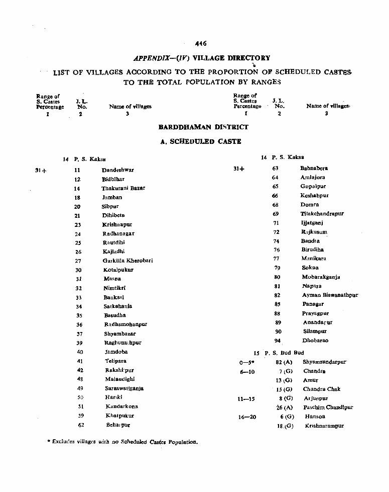
446
.APPENDIX-(IY) VILLAGE DIRECTORY ...
LIST OF VILLAGES ACCORDING TO THE PROPORTION OF SCHEDULED CASTes-
TO THE TOTAL POPULATION BY RANGES
Range of S. Castes Per~ntage
1
J.L. No. 2
Name of villages 3
14 P. S. Kaksa
31+ 11 Dandeshwar
12 Bidbibar
14 Thakurani Bazar
18 Jamban
20 Sibpur
21 Dihibeta
23 Krishnapur
24 Radhanagar
25 Rautdihi
26 Kajladbi
27 Oarkilla Kherobari
30 Kotalpukur
31 Masna
32 Nimtikri
33 Bankati
34 Satkahania
35 Basudha
36 Radhamohanpur
37 Shyambazar
39 Raghuna,hpur
40 Jamdoba
41 Telipara
42 Rakshi:pur
48 MaJaodighi
49 Saraswatiganja
50 Harlki
51 Kandarkona
59 Khatpukur
62 Behafpur
Range of S. Castes Percentage
1
BARDDHAMAN DISTRICf
A. SCHEDULED CASTE
31+
J.L. No.
2 Name of villaacs;
3
14 P. S. Kaksa
63 Babnabera
64 Amiajora
65 Gopalpur
66 Keshabpur
68 Domra
69 Tilakchandrapur
71 Ijjatganj
72 Rajkusum
74 Bandra
76 Birudiha
77 Manikara
79 Sokna
80 Mobarakganja
81 NapaJ8
82 Ayman Biswanathpur-
8S Panagar
88 Prayagpur
89 Anandapur
90 Silarnpur
94 Dhobarao
15 P. S. Bud Bud
0-5. 82 (A) Shyamsundarpur
6-10 7 tG) Chandra
11-15
16-20
13(0)
15 (0)
Amur
Chandra Cbak
8 (0) Ar jUnpur
26 (A) Pascbim Chandlpur
6 (G) Han50a
18.(G) Krfshnarampur
* Exduces villages with no ScheduJed Castes Population.

447
APPEND1X-(IV) VILLAGE DIRECTORY
LIST OF VILLAGES ACCORDING TO THE PROPORTIO;{ OF SC-lEDULBO· CASTES
TO TH E TOTAL POPULATION BY RANGES
'R.ange of 'So Castes ·PercOntage
1
J.L. No.
2 Name of villa~es
3
15 P. S. Bud Bud (cOntd)
16-20 22 (G) Kendnatikuri
43 (a) Kalyanpur
_21-30 S CO) patihar
10 (0) Raipur
11 (0) Bud Bud
14 (0) Banagram
31 (G) Sandhipur
33 (0) Pardaha
67 (A) Baradoba
78 (A) Dharala
~31+ I (O) Naskar Bandh
2 (G) Bharatpur
3 (O) Saldanga
4 (G) Randiha
9 (G) Maro
12 (G) Haora
16 (G) Chak Tentul
17 (G) Fatepur
19 (G) Mangraro
20 (G) Kasba
21 (G) Jaykrishnabati
23 (G) sodpur
24 (G) KuruarBand
27 (G) Narayanpur
28 (G) Bara Chatra
36~G) Bhagabanpur
37 (G) Mankar
38 (G) Mallikpara
Range of S. Castes Percentage
1
BARDDHAMAN DISTIUCT
A.SCHEDULED CASTE
J.L. No.
ra Name of villages
3
15 P. S. Bud Bud (contd)
27 (A) Debsala
31+ 30 (A) Parisa
33 (A) Mokota
68 (A) Singra
69 (A) Poduma
70 (A) Bilaspur
71 (A) Gobindapur
73 (A) Sonai
77 (A) Pondali
79 (A) Raghunathpur
80 (A) Kotchandipur
83 (A) Gopalnath
84 (A) Khandari
16 P. S. AUsgram
0-5· 108 Chak Radhamohanpur
118 Babur Bandh
158 Lakshmiganj
6-10 37 Bara Chatra
S4 Khorda Wariapur
104 ladavgang
136 Bhiti
145 Dhararopore
146 Pur nagar
149 Pichkuri
159 Itachanda
170 Bhota
11-15 51 Pubar
114 Srikrishnapur
130 Bramhandihi
164 Bhat Gonna
* Excludes villages with no Scheduled Castes Population

448
APPENDIX-QV) VILLAGE DIRECTORY
LIST OF VILLAGES ACCORDING TO THE PROPORTION OF SCHEDULED CASTeS
TO THE TOTAL POPULATION BY RANGES
Itangeof S.Ca8tes Percentage
I
J.t. No. 2
Name of villages :3
16 P. S. Ausgram (eontd)
16-20 II Jalikandar
40 "Ban.Nabagram
47 Maliara
48 Malacha
64 Kaludiha
86 Radhabllavpur
134 Aogram
138 Kalyanpur
160 Tusukdanga
173 Asinda
175 Bhada
21-30 7 Bhuyera
8 Bishnupur
12 Hedogarya
21 Dhantor
29 Rangakhila
36 Ramharipur
49 Bankul
57 Warispur
58 AlefNagar
61 Pratappur
6'2 Lachhminarayanpur
63 Babuisol
87 Panchmahali
91 lamara
92 Jayrampur
96 Kalaijhuti
98 Abhirampur
101 Bhalk.i
Range of S. Castes Percentage
I
BARDDHAMAN DI~TRICT
A. SCHEDVLED CASTE
J. L. No.
2 Name of vlllaps
:3
16 P. S. Auagram (contd)
21-30 103 Telata
109 Kharatia
117 Sahapur
123 Jaykrishnapur
139 Batagram
ISO Ukta
167 Naoda
174 Brajapur
176 Raranji
179 Kbairapur
31+ M nkhira
2 Harispur
3 Akulia
4 Harinathpur
5 Nawapara
6 Choora
10 Gohalara
14 Aduria
~S Am'lrpur
16 Phanri Jangal
17 Srichandrapur
]8 M1guria
20 Chota Ramebandrapur
28 Arjuri
31 Chak Tilang
32 Tilang
38 Ramchandrapur
39 Purbatali
41 Dhankora
.. Excludes villages with no Scheduled Castes Population

449
APPENDIX-(1V) VILLAGE DIRECTORY
LIST OF VII.LAGES ACCORDING TO THE PROPOR nON OF SCHEDULED CASTES
TO THE TOTAL POPULATION BY RANGES •
Range of S. Castes Percentage
1
16
31+
J.L. No.
2
Name of villages 3
Range of S. Castes Percentage
1
BARDDHAMAN DlS1RICr
A.SCHEDULED CASTE
P. S. Ausgram (contd) 16
42 Goswami Khandamallikpur 31+
43 Ramnagar Uttar
44 Khatnagar
45 Kural
46 Gopalpur
52 Panduk
53 Jalalpur
59 Bahamanpur
65 Premganga
88 Amrargar
90 Suata
93 Eral
94 Sinli
95 Sar
97 Bijaypur
99 Bhadurpur
100 Chandipur
102 Samantapur
105 Kumarganj
)06 Gopaipota
110 Majhergram
III Ausgram
113 Kurumba
116 Nabagram
119 Silut
121 Beluti
122 Beranda
125 N rishinhapur
126 Purucha
127 Bilshanda
* Excludes villages with no Scheduled Castes population
J. L. No.
2 Name of villages
3
P. S. Ausgram (contd)
128 Reora
129 Baksbibadpagram
131 Bhedia
132 Budra
133 Satta
137 SUndalpur
140 Gangarampur
141 Sitalgram
142 Gobindapur Purba 143 Sibbati
144 Digha
147 Keleti
148 Soara
151 Parasurampur
152 Somaipur
154 AluUa
155 Kantatikuri
156 Donaipur
157 Kamalnapr
161 Sibada
162 Dwariapur
163 Gonna
165 Aligram
166 Deasa
168 Belgram
169 Dignagar
171 Takipur
172 Chonari
177 Belari
178 Bara

4S0
.4.PPllNDJ-X-(IV) VILLAGE DIRECTORY
LIST OF VILLAGES ACCORDING TO THE PROPORTION OF SCHEDULED CASTBS
TO THe TOTAL POPULATION BY RANGES
Range of S. Castes Peu:entage
J. L. No. 2
17 P. S. Oalsi
30
7S
6-10 73 85
104
U8
141
144
151
lL-l$, SO ,57
59
77
87
101
lQS
1,27
1S3
ISS
16-20 SS
i9 91
96
100
102
130
21-30 44
46
Sf
S4
68
74
Name of villages 3
Ohagra
Patrahati
Sundalpur
Pursha
Bharichha
Chakmuria
Pilgram
Mauri
Chandanpur
Bhimsara
Dharmapur
Bamunara
Sirarai
Parandanpr
Khetura
Danbanpur
Itaru
Sasanga
Mobanpur
Iagulpara
Bandutia
Askaran
Babir Ghanya
DayaJpur
Haripur
Dalimgarya
Simnari
Jharul
Ranadi
Mallatikari
Parangan
Kaitara
!lange of S. Castes Percentage
1
BARDDHAMAN DISTRIct
A. SCBEDULED CASTE 17 P. S. Galsi
21-30 80
83
88
92
93
97
98
US
128
129
139
142
145
31+ 2$
26
29
39
40
41
42 45
48
49
52-
53
56
58
60
61 ,62
63
64
65
~6
.,. Excludes villages with no Scheduled Castes population
J.L. No. 1
Name of vin.gee 3
Itampur
Sujapur
Uchagram
Mahulara
Kutruki
Karkuba
Babla
Alusi
Parsura
Bhuri
Kheno
Jaykrishnapur
Sankari
Amarpur
Loapur
Garlbbati
KhamarJIam
Khanpara
Kondaipur
JSlurkona
Itakona
Paraj
Slhigram
Bolpur
Karakdal
Loa
Karkona
Nabakhanda
BUingpur
SiIla
Ramgopalpur
Kaspur
Simasimi
Bikrampur

451
APPENDIX-elY). VILLAGE DI1lECTORY
LIST OF VILLAGES ACCORDING TO THE PROPORTION OF SCHEDULED eASTUS'
TO THE TOTAL POPULATION BY RANGES
Range of S. Castes
. PCIcentaac 1
J. L. No. 2
17 P. S. Galsi
31+ 67
69
70
72
76
78
8t
82
84
86
89
90
94
9S
'99
103
106
108
110
111
112 113
114
115
116
11' 119
120
121
122
123
124
Name of villaaea 3
NaIdanga
Gopdal
Oohagram
Khandajuli
Malia Sarul
Adra
Potna
Khuraj
Bhasapur
Kal Kal
Oolgram
Bansujapur
Brindabanpur
Srirampur
Galsi
Irkona
Gomai
Belan
Mahara
Mallikpur
Bakta
Garamba
Dakshin Bhasapur
Mithapur
Sonda
Sikarpur
Maszidpur
Dumur
Gopalpur
Taherpur
Dadpur
Omarpur
Range of S. Castes Percontaae
1
BARDDHAMAN DISTRICT
A.SCHEDULED CASTE
17 p_ S Galsi
125
126
131
132
133
134
136
137
140
146
147 ]48
149
ISO 152
154
156
IS?
ISS
159
160
161
J.L. No •
2 Name efVmapa
3
Nabagram
ChakAlam
KaIDa
Balna
Samta
Sridharpur
Sarol
Ura
Chhotamure
Channa
Hitla
Kisorkooa
Satioandi
Kurmuna
Belgram
Sanko
Ghosh Kamalp_
Ketna
JuJuti
MeNal
ShyamauncJarpur
Konarpur
18 P.S. Kbandagbosh
0-.-5* 24 Bamaoari
38 Narayaopur
68 Keshabpur
93 Amilia
6-10 41 Khantikar
59 Wania
81 Tarap08h
• Excludes YiUaic with no Schedulcd castes populalion.

452
APPBNDIX-(IY) VILLAGE DIRECTORY
LIST OF VILLAGES ACCOROING TO THE PROPOR.TION OF SCHEDULED CASTBS
TO THE TOTAL POPULATION BY RANGES
Range of S. Castes Percentage
1
J. L. No.
2
18 P. S. Khandaghosh
11-15 32
47
52
62
73
88
t6~20 22 45
75
80
90
94
109
11-30 3
4
20
23
34
39
40
48
49
50
51
74
78
82
83
85
91
104
Name of villages 3
Sadhaopur
Enayetnagar
Alipur
Padua
Huria
Angram
Shyamdanga
Onari
Kendia
Punia
Puriha
Kantapukur
Amra
Nikunjapur
Lodna
Kapsit
Barisiali
Sibarambati
Kule
Ukhrid
Olkunda
Telua
Sikarpur
Krisbnagar
Kamalpur
Sagrai
Ahadipur
Krishnapur Kukra
Saranga
Sunia
Torkona
itange of S. Castes Percentage
1
BARDDHAMAN DISTRICT
A. SCHEDULED CASTE
J. L. No. 2
Name of villages 3
18 P. S. Kbandaghosb
31+ 2 Metidanga
S Banamalipur
6 Bichkhara
7 Nabargam
8 Keleti
9 Kamirkola
10 Rupsa
It Dbarmapur
12 Gharkura
13 Naricha
lS Khejurhati
16 _,Aradanga
18 Khandaghosh
2S Dubrajhat
26 Berugram
27 Boyda
28 Kalna
29 Sultanpur
31 Amral
33 Pansur
35 Bonwai
37 Tarul
42 Karimpur
43 Mansubpur
44 Jot Dharmadas
46 Oayespur
53 AalUr
55 Chandipur
S6 Napara
57 Masila ., 58 Sasanga
61 Cbaksultan
-II Excludes villages with no Scheduled Castes Population.

453
APPEND1X-(IV) VILLAGE DIRECTORY
LIST OF VILLAGES ACCORDING TO THE PROPORTION OF SCHEDULED CASTES
TO THE TOTAL POPYLATION BYRANGES
~Range of -So Castes ,Percentage
1
J. L. No.
2 Name of villages:
3
18 P. S. Khandaghosh
31+ 63 . Salun
64 Atkulya
65 Gaitanpur
66 Tildanga
69 Khudkurt
70 Sankari
76 Jubila
77 Chak baduIia
79 Badulia
84 Chagram
86 Guir
89 Chintamanipur
92 Jarul
95 Kamadebpur
9{i Kaiar
97 Gopinathpur 98 Amba
99 Pitambarpur
100 Balabati
101 Arin
102 Baragopinathpur
103 Sankarpur
105 Induti
106 Muidhara
107 Gopalbera
108 Doargan
Ito Rantara
III Kendur
19 P. S. Raina
'(}-s* 3 Machhkhara
27 Sri pur
Range of S. Castes Percentage
1
BARDDHAMAN DIS1 RICT
A. SCHEDULED CASTE
J. L. No.
2 Name of villages
3
19 P. S. Raina
0-5* 47 Goigramnurpur
70 Mathnurpur
157 Charmastafa
165 Borajpota
183 Alampur
6-10 10 Jotsadi
23 Bhimpur
89 Belur
91 Gunar
129 Katnabil
166 Kurchigara
205 Singarpur
11-15 2 Babarakpur
17 Jamut
28 Shyamdasbati
29 Golgram
77 Rasulpur
78 Madanagar
102 Baira
141 Kalui
162 Brahmandanga
16-20 II Belsar
30 Bautir
31 Sibpur
50 Baharampur
S9 Mogalmari
66 Baithari
68 Paschimpara
69 Ausara
74 Muktipur
'* Excludes village with no Scheduled castes population.

454
APPENDIX-(IY) VILLAGE DIRECTORY
LIST OF VILLAGES' ACCORDING TO THE PROPORTION OF SCHEDULED CASTBS-
TO THE TOTAL POPULA'IION BY RANGES
a8JIg~of Range of B. Castes J.L. S. Castes, J.L. Percentage No. Name of villages Pcrc:cntage No. Name of YilJaaOi"
1 2 3 1 2 3
BARDDHAMAN DI..,TRICT
A. SCHEOULED CASTE
19 P.S. Raina 19 P. S. Raina
16-20 93 Hakrisbnapur 21-30 111 Deno 117 Sakoara 112 Adampur 118 Raynagar 122 Bansa 1:77 Dakshin GopaJplD' 124 Dharan 179 Bhanjapur 128 Nasipur
198 Barati 135 Ekhakshhi
21-30 5 Beuda Oacbha 139 Sanko Narayanpar'
6 Iakta 145 Chuadanga
1 SaJgachha 151 Darbeshpur
8r Chota Kairapur 154 Bajikowarpu,
9 Jot Silam 161 Chakbhura
12 Sarna,spur 169 Dakshin MohaDpur
16 Kukra 170 Binodpur
19 Khemta 172 Pahalanpur
21 Abladipur 173 Ropsara
~2 Bamnnia t97 lasapur
34 Bangram 200 Daminya
,39 Dbamas 201 Tailara
52 Gopinatbpur 203 Bataspur
62 Bujrakdighi 207 Atpur
64 Chak Chandan 208 Ket Simul
7S Khalina 31+ ' 1 Char Purohit
80 Meral 4 Jamna
81 Jagatpur 13. Gop3.lpur 82 Dakshinkul 14 Narugram
as Deriapur .15 Sipta
87 Anguna 18 Fakirpur
88 Mugura 20 Pursnna
90 Sakita 21 Ahladipur
95 Ibidpur 2! Nandal
103 Rusona 26 Sank:upur
104 Itayna 33 Hijalna
.. Excludes villages with no Scheduled Castes Population.

455
APPENDIX-(IV) VILLAGE DIRECTORY
LIST OF VILLAGES ACCORDING TO THB PROPORTION OF SCHEDULED CASTB&
TO THE TOTAL POPULATION BY RANGES
'Ilangcof Range of ·S. Castes J. L. S. Castes J. L. ,'Percentage No. Name of villages Percentage No. Name of villqea
I 2 3 1 2 3
BARDDHAMAN DISTRICT
A. SCHEDULED CASTE
19 P.s. Raina 19 P.S. Raina
11+ 36 ~aripur 31+ 98 Bidyanidhi
37 Nata 99 Sahajpur
38 Uttar Mohanpur 100 Ramkhanda
40 Teandul 101 Alalpur
41 Sukur 105 Birampur
42 Ramanandapur 106 Maheshbati
43 Balla 107, Jot Rajaram
44 Sekhpur 109 Harihacpur
45 Baliarpur 110 Patepur
48 Sibarampur 113 Dbamnari
49 Debibarpur 114 Pipuldaba
,51 Burar 115 Pasra
53 ' Ramkrishnapur 116 Neor
54 Chandipur 119 Bisweswarbati
55 Sebara 120 Netran Khanda
56 Konakrisbnapur 121 Rambati
57 Bera 123 Bhagabatipur
58 Ujirbati 126 Gobindpur
,60 Bajitpur 127 Maszidpur
63 ,Ramchandrapur 130 Mirpur
65 Srirampur 131 Ucbalan
67 Udgara 132 Naudanpur
71 Palasan 133 Agarpara
72 Sbyamsundar 134 Makarkola
73 Mirzapur 136 Narottambati
79 Jamaipata 137 Babla
83 Bora 138 Maniari
84 Balagarh 140 Rampur
86 Astikpur 142 Kemata
92 Uchitpur 143 Mandarpur
94 Pipila 144 Balcbandrapur
99 Bokra 149 Belar"
97 Narayanpur 150 Bhurkunda
152 Sundarpur
• Excludes villages with no Scheduled Castes Population.

456
APPENDIX-(IV) VILLAGE DIRECTORY
LIST OF VILLAGES ACCORDING TO THE PROPORTION OF SCHEDULED CASTBS.
Rallgeof S. Castes Percentage
1
J. L. No. 2
TO THE TOTAL POPULATION BY RANGES
Name of villages 3
Range of s. Castes Percentage
1
BARDDHAMAN D .... TRICT
- A. SCHEDULED CASTE
J.L. No.
2 Name of villaaes.
3
19 P. S. Raina (contd) 20 P. S. Jamalpur
31+ ISS Serpur 6-10 17 Basisthapur
158 Bhadiara 18 Keliri
159 Painta 3() Smmabad
160 Sundhipur 58 Ramchandrapur
163 Durgabati 87 Mathurapur
164 Kaiti 108 Dastanpur
167 Cb.otabairan 11-15 43 Kalna J
81 Dumo 168 Momrejpur
174 Kamarhati 85 Mahishgaria
175 Akhina 92 Bhairabpur
178 Nala 93 Pirijpur
18i Ami t17 Maina
184 Madhabdihi 16-20 21 Purba Sadipur
185 Lohai 24 Dhuluk
186 Konarpur 26 Parbalpur
187 Pashanda 33 Balarampur
188 Darpur 39 Sab Hosenpur
189 Birpur 40 Hara Govindapur
190 Dighra 44 Kansra
191 Nilat 47 Radhaballabbbati
192 Chabukpur 63 Baratikra ..
193 Kamargaria 72 Siali
194 Sabaldaha 78 Mirza pur
195 Bara Bainar 80 Madbabpur
196 Baidyapur 9S Bahl1durpur
199 Nizampur 109 Keotara
202 Gotan 122 Datta para
206 Narasinhapur 21-30 . I Sambhupur
.2 Chokshanjadi 20 P. S. JamaJpur 4 Haibatpur
0-5'" 84 Tjlkuria 22 Salmula 98 Bag KaJapahar 23 Dattapur
* Excludes villages with no SCheduled Castes Population.

457
APPI!.NDIX--CIV) VILLAGE DIRECTORY
LIST OF VILLAGES ACCORDlNG:1 0 'PHE PROPOR nON OF SCHEDULED CASTBS
TO THE TOTAL POPULATION BY RANGES
Range of S. Castes Percentage
1
J. L. No. 2
Name of vlllJges 3
20 P. S. Jamalpur (OOntd)
121-30 25 Fllimpur
28 Hiranyagram
31 Sarangpur
45 Khanpur
51 lletragar
52 Sajipur
53 Harekrishnapur
54 Basantapur
56 Gopikantapur
59 Chak Dighi
61 Jargram
62 ~atgharia
13 Amarpur
14 Dakshin Mohanpur
75 Daspur
76 Antpara
77 llamkrishnapur
82 Bidyabatipur
83· Oureghar
90 Siptai
94 Gohaldaha
104 Mahindar
lOS Dogachhia
101 Panch Simui
l}O Siromani
116 Usara
31+ 3 Jamdaha
5 Chalbalpur
6 Kanakpur
7 Sadipur
8 Krishnapur
9 Dadpur
10 Habaspur
Range of s. Castes Percentage
1
A. SCHEDULED CASTES
20
31+
"'
• Excludes village with no Scheduled castes popula1ion.
J.L. No.
2 Name ohinag.
3
P. S Jamalpur (contd)
11 Chaupiria
12 Ballabbbati
.13 Masagram
14 Biswambharpur
IS Rap.pur
16 Nabagram
19 Sanchra
20 Ajhapur
27 Ruda
29 Krishna Chandrapul'
32 Bcrugram
34 Kabra
35 Rajarampur
36 Srikrishnapur
37 Jot Sriram
38 Jot Dakshin
41 Kubajpur
42 Sura
46 1otRashab,
48 Jot Krishtai
49 'Uttar Mohanpur
SO Halara
55 Paratal
57 Jot Subal
60 Sukpur
64 Dhapdhara
65 Sonargaria
66 Paikpara
67 Muidipur
68 Nandan pur
69 Ujirpur
70 Resalatpur
71 Kora

458
APPENDIX-(lV) VILLAGE DIRECTORY
LIST OF VILLAGES ACCORDING TO THE PROPORTION OF SCHEDULED CASTBS
TO THE-TOTAL FOPULATION BY RANGES
Range of S. Castes
'. Percentage 1
J. L. No. 2
Name. of villasel 3
20 P. S. Jamalpur (contd)
31+ 79, Pranballabhpur.
86 Narayanpur
88 Bisbnubati
89 Srimanpur
91 Illampur
96 1anakibati
97 Khord Palasi
99 Itla
101 Napara
102 Sabapur
106 Astai
111 Abujhati
112 Amra
113 Gopalpur
114 Jaugram
118 Kulingram
120 Ajapur
121 Chak Muzafarpur 21 p_ S Memari
'0-5* 16 Banagram
37 Paschim Chandipur
47 Genra Ghata
7S Bilbari
82 Ranihati
90 Sahazadpur
94 Mosra
160 Durgadanga
180 Sarra
183 Bansipur
'6-10 9 Dihi Palasan
17 Bhandul
63 Akalia
76 Naopara
Range of S. Castes Percentage
1
A. SCHEDULED;CASTES
J. L. No.
2 Name of village.
3
21 P. S. Mernari (contd)
6-10 V8 Jhiltra
79 Bamunpukul'
85 Mablshdanga
92 Makra
98 Mutra
101 Raybati
102 Goaldingi
115 Purba Srirampur
131 Gopinathpur
179 Tanti Baksa
186 Sitarambati
188 Taharput
189 Ichhabacba
204 Kabirpur
211 Smara
1222 Krishna JibaDpur
11-:-15 1 Malamba
3 Damuna
S Haladharpur
8 Bara Palasan'
18 Rean
S1 Bharpota
70 Asapur
77 Nanua
84 Bisbnupur
93 Bohar
97 Senpur
100 lakra
134 Chaknara
Hil Icbbapul'
162 Merua
172 Panchkhea
17S Ghosh
,*, Excludes villages with no Scheduled Castes population

459
APPENDIX-CIV) VILLAGE DIRECTORY
LIST OF VILLAGES ACCORDING TO THE PROPOR nON OF SCHEDULED CASTES
TO TaE TOTAL POPULATION By RANGES
Range of S. Castes Percentage
1
J.L. No. 2
Name of YiI~ges 3
Range of S. Castes Percentase
1
A. SCHEDULED CASTES
21 P. S. Memari (contd) 21
11-13 178 Nandiara Ql-30
185 Chhilinda
187 Purba Kasiara
199 Dharma Simla
205 Mabe~pur
211 Syamnagar
2)8 Maglampur
219 Katapur
16-20, 7 Mandalgram
14 Barari
23 Saligram
43 Pingur
48 Nagarkona
52 Nabagram
S9 Baje Rasulpur
73 Begunia
74 DakhaJpur
87 Rukaspur
109 Mallikpur
120 Kanpur
121 Ganti
128 Amadpur
129 Brahmanpur
130 Dakshin Radhakantapuf
132 Keja
137 Deule
146 Tatarpur
170 Sriharipur
192 Chhota Ohamas
195 Gobindapur 207 Sasinara 216 Alipur
21-30 l~ Bijur 15 Kantipur
• Excludes villages with no Scheduled castes populalion.
J.L. No.
2 Name of villages
3
P. S. Memari (contd)
20 Kaleswar
26 Hairgram
27 Bodhpur
33 Kuchut
34 Masagaria
39 Palsit
40 Bbaita
42 Paschim Memarl
49 Sahapur
S3 Sekhpur
54 Helut
56 Paschim Tajpur
61 Naobati
64 Chandipur
65 Kabastikri
67 Gageswar
68 Dhunai
69 Belui
71 Ghoshpur
80 Abira
81 Satgachhia
95 Chak Balaram
9~ Barwa
106 Chait: Narayan -
108 Kasiara
111 Uttar Radhakantapv
112 Sahanagar
113 Baliadaoga
117 Rokanpur
118 Debpur
122 Parhan
124 Tajpur
125 Kasipur

460
APPENDIX-(IV) VILLAGE DIRECfORY
LIST OF VILLAGES ACCORDING TO THE PROPORTION OF SCHEDULED CASTES
TO THE TOTAL POPULATION BY RANGES
Range of s. Castes Percentage
I
J. L. No. 2
Name of villages 3
Range of S. Castes Percentage
1
1.L. No.
2 Name of villages
3
A. SCHEDULED CASTES
21 P. S. Memari (contd) 21 P. S. Memari (contd)
21-30 127 Nihsanka 31+ 25 Barsua
133 Sanui 28 Ausa
142 Jot Kanu 29 Paisa
148 Barar 30 Begut
149 Dandur 31 Nabastha
154 Bagila 32 BasatpUI
158 Kiskinda 3S Paikara
159 Bahabpur 36 Karanda
164 Bijra 38 Khaurgram
165 Sankarpur 41 Konarpur
171 Partona 44 Dadpur
173 Magra 45 Palla
177 Harirambati 46 Chanchai 181 Kbayerpur SO Mamudpur
182 Taralpur 55 Dalui Bazar
184 Barasat 57 Ulara
193 Debipur 58 Telsara
196 Kali Bele 4;0 Baragram
201 Mabarakpur 66 Jabui
208 Kalsi 72 Biskopa
210 Simla 89 Bitra
213 Sura 96 BaneswarpUr
221 Birsimul 103 Harkala
31+ :I Bhagabanpur .104 Sridharpur
4 Sargachhi \107 Kole
(; Urltia 110 Kamalpur
10 Kantabari 114 Katna
11 Gorapur il6 Patra
13 Kalyanpur 119 Oandhapur
19 Melna 123 Madhupur
21 Barkona 126 Barea
22 Chakundi 135 Baidyadanga
24 Gangua 136 Rasulpur
• Excludes villages with no Scheduled Castes Population.

461
APPENDIX-(IV) VILLAGE DIRECTORY
LIST OF VILLAGES ACCORDING TO THE PROPORTION OF SCHEDULED CASTES
TO THE TOTAL POPULATION BY RANGES
Range of S. Castes Percentage
1
J.L. No.
2
Name of ~illages 3
~1 P. S. Memati (contd)
31+ 138 Salda
139 KeDDa
140 Bahara
141 Mahesdaoga
143 Kanthalgachhi
144 Nimo
145 Hingalgaria
147 Kailaspur
150 Dilalpur
155 Talchini
156 Baharampur
157 Krisboapur
163 Iswarpur
167 Gantar
168 Andur
169 MandaI lana
114 Doha
190 Palta
191 Jot Chaitanya
194 Chanpira
197 Nalsara
198 Gauripur
200 Nisiralar
202 Punyagram
203 Jayrampur
206 Amudpur
209 Nudipur
214 Durgapuli
215 Chotkhanda
220 Benapur
22 p, S. Barddhaman
,0-5· 18 Karimpur
19 Matial
Range of S. Castes Percentage
I
A. SCHEDULED CASTES
J. L. No.
ra Name of villages
3
22 P. S. Barddhaman (contd)
0-5· 44 l'otGoda
53 Tentral
56 Champardighi
92 Aswatha Garia
116 Nityanandapur
6-10 16 Nababhat
41 Goda
43 Krishnapur
52 Khetia
87 Nandur
93 Naopara
117 Pure Balisa
149 Ataghar
11-15 55 Kbarjuli
74 Bamchandipur
78 Gopalnagar
110 Sirajpul'
153 Ghatsila
155 Saktigar
16-20 8 Jiara
9 Alampur
12 Nutaogram
32 Baogpur
65 Raypur
VO Nari
104 Parui
115 Neragohalia
147 Purba Kasiara
148 Ramo agar
21-30 7 Gopalpur
13 Amar
45 Bidchhala
46 Saraitkar
III Excludes villages with no Scheduled Castes population

462
APP16NDIX-(IV) VILLAGE DIRECTORY
LIST OF VILLAGES ACCORDING TO THE PROPORTION OF SCHEDULED CAS rES
TO THE TOTAL POPULATION BY RA:-.IGES
Range of S. Castes I. L.
Itange of S. Castes I. L.
Percentage No. Name of villages Percentage No. Nameofvin~
2 3 1 2 3
A. SCHEDULED CASTES
22 P. S. Barddhaman (contd) 22 P. S. Barddbaman (contd)
21-30 48 Diuri 31+ 17 Isufabad
50 Simdall 20 Nala
57 Barasati 21 Belkas
61 Sonpur 22 Baharpur
63 Bhita 25 Fakirpur
66 Mirrapur 26 Kanchan Nagar
68 Rayan 27 Birutikri
69 Sadhanpur 28 Katrapota
71 Kalyanpur 42 Bahir SarbamangaJa.
72 Nandara 47 Palitpur
79 Becharhat 49 Kamnara
80 rirampur 51 GopaJbati
89 Jotram 54 Malkita
91 Baikunthapur 58 Tabgram
III Baman Sirajpur 59 Daspur
l!7 Faridpur 60 Tentu1ia
129 Karori 62 Kadigachba
131 Banagram 64 Khaidya
142 Mahipal 67 lamar
160 Kalinagar 73 Daugachha
162 Tot para 76 Kanainatsal
]63 Barsul 77 Alisa
165 Dakshin GopaJpur 81 Hat Simul
31+ 1 Pilkhuri 82 Pamra
2 Iag~dbad 83 Kanthal Gachhi
3 Mahinagar 84 Chaitpur
4 Haldi 86 Kandarsona
5 Kasiara ss, Gangpur
6 Patikirtipur 90 Durgabati
10 Talit 94 Shyamsundarpur'
11 "Baghar 95 Kantia
14 Chandu) 96 Basatpur
15 Jhinguti 97 Kusa
• Excludes villages with no Scheduled Castes Population.

463
APPEND1X-{IV) VILLAGE DIRECTORY
LIST OF VILLAr;ES ACCORDING TO THE PROPORTION OF SCHEDULED CASTES
TO THE TOTAL POPULATION-BY RANGES
Range of S. Castes . Percentage
1
1. L. No .
2 Name ofvil1ages
3
Range of S. Castes Percentage
1
A. SCHEDULED CASTES
22 P. S. Barddhaman (contd) 22 31+ 98 Korar 31+
100 Jamalpur
101 Sapar
102 Chandutill
103 Kaligram
105 Palasi
106 Kurman 23
107 Chhotll Belun 0-5·
109 Ramchandrapur
112 Nabagram
113 Bandul Ci-IO
114 Bhandardibi
liS Kamarkita
121 Kadra
122 Samanti
123 Kashta Kurumba
126 Sialdah
128 Bakalsa 11-15
130 Sadya
132 Debgram
133 Balgana
.134 Purba Malkita
135 Sukur
136 Hat Gobindapur
138 Hat Kanda
141 Raipur 16-20
143 Schara
144 Sonakur
145 Purba Krishnapur
150 Subari
151 larur
154 Putuoda
156 Amra
.. Excludes villages with no Scheduled Castes Population •
1. L. No.
1 Name orvilla.-
3
P. S. Barddhaman (contd)
1S7 Belna
158 Manikhati
159 Jafarbad
161 Baje Salepur
164 Tot Khanda
P. S. Bhatar
18 Gholada
23 Chandai
lOS Bijoypur
7 Daura
9 Banagram
17 Gramdibi
34 Iharul
53 Bazar Mahammadpua
67 Bamsor
87 Salun
36 Mandardibi
42 Rajipur
44 Jhuka Danga
55 Nabasta
59 EoraChak
71 Balgana,
104 Brachya
106 Palsana
5 Poalkura
49 Mahachanda
SO Jhikardanga
54 Narjja
68 Muratipur
73 Santoshpur
77 Sikartor
82 Bhatakul

464
APPIINDIX-(lV) VILLAGE DmECTORY
LISl' OF VILLAGES ACCORDING TO THE PROPORTION OF SCHEDULED CA.StBS
TO THE TOTAL POPULATION BY RANGES
Range of S. Castes Percentage
23
16-20
11-30
J. L. No.
2 Name of villages
3
P. S. Dhatar (contd)
92 ebhaHni
98 Margram
2 Dangaara
4 Desana
15 Sonchalida
16 Bigra
21 Banpas
24 Dhandolsa
33 Mahala
39 Sesna
40 Kapsor
41 Chandiput'
46 Khurul
48 Nunari
57 Eora
60 BaJaidanga
61 Belenda
62 Nutangram
64 Sotkhat
65 Kulchanda
72 Nityanandapur
75 Bbairabpur
79 Tulsidanga
81 Kanpurhat
83 Mukundapur
84 Sobada
86 Ka'igram
89 Nadgram
9() Muraripur
91 Khesur
95 Kulgar
107 Kubajpur
hnge of S. Castes Percentage
1
A. SCHEDULED CASTES
23 31+
• Excludes villages with DO Scheduled Castes Population.
1. L. No. 2
Name or villaget-3
P. S. Dhatar (CODtd)
1 Basatpur
6 Kanpur
8 RamchaJldrapur·
10 Nuta
11 Orgram
12 Salkuni
13 Silakot
14 Mandarbati
19 Mohanpur
20 Ambana
22 Haribati
25 Narayanpur
26 Ralanpur
27 Bamunara
28 Kumarun
29 . Nrisinhapur
30 Sripur
31 Ka:.ipur
32 Nurpur
35 D~bpur
37 Rampur
38 Ernar..,.
43 Panoa
45 Basuda
47 Parbat
SI Kurumba.
S2 Bljlpur
56 Karjjana
58 Aua
63. Palar
66 Bhatar
69 Usha
74 Kalapahari

-465
APPENDIX-(lV) VILLAGE DIRECTORY
LI~T OF VILLAGES ACCORDING TO THE PROPOR nON OF SCHEDULED CASTES
TO THE TorAL POPULATION BY RANGES
Range of Range of S. Castes 1. L. S. Castes J.L.
PClIrccntage No. Name of villages Percentage No. Name of villages
1 Z 3 1 2 3
A. SCHEDULED CASTES
23 P. S. Bhatar (contd) 24 P. S. MangaI Kote (contd)
31+ 76 PashaJa 16-20 100 Dhanyarukhi
78 Haripur 102 Lakshmipur
85 Dhenria 109 Purbba Gopalpur
88 Madhpur 122 Belgram
93 Barabalur 179 Kharija Kshlrgram
94 Chandibati 21-30 Majkhanra
96 Katari 2 Paschim Nabagram
97 Kachgaria 3 Debagram
99 Amarun
Nawada 9 Ramnagar
100 15 Jalpara
101 Sumur 16 Balidanga
102 Ghugia 19 Nawapara Irsanda
24 P. S. Mangal Kote 22 Tikuri
0-5* 20 Barulia 23 ~arayanpur
45 Dwarsini 29 1ayrampur
52 Sitahati 33 Kasiara
65 Purbba Nayapara 34 Taldanga 73 Sinut 3S Lakhuria 77 Krishnabati
38 Siur 86 Madhpur 47 Chandra
131 Dharsona 49 Mahartnba 6-10 59 Nutanhat 56 Sagira
72 Bh<ltpara 62 Jhihu 104 Kulsuna 81 Palisgram
11-15 27 Chanak 83 Bakulia 51 Deulia 84 Kankora 63 Banpara 88 Keotsa 74 Kunda 95 Sanri 78 Scmulia 103 Uttar :Belgram 85 Jaykr.shnapur
lOS Buinchi 16---20 25 Krishnapur 106 Durmut
48 Aogram 125 Jabagram 64 Manga·kot 132 P~Iasi
70 Tbengapaca
90 Chakulia 31+ 4 Unia Tatarpur
• Excludes villages with no Scheduled Castes Population.

466
APPENDIX-OV) VILLAGE DIRECTORY
LIST OF VILLAG.r.;S ACCORDING TO THE PROPORTION OF SCHEDULED CASTBS
r,TO THE·TOTAL POPULA1ION BY RANGES
RaDgeof S. Castes Pcrcentase
1
J. L. No. 2
Name of villages 3
24 P. S. Mangal Kote (contd)
31+ 6 Kesabpur
7 Raghunathpur
8 Palpara
10 Mallikpur
11 Sarangapur
12 Sarulia
14 Ujirpur
17 Salanda
21 Paligram
26 Gopalbcra
28 Baruipara
30 Nayapara
31 BhiDbhina
32 Gatistha
36 Jhilera
37 Kotalghosh
40 Amdob
41 Paschim Gopalpur
42 Radhanagar
43 Sukhpukhuria
44 Bamunara
46 Pilsoan
50 Khurtuba
53 Kalyanpur
54 Atihara
55 Puratan Kurgram
58 Kogram
61 Halimpur
67 Sankarpur
68 Babladihi
69 Polsona
76 Brahmapur
79 Khudrum
80 Ichhabargram
Range of S. Castes Percentage
1
A. SCHEDULED CASTES
J.L. No.
2 Name of villages
3
24 P. S. Man gal Kote (contd)
31+ 81 Palisgram
82 Mukha
89 Maliara
91 Majigram
92 Singat
93 Mathrun
94 Bhalugram
96 Konarpur
97 Kherua
99 Syambazar
101 Pindera
107 Bankapasi
108 Murulia
110 Balarampur
111 Jageswardihi
112 Chaitanyapur
113 Haripur
114 Kaichar
lIS Sitalgram
116 Kanaidanga
J!17 Nigan
119 Masaru
120 Chhota Poshla
121 Gohagram
123 Saota
124 Gobardhanpur
]2S Jabagram
126 Bamuugram
127 Chak Kharija
Kshirgram
128 Kshirgram
130 Ita 2S P. S. Ketugram
0-5" 55 Chakdaha
.. Excludes villages with no Scheduled Castes Population.

467
APPJ:..NDIX-(IV) VILLAGE DIRECTORY
LI::'T OF VILLAGES ACCORDING LO THE PROPORrION OF SCHEDULED CASTES
TO T HE TO l'AL POPULATION BY RANGES
Range of s. Castes
P "rcentagc 1
J. L. No. 2
Name of villqes 3
25 P. S. Ketugram (contd)
0-5· 100 ~antapur
" 103 Nutangram
105 Chilr Suj.. pur
108 N.ITayanpur
119 Enayctpur
6-10 10 Mahula
23 Murgram
42 Raikhan
47 Kauchra
54 Narenga
62 Ganlul
67 Khaipur
77 Kom~anga
106 Sujapur
11-15 1 Cheehuri
13 MOl gram
15 Chinispur
18 Kechunia
26 Kandanag
32 KuJutia
46 Ehiapur
78 Mahha
94 Siblun
16-20 11 Ankona
17 Kojalsa
21 Kacbutia
24 Katandidanga
27 Nirol
31 Ujalpur
34 KUlmadanga
44 Argun
45 Khaspur
56 Noapara
68 Srin,mpur
Range of S. Castes Percentage
1
A. SCHEDULED CASTES
J.L. No.
2 Name of villages
3
25 P. S. Ketugram (contd)
16-20 73 KhenaiboDda
74 Teora
84 Brabmadanga
96 Baiutia
101 Keuguri
21-30 2 Chakta
3 Mauri
4 Majhina
S Kusutia
7 Srigram
22 MaJagram
28 bcninagar
30 Amgaria
3S Sripur
36 Kandara
37 Komarpur
40 Babara
41 Rajur
43 Khanji
48 Dadhia
52 Bira
61 Ghatkuria
72 Kauri
85 Ketugram
90 Ambalgram
97 Birahirnpur
110 Kalyanpur
112 Siruli
120 Kankurhati
31+ 6 Haldi
9 lcbhapur
t2 Murutia
14 Berugram
IlJ Agardanga
• Excludes villages with no Scheduled Castes population.

468
APPENDIX-(JV) VILLAGE DIRECTORY
LIST OF VILLAGES ACCORDING TO THE PROPORTION OF SCHEDULED CASTBS
TO THE';;TOTAL POPULATION BY RANGES
Range of S. Castes Percentage
1
25
31 +
J. L. No. 2
Name of villages 3
P. S. Ketugram (contd)
25 Loharundi
29 GOllalpur
33 Kantadihi
38 Bamundihi
39 Masundi
50 Serandi
51 Patita
53 Bankui
57 Kulun
58 Pandugram
60 Jamalpur
63 Bhaadargaria
64 Bakalsa
65 Kulai
66 Khatundi
69 Daksbindihi
70 Mitrati kuri
71 Hatpara
75 BilJeswar Rasui
76 Charkhi
19 Chitahati
80 Gurpara
81 . Taipur
82 Kopa
83 Purulia
86 Pachandi
87 Murundi
88 Gornai
89 Chak Kharulia
91 Senpara
92 Talari
93 Nabagram
95 Gangatikuri
Range of S. Castes Percentage
1
A. SCHEDULED CASTES
2S
31+
26
0-5·
6-101
11-15
16-20
.• Excludes villages with no Scheduled castes population.
I.L. No.
2
Name of villages 3
P. S. Ketugram (contd)
98 Baharan
99 Jhamatpur
102 Maugram
107 Kamalabari
ttl Bishnupur
113 Dattabati
114 Naliapur
115 Paschim Sujapur
116 Sitahati
IJ7 Naihati
118 Uddharanpur
121 Begunkota
122 Sankhai
P. S. Katwa
\. 2 Sabapur
lIS Khaspur
132 Simulgachhi
133 Bhatna Pakua
134 Mallikpur
135 Chaudpur
13 Parulia
45 Arjundihi
99 Akhra
37 Karajagram
40 Alampur
61 Kuara
62 Auria
103 Ramdaspur
119 Chhoto Me;gachbi
140 Paschim Bejnagar
7 Srikbauda
S Deb Kunda
24 Mandalhat
28 Kbajirdihi

469
APPHNDIX-(IV) VILLAGE DIRECTORY
LIST OF VILLAGES ACCORDING TO THE PROPORTION OF SCHEDULED CA.STBS,:
TO THE TOTAL POPULATION BY RANGES
Range of 'So Castes Pelcentage
1. L. No.
Z Name or :villages
3
26 P. S. Katwa (eootd)
16-20 39 Baudmuta
48 Kaithan
63 Palasaui
80 De Para
82 Tikarkhanji
86 Nasipur
95 Sahapur
109 Kabirajpur
123 Chanduli
127 Multikrishnanagar
130 Bara Meiguchhi
138 Ghumuria
,21-30 4 Baura
12 Suisurura
16 Baudra
17 Jajigram
18 Panebghara
35 Purha Bijnagar
38 Durga
41 Gaufulia
46 Bhalsuni
47 Kamulia
49 Kamui
51 Gidhgraue
60 Jamra
64 Dona
67 Mejhiari
77 Amdanga
78 Musthuli
84 Bara Khanji
97 Benga
102 Dcasin
107 MakhIlir
Range of S. Castes Percentage
1
A. SCHEDULED CASTES
26
21-16
31+
• Excludes villages with no Scheduled Castes Population.
J. L. No. 2
Name of vUlagea 3
P. S. Katwa (eontd)
111 Agradwlp
113 Garipur
115 Bara KuIgaehhi
117 Suagachhi
122 Gharanes
125 Nutangram
131 Gaurdanga
1 Sauta
3 Churpaui
5 Baghtona
6 Nahata
9 Kasigram
11 Nanagar
15 Goai
25 Ekaihat
26 Bikihat
29 Radbakrishnapur
31 Chandhak
32 Mera
33 Mostafapur
34 Arangabad
36 Kalyanbati
42 Gasumba
43 Barampur
44 Debagram
50 Kalsa
52 Katari
53 Paini
54 Sargranc
55 Ergram
56 Narsana
57 Chandrapur
58 Bainchi

470
APPENDIX-(IV) VILLAGE DIRECTORY
LIST OF VILLAGES ACCORDING TO THE PROPORTION OF SCHEDULED CASTE&
TO THE TOTAL POPULATION~BY RANGES
Range of S. Castes Percentage
1
J. L. No.
2 Name of villages
3
26 P. S. Katwa (contd)
31+ 59 Kamal
65 Panjoa
66 VIas Tikri
68 Demiapur
69 SUa
70 Ronda
71 Kurchi
72 Nandigram
74 Mulgram
75 Srirampur
79 Jagadanandapur
81 Narayanpur
83 Gop Khanji
85 Nalah?ti
89 Charpatithat
93 Islampur
96 Bir Begun
98 Now~para
100 Bishnupur
104 Jamunapatai
lOS Kumri
106 Parasumanepur
110 Kashetpur Palasi
111 Kaiikapur
114 Chhota Kulgachhi
116 Gara Ga~hba
120 Malancha
121 Singi
124 Post Gram
126 Suibati
129 Okarsha
136 AmuI
Range of S. Castes Percentage
1
A. SCHEDULED CASTES
27
0-5*
6-10
11-15
• Excludes villages with no Scheduled Castes Population.
J. L. No.
2 Name of villagca
3
P. S. Monteswar
27 Ujna
68 Ibrambad
72 KUlut
76 Chak Brabmapur
104 Bhagra
115 Sele
124 Bamunia
136 Purguna
143 Bhandarbati
9 Ataspur
18 Gopalna~ar
22 Bhandarpur
29 Kharampur
43 Patikhaldanga
58 Hurkadanga
79 Kaigram
88 Bandhupur
13 Raigram
12 Bhojpur
16 Hosenpur
17 Banui
~3 Pan "area
$0 Jayrampur
48 Dhenua
SO Sahazadpur
71 Kmumgram
87 Gar Sonadanga
111 Kule
126 Kutjora
128 Sih'gram
141 Piagram

471
APPENDIX-(IV) VILLAGE DIRECTORY
LIST OF VILLAGES ACCORDING TO THE PROPORTION OF SCHEDULED eASfBS
TO THE TOTAL POPULATION BY RANGES
'Range of s. Castes Percentage
J. L. No.
2.
I
Nameofvillagea; 3
27 P. S. Montcswar (cootd)
16-20 25 Mulgram
39 Balijuri
45 Daukadanga
63 Purba Balarampur
69 Sahapur
74 Kanchandanga 82 Dwari
105 Piplan
llO Barandala
111 Gangania
134 Kharad
21-)() 1 Nabagram
3 Be)enda
5 [Ddrapur
7 Baghasan
26 Sijoa
30 Jhikra
36 Kalswar
41 Manteswar
42 Lohar
44 Bharucha
46 Patun
49 Golatun
52 Purba Kharlpur
54 Bamunpara
59 Lohana
64 Putsuri
65 Bigha
78 Masdanga
80 Brahrnapur
81 Rautgram
Range of S. Castes Percentage
1
A. SCHEDULED CASTES
27
21-30
31+
... Excludes villages with no Scheduled Castes population
J. L. No. 2
Name of villagea 3
P~ S. Monteswar (eontd)
97 Mamudpur
98 Dheur Chanda
103 Karanda
117 Mangalpur
120 Khorda Isna
121 Asuri
122 DewaDi
130 Sonagaehhi
132 Ganguria
133 Majhergram
138 Basatpur
14~ Gabrupur
2 Ausgram
4 Phulgram
6 Paikurmuri
8 Chhotadheria
11 Khanpur
13 Kalui
14 Susuna
15 Ghoradanga
19 Paschim Mamudpur
20 Pasehim Kharampur
21 TuUa
24 Susuni
28 Bhadai
32 Kamra
35 Kuli
37 Balararnpur
38 Sinbali
47 Bhurkuoda
5S Gulita Daspur

472
APPENDIX-(IV) VILLAGE DIRECTORY
LIST OF VILLAGES ACCORDING TO THE PROPORTION OF SCHEDULED CASTES,
TO THE TOTAL POPULATION~BY RANGES
Range of S. Castes Perccntage
1
J. L. No.
2 Name of villages
3
27 P. S. Monteswar (eontd)
31+ S6 Kasa
62 Sirajpur
66 Denur
75 Hatdanga
83 Matbura
84 Hazrapur
85 Chak Dhabari
86 Sutra
95 Basudebpur
96 Safarda
99 Katsihi
101 Bheti
108 Jamna
109 Debpur
114 Purba Mitani
119 Maraipiri
125 Khandra
127 Parulia
12J Dhanya Kberur
135 Tentulia
140 Murulia
28 P. S. Purbasthali
0-5* 5 Kbardattapara
7 Pathangram
52 Ghuni
62 Sihipara
69 Loha~hur
71 Muragachba
88 Paranpur
98 Mandras
111 Bh"luIia
Range of S. Castes Percentage
1
A. SCHEDULED CASTES
28
0-5*
6-10
11-15
* Excludes vilbges with no Scheduled Castes population
J. L. No.
2
Name of vlllage&. 3
P. S. Purbasthali (contd)
12S DharmataJa
128 Atkadanga
]32 Maganpur
141 Rajapur
184 Hat Simla
186 Nasaratpur
188 Goalpara
6 Hapania
39 Dhamas
47 Bodhsah
64 Dhilpur
65 Sardanga
73 Faba
84 Tell N~opara
87 Bhandartlkuri
92 Sulautu
129 Bhatsala
130 ::iyampur
135 Snrampur
156 Dighapara
157 Kh"rashgram
170 Lakshmipara
2 Chandan pur Simuldanglt
3 Chak Sabara
4 Krishnabati
12 Cbh~tri
17 Patah
31 Majida
32 Kamalnagar
33 Menala
38 Sinhon

473
A1>P.NDIX~(Il1) Vn;t.AGE nIltEcTORY
:LIST OF VILLAGES ACCOll()ING TO THE P~OPOR.TION OF SCHEDULED CASl'BS
TO TUB TOTAl.. POPULATION:BY RANGES
Range of S. Q1stes Percentage
28 P. S.
11-15
16-20
21-30
1. L. No.
2 Name of villages
3
Purbasthali (contd)
42 Sarangput
43 Nimdaha
50 Uttar Naopara
57 Kubatpur
60 Kuksinila
63 Doghari
72 Hrishi
80 Purbastbali
91 lahmNagar
104 Gobindapur
117 Bagpur
131 Betpukur
140 Bidyanagar
143 Sahapur
]59 Dhamai
185 Gopinathpur
9 Hatsiuri
13 Kanknal
15 Santoshpur Pila
48 Mabadebpur
58 Sanghospara
68 Bagacbra
70 Biswarambba
78 Kasthashali
79 Chupi
too Sonarudla
119 Minapur
134 Chandpur
136 Champahati
167 Kundapara
8 Gochha
Range of S. Castes Percentage
1
A. SCHEDULED CASTES
J. L. No. 2
Name of villages 3
28 P. S. Purbasthali (contd)
21-30 16 Mamudpur
20 1handanga
21 Narayanpur
29 Rukuspur
34 Chandipur
40 Ukbra
41 Jajneswarpur
81 Palaspuli
103 DustipaI8
107 Dogahhia
108 Saidpur
114 Satgachhia
115 Kurcha
120 Konrapur
127 Damodarpara
133 Rajyadharpur
145 Malatipur
162 Sankra
164 Mahesgaria
183 Jalnidanga
187 Paruldanga
31+ 1 Bahara
11 Madhupur
14 Uttar Srirampur
18 Kasipur
19 Sariaha
22 Dampal
23 Tegacbbi
24 Nawapara
26 Daforpota
27 Kamlilpur
• Excludes villages with no Scheduled Castes population

474
APPENDIX-(IV) VILLAGE DIRECTORY
LIST OF VILLAGES ACCORDING TO THE PROPORTION OF SCHEDULED CASTES
TO THE TOTAL POPULATION BY RANGES
Range or s. Castes
P <IIrcentage I'
J. L. No. 2
Name of villages 3
Range or S. Castes Percentage
1
J. L. No.
2 Na~e of village&!
. 3
A. SC HEDULED CASTES
28 P. S. Purbasthali (eootd) 28 P. S. Purbasthali (conld)
31+ 28 Barea 31+ 113 . Banki I.
35 Char Chuadanga 116 Ramchandrapur
36 Atpara 118 Kaehua
,7 Uttar Laksmipur 121 Jagra
45 Palasberia 122 Belgaria
46 Jamalpur 124 KaraH
51 Haldipara 137 Chak Rahatpur
53 Satpota 138 Kobla
54 , Isabpur 139 Ganganandapur
55 Muksimpara 144 Dakshin Chandipur
59 Sumuria 146 Masgaria
61 Dubrajpur 148 Malgaria
66 MoaH 149 Naopara
67 Baragachhi 150 Maruidanga
74 Sajiara 151 Sahazadpur
75 Kuturia 154 Satgaria
76 Simla 158 Bagiara
77 Gopipur 166 Nadanghat
82 Belgachhi 168 Gahak
83 Kumirpara '169 Alcabpur
85 Parulia 171 Jakar
90 Mahatapur 172 Bhaidarpara
93 Mandanga 176 Kansaripur
94 Golhat 177 Dakshinbati
95 Syambati 178 Rahatpur
96 Baidyapur 180 Samudragar
97 Bhatra 181 Ningra
99 Balarampur 182 lalihati
102 Haripur 189 DtIoba
106 Kaibati 190 Panchlaki
109 Mudafar Falahari 29 P. S. Kalna
112. Bamangaria 0-5* 3 Ghanasyampur
• Excludes villages with no Scheduled castes Population.

475
APPBNDIX-(lV) VILLAGE DIRECTORY
LIST OF VILLAGES ACCORDING TO THE PROPQRT(ON OF SCHEDULED CAS1'BS
TO THE TOTAL POPULATION BY RANGES
Range of Range of S Castes J. L.
Name of vill~,es S. Castes J. L.
~reentage No. Percentage No. Name of villages 2 3 1 2 3
A. SCHEDULED CASTES
:l~ t'. I:i. Kal.na (Contd) 29 P. S. Kalna (contd)
0-5* 22 ehaugharia 11-15 65 Nawapara
33 Muragachha 69 Katubpur
50 Nirargach hi 79 Deara
88 Piarinagar 87 Dhatrigram
90 Mirzabati 100 Sikarpur
121 Potani l36 Kulepara
6-JO 16 Karpurdanga 156 Goda Gobindabati
37 Kharinan 160 Umarpur
45 Mrijapur 162 Koyal Danga
52 Sondalpur 209 Arjuna
71 Gopalpur 16--20 6 Baruha
7l Hridaypur 8 Indrapur
74 Tebata 9 Patbardanga
77 Alagari 21 Bherua
81 Madan Hasa 36 Kadipur
83 Kesabpur 43 Nandai
84 Khaspur 44 Durgapur
111 Usmanpur 54 Briddbapara
112 Sabidpur 59 SUrjyapur
124 Jayrampur 78 Radbanagar
133 Panchi Rakhi 85 Faringgachbi
142 Patilpara 101 Bigra
158 Kadamba 126 Tola
183 Beguni 127 Tala
196 Dafarpur 137 Singo
205 Paharpur 149 Chagram
215 Kani Bamni 195 lharubati
11-15 12 Ramanandpur 204 DampaIa
27 Khalispur 208 Kasipur
35 Manikhar 21-30 5 Kboud Bitua
58 Atgharia 14 Jurepara
* Excludes villages with no Scheduled Ca"es Population.

476
APPENDIX-{lV) VILLAGE DIRECTORY
LIST OF VILLAGES ACCORDING TO THE .PROPORfION OF SCHEDULED CASTES
TO THE TOTAL POPULATION By ItANGES
Range of ~. Castes p CD f1(eJltage
1
J. L. No. 2.
Name of villages 3
Range of S. Castes Percentase
1
J. L No.
2 N4llJe of vmaps
3
A.SCHEDULED CASTES
29 P. S. Kalna (contd) 29 P. S. Kalna (contd)
21-30 15 Begpur 21-30 152 Arbelia
17 Kulara '54 Jaypur
18 Rajkhara 163 Mirpur
24 Utra 165 Rameswarpur
25 Rasulpur 170 Hanspukur
30 Kakuria 176 Purbba Sahapur
32 Naopara 177 Kalyanpur
42 Khanpur 186 Bansai
46 Malatipur 189 Hatgachha
47 Nagar Gachhi 191 Maheswarpur
48 Gram Kalna 192 Ekchaka
49 Belkuli 194 Dwadiaton
55 Madhupur 198 Bahana
60 Nischintapur 200 Ichhapur
62 Bhatra 20e Pathar Ghata
63 Kasimpur 210 Kaigaria
64 Uplati 31+ 2 Parsahapur
73 Hat Bele 4 Paschim Sahapur
99 Singrail 11 R&mpur
104 Amakllar 13 lot SYam 107 Narenga 19 Taipara
109 Agraduha 23 Dhaleswar 116 Beruha 26 Harsuna 120 Damdama 28 Raniband 128 Baidyapur Z9 Goptipur 131 Amdabad 34 Medgachhi 132 Hasanhati 39. Kutir Danga
145 Kola 40 Dupsa
146 Kulti 41 Uttar Ranteswarpur
151 Noara 51 Krishoapur
• Excludes villages with no Scheduled Castes Population.

477
APPENDlX-(/Vj VILLAGE DIRECfOI"I'
LIST OF VILLAGES ACCORDING TO THE PROPOR.TION OF SCHEDULED CASTES
TO THE TOTAL POPULATION BY RANGES
Rangcol S. Castes
,J>eIoOtBitage I
J. L. No. 2.
I
Name of viollages 3
29 P. S. Kalna (contd)
311+ 53 Saygania i 56 Maslandapur
~ Sin lou
66 Sultanpur
67 Isabpur
68 Mainaguri
70 Suipara
75 Baitipara
76 Basatpur
80 Sehara
82 Salghara
91 Krishnadebpur
92 Hot Kalna
93 Uttar Goara
94 Rangapara
95 Dharmadanga
96 Sadhpukharia
97 Moktarpur
98 Tamasapur
103 Rukaspur
lOS Balia
106 Akal Pansh
113 At Katia
118 Gopaldaspur
119 BhurKunda
122 Baradhamas
125 Batindar
]29 Mirhat
130 Narikeldanga
Range of S. Castes Percentage
1
A~ SCHEDULED CASTES
29
31+
.. Excludllll villages with no Scheduled castes population.
J.L. No.
2
Name of villag_ 3
P. S. Kalna (contd)
134 Udaypur
13'5 Anklla
138 Kumarpara
13~ Sin gar Kon
141 Saidpur
143 Bara BaharkUli
147 Simla
148 BadIa
ISO Dakshin Goara
153 Kadipara
155 Bhabanandapur
157 Madhubati
159 Nepakuli
167 Jiadbara
168 Saspur
169 Kuledaha
171 Satgachhl
172 Medgachhi Paikpara
173 Sutapati
174 Bundebag
175 Barasat
178 Kusadanga
179 Ara
181 Rahatpur
182 Khagrakur
184 Higli
185 Chak Simla
187 Jbero Jamirtala
188 BoaJia

478
.4.PPENDIX-(lV) VILLAGE DIRECfORY
·LIST OF VILLAGES ACCORDING TO. THE PROPORTION OF SCHEDULED CASTSS
TO THE TOTAL POPULATION BY RANGES
ltaDBCof S. Castes J. L. ~Dtage. No.
I 2 Name of villages
3
Range of S. Castes J. L. Percentage . No.
1 2
, Name of villagOl-
3
A. SCHEDULED CASTES
31+
29 P. S. K.alna (contd.)
190 .
193-
197
202
Barar Krishnapur
Kelenai
Barumpara
Dakshin Krisnapur
• Excludes villages with no Scheduled Castes population
31+
29 P. S. Kalna (contd.)
203
207
212
214
Dakshin Durgapw
Dhhota Baharkuli
Pindira
Rameswar

479
APPENDIX-(IY)' VILLAGE DIRECTORY
LIST OF VILLAGES ACCORDING TO THE PROPORTION OF SCHEDtJLED TRIBES
TO THE TOTAL' POPULATION BY RANGES
'ilange of S. Tribe!
'Percentage 1
0-5*
6-15
16-25
26-35
36-50
51+
0-5*
6-15
'16-25
1
2
J.L! No.
2 Name of villages
3
P. S. Chittaranjan
8 Narnokeshia
P. S. Salanpur
31 Basudebpur
32 Jemari
56 Acbhra
63 Shyamdi
7 Rarnchandrapur
9 Brindabani
11 Dhanguri
12 Pithakiari
27 Salanpur
52 Paharpur.
57 Dabar
58 Alkusba
62 Radhaballavpur
65 Mohanpur
76 Ethora
5 Sidhabari
8 Kalipathar
23 HadJa
26 Nekhrajuria
40 Kusumkanali
45 Kalya
Range of S. Tribes Percentage
1
B?SCHJtDULED TRIBBS
J. L. No.
2 Name of villas-
3
2 P. S. Salanpur (contd)
15-25 48 Kalisanko
50 Dharaspur
64 Pahargara
26-35 10 Damdaha
53 Manahara
36-50 4 Bathanbari
44 Jitpur
51 Keshardi
51+ 6 Banskatia
14 Mucbidi
15 Pratappur
21 Barabai
24 Maheshpur
42 Ghiadoba
43 Uttar Rampur
46 Seakulberia
54 Malladih
55 Kankur Kunda
6' Madbai Chalc
3 P. S. Kulti
0-5· 4 Dawagaria
12 Manberia
13 Balitara
17 Lachhmanpur
19 Chalbalpur
29 Raydi
37 Jasaidj
49 Beluni
54 Aldihi
... Excludes villages with no Scheduled Tribes Population.

480
APPFJNDIX-(IY) VILLAGE DIRECTORY
LIST OF VILLAGES ACOORDING TO THE PROPORTION OF SCHEDULED l'RIBES
TO THE TOTAL POPULATION BY RANGES
Range of S. Tribe!! Percentage
1
3
0-5*
6-15
16-25
26-35
36-50
51+
4
0-5*
6-15
J. L. No.
2 Name of viUages
3
P. S. Kulti (~Dfd)
55 Methani
56 Kamalpur
6 Chanptaria
9 Banifa
21 Kaltara
35 Hatinal
42 Chhota Dhemua
43 Sadepur
44 Radhanagar
50. Lachhipur
24 Mabutdi
Debipur
5 JamaJdi
53 Batn:Uldiba
33 Boldi
3 Indlcata
7 Digar;
20 Decli
41 Monohar Chat
47 Kalikaput
P. S. Hirapur
2 Junut
3 Bhatadi
19 Lakrasata
8 Patmohana
9 Bidyanandapur
16 Shyamdihi
17 Bangram
Range of s. Tribes Percentage
1
B. SCHEDULED TRUlES
4
16-25
26-35
36-50
51+
5
0-5*,
16-15
16-25
* Excludes villages with no Scheduled Castes Population.
J. L. No.
2 Name of vDlaaea·
3
P. S. Hirapur (contd)
5 Chapradi
\3 Purushottampur'
11 Kuilapur
15 Dihika
26 Kalajhariya
23 Talkunri
27 Dhenua
1 Jamdiha
24 Barathol
P. s. A~aDSor 2 Marichkata
9 Nar~amuda
Z1 Shit ala
Z6 Uttar Dhadka
30 Kankhaya
3 Ragbunathbati
5 Bara Dhemo
10 Gopalpur ,
24 Bara Pukhuriya
2S Gar Parira
28 Kalla
31 Ban Bisbnupur
32 Nischinta
37 Mohishila
. 17 Palasdiha
39 Ghalilc
40 Damra

481
APPJJllDIX-(IV) VILLo\GE DIRECTORY
'lIST OF VILLAGES ACCORDING TO THE PROPORTION OF SCHEDULED TRIBES
TO THE TOTAL POPULATION BY RANGES
Range of S. Tribes Percenta,e
s 26--35
36-50
51+
6
0-5*
,,6-15
16-25
J. L. No.
2 Name of vil14'tges
3
P. S_ Asansol (coptd)
6 Jagatdi
23 Mahujuri
34 Chak Keshabganj
11 BaJa Chak
29 SaC Pukhuria
4 Ramjibanpur
33 Keshabganj
38 Kotaldlhi
P. S. Barabani
17 Madan pur
25' Baliapur
33 Numi
34 Panchgechhiya
46 ~elejora
51 Shyamsundarpur \
1 Parulbaria
7 Baradangi
9 Kantapahari
10 Panuria
19 Kapistha
27 Raniganja , 30 Lalganja
32 Kanyapur
35 Maoohar Baba)
41 Jayramdanga
43 Magiyara
50 Domohani
3 Daskiari
23 Bila
Range of S. Tribes Percentage
1
B. SCHEDULED TRIBES
6
26-35
36-50
S1+
7
0-5·
• Excludes villages with no Scheduled Tribes Population
J. L. No. Name of villagei" 2 3
P. S. B.arabani (contd)
36 Chincbmiya
37 Bijari
42 Bhaskajuri
47 Khosnagar
4 Kanskuli
S Cbbotkara
11 Aliganja
20 Jamgram
21 Puchra
45 Barabani
14 Gourbazar
28 Raghunath Cbak
39 Karrabaid
6 Khaerbad
29 Taldanga
48 Khamra
49 Gopalbaid
P. S. Jamuria
5 Chic:burbil
6 Chufulia
1$ Birkulti
35 Bijpur
44 Dagbardanga
4$ Jaroso)
S4 Kunustara
~O Bhaterdaba
65 Bhuri
68 Nimsa
69 Chichuria

·4.82
APPEND1X-(IV) VILLAGE DIRECTORY
LIST OF VILLAGES ACCORDING TO THE PROPORTION OF SCHEDULED TRIBES
TO TBI:. TOTAL POPULATION BY RANGES
Range of Range of s. Tribe! J. L. S. Tribes J. L. Percentage No. Name of villages Percentage No. Name of villagce
1 2 3 1 2. 3
B. SCHEDULED TRIBBS
7 P. S. Jamuria (contd) 8 P. S. Raniganj
~lS 7 Madhudanga 0-5· 1 Saora
14 Desher Mohan 2 Ratibati
15 Taltor 3 Chapui
19 Nandi 13 Egara
29 Chanda 18 Amrasota
31 Banali 22 Mangalpur
34 Katagaria 23 Ronai
36 BaJanpur 30 Baktarnagar
37 Mandalpur ~15 5' Chelad
38 Ikra 7 Ghalbalpur
40 Hijalgara 31 Napur
45 Patbarehur
53 Tapasi 16-25 6 Tirat
56 Dhasala 20 Banshra
57 Bahadurpur 21 Sonaehora
58 Chakdala 26-35 9 Be1ebathan
66 Semalya . '.1' 36-50 10 Harabbanga
67 Chhatrishganda '2.9 Chak Brindabanpur
72 Dobrana
16-25 32 Mithapur 51+
39 Sekpur !) P. S. On~1
52 Sartbakpur 0-5· 1 Keprakbottam
55 Jote Janaki 2 Bclpahari
26-35 3 Madhabpur 3 Ramnagar \
8' Madantor 4 DaJurband
18 Shibpur S,. Baidyanathpur
'17' Khoshkhula ,9 Danya
36-50 10 Mllral
51+ 26 Joba 14 Konardihi
51 Mamudpur 16 Shyam!lundarpur
59 Sarakdihi 23 Bajari
• Exclud~s villages with no Scheduled Tribes Population.

483
APPENDIX-(IY) VILLAGE DIRECTORY
LIST OF VILLAGES ACCOROING TO THE PROPORT{O~ OF SCHEDULED TIRSBS
TO THE TOTAL POPULATION BY RANGES
Range 01 Range of S. Tribes J. L. S. Tribes J. L. Percentage No. Name of villages Percentage No. Name of village.
2 3 1 2 3
B. SCHEDULED TRIBES
9 P. S. Ondal (contd) 10 P. S. Faridpur (contd)
0-5* 35 Mabira 0-5· 13 Laskar Bandh
36 Daksbin Khan da 14 Gogla
39 Dbandadihi 15 Mondarbani 42 Bhadur 16 lklijuri 44 Hansbpur 17 Sirsha
45 Char Rambati 26 Jagannathpur 47 Palashban 29 Khatgaria
48 Madanpur 39 Nachan 50 Baska 40 Pratappur
52 Andul 41 Baragaria
53 Tamla 42 Katabera
56 Sbrirampur 50 Ichhapur
G-15 13 Bhatmura 52 Banguri
20 Nabagram 55 Jabuna
21 Bhaluka 6-15 1 Bangram
24 Haripur 2 NutanDanga
25 Kwnar Khala 9 Srikrishnapur
46 Babujsol 19 Nabaghanapur
23 Jamgara 16-25 11 ChakKarala
30 Kalikapur 27 Hansdiha
Sarpi 35
26-35 .12 loal Bhanga 16-25 18 Nakl'a Konda
, 22 Soppur 24 Madhaiganja
36-S0 26 Banbahal 31 Bansia
40 Madbabpur 38 Banshgara
51+ 15 Cbar lharia 26-35 48 Hetedoba
10 P. s. Faridpur 36-S0
0-5" 3 Pansiuli
4 Madhaipur SI+ 32 Shyampur
7 Shyamsundarpur 37 Chapa Bandi
.. &eludes ,illa,ges with no Scheduled Tribes POI-ulatioll

484
APPEN Dl¥-(lV) VILLAGE DIRECTORY
LIST OF VILLAGBS ACCORDING TO THE PROPORTION OF SCHEDULED TRIBES
TO THE TOTAL POPULATION BY RANGES
Range of S. Tribe!' Percentage
1
11
,()-5·
6-15
16-25
26-35
36-50
51+
12
0--5*
6-15
16-25
26-35
36-50
.51+
13
14
0--5*
J. L. No.
2 Name of villages
3
P. S. Durgapur
49 Bansol
P. S. New Township
80 Jemua
96 Tetikhala
Coke Oven
Entirely Urban
P. S. Kaksa
4 Sundipur
2l Dihibcta
42 Rakshitpur
48 Mnlandighi
61 Banskopa
62 Beharpur
64 Amlajora
Range of S. Tribes Percentage
1
B. SCHEDULED TRIBBS
14
0-5*
6-15
16-25
69 Tilakchandrapur 26-35
76 Birudiha
77 Manikara
• Excludes villages with no Scheduled Tribes Population.
J. L. No. 2
Name of villages 3
P. S. Kaksa (contd)
81 Napara
82 Ayman Biswanathput
87 Debipur
88 Prayagpur
90 Silampur
2 'Kanchanpur
20 Sibpur
24 Radhanagar
26 Kajladihi
34 Satkahania
37 Shyambazar
39 Raghunathpur
43 Chua
47 Akandara
51 Kandarkana
6S Gopalpur
66 Keshabpur
72 Rajkusum
85 Panagar
91 Area
19 Jatgaria
32 Nimtikri
SO Hariki
52 Pathardiha
58 Bomunara
70 Garadaha
7l Ijjatganj
15 Phuljhuri
2~ Nabagram
25 Rautdihi

485
APPENDIX-(IV) VILLAGE DIRECI'ORY
LIST OF VILLAGES ACCORDING TO THE PROPORTION OF SCHEDULED TRIBES
TO THE TOTAL POPULATION BY RANGES
,Range of 'So Tribes ''Percentaje
1
J. L. No. 2
Name of villages 3
Range of S. Tribes Percentage
1
J.L. No.
2
Name of viUases
3
B. SCIiEDUllED TRIBES
14 P. S. Kaksa (contd)
~26-3S 29 Banagram
3S Ba,udba
41 Telipara
53 Kuldiha
68 Domra
93 Piariganj:
94 DhobaraO
44 Bistupur
67 SWldiara
92 Paschim Gangarampur
~SI+ 27 Garkilla Kherobari
28 Gouranglipur
40 ]amdoba
75 Brindabanpar
15 P. S. Bud Bud
',0-5* I(G) Naskar B'andh
2(G) Bhmatpur
3(0) Saldanga
5(G) Patihar
6(0) Hansoa
7(G) Chandr'a
8(G) Arjuoput
10(0) Raiput
11(0) Budbuti
13(G) AmuT
14(0) Banagram
IS(G) i Chandra 'Chak
lo(G} Chak Tentul
27(A) Deb Sala
73('\) Sonai
79(A), Raghunathpur
.. Excludes villages with no Scheduled Tribes Population.
15 P. S. Bud Bud (contd)
6--t5 4(0) Randiha
16-25
26-35
36-50
51+
16
0-5*
17(0) Fatepur
18(0) Krishnarampllr
19(0) Mangram
37(0) Mankar
38(0) Mallikpara
6SeA) ]ingra
20(0) Kasba
21(G) Jay Krishnabati
27(0) Narayanpur
25(A) Kokra
33(A) Mokota
67(A) Baradoba
69(A) Padullla
83('\) Gopaltnath
22(G) Kenduatikuri
71(A) Gobind\lpur
84(A) Khandari
t4(A) Chak Piariganj
~6(A) Pashim Chandipur.
66(A) Lachhminarayanpur Cbak.
SI(A) Balarampur .~ \" 1', •
P. S. Ausgram
.1 Mankhira
4 Harinathpur
,5, Nawapara
9 Genrai
39 Purbatati

486
APPENDIX-{lY} VILLAGE DlRECfORY
LIST OF VILLAGES ACCORDING TO THE PR.OPORTION OF SCHEDULED TRIBES.
TO THE TOTAL POPULATION BY RANGES
llange of S·Ttibes Percentage
I
16
O-~*
6-15
I. L. No. 2
Name of villages 3
Range ot S. Tribes Percentage
1
B. SCHEDULED TRIBES
P. S. Au~gram (contd) 16
,n Pubar 6-15
86 RadhabaUabhpur
96 Kalaijhuti
99 Bahadurpur
111 Ausgram
114 Srikrishnapur
115 Nripatigram
11\1 Silut
122 Beranda
123 Jay Krishnapur
140 Gangarampur
148 Soara
lS3 Lakshmiganj
159 Itachanda
160 Turukdanga
165 Aligram
170 Bhota
J'17 BeJari
7 Bhuyeta
14 Aduria
17 Sri Chandrapur
38 Ramchandrapur
41 Dhonkora
42 Goswamikhanda Mallitpur
44 Kbatnagar
46 Gopalpur
49 Bankul
52 Panduk
57 Warispur
58 Alefnagar 16-25
61 Pratappur
* Excludes villages with no Sche~ulcd Tribes Population.
1. L. No.
2 Name of yillages
3
P. S. Ausgram (contd)
(is Premganja
90 Suata
91 Jamtar.
93 Eral
97 Bijaypur
lOS Cbak Radbamobanpur
110 Majhergram
129 Baksibad.Pogram
J31 Bhcdia
132 Budla
133 Satla
139 Batagram
J41 Sitalgram
144 Digha
149 Plchkuri
ISO Ukta
152 Somaipur
154 AJutia
15S Kantatikuri
,'157 Kamainagar
161 Sibada
162 Dwariapur
166 Deasa
168 Belgram
1~9 Dignagar
111 Takipur
173" Asinda
175 Bbada
178 Bara
3 AkuJia
6 Chhora

487
APPENDIX-(IY) VILLAGE DIRECTORY
LIST OF VILLAGBS ACCORDING TO'THE PROPORTION OF SCHEDULED TRIBES
'TO THE TOTAL POPULATION BY RANGES
'Range or S. Tribes
,Percentage 1
J. L. No. 2
Name of villagos 3
16 P. S. AU5J:ram (contd)
16-25 15 Amarpur
40 Ban-Nabagram
43 Ramnaiar Uttar
45 Kural
48 Malacha
88 Amrargar
92, Jayrampur
95 Sar
98 Abhirampur
101 Bhalki
113 K;urumba
125 Nrisinhapur
127 Bilshanda
128 Reora
143 Sibbati
167 Naoda
172 Chonari
174 Brl)japur
176 Karanji
179 Kairapur
-26--35 12 Hedogarya
16 Phanri JaDlal
29 Rangakhila
109 Karatia
136 Bhiti
138 Kalyanpur
36-5(. 11 Jalikandar
37 Bara Ghatra
62 Lachhminarayanpur
63 Babuisol
64 Kuldiha
Range of S. Tribes Percentage
1
B.; SCHEDULED TRIBES
J.L. No.
2 Name of villages
3
16 P. S. Ausgram (colltd)
100 Chandipur
137 Sundalpur
164 Bhatgonna
51+ 47 MaHara
50 Banktara
59 Bahmanpur
60 Radhamohanpur
85 Ramnagar
89 Dombandi
104 Jadabganj
17 P. S. GaIsi
0-5* 29 Oarib Bati
30 Ohagra
39 Khamargram
42 Nurkona
44 Simnari
41 Paraj
49 Sihigram
55 Jagalpara
56 Loa
57 Dharamapur
59 Bamunafa
63 Ramgopalpur
64 Kaspur
66 Bikrampur
68 Purangan
70 Oohagram
73 Sundalpur
77 Sirarai
79 Bondutia
80 Rampur
.. ExclUdes villages with no SCheduled Ttibes Population.

488
APPENDIX-(lY} VILLAGE DIRECTORY
LIST OF VILLAGES ACCORDING TP THE PR.OPORTION OF SCHEDULED 'TRIBES.
TO THE TOTAL POPULATION BY RANGES
Ilaageof ,;.TIibes ~tage
1
J.L. No.
2
N arne of villages 3
Range ot S. Tribes Percentage
1
a SCHEDlJLI&D TRIBES
17 P. S. Oalsi (COIltd) 17
0-5· 83 Sujapur 6-15
85 PUlsha
89 Golgram
90 Ba:n Sujapur
91 Askaran
9l Mahulara
96 Bahirghanya
97 Kurkuba
98 BahIa
99 6aisi
101 Khetura I
IO~ Haripur
IPS Darbarpur
IP7 Tentulmuri
110 Mahara
, 115 :jI.fitbapur
. JI' ~jJc:arpur
119 l¥faszidpur
.120 Dumur
129 Bhuri
130 Dalimgarya
138 Chak Muria
139 Khano
140 Chhota Mure 16-15
J41 Pilgram
145 Sankrai
150 Kurmuna
),51 Chandanpur
153 Sasanga
154 Sanko
1~ , Jujuli
• Excludes villages with no Scheduled Tribes PopulatioB.
J.L No.
2 Name of viUalCS
3
P. S. Galsi (cootd)
26 Loapur
40 Khaopara
45 Rakona
58 Karkona
75 Patrahati
78 Adra
81 PotDa
93 Kutruki
94 Brindabanpur'
106 Gomai
113 Garamba
128 Parsura
131 Kalna
137 Vra
143 Taranasar
147 Hitta
148 KisorkoDa
149 Satinandi
152 Belgram
159 Merua!
160 Syamsundarpw' :
161 Konarpur
86 Kolkol
9S Srirampur
108 BeJan
127 Itaru
132 Balna
142 Jaykrishnapur
ISS Mohanpur
157 Ketna

4'89
.APPlDND/]{-(IV) VJt.LAGE DIRECTORY
LIST OF VILLAGES ACCORJUNG TO TH~ PROPOIt'tIOi¢ OF SCHEDULED TIRBBS
TO 'tHE TOTAL POPULATION BY RANGES
Range of S.Trib~ Percentage
J. L. No.
2
I
Name of vin8acs 3
17 P. S. Galse (contd)
26-35 41 Kondaipur
46 Jharul
88 Uchchaaram
126 ChakAlam
36-50 146 Channa
'1+ 71 Cha~ KhandaJuli
18 P. S. Kbandagbosh
0-5* 4 Lodna.
8 Kole.ti
12 Ghark.ura
13 Naricha
15 Khujurhati
18 Khanda&hosh
23 Barisiali
24 Bamanari
25 Dubr;ljhat
26 Bcrugram
29 Sultanpur
3.1 Amral
32 Sandhanpur
3? Tarul
40 Ukhricl
.41 Khanti Kat
42 Karimpur
4S Onad
47 EnaYdnagar
54 . Nis~intapur
56 Napara
60 Palasdanga
61 Chak Sultan
Range of S. Tribes Percentage
1
B. SCHEDULED TRIBES
1S 0--5·
6-15
• Excludes villages with DO Scheduled Tribes Population.
J. L. No. 2
Name of vi)J,~ 3
P. S. Jt;handagh~h (contd)
62 Padna
63 Salun
68 Kesabpur
69 Khudkuri
70 Sa.nkari
72 Kulchaura
73 Huria
74 Kamalpur
76 Jubila
77 Cbat Badulia
79 Badulia
82 Aladipur
84 Cba&ram
8S Saranga
.9 Chintamanipur
91 Sunia
93 Amilia
!H Kantapukur
95 l<amadebpur
96 Kalar
JOI Aria
102 Bara Gopinathpur /
106 Muidhara
J Beldanga
10 Rupsa
43 Muosabpur
'1 Krishnanagar
67 Masila
7* Sagrai
90 Purina
97 Gopinathpur
110 Rautara

490
APPEN DIX-(IV) VILLAGE DIRECTORY
LIST OF VILLAGES ACCORDING TO THE PROPORTION OF SCHEDULED TRIBES
TO THE TOTAL POPULATI()N ,BY RAl.'\GES
Range of S.Tri~ Percentage
. 1
J. L. l_No.
2 Name of villages
3
18 P. S. Khsndaghosh (contd)
16-25 58 Sasanga
66 Tiidanga
26-35
36-50
51+ 67 Rayrur
19 P, S. Raina
0-5* 3 Machhkhara
9 Jot Silam
10 Jot Sadi
11 Belsar
13· Gopalpur
15 Sipta
16 Kukra
21 Alhadipur
:7 Sripur
29 Golgram
30. Bantir
32 Bamania
33 Hijalna
4,5 Baliarpur
4) Kulia
48 Sibarampur
55: Sehara
60 Bajitpur
6J Bendua
62 Bujrukdighi
63 Ramchandrapur
64 Cbak Chandan
65 Srirampur
I: •. J
Range of S. Tribes Percentage
1
B.~SCHKDULED.~TRIBES
19
0-5.y.
• Excludes villages with no Scheduled Tribes Population.
J. L. No.
2 Name of villages
3
P. S. Raina (contd)
69 Ausara
72 Syam Sundar
-78 Madanagar
80 Meral
86 Astikur
90 Sakita
91 Gunar
93 EIakrishnapur
96 Bokra
106 Maheshbati
110 Fatepur
111 Deno ..
il3 Dhamnari
115 PaSTa
121 Rambati
126 Gobindapur
129 Katoabil
130 Mirpur
131 Jchalan
pS Eklakshmi
140 Rampur
142 Keunta
145 Chuadanga
159 Painta
161 Brahmandan
165 Borajpota
167 Chhota Bainan
170 Binodpur
112 Pahalaupur
174 Kamarhati
175 Akhina

491
APPENDIX-(IV) VILLAGE DIRECTORY
LIST OF VILLAGES' ACCORDING TO THe PROPORTtON OF SCHEDULED TIRBES
TO THE TOTAL POPULATION BY RANGES
Range of S. Tribes Percentage
J. L. No.
2
i N:!me of villages
3
19 P. S. Raina (co~td)
0-3· 178 Nale
179 BhaIijapur
182 Arui
184 Madhabdihi
185 Lohai
186 Konarpur
193 Kamargaria
194 SUbaldaha
195 Bara Bainan
198 Barati
199 Nizampur
202 Gotam
205 Singarpur
207 Atapur
20a Kot Simul
6:715 ~ Chak Purohit
5 Bandgachha
6 Jakta
8 Chhota Kairapur
14 Narugram
18 Fakirpur
2~ Bhimpur
28 Syamdasbati
34 Banagram
35 Pirijpur
36 Haripur
37 Natu
39 Dhamas
40 Teandul
41 Sukur
43 Balla
Range of S. Tribes Percentage
1
B. SCHEDULED TR IBES
J. L. No. 2
Name of viJIage. 3
19 P. S. Raina (contd)
6-15 49 Debibarpur
52 Gopinathpur
53 Ramkrisbnapur
59 Mogalmari
,67 Udgara
68 Paschimpara
71 Palasan
73 Mirzapur
87 Anguna
98 Bidyanidhi
100 Rasuikhanda
104 Rayna
U2 Adampur
116 Neor
117 Saknara
lI8 Raynagar
120 Netrakhanda
122 Bansa
124 Dharan
132 Nandanpur
136 Narottambati
138 Maniari
139 Sanko Narayanpur
143 Mandarpur
'144 Bulchandrapur
IS8 Bhandiara
160 Sundhipur
164 Kaiti
173 Rupsara
177 Dakshin Gopalpur
191 Nilut
• Excludes villages with no Scheduled Tribes Population

492
APPEND1X-lIV) VILLAGE DIRECTOR.Y
LIST OF VILLAGES ACCORDING TO TaB PROPORTION OF SCHEDULED TRIBES
TO THl:. TOTAL POPULATION~BY RANGES
Range of S. Tribe@ f'erccntage
1
19
6-15
16-25
26-35
36-50
51+
20 {)-oS"
J. L. No.
2 Name of villages
3
Range of S. Tribes Percentage
1
~B. SCHEDULED ~TRIBKS
P. S. Raina (contd) 20
197 lasapllr 0-5'"
38 Uttar Mohanpttr
47 Goigram Nurpur
128 Nasipur
137 Babla
141 Kalui
P. S. Jama]pur
3 lamdaha 6-15 6 Kanakpur
17 Basishtapur
25 Faimpur
27 Jiuda
33 Balarampur
34 Kalera
37 Jot Sriram
38 Jot Dakshin I 39 'Sah Hosenpur
40 Haragobindapur
41 Kubajpur
42 Sura
43 Kalna
46 Jot Ragbab
47 a1adhaballabhbati
49 Uttar Mohanpur
50 Halora
52 Sajipur
63 Baratikra
64 Dhapdhara
• ExclUdes villages with no Scheduled Tribes Population.
J. L. ~No.
:"2 Name of villaaCl
3
P. S. Jamalpur (contd)
6S Sonargaria
67 Muidipur
68 Nandanpur
71 Kora
72 Siali
73 Arnsrpur
76 Autpara
89 Srimanpur
113 GopaJpur
121 Chak Muzafarpur
Samhhupur
2 Chakshanjadi
9 Dadpur
13 Mas!lgram
14 Biswambharpur
18 Keliri
29 Krishnachandra~llt'
30 Selimabad
35 Rajarampur I
Srikrishnapur 36
044 Kan.ra
45 Kbanpur
53 Hnrelcrishnapur
59 Chak Diahi
62 Satgharia
70 Resalatpur
74 Dakshin Mohanpul'
71 Ramkrishnapur
81 Dumo
82 Bidyabatipur
83 Gureghar

493
APPEND/X;:-(IV) VILI..AGE DUlECTOllY
LIST OF VILLAGES ACOORDJNG T0. THE PROPORTION OF SCHEDULED TRIBBS
TO THE TOTA~ POPULATION BY RANGES
~RaDgeof -So Tribes !.Pe~llJe
1
J. L. No. 2
Name of viliagcs 3
Range of S_ Tribes Percentage
1
J. L. No. 2
Name of viliase& 3
B. SCHEDULED TRIBES
20 f-. S. lamalpur (contd) 20 P. S. JaUlaJpur (cQptd)
6-15 90 Siptai 16-25 109 Kcotara
92 Bhairabpur ltO Siromani
95 Bahadurpur 111 Abujhati
96 Janakibati 114 Tangram
105 Dogachbia 116 Ilsara
112 Amra 122 Datt.para
l17 Maina 26-35 22 Salmula
U8 Kuiingram 48 Jot Krishtai
120 \ Ajapur 51 Betragar
16-25 10 Habaspur 78 Mirzapur
11 Cbanberia 88 Bishnubati
12 Ballabhbati 101 Napara
15 Ruppur 102 Sahapur
16 Nabagram 104 Mahindar
19 Sanchra 36-50. 24 Dhuluk
20 Ajhapur 26 Parbbatpur
21 Purbba Sadipur 54 ;Basantapur
23 Dattapur 56 Go pi kantapur
28 Hiranyagram 58 Ramchandrapur
31 Sarangpur 84 Tilkuria
57 Jot Subal 93 firijpur
60 Sukpur 94 GohaJdaha
61 Jargram 98 Bag Kalapahar
79 Pranba!Jabbpur 108 Dastanpur
. 80 Madhabpur SI+ 97 Khord Palasi
85 Mabishgaria liS Tajanpur .86 Narayanpur [19 Gangarambati 87 Mathurapur
123 Kamalpur 91 Ilampur
99 Ida 21 P. S. Memari
106 Astai 0-5* 6 Untaia
107 PanchSimul 7 Mandalgram
... Excludes villages with no Scheduled Tribes Population.

494
Al'Pl!..NDIX-(IY) ' VILLAGE DIRECTOR.Y
I,IST OF VILLAGES ACCORDING TO THE PROPORTION OF SCHED"ULEU TRIBES,
'1'0 THE TOTAL pOpULATION BY RANGES
ilange of s·TIibes Percentage
1
J.L. No. 2
Name of vinages 3
Range 01 S. Tribes
, Percentage 1
B. SCHEDULED TRIBES
21 P. S. Memari (contd) 2i 0-5* 8 Bara Palasan 6--15
10 Kantabari
IS Kantipur
23 Saligram
45 Palla
48 Nagarkona
55 Dalui Bazar
64 Chandipur
70 Asapur
7S Bilbari
87 Rukaspur
88 Sikarpur
134 Chaknara
135 Baidyadanga
143 Kanthalgachbi
144 -Nimo
146 Tatarpur
J56 Baharampur
161 Ichhapur
167 Gaular
170 Sriharipur
186 Sitarambati
191 Jot Cbai\anya
195 Gobindapur
197 Nalsara
207 ' Sasinara
209 lIN d' • u lpur
216 Alipur
220 Benapur
6-15 13 Kalyanl'ur
19 Melna
* Excludes villages with DO Scheduled Tribes p~puJation
J. L. No.
2 Name of villages·
3
P. S. Memari (eontd)
22 Chakundi
25 Barsua
30 Begut
31 Nabaitha
33 Kuchut
34 MasagaIia
35 Paikara I
39 'Polsit
40 Bhaita
43 Pingur
44 Dadpur
46 Cbanchai
50 Mamudpur
54 Belut
56 Paschim TazpuJ!
58 Telsara
60 "Baragram
61 Naohati
(;3 Akalia
66 Jabui
68 Dhunai
71 Ghoshpur
72 ' Biskopa
74 DakhaJpur \ 76 Naopara
83 Paralcpur
86 ' Mahishpur
89 Bitra
100 Jakra
105 Ka.nalia,
leS Kasiara

495
4PPENDIX~(1V} Vn,.LAGE DIRECTORY
LIST OF VILLAGES ACCO~DING TO.THE PROPORTION OF SCHEDULED TRIBaS
TO TIfE TOTAL POPULATION BY ~ANGES
''Range of S. Tribes
,.Percentaie J
J.L No. 2
Name of villa~es, 3
Range of S. Tdb(;;s Percentage
1
J.L. No.
2 Name of villages.
3
B .• SCHEDULED TRIBES
21 P. S. Me)llari (contd) 21 P. S. Memari (col\td)
6-15 no Kamalpw: 6-15 203 JaY,t:ampuw
111 Uttar Radhakantapur 206 Anudpur
114 Katna 212 Ilamdanga
121 Ganti 214 Durgapur
128 Amadpur 16-25 12 Bijur
129 Brahmanpur 17 Bhandul
130 DakshiD Radhakantaput 26 Hairgram
132 Keja 2& Anea,
136 Rasulpur 29 PaIsa
137 Deuli 32 Basatpur
138 Salda 36 Karanda
139 Kenna 38 Khaurgram
140 ' Bahara 41 Konarpara
141 Mahesdanga 42 Paschim Memari
154 Bagila 52 Nabagram
160 Durgadanga 53 Sekhpur
163 Iswampur 57 Ulara
168 Andur 73: Begunia
169 MandaI lana 79 Bamunpukur
171 Partona 80' Ahira
177 Harirambati . 81 Satgachbia
179 Tantibaksa 82 Ranihati
'180 Sarra &4 Bishnupur
182 Taralpur 8S Mahishdanga
188 Taharpur 90 Sahazadpur
190 Pal!a ~1 Siddharia
192 Chhola Dhamas 9Z Makra
196 Kali Dele 93 Bohar
198 Gauripur 96 Baneswarpur
201 Mobarakpur 97 SCllpur
202 Punyagram 98 Mutra
.. Excludes villages with no Scheduled Tribes Population.

496
APP~;NDIX-([JI) 'VILLAGE DIRECTORY
LIST OF VILLAGES ACCOROING TO THE PRO,t»ORTION OF SCHEDULED 'rRIBBS,
TO THE TOTAL POPULATION By RANGES
RaBge of Ii·Tribes h.n;entage
1
J. L. No.
2
Name of villages 3
21 P. S. ~emari (contd)
16-25 99 Barwa
102 Goaldingi
H)3 Harhla
104 Sridharpur
107 Kale
109 MallickpUT
113 Baliadanga
1t1 Rofcanpur
118 Debpur
119 Gandhapur
122 Parhati
t25 Kasipur
127 Nih~anka
131 GoPinathpur
133 Safluj
t4'2 Jot Kanu
148 Barar
158 Kiskinda
162 Merua
164 Bijt'a
1'16 Hatbakra
18t Kbayerpur
187 Puma Kasiara
189 Icbbabacha
'193 Debipur
199 Dharma Simla
200 Nisiragar
208 Kalsi
213 Sura
218 Maglampur
2t9 Kafapur
Range of S. Tribes Percentage
1
B. sCHEDULEr) 'tRiBES
21
26-35 \;
36-,.,
* Excludes villages with no Scheduled Tribes ~oPulalion
J.L. No.
2
Name or vJlla,,,., 3
P. S. Memari (contd
27 BOdhpur
49 Sabapur
S9 Baje Rasulpur
65 Kabastikri
67 Gageswar
77 Nanua
94 Mosra
15 Purba Srirampur,-
116 Patra
120 Kanpur
123 Madhupur
124 Tajpur
ISO DilaJpur
159 Bahabpur
165 Sankarpur
172 Panchkhea
173 Magra
174 Deha
175 Ghosh
178 Nandiara
210 Simla
215 ' Cholkanda
217 Syamnagar
11 Gorapur
16 Banagram
20 : Ka)eswar
47 Genraghata
69 Belui
7g Jh'kra
95 Chak BaJaram<

(~7
APP.Nbix-(IV) VILLAGE DIRECTORY
LIST OF, VILLAGES' AOCORDING TO THE PROPoR.TION OF SC~EOULED TIRBB&
TO tHE TOTAL POP\.JLATION BY RANGES
Raogeof B.,TrlbeS Pamlta,IC
if.L. No.
2 Hameo.
3
21 P. S. Nemari (contd)
36-SO 10) Raybati
126 Barea
,)47 Kailaspur
1M B'lra~ar
IU Cbbilinda
204 Kabirpur
20~ Maheshpur
211 Sonara
12~! Bimmul
222 KrHbna Ji banpur
'1+ 18 Rean
51 Bharpota , , ,
106 Chak Narayan
112 Sahanagar
183 Bansipur
194 Chanpira
22 P. S. Barddhaman
0-5· 9 Ala~pur
> 14 C~dul
15 JhingUti
17, IS1Ititbad
19 Matial
21 Belkas
25 Fakirpur
27 Birl:1tikri
SO Simdali
5~ Gopalbati
52 Kbetia
53 Tentral
54 Malkita
Range of S.,Tribes Percentage
1
B. SCHEDULED TRIBES
22 0-5·
J.L. No. 2
Name of v¥lagea 3
P. S. Barddhaman (contd)"
56 Chamardighi
59 Daspur
61 Sonpur
65 Raypur
67 Jamar
68 Rayan
70 Nari
78 Gopalnagar
83 KanthaJgachhi
96 Basatpur
97 Kusa
98 Korar
100 Jamalpur
101 Sapar
102 Chandutia
103 Kaligram
105 Palasi
106 Kurman
109 RamchandrapW"
110 Sirajpur
III Baman Sirajpur
113 Bandul
115 Neragohalia
116 Nityanandapur
117 Pure Balisa
121 Kadra
122 Samanti
123 Kashta Kurumba
]29 Karori
130 Sadya
150 Suhari

498
APPENDIX-(ly) VILLAGE DI~CTORY
LIST OF VILLAGES ACCORDING TO TrlB,.:PROPO&TION OF SCHEDULED .TRIBES
TO THI!. TOTAL IOPULATION BY RAGNES
Range of s. Tribe!
.percentage I
J.LNo • 2
Name of villagea 3
Range of S. Tribes Percentage
·1
J.L No. ~2
Name of vIlla&at 3·
B. SCHEDULED TRIBES
22 P. S. Barddhaman (contd) 22 P. S. Barddhaman (contd-
()-5* 153 Ghatsila 6-15 ·63 Bruta 'J
154 Putunda' 66 Mir:l.apur
155 Saktigar 13 DaItgachha
156 Amra 76 Kanainatsal
157 Belna n Alisa
79 ' Becharhat -6-15 1 PHkhuri
81 Hatsimul 2 Jagadabad
84 Cbaifpur 3 Mahinagar
88 . Gaogpur S Kasiara
91 Baikuntbapur 7 GopaJpur
107 Chhota Belun S Jiara
114 Bhandardibi 10 TaUt
118 Kamarkita 11 Bagbar
126 Sialdaha 13 Arnar
127 Faridpur 16 Nababhat
132 Debagram 18 Kasirnpur
133 Balgana f
20 Nala 134 Porba Malkita
22 Baharpur 136 Hat Gobindapur
32 Bangpur 144 Sonakur
41 Gada 145 Purba Krishnapur
42 Bahir Sarbamangala 146 Tajpur 43 Krishnapur
1149 Ataghar 4' Bidchhala
1151 Jarur 46 Saraitikar
161 Bajo Salepur 47 Palitpur
Ifj3 Bars.ul 48 Diuri ,' ..
49 Kamnara 164 Tatkhanda ,
5S Kharjuli 165 Daksbin Gopalpul7
57 Barasati 1 __ 25 4 Haldi
58 Tubgram 12 Nutaogram
60 Tentulia 44 Jotgoda
.. Excludes villages with no Scheduled Tribes Population.

499
APP.ND1X4IY) viLl.AGE\ DIRtCtOR"Y
'LIST OF, VILLAGES ACCOROING TO 'rHE (PROPOR.TION OF SCHEDULED TRIBES
TO THE TOTAL POPUI,ATtON BY RANGES
Range'of S. Tribes , PerceDtale
l. L. No.
2 Name of vlWlge~
3
Range of S. Tribes Percentage
1
B. SCHEDULED TRIBES
22 P. S. Barddhaman (coote) 23
J~25 64 _Khaidya 0-5*
'71 Kalyanpur
72 Nandara
74 Ramchandipui
82 Pamra
89 lotram
90 Durgabati
95 Kantia
137 Banagram
158 : },fanikhati
162 Totpara
26-35 86 Kandarsona
87 Nandur
93 Naopara
94 Syamsundarpur
138 Hatkanda
141 , Raipur
14& Ramnagar
160 , Kalinagar
36-50' 92 Aswathagaria
143 Sehara
147 Purba Kaslar.
51+ 142 ,Mahipal
23 P. S. Bhatar
0-5* 7 Danra
8 ' Ramcbandrapur
12 Salkuni
13 Silakot
17 ' Gramdihi
18 Gholada
.. Excludes villages with no Scheduled Tribes Populatioll
J. L. No. 2
NameolWl~
3
P. S. Bhatar (contd)
20 Ambana
21 Banpas
26 Ratanpur
29 Nrisinhapur
30 Sripur
38 Eruar
43 Panoa
45 Basuda
47 Parhat
52 Bijipur
57 Eora
S8 Arra
60 Balsidanga
61 Belenda
63 Palar
66 Bhatar
67 Bamsor
68 Muratipur
69 Usha,
71 Balgana
72 Nityanandapur
14 Kalapahari
76 Pashala
19 Tulsidanga
82 'Bbatakul
81 Salun
88 Madbpur
89 Nasigram
90 Muraripur
91 Kherur
93 BaraBalnu
98 ,Har&ram

500
APPEN/iUX-(Iy) VILLAGE DIRltCl'ORY
LIST OF VILl,AGES ACCORDING TO THB PROPORTION OF SCHEOUh80 T1ilIBES
TO THE TOTAL POPULATION BY RANGES
{Ungeof S. Tribe!! ·percentage
1
J. L. ~No.
2 Name of villages
3
23 P. S. Dbatar (contd)
'0-5· 99 Amalun
104 Eracbya
106 Palsana
107 Kubajpur
~-lS 2 Dangsara
4 Berana
14 Mandarbati
16 Bigra
19 Mohanpur
22 Haribati
25 Narayanpur
32 Nurpur
34 Jbarul
39 Serua
41 Chandipur
42 Rajipur
46 Khurul
48 Nunari
56 Karjjana
65 Kulchanda
84 Selenda
86 Kasigram
92 Chhatioi
9S . Kulnagar
101 Sunur
IDS Bijaypur
.1.6-25 5 Poalkura
31 Kasipur
33 Mahata . , 3S Debpllr
!37. Rampur
Range of S. Tribes Percentage
1
B. SCHEDULED TRIBBS
23
16-25
2~3S
36-50
51+
24
O-S""
• excludes ~itlages with no Scheduled Tribes Population.
J. L No. 2
Name of villap 3
P. S. Bbatar (contd)
49 Mahachanda
S4 ,
Nirjja
64 Sot Khali
1 Basatpur
11 Orgram
15 Sonchalida
24 Dhaodalla
27 Bamunara
44 Jhnkadanga
83 Mukundapur
23 Cbandai
5S Nabasta
59 'Eora Chat:
P. s.. Mongal Kota
1 ' Majhi Khata
2 Phichim Nabagram
4 Uma Tatarpar
:9 Ramnagar
3S Lakhuria
,43 S¥klpukuria
4S Qwarsini
48' Aogram
49 Mahartuba
SO Khurtuba
53 Kalyanput'
~ MangalKote
72 llhatpara
92 , $ingat
9S Sanri

,501
APPBNDIX-(l~) VILLAGB DDlKClOIlY
LIST OF VILLAGES ACCORDING TO THB PROPORTION !OF. SCHEDULED TltlBlB
TO TH_ TOTAL POPULATION.BY RANGES
"ltangeof S.Tribes '~Pe~ae
I
J. L. No. L2
Name of villag'" , 3
24 P. S. Mona.1 Kote (Gont4)
'O-S· 109 Purbba Gopalp'or
U4 Kaliobar
116 Kanaidanga
128 Ksbirgram
,6-15 12 Saruli
16 Balidanga
17 Sala'l'Ida
21 Paligram
26 Gopalbera
3«J Nayapara
34 Taldanga
18' Simulia
I'll Gohagram
'16-25 11 Sararigapur
14 Ujirpur
15 Jalpura
27 Chanak
29 Jayrampur
'26-35 6 Keshab?ur
7 Raghunathpur
8 PaJpara
~3 Narayanpur
36-50 22 Tikuri
25 Krishnllpur
28 Barnipara
"1+ 18 Kalaipa,a
2S P. S. Ketugram
·0-5· 11 Anthona
29 Gopalpur
Range of S. Tribes Pe~CCQtage
1
~., SqBEDVLED TRIB:JS
J.L. Ne.
2 ~ameof"',
3
25 P. S. Ketulflm (conW)
0-5* 34 KUTJJladanga
36 Kandara
41 Rajur, ,
56 Noapara
72 Kauri
76 Charkhi
78 Maliha
80 Gurpafa
a. Gomai
90 Ambalgram
93 Nabagram
94 Siblun
95 Ganlatiku,i
US UddlJaranpur
6-15
16-25 52 Bira
26-35
35-50
51+ .",.!. '\ t
. 11'1
26 P. S. Katwa
0-5· 7 Srikhanda
12 Srisurura
24 MandaJbat
29 Radhakrishnapur
40 Alampur
49 Karut
57 Cbandrapur
63 Palasani
• Excludes villages with no Scheduled Tribes Population.

502
APPENDIX-4W) vn.LAG~ DIREC'tOlty"
LJST OF' VILLAGES ACCORDING TO THE PROPORTION OF SCIlEDULED TRIBES:
TO THE TOTAL POPULATION BY RANGES
Ita.Dgc 01 S. 1'ribes ... tage
J
26
G-S'''
6-15
16-25
26-35
36-50
'1-+ 27
0--5·
, J. I,.. "'No.
2 Name or vDlages
3
P. S~ Katwa (contd)
I., '78: MustliuIi
82 Tikarkhanji
10);' Ramdaspur
113 Gazipur
16 Bandta
l' Jajigram
5S Elgram " h
. Ji. 5'. Monteswar
. , .' Nabagram
3 Belenda
7 Baghasan
9 Ataspur
13 Kalui
14 Susuna
IS Ghoradanga
17 Banui
Range of S. Tribes Percentage
1
B. SCHEDVLEj)1 TRlBES
27
0--5· ,', \.
20 . Paschim KharampUl'
22 BbandarpUr , .
23 Panbarea
24 Susuni
2S Mulgram
26 Sjjna
27 Ujna
37 BaJaulmpur \ '
39 Balijur}
40 Jayrampur
• Excludes villages with no Scheduled Tribes P9Pulation.
l.L No.
2 Name or villa_
3
P. i. Monteawar (contd)
" 41 Manteswar
. 45 Dan.lr;adanga
46 PalUD
48 ' Dhenua
49 Ga1atun
:;4 Bam1lpparan
56 Kala
;;9 Lohana
60 Nutangram
,66 DeDI.!
67 Mansa
68 Ibrarqba<l
71 Kusumgram
86 Sutra
88 Bandhupur
92 Purnia
93 Raigram
97 Mamudpur
99 Katsihi
103 Karanda
104 Bbagra
109 Debpur
110 Baranoala
111 Gangania
1't3 Kuli
115 Sele
}20 Khorda Isna
121 Asuri
129 nhanya Kherur'
133 Maghergram
136 Purgune

503
A..PPE.Jl/lJIX-(JY) VILLAGE DIRECTORY
LIST OF VILLAGES ACCORDING TO THB PROPORTION OF SC~DULED TRIBBS
TO THE TOTAL FOPULATION BY RANGES
;,'Rangeof ~S. Tribes 'fe~ta~
I
J. L. No. 2
1 Nameofvi~~
3
27 P. S. MOllteswar (contd) ( , .
0-5* 138 BjlSatPUr
139 Bhelia
141 Piagram
142 Dewangadi
144- Gaorapur
,6-15 18 Gopalnagar
19 Paschim Mamudpur
29 Kharampur
30 Jhikra
70 Ruigaria
82 Dwari
89 Mirgabar
100 Fazalpur
lOS Piplan
119 Maraipiri
122 Dewani :'1
'125 Khandra
126 Kuljora
132 Ganguria
<16-25 128 Sibigram
143 Bhandarbati
'26-35
36-50 134 Khorad
.. 51+ US Chak Basupur
28 P. S. PurbasthaIi
-0--5· 1 Bahara
11 Madhupur
13 Kanknal
14 Uttar Srirampur
Range 01 S. Tribes Pqcontaae
1
IJ •• SCHEDULED ,liRIBES
J.L. No.
2 Nameof~
3
28 p. S. Purbasthali (~on.td)
0-5· 15 Santoshpur Pila
17 "
Patuli
38 Sinhari
40 Ukhra
45 Pa!<»beria
48 Mahadebpur
49 Jaykrishnapur
52 Ghuni
54 Isabpur
56 Bararpara
60 Kuk:>imla
69 Lohachur
74, Sajiara
80 Purbbasthali \
81 PalaspuJi
91 ' Jabannagar
107 Dogachhia
1(9 Mudafar Fa lahali
n5 Kurcha
117' Bagpur
119 Minapur
126 Kusagaria
136 Chanpahati
f 13'8 ' Kobia
139 Ganganandapur
''149 Naopara
151 Sahazadpur
152 Arjunpukur
154 Satgaria
157 Kharashgram
158 Bagiara
• Excludes villages with no Scheduled Tribes Population.

504 ,
AJtPENntK-....flY) mt.A~ DJRECrrORY
LIST OF VILLAGES ·A.'CCOROING TO TH~ PROPORTION 01<' SCHBbuLEO TRIBBS;
TO THB 'l'OTAL PoPULAT10N BY RANGES
&ugeof ... Tribes
'RIteIIta8e I
I,L. No. 2
Name of vBlates 3
Range 01 S. Tribe~ .ercentale
1
J.L No.
2 ( ''Name ohilli_
3
B. SCHEbtJt.Jtb tRIBES
28 1>. S. PurbsfhaIi (cbntd) 28' P. S. Purbasthali (contd)
~5· 1.5'9 Dhamai 17J Jakar 16'3 Islampur 173 Seoragaria
164 Mahesgaria 174 Rajibpur
fSS Jialgaria 182 Jalahati '166 l Nadanghat 190 Panchlaki
168 Oahak: 16-25 . 42 Sarangpur 172 Bliaidarpara
57 Kubajpur 177 Daksbinbati
64 Dbitpur 178 RaIiatpur
100 Sonarudra 179 SihjlJli lot PoIgram
181r Samudragar 116 Ramchandrapur
184 Hat Simla 127 Damodarpara
ISS Oopinathpur 128 Atkadanga
186 Nasaratpur 144 Dakshin ChandiplU'
187 Paruldanga 169 Akabpur
12 Ch~tni iS8 Goalpara
47 B~ah 26-35 70 BiSwarambha
5S MU[(Qsimpara j~; ! U4 Satgachhia
58 Sangboshpara 143 Sab~pur
~S. Sardj1nga
73 F~e!l 36-50 189 ~hoba
8~ Bl;l~ndartik.uri 51+
102 Haripur 29 p" S. Kalna 104 Oobindapur 0-5* 4 Paschim Sahapur 106 Kaibflti 110' Hostnabad 111
i Bhaturia 27 , ;Kbalispur
130 Syampur 28 Raniband 140 Bidyanagar 45, , M:rjapul' 145 Malatipur 48 Gr~mkalna 16Z .. SaOkra 5l Sondalpur 170 Lakshmipara 56 Maslandapur
• Elldudes villages with no Scheduled Tribes Population

505
APP/!,;NDJZ-(lV) VILLAGE DIREcrOttY
LIST OF VILLAGES ACCORDING TO THE PROPORTION OF SCHEDULED TRIBES
TO THB TOTAL POPULATION BY RANGES
Ra.nge of S. Tribes Percentage
1
29
0-5*
6-15
J. L. No. 2
Name of v1llala 3
Range of S. Tribes Percentaae
1
B. SCHEDULRD TRIBES
P. S. Kala. (contd) 29 63 Kasimpur 6-15
67 Isabpur
80 Schara
82 Salgbara
87 Dbatrigram
88 Piarinagar
'1' Krisbnadebpur
93 Uttargoara
94 Rangapara
101 Bijra
102 Rustumpur
129 Mirhat
130 NarikeJdanga
162 Koyaldanga
168 Sa spur
169 Kubdaba
173 Satapati
174 Bundebaj
179 Aro
181 Rahatpur
]91 Mabeswarpur
194 Dwariaton
213 Angarson
2 Par Sahapur
(; Baruha
8 Indrapur
9 Pathardanga
IS Begpur
16 Karpurdanga
23 Dhaleswar
2S Ro,ulpur
J.L. No. 2
Name of villages. 3
P. S. Kalu3 (contd)
26 Harsuna
29 Guptipur
31 Sakati
33 Muragachha
35 Manikhar
36 Kadipur
40 Dupsa
41 Uttar Rarneswarpur
43 Nandai
46 Malatipur
47 Nagargachhi
'3 Sargaria
S4 Briddhapara
57 Simlon
58 Atgbaria
60 Nischintapur
66 Sultanpur
71 Gopalpur
73 Hatbele
75 Baitipara
76 Basatpur
17 AJagari
78 Radhanagar
89 Bhabanipur
95 Dharmadanga
98 Tarnasapur
100 S,karpur
103 Rakaspur
104 Anukhal
105 Balia
196 Akalpaush.

506
APPENDIX-(IV) VILLAGE DlRECl'ORV
LIST OF VILLAGES ACCORDING TO THE PROPORTION OF SCHEDULED TRIBeS
TO THE TOTAL FOPULATION BY RANGES.
Range of S. Tribes' .percentage
t
J.L. No. 2
Name of villages 3
Range of S. Tribes Percontage
1
Y.L. No. 2
Name of villages: 3
B. SCHEDULED TR1BES
29 P. S. Kalaa (contd) 27 P. S. Kalna (contd) <1-1.5 110 Jhikra 16-25 62 Bhatra
118 Gopaldaspur 64 Uplati 119 Bhurkuoda 65 Nawapara 120 Damdaina 63 Mainagari 12:5 Balindar 69 Kutubpur 126 To!a 71J Sripata 128 Ba;!lyapur 72 Hridaypur 134 Udaypur 14 Tehata 138 KUmarpara 81 Madan Hasa 140 Daxshin Nawapara 83 Kesabpur 148" BadIa 90 Mhzabati 152 Arbelia 96 Sa!lh pukbaria 154- Jaypur IDS, Bajihpur 159 Nepakuli 109 Agradaha 160 Umarp!.lT H6 Biruha 175 Barasat ~21 POfanai
ISS Boalia IZ2 Bara Dhamas 192 Ekchaka 133 P3.)Jch Rakhi 195 lharubati 136 Kulepara
200 Ichhapur 237 Singa I
202 Dakshin Krishnapur lp Singarlron 203 Dakshin Durgapur l46 Ku'ti
201 Chhola Babarl::uli J~9 Cllagram
15~ Noara 16--25 3 Ghanasyampnr
IH Kadipara 7 13esbnti
1.55 Bhabanandapur 20 Narayanpur 151 Madhubati 22 Changbaria 15S Kadamba 30 Kakuria 167 J(udhala 31 Kharinan 170 Hanspukur 49 Bdkuli
176 Pm bba Sahapur 55 Madbupur
111 Kalyanpur \
.. Excludes villages witll no Scheduled Tribes Population.

507
APPr_NDIX-(IV) VILLAGE DIRECTORY
LIST OF VILLAGES ACCORDING '10 THE PROPORTION OF SCHEDULED TRIBES
TO THE TOIAL POPULATION BY RANGES
. Ita.oge of S. Tribes Percentage
1
J. L. No. 2
. Name of villages. 3
Range of S. Tribes Percentage
1
B. SCHEDULED TRI8ES
29 P. S. Kalna (contd) 29
16-25 183 Beguni 26-3g
189 Hat!;achha
190 Bazar KrisbnapW"
196 Dalarpur
205 PabaJpur
206 Pathargilata
209 Arjuna
214 Rameswar
26-35 1 Baghadanga
12 Ramanaodpur
17 KuJara
18 Rajkllara 36-50
l~ Taipafa
21 Bherna
24 U$ra
32 Naopara
34 Medgachhi
50 Nirazgachhi
59 Surjyapur
79 Deara
84 Khaspur '1+ 86 Badhagachhi
97 Moklarpur
107 Narenga
112 Sabidpur
115 Masidpur
127 Tala
• Excludes villages with no Scheduled Tribes Population.
J.L . No.
2 Name of village~
3
P. S, Kutti (contd)
132 Hasanbati
142 PatiJpara
143 Bara Baharkuli
145 Kola
147 Simla
156 Goda Gobindabati
163 Mirpur
204 Dampara
208 Kasipur
210 Kaigada
212 Pindila
5 Khord Bitra
42 Khanpur
44 Durgapur
111 Usmanpur
124 Jayrarnpur
131 Arndabad
135 Anakha
141 Saidpur
186 Bansai
113 Atka.ia
114 Bardalia
123 Sibpur
198 Bahara
199 Panch Oeuli
211 Suye
215 Kani Bamni

508
TOWN
STATE-
STATUti AND
Numbers of households Class, name and Civic Location Name of ~Cluding housolese
SI administration status Code Police Areasnlq. ousehold in 1981 No. of Town No. Station Kms. Census
1 2 3 4 5 6
I IV Amkula (N M)* See Raniganj
2 I Asansol {M). See Asansol
Asausol Urban Agglomeration 73-71 70,S 14
'(0 I Asansol (M)· 23/1S/XIV Asanso) 22-49 33,740
(ii) IV Bhanwara (N M)* 23/1S/XVI Barabani 6'74 2,698
(iii) III Burupur (N M)* 23/15jXII Hirapur 9'41 6,592
(iv) IV Jamuria (N M)* 23J1SjXXm Jamuria 9'12 3,187
(v) V Ningi (N M) 23/1SfXIX Jamuri. !'S6 2,529
(vi) II Outer Bumpur eN M) 23/15/XIII Hirapur 11-68 17,850
(vii) V Pariharptfr (N M) 23/1SfXVII Jamuria 5'l9 1.343
(viii) IV Sri})UJ' (N M) 23M/XVII Jamuri. 4'1:3 2,875
.3 IV Bagra(NM)* See Raniganj
·4 V Bahula (N M)* See Ondal
5 V BalJavpaf (N M) See RaDiganj
.(j IV Bal1lkar (N M) See Kulti
1 I Baraddhaman (M) 23/1S/XIV Barddhaman 22'68 30,689
~ IV BhaDwara (N M) See Asansol

509
DIRECTORY
MENT-I GROWTH HISTORY
Populatioll and growth Rate of tho Sex Ratio town at the Census of Density
(19at 1961 1971 1981 1901 1911 1921 1931 1941 1951 1961 1971 1981 census) Census CciDsus Census
7 8 9 10 11 1:3 13 14 IS 16 17 18 19
Urban ~gglomeratlon
Urban Agglomeration
14,906 21,919 26,499 37,026 69,475 94,764 185.905 251,424 366,424 4,998 659 757 787 .• (+ 7'05) (+20'90) (+39'73) (+87'64) (+36'40) (+96'18) (+35'24) (+45'74)
14,906 21.919 26,499 31,286 55,797 76.277 103,405 155,968 187,039 .. (+47'05) (+20'90) (+18'06) (+78'34) <+36'70) (+35'57) (+50'83) (+19'92)
8,317 664 751 802
11,572 1,717 741
5,740 13,678 18,487 21,024 28,924 (+138'29) (+3S'ICi) (+13'72) (+37'58)
33,2H 3,529 (+14'82)
590 731 731
17.216 9.631 18.691 1,913 651 792 851 (+44'05) (+94'05)
9.635 2.496 656
44.260 56.900 86,803 7.432 CiSS 781 794 (+28'56) (+52'55)
7.101 1,342 789
12,372 3,003 744
UrbaD Agglomeration
Urban Agglomeration
Urban Agglomeration
Urban Agglmeration
:35,022 35,921 34,616 39,61R ti2,910 75,376 108;124 143,318 167,364 7,37cj '1i9 807 887 (+2'57 (-3'63) (+14'45) (+58'79) (+19'82) (+43'58) (+32'43) (+16'71)
\Urb~n Agglomeration

510
TOWN
STATE-
STA'FUS AND
Numbers of households. Class, name and Civic Location Name of (IncludinG houseless SI. administration status Code Police Area (in sq. househoJd in 1981 • 'No. of Town No. Station Kms.) Census
1 2 3 4 5 6
9 Bumpur (N M). Sec Asansol
10 V Chak Bankola (N M) Sec Ondal
)1' IV Chhora (N M)· See Onda]
12- IV Chinakuri (N.M)· See Dishergar!l,
13 II Chittaranjan (N M> Sec Chittaranjan
Chittaranjan Urban A!1!1lomeradoo 24-02 12,027
Chittaranjan (N M) , ,
(iT II ' 23/15/1 , Chittaranjan 19'65 9,98S
(i~ IV Hindustan Cables twon 25/15/11 Salanpur 4'37 2.039 (N M)*
14 IV Dainhat (M) 2~/15fXL IVII Katwa 10'36 2,928
15 .' V Dignala (NM): See Ondal
16' , IV Dishergarh-(NM) , See Dishergarh
Dishergarh Urban Agglomeration 95.77
(i) IV Chinakuri (NM)* 23/15/IX Kulti 4'82 4t,2!f
(i1) IV Dishergarh (NM) 23JI5fXI Kulti 5'70 24,44-
(iii) IV Sitalpur (NM)* 23/15/X Kulti 2'70 30,05-
17 I Durg!lpur (NA) 23M/XL Durgapur 154'20 695.8+
18 IV Guskara (NM) 23/15jXl,.I1I Ausgram 487 2,352

Sl1
. DIRECTORY
MENT-I
GROWTH HISTORY
Population and growth Rate of the Sex Ratio town at the Census of Density r------.A.-- ,
.r- -.. (1981 . 1961 1971 1981 1901 1911 1921 1931 1941 1951 1961 1911 191H census) Census Census Census
7 8 9 10 ·11 12 13: 14 15 16 11 18 19j
Urban Agglomeration
Urban Agglomeration
Urban Agglomeration
Urban Agglomeration
·Urban Agglomeration
16.162 28,951 47,341 61,U45 2.541 753 774 811 (+79'17) (+63'49) (+28'95)
16,162 28.957 40,736 (+79'17) (+40'68)
50.748 (+24'58)
2.583 753 774 791
6.605 10.297 2.356 772 895 (+55'90)
5,618 5,342 4,843 4,845 5.036 8,149 10,519 12,906 15,843 1.529 992 991 976 (-4'91) (-9'34) (+0'04) (+3.94) (Hl,81 (+29'08) (+22-69) (+22'76)
Urban Agglomeration
·Urban Agglomeration
7.842 9,437 10.084 43.326 3.277 801 854 747 (+20'34) (+6'86) (+329.65)
17,282 3,585 ; [~. 714
7.841 9,437 10,084 13,999 2,456 801 854 8n (+20'34) (+6'86) (+38'82)
12,045 4,461 664
. 41,696 206.638 (+395'58)
31 t ,798 (+50'89)
2,022 338 764 837
.7,017 10,046 12,515 2,572 754 837 893 (+43'17) (+24'68)

$]2
TOWN STII.TE-
STATUS ANI}
Numbers of householdS. Class, Dame and Civic Location Name of (lncludinj; houseJess
SI. administration status Code PPlice Area (in sq. household in 1~S1 No, of Town No, Station Kms.) , Census
1 .2 3 4 5 (i
19 IV Hindustan Cables town See Chittaranjan (NM)*
20 IV Jamuria (NM)* Sec AsalJljol,
21 V Jcmad(NM) See Ranigan}
22 IV Kajora (NM)* See Ondu
23 V KaIcs&(NM) 2J/15/Xll Kaksa 8'66 1,813
24 III Kalna (M) 23'15!XL~ KaIqa (;'47 6,356
25 111 Katwa(M)· See Katwa..
Katwa UrbaD Agglomc:'nt)oD a'Sl 8,137
(I) III Katwa(M)* ~3/1SJXL~ KotY'~ H6. 6,739
(ii) V Panuhat" 23/15jXLVII Katwa 2'96 J,39g
26 IV Kenda(NM) See Ondal
27 Vi Khandra (N M) See Ondal,
28 III Kuld (NM) Sec Kulli
Kulti Urban Agglomertion 1"2.7 13,342
(i) IV Balakar (NM) 2J/14/V Knlti 3'24 3,045
(ii) III Kulti (NMl 23(IS/VIl Kultl 7'90 1,391
(iii) VI Lal Bazar (NM) 23HSlIII Kulti 2'01 98.1.

IlDU!}(ITORY
ME~I
m.OWTH HISTORY
Poplllation and growth! Rate af t1~o.':" ____ -'-p-tcw-,, ~t!~he CenSus of ~ ',,:1 ,';
1901
7
:} i911 1921 1931" 1941 1951 1961 !
'S 9 10 11 12 13
Urb. Agglomeration
Urbapt.!\gglomeration
Urban Agglomeration
Urbae, A:~glomeratjon
.,. llJ. ,", ... , • .;2·"
1971
14
Density in ftf"""i!' '
,,~.., (\9&1 1961 19S1 Census) Census
IS 16 11'
9,4l4 t.089 I
8.121 80603 8.414 9,567, (·,.2,562 17,324 22.603 28,594 35,023 5,'»1 ",930 •• (+5'94) (-2'08) (+13-57) (+31'31) (+37'91) (+30'48) (+26'51) (+22'48)
Urban. Agglomeration 1 I
7.'2~/.o~16dlO4,:J; 6,823 7.772 11.282 15,5)} 20,621 28.832 44,430 5,037 • 858 •• (+4'38) (+1'17) (+13'91) (+45'16) (+37'68) (+32-76) <+39'821 (+54'10)
7,nG()i ;~fl~"~ 6,823 7,772 11,282 15,533 21\621 28,832 36,930 6,302 (-4'38) (-I·J7) (+13"91) (+45-16) (+37'68) (+32'76) (+39'82) (+28'99)
1, b i!. 7.S00 2.534
UrbaIi'\,t(gglomcratioD
Urban Agglomeration
UrbaJ.'Anlomeratlon
11.574 29,194 41.803 48,4S41.b" 44.289" 7SP?l 4,914 721
(+152'24) (+43'19) (+15-91) (-8'dO) t·H 4} "(h
0' C ' .k'·;9.771 10440 J4 174~ . 'i J4,62~ ," J7.418 '.3'4 _7~8 t ' •• ~ • ," +03-17 J - (+J9' f ". v'
(+6'85) (+35'77)
t~ '\. 11.574 19!423 3';)63 34 280 i) <' 29,665 , 4.1.323 5.231 733 .. (+9'30) (+13-41) '(+jC).~~ tio'j )'': ~'i 1
(+6N2) (+61'47)
O(~{ ._Id' 1.~ll111L;:: .. 4.72iJ 2.348 ,Jr'l '0 .. o. j)'''' .-'\,_ \( f \. s:
. Se«.~(fQ 4......--~
0 1971 )98) Census
s Censu. 18 19
786 820 ,J
" \f
778 812 (j \
784 827 'J vj
784 -f' \ ,

.s14
TOWRi
'Sr.ATE-
$TA'rUS AND
91. "OlIl9S,'lrame and Civic LocatIon Nam'of Number of households
No. adtninistratfon'status Code Police Arta (In sq.
(Includins houscless of Town No. ~tion household in 1931
1 a Kms.) Ctnsus) 3 .. 5 .6
(iv) V Pet ana (NM) 23/15/VI KuJli 0'45 1,190
(Y) VI Ram Nagar (NM) 231lS/lV KUlti 1-67 734<
29 VI Lal Bazar (NM) Scct'KuId
30 IV Memari(NM) 23/1s:xLrV Memari 6'06 3;"51)
31 IV . Niamatpur (NM> . See NiamalpUi
Nfamatpor Urban Ag~lomeradoa.> "09 3.214
(i) IV Niamatpur (NM) 23/1S/VlII Kulti 6'45 2,640
)1 'VI Nimcha\NM) SIlO Raoigauj
33 V Ninga (mf) Seo~
34 IV Ondal (NM) See Oildal
Oodal Urban Agglomeration 71'58 ,16,606-
(I) V Bahula (NM)* 23/1S/XXXVIn OndaJ 5'44 2.683
(ii) V ('hak Bankola (NM) 23/IS{KXXVI Ondal 1'78 ,I~$,
(iii) VI Chbora (NM)* ~)I"~ ·)0n4ai &95 2.464 .. (iv) V DiglIala (NM) z1.)1SWoor ,Oodal- , .-a"64 1.310
(v) iv Kajora (NM)" ~3JUP9'XI' rOndal ,IJ,1I2 . 4,049 , "
(Iv) IV Kenda(NM) 2:t/lJ/XXXI lamurfa 7'95 3.~50

~5
DIRECTORY -MENT-I
GROWTH HIS1'ORY
r--1901 1911 1921
7 a 9
<.
Urpan Agglomeration
Urba~ Agglomeration
.:~,1
.. Urban A:gglomeratioD
Urban Agglomeration
Urban Agglomeration
i .0
•• f
••
Population and growtb Rate of tbe D~nsity town at the Census of In
1931 1941 1951 1961 -:------., (1981
1971 19S1 Census)
10 11 12 13 14 15 16
7,940 17,644
... 3,572 2,139
5,005 8,386 11.046 16.275 2,686 (+67"6S) (+31-72) (+47-34)
11.756 12,630 12.680 17.771 l,507 (+1'43) (+0-40) (+40'20)
11,756 1:.630 12,680 15,231 2.361 (+1'43) (+0'40) (+40'20)
3,110 9,856 4,288 26,516 32,469 109,2()9 1.526 (+216'91) (+.56-49) (+518°38) (+~·4.5) (+2j6·.>5)
9,818 1'.805
6.726 3.779
1l.32Z 1.265
6.976 1,916
14.474 J,214
.. 11.671 1,468
Sex Ratio ..- ' "------,
1961 1971 1981 Census Census Cens\lS
17 18 19
843'
769
764 810 849
817 810 847
817 810 870
668 750 '122
732
571
738
815
673
684

516
TOWN STATE·
STATUS AND
ClaSS', name and Civic Location NRmeof Number of households (Includine houseJess SL admffiistration status Code Police Area (in sq. household in 1981 No. ofTOWI No-. Station Kma.) Census)
1 2 3 4 5 6
(vi~ VI Kbandra (NM) 23 J 15 /XXXIV Ondal 7"49 3.050
("iii) IV Ondal(NM) 2l/IS/XXXI Ondal 2'77 2,789
(ix) IV Parashkol (NM)* 23/15/XXXlX Ondal 9'82 2;9Jl
(x) VI Parasia ,(NM) 231tt5/XXf ' Jamuria 4'49 1.329
(xi) IV Ukhra (NM) 23/l5/XXXV Ondal '1'33 2,ta6'1 I
3S II OuteJi BIlmpur tNM) See ASaDSft
36 V Panulmt,(NM)· See Katwa,
37 IV ParashkoJ (NM)* Sc:o,Onaal,
38 VI Parasia (NM) SeO'~.1
39 V Pariharpur (NM) Sce.AsaIUl
40 V PetaDa.{NM) See Kul~
41 V Raghunath Chak (N~ See ~higanj,
42 VI Ram Nagar (NM), ~ Kulti
43 II RaniKanj (NM). See Raniganj
,HanigaDj Urban AgeJomeratiQD gS'01 24.812
(i) IV Amkula (NM)* ll{)U~XVlI RanI,anJ "19 2,982
(il) IV Bagra (NM)* ~/ls.jya JamurJa '1'28 ~,'34

517
DlUCfORY
MENT-J
GROWTH HISTORY
PopuJation and growth Rato of the Density SeJII.atio town at the Ceilsus of in
(1981 1961 1971 19&1
1901 1911 1921 1931 1941 1951 1961 1971 1981 Census) Census CellSUS CeDSus
1 8 9 10 11 12 13 14 15 16 11 18 19
4,649 621 831
3,110 9.856 4,281 18.645 21,810 14,921 5,3&7 656 742 821 <+216'91) (-56'49) (+334'82) (+16'98) (-31'S9)
11,169 1,137 674
4,823 1.674 569
7,871 10.659 12.660 1,726 697 966 783 (+35"42) (+18'77)
I.J'lt11'll Agglomeration
urban Agglomenotion
mall· AggtomeratioD
~rbair 'Agglomeration
vrbaDI Aaglomeration
Uiball Agglo~ration
UtbaD Aglomeration
Urban Agglomeration
Urban Agglomeration
15,841 15.497 14536 16.373 22.R3Q 25.939 30, J 13 46,537 119,101 3,128 "',3 756 t4~ (-2'17) (-6.20) (+12'64) (+39°49) (+13'57) (+16'09) (+54°54) (+155'93)
" 13,SSl 2.617 663
.. 13,962 1,918 •• 684

'18
TOWN GTA.TE·
, STATUS, AND
Class, name and Civic Location Nllmeof Number of households (Includins houseless Sl. administrati()11 status Code Police' Area (in sq. household in 1931 No. or Town No, Station Kms.) Census), ' 1 2 3 4 5 6
(iii) V Ballavpur (NM,' 23/15/XXIX Raniganj 1'67 ,1,213
(iv). V ]emari (NM) 23/15/XXIV Raniganj 4,'24 2,330 ' i
(v); VI Nimeha (NM) 23/IS/XXV Raniganj 3'85 531
(vi) V Raghunath Chak (NM, 23/IS/XXvm Raniganj 0'81 1,194 "
(vii!, II Raniganj (M). 23/IS/XXX Raniganj 6'4S 8,607 \>... \
(viii) IV Siarsol (NM) 2l/iS/XXVI R.aniganj 8'52 4 .•. 361 \
44 V Sarakdi Nadiha (NM) 23/15/XV Asansol S'90 2,157- 1 (Sen Relish township)
4S IV Sitalpur (NM)· ~ Dis~.r~arh
46 IV Siarsol (NM) Sco. ~~t¥ga~
47 IV SrJpur (NM) See: .\sansol
48 V Sukdal(NM) 23/1S/XLII Bud Bud 4-5, 1.4,!)' I
49 IV Ukbra (NM) I See ~daI

r
DIRECTORY
MENT':":"l
GROWTH HISTORY
.10 ..:...
1901
7
1921
9
, POpafation· and growtH Rate onliO
town at the Census of
1931 .1941 1951. 1961
10 11 13 13
519
7971
14
19$1
15
6,606
Density in
(1981 CeIisus)
16
3,956
6,433 9,596 2,263 (+49'17)
2,329 iOS
5,062 5,818
15,841 15j497 14{~6 16,373 '2'2;8'39 25,939 ~O.ff3 40,104 51.629 8.004 ,(-2.:11) . (-:-6!20) (+12,64) (+3~49) (+13'57) (+J6'09) (~'18) (+2&-74)
!o.
5.786
Ur~an .AggLj)mcration
Urban: Aggtomeratfon
\Trblml j Ai81omeratioll
'Ur~ ~qmctation
16,836
9.661 (+66'97)
6.,903
1,917
1,637
1,510
1961 Census
17
773
Sex Ratio
1971 Census
18
622
780
1981 CeDSUI
19
700
779
725
815
763
826

1~~ ,ST,fTE"!
PHYSIC~_t.r,4SP.&CTS ANq
Physical aspects A. ~.fI! }. 'j .Nawe~ru~ road distance
Temperature (n 1l1S.) from.
CJ~ 'and namq. __ ,.liP Centig_ra~ej ,-- "--
SL Rainfall , 'Maximum A_, itinimam" 'IState . -~trrct-
No. ~ of Town ~ . , (inmm) H. Q. .Q.
~ 2 ,
3 4 '5 6 7S
1 IV Amkula· S~e R1niganj .'
Asanso!';" 2 r Se. Asansol
A,onsol Urban Agglomeruwm (0 See the
(I) 1 " Asanso!. - d9~ 40 fo Calcutta (210) Barddhaman (100)
(ii) IV Bhanwara* 1,~,9,2 45-2 20 Calcutta (208) Barddhaman (113) , .... (iii) III Burnpur* 896 45'S 12'0 Calcutta (220) Barddhaman (110)
Iv) IV Jamuria* ~[?;_~:~ .. 46'66 2~:66 Calcutta @O) B!lrddhaman (105)
(v) V Ninga 869'5 46'66 26'66 Calcutta (198) Barddhaman (98)
(vi) It~\Outer B~pur 1\7:4f60 ~'S 1,~'\O q~:alcuttt \«2,18) ()~.dhama[J< (108)",
(vii) V Pariharpur ~M'S i4flii '26:1)6 ' :' ~C~Iktta l(2bSJ (1 B~rdahalriab (1081
(viii) V ,Sri pur ., 86~SI 46'66 26'66 0.:lcutla (200) Batddhamali (100)
3 IV Bagra ,See Raniganj
,fi V"Bahula* ., _ See'Ondal
S V Ballavpur See Raniganj
6 IV Barakar (If) I I.i 1 .dlgl
C€ Kw'ti 1
., I Barddhaman 1,403'9 42-1 8'8 Calcutta (100) AWd4)1aman (I», t') I
8 IV Bhanwara* See AsansoJ
9 III Burnpur· b\, I ~ee ~1JI!C)1,
10 V Chak Bankola See Ondal
1\J IV Chhora* Sec .911daJ
12 IV Chinakurl· Sce DisheJ'!arh
13 II Chittaranjan j \'g~ iCllfi~hJiind I
a h iltartJnian U rban "gg~omeratfon See the
(I) II Chittaranjan 1,074'6 45" 8-8 Calcutta (250) Barddhaman (140)
(ii) IV Hindustan Cables Town· 1,389 44'33 8'81 Ca]cutta (240) Barddhaman (130)
14 IV Dainhat NA NA NA Calcutta (140) Barddhaman (60)
15 V Dignala Sec Ondal
16 IV Dishergarh* See Dishergarb
DisT,ergarh Urban Agglomeration See the

DIUCl'ORY MENT-II
LO CATION OF TOWNS, 11),79
521
Name of and Road distaoce ('it'.! KmB. ) from r------,---~------------_r_
Sub-division! Nearest city with Papulation P9lice Station of .one lakb
H • .Q_ .and morc~
S·· 9
Urban ~gbJomerati.on
Urban A,g$lomeration
ConstitueDt Units ?
Asansol (~ Asansol (,Q)
Asansol (8) Barabani (5.) , Asansol (S) Hir~p.ur (7)
Asansol (19) Jamuaa (0)
Asansol (S) Ja,mwia (NA)
Asansol,(1) HirllPur (3)
Asan~ol(14) Jamuria(6)
Asansol (10~ Jamuria.(8)
Urban Agglomeration
Urban Agglomeration
Urban ~iglomeration
Urban t\&glomeration
Barddhaman-!O) ijarddhaman(O)
Urban A,gslomeratioll
Urban A.sl:lomeration
Urban A~Jomeration
Urban A"lomeration
Urban 4$~lomeration
Urban A~lomeration"
Constit~en~ Units
Asansolo~~ Chitta~nj~t\ (0)
AsansoU.2,~ ~aJanpur (10)
Katwa (~) K~~wa ~)
Urban A~~lomention , ,", I ,
Urban ,~~logteratjon '- I r t .•
Constit'Qel¥ Units , I f;r·j-·'
Du~gapu.r (60)
Asamol(S)
Asansol (5)
Asanaol (19)
Asansol (8)
Durgapur (4~)
AsansoL.{14)
Asansol (lO)
Calcutta (100)
ASfnsol~32)
Asansol (28)
Railway ..station
10
·As_nsol :(0)
Barabani (5)
Burnpur (0)
Jamuria (0)
Kalipahari (3)
Burnpur (3)
;Jamuria (6)
"Kalipahad(~)
Barddhaman (0)
Bus route
11
Asansol (0)
Bhanwara (0)
Burnpur (0)
Jamuria (0)
Ninga (0)
Burnpur (3)
ParHaarpur (0)
Sftpur (0)
Barddhaman (0)
Chittaranjalll (0) CllIttaranjan (0)
~
Navigable riverl canal ( if withi.::
10 Kms.)
12
Damodar (R) (6)
' .. Rupnarayanpur (0) Hindustan Cables Town '(~ .... Dainhat (W Daiahat (0)

522
TOWN
STATE-
I'HYSICAL ASPECTS AND
Physical aspects Name or and road distance
Temperature (in Kms.) from
Class and name ( in Centigrade)
SI. Rainfall State Di<trict No_ of Town (inmm) Maximum Minimum ,H.Q. H.Q.
2 3 4 5 6 7
(I) IV Chioakuri* 870 44 S'S Calcutta (238) Barddhaman (132)
(ii) IV Dishergarh* 870 44 8'8 Calcutta (236) Barddhaman (130)
(iii) IV Sitalpur* 870 44 S'S Calcutta (230) Barddhamao (125)
'19'22 0-
17 I Durgapur 987 33'55 Calcutla (170) BarddbamaD (65)
18 IV Guskara 902-1 43" 9'0 Calcutta (142) Barddbaman (35)
19 IV Hindustan Cables Town* See Chittaranjan
20 IV Jamuria* See AsansoJ
21 V Jemari See Raniganj
22 IV . Kajora* See Ondal
23 V Kaksa NA NA NA Calcutta (146) Barddhaman (SO)
24 IJI Kalna NA NA 'NA " Calcutta (83) Barddbaman (60)
2' III Katwa* See Katwa
Katwa Urban Agglomeration See the
(i) III Katwa* 1,015'29 45 2-5 Calcutta (144) Ba~ddhaman (55)
,ij) IV Panuhat* ],015'29 45 2·5 Calcutta (144) BarddbamaD (S8)
V Kenda See Oodal
2' VI Khandra See Ondsl
2S III KuIti See Kultl
Kurti Urban Agglomeration See the
(i) IV Barakar 870 44 S-S CaJcvtta (235) Barddhaman (t26)
(ii) III Kulti 870 44 8'8 Calcutta (232) Barddhaman (122)
(iii) VI La} Bazar 870 44 8'8 Calcutta (236) Barddhaman (t~2)
(iv) V Petana 870 44 S'S Calcutta (234) Barddhaman (130) , '
(v) VI Ramnagar !t70 44 8'S Calcutta (25») Sarddhaman (142)
VI Lal Batar H: ( I'
See Kultl 29
30 IV : Memarl MAl 48 10 Calcutfa' (SO) Barddhaman (26)
31 IV Niamatpur* See Niamatpg.
Niamatpur Urban Agglomeration· See the
(i) IV Niamatpur 870 44 a·s Calcutta (227) Barddhamao (114)

523
DlREerOR~
MENf='"JI
LOCATION &F ITQWNS, 1979
Name of and Road disfa~ (in Kms. ) from
Sub.divisiod/ " ' Nearest city with Population' ((; Navigable riverl .police Station . of Olle lakh Raifway Bus canal ( if within
H',Q. /abd:morc Station - lpUfc 10 Kms.)
II 9 10 11 12
Asans~ (I~ Kul1i (10 Asansol (19) Sitarampur (10) Chinakuri (0)
AsanSIM tl,7~ KulH (9) Asanso) (17) Barakar (5) Disbergarh (0) " Asansol(7) .KuJti (4) Asansol (7) Sitarampur (9) Dishergarh (1)
Durgapnr (o1":Durgapur (0) Asansol (45) Durgapur (0) Durgapur (0) D V C Canal (C) (0)
Barddhatnao (35) Ausgram (5} Bardilhaman (35) Guskara'(O) Ouskara (0)
Urban (Agglomeration
Urban AggJomcnltion
Urban AgglOlWeratien
Urban AggioliietadOi1
Durgap11l' (22) Kaisa (Ol' Durgllpur (22) Panagarb (1) Panagarb Bazar (1)
[{alna (O}Kaltll1(O) \, Bard'dhafnan (60) Ambika K'aina (I) Kafna (0) Bhagitathi (R) (0) ' .
Urban iAgglmn~Milbll
Constitlient Uiljfs"·"· , i'
Katwa (9) Katwlf({) ·'BarddJillman P') Kalwa (0) Katwa (0) Bhagirathi (R) (O)
Katwa (3i)· Katwa (3) I Barddhaman (58) . Kalwa (3) Kalwa (3) Bha~bthi (R) (I)
Urban Atg]omerat'ion
urban Agglomeration
Urban Ag!lomention
Constlt .. ent '1Jni~
Asanso'b(JZ())-'Kuld'(t) Asansol (20) Barakar (0) Barakar (0)
Asansol{I,,>, '({ulti (0) Asansol (16) Kuld (0) Kulti (0)
Asansol\(20 Kuld (t) Asansol (21) Kulti (1) Kulti (1)
Asanso)lfl8)lKulti (I) Asansol (18) Kulti (1) Kulti O. T. Road (2)
Asansoti(2SH(utti @) Asansol (25) Barakar (12) Ramnagar (0)
Urban ..\gctooreration \1 \ r~'
Barddhamaa (;Z6) Memari'(O) 'Barddhantan (26) Memari (01 Memari (0) Damodar (C) (3)
Urban A~gl<UlMf~tion
Constit~ lqll{ts cr" '
Aunsal (_}.j~Ql~ (J)~ , Asansol (S) Sitarampur (3) Niamatp1ll' (0)

524
TOWN
STATE· r HYSICAL ASPECTS "ND
Physical aspcc&s r--- Name of and road distance Temperature (in Kms. ) from
Class and name (in Ceotigrade),
r-~ SJ. Rain rail ,.... --.. State District No. of Town (in mm) Maximum Minimum H. Q. H.Q -1 2 3 4 5 6 7
:J2 VI Nimeha See Raniganj
33 V Ninga See kamol
34 IV Ondal See Ondil
Ondal Urban Agglotne,.atioll See the'
(I) V Bahula* NA NA NA Calcutta (233) Barddharnan (90) ,
(ii) V Chak Bankola NA NA NA Calcutta (226) Barddbamao (102) (iii) IV Chhora* NA NA NA Calcutta (238) Barddhaman (9:) (iv) V Dignala NA NA NA Calcutta (219) Barddhaman (76) (v) IV Kajora- NA NA NA Calcutta (221) Barcldbaman (80)
(vI) IV Kenda l,tOO 44 9 Cakutta (190) Barddhaman (80),
(vii) VI IOtandra , NAt NA NA c;al~ta' (222) Barddbljmlln (92) (viii) IV Ondal 1,219.2 4g-3 4'4 Calcutta (218) BardJlbaman (80) (ix) IV Parashkol- NA NA NA Calcutta (230) Barddhaman (87) (~) VI PaTasia 1,200 45 7'8 C;:-alcutta, (197) BarddhalDa11 (87)
(".) IV Ukhra NA NA NA " CalcuHa (20S) Bardhbaman (90) ,,, II Outer Burnpur
See AsaIl80I 36 V Panuhat*
See Katwa 37 IV Parashkol*
See ODdal 38 VI Parasia
See'ODdal 39 V Paril.arpur
, Seo A .. nsoJ
40 V Pelana See I{IIIti'
41 V RaghUnath Chak Sec RlibiSlInj"
42 VI Ram Nagar See Kuhli ,
43 II Raniganj See Raoiganj
Baniganj Urban AgglJmef'ation See tbe
(i) IV Amkula* NA NA NA Cal~utta (190) Barddhaman (94) (ii) IV Bagra 869·5 46'7 26-6 Calcutta (192) Barddhaman (92) , (iii) V Ballavpur NA NA NA Calcut!a (184) Barddhaman . (86) (Iv) V .lcmari 1.200 \46 10 Calcutta (192) Barddhamlin (96)

S2s'
DIRECfORY
M£NT- II
LOCATION OF TOWNS,' 1979
Name of and Road dIstance (In Kms. ) from ,-- _'-~--'-:"'_;___
Sub.division/ Hearcst city with Population Navigable riverl Pollce-Stalion of one .akb Railway Bus canal ( jf withi c::
H:q; and more Station route I() Kms.)
B 9 10 11 12
Urban Agglomeration
Urban ~ge1omerat;on
Urban ~omeratjon
Constituent. Unlls
Durgapur (30) Onda) (13) Dursapur (30) Sldull (.5) Babula (0) -Durgapllr (32) Anda)(14) Durgapur (32) Ukbra(1) Ukbra (I) -Durgapur (35) Ondlll (23) Durgapur (35) Ukhra (5) Chhora (0)
Durgapur (16) Ondal (6) Durgapur (16) Ondal (6) Dignala (0) Damodar'(R) (8)
Durgapur (20), Ondal,(8) Durgap~ (20) ,Kajara (0) Kajora (0)
Asanso~ (~2l Jamuria (16) Durgapur (35) Pandabeswar (12) Kenda (0) , . .. . ,,) ,
Durgapur (25) Ondal (6) DUlgapur (25) Khandara (0) Kbandara (0)
Durgapur (t8) Ondal (0) Durppur (18) Onda) (0) ODda) (0) Damodar (R) (3)
Durgapur (24) Ondal (IS) Durgapur (24) Kajora (7) Parashkol (0)
Asansol (23) 1amuria (10) Durgapur (40) Ondal (20) Raniganj (4) .. Durgapur (16) Ondal (8) Durgapur (16) Ukhra (0) Ukhra (0)
Urban Agglomeration
Urban Agglomeration
Urtan Agglomeration
Urban Agglomeration
Urban AgglomoJation
Urban Agglomeration
Urban Agglomeration
Urban Agglomeration
Urban Agglomeration
Constituent UnIts
Asansel (15) Raniganj (10) Asansol (IS) Kalipahari (9) Tirat (7) bamodar (R) (I) Asansol (12) 1amuria (9) Asansol (12) Kalidahari (5) Bagra (0) .. Asansol (22) Raniganj (3) AS8nso) (22) RaDiganj (3) Ballavpur (0) Damodar (R) (2)
AYDsol (8) RaDipnj (8) Asanso' (8) Kalipahari (8) Jaykaynagar (I) Dumodar (R) (10)

r-~ ____ ~~_~ __ si_~~~~~.~.~~.~ ____ ~
SI. CJass aAd name RdnfaU No. . 'of Town (inmm)
1 2 11 3
(v) VI Nfmeha NA
(vi) V Raghunath Chak NA
(vii) n Raniganj* NA
(viii) IV Siarsol NA
44 V Sarakdi-N1diha 'f 1';letr ,. (Sen ReJeigh Townsnsblp)
4' 46
47 48
49
IV .... Sitalpur*
IV" Siarsol
JV SFipul'!
V.Sukdal
IV" Ukbra
1.385
. Temperature ( in C~ti8rade )
-Maximtthl~~inimum 4 5
NA NA
NA NA
NA NA
NA NA
47': i~ 5
29 10
TOWN
STATE-
PHYSICAL' ASPECTS' ANa
Name of aUdJ:oad distance .. ( in Il{JnS. ) from
'H ",8 e ... ~ •. t D' istC;"t • Q. H.Q.
6 7
Calcutta (t 90) BatMhaman :(95)
Calcutta (183) BarBdl1amaTt' (85)
Calcntta (188)
Calcutta (180)
"'ealtuttlt (218)
',. "'Y
Calcutta (175) r
BarBI:IHamali' '~88j
Barddban1lin~ (1J5),J'
Barddharnan (]~
See' 'Dishergarb
~ ( See 'ianj~ahj 10 See~ AsJns~r
\ .. B:u-tlchaman (40)
. ",' , , .. S~~ Ondal

DIRECTORY MENT II
LOCATION 'OF TOWNS, 197}
527
'i ' _ Nlmie of and Road distance (in Kms. ) fro111
Sub-division! Nearest city with Population Police Station of one lakh Railway Bus
H.Q. and more Station routo
8 '9 10 11
Asansol (15)Raniganj (10) Asansol (15) Raniganj (10) Ranisayermura (l)
Asansol (19) Raniganj (2) Asansol (19) Raniganj (2) Kaghunath Chak CO)
AsansoI (18) Raniganj (0) Asansol (18) Raniganj (0) Raniganj (0)
Asansol (22) Raniganj (1), Asansol (22) Raniganj (1) Siarsol (0)
Asanso! (1) Asansol (1) Asansol (3) Asansol (3) Sarakdi Nadiha (0)
Urban Agglomeration
Urban Agglomeration
Urban Agglomeration
Durgapur (19) Bud Bud (1) Durgapur (19) Mankar (1) O. T. Road (I) Urban Agglomeration
Navigable river! canal ( if withi g
10 KIDs.)
12
Damodar (R) (2)
Damodar (R) (8)
D. V.C. Canal (C)(O)

528
. !'OWN
S T.4. T'E-
tttUNICfPA'L
.R e_c,e i p,t (in lU. ,I)() ) ') ~1L.!!.!.A~
-tteve~ tferiVe'4 ----~
Civic Receipt from municipal adminis ration thlough prOPel ~ies and Govern- Other
SI. .. Claas'2nd status " . taxes pOwel apart mennt SOLfe :5 No. name of town (In lJdO) etc. from taxation grant LQaD Advance (sp cify)
2 3 4 5 6 7 8 9
IV Amkula· ,See Rllni .. anj Urban AgglOJl1eration
2 I Asansol* See Asansol Urban t\gi~eration
.4~1 0 rhan Agglom.mfifPt. See the ,coostituent Units
(i) I Asansol* 14 32,630 .240 36,860 .2,100 i,8.0 MilO-Bxtra ordinary
~oo
dcbt-16.,900 DepoSit..:.... 2,930 -------Total~ 2O,~30
(ii) IV Bbanwara* NM 20 MIO
-DIlFi'll'n· HM· (
(iii) m 300
(iv) IV Jamuria* NM NA NA NA NA NA NA
(v) V Nil.lla NM 10
(vi) II Outer Burnpur NM 30 30
(vii) V Parihar pur NM NA NA NA NA NA NA ,viii) IV Sripur NM 10
3 IV Bagra· See RanigaDj Urban Agglomeration
4 V Bahula· See Ondal Urban AJ:siomeration
5 V Ballavpur See Raniganj UIban Agglomeration
6 IV Barakar See Kulti Urban Agglomeration
7 I Barddhaman M 20.890 3,260 34.660 4.000 570 7,820
8 IV Bhanwara* See Asansol Urban Ag,lomeration
9 III Burnpur· See Asangol Urban Agglomeration
10 V Chak Dankola See Ondal Urban Agglomeration
11 IV Cbhora* See Ondal Urban Agglomeration
1]. IV Chinakuri* See Dishergarh Urban AgglomaratioD
13 11 Chittaranjan See Chittaranjan Urban Agglomeration
Ohitta't'anjan Urban Agglomer:ltioll See th~ Constituent Units
(i) 11 Chittaranjan NM (Purdy Railway Manag(Jmenl)
. (ii) IV Hindustan Cables NM NA NA NA NA NA NA town*
14 IV Dainhat M 330 ' 200 6,540 ISO
15 V Dignala See Ondal Urban A&&lomeration
16 IV Disbergarh* See DI~helga,b Urbu Aaalomeration

Mn:CfORY ~Il
FtNANOR. 1978-79
r--
Total General receipt administration
10 11
94,028 1.890
2.9,30 60 300
NA NA
10 10
60 60 NA .NA
10 10
7~ 9,~
NA NA
Ult "420
Ei~.peD d i tu.re
Public PUbliC::: Public an
..6aiety, 'conv eaees 'WOl'ks
12 131 14
730 41,410 12,290
],910
100 140 ~..\ NA NA
NA NA NA
.,0 29.750 11,180
NA NA NA
.110 .' 390 560
(in RB. ,.00)
PJ1bliC Instituti ons
11
11,200
220
30
NA
NA
3.460
NA
Others (SpCCil'y)
16
Total expenditure
17
see 'Rtll1iganj Urban A,g'omeratlon
See Asansol Urban Agglomeration
Se~ the CQllstitUet.lt vuits
1(;,220 83,741)
'2.198
20 290 NA NA·
ro ·at
NA 'NA
10
See Raniganj Urban Aggloroer"ioD
See Ondal Urban AggIOQlerll.tion
See Raniganj Urban Agglomeration
See KuJti Urban Agglomeration
12,380 66,793
~ ee Asansol Urban Aggloftlerafion
See AS~.IlSQl, UrbaJ) Agglomeration
See Ondnl Urbap Agglomeration
See Ondal Urban AggIolP4ation
~ Dishergarh Urban Agglomeration
See Chittaranjan UrblJn.Agglo1Qera~ion
~ Constituent Units
(Purely RailWaY Mana~Dlept)
NA .NA-
1,610 '3i060' See.OndaI Urban .Agglomeration
Sc~ Diahergar)l Urban. t\gg)O.rn.eJllijon

53()'
TOWN STATE-
MUNICIPAL
R e c e i p t ( in Rs. ,00 ) __.__ ---, Revenue derived
Civic Receipt from municipal administration through properties and Govern- Other
SI. Class and status taxes powel apart mennt sources' No. name of town (In 1980) etc. from taxatioD grant Loan Advance (specify)
1 2 3 4 S 6 7 8 9
D/shergarh Urban Agglomeration See the Constituent Units
(i) IV Ch:nakuri* NM NA NA NA NA NA NA
(ii) IV Dihe'galh* NM NA NA NA NA NA NA
(iii) IV Sitalpur· NA NA NA NA NA NA NA
17 I Durgapur NA 55.120. 680 22.740 31,760 810
18 IV Guskara NM 220 5,540 380
19 IV Hindustan Cables town Sec Chittaranjan Urban Agglomeration
20 IV Jamuria* See Asansol Urban Agglomeration
21 V Jemad See Raniganj Urban Agglomeration
2,Z IV Kajora" See Ondal Urban Agglomeration
!23 V Kaksa NM 80 10-
24 III Kalna M 490 10 1,320 ISO no !S III Katwa* See Katwa Urban Agglomeration
Katwa Urban Agglomeration tee Constituent Units
(i) III Katwa· M 3.580 150 17,730 7,lIO 690
(ii) V Panuhat· NM 20 720
Z6 IV Kenda Sec Onda] Urban Agglomeration
~7 VI Khandra i See Onda! Urban Agglomeration'
~8 IlJ Kulti Sec Kul!! Urban Agglomerat.,n
Kvlti Urban Agglomeration Sec Constituent Units
(i) IV Barakar NM 20 .. (ii) III KuIti NM 20 10
(iii) VI La} Bazar NM NA NA NA NA NA -NA
'(iv) V Petana NM NA NA NA NA NA NA
: (v) VI Ramoagar NM NA NA NA NA NA NA
29 VI Lal Bazar See ~ulti Urbaq Agglomcrllfion , 30 IV Memari NM 280 370
31 IV Niamatpur Sec Niamatpur Urban Agglomeration
Niamatpur Urban Agglomeration· Sec Constituent Units
(1) VI Niamatpur NM NA' NA NA NA NA NA

53J
DlItBCTORY ME~UI
Fl'NANCRi 1973-79
Expenditure (in Rs. ,00 )
Public health Total General Public and· Public Public Others Total·
receipt administration safety conveniences works Institutions (specify) expenditure
10 11 12 13 14 15 16 17
Ste the Cemstituent Units
NA NA NA NA NA NA NA NA
NA NA NA NA NA NA NA NA
NA NA NA NA NA NA NA NA
IlJ,I10 7,280 2,920 9,210 2J,160 80 6,100 46,950
6.140 260 10 5,670 20 140 6,100
See Cbittaranjan Urban Agglomeration
See Asanso! Urban Agglomeration
See Raniganj Urban AgglomeratIon
See Onda! Urban Agglomeration
90 20 '0 10 10 90
2,080 1.480 50 130 590 40 330 2,620
See Katwa Urban Agglomeration
See Constituent Units
29,260 1,220 360 5,540 2,260 5,170 '1,820 22,370
740 80 10 380 SO 10 530
Sr e ODdal Urban Agglomeration
See Onda! Urban Agglomeration
See Kulti Urban Agglomeration
See the Constituent Cnits
20 20 20
30 20 10 30
NA NA NA NA NA NA NA NA
NA NA NA NA NA NA NA NA
NA NA NA NA NA NA NA NA • See Kulti Urban AgglOD1cration
650 200 20 310 / 530
See Niamatpur Urban. Agglomeration
See_the Constituent Unit! NA NA NA NA NA NA- NA NA

532
TOWN 8 TAT JjJ-
MUNICIPAL
R e c e i p t ( in Rs. ,00 ) --A.
Revenue derived Civic Receipt from municipal
administration through properties and Govern- Other SI. Class and status taxes powel apart mennt sources
No. name of town (In 1::1/i0) etc. from taxation grant Loan Advance (specify)
1 2 3 4 S 6 7 8 9
·32 VI Nimeha See Raniganj Urban Agglomeration
33 V Ninga See Asansol Urban Agglomeration
34 IV Ondal See Ondal Urban Agglomeration
Ondal Urban Agglomeration See the Constitu~nt Units
,(i) V Bahula· NM NA NA NA Nl\. NA NA
(ii) V Chak Bankola NM NA NA NA NA NA NA
(iii) IV Chhora* NM NA NA NA NA NA NA
(iv) V Dignala NM NA NA NA NA NA NA
(v) IV Kajora* NM NA NA NA NA NA NA
(vi) IV Kenda NM NA NA NA NA NA NA
(vii) VI Khandra NM R\ NA NA NA NA NA
(viii) IV Ondal NM NA NA NA XA NA NA
(ix) IV Parashlcol* NV[ NA NA N-\ NA NA NA
(x) Vi Parasia NM NA NA NA NA NA NA
(xi) IV Ukhra NM NA NA NA NA NA NA
3S II Outer B~lrnpur See As:.nsol Urban Agglomeration
36 V Panuhat* See Katwa Urban Agglomeration
, 37 IV Parashkol· [ee Oneal Urban Agglomeration
38 VI Parasia See Oodd Urban Agglomeration
39 V Pariharpur See A~ansol Urban Agglomeration
40 V Petana See Kulti Urban Agglomeration
41 V Raghunath Chak See R!l,nig-anj Urban Agglomeqltion
42 VI Ramnagar See Kulti Urban Agglomeration
43 II Raniganj See Raoigan; Urban Agglomeration
Raniganj Urban Agglomeration See the Constituent Units
(i) IV Amkula* NM NA NA NA NA NA NA
(ii) IV Bagra, N:'d NA NA, NA NA NA NA
(iii) V Ballavpur NM NA NA NA NA NA NA
(iv) V Jemari NM NA NA NA NA NA NA
(v) VI Nimeha NM NA NA NA NA NA NA
(vi) V Raghunath Chak NM NA NA NA NA NA NA
(vii) II Raniganj* M 9,390 380 10,260 1,500 7,480
(vii) IV Siarsol NM NA NA NA NA NA NA

533
DIRECTORY MENT-lll
FINANCE, 1978-79
Expenditure (in Rs • • 00)
Public health Total General Public and Public Public Others Total
receipt administration safety conveniences works Institutions (specify) expenditure
10 11 12 13 14 15 16 17
See Raniganj Urban Agglomeration
See Asansol Urban Agglomeration
See Ondal Urban Agglome'ratioD
See Constituent Units
NA NA NA NA NA NA NA NA
NA NA NA NA NA NA NA NA
NA NA NA NA NA NA NA NA
NA NA NA NA NA NA NA NA
NA NA NA NA NA NA NA NA
NA NA NA NA NA NA NA NA
NA NA NA NA NA NA NA NA
NA N\ NA NA NA NA NA NA
NA NA NA NA NA NA NA NA
NA NA NA NA NA NA NA NA
NA NA NA NA NA NA NA NA
See Asansol Urban Agglomeration
See K[.twa Urban Agglomeration
See Ondal Urban Agglomeration
See Ondal Urban Agglomeration
See Asansol Urban Agglomeration
See Kulti Urban Agglomeration
See Ranigaj Urban Agglomeration
See Kulti Urban Agglomeration
See Raniganj Urban Agglomeration
See the Constituent Units
NA NA NA NA NA NA NA NA
20 10 10 20
NA NA NA NA NA NA NA NA
NA NA NA NA NA NA NA NA
NA NA NA NA NA NA NA NA
NA NA NA NA NA NA NA NA
29.010 3.260 24) 3.700 8,090 1.590 9,150 26.030
NA NA NA NA NA NA NA NA

Sl. No.
1
44 V
45, IV
46- IV
47 IV
48 V
49 VI
Civic administration
Class and .:' status name of town (In 1980)
2 3
Saralcdi.Nadiha: ", NM
(Sen Raldg,h ,township )
Sitalpur*
Siarsol
Sripur
Sukdal NM Ukhra
Receipt through
talCes' etc.
4
NA
NA
R e cci p t (in Rs. .00 )
Revenue derived from municipal propel ties and Govem~
powel' apart mennt from taxation srant Loan Ad_nce
5- 6 7 8
NA NA NA NA
See Dishergarh Urban Agglo;neration
See Raniganj Urban Agglomeration
See Asanaol Urban Agglorr.eration
TOWM'
8TA.XJJ.a
MUNICIl~~
Other sources (specif,)
9
NA
NA' NA NA .NA NA
See Ondal Urban Agglomeration

DIRECfORY MJiJNT":"'ll1
FINANCE, 1978-79
535
Expenditure
Total receipt
10
NA
NA
Public, health General Public I arid,
administration safety cqnveniences
11 12 13
NA NA NA
See Dishergarb Urban Agglom"fation
See Raniganj Urban Agglomeration
See Asansol Urban Agglomeration
NA NA NA See Ondal Urban AgglomeraticD
Public works
14
NA
NA
(in Rs. ,00) .
Public Institutions
IS
NA
NA
Others (specify)
16
NA
NA
Total expenditure
17
NA
NA

536
TOWN
~_i.B-
CIViC ANI} OTliEil
Scheduled Civie 4stea
administra· and Number of latrines Class fion Scbeauled -Road System ,..----_ ....
Sl. and status Popula. Tribes 'length of Water -.
No. Name of T e_ (in 1980) llioD POpdllllion (in lim. ) sewel1lft· BorDe Service OthLfS
"I 2 l 4 '5 S 7 S 9 10
1 IV Amkula· See RaniJanJ
2 I Asansol* See Asansol
A8amoZ Urblln Agglomllrtreion 366,424 44,282 ft. (1&3~) 12,i<60 10;494 10.517 KR (66'0)
(i) I Asansol· M 187,039 12,496 PR (10S,,() .m (32'0)
S.OSD 227 10,130 2.531
(il) IV Bhanwara* NM ll,S72 5,031 PR (12'0) OSD KR (6'0)
170 928
(iii) m B\lrnpur· NM 33.211 3,671 PR (4j'14) KR (20)
S,OSD 6,018 66 2
(iv) IV 1amuria· NM 18,691 4,711 PR (B'O) OSD 484 30 KR (10'0)
(v) V Ninga NM 9,63S 1,879 PR (1'5) OSD 1,0)0 40) 27 KR (1·0)
(vi) II outer Bumpur NM 86,303 11,036 PR (12'0) 4,000 3,000 7,000 KR (10·0)
(vii) V Pariharpur NM 7,101 2,354 KR (3'0) Jl NA 4
(viii) IV Sripur NM 12,372 3,103 PR (2'0) 0';0, 400 98 25 KR (2'J) BSD
3 IV Bagra* See RanigaJ'lj
4 V Bahula* See Ondal
5 V Ballavpur See Raniganj
6 IV Barakar See Kuld
'I I Barddhaman M 167,364 16,935 PR (70'63) OSD 6,145 3,200 J.C.R (16·67)
8 IV Bhanwara· See Asansol
9 III Burnpur* See Asanso!
10 V Chak Banko!a See Ondal
11 IV Chhora* See Ondal
12 IV Chinakuri· See Dishergarb
13 II Chittaranjan See Cbittaranjan
Ohittaranjan Urban Agglomeration 61,045 7.604 PR (186'0) KR (16'0)
S,OSD 1,700 2

537
"aDlECTO R Y
:11mEt'I1'-IV
,AfifBNI'rJES, 1919
Method Protected water supply of r--
. ~ _il!Jctctrification (Number of connections)
~1Il1 System of ~ ------'----lltf, ,"-hr_ '/Storage with " ftiJ:Ii!" Road night uar . lcapacity ja fi,ltdll, Commer. lighting wi! ' Istappiy llihno(io b~~) --.* iDomc£tJc ;Jddustrial eial (points) Olilers 11 Ul 13 ~ 15 16 17 J8 19
Urban Agglomeration
Urban Agglomeration
.. ' ' OH"'~''O&) 41,081 1,~7 29;887 4,919 4 10 (9, ,000) , SR (2,.2-50) . OHT, SR. (21~o,oOO)
.SpST T,TW IG (9,000,000) yes 12,542 607 4,106 1;518 l_
HL T SR (2,250) yea 3,500 317 86
HL,S T OHT, yes ,SR (2IMO,GOO)
4,764 2 400 3,000
ST, HL T,W NA Raniganj (14) SIS 71 346 4
ST, HL T, W ORT (70,000) Asansol (8) J.200 20 10 29
ST, HL T. W OHT '<'7,poo) AsansoJ (6) 20,000 500 25,000 235
HL. ST TK,W Asansol (14) 60 .21 -'HL, WB T,W OHT(ifO,lIOO) Asansol (12) 500 20 25 30
"Utban 'Agglomeration
"UtbaD 'Agglomeration
JiUtban Agalomeration
UrbaD Agglomeration
WB,B T, T'w OHT;.tlO yes U,255 950 4,527 4.500 ~ : : ~ ~. ,.
(13,100'000) Urban Agg'lomeraifrin
:Mlban 4gglomeratioD
'Urban J\IIlomeratiuo
Urban ~lDeration
Urban Agglom~Ialic.D
'mNn ~Io ..:1eratiOil
~. ST ORT (4,284,000) , .. \)
IO (540,000) 1,550 7 80 !2,,9f/J

538
TOWN
STA.TE-CIVIC AND OTHBR
Scheduled Civic Castes
administra. and Number of latrines Class tion Scheduled Road System S1. and status Popula- Tribes length of Water No. Name of Town (in 1980) lion Population (inkm. ) lIewerage Borne Service Others 1 2 3 4 5 S 7 a !> 10
(i) D ChittaranJan NM 50,'1"8 !l.808 PR (170'0) S KR (IS-O)
[I (ii) IV Hindustan Cables Town. NM ,o,297 ,1,796 FR (J6-0) OSD J~~Oa 2 KR (1-0)
14 IV Dainllat M 15.841' 7,088 PR ('10) OSD 384 203 'KR (21-0)
.}S V Dignala Sec Onds) 16 IV Dlshergarh* See Dishergar h
Dilh6f"r:tarh Urban Aqglomeratlolf 43.326 14,754 PR (1305) 2.3S~ S84 96 .. KR (8'5) (i) IV Cbinakuri* NM 17,282 S.548 PR (2'0) OSD
KR (4'0) 813 227 17
(Ii) IV Dishergarh· NM ]3.999 3,951 PR (7-0) OSD 526 59 2~ KR f~-O)
(iii) IV Sitalpur· NM 12,045 5,255 PR ("5) 03D 1,030 298 .53 Kit,. (J~S)
.7 1 Durgapur NM 3lt,798 40,948 FR (476-28) S. 41,148 314 KR (195'99) OSD
rS tv Guskara NM 12.525 2.523 PR (3-Q~ , OSD, 125 2S0[ 25 KR (7' BSJ
19 IV Hindustan Cables Towll* fkc ChittaranJan 20 IV Jamuria* - Seo,Asaneol 21 V Jemari See ~i.Wlj 22 IV Kajora* SCfj Ondal
" -!
23 V Katsa NM ~.434 2,832 PR (~-') OSD .. NA' NA L ~ {to',O) .,'{
"
24 m Kalna M 35,023 1,465 PR (37'(») OSD 1.200 1~3'2 101 KR (IO-O)
2' UI Katwa* See KalWa
Kalwa Urban Aggl_ratiOil 44,430 4,493 PR (38'0) KR (14'0)
1,600 1.060 2,000
(i) III Kalwa- M 36.930 2,790 PR (304-0) 03D, 1,600 l;OSa KR (S-O) CD
(ii) V Panuhat t NM 1,500 1.703 PR (4-0) OS") 10 .oGO ,~ (6-0)
Soc '(;nd~ 26 IV !Kaida

539
DIRECTORY
MENT-/Y
AMENITIES, 1979
Method Protected water supply of
,---__ .A ~ Electrification (Number of connections)
disposal System of ~ ~
of Source storage with Fire Road night of capacity in fighting Commer. lighting lOil 'supply litres (in br'll~kets) service- Domestic Industrial cia! (points) Othell 11 12 13 14 IS 16 17 18 19
S T 10 (540,000) ,. NA 2 NA 2.360 -ST T. W om (4,284.000) l'cs 1.550 S 80 600
HL TW Barddhamaa 378 35 179 128 (60)
Urban Agglomeration
Urban Agglomeration
OHT (8.143.200) 1,090 42 120 394
ST, HL T OHT (943,200) AsanlOl (19) , 3 180
ST, HL T OHT (2,100 000) Asanlol (11) 1,085 3S 120 189
ST. HL T om (4.500,000) AsanlOl (10) 4 .. 25
ST. HL T. rw SR. ORT (3,150,000)
yea 41,71$ 28S 1.938 10,089
HL T.TW OHT (IS7.000) Barddhaman 454 58 209 ]39 (35)
Urban Agglomeration
Urban Agpomeration
Urban ABSIomeration
Urban AuIo~eration
ST. B Y(, TK Durgapur (22) 490 130 460 90
WB T, TW OHT (1,980,000) Barddhaman 1.260 62 618 650 S (56)
Urban Agglomeration OHT (1,112.000) 2.595 30 1.135 51!)
WB.ST T,TW OHT (1.000,000) Barddbaman 2.491 4 1.278 S06 <,,) ST, HL T,TW OHT (112,000) Barddhamaa 104 26 51 13 (56)
Urban Agglomeration

5400
'TOWN
';SrATE-CIVIC' AN[j o,TrfEf.\'
Scheduled Civic Castes
, lldretfflstra. and Number of latrines ; Class tion Scheduiecf. Road . Systlzm A __ -..:.--, SI. ihnd status Popula- Tribes length , of: Water', NO',: : Hame bf Town ' tiDJIi9S0)' tina PopulUioD. ; '; (in km.) iSl;we.lage. Doroe' ,Service Ollll;!fs
1 <~ :. 2 3 4 5 S 7 a 9 : ao
27 V( K~a i:) . - See Ondal 28 III Kulti SeeKuW
Kulti Urban A gJlomeratlon 7.5,031 12,211 PR (24-5) OSD 8,941 3,260 211 ::'J "
KR (I J 0)
" IV Barakar NM 17,476 2,612 PR (4,5) OSD 2,()81 458 33 (' KR (2'5)
(ii) III Kulti NM 41,313 7,309 PR (13'0) aSD 6.424 2,005 Ur! KR (Z-O)
i i) VI Lal Bazar NM 4.120 1,229 PR (2'S) CSD HiS 54 7 , i
7,9'{0 j. ;9'1 . -PR (6-0) aSD 45 71S 8 :iv) V Petana NM KR 0'5)
(v) VI Ihm Nagar NM ";3;S71 ' 9IO 'Fa (Nj) KR (2-5)
OSD 225 28 '; 6
29 VI Led Bazar See KUlti
30 IV ~~F~ri NM ,tlS,ns 3..Q14 PR (5'0) OSD 1,200 l 50 1 KR (20-0). . .
31 IV ~~fI1atPur -rSeq- Niamatpur Ntamatp'Ul' Urhan Agglomeration. 17,777 2.f!27 PR (6'0) 593 1,408 26
KR (6-0) {<;"'.I_'.;'
(i) 1V Niamatpur NM IS,231 2.1$0 PR (4·(). OSD 428 lr~~~ .', .'i It), KR (2-0)
32 VI Nimeha. Se~ Ranlgan) 33 V Ninga See -A¥anSbl 34 IV ODdaJ . See ·O.Qdal
Ondal Urblln Agglomeration 109,209 32,904 PR (41'0) 1,784 3.177 MOS " .J f." , .. , KR~o) ,. .'
(i) V Babula· I'rM 9.818 3.192' PR (5'0) ISO 279 407 310 , , KR.(4·O,
(ii) V Cbak Bankola NM 6.726 1,823 PR (3-0) )SD 33 372 10' KR (Zot)
(iii) IV Qmora* NM 11.322 '. MIL; :PR '(J}O) )80 127" 374 ,490 .~
• ;', KR (511) -'
(iV) V DigMla NM . ",976 ~j ili9ail i PR ('l~ . KR (3-0)
CS..) 201 302 t7~,
(v) IV Kajora· NM 14,474 4.878 PR (5'0) OSD 3U 2"!J: -KR (SoO)

S41
Dl'RECTORY
IIENT-JV
AMENITIES, 1~79
Method Protected water supply of ,._
~ Electrification (Number of connections) .fisposat System of r- ""-.___
of Source storageiJib Fire Road night of capacity i fighting Commer_ lighting sl)iI (supply litrcs (in b ,ets) service* Domestic Illdustrial cia! ( points) OthcP
11 12 13 I 14 IS 16 17 18 19
Urban Agglomeration
Urban Agglomeration i. OHT (7,195,000)
11,881 22 10 (1.687,000) 441 182 : SR (S76,S67)
ST. HL T OHT A!ansol ,-(r ,120.000) (20) ,
2,998 19 367 58
ST, HL T OHT Asansol 7,050 1 58 110 (4,500,000) (16) ,
ST Ht. T OHT (4S0.0QO) Asanspl (17) 1I5 1 8
ST, HL T 10 (1,687.000) Asansol (16)
1,500 16
ST, HL T OHT AsansoJ 218 1 f· (1,12S,OOS) (25)
Urban Agglomeration
HL. WB T OHT Barddbaman 714 107 734 16 (217.300) (26)
Urban Agglomeration 1,910 4 35 31 39
\ 1,600 3 31 27/ 1.1 ST, HL T 10 Asanso) (673,000) (8)
Urban ~gglomeration
Urban Agglomeration
Urban Agglomeratio,n
OHT 3,979 41 1,133 10 33 (6.013.000)
ST, HL T,W OHT Ranganj 388 6 136 (' (607.000) (1'8) .
ST, HL T,W OHT ~SO.OOO)
Raniganj (14)
220 4 10)
ST. HL T,W OHT Raniganj ::m 3 121 t643,OOO) ~16) '-I
ST, HL W RaniganJ 232 36 (IS),
ST, HL T.W OHT RanlganJ 336 9 113 (787,000) (12)

542
TOWN
STATE-
CIVIC AND OTHER
Scheduled Civic Castes
administra- and Number or latrines Class tion S~hedul,d Road System r-~-"""-~",
Sl. and statu~ Popula . Tlibes kngth of Water No. }o(ame of Town (in 1980) .tion Popuhuion (iokm. ) s,welagc .Horne Sen-icc O.h(ls
1 2 3 4 S S 7 a 9 10
(vi) V Kenda NM 11,671 4,355 PR (3'0) .. BOO KR (10'0)
(vii) VI Khaodra NM 4,649 1,69" PR (2·0) OSO 103 211 10} , KR (2,0)
(viii) IV Ondal NM 14,921 1,813 PR (30) OSO KR (3·0)
73 372 138
(ix) IV Parasbko)· NM ll,169 4,~51 PR (6'0) OSD 583 488 221 KR (8-0)
(x) VI Parasia NM 4,823 1,343 PR (5-0) OSO 782 KR (2'0)
(xi) IV Ukhra NM 11.660 3,204 PR (4'0) OSO KR (2'0)
63 392 172
35 D Outer Burnpur See Asan~ol
36 V Panuhat· See Katwa
37 IV Parashkol· See Ondal
38 VI Parasia See On<!al
39 V Parih"rpur See Asaosol
40 V Petana See Multi
41 V Raghunath Chat Sec Ranigaoj
42 VI Ram N3gar See Kulti
43 n Raniganj See Ranigaoj
Raniganj Urban Agglomeration 119,101 29.471 PR (41'64) 1,353 2,247 2;412 KR (55'59) /1
(i) IV Amku!a* NM 13,581 3,812 PR (4'0) 270 KR (5-0)
(Ii) IV Bagra· NM 13.962 4,306 PR (2-27) KR (6'16)
297
(iii) V Ballavpur NM 6,6(16 1,246 PR (2'0) OSO SO 12 KR (4-0)
" (iv) V Jemari NM 9,596 2,5J2 PR (5'0) OSD 400 10 KR (4'0)
(v) VI Nimeha NM 2329 936 PR (3'S) NA NA NA 2 KR (17-0)
(vi) V Raghunath Chat NM 5,062 1.451 PR (l'S) KR (2'0)
IS 10

543
DJRECI'ORY
MENT-IV
AMENITIES, 1979
Method Protected water supply of Electrification ( Number of conoectiOIll )
dispO'sal System of ___...____ of Source storage with Fire Road
nigat of capacity in fighting Commer. lighting SOl tsupply litres (in brackets) service· Domestic Industrial cia! ( pointa) Othen 11 12 13 J4 15 16 17 18 19 '
ST T, W OHf (22S,000) Raniganj 782 5 IS (14)
ST, HL T,W OHf (292,000) Raniganj 173 3 10& •• (IS)
ST. HI; T,W ORT (SSo,oeO) RBn'ganj 392 192 (16)
ST, HI.. T,W OHT (634,000) Raniganj (20)
101 4 11
ST T,W O~IT (22S.000) Ranlganj 805 6 11 (16)
ST, HL T,W OHT (%9,0:10) Raniganj (U) !
319 2 308 10
Urban Agglomeration
Urban Agglomeration
Urban Agglomeration
Urban AggJomellllion
Urban Agglomeration
Urban Agglomeration
Urban Agglomeration
Urban Agglomeration
Urban Agglomeration
Urban Agglomeration ORT (5,422,500) 2,144 253 1,170 600 Z
ST T, W NA RaniganJ (10)
207 9 2
ST W Asan~ol 278 4 (to)
ST, HL T,TW NA Raniganj (3)
98 7 53 1 .. ST T. W OHT (22,500) Raniganj
(9) 1 2 12 2
NA W Raniganj 1 1 .. (to)
ST. HL T. W NA llanJgaoj (2)
98 V S2 I ..

SI. No. 1,
. Class ... land" "~)of TO\lJJ.,
2
l(vii) II Raniganj
:OiWc -admjoistra ..
tion status Popula.
,;~rW80): . ,tUm
3 4
M :~t.629
• ,viii) IV ~;argol NM
44 V Sarakdi-Nadfha NM '9.661 (Sen Raleigh Township)
45 IV . Sitalpur*
4' IV Siarsol
47 IV _Sripur
48 V Sukdal NM 6,903
49 IV Ukhra
Scheduled Castes
and Schedul,d·
Tr'''.es Popuilation
5
~101 ,;·1
~OJ
U72
1,tO'
Road. length' ,
(inkm.)
S
PR (tlH"~ KR' (3;34)
PR (fJ.l~f.) KR' (14'0)
PR (,1.0.0) KR (12'0)
PR (5'0)
'~&Wn of
,.werlge
7
.-o5D
lIT
'JlDM'N ,~~
CI vro i AMID OTlffill.
-Number of latrilllCs
,- A __ - __ ""
Water· Boroe ,Service (ihbers
8 9 :10
2,200 Z,400
,121 2S
1..066 20
See DiSberlarh
See Raniganj
See Asansol
220 22
.See ODda}
*In case this serv'ce is not available in the town mention the name of the nearest town if in the same, district or the name of the nearest district if in the same state or other state where available along with dis.ance from -th~ town:

DIR~'T.Oq.y
MENT-IV
AMENl'Tl~, 1979
Meth'od Protected water supply of ,--_--A_-__ - .......
disposal System of of Source storage with
night of / capacity. tn soil supply Iitres (in brackets)
11 12 13
HL. WB T mIT "(5,400,000)
ST, HL T. W NA
ST T IG (NA)
Urban Agglomeration
Urban Agglomeration
Urban Agglomeration
NA TW
Urban Agatomerat'on
S4S
Fire .figbting service·
14
yes
Raniganj (1)
Asansol (8)
l!)urgapur (19)
Electrification ( Number or connections) ~ .A.
Road Commer. lighting
Domestic Industrial cial (!pOints) Otli.ers
IS 16 J7 18 19
:1.'225 209 998 SsS 2
237 14- S6 8
1,15'1' 1 6 503 6
101 30 231

5~6
TOWN
STA.TE-
CIVIC AND OTHER AMENITIES
Class Area of Population System 81. and Name of slum of Paved roads of
No. Name of town slum (in Sq. KIDs,) slum (in KIDs,) sewerage
1 2 3 4 , 6 7
1 I Alamo} Total "77 90,000 53'0 i) Habuatala ii) Dhusubdanga
~ii~ Gopalpur IV Jhingrl MahalIa v) Kasai MahalIa vi) Kumarpur
vii) Munshl Bazar viii) Old Station ix) Santal Bust~e
2 I Barddhaman NA
3 II Chittaranjan No Slums
4 I Durgapur Total 51 'SO 120,000 5'0 OSD i) Ashis NagllJ ii) Cannel Per
iii) Colony Shrinagar iv) Kada Road v) Labour Hut
vi) Netaji Colony vii) SUbhas Pam
viii) Sukumar Nagar ix) Tamla Bridge
, II Outer Bumpur No Slums
6 II Raniganj* NA

DIRECTORY
MENT IY-A
IN NOTIFIED SLUMS, 1979
Number of la1rincs __ ----------.A-----------~
Private r-----~--~----~ Water Borne Service Others , .'
8 10
4,500 900
160 200 ISO
Commu· nity
Ii
30
Method 'of disposal of niallt soil
.,12
HL
ST,HL
No. of 'ap points public hydrants
installed for supply of pro
tected water
13
NA
Electrifiea don (No. of Connection)
Road lighting Domestic (points)
. 14 IS
NA NA
Other.s
16

54d
,TOWN
STATE-
MEDICAL, EDUCATIONAL, RECRE\TIO:-.TAL AND
Ecuc'ltional facilities Medical Fedities*
i "------, Arts! Recognised Hospitals! Jleds in Sciencel Shorthand. Displn- m~dical' Commerce Typewriting sarieJ/ Institution' Collcges and other. T.li., noted in (of lte&ree vecationaL
st. Class and popula- Clinics cl Col. level and Medical En 'ineerir.g PolI- training No. Nametllnd Town ti'on others No.4 alwve) CoUeger. Colt'Jge" tet:bnics Inr.titl1tiollS
1 2 3 4 5 6 7 8 9 10 , 0,
1 IV Amkul;;* See Raniganj Urban Agglomeration
2 I A~ansol* See AsaDsot Urban Agglomeration
A:ram;ol Urban 366,424 H (4) 1,032 ASe (6) Sh.type Agglomflraton D (5) (4)
FC (f) TB (1)
NH (12) 0(3)
(I) I Asansol* 187,039 H (2) 504 ASC(4) Bar.4dhaman DUlIgapur Sh. type D (1) ~JOO) (6u) (3)
TR (J) NH (12)
0(2)
(ii) IV Bhanwara· 1],572 D(l) Asansol Barcdhaman Durgapur Asansol Asansol (8) (113) (48) (a) (8)
(iii) III Burnpur· 33,21 I H (1) 488 Outer Bumpur Barddham:n Durgapur Asansol Asansol D (3) (0) '(liS) (SO) (1) (7)
FC (1)
(Iv) TV lamuria* 18,691 0(1) Raniganj Barddhaman r,urgapur Asansol Raniganj (14) (lOt) (40) (18) (14)
(v) V NiDga 9,635 Sripur Asansol Barddhaman Durgapur Asansot Alansol (2) (8) (100) (40) (II) (8)
("Ii) II Outer Burnour 86,803 Burnpur ASC (2) Barddhaman Durgapur Asansol Sh. type (1) (115) (So) (7) (I)
(vii) V Pariharpur '1, tOI Sripur Asansol Barddhaman Durgapur Asansol Asansol (3) (14) (108) (40) (14) (14)
(viii) IV Sripur 12,372 H(1) 40 Asansol Barddhaman Durgapur Asansol Asansol (12) (106) (40) {I 2) (12)
3 IV Bagra* See Raniganj Urban Agglomeration
.. V Bahula· See Ondal Urban Aaglomeration
5 V Ba1Javpur See Raniganj Urban Agglomeration
6 IV Barakar Sec Kulti Urban Agglomeration
1 I Barddhaman 167.364 H (2) 630 ASC (3) 1 :Curgapur 1 Sh. type D (2) L (I) '(65) (1) FC(I) 0(1)
8 IV Bbanwara· See Asansol Urban Agglomeration
9 III Burnpur· See Asan~ol Urban Agglomeration
10 V Chak Bankola See Ondai Urban Agglomeration
11 IV Cbhora* See Ondal Urban Agglomeration

'nJRt:CTORY
MEN'f'-·V
CULTVRAL FACILITIES'IN TOWN; 1979
Ptftlcatinnal facilities
Hiphrr ~condary/ 1r1t~r.,,~ute
Pl1C (PreUnivemty)/
Junwr College
Matri'CUJationt Secondary '!evel
11 12
29 39
22
Burn pur ,Bum pur (2) (2)
2 S'
Ranigtfnj 2 ('14)
Asan·ol Sril'ur (8) (2)
S 9
A!lansol Sri pur (1 4) (3)
AS'Dsol 1 (12)
6 20
Junior Secondary
and Middle Schools
13
55
30
Bilrnpur (2)
5
2
Sripur (2)
15
2
lS,
Primary ~chooJs
14
125
85
3
9
5
Sripur (2)
19
:z
2
107
.\datt I,t~cy cJases/ Centres
, others , (specify)
15
8
I
1
4
Sri pur (3)
1
3
Workitlg women's
hostels with
number of
seats
16
.'"
1
Number of recreational and cultural faciliti~
r--------"'-------, PubliC'!
Stadia
17
3
1
2
I
Auditorial Iibrarieg Drama I includjn
Community reading HaMs ro~ Cinema
18 19 20'
See RaniganJ Utban Agg1o~ation
See Asansol Urban Agglomeration,
9
4 3
I I
1 , I
1
2
1
PL (33) RR (19)
PL (5)
PL r) ~(7)
PL (I>
PL (18) R'R: (1%)
PL. (2)
See Ranigaj Urban Agglomeration
Sec Ondal Urbao AaaIomcratioll !
ee Raniganj Urban Agglomeration
See Kulti Urban Agglomeration
4 2 (No of Seat N.A.)
PL (I) M.(I)
See Assansol Urban Agglomeration
See Asansol Urban A$g!om~ration,
See Oodal Urban Agglomeration
See Ondal Urban AgglomeratioD

·550
TOWN
STATE·
MEDICAL. EDUOATIONAL, RECREATIONAL AND
Meuical Fecilities* Educational racilities
,-----..A- Arts! Fecognised Hospitalsl Beds in Science I Shorthand, Dispen- medical Commerce Typewriting saries/ Institution Colleges and other T.B. noted in (of degree vocational
SI. Claas and Popula- Clinics 11 Col. level and Medical Engineering Polio training No. Name and' Town 'Qon otbers No.4 above) Colleges Colleges ' technics Institutions
1 .2 3 4 5 6 1 8 9 10
1% IV Chinakuri* See Dishergarh U:rban Agglomeration
13' II Chittaranjan See ChiUaranjan Urban Agglomeration
Ohittarn.njan 61.0tS H(n 160 AS (1) 2 Sh. type Urban Agglomeration D (4) (1)
PC (2)
(i) II Chittaranjan 50,748 H(I) 150 AS (1) Barddhaman Durgapur 1 Sh. type D (4) (140) (67) (1) FC (2)
(ii) IV Hindnstan cables 10,291 H (1) 10 Chittaranjan Barddhaman DurlZapar I Cbittaranjan Town* (2) (130) (60) (2)
14 IV Dainhat 15,843 D (I) Katwa Barddhaman Durgapur Barddha. Type (1) (5) (60) (130) man (60)
15 V DignaJa See Ondal Urban Agglomeration
16 IV Dishergarh* See Dishergarh Urban Agglomeration
J)i&hergqrh Urban 43,326 , H (2) 50 Sh. type Agglomeration D (7) (1)
0(1)
(I) IV Chlnakuri* 17,282 H(I) NA Asanso) Barddhaman Durgapar Asanso} Dishergarb D (4) (19) (132) (67) (19) (2)
(ii) IV Dishergarh* 13,999 H (I) 50 Asanso) Barddhaman ,Durgapur Asanso1 Sh. Iyye D(3) (17) (1~') , (70) (17) (1) o (I)
(iii) IV Sitalpu{* 12,045 Dishergarb Asanso} Barddhamau Durgapur Asausol Dishergarh (1) (JO) (125) (60) (10) . (1) .
17 I Durgapur 311,798 H (21) 1,056 ASe]), SC(I) Barddhaman 1 1 Sh. type (65) (1)
18 IV OuskaTa 12,525 D(I) AS (1) Barddhaman Durgapur Barddha- Sh. type HCcn ]0 (35) (30) man (35) (2) FC (I)
0(2)
19 IV Hindustan Cables town· See Chittaranjan Urban Agglomeration
20 IV lamuria* See ASazlsoJ Urban Agglomeration
21 V Jamari See Ranigal)j Urban Agglomeration
22 IV Kajora* See Onda~ Urban Agglomeration
23 V Kak~a 9.434 Dargapar Dargapur Barddhaman Durgapur' Barddha- Sh. typo (22) (22) (SO) (22) man (SO) (2)

551
DIRECTORY
MENT-V
CULTURAL FACILITIES IN TOWN. 1979
Educational facilities -- Number of Higher Secondary I Working recreational and cultural facilities Inter~~diate Adult women"s ,--
PUbli;' PU (Pre- Junior literacy hnstels Univenity)/ Secondary classes/ with Auditoria/ Iibrarieg
Junior Matri- and Centres number Drama/ incJudin College culation/ Middle t mary others of Community reading level Secondary Schools hools (specify) seats Stadia Cinema Halls rooms
\
11 12 13 14 IS 16 17 18 19 20
See Dishergarh Urban Agglomeration
See Chittaranjan Urban Agglomeration
2 13 14 39 2 r:I II PL (5)
2 9 10 31 2 2 9 PL (4)
Chittaranjan (2) 4 4 8 2 PL (I)
1 1 2 17 1
~ee Ondal Urban Agglomeration
See Dishergarh Urban A8&lomeratioD
3 3 13 2 PL (4) RR (2)
Kulti Dishergarh Dishergarh 4 PL (2) (11) (2) (2)
Kultl 2 2 7 2 PL (2) (9) RR (2)
Kulti 1 1 2 (4)
18 21 30 120 2 3 4 4 14 PL,RR (28)
2 2 5 1 PL (I)
See Cbittan.njan Urban Agglomeration
See Asansol Urban Agglomeration
See Raniganj Urban Agglomeration
See Ondal Urban Agglomeration
NA 2 2 S 1 PL (1)

552
TrOWN
STATE-
MEDICAL, EDUCATIONAL. REC~EA'f:IONAL AND
Educational Cacilities Medical Fecilitks* " , r-
r----..A.---;---., Arts! Recognised Hospitals! ' Beds in SciFncel Sholthand, OiSPCll- m~dical ,CoJnJ1lerce Typewriting saries/ fnstiwtion Col1eges and other T.B. not~d in (of degree vocational
S1; Class, and Popula- Clinics &. Cdl. level and Medical Engineering Poli- training NCb Nalne and Town ti.on o,thers No.4 above) Colleges ColI.:ges technics Institutions
1 2 3 4 5 6 7 8 9 to '.
24 III Kalna 35.023 Het) no ASC (1) BarC:dhaman Haora Barddha- Sh. type FC (I) 0(1) 56} (80) man (56) (I) o (1)
25 III Katwa* See Katwa Urban Agglomeration
Kalwa Urban 44.430 H(I) 100 ASC(l) Sb. type Agglomeration D (2) 0(2) (2)
(i) ,Ill ,Katwa* 36,930 H(I) 100 ASC (1) Barddhaman Durgapur Barddha- Sh. type D (0 0(2) (55) (120) mln (55) (2)
(ii) V PaDuhat* 7,500 D (I> Katwa Barddhaman Durgapur Barddha- Katwa ~ 1) (56) (121) man (56), (1)
26 IV Kenda See Ondal Urban Agglomeration
27 VI Khandra StI,e Ondal Urban Agglomeration
28 III Kulti See Kulti Urban AgglomeratioJ , Kulti Urban 75,031 H (3) 90 Sh. type Agglomeration D (4) (3)
'tv <,
BaT!Idhaman Durgapur Asansol (i) Barakar 17,476 H (1) 15 Asansol Sh. type (20) (130) (75) (20) (2)
(ii) III Kulti 41,321 H (2) 75 AsansoI Ba,rddhaman Dllr~pur. AsansoJ Sh •. type D (2) (16) , (1211) . '(74) ,. ~6)' (0
(iii) ,vI .Lal Bazar 4.720 D(l) Asansol Ba(ddbaman I)urgapur AsansoI Kulti (21)' (132) ., (76) (21) (1)' ,
\V
(iv) V Pelana 7,940 KuIti Asansol Barddhaman Durgapur Asansol Kulti (I) (H;)' , (130) , (75) (16) (ll ..
(v) VI Ram Nagar 3,572 D (1) AsansoI Barddhaman Durgapur Aaansol Kutti (39) (~42) (77) (JD) ~3)
29 N LaI Bazar See Kulti Urban Agglomeration
30 IV Memari 16,275 HC(l) Barddhllman Barddhaman burgapur Bal<ldha- Sh. type FC (l) (26) (26) (90) man (26) (t)
31 IV Niamatpur See Niamatpur Urban Agglomeration
Niamatpur Urban ~U/o7JirB1.ation*'
17,777 D (2) Sh. type (1) 0(1)
(i) 'IV Niamatputl'f' TS,23 I D (2) Asansol Barddhaman Durgapur Asansol Sh. type(l) (8) (115) (50) (6) 0(1)
32 VI / '
,Nimeha See Rahiganj Urban Agglomeration
33 V Ninga See Asansol UrbaD AgglomeratioQ

!53
Dnhlc'rORY MkN'r'-v c'ULTUR:AL FACILITIES IN TOWN, tit:),
Educational faCilities Number of
~igl!.el '~cpDdary I Working recreational and cultural facilities [email protected]<l'~te Adult women's .-- ., ~u . (Pre- Junior litetacy hostels Public
n~v.eJ~!~)1 Secondary clawsesl with Auditorial Iibrarieg DOlor Matri- tlid centres number Drama! inc1udin
Cellese CliIation! dd'le tl:ary , othe~s of CommuQitr reading evel Secobdar), Sb'tfciols 015 (~Iry) seats Sadla Cnema HaJJa roo~,
11 12 13 14 15 16 17 18 I? 20
3 2 3 29 20 1 2 1 PL(l) Tolles (2) RR (3)
See Katwa Urban Asilomeration
3 3 S 23 2 !Z 2 PL (0 RR(l)
~ 3 S 23 2 2 2 PL (I) RR(J)
K't\1oa Kalwa Kalwa 'Katwa ,:Katwa (I) (I) (I) (l) (1)
See Ondal Urban A,Blo~ratlon
See Ondal Urban Agglomeration
See Kulti Urba~ Ag8Jqm~ration
1 6 7 22 3 1 3 S PL (10) ~R(~
KuIti 2 2 7 1 1 PL (2) ('I) RR(2)
4 5 to 1 1 2 5 PL (6)
'f{ultl RR(4)
K'ttlti 'Kura 2 1 PJ. (1) (1) (I) (1)
Kutti dlCulri "Kuhl i (i) (1) (1)
~1,lltl ~ulti Kulti 2 PL (1) (3) ;) (J)
See Kuld Uuban Agglomeration
'1 2 2 4 2 J 'PL fI) RR(l>
SeelNiamatpur Urban \Agglo~tiQD
~ 3 , 1 2
Asansol (8) 2 3 (5 1 2
See Ranfganj Urban Agglomoation
See Asanso) Urban Agglomeration

554
TOWN.
STATE-
MEDICAL, EDUCATIONAL, RECREATIO~AL AND
Me.iical Fecilities* Educational facilities
r------.& Arts! RecOgni~ , Hospitals/ Beds. in Science I Shorthan " Dispen- medical Commerce Typewriting saries/ Institution Colleges and other T.B. noted in (of degree vocational
Sl. Class and Popula- Clinics &: Col. level and Medical Engin3ering Poli- training No. Name and Town Gon 'Others No. 4 above) So~Jeges CoU~ges tect:mics Institutions
1 2 3 ! 4 5 6 ? 8 9 10
34 IV Ondal' See Ondal Urban Agglomera~ion
ondal Urban t09,~09 H (I) 30 Sh· type Agglotll~atio,. D (31) (1)
He (1) 0(1)
(i) 'r. Bahul!\· 9,818 o (4) Raniganj Barddhaman Durgapur Durgapur Kajora
t:{ (18) (90) (30) (30) (6)
(ii) V Chak Banl<ola 6.726 D <I) Raniganj Barddhaman Durgapur Durgapur Kajora (14) (102) , (32) (32) (12)
(iii) . IV Chhora* il,322 H(t) 20 RaDigan; Barddhaman Durgapur Durgapur KaJora D (2) (16) (95) (35) (35) (8)
(iv) :'y . Dignalii' 6,976 D (3) Ranigaoj B<:rddhaman Durgapur Durgapur Kajora
('
(15) (76) (16) (16) (1)
Yv) 'tv Kajora* 14,414 0(2) Raniganj Barddhaman Durgapur Durgapur Sh. type (12) (80) (20) (20) (I)
" '
(~i) ~V KeDda 11,671~ RanigaDj Raniganj Barddhaman Durgapur Asansol Ran1ganj (14) (14) (80) (35) (32) (14)
(vii) VI Khandra 4,649 D (3) 10 R<:niganj rBardt$bamr ,purgapur PJIrgapur Kajara HC (1) , , (15) . (92) . (25) / (2S) (8)
(viii) IV Ondal 14,921 D.(4) Raniganj :Barddhamlan Durgapur Durgapur K$jora (16) (80) (15) (15) ,(7)
(ix) IV Parashkol* I1,t69 Babula Raniganj Barddbaman Durgapur Durgapur Kajora I' . (2) (20) (87) , (24) (24) (6)
(It) 'VI Par::lsia 4,823 RaniganJ Raniganj Baiddbama4 Durgapur Asansol Raniganj (16) . (16) (87) (40) (30) (16)
(xi) IV'~Ukhra . -12,660 D (12) Ranigan, Barddbaman Durgapur Durgapur Kajora 0(1) (12) (100) (30) (30) (10)
35 II Outer Buropur See, Asansol Urban Agglomeration
36 V Panubat* Sec Katwa urban Agglomeration
37, IV ,p"arasb~o'~ . See Ondal Urban Aga1omeration
38 VI ,~C < J:. See Oodal urban AgglomeratioD Parasla .. _

ntR'tlttrORY MENTLV CtJLTU~U FAOI1EY1'jES,'ip,r~dWN, 197~
Educational taci'llties .--~~~ __ -~---=--==-L ..
~Jier~t'c~tdary / Adult, ter-medH,te
~pi$v0(prj!:. Junior .:- liter!i;cy Q drsi'1')/ Secondary classes/
" 'Jlltilo(l" Matri- and , tjiha:ry " Ce~ltres
C'o'lfJgeJ cliTation/g MipdJe- I I' other$ eJl(1t#ijI ~ '< ; ;Sfitbrk1ary Schdob h:6ols ;(~McifY)
ff 12 i'J 14 15
f1(j'( pr' i" 25 10
Ukl'ra ',(1'6r
\, Ul\hW (10) r~W:)a I
'oJ'I' ('
11 1
Ukhra Ukhra Ukhra I 1 (8) (8) (8)
01iditt" ( JUjora rr 1 f (2')1 I ,~ tn 1
tJ'khm" 1: ;,1'j 3 (116~! I
",
:Ranj~ifDf t nIl., t 2' (14) )
_- ~
mfiTa' ;Ukhra 1 1 , 1 (f) , L eli)
i' I'!' p'. r i$ "f) " ,
,2
tJkh~~ "mlfta ,mtira I (12) , \( 2) (12)
Ran1gJnj" rliditd'a ~ j'i l t (16)' , , ~3)
1 1 1 5 2
Working' ; W9h1::n's
, hrist~!s ',! wi!h
number Of
Seats
'16
Number of -'recreational and cultural faciFties
''''_:;~ __ --.A. ______ ~
, , Sta1ia
"17
.-.
Cinema
Auditorial D,ramaf ..,
Com'q1unity, " Halls' '
Public m,raries including
• reading' , rooms
20
See Ondal Urban' Aggfomeration
3 8 ,} PL '<,9)
, 7
. 1 1
1
..
RR(9)
1 PL (I) RR(l)
PL (2') RR(2)
PL (2) RR(2)
PL (1) RR(l)
PL '(1) RR (1)
PL(l) RR(I)
PL (1) RR(I)
See Asanso) Urban Agglomeration
See, Katwa Urban Agglomeration '-0/\ I t,.A: '-.
See. 9n?,~1(yrb~~gglomeration See Ondal Urban Agglomeration

(.~
TOWN,
. ST.tl:TE ..
MEDICAL, EDUOATlONAL •. RECRlBATIONAIl AND'
Meuical Fecilities* Educational facilities . Artsl Recognised r---
Bedsi;;-' Hospitalsl Sciencel ShortbaJW\ Dispen- medical Commerce Typewriting sariesJ Institution Colleges aadOtberl T.B. Doted in (of degree vocational SI, Class and Popula- Clinics Ik. Col. level and Med~1 Engineering, Poli- trai1livg No; Name and ,Town tion otbers No.4 above) COlleJes COll.:&es tcdmics InstiUHrons 1 Z, 3 4 5 6 7 8 9 10
39 II Patillarpur See Asansol Urban Agglomeration
40 V Petana See Kultl Urban Agglomeration
41 V Raghunath Chak See Raniganj Urban Agglomeration
42 VI Ram Nagar Ste KuIti Urban Agglomeration
4) II Raniganj* See Raniganj Urban Agglomeration
Raniganj Urban 119,10J H (4) 210 ASC (I) Sb. typo A ,glomeration D (19) (3)'
HC (2) 60 TB (2) N'R (2) o ('2)
(i) IV Amkulal" 13,581 Raniganj Ranfganj Barddhaman Durgapnr Auosol Ranigatlj (10) (10) (94) (33) (IS) (1~)
(ii) IV Bagra* 13,962 H (I) 34 bnfg'lnj Barddhaman Durgapur Asansol RaaiRlPlt (10) (92) (32) (IZ) (JO)f
(Iii) V Ballavp.ur 6,606 Raniganj Raniganj &rddhaman Durgapur Aaansol RaaisaBt' (3) (3) (86) (24) (22) (3)
(Iv) V Jemad 9.S96 H (1) 12 Raniganj Batddhatnan . DurgapUf Asansol Ra'-rJ (9) (96) (32) (12) (9
(v) VI, Nimeha 2,329 Ranlganj Raniganj Barddhaman Durgapnr Asanso] RaDigtJ (10) (10) (95) (32) (J3) (10
(iv) V, Raghunath Chak 5,062 Raniganj Raniganj Barddhaman . :purgapur &ansol Raar} (2) (2) (85) ,(24) (19) ( <
(vii) II Raniganj· ,1,629 H (2) 164 ASC (1) Barddhaman Durgapur Ranis,nj Sh. type D (19) (IS) (23) (1) (3) TB (2) NH (2) 0(2)
(viii) . IV Siarsol 16,336 HC(1) 60 Raniganj Batddhaman Dursapur Asansol Ranigan} (1) (85) (22) (20) (1)
44 V Sarakdi Nadiha . 9,'61 HC (1). Asauso} Balddhaman Durg3pUr I AsansoJ ( Sen' ReJefgb township , (3) (106) (40) (3)

nIR~crORY
MgNT~Y
CULTURAL FACILITIES'IN TOWN, t9-7~
Educational fadllties
HlgberlSecOlldary I Intl!tmediate Pll(~v (Pre
Unlvelsitl')/ JuDior
ColltaeJe\>el'
Matriculation/ Secondary
11
3
Ranlganj (10)
Raniganj (10)
Raniganj (3)
I
Raniganj (to)
Ranlganj (2)
2
Raniganj (I)
Asansoj (3)
12
9
Ranllfarrj (to)
1
Sahebganj (1)
t
Raniganj (10)
, Sahe.bganj (1)
7
RanlganJ (1)
1
Junior Secondary
and MWdle Schbols
13
12
Raniganj' (10)
1
Sahebganj (1)
1
Siarsoj (5)
Sahebganj (1)
9
1
1
Pxlmary ~chOOJs
14
31
2
2
3
2
1
1
21
6
1
Adult· litel~ classeS/ ceBtrea others (specify)
IS
4
4
Working women's
ho&t~ls with
number of
seats
16
Number of rc<:reational and cultural facilities
'Sl'ac!ia
17
Public Auditorial Jibrarie
DramaJ includin,
Cinema Community reading ' .. Hall!!' roomsg
18 19- 20
See AsansoJ Urban Agglomteation'
See Kulti Urban' Agglomeration
See Raniganj Urban AglDmeration
See Kulti Urban Agglomeration
See Raniganj Urban Agglomeration
s 1
1
2 1
2
3
PL (5) RR (1)
PL (2)
PL (1)
PL (1) RR(l)
PL (1)
PL (2)

1
4S
46
47
IV Slarsol ,;1
,IV Sitalput*
V Sripiu~
48 V 'Sukdal
49 ,~V lYkhia U, ]].'~
Population
c i 3
'6.903 , ~'"
.558
~:fQWN<T
,~T"ff~"\.J.. MEDICAL, EDUqAr~9,NAL,~¥q.t~A rIPN;A~ AND
Edqcat-ional faclli~,ic;s r---------------, Medical Fecilities* . r----A- - ... Arts! Hospitals/ . Beds in Science/
- ]JJsp~n- m~dical Comtrierce saries/ 'Institution "C'ollMes T.B. . n'otc;,d in (6f'~gree
Clinics &; " Col. Jeve~ and .. ioth~rs !'io. 4 i ,<,~o~e)
:;4 5 (}
Engln~riDg .. ';pblb £4}lt¥.~ '. \ }j:C811Jcs
8 9
See RaniganJ Urban Agglomeration
See Dishergarh Urban Al!glomeration
See Asansol Urban Agglomeration
D (2) DUlgapur Barddhaman Durgapur Durgapur Sh. type (2) (40) (40) (40) (40)
See Ondal Urban Agglomeration ~ i v t:
*If a medical or educational facility is not availale in the town mention the name of the Dearet town in the same district or the name of the nearest district if in the same slate or other state and its distanse from the town where facility is available.
*TOW1l~ having o~tgrwoths. Tll.e Populat.ipn and the; .amenities of ~ge outgro,wths havr;,\;leen i,cluded with the referrent towns.

lll~-,- _._. MENT-.v. CUL1:URAL I;ACILITIES 1N TOW.N, 1979
Educational facilities
Higher Secondaryl Intermediate .
PUC (PreUnivelSity)/
Junior College level
. "J ;:.
,11
NA
Matriculation/ Secondary
12
. 'I
Junior Secondary
and ... Middle Schools
13
Primary Schools
14
3
559
Adult literacy classes/ centres others (specify)
IS
Wor.king women's
hostels with
number of
seats
16
Number of recreational and cultural faci)iti~s
~~
Stadia
11
Cinema
18
Auditorial Drama!
Community Halls
19
Publtc .~ libraries including reading rooms
20
See :R.aniganj Urban Agglomeration
See Disbergarh ,Urban Agglomeration
See Asansol lJrban Agglomeration
PL (1)
See OOOal Urban Agglomeration

560
ToWN' S'T A T ~~
TRADE,' COMM"ER.CE~ INDUSTR. Y
Names of three mQSt fmJlOrtant Names of thrre most f1t'portant commoditieS imported commodities exported"
Sl~ -€l~""1lnd' 3rd No. name of town lst 2nd 1st 2nd 3rc}
1 2 3 4 , IS 7 8
1 IV Amkula· See R.&rti'gaDJ
z I AsaDsol* See ~~sol
}£ ~1(11!.~!M Urban Agulomerrz'ion See the
(I) I AsaDsol* Rice Wheat Sugar Glass Oxygen Wine ,<- .-.... ':'" (ii) IV Bharwara· Rice Wheat sugar Coal Vegetable
(iii) ~)
IfI BurDpur· spelter sulpher Rolls Saleable steel Pig Iron
(iv) IV Jamurls· Rice _ Wheat Pulses Coal Products Bakery Products Mustard oil
(v) V Ninga Rice Wheat Pulses Coal
(Vi) II Outer Burnpur Rice Wheat lugar Nuts &. bolts screws sweet meats
(vii) V Pariharpur Rico Wheat PI-lIes Coal
(viii) IV Sripur Rice Wheat Pnlles Coal
3 IV Bagra* See Raniganj
4 V Bahula* See Ondal
S V Ballavpur See Raniganj
(j IV Barakar See Kultl
'I 1 Barddhaman Cloth Medicine Oil-seed Rice Chira Mud
II IV Bhanwara* See AsaDSol
9 III Durnpur· See Asanaol
10 V Chak Bankola See Ondal
Jt IV Chhora· See Oodal
12 IV Chlnakurl· See Dj~hergarh
13 II ChittaranJan Sec Chittaranjan , Ohittaranian Urban AguZumeration See the
(I) II Chittaranjan Loco Rice Coal steam Electric Disel Components Locomotive Locomotive Loc:omo-
live
(it) IV Hindustan Copper Lead Iosulatlnl Underground Plastic DryCaro Cables Town· Paper Telephone Cables &.Coaxial
Cables Cables
14 IV Dainhat Potatoes Paddy MangoCi Jute Pottery vegetables P.",,, .. cta

'61
ItlBQrORY M. l/J 11 'l!-VI
AND:-:BJIIl'NKING, 1979
, Names of three' most impqrtant Number of Number of commodities manufactured l\umber acricultural non.agricu).
of credit tural credit lit :2nd 3rd lanks societies societies
9 illO 11 12 13 14
U~bal" Aglomerati"u
Urban ~meration
Constituent Units
Glass OJqygeJl Wine 20 Coal Cutter Cane,buket 00 J
Saleable steel Pig Iron 4 .. 4 Bakery Products Lozences Furniture 1 Coal I 1 BJicks Fabr,ioation Coal Pr.odUcts 1 IS Coal, I
1 Urban Agglomeration
1lJitban ;Aukimeration
Urban) Aulomeration
Urban Agglomeration
li!fuStl'rd oj) &eel Furniture Soap
ldrbm: A'lillomeration
Urh~D. Agglomeration
Urban Agglomeration 'l
llJ.dJeru Agglomeration
~: '..J • UrbaD Agglomeration
\l'dlIUII_Iomeration
Qlas~ Units
Electric Locomotive DiscI Locomntive Steam Locomotive
1 1
UndecgrQlJDd Telephone PJastl&. Cables Dry Care I ~~.bles &: Coulal, Cables'
Brick88ud tiles ' PotterJ Han<t1Ooo Cloth
1 2 1

562
TOWNl :8 TA T N~
TRADE, COMMERCE, INDUSTRY'.
Names of three mMt important Names of three most important commodities imported commodities exported
SI. Class and r--------'-- r-No. name of town lst 2nd 3rd 1st 2nd 3rd
1 2 3 4 S 6 V 8
15 V Dignala See Ondal" 16 IV Dishergarh* See Dishergarh
Di.hergarh Urban Agglomeration See the
«i) IV Chinakuri~ Rice Wheat sugar Coal
(ii) IV Disbergarh* Rice Wheat sugar ,Coal' Bakery Earthen Products Wares
~;_ .'" ~,
(iii) IV Sitalpur· Rice Wh«?at Vegetables Coal
17 I Ourgapur Iron ore Lime Coal Steel Boiler Mining stone Products equipment
18 IV Guskara Mustard oil
SUgat' Pulses 'Rice Potato Vegetables
19 IV Hindustan Cables Town* See Chittaranjan
20 IV Jamuria* See Asansol II
21 V Jemari (J. K. Nagar Township) ~ Raniganj,
22 IV Kajora- :ee.Ondal'
23 V Kaksa Coal Wheat Mustard Engineering Oil equipment
24 III Kalna Hardwares spices Medicine PaddY Jute Potato
2S 111 Katwa* lee Katwal
Katwa Urban Agglomeration see the
(i) III Kalwa· Paddy Wheat Jute 'Bricks Bidi Handloom "'ProduCts
tif) V Panuhat· Cotton yarn Paddy Bamboo Handloom Rice . Cloth f'
26 IV Kenda ~eOndat
27 VI Khandra See ODdal"
28 rn Kulti See Kulti
Kulei Urban AgglomeratIon See the
(i) IV Barakar wheat Pulses Cloth M~tard oil Soap EogineeriJJ8 goods
. (ii) III KuItI Grocery st¥iollcry Medicine ~ ,,;pe Fireclay iCcal articles articles . Bricks

563
yWRE('TORY .M'E N''l'r-Vl
~N~ BANKING, 197fl
Names-. of· three mo.t important • Number of Number o( commodities manu_factured Number agric~~ural .'" non.agric~
~ Qf s~~~ tural cred4 ',' J; lSt 2nd, 3Td banks societies
9 " 10, 11 ~ '12 13 14
Urbafl Aggromentlon
Urhan Aglom~ration
Constituent units I 1 :a Country Liquar Earthen War~ Bakery Products 2 3
en) ,- ! Iron and Steel M.inlng Equipment Chemicals ,"14 1 .. trOil Grills CarpentatY Products Bricks 2 3 ! .,.
p~ban Agglomeration
U,ban AgglomeratIon I,
Urban Agglomer_tion .-':
Urban Agglomeration
EntPnecring Equipments 2 1 1
Himdloom Cotton Textile . Wooden Produ, S 2 3 Urban Agglomeration
Constitnent L.nits
tfflc"~' Bidi Handloom Products
4 2 l4
Hllddloom Cloth I ,-Urban Agglomeration
Urban Agglomeration
Urban Agglomeration
Constituent Units
Soap Mustard oil Engineering 1 I goods
,Spun Pipe puc clay Bricks ~e Parts of' " Ral way organisation
r 4

564
TOWN 8 T A"T:lI·
TRADE, COMMl~RO~..:J;NDU9TRY
Names of three mO'it important Name., .. three most important commodities imported commodities exported
St~ Class "arid' ,...---r-2nd 3rd-
~ r'<' No, name of.loWn fst 1st 2nd 3rd
1 ~ .,'_
1 2 3 4 5 6 7 8
(iii) VI Lal Bazar Riee Wheat Stationary Articles Coal
(iv) V Petana Rice Wheat Sugar
(v) VI Ram Nagar Rice Wheat Sugar Coal
29 VI Lal Bazar See Kultl
30 IV Memari .. 'Wheat Sugar' Raw Materials", Potato Rice lute",
31 IV Niamatpur Sea Niamatpur
Niamatpur, Urban Agglomeratj&n* See the
IV Niamatpur Rjce W~t, ,; ~ Sugar ~ I
32 VI Nimeha See, RaniganJ
33 V Ninga See Asansol
34 IV Onda! See Oridal
Ondal Urban Agglomeration See the
(i) V Babula· Food grains Engineering Medicine Coal Engl .. _nt·,c.!, Candle, goods goods' .
(ii) V Chak Bankola Food grains Engineering Medicine goods. ,
Coal
'. (iii) IV Chhora" Food grains Engineering Medicine Coa:l goods I
(Iv) V Dignala Food grains Engineering. Medicine Ink Mustard oil goods
(V) IV Kajora* Food grains Engineering Medicine C;:oa,li EngIneering C;~ndle g~,,"H goods
(vi) IV Kenda Rice Whea't" \, , Sugar Coal ·1
{vii) VI Khandra' Food grains Engineering Medicine Coal .,',. go"ds
' ~)
\
(viii) IV Ondal Food grains Engineering Medicine goods
(Ix) IV Parashkol Food grains Ehgineering Medicine goods
Coal
(x) VI Parasia F60dgrains :Bn~ Medicine 'Coal go ' 1fJ~'"
(xi) IV Ukhra F60d grairls> '~~edicine ; Coal .'; aoecif.<wlI .
35 II Outer Burnpur See Asansol

'lIBECTORY M 1i N !l'-Vr
AN]l)<U~NKtNG.l·979
Na~()r' three mos~ important comModities manufactured
C«>at
1St
9
UfbaD "·Aiglomeration
Iront.or ill
Urbani Agillomeration
COnstitbent Units
. 2nd
10
..
Soap
Spare pilrt!t~f coal mining machinery Wooden Products
Utblih Agglomerati()n
Urban Agglomeratitin
Urban AgglomJratioR
Constituent Units
Engineering goods
Mustard oil
Candle
...
Bricks
Urban Agglomeration
Carpentary .
Ink
ELgineering goods
565
3ed
11
Table mat
r:, ••
Gum
Number of
banks
12
1
4
1
1
1
1
1
Number of agricultural
credit societies
13
.,
Number of non.agriwl. tural credit
societies' 14 •
2
I
2
.. '

'66
TOWN 'f] T A 7'-.E-
TRADE, COM~ERGE~.' INDUSTR.Y
Names of three m~t Important Nam~ .Qf. three most important ijl
commodities imported ~q!n~odities exported Class and r- i. ~- .. -, .. ...".,... N~ name of town lst - _ 2lid"-:""" .. 3ra "~ 1st 2nd 3Td 1 2 3 4 S 6 'I 8
36, V Panuna!* See 'Kalwa " 37 IV ParashkoI* See Oadal :48 VI Parasia See Oncral :49 V Parlharpuf See As8nJ01 40 V Petana See Kultl
041 V Raghunath Chak Seo RanfganJ 42 VI Ram Nagar S~ "ultf 43· II Raniganjt 'Seo'Ranies"
Raniganj Urban Agglomeration See! the (i) IV Amkuta· Kerosene oil Medicine Sta1ionary goods Coal Milk • .1
(ill IV Bagra* Rice Wheat Engineering goods Coal
(iii) V BallavpuT Bamboo Wheat Mustard oil Paper
(Iv) V lemari Food grains Kerose!\e 011 Medicine Aluminium ~'! sheet
(v) VI Nimeha Keroseo oil Sugar ..• Coal
(Vi) V Raghunath Cbak Mustard oil Wheat SUlar Mustard oli
(vii) II Ranlganj; Petroleum Kerosen:e oil Spices Ceal Brfcks Glass
(vtii) IV Slarsol Fopd grains Clothlna, Kerosene on Coal .'.
V Sarakdl.Nadiha St~l Nickel Food :OJ.Cycles Bj·CycJes 44 (Sen Rcleigb Township) grain. a cCI>..8Sories
4S IV Siarsol See RaniganJ
46 IV Sitalpqf* See Dis~ergarh
47' IV sri pur . See :Asansol
48 V Su'kdal Mustard oil Potato Clothing Rice Wheat Jute
49 IV Ukhra See OndaJ

567
DIRECTORY M JjJ N T-fl
AND BANKING, 1979
Names of three, most important Number of Number 01 commodities ,manufactured ,Number agricultural non-agricul.
r- -----~'~ ,--- of credit tural credit 1st 2nd Jrd banks societies societies
9 10 11 12 13 14
Urban Agglomelation
Urban Agglomeration
Urban Agglomeration
Urban Agglomeration
Urban Agglomeration
Urban Agglomeration
Urban Agglomeration
Urba'n Agglomeratian
Constituent Units
1 1 Paper 1
Aluminium sheet I
Mustard oil
Mustard oil Bricks Glass 8
1
Bi-Cycles Bi-Cycles accessories '.,
ur~ Agglomeration
Urdan Agglomeration
Urbli& 'Agglomeration
Bid! Bamboo Basket 1 -Urb_ Agglomeration

S68
APPENDIX
~ING THEIR OUTGROWTHS WITH POPULATION
DISTRICT-BARDDHAMAN
SL Name of·-the town Population Outgrowth Population of
No. . 01 core- town ·Outgrowtb
I 2 3 4 5
1 Amkula (NM) 6.423 (i) Murgathaul 7.158 23/15/XXVII (10)
2 Asansol (M) 183,375 (i) KaJipahari 3.664 23/1S/XIV (8)
3 Bagra (NM> 8.333 (i) Sat gram 5.629 23/15/XX (It)
4 Babula (NM) 8.007 (i) Siduli ],.811 23/1S/XXXVIII (15)
5 Bhanwara (NM) 8,258 (i) Charanpur 3,314 23/15/XVI (9)
6 Burnpur (NM? 30,901 (i) Nabaghanadi 2,310 23/1S/XII (6)
7 Chhora (NM) 8,193 (i) E.hankarpur 3,129 23/l5/XXXVII (14)
8 Chlnakuri (NM) 12,355 (i) Bejdihi 4;927 23/15/IX (3)
9 Di,hergarh (~M) 13,182 (I) Parra 817
23/15/XI (15) , . .
10 Hindustan Callies Town (NM) 9.272 (I) ~nagarya 1,025
23/1S~I (2)
11 Ja~uria (NM) 12,350 '6) Kttithi }jl31
23/15/XXIII (7) (ii) Damadarpur 3,210
12 KajOra (NM) 12,969 (i) Gaidhoba 1,50'
23/l5/XXXI (13)
13 Katwa (M) 32,890 (i) Kesia -4W4O
23/1S/XLVI (17)
14 Niamtpur (NM) 15.231 <I) Sitarampur 2~546
.. 23/15/VIII (2)
51 Panuhat (NM) 6.584 <I) Atuhat Chak 916
2~/15/XLVII (18)
16 Parashkol (NM) 6,108 (I) Madhusudanpur 2,411
23/15/XXXIX (16) (ii) Mukundapur 2.650
17 Raniganj eM) 48.702 (i) Sahebganj 2,927
23/lS/XXX (12)
18 Sitalpur (NM) 6,731 (i) Asanbanl 5,314
23/15/X (4)