Village Midline Study Vaishali, Bihar State, India - ReliefWeb
41
Village Midline Study Vaishali, Bihar State, India Authors: Pratyaya Jagannath Kanchan Kargwal Namrata Sharma Sanjay Prasad Mansi Nagpal Arun Khatri-Chhetri
-
Upload
khangminh22 -
Category
Documents
-
view
0 -
download
0
Transcript of Village Midline Study Vaishali, Bihar State, India - ReliefWeb
Village Midline StudyVaishali, Bihar State, India
Authors: Pratyaya JagannathKanchan KargwalNamrata SharmaSanjay PrasadMansi NagpalArun Khatri-Chhetri
1
Village Midline Study: Vaishali, Bihar State, India
CGIAR Research Program on Climate Change,
Agriculture and Food Security (CCAFS)
Pratyaya Jagannath, Kanchan Kargwal, Namrata Sharma,
Sanjay Prasad, Mansi Nagpal and Arun Khatri-Chhetri
2
Correct citation:
Jagannath P, Kargwal K, Sharma N, Prasad S, Nagpal M, Khatri-Chhetri A. 2020. Village Midline
Study: Vaishali, Bihar State, India. CCAFS Report. Wageningen, the Netherlands: CGIAR Research
Program on Climate Change, Agriculture and Food Security (CCAFS). Available online at:
www.ccafs.cgiar.org
Published by the CGIAR Research Program on Climate Change, Agriculture and Food Security
(CCAFS).
The CGIAR Research Program on Climate Change, Agriculture and Food Security (CCAFS) is a
strategic partnership of CGIAR and Future Earth, led by the International Center for Tropical
Agriculture (CIAT). The Program is carried out with funding by CGIAR Fund Donors, Australia
(ACIAR), Ireland (Irish Aid), Netherlands (Ministry of Foreign Affairs), New Zealand Ministry of
Foreign Affairs & Trade; Switzerland (SDC); Thailand; The UK Government (UK Aid); USA
(USAID); The European Union (EU); and with technical support from The International Fund for
Agricultural Development (IFAD).
Contact:
CCAFS Program Management Unit, Wageningen University & Research, Lumen building,
Droevendaalsesteeg 3a, 6708 PB Wageningen, The Netherlands. Email: [email protected]
Creative Commons License
This Report is licensed under a Creative Commons Attribution – NonCommercial 4.0 International
License.
Articles appearing in this publication may be freely quoted and reproduced provided the source is
acknowledged. No use of this publication may be made for resale or other commercial purposes.
© 2020 CGIAR Research Program on Climate Change, Agriculture and Food Security (CCAFS).
DISCLAIMER:
This Report has been prepared as an output for the CCAFS Priorities and Policies for CSA Flagship
under the CCAFS program and has not been peer reviewed. Any opinions stated herein are those of the
author(s) and do not necessarily reflect the policies or opinions of CCAFS, donor agencies, or partners.
All images remain the sole property of their source and may not be used for any purpose without
written permission of the source.
3
About the authors
Pratyaya Jagannath is the Managing Director at Kabil Professional Services.
Kanchan Kargwal is a Consultant at Kabil Professional Services.
Namrata Sharma is a Consultant at Kabil Professional Services.
Sanjay Prasad is a Senior Manager (Research) at Kabil Professional Services.
Mansi Nagpal is a Consultant (Project Scientist) at CCAFS South Asia.
Arun Khatri-Chhetri is former Science Officer at CCAFS South Asia.
4
Contents
Introduction .................................................................................................................. 5
Data analysis ................................................................................................................. 7
Topic 1. Community resources – participatory satellite imagery interpretation
and visioning................................................................................................................................... 7
Topic 2. Organizational landscapes .................................................................................... 20
Topic 3. Information networks ............................................................................................. 36
Conclusion and recommendations............................................................................ 37
Implications for CCAFS and recommendations of major opportunities ............... 39
5
Introduction
The CGIAR Research Program on Climate Change, Agriculture and Food Security (CCAFS) is a
strategic ten-year partnership between the CGIAR and Future Earth to help the developing world
overcome the threats posed by a changing climate, to achieve food security, enhance livelihoods and
improve environmental management. Starting in 2011, CCAFS carried out a major baseline study at
household, village and organisation levels across its five target regions, namely East Africa, West
Africa, South Asia, Latin America and Southeast Asia (more information about CCAFS sites is
available on our website http://ccafs.cgiar.org/where-we-work). In 2018, CCAFS carried out a
midline study at one of these sites (Lawra-Jirapa in Ghana) to determine if there is scope for
conducting more midlines in other sites.
The baseline effort consisted of three components – a household survey, village study, and
organizational survey. The household baseline survey, a quantitative questionnaire on basic indicators
of welfare, information sources, livelihood/agriculture/natural resource management strategies, needs
and uses of climate and agriculture-related information and current risk management, mitigation and
adaptation practices, was implemented by CCAFS partners in 35 sites (245 villages) with nearly 5,000
households in 12 countries to date. CCAFS partners also implemented village baseline studies (VBS)
and organizational surveys in one out of the seven villages within each CCAFS site where the
household survey was implemented. Similar to the baseline, the midline effort also consists of these
three components with a few improvements. Data from the current midline study, as well as an
endline study that will take place in roughly five years, will be used to monitor changes occurred
since the baseline study was carried out. The goal is not to attribute these changes to the program, but
to be able to assess the types of changes occurred and whether these changes are helping villages
adapt to, and mitigate climate change.
The focus of this site analysis report is the village midline study (VMS). The VMS aims to provide
information on changes occurred since the village baseline study (VBS) at the village level on some
basic indicators of natural resource utilization, organizational landscapes, information networks for
weather and agricultural information, as well as mitigation midline information, which can be
compared across sites and with the situation at baseline.
The objectives of the village midline study are to:
Provide an initial comparison with the situation found during the VBS to allow us to monitor
changes over time. In particular, changes that allow people to:
o Manage current climate risks,
o Adapt to long-run climate change, and
o Reduce/mitigate greenhouse gas emissions.
Understand the enabling environment and changes in it that mediates certain practices and
behaviours and creates constraints and opportunities (policies, institutions, infrastructure,
information, and services) for communities responding to change.
Explore social differentiation:
o Perceptions of women and men will be gathered separately to be able to present
gender differentiated perspectives.
o Focus group participants will be selected to present age differentiated perceptions.
6
The detailed tools and guidelines used for the implementation of the village midline study across all
CCAFS sites, as well as the manuals, data and analysis reports can be accessed on our website
(http://ccafs.cgiar.org ).
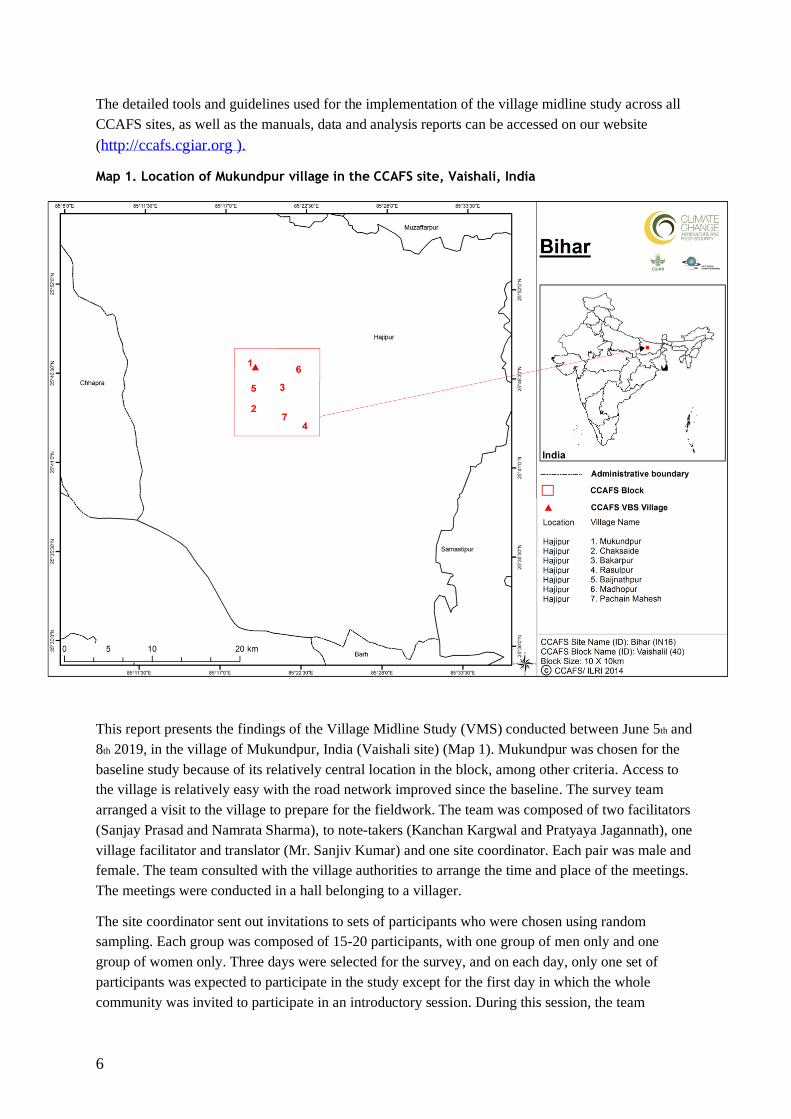
Map 1. Location of Mukundpur village in the CCAFS site, Vaishali, India
This report presents the findings of the Village Midline Study (VMS) conducted between June 5th and
8th 2019, in the village of Mukundpur, India (Vaishali site) (Map 1). Mukundpur was chosen for the
baseline study because of its relatively central location in the block, among other criteria. Access to
the village is relatively easy with the road network improved since the baseline. The survey team
arranged a visit to the village to prepare for the fieldwork. The team was composed of two facilitators
(Sanjay Prasad and Namrata Sharma), to note-takers (Kanchan Kargwal and Pratyaya Jagannath), one
village facilitator and translator (Mr. Sanjiv Kumar) and one site coordinator. Each pair was male and
female. The team consulted with the village authorities to arrange the time and place of the meetings.
The meetings were conducted in a hall belonging to a villager.
The site coordinator sent out invitations to sets of participants who were chosen using random
sampling. Each group was composed of 15-20 participants, with one group of men only and one
group of women only. Three days were selected for the survey, and on each day, only one set of
participants was expected to participate in the study except for the first day in which the whole
community was invited to participate in an introductory session. During this session, the team
7
explained the study to them and shared with them the findings of the village baseline study. After the
introductory session, the voluntary participation of 15 men and 15 women from the community was
requested for the midline study. The whole community was again invited at the end of the third day to
attend a debriefing session where a summary of the preliminary findings was shared.
The study used participatory methods of data collection. During the study, the men’s group and the
women’s group worked separately most of the time. The task on day one was to introduce a satellite
image of the block the community group which presented sketches of resources that were identified
by the baseline participants as being important to the community. The midline participants identified
any important additional resources and added these to the map. The groups also analysed changes in
the state of the previously identified resources. The outputs were maps and sketches. The process of
working with the community to identify the resources of importance to them depended entirely on
their ability to understand and interpret the image and sketches.
The task on day two was to work with each group to understand the organizational landscape and
existing links with regards to food security related issues in a normal year, in a year of crisis, and in
relation to natural resource management. After putting together their organizational landscape, the
groups also compared it to the ones created during the baseline study. The outputs were diagrams
showing the organizational landscape. Information on each organization was also captured in the
cards.
There were two main tasks on the third day. The first task was to work with each group to understand
how information networks related to weather and farming activities have changed since the baseline
study. The outputs were diagrams. The second task was to bring the men’s and women’s groups
together to discuss a vision of what the community would like their village to be in the future. The
reunited group was then split up in two mixed groups, one assessing the progress that was made
towards the vision that was created during the baseline, while the other group created a new vision.
The output was a map/sketch showing “the vision of the community.”
The information generated from the study was captured on photographs, maps, flip charts,
information cards, and notes. All these were then brought together in one debriefing report and then
used to write this final report. The debriefing report was prepared in the field so that it could benefit
from the presence of the site team. The photographed sketches and maps were inserted in the
debriefing report. In this final site analysis report, computer generated maps and diagrams derived
from the field outputs replaced them.
Data analysis
Topic 1. Community resources – participatory satellite imagery interpretation and visioning
Community infrastructure and resources, as well as gender-differentiated access and utilization of
those resources, have been analyzed, based on a process of participatory visual interpretation of high-
resolution satellite imagery. The aim was to identify how community resources and associated
community dynamics have changed since the baseline study. The non-mixed men and women
participants were presented with the maps created by the baseline participants and were asked to
discuss any changes in the state of those resources in terms of quality, access, management, and
finally to point out potential drivers of change. Later on, two mixed groups, respectively 1) developed
8
an image of village resources and human well-being into 2030 and 2) assessed the progress made
towards the future vision that was created by the baseline participants. The detailed approach to this
exercise is outlined in the CCAFS Village Midline Study Implementation Manual.
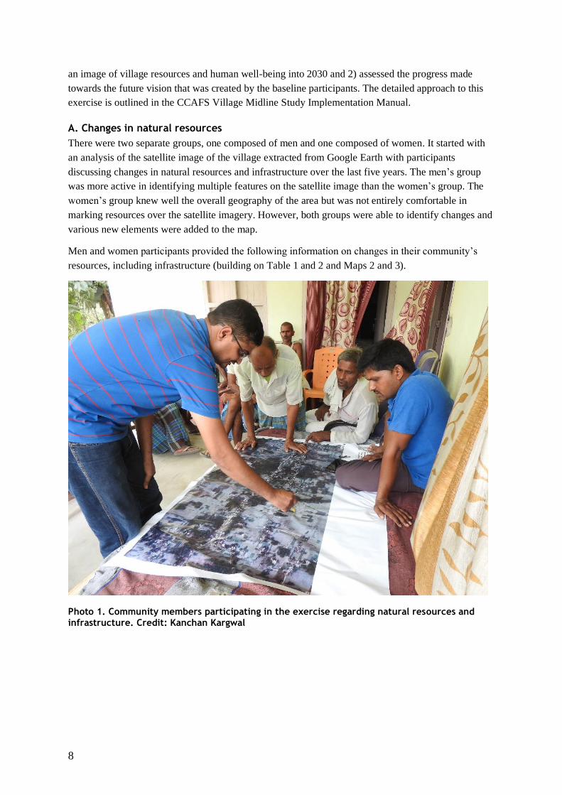
A. Changes in natural resources
There were two separate groups, one composed of men and one composed of women. It started with
an analysis of the satellite image of the village extracted from Google Earth with participants
discussing changes in natural resources and infrastructure over the last five years. The men’s group
was more active in identifying multiple features on the satellite image than the women’s group. The
women’s group knew well the overall geography of the area but was not entirely comfortable in
marking resources over the satellite imagery. However, both groups were able to identify changes and
various new elements were added to the map.
Men and women participants provided the following information on changes in their community’s
resources, including infrastructure (building on Table 1 and 2 and Maps 2 and 3).
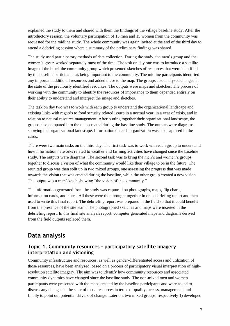
Photo 1. Community members participating in the exercise regarding natural resources and infrastructure. Credit: Kanchan Kargwal
9
Map 2. Major changes in resources (compared to baseline) according to the men’s group
Map 3. Major changes in resources (compared to baseline) according to the women’s group

10
Table 1. Major changes in natural resources since the baseline study (2011), as perceived by men (M) and women (F)
Land cover class Community
determined land use
Location Names Has there been a
change from
baseline? Yes/No
Description of the change Reason for change Agents of change
Large Pond-
Under 50 acres),
(F, M)
Water for irrigation Low lying area that
retains water
No
Small Ponds
Under 50 acres
(M)
Not in use Mukundpur No
Ponds (F) Washing, bathing, and
other daily uses
West of Mukundpur Yes The pond has now dried up.
There is no water anymore.
There has been erratic and
low rainfall for the last 2 to3
years. The water level went
down, and the pond is no
longer in use.
Rainfall, groundwater
depletion
School (F, M) Education Within the village Yes Upgraded to a secondary
school (up to class 8th from
primary classes, i.e. from
class 5th)
Better education facilities Government
intervention
Well (F) Water for drinking and
irrigation purposes
Within the village (6
wells)
Yes All the wells have dried up
and are not in use
Groundwater table depletion,
negligible rainfall
Rainfall, climate
Canal (M, F) Irrigation water Divides the village
into two parts
Yes The canal has now dried up;
there is no water. Only during
the rainy season is the canal
sometimes getting some
water.
Negligible rainfall Rainfall, climate
Temple (F) The place for
gathering. The trees
provide shade and the
temples provide space
for community
gathering
Three different
temples within the
village
No
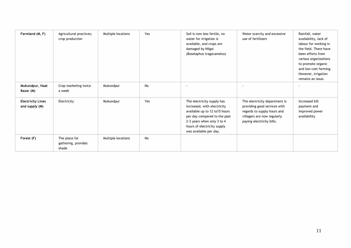
11
Farmland (M, F) Agricultural practices;
crop production
Multiple locations Yes Soil is now less fertile, no
water for irrigation is
available, and crops are
damaged by Nilgai
(Boselaphus tragocamelus)
Water scarcity and excessive
use of fertilizers
Rainfall, water
availability, lack of
labour for working in
the field. There have
been efforts from
various organizations
to promote organic
and low-cost farming.
However, irrigation
remains an issue.
Mukundpur, Haat
Bazar (M)
Crop marketing twice
a week
Mukundpur No - - -
Electricity Lines
and supply (M)
Electricity Mukundpur Yes The electricity supply has
increased, with electricity
available up to 12 to15 hours
per day compared to the past
2-3 years when only 3 to 4
hours of electricity supply
was available per day.
The electricity department is
providing good services with
regards to supply hours and
villagers are now regularly
paying electricity bills.
Increased bill
payment and
improved power
availability
Forest (F) The place for
gathering, provides
shade
Multiple locations No

12
Table 2. New elements added to the map
Land cover
class
Community
determined
land use
Location
Names
Current state (quality) Time to
resource
Management
and ownership
issues
Environmental
Benefits
Opportunities Limitations
Boreholes
(M, F)
Water for
irrigation
Multiple
locations
Yes Varies
depending on
location
Groundwater
table depletion,
no rainfall
Rainfall, excessive
borehole drilling,
climate
Boreholes (M, F) Groundwater
table depletion.
The water table
has gone down to
150 feet.
Expensive to
install.
Road
Network
(M)
Connectivity
and
transport
Multiple
locations
The roads were unpaved
until recent years. The
roads have now been
improved in the village
benefitting from the
Pradhan Mantri Gram Sadak
Yojana plan. Better road
network and town access
Within the
village
Government Improved
accessibility helps
businesses and town
dwellers
-
13
The two groups consisted of people belonging to various age groups and coming from different
backgrounds and. Men and women provided the following information regarding the community’s
natural resources and infrastructure.
Water: Agriculture production in summer is heavily dependent on monsoon rains while the
groundwater resources are used in winter to meet water requirements for production. During the
discussion, the men’s and women’s groups expressed concerns regarding the erratic rainfalls over the
past 3-4 years as well as the depleting groundwater. The villagers reported facing acute water scarcity
which impacts negatively the efficient management of crop cycles. The water shortage in the village
are alarming as it also leads to a shortage of drinking water, as well as a shortage of water to use for
agricultural practices. These results, as claimed by both the men’s and women’s group discussions, to
a shift away from agriculture. Recently, the Gram Panchayat has installed deep boreholes and
constructed overhead tanks for supplying drinking water.
Wells and Borewells: The villagers reported that the wells in the village show a sharp decline in
water levels. Many people in the village are now opting for deep borewells with the depth of the bore
wells varying from 300 to 400 feet. The cost of installing a borewell exceeds Rs. 50,000 per unit.
Besides, villagers also have to install high powered submersible pump sets, which come at an extra
cost. The dug wells in the village have all dried up and are unused, which has an important impact on
the agricultural production in the village.
Canal: The villages consist of two canals, one major and one minor. The major canal divides the
village into two parts. According to participants, there is no water in either of the canals due to little
or no rain in the past 3-4 years. Declining rainfall has also resulted in the drying of the low-lying areas
that retain water (big pond locally known as Chour). The canal is now turning into a garbage dumping
area, which blocks its natural flow, and should there be high rainfall and water discharge in the canal,
inundations in the village could ensue.
Farming: The major cropping system of the village is Rice-Wheat. Scanty rainfall in the region
negatively affects agricultural production in the village. As a result, villagers are now shifting from
rice and wheat cultivation to the cultivation of vegetables such as potato, eggplant, and gourd, etc.
The organizations which used to work in the area, i.e. Bioversity International and CIMMYT, have
promoted organic farming and zero budget natural farming. The adoption of such practices has
ensured some productivity; however, it is not enough to fully address food security issues. There are
several households doing mushroom cultivation with the support of the Panchmurti Farmer’s
Producer Company. As the area has few markets, all the crops and vegetables grown in the area are
sold in the local market only. Many of the farmers also have mango and litchi plantations, which
provides an income during the summer season. Many landless and smallholders are employed in the
local plantations.
Livestock: The households in the village have diversified their sources of income by investing in
livestock. Many of the households have been rearing milch buffaloes and cows to increase their cash
income Income through livestock is further assured by the presence of four dairies (milk collection
centres) in the village, namely Sudha, Aasma, Ganga, and Raj. The dairy cooperatives within the
village also play a pivotal role in securing income by guaranteeing returns. Moreover, the Panchmutri
Farmer’s Producer company has been actively promoting quail farming, which is getting popular.
14
The participants reported a significant positive change in the education available in the village.
According to them, the school, which had classes up to 5th standard has recently been upgraded with a
secondary school providing education up to 8th standard. The Mid Day Meal scheme is functioning
well, and the enrolment in the school has improved along with the attendance of the children. While
before girls had to drop out due to a significant distance to the school, this has changed over the last
few years and girls’ attendance has also increased. The FGDs participants also reported the improved
road network from a dirt road to a paved one which benefitted from the Pradhan Mantri Gram Sadak
Yojana (PMGSY) plan. This has increased the connectivity and accessibility to the nearby markets
and to Hajipur town.
The households in the village are complaining of a lack of government attention to the woes of the
farmers and marginalized groups of the village. The Bihar Rural Livelihood Promotion Society has
started working in the village and has mobilized the women in Self Help Groups (SHGs). The farm-
based livelihoods interventions will begin soon in the village. The Jeevika has been a pioneer in
promoting of agro-ecology with related the interventions expected to roll out soon in the village.
B. Gender-differentiated comparison of changes in conditions
The VMS conducted separate group meetings for men and women. As per Table 1, the views of men
and women participants regarding community resources were mostly similar. The men’s and
women’s groups both identified canal as a significant source of water, which is now dried-up due to
erratic rainfall in the region. Moreover, men and women participants both noted the non-usability of
the dug and bore wells for irrigation, due to declining groundwater table that has gone down to 150ft.
The borewells in the village now go up to a depth of 300 to 400 feet.
While the men participants were prompt and confident in their answers, the women were less at ease
to discuss their point of view. The women’s group identified various temples as community resources
as well as the trees in and around temple premises which were not mentioned by the men’s group.
Due to the labor role division in the village in which women are mostly in charge of the household
chores, the women’s group also identified dry wells as community resources, which were earlier used
for fetching water but are not in use anymore.
The men’s group pointed out the difference in the newly paved road, which was not reported by the
women’s group.
15
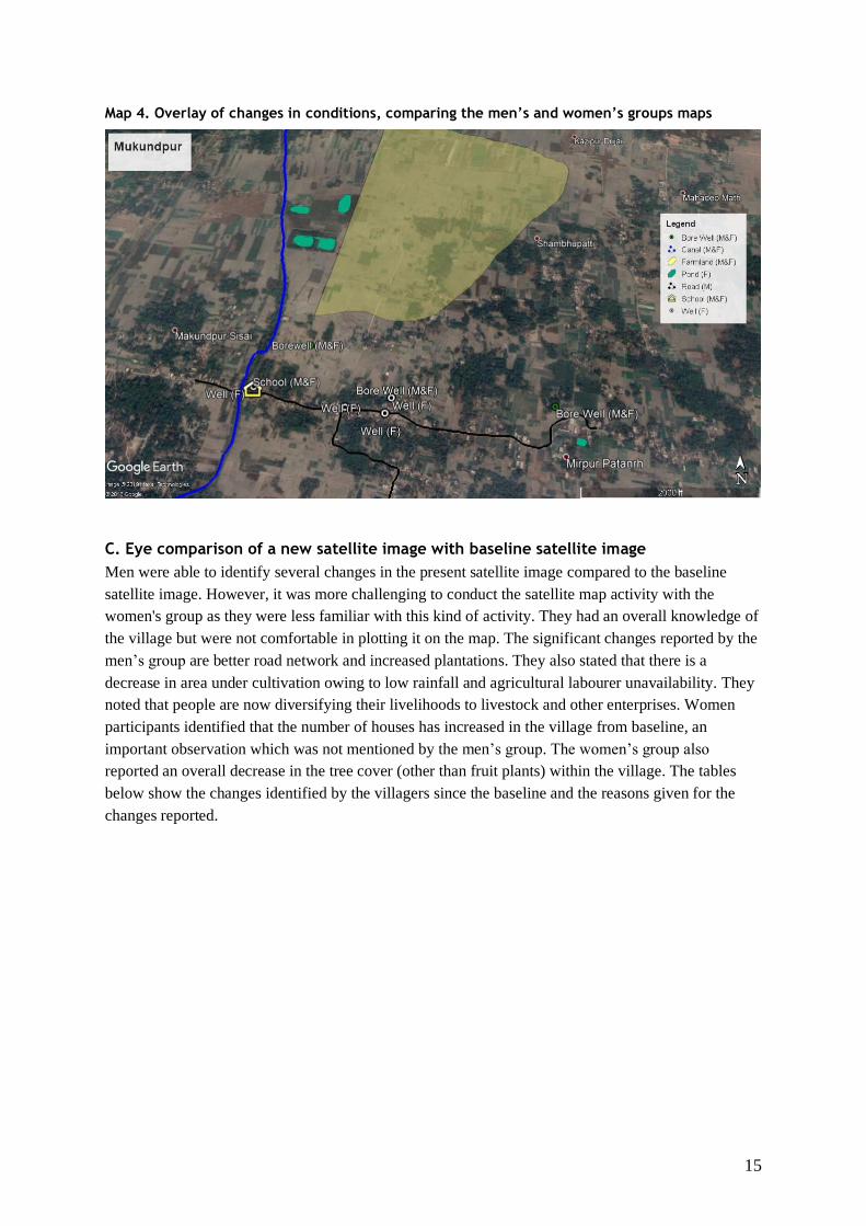
Map 4. Overlay of changes in conditions, comparing the men’s and women’s groups maps
C. Eye comparison of a new satellite image with baseline satellite image
Men were able to identify several changes in the present satellite image compared to the baseline
satellite image. However, it was more challenging to conduct the satellite map activity with the
women's group as they were less familiar with this kind of activity. They had an overall knowledge of
the village but were not comfortable in plotting it on the map. The significant changes reported by the
men’s group are better road network and increased plantations. They also stated that there is a
decrease in area under cultivation owing to low rainfall and agricultural labourer unavailability. They
noted that people are now diversifying their livelihoods to livestock and other enterprises. Women
participants identified that the number of houses has increased in the village from baseline, an
important observation which was not mentioned by the men’s group. The women’s group also
reported an overall decrease in the tree cover (other than fruit plants) within the village. The tables
below show the changes identified by the villagers since the baseline and the reasons given for the
changes reported.
16
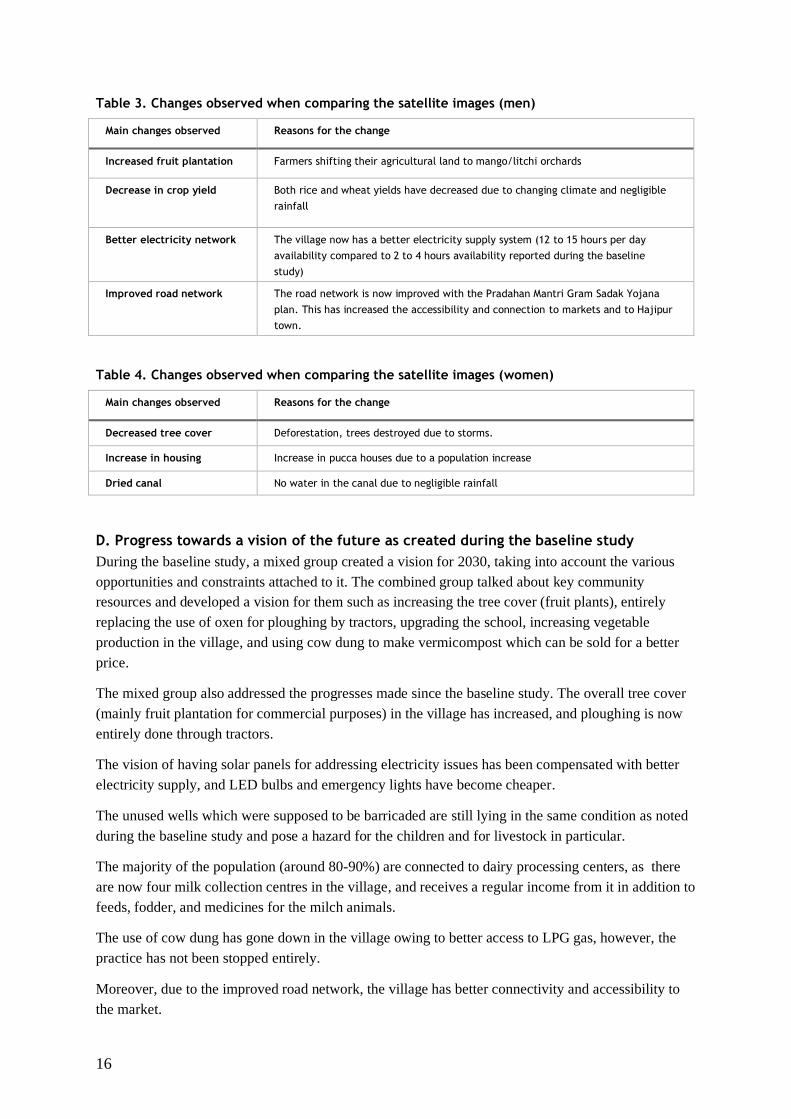
Table 3. Changes observed when comparing the satellite images (men)
Main changes observed Reasons for the change
Increased fruit plantation Farmers shifting their agricultural land to mango/litchi orchards
Decrease in crop yield Both rice and wheat yields have decreased due to changing climate and negligible
rainfall
Better electricity network The village now has a better electricity supply system (12 to 15 hours per day
availability compared to 2 to 4 hours availability reported during the baseline
study)
Improved road network The road network is now improved with the Pradahan Mantri Gram Sadak Yojana
plan. This has increased the accessibility and connection to markets and to Hajipur
town.
Table 4. Changes observed when comparing the satellite images (women)
Main changes observed Reasons for the change
Decreased tree cover Deforestation, trees destroyed due to storms.
Increase in housing Increase in pucca houses due to a population increase
Dried canal No water in the canal due to negligible rainfall
D. Progress towards a vision of the future as created during the baseline study
During the baseline study, a mixed group created a vision for 2030, taking into account the various
opportunities and constraints attached to it. The combined group talked about key community
resources and developed a vision for them such as increasing the tree cover (fruit plants), entirely
replacing the use of oxen for ploughing by tractors, upgrading the school, increasing vegetable
production in the village, and using cow dung to make vermicompost which can be sold for a better
price.
The mixed group also addressed the progresses made since the baseline study. The overall tree cover
(mainly fruit plantation for commercial purposes) in the village has increased, and ploughing is now
entirely done through tractors.
The vision of having solar panels for addressing electricity issues has been compensated with better
electricity supply, and LED bulbs and emergency lights have become cheaper.
The unused wells which were supposed to be barricaded are still lying in the same condition as noted
during the baseline study and pose a hazard for the children and for livestock in particular.
The majority of the population (around 80-90%) are connected to dairy processing centers, as there
are now four milk collection centres in the village, and receives a regular income from it in addition to
feeds, fodder, and medicines for the milch animals.
The use of cow dung has gone down in the village owing to better access to LPG gas, however, the
practice has not been stopped entirely.
Moreover, due to the improved road network, the village has better connectivity and accessibility to
the market.
17
The school is now upgraded to a secondary school from primary school.
However, the primary concern within the villagers is water availability. Due to decreased rainfall in
the past 3-4 years, the village is experiencing water scarcity. The groundwater table has also gone
down.
The villagers, having now better access to electricity, are using the main grid power for their pumps.
The vision to have solar power has now waned due to cost and maintenance related reasons.
Another issue concerning farming is the increasing population of Nilgai in the village. Villagers have
now stopped cultivating maize, mungbean and other vegetable crops. Only within the homestead land
are villagers cultivating vegetables.
E. New vision of the future
The group's new vision focused on the economic stability of households through agriculture and dairy
production. The most significant issue in the village being water scarcity, the villagers want support
from the government to help increase water availability in the region through the canal as two big
rivers, the Ganges and Gandak, flow nearby.
Women were mostly concerned about the overall welfare of their families and the need to ensure an
income from various sources. They also were concerned about the education facilities for the children.
The men were mostly concerned about infrastructure related issues. Employment opportunities are a
concern for both men and women. However, both groups reported that the primary concern right now
remain water scarcity.
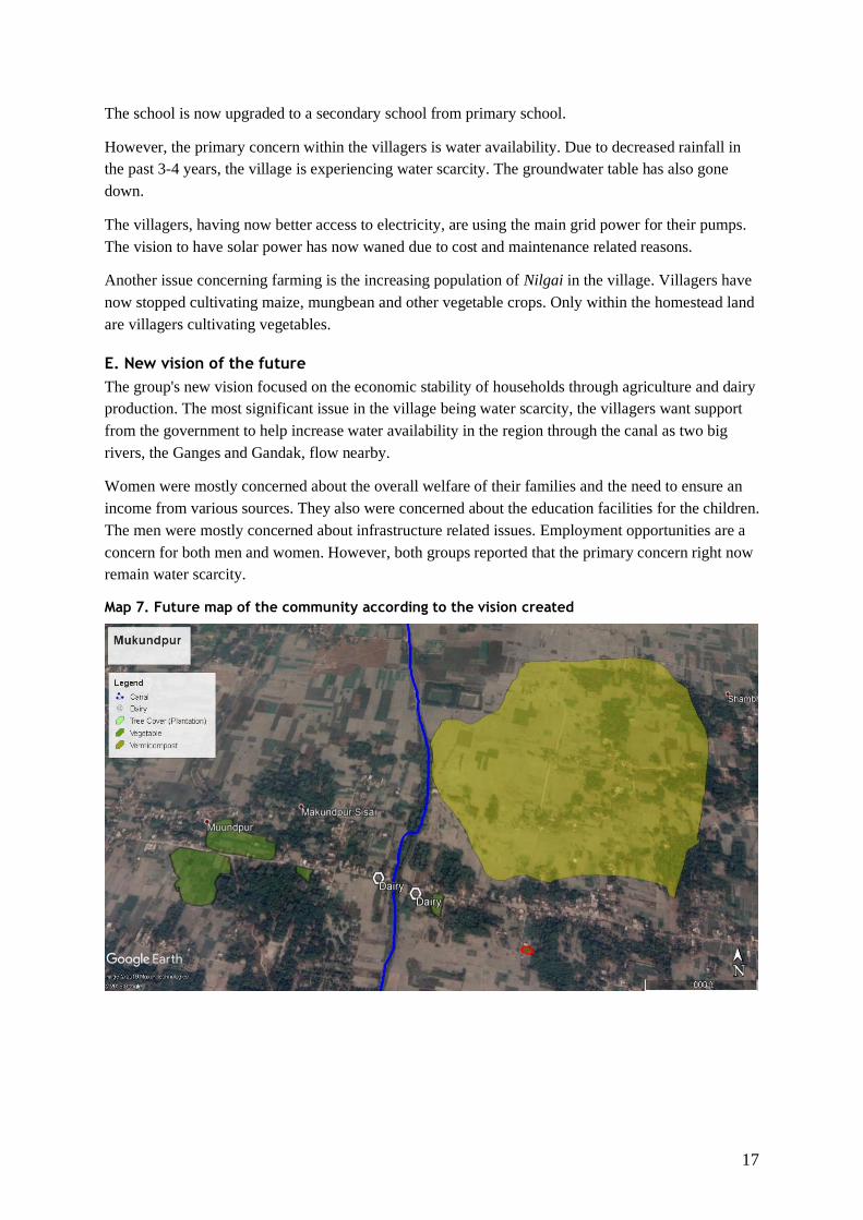
Map 7. Future map of the community according to the vision created
18
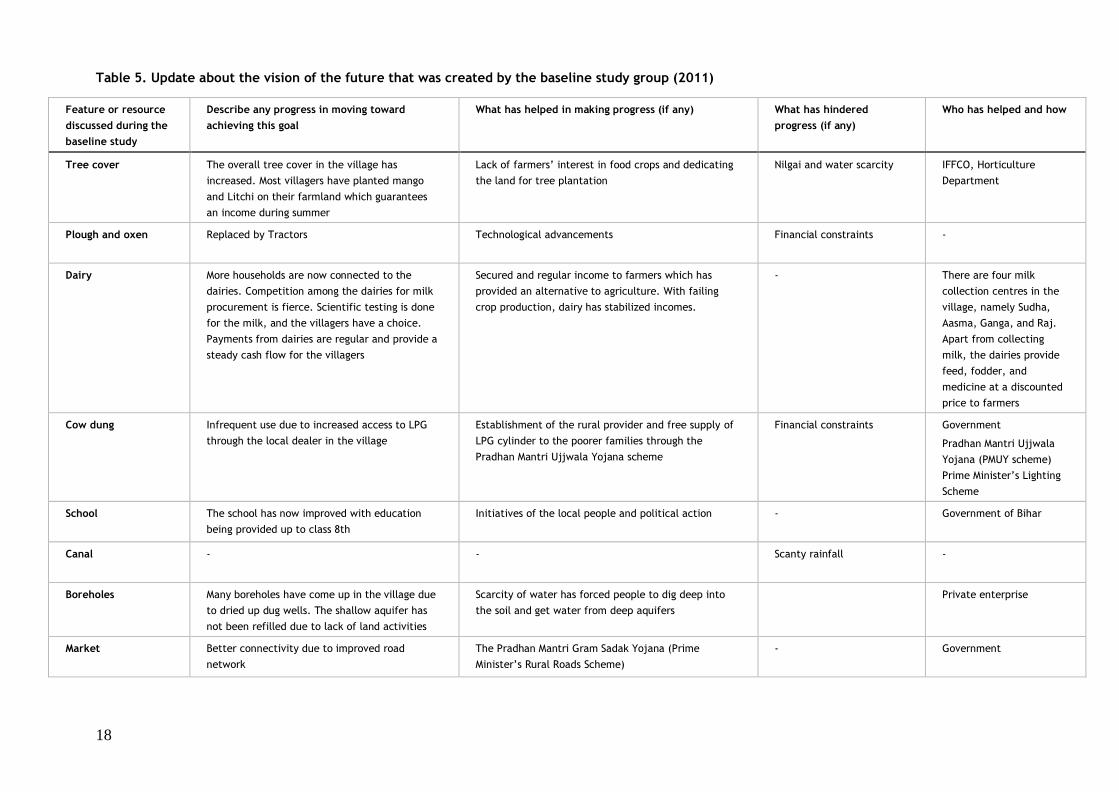
Table 5. Update about the vision of the future that was created by the baseline study group (2011)
Feature or resource
discussed during the
baseline study
Describe any progress in moving toward
achieving this goal
What has helped in making progress (if any) What has hindered
progress (if any)
Who has helped and how
Tree cover The overall tree cover in the village has
increased. Most villagers have planted mango
and Litchi on their farmland which guarantees
an income during summer
Lack of farmers’ interest in food crops and dedicating
the land for tree plantation
Nilgai and water scarcity IFFCO, Horticulture
Department
Plough and oxen Replaced by Tractors Technological advancements Financial constraints -
Dairy More households are now connected to the
dairies. Competition among the dairies for milk
procurement is fierce. Scientific testing is done
for the milk, and the villagers have a choice.
Payments from dairies are regular and provide a
steady cash flow for the villagers
Secured and regular income to farmers which has
provided an alternative to agriculture. With failing
crop production, dairy has stabilized incomes.
- There are four milk
collection centres in the
village, namely Sudha,
Aasma, Ganga, and Raj.
Apart from collecting
milk, the dairies provide
feed, fodder, and
medicine at a discounted
price to farmers
Cow dung Infrequent use due to increased access to LPG
through the local dealer in the village
Establishment of the rural provider and free supply of
LPG cylinder to the poorer families through the
Pradhan Mantri Ujjwala Yojana scheme
Financial constraints Government
Pradhan Mantri Ujjwala
Yojana (PMUY scheme)
Prime Minister’s Lighting
Scheme
School The school has now improved with education
being provided up to class 8th
Initiatives of the local people and political action - Government of Bihar
Canal - - Scanty rainfall -
Boreholes Many boreholes have come up in the village due
to dried up dug wells. The shallow aquifer has
not been refilled due to lack of land activities
Scarcity of water has forced people to dig deep into
the soil and get water from deep aquifers
Private enterprise
Market Better connectivity due to improved road
network
The Pradhan Mantri Gram Sadak Yojana (Prime
Minister’s Rural Roads Scheme)
- Government
19
Vermicompost The by-product of cattle was earlier used as
fuel. However, growing demand for
vermicompost and the efforts of the Panchmurti
Framer’s Producer Company has helped farmers
produce more vermicompost and sell it in the
market.
Awareness to use cow dung as a resource for income
generation
Panchmurti Farmer’s
Producer Company
Vegetables Decreased production because farmers are
unable to watch and ward for Nilgai menace
Only produced on the homestead. Some organizations
started to promote organic farming. Providing a watch
and ward has been an issue for the farmers.
Water scarcity and Nilgai
destroying the field crop
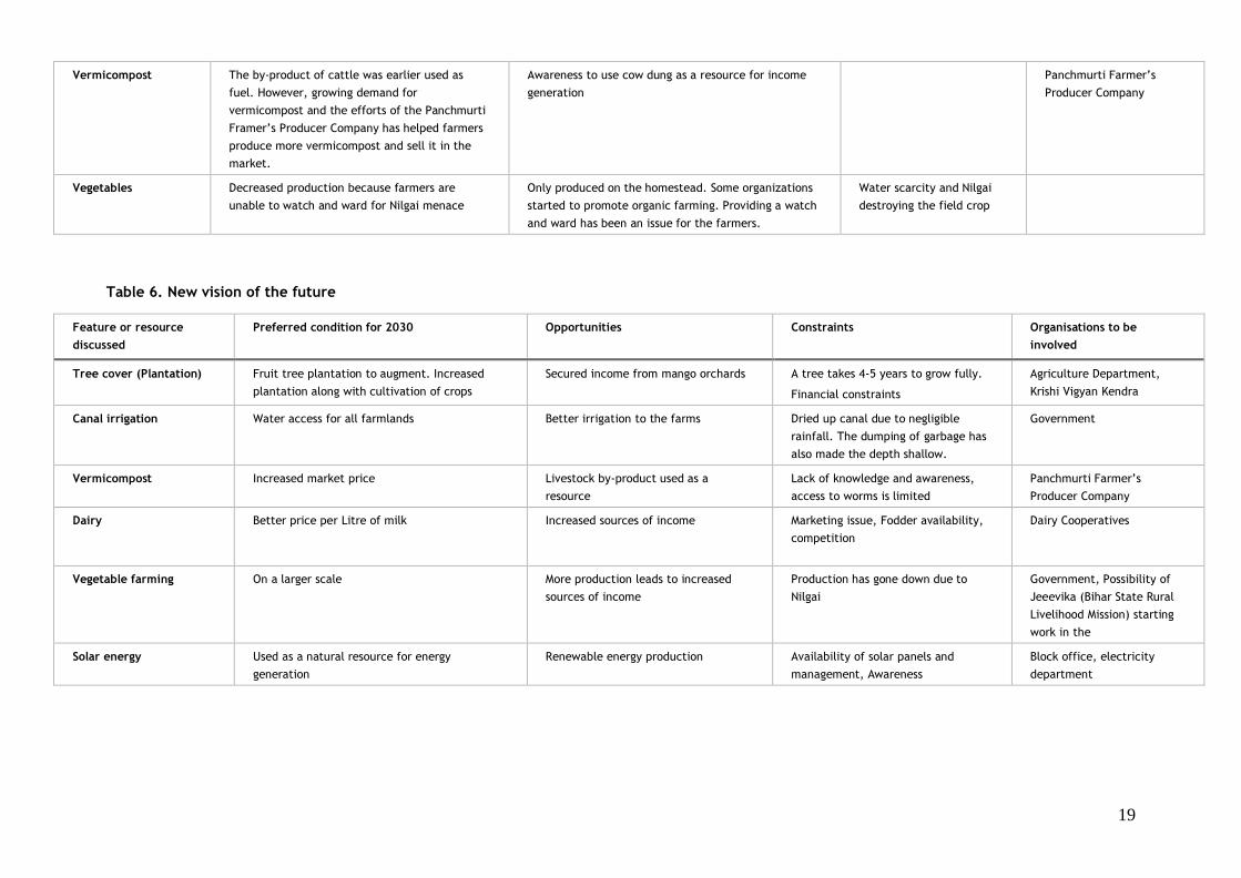
Table 6. New vision of the future
Feature or resource
discussed
Preferred condition for 2030 Opportunities Constraints Organisations to be
involved
Tree cover (Plantation) Fruit tree plantation to augment. Increased
plantation along with cultivation of crops
Secured income from mango orchards A tree takes 4-5 years to grow fully.
Financial constraints
Agriculture Department,
Krishi Vigyan Kendra
Canal irrigation Water access for all farmlands Better irrigation to the farms Dried up canal due to negligible
rainfall. The dumping of garbage has
also made the depth shallow.
Government
Vermicompost Increased market price Livestock by-product used as a
resource
Lack of knowledge and awareness,
access to worms is limited
Panchmurti Farmer’s
Producer Company
Dairy Better price per Litre of milk Increased sources of income Marketing issue, Fodder availability,
competition
Dairy Cooperatives
Vegetable farming On a larger scale More production leads to increased
sources of income
Production has gone down due to
Nilgai
Government, Possibility of
Jeeevika (Bihar State Rural
Livelihood Mission) starting
work in the
Solar energy Used as a natural resource for energy
generation
Renewable energy production Availability of solar panels and
management, Awareness
Block office, electricity
department
20
Topic 2. Organizational landscapes
This section aims to provide evidence of the existing organizational capacities that help
address food security and natural resource management issues. This will inform CCAFS
about how prepared the village is to respond to the challenges envisaged as a consequence of
climate change or to other future challenges in order to engage with CCAFS partners at a
collective level.
Specifically, this section presents the different formal and informal organizations involved in
the community in general terms, as well as working in food security and natural resources
management (NRM) related issues in particular. It also elaborates on the types of activities the
organizations are engaged in, who their members are, whether the organisations are seen as
useful, etc.
A. Basic spheres of operation
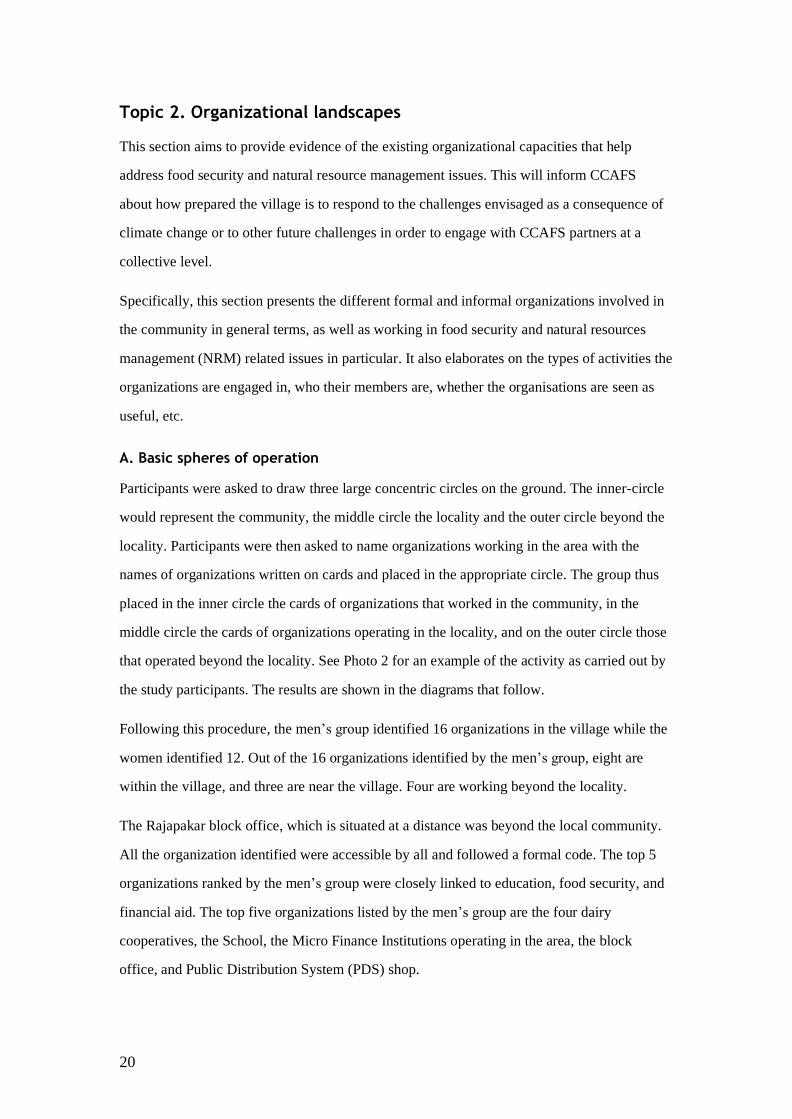
Participants were asked to draw three large concentric circles on the ground. The inner-circle
would represent the community, the middle circle the locality and the outer circle beyond the
locality. Participants were then asked to name organizations working in the area with the
names of organizations written on cards and placed in the appropriate circle. The group thus
placed in the inner circle the cards of organizations that worked in the community, in the
middle circle the cards of organizations operating in the locality, and on the outer circle those
that operated beyond the locality. See Photo 2 for an example of the activity as carried out by
the study participants. The results are shown in the diagrams that follow.
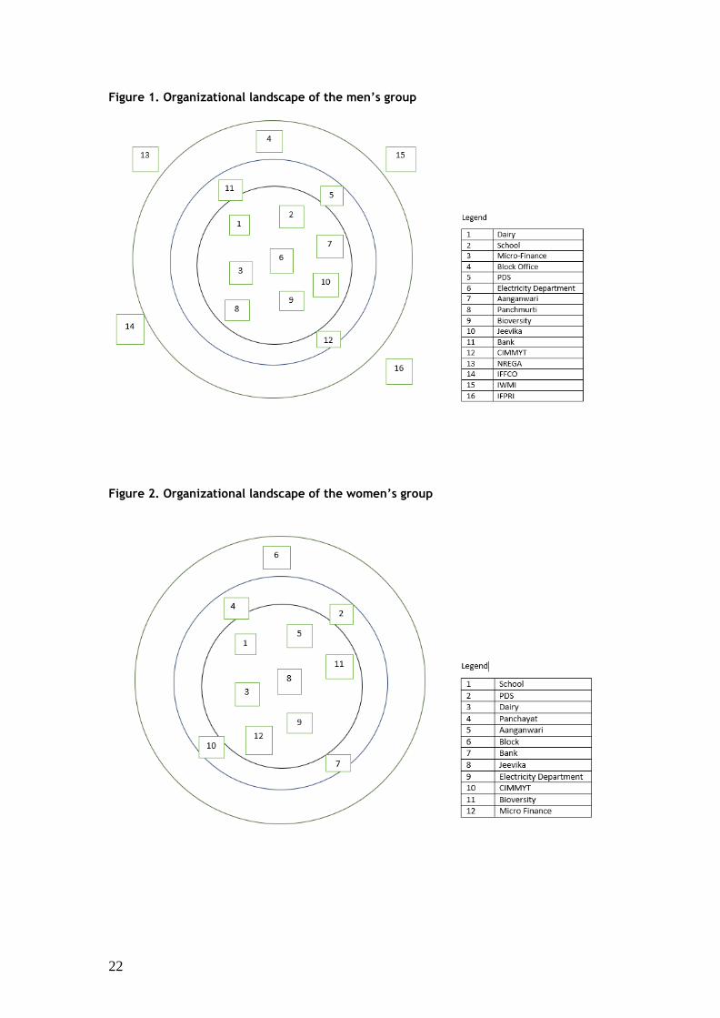
Following this procedure, the men’s group identified 16 organizations in the village while the
women identified 12. Out of the 16 organizations identified by the men’s group, eight are
within the village, and three are near the village. Four are working beyond the locality.
The Rajapakar block office, which is situated at a distance was beyond the local community.
All the organization identified were accessible by all and followed a formal code. The top 5
organizations ranked by the men’s group were closely linked to education, food security, and
financial aid. The top five organizations listed by the men’s group are the four dairy
cooperatives, the School, the Micro Finance Institutions operating in the area, the block
office, and Public Distribution System (PDS) shop.
21
The women’s group identified 12 organizations that worked in the village. Out of these 12
listed organizations, 8 are situated in the village itself. Eight of these organizations directly
work with the community. Three organizations, the Gram Panchayat, Public Distribution
System (PDS) shop, and bank are situated nearby. The top five organizations identified by
women included the School, the PDS, the Anganwadi, the Gram Panchayat, the Block office
and the four dairy cooperatives of the village. They were all accessible by anyone in the
community and have been present for a long time. The majority of the organisations had state
origin and are owned by the government.
In tables 7 and 8, more detailed information is provided on the five most important
organizations as they were ranked by the men’s and women’s groups.
Photo 2. The organizational landscape activity in progress. Credit: Kanchan Kargwal
22
Figure 1. Organizational landscape of the men’s group
Figure 2. Organizational landscape of the women’s group
23
While conducting the organizational landscape activity with the villagers, it was noted that
several organizations which had been mentioned during the baseline study were not discussed
during the midline study, among which:
1. Iffco Tokio Life Insurance Company Limited,
2. Department of Livestock and Fishery,
3. Poorest Area Civil Society,
4. Primary Agricultural Credit Cooperative Society,
5. Department of Forest and
6. Department of Irrigation
The reasons reported for this being the closing of operations of these organizations in the
village and an unavailability of the services. During the midline study, it was also reported
that some organizations which were listed have also stopped working, i.e., CIMMYT,
Bioversity International, IWMI, and IFPRI.
24
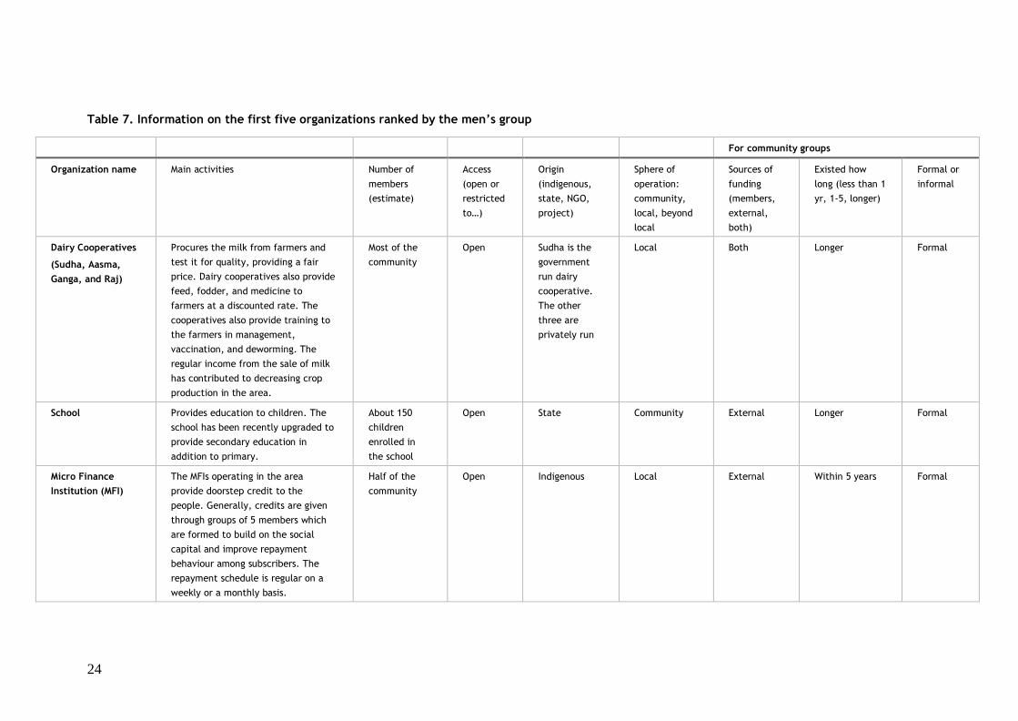
Table 7. Information on the first five organizations ranked by the men’s group
For community groups
Organization name Main activities Number of
members
(estimate)
Access
(open or
restricted
to…)
Origin
(indigenous,
state, NGO,
project)
Sphere of
operation:
community,
local, beyond
local
Sources of
funding
(members,
external,
both)
Existed how
long (less than 1
yr, 1-5, longer)
Formal or
informal
Dairy Cooperatives
(Sudha, Aasma,
Ganga, and Raj)
Procures the milk from farmers and
test it for quality, providing a fair
price. Dairy cooperatives also provide
feed, fodder, and medicine to
farmers at a discounted rate. The
cooperatives also provide training to
the farmers in management,
vaccination, and deworming. The
regular income from the sale of milk
has contributed to decreasing crop
production in the area.
Most of the
community
Open Sudha is the
government
run dairy
cooperative.
The other
three are
privately run
Local Both Longer Formal
School Provides education to children. The
school has been recently upgraded to
provide secondary education in
addition to primary.
About 150
children
enrolled in
the school
Open State Community External Longer Formal
Micro Finance
Institution (MFI)
The MFIs operating in the area
provide doorstep credit to the
people. Generally, credits are given
through groups of 5 members which
are formed to build on the social
capital and improve repayment
behaviour among subscribers. The
repayment schedule is regular on a
weekly or a monthly basis.
Half of the
community
Open Indigenous Local External Within 5 years Formal

25
Block office The Community Development Block
office is the nodal point for the
provision of government services and
facilitates all development activities
in the area
Most of the
community
Open State Beyond local External Longer Formal
Public Distribution
System (PDS) Shop
Provides cereals, pulses, sugar, and
kerosene to the households at a
subsidized rate
Most of the
community
Open State Local External Longer Formal
Table 8. Information on the first five organizations ranked by the women’s group
Organisation name Main activities Number of
members
(estimate)
Access
(open or
restricted
to…)
Origin
(indigenous,
state, NGO,
project)
Sphere of
operation:
community,
local, beyond
local
Sources of
funding
(members,
external,
both)
Existed how
long (less than
1 yr, 1-5,
longer)
Formal or
informal
School Provides education to children. The
school has been recently upgraded
from primary to provide secondary
education as well
About 150
children
enrolled in
the school
Open State Community, External Longer Formal
Public Distribution
System (PDS) Shop
Provides cereals, pulses, sugar, and
kerosene to the households at a
subsidized rate
Most of the
community
Open State Local External Longer Formal
Dairy cooperatives
(Sudha, Aasma,
Ganga, and Raj)
Procures the milk from farmers and
test it for quality while providing a
fair price. The dairy cooperatives also
provide feed, fodder, and medicine to
the farmers at discounted rates. The
cooperatives provide training to the
farmers in management, vaccination,
Most of the
community
Open Sudha is the
government
run dairy
cooperative.
The other
three are
privately run
Local Both Longer Formal
26
and deworming. The regular income
from the sale of milk has contributed
to decreasing crop production in the
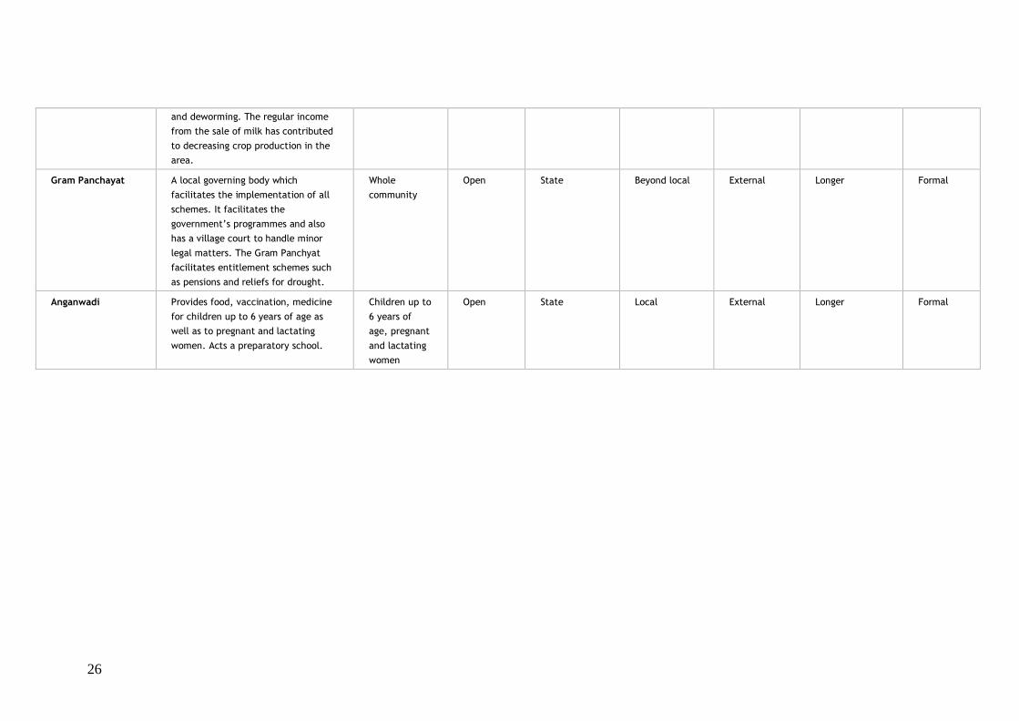
area.
Gram Panchayat A local governing body which
facilitates the implementation of all
schemes. It facilitates the
government’s programmes and also
has a village court to handle minor
legal matters. The Gram Panchyat
facilitates entitlement schemes such
as pensions and reliefs for drought.
Whole
community
Open State Beyond local External Longer Formal
Anganwadi Provides food, vaccination, medicine
for children up to 6 years of age as
well as to pregnant and lactating
women. Acts a preparatory school.
Children up to
6 years of
age, pregnant
and lactating
women
Open State Local External Longer Formal
27
B. Organizational landscape of food security
The goal of this exercise was to obtain an improved understanding of how the existing
organizational landscape contributes to the food security of the groups. Food security is
mostly measured at the household level. Nonetheless, community-level organizations and
interactions influence the food security of different groups within the community differently.
Men and women participants were asked to discuss the concepts of food availability, access,
and utilization, and then review each organization previously identified by pointing out which
of them had activities that fell under these categories. Organizations identified by the men’s
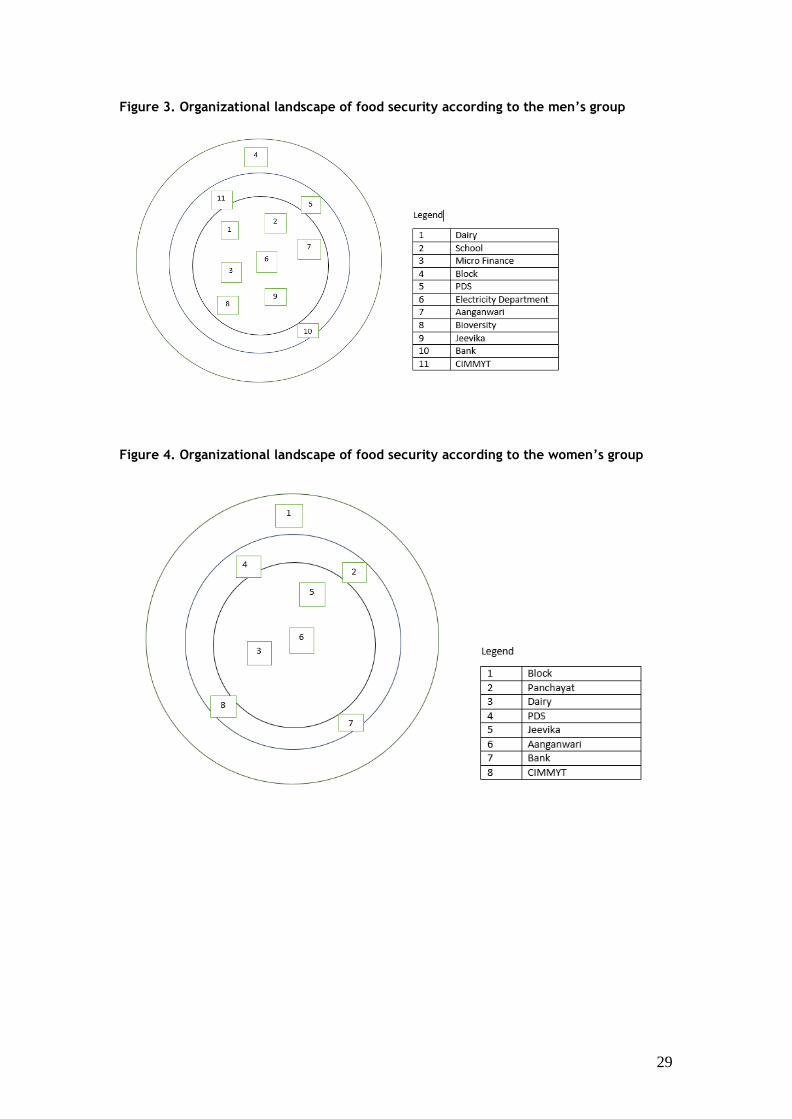
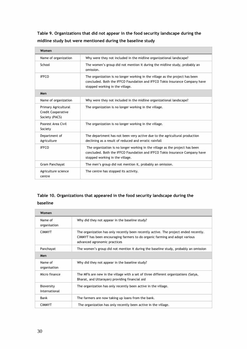
and women’s groups are shown, respectively, in Figures 3 and 4.
The men’s group identified 11 organizations working on food security related issues while the
women’s group identified 8. Food security was explained to both groups in terms of both
physical and economic access to food. It includes year-round security of the food in a
household through their own farms or from other sources. Food security was further divided
into availability, accessibility, and utilization of food. Food security was also conceptualized
as including the entire household, thus not leaving any individual member of the household
behind.
The major organizations related to food security as identified by the men’s group included the
school, the Anganwadi, and the PDS. The school provides a midday meal to the children
while the Anganwadi centers provides nutritious food ration to children below the age of six
years and to pregnant and lactating women. The PDS shop provides cereals, pulses, sugar, and
kerosene to people every month. These organizations all provide food and cereals to children,
mother, and poorer households which helps in closing the nutrition gap observed during the
baseline study. These organizations were part of the baseline assessment as well and they
have continued to exist and function within the village since. The organization’s list also
included organizations which were linked to a direct source of income, for example the dairy
cooperatives, Micro Finance Institutions (MFIs), and Banks. These organizations offer
financial assistance to obtain agriculture inputs in order to increase and diversify crop
production.
A total of 8 organizations working in food security related issues were identified by the
women’s group. The women’s group listed the Block office, the Panchayat, dairy
cooperatives, the PDS, and the Jeevika. The Anganwadi was also highlighted for its role in
28
ensuring food security by supporting good nutrition for women and children. Moreover,
women in the village are able to access savings and credit activities through the Self Help
Groups, which are composed of 10 to 15 women. The Jeevika has not yet started intervening
in livelihood activities but will be instrumental in addressing food security issues.
Both groups appreciated the government related PDS, school, and the Anganwadi centres for
their active role in food security. Other organizations providing financial aid, thus directly or
indirectly helping in food security related issues, were also lauded.
There were many organizations which were mentioned during the baseline study but were not
cited during the midline study. New organizations have also emerged during the midline study
as participants pointed out new actors working in food security related areas.
The men’s group identified several new organizations since the baseline study working in the
village in food security related areas, for example, Bioversity and CIMMYT even if their
projects have now ended. Micro Finance Institutions (MFIs) like Satya, Bharat, and Uttrayan
were also reported as they provide loans to groups of people, thus acting as financial aid
actors. The men’s group also reported that the PACS is no longer working in the village.
The Women’s group also reported CIMMYT for having provided agricultural inputs and
training, indirectly helping in food security.
Both the men’s group and the women’s group reported that IFFCO is no longer active in the
village as the project has reached an end.
Participants stated that they are suffering from delayed monsoons and will experience extreme
drought conditions in the coming years, which will directly affect farm production and might
lead to repeated food crises.
29
Figure 3. Organizational landscape of food security according to the men’s group
Figure 4. Organizational landscape of food security according to the women’s group
30
Table 9. Organizations that did not appear in the food security landscape during the
midline study but were mentioned during the baseline study
Women
Name of organization Why were they not included in the midline organizational landscape?
School The women’s group did not mention it during the midline study, probably an
omission.
IFFCO The organization is no longer working in the village as the project has been
concluded. Both the IFFCO Foundation and IFFCO Tokio Insurance Company have
stopped working in the village.
Men
Name of organization Why were they not included in the midline organizational landscape?
Primary Agricultural
Credit Cooperative
Society (PACS)
The organization is no longer working in the village.
Poorest Area Civil
Society
The organization is no longer working in the village.
Department of
Agriculture
The department has not been very active due to the agricultural production
declining as a result of reduced and erratic rainfall
IFFCO The organization is no longer working in the village as the project has been
concluded. Both the IFFCO Foundation and IFFCO Tokio Insurance Company have
stopped working in the village.
Gram Panchayat The men’s group did not mention it, probably an omission.
Agriculture science
centre
The centre has stopped its activity.
Table 10. Organizations that appeared in the food security landscape during the
baseline
Women
Name of
organisation
Why did they not appear in the baseline study?
CIMMYT The organization has only recently been recently active. The project ended recently.
CIMMYT has been encouraging farmers to do organic farming and adopt various
advanced agronomic practices
Panchayat The women’s group did not mention it during the baseline study, probably an omission
Men
Name of
organisation
Why did they not appear in the baseline study?
Micro finance The MFIs are new in the village with a set of three different organizations (Satya,
Bharat, and Uttarayan) providing financial aid
Bioversity
International
The organization has only recently been active in the village.
Bank The farmers are now taking up loans from the bank.
CIMMYT The organization has only recently been active in the village.
31
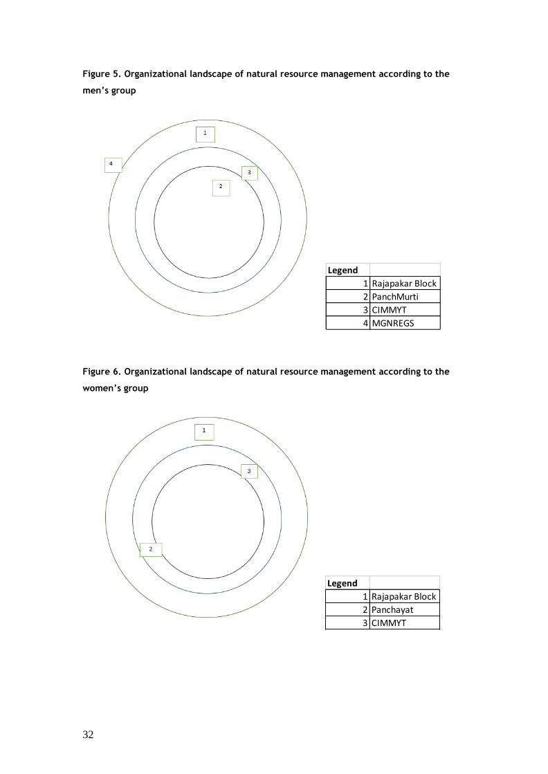
C. Organizational landscape of natural resource management
In this section, the organizational landscape in relation to natural resource management
(NRM) is discussed. Specifically, what organizations were actively working to protect the
environment and manage natural resources? The process entailed asking the groups to identify
the organisations involved in the management of natural resources in the community; then
developing a list of natural resources that are important to the community’s livelihoods, and
finally to ask the group to decide on a symbol for each type of natural resource listed.
As reported by the men’s groups, only 4 organizations were working in the NRM related
areas while the women identified 3 organizations. These organizations focus on inputs,
technology, climate change awareness and community infrastructure. Currently, the flagship
programme of the Government of India, i.e., Mahatma Gandhi National Rural Employment
Guarantee Scheme (MGNREGS), which provides 100 days of employment, is controlled by
The Rajapakar Block office. The funds and labour emerging from MGNREGS are used to
create community infrastructures for Natural Resources Management. One of the biggest gaps
found among identified organizations was that none were working specifically in NRM other
than those working in livestock and agriculture. The women participants were less aware of
NRM or climate change related organizations compared to the men. As a result, the women’s
group was unable to recall the names of many organizations or to detail their activities. Both
the men’s and women’s groups cited more agriculture related support in relation to NRM,
such as the provision of inputs and trainings. Farmers were familiar with some soil
management practices largely due to the awareness created by the Panchmurti Farmer’s
Producer Company on cow manure application and vermicomposting. Both the men’s and
women’s groups reported the work of CIMMYT with respect to natural resource management
and noted that the organization was supporting farmers through trainings, providing access to
agricultural inputs, weather-based insurance and developing new practices to implement on
farm.
32
Figure 5. Organizational landscape of natural resource management according to the
men’s group
Figure 6. Organizational landscape of natural resource management according to the
women’s group
Legend
1 Rajapakar Block
2 PanchMurti
3 CIMMYT
4 MGNREGS
Legend
1 Rajapakar Block
2 Panchayat
3 CIMMYT
33
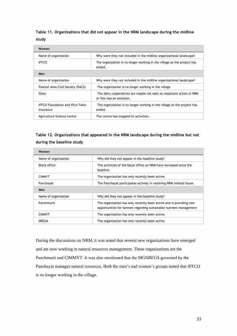
Table 11. Organizations that did not appear in the NRM landscape during the midline
study
Women
Name of organization Why were they not included in the midline organizational landscape?
IFFCO The organization is no longer working in the village as the project has
ended.
Men
Name of organization Why were they not included in the midline organizational landscape?
Poorest Area Civil Society (PACS) The organization is no longer working in the village
Dairy The dairy cooperatives are maybe not seen as important actors in NRM
or this was an omission.
IFFCO Foundation and Iffco Tokio
Insurance
The organization is no longer working in the village as the project has
ended.
Agriculture Science centre The centre has stopped its activities.
Table 12. Organizations that appeared in the NRM landscape during the midline but not
during the baseline study
Women
Name of organization Why did they not appear in the baseline study?
Block office The activities of the block office on NRM have increased since the
baseline.
CIMMYT The organization has only recently been active.
Panchayat The Panchayat participates actively in resolving NRM related issues
Men
Name of organization Why did they not appear in the baseline study?
Panchmurti The organization has only recently been active and is providing new
opportunities for farmers regarding sustainable nutrient management
CIMMYT The organization has only recently been active.
NREGA The organization has only recently been active.
During the discussions on NRM, it was noted that several new organizations have emerged
and are now working in natural resources management. These organizations are the
Panchmurti and CIMMYT. It was also mentioned that the MGNREGS governed by the
Panchayat manages natural resources. Both the men’s and women’s groups stated that IFFCO
is no longer working in the village.
34
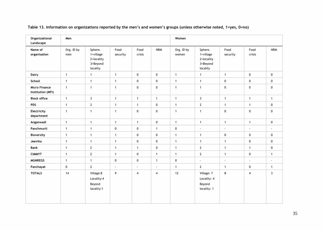
D. Gender differences between organizational landscapes
Table 13 below summarizes information on all the organizations identified separately by men
and women participants. The organizations are classified according to their role in supporting
food availability, access and/or utilization and the management of natural resources.
35
Table 13. Information on organizations reported by the men’s and women’s groups (unless otherwise noted, 1=yes, 0=no)
Organizational
Landscape
Men Women
Name of
organisation
Org. ID by
men
Sphere.
1=village
2=locality
3=Beyond
locality
Food
security
Food
crisis
NRM Org. ID by
women
Sphere.
1=village
2=locality
3=Beyond
locality
Food
security
Food
crisis
NRM
Dairy 1 1 1 0 0 1 1 1 0 0
School 1 1 1 0 0 1 1 0 0 0
Micro Finance
Institution (MFI)
1 1 1 0 0 1 1 0 0 0
Block office 1 3 1 1 1 1 3 1 1 1
PDS 1 2 1 1 0 1 2 1 1 0
Electricity
department
1 1 1 0 0 1 1 0 0 0
Anganwadi 1 1 1 1 0 1 1 1 1 0
Panchmurti 1 1 0 0 1 0 - - - -
Bioversity 1 1 1 0 0 1 1 0 0 0
Jeevika 1 1 1 0 0 1 1 1 0 0
Bank 1 2 1 1 0 1 2 1 1 0
CIMMYT 1 2 1 0 1 1 2 1 0 1
MGNREGS 1 1 0 0 1 0 - - - -
Panchayat 0 2 - - - 1 2 1 0 1
TOTALS 14 Village:8
Locality:4
Beyond
locality:1
9 4 4 12 Village: 7
Locality: 4
Beyond
locality: 1
8 4 3
36
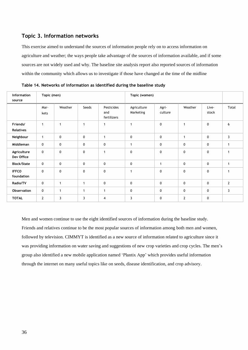
Topic 3. Information networks
This exercise aimed to understand the sources of information people rely on to access information on
agriculture and weather; the ways people take advantage of the sources of information available, and if some
sources are not widely used and why. The baseline site analysis report also reported sources of information
within the community which allows us to investigate if those have changed at the time of the midline
Table 14. Networks of information as identified during the baseline study
Information
source
Topic (men) Topic (women)
Mar-
kets
Weather Seeds Pesticides
and
fertilizers
Agriculture
Marketing
Agri-
culture
Weather Live-
stock
Total
Friends/
Relatives
1 1 1 1 1 0 1 0 6
Neighbour 1 0 0 1 0 0 1 0 3
Middleman 0 0 0 0 1 0 0 0 1
Agriculture
Dev Office
0 0 0 1 0 0 0 0 1
Block/State 0 0 0 0 0 1 0 0 1
IFFCO
foundation
0 0 0 0 1 0 0 0 1
Radio/TV 0 1 1 0 0 0 0 0 2
Observation 0 1 1 1 0 0 0 0 3
TOTAL 2 3 3 4 3 0 2 0
Men and women continue to use the eight identified sources of information during the baseline study.
Friends and relatives continue to be the most popular sources of information among both men and women,
followed by television. CIMMYT is identified as a new source of information related to agriculture since it
was providing information on water saving and suggestions of new crop varieties and crop cycles. The men’s
group also identified a new mobile application named ‘Plantix App’ which provides useful information
through the internet on many useful topics like on seeds, disease identification, and crop advisory.
37
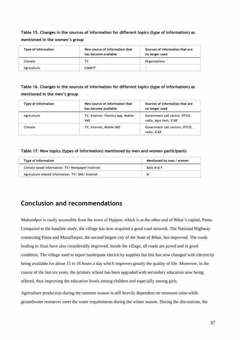
Table 15. Changes in the sources of information for different topics (type of information) as
mentioned in the women’s group
Type of information New source of information that
has become available
Sources of information that are
no longer used
Climate TV Organizations
Agriculture CIMMYT -
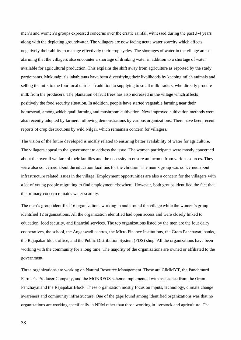
Table 16. Changes in the sources of information for different topics (type of information) as
mentioned in the men’s group
Type of information New source of information that
has become available
Sources of information that are
no longer used
Agriculture TV, Internet, Plantics App, Mobile
SMS
Government call centre, IFFCO,
radio, Agro fairs, ICAR
Climate TV, Internet, Mobile SMS Government call centers, IFFCO,
radio, ICAR
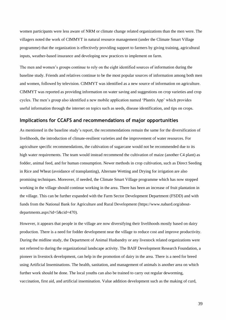
Table 17. New topics (types of information) mentioned by men and women participants
Type of information Mentioned by men / women
Climate based information: TV/ Newspaper/Internet Both M & F
Agriculture related information: TV/ SMS/ Internet M
Conclusion and recommendations
Mukundpur is easily accessible from the town of Hajipur, which is at the other end of Bihar’s capital, Patna.
Compared to the baseline study, the village has now acquired a good road network. The National Highway
connecting Patna and Muzaffarpur, the second largest city of the State of Bihar, has improved. The roads
leading to Sisai have also considerably improved. Inside the village, all roads are paved and in good
condition. The village used to report inadequate electricity supplies but this has now changed with electricity
being available for about 15 to 16 hours a day which improves greatly the quality of life. Moreover, in the
course of the last six years, the primary school has been upgraded with secondary education now being
offered, thus improving the education levels among children and especially among girls.
Agriculture production during the summer season is still heavily dependent on monsoon rains while
groundwater resources meet the water requirements during the winter season. During the discussions, the
38
men’s and women’s groups expressed concerns over the erratic rainfall witnessed during the past 3-4 years
along with the depleting groundwater. The villagers are now facing acute water scarcity which affects
negatively their ability to manage effectively their crop cycles. The shortages of water in the village are so
alarming that the villagers also encounter a shortage of drinking water in addition to a shortage of water
available for agricultural production. This explains the shift away from agriculture as reported by the study
participants. Mukundpur’s inhabitants have been diversifying their livelihoods by keeping milch animals and
selling the milk to the four local dairies in addition to supplying to small milk traders, who directly procure
milk from the producers. The plantation of fruit trees has also increased in the village which affects
positively the food security situation. In addition, people have started vegetable farming near their
homestead, among which quail farming and mushroom cultivation. New improved cultivation methods were
also recently adopted by farmers following demonstrations by various organizations. There have been recent
reports of crop destructions by wild Nilgai, which remains a concern for villagers.
The vision of the future developed is mostly related to ensuring better availability of water for agriculture.
The villagers appeal to the government to address the issue. The women participants were mostly concerned
about the overall welfare of their families and the necessity to ensure an income from various sources. They
were also concerned about the education facilities for the children. The men’s group was concerned about
infrastructure related issues in the village. Employment opportunities are also a concern for the villagers with
a lot of young people migrating to find employment elsewhere. However, both groups identified the fact that
the primary concern remains water scarcity.
The men’s group identified 16 organizations working in and around the village while the women’s group
identified 12 organizations. All the organization identified had open access and were closely linked to
education, food security, and financial services. The top organizations listed by the men are the four dairy
cooperatives, the school, the Anganwadi centres, the Micro Finance Institutions, the Gram Panchayat, banks,
the Rajapakar block office, and the Public Distribution System (PDS) shop. All the organizations have been
working with the community for a long time. The majority of the organizations are owned or affiliated to the
government.
Three organizations are working on Natural Resource Management. These are CIMMYT, the Panchmurti
Farmer’s Producer Company, and the MGNREGS scheme implemented with assistance from the Gram
Panchayat and the Rajapakar Block. These organization mostly focus on inputs, technology, climate change
awareness and community infrastructure. One of the gaps found among identified organizations was that no
organizations are working specifically in NRM other than those working in livestock and agriculture. The
39
women participants were less aware of NRM or climate change related organizations than the men were. The
villagers noted the work of CIMMYT in natural resource management (under the Climate Smart Village
programme) that the organization is effectively providing support to farmers by giving training, agricultural
inputs, weather-based insurance and developing new practices to implement on farm.
The men and women’s groups continue to rely on the eight identified sources of information during the
baseline study. Friends and relatives continue to be the most popular sources of information among both men
and women, followed by television. CIMMYT was identified as a new source of information on agriculture.
CIMMYT was reported as providing information on water saving and suggestions on crop varieties and crop
cycles. The men’s group also identified a new mobile application named ‘Plantix App’ which provides
useful information through the internet on topics such as seeds, disease identification, and tips on crops.
Implications for CCAFS and recommendations of major opportunities
As mentioned in the baseline study’s report, the recommendations remain the same for the diversification of
livelihoods, the introduction of climate-resilient varieties and the improvement of water resources. For
agriculture specific recommendations, the cultivation of sugarcane would not be recommended due to its
high water requirements. The team would instead recommend the cultivation of maize (another C4 plant) as
fodder, animal feed, and for human consumption. Newer methods in crop cultivation, such as Direct Seeding
in Rice and Wheat (avoidance of transplanting), Alternate Wetting and Drying for irrigation are also
promising techniques. Moreover, if needed, the Climate Smart Village programme which has now stopped
working in the village should continue working in the area. There has been an increase of fruit plantation in
the village. This can be further expanded with the Farm Sector Development Department (FSDD) and with
funds from the National Bank for Agriculture and Rural Development (https://www.nabard.org/about-
departments.aspx?id=5&cid=470).
However, it appears that people in the village are now diversifying their livelihoods mostly based on dairy
production. There is a need for fodder development near the village to reduce cost and improve productivity.
During the midline study, the Department of Animal Husbandry or any livestock related organizations were
not referred to during the organizational landscape activity. The BAIF Development Research Foundation, a
pioneer in livestock development, can help in the promotion of dairy in the area. There is a need for breed
using Artificial Inseminations. The health, sanitation, and management of animals is another area on which
further work should be done. The local youths can also be trained to carry out regular deworming,
vaccination, first aid, and artificial insemination. Value addition development such as the making of curd,
40
cottage cheese, and clarified butter can also be beneficial. Increased and more widespread installation of
vermicomposting pits would provide an income for the villagers as well as enrich their farmland.
The Mahatma Gandhi National Rural Employment Guarantee Scheme (MGNREGS) present an opportunity
to improve the natural resources management of the village. The MGNREGS provides funding for the
creation of structures, plantations for in-situ soil as well as for moisture harvesting. There have been various
examples in nearby Jharkhand and West Bengal (https://usharmukti.nregawb.in/). In those states, the fund
has been utilized for groundwater recharge, creation of community infrastructure, improving the agricultural
productivity, which ultimately improves livelihood and support the mitigation of climate change’s negative
effects.
The Bihar Rural Livelihood Promotion Society (Jeevika, http://www.brlp.in/) has started working in the
village and has mobilized women under the ambit of Self Help Groups (SHGs). The farm-based livelihoods
interventions will begin soon in the village. The Jeevika is a pioneer in the promotion of agro-ecology. There
is space for the promotion of microenterprise and skill trainings with the support of Jeevika for the youth,
which will increase the livelihood opportunities for the villagers.