The King of Spain's Slaves in St. Augustine, Florida (1580 ...

MITTEILUNGENDES KUNSTHISTORISCHEN INSTITUTESIN FLORENZ
LVI. BAND — 2014
HEFT 1
Littoral and Liminal SpacesThe Early Modern Mediterranean and Beyond

MITTEILUNGENDES KUNSTHISTORISCHEN INSTITUTESIN FLORENZ
_ 3 _ Hannah Baader - Gerhard WolfA Sea-to-Shore Perspective. Littoral and Liminal Spaces of the Medieval and Early Modern Mediterranean
_ 17 _ Çigdem KafesciogluViewing, walking, mapping Istanbul, ca. 1580
_ 37 _ Stephanie HankeAn der Schwelle zwischen Stadt und Meer: Frühneuzeitliche Uferpromenaden in Messina, Palermo und Neapel
_ 59 _ Itay SapirThe Birth of Mediterranean Culture: Claude Lorrain’s Port Scenes Between the Apollonian and the Dionysian
_ 71 _ Brigitte SölchArchitektur bewegt – Pugets Rathausportal in Toulon oder Schwellenräume als ‘sympathetische’ Interaktionsräume
_ 95 _ Joachim ReesAuf schwankendem Grund. Visuelle Konstruktionen des Litorals in den Bildkünsten der Niederlande und Japans um 1600
_ 113 _ Peter N. MillerFrom Spain to India Becomes A Mediterranean Society. The Braudel-Goitein ‘Correspondence’, Part II
Redaktionskomitee | Comitato di redazioneAlessandro Nova, Gerhard Wolf, Samuel Vitali
Redakteur | RedattoreSamuel Vitali
Editing und Herstellung | Editing e impaginazioneOrtensia Martinez Fucini
Kunsthistorisches Institut in FlorenzMax-Planck-InstitutVia G. Giusti 44, I-50121 FirenzeTel. 055.2491147, Fax [email protected] – [email protected]/publikationen/mitteilungen
Graphik | Progetto graficoRovaiWeber design, Firenze
Produktion | ProduzioneCentro Di edizioni, Firenze
Die Mitteilungen erscheinen jährlich in drei Heften und können im Abonnement oder in Einzelheften bezogen werden durch | Le Mitteilungen escono con cadenza quadrimestrale e possono essere ordinate in abbonamento o singolarmente presso:Centro Di edizioni, Lungarno Serristori 35I-50125 Firenze, Tel. 055.2342666, Fax 055.2342667,[email protected]; www.centrodi.it.
Preis | PrezzoEinzelheft | Fascicolo singolo: € 30 (plus Porto | più costi di spedizione)Jahresabonnement | Abbonamento annuale: € 90 (Italia); € 120 (Ausland | estero)
Die Mitglieder des Vereins zur Förderung des Kunsthistorischen Institutes in Florenz (Max-Planck-Institut) e. V. erhalten die Zeitschrift kostenlos. I membri del Verein zur Förderung des Kunsthistorischen Institutes in Florenz (Max-Planck-Institut) e. V. ricevono la rivista gratuitamente.
Adresse des Vereins | Indirizzo del Verein:c/o Sal. Oppenheim jr. & Cie. AG & Co. KGaA z. H. Frau Cornelia Schurek Odeonsplatz 12, D-80539 Mü[email protected]; www.associazione.de
Die alten Jahrgänge der Mitteilungen sind für Subskribenten online abrufbar über JSTOR (www.jstor.org).Le precedenti annate delle Mitteilungen sono accessibili online su JSTOR (www.jstor.org) per gli abbonati al servizio.
LVI. BAND — 2014
HEFT 1
Littoral and Liminal SpacesThe Early Modern Mediterranean and Beyond
edited by Hannah Baader and Gerhard Wolf

____
1 Map of Istanbul, in: Seyyid Lokman, Hünernâme, vol. 1, 1579/80–1584/85. Istanbul, Topkapı Palace Museum Library, H. 1523, fol. 158v−159r

| 17
Dirin Istanbul’a ben ehl-i nazar deryâsıKesret-i nâsa nazar nev‛-i beser deryâsı
I say Istanbul’s a sea of people of the gazeIts populace abundant, a sea of all types1
By the 1580s, when the Ottoman court gave new impetus to the creation of illustrated chronicles, his-tories and eulogies of the dynasty, Ottoman painters and cartographers already had a rich tradition behind them of portraying cities. From the early decades of the sixteenth century onwards, city images in a varied range of formats and representational modes had been a central constituent in historical and geographic writ-ing projects sponsored by or presented to members of the court, partaking in the spatial imaging of the empire. Urban images mediated the representation of
conquest and territorial expansion, possession of and control over the wide geographic expanse that the Ot-toman polity ruled over or had claims on. They linked the Ottoman dynasty to the past and present of cities of symbolic significance then within their territories, Baghdad, Tabriz, and Cairo among them, enhancing the dynasty’s self-definition as rulers of a world em-pire, reinforcing links with a universal history and articulating forms of belonging to a newly expand-ing geography. Following separate courses in distinct book production contexts, two products of Ottoman geographical and historical writing, namely the two versions of Piri Reis’ Kitâb-ı Bahriye written in the 1520s and the conquest narratives composed between the 1530s and 1550s by Nasuhü’s-Silahi (also called Matrakçı Nasuh), paved the way for this continuous practice.2 Urban images fully partook of the compos-
1 Mustafa Âlî, Divan, I, ed. by İsmail Hakkı Aksoyak, Cambridge, Mass., 2006, p. 309. See note 34 for a note on the translation.
2 Nasuhü’s Silahi signed some of his works as Nasuh, his first name, and others as Nasuh el-Matraki, with reference to a martial game he invented.
VIewINg, wAlkINg,MAPPINg
ISTANBUl, CA. 1580
Çigdem Kafescioglu
18 | ÇIg deM KafeScIog Lu |
ite and varied nature of Ottoman cartographic pro-duction, whose development was connected in multi-ple ways to various modes of spatial representation in earlier and contemporary Islamic, Mediterranean, and european cultural spheres.3
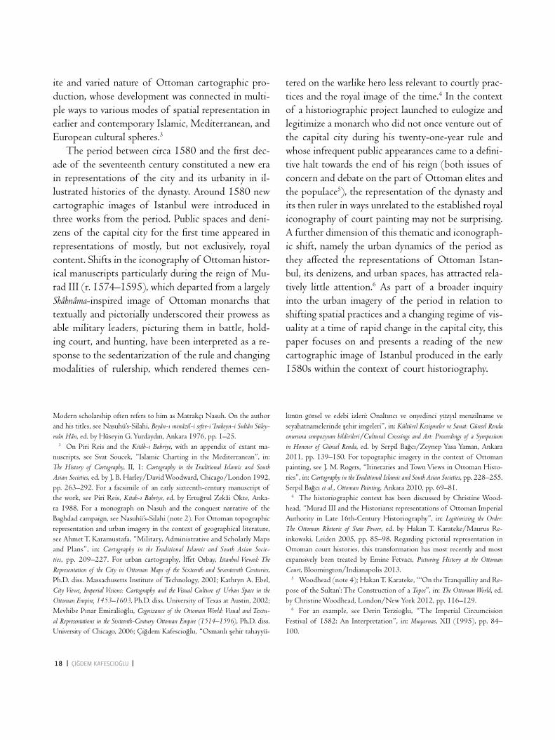
The period between circa 1580 and the first dec-ade of the seventeenth century constituted a new era in representations of the city and its urbanity in il-lustrated histories of the dynasty. Around 1580 new cartographic images of Istanbul were introduced in three works from the period. Public spaces and deni-zens of the capital city for the first time appeared in representations of mostly, but not exclusively, royal content. Shifts in the iconography of Ottoman histor-ical manuscripts particularly during the reign of Mu-rad III (r. 1574–1595), which departed from a largely Shâhnâma-inspired image of Ottoman monarchs that textually and pictorially underscored their prowess as able military leaders, picturing them in battle, hold-ing court, and hunting, have been interpreted as a re-sponse to the sedentarization of the rule and changing modalities of rulership, which rendered themes cen-
tered on the warlike hero less relevant to courtly prac-tices and the royal image of the time.4 In the context of a historiographic project launched to eulogize and legitimize a monarch who did not once venture out of the capital city during his twenty-one-year rule and whose infrequent public appearances came to a defini- tive halt towards the end of his reign (both issues of concern and debate on the part of Ottoman elites and the populace5), the representation of the dynasty and its then ruler in ways unrelated to the established royal iconography of court painting may not be surprising. A further dimension of this thematic and iconograph-ic shift, namely the urban dynamics of the period as they affected the representations of Ottoman Istan-bul, its denizens, and urban spaces, has attracted rela- tively little attention.6 As part of a broader inquiry into the urban imagery of the period in relation to shifting spatial practices and a changing regime of vis-uality at a time of rapid change in the capital city, this paper focuses on and presents a reading of the new cartographic image of Istanbul produced in the early 1580s within the context of court historiography.
Modern scholarship often refers to him as Matrakçı Nasuh. On the author and his titles, see Nasuhü’s-Silahi, Beyân-ı menâzil-i sefer-i ‘Irakeyn-i Sultân Süley-mân Hân, ed. by Hüseyin g. Yurdaydın, Ankara 1976, pp. 1–25. 3 On Piri Reis and the Kitâb-ı Bahriye, with an appendix of extant ma-nuscripts, see Svat Soucek, “Islamic Charting in the Mediterranean”, in: The History of Cartography, II, 1: Cartography in the Traditional Islamic and South Asian Societies, ed. by J. B. Harley/David woodward, Chicago/london 1992, pp. 263–292. For a facsimile of an early sixteenth-century manuscript of the work, see Piri Reis, Kitab-ı Bahriye, ed. by ertuğrul Zekâi Ökte, Anka-ra 1988. For a monograph on Nasuh and the conquest narrative of the Baghdad campaign, see Nasuhü’s-Silahi (note 2). For Ottoman topographic representation and urban imagery in the context of geographical literature, see Ahmet T. karamustafa, “Military, Administrative and Scholarly Maps and Plans”, in: Cartography in the Traditional Islamic and South Asian Socie-ties, pp. 209–227. For urban cartography, İffet Orbay, Istanbul Viewed: The Representation of the City in Ottoman Maps of the Sixteenth and Seventeenth Centuries, Ph.D. diss. Massachusetts Institute of Technology, 2001; kathryn A. ebel, City Views, Imperial Visions: Cartography and the Visual Culture of Urban Space in the Ottoman Empire, 1453–1603, Ph.D. diss. University of Texas at Austin, 2002; Mevhibe Pınar emiralioğlu, Cognizance of the Ottoman World: Visual and Textu-al Representations in the Sixteenth-Century Ottoman Empire (1514–1596), Ph.D. diss. University of Chicago, 2006; Çiğdem kafescioğlu, “Osmanlı şehir tahayyü-
lünün görsel ve edebi izleri: Onaltıncı ve onyedinci yüzyıl menzilname ve seyahatnamelerinde şehir imgeleri”, in: Kültürel Kesiş meler ve Sanat: Günsel Renda onuruna sempozyum bildirileri/Cultural Crossings and Art: Proceedings of a Symposium in Honour of Günsel Renda, ed. by Serpil Bağcı/Zeynep Yasa Yaman, Ankara 2011, pp. 139–150. For topographic imagery in the context of Ottoman painting, see J. M. Rogers, “Itineraries and Town Views in Ottoman Histo-ries”, in: Cartography in the Traditional Islamic and South Asian Societies, pp. 228–255. Serpil Bağcı et al., Ottoman Painting, Ankara 2010, pp. 69–81. 4 The historiographic context has been discussed by Christine wood-head, “Murad III and the Historians: representations of Ottoman Imperial Authority in late 16th-Century Historiography”, in: Legitimizing the Order: The Ottoman Rhetoric of State Power, ed. by Hakan T. karateke/Maurus Re-inkowski, leiden 2005, pp. 85–98. Regarding pictorial representation in Ottoman court histories, this transformation has most recently and most expansively been treated by emine Fetvacı, Picturing History at the Ottoman Court, Bloomington/Indianapolis 2013. 5 woodhead (note 4); Hakan T. karateke, “‘On the Tranquillity and Re-pose of the Sultan’: The Construction of a Topos”, in: The Ottoman World, ed. by Christine woodhead, london/New York 2012, pp. 116–129. 6 For an example, see Derin Terzioğlu, “The Imperial Circumcision Festival of 1582: An Interpretation”, in: Muqarnas, XII (1995), pp. 84–100.

| MaPPIng IsTanbul | 19
A Volume of Essays in Honor of Norman Itzkowitz, ed. by karl k. Barbir/Baki Tezcan, Madison, wis., 2007, pp. 113–134; gabriel Piterberg, An Ottoman Tragedy: History and Historiography at Play, Berkeley 2003; Baki Tezcan, The Second Ottoman Empire: Political and Social Transformation in the Early Modern World, New York 2010. 9 I have not been able to study the first volume of the Şehinşehnâme manus- cript; my focus here is therefore largely on the Hünernâme image. For the Hünernâme project, see Bağcı et al. (note 3), pp. 140–151; Serpil Bağcı, “Visu- alizing Power: Portrayals of the Sultans in Illustrated Histories of the Ot-toman Dynasty”, in: Islamic Art, VI (2009), pp. 113–127; Fetvacı (note 4), pp. 149–189, and Christine woodhead, “Reading Ottoman Şehnames: Official Historiography in the late Sixteenth Century”, in: Studia Islamica, 104/105 (2007), pp. 67–80. 10 See Fetvacı (note 4), pp. 195f., for another painting referring to the same event. In his Künhü’l-Ahbâr Mustafa Âlî interpreted the comet as a sign
7 while some of these dynamics can be traced to the earlier decades of the 1500s or even to the previous century, many of the cultural and social phenomena that make up this larger picture of an intensely vivacious urban life came to be more visible through the second half of the sixteenth century. For a discussion of emerging social and cultural trends that largely focuses on the sixteenth century, see Cemal kafadar, “How Dark is the History of the Night, How Black the Story of Coffee, How Bitter the Tale of love: The Changing Measure of leisure and Pleasure in early Modern Istan-bul”, in: Medieval and Early Modern Performance in the Eastern Mediterranean, ed. by Arzu Öztürkmen/evelyn Birge (forthcoming). For an overview of the seven-teenth-century city with implications for the later sixteenth, see eunjeong Yi, Guild Dynamics in Seventeenth-Century Istanbul: Fluidity and Leverage, leiden 2004, pp. 19–40. 8 Cemal kafadar, “Janissaries and Other Riffraff of Ottoman Istanbul: Rebels without a Cause?”, in: Identity and Identity Formation in the Ottoman World:
The later sixteenth century was a period of remark-able dynamism, when the social and physical cityscape of Istanbul underwent significant transformations. A larger set of groups and individuals participated in cultural production and circulation processes. An ex-panding range of public spaces occupied a growing role in the social and cultural dynamics of the city; new group solidarities and new modes of expressing these within the urban sphere were formulated. The population boom that accompanied such cultural vi-vacity was owed in part to massive migrations from the countryside, the outcome of cycles of rural un-rest that marked the Anatolian provinces during the later decades of the century.7 This was also a period of increasingly visible social unrest and frequent and ever more conspicuous expressions of popular dissent in the capital city, marking the onset of an era of re-current economic and political crises, upheavals, and shifts in political alignments, which constituted the salient facet of a deep structural transformation of Ottoman modalities of rule and redistribution.8
The Cartography of Istanbulin Ottoman Histories, 1579–1585Two multi-volume dynastic histories of the peri-
od, the Hünernâme and the Şehinşehnâme, feature vari-ants of the new map of Istanbul, each within their first volumes (Figs. 1 and 2). Both were written by
the court historiographer Seyyid lokman and illus-trated at the court ateliers by painters working under Nakkaş Osman, the head of the atelier of painters and illuminators at the time. The first is a thematic history of the reigns of the first Ottoman sultans up to Selim I (r. 1512–1520), and the second a history of the reign of Murad III, to whom both manuscripts were presented.9 Produced within the same years (1579/80–1584/85 and 1581 respectively) and covering different periods of dynastic history, the two works included versions of the same image in relation to different time frames and narratives: the conquest of Constantinople in 1453 in the Hünernâme and the reign of Murad III in the Şehinşehnâme, here focusing on the appearance of a comet in the Istanbul skyline in 1572, interpreted (by most) as an auspicious sign at a time of debates during the Safavid-Ottoman wars.10 The Hünernâme view presents the Constantinopolitan peninsula and the walled city on a double folio, with the city’s three boroughs, eyüp, galata, and Üsküdar, pictured in differing degrees of detail. On the con- trary, the Şehinşehnâme view encompasses only the east-ern sections of the walled peninsula on a single folio, but includes a larger and more detailed rendering of the Asian borough of Üsküdar. A painted map of the water distribution system encompassing the lands ly-ing to the north and west of the walled city of Istan-bul in the Süleymannâme, a historical work on the reign

20 | ÇIg deM KafeScIog Lu |
____
2 Map of Istanbul, in: Seyyid Lokman, Şehinşehnâme, vol. 1, 1581. İstanbul university Library, f. 1404, fol. 58r
____
3 Map of the Kırkçeşme water distribution system outside of Istanbul, in: Süleymannâme, 1579. dublin, chester beatty library, Turk Ms. 413, fol. 22v−23r

| MaPPIng IsTanbul | 21
workshop, Veli Can, have been suggested as the possible authors of these images; see Orbay (note 3), pp. 74–80, and Bağcı et al. (note 3) for the first suggestion, and Nigar Anafarta, Hünernâme Minyatürleri ve Sanatçıları, Istanbul 1969, for the second. The topographic paintings present no immediate links to narrative paintings that have been attributed to Osman, but, on the whole,
of the destructive wars between east and west, of bloodshed and evil (Geli-bolulu Mustafa Âlî ve Künhü’l-Ahbâr’ında II. Selim, III. Murad ve III. Mehmed Devirleri, ed. by Faris Çerçi, kayseri 2000, pp. 263–265). 11 All three are unique manuscripts originally held at the inner treasury of the Topkapı Palace. Nakkaş Osman himself and another member of the
the Hagia Sophia, followed by a narrative of the Ot-toman conquest of the city. Temporally disjunct from the narrative, for it represents Istanbul in the later six-teenth century, the view presents a visual counterpart to a textual mode of temporal connection frequently used by lokman: he inserted comments giving praise and eulogies to the ruling sultan, Murad III, into the narratives and depictions of the Ottoman past. To readers of the Hünernâme, the disjunction in the temporal frames of the image and the narrative would represent one of the links between the past and the present held in the manuscript.
of Süleyman completed in 1579 (Fig. 3), suggests that the three images were part of a larger cartograph-ic study of the city around this time.11
The two completed volumes of the Hünernâme, ini-tially planned as a four-volume work, comprised his-torical biographies of Ottoman sultans, not so much to present a chronicle of each reign as to portray the ruler as an ideal monarch. The large view of Istanbul is attached to a section of the text (fol. 156r–162v) dedicated to the reign of Mehmed II and offers the reader a concise version of the foundation myths of Constantinople and the story of the construction of

22 | ÇIg deM KafeScIog Lu |
attribution in this context may not be a rewarding pursuit. It might be noted that the maker of the two city views of Istanbul in the Hünernâme and the Şehinşehnâme, most likely the same artist, had access to and familiarity with european cartographic conventions that had been developed in the print medium, as will be discussed below. 12 The representation of some major Ottoman monuments in the view has been discussed by Orbay (note 3), pp. 73–116, who has provided an in-depth analysis of the image; my focus and interpretation differs from hers in several respects. On the Istanbul harbor and the expansion of the dockyards, see İdris Bostan, Osmanlı Bahriye Teşkilâtı: XVII. Yüzyılda Tersâne-i Âmire, Ankara 1992. 13 The types of residential and commercial buildings can be followed in the nearly contemporary survey of pious institutions entitled Istanbul Vakıfları Tahrir Defteri 1009 (1600) tarihli, ed. by Mehmet Canatar, Istanbul 2004. See also Stephanos Yerasimos, “Houses of Istanbul in the Sixteenth Century”, in: The Illuminated Table, the Prosperous House: Food and Shelter in Ottoman Material Culture, ed. by Suraiya Faroqhi/Christoph k. Neumann, würzburg 2003, pp. 321–335. 14 Orbay (note 3), pp. 83f., suggests that the map’s two pages are the work of different artists and that the langa garden is depicted twice in the view. The apparent repetition of the langa enclosure might be the result of a
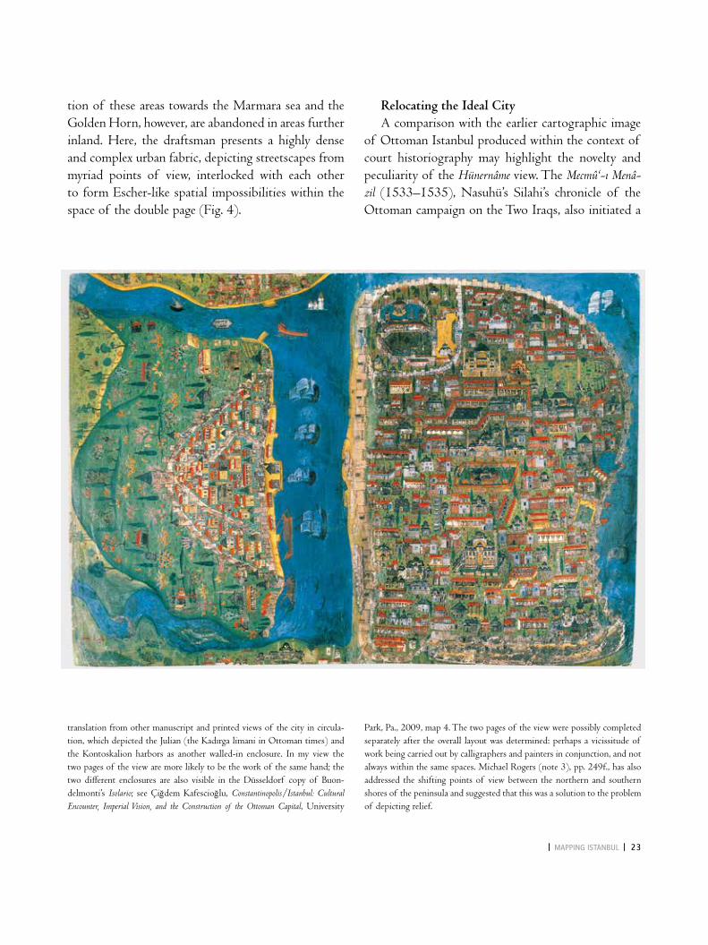
The view is uncommon in its use of viewpoint and perspective in the representation of urban space. It displays the walled city as an entirely built-up area with the two exceptions of the lycus/Bayrampaşa valley abutting the land walls and the langa gardens, the ancient Theodosian harbor. The imperial capital is portrayed with all the monumental landmarks of the dynasty’s pious and charitable institutions, carefully including many founded by the elite; the Byzantine columns and the newly expanded dockyards are also depicted.12 Courtyard houses, towers, rows of houses and shops aligning the streets, and large single-story courtyard structures correspond to the range of build-ings present in the archival sources of the city from the later sixteenth century.13 As İffet Orbay has observed, by depicting the monuments and the residential and commercial structures as facing the Marmara Sea to the south and the golden Horn to the north, the map-maker visualized a defining aspect of the Istanbulite cityscape: its multiple orientations towards the bodies of water surrounding the peninsula and the vantage points towards the city from across these waters.14 The uniform viewpoints retained in the representation of maritime neighborhoods and the uniform orienta-
____
4 Map of Istanbul, in: Seyyid Lokman, Hünernâme (detail of fig. 1), fol. 158v
____
5 Istanbul, in nasuhü’s-silahi, Beyân-ı menâzil-i sefer-i ‘Irakeyn-i SultânSüleymân Hân (Mecmû‘-ı Menâzil), ca. 1537. Istanbul university library, T. 5964, fol. 8v−9r
| MaPPIng IsTanbul | 23
tion of these areas towards the Marmara sea and the golden Horn, however, are abandoned in areas further inland. Here, the draftsman presents a highly dense and complex urban fabric, depicting streetscapes from myriad points of view, interlocked with each other to form escher-like spatial impossibilities within the space of the double page (Fig. 4).
Relocating the Ideal CityA comparison with the earlier cartographic image
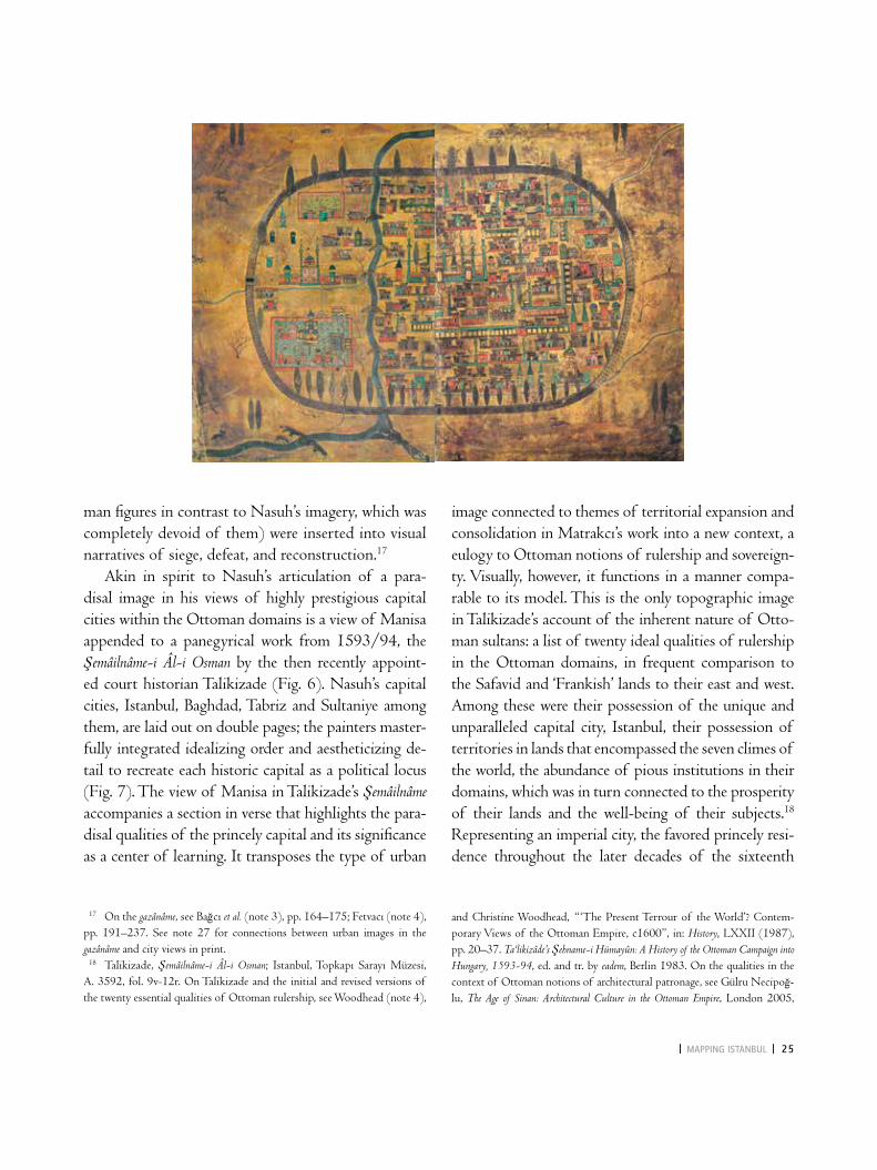
of Ottoman Istanbul produced within the context of court historiography may highlight the novelty and peculiarity of the Hünernâme view. The Mecmû‘-ı Menâ-zil (1533–1535), Nasuhü’s Silahi’s chronicle of the Ottoman campaign on the Two Iraqs, also initiated a
translation from other manuscript and printed views of the city in circula-tion, which depicted the Julian (the kadırga limani in Ottoman times) and the kontoskalion harbors as another walled-in enclosure. In my view the two pages of the view are more likely to be the work of the same hand; the two different enclosures are also visible in the Düsseldorf copy of Buon-delmonti’s Isolario; see Çiğdem kafescioğlu, Constantinopolis/Istanbul: Cultural Encounter, Imperial Vision, and the Construction of the Ottoman Capital, University
Park, Pa., 2009, map 4. The two pages of the view were possibly completed separately after the overall layout was determined: perhaps a vicissitude of work being carried out by calligraphers and painters in conjunction, and not always within the same spaces. Michael Rogers (note 3), pp. 249f., has also addressed the shifting points of view between the northern and southern shores of the peninsula and suggested that this was a solution to the problem of depicting relief.
24 | ÇIg deM KafeScIog Lu |
particular mode of urban representation, one that re-mained viable in illustrated court histories throughout the course of the sixteenth century.15 The bird’s eye view of Istanbul that launches the visual narrative of this work shows a city of monuments founded by sul-tans, the dynastic family and the ruling elite, most of them identifiable, located within a paradisal landscape of blossoming trees and flowers (Fig. 5). A set of symbolic nodes and axes composed of the buildings of the ruling house endow it with a tight structure and hierarchies of size, location and artistry. An ideal order is created; and an urban system articulating an imperial vision is denoted.
Nasuhü’s Silahi’s expansive historiographic pro-ject, entailing translations of medieval histories, and chronicles and conquest narratives he authored (il-lustrated exclusively by topographic images), situated
the Ottoman dynasty within world history and in an imperial geography.16 while the project did not sur-vive him, the mode of urban representation that ori-ginated in the illustrations of the Mecmû‘-ı Menâzil was well and alive at the time the team working on the Hünernâme volumes made a set of visual choices re-garding the Istanbul view to be included in the book. Nasuh’s urban imagery, his merging of representa-tional conventions of Italian urban mapping found in manuscripts of Ptolemy’s Geography and Buondelmon-ti’s Isolario with spatial, compositional, painterly and coloristic conventions and predilections of Ottoman book painting remained available to, and meaningful for patrons, authors, and painters of conquest narra-tives. In the gazânâme focusing on the exploits of mili-tary commanders, a favored genre of the final decades of the sixteenth century, city views (now featuring hu-
15 On the Istanbul view in Nasuhü’s-Silahi’s Mecmû‘-ı Menâzil, see walter B. Denny, “A Sixteenth Century Architectural Plan of Istanbul”, in: Ars Orientalis, VIII (1970), pp. 49–63; Orbay (note 3), pp. 29–72; kafescioğlu (note 14), pp. 207–226. 16 For a discussion of Nasuhü’s-Silahi’s project and a reconstruction of the genesis of its separate parts between the 1520s and the 1550s, see the
introduction by Hüseyin Yurdaydın in Nasuhü’s-Silahi (note 2), pp. 121–143. Translations of earlier histories and attempts to render dynastic his-tory part of a universal narrative continued in Ottoman historiography of the sixteenth century. Nasuh’s exclusive focus on urban cartography in the illustrated volumes of his work, on the other hand, remained one of the distinguishing traits of his histories.
____
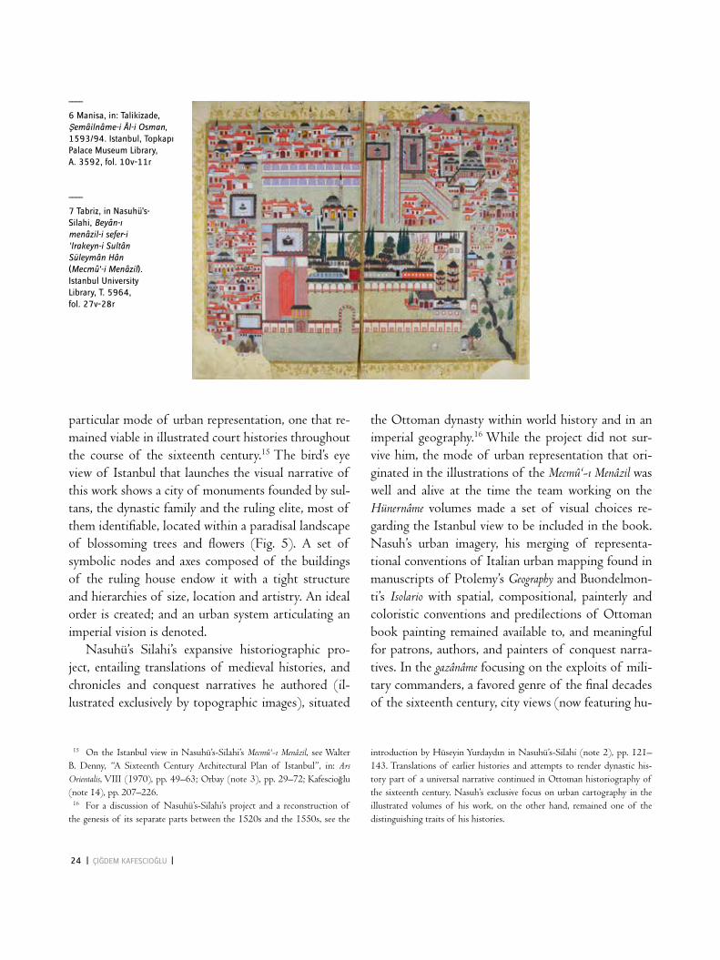
6 Manisa, in: Talikizade, Şemâilnâme-i Âl-i Osman, 1593/94. Istanbul, Topkapı Palace Museum library, a. 3592, fol. 10v−11r
____
7 Tabriz, in nasuhü’s-Silahi, Beyân-ı menâzil-i sefer-i ‘Irakeyn-i SultânSüleymân Hân (Mecmû‘-i Menâzil). Istanbul university Library, T. 5964, fol. 27v−28r
| MaPPIng IsTanbul | 25
man figures in contrast to Nasuh’s imagery, which was completely devoid of them) were inserted into visual narratives of siege, defeat, and reconstruction.17
Akin in spirit to Nasuh’s articulation of a para- disal image in his views of highly prestigious capital cities within the Ottoman domains is a view of Manisa appended to a panegyrical work from 1593/94, the Şemâilnâme-i Âl-i Osman by the then recently appoint-ed court historian Talikizade (Fig. 6). Nasuh’s capital cities, Istanbul, Baghdad, Tabriz and Sultaniye among them, are laid out on double pages; the painters master-fully integrated idealizing order and aestheticizing de-tail to recreate each historic capital as a political locus (Fig. 7). The view of Manisa in Talikizade’s Şemâilnâme accompanies a section in verse that highlights the para-disal qualities of the princely capital and its significance as a center of learning. It transposes the type of urban
image connected to themes of territorial expansion and consolidation in Matrakcı’s work into a new context, a eulogy to Ottoman notions of rulership and sovereign-ty. Visually, however, it functions in a manner compa-rable to its model. This is the only topographic image in Talikizade’s account of the inherent nature of Otto-man sultans: a list of twenty ideal qualities of rulership in the Ottoman domains, in frequent comparison to the Safavid and ‘Frankish’ lands to their east and west. Among these were their possession of the unique and unparalleled capital city, Istanbul, their possession of territories in lands that encompassed the seven climes of the world, the abundance of pious institutions in their domains, which was in turn connected to the prosperity of their lands and the well-being of their subjects.18 Representing an imperial city, the favored princely resi- dence throughout the later decades of the sixteenth
17 On the gazânâme, see Bağcı et al. (note 3), pp. 164–175; Fetvacı (note 4), pp. 191–237. See note 27 for connections between urban images in the gazânâme and city views in print. 18 Talikizade, Şemâilnâme-i Âl-i Osman; Istanbul, Topkapı Sarayı Müzesi, A. 3592, fol. 9v-12r. On Talikizade and the initial and revised versions of the twenty essential qualities of Ottoman rulership, see woodhead (note 4),
and Christine woodhead, “ ‘The Present Terrour of the world’? Contem-porary Views of the Ottoman empire, c1600”, in: History, lXXII (1987), pp. 20–37. Ta‘likizâde’s Şehname-i Hümayûn: A History of the Ottoman Campaign into Hungary, 1593-94, ed. and tr. by eadem, Berlin 1983. On the qualities in the context of Ottoman notions of architectural patronage, see gülru Necipoğ-lu, The Age of Sinan: Architectural Culture in the Ottoman Empire, london 2005,
26 | ÇIg deM KafeScIog Lu |
century (which was connected to the personal histories of Talikizade and Murad III alike), the Manisa view is well-placed in its immediate book context. The princely capital at the foot of mount Split is orderly, geometri-cally laid out, and centered by a palace comprising mul-tiple structures within a vibrant and blossoming garden. This mode of urban portrayal reproduces Manisa as a
political center, as an imperial city home to the pious works of dynastic women and their ruling sons (with an emphasis on Murad III’s newly completed mosque complex) and as a wealthy and orderly commercial hub. It is connected to visual and textual allegories of the paradisal garden, a broad constellation of images refer-ring to the heavenly abode and its earthly reflections in
pp. 30–33. On the painter Nakkaş Hasan and illustrations of Talikizade’s works, see Bağcı et al. (note 3), pp. 177–183. 19 On garden imagery in the Persianate literary tradition, see Julie Scott Meisami, “Allegorical gardens in the Persian Poetic Tradition: Nezami, Hafez, Rumi”, in: International Journal of Middle East Studies, XVII (1985), pp. 229–260; eadem, “Palaces and Paradises: Palace Description in Medieval Persian Poetry”, in: Islamic Art and Literature, ed. by Oleg grabar/Cynthia Rob-inson, Princeton 2001, pp. 21–54. Paradisal imagery in relation to Ottoman urban representations is discussed in kafescioğlu (note 14). The political
associations of the paradisal garden as a “garden of state and religion” are discussed in gülru Necipoğlu, “l’idée de décor dans les régimes de visualité islamiques”, in: Purs décors? Arts de l’Islam, regards du XIXe siècle: collections des Arts Décoratifs, exh. cat., ed. by Rémi labrusse/Sophie Makariou/evelyne Pos-sémé, Paris 2007, pp. 10–23. walter Andrews discusses the centrality of the garden trope in Ottoman poetry in imaginings of the Ottoman ruler and rulership; walter Andrews, “Speaking of Power: The Ottoman kaside”, in: Qasida Poetry in Islamic Asia and Africa, I: Classical Traditions and Modern Meanings, ed. by Stephan Sperl/Christopher Shackle, leiden 1996, pp. 281–300.
____
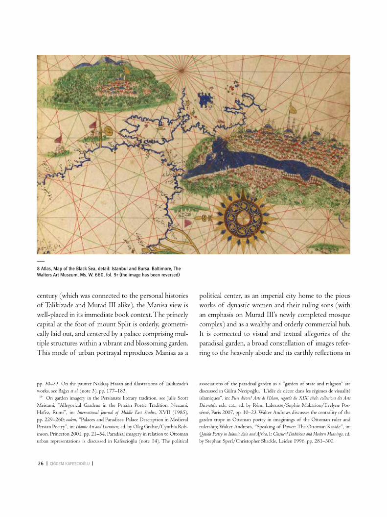
8 atlas, Map of the black sea, detail: Istanbul and bursa. baltimore, The Walters art Museum, Ms. W. 660, fol. 9r (the image has been reversed)

| MaPPIng IsTanbul | 27
palaces and cities. This trope of longue durée in the Near eastern and Mediterranean worlds (alongside its often nearby opposite, the doomed and evil city) was adapt-ed to diverse conjunctions and contexts; in Ottoman courtly literature and arts, garden imagery was often as-sociated with metaphors of kingship and an ideal order of divine sanction that shaped architectural spaces as much as discourses on them.19
The population of Manisa was miniscule in com-parison to that of late-sixteenth-century Istanbul.20 The stark contrast between the view of Istanbul in the first volume of the Hünernâme and Matrakcı’s ren-dering of the Ottoman capital in the 1530s has also often been commented on in terms of the city’s popu-lation expansion through the intervening decades. The growth in population and settlement density are cer-tainly one reason for the differences that separate the Hünernâme painting from earlier manuscript images of Istanbul: the city’s population expanded, possibly threefold, in those decades.21 The remarkable densi-ty of human settlement also came to define the city’s image in the Mediterranean nautical cartography tradition, for instance in an atlas from the later six-teenth century (Fig. 8) and in later manuscripts of Piri Reis’s Kitâb-ı Bahriye.22 These images, which belong to an idiom that developed as a shared representational tradition within Mediterranean practices of nautical charting, masterfully exploit the theatrical setup of the Constantinopolitan peninsula facing the golden Horn and, from across the golden Horn, present an easily legible, captivating metonymy of an imperial capital: a rhythm of domes, minarets and columns forming sum-
mits within a uniform, homogeneous urban fabric. Hü-nernâme’s sibling image in the Şehinş ehnâme also retained a uniform vantage point above the city’s northern sub-urbs to convey a comparable, although more varied, settlement density (Fig. 2). The aesthetic of the Hü-nernâme view, by contrast, is not one of order, symme-try, and uniformity, but rather of diversity, asymmetry, and, partially, disorder, suggesting the impossibility of retaining an idealized vision of the capital comparable to that projected in the Mecmû‘-ı Menâzil in the 1530s (Fig. 5) or to that in Şemâilnâme representing contem-porary Manisa (Fig. 6).
Evoking Print, Playing with Perspective:New Possibilities for the Multifocal ImageTo rather different visual effect, both european
and Ottoman modes of spatial representation engaged with multifocal and multiperspectival representations of the urban body. In the 1530s, Nasuhü’s-Silahi and his followers formulated their particular mode of ur-ban imagery by translating architectural representation in Persianate painting into representations of urban space: the former was a multifocal and multiperspecti-val mode that juxtaposed plan, section and axonomet-ric views of buildings while also merging interior and exterior, frontal and side views of building masses and surfaces.23 The Ottoman translation was a dual pro-cess as the Persianate mode was not only transposed from individual buildings to the urban entity, but also absorbed into the conventions of urban cartography formulated in fifteenth-century Italy in manuscripts of Ptolemy’s Geography and Buondelmonti’s Liber in-
22 See, as an example of the seventeenth-century views of Istanbul in the Kitâb-ı Bahriye manuscripts, Paris, Bibliothèque nationale de France, suppl. Turc 956, fol. 434v. The manuscript is dated 1550–1599 in the library catalogue; details of the Istanbul map suggest that it dates to the mid-seven-teenth century and is possibly a later addition to the manuscript. http://gal-lica.bnf.fr/ark:/12148/btv1b6000438h.r=piri+reis (accessed on 4 April 2014). 23 David J. Roxburgh, “Micrographia: Toward a Visual logic of Persianate Painting”, in: Res: Anthropology and Aesthetics, 43 (2003), pp. 13–30.
20 Manisa’s population has been estimated at between 8000 and 8500 individuals in the later sixteenth and around 18,000 in the later seventeenth centuries; Feridun M. emecen, Tarihin içinde Manisa, Manisa 2006, pp. 8f. 21 There are no clear population figures for Istanbul during this period; an estimate of 350,000 to 400,000 in the larger city is widely accepted for the later sixteenth century; a significant increase from an estimated 70,000 to 100,000 in the late-fifteenth century. For population estimates, see Ha-lil İnalcık, “Istanbul”, in: Encyclopaedia of Islam, 2nd ed., IV, leiden 1978, pp. 224–248.

28 | ÇIg deM KafeScIog Lu |
most popular and widespread city atlas, in the Topkapı Palace Museum library (A. 3712), and as evinced by Ottoman topographic and urban images in the gazânâ-me manuscripts of the 1580s that borrow freely from and reinterpret such printed material.27 The Hünernâme and the Şehinşehnâme views also present interpretations of the perspective plan. Their juxtapositions of urban boundaries in plan with profile views of the bound-ary markers and areas immediately beyond, and their occasional recourse to aerial perspective for particular buildings and districts all correspond to contemporary practices of spatial representation in print, with its in-sistence on verisimilitude and its free manipulations of
sularum archipelagi.24 The european “perspective plan” took a different route in its perspectival play: although it also created multifocal and multiperspectival urban representations, it remained staunchly loyal to notions of verisimilitude and a unitary viewer.25 Hence the city and particular buildings may be pictured from aerial or profile views, various vantage points may be introduced, and the picture plane may bend to ac-commodate a horizon line and a distant landscape, all the while retaining the postulation of a unitary gaze above the city.26 Versions of the perspective plan did circulate in Ottoman hands, as suggested by a later, 1617 copy of georg Braun’s Civitates orbis terrarum, the
24 For a discussion of the links between the isolario imagery and Nasuh’s method of depicting urban space, see kafescioğlu (note 14), pp. 207–209. 25 On the bird’s eye view as it took shape in the medium of print, see Jür-gen Schulz, “Jacopo de’ Barbari’s View of Venice: Map Making, City Views, and Moralized geography Before the Year 1500”, in: The Art Bulletin, lX (1978), pp. 425–474; lucia Nuti, “The Perspective Plan in the Sixteenth Century: The Invention of a Representational language”, in: The Art Bulletin, lXXVI (1994), pp. 105–128; Hillary Ballon/David Friedman, “Portray-ing the City in early Modern europe: Measurement, Representation, and Planning”, in: The History of Cartography, III, 1: Cartography in the European Renais-sance, ed. by. David woodward, Chicago/london 2007, pp. 680–704. 26 The use of a curvilinear perspective to accommodate the horizon and the surrounding landscape in seventeenth-century printed views of Naples is dis-
cussed by Barbara Ann Naddeo, “Topographies of Difference: Cartography of the City of Naples, 1627–1775”, in: Imago Mundi, lVI (2004), pp. 23–47. A similar use, in the medium of the painted map, is found in the Şehinş ehnâme view of Istanbul, which merges the aerial view with the view of the horizon, here to accommodate the auspicious shooting star of 1572 (Fig. 2). 27 A case in point are the references to the view of Aden in Rumuzi’s Tarih-i Feth-i Yemen, Istanbul University library, Ms. 6045, fol. 185v-286r, reproduced in Bağcı et al. (note 3), p. 175. The established printed image of Istanbul during this period was giovan Andrea Vavassore’s bird’s eye view, reproduced in several copies and variations throughout the early seventeenth century, including one in the Civitates orbis terrarum. For the views of Con-stantinople and of Aden, see georg Braun, Civitates orbis terrarum, Cologne 1572–1617, I, pp. 53f., and V, p. 143.
____
10 Pieter van der Keere, Panorama of Istanbul, detail with western section of the walled peninsula, 1626
____
9 Panorama of Istanbul, detail with western section of the walled peninsula, ca. 1590. Vienna, Österreichische nationalbibliothek, Cod. 8626, fol. 160r

| MaPPIng IsTanbul | 29
the Hünernâme view, on the other hand, is predicated on its presence within a historical work: it is a car-tographic image created at the court ateliers, beyond the relatively tighter constraints of court painting. Its manner of responding to and translating from euro-pean printed imagery, in turn, provides insights into the local subjectivities that ultimately shaped the image.30
Its multiple connections to the printed city image and to conventions of manuscript painting in repre-senting architectural and urban space notwithstanding, the Hünernâme view operates at a register of visual rep-resentation that evokes but nevertheless stands apart from both. Its blatant refusal to engage in either the suggested perspectival uniformity of the printed view or the more ordered and geometricized form of multi-perspectival representation prevalent in Persianate painting underlines its novelty. It freely and selectively juxtaposes aspects of both, departing from all conven-tions in the depiction of the neighborhoods beyond the immediacy of the city walls. Here, multiple points of view collide to produce configurations beyond the established impossibilities of printed and paint-ed urban imagery, through the interplay of two- and three-dimensional renderings of architectural masses: façades slide into roof systems which in turn become part of courtyards or the façades of other buildings. The unity of the architectural fragment, which is pre-served even in the most fantastic of architectural com-positions in the Ottoman and the Persianate corpus, is undermined here (Fig. 4).31
the planimetric and the pictorial.28 These images may have also been inspired by panoramas of Istanbul, in manuscript in the later sixteenth century and in print throughout the following decades, drafted by europe-an artists from vantage points on the northern shores of the golden Horn (Figs. 9 and 10). The Hünernâ-me view’s responses to the printed image can also be recognized in its controlled and reduced color scheme (which goes beyond the coloristic restraint that char-acterized the painting of the period) and its rendering of non-urban areas (in parallel brushstrokes of green pigment) and the sea in ways that evoke conventions of topographic representation in print. The slightly earlier water distribution map (Fig. 13) also engages in the conventions of the printed view in the street divisions and urban blocks (which occupy only a small part of the double folio map) and in the rendition of the topographical features of the extramural areas, as revealed in a comparison with the rendering of extra-mural areas of Constantinople and Rome in Braun’s Civitates orbis terrarum (Figs. 11, 12, 14).
At a time when the Ottoman elites were relative-ly less receptive to cultural practices and artifacts from lands beyond the empire’s central territories, cartographic representation continued to constitute a field of dialogues with, responses to, and transla-tions from western european representational prac-tices. The unfolding of that dialogue within nautical cartography practices in different production centers along Mediterranean coastlines awaits further scru-tiny.29 The peculiarity and, in one sense, uniqueness of
28 See notes 25 and 26. 29 For a discussion of the nautical cartography of the Kitâb-ı Bahriye within the isolario genre, see george Tolias, “Isolarii”, in: History of Cartography, IV: Cartography of the Renaissance, ed. by David woodward, Chicago 2007, pp. 263–284. Bronwen wilson drives attention to possible references to the Kitâb-ı Bahriye cartography in later Italian isolarii: Bronwen wilson, “Assembling the Archipelago: Isolarii and the Horizons of early Modern Public Making”, in: Making Space Public in Early Modern Europe: Performance, Geography, Privacy, II, ed. by Angela Vanhaelen/Joseph P. ward, New York 2013, pp. 101–126: 109. 30 For an earlier phase of cultural exchanges between Ottoman and Italian worlds, see gülru Necipoğlu, “Visual Cosmopolitanism and Creative Transla-
tion: Artistic Conversations with Renaissance Italy in Mehmed II’s Constan-tinople”, in: Muqarnas, XXIX (2012), pp. 1–81. For a discussion of Ottoman portrait painting within the framework of cultural interaction and translation contemporaneous with the cartographic works discussed here, see emine Fetvacı, “From Print to Trace: An Ottoman Imperial Portrait Book and Its western european Models”, in: The Art Bulletin, XCV (2013), pp. 243–268. 31 It has been suggested that the convergence of different points of view is the painter’s way of rendering the hilly topography of the peninsula vis-ible, particularly in the representation of the city’s western sections (Orbay [note 3], pp. 87, 309). This explanation, however, does not fully account for the multiple juxtapositions of architectural volumes in the view.

30 | ÇIg deM KafeScIog Lu |
into the image. It demands, in turn, the intense visual involvement of the book’s reader, a reader with mul-tiple lenses to allow for a gaze that will capture the city’s represented totality and for the scrutiny of its complex and multifocal detail. The volume’s portfolio size (49 × 32 cm, the double folio map measuring 49 × 64 cm) intensifies the embodied engagement de-manded of the reader. In its representation of space, its multifocal and multiperspectival construction, and its location in a large-size manuscript the Hünernâme view captures what Christian Jacob defined as one of the major intellectual and metaphysical effects of the map. By materializing a spatial organization, Jacob observes, a map objectifies space: “[…] the territory, the world, the universe, by becoming visible through the mediation of an artifact, define the problematic position of the person who looks at them. The viewer is at the same time outside the representation and en-
A closer look at the view suggests the subjective experience of a dense urban environment; a personal, embodied observation of one of the largest and most populous cities of the early modern world. It manipu- lates available languages of spatial representation to convey the pattern of the city’s winding streets and dead-ends at a time when the inhabitation of that ur-ban fabric attained a degree of density beyond the ex-periences of any urban dweller from the larger region. It is a picture at once from outside and from within the city, juxtaposing the totalizing bird’s eye view from a point above the Propontis with one that captures myriad views of the streets, squares, courtyards, and façades of the neighborhoods. If the bird’s eye view embodied and implicated the heavenly and the royal gaze, the image of the streets and the dense and com-plex stacking of buildings implicated the contingency of the street experience, inscribing the walking subject

| MaPPIng IsTanbul | 31
disorienting way of imagining and representing Istan-bul emerged at the conjuncture of change and crisis referred to in the introduction to this paper. Inserting the unruly view from the street into the static and hier- archized space of royal historiography, the painting complicated the orderly dynastic image projected in the other folios of the Hünernâme.
The opening couplet of Mustafa Âlî’s qasida to the city of Istanbul, the epigraph to this paper, suggests that our draftsman was not alone in foregrounding the multiplicity of gazes in the representation of the city.34 Defining Istanbul as an entity composed of the
veloped by it. This is the place I occupy, whence I see, but also the space in which I see myself and where I am not.”32
The collision of the aerial view with myriad differ-ent views into the streets in the two pages of a courtly book representing dynastic history resulted in a stark departure from what a recent study has termed the “overwhelming sense of order” of Ottoman court painting of this period and its predilection for visual-izing courtly hierarchies that dominated its composi-tions, color schemes, renderings of spaces and the in-dividuals that inhabit them.33 This distinct and rather
____
13 Map of the Kırkçeşme water distribution system outside of Istanbul, in: Süleymannâme (detail of fig. 3)
____
11, 12 byzantium nunc constantinopolis, in: georg braun, Civitates orbis terrarum, cologne 1599, vol. 1, whole and detail, pp. 52f.
____
14 Roma, in: georg braun, Civitates orbis terrarum, detail with extramural area to the west, cologne 1599, vol. 1, pp. 45f.
32 Christian Jacob, The Sovereign Map: Theoretical Approaches in Cartography through-out History, ed. by edward H. Dahl, Chicago 2006, pp. 99–101. 33 Fetvacı (note 4), p. 79 and passim. 34 The term ehl-i nazar connotes people of perception and insight; other uses in this period suggest that it is also connected to notions of sagacity
and perspicuity regarding the social body, and the ability to recognize char-acter through physiognomy, as also evident in Nev’izade Atayi’s use of the term in the early seventeenth century; Nev’izade Atayi, Sohbetü’l-Ebkâr, ed. by Muhammed Yelten, Ankara 1999, pp. 100–102. As nazar (literally, look, gaze, consideration, contemplation) primarily evokes the sense of sight as

32 | ÇIg deM KafeScIog Lu |
as its radif (repeated at the end of each couplet), the qasida evokes the seas surrounding Istanbul and the abundance of all things subject to condemnation and praise. Images of physical discomfort, violence, insecurity, plague and death, suffering, evil, corrup-tion and injustice are juxtaposed with the prosperity and beauty that shine through the light of divinely ordained rule onto a city of the learned and the artful. Istanbul was a hub of material wealth and splendor, a city of beauties and, finally, a locus of mobility and travel. with a comparably varied set of shifting lenses
gazes of its denizens and matching this multiplicity with a plurality of ‘types’ housed in the populous city, Âlî’s couplet suggests the possibility of reading the Hünernâme map not only in terms of a quantitative increase in the population, but also in terms of the accompanying diversity and tempestuous vivacity of that population. As the following couplets of the qasi-da show (and as his other writing makes evident) this was not only a matter of idealization for Âlî: this city of people of the gaze was an object of castigation as much as an object of praise. with the word sea (deryâ)
with me. On Mustafa Âlî, see Cornell Fleischer, Bureaucrat and Intellectual in the Ottoman Empire: The Historian Mustafa Âlî (1541-1600), Princeton 1986.
the basis of observation, I have translated ehl-i nazar here as “people of the gaze”. My thanks to Selim kuru for discussing the translation of this couplet

| MaPPIng IsTanbul | 33
____
15 Mehmed II and the greek patriarch at the atmeydanı (hippodrome) of Istanbul, in: Seyyid Lokman, Hünernâme, vol. 1. Istanbul, Topkapı Palace Museum library, H. 1523, fol. 162v
____
16 Woman appealing for justice at the atmeydanı (hippodrome) of Istanbul, in: Seyyid Lokman, Hünernâme, vol. 2, ca. 1587/88. Istanbul, Topkapı Palace Museum Library, H. 1524, fol. 250r
____
17 Procession of the bedestan merchants at the atmeydanı (hippodrome) of Istanbul, in: Intizami, Surnâme. Istanbul, Topkapı Palace Museum library, ca. 1588. H. 1344, fol. 79v−80r
34 | ÇIg deM KafeScIog Lu |
monument, observed its ruinous surroundings and contemplated the vicissitudes of kingship.36 By re-locating the viewer, unmistakably, to street level, and by prioritizing the main public square of the city in the narration of this momentous event, the Hünernâ-me announces a new way of picturing Istanbul. In the following years, the public spaces of the capital city and royal and urban figures within its urban spaces were portrayed with increasing frequency in the texts and paintings of books produced for the Ottoman court, announcing shifts in the uses and meanings of public space, and shifts in notions of visual order that informed the imagination and representation of the ruler and the ruled. The later dynastic histories of the period and the Surnâme (Book of Festivities), famed for its portrayal of artisans’ processions, cap-tured a remaking of the city’s main public square as the monarch, figures of authority, and denizens (per-formers, audiences, professionals, socialites) were portrayed in a set of new images and narratives (Figs. 16 and 17).37 By inscribing the changing image of rulership within the discursive sphere of court historiography, the vantage point from the street at the same time announced the entry into the realm of Ottoman visuality of the public spaces and the denizens of a metropolis undergoing multiple processes of change.
An earlier version of this paper was presented at the workshop “The Med-iterranean: A Liquid Space of Architectures, Images, and Things” held at the Kunsthistorisches Institut in Florenz – Max-Planck-Institut in December 2010. I would like to thank Gerhard Wolf, Hannah Baader, and the partici-pants of the workshop for their comments on the topic during that event. I offer my sincere thanks to the Radcliffe Institute for Advanced Study at Harvard University, where this paper was written.
directed at the city’s parts and its inhabitants, Mustafa Âlî and the anonymous draftsman of the Hünernâme view portrayed the restless complexity of the early modern metropolis.
In the period of the intense production of illus-trated court histories that continued throughout the very early years of the 1600s, no other cartographic image of Istanbul was included in any manuscript (or at least none has surfaced) following the completion of the first volume of the Hünernâme in 1584/85. Perhaps this image, which incorporated myriad gazes in a frame founded upon a unitary, utopic gaze asso-ciated with divinity, rulership, and possession, was a visual dead-end, its decentering of the viewing sub-ject not completely at home within a book produced primarily for the royal eye.35 The beginnings of a shift in the focus of urban representation may be found in the Hünernâme itself, just a few pages apart from the view examined in this paper: a painting narrat-ing Mehmed II’s encounter with the greek patriarch of Constantinople, who, wanting to stop him from shooting arrows at the serpent column at the Atmey-danı (the hippodrome), informed the conquering monarch that it was a talisman that protected the city from the invasion of snakes (Fig. 15). After having viewed the map the sixteenth-century viewer through this painting was transported to an earlier moment in time, to an instance when the temporalities of text and image coincided. The narrative, it so happens, is a fragment of revisionist history writing, as here the reader is introduced to a new story of what the Otto-man ruler did upon entering the fallen city, namely go first to the Hippodrome. earlier and later narratives of this fateful moment took Mehmed directly into the Hagia Sophia, where he admired the magnificent
35 I refer to Norman Bryson’s discussion of the decentering of the viewing subject, which he bases on the viewing experience of non-perspectival rep-resentation and may be useful in understanding the particular construction of the gaze in the Hünernâme map; see Norman Bryson, “The gaze in the expand-ed Field”, in: Vision and Visuality, ed. by Hal Foster, Seattle 1988, pp. 87–108.
36 Tursun Beg, The History of Mehmed the Conqueror, ed. by Halil İnalcık/Rhoads Murphey, Minneapolis 1978, fol. 51r–53r. 37 In a forthcoming article I will focus on narrative images centered on public spaces in Istanbul in late sixteenth- and early seventeenth-century Ot-toman illustrated manuscripts.
| MaPPIng IsTanbul | 35
Abstract
A new cartographic image of Istanbul was introduced to the illustrated Ottoman histories produced between 1579 and 1585; these were the very last maps of the capital city to be inserted into court-produced manuscripts of the early modern era. The maps partook fully of the composite and varied nature of Ottoman cartographic production, whose development was connected in multiple ways to various modes of spatial representation in earlier and contemporary Islamic, Mediterranean, and european cultural spheres. The mapmakers’ responses to and uses of european printed city views circulating in Ottoman domains introduces a set of questions regarding this particular context of inter-cultural connection and receptivity. One of the maps in question, located in the first volume of the Hünernâme, a multi-volume dynastic history presented to Murad III (r. 1574–1595), powerfully captures an Ottoman draftsman’s creative engagement with and manipulation of multiple visual idioms at his disposal. The complex and multi-focal visual structure of this image, which merges conventions of the aerial city view with myriad close perspectives into the urban fabric, suggests a subjective, embodied observation of the expanding metropolis, highlighting emerging modes of urban experience and emerging discourses on urbanity in early modern Istanbul.
Photo Credits
Topkapı Palace Museum Library, Istanbul: Figs. 1, 4, 6, 15–17. – Istanbul University Library: Fig. 2. – Chester Beatty Library, Dublin: Figs. 3, 13. – From Nasuhü’s-Silahi (note 2): Figs. 5, 7. – The Walters Art Museum, Baltimore: Fig. 8. – From Metin And, Istanbul in the Sixteenth Century: The City, the Palace, Daily Life, Istanbul 1994: Fig. 9. – Harvard University Fine Arts Library, Cambridge, Mass.: Fig. 10. – Harvard University Houghton Library, Cambridge, Mass.: Figs. 11, 12, 14.
Copyright © 2022 FDOKUMEN