User requirements and preparedness for User requirements and ...
17
User requirements and preparedness for User requirements and preparedness for the next generation of geostationary t llit satellites Agnes Lane Manager Requirements and Analysis Observations and Infrastructure Division Australian Bureau of Meteorology [email protected]
-
Upload
khangminh22 -
Category
Documents
-
view
0 -
download
0
Transcript of User requirements and preparedness for User requirements and ...

User requirements and preparedness forUser requirements and preparedness for the next generation of geostationary
t llitsatellites
Agnes Lane
Manager Requirements and Analysis
Observations and Infrastructure Division
Australian Bureau of Meteorologygy
IntroductionIntroduction
• Satellite observations make a significant contribution to the Bureau's weather and climate services
• The Bureau's forecasters rely heavily on geostationary observations
• MTSAT-2 FY-2MTSAT 2, FY 2
• Reliance will continue to grow with the arrival of new generation geostationary satellites
• Himawari, FY-4, GEO-KOMPSAT-2A

Geostationary satellite observationsGeostationary satellite observations
Geostationary satellite observations are a vital input to the Bureau's forecast and
i iwarning services.
• MTSAT AMVs used for:
operational NWP and climate studies
important for regional prediction and t i l l t k di titropical cyclone track prediction
• Hourly MTSAT imagery supports all forecasting activities
upper-level tropospheric vectors (in magenta), and lower-level tropospheric vectors (in yellow)forecasting activities
• Applications such as solar radiation, NDVI important for climate services
vectors (in yellow)
p

The benefits expected from HimawariThe benefits expected from Himawari
• For the first time, the Bureau will have access to high temporal resolution geostationary imageryg y g y
• The new data will improve the Bureau’s forecast and warning services, including:
•Improved ability to locate the centre of tropical cyclones over the ocean, leading to improved forecast tracks and reliability estimates
I d fi th i th h b tt d t ti d t ki f d i d•Improved fire weather services through better detection and tracking of secondary wind changes
•Improved detection of volcanic ash, leading to earlier identification of threat areas for aviation
•Improved detection of fog and low cloud conditions critical for safe and economic aircraft operations
•High impact satellite imagery (eg true colour) for the web and mobile channels•High impact satellite imagery (eg. true colour) for the web and mobile channels
The future: HimawariThe future: Himawari
The Bureau's plans for the transition from MTSAT to Himawari are well advanced:
• user requirements for new and enhanced applications have been collected and documented,
• transition of MTSAT based applications to Himawari has commenced,
• planning for reception of data via a dedicated communications link is in progress,
• training material for forecasters is being developed,
• computing infrastructure has been specified,
• upgrade of forecaster visualisation tools has commenced,
• a project manager has been appointed to manage the transition.

Collecting requirements for Himawari data and products
• Bureau requirements
• a workshop was held in 2013 attended by forecasters research• a workshop was held in 2013, attended by forecasters, research scientists, climate scientists , training experts• Himawari products were classified into priority categories:p p y gCritical, Essential, Important, Desirable, Low
• Those products requiring 24x7 support ranked highest
• Australian requirements
• CSIRO are leading discussions on non-Meteorological applications of Himawari• a workshop will be held in Tokyo in December
•RA-V requirements
• WMO RA-V task team on Satellite Utilization

Himawari applicationsHimawari applications
Applications to be developed in 2014/15:
• Single channel imagery for all 16 channels• Single channel imagery for all 16 channels
• Multispectral imagery (true colour, atmospheric air mass, micro-physical properties and severe storm identification)
• Cloud properties
• Fog and Low Cloud
• Volcanic Ash
• Solar Radiation
• Sea Surface Temperature
• Aircraft Icing Potential
• Atmospheric Motion Vectors
• Severe storm products (prediction and identification tools), including Advanced Dvorak analysis (Tropical p (p ) g y ( pCyclone intensity), Convective initiation, Overshooting tops

Computing infrastructure requirements
• The Bureau will enhance current virtualisation infrastructure for processing Himawari AHI datap g
• 32 core system with 120 GB RAM and 12TB disk space
• Data will be archived on existing robotic tape storage systemData will be archived on existing robotic tape storage system
• Discussions with other Australian government agencies regarding access to data and products for non-meteorological uses
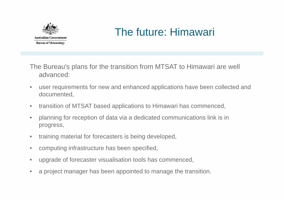
Training requirementsTraining requirements
• Australian VLab Centre of Excellence have commenced a national Himawari-8 training campaigng p g
• Developing training resources for the effective forecaster use of 10 minute, 16 channel Himawari 8 data using observations from the HIWC and RGB case studies using MODIS
• Stakeholder engagement and input is important.
Beijing Sangeang Api
Burketown
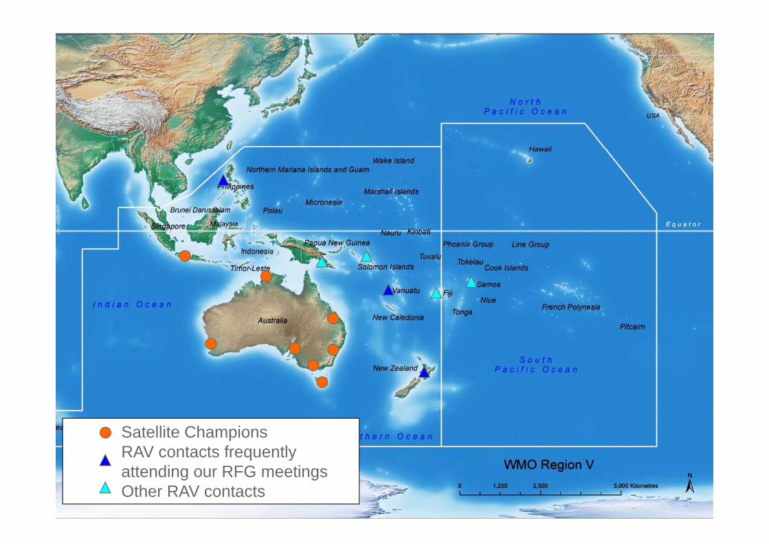
Satellite ChampionsRAV contacts frequently co tacts eque t yattending our RFG meetingsOther RAV contacts

National Himawari Training Campaign timetable
First phase – by mid/end November 2014• Setting up resources to familiarise / re‐familiarise forecasters with the use of g p /Himawari‐8 type data. • Collaboration with 'Satellite Champions' and other stakeholders
Second phase – Likely to be early in 2015.• An online feedback session involving all Champions and some stakeholders
Third Phase – by the beginning of April 2015• Preparing training and assessment resources for the Advanced Forecaster Course 2015Course 2015.
Fourth Phase – from April 2015Ch i d t k h ld t d i th i t i i t i l dif i• Champions and stakeholders to design their own training material, modifying
existing resources. • These resources can be forwarded back to the group.
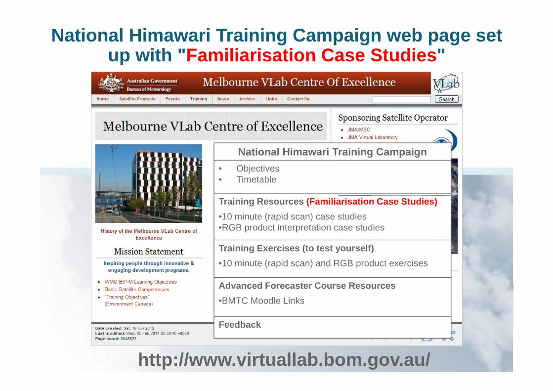
National Himawari Training Campaign web page set up with "Familiarisation Case Studies"p
National Himawari Training CampaignNational Himawari Training Campaign• Objectives• Timetable
Training Resources (Familiarisation Case Studies)•10 minute (rapid scan) case studies •RGB product interpretation case studies
Training Exercises (to test yourself)•10 minute (rapid scan) and RGB product exercises
Advanced Forecaster Course ResourcesAdvanced Forecaster Course Resources•BMTC Moodle Links
Feedback
http://www.virtuallab.bom.gov.au/

Familiarisation Training Resources (RGB product)
Introduction recording (10-20 minutes)( )
Short 10 minute movie accompanying the PowerPoint
PowerPoint slides with the exercise and the task

RA-V Requirements for Himawari data and products
• WMO RA-V Task Team on Satellite Utilization
– Provide access to satellite data and products required by WMO Members in order to– Provide access to satellite data and products required by WMO Members in order to fulfill their national or international role in support of protection of life and property and other socio-economic benefits
The Team makes recommendations on eg existing data/products to be included in– The Team makes recommendations on eg. existing data/products to be included in existing distribution services (e.g., new product on DVB-S service), amendments of existing products or development of new products, training etc.
• As part of this activity the task team’s immediate will focus will be Himawari preparedness• As part of this activity, the task team s immediate will focus will be Himawari preparedness in the Region
– The Task Team and the VLab Centre of Excellence will work together

Satellite requirementsSatellite requirements

ContactsContacts
National Himawari Training Campaign
Bodo ZeschkeBodo Zeschke
Australian VLab Centre of Excellence
Himawari Preparedness
Agnes LaneAgnes Lane

Thank you…