Urban Development and the (Re)use of the Communist-Built ...
21
land Article Urban Development and the (Re)use of the Communist-Built Industrial and Agricultural Sites after 1990. The Showcase of Bucharest–Ilfov Development Region Ines Grigorescu 1 , Cristina Dumitrică 1, * , Monica Dumitras , cu 1 , Bianca Mitrică 1 and Costin Dumitras , cu 2 Citation: Grigorescu, I.; Dumitric˘ a, C.; Dumitras , cu, M.; Mitric ˘ a, B.; Dumitras , cu, C. Urban Development and the (Re)use of the Communist-Built Industrial and Agricultural Sites after 1990. The Showcase of Bucharest–Ilfov Development Region. Land 2021, 10, 1044. https://doi.org/10.3390/ land10101044 Academic Editor: Alexandru-Ionu¸ t Petri¸ sor Received: 16 August 2021 Accepted: 2 October 2021 Published: 5 October 2021 Publisher’s Note: MDPI stays neutral with regard to jurisdictional claims in published maps and institutional affil- iations. Copyright: © 2021 by the authors. Licensee MDPI, Basel, Switzerland. This article is an open access article distributed under the terms and conditions of the Creative Commons Attribution (CC BY) license (https:// creativecommons.org/licenses/by/ 4.0/). 1 Institute of Geography, Romanian Academy, 023993 Bucharest, Romania; [email protected] (I.G.); [email protected] (M.D.); [email protected] (B.M.) 2 Faculty of Geography, University of Bucharest, 030018 Bucharest, Romania; [email protected] * Correspondence: [email protected]; Tel.: +40-721-527-607 Abstract: Urban development and changing the patterns of industry and agriculture had caused the foremost spatial and functional transformations of the post-communist period in Romania. These changes have resulted in increased land consumption, often including the reuse of abandoned or non-residential built-up areas (e.g., industrial, agricultural). By integrating spatial and statistical data, the current analysis has revealed as key features: spatial shrinkage, fragmentation, functional diversi- fication, tertiarization and change of patterns. Using a functional change matrix, five main (re)use types have been identified and quantified: maintenance, conversion, replacement, abandonment, and demolition. Overall, between 1990 and 2018, over 50% functional losses have been recorded. Keywords: urban development; built industrial and agricultural sites; Bucharest–Ilfov development region; Romania 1. Introduction Urban development, mainly through urbanisation and suburbanisation, is the lead- ing driver of the most important types of land use changes worldwide, and the reuse of built industrial heritage has been a common practice in a growing number of cities [1]. In the past century, the Central Eastern European cities, in particular, have developed primarily under the influence of two different societal systems: the communist (pre-1990) and the post-communist (post-1990). The fall of the communist regime marked drastic changes in their economies by replacing the old centralised system with the free-market system that is reflected in the urban development of their cities [2,3]. It also involved significant spatial transformations (i.e., changes in the land use/land cover pattern) driven by the decollectivisation of agriculture, change of land property, privatisation or deindus- trialization processes [2,4–6]. The urban development policy has evolved and changed more rapidly [7], facing new challenges of the so-called transition and post-transition periods [2,5] which included the EU joining period (2007) and EU Urban Agenda. The most relevant challenges of Central Eastern European cities are governance, an integrated perception of a city with its hinterland (metropolitan planning), and financialisaton [7]. Thus, the complexity of the functional and spatial transformations was powered by the accelerated urbanisation processes of the neoliberal economies, the major development of infrastructures driven by the arrival of the EU cohesion funds and foreign multinational investments [3], and the intensive land consumption and conversion for new urban use (residential, commercial, industrial, recreational or other) [5,8]. Under the continuous urban transformation, most cities have experienced, in the past decades, reshaping of former built industrial and agricultural spaces, which have become key consequences of the spatial and functional transitions occurring in- and outside city boundaries. These units (especially post-industrial) are generally located in advantageous locations (within or Land 2021, 10, 1044. https://doi.org/10.3390/land10101044 https://www.mdpi.com/journal/land
-
Upload
khangminh22 -
Category
Documents
-
view
0 -
download
0
Transcript of Urban Development and the (Re)use of the Communist-Built ...

land
Article
Urban Development and the (Re)use of the Communist-BuiltIndustrial and Agricultural Sites after 1990. The Showcase ofBucharest–Ilfov Development Region
Ines Grigorescu 1 , Cristina Dumitrică 1,* , Monica Dumitras, cu 1 , Bianca Mitrică 1 and Costin Dumitras, cu 2
�����������������
Citation: Grigorescu, I.; Dumitrica,
C.; Dumitras, cu, M.; Mitrica, B.;
Dumitras, cu, C. Urban Development
and the (Re)use of the
Communist-Built Industrial and
Agricultural Sites after 1990. The
Showcase of Bucharest–Ilfov
Development Region. Land 2021, 10,
1044. https://doi.org/10.3390/
land10101044
Academic Editor:
Alexandru-Ionut Petrisor
Received: 16 August 2021
Accepted: 2 October 2021
Published: 5 October 2021
Publisher’s Note: MDPI stays neutral
with regard to jurisdictional claims in
published maps and institutional affil-
iations.
Copyright: © 2021 by the authors.
Licensee MDPI, Basel, Switzerland.
This article is an open access article
distributed under the terms and
conditions of the Creative Commons
Attribution (CC BY) license (https://
creativecommons.org/licenses/by/
4.0/).
1 Institute of Geography, Romanian Academy, 023993 Bucharest, Romania; [email protected] (I.G.);[email protected] (M.D.); [email protected] (B.M.)
2 Faculty of Geography, University of Bucharest, 030018 Bucharest, Romania; [email protected]* Correspondence: [email protected]; Tel.: +40-721-527-607
Abstract: Urban development and changing the patterns of industry and agriculture had caused theforemost spatial and functional transformations of the post-communist period in Romania. Thesechanges have resulted in increased land consumption, often including the reuse of abandoned ornon-residential built-up areas (e.g., industrial, agricultural). By integrating spatial and statistical data,the current analysis has revealed as key features: spatial shrinkage, fragmentation, functional diversi-fication, tertiarization and change of patterns. Using a functional change matrix, five main (re)usetypes have been identified and quantified: maintenance, conversion, replacement, abandonment,and demolition. Overall, between 1990 and 2018, over 50% functional losses have been recorded.
Keywords: urban development; built industrial and agricultural sites; Bucharest–Ilfov developmentregion; Romania
1. Introduction
Urban development, mainly through urbanisation and suburbanisation, is the lead-ing driver of the most important types of land use changes worldwide, and the reuse ofbuilt industrial heritage has been a common practice in a growing number of cities [1].In the past century, the Central Eastern European cities, in particular, have developedprimarily under the influence of two different societal systems: the communist (pre-1990)and the post-communist (post-1990). The fall of the communist regime marked drasticchanges in their economies by replacing the old centralised system with the free-marketsystem that is reflected in the urban development of their cities [2,3]. It also involvedsignificant spatial transformations (i.e., changes in the land use/land cover pattern) drivenby the decollectivisation of agriculture, change of land property, privatisation or deindus-trialization processes [2,4–6]. The urban development policy has evolved and changedmore rapidly [7], facing new challenges of the so-called transition and post-transitionperiods [2,5] which included the EU joining period (2007) and EU Urban Agenda. Themost relevant challenges of Central Eastern European cities are governance, an integratedperception of a city with its hinterland (metropolitan planning), and financialisaton [7].Thus, the complexity of the functional and spatial transformations was powered by theaccelerated urbanisation processes of the neoliberal economies, the major development ofinfrastructures driven by the arrival of the EU cohesion funds and foreign multinationalinvestments [3], and the intensive land consumption and conversion for new urban use(residential, commercial, industrial, recreational or other) [5,8]. Under the continuousurban transformation, most cities have experienced, in the past decades, reshaping offormer built industrial and agricultural spaces, which have become key consequences ofthe spatial and functional transitions occurring in- and outside city boundaries. Theseunits (especially post-industrial) are generally located in advantageous locations (within or
Land 2021, 10, 1044. https://doi.org/10.3390/land10101044 https://www.mdpi.com/journal/land

Land 2021, 10, 1044 2 of 21
near city centres) and are characterized by special architectural and technical features, aswell as by large spaces suitable to be reused for new functions, making them importantdrivers for urban (re)development [9,10]. They are frequently left deteriorated, as they arenot considered as important as other heritage structures for preservation [10], which drivesa significant increase in the amount of unused space, often called brownfields [11], to beused as available land resource under rapid urbanisation (including urban regeneration)and suburbanisation processes [6]. In post-socialist countries, suburbanisation has becomethe most important urban process contributing to reshaping morphology, land use patterns,and socio-economic structure of cities and their surrounding territories [12]. However,despite the extended body of knowledge on post-communist urban multiple transforma-tion dynamics in relation to certain factors, i.e., the political, social, economic and culturaltransition to capitalism and a market economy [3,13–18], the urban transition in relationto the former industrial and agricultural sites is less studied. There is, however, amongthe post-communist experience, evidence of the eastern German, Czech and Polish citiesthat are seeing signs of reurbanisation and regeneration through new inner-city growthand core city stabilisation [19–21]. Despite that, Sýkora and Bouzarovski [16], have pointedto an uneven knowledge of the multiple transformations of the post-communist cities,with an over-representation of cities such as Budapest, Prague, and Warsaw, followedby Ljubljana, Tallinn, Moscow, and Sofia. These studies have particularly analysed thespatial and temporal changes of the urban and suburban landscape in relation to certainkey structural and functional suburbanisation-related processes (e.g., urban sprawl, landconversion, housing development) or de-agriculturalisation [21]. The existing analyseswere centred on cities or metropolitan areas such as: Prague [12,22,23], Budapest [24–27])Tallinn [28,29], Sofia [30–32], Warsaw [33–36], Cracow [37], Katowice, Wrocław, Łódz, andGdansk [38], Wroclaw [39,40], Poznan [41], Bucharest [5,6,42–47], Bratislava [18,23], etc.
According to Sýkora and Bouzarovski [16], the complexity of the post-communisttransition of a city involves a three-tier transformation: (1) institutional, which creates thegeneral societal framework for transition, (2) social, economic, cultural and political, shownin the life of people, companies and institutions and resulting in social restructuring, and(3) urban change dynamics. The same authors refer to a common logic in the developmentof post-communist cities (in terms of morphology, land use and social segregation) thatprovides a set of examples able to impact other cities of regions. However, throughout thiscomplex transformation, the economic restructuring process, which involves deindustri-alisation, plays a significant role. The reuse of built industrial and agricultural sites hasbeen a delayed process in the Central and Southeast European post-socialist countries (e.g.,Czech Republic, Poland, and Romania) compared to the Western European countries (e.g.,Great Britain, France, former West Germany) due to long-term experiences the latter havehad with brownfields [11]. This process emerged in the 1970s in Western Europe as a longand less intensive process subsequent to massively declining mining, heavy industries,and textiles. In the Central and Southeast European countries, it started to appear morerecently (after 1989, following the collapse of the Eastern Bloc and the transition to themarket economy), being characterised by an intensive progress [11,19,48]. It generallyincluded, apart from the former industrial sites, the post-agricultural areas [40,49], i.e.,some of the assets of the communist agriculture (e.g., state farms, greenhouses), whichfollowing privatisation, land reforms and farm restructuring, they become available in theurban development process.
In Romania, the profound socio-economic transformations conditioned by the tran-sition from a centralised to a market-based society had significantly impacted two majorfields: agriculture via decollectivisation, privatization and re-ownership, and industry viadeindustrialization and restructuring. Through the abandonment of agricultural land orpost-industrial sites, both fields have released important amounts of land resources intothe real estate market to be easily converted into other land use categories (e.g., residen-tial, commercial, and logistic). As a consequence, changing the patterns of industry hadcaused significant spatial and structural transformations. Moreover, in recent decades,

Land 2021, 10, 1044 3 of 21
post-industrial sites have received increasing attention, since vacant agricultural or naturallands prone to urban development have become less available, more expensive and moreprotected in dense populations [11].
There are two main groups of topics that most studies referring to built industrial andagricultural sites (post-industrial sites, in particular) generally discuss: heritage-oriented,as a combination of cultural industry and heritage conservation, which involves the reuseof post-industrial buildings (e.g., mills, warehouses, railway stations, and factories) thatlost their function and became abandoned or underused [1,10,50–55]; and development-oriented through the adaptive (re)use of post-industrial sites under brownfields regen-eration [11,56] and urbanisation and suburbanisation processes [37,57]. The discussionabout the reuse of built industrial and agricultural sites under urban development pro-cesses, in particular, is related to the new functional transitions and patterns identifiedwithin several urban systems, e.g., cultural and touristic [38,50,53,58,59], urban regenera-tion [1,21,37,48,60–65], sustainable urban development [51], or the shift towards creativeindustries [66,67]. Holistic approaches using qualitative and quantitative criteria [10,68],or models and strategies [69,70] to support the decision-making process for the reuse andredesign of different abandoned industrial assets have been carried out for several regionsof the world (e.g., northern Italy and Hong Kong). In addition, studies have been focusingon different methodologies to identify critical factors influencing the local sustainabledevelopment through adaptive reuse projects, i.e., Fuzzy approach [71,72].
Studies carried out for the Romanian territory have not sufficiently examined the(re)use of built industrial and agricultural sites in relation to urbanisation and suburbanisa-tion processes. Most national-level studies have focused on post-industrial sites in terms ofthe identification and analysis of several typologies and patterns across Romania in relationto the underlying driving factors of the post-communist period. Hence, under specificspatial constraints and development opportunities, Filip and Cocean [73] recognized threetypes of post-industrial sites or brownfields: compact, bipolar compact and dispersed.Based on several models of technical and industrial heritage reuse and the differentiatedbehaviour of urban metabolisms, Cercleux et al. [57] provided a general classification ofRomanian cities: in harmony, in disharmony, and indifferent. Merciu et al. [74,75] identifiedand described models of good practice of cultural conversions of the Romanian industrialheritage emphasising their importance and value as cultural resources. Cobârzan [76]developed a quantitative and qualitative analysis of the scale and nature of brownfieldsites in Romania in order to provide policy recommendations to support their regeneration.
More focused regional- and local-level studies have been centred on the effects, reuseand evolution patterns of brownfields in several cities or regions: typologies (derelict,unoccupied or abandoned and residential) and redevelopment models (self-developmentand assisted development) in Craiova [77]; integrating brownfields into urban redevel-opment strategies in Timis, oara [78]; effects of post-socialist deindustrialization [79] andurban integration of post-industrial sites [80] in Bucharest; theoretical and practical aspectsof regeneration of decommissioned industrial areas in Oradea [64], Lugoj [81] or S, tei [60].Studies on the ecological revitalisation of post-industrial sites or brownfields have gener-ally considered the renewal of industrial polluted sites which included mining areas, i.e.,Petros, ani [59] or heavy industry, i.e., Galat, i [82] as a prerequisite to sustainable urban devel-opment. Perception studies have referred to the relationships between the community, theindustrial heritage and central authorities in a mining city—Petrila [83], or to the landscaperevitalization of industrial space in two factory buildings in Sinaia town [84]. Despite thevast literature on the abandoned industrial assets taken over in the urban developmentprocess through replacement or conversion, the authors identified knowledge gaps in thenarrative review related to the inclusion of former (communist) built agricultural units asspaces suitable to be reused in the urban development process. As a result, the currentstudy is seeking to examine and compare the (re)use of both types of former built commu-nist sites—industrial and agricultural—under urbanisation and suburbanisation processesdriven by the socio-economic and spatial transformations of the communist (intensive and
Land 2021, 10, 1044 4 of 21
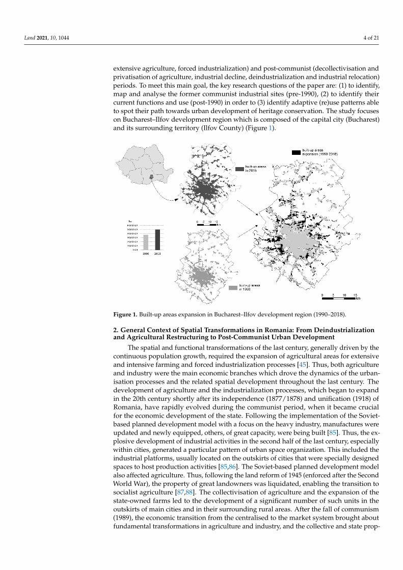
extensive agriculture, forced industrialization) and post-communist (decollectivisation andprivatisation of agriculture, industrial decline, deindustrialization and industrial relocation)periods. To meet this main goal, the key research questions of the paper are: (1) to identify,map and analyse the former communist industrial sites (pre-1990), (2) to identify theircurrent functions and use (post-1990) in order to (3) identify adaptive (re)use patterns ableto spot their path towards urban development of heritage conservation. The study focuseson Bucharest–Ilfov development region which is composed of the capital city (Bucharest)and its surrounding territory (Ilfov County) (Figure 1).
Land 2021, 10, 1044 4 of 22
agricultural units as spaces suitable to be reused in the urban development process. As a result, the current study is seeking to examine and compare the (re)use of both types of former built communist sites—industrial and agricultural—under urbanisation and sub-urbanisation processes driven by the socio-economic and spatial transformations of the communist (intensive and extensive agriculture, forced industrialization) and post-com-munist (decollectivisation and privatisation of agriculture, industrial decline, deindustri-alization and industrial relocation) periods. To meet this main goal, the key research ques-tions of the paper are: (1) to identify, map and analyse the former communist industrial sites (pre-1990), (2) to identify their current functions and use (post-1990) in order to (3) identify adaptive (re)use patterns able to spot their path towards urban development of heritage conservation. The study focuses on Bucharest–Ilfov development region which is composed of the capital city (Bucharest) and its surrounding territory (Ilfov County) (Figure 1).
Figure 1. Built-up areas expansion in Bucharest–Ilfov development region (1990–2018).
2. General Context of Spatial Transformations in Romania: From Deindustrialization and Agricultural Restructuring to Post-Communist Urban Development
The spatial and functional transformations of the last century, generally driven by the continuous population growth, required the expansion of agricultural areas for exten-sive and intensive farming and forced industrialization processes [45]. Thus, both agricul-ture and industry were the main economic branches which drove the dynamics of the urbanisation processes and the related spatial development throughout the last century. The development of agriculture and the industrialization processes, which began to ex-pand in the 20th century shortly after its independence (1877/1878) and unification (1918) of Romania, have rapidly evolved during the communist period, when it became crucial for the economic development of the state. Following the implementation of the Soviet-based planned development model with a focus on the heavy industry, manufactures were updated and newly equipped, others, of great capacity, were being built [85]. Thus, the explosive development of industrial activities in the second half of the last century, especially within cities, generated a particular pattern of urban space organization. This included the industrial platforms, usually located on the outskirts of cities that were spe-cially designed spaces to host production activities [85,86]. The Soviet-based planned de-velopment model also affected agriculture. Thus, following the land reform of 1945
Figure 1. Built-up areas expansion in Bucharest–Ilfov development region (1990–2018).
2. General Context of Spatial Transformations in Romania: From Deindustrializationand Agricultural Restructuring to Post-Communist Urban Development
The spatial and functional transformations of the last century, generally driven by thecontinuous population growth, required the expansion of agricultural areas for extensiveand intensive farming and forced industrialization processes [45]. Thus, both agricultureand industry were the main economic branches which drove the dynamics of the urban-isation processes and the related spatial development throughout the last century. Thedevelopment of agriculture and the industrialization processes, which began to expandin the 20th century shortly after its independence (1877/1878) and unification (1918) ofRomania, have rapidly evolved during the communist period, when it became crucialfor the economic development of the state. Following the implementation of the Soviet-based planned development model with a focus on the heavy industry, manufactures wereupdated and newly equipped, others, of great capacity, were being built [85]. Thus, the ex-plosive development of industrial activities in the second half of the last century, especiallywithin cities, generated a particular pattern of urban space organization. This included theindustrial platforms, usually located on the outskirts of cities that were specially designedspaces to host production activities [85,86]. The Soviet-based planned development modelalso affected agriculture. Thus, following the land reform of 1945 (enforced after the SecondWorld War), the property of great landowners was liquidated, enabling the transition tosocialist agriculture [87,88]. The collectivisation of agriculture and the expansion of thestate-owned farms led to the development of a significant number of such units in theoutskirts of main cities and in their surrounding rural areas. After the fall of communism(1989), the economic transition from the centralised to the market system brought aboutfundamental transformations in agriculture and industry, and the collective and state prop-

Land 2021, 10, 1044 5 of 21
erty was replaced by private property. The assets of the state-owned agricultural units (e.g.,farms, greenhouse) underwent significant transformations following the decollectivisationand privatisation processes. The industrial restructuring [89], which in its early stages, tookon diverse forms: steep decline, closing of factories, massive layoffs, followed by negativesocial and economic effects that slowed down the privatisation process and discouragedforeign investments [90]. Given the strong industrial development during the communistperiod, industrial restructuring in post-communist Romania was, to a large extent, synony-mous with deindustrialization. Moreover, its highest concentration in urban areas explainswhy cities were most affected by deindustrialization [85,91]. The decline of urban industrydetermined the closure of many industrial enterprises or the reduction of activity in others;big cities, in particular, registered the strongest decline of the industrial labour force. Itwas also the case of Bucharest, whose industry was abandoned, relocated or subjected tonew specializations (e.g., services, creative industries). In addition, in the proximity oflarge cities, following the decollectivisation and privatisation of agriculture, new types ofrelationships between the surrounding rural territories and urban areas emerged. As aresult, the urban–rural fringe has become progressively shifted further to the surroundingrural agricultural space, the first to be consumed as a land resource in the (sub)urbandevelopment process [45]. The agricultural and industrial restructuring process generateda significant amount of abandoned spaces, continuously under degradation, thus becoming“problem spaces” for urban development [90] which can become sources for land use con-flicts [85]. The development of cities involved not only a functional diversification, but alsoa significant spatial expansion through urbanisation and suburbanisation processes [6,46],consuming in most of cases, former agricultural and industrial sites. Thus, in the caseof large cities, the former state-owned agricultural enterprises and industrial platforms,initially located on the periphery or in the surrounding of large towns, were integratedinto the urban space, replaced or surrounded by residential areas. In the particular case ofindustrial platforms, especially in the small urban centres, they have remained at the edgeof cities [85].
3. Study Area: Bucharest–Ilfov Development Region
The study area is one of Romania’s eight development regions—NUTS 2, whichwas established in 1998 as territorial–statistical entities without legal personality in orderto provide data for Eurostat estimations and for the absorption of European structuralfunds [92]. Bucharest–Ilfov development region is located in the southern part of Romania(central Romanian Plain) and is one of country’s main agricultural regions. The area wassubject to significant man-made environmental changes driven by urban development,agriculture and industry in relation to the natural conditions and the contextual socio-economic factors [93]. The gradual transition from the traditional rural–agrarian to theurban–industrial society [4] was followed by the spatial and structural changes brought inby the fundamental political and socio-economic transformations of the post-communistperiod [45]. The study area includes the municipality of Bucharest, the capital of Romania,and Ilfov county which surrounds it. It holds 11.5% (2,498,967 inhabitants at 2011 census)of Romania’s population and only 0.8% of its territory (1821.15 sq.km), being the smallestdevelopment region [94]. Since the first half of the 19th century, the city of Bucharest hasbeen home to important industrial activities (mainly agricultural-based) in the fields ofcorn-grinding, leather dressing, textiles and food. The industrial tradition was continuedduring the inter-war period with a diversification of the industrial activities (e.g., machine-building, chemical, and textile). In 1938, a peak year of the inter-war Romanian economy,Bucharest concentrated on one-fifth of the industrial production, primarily of the light andfood industry. During the communist period, the south of the country was dominated bythe Bucharest–Ploies, ti axis. In this way, the capital became the leading industrial centre ofRomania, producing a wide range of items [90], the largest number of employees in theindustry and most important in terms of national industrial production. However, after2013, Bucharest registered lower shares than the national average. Currently, almost two-

Land 2021, 10, 1044 6 of 21
thirds of foreign direct investments (FDI) are concentrated in Bucharest–Ilfov developmentregion; Bucharest maintains its supremacy by hosting foreign companies or only theirregistered offices [85]. Conversely, Ilfov county has a mixed profile: services-industrialin the proximity of the capital city and rural–agricultural in the rest. The latter has beenmaintained, to a certain extent, from the communist period when it used to be part of oneof Bucharest’s subdivisions (“Sectorul Agricol Ilfov”) set up with the aim of supplying thecity with agricultural products.
The evolution of the inter-communal relations at the rural–rural, rural–urban/urban–rural levels, as well as the way of rural settlements set-up, made the demographic size varygreatly [95,96]. The 32 rural LAUs (local administrative units) /communes range from aminimum of 2674 inhabitants (inh.) in Dărăs, ti–Ilfov to a maximum of 18,477 inh. in Chiajna.One of the communes, e.g., Jilava, Cernica, Dobroes, ti, and Brănes, ti, has a demographicsize close to the urban dimension. The demographic size of urban LAUs/towns vary from10,554 inh. in Măgurele to 2,114,236 in the case of Bucharest municipality. The towns areincluded in the following categories: 4 (between 10,000 and 20,000 inh.) and 5 (between20,000 and 50,000 inh.) and Bucharest Municipality with over 2 million inh.
Since 1992, the dynamics of the population show a slow increase in terms of theabsolute value (from 2.46 million in 1992 to 2.50 million in 2018, meaning an increase of1.77% (43,611 inhabitants)). The population dynamics registered a negative trend in thecases of four LAUs, a positive one for 35 LAUs and stagnant for one LAU: the highestdecrease is registered by Nuci LAU (−19.0%) followed by Dărăs, ti-Ilfov (−10.4%), Gruiu(−4.2%) and Bucures, ti municipality (−4.0%); Vidra LAU registered a stagnant evolution; aslow increase (between 1.7 and 25.0%) is registered in the case of seven LAUs; moderateincrease (between 25.1 and 50.0%) for 14 LAUs; high increase (between 50.1 and 100.0%)for six LAUs; very high increase (over 100.1%) for Popes, ti–Leordeni and Bragadiru urbanLAU and Chiajna rural LAU (Figure 2).
Land 2021, 10, 1044 7 of 22
Figure 2. Population dynamics over the 1992–2018 period.
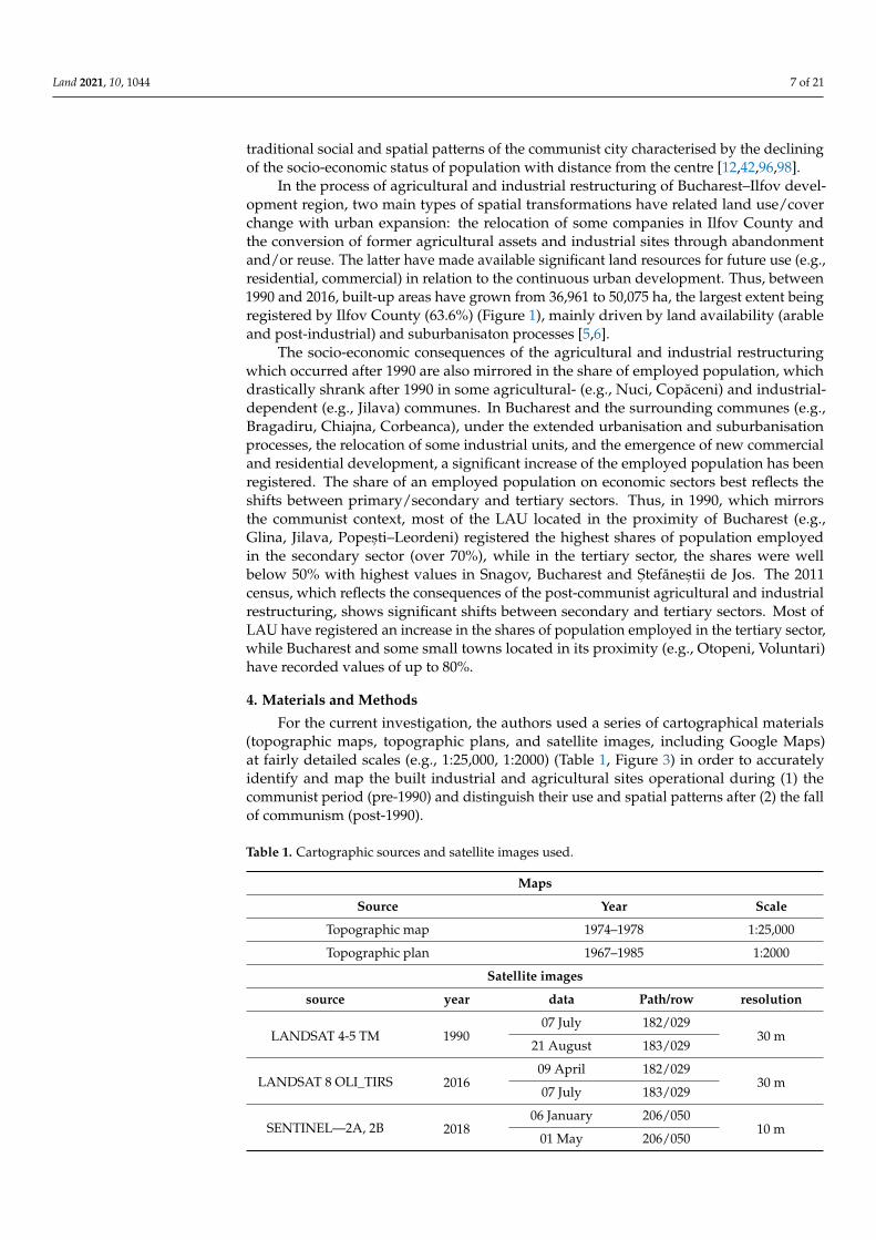
In the process of agricultural and industrial restructuring of Bucharest–Ilfov devel-opment region, two main types of spatial transformations have related land use/cover change with urban expansion: the relocation of some companies in Ilfov County and the conversion of former agricultural assets and industrial sites through abandonment and/or reuse. The latter have made available significant land resources for future use (e.g., resi-dential, commercial) in relation to the continuous urban development. Thus, between 1990 and 2016, built-up areas have grown from 36,961 to 50,075 ha, the largest extent being registered by Ilfov County (63.6%) (Figure 1), mainly driven by land availability (arable and post-industrial) and suburbanisaton processes [5,6].
The socio-economic consequences of the agricultural and industrial restructuring which occurred after 1990 are also mirrored in the share of employed population, which drastically shrank after 1990 in some agricultural- (e.g., Nuci, Copăceni) and industrial-dependent (e.g., Jilava) communes. In Bucharest and the surrounding communes (e.g., Bragadiru, Chiajna, Corbeanca), under the extended urbanisation and suburbanisation processes, the relocation of some industrial units, and the emergence of new commercial and residential development, a significant increase of the employed population has been registered. The share of an employed population on economic sectors best reflects the shifts between primary/secondary and tertiary sectors. Thus, in 1990, which mirrors the communist context, most of the LAU located in the proximity of Bucharest (e.g., Glina, Jilava, Popești–Leordeni) registered the highest shares of population employed in the sec-ondary sector (over 70%), while in the tertiary sector, the shares were well below 50% with highest values in Snagov, Bucharest and Ștefăneștii de Jos. The 2011 census, which reflects the consequences of the post-communist agricultural and industrial restructuring, shows significant shifts between secondary and tertiary sectors. Most of LAU have registered an increase in the shares of population employed in the tertiary sector, while Bucharest and some small towns located in its proximity (e.g., Otopeni, Voluntari) have recorded values of up to 80%.
4. Materials and Methods For the current investigation, the authors used a series of cartographical materials
(topographic maps, topographic plans, and satellite images, including Google Maps) at fairly detailed scales (e.g., 1:25,000, 1:2,000) (Table 1, Figure 3) in order to accurately iden-tify and map the built industrial and agricultural sites operational during (1) the com-munist period (pre-1990) and distinguish their use and spatial patterns after (2) the fall of communism (post-1990).
Figure 2. Population dynamics over the 1992–2018 period.
The demographic increase of the area is given by the town status gain by some ruralLAUs located in Ilfov County. Numerous residents from the capital city moved theirresidence to the newly transformed towns, thus helping increase the local population.Numerous residents from the capital city moved their residence to the newly transformedtowns, thus helping increase the local population. An important phenomenon Romania’slarge cities are facing is the centre to the outskirts and blocks-of-flats to one-family dwellingsor new residential districts migration [42,97]. Thus, changing the spatial distribution of pop-ulation according to its socio-economic status (residential suburbanisation) is reversing the
Land 2021, 10, 1044 7 of 21
traditional social and spatial patterns of the communist city characterised by the decliningof the socio-economic status of population with distance from the centre [12,42,96,98].
In the process of agricultural and industrial restructuring of Bucharest–Ilfov devel-opment region, two main types of spatial transformations have related land use/coverchange with urban expansion: the relocation of some companies in Ilfov County andthe conversion of former agricultural assets and industrial sites through abandonmentand/or reuse. The latter have made available significant land resources for future use (e.g.,residential, commercial) in relation to the continuous urban development. Thus, between1990 and 2016, built-up areas have grown from 36,961 to 50,075 ha, the largest extent beingregistered by Ilfov County (63.6%) (Figure 1), mainly driven by land availability (arableand post-industrial) and suburbanisaton processes [5,6].
The socio-economic consequences of the agricultural and industrial restructuringwhich occurred after 1990 are also mirrored in the share of employed population, whichdrastically shrank after 1990 in some agricultural- (e.g., Nuci, Copăceni) and industrial-dependent (e.g., Jilava) communes. In Bucharest and the surrounding communes (e.g.,Bragadiru, Chiajna, Corbeanca), under the extended urbanisation and suburbanisationprocesses, the relocation of some industrial units, and the emergence of new commercialand residential development, a significant increase of the employed population has beenregistered. The share of an employed population on economic sectors best reflects theshifts between primary/secondary and tertiary sectors. Thus, in 1990, which mirrorsthe communist context, most of the LAU located in the proximity of Bucharest (e.g.,Glina, Jilava, Popes, ti–Leordeni) registered the highest shares of population employedin the secondary sector (over 70%), while in the tertiary sector, the shares were wellbelow 50% with highest values in Snagov, Bucharest and S, tefănes, tii de Jos. The 2011census, which reflects the consequences of the post-communist agricultural and industrialrestructuring, shows significant shifts between secondary and tertiary sectors. Most ofLAU have registered an increase in the shares of population employed in the tertiary sector,while Bucharest and some small towns located in its proximity (e.g., Otopeni, Voluntari)have recorded values of up to 80%.
4. Materials and Methods
For the current investigation, the authors used a series of cartographical materials(topographic maps, topographic plans, and satellite images, including Google Maps)at fairly detailed scales (e.g., 1:25,000, 1:2000) (Table 1, Figure 3) in order to accuratelyidentify and map the built industrial and agricultural sites operational during (1) thecommunist period (pre-1990) and distinguish their use and spatial patterns after (2) the fallof communism (post-1990).
Table 1. Cartographic sources and satellite images used.
Maps
Source Year Scale
Topographic map 1974–1978 1:25,000
Topographic plan 1967–1985 1:2000
Satellite images
source year data Path/row resolution
LANDSAT 4-5 TM 199007 July 182/029
30 m21 August 183/029
LANDSAT 8 OLI_TIRS 201609 April 182/029
30 m07 July 183/029
SENTINEL—2A, 2B 201806 January 206/050
10 m01 May 206/050

Land 2021, 10, 1044 8 of 21
Land 2021, 10, 1044 8 of 22
Table 1. Cartographic sources and satellite images used.
Maps Source Year Scale
Topographic map 1974–1978 1:25,000 Topographic plan 1967–1985 1:2000
Satellite images source year data Path/row resolution
LANDSAT 4-5 TM 1990 07 July 182/029
30 m 21 August 183/029
LANDSAT 8 OLI_TIRS 2016 09 April 182/029
30 m 07 July 183/029
SENTINEL—2A, 2B 2018 06 January 206/050
10 m 01 May 206/050
The reason behind choosing the two periods is that they have different socio-eco-nomic characteristics which have influenced the evolution of the Romanian economy: (1) the centralisation of agriculture (intensification, extensification, collectivisation and state farms), forced industrialization and urbanisation and (2) a changeover in the economy meant to replace the old centralised system by the free market system; agriculture (decol-lectivisation and privatisation) and industry (deindustrialization and industrial reloca-tion) were the two main fields to be significantly transformed [2].
Figure 3. Cartographic sources and satellite images used for the statistical and spatial analyses (case study: Titan Dairy Factory turned into Cora Hypermarket).
In order to highlight the consequences of the restructuring in agriculture and indus-try (e.g., layoffs, unemployment), the study was completed by the dynamics of the em-ployed population and the shifts between the economic sectors based on the socio-eco-nomic data extracted from the available national censuses (1992, 2011) at Local Adminis-trative Unit (LAU) level. In order to easily track the current vs. former use of the built industrial and agricultural sites, the authors have framed them into 8 main categories ac-cording to their past and current functions, grouped two-tier (levels) (Table 2) which in-cludes agro-food (which also incorporates animal husbandry farms and greenhouses), textile, wood, chemical and pharmaceutical, building materials, metallurgy, machine building, energy, air, road and rail transport, commercial, residential, services, abandoned
Figure 3. Cartographic sources and satellite images used for the statistical and spatial analyses (casestudy: Titan Dairy Factory turned into Cora Hypermarket).
The reason behind choosing the two periods is that they have different socio-economiccharacteristics which have influenced the evolution of the Romanian economy: (1) the cen-tralisation of agriculture (intensification, extensification, collectivisation and state farms),forced industrialization and urbanisation and (2) a changeover in the economy meant toreplace the old centralised system by the free market system; agriculture (decollectivisationand privatisation) and industry (deindustrialization and industrial relocation) were thetwo main fields to be significantly transformed [2].
In order to highlight the consequences of the restructuring in agriculture and industry(e.g., layoffs, unemployment), the study was completed by the dynamics of the employedpopulation and the shifts between the economic sectors based on the socio-economic dataextracted from the available national censuses (1992, 2011) at Local Administrative Unit(LAU) level. In order to easily track the current vs. former use of the built industrialand agricultural sites, the authors have framed them into 8 main categories accordingto their past and current functions, grouped two-tier (levels) (Table 2) which includesagro-food (which also incorporates animal husbandry farms and greenhouses), textile,wood, chemical and pharmaceutical, building materials, metallurgy, machine building,energy, air, road and rail transport, commercial, residential, services, abandoned areas. Thecategory named others includes built-up space and functional uses which were difficultto distinguish.
An important aspect of the analysis was to categorise the new spatial patterns of builtindustrial and agricultural units in relation to their former and current functions and state(maintenance, conversion, replacement, abandonment and demolition) and relate themto the main potential drivers of change (e.g., location in relation to the built-up areas, leg-islative measures, urban planning).In the first stage, the comparative analysis of each builtindustrial and agricultural site (current state and use vs. former use) enabled the authors toidentify the functional transformations that occurred after 1990 and to select five typologiesand patterns of post-industrial (re)use under urbanisation and suburbanisation processes:
Maintenance—the built industrial and agricultural units continue to maintain their usein the its original building;
Conversion—the industrial and agricultural units have another use; the building is main-tained, but the function is different (e.g., commercial, residential, other type of industry);
Replacement—the industrial and agricultural units have been totally replaced by otherbuilding with a different function;

Land 2021, 10, 1044 9 of 21
Abandonment—the industrial and agricultural units (the building together with itsannexes and the surrounding terrain) have been abandoned, thus being prone to furthertypes of reuse (conversion, replacement or even demolition);
Demolition—the buildings located on the site of the industrial and agricultural unitshave been demolished; this type of reuse is the most invasive in terms of urban developmentand preservation of industrial/cultural heritage.
Table 2. Former and current use of the built industrial and agricultural sites.
Level I Level IIResearch & Development Institutions (1)
Agro-food (21)Textile (22)Wood (23)
Chemical and Pharmaceutical (24)Building materials (25)
Metallurgy (26)Machine building (27)
Industrial andagricultural units (2)
Energy (28)Air (31)
Road (32)Transport (3)Rail (33)
Commercial (4)Residential (5)
Services (6)Abandoned (7)
Others (8)
In the second stage, with the help of a functional change matrix (Figure 4), the au-thors were able to evaluate the dominant typologies by which each built industrial andagricultural site changed its function (conversion, replacement, abandonment, demolition)or maintained it (maintenance) after 1990.
Land 2021, 10, 1044 10 of 22
Figure 4. Functional change matrix.
The identified dominant typologies will further help identify and explain the spatial and functional patterns which reflect transformations and future patterns of spatial trans-formations and the relationships with urban development. At the same time, one can iden-tify their bivalent potential of being integrated into urban development projects or into heritage conservation projects. In this way, the transformation flows can contribute either to urban development (urban development-oriented) or to heritage conservation (herit-age-oriented).
5. Results This section may be divided by subheadings. It should provide a concise and precise
description of the experimental results, their interpretation, as well as the experimental conclusions that can be drawn. The inter-war and communist industrialization and devel-opment of agriculture placed most of industrial units (e.g., heavy, food, textile, wood) inside the city limits and at its current outskirts (then industrial–residential neighbour-hoods). Because of the predominant rural–agricultural profile of Ilfov County, the pri-mary food industry (e.g., animal farms, greenhouses) was located outside city limits. Dur-ing the communist period, most of the industrial sites were located in the planned work-ing class neighbourhoods: 23 August Plants (heavy industry, totally disbanded) in Pan-telimon Neighbourhood; Cesarom (building materials, largely disbanded), Turbomecan-ica (engines, totally disbanded) in Militari Neighbourhood. Other industrial units were positioned in the city’s outskirts, some of which are currently integrated into the city, e.g., in Ilfov County: Pipera Industrial Zone with several factories and research centres in the field of electronics, computers, automatics or furniture; Băneasa–Otopeni Industrial Zone with aircraft and heavy industry, generally dismantled. Most of the state-owned farms (initially part of the former agricultural subdivision of Bucharest—“Sectorul Agricol Il-fov”) were located not far from the city limits in Otopeni (dairy farm), Chitila (poultry farm), Buftea (poultry farm); Domnești (greenhouses) etc. In the process of restructuring in agriculture and industry (post-communist period), most of the industrial units were closed, abandoned or dismantled. Few of them host different activities in the former assets and fewer kept their original function. As a result, in the 1990–2018 period, a shrinkage from 6536.3 to 2791 ha units was recorded, which means that nearly 60% of built industrial and agricultural units have lost their initial use (Figure 5). In addition, before 1990, the units were mainly industrial and were compacted and almost monolithic (totalling 491 units); after 1990, they became highly fragmented (708 units) both spatially and function-ally, enabling their transition from their initial function to another (Figure 6).
Figure 4. Functional change matrix.
The identified dominant typologies will further help identify and explain the spa-tial and functional patterns which reflect transformations and future patterns of spatialtransformations and the relationships with urban development. At the same time, one canidentify their bivalent potential of being integrated into urban development projects orinto heritage conservation projects. In this way, the transformation flows can contributeeither to urban development (urban development-oriented) or to heritage conservation(heritage-oriented).
Land 2021, 10, 1044 10 of 21
5. Results
This section may be divided by subheadings. It should provide a concise and precisedescription of the experimental results, their interpretation, as well as the experimentalconclusions that can be drawn. The inter-war and communist industrialization and de-velopment of agriculture placed most of industrial units (e.g., heavy, food, textile, wood)inside the city limits and at its current outskirts (then industrial–residential neighbour-hoods). Because of the predominant rural–agricultural profile of Ilfov County, the primaryfood industry (e.g., animal farms, greenhouses) was located outside city limits. Duringthe communist period, most of the industrial sites were located in the planned workingclass neighbourhoods: 23 August Plants (heavy industry, totally disbanded) in PantelimonNeighbourhood; Cesarom (building materials, largely disbanded), Turbomecanica (engines,totally disbanded) in Militari Neighbourhood. Other industrial units were positioned in thecity’s outskirts, some of which are currently integrated into the city, e.g., in Ilfov County:Pipera Industrial Zone with several factories and research centres in the field of electronics,computers, automatics or furniture; Băneasa–Otopeni Industrial Zone with aircraft andheavy industry, generally dismantled. Most of the state-owned farms (initially part of theformer agricultural subdivision of Bucharest—“Sectorul Agricol Ilfov”) were located notfar from the city limits in Otopeni (dairy farm), Chitila (poultry farm), Buftea (poultryfarm); Domnes, ti (greenhouses) etc. In the process of restructuring in agriculture andindustry (post-communist period), most of the industrial units were closed, abandonedor dismantled. Few of them host different activities in the former assets and fewer kepttheir original function. As a result, in the 1990–2018 period, a shrinkage from 6536.3 to 2791ha units was recorded, which means that nearly 60% of built industrial and agriculturalunits have lost their initial use (Figure 5). In addition, before 1990, the units were mainlyindustrial and were compacted and almost monolithic (totalling 491 units); after 1990,they became highly fragmented (708 units) both spatially and functionally, enabling theirtransition from their initial function to another (Figure 6).
Of the total loss of 3745.3 ha, almost 35% have turned into residential, commercial andbusiness as a consequence of urban development, and almost 24% have been abandoned, aprecursor of urban development through their availability as land resources for furtherbuilt-up areas expansion. The most significant spatial shrinkage was recorded by theagro-food, building materials and machine building industrial branches with up to a 72%to 76% decrease of industrial use. In terms of fragmentation of industrial and agriculturalunits, the most representative transformation, with up to a 54% breakup, was experiencedby the building materials (from 19 to 42 units), agro-food (from 64 to 119 units), chemicaland pharmaceutical (from 22 to 38 units), and metallurgy (from 16 to 23 units) industrialbranches (Figure 7). This overall spatial and functional development falls into the pathof most post-communist cities, which following the economic restructuring, deindustri-alisation and tertiarisation processes occurred. The resulted brownfields made room forcentral and inner-city urban restructuring and redevelopment through the replacement ofexisting activities (mainly industry and agriculture) with more economically efficient uses,i.e., commercialisation, business offices, and residential [3,12,15–17,48,56]. Consequently,this process of transformation of the post-industrial brownfields and of post-agriculturalareas to other more economically profitable uses have taken several forms which involvedmore drastic, sometimes irreversible changes, but also smoother ones. However, bothsituations lead, upon case, either to new urban development or urban restructuring andheritage conservation.
Land 2021, 10, 1044 11 of 21Land 2021, 10, 1044 11 of 22
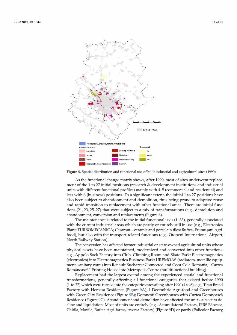
Figure 5. Spatial distribution and functional use of built industrial and agricultural sites (1990).
Figure 6. Spatial distribution and functional use of built industrial and agricultural sites (2018).
Figure 5. Spatial distribution and functional use of built industrial and agricultural sites (1990).
As the functional change matrix shows, after 1990, most of sites underwent replace-ment of the 1 to 27 initial positions (research & development institutions and industrialunits with different functional profiles) mainly with 4–5 (commercial and residential) andless with 6 (business) positions. To a significant extent, the initial 1 to 27 positions havealso been subject to abandonment and demolition, thus being prone to adaptive reuseand rapid transition to replacement with other functional areas. There are initial func-tions (21, 23, 25–27) that were subject to a mix of transformations (e.g., demolition andabandonment, conversion and replacement) (Figure 8).
The maintenance is related to the initial functional uses (1–33), generally associatedwith the current industrial areas which are partly or entirely still in use (e.g., ElectronicaPlant; TURBOMECANICA; Cesarom—ceramic and porcelain tiles; Buftea, Frumus, ani Agri-food), but also with the transport-related functions (e.g., Otopeni International Airport;North Railway Station).
The conversion has affected former industrial or state-owned agricultural units whosephysical assets have been maintained, modernized and converted into other functions:e.g., Appolo Sock Factory into Club, Climbing Room and Skate Park; Electromagnetica(electronics) into Electromagnetica Business Park; UREMOAS (radiators, metallic equip-ment, sanitary ware) into Renault Bucharest Connected and Coca-Cola Romania; “CarteaRomânească” Printing House into Metropolis Centre (multifunctional building).
Replacement had the largest extend among the experienced spatial and functionaltransformations, generally affecting all functional categories that existed before 1990(1 to 27) which were turned into the categories prevailing after 1990 (4 to 6), e.g., Titan BreadFactory with Hercesa Residence (Figure 9A); 1 Decembrie Agri-food and Greenhouseswith Green City Residence (Figure 9B); Domnes, ti Greenhouses with Curtea DomneascăResidence (Figure 9C). Abandonment and demolition have affected the units subject to de-cline and liquidation. Most of units are entirely (e.g., Acumulatorul Factory, IPRS Băneasa,Chitila, Movila, Buftea Agri-farms, Aversa Factory) (Figure 9D) or partly (Policolor Factory,

Land 2021, 10, 1044 12 of 21
Republica Factory, Malaxa Plant—23 August—Faur SA) abandoned. Abandonment ismulti-faced: through reinvestments and modernisation and has the potential to returnto its initial function (maintenance), to shelter a new one (conversion), to be torn down(demolition) in order to make room, or most probably, to other uses (replacement) withvarious functional profiles. In turn, demolition has limited development directions, beingprone to new functional uses (replacement) by means of newly built residential, commercialor business areas, e.g., Granitul Building Materials, Sintofarm Pharmaceutical, DanubianaRubber Factory, Precizia Micro mechanics, IMUAB Machine Building (Figure 9E). Due tothe high demand of land resources, intense spatial and functional changes occurred, espe-cially inside the city. Thus, former units were subject to mixed transformations, e.g., UMEB(Electric Machines Plant) turned into Mall Afi Cotroceni, one of the largest in southeasternEurope, and office buildings (conversion and replacement) and Apaca Factory (textiles)has kept buildings for its original use (maintenance) and the remaining spaces were leasedfor other businesses (conversion) (Figure 9F).
Land 2021, 10, 1044 11 of 22
Figure 5. Spatial distribution and functional use of built industrial and agricultural sites (1990).
Figure 6. Spatial distribution and functional use of built industrial and agricultural sites (2018). Figure 6. Spatial distribution and functional use of built industrial and agricultural sites (2018).
Land 2021, 10, 1044 12 of 22
Of the total loss of 3745.3 ha, almost 35% have turned into residential, commercial and business as a consequence of urban development, and almost 24% have been aban-doned, a precursor of urban development through their availability as land resources for further built-up areas expansion. The most significant spatial shrinkage was recorded by the agro-food, building materials and machine building industrial branches with up to a 72% to 76% decrease of industrial use. In terms of fragmentation of industrial and agricul-tural units, the most representative transformation, with up to a 54% breakup, was expe-rienced by the building materials (from 19 to 42 units), agro-food (from 64 to 119 units), chemical and pharmaceutical (from 22 to 38 units), and metallurgy (from 16 to 23 units) industrial branches (Figure 7). This overall spatial and functional development falls into the path of most post-communist cities, which following the economic restructuring, de-industrialisation and tertiarisation processes occurred. The resulted brownfields made room for central and inner-city urban restructuring and redevelopment through the re-placement of existing activities (mainly industry and agriculture) with more economically efficient uses, i.e., commercialisation, business offices, and residential [3,12,15–17,48,56]. Consequently, this process of transformation of the post-industrial brownfields and of post-agricultural areas to other more economically profitable uses have taken several forms which involved more drastic, sometimes irreversible changes, but also smoother ones. However, both situations lead, upon case, either to new urban development or ur-ban restructuring and heritage conservation.
Figure 7. Spatial and functional change of built agricultural and industrial sites: shrinkage (A) and fragmentation (B).
As the functional change matrix shows, after 1990, most of sites underwent replace-ment of the 1 to 27 initial positions (research & development institutions and industrial units with different functional profiles) mainly with 4–5 (commercial and residential) and less with 6 (business) positions. To a significant extent, the initial 1 to 27 positions have also been subject to abandonment and demolition, thus being prone to adaptive reuse and rapid transition to replacement with other functional areas. There are initial functions (21, 23, 25–27) that were subject to a mix of transformations (e.g., demolition and abandon-ment, conversion and replacement) (Figure 8).
The maintenance is related to the initial functional uses (1–33), generally associated with the current industrial areas which are partly or entirely still in use (e.g., Electronica Plant; TURBOMECANICA; Cesarom—ceramic and porcelain tiles; Buftea, Frumușani Agri-food), but also with the transport-related functions (e.g., Otopeni International Air-port; North Railway Station).
The conversion has affected former industrial or state-owned agricultural units whose physical assets have been maintained, modernized and converted into other func-tions: e.g., Appolo Sock Factory into Club, Climbing Room and Skate Park; Electromag-netica (electronics) into Electromagnetica Business Park; UREMOAS (radiators, metallic equipment, sanitary ware) into Renault Bucharest Connected and Coca-Cola Romania; “Cartea Românească” Printing House into Metropolis Centre (multifunctional building).
Figure 7. Spatial and functional change of built agricultural and industrial sites: shrinkage (A) and fragmentation (B).

Land 2021, 10, 1044 13 of 21Land 2021, 10, 1044 13 of 22
Figure 8. Functional changes and functional change matrix (1990-2018).
Replacement had the largest extend among the experienced spatial and functional transformations, generally affecting all functional categories that existed before 1990 (1 to 27) which were turned into the categories prevailing after 1990 (4 to 6), e.g. Titan Bread Factory with Hercesa Residence (Figure 9A); 1 Decembrie Agri-food and Greenhouses with Green City Residence (Figure 9B); Domnești Greenhouses with Curtea Domnească Residence (Figure 9C). Abandonment and demolition have affected the units subject to decline and liquidation. Most of units are entirely (e.g., Acumulatorul Factory, IPRS Băneasa, Chitila, Movila, Buftea Agri-farms, Aversa Factory) (Figure 9D) or partly (Poli-color Factory, Republica Factory, Malaxa Plant—23 August—Faur SA) abandoned. Aban-donment is multi-faced: through reinvestments and modernisation and has the potential to return to its initial function (maintenance), to shelter a new one (conversion), to be torn down (demolition) in order to make room, or most probably, to other uses (replacement) with various functional profiles. In turn, demolition has limited development directions, being prone to new functional uses (replacement) by means of newly built residential, commercial or business areas, e.g. Granitul Building Materials, Sintofarm Pharmaceutical, Danubiana Rubber Factory, Precizia Micro mechanics, IMUAB Machine Building (Figure 9E). Due to the high demand of land resources, intense spatial and functional changes occurred, especially inside the city. Thus, former units were subject to mixed transfor-mations, e.g. UMEB (Electric Machines Plant) turned into Mall Afi Cotroceni, one of the largest in southeastern Europe, and office buildings (conversion and replacement) and Apaca Factory (textiles) has kept buildings for its original use (maintenance) and the re-maining spaces were leased for other businesses (conversion) (Figure 9F).
Figure 8. Functional changes and functional change matrix (1990–2018).
The investigation revealed several main features of the industrial sites after 1990which can be summed up into: (i) significant spatial shrinkage of the overall industrialarea, from the total of 6536.3 ha during the communist period, the industrial units hadshrunk to more than half, that is 2791 ha; (ii) intensive fragmentation from 491 (before1990), when the industrial units were compact and extended to 708 units (after 1990).Following the privatisation process, they were divided into smaller plots in order to beeasily managed by the new owners and gradually (in most of cases) demolished and/ortuned into other destination (e.g., commercial, residential); (iii) functional diversificationoccurred as a natural stage following the fragmentation process and the resulted functionalchanges, which brings in new uses compared to the original ones (e.g., new industrialfunctions with diversified profiles, residential or commercial); (iv) shifting functionalityfrom secondary to tertiary (tertiarization) is the immediate consequence of the nature offunctional diversification which is roughly changing the functional profile from industrial(mainly heavy, machine building, food, textiles) to services, IT&C, logistics, business etc.;(v) change of patterns is the overall consequence of the transition from the compact in-dustrial pattern, generally large-sized (well-known large industrial zones or state-ownedfarms) to the mosaic-like pattern resulting from the first three abovementioned categories:(i) spatial shrinkage, (ii) intensive fragmentation, (iii) functional diversification and (ter-tiarization). After the fall of communism, in urban areas, the spatial transformation waslargely associated with deindustrialization, revitalisation of the inner city, and residentialand commercial suburbanisation in the outer city [5]. In the case of Bucharest, becausemost of the post-industrial sites are located within the city limits or at outskirts, they weresubject to a continuous transformation under the high demand for land resources driven bythe extended urban development. However, as shown by the current investigation, most ofpost-industrial sites become rapidly incorporated in the urban development process, whilethe valorisation of the cultural heritage provided by the former industrial buildings wasnot a priority.

Land 2021, 10, 1044 14 of 21Land 2021, 10, 1044 14 of 22
Figure 9. Examples of functional changes in the study area: (A) – Titan Bread Factory into Hercesa Residential Complex; (B) – 1 Decembrie Greenhouses into Green City Residence; (C) – Domnești Greenhousese into Curtea Domnească Residence; (D) – Aversa Factory into abandoned land; (E) – IMUAB Machine Building into abandoned land; (F) – UMEB Electric Machines Plant into Mall Afi Cotroceni and Apaca Textile Factory into industrial and business use.
The investigation revealed several main features of the industrial sites after 1990 which can be summed up into: (i) significant spatial shrinkage of the overall industrial area, from the total of 6536.3 ha during the communist period, the industrial units had shrunk to more than half, that is 2791 ha; (ii) intensive fragmentation from 491 (before 1990), when the industrial units were compact and extended to 708 units (after 1990). Fol-lowing the privatisation process, they were divided into smaller plots in order to be easily managed by the new owners and gradually (in most of cases) demolished and/or tuned into other destination (e.g., commercial, residential); (iii) functional diversification oc-curred as a natural stage following the fragmentation process and the resulted functional changes, which brings in new uses compared to the original ones (e.g., new industrial functions with diversified profiles, residential or commercial); (iv) shifting functionality from secondary to tertiary (tertiarization) is the immediate consequence of the nature of functional diversification which is roughly changing the functional profile from industrial (mainly heavy, machine building, food, textiles) to services, IT&C, logistics, business etc.; (v) change of patterns is the overall consequence of the transition from the compact in-dustrial pattern, generally large-sized (well-known large industrial zones or state-owned farms) to the mosaic-like pattern resulting from the first three abovementioned categories:
Figure 9. Examples of functional changes in the study area: (A)—Titan Bread Factory into HercesaResidential Complex; (B)—1 Decembrie Greenhouses into Green City Residence; (C)—Domnes, tiGreenhousese into Curtea Domnească Residence; (D)—Aversa Factory into abandoned land; (E)—IMUAB Machine Building into abandoned land; (F)—UMEB Electric Machines Plant into Mall AfiCotroceni and Apaca Textile Factory into industrial and business use.
6. Discussion
The post-communist cities are still cities in transition, subject to multiple transfor-mation [3,16], generally governed by market forces which require large land resourcesfor new real estate investments in the development of offices, retail, residential areas. Assuch, processes such as land conversion have become key in providing the available landnecessary to meet the market demand.
Compared to other post-communist cities that have undergone specific transfor-mations related to deindustrialization and brownfield regeneration, i.e., Brno [11,48,55],Bucharest and its surrounding territory has been subject to mixed-use development, similarto Budapest [24–27], Warsaw [33–36] or Sofia [30–32]. Thus, the spatial and functionaltransformations involved new land uses associated with urban growth and sprawl (e.g.,residential, business) at the expense of several land use categories: arable lands, pastures,permanent crops and agricultural complex cultivation patterns [5,6,99], forest and naturalareas [65,100], but also former industrial sites [57,75,79,80]. The last category has hadan important place in the overall spatial and functional transformation of the urban andsuburban landscape because most of the post-industrial sites located within Bucharest city

Land 2021, 10, 1044 15 of 21
limits or at outskirts, were subject to a continuous transformation and dynamics under thehigh demand for land resources driven by the extended urban development (urbanisationand suburbanisation). The state-owned agricultural enterprises, although located outsidethe city limits, are exposed to the same spatial dynamics, largely driven by residential sub-urbanisation. The real estate value of the physical assets (e.g., factories, halls, greenhouses)and of the land under the abandoned or demolished post-industrial units are the maindrivers behind their valorisation and/or transformation into other uses, mainly residential,commercial, office buildings. In the case of large post-industrial units, i.e., the communist“industrial platforms”, a chance of “viability” is represented by their transformation intoindustrial parks which are functional areas concentrating high-level, non-polluting activi-ties [85]. This can generally happen in the case of the industrial platforms located at theoutskirts or outside the city limits, in areas where the real estate value is not big enoughto drive their transformation into other functional areas. Another way of reducing thenumber of abandoned or unused industrial buildings and/or preventing the demolitionof cultural heritage is the adaptive reuse, which refers to the change of use of existingbuildings or structures according to the needs of the new or existing owners [1,10,101]. Asfor the former state-owned agricultural enterprises, only large and coherent investmentprojects (i.e., EU funds) or their adaptive reuse can guarantee their preservation. However,the spatial and functional development of cities and their surrounding territories has beenraising a number of conflicts between development-oriented interests and environmentallybased, sometimes “conservationist”, interests, such as the “sustainable city”, “compactcity”, “self-reliant city”, or “green city” [7]. It is particularly the case of Central EasternEuropean cities, where the spatial and functional transformations have been more dynamicand acute.
The generated real estate stock (mainly industrial) becomes an important prerequisitefor the location of new functions (e.g., residential, warehouses, commercial, or office activi-ties) [85]. Subsequently, through replacement, the new spaces are completely engulfed intothe urban tissue. In both situations, the functional shift from primary and secondary totertiary includes new specializations (e.g., services, creative industries). “Creativity” and“culture” are two policy solutions to the post-communist urban transformations [7]. Apartfrom being developed in the post-industrial urban contexts while addressing the rapidde-industrialisation of ex-communist cities, they also had important symbolic value ofproviding the innovative urban policy that most post-communist cities wish for [102]. Therelocation of these creative clusters is predominantly heterogeneous, but also metropoli-tan [62], which in the current situation, enacts as the relocation of companies in the outskirtsor outside the city. This trend is widely identified in the post-industrial landscapes of manyEuropean cities.
7. Conclusions
In Romania, after the fall of communism, the spatial transformation of the urbanareas is largely associated with deindustrialization, revitalisation of inner city areas andresidential and commercial suburbanisation in the outer city [5]. This process has gener-ally characterised urban areas and their surrounding territories where the industry andagricultural farms were located. The authors tried to identify and understand the changesin the spatial patterns of former built industrial and agricultural units after the fall ofcommunism, as well as the models of adaptive reuse and their relationships with urbansprawl-related trends. In order to underline the spatial dimension of landscape transforma-tions, the analysis revealed the state of the industrial and agricultural units before and after1990—a historical landmark which divides two important historical periods: communistand post-communist.
The functional change matrix highlighted not only the functional changes that agri-cultural and industrial sites underwent during the post-communist period, but two otherimportant aspects such as their spatial shrinkage and fragmentation. These latter con-sequences are important elements that reveal the essential role they have in the future

Land 2021, 10, 1044 16 of 21
processes of spatial transformation of the urban fabric (urbanisation, urban regenerationand renewal). Moreover, using the functional change matrix, two main models wereidentified in the process of urban development in relation to the (re)use of built industrialand agricultural units: (1) heritage-oriented by way of maintenance and conversion, ensur-ing the continuation, reconversion and adaptive reuse; (2) urban development-orientedthrough the abandonment and/or demolition which can be considered as precursors ofurban development (Figure 10).
Land 2021, 10, 1044 16 of 22
engulfed into the urban tissue. In both situations, the functional shift from primary and secondary to tertiary includes new specializations (e.g., services, creative industries). “Creativity” and “culture” are two policy solutions to the post-communist urban trans-formations [7]. Apart from being developed in the post-industrial urban contexts while addressing the rapid de-industrialisation of ex-communist cities, they also had important symbolic value of providing the innovative urban policy that most post-communist cities wish for [102]. The relocation of these creative clusters is predominantly heterogeneous, but also metropolitan [62], which in the current situation, enacts as the relocation of com-panies in the outskirts or outside the city. This trend is widely identified in the post-in-dustrial landscapes of many European cities.
7. Conclusions In Romania, after the fall of communism, the spatial transformation of the urban ar-
eas is largely associated with deindustrialization, revitalisation of inner city areas and res-idential and commercial suburbanisation in the outer city [5]. This process has generally characterised urban areas and their surrounding territories where the industry and agri-cultural farms were located. The authors tried to identify and understand the changes in the spatial patterns of former built industrial and agricultural units after the fall of com-munism, as well as the models of adaptive reuse and their relationships with urban sprawl-related trends. In order to underline the spatial dimension of landscape transfor-mations, the analysis revealed the state of the industrial and agricultural units before and after 1990—a historical landmark which divides two important historical periods: com-munist and post-communist.
The functional change matrix highlighted not only the functional changes that agri-cultural and industrial sites underwent during the post-communist period, but two other important aspects such as their spatial shrinkage and fragmentation. These latter conse-quences are important elements that reveal the essential role they have in the future pro-cesses of spatial transformation of the urban fabric (urbanisation, urban regeneration and renewal). Moreover, using the functional change matrix, two main models were identified in the process of urban development in relation to the (re)use of built industrial and agri-cultural units: (1) heritage-oriented by way of maintenance and conversion, ensuring the continuation, reconversion and adaptive reuse; (2) urban development-oriented through the abandonment and/or demolition which can be considered as precursors of urban de-velopment (Figure 10).
Figure 10. Functional change flows in the post-communist period.
Generally, the heritage-oriented model supports the valorisation and continuation of the former built industrial and agricultural units towards achieving sustainable and resil-ient urban and suburban areas through the sense of belonging and intrinsic value, the cultural identity, cultural significance of place etc. [103–105]. However, in the case of Bu-charest–Ilfov development region, the extended urban development processes
Figure 10. Functional change flows in the post-communist period.
Generally, the heritage-oriented model supports the valorisation and continuationof the former built industrial and agricultural units towards achieving sustainable andresilient urban and suburban areas through the sense of belonging and intrinsic value,the cultural identity, cultural significance of place etc. [103–105]. However, in the case ofBucharest–Ilfov development region, the extended urban development processes deter-mined a high demand for land resources and a high pressure on agricultural assets, whichwere generally subject to demolition and replacement (the urban development-orientedmodel). In this case, the heritage-oriented model mainly refers to the industrial sites. Twoillustrate examples are: “Cartea Românească” Printing House, a historical monument (codeB-II-m-B-18922) built in 1919, currently operating as a multifunctional building (MetropolisCentre) (Figure 11A); Malaxa Plant—23 August—Faur SA one of the first and largest heavymachinery factories in Romania (established in 1921) with some buildings declared histori-cal monuments (code B-II-a-A-18091) which is currently partly abandoned and convertedto other uses, but with plans to establish a museum comprising historical technologies(Figure 11B).
Land 2021, 10, 1044 17 of 22
determined a high demand for land resources and a high pressure on agricultural assets, which were generally subject to demolition and replacement (the urban development-ori-ented model). In this case, the heritage-oriented model mainly refers to the industrial sites. Two illustrate examples are: “Cartea Românească” Printing House, a historical monument (code B-II-m-B-18922) built in 1919, currently operating as a multifunctional building (Me-tropolis Centre) (Figure 11A); Malaxa Plant—23 August—Faur SA one of the first and largest heavy machinery factories in Romania (established in 1921) with some buildings declared historical monuments (code B-II-a-A-18091) which is currently partly abandoned and converted to other uses, but with plans to establish a museum comprising historical technologies (Figure 11B).
Figure 11. “Cartea Românească” Printing House, currently in Metropolis Centre (A) and Malaxa Plant—23 August—Faur SA Heavy Machinery Factory, currently mixed uses (B).
The urban development-oriented model is extremely complex; it provides a wide va-riety of spatial and functional changes. As exemplified in Figure 7, it has an extended spatial coverage both inside and outside the city limits. Figure 8 shows the array of func-tional transformations towards specific target uses driven by the urbanisation and subur-banisation processes (e.g., residential, commercial, logistic), as also exemplified in Figure 9. Within the urban development model, both industrial and agricultural built sites are involved.
The underlying relationships between the five types of transformation are quite dy-namic, especially from the abandonment stage, which can direct each abandoned unit ei-ther to heritage or urban development. However, as shown by the current investigation, most of abandoned sites have become rapidly taken in by the urban development process. The identification of already transformed sites (replacement, conversion) shows the dy-namics and pattern of spatial transformations, but the detection of abandoned or demol-ished sites can show the direction of these transformations, key elements in the urban planning and development. The used methodology offers both an applied and a theoret-ical perspective for understanding the spatial and functional changes of the post-indus-trial and post-agricultural sites, easy to implement in various regions. It can provide best results in regions with significant socio-economic and political transformations, such as the former communist countries, where the spatial and functional changes have signifi-cantly altered the landscape.
Strengths and limitations of the present study. The proposed methodology requires accurate, historical, and recent cartographical sources to provide, as precise as possible, the spatial and functional transformations of the elements at stake. Quantitative and qual-itative data on land use/cover, land use functions, demography, socio-economic charac-teristics etc. should be integrated to provide a more accurate picture of the change patterns and types. Thus, the current study has a number of strengths: (i) the theoretical back-ground which is built upon the most representative studies developed in the Central East-ern European countries; (ii) the variety, reliability and scale of statistical (National Census, TEMPOline time series) and spatial data (e.g., topographic maps, satellite images) used; (iii) the visual presentation of the spatial and functional changes, along with the analysis of statistics, that can become self-explanatory tools in the planning process; (iv) the poten-tial of the methodology of being replicated to other areas, irrespective of the spatial scale. There are, however, limitations which have been identified: (i) the limited availability of accurate geospatial data (topographic maps, cadastral maps, satellite images) for the
Figure 11. “Cartea Românească” Printing House, currently in Metropolis Centre (A) and MalaxaPlant—23 August—Faur SA Heavy Machinery Factory, currently mixed uses (B).
The urban development-oriented model is extremely complex; it provides a widevariety of spatial and functional changes. As exemplified in Figure 7, it has an extendedspatial coverage both inside and outside the city limits. Figure 8 shows the array offunctional transformations towards specific target uses driven by the urbanisation andsuburbanisation processes (e.g., residential, commercial, logistic), as also exemplified inFigure 9. Within the urban development model, both industrial and agricultural built sitesare involved.

Land 2021, 10, 1044 17 of 21
The underlying relationships between the five types of transformation are quite dy-namic, especially from the abandonment stage, which can direct each abandoned uniteither to heritage or urban development. However, as shown by the current investiga-tion, most of abandoned sites have become rapidly taken in by the urban developmentprocess. The identification of already transformed sites (replacement, conversion) showsthe dynamics and pattern of spatial transformations, but the detection of abandoned ordemolished sites can show the direction of these transformations, key elements in the urbanplanning and development. The used methodology offers both an applied and a theoreticalperspective for understanding the spatial and functional changes of the post-industrial andpost-agricultural sites, easy to implement in various regions. It can provide best results inregions with significant socio-economic and political transformations, such as the formercommunist countries, where the spatial and functional changes have significantly alteredthe landscape.
Strengths and limitations of the present study. The proposed methodology requiresaccurate, historical, and recent cartographical sources to provide, as precise as possible, thespatial and functional transformations of the elements at stake. Quantitative and qualitativedata on land use/cover, land use functions, demography, socio-economic characteristics etc.should be integrated to provide a more accurate picture of the change patterns and types.Thus, the current study has a number of strengths: (i) the theoretical background whichis built upon the most representative studies developed in the Central Eastern Europeancountries; (ii) the variety, reliability and scale of statistical (National Census, TEMPOlinetime series) and spatial data (e.g., topographic maps, satellite images) used; (iii) the visualpresentation of the spatial and functional changes, along with the analysis of statistics,that can become self-explanatory tools in the planning process; (iv) the potential of themethodology of being replicated to other areas, irrespective of the spatial scale. Thereare, however, limitations which have been identified: (i) the limited availability of accurategeospatial data (topographic maps, cadastral maps, satellite images) for the analysedperiods, which requires the use of different years to better illustrate the analysed elements;(ii) the limited availability of up-to-date statistical data at an LAU level necessary to explainthe socio-economic context of the spatial and functional changes; there are indicators thatwould have been beneficial, but could not be included in the current study, i.e., employmentby branch of economic activity before 1990 and in 2018. Thus, the outcomes of the currentstudy support identifying areas prone to future development through the adaptive (re)useof former built-up land (agricultural or industrial) in order to predict future urban growthspatial trends and patterns inside and outside the city limits.
Author Contributions: Conceptualization, I.G., C.D. (Cristina Dumitrică), and M.D.; methodol-ogy, I.G., C.D. (Cristina Dumitrică), B.M.; validation, C.D. (Cristina Dumitrică), and C.D. (CostinDumitras, cu); formal analysis, M.D. and B.M.; investigation, M.D., B.M., and C.D. (Costin Dumitras, cu);resources, C.D. (Cristina Dumitrică); writing—original draft preparation, I.G.; writing—review andediting, I.G. and B.M.; visualization, C.D. (Cristina Dumitrică) and M.D.; supervision, I.G. All authorshave read and agreed to the published version of the manuscript.
Funding: This research received no external funding.
Data Availability Statement: Data sharing not applicable.
Acknowledgments: The current study was carried out within the framework of the projects en-titled “Geographical study of the man-environment relationships in the Romanian MetropolitanAreas” and “Atlas of Environment”, as part of the Research Plan of the Institute of Geography,Romanian Academy.
Conflicts of Interest: The authors declare no conflict of interest.

Land 2021, 10, 1044 18 of 21
References1. Mengüsoglu, N.; Boyacioglu, E. Reuse of industrial built heritage for residential purposes in Manchester. METU J. Fac. Archit.
2016, 30, 117–138.2. Popovici, E.A.; Bălteanu, D.; Kucsicsa, G. Assessment of changes in land-use and land-cover pattern in Romania using Corine
Land Cover Database. Carpath. J. Earth Environ. 2013, 8, 195–208.3. Garcia-Ayllon, S. Urban transformations as indicators of economic change in post-communist Eastern Europe: Territorial
diagnosis through five case studies. Habitat Int. 2017, 71, 29–37. [CrossRef]4. Mitrică, B.; Grigorescu, I.; Urucu, V. Dezvoltarea Urbană s, i Ariile Metropolitane. In Romania—Natură s, i Societate; Bălteanu, D.,
Dumitrascu, M., Geacu, S., Mitrică, B., Sima, M., Eds.; The Publishing House of the Romanian Academy: Bucharest, Romania,2016; pp. 250–291. (In Romanian)
5. Grigorescu, I.; Kucsicsa, G.; Popovici, E.-A.; Mitrică, B.; Dumitrascu, M.; Mocanu, I. Regional disparities in the urban sprawlphenomenon in Romania using Corine Land Cover database. Rev. Roum. Géogr./Rom. Journ. Geogr. 2018, 62, 169–184.
6. Grigorescu, I.; Kucsicsa, G.; Popovici, E.A.; Mitrică, B.; Mocanu, I.; Dumitrascu, M. Modelling land use/cover change to assessfuture urban sprawl in Romania. Geocarto Int. 2021, 36, 721–739. [CrossRef]
7. Bucek, J. Urban Development Policy Challenges in East-Central Europe: Governance, City Regions and Financialisation. Quaest.Geogr. 2016, 35, 7–26. [CrossRef]
8. Nuissl, H.; Siedentop, S. Urbanisation and Land Use Change. In Sustainable Land Management in a European Context, Human-Environment Interactions; Weith, T., Barkmann, T., Gaasch, N., Rogga, S., Strauß, C., Zscheischler, J., Eds.; Springer: Cham,Switzerland, 2021; Volume 8, pp. 75–99.
9. Loures, L. Post-industrial landscapes as drivers for urban redevelopment: Public versus expert perspectives towards the benefitsand barriers of the reuse of post-industrial sites in urban areas. Habitat Int. 2015, 45, 72–81. [CrossRef]
10. Bottero, M.; D’Alpaos, C.; Oppio, A. Ranking of Adaptive Reuse Strategies for Abandoned Industrial Heritage in VulnerableContexts: A Multiple Criteria Decision Aiding Approach. Sustainability 2019, 11, 785. [CrossRef]
11. Osman, R.; Frantal, B.; Klusácek, P.; Kunc, J.; Martinát, S. Factors affecting brownfield regeneration in post-socialist space: Thecase of the Czech Republic. Land Use Policy 2015, 48, 309–316. [CrossRef]
12. Sýkora, L.; Ourednicek, M. Sprawling post-communist metropolis: Commercial and residential suburbanisation in Prague andBrno, the Czech Republic. In Employment Deconcentration in European Metropolitan Areas; Razin, E., Dijst, M., Vázquez, C., Eds.;Springer: Heidelberg, Germany, 2007; Volume 91, pp. 209–233.
13. Tosics, I. City development in central and eastern Europe since 1990: The impacts of internal forces. In Transformation of Cities inCentral and Eastern Europe: Towards Globalisation; Hamilton, F.E.I., Dimitrowska-Andrews, K., Pichler-Milanovic’, N., Eds.; UnitedNations University Press: Tokyo, Japan, 2005; pp. 44–78.
14. Tsenkova, S.; Nedovic-Budic, Z. The Urban Mosaic of Post-Socialist Europe: Space, Institutions and Policy; Springer Science & BusinessMedia: Heidelberg, Germany, 2006.
15. Sýkora, L. Post-socialist cities. In International Encyclopedia of Human Geography, 1st ed.; Elsevier: Oxford, UK, 2009; Volume 8,pp. 387–395.
16. Sýkora, L.; Bouzarovski, S. Multiple transformations: Conceptualising the post-communist urban transition. Urban Stud. 2012,49, 43–60. [CrossRef]
17. Sýkora, L.; Stanilov, K. The challenge of post-socialist suburbanisation. In Confronting Suburbanisation: Urban Decentralization inPost-Socialist Central and Eastern Europe; Sýkora, L., Stanilov, K., Eds.; Wiley Blackwell: Oxford, UK, 2014; pp. 1–32.
18. Malý, J.; Dvorák, P.; Šuška, P. Multiple transformations of post-socialist cities: Multiple outcomes? Cities 2020, 107, 102901.[CrossRef]
19. Haase, A.; Wolff, M.; Špacková, P.; Radzimski, A. Reurbanisation in Post-socialist Europe - A ComparativeView of EasternGermany, Poland, and the Czech Republic. Comp. Popul. Stud. 2017, 42, 353–389. [CrossRef]
20. Idczak, P.; Musiałkowska, I.; Mrozik, K. Ecosystem services in the appraisal of the economic performance of urban regenerationprojects exemplified by the Jessica Initiative. Econ. Environ. 2019, 70, 114–129.
21. Jadach-Sepioło, A.; Zathey, M. Alternative between Revitalisation of City Centres and the Rising Costs of Extensive Land Usefrom a Polish Perspective. Land 2021, 10, 488. [CrossRef]
22. Ourednícek, M. Differential suburban development in the Prague urban region. Geogr. Ann. Ser. B, Hum. Geogr. 2007, 89, 111–126.[CrossRef]
23. Pazur, R.; Feranec, J.; Stych, P.; Kopecká, M.; Holman, L. Changes of urbanised landscape identified and assessed by the UrbanAtlas data: Case study of Prague and Bratislava. Land Use Policy 2017, 61, 135–146. [CrossRef]
24. Kok, H.; Kovacs, Z. The process of suburbanisation in the agglomeration of Budapest. J. Hous. Built Environ. 1999, 14, 119–141.25. Soós, G.; Ignits, G. Suburbanisation and its consequences in the Budapest metropolitan area. In Proceedings of the 3rd Euro
Conference The European City in Transition, The City and the Region, Weimar, Germany, 14–15 November 2003.26. Tosics, I. Spatial Restructuring in Post-Socialist Budapest; Physica-Verlag: Heidelberg, Germany, 2006; pp. 131–150.27. Kovács, Z.; Farkas, J.Z.; Egedy, T.; Kondor, A.C.; Szabó, B.; Lennert, J.; Baka, D.; Kohán, B. Urban sprawl and land conversion in
post-socialist cities: The case of metropolitan Budapest. Cities 2019, 92, 71–81. [CrossRef]28. Tammaru, T.; Leetmaa, K.; Silm, S.; Ahas, R. Temporal and Spatial Dynamics of the New Residential Areas around Tallinn. Eur.
Plan. Stud. 2009, 17, 423–439. [CrossRef]

Land 2021, 10, 1044 19 of 21
29. Leetmaa, K.; Kährik, A.; Nuga, M.; Tammaru, T. Suburbanisation in the Tallinn metropolitan area. In Confronting Suburbanisation:Urban Decentralization in Post-Socialist Central and Eastern Europe; Wiley Blackwell: Oxford, UK, 2014; pp. 192–224.
30. Hirt, S. Post-Socialist Urban Forms: Notes From Sofia. Urban. Geogr. 2006, 27, 464–488. [CrossRef]31. Hirt, S. Suburbanising Sofia: Characteristics of post-socialist peri-urban change. Urban Geogr. 2007, 28, 755–780. [CrossRef]32. Hirt, S.; Kovachev, A. The changing spatial structure of post-socialist Sofia. In The Urban Mosaic of Post-Socialist Europe: Space,
Institutions and Polic; Tsenkova, S., Nedovic-Budic, Z., Eds.; Springer Science & Business Media: Heidelberg, Germany, 2006;pp. 113–130.
33. Degórska, B. Spatial growth of urbanised land within the Warsaw Metropolitan Area in the first decade of the 21st century. Geogr.Pol. 2012, 85, 77–95. [CrossRef]
34. Sławinski, T.; Sulmicki, M. The 3S Model of Urban Sprawl in the Warsaw Functional Area. MAZOWSZE Stud. Reg. 2015,17, 53–65.
35. Mantey, D.; Sudra, P. Types of suburbs in post-socialist Poland and their potential for creating public spaces. Cities 2018,88, 209–221. [CrossRef]
36. Sudra, P. Spatial dispersion and the concentration of buildings in an urban agglomeration—A typology proposal for the WarsawMetropolitan Area. Environ. Socio-Econ. Stud. 2020, 8, 81–96. [CrossRef]
37. Gyurkovich, M.; Gyurkovich, J. New Housing Complexes in Post-Industrial Areas in City Centres in Poland versus Cultural andNatural Heritage Protection—With a Particular Focus on Cracow. Sustainability 2021, 13, 418. [CrossRef]
38. Szubert, M.; Warcholik, W.; Zemła, M. The Influence of Elements of Cultural Heritage on the Image of Destinations, Using FourPolish Cities as an Example. Land 2021, 10, 671. [CrossRef]
39. Kirschke, K.; Kirschke, P.; Komarzynska-Swiesciak, E. Adaptive reuse of commercial and public buildings in Wroclaw Old Townin Poland. The occupant’s safety and comfort versus preservation of authenticity of monumental buildings. Teka Kom. Archit.Urban. Studiów Krajobrazowych 2018, 14, 24–41. [CrossRef]
40. Szmytkie, R. Suburbanisation processes within and outside the city: The development of intra-urban suburbs in Wrocław, Poland.Morav. Geogr. Rep. 2021, 29, 149–165. [CrossRef]
41. Mrozik, K.; Podawca, K.; Drozynska, D. Spatial diversification of the implementation of planning and investment processes inthe Poznan Metropolitan Area. Ekon. Sr. 2020, 4, 64–80.
42. Grigorescu, I.; Mitrică, B.; Mocanu, I.; Ticană, N. Urban sprawl and residential development in the Romanian Metropolitan Areas.Rev. Roum. Géogr./Rom. J. Geogr. 2012, 56, 43–59.
43. Mihai, B.; Nistor, C.; Simion, G. Post-socialist urban growth of Bucharest, Romania—A change detection analysis on Landsatimagery (1984–2010). Acta Geogr. Slov. 2015, 55, 223–234. [CrossRef]
44. Dumitrache, L.; Zamfir, D.; Nae, M.; Simion, G.; Stoica, I.V. The Urban Nexus: Contradictions and Dilemmas of (Post) Communist(Sub) Urbanisation in Romania. Human Geogr. 2016, 10, 39–58. [CrossRef]
45. Grigorescu, I.; Kucsicsa, G.; Mitrică, B.; Mocanu, I.; Dumitrascu, M. Regional Spatial and Statistical Analyses of the Urban–ruralRelationships in Romania. Case Study: Romanian Plain. In Smart Geography; Nedkov, S., Zhelezov, G., Ilieva, N., Nikolova, M.,Koulov, B., Naydenov, K., Dimitrov, S., Eds.; Springer: Cham, Switzerland, 2020; pp. 155–173.
46. Kucsicsa, G.; Grigorescu, I. Urban Growth in the Bucharest Metropolitan Area: Spatial and Temporal Assessment Using LogisticRegression. J. Urban. Plan. Dev. 2018, 144, 05017013. [CrossRef]
47. Stoica, I.-V.; Vîrghileanu, M.; Zamfir, D.; Mihai, B.-A.; Săvulescu, I. Comparative Assessment of the Built-Up Area ExpansionBased on Corine Land Cover and Landsat Datasets: A Case Study of a Post-Socialist City. Remote. Sens. 2020, 12, 2137. [CrossRef]
48. Frantal, B.; Greer-Wootten, B.; Klusácek, P.; Krejcí, T.; Kunc, J.; Martinát, S. Exploring spatial patterns of urban brownfieldsregeneration: The case of Brno, Czech Republic. Cities 2015, 44, 9–18. [CrossRef]
49. Spórna, T. The suburbanisation process in a depopulation context in the Katowice conurbation, Poland. Environ. Socio-Econ. Stud.2018, 6, 57–72. [CrossRef]
50. Kerstetter, D.; Confer, J.; Bricker, K. Industrial Heritage Attractions: Types and Tourists. J. Travel Tour. Mark. 1998, 7, 91–104.[CrossRef]
51. Landorf, C. A Framework for Sustainable Heritage Management: A Study of UK Industrial Heritage Sites. Int. J. Heritage Stud.2009, 15, 494–510. [CrossRef]
52. Veldpaus, L.; Roders, A.R.P.; Colenbrander, B.J.F. Urban Heritage: Putting the Past into the Future. Hist. Environ. Policy Pract.2013, 4, 3–18. [CrossRef]
53. Chen, J.; Judd, B.; Hawken, S. Adaptive reuse of industrial heritage for cultural purposes in Beijing, Shanghai and Chongqing.Struct. Surv. 2016, 34, 331–350. [CrossRef]
54. Zhang, C.; Lin, S.; Gao, L. The Role of Community in Industrial Heritage Redevelopment: Evidence from Taigucang Wharf,Guangzhou, China. Asian J. Tour. Res. 2016, 1, 147–166. [CrossRef]
55. Navratil, J.; Krejci, T.; Martinat, S.; Pasqualetti, M.J.; Klusacek, P.; Frantal, B.; Tochackova, K. Brownfields do not “only live twice”:The possibilities for heritage preservation and the enlargement of leisure time activities in Brno, the Czech Republic. Cities 2018,74, 52–63. [CrossRef]
56. Frantál, B.; Kunc, J.; Nováková, E.; Klusácek, P.; Martinát, S.; Osman, R. Location Matters! Exploring Brownfields Regeneration ina Spatial Context (A Case Study of the South Moravian Region, Czech Republic). Morav. Geogr. Rep. 2013, 21, 5–19. [CrossRef]
Land 2021, 10, 1044 20 of 21
57. Cercleux, A.-L.; Merciu, F.-C.; Merciu, G.-L. Models of Technical and Industrial Heritage Re-Use in Romania. Procedia Environ. Sci.2012, 14, 216–225. [CrossRef]
58. Copic, S.; Tumaric, A. Possibilities of industrial heritage reuse as tourist attractions: A case study of city of Zrenjanin (Vojvodina,Serbia). Geogr. Pannonica 2015, 19, 44–49. [CrossRef]
59. Iancu, F.; Stoica, I. Tourist capitalization of industrial heritage elements: A strategic direction of sustainable development. Casestudy: Petros, ani depression. GeoJ Tour. 2010, 5, 62–70.
60. Filimon, L.; Nemes, V.; Olau, P. Urban regeneration in the context of current urban development policies in Romania. Case study:Stei city (Bihor county, Romania). Rev. Rom. Geogr. Pol. 2012, XIV, 200–210.
61. Boix, R.; Hervás-Oliver, J.L.; De-Miguel-Molina, B. Micro-geographies of creative industries clusters in Europe: From hot spots toassemblages. Pap. Reg. Sci. 2014, 94, 753–772. [CrossRef]
62. Zhong, S. Artists and Shanghai’s culture-led urban regeneration. Cities 2016, 56, 165–171. [CrossRef]63. Boca, M.C. Urban regeneration and gentrification in Romania. J. Geogr. Politi- Soc. 2018, 8, 2731. [CrossRef]64. Boca, M.C. Theoretical and practical aspects of regeneration of decommissioned industrial areas in Oradea, Romania. J. Geogr.
Politi- Soc. 2019, 9, 33–38. [CrossRef]65. Grigorescu, I.; Geacu, S. The dynamics and conservation of forest ecosystems in Bucharest Metropolitan Area. Urban. For. Urban.
Green. 2017, 27, 90–99. [CrossRef]66. Evans, G. Creative Cities, Creative Spaces and Urban Policy. Urban. Stud. 2009, 46, 1003–1040. [CrossRef]67. Zheng, J.; Chan, R. The impact of ‘creative industry clusters’ on cultural and creative industry development in Shanghai. City,
Cult. Soc. 2014, 5, 9–22. [CrossRef]68. Sugden, E. The Adaptive Reuse of Industrial Heritage Buildings: A Multiple-Case Studies Approach. Master’s Thesis, University
of Waterloo, Waterloo, ON, Canada, 2018.69. Langston, C.; Wong, F.K.; Hui, E.C.M.; Shen, L.-Y. Strategic assessment of building adaptive reuse opportunities in Hong Kong.
Build. Environ. 2008, 43, 1709–1718. [CrossRef]70. Klusácek, P.; Alexandrescu, F.; Osman, R.; Malý, J.; Kunc, J.; Dvorák, P.; Frantal, B.; Havlícek, M.; Krejcí, T.; Martinát, S.; et al.
Good governance as a strategic choice in brownfield regeneration: Regional dynamics from the Czech Republic. Land Use Policy2018, 73, 29–39. [CrossRef]
71. Tan, Y.; Shen, L.-Y.; Langston, C. A fuzzy approach for adaptive reuse selection of industrial buildings in Hong Kong. Int. J. Strat.Prop. Manag. 2014, 18, 66–76. [CrossRef]
72. Vardopoulos, I. Critical sustainable development factors in the adaptive reuse of urban industrial buildings. A fuzzy DEMATELapproach. Sustain. Cities Soc. 2019, 50, 101684. [CrossRef]
73. Filip, S.; Cocean, P. Urban industrial brownfields: Constraints and opportunities in Romania. Carpath J. Earth Environ. 2012,7, 155–164.
74. Merciu, F.C.; Cercleux, A.L.; Peptenatu, D.; Merciu, G.L.; Pintilii, R.; Drăghici, C.C. Revival of industrial towns through culturalregeneration–a viable solution. In Proceedings of the 1st International Conference on Tourism and Economic Development(TED ‘11), Drobeta-Turnu Severin, Romania, 27–29 October 2011; pp. 27–29.
75. Merciu, F.-C.; Merciu, G.-L.M.; Cercleux, A.-L.; Drăghici, C. Conversion of industrial heritage as a vector of cultural regeneration.Procedia. Soc. Behav. Sci. 2014, 122, 162–166.
76. Cobârzan, B. Brownfield redevelopment in Romania. Transylv. Rev. Adm. Sci. 2007, 3, 28–46.77. Popescu, G.; Patrascoiu, R. Brownfield sites - between abandonment and redevelopment case study: Craiova city. Hum. Geogr. – J.
Stud. Res. Hum. Geogr. 2012, 6, 91–97. [CrossRef]78. Moscovici, A.M.; Banescu, O.A.; Vaduva, R. Integrating brownfield sites into city redevelopment strategies. In Proceedings of the
17th International Multidisciplinary Scientific GeoConference, Surveying Geology & Mining, Albena, Bulgaria, 29 June–5 July2017; Volume 17, pp. 675–682.
79. Simion, G. Effects of post-socialist deindustrialization in Central and Eastern Europe: Results of an industrial site survey and GISmapping in Bucharest City, Romania. Hum. Geogr. 2016, 10, 64–76.
80. Motcanu-Dumitrescu, M.A. Bucharest Municipality competitive local economic development through urban regeneration ofdestructured industrial areas. Urbanism. Arhitectură. Constructii 2015, 6, 37–56.
81. Jucu, I.S. Romanian Post-socialist Industrial Restructuring at the Local Scale: Evidence of Simultaneous Processes of De-/Reindustrialization in the Lugoj Municipality of Romania. J. Balk. Near East. Stud. 2015, 17, 408–426. [CrossRef]
82. Georgescu, L.P.; Iticescu, C.; Murariu, G.; Topa, C. Ecological revitalisation of brownfields–a challenge for Romania and EasternEurope. J. Food Agric. Environ. 2014, 12, 503–507.
83. Constantinescu, I.P.; Dascălu, D.; Sucală, C. An Activist Perspective on Industrial Heritage in Petrila, a Romanian Mining City.Public Hist. 2017, 39, 114–141. [CrossRef]
84. Huzui, A.E.; Mirea, D.A.; Stoiculescu, R.C. The perception upon landscape revitalization of industrial spaces. Case study: Theindustrial units Belvedere Cigarette Factory and SC Mefin Sinaia. Rom. Rev. Reg. Stud. 2011, 7, 67–78.
85. Popescu, C. Industrializarea României–de la Dezindustrializare la Reindustrializare. In Romania; The Publishing House of the RomanianAcademy: Bucharest, Romania, 2016; pp. 375–404. (In Romanian)
86. Nae, M.; Dumitrache, L.; Suditu, B.; Matei, E. Housing Activism Initiatives and Land-Use Conflicts: Pathways for ParticipatoryPlanning and Urban Sustainable Development in Bucharest City, Romania. Sustainability 2019, 11, 6211. [CrossRef]

Land 2021, 10, 1044 21 of 21
87. Bălteanu, D.; Popescu, M.; Popovici, E.A. Agriculture. In Romania; The Publishing House of the Romanian Academy: Bucharest,Romania, 2006; pp. 228–235.
88. Popovici, E.A.; Bălteanu, D.; Kucsicsa, G. Utilizarea Terenurilor s, i Dezvoltarea Actuală a Agriculturii. In Romania; The PublishingHouse of the Romanian Academy: Bucharest, Romania, 2016; pp. 329–374. (In Romanian)
89. Ianos, I.; Tălângă, C.; Braghină, C.; Gheorghe, C.A. Characteristics of the industrialization process around the moment of collapseof a centralized political system. Romania as a case study. Forum Geogr. 2010, 9, 161–172.
90. Popescu, C. Industrial Restructuring. In Romania; The Publishing House of the Romanian Academy: Bucharest, Romania, 2006;pp. 236–256.
91. Popescu, C. Deindustrialization and urban shrinkage in Romania. What lessons for the spatial policy? Transylv. Rev. Adm. Sci.2014, 10, 181–202.
92. Săgeată, R.; Popescu, C.Regiunile de Dezvoltare si Politica de Dezvoltare Regională. In Romania; The Publishing House of theRomanian Academy: Bucharest, Romania, 2016; pp. 604–608. (In Romanian)
93. Grigorescu, I.; Sima, M.; Mitrică, B.; Kucsicsa, G.; Dumitrascu, M. A regional assessment of the man-made hazards. The case ofBucharest–Ilfov Development Region. In Proceedings of the 17th International Multidisciplinary Scientific GeoConference vol. 5Ecology and Environmental Protection, Albena, Bulgaria, 29 June–5 July 2017; pp. 15–22.
94. Bălteanu, D.; Mitrică, B.; Mocanu, I.; Sima, M.; Popescu, C. Caracterizarea Geografică a Regiunilor de Dezvoltare. In Romania; ThePublishing House of the Romanian Academy: Bucharest, Romania, 2016; pp. 621–652. (In Romanian)
95. Mitrică, B. Changes in the dynamics and demographic structures of the Romanian urban population. An overview of thepost-communist period. Romanian J. Geogr. 2014, 58, 201–212.
96. Mitrică, B.; Persu, M.R.; Mocanu, I.; Serban, P.; Grigorescu, I.; Damian, N. Changes in the Dynamics and Demographic Structureof the Romanian Rural Population: An Overview of the Post-communist Period, in vol. In Three Decades of Transformation in theEast-Central European Countryside; Banski, J., Ed.; Springer: Heidelberg, Germany, 2019; pp. 191–215.
97. Stănculescu, M.S.; Berevoiescu, I. Sărac Lipit, Caut Altă Viat,ă! Fenomenul Sărăciei Extreme s, i al Zonelor Sărace în România; NemiraPublishing House: Bucharest, Romania, 2004.
98. Erdeli, G.; Simion, G. Local Decentralization and extended suburbanisation: A geographical approach of the metropolisationprocess in Romania. Bul. Soc. Geogr. Rom. 2006, XII, 107–120.
99. Grădinaru, S.R.; Ioja, I.-C.; Onose, D.A.; Gavrilidis, A.A.; Pătru-Stupariu, I.; Kienast, F.; Hersperger, A.M. Land abandonment as aprecursor of built-up development at the sprawling periphery of former socialist cities. Ecol. Indic. 2015, 57, 305–313. [CrossRef]
100. Kucsicsa, G.; Popovici, E.A.; Bălteanu, D.; Dumitrascu, M.; Grigorescu, I.; Mitrică, B. Assessing the Potential Future Forest-CoverChange in Romania, Predicted Using a Scenario-Based Modelling. Environ. Model. Assess 2019, 25, 471–491. [CrossRef]
101. Wilkinson, S.; James, K.; Reed, R. Using building adaptation to deliver sustainability in Australia. Struct. Surv. 2009, 27, 46–61.[CrossRef]
102. Bullen, P.A.; Love, P. Adaptive reuse of heritage buildings. Struct. Surv. 2011, 29, 411–421. [CrossRef]103. De Medici, S.; De Toro, P.; Nocca, F. Cultural Heritage and Sustainable Development: Impact Assessment of Two Adaptive Reuse
Projects in Siracusa, Sicily. Sustainability 2019, 12, 311. [CrossRef]104. Aigwi, I.E.; Ingham, J.; Phipps, R.; Filippova, O. Identifying parameters for a performance-based framework: Towards prioritising
underutilised historical buildings for adaptive reuse in New Zealand. Cities 2020, 102, 102756. [CrossRef]105. Borén, T.; Young, C. Conceptual export and theory mobilities: Exploring the reception and development of the “creative city
thesis” in the post-socialist urban realm. Eurasian Geogr. Econ. 2016, 57, 588–606. [CrossRef]