Study of microdroplet generation from vacuum arcs on graphite cathodes
Unroofing history of Late Paleozoic magmatic arcs within the
‘‘Turan Plate’’ (Tuarkyr, Turkmenistan)
E. Garzanti a,*, M. Gaetani b
aDipartimento di Scienze Geologiche e Geotecnologie, Universita di Milano-Bicocca, Piazza della Scienza 4, 20126 Milan, ItalybDipartimento di Scienze della Terra, Universita di Milano, Via Mangiagalli 34, 20133 Milan, Italy
Received 15 March 2001; accepted 15 October 2001
Abstract
Stratigraphic, sedimentologic and petrographic data collected on the Kizilkaya sedimentary succession (Western
Turkmenistan) demonstrate that the ‘‘Turan Plate’’ consists in fact of an amalgamation of Late Paleozoic to Triassic
continental microblocks separated by ocean sutures. In the Kizilkaya area, an ophiolitic sequence including pyroxenite, gabbro,
pillow basalt and chert, interpreted as the oceanic crust of a back-arc or intra-arc basin, is tectonically juxtaposed against
volcaniclastic redbeds documenting penecontemporaneous felsic arc magmatism (Amanbulak Group). A collisional event took
place around ?mid-Carboniferous times, when oceanic rocks underwent greenschist– facies metamorphism and a thick
volcaniclastic wedge, with pyroclastic rocks interbedded in the lower part, accumulated (Kizilkaya Formation). The climax of
orogenic activity is testified by arid fanglomerates shed from the rapid unroofing of a continental arc sequence, including
Middle–Upper Devonian back-reef carbonates and cherts, and the underlying metamorphic and granitoid basement rocks
(Yashmu Formation). After a short period of relative quiescence, renewed tectonic activity is indicated by a conglomeratic
sequence documenting erosion of a sedimentary and metasedimentary succession including chert, sandstone, slate and a few
carbonates. A final stage of rhyolitic magmatism took place during rapid unroofing of granitoid basement rocks (Kizildag
Formation). Such a complex sequence of events recorded by the Kizilkaya episutural basin succession documents the stepwise
assemblage of magmatic arcs and continental fragments to form the Turan microblock collage during the Late Paleozoic.
Evolution of detrital modes is compatible with that predicted for juvenile to accreted and unroofed crustal blocks. The
deposition of braidplain lithic arkoses in earliest Triassic time indicates that strong subsidence continued after the end of the
volcanic activity, possibly in retroarc foreland basin settings. The occurrence of transgressive coquinas yielding endemic
ammonoids (Dorikranites) characteristic of the whole Caspian area suggests proximity to the southern margin of the newly
formed Eurasian continent in the late Early Triassic. The Late Triassic Eo-Cimmerian Orogeny caused only mild tilting and
rejuvenation of the underlying succession in the study area. Only at this time were the Turan blocks, a series of Indonesian-type
terranes comprised between the Mashad Paleo-Tethys Suture in the south and the Mangyshlak belt in the north, finally
incorporated into the Eurasian landmass. D 2002 Elsevier Science B.V. All rights reserved.
Keywords: Turan blocks; Oceanic sutures; Volcaniclastic redbeds; Sandstone petrography; Late Paleozoic; Olenekian
0037-0738/02/$ - see front matter D 2002 Elsevier Science B.V. All rights reserved.
PII: S0037 -0738 (01 )00231 -7
* Corresponding author.
E-mail addresses: [email protected] (E. Garzanti), [email protected] (M. Gaetani).
www.elsevier.com/locate/sedgeo
Sedimentary Geology 151 (2002) 67–87
1. Introduction
The Caspian area is of great economic interest due
to the occurrence of numerous giant gas and oil re-
servoirs (e.g., Khain et al., 1991). Geological knowl-
edge is, however, still incomplete, particularly as
regards the pre-Jurassic paleogeographic and paleo-
geodynamic scenario, which is rather poorly con-
strained. Unraveling the earlier stages through which
the area was consolidated and welded to Eurasia will
contribute to the understanding of the extent to which
Paleozoic–early Mesozoic structures have controlled
subsequent sedimentary basin evolution and location
of depocentres (Thomas et al., 1999a). Exposures of
Permo-Triassic rocks are unfortunately limited to
scattered punctiform or narrow linear outcrops includ-
ing the Bolshoe Bogdo in Russia (near Volgograd),
the Gornyi Mangyshlakh and its continuation toward
the Kugusem scarp (Western Kazakhstan), the small
domal structure of Kizilkaya in Tuarkyr (Western
Turkmenistan) and the Aghdarband window in the
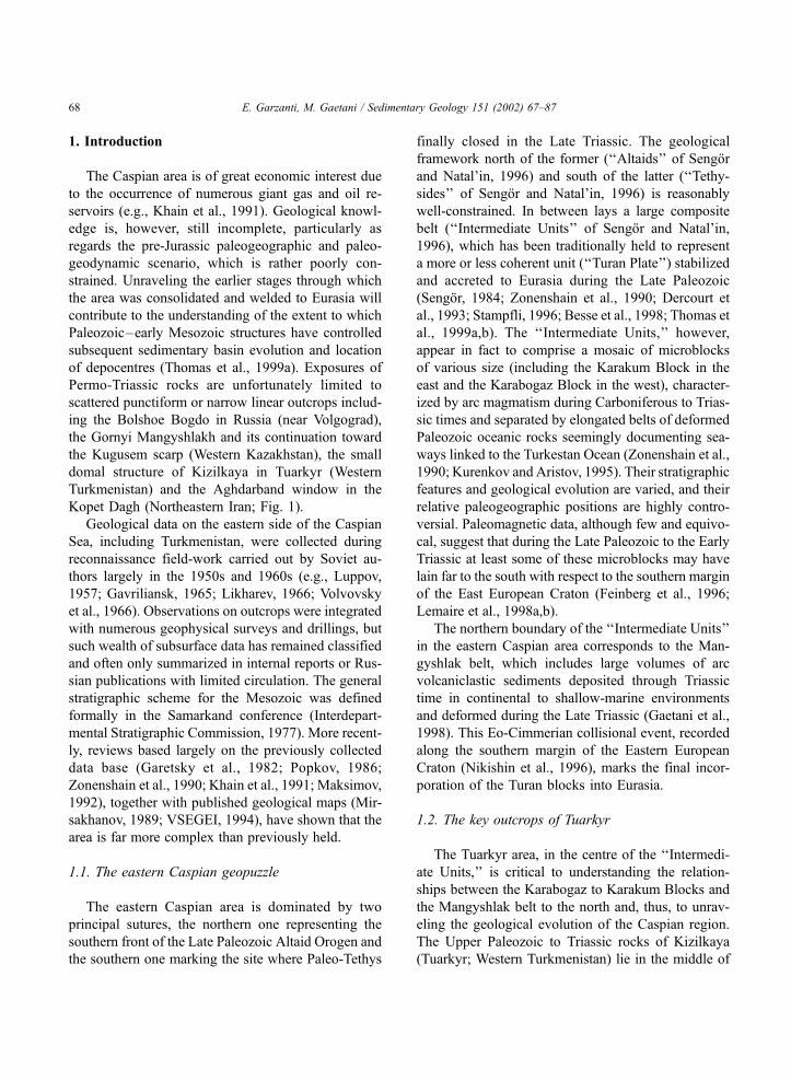
Kopet Dagh (Northeastern Iran; Fig. 1).
Geological data on the eastern side of the Caspian
Sea, including Turkmenistan, were collected during
reconnaissance field-work carried out by Soviet au-
thors largely in the 1950s and 1960s (e.g., Luppov,
1957; Gavriliansk, 1965; Likharev, 1966; Volvovsky
et al., 1966). Observations on outcrops were integrated
with numerous geophysical surveys and drillings, but
such wealth of subsurface data has remained classified
and often only summarized in internal reports or Rus-
sian publications with limited circulation. The general
stratigraphic scheme for the Mesozoic was defined
formally in the Samarkand conference (Interdepart-
mental Stratigraphic Commission, 1977). More recent-
ly, reviews based largely on the previously collected
data base (Garetsky et al., 1982; Popkov, 1986;
Zonenshain et al., 1990; Khain et al., 1991; Maksimov,
1992), together with published geological maps (Mir-
sakhanov, 1989; VSEGEI, 1994), have shown that the
area is far more complex than previously held.
1.1. The eastern Caspian geopuzzle
The eastern Caspian area is dominated by two
principal sutures, the northern one representing the
southern front of the Late Paleozoic Altaid Orogen and
the southern one marking the site where Paleo-Tethys
finally closed in the Late Triassic. The geological
framework north of the former (‘‘Altaids’’ of Sengor
and Natal’in, 1996) and south of the latter (‘‘Tethy-
sides’’ of Sengor and Natal’in, 1996) is reasonably
well-constrained. In between lays a large composite
belt (‘‘Intermediate Units’’ of Sengor and Natal’in,
1996), which has been traditionally held to represent
a more or less coherent unit (‘‘Turan Plate’’) stabilized
and accreted to Eurasia during the Late Paleozoic
(Sengor, 1984; Zonenshain et al., 1990; Dercourt et
al., 1993; Stampfli, 1996; Besse et al., 1998; Thomas et
al., 1999a,b). The ‘‘Intermediate Units,’’ however,
appear in fact to comprise a mosaic of microblocks
of various size (including the Karakum Block in the
east and the Karabogaz Block in the west), character-
ized by arc magmatism during Carboniferous to Trias-
sic times and separated by elongated belts of deformed
Paleozoic oceanic rocks seemingly documenting sea-
ways linked to the Turkestan Ocean (Zonenshain et al.,
1990; Kurenkov and Aristov, 1995). Their stratigraphic
features and geological evolution are varied, and their
relative paleogeographic positions are highly contro-
versial. Paleomagnetic data, although few and equivo-
cal, suggest that during the Late Paleozoic to the Early
Triassic at least some of these microblocks may have
lain far to the south with respect to the southern margin
of the East European Craton (Feinberg et al., 1996;
Lemaire et al., 1998a,b).
The northern boundary of the ‘‘Intermediate Units’’
in the eastern Caspian area corresponds to the Man-
gyshlak belt, which includes large volumes of arc
volcaniclastic sediments deposited through Triassic
time in continental to shallow-marine environments
and deformed during the Late Triassic (Gaetani et al.,
1998). This Eo-Cimmerian collisional event, recorded
along the southern margin of the Eastern European
Craton (Nikishin et al., 1996), marks the final incor-
poration of the Turan blocks into Eurasia.
1.2. The key outcrops of Tuarkyr
The Tuarkyr area, in the centre of the ‘‘Intermedi-
ate Units,’’ is critical to understanding the relation-
ships between the Karabogaz to Karakum Blocks and
the Mangyshlak belt to the north and, thus, to unrav-
eling the geological evolution of the Caspian region.
The Upper Paleozoic to Triassic rocks of Kizilkaya
(Tuarkyr; Western Turkmenistan) lie in the middle of
E. Garzanti, M. Gaetani / Sedimentary Geology 151 (2002) 67–8768
the east Caspian steppe, nearly 500 km southeast
of the Mangyshlak belt and nearly 700 km north-
west of the Aghdarband window, representing the
closest outcrops with broadly correlative sedimen-
tary successions (Fig. 1).
The Kizilkaya area was restricted because of a
large uranium mine active until the 1970s, and pub-
lished geological information has remained largely
confidential (e.g., Kalugyn, 1975). Only in recent
years have western geologists had access to the area
to carry out paleomagnetic investigations (Lemaire et
al., 1997, 1998a,b). Petrologic observations on the
Permo-Triassic igneous rocks of the Turkmenbasi
(Krasnovodsk) area, representing the southern margin
Fig. 1. Location map of the Caspian area (A) and geologic sketch map of the Kizilkaya structure (B) (modified after Khurbatov’s map, sheet
K-40-XXXII).
E. Garzanti, M. Gaetani / Sedimentary Geology 151 (2002) 67–87 69
of the Karabogaz High, were also made (Lemaire,
1997). During our 1997 geological expedition to
Tuarkyr, in the framework of the Peri-Tethys Pro-
gramme (Dercourt et al., 2000), we measured a
complete, composite stratigraphic section across the
Kizilkaya structure, and visited the small outcrop of
pillow-lavas near the village of Tuar some 35 km
northwest of Kizilkaya, collecting 138 samples for
paleontological, petrographic and geochemical analy-
sis. Our principal aims were as follows.
(1) To improve the stratigraphic information on the
Upper Paleozoic to Triassic sedimentary succession,
and to integrate it with detailed sedimentological ob-
servations and quantitative petrographic data.
(2) To investigate the geochemical signature of the
associated mafic igneous rocks.
(3) To compare the sedimentary record of Tuarkyr
with that of adjacent basins, with specific reference to
petrologic signatures of terrigenous detritus and tim-
ing of volcaniclastic deposition. In particular, we
wanted to understand whether paleogeographic highs
feeding the Tuarkyr clastics, or the Tuarkyr clastics
themselves, could have represented the source of
detritus for the Mangyshlak trough in Triassic time.
(4) To evaluate the relative incidence of Late Pale-
ozoic versus Late Triassic orogenic events in Tuarkyr,
so as to clarify the paleotectonic and paleogeographic
evolution of the eastern Caspian area. In particular, we
tried and constrain the timing of assembly of the Turan
microblocks and final accretion to the Eurasian land-
mass.
2. The oceanic rocks of Kizilkaya and Tuar
The Kizilkaya structure is a monocline f 17 km
long and 4 km wide, bounded to the northeast by a
major regional fault (Fig. 1). On the southwest side of
the fault, a sedimentary succession dipping mainly
40j–45j west south-west consists of Upper Paleozoic(Amanbulak Group) to Lower Triassic redbeds. Along
the northeast side of the fault, slivers of mafic igneous
rocks and tectonised cherty slates are exposed. These
rocks were first observed in the 1930s by Soviet
geologists, who described an up to 200-m thick cherty
slate unit inferred to be intruded by gabbros near
Kizilkaya and Tuar (Nalivkin and Luppov, 1936, in
Luppov, 1957). All of these structures and rock units
are unconformably overlain by fluvio-deltaic clastics
containing Jurassic floras.
2.1. Mafic igneous rocks
A 100-m thick tectonised sequence including
pyroxenitic cumulates, gabbros, diabases and pillow
lavas mantled by sedimentary chert layers is found in
tectonic contact with the Amanbulak redbeds on the
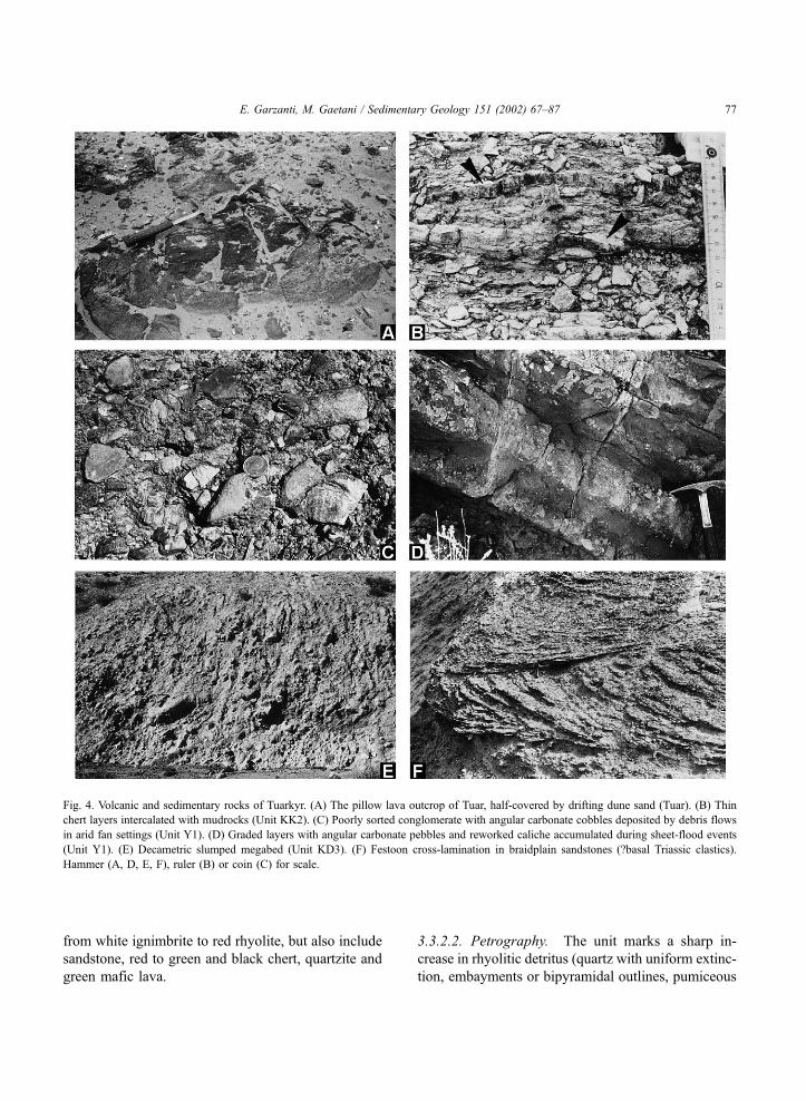
eastern side of the Yashmu hill. Pillow lavas, locally
associated with chert, also occur at Tuar (Figs. 1 and
4A). In gabbroic rocks, primary clinopyroxene + pla-
gioclase assemblages are partially replaced by greens-
chist–facies assemblages including tremolite, chlorite,
albite. Late-stage sericite, epidote and locally pum-
pellyite are also found. Pillow lavas, consisting of
plagioclase laths set in an altered glassy groundmass,
are spilitized and contain veins and cavities filled by
quartz, chlorite or calcite. Phenocrysts of mafic min-
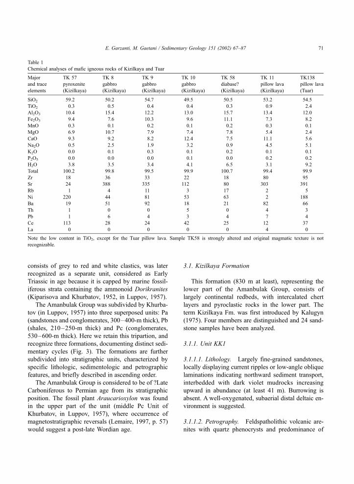
erals are not preserved. Geochemical analyses of these
largely altered mafic magmatic rocks (Table 1) sug-
gest that they crystallized from low-TiO2, subalkalic,
basaltic to basaltic–andesite magmas (Fig. 2). The
oceanic rocks are undated, although a mid-Paleozoic
age is generally assumed (Mirsakhanov, 1989).
2.2. Dark cherty slates
A small outcrop of anchimetamorphic grey cherty
mudrocks is found in the vicinity of the Kizilkaya
village, where they are invariably in tectonic contact
with the unmetamorphosed and only mildly tilted
Amanbulak redbeds (Luppov, 1957). The dark cherty
slates were generally assigned to the mid-Paleozoic
(Luppov, 1957; Mirsakhanov, 1989; VSEGEI, 1994)
but recently have been reported to contain Early to
mid-Carboniferous radiolaria (Gorelovski, personal
communication, 1997).
3. The Kizilkaya sedimentary succession
The thick continental redbeds of Kizilkaya, largely
of Upper Paleozoic age (Amanbulak Group; ‘‘Aman-
bulak Series’’ of Luppov, 1932, in Luppov, 1957;
Likharev, 1966), are truncated by a major angular
unconformity and covered by Jurassic terrigenous
units. The uppermost part of the sequence, which
E. Garzanti, M. Gaetani / Sedimentary Geology 151 (2002) 67–8770
consists of grey to red and white clastics, was later
recognized as a separate unit, considered as Early
Triassic in age because it is capped by marine fossil-
iferous strata containing the ammonoid Dorikranites
(Kiparisova and Khurbatov, 1952, in Luppov, 1957).
The Amanbulak Group was subdivided by Khurba-
tov (in Luppov, 1957) into three superposed units: Pa
(sandstones and conglomerates, 300–400-m thick), Pb
(shales, 210–250-m thick) and Pc (conglomerates,
530–600-m thick). Here we retain this tripartion, and
recognize three formations, documenting distinct sedi-
mentary cycles (Fig. 3). The formations are further
subdivided into stratigraphic units, characterized by
specific lithologic, sedimentologic and petrographic
features, and briefly described in ascending order.
The Amanbulak Group is considered to be of ?Late
Carboniferous to Permian age from its stratigraphic
position. The fossil plant Araucarioxylon was found
in the upper part of the unit (middle Pc Unit of
Khurbatov, in Luppov, 1957), where occurrence of
magnetostratigraphic reversals (Lemaire, 1997, p. 57)
would suggest a post-late Wordian age.
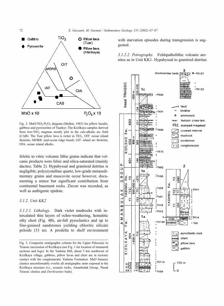
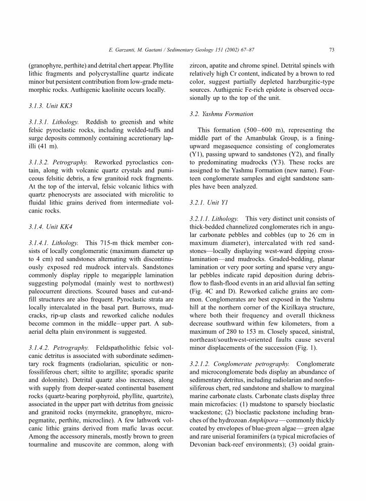
3.1. Kizilkaya Formation
This formation (830 m at least), representing the
lower part of the Amanbulak Group, consists of
largely continental redbeds, with intercalated chert
layers and pyroclastic rocks in the lower part. The
term Kizilkaya Fm. was first introduced by Kalugyn
(1975). Four members are distinguished and 24 sand-
stone samples have been analyzed.
3.1.1. Unit KK1
3.1.1.1. Lithology. Largely fine-grained sandstones,
locally displaying current ripples or low-angle oblique
laminations indicating northward sediment transport,
interbedded with dark violet mudrocks increasing
upward in abundance (at least 41 m). Burrowing is
absent. A well-oxygenated, subaerial distal deltaic en-
vironment is suggested.
3.1.1.2. Petrography. Feldspatholithic volcanic are-
nites with quartz phenocrysts and predominance of
Table 1
Chemical analyses of mafic igneous rocks of Kizilkaya and Tuar
Major
and trace
elements
TK 57
pyroxenite
(Kizilkaya)
TK 8
gabbro
(Kizilkaya)
TK 9
gabbro
(Kizilkaya)
TK 10
gabbro
(Kizilkaya)
TK 58
diabase?
(Kizilkaya)
TK 11
pillow lava
(Kizilkaya)
TK138
pillow lava
(Tuar)
SiO2 59.2 50.2 54.7 49.5 50.5 53.2 54.5
TiO2 0.3 0.5 0.4 0.4 0.3 0.9 2.4
Al2O3 10.4 15.4 12.2 13.0 15.7 13.4 12.0
Fe2O3 9.4 7.6 10.3 9.6 11.1 7.3 8.2
MnO 0.3 0.1 0.2 0.1 0.2 0.3 0.1
MgO 6.9 10.7 7.9 7.4 7.8 5.4 2.4
CaO 9.3 9.2 8.2 12.4 7.5 11.1 5.6
Na2O 0.5 2.5 1.9 3.2 0.9 4.5 5.1
K2O 0.0 0.1 0.3 0.1 0.2 0.1 0.1
P2O5 0.0 0.0 0.0 0.1 0.0 0.2 0.2
H2O 3.8 3.5 3.4 4.1 6.5 3.1 9.2
Total 100.2 99.8 99.5 99.9 100.7 99.4 99.9
Zr 18 36 33 22 18 80 95
Sr 24 388 335 112 80 303 391
Rb 1 4 11 3 17 2 5
Ni 220 44 81 53 63 2 188
Ba 19 51 92 18 21 82 66
Th 1 0 0 5 0 4 3
Pb 1 6 4 3 4 7 4
Ce 113 28 24 42 25 12 37
La 0 0 0 0 0 4 0
Note the low content in TiO2, except for the Tuar pillow lava. Sample TK58 is strongly altered and original magmatic texture is not
recognizable.
E. Garzanti, M. Gaetani / Sedimentary Geology 151 (2002) 67–87 71
felsitic to vitric volcanic lithic grains indicate that vol-
canic products were felsic and silica-saturated (mainly
dacites; Table 2). Hypabyssal and granitoid detritus is
negligible; polycrystalline quartz, low-grade metasedi-
mentary grains and muscovite occur however, docu-
menting a minor but significant contribution from
continental basement rocks. Zircon was recorded, as
well as authigenic epidote.
3.1.2. Unit KK2
3.1.2.1. Lithology. Dark violet mudrocks with in-
tercalated thin layers of ochre-weathering, hematitic
silty chert (Fig. 4B), air-fall pyroclastics and up to
fine-grained sandstones yielding chloritic silicate
peloids (33 m). A prodelta to shelf environment
with starvation episodes during transgression is sug-
gested.
3.1.2.2. Petrography. Feldspatholithic volcanic are-
nites as in Unit KK1. Hypabyssal to granitoid detritus
Fig. 2. MnO/TiO2/P2O5 diagram (Mullen, 1983) for pillow basalts,
gabbros and pyroxenites of Tuarkyr. The Kizilkaya samples derived
from low-TiO2 magmas mostly plot in the calc-alkalic arc field
(CAB). The Tuar pillow lava is richer in TiO2. OIT: ocean island
tholeiite; MORB: mid-ocean ridge basalt; IAT: island arc tholeiite;
OIA: ocean island alkalic.
Fig. 3. Composite stratigraphic column for the Upper Paleozoic to
Triassic succession of Kizilkaya (see Fig. 1 for location of measured
sections and logs). In the Yashmu Hill, about 5 km northwest of
Kizilkaya village, gabbros, pillow lavas and chert are in tectonic
contact with the conglomeratic Yashmu Formation. Mid?-Jurassic
clastics unconformably overlie all stratigraphic units exposed in the
Kizilkaya structure (i.e., oceanic rocks, Amanbulak Group, ?basal
Triassic clastics and Dorikranites beds).
E. Garzanti, M. Gaetani / Sedimentary Geology 151 (2002) 67–8772
(granophyre, perthite) and detrital chert appear. Phyllite
lithic fragments and polycrystalline quartz indicate
minor but persistent contribution from low-grade meta-
morphic rocks. Authigenic kaolinite occurs locally.
3.1.3. Unit KK3
3.1.3.1. Lithology. Reddish to greenish and white
felsic pyroclastic rocks, including welded-tuffs and
surge deposits commonly containing accretionary lap-
illi (41 m).
3.1.3.2. Petrography. Reworked pyroclastics con-
tain, along with volcanic quartz crystals and pumi-
ceous felsitic debris, a few granitoid rock fragments.
At the top of the interval, felsic volcanic lithics with
quartz phenocrysts are associated with microlitic to
fluidal lithic grains derived from intermediate vol-
canic rocks.
3.1.4. Unit KK4
3.1.4.1. Lithology. This 715-m thick member con-
sists of locally conglomeratic (maximum diameter up
to 4 cm) red sandstones alternating with discontinu-
ously exposed red mudrock intervals. Sandstones
commonly display ripple to megaripple lamination
suggesting polymodal (mainly west to northwest)
paleocurrent directions. Scoured bases and cut-and-
fill structures are also frequent. Pyroclastic strata are
locally intercalated in the basal part. Burrows, mud-
cracks, rip-up clasts and reworked caliche nodules
become common in the middle–upper part. A sub-
aerial delta plain environment is suggested.
3.1.4.2. Petrography. Feldspatholithic felsic vol-
canic detritus is associated with subordinate sedimen-
tary rock fragments (radiolarian, spiculitic or non-
fossiliferous chert; siltite to argillite; sporadic sparite
and dolomite). Detrital quartz also increases, along
with supply from deeper-seated continental basement
rocks (quartz-bearing porphyroid, phyllite, quartzite),
associated in the upper part with detritus from gneissic
and granitoid rocks (myrmekite, granophyre, micro-
pegmatite, perthite, microcline). A few lathwork vol-
canic lithic grains derived from mafic lavas occur.
Among the accessory minerals, mostly brown to green
tourmaline and muscovite are common, along with
zircon, apatite and chrome spinel. Detrital spinels with
relatively high Cr content, indicated by a brown to red
color, suggest partially depleted harzburgitic-type
sources. Authigenic Fe-rich epidote is observed occa-
sionally up to the top of the unit.
3.2. Yashmu Formation
This formation (500–600 m), representing the
middle part of the Amanbulak Group, is a fining-
upward megasequence consisting of conglomerates
(Y1), passing upward to sandstones (Y2), and finally
to predominating mudrocks (Y3). These rocks are
assigned to the Yashmu Formation (new name). Four-
teen conglomerate samples and eight sandstone sam-
ples have been analyzed.
3.2.1. Unit Y1
3.2.1.1. Lithology. This very distinct unit consists of
thick-bedded channelized conglomerates rich in angu-
lar carbonate pebbles and cobbles (up to 26 cm in
maximum diameter), intercalated with red sand-
stones—locally displaying west-ward dipping cross-
lamination—and mudrocks. Graded-bedding, planar
lamination or very poor sorting and sparse very angu-
lar pebbles indicate rapid deposition during debris-
flow to flash-flood events in an arid alluvial fan setting
(Fig. 4C and D). Reworked caliche grains are com-
mon. Conglomerates are best exposed in the Yashmu
hill at the northern corner of the Kizilkaya structure,
where both their frequency and overall thickness
decrease southward within few kilometers, from a
maximum of 280 to 153 m. Closely spaced, sinistral,
northeast/southwest-oriented faults cause several
minor displacements of the succession (Fig. 1).
3.2.1.2. Conglomerate petrography. Conglomerate
and microconglomerate beds display an abundance of
sedimentary detritus, including radiolarian and nonfos-
siliferous chert, red sandstone and shallow to marginal
marine carbonate clasts. Carbonate clasts display three
main microfacies: (1) mudstone to sparsely bioclastic
wackestone; (2) bioclastic packstone including bran-
ches of the hydrozoan Amphipora—commonly thickly
coated by envelopes of blue-green algae—green algae
and rare uniserial foraminifers (a typical microfacies of
Devonian back-reef environments); (3) ooidal grain-
E. Garzanti, M. Gaetani / Sedimentary Geology 151 (2002) 67–87 73
stone. Brachiopod associations of Late Silurian (Naliv-
kin and Luppov, 1936, in Luppov, 1957) to Middle–
Late Devonian age (Vistelius et al., 1953, in Luppov,
1957) were reported. Several clasts of fossiliferous
limestone were collected, and studied in detail by Va-
chard, who identified the following genera and species.. Moravamminids (‘‘Pseudo algae’’): Devonoscala
tatarstanica (Antropov, 1959).. Calcispherids: Radiosphaera ponderosa (Reitlin-
ger, 1957).. Parathuramminids: Archaeosphaera sp.; Vicine-
sphaera ex gr. angulata (Antropov, 1950); Salpingo-
thurammina cf. aperturata (Pronina, 1960);Bykovaella
sp.; Suleimanovella suleimanovi (Lipina, 1950); Eovo-
lutina ex gr. elementa (Antropov, 1950); Bisphaera
elegans (Vissarionova, 1950); Irregularina sp.; Cri-
brosphaeroides ex gr. simplex (Reitlinger, 1954); Par-
phia robusta (Maclay, 1965).. True Foraminifera: Paracaligella aff. lobata
(Pronina in Petrova and Pronina, 1980).
These faunal assemblages indicate more or less
restricted back-reef depositional environments, and a
Middle to Late Devonian (probably Frasnian) age
(Vachard, written communication, 1998). Such fossil-
iferous clasts represent the only preserved record of
platform carbonate growth in nearby areas during the
mid-Paleozoic.
3.2.1.3. Sandstone petrography. Sandstone compo-
sition compares with the underlying Kizilkaya red-
beds, with volcanic detritus still predominating over
sedimentary and basement-derived grains (including
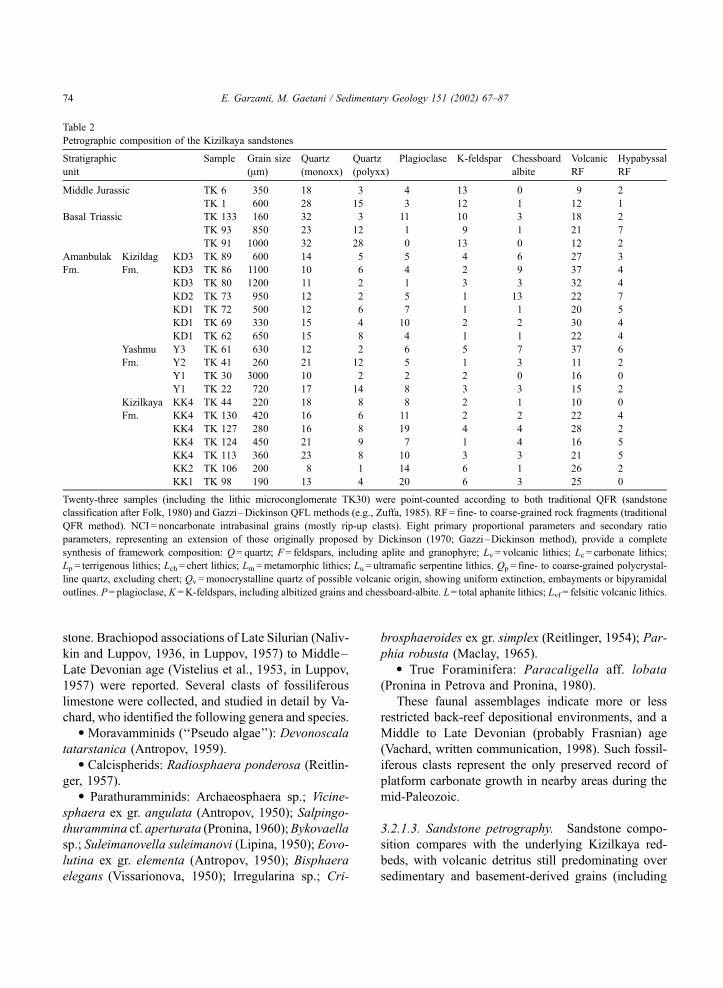
Table 2
Petrographic composition of the Kizilkaya sandstones
Stratigraphic
unit
Sample Grain size
(Am)
Quartz
(monoxx)
Quartz
(polyxx)
Plagioclase K-feldspar Chessboard
albite
Volcanic
RF
Hypabyssal
RF
Middle Jurassic TK 6 350 18 3 4 13 0 9 2
TK 1 600 28 15 3 12 1 12 1
Basal Triassic TK 133 160 32 3 11 10 3 18 2
TK 93 850 23 12 1 9 1 21 7
TK 91 1000 32 28 0 13 0 12 2
Amanbulak Kizildag KD3 TK 89 600 14 5 5 4 6 27 3
Fm. Fm. KD3 TK 86 1100 10 6 4 2 9 37 4
KD3 TK 80 1200 11 2 1 3 3 32 4
KD2 TK 73 950 12 2 5 1 13 22 7
KD1 TK 72 500 12 6 7 1 1 20 5
KD1 TK 69 330 15 4 10 2 2 30 4
KD1 TK 62 650 15 8 4 1 1 22 4
Yashmu Y3 TK 61 630 12 2 6 5 7 37 6
Fm. Y2 TK 41 260 21 12 5 1 3 11 2
Y1 TK 30 3000 10 2 2 2 0 16 0
Y1 TK 22 720 17 14 8 3 3 15 2
Kizilkaya KK4 TK 44 220 18 8 8 2 1 10 0
Fm. KK4 TK 130 420 16 6 11 2 2 22 4
KK4 TK 127 280 16 8 19 4 4 28 2
KK4 TK 124 450 21 9 7 1 4 16 5
KK4 TK 113 360 23 8 10 3 3 21 5
KK2 TK 106 200 8 1 14 6 1 26 2
KK1 TK 98 190 13 4 20 6 3 25 0
Twenty-three samples (including the lithic microconglomerate TK30) were point-counted according to both traditional QFR (sandstone
classification after Folk, 1980) and Gazzi–Dickinson QFL methods (e.g., Zuffa, 1985). RF = fine- to coarse-grained rock fragments (traditional
QFR method). NCI = noncarbonate intrabasinal grains (mostly rip-up clasts). Eight primary proportional parameters and secondary ratio
parameters, representing an extension of those originally proposed by Dickinson (1970; Gazzi–Dickinson method), provide a complete
synthesis of framework composition: Q = quartz; F= feldspars, including aplite and granophyre; Lv = volcanic lithics; Lc = carbonate lithics;
Lp = terrigenous lithics; Lch = chert lithics; Lm=metamorphic lithics; Lu = ultramafic serpentine lithics. Qp = fine- to coarse-grained polycrystal-
line quartz, excluding chert; Qv =monocrystalline quartz of possible volcanic origin, showing uniform extinction, embayments or bipyramidal
outlines. P= plagioclase, K=K-feldspars, including albitized grains and chessboard-albite. L= total aphanite lithics; Lvf = felsitic volcanic lithics.
E. Garzanti, M. Gaetani / Sedimentary Geology 151 (2002) 67–8774
granitoid rock fragments and microcline). Rutile
appears in the dense mineral fraction.
3.2.2. Unit Y2
3.2.2.1. Lithology. Mostly red sandstones and mud-
rocks (70–77 m). Mudcracks are common. Mainly
fine-grained, rippled or intensely burrowed sandstones
largely represent levee to overbank deposits interbed-
ded with floodplain mudrocks, whereas the few inter-
calated pebbly sandstones (maximum diameter 3 cm)
represent the distal toe of the alluvial fan.
3.2.2.2. Petrography. Composition is similar to
member Y1. Sandstones are further enriched in detri-
tal quartz and still contain carbonate lithic fragments.
Granophyre and chessboard-albite grains are com-
mon. Zircon and brown tourmaline are the predom-
inant transparent dense minerals.
3.2.3. Unit Y3
3.2.3.1. Lithology. Dominantly red mudrocks, al-
though a coarsening-upward sequence capped by red
coarse-grained sandstones is intercalated in the mid-
dle/upper part (about 270 m). This poorly exposed
pelitic interval mostly consists of floodplain deposits.
3.2.3.2. Petrography. The rare sandstones show an
abundance of volcanic detritus, from felsic (volcanic
quartz, pumiceous vitric to felsitic lithic grains) and
subordinately from intermediate to mafic products
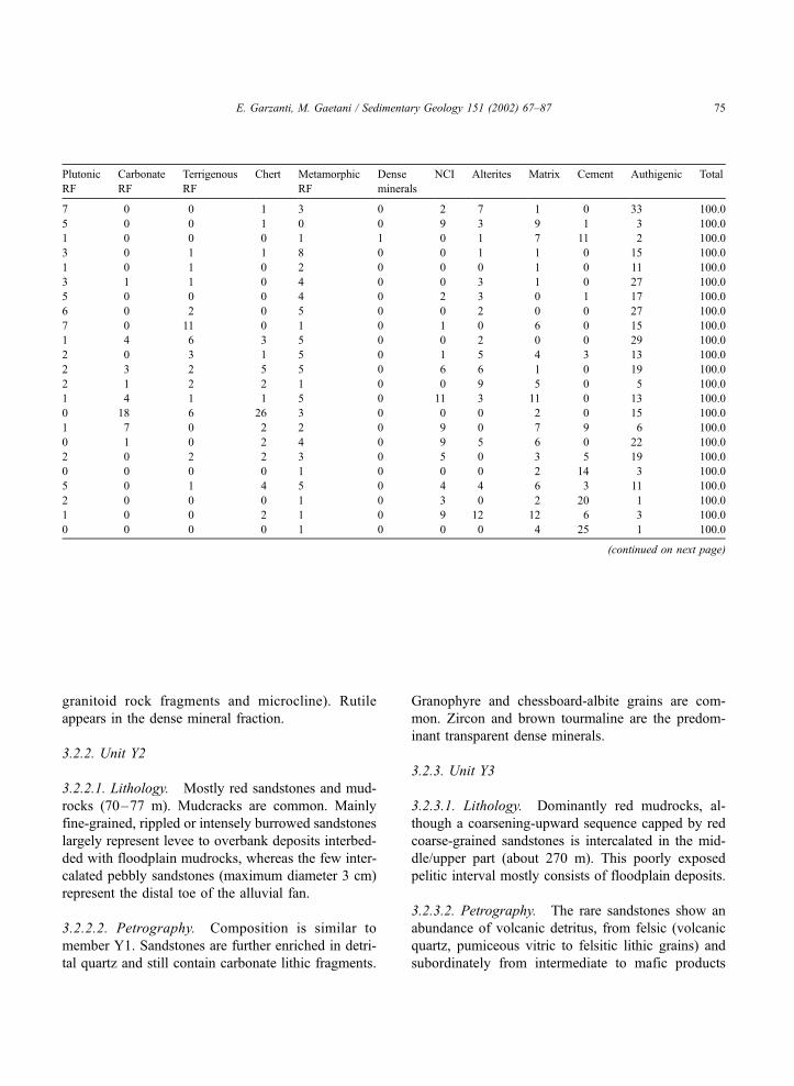
Plutonic
RF
Carbonate
RF
Terrigenous
RF
Chert Metamorphic
RF
Dense
minerals
NCI Alterites Matrix Cement Authigenic Total
7 0 0 1 3 0 2 7 1 0 33 100.0
5 0 0 1 0 0 9 3 9 1 3 100.0
1 0 0 0 1 1 0 1 7 11 2 100.0
3 0 1 1 8 0 0 1 1 0 15 100.0
1 0 1 0 2 0 0 0 1 0 11 100.0
3 1 1 0 4 0 0 3 1 0 27 100.0
5 0 0 0 4 0 2 3 0 1 17 100.0
6 0 2 0 5 0 0 2 0 0 27 100.0
7 0 11 0 1 0 1 0 6 0 15 100.0
1 4 6 3 5 0 0 2 0 0 29 100.0
2 0 3 1 5 0 1 5 4 3 13 100.0
2 3 2 5 5 0 6 6 1 0 19 100.0
2 1 2 2 1 0 0 9 5 0 5 100.0
1 4 1 1 5 0 11 3 11 0 13 100.0
0 18 6 26 3 0 0 0 2 0 15 100.0
1 7 0 2 2 0 9 0 7 9 6 100.0
0 1 0 2 4 0 9 5 6 0 22 100.0
2 0 2 2 3 0 5 0 3 5 19 100.0
0 0 0 0 1 0 0 0 2 14 3 100.0
5 0 1 4 5 0 4 4 6 3 11 100.0
2 0 0 0 1 0 3 0 2 20 1 100.0
1 0 0 2 1 0 9 12 12 6 3 100.0
0 0 0 0 1 0 0 0 4 25 1 100.0
(continued on next page)
E. Garzanti, M. Gaetani / Sedimentary Geology 151 (2002) 67–87 75
(microlitic to lathwork lithic grains). Hypabyssal and
chessboard-albite grains are also common.
3.3. Kizildag Formation
This formation (686 m), representing the upper part
of the Amanbulak Group, includes abundant pebbly
sandstones to cobble conglomerates, with locally
interlayered boulder megabeds and pyroclastics. The
term Kizildag Fm. was firstly introduced by Kalugyn
(1975). Three members are distinguished and 20
sandstone samples have been analyzed.
3.3.1. Unit KD1
3.3.1.1. Lithology. Pebbly to cobbly (maximum
diameter 13 cm) conglomerates, reddish sandstones
and light red mudrocks (166 m). Tabular cross
lamination and clast imbrication in braided-channel
sandstones and conglomerates with scoured base
point to northward to north-northeast-ward sediment
transport.
3.3.1.2. Petrography. The base of the unit marks a
sharp increase in grain size associated with a distinct
increase in low-grade metamorphic (slate, meta-rhyo-
lite) and sedimentary lithic grains (including green to
black or red chert, clasts of lithofeldspathic volcanic
arenite and subordinate carbonate grains). The P/F
ratio also increases. Volcanic detritus still includes
mainly felsic but also intermediate to mafic lithics.
Carbonate grains are commonly recrystallized or con-
sist of bioclastic packstone yielding Cayeuxia-like
blue-green algae, tiny tubes and rare uniserial fora-
minifers included in lumps; most grains are coated.
Authigenic kaolinite is locally found.
3.3.2. Unit KD2
3.3.2.1. Lithology. Pebbly to cobbly, light grey to
greenish sandstones and red to light grey mudrocks
(309 m). Cross-laminations in braided-channel to
delta-front sandstones point to north-northeast-ward
to northwest-ward sediment transport. Cobbles (com-
monly 12–20 cm in maximum diameter) are mostly
Table 2 (continued )
Stratigraphic
unit
Q F Lv Lc Lp Lch Lm Lu Total Qp/Q Qv/Q P/F K/F Lv/L Lvf /Lv
Middle Jurassic 39 42 17 0 0 1 2 0 100.0 12 17 22 78 88 89
55 24 19 0 0 1 0 0 100.0 35 7 18 76 94 96
Basal Triassic 45 32 23 0 0 0 1 0 100.0 9 6 47 43 97 97
47 23 27 0 1 1 2 0 100.0 35 13 10 83 92 95
71 15 13 0 1 0 0 0 100.0 47 7 0 100 96 96
Amanbulak Kizildag KD3 32 23 38 1 1 0 2 2 100.0 24 35 34 31 87 91
Fm. Fm. KD3 25 22 49 0 0 0 3 0 100.0 35 23 22 14 94 91
KD3 28 19 49 0 3 1 1 0 100.0 18 46 26 52 91 86
KD2 22 31 33 0 13 0 1 0 100.0 15 52 36 9 71 82
KD1 29 15 30 6 9 4 6 0 100.0 33 19 82 14 53 58
KD1 26 21 42 0 4 1 6 0 100.0 21 16 79 12 80 70
KD1 35 11 35 5 2 7 6 0 100.0 36 13 73 13 64 76
Yashmu Y3 18 24 52 1 2 2 0 0 100.0 14 54 35 30 91 74
Fm. Y2 52 16 18 7 0 2 5 0 100.0 36 22 55 20 60 89
Y1 15 4 19 21 8 31 2 0 100.0 14 14 n.d. n.d. 24 n.d.
Y1 45 20 23 9 0 2 1 0 100.0 45 10 61 21 64 88
Kizilkaya KK4 47 24 19 3 1 3 3 0 100.0 32 13 61 29 68 85
Fm. KK4 35 22 35 0 3 2 4 0 100.0 27 20 77 10 80 78
KK4 30 34 36 0 0 0 1 0 100.0 33 6 71 15 98 91
KK4 44 19 26 0 1 5 5 0 100.0 29 28 61 14 73 83
KK4 43 21 35 0 0 0 1 0 100.0 25 10 66 19 98 72
KK2 15 38 43 0 0 2 2 0 100.0 6 19 68 27 92 92
KK1 23 40 35 0 0 0 1 0 100.0 21 9 68 21 96 92
E. Garzanti, M. Gaetani / Sedimentary Geology 151 (2002) 67–8776
from white ignimbrite to red rhyolite, but also include
sandstone, red to green and black chert, quartzite and
green mafic lava.
3.3.2.2. Petrography. The unit marks a sharp in-
crease in rhyolitic detritus (quartz with uniform extinc-
tion, embayments or bipyramidal outlines, pumiceous
Fig. 4. Volcanic and sedimentary rocks of Tuarkyr. (A) The pillow lava outcrop of Tuar, half-covered by drifting dune sand (Tuar). (B) Thin
chert layers intercalated with mudrocks (Unit KK2). (C) Poorly sorted conglomerate with angular carbonate cobbles deposited by debris flows
in arid fan settings (Unit Y1). (D) Graded layers with angular carbonate pebbles and reworked caliche accumulated during sheet-flood events
(Unit Y1). (E) Decametric slumped megabed (Unit KD3). (F) Festoon cross-lamination in braidplain sandstones (?basal Triassic clastics).
Hammer (A, D, E, F), ruler (B) or coin (C) for scale.
E. Garzanti, M. Gaetani / Sedimentary Geology 151 (2002) 67–87 77
vitric and felsitic lithic grains). Carbonate and meta-
volcanic lithic grains are not found, and both chert and
low-grade metapelite decrease, whereas hypabyssal to
granitoid detritus increases (granophyre to granitoid
grains, perthite, microcline).
3.3.3. Unit KD3
3.3.3.1. Lithology. Light grey to red pebbly sand-
stones to cobble conglomerates interbedded with red
mudrocks (211 m). The base of the unit is marked by a
21.5-m thick cobble conglomerate megabed (with one
boulder over 2 m in maximum diameter; Fig. 4E), over-
lain by red to black pyroclastic rocks. This slumped
megabed suggests gravitational instability, probably
associated with renewed volcanic activity.
3.3.3.2. Petrography. Sedimentary detritus (mainly
sandstone, locally chert) decreases further, whereas
supply from granitoids increases further (sharp de-
crease of the P/F ratio). Volcanic quartz is still abun-
dant. Metamorphic detritus is persistent, including
higher-grade, deeper-seated rocks (phyllite to micas-
chist, paragneiss and orthogneiss).
3.4. ?Basal Triassic clastics and Dorikranites beds
The Mesozoic units overlying the Amanbulak
Group were never given a formational name. The in-
formal term ‘‘Dorikranites beds,’’ introduced herein,
designates the fossiliferous marker horizon found only
locally beneath the Eo-Cimmerian unconformity and
capping the ?basal Triassic clastics.
3.4.1. ?Basal Triassic clastics
The top of the Amanbulak Group is an unconform-
ity which corresponds to a major petrographic and
sedimentologic change and is probably associated with
a significant hiatus which, in absence of chronostrati-
graphic evidence, is generally assumed to roughly cor-
respond with the Permian/Triassic boundary (Luppov,
1957; Kalugyn, 1975). Four sandstone samples have
been analyzed.
3.4.1.1. Lithology. Grey cobble conglomerates with
sharp scoured base, passing upward to amalgamated
braidplain sandstones displaying spectacular large-
scale cross-lamination pointing to mainly west to
northwest, but also north to northeast, sediment trans-
port (Fig. 4F). Cobbles (up to 25 cm in maximum
diameter) consist of white to green and red ignimbrite
and lava, quartzose metamorphic clasts including
meta-conglomerate, and light grey to pink granite.
Grain size progressively decreases upward and, at the
top of the unit, white cross-laminated sandstones are
intercalated within prevailing light red mudrocks. This
unfossiliferous clastic sequence is about 500 m thick.
3.4.1.2. Petrography. Lithic arkoses to feldspathic
volcanic arenites. A sharp increase in detrital quartz
and a decrease in lithic fragments—which mostly
include relatively resistant felsic volcanic types—is
documented with respect to the Amanbulak Group. K-
feldspar becomes dominant among detrital feldspars.
Authigenic kaolinite is widespread.
3.4.2. Dorikranites beds
The Kizilkaya redbed succession is capped by an
over 12-m thick carbonate interval consisting of winn-
owed shelf packstones (‘‘coquinas’’) yielding echino-
derm plates, ammonoids (including Dorikranites sp.)
and pelecypods. The following pelecypod genera and
species were determined by Posenato and Loriga
Broglio (written communication, 1998): Eumorphotis
inaequicostata (Benecke) sensu (Chen, 1976); E. mul-
tiformis (Bittner); E. multiformis reticulata Chen; E.
multiformis rudaecosta (Kiparisova); Promyalina
putiatinensis (Kiparisova); Bakevellia exporrecta
(Lepsius). This transgressive marker layer of late Early
Triassic (Olenekian) age can be traced all around the
Caspian area (Kugusem, Mangyshlak, Bolshoe
Bogdo: von Buch, 1831; Shevyrev, 1968, 1990; Gae-
tani et al., 1998; Kukhtinov and Crasquin-Soleau,
1999).
3.5. Eo-Cimmerian unconformity and Jurassic clastics
The Upper Paleozoic to Lower Triassic succession
of Kizilkaya is truncated by a regional angular uncon-
formity. A very significant time gap, spanning from
the Middle Triassic to the Early Jurassic, is docu-
mented by a red lateritic hardground (0.7–3 m thick)
capping about 20-m thick white kaolinized saprock.
The unconformity is overlain by some hundred
meters of largely flat-lying (mildly tilted to the north-
east only in proximity of the main Kizilkaya fault)
E. Garzanti, M. Gaetani / Sedimentary Geology 151 (2002) 67–8778
clastic rocks assigned to the upper Lower Jurassic to
Middle Jurassic (Interdepartmental Stratigraphic Com-
mission, 1977).
3.5.1. Lithology
The base of the Jurassic clastics consists of locally
microconglomeratic white sandstones displaying spec-
tacular festoon cross-lamination pointing to north-
northeast-ward sediment transport. Locally interca-
lated are coal seams, carbonaceous grey silty marls,
and very fine-grained sandstones showing hummocky
cross-lamination. A braidplain to paralic depositional
setting is suggested.
3.5.2. Petrography
Coarse-grained lithic arkoses with felsitic volcanic
rock fragments, petrographically indistinguishable
from Triassic sandstones. Recycling of the latter and/
or reactivation of the same source rocks is indicated.
4. Geologic evolution of Tuarkyr
4.1. Sedimentary history
Sedimentology and petrography of the Amanbulak
Group document a complex paleogeographic evolution
during the Late Paleozoic. The transgressive basal part
of the unit (Units KK1 and KK2) consists of deltaic to
marine volcaniclastics derived from a largely undis-
sected, penecontemporaneous magmatic arc source
(Fig. 5; Dickinson, 1985). Detrital modes, dacite-type
character of volcanic detritus, and occurrence of meta-
morphic and hypabyssal to granitoid rock fragments
derived from the wallrocks of the arc suggest a con-
tinental arc setting (e.g., Marsaglia and Ingersoll,
1992). Penecontemporaneous explosive felsic activity
is documented by interbedded pyroclastic deposits
(Unit KK3), followed by continental redbeds contain-
ing a greater variety of grain types (Unit KK4). Oc-
currence of chert, carbonate and quartz-bearing
porphyroid (derived from a slightly metamorphosed
felsic paleovolcanic source) clasts suggests a mixed
collisional belt provenance, still dominated by detritus
from a partly dissected continental volcanic arc (Figs. 5
and 6). Occurrence of Cr-rich chrome spinel suggests
provenance from upper mantle slabs tectonically
emplaced in convergent to strike-slip settings within
the arc-trench system (e.g., Hisada and Arai, 1993).
Clastic petrography, thus, indicates a major paleogeo-
dynamic event, which took place prior to, or contem-
poraneous with, deposition of the Kizilkaya Formation,
around ?mid-Carboniferous times. Petrographic evo-
lution is gradual, suggesting high accumulation rates.
Grain size of sedimentary detritus increases at the
base of the Yashmu Formation, recording the climax
of tectonic activity. Geometry of the conglomerate
body (Unit Y1), rapidly wedging out southward, and
mainly westward paleocurrent directions suggest that
the source area was located to the northeast. Clast
composition points to progressive unroofing of a
sedimentary sequence including chert and mid-Paleo-
zoic platform carbonate (largely Middle to Late Dev-
onian back-reef limestone), along with felsic metavol-
canite, overlying a continental basement including
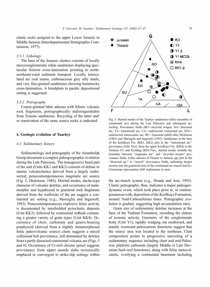
Fig. 5. Detrital modes of the Tuarkyr sandstones reflect assembly of
continental arcs during the Late Paleozoic and subsequent un-
roofing. Provenance fields (RO= recycled orogen; DA= dissected
arc; TA= transitional arc; CA= undissected continental arc; IOA=
undissected intraoceanic arc; BU= basement uplift) after Dickinson
(1985) and Marsaglia and Ingersoll (1992). Sandstones at the base
of the Kizilkaya Fm. (KK1, KK2) plot in the ‘‘transitional arc’’
provenance field. Next, from the upper Kizilkaya Fm. (KK4) to the
Yashmu (Y) and Kizildag (KD) Fms., detrital modes straddle the
boundary between ‘‘magmatic arc’’ and ‘‘recycled orogen’’ pro-
venance fields. Lithic arkoses of Triassic to Jurassic age plot in the
‘‘dissected arc’’ to ‘‘mixed’’ provenance fields, indicating deeper
erosion into the granitoid roots of the continental arc massif and Eo-
Cimmerian rejuvenation (full explanation in text).
E. Garzanti, M. Gaetani / Sedimentary Geology 151 (2002) 67–87 79

granophyre and microcline-bearing granite (Unit Y2).
After a relatively quiescent stage characterized by
deposition of floodplain mudrocks, prograding clastic
wedges were mostly derived from dacite/rhyodacite
volcanic products (Unit Y3). These source rocks were
possibly co-genetic with the felsic volcanic rocks
exposed in the Turkmenbasi area, which represent a
high-K calc-alkalic series emplaced through thick
continental crust (Lemaire et al., 1997). If this is so,
a Permian emplacement age for the Turkmenbasi lavas,
as suggested by Lemaire (1997, p. 103), would be
confirmed.
The base of the overlying Kizildag Formation (Unit
KD1) documents a change in sediment transport, now
mainly toward the north, and in clastic petrography,
with distinct increase in chert and low-grade meta-
morphic lithic fragments. In the middle–upper part
of the Kizildag Formation, detritus from quartz-bear-
ing ignimbrite sharply increases (Unit KD2). Feld-
spars and granitoid rock fragments also increase at the
expense of sedimentary detritus, testifying to rapid
unroofing during a final stage of rhyolitic volcanism
(Unit KD3).
The supposed base of the Triassic consists of
coarse-grained lithic arkoses indicating a dissected
arc provenance. Sediment was largely derived from
unroofed granitoid rocks, such as those drilled in the
Karakum Block (Gavriliansk, 1965; Volvovsky et al.,
1966) or exposed east of Turkmenbasi (Mirsakhanov,
1989), which may represent the roots of the Turk-
menbasi arc.
Evolution of detrital modes from the Upper Paleo-
zoic to the Jurassic is compatible with that predicted
for juvenile to accreted, unroofed, finally consolidated
and episodically rejuvenated crustal blocks (stages 1 to
4 of Cox and Lowe, 1995). Although the largely
volcaniclastic sandstone suites accumulated in the
Tuarkyr and Mangyshlak episutural basins are broadly
similar in composition (Fig. 6), their sources were
distinct. Continental arc sources in Tuarkyr were in
fact largely unroofed by the close of the Paleozoic and
shed detritus rich in quartz and feldspars during the
Early Triassic, while lithofeldspathic volcanic arenites
were being deposited in Mangyshlak. Recycling of the
Tuarkyr clastics as a source for the Mangyshlak sand-
stones can be ruled out, both because of lithic arkose
composition of Lower Triassic Tuarkyr sandstones and
because of lack of nonvolcanic lithic grains (including
resistant chert) in the Mangyshlak sandstones.
4.2. Climatic changes and latitudinal drift
Climatic indicators (e.g., facies, geometry and
color of continental clastics, occurrence of reworked
caliche, relative abundance of labile lithic fragments)
point to progressively increasing aridity during sed-
imentation of the Kizilkaya Formation, until the
Yashmu fanglomerates (Unit Y1) were deposited in
arid settings. A gradual but steady increase in seasonal
humidity during deposition of the Kizildag Formation
is testified by fluviatile sandstones, more common
light green to grey colors of interbedded floodplain
mudrocks and occurrence of conifer plant fossils.
Unconformable transition to quartz-rich, grey braid-
plain clastics points to subhumid conditions in the
Fig. 6. Detrital modes of Carboniferous to Triassic sandstones from
both Tuarkyr and Mangyshlak are quartz-rich with respect to typical
Circum-Pacific arc suites. They compare better with largely con-
tinental, broadly coeval terrigenous wedges derived from recycling
of volcaniclastic assemblages and accumulated in collisional basins
in Central Asia after the Altaid Orogeny (‘‘collisional successor
basin’’ provenance of Graham et al., 1993; Junggar/Tarim: Carroll et
al., 1995; Noyon Uul: Hendrix et al., 1996), reflecting both con-
vergence and lateral wrenching in back-arc to retroarc foreland
basin settings during continental accretion (Thomas et al., 1999b).
Ideal arkose composition after Dickinson (1985). Provenance fields
as in Fig. 5. Confidence regions (90%, 95%, 99%) around the mean,
calculated according to Weltje (1998), are indicated for the
Amanbulak and Mangyshlak sandstones.
E. Garzanti, M. Gaetani / Sedimentary Geology 151 (2002) 67–8780

earliest Triassic. These distinct climatic trends are the
result of interplaying factors, including paleolatitudi-
nal drift, paleoclimatic changes, and tectonic events
such as continental collision leading to closure of
oceanic seaways and formation of topographic relief.
All of these factors are not well constrained, and
interpretation of sedimentary data remains tentative.
The stage of pronounced aridity suggested by the
Yashmu fanglomerates (Unit Y1) is particularly sig-
nificant and puzzling, because it took place during the
Late Carboniferous–Early Permian interval, when
Tuarkyr should have lain at low latitudes and not far
from the northwestern shores of subequatorial Paleo-
Tethys. One possible explanation is that the ?mid-
Carboniferous tectonic event caused not only closure
of an adjacent seaway but also formation of signifi-
cant relief and of an effective rain shadow. Progres-
sive increase in humidity in Permian to earliest Tri-
assic time might have resulted from a gradual
peneplation of collided blocks, possibly associated
with a shift of climatic belts at the end of the Gond-
wanan glaciation. Given our limited knowledge of
both paleoposition of Tuarkyr and atmospheric circu-
lation toward the close of the Paleozoic (Crowley,
1994; Francis, 1994), this paleoclimatic problem re-
mains unconstrained.
Recent paleomagnetic studies on the middle–upper
Amanbulak Group (site KC in Lemaire, 1997, roughly
corresponding to our Units Y3 to KD2) suggest
deposition during the mid-Permian, shortly before
the Illawarra magnetic reversal. Unfortunately paleo-
latitudes ranging from 9F 3jN to 12jF 2jN and
even 19jF 7jN have been inferred from the same
site (Lemaire, 1997; Lemaire et al., 1998a,b), leaving
the paleoposition of Tuarkyr poorly constrained. At
that time the Karabogaz and Karakum Blocks are ge-
nerally held to have lain not far from the composite
active northern margin of Paleo-Tethys (Dercourt et
al., 1993; Golonka et al., 1994; Gaetani et al., 2000a,b),
while the Cimmerian blocks (which had detached since
the Early Permian from glaciated Gondwana) were
rapidly drifting northward toward the equator (Gaetani
et al., 1995; Besse et al., 1998).
In the Early Triassic, occurrence of the endemic
genus Dorikranites all around the Caspian area sug-
gests that Tuarkyr lay then not too far from Man-
gyshlak and the northern Caspian region. According
to paleomagnetic data collected by Feinberg et al.
(1996), the paleolatitude of Mangyshlak at that time
was 17F 4jN, but these results also have been
questioned recently (e.g., Besse et al., 1998, p. 86).
Toward the end of the Triassic, Paleo-Tethys finally
closed, and during the Eo-Cimmerian orogeny the
Turan and Peri-Gondwanan blocks all became defin-
itively incorporated into Eurasia (Sengor et al., 1988;
Gaetani et al., 1998).
The thick laterite-type pedogenic profile capping
the pre-Eo-Cimmerian succession documents pro-
longed subaerial exposure in warm humid climates
in Late Triassic to Early Jurassic times. Occurrence of
coal, although less abundant than in Mangyshlak
(Gaetani et al., 1998) or Elburz (Northern Iran;
Assereto, 1966), points to humid subtropical to tem-
perate settings. Increasing humidity may be ascribed
to continuing migration toward northern temperate
latitudes, as indicated by the Laurussia apparent polar
wander path (Van der Voo, 1993). However, scant and
unreliable paleomagnetic data (paleolatitudes ranging
from 26jN to 48jN; Nazarov, 1971) leave even the
Jurassic paleoposition uncertain.
4.3. The oceanic basement of the episutural basin
The sequence of oceanic rocks found from Kizil-
kaya to Tuar along a major fault alignment which pre-
dates the Eo-Cimmerian unconformity, although
strongly tectonized and displaying greenschist–facies
metamorphism, represents a complete section of oce-
anic crust, including cumulates to plutonic, hypabys-
sal, effusive and sedimentary layers. Ultramafic rocks
were not observed in outcrop, but dunites were cored
in nearby localities (Gorelovski, personal communica-
tion, 1997). These ophiolites compare geochemically
with rocks derived from low-TiO2 basaltic magmas
produced in supra-subduction arc settings (e.g., juve-
nile intraoceanic back-arc basins; Serri, 1981), rather
than with mid-ocean ridge tholeiitic suites. Geochem-
ical data and spatial relationships suggest that they
may have represented the deformed oceanic substra-
tum of the Kizilkaya episutural basin.
4.4. Low-grade metamorphism of oceanic rocks
The oceanic rocks of Kizilkaya display greens-
chist–facies metamorphic parageneses. The Amanbu-
lak Group, in contrast, locally contains post-depo-
E. Garzanti, M. Gaetani / Sedimentary Geology 151 (2002) 67–87 81
sitional Fe-rich epidote, indicative of hydrothermal
fluid circulation. Kaolinite is extensively preserved,
increasing in frequency in the upper part of the section
and becoming abundant in Lower Triassic sandstones.
Moreover, well-preserved vegetal matter in the Ki-
zildag Formation displays low thermal maturity (Ci-
rilli, personal communication, 1998). The Amanbulak
Group was not subject to a significant overprint du-
ring the Eo-Cimmerian orogenic event: diagenetic
temperatures, even in the basal part, did not exceed
200 jC.Within ?mid-Paleozoic oceanic rocks, only late
stage growth of very-low grade metamorphic minerals
such as sericite, epidote and pumpellyite may be
ascribed to the Eo-Cimmerian Orogeny. Greens-
chist–facies conditions must have been attained prior
to deposition of the Amanbulak Group, possibly
during the Late Paleozoic (?mid-Carboniferous) oro-
genic episode which caused deformation and mild
metamorphism of the associated dark cherty slates
found in fault contact with the Amanbulak redbeds at
Kizilkaya. Lower greenschist–facies metamorphism
in ?Permian arc-volcanic rocks of the Turkmenbasi
area should instead be ascribed to the Eo-Cimmerian
event, as suggested by K/Ar and Ar/Ar ages between
187 and 229 Ma (Lemaire, 1997, p. 96).
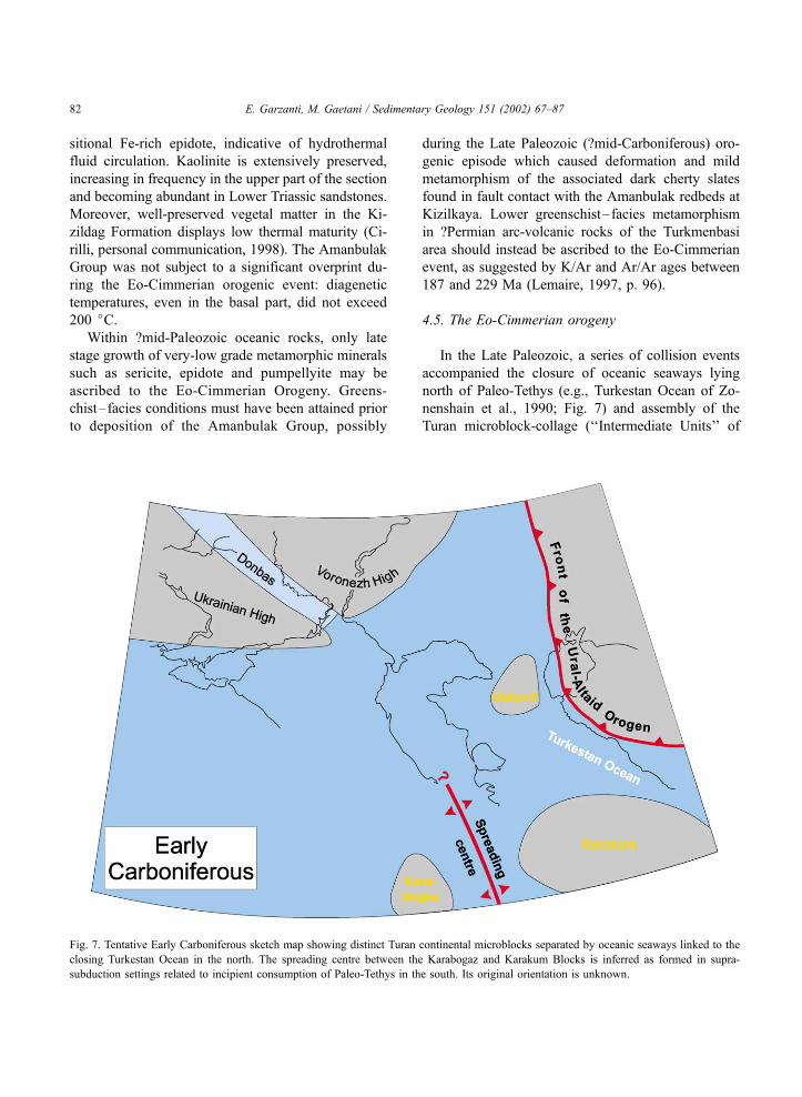
4.5. The Eo-Cimmerian orogeny
In the Late Paleozoic, a series of collision events
accompanied the closure of oceanic seaways lying
north of Paleo-Tethys (e.g., Turkestan Ocean of Zo-
nenshain et al., 1990; Fig. 7) and assembly of the
Turan microblock-collage (‘‘Intermediate Units’’ of
Fig. 7. Tentative Early Carboniferous sketch map showing distinct Turan continental microblocks separated by oceanic seaways linked to the
closing Turkestan Ocean in the north. The spreading centre between the Karabogaz and Karakum Blocks is inferred as formed in supra-
subduction settings related to incipient consumption of Paleo-Tethys in the south. Its original orientation is unknown.
E. Garzanti, M. Gaetani / Sedimentary Geology 151 (2002) 67–8782
Sengor and Natal’in, 1996). Calc-alkalic to shosho-
nitic volcanism related to the Altaid Orogeny in
Ghissar and south Tien Shan ended in the Middle
Permian (Masumov et al., 1978), and shortly after-
ward rhyolitic activity in Tuarkyr also came to an end.
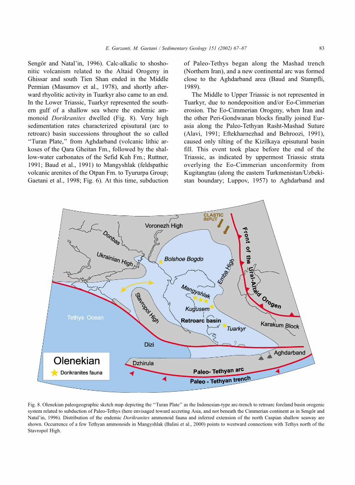
In the Lower Triassic, Tuarkyr represented the south-
ern gulf of a shallow sea where the endemic am-
monoid Dorikranites dwelled (Fig. 8). Very high
sedimentation rates characterized episutural (arc to
retroarc) basin successions throughout the so called
‘‘Turan Plate,’’ from Aghdarband (volcanic lithic ar-
koses of the Qara Gheitan Fm., followed by the shal-
low-water carbonates of the Sefid Kuh Fm.; Ruttner,
1991; Baud et al., 1991) to Mangyshlak (feldspathic
volcanic arenites of the Otpan Fm. to Tyururpa Group;
Gaetani et al., 1998; Fig. 6). At this time, subduction
of Paleo-Tethys began along the Mashad trench
(Northern Iran), and a new continental arc was formed
close to the Aghdarband area (Baud and Stampfli,
1989).
The Middle to Upper Triassic is not represented in
Tuarkyr, due to nondeposition and/or Eo-Cimmerian
erosion. The Eo-Cimmerian Orogeny, when Iran and
the other Peri-Gondwanan blocks finally joined Eur-
asia along the Paleo-Tethyan Rasht-Mashad Suture
(Alavi, 1991; Eftekharnezhad and Behroozi, 1991),
caused only tilting of the Kizilkaya episutural basin
fill. This event took place before the end of the
Triassic, as indicated by uppermost Triassic strata
overlying the Eo-Cimmerian unconformity from
Kugitangtau (along the eastern Turkmenistan/Uzbeki-
stan boundary; Luppov, 1957) to Aghdarband and
Fig. 8. Olenekian paleogeographic sketch map depicting the ‘‘Turan Plate’’ as the Indonesian-type arc-trench to retroarc foreland basin orogenic
system related to subduction of Paleo-Tethys (here envisaged toward accreting Asia, and not beneath the Cimmerian continent as in Sengor and
Natal’in, 1996). Distribution of the endemic Dorikranites ammonoid fauna and inferred extension of the north Caspian shallow seaway are
shown. Occurrence of a few Tethyan ammonoids in Mangyshlak (Balini et al., 2000) points to westward connections with Tethys north of the
Stavropol High.
E. Garzanti, M. Gaetani / Sedimentary Geology 151 (2002) 67–87 83
Elburz (Northern Iran; Ruttner, 1991; Saidi et al.,
1997).
New stratigraphic data from Tuarkyr confirm that
the so called ‘‘Turan Plate,’’ between the Mashad
Paleo-Tethys Suture in the south and the Eo-Cimmer-
ian Mangyshlak belt in the north, consists of an
originally complex, Indonesian-type mosaic of dis-
tinct continental microblocks and intervening oceanic
sutures. Magmatic arcs and continental fragments of
various size were assembled at successive stages main-
ly during the Late Paleozoic, but were still character-
ized by considerable subsidence at the beginning of
the Mesozoic, until they were finally welded to the
Eurasian landmass during the Late Triassic Eo-Cim-
merian Orogeny.
5. Conclusions
The mid-Paleozoic history of the Karabogaz and
Karakum Blocks is largely unknown. The original
sedimentary successions have long been eroded, and
preserved only as clasts within the Amanbulak terri-
genous wedge. Plutonic to hypabyssal granitoid bodies
found both in the Karakum Block and in the Turk-
menbasi area are generally ascribed to the mid-Paleo-
zoic (Mirsakhanov, 1989; Berkeliev, personal com-
munication, 1997), but geochemical data are lacking
and radiometric ages are old and few (e.g., Late De-
vonian age quoted by Gavriliansk, 1965). Even the
Upper Paleozoic to Lower Triassic stratigraphic record
is preserved only in the Kizilkaya domal structure, and
due to lack of outcrops and limited availability of bore-
hole and seismic data, paleogeographic reconstructions
are inevitably very tentative. Moreover, the original
configuration has been subsequently modified by oro-
genic episodes during the Mesozoic and by intense
strike-slip tectonics during Neogene to recent times
(e.g., Lyberis and Manby, 1999; Thomas et al.,
1999a,b), and we have no information concerning
rotations of crustal blocks.
New sedimentological and petrographic data pre-
sented here allow us to envisage the following major
steps in the geologic evolution of Tuarkyr.
During the Late Silurian to Late Devonian (pre-
Fammenian), platform carbonates, including carbo-
nate banks with abundant Amphipora hydrozoans
and back-reefs with algal-foraminiferal assemblages,
accumulated in a nearby area, on tropical shelves
facing an oceanic seaway lying north of Paleo-Tethys
(Turkestan Ocean).
Convergence and west- to northwest-wards sub-
duction began at the northwestern margin of the
Turkestan Ocean (Zonenshain et al., 1990, pp. 70
and 217), possibly as a response to accelerated spread-
ing of Paleo-Tethys in the south (e.g., Golonka et al.,
1994).
A possibly subduction-related extensional tectonic
regime (e.g., Doglioni, 1994) characterized the over-
riding plate. Rifting in intra-arc or back-arc settings
took place in Tuarkyr around Late Devonian to ear-
liest Carboniferous times (Gorelovski, personal com-
munication, 1997).
During the Early Carboniferous, the Kizilkaya
episutural basin deepened and its bottom was covered
by veneers of cherty sediments, partly interlayered
with pillow basalts.
Around mid-Carboniferous times, closure of Tur-
kestan seaways took place (Solov’eva, 1963; Zonen-
shain et al., 1990; Kurenkov and Aristov, 1995). The
Karabogaz and Karakum continental blocks began to
collide and portions of oceanic crust were subducted
and metamorphosed along the suture zone (marked on
VSEGEI, 1994). Previously emplaced felsic volcanic
rocks also locally underwent low-grade metamorphic
overprint.
Continuing subduction caused explosive dacite-
type volcanism in the Kizilkaya episutural basin,
which was rapidly filled by volcaniclastic redbeds
(Kizilkaya Formation). Chunks of oceanic lithosphere
were exhumed toward the surface during collision
with the Karakum Block.
Collision reached its climax with the closure of
oceanic seaways, probably associated with formation
of significant relief, and caused a marked increase in
aridity roughly around the Carboniferous/Permian
boundary. Detritus was supplied from cannibalized
sedimentary, volcanic and hypabyssal sources (lime-
stone, chert, volcanic arenite, meta-rhyolite and gran-
ophyre clasts) located nearby in the north to northeast
(Yashmu Formation).
After a relatively quiescent stage marked by de-
creasing grain size of terrigenous detritus (Yashmu
Formation, Unit Y3), a new tectonic and volcanic
event is recorded in the overlying conglomeratic
succession (Kizildag Formation, Unit KD1). Detritus
E. Garzanti, M. Gaetani / Sedimentary Geology 151 (2002) 67–8784
was now derived from sources mainly located in the
south and including volcanic to volcaniclastic, sedi-
mentary and metamorphic rocks (volcanic arenite,
green lava, chert, carbonate and phyllite clasts).
While the source terranes were progressively
eroded to their granitoid backbone, as documented
by sandstones with partly dissected continental-arc
provenance, final explosive episodes of rhyolitic vol-
canism took place (Kizildag Formation, Units KD2
and KD3). Tuffs and liparitic ignimbrites in fact occur
in the Kizilkaya section and were cored both to the
west in the Karabogaz Block (Gorelovski, personal
communication, 1997) and to the east in the central
part of the Karakum Block (Gavriliansk, 1965; Vol-
vovsky et al., 1966). Occurrence of fossil conifers
suggests more humid climates.
A major unconformity at the base of braidplain
lithic arkoses suggests continuing tectonic activity and
erosion of the plutonic roots of the arc massif roughly
around the Permian/Triassic boundary. A further in-
crease in humidity is also indicated.
Rapid subsidence continued into the Early Triassic,
in a complex retroarc foreland-basin setting.
In the upper Olenekian, transgressive marine strata
yielding the endemic ammonoid Dorikranites are
found at Kizilkaya and all around the north Caspian
region, indicating that Tuarkyr lay not too far from the
southern margin of newly formed Eurasia.
Final consolidation of the Turan microblock-col-
lage took place with the Eo-Cimmerian Orogeny,
when the Peri-Gondwanan blocks collided with Eur-
asia. This event only caused mild deformation in
Tuarkyr.
After a prolonged period of erosion and weath-
ering, documented by deeply altered lateritic soil
profiles, sedimentation of lithic arkoses, largely de-
rived from erosion of the remnants of Eo-Cimmerian
anticlines, resumed in the Middle Jurassic.
Evolution of detrital modes from the Upper Pale-
ozoic to the Jurassic is that predicted for juvenile to
accreted, unroofed, finally consolidated and episodi-
cally rejuvenated crustal blocks in arc, retroarc, and
finally intraplate settings. Clastic petrography, thus,
mirrors faithfully the complex, multistep processes
through which continental crust of the several ‘‘Turan
Plate’’ microblocks was generated during the Late
Paleozoic, and finally welded to Eurasia at the close
of the Triassic.
Acknowledgements
This study has been carried out within the Peri-
Tethys Programme. Many hearty thanks to F. Cecca,
V. Kalugyn and driver Tola Polivianij for their friend-
ly assistance in the field. Early Triassic pelecypods
were determined by R. Posenato and C. Loriga
Broglio (Ferrara). Paleozoic algal and foraminiferal
assemblages were determined by D. Vachard (Ville-
neuve d’Ascq). Very useful discussions and exchange
of information in Ashkabad with G. Gorelovski and
T. Berkeleev, and in Europe with M.F. Brunet, M.M.
Lemaire, A. Nikishin, L.E. Ricou, H. van Konijnen-
burg and R.A. Wood are gratefully acknowledged. S.
Poli and G. Weltje provided fundamental help with
chemical analysis of mafic igneous rocks and with
calculation of confidence regions in triangular space.
F. Cordey and S. Cirilli processed samples from chert
(oceanic rocks at Kizilkaya and Tuar; lower Kizil-
kaya Formation) and mudrock layers (Kizildag
Formation) in the vain search for stratigraphically
meaningful radiolaria and pollen. G. Muttoni and L.
Trombino gave advice on paleomagnetic and pedo-
genetic aspects. Drawings by Magda Minoli. The
manuscript has greatly benefited from stimulating
criticism by J.C. Thomas and by careful reviews by
S. Critelli and G. Manby. Financial support from
Peri-Tethys Programme (Paris) and Italian CNR to
M. Gaetani.
References
Alavi, M., 1991. Sedimentary and structural characteristics of the
Paleo-Tethys remnants in northeastern Iran. Geol. Soc. Am.
Bull. 103, 983–992.
Assereto, R., 1966. The Jurassic Shemshak Formation in Central
Elburz (Iran). Riv. Ital. Paleontol. Strat. 72, 1133–1182.
Balini, M., Gavrilova, V.A., Nicora, A., 2000. Biostratigraphical
revision of the classic Lower Triassic Dolnapa section (Man-
gyshlak, West Kazakhstan). Zentralbl. Geol. Palaeontol., Teil I
1998 (11–12), 1441–1462.
Baud, A., Stampfli, G., 1989. Tectonogenesis and evolution of a
segment of the Cimmerides: the volcano-sedimentary Triassic
of Aghdarband (Kopet-Dagh, north-east Iran). In: Sengor,
A.M.C. (Ed.), Tectonic Evolution of the Tethyan Region. Kluwer,
Deventer, pp. 265–275.
Baud, A., Stampfli, G., Steen, D., 1991. The Triassic Aghdarband
Group: volcanism and geological evolution. In: Ruttner, A.W.
(Ed.), The Triassic of Aghdarband (AqDarband), NE-Iran, and
Its Pre-Triassic Frame, Abh. Geol. Bundesanst., vol. 38, pp.
125–137.
E. Garzanti, M. Gaetani / Sedimentary Geology 151 (2002) 67–87 85
Besse, J., Torcq, F., Gallet, Y., Ricou, L.E., Krystyn, L., Saidi, A.,
1998. Late Permian to Late Triassic paleomagnetic data from
Iran: constraints on the migration of the Iranian block through
the Tethys Ocean and initial destruction of Pangea. Geophys. J.
Int. 135, 77–92.
Carroll, A.R., Graham, S.A., Hendrix, M.S., Ying, D., Zhou, D.,
1995. Late Paleozoic tectonic amalgamation of northwestern
China: sedimentary record of the northern Tarim, northwestern
Turpan, and southern Junggar Basins. Geol. Soc. Am. Bull. 107,
571–594.
Cox, R., Lowe, D.R., 1995. A conceptual review of regional-scale
controls on the composition of clastic sediment and the co-evo-
lution of continental blocks and their sedimentary cover. J. Sedi-
ment. Res., A 65, 1–12.
Crowley, T.J., 1994. Pangean climates. In: Klein, G.D. (Ed.), Pan-
gea, Paleoclimate, Tectonics, and Sedimentation During Accre-
tion, Zenith, and Breakup of a Supercontinent. Geol. Soc. Am.,
Spec. Pap., vol. 288, pp. 25–39.
Dercourt, J., Ricou, L.E., Vrielinck, B., 1993. Atlas Tethys Palae-
oenvironmental Maps. Gauthier-Villars, Paris, pp. 1–315.
Dercourt, J., Gaetani, M., Vrielynck, B., Barrier, E., Biju-Duval, B.,
Brunet, M.F., Cadet, J.P., Crasquin, S., Sandulescu, M., 2000.
Atlas Peri-Tethys Palaeogeogeographic Maps, 24 Maps and Ex-
planatory Notes. CCGM/CGMW, Paris, pp. 1–269.
Dickinson, W.R., 1970. Interpreting detrital modes of graywacke
and arkose. J. Sediment. Petrol. 40, 695–707.
Dickinson, W.R., 1985. Interpreting provenance relations from de-
trital modes of sandstones. In: Zuffa, G.G. (Ed.), Provenance of
Arenites. Reidel, Dordrecht, pp. 333–361.
Doglioni, C., 1994. Foredeeps versus subduction zones. Geology
22, 271–274.
Eftekharnezhad, J., Behroozi, A., 1991. Geodynamic significance
of recent discoveries of ophiolites and Late Paleozoic rocks
in NE-Iran (including Kopet Dagh). In: Ruttner, A.W. (Ed.),
The Triassic of Aghdarband (AqDarband), NE-Iran, and Its Pre-
Triassic Frame. Abh. Geol. Bundesanst., vol. 38, pp. 89–100.
Feinberg, H., Gurevitch, E.L., Westphal, M., Pozzi, J.P., Khramov,
A.N., 1996. Palaeomagnetism of a Permian/Triassic sequence in
Mangyshlak (Kazakhstan, CIS). C. R. Acad. Sci. 322, 617–623.
Folk, R.L., 1980. Petrology of Sedimentary Rocks. Hemphill, Aus-
tin, pp. 1–182.
Francis, J.E., 1994. Palaeoclimates of Pangea-Geological evidence.
In: Embry, A.F., Beauchamp, B., Glass, D.J. (Eds.), Pangea:
Global Environments and Resources. Can. Soc. Pet. Geol.,
Mem., vol. 17, pp. 265–274.
Gaetani, M., Angiolini, L., Garzanti, E., Jadoul, F., Leven, Y.E.,
Nicora, A., Sciunnach, D., 1995. Permian stratigraphy in the
Northern Karakorum, Pakistan. Riv. Ital. Paleontol. Strat. 101,
107–152.
Gaetani, M., Balini, M., Vuchs, V.J., Gavrilova, V.A., Garzanti, E.,
Nicora, A., Erba, E., Cariou, E., Cecca, F., Premoli Silva, I.,
Petrizzo, M.R., Cirilli, S., Bucefalo Palliani, R., 1998. The Mes-
ozoic of the Mangyshlak (West Kazakhstan). In: Crasquin-Sol-
eau, S., Barrier, E. (Eds.), Epicratonic Basins of Peri-Tethyan
Platforms, Peri-Tethys Memoir 4, Mem. Mus. Natl. Hist. Nat.,
vol. 179, pp. 35–74.
Gaetani, M., Arche, A., Kiersnowski, H., Chuvachov, B., Crasquin,
S., Sandulescu, M., Seghedi, A., Zagorchev, I., Poisson, A.,
Hirsch, F., Vaslet, D., Le Metour, J., Ziegler, M., Abbate, E.,
Ait-Brahim, L., Barrier, E., Bouaziz, S., Bergerat, F., Brunet,
M.F., Cadet, J.P., Stephenson, R., Guezou, J.C., Jabaloy, A.,
Lepvrier, C., Rimmele, G., 2000a. Wordian paleogeographic
map. In: Dercourt, J., Gaetani, M., et al., (Eds.), Peri-Tethys
Atlas and Explanatory Notes, Map 3. CCGM/CGMW, Paris,
pp. 19–25.
Gaetani, M., Arche, A., Warrington, G., Geluk, M., Lepper, J.,
Courel, L., Szulc, J., Lozowsky, V., Sandulescu, M., Seghedi,
A., Zagorchev, I., Nikishin, A., Nazarevich, V., Bolotov, S.,
Kukhtinov, D.A., Zhidovinovj, S., 2000b. Olenekian paleogeo-
graphic map. In: Dercourt, J., Gaetani, M., et al., (Eds.), Peri-
Tethys Atlas and Explanatory Notes, Map 4. CCGM/CGMW,
Paris, pp. 27–32.
Garetsky, R.G., Shlezinger, A.E., Yanshin, A.L., 1982. Turan plat-
form (in Russian) . In: Peive, A.V., Khain, V.E., Muratov, M.V.,
Delany, F. (Eds.), Tectonics of Europe and Adjacent Areas.
Variscides, Epi-Paleozoic Platforms, Alpides, Nauka, Moscow,
pp. 254–265.
Gavriliansk, G.A., 1965. Geology and Stratigraphy of Central Kar-
akum. Trudy G.P.G.K. Turkmens SSR, Ashkabad, vol. 3, pp.
1–141 (in Russian).
Golonka, J., Ross, M.I., Scotese, C.R., 1994. Phanerozoic paleogeo-
graphic and paleoclimatic modeling maps. In: Embry, A.F.,
Beauchamp, B., Glass, D.J. (Eds.), Pangea: Global Environ-
ments and Resources. Can. Soc. Pet. Geol., Mem., vol. 17,
pp. 1–47.
Graham, S.A., Hendrix, M.S., Wang, L.B., Carroll, A.R., 1993.
Collisional successor basins of western China: impact of tecton-
ic inheritance on sand composition. Geol. Soc. Am. Bull. 105,
323–344.
Hendrix, M.S., Graham, S.A., Amory, J.Y., Badarch, G., 1996.
Noyon Uul syncline, southern Mongolia: lower Mesozoic sedi-
mentary record of the tectonic amalgamation of central Asia.
Geol. Soc. Am. Bull. 108, 1256–1274.
Hisada, K., Arai, S., 1993. Detrital chrome spinels in the Cretaceous
Sanchu sandstone, central Japan: indicator of serpentinite pro-
trusion into a fore-arc region. Palaeogeogr., Palaeoclimatol., Pa-
laeoecol. 105, 95–109.
Interdepartmental Stratigraphic Commission, 1977. Interdepartmen-
tal definition of Mesozoic stratigraphy in Central Asia. Samar-
kand Conference (1971). VSEGEI, Leningrad, pp. 1–47 (in
Russian).
Kalugyn, V.M., 1975. Permian and Triassic of Tuarkyr (Internal
Report in Russian). Turkmengeologya, Ashkabad.
Khain, V.E., Sokolov, K.A., Kleshev, K.A., Shein, V.S., 1991. Tec-
tonic and geodynamic setting of the oil and gas basin of the
Soviet Union. Am. Assoc. Pet. Geol. Bull. 75, 313–325.
Kukhtinov, D.A., Crasquin-Soleau, S., 1999. Upper Permian and
Triassic of the Precaspian depression: stratigraphy and palae-
ogeography. In: Crasquin-Soleau, S., De Wever, P. (Eds.),
Peri-Tethys: Stratigraphic Correlations 3. Geodiversitas, vol.
21, pp. 325–346.
Kurenkov, S.A., Aristov, V.A., 1995. On the time of formation of
the Turkestan paleo-ocean crust. Geotectonics 29, 469–477.
Lemaire, M.M., 1997. Les relations du Bloc d’ Ustyurt avec l’ Iran et
E. Garzanti, M. Gaetani / Sedimentary Geology 151 (2002) 67–8786
l’ Eurasie d’ apres les donnees paleomagnetiques de formations
Permiennes a Jurassiques de la Plaque de Touran et de la Plaque
Scythe. PhD thesis, Univ. L. Pasteur, Strasbourg, pp. 1–211.
Lemaire, M.M., Westphal, M., Gurevitch, E.L., Nazarov, K., Fein-
berg, H., Pozzi, J.P., 1997. How far between Iran and Eurasia
was the Turan plate during Triassic–Jurassic times? Geol. Mijn-
bouw 76, 73–82.
Lemaire, M.M., Gurevitch, E.L., Nazarov, K., Westphal, M., Fein-
berg, H., Pozzi, J.P., 1998a. Paleomagnetism of Permian to
Jurassic formations from the Turan Plate. In: Crasquin-Soleau,
S., Barrier, E. (Eds.), Epicratonic Basins of Peri-Tethyan Plat-
forms, Peri-Tethys Memoir 3, Mem. Mus. Natl. Hist. Nat., vol.
177, pp. 71–87.
Lemaire, M.M., Westphal, M., Montigny, R., Gurevitch, E.L., Fein-
berg, H., Pozzi, J.P., Nazarov, K., 1998b. Paleomagnetisme et
evolution du bloc Scythe-Touran du Permien inferieur au Trias
superieur. C. R. Acad. Sci. 327, 441–448.
Likharev, B.K. (Ed.), 1966. Stratigraphy of the SSSR, Permian
System. Nedra, Moscow, pp. 325–327 (in Russian).
Lyberis, N., Manby, G., 1999. Oblique to orthogonal convergence
across the Turan block in the post-Miocene. Am. Assoc. Pet.
Geol. Bull. 83, 1135–1160.
Luppov, N.P., 1957. Soviet Socialist Republic of Turkmenistan.
Geological Description. Geology of the Soviet Union, vol. 22,
pp. 68–81, part 1, chap. 4 (in Russian).
Maksimov, S.P., 1992. Geological structure and economic minerals
of the USSR. Kazakhstan and Middle Asia, Vol. 6., Book 3,
Platform cover of the epi-Paleozoic plates and depressions of
Middle Asia and Kazakhstan (Turanian Plate and adjacent
areas). Nedra, Moscow, pp. 1–148 (in Russian).
Marsaglia, K.M., Ingersoll, R.V., 1992. Compositional trends in arc-
related, deep-marine sand and sandstone: a reassessment of
magmatic-arc provenance. Geol. Soc. Am. Bull. 104, 1637–
1649.
Masumov, A.S., Borisov, O.M., Bensh, F.R., 1978. The Upper Pa-
leozoic of Central and Southern Tien Shan. F.A.N, Uzbek SSR,
Tashkent, pp. 18–68 (in Russian).
Mirsakhanov, M.W. (Ed.), 1989. Geologic map of Turkmenistan,
scale 1:500,000. Turkmengeologyia, Ashkabad (in Russian).
Mullen, E.D., 1983. MnO//TiO2/P2O5: a minor element discrimi-
nant for basaltic rocks of oceanic environments and its implica-
tions for petrogenesis. Earth Planet. Sci. Lett. 62, 53–62.
Nazarov, K., 1971. Palaeomagnetic directions and pole positions:
Data for the USSR-Issue 1. Soviet Geophysical Committee:
World Data-Center-B (Moscow). Catalogue.
Nikishin, A.M., Ziegler, P.A., Stephenson, R.A., Cloetingh, S.A.P.L.,
Furne, A.V., Fokin, P.A., Ershov, A.V., Bolotov, S.N., Korotaev,
M.V., Alekseev, A.S., Gorbachev, V.I., Shipilov, E.V., Lankreijer,
A., Bembinova, E.Y., Shalimov, I.V., 1996. Late Precambrian to
Triassic history of the East European Craton: dynamics of sedi-
mentary basin evolution. Tectonophysics 268, 23–63.
Popkov, V.I., 1986. Tectonics of the pre-Jurassic sedimentary com-
plex in the western Turanian Plate. Geotectonics 20, 328–335.
Ruttner, A.W., 1991. Geology of the Aghdarband area (Kopet Dagh,
NE-Iran). In: Ruttner, A.W. (Ed.), The Triassic of Aghdarband
(AqDarband), NE-Iran, and Its Pre-Triassic Frame, Abh. Geol.
Bundesanst., vol. 38, pp. 7–79.
Saidi, A., Brunet, M.F., Ricou, L.E., 1997. Continental accretion of
the Iran Block to Eurasia as seen from Late Paleozoic to Early
Cretaceous subsidence curves. Geodin. Acta 10, 189–208.
Sengor, A.M.C., 1984. The Cimmeride orogenic system and the
tectonics of Eurasia. Geol. Soc. Am., Spec. Pap., vol. 195, pp.
1–74.
Sengor, A.M.C., Natal’in, B., 1996. Paleotectonics of Asia: frag-
ments of a synthesis. In: Yin, A., Harrison, T.M. (Eds.), The
Tectonic Evolution of Asia. Cambridge Univ. Press, Cambridge,
pp. 486–640.
Sengor, A.M.C., Altiner, D., Cin, A., Ustaomer, T., Hsu, K.J., 1988.
Origin and assembly of the Tethyside orogenic collage at the
expense of Gondwana Land. In: Audley-Charles, M.G., Hallam,
A. (Eds.), Gondwana and Tethys, Geol. Soc. Am., Spec. Publ.,
vol. 37, pp. 119–181.
Serri, G., 1981. The petrochemistry of ophiolite gabbroic com-
plexes: a key for the classification of ophiolites into low-Ti
and high-Ti types. Earth Planet. Sci. Lett. 52, 203–212.
Shevyrev, A.A., 1968. Triassic Ammonoids of Southern U.S.S.R.
Trudy Paleontol. Inst. ANSSR, Moscow, vol. 119, pp. 1–262
(in Russian).
Shevyrev, A.A., 1990. Ammonoids and Chronostratigraphy of the
Triassic. Trudy Paleontol. Inst. ANSSR, Moscow, vol. 241, pp.
1–179 (in Russian).
Solov’eva, M.N., 1963. Stratigraphy and Fusulinid Zones of the
Middle Carboniferous of Central Asia (in Russian). Neftegas,
Geol. Geophys., vol. 8.
Stampfli, G., 1996. The Intra-alpine terrain: a Paleotethyan remnant
in the Alpine Variscides. Eclogae Geol. Helv. 89, 13–42.
Thomas, J.C., Cobbold, P., Shein, V.S., Le Douaran, S., 1999a.
Sedimentary record of late Paleozoic to recent tectonism in
central Asia—analysis of subsurface data from the Turan and
south Kazak domains. Tectonophysics 313, 243–263.
Thomas, J.C., Grasso, J.R., Bossu, R., Martinod, J., Nurtaev, B.,
1999b. Recent deformation in the Turan and South Kazakh plat-
forms, western Central Asia, and its relation to Arabia– and
India–Asia collisions. Tectonics 18, 201–214.
Van der Voo, R., 1993. Paleomagnetism of the Atlantic. Tethys and
Iapetus Oceans. Cambridge Univ. Press, p. 411.
Volvovsky, I.S., Garetsky, R.G., Shlezinger, A.E., Shrajbman, V.I.,
1966. Tectonics of the Turan Plate. Trudy Geol. Inst., ANSSR,
Moscow, pp. 42–45, Mem. 165 (in Russian).
von Buch, L., 1831. Explication de trois planches d’ Ammonites.
Paris.
VSEGEI, 1994. Geologic map, Krasnovodsk Sheet, K-(39),(40),
scale 1:1,000,000.
Weltje, G.J., 1998. Construction of predictive regions in ternary
diagrams: towards statistically rigorous provenance studies.
Utrecht Univ., Int. Rep. Geol. Dept., Earth Sciences, pp. 1–
28.
Zonenshain, L.P., Kuzmin, M.I., Natapov, L.M., 1990. Geology of
the USSR: a plate-tectonic synthesis. Am. Geophys. Union,
Geodyn. Ser., vol. 21, pp. 1–242.
Zuffa, G.G., 1985. Optical analyses of arenites: influence of meth-
odology on compositional results. In: Zuffa, G.G. (Ed.), Prove-
nance of Arenites, Reidel, Dordrecht, vol. 148, pp. 165–189,
NATO-ASI Series.
E. Garzanti, M. Gaetani / Sedimentary Geology 151 (2002) 67–87 87
Copyright © 2022 FDOKUMEN