Cost analysis of shrimp-based cropping systems in the coastal Bangladesh: A village level study
NUMBER2/ 2013INTERNATIONAL ASSOCIATION FOR HYDRO-ENVIRONMENT ENGINEERING AND RESEARCH
HIGH RISE: COSTING CLIMATE CHANGESEE PAGE 44
ALL HANDS TO THE PUMPSEE PAGE 56
SPECIAL ISSUE
hydrolink
LOCAL FEATURES OF TSUNAMI DAMAGESEE PAGE 36
hydrolink 2_2013def_23212 19-07-13 13:24 Pagina 33
The word informatics has many meanings,such as computing, computer science,informatics engineering, and so on. In itsmeaning of information technology it is thestudy, development, implementation andmanagement of computer-based informationsystems. In this case it could be educationinformatics, business informatics,computational informatics, geoinformatics,medical informatics and so on. In particular,hydroinformatics is the inter-disciplinary fieldwhich links water and environmental problemswith various computational modeling methodsand fast developing information andcommunication technologies.
The Institute for Water Education of UNESCO-IHE has also been dealing with variousburning, current issues related with hydroinformatics. So why ishydroinformatics so important? New computer based modelingtools, Web-based information and knowledge systems, GIS areincreasingly used to provide support for decision making for floodand river management, urban drainage and supply networks,estuaries and coastal waters, at all levels of management andoperations.
The present issue of Hydrolink is focussed on Sea Level Rise andrepercussions on coastal protection and and its costs but it is alsodevoted to hydroinformatics. When sea levels rise rapidly, as theyhave been doing, even a small increase can have devastatingeffects on coastal habitats. As seawater reaches farther inland, itcan cause destructive erosion, flooding of wetlands, contaminationof aquifers and agricultural soils, and lost habitat for fish, birds, andplants. In addition, hundreds of millions of people live in areas thatwill become increasingly vulnerable to flooding. Higher sea levelswould force them to abandon their homes and relocate. Two articleson the Japan tsunami relate to the impact of extreme events and
sea level rise on the safety of existing coastalprotection measures, with the article onBangladesh emphasizing the complex interactionof sea level rise on human development and thefinancial cost of increased protection.At the same time in the last few weeks we haveseen a series of devastating floods around theworld most recently in Sichuan. What isinteresting is the extraordinary contrast betweenthe Asian floods with thousands still missing inUttarakhand, India and a hundred thousandevacuated, but limited discussion on financialdamage, and the recent disastrous floods inGermany and Hungary, where the economic costhas been reported by Munich Re as possiblyexceeding 12 Billion Euro (but yet with only 16 lives lost, fortunately).
Hydraulic engineering mainly deals with the Earth system. But it isnecessary to expand our view to look both at processes affectingthe whole Earth (such as sea level rise and floods) and how thoseprocesses influence our lives. The latest developments inhydroinformatics link science and engineering practice together withstakeholders’ views as well as social considerations (such as thecosts which must be sustained in order to protect the coasts againstrising sea levels). Finally both inland flooding and adaptation to sealevel rise involve similar issues: how to balance protecting humanlife and goods against what society regards as an affordablefinancial cost. Here our IAHR community can help in bothdeveloping better hydroinfomatic tools to help society evaluatedifferent development scenarios and at the same time we can assistin providing tools to help in disaster handling. This is the essence ofthe important letter which we publish written by our Germanuniversity colleagues, considering that our community can bring ourscientific knowledge to assist in the social dialogue. I hope youenjoy this issue.
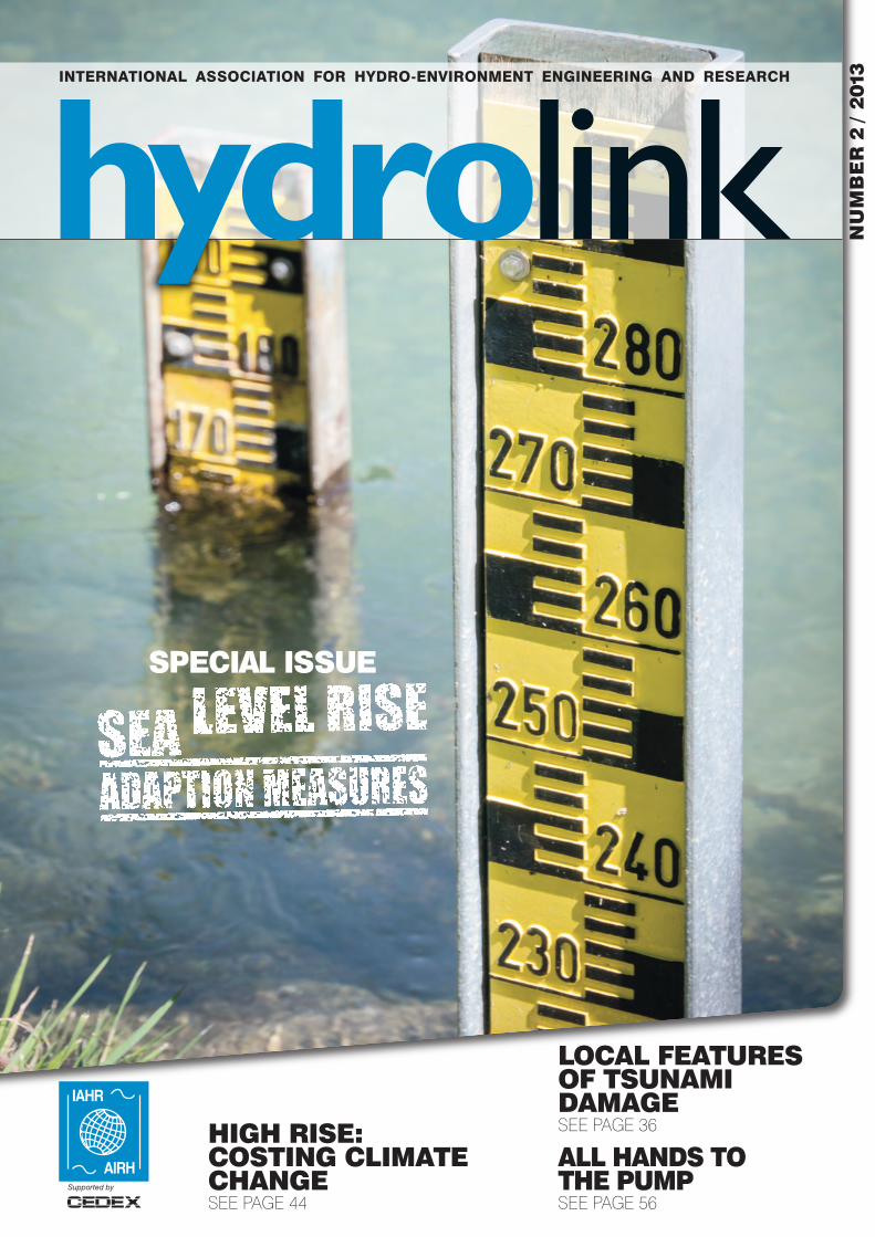
Prof. Michele MossaTechnical University of Bari (Italy)Editor of [email protected]
A CHANGING PLANET AND HYDROINFORMATICS AS A DECISION SUPPORT SYSTEMEDITORIAL BY PROF. MICHELE MOSSA
34 hydrolink number 2/2013
hydrolink 2_2013def_23212 19-07-13 13:24 Pagina 34
35hydrolink number 2/2013
IN THIS ISSUEIAHRInternational Associationfor Hydro-EnvironmentEngineering and Research
IAHR SecretariatPaseo Bajo Virgen del Puerto, 328005 Madrid SPAINTel. : +34 91 335 79 08Fax. : +34 91 335 79 [email protected]
Editor:Michele Mossa, Technical University of Bari, Italye-mail: [email protected]
Contact us:
Estibaliz Serrano Publications ManagerIPD Programme Officer tel.: +34 91 335 79 86e-mail: [email protected]
Hydrolink Advisory BoardChair: Angelos Findikakis Bechtel National Inc., USA
Luis BalaironCEDEX –Ministry Public Works, Spain
Jean Paul ChabardEDF Research & Development, France
Jaap C.J. KwadijkDeltares, The Netherlands
Yoshiaki KuriyamaThe Port and Airport Research Institute, PARI, Japan
James SutherlandHR Wallingford, UK
Ole MarkDHI, Denmark
Jing PengChina Institute of Water Resources and Hydropower Re-search, China
Luis Zamorano RiquelmeInstituto Nacional de Hidraulica INA, Chile
ISSN 1388-3445
Cover picture: Water level indicators ©dreamstime.com
SPECIAL ISSUE:SEA LEVEL RISE ADAPTION MEASURESEDITORIAL ................................................................................34
LOCAL FEATURES OF TSUNAMI DAMAGE FROM THE 2011 TOHOKU EARTHQUAKE IN IWATE PREFECTURE .....................................................36
ASSESSMENT OF TSUNAMI PROPAGATION FROM VIDEO RECORDINGS, JAPAN...........................38
UNDERSTANDING CLIMATE CHANGE AND LIVELIHOODS IN COASTAL BANGLADESH.............40
HIGH RISE: COSTING CLIMATE CHANGE ...............44
SEA LEVEL RISE IN MALAYSIA......................................47
IAHR COUNCIL ELECTIONS 2013 ................................50
MURRUMBIDGEE RIVER COMPUTER AIDED RIVER MANAGEMENT (CARM) .......................52
ALL HANDS TO THE PUMP(PUMP-TURBINES, RENEWABLES ANDDYNAMICS) ..............................................................................56
STATEMENT REGARDING THE RECENT FLOODS IN GERMANY ........................................................58
9TH INTERNATIONAL SYMPOSIUM ONECOHYDRAULICS..................................................................59
20TH EUROPEAN JUNIOR SCIENTISTSWORKSHOP ON SEWER SYSTEMS ANDPROCESSES – A SUMMARY ..........................................60
PEOPLE & PLACES ..............................................................62
NUMBER 2/ 2013
IAHR
36
40
47
52
56
hydrolink 2_2013def_23212 19-07-13 13:24 Pagina 35
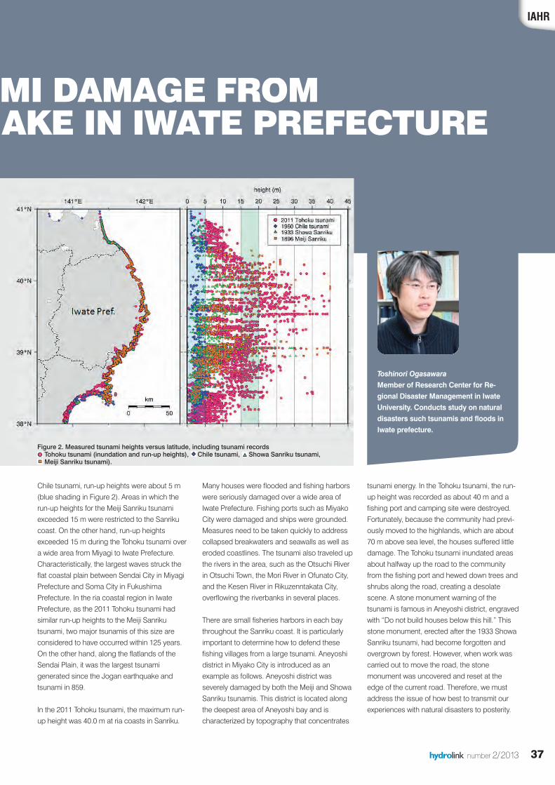
tsunami, and the 1960 Chile tsunami.Measurements for the 2011 Tohoku tsunamiwere obtained from the 2011 TohokuEarthquake Tsunami Joint Survey Group.Heights shown in Figure 2 are measured fromsea level, generally excluding astronomical tidesand inundation, and were determined fromwatermarks on buildings and trees. The 2011Tohoku tsunami was much larger than the Chiletsunami. Compared to the Meiji Sanrikutsunami, the maximum run-up heights for the2011 event were greater in many areas andsimilar in some regions. For the Showa Sanrikutsunami, run-up heights were limited to about 20m in most areas (green shading in Figure 2) andthe maximum value was about 30 m. In the
36 hydrolink number 2/2013
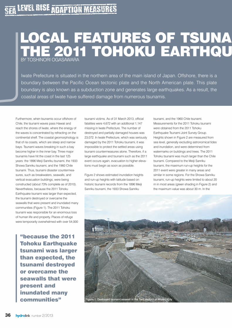
Furthermore, when tsunamis occur offshore ofChile, the tsunami waves pass Hawaii andreach the shores of Iwate, where the energy ofthe waves is concentrated by refracting on thecontinental shelf. The coastal geomorphology isthat of ria coasts, which are steep and narrowbays. Tsunami waves breaking in such a baybecome higher in the inner bay. Three majortsunamis have hit the coast in the last 125years: the 1896 Meiji Sanriku tsunami, the 1933Showa Sanriku tsunami, and the 1960 Chiletsunami. Thus, tsunami disaster countermea-sures, such as breakwaters, seawalls, andvertical evacuation buildings, were beingconstructed (about 73% complete as of 2010).Nevertheless, because the 2011 TohokuEarthquake tsunami was larger than expected,the tsunami destroyed or overcame theseawalls that were present and inundated manycommunities (Figure 1). The 2011 Tohokutsunami was responsible for an enormous lossof human life and property. Places of refugewere temporarily overwhelmed with over 54,000
tsunami victims. As of 31 March 2013, officialfatalities were 4,672 with an additional 1,147missing in Iwate Prefecture. The number ofdestroyed and partially damaged houses was23,072. In Iwate Prefecture, which was seriouslydamaged by the 2011 Tohoku tsunami, it wasimpossible to protect the settled areas usingtsunami countermeasures alone. Therefore, if alarge earthquake and tsunami such as the 2011event occurs again, evacuation to higher eleva-tions must begin as soon as possible.
Figure 2 shows estimated inundation heightsand run-up heights with latitude based onhistoric tsunami records from the 1896 MeijiSanriku tsunami, the 1933 Showa Sanriku
LOCAL FEATURES OF TSUNAM THE 2011 TOHOKU EARTHQUA BY TOSHINORI OGASAWARA
“because the 2011Tohoku Earthquaketsunami was largerthan expected, thetsunami destroyedor overcame theseawalls that werepresent andinundated manycommunities”
Iwate Prefecture is situated in the northern area of the main island of Japan. Offshore, there is aboundary between the Pacific Ocean tectonic plate and the North American plate. This plateboundary is also known as a subduction zone and generates large earthquakes. As a result, thecoastal areas of Iwate have suffered damage from numerous tsunamis.
Figure 1. Destroyed tsunami seawall in the Taro distinct of Miyako City
hydrolink 2_2013def_23212 19-07-13 13:24 Pagina 36
37hydrolink number 2/2013
Chile tsunami, run-up heights were about 5 m(blue shading in Figure 2). Areas in which therun-up heights for the Meiji Sanriku tsunamiexceeded 15 m were restricted to the Sanrikucoast. On the other hand, run-up heightsexceeded 15 m during the Tohoku tsunami overa wide area from Miyagi to Iwate Prefecture.Characteristically, the largest waves struck theflat coastal plain between Sendai City in MiyagiPrefecture and Soma City in FukushimaPrefecture. In the ria coastal region in IwatePrefecture, as the 2011 Tohoku tsunami hadsimilar run-up heights to the Meiji Sanrikutsunami, two major tsunamis of this size areconsidered to have occurred within 125 years.On the other hand, along the flatlands of theSendai Plain, it was the largest tsunamigenerated since the Jogan earthquake andtsunami in 859.
In the 2011 Tohoku tsunami, the maximum run-up height was 40.0 m at ria coasts in Sanriku.
Many houses were flooded and fishing harborswere seriously damaged over a wide area ofIwate Prefecture. Fishing ports such as MiyakoCity were damaged and ships were grounded.Measures need to be taken quickly to addresscollapsed breakwaters and seawalls as well aseroded coastlines. The tsunami also traveled upthe rivers in the area, such as the Otsuchi Riverin Otsuchi Town, the Mori River in Ofunato City,and the Kesen River in Rikuzenntakata City,overflowing the riverbanks in several places.
There are small fisheries harbors in each baythroughout the Sanriku coast. It is particularlyimportant to determine how to defend thesefishing villages from a large tsunami. Aneyoshidistrict in Miyako City is introduced as anexample as follows. Aneyoshi district wasseverely damaged by both the Meiji and ShowaSanriku tsunamis. This district is located alongthe deepest area of Aneyoshi bay and ischaracterized by topography that concentrates
IAHR
AMI DAMAGE FROM UAKE IN IWATE PREFECTURE
tsunami energy. In the Tohoku tsunami, the run-up height was recorded as about 40 m and afishing port and camping site were destroyed.Fortunately, because the community had previ-ously moved to the highlands, which are about70 m above sea level, the houses suffered littledamage. The Tohoku tsunami inundated areasabout halfway up the road to the communityfrom the fishing port and hewed down trees andshrubs along the road, creating a desolatescene. A stone monument warning of thetsunami is famous in Aneyoshi district, engravedwith “Do not build houses below this hill.” Thisstone monument, erected after the 1933 ShowaSanriku tsunami, had become forgotten andovergrown by forest. However, when work wascarried out to move the road, the stonemonument was uncovered and reset at theedge of the current road. Therefore, we mustaddress the issue of how best to transmit ourexperiences with natural disasters to posterity.
Toshinori Ogasawara Member of Research Center for Re-gional Disaster Management in IwateUniversity. Conducts study on naturaldisasters such tsunamis and floods inIwate prefecture.
Figure 2. Measured tsunami heights versus latitude, including tsunami records Tohoku tsunami (inundation and run-up heights), � Chile tsunami, Showa Sanriku tsunami, �Meiji Sanriku tsunami).
hydrolink 2_2013def_23212 19-07-13 13:25 Pagina 37
38 hydrolink number 2/2013
One of the problems in studying tsunami wavesis how to acquire field data under intense hydro-dynamic conditions. Various measurementdevices are available for that purpose.Nevertheless, especially in a case of a megatsunami, these devices may suffer damage fromthe tsunami and cease to function properly. Pasttsunami events, such as The Indian OceanTsunami of 2004 or The Great North East JapanTsunami of 2011 have shown that measureddata availability was limited during a megatsunami. The tsunami damaged a large numberof water gauges installed at the tidal obser-vatory in coastal areas and rivers. In addition,the tsunami force may have caused errorreadings. Thus, detailed information, such asfluctuation of the water level, was lost. Posttsunami surveys, i.e. tracing, water mark, wereoften conducted, which may provide somedegree of understanding on tsunami propa-gation process, yet it is not the live actualcondition. Nowadays, with advances in technology, it iseasy to record video of various moments,including a tsunami event. In the case of TheNorth East Japan Tsunami of 2011, there were
video recordings from various sources. Videorecordings during the tsunami are availablefrom survivors, CCTV, TV stations, and otherrelated agencies. These videos can beobtained from corresponding agencies andsome of them are available even in You Tube.Although they may not reveal the water leveldata, they may contain other information. Thesevideos provide live data of the tsunami eventthat may be helpful for explaining the tsunamipropagation process.
The Great North East Japan Tsunamiof 2011The Great North East Japan Tsunami of 2011
was one of the biggest natural disasters inhistory. The tsunami event promptedresearchers and governmental organizationsthroughout Japan to enhance existingmeasures for prevention of tsunami disaster.The tsunami was generated by a 9.0 (MW)mega earthquake off the coast of Japan. Theearthquake occurred at 14:46 (Japan StandardTime) on 11 March 2011. It caused 5-8 mupthrust on a 180 km wide seabed. The tsunamirun-up height in some places reached to about40 m. The wave brought destruction on thenorth east coast of Japan. In some places, thetsunami wave wiped out an entire town withthousands of casualties.
Tanaka is Professor of HydraulicEngineering at Tohoku University,Sendai, Japan and was recentlyappointed Vice Dean for Education atthe university. He is Chair of the AsiaPacific Division of IAHR.
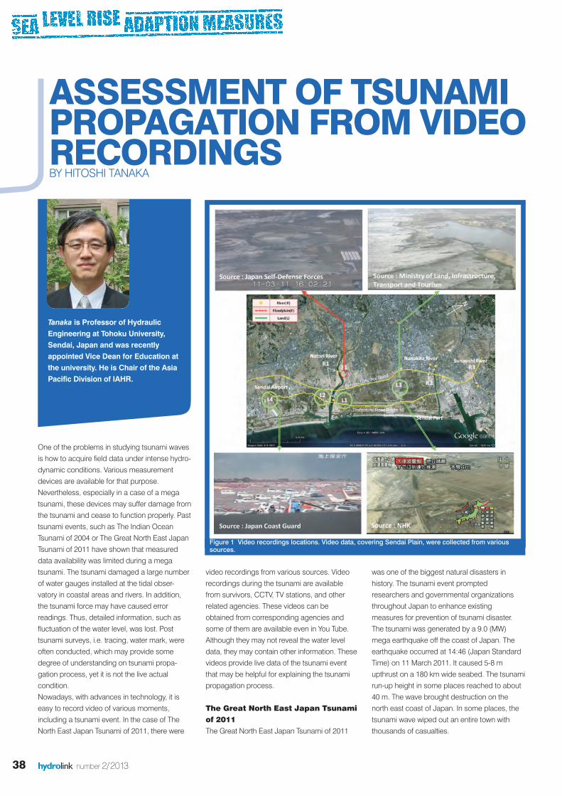
Figure 1 Video recordings locations. Video data, covering Sendai Plain, were collected from varioussources.
ASSESSMENT OF TSUNAMI PROPAGATION FROM VIDEO RECORDINGSBY HITOSHI TANAKA
hydrolink 2_2013def_23212 19-07-13 13:25 Pagina 38
39hydrolink number 2/2013
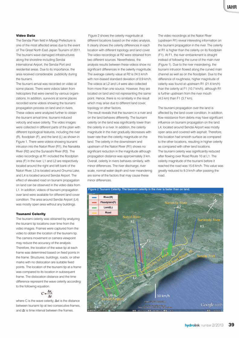
Figure 2 shows the celerity magnitude atdifferent locations based on the video analysis.It clearly shows the celerity differences in eachlocation with different topology and land cover. The video recordings at R2 were obtained fromtwo different sources. Nevertheless, theanalysis results between these videos show nosignificant differences in the celerity magnitude.The average celerity value at R2 is 24.5 km/hwith non-biased standard deviation of 0.9 km/h.The videos at L2 and L4 were also collectedfrom more than one source. However, they arelocated on land and not representing the samepoint. Hence, there is no similarity in the resultwhich may arise due to different land cover,topology or other factors. The result reveals that the tsunami in a river andon the land behaves differently. The tsunamicelerity on the land was significantly lower thanthe celerity in a river. In addition, the celeritymagnitude in the river gradually decreases withlower rate than the celerity magnitude on theland. The celerity in the downstream andupstream of the Natori River (R1) shows nosignificant reduction in the magnitude althoughpropagation distance was approximately 3 km.Overall, celerity in rivers behaves similarly, withminor differences. The river discharge, riverscale, normal water depth and river meanderingare some of the factors that may cause theseminor differences.
The video recordings at the Natori River(upstream R1) reveal interesting information onthe tsunami propagation in the river. The celerityat R1 is higher than the celerity on its floodplain(F1). At F1, the river embankment is straightinstead of following the curve of the main river(Figure 1). Due to the river meandering, thetsunami intrusion flowed along the curved mainchannel as well as on the floodplain. Due to thedifference of roughness, higher magnitude ofcelerity was found at upstream R1 (21.6 km/h)than the celerity at F1 (10.7 km/h), although R1is further upstream from the river mouth (4.5 km) than F1 (3.7 km).
The tsunami propagation over the land isaffected by the land cover condition. In addition,flow resistance from debris may have significantinfluence on tsunami propagation on the land.L4, located around Sendai Airport was mostlyopen area and covered with asphalt. Therefore,this location had smooth surface as comparedto the other locations, resulting in higher celerityas compared with other land locations. The tsunami celerity was significantly reducedafter flowing over Road Route 10 at L1. Thecelerity magnitude of the tsunami before itreached the road was 15.6 km/h. This value wasgreatly reduced to 9.3 km/h after passing theroad.
Video DataThe Sendai Plain field in Miyagi Prefecture isone of the most affected areas due to the eventof The Great North East Japan Tsunami of 2011.The tsunami wave damaged infrastructuresalong the shoreline including SendaiInternational Airport, the Sendai Port andresidential areas. Due to its importance, thearea received considerable pubblicity duringthe tsunami. The tsunami arrival was recorded on video atsome places. There were videos taken fromhelicopters that were owned by various organi-zations. In addition, survivors at some placesrecorded some videos showing the tsunamipropagation process on land and in rivers.These videos were analyzed further to obtainthe tsunami arrival time, tsunami-inducedvelocity and wave celerity. The video imageswere collected in different parts of the plain withdifferent topological features, including the river(R), floodplain (F), and the land (L) as shown inFigure 1. There were videos showing tsunamiintrusion into the Natori River (R1), the NanakitaRiver (R2) and the Sunaoshi River (R3). Thevideo recordings at R1 included the floodplainarea (F) in the river. L1 and L2 are respectivelylocated around the right and left bank of theNatori River, L3 is located around Onuma Lake,and L4 is located around Sendai Airport. Theeffect of elevated road on tsunami propagationon land can be observed in the video data fromL1. In addition, videos of tsunami propagationover land were available for different land covercondition. The area around Sendai Airport (L4)was mostly open area without any buildings.
Tsunami CelerityThe tsunami celerity was obtained by analyzingthe tsunami tip locations over time from thevideo images. Frames were captured from thevideo to obtain the location of the tsunami tip.The camera movement or camera viewpointmay reduce the accuracy of the analysis.Therefore, the location of the wave tip at eachframe was determined based on fixed points inthe frame. Structures, buildings, roads, or othermarks with no dislocation are suitable fixedpoints. The location of the tsunami tip at a framewas compared to its location in subsequentframe. The dislocation distance and the timedifference represent the wave celerity accordingto the following equation.
where C is the wave celerity, Δxt is the distancebetween tsunami tip at two consecutive frames,and Δt is time interval between the frames.
IAHR
Figure 2 Tsunami Celerity. The tsunami celerity in the river is faster than on land.
hydrolink 2_2013def_23212 19-07-13 13:25 Pagina 39
40 hydrolink number 2/2013
In recent years, there has been a growingconcern about the effect of climate-inducedsea-level rise on the environment, populationand livelihoods around the worlds’ coastline.However, these issues are highly spatiallyvariable, as sea level is only one of severaldrivers of coastal change (Nicholls et al 2007). It was recognised in the 1980s (Milliman et al1989) that deltaic environments are amongstthe most vulnerable coastal areas to such risebecause of their low altitude and often large,poor and growing population.
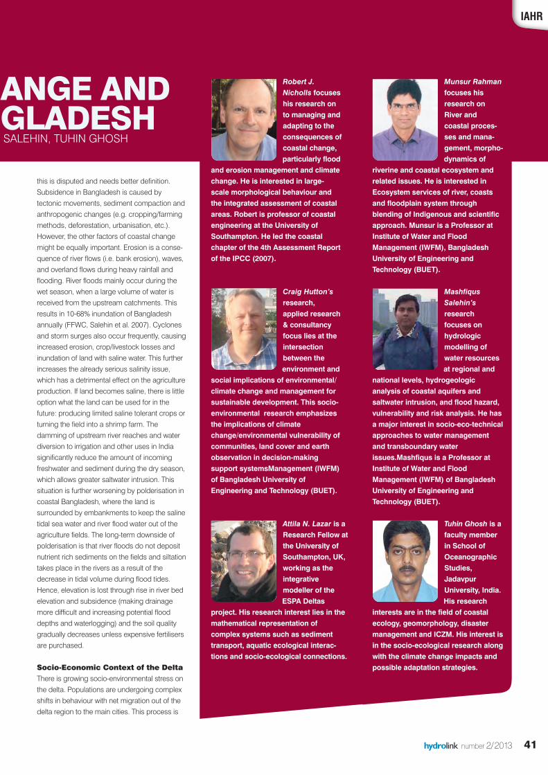
Threats act on multiple scales including global(e.g. sea level rise), regional (e.g. catchmentmanagement reducing water and sedimentinput) and delta plain (e.g. water extraction,sediment starvation, natural and more impor-tantly human-induced subsidence) scales. The result of these changes might result in anincrease in flooding, salinization of waterresources and soil, land loss due to erosion,subsidence and inundation, and degrading thequality of ecosystem services such as cropproductivity, fish stocks and protection againststorm surges. Thus, delta environments arecomplex social-environmental systems wherethe change is only partially driven by sea levelrise and climate change, and human-induceddevelopment activities are also critical drivers.
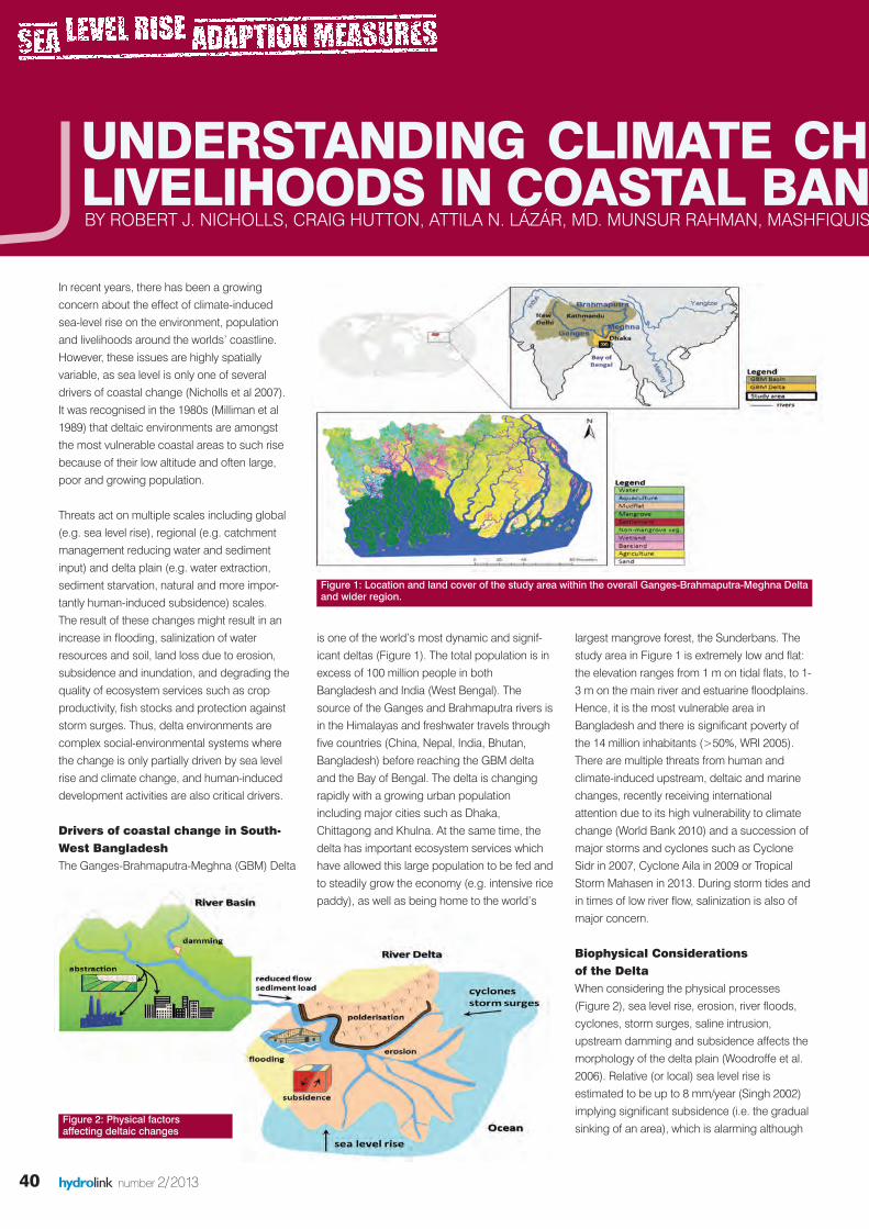
Drivers of coastal change in South-West BangladeshThe Ganges-Brahmaputra-Meghna (GBM) Delta
UNDERSTANDING CLIMATE CHA LIVELIHOODS IN COASTAL BANGBY ROBERT J. NICHOLLS, CRAIG HUTTON, ATTILA N. LÁZÁR, MD. MUNSUR RAHMAN, MASHFIQUIS S
Figure 2: Physical factors affecting deltaic changes
Figure 1: Location and land cover of the study area within the overall Ganges-Brahmaputra-Meghna Deltaand wider region.
is one of the world’s most dynamic and signif-icant deltas (Figure 1). The total population is inexcess of 100 million people in bothBangladesh and India (West Bengal). Thesource of the Ganges and Brahmaputra rivers isin the Himalayas and freshwater travels throughfive countries (China, Nepal, India, Bhutan,Bangladesh) before reaching the GBM deltaand the Bay of Bengal. The delta is changingrapidly with a growing urban populationincluding major cities such as Dhaka,Chittagong and Khulna. At the same time, thedelta has important ecosystem services whichhave allowed this large population to be fed andto steadily grow the economy (e.g. intensive ricepaddy), as well as being home to the world’s
largest mangrove forest, the Sunderbans. Thestudy area in Figure 1 is extremely low and flat:the elevation ranges from 1 m on tidal flats, to 1-3 m on the main river and estuarine floodplains.Hence, it is the most vulnerable area inBangladesh and there is significant poverty ofthe 14 million inhabitants (>50%, WRI 2005).There are multiple threats from human andclimate-induced upstream, deltaic and marinechanges, recently receiving internationalattention due to its high vulnerability to climatechange (World Bank 2010) and a succession ofmajor storms and cyclones such as CycloneSidr in 2007, Cyclone Aila in 2009 or TropicalStorm Mahasen in 2013. During storm tides andin times of low river flow, salinization is also ofmajor concern.
Biophysical Considerations of the DeltaWhen considering the physical processes(Figure 2), sea level rise, erosion, river floods,cyclones, storm surges, saline intrusion,upstream damming and subsidence affects themorphology of the delta plain (Woodroffe et al.2006). Relative (or local) sea level rise isestimated to be up to 8 mm/year (Singh 2002)implying significant subsidence (i.e. the gradualsinking of an area), which is alarming although
hydrolink 2_2013def_23212 19-07-13 13:25 Pagina 40
41hydrolink number 2/2013
this is disputed and needs better definition.Subsidence in Bangladesh is caused bytectonic movements, sediment compaction andanthropogenic changes (e.g. cropping/farmingmethods, deforestation, urbanisation, etc.).However, the other factors of coastal changemight be equally important. Erosion is a conse-quence of river flows (i.e. bank erosion), waves,and overland flows during heavy rainfall andflooding. River floods mainly occur during thewet season, when a large volume of water isreceived from the upstream catchments. Thisresults in 10-68% inundation of Bangladeshannually (FFWC, Salehin et al. 2007). Cyclonesand storm surges also occur frequently, causingincreased erosion, crop/livestock losses andinundation of land with saline water. This furtherincreases the already serious salinity issue,which has a detrimental effect on the agricultureproduction. If land becomes saline, there is littleoption what the land can be used for in thefuture: producing limited saline tolerant crops orturning the field into a shrimp farm. Thedamming of upstream river reaches and waterdiversion to irrigation and other uses in Indiasignificantly reduce the amount of incomingfreshwater and sediment during the dry season,which allows greater saltwater intrusion. Thissituation is further worsening by polderisation incoastal Bangladesh, where the land issurrounded by embankments to keep the salinetidal sea water and river flood water out of theagriculture fields. The long-term downside ofpolderisation is that river floods do not depositnutrient rich sediments on the fields and siltationtakes place in the rivers as a result of thedecrease in tidal volume during flood tides.Hence, elevation is lost through rise in river bedelevation and subsidence (making drainagemore difficult and increasing potential flooddepths and waterlogging) and the soil qualitygradually decreases unless expensive fertilisersare purchased.
Socio-Economic Context of the DeltaThere is growing socio-environmental stress onthe delta. Populations are undergoing complexshifts in behaviour with net migration out of thedelta region to the main cities. This process is
IAHRIAHR
HANGE AND NGLADESH
IS SALEHIN, TUHIN GHOSH
Tuhin Ghosh is afaculty memberin School ofOceanographicStudies,JadavpurUniversity, India.His research
interests are in the field of coastalecology, geomorphology, disastermanagement and ICZM. His interest isin the socio-ecological research alongwith the climate change impacts andpossible adaptation strategies.
MashfiqusSalehin’sresearchfocuses onhydrologicmodelling ofwater resourcesat regional and
national levels, hydrogeologicanalysis of coastal aquifers andsaltwater intrusion, and flood hazard,vulnerability and risk analysis. He hasa major interest in socio-eco-technicalapproaches to water managementand transboundary waterissues.Mashfiqus is a Professor atInstitute of Water and FloodManagement (IWFM) of BangladeshUniversity of Engineering andTechnology (BUET).
Munsur Rahmanfocuses hisresearch onRiver andcoastal proces-ses and mana-gement, morpho-dynamics of
riverine and coastal ecosystem andrelated issues. He is interested inEcosystem services of river, coastsand floodplain system throughblending of Indigenous and scientificapproach. Munsur is a Professor atInstitute of Water and FloodManagement (IWFM), BangladeshUniversity of Engineering andTechnology (BUET).
Attila N. Lazar is aResearch Fellow atthe University ofSouthampton, UK,working as theintegrativemodeller of theESPA Deltas
project. His research interest lies in themathematical representation ofcomplex systems such as sedimenttransport, aquatic ecological interac-tions and socio-ecological connections.
Craig Hutton’sresearch,applied research& consultancyfocus lies at theintersectionbetween theenvironment and
social implications of environmental/climate change and management forsustainable development. This socio-environmental research emphasizesthe implications of climatechange/environmental vulnerability ofcommunities, land cover and earthobservation in decision-makingsupport systemsManagement (IWFM)of Bangladesh University ofEngineering and Technology (BUET).
Robert J.Nicholls focuseshis research onto managing andadapting to theconsequences ofcoastal change,particularly flood
and erosion management and climatechange. He is interested in large-scale morphological behaviour andthe integrated assessment of coastalareas. Robert is professor of coastalengineering at the University ofSouthampton. He led the coastalchapter of the 4th Assessment Reportof the IPCC (2007).
hydrolink 2_2013def_23212 19-07-13 13:25 Pagina 41
42 hydrolink number 2/2013
complex and a number of factors are involved.Shrimp farming is becoming an attractive optionwhere salinity has risen, but is becoming recog-nised as a temporary solution with inequitabledistribution of benefits away from the poor andprogressively landless. Extreme events cancause immediate catastrophic financial situa-tions for families, and there is only a limitedsafety net for the poorest. However, the growthsof flood warnings and cyclone shelters havegreatly reduced the death toll during extremefloods and cyclones. Bio-physical processesplay an important role in people’s lives. Cropproductivity, forest goods, fish stocks andarsenic pollution of groundwater resources aredirectly affecting the livelihoods of thepopulation.
Governance DimensionsEach component of the ecosystem (i.e. water,fisheries, vegetation, forests and wildlife, etc.) isgoverned by a different legal regime which willbe identified. Laws and institutions rarely includecross-cutting issues and are often confinedwithin sectorial boundaries. This is somewhatcompounded by a fragmented legal regime andinconsistencies within laws and regulations.Weaknesses in government planning structuresin combination with the heavy reliance on donorfunding potentially result in donor initiatedprojects that are not optimum in achievingnational goals and policies.
The ESPA Deltas ProjectEnvironmental change and people’s livelihoodis complex in deltaic environments. There is a
lack of understanding of the relative importanceof the above factors. The ESPA-funded“Assessing Health, Livelihoods, EcosystemServices and Poverty Alleviation In PopulousDeltas” project (2012-16,http://www.espadelta.net/) aims to address thisgap in a policy relevant way. The project wasfounded on the recognition of the interaction ofthe biophysical, governmental and socio-environmental factors unfolding on the deltaand has established an integrative researchprocess based upon these three main themes.The project is providing policy makers with theknowledge and tools to evaluate the effects ofpolicy decisions on people's livelihoods in thetidal influenced delta plain. It is beingconducted by a multidisciplinary and multi-national team (24 institutes from UK,Bangladesh, India and China) of policyanalysts, social and natural scientists andengineers using a participatory, holisticapproach to formally evaluating ecosystemservices and poverty in the context of the widerange of changes that are occurring. Theapproach is being developed in the coastalBangladesh study area (Figure 1) but isdesigned to be generic and transferable toother deltaic settings. The methodology is builtupon a combined system-based conceptuali-sation of the human-environmental interactionsand stakeholder engagement. The four majorbuilding blocks of the project are: (1) policyanalysis, (2) understanding of social interac-tions, (3) understanding of the status andchanges of the biophysical environment, and(4) integrative modelling of the system using
scenarios. The ESPA Deltas methodology is built onsubstantial stakeholder engagement anditerative learning throughout the project. There isparticipatory involvement of stakeholders (fromgovernment to civil societies) in all stages of theresearch starting from the identification ofresearch questions to developing scenarios andexploring these within model frameworks. Thisensures trust, interest and willingness to partic-ipate. This integrative tool will be used as aniterative learning instrument to explore a rangeof climate, social and governance scenarios inclose collaboration with decision makers. Theproject will identify perceived critical threats andinform policy makers of the potential benefits ofpolicy changes to promote sustainability, toreduce poverty and to embrace integratedmanagement.
ReferencesMilliman, J.D., Broadus, J.M., Gable, F., 1989. Environmental and
Economic Implications of Rising Sea Level and SubsidenceDeltas: The Nile and Bengal Examples, Ambio 18, pp. 340–345.
Nicholls, R.J., Wong, P.P., Burkett, V.R., Codignotto, J.O., Hay, J.E.,McLean, R.F., Ragoonaden, S., Woodroffe, C.D. (2007) Coastalsystems and low-lying areas. In: Parry, M.L., Canziani, O.F.,Palutikof, J.P., van der Linden, P.J., Hanson, C.E. (eds.) ClimateChange 2007: Impacts, Adaptation and Vulnerability. Contributionof Working Group II to the Fourth Assessment Report of theIntergovernmental Panel on Climate Change, CambridgeUniversity Press, Cambridge, UK, 315-356.
Salehin, M., Haque, A., Rahman, M.R., Khan, M.S.A., Bala, S.K.(2007). Hydrological Aspects of 2004 Floods in Bangladesh,Journal of Hydrology and Meteorology, 4(1):33-44.
Singh, O.P. 2002. Spatial variation of sea level trend along theBangladesh coast. Marine Geodesy, 25:205-212.
Woodroffe, C.N., Nicholls, R.J., Saito, Y., Chen, Z., Goodbred, S.L.(2006) Chapter 10: Landscape Variability And The Response OfAsian Megadeltas To Environmental Change. In: N. Harvey (ed.),Global Change and Integrated Coastal Management, 277–314.2006 Springer.
World Bank. 2010. Economics of Adaptation to Climate Change(EACC) Report, Bangladesh, 2010.http://climatechange.worldbank.org/sites/default/files/documents/EACC_Bangladesh.pdf
World Resources Institute (WRI) 2005. in collaboration with UnitedNations Development Programme, United Nations EnvironmentProgramme, and World Bank (2005). World Resources 2005: TheWealth of the Poor—Managing Ecosystems to Fight Poverty. WRI:Washington, DC.
Abstract submission is now open!
invites you to submit an abstract
photo by tony arborino
s iis noon ssimiissitract subs w open!s no
o submit an abou tes yt acttrso submit an ab
hydrolink 2_2013def_23212 19-07-13 13:25 Pagina 42

Scientific papers, technical notes and SonTek-IQ Series specifications at sontek.com/iq.Questions? E-mail: [email protected] or call +1.858.546.8327.See the SonTek-IQ in action: youtube/sontekysi
Standard, Plus and PipeSonTek-IQ Series
TM
FLOW, TOTAL VOLUME, LEVEL AND VELOCITY
Fully self-contained, all-in-one designMeasure flow in man-made or natural channels, pipes or streams
between 8cm and 5m deepFour, pulsed Doppler velocity beams for great section coverageRS-232, SDI-12, Modbus, Analog communication/output
NEW!
SonardantSATTAO, TWOLF
-ekk-TTeknnTsul P,dar
EV, LEEMULOL VA
MTM
SQ S TM
QT
I-pi Pd an
ITOCLED VNAL E
sseeiirr Se SeYIT
N WNEWEWW!
ss
, T
, LE
be
MuF
d 5nm an 8ceewtbe
an mw ioe flrusaeMedniatnoc-ff-ley sllu
peem dd 5
arutar ne odam-nangiese dno-ni-ll, aed
pes ois, plennahl can
s maertr spes o
ekSee the SonT eQuestions? E-mail: Scientific papers,
SRoF
q yyyoutub-IQ in action: ek
[email protected]? E-mail: technical notes and SonTScientific papers,
od, M21-ID, S232-Slppoed Dslu, prr, puo
yysibe/sontek or call +1.858.546.8327.com
-IQ Series specificaek nd SonT e
moog clans, Aubods fmay betiocler vel
or call +1.858.546.8327.sontt tions a-IQ Series specifica
uptuo//onoitacinummn coitect saerr gos f o
q.tek.com/iq
tuegarevon c
hydrolink 2_2013def_23212 19-07-13 13:25 Pagina 43
44 hydrolink number 2/2013
Media reports indicate almost daily how poten-tially devastating the effects of climate changeand associated sea-level rise could be. A simpleGoogle News search for ‘sea-level rise’ illus-trates the diversity of impacts, from migratorybirds to energy supplies to soil salinisation toflooding. These impacts could have a significantimpact on the environment and the people whoreside there – typically the coastal zone is aboutthree times more densely populated as furtherinland (Small and Nicholls, 2003). As engineers,we have the ability to protect those who arevulnerable, such as through building harddefences such as sea walls or dikes. But inorder to do this – particularly over the long-term -we need to understand how much sea levelsmight rise and how much it might cost so thatthe financial commitment can be assessed intothe future. This is especially true when poorercountries may seek financial assistance tosupport such adaptations. In 2010, the WorldBank published its ‘Economic of Coastal ZoneAdaptation to Climate Change’ report (Nichollset al., 2010) to answer these questions, whichwas part of a larger ‘Economics of Adaptation toClimate Change’ project which looked at anumber of sectors (World Bank, 2010).
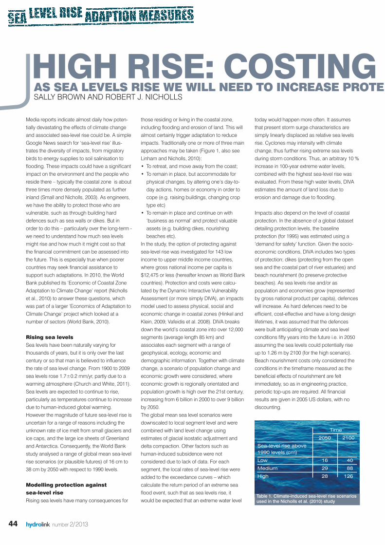
Rising sea levelsSea levels have been naturally varying forthousands of years, but it is only over the lastcentury or so that man is believed to influencethe rate of sea level change. From 1900 to 2009sea levels rose 1.7±0.2 mm/yr, partly due to awarming atmosphere (Church and White, 2011).Sea levels are expected to continue to rise,particularly as temperatures continue to increasedue to human-induced global warming.However the magnitude of future sea-level rise isuncertain for a range of reasons including theunknown rate of ice melt from small glaciers andice caps, and the large ice sheets of Greenlandand Antarctica. Consequently, the World Bankstudy analysed a range of global mean sea-levelrise scenarios (or plausible futures) of 16 cm to38 cm by 2050 with respect to 1990 levels.
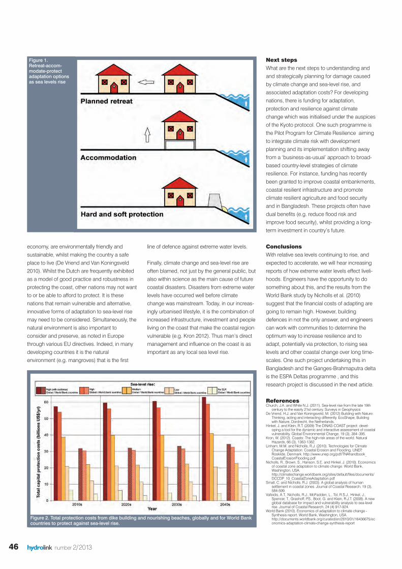
Modelling protection against sea-level riseRising sea levels have many consequences for
those residing or living in the coastal zone,including flooding and erosion of land. This willalmost certainly trigger adaptation to reduceimpacts. Traditionally one or more of three mainapproaches may be taken (Figure 1, also seeLinham and Nicholls, 2010): • To retreat, and move away from the coast;• To remain in place, but accommodate forphysical changes, by altering one’s day-to-day actions, homes or economy in order tocope (e.g. raising buildings, changing croptype etc)
• To remain in place and continue on with‘business as normal’ and protect valuableassets (e.g. building dikes, nourishingbeaches etc).
In the study, the option of protecting againstsea-level rise was investigated for 143 lowincome to upper middle income countries,where gross national income per capita is$12,475 or less (hereafter known as World Bankcountries). Protection and costs were calcu-lated by the Dynamic Interactive VulnerabilityAssessment (or more simply DIVA), an impactsmodel used to assess physical, social andeconomic change in coastal zones (Hinkel andKlein, 2009; Vafeidis et al. 2008). DIVA breaksdown the world’s coastal zone into over 12,000segments (average length 85 km) andassociates each segment with a range ofgeophysical, ecology, economic anddemographic information. Together with climatechange, a scenario of population change andeconomic growth were considered, whereeconomic growth is regionally orientated andpopulation growth is high over the 21st century,increasing from 6 billion in 2000 to over 9 billionby 2050. The global mean sea level scenarios weredownscaled to local segment level and werecombined with land level change usingestimates of glacial isostatic adjustment anddelta compaction. Other factors such ashuman-induced subsidence were notconsidered due to lack of data. For eachsegment, the local rates of sea-level rise wereadded to the exceedance curves – whichcalculate the return period of an extreme seaflood event, such that as sea levels rise, itwould be expected that an extreme water level
today would happen more often. It assumesthat present storm surge characteristics aresimply linearly displaced as relative sea levelsrise. Cyclones may intensity with climatechange, thus further rising extreme sea levelsduring storm conditions. Thus, an arbitrary 10 %increase in 100-year extreme water levels,combined with the highest sea-level rise wasevaluated. From these high water levels, DIVAestimates the amount of land loss due toerosion and damage due to flooding.
Impacts also depend on the level of coastalprotection. In the absence of a global datasetdetailing protection levels, the baselineprotection (for 1995) was estimated using a‘demand for safety’ function. Given the socio-economic conditions, DIVA includes two typesof protection; dikes (protecting from the opensea and the coastal part of river estuaries) andbeach nourishment (to preserve protectivebeaches). As sea levels rise and/or aspopulation and economies grow (representedby gross national product per capita), defenceswill increase. As hard defences need to beefficient, cost-effective and have a long designlifetimes, it was assumed that the defenceswere built anticipating climate and sea levelconditions fifty years into the future i.e. in 2050assuming the sea levels could potentially riseup to 1.26 m by 2100 (for the high scenario).Beach nourishment costs only considered theconditions in the timeframe measured as thebeneficial effects of nourishment are feltimmediately, so as in engineering practice,periodic top-ups are required. All financialresults are given in 2005 US dollars, with nodiscounting.
HIGH RISE: COSTING C AS SEA LEVELS RISE WE WILL NEED TO INCREASE PROTEC SALLY BROWN AND ROBERT J. NICHOLLS
Time
2050 2100
Sea-level rise above 1990 levels (cm)
Low 16 40
Medium 29 88
High 28 126
Table 1. Climate-induced sea-level rise scenariosused in the Nicholls et al. (2010) study
hydrolink 2_2013def_23212 19-07-13 13:25 Pagina 44
45hydrolink number 2/2013
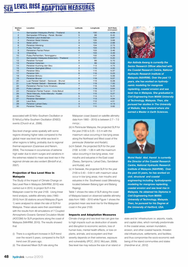
4) Protection costs are likely to increase overtime as dikes must be maintained to remaineffective.
Sea and river dike maintenance costs (notreported in Figure 2, but estimated at 1% and0.5% of capital costs respectively followingreported practise) increase approximatelylinearly throughout the study period, with costsincreasing 4.2 times from the 2010s to 2040s to$7.9 billion per year. This can represent signif-icant increased expenditure, and should beconsidered in long-term planning, includingbeyond the time period analysed here as sealevels will continue to rise beyond 2050. Thecost estimate is a minimum as we did notconsider the maintenance of the dikes builtprior to our 1995 model baseline, which willhave significant additional maintenance costs
Maximising benefits and appropriateadaptation optionsFrom a strategic planning perspective,protecting the coast often happens where it iscost efficient to do so: That is, where overalldamage costs via protection are greater thanthe expense of adapting to any residualdamage. On a global scale, the benefit to costratio suggests that adaptation is a worthwhileinvestment: It not only protects the coastalzone, but also benefits infrastructure networksthat are linked to it.
This study only investigated capital costs ofdike building and nourishing beaches, plusassociated dike maintenance costs, but otherforms of protection and adaptation areavailable. These methods may be more costeffective or appropriate depending on the localsituation, but are difficult to model at globalscales. Thus engineers have a wider range ofoptions to consider, integrating into widercoastal zone management and coastal change.These need to be evaluated at a small scale orby a case-by-case basis to determine cost-effective adaptation measures that areaffordable, plus socially and ecologically appro-priate for different settings. For instance, Dutchengineers operate a ‘Building with Nature’approach creating integrated and flexibleprotection solutions, that help boost the
Costs of protectionThe costs of protection were projected in 2050for a low, medium and high sea level rise (seeTable 1), with the latter also computing a 10%increase in surge height due to the intensifi-cation of surge activity. Additionally, ahypothetical scenario of no sea-level rise (i.e.accounting for land movement only) was under-taken to evaluate residual effects. Results forthe total adaptation (protection) costs from dikebuilding and nourishing beaches are shown inFigure 2. The results indicate a wide range ofcosts based across the scenarios, and that themagnitude of sea-level rise is more importantthan timing. Hence we are already committed tomany of these costs as some sea-level rise isinevitable.It was observed that:1) There are baseline costs even if climate-
induced sea-level rise is zero. Land subsidence, increasing population and agrowing economy will lead for a demand forhigher defences in many places, independent ofclimate change. Globally, these protection costscould be up to $10 billion per year over thecoming decades (less than 0.01 % of globalGDP). These costs are included in the estimatesbelow.
2) World Bank regions account for at least 55 %of the total adaptation costs.
Under low to high sea-level rise scenarios,global protection costs range from $21-$60billion per year over the coming decades. WorldBank regions with the highest cost include LatinAmerica and the Caribbean, followed by EastAsia and the Pacific Region. The regions withthe lowest cost are the Middle East and NorthAfrica. Dikes are responsible for around fourfifths of the total capital cost of defences.
3) Increases in cyclone intensity only had arelatively small influence on the cost ofprotecting the coast.
Globally, costs were increased only by 8-9 %compared with the equivalent scenario withoutcyclones. Even in World Bank regions wherecyclones are prevalent, such as East Asia andPacific and South Asia, dike costs only rise by13 % in the 2040s.
IAHR
CLIMATE CHANGE ECTION LEVELS TOO AND THAT COMES AT A FINANCIAL COST.
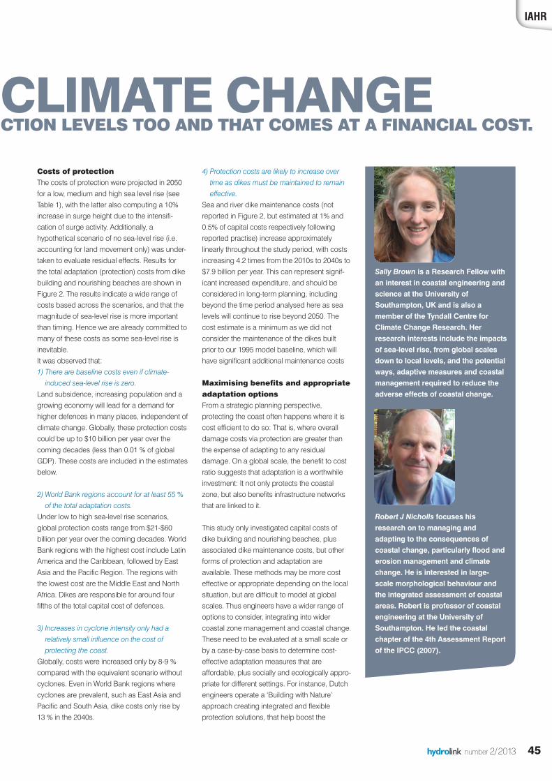
Sally Brown is a Research Fellow withan interest in coastal engineering andscience at the University ofSouthampton, UK and is also amember of the Tyndall Centre forClimate Change Research. Herresearch interests include the impactsof sea-level rise, from global scalesdown to local levels, and the potentialways, adaptive measures and coastalmanagement required to reduce theadverse effects of coastal change.
Robert J Nicholls focuses hisresearch on to managing andadapting to the consequences ofcoastal change, particularly flood anderosion management and climatechange. He is interested in large-scale morphological behaviour andthe integrated assessment of coastalareas. Robert is professor of coastalengineering at the University ofSouthampton. He led the coastalchapter of the 4th Assessment Reportof the IPCC (2007).
hydrolink 2_2013def_23212 19-07-13 13:25 Pagina 45
46 hydrolink number 2/2013
economy, are environmentally friendly andsustainable, whilst making the country a safeplace to live (De Vriend and Van Koningsveld2010). Whilst the Dutch are frequently exhibitedas a model of good practice and robustness inprotecting the coast, other nations may not wantto or be able to afford to protect. It is thesenations that remain vulnerable and alternative,innovative forms of adaptation to sea-level risemay need to be considered. Simultaneously, thenatural environment is also important toconsider and preserve, as noted in Europethrough various EU directives. Indeed, in manydeveloping countries it is the naturalenvironment (e.g. mangroves) that is the first
line of defence against extreme water levels.
Finally, climate change and sea-level rise areoften blamed, not just by the general public, butalso within science as the main cause of futurecoastal disasters. Disasters from extreme waterlevels have occurred well before climatechange was mainstream. Today, in our increas-ingly urbanised lifestyle, it is the combination ofincreased infrastructure, investment and peopleliving on the coast that make the coastal regionvulnerable (e.g. Kron 2012). Thus man’s directmanagement and influence on the coast is asimportant as any local sea level rise.
Figure 1. Retreat-accom-modate-protectadaptation optionsas sea levels rise
Figure 2. Total protection costs from dike building and nourishing beaches, globally and for World Bankcountries to protect against sea-level rise.
ReferencesChurch, J.A. and White N.J. (2011). Sea-level rise from the late 19th
century to the easrly 21st century. Surveys in GeophysicsDe Vriend, H.J. and Van Koningsveld, M. (2012) Building with Nature:
Thinking, acting and interacting differently. EcoShape, Buildingwith Nature, Dordrecht, the Netherlands.
Hinkel, J. and Klein, R.T. (2009) The DINAS-COAST project: devel-oping a tool for the dynamic and interactive assessment of coastalvulnerability. Global Environmental Change, 19 (3), 384–395.
Kron, W. (2012). Coasts: The high-risk areas of the world. NaturalHazards, 66 (3), 1363-1382.
Linham, M.M. and Nicholls, R.J. (2010). Technologies for ClimateChange Adaptation: Coastal Erosion and Flooding. UNEP,Roskilde, Denmark. http://www.unep.org/pdf/TNAhandbook_CoastalErosionFlooding.pdf
Nicholls, R., Brown, S., Hanson, S.E. and Hinkel, J. (2010). Economicsof coastal zone adaptation to climate change. World Bank,Washington, USA.http://climatechange.worldbank.org/sites/default/files/documents/DCCDP_10_CoastalZoneAdaptation.pdf
Small, C. and Nicholls, R.J. (2003). A global analysis of humansettlement in coastal zones. Journal of Coastal Research, 19 (3),584-599.
Vafeidis, A.T., Nicholls, R.J., McFadden, L., Tol, R.S.J., Hinkel, J.,Spencer, T., Grashoff, P.S., Boot, G. and Klein, R.J.T. (2008). A newglobal database for impact and vulnerability analysis to sea-levelrise. Journal of Coastal Research, 24 (4) 917-924.
World Bank (2010). Economics of adaptation to climate change -Synthesis report. World Bank, Washington, USA.http://documents.worldbank.org/curated/en/2010/01/16436675/economics-adaptation-climate-change-synthesis-report
Next stepsWhat are the next steps to understanding andand strategically planning for damage causedby climate change and sea-level rise, andassociated adaptation costs? For developingnations, there is funding for adaptation,protection and resilience against climatechange which was initialised under the auspicesof the Kyoto protocol. One such programme isthe Pilot Program for Climate Resilience aimingto integrate climate risk with developmentplanning and its implementation shifting awayfrom a ‘business-as-usual’ approach to broad-based country-level strategies of climateresilience. For instance, funding has recentlybeen granted to improve coastal embankments,coastal resilient infrastructure and promoteclimate resilient agriculture and food securityand in Bangladesh. These projects often havedual benefits (e.g. reduce flood risk andimprove food security), whilst providing a long-term investment in country’s future.
ConclusionsWith relative sea levels continuing to rise, andexpected to accelerate, we will hear increasingreports of how extreme water levels effect liveli-hoods. Engineers have the opportunity to dosomething about this, and the results from theWorld Bank study by Nicholls et al. (2010)suggest that the financial costs of adapting aregoing to remain high. However, buildingdefences in not the only answer, and engineerscan work with communities to determine theoptimum way to increase resilience and toadapt, potentially via protection, to rising sealevels and other coastal change over long time-scales. One such project undertaking this inBangladesh and the Ganges-Brahmaputra deltais the ESPA Deltas programme , and thisresearch project is discussed in the next article.
hydrolink 2_2013def_23212 19-07-13 13:26 Pagina 46

47
IAHR
IntroductionUntil quite recently, climate change and globalwarming were foreign words to us. However,thanks to climate change scientists from all overthe world and their research findings, some ofus are now more aware that global daily temper-ature is increasing (Karl et al, 1991), and thesephenomena are believed to be the reason whynatural disasters such as floods, droughts,landslides, hurricanes and storm surges aremore frequent than previously. The InternationalPanel on Climate Change (IPCC, 1995) reportedthat the global mean surface air temperaturehas increased by 0.5°C in the 20th century andis projected to increase further in this century,i.e. between 1.5 to 4.5°C. These temperaturechanges will have many negative effects,including greater frequency of heat waves;increased intensity of rain events and storms,floods and droughts; rising sea levels; a morerapid spread of disease; rising number ofnatural disasters and casualties due tolandslides and loss of biodiversity (McLean,2009).
Rising sea levels also pose a particular threat tocountries with high population and socio-economic activities in the coastal regions.Church et al. (2001) predicted a sea level rise(SLR) of 0-1 meter during the 21st century.
According to Dasgupta et al. (2007), three mainfactors contributing to the rising seas are:ocean thermal expansion; melting of theGreenland and Antarctica glacier and icesheets; and changes in terrestrial storage, withocean thermal expansion as the dominantfactor. However, new data on rates ofdeglaciation in Greenland and Antarcticasuggest greater significance for glacial melt,and a possible revision of the upper-boundestimate for SLR in this century. Since theGreenland and Antarctic ice sheets containenough water to raise the sea level by almost
70 m, small changes in their volume would havea significant effect (Dasgupta et al., 2007).
Bindoff et al. (2007) estimates the global meansea level rise rate to be 1.8 ± 0.5 mm/yr for theperiod of 1961-2003, and 1.7 ± 0.5 mm/yr overthe 20th century while Casenave and Nerem(2004) estimate the rate of sea level rise as 3.1± 0.7 mm/yr, based on satellite altimetry obser-vations for the period of 1993 to 2003. Largevariations in sea level rise were observed in thewestern Pacific and eastern Indian Ocean,mainly due to ocean circulation changes
SEA LEVEL RISE IN MALAYSIABY NOR ASLINDA AWANG & MOHD RADZI BIN ABD. HAMID
Although the global prediction for sea level rise is about 1.7 – 3.1 mm/year, the regional sea levelrise in Malaysia is expected to be higher, owing to local climate and topographical conditions. Low-lying areas with high population and socio-economic activities are at risk of being inundated.Malaysia has a long shoreline with most of the cities located near the coast, and NAHRIM hascarried out a number of studies as our preparation to face global warming issues in terms ofprojections for sea level rise in Malaysia, and production of Potential Sea Level Rise (SLR) InundationMaps and Coastal Vulnerability Assessments for high risk areas. These Potential SLR InundationMaps can be used as a guide for planning and implementation agencies such as theDepartmentof Town and Country Planning (JPBD), the Drainage and Irrigation Department (DID), the PublicWorks Department (PWD) and Local Authorities in their development and adaptation planning,avoiding massive development in critical areas.
Figure 1: Projected mean sea level rise along the coast of Malaysia for year 2100. Red circles indicate values higher than 0.4 m rise (Source: NAHRIM, 2010).
hydrolink number 2/2013
hydrolink 2_2013def_23212 19-07-13 13:26 Pagina 47
48 hydrolink number 2/2013
Malaysian coast (based on satellite altimetrydata from 1993 – 2010) is between 2.7 – 7.0mm/yr.;
(iii) In Peninsular Malaysia, the projected SLR forthe year 2100 is 0.25 – 0.5 m with themaximum value occurring in low-lying areasalong the Northeast and West coast of thepeninsular (Kelantan and Kedah);
(iv) In Sabah, the projected SLR for the year2100 is 0.69 – 1.06 m with the maximumvalue occurring in low-lying areas, rivermouths and estuaries in the East coast(Tawau, Semporna, Lahad Datu, Sandakanand Kudat); and
(v) In Sarawak, the projected SLR for the year2100 is 0.43 – 0.64 m with maximum valueoccur in low lying areas, river mouths andestuaries in the Southwest coast (Meradong,located between Batang Igan and BatangRajang).
Table 1 shows the rates of SLR along the coastof Malaysia based on observed satellite altimetrydata from 1993 – 2010 while Figure 1 shows theprojected mean sea level rise for the Malaysiancoast in the year 2100.
Impacts and Adaptation MeasuresClimate change and sea level rise can give riseto high impacts such as destruction of assetsand disruption to economic sectors, loss ofhuman lives, mental health effects, or loss onplants, animals, and ecosystem and theirseverity depends on their extremes, exposureand vulnerability (IPCC, 2012; McLean, 2009).Sea level rise may reduce the size of an island or
state and its’ infrastructure i.e. airports, roads,and capital cities, which normally predominatein the coastal areas; worsen inundation,erosion, and other coastal hazards; threatenvital infrastructure, settlements, and facilities;and thus compromise the socio-economic well-being of the island communities and states(Handmer et al., 2012)
associated with El Niño–Southern Oscillation orEl Niño/La Niña–Southern Oscillation (ENSO)events (Church et al., 2006).
Sea level change varies spatially with someregions showing higher rates compared to theglobal mean sea level rise while sea level inother regions is falling, probably due to regionalthermal expansion (Cazenave and Nerem,2004). The increase in occurrences of extremehigh water due to storm surges and variations inthe extremes related to mean sea level rise in theregional climate are also evident (Bindoff et al.,2007).
Projection of Sea Level Rise inMalaysiaThe Study of the Impact of Climate Change onSea Level Rise in Malaysia (NAHRIM, 2010) wascarried out in 2010, to project SLR in theMalaysian coast for the year 2100. Using lineartrend analysis, satellite altimetry data (1993 –2010) from 30 stations around Malaysia (Figure1) were analysed to obtain the rate of SLR forMalaysia. These values were then assimilatedwith the results from 49 simulations of 7 CoupledAtmospheric-Oceanic General Circulation Model(AOCGM) for SLR projections along the coast ofMalaysia (NAHRIM, 2010). The results showedthat:
(i) There is a significant increase in SLR trendover the recent 5 years, compared to the SLRtrend over 20 years ago;
(ii) The observed Mean SLR rate along the
Station Location Latitude Longitude SLR Rate No. (mm/year)
1 Sempadan Malaysia (Perlis) - Thailand 6 100 6.082 Sempadan P.Pinang – Perak Border 5 99 6.453 Perairan Laut Andaman 1 104 3.874 Perairan Selat Melaka 2 105 3.685 Selat Johor 3 104 2.886 Perairan Mersing 4 104 2.737 Pulau Tioman 5 104 2.788 Persisiran Pantai Pekan 6 103 3.469 Cherating 7 103 3.4910 Pulau Perhentian, Terengganu 7 102 4.2911 Sempadan Malaysia (Kelantan) - Thailand 7 101 5.2012 Perairan Tumpat 6 99 5.7013 Perairan Kelantan 7 99 5.0214 Perairan Kuching dan Bau 4 113 4.7415 Perairan Sejingkat (Sibu) 2 110 4.0016 Perairan Sibu 5 115 5.3717 Perairan Miri 6 116 5.2318 Perairan Bintulu 7 117 5.0619 Perairan Brunei 6 118 5.5720 Luar Persisir Sabah - Sarawak - Brunei 5 119 6.2821 Luar Persisir Sabah - Sarawak - Brunei 4 119 7.0022 Persisiran Pantai Kota Kinabalu 7 118 5.2523 Pulau Labuan 6 119 5.6424 Persisiran Pantai Tuaran - Kota Belud 7 116 5.1725 Teluk Marudu, Kota Marudu - Kudat 6 115 5.2726 Perairan Pitas 5 114 5.1127 Perairan Sandakan 5 113 4.8428 Laut Sulu 4 112 4.5129 Perairan Lahad Datu 3 111 4.1330 Perairan Tawau 3 110 3.82
Nor Aslinda Awang is currently theSenior Research Officer attached withthe Coastal Research Centre, NationalHydraulic Research Institute ofMalaysia (NAHRIM). Over the past 13years, she has worked on hydrody-namic modeling for mangrovereplanting, coastal erosion and sealevel rise in Malaysia. She graduated inCivil Engineering from MARA Universityof Technology, Malaysia. Then, shepursued her studies in The Universityof Waikato, New Zealand where sheearned a Master in Earth Sciences.
Mohd Radzi Abd. Hamid is currentlythe Director of the Coastal ResearchCentre, National Hydraulic ResearchInstitute of Malaysia (NAHRIM). Overthe past 25 years, he has worked oncivil, structural and coastalengineering including hydrodynamicmodeling for mangrove replanting,coastal erosion and sea level rise inMalaysia. He obtained his Diploma inCivil Engineering from MARAUniversity of Technology, Malaysia.Then, he pursued for his Degree atthe University of Hartford, USA.
hydrolink 2_2013def_23212 19-07-13 13:26 Pagina 48
49hydrolink number 2/2013
IAHR
The magnitude of tropical cyclones oftengoverns the magnitude of damage due to stormsurge (Xiao and Xiao, 2010). Suzuki (2009)projected the changes in storm surge andassociated damage for three major bays inJapan, namely Tokyo, Ise, and Osaka, based onthe calculation of inundations for different sealevels and different strengths of typhoons, usinga spatial model with information on topographyand levees. His results indicate that a typhoonwith the strength of 1.3 times higher than thedesign standard, combined with a 60 cm sealevel rise in the investigated bays will causedamage of about USD 3, 40, and 27 billion,respectively.
Warming of the ocean surface will give impactsto the biodiversity and the growth rates ofspecies that are sensitive to temperature such ascorals (Handmer et al., 2012). They reported thatdamage to structures, infrastructure, and cropsduring tropical cyclones and water shortage arethe main impacts from climatic extremes in thetropical regions. On atolls, storm surges, highwave events and ‘king’ tides would bring aserious problem of salinisation of the freshwater.Therefore, awareness, improved governance,proper development and preparedness are veryimportant in coping with climate change impactsin developing countries (Handmer et al., 2012).
Although risks cannot be fully eliminated,disaster risk management and adaptation toclimate change are very important to reduceexposure and vulnerability, and increaseresilience to the potential adverse impacts ofclimate extremes (IPCC, 2012). Furthermore,adaptation and mitigation will complement eachother hence reducing the risks of climate changesignificantly (IPCC, 2012). Some of the alter-native methods recommended by the MalaysianDrainage and Irrigation Department’s Manual(DID Manual, 2009) to mitigate the damage ofcoastal storms and forces are accommodation,protection, beach nourishment, retreat; do-nothing; integrated shoreline management plan,and refurbishment on coastal bund.
Based on the SLR Projections mentioned earlier,NAHRIM then carried out Desktop Studies onfour (4) selected high risk areas along the coastof Malaysia, i.e. Kedah Estuary, TerengganuEstuary, Kota Kinabalu, Sabah and SarawakEstuary. Using Numerical Modeling Suite andGIS Software, Potential SLR Inundation Mapswere produced to assess the impact of SLRtowards the population, development and theroad systems that exist within these areas.
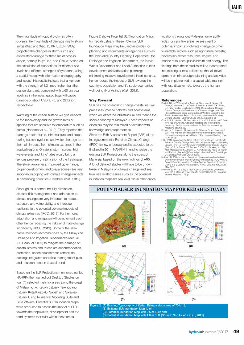
Figure 2 shows Potential SLR Inundation Mapsfor Kedah Estuary. These Potential SLRInundation Maps may be used as guides forplanning and implementation agencies such asthe Town and Country Planning Department, theDrainage and Irrigation Department, the PublicWorks Department and Local Authorities in theirdevelopment and adaptation planning;minimising massive development in critical area,hence reduce the impact of SLR towards thecountry’s population and it’s socio-economicswell-being (Nor Aslinda et al., 2012).
Way ForwardSLR has the potential to change coastal naturalprocesses, marine habitats and ecosystems,which will affect the infrastructure and thence thesocio-economy of Malaysia. These impacts ordisasters may be minimized or avoided withknowledge and preparedness. Since the Fifth Assessment Report (AR5) of theIntergovernmental Panel on Climate Change(IPCC) is now underway and is expected to befinalized in 2014, NAHRIM intend to revise theexisting SLR Projections along the coast ofMalaysia, based on the new findings of AR5.A lot of detailed studies will have to be under-taken in Malaysia on climate change and sealevel rise related issues such as the potentialinundation maps for sea level rise in other critical
Figure 2: (A) Existing Topography of Kedah Estuary study area of 70 km2; (B) Existing SLR Inundation Map (0 m); (C) Potential Inundation Map with 0.5 m SLR; and(D) Potential Inundation Map with 1.0 m SLR (Source: Nor Aslinda et al., 2011)
locations throughout Malaysia, vulnerabilityindex for sensitive areas, assessment ofpotential impacts of climate change on othervulnerable sectors such as agriculture, forestry,biodiversity, water resources, coastal andmarine resources, public health and energy. Thefindings from these studies will be incorporatedinto existing or new policies so that all devel-opment or infrastructure planning and activitieswill be implemented in a sustainable mannerwith less disaster risks towards the humanpopulation.
References Bindoff, N.L., J. Willebrand, V. Artale, A, Cazenave, J. Gregory, S.
Gulev, K. Hanawa, C. Le Quéré, S. Levitus, Y. Nojiri, C.K. Shum,L.D. Talley and A. Unnikrishnan, 2007: Observations: OceanicClimate Change and Sea Level. In: Climate Change 2007: ThePhysical Science Basis. Contribution of Working Group I to theFourth Assessment Report of the Intergovernmental Panel onClimate Change [Solomon, S., D. Qin, M. Manning, Z].
Church, J. A., Hunter, J. R., McInnes, K. L. and N. J. White. 2006. Sea-level rise around the Australian coastline and the changingfrequency of extreme sea-level events. Australia MeteorologyMagazine 55: 253-260
Dasgupta, S., Laplante, B., Meisner, C., Wheeler, D. and Jianping, Y.2007. The impacts of sea level rise on developing countries: acomparative analysis. World Bank Policy Research Working Paper4136: 51 pp.
IPCC, 2012: Managing the Risks of Extreme Events and Disasters toAdvance Climate Change Adaptation. A Special Report of WorkingGroups I and II of the Intergovernmental Panel on Climate Change[Field, C.B., V. Barros, T.F. Stocker, D. Qin, D.J. Dokken, K.L. Ebi,M.D. Mastrandrea, K.J. Mach, G.-K. Plattner, S.K. Allen, M. Tignor,and P.M. Midgley (eds.)] Cambridge University Press, Cambridge,UK, and New York, NY, USA, 582 pp.
McLean, R. 2009. Impacts of weather, climate and sea level-relatedextremes on coastal systems and low-lying islands. IPCC WorkingGroup II Scoping Meeting: Possible Special Report on "Extremeevents and Disasters: Managing the Risks". Oslo, Norway, 23-26May 2009.
NAHRIM, 2010. The study of the impact of climate change on sealevel rise in Malaysia (Final Report), National Hydraulic ResearchInstitute Malaysia: 172pp.
hydrolink 2_2013def_23212 19-07-13 13:26 Pagina 49
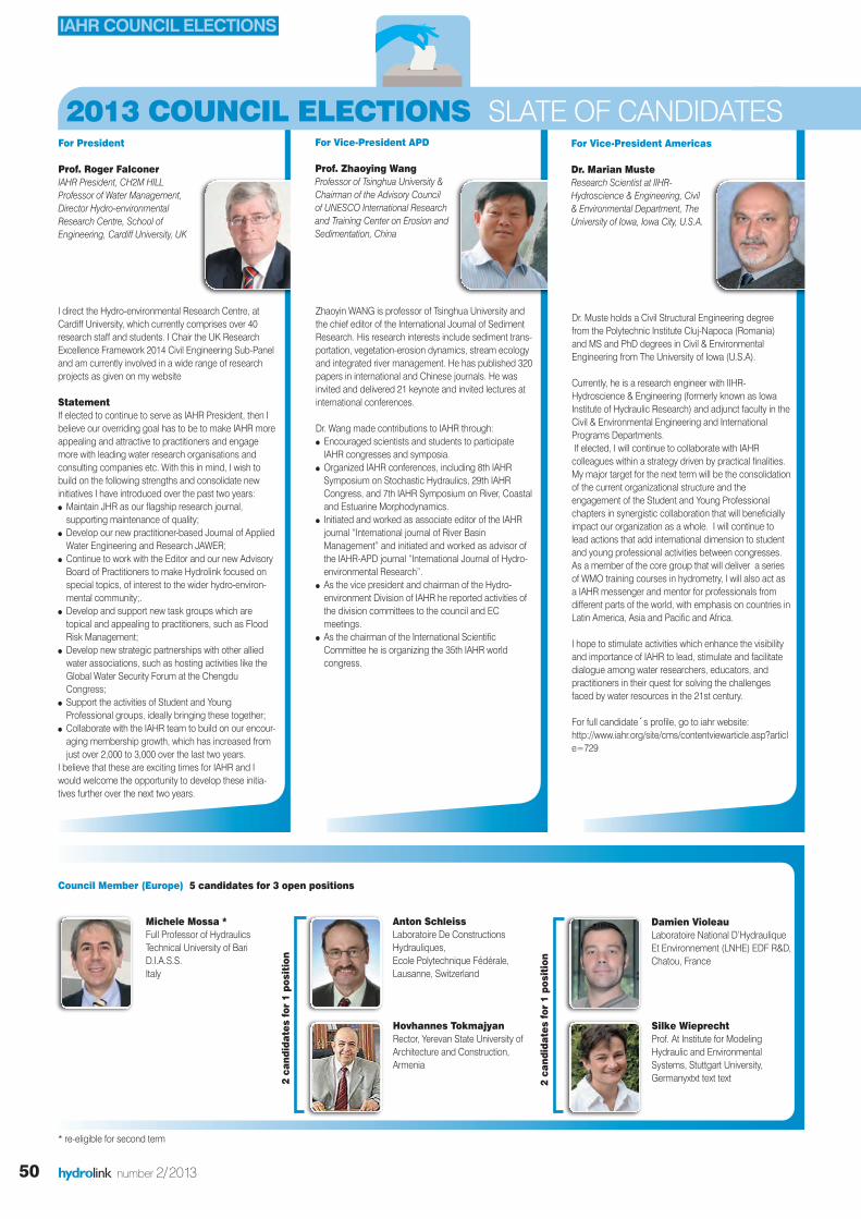
For President
Prof. Roger Falconer IAHR President, CH2M HILLProfessor of Water Management,Director Hydro-environmentalResearch Centre, School ofEngineering, Cardiff University, UK
I direct the Hydro-environmental Research Centre, atCardiff University, which currently comprises over 40research staff and students. I Chair the UK ResearchExcellence Framework 2014 Civil Engineering Sub-Paneland am currently involved in a wide range of researchprojects as given on my website
Statement If elected to continue to serve as IAHR President, then Ibelieve our overriding goal has to be to make IAHR moreappealing and attractive to practitioners and engagemore with leading water research organisations andconsulting companies etc. With this in mind, I wish tobuild on the following strengths and consolidate newinitiatives I have introduced over the past two years:l Maintain JHR as our flagship research journal,supporting maintenance of quality;
l Develop our new practitioner-based Journal of AppliedWater Engineering and Research JAWER;
l Continue to work with the Editor and our new AdvisoryBoard of Practitioners to make Hydrolink focused onspecial topics, of interest to the wider hydro-environ-mental community;.
l Develop and support new task groups which aretopical and appealing to practitioners, such as FloodRisk Management;
l Develop new strategic partnerships with other alliedwater associations, such as hosting activities like theGlobal Water Security Forum at the ChengduCongress;
l Support the activities of Student and YoungProfessional groups, ideally bringing these together;
l Collaborate with the IAHR team to build on our encour-aging membership growth, which has increased fromjust over 2,000 to 3,000 over the last two years.
I believe that these are exciting times for IAHR and Iwould welcome the opportunity to develop these initia-tives further over the next two years.
Zhaoyin WANG is professor of Tsinghua University andthe chief editor of the International Journal of SedimentResearch. His research interests include sediment trans-portation, vegetation-erosion dynamics, stream ecologyand integrated river management. He has published 320papers in international and Chinese journals. He wasinvited and delivered 21 keynote and invited lectures atinternational conferences.
Dr. Wang made contributions to IAHR through:l Encouraged scientists and students to participateIAHR congresses and symposia.
l Organized IAHR conferences, including 8th IAHRSymposium on Stochastic Hydraulics, 29th IAHRCongress, and 7th IAHR Symposium on River, Coastaland Estuarine Morphodynamics.
l Initiated and worked as associate editor of the IAHRjournal “International journal of River BasinManagement” and initiated and worked as advisor ofthe IAHR-APD journal “International Journal of Hydro-environmental Research”.
l As the vice president and chairman of the Hydro-environment Division of IAHR he reported activities ofthe division committees to the council and ECmeetings.
l As the chairman of the International ScientificCommittee he is organizing the 35th IAHR worldcongress.
For Vice-President APD
Prof. Zhaoying Wang Professor of Tsinghua University &Chairman of the Advisory Councilof UNESCO International Researchand Training Center on Erosion andSedimentation, China
Dr. Muste holds a Civil Structural Engineering degreefrom the Polytechnic Institute Cluj-Napoca (Romania)and MS and PhD degrees in Civil & EnvironmentalEngineering from The University of Iowa (U.S.A).
Currently, he is a research engineer with IIHR-Hydroscience & Engineering (formerly known as IowaInstitute of Hydraulic Research) and adjunct faculty in theCivil & Environmental Engineering and InternationalPrograms Departments.If elected, I will continue to collaborate with IAHRcolleagues within a strategy driven by practical finalities.My major target for the next term will be the consolidationof the current organizational structure and theengagement of the Student and Young Professionalchapters in synergistic collaboration that will beneficiallyimpact our organization as a whole. I will continue tolead actions that add international dimension to studentand young professional activities between congresses.As a member of the core group that will deliver a seriesof WMO training courses in hydrometry, I will also act asa IAHR messenger and mentor for professionals fromdifferent parts of the world, with emphasis on countries inLatin America, Asia and Pacific and Africa.
I hope to stimulate activities which enhance the visibilityand importance of IAHR to lead, stimulate and facilitatedialogue among water researchers, educators, andpractitioners in their quest for solving the challengesfaced by water resources in the 21st century.
For full candidate´s profile, go to iahr website:http://www.iahr.org/site/cms/contentviewarticle.asp?article=729
For Vice-President Americas
Dr. Marian Muste Research Scientist at IIHR-Hydroscience & Engineering, Civil& Environmental Department, TheUniversity of Iowa, Iowa City, U.S.A.
hydrolink number 2/201350
Michele Mossa *Full Professor of HydraulicsTechnical University of BariD.I.A.S.S.Italy
Anton SchleissLaboratoire De ConstructionsHydrauliques,Ecole Polytechnique Fédérale,Lausanne, Switzerland
Hovhannes TokmajyanRector, Yerevan State University ofArchitecture and Construction,Armenia
Damien VioleauLaboratoire National D’Hydraulique Et Environnement (LNHE) EDF R&D,Chatou, France
Silke WieprechtProf. At Institute for ModelingHydraulic and EnvironmentalSystems, Stuttgart University,Germanyxtxt text text
Council Member (Europe) 5 candidates for 3 open positions
* re-eligible for second term
2013 COUNCIL ELECTIONS SLATE OF CANDIDATES
IAHR COUNCIL ELECTIONS
2 candidates for 1 position
2 candidates for 1 position
hydrolink 2_2013def_23212 19-07-13 13:29 Pagina 50

IAHR
Arthur Mynett has long been contributing to IAHR invarious capacities. He was actively involved in specialistworking groups and served for over a decade assecretary and chairman of the IAHR-IWA-IAHS JointCommittee on Hydroinformatics. He stimulated cross-links within IAHR as well as with other associationsoutside. He served as Division Chair and has beenelected on Council since 2005.
As professor at UNESCO-IHE, Delft University ofTechnology, and the Chinese Academy of Sciences hehas stimulated many young researchers from all over theworld to contribute to IAHR’s regional and global confer-ences. His working experience of over 30 years with DelftHydraulics enables him to convey the practitioners’needs and promote IAHR in international fora.Prof. Mynett is in charge of organizing the IAHR WorldCongress 2015 in the Netherlands.
Statement “The future of IAHR is with the young generation of hydro-environment professionals; they deserve a prominent rolewithin our association. Externally, we need to strengthenour position and align our activities with other associa-tions. I see a stronger role for IAHR in continuous profes-sional education, and an obligation to reach out towardsthe developing world. Increased membership and soundfinancial policies are crucial to secure the future of ourassociation. As Vice-President I intend to enhance ourrole in the global hydro-environment arena”.
Dr. Gutiérrez graduated in Civil Engineering from thePolytechnic University of Madrid in 1978, and wasawarded a doctorate from the same institution in 1994,.From 1978 until 1998 he worked as an engineer in theHydraulic Studies and Planning Department of theCEDEX “Centro de Estudios Hidrográficos”, in Spain,occupying different posts including finally Head ofDepartment. From 1998 until now he is the Director of theMaritime Experimentation Laboratory of CEDEX. He hasalso served as Associate Professor at the MadridPolytechnic University. He has published numerouspapers related to hydraulic structures and maritimeworks. In 2007, he received the Spanish decoration ofthe Order of Isabel La Católica, for services to foreignadministration. He has been IAHR Secretary Generalsince 2005.
I plan to engage in the following activities:l To ensure a proper execution of collaboration betweenIAHR and CEDEX, acting as link between both institu-tions, especially for the development of a newagreement post 2015.
l To increase the number of members –especiallyinstitute (especially), improve IAHR finances andprovide better services to members, with specialemphasis on increasing: – Specific agreements with national water andhydrotechnical associations
– The participation of professional engineers andothers practitioners
– The participation of students, professional engineersand research workers who have recently graduated.
51hydrolink number 2/2013
For Secretary-General
Dr. Ramón M. Gutiérrez Serret Director of the MaritimeExperimentation Laboratory ofthe CEDEX “Centro de Estudiosde Puertos y Costas”Ministry of Environment, Spain
Philippe Gourbesville is, since 2007, the Director ofPolytech Nice Sophia and professor of Hydroinformaticsand Water Engineering, at the University which is the firstgroup of engineering schools in France. He is a visitingprofessor at various European and international univer-sities. After graduating from Strasbourg University,France, Philippe has spent 12 years in a water consultingcompany as project manager before joining theUniversity of Nice Sophia Antipolis, France in 1997. Since2004 and under the Erasmus Mundus, Philippe hasdeveloped the first joint master degree EuroAquaefocused on Hydroinformatics and water managementwith 5 European leading universities.
If elected, my actions will be focused on the following:l Promote innovation by attracting industrial companieswhich are interested and active in the water domain butnot represented in IAHR and connecting practice withresearch
l Increase the value of IAHR for Institute Membersthrough the development of a problem orientedapproach/organization, the publication of referencedocuments by the sections …
l Develop collaboration with sister scientific organiza-tions at national or international level, and promote co-sponsorship of events.
l Promote involvement of students and young profes-sionals by developing specific actions targeting thosetwo communities which represent the future of IAHR.
l Promote knowledge sharing and transfer by expandingIAHR’s online electronic library and by introducingebooks, wikis and forums.
For full candidate’s profile, go to iahr website:http://www.iahr.org/site/cms/contentviewarticle.asp?article=725
Prof. Philippe Gourbesville Professor and Director ofPolytech Nice Sophia,University Nice SophiaAntipolis, France
Prof. Arthur E. Mynett Professor of Hydraulic Engineeringand Head of Water Science andEngineering Department atUNESCO-IHE Institute for WaterEducation, Delft, The Netherlands
For Vice President Europe 2 candidates for 1 position
James Ball *University of Technology SydneyFaculty of Engineering School of Civil and EnvironmentalEngineeringAustralia
Hitoshi TanakaChair of the IAHR Asia & Pacific Division Dept. of Civil Engineering, Tohoku UniversityJapan
Jing PengDivision of InternationalCooperationChina Institute of Water Resourcesand Hydropower ResearchChina
Arturo Marcano *CVG EDELCAHidroeléctrica MacaguaDepartamento de HidráulicaVenezuela
Angelos FindikakisBechtel National Inc.USA
Council Member (Asia and Pacific) 3 candidates for 3 positionsCouncil Member (North and South Americasand Others)2 candidates for 2 positions
* re-eligible for second term
2013 COUNCIL ELECTIONS SLATE OF CANDIDATES
YOUR VOTE COUNTS!The IAHR Council Elections ar
e open until Wednesday, September 11th. All
IAHR Members have been invited to vote by electronic ballot
. If you wish to
vote and have not received a ballot or have lost your ballot, p
lease contact
Elsa Incio at [email protected] or visit the website at www.iahr.org !
hydrolink 2_2013def_23212 19-07-13 13:29 Pagina 51

52 hydrolink number 2/2013
Stefan Szylkarski is a Group Directorwith DHI and a civil engineer with overtwenty years of experience inhydraulics and environmentalengineering in water environments.He has worked extensively with DHI inthe application of hydrodynamicmodels, decision support andintegrated hydroinformatic softwaresystems for planning and real timemanagement of regulated riverssystems.
Terry van Kalken is a TechnicalDirector at DHI. He has 25 years’experience in the development andapplication of hydrodynamic modelsfor water resources and flood risk.Following an MSc in ComputationalHydraulics at IHE Delft in 1988, heworked initially at DHI in Denmark inthe MIKE 11 development team, andsubsequently on projects in Asia,Latin America, Africa, UK, Europe andNew Zealand. He is currently CARMproject manager, based in Brisbane,Australia.
HydroinfromaticsThe Hydroinformatics industry is a growingbranch of informatics which integrates digitalinformation and communication technologies,numerical modelling in a decision supportframework to solve problems in water environ-ments, including hydrologic, hydraulic andenvironmental systems. Hydroinformatics grewout of the earlier discipline of computationalhydraulics and was foreseen more than 20 years ago (Abbot et al, 1991) as a naturalprogression of the 4th generation hydraulicmodelling systems that were emerging at thetime, and which are in common engineeringpractice today.The management of waters in large riversystems is a key area where hydroinformatics isbeing applied today and in recent times hasexperienced significant evolution.Hydroinformatics in river management providessupport for decision-making in planning andoperations of river systems to address increas-ingly serious problems in the equitable andefficient use of water. River management hastraditionally utilised conceptual hydrologyapproaches as the basis for decision makingtools. However, computational hydraulicsremains as the core technology of hydro-informatics. As river management continues toevolve into hydroinformatics, the tools applied inriver management are shifting towards compu-tational hydraulics at the core and augmentedwith the traditional and complementarytechnologies including meteorology, hydrology,optimisation and eco-hydraulics.
Decision Support Processes in RiverSystem Management.Within the area of river management there aretwo very distinct requirements for a decisionsupport system (DSS) in the management ofwaters within a river basin; the basin planningprocess and the river operations process. The river basin planning process requires data,models and analytical tools to support decision-making in terms of allocating water tocompeting users over long periods of time intothe future. The DSS supports the making ofvalue judgments and the trade-offs between
social, environmental and economic uses of thewater in a river basin. The DSS will thereforeincorporate tools and methods suited foranalysing high level system behaviour; it utilisesconceptual model of complex processes andincorporates tools that focus on uncertainty andtrade-offs between overall allocation of water todifferent users. The system is, in general, datadriven with simplified conceptual and empiricalmodels for forecasting future behaviour usinghistorical or long term forecast data for timespans in the order of decades. The DSS used inthis process is therefore an offline and stand-alone system similar in nature to the traditionalmodelling and planning approach.The river basin operational process requiressupport for real time decision making in terms ofsettings for water infrastructure such as valves,gates, weirs and pumps. The DSS supports theoperator in making very specific and exactsettings for infrastructure in the river basinspanning the coming hours and days. Theobjective of the DSS is to provide an optimisedsystem setting for all dam and regulated waterreleases so as to meet the near future demandsas efficiently as possible. The operational DSSwill therefore require large amounts of real timedata and physics based models that preciselypredict water flows and process in the system.The models required for an operational DSS areby nature highly parameterised, a necessaryrequirement if oversimplification of the complexriver processes is to be avoided and to ensureprecise decisions can be made on a soundphysical basis. The operational DSS combinesvast amounts of real time hydrological andhydraulic data, and continuously updatesoperational forecasts based on the most currentriver state. This requires a high level ofautomation and sophistication in operationalInformation Technology.The concept of different systems supporting theplanning and operation of river basins isanalogous to the flying of a modern airliner. Theroute planning process uses a specific softwaretool that produces a flight plan which balancesvalue judgments and trade-offs between risks,resources schedule and economy. Once theplane is airborne the pilot acts as the flight
EVOLUTION OF HYDROINFORMATICS IN MURRUMBIDGEE RIVER COMPUTER A BY STEFAN SZYLKARSKI & TERRY VAN KALKEN
HYDROINFORMATICS
hydrolink 2_2013def_23212 19-07-13 13:29 Pagina 52
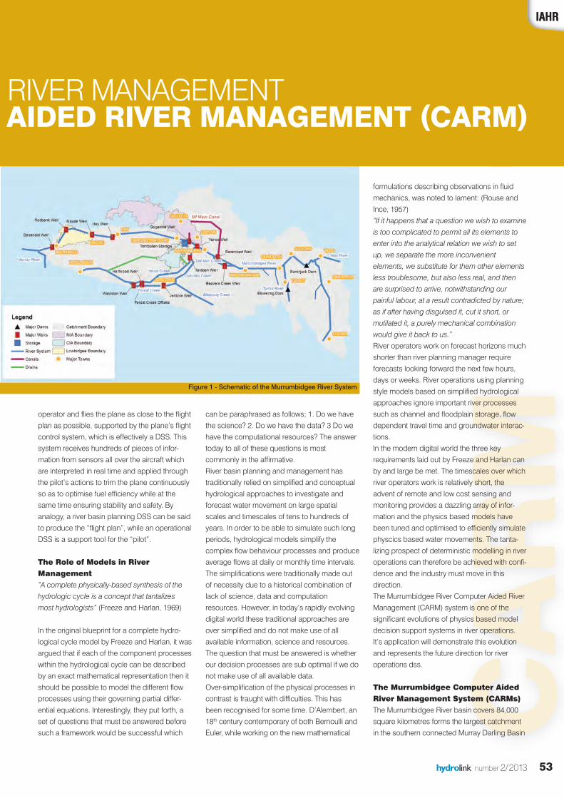
CARM
53hydrolink number 2/2013
formulations describing observations in fluidmechanics, was noted to lament: (Rouse andInce, 1957)“If it happens that a question we wish to examineis too complicated to permit all its elements toenter into the analytical relation we wish to setup, we separate the more inconvenientelements, we substitute for them other elementsless troublesome, but also less real, and thenare surprised to arrive, notwithstanding ourpainful labour, at a result contradicted by nature;as if after having disguised it, cut it short, ormutilated it, a purely mechanical combinationwould give it back to us.”River operators work on forecast horizons muchshorter than river planning manager requireforecasts looking forward the next few hours,days or weeks. River operations using planningstyle models based on simplified hydrologicalapproaches ignore important river processessuch as channel and floodplain storage, flowdependent travel time and groundwater interac-tions. In the modern digital world the three keyrequirements laid out by Freeze and Harlan canby and large be met. The timescales over whichriver operators work is relatively short, theadvent of remote and low cost sensing andmonitoring provides a dazzling array of infor-mation and the physics based models havebeen tuned and optimised to efficiently simulatephyscics based water movements. The tanta-lizing prospect of deterministic modelling in riveroperations can therefore be achieved with confi-dence and the industry must move in thisdirection.The Murrumbidgee River Computer Aided RiverManagement (CARM) system is one of thesignificant evolutions of physics based modeldecision support systems in river operations. It’s application will demonstrate this evolutionand represents the future direction for riveroperations dss.
The Murrumbidgee Computer AidedRiver Management System (CARMs)The Murrumbidgee River basin covers 84,000square kilometres forms the largest catchmentin the southern connected Murray Darling Basin
IAHR
operator and flies the plane as close to the flightplan as possible, supported by the plane’s flightcontrol system, which is effectively a DSS. Thissystem receives hundreds of pieces of infor-mation from sensors all over the aircraft whichare interpreted in real time and applied throughthe pilot’s actions to trim the plane continuouslyso as to optimise fuel efficiency while at thesame time ensuring stability and safety. Byanalogy, a river basin planning DSS can be saidto produce the “flight plan”, while an operationalDSS is a support tool for the “pilot”.
The Role of Models in RiverManagement ”A complete physically-based synthesis of thehydrologic cycle is a concept that tantalizesmost hydrologists” (Freeze and Harlan, 1969)
In the original blueprint for a complete hydro-logical cycle model by Freeze and Harlan, it wasargued that if each of the component processeswithin the hydrological cycle can be describedby an exact mathematical representation then itshould be possible to model the different flowprocesses using their governing partial differ-ential equations. Interestingly, they put forth, aset of questions that must be answered beforesuch a framework would be successful which
can be paraphrased as follows; 1. Do we havethe science? 2. Do we have the data? 3 Do wehave the computational resources? The answertoday to all of these questions is mostcommonly in the affirmative. River basin planning and management hastraditionally relied on simplified and conceptualhydrological approaches to investigate andforecast water movement on large spatialscales and timescales of tens to hundreds ofyears. In order to be able to simulate such longperiods, hydrological models simplify thecomplex flow behaviour processes and produceaverage flows at daily or monthly time intervals.The simplifications were traditionally made outof necessity due to a historical combination oflack of science, data and computationresources. However, in today’s rapidly evolvingdigital world these traditional approaches areover simplified and do not make use of allavailable information, science and resources.The question that must be answered is whetherour decision processes are sub optimal if we donot make use of all available data.Over-simplification of the physical processes incontrast is fraught with difficulties. This hasbeen recognised for some time. D’Alembert, an18th century contemporary of both Bernoulli andEuler, while working on the new mathematical
IAHR
N RIVER MANAGEMENT R AIDED RIVER MANAGEMENT (CARM)
Figure 1 - Schematic of the Murrumbidgee River System
hydrolink 2_2013def_23212 19-07-13 13:29 Pagina 53
New in the Series IAHR Monographs
Wolfgang Rodi, ,
Thorsten Stoesser
Peter A. Davies
About the IAHR Book Series
Groundwater
Environmental Fluid
!
oesserren SttsThor
, odiang RgolffgW
w in the Series IAHR MonogrNe
,
aphsw in the Series IAHR Monogr
About the IAHR Bo
ok Series
er AteP
En
viess. Daer A
al Fluid tonmenvirEn
oundwGr
!
er taoundw
Individual membership benefits:� � � � �
� � � �
welcome IAHR
� River and coastal hydraulics� Water resources management� Eco-hydraulics� Ice engineering
� Hydraulic machinery� Hydroinformatics� Hydraulic structures, marine outfalls and urban drainage
� Education and Professional Development
� Fluid Mechanics� Groundwater
Membership Fees for different categories:Our two-tier fee structure reflects the countries economic standard
Country Base fee € (in 2013) Senior, Student fee € (in 2013)High income 78 39Low income 39 20
IAHR, founded in 1935, is a worldwide, independent organisation of engineers and water specialists working in fields relatedto hydro-environmental science and its practical application
*For information on income level of country and benefits of different categories visit “About IAHR / Membership” on the IAHR website www.iahr.org (for information: 1 Euro is approximately equivalent to 1.30 US Dollars)
Join now atwww.iahr.org
Supported by
TANRETNI
w
TAICOSSALANOI
clewwe
ORDYHROFNOIT
moc
TNEMNORIVNE-O
em ot
AGNIREENIGNE
o HAI
HCRAESERDNA
RH
wpemoceb
igneecI�
dyh-ocE�
erretaW�
nareviR�
clewwelrowehtfotrap
gnireenisciluard
nemeganamsecruosesciluardyhlatsaocdn
mocorivne-ordyhdl
rudnasllaftuourtsciluardyH�
tamrofniordyH�
camciluardyH�
tns
em oteenignetnemno
G�
F�
DE�
eganiardnabreniram,serutc
scityrenihc
o HAIaeserdnagnire
retawdnuorGscinahceMdiulF
tnempoleveDeforPdnanoitacudE
RHtinummochcra
lanoisse
!yt
igneecI�
gnireeni
rudnasllaftuo
G�eganiardnabr
retawdnuorG
ybdetroppuS
wJ
gro.rr.hai.wwwtawonnioJ
alacitcarpe-ordyhotretawdnaednepedniuof,RHAI
elemocninonoitaamrofniroF*
noitacilppanaecneicslatnemnorivneifnignikrowstsilaicepsrnignefonoitasinagrotnewdlrowasi,5391nidedn
sioruE1:noitaamrofnirof(effidfostifenebdnayrtnuocfoleve
stidndetalersdle
sreen,ediw
niwoLnihgiHtnuoC
wtruOMem
U03.1ottnelaviuqeyletaatmixorppa/RHAItuobA““Atisivseirogetactnere
93emocn87emocn
(€eefesaByrt
celfererutcurtseefreit-owmbership Fees
)sralloDSUetisbewRHAIehtno”pihsrebmeM
0293
utS,r,oineS)3102ni(
monoceseirtnuocehtstcrefid f ent corfs
gro.rhai.www
)3102ni(€eeftnedu
dradnatscim:seirocateg
hydrolink 2_2013def_23212 19-07-13 13:30 Pagina 54

CARM
55hydrolink number 2/2013
IAHR
(MDB). The river flows 1000km westward fromthe catchment headwaters to the Murray River.The average annual rainfall ranges from over1,700 millimetres in the alpine areas of theSnowy Mountains, to less than 350 millimetreson the semi-arid western plains. Evaporationdisplays an inverse picture, varying from lessthan 1,000 millimetres per year in the south-east,to over 1,800 millimetres per year in the west.Major water storages in the headwaterscomprise Burrinjuck Dam (1028 GL) andBlowering Dam (1628 GL). River operations areaugmented by a series of 6 in-river regulators(weirs) and on off-stream storage reservoir atTombullen.State Water Corporation is responsible for bulkwater deliveries and river operations in NewSouth Wales (NSW). The daily operation of theriver is a complex task that needs to take intoaccount not only the thousands of individualwater users but also a range of catchment andriver processes that are difficult to quantify.Water once released from the dams takes up tofour weeks to travel down the system. Currentriver operations rely heavily on the experienceand judgment of the river operator and arebased on simple water balance modellingconcepts. The long travel times coupled withdynamic river behaviour and unpredictablefuture weather conditions leads to significantuncertainty in the volume and timing of damreleases. As a result of the many uncertainties inquantifying the real inflows and extractions toand from the river, the river operator is usuallyconservative when computing the daily damreleases, with the end result that often morewater is released than is needed to satisfy alldemands, which affects the future reliability ofsupply.
As part of a programme to modernise thecurrent operations, State Water have embarkedon a US$65m upgrade of the river managementand operational system for the MurrumbidgeeRiver that sets a benchmark for efficient riveroperations in Australia and internationally. TheMurrumbidgee River Computer Aided RiverManagement system (CARMs) is an example ofan operational DSS in river basin management.The recent recipient of the Australian WaterAssociation’s National Award for Innovation inWater Infrastructure, CARMs represents thefuture direction of contemporary DSS in opera-tional river management.CARM is true to the vision of the role of hydroin-formatics in supporting decision making asenvisaged more than two decades ago. TheCARM system integrates real time data, hydro-
logical and hydraulic models in a DecisionSupport framework customised for real timeriver operations (van Kalken et al, 2012). Realtime data feeds include observed and forecastcatchment rainfall, river extractions, river flowsand levels and dam and regulator gate settings.Real time extraction metering forms a keycomponent of the CARM project and is beingrealised through the installation of over 700 newflow meters providing real time water extractioninformation to river operators for the first time(see Fig. 3b). Catchment runoff flows areforecast using rainfall-runoff models, utilisingboth rainfall observations and Bureau forecasts.These are fed into a hydrodynamic riversimulation model that accurately simulates theriver behaviour, including flow dependent traveltime, channel and weir storage. The hydrody-namic model assimilates the measured riverflows and levels to update the river state prior togenerating forecasts. Near-river bank andgroundwater exchanges, as well as evapotran-spiration along the riparian margin, aresimulated using an integrated surface ground-water interaction model, fully coupled to thehydrodynamic river model. CARM incorporates an optimisation tool which
updates the settings for the dam releases andthe downstream re-regulation weirs severaltimes a day. The optimisation recognisessystem constraints such as channel capacitiesand desired flow rates of change, and operateswith the objective to meet all water demandswhile at the same time minimising releases fromthe headwater storages.
The CARM DSS integrates all measured andmodelled data will a range of custom tools toallow the operators to check and verify data andresults.
ConclusionsThe rise of hydroinformatics as the naturalprogression from computational hydraulicsembedded in common hydraulic modellingsoftware was foreseen more than 20 years ago.Advances in information technology, data acqui-sition and processing and computational powerhave all contributed to the realisation of thehydroinformatics vision. The development of DSS in river managementis the realisation of the hydroinformatics vision inriver management. DSS in river managementcan be broadly classified into two distinct typessupporting river basin planning over longtimescales or conversely river operations overshorter timescales. The requirements for theunderlying numerical tools are also different,with river basin planning being undertaken overlarge spatial and temporal timescales, whichultimately leads to the necessary simplificationof short term processes. Conversely, riveroperations requires precise knowledge of thedynamic river and catchment processes onwhich to base robust decisions, and thesecannot be adequately resolved with simplifiedapproaches.
The Murrumbidgee River Computer Aided RiverManagement (CARM) system is one of thesignificant evolutions of physics based modeldecision support systems in river operations. Itsapplication will demonstrate this evolution andrepresents the future direction for river opera-tions.
ReferencesAbbott, M.B., Havnø, K. and Lindberg, S. (1991); “The Fourth
Generation of Modelling in Hydraulics”, Journal of HydraulicsResearch, 29 (5), 581-600.
Butts., M., and Graham, D., (2008), Evolution of an integrated surfacewater-groundwater hydrological modelling system. IAHRInternational Groundwater Symposium, Istanbul, June 18-20, 2008
Freeze, R.A., and Harlan, R.L. (1969) Blueprint of a physically-based,digitally simulated hydrologic response model, J. Hydrol. 9, 237-258,
Rouse, H. and Ince, S (1957); “History of Hydraulics”, Iowa Institute ofHydraulic Research, State University of Iowa, 1957.
van Kalken, T., Nachiappan, N., Berry, D. and Skinner, J, (2012), AnOptimized, Real Time Water Delivery and Management System forthe Murrumbidgee River, Engineers Australia, Hydrology andWater Resources Symposium, 3-11 July 2012.
Figure 3a - Yanco Weir, Murrumbidgee River
Figure 3b - Telemetered Water Meter
hydrolink 2_2013def_23212 19-07-13 13:30 Pagina 55
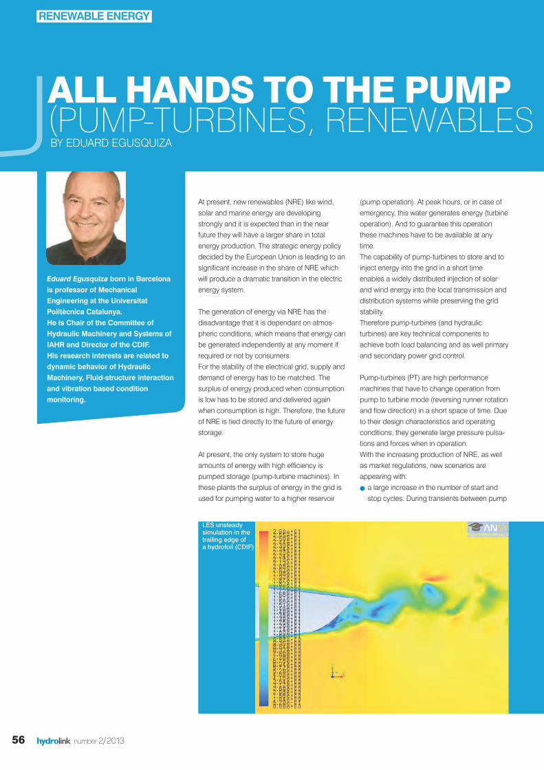
Eduard Egusquiza born in Barcelonais professor of MechanicalEngineering at the UniversitatPolitècnica Catalunya.He is Chair of the Committee ofHydraulic Machinery and Systems ofIAHR and Director of the CDIF.His research interests are related todynamic behavior of HydraulicMachinery, Fluid-structure interactionand vibration based conditionmonitoring.
56 hydrolink number 2/2013
ALL HANDS TO THE PUMP(PUMP-TURBINES, RENEWABLES BY EDUARD EGUSQUIZA
At present, new renewables (NRE) like wind,solar and marine energy are developingstrongly and it is expected than in the nearfuture they will have a larger share in totalenergy production. The strategic energy policydecided by the European Union is leading to ansignificant increase in the share of NRE whichwill produce a dramatic transition in the electricenergy system.
The generation of energy via NRE has thedisadvantage that it is dependant on atmos-pheric conditions, which means that energy canbe generated independently at any moment ifrequired or not by consumers.For the stability of the electrical grid, supply anddemand of energy has to be matched. Thesurplus of energy produced when consumptionis low has to be stored and delivered againwhen consumption is high. Therefore, the futureof NRE is tied directly to the future of energystorage.
At present, the only system to store hugeamounts of energy with high efficiency ispumped storage (pump-turbine machines). Inthese plants the surplus of energy in the grid isused for pumping water to a higher reservoir
RENEWABLE ENERGY
(pump operation). At peak hours, or in case ofemergency, this water generates energy (turbineoperation). And to guarantee this operationthese machines have to be available at anytime.The capability of pump-turbines to store and toinject energy into the grid in a short timeenables a widely distributed injection of solarand wind energy into the local transmission anddistribution systems while preserving the gridstability.Therefore pump-turbines (and hydraulicturbines) are key technical components toachieve both load balancing and as well primaryand secondary power grid control.
Pump-turbines (PT) are high performancemachines that have to change operation frompump to turbine mode (reversing runner rotationand flow direction) in a short space of time. Dueto their design characteristics and operatingconditions, they generate large pressure pulsa-tions and forces when in operation. With the increasing production of NRE, as wellas market regulations, new scenarios areappearing with:
l a large increase in the number of start andstop cycles. During transients between pump
LES unsteadysimulation in the trailing edge of a hydrofoil (CDIF)
hydrolink 2_2013def_23212 19-07-13 13:30 Pagina 56
essential to understand some complex flowphenomena and also useful to validate computational models.
To analyse machine structure dynamicsadvanced Finite Element Models (FEM) whichinclude the surrounding mass of water andcomplex boundaries are also available. Theunsteady fluid flow and structure deformationscan be calculated simultaneously (Fluid-structure interaction).
Because real machines have quite complicatedboundary conditions, experiments are alsonecessary in actual machines. Moreover, thestructural characteristics of a real machinecannot be reproduced completely in alaboratory model, so experimental research inprototypes is necessary. Dynamics has also an important role in theupgrading of old power plants. Here a newrunner with more power is installed inside theoriginal casing generating new excitations thatcan produce damage in the machine.
57hydrolink number 2/2013
IAHRIAHR
AND DYNAMICS)
and turbine operating modes strong hydrody-namic instabilities like rotating stall canappear generating strong dynamic forces onthe machine.
l a longer time of off-design operation at verylow loads required by the market and by thegrid authority. Deep part load or overloadoperation leads to complex flow inside themachine with secondary flows and cavitation,which are also sources of dynamic loading.
l the constant trend to increase the hydraulicpower concentration in order to reduce cost.This leads to higher flow velocities andstronger pressure fluctuations.
l Faster start-up and coast-down for a bettergrid control.
The consequence is that dynamic loading,vibration levels and dynamic stresses are muchincreased. The turbine components as well asthe whole hydraulic system including piping andPT structure has to resist all of these forces andkeep stresses below fatigue limit, for a lifespanof several decades. On the other hand, instabil-ities and cavitation can impair the operation ofthe machine.Due to these facts analysis of the dynamicbehaviour is necessary. The challenge is to
calculate the hydraulic forces generated as wellas the deformations, vibrations and stressesproduced. The final objective is to determine thelimits of operation and the residual life of themachine components.
Taking into account that the runner of a pump-turbine is a structure rotating inside a casing fullof water at high pressure with very small clear-ances between the runner and the casing thedynamic response is very complex. Addedmass and damping of water is affecting thedynamic very much.To tackle these phenomena advanced threedimensional Computation Fluid Dynamic (CFDsimulation) with better flow turbulence modellingis available. However advanced simulationmethods are time consuming and sometimesare not applicable to industrial application inlarge machines.
Even with large computational power, somephenomena have to be investigated experimen-tally in models at reduced scale. In these testbeds advanced equipment with high speedcameras, miniature embedded sensors, laserPIV and advanced acquisition systems areused. This advanced experimental research is
t View of a test rig for reduced-scale models (Laboratoire de Machines Hydraulics, EPFL)
t Deformations (amplified) in the runner of a pump-turbine near resonance conditions (CDIF)
Reprinted with permission of Public Service Europe www.publicservice.co.uk
hydrolink 2_2013def_23212 19-07-13 13:30 Pagina 57
58 hydrolink number 2/2013
be completely obviated. There is always aremaining risk whose minimization is also influ-enced by the effectiveness of defending thecatastrophe. We have possibilities to estimatethe consequences of the failure of technicalsystems. It is necessary to clarify in advancewhat is not allowed to occur at all (e.g. loss oflives or failure of critical infrastructure) and toconcentrate the preventive flood protection onthe core endangered areas. Such flood riskmanagement requires the consolidation of floodprevention, technical flood protection andcatastrophy defense. Every avoided dike break increases the floodrisk for the downstream areas. Therefore, largecontrollable flood polders and flood retentionreservoirs have to be complemented byimproved stable dikes. Moreover, the strength-ening and building of new dikes in the affectedareas require transnational flood protectionconcepts. The sole demand for ‘more space for rivers‘does not consider the whole complexity of theproblem, deflects from currently feasiblesolutions and cannot efficiently reduce thedangers of flooding in the coming decades. Thedeconstruction of dikes is a possible option foraction as well as resettlements of residents offlood-prone areas, but only applicable if politicalwillingness and social acceptance are present.The many exceptional rules for allocation ofbuilding areas in flood-prone areas after theWater Resources Act are very questionable inthat context.
In Germany we have the ability to improve floodprotection. This requires expert knowledge towhich we as researchers can and want tocontribute. Many new developments have beenimplemented (e.g. new systems for dike controland safeguard, new large-scale planning toolsfor the development of transnational floodprotection concepts for river basins whichovercome the federal fragmentation of floodprotection in Germany, new constructiontechniques for protecting buildings and infra-structure and flood-proof buildings). Thisrequires awareness that flood protection is not atask reccurring from time to time, but anongoing service for the public in many areas inour country. An improvement of the flood protection requiresa social dialogue about handling of risks,openness in thinking, reality awareness and thewillingness and power for changes. We offer oursupport for the implementation.
The flood in June 2013 has caused enormousdamages. As in 2002 and 2005, large areashave been flooded in Germany. The question forthe reasons meets the core of our understandingabout the interrelation between nature andhumans.
Our opinion is the following:Floods occur as a result of extreme weatherconditions. The flood of 2013 was the result ofextreme precipitation (200 mm within three days)which fell on extremely humid soils (highest soilmoisture at the end of May 2013 in 50 years).For hundreds of years humans have beensettling along large rivers. If we also want to usefloodplains for settlements in the future, wecannot disclaim technical flood protection. Each flood is unique and demonstrates ournatural limits in influencing such events. Humanscan control such extreme floods only to a certainextent by technical measures and therefore theyhave to protect themselves against the conse-quences of floods. In many areas in Germanythe dikes and flood protection systems,especially those which have been strengthenedand newly built after the 2002 event, have fulfilledtheir protective functions. Complete flood protection is not wise economi-cally and technically often not possible either.Each increase of the degree of flood protectionrequires a social consensus as the comparisonof the towns of Eilenburg and Grimma hasdemonstrated. In Eilenburg, an extended floodprotection system was installed after the flood ofthe year 2002. In Grimma, a similar protectionmeasure was refused by some parts of the localinhabitants. As a result, the city of Grimma wasdamaged in a similar way as in 2002, but flooddamages in Eilenburg were very smallcompared to 2002. Therefore, individual respon-sibility of affected citizens is also required andmust be complemented by national floodprevention. Society has to decide: How muchflood protection is sufficient? Which risks are wewilling to take in the future?Technical flood protection must always becombined with flood prevention (What happens,if …?). A failure of a protection system can never
The following persons have written thisstatement:Prof. Andreas Dittrich, Technische Universität BraunschweigProf. Peter Fröhle, Technische Universität Hamburg-HarburgProf. Kai-Uwe Graw, Technische Universität DresdenProf. Uwe Grünewald, Brandenburgisch University of Technology CottbusProf. Uwe Haberlandt, Leibniz Universität HannoverProf. Reinhard Hinkelmann, Technische Universität BerlinProf. Jürgen Jensen, Universität SiegenProf. Günter Meon, Technische Universität BraunschweigProf. Heribert Nacken, RWTH Aachen UniversityProf. André Niemann, Universität Duisburg-EssenProf. Peter Rutschmann, Technische Universität MünchenProf. Torsten Schlurmann, Leibniz Universität HannoverProf. Andreas Schumann (Initiator), Ruhr-Universität BochumProf. Holger Schüttrumpf, RWTH Aachen UniversityProf. Jürgen Stamm, Technische Universität DresdenProf. Stephan Theobald, University of KasselProf. Silke Wieprecht, University of Stuttgart
STATEMENT REGARDING THE RECENTFLOODS IN GERMANY HAS FLOOD PROTECTION FAILED IN JUNE 2013 IN GERMANY?
STATEMENT OF PROFESSORS HOLDING CHAIRS IN HYDRAULIC ENGINEERING AND ENGINEERING HYDROLOGY AT GERMAN UNIVERSITIES FROM 15 JUNE 2013.
TOPICAL ISSUE
hydrolink 2_2013def_23212 19-07-13 13:30 Pagina 58

IAHR
59hydrolink number 2/2013
9TH INTERNATIONAL SYMPOSIUM ONECOHYDRAULICS SEPTEMBER 17TH - 21ST, 2012 VIENNA, AUSTRIABY HELMUT MADER AND JULIA KRAML
CONFERENCE REPORT
International Symposia on Ecohydraulics havebeen arranged and hosted by members of theEcohydraulics Committee of IAHR since 1994 inTrondheim, Quebec, Salt Lake City, Cape Town,Madrid, Christchurch, Conception and Seoul.The 9th International Symposium onEcohydraulics was organized by the Departmentof Water, Atmosphere and Environment, Instituteof Water Management, Hydrology and HydraulicEngineering, BOKU, Vienna.
ISE 2012 has been an international and interdisci-plinary platform for networking and informationexchange and brought together 249 delegates,researchers and scientists from 33 countries affil-iated with universities, planning offices, publicauthorities, and industry to debate the latestachievements in science and technology in thefield of Ecohydraulics in 33 sessions of oral and 2sessions of poster presentations. Out of 452abstracts submitted, the International ScientificCommittee finally has selected 200 oral presenta-tions and 61 posters during the reviewingprocess to keep the scientific standard at a veryhigh level. As the Symposium theme "Water is theorigin of everything" - a quote from the Greekphilosopher Thales of Milet Miletus (624-546 A.D.)is still valid in our times and various human activities still affect the water cycle, and adverseenvironmental impacts have to be faced, themain objectives of the ISE 2012 focused on thecentral role of Ecohydraulics to analyze the inter-relationship between water and the environment,the assessment of human induced environmentalimpact and the development of watermanagement strategies harmonizing economicas well as ecological requirements. Papers onthe following topics: i) River restoration, ii)Aquatic ecology, iii) Habitat Modelling, iv)Minimum flow, v) Hydro peaking, vi) Aquaticcontinuum, vii) Fish migration, viii) Fishscreening, ix) Sediment flow, x) Sediment interac-tions on habitat, xi) Flow regime alterations, xii)
Wetland and Estuary Restoration, xiii) Watermanagement in wetlands and estuary, xiv) Hightechnology on Ecohydraulics, xv) Effects of globalclimate change, xvi) Solute and Nutrient Transporthave been presented at the symposium and havebeen included in the symposium proceedings.
The opening ceremony of the ISE 2012 waschaired by Prof. Helmut MADER, ConferenceChairman, University of Natural Resources andApplied Life Sciences, BOKU with OpeningRemarks and Welcome Messages by Prof. GeorgHaberhauer, Vice Rector of the University ofNatural Resources and Life Sciences and by Dr.Robert Fenz, Department Head, Section Water ofthe Austrian Federal Ministry of Agriculture,Forestry, Environment and Water Management.The opening ceremony was completed by thekeynote lecture of Dr. Birgit VOGEL entitled“Large River Basins and their AppliedManagement - Feasible or Not?” This introductorylecture for the Ecohydraulics 2012 conferencefocused on large river basins around the world,their basic natural features, keypressures/impacts and their basin-widemanagement. Following symposium days startedwith keynote lectures by Dr. Otto PIRKER fromVERBUND Hydro Power, entitled “Re-establishingriver continuity from an end users perspective”, byDr. Atle Harby, Director of the Center forEnvironmental Design of Renewable Energy atSINTEF, Norway, entitled “Eco-hydraulic researchwithin Centre for Environmental Design ofRenewable Energy” and by Prof. Claudio I. Meier
from the Department of Civil Engineering,Universidad de Concepción entitled “How DoRiparian Poplars and Willows really Establish alongGravel-Bed Rivers?”.The symposium offered 3 parallel sessions fororal presentations, 2 poster sessions and 3Technical Tours visiting fish passes at Danubehydropower plants, the National Parks “DonauAuen” and “Neusiedler See – Seewinkel” and theLife Nature Project in world cultural heritageWachau. Delegate Breakfasts & Daily ComeTogether, an Ice Breaker "Heuriger" with WineDegustation and a Conference Banquet in theVienna City Hall, Ballroom have been part andparcel of the social programme.
The full version of conference proceedings arepublished in the e-Book: 9th InternationalSymposium on Ecohydraulics 2012 -Proceedings, Editors: Helmut Mader & JuliaKraml, ISBN: 978-3-200-02862-3 and can bedownloaded from the Symposium webpage(www.ise2012.boku.ac.at). Selected papers willbe published in special issues of LIMNOLOGICA -Ecology and Management of Inland Waters andJRBM - International Journal of River BasinManagement.
The ISE 2012 was co-sponsored by the IAHR.The main support was provided by the Universityof Natural Resources and Applied Life Sciences,BOKU, the City of Vienna and the companiesVERBUND Hydro Power AG, ANDRITZ Hydro,KIRCHDORFER Group and MABA as goldSponsors of the ISE 2012.
Finally, 20 years after the first Symposium onEcohydraulics was organized in Trondheim, it isa great pleasure for the Local OrganizingCommittee of the 10th Symposium onEcohydraulics to welcome delegates back toTrondheim, Norway, 23rd – 27th June 2014(www.cedren.no/ecohydraulics2014).
The 9th International Symposium on Ecohydraulics was held in Vienna, Austria from September 17th - 21st, 2012. The Symposium was hosted in the “Water Campus” of the University of NaturalResources and Applied Life Sciences, BOKU.
"Water is the origin of everything"
hydrolink 2_2013def_23212 19-07-13 13:30 Pagina 59
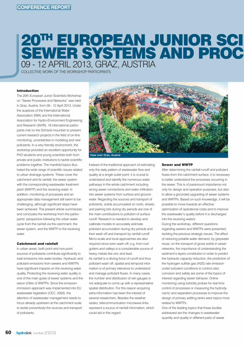
60 hydrolink number 2/2013
Sewer and WWTPAfter determining the rainfall runoff and pollutantfluxes from the catchment surface, it is necessaryto better understand the processes occurring inthe sewer. This is of paramount importance notonly for design and operation purposes, but alsoto allow a grounded upgrading of sewer systemsand WWTPs. Based on such knowledge, it will bepossible to move towards an effectiveoptimization of operational costs and to improvethe wastewater’s quality before it is dischargedinto the receiving waters.During the workshop, different questionsregarding sewers and WWTPs were presented,tackling the previous strategic issues. The effectof reducing potable water demand, by greywaterreuse, on the transport of gross solids in sewernetworks, the importance of understanding thesediment’s layers constitution in order to predictthe hydraulic capacity reduction, the prediction ofthe hydrogen sulfide gas (H2S) rate emissionunder turbulent conditions to control odor,corrosion and safety are some of the topics ofinterest regarding sewer behavior. Onlinemonitoring using turbidity probes for real timecontrol of processes or measuring the hydrody-namic and separation processes to improve thedesign of primary settling tanks were topics morerelated to WWTPs.One of the leading topics that these studiesaddressed are the changes in wastewaterquantity and quality in different parts of sewer
CONFERENCE REPORT
20TH EUROPEAN JUNIOR SCIE SEWER SYSTEMSAND PROCE 09 - 12 APRIL 2013, GRAZ, AUSTRIACOLLECTIVE WORK OF THE WORKSHOP PARTICIPANTS
IntroductionThe 20th European Junior Scientists Workshopon “Sewer Processes and Networks” was heldin Graz, Austria, from 09 - 12 April 2013. Underthe auspices of the International WaterAssociation (IWA) and the InternationalAssociation for Hydro-Environment Engineeringand Research (IAHR), 18 international partici-pants met on the Schöckl-mountain to presentcurrent research projects in the field of on-linemonitoring, uncertainties in modeling and newpollutants. In a very friendly environment, theworkshop provided an excellent opportunity forPhD-students and young scientists both fromprivate and public institutions to tackle scientificproblems together. The manifold topics illus-trated the wide range of scientific issues relatedto urban drainage systems. These cover thecatchment and its rainfall, the sewer systemwith the corresponding wastewater treatmentplant (WWTP) and the receiving water. Inaddition, monitoring of processes and anappropriate data management still seem to bechallenging, although significant steps havebeen achieved. The present article summarizesand concludes the workshop from the partici-pants’ perspective following the urban watercycle from the rainfall via the catchment, thesewer system, and the WWTP to the receivingwater.
Catchment and rainfallIn urban areas, both point and non-pointsources of pollutants contribute significantly tototal emissions into water bodies. Hydraulic andpollutant emissions from sewers and WWTPshave significant impacts on the receiving waterquality. Protecting the receiving water quality isone of the main goals of sewer systems and theraison d’être of WWTPs. Since the emission-immission approach was implemented into EUwastewater legislation (CEC, 2000), theattention of wastewater management needs tofocus already upstream at the catchment scaleto tackle preventively the sources and transportof pollutants.
Instead of the traditional approach of estimatingonly the daily pattern of wastewater flow andquality at a single outlet point, it is crucial tounderstand and identify the numerous waterpathways in the whole catchment includingwrong sewer connections and water infiltrationinto sewer systems from surface and ground-water. Regarding the sources and transport ofpollutants, solids accumulated on roofs, streets,and parking lots during dry periods are one ofthe main contributions to pollution of surfacerunoff. Research is needed to develop andcalibrate models to accurately estimatepollutant accumulation during dry periods andtheir wash off and transport by rainfall runoff.Micro-scale and local approaches are alsorequired since even wash off, e.g. from roofgutters and valleys is a considerable source ofheavy metals like zinc and lead.As rainfall is a driving force of runoff and thuspollutant wash off, spatial and temporal infor-mation is of primary relevance to understandand manage pollutant fluxes. In many cases,the number and distribution of rain gauges isnot adequate to come up with a representativespatial distribution. For this reason acquiringextra information has been the interest ofseveral researchers. Besides the weatherradars, telecommunication microwave linksrepresent a source of rainfall information, whichcould aid in this regard.
View over Graz, Austria
hydrolink 2_2013def_23212 19-07-13 13:30 Pagina 60

IAHR
61hydrolink number 2/2013
systems. E.g., the reduction of waterconsumption decreases the volumes releasedinto the sewer during dry weather periods butstrongly increases the concentration of pollu-tants. Investigations are needed to understandthe consequences of these new conditions forsewer systems, especially regarding sedimentaccumulation, H2S production and sewercorrosion. At the same time, policies for combined seweroverflow reduction lead to increased travel timesand wastewater fluxes at the WWTP during wetweather periods. All those changes have to beanticipated in order to maintain or improve thewater quality of the receiving water bodies. Inthis respect, real time control strategies on theintegrated system represent an option, butsubsequently require reliable online techniquesfocusing on water quality.
Receiving WaterAlthough short in time, wet weather flow peakscan significantly affect the receiving waterquality with respect to (micro) pollutants. Theestimation of pollutant emission from sewersand impacts on receiving waters during wetweather is difficult due to large variability ofconcentrations during and between events formost of the pollutant parameters. Apart frompollutants from the waste water system, thesurface water also receives pollutants fromvarious sources, like atmospheric deposition,drainage from agricultural areas and excretion ofdogs and birds in urban areas. These mayexceed the impact of emissions from the waste-water system. Since the relationships betweenpollutant loads and chemical and ecologicaleffects are often non-linear, the singular effectsof the emissions from various point and non-point sources into the receiving water cannot beassessed separately.Long-term water quality dynamics (e.g. eutroph-ication) are difficult to describe with models.Especially when studying the ecological waterquality, lots of other influencing factors may playa major role: geometry of the receiving waterbody, salinity, morphology, flow velocity, climate,
IENTISTS WORKSHOP ON CESSES – A SUMMARY
etc. High standard data collection is needed fora better understanding of water quality dynamics(chemical and ecological, short-term and long-term). For policy-making purposes, it isimportant to have insight in the potential positiveeffects of measures in wastewater systems orthe catchment on the receiving water quality.Local approaches are necessary to take intoaccount the specific characteristics of the wastewater system, receiving water system and otherinfluencing factors.
Monitoring and DataMore and more data on water quality andquantity from sewer systems, WWTPs and riversare acquired in the course of research projectsand applied urban water management. Thesedata are especially used for system mainte-nance, operation and control, decision makingor legislative purposes. The increasing amountof data available asks for reliable and harmo-nized methods to gather, store, preprocess andassess collected data. Best practices to ensuredata quality has not yet been systematicallyimplemented by operators and environmentalauthorities. This is mainly due to a lack of i)standardized protocols for monitoring operation(cleaning, operation frequency, metadata, etc.),ii) data validation, iii) calibration (most ofresearch teams use different protocols), iv) well-trained staff and v) financial resources dedicatedto maintenance. Urban drainage monitoring hasbeen implemented in numerous internationalresearch projects, but there is still a lack offeedback and return on experience to supportthe development of new monitoring programs.Even under state-of-the-art monitoring, measure-ments are subject to uncertainties that need tobe evaluated. Information about data quality anduncertainty is highly needed to describe thecomplexity of sewer systems, WWTPs and riverprocesses or to calibrate accurate and robustmodels. Knowledge about uncertainties aimsmainly to avoid wrong data analysis or interpre-tation errors during decision making processes.High-quality data, a prerequisite of clear andconvincing results and conclusions, is also the
condition to ensure the successful transfer ofexperience between research teams and stake-holders.Urban drainage monitoring focuses on a widepanel of parameters (pollutant, flow, rainfall,etc.) using different technologies (e.g., samplingor on-line monitoring). Research is still neededto enhance the description of not well under-stood phenomena (e.g., in-sewer sedimen-tation, pollutant accumulation and erosion) or toreduce current high monitoring costs (e.g., tracepollutants, development of cheap sensors,software sensors, and use of data availablefrom other services or companies). On the otherhand since a lot of technologies are alreadyavailable, more studies are needed to compareand evaluate existing products.
ConclusionThe 20th European Junior Scientists Workshopwas an excellent opportunity for PhD-studentsand young scientists to address prospectivechallenges regarding the urban water cycle andits characterization. It clearly demonstrated thediversity of ongoing research on sewer systemsand processes, especially on modeling andmonitoring of pollutants in urban areas. On theother hand it also showed the interdepen-dencies within the urban water cycle andstressed the need of complex approaches bothin waste water management (operation) andresearch. According to the invitation of theorganizers, the workshop offered a friendly andinspiring environment to bring young scientiststogether. Numerous fruitful discussions, a livelyexchange of ideas and hopefully a starting pointfor future research collaborations confirmedthis. The participants would like to thank theorganizers again for the very successful event.
More information and the participantsreleased abstracts and/or held presentationscan be found on the workshop’s website:http://www.ejsw-2013.tugraz.at
ReferencesCEC. (2000). Directive 2000//60/EC establishing a framework forCommunity action in the field of water policy. Official Journal of theEurop
hydrolink 2_2013def_23212 19-07-13 13:30 Pagina 61
62 hydrolink number 2/2013
PEOPLE &PLACES
James Sutherland has beenpromoted Technical Director at HR Wallingford
He is on the Advisory Board for Hydrolink
and is member of Coastal and Maritime
Hydraulics Committee.
James Sutherland is a Technical Director in
the Coasts and Estuaries Group at HR
Wallingford, as well as an internationally
known specialist in coastal & marine
processes with 24 years’ experience of
working and publishing on nearshore hydro-
dynamics, sediment transport (including scour around coastal structures
and coastal erosion) beach management and wave forces on maritime
structures. He has worked on projects in over 20 countries in Europe,
the Middle East, Asia-Pacific and Africa.
Marcelo H. Garcia has been elected2013 Distinguished Member of ACSE
Thanks foreminent research on fluvial and
coastal sediment transport and environmental
fluid mechanics, application of this under-
standing to a broad range of applied
problems, engineering education and for
leading the ASCE Sedimentation Manual 110
to publication.
Marcelo García is former JHR Editor and
active Member of IAHR.
Dr. Mahad Said Bawaain, has beenappointed Director of the Centre forEnvironmental Research at SultanQaboos University in Oman
CESAR came into existence in 2000 in order
to promote and coordinate environmental
studies and research at Sultan Qaboos
University. Its vision is to help various
agencies of the government in their efforts to
protect and maintain the nation’s pristine
environmental resources through planned
initiatives and research.
Mahad Said Bawaain is Chair of the IAHR-
MENA (Middle East North Africa) Collaboration Committee. For more
information on the Committee visit IAHR website under About IAHR/
Regional Divisions.
For information about CESAR please visit http://www.squ.edu.om/center-
environment/tabid/9153/Default.aspx
New Student Chapter at University of Central Florida
Chair
Karim Alizad
IAHR UCF Student Chapter
Department of Civil,
Environmental, &
Construction Engineering
Orlando, FL 32816
UNITED STATES OF AMERICA
Vice-chair
Matthew Bilskie
IAHR UCF Student Chapter
Department of Civil,
Environmental, & Construction
Engineering
Orlando, FL 32816
UNITED STATES OF AMERICA
Secretary
Davina Passeri
IAHR UCF Student Chapter
Department of Civil,
Environmental, & Construction
Engineering
Orlando, FL 32816
UNITED STATES OF AMERICA
Student Advisor
Dr. Stephen C. Medeiros
UCF
College of Engineering and
Computer Science
CHAMPS Lab
Orlando, FL 32816
UNITED STATES OF AMERICA
hydrolink 2_2013def_23212 19-07-13 13:30 Pagina 62
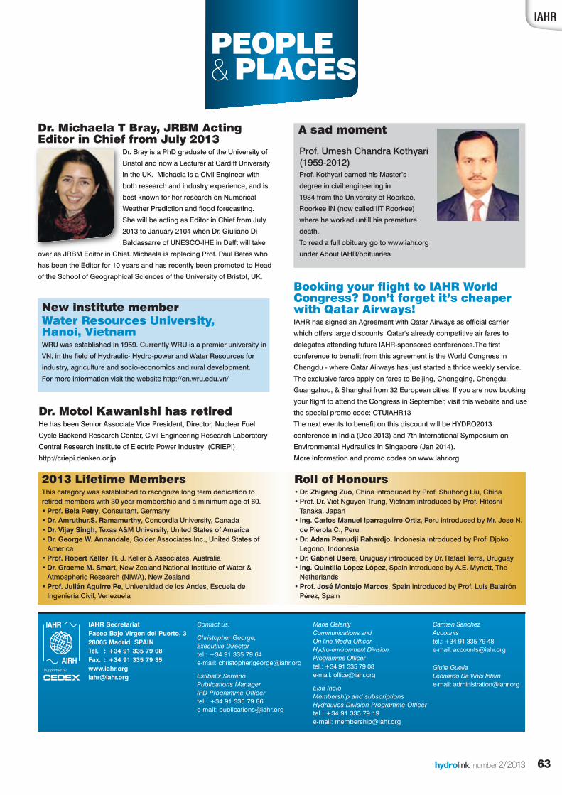
IAHR
63
PEOPLE &PLACES
hydrolink number 2/2013
Contact us:
Christopher George, Executive Directortel.: +34 91 335 79 64e-mail: [email protected]
Estibaliz Serrano Publications ManagerIPD Programme Officer tel.: +34 91 335 79 86e-mail: [email protected]
Maria Galanty Communications and On line Media Officer Hydro-environment Division Programme Officertel.: +34 91 335 79 08e-mail: [email protected]
Elsa IncioMembership and subscriptionsHydraulics Division Programme Officertel.: +34 91 335 79 19e-mail: [email protected]
Carmen Sanchez Accountstel.: +34 91 335 79 48e-mail: [email protected]
Giulia GuellaLeonardo Da Vinci Interne-mail: [email protected]
IAHR SecretariatPaseo Bajo Virgen del Puerto, 328005 Madrid SPAINTel. : +34 91 335 79 08Fax. : +34 91 335 79 [email protected]
2013 Lifetime MembersThis category was established to recognize long term dedication toretired members with 30 year membership and a minimum age of 60.•Prof. Bela Petry, Consultant, Germany•Dr. Amruthur.S. Ramamurthy, Concordia University, Canada•Dr. Vijay Singh, Texas A&M University, United States of America•Dr. George W. Annandale, Golder Associates Inc., United States ofAmerica
•Prof. Robert Keller, R. J. Keller & Associates, Australia•Dr. Graeme M. Smart, New Zealand National Institute of Water &Atmospheric Research (NIWA), New Zealand
•Prof. Julián Aguirre Pe, Universidad de los Andes, Escuela deIngeniería Civil, Venezuela
Roll of Honours•Dr. Zhigang Zuo, China introduced by Prof. Shuhong Liu, China •Prof. Dr. Viet Nguyen Trung, Vietnam introduced by Prof. HitoshiTanaka, Japan
• Ing. Carlos Manuel Iparraguirre Ortiz, Peru introduced by Mr. Jose N.de Pierola C., Peru
•Dr. Adam Pamudji Rahardjo, Indonesia introduced by Prof. DjokoLegono, Indonesia
•Dr. Gabriel Usera, Uruguay introduced by Dr. Rafael Terra, Uruguay • Ing. Quintilia López López, Spain introduced by A.E. Mynett, TheNetherlands
•Prof. José Montejo Marcos, Spain introduced by Prof. Luis BalairónPérez, Spain
New institute memberWater Resources University, Hanoi, Vietnam WRU was established in 1959. Currently WRU is a premier university in
VN, in the field of Hydraulic- Hydro-power and Water Resources for
industry, agriculture and socio-economics and rural development.
For more information visit the website http://en.wru.edu.vn/
Dr. Motoi Kawanishi has retiredHe has been Senior Associate Vice President, Director, Nuclear Fuel
Cycle Backend Research Center, Civil Engineering Research Laboratory
Central Research Institute of Electric Power Industry (CRIEPI)
http://criepi.denken.or.jp
Booking your flight to IAHR WorldCongress? Don’t forget it’s cheaperwith Qatar Airways!IAHR has signed an Agreement with Qatar Airways as official carrier
which offers large discounts Qatar's already competitive air fares to
delegates attending future IAHR-sponsored conferences.The first
conference to benefit from this agreement is the World Congress in
Chengdu - where Qatar Airways has just started a thrice weekly service.
The exclusive fares apply on fares to Beijing, Chongqing, Chengdu,
Guangzhou, & Shanghai from 32 European cities. If you are now booking
your flight to attend the Congress in September, visit this website and use
the special promo code: CTUIAHR13
The next events to benefit on this discount will be HYDRO2013
conference in India (Dec 2013) and 7th International Symposium on
Environmental Hydraulics in Singapore (Jan 2014).
More information and promo codes on www.iahr.org
Dr. Michaela T Bray, JRBM ActingEditor in Chief from July 2013
Dr. Bray is a PhD graduate of the University of
Bristol and now a Lecturer at Cardiff University
in the UK. Michaela is a Civil Engineer with
both research and industry experience, and is
best known for her research on Numerical
Weather Prediction and flood forecasting.
She will be acting as Editor in Chief from July
2013 to January 2104 when Dr. Giuliano Di
Baldassarre of UNESCO-IHE in Delft will take
over as JRBM Editor in Chief. Michaela is replacing Prof. Paul Bates who
has been the Editor for 10 years and has recently been promoted to Head
of the School of Geographical Sciences of the University of Bristol, UK.
A sad moment
Prof. Umesh Chandra Kothyari(1959-2012)Prof. Kothyari earned his Master’s
degree in civil engineering in
1984 from the University of Roorkee,
Roorkee IN (now called IIT Roorkee)
where he worked untill his premature
death.
To read a full obituary go to www.iahr.org
under About IAHR/obituaries
hydrolink 2_2013def_23212 19-07-13 13:30 Pagina 63

www.rdinstruments.com
Go with the flow.Need fast, easy, and reliable river
and stream discharge data? Teledyne RDI’s RiverRay ADCP
gives it to you straight.
RiverRay
tesevahtahtuCrelppoDevedehtsA
adnatsehtorPtnerrforepole
isehtsreviledsucelbaulavnia,yy,sae,tsaFrabehtsesiartesevahtaht
Ri RRiR
ibailerdnayticilpmiW.kcabdeefremotstuaeht,elbailerdnaoituloverriehthtiw
adnatseht
R right on QR
snoitareporuoyytilikrower’uoyrehtehWaRreviRevitpada-otaRreviRwenyrano
right on Q
ecirpata,eriuqersrtswollahsanignik
eyfotluserehtsiya.PP.CDAya
oykaerbt’nowtahtvirgnigararomaeraygolonhcetfosrae
.tegdubruoy aRreviR,rr,evd nasecnavda
wwwwtt
Ri ee RR
www//w///:pttheromnraeL
RrrevvviR
Ray
oc.stnemurtsnidr.ww.:ta
right on Q...yaR
xpsa.yy.arrevir/mo
right on Q
x
wwww rtsnidrd.www
moc.stnemur
hydrolink 2_2013def_23212 19-07-13 13:31 Pagina 64
Copyright © 2022 FDOKUMEN