Tschand Property - Montgomery Planning Board
19
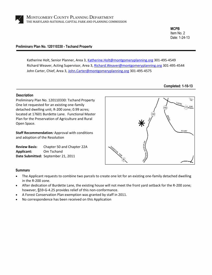
The Applicant requests to combine two parcels to create one lot for an existing one-family detached dwelling in the R-200 zone. After dedication of Burdette Lane, the existing house will not meet the front yard setback for the R-200 zone; however, §59-G-4.25 provides relief of this non-conformance. A Forest Conservation Plan exemption was granted by staff in 2011. No correspondence has been received on this Application Summary MONTGOMERY COUNTY PLANNING DEPARTMENT THE MARYLAND-NATIONAL CAPITAL PARK AND PLANNING COMMISSION MCPB Item No. 2 Date: 1-24-13 Preliminary Plan No. 120110330 - Tschand Property Katherine Holt, Senior Planner, Area 3, [email protected] 301-495-4549 Richard Weaver, Acting Supervisor, Area 3, [email protected] 301-495-4544 John Carter, Chief, Area 3, [email protected] 301-495-4575 Preliminary Plan No. 120110330: Tschand Property One lot requested for an existing one-family detached dwelling unit; R-200 zone; 0.99 acres; located at 17601 Burdette Lane. Functional Master Plan for the Preservation of Agriculture and Rural Open Space. Staff Recommendation: Approval with conditions and adoption of the Resolution Review Basis: Chapter 50 and Chapter 22A Applicant: Om Tschand Date Submitted: September 21, 2011 Description Completed: 1-10-13
-
Upload
khangminh22 -
Category
Documents
-
view
0 -
download
0
Transcript of Tschand Property - Montgomery Planning Board
The Applicant requests to combine two parcels to create one lot for an existing one-family detached dwelling in the R-200 zone.
After dedication of Burdette Lane, the existing house will not meet the front yard setback for the R-200 zone; however, §59-G-4.25 provides relief of this non-conformance.
A Forest Conservation Plan exemption was granted by staff in 2011. No correspondence has been received on this Application
Summary
MONTGOMERY COUNTY PLANNING DEPARTMENT
THE MARYLAND-NATIONAL CAPITAL PARK AND PLANNING COMMISSION
MCPB Item No. 2 Date: 1-24-13
Preliminary Plan No. 120110330 - Tschand Property
Katherine Holt, Senior Planner, Area 3, [email protected] 301-495-4549
Richard Weaver, Acting Supervisor, Area 3, [email protected] 301-495-4544
John Carter, Chief, Area 3, [email protected] 301-495-4575
Preliminary Plan No. 120110330: Tschand Property One lot requested for an existing one-family detached dwelling unit; R-200 zone; 0.99 acres; located at 17601 Burdette Lane. Functional Master Plan for the Preservation of Agriculture and Rural Open Space. Staff Recommendation: Approval with conditions and adoption of the Resolution Review Basis: Chapter 50 and Chapter 22A Applicant: Om Tschand Date Submitted: September 21, 2011
Description
Completed: 1-10-13
Rebecca.Boone
Weaver
Rebecca.Boone
Holt
Rebecca.Boone
Carter
2
RECOMMENDATION: Approval with the following conditions:
1. This Preliminary Plan is limited to one lot for one-family detached dwelling unit.
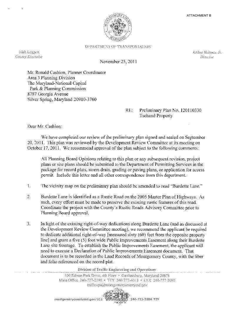
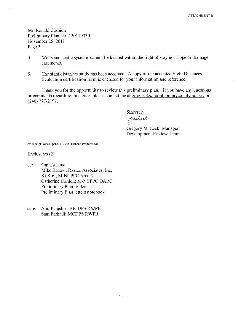
2. The Planning Board has accepted the recommendations of the Montgomery County Department of Transportation (“MCDOT”) in its letter dated November 25, 2011, and does hereby incorporate them as conditions of the Preliminary Plan approval. Therefore, the Applicant must comply with each of the recommendations as set forth in the letter, which may be amended by MCDOT provided that the amendments do not conflict with other conditions of the Preliminary Plan approval.
3. Prior to recordation of plat, the Applicant must satisfy the provisions for access and improvements as required by MCDOT.
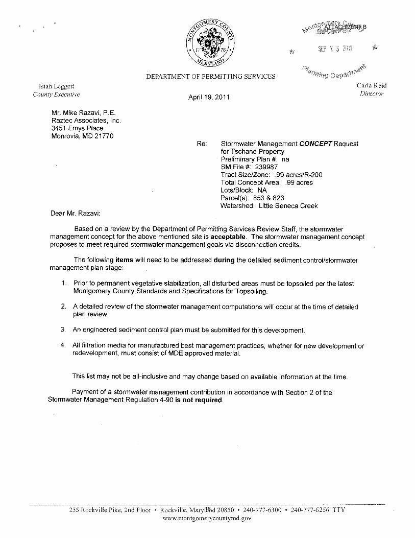
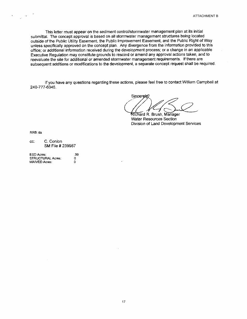
4. The Planning Board has accepted the recommendations of the Montgomery County Department of Permitting Service (“MCDPS”) – Water Resources Section in its stormwater management concept letter dated April 19, 2011, and does hereby incorporate them as conditions of the Preliminary Plan approval. Therefore, the Applicant must comply with each of the recommendations as set forth in the letter, which may be amended by MCDPS – Water Resources Section provided that the amendments do not conflict with other conditions of the Preliminary Plan approval.
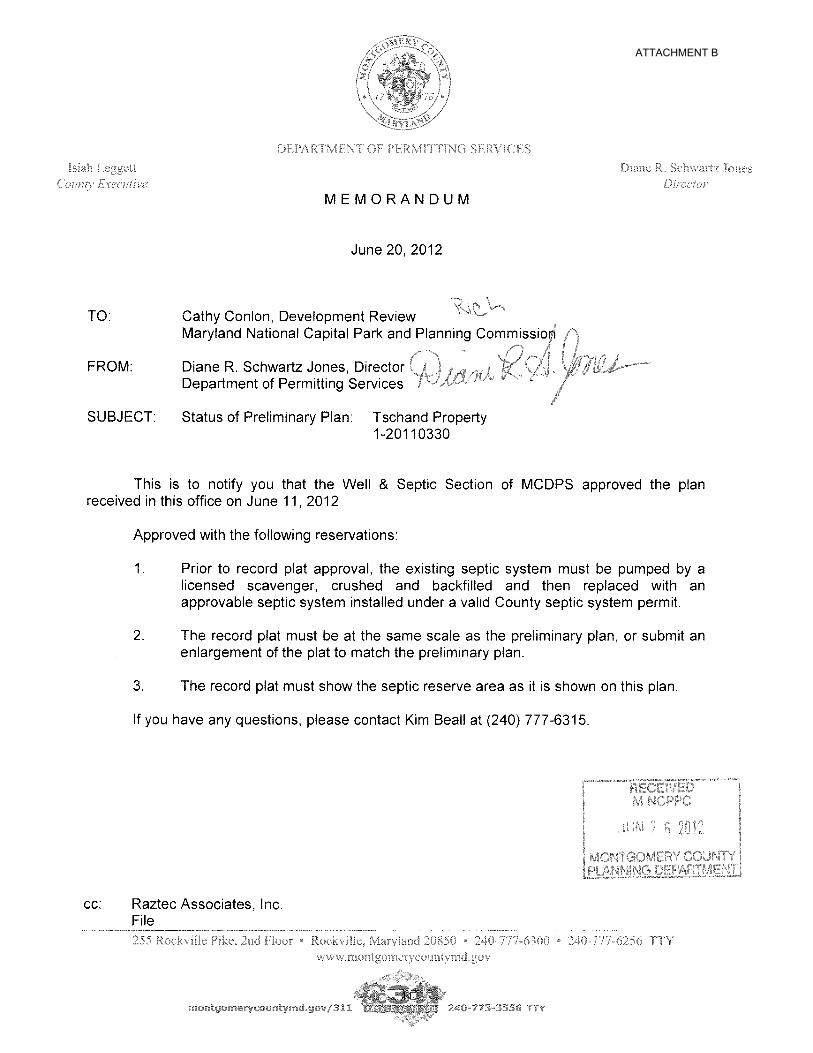
5. The Planning Board has accepted the recommendations of the MCDPS – Well and Septic Section in its letter dated June 20, 2012, and does hereby incorporate them as conditions of the Preliminary Plan approval. Therefore, the Applicant must comply with each of the recommendations as set forth in the letter, which may be amended by MCDPS – Well and Septic Section provided that the amendments do not conflict with other conditions of the Preliminary Plan approval.
6. The Applicant must dedicate and the record plat must show dedication of 60 feet from the opposite right-of-way line along the Subject Property.
7. The record plat must reflect overlapping Public Improvement Easements and Public Utility Easement as shown of the Certified Preliminary Plan.
8. The record plat must show necessary easements. SITE DESCRIPTION Preliminary Plan No. 120110330 (“Application” or “Preliminary Plan”) is a request to subdivide a property identified as Parcels 853 and 823 on Tax Map ET12, located at 17601 Burdette Lane near the corner of Black Rock Road and consisting of 0.99-acres, zoned R-200 (“Property” or “Subject Property”). The Property is located within the Functional Master for the Preservation of Agriculture and Rural Open Space (AROS) area and abuts a road (Burdette Lane) covered by the Rustic Roads Functional Master Plan (RRFMP). The Property is currently improved with one-family detached dwelling unit built in 1963 and a shed. Access to the Property is provided by an existing driveway cut from Burdette Lane. The house is served by an existing septic system.
3
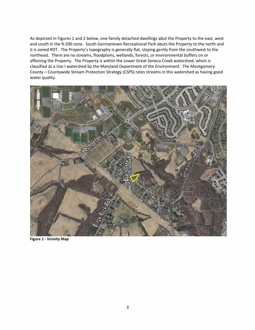
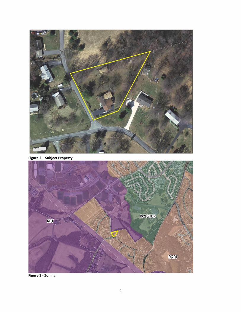
As depicted in Figures 1 and 2 below, one-family detached dwellings abut the Property to the east, west and south in the R-200 zone. South Germantown Recreational Park abuts the Property to the north and it is zoned RDT. The Property’s topography is generally flat, sloping gently from the southwest to the northeast. There are no streams, floodplains, wetlands, forests, or environmental buffers on or affecting the Property. The Property is within the Lower Great Seneca Creek watershed, which is classified as a Use I watershed by the Maryland Department of the Environment. The Montgomery County – Countywide Stream Protection Strategy (CSPS) rates streams in this watershed as having good water quality.
Figure 1 - Vicinity Map
4
Figure 2 – Subject Property
Figure 3 - Zoning
5
PROJECT DESCRIPTION1 The Applicant proposes to combine Parcels 853 and 823 into one lot and retain the existing one-family detached dwelling unit; no other development is proposed. A new septic system is approved by MCDPS2. In addition to the dedication for Burdette Lane, there will be two overlapping easements contiguous to the Property frontage; one is a 15-foot wide Public Utilities Easement (PUE) and a second is a five-foot wide Public Improvement Easement (PIE). The five foot wide PIE will allow the County to perform normal maintenance of any existing pavement and drainage ways within the easement area that are outside of the dedicated right-of-way. The five foot wide PIE is included within the 15 foot wide PUE and leaves 10 feet of PUE free and clear to place utilities if or when they are needed. ANALYSIS AND FINDINGS Conformance to the Master Plan Two functional master plans provide guidance on the development of this Property: the AROS Plan and the RRFMP. Excerpts from AROS Plan appear below in the order of their appearance. Functional Master Plan for the Preservation of Agriculture and Rural Open Space (AROS, 1980)
“This Plan confirms…
That farmland, rural open space, and residential development (rural communities and large lot development) can be compatible land-uses within the Agricultural Preservation Study Area, if appropriately located” (Summary of Findings and Recommendations, p. iv).
The Property is abutting the South Germantown Recreational Park and is surrounded by homes built in the 1960s that are zoned R-200. These properties were created, and the homes were built, well before the AROS Plan went into effect.
“Rural Communities and Villages These are historic rural settlements that were not affected by the 1973 Rural Zone Sectional Map Amendment of the upper county. Today the rural communities and villages remain zoned R-200 (1/2 acre lot sizes), or as in Boyds and Sandy Spring/Ashton which are governed by separate local area master plans. This functional master plan reconfirms and is consistent with land use recommendations of those area master plans” (p. 38).
The R-200 zone was reconfirmed in the AROS plan and the Property remained in the R-200 zone. There are about 68 properties zoned R-200 in this area between South Germantown Recreational Park and Germantown Road (MD 118). This general area is also identified as the site of a 19th century freed slave community that once included a church and a school.
“Recommended Transportation Guidelines Allow roads to remain in their present condition for 15-20 years except for maintenance and safety projects” (p. 63).
1 See attached Preliminary Plan dated September 5, 2012.
2 See attached letter.
6
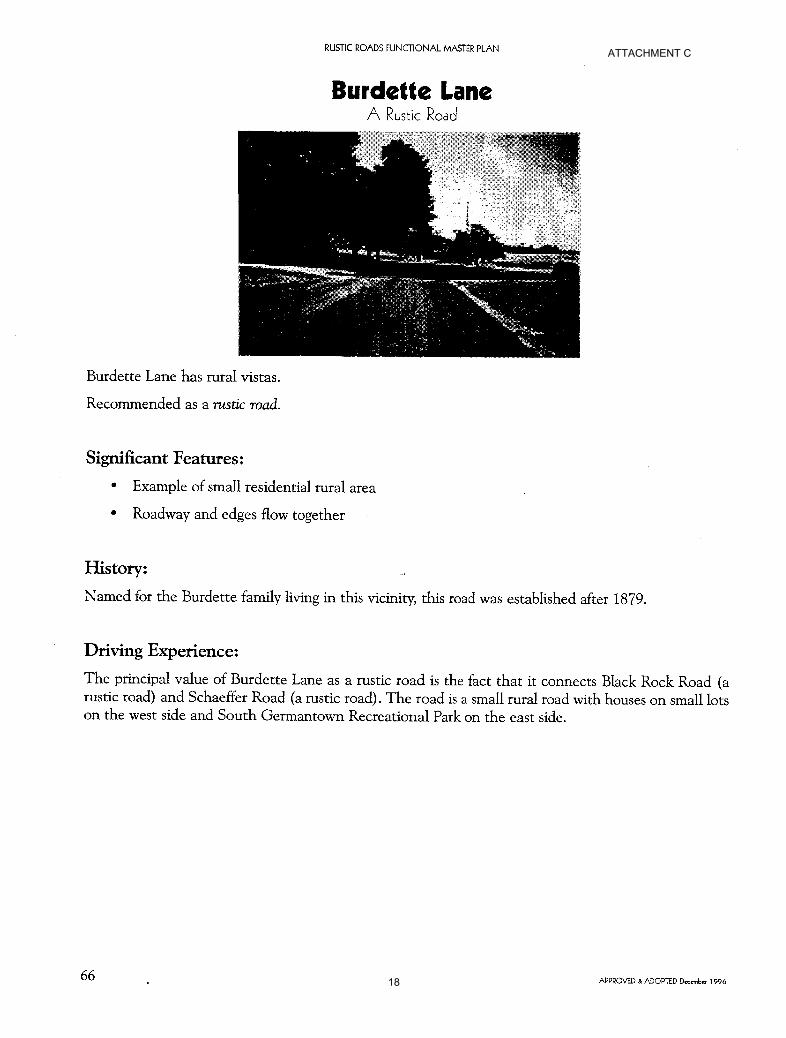
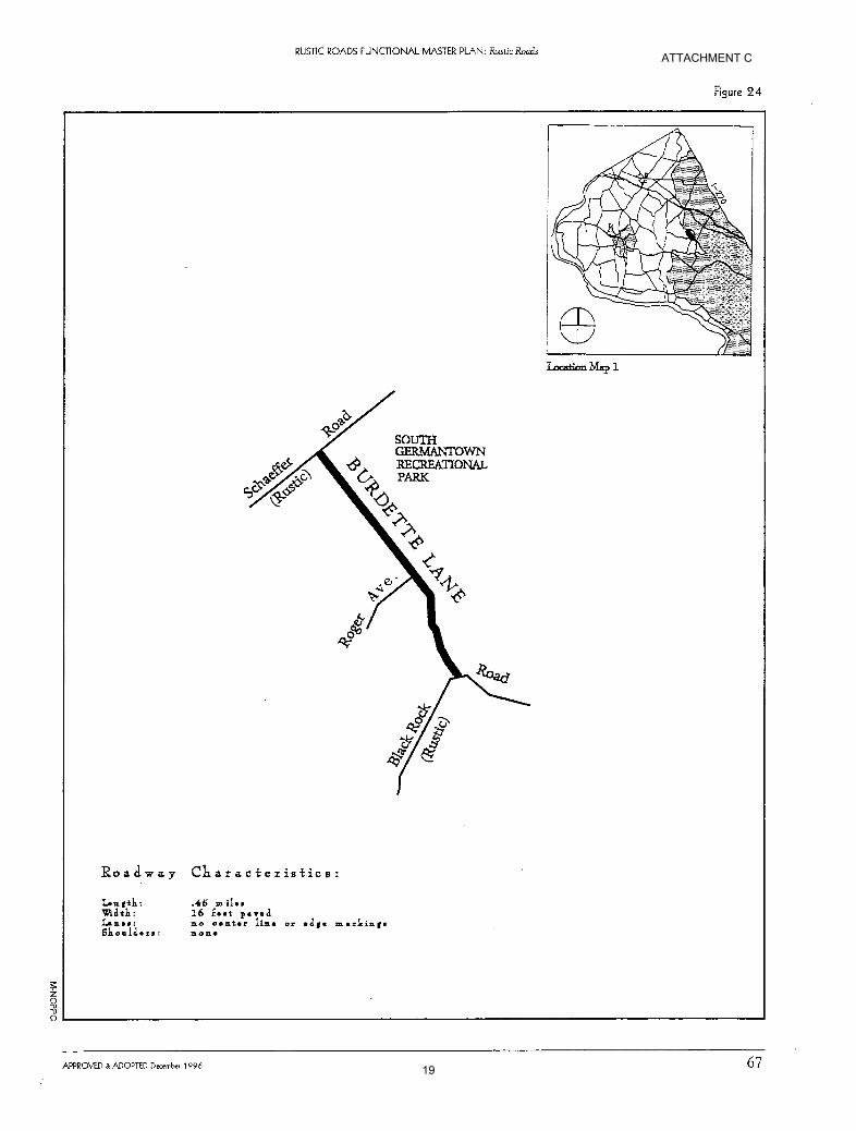
The RRFMP was adopted in 1996, which is 16 years after the recommended transportation guidelines in the 1980 AROS Plan. The RRFMP states, “The law is very specific that rustic roads are to be maintained” (p. 35). Excerpts from the Rustic Roads Functional Master Plan are as follows: Burdette Lane was designated a rustic road in 1996 with the adoption of the RRFMP3. The Significant Features identified in this plan for the road are:
Example of a small residential rural area
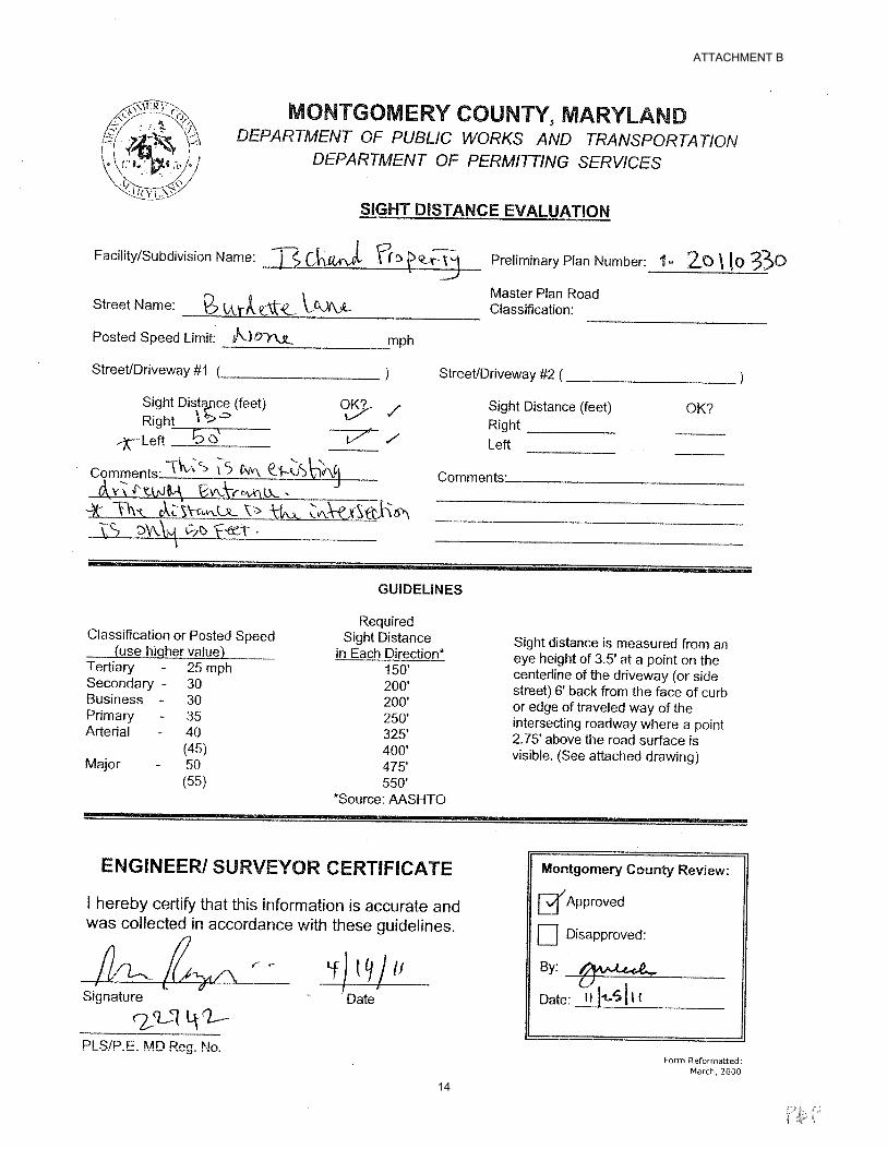
Roadway and edges flow together (RRFMP, 1996, pp. 66-67). The RRFMP describes Burdette Lane as, “a small rural road with houses on small lots on the west side and South Germantown Recreational Park on the east side” (p. 66). The value of Burdette Lane as a rustic road is due partly to the fact that it connects Black Rock Road (a rustic road) and Schaeffer Road (a rustic road). Burdette Lane is short, being only 0.45 miles in length. The road is described as having a narrow, 16 feet of pavement with existing homes near the edge of pavement. The RRFMP recommends a 70-foot width for the Burdette Lane right-of-way (p. 194); the typical recommended width of most rustic roads in the County. The Property is the only remaining privately owned property fronting on Burdette Lane that has not dedicated right-of-way. All other unplatted properties fronting Burdette Lane that have not dedicated right-of-way are owned by M-NCPPC as part of the South Germantown Recreational Park. Where dedication has occurred by previously platted properties, 30 feet of dedication from the centerline of pavement was required. The Property is essentially the last property that can provide dedication per record plat. Hence, the opportunity to get a 70-foot wide right-of-way per the RRFMP recommendations for the vast majority of the length of Burdette Lane is very limited. To be consistent with platted properties on the opposite side of Burdette Lane, staff recommends a 30-foot dedication from centerline along the Property frontage with a five-foot PIE. As discussed above, the PIE will give MCDOT the same maintenance capabilities as would have been provided with a 35-foot dedication from centerline. The reduction in right-of-way dedication is not inconsistent with the Vision of the RRFMP. The proximity of the house to the pavement will not be changed by the reduction in dedication and does nothing to require alterations to the pavement of Burdette Lane which helps shape its rustic characteristics. With the PIE, the County will have control over maintenance and drainage of the road as they would if full dedications were made. For the reasons discussed above, Staff concludes that the Application is in substantial conformance with both the AROS Plan and the RRFMP. Public Facilities Roads and Transportation Facilities The Local Area Transportation Review (LATR) guidelines require a traffic study to be performed if the development generates 30 or more peak-hour trips. The Application generates no new traffic; therefore,
3 See attached pages from the Functional Master Plan.
7
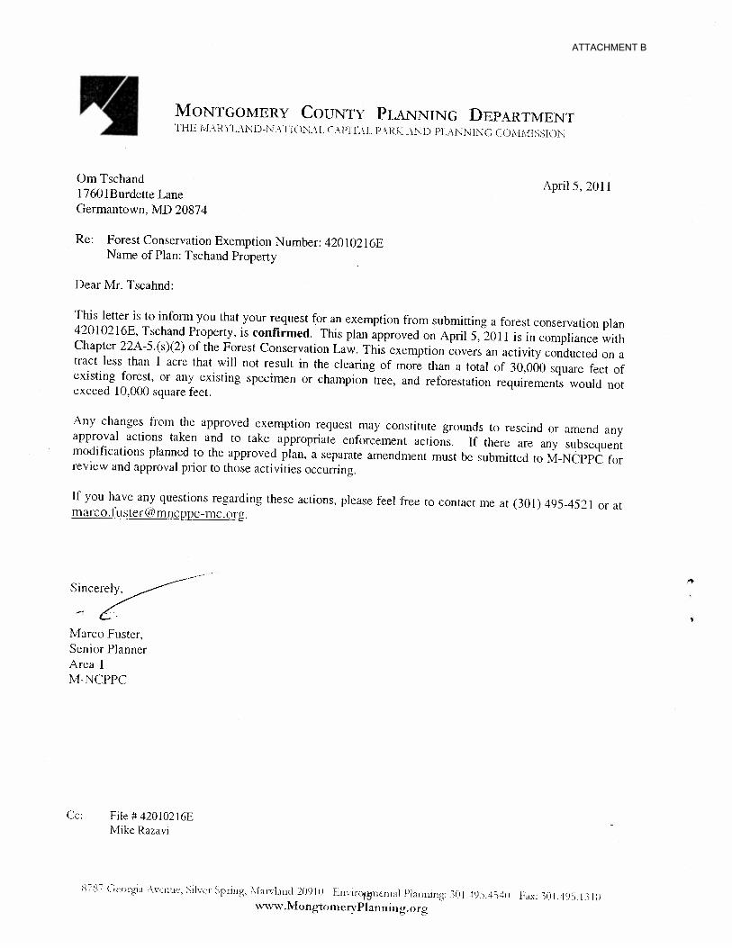
the Application is not subject to LATR. The Property is located in the Poolesville Policy Area where there is a no Policy Area Mobility Review (PAMR) mitigation requirement. Access to the Property will continue to use the existing driveway cut from Burdette Lane. The sight distance for the driveway is acceptable per the Sight Distance Evaluation reviewed and approved by MCDOT on November 25, 20114. As discussed previously, the Applicant is required to dedicate additional right-of-way measured 30 feet from the centerline and grant a five-foot wide PIE and 15-foot wide PUE along the Burdette Lane frontage. The Application was reviewed by the Montgomery County Fire and Rescue Service; however, they do not comment because the house is located on a single driveway. Sidewalks do not exist along the road and are not recommended because of the rustic road designation. Pedestrians continue to use the shoulder of the road for mobility. Access for the subdivision is safe and adequate. Other Public Facilities and Services Public facilities and services are available and adequate to serve the proposed lot. The house will be served by the existing well and the septic system was improved to include new reserve fields. Electrical and telecommunications services are available to serve the Property. Other public facilities and services, such as schools, police stations, and health services are operating within the standards set by the Subdivision Staging Policy currently in effect. The Application is located in the Northwest School Cluster which is operating at adequate levels according to the FY13 Annual School Test5. No School Facility Payment is required. Environment Environmental Inventory Natural Resources Inventory/Forest Stand Delineation (NRI/FSD) #420102160 for this Property was approved by staff on March 17, 2011. The Property contains no streams, floodplains, wetlands, forest, or environmental buffers on or affecting the site. Forest Conservation Plan (FCP) This Property is subject to the Montgomery County Forest Conservation Law (Chapter 22A of the County code). The Property was granted a forest conservation plan exemption (42010216E) on April 5, 20116, under 22A-5(s)(2)7 the small property exemption. Therefore, an FCP for the Property is not required. The Application meets all applicable requirements of the Chapter 22A of the Montgomery County Code (Forest Conservation Law).
4 See attached letter.
5 Per the 2012-2016 Subdivision Staging Policy Appendix
http://www.montgomeryplanning.org/research/growth_policy/subdivision_staging_policy/2012/documents/SSPappe
ndix4sc.pdf 6 See attached letter.
7 22A-5(s) (2) an activity occurring on a tract less than 1 acre that will not result in the clearing of more than a total
of 30,000 square feet of existing forest, or any existing specimen or champion tree, and reforestation requirements
would not exceed 10,000 square feet. Forest in any priority area on-site must be preserved.
8
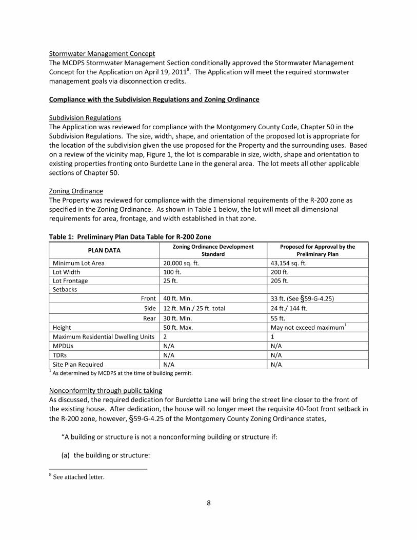
Stormwater Management Concept The MCDPS Stormwater Management Section conditionally approved the Stormwater Management Concept for the Application on April 19, 20118. The Application will meet the required stormwater management goals via disconnection credits. Compliance with the Subdivision Regulations and Zoning Ordinance Subdivision Regulations The Application was reviewed for compliance with the Montgomery County Code, Chapter 50 in the Subdivision Regulations. The size, width, shape, and orientation of the proposed lot is appropriate for the location of the subdivision given the use proposed for the Property and the surrounding uses. Based on a review of the vicinity map, Figure 1, the lot is comparable in size, width, shape and orientation to existing properties fronting onto Burdette Lane in the general area. The lot meets all other applicable sections of Chapter 50. Zoning Ordinance The Property was reviewed for compliance with the dimensional requirements of the R-200 zone as specified in the Zoning Ordinance. As shown in Table 1 below, the lot will meet all dimensional requirements for area, frontage, and width established in that zone. Table 1: Preliminary Plan Data Table for R-200 Zone
PLAN DATA Zoning Ordinance Development
Standard Proposed for Approval by the
Preliminary Plan
Minimum Lot Area 20,000 sq. ft. 43,154 sq. ft.
Lot Width 100 ft. 200 ft.
Lot Frontage 25 ft. 205 ft.
Setbacks
Front 40 ft. Min. 33 ft. (See §59-G-4.25)
Side 12 ft. Min./ 25 ft. total 24 ft./ 144 ft.
Rear 30 ft. Min. 55 ft.
Height 50 ft. Max. May not exceed maximum1
Maximum Residential Dwelling Units 2 1
MPDUs N/A N/A
TDRs N/A N/A
Site Plan Required N/A N/A 1 As determined by MCDPS at the time of building permit.
Nonconformity through public taking As discussed, the required dedication for Burdette Lane will bring the street line closer to the front of the existing house. After dedication, the house will no longer meet the requisite 40-foot front setback in
the R-200 zone, however, §59-G-4.25 of the Montgomery County Zoning Ordinance states,
“A building or structure is not a nonconforming building or structure if:
(a) the building or structure:
8 See attached letter.
9
(1) was otherwise lawful on: A. June 1, 1958; or B. the date of an amendment of this Chapter; or
(2) is on an otherwise lawful lot; and
(b) The lot on which the building or structure is located is reduced in area by taking under eminent domain or another government action that would otherwise make the building or structure nonconforming because a dimension of the building or structure, or the location of the lot is deficient.
The building or structure may be repaired, altered, or reconstructed, if it is an otherwise lawful use, except that the construction must not change any dimension of the building or structure that is deficient.”
As a public taking through dedication the house is afforded relief from nonconformity under §59-G-4.25 and will remain as a conforming structure that may be repaired, altered, or reconstructed. The Application was reviewed by other applicable county agencies, all of whom have recommended approval of the Preliminary Plan. The Application complies with the Chapter 50 and Chapter 59 of the County Code. Citizen Correspondence and Issues The Applicant notified adjacent and confronting property owners of the pre-submission meeting held on August 5, 2010 at 6 p.m. at the Germantown Community Center at 18905 Kingsview Road, Germantown. A second public meeting was held on January 19, 2011 at 6 p.m. at the same location due to the expiration of the 90 day period. One person attended the first meeting in August and asked about setbacks for the septic system; no one attended the second meeting. To date, staff has not received any correspondence regarding the application. CONCLUSION The Application meets all requirements established in the Subdivision Regulations and the Zoning Ordinance and substantially conforms to the recommendations of the Preservations of Agriculture and Rural Open Space Functional Master Plan and the Rustic Roads Functional Master Plan. Access and public facilities will be adequate to serve the Property. The Application was reviewed by all applicable county agencies, all of whom have recommended approval of the Application, therefore, Staff recommends approval of the Application with the above conditions specified. Attachments Attachment A – Proposed Development Plan Attachment B – Agency Correspondence Attachment C – Rustic Roads Functional Master Plan excerpts
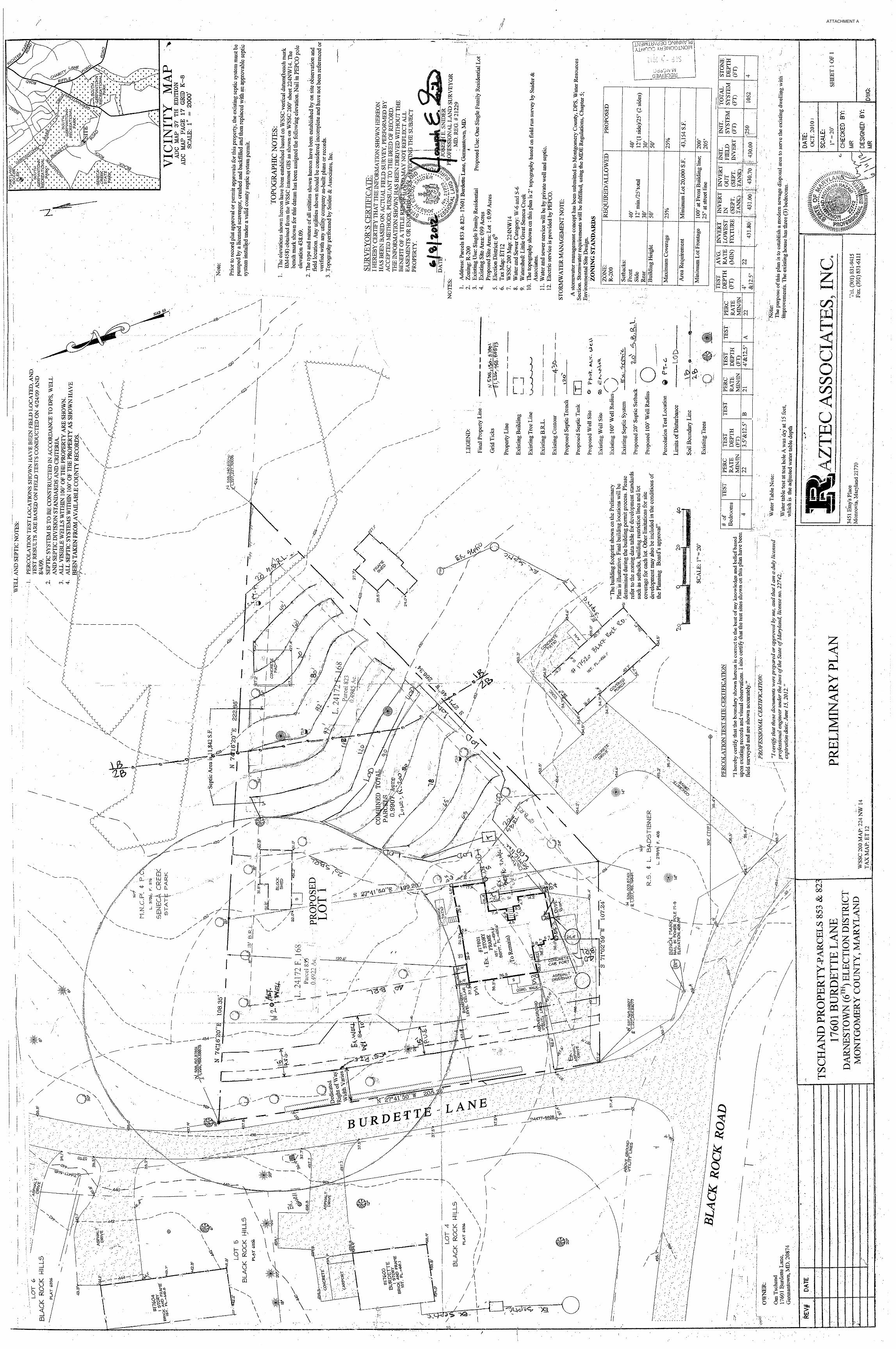
ATTACHMENT A
10
ATTACHMENT B
11
ATTACHMENT B
12
ATTACHMENT B
13
ATTACHMENT B
14
ATTACHMENT B
15
ATTACHMENT B
16
ATTACHMENT B
17
ATTACHMENT C
18
ATTACHMENT C
19