Tree damage risk factors associated with large, infrequent wind disturbances of Carolina forests
18
© Institute of Chartered Foresters, 2008. All rights reserved. Forestry, Vol. 81, No. 3, 2008. doi:10.1093/forestry/cpn020 For Permissions, please email: [email protected] Advance Access publication date 8 May 2008 Introduction Large hurricanes and other catastrophic wind events such as tornados and severe downbursts are major natural disturbance agents impact- ing forests of the eastern United States as well as those of many other areas of the world. They often cause severe though highly variable tree damage across the affected landscape (e.g. Frelich and Lorimer, 1991; Peterson and Pickett, 1991; Walker et al., 1992; Foster and Boose, 1994; Webb, 1999; Kramer et al., 2001; Harcombe et al., 2002; Woods, 2004; McNab et al., 2004). It has been well documented that various meteoro- logical, topographic and biological factors interact to influence the patterns of damage (e.g. Bellingham, 1991; Boose et al., 1994, 2004; Coutts and Grace, 1995; Everham and Brokaw, 1996; Bellingham and Tanner, 2000; Peterson, 2000, 2004; Ruel, 2000; Ulanova, 2000; Canham et al., 2001; Papaik and Canham, 2006; Rich et al., 2007), yet it is unclear the extent to which these previous Tree damage risk factors associated with large, infrequent wind disturbances of Carolina forests WEIMIN XI 1 *, ROBERT K. PEET 1 , JAMES K. DECOSTER 2 and DEAN L. URBAN 3 1 Department of Biology, University of North Carolina, Chapel Hill, NC 29599-3280, USA 2 Southern Colorado Plateau Inventory and Monitoring Network, National Park Service, Flagstaff, AZ 86011, USA 3 The Nicholas School of the Environment and Earth Sciences, Duke University, Durham, NC 27708, USA *Corresponding author. E-mail: [email protected] Summary Past studies of large, infrequent wind disturbances have shown that meteorological, topographic and biological factors interact to generate complex damage patterns, but have left open the extent to which these limited past findings are representative and can be used to predict future damage. We present a multi-scale, comparative analysis to examine how risk factors change over spatial scales and to evaluate the consistency in risk factors associated with three major wind events: a North Carolina Piedmont tornado of 1988, Hurricane Hugo of 1989 and Hurricane Fran of 1996. Our results reveal that the risk factors that best explain variation in damage vary with scale of observation. Tree size and species explain damage variation at the stand scale; topographic, site and stand factors explain damage variation at the landscape scale and wind speed and precipitation explain damage variation at the regional scale. However, it is possible to integrate these factors by incorporating factors from the finer scales into coarser-scale studies. We also found distinct differences in the damage caused by the hurricanes relative to the tornado, and to some extent consistency between hurricanes.
-
Upload
fieldguides -
Category
Documents
-
view
3 -
download
0
Transcript of Tree damage risk factors associated with large, infrequent wind disturbances of Carolina forests
© Institute of Chartered Foresters, 2008. All rights reserved. Forestry, Vol. 81, No. 3, 2008. doi:10.1093/forestry/cpn020For Permissions, please email: [email protected] Advance Access publication date 8 May 2008
Introduction
Large hurricanes and other catastrophic wind events such as tornados and severe downbursts are major natural disturbance agents impact-ing forests of the eastern United States as well as those of many other areas of the world. They often cause severe though highly variable tree damage across the affected landscape (e.g. Frelich and Lorimer, 1991 ; Peterson and Pickett, 1991 ; Walker et al. , 1992 ; Foster and Boose, 1994 ;
Webb, 1999 ; Kramer et al. , 2001 ; Harcombe et al. , 2002 ; Woods, 2004 ; McNab et al. , 2004 ). It has been well documented that various meteoro-logical, topographic and biological factors interact to infl uence the patterns of damage (e.g. Bellingham, 1991 ; Boose et al. , 1994 , 2004 ; Coutts and Grace, 1995 ; Everham and Brokaw, 1996 ; Bellingham and Tanner, 2000 ; Peterson, 2000 , 2004 ; Ruel, 2000 ; Ulanova, 2000 ; Canham et al. , 2001 ; Papaik and Canham, 2006 ; Rich et al. , 2007 ), yet it is unclear the extent to which these previous
Tree damage risk factors associated with large, infrequent wind distur bances of Carolina forests WEIMIN XI 1 * , ROBERT K. PEET 1 , JAMES K. DECOSTER 2 and DEAN L. URBAN 3
1 Department of Biology, University of North Carolina, Chapel Hill, NC 29599-3280, USA 2 Southern Colorado Plateau Inventory and Monitoring Network, National Park Service, Flagstaff, AZ 86011, USA 3 The Nicholas School of the Environment and Earth Sciences, Duke University, Durham, NC 27708, USA * Corresponding author. E-mail: [email protected]
Summary
Past studies of large, infrequent wind disturbances have shown that meteorological, topographic and biological factors interact to generate complex damage patterns, but have left open the extent to which these limited past fi ndings are representative and can be used to predict future damage. We present a multi-scale, comparative analysis to examine how risk factors change over spatial scales and to evaluate the consistency in risk factors associated with three major wind events: a North Carolina Piedmont tornado of 1988, Hurricane Hugo of 1989 and Hurricane Fran of 1996. Our results reveal that the risk factors that best explain variation in damage vary with scale of observation. Tree size and species explain damage variation at the stand scale; topographic, site and stand factors explain damage variation at the landscape scale and wind speed and precipitation explain damage variation at the regional scale. However, it is possible to integrate these factors by incorporating factors from the fi ner scales into coarser-scale studies. We also found distinct differences in the damage caused by the hurricanes relative to the tornado, and to some extent consistency between hurricanes.
FORESTRY318
fi ndings are broadly representative and can be used to predict future forest damage.
Wind-induced tree damage is diffi cult to pre-dict for several reasons. First, wind intensity var-ies greatly among different types of windstorms, as well as spatially and temporally during an event. Complex air fl ows and tremendous varia-tion in wind gusts during storms often make it diffi cult to accurately determine wind intensity. Second, the predictive power of a given factor may change with wind speed during an event or among different wind events (e.g. hurricanes vs tornados). Although several researchers have spe-cifi cally examined major damage factors in vari-ous forests, the spatial and temporal variation of these risk factors has not been well studied. Third, catastrophic wind events are never pre-cisely replicated.
To predict damage risk, we must have a sound understanding of (1) the magnitude of damage risk factors and their consistency among wind disturbance events, (2) the interaction of factors in controlling patterns of damage severity and (3) the relative roles of the different factors at differ-ent spatial scales. Although the importance of a comprehensive study of factors determining tree damage and the dynamics of recovery has long been recognized, to date few studies have exam-ined the interactions of various factors across spa-tial scales, and even fewer studies have compared the consistency of risk factors among different windstorms (but see Glitzenstein and Harcombe, 1988 ; Foster and Boose, 1992 ; Boose et al. , 1994 ; Peterson and Rebertus, 1997 ; Peterson, 2000 ).
Carolina forests experience occasional intense wind events. Historically, hurricanes and tor-nados have been the major natural disturbance factors causing serious forest damage. Hurricane Hugo in 1989 caused substantial tree damage and mortality in parts of South Carolina and adjacent North Carolina. Since 1900, nine hurricanes have passed through central North Carolina ( Barnes, 2001 ). Hurricane Fran in 1996 was the most de-structive hurricane of the past century to visit the North Carolina Piedmont region. The total tim-berland damaged by Hurricane Fran for North Carolina was estimated as 3 332 960 ha ( Doggett, 1996 ).
We present a multi-scale, comparative analysis to evaluate the consistency in damage risk factors associated with Hurricane Fran and two other
major wind events that occurred in Carolina forests in the late 1980s: a tornado that caused signifi cant damage to Umstead State Park in cen-tral North Carolina (1988) and Hurricane Hugo (1989). The goal of the present study is to better understand the roles of various meteorological, topographic and biological factors in determin-ing damage risks at three spatial scales: the stand scale (<1 km), the landscape scale (<10 km) and the regional scale ( ~ 100 km). At the stand scale, we focus on the relationship between tree damage and tree characteristics: size, species and growth rate. At the landscape scale, we examine the in-fl uence of stand age, height, basal area, density, site exposure, relative topographic position, el-evation, slope and aspect on damage severity. At the regional scale, we examine the infl uence of wind speed, precipitation, pre-disturbance spe-cies composition and proximity to the hurricane path.
In this study, we investigate the consistency of damage risk factors among storms as well as their interactions to address the following two ques-tions: (1) What are the relative contributions of wind speed, precipitation, topography, site fac-tors, pre-hurricane community attributes and tree characteristics (species, size and growth rate) in determining tree damage risk at scales ranging from a forest stand to a region? (2) Are the dam-age risk factors consistent among windstorms? We compare the risk factors that predict tree damage resulting from Hurricane Fran with the factors we found to be important for predicting tree damage resulting from Hurricane Hugo and the Umstead tornado.
Methods and background
We used fi ve datasets in this multi-windstorm, multi-scale comparative study of tree damage risk. Two of the fi ve datasets are stand-scale stud-ies, one is landscape-scale analysis and another two are regional studies. The fi rst stand-scale dataset includes a set of long-term tree-census plots located in or near the Duke Forest. Many of these plots were signifi cantly damaged by the intense winds of the 1996 Hurricane Fran. The second stand-scale dataset contains stand and tree damage information from a fi eld survey in 1989 after a severe (F4) tornado damaged forests
319
of Umstead State Park in Wake County, North Carolina. We also conducted risk factor analy-sis among the tree-census plots across the Duke Forest (referred to as landscape scale). The fi rst regional-scale dataset contains results of a state-wide forest damage survey conducted follow-ing Hurricane Fran by Coleman Doggett of the North Carolina Department of Environment and Natural Resources. The second regional-scale da-taset includes a total 2351 forest inventory plots with data from before and after the 1989 Hurri-cane Hugo distributed across South Carolina and maintained by the US Forest Service Forest Inven-tory and Analysis (FIA) programme.
Duke Forest and Hurricane Fran
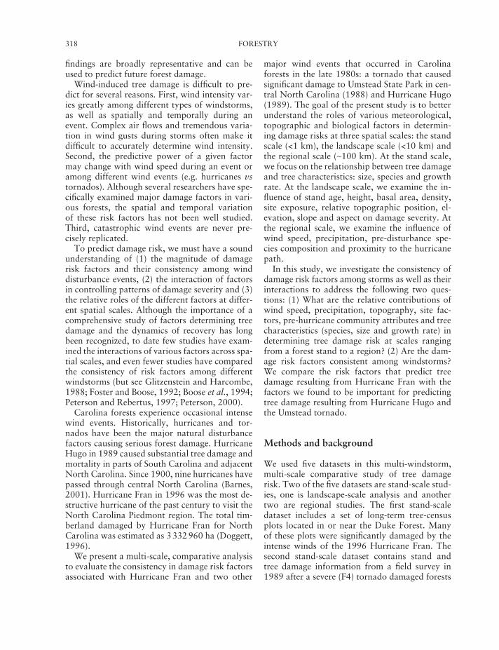
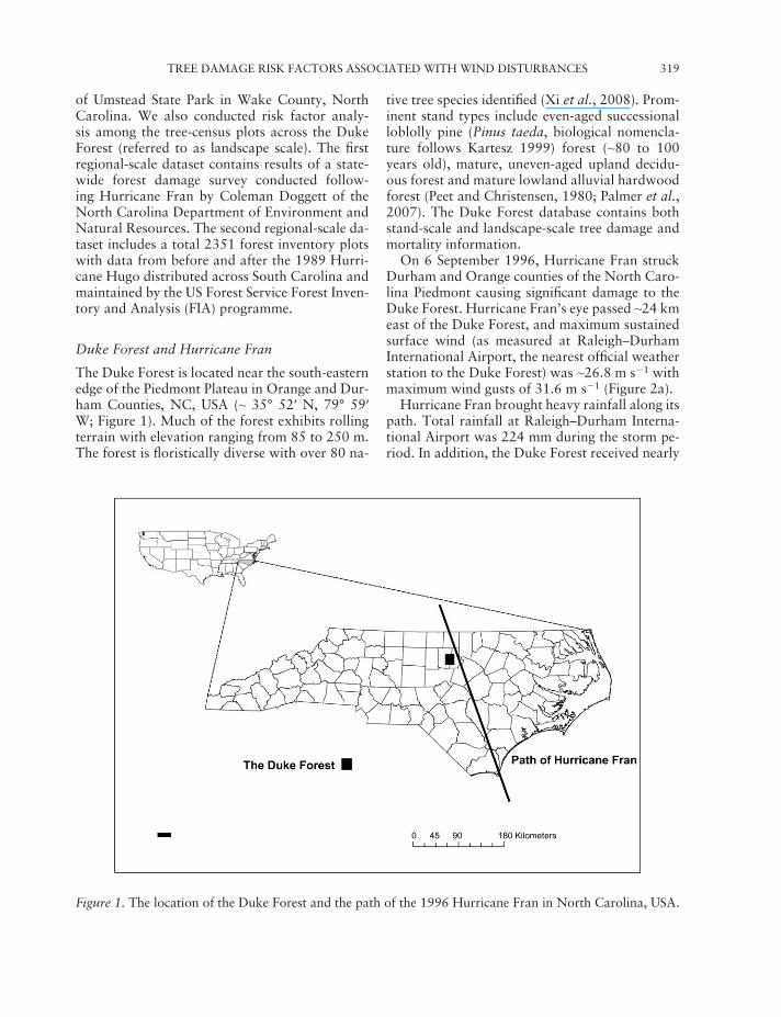
The Duke Forest is located near the south-eastern edge of the Piedmont Plateau in Orange and Dur-ham Counties, NC, USA ( ~ 35° 52 ′ N, 79° 59 ′ W; Figure 1 ). Much of the forest exhibits rolling terrain with elevation ranging from 85 to 250 m. The forest is fl oristically diverse with over 80 na-
tive tree species identifi ed ( Xi et al. , 2008 ). Prom-inent stand types include even-aged successional loblolly pine ( Pinus taeda , biological nomencla-ture follows Kartesz 1999) forest ( ~ 80 to 100 years old), mature, uneven-aged upland decidu-ous forest and mature lowland alluvial hardwood forest ( Peet and Christensen, 1980 ; Palmer et al. , 2007 ). The Duke Forest database contains both stand-scale and landscape-scale tree damage and mortality information.
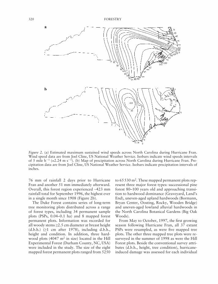
On 6 September 1996, Hurricane Fran struck Durham and Orange counties of the North Caro-lina Piedmont causing signifi cant damage to the Duke Forest. Hurricane Fran’s eye passed ~ 24 km east of the Duke Forest, and maximum sustained surface wind (as measured at Raleigh – Durham International Airport, the nearest offi cial weather station to the Duke Forest) was ~ 26.8 m s � 1 with maximum wind gusts of 31.6 m s � 1 ( Figure 2a ).
Hurricane Fran brought heavy rainfall along its path. Total rainfall at Raleigh – Durham Interna-tional Airport was 224 mm during the storm pe-riod. In addition, the Duke Forest received nearly
Figure 1. The location of the Duke Forest and the path of the 1996 Hurricane Fran in North Carolina, USA.
TREE DAMAGE RISK FACTORS ASSOCIATED WITH WIND DISTURBANCES
FORESTRY320
76 mm of rainfall 2 days prior to Hurricane Fran and another 51 mm immediately afterward. Overall, this forest region experienced ~ 423 mm rainfall total for September 1996, the highest ever in a single month since 1908 ( Figure 2b ).
The Duke Forest contains series of long-term tree monitoring plots distributed across a range of forest types, including 34 permanent sample plots (PSPs, 0.04 – 0.1 ha) and 8 mapped forest permanent plots. Information was recorded for all woody stems ≥ 2.5 cm diameter at breast height (d.b.h.) ( ≥ 1 cm after 1978), including d.b.h., height and condition. In addition, three hard-wood plots (4047 m 2 in size) located in the Hill Experimental Forest (Durham County, NC, USA) were included in the study. The size of the eight mapped forest permanent plots ranged from 5250
to 65 530 m 2 . These mapped permanent plots rep-resent three major forest types: successional pine forest 80 – 100 years old and approaching transi-tion to hardwood dominance (Graveyard, Land’s End), uneven-aged upland hardwoods (Bormann, Bryan Center, Oosting, Rocky, Wooden Bridge) and uneven-aged lowland alluvial hardwoods in the North Carolina Botanical Gardens (Big Oak Woods).
From May to October, 1997, the fi rst growing season following Hurricane Fran, all 37 extant PSPs were resampled, as were fi ve mapped tree plots. The other three mapped tree plots were re-surveyed in the summer of 1998 as were the Hill Forest plots. Beside the conventional survey attri-butes (d.b.h., height, tree condition), hurricane-induced damage was assessed for each individual
Figure 2. (a) Estimated maximum sustained wind speeds across North Carolina during Hurricane Fran. Wind speed data are from Joel Cline, US National Weather Service. Isobars indicate wind speeds intervals of 5 mile h � 1 (=2.24 m s � 1 ). (b) Map of precipitation across North Carolina during Hurricane Fran. Pre-cipitation data are from Joel Cline, US National Weather Service. Isobars indicate precipitation intervals of inches.
TREE DAMAGE RISK FACTORS ASSOCIATED WITH WIND DISTURBANCES 321
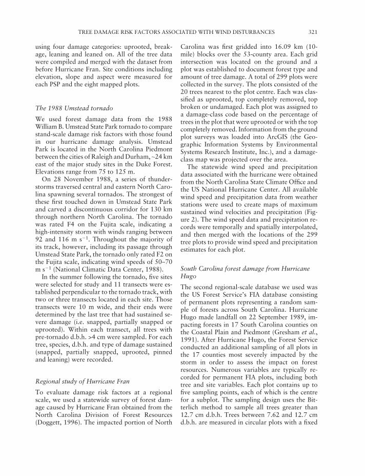
using four damage categories: uprooted, break-age, leaning and leaned on. All of the tree data were compiled and merged with the dataset from before Hurricane Fran. Site conditions including elevation, slope and aspect were measured for each PSP and the eight mapped plots.
The 1988 Umstead tornado
We used forest damage data from the 1988 William B. Umstead State Park tornado to compare stand-scale damage risk factors with those found in our hurricane damage analysis. Umstead Park is located in the North Carolina Piedmont between the cities of Raleigh and Durham, ~ 24 km east of the major study sites in the Duke Forest. Elevations range from 75 to 125 m.
On 28 November 1988, a series of thunder-storms traversed central and eastern North Caro-lina spawning several tornados. The strongest of these fi rst touched down in Umstead State Park and carved a discontinuous corridor for 130 km through northern North Carolina. The tornado was rated F4 on the Fujita scale, indicating a high-intensity storm with winds ranging between 92 and 116 m s � 1 . Throughout the majority of its track, however, including its passage through Umstead State Park, the tornado only rated F2 on the Fujita scale, indicating wind speeds of 50 – 70 m s � 1 ( National Climatic Data Center, 1988 ).
In the summer following the tornado, fi ve sites were selected for study and 11 transects were es-tablished perpendicular to the tornado track, with two or three transects located in each site. Those transects were 10 m wide, and their ends were determined by the last tree that had sustained se-vere damage (i.e. snapped, partially snapped or uprooted). Within each transect, all trees with pre-tornado d.b.h. >4 cm were sampled. For each tree, species, d.b.h. and type of damage sustained (snapped, partially snapped, uprooted, pinned and leaning) were recorded.
Regional study of Hurricane Fran
To evaluate damage risk factors at a regional scale, we used a statewide survey of forest dam-age caused by Hurricane Fran obtained from the North Carolina Division of Forest Resources ( Doggett, 1996 ). The impacted portion of North
Carolina was fi rst gridded into 16.09 km (10-mile) blocks over the 53-county area. Each grid intersection was located on the ground and a plot was established to document forest type and amount of tree damage. A total of 299 plots were collected in the survey. The plots consisted of the 20 trees nearest to the plot centre. Each was clas-sifi ed as uprooted, top completely removed, top broken or undamaged. Each plot was assigned to a damage-class code based on the percentage of trees in the plot that were uprooted or with the top completely removed. Information from the ground plot surveys was loaded into ArcGIS (the Geo-graphic Information Systems by Environmental Systems Research Institute, Inc.), and a damage-class map was projected over the area.
The statewide wind speed and precipitation data associated with the hurricane were obtained from the North Carolina State Climate Offi ce and the US National Hurricane Center. All available wind speed and precipitation data from weather stations were used to create maps of maximum sustained wind velocities and precipitation ( Fig-ure 2 ). The wind speed data and precipitation re-cords were temporally and spatially interpolated, and then merged with the locations of the 299 tree plots to provide wind speed and precipitation estimates for each plot.
South Carolina forest damage from Hurricane Hugo
The second regional-scale database we used was the US Forest Service’s FIA database consisting of permanent plots representing a random sam-ple of forests across South Carolina. Hurricane Hugo made landfall on 22 September 1989, im-pacting forests in 17 South Carolina counties on the Coastal Plain and Piedmont ( Gresham et al. , 1991 ). After Hurricane Hugo, the Forest Service conducted an additional sampling of all plots in the 17 counties most severely impacted by the storm in order to assess the impact on forest resources. Numerous variables are typically re-corded for permanent FIA plots, including both tree and site variables. Each plot contains up to fi ve sampling points, each of which is the centre for a subplot. The sampling design uses the Bit-terlich method to sample all trees greater than 12.7 cm d.b.h. Trees between 7.62 and 12.7 cm d.b.h. are measured in circular plots with a fi xed
FORESTRY322
area of 13.5 m 2 (1/300 acre). For each tree in the ‘ plot ’ , species, d.b.h., height, crown ratio, canopy position, presence of rot and other variables are recorded. Site data are collected and include soil texture, hydrology, if the site was planted and if it is a forest edge. In the sampling period follow-ing Hurricane Hugo, data specifi cally related to tree damage were collected, including presence of root damage, bole missing and per cent of crow-ing missing. In total, the dataset contains infor-mation on 29 397 trees from 2352 plots.
Wind speed data for Hurricane Hugo were ob-tained from the US National Hurricane Center. All available wind data from weather stations and reconnaissance aircraft were used as input for a hurricane model, creating maps of maxi-mum sustained wind velocities for 3-h intervals ( Powell et al. , 1991 ). We interpolated these da-tasets by overlaying the maps on one another and manually connecting the maximum wind in wind-speed isobars. This provides a map of maxi-mum sustained wind speeds in 1-min averages. The wind speeds were digitized and merged with the locations of the FIA forest inventory plots to provide plot-specifi c wind speed and precipita-tion estimates.
Data analysis
Logistic regression, a multivariate technique that uses a logit function to predict the outcome of a dichotomous or polytomous response, was used for all fi ve databases to identify the factors in-dicating signifi cant risk of damage (e.g. Jalkanen and Mattila, 2000 ).
At the stand scale for the Duke Forest and the Umstead Park plots, a dichotomous logistic re-gression was used to identify possible risk factors for individual trees as a function of pre-hurricane tree size (d.b.h.) and species. Relative tree growth rate was also included in the Duke Forest analysis. For both damage models, the response variables were classifi ed into severe damage vs light or no damage. For the Duke Forest plots, severe dam-age was defi ned as completely uprooted or loss of more than 90 per cent of the crown. We ran sepa-rate models for each species in each of the fi ve mapped forest plots to examine their damage risk factors. Three mapped plots (Oosting, Wooden Bridge and Bryan Center) were excluded from this
analysis out of concerns for unbalanced plot sizes (i.e. we excluded plots that were either too large or too small). For the Umstead Park plots, severe damage was defi ned as trees uprooted, snapped or partially snapped. Species were included in the models as dummy variables.
For the landscape-scale portion of the Duke Forest study, 22 pine PSPs with stand age and tree height were used for analysis, and plot-level damage severity was analysed as a function of stand age, density, height, basal area, elevation, aspect, slope and site exposure. The hardwood PSPs were not included in this analysis due to the limited number of survey plots. For the land-scape-scale damage models, the response variable was plot-level damage severity, which was classi-fi ed as light or no damage, moderate damage or severe damage. A polytomous logistic regression was performed at this scale. We assigned an ‘ in-tegrated stem damage code ’ to each tree stem: 0 = no hurricane damage; 1 = crown loss 10 – 35 per cent, leaning over 10 per cent or bent and crown displace >10 per cent; 2 = partially uprooted, crown loss was 35 – 90 per cent, the tree was leaning but supported by other trees or pinned against another tree; 3 = completely uprooted, lost >90 per cent of the crown or was pinned to the ground. We weighted the code by multiply-ing by the stem relative basal area (i.e. the basal area of the stem divided by the stand basal area). We used the average value of the weighted ‘ inte-grated stem damage code ’ of all stems in a plot as an index of plot-level damage. The range of the stand damage index (SDI) was thus 0 – 3. We then assigned plot-level SDI values: light or no damage if SDI ≤ 1, moderate damage if 1 < SDI ≤ 2 and severe damage if 2 < SDI ≤ 3.
At the regional scale, Hurricane Fran damage was modelled as the probability of plot-level tree damage as a function of stand age, mean d.b.h., ratio of pine to hardwoods, wind speed, rainfall and distance to the path of the hurricane. The response variable was classifi ed into four dam-age levels based on the percentage of trees up-rooted or with the crown completely gone: no damage or light damage = 0 – 25 per cent, moder-ate damage = 25.1 – 50 per cent, heavy damage = 50.1 – 75 per cent and severe damage = 75.1 – 100 per cent. Again, a polytomous logistic regres-sion was performed for those multilevel damage responses.
TREE DAMAGE RISK FACTORS ASSOCIATED WITH WIND DISTURBANCES 323
Hurricane Hugo damage was analysed as the probability of severe tree damage as a function wind speed, species, tree architectural character-istics (height, crown ratio, canopy position, rot-ten bole, height – diameter ratio), site factors (soil texture, hydrology, forest edge, plantation) and community attributes (density, basal area). The response variables were classifi ed into severe dam-age vs light or no damage. The severe damage was defi ned as trees that had exposed roots, a broken or twisted bole, a portion of bole missing or the trees had died. Multiple linear regression was used to as-sess the amount of variation in the data explained by the model and the relative importance of the independent variables. In this analysis, per cent crown missing was used as the dependent variable.
All logistic regression analyses were performed using the SAS PROC LOGISTIC function (SAS Institute Inc., 2003: http://www.sas.com). A ro-bust, locally weighted scatter plot smoothing was performed using the LOWESS macro (with PROC LOESS) and a smoothed curve was plotted. The empirical log odds were also plotted for the logistic regressions using the LOGODDS macro ( Friendly,
2000 ). For all the logistic regression analyses, non-signifi cant interactions were removed using back-wards selection with an α = 0.05 signifi cant level. Reduced models without interaction terms were created to facilitate interpretation of the variable responses. The multiple linear regression was per-formed using SAS PROC GLM (SAS Institute Inc., 2003).
Results
Risk factors for tree damage at the stand level
Due to the small extent of the areas sampled, tree characteristics and species are the only fac-tors that can be analysed in stand-scale studies. In both the Duke Forest ( Table 1 , Figures 3 – 5 ) and the Umstead Park studies ( Figure 6 ), tree d.b.h. was found to be a signifi cant predictor of dam-age, with larger trees being more susceptible to damage. The pre-hurricane relative growth rate was not a signifi cant predictor of tree damage in the Duke Forest study ( Table 1 ).
Table 1 : Logistic regression models of hurricane damage during Hurricane Fran in two pine stands and three hardwood stands in the Duke Forest
VariablesParameter estimate
Standard error Wald χ 2 P > χ 2
Even-aged successional pines Graveyard Pre-hurricane d.b.h. 0.0397 0.00584 46.2109 <0.0001 *** 10-year relative growth n/a n/a 1.3465 0.2459 ns Land end Pre-hurricane d.b.h. 0.0250 0.00709 12.4430 0.0004 *** 10-year relative growth n/a n/a 0.1177 0.7315 ns Uneven-aged upland hardwoods Bormann Pre-hurricane d.b.h. 0.0423 0.0043 98.4993 <0.0001 *** 10-year relative growth n/a n/a 0.7446 0.3882 ns Rocky Pre-hurricane d.b.h. 0.0831 0.0096 75.1505 <0.0001 *** 10-year relative growth n/a n/a 1.4185 0.2337 ns Uneven-aged lowland alluvial hardwoods Big oak woods Pre-hurricane d.b.h. 0.0250 0.0100 6.2473 0.0124 * 10-year relative growth n/a n/a 0.4425 0.5059 ns
Tree damage was examined as a function of pre-hurricane d.b.h. and relative tree growth rates. *** P ≤ 0.001, * P ≤ 0.05, n/a = not applicable, ns = not signifi cant. The 10-year relative growth is defi ned as the diameter increase of ~ 10-year period divided by the previous tree diameter.
FORESTRY324
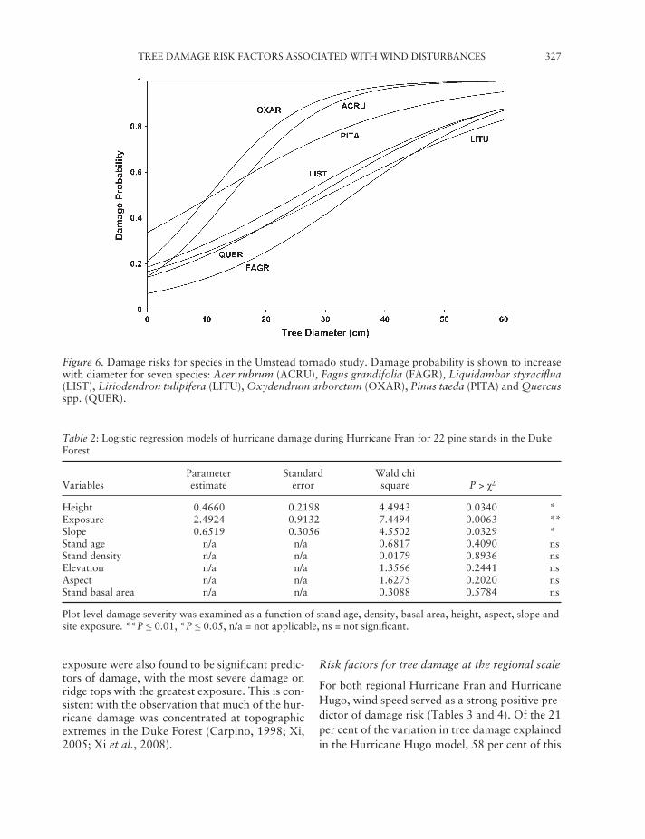
In addition to tree size, species differed in their damage probabilities in both the Duke Forest and Umstead studies. In the Umstead study, species showed a hierarchy in damage probability with
P. taeda at the high end, through Liquidambar styracifl ua , Quercus spp. and Fagus grandifolia , to Liriodendron tuliperfera at the low end. Inter-actions between species and d.b.h. demonstrated
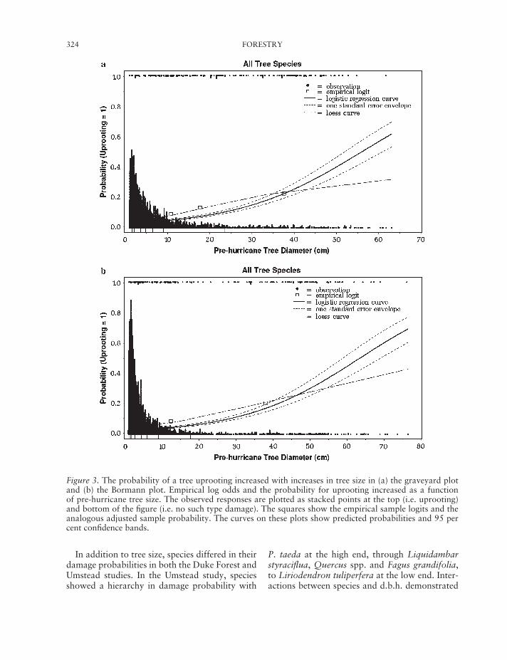
Figure 3. The probability of a tree uprooting increased with increases in tree size in (a) the graveyard plot and (b) the Bormann plot. Empirical log odds and the probability for uprooting increased as a function of pre-hurricane tree size. The observed responses are plotted as stacked points at the top (i.e. uprooting) and bottom of the fi gure (i.e. no such type damage). The squares show the empirical sample logits and the analogous adjusted sample probability. The curves on these plots show predicted probabilities and 95 per cent confi dence bands.

TREE DAMAGE RISK FACTORS ASSOCIATED WITH WIND DISTURBANCES 325
that the rate of increase in damage probability varied among species ( Figures 6 ).
The Duke Forest study showed similar patterns, although the overall damage probabilities were lower. In the Graveyard plot during Hurricane
Fran, the dominant P. taeda experienced a high level of uprooting, whereas the younger, sub-canopy Acer rubrum sustained much less damage. Oxydendrum arboretum particularly experienced a high level of uprooting, presumably due to its
Figure 4. The probability of (a) loblolly pine and (b) red maple uprooting during Hurricane Fran in the graveyard plot of Duke Forest increased with increasing tree size (d.b.h.). Interactions between diameter and species showed that rate of increase with diameter varies among species. Results for other species are available from the senior author upon request.
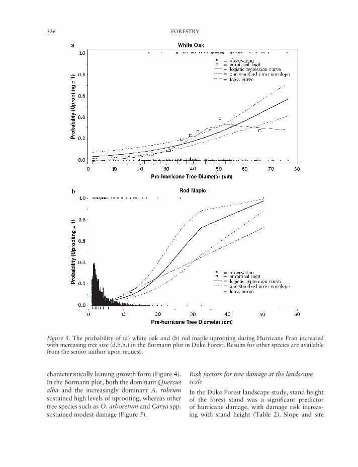
FORESTRY326
characteristically leaning growth form ( Figure 4 ). In the Bormann plot, both the dominant Quercus alba and the increasingly dominant A. rubrum sustained high levels of uprooting, whereas other tree species such as O. arboretum and Carya spp. sustained modest damage ( Figure 5 ).
Risk factors for tree damage at the landscape scale
In the Duke Forest landscape study, stand height of the forest stand was a signifi cant predictor of hurricane damage, with damage risk increas-ing with stand height ( Table 2 ). Slope and site
Figure 5. The probability of (a) white oak and (b) red maple uprooting during Hurricane Fran increased with increasing tree size (d.b.h.) in the Bormann plot in Duke Forest. Results for other species are available from the senior author upon request.
TREE DAMAGE RISK FACTORS ASSOCIATED WITH WIND DISTURBANCES 327
exposure were also found to be signifi cant predic-tors of damage, with the most severe damage on ridge tops with the greatest exposure. This is con-sistent with the observation that much of the hur-ricane damage was concentrated at topographic extremes in the Duke Forest ( Carpino, 1998 ; Xi, 2005 ; Xi et al. , 2008 ).
Risk factors for tree damage at the regional scale
For both regional Hurricane Fran and Hurricane Hugo, wind speed served as a strong positive pre-dictor of damage risk ( Tables 3 and 4 ). Of the 21 per cent of the variation in tree damage explained in the Hurricane Hugo model, 58 per cent of this
Figure 6. Damage risks for species in the Umstead tornado study. Damage probability is shown to increase with diameter for seven species: Acer rubrum (ACRU), Fagus grandifolia (FAGR), Liquidambar styracifl ua (LIST), Liriodendron tulipifera (LITU), Oxydendrum arboretum (OXAR), Pinus taeda (PITA) and Quercus spp. (QUER).
Table 2 : Logistic regression models of hurricane damage during Hurricane Fran for 22 pine stands in the Duke Forest
VariablesParameter estimate
Standard error
Wald chi square P > χ 2
Height 0.4660 0.2198 4.4943 0.0340 * Exposure 2.4924 0.9132 7.4494 0.0063 ** Slope 0.6519 0.3056 4.5502 0.0329 * Stand age n/a n/a 0.6817 0.4090 ns Stand density n/a n/a 0.0179 0.8936 ns Elevation n/a n/a 1.3566 0.2441 ns Aspect n/a n/a 1.6275 0.2020 ns Stand basal area n/a n/a 0.3088 0.5784 ns
Plot -level damage severity was examined as a function of stand age, density, basal area, height, aspect, slope and site exposure. ** P ≤ 0.01, * P ≤ 0.05, n/a = not applicable, ns = not signifi cant.
FORESTRY328
variation is explained by wind speed ( Table 4 ). For Hurricane Fran, stand damage severity simi-larly exhibited a strong positive relationship with wind speed. Tree size was also found to be a sig-nifi cant predictor of regional-scale forest damage in both the Hugo and Fran studies (mean d.b.h. was used in the Fran study, whereas height was used in the Hugo study). In the Fran study, the pine ratio was signifi cant in infl uencing damage risks, suggesting that pine forests were less sus-ceptible to damage ( Table 3 ). This is consistent with the fi ndings in the Hugo study where P. taeda had a lower probability of damage.
In the Hurricane Fran study, precipitation and distance to hurricane path were signifi cant pre-dictors of wind damage ( Table 3 ), with damage increasing with precipitation and decreasing with distance to the hurricane path. The Hurricane Hugo study found signifi cant damage risk factors associated with species, tree characteristics (low height – diameter ratios, rotten boles, low crown ratios), site characteristics (forest edges) and community characteristics (low density) ( Tables 4 and 5 ).
Discussion
Previous studies of wind damage of forests have suggested that the relative importance of different predictors varies with scale of observation (e.g. Bormann and Likens, 1979 ; Foster and Boose, 1992 , 1994 ; Boose et al. , 2001 ), and our multi-scale analysis (i.e. stand, landscape, regional) supports this observation ( Table 5 ). Our results show that to understand forest damage patterns, it is important to examine risk factors at ecologi-cally relevant scales. In addition, our study pro-vides insight into the consistency of possible risk factors at these three spatial scales. Our previous studies have shown that predictors of wind dam-age also vary in their relative importance with disturbance intensity and damage severity ( De-Coster, 1996 ).
Risk factors for tree damage at the stand scale
The small spatial extent of the individual study areas at the stand scale inherently limits the number
Table 3 : Logistic regression models of hurricane damage during Hurricane Fran at a regional scale
VariablesParameter estimate
Standard error Wald χ 2 P > χ 2
d.b.h. 0.0576 0.0150 14.6852 0.0001 *** Pine ratio − 0.8893 0.3106 8.1975 0.0042 ** Wind speed 0.0772 0.0160 23.1965 <0.0001 *** Rainfall 0.1330 0.0500 7.0661 0.0079 ** Distance to path − 0.0257 0.0063 16.5021 <0.0001 ***
Heavily damaged trees are examined as a function of wind speed, the amount of rainfall, tree size (d.b.h.), tree species composition ratio and the distance to the hurricane path. *** P ≤ 0.001, ** P ≤ 0.01. Tree species composition ratio (pine ratio) is the ratio of the number of pine trees to deciduous trees in each plot.
Table 4 : Relative importance of variables during 1989 Hurricane Hugo
Relative importance of variables during 1998
Hurricane Hugo
Variables % Variation explained
Wind speed 58.39 Tree size/height 6.37 Other tree characters 12.13 Species 9.30 Site variables 0.56 Community attributes 0.98 Interactions 11.81
The full model was compared with reduced models, and the differences in the R 2 ’s were calculated. The R 2 of the full model was 0.2151. Of the 21.51% of the variation explained in this model, the groups of variables explained the relative amount of this explained variation. The full model is not presented out of concerns for space.
TREE DAMAGE RISK FACTORS ASSOCIATED WITH WIND DISTURBANCES 329
of factors that can be examined. Although wind speed is presumed to account for much of the variability in damage among trees, it is not fea-sible to measure the variability in wind regimes at such small spatiotemporal scales (i.e. measure the speed of individual wind gusts; Boose et al. , 1994 ; Peterson, 2004 ). Larger scale wind regimes can be measured (e.g. 1-min wind speeds), but these are not measurable at the scale of the stand. Simi-larly, information on within-stand variation in topographic and edaphic conditions is generally not available, and where it is available high spa-tial autocorrelation precludes meaningful analy-sis of these factors. At the stand scale, analysis of risk factors is generally limited to characteristics of the individual.
The Umstead tornado study and Duke For-est stand study demonstrate that tree size and species are important risk factors for damage. Tree size has been cited in many studies as
being associated with high damage levels (e.g. Glitzensten and Harcombe, 1988 ; Gresham et al. , 1991 ; Peterson and Pickett, 1991 ; Arévalo et al. , 2000 ; Canham et al. , 2001 ; Pe-terson, 2004 ). Tree size is important in that the largest trees are the ones subjected to the great-est forces of winds ( Weidman, 1920 ). In ad-dition, differential damage among species has been documented (e.g. Zimmerman et al. , 1994 ; DeCoster, 1996 ; Peterson, 2004 ; Xi, 2005 ; Xi et al. , 2008 ). This species effect is likely the re-sult of a combination of wood strength, shape and size of the crown, extent and depth of the root system and stem biomechanical proper-ties ( Asner and Goldstein, 1997 ). Although we did not examine crown and root properties in our comparative study, we explicitly examined stem biomechanical properties using tree size as a surrogate and wood strength using relative growth rate as a surrogate.
Table 5 : Factors that were signifi cantly related to wind damage at three relevant scales (i.e. regional, landscape and stand
Hurricanes Tornado
Damage risk factorsRegional
FranRegional
HugoLandscape
FranStand-scale
FranStand-scale
Umstead Park
Abiotic Wind speed *** *** n/a n/a n/a Rainfall ** n/a n/a n/a n/a Exposure * n/a ** n/a n/a Slope n/a n/a * n/a n/a Aspect n/a n/a ns n/a n/a Soil texture n/a ns n/a n/a n/a Hydrology n/a ns n/a n/a n/a Biotic Tree size *** *** * *** *** Species/stand composition * *** n/a ** *** Growth rates n/a n/a n/a ns n/a Stand density n/a ** ns n/a n/a Stand basal area n/a *** ns n/a n/a Height – diameter ratio n/a *** n/a n/a n/a Rotten bole n/a *** n/a n/a n/a Canopy position n/a *** n/a n/a n/a Crown ratio n/a *** n/a n/a n/a Plantation n/a ns n/a n/a n/a Others Distance to path *** n/a n/a n/a n/a Forest edge n/a *** n/a n/a n/a
*** P ≤ 0.001, ** P ≤ 0.01, * P ≤ 0.05, n/a = not applicable, ns = not signifi cant.
FORESTRY330
Risk factors determining tree damage at land-scape scale
Studies at the landscape scale may allow for the examination of topography and other site factors and community variables as damage risk fac-tors, provided they cover a suffi ciently large spa-tial extent and have a suffi cient sample size. In a landscape-scale study of site variables infl uencing damage by Hurricane Fran in the Duke Forest, Carpino (1998) found that the patches of most severe damage were ~ 0.2 ha in size, presumably conforming to the scale of downbursts of wind associated with turbulence cells.
Generally, studies at the landscape scale use a relative level of stand damage as the dependent variable. As in the Duke Forest stand-level study, tree size can be incorporated directly into such models as stand height or diameter or indirectly as tree age. The literature confi rms the pattern of stand height being associated with higher lev-els of damage ( Foster, 1988 ; Foster and Boose, 1992 , Boose et al. , 1994 ).
Although it is well documented that topogra-phy infl uences tree damage at the landscape scale, it is diffi cult to predict the infl uence of topogra-phy on tree damage due to the complex nature of topographic exposure and because topographic features can alter both wind speed and direction. Generally, areas with high exposure to winds, such as exposed slopes and ridges, sustain the greatest levels damage, whereas lee slopes and valley bottoms sustain the lowest levels of dam-age ( Foster and Boose, 1992 ). In our Duke Forest landscape, study slope and site exposure best ex-plained variation in damage with the most severe damage recorded on ridge tops with the greatest exposure and with relatively little damage ob-served on the lower. However, valley bottoms, which were prone to soil saturation, also expe-rienced high damage levels. Site exposure (e.g. natural or human-caused openings) in the forest increased damage risk ( Foster and Boose, 1992 ), although trees that grow along a forest edge may through time develop resistance to wind ( Foster, 1988 ).
Although not found to be important risk factors in the Duke Forest landscape study, stand charac-teristics such as tree density may be important at this scale and were found to be signifi cant in the Hurricane Hugo study. Low stand density is as-
sociated with high levels of damage, perhaps as a result of increased exposure of the individual trees ( Foster, 1988 ). A less dense understorey would also reduce the risk of understorey trees being damaged by canopy tree fall ( Webb, 1988 , 1989 ).
Risk factors determining tree damage at regional scale
Whereas precipitation generally does not signifi -cantly vary at the stand and landscape scales and wind speeds generally cannot be measured at these sales, these variables can be incorporated into regional-scale studies. In the regional models for Hurricane Hugo and Hurricane Fran, the 1-min average wind speeds explained much of the variation in damage severity. Wind speeds inevi-tably vary greatly at fi ne spatiotemporal scales in the forms of wind gusts, microbursts and torna-dos spawned by the hurricanes, creating much of the unexplained variation in the models.
Precipitation is important in that it causes in-stability of the root structure, causing trees to be more susceptible to uprooting. Precipitation as-sociated with the storm tends to loosen the soil and causes greater risk of tree uprooting. In the absence of precipitation, tree roots typically with-stand such force, and with increased wind speed trees will snap along the bole rather than uproot-ing ( Day, 1950 ; Fraser, 1962 ; Foster, 1988 ; Putz and Sharitz, 1991 ; but see Peterson, 2007 ). In our previous studies, 70.2 per cent of the severely damaged trees Duke Forest study were uprooted ( Xi, 2005 ; Xi et al. , 2008 ), whereas in the Um-stead tornado study 70.7 per cent of the heavily damaged trees were snapped ( DeCoster, 1996 ).
Integrating damage risk across spatial scales
Although specifi c risk factors tend to be most pre-dictive at a specifi c scale (e.g. tree characteristics at the stand scale, topography, edaphic and stand features at the landscape scale and wind speed and precipitation at the regional scale), it is pos-sible to incorporate risk factors from fi ner spatial scales into regional- or landscape-scale studies. This can be conducted in two ways.
The fi rst method of incorporating risk factors from multiple scales is to transform tree variables
TREE DAMAGE RISK FACTORS ASSOCIATED WITH WIND DISTURBANCES 331
to stand variables and examine risk factors for stand damage. As was done in the Duke Forest landscape study, the average tree height can be converted to the independent aggregate variable stand height. Similarly, tree species can be trans-formed into stand species composition. In the regional Hurricane Fran study, the independent variable pine ratio was created based on the trees species. More detailed stand composition vari-ables can be created and analysed as categorical variables.
A second means to incorporate risk factors from multiple scales is to examine the damage to individual trees and examine damage risk as a function of regional- and landscape-scale vari-ables, in addition to the individual tree variables. For example, in the Hurricane Hugo study, indi-vidual tree damage was examined as a function of wind speed, community variables (density, basal area), edaphic variables (soil moisture, soil texture, forest edge and plantation), tree species, tree height and tree architecture (canopy posi-tion, crown ratio, height – diameter ratio and rot-ten bole).
One advantage of integrating risk factors across spatial scales is that it can create models that explain more of the variability in the data. For example, of the 21.51 per cent of the varia-tion in tree damage explained in the Hurricane Hugo model, the regional-scale wind variable explained 58.4 per cent of this variation, tree variables explained an addition 27.8 per cent of the variation and site and community variables explained 1.54 per cent of the variation ( Table 4 ). Moreover, regional datasets allow for the pos-sibility of large sample sizes and hence the ability to examine more explanatory variables than is often possible in stand-level studies. For example, the FIA dataset used in the Hugo analysis allowed examination of tree architectural variables such as crown position, crown ratio and height – diam-eter ratio as damage risk factors.
Comparison of windstorms
A comparison of these fi ve studies shows that some risk factors are consistent across the storms, whereas others are not ( Table 5 ). Not surprising, wind speed was found to be consistent between the two regional hurricane studies, with damage
risk increasing with wind speed. Moreover, tree height was found to be consistent across all four studies, with greater risk of damage occurring in larger trees or in stands of greater height.
The most obvious differences between a hur-ricane and a tornado are size and intensity. Tor-nado impacts are more localized, but tend to result in severe damage to a majority of the trees in the impacted area.
Although species were found to differ in their relative susceptibilities to damage, they were not consistent among studies. Particularly striking is that P. taeda demonstrated high damage risk in tornado study, whereas it sustained relatively low levels of damage in the three hurricane stud-ies ( DeCoster, 1996 ; Xi, 2005 ). This may be the consequence of the differences in wind regimes. Hurricane wind regimes are characterized by lon-ger duration (hours vs seconds) and have much less wind shear than wind regimes of tornados. The fl exibility of P. taeda boles may allow them to bend with the gusts of the hurricane, but break in the sudden wind shear of tornados. In contrast, the extended winds of hurricanes may cause de-ciduous hardwood trees with fl exible broad leaves to catch the drag force of the extended wind more readily than the stiff, narrow needles of pine trees ( Vogel, 1996 ).
A fi nal difference among the studies was the relative importance of site factors and topography in determining stand damage at the landscape and regional scales. The Duke Forest landscape study showed that topographic position (slope and site exposure) was important in explaining the varia-tion in damage patterns, whereas the Hurricane Hugo study showed that site factors explained only a small portion in the damage patterns, and topography was not important. This may have been due to fact that much of the study area fell on the South Carolina coastal plain, which has little topographic relief.
Management implications
Comparative studies of damage risk factors pro-vide a better understanding of variation in dam-age patterns within and among forests and has implications for risk assessment and management practices. Ability to predict severity of large, in-frequent disturbance events is an important step
FORESTRY332
towards explaining forest composition ( Turner et al. , 1998 ; Peterson, 2004 ). The information presented in this study should help ecologists in other forested regions better understand the likely impacts of large, infrequent wind disturbances on long-term forest dynamics. Forest managers may use this information both to assess the vulner-ability of forest lands to hurricane damage and to design effi cient campaigns for mapping forest damage after heavy storms.
Conclusions
Although wind speed is undoubtedly the most important factor for predicting tree damage, to date it has only been quantifi ed at the spatial scale of a region and a temporal scale of 1-min aver-ages. Fine-scale spatiotemporal variability in wind speeds is undoubtedly important in accounting for patterns in tree damage and is presumably respon-sible for the large amount of unexplained varia-tion in wind disturbance models. Second to wind speed, tree size is consistently found to be a major predictor of damage severity with large trees being associated with a high risk of uprooting or break-age. Landscape-scale analyses show relatively predicable patterns controlled by a combination of topographic position, and stand height, in con-trast to stand-level patterns, which can be under-stood only in the context of tree size, species and possibly other individual tree characteristics.
Certain variables are appropriate for predicting damage only at certain spatial scales: meteorolog-ical variables at the regional scale, site and com-munity variables at the landscape scale and tree variables at the stand scale. However, variables observed at fi ner scales can be integrated into broader-scale studies, providing greater ability to predict tree or stand damage. Thus, our ability to predict tree damage increases with spatial scale, suggesting the importance of examining broad geographical patterns when assessing risk factors for broad-scale disturbances such as windstorms.
Funding
W. C. Coker and A. H. Beers fellowships; Dissertation Completion Fellowship from the University of North Carolina at Chapel Hill to W.X.; National Science Foundation (DEB-97-07551) to R.K.P. and D.L.U.
Acknowledgements We thank the staff of the Duke Forest and in particu-lar Judson Edeburn and Richard Broadwell for logis-tic help. Meteorologists Joel Cline of the US National Weather Service and Ryan Boyles of the State Climate Offi ce of North Carolina provided climate data, and Mark Powell of the US National Hurricane Center pro-vided the wind speed data for Hurricane Hugo. George Hess and Kathleen Summitt of North Carolina State University provided Geographic Information Systems data for Hill Experimental Forest, Coleman Doggett and Donald F. Rogers of the North Carolina Division of Forest Resource provided Hurricane Fran damage assessment data and Ray Sheffi eld and Noel Cost of the US Forest Service, Southeastern Forest Experiment Station, provided the FIA data. We thank Jack Weiss for his statistical advice and Jie Zhao for her consider-able help in refi ning the fi gures. We are grateful to two anonymous reviewers for their constructive comments. We also would like to thank our many dedicated as-sistants for their help with fi eldwork.
Confl ict of Interest Statement
None declared.
References
Arévalo , J.R. , DeCoster , J.K. , McAlister , S.D. and Palmer , M.W. 2000 Changes in two Minnesota forests during 14 years following catastrophic windthrow . J. Veg. Sci. 11 , 833 – 840 .
Asner , G.P. and Goldstein , G. 1997 Correlating stem biomechanical properties of Hawaiian canopy trees with hurricane wind damage . Biotropica . 29 , 145 – 150 .
Barnes , J. 2001 North Carolina’s Hurricane History . The University of North Carolina Press , Chapel Hill, NC .
Bellingham , P.J. 1991 Landforms infl uence patterns of hurricane damage – evidence from Jamaican mon-tane forests . Biotropica . 23 , 427 – 433 .
Bellingham , P.J. and Tanner , E.V.J. 2000 The infl uence of topography on tree growth, mortality, and recruit-ment in a tropical montane forest . Biotropica . 32 , 378 – 384 .
Boose , E.R. , Chamberlin , K.E. and Foster , D.R. 2001 Landscape and regional impacts of hurricanes in New England . Ecol. Monogr. 71 , 27 – 48 .
Boose , E.R. , Foster , D.R. and Fluet , M. 1994 Hurricane impacts to tropical and temperate forest landscapes . Ecol. Monogr. 64 , 369 – 400 .
TREE DAMAGE RISK FACTORS ASSOCIATED WITH WIND DISTURBANCES 333
Boose , E.R. , Serrano , M.I. and Foster , D.R. 2004 Land-scape and regional impacts of hurricanes in Puerto Rico . Ecol. Monogr. 74 , 335 – 352 .
Bormann , F.H. and Likens , G.E. 1979 Pattern and Pro-cess in a Forested Ecosystem . Springer-Verlag , New York .
Canham , C.D. , Papaik , M.J. and Latty , E.F. 2001 In-terspecifi c variation in susceptibility to windthrow as a function of tree size and storm severity for northern temperate tree species . Can. J. For. Res. 31 , 1 – 10 .
Carpino , E. 1998 Ecological determinants of hurricane damage in a southeastern piedmont forest Duke Uni-versity , Durham, NC . Master thesis .
Coutts , M.P. and Grace , J. 1995 Wind and Trees . Cam-bridge University Press , Cambridge, UK .
Day , W.R. 1950 The soil conditions which determine wind-throw in forests . Forestry . 23 , 90 – 95 .
DeCoster , J.K. 1996 Impacts of tornados and hurri-canes on the community structure and dynamics of North and South Carolina forests University of North Carolina , Chapel Hill, NC . Ph.D. dissertation .
Doggett , C. 1996 North Carolina Forest Damage Ap-praisal – Hurricane Fran, September 1996. Docu-mented by the North Carolina Division of Forest Resources . North Carolina , Raleigh, NC .
Everham , E.M. and Brokaw , N.V.L. 1996 Forest dam-age and recovery from catastrophic wind . Bot. Rev. 62 , 113 – 185 .
Foster , D.R. 1988 Species and stand response to cata-strophic wind in central New England, USA . J. Ecol. 76 , 135 – 151 .
Foster , D.R. and Boose , E.R. 1992 Patterns of forest damage resulting from catastrophic wind in central New England, USA . J. Ecol. 80 , 79 – 98 .
Foster , D.R. and Boose , E.R. 1994 In Hurricane disturbance regimes in temperate and tropical for-est ecosystems . Wind Effects on Trees, Forests and Landscapes . M. Coutts (ed). Cambridge University Press , Cambridge, UK , pp. 305 – 339 .
Fraser , A.I. 1962 The soil and roots as factors in tree stability . Forestry . 35 , 117 – 127 .
Frelich , L.E. and Lorimer , C.G. 1991 Natural distur-bance regimes in hemlock – hardwood forests of the Upper Great Lakes Region . Ecol. Monogr. 61 , 145 – 164 .
Friendly , M. 2000 Visualizing Categorical Data . SAS Institute Inc , Carey, NC .
Glitzenstein , J.S. and Harcombe , P.A. 1988 Effects of the December 1983 tornado on forest vegetation of the Big Thicket, southeast Texas, USA . For. Ecol. Manage. 25 , 269 – 290 .
Gresham , C.A. , Williams , T.M. and Lipscomb , D.J. 1991 Hurricane Hugo wind damage to southeast-ern US coastal forest tree species . Biotropica . 23 , 420 – 426 .
Harcombe , P.A. , Bill , C.J. , Glitzenstein , J.S. , Fulton , M. , Marks , P.L. and Elsik , I.S. 2002 Stand dynamics over 18 years in a southern mixed hardwood forest, Texas, USA . J. Ecol. 90 , 947 – 957 .
Jalkanen , A. and Mattila , U. 2000 Logistic regres-sion models for wind and snow damage in northern Finland based on the National Forest Inventory data . For. Ecol. Manage. 135 , 315 – 330 .
Kramer , M.G. , Hansen , A.J. , Taper , M.L. and Kissinger , E.J. 2001 Abiotic controls of long-term windthrow disturbance and temperate rainforest dynamics in Southeast Alaska . Ecology . 82 , 2749 – 2768 .
McNab , W.H. , Greenberg , C.H. and Berg , E.C. 2004 Landscape distribution and characteristics of large hurricane-related gaps in a southern Appalachian watershed . For. Ecol. Manage. 196 , 435 – 447 .
National Climatic Data Center 1988 Climatological Data: North Carolina, Vol. 93 . National Oceanic and Atmospheric Administration . Asheville, NC .
Palmer , M.W. , Peet , R.K. , Reed , R.A. , Xi , W. and White , P.S. 2007 A multiscale study of vascular plants in a North Carolina Piedmont forest . Ecology . 88 , 2674 . (Ecological Archives E088-162) .
Papaik , M.J. and Canham , C.D. 2006 Species resis-tance and community response to wind disturbance regimes in northern temperate forests . J. Ecol. 94 , 1011 – 1026 .
Peet , R.K. and Christensen , N.L. 1980 Succession: a population process . Vegetatio . 43 , 131 – 140 .
Peterson , C.J. 2000 Catastrophic wind damage to North American forests and the potential impact of climate change . Sci. Total Environ. 262 , 287 – 311 .
Peterson , C.J. 2004 Within-stand variation in windthrow in southern boreal forests of Minnesota: is it predictable? Can. J. For. Res. 34 , 365 – 375 .
Peterson , C.J. 2007 Consistent infl uence of tree diam-eter and species on damage in nine eastern North America tornado blowdowns . For. Ecol. Manage. 250 , 96 – 108 .
Peterson , C.J. and Pickett , S.T.A. 1991 Treefall and resprouting following catastrophic windthrow in an old-growth hemlock hardwoods forest . For. Ecol. Manage. 42 , 205 – 217 .
Peterson , C.J. and Rebertus , A.J. 1997 Tornado damage and initial recovery in three adjacent, lowland tem-perate forests in Missouri . J. Veg. Sci. 8 , 559 – 564 .
FORESTRY334
Powell , M.P. , Dodge , P.P. and Black , M.L. 1991 The landfall of Hurricane Hugo in the Carolinas: wind surface distribution . Weather. Forecast. 6 , 379 – 399 .
Putz , F.E. and Sharitz , R.R. 1991 Hurricane damage to old growth trees in Congaree Swamp National Monument, South Carolina, U.S.A . Can. J. For. Res. 21 , 1765 – 1771 .
Rich , R.L. , Frelich , L.E. and Reich , P.B. 2007 Wind-throw mortality in the southern boreal forest: ef-fects of species, diameter and stand age . J. Ecol. 95 , 1261 – 1273 .
Ruel , J.C. 2000 Factors infl uencing windthrow in bal-sam fi r forests: from landscape studies to individual tree studies . For. Ecol. Manage. 135 , 169 – 178 .
Turner , M.G. , Baker , W.L. , Peterson , C.J. and Peet , R.K. 1998 Factors infl uencing succession: lessons from large, infrequent natural disturbances . Ecosystems . 1 , 511 – 523 .
Ulanova , N.G. 2000 The effects of windthrow on for-ests at different spatial scales: a review . For. Ecol. Manage. 135 , 155 – 167 .
Vogel , S. 1996 Blowing in the wind: storm-resisting features of the design of trees . J. Arbor. 22 , 92 – 98 .
Walker , L.R. , Voltzow , J. , Ackerman , J.D. , Fernandez , D.S. and Fetcher , N. 1992 Immediate impact of Hur-ricane Hugo on a Puerto Rican rainforest . Ecology . 73 , 691 – 694 .
Webb , S.L. 1988 Windstorm damage and microsite colonization in 2 Minnesota forests . Can. J. For. Res. 18 , 1186 – 1195 .
Webb , S.L. 1989 Contrasting windstorm consequences in two forests, Itasca State Park . Ecology . 70 , 1167 – 1180 .
Webb , S.L. 1999 In Wind disturbances in temper-ate forests . Ecosystems of Disturbed Ground . L.R. Walker (ed). Elsevier , Amsterdam, The Netherlands , pp. 187 – 222 .
Weidman , R.H. 1920 The windfall problem in the Klamath region, Oregon . J. For. 18 , 837 – 843 .
Woods , K.D. 2004 Intermediate disturbance in a late-successional hemlock-northern hardwood forest . J. Ecol. 92 , 464 – 476 .
Xi , W. 2005 Forest response to natural disturbance: changes in structure and diversity on a North Caro-lina Piedmont forest in response to catastrophic wind events University of North Carolina , Chapel Hill, NC . Ph.D. dissertation .
Xi , W. , Peet , R.K. and Urban , D.L. 2008 Changes in forest structure, species diversity, and spatial pat-tern following hurricane disturbance in a Piedmont North Carolina forest, USA . J. Plant Ecol. 1 ( 1 ), 43 – 57 .
Zimmerman , J.K. , Everham , E.M. , Waide , R.B. , Lodge , D.J. , Taylor , C.M. and Brokaw , N.V.L. 1994 Responses of tree species to hurricane winds in subtropical wet forest in Puerto Rico – impli-cations for tropical tree life-histories . J. Ecol. 82 , 911 – 922 .
Received 6 August 2007
![North Carolina register [serial] - NC.gov](https://static.fdokumen.com/doc/165x107/6327f539e491bcb36c0b8a23/north-carolina-register-serial-ncgov.jpg)