Travelers in the Ottoman Balkans. Descriptions and comments ...
12
University for Business and Technology in Kosovo University for Business and Technology in Kosovo UBT Knowledge Center UBT Knowledge Center UBT International Conference 2020 UBT International Conference Oct 31st, 10:45 AM - 12:15 PM Travelers in the Ottoman Balkans. Descriptions and comments on Travelers in the Ottoman Balkans. Descriptions and comments on the architectural and urban environment in the Thrace region the architectural and urban environment in the Thrace region between 15 th and Early 20 th century between 15 th and Early 20 th century Luca Orlandi Özyeğin University, Istanbul – Turkey Follow this and additional works at: https://knowledgecenter.ubt-uni.net/conference Part of the Architecture Commons Recommended Citation Recommended Citation Orlandi, Luca, "Travelers in the Ottoman Balkans. Descriptions and comments on the architectural and urban environment in the Thrace region between 15 th and Early 20 th century" (2020). UBT International Conference. 347. https://knowledgecenter.ubt-uni.net/conference/2020/all_events/347 This Event is brought to you for free and open access by the Publication and Journals at UBT Knowledge Center. It has been accepted for inclusion in UBT International Conference by an authorized administrator of UBT Knowledge Center. For more information, please contact [email protected].
-
Upload
khangminh22 -
Category
Documents
-
view
1 -
download
0
Transcript of Travelers in the Ottoman Balkans. Descriptions and comments ...

University for Business and Technology in Kosovo University for Business and Technology in Kosovo
UBT Knowledge Center UBT Knowledge Center
UBT International Conference 2020 UBT International Conference
Oct 31st, 10:45 AM - 12:15 PM
Travelers in the Ottoman Balkans. Descriptions and comments on Travelers in the Ottoman Balkans. Descriptions and comments on
the architectural and urban environment in the Thrace region the architectural and urban environment in the Thrace region
between 15 th and Early 20 th century between 15 th and Early 20 th century
Luca Orlandi Özyeğin University, Istanbul – Turkey
Follow this and additional works at: https://knowledgecenter.ubt-uni.net/conference
Part of the Architecture Commons
Recommended Citation Recommended Citation Orlandi, Luca, "Travelers in the Ottoman Balkans. Descriptions and comments on the architectural and urban environment in the Thrace region between 15 th and Early 20 th century" (2020). UBT International Conference. 347. https://knowledgecenter.ubt-uni.net/conference/2020/all_events/347
This Event is brought to you for free and open access by the Publication and Journals at UBT Knowledge Center. It has been accepted for inclusion in UBT International Conference by an authorized administrator of UBT Knowledge Center. For more information, please contact [email protected].
Travelers in the Ottoman Balkans. Descriptions and
Comments on the Architectural and Urban Environment
in the Thrace Region between 15th and Early 20th
Century.
Luca Orlandi1
1 Asst. Prof. Dr.,
Özyeğin University, Istanbul – Turkey,
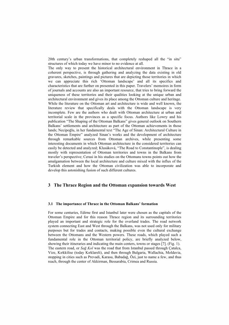
Abstract. This paper focuses on the architectural and urban environment of
Thrace region during the Ottoman Empire and its perceptions witnessed by
Western travelers from 15th to early 20th century. Due to their expansion in the
Balkans’ region, a remarkable effort was done by the Ottoman Turks to replace
the Byzantine hegemony in those lands. Thrace region, herewith introduced as a
case study, present an impressive number of artifacts which were planned or
reorganized by the new rulers to enhance the conquered and ‘Ottomanized’
territories. Many of those artefacts disappeared in time and thanks to the
travelers who left several written descriptions or sketchbooks while crossing
those lands, today we can better understand the achievement reached by the
Ottomans, in terms of artistic and architectural assess. Within this framework,
the paper aims to highlight some of those masterpieces in Thrace as an
expression of such remarkable Ottoman heritage and how the contribution of
travel literature today can open new perspectives to recognize such urban and
architectural environment.
Keywords: Ottoman Heritage, Balkans, Thrace, Travelers
1 Introduction
The aim of this paper is to present some aspects of the architectural and urban
environment planned and built by the Ottomans in the Southern Balkans, specifically
in the Thrace region, nowadays inside the European part of Turkey and partially
shared by Greece and Bulgaria.
The transformation of those territories and road network systems created or renovated
by the Ottomans through the lens of the descriptions left by Western travelers will be
the main focus of this presentation. Within the perspective to acknowledge and
reassess those urban and architectural artifacts as a significant part of the Ottoman
heritage, some descriptions, memories and sketches left by several travelers during

the last centuries, will be presented in a chronological manner. In order to set a
framework on the urban, architectural and infrastructures panorama observed by
travelers some architectural structures belonging to the Ottomans - crossing the
Balkan Peninsula and in particular Thrace - will be analyzed as well [1].
The province of Rumeli1 was the only portion of the whole Ottoman Empire in
European soil and before the conquest of Istanbul their capital was located there, in
the ancient city of Adrianopolis/Edirne [2]. During the 16th century the Ottomans
were able to consolidate almost all those territories once belonged to the ancient
Roman and later Byzantine empire. Thanks to their administrative and military
structure and thanks to skilled architects, engineers and craftsmen which contribution
was fundamental to boost a new architectural and artistic development in the
conquered lands, the Ottomans were able to rule those territories for six hundred
years.
The Rumeli province - including Thrace - collects by far a considerable number of
Ottoman’s era masterpieces that enhance a high level of art, architecture and urban
planning achieved by the Ottoman civilization [3]. Especially in the 16th century, the
Ottomans reached their peak in terms of architecture and engineering production,
thanks to the patronage of wise sultans like Suleiman the Magnificent, Selim II and
Murat III and through the works completed or supervised by Architect Sinan [4].
They reorganized the existing urban and rural centers, developing new cities and
villages, strengthening infrastructures like bridges and aqueducts and forming at the
same time trade centers on the main intersections spots. Moreover, they built new
religious complexes like külliyes or imarets, mosques, mescits and medreses to spread
the new Muslim faith or multi-functional buildings, like caravanserais and post
stations, menzilhane, along the main land routes, in order to accommodate travelers
during their journeys [5].
Beside military and strategic purposes related to the Ottoman’s expansionist visions
towards Europe, these territorial transformations through architectural and
engineering works noticeably increased cultural relationships between different ethnic
groups coexisting in the same areas - like Christians, Jews and Muslim communities
as well, and enhanced trades and diplomatic relations to and from the European states.
At the same time those landscapes were completely transformed, both in architectural
and urban scale by designing several elements, urban features and landmarks, and by
fitting them appropriately in the local context. Overall, it can be said that the
Ottomans through their punctual or extensive architectural transformations of the
conquered territories remodeled a landscape that can unquestionably be regarded as
an example of ‘Ottoman Landscape’ [6].
2 Methodology and Literature review
The research method in this article is mostly based on qualitative sources. The
quantitative method of research cannot be applicable to this work due to the fact that
many settlements or artifacts were severely affected by wars, natural disasters and
1 Rumeli, or Rumelia, indicated the ‘land of the Rum’, and for the Turks meant the lands once
belonged to the Byzantine or more generally to the ancient Roman Empire.
20th century’s urban transformations, that completely reshaped all the “in situ”
structures of which today we have minor to no evidence at all.
The only way to present the historical architectural environment in Thrace in a
coherent perspective, is through gathering and analyzing the data existing in old
gravures, sketches, paintings and pictures that are depicting those territories in which
we can appreciate this rich ‘Ottoman landscape’ and all its specifics and
characteristics that are further on presented in this paper. Travelers’ memoires in form
of journals and accounts are also an important resource, that tries to bring forward the
uniqueness of these territories and their qualities looking at the unique urban and
architectural environment and gives its place among the Ottoman culture and heritage.
While the literature on the Ottoman art and architecture is wide and well known, the
literature review that specifically deals with the Ottoman landscape is very
incomplete. Few are the authors who dealt with Ottoman architecture at urban and
territorial scale in the provinces as a specific focus. Authors like Lowry and his
publication “The Shaping of the Ottoman Balkans” gives general outlook on Southern
Balkans’ settlements and architecture as part of the Ottoman achievements in those
lands; Necipoğlu, in her fundamental text “The Age of Sinan: Architectural Culture in
the Ottoman Empire” analyzed Sinan’s works and the development of architecture
through remarkable sources from Ottoman archives, while presenting some
interesting documents in which Ottoman architecture in the considered territories can
easily be detected and analyzed; Klusáková, “The Road to Constantinople”, is dealing
mostly with representation of Ottoman territories and towns in the Balkans from
traveler’s perspective; Cerasi in his studies on the Ottomans towns points out how the
amalgamation between the local architecture and culture mixed with the influx of the
Turkish element and how the Ottoman civilization was able to incorporate and
develop this astonishing fusion of such different cultures.
3 The Thrace Region and the Ottoman expansion towards West
3.1 The importance of Thrace in the Ottoman Balkans’ formation
For some centuries, Edirne first and Istanbul later were chosen as the capitals of the
Ottoman Empire and for this reason Thrace region and its surrounding territories
played an important and strategic role for the overland trades. The road network
system connecting East and West through the Balkans, was not used only for military
purposes but for trades and contacts, making possible even the cultural exchange
between the Ottomans and the Western powers. These roads, which played such a
fundamental role in the Ottoman territorial policy, are briefly analyzed below,
showing their itineraries and indicating the main centers, towns or stages [7]. (Fig. 1).
The eastern road, or Sağ Kol was the road that from Istanbul passed through Çatalca,
Vize, Kırkkilise (today Kırklareli), and then through Bulgaria, Wallachia, Moldavia,
stopping in cities such as Prevadi, Karasu, Babadağ, Özi, just to name a few, and thus
reach, through the center of Akkirman, Bessarabia, Crimea and Russia.

The middle or ‘the Imperial Road’, also called the Edirne Yolu, started from the
Ottoman capital near the gate of Edirnekapı, and connected the main Istanbul-Edirne
axis with central Europe, through important cities and towns in the Balkan area2.
The western road - the third important one of the Rumelian road system - was simply
called the left road, or Sol Kol3. During the Roman Empire took the name of Via
Egnatia and was mainly used as a military road. For several centuries it was the only
land route that directly connected the “two Rome”, through Greece and Albania.
Starting from Constantinople, to reach Rome, the land road roughly crossed several
centers, interrupted in Durres, in today’s Albania, and then continued across the
Ionian Sea in the town of Egnatia, a small port on the Apulian coast between Brindisi
and Bari, and from here the road finally went up towards Rome [8].
Fig. 1. The Ottoman road network system in Thrace and the main centers.
3.2 The Ottoman urban and architectural heritage in Thrace
By using descriptions and visual perceptions left by Western travelers, the paper
wants to analyze the Ottomanized environment in Thrace. Overall, the main focus is
to show the rich variety and high quality of those urbanized landscapes in Ottoman
2 Through Büyükçekmece, Silivri, Çorlu, Karıştıran, Lüleburgaz, Babaeski, Havsa, Edirne,
Cisr-i Mustafapaşa (now Svilengrad), Filibe (today’s Plovdiv), Sofia, Niš the road reached
Belgrade and was subsequently extended to Budin (today’s Budapest) - to remain within the
borders of the empire – and continued to Vienna and further towards central Europe. 3 Starting from Istanbul, after passing through Küçükçekmece, Büyükçekmece and Silivri it
folded along the coast of the Marmara Sea, crossing Tekirdağ, Malkara, Ferecik, Dimetoka,
Gümülcine, Pravişte, Lanzaka, and Larissa (Yenişehir), to then divide into two other
branches, one towards Istefe (Tebai), and the other for Gordüs, through Eğriboz.

times through travelers’ recounts that accurately explained land routes and tracks for
caravans within those territories, highlighting the new Ottoman settlements, such as
towns and villages and describing architectural elements such as mosques, baths,
station posts, as well as infrastructures such as bridges and water supply systems
along those roads. Within this purpose, the transformations occurred in the minor
centers and along the main road axes in Thrace can be used as a source to better
understand the cultural milieu produced by the Ottomans, in terms of civilization and
achievements. Unfortunately, many of those artefacts are lost forever and in that sense
written sources are truly helpful to give an idea of how Ottomans planned in a very
accurate way the modification of the conquered territories at architectural scale.
An original study by Klusáková explored the ‘Ottoman landscape’ and the road
network system in the Balkans and the impact of Ottoman civilization in the eyes of
Western travelers. Through the analysis of an anonymous 16th century sketches’
manuscript, known as the Leiden sketchbook [9], Klusáková summarizes the concept
of travel to the East, highlighting how much the landscape reshaped by the Ottomans
was studied and observed by those who went from the West to the heart of the capital
of the Empire4. Ottoman architecture in Thrace reflects the spirit and the vision of the
Sultans and how the ‘Ottomanization’ of those lands was a necessity to establish and
consolidate their power over local populations, identifiable by ethnic groups and
different religions. Superb mosques adorned with slender minarets, pious foundation’s
complexes, caravanserais and baths, soup kitchens and covered bazaars in the minor
centers, solid stone bridges across rivers, lakes and mountain passages were
architectural and engineering elements spreading in the territories that positively
surprised the travelers for their artistic qualities and functional use.
Just to give an example, during the second half of the 16th century, along the Imperial
road between Istanbul and Edirne, Sinan was able to build something like forty works,
of which almost one third is today badly damaged or completely lost. In the Sultans’
agenda carried on mostly by Gran Viziers and other high rank officers, the
Ottomanization process throughout architectural and urban planning was a priority,
especially in specific areas like the Balkan Peninsula, seen as a crucial and strategic
land between East and West. In her important work, Necipoğlu, while introducing
Sinan and his patronage in relation to the policy towards the conquered lands, states
that: “The colonization of space through settlement […] played a central role in
Ottoman architectural culture” [10].
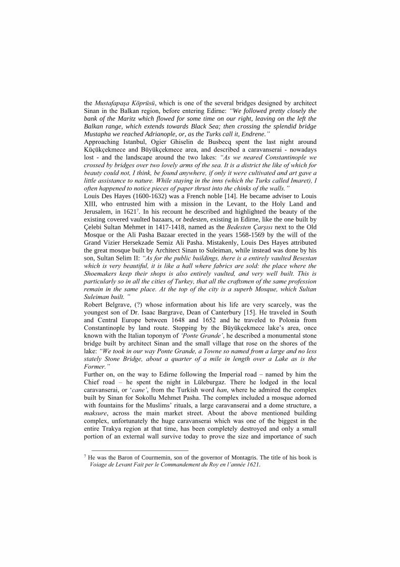
Today, many architectural masterpieces left by the Ottoman civilization - not only
including some of Sinan's works - are no longer visible or - in some cases - are so
completely included into a contemporary built environment that it is very difficult to
appreciate their qualities and to visualize them in their proper historic context (Fig. 2
and 3). Crossing Thrace by vehicles or trains on modern highways or railways cannot
give an idea of how complex and spread that incredible network of historic routes and
4 In the Leiden sketchbook the journey begins in Vienna and ends in Istanbul through
twenty-seven sketches of cities, towns and small centers from the Habsburg Empire
along the Imperial Road, crossing the Balkans, and especially in the territories
between Edirne and Istanbul. Those sketches represented in details some architectural
features which characterized those centers, with precise drawings of domes, minarets,
caravanserais, bridges that can be easily identify the Ottoman urban environment.
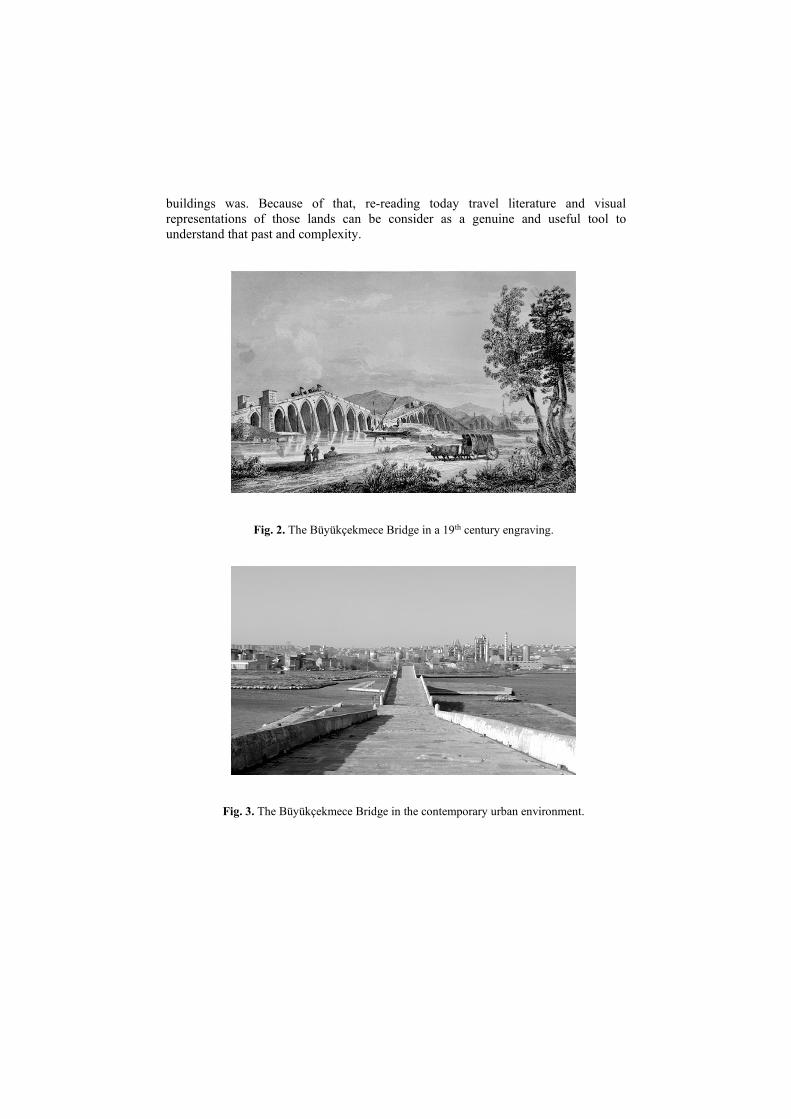
buildings was. Because of that, re-reading today travel literature and visual
representations of those lands can be consider as a genuine and useful tool to
understand that past and complexity.
Fig. 2. The Büyükçekmece Bridge in a 19th century engraving.
Fig. 3. The Büyükçekmece Bridge in the contemporary urban environment.

4 Travelers and travelogues in Thrace
In this chapter a selection of travelers who crossed Thrace between 15th and the early
20th century will be presented to underline the relations between the existing Ottoman
built environment and its reflection on traveler’s descriptions or appreciations. The
selection includes some travelers who are very different from each other’s by
formation, intentions and journey’s purposes, and by the period in which they lived.
Nevertheless their narratives are useful to understand and assess the impact of urban
and architectural transformations in those territories ruled by the Ottomans.
In several cases, travelers’ impressions about the Ottomanized territories were
positive, revealing a common sense of admiration and respect for the Ottoman
administration and organization, especially considering the urban and architectural
environment they went across. In Thrace region those descriptions were remarkable,
since probably their expectations were so low about what they were supposed to see.
As noticed by Longino: “Travelers made their way to the Levant armed to varying
degrees with their ancestors’ crusader memories, booking knowledge of the Levant, a
sense of cultural superiority, and clear expectations of self-enrichment as a
consequence of their adventuring” [11]. On the other hand, finding, a well-ordered
civilization, expressed through a systematic approach to the organization of social life
in the smaller centers, an structured viability with all the vital functions for local
communities and travelers most likely changed the opinions of traveler.
4.1 Traveler’s descriptions of Ottoman structures in Thrace region
The first chosen traveler is Bertrandon de la Bro(c)quière (c. 1400 – 9 May 1459)5.
He was a Burgundian pilgrim to the Middle East in the years 1432–33 [12]. From his
travels’ memoires there are relevant descriptions of the territories of Thrace already
occupied by the Muslim Turks decades before the conquest of Constantinople. Precise
information indicates small towns like Burgas/Lüleburgaz, connotated by a strong
Turkish presence, and Edirne, the capital of the Ottoman Empire, whose splendor is
described giving information about the geography, the main activities and the
defensive structures: “We came to Pirgasy, where there are none but Turks. […] We
next came to Andrinopole, a large commercial town, very populous, and situated on a
great river called Mariza, six days’ journey from Constantinople. This is the strongest
town possessed by the Turk in Greece, and here he chiefly resides.”
Ogier Ghiselin de Busbecq (1522-1592) was a Flemish diplomat [13]. He served as
ambassador for the Habsburg’s emperor at the court of the Sultan6. In his recount, on
the way from Sofia to Istanbul, he admired the engineering structure of a stone bridge,
5 Bertrandon de la Bro(c)quière wrote it in French at the request of Philip the Good, Duke of
Burgundy, for the purpose of facilitating a new Crusade. Bertrandon was born in the late 14th
or early 15th century in the Duchy of Aquitaine and his life before 1421 is unknown. He
rapidly gained the confidence of Philip the Good and was entrusted with a series of important
missions. In 1423 he was honored with the title premier écuyer tranchant, “first wit esquire”. 6 Ogier Ghiselin de Busbecq was a writer, herbalist and diplomat in the employ of three
generations of Austrian monarchs, as other members of his family did before.
the Mustafapaşa Köprüsü, which is one of the several bridges designed by architect
Sinan in the Balkan region, before entering Edirne: “We followed pretty closely the
bank of the Maritz which flowed for some time on our right, leaving on the left the
Balkan range, which extends towards Black Sea; then crossing the splendid bridge
Mustapha we reached Adrianople, or, as the Turks call it, Endrene.”
Approaching Istanbul, Ogier Ghiselin de Busbecq spent the last night around
Küçükçekmece and Büyükçekmece area, and described a caravanserai - nowadays
lost - and the landscape around the two lakes: “As we neared Constantinople we
crossed by bridges over two lovely arms of the sea. It is a district the like of which for
beauty could not, I think, be found anywhere, if only it were cultivated and art gave a
little assistance to nature. While staying in the inns (which the Turks called Imaret), I
often happened to notice pieces of paper thrust into the chinks of the walls.”
Louis Des Hayes (1600-1632) was a French noble [14]. He became adviser to Louis
XIII, who entrusted him with a mission in the Levant, to the Holy Land and
Jerusalem, in 16217. In his recount he described and highlighted the beauty of the
existing covered vaulted bazaars, or bedesten, existing in Edirne, like the one built by
Çelebi Sultan Mehmet in 1417-1418, named as the Bedesten Çarşısı next to the Old
Mosque or the Ali Pasha Bazaar erected in the years 1568-1569 by the will of the
Grand Vizier Hersekzade Semiz Ali Pasha. Mistakenly, Louis Des Hayes attributed
the great mosque built by Architect Sinan to Suleiman, while instead was done by his
son, Sultan Selim II: “As for the public buildings, there is a entirely vaulted Besestan
which is very beautiful, it is like a hall where fabrics are sold: the place where the
Shoemakers keep their shops is also entirely vaulted, and very well built. This is
particularly so in all the cities of Turkey, that all the craftsmen of the same profession
remain in the same place. At the top of the city is a superb Mosque, which Sultan
Suleiman built. ”
Robert Belgrave, (?) whose information about his life are very scarcely, was the
youngest son of Dr. Isaac Bargrave, Dean of Canterbury [15]. He traveled in South
and Central Europe between 1648 and 1652 and he traveled to Polonia from
Constantinople by land route. Stopping by the Büyükçekmece lake’s area, once
known with the Italian toponym of ‘Ponte Grande’, he described a monumental stone
bridge built by architect Sinan and the small village that rose on the shores of the
lake: “We took in our way Ponte Grande, a Towne so named from a large and no less
stately Stone Bridge, about a quarter of a mile in length over a Lake as is the
Former.”
Further on, on the way to Edirne following the Imperial road – named by him the
Chief road – he spent the night in Lüleburgaz. There he lodged in the local
caravanserai, or ‘cane’, from the Turkish word han, where he admired the complex
built by Sinan for Sokollu Mehmet Pasha. The complex included a mosque adorned
with fountains for the Muslims’ rituals, a large caravanserai and a dome structure, a
maksure, across the main market street. About the above mentioned building
complex, unfortunately the huge caravanserai which was one of the biggest in the
entire Trakya region at that time, has been completely destroyed and only a small
portion of an external wall survive today to prove the size and importance of such
7 He was the Baron of Courmemin, son of the governor of Montagris. The title of his book is
Voiage de Levant Fait per le Commandement du Roy en l’année 1621.

structure. “[We stopped] that night with a supper at a Towne calld Burgoss, a small
but very pleasant place in the Chief street whereof is a faire Mosque (or Church)
adornd with curious Fountaines on the one side, and on the Other with a stately Cane
for Travellers conteining three large Quadrangles cloistered round, having within
them very faire Chambers: Both Mosque and Cane had the same Founder, and are
joind with a faire Cupula cross the Street, one to the other.”
Giovan Battista de Burgo (?) was an Irish abbot who undertook a long journey [16],
which lasted five years, across three continents: Asia, Africa and Turkish Europe8.
His travelogue contained rich information about the Ottoman daily life and several
descriptions of places he visited during his land journey in 1664. In this passage it is
reported the same complex in Lüleburgaz described by Robert Belgrave: “We found a
beautiful mosque with two caravanserais for the passengers. Therefore we entered the
mosque, and there at the entrance we found two beautiful fountains, in which Turks
customarily use before entering the mosque and there - without any respect - they
wash their hands, heads, beards, legs, and other secret places; and after they are
washed, then they enter the mosque to make their prayers. But we did not enter the
mosque, we went straight to the caravanserai assigned for the Christians.”
Lady Mary Wortley Montagu (1689-1762) was an English aristocrat who travelled in
many countries [17]. She eventually became a famous writer once back to England9,
and in a letter she described the markets and covered bazaars in Edirne: “The
Bedesten is another exchange, built upon pillars, where all sort of horse furniture is
sold; glittering everywhere with gold, rich embroidery and jewels it makes a very
agreeable show.”
Helmuth K. Graf von Moltke (1800-1891) was a German military commander10. In
the years 1835 served the Sultan Mahmut II to reform the Ottoman army [18], and in
his memories he described the magnificent view of Edirne within its landscape: “Like
all Turkish cities I visited, Edirne, seen from outside, is beautiful. In a vast plain
covered with meadows, among the meandering of the river, the domes and minarets
rise, the walls and towers overlook a tangle of red roofs, among whom shine the
bushes of a beautiful shining green, and large cypress blacks. The grand mosque of
Sultan Selim stands, with its four graceful minarets, on the highest hill.”
Le Corbusier (1887-1965), who was one of the pioneers and masters of modern
architecture11, in a late publication collected the experiences from a journey he made
8 Unfortunately, the real identity of Giovan Battista de Burgo is still unknown and there are
many missing data to confirm even its existence. This real or supposed Irish abbot wrote his
memories in Italian language and published them in Milan in 1689. 9 Montagu is today chiefly remembered for her letters, particularly her correspondences from
the Ottoman Empire dated 1717, The Turkish Embassy Letters, which have been described
by Billie Melman as “the very first example of a secular work by a woman about the Muslim
Orient”. 10 Chief of the Prussian Army for thirty years, he is regarded as one of the great strategists of
the latter 19th century and creator of a new and more modern method of directing armies in
the field. 11 Charles-Edouard Jeanneret, known as Le Corbusier, radically changed the concept of
architecture and he was an innovative leader of the International Style. Beside his activity, he
was important also for his writings and theories about the meaning of architecture and urban
planning.

in 1910-11 to learn about the great architecture of the past, visiting Greece, Italy and
the Ottoman Empire [19]. About Edirne he left several sketches and delighted
descriptions of the former capital of the Ottoman Empire, emphasizing the beautiful
nature and the astonishing mosque built by Sinan for the Sultan Selim II in the skyline
of Edirne: “And Adrianople appears in the splendor of the great afternoon light.
Adrianople is like the raised floor of this large overgrown which ends in a
magnificent dome. Formidable minarets that for the distance are as slender as swamp
asperellas exalt and carry even more on this vigorous thrust. Three other enormous
and grandiose mosques from bottom to top support this joyful tension. Sultan Selim
mosque is for the city like a magnificent tiara. The ancient capital of the Turks
remained full of nobility.”
5 Conclusion
Crossing Balkan cities like Sarajevo, Thessalonica, Skopje, or countries like Albania,
Bosnia Herzegovina or Macedonia, it is possible to observe, along the provincial
roads or in the minor urban and rural areas, several mosques or mescits, public baths,
caravanserais, covered bazaars, bridges, fortifications and other infrastructures, which
testify the incredible Ottoman achievement in those territories. Reaching the core of
the empire from the European countries, in the final part of their journey across the
Thrace region, the travelers crossed probably the most Ottomanized landscape of that
huge empire, perfectly integrated into the territories which were under the rule of the
Ottomans. This land road system was not only an important commercial and military
road; it was the backbone of the urban and social network of the empire.
The visual representations and the narratives reflected by the travelers presented in
this paper are both related to the concept of ‘perception’ itself and to the urban and
architectural environment briefly analyzed. From the observation of those lands made
in the past by the travelers we can infer how those territories were important for the
definition and the consolidation of the power of the Empire itself.
Following the concept of the travelers’ perception of the visited lands, we can find
several levels of perception: a regional and territorial scale, presented by the
geographical descriptions of those lands and by the first glimpses about cities, towns
and minor centers from far; a town-generating elements at urban space scale,
represented very well by structures like the menzil kulliyes, the market areas and big
infrastructures like roads and bridges; and then a specific perception on the town size
and on the administrative buildings and other remarkable buildings, such as baths,
markets and caravanserais that really defined a different way to live and to participate
in the administrative and social life of the Ottomans.
In lands like Thrace, connoted since the ancient past by the presence of strong multi-
ethnics and multi-confessional components, the traces and the influences left by the
Muslim Turks and the Ottomans through almost six hundred years of domination and
sovereignty are spread out everywhere. Within this purpose, all those transformations
occurred in the minor centers and along the main road axes seen through the eyes of
the travelers, can be used as sources to better understand the cultural milieu produced
and improved by the Ottomans and can be helpful also in the perspective to increase
more knowledge about their civilization and achievements. Therefore, narratives,
memoires, drawings and sketches left by travelers can help to enhance the Ottoman
achievement in Thrace as an unique cultural heritage, shared both by Turkey and its
neighbors, that still needs to be accurately explored and then protected and preserved.
References
1. Hupchick, D. P., Cox, H. E.: The Palgrave Concise Historical Atlas of the Balkans, Palgrave
Macmillan, New York (2001)
2. İnalcik, H.: Rumeli. In TDV İslâm Ansiklopedisi, vol. 35 (2008) 232-235
3. Lowry, H. W.: The Shaping of the Ottoman Balkans, 1350-1550: The Conquest, Settlement
& Infrastructural Development of Northern Greece, Bahçeşehir University Press, Istanbul
(2008)
4. Orlandi, L.: Il Paesaggio delle Architetture di Sinan, Ege Yayınları, Istanbul (2017)
5. Cerasi, M.: La Città del Levante. Civiltà urbana e architettura sotto gli Ottomani nei secoli
XVIII-XIX, Jaca Book, Milano (1988)
6. Orlandi, L.: Lost Highways. Sinan’s Architectural and Urban Transformations in Thrace as
Traces of the Ottoman Civilization and as Possible Cultural Landscape for the Future. In
Amoruso, G. (ed.): Putting Tradition into Practice: Heritage, Place and Design, Proceedings
of the 5th INTBAU annual event, Lecture Notes in Civil Engineering 3, Springer
International Publishing AG 2018, 938-948
7. Yerasimos, S.: Les Voyageurs dans l’Empire Ottoman (XIVe – XVIe siècles). Bibliographie,
itinéraires et inventaire des lieux habités, Publications de la Société Turque d’Histoire,
Ankara (1991)
8. Heywood, C.: The Via Egnatia in the Ottoman period: The menzilhanes of the Sol Kol in the
late 17/early 18th century. In Zachariadou, E. (ed.) The Via Egnatia under Ottoman Rule
(1380-1699), Halcyon Days in Crete II, A Symposium held in Rethymnon 9-11 January
1994, Rethymnon, Crete University Press (1996), 129-141
9. Klusáková, L.: The Road to Constantinople, ISV Publisher, Prague (2002)
10. Necipoğlu, G.: The Age of Sinan: Architectural Culture in the Ottoman Empire, Reaktion
Books, Princeton University Press (2005)
11. Longino, M.: Imaging the Turk in Seventeenth-century France: Grelot’s Version, (2000), 1
12. Schefer, C. (ed.): Bertrandon de la Broquiere: Le voyage d’Outremer, Ernest Leroux, Paris
(1892) 172
13. Forster E. S., (ed.): Busbecq O. Ghislain De, The Turkish Letters of Ogier Ghiselin de
Busbecq, Imperial Ambassador at Constantinople, 1554-1562, Clarendon Press, Oxford
(1927)
14. Carnac Temple R. (ed.): Travels in Europe, 1608-1628, Appendix F, Hakluyt Society,
Cambridge (1907) 210-212
15. Brennan, M. G. (ed.): The Travel Diary of Robert Belgrave Levant Merchant (1647-1656),
The Hakluyt Society, Series III, 3, London (1999)
16. Cossuto, G. (ed): De Burgo Giovan Battista, Viaggio di Cinque anni in Asia, Africa &
Europa del Turco, Milano 1689, Ed. Isis, Istanbul (2003)
17. Desai, A. (ed.): Wortley Montagu Lady Mary. The Turkish Embassy Letters, Virago Press,
London (1996)
18. Moltke H. von: Una guerra da Turchi, Touring Editore, Milano (1998)
19. Gresleri, G.: Le Corbusier. Viaggio in Oriente, Marsilio Editori, Fondation Le Corbusier,
Venezia – Paris (1985) 174