TRAINING OF TRAINERS CURRICULUM - World Agroforestry
206
TRAINING OF TRAINERS CURRICULUM For the Department of Range Resources Management on climate-smart rangelands
-
Upload
khangminh22 -
Category
Documents
-
view
1 -
download
0
Transcript of TRAINING OF TRAINERS CURRICULUM - World Agroforestry

TRAINING OF TRAINERS CURRICULUM
For the Department of Range Resources Management on climate-smart rangelands

2
AUTHORSThe training curriculum was prepared as a joint undertaking between the National University of Lesotho (NUL) and World Agroforestry (ICRAF).
Prof. Makoala V. Marake
Dr Botle E. Mapeshoane
Dr Lerato Seleteng Kose
Mr Peter Chatanga
Mr Poloko Mosebi
Ms Sabrina Chesterman
Mr Frits van Oudtshoorn
Dr Leigh Winowiecki
Dr Tor Vagen
Suggested Citation Marake, M.V., Mapeshoane, B.E., Kose, L.S., Chatanga, P., Mosebi, P., Chesterman, S., Oudtshoorn, F. v., Winowiecki, L. and Vagen, T-G. 2019. Trainer of trainers curriculum on climate-smart rangelands. National University of Lesotho (NUL) and World Agroforestry (ICRAF).
ACKNOWLEDGEMENTSThis curriculum is focused on training of trainer’s material aimed to enhance the skills and capacity of range management staff in relevant government departments in Lesotho. Specifically, the materials target Department of Range Resources Management (DRRM) staff at central and district level to build capacity on rangeland management. The training material is intended to act as an accessible field guide to allow rangeland staff to interact with farmers and local authorities as target beneficiaries of the information.
We would like to thank the leadership of Itumeleng Bulane from WAMPP for guiding this project, including organising the user-testing workshop to allow DRRM staff to interact and give critical feedback to the drafting process. We would also like to acknowledge Steve Twomlow of IFAD for his passion and expertise and his extensive work on sustainable landscapes in Africa.
Design layout by Debra-Jean Harte

3
TABLE OF CONTENTS
MODULE 1: INTRODUCTION TO RANGELANDS
Page 4 CHAPTER 1 - DEFINING RANGELANDS AND THE LESOTHO CONTEXT
Page 11 CHAPTER 2 - GEOMORPHOLOGY & SOILS OF LESOTHO
Page 21 CHAPTER 3 - BASIC ECOLOGICAL PROCESS
Page 27 CHAPTER 4 - VEGETATION OF LESOTHO
Page 46 CHAPTER 5 - THE ROLE OF PLANTS
Page 63 CHAPTER 6 - THE ROLE OF ANIMALS
MODULE 2: UNDERSTANDING CLIMATE RISK, VULNERABILITY & IMPACT ON RANGELANDS IN LESOTHO
Page 75 CHAPTER 7 - CLIMATE AND CLIMATE CHANGE
Page 98 CHAPTER 8 - LAND DEGRADATION AND SOIL EROSION
MODULE 3: RANGELAND MANAGEMENT & GOVERNANCE IN LESOTHO
Page 112 CHAPTER 9 - RESTORATION OF ERODED AND DEGRADED LANDS
Page 120 CHAPTER 10 - POLICY & LEGISLATIVE FRAMEWORKS FOR RANGE MANAGEMENT IN LESOTHO
Page 124 CHAPTER 11 - DROUGHT ECOLOGY & MANAGEMENT
Page 132 CHAPTER 12 - GRAZING & BROWSING MANAGEMENT
Page 142 CHAPTER 13 - FIRE ECOLOGY & MANAGEMENT
Page 155 CHAPTER 14 - WETLAND ECOSYSTEMS AND MANAGEMENT
Page 161 CHAPTER 15 - WATERSHED MANAGEMENT
Page 168 CHAPTER 16 - FORAGE PRODUCTION
MODULE 4: MONITORING RANGELAND CONDITION
Page 183 CHAPTER 17 - RANGE CONDITION ASSESSMENT
Page 202 CHAPTER 18 - LESOTHO’S NATIONAL RANGELAND MONITORING SYSTEM

4
MODULE 1INTRODUCTION TO RANGELANDS
Rangeland is the term used to describe arid or semi-arid land that is well suited for grazing. The term ‘rangeland’ refers to open natural areas used for extensive livestock production or set aside for conservation.
The arid conditions along with poor soil quality make rangelands unfit for growing crops, which require nutrient-rich soil and proper irrigation.
Some rangeland is dominated by grasses, others by shrubs or low-growing trees, while the driest rangelands are deserts.
While these lands may appear barren at first glance, there are a number of valuable uses of rangeland, including:
Grazing of livestock - grasses and forage plants that grow in these climates are well- suited for grazing;
Provide habitats for wildlife, and, if well-established, can boost the biodiversity of a region and bring stability to the ecosystem;
Provide watersheds for use by surrounding communities;
Recreation - the open spaces and natural beauty make them ideal for outdoor activities, including hiking, fishing, and hunting, biking, and driving off-road vehicles;
Location for renewable energy sources such as wind and solar power due to the vast rolling landscapes.
Introduction
Importance of Rangelands
CHAPTER 1
DEFINING RANGELANDS AND THE LESOTHO CONTEXT
M1
WHAT IS A WATERSHED?A watershed is an area of land that delivers rainwater or snowmelt into waterways. Watersheds are important because the water bodies they drain into provide drinking water and other benefits to humans and animals. Properly managed rangelands protect watersheds from erosion and pollutant runoff that can contaminate waterways.

5
Grasslands are characterised as lands dominated by grasses rather than large shrubs or trees, for example: grasses (Poaceae), sedge (Cyperaceae) and rush (Juncaceae). Grasslands (also known locally as makhulo) are dominated by a single layer of grasses. The amount of cover depends on rainfall and the degree of grazing. Trees are absent, except in a few localized habitats. Geophytes (bulbs) are often abundant. Frosts, fire and grazing maintain the grass dominance and prevent the establishment of other non-grass species.
Grass plants tolerate grazing, fire, and even mowing - most produce new stems readily, using a wide variety of strategies. Over-grazing tends to increase the proportion of pioneer, creeping and annual grasses, and it is in the transition zones between sweet and sour grass dominance that careful management is required to maintain the abundance of sweet grasses.
There are two categories of grass plants:
Sweet grasses have lower fibre content, maintain their nutrients in the leaves in winter and are therefore palatable to stock.
Sour grasses have higher fibre content and tend to withdraw their nutrients from the leaves during winter so that they are unpalatable to stock and have low nutritional value.
Types of Rangelands
LESOTHO GRASSLANDS
According to the Lesotho Land Cover Atlas (FAO 2017).
The grassland is the mainstay of multi-purpose animals (dairy/beef and draught power) albeit a growing specialised production of semi-commercial dairy and small stock for wool and mohair production in Lesotho. Best management practices elsewhere indicate that pastures may be augmented especially in wetter areas by the inter-seeding of legumes and sweet grasses. However, in Lesotho, much of the Grassland Biome has been converted to arable agriculture mainly cereal production for staple crops such as maize, sorghum, wheat, legumes (beans and peas).
A. Natural grassland rangeland

6
A savanna is a grassland ecosystem characterised by sufficiently widely spaced so that the canopy does not close. The open canopy allows sufficient light to reach the ground to support an unbroken herbaceous layer consisting primarily of grasses. The environmental factors delimiting the savanna rangeland are complex: altitude ranges from sea level to 2,000m; rainfall varies from 235 to 1,000mm per year; frost may occur from 0 to 120 days per year; and almost every major geological and soil type occurs within the biome. A major factor delimiting the savanna is the lack of sufficient rainfall which prevents the upper tree layer from dominating, coupled with fires and grazing, which keeps the grass layer dominant.
Summer rainfall is essential for grass dominance, which, with its fine material, fuels near-annual fires. In fact, almost all species are adapted to survive fires, usually with less than 10% of plants, both in the grass and tree layer, killed by fire. Even with severe burning, most species can re-sprout from the stem bases. The grass layer is dominated by C 4-type grasses, which are at an advantage where the growing season is hot. But where rainfall has a stronger winter component, C 3-type grasses dominate (Box 1).
C3 AND C4 ASSIMILATION PATHWAYSBOX 1
Grasses are often described as being either C3 or C4 grasses. This refers to the pathway grasses use to capture carbon dioxide during photosynthesis. The more primitive C3 grasses fix an initial 3-carbon molecule during photosynthesis and the more advanced C4 grasses a 4-carbon molecule.
These differences are important because the two pathways are also associated with different growth requirements. C3 plants are adapted to cool season establishment and growth in either wet or dry environments. On the other hand, C4 plants are more adapted to warm or hot seasonal conditions under moist or dry environments. A feature of C3 grasses is their greater tolerance of frost compared to C4 grasses. C3 species also tend to generate less bulk than C4 species. However, feed quality is often higher than C4 grasses. The table below shows the important differences:
B. Savannas rangeland
Factors Photosynthetic pathway C3 C4
Initial molecule formed during photosynthesis 3 carbon 4 carbon
Growth period Cool season or year-long Warm season
Light requirements Lower Higher
Temperature requirements Lower Higher
Moisture requirements Higher Lower
Frost sensitivity Lower Higher
Feed quality Higher Lower
Production Lower Higher
Example genera
Festuca, Bromus, Merxmuellera, Pentaschistis
Themeda, Eragrostis, Aristida, Panicum

7
The chapters that follow will address each of the above aspects of rangeland management.
Controlling and regulating the movement of animals;
Controlling and regulating the numbers of animals;
Controlling problem plants;
Controlling wildfires;
Managing prescribed burning, if necessary;
Restoring denuded land;
Planning and keeping records of rangeland management aspects; and
Developing and maintaining rangeland management supporting infrastructure.
NOTE TO TRAINERS:A rangeland cannot be managed successfully if the ecological principles governing the ecosystem are not understood.
Rangeland management is defined as the science of managing natural resources, including vegetation, soil and water (which form part of rangelands). With rangeland management, an attempt is made to sustainably utilise the natural resources in line with human land use and growing population pressure. To successfully manage and sustainably utilise rangelands, the ecological principles governing the ecosystem should be understood and considered. Practically, rangeland management involves the following aspects:
This maintenance was done through numerous ecological processes, which include, among others, grazing animals that could migrate to greener pastures and predators that were “responsible” for controlling herbivore numbers and preventing animals from grazing continuously in the same area.
Rangelands are still adapted to this natural “order”; however, with agriculture, population spread and livestock numbers, rangelands need to be managed very carefully. Management of a rangeland and animals therefore becomes necessary as a substitute for the natural processes that used to sustain rangeland condition.
Rangeland management can therefore be seen as applying practices that simulate the natural processes (natural order) of the past with a view to ensure the sustainable utilisation of natural resources (Box 2).
Rangeland Management
Before human agriculture started to dominate, natural ecosystems in a balanced state were able to maintain important ecological functions such as:
Maintaining a good ground cover;
Ensuring good water infiltration and nutrient cycling; and
Minimising infrared radiation that contributes to climate change.
Why is rangeland management important?

8
SUSTAINABLE RANGE MANAGEMENTBOX 2
Sustainability means meeting the needs of the present without compromising the needs of future generations.
Land degradation, in the form of soil erosion and invasion of unpalatable shrubs, is well documented in Lesotho. This high level of degradation can be directly linked to poor land management practices, such as overgrazing and inappropriate crop production practices. Such practices not only cause land degradation, but also contribute to climate change through increased solar radiation and decreased carbon stocks in the topsoil. The direct result of these impacts is a reduction of the natural resource’s ability to produce food.
Sustainable rangeland management makes use of the beneficial actions of livestock by moving and herding them in a bunch to a fresh place every day. The animals are moved according to a grazing plan; animals come to the same area only once during the growing season and once during the non-growing season.
Adopting principles of sustainability is critical for sustainable livestock based livelihoods in Lesotho especially the wool and mohair industry. The principles include:
bunching of animals to improve the nutrient and water cycles by natural fertilisation, breaking soil capping and increasing soil cover through trampling;
Perennial grasses need adequate recovery periods between grazing to prevent overgrazing and over-rest; and
Ensure that livestock numbers do not exceed the amount of food available and always ensure a sufficient reserve supply to cope with drought conditions.
The following are key outcomes for sustainable range management:
Perennial plants have adequate recovery periods;
Over-grazing of perennial grass plants is reduced; and
During the non-growing or dry season, the build-up of soil cover (mulch) is improved as dead plant material is broken off and trampled into the ground.
Planned grazing and herding results in:
Sound rangeland management;
Increased productivity of vegetation due to natural fertilisation by the animals;
Limited loss of livestock from theft and disease, due to daily contact with herders;
Limited loss to problem animals;
Increased carrying capacity (case studies from Southern Africa show a doubling, in some cases even tripling, of stocking rates over time);
Improved livelihoods;
Mitigation of droughts and climate change;
Increased biodiversity;
Increased carbon sequestration into the soil; and
Synergies with wildlife and tourism enterprises.
1
4
1
1
2
5
6
7
8
9
10
2
2
3
3
3
On the contrary, rangeland that is poorly managed, or not managed at all, will experience a reduction of ecological functions, which leads to land degradation. Land degradation ultimately leads to a reduction in agricultural potential (reduced food production), increase in vulnerability to climate change and extreme weather events, less clean water and reduction in overall biodiversity
9
1
1
4
2
2
5
3
3
6
Principles of Sustainable Range Management
The relevance of rangeland management in Lesotho
A. Correct kind of animals
C. Proper distribution of animals over rangeland
B. Correct number of animals
D. Correct number of grazing days
Preference: While facing decisions on the kind of animals in a rangeland, first we look at the preference of animals to vegetation type and vegetation present in rangeland e.g.:
Goats prefer trees and shrubs;
Cattle prefer tall grasses; and
Sheep prefer short grasses.
Palatability: It is related to preference.
Topography: If range area is slopey (on a slope) then allow sheep and goats only. Cattle should be allowed in plain areas.
There are many methods for proper or uniform distribution of animals over rangeland. These are:
Providing water facilities at different points;
Fencing particular area;
Salt lick placement over different points on rangeland;
By using special grazing system;
Range fertilisation; and
Range burning.
Carrying capacity: The correct number of animals depends on the carrying capacity of an area. If the number of animals is more than the land carrying capacity, degradation will occur.
Correct season or number of days of grazing; whenever the range is ready, one can allow grazing according to carrying capacity.
Lesotho has a land surface of roughly three (3) million hectares of which about 50 percent are grassland cover (FAO, 2017). Rangelands are important in the success of livestock keeping, as farmers seldom practice supplementary feeding. Livestock production contributes significantly to the livelihoods of rural communities through provision of meat, milk, draught power and transport (Department of Range Resources Management, 2014).
Rural households in Lesotho are highly dependent on natural rangeland for livestock production through the production and sale of meat, wool, mohair, hides and skins. The greatest proportion of population especially in the rural lowlands, foothills and mountains areas are dependent on rangelands due to livestock based livelihoods. Furthermore, Lesotho is unique in its ability to “produce” water from its expanded grasslands in mountainous afro-alpine wetlands. These two commodities, livestock and water, not only maintain livelihoods in Lesotho.

10
Image 1: The lack of vegetation cover can clearly be seen on this satellite image, showing the border between Lesotho (top) and the Free State province of South Africa (bottom). This difference in range condition is attributed to land management.
The state of land degradation in Lesotho, as opposed to most other countries, is severe (Image 1) with soil loss rates of 20 tons/ha/annum for croplands and 18 tons/ha/annum for rangelands (National Resources Inventory (NRI) 1988). This can mainly be attributed to the removal of the protective vegetation cover through overgrazing and poor cropland management. In this manual we will look further into the causes of land degradation.
1
2
4
3
5
Based on the policy issues and legislative frameworks (Chapter 10), the key focus areas for Lesotho have been identified as follows:
Sustainable management of rangeland resources;
Conservation of biodiversity and maintenance of ecosystems;
Rangeland monitoring and research;
Maintenance and protection of wetland areas; and
Socio-economic dimensions.

11
Figure 1: Soils are influenced by topographic conditions
CHAPTER 2
Lesotho is situated in geologic sedimentary basin called the Karoo. The geology of Lesotho is divided into three episodes: the sedimentation of the Karoo basin, the magmatic episodes of the Lesotho formation and geomorphologic evolution and development of soils (Fig. 1).
Introduction
GEOMORPHOLOGY & SOILS OF LESOTHO
Undulating & Steep SlopesConditions
Depression Areas Conditions
Level Conditions
On level topographic conditions, almost the entire water received through rainfall percolates through the soil. Under such conditions, the soils formed may be considered as representative of the regional climate. They have normal solum with distinct horizons. But vast and monotonous level land with little gradient often has impaired drainage conditions.
The soils on undulating and steep slopes are generally shallow, stony and have weakly developed profiles with less distinct horizonation. It is due to accelerated erosion, which removes surface material before it has the time to develop. Reduced percolation of water through soil is because of surface runoff, and lack of water for the growth of plants, which are responsible for checking of erosion and promote soil formation.
The depression areas in semi-arid and sub humid regions reflect more moist conditions than actually observed on level topographic positions due to the additional water received as runoff. Such conditions (as in the Tarai region of the Uttar Pradesh) favour more vegetative growth and slower rate of decay of organic remains. This results in the formation of comparatively dark-coloured soils rich in organic matter.

12
The geomorphology of Lesotho is characterised by extensive erosion of the Lesotho plateau. The Clarens sandstone escarpment at about 1800m above sea level (ASL) marks the transition from the lowlands to the foothills. The broadest classification of the lands in Lesotho uses the division between the lowlands and the mountains and reflects the geological structure, lithology and gross-topography. The lowlands are the regions, mainly in the west, where sedimentary strata outcrop situated below the escarpment formed by the Clarens Formation. The mountains include the eastern part of the country, which lies above the same scarp and are formed mainly in the basalts of the Lesotho Formation. A further sub-division into land regions with similar climatic and geomorphological processes acting on similar rocks has been made within the land regions in Lesotho.
Geomorphology of Lesotho
Soil Formation Process1
Landscape ProcessesSoils of Lesotho
Summit position: Where the summit is greater than 30m wide much of the water is retained on the surface, which is why this position is considered to be the most stable element of the landscape. Water movement in the soil is predominantly vertical except near the transition to the shoulder or on local undulations on the summit.
Shoulder position: Surface runoff is maximized in this element, resulting in a highly erosional and relatively unstable surface. Depending on the degree of slope, lateral movement of surface material (soil creep) and lateral subsurface water movement may become important processes on this part of the landscape. The subsurface movement is not uniform across the slope but is often concentrated in defined flowlines downslope.
Back-slope position: The dominant process on the back-slope positions in transportation of material as well as water. This transport takes place both at the surface and in the subsurface. This landscape position is, therefore, considered to be relatively unstable. On back-slopes that are relatively smooth, the surface transport is uniform.
Foot slope position: Concavity is characteristic of this landscape position. The concavity results in deposition from upslope of particulate material as well as material carried in solution. The position is, therefore, dominantly constructional and relatively unstable. Seepage zones are common and water retention is high. Mass movements are common in this position as a result of loading and water saturation during part of the year. Soils in foot-slope positions are commonly very heterogeneous due to mass movement, irregular seepage and non-uniform deposition.
Toe slope position: The toe-slope element is unstable as a result of its dominantly constructional nature. Soils on the toe-slope are highly variable reflecting periodic flooding, abandoned stream channels (oxbows) and multiple sources of materials. On the lower toe-slopes, soil development is absent or minimal and the water table may be high. Higher above the stream the soils are better drained and show characteristics of profile development.
1
4
2
3
Soil genesis refers to the developmental processes of soil forming factors over long time periods and is a result of the complex interactions of physical, chemical and biological processes. Soil forming processes usually refer to the results of the interaction of these processes of different nature:
Accumulation of soil components (e.g. organic matter);
In-situ formation of new ones (e.g. clay minerals or oxides);
Transport within the soil profile (e.g. clay, carbonate or soluble salts); and
Changes in the aggregation state of soil particles (e.g. formation of a structure).
1 Antonio Delgado A. and J.A. Go´mez. 2016. The Soil: Physical, Chemical and Biological Properties. In F.J. Villalobos, E. Fereres (eds.), Principles of Agronomy for Sustainable Agriculture. Springer Int. Publ. AG.

13
These processes will define the soil type and can strongly affect soil quality. Available soil depth for plant growth (the depth of the soil profile that can be explored by plant roots also termed rootable soil depth), is a determining factor in agronomy since it strongly affects overall crop development and soil productivity. The available soil depth is the result of the balance between soil formation and erosion rates. Soil formation rates are extremely low and mostly related to geology (parent material properties) and climate conditions. It is usually less than 5mm per century (although rates range from 0.01 to 40mm per century).
SOIL, OUR HERITAGE“Soil is the heritage of the human race and the most precious asset that a nation possesses. It is the source of all food and the basis of all civilisations. Formed with infinite slowness over the ages, it is quick to waste and, once wasted, it can for all practical purposes never be replaced. It behoves us then to guard our soil resources with the utmost care and to use them wisely, for a healthy nation can be built up only on the products of healthy soil” (JC Ross, 1963).
Human interventions - The removal of the protective plant cover through human induced land and vegetative degradation leads to accelerated soil erosion rates under inappropriate land use or soil management practices. Accelerated soil erosion rates result in a reduction of the soil profile depth and consequently land degradation. Achieving tolerable soil erosion rates is a major goal of soil conservation practices in Lesotho. Such rates are defined as those which are either close to the soil formation rates or at least below a given critical threshold (e.g. below 10–100mm in 100 years. The use of soil conservation techniques aim at reducing erosion rates within the range of 0.003–60mm per 100 years for achieving a more sustainable agriculture.
Soil Properties
ParentMaterial
Topography
Organisms
Time
Process
Climate
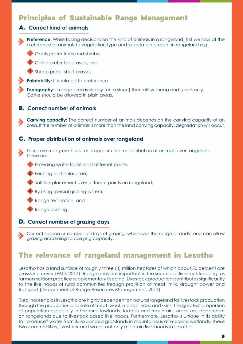
Figure 2: The type of soil found on any site is dependent upon the interaction of five factors
14
The type of soil found on any site is dependent upon the interaction of five factors modelling the soil formation (Fig. 2). Any of the physical, chemical or biological processes taking place in the soil as a result of these factors are called pedogenic processes:
Additions: Materials added to the soil, such as decomposing vegetation and organisms (organic matter--OM), or new mineral materials deposited by wind or water.
Losses: Through the movement of wind or water, or uptake by plants, soil particles (sand, silt, clay, and OM) or chemical compounds can be eroded, leached, or removed from the soil, altering the chemical and physical makeup of the soil. Water evaporates into the atmosphere; soil particles are eroded; organic matter may decompose into carbon dioxide; minerals and nutrients are leached into the ground water or lost through plant uptake.
Transformations: Transformation include the chemical weathering of both primary minerals and /or formation of secondary soil minerals (clays) and decomposition of organic materials into decay resistant humic materials. The plants and animals are also responsible for transformation of the soil by physically and chemically breaking down the materials.
Translocations and podsolization: Movement of soil constituents (organic or mineral) within the profile and/or between horizons. Over time, this process is one of the more visibly noticeable as alterations in colour, texture, and structure become apparent.
Weathering Processes: Weathering is the breakdown and alteration of rocks and minerals. Climatic conditions control the rate of weathering that takes place by regulating the effect of moisture and temperature. Weathering takes a number of forms:
Chemical Weathering - involves the alteration of the chemical and mineralogical composition of the weathered material.
Physical / Mechanical Weathering - is the breakdown of mineral or rock material into smaller particles by entirely mechanical methods induced and /or physical activity of biological agents.
1
2
Soil Properties 2
2 Based on the publication by: Delgado A. and J.A. Go´mez. 2016. The Soil: Physical, Chemical and Biological Properties. In F.J. Villalobos, E. Fereres (eds.), Principles of Agronomy for Sustainable Agriculture. Springer Int. Publ. AG
reservoir for water and nutrients. However, in addition to being a physical medium, soil supports biological systems vital for producing the food and fibre that humans need and for maintaining the ecosystems on which all life ultimately depends. Soil directly and indirectly affect agricultural productivity, water quality, and the global climate through its function as a medium for plant growth, regulator of water flow and nutrient cycling as well as geo-carbon cycles.
The soil also hosts a complex array of fauna and microbial systems involved in many different biological processes, which also affects its physical and chemical properties, and ultimately the productivity of agricultural ecosystems. For a given soil, its properties depend on the history of the soil formation and can be substantially modified by human intervention (e.g. through agricultural practices). A proper understanding of soil characteristics and adequate interpretation of the magnitudes of its properties, both combined under the broader term of soil quality (Fig. 3), is required for proper management of agricultural soils.

15
Soil Property Attributes
Soil Properties Soil Properties Soil Properties
Physical Chemical Biological
SoilTexture
Bulk Density
InfiltrationRate
Cation Exchange Capacity
OrganicCarbon
Concentration
Soil pH
Soil Respiration
Earthworms Presence
Microbial Biodiversity
Figure 3: Soil properties normally used to evaluate soil quality

16
The soil structure provides the physical architecture for aeration, drainage and movement of plant roots. Soil chemistry is dominated by the interaction between the soil solid components (both mineral and organic) and its water phase. Soil physical properties determine many key soil processes (Fig. 4) and thus the agronomical potential of a soil.
Soil Physical Properties: Texture and Structure
Leaching, Salinization, Acidification
Infiltration, Runoff,
WaterloggingTrafficability
& Erosion
Soil Processes & Management
RootGrowth
Water Uptake
Plant Process
Mechanical Properties
(e.g. Penetration resisitance)
Hydraulic Conductivity
Water Retention & Porosity
Soil Physical Properties
Soil Texture& Structure
ClayMineralogy
Figure 4: Soil properties normally used to evaluate soil quality

17
Soil Chemical Properties
Soil Biological Properties
A. The Soil Reaction (pH)
B. Redox Status
C.Salinity and Sodicity
1
1
2
2
The degree of acidity or alkalinity of a soil is a very relevant property affecting many other physico-chemical and biological properties. Problems derived from acidic soils or acidification of agricultural soils can be overcome by increasing base saturation and pH with soil amendments (liming). Some of the soil fertility features affected by soil pH include:
Nutrient availability to plants in the soil; and
Biological properties especially microbial activity.
The oxidation-reduction (redox) status of a soil is determined by the availability of electrons which can participate in redox reactions. Important processes that are impacted by redox status:
Ion Retention in Soils: Ions can be retained in soils by precipitation and adsorption processes; and
Ion Exchange Capacity: Exchangeable ions are those weakly adsorbed by soil particles that can be exchanged chemically from sorption sites by other ions in the solution. Exchangeable ions are essential for maintaining plant nutrient and dynamic balance between the soil solid phase and soil solution.
Soil salinity is defined as a high concentration of soluble salts in soils. A saline soil has a soluble salt concentration high enough to negatively affect the growth and development of most cultivated plants. Sodicity on the other hand refers to the sodium content of the soil and affects the physical properties of the soil including soil structure and drainage dynamics. Salinity and sodicity may have toxic effects on plant growth.
Soils host a complex web of organisms (Fig. 5) which can influence soil evolution and specific soil physical and chemical properties. For instance earthworms activity increases infiltration rate, or microbial activity decreases soil organic matter due to mineralization. Soil biological properties are also interconnected with other soil physical and chemical properties; e.g. aeration, soil organic matter or pH affect the activity of many microorganisms in soils which in turn perform relevant activities in carbon and nutrients cycling.
Roots
Animals
Nematodes 1
Bacteria
Arthropods 1 Arthropods 2
Organic Matter
Fungi Nematodes 2
Protozoa
Nematodes 3
Figure 5: Soil Food Web. Source: Delgado A. and J.A. Gomez (2016)

18
Table 1: Selected Soil Biological Properties. Source: Delgado A. and J.A. Gomez (2016)
Thus, changes in soil properties due to management can significantly affect biological properties in soils, some of them being extremely sensitive to soil management e.g. soil microbial activity can be greatly increased by improved drainage, liming or organic amendments. That is why some soil biological properties can be used as indirect indicators of appropriate soil management and good soil quality, like soil respiration rate or some enzymatic activities that can be derived from living organisms in soil.
Soil organic matter is a key factor affecting biological activity in soils because it is the main carbon substrate for most organisms, including soil microbiota. Both the amount and type of organic compounds in the soil determines its biological activity e.g. microbial activity is greatly increased by incorporating fresh organic residues (such as green manure or crop residues), which can be readily mineralized by microbes subject to prevailing carbon to nitrogen ratios of the organic substrates.
Many of the properties (Table 1) are a description of the diversity and activity of parts of the soil food web, or of related properties such as soil respiration rate or organic matter content.
Properties Comments
1.Respiration rate
CO2 evolution under standard laboratory or field conditions.
2.Potential N and C mineralization
Increase in mineral N or C content under laboratory conditions.
3.Earthworms
Density of earthworms.
4.Bacterial biomass
Total bacterial biomass for a given soil mass.
5.Bacterial diversity
It can be determined by functional groups or describing genetic diversity.
6.Presence of pathogens
By different pathology techniques and cultures to DNA profiling.

19
Nutrients in soils are present in different chemical forms either in the soil solution or adsorbed on the solid phase (mineral and organic matter). Exchange of nutrients between different forms or “soil pools” is governed by physical, chemical, or biological processes. All these processes form aspects of the nutrient cycle in soils because soil is an open system i.e. it exchanges material and energy with its surroundings e.g. loss of nutrients, water, gases and heat. The soil and global nutrient cycles are affected by human activities. In agricultural soils, fertilisation alters the cycle, introducinag nutrients in the system. Without this supply, the natural input of nutrients in soils would be much lower than typical crop extractions, thus inducing a “negative balance” which would cause a progressive depletion of nutrients and thus a progressive loss of soil fertility.
A general nutrient cycle is represented in Figure 6. The flux of nutrients to plant roots comes from the soil solution, mainly as dissolved ions. The “labile nutrient pool” is that readily equilibrated with the solution as adsorbed ions. Those precipitated as soluble salts, or those present in organic compounds which are readily mineralized. The “available pool” of nutrients is the amount in solution plus that readily equilibrated with the solution (“labile forms”); for a given nutrient it can be considered the amount that can be extracted by successive crops until severe deficiency of this nutrient appears in crop.
Nutrient Cycles and Balances in the Soil
Nutrient in Solution
Labile Pool
Water
Fertilizer
Atmosphere(N,C)
Crop
Uptake
LeachingErosion
Capilaryrising
DesorptionDissolutionMineralization Absorbed (exchangeable)
Precipitated (soluble)Organic (ready mineralizable)
Non-labile PoolAbsorbed (non-exchangeable)Precipitated (insoluble)Organic (stable)Primary minerals
DesorptionDissolutionMineralization
Figure 6: General cycle of nutrients in soil showing the physical, chemical or biological processes involved in the nutrient cycle.

20
Benchmark Soils of Lesotho 3
3 The Office of Soil Survey of the Soil Conservation Division, currently Department of Soil and Water Conservation in the Ministry of Forestry, Range and Soil Conservation identified 11 out of 38 soil series as benchmark mark soils according to specific criteria across the lowlands, foothills and mountain of Lesotho as compiled by Cauley P.M. 1982. Benchmark Soils of Lesotho: Their Classification, Interpretations, Use and Management. Office of Soil Survey, Soil Conservation Division. Ministry of Agriculture. Maseru. Lesotho.
The Benchmark Soil Series represent those groups of soils that are considered to be capable of producing arable crops under dry land conditions during an average climatic season. They are confined to those areas of Lesotho that receive at least 625 mm of rainfall per year and have elevations less than 2400m ASL. Although each benchmark soil may have widely different physical and chemical properties, the properties of any soils that fall within the representative benchmark group will be closely related.
Soil scientists selected the benchmark soils from all other arable soils by identifying those soils that are important because of extent or use. For example the Sephula series, although only marginally arable, is extensive throughout the western lowlands and widely cultivated; and the Khabos series while not extensive lies along streams and rivers and has the potential for the production of high value cash crops because of level slopes and high soil fertility. Both Series are representative of a particular groups of arable soils.
After selecting the benchmarks soil, soil scientists conducted detailed field investigations and compiled notes on each soil. These notes provided the data for developing a range of soil characteristics. By analysing the range in characteristics, a central concept was identified and a location selected for a pit excavation from which a typical pedon description and the soil samples for laboratory analysis were conducted. Once all the soil information from the field notes and laboratory analysis data of the typical pedons were analysed, the benchmark soils were classified and interpretations developed. In some cases the original soil concept, with the exception of a few cases, remained basically the same e.g. Leribe series. In other cases, for example, the Rama series, the soil concepts were considerably altered and where the data did not match any existing soil series, new soil series were established e.g. Tumo and Sefikeng.
Soil concepts, like those in other scientific disciplines, change as more information is gathered. The classification of all the existing benchmark series has been revised, and the concepts have been defined to fit existing conditions in the light of new data, and to facilitate the identification of the soils in the field. The concept and interpretative data, while accurately reflecting current knowledge, will in time need to be updated or in some cases completely revised.

21
CHAPTER 3
Landscape functions, also known as “basic ecological services”, are the basic processes that result in the goods and services provided by the ecosystem. Landscape functions include processes involved in the transportation, utilisation and cycling of natural resources such as water, topsoil, organic matter and vegetation. In healthy productive ecosystems the landscape functions are all present and highly functional, while in degraded ecosystems the landscape functions are extremely limited.
Ecosystem functioning is described as the capacity of an ecosystem to provide ecosystem services (socioeconomic and ecological services) and is often measured by considering the ecosystem processes operating to maintain the biogeochemical/ biophysical system, including productivity, nutrient dynamics (cycling), decomposition, soil erosion, water infiltration (water holding capacity), runoff etc. When ecosystem functioning is considered at landscape level, it is called landscape functioning. The landscape concept differs from the ecosystem concept in focusing on groups of ecosystems and the interactions among them.
“Landscape function” describes how well a landscape is performing as a biophysical system. A landscape is a complex system characterised by a mosaic of interacting ecosystems at any scale.
A landscape that is characterised by many vegetated patches may be considered functional, while a more dysfunctional landscape is characterised by many bare soil patches.
Landscape functional analysis considers three important indices of landscape function:
soil surface stability (resistance to erosion);
infiltration/ water holding capacity; and
nutrient cycling.
The two most important landscape functions are the nutrient cycle and the water cycle, which will be discussed in this manual. The effective functioning of these two cycles are, however, highly dependent on vegetation cover, which we will look at first.
Vegetation cover refers to the level at which the ground is covered by plants of different types. This cover may include live plants and/or a layer of organic mulch. Grasses are known to form a particularly good protective layer at ground level. Rangeland management, therefore, strives to a large degree to maintain and increase the level of grass cover, particularly in grassland environments, which in turn contributes to soil surface stability.
Rangelands with a good ground cover function well in terms of water and nutrient cycling. Furthermore, it also captures more carbon than poorly covered land and emits less infrared radiation, thereby mitigating climate change; one of the major threats to modern agriculture. Thus, vegetation cover plays important roles in the ecosystem. For example:
Acts as a thermal insulator between the atmosphere and the ground, thereby plant cover controls soil temperature extremes, thereby improving seedling survival, decreasing evaporation and maintaining healthy microbial life in the soil;
Introduction
Importance of vegetation cover in the ecosystem
BASIC ECOLOGICAL PROCESS
1
2
3

22
Plants and organic material slow down the speed of runoff water, thus increasing water infiltration and subsequent plant growth. On the other hand, poorly covered land, with subsequent increased runoff, will experience drought even during normal rainy seasons;
Plants break the impact of raindrops, thereby decreasing the possibility of soil erosion and crust formation;
Improves soil structure;
Improves other soil characteristics such as fertility, etc.;
Provides habitat for some animals;
Plants shed leaves, or eventually die off, leaving organic material behind, which serves as mulch or is incorporated into the soil by invertebrates. This increased organic matter in the soil, and improves water and nutrient cycling;
Plants decrease wind speed at soil surface level, thereby decreasing evaporation, the level of wind erosion and allowing the establishment of a larger seed bank; and
Increases the amount of water available for uptake by plants.
Vegetation cover, therefore, plays important roles in the ecosystem. For example, it may act to:
Reduce soils erosion;
Improve soil structure;
Improve water infiltration and holding capacity of the soil;
Regulate biogeochemical cycles;
Provide habitat for some animals;
Improve soil microbial activity; vii) reduce direct water evaporation from the soil; and
Increase the amount of water available for uptake by plants.
1
4
2
5
3
6
7
Figure 7: The impact of poor versus good vegetation cover on ecological processes.
23
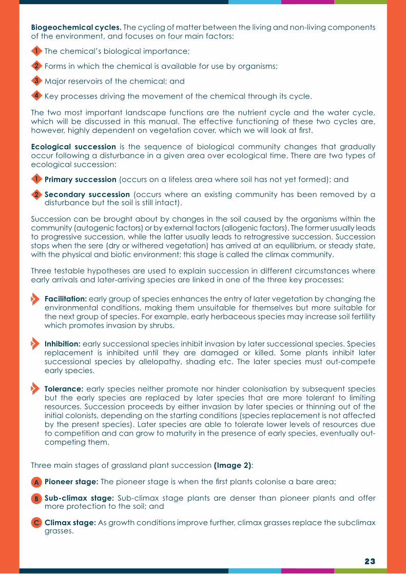
Biogeochemical cycles. The cycling of matter between the living and non-living components of the environment, and focuses on four main factors:
The chemical’s biological importance;
Forms in which the chemical is available for use by organisms;
Major reservoirs of the chemical; and
Key processes driving the movement of the chemical through its cycle.
The two most important landscape functions are the nutrient cycle and the water cycle, which will be discussed in this manual. The effective functioning of these two cycles are, however, highly dependent on vegetation cover, which we will look at first.
Ecological succession is the sequence of biological community changes that gradually occur following a disturbance in a given area over ecological time. There are two types of ecological succession:
Primary succession (occurs on a lifeless area where soil has not yet formed); and
Secondary succession (occurs where an existing community has been removed by a disturbance but the soil is still intact).
Succession can be brought about by changes in the soil caused by the organisms within the community (autogenic factors) or by external factors (allogenic factors). The former usually leads to progressive succession, while the latter usually leads to retrogressive succession. Succession stops when the sere (dry or withered vegetation) has arrived at an equilibrium, or steady state, with the physical and biotic environment; this stage is called the climax community.
Three testable hypotheses are used to explain succession in different circumstances where early arrivals and later-arriving species are linked in one of the three key processes:
Facilitation: early group of species enhances the entry of later vegetation by changing the environmental conditions, making them unsuitable for themselves but more suitable for the next group of species. For example, early herbaceous species may increase soil fertility which promotes invasion by shrubs.
Inhibition: early successional species inhibit invasion by later successional species. Species replacement is inhibited until they are damaged or killed. Some plants inhibit later successional species by allelopathy, shading etc. The later species must out-compete early species.
Tolerance: early species neither promote nor hinder colonisation by subsequent species but the early species are replaced by later species that are more tolerant to limiting resources. Succession proceeds by either invasion by later species or thinning out of the initial colonists, depending on the starting conditions (species replacement is not affected by the present species). Later species are able to tolerate lower levels of resources due to competition and can grow to maturity in the presence of early species, eventually out-competing them.
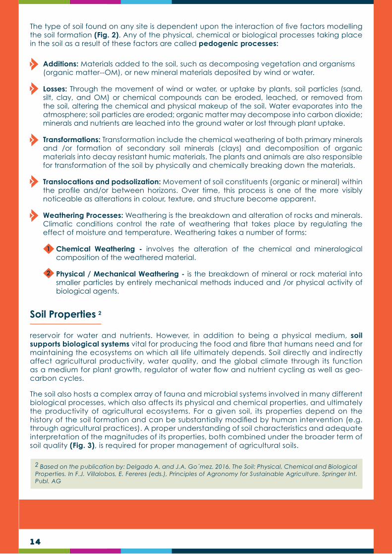
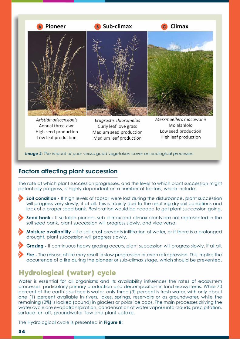
Three main stages of grassland plant succession (Image 2):
Pioneer stage: The pioneer stage is when the first plants colonise a bare area;
Sub-climax stage: Sub-climax stage plants are denser than pioneer plants and offer more protection to the soil; and
Climax stage: As growth conditions improve further, climax grasses replace the subclimax grasses.
1
1
2
2
3
4
A
C
B
24
Image 2: The impact of poor versus good vegetation cover on ecological processes.
A CB
The rate at which plant succession progresses, and the level to which plant succession might potentially progress, is highly dependent on a number of factors, which include:
Soil condition - If high levels of topsoil were lost during the disturbance, plant succession will progress very slowly, if at all. This is mainly due to the resulting dry soil conditions and lack of a proper seed bank. Restoration would be needed to get plant succession going.
Seed bank - If suitable pioneer, sub-climax and climax plants are not represented in the soil seed bank, plant succession will progress slowly, and vice versa.
Moisture availability - If a soil crust prevents infiltration of water, or if there is a prolonged drought, plant succession will progress slowly.
Grazing - If continuous heavy grazing occurs, plant succession will progress slowly, if at all.
Fire - The misuse of fire may result in slow progression or even retrogression. This implies the occurrence of a fire during the pioneer or sub-climax stage, which should be prevented.
Factors affecting plant succession
Water is essential for all organisms and its availability influences the rates of ecosystem processes, particularly primary production and decomposition in land ecosystems. While 70 percent of the earth’s surface is water, only three (3) percent is fresh water, with only about one (1) percent available in rivers, lakes, springs, reservoirs or as groundwater, while the remaining (2%) is locked (bound) in glaciers or polar ice caps. The main processes driving the water cycle are evapotranspiration, condensation of water vapour into clouds, precipitation, surface run-off, groundwater flow and plant uptake.
The Hydrological cycle is presented in Figure 8:
Hydrological (water) cycle

25
Figure 8: The water cycle, showing rainfall, infiltration, runoff and evaporation (adapted from McIntyre et al., 2002).
During a rainfall event, most rainwater reaches the soil, with only small amounts of water trapped by foliage. Once on the ground, it either soaks away into the soil or runs off to reach a myriad of smaller drainage lines, wetlands and rivers. Of the water that infiltrates into the soil the following may happen:
Some is directly lost again as a result of evaporation from the soil surface.
Some is absorbed by plants for plant growth.
Some is lost again through transpiration by plants.
Some will drain down to become groundwater.
Some ground water will seep through the soil surface to be become surface water again.
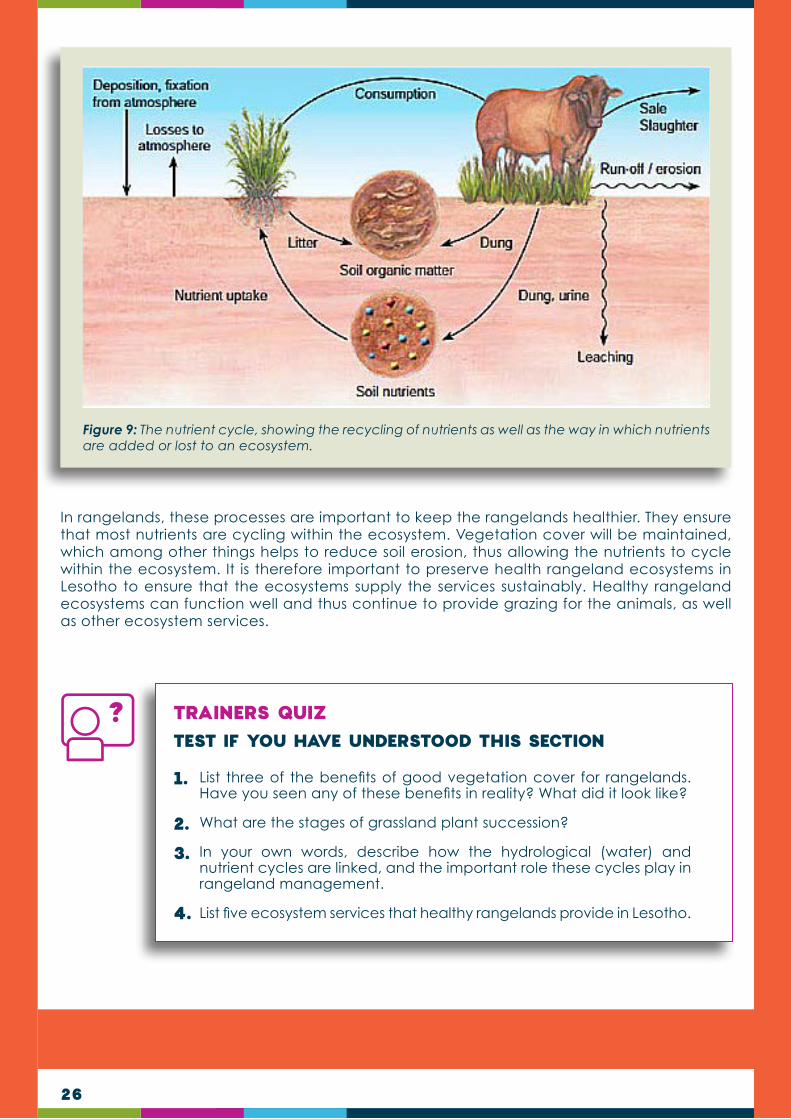
Nutrients are chemicals in an ecosystem necessary for organisms to grow. The nutrient cycle includes the use, movement and cycling of these nutrients, and is one of the most important ecological services to sustain an ecosystem. It essentially recycles nutrients, after being used by living organisms, to make them available again. The nutrient cycle includes all nutrients, such as carbon, nitrogen, phosphorus, potassium, calcium and magnesium, of which the first two are the most important. Without the nutrient cycle, nutrients would be trapped (immobilised) in organic material, unavailable for plants, animals and humans to use.
Nutrient Cycles
26
Figure 9: The nutrient cycle, showing the recycling of nutrients as well as the way in which nutrients are added or lost to an ecosystem.
In rangelands, these processes are important to keep the rangelands healthier. They ensure that most nutrients are cycling within the ecosystem. Vegetation cover will be maintained, which among other things helps to reduce soil erosion, thus allowing the nutrients to cycle within the ecosystem. It is therefore important to preserve health rangeland ecosystems in Lesotho to ensure that the ecosystems supply the services sustainably. Healthy rangeland ecosystems can function well and thus continue to provide grazing for the animals, as well as other ecosystem services.
TRAINERS QUIZ TEST IF YOU HAVE UNDERSTOOD THIS SECTION
List three of the benefits of good vegetation cover for rangelands. Have you seen any of these benefits in reality? What did it look like?
What are the stages of grassland plant succession?
In your own words, describe how the hydrological (water) and nutrient cycles are linked, and the important role these cycles play in rangeland management.
List five ecosystem services that healthy rangelands provide in Lesotho.
1.
2.3.
4.

27
CHAPTER 4
Vegetation is a general term for the plant life of a region and refers to the ground cover provided by plants, and is, by far, the most abundant biotic element of the biosphere. Vegetation is also known as flora, and can be of any form e.g. grasses, herbs, shrubs, trees etc. The existence of plants can be under threat due to various factors such as overharvesting, fire, overgrazing, habitat destruction, competition by invasive species, as well as climate change. Therefore, it is important to conserve plants in order to prevent them from extinction. Different ways are used:
In situ conservation: the on-site conservation (conservation of species in their natural habitats) e.g. Protected areas (Nature reserves, parks).
Ex situ conservation: the off-site conservation (conservation of species outside their natural habitats) e.g. in botanical gardens.
Other plant genetic resources may be conserved in the form of seeds which are stored in a seed bank and later replanted to ensure continued survival of species.
A taxonomic group at any rank is referred to as a taxon (taxa plural). A taxon is more general than the one below it. The last two levels of the taxonomic hierarchy (genus and species epithet) give the scientific name of the species. The former begins with a capital letter and the latter with a small letter (and the two are written in italics or underlined). Plants are assigned names based on International Code of Botanical Nomenclature (ICBN), and the names are given in Latin or Greek.
For example:
Scientific name: Themeda triandra
Common names: names usually in English e.g. red grass, red oat grass, Kangaroo grass (Australia).
Vernacular names: name based on a language of a particular race or group e.g. Seboku (Sesotho), rooigrass (Afrikaans).
Synonym: Themeda australis
Introduction
Hierarchical classification of species4
VEGETATION OF LESOTHO
4 Abbreviations used: Sp. (single species), spp. (more than one species), var. (variety), ssp. (subspecies).

28
Table 2: Classification of plants
Plants are broadly classified into five (5) major groups namely; algae, bryophytes, pteridophytes, gymnosperms and angiosperms, and these are discussed below and shown below.
Algae
Aquatic, and most primitive of all plants in that the body is small and undifferentiated eg. Spirogyra (bolele).
Bryophytes
Land plants, but prefer moist areas. They lack true leaves, stem and roots (also no vascular system) eg. Mosses.
Gymnosperms
Seed-bearing vascular plants with no flowers eg. Pines.
Pteridophytes
Possess true roots, stems and leaves as well as vascular system (but without seeds). They prefer moist, shady areas.
Angiosperm
Seed-bearing vascular plants that have flowers. The group is broadly divided into monocots and dicots, eg. grasses (monocots).
Spirogyra (bolele), an Algal species
A Moss, an example of Bryophytes
A fern, an example of Pteridophytes
A pine, an example of Gymnosperms
Acacia, an example of Angiosperms
Classification of plants

29
Even though a species is regarded as the lowest basic taxonomic rank, the following ranks may be found below species level:
Subspecies: a taxonomic category that ranks below species, usually permanently geographically isolated e.g. Dicoma anomala subspecies anomala, D. anomala subsp. gerrardii.
Variety: a taxonomic category below species and subspecies (meaning a variation of a species) e.g. Agave americana var. americana, A. americana var. variegata as shown in Image 3.
Hybrid/cultivar: the result of interbreeding between two plants of different taxa e.g. Populus x canescens, which is a hybrid between Populus alba and Populus tremula.
NOTE TO TRAINERS:Example of hierarchical classification of plants:
The following is an example of hierarchical classification of plants, using (Themeda triandra) Red grass, as an example (based on Wikipedia.org):
In summary, Themeda triandra can be described as follows using different terms defined above:
Themeda triandra (scientific name), previously known as T. australis (synonym), with vernacular (Sesotho) name Seboku and Common/English name (Red grass), is a perennial herb (growth form), found in a terrestrial environment (habitat). It is native to Africa, Australia and Asia
Image 3: Agave americana var. americana (left), A. americana var. variegata (right).
Level Example
Domain Eukarya
Kingdom Plantae
Division (-phyta) Anthophyta (flowering plants)
Class (-psida or -ae) Monocotyledonae
Order (-ales) Poales
Family (-aceae) Poaceae
Genus Themeda
Species Triandra

30
NOTE TO TRAINERS CONT:(endemism). It is endangered in most countries (conservation status), being used predominantly for grazing, and to a lesser extent for thatching and basketry. It is sometimes used as an ornamental and landscape plant (importance). It is often dominant on mountain slopes and is an indicator of a veld being in good condition. Even though it is a palatable grass, it does not do well under heavy grazing (major threats). It flowers (is a flowering plant) between September and March, producing distinct large red-brown, bisexual spikelets (inflorescence type) clustered in triangular units (Image 4).
More information on other species can be sourced from plantzafrica.com. The website also gives information on plant type, distribution, habitat, flowering season, flower colour, ecology and uses. In addition, Wikipedia.org also provides hierarchical classification (taxonomy and naming) of the plants.
Image 4: Themeda triandra (Red grass), also showing inflorescence (spikelets).
Lesotho is a grassland biome characterised by a temperate climate (i.e. hot, wet summers and cold, dry winters). In fact the general appearance of the vegetation (dominant vegetation) is grass with scattered shrubs and trees found in gullies and valleys of foothills and slopes of lowlands. The country’s grassland vegetation comprises 50 percent of rangelands, shrubland makes 27 percent, woodlands contribute 1.1 percent and wetlands make up 0.9 percent (FAO 2017). The flora of Lesotho comprises about 3, 000 plant species belonging to 800 genera and 200 families. The Asteraceae (daisy) family is the largest plant family in the country with 69 genera and 312 species and the Poaceae (grass) family the second largest plant family and accounts for about 97 genera and 295 species (Kobisi, 2005).
The vegetation of Lesotho
No. Family name Family common nameGenera
in family
Species in family
(*)
Largest genus in
family
Species in
genus
1 Asteraceae Daisy or sunflower family 69 312 (29) Helichrysum 75
2 Poaceae Grass family 97 295 (44) Eragrostis 24
3 Scrophulariaceae Figwort or snapdragon family 22 95 (3) Zaluzianshya 14
4 Fabaceae Pea or legume family 26 90 (10) Lotononis 14
5 Cyperaceae Sedge family 19 69 (1) Cyperus 16
6 Orchidaceae Orchard family 13 48 Disa 11
7 Iridaceae Iris family 9 37 Moraea 13
Table 3: The large plant families in Lesotho, arranged from most to least number of species. The number of species shown in brackets (*) account for number of exotic species within the total of species for the family (after Kobisi, 2005).
31
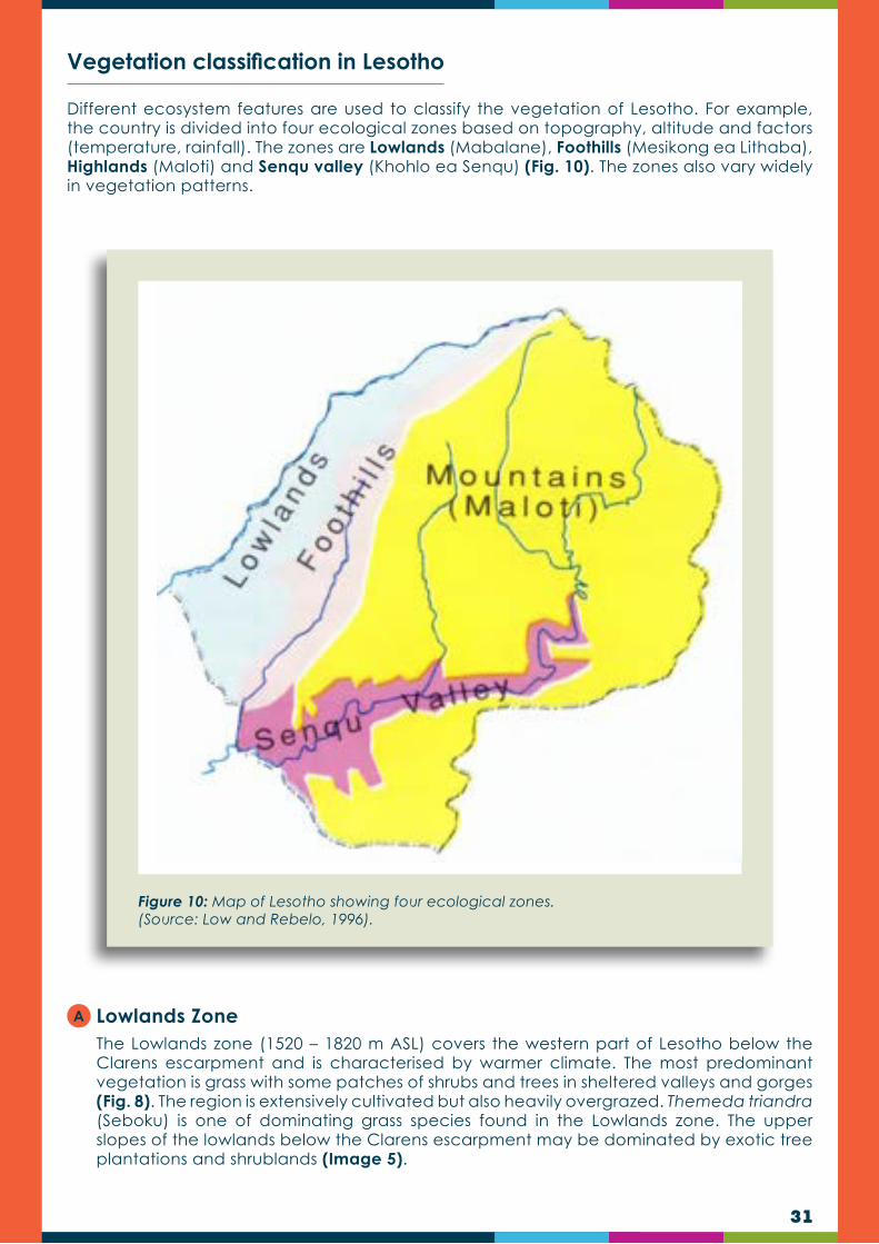
Different ecosystem features are used to classify the vegetation of Lesotho. For example, the country is divided into four ecological zones based on topography, altitude and factors (temperature, rainfall). The zones are Lowlands (Mabalane), Foothills (Mesikong ea Lithaba), Highlands (Maloti) and Senqu valley (Khohlo ea Senqu) (Fig. 10). The zones also vary widely in vegetation patterns.
Lowlands Zone The Lowlands zone (1520 – 1820 m ASL) covers the western part of Lesotho below the Clarens escarpment and is characterised by warmer climate. The most predominant vegetation is grass with some patches of shrubs and trees in sheltered valleys and gorges (Fig. 8). The region is extensively cultivated but also heavily overgrazed. Themeda triandra (Seboku) is one of dominating grass species found in the Lowlands zone. The upper slopes of the lowlands below the Clarens escarpment may be dominated by exotic tree plantations and shrublands (Image 5).
Vegetation classification in Lesotho
Figure 10: Map of Lesotho showing four ecological zones. (Source: Low and Rebelo, 1996).
A
32
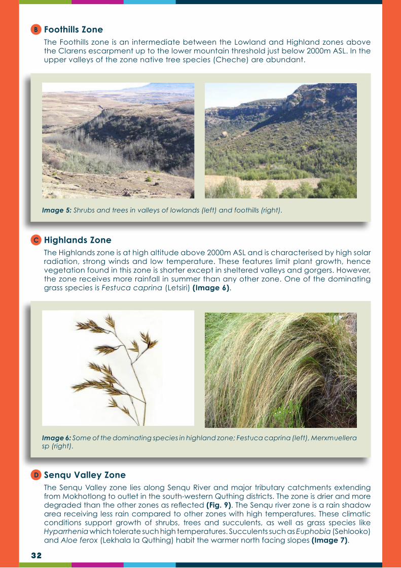
Foothills Zone The Foothills zone is an intermediate between the Lowland and Highland zones above the Clarens escarpment up to the lower mountain threshold just below 2000m ASL. In the upper valleys of the zone native tree species (Cheche) are abundant.
Highlands ZoneThe Highlands zone is at high altitude above 2000m ASL and is characterised by high solar radiation, strong winds and low temperature. These features limit plant growth, hence vegetation found in this zone is shorter except in sheltered valleys and gorgers. However, the zone receives more rainfall in summer than any other zone. One of the dominating grass species is Festuca caprina (Letsiri) (Image 6).
Senqu Valley Zone The Senqu Valley zone lies along Senqu River and major tributary catchments extending from Mokhotlong to outlet in the south-western Quthing districts. The zone is drier and more degraded than the other zones as reflected (Fig. 9). The Senqu river zone is a rain shadow area receiving less rain compared to other zones with high temperatures. These climatic conditions support growth of shrubs, trees and succulents, as well as grass species like Hyparrhenia which tolerate such high temperatures. Succulents such as Euphobia (Sehlooko) and Aloe ferox (Lekhala la Quthing) habit the warmer north facing slopes (Image 7).
B
C
D
Image 5: Shrubs and trees in valleys of lowlands (left) and foothills (right).
Image 6: Some of the dominating species in highland zone; Festuca caprina (left), Merxmuellera sp (right).

33
Image 7: Degraded Senqu valley (left), Aloe ferox, one of the dominating plant species (right).
Image 8: Harpochloa falx (left) and Eragrostis curvula (right), some of the species becoming prevalent in the grasslands.
Staples and Hudson (1938) broadly divides the grassland of Lesotho into two types namely the Themeda triandra (Seboku grassland) and the Festuca caprina (Letsiri grassland). The former is characterised by sweet, palatable grasses and usually occurs on north-facing slopes and at lower elevations (below 2700 m), whereas the latter is characterised by sour, unpalatable grasses which grow mainly on south-facing slopes and at higher altitudes (above 3000 m). However, Lesotho’s grasslands are rapidly changing in composition, with more stoloniferous, weedy and taller species such as Aristida (Lefielo) and Eragrostis spp., (ts’aane) as well as Harpochloa falx (Lefokololi) becoming more prevalent (Kobisi and Kose, 2003). Changes in the composition of the grasslands is influenced by pressures such as fires, grazing, climatic changes, high urban densities (human settlement) and agricultural activities, as well as construction works (including mines). Based on altitude and the dominant species, the vegetation of the country has also been divided into three grassland types: Highveld Grassland (up to 1,800 m ASL); Afromontane Grassland (from about 1,800 to 2,500 m ASL) and Afroalpine Grassland (above 2,500 ASL (Fig. 11)).
Other classification systems

34
Figure 11: The three vegetation types based on grassland belts (Source: Low and Rebelo, 1996).

35
Image 9: A wetland, showing water surplus and vegetation.
Within these zones are small areas of woodland and forest which form part of the Forest biome. Also within the zones, wetlands are found which host a wide range of species. However, as previously indicated, wetlands make up only 0.9 percent of Lesotho’s land cover. A wetland is a water-logged area which usually results when precipitation exceeds potential evaporation, creating a net water surplus. Wetlands usually have high species richness and often harbour endemic and tiny plants (Image 9). Box 3 showcases the importance of wetlands in Lesotho by providing examples of wetland ecosystem services.
THE SOCIO-ECONOMIC AND ECOLOGICAL IMPORTANCE OF WETLANDS IN LESOTHO
BOX 3
Wetlands contribute both ecologically and socio-economically in the country. They support high biodiversity, which is important for the biodiversity of the landscape. Most of the wetlands in the country form the headwaters of the most important rivers in the country (Maliba-matšo, Senqu-Orange, Mohokare, Makhaleng and Senqunyane, etc.) and are important for regulating streamflow in these rivers. Thus, they contribute to the water levels in the high capacity dams in the country (e.g. Katse, Mohale, Muela, Metolong). Nutrient uptake by the vegetation and sedimentation that occurs in wetlands also enhance the quality of the water. Therefore, wetlands contribute to the water resources of the local population and for export to South Africa (through the Lesotho Highlands Water Project), as well for Namibia, through the Senqu-Orange River. Furthermore, because they harbour palatable vegetation, they are a critical grazing resource, especially in summer when thousands of livestock units (sheep, cattle, goats and horses) are seen grazing in these ecosystems. This is important because livestock farming contributes significantly to the people’s livelihoods and to the economy of the country through the sale of wool and mohair. Crop farming also benefits from the wetlands because of the abundance of moisture that facilitates crop farming in and around such environments. Additionally, wetlands provide harvestable biological resources for various uses, including traditional medicine (e.g. Gunnera perpensa and Kniphofia caulescens), artefacts material (e.g. Merxmuellera macowanii, M. drakensbergensis and Festuca caprina) shelter construction (e.g. M. macowanii, Festuca caprina and Phragmites australis) and vegetables (e.g. Rorippa nudiuscula and Hypochaeris radicata).
36
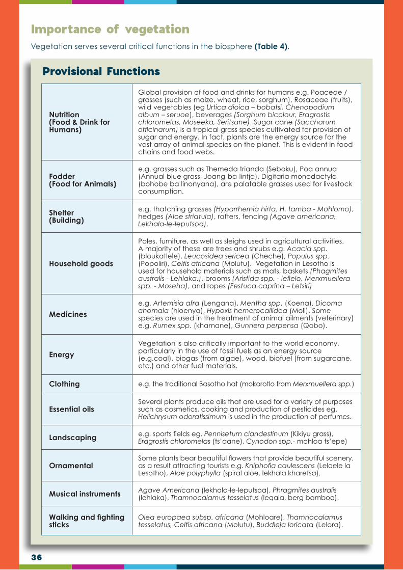
Vegetation serves several critical functions in the biosphere (Table 4).
Importance of vegetation
Nutrition(Food & Drink for Humans)
Global provision of food and drinks for humans e.g. Poaceae /grasses (such as maize, wheat, rice, sorghum), Rosaceae (fruits), wild vegetables (eg Urtica dioica – bobatsi, Chenopodium album – seruoe), beverages (Sorghum bicolour, Eragrostis chloromelas, Moseeka, Seritsane). Sugar cane (Saccharum officinarum) is a tropical grass species cultivated for provision of sugar and energy. In fact, plants are the energy source for the vast array of animal species on the planet. This is evident in food chains and food webs.
Fodder (Food for Animals)
e.g. grasses such as Themeda trianda (Seboku), Poa annua (Annual blue grass, Joang-ba-lintja), Digitaria monodactyla (bohobe ba linonyana), are palatable grasses used for livestock consumption.
Shelter(Building)
e.g. thatching grasses (Hyparrhernia hirta, H. tamba - Mohlomo), hedges (Aloe striatula), rafters, fencing (Agave americana, Lekhala-le-leputsoa).
Household goods
Poles, furniture, as well as sleighs used in agricultural activities. A majority of these are trees and shrubs e.g. Acacia spp. (bloukatlele), Leucosidea sericea (Cheche), Populus spp. (Popoliri), Celtis africana (Molutu). Vegetation in Lesotho is used for household materials such as mats, baskets (Phagmites australis - Lehlaka.), brooms (Aristida spp. - lefielo, Merxmuellera spp. - Moseha), and ropes (Festuca caprina – Letsiri)
Medicines
e.g. Artemisia afra (Lengana), Mentha spp. (Koena), Dicoma anomala (hloenya), Hypoxis hemerocallidea (Moli). Some species are used in the treatment of animal ailments (veterinary) e.g. Rumex spp. (khamane), Gunnera perpensa (Qobo).
Energy
Vegetation is also critically important to the world economy, particularly in the use of fossil fuels as an energy source (e.g.coal), biogas (from algae), wood, biofuel (from sugarcane, etc.) and other fuel materials.
Clothing e.g. the traditional Basotho hat (mokorotlo from Merxmuellera spp.)
Essential oilsSeveral plants produce oils that are used for a variety of purposes such as cosmetics, cooking and production of pesticides eg. Helichrysum odoratissimum is used in the production of perfumes.
Landscaping e.g. sports fields eg. Pennisetum clandestinum (Kikiyu grass), Eragrostis chloromelas (ts’aane), Cynodon spp.- mohloa ts’epe)
OrnamentalSome plants bear beautiful flowers that provide beautiful scenery, as a result attracting tourists e.g. Kniphofia caulescens (Leloele la Lesotho), Aloe polyphylla (spiral aloe, lekhala kharetsa).
Musical instruments Agave Americana (lekhala-le-leputsoa), Phragmites australis (lehlaka), Thamnocalamus tesselatus (leqala, berg bamboo).
Walking and fighting sticks
Olea europaea subsp. africana (Mohloare), Thamnocalamus tesselatus, Celtis africana (Molutu), Buddleja loricata (Lelora).
Provisional Functions

37
Birth To keep men away from the new born (Phragmites australis - lehlaka)
Traditional horn (Lenaka)
Aloe ferox (lekhala la Quthing), Aster bakerianus (phoa), Phygelius capensis (mafifi-mats’o).
Initiation schools Phygelis capensis, Asparagus africanus (lerara-tau), Kniphofia ritualis (leloele).
Symbolism For example, charm against lightning or hail: Pentanisia prunelloides (setima-mollo), Phygelius capensis.
Traditional usesFor example, cleansing after burial: Aloe maculata (lekhala-la-bafu), or cleansing after handling a corpse (Galium spp. – mabone).
Biogeochemical
Vegetation regulates the flow of numerous biogeochemical cycles, most critically those of water, carbon, and nitrogen. It has been the primary source of oxygen in the atmosphere, enabling the aerobic metabolism systems to evolve and persist.
SoilIt strongly affects soil characteristics/properties, including soil volume, chemistry and texture, as well as improving soil fertility (eg. legumes).
LandPrevention of soil erosion: vegetation protects the soil against the onslaught of water, wind and sun. As a result of coverage, runoff rainwater is slowed down and the soil is stabilised.
Water purification Wetlands provide water which is purified by the constituting vegetation.
HabitatVegetation serves as a habitat for wildlife eg. some trees and shrubs provide a habitat for birds, Bokong wetlands provide a habitat for the Ice Rat (Otomys sloggetti).
Pollination Vegetation facilitates reproduction by producing nectar that attracts insect pollinators.
Soil formation Vegetation contributes in weathering of rocks to form soil.
Table 4: Some of the functions focus on the ecosystem level and are broadly categorised into provisional, cultural, regulatory and support services
Cultural Functions
Regulatory
Support

38
These are plants which have a negative environmental impact in a particular locality. The main negative impact of problem plants is invasiveness i.e. the replacing of naturally occurring species and subsequent loss of biodiversity, and excessive water consumption. In Lesotho plant encroachment is mainly caused by indigenous invasive shrubs. Invasive shrubs have a negative impact on livestock production and the ecology in the following possible ways:
They lower the quantity and quality of available forage;
They can obstruct the movement of grazing animals;
They can poison animals;
They outcompete and cause mortality of native plants;
They reduce the ability of an ecosystem to recover; and/ or
They affect the quality of wool and mohair.
Invasive alien plants (IAPs) are plants that are of exotic (non-native/ foreign) origin that are invading previously pristine areas or ecological niches. They have been introduced deliberately or unintentionally outside their natural distribution and where they have the ability to establish themselves, invade, out-compete native species and take over environments or ecosystems and threaten biological diversity (Phiri, 2005). In fact, IAPs are considered to be the second cause of global biodiversity loss, following direct habitat destruction.
Problem plants also include weeds, which are plants considered undesirable in a particular situation (i.e. plants in a wrong place). However, it should be noted that not all weeds or problem plants are alien/exotic in origin. Weeds can:
Cause oxygen deficiency: submerged weeds removes oxygen from the water during respiration, thereby causing oxygen deficiency.
Create dense, floating mats, which can block pumps, prevent reduce water flow.
Provide breeding sites for mosquitoes and snails that carry diseases such as malaria and bilharzia.
Cause livestock to drown when they try to walk over a seemingly solid mass of vegetation.
Prevent the access of sunlight for organisms living in the water, thereby affecting the entire food chain and affecting biodiversity.
Problem Plants
The most common characteristics of invasive plant species include fast growth, rapid reproduction, high dispersal ability, phenotypic plasticity (ability to alter growth form to suit current conditions), tolerance of a wide range of environmental conditions (e.g. changes in climate, fire). The ability to invade and causes densification lies in certain factors and characteristics of invasive plants, described below (adapted from Hae, 2016):
Resource utilisation: Rangeland in a good condition has a high diversity of healthy plants which utilise resources (moisture, nutrients and light) to its maximum, making it difficult for invasive species to establish. When this balance is disturbed through poor grazing and fire management, particularly in combination with drought, empty “niches” are created for invasive species to establish. Good establishment is usually obtained by invasive plants being usually taller and having deeper root systems. As a result invasive plants are well adapted contenders to compete for the little resources offered by bare ground.
Invasive species

39
Rapid growth and reproduction: After establishment invasive plants usually extent their range in a short space of time. They are efficient resource users, have high rates of net photosynthesis (high growth rates) and are prolific seeders. Most of the invasive shrubs in Lesotho belong to the daisy family (Asteraceae), which produces fluffy seeds which are dispersed by wind. As a result these species tend to form dense monocultures that spread fast.
Chemical warfare: Many invasive plants use chemical compounds to reduce competition from other species to their own benefit. An example of such a strategy is allelopathy, which involves the release of biochemicals, known as allelo-chemicals, from their roots or other plant parts. These chemicals inhibit the growth of other nearby plants which reduces competition for resources. Some invasive plants produce volatile oils which render them highly unpalatable, thereby protecting then during conditions of overgrazing. Such plants also increase the intensity of fire, through the oils being highly flammable, which could potentially have a negative impact on other surrounding plants. Such invasive plants are usually well adapted to fire, after which they will easily re-grow.
Natural enemies: All plants have natural enemies, such as insects and microbes, which regulate their populations. In many instances invasive plants are not native, to at least the immediate area, and usually lack natural enemies. This gives such invasive species a competitive advantage by not having to spend additional resources for defence, which could be allocated for growth.
Currently a total of 54 IAPs consisting of 51 terrestrial and three (3) aquatic plants has been documented in Lesotho (National Environment Secretariat (NES), 2007). Common invasive grass species in Lesotho include: Aristida junciformis (Lefielo), which is extremely difficult to eradicate with normal range management practices once dominant in the range. Other alien grass species include Pennisetum clandestinum (kikiyu grass, tajoe, mohloa-ts’epe), Avena fatua (wild oats, belete), Arundo donax (giant reed, lehlaka), Bromus catharticus (Lehola la lintja), Panicum schinzii (land grass, mofants’oe-o-moholo), Digitaria sanguinalis (crab finger grass, Lehola la lintja), D. ternata (black-seed finger grass, moeane), Chloris virgata (sweet grass, lehola-la-lipere), Paspalum dilatatum (common paspalum, bohloa), Brachiaria eruciformis (sweet signal grass, kholane), Pennisetum clandestimum (kikuyi grass/mohla-tšepe), P. villosum (feathertop), Sorghum halepense (Aleppo grass).
Causes of Invasive Alien Plants (IAPs) encroachment
The causes of plant invasion are complex. The core of the problem arises from the disruption of natural processes that prevented plant encroachment and maintained healthy rangelands in the past. Lesotho, like many other countries, has seen increased encroachment of IAP. A majority of the plants originated from America, Europe and Asia. Many of the species are spread throughout Lesotho (NES, 2005; 2007). It is generally agreed that encroachment is caused by a combination of factors including:
Overgrazing: Species-selective overgrazing of palatable forage plants, thereby weakening such plants to the benefit of invasive species, which are less preferred by grazers. Species-selective overgrazing was uncommon in the distant past because grazers were migrating. The ecology is therefore poorly adapted to continuous grazing.
Fire: The inappropriate use of fire, such as burning during winter or burning rangeland which is in a poor condition, would result in the weakening of grasses to the benefit of the stronger competitive invasive shrubs. The correct use of fire, such as the burning of rangeland in a good condition during early spring, could assist in preventing encroachment.
Lack of trampling: Heavy trampling by migrating herds, followed by long rest, was a major driving force in controlling invasive shrubs and woody plants in the past. Such short term heavy trampling cause damage to shrubs and stimulate grasses. Lack of trampling and rest would benefit invasive shrubs.

40
Increased atmospheric CO2: In theory, global warming associated with increases in atmospheric levels of CO2 above current levels (390 ppm) can increase photosynthesis by decreasing photorespiration. The latter increases with temperature and is higher in C3 (shrubs) than C4 (most grasses) plants. In addition, rising CO2 generally stimulates C3 photosynthesis more than C4. Doubling of the current ambient CO2 concentration (to 780 ppm) can stimulate the growth of C4 plants by 10–20 percent compared to 40-45 percent increase in C3 plants.
Change in rainfall intensity: As a result of climate change the occurrence of extreme one-day rainfall events have increased. This change results in more runoff, particularly in degraded landscapes, with decreased rates of water infiltration. Invasive species, with generally deeper root systems, may be affected less than grasses.
The impact of IAPs
Ecological Impacts of IAPs:
Problems associated with invasive alien plant species include:
Decline in species diversity: by transforming the structure and species composition of ecosystems through direct competition with native species for resources.
IAPs can also change the ecosystem function by increasing decomposition of organic matter resulting in reduction of native species.
IAPs may also change ecological services by disturbing the normal operations such as the hydrological cycle, waste assimilation, nutrient recycling, conservation and regeneration of soils as well as soil composition, pollination of crops and seed dispersal. These may result in local or total extinction of indigenous species which cannot survive under the changed conditions.
Change in fauna: many indigenous birds, insects and other animals are not adapted to feed on or nest in alien plants and consequently leave the area.
Increased fire hazard: Some aliens are very inflammable, enhancing the change in runaway fires and increasing fuel load, thereby creating more intense and hotter fires.
Prevention of access: thorny or spiny alien species e.g. Opuntia spp. can form impenetrable barriers thereby preventing access to streams, pastures, shade trees or other plantations.
Decreased productivity of rangelands: unpalatable or poisonous species are subsequently promoted by selective grazing and then cause suffering and death of stock.
Reduction in land value: It would cost more to clear a farm of IAPs than the land is worth, thereby rendering it worthless.
Reduction in conservation and tourism: Monotonous sands of tall alien trees can obscure views of the scenery and natural species-rich vegetation, thereby detracting from a tourist’s experience and limiting the scope of the tourism industry.
Soil erosion: IAPs are easily ripped out during floods, exposing bare soil.
Depletion of water resources: IAPs usually use more water than the plants they replace.
Economic impacts:
These are mostly costs associated with eradication or control of the IAPs:
IAPs reduce crop yields by decreasing water available to cultivated crops in addition to increasing weed control costs.
Degrade water catchment areas and the quality of water in freshwater ecosystem, thereby increasing water purification costs.
A
B

41
Uses of IAPs
Despite being invasive, some of the plant species are utilised for a variety of purposes, ranging from food (vegetables, fruits), medical conditions (skin, reproductive, digestive and respiratory problems) to functional uses such as building, poles, rafters, firewood and sleighs. For example, the fruits of Rosa rubiginosa (morobei) are eaten and also used in jam making and are the basing of an emerging commercial industry exporting products of rosa canina. Animal feeds include such species as Opuntia ficus-indica (prickly pear, torofeie) (Fig. 17) during drought seasons especially in the southwestern lowlands of Lesotho, Pennisetum clandestinum (kikuya grass). For medicinal purposes, species such as Agave americana (lekhala-le-leputsoa), Datura stramonium (letjoi) and Tagetes minuta (monkhane), are used for a variety of skin problems namely; bruises, blisters, sore feet, pimples, swelling and boils. Interestingly, the leaves of A. americana are used in the making of petroleum jelly in Lesotho (Image 10).
Functional uses (such as poles, rafters, hedges and sleighs) are observed in several Acacia species (leoka) such as A. dealbata, A. decurrens, A. mearnsi, as well as Populus x canescens (popoliri) and A. americana. Leaves of A. americana are also used to make fibres used in floor mats (Moteetee et al., 2018). The importance of trees such as A. decurrens and Pinus halepensis (pine, phaena) as sources of firewood is highly significant in remote areas where electricity and other sources of fuel are scarce. Other species used for making fire include Datura stramonium, R. rubiginosa and T. minuta. The importance of T. minuta also extends to its use as a fumigant, pesticide as well as in the production of perfumes. In addition, it is placed under bedding to chase away bed bugs. Nicotiana glauca (tree tobacco) is used as a rat or cockroach poison (NES, 2007).
It is important to note that some of the IAPs occurring in Lesotho seem to be making notable impact in the commercial arena, for example, Agave americana, and Rosa rubiginosa (‘morobei) have entered local and international biotrade industries for making useful products for the food, pharmaceutical, and cosmetic industries (NES, 2014). In fact, Lesotho is currently exporting R. rubiginosa fruits to Germany (through the Rosehip Company) for making tea and jam, as well as production of essential oils used in the cosmetics industry. In addition, the remaining residue is reported to induce fertility in animals. To this end, it is projected that by the year 2040, the country may witness depleting number and abundance of commercially useful native species and increasing number and abundance of commercially used IAS (NES, 2014).
Image 10: Agave americana (left), used to make petroleum jelly (right) in Lesotho.
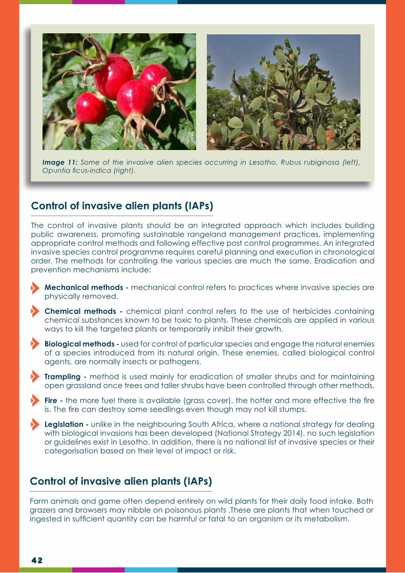
42
Image 11: Some of the invasive alien species occurring in Lesotho, Rubus rubiginosa (left), Opuntia ficus-indica (right).
Control of invasive alien plants (IAPs)
Control of invasive alien plants (IAPs)
The control of invasive plants should be an integrated approach which includes building public awareness, promoting sustainable rangeland management practices, implementing appropriate control methods and following effective post control programmes. An integrated invasive species control programme requires careful planning and execution in chronological order. The methods for controlling the various species are much the same. Eradication and prevention mechanisms include:
Mechanical methods - mechanical control refers to practices where invasive species are physically removed.
Chemical methods - chemical plant control refers to the use of herbicides containing chemical substances known to be toxic to plants. These chemicals are applied in various ways to kill the targeted plants or temporarily inhibit their growth.
Biological methods - used for control of particular species and engage the natural enemies of a species introduced from its natural origin. These enemies, called biological control agents, are normally insects or pathogens.
Trampling - method is used mainly for eradication of smaller shrubs and for maintaining open grassland once trees and taller shrubs have been controlled through other methods.
Fire - the more fuel there is available (grass cover), the hotter and more effective the fire is. The fire can destroy some seedlings even though may not kill stumps.
Legislation - unlike in the neighbouring South Africa, where a national strategy for dealing with biological invasions has been developed (National Strategy 2014), no such legislation or guidelines exist in Lesotho. In addition, there is no national list of invasive species or their categorisation based on their level of impact or risk.
Farm animals and game often depend entirely on wild plants for their daily food intake. Both grazers and browsers may nibble on poisonous plants .These are plants that when touched or ingested in sufficient quantity can be harmful or fatal to an organism or its metabolism.

43
Impact of poisonous plants
Poisonous plants
Loss of livestock by plant poisoning is one of the major risks facing the livestock farmer today. It is estimated that about 10 percent of all cattle mortalities and 15 percent of all small-stock mortalities are caused by plant poisoning. Animals are at a higher risk of eating poisonous plants during the following conditions:
When animals are introduced to a new area where poisonous plants are not known to the newly introduced animals.
When forage is rare, and animals are ‘forced’ to feed on other plants (including poisonous ones). This may happen after a fire, during overgrazing or during a drought.
High risk also occurs during the early growing season when poisonous plants might be green and grasses are still dormant.
Poisonous plants, in a rangeland management context, are all plants (indigenous or alien) causing livestock poisoning when eaten. They contain toxic substances (such as glycosides, alkaloids and terpenoids) that cause illness or death by negatively affecting organs such as the heart, liver, kidneys and nervous system.
POISONOUS PLANTS
1 Amaranthus hybridus 12 Echium vulgare 23 Nicotiana glauca
2 Argemone ochroleuca 13 Gnidia kraussiana 24 Ranunculus multifidus
3 Asclepias fruticosa 14 Helichrysium argyrosphaerum 25 Sarcostemma viminale
4 Boophane disticha 15 Hypericum aethiopicum 26 Scilla natalensis
5 Callilepis laureola 16 Kalanchoe rotundifolia 27 Solanum incanum
6 Chenopodium mucronatum 17 Lasiospermum bipinnatum 28 Sesbania punicea
7 Chrysocoma ciliata 18 Lotononis laxa 29 Tribulus terrestris
8 Cotyledon orbiculata 19 Melia azedarach 30 Xanthium strumarium
9 Crinum bulbispermum 20 Melianthus comosus 31 Xanthium spinosus
10 Cucumis africanus 21 Melica decumbens 32 Homeria Pallida
11 Datura stramonium 22 Melilotus alba 33 Quercus robur
Table 5: Common poisonous plants in Lesotho.

44
NOTE TO TRAINERS:Poisonous grass species occurring in Lesotho include: Avena fatua (wild oats, belete) and Sorghum halepense (allepo grass), which are both IAPs. Wilted foliage and young sprouts of S. halepense are poisonous.
Poisonous plants occurring in Lesotho include (alien species are marked with an asterisk):
*Agave americana (the sap may irritate the skin),
Amaranthus hybridus (pig weed), which contains high levels of nitrates responsible for the toxic effects,
*Argemone ochroleuca (Mexican poppy), which contains isoquinoline alkaloids,
Asclepias fruticosa (milk weed, lerete-la-ntja), which contains cardiac glycosides,
Boophane disticha (bushman poison bulb, leshoma (Image 12),
Chenopodium mucronatum (stinking goosefoot),
Cotyledon orbiculata (pig’s ear (Serelile),
Crinum bulbispermum (river lily),
Cucumis africanus (wild cucumber),
*Datura stramonium (common thorn apple(letjoi),
*D. ferox (large thorn apple (letjoi),
Drimia depressa (Urginea capitate (moretele),
*Echium vulgare (blue weed),
Gnidia kraussiana (yellow heads),
Helichrysum argyrosphaerum (wild everlasting),
Homeria pallida (yellow tulip),
Hyperiucum aethiopicum (St John’s wort),
Kalanchoe rotundifolia (sereleli), (Image 12),
Lasiospermum bipinnatum (sehalikane),
Lotononis laxa (wild Lucerne (‘musa-pelo-oa-matlapa-o-monyane),
*Melia azedarach (siringa tree, seeds are poisonous),
Melilotus alba (white seed clover),
Nicotiniana glauca (tree tobacco),
*Opuntia ficus-indica (sweet prickle pear (torofeie),
Pteridium aquilinum (bracken fern),
*Phytolacca heptandra (forest ink weed (monatja)),
Ranunculus multifidus (buttercup (tlhapi)),
*Ricinus communis (castor bean (mohlafotha), the whole plant is extremely poisonous),
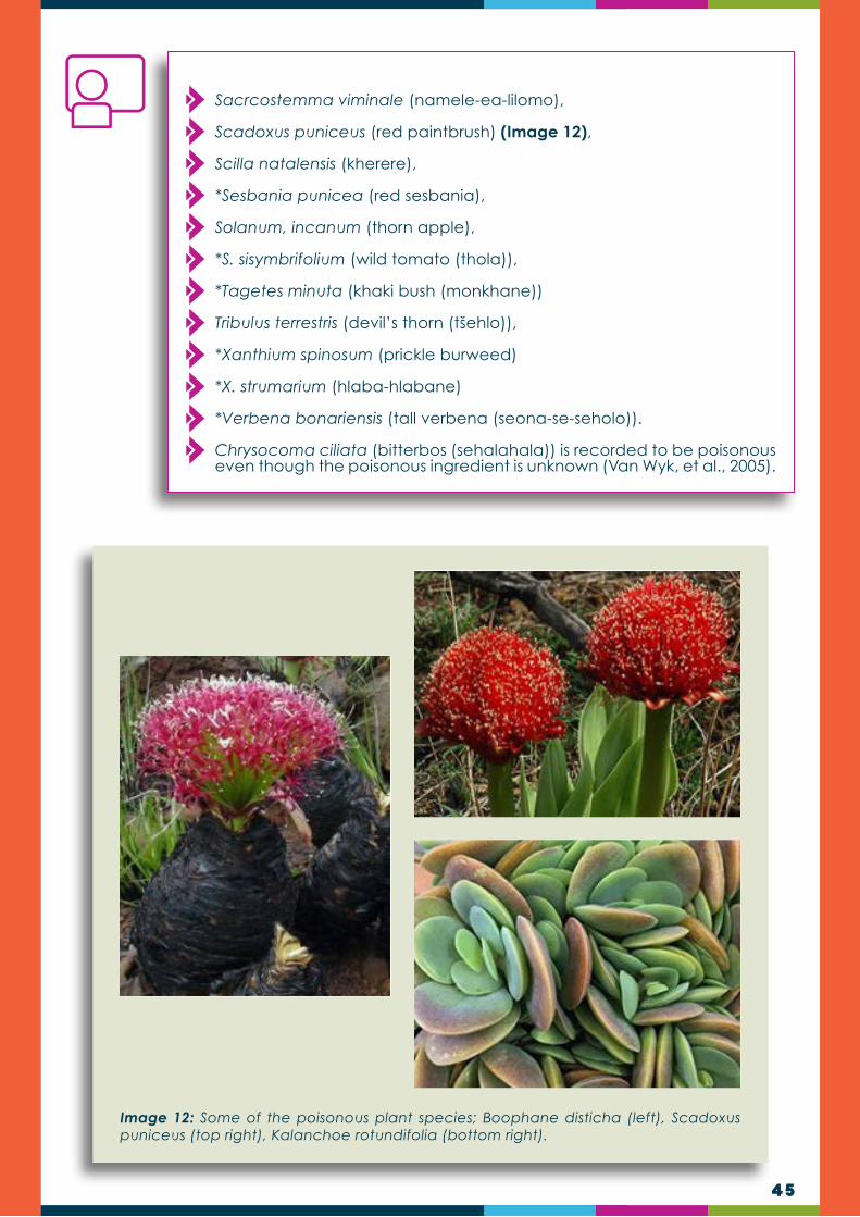
45
Sacrcostemma viminale (namele-ea-lilomo),
Scadoxus puniceus (red paintbrush) (Image 12),
Scilla natalensis (kherere),
*Sesbania punicea (red sesbania),
Solanum, incanum (thorn apple),
*S. sisymbrifolium (wild tomato (thola)),
*Tagetes minuta (khaki bush (monkhane))
Tribulus terrestris (devil’s thorn (tšehlo)),
*Xanthium spinosum (prickle burweed)
*X. strumarium (hlaba-hlabane)
*Verbena bonariensis (tall verbena (seona-se-seholo)).
Chrysocoma ciliata (bitterbos (sehalahala)) is recorded to be poisonous even though the poisonous ingredient is unknown (Van Wyk, et al., 2005).
Image 12: Some of the poisonous plant species; Boophane disticha (left), Scadoxus puniceus (top right), Kalanchoe rotundifolia (bottom right).
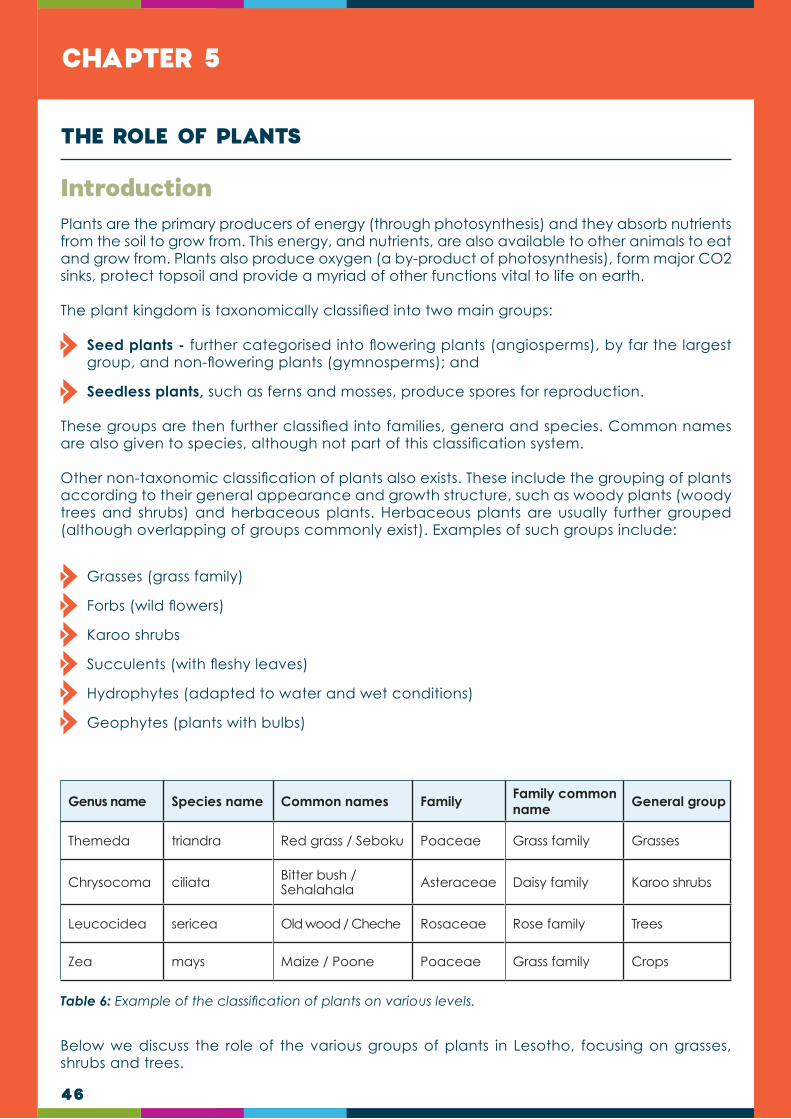
46
CHAPTER 5
Plants are the primary producers of energy (through photosynthesis) and they absorb nutrients from the soil to grow from. This energy, and nutrients, are also available to other animals to eat and grow from. Plants also produce oxygen (a by-product of photosynthesis), form major CO2 sinks, protect topsoil and provide a myriad of other functions vital to life on earth.
The plant kingdom is taxonomically classified into two main groups:
Seed plants - further categorised into flowering plants (angiosperms), by far the largest group, and non-flowering plants (gymnosperms); and
Seedless plants, such as ferns and mosses, produce spores for reproduction.
These groups are then further classified into families, genera and species. Common names are also given to species, although not part of this classification system.
Other non-taxonomic classification of plants also exists. These include the grouping of plants according to their general appearance and growth structure, such as woody plants (woody trees and shrubs) and herbaceous plants. Herbaceous plants are usually further grouped (although overlapping of groups commonly exist). Examples of such groups include:
Grasses (grass family)
Forbs (wild flowers)
Karoo shrubs
Succulents (with fleshy leaves)
Hydrophytes (adapted to water and wet conditions)
Geophytes (plants with bulbs)
Below we discuss the role of the various groups of plants in Lesotho, focusing on grasses, shrubs and trees.
Introduction
THE ROLE OF PLANTS
Genus name Species name Common names Family Family common name General group
Themeda triandra Red grass / Seboku Poaceae Grass family Grasses
Chrysocoma ciliata Bitter bush / Sehalahala Asteraceae Daisy family Karoo shrubs
Leucocidea sericea Old wood / Cheche Rosaceae Rose family Trees
Zea mays Maize / Poone Poaceae Grass family Crops
Table 6: Example of the classification of plants on various levels.

47
The grass family is arguably the most important plant family on earth. Grass crops such as maize, wheat, rice and sugarcane are still our most important sources of energy. Grass, in the form of forage, is also the most important source of food to farm animals and the large herds of grazing animals in the wild. Not all grass species are, however, good forage plants.
Important functions of grasses:
Provision of forage
Cover, protect and stabilise topsoil
Contribute to soil formation
This ability is set in two characteristics common to the grass family. First grasses have a dense crown cover which scatters raindrops and minimises the negative impact of raindrops on the soil surface. Secondly grasses have a very extensive root system situated close to the soil surface. These roots are able to keep the soil intact during rainfall events.
Grasses
Table 7: Grass species and their traditional uses (Moffet, 1997).
Selected important grasses of Lesotho
The importance of grasses ranges from food, fodder, thatching, medicinal to landscaping, production of household items such as floor mats, brooms, baskets, ropes and clothing. Some of the important grasses of Lesotho are discussed below, giving their ethno-botanical uses:
Species name Sesotho name Brooms Baskets Hats Mats RopesBeer
strainersRoofs Screens
Musical instruments
Aristida diffusa Monya ✔
Aristida species general Lefielo
Arundo donax (Spanish reed) ✔
Eragrostis gummiflua Thitapoho ✔
Eragrostis plana Modula ✔ ✔ ✔
Fingerhuthia sesleriiformis Thitapoho e kgolo ✔
Gladiolus crassifolius (non-grass)
Kgala e nuenyane ✔ ✔
Hyparrhenia anamesa Leqokwana ✔ ✔ ✔
Hyparrhenia dregeana Leqokwa ✔ ✔
Hyparrhenia hirta Leqokwana ✔ ✔ ✔
Merxmuellera drakensbergensis
Mosua ✔ ✔ ✔ ✔ ✔
Merxmuellera macowanii Moseha ✔ ✔ ✔ ✔ ✔
Merxmuellera stereophylla Lesuwane ✔ ✔ ✔ ✔
Phragmites australis Lehlaka ✔ ✔
Thamnocalamus tesselatus Leqala ✔

48
Examples of grasses of Lesotho:
Food: these include a number of staple crop plants e.g. Sorghum bicolor (mabele) used for making porridge and brewing beer; Triticum aestivum (wheat, koro), Zea mays (poone),
Soil stabilizer: Digitaria monodactyla (one finger grass - bohobe ba linonyana), Microchloa caffra (pin cushion grass - joang ba matlapa), Aristida congesta subsp. congesta (tassle bristle grass - bolepo), Eragrsostis racemosa (narrow heart lovegrass - tšaane ea lithota), Diheteropogon filifolius (thread-leaved bluestem - sehlooko-sa-matlapa).
Indicators of overgrazing and veld degradation: Aristida congesta sub spp. congesta (tassel bristlegrass - bolepo), A. diffusa (iron grass - bohlanya-ba-lipere), A. bipartita (rolling grass - bohlanya-ba-pere /lefielo), Sporobolus africanus (drop seed), Merxmuellera disticha (broom grass - moseha).
Other grasses
Thatching
• Hyparrhenia hirta (common thatch grass, mohlomo, the most popular thatching grass in southern Africa).
• H. tamba, Phragmites australis (reed, lehlaka) used as a base for thatched roofs.
• Merxmuellera spp. (M. drakensbergensis, M. macowanii, M. stenophylla moseha).
• Thamnocalamus tesselatus (leqala, berg bamboo).
• Traditional Basotho houses are thatched using some of these grasses.
Household items
• Brooms (Fingerhuthia africana - Thita-poho).• Aristida spp. namely; A. congesta, A. diffusa.• A. gummiflua (awned grass, lefielo).• Eragrostis gummiflua (gum grass, lefielo).
• Mats, baskets, arrows (Phragmites australis - lehlaka, Merxmuellera drakensbergensis, M. macowani, M. stenophylla - moseha).
Baskets produced from grass species Broom produced from grass species
Hyparrhenia tamba Traditional Basotho house thatched using Hyparrhenia sp.

49
Other grasses
Merxmuellera macowanii Traditional Basotho hat
Eragrostis curvula Cymbopogon nardus
Clothing - Hats, bracelets and other decorations
• Eragrostis plana (molula).
• Merxmuellera spp. eg. M. drakensbergensis.
• M. macowani.• M. stenophylla (moseha).
Medicine
• Eragrostis plana (fan lovegrass, molula).• E. curvula (weeping love grass, moseeka).• Arundinella nepalensis (molula).• Cymbopogon nardus (lebata).

50
Other grasses
A lawn lined with kikiyu grass Sports field lined with Cynodon dactylon
Eragrostis capensis
Landscaping and Lawns
• Lolium perenne (perennial rye grass).• Pennisetum clandestinum (kikiyu grass,
tajoe).• Cynodon dactylon (couch grass,
bermuda grass, mohloa-ts’epe).
• Melinis nerviglumis (bristle-leaved red top, letsiri-le-lenyane).
• Merxmuellera stricta (Cape wire grass).
Landscaping and Lawns
• Eragrostis capensis (heartseed lovegrass, baroana).
• Andropogon appendiculatus (bluestem, morotloana, seboku-se-seholo).
• Harpochloa falx (lefokololi)• Setaria sphacelata var. sphacelata
(common bristle grass, thusane).

51
Other grasses
Tenaxia disticha
Aristida congesta
Table 8: Different functions of grasses in Lesotho
Indicators of overgrazing and veld degradation
• Aristida congesta subsp. congesta (tassel bristle grass, bolepo).
• A. diffusa (iron grass, bohlanya-ba-lipere).
• A. bipartita (rolling grass, bohlanya-ba-pere, lefielo).
• Sporobolus africanus (drop seed).• Tenaxia disticha (broom grass, moseha).
Soil stabilizers
• Digitaria monodactyla (one finger grass, bohobe ba linonyana).
• Aristida congesta subsp. congesta (tassel bristle grass, bolepo).
• Eragrostis racemosa (narrow heart lovegrass, ts’aane ea lithota).
• Diheteropogon filifolius (thread-leaved bluestem, sehlooko-sa-matlapa).

52
Herbaceous shrubs and wild flowers, often collectively referred to as ‘forbs’, consist of the non-grass component of herbaceous (non-woody) plants in rangelands. Although forbs are usually not contributing as much to biomass and forage production as grasses, they may potentially contribute much to plant species diversity in the grassland biome (up to 80% of the species composition).
Herbaceous shrubs and wild flowers
Selected important herbaceous plants of Lesotho
Herbaceous plants are plants that have no persistent woody stem above ground. The term is mainly applied to perennials, but in botany it may also refer to annuals or biennials. A majority of important herbaceous plants occurring in Lesotho are over-harvested mainly because they are used for medicinal and cultural purposes.
Some of these plants are discussed in Table 9 below:
Herbaceous
Scientific name Common name (English name)
Vernacular name (Sesotho) Uses
Ajuga ophrydis Bugle SenyarelaReproductive ailments (fertility, regulates menstrual cycle)
Alepidea amatymbica
Larger tinsel flower Lesooko Respiratory ailments
(chest complaints)
Aloe ferox Bitter aloe Lekhala-la-Quthing Skin ailments
Aloe striatula Shrub aloe Mohalakane Digestive ailments
Artemisia afra African wormwood Lengana Respiratory ailments
Aster bakerianus Phooa Digestive ailments
Berkheya setifera Buffulo tongue Leleme-la-
khomo
Stomach problems, sterility, kidney problems, circulatory problems
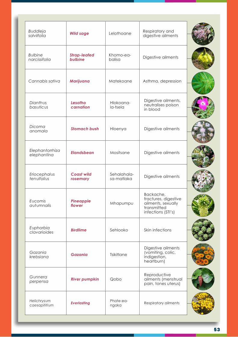
53
Buddleja salviifolia Wild sage Lelothoane Respiratory and
digestive ailments
Bulbine narcissifolia
Strap-leafed bulbine
Khomo-ea-balisa Digestive ailments
Cannabis sativa Marijuana Matekoane Asthma, depression
Dianthus basuticus
Lesotho carnation
Hlokoana-la-tsela
Digestive ailments, neutralises poison in blood
Dicoma anomala Stomach bush Hloenya Digestive ailments
Elephantorrhiza elephantina Elandsbean Mositsane Digestive ailments
Eriocephalus tenuifolius
Coast wild rosemary
Sehalahala-sa-matlaka Digestive ailments
Eucomis autumnalis
Pineapple flower Mhapumpu
Backache, fractures, digestive ailments, sexually transmitted infections (STI’s)
Euphorbia clavarioides Birdlime Sehlooko Skin infections
Gazania krebsiana Gazania Tsikitlane
Digestive ailments (vomiting, colic, indigestion, heartburn)
Gunnera perpensa River pumpkin Qobo
Reproductive ailments (menstrual pain, tones uterus)
Helichrysum caesapititium
Everlasting Phate-ea-ngaka
Respiratory ailments

54
Helichrysum odoratissimum
Everlasting PhefoRespiratory ailments (coughs, fever, colds)
Hermannia depressa
Creeping red hermannia Selenjane
Digestive ailments (heartburn, colic, poison)
Hypoxis hemerocallidea
African potato, star flower Moli
Cancer, HIV-related infections, boosts immune system
Mentha aquatica, M. longifolia
Wild mint Koena ea metsi, Koena
Respiratory infections (coughs, colds, asthma)
Morella serrata Lance-leaved waxberry Maleleka
Respiratory ailments (coughs, colds), headache, painful menstruation
Pentanisia prunelloides Wild verbena Setima-mollo Digestive ailments
(diarrhoea)
Pelargonium sidoides
African geranium Khoara
Respiratory ailments, gastro-intestinal problems
Scabiosa columbaria
African white scabious Selomi
Reproductive ailments (menstrual pains)
Trifolium burchellianum Burchell’s clover Moroko,
‘Musa-pelo Heart problems
Xysmalobium undulatum Bitter root Poho-ts’ehla Intestinal worms,
headache
Some of the herbaceous plants are important food plants, which are used as vegetables e.g. Amaranthus paniculatus (theepe), Chenopodium album (seruoe), Sisymbrium thellungii (sepaile-sa-thaba), Lepidium capense (Qhela), Rorippa nasturtium-aquaticum (papasane), Urtica urens (stinging nettle, bobatsi). The latter is also used for medicinal purposes in boosting the immune system. In addition, some of the plants are used for religious purposes, for example, Olea europaea subsp. africana (wild olive, mohloare) is used during Easter.
Table 9: Some of the important herbaceous plants of Lesotho
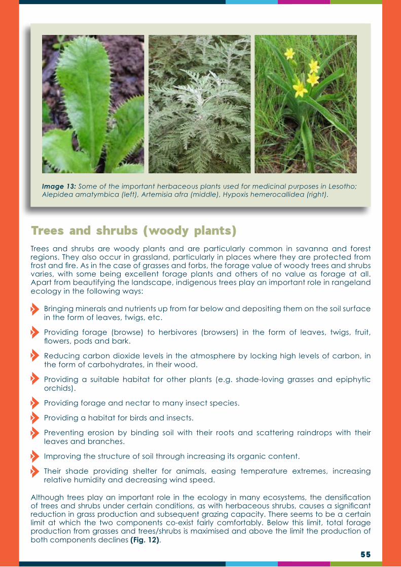
55
Image 13: Some of the important herbaceous plants used for medicinal purposes in Lesotho; Alepidea amatymbica (left), Artemisia afra (middle), Hypoxis hemerocallidea (right).
Trees and shrubs are woody plants and are particularly common in savanna and forest regions. They also occur in grassland, particularly in places where they are protected from frost and fire. As in the case of grasses and forbs, the forage value of woody trees and shrubs varies, with some being excellent forage plants and others of no value as forage at all. Apart from beautifying the landscape, indigenous trees play an important role in rangeland ecology in the following ways:
Bringing minerals and nutrients up from far below and depositing them on the soil surface in the form of leaves, twigs, etc.
Providing forage (browse) to herbivores (browsers) in the form of leaves, twigs, fruit, flowers, pods and bark.
Reducing carbon dioxide levels in the atmosphere by locking high levels of carbon, in the form of carbohydrates, in their wood.
Providing a suitable habitat for other plants (e.g. shade-loving grasses and epiphytic orchids).
Providing forage and nectar to many insect species.
Providing a habitat for birds and insects.
Preventing erosion by binding soil with their roots and scattering raindrops with their leaves and branches.
Improving the structure of soil through increasing its organic content.
Their shade providing shelter for animals, easing temperature extremes, increasing relative humidity and decreasing wind speed.
Although trees play an important role in the ecology in many ecosystems, the densification of trees and shrubs under certain conditions, as with herbaceous shrubs, causes a significant reduction in grass production and subsequent grazing capacity. There seems to be a certain limit at which the two components co-exist fairly comfortably. Below this limit, total forage production from grasses and trees/shrubs is maximised and above the limit the production of both components declines (Fig. 12).
Trees and shrubs (woody plants)

56
Figure 12: The relationship between grass production, browse production and total forage production on a scale of tree density (trees/ha) (van Oudtshoorn, 2015).
Forage plants are extremely important to the livestock farmer. To a large degree, the livestock farmer farms with forage plants. The animal is the factory that converts forage to the product (meat or more animals). The more good forage plants available for grazing and browsing, the higher the carrying capacity. Grazing management should therefore focus on the requirements of the good forage plants.
Forage plants are plant species that produce material suitable and available for consumption by herbivores. Forage plants can include most growth forms such as grasses, trees, shrubs and forbs. The morphological part of forage plants usually utilised by herbivores is the leaves, but other parts such as the fruit, particularly seed pods, bark and even flowers are also consumed by the various types of herbivores. Forage plants usually benefit from being optimally utilised by herbivores and they attract animals by being palatable. Possible benefits for forage plants from being utilised by herbivores include:
Seed dispersal through the digestive tract of animals or by clinging to animals to be released later.
Enhanced germination of seed scarified while passing through the digestive tract of herbivores.
Fertilisation of the soil in the form of dung and urine left behind by herbivores while feeding.
Stimulation of growth by the removal of foliage which allows more sunlight and improved photosynthesis and the prevention of the build-up of unused biomass (moribund) over time.
Forage plants

57
Grasses are important forage plants because of their general palatability to many herbivores, their high production potential and their wide distribution. Grasses, and also the types of grasses on a farm, are therefore vital as the farmer essentially converts grass to meat and ultimately to money. The livestock farmer is therefore often considered to be a “grass farmer”.
However, grasses differ vastly in their grazing value. Some grasses are small, with few leaves to contribute to grazing. Others are seemingly productive, but are not preferred by grazers. Others again are well preferred and easily disappear during poor grazing management.
Two main factors influence the grazing value of grasses, namely the quality and the quantity of forage. The grazing value is influenced by the following aspects:
Production ability: the ability of the grass to produce either much or little leaf material.
Palatability: the general acceptability of the grass to grazers
Nutritional value: indicates the amount of nutrients that the grass contains.
Growth vigour: the plant’s ability to re-grow rapidly after being grazed.
Digestibility: determined by the fibre content of the leaves and stems.
Habitat preference: grasses that prefer wet conditions usually have a higher leaf production and stay green for longer, while those that grow in nitrogen rich soil are usually more nutritious.
Grazing and browsing value of plants
DID YOU KNOW?The seed of some good forage plants is commercially available. Such plants, known as cultivated pastures or forages, can be established on lands or used to improve rangeland that is in a poor condition. Such pastures can be used for summer grazing, winter grazing or can be preserved in the form of hay for use during the critical times. Examples of suitable cultivated pastures in Lesotho are Weeping love grass (Eragrostis curvula), Teff (Eragrostis tef), Kikuyu grass (Pennisetum clandestinum), Tall fescue (Festuca arundinacea), Rye grasses (Lolium species) and Lucerne (Medicago sativa).
Grazing value of grasses
NOTE TO TRAINERS:A common management mistake by livestock farmers is to put more emphasis on the animal component and not enough on the forage component.
A good knowledge of the various grasses and other forage plants and their grazing value is one of the most important factors for successful animal production on a farm.
See Table 10 for grazing grasses of Lesotho

58
The grazing value of a grass plant generally decreases during the seasonal growth stages up to maturity. Although fodder production increases, the quality of fodder decreases as plants mature. The seasonal development of pastures can be divided into four phases (Fig. 13).
Phase 1: Plants are growing rapidly, producing high-quality green leaf. Pastures are most nutritious during this phase but are susceptible to overgrazing.
Phase 2: Grasses begin to grow stems, which are lower in quality (less protein and minerals). Grasses are less susceptible to overgrazing and are of high quality. This is the most favourable stage for grazing in terms of quantity and quality of forage.
Phase 3: Grasses are setting seed and quality further declines. The quantity of pasture is usually not limited during this phase. Little leaf growth occurs from now on.
Phase 4: Grasses are becoming dormant. Quality is low and declines further as plants go dormant or get frosted.
Grazing value during the stages of maturity
Figure 13: The relation between pasture quality and quantity during the growing and dormant seasons (MLA 2006).

59
Grazing grasses
Scientific name Sesotho name English name (common name) Comments
Themeda trianda Seboku Red grass, rooigrass
Most important grazing grass in open grassland regions of southern and Eastern Africa.
Heteropogon contortus Seloka Spear grass
Digitaria monodactyla
Bohobe ba linonyana One finger grass
D. Eriantha Monyane Common finger grass
Lolium perenne Perennial rye grass For winter pasture
Festuca scabra, F. caprina Letsiri Munnik fescue
Eragrostis tef Tef Fodder for horses
E. curvula Moseeka, seritsoana Weeping grass,
E. capensis Baroa Heartseed grass
E. chloromelas Moseeka Curly leaf
Sporobolus fimbriatus Matolo-a-maholo Dropseed grass

60
Panicum schinzii Mofants’oe-o-moholoSweet grass, Land grass
Leersia hexandra Mohlakana Wild ricegrass Found in swamp areas.
Andropogon appendiculatus
Seboku se seholo Blue stem
Cynodon dactylon Mohloa-ts’epe Couch grass
Paspalum dilatatum Bohloa Dallis grass
P. distichum Water couch paspalum Grazed by sheep.
Brachiaria serrata Lefokololi Velvet grass
Bromus catharticus Joang ba lintja Rescue grassProvides grazing in winter when nothing else is green.
Pennisetum clandestinum
Tajoe Kikiyu grass
Poa annua Joang-ba-lintja Annual bluegrass Provides grazing in winter.
Hemarthria altissima Red swamp grass Valuable source of grazing in wet areas.
Table 10: Grass species commonly used for grazing
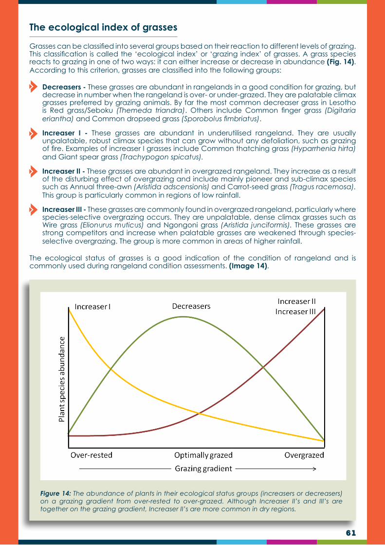
61
Grasses can be classified into several groups based on their reaction to different levels of grazing. This classification is called the ‘ecological index’ or ‘grazing index’ of grasses. A grass species reacts to grazing in one of two ways: it can either increase or decrease in abundance (Fig. 14). According to this criterion, grasses are classified into the following groups:
Decreasers - These grasses are abundant in rangelands in a good condition for grazing, but decrease in number when the rangeland is over- or under-grazed. They are palatable climax grasses preferred by grazing animals. By far the most common decreaser grass in Lesotho is Red grass/Seboku (Themeda triandra). Others include Common finger grass (Digitaria eriantha) and Common dropseed grass (Sporobolus fimbriatus).
Increaser I - These grasses are abundant in underutilised rangeland. They are usually unpalatable, robust climax species that can grow without any defoliation, such as grazing of fire. Examples of increaser I grasses include Common thatching grass (Hyparrhenia hirta) and Giant spear grass (Trachypogon spicatus).
Increaser II - These grasses are abundant in overgrazed rangeland. They increase as a result of the disturbing effect of overgrazing and include mainly pioneer and sub-climax species such as Annual three-awn (Aristida adscensionis) and Carrot-seed grass (Tragus racemosa). This group is particularly common in regions of low rainfall.
Increaser III - These grasses are commonly found in overgrazed rangeland, particularly where species-selective overgrazing occurs. They are unpalatable, dense climax grasses such as Wire grass (Elionurus muticus) and Ngongoni grass (Aristida junciformis). These grasses are strong competitors and increase when palatable grasses are weakened through species-selective overgrazing. The group is more common in areas of higher rainfall.
The ecological status of grasses is a good indication of the condition of rangeland and is commonly used during rangeland condition assessments. (Image 14).
The ecological index of grasses
Figure 14: The abundance of plants in their ecological status groups (increasers or decreasers) on a grazing gradient from over-rested to over-grazed. Although Increaser II’s and III’s are together on the grazing gradient, Increaser II’s are more common in dry regions.

62
Image 14: Examples of grass species in the four ecological index groups.
The browsing value of shrubs and trees
Browse refers to forage material supplied by shrubs and trees and includes leaves, soft twigs and fruit. Browse is utilised (browsed) by browsers such as goats and various wildlife herbivores. Browse is generally high in nutrients and browsers therefore have access to a reasonable diet most times of the year.
Many herbivores are mixed feeders and are able to graze and browse, depending on what is available and the time of the year. Such animals will often utilised grasses during the early and mid-growing season and browse when the palatability of grasses decreases towards the end of the growing season and during the dormant season.
To be of value, browse must be acceptable and available to the browsing animals. To be acceptable, the browse should be palatable and easily digestible. Many shrubs and trees are unpalatable due to the presence of the chemical deterrents they possess. As in the case of grasses, such unpalatable species will increase when palatable shrubs and trees are over-utilised. This is because over-utilised palatable shrubs are weakened and then easily outcompeted by the strong unpalatable shrubs. Furthermore the palatable shrubs are prevented from producing seed and eventually disappear from the soil seed-bank.
To be available, the browse should be within reach of animals in terms of height. Browse from the various trees and shrubs should furthermore be available during most times of the year, such as in the case of evergreen plants.
TRAINERS QUIZ TEST IF YOU HAVE UNDERSTOOD THIS SECTION
What grass group, according to the ecological index of grasses, decrease in number when the rangeland is over- or under-grazed?
True or False: Increaser I grasses are usually unpalatable.
What group of grasses increases when palatable grasses are weakened through species-selective overgrazing?
1.
2.3.
63
What group of grasses includes mainly pioneer and subclimax species?
What group of grasses are palatable climax grasses preferred by grazing animals?
True or False: Increaser II is particularly common in regions of low rainfall.
Name the group that is more common in areas of higher rainfall.
True or False: An example of an Increaser I is common thatching grass (Hyparrhenia hirta).
4.
5.
6.
7.8.
CHAPTER 6
As with plants, animals play an important ecological role in our natural rangelands.
Grazers and browsers disperse seed and recycle nutrients;
Insects pollinate plants to ensure reproduction;
Birds control insects pests and seed eating birds spread seed;
Micro-organisms, such as bacteria, fungi and protozoa, recycle nutrients in the soil and play an important role in digesting food in the digestive tracts of many animals; and
Predators control the number of herbivores to maintain a balance between food supply and food demand.
These associations have developed over a long time and are necessary to maintain a balance in the ecosystem.
An herbivore is an animal that feeds mainly on plant material and is anatomically and physiologically adapted to eating plant material. Plants and herbivores have co-existed in natural rangelands for millennia and are therefore not only well adapted to each other, but also dependent on each other. Many forage plants, particularly grasses, are adapted to grazers in that their growing tips are near the ground, out of reach of the grazing animal. Grasses and other forage plants furthermore have the ability to store reserve nutrients, which can be used for re-growth after defoliation. Although they are adapted to be eaten by herbivores (called “herbivory”), they are not adapted to over-utilisation. Herbivory has effects on community structure and ecosystem dynamics. There are two main types of herbivores, namely:
Grazers (e.g. cattle, zebra, buffalo, etc.) feed mainly on grasses and other herbaceous plants; and
Browsers feed mainly on woody plants (trees and shrubs).
Introduction
Herbivores
THE ROLE OF ANIMALS

64
DID YOU KNOW?
DID YOU KNOW?
When a grass is grazed or burnt, it is stimulated to regrow. For this regrowth, reserved nutrients, produced through photosynthesis and stored in the basal parts of the plant, are used. As new leaves are regrown after defoliation and photosynthesis start again, reserve nutrients that consist of mainly carbohydrates, are replenished. For this reason, rest after grazing is an important range management principle for a good range condition.
The natural grazing patterns of the past (before anthropogenic disturbances) can give us a vital understanding of the way we could sustainability manage present grazing lands. The rangeland ecology is well adapted to these grazing patterns as it has been subjected to it for millennia. By applying the principles of these natural grazing patterns, we should be able to manage the grazing lands in our care more efficiently.
Large herbivores
Historic grazing patterns
Large herbivores, like livestock, are animals that consume only plants. They learn to recognise suitable feed by using a combination of sight, smell, taste and touch. Herbivores are drawn towards feed that smells good, tastes good or digests easily. They are repelled by feed that smells bad, that is tough or digests poorly. The selection of feed is also influenced by thorns, roughness and stickiness.
Herbivores are anatomically well adapted to eat and digest plants. They have specialised lips, teeth and other features that enable them to reach, grasp and grind plant material. Furthermore, they have specialised digestive systems that can deal with the normally high fibre content (roughage) in their diet.
Large herbivores were once common in the Lesotho rangelands. These included Zebra, Eland, Red Hartebeest, Black wildebeest and Blesbok. With the exception of Grey rhebuck, all species disappeared due to anthropogenic disturbances and range deterioration (Portillo et al, 1991).
The most significant of the historic grazing patterns is the tendency of large herbivores to congregate in large herds and to be nomadic. This behaviour is typical of most of the large herbivores (Zebra, Eland, Red Hartebeest, Black wildebeest and Blesbok) that used to roam the plains of Lesotho. The main driving force behind these movements was a combination of the following factors:
Search for improved pastures
Search for water
Preventing excessive predation
Accumulation of dung and urine

65
In recent years there is a new appreciation for the benefits related to the historic migratory grazing patterns, as well as the realisation of the negative impacts of continuous selective grazing (the opposite of historic migratory grazing). This led to the developments of new rotational grazing management approaches such as Holistic management, high density grazing and ultra-high density grazing, aiming at following the principles of the old migrations.
The historic migratory behaviour of large herds of herbivores had a distinct combination of impacts on the rangeland ecology. It can generally be described as being a high impact followed by a long period of rest. These impacts, together with impacts related to predation, largely maintained the rangelands in a good condition. The impacts related to herd migrations include:
Non-selective grazing - Grazing animals in a large dense herd, including cattle, sheep and goat, tend to graze non-selectively. Such animals will eat less palatable grasses and grass parts, which will normally not be consumed during selective grazing.
Short-term trampling - The trampling impact of large dense herds is severe but short-term. This short-term heavy trampling has several advantages to the rangeland ecology, which includes:
Breaking of soils crusts which improve water infiltration and soil aeration.
Planting of seed by covering seed with a thin layer of soil.
Damaging and controlling of shrubs and unpalatable brittle grasses, which are less well adapted to trampling than palatable soft grasses.
Enhance nutrient cycling by trampling dead biomass (so-called “moribund”) onto the ground to form a mulch and enable anthropods and microbes to do their job.
Long period of rest - During migrations, only few animals stay behind due to pressure from predators. This results in a long period of rest, which leads to high rates of seed production and building up of reserve nutrients (high growth vigour). The long rest period also breaks the cycle of parasites, thereby minimising the build-up of pests and diseases.
High concentration of dung and urine - Dense herbivore herds leave behind high concentration of dung and urine per square meter. This leads to rangeland “fertilisation” and increased forage quality.
Figure 15: Some of the beneficial impacts of the old migrations include crust breaking through trampling (left), utilisation and trampling of unpalatable shrubs and grasses (centre) and high concentration of dung (right).

66
Feeding behaviour
Grazing animals are divided into groups based on their vegetation preferences and primary foraging methods. These groups include the grazers (cattle and horses), which have a diet dominated by grasses and grass-like plants, the browsers (goats), which consume primarily shrubs and forbs, and the intermediate feeders (sheep), which have no particular preference for grasses, forbs, or shrubs. Browsers commonly consume large amounts of green grass during rapid growth stages but avoid dry, mature grass and often experience digestive upsets if forced to consume too much mature grass. Differences in foraging behaviour is accounted for by:
Body size and reticulo-rumen capacity
Anatomical differences in teeth, lips, and mouth structure,
Grazing ability, and differences in digestive systems
Animal behaviour e.g. young animals learn foraging behaviours from their mothers and peers and can be taught to eat or avoid certain plants.
The amount of forage consumed is affected by many factors, including breed and age of animal. Although many other factors can influence forage consumption, animal unit equivalents (AUEs) can be useful in estimating stocking rates and comparing forage demand of different ages and species of animals.
Feeding behaviour of cattleA cattle cow of 450 kg (one animal unit) consumes 10-11.5 kg of dry matter per day, which equals about 3.5-4.1 tons per year.
Cattle are considered bulk grazers and least damaging to natural grazing compared to other livestock.
Cattle consume about 90 percent grass and 10 percent browse, although breeds differ in this ratio.
Cattle walk one to four kilometres per day in search of food.
Cattle prefer lower, flatter areas, which can lead to degradation of riparian areas.
They prefer a grazing height of 20–30 cm, but can graze at a height range of 8–65 cm if they have to.
One cow would drink water one to four times a day. The total amount of water consumed is about 45 litres (10% of body mass) per day, depending on temperature and diet.
While cattle graze with their heads down, they chew the food only two or three times before swallowing. Ruminating (chewing the cud) their food follows later. The rumen is a large fermentation tank and needs 20% roughage and 6–8% protein to function properly (Table 11). The amount of energy that animals can obtain from plant material varies with the digestibility of the material. For example, if an animal eats 10kg of fresh green leaf that is 70 percent digestible, it absorbs 7kg of energy, protein and minerals from the feed, and passes 3kg as manure. If it eats 10kg of old grass that is only 40% digestible, only 4kg is absorbed and 6kg passes as manure. Such old dry material also takes longer to digest and animals therefore eat less per day.
Forage growth stage Approx. % digestibility
Required dry matter intake (kg/day) Required protein content (%)
Maintainance 0.5 kg/day Maintainance 0.5 kg/day
1. Fresh green leaf 70 4.8 7.0 7.8 7.9
2. Mature green leaf 60 5.8 8.7 6.7 6.8
3. Mature leaf & Stem 50 7.8 11.4 5.6 5.6
4. Dry grass 40 9.2 - 4.7 -
Table 11: Approximate daily intake of dry matter and %age protein required for one animal unit (cattle) to maintain weight or to gain 0.5 kg/day (MLA, 2006).

67
Image 16: Cattle use their tongues to wrap grass and pull it into their mouths, the so-called lasso eating action (Source: Afrivet).
Image 17: Sheep are highly selective feeders and can cause serious harm to range condition during continuous grazing (Source: Afrivet).
The higher the digestibility of the feed, the faster the animals can digest the material, and hence they need more protein. Growing animals need protein for building muscle and pregnant cows need it for the growing foetus or for milk production.
Although cattle can survive on old dry grass with a protein content of only 4.7 percent, they will be able to digest the old grass better and faster if given a protein supplement, and will therefore eat more and do better.
Sheep use their lips and teeth to feed and can bite closer to the ground than cattle. They nibble grass with their lips and teeth but can also use their tongues in taller grass. As they are selective grazers, they approach grass tufts from the side.
Feeding behaviour of sheep
A sheep of 50kg consumes about 2kg of dry matter per day (about 2.5% of its body weight), or 0.7 tons per year.
Sheep are more selective than cattle and tend to prefer grazing on forbs (broad leaved plants).
Sheep diets are about 50 percent grass, 30 percent forbs, and the rest browse, but can adapt well, depending on the composition of available food.
Sheep are potentially very damaging to natural grazing because of their highly selective nature and ability to graze close to ground level, thereby damaging the growing parts of plants.
Sheep will utilise steep slopes.
Sheep prefer short grass at a grazing height below 10cm but can graze in a range of 2.5–20cm if necessary.
The daily water intake of a sheep is about 5 litres per day.

68
Image 18: Goats are primarily browsers (Source: Riaan van Zyl)
Despite their grazing preferences, goats can be grazed on grassland alone. Goats are very active foragers, able to cover a wide area in search of scarce plant materials.
They eat a large variety of plants, including many different types of grasses, legumes, weeds and brushes (vegetation dominated by shrubs). Goat grazing can be used as an effective method of weed control.
Feeding behaviour of goats
Feeding behaviour of horses and donkeys
Goats are up to 80 percent browsers. They prefer woody and herbaceous shrubs, but will easily also consume grass.
Goats prefer woodier browse and find young, tender leaves and twigs to be their favourite. Goats also eat young trees.
As they include a large variety of plants in their diet, they move around much more than sheep.
They are therefore also less damaging to natural grazing than sheep as they seldom concentrate in one area.
Goats are hardy and adaptable and can survive on little, leading to land degradation if not controlled.
Goats are multi-strata grazers and have a grazing and browsing height in the range of 2 –160cm, although they prefer a height of 10cm and higher.
They are useful for controlling shrubs and small bushes.
They complement cattle effectively in regions with suitable shrubs and trees.
Goats utilise steep slopes.
These animals have the ability to cut down grass with their teeth very close to the ground (‘surface feeders’) and can therefore be very damaging to rangeland if not controlled. They are generally non-selective, or only slightly selective in their choice of grazing species and will sometimes even browse shrubs.
They have a grazing height range of 2 – 85cm, but prefer to graze from 2 – 12 cm.
If an abundance of pasture is available, horses will be very selective. As the amount of available forage decreases, the degree of selectivity will decrease.
Horses do not drink water frequently in natural environments, thus grazing patterns are often set to allow access to water once or twice per day.

69
Image 19: Horses and donkeys have the ability to cut down grass with their teeth very close to the ground, and can therefore be very damaging to range condition if not controlled.
Horses are able to comfortably adapt to browsing, picking the leafy material from bushes or other plants, meaning they have to be selective about what they consume, i.e. the horse will often select the tastiest part of the hay and leave the stems and undesirable portions.
Donkeys (Equus asinus) are natural browsers and will graze up to 16 hours a day on a diet of high fibre plant material.
They are very efficient at metabolising their food and therefore their energy requirements are lower than a similar sized pony, making them susceptible to being overfed, which can lead to serious health problems such as hyperlipaemia, laminitis and other organ dysfunction.
Ideally, donkeys should be fed 1.5% of their body weight in dry matter for maintenance. A donkey at grass will not require more than straw to supplement their grazing, even if they are in light work.
It is also important to provide them with a mineral lick, free access to clean water, and a vitamin supplement in the winter.
DID YOU KNOW?Horse feed consumption is motivated by hunger, but the methods and patterns of feeding are governed by behaviour. Mare nutrient requirements, for example, increase during late pregnancy and lactation; therefore the demand for consumption of feed is higher (assuming there is no change on nutrient density of the ration). Horses also demonstrate increased appetite when workload increases. The horse compensates for this increase in demand by increasing the rate of eating.
If the quality or quantity of available feed is low or horses are being worked hard, the horse often cannot increase the rate of consumption enough to meet demand. This is where human management plays an important role. The owner should compensate for the imbalance and increase the feed and/or improve the feed quality.

70
Overgrazing
Although grazing grasses are well adapted to grazing, they are not adapted to overgrazing or even to under-grazing. Overgrazing is the continual grazing of a grass plant and its regrowth over time, without allowing the plant to rest and replenish reserve nutrients. In other words, overgrazing takes place when a grass plant is forced to grow on its reserve nutrients for an extended period. Continuous grazing therefore leads to overgrazing.
During this process, the reserve nutrients become depleted and the root system weakens and fails to function properly. Initially the grass plant only loses vigour, but eventually the whole plant might die if a period of rest is not allowed. Overgrazing is therefore a function of time (grazing frequency) and not necessarily of animal numbers (grazing intensity).
Two types of overgrazing are recognised, namely:
Species-selective overgrazingSpecies-selective overgrazing occurs when animals are allowed time to overgraze palatable (decreaser) grasses without sufficient rest. During this process, palatable grasses are weakened and are unable to compete with the less palatable grasses (and other plants) for space, moisture, nutrients and light. During species-selective overgrazing, palatable grasses furthermore produce much less seed than the now stronger unpalatable plants. Consequently, unpalatable plants in terms of space as well as representation in the soil seed bank (Fig. 15) subsequently replace palatable grasses.
Area-selective overgrazingArea-selective overgrazing occurs when animals concentrate in areas with fertile soil, such as areas along rivers and drainage lines, and is common in Lesotho. As these areas are rich in minerals, essential to grazers, the animals will remain in the area if their movement is not controlled, resulting in overgrazing and land degradation. This type of overgrazing is more common in the lowland parts of Lesotho.Areas affected by area-selective overgrazing have very low, to no, ground cover.
Rangeland affected by species-selective overgrazing may have high levels of biomass, but of poor to extremely poor quality. To prevent species selective overgrazing palatable grasses need rest to stay strong enough to out-compete unpalatable plants and to continue producing seed. This type of overgrazing is more common in the mountainous areas of Lesotho.
A
A
Figure 15: Plant species composition changes during species-selective overgrazing owing to the weakening of palatable (decreaser) grasses (green) to the advantage of unpalatable grasses and other unpalatable plants (brown).

71
Figure 16: Overgrazing in fertile low-laying areas, where most grasses are relatively palatable and well utilised, leads to bare ground and is called area-selective overgrazing.
Image 20: An example of species-selective overgrazing where the highly unpalatable turpentine grass Lebata (Cymbopogon dieterlenii) has completely taken over with time. If this rangeland was in a good condition it would have been dominated by the palatable Red grass/Seboku (Themeda triandra).
Image 21: An example of a fertile valley in the Lesotho lowlands been subjected to area-selective overgrazing with resultant poor grass cover and soil erosion.
Species-selective grazing is more prevalent in high altitude grassland. It was probably uncommon in the historical past as animals could move or migrate to greener pastures after palatable grasses have been grazed.
Area-selective grazing was probably rare in the historical past because of the presence of predators, which minimised the concentration of animals in one area for too long. This situation of overgrazing not only significantly reduces the grazing capacity, but also increases infrared radiation, one of the main causes of climate change.

72
Under-grazing
Optimal grazing
Under-grazing (or over-resting) of rangeland, although rare, refers to rangeland not being sufficiently grazed by animals. During this process, and in the absence of fire, perennial grasses tend to accumulate old leaf material, called moribund, over time. The moribund obstructs sunlight, thereby preventing proper photosynthesis, resulting in suffocation, loss of vigour or even complete death of grass plants. As in the case of overgrazing, under-grazing can also result in the increase of unwanted vegetation. This is mainly because the weakened perennial grasses lose their ability to outcompete unwanted plants. The negative result of under-utilisation is mainly, but not exclusively, a phenomenon found in regions of high rainfall due to the faster build-up of moribund.
Optimal grazing is a level of grazing between overgrazing and under-grazing. Since overgrazing is continuous grazing, optimal grazing implies there should be a period of rangeland rest incorporated in the grazing management schedule. This period of rest, which should be during the actively growing season (November to April) is important to allow grasses, particularly palatable grasses, to maintain vigour, through storing reserves, and to produce seed.
Thus, the main aim of the rest is to allow good forage plants to produce seed and to maintain high levels of reserve nutrients and should thus be applied during the active growing season. The various rotational grazing management systems have been developed to apply the much needed principle of rangeland rest.
Optimal grazing is based on the principles of the natural migratory grazing patterns of the past, to which the rangeland ecology is well adapted. Where optimal grazing is implemented, whether through maboella or any other rotational grazing approach, rangeland conditions will be maintained, or even be improved in degraded areas. Therefore, to ensure a good grazing capacity, prevent soil erosion and mitigate climate change, the implementation of optimal grazing, in some or other form, is imperative for sustainable natural resource utilisation in Lesotho.
Figure 17: Optimal grazing basically implies that there is a period of rest between grazing cycles.
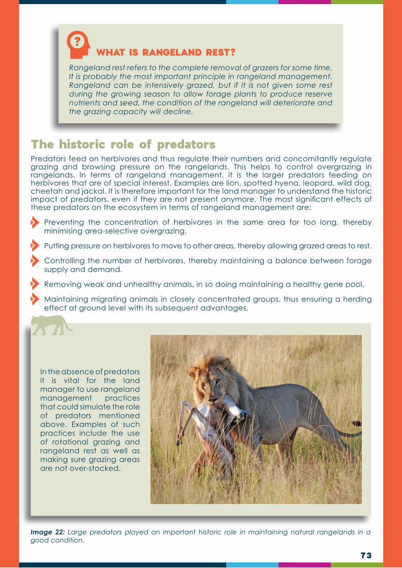
73
WHAT IS RANGELAND REST?Rangeland rest refers to the complete removal of grazers for some time. It is probably the most important principle in rangeland management. Rangeland can be intensively grazed, but if it is not given some rest during the growing season to allow forage plants to produce reserve nutrients and seed, the condition of the rangeland will deteriorate and the grazing capacity will decline.
Predators feed on herbivores and thus regulate their numbers and concomitantly regulate grazing and browsing pressure on the rangelands. This helps to control overgrazing in rangelands. In terms of rangeland management, it is the larger predators feeding on herbivores that are of special interest. Examples are lion, spotted hyena, leopard, wild dog, cheetah and jackal. It is therefore important for the land manager to understand the historic impact of predators, even if they are not present anymore. The most significant effects of these predators on the ecosystem in terms of rangeland management are:
Preventing the concentration of herbivores in the same area for too long, thereby minimising area-selective overgrazing.
Putting pressure on herbivores to move to other areas, thereby allowing grazed areas to rest.
Controlling the number of herbivores, thereby maintaining a balance between forage supply and demand.
Removing weak and unhealthy animals, in so doing maintaining a healthy gene pool.
Maintaining migrating animals in closely concentrated groups, thus ensuring a herding effect at ground level with its subsequent advantages.
The historic role of predators
Image 22: Large predators played an important historic role in maintaining natural rangelands in a good condition.
In the absence of predators it is vital for the land manager to use rangeland management practices that could simulate the role of predators mentioned above. Examples of such practices include the use of rotational grazing and rangeland rest as well as making sure grazing areas are not over-stocked.
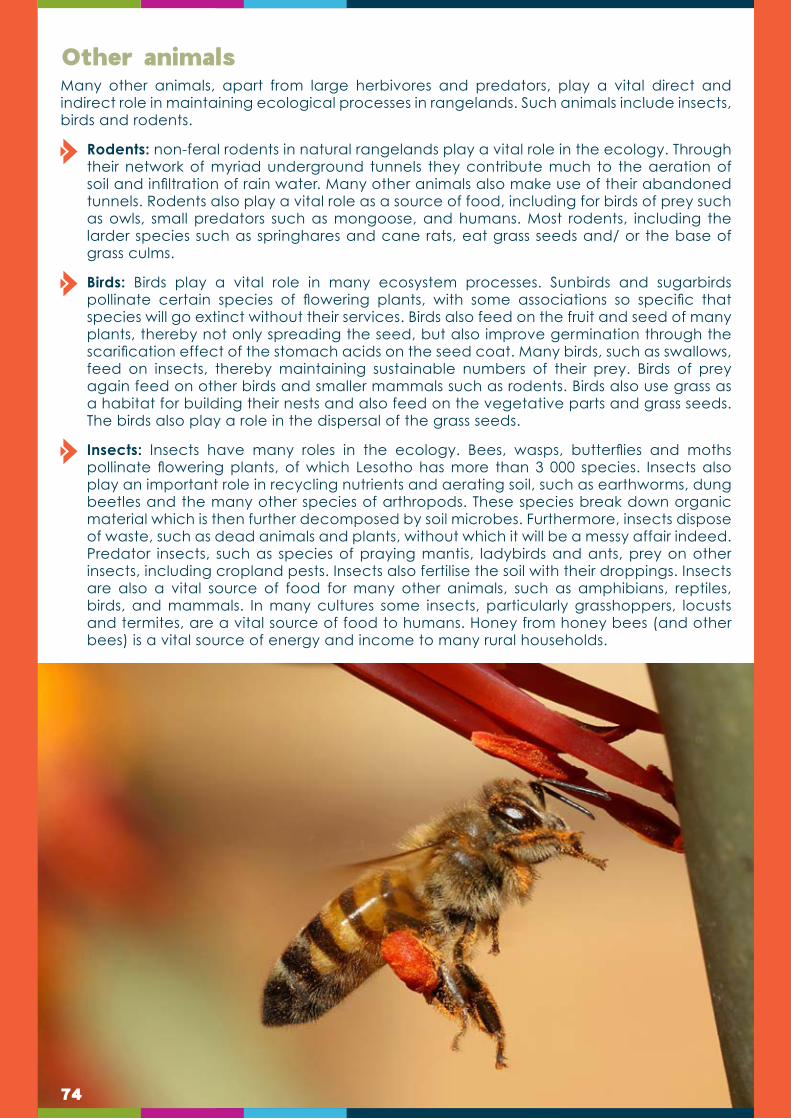
74
Many other animals, apart from large herbivores and predators, play a vital direct and indirect role in maintaining ecological processes in rangelands. Such animals include insects, birds and rodents.
Rodents: non-feral rodents in natural rangelands play a vital role in the ecology. Through their network of myriad underground tunnels they contribute much to the aeration of soil and infiltration of rain water. Many other animals also make use of their abandoned tunnels. Rodents also play a vital role as a source of food, including for birds of prey such as owls, small predators such as mongoose, and humans. Most rodents, including the larder species such as springhares and cane rats, eat grass seeds and/ or the base of grass culms.
Birds: Birds play a vital role in many ecosystem processes. Sunbirds and sugarbirds pollinate certain species of flowering plants, with some associations so specific that species will go extinct without their services. Birds also feed on the fruit and seed of many plants, thereby not only spreading the seed, but also improve germination through the scarification effect of the stomach acids on the seed coat. Many birds, such as swallows, feed on insects, thereby maintaining sustainable numbers of their prey. Birds of prey again feed on other birds and smaller mammals such as rodents. Birds also use grass as a habitat for building their nests and also feed on the vegetative parts and grass seeds. The birds also play a role in the dispersal of the grass seeds.
Insects: Insects have many roles in the ecology. Bees, wasps, butterflies and moths pollinate flowering plants, of which Lesotho has more than 3 000 species. Insects also play an important role in recycling nutrients and aerating soil, such as earthworms, dung beetles and the many other species of arthropods. These species break down organic material which is then further decomposed by soil microbes. Furthermore, insects dispose of waste, such as dead animals and plants, without which it will be a messy affair indeed. Predator insects, such as species of praying mantis, ladybirds and ants, prey on other insects, including cropland pests. Insects also fertilise the soil with their droppings. Insects are also a vital source of food for many other animals, such as amphibians, reptiles, birds, and mammals. In many cultures some insects, particularly grasshoppers, locusts and termites, are a vital source of food to humans. Honey from honey bees (and other bees) is a vital source of energy and income to many rural households.
Other animals
75
M2MODULE 2UNDERSTANDING CLIMATE RISK, VULNERABILITY & IMPACT ON RANGELANDS IN LESOTHO
Weather is the set of all phenomena in a given atmosphere at a given time. The term usually refers to the activity of these phenomena over short periods (hours or days). Common weather phenomena include such things as wind, cloud, rain, snow, fog and dust storms. Less common events include natural disasters such as cyclones and ice storms. Almost all familiar weather phenomena occur in the troposphere, the lower part of the atmosphere.
Climate is defined as the weather averaged over a long period of time. The standard averaging period is 30 years, but other periods may be used depending on the purpose. Climate also includes statistics other than the average, such as the magnitudes of day-to-day or year-to-year variations. Therefore, climate is “the average and variations of weather over long periods of time”. Different “Climate Zones” such as tropical, temperate or polar can be defined using parameters such as temperature and rainfall. The climate of a region depends on many factors including the amount of sunlight it receives, its altitude, topography, and how close it is to oceans. Since the equatorial regions receive more sunlight than the poles, climate varies with latitude.
Thus while the weather can change in just a few hours, climate changes occur over longer timeframes. Climate events, like El Niño, happen over several years, small scale fluctuations happen over decades, and larger climate changes happen over hundreds and thousands of years. We are now living in the advent of climate change with global warming causing the earth’s average global temperature to increase. The earth’s global climate is a dynamic system driven by such variables as the amount of solar radiation, chemistry of the atmosphere, amount and types of clouds, and the influence of the biosphere. A change in the temperature can cause changes in other parameters that affect climate such as weather elements like clouds or precipitation.
Greenhouse gases in our atmosphere allow the lower atmosphere to absorb heat that is radiated from the earth’s surface, trapping heat within the earth system. Without any greenhouse gases, the earth would be a frozen world. However, the amount of greenhouse gases in our atmosphere is on the rise due to anthropogenic (man-made) activities, causing temperature to rise. Naturally occurring greenhouse gases-carbon dioxide (CO2), methane (CH4), and nitrous oxide (N2O) typically trap some of the sun’s heat, keeping the planet from freezing. However, with increasing human activities, such as the burning of fossil fuels, increasing greenhouse gas levels lead to an enhanced greenhouse effect. The result is global warming and unprecedented rates of climate change (Fig. 18).
Understanding the difference between weather and climate
CLIMATE AND CLIMATE CHANGE
CHAPTER 7

CLIMATE CHANGE
The increases in temperatures will result in:
Higher evaporation rates.
More exposure to sun radiation.
Shifts in crop growing season.
More infestations by pests and diseases.
Increased risk of wildfire.
TEMPERATURE Climate change is anticipated to have far reaching effects such as:
Damage to personal assets and public infrastructure.
Uprooting of trees.
Death and injuries of people and animals.
DISASTER & CASUALTIES
Promote disaster risk reduction initiatives for controlling floods, wildfires and similar events.
Promote safer housing and construction of raised roads and buildings.
Establish wind breaks around homesteads.
Improve emergency response services.
DISASTER & CASUALTIES
Improve designs of human settlement areas.
Improve access to health services.
Clear disease habitats.
Introduce better systems for disease surveillance and monitoring.
Make low cost investments in health sector
Promote health education.
HUMAN HEALTH
Climate change would lead to increased frequency, magnitude and duration of extreme weather events such as prolonged dry spells, droughts, intense rainfall, floods, heavy snow, hailstorms, strong winds, thunderstorms and severe dust storms and some of these events will even occur in new areas.
EXTREME WEATHER EVENTS
Significant changes in timing intensity of rainfall result in:
Reduction in size and number of freshwater sources.
Poor water quality in some areas.
Scarcity of water for household use and for farming.
More people experiencing water-borne disease.
Soil erosion and loss of soil moisture.
Delay in start of planting season.
Desertification.
RAINFALL & WATER RESOURCES
Climate changes has the potential to substantially result in:
Extinction of many species of plants, birds, insects, fish and animals.
Loss of wetlands.
Reduced food supply for wildlife.
Increased incidences of wildfires.
Destruction of breeding habitats for wildlife.
Conversion of wild habitats to agricultural and grazing lands.
Migrations of birds and animals.
New species which adversely change local biodiversity composition.
BIODIVERSITY
Climate change poses the following threats to livelihoods and lifestyles in Lesotho.
Declining incomes for farmers from sale of wool, mohair and other agricultural produce.
More people will become hungry and destitute due to high food prices.
Increase in sexual violence and exploitation against woman and girl-children due to scarcity of food.
Because woman and girls are typically the ones who care for the homes, they will have to travel longer distances to fetch water or collect firewood.
Competition for scarce resources such as water and grazing lands has the potential to cause social tensions and conflicts between communities resulting into people migrating to live in new areas.
Displacement and migration can reduce access to education.
Loss of cultural heritage and biodiversity is likely to reduce the attractiveness of Lesotho to tourist.
LIVELIHOODS & LIFESTYLE
The devastating impacts of climate change on crop production and nutrition security include:
Damage to crops by early frost and other unpredictable weather events.
Uncertainty about what and when to plant.
Shorter growing season.
Loss of soil fertility.
Reduce yields from rain-fed crops.
Increased incidences and new combinations of pests.
Decline in incomes from sale of crops
CROP PRODUCTION
Control soil erosion
Conserve soil moisture, for example, by mulching.
Restore soil fertility, for example, using animal manure.
Apply fertilizer more efficiently.
Adapt low-cost, small-scale irrigation technologies such as gravity fed sprinkler and drip systems.
Discard some old tillage practices and adopt innovative farming practices such as conservation agriculture and key-hole vegetable gardening.
Introduce new crops and grow various crops on the same piece of land.
Use improved seeds that are more tolerant to draught, pests and diseases and which lead to early maturity of crops and high yields.
Prepare a basic crop in calendar indicating associated risks for each season and devise new planting and harvesting times.
Protect high value crops grown at small scale using physical means such as hail nets.
Practice mixed farming (crops & livestock).
Conduct more filed demonstrations.
Promote farmer-to-farmer information exchange.
Strengthen agriculture extension services and outreach programmes.
Improve climate forecasting for farming and teach framers how to interoperate weather and climate information.
CROP PRODUCTION
Human beings are effected by climate change in several ways.
Increases in the intensity, frequency and duration of extreme weather events such as severe heat waves puts many more lives at risk.
Rising temperatures are changing the geographical distribution of disease vectors which are migrating to new areas including higher altitudes and this will expose Besotho to new diseases.
Both scarcities of water, which is essential for proper hygiene, and excess water due to more frequent and torrential rainfall increase the burden of diseases spread through contaminated food and water.
Declining agriculture yields are exposing pregnant woman and many vulnerable people to food insecurity and malnutrition, ultimately increasing death rates.
HUMAN HEALTH
Plant fruit trees in homestead gardens.
Encourage establishment of community orchards.Grow fodder amongst trees.
Develop appropriate agro forestry models for mountains and lowlands.
Practice pruning and fertilizing to double tree densities, prevent soil erosion and produce fodder.
AGRO FORESTRY
Introduce better methods for assessment of vulnerability of ecosystems and monitoring species.
Enhance public awareness on biodiversity conservation.
Research and develop species more resistant to climate change.
Improve breeding techniques and protect breeding grounds.
Designate special areas for conserving biodiversity.
Develop legislation for biodiversity protection.
BIODIVERSITY
Improve early warning system against climate induced disaster and hazards to enable advanced preparation.
EXTREME WEATHER EVENTS
Climate change will result in:
Reduced range-land and pasture productivity.
Scarcity of forage and crop by-product.
Low quantities of livestock products such as milk and manure.
Reduced animal weight gain and reproduction.
Weak draught animals used in farming.
Increased infestations of pests and diseases such as scab, anthrax and tick-borne diseases.
Spread of climate sensitive parasites and their vectors to new areas.
More livestock deaths
LIVESTOCK
Plant more trees around homesteads and other areas.
Adopt innovative framing practices.
Use umbrella, sunscreen or wear protective cloths to reduce exposure to UV rays.
TEMPERATURE
PRACTICAL MEASURE THAT REDUCE VULNERABILITY TO THE IMPACT OF CLIMATE CHANGE ARE DESCRIBED AS “ADAPTION”.CLIMATE CHANGE ADAPTING IN LESOTHO REQUIRES TAKING THE FOLLOWING MEASURES AND ACTIONS
IMPACTS
ADAPTING
COMMON PLANNING & MANAGEMENTStrengthen capacity to identify, collect, analyse and share climate data.
Preserve indigenous knowledge and technologies that are relevant to climate change adaption.
Improve town planning and reclaim degraded lands.
Ensure sustainable land management reforms in support of climate change adaption.
Maintain Inventory of successful climate change adaption measures.
Promote exchange of climate information amongst peers and experts.
Raise public awareness and education on climate change adaption.
Integrate climate change and adaption issues into education curricula.
Strengthen capacity of local government in planning for climate change.
Integrate climate change adaption activities into budgets and local development plans.
Solicit external funding and improve access to funding needed for climate change adpation.
Introduce insurance options to help advance efforts on covering and quantifying risks and potential losses due to climate change.
LIVELIHOODS & LIFESTYLEReduce post-harvest losses of food and fodder, for example, by improving local processing and preservation techniques.
Develop local food banks for people and livestock.
Equip pregnant and lactating mother and other vulnerable groups with skill and knowledge needed to prevent malnutrition.
Promote life skill and training and psychosocial support.
Promote advocacy activities to reduce incidences and sexual and gender based violence and exploitation of woman, girls and other vulnerable group.
Use alternative energy source to wood, coal and charcoal.
Supplement hydro-power with wind, solar or biogas.
Use energy innovative technologies such as fuel efficient cooking stoves.
Diversity livelihood, for example, from crop production to intensive pig and poultry production or from farming to non-farming income generating activities.
Introduce supplementary livelihood such as bee keeping and handy craft production.
Develop markets and trade flows.
Develop entrepreneurial and business skills.
Reduce livestock numbers during extreme weather conditions.
Build shelters to protect livestock from extreme weather events.
Promote breeding of indigenous cattle breeds and avoid indiscriminate cross-breeding.
Keep livestock breeds that require less feed and water and which are more tolerant to extremes of climate and disease.
Introduce more fodder species and varieties on crop farm land.
Increase reliance on supplementary feeds such as planting forages and crop by-products.
Promote planned and controlled range management systems.
Conduct regular animal diseas surveillance and improve
disease management systems.
Raise more awareness and knowledge of animal diseases in endemic areas.
Train farmers on how to recognise new disease symptoms for livestock.
Conduct routine vaccinations and other measures to promote livestock health.
Introduce emergency assistance measures for livestock farmers.
Adhere to proper disposal of carcasses of affected animals.
LIVESTOCK
RAINFALL & WATER RESOURCESReduce water in times of dry spell and draught.
Promote rain water harvesting and water storage.
Construct dams and spring water tanks for irrigation and household use.
Implement water run off control mechanisms.
Conserve water catchment areas.
Protect ground water resources.
Improve water supply and encourage water recycling.
Develop management and maintenance of existing water supply systems.
Reform water policy including pricing and irrigation policies.
Information adapted from “The Climate Change"poster compiled by the United Nations Trust Fund For Human Security.
76

CLIMATE CHANGE
The increases in temperatures will result in:
Higher evaporation rates.
More exposure to sun radiation.
Shifts in crop growing season.
More infestations by pests and diseases.
Increased risk of wildfire.
TEMPERATURE Climate change is anticipated to have far reaching effects such as:
Damage to personal assets and public infrastructure.
Uprooting of trees.
Death and injuries of people and animals.
DISASTER & CASUALTIES
Promote disaster risk reduction initiatives for controlling floods, wildfires and similar events.
Promote safer housing and construction of raised roads and buildings.
Establish wind breaks around homesteads.
Improve emergency response services.
DISASTER & CASUALTIES
Improve designs of human settlement areas.
Improve access to health services.
Clear disease habitats.
Introduce better systems for disease surveillance and monitoring.
Make low cost investments in health sector
Promote health education.
HUMAN HEALTH
Climate change would lead to increased frequency, magnitude and duration of extreme weather events such as prolonged dry spells, droughts, intense rainfall, floods, heavy snow, hailstorms, strong winds, thunderstorms and severe dust storms and some of these events will even occur in new areas.
EXTREME WEATHER EVENTS
Significant changes in timing intensity of rainfall result in:
Reduction in size and number of freshwater sources.
Poor water quality in some areas.
Scarcity of water for household use and for farming.
More people experiencing water-borne disease.
Soil erosion and loss of soil moisture.
Delay in start of planting season.
Desertification.
RAINFALL & WATER RESOURCES
Climate changes has the potential to substantially result in:
Extinction of many species of plants, birds, insects, fish and animals.
Loss of wetlands.
Reduced food supply for wildlife.
Increased incidences of wildfires.
Destruction of breeding habitats for wildlife.
Conversion of wild habitats to agricultural and grazing lands.
Migrations of birds and animals.
New species which adversely change local biodiversity composition.
BIODIVERSITY
Climate change poses the following threats to livelihoods and lifestyles in Lesotho.
Declining incomes for farmers from sale of wool, mohair and other agricultural produce.
More people will become hungry and destitute due to high food prices.
Increase in sexual violence and exploitation against woman and girl-children due to scarcity of food.
Because woman and girls are typically the ones who care for the homes, they will have to travel longer distances to fetch water or collect firewood.
Competition for scarce resources such as water and grazing lands has the potential to cause social tensions and conflicts between communities resulting into people migrating to live in new areas.
Displacement and migration can reduce access to education.
Loss of cultural heritage and biodiversity is likely to reduce the attractiveness of Lesotho to tourist.
LIVELIHOODS & LIFESTYLE
The devastating impacts of climate change on crop production and nutrition security include:
Damage to crops by early frost and other unpredictable weather events.
Uncertainty about what and when to plant.
Shorter growing season.
Loss of soil fertility.
Reduce yields from rain-fed crops.
Increased incidences and new combinations of pests.
Decline in incomes from sale of crops
CROP PRODUCTION
Control soil erosion
Conserve soil moisture, for example, by mulching.
Restore soil fertility, for example, using animal manure.
Apply fertilizer more efficiently.
Adapt low-cost, small-scale irrigation technologies such as gravity fed sprinkler and drip systems.
Discard some old tillage practices and adopt innovative farming practices such as conservation agriculture and key-hole vegetable gardening.
Introduce new crops and grow various crops on the same piece of land.
Use improved seeds that are more tolerant to draught, pests and diseases and which lead to early maturity of crops and high yields.
Prepare a basic crop in calendar indicating associated risks for each season and devise new planting and harvesting times.
Protect high value crops grown at small scale using physical means such as hail nets.
Practice mixed farming (crops & livestock).
Conduct more filed demonstrations.
Promote farmer-to-farmer information exchange.
Strengthen agriculture extension services and outreach programmes.
Improve climate forecasting for farming and teach framers how to interoperate weather and climate information.
CROP PRODUCTION
Human beings are effected by climate change in several ways.
Increases in the intensity, frequency and duration of extreme weather events such as severe heat waves puts many more lives at risk.
Rising temperatures are changing the geographical distribution of disease vectors which are migrating to new areas including higher altitudes and this will expose Besotho to new diseases.
Both scarcities of water, which is essential for proper hygiene, and excess water due to more frequent and torrential rainfall increase the burden of diseases spread through contaminated food and water.
Declining agriculture yields are exposing pregnant woman and many vulnerable people to food insecurity and malnutrition, ultimately increasing death rates.
HUMAN HEALTH
Plant fruit trees in homestead gardens.
Encourage establishment of community orchards.Grow fodder amongst trees.
Develop appropriate agro forestry models for mountains and lowlands.
Practice pruning and fertilizing to double tree densities, prevent soil erosion and produce fodder.
AGRO FORESTRY
Introduce better methods for assessment of vulnerability of ecosystems and monitoring species.
Enhance public awareness on biodiversity conservation.
Research and develop species more resistant to climate change.
Improve breeding techniques and protect breeding grounds.
Designate special areas for conserving biodiversity.
Develop legislation for biodiversity protection.
BIODIVERSITY
Improve early warning system against climate induced disaster and hazards to enable advanced preparation.
EXTREME WEATHER EVENTS
Climate change will result in:
Reduced range-land and pasture productivity.
Scarcity of forage and crop by-product.
Low quantities of livestock products such as milk and manure.
Reduced animal weight gain and reproduction.
Weak draught animals used in farming.
Increased infestations of pests and diseases such as scab, anthrax and tick-borne diseases.
Spread of climate sensitive parasites and their vectors to new areas.
More livestock deaths
LIVESTOCK
Plant more trees around homesteads and other areas.
Adopt innovative framing practices.
Use umbrella, sunscreen or wear protective cloths to reduce exposure to UV rays.
TEMPERATURE
PRACTICAL MEASURE THAT REDUCE VULNERABILITY TO THE IMPACT OF CLIMATE CHANGE ARE DESCRIBED AS “ADAPTION”.CLIMATE CHANGE ADAPTING IN LESOTHO REQUIRES TAKING THE FOLLOWING MEASURES AND ACTIONS
IMPACTS
ADAPTING
COMMON PLANNING & MANAGEMENTStrengthen capacity to identify, collect, analyse and share climate data.
Preserve indigenous knowledge and technologies that are relevant to climate change adaption.
Improve town planning and reclaim degraded lands.
Ensure sustainable land management reforms in support of climate change adaption.
Maintain Inventory of successful climate change adaption measures.
Promote exchange of climate information amongst peers and experts.
Raise public awareness and education on climate change adaption.
Integrate climate change and adaption issues into education curricula.
Strengthen capacity of local government in planning for climate change.
Integrate climate change adaption activities into budgets and local development plans.
Solicit external funding and improve access to funding needed for climate change adpation.
Introduce insurance options to help advance efforts on covering and quantifying risks and potential losses due to climate change.
LIVELIHOODS & LIFESTYLEReduce post-harvest losses of food and fodder, for example, by improving local processing and preservation techniques.
Develop local food banks for people and livestock.
Equip pregnant and lactating mother and other vulnerable groups with skill and knowledge needed to prevent malnutrition.
Promote life skill and training and psychosocial support.
Promote advocacy activities to reduce incidences and sexual and gender based violence and exploitation of woman, girls and other vulnerable group.
Use alternative energy source to wood, coal and charcoal.
Supplement hydro-power with wind, solar or biogas.
Use energy innovative technologies such as fuel efficient cooking stoves.
Diversity livelihood, for example, from crop production to intensive pig and poultry production or from farming to non-farming income generating activities.
Introduce supplementary livelihood such as bee keeping and handy craft production.
Develop markets and trade flows.
Develop entrepreneurial and business skills.
Reduce livestock numbers during extreme weather conditions.
Build shelters to protect livestock from extreme weather events.
Promote breeding of indigenous cattle breeds and avoid indiscriminate cross-breeding.
Keep livestock breeds that require less feed and water and which are more tolerant to extremes of climate and disease.
Introduce more fodder species and varieties on crop farm land.
Increase reliance on supplementary feeds such as planting forages and crop by-products.
Promote planned and controlled range management systems.
Conduct regular animal diseas surveillance and improve
disease management systems.
Raise more awareness and knowledge of animal diseases in endemic areas.
Train farmers on how to recognise new disease symptoms for livestock.
Conduct routine vaccinations and other measures to promote livestock health.
Introduce emergency assistance measures for livestock farmers.
Adhere to proper disposal of carcasses of affected animals.
LIVESTOCK
RAINFALL & WATER RESOURCESReduce water in times of dry spell and draught.
Promote rain water harvesting and water storage.
Construct dams and spring water tanks for irrigation and household use.
Implement water run off control mechanisms.
Conserve water catchment areas.
Protect ground water resources.
Improve water supply and encourage water recycling.
Develop management and maintenance of existing water supply systems.
Reform water policy including pricing and irrigation policies.
Information adapted from “The Climate Change"poster compiled by the United Nations Trust Fund For Human Security.
77

78
5 Based on publication by: Dejene, A., Midgley, S., Marake, M.V. and S. Ramasami. 2011. Strengthening Climate Change Capacity for Adaptation in Agriculture: Experience and Lessons from Lesotho. FAO.
Net primary productivity is low over most of Lesotho, linked to the climate and thin soils on steep slopes. Areas of higher potential are restricted to small areas in the lowlands and foothills. The main climatic constraints to agricultural production (crop and livestock) are the high levels of rainfall variability, soil characteristics which combine with rainfall and evaporation to determine effective soil water regimes and availability for crop production, and the duration of the growing season as determined by the temperature regime, rainfall seasonality and the frost risk.
Temperature: As a result of the high altitude, Lesotho experiences some of the lowest temperatures in Southern Africa, especially along the mountain ridges and plateaus. A significant proportion of Lesotho experiences a mean annual temperature of <10°C. Mean daily maximum and minimum temperatures mostly do not exceed 22.5 - 25°C and 10 - 12.5°C, respectively, except in the south-western/ western lowlands where temperatures can reach 27.5–32.5°C and 15–17.5°C, respectively. Along the ridges and internal plateaus, temperatures can drop below -2.5°C a few times a year and temperatures below -7.5°C can occur. Extreme high temperatures can occur up to 36-38°C, mainly in the south-west.
Precipitation: Rainfall in Lesotho is driven by the regional expression of global atmospheric circulation systems over Southern Africa and moderated by the topographic position of Lesotho (1388m to 3482m ASL on the Southern African plateau. Mean circulation over Southern Africa is anti-cyclonic throughout the year, meaning warm, dry descending air, and is responsible for the general aridity across the region. During the winter months (May to July), cool dry air is a feature of the interior Southern African plateau, including Lesotho, and rainfall is very low. Precipitation in Lesotho is strongly controlled by topography and lack of marine influence. Occasionally deep cold fronts can deposit significant amounts of snow on the high ground, often at the beginning or end of winter. Strong winds associated with frontal systems occur particularly during late winter.
Between 75 to 85 percent of rainfall over Lesotho occurs during the summer season months (November to January). The highest mean annual rainfall (>1200 mm yr-1) occurs off the Lesotho escarpment in KwaZulu Natal (South Africa), a function of the orographic forcing of rainfall (Schulze et al., 1997). The strong rain shadow formed by the eastern escarpment results in a much lower rainfall (about 400–600 mm yr-1) in the Senqu River valley, while the remainder of Lesotho receives about 600–800 mm yr-1, except in the northern lowlands and north-eastern mountains (800–1000 mm yr-1). Precipitation occurs as rain, snow, hail and sleet. Potential evapotranspiration is higher than precipitation throughout the year with the exception of March. Variability of rainfall is high, ranging from 20-40% in the south. Rainfall during drier years is below that required for rainfed agriculture over much of the south-western and western parts of the country.
Snowfall: Given the high elevations and temperature drops during the winter months, Lesotho experiences significant snowfall incidences annually especially in the mountain areas. The snowfall is a major contribution in the hydrologic cycles over Lesotho replenishing wetlands during the normally dry winter months. Snowfall is also associated with significant drops in temperature which affects livestock especially small around shearing time. Of great concern is the scenario of decreased snowfall, since snow melt currently supplies much of the required moisture in spring during the crop planting and early growth season.
The Climate of Lesotho5

79
Climate-related stresses have also been prevalent in Lesotho for a long time. Southern Africa has often been affected by climate vulnerability and extreme climate events in the past. Recent droughts highlight two important points:
Short-term climate variability can be responsible for serious and immediate impacts on human and animal well-being and crop production; and
The magnitude of the impact of climate variability is determined by the social, economic and political vulnerability of different communities and nations, as well as local agricultural management practices.
The people of Lesotho have evolved within this climatic context and have developed a range of coping mechanisms which have served them well in the past. What has changed in recent times, however, is the apparent increasing frequency, magnitude and duration of climatic shocks, leaving little or no time to recover from the last event.
Frost Incidences: The climate of Lesotho normally has a potential of two frost incidences occurring when the temperature levels usually during the night drops below freezing point (0°C). Early frost during the mid to late autumn can interrupt the normal growing season precipitating a crop failures and /or economic losses especially for staple cereal crops (maize and sorghum) including legume (beans). Climate change projections indicate a decrease in the incidence of extremely cold nights which would precipitate frost bites in crops. Secondly, late frost may occur in early to mid-spring causing significant crop damage in the early season. Such incidences are more deleterious in the mountain areas where the growing season is normally short.
Climate variability and vulnerability patterns
WHAT IS CLIMATE VULNERABILITY?Despite the much debated climate change, climatic variability is a norm over long periods of time. However, the compounding factor currently is the livelihood vulnerability to the changing climate. Thus the advent of climate change imposes risks especially on agriculture and natural resource based livelihoods. The main climatic constraints to agricultural production are the high levels of variability, soil characteristics which combine with rainfall and evaporation to determine soil moisture, and the duration of the growing season (as determined by the temperature regime, rainfall seasonality and the frost risk). The choice of crop, cultivar and planting date required careful consideration and is not always optimal for the conditions. Rangelands are affected by the incident temperature and precipitation regimes compounded by human interventions and management of the range during drought and other drought induced hazards like fire and degradation.
Risk is often defined as the likelihood of occurrence of a hazard times the potential consequences. However, this does not take into account underlying adaptive capacity and farmer/household coping mechanisms. To address this, the concept of vulnerability is more often used in the climate change context. Vulnerability is the function of exposure to climate change (i.e. how much will the sector be exposed to climate change), the sensitivity to change (i.e. how much will the system react to climate change) - together they give an indication of potential impact - and the capacity of natural and human systems to adapt to that new climatic condition - called adaptive capacity.

80
DID YOU KNOW?Crop and rangeland yields in the Free State Province (FSP) of South Africa, just across the border from Lesotho’s drier Mafeteng and Mohale’s Hoek districts, surpass the crop yields in Lesotho by 2.5 to 9 times. The distinct contrast could be attributable to widely differing crop, livestock and natural resources management, and efficient use of agricultural inputs, and underlines the scope which exists for adaptation in Lesotho. The FSP and Lesotho sides of the border mostly share the same climatic and soil conditions, indicating that Lesotho’s agriculture can be improved.
In addition, the country has experienced heightened competition for arable land due to population increase and migration to the lowlands, competition for land between crops and livestock, lack of resting of the land and progressive loss of vegetative cover, rapidly dwindling soil and water resources, few opportunities for off-farm income, and deepening poverty.
Figure 18: The climate system (NPS, 2018).

81
TAKE AWAYSmallholders in Lesotho are vulnerable to the slightest change in climate and it is crucial to create more awareness and action amongst policy makers about the implication of changes in temperature and rainfall to the country’s food security and wellbeing in the coming decades. As over 15% of Lesotho’s 2.0 million people are undernourished (2005 – 07) and the figure has not declined over the past two decades (FAO, 2010), the immediate priority should be to address the need to enhance food production whilst ensuring sustainable management of natural resources. In addition to the projected increase in high temperature stress on major crops like maize, wheat, beans and peas, the moderate drying during winter may cause water stress situations during the wheat-growing season. On the other hand, a moderate increase in spring/summer rainfall may not always lead to adequate moisture for maize, the most important crop in the region in the context of food security. As droughts are already common in the mountains, foothills and lowlands, increasing temperature and uneven distribution of rainfall can further aggravate the situation and warrants immediate and urgent attention to adaptation.
Climate change simulations performed by the Lesotho Meteorological Services show temperatures increasing by about 1°C by 2030, 1.5 - 2.0°C by 2050, and by about 2.5 - 3.5°C by the 2080s. Winter rainfall shows strong decreases, with no change in summer and autumn rainfall, and gradually increasing spring rainfall. In summary, the following climate change projections appear likely for Lesotho for the periods ca. 2030, 2050 and 2080:
Changing climatic variability, and frequency and intensity of extreme events: this can include droughts and heavy rainfall, and thus captures magnitude of non-average climatic events over short time-scales rather than direction of change. Recent projections indicate a decrease in the extent of extremely cold days and nights especially in the mountains. This overall warming trends are likes to shorten the winter seasons.
Gradually changing means (i.e. the general direction of change): For temperature changes, an increase in annual mean temperature of approximately 1.0°C (2030), 2.0°C (2050) and 3.5°C (2080) is likely. For rainfall, a moderate drying in late autumn/winter is expected and moderate increases in spring/summer rainfall, with stronger spring/summer wetting towards the end of the century.
Both the southern lowlands and the mountains experience sub-optimal spatial and erratic distribution of rainfall and recurring droughts, and rising temperatures will further reduce available soil moisture during times of inadequate rainfall. The biophysical features of Lesotho, notably the high proportion of high-altitude rangeland, and thin and highly erodible soils of varying fertility, make the country particularly sensitive to climatic events.
Longer dry spells punctuated by heavy rainfall events could have disastrous consequences for the escalation of soil erosion.
Degraded lands occurring through Lesotho have much higher sensitivity to climatic hazards than those which enjoy good vegetation cover and soil water infiltration abilities.
Climate change Projection for Lesotho
Climate Change Impacts on Natural Resources

82
Denudation of the soil surface, brought about by the combination of constant grazing and trampling by livestock (severe overstocking), collection of fuel wood, and conventional agricultural practices (e.g. ploughing) on croplands, multiplies the impacts of climate events such as drought and heavy rainfall on soil losses.
Heavy rainfall does not infiltrate easily into such degraded soils, and runs off, taking with it vast amounts of nutrient and organic matter rich topsoil. Recharge to groundwater is diminished and the excess surface water causes flooding. Declining groundwater levels in regions heavily reliant on it, such as the lowlands, would reduce the availability of safe water for people, home gardens and livestock.
Impacts on land and soil:
Water:
Forests:
Land degradation has already seriously reduced the productive capacity of Lesotho’s croplands and rangelands (see Chapter 8). Protection and rehabilitation of the land through careful land use planning and management will become increasingly critical in order to safeguard this resource for future generations living under a potentially harsher climate. There is great potential for increased uptake of locally proven erosion control methods to improve resilience against the impacts of climate change. However, these conventional approaches are ineffective without substantial changes in land management, since they are merely “band aids” for underlying poor catchment management. Thus, greater potential lies in adopting production practices such as conservation agriculture, based on reduced tillage, maintenance of soil cover and crop rotation.
Across Southern Africa, climate change impacts and responses will often be very closely associated with water resources and access to water for agricultural production. In contrast to most countries in the surrounding region, Lesotho is essentially one large catchment and endowed with extensive water resources. However, only 1% of crop production in Lesotho is under irrigation and almost all subsistence and smallholder farming is rainfed. While water is available, it is being allocated for other purposes and farmers have yet to productively exploit their country’s water resources. Small-scale water harvesting schemes are seriously lacking and yet these remain viable adaption options for smallholders in the face of expected climate change impacts on water resources.
Studies (Dejene et al., 2011) indicated that the majority of households have relatively easy access to a village water supply for household purposes. In parts of the lowlands of Lesotho, some households also use water from groundwater sources. Surface water sources (mainly rivers) are used for livestock watering. Accessibility of water sources is generally good (livestock can reach water within 30 minutes). However, sufficiency of water supplies is more problematic in the mountains than in the lowlands.
During spring droughts, livestock have to be driven down to larger rivers when rivers near to the settlements dry up. A lack of grazing on these routes leads to considerable mortality especially of lambs. Increasing variability of river flows would increase the frequency of such events.
Almost all households in Lesotho use firewood for cooking or heating, or both. Dependency on firewood is particularly high in the mountains; in the lowlands cow dung, gas and paraffin are used to supplement wood-based energy. In the mountains, natural lack of forest and exploitation combine to force people to walk long distances in search of woody shrubs and most households take more than one hour compared to about 30% in the lowlands. The primary source of wood is the indigenous woodlands, particularly in parts of the lowlands where there are no mature government woodlots and limited access to private or community woodlots. In the mountains, a high proportion of wood from shrubs is sourced from own land but still roughly 40% of households are struggling to access firewood for household

83
purposes (Dejene et al. 2011). The future trend in natural wood availability is uncertain since tree establishment will depend on the complex interaction of rainfall trend and distribution, warming, rising CO2 concentration, incidence of wildfire, incidence of pests and diseases, and land condition. There are, however, some efforts at tree planting on both communal and private land holdings.
In both the southern lowland and mountain livelihood zones, the majority of the population engage with rainfed agriculture and are dependent to some degree on own production for household food supply and/or cash income. Climatic variability has direct impacts on the household livelihoods and food situation, for example:
Regular droughts have become a feature of the climate and have a number of direct and indirect impacts on households, crops and animals. Drought is regarded as the primary climatic hazard, followed by strong winds and storms. This is followed by hail and heavy rainfall in the lowlands, and heavy rainfall, frost and heavy snow in the mountains.
Range management practices are not strategically planned to respond to recurring drought, resulting into low livestock conception and birth rates. In the mountains, severe overstocking on limited rangeland subjects animals to highly stressful conditions - resulting in very high mortality rates especially of young animals.
The arable southern lowlands experience some of the driest and hottest weather in the country, and heat stress in mid-summer can be expected to become an increasingly regular occurrence (Battisti and Naylor, 2009).
In both mountains and lowlands, rising temperatures will lead to greater evapotranspiration rates, and more rapid soil drying between rainfall events, particularly where soils are exposed and shallow to bedrock in depth. The preservation of soil moisture between rainfall events will thus become increasingly critical. Drought impacts on crop yields in various ways, depending to a large degree on the developmental stage of the crop, during the flowering period (all crops) or tasselling (maize) lack of soil moisture causes poor fruit and seed set; drought during critical growth phases stunts growth and seed development.
Dry spells at the beginning of the cropping season delays planting and can lead to fallowing of fields, as was the case during the 2015 drought and repeating in the current El Niño season;
An increased frequency or intensity of hailstorms, floods and frost can destroy crops and kill livestock and impacts on crops, livestock and physical infrastructure.
The physical land degradation that comes with high intensity rains is potentially devastating, particularly under conventional agriculture where soils are disturbed (ploughed) and left exposed. The rate of leaching of nutrients through these structurally poor soils is high and manifests in stunted or nutrient deficient crops. Lack of water infiltration could lead to increased waterlogging of fields after heavy rainfall, disrupting farm operations.
Many areas of Lesotho are normally characterised by cool growing season weather conditions and very cold winters which inhibit pests and diseases. Increasing temperatures are conducive to increased pest and disease pressure, in both crops and livestock. Crop wilting due to either high mid-day temperatures or fungal diseases has become an increasing problem in recent times, especially for vegetable producers, at high economic cost. Cattle are prone to tick-borne diseases and anthrax, whereas the main disease in sheep is scab. Most of the farmers in rural areas have inadequate access to pest and disease control in crops and livestock, with veterinary services severely under-resourced.
Climate Change Impacts on Livelihoods and Food Security
84
Rainfed agricultural systems have much higher sensitivity to climatic hazards and rainfall variability than those with some form of irrigation. Maize is particularly sensitive to the timing and duration of dry spells; the capacity to irrigate during sensitive developmental periods can mean the difference between a normal yield and crop failure.
Expected gradual warming may lead to negative impact on summer crops (e.g. maize) especially in the foothills and lowlands.
Of great concern is the scenario of decreased snowfall, since snow melt currently supplies much of the required moisture in spring during the crop planting and early growth season.
Following this account of potential negative impacts of extreme events and warming on agricultural production, we note that both mountain and lowland agro-ecological zones could respond very positively to moderate increases in rainfall in a year with reasonably well distributed summer rainfall. For example:
Recent hydrological modelling results (Schulze, 2010) show a future reduction in the number of days per year experiencing soil water stress over Lesotho.
Since Lesotho has a cool climate, the expected gradual warming could also have positive impacts on crops, livestock and people during winter. Cold stress will be reduced, the growing season will likely be extended especially during winter, and the diversity of crops suited to the climate will increase (especially in the mountains) as evidenced by current seasonal patterns of rainfall, frost and snow).
Some crops (e.g. legumes and root crops) grown in Lesotho could benefit from an increase in heat units which stimulate plant growth and development, particularly in spring when the greatest rise in temperature is expected. However, this will have to go hand in hand with sufficient soil moisture availability during the period of early rapid growth, and efficient monitoring and control of pests and diseases.
On balance, increasing temperatures and heat waves will continue to have negative impacts on agriculture and food security for smallholders.
NOTE TO TRAINERS:Lesotho is, as over most of the sub-continent, arguably overly reliant on maize which, whilst it can be highly productive during good rainfall years, is notoriously sensitive to erratic and below-normal rainfall. It is well-known amongst farmers that greater crop diversity and mixed farming (crops and livestock) offer considerable protection against farming risk, including climatic-related risk.
Larger farming enterprises with a range of different crop types, or even cultivars of the same crop with differing drought or pest resistance traits, are much less likely to suffer complete crop losses. Warming trends in Lesotho could open up opportunities for new crops. A co-benefit is increased nutritional diversity, which is very low in Lesotho. Larger mixed farming enterprises are more resilient during a crisis since they are able to sell livestock for cash to buy food when crops have failed. Those who do not own livestock or own only very few animals are more sensitive to climate shocks. Even a humble poultry business, together with homestead vegetable gardening, for example, can make these households less sensitive. The keyhole garden technology prevalent across the southern lowlands appears to be working well and is popular, with communities calling for continued support in constructing and managing these homestead gardens. This is a good example of a low-cost adaptation practice which is also supported by local government and can be up-scaled to the national level.

85
The overall impact of climate change on land-based livelihoods is a complex outcome of multiple stressors and vulnerability. Both the southern lowlands and the mountains are highly exposed to climate variability and increases in variability brought about by climate change. They are also highly sensitive, based on serious land degradation, high reliance on rainfed agriculture (often in monoculture), low economic and agricultural diversity, the burden placed on economically active adults in caring for children, the aged and the sick, and a high rural population density in the lowlands. Thus, the impacts of climate change are expected to be severe.
Given the high current and expected future impact of climate-related hazards and climate change on agrarian communities across southern Africa, planning and implementation of effective adaptation responses is urgently required. It is generally accepted that farmers with the least resources have the lowest capacity to adapt and are thus the most vulnerable and in need of assistance. However, the specific nature of such vulnerabilities and associated coping and adaptation options is highly contextualized at national, district, sub-catchment and village levels. Local micro-climatic characteristics, combined with spatially heterogeneous soils, vegetation cover, water resources, and pests and diseases, as well as social, economic and infrastructure differentials, call for interventions that are strongly rooted within this context and are not completely foreign to those who will be expected to implement them.
Reducing food security will require that social, economic and environmental determinants of vulnerability be integrated in policies. Effective long-term agricultural policies must certainly be developed, but it must also be integrated within a wider sustainable development framework, according to local and national situations, and be grounded in the local context (Ziervogel et al., 2006). Thus, following an overall risk and vulnerability assessment at national and district levels detailed local information must be sought on past and current coping strategies (or lack of) in the face of climatic variability and extreme events.
Adaptation strategies for strengthening adaptive capacity must acknowledge the communities’ stated needs and aspirations and align these with targeted innovations to create resilience and sustainability. A holistic approach is required, taking into account factors critical for the development of rural livelihoods such as:
Addressing the root causes of poverty
Farmers should be guided to gradually re-orientate their farming approaches to be resilient to the eminent impact of climate change in fragile and highly vulnerable production system.
Given the country’s energy needs, particularly in off grid rural communities, biogas energy development using livestock manure could be a mitigation option. The adoption of improved (including both heat- and cold-tolerant) breeds of cattle, goats and merino sheep will also be important for improving the resilience and productivity of the local production of meat, milk, wool and mohair – i.e. an adaptation option.
Sustainable crop intensification on some crops (i.e. maize) in the lowlands, with clear principles of environmental conservation and livelihood diversification, would be a viable strategy in this country that largely depends on its water resources.
Technical responses (husbandry) require support by transitional government assistance through infrastructure development, subsidies, and credit and marketing facilitation.
Infrastructure needs in order to improve market access include maintenance of roads, networks to ease service and goods delivery, irrigation infrastructure such as the provision of immovable equipment, dam construction, installation of wind and solar energy systems for the exploitation of groundwater resources, and agricultural business centre establishment in villages.
Climate Change Adaptation and Mitigation measures

86
Farming machinery and spare parts could be available in various ways from the depots, i.e. stored here for sale or kept for community use based on agreed arrangements. All programmes aimed at strengthening agriculture and developing resilience must include some form of organized credit provision.
The credit facilities that already exist amongst these communities are weak and should be strengthened and modified where necessary. The modification will serve to facilitate co-existence of the informal mechanisms with more formal mechanisms such as revolving funds.
Development of intensive pig and poultry enterprises is impossible without sustainable credit facilities.
Community fundraising and income earning activities are important gatherings to raise funds that can be used to develop agricultural businesses.
Cooperatives should be encouraged from the beginning, to facilitate a smooth transition from project to autonomous community managed programmes.
Figure 19: Some key adaptive interventions, case study of Maputsoe Village.Source: (UNDP 2018) https://www.adaptation-undp.org/resources/brochures-posters-communications-products/ecosystem-based-adaptation-action-lesotho-0
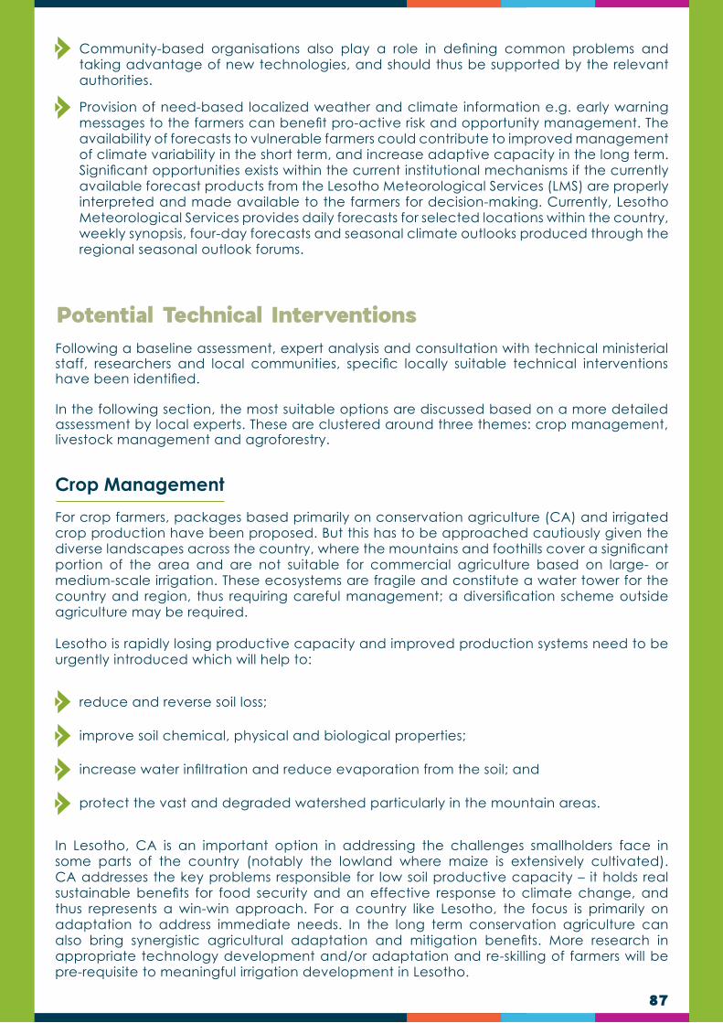
87
Community-based organisations also play a role in defining common problems and taking advantage of new technologies, and should thus be supported by the relevant authorities.
Provision of need-based localized weather and climate information e.g. early warning messages to the farmers can benefit pro-active risk and opportunity management. The availability of forecasts to vulnerable farmers could contribute to improved management of climate variability in the short term, and increase adaptive capacity in the long term. Significant opportunities exists within the current institutional mechanisms if the currently available forecast products from the Lesotho Meteorological Services (LMS) are properly interpreted and made available to the farmers for decision-making. Currently, Lesotho Meteorological Services provides daily forecasts for selected locations within the country, weekly synopsis, four-day forecasts and seasonal climate outlooks produced through the regional seasonal outlook forums.
Following a baseline assessment, expert analysis and consultation with technical ministerial staff, researchers and local communities, specific locally suitable technical interventions have been identified.
In the following section, the most suitable options are discussed based on a more detailed assessment by local experts. These are clustered around three themes: crop management, livestock management and agroforestry.
Potential Technical Interventions
Crop Management
For crop farmers, packages based primarily on conservation agriculture (CA) and irrigated crop production have been proposed. But this has to be approached cautiously given the diverse landscapes across the country, where the mountains and foothills cover a significant portion of the area and are not suitable for commercial agriculture based on large- or medium-scale irrigation. These ecosystems are fragile and constitute a water tower for the country and region, thus requiring careful management; a diversification scheme outside agriculture may be required.
Lesotho is rapidly losing productive capacity and improved production systems need to be urgently introduced which will help to:
reduce and reverse soil loss;
improve soil chemical, physical and biological properties;
increase water infiltration and reduce evaporation from the soil; and
protect the vast and degraded watershed particularly in the mountain areas.
In Lesotho, CA is an important option in addressing the challenges smallholders face in some parts of the country (notably the lowland where maize is extensively cultivated). CA addresses the key problems responsible for low soil productive capacity – it holds real sustainable benefits for food security and an effective response to climate change, and thus represents a win-win approach. For a country like Lesotho, the focus is primarily on adaptation to address immediate needs. In the long term conservation agriculture can also bring synergistic agricultural adaptation and mitigation benefits. More research in appropriate technology development and/or adaptation and re-skilling of farmers will be pre-requisite to meaningful irrigation development in Lesotho.

88
Livestock Management
Agroforestry
In the livestock subsector, the reduction of climate-related risks and adaptation to climate change will not be easy and will require long-term approaches. This is because the fundamental systems and processes that must be changed or adapted are communal in nature, unless a radical shift from current cultural norms of livestock management (e.g. communal grazing in the open rangelands associated with grazing of crop residues) is experienced.
Rangeland overgrazing and degradation must be halted and reversed to allow for recovery to full production potential.
The cornerstone of all range management systems in Lesotho is the “Maboella” system, a traditional management strategy of the rangeland common property resources, should be complemented by the transhumance system. Any innovations in range management systems must improve on these traditional strategies for management of rangelands under common property resources, with transhumance practices giving way to more innovative systems of range management acceptable to the people.
Planned and controlled range management programmes must be implemented, with grazing areas realistically divided into manageable blocks that allow for rotational grazing with managed rest periods.
Only productive animals should be retained - undesirable and unproductive animals must be culled. Such a system must be based on established rangeland carrying capacities countrywide.
Re-seeding with palatable grass species will be required in some places with due consideration for likely competition with the native grass species and suitability for erosion control. The challenge, however, is the fact that promulgation of such controls is politically controversial and experience shows that strong political will is required.
Over the short term, interventions which reduce pressure on the rangelands will be required, such as fodder production and preservation, and the use of other supplementary feeds.
A fodder production scheme would provide a key alternative and/or supplementary approach to scarce rangeland resources.
Furthermore, it is recommended that fodder production be introduced and encouraged on the crop farm lands to boost livestock feed supplies and to relieve pressure on the local rangelands. In this respect, it is also recommended that dual purpose (food feed) fodder species and varieties (e.g. dual purpose legumes, sorghum) be given consideration as this will be more attractive to farmers than only planting fodder for animals.
Agroforestry is the interaction of agriculture and trees, including the agricultural use of trees. This includes trees on farms and in agricultural landscapes, farming in forests and along forest margins and tree-crop production, including cocoa, coffee, rubber and oil palm. Interactions between trees and other components of agriculture may be important at a range of scales: in fields (where trees and crops are grown together), on farms (where trees may provide fodder for livestock, fuel, food, shelter or income from products including timber) and landscapes (where agricultural and forest land uses combine in determining the provision of ecosystem services).
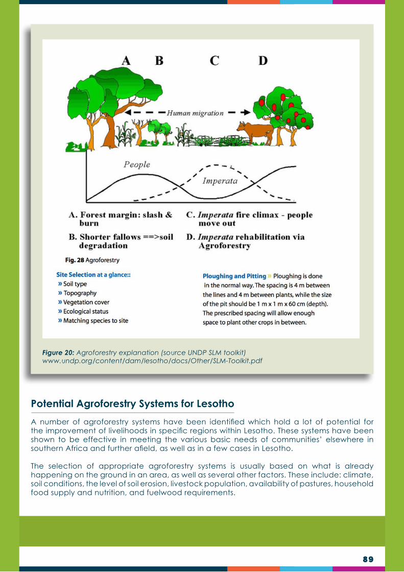
89
Potential Agroforestry Systems for Lesotho
A number of agroforestry systems have been identified which hold a lot of potential for the improvement of livelihoods in specific regions within Lesotho. These systems have been shown to be effective in meeting the various basic needs of communities’ elsewhere in southern Africa and further afield, as well as in a few cases in Lesotho.
The selection of appropriate agroforestry systems is usually based on what is already happening on the ground in an area, as well as several other factors. These include: climate, soil conditions, the level of soil erosion, livestock population, availability of pastures, household food supply and nutrition, and fuelwood requirements.
Figure 20: Agroforestry explanation (source UNDP SLM toolkit) www.undp.org/content/dam/lesotho/docs/Other/SLM-Toolkit.pdf

90
1
2
3
Agroforestry Systems for the Mountain RegionThaba-Tseka falls under the Mountain physiographic region of Lesotho. In this region a number of factors prevail which may influence the choice of suitable agroforestry systems. The high mountains portion of the region (3200 – 3500 meters ASL) consists mostly of grazing country, although a few villages do exist. This area is generally referred to as cattle post country, although small stock are often grazed in it more than cattle (the first grazing herds to be sent there for the summer months). However, the carrying capacity of the grazing areas is gradually being reduced due to the compound effect of overgrazing and soil erosion worsened by rainfall. In the lower mountainous region a lot of grazing still takes place, and the number of villages is higher.
Another feature of the mountain region is its severely cold winters, often accompanied by strong winds, snow and frost. This wintry climate affects both humans and livestock. Usually there are very few, or no, trees to shelter or protect livestock from the cold, and there is very by way of fuelwood for the local communities to warm themselves.
Another problem is that not many fast growing tree and shrub species have been tested which can tolerate the extremely low temperatures experienced in the mountains. These include both fuelwood and fodder species.
In order to counter the effects of the above factors to some degree, the following agroforestry systems should be considered for the mountain region.
Woodlots: The establishment of woodlots in the mountains is of utmost importance considering the acute lack of fuelwood in this region. Initially species that could be used to establish woodlots include cold and frost tolerant eucalyptus species such as E. stellulata. Other species that could be used in woodlots include: Populus simonii, Ulmus parvifolia, Salix fragilis, and Robinia pseudoacacia. Pines (Pinus spp.) and cypresses (Cupressus glabra, C.lusitanica) perform well in the mountains, but their growth rate is rather slow under climatic conditions in this region. Fodder plants may also be planted within the woodlots, between the rows of trees, and animals may be allowed to graze once the trees are out of danger of trampling. The woodlots may be individually or communally owned. Another negative is that they do not coppice once cut down. The young trees will require protection from browsing by livestock. Two government woodlots already exist at Ha Rantsimane, although the species used in these are not very good for fuelwood, despite their ability to tolerate the very cold conditions of the area.
Trees on pastures: This system could entail the planting of trees on pasture land along rivers and streams and other wet areas. Species used here should be ones which can tolerate waterlogging such as poplar and willow species, which could also be inter-planted with other fodder plants such as tall fescue, dallis grass and vetches. Protection of young trees will need to be given attention.
Dispersed trees on rangeland: Planting trees in a dispersed manner on rangeland is a good idea, especially considering the fact that animals may need to be sheltered from the elements such as snow, rain and strong winds. However, it should be considered that rangelands belong to whole communities, and as such, anything that takes places in them is subject to community consensus. Traditionally Basotho are not used to planting trees in rangelands. It would therefore be advisable to try this system on a pilot scale, in one or two areas where the communities are willing to experiment with this idea. In this system young trees will need to be protected from livestock, and other pests and destructive agents. Veld fires could also be a problem that would need to be addressed.
The system itself is relatively simple to establish as it may not require a lot of transportation of seedlings from outside the area concerned. It need only involve the planting of cuttings of poplars and willows which can be found along rivers in the area. Seedlings that may have to be transported from outside the area include Cupressus and Eucalyptus species, as well as Robinia pseudoacacia and Ulmus parvifolia. The government nursery in Thaba-Tseka could also raise some of the requisite seedlings.

91
Homestead gardens and orchards: Home gardens and orchards is a system whose advantage is the fact that it can be practised within the homestead where it can be monitored and protected relatively easily from damage by livestock. This system involves the establishment of small orchards or the planting of individual fruit trees scattered in the home garden and then planting various vegetables within the rows of trees in orchards, or underneath the scattered trees. Almost any species of fruit tree that can tolerate the climatic conditions of the mountain region can be used. These include peaches, apricots, apples, pears, plums, nectarines and quinces. Nut trees such as almonds, hazel nuts, walnuts and pecans grow well in the mountains and could be tried as orchard species. In Thaba-Tseka town itself there are some very old (more than 50 years old) specimens of the English walnut (Juglans regia) which are still bearing nuts even today.
4
5
Image 23: A homestead orchard of peaches intercropped with maize at Ha Mafa, Thaba-Tšoeu, Mafeteng district. Management of these types of agroforestry systems can be improved so that they are more productive
Alley cropping: this system can be established by planting trees (either fruit or non-fruit species) along contours on field bunds and terraces, intercropped with conventional field crops such as maize, sorghum, wheat, barley, beans and peas. The fruit trees that can be planted are those mentioned in the homestead gardens above. It is advisable, however, that the non-fruit species used be nitrogen fixing ones such as Robinia pseudoacacia and Gleditsia triacanthos. These have the advantage of being able to improve soil fertility and also being fodder species, providing leaves and pods, respectively. Alternatively, their leaves may be harvested and added to the soil as green manure. Another advantage is that as soon as they have been cut down for fuelwood or green manuring, these species and other leguminous ones rapidly develop new growth, doing away with the need to constantly replant.

92
Windbreaks: Establishing windbreaks in the mountains may be more difficult than in the other regions due to the very cold winters and the relatively short growing season. To this end, any attempt to establish windbreaks should have a long term perspective. It may also be easier, and advisable, to establish windbreaks around homesteads than around crop fields and pastures. This is because most families tend to place more emphasis on the protection of their homes and gardens against cold, strong winds, rather than crops in the fields and pastures.
The species that may be used in the mountains include Eucalyptus species, Pinus species, Populus nigra, P. simonii, and Cupressus glabra. However, Australian beefwood (Casuarina cunninghamiana) should also be tried as it is one of the best windbreak species that grow in Lesotho. Its performance at high altitudes has not really been tested in the country. The windbreak becomes more effective if it is made up of double or even triple rows. This has the advantage that at least one or two rows of trees will remain when one row is felled on reaching maturity. This therefore means that the rows of trees should be established at different times, with a minimum period of two years in between plantings.
Image 24: Alley cropping in Mpumalanga, South Africa. Here Leucaena leucocephala is planted with spinach. Leucaena, being a N2-fixing species helps with the maintenance of soil fertility
6

93
Hedges and live fences: Although the problem of trespassing is not common in the mountains, it is still be advisable to establish protective hedges and live fences around homesteads, especially against livestock kept within the village.
Suitable species here could include the privets (Ligustrum spp.), broom (Cytisus scoparius) and Cotoneaster spp. hedges. For live fences Agave americana would be useful, and could also be used for fencing in livestock near the homestead. Agave has the added benefit in that it is used in the production of medicinal products, and its large inflorescence is eaten by livestock.
The southern lowlands are without doubt the driest areas in Lesotho, receiving the least rainfall of all the regions. Average temperatures in the region are higher than in both the mountains and foothills. Overgrazing in both these areas has led to much land degradation and soil erosion. The livestock population has declined quite substantially over the last 20 years due to the disappearance of grazing lands.
The population of each of the two catchments in the south is higher than that of Rantsimane, consequently the natural resources of the region suffer a lot more. There is an acute shortage of fuelwood. Much of the energy used by communities in Mabalane and Ha Mafa is in the form of shrubs, crop residues, dung and paraffin (kerosene). In the recent past many houses in the lowlands have been damaged, with roofs blown away by strong winds. Incidents have been reported in both areas.
Both catchments have a government forest reserve (woodlot) each, which provide most of the fuelwood needed by adjacent communities, mainly for special occasions such as funerals, weddings and other traditional ceremonies. A limited degree of grazing is allowed in these forest reserves.
Image 25: A windbreak of beefwood (Casuarina cunninghamiana) at Ha Mafa, Thaba-Tšoeu, Mafeteng district.
7
Potential Agroforestry Systems for Southern Lowlands

94
Although access to the two areas is relatively easy, they are quite far from nurseries, which means that tree seedlings have to be collected from either Mohale’s Hoek or Mafeteng nurseries. Also extension services seem to be more accessible in these areas.
The agroforestry systems recommended for Mabalane and Ha Mafa are described below:
Woodlots: Suitable species include silver wattle (Acacia dealbata), green wattle (Acacia decurrens), Robinia pseudoacacia, Gleditsia triacanthos, Ulmus parvifolia, Eucalyptus stellulata, E. nitens, E. rubida and other eucalypts. Densely planted hybrid poplars and willows could also be planted in wet areas. In all cases the trees may be planted in combination with fodder grasses in the spaces between the trees.
Trees on pastures: Because of the high population density in the lowlands and the consequent shortage of natural energy sources, many of the trees planted in public areas may fall prey to those collecting fuelwood. This system could work better in situations where the pasture is privately owned and/or protected. The species to be used include Acacia species, poplar and willow species in wet areas, inter-planted with kikuyu grass, tall fescue, dallis grass and vetches.
Dispersed trees on rangeland: There are still a few rangelands left in the lowlands, although they are sometimes fraught with conflict, which could make the establishment of this type of agroforestry system difficult as explained earlier. Suitable species for the lowlands include Cupressus arizonica, C. glabra, Pinus radiata, Eucalyptus species, Populus canescens, Ulmus parvifolia, Acacia dealbata, A. decurrens, as well as Robinia pseudoacacia, Gleditsia triacanthos and Ailanthus altissima. Cuttings of poplars and willows can be produced locally and planted in wet areas in the rangelands.
Homestead gardens and orchards: Species of fruit trees that could be used include peaches, apricots, apples, pears, plums, nectarines, quinces, figs, pomegranates, grape vines, mulberries, Citrus species, nut trees and appropriate olive (Olea spp.) cultivars, inter-planted with various vegetables. The variety of vegetables grown in lowlands home gardens is also diversified, probably because of better access to garden centres and other outlets that sell seeds.
1
2
3
4
Image 26: Farmer in his home garden at Ha Rantsimane, Thaba-Tseka. Note apple tree in foreground and peaches in the background.

95
Alley cropping: Alley cropping is possible in the lowlands due to the relatively large number of cropping areas as well as large pieces of land for gardens and orchards, many of which are sitting unused. The trees used should ideally include nitrogen fixing species plus some indigenous ones such as the white stinkwood (Celtis africana), oldwood or troutwood (Leucosidea sericea), silky oak (Grevillea robusta), which grows quite well in the lowlands, and would probably perform equally well in both Mabalane and Ha Mafa, and all the fruit trees mentioned in the home gardens system. Nut trees may also be used in alley cropping.
Windbreaks: As indicated earlier, strong winds occur in the lowlands, especially around the months of August and September, which sometimes prove disastrous to local communities. It would therefore be advisable for windbreaks to be established around homesteads. The windbreaks may also protect the soil against wind erosion. The species that may be used in the lowlands include Acacia baileyana, Casuarina cunninghamiana, Eucalyptus species, Pinus species, Eleagnus angustifolia, Schinus molle, Populus nigra, P. simonii, Cupressus spp., Cedrus deodara. Deciduous species that can be used include Acer negundo, Fraxinus pennsyvanica, Maclura pomifera, Morus alba, Morus nigra, Salix caprea and Sophora japonica.
Hedges and live fences: The issue of trespassing is much higher in the lowlands than in any of the other region due to the high population density. Protective hedges and live fences should therefore be planted around homesteads to protect against both human and livestock.
Suitable species for hedges include the privets (Ligustrum spp.), broom (Cytisus scoparius), Cotoneaster spp., Teline monspessulana, Chamaecytisus palmensis and Spartium junceum. Live fencing species are Agave americana, Pyracantha spp., Maclura pomifera, and Ulex europeus.
Fodder banks: In other African countries livestock owners have long recognized the importance of trees and shrubs in the feeding of animals. In arid and semi-arid areas where the growth of herbaceous plants is limited by lack of moisture, leaves and edible twigs of trees and shrubs can constitute well over 50% of the biomass production of rangeland. At high altitudes, tree foliage may provide over 50% of the feed available to ruminants in the dry season, branches being harvested and carried to the animals (Bennison and Paterso, 1993). Even in regions of higher rainfall where grass supplies the major proportion of the dry matter eaten by ruminants, tree leaves and fruits can form an important constituent of the diet, particularly for small ruminants.
The species that could be used here are tree lucerne or tagasaste (Chamaecytisus palmensis), Teline monspessulana, saltbush (Atriplex nummularia, A. lentiformis), Colutea arborescens and tree lupin (Lupinus arboreus). These trees could be planted in rows intercropped with herbaceous annual or perennial fodder crops such as Bana grass, elephant grass, lucerne, clover, rye grass, vetches (Vicia spp.), triticale, barley, oats, and fodder sorghum.
5
6
7
8

96
Image 27: A fodder bank of tree lucerne or tagasaste (Chamaecytisus palmensis) in the Western Cape, South Africa
Image 28: Donga reclamation at Ha Mafa undertaken by an individual (pictured) using various tree and shrub species and grasses
Donga rehabilitation: As indicated earlier, the extent of soil erosion in Mabalane and Ha Mafa is quite serious. Some erosion control and donga reclamation work has taken place in parts of these areas (Image 28 and 29), especially at Ha Mafa, by an individual as well as an IFAD funded programme, the Sustainable Agriculture and Natural Resource Management Programme (SANReMP). As in the MRDP, a combination of tree, shrub, grass and herbaceous plant species may be used. These include willows and poplars on the donga floor where there is likely to be sufficient moisture to support tree establishment, Robinia pseudoacacia, Gleditsia triacanthos, Acacia spp., Alnus glutinosa, A. cordata, Tamarix gallica, Sesbania punicea, Ailanthus altissima, Ulmus parvifolia, A. procera, legumes such as arrow leaf clover, and vetches, and grasses, such as kikuyu, dallies, reeds, bamboos, rompha, vetiver grass (Vetiveria zizaniodes), Cynodon spp. and tall fescue.
9

97
Image 29: Donga rehabilitation work by SANReMP at Ha Mafa, Thaba-Tšoeu, Mafeteng district.
It should be noted that vetiver grass (Vetiveria zizanioides) is internationally reputable as an excellent grass for use in the rehabilitation of degrade lands.
Beekeeping: There are already a number of beekeepers in the lowlands, although the practice needs to be more organised. Indications are that many more lowlands farmers are willing to embark on beekeeping as a business.
The fruit trees recommended for home gardens are all suitable as bee fodder. Other suitable species include several Eucalyptus species (E. elata, E. macarthurii, E. rubida, E. sideroxylon and E. tereticornis), tree lucerne (Chamaecytisus palmensis), Acacia species, Rhus lancea, Protea caffra, Populus deltoides, Prosopis glandulosa, Robinia pseudoacacia, Salix babylonica, Schinus molle, Aloe species, and Agave americana.
It should be noted, however, that because of the relatively dry conditions in the southern lowlands, tree species used in these areas should be drought tolerant ones.
10
TRAINERS QUIZ TEST IF YOU HAVE UNDERSTOOD THIS SECTION
What is the difference between weather and climate?
What influences vulnerability to climate change?
Describe in your own words how climate change impacts on both natural resources and livelihoods in Lesotho.
What options exists to assist farmers in adapting to climate change?
What are the interventions most likely to work in your district, and why?
1.
3.
2.
4.
5.

98
CHAPTER 8
Land or rangeland degradation refers to a gradual deterioration of landscape functions as a result of human activities. It is furthermore compounded by human-induced climate variation:
Land degradation ultimately reduces the production ability of land; and
It contributes significantly to climate change by reducing the natural ability of land to sequester carbon and to absorb solar radiation.
Land degradation occurs in the course of time and often goes unnoticed by the inexperienced or untrained land user, or is simply ignored by many. Understanding and recognising the processes and principles related to land degradation may assist the land manager to see the early warning signs of rangeland deterioration, and to act before production potential is lost and costly restoration is needed.
The main factors representing land degradation are listed below:
Physical soil degradation such as soil erosion, soil crusting and soil compaction.
Chemical soil degradation such as the reduction of soil fertility, acidification and salination.
Biological degradation such as reduction in plant and animal production and diversity.
The further land degrades, the more drastic measures are needed to stop the degradation or to restore the damage. In most cases, degraded land can never be fully restored to its historical undisturbed state.
Introduction
LAND DEGRADATION AND SOIL EROSION
Figure 21: Land degradation is indicated by various soil, vegetation and climate related aspects.

99
Land degradation is usually caused by the result of poor rangeland management practices (or by a complete lack of rangeland management). In Lesotho the main culprit is overgrazing resulting from employing an inappropriate grazing system and/or from the overstocking. To a large degree land degradation is caused by continuous grazing (lack of rangeland rest inducing a downward spiral in the quality of the rangeland (Fig. 22).
Land degradation in Lesotho is attributed to both natural and human induced factors over time.
Causes of Land Degradation
Figure 22: Land degradation becomes self-perpetuating and follows a downward spiral if the causes of degradation are not addressed (Van Oudtshoorn, 2015).
Natural Factors
Climate change: occurrence of more intense and shortened rainfall events, increased temperatures and regular in-season droughts has led to more runoff, higher soil temperatures and ultimately less ground cover. There is also growing evidence that the increasing carbon dioxide levels in the atmosphere favours the growth of shrubs more than the grass component.
Topography: Soil erosion by wind and water is the most common and extensive form. Landslides are also common along river banks and on the mountains. Landslide is sudden movement of the soil and the weathered rock material down the slope due to the force of gravity. When the rivers are in flood they greatly add to landslides.
A

100
Desertification: Desertification is a widespread process of land degradation in arid, semi- arid, and dry sub-humid areas resulting from various factors, including climatic variations and human activities. If climate change continues unabated, the frequency and intensity of droughts would reinforce the variability of dry-land ecosystems. The increasing rate of desertification will be a threat to food security. Desertification and land degradation can contribute to local warming by reducing plant cover and increasing soil exposure, which changes the energy balance of an area. Deserts, semi-arid lands, and dry woodlands also constitute a large potential source of carbon emissions into the atmosphere.
Common anthropogenic factors and causes in Lesotho (poor/unsustainable land management practices) include:
Deforestation: Forests play an important role in maintaining fertility of soil by shedding their leaves, which contain many nutrients. Forests are also helpful in binding up of soil particles with the help of roots of vegetation. Therefore, cutting of forests will affect the soil adversely.
Uncontrolled fires: Any fire which threatens to destroy life, property, or natural resources, and (a) is not burning within the confines of firebreaks, or (b) is burning with such intensity that it could not be readily extinguished with ordinary tools commonly available.
Overgrazing: Increase in livestock population and poor management of pastures and rangelands result in overgrazing and degradation of vegetation. Lack of vegetation cover leads to soil erosion.
Soil erosion: Soil erosion means the removal of top fertile layer of the soil. Lack of vegetative cover, resulting from deforestation and overgrazing are equally responsible for an increase in the rate of erosion by water. Land degradation results from the combined effects of processes such as loss of biological diversity and vegetative cover, soil loss nutrient imbalance, decline in soil organic matter and decrease of infiltration and water retention capacity.
Poor farming practices: All practices in different land use that cause the land to deteriorate.
Wastelands/barren lands: Wastelands are the lands, which are economically unproductive, ecologically unsuitable and subject to environmental deterioration. Estimates show that barren lands in Lesotho form about five (5) percent of land cover.
B
Land degradation is thus caused by a variety of complex interrelated degradation processes which can be grouped into three major land degradation types (Table 12).
Types of land degradation
Soil degradation and Types
Soils are affected in the process when acidification, sedimentation, contamination, erosion, or salinization occurs. Land degradation lowers the soil fertility status due to the removal of change in the chemical and physical properties in the top soil and organic matter. Soil degradation occurs when there is a decline in the productive capacity of the soil as a result of adverse changes in its biological, chemical, physical and hydrological properties.

101
Soil Degradation and Types
1. Degradation of soil physical properties
Surface crusting and compaction (e.g. through the impact of raindrops, animal hooves and farm machinery) and burning.
Loss of topsoil structure (e.g. through excessive tillage and loss of soil organic matter)
Sub-soil compaction (e.g. due to the passage of heavy farm machinery and / or ploughing to a constant depth)
Reduced soil rooting depth (erosion)
Loss of soil fines (erosion of silts and clay) leaving sandier and stonier soils
2.Degradation of soil chemical properties
Decline in number and availability of soil nutrients (N, P, K, secondary and trace elements through leaching, gaseous losses, removal in harvested products etc.).
Changes in soil pH (acidification or alkalinization).
Chemical imbalances and toxicities (e.g. through application of inappropriate types and quantities of fertilizer, pesticides etc.).
Salinization (build-up of salts through poor irrigation practices in crop lands and poor grazing practices in grasslands); and sodicity.
Chemical pollution (e.g. from over use of agro-chemicals, plastic mulches or poor management of industrial and mining wastes).

102
Soil Degradation and Types
3. Degradation of soil biological properties
Reduction in numbers and activity of beneficial soil organisms (bacteria, rhizobia, mycorrhiza, earthworms, termites etc. and associated loss of function).
Increase in numbers and activity of harmful soil organisms (nematodes, parasitic weeds etc. and associated pest / disease damage.
4. Degradation of soil hydrological properties
Waterlogging: Rise in the water table close to the soil surface due to poor irrigation practices, or loss of deep rooted vegetation whose water needs would have kept the water table low or reduced soil permeability.
Aridification: Decrease in soil moisture availability, typically due to reduced rain water capture and infiltration following loss of vegetation, deep rooting and deterioration in the soil physical structure including windblown deposition.
Reduced plant water uptake due to soil salinization.
5.Soil erosion
Soil erosion by water (splash, sheet, rill and gully erosion) Soil erosion by wind (removal and re-deposition of soil particles, abrasion by transported materials and formation of mobile sand dunes) Gravitational erosion (mass movement through landslides) Freeze/thaw erosion.
6.Soil pollution
Soil chemical imbalances and nutrient toxicities (e.g. due to the application of inappropriate types and quantities of fertiliser) Build up of inorganic pollutants in the soil (e.g. as a result of over use of agro-chemicals and deterioration, in the topsoil, of residues from use of plastic mulches) Accumulation of pollutants / toxicities of organic origin following the planting of certain crops (tobacco, eucalyptus, Jatropha spp. etc) Emissions of toxic chemicals (e.g. from industrial smoke from heavy industry settling on the soil surface (downwind).

103
1. Degradation of vegetation quantity and quality
Reduction in vegetative ground cover – with expanding areas of bare ground in formerly vegetated areas
Reduction in vegetation biomass – with fewer plants, at lower density, with reduced vigor and growth producing fewer leaves, stems, flowers, fruits, seeds, etc. (resulting in reduced yield of grassland, forest and woodland products)
Reduction in the quality of the vegetative biomass – where plant species of high value (for fodder, timber, fuel wood, food, medicines etc.) have been replaced, to a lesser or greater extent, by species of lower, or no value; or parts of the plants have been damaged or their health affected through excessive removal of specific parts (for timber, fuel wood, fodder, fruits, food, medicine etc.)
2.. Degradation of plant diversity
Reduction in species diversity and / or abundance
• Reduced numbers / populations of specific species in natural plant communities; or
• Reduced diversity of local crop varieties and land-races
Reduction in habitat for associated species (pollinators, beneficial predators etc.) with consequent decline in related functions and resilience
Vegetation degradation Types

104
Water Resources Degradation
1. Degradation of surface and ground water resources and change in hydrological regime
Increased fluctuation in quantity of surface water flow (leading to increased storm peak flows and reduced dry season flow as a higher proportion of the rain falling during storm events is lost rapidly as surface runoff rather than infiltrating into the soil).
Increased incidence of downstream flooding (as upstream areas become degraded and can no longer absorb the volume of rainfall received during storm events).
Drying up of water sources (rivers, springs, lakes, ponds, boreholes etc.), (e.g. more frequently and for longer periods as water is lost in surface runoff rather than infiltrating to replenish groundwater levels).
Reduced groundwater recharge (e.g. due to increased surface rainwater runoff or reduced rainfall).
Lowering of the ground water table (e.g. due to reduced recharge and increased extraction).
2. Degradation of water resources quality and storage capacity
Increased sediment load in streams and rivers (e.g. due to increased soil erosion in their catchment areas).
Reduced water storage capacity (e.g. due to sedimentation of reservoirs).
Increased salinity of surface and groundwater resources (e.g. due to excess salt flushing from irrigated areas).
3.Water pollution
Pollution of surface and ground water resources (e.g. from leaching or discharge of human and animal wastes, agro-chemicals, industrial and mining wastes) affecting the water quality for human and animal consumption, for agro-industry and irrigation.
Decline in aquatic life and diversity due to water pollutants, with associated loss of key species in food web and reduced ecological resilience.
Table 12: Comparison of the three major land degradation types.

105
Degraded rangelands are degraded are characterised by the presence of soil erosion, invasion of poor forage plants and general lowered botanical diversity. All these characteristics may be present in the same landscape. A common, but less visible characteristic, is the reduced organic carbon content of the topsoil.
Ultimately, land degradation leads to the reduction in the important ecological functions of water and nutrient cycling in rangelands. Due to the poor functioning of these processes the production ability of rangelands is compromised. For livestock farmers it represents a loss in grazing capacity and financial security.
Soil is formed at a very slow rate estimated in mere mm of less than one millimetre per 100 years. It is therefore a non-renewable resource and when lost (through erosion), it is basically lost forever. Soil erosion is very common in Lesotho and undermines the potential to produce food for an increasing population.
Healthy rangelands in the grassland biome are characterised by extraordinary high levels of phytomass in the plants and roots, which also builds up to a high organic carbon content in the soil. Such healthy grasslands therefore contain high carbon stocks in the vegetative parts and soil. When such grasslands are well managed they maintain a positive carbon balance.
Furthermore, healthy grassland also maintains a high level green leaf surface area and groundcover, thereby absorbing a high degree of shortwave solar radiation and minimising infrared radiation. These attributes of healthy grassland not only reduce climate vulnerability, but also makes it more resilient to climate change.
When such grasslands are poorly managed and degradation occurs, phytomass production and soil carbon content is reduced and the rangeland goes into a negative carbon balance. Furthermore green leaf surface area is reduced and groundcover is compromised, which leads to reduced levels of solar radiation absorption and increased levels of infrared radiation. Through these adverse conditions degraded rangeland not only contribute to climate variability, they are also less resilient to climate change.
The impact of land degradation on rangelands
Soil erosion
The implication of land degradation for climate vulnerability
Types of soil erosion
Soil erosion is the process by which soil is transported by water or wind and deposited somewhere else. A distinction can be made between so-called natural erosion (or geological erosion) and accelerated erosion (or man-made erosion):
Natural Soil Erosion: It is not easily distinguished from “accelerated” erosion on every soil. A distinction can be made by studying and understanding the sequence of sediments and surfaces on the local landscape, as well as by studying soil properties. Depending on the local landscape and weather conditions, erosion may be very slow or very rapid. Natural erosion is a slow process where there is more or less equilibrium between soil loss and soil formation. Natural erosion has sculpted landforms on the uplands and built landforms on the lowlands. Its rate and distribution in time controls the age of land surfaces and many of the internal properties of soils on the surfaces. However, much soil erosion occurred in the ancient past when the earth was poorly covered by vegetation and particularly before the appearance of grasses. Most of the valleys and mountains as we know them today were shaped through geological erosion.

106
Accelerated erosion: is soil loss caused by human land use decisions, as contrasted with natural or geologic erosion which occurs independent of human activities. The primary causes are tillage, grazing, and cutting of timber. The rate of erosion can be increased by activities other than those of humans. Fire that destroys vegetation and triggers erosion has the same effect.
There are two types of accelerated soil erosion, namely erosion by means of water (water erosion) and by means of wind (wind erosion):
Water Erosion
Soil erosion by means of water (Image 30) starts when a raindrop, at a velocity of about 20 km/h (heavy rain), strikes bare earth (1). This impact on exposed ground breaks the soil binding structure and splashes soil particles in all directions (splash erosion). Smaller soil particles are taken up in suspension by rainwater. This muddy water then enters through small pores in the soil surface, thereby clogging the pores and sealing off the surface (crusting) (2, 3). The infiltration rate is subsequently reduced and runoff increases. The increased runoff erodes the soil to form rills (4) and eventually gullies (5), depending on the erodibility of the soil. Water erosion can take the following forms:
Sheet Erosion: is the more or less uniform removal of soil from an area without the development of conspicuous water channels. Sheet erosion is characterised by an even, often unnoticeable layer of topsoil being washed away. It may occur over large areas of land and often remains devoid of vegetation for decades or longer. Sheet erosion occurs when rainfall intensity is greater than infiltration (sometimes due to crusting). It can be a very effective erosive process because it can cover large areas of sloping land and go unnoticed for quite some time. Although often difficult to recognize, sheet erosion is responsible for extensive soil loss in both cultivated and non-cultivated environment. Sheet erosion can be recognized by either soil deposition at the bottom of a slope, or by the presence of light-coloured sub-soil appearing on the surface. If left unattended, sheet erosion will gradually remove the finest soil particles which contain the bulk of the available nutrients and organic matter which are important to agriculture and eventually lead to unproductive soil. The danger of sheet erosion lies in the fact that most nutrients are situated in the displaced topsoil, and that a substantial loss in production potential usually coincides with this loss. The channels are tiny or tortuous, exceedingly numerous, and unstable; they enlarge and straighten as the volume of runoff increases. Sheet erosion is less apparent, particularly in its early stages, than other types of erosion. It can be serious on soils that have a slope gradient of only 1 or 2%; however, it is generally more serious as slope gradient increases. Sheet erosion is often caused by area-selective overgrazing, where animals concentrate on certain areas and are not moved to allow such areas to rest.
Rill Erosion: is the removal of soil through the cutting of many small, but conspicuous, channels where runoff concentrates. As the erosion process continues, runoff may start accumulating in certain areas to form rill erosion. These rills may develop into gully erosion, depending on the erodibility of the soil. Rill erosion is intermediate between sheet and gully erosion. The channels are shallow enough that they are easily obliterated by tillage; thus, after an eroded field has been cultivated, determining whether the soil losses resulted from sheet or rill erosion is generally impossible.
Gully Erosion: is the consequence of water that cuts down into the soil along the line of flow. Gullies form in exposed natural drainage-ways, in plough furrows, in animal trails, in vehicle ruts, between rows of crop plants, and below broken man-made terraces. In contrast to rills, they cannot be obliterated by ordinary tillage. Deep gullies cannot be crossed with common types of farm equipment. In cultivation or pastures, advanced rill erosion can develop into gully erosion. This type of erosion is highly visible, affects soil productivity and restricts land use. Gully depth is often limited by the depth of the underlying rock which means gullies and may reach depths of 10–15m on deep soils. Gully development may be triggered by:
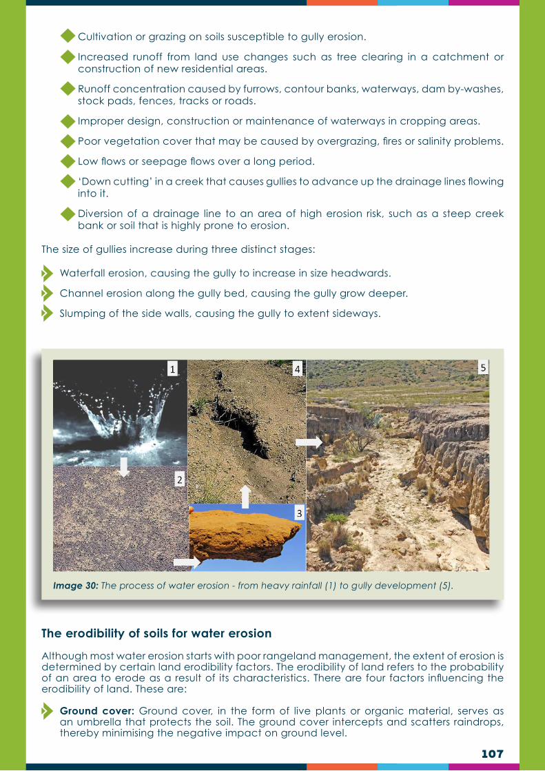
107
Cultivation or grazing on soils susceptible to gully erosion.
Increased runoff from land use changes such as tree clearing in a catchment or construction of new residential areas.
Runoff concentration caused by furrows, contour banks, waterways, dam by-washes, stock pads, fences, tracks or roads.
Improper design, construction or maintenance of waterways in cropping areas.
Poor vegetation cover that may be caused by overgrazing, fires or salinity problems.
Low flows or seepage flows over a long period.
‘Down cutting’ in a creek that causes gullies to advance up the drainage lines flowing into it.
Diversion of a drainage line to an area of high erosion risk, such as a steep creek bank or soil that is highly prone to erosion.
The size of gullies increase during three distinct stages:
Waterfall erosion, causing the gully to increase in size headwards.
Channel erosion along the gully bed, causing the gully grow deeper.
Slumping of the side walls, causing the gully to extent sideways.
Image 30: The process of water erosion - from heavy rainfall (1) to gully development (5).
The erodibility of soils for water erosion
Although most water erosion starts with poor rangeland management, the extent of erosion is determined by certain land erodibility factors. The erodibility of land refers to the probability of an area to erode as a result of its characteristics. There are four factors influencing the erodibility of land. These are:
Ground cover: Ground cover, in the form of live plants or organic material, serves as an umbrella that protects the soil. The ground cover intercepts and scatters raindrops, thereby minimising the negative impact on ground level.
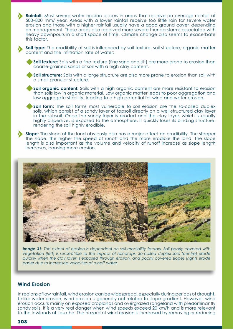
108
Rainfall: Most severe water erosion occurs in areas that receive an average rainfall of 500–800 mm/ year. Areas with a lower rainfall receive too little rain for severe water erosion and those with a higher rainfall usually have a good ground cover, depending on management. These areas also received more severe thunderstorms associated with heavy downpours in a short space of time. Climate change also seems to exacerbate this factor.
Soil type: The erodibility of soil is influenced by soil texture, soil structure, organic matter content and the infiltration rate of water:
Soil texture: Soils with a fine texture (fine sand and silt) are more prone to erosion than coarse-grained sands or soil with a high clay content.
Soil structure: Soils with a large structure are also more prone to erosion than soil with a small granular structure.
Soil organic content: Soils with a high organic content are more resistant to erosion than soils low in organic material. Low organic matter leads to poor aggregation and low aggregate stability, leading to a high potential for wind and water erosion.
Soil form: The soil forms most vulnerable to soil erosion are the so-called duplex soils, which consist of a sandy layer of topsoil directly on a well-structured clay layer in the subsoil. Once the sandy layer is eroded and the clay layer, which is usually highly dispersive, is exposed to the atmosphere, it quickly loses its binding structure, rendering the soil highly erodible.
Slope: The slope of the land obviously also has a major effect on erodibility. The steeper the slope, the higher the speed of runoff and the more erodible the land. The slope length is also important as the volume and velocity of runoff increase as slope length increases, causing more erosion.
Image 31: The extent of erosion is dependent on soil erodibility factors. Soil poorly covered with vegetation (left) is susceptible to the impact of raindrops. So-called duplex soils (centre) erode quickly when the clay layer is exposed through erosion, and poorly covered slopes (right) erode easier due to increased velocities of runoff water.
Wind Erosion
In regions of low rainfall, wind erosion can be widespread, especially during periods of drought. Unlike water erosion, wind erosion is generally not related to slope gradient. However, wind erosion occurs mainly on exposed croplands and overgrazed rangeland with predominantly sandy soils. It is a very real danger when wind speeds exceed 20 km/h and is more relevant to the lowlands of Lesotho. The hazard of wind erosion is increased by removing or reducing

109
the vegetation. When winds are strong, coarser particles are rolled or swept along on or near the soil surface, kicking finer particles into the air. The particles are deposited in places sheltered from the wind. When wind erosion is severe, the sand particles may drift back and forth locally with changes in wind direction while the silt and clay are carried away. Small areas from which the surface layer has blown away may be associated with areas of deposition in such an intricate pattern that the two cannot be identified separately on soil maps.
There are three types of wind erosion:
Suspension: Fine particles less than 0.1 mm in size are moved parallel to the surface and upward into the atmosphere by strong winds. The most spectacular of erosive processes, these particles can be carried high into the atmosphere, returning to earth only when the wind subsides or they are carried downward with precipitation. Suspended particles can travel hundreds of miles.
Saltation: Movement of particles by a series of short bounces along the surface of the ground, and dislodging additional particles with each impact. The bouncing particles ranging in size from 0.1 to 0.5 mm usually remain within 30 cm of the surface. Depending on conditions, this process accounts for 50 to 90% of the total movement of soil by wind.
Soil Creep: The rolling and sliding of larger soil particles along the ground surface. The movement of these particles is aided by the bouncing impacts of the saltating particles described above. Soil creep can move particles ranging from 0.5 to 1 mm in diameter, and accounts for 5 to 25% of total soil movement by wind.
Wind erosion can be controlled by using a grazing management system that ensures that as much vegetation as possible covers the ground. Croplands practices such as conservation agriculture (CA) and the establishment of perennial crops/pastures helps to protect the soil and prevent wind erosion.
Image 32: Wind erosion is a problem on exposed cropland and overgrazed rangeland with sandy soils.

110
Desertification forms part of the larger concept of climate change and refers to the process of severe long-term land degradation on a regional scale and its impact on macro and micro climate.
During this process, land degradation spirals downwards until the natural resources are almost completely exhausted. The removal of vegetation (e.g. through overgrazing, cultivation or collection of firewood), on a regional scale, alters the climate and reduces rainfall. This happens when a decrease in vegetation cover increases infrared radiation reflected back to the atmosphere (the so-called albedo effect), thereby reducing cloud formation. The albedo effect changes atmospheric circulation and external moisture fluxes, causing not only a lower, but also a more erratic, rainfall. The lowered cloud cover, and lack of ground cover, also increase soil surface temperatures. The more erratic rainfall also increases soil erosion, leaving the soil environment void of fertile topsoil. The combination of these “new” climatic and environmental conditions counter natural restoration processes, leaving it in new desert-like state.
Desertification
Image 33: Desertification happens when long-term poor management on a regional scale constantly removes vegetation cover, which influences the regional climate.
CASE STUDYStudies in Lesotho (Dejene et al., 2011) showed that a higher proportion of farmers in the mountains rate their soils as being highly erodible and currently highly eroded, compared to those in the lowlands. This is paradoxical to reality, since the lowlands are in a worse situation than the mountains, and suggests that lowland farmers are not fully aware of the crisis. This can be attributed to the nature of soil erosion in the lowlands

111
compared to the mountains. In the lowlands the soils are deeper to bed rock and loss of the fertile top soil is not often perceived by farmers. In contrast, the same loss of soil in the mountains leads to strip erosion leaving the bedrock exposed. Only half of those in the mountains are using soil erosion control methods (primarily diversion furrows, with some terracing). In the lowlands this figure is generally higher (furrows, terracing, contour ploughing and barriers). In both zones, one-third of farmers indicated that erosion control structures were not being maintained.
Soils in the mountains are perceived to be more fertile than those in the lowlands and a very low proportion of farming households (14%) add nutrients (manure) to their croplands (Dejene et al., 2011). By contrast, over 65% of farmers in the lowlands use manure or inorganic fertiliser. This misinformed perception is borne of the fact that initially the mountain soils are formed from parent material with higher base saturation and generally higher organic matter levels deriving from the original rangelands ecosystems. Unfortunately, over time, this myth has perpetuated the exploitation and mining of the nutrients and organic matter resulting in soil degradation, declining fertility and reduced yields. Furthermore, the mountain agriculture is increasingly encroaching onto steep slopes dominated by shallow entisols and /or inceptisols. However, a higher proportion of households in the mountains practice intercropping, usually with beans (which are nitrogen-fixing), in contrast with the lowlands where this practice is rare with exception of a minority of rural farmers practicing Machobane Farming systems and those using legume cover crops in conservation agriculture. Intercropping with N-fixing legumes is an effective natural fertiliser and should be further encouraged in both mountains and lowlands.
TRAINERS QUIZ TEST IF YOU HAVE UNDERSTOOD THIS SECTION
What three natural processes cause land degradation?
List five human-induced processes which cause land degradation.
What are the three main types of land degradation?
What is accelerated erosion?
Name the three forms that water erosion takes?
Describe in your own words how climate change and desertification are linked (clue: Albedo effect).
1.
3.
2.
4.
5.
6.

112
MODULE 3RANGELAND MANAGEMENT & GOVERNANCE IN LESOTHO
The practice of land, or ecological, restoration has become more and more a necessity as the global human population expands and the pressure on natural resources increases. Ecological restoration is necessary when degraded land cannot recover by itself and needs human intervention. Degradation, in other words, has progressed beyond the point of no return. Land restoration is the process of regaining ecological functionality of the land and enhancing human well-being.
Land restoration comprises three types of activities, each with its own objectives:
Ecological restoration: Through ecological restoration an attempt is made to return degraded land to a historical undisturbed state. Therefore, to restore degraded land fully, all species and ecological functions have to be reinstated or should be put on track towards such a goal. In many instances the level of degradation prevents fully ecological restoration.
Land rehabilitation: Land restoration is returning the land to its former use, while rehabilitation is required when the land is already degraded to such an extent that the original use is no longer possible and the land has become practically unproductive. Here longer-term, and often more costly investments, are needed to show any impact. Rehabilitation, like restoration, focuses on reinstating the historical landscape functions (e.g. infiltration of water, nutrient cycling, etc.) and productivity. However, rehabilitation does not attempt to re-establish historical plant species diversity, as in the case of restoration. Grass species chosen for rehabilitation projects are often productive pasture species and may even exceed the historical level of plant and animal production, but the species diversity may be low to very low.
Land reclamation: The term reclamation has an even broader application. The main objectives of reclamation include stabilisation of the terrain, assurance of public and livestock safety, visual aesthetic improvement and, within regional context, usually a return to what is considered to be land of a useful purpose.
Land restoration can only commence when the practices causing degradation in the first place are replaced by more sustainable practices. It has to be based on increased awareness of root causes of problems, as well as capacity to tackle them effectively, and should be informed by consultation done through the mobilisation phase. This calls for a major effort in implementing sustainable land management practices. Tools for reducing land degradation and restoring degraded land, are therefore based on better knowledge regarding trade-offs between production and environmental services at the landscape scale. Landscape approaches to restoration require a systematic understanding of the complexity of multi-functional landscapes and the roles of all actors in managing trade-offs. This looks at how to modify the way the land is used through influencing people’s behaviour on the landscape, their management of livestock on it, and the use of mechanical techniques to aid recovery of degraded areas to a more naturally functional state. Comprehensive land assessments yielding a set of biophysical and socio-economic conditions will assist to assess what optimal technologies or practices can farmers and other land users introduce to restore degraded land or prevent degradation.
Introduction
CHAPTER 9
RESTORATION OF ERODED AND DEGRADED LANDS
M3
A
B
C

113
Sheet erosion, also known as splash erosion, is the uniform removal of soil in thin layers by the forces of raindrops and overland flow. To rehabilitate an area degraded by sheet erosion, the causes of degradation first have to be removed and the factors limiting plant growth have to be dealt with. The following measures should be considered:
Use rotational grazing and graze degraded areas only during winter;
Reduce the number of animals in such areas; and
Do not place water, supplement feeding or salt licks near eroded areas.
Once the causes of initial sheet erosion have been removed, the growth-limiting factors can be tackled. The main factors that limit plant growth, caused by the hard crust and loss of soil, are dry soil, high soil temperatures, a poor seedbank, low soil organic content and poor aeration of the soil. Sheet erosion can thereafter be controlled by:
Maintaining plant cover (preventing splash erosion) and maximising infiltration of ponded water through the maintenance of soil structure and organic matter. Organic matter acts as a glue, stabilising pore spaces which transmit surface water deeper into the soil and thus reduce the volume of ponded water available for erosion.
Planting of a cover crop as a secondary crop grown to protect the soil against erosion and increase soil fertility while the main crop is growing. Cover crop should not be planted in large numbers, or else it may compete with the main crop; Cover crop should be quick growing and provide enough cover to the soil in a short delay; it should not remove large amounts of nutrients from the soil; preferably, a cover crop should be of some economic importance.
No till: Tilling now as then has a large number of negative impacts such as:
Compaction of soil below the depth of tillage (formation of a tillage pan);
Crusting of soil when soil pulverization is followed by rain, stimulating weed seed germination and inhibiting crop emergence;
Increased susceptibility to water and wind erosion associated with residue removal and soil loosening;
During rangeland management, all three activities described above may be applicable, for example:
Restoration would apply to the thinning of invader shrubs during initial stages of encroachment (where no topsoil loss occurs);
Rehabilitation would apply to the re-vegetation of areas affected by sheet erosion; and
Reclamation would apply to the stabilisation, filling and/or landscaping of dangerous gullies in eroded areas.
Rehabilitation of areas affected by sheet erosion
DID YOU KNOW?The SDG #15 Life on Land aims to conserve and restore the use of terrestrial ecosystems, combat desertification, stop and reverse land degradation, and halt biodiversity loss. In Lesotho, all strategies towards conservation and appropriate use of ecosystems are encapsulated in the Range Management Policy of 2014.
1
2
3

114
Accelerated decomposition of organic matter, which is undesirable from a long-term perspective;
Destruction of soil microbial life and soil nutrient cycling
Cost of equipment purchase and operation;
Energy cost of tillage operations;
Labour and temporal obligations; and
Alteration of the soil food-web, shifting populations away from larger, longer-lived organisms to smaller, shorter-lived organisms
Stonelines: Slowing down the speed of runoff water, thereby increasing infiltration of water, through stonelines. Stonelines are arranged along the contour to act as a barrier that slows down the speed of water and soil, improve infiltration, mitigate landslides and trap sediment and moisture, thereby enhancing vegetation growth.
The severity of sheet erosion may vary from site to site. Various techniques have been proposed to deal with sheet erosion, either individually or in combination. Techniques include:
Crust-breaking (or scarification): this refers to the breaking of the hard upper crust on the soil surface associated with bare ground. This technique intends to improve infiltration of rainwater, germination, aeration of the soil and general plant growth. Trampling animals that break the crust is nature’s way of restoration and has proven to be highly effective.
Image 34: Cattle overnight in a makeshift kraal for a week, erected on degraded land (left), where waste and nutrients are left behind (centre) for restoration purposes (right).
Image 35: Brush-packing can be highly effective in restoring degraded land and is often used in conjunction with bush control projects.
Brush-packing: With this method brush, obtained from shrubs or trees, is packed on bare land. To be most effective it should at least cover 70% of a bare area. The structure and placement of the brush should be such that most of it is at ground level. This ensures maximum infiltration of water and complete decomposition of the brush. Shrubs or trees with fine brush, such as acacias, work best.

115
Image 36: Water harvesting refers to the creation of small dams or basins with the purpose of collecting (‘harvesting’) rainwater during rainfall events.
Image 37: Silt traps are permeable structures, often using geo-textiles (above), rocks or Vetiver grass positioned on a contour to slow down the speed of runoff water and to collect sediment.
Water harvesting: Water is harvested by collecting rainwater when it rains. Water-harvesting techniques are used to ensure that the most precious resource, rainwater, is efficiently harnessed, particularly in dry regions. In terms of rangeland management, it mainly involves the construction of basins (hollows or small dams) to catch and collect runoff water. The harvested water in the basins is then intended to infiltrate into the soil, promoting and improving plant growth. To enhance restoration during water-harvesting, a mixture of the seed of adapted plants can be added to the basins. At the same time, manure can also be added to the basins, particularly if grazing pressure can be regulated to prevent animals from overgrazing such enriched spots.
Silt trapping, or contour lining: this refers to the construction of permeable barriers at intervals along the contour of areas affected by sheet erosion. The intention is to reduce erosion and promote growth of vegetation by slowing down runoff, promoting infiltration of water and collecting silt/sediment. Silt barriers, or silt fences, can be made by using any material sufficiently strong to withstand runoff during heavy downpours and durable enough to last until the required results have been obtained.

116
Reseeding: refers to the seeding of plants in rangeland where land degradation has led to a reduction in the seed of plants that can provide the cover necessary for restoration. For reseeding, a mixture of seed of plant species adapted to local conditions (soil, rainfall and temperature) is recommended. These plants should preferably include pioneer, sub-climax and climax species, depending on the current composition.
Image 38: Seeding of good grazing grass using a tractor and a ripper (tractor wheel method). The seed mixture is seeded behind the ripper and then compressed to the ground with the rear wheel when the tractor draws the next line.
Image 39: Seed of good grazing grass can be sown around feeding troughs so that animals can trample the seeds into the ground for good germination. The feeding troughs are moved to new, poorly covered areas on a weekly basis.
RESEEDING:The best time for reseeding is from the early to the middle of the growing season. A general seeding rate of 8–15 kg/ha (0.8–1.5 g/m2) can be followed. Brush-packing on the newly seeded areas helps to protect seedlings from grazers during early establishment. In general, it is vital that the restoration site then receives sufficient rest to allow the new plants to grow and produce seed.
Rills are small gullies or channels that may turn into fully developed gullies if not stabilised in time. To prevent rills from eroding further, the amount of runoff entering a rill should be decreased and the rate of runoff should be slowed down.
This can be done by promoting vegetation growth on bare areas further up in the catchment (see previous section) and by constructing small barriers (weirs) within the rills. Such barriers could consist of loose rocks, poles, small gabions, small concrete structures or even brush. As in the case of larger gullies, care should be taken to prevent undercutting and runoff passing the barrier on the sides. A small rill can easily be controlled with a few well-placed stones or brush to cover it.
Rehabilitation of rills

117
Gully (or donga) erosion, which is common in Lesotho, represents immensely high levels of soil loss. For all practical purposes, the damage is done and the soil lost cannot be recovered. Preventing gully erosion should therefore always be top priority. This is only done through good grazing and cropland management.
Vegetation is the primary, long term weapon in controlling gully erosion but structures may be needed to stabilise a gully head or to promote siltation and vegetative growth in the gully floor. Structures may be made of concrete, masonry, wood or other building material; however, they have an inherent risk of failure and may be undermined or bypassed. While structures may be subject to decay and become less effective over time, vegetation can multiply and thrive and improve over the years:
Vegetation provides protection against scouring and minimises the erosion risk by reducing flow velocity. As velocity falls, sediment is deposited forming an ideal environment for new vegetative growth. However, gullies can be a harsh environment in which to establish vegetation. They dry out very rapidly and usually have infertile subsoils.
An initial application of a mixed fertiliser aids in rapid establishment of an effective cover
Indigenous species should be considered, especially in an area where it is not desirable to introduce exotic species.
A number of exotic grasses and other species are well established in our agricultural lands and have been used with great success for controlling erosion.
Vegetation that grows vigorously with a spreading, creeping habit is preferred.
Obtain local advice to see if a proposed plant has a weed potential in a particular area.
Where sub-surface flows are contributing to gully erosion, trees in the area above the gully head should assist by helping to dry out the soil profile and provide structural support to sub-soils prone to slumping. Trees are desirable in the areas surrounding gullies but are not likely to be successful in stabilising an actively eroding gully head.
Rehabilitation of gullies
Image 40: A small rill can easily be controlled with a few well-placed stones.
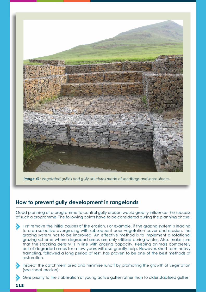
118
How to prevent gully development in rangelands
Good planning of a programme to control gully erosion would greatly influence the success of such a programme. The following points have to be considered during the planning phase:
First remove the initial causes of the erosion. For example, if the grazing system is leading to area-selective overgrazing with subsequent poor vegetation cover and erosion, the grazing system has to be improved. An effective method is to implement a rotational grazing scheme where degraded areas are only utilised during winter. Also, make sure that the stocking density is in line with grazing capacity. Keeping animals completely out of degraded areas for a few years will also greatly help. However, short term heavy trampling, followed a long period of rest, has proven to be one of the best methods of restoration.
Inspect the catchment area and minimise runoff by promoting the growth of vegetation (see sheet erosion).
Give priority to the stabilisation of young active gullies rather than to older stabilised gullies.
Image 41: Vegetated gullies and gully structures made of sandbags and loose stones.
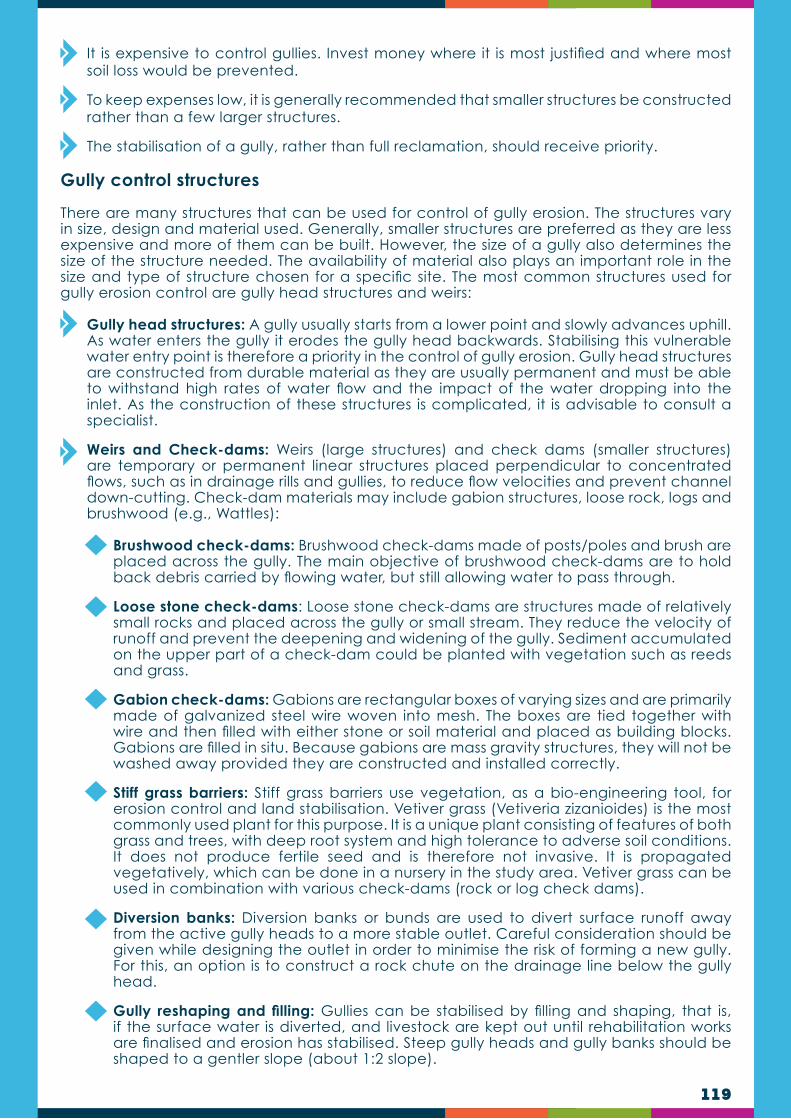
119
It is expensive to control gullies. Invest money where it is most justified and where most soil loss would be prevented.
To keep expenses low, it is generally recommended that smaller structures be constructed rather than a few larger structures.
The stabilisation of a gully, rather than full reclamation, should receive priority.
Gully control structures
There are many structures that can be used for control of gully erosion. The structures vary in size, design and material used. Generally, smaller structures are preferred as they are less expensive and more of them can be built. However, the size of a gully also determines the size of the structure needed. The availability of material also plays an important role in the size and type of structure chosen for a specific site. The most common structures used for gully erosion control are gully head structures and weirs:
Gully head structures: A gully usually starts from a lower point and slowly advances uphill. As water enters the gully it erodes the gully head backwards. Stabilising this vulnerable water entry point is therefore a priority in the control of gully erosion. Gully head structures are constructed from durable material as they are usually permanent and must be able to withstand high rates of water flow and the impact of the water dropping into the inlet. As the construction of these structures is complicated, it is advisable to consult a specialist.
Weirs and Check-dams: Weirs (large structures) and check dams (smaller structures) are temporary or permanent linear structures placed perpendicular to concentrated flows, such as in drainage rills and gullies, to reduce flow velocities and prevent channel down-cutting. Check-dam materials may include gabion structures, loose rock, logs and brushwood (e.g., Wattles):
Brushwood check-dams: Brushwood check-dams made of posts/poles and brush are placed across the gully. The main objective of brushwood check-dams are to hold back debris carried by flowing water, but still allowing water to pass through.
Loose stone check-dams: Loose stone check-dams are structures made of relatively small rocks and placed across the gully or small stream. They reduce the velocity of runoff and prevent the deepening and widening of the gully. Sediment accumulated on the upper part of a check-dam could be planted with vegetation such as reeds and grass.
Gabion check-dams: Gabions are rectangular boxes of varying sizes and are primarily made of galvanized steel wire woven into mesh. The boxes are tied together with wire and then filled with either stone or soil material and placed as building blocks. Gabions are filled in situ. Because gabions are mass gravity structures, they will not be washed away provided they are constructed and installed correctly.
Stiff grass barriers: Stiff grass barriers use vegetation, as a bio-engineering tool, for erosion control and land stabilisation. Vetiver grass (Vetiveria zizanioides) is the most commonly used plant for this purpose. It is a unique plant consisting of features of both grass and trees, with deep root system and high tolerance to adverse soil conditions. It does not produce fertile seed and is therefore not invasive. It is propagated vegetatively, which can be done in a nursery in the study area. Vetiver grass can be used in combination with various check-dams (rock or log check dams).
Diversion banks: Diversion banks or bunds are used to divert surface runoff away from the active gully heads to a more stable outlet. Careful consideration should be given while designing the outlet in order to minimise the risk of forming a new gully. For this, an option is to construct a rock chute on the drainage line below the gully head.
Gully reshaping and filling: Gullies can be stabilised by filling and shaping, that is, if the surface water is diverted, and livestock are kept out until rehabilitation works are finalised and erosion has stabilised. Steep gully heads and gully banks should be shaped to a gentler slope (about 1:2 slope).
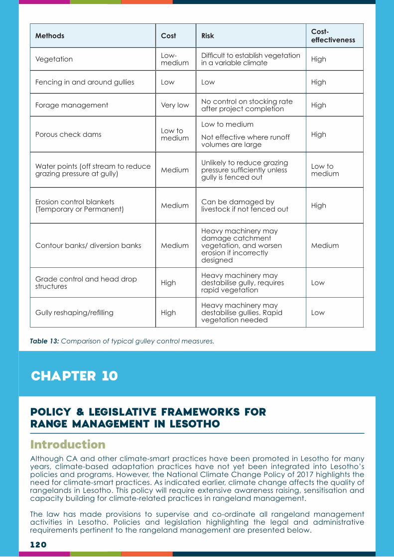
120
Methods Cost Risk Cost- effectiveness
Vegetation Low-medium
Difficult to establish vegetation in a variable climate High
Fencing in and around gullies Low Low High
Forage management Very low No control on stocking rate after project completion High
Porous check dams Low to medium
Low to medium
Not effective where runoff volumes are large
High
Water points (off stream to reduce grazing pressure at gully) Medium
Unlikely to reduce grazing pressure sufficiently unless gully is fenced out
Low to medium
Erosion control blankets (Temporary or Permanent) Medium Can be damaged by
livestock if not fenced out High
Contour banks/ diversion banks Medium
Heavy machinery may damage catchment vegetation, and worsen erosion if incorrectly designed
Medium
Grade control and head drop structures High
Heavy machinery may destabilise gully, requires rapid vegetation
Low
Gully reshaping/refilling HighHeavy machinery may destabilise gullies. Rapid vegetation needed
Low
Table 13: Comparison of typical gulley control measures.
CHAPTER 10
Although CA and other climate-smart practices have been promoted in Lesotho for many years, climate-based adaptation practices have not yet been integrated into Lesotho’s policies and programs. However, the National Climate Change Policy of 2017 highlights the need for climate-smart practices. As indicated earlier, climate change affects the quality of rangelands in Lesotho. This policy will require extensive awareness raising, sensitisation and capacity building for climate-related practices in rangeland management.
The law has made provisions to supervise and co-ordinate all rangeland management activities in Lesotho. Policies and legislation highlighting the legal and administrative requirements pertinent to the rangeland management are presented below.
Introduction
POLICY & LEGISLATIVE FRAMEWORKS FOR RANGE MANAGEMENT IN LESOTHO

121
Land Husbandry Act, 1969 (No. 22 of 1969)
An Act to control and improve, in respect of agricultural land, the use of land, soil conservation, water resources, irrigation and certain agricultural practices, and to provide for incidental or connected matters. The Act provides for soil conservation and livestock control. It harmonises soil conservation activities in agriculture, livestock management and proper management of water resources. The Act contains provisions on range management and grazing control for communities to manage range resources in a sustainable manner, guaranteeing equal access.
Land Husbandry (Amendment) Act (No. 19 of 1974)
An Act to amend the Land Husbandry Act 1969, hereinafter called the principal law. This Act amends the Land Husbandry Act 1969: in section 3 (2) (b) by deleting the words "of section 93 of the Constitution" and substituting the following therefor "of section 4 of the Land Act 1973"; in section 4 relative to consultation of local authorities by the Minister when making of Regulations in regard to a particular agricultural area; and by deleting section 5. Section 5 concerned consultation by the Minister when making Regulations.
Range Management and Grazing Control Regulations 1980 (No. 30 of 1980).
These Regulations, made under section 4 (1) of the Land Husbandry Act by the Minister of Agriculture and Marketing, provides for the protection of agricultural land. They provide, among other things, for setting aside of areas for the propagation of grass, reedbeds, tree planting or rotational grazing ("leboella"), restriction of grazing by local chiefs, rights of access to grazing areas, organisation of rotational grazing, regulation of total number of stock in the country, control of parasites.
Range Management and Grazing Control (Amendment) Regulations, 1986 (No. 144 of 1986)
These Regulations amend the Range Management and Grazing Control Regulations 1980 with respect to a wide variety of matters including: interpretations; grazing fees and penalties for grazing offences; organisation of rotational grazing; regulation of stock numbers; and inspection of stock by an Agricultural Officer. Definitions that are added by these Regulations include: “grazing season”, “carrying capacity” (e.g. the maximum stocking rate possible without damage to vegetation or related resources).
Range Management and Grazing Control (Amendment) Regulations, 1992 (No. 78 of 1992).
These Regulations amend the Range Management and Grazing Control Regulations 1980 by adding new definitions and with respect to grazing fees penalties for grazing offences. They also prohibit the cutting of grass on a communal grazing area. No person shall graze or cause his or her stock to graze on a communal grazing area unless (s)he has paid to the Village Development Council or Ward Development Council, as the case may be, the annual grazing fees set out in the third schedule and no grazing.
Legal Framework

122
Range Management and Grazing Control (Amendment) Regulations 1993 (No. 150 of 1992).
These Regulations amend the Range Management and Grazing Control Regulations 1980 with respect to grazing fees and penalties for grazing offences. They also concern fees in relation with organisation of rotational grazing and regulation of stock numbers.
Range Management and Grazing Control (Amendment) Regulations 1995 (No. 31 of 1995).
These Regulations amend the Range Management and Grazing Control Regulations 1980 in a provision which prescribes a penalty for trespass upon leboella. Section 6 stipulates that a person shall not, except in cases specially approved Trespass by the chief, graze his stock or any stock in his possession or upon leboella because such stock to be grazed in any area set aside by a chief as leboella.
Policy FrameworkBased on the policy issues, the key focus areas have been identified as follows:
Sustainable management of rangeland resources policy
Sustainable management of rangeland resources sets an ultimate objective of ensuring proper and systematic management of rangelands for optimum plant and animal productivity by putting into place mechanisms that allow for equitable access and participation of various stakeholders.
Development projects in Lesotho are expected to take sustainable management of rangeland resources considerations into account as described below:
Develop and facilitate implementation of grazing management plans, which promote livestock grazing system that recognises rest and rotation and variations of deferment of grazing areas and review and/or strengthen existing guidelines and regulations on grazing control management.
Strengthen and resuscitate existing Range Management Associations and where necessary, promote establishment of new structures and promote fodder production and storage for stall feeding programmes.
Restore degraded rangeland through ecologically sound methods by stakeholders including communities and herders and provide relevant information and education and also to integrate indigenous knowledge to the various levels of stakeholders on proper planning, management and implementation of rangeland resources management programmes.
Explore options and benefits for provision of environment services on the rangelands, and work with the ministry responsible for environment, advocate for resuscitation of The National Environment Council or to establish as appropriate an environment coordinating body for coordination and co-operation among relevant stakeholders including local authorities, private sector and other organisations that are engaged in environmental protection programmes.
123
Conservation of biodiversity and maintenance of ecosystem policy
Conservation of biodiversity and maintenance of ecosystem policy adopts a broad approach to conservation. It requires that a healthy and balanced ecosystem is maintained to sustain the biodiversity. Development projects in Lesotho are expected to:
Conserve biodiversity, provide information and educate communities, grazing associations, herders and other resource users on the importance and protection of rangeland ecosystems and implement the National Biodiversity Strategic and Action Plan targeted at conservation and protection of vulnerable ecosystems in liaison with the ministry responsible for environmental matters and other key stakeholders.
Promote establishment and capacity building of conservation groups at community level including youth, herders, traditional healers and other key resource users, and devise or identify and implement mechanisms that encourage mandatory compensation for utilisation of rangeland resources (environmental services/ecosystem services – PES). Uphold designation of hot spots for conservation and protection of threatened and endangered species and develop guidelines for economic and sustainable utilisation and harvesting of plant and animal species without compromising food chain and quality of biodiversity.
Promote establishment of community gardens through collection and propagation of seeds for threatened and endangered species, and support systematic reintroduction of lost valuable species of plants, birds and animals to appropriate habitats and regulate development of man-made ecosystems in the rangelands.
Work in unison with key stakeholders including the ministries responsible for rearing and registration of livestock to prohibit utilisation of rangeland resources by stock that are deemed unproductive, unsuitable and unregistered, and develop guidelines and procedures to be followed when developments/infrastructural works deemed destructive to rangeland resources for example mining and road construction are carried out on rangelands.
Rangelands monitoring and research policy
The policy covers rangeland monitoring and more research to inform strategies and decision-making processes. The policy may impose requirements on how the rangelands monitoring and research is to be carried out including but not limited to requirements regarding:
Monitor rangelands on regular basis and establish a reporting system to capture rangelands programme implementation from the district level and other key stakeholders and develop and disseminate information products on key strategies and implementation progress.
Develop a National Research Agenda to prioritise research on range resources and use it to mobilise required resources from the government and development partners; undertake periodic research and propose appropriate strategies on rangelands management, conservation and rehabilitation of ecosystem.
Promote collaborative research with local and international research partners, institutions and individual researchers and collaborate with institutions, research institutes and educational centres for training and educating specialized human force.
Mobilise and establish grant program to provide assistance to expand the professional education of range resources scientists; determine rangeland health status and recommend appropriate remedial measures until the rangeland has recovered.
Maintenance and protection of wetland areas policy
The policy includes information on the location, status, extent, characteristics and function of the wetlands needed to promote the understanding and conservation of this resource. This policy outlines requirements to formulate and disseminate information on the importance of wetland and wetland areas protection and maintenance, and develop guidelines on cattle-post adjudication for protection of wetlands, and includes:

124
The identification of degraded wetland and wetland areas, determination of appropriate reclamation activities, and develop guidelines on infrastructural developments on rangelands for wetland areas protection.
The promotion and declaration of major wetland catchments as protected areas and uphold coordination and collaboration on wetland areas management.
Socio-economic dimensions policy
The policy assists to understand and follow the requirements of socio-economic dimensions including the following:
Proper management and control for harvesting of rangeland resources to meet social, cultural and economic requirements is important for improvement of the livelihoods of the rural communities and without compromising the status of biodiversity.
Review and develop guidelines in consultation with other relevant stakeholders for harvesting rangeland resources by various resource users and review and promote local structures to be equipped with skills for effective management and control of rangelands resources exploitation.
Improve participatory grazing management planning and work in collaboration with relevant authorities to strengthen curriculum in tertiary institutions to integrate Climate Change and Range Science.
Provide technical support for enhanced productivity of rangeland resources in selected areas and exploitation for income generation purposes and promote opportunities for private sector institutions, non-governmental organisations and development partners’ involvement in the development and management of rangeland resources and mainstream gender and HIV and AIDS in planning and implementation of rangeland management programmes.
CHAPTER 11
Drought is a complex concept to define. This complexity creates ambiguity which in turn causes confusion and indecision, resulting in either inaction or ad hoc responses which do not fully consider the complex, long-term ecological and socio-economic interactions associated with water shortages. The politics of the phenomenon further influences to blur and distort public perceptions of drought by characterizing the consequences of drought as something exceptional, thereby portraying drought as a temporary, climatic aberration. Consequently, the occurrence of a serious drought brings about a number of emotive descriptions e.g. crop failures, land misuse, overpopulation, and rainfall record.
Introduction
DROUGHT ECOLOGY & MANAGEMENT
NOTE TO TRAINERS:The notion of perceiving drought as a disaster in policy circles means it is not taken seriously in planning once normalcy is resumed. However, drought is part of the climate variability and fluctuation should be considered as a recurring, albeit unpredictable, environmental feature which must be included in planning. It is exactly the muddled views and lagged responses toward drought which pose a threat to sustainable management of rangelands.
Drought must always be planned for.

125
Much of the confusion about drought is a consequence of the variable perspectives and differential definitions. The on-set and off-set of a drought are hard to recognize because it is a gradual phenomenon, the effects of which accumulate slowly as a dry period begins and may linger after expected rainfall patterns have resumed. There are four main foundations of defining drought:
Meteorological observations;
Agricultural problems;
Hydrological conditions; and
Socioeconomic considerations.
Perception of drought, therefore, depends on how the nuances of these four considerations are blended.
Meteorological Drought Perception
Most interpretations of drought are founded on meteorological elements as part of the definition. The Society of Range Management Glossary uses a meteorology cal-based definition of “prolonged dry weather, generally when precipitation is less than three-quarters of the average annual amount.”
This perspective uses the significance of negative deviation (decrease) from the climatologically-expected “normal” precipitation. However, such expectations vary with location and are often site-specific.
By international convention, a 30-year precipitation record is generally considered the basis for a calculation of “normal”. This practice does not make use of the entire historical precipitation record available for many locations; therefore it may not adequately reflect the long-term climatic record, especially in semi-arid regions prone to large inter-annual variation.
Agricultural Drought Perception
The popular perception of drought is in terms of when water deficits limit vegetation production, specifically arable crops. From an agricultural perspective, a drought occurs when low soil moisture causes extreme plant stress - leading to lowering of yield and in the rangelands, forage production. In the extreme, plants reach a permanent wilting point, resulting in crop failure. This definition is more complicated than simple considerations about the amount of precipitation because it integrates the timing and amount of precipitation with plant water demand (as can be influenced by high temperatures and wind), and available soil water (as can be influenced by the infiltration capacity, soil texture, and soil depth). These better reflect the considerations of agricultural drought by emphasizing the deficit between actual and expected weekly evapotranspiration (ET).
This rationale considers the amount of water in the topsoil as a critical element of drought calculation because of the interaction of water with root growth, nutrient supplies, and microorganism activity which occur in that zone. Drying of the topsoil layer, therefore, is considered an early indicator of yield loss.
Hydrologic Drought Perception
A hydrologic drought is defined as a period when surface and groundwater availability is inadequate to supply established uses. Therefore, this definition of drought focuses attention on the drying up of streams and rivers, depletion of water stored in surface reservoirs and lakes, lower than normal accumulation of snowpack in the mountains, and decline of ground water levels. This concept of drought is often used by regional planners who are concerned with amenities such as municipal and/or irrigation water supply, hydro-electric power generation, and recreational opportunities. This perspective may also be used by a rancher who identifies drought as when a particular pond or stream dries up.
Definition of Drought: Perceptive Differences
A
B
C
D

126
Socioeconomic Drought Perception
Not all water shortages are manifested in ways that impact people. A socio-economic perspective does not recognize drought until it tangibly affects people’s lives in terms of their behaviour and options (e.g., water rationing, increased prices, or lost recreational opportunities) or depressed earning power; in particular, reduced agricultural income. Such direct economic loss may affect the viability of the individual enterprise and, if severe enough, may trickle down and adversely affect other industries, thus increasing regional financial stress.
The foregoing drought perspectives-meteorological, agricultural, hydrologic, and socio-economic-are frequently out of phase with each other, leading to contradictory statements about drought incidence at a particular time and location. Differing definitions and perspectives result in confusion and make it difficult for people with diverse interests to agree about what a drought is; its’ on-set and off-set. For example:
Meteorologic drought is not directly tied to agricultural drought because other factors- such as temperature, wind, infiltration rate, soil moisture storage capability, and timing of rain relative to plant growth needs-are not accounted for in the definition of meteorologic drought, but do make a difference in the perception and consequences of agricultural drought.
The beginning and end of a hydrologic drought, especially when viewed in terms of large reservoir or aquifer management, tends to lag far behind meteorologic drought. Also, depending on the recharge system, hydrologic drought is less closely associated with total amount of precipitation than to episodic large events which generate significant runoff or deep drainage. Thus, a single high intensity thunderstorm may produce a flash-flood that fills reservoirs and exceeds the monthly precipitation average, but does little to alleviate a water shortage for terrestrial vegetation. Conversely, a series of light showers may result in lush plant growth, but not recharge streams and aquifers.
The socio-economic ripple-effects (secondary impacts) initiated by a water shortage make it very difficult for diverse stakeholders to agree about when the consequences of a drought have ended. For example, a water shortage that reduces crop and fodder growth may force farmers to sell their livestock. Once livestock are sold, it may take several years to build herds back to their original pre-drought level.
The socio-economic elements of drought are especially complicated because there is a human expectation element involved that may or may not be realistic. For example, the demand for water may be impossible to fulfil when national, district or sub-district economic development expands demand beyond typically available supplies. Thus, water availability during a dry period might not be recognized as drought in sparsely settled areas, but could result in serious water shortages if a large urban population were present. Likewise, a farmer who grazes large stock may experience the consequences of drought sooner and more frequently than one who grazes small-stock under similar rangeland conditions.
Drought Perspective Complications
THE DROUGHT PARADOXA common and widespread assertion by users of degraded rangeland is that droughts are more frequent and more severe than during previous generations. However, there is usually no discernible difference in the long-term trend of the amount and temporal distribution of precipitation and/or temperature.
How can these seemingly contradictory observations be reconciled? Despite lack of conclusive evidence that “meteorological” droughts are increasing, a history of unsustainable range use causes an increase in the frequency and consequences of drought defined from an “agriculture perspective”. The increase in “agricultural” drought is attributable to erosion, crusting, and/or degraded vegetation.
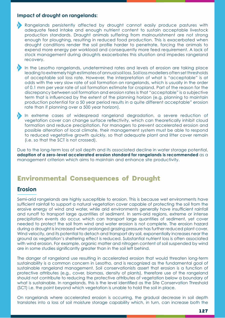
127
Semi-arid rangelands are highly susceptible to erosion. This is because wet environments have sufficient rainfall to support a natural vegetation cover capable of protecting the soil from the erosive energy of wind and water, while arid environments generally have insufficient rainfall and runoff to transport large quantities of sediment. In semi-arid regions, extreme or intense precipitation events do occur, which can transport large quantities of sediment, yet cover needed to protect the soil from wind and water erosion is not complete. The erosion hazard during a drought is increased when prolonged grazing pressure has further reduced plant cover. Wind velocity, and its potential to detach and transport dry soil, exponentially increases near the ground as vegetation’s sheltering effect is reduced. Substantial nutrient loss is often associated with wind erosion. For example, organic matter and nitrogen content of soil suspended by wind are in some studies significantly greater than in the soil left behind.
The danger of rangeland use resulting in accelerated erosion that would threaten long-term sustainability is a common concern in Lesotho, and is recognized as the fundamental goal of sustainable rangeland management. Soil conservationists assert that erosion is a function of protective attributes (e.g., cover, biomass, density of plants), therefore use of the rangeland should not contribute to reducing the protective attributes of vegetation below a boundary of what is sustainable. In rangelands, this is the level identified as the Site Conservation Threshold (SCT) i.e. the point beyond which vegetation is unable to hold the soil in place.
On rangelands where accelerated erosion is occurring, the gradual decrease in soil depth translates into a loss of soil moisture storage capability which, in turn, can increase both the
Environmental Consequences of Drought
Impact of drought on rangelands:
Rangelands persistently affected by drought cannot easily produce pastures with adequate feed intake and enough nutrient content to sustain acceptable livestock production standards. Draught animals suffering from malnourishment are not strong enough for ploughing, resulting in reduced food production. This is exacerbated when drought conditions render the soil profile harder to penetrate, forcing the animals to expend more energy per workload and consequently more feed requirement. A lack of stock management during droughts exacerbates this situation and impedes rangeland recovery.
In the Lesotho rangelands, undetermined rates and levels of erosion are taking place leading to extremely high estimates of annual soil loss. Soil loss modellers often set thresholds of acceptable soil loss rate. However, the interpretation of what is “acceptable” is at odds with the very slow rate of soil formation on rangelands, which is usually in the order of 0.1 mm per year rate of soil formation estimate for cropland. Part of the reason for the discrepancy between soil formation and erosion rates is that “acceptable” is a subjective term that is influenced by the extent of the planning horizon (e.g. planning to maintain production potential for a 50 year period results in a quite different acceptable” erosion rate than if planning over a 500 year horizon).
In extreme cases of widespread rangeland degradation, a severe reduction of vegetation cover can change surface reflectivity, which can theoretically inhibit cloud formation and reduce precipitation. For managers to prevent accelerated erosion and possible alteration of local climate, their management system must be able to respond to reduced vegetative growth quickly, so that adequate plant and litter cover remain (i.e. so that the SCT is not crossed).
Due to the long-term loss of soil depth and its associated decline in water storage potential, adoption of a zero-level accelerated erosion standard for rangelands is recommended as a management criterion which aims to maintain and enhance site productivity.
Erosion

128
frequency and length of periods without enough soil moisture for expected plant growth. As a site becomes increasingly vulnerable to agricultural drought, the difficulty in maintaining plant cover increases and the site becomes more vulnerable to accelerated erosion, which creates a spiral of decreasing production potential. In fact, one definition of desertification is the diminution or destruction of biological production potential, a characterization that is not specifically linked to precipitation. Therefore, even though precipitation patterns do not change, a site can lose production potential by losing soil which reduces the nutrients and moisture storage capability of the site.
Another problem associated with a site’s vegetation cover dropping below the SCT is that the exposed soil has an increased susceptibility to crusting. The energy of a single raindrop striking an exposed soil surface cause the particles to be detached and consequently likely to lodge in the remaining soil pores, making them smaller or sealing them completely by inducing formation of soil crusts. A “washed in” layer of clay particles that clogs soil pores and forms a crust may reduce infiltration rates significantly.
An increase in grazing intensity is sometimes advocated as a stop-gap measure intended to increase infiltration. Livestock trampling does break soil crusts and incorporate mulch and seeds into the soil; however, this prescription is not a solution since any increase in infiltration is short-lived because the raindrop impact quickly reseals the soil surface as the unstable soil pores become plugged. The potential for wind erosion also increases when the soil has been churned to dust. The only solution to crusted soils is to eventually accumulate enough cover so that rainfall energy is dissipated before it reaches the soil. Building back the cover may be a very slow process; like with many aspects of degradation, it is much easier to avoid getting into the problem than trying to fix it.
Many perceived agricultural droughts are related to forage shortages which should be recognized as carrying capacity crises caused by inappropriate stocking policies. Studies support the general conclusion that there are no significant differences in infiltration rates or soil loss between similar ungrazed and moderately grazed rangelands. However, heavy grazing results in reduced infiltration and accelerated erosion. The quandary is that moderate grazing rates are, in practice, calculated on the basis of expected production from a site. During an agricultural drought, the physiological needs of forage plants are not met and production rapidly declines. The result is that rangelands stocked at a moderate rate based on long-term experience may actually be heavily stocked based on physiological condition of plants during a dry period. Physiological stress may occur more quickly if the vegetation has low energy reserves as a result of having been subjected to intense grazing pressure prior to a dry period. The amount, vigour, and quality of vegetation is correlated with the condition of the range. Therefore, agricultural drought on sites in poor condition is likely to be manifest more frequently and more severely than on sites in good condition.
Crusting
Degradation of Vegetation

129
THE ROLE OF THE FARMER IN DROUGHT RESPONSEThe uncertainty (imperfect knowledge) regarding inherent climatic variability, market prices, and external financial considerations are inevitable for a farmer. Planning for drought must, therefore, focus on things that the manager can do to reduce risk (uncertain consequences) associated with climatic variability. Devising a management strategy that emphasizes minimising climatic and financial risk is a more sound approach to ranch management than attempting to maximize forage production and harvest efficiency. For example, ranches that employ intensive grazing systems geared to maximizing harvest efficiency often encounter a “feed-drought” sooner and more frequently than a ranch with lower harvest efficiency. Use of intensive grazing systems requires the rancher to promptly respond to deviations from expected forage supply.
Such an expectation is simply not realistic for many ranchers since they do not have the labour availability, the mind-set, or the ecological/financial expertise to implement this responsibility. Modern technology and financial structures provide many self-evident benefits in terms of increasing efficiency and flexibility of rangeland use. However, this flexibility can be misapplied to enable ranchers to delay making de-stocking decisions. For example:
The ability to procure loans for feed supplies can allow a rancher to retain livestock on the range past the point of rangeland carrying capacity.
Development of wells provides a secure water source, thereby the natural controlling factor of drinking water availability is de-coupled from forage availability.
Decisions intended to reduce short-term losses can actually raise the stakes by increasing long-term economic and ecological risks, including the possibility for catastrophic damage (i.e., bankruptcy from an economic perspective and irreversible degradation from an ecological perspective), if the hoped-for rain does not occur.
It is thus vital that the rancher maintain the proper stocking rate for any given weather/forage condition to minimise the consequences of drought. If ranchers aggressively implement tactical decisions of substantial destocking they will have better long-term expected economic return, with less variance, than if they engage in hopeful inaction. This conclusion, based on an analysis of a sheep enterprise on the semi-arid rangelands, showed that a policy of aggressive destocking when rain begins to lag behind expectation would have been the most economically rewarding and sustainable course of action, given commodity price responses and using weather records of the past century. Other studies of arid zone beef cattle ranches concluded that if no government support was available during dry years, then a low-stocking strategy was favoured, but that availability of government support during drought made strategies with higher stocking more favourable.
It is the responsibility of the individual rancher to be aware of how much forage is available and to anticipate current and future animal (livestock and wildlife) demand. These tools provide the rancher with timely information to maintain a proper balance between forage production and animal demand, thus preventing damage to the range resource, limiting death losses of livestock due to consumption of poisonous plants and avoiding the full vulnerability associated with market crashes that frequently accompany droughts. Adoption of a grazing strategy that provides a cushion of “reserve forage” provides ranchers some flexibility in the speed and extent to which they must respond to drought. Another reason that lower stocking rates are usually more desirable than seeking to maximize harvest efficiency is to allow for the periodic use of fire necessary to control brush encroachment.

130
Managing drought is a vital part of rangeland management. Drought can cause substantial damage to the condition of the rangeland because plants are put under stress, available forage decreases and soil cover is greatly reduced. Timely decision-making is critical during times of drought. Appropriate planning for the inevitable drought increases the likelihood of the farming business and rangeland surviving in a reasonable condition.
Common drought management decisions have included reducing herd size and feeding harvested forage. Unfortunately, these methods have not alleviated the stress of long-term drought. According to climate forecasts, drought frequency and severity are expected to increase in coming years, posing greater challenges to livestock producers. As a result, livestock producers will have to rely on integrated and long-term management strategies. Matching animals to the environment is an effective drought management strategy. In reality though, the livestock industry has increasingly provided incentives for the selection of cattle that may not be the most suited to harsh rangeland environments. Therefore, it is important to weigh the pros and cons of animal traits, and understand how animals interact with the environment to develop integrated drought management plans.
Adaptive management can be used to manage complexity, such as how to match forage production variability across years and within portions of a grazing season, with animal demand through management flexibility. Adaptive management strategies should incorporate flexibility and feedback mechanisms informed by appropriate seasonal weather variables and monitoring metrics, to both increase resiliency of rangeland ecosystems and reduce risk for the ranching enterprise associated with drought.
For management flexibility, four strategies are often used by ranchers to deal with drought:
Predict it using weather and climate forecasting tools;
Track it;
Employ conservative stocking rates; and
Utilise inherent spatial variability.
Adaptive grazing management plans that seek to integrate drought prediction tools, conservative but flexible stocking, and existing and predicted spatial heterogeneity in forage quantity and quality can be incorporated into conservation practices where spatial heterogeneity in forage resources within and among allotments/pastures is often not explicitly monitored or considered when planning livestock movements.
Integrating these strategies can be accomplished through adaptive management where specific goals and objectives are set for individual ranching operations. Filtering the specific goals and objectives through the lens of weather/climatic variability assists ranchers in determining options for adaptive management strategies addressing drought. A suite of proactive strategies are currently being employed by ranchers, including: grass banking, conservative overall ranch stocking rate, incorporating yearling livestock to match forage availability with forage demand, and using seasonal outlook weather/climate predictions to adjust stocking rates.
The strategy of grass banking and intentionally resting pastures may have multiple objectives for vegetation, profitability of ranching operations, and wildlife habitat. What is novel here is the explicit incorporation of seasonal outlook weather/ climate predictions, rotation of year-long rest among pastures across years, and relevant monitoring metrics for each of the primary and secondary objectives, which provides key data for feedback, both within and between grazing seasons, to complete the loop in terms of adaptive decision making.
Drought Adaptive6 Management and Mitigation7
6 Section partly based on article published by: Derner J.D. and D. J. Augustine. 2016. Adaptive Management for Drought on Rangelands. Rangelands 38 (4):211—215.7 Section partly based on article published by: Scasta J.D. , D. L. Lalman, and L. Henderson. 2016. Drought Mitigation for Grazing Operations: Matching the Animal to the Environment. Rangelands 38 (4):204—210.

131
Managers should therefore, consider integrating the contemporary livestock selection strategies with conventional resource management strategies. For example, when forage quantity is predicted to be reduced by drought, adjusting stocking rates and resting pastures to maintain a forage reserve is prudent. When forage quality is predicted to be reduced by drought, it may be effective to provide a protein supplement to enhance DMI and forage digestibility to avoid performance losses. Furthermore, because drought can also cause a shift in diet composition towards greater selection of shrubs, an inventory of alternative forages is practical. Researchers also suggest adjusting stocking rates relative to precipitation in the current growth season, adopting more liquid livestock classes such as stocker cattle, and/or adopting more drought tolerant livestock species such as sheep or goats.
As drought escalates, stock water quantity and quality can deteriorate, especially in stock ponds. As water quantity is reduced, the concentration of faeces and urine in the remaining water source can increase proportionally and have a negative effect on animal performance. Thus, as drought escalates, ranchers should not only assess water quantity, but water quality as well.
WHAT TO CONSIDER IN DROUGHT MANAGEMENT:
The proactive reduction of animal numbers reduces the risk of land degradation and the need to sell animals later when prices are low. Keep only the most valuable animals. Use this opportunity to get rid of old animals and poor genetics, and that troublesome cow that always jumps the fence.
Always prevent overgrazing and apply good rangeland management in order to enter a drought under good rangeland conditions. The rangeland will therefore have a good resilience and recover more quickly after the drought.
Monitor rangeland condition so that you are aware of the state of health of the rangeland on your farm.
Use records (e.g. animal sales or rangeland monitoring) of previous drought events for planning purposes. If not available, consult other farmers in the region who may be able to help.
Supplement feed (roughage) is generally not recommended as it maintains animals on the land artificially, causing overgrazing of perennial grasses already under stress. Supplement feeding of animals may therefore lead to deterioration of the rangeland, reduce the overall carrying capacity and weaken the ability of the rangeland to recover after the drought.
Although expensive, the establishment of a drought resistant fodder crop such as fodder sorghum or fodder pearl millet (Babala) may greatly assist in allowing camps to rest. These fodder crops, which are extremely productive under optimal conditions, are utilised while the most severely affected camps are afforded a well-deserved rest after the drought is over.
Vegetation should be allowed to recover for some months before restocking after a drought.
132
CHAPTER 12
Grazing management is the process of controlling livestock in terms of the frequency and intensity of their grazing. In practice it entails planning, movement of animals and controlling the number of animals. Good grazing management is the most important aspect of rangeland management due to the fact that poor grazing management is the main cause of rangeland degradation. Good grazing management has the following objectives:
To maintain/improve forage production for livestock.
To restore poor rangeland and degraded areas.
To conserve watersheds and maintain/improve hydrological processes.
To optimise soil fertility and nutrient cycling.
To mitigate climate change through increased carbon capturing.
To mitigate climate change through reduced infrared radiation.
To meet economic requirements of farmers.
To ensure food security for rural and urban populations.
To conserve biodiversity and general rangeland health.
A grazing management plan is a conservation related plan for a demarcated grazing area, developed for a livestock farmer or community. It addresses rangeland resource concerns on land where grazing related activities or practices, is applied. A grazing management plan is best developed by a qualified person in collaboration with the land users. A grazing management plan will typically include the following aspects:
Identify current issues and the impact of current grazing management
Assess the current rangeland condition in terms of carrying capacity, erosion protection, wetland health, general biodiversity, etc.
Discuss and evaluate the current grazing management approach with stakeholders, focusing on concerns that are leading to production potential and environmental deterioration.
Identify improved grazing management options:
Identify various improved grazing management options to improve forage production and mitigate environmental concerns.
Identify constraints and costs associated with implementing improved grazing management options.
Develop an improved grazing management strategy:
Select the most promising improved grazing management options. These options should address maintaining or improving natural pastures and environmental issues and should cater for the whole year.
Develop an implementation timetable, from the initial stages to the eventual full implementation.
Introduction
Grazing management planning
GRAZING & BROWSING MANAGEMENT
A
B
C

133
Develop an improved grazing management evaluation process:
Recommend a process for monitoring and evaluating the effectiveness of the grazing management enhancements.
Make any adjustments to management, based on continual monitoring and evaluation.
D
The grazing system, as part of grazing management, is the particular system in which animals are controlled in terms of their frequency and intensity of grazing. The implementation of a good grazing system is of the utmost importance for sustainable livestock production. A good grazing system can be planned and designed, but incorrect implementation may lead to rangeland degradation. For example, a grazing area can be divided into three separated portions for rotational grazing by one herd of animals. If each portion is instead stocked with a smaller herd of animals, and continuous grazing is applied, it will likely lead to deterioration.
Grazing systems range from extensive, semi-intensive and intensive, and every level in between. This is determined by the amount of grazing portions/camps allocated to a herd of animals. The more grazing portions/camps, the more intensive the grazing system will be and the less selective animals will graze, and vice versa. This is due to the higher density (intensity) of animals per portion/camp when a high number of portions/camps are used during rotational grazing, and vice versa. Extensive systems have one large area (system 1) and very intensive systems many smaller portions (system 5), forcing animals to eat intensive (non-selective) (Fig. 23).
Grazing systems
Figure 23: Grazing systems varies from extensive to intensive, depending on how many portions are allocated per herd of animals.

134
Based on the above, there are two basic forms of grazing systems, namely:
Continuous grazing: refers to a system by which animals only graze in one area
Rotational grazing: animals are moved from one area to another. Rotational grazing in turn has two basic approaches, namely:
controlled selective rotational grazing and
non-selective rotational grazing.
These three grazing systems (continuous, controlled selective and non-selective rotational grazing) differ in various ways, each with its own advantages and disadvantages and conditions for application (see diagram). Let us look at these systems in more detail.
Continuous grazing, also known as selective grazing, is a system by which one or more groups of animals remain in one undivided grazing area for more than one year. Animals have free access to all areas and are not controlled (limited) in terms of their movement and choice of grazing. Many people argue that continuous grazing is not a grazing system and will ultimately lead to rangeland deterioration due to continuous selective grazing.
Continuous grazing
Advantages Disadvantages
Relatively low cost of supporting infrastructure (fences and drinking-water system) compared to that of rotational grazing systems.
Low management input in terms of planning, labour, movement of animals and record-keeping.
Low disturbance of animals (if animals do not overnight in a kraal).
At correct stocking rates, high performance per animal (animals can select palatable species over a large area).
Difficult to control area-selective grazing, which might lead to overgrazing of some parts and under-utilisation of others.
Difficult to control species-selective grazing, which might lead to overgrazing and a decrease of palatable grasses, particularly when overstocked.
Fodder banks cannot be saved for the dry season or for periods of drought.
No rest period can be applied to maintain vigour and ensure seed production of good forage plants.
Animals are often not seen for extended periods, leading to sick or weak animals not being noticed in time.
Footpaths to preferred areas may lead to erosion.

135
A continuous grazing system on a property could greatly benefit from having various water points spread throughout the grazing area, allowing animals to utilise more areas within the grazing area. Furthermore, to prevent overgrazing and to improve rangeland conditions, herders can be used to keep animals in one dense group and to move them throughout the grazing area in a planned herding routine. This will then be a form of rotational grazing and not continuous grazing.
WHAT IS PLANNED HERDING?Planned herding is the grouping together of livestock in a single herd. The herd is then moved through an unfenced grazing area according to a grazing plan, imitating a herd of migrating grazers. In this way, grasses are allowed the necessary rest period and the impact of the herd on the environment is used to restore degraded land.
Rotational grazing refers to any system by which a group of animals is moved to apply rangeland rest to an area that has been grazed. The group of animals is typically rotated among demarcated areas or camps, usually in a cycle, in order to apply the essential principle of rangeland rest. The overall aims of rotational grazing are:
To control the frequency at which demarcated grazing areas are utilised in order to maintain or improve the quality of forage, to maintain or improve growth vigour, to save fodder banks and to ensure seed production of good forage plants.
To control the intensity of grazing by controlling the number of animals, size of the grazing area and period of stay.
Rotational grazing has two main approaches, namely “controlled selective grazing (CSG)” and “non-selective grazing (NSG)”.
Controlled selective grazing (CSG)
This approach aims to stimulate and increase the number of palatable grasses (decreasers) through careful (controlled) grazing of these grasses. It further attempts to decrease the number of unpalatable grasses by allowing them to become moribund and lose condition. It uses medium stocking densities to apply selective grazing for a given period. This approach is also known as high-performance grazing (HPG) as individual animals benefit from the high quality grazing obtained from utilising mainly palatable grasses.
The main feature of controlled selective grazing is that animals are moved to a new grazing area when the palatable grasses, such as Red grass/Seboku (Themeda triandra) is grazed to about 50% of its biomass and before unpalatable grasses are grazed. In other words, the level of selective grazing is controlled by the manager to protect good forage plants. For this about four to eight demarcated areas or camps are needed.
During the dormant season, area or camps can be selected for grazing according to availability of forage. It is important to be flexible and to adapt to environmental conditions.
Rotational grazing systems

136
Advantages Disadvantages
Species composition can be improved by stimulating palatable grasses only and by allowing them to rest.
Areas can be set aside for dry periods (fodder banks).
Degree of defoliation can be controlled by moving animals at the appropriate time, thereby ensuring the vitality of good grazing grass species.
Animals are regularly inspected when they are moved from area to area, thereby ensuring that sick animals are noticed in time.
Excess growth can be cut for hay (if terrain allows).
High production per animal is achieved because animals only utilise high quality grazing.
Moderate level of management and planning skills required.
Increased labour inputs to move stock.
Non-selective grazing (NSG)
This approach aims to utilise as much forage as possible (non-selective) by minimising time and space for selecting only palatable species. This is achieved by using high to ultrahigh stocking densities and a high number of small grazing areas, or through high density herding. To maintain vitality and seed production, rest periods are typically long, often one growing season after a full year of on-and-off grazing. This approach is also known as high-utilisation grazing (HUG), high- (or ultrahigh-) density grazing or short-duration grazing. It is not only a grazing system but is also regarded as a rangeland restoration system.
Non-selective grazing has become very popular and is based on the historic migration and general movement of large herds of herbivores and its positive effect on the ecological environment (the so-called “herd effect”). This grazing approach was first recommended by botanist/ecologist John Acocks in 1966 in his article “Non-selective grazing as a means of rangeland reclamation”. It was further developed from the 1970s onwards by well-known ecologist Alan Savory, with his so-called Holistic Resource Management (HRM).

137
Advantages Disadvantages
Even, non-selective utilisation of rangeland. Utilising almost all grasses and consuming more biomass than usual.
Trampling effect of high animal concentrations breaks soil crusts, improves infiltration of water, improves aeration of the soil, increases germination, incorporates organic material and feeds soil organisms.
High concentrations of dung and urine improve nutritional status and biological health of the soil.
High production and vigour of grasses owing to moderate to high levels of grazing (low moribund level), followed by a long period of rest.
Low levels of moribund and therefore a decreased incidence of severe wildfires.
High animal production/ha possible.
High level of management and planning skills and application required.
Daily to even hourly involvement of labour.
High numbers of animals required for correct implementation, possibly with high initial cost.

138
WHAT IS STRIP GRAZING?
Strip grazing is a type of non-selective grazing where the movement of animals are managed in strips (corridors), or cells, by using electric fencing. The terms high or ultra-high density grazing also apply to this method. A high number of animals are “forced” into a small “cell” for a day, or even a few hours, after which they move to the next cell (see photo below). Most plant biomass is consumed, a high level of trampling occurs and a high concentration of dung and urine is left behind. Such an area will then typically rest for a complete growing season. The aim is to simulate historic migratory grazing patterns.
Block-design systems
With the block-design systems the whole grazing area is divided into two or three blocks of equal size. Each block is then alternately rested for a complete growing season, which is the main aim of block-design systems (also known as fodder bank systems). This complete growing season rest intends to allow the good grazing grasses to produce seed, to maintain vitality and to save a fodder bank for the following dry season.
The block/s that are not rested is then grazed using either continuous grazing (for rangeland in a good condition) or rotational grazing (for rangeland that needs to improve). Below are two illustrated examples, among many possible designs, of such systems.
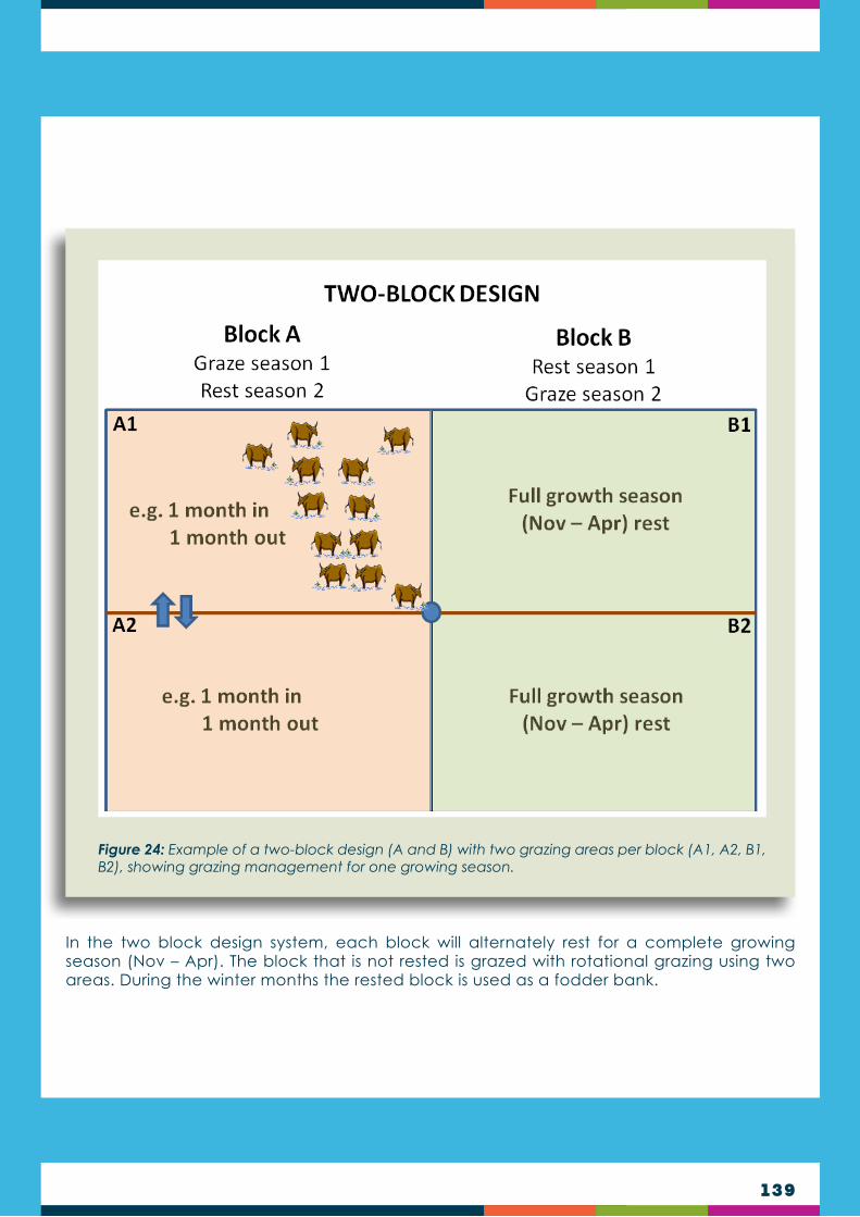
139
In the two block design system, each block will alternately rest for a complete growing season (Nov – Apr). The block that is not rested is grazed with rotational grazing using two areas. During the winter months the rested block is used as a fodder bank.
Figure 24: Example of a two-block design (A and B) with two grazing areas per block (A1, A2, B1, B2), showing grazing management for one growing season.

140
In a three block design system, each block will alternately rest for a complete growing season (Nov – Apr). The blocks that are not rested are grazed with rotational grazing using four areas. During the winter months the rested block is used as a fodder bank.
Figure 25: Example of a three-block design (A, B and C) with two grazing areas per block (A1, A2, B1, B2, C1 and C2), showing grazing management for one growing season (where block C rests).

141
THE IMPORTANCE OF INDIGENOUS KNOWLEDGE IN RANGELAND MANAGEMENT: MABOELLA
Maboella is the name given to the system of ecosystem governance used by the Basotho in order to ensure the security of their food crops, livestock and other ecosystem services and natural resources. It is based on a village layout that allows the system to function in harmony with the topography. It is further based on traditional governance structures, involving a main chief, who oversees area chiefs, who oversee local chiefs. The area chiefs are generally those responsible for grazing rights because their responsibilities extend over larger areas, and they are assisted and advised by grazing supervisors who also double as enforcers should agreements be breached.
In each season, the supervisors and the area chief will survey the entire crop and rangeland area, before allocating grazing or other land use areas. This permits an accurate assessment of the veld condition to enable resting of pressurised areas, and other resources that may be required (such as thatching grass) can be placed off-limits to grazing animals. These boundaries are communicated to land users through meetings and/or announcements.
The valley bottoms, which generally have deeper and more fertile soils, are traditionally used for planted crops. They are within line of sight of the village which is on the foothill slopes, and this allows constant monitoring for pests, animal invasion, etc. Livestock are not permitted to graze here until after the harvest, at which point the croplands become winter fodder areas for livestock to use crop residue in cold weather (unless a resident has specifically asked to use the residue for another purpose). If thatching grass was growing on these lower areas, the grass might be officially “protected” by the area chief. Breach of the croplands by animals would result in fines, or sometimes impounding of animals depending on the area that was affected.
Livestock rangeland areas are designated on the higher slopes above the village. The animals thus graze the higher quantity sourveld grasses during summer, and may be excluded from specified areas of thatching grass or stressed veld. Young boys typically were responsible for herding the animals, and schools were aware that boys from a family would take turns to attend school on alternating days of the week, for example.
The highest slopes were designated for cultural purposes, typically initiation schools and muti harvesting. The traditional healers reported to the main chief rather than areas chiefs. Effectively, this limitation on use of the highest slopes allowed the watersheds to be protected and restricted access to specified numbers of people (MaSissi Matla, personal communication).
Holistic planned grazing is one of a number of newer grazing management systems that aim to more closely simulate the behaviour of natural herds of wildlife and have been shown to improve riparian habitats and water quality over systems that often led to land degradation, and be an effective tool to improve range condition for both livestock and wildlife.
Holistic planned grazing is similar to rotational grazing but differs in that it more explicitly recognises and provides a framework for adapting to the four basic ecosystem processes: the water cycle, the mineral cycle including the carbon cycle; energy flow; and community dynamics (the relationship between organisms in an ecosystem), giving equal importance to livestock production and social welfare. Holistic management has been likened to “a permaculture” approach to rangeland management. This because, while livestock managers
Holistic management
142
had found that rotational grazing systems can work for livestock management purposes, scientific experiments demonstrated it does not necessarily improve ecological issues such as desertification. A more comprehensive framework for the management of grassland systems - an adaptive, holistic management plan - was developed, where livestock are substituted for natural herds to provide important ecosystem services like nutrient cycling.
Holistic management planned grazing has four key principles that take advantage of the symbiotic relationship between large herds of grazing animals, their predators and the grasslands that support them:
Nature functions as a holistic community with a mutualistic relationship between people, animals and the land. If you remove or change the behaviour of any keystone species like the large grazing herds, you have an unexpected and wide-ranging negative impact on other areas of the environment.
It is crucial that any agricultural planning system must be flexible enough to adapt to nature’s complexity, since all environments are different and have constantly changing local conditions.
Animal husbandry using domestic species can be used as a substitute for lost keystone species. Thus when managed properly in a way that mimics nature, agriculture can heal the land and even benefit wildlife, while at the same time benefiting people.
Time and timing is the most important factor when planning land use. Not only is it crucial to understand how long to use the land for agriculture and how long to rest, it is equally important to understand exactly when and where the land is ready for that use and rest.
(Savory Institute, 2018)
1
2
3
4
CHAPTER 13
In high rainfall grassland, such as in Lesotho, burning is a necessity to maintain ecosystem health, particularly where low levels of grazing are maintained. Burning is a requirement in rangelands for two basic reasons:
to remove old accumulated organic material (mulch or moribund); and
to prevent bush encroachment.
Studies have shown that areas most prone to lightning strikes are also the areas containing plants and animals best adapted to fire. Such areas, in fact, need fire to maintain healthy local plant species diversity. The right time to burn is probably as close as possible to the first seasonal rains. A range that has been burnt should rest for the first 6-12 weeks of grass regrowth or until the grass has regrown to a height of at least 100 mm.
Although prescribed burning and grazing intensity rangeland management tools have comparatively low potential increases in forage production and plant species diversity potential benefits, they are not labour intensive and are widely applied, cost-effective approaches that can be used to reverse or decelerate rangeland deterioration. Prescribed burning (or controlled burning) is the use of fire under specific conditions to achieve desired goals and has the potential to manipulate rangeland vegetation to favour optimum forage and animal productivity.
Introduction
FIRE ECOLOGY & MANAGEMENT
1
2

143
Before man discovered fire, rangeland fires were mainly ignited by lightning in the early rainy reason when fuel loads were still dry enough to burn. During such early rainy season fire events, the fires were relatively ‘cool’ because of relatively high humidity and some green foliage among the fuel. Rangeland fires were probably also not very extensive as lightning is often followed by rain. It is likely that the appearance of anthropogenic fires substantially increased the frequency and intensity of rangeland fires as burning started to occur more regularly and at times when conditions were favourable for intense fire.
Despite the significance of prescribed burning in the development of rangelands, negative attitudes towards burning have frequently limited its application as a rangeland improvement tool, and it is not recommended in Lesotho. On the other hand, a lot of information is known about the effects of fire on savanna rangelands and its value as a management tool, but the information necessary to conduct specific prescribed burns is generally disjointed.
It is widely accepted that most grasslands are fire-adapted formations and that fire is a strong selective force in the evolution of the flora; however, the influence of different fire regimes and behavioural patterns should provide information that improves understanding of both rangelands ecosystems and its possible management. This chapter outlines the importance and limitations of prescribed burning, significance of fire regimes, effects of fire and possible ways of preventing breakaway fires in rangelands commons. The chapter also seeks to fill a gap in the understanding of fire ecology and wisdom, or lack thereof, in utilising prescribed burning as a rangeland improvement tool.
Fire is an extensively used management technique to simultaneously achieve several objectives in rangelands. The prevailing view among scientists, progressive livestock farmers and wildlife managers on the permissible reasons for burning rangelands is that:
It can be used to remove unacceptable plant material (top-hamper and/or moribund material), improving access to new growth and facilitates the introduction of exotic species, and
Eradicate and/or prevent the encroachment of undesirable plant species.
These perhaps are the fundamental reasons for burning the rangeland.
In addition, plant productivity can be influenced by use of fire to favour desirable plants or to reduce the abundance of unpalatable species. Fire can also be used to attract animals to ungrazed areas and improve grazing distribution. Livestock have a tendency to select and graze fresh plant material from burned treatments compared to the unburned ones. Fresh green shoots of new growth on burned rangelands are palatable and high in crude protein.
Furthermore, rangeland burning can control pests and parasite infestation (by burning and killing of nymphs and adult stages of insects) and disease vectors in the dry season. There are mixed results in the literature with some studies showing that prescribed burning reduces fire hazards or accidental fires, which could destroy buildings, wildlife and protected pastures, while other attest to little or no evidence that prescribed burning has effect on the
The Importance of Prescribed Burning
DID YOU KNOW?If top-hamper builds up over several years it can seriously reduce grass tufts. Animals do not graze, or only graze very little old grass, so it has a low forage value and reduces animal performance.

144
occurrence of destructive wildfires. Nonetheless, use of fire to improve rangeland habitats for livestock and wildlife may provide an economical and ecologically sound alternative to present rangeland management methods, hence a need to validate and provide more evidence of the benefits of prescribed burning to rangeland and animal productivity.
MALPRACTICE OF FIRE REGIMES
Fire is sometimes used to stimulate out-of-season growth as shown by burning of vleis in winter to give an early winter flush. This is also often practised in summer and late autumn to provide green grazing for livestock. However, this is malpractice, leading to rangeland deterioration. While green flush may produce a green bite for livestock in the dry season, growth does not last long. The valuable root reserves are depleted, affecting growth vigour in the following dry season, and there is general damage to grass plants. Early winter burns leave the soil exposed to insolation and erosion throughout the winter period, leading to compaction and erosion with the coming of the rains.
Prescribed burning is the deliberate ignition of vegetation, under specific environmental conditions (fire regime), and subsequent control of fire spread, to achieve a desired management objective. Prescribed burning is recognised as an important rangeland management tool, particularly in regions of high rainfall.
The objectives of prescribed burning include the removal of unpalatable accumulated grass residue (called moribund), the control of unwanted plants, reducing a fire hazard and maintaining diversity (or preventing extinction of fire-adapted plant species). The two main objectives of prescribed burning in rangeland management are:
Improvement of grazing value - This is where rangeland with abundant moribund, or rangeland dominated by unpalatable grasses such as thatching grasses, is burned. The goal is to improve the nutritional status and vigour of natural pastures through burning.
Control of undesirable plants - This is where rangeland in the initial stages of densification of undesirable plants, such as invasive shrubs, is burned. It also includes follow-up burning of areas where bush encroachment control, through chemical or mechanical control, has been applied.
Due to inappropriate fire regimes and inability to control fires, fires can often end up doing more harm than good:
Fire can burn off all standing grass cover - both the moribund material and the recent growth.
As grass provides feed base for the livestock industry, removal through burning can represent a major loss of forage if fires breakaway.
In addition to the value of lost grazing, there is the value of associated losses of hay, fence posts, buildings, wildlife and human life.
Inappropriate use of fire on rangelands leads to accelerated erosion and loss of soil nutrients, loss of forage and adverse changes in species composition, increased wood weeds and undesirable herbs, and consequently decreased animal performance.
Prescribed Burning
Limitations of Prescribed Burning

145
Fire regime describes the general pattern in which fires naturally occur in a particular ecosystem over an extended period of time and is usually defined by a combination of intensity, frequency, season and type of fires that prevail in a given area. Plant species are adapted to a particular fire regime, so that altering the regime will change the relative abundance of species and is linked to changes in rangeland health and vitality, regeneration patterns, weed invasion and occurrence of pests and diseases. This hypothesis forms the basis for most prescribed burning.
Fire intensity refers to the rate of heat release during a fire, measured in kilojoules per second per metre (kJ/s/m), and determines the severity of fire in terms of vegetation recovery. The fire intensity, including the moving speed of the fire, is greatly affected by the following factors:
Wind speed - The higher the wind speed, the faster the fire burns. This is due to the additional supply of oxygen and the ‘bending’ of flames, which preheat the fuel in front.
Quantity of fuel - The more fuel, such as dry grass, the higher the intensity of the fire, and vice versa.
Humidity - The drier the air, the drier the fuel. Dry fuel burns more intensely than fuel that contains moisture.
Air temperature - The higher the air temperature, the higher the intensity of the fire. This is due to the preheating of fuel as well as the influence on humidity. In general, the higher the temperature, the lower the humidity.
Slope - Fires burning up-slope are more intense (faster) than those burning downslope. This is due to the preheating of fuel further up the slope.
Fire, at a wider scale, can significantly increase emission of greenhouse gasses such as carbon dioxide, methane and nitrous oxide, which entrap incoming solar energy and thus enhance the process of atmospheric warming.
Short-term exposure to smoke can cause debilitating health effects to humans with respiratory conditions such as asthma, emphysema, or cardiovascular diseases.
Fire has direct and indirect effects on soils, vegetation and animals. Limited research has been conducted on the long-term effects of burning on soil, forage and animal attributes of the savanna rangelands, especially during the early rain season when prescribed burning would be recommended. Most data that is available on Southern African savanna rangelands following a fire is short-term because generally long term trials are expensive and difficult to manage over long periods. However, long-term fire studies help to buffer effects of periodic or short-term impacts. They provide valuable information on the functional processes affecting vegetation and ecological trends over time. Therefore, international and inter-institutional collaborative and participatory long term fire trials should be set to continuously investigate the effects of fire on soil, plant and animal attributes on savanna rangelands in Southern Africa.
Environmental consequences of rangeland fires depend on the environmental context and conditions of application. Of all the possible ecological impacts, fire is the most dramatic. It has both a short- and a long-term effect on the rangeland. The short-term effect is best noticed in the conditions for plant growth directly after a fire event, while the long-term consequences become visible in the general plant species composition and vegetation structure as time progresses. Both these factors are greatly affected by the so-called fire regime and after burning management. In general, rangeland in a healthy condition can endure the impact of fire better than rangeland in a poor condition. In order to minimise these harmful effects of fire on the savanna rangelands the knowledge of fire regimes is important.
Fire Regimes
Fire Intensity

146
Fire intensities range from 100-4000 KJ/s/m in wet savannas although higher ranges of 11000 - 17 500 kW m-1 have been reported. Fire intensity fall into three categories:
When burning to remove moribund and or unacceptable grass material, a cool or low intensity fire (< 1000 kJ/s/m at air temperature of < 20oC, wind speed is 5-15 km/h and relative humidity is > 50%) is recommended. Cool fire temperatures usually reach 300oC and its effects rarely go beyond 2 cm below ground level. Cool fires are practiced in the Hyparrhenia type of grassland and in other grasslands types, where the dominant grass species become coarse, unpalatable and extremely low in nutritive value.
When burning to control undesirable plants like encroaching bush, a high (hot and/or very hot) fire intensity of > 2000 kJ/s/m is necessary, achieved when the grass fuel load is > 4000 kg/ha, the air temperature is 25-30oC and the relative humidity is < 30%. Wind speed should not exceed 20 km/h. This will cause a significant top kill of stems and branches of bushes up to a height of 3 m. A hot fire moves rapidly and flame heights range from 1-3 m above the ground and 5 cm below the ground and temperatures can reach 600oC. In order to ensure adequate fuel load to obtain a hot killing burn, it is recommended that the area scheduled for burning be rested from grazing through the late summer and winter preceding the burn. Despite the importance of fire intensity as a key element of the fire regime, it is seldom measured or included in fire records.
Dormant perennial grasses are little affected by an increase in fire intensity. For this reason, fire can be used to maintain grassland in regions of high rainfall. Trees and shrubs, however, are much more affected by fire intensity, with an increase in top-kill as fire intensity increases. Most trees and shrubs are not completely killed by fire and usually re-grow from the base (called “coppicing”).
A
B
The frequency (interval between burns) of fires is determined by:
the availability of fuel,
suitable climate, and
an ignition event.
The best time to burn the rangelands to achieve the desired effect varies with objectives and can be based on the physiological stages of the area. When burning to remove moribund and/or unacceptable grass material the frequency of burning will depend upon the accumulation rate of excess grass litter. Field experience indicates that excess grass litter should not exceed 4000 kg/ha and therefore, the frequency of burning should be based on the rate at which the phytomass of this grass material accumulates. This approach has the advantage that the frequency of burning is related to the stocking rate of grazers and to the amount of rainfall the area receives. To prevent severe wildfire, the biomass build-up should be controlled through grazing or prescribed burning.
Based on the response of African savanna rangeland vegetation to the season (time of year) of burning, it is recommended that when burning to remove moribund and/or unacceptable grass material, fires should be preferably applied after the first spring rainfall (15-20 mm) when the grass is still dormant and the fire hazard is low. Fire intensity is lowest in summer fires, increases in autumn fires and is highest in winter fires. This is attributed to differences between the mean moisture content of grass fuels in winter and summer.
Winter burning (June to September) is mainly caused by humans, while lightning can additionally ignite fires during the early rainy season (October to December). The season of burning has the following influence on grass, shrubs and trees:
Frequency of Burning
Season of Burning

147
Fire type distinguishes between fires that burn in organic layers of the soil (ground fires), those burning in fuels contiguous with the ground (surface fires) and those burning in the canopies of trees (crown fires). True crown fires are rare in burning rangeland - surface fires are more common on savanna grasslands compared to crown fires and ground fires:
A surface fire burns grass and other smaller plants, as well as litter, at ground level. Surface fires are usually more desired in savanna burning than crown fires. Surface fires spread slowly and do not produce high intensity burning sufficient to ignite the wood exteriors of structures beyond about 3- 5 m.
A crown fire burns trees and shrubs from top to top, more or less independently of the surface fire. Crown fires tend to burn with much greater intensity, spread faster and may get out of control. Crown fires usually results in 100% tree mortality, a lot of smoke production, and are not as easily suppressed by normal firefighting techniques. The majority of crown fires generally burn in conjunction with surface fires. Fuel types with certain physical or chemical characteristics have been known to support crown fires independent of surface fires under extreme environmental conditions, usually including strong winds.
The type of fire is also affected by wind direction. A fire burning with the wind (or upslope), called a head fire, while a fire burning against the wind (or downslope) is called a backfire:
Head fires have greater flame height and therefore heat energy released at a higher level from the ground. Head fires cause least damage to the grass sward but can cause maximum damage to woody vegetation.
Backfires move more slowly, consequently with more energy release at ground level. Back fires therefore affect the growing tips of grasses much more than head fires, resulting in reduced re-growth. Although back fires are safer to conduct than head fires, they do more damage to the grass sward and are more difficult to keep burning in many fuel
Grass is generally little affected by fire while dormant. However, when grass is burned while actively growing, which is possible when some dry fuel is available, fire has a negative effect on the vitality of the grass plants. Some grasses are more sensitive to the season of burning than others. Themeda triandra, for example, will decrease when frequently burned while actively growing, and increase when frequently burned while fully dormant.
Shrubs and trees are affected in two ways: directly through their physiological stage, and indirectly through the intensity of the fire, as influenced by the season of burning. Shrubs and trees are most susceptible to fire if they are burned during the early growing season when reserve nutrients are pushed from the roots to the buds. Conversely, if shrubs and trees are burned during the dormant season (winter), fewer are killed and more coppicing will occur. During the hot, dry, windy season (September/October), fires are extremely intense because of dry fuel, high temperatures and strong winds. During this season trees and shrubs, and even tall trees, are susceptible because of the high intensity of fires.
If soil moisture is not adequate at the time of the fire or replaced soon after, areas that are subjected to prescribed fire may actually produce less forage than unburned. Soil moisture is a critical aspect of the fire prescription and should be carefully considered in conjunction with other elements of the fire plan. Conversely, when burning to control encroaching plants, fire should be applied before the first spring rains when the grass is dry and dormant. Early rain season burns in the savannas are often cool, whereas late dry season burns are more thorough, hotter and damaging. In this context a cool fire can be loosely defined as an early rain season fire, set before the fuel has completely dried out whilst a hot fire refers to fire set at the end of the dry season, when the grass cover is completely dry. Burning in semi-arid savanna rangelands or during summer in humid savannas is usually not recommended because of the risk of drying the soil and fuel conditions, excessive consumption of litter and surface soil organic matter, and damage to physiologically active plants.
Type of Fire
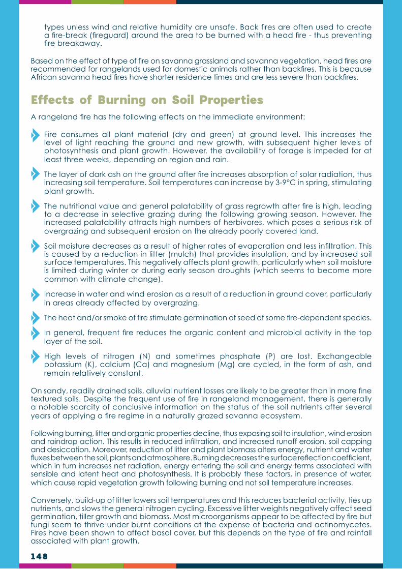
148
types unless wind and relative humidity are unsafe. Back fires are often used to create a fire-break (fireguard) around the area to be burned with a head fire - thus preventing fire breakaway.
Based on the effect of type of fire on savanna grassland and savanna vegetation, head fires are recommended for rangelands used for domestic animals rather than backfires. This is because African savanna head fires have shorter residence times and are less severe than backfires.
A rangeland fire has the following effects on the immediate environment:
Fire consumes all plant material (dry and green) at ground level. This increases the level of light reaching the ground and new growth, with subsequent higher levels of photosynthesis and plant growth. However, the availability of forage is impeded for at least three weeks, depending on region and rain.
The layer of dark ash on the ground after fire increases absorption of solar radiation, thus increasing soil temperature. Soil temperatures can increase by 3-9°C in spring, stimulating plant growth.
The nutritional value and general palatability of grass regrowth after fire is high, leading to a decrease in selective grazing during the following growing season. However, the increased palatability attracts high numbers of herbivores, which poses a serious risk of overgrazing and subsequent erosion on the already poorly covered land.
Soil moisture decreases as a result of higher rates of evaporation and less infiltration. This is caused by a reduction in litter (mulch) that provides insulation, and by increased soil surface temperatures. This negatively affects plant growth, particularly when soil moisture is limited during winter or during early season droughts (which seems to become more common with climate change).
Increase in water and wind erosion as a result of a reduction in ground cover, particularly in areas already affected by overgrazing.
The heat and/or smoke of fire stimulate germination of seed of some fire-dependent species.
In general, frequent fire reduces the organic content and microbial activity in the top layer of the soil.
High levels of nitrogen (N) and sometimes phosphate (P) are lost. Exchangeable potassium (K), calcium (Ca) and magnesium (Mg) are cycled, in the form of ash, and remain relatively constant.
On sandy, readily drained soils, alluvial nutrient losses are likely to be greater than in more fine textured soils. Despite the frequent use of fire in rangeland management, there is generally a notable scarcity of conclusive information on the status of the soil nutrients after several years of applying a fire regime in a naturally grazed savanna ecosystem.
Following burning, litter and organic properties decline, thus exposing soil to insulation, wind erosion and raindrop action. This results in reduced infiltration, and increased runoff erosion, soil capping and desiccation. Moreover, reduction of litter and plant biomass alters energy, nutrient and water fluxes between the soil, plants and atmosphere. Burning decreases the surface reflection coefficient, which in turn increases net radiation, energy entering the soil and energy terms associated with sensible and latent heat and photosynthesis. It is probably these factors, in presence of water, which cause rapid vegetation growth following burning and not soil temperature increases.
Conversely, build-up of litter lowers soil temperatures and this reduces bacterial activity, ties up nutrients, and slows the general nitrogen cycling. Excessive litter weights negatively affect seed germination, tiller growth and biomass. Most microorganisms appear to be affected by fire but fungi seem to thrive under burnt conditions at the expense of bacteria and actinomycetes. Fires have been shown to affect basal cover, but this depends on the type of fire and rainfall associated with plant growth.
Effects of Burning on Soil Properties

149
As in the case of other ecological disturbances, general botanical diversity is at its lowest under conditions of frequent burning and of no burning, with the highest diversity in between these two burning scenarios. However, in high rainfall regions, and in the rare case of absence of grazing, annual fire will result in a high botanical diversity, particularly of forb species.
Effects of Burning on Vegetation
Frequent rangeland fires in regions of high rainfall generally favour perennial grasses and forbs, which are well adapted to fire. In the absence of grazing, even annual burning in high-rainfall grassland does not have a negative effect on grass and forb species diversity. Short tufted perennial grasses are best adapted to frequent fire, particularly the good grazing grass Themeda triandra, well known for its tolerance to frequent fire, provided overgrazing does not occur after grazing.
Forb species in particular are well adapted to fire. Most forbs will be stimulated to flower more profusely after a fire. Particularly, short forbs depend on fire, and their diversity will decline in the absence of fire. Such species will flower and produce seed before grass biomass covers them, after which they wait for the next fire event. They may look small, but have large underground parts (bulbs, tubers and rhizomes) which enable them to withstand the impact of fire, even when all above ground parts are destroyed.
Larger herbaceous shrubs are less dependent on fire than the smaller forbs. Such shrubs, especially those containing essential oils, will burn profusely, but recover over time, particularly in degraded areas where there is a lack of grass competition.
Trees and woody shrubs are not as well adapted to fire as grasses and forbs. Most trees smaller than 2m will be ‘top-killed’ by fire, while those taller than 2m have a better chance of survival. Few trees are actually completely killed by fire, and most will freely coppice (regrow) again. However, frequent fires with sufficient fuel would ultimately result in a landscape with no trees, only grass and forbs. Such grassland is called fire-climax grassland and is in fact fire-derived and fire-maintained.
Fire has a greater suppression effect on woody species in regions of high rainfall than in arid regions. This is due to higher fuel loads enabling more frequent and more intense fires. In many grassland regions frost also plays an important role in stunting trees and shrubs, which are then more susceptible to fire damage.
Grasses and forbs
Trees and shrubs
FIRE AND INVASIVE SHRUB SPECIES IN LESOTHO
Several larger herbaceous shrubs are serious invaders in Lesotho. It is thought that poor grazing management in combination with frequent fire has led to their invasion. Invasive shrubs which are particularly tolerant to fire include Felicia filifolia (Sehalahala-seseholo) and Relhania dieterlenii (Hae, 2016).
Frequent fire in combination with rangeland rest can be used to control the density of invasive shrubs. Research has shown that Chrysocoma ciliata (Sehalahala), and possibly others, is controlled when enough grass biomass is present to generate an intensive fire to cause the needed shrub damage, and enough subsequent biomass is produced for annual or biannual follow-up fires (Portillo, 1991). Fire can also stimulate the seed of many forb species. One known example is another invasive shrub, namely Seriphium plumosum (Bankrupt bush) (Snyman, 2011).
150
Fire affects animals by changing plant palatability and availability, as well as indirectly altering water availability. Livestock prefer burned to unburned areas, and generally have greater weight gains on burned areas. This is attributed to increased forage protein content, palatability, digestibility, availability, and absence of litter in the plants following early rain season burning. It has been noted that best weight gains of 15-20 kg/ha/yr/head accrued 60-90 days following the fire, with no difference in weight gain between burned and unburned plots after that time. Research has shown that yearling or stocker animals can gain 10-12% more on late spring burned pastures than on either unburned or early burned pastures, and that these benefits are realised only during the year of burning.
There is a dearth of information relating livestock performance to the prescribed burning in the Southern African savanna rangelands. Prescribed burning is a potential tool to increase livestock production from savanna rangelands, but its utilisation by livestock must receive sufficient research consideration to ensure optimum benefits. It is essential to effectively and efficiently manage the rangeland after prescribed burning to prevent soil erosion, death of desirable forages and overgrazing.
Fire management is probably the most disputed rangeland management practice of all because wildfires, which are increasing as the population increases, can be devastating. Wildfires kill people, damage property, destroy crops and are expensive to control.
On the other hand, prescribed burning can be a useful rangeland management tool, particularly in regions of high rainfall. By burning rangeland in these regions, farmers substantially increase the nutritional value of natural pastures and the productivity of their properties. Fire management includes two aspects, namely controlling wild fires and using fire as a rangeland management tool during prescribed burning.
Effects of Burning on Animal Production
Fire management
Wildfires can be seen as fires ignited by lightning or fires started by humans without subsequent control. Such fires can be detrimental to range condition, particularly where rangeland is already in a poor or degraded state, and should therefore be prevented or controlled. An important factor in fighting wild fires is to be proactive by being always ready to fight a fire during the fire season. Important aspects in this regards include:
Take immediate action against wildfires when they occur, before they get out of hand.
Have trained people with protective clothing available.
Have fire-fighting equipment available.
Notify all neighbours when a fire occurs in the area.
Ensure that responsible people are present when the land-user is absent.
Wild fire control

151
Firebreaks
A firebreak is a barrier (constructed or natural) that is reasonably clear of flammable material and is used to stop a fire or serve as a control line from where to fight a fire.
The first step in preparing a firebreak is to remove all obstructions such as rocks, trees and shrubs from the firebreak strip. Then flammable plant material has to be removed before the dry season each year.
There are various ways in which such material can be removed or reduced. Common methods are burning, mowing (slashing), mechanical removal or chemical removal. These methods can also be used in combination, for example slashing first and then burning would reduce the intensity of a fire. Each method has its own advantages and disadvantages and their use is influenced by site conditions. Let us consider each method:
BurningBurning is inexpensive, quick and effective as it removes all flammable material for the entire upcoming burning season if applied at the right time of the year. However, preparation of a firebreak by fire is risky as the fire might escape, perhaps with severe consequences.
The permission or presence of neighbouring land-users might be needed for the use of fire for making a firebreak which should be arranged in advance.
To reduce this risk of a fire escaping during preparation of a firebreak, two main methods are employed – slashing and the use of chemicals. When slashing is used, the firebreak strip is slashed late in the growing season. The strip is then burned when the slashed grass is dry and the surrounding grass is still green.
Image 42: Examples of firefighting equipment. Firefighting clothing (top left), knapsack with pump-action nozzle (top centre), drip torch for staring back fire (top right), pickup truck with water tank and pump (bottom left) and tractor drawn water tank with pump (bottom right).
A

152
Fire and chemicals are also combined to make firebreaks in two ways. Firstly, a chemical is applied to the strip to kill the grass and other plants late in the growing season (e.g. March/April). The strip is burned once the fuel in the treated firebreak is dead, while the surrounding plants are still green.
The second combination of fire and chemicals involves spraying two narrow strips of chemicals, called tracers, on both sides along the firebreak with the firebreak in the middle. The tracer strips are then burned when the grasses (only aboveground parts) are dead and the rest of the rangeland is still green. The larger remaining strip in the middle is burned later when all grasses are dormant. This method is more cost effective than the first one as less chemicals are needed.
Mowing/slashingAll plant material in the firebreak strip is mowed or slashed down as low as possible late in the growing season or early in the dormant season. To prevent damage to the mower, all rocks, trees and shrubs are removed beforehand. The firebreak is then maintained void of trees and shrubs. The advantage of this method is good protection of the soil against water and wind erosion.
Mechanical removalThis is a method by which all plant material is mechanically removed from the firebreak. Commonly used are graders and disc ploughs. The method is quick and effective as it removes all flammable material. It is, however, very susceptible to erosion, even on a very slight slope. It is therefore only used on flat surfaces.
Chemical removalChemical removal of flammable material in a firebreak refers to a method by which either all plants are killed with a systemic herbicide, or only the aboveground parts are destroyed with a contact herbicide. A chemical with the active ingredient Paraquat (or similar), which only kills the above ground parts, is usually used.
B
C
D
Image 43: Examples of methods of creating fire breaks.
Management after burn is essential for obtaining desirable and sustainable livestock production levels. After burning, management depends on geographic locality and the nature of the resident vegetation among other factors. It is recommended that when burning to remove unacceptable grass material, grazing can commence as soon as the rangeland is recovered to a grazeable condition. Subsequent grazing distribution, stocking rate, graze periods and rest periods should be managed to obtain desired plant responses. When
Rangeland Management after Burning

153
burned areas are managed improperly, livestock often concentrate on and overgraze them because the forage regrowth is more palatable, nutritious and readily available than forage in unburned areas. The burned area should be rested after burning for at least the first 6-12 weeks to permit adequate grass growth to build root reserves, establish good basal cover, and to lay down litter against compaction and erosion. When burning to control undesirable plants post-fire grazing management will depend upon the ecological characteristics of encroaching plant in question. There is a continuing need to increase the understanding of the effects of post-fire rangeland management within the context of societal and ecological goals for communal rangelands in Africa.
Prescribed burns should be done safely so that they do not go beyond the planned fire lines. Although burning is site specific, there are various precautions which can be applied to reduce breakaway fires during prescribed burning in most savanna rangelands in Southern Africa:
An accurate local weather forecast is required to determine the fire hazard index before, during and after burning.
Ideally a prescribed burn to control top-hamper should be conducted at the beginning of the wet season soon after a good rain of 15-20 mm and when relative humidity is 40-60%, at average wind velocities of 5-15 km/h and air temperature should be between 15-25°C.
The most desirable time to initiate burning is in the late afternoon between 15h00 and 17h00 hours, as moisture levels rise and fires are less subject to thermal convection abnormalities, more easily controlled and generally have much less chance of getting out of hand through windborne sparks, thereby igniting areas not set to be burned.
When burning to control undesirable plants, grass fuel load should be > 4000 kg/ha and air temperature of 25-30°C, wind speed less than 20 km/h and relative humidity less than 30% is recommended. However, due to species variability in savanna rangelands it is difficult to approve optimum climatic conditions required to burn undesirable plants. In all cases burning should always be done on a manageable unit basis.
Before lighting a fire the neighbours, local authorities, police, department of natural resources and other stakeholders should be alerted and a permit should be acquired where necessary.
Moreover, the user should be an experienced professional with thorough knowledge of ecosystems, weather and fire behaviour.
Adequate labour should be available at a burn to ensure control of the fire at all times.
An emergency plan of action should always be formulated prior to any burn that is about to take place. There is need for good communication, especially radio communication, during the ignition phase when undertaking landscape-scale rangeland fires.
Control of Fire
TAKE AWAYFire has important beneficial effects on savanna flora and fauna, which are modified by fire regimes. Thus, rangeland managers can manipulate rangeland and animal productivity by using appropriate burning frequency and season and type of fire. The use of fire needs to be carefully planned in advance, and rest periods (where appropriate) need to be incorporated after its use. Prescribed burning must be integrated with other grazing management techniques to gain the full benefits. The current legislative frameworks and integrated policies on fire control should be adjusted and effectively enforced to promote the use of prescribed burning and minimise breakaway fires through the use of fireguards. Sharing information across tenures and nations is important; effective fire management practice and policy requires better awareness and understanding of techniques and issues among fire users and the broader community.
154
TAKE AWAYFire has important beneficial effects on savanna flora and fauna, which are modified by fire regimes. Thus, rangeland managers can manipulate rangeland and animal productivity by using appropriate burning frequency and season and type of fire. The use of fire needs to be carefully planned in advance, and rest periods (where appropriate) need to be incorporated after its use. Prescribed burning must be integrated with other grazing management techniques to gain the full benefits. The current legislative frameworks and integrated policies on fire control should be adjusted and effectively enforced to promote the use of prescribed burning and minimise breakaway fires through the use of fireguards. Sharing information across tenures and nations is important; effective fire management practice and policy requires better awareness and understanding of techniques and issues among fire users and the broader community.
Fireguards
The most important preliminary step in preventing breakaway fires is to have an adequate system of fireguards and suitable equipment. A fireguard (or firebreak) is defined as strip of land, whether under trees or not, which has been cleared of inflammable matter and serves as barrier to prevent or retard the spread of a fire. An adequate, planned system of fireguards should be developed on each grazing area to be burned. Ideally a fireguard should be able to stop a fire on its own accord when there is only a moderate wind blowing. It should also provide a front along which virtually any fire can be extinguished when the guard is suitably manned.
The manner of construction will depend on the availability of implements, and the type of terrain and vegetation. Fireguards can be set up by grading, ploughing, disking, slashing, mowing, hoeing or burning. Fire-fighting equipment that should be available before burning includes vehicles, tractors, pump units with hoses, knapsack sprayers and hand tools. Training of labour in the use of fire-fighting equipment is of great importance.
A fireguard should be at least 10-15 m on either side of the common boundary. Obviously the wider the fireguard the more effective it is, but there is a width above which the extra security does not warrant the extra expense. On the other hand there is a width below which a guard has little value. Naturally, the desired width will depend upon the nature of the vegetation, topography, the type of the rangeland to be protected and the type of fireguard. Fireguards should be strategically located along natural features where possible (bare rocks, stream banks, roads, railway lines, telephone and power lines, etc.) to be of greatest effect in the event of breakaway fires, as well as to reduce costs. They should be sited slightly obliquely to the prevailing wind directions, the chance of fires hitting fireguards on a broad front are reduced, hence making control easier. To effectively contain fires on any farm, fireguards should protect all farm boundaries. Fire breaks along fence lines around paddocks or group of paddocks aid prescribed burning of paddocks.
Despite the importance of fireguards, it should be noted that they only serve as a control measure in prescribed burning programmes. The first objection usually raised against fireguards is the expense involved in labour, fencing, fuel and in equipment required. However, when the cost of a fireguard construction is considered in relation to the area protected it is astoundingly low. Secondly, fireguards by their nature constitute an erosion hazard. However, by enabling prescribed burning, and rangelands to be protected from fire, fireguards can help bring about great improvements in the rangeland productivity and an increase in carrying capacity.
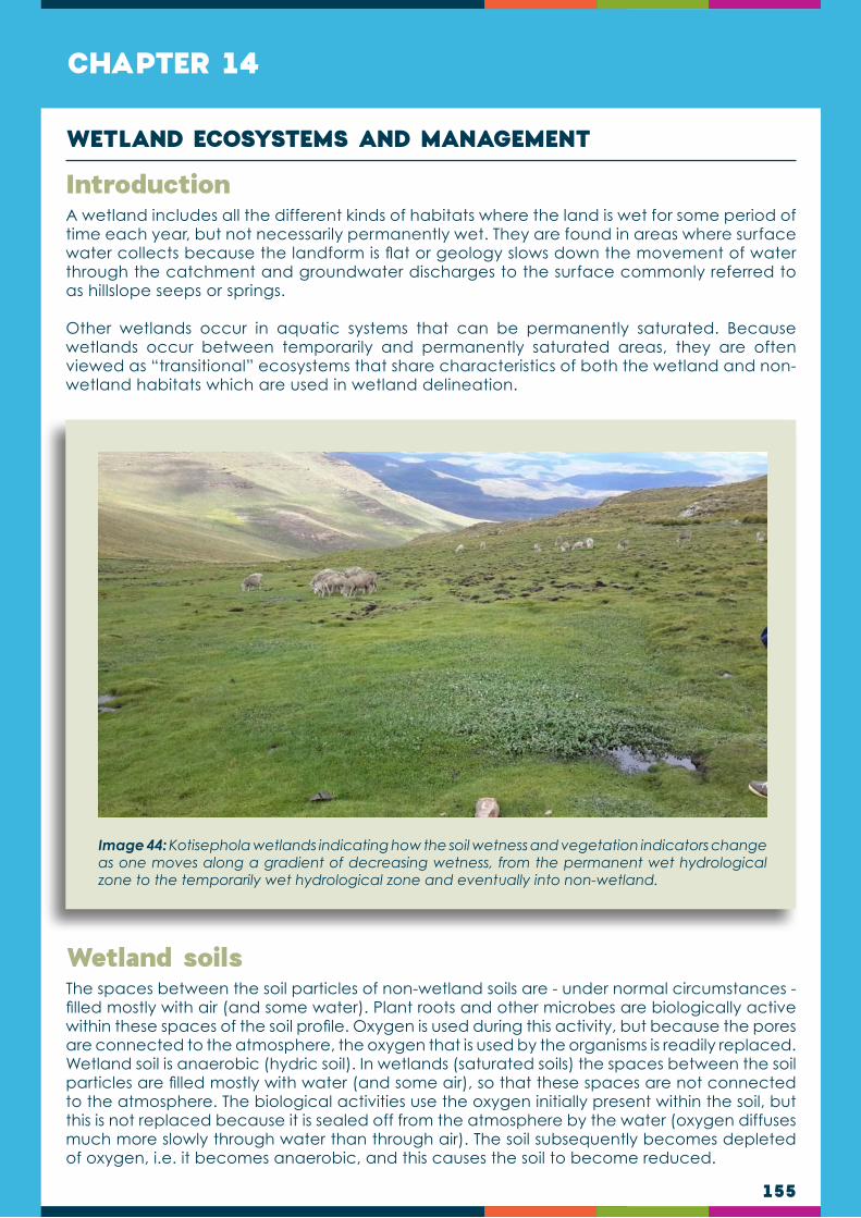
155
CHAPTER 14
A wetland includes all the different kinds of habitats where the land is wet for some period of time each year, but not necessarily permanently wet. They are found in areas where surface water collects because the landform is flat or geology slows down the movement of water through the catchment and groundwater discharges to the surface commonly referred to as hillslope seeps or springs.
Other wetlands occur in aquatic systems that can be permanently saturated. Because wetlands occur between temporarily and permanently saturated areas, they are often viewed as “transitional” ecosystems that share characteristics of both the wetland and non-wetland habitats which are used in wetland delineation.
The spaces between the soil particles of non-wetland soils are - under normal circumstances - filled mostly with air (and some water). Plant roots and other microbes are biologically active within these spaces of the soil profile. Oxygen is used during this activity, but because the pores are connected to the atmosphere, the oxygen that is used by the organisms is readily replaced. Wetland soil is anaerobic (hydric soil). In wetlands (saturated soils) the spaces between the soil particles are filled mostly with water (and some air), so that these spaces are not connected to the atmosphere. The biological activities use the oxygen initially present within the soil, but this is not replaced because it is sealed off from the atmosphere by the water (oxygen diffuses much more slowly through water than through air). The soil subsequently becomes depleted of oxygen, i.e. it becomes anaerobic, and this causes the soil to become reduced.
Introduction
Wetland soils
WETLAND ECOSYSTEMS AND MANAGEMENT
Image 44: Kotisephola wetlands indicating how the soil wetness and vegetation indicators change as one moves along a gradient of decreasing wetness, from the permanent wet hydrological zone to the temporarily wet hydrological zone and eventually into non-wetland.

156
Iron oxide minerals give the horizons red, brown, yellow, or orange colours, depending on which iron (Fe) minerals are present. Manganese (Mn) oxide minerals produce metallic black colours. The Fe and Mn oxides tend to coat the surfaces of sand, silt, and clay particles. Without the oxide “paint” on the surfaces, these soil particles are grey. The red, brown, yellow, and orange colours occur when Fe is in its oxidised state (Fe3+) and black colours also occur when Mn is in its oxidised state (Mn3+ or Mn4+). Where these elements are reduced, Fe and Mn oxide minerals they become colourless and also soluble, hence move within the soil to other soil horizons or may be leached from the soil hence the natural grey colour of the soil particles is exposed so that the colour of the soil changes to grey. In wetlands transitional ecosystem, both oxidised and reduced conditions happen, hence when oxidised conditions prevail again moved elements reappear as mottles (redox concentrations).
For an area to be considered a wetland, the colour of soil reflects signs of wetness within the upper 500 mm of the soil profile. These features indicate that the soil has been reduced in the past (redoximorphic features). In addition, they are used to delineate the wetland. They include:
Grey” colours of the soil when exposed to air, the colour of the soil changes as the Fe2+ is oxidised back to Fe3+ (reduced matrix). When using the Munsell colour book the colour of the soil has low chroma.
Grey colours with low chroma, but does not change when exposed to air because Fe and Mn have been stripped out (redox depletion).
Yellow/orange/red mottles due to accumulation of iron and manganese oxides when oxidised conditions prevail after soil has been reduced.
Fe-Mn concretions: Firm, to extremely firm, irregularly shaped bodies with diffuse boundaries.
Pore linings/oxidised rhizospheres are recognized as high chroma colours that follow the route of plants roots.
Green mottles/gleyed soils.
Wetland hydrology generally refers to the hydrological characteristics responsible for the existence and ecology of the wetland, which includes the source of the water (precipitation, surface water inflow and ground water inflow), the way in which the water moves through the wetland (surface flow and sub-surface flow), and also the way in which the water exits the wetland (evaporation, surface water outflow and groundwater outflow). It is described by:
Water transfer mechanisms
Water budget
Hydroperiod
Wetland hydrology
The water transfer mechanism is the way in which water can move into or out of a wetland. Water transfer mechanisms can be grouped as:
Precipitation
Evapotranspiration
Surface water inflow and outflow
Ground water inflow and outflow.
Water transfer mechanisms

157
There are three landscape locations of wetlands that determine water transfer mechanisms. Water transfer mechanism in each location has been developed in Ramsar (COP9) as follows:
Hillside wetlands
Hillslope wetlands Surface water-fed: Wetland underlain by impermeable strata. Input dominated by precipitation, surface runoff and possible spring flow. Output by evaporation and surface outflow.
Hillslope wetlands Surface and groundwater-fed: Wetland separated from underlying aquifer by lower permeability layer. Input from groundwater seepage, precipitation and surface runoff. Groundwater input may be restricted by lower permeability layer. Output by evaporation and surface outflow.
Hillslope wetlands Groundwater-fed: Wetland in direct contact with underlying aquifer. Input dominated by groundwater seepage, supplemented by precipitation and surface runoff. Output by evaporation and surface outflow.
Depression wetlands
Depression wetlands Surface water-fed: Wetland underlain by impermeable strata. Input dominated by precipitation, surface runoff and possible spring flow. Output by evaporation only.
Depression wetlands Surface and groundwater-fed: Wetland separated from underlying aquifer by lower permeability layer. Input from groundwater discharge, when groundwater table is high, precipitation, surface runoff and possibly spring flow. Groundwater input may be restricted by lower permeability layer. Output by evaporation and groundwater recharge when groundwater table low.
Depression wetlands Groundwater-fed: Wetland in direct contact with underlying aquifer. Input dominated by groundwater discharge when groundwater table is high, supplemented by precipitation, surface runoff and spring flow. Output by evaporation and groundwater recharge when groundwater table low.
Valley bottom wetlands
Valley bottom wetlands Surface water-fed: Wetland underlain by impermeable strata. Input dominated by overbank flow and lateral flow, supplemented by precipitation and surface runoff. Output by drainage, surface outflow and evaporation. Inflows and outflows are controlled largely by water level in the river or lake.
Valley bottom wetland Surface and groundwater-fed: Wetland separated from underlying aquifer by lower permeability layer. Input from over-bank flow and groundwater discharge, supplemented by runoff and precipitation. Groundwater flow may be restricted by intervening low permeability layer. Output by drainage, surface outflow, evaporation and groundwater recharge.
Valley bottom wetland Groundwater-fed: Wetland in direct contact with underlying aquifer. Input dominated by over-bank flow and groundwater discharge, when groundwater table is high, supplemented by runoff and precipitation. Output by groundwater recharge when water table is low, drainage, surface outflow and evaporation.

158
The balance between the inputs and outputs of water in a wetland is called a water budget (or water balance).
The hydroperiod of a wetland is the result of its water balance, i.e. the changes in water inputs and outputs of the wetland (Cronk & Siobhan Fennessy, 2001). The hydroperiod characterises wetland ecology. Changes in the hydroperiod usually affect at least one of the following:
The volume of water that enters/exits the wetland over a period of time.
The timing of water inputs (does the water enter the wetland at the beginning of the rainy season, at the end of the rainy season or on a continual basis).
The frequency at which water enters the wetland (does water enter the wetland once a year or more frequently).
The duration of flooding (is the wetland saturated for, e.g., 2 weeks, 2 months or 12 months of the year).
The hydroperiod of a wetland significantly affects a number of wetland characteristics, including the vegetative composition and diversity, primary productivity, organic matter accumulation, nutrient cycling and nutrient inflows. Hydroperiod may be one of the wetland characteristics that is most sensitive to anthropogenic impacts. Wetland ecosystem response to changes in the hydroperiod may be manifested in major habitat changes (through shifts in vegetation community abundance, diversity, and invasive/opportunistic species occurrence), as well as altered flood storage capacity and altered chemical properties. Hydric soils and hydrophytic vegetation are therefore indirect indicators of wetland hydrology, indicating that at some stage the area is sufficiently wet for these characteristics to develop.
Water budget of a wetland provides information on its hydrological functioning, such as:
Flood control
Ground water recharge.
The water budget
The wetland hydroperiod
WATER BUDGET EQUATION:P – E – ET ± SRO ± GF = ΔS
Where: • P is precipitation
• SRO is surface runoff
• GF is ground water flow
• E is evaporation, ET is evapotranspiration, and
• ΔS is change in storage

159
Lesotho has a network of unique high altitude wetlands, which are home to high biodiversity. Wetlands are locally known as Mekhoabo and are a common feature in the country, especially in the mountains. The major types of wetlands in the country are marshes (also called vleis, or valley bottom wetlands) and mires (bogs and sponges)(Schwabe, 1995; Pooley, 2003). Figure 30 presents the wetland map of Lesotho. Wetlands occur in all the major agro-ecological zones of the country. However, the greatest density of wetlands occur in the mountains, above 2,000m ASL, mainly due to the impermeable basalt rock characterising these mountains (Hughes & Hughes, 1992). Most of the high-altitude palustrine wetlands are found in the riverheads of river systems (Backéus & Grab, 1995; van Zinderen Bakker & Werger, 1974). Figure 30 highlights that the highest density of the wetlands is associated with the central and North-eastern parts of the country.
While more than half of the wetlands in Lesotho occur in the Afroalpine Grassland; the other two ecosystem types contribute almost equally to the remaining proportion (Pomela et al., 2000). However, the frequency and extent of wetlands decline towards the South and West along the interior mountain ridges, as the rainfall decreases and the altitude in general becomes lower (Hughes & Hughes, 1992). In general, peat-forming mires occur more commonly above 2,750m ASL (in the alpine belt), while marshes and floodplains are more often found below this level (Hughes & Hughes, 1992; Schwabe, 1995). The sources of most rivers and streams in Lesotho are associated with the high density of wetlands (Figure 30).
Mucina and Rutherford (2006) classify all the Grassland Biome wetlands of Lesotho as freshwater wetlands, which are further divided into:
Eastern Temperate Freshwater wetlands (AZf 3), which occur in the Lowlands of the country at altitudes 750-2000 m: this type of wetlands is experiencing invasion. Some of the invaders encountered in this wetland type include Cirsium vulgure, Conyza bonariensis, Oennothera rosea, Plantago lanceolata, and Verbena bonariensis.
Wetland vegetation
Figure 25: Although mainly concentrated in the highlands, wetlands occur throughout the country and are estimated to cover 2.72% of the country’s total surface area (Department of Environment, 2014).

160
Drakensberg wetlands (AZf 4), which occurs in the Drakensberg range at altitudes 1800-2500m, and a characteristic feature of this wetland type is the frequent occurrence of terrestrial orchids and species of Kniphofia and Geranium. Some endemic species occur in this type.
Lesotho mires (AZf 5), which occur at altitudes 2500-3400m, and are the highest occurring wetlands in the country. These wetlands are associated with a lot of peat. Endemic species are also found in this type of wetlands. Grazing and burning are the major threats to these wetlands.
Wetland type Common plant species Endemic plant species
Eastern temperate freshwater wetlands (AZf 3)
Cyperus congestus, Agrostis lachnantha, Eragrostis plana, E. planiculmis, Helictotrichon turgidulum, Leersia hexandria, Paspalum dilatatum, Pennisetum thunbergii, Schoenoplectus decipiens, Andropogon appendiculatus, Cyperus marginatus, Kyllinga erecta, K. pulchella, Pennisetum sphacelatum, Pycreus nitidus, Setaria pallide-fusca, Ranunculus multifidus, Berula erecta, Mentha aquatic, Rumex lanceolatus, Senecio inornatus, Phragmites australis, Typha domingensis, Aponogeton junceus, Marsilea marcrocapa, Potamogeton thunbergii, etc.
Crassula tuberella, Nerine platypetala.
Drakensberg wetlands(AZf 4)
Cyperus congestus, Merxmuellera macowanii, Cyperus marginatus, Epilobium salignum, Geranium wakkerstroomianum, Nasturtium officinale, Gunnera perpensa, Carex acutiformis, C. austro-africana, Fuirena pubescens, Carex cognata, Helictotrichon turgidulum, Scirpus ficinioides, Ranunculus meyeri, R. multifidus, Rumex lanceolatus, Kniphofia northiae, Isolepis fluitans, Limosella africana, L. inflata, Crassula natans, Juncus dregeanus, Geranium pulchrum, Felicia uliginosa, Cotula paludosa, etc.
Felicia drakensbergensis, Kniphofia albomontana, Helichrysum ephelos.
Lesotho mires (AZf 5)
Thesium nigrum, Agrostis bergiana, Carex cognata, C. monotropa, Kyllinga erecta, Scirpus ficinioides, Agrostis lachnantha, Juncus dregeanus, Koeleria capensis, Luzula africana, Pennisetum thunbergii, Athrixia fontana, Haplocarpha nervosa, Ranunculus meyeri, R. multifidus, Senecio macrocephalus, S. polyodon, Trifolium burchellianum, Ornithogalum paludosum, Oxalis obliquifolia, Crassula natans, C. inanis, Limosella longiflora, Limosella major, Aponogeton junceus, Limosella africana, Limosella vesiculosa, Senecio cryptolanatus, Schoenoxiphium filiforme, Alepedia pusilla, Cotula paludosa, Felicia uliginosa, Rhodohypoxis deflexa, Limosella inflata, etc.
Isolepis angelica, Helichrysum flanaganii, Kniphofia caulescens, Aponogeton ranunculiflorus
Table 14: Presents examples of the common species occurring in the three types of wetlands in Lesotho.
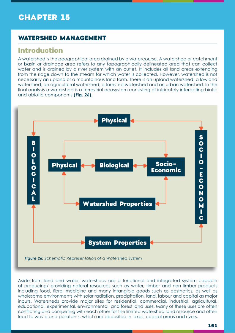
161
CHAPTER 15
A watershed is the geographical area drained by a watercourse. A watershed or catchment or basin or drainage area refers to any topographically delineated area that can collect water and is drained by a river system with an outlet. It includes all land areas extending from the ridge down to the stream for which water is collected. However, watershed is not necessarily an upland or a mountainous land form. There is an upland watershed, a lowland watershed, an agricultural watershed, a forested watershed and an urban watershed. In the final analysis a watershed is a terrestrial ecosystem consisting of intricately interacting biotic and abiotic components (Fig. 26).
Aside from land and water, watersheds are a functional and integrated system capable of producing/ providing natural resources such as water, timber and non-timber products including food, fibre, medicine and many intangible goods such as aesthetics, as well as wholesome environments with solar radiation, precipitation, land, labour and capital as major inputs. Watersheds provide major sites for residential, commercial, industrial, agricultural, educational, experimental, environmental, and forest land uses. Many of these uses are often conflicting and competing with each other for the limited watershed land resource and often lead to waste and pollutants, which are deposited in lakes, coastal areas and rivers.
Introduction
WATERSHED MANAGEMENT
Biological
Watershed Properties
Socio-Economic
Physical
System Properties
Physical
SOCIO-ECONOMIC
BIOLOGICAL
Figure 26: Schematic Representation of a Watershed System

162
The concept applies at various scales from, for example, a farm drained by a creek (a “micro-watershed”) to a large river basin (or a lake basin). A river basin usually comprises a complex system of watersheds and micro-watersheds, crossed by and draining into a major river and its tributaries, from the beginning of the river (its “source”) to its mouth (a lake basin may be defined as a geographic land area draining into a lake). Because soils and vegetation are intimately linked to the water cycle, watersheds are the most useful planning unit for integrated water and land resource management.
Watersheds perform the following important functions and services, among others:
The provision of freshwater (particularly upland watersheds);
The regulation of water flow;
The maintenance of water quality;
The provision and protection of natural resources for local livelihoods;
Protection against natural hazards (e.g. local floods and landslides);
The provision of energy (e.g. hydropower);
Biodiversity conservation; and
Recreation.
Watershed services and functions may be threatened by deforestation, uncontrolled timber harvesting, changes in farming systems, overgrazing, infrastructure, roads and road construction, pollution, and the invasion of alien plants. They may also be affected by natural disturbances such as wildfires, windstorms and disease. The deterioration of watershed functions has significant negative impacts, potentially leading to erosion and the depletion of soil productivity; the sedimentation of watercourses, reservoirs and coasts; increased runoff and flash flooding; reduced infiltration to groundwater; reduced water quality; and the loss of aquatic habitat and biodiversity.
Watershed management is defined as the process of guiding and organizing land and other resource uses in a watershed to provide desired goods and services without adversely affecting soil and water resources (Brooks et al., 1991). It is also defined as the application of business methods and technical principles to the manipulation and control of watershed resources to achieve a desired set of objectives such as maximum supply of usable water, minimisation of soil erosion and siltation problems;-and reduction of flood and drought occurrences (Clawson, 1970; and Satterlund, 1978).
Watershed management, therefore, is any human action aimed at ensuring the sustainable use of natural resources in a watershed, attempts to provide solutions to these threats. The origin of watershed management is closely linked to forestry; for example, the uncontrolled removal of forests creates significant changes in the hydrological regimes of important watersheds, leading to accelerated erosion and hazards downstream. The recognition of this relationship between upstream land use and water yields and quality led to the development of watershed management concepts. Watershed management considers the management and conservation of all available natural resources in a comprehensive way. It provides a framework for integrating different land-use and livelihood systems (e.g. forestry, pasture and agriculture), using water as the “entry point” in the design of interventions. Watershed management aims to preserve the range of environmental services – especially hydrological services – provided by a watershed, and to reduce or avoid negative downstream impacts while, at the same time, enhancing resource productivity and improving local livelihoods. Watersheds should be understood as dynamic systems characterised by diverse interactions and spatial relations between humans and the environment that manifest as mosaics of different land-use systems. The socioeconomic, cultural and environmental relationships,
Watershed Management

163
flows and conflicts between the upper and lower parts of a watershed are called upstream–downstream linkages. The consideration of these linkages is one of the key principles of watershed management. Other key principles are: addressing the root causes and drivers of environmental degradation (instead of treating symptoms); planning in an iterative process involving cycles of analysis, plan formulation, implementation and evaluation that allows for continuous learning and adjustments; working across sectors, with all stakeholder groups and administrative levels, thereby integrating bottom-up and top-down aspects; and combining local and scientific knowledge. The demands for watershed services and the recognition that these services have economic value are growing globally. Increasingly, schemes are being created whereby downstream water users compensate upstream watershed managers for management that ensures the provision of environmental services, such as clean water.
The general objective of watershed management is the sustainable production of goods and services demanded by society without adversely affecting the sustainability of soil and water resources. Specifically, most watershed management activities are directed towards the following:
Streamflow regulations for adequate quantity, quality and favourable flow patterns;
Conservation of the soil resources for long-term productivity;
Enhancement of infiltration capacity of the soil;
Soil erosion minimisation;
Optimum production of various combinations of goods and services;
Eradication of the pervasive poverty in the uplands; and
Environmental stabilization (climate change mitigation).
Watershed management has developed significantly in recent decades. In the mid-twentieth century, the focus was mainly on agricultural land drainage and reclamation schemes, and the development of infrastructure for water resources and hydropower schemes in uplands in the name of economic and social development. The environmental movement that arose in some countries in the 1970s brought with it growing recognition of upstream–downstream linkages, the socioeconomic effects of watershed management activities, and the need for integrated land and water resource planning. Today, based on the many field experiences that have now been gained, watershed management emphasizes multi-stakeholder participation and negotiation in resolving conflicts over scarce resources, balancing competing needs, and generating simultaneous benefits for people and the environment.
1
1
2
2
3
3
4
5
6
7
The purpose of watershed management is implemented through three key strategies for watershed management:
Protection strategies which include all activities geared to protect the watershed from the forces of denudation such as illegal logging, fire, encroachment, pests and diseases. These also include such programs as the (National Integrated Protected Areas System);
Conservation strategies include all programs and activities designed to sustain the long-term productivity of all watershed resources (e.g., water, timber and soil); and
Development strategies, which include soil erosion control, land use planning, reforestation, infrastructure development and all other activities related to the rehabilitation and improvement of the existing condition of watershed resources.
Purpose of Watershed Management

164
By considering, in a comprehensive way, all the natural resources in a watershed, especially water, land and soil, watershed management provides a framework for assessing the ways in which those resources are used, what affects them, and how they can best be used and protected. Most people agree that natural resources are under increasing pressure. Rising demand for agricultural land to produce at least 70% more food by 2050 in order to feed the growing world population competes with an increasing need for land and water for urban expansion, industrial development and tourism. At the same time, recognition is growing that a substantial proportion of cultivated lands is already highly or moderately degraded due to unsustainable agricultural practices leading to soil erosion, nutrient depletion and the loss of productivity. Unsustainable agricultural practices also have off-site impacts, such as changes in runoff patterns, river hydrology and groundwater recharge rates, and the pollution and siltation of downstream water bodies. Watershed management promotes the adoption of sustainable land and water management practices and encourages investment in better land husbandry that supports, not harms, the ecosystems on which productivity depends. Efforts to improve efficiency in the use of natural resources, especially water, are required to reduce pressures on the natural resource base and to restore the health and quality of freshwater ecosystems. The key purpose of watershed management is to negotiate a balance among the interests – and often competing needs – of stakeholders, and to jointly identify options for resource use that balance economic, social and environmental objectives and for which the highest consensus can be achieved among stakeholders. Effective watershed management identifies degraded areas in need of restoration, as well as areas with high ecological value that must be protected from degradation or conversion to other uses. Watersheds have long been recognized as an appropriate spatial unit for management, and they are also increasingly recognized as the key scale for resource governance.
By considering land and water resources in a holistic and integrated way, watershed management can provide a framework for the planning and implementation of measures that protect sloping land against water-induced natural hazards and risks such as landslides, gully formation, torrents (i.e. swift, violent streams of water) and local flooding. Many watershed protection and rehabilitation measures are available, some of which are described below. More information on watershed rehabilitation and protection can be found in the FAO conservation guidelines.
Vegetative and soil treatment measures are particularly important in the protection and stabilization of denuded slopes when there is an abundance of vegetative material, natural vegetation is easily propagated and established, structural works are unsuitable or unnecessary, and aesthetic values are important. Measures include the (re)vegetation of exposed slopes to protect against erosion, and the stabilization of slopes with living or dead plant material. Stabilizing slopes through vegetative and soil treatment measures is often more sustainable, and requires less maintenance, than the use of engineering structures. Vegetative measures may not always be sufficient, however, for example in dealing with torrents and landslides, in which case check-dams, retaining walls and other engineered structures may be necessary.
Natural Resource Management
Rehabilitation and protection
Protection of denuded slopes through vegetative and soil treatment measures
165
Gully control: Minimising surface runoff is essential for gully control. Poor land management practices, intense rain, prolonged rain of moderate intensity, and rapid snow melts can result in high levels of runoff, flooding and the formation of gullies. For watershed managers, gully control means: improving gully catchment to reduce and regulate peak flows; the diversion or retention of surface water above gully areas; and stabilizing gullies by structural measures and accompanying re-vegetation. Structural measures should be considered only after appropriate land-use management measures have been explored and adopted in the watershed.
Prevention of Landslides: Landslides are natural phenomena that may occur in areas characterised by fragile geology, steep topography and high precipitation. It is difficult to predict when landslides will occur, and the volume of soil movement they will involve, but human activities may promote them. The conversion of forest to grasslands, road and dam construction, logging, and other activities can cause changes in slope stability and therefore increase the risk of landslides. Watershed managers can play important roles in preventing landslides by making appropriate land management decisions. Note, however, that landslides caused by tectonic processes cannot be prevented or ameliorated through watershed management.
The watershed management framework has a wide range of applications; for example, it can be used in the planning and implementation of climate-change adaption and mitigation measures. Changes in the hydrological cycle and water availability due to climate change may lead to a greater incidence of flooding and water shortages, increases in the risk of erosion and landslides, and, ultimately, to reductions in crop, pasture and forest productivity. Rising temperatures are likely to lead to the melting of glaciers and the movement of permafrost and therefore to the more frequent occurrence of rock falls, ice and snow avalanches, mud flows, landslides and glacial lake outburst floods in upland watersheds.
By assessing the vulnerability of watersheds to climate change and identifying and prioritizing adaptation options, watershed management can play a crucial role in strengthening the resilience and adaptive capacity of watershed communities. In many watersheds, a key approach in ensuring resilience is likely to be sustainable forest management, because sustainably managed forests and trees have significant capacity to act as buffers as hydrological regimes change. It will also be important to adapt agricultural practices and diversify economic opportunities within watersheds as conditions change.
Watershed management can be applied to mitigate climate change, especially in larger watersheds that have high forest cover or high potential for afforestation and reforestation. Watershed management can be used to identify areas for carbon storage and sequestration by forests and trees and to reduce deforestation and forest degradation by limiting agricultural expansion and the conversion of forests to pasture lands. There is a high degree of overlap between the key principles of watershed management and the REDD+ safeguards. When biodiversity conservation is the focus of an intervention, watershed management can be used to identify and delineate areas with high conservation value and in the establishment, planning and management of parks and forest protected areas.
Other Purposes of Watershed Management

166
Watershed management requires the active participation of all stakeholders, ideally working together in watershed management committees and applying collaborative approaches in which technical experts, policymakers, government agencies, local administrators and watershed communities share responsibility for identifying, prioritizing, implementing and monitoring watershed management. Watershed management committees provide a platform for dialogue, negotiation and decision-making among actors with diverse and sometimes conflicting interests and concerns. A balance must be achieved between the aspirations and interests of stakeholders, the technical recommendations of experts, and local governance policies. Social inclusion is crucial in watershed management, and watershed management committees can be excellent vehicles for ensuring gender balance in decision-making processes. Women are keepers of traditional knowledge and often the primary managers of watershed resources; they are the main providers of water for the household, used for drinking, cooking, washing and irrigating house gardens. Their voices must be heard when decisions are being made that affect the management and use of local resources.
In Lesotho watersheds are common property with many stakeholders. The benefits derived from the watersheds should be equitably shared among all stakeholders who are willing to participate and invest in the management of watershed resources. Some of the major watershed stakeholders include the state, the local communities and community based organisations, the local authorities and various economic sectors. While equitable sharing should be commensurate to one’s investments, it should also be adequate enough to encourage sustainable participation. This is particularly important for local communities which usually do not have enough resources to invest in sustainable watershed management in order to generate benefits sufficient for their needs. Sustainable participation of major stakeholders is essential due to the complex nature of watershed ecosystem and the magnitude of tasks needed to be performed. The path to sustainability of watershed resources is replete with roadblocks that will become less formidable only with the concerted efforts of stakeholders.
Public Participation in Watershed Management
Watershed management uses community-based approaches in planning, implementing and monitoring field activities. Communities in targeted watersheds are involved at all stages and receive technical assistance from decentralized government line agencies. Since there is a high level of community participation in watershed management, women are also very much involved. Gender relations need to be considered in all aspects of watershed management and women should be able to actively bring their contribution as key stakeholders. In collaboration with all stakeholders, diagnostic studies and mapping exercises are conducted using participatory appraisal, mapping and planning tools to assess the situation, analyse upstream–downstream linkages, establish watershed management committees, prepare watershed management plans, and implement improved practices and technologies. The planning process normally includes the following steps: delineation of the watershed; assessment of biophysical features, such as climate, geology, topography, soils, water quality and quantity in terms of infiltration rates and runoff, natural vegetation, fauna, and land suitability for different land uses; assessment of socioeconomic conditions, and livelihoods analysis, addressing, for example, demographics, major resource user groups, farming systems, access to land, actual land uses, major economic activities and sources of income, markets, social infrastructure, local institutions and service providers, and relevant policies and laws; watershed mapping and zoning to visualize current land uses, the degree of degradation, etc., and to develop future scenarios; action research for joint problem analysis, the identification of solutions, and immediate field-testing and validation of improved practices in each area; establishment of watershed management committees; preparation of watershed management plans; implementation of prioritized activities; monitoring and documentation of processes, results and impacts; and capacity building for all stakeholders.
Implementation of watershed management initiatives

167
A watershed management plan builds on a situational analysis of a watershed that includes information on demographics, land uses, natural resources, and natural resource users; socioeconomic data and livelihood mapping; problem analysis; and the prioritization of activities. The situation analysis must be gender-sensitive and include the collection of gender disaggregated data, so as to address women’s and men’s particular needs. The plan should specify the activities to be implemented, as well as the required inputs, costs, timeframes, roles and responsibilities, sources of community contributions, and partnerships. Participatory approaches are also used in monitoring and evaluating the implementation of the plan, focusing on the documentation of processes and measuring changes over time in upstream–downstream interactions.
Watershed Management Plans
Watershed management initiatives usually have a strong capacity-development component that aims to ensure technical quality in, for example: slope stabilization and erosion control through cost-effective bioengineering and vegetative techniques; low-cost water conservation and storage techniques such as water-harvesting ponds, roof-water harvesting systems, and irrigation channels; good forestry and agroforestry practices to protect springs and watercourses, improve wood-energy supply, and increase the production of wood and non-wood forest products; good agricultural practices to improve soil fertility, increase land productivity, and reverse land degradation; and livelihood diversification activities, which may include the establishment of forest and fruit tree nurseries, food-processing facilities, fruit orchards, home-based poultry farms, and kitchen gardens that provide households with fresh vegetables while diversifying local diets and improving nutrition. The combination of activities is highly context-specific, but all selected interventions should follow the principles of best practices: increasing productivity, improving local livelihoods and restoring or conserving ecosystems. The diversification of livelihood options provides multiple benefits and helps increase community resilience to climate change and strengthen adaptive capacity.
Some recent initiatives have set up revolving funds to be managed by watershed management committees with the aim of ensuring economic sustainability and increasing the resilience of communities to sudden shocks. Innovative uses of such funds include: the development of incentive-based compensation mechanisms for water-related environmental services based on upstream–downstream linkages and public–private partnerships; and the development of social-protection and financial risk-transfer measures through watershed management funds combined with livelihood diversification programmes.
Good Practices, Innovation and Capacity Development
Innovative Funding for Watershed Management
Watershed management initiatives support institutional development by enhancing the technical and functional capacities of watershed management committees and governmental agencies at the municipality and district levels. The involvement of government officials at the district level is crucial for ensuring that watershed management plans are incorporated in district development plans, which in turn helps foster government ownership, facilitate the scaling up of successful approaches, and strengthen local governance processes. The involvement of communities ensures that local people are committed to sharing the benefits and costs of watershed management and have a stake in maximizing the benefits derived from interventions.
Sustainability and Ownership

168
Considerations in selecting the land for forage crops
Consideration in selecting forage species
On the farm, space must be used as efficiently as possible. The most fertile and easily managed lands should be reserved for food crops and grains. Land that is steep, difficult to manage, or with shallow soils can frequently be used for pasture. On some very steep lands, pasture can constitute the most easily managed crop. Once established, animals themselves can harvest it, for they climb to the places where forage cannot be harvested in any other way. Forage lands should also be selected with respect to long-term uses of other lands of the farm. Forages need to be rotated or replanted. In some cases the lands used for several years as forages can then be planted to forests. With continued use pasturelands can become so compacted that future use for intensive agriculture can be impeded. Occasional deep ploughing can eliminate this problem. The management of animals is an important consideration in selection of lands for forage and pasture. Animals can walk long distances through fenced lanes to pastures, but on the small farm cut forages should be near where they will be used, for they are heavy. Practical matters such as location of other crops, provision for watering animals, provision of shade for animals, protection of animals from dogs and thieves are also important considerations in selecting a site for pasture and forage.
The site itself will determine in part the forage to be grown. The decision will have to be made whether the area will be grazed or the forage will be cut and removed. Adaptability of the forage to the site is the most important consideration. This will be determined by elevation,
Forage species selection criteria
CHAPTER 16
The term forage is defined as herbaceous plants or plant parts fed to domestic animals. Generally the term refers to such material as pasturage, hay, silage, and green chop, in contrast to less digestible material known as roughage. In practice, however, the concept is often extended to woody plants producing succulent growth and indeed in the tropics some shrubs and trees are of considerable importance in this respect. Forage crops may be used in pastures or may be cut and carried to the animals that are expected to eat them. The most important forage plants are the grasses. About 75 percent of forage consumed in the tropics is grass. The family of grasses, Poaceae (previously Graminae), includes about 620 genera and 10,000 species. While the number of cultivated grasses reaches 350 or more, nevertheless, a relatively small number of grasses predominate and can be considered principal forage species.
A second major group of forages is the legumes. The family Fabaceae (previously Leguminosae) is one of the largest of flowering plants with an estimated 700 genera and 14,000 species. Legumes are not as prominent in tropical pastures as are grasses, chiefly because they are difficult to maintain in a mixed pasture. Nevertheless, they are extremely important in improvement of the fertility of the soil, and in furnishing protein to the diet of grazing animals. A relatively few species have now been established as suitable for semi-permanent stands similar to alfalfa in the temperate zone. A few leguminous trees are useful as forage, and these might be especially valuable for some small farms. In addition to these principal classes of forage, may other kinds of plants are at times valuable. Although seldom cultivated, they may be parts of the unimproved pasture and be convenient to use under some circumstances. They can be called the miscellaneous group. This group includes annual herbs (forbs) and woody shrubs and trees (browse).
Introduction
FORAGE PRODUCTION

169
soil type, rainfall amount and distribution, and temperatures. A good forage should grow well and survive with a minimum of care. Even though it is desirable to treat pastures and fields of forage crops as carefully as possible, nevertheless, a good forage crop should resist neglect and abuse. A good forage should also resist the dry season of the year, continuing to grow or maintaining foliage and nutritive value and, above all, living through the dry season so that growth is resumed again with rains. Or, in the case of forage cut as hay, it should be uniform, timely, manageable, have good keeping qualities, and be nutritious.
Naturally, a good forage should be palatable to the animals for which it is grown. This palatability should extend throughout the year. When the forage is used through cutting or pasturing, it should regenerate rapidly. The overall yield should be high, and this depends in part on previously mentioned factors. Finally, nutritional value should be high. Height of forage is an important characteristic. Tall forages are easy to cut but difficult to graze. Improved cultivars might be available of any particular forage species, and technology might be developed for maximum production. Thus, for every region a certain body of information is usually available. Seeking for this information before establishing pasture or forage will be time saving. Local information on suitable forages is often available from agricultural extension agents. Observing the success of forages and animals on the land of local farmers is an easy way to learn.
Grasses as forages
The grasses produced as forages are hundreds in number and constitute an enormous and economically important resource for forage production. Classification of the 10,000 or more species of grass in the world is very difficult, and it is not possible to classify species into reliable groups larger than the tribe (an association of genera). Nevertheless, many genera are quite distinct, not only in their morphological characters, but also in their physiology, reproduction, suitability for distinct uses, and their values.
For the small farm it is not necessary to know or to cultivate a large number of grasses. It is desirable to recognize 5-10 of the most important species and to cultivate several different species for their abilities to produce in distinct parts of the farm, or their suitability for different animals or different purposes.
Grasses are propagated in several ways. Some can be planted from seeds, some of which are apomictic (not sexual in nature and genetically identical to the parent plant). Seed production can be poor, the germination can be erratic due to poor viability of the seed, or the seedling may die earlier before the plants are well established. This is usually associated with poor conditions for growth. In addition grasses often propagate themselves from normal or modified underground or prostrate aerial stems (rhizomes or stolons). Sometimes the stolons are no more than upright branches (tillers) from the principal stem, which root at the base. Such a grass forms a clump (tuft) which can be broken into numerous plants for replanting. A grass may form either stolons or rhizomes or both. The ability of a grass to extend itself by rhizomes or stolons varies remarkably but is obviously related to the planting, establishment, and long term survivability of a grass.
Tufted grasses are usually long lived. Stoloniferous and rhizomatous grasses often fill a soil so thoroughly that new growth cannot occur. They are then said to be sod bound. Rhizomatous grass may form thick stands that are difficult to eradicate. Grasses differ remarkably in adjustment to particular soils and rainfall patterns or drought resistance. Grasses differ in their need for nutrients and ability to survive on poor, unfertilised soils. Grasses differ in their uses. Some grasses are best cut and carried to the animals that will use them. This is often the case when the grass is very tall and could easily be tramped to the ground by grazing animals, or when animals are likely to damage or destroy the grass plants by their grazing. On the other hand, some grasses are especially suitable for grazing in pastures.
Forage species adapted to Lesotho climate

170
Grasses
Species Common Names Characteristics
Cenchrus ciliaris
Blue buffalo grass / Buffel grass
Perennial, tufted or rhizomatous, dry areas, principally as pasture, resists overgrazing.
Chloris gayana Rhodes Perennial, stoloniferous, widely adapted,
as pasture or hay.
Cynodon dactylon Bermuda
Perennial, stoloniferious and rhizomatous, moderately dry areas of subtropics, principally as pasture.
Cynodon nlemfuensis Star Perennial, stoloniferous, widely adapted,
mostly as pasture.
Digitaria eriantha
Smuts finger grass
Perennial tufted, subtropics and temperate, well-drained soils, grazing and hay production.
Eragrostis curvula
Weeping love grass
Densely tufted perennial with fine leaves, temperate climates, mainly hay production.
Eragrostis tef Teff grass
Annual tufted grass with fine soft leaves, temperate climates, mainly hay production and as a nurse crop.
Euchlaena mexicana Teosinte Annual, tufted, maize-like, dry areas, as
cut forage, sometimes as hay or ensilage.
Panicum coloratum
Coloured Guinea / Small buffalo grass
Perennial, tufted, very widely adapted, as pasture or cut foliage.
Panicum maximum
Guinea grass / White buffalo grass
Perennial, tufted, widely adapted but frost sensitive, as pasture or cut forage.

171
Table 15: some of the more important grasses of Lesotho
Paspalum dilatatum Dallis
Perennial, tufted, spreading, very leafy, coarse grass, adapted to hot, sunny areas with lots of rain.
Paspalum notatum Bahia Perennial, creeping, spreading, widely
adapted, as pasture or cut foliage.
Pennisetum americanum
Pearl millet
Annual, usually tufted, widely adapted, cut for hay or silage, also pasture. Can regrow; good seed production.
Pennisetum clandestinum Kikuyu
Perennial with thickened rhizomes and stolons, adapted to various altitudes of principally as pasture.
Pennisetum purpureum
Elephant, napier
Perennial with thickened rhizomes and stolons, adapted to various altitudes of principally as pasture.
Pennisetum purpureum Merker
Variety of napier, similar in behaviour, widely adapted, for cut forage, although sometimes grazed.
Sorghum almum Columbus
Perennial, tufted, dense, rhizome forming, adapted to rather dry subtropical areas, many soils, as pasture, hay or silage.
Sorghum bicolor Sorghum
Annual, at times perennial, tufted, drought resistant, widely adapted, used as cut forage or ensilage.
Sorghum sudanense Sudan
Annual tufted, vigorous, erect widely adapted and drought resistant, high yielding, as cut forage or ensilage. Improved cultivars available.
Zea mays L. Corn, maize
Annual, tufted or single stems, vigorous and productive, can be used before or after cob is produced, cut forage or ensilage.

172
Of the more than 10 thousand species of plants in the family Leguminosae only a relatively few are useful as forage. Some legumes grow very well on highly acid soils typical of the tropics. The importance of legumes in the pasture or field of forage is double. First, legumes contain large amounts of protein and thus enrich a diet of grass when the two are combined. Second, probably all legumes have the ability to enrich the soil with nitrogen, although this probably does not occur until the plant or part of its roots dies. This acidity reduces the need for nitrogenous fertiliser.
The ability of a legume to fix nitrogen depends upon the presence of the appropriate bacterium, Rhizobium. This bacterium lives in special structures on legume roots, the root nodules. Some species are very versatile, that is, very flexible with respect to the strain of Rhizobium that is suitable; other species are highly specific in their requirements. Similarly, some strains of Rhizobium are highly specific for certain legumes; others are capable of living in nodules of many leguminous species. Furthermore, some strains of Rhizobium are adapted to acid soils while others survive only on alkaline soils. If legumes do not encounter an appropriate strain of Rhizobium an inoculum is frequently added to the seed, sometimes as a fine cap or pelleting. On the small farm addition of inoculant to the seed may not be practical. Whenever possible, local information concerning species and their inoculum should be obtained before planting legumes.
A few legumes can be grown in pure stand, but most grow and serve better in mixed plantings with grass. Mixed plantings are easy to establish but difficult to maintain. Heavy grazing almost always eliminates the legume and leaves the grass. Most legumes are planted from seeds. Seeds are sown in normal ways, often alternated with rows of grass. Problems are often encountered with hard seeds that do not imbibe water readily and thus germinate irregularly. Seeds are sometimes scarified in hot water or sulfuric acid, something that must be done very carefully in order to avoid damage to the seed. After scarifying and as soon as possible after applying inoculant, seeds can be planted and watered. In spite of their ability to fix nitrogen, legumes benefit from light application of nitrogen at planting and normal quantities of phosphorous and potassium.
Legumes as forages
Legumes
Species Common Names Characteristics
Acacia albida Apple-ring acacia Tree, dry areas, cut forage or hay.
Albizzia lebbek Woman's tongue Tree, dry areas, cut leaves and pods.
Arachis hypogaea Peanut Annual herb, sandy soil, use as forage combined with use for seeds.
Cajanus cajan Pigeon pea Short lived perennial, widely adapted, cut forage.

173
Calopogonium mucunoides Calopo Annual, cut forage.
Canavalia ensiformis Jack bean Annual vine, widely adapted, cut forage.
Centrosema pubescens benth Centro Perennial, climbing vine, widely adapted,
pasture.
Clitoria ternatea Butterfly pea Perennial, climbing vine, widely adapted, cut forage.
Cyamopsis tetragonoloba
Cluster bean Annual herb, widely adapted, cut forage
Desmodium intortum
Greenleaf desmodium
Perennial upright herb, widely adapted, pasture or cut foliage.
Dolichos uniflorus Twinflower Weakly perennial low vines, pasture, forage, and green manure.
Dolichos lablab Lablab bean Weakly perennial vine, widely adapted, pasture or cut forage.
Erythrina species Coral bean Tree, widely adapted, cut forage.
Glycine wightii Glycine Perennial vine, widely adapted, cut forage.
Leucaena leucocephala Tantan Tree, widely adapted, pasture or cut forage.
Lotononis bainesii Lototonis Perennial herb, pasture.
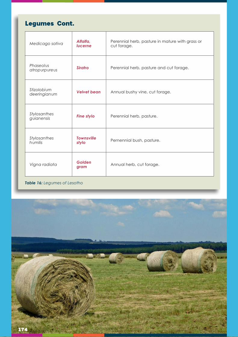
174
Legumes Cont.
Medicago sativa Alfalfa, lucerne
Perennial herb, pasture in mature with grass or cut forage.
Phaseolus atropurpureus Siratro Perennial herb, pasture and cut forage.
Stizolobium deeringianum Velvet bean Annual bushy vine, cut forage.
Stylosanthes guianensis Fine stylo Perennial herb, pasture.
Stylosanthes humilis
Townsville stylo Pernennial bush, pasture.
Vigna radiata Golden gram Annual herb, cut forage.
Table 16: Legumes of Lesotho

175
Soil preparation and planting
As in the case of other crop plants, soil preparation is desirable before forage crops can be grown. Nevertheless, on the small farm in the hot, humid tropics, soil preparation will often be minimal. As a general rule, preparation begins by removing old vegetation. Burning is sometimes the best way to remove old and undesirable grasses and, in fact, in some cases it is an important technique in removing old, lignified, inedible stems, returning minerals to the soil. On the other hand, burning followed by heavy rains leads to leaching of the soil and possibly erosion.
Therefore, where practical, a strip system is recommended. Vegetation can be cleared from strips following contours. This vegetation can be piled in continuous piles following the contour at the lower edge of the strip. The rotting of this vegetation over a period of time will restore its nutrients to the soil.
Newly planted forages need the stimulation of a loose and penetrable soil for maximum growth. However ploughing will often be impossible or, when erosion is expected, impractical. Unless soils are naturally loose some provision for opening them will have to be made, particularly in the immediate area of the individual plant.
Herbicides are sometimes used before establishing new forage plantings. Those that kill broad-leaf weeds and trees might be very economical in eliminating brush and trees, even on the small farm. Herbicides are best applied in the early spring; and brush can be removed several weeks later. Grass killing herbicides are also frequently used especially when undesirable grasses predominate. It must be remembered that herbicides are dangerous chemical compounds that should be applied according to manufacturer’s suggestions and local laws or regulations.
If ploughing is done, ridges or furrows can be prepared 60-100 cm. apart. If planting is done by hand these are appropriate distances between plants or planting holes. Lime should be applied to very acid soils when it is available and economical to use. When available, lime is justified in terms of the increased forage that can be expected from its application. For best results lime should be mixed into the soil, but on the small farm this may not be practical. It is here that barriers of cut vegetation along contours are useful. Such barriers impede the loss of lime and fertilisers and give them a longer time to soak into the ground. The small farmer may not have mineral fertilisers to apply, but manures and rotted plant material should be mixed into the soil if possible. While on the small farm such operations are labour intensive, they are important if a good pasture is to be established.
Because of labour requirements, it is recommended that on the small farm a percentage of the existing forage be replaced each year, perhaps for conversion to forest, and a new forage strip be established. This plan permits the farm to produce wood for fencing, fuel, and construction while simultaneously using land in adjacent strips for forages.
Propagation of the various forage species depends on the nature of the seed or cuttings used. There are many variations of these practices. Forages are usually planted in rows for convenience, but seed can be broadcast if the soil is prepared to receive it.
How to establish planted forages

176
Post-planting care
Newly planted pastures need protection from grazing until they are well established. This may require 3-4 months. Fences can be established, and five separated plots for rotational grazing have been recommended. Fertilisers are often applied to pastures several months old at the rate of about 400 kg per hectare. Weeds must normally be controlled until pastures are well established. Mowing vigorous grasses, or cutting with mowers/sickles/hoes will tend to eliminate weeds. Vigorous weeds and trees should be carefully removed. Herbicides are sometimes used in intensively managed pastures.Pasturing or cutting removes mineral nutrients from the soil. Where use is intensive, materials are removed more rapidly. On the small farm where purchase inputs are to be minimised it is not desirable to use pastures so intensively that they suffer loss of plants or do not regrow sufficiently rapidly for regular reuse. Nevertheless, when used on a rotational basis, even unfertilised pastures have the capacity to regrow after pasturing. The sources of nitrogen to sustain such pastures are the minimal amounts: deposited with rains, that fixed by legumes and possibly some grasses, and manures left behind by animals. Other elements, potassium and phosphorous, are slowly released to the soil by weathering. The regrowth capacity of an unfertilised pasture varies. Rotation of pasture with forest permits accumulation in the upper soil of very deeply buried minerals.
Pasture should be grazed heavily for up to one week by the appropriate number of animals. Grazing animals should remove the major part of the available forage of all species of forage present. After animals are removed from a pasture, untouched, undesirable plant species should be killed, so that they do not multiply and spread. This single management practice can do much to increase the value of an unfertilised pasture on the small farm.
Storage of forage by making hay, dried forage, is often possible. In order to make hay, the forage must be mowed. This is done uniformly with machinery but can also be done by sickle. The cut forage is usually allowed to lie for several days until dry and then is gathered by raking and/or baling and is carried to storage areas. Preparation of hay is difficult if rains fall after cutting. Forage when fresh or dried can be spoiled by excess moisture. Large farms often dry hay artificially before storing it, a practice that is costly and not practical for the small farm. Hay is less nutritive than fresh forage. Storage can also be in the form of silage, a fermented form of forage of less nutritive value than fresh forage but of more value than hay. Forage can be packed in upright structures called silos or in trenches often dug into embankments. The latter are more suitable for the small farm.
The success of ensilage depends on several factors including the species of forages and its water and sugar content. Molasses is sometimes added to the packed fresh grass to encourage fermentation. Silage must be packed tightly and sealed to reduce or prevent entry of air. The chief types of fermentation that take place are lactic acid and butyric acid fermentation. The organisms responsible for fermentation sometimes add to the nutritive value of the silage.
Practical silage practices must be learned for each locality and depend on forages and other materials available, and their relative costs in money or labour. It is highly desirable to plant pastures that will continue to grow through the dry season, or that produce a feed that retains its value in the field, even when forage plants are not growing. Some legumes are more productive during the dry, than the wet, season.
Intense management includes the following classes of practices: control of insects and diseases, weed control, frequent liming and fertilising, harvesting at the right time and height, and rotational grazing.
177
Weed control
Efficient forage management including weed control, grazing management and soil fertility management result in high forage production.
Weeds can reduce the productivity of the sown forage, particularly during the establishment year, and should be controlled during the first year by either hand weeding or using herbicide. In subsequent years fields are kept clean by slashing, hand pulling or mowing the weeds.
Forage management and maintenance
Grazing management
Soil fertility management
In the establishment year grasses reach the early flowering stage 3–4 months after planting. At this stage the plant is not firmly anchored in the soil and therefore it is usually advisable to make hay rather than graze the pastures to avoid the risk of the cattle pulling out the young shoots. If the pasture must be grazed during the establishment year, grazing should be light enough (use calves) to allow the plants to establish firmly in the soil. For maximum benefit, use the pasture not later than the start of the flowering stage. Graze or cut at intervals of 4 to 6 weeks, leaving stubble at 5 cm height. Graze animals when the grass is at the early flowering stage by moving animals from paddock to paddock. One animal will need 1–2 acres of improved pasture per year in areas receiving over 900 mm rainfall. Conserve excess pasture in the form of hay for dry-season feeding.
Forage crops require additional nutrients from inorganic fertiliser or farmyard manure in order to attain maximum production from pasture. Although soil nitrogen is adequate for forage productivity during the establishment year, it tends to drop during the subsequent year. Top-dressing is recommended for grass in subsequent seasons with 5-7 bags of calcium ammonium nitrate (CAN) or Lime ammonium nitrate (LAN) per hectare per year in three splits during the rainy season or 5-10 tons of farmyard manure. Added to this, in areas with phosphate deficiencies top-dressing with 2 bags of single superphosphate (SSP) or 1 bag of triple superphosphate (TSP) is recommended per hectare per year after the establishment year in addition to nitrogen fertiliser. Nitrogen fertiliser may be applied on 1 or 2 months before the dry season to increase yields during the dry season. In order to achieve potentially higher dry matter yields, a balanced recommended blend of nitrogen, phosphorus, potassium and sulphur is important.
Forage maintenance
Forage maintenance methods can be summarized into three: direct sowing, under-sowing or over-sowing.
Direct sowing
Direct sowing is a method of establishing pasture grasses without a nurse or cover crop. Care should be taken in terms of sowing periods and methods in order to get good quality and quantity forage. Forages need to be sown as early as possible in the rainy season. Sowing during the short rains is advantageous to eliminate annual weeds in areas receive bimodal rainfall. Sowing can be done either through broadcasting or drilling in rows 30 to 40 cm apart. Tiny seeds are not buried deep since their initial vigour is not sufficient to push through a heavy cap of soil, but mixing seeds with sawdust, rough sand or phosphate fertiliser helps for even distribution.

178
Forage utilisation options
Forage crops are annual or perennial or permanent crops, cultivated on arable land and grazed or fed to stock, either green as cut-and-carry or in a conserved form like hay or silage. They are known to be highly productive per hectare (dry matter yield) compared with permanent pastures. These crops are also grown.
They are characterised as supplementary feed during the dry months of the year. Improved forage can be used to maintain more animals, to provide increased quantities of better quality forage to same number of animals, or to strategically feed selected groups of animals.
For smallholder farmers who depend on dairy for their income and livelihood there are significant opportunities to increase production by increasing the quantity and quality of forage available to lactating animals.
Nutrition is a more significant constraint to sustaining livestock production. Forages can be fed to animals either fresh (grazed directly or cut-and-carried), dried (for example as hay) or preserved as silage.
Some forage has long stems and chopped into approximately 3cm lengths before feeding to livestock. This makes it easier to mix with other feeds, such as concentrates, and also prevents wastage by making it more difficult for cattle to select only their favourite parts of the plant.
For example, when designing a ration for dairy cattle, especially more productive cows, it is necessary to provide enough forage to supply the fibre and bulk required, but at the same time to supply the energy and protein required to support the desired level of milk production.
Dry cows can survive pretty well on forage alone and, provided they are given enough good quality forage, milking cows can produce 5 to 10 litres of milk per day from forage alone. But if the forage is of poor quality – such as sorghum straw or dry maize stover – then production levels from just forage will be much lower. And higher yielding cows simply cannot eat enough bulk forage to obtain all the nutrients they need – their guts fill up before they are able to absorb sufficient nutrients - and they have to be given other, more nutrient rich feeds which are called supplements.
Under-sowingUnder-sowing is a method establishing forages or pastures under a nurse or a cover crop. The nurse crop is grown together with pasture for economical land use. It can be harvested after maturity.
The following considerations are recommended for successful under-sowing:
Broadcasting or drilling of pasture or forage seed mixed with fertiliser 3 days after planting wheat or barley.
Where maize is the nurse crop, the forage seed will be broadcasted mixed with phosphate fertiliser in the maize field after the second weeding of maize (4 to 5 weeks after planting maize) or when maize is knee high.
Over-sowingOver-sowing is the introduction of improved pasture species (grasses or legumes) to a natural pasture. Over-sowing increases forage quality and productivity of natural pastures. It is also the easiest and most cost-efficient strategy for improving natural pasture. Although both grasses and legumes may be over-sown, legumes are more suitable, as grasses do not establish readily, especially on soils that are not loose. Over-sowing should be done in areas where soils are light and loose. Benefits become evident after about 2 years.

179
Fodder flow and supplement feeding planning
Fodder includes grazing, hay, silage, and roots. The objective of fodder flow planning is to match the production capabilities of the farm with the animals’ requirements in order to obtain the greatest margin over feed costs, within safe limits of natural resource utilisation. The carrying capacity of the property, not the owner’s target income, must determine the size of the herd: specifically, how much suitable fodder can be produced annually for the use of the dairy herd. The annual fodder requirements of every 100 cows and their associated replacement heifers must be known. From this total requirement, and from the assessment of the farm’s fodder production capacity, the potential herd size can be calculated. It is neither profitable nor wise to exceed that herd size.
Planning and managing the fodder flow is not only one of the most critical of all management functions. It can also be one of the most satisfying - financially, psychologically, and aesthetically. Not only does a good fodder flow provide the soundest basis of a profitable operation but also, there for anyone to see at any time, is highly visible proof, pleasing to look at, of a good job well done. Conversely, a poor fodder flow causes trouble on the grazing, in the rangeland, at the bank, probably even in the home.
Fodder flow planning can be divided into three major sections, namely:
Principles of fodder production planning
The soundness of any system, existing or proposed, may be evaluated against the following four criteria in very strict order of precedence:
Safe use of resources
The resources available for producing fodder are land (including veld and water), labour, management, and capital. If each part of the farm has been developed to produce as much forage as it can, and there is no weakening of its soil and water resources, then the fodder flow rates well under this criterion. A careful assessment of the land and water resources is needed. Determine the areas of land suitable for annual cultivation or for planted pastures, because that largely limits the quantity of high-quality forage that can be produced.
Meeting the animals’ requirements
Adequate feed must be produced, stored, or bought to feed all animals present on the farm at any given time. As a first step, enough food must be available over an average year to meet the annual total dry matter requirement plus the average input to the fodder bank:
The fodder bank: The fodder bank is a store of conserved fodder (hay or silage) which is deliberately accumulated over and above the normal seasonal requirements, for use in unpredictable, lean times such as an unseasonal dry period, a severe hail storm, or an army worm outbreak. A fodder bank is not a permanent or separate store in the sense that a particular silo or hayshed is “the” fodder bank. Rather, the total store of conserved fodder is built up year by year, part being for dry-season feed and part for reserve, the division being merely a book entry. The oldest stored fodder is always fed first, whether for normal use or for emergency, and any fodder actually in store will seldom be more than two or three years old. This is especially important in the case of hay, which deteriorates far more rapidly than silage does.
A

180
Fodder flow: The fodder flow is the sum of fodder available from each source (veld, pasture, stover, etc.) month by month. Ideally, it would exactly match the required feed flow. Rarely does this happen naturally, however, so the match must be forced, by:
Purposely altering the stock flow, e.g. by strategic culling and calving, and/or
Producing more food at particular times, and/or
Transferring excess fodder from one time of the year to another as hay, silage, or forage.
If the match is not achieved by the farmer it will be forced on him by Nature, firstly as a loss in production and reproduction (low fertility), then as a loss in live-mass (thin animals), and ultimately as a loss of animals either by forced selling or, in extreme cases, by death due to starvation.
Underfeeding can be blamed, at least partly, on poor quality of roughage. Quality of forage is more important in dairying than in many other enterprises. A high proportion of cows in the herd need a diet rich in energy (dry matter containing more than, say, 10.5 MJ ME/kg or 70 TDN) and good-quality protein. While it is true that cows are better off with lots of poor roughage than with inadequate amounts of good roughage, the aim must always be to produce enough roughage of the best possible quality. To some extent, the quality of the diet can be improved by feeding concentrates, but that strategy has limits, and it is much more expensive than providing good fodder as a basis.
A common fallacy is that protein is the only consideration in assessing roughage quality. In fact, energy is more critical since it constitutes by far the greater part of the cost of feeding cows. Protein, while more expensive per kg, is needed in smaller amounts (10 to 15% of the energy expressed as kg of digestible organic matter, DOM). One should worry primarily about providing enough cheap energy; then worry about providing enough protein. Good pastures provide both, the latter usually in excess.
Note that the obvious signs of a bad fodder flow (hungry and unhappy animals, chronic shortage of grazing, overgrazed pastures in poor condition) have not been included in the above list of problems. These are the signs of “clinical overstocking”, immediately obvious to mere humans, and by the time that they have appeared much damage has already been done to the dairy enterprise. Don’t rely only on your own assessment of the feeding regime: ask the cows if they have been getting enough to eat. Their answer is to be found in the list given above.
The second property of a good fodder flow is, therefore, that the herd is properly fed all year round.
Margin over all feed costs
With a good, well-managed fodder flow the livestock enterprise will show a positive margin over feed costs, if not over all costs. Provided that the afore-mentioned two criteria (care of natural resources, adequate feeding of the herd) continue to be met, numbers and kinds of animals, as well as sources of feed can be manipulated to improve the overall margin, whether expressed as total profit or as return-to-costs. Remember always that profits are not ensured by having many cows, only by having well-fed cows. Pushing up the number of animals to improve the gross margin is a futile exercise if food is the limiting factor, as it almost invariably is. Indeed, reducing cow numbers is sometimes the route to increased profits.
Since feed costs make up about 70% of all variable costs on a typical dairy farm, it makes sense to devote much attention to planning feed supplies, and to managing them efficiently. By integrating other enterprises with the dairy, wastage can be

181
reduced and residues can be profitably utilised, with a positive effect on the farm’s economics. The major impact of roughages on economics is that they provide the cheapest way of supplying the cows with their energy and protein requirements.
Manageability
The fact that a given production plan will (probably) provide for sufficient total feed over the year, does not necessarily mean that the flow of fodder will be satisfactory. For instance, an all-kikuyu system may look good in terms of resource protection, total tonnage of food available, and margin over feed costs, but nowhere with a cold, dry winter could such a system be a practical basis for an intensive dairy farm: winter feeding would not be economical, probably not even practicable without large purchases of feed.
A good fodder flow will allow the livestock enterprise to run smoothly (from a feeding point of view) throughout the year, and will mesh in well with other activities on the farm. For instance, it will be managed so that unexpected surplus forage can be put to good use. It will provide a reliable reserve of fodder so that the animals will continue to be well-fed when normal seasonal shortages occur, and even when unexpected unseasonal shortages are experienced, whether caused by drought, flood, fire, or pests. The fodder conservation programme will not call for silage or hay to be made at times when it is difficult to provide the needed labour, supervision, or machinery.
The farmer should draw up his own list of points that will make for a manageable fodder flow on his farm.
Planning in practice
Although it takes time, a good fodder flow must be planned. Tackle the job by applying the above principles in a logical sequence of steps.
Resource assessment
The natural resources of most concern are land, soil and water. Well-managed natural resources will show a positive fodder flow.
Livestock herd feed requirements
Fundamental to the whole fodder flow plan is an estimate of the amount of food that is needed by a livestock herd. Herd requirements are a function of the herd structure, which means taking into account the average number of livestock in the herd, size of livestock and livestock production stages. Each of these factors affects either the number of animals to be fed or the requirement of an average animal for dry matter, energy, and protein. Other major factors affecting the amount of forage to be produced are roughage quality and wastage of forages.
Implementing the plan
From theory to practice
There now is a plan, and an outline of how it will unfold, i.e. the stages of development. Next, work out the details of implementation. This may take the form of a timetable, in which the farmer will show actions required against dates (month/year), e.g. ha of Kikuyu to plant this year, soil samples to be taken in June, bunker silos to be built by
B
C

182
the end of next summer, and so on. Also specify the results expected against dates, e.g. area of ryegrass needed by next winter, herd size at the end of next year.
This is not an inflexible schedule; its main function is to help implement that plan which has been worked out, not some other plan of unknown origin. The plan can be modified at any time, but it is useful to have a reference point that enables the farmer to know what is being changed, with what expected results. It is also useful to have a second timetable, within the first that is prepared for six to eight weeks ahead. This will give details of, say, machinery to be overhauled, land preparation, pasture establishment, hay/silage making, vet’s visits, stock sales, and other operations which can be planned to within a week.
Managing the fodder flow
This includes details about the establishment and management of pastures and forage crops.
Records
Monitoring progress is a vital aspect of implementation. Only by keeping appropriate records is it possible to know whether the plan is developing as expected.
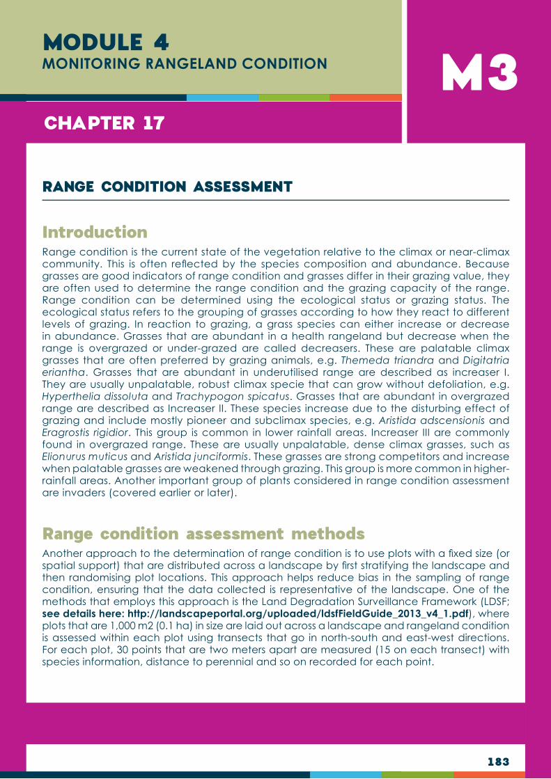
183
M3MODULE 4MONITORING RANGELAND CONDITION
CHAPTER 17
Range condition is the current state of the vegetation relative to the climax or near-climax community. This is often reflected by the species composition and abundance. Because grasses are good indicators of range condition and grasses differ in their grazing value, they are often used to determine the range condition and the grazing capacity of the range. Range condition can be determined using the ecological status or grazing status. The ecological status refers to the grouping of grasses according to how they react to different levels of grazing. In reaction to grazing, a grass species can either increase or decrease in abundance. Grasses that are abundant in a health rangeland but decrease when the range is overgrazed or under-grazed are called decreasers. These are palatable climax grasses that are often preferred by grazing animals, e.g. Themeda triandra and Digitatria eriantha. Grasses that are abundant in underutilised range are described as increaser I. They are usually unpalatable, robust climax specie that can grow without defoliation, e.g. Hyperthelia dissoluta and Trachypogon spicatus. Grasses that are abundant in overgrazed range are described as Increaser II. These species increase due to the disturbing effect of grazing and include mostly pioneer and subclimax species, e.g. Aristida adscensionis and Eragrostis rigidior. This group is common in lower rainfall areas. Increaser III are commonly found in overgrazed range. These are usually unpalatable, dense climax grasses, such as Elionurus muticus and Aristida junciformis. These grasses are strong competitors and increase when palatable grasses are weakened through grazing. This group is more common in higher-rainfall areas. Another important group of plants considered in range condition assessment are invaders (covered earlier or later).
Another approach to the determination of range condition is to use plots with a fixed size (or spatial support) that are distributed across a landscape by first stratifying the landscape and then randomising plot locations. This approach helps reduce bias in the sampling of range condition, ensuring that the data collected is representative of the landscape. One of the methods that employs this approach is the Land Degradation Surveillance Framework (LDSF; see details here: http://landscapeportal.org/uploaded/ldsfFieldGuide_2013_v4_1.pdf), where plots that are 1,000 m2 (0.1 ha) in size are laid out across a landscape and rangeland condition is assessed within each plot using transects that go in north-south and east-west directions. For each plot, 30 points that are two meters apart are measured (15 on each transect) with species information, distance to perennial and so on recorded for each point.
Introduction
Range condition assessment methods
RANGE CONDITION ASSESSMENT

184
Land Degradation Surveillance Framework Explaining the Land Degredation Survei l lance Framework
Assessing land health in landscapes using multiple indicators at the same time (e.g. land use, land cover, soil properties, soil erosion, etc) requires multiple perspectives to understand how these indicators vary at different spatial scales. Data is therefore collected from four nested spatial scales: sites, clusters, plots and sub-plots, as illustrated below.
HOW DATA IS COLLECTED IN THE FIELD
Sites [100km2] are selected at random across a region or watershed, or they may represent areas of planned activities (interventions) or special interest. Each site is divided into 16 tiles of 2.5km x 2.5km each.
Within each tile, random centroid locations are generated for clusters. Clusters [1km2] are the basic sampling units and are made up of 10 plots [1000m2 or 0.1ha]. Using each cluster centre-point, the sampling plots are randomized to ensure comprehensive cover and accuracy of the data collection.
Each plot consists of four sub-plots [100m2 or 0.01ha].
At plot level, basic site characteristics are described and recorded:
Slope, landform, presence/absence of soil and water conservation structures
Land use
Rangeland health (see note on the LDSF Rangeland Module*)
Topographic position
Composite soil samples
At sub-plot level, soil erosion and herbaceous cover are observed:
Vegetation measurements (woody cover rating; tree and shrub densities)
Visible erosion recorded and classified
Topsoil and subsoil samples collected (160 per site) and composited into one topsoil and one subsoil sample per site
1
Sub-plot and plot-level data are analyzed using open source statistical software.
Generally, very little is known about the state of ecosystems across Africa, including land cover and vegetation trends. This is particularly important in understanding land degradation processes, predicting changes in climate and improving land management. Systematic baselines of soil and ecosystem properties allow for a proper assessment of landscape performance and/or prediction of change over time.
DATA COLLECTION AND ANALYSIS
Data collected in the field at a plot and sub-plot level
Data analysed
Biophysical indicators
Predictive maps
Data for land planning
OUTPUTS
SITE CLUSTER
PLOT
SUB-PLOT
DATA ANALYSIS2Soil samples are analyzed for mid-infrared (MIR) absorbance, to predict important soil properties such as SOC, pH, base cations, and texture.
3Explaining the Land Degredation Survei l lance Framework
OUTPUTSBIOPHYSICAL INDICATORS
Data from multiple global sites are used to create predictive mapping outputs at multiple spatial scales, with fine-resolution maps produced at 5 to 10m resolution or higher, high resolution maps at 20 to 30m resolution, and moderate resolution maps at 250 to 500m resolution. This enables you to zoom in to a specific area of your site and assess the possible indicators therein.
PREDICTIVE MAPS
The LDSF is part of the Ecosystem Health Surveillance System (EcoHSS) developed by ICRAF - illustrated below. As part of this system, we produce spatial assessments of processes of land degradation, soil functional properties, vegetation cover and biodiversity.
The LDSF measures a wide range of indicators, that serve as a valuable biophysical baseline. LAND USE
Current
Primary use
Historical
Ownership
LAND COVER
Vegetation stucture (LCCS)
Vegetation types
Woody vegetation
Shrubs
Density
Distribution
Biodiversity
Trees
Density
Distribution
Biodiversity
Herbaceous vegetation
Type
Density
Distribution
Indicators measured with the
LDSF
IMPACT ON HABITAT
LAND DEGRADATION
Impact on habitat
Soil erosion
Inherent degradation risk
Root-depth restrictions
Rock/stone cover
TOPOGRAPHY/LANDFORM
SOIL HEALTH
Soil on carbon (SOC)
Infiltration capacity
Soil pH/acidity
Texture (sand and clay)
Cumulative mass
Qualities of robust indicators for assessment and monitoring of land degradation include: Science-based
Readily measurable (quantifiable)
Based on field assessment across multiple scales (plot, field, landscape, region)
Rapid
Representative of the complex processes of land degradation
250m-500m resolution
20m-30m resolution
5m-10m resolution
Ecosystem Health Surveillance System
(EcoHSS)
ECOSYSTEM HEALTH DIAGNOSTICS
MONITORINGECOSYSTEM HEALTH
BASELINE ASSESSMENTS
ECOSYSTEM HEALTH ANALYTICS
Stakeholder engagement
Agricultural production
Indicator sets
Sustainability
Resilience
Livelihoods
Nutrition
Smallholder farmers
National stakeholders
IFAD projects and investments
Interaction with evidence
Participatory workshops
Social resilience
Ecological resilience
Earth observation
Big dataanalytics
Biophysical
Socio-economic
Land degredation
Soil health
Land cover
Land use
Household indicators
Village/community level indicators
185
The LDSF rangeland module
The LDSF biophysical indicators, spatial assessments, and predictive maps have many practical applications, and are invaluable tools for policy- and decision-makers to be applied in real decision contexts.
Explaining the Land Degredation Survei l lance Framework
DATA FOR LAND PLANNING
EXAMPLE APPLICATIONS OF THE LDSF IN PROJECTS
Monitoring resilience-building interventions
Co-locating sites and addressing socio-economic and biophysical trends and linkages (e.g. IFAD MPAT survey)
Project biophysical baseline
Project design and selection of intervention sites
Ongoing monitoring, such as identifying and tracking land degradation in a spatially explicit way
Understanding relationships between the drivers of change and the metrics of soil health across landscapes
Building national capacity and project staff for systematic land health monitoring
THE LDSF RANGELAND MODULE
Rangelands are important ecosystems and often harbour high biodiversity of grass species and high sol organic carbon (SOC) content, while degraded rangelands have low productivity in terms of livestock and grass biomass. The LDSF Rangeland Module aims to assess the health of a rangeland and can be applied in each LDSF plot.
Key rangeland indicators measured include: perrenial species diversity; ratio of annual to perrenials; percent bare soil; distance to nearest perrenial; and percent perrenial cover. Other key indicators of rangeland health are also included: shrub density and diversity (as a measure of encroachment or presence of invasive woody species), as well as infiltration capacity and soil properties.
In partnership with development agencies looking at social-economic and human development progress, LDSF data and co-locating survey locations allow us to understand deeper trends.
In the IFAD EO, we have partnered with IFAD and the MPAT survey tool to host capacity building sessions - working with project stakeholders to understand:
• What aspects would be valuable to look at together?
• Are they correlated?
• What kind of trends are you interested to unpack across biophysical and socio-economic areas?
UNDERSTAND TRENDS BETWEEN BIOPHYSICAL DATA AND SOCIO-ECONOMIC INDICATORS
W
Indicative questions on the trends between biophysical and socio-economic schemes:
• What is the relationship between livestock and rangeland health?
• What is the link between land health and human nutrition and food security?
• Which agricultural activities best suit certain agri-ecological zones and land use?
• What is the impact of the agro-ecological zone on food security?
• What are the links between education and biodiversity?
• What is the relationship between tree cover and availability of energy?
Outputs of the LDSF including the indicator calculations and the high resolutions maps can be interactively visualised through a dashboard. A dashboard is a visual display of interactive information and data in a central online point. Dashboards allow information and data to be quickly and easily communicated to key users and decision makers.
VIEW DATA INTERACTIVELY THROUGH A DASHBOARD
CAPACITY DEVELOPMENT WITH PARTNERS
Field training includes all aspects of the LDSF such as: GPS navigation; electronic data entry and upload; LCCS vegetation classification; soil sampling; infiltration measurements; woody biodiversity measurements; and land degradation assessments. Participants include field technicians, members of the LDSF field team, partners interested in learning new techniques for land and soil health assessments.
Data analytics training to explore the LDSF data with R statistics: tidying and visualizing data; applying mixed-effect models to assess key indicators of land and soil health; database development; data management. Participants include technical staff interested in data analysis and data management and those who will continue to work with the LDSF datasets.
Remote sensing (RS) training to explore key concepts, methods and applications of RS, including: the use of open source GIS and remote sensing software; basic analysis using RS data (creation of image composites, image calculations, generation of vegetation indices and soil maps, etc). Participants include technical staff familiar with RS and GIS principles.
What is the link between rangeland
health and livestock health?
Livestock numbers
and health
Rangeland
health
How much land is allocated
to tree cover?
Farm assets
Tree cover
TREND OR QUESTION TO UNDERSTAND
SOCIO-ECONOMIC INDICATORS
BIOPHYSICAL
Rangelands are important ecosystems and often harbour high biodiversity of grass species and high sol organic carbon (SOC) content, while degraded rangelands have low productivity in terms of livestock and grass biomass. The LDSF Rangeland Module aims to assess the health of a rangeland and can be applied in each LDSF plot.
Key rangeland indicators measured include: perennial species diversity; ratio of annual to perennials; percentage bare soil; distance to nearest perennial; and percentage perennial cover. Other key indicators of rangeland health are also included: shrub density and diversity (as a measure of encroachment or presence of invasive woody species), as well as infiltration capacity and soil properties.
Development of remote sensing capacity in DRRM to assess and monitor rangeland health:
Modelling of rangeland health; and
Spatial assessments (mapping) of key indicators at fine to moderate spatial resolution.
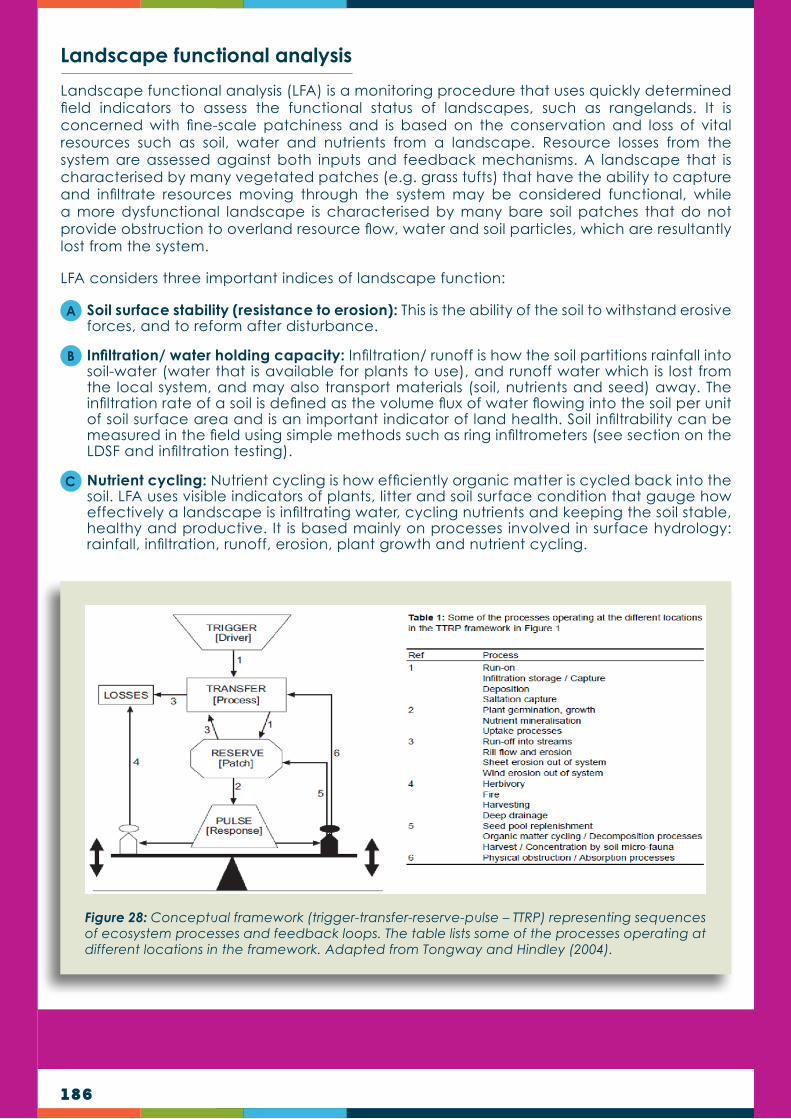
186
Landscape functional analysis
Landscape functional analysis (LFA) is a monitoring procedure that uses quickly determined field indicators to assess the functional status of landscapes, such as rangelands. It is concerned with fine-scale patchiness and is based on the conservation and loss of vital resources such as soil, water and nutrients from a landscape. Resource losses from the system are assessed against both inputs and feedback mechanisms. A landscape that is characterised by many vegetated patches (e.g. grass tufts) that have the ability to capture and infiltrate resources moving through the system may be considered functional, while a more dysfunctional landscape is characterised by many bare soil patches that do not provide obstruction to overland resource flow, water and soil particles, which are resultantly lost from the system.
LFA considers three important indices of landscape function:
Soil surface stability (resistance to erosion): This is the ability of the soil to withstand erosive forces, and to reform after disturbance.
Infiltration/ water holding capacity: Infiltration/ runoff is how the soil partitions rainfall into soil-water (water that is available for plants to use), and runoff water which is lost from the local system, and may also transport materials (soil, nutrients and seed) away. The infiltration rate of a soil is defined as the volume flux of water flowing into the soil per unit of soil surface area and is an important indicator of land health. Soil infiltrability can be measured in the field using simple methods such as ring infiltrometers (see section on the LDSF and infiltration testing).
Nutrient cycling: Nutrient cycling is how efficiently organic matter is cycled back into the soil. LFA uses visible indicators of plants, litter and soil surface condition that gauge how effectively a landscape is infiltrating water, cycling nutrients and keeping the soil stable, healthy and productive. It is based mainly on processes involved in surface hydrology: rainfall, infiltration, runoff, erosion, plant growth and nutrient cycling.
A
C
B
Figure 28: Conceptual framework (trigger-transfer-reserve-pulse – TTRP) representing sequences of ecosystem processes and feedback loops. The table lists some of the processes operating at different locations in the framework. Adapted from Tongway and Hindley (2004).
187
Determine grazing capacity
Grazing capacity refers to the number of grazers that can supported on a property without deterioration of the range condition. Grazing capacity can be expressed as hectare/livestock unit/year (ha/LSU/yr) where one livestock unit is a grazing animal of 450 kg. The grazing capacity of a property fluctuates over time and depends on rainfall and past range management such as occurrences of overgrazing.
Grazing capacity determination methods
The benchmark method
Where to collect data?
Determining grazing capacity is critical for sustainable rangeland grazing. Various methods can be used to determine grazing capacity. All methods rely on data collection in the field. In general, a good knowledge of the local grasses and their ecological importance is required for high quality data. To determine grazing capacity, information on the quality and quantity of the grazing is needed. The quality of grazing is related to the grass species composition, and the quantity on the amount of grass biomass present. These methods are used for a once-off rangeland condition and grazing capacity assessment or for long-term monitoring. Below we describe three methods: the benchmark method, the biomass method and a multi-criteria method.
The benchmark method (Danckwerts 1989) relies on collecting grass species data on a line transect. This is in order to get the grass species composition, in percentage occurrence of each species at each site. With each transect grass species data are collected at regular points (e.g. 1 m apart) along a straight line. The line can be obtained by using a 100 m measuring-tape or a rope marked at 1 m intervals. Another way is by simply walking in a straight line and putting the point of a stake onto the ground at each step or second step (so-called step-point method), from where data is collected. The grass species nearest to each point is then recorded on a form (see table 17).
When surveys are done for grazing capacity determination, it is important that sample sites are spread out over the whole study area and that the sites represent all vegetation units present in the study area. A map showing the vegetation units, such as grassland, shrubland, wetlands or boglands, is handy to plan where sites need to be placed. Each unit should have survey sites and larger units should have more sites that smaller units.

188
Image 45: Collecting data on a line transect using a measuring-tape and a wire stake. The tip of the wire stake is put down below each metre mark on the measuring-tape, from where the nearest grass species is then identified and recorded.
Apart from the grass names, one can also record whether the point is touching the base or crown of the recorded plant. This information is then used to calculate the basal cover or crown cover in percentage. Transects usually consist of 100 points, making it easy to convert the plant species data to percentage. For long-term monitoring, annual or bi-annual surveys should preferably be done on the same line every year.
Table 17 shows an example of a completed form used during a line transect survey to record species composition at an assessment site. Exactly 100 points were done to simplify the conversion of each species’ occurrence to percentage. A distinction was made between ‘hit’ (the point directly onto the base of plant) and ‘nearest plant’ (the point on ground). The total hits, in percentage, represent the basal cover, in this example 11% basal cover.

189
Table 17: Example of a completed survey form.
The benchmark method has two variations, one relies on the ecological index classification (decreasers and increasers) of grasses and the other on the grazing value (or forage value) of grasses and other forage plants. It uses a species survey (usually transect method) to determine the herbaceous plant species composition. It then uses the grazing values or ecological index values of the species present, and compares them with those of a benchmark site. Although less effective, the method can also be used without a benchmark site and with monitoring only the ecological index score and/or grazing value score over time.
What is a benchmark site?Assessment of range condition should include a comparison to some reference or benchmark site. Such a site is an area considered to be in excellent condition as regards the land use practised on the property. For a livestock or game ranch farmer, this would mean a maximum number of good forage plants. However, choosing a benchmark site requires a good knowledge of rangeland management principles. The benchmark site does not necessarily have to be on the same property and might be in a well-managed camp on a neighbouring farm, but in the same vegetation type as the monitoring sites.

190
A good knowledge of local plants is required. The following steps are involved (also see the table below for an example sheet for the ecological index method):
Table 18 is an example of a sheet where grass species composition was analysed for the benchmark method, using ecological index groups and values. Values in blue indicate results from the analysis. The grazing value of each species (1 – 10) can also be used instead of ecological index values.
Step 1 Do a transect to establish the grass species composition at the assessment site and list the species with their percentages.
Step 2 Group the plants now according to their ecological index groups (decreasers and increasers).
Step 3
Add the ecological index values (1–10) (sub-method A) or grazing values (also 1–10) (sub-method B) for each species in the column on the right. The ecological index group values are as follows:
Group Value
Decreasers 10
Increaser I’s 7
Increaser II’s 4
Increaser III’s 1
Invaders 1
Step 4Multiply the ecological index value (or grazing value for sub-method B) of each species with its percentage occurrence and record the value in the ‘Score’ columns.
Step 5 Add all the scores to get the subtotals and grand total.
Step 6
Determine the percentage difference between the grand total of the assessment site against that of the benchmark site. In the example below it is 481 over 900. If a benchmark site is not available a grand total of 1 000 (excellent rangeland condition) can be used. The percentage difference between these two sites represents the Range Condition Index (RCI).
Step 7
Interpret the results. This step involves comparison of all results from the table and writing comments on the most noticeable differences. The most valuable information is obtained from the ecological index method because of the classification system used. To a large extent, the percentage of decreasers are indicative to range condition and is closely checked during long-term monitoring.
Step 8Make recommendations for adaptive management. This step involves the listing of new or ongoing range management actions derived from information obtained from the assessment.
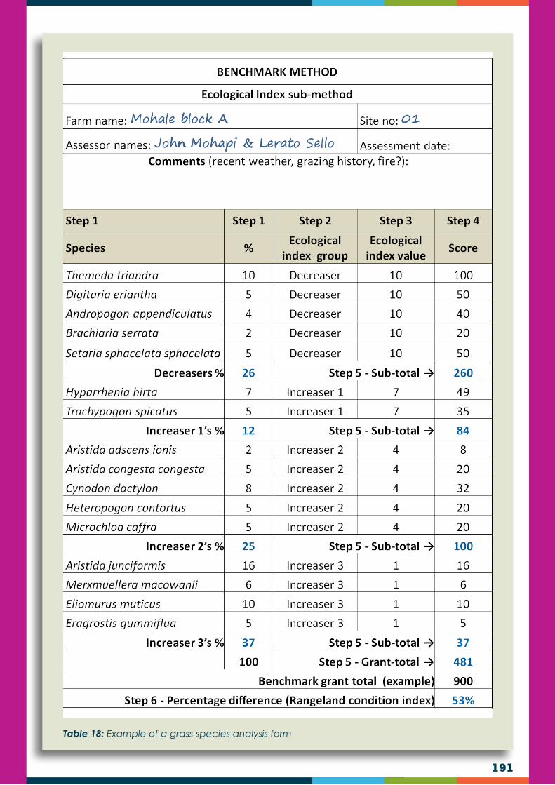
191
Table 18: Example of a grass species analysis form

192
Grazing capacity determination for the benchmark method
To determine grazing capacity with the benchmark method, the range condition index percentage, obtained from either the ecological index or grazing value index, is used (53% in example above). It also incorporates the average rainfall for the last two seasons. The equation used for this method is shown below, followed by an example calculation. It is suitable for regions with a rainfall of 600 mm/annum and more.
GC (AU/ha) = {[-0.03 + 0.00289 × RCI%] + [(rainfall – 419.7) (0.000633)]}
WHERE:
EXAMPLE:
GC = Grazing capacity in AU/ha.
RCI % = Range condition index in % of the benchmark rangeland condition score (53% for example below).
Rainfall = Average annual rainfall in mm for last two seasons (650 mm for example below).
GC = {[-0.03 + 0.00298 × RCI%] + [(X2 – 419.7) (0.000633)]}
GC = {[-0.03 + 0.00298 × 53%] + [(650 mm – 419.7) (0.000633)]}
GC = {[-0.03 + 0.00158] + [(230.3) (0.000633)]}
GC = {-0.02842 + 0.14578}
GC = 0.11736 AU/ha
or
GC = 8.5 ha/AU

193
Biomass method
This method, described by Moore & Odendaal (1987), uses the grass biomass per hectare to determine the grazing capacity for animal units (AU) for one year. It assumes that one AU consumes 11.25 kg grass per day (2.5% of its body mass of 450 kg). The method also includes a utilisation factor that can range from 0.20 (20%) to 0.50 (50%) (average 0.35), depending on the rangeland condition. The utilisation factor above is often linked to the range condition index percentage obtained during the benchmark method. Linking these two methods incorporates an effective combination between the quantity and quality grass fodder components.
Equation: y = d ÷ [ DM x f ] r
WHERE:
EXAMPLE:
y = grazing capacity (ha/AU).
d = number of days in the year (or period to be grazed).
DM = dry matter (biomass) in kg/ha (2 500 kg/ha in example below).
f = utilisation factor (between 0.20 (poor veld condition) and 0.50 (good veld condition) with 0.35 average).
r =daily dry matter required by one grazing animal (2.5% of bodyweight), which is 11.25 kg for an AU (450 kg grazing animal (cattle)).
y = 365 ÷ [2 500 kg/ha × 0.35]
11.25
y = 365 ÷ [875]
11.25
y = 365 ÷ 77.77
or
y = 4.7 ha/AU
This example shows the calculation where the dry matter production is 2 500 kg/ha and the utilisation factor is 0.35.

194
RCI % f value RCI % f value RCI % f value RCI % f value RCI % f value RCI % f value
10 0.200 25 0.250 40 0.300 55 0.350 70 0.400 85 0.450
10.5 0.202 25.5 0.252 40.5 0.302 55.5 0.352 70.5 0.402 85.5 0.452
11 0.203 26 0.253 41 0.303 56 0.353 71 0.403 86 0.453
11.5 0.205 26.5 0.255 41.5 0.305 56.5 0.355 71.5 0.405 86.5 0.455
12 0.207 27 0.257 42 0.307 57 0.357 72 0.407 87 0.457
12.5 0.208 27.5 0.258 42.5 0.308 57.5 0.358 72.5 0.408 87.5 0.458
13 0.210 28 0.260 43 0.310 58 0.360 73 0.410 88 0.460
13.5 0.212 28.5 0.262 43.5 0.312 58.5 0.362 73.5 0.412 88.5 0.462
14 0.213 29 0.263 44 0.313 59 0.363 74 0.413 89 0.463
14.5 0.215 29.5 0.265 44.5 0.315 59.5 0.365 74.5 0.415 89.5 0.465
15 0.217 30 0.267 45 0.317 60 0.367 75 0.417 90 0.467
15.5 0.218 30.5 0.268 45.5 0.318 60.5 0.368 75.5 0.418 90.5 0.468
16 0.220 31 0.270 46 0.320 61 0.370 76 0.420 91 0.470
16.5 0.222 31.5 0.272 46.5 0.322 61.5 0.372 76.5 0.422 91.5 0.472
17 0.223 32 0.273 47 0.323 62 0.373 77 0.423 92 0.473
17.5 0.225 32.5 0.275 47.5 0.325 62.5 0.375 77.5 0.425 92.5 0.475
18 0.227 33 0.277 48 0.327 63 0.377 78 0.427 93 0.477
18.5 0.228 33.5 0.278 48.5 0.328 63.5 0.378 78.5 0.428 93.5 0.478
19 0.230 34 0.280 49 0.330 64 0.380 79 0.430 94 0.480
19.5 0.232 34.5 0.282 49.5 0.332 64.5 0.382 79.5 0.432 94.5 0.482
20 0.233 35 0.283 50 0.333 65 0.383 80 0.433 95 0.483
20.5 0.235 35.5 0.285 50.5 0.335 65.5 0.385 80.5 0.435 95.5 0.485
21 0.237 36 0.287 51 0.337 66 0.387 81 0.437 96 0.487
21.5 0.238 36.5 0.288 51.5 0.338 66.5 0.388 81.5 0.438 96.5 0.488
22 0.240 37 0.290 52 0.340 67 0.390 82 0.440 97 0.490
22.5 0.242 37.5 0.292 52.5 0.342 67.5 0.392 82.5 0.442 97.5 0.492
23 0.243 38 0.293 53 0.343 68 0.393 83 0.443 98 0.493
23.5 0.245 38.5 0.295 53.5 0.345 68.5 0.395 83.5 0.445 98.5 0.495
24 0.247 39 0.297 54 0.347 69 0.397 84 0.447 99 0.497
24.5 0.248 39.5 0.298 54.5 0.348 69.5 0.398 84.5 0.448 99.5 0.500
Table 19: Utilisation factor values used for the biomass grazing capacity method based on the range condition index percentage obtained during the benchmark method.
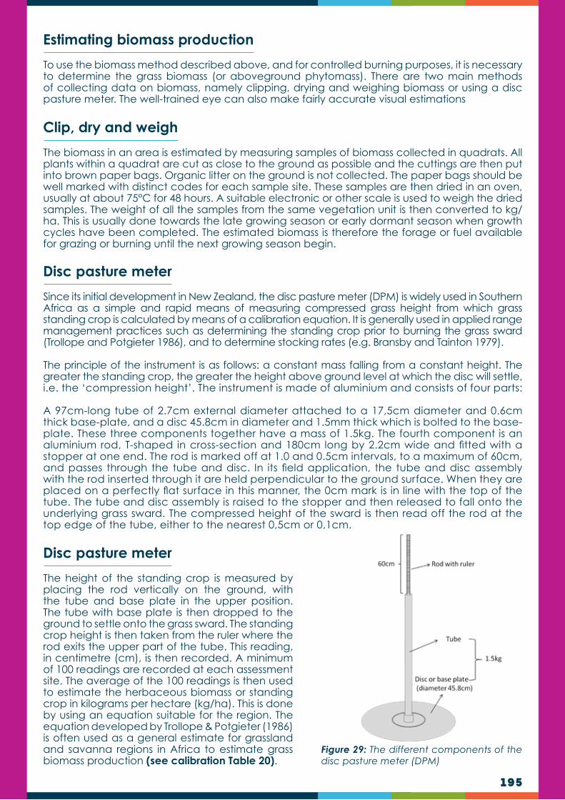
195
Figure 29: The different components of the disc pasture meter (DPM)
Estimating biomass production
Clip, dry and weigh
Disc pasture meter
Disc pasture meter
To use the biomass method described above, and for controlled burning purposes, it is necessary to determine the grass biomass (or aboveground phytomass). There are two main methods of collecting data on biomass, namely clipping, drying and weighing biomass or using a disc pasture meter. The well-trained eye can also make fairly accurate visual estimations
The biomass in an area is estimated by measuring samples of biomass collected in quadrats. All plants within a quadrat are cut as close to the ground as possible and the cuttings are then put into brown paper bags. Organic litter on the ground is not collected. The paper bags should be well marked with distinct codes for each sample site. These samples are then dried in an oven, usually at about 75°C for 48 hours. A suitable electronic or other scale is used to weigh the dried samples. The weight of all the samples from the same vegetation unit is then converted to kg/ha. This is usually done towards the late growing season or early dormant season when growth cycles have been completed. The estimated biomass is therefore the forage or fuel available for grazing or burning until the next growing season begin.
Since its initial development in New Zealand, the disc pasture meter (DPM) is widely used in Southern Africa as a simple and rapid means of measuring compressed grass height from which grass standing crop is calculated by means of a calibration equation. It is generally used in applied range management practices such as determining the standing crop prior to burning the grass sward (Trollope and Potgieter 1986), and to determine stocking rates (e.g. Bransby and Tainton 1979).
The principle of the instrument is as follows: a constant mass falling from a constant height. The greater the standing crop, the greater the height above ground level at which the disc will settle, i.e. the ‘compression height’. The instrument is made of aluminium and consists of four parts:
A 97cm-long tube of 2.7cm external diameter attached to a 17,5cm diameter and 0.6cm thick base-plate, and a disc 45.8cm in diameter and 1.5mm thick which is bolted to the base-plate. These three components together have a mass of 1.5kg. The fourth component is an aluminium rod, T-shaped in cross-section and 180cm long by 2.2cm wide and fitted with a stopper at one end. The rod is marked off at 1.0 and 0.5cm intervals, to a maximum of 60cm, and passes through the tube and disc. In its field application, the tube and disc assembly with the rod inserted through it are held perpendicular to the ground surface. When they are placed on a perfectly flat surface in this manner, the 0cm mark is in line with the top of the tube. The tube and disc assembly is raised to the stopper and then released to fall onto the underlying grass sward. The compressed height of the sward is then read off the rod at the top edge of the tube, either to the nearest 0,5cm or 0,1cm.
The height of the standing crop is measured by placing the rod vertically on the ground, with the tube and base plate in the upper position. The tube with base plate is then dropped to the ground to settle onto the grass sward. The standing crop height is then taken from the ruler where the rod exits the upper part of the tube. This reading, in centimetre (cm), is then recorded. A minimum of 100 readings are recorded at each assessment site. The average of the 100 readings is then used to estimate the herbaceous biomass or standing crop in kilograms per hectare (kg/ha). This is done by using an equation suitable for the region. The equation developed by Trollope & Potgieter (1986) is often used as a general estimate for grassland and savanna regions in Africa to estimate grass biomass production (see calibration Table 20).

196
cm kg/ha cm kg/ha cm kg/ha cm kg/ha cm kg/ha cm kg/ha cm kg/ha
2 177 6.3 2654 10.6 4339 14.9 5705 19.2 6884 23.5 7937 27.8 8897
2.1 256 6.4 2698 10.7 4374 15 5734 19.3 6910 23.6 7960 27.9 8918
2.2 333 6.5 2743 10.8 4408 15.1 5763 19.4 6935 23.7 7983 28 8940
2.3 408 6.6 2787 10.9 4442 15.2 5792 19.5 6961 23.8 8006 28.1 8961
2.4 482 6.7 2831 11 4477 15.3 5821 19.6 6986 23.9 8030 28.2 8982
2.5 554 6.8 2874 11.1 4511 15.4 5850 19.7 7012 24 8053 28.3 9004
2.6 625 6.9 2918 11.2 4544 15.5 5879 19.8 7037 24.1 8076 28.4 9025
2.7 695 7 2960 11.3 4578 15.6 5907 19.9 7063 24.2 8099 28.5 9046
2.8 763 7.1 3003 11.4 4612 15.7 5936 20 7088 24.3 8122 28.6 9067
2.9 830 7.2 3045 11.5 4645 15.8 5964 20.1 7113 24.4 8145 28.7 9088
3 895 7.3 3087 11.6 4678 15.9 5993 20.2 7138 24.5 8167 28.8 9109
3.1 960 7.4 3129 11.7 4711 16 6021 20.3 7164 24.6 8190 28.9 9130
3.2 1024 7.5 3170 11.8 4744 16.1 6049 20.4 7189 24.7 8213 29 9151
3.3 1086 7.6 3211 11.9 4777 16.2 6077 20.5 7214 24.8 8236 29.1 9172
3.4 1148 7.7 3252 12 4810 16.3 6105 20.6 7239 24.9 8258 29.2 9193
3.5 1209 7.8 3293 12.1 4842 16.4 6133 20.7 7263 25 8281 29.3 9214
3.6 1269 7.9 3333 12.2 4875 16.5 6161 20.8 7288 25.1 8304 29.4 9235
3.7 1328 8 3373 12.3 4907 16.6 6189 20.9 7313 25.2 8326 29.5 9256
3.8 1387 8.1 3413 12.4 4939 16.7 6217 21 7338 25.3 8349 29.6 9277
3.9 1444 8.2 3453 12.5 4971 16.8 6244 21.1 7362 25.4 8371 29.7 9297
4 1501 8.3 3492 12.6 5003 16.9 6272 21.2 7387 25.5 8393 29.8 9318
4.1 1557 8.4 3531 12.7 5035 17 6299 21.3 7411 25.6 8416 29.9 9339
4.2 1613 8.5 3570 12.8 5067 17.1 6327 21.4 7436 25.7 8438 30 9360
4.3 1667 8.6 3609 12.9 5098 17.2 6354 21.5 7460 25.8 8460 30.1 9380
4.4 1722 8.7 3647 13 5130 17.3 6381 21.6 7485 25.9 8483 30.2 9401
4.5 1775 8.8 3685 13.1 5161 17.4 6408 21.7 7509 26 8505 30.3 9421
4.6 1828 8.9 3723 13.2 5192 17.5 6435 21.8 7533 26.1 8527 30.4 9442
4.7 1881 9 3761 13.3 5223 17.6 6462 21.9 7557 26.2 8549 30.5 9462
4.8 1932 9.1 3799 13.4 5254 17.7 6489 22 7581 26.3 8571 30.6 9483
4.9 1984 9.2 3836 13.5 5285 17.8 6516 22.1 7605 26.4 8593 30.7 9503
5 2035 9.3 3873 13.6 5315 17.9 6543 22.2 7629 26.5 8615 30.8 9523
5.1 2085 9.4 3910 13.7 5346 18 6569 22.3 7653 26.6 8637 30.9 9544
5.2 2135 9.5 3947 13.8 5377 18.1 6596 22.4 7677 26.7 8659 31 9564
5.3 2184 9.6 3983 13.9 5407 18.2 6622 22.5 7701 26.8 8681 31.1 9584
5.4 2233 9.7 4020 14 5437 18.3 6649 22.6 7725 26.9 8703 31.2 9605
5.5 2281 9.8 4056 14.1 5467 18.4 6675 22.7 7749 27 8724 31.3 9625
5.6 2329 9.9 4092 14.2 5497 18.5 6702 22.8 7772 27.1 8746 31.4 9645
5.7 2377 10 4128 14.3 5527 18.6 6728 22.9 7796 27.2 8768 31.5 9665
5.8 2424 10.1 4163 14.4 5557 18.7 6754 23 7820 27.3 8789 31.6 9685
5.9 2471 10.2 4199 14.5 5587 18.8 6780 23.1 7843 27.4 8811
6 2517 10.3 4234 14.6 5616 18.9 6806 23.2 7867 27.5 8833
6.1 2563 10.4 4269 14.7 5646 19 6832 23.3 7890 27.6 8854
6.2 2608 10.5 4304 14.8 5675 19.1 6858 23.4 7913 27.7 8876
Table 20: Disc pasture meter heights (cm) and corresponding grass biomass (kg/ha) based on the equation developed by Trollope & Potgieter (1986)

197
Multi-criteria methods
Visual veld condition assessment method
Multi-criteria methods use the visual evaluation of criteria that are directly and indirectly related to range condition and grazing capacity. It uses the estimation of levels of condition on a scale, rather than surveys with actual quantitative data. Many people might find using multi-criteria methods to be more convenient because of the lower level of technical and botanical expertise required.
However, owing to the subjective manner of the method, the user has a major influence on the outcome and should therefore be extremely realistic and unbiased. The more knowledgeable the assessors, the more accurate the data and results. In this manual we describe the so-called “visual veld condition assessment” method (adapted from Van Zyl (1989) developed for the highveld region of South Africa).
With the visual veld condition assessment method criteria related to range condition and grazing potential are evaluated and rated on a scale. These criteria include grass biomass, presence of good grazing grasses, grass vitality, presence of unwanted plants, level of soil erosion and soil properties. After this evaluation the scores for each criterion are added to get the Veld Condition Score (VCS). This VCS, which has a maximum value of 80, is then used on a rainfall table to determine the grazing capacity. The following steps are followed:
Overleaf are the sheets used during this assessment (adapted from Van Zyl (1989) as developed for the highveld region of South Africa). They can be scanned and used during field work.
Step 1
On arrival at the assessment site, slowly walk a transect of about 100 × 2 m. During the walk, carefully inspect the plant species (types and condition) and the condition of the topsoil. To strengthen the information, a transect (e.g. step-point method) can also be used to determine species composition and basal cover. Make sure the site is representative of the vegetation unit.
Step 2 Complete the general information and site description for the site on the first page.
Step 3
Evaluate the criteria (A - F) on the second page. This is done by reading the descriptions of the different levels under each criterion. Choose then a score according to your evaluation and write it down in the space allowed. Add all the scores together to get the Veld condition score (VCS).
Note: The evaluation is best done by comparing, in your mind, a benchmark site in excellent condition. It should also be done in consultation with your assessment partners. If necessary, walk around and inspect the indicators more closely. Be very realistic and unbiased at all times. Also, try to avoid choosing the ‘average’ option as far as possible.
Step 4
Use the VCS on the rainfall table (page 3) to determine the estimated grazing capacity. This is done by selecting your VCS on the left column of the table and then linking that particular row with the rainfall column for your site. The average rainfall for the last two seasons can be used or the long-term average rainfall for the area. Where the two lines cross is the estimated grazing capacity, indicated in ha/LSU, where one LSU represents a grazing animal of 450 kg.

198
16
VISUAL VELD CONDITION ASSESSMENT
AMULTI-CRITERIAMETHOD
Grazingarea:______________________________________District:__________________
Observers: ___________________________________________Date:_______________
Coordinates:S:______________________E:____________________Elevation:________
Sitedescription
Comments:
___________________________________________________________________________
___________________________________________________________________________
___________________________________________________________________________
___________________________________________________________________________
Terrainunit Crest Midslope Footslope Valleybottom
SlopeLevel
(0°-2°)
Gentle
(3°-10°)
Moderate
(11°-45°)
Steep
(>45°)
Aspect N S W E NE NW SE SW
Soiltype Sandy Loam Clay Blackturf Humus Gravelly/rocky

199
17
Evaluation
Applyscorestothefollowingcriteria(A–F):
A. Howmuchgrassbiomassispresent?(quantitygrazing)
1 Verylowlevelsofgrassbiomass 0–3 ScoreA:
↓2 Lowlevelsofgrassbiomass 4–7
3 Moderatelevelsofgrassbiomass 8–11
4 Highlevelsofgrassbiomass 12–15
5 Veryhighlevelsofgrassbiomass 16─20
B. Howmanygoodgrazinggrassesarepresent?(qualitygrazing)
1 Mainlypoorgrazinggrassespresent 0–3 ScoreB:
↓2 Moderateandpoorgrazinggrassesmixed 4–7
3 Mainlymoderategrazinggrassespresent 8–11
4 Goodandmoderategrazinggrassesmixed 12–15
5 Mainlygoodgrazinggrassespresent 16─20
C. Howisthegrassvitality?(growthvigour)
1 Goodgrassesheavilygrazedwithverysmallweaktufts 1–2 ScoreC:
↓2 Goodgrassesheavilygrazedwithsmalltufts 3–4
3 Goodgrassesmoderatelygrazedwithmediumsizedtufts 5–6
4 Goodgrassesarestrongwithlargetufts 7–8
5 Goodgrassesareverystrongwithlargevigoroustufts 9–10
D. Howmuchencroachmentbyunwantedplantsispresent?
1 Heavyencroachmentispresent 1 ScoreD:
↓2 Heavytomediumencroachmentpresent 2─3
3 Mediumencroachmentispresent 4–5
4 Mediumtolightencroachmentispresent 6–7
5 Onlylightencroachmentispresent 8–9
6 Noencroachmentpresent 10
E. Howisthesoilsurfacecondition?(erosion)
1 Distincterosionwithonlyfewvegetationpatches 1–2 ScoreE:
↓2 Distincterosionaroundgrasstuftswithsomebarepatches 3–4
3 Moderatetolighterosionaroundgrasstufts 5–6
4 Noerosionandgoodcoveratgroundlevel 7–8
5 Noerosionwithdensecoverandgoodorganicmulch 9–10
F. Whatisthesoiltype?(productionpotential)
Texture↓Soildepth→ Deep Shallow Gravelly ScoreF:
↓1 Sandysoil(<10%clay) 2–4 -3 -5
2 Sandyloamsoil(10–15%clay) 5–6 -3 -5
3 Loamsoil(15–25%clay) 7–8 -3 -5
4 Clayloamsoil(25–35%clay) 9–10 -3 -5
5 Claysoil(35–50%clay) 7–8 -3 -5
6 Heavyclaysoil(>50%clay) 5-6 -3 -5

200
VCS Veld Condition
SEASONAL RAINFALL (mm/annum)
300 325 350 375 400 425 450 475 500 525
GRAZING CAPACITY (ha/AU/year)
20 - 22
Very poor
50.3 45.2 40.2 35.2 32.7 30.2 27.6 26.4 25.1 23.9
23 - 24 45.3 40.7 36.2 31.7 29.4 27.2 24.9 23.8 22.6 21.5
25 - 27 40.2 36.2 32.2 28.1 26.1 24.1 22.1 21.1 20.1 19.1
28 - 29 37.2 33.5 29.8 26.0 24.2 22.3 20.5 19.5 18.6 17.7
30 - 32
Poor
34.2 30.8 27.3 23.9 22.2 20.5 18.8 17.9 17.1 16.2
33 - 34 31.6 28.5 25.3 22.1 20.6 19.0 17.4 16.6 15.8 15.0
35 - 37 29.0 26.1 23.2 20.3 18.9 17.4 16.0 15.3 14.5 13.8
38 - 39 26.9 24.2 21.5 18.8 17.5 16.1 14.8 14.2 13.4 12.8
40 - 42 24.7 22.2 19.8 17.3 16.0 14.8 13.6 13.0 12.3 11.7
43 - 44
Moderate
23.5 21.1 18.8 16.5 15.2 14.1 12.9 12.4 11.7 11.2
45 - 47 22.2 20.0 17.8 15.6 14.4 13.3 12.2 11.7 11.1 10.6
48 - 49 21.1 19.0 16.9 14.8 13.7 12.7 11.6 11.1 10.6 10.1
50 - 52 20.0 18.0 16.0 14.0 13.0 12.0 11.0 10.5 10.0 9.5
53 - 54 19.0 17.1 15.2 13.3 12.4 11.4 10.5 10.0 9.5 9.1
55 - 57 18.0 16.2 14.4 12.6 11.7 10.8 9.9 9.5 9.0 8.6
58 - 59
Good
17.2 15.5 13.8 12.1 11.2 10.3 9.5 9.1 8.6 8.2
60 - 62 16.4 14.7 13.1 11.5 10.6 9.8 9.0 8.6 8.2 7.8
63 - 64 15.7 14.1 12.5 11.0 10.2 9.4 8.6 8.2 7.9 7.5
65 - 67 14.9 13.4 11.9 10.4 9.7 8.9 8.2 7.8 7.5 7.1
68 - 69 14.3 12.8 11.4 10.0 9.3 8.5 7.9 7.5 7.2 6.8
70 - 72
Very good
13.6 12.2 10.9 9.5 8.8 8.1 7.5 7.1 6.8 6.4
73 - 74 13.0 11.7 10.4 9.1 8.4 7.8 7.2 6.8 6.5 6.2
75 - 77 12.3 11.1 9.9 8.6 8.0 7.4 6.8 6.5 6.2 5.9
78 - 79 11.8 10.6 9.5 8.3 7.7 7.1 6.5 6.2 5.9 5.6
80 11.2 10.1 9.0 7.9 7.3 6.7 6.2 5.9 5.6 5.3
Add the scores together to get the Veld Condition Score (VCS):
VCS = A + B + C + D + E + F = ___ + ___ + ___ + ___ + ___ + ___ = VCS = _______
Use the Veld Condition Score (VCS) (left column), and long-term average rainfall (top row), to get the estimated grazing capacity from the table below:

201
SEASONAL RAINFALL (mm/annum)
550 575 600 625 650 675 700 725 750 800 850 900
GRAZING CAPACITY (ha/AU/year)
22.6 21.4 20.1 18.8 17.6 16.3 15.1 13.8 12.6 11.5 10.4 9.5
20.4 19.3 18.1 17.0 15.9 14.7 13.6 12.5 11.4 10.3 9.4 8.6
18.1 17.1 16.1 15.1 14.1 13.1 12.1 11.1 10.1 9.2 8.4 7.6
16.8 15.8 14.9 14.0 13.1 12.1 11.2 10.3 9.3 8.5 7.7 7.0
15.4 14.5 13.7 12.8 12.0 11.1 10.3 9.4 8.5 7.7 7.0 6.4
14.3 13.4 12.7 11.9 11.1 10.3 9.5 8.7 7.9 7.2 6.5 6.0
13.1 12.3 11.6 10.9 10.2 9.4 8.7 8.0 7.3 6.6 6.0 5.5
12.1 11.4 10.8 10.1 9.4 8.7 8.1 7.4 6.8 6.1 5.6 5.1
11.1 10.5 9.9 9.3 8.6 8.0 7.4 6.8 6.2 5.6 5.1 4.7
10.6 10.0 9.4 8.8 8.2 7.6 7.1 6.5 5.9 5.4 4.9 4.4
10.0 9.4 8.9 8.3 7.8 7.2 6.7 6.1 5.6 5.1 4.6 4.2
9.5 9.0 8.5 7.9 7.4 6.9 6.4 5.8 5.3 4.8 4.4 4.0
9.0 8.5 8.0 7.5 7.0 6.5 6.0 5.5 5.0 4.6 4.1 3.8
8.6 8.1 7.6 7.2 6.7 6.2 5.7 5.3 4.8 4.3 3.9 3.6
8.1 7.7 7.2 6.8 6.3 5.9 5.4 5.0 4.5 4.1 3.7 3.4
7.8 7.4 6.9 6.5 6.0 5.6 5.2 4.8 4.3 3.9 3.6 3.2
7.4 7.0 6.6 6.1 5.7 5.3 4.9 4.5 4.1 3.7 3.4 3.1
7.1 6.7 6.3 5.9 5.5 5.1 4.7 4.3 3.9 3.5 3.2 2.9
6.7 6.3 6.0 5.6 5.2 4.8 4.5 4.1 3.7 3.4 3.1 2.8
6.4 6.1 5.7 5.4 5.0 4.6 4.3 3.9 3.6 3.2 2.9 2.7
6.1 5.8 5.4 5.1 4.7 4.4 4.1 3.7 3.4 3.1 2.8 2.6
5.9 5.5 5.2 4.9 4.5 4.2 3.9 3.6 3.3 3.0 2.7 2.4
5.6 5.2 4.9 4.6 4.3 4.0 3.7 3.4 3.1 2.8 2.6 2.3
5.4 5.0 4.7 4.4 4.1 3.9 3.6 3.3 3.0 2.7 2.4 2.2
5.1 4.8 4.5 4.2 3.9 3.7 3.4 3.1 2.8 2.5 2.3 2.1
Determine browsing capacity
Browsing is when animals feed on leaves, branches, flowers and fruits of woody plants and forbs. Browsing capacity can be defined as the number of browsers that can be sustained by the woody vegetation of the area. The browsing capacity of trees and shrubs depends on the palatability and quantity of browse materials they produce in the 1.5 m high browsing zone, since small stocks cannot browse beyond this height. Thus, the quantity of browse produced by browse species in the 1.5 m high browsing zone is considered in determining browsing capacity. Species palatability and their abundances are important aspects of browsing capacity determination.
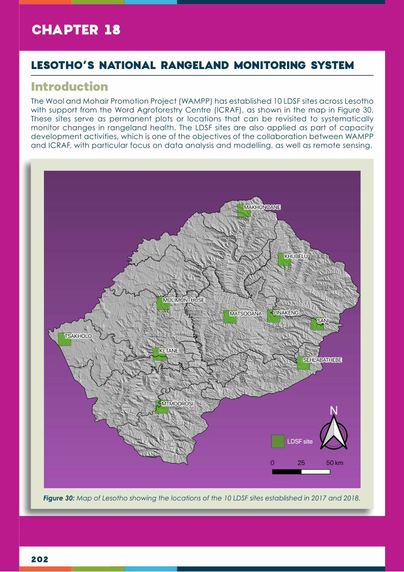
202
CHAPTER 18
The Wool and Mohair Promotion Project (WAMPP) has established 10 LDSF sites across Lesotho with support from the Word Agroforestry Centre (ICRAF), as shown in the map in Figure 30. These sites serve as permanent plots or locations that can be revisited to systematically monitor changes in rangeland health. The LDSF sites are also applied as part of capacity development activities, which is one of the objectives of the collaboration between WAMPP and ICRAF, with particular focus on data analysis and modelling, as well as remote sensing.
Introduction
LESOTHO’S NATIONAL RANGELAND MONITORING SYSTEM
Figure 30: Map of Lesotho showing the locations of the 10 LDSF sites established in 2017 and 2018.

203
The map background shows topographic shading based on the Shuttle Radar Topography Mission (SRTM) digital elevation model (DEM) and 30m resolution.
The Land Degradation Surveillance Framework (or LDSF) is designed to provide a biophysical baseline at landscape level, and a monitoring and evaluation framework for assessing processes of land degradation and the effectiveness of rehabilitation measures (recovery) over time.
The LDSF forms a comprehensive method for field-based assessment of land and soil health. Land health generally refers to the degree to which the integrity of the soil, vegetation, water and air, as well as ecological processes, are balanced and sustained.
Generally, very little is known about the state of ecosystems across Africa, including land cover and vegetation trends. This is particularly important in understanding land degradation processes, predicting changes in climate and improving land management. Systematic baselines of soil and ecosystem properties allow for a proper assessment of landscape performance and/or prediction of change over time.
National assessment of rangeland health for spatially explicit targeting of interventions (e.g. restoration) (2018 to 2019)
This component of the proposed project is applying the LDSF baselines in combination with predictive maps to inform WAMPP activities and management interventions. It is also working to establish protocols for electronic data entry and more systematic field data collection
The LDSF provides a field protocol for measuring indicators of the “health” of an ecosystem, including vegetation cover, structure and floristic composition, historic land use, land degradation, soil characteristics, including soil organic carbon stocks for assessing climate change mitigation potential, and infiltration capacity, as well as providing a monitoring framework to detect changes over time.
Explaining the Land Degredation Survei l lance Framework
Assessing land health in landscapes using multiple indicators at the same time (e.g. land use, land cover, soil properties, soil erosion, etc) requires multiple perspectives to understand how these indicators vary at different spatial scales. Data is therefore collected from four nested spatial scales: sites, clusters, plots and sub-plots, as illustrated below.
HOW DATA IS COLLECTED IN THE FIELD
Sites [100km2] are selected at random across a region or watershed, or they may represent areas of planned activities (interventions) or special interest. Each site is divided into 16 tiles of 2.5km x 2.5km each.
Within each tile, random centroid locations are generated for clusters. Clusters [1km2] are the basic sampling units and are made up of 10 plots [1000m2 or 0.1ha]. Using each cluster centre-point, the sampling plots are randomized to ensure comprehensive cover and accuracy of the data collection.
Each plot consists of four sub-plots [100m2 or 0.01ha].
At plot level, basic site characteristics are described and recorded:
Slope, landform, presence/absence of soil and water conservation structures
Land use
Rangeland health (see note on the LDSF Rangeland Module*)
Topographic position
Composite soil samples
At sub-plot level, soil erosion and herbaceous cover are observed:
Vegetation measurements (woody cover rating; tree and shrub densities)
Visible erosion recorded and classified
Topsoil and subsoil samples collected (160 per site) and composited into one topsoil and one subsoil sample per site
1
Sub-plot and plot-level data are analyzed using open source statistical software.
Generally, very little is known about the state of ecosystems across Africa, including land cover and vegetation trends. This is particularly important in understanding land degradation processes, predicting changes in climate and improving land management. Systematic baselines of soil and ecosystem properties allow for a proper assessment of landscape performance and/or prediction of change over time.
DATA COLLECTION AND ANALYSIS
Data collected in the field at a plot and sub-plot level
Data analysed
Biophysical indicators
Predictive maps
Data for land planning
OUTPUTS
SITE CLUSTER
PLOT
SUB-PLOT
DATA ANALYSIS2Soil samples are analyzed for mid-infrared (MIR) absorbance, to predict important soil properties such as SOC, pH, base cations, and texture.
THE LANDDEGREDATIONSURVEILLANCEFRAMEWORK
THELAND DEGREDATION SURVEILLANCE FRAMEWORK
MEASURING LAND HEALTH
The LDSF forms a comprehensive method for field-based assessment of land and soil health. Land health generally refers to the degree to which the integrity of the soil, vegetation, water and air, as well as ecological processes, are balanced and sustained.
The LDSF provides a field protocol for measuring indicators of the “health” of an ecosystem, including vegetation cover, structure and floristic composition, historic land use, land degradation, soil characteristics, including soil organic carbon stocks for assessing climate change mitigation potential, and infiltration capacity, as well as providing a monitoring framework to detect changes over time.
VALUE OF THE LDSF
Understand variability of environmental, social and economic indicators, and establish a baseline
Monitor soil organic carbon for climate change mitigation
Better understand map drivers and indicators of land degradation
Target land management interventions in landscapes and monitor and assess their impacts
Assess land mangement practices
Implement spatial targeting/prioritization of interventions
Enable inputs into bio-economic trade-off analysis
Inform investments
Improve crop/rangeland/climate models
Provide evidence to decision and policy makers
Communicate with local district officers and farmers
The Land Degredation Surveillance Framework (or LDSF) is designed to provide a biophysical baseline at landscape level, and a monitoring and evaluation framework for assessing processes of land degradation and the effectiveness of rehabilitation measures (recovery) over time.
Tor Gunnar Vagen, Senior [email protected]
Leigh Ann Winowiecki, Soil Systems [email protected]
World Agroforestry Centre (ICRAF)http://landscapeportal.org
CONTACT
The LDSF emphasizes landscape level measurements. These are measurements that are repeated many times across large areas (landscapes). The approach collects a statistical sample of the surveyed landscapes and develops models based on these data. As such, the LDSF forms part of the Ecosystem Health Surveillance System (EcoHSS) developed by the World
Agroforestry Centre (ICRAF). At present, the ICRAF GeoScience Lab hosts more than 30,000 biophysical, field-collected datasets from over 200 LDSF sites across the tropics, collected as part of multiple initiatives applying the EcoHSS.
Illustrated above is a layout of the EcoHSS.
ACCESS POWERFUL PREDICTIVE DATA FROM A GLOBAL NETWORK OF SITES

204
approaches as part of the national assessments of rangeland health conducted by DRRM to complement the LDSF sites, but also to allow for comparative analysis across both LDSF and the national assessment of rangeland health.
Figure 31 is a map of Lesotho showing the locations of National Rangeland Assessment clusters. Each of the clusters has 20 (1,000 m2) sampling plots that are randomly located where the core LDSF framework and rangeland module is applied, together with assessments of plant cover, botanical composition, vigour and browsing capacity.
Remote sensing or earth observation is an important element of systems for monitoring of rangeland health and is being applied for the development of predictive models and maps of soil properties, land degradation status (e.g. soil erosion prevalence) and overall range condition, allowing for the tracking of rangeland performance over time. Mapping of the distribution of increasers and degreasers is also being explored. The development of interactive tools will allow DRRM staff to explore indicators of rangelands health and maps, and will form part of a rangeland health monitoring and decision support tool for Lesotho.
Figure 31: Map showing the locations of National Rangeland Assessment clusters in Lesotho.

205
Figure 33 shows how maps of rangeland health can be produced at different spatial resolutions, depending on the satellite sensor used to generate the indicator maps. In this example, we have a map of (fractional) vegetation cover for 2017 from parts of Mohale’s Hoek produced using MODIS data at 500m resolution on the left and the same indicator mapped using Landsat 8 at 30m resolution on the right. The black box in each map highlights the same area in each map for reference.
3Explaining the Land Degredation Survei l lance Framework
OUTPUTSBIOPHYSICAL INDICATORS
Data from multiple global sites are used to create predictive mapping outputs at multiple spatial scales, with fine-resolution maps produced at 5 to 10m resolution or higher, high resolution maps at 20 to 30m resolution, and moderate resolution maps at 250 to 500m resolution. This enables you to zoom in to a specific area of your site and assess the possible indicators therein.
PREDICTIVE MAPS
The LDSF is part of the Ecosystem Health Surveillance System (EcoHSS) developed by ICRAF - illustrated below. As part of this system, we produce spatial assessments of processes of land degradation, soil functional properties, vegetation cover and biodiversity.
The LDSF measures a wide range of indicators, that serve as a valuable biophysical baseline. LAND USE
Current
Primary use
Historical
Ownership
LAND COVER
Vegetation stucture (LCCS)
Vegetation types
Woody vegetation
Shrubs
Density
Distribution
Biodiversity
Trees
Density
Distribution
Biodiversity
Herbaceous vegetation
Type
Density
Distribution
Indicators measured with the
LDSF
IMPACT ON HABITAT
LAND DEGRADATION
Impact on habitat
Soil erosion
Inherent degradation risk
Root-depth restrictions
Rock/stone cover
TOPOGRAPHY/LANDFORM
SOIL HEALTH
Soil on carbon (SOC)
Infiltration capacity
Soil pH/acidity
Texture (sand and clay)
Cumulative mass
Qualities of robust indicators for assessment and monitoring of land degradation include: Science-based
Readily measurable (quantifiable)
Based on field assessment across multiple scales (plot, field, landscape, region)
Rapid
Representative of the complex processes of land degradation
250m-500m resolution
20m-30m resolution
5m-10m resolution
Ecosystem Health Surveillance System
(EcoHSS)
ECOSYSTEM HEALTH DIAGNOSTICS
MONITORINGECOSYSTEM HEALTH
BASELINE ASSESSMENTS
ECOSYSTEM HEALTH ANALYTICS
Stakeholder engagement
Agricultural production
Indicator sets
Sustainability
Resilience
Livelihoods
Nutrition
Smallholder farmers
National stakeholders
IFAD projects and investments
Interaction with evidence
Participatory workshops
Social resilience
Ecological resilience
Earth observation
Big dataanalytics
Biophysical
Socio-economic
Land degredation
Soil health
Land cover
Land use
Household indicators
Village/community level indicators
Figure 32: Schematic illustration of the Ecosystem Health Surveillance System (EcoHSS) that the LDSF is part of.
Figure 33: Maps of rangeland health showing different spatial resolutions