Traditional Ecological Knowledge and the mapping of benthic marine habitats
11
(This is a sample cover image for this issue. The actual cover is not yet available at this time.) This article appeared in a journal published by Elsevier. The attached copy is furnished to the author for internal non-commercial research and education use, including for instruction at the authors institution and sharing with colleagues. Other uses, including reproduction and distribution, or selling or licensing copies, or posting to personal, institutional or third party websites are prohibited. In most cases authors are permitted to post their version of the article (e.g. in Word or Tex form) to their personal website or institutional repository. Authors requiring further information regarding Elsevier’s archiving and manuscript policies are encouraged to visit: http://www.elsevier.com/copyright
-
Upload
independent -
Category
Documents
-
view
0 -
download
0
Transcript of Traditional Ecological Knowledge and the mapping of benthic marine habitats

(This is a sample cover image for this issue. The actual cover is not yet available at this time.)
This article appeared in a journal published by Elsevier. The attachedcopy is furnished to the author for internal non-commercial researchand education use, including for instruction at the authors institution
and sharing with colleagues.
Other uses, including reproduction and distribution, or selling orlicensing copies, or posting to personal, institutional or third party
websites are prohibited.
In most cases authors are permitted to post their version of thearticle (e.g. in Word or Tex form) to their personal website orinstitutional repository. Authors requiring further information
regarding Elsevier’s archiving and manuscript policies areencouraged to visit:
http://www.elsevier.com/copyright
Author's personal copy
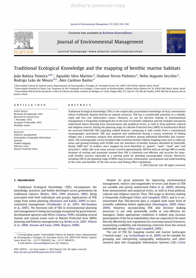
Traditional Ecological Knowledge and the mapping of benthic marine habitats
João Batista Teixeira a,b,*, Agnaldo Silva Martins a, Hudson Tercio Pinheiro a, Nelio Augusto Secchin a,Rodrigo Leão de Moura b,c, Alex Cardoso Bastos a
aUniversidade Federal do Espírito Santo, Departamento de Oceanografia e Ecologia, Av. Fernando Ferrari 514, 29075-910 Vitória, Espírito Santo, BrazilbUniversidade Estadual de Santa Cruz, Programa de Pós-Graduação em Ecologia e Conservação da Biodiversidade, Rodovia Ihéus-Itabuna km 16, 45662-900 Ilhéus, Bahia, BrazilcUniversidade Federal do Rio de Janeiro, Centro de Ciências da Saúde, Instituto de Biologia, Av. Carlos Chagas Filho 373, Sala A1-150, Ilha do Fundão, 21941-902 Rio de Janeiro, Rio deJaneiro, Brazil
a r t i c l e i n f o
Article history:Received 26 September 2011Received in revised form1 November 2012Accepted 9 November 2012Available online
Keywords:Fisheries managementParticipatory Geography InformationSystemsSeabed mappingSidescan sonarMarine Protected Areas
a b s t r a c t
Traditional Ecological Knowledge (TEK) is the empirically accumulated knowledge of local communitieswhose livelihoods depend directly on natural resources. TEK has a considerable potential as a reliable,rapid and low cost information source. However, its use for decision making in environmentalmanagement is frequently challenged due to the lack of scientific validation and the multiple and poorlyunderstood biases deriving from measurement and analytical errors, as well as from political, culturaland religious sources. During the planning stage of a Marine Protected Area (MPA) in Southeastern Brazilwe assessed fisherfolk TEK regarding seabed features, comparing it with results from a conventionaloceanographic assessment. TEK was acquired and synthesized during a survey involving 19 fishingvillages and a consensus analysis that minimized variation among individual fisherfolks and commu-nities. The oceanographic survey included high resolution benthic habitat mapping tools such as sidescansonar and ground-truthing with SCUBA near the interfaces of benthic features identified by fisherfolk.Nearly 3000 km2 of seafloor were mapped by local fisherfolk as “gravel”, “sand”, “mud” and “reefstructures”, while side-scan sonar surveys covered approximately 360 km with an average 400 m swath.Analyses of overlap and proximity showed that TEK is relatively cost-effective and accurate for large-scale benthic surveys, especially as a starting point for planning oceanographic surveys. Moreover,including TEK in the planning stage of MPAs may increase communities’ participation and understandingof the costs and benefits of the new access and fishing effort regulations.
! 2012 Elsevier Ltd. All rights reserved.
1. Introduction
Traditional Ecological Knowledge (TEK) encompasses theknowledge, practices and beliefs developed across generations bytraditional cultures (Berkes, 1993, 1999; Johannes, 1989), beingassociated with both individuals and groups. Applications of TEKrange from urban planning (Rantanen and Kahila, 2009) to envi-ronmental management (Friedlander et al., 2003; McClanahanet al., 2005). The foremost role of TEK in environmental planningandmanagement is being increasingly recognized by governments,development agencies and NGOs (Calamia, 1999), including severalmarine and coastal issues such as Marine Protected Area (MPA)planning and fisheriesmanagement (e.g. Berkes et al., 2001;Wilsonet al., 2006; Aswani and Lauer, 2006; Begossi, 2008).
Despite its great potential for improving environmentalmanagement, sources and magnitudes of errors and biases in TEKare variable and poorly understood (Ellen et al., 2000), derivingfrom measurement and analytical errors, as well as from political,cultural and religious sources. Thus, TEK usage in decision makingis frequently challenged (Silver and Campbell, 2005), and it is rec-ommended that TEK-derived data is coupled with some level ofscientific validation before application (Huntington, 2000; Usher,2000). However, incorporating TEK into decision makingprocesses is not only potentially useful or cost-effective formanagers. Under appropriate conditions it indeed may increaseparticipation of the local stakeholders that are expected to be moredirectly affected by new regulations for accessing natural resources,maximizing credibility and minimizing criticisms from the severalstakeholder groups (Silver and Campbell, 2005).
The use of TEK for mapping coastal and marine landscapes(“mental maps”; e.g. Gerhardinger et al., 2009) can be valuable forgrouping and interpreting topography, bathymetry and otherresearch data into Geographic Information Systems (GIS) (Close
* Corresponding author. Universidade Federal do Espírito Santo, Departamentode Oceanografia e Ecologia, Av. Fernando Ferrari 514, 29075-910 Vitória, EspíritoSanto, Brazil. Tel.: !55 27 32264203; fax: !55 27 30458731.
E-mail address: [email protected] (J.B. Teixeira).
Contents lists available at SciVerse ScienceDirect
Journal of Environmental Management
journal homepage: www.elsevier .com/locate/ jenvman
0301-4797/$ e see front matter ! 2012 Elsevier Ltd. All rights reserved.http://dx.doi.org/10.1016/j.jenvman.2012.11.020
Journal of Environmental Management 115 (2013) 241e250

Author's personal copy
and Hall, 2006; De Freitas and Tagliani, 2009; Lauer and Aswani,2009; Hall et al., 2009). For instance, in developing countries it isgenerally impossible (due to cost constrains) to obtain detailed andlarge scale benthic habitat maps for planning and managing MPAs,but mental maps of seabed features can be more easily obtainedand rapidly validated (Wright and Heyman, 2008; Aswani andLauer, 2006). Actually, seafloor habitat maps are still lacking formost tropical continental shelves, impeding a more systematicapproach for defining access rules coupled with ecological repre-sentation and functionality (e.g. connectivity among benthichabitats).
Oceanographers employ a broad array of tools and techniquesfor seafloor habitat mapping, from multibeam echosounders andsidescan sonar on scales greater than 1 km2 to in situ dive surveyson smaller-scale (<1 km2), sediment samples. Generally, a combi-nation of acoustic and direct methods produces the more accuratepicture of seabed types (Diaz et al., 2004), and the choice ofa benthic habitat survey method largely depends on the objectivesand cost constrains (e.g. availability of equipment and specializedpersonnel).
In data deficient contexts, TEK has the greater potential forcontributing with relevant information for developing targetedresearch and filling large geographic knowledge gaps (Stoffle et al.,1994). Close and Hall (2006) developed a protocol for integratinginformation about fishing areas into GIS through semi-formal
interviews. Techniques of Participative Rural Diagnostics werealso adapted into GIS (Participatory Geographic Information Systemse PGIS) and are being steadily employed (e.g. Bemigisha et al.,2009). Thus, integration of TEK into marine and coastal manage-ment deserves increased attention from managers and scientists.
In the present study we compared TEK-derived seafloor habitatmaps obtained during the planning stage of a Marine ProtectedArea (MPA) with habitat maps derived from a conventionaloceanographic assessment. Analyses of overlap and proximityshowed that TEK is relatively cost-effective and accurate for largescale benthic habitat mapping, especially as a starting point forplanning detailed “scientific” sampling. We also emphasize thatincluding TEK in the planning stage of MPAs may increasecommunities’ participation and understanding of the costs andbenefits of the new access and fishing effort regulations(Obermeyer, 1998; Craig et al., 2002).
2. Material and methods
2.1. Study area
The study region is located in the southern coast of EspíritoSanto State, Southeastern Brazil (18"220Se21"190S; Fig. 1), a trop-icalesubtropical transition zone with predominance of oligotro-phic waters and seasonal (summer) upwelling in its southern
Fig. 1. Study area showing local fishing communities and the places where participative workshops were carried out.
J.B. Teixeira et al. / Journal of Environmental Management 115 (2013) 241e250242

Author's personal copy
portion (Schmid et al., 1995). Climate is warm and humid in spring/summer and dry in autumn/winter, with 22 "C average annualtemperature (Nimer, 1989). The inner shelf is characterized by theinteraction of Tropical Water (TW) associated with the BrazilCurrent with South Atlantic Central Water (SACW) and CoastalWater (CW). Salinity is around 36.4 and sea surface temperature isalways above 20.5 "C (Castro and Miranda, 1998).
Coastline geomorphology is heterogeneous and encompassesQuaternary coastal plains, Tertiary coastal plateaus and coastalhills/hillocks. Hard bottom reefal structures are widespread in thecontinental shelf, including outcrops of ferruginous rocks (“later-ites”), igneous rocks, banks and slabs of calcareous algae, andbiogenic paleoreefs (“hillocks”). Terrigenous sand predominatesfrom the coast to depths of up to 20 m, followed by calcareous andbiogenic sediments such as bryozoans and calcareous algae reefs,with remarkable occurrence of paleovalleys near the 20 m isobaths(Albino and Gomes, 2005) (Fig. 1).
In the study region, algal diversity is the highest in the South-western Atlantic, including endemic calcareous algae species(Amado-Filho et al., 2007). Due to its unique attributes, the region isa National Priority Area for marine biodiversity conservation(MMA, 2007), but still lacks a comprehensive coastal zonemanagement framework. Most fisheries resources are alreadyoverexploited (Martins et al., 2009), and calcareous algae and car-bonatic sediments are being steadily exploited for the cosmetic,fertilizer and animal feed industries.
2.2. Fishing communities
Fishers from the study region were engaged into the surveythrough interviews (n # 37) and participation of 100 selected localexperts in workshops convened in the five localities with largernumbers of fisherfolks (Table 1) and better logistical conditions.Fisheries represent the main economic activity in three of thesemain localities, Ubú, Itaoca/Itaipava and Barra/Pontal do Itape-mirim, while in the other two, Anchieta and Piúma, there areseveral other important economic sectors related to the steelindustry and commerce. Representatives from 5 smaller(<50 fishers) neighboring villages (Mãe-bá, Ponta dos Castelhanos,Iriri, Inhaúma, Sede de Marataízes) were also invited to participatein the workshops (Fig. 1). In the larger localities fisheries areoriented to local and regional markets, while in the smaller villagesfisheries also play an important role in subsistence. Fishing systemsinvolve mainly benthic and demersal resources, with operation ofgears with great interaction with the bottom. All workshopparticipants were professional fishers who work daily at sea,although the fishing grounds may not overlap within the studyarea. For instance, the shrimp trawling fishers that predominate inAnchieta and Piuma do not operate on the reef and rhodolith areaswhere fishers from Barra and Pontal do Itapemirim capture reeffishes and lobsters. Fishers have no exclusive use rights over fishing
grounds and there are virtually no restrictions to entry if the fisherrequesting a licence is registered as a professional in a guild(“Colônia de Pescadores”). No quota system exists and the onlyregulations concern mesh sizes and annual seasons (fishing bans)for penaeid shrimps, lobsters (Panulirus spp.) and snook (Cen-tropomus spp.).
Semi-formal interviews using the “snowball” technique (Davisand Wagner, 2003) aiming to characterize fishing systems andidentify key informants. From the identification and targetedengagement of community leaders and the most experiencedfisherfolk, participative workshops were convened with w20 keyinformants from each locality.
2.3. Traditional Ecological Knowledge assessment
Focus group techniques might be biased toward the opinion ofa few outspoken or politically powerful participants (Morgan,1993). We minimized this weakness by carrying out a stepwiseprocess in order to strengthen the relationship between partici-pants and convenors (Silver and Campbell, 2005; Usher, 2000),always targeting consensus in the interpretation of benthic habitatfeatures and distribution, as follows:
Stage 1. Semi-formal interviews using the “snowball” technique(Davis and Wagner, 2003) aiming to characterize fishing systemsand identify key informants. From the identification and targetedengagement of community leaders and the most experiencedfisherfolk, participative workshops were convened with w20 keyinformants from each locality. These informants were generallyolder fishers (40e70 years old) with broad credibility within theircommunities, many of them being considered as local leaderships,both formally (e.g. associations’ presidents) and informally.
Stage 2. Five workshops (see Fig. 1 for locations) with an initialpresentation of the aims andmethodology, followed by the divisionof participants into working groups of 4e6 people themed aroundfishing system. Each group received transparencies and scrap paperwith a base map (scaled in km and nm) showing territorial limits,coastline, rivers, bathymetry, and the magnetic and geographicnorth. A facilitator explained the references to fisherfolks, whodrew their mental maps of the seabed on the scrap paper and onthe transparencies. Groups’ findings were analyzed by all partici-pants, through the projection of overlapped transparencies, i.e.highlighting coincidences and discrepancies. Rejection and confir-mation of features was thus based on consensus during this finalstage of the workshops.
Stage 3. Systematization of TEK in a GIS using ArcInfo 9.3/ESRI"
software with polygon shapefiles. Discrepancies were filtered bythe subsequent application of two criteria: 1) features similarlyclassified in more than one workshop prevailed over a single orfewer divergent views; 2) features mapped by fisherfolks from thenearest locality prevailed over features mapped by fisherfolks fromdistant localities. The resulting map (MTEK) was coded in four
Table 1Estimated number of fishers in the five main localities in which workshops were convened.
Locality Number of fishers per fishing system
Bottom trawl Line/longline Ornamentalfish/invertebrates
Spearfishing/lobster Gill nets Total
Anchieta Sede 80 80 2 e 30 192Itaoca/Itaipava 28 50 e 8 12 98Barra/Pontal do
Itapemirim25 60 12 905 16 1108
Piúma 150 8 e 10 150 318Ubú/Parati e 45 e 5 40 90Total 283 243 14 928 248 1716
J.B. Teixeira et al. / Journal of Environmental Management 115 (2013) 241e250 243

Author's personal copy
categories that were initially pointed out by the fisherfolks: 1)sandy bottom (sandTEK); 2) muddy bottom (mudTEK); 3) rocky and/or biogenic reefs (reef_structuresTEK); 4) biodetrical bottom or rho-dolith beds (gravelTEK).
2.4. Oceanographic surveys
Acoustic surveys were undertaken with an Edgetech 4100sidescan system with a 272TD towfish operated with 100 kHz and400 m swath. Bathymetric data was acquired with a Skipper 417echosounder. Acoustic seabed mapping with sidescan sonar isa well-established geophysical technique in oceanography (Blondeland Murton, 1997; Morang et al., 1996), in which indirect images(sonograms) are generated by different return intensities ofacoustic signals (backscatter). Backscatter patterns reflect sedimenttypes and bottom morphology, also depending on depth and inci-dent angle and attenuation of acoustic waves, among other factor.The spatial sampling design of the oceanographic survey was basedon the TEK map and covered the interfaces between seabedfeatures identified by fisherfolks, covering a linear extent of 360 km(w130 km2). Sidescan data was processed with SonarWiz Map4"
software, and georeferenced mosaics were exported into the GISwith a 1.0 m/pixel resolution. Images were interpreted based uponreflection intensity, roughness, shapes, shadows and bed texture.Benthic habitat classes were validated during 29 SCUBA divesacross all seabed types before being inserted in the GIS (100%correspondence). Thus, we did not conduct a more thoroughground-truthing of the sonar records (i.e. ground-truthing inhundreds of points) and considered the sonographic records asgood descriptors of the seabed (Blondel and Murton, 1997). Theresulting map (MSONAR) was coded in four benthic habitat cate-gories: 1) sandy bottom (sandsonar); 2) muddy bottom (mudsonar); 3)rocky and/or biogenic reefs (reef_structuressonar); 4) biodetricalbottom or rhodolith beds (gravelsonar).
2.5. Comparative analyses
Comparisons between maps generated by the oceanographicsurvey (MSONAR) and the TEK assessment (MTEK) were done withthe ArcToolbox/Intersect tool of ArcInfo 9.3/ESRI". Overlaps wererasterized (100 m pixels) and coded based on the four seabedclasses. Each pixel was further transformed in central points(100 m spacing) using Erdas Imagine 8.7/Leica Geosystems",preserving the four classes in the attribute table. This procedureresulted in two shapefiles with the overlaps, which were comparedin terms of the percentage of coincidences for each seabed type.
In order to verify if fisherfolk knowledge depends on thedistance offshore we employed the non-parametric WilcoxoneManneWhitney test (a # 0.05). In order to assess if seabedclasses identified by conventional oceanographic methods (MSO-NAR) are closer to equivalent classes identified by fisherfolks(MTEK) than to different seabed classes, analyses of proximity werecarried out with the ArcToolbox/Proximity/Near’ function, calcu-lating the distance between each centroid ofMSONAR to the closestMTEK class. This procedure was carried out separately for eachseabed class. Average proximity of equivalent seabed classesrepresents the margin of error (distance between the featuremapped by sidescan sonar and fisherfolks’ mental maps) and wasassessed with pairwise comparisons between seabed types(WilcoxoneManneWhitney test; a # 0.05).
Sidescan sonar images are able to identify features of a fewmeters, while fisherfolks’ mental maps represent seabed areas ofa few square kilometers. During the workshops, fishermen weregiven a nautical chart (scale 1:130,000) with isobaths and depthreferences (Supplementary Material 1), and were advised to
identify significant and extensive areas of muddy, sandy andcarbonate beds, and also areas with high concentration of reefs.Although the scale of the maps drawn by fisherfolk are differentfrom those of acoustic surveys, potential mismatches are mini-mized by the regional scale of the study.
Analyzing the mean proximity between sidescan-mappedfeatures and TEK-traced polygons allowed us to verify how TEKpolygons fit within sidescan mapped area. Thus, the comparisonsbetween mapped areas were relative to each other, and thedifferences in the scale of the two information sources did notinfluence our final conclusions (Supplementary Material 2).
3. Results
The 3000 km2 of seafloor mapped by fisherfolks (MTEK)included 8% of sand, 8% of silt/mud, 68% of calcareous/gravel, and16% of rocky/biogenic reef bottom, while the oceanographic survey(MSONAR) included 15% of sand, 13% of silt/mud, 68% of calcareous/gravel and 4% of rocky/biogenic reef bottom (Figs. 2 and 3). Featuresidentified by the acoustic survey were 100% corroborated by theSCUBA ground-truthing.
Fisherfolks’ mental maps of mud/silt and calcareous/gravelbottom showed 49 and 78% overlap with the oceanographic surveyresults. On the other hand, features identified by fisherfolks as reefsand sand corresponded largely to calcareous/gravel bottom habitat(Fig. 4). Fisherfoks’ correct assignment of benthic habitat classes didnot vary significantly with the distance from the coast (ManneWhitney test p # 0.055).
Areas classified by fisherfolks as calcareous/gravel and silt/mudbottom were indeed closer to these habitat classes as identified bythe oceanographic survey, while areas identified by fisherfolks asrocky/biogenic reef and sandy bottomwere not significantly relatedto these bottom types (WilcoxoneManneWhitney p # 0.314 and0.293, respectively; Fig. 5). Reef areas identified by fisherfolks are asclose to reefs as they are to gravel bottom, while areas identified assandy bottom are as close to sand as they are to gravel bottom(Fig. 6). Gravel bottom estimates were the most coincident, owingconsiderably to the predominance of this bottom class across thestudy region.
For the scales of coastal and marine planning, the averagemargin of error of up to 1600 m found in the TEK-derived maps isrelatively small (Blondel and Murton, 1997). For instance, mentalmaps of silt/mud bottom and calcareous/gravel bottom had averagedisplacements of 900 and 728 m relative to the oceanographicsurvey mapping, respectively. Mental maps of reef structures weredisplaced between 400 and 850 m, while mental maps of sandybottom were displaced between 600 and 1600 m from actual sandor gravel banks (Fig. 6).
4. Discussion
Seabed habitat mapping provides the much needed spatialplanning units for environmental conservation and management(Friedlander et al., 2003; Murray et al., 1999; Edgar et al., 2008), butcost and technology availability constrain the availability of habitatmaps for most continental shelves of developing countries. Inter-pretation of seabed classes derived from geophysical methods notonly requires the sampling of complete habitat mosaics, but alsoextensive ground-truthing with video transections and/or SCUBA(Cochranea and Lafferty, 2002; Kendall et al., 2005; Lathrop et al.,2006), meaning that seabed habitat maps can cost severalhundreds of dollars per square kilometer.
Traditional Ecological Knowledge can fill several importantknowledge gaps in terms of seabed habitat classification anddistribution, but its biases are generally poorly understood (Silver
J.B. Teixeira et al. / Journal of Environmental Management 115 (2013) 241e250244

Author's personal copy
and Campbell, 2005). In this study we demonstrate that TEK isa valid alternative for mapping seabed features, being cost-effectiveand with good results, also providing a major opportunity forfisherfolks’ engagement in the planning processes that will ulti-mately affect their activity. Mental maps of fisherfolks can also bean optimal starting point for the design of conventional oceano-graphic surveys for mapping seabed habitats for management andsystematic conservation planning purposes, decreasing their costsunder no-data scenarios.
The TEK about seabed configuration in the study region wasassessed through a stepwise participatory process aiming to engagefishing communities, through incorporation of their accumulatedknowledge in the planning process for a new MPA. Such commu-nity involvement allows fishing communities to become conser-vation partners, rather than opponents, adding an indirect benefitfor marine conservation (Friedlander et al., 2003; Drew, 2005).When fisherfolks and decision makers manage to work together,from planning to implementation of regulations, uncertainties inpublic policies, as well asmanagement costs (e.g. enforcement), canbe greatly reduced (McClanahan et al., 2005; Gerhardinger et al.,2009).
The margin of error of TEK-derived seabed habitat mappingreached only up to 1600 m in relation to standard oceanographicmethods, with no significant correlation between errors anddistance from the coast. Overlap and proximity analyses allowed forthe identification of seabed types that are more difficult to be
identified and positioned by mental maps. Features identified byfisherfolk as gravel were strongly corroborated by the oceano-graphic survey. However, ground-truthing with SCUBA diveshowed that this type of seabed, as identified by fisherfolks and theconventional oceanographic methods, is considerably heteroge-neous, including gross biodetritic calcareous sand, slabs of calcar-eous algae/bryozan/fouling invertebrates and rhodoliths associatedto macroalgae.
Conversely, features classified as reef structures by fisherfolkspresented a high percentage of gravel. Relevantly tough, the largeextensions of smaller rocky or biogenic reefs are intermingled bygravel and calcareous algae nodules (rhodoliths) in the entire studyarea (Albino and Gomes, 2005), impeding the identification ofindividual reefal structures at the scale at which TEK operates.Therefore, despite lowered detailed description for these relatedseabed classes, the TEK-mapping identified the larger reefal realmcorrectly. Areas identified as mud by fisherfolks were also relativelywell corroborated, and the correctness of TEK may have beeninfluenced by the increased trawling and seabed flattening that istaking place in the region (Pinheiro and Martins, 2009). Similarly,areas identified by fisherfolks as sand are as close to sandy bottomas they are to gravel/calcareous beds. This can be explained by thelimited differentiation, by the fisherfolks, between biodetric gaveland gross sand. The oceanographic survey indeed showed that sandfeatures were frequently intermingled with gravel beds, resultingin the lumping of this benthic classes by TEK, as both show similar
Fig. 2. Seabed classes identified by the fisherfolks during the workshops (MTEK). A) Integration of types of seabed mapped in all workshops; B) Transparency resulting from thework of one group.
J.B. Teixeira et al. / Journal of Environmental Management 115 (2013) 241e250 245

Author's personal copy
Fig. 4. Comparison of TEK-based mapping with the geophysical survey results. A) Percentages seabed class coverage in TEK-derived mapping (MTEK) and in the oceanographicsurvey (MSONAR). B) Composition of MSONAR classes for each type of MTEK seabed.
Fig. 3. Seabed classes identified during the oceanographic survey (MSONAR).
J.B. Teixeira et al. / Journal of Environmental Management 115 (2013) 241e250246

Author's personal copy
textures (Cochranea and Lafferty, 2002; Kendall et al., 2005). Thus,features described as sand by fisherfolks shall be interpreted asunconsolidated sandy sediment and/or biodetric gravel. Potentialmismatches of scales are overcome by first assessing TEK (coarser
lines drawn by fisherfolks) and then refining the habitat map withhigher resolution acoustic data. For instance, fisherfolks shall not beasked to draw specific habitat patches, but the general region ofreefs and other habitats.
Fig. 5. Extremes and quartiles of scores of proximity between each seabed class mapped by conventional oceanographic methods (MSONAR) and TEK-derived maps (MTEK). Themodel besides each map represents proximity between habitat classes. Data marked with (*) do not show a significant difference (ManneWhitney test p # 0.750 in A1 and p# 0.149in B1).
J.B. Teixeira et al. / Journal of Environmental Management 115 (2013) 241e250 247

Author's personal copy
5. Conclusion
Our study has found, from a detailed case study in SoutheasternBrazil, that TEKmapping can reliably fill important knowledge gapsin terms of seabed habitat classification and distribution, and alsoallows for stronger community engagement in the planning phaseof MPAs and other coastal management interventions. A greatamount of relevant information such as fishing areas, numbers offisherfolk per fishing system, conflicts, and ethnoecological infor-mation can be acquired during TEK assessments, complementing
the standard oceanographic methods used for habitat mapping.The effectiveness of participatory processes involving traditionalfisherfolks depends on how participation is structured and incor-porated into decision-making processes, especially because a mereconsultative process do not guarantee community engagement,even if it successfully decodes TEK (Craig et al., 2002; Obermeyer,1998). Community engagement shall be built up across variousstages of involvement, in order to break down resistance andminimize conflicts arising from the lack of legitimacy of the infor-mation being incorporated in the discussion. When TEK is
Fig. 6. Overlap of seabed maps produced by TEK (MTEK) and the oceanographic survey (MSONAR). The upper line shows the wider location of A, B, C and D on the MTEK andMSONAR maps.
J.B. Teixeira et al. / Journal of Environmental Management 115 (2013) 241e250248

Author's personal copy
incorporated as a reliable data source and further validated, theparticipatory approach has the greater potential to strengthen thedecisions regarding access rules to fishing grounds (Usher, 2000).Indeed, local knowledge about the environment is much more thana static, predetermined, intergenerationally transmitted set ofmental models, limiting the usefulness of strictly cogitative-basedmodels of categorization of human action (Ellen et al., 2000;Lauer and Aswani, 2009). Finally, we emphasize that the dynamicsituational dimensions, which are inseparable from the veryactivity of engaging with the environment (e.g. fishing), need to beacknowledged by researchers and managers incorporating TEK intheir agendas and toolboxes.
Acknowledgments
We are especially indebted to the fisherfolks that kindlyaccepted to share their extensive knowledge. We also thank Rob-erto Sforza, Priscila Angonesi, Fernando Repinaldo, Arthur LuizFerreira, Carla Rocha, Leandro Bonesi, James Araújo, EduardoGodoy, Nilamon Oliveira Jr, Eduardo Stein and Associação Ambi-ental Voz da Natureza for helping with the organization of theworkshops, WINDIVE, FLAMAR diving, A.A. Voz da Natureza, FlávioPavan Filho, Flávio Coelho, Maria Elisa Roquette, Miguel Saldanha,Diana Abreu, Lucas Lage, Thiony Simon, Lucas Xavier, Flavia Car-nelli, Raphael Macieira, Caio Pimentel, and Ryan Andrades fordiving support, and Jean-Christophe Joyeux and Gilberto Barrrosofor insights and collaboration during the research. The Fundação deApoio à Ciência e Tecnologia do Espírito Santo (FAPES), the Coor-denação de Aperfeiçoamento de Pessoal de Nível Superior (CAPES),the Conselho Nacional de Desenvolvimento Científico e Tecnológico(CNPq), the Fundação O Boticário de Proteção a Natureza (Projectnumber 0787_20081), the Fundação SOS Mata Atlântica (ProgramaCosta Atlântica) and the Instituto Chico Mendes de Biodiversidade(ICMBio) provided essencial support and/or grants to the authors.
Appendix A. Supplementary material
Supplementary material related to this article can be found athttp://dx.doi.org/10.1016/j.jenvman.2012.11.020.
References
Albino, J., Gomes, R.C., 2005. Descrição dos aspectos oceanográficos do litoral doEspírito Santo. Modelagem, monitoramento, erosão e ocupação costeira. Insti-tuto do Milênio e RECOS, Vitória. ES.
Amado-Filho, G.M., Maneveldt, G., Manso, R.C.C., Marins-Rosa, B.V., Pacheco, M.R.,Guimarães, S.M.P.B., 2007. Structure of rhodolith beds from 4 to 55 meters deepalong the southern coast of Espírito Santo State, Brazil. Ciencias Marinas 33 (4),399e410.
Aswani, S., Lauer, M., 2006. Benthic mapping using local aerial photo interpretationand resident taxa inventories for designing marine protected areas. Environ-mental Conservation 33, 263e273.
Begossi, A., 2008. Local knowledge and training towards management. Environ-ment Developement and Sustainability 10, 591e603.
Bemigisha, J., Carranza, J., Skidmore, A.K., McCall, M., Polce, C., Prins, H.H.T., 2009.Representation of uncertainty and integration of PGIS-based grazing intensitymaps using evidential belief functions. Transactions in GIS 13 (3), 273e293.
Berkes, F., Mahon, R., McConney, P., Pollnac, R., Pomeroy, R., 2001. Managing Small-scale Fisheries: Alternative Directions and Methods. International DevelopmentResearch Center, Ottawa, 308 pp.
Berkes, F., 1993. Traditional ecological knowledge in perspective. In: Inglis, J.T. (Ed.),Traditional Ecological Knowledge: Concepts and Cases. International Programon Traditional Ecological Knowledge and International Development ResearchCentre, Ottawa, pp. 1e9.
Berkes, F., 1999. Sacred Ecology: Traditional Ecological Knowledge and ResourceManagement. Taylor and Francis, Philadelphia, 209 pp.
Blondel, P., Murton, B.J., 1997. Handbook of Seafloor Sonar Imagery. Praxis-Wileyand Sons, West Sussex, 314 pp.
Calamia, M.A., 1999. A methodology for incorporating traditional ecologicalknowledge with geographic information systems for marine resourcemanagement in the Pacific. Traditional Marine Resource Management andKnowledge Information Bulletin 10, 2e12.
Castro, B.M., Miranda, L.B., 1998. Physical oceanography of the western Atlanticcontinental shelf located between 4"N and 34"S coastal segment, 4"W. In:Robinson, A.R., Brink, K.H. (Eds.), The Sea. John Wiley and Sons, New York,pp. 209e251.
Close, C.H., Hall, G.B., 2006. A GIS-based protocol for the extraction and use of localknowledge in fisheries management planning. Journal of EnvironmentalManagement 784, 341e352.
Cochranea, G.R., Lafferty, K.D., 2002. Use of acoustic classification of sidescan sonardata for mapping benthic habitat in the Northern Channel Islands, California.Continental Shelf Research 22, 683e690.
Craig, W.J., Harris, T.M., Weiner, D., 2002. Community Participation and GeographicInformation Systems. Taylor & Francis, London, 383 pp.
Davis, A., Wagner, J.R., 2003. Who knows? On the importance of identifying“experts” when researching local ecological knowledge. Human Ecology 31 (3),463e489.
De Freitas, D.M., Tagliani, P.R.A., 2009. The use of GIS for the integration of tradi-tional and scientific knowledge in supporting artisanal fisheries management insouthern Brazil. Journal of Environmental Management 90 (6), 2071e2080.
Diaz, R.J., Solan, M., Valente, R.M., 2004. A review of approaches for classifyingbenthic habitats and evaluating habitat quality. Journal of EnvironmentalManagement 73, 165e181.
Drew, J.A., 2005. Use of traditional ecological knowledge in marine conservation.Conservation Biology 19 (4), 1286e1293.
Edgar, G.J., Langhammer, P.F., Allen, G., Brooks, T.M., Brodie, J., Crosse, W., DeSilva, N., Fishpool, L.D.C., Foster, M.N., Knox, D.H., McCosker, J.E., McManus, R.,Millar, A.J.K., Mugo, R., 2008. Key biodiversity areas as globally significant targetsites for the conservation of marine biological diversity. Aquatic Conservation:Marine and Freshwater Ecosystems 18, 969e983.
Ellen, R., Parkes, P., Bicker, A., 2000. Indigenous Environmental Knowledge and ItsTransformations: Critical Anthropological Perspectives. Harwood AcademicPublishers, Amsterdam, 356 pp.
Friedlander, A.M., Sladek Nowlis, J., Sanchez, J.A., Appeldoorn, R., Usseglio, P.,McCormick, C., Bejarano, S., Mitchell-Chui, A., 2003. Designing effective marineprotected areas in Seaflower Biosphere Reserve, Colombia, based on biologicaland sociological information. Conservation Biology 17, 1769e1784.
Gerhardinger, L.C., Godoy, E.A.S., Jones, P.J.S., 2009. Local ecological knowledge andthe management of marine protected areas in Brazil. Ocean and CoastalManagement 52, 154e165.
Hall, G.B., Moore, A., Knight, P., Hankey, N., 2009. The extraction and utilization oflocal and scientific geospatial knowledge within the Bluff oyster fishery, NewZealand. Journal of Environmental Management 90, 2055e2070.
Huntington, H.P., 2000. Using traditional ecological knowledge in science: methodsand applications. Ecological Applications 10, 1270e1274.
Johannes, R.E., 1989. Traditional Ecological Knowledge: a Collection of Essays. IUCN,Switzerland and Cambridge, Gland, 77 pp.
Kendall, M.S., Jensen, O.P., Alexander, C., Field, D., McFall, G., Bohne, R.,Monaco, M.E., 2005. Benthic mapping using sonar, video transects, and aninnovative approach to accuracy assessment: a characterization of bottomfeatures in the Georgia Bight. Journal of Coastal Research 21 (6), 1154e1165.
Lathrop, R.G., Cole, M., Senyk, N., Butman, B., 2006. Seafloor habitat mapping of theNew York Bight incorporating sidescan sonar data. Estuarine, Coastal and ShelfScience 68, 221e230.
Lauer, M., Aswani, S., 2009. Indigenous ecological knowledge as situated practices:understanding fishers’ knowledge in the western Solomon Islands. AmericanAnthropologist 111, 317e329.
Martins, A.S., Santos, L.B., Pizetta, G.T., Monjardim, C., Doxsey, J.R., 2009. Interdis-ciplinary assessment of the status quo of the marine fishery systems in the stateof Espirito Santo, Brazil, using Rapfish. Journal of Applied Ichthyology 25, 269e276.
McClanahan, T.R., Maina, J., Davies, J., 2005. Perceptions of resource users andmanagers towards fisheries management options in Kenyan coral reefs. Fish-eries Management and Ecology 12, 105e112.
MMA, 2007. Áreas prioritárias para conservação, uso sustentável e repartição debenefícios da biodiversidade brasileira: Atualização da portaria MMA n" 9, de23 de janeiro de 2007, second ed.. In: Série Biodiversidade 31 Ministério doMeio Ambiente, Secretaria de Biodiversidade e Florestas, Brasília, 327 pp.
Morang, A., Larson, R., Gorman, L., 1996. Monitoring the coastal environments: partIII geophysical and research methods. Journal of Coastal Research 13, 1064e1085.
Morgan, D.L., 1993. Succesfull Focus Groups: Advancing the State of the Art. SagePubl., Newbury Park, CA, 271 pp.
Murray, S.N., Ambrose, R.F., Bohnsack, J.A., Botsford, L.W., Carr, M.H., Davis, G.E.,Dayton, P.K., Gotshall, D., Gunderson, D.R., Hixon, M.A., Lubchenco, J.,Mangel, M., MacCall, A., McArdle, D.A., Ogden, J.C., Roughgarden, J., Starr, R.M.,Tegner, M.J., Yoklavich, M.M., 1999. No-take reserves networks: protection forfishery populations and marine ecossystens. Fisheries 24, 11e25.
Nimer, E., 1989. Climatologia do Brasil, second ed. IBGE, Rio de Janeiro, 422 pp.Obermeyer, N.J., 1998. The evolution of public participation GIS. Cartography and
Geographic Information Systems 25, 665e666.Pinheiro, H.T., Martins, A.S., 2009. Estudo comparativo da captura artesanal do
camarão sete-barbas e sua fauna acompanhante em duas áreas de pesca dolitoral do estado do Espírito Santo, Brasil. Boletim do Instituto de Pesca de SãoPaulo 35 (2), 215e225.
Rantanen, H., Kahila, M., 2009. The SoftGIS approach to local knowledge. Journal ofEnvironmental Management 90, 1981e1990.
J.B. Teixeira et al. / Journal of Environmental Management 115 (2013) 241e250 249

Author's personal copy
Schmid, C., Sharfer, H., Podestá, G., Zenk, W., 1995. The vitória eddy and its relationto the Brazil Current. Journal of Physical Oceanography 25 (11), 2532e2546.
Silver, J.J., Campbell, L.M., 2005. Fisher participation in research: dilemmas with theuse of fisher knowledge. Ocean and Coastal Management 48, 721e741.
Stoffle, R.W., Halmo, D.B., Wagner, T.W., Luczkovich, J.J., 1994. Reefs from space:satellite imagery, marine ecology, and ethnography in the Dominican Republic.Human Ecology 22, 355e378.
Usher, P.J., 2000. Traditional ecological knowledge in environmental assessmentand management. The Arctic Institute of North America 53 (2), 183e193.
Wilson, D.C., Raakjær, J., Degnbol, P., 2006. Local ecological knowledge and practicalfisheries management in the tropics: a policy brief. Marine Policy 30, 794e801.
Wright, D.J., Heyman, W.D., 2008. Introduction to the special issue: marine andcoastal GIS for geomorphology, habitat mapping, and marine reserves. MarineGeodesy 31, 223e230.
J.B. Teixeira et al. / Journal of Environmental Management 115 (2013) 241e250250