towards sustainable and place rooted projects methodological ...
255
TOWARDS SUSTAINABLE AND PLACE ROOTED PROJECTS METHODOLOGICAL STRATEGY OF PLACE ANALYSIS AND INTERVENTION BASED ON PLACE IDENTITY Ramo de Doutoramento em Arquitetura Especialidade de Teoria e Prática de Projeto Nome da Doutoranda: Filomena Lopes Nascimento Nome dos Orientadores: Luís Miguel Cotrim Mateus, Faculdade de Arquitetura da Universidade de Lisboa; Miguel João Santiago, Universidade da Beira Interior Constituição do Júri: Presidente: Doutor Amílcar de Gil e Pires, Professor Auxiliar Faculdade de Arquitetura da Universidade de Lisboa Vogais: Doutora Teresa Marquito Marat-Mendes, Professora Auxiliar ISCTE – Instituto Universitário de Lisboa; Doutora Alexandra Cláudia Rebelo Paio, Professora Auxiliar ISCTE – Instituto Universitário de Lisboa; Doutor Victor Manuel Mota Ferreira, Professor Auxiliar Faculdade de Arquitetura da Universidade de Lisboa; Doutor Luís Miguel Cotrim Mateus, Professor Auxiliar, Faculdade de Arquitetura da Universidade de Lisboa; Doutor Luiz Filipe Pires da Conceição, Professor Auxiliar Convidado Faculdade de Arquitetura da Universidade de Lisboa. Tese especialmente elaborada para a obtenção do grau de doutor Documento definitivo Novembro, 2017
-
Upload
khangminh22 -
Category
Documents
-
view
1 -
download
0
Transcript of towards sustainable and place rooted projects methodological ...

TOWARDS SUSTAINABLE AND PLACE ROOTED PROJECTS
METHODOLOGICAL STRATEGY OF PLACE ANALYSIS AND
INTERVENTION BASED ON PLACE IDENTITY
Ramo de Doutoramento em Arquitetura
Especialidade de Teoria e Prática de Projeto
Nome da Doutoranda: Filomena Lopes Nascimento
Nome dos Orientadores: Luís Miguel Cotrim Mateus, Faculdade de Arquitetura da
Universidade de Lisboa; Miguel João Santiago, Universidade da Beira Interior
Constituição do Júri:
Presidente: Doutor Amílcar de Gil e Pires, Professor Auxiliar Faculdade de Arquitetura da Universidade de Lisboa Vogais: Doutora Teresa Marquito Marat-Mendes, Professora Auxiliar ISCTE – Instituto Universitário de Lisboa; Doutora Alexandra Cláudia Rebelo Paio, Professora Auxiliar ISCTE – Instituto Universitário de Lisboa; Doutor Victor Manuel Mota Ferreira, Professor Auxiliar Faculdade de Arquitetura da Universidade de Lisboa; Doutor Luís Miguel Cotrim Mateus, Professor Auxiliar, Faculdade de Arquitetura da Universidade de Lisboa; Doutor Luiz Filipe Pires da Conceição, Professor Auxiliar Convidado Faculdade de Arquitetura da Universidade de Lisboa.
Tese especialmente elaborada para a obtenção do grau de doutor
Documento definitivo
Novembro, 2017

Acknowledgments
To my family, friends, and advisors.
Special thanks to Professor Luís Mateus by the monthly meetings; without them, I would never finish the Ph.D.
Thank you, Sónia Mariano, for the InDesign and Illustrator tips and help.
At least, I thank the ones who are crazy enough to change the world, they are a source of inspiration, and to “Karma” for taking me to India showing me the social power of architecture; it changed me forever.


I
Index of Figures and Tables
The Thesis was printed in black and white. However, its color version is available on its digital support.
• Figures:
Figure 1: Research scheme. 2016. Source: Filomena Nascimento ...............................................................................15 Figure 2, 3: Romanian immigrants in Porto. Migration, especially stress migration, has been, largely, contributing to accelerate the increase of urban areas and urban settlements worldwide, both depending - among other factors - on population size and density. Portugal, 2011. Source: Filomena Nascimento ...............................................................................29
Figure 4: Figure 4: Forest of concrete at the megacity of São Paulo (Brazil). Currently, the Metropole is an example of what, among other factors, rapid urbanization and stressed migration can do. The Metropole is struggling against crime, air and noise pollution, housing, overcrowding, and poverty. Brazil, 2016. Source: Filomena Nascimento ..............................32
Figure 5: Trash at Chembur train station. Trash at Chembur train station. In Mumbai, the lack of infrastructures for garbage olle tion and re y ling added to ulture males it finishing in
the city´s physical space - especially in public spaces - create hazardous conditions to health and well-being - increasing the rate of infection so as the risk of epidemic. Mumbai, 2015. Source: Filomena Nascimento ...............................................37
Figure 6: Informal settlements in the city of Cairo. The majority of the houses are made by their owners, built without any plan or professional guidance, contributing to accelerate the built environment quality. Egypt, 2013. Source: From the Dehumanization of the Landscape, Pilot Project, Filomena Nascimento. Author: Rita Picareta .........................................37
Figure 7, 8: ’’NASA’s Centennial Challenge’ competition for a sustainable habitat for humans to live on Mars. Winner project ‘Ice House’ by the Team Space Exploration Architecture and Clouds Architecture. Mars, 2015. Source: http://www.marsicehouse.com/ .................................................................44
Figure 9, 10: Tornado Proof Houses, 10Design studio. America, 2011. Source:http://www.10design.co/press-releases/tornado-proof-house ....................................47
II
Figure 11: Dixon Water Josey Pavilion, Lake I Flato. America, 2014.Source:ht tp://www.archdaily.com.br/br/782530/pavilhao da funda ao di on water lake ato ar hite ts ....
Figure 12, 13: Simplified Vastu-Purusha mandalas relating to cardinal points offering design guidance. 2016. Source: Google search ..........................................................................56
Figure 14: Socio-spatial system interaction triad. 2013. Source: Filomena Nascimento ...............................................59
Figure 15: Socio-spatial system interaction triad with variables. 2013. Source: Filomena Nascimento .....................................81
Figure 16: Mumbai slum population distribution according Census 2001, Map was adapted by Filomena Nascimento, 2016. Source: http://www.censusindia.gov.in/maps/Town_maps/Mum_slum_pop.aspx, ................................................93
Figure 17: Map of Mumbai showing working areas. Mumbai, 2015. Source: Filomena Nascimento ....................................96
Figure 18: Port of Mumbai, small boat area. The port - one of the largest in the world - it receives an annual cargo average of 57.04 million tonnes. Due to its cinema industry, the big number of national and international companies, banks and its vibrant port, Mumbai is responsible for 70% of the country ommer ial and finan ial transitions. Mum ai, . Sour e
Filomena Nascimento ..............................................................97
Figure 19: Squatter settlement in a Mumbai pavement-walk. Due to the low incomings, the real estate prices and stress migration, the city hosts more than 50% of squatters among its population, living wherever they can - on sidewalks, along with the railways, in pavements and illegal informal clusters, preferably settled around employment places. Mumbai, 2015. Source: Filomena Nascimento ...............................................98
Figure 20: Pavement dewllers. Chembur. Mumbai, 2015. Source: Filomena Nascimento ...............................................99
Figure 21: Slum house. Mumbai (South) 2015. Source: Filomena Nascimento ............................................................101
Figure 22: Built environment qualities measurement. Mumbai major public transportation net. Mumbai, 2015. Source: Filomena Nascimento ............................................................102
Figure 23: Built environment qualities measurement. Correlation between public transportation net and slums concentration distribution. People, preferably settle around employment and transportation hubs. Mumbai, 2015. Filomena
III
Nascimento .............................................................................102
Figure 24, 25: Schemes of cities, towns and villages networking - large scale densities distribution. 2015. Source: Filomena Nascimento sketch book ......................................105
Figure 26: Mumbai showing visited and working areas. Mumbai, 2015. Source: Filomena Nascimento ...................107
Figure 27: Sketch of a vernacular mud brick house, way Chennai to Tirupati, 2015. Source: Filomena Nascimento ...........................................................................................................108
Figure 28: India 2015 baseline water stress map, India Water Tool, 2015. Mumbai is located in an area of low baseline water stress; however water is extremely polluted. Sources: http://www.indiawatertool.in/Map was adapted by Filomena Nascimento ..............................................................................111
Figure 29: Slum house scheme considering open-to-sky-space and natural ventilation on slums improvement studies hypothesis, 2015. Source: Filomena Nascimento .................101
Figure 30: Slum house scheme considering open-to-sky-space and new streets possibilities – on slums improvement studies - hypothesis, 2015. Source: Filomena Nascimento ..........................................................................................................112
Figure 31: Slum house scheme considering open-to-sky shared house space and public spaces new possibilities on slums improvement studies – hypothesis, 2015. Source: Filomena Nascimento ............................................................112
Figure 32: Mumbai sidewalk seller’s. Mumbai, 2015. Source: Filomena Nascimento ............................................................112
Figure 33: Mumbai crowded streets. Mumbai, 2015. Source: Filomena Nascimento ............................................................113
Figure 34: In Mumbai, sidewalks are crowded during the day with street vendors. Govandi, Mumbai, 2015. Source: Filomena Nascimento ............................................................................114
Figure 35, 36: Video frames showing Mumbai built environment degradation. Mumbai, 2015. Source: Filomena Nascimento ........................................................................................................115
Figure 37, 38, 39: Slums emergent intervention fronts, slums assets and Slum improvement proposal, 2015. Source: Filomena Nascimento .............................................................117
IV
Figure 40: Map showing the location of the nine given competition cities, Kenya, 2016. Source: Filomena Nascimento. Map was recreated through the United Nations competition given material ..........................................................................120
Figure 41: Map showing Nyeri location, Kenya, 2016. Source: Filomena Nascimento. Map was recreated through the United Nations competition given material ......................................126
Figure 42: Aerial plan showing Nyeri with Witemere working area. 2016. Source: United Nations competition brochure ...........................................................................................................129
Figure 43: Witemere slum facing the Kimathi road. The road defines a arrier that separates the iery town from the ite-mere site. Niery, 2016. Source: Filomena Nascimento ........130
Figure 44: Nyeri town, Kimathi road - the south limit of the in-tervention area. Niery, 2016, Source: Filomena Nascimento .......................................................................................................130
Figure 45: View of the Witemere slum facing south. Niery, 2016. Source: Filomena Nascimento ...................................130
Figure 46: Air temperature, humidity and wind rose charts. Nyeri climate studies. 2016. Source: Filomena Nascimento ........................................................................................................132
Figure 47: Nyeri sunrise and sunset diagram. 2016. Source: Filomena Nascimento ............................................................132
Figure 48: Witemere intervention 3D visualization using Sketchup. Witemere, 2016. Source: Filomena Nascimento .........................................................................................................133
Figure 49, 50: The Witemere site lack of infrastructures is visible, the roads and streets are made of rammed earth and the hoses of wood, without any kind of foundations or basic sanitation. Nyeri, 2016. Source: Filomena Nascimento ....... .....................................................................................................135
Figure 51: Inhabitants of Witemere watching clothes in the Chania river, a practice contributing to increasing environmental disasters and health hazards. Nyeri, 2016. Source: Filomena Nascimento .............................................................................135
Figure 52, 53: Witemere concept development scheme in-cluding F1 (phase 1), regarding the Witemere level tasks - site infrastructures and public facilities program (F) areas. 2016. Source: Filomena Nascimento .............,...............................136
V
Figure 54: Witemere house reconstruction scheme comprising F2 (phase 2) and intervention moments (M). 2016. Source: Filomena Nascimento ............................................................138
Figure 55, 56, 57, 58: Witemere Proposal. 2016. Source: Filomena Nascimento ............................................................140
Figure 50: Methodological strategy presentation scheme. 2017. Source: Filomena Nascimento ..............................181
Figure 51: Infography Illustrating parameters and sub-parameters. 2017. Source: Filomena Nascimento ............182
• Tables
Table 1: Crossing data table, 2016. Source: Filomena Nascimento ...............................................................................85
Table 2: Dwelling characteristic by the type of Roof / Wall / Floor. 2016 Source: Nyeri Town Strategic Urban development Plan (2014 - 2036) ...................................................................127
Table 3: Methodological Strategy of Place Analyses and Intervention Based on Place Identity (Synthesis) 2017. Source: Filomena Nascimento ............................................................167
Glossary and Abbreviations
• Glossary
Augmented reality: Requires the combination of a digital and the physical user´s environment in real time using a mobile phone, a tablet or a computer device. By merging both, real and virtual, it reates a new artifi ial environment ased on the new layers of information (graphics, audio, GPS, video) written on top of the existent one.
Brownfield development: Describes the redevelopment of land that has previously been developed. It often involves abandoned or underused military, industrial or commercial facilities (UN-H, 2012).
Density and how it is measured: Urban density can be explained as the number of people in a given area or space. Measuring urban density consists of three components: population, occupancy and residential density, which are interrelated and mutually dependent (UN-H, 2012).
Migration: The physical movement of people from one place to another (UN-H, 2012).

VI
Resilience: City resilience describes the capacity of cities to function, so that the people living and working in cities – particularly the poor and vulnerable – survive and thrive no matter what stresses or shocks they encounter (ARUP, 2014). Slum: A settlement made up of households that lack one or more of the following five onditions a ess to pota le water, a ess to hygieni sanitation fa ilities, suffi ient living area (not more than three people sharing the same room), structural quality and durability of dwellings and security of tenure (UN-H, 2012).
Urban agglomeration: ‘’…refers to the population contained within the contours of a contiguous territory inhabited at urban density levels without regard to administrative boundaries. It usually incorporates the population in a city or town plus that in the suburban areas lying outside the city proper but being adjacent to the city boundaries…’’ (UN, 2014).
Urbanization: The term used for the physical growth of urban areas as a result of global change in population location. The pull of the ity has always een ased on the enefits of urban agglomeration because living in cities permits the individual to take advantage of the opportunities of proximity, diversity and marketplace competition (UN-H, 2012).
Urban sprawl: A spatial phenomenon where a city spreads outwards, even beyond its suburbs to its outskirts. Urban sprawl is also referred to as irresponsible and, often, poorly planned development (often due to a lack of regulation) that destroys agricultural and natural land and systems (UN-H, 2012).
Virtual reality: irtual reality is an artifi ial environment that is created with software and presented to the user in such a way that the user suspends belief and accepts it as a real environment. On a computer, virtual reality is primarily e perien ed through two of the five senses sight and sound.
• Abbreviations
AR: Augmented reality BEM: Building Energy Modelling BIM: Building Information Modelling BREEAM: Building Research Establishment Environmental Assessment Method CBD: City business district DGNB: German Sustainable Building Council GDP: Gross domestic product GNP: Gross National Product LEED: Leadership in Energy and Environmental DesignNASA: National Aeronautics and Space AdministrationÖGNI: Austrian Sustainable Building Council

VII
UN: United Nations UNH: UN-Habitat UUSA: United States of America VR: Virtual reality INE: Instituto Nacinal de Estatística
References
ARUP (2014). City Resilience Framework. The Rockefeller Foundation, 3
UN-H, UN-Habitat (2012). For a Green Economy Leveraging Density. UNON, Publishing Services Section, Nairobi, glossary IX-XI
UN, United Nations (2014). United Nations Department of Economic and Social Affairs/Population Division. World

IX
Table of Contents
Abstract ........................................................................................1Resumo .......................................................................................3
Research Motivation ..................................................................7
Research Introduction
• Research Introduction .........................................................8• Research Structure .............................................................8• State of the Art .....................................................................9• Research Question ............................................................12• Research Goals .................................................................12• Research, Data and Methods ...........................................13• Research Contributions ....................................................15• References .........................................................................16
Chapter I: Context and Concepts
Chapter Introduction ................................................................21 Research, Data and Methods ................................................23
Contemporary Cities: Global Overview, Trends and Challenges
• Urban Transition Process and Urbanization .................26• Contemporary Cities Trends ............................................30• Contemporary Cities Challenges ....................................33
From Landscape to Place Identity
• Contemporary Built Landscape .......................................42• Environment and Human Behaviour ...............................48• Place Identity .....................................................................52
Chapter Discussion and Conclusions ...................................58 • Final Considerations and Future Outcomes ..................61• Limitations ..........................................................................63
References ...............................................................................65
Chapter II: From the Draft to the Operability of the New Methodological Strategy of Place Analysis and Intervention Based on Place Identity
Chapter Introduction ................................................................75Research, Date and Methods .................................................76
X
Place, Place Analysis and Place Intervention
• Drafting a New Methodological Strategy of Place Analysis and Intervention Based on Place Identity ..........79 • Holistic Space Approach and Parameters as Project Development Tools ...............................................80• Methods and Methodologies of Place Analysis and Intervention - Crossing Data ............................................83
Testing the Operability of the New Methodological Strategy:
Methodological Strategy of Sustainable Urban Growth for Cities in Low-Income Countries. Case Study: South Mumbai
• Research, Data and Methods ..........................................92• India Overview ...................................................................95• Mumbai Overview .............................................................96• Results ................................................................................99• Discussion and conclusions ...........................................106• Final Considerations and Future Outcomes .................116• Limitations .........................................................................118
International Design Collaboration for Kenya - The Site and the City. Nyeri, a New Bill of Rights. Case Study: Witemere
• Competition, Terms and Conditions ..............................120• Research, Data and Methods .........................................121• Kenya Overview ...............................................................124• Nyeri Town Overview .......................................................126• Witemere and the Assignment .......................................128• Results ..............................................................................128• Discussion and conclusions ...........................................139• Final Considerations and Future Outcomes .................143• Limitations ........................................................................144
Chapter Discussion and Conclusions ..................................144• Final Considerations and Future Outcomes ..................146 • Limitations .........................................................................151
References ..............................................................................153
Chapter III: Methodological Strategy Revisited
• Chapter Introduction ........................................................111• Research, Date and Methods .........................................162• Chapter Discussion and Conclusions ............................163• Final Considerations and Future Outcomes ................164• Limitations ........................................................................164
References ..............................................................................176

XI
Chapter IV: Research Conclusions
Research Discussion and Conclusions ...............................179• Research Limitations .......................................................184• Research Pathways .........................................................185
Research Bibliography ..........................................................187
Annexes
• Annex I• Annex II• Annex III• Annex IV

1
Abstract
The research, focused on the disciplines of architecture and urbanism, proposes to approach contemporary urban context, trends, and challenges in order to identify current dysfunctions used as the engine to look to places from a different perspective - rediscovering their uniqueness - in order to create a new planning approach towards sustainable and place rooted projects.
For the first time in human history the urban population has surpassed the rural one, currently, 54% of the world population lives in urban areas, and by 2050 it is estimated that 66% of the world population to be urban. In the coming decades, all regions of the planet will be more urbanized; highlighting Africa and Asia which, by 2050, will absorb approximately 90% of the world’s population.
Contemporary cities, especially the ones in developing countries, are sharply losing their capacity to guarantee life quality to their citizens. Globally, urban life is marked by increased levels of poverty, crime, difficult access to clean water, air and noise pollution, overcrowding, the exacerbation of resources consumption, and the ascendant house crises. Inside contemporary context, the urban and the architectural paradigm are no longer uncontrolled consumption of physical and social resources but their sustainable optimization, only possible through a deeply understanding of the place. This new paradigm shift requires cities to respond hurriedly, through new practices facing sustainability goals and programs that would consider their spatial qualities/identity as a project foundation, where a holistic approach towards a resilient and inclusive urban future is claimed. This is why we propose a methodological strategy of place analysis and intervention based on place identity as a new project development tool.
The research is divided into theoretical and practical syntheses. The theoretical synthesis uses secondary data to explore, on a global scale, contemporary cities context, trends and challenges in order to create an expanded field of information gathering insights defining the research question, the main concepts and the case studies outline. At this level, we defined place identity as the sum of the inter-relation and articulation of the geographical, the socio-cultural and the built environment qualities. We also defined the concept of socio-spatial system, where people and environment are understood as one, applying to a space holistic approach as a project development tool. In addition, the project methodologies of 10 architecture studios were analyzed and the data obtained was crossed with the one from the literature review, resulting in a draft of the methodological strategy.
2
At the practical synthesis, based on a quantitative approach, we tested the operability and recalibrated the methodological strategy. Two case studies were conducted, the first in Mumbai (India) and the second in Nyeri (Kenya), whose results gave rise to a stabilized version of the methodological strategy of place analysis and intervention based on place identity. Later, the methodological strategy was presented to architects, urban planners, and academics under a survey, and presented in conference communications. The feedback obtained was used to review and (re)design its final version.
The methodological strategy must be understood a flexible recommendation instead of a solution for every place and program. It works as a support for sustainable decision-making throughout project different stages inducting us, through given parameters, to listen to the question and not being assumptive about the place, becoming, thus, a development tool for the design of more sustainable, resilient and place rooted projects.
Key words: Methodological Strategy, Place Identity, Socio Spatial-System, Sustainability, Place Rooted Projects

3
Resumo
A investigação, centrada nas disciplinas da arquitectura e do urbanismo, propõe abordar o contexto urbano contemporâneo, nomeadamente as suas tendências e desafios, com o objectivo de identificar disfunções que potenciem novas formas de abordagem projectual centradas na (re)descoberta da identidade do lugar, impulsionando projectos mais sustentáveis, resilientes e inclusivos.
Pela primeira vez na história da humanidade a população urbana ultrapassou a população rural, actualmente 54% da população mundial vive em áreas urbanas, e até 2050 estima-se que 66% da população mundial seja urbana. Nas próximas décadas, todas as regiões do planeta serão mais urbanizadas; destacando a África e a Ásia que em 2050 absorverão, aproximadamente, 90% da população mundial.
As cidades contemporâneas, destacando as que se encontram em países em vias de desenvolvimento, estão abruptamente a aumentar em número e em área e, consequentemente, a perder a capacidade de continuar a garantir a anterior qualidade de vida aos seus cidadãos. Globalmente, a vida urbana é marcada por níveis crescentes de pobreza, migração, criminalidade, poluição atmosférica, o difícil acesso à educação, aos cuidados de saúde e à água potável, pelo consumo exacerbado dos recursos naturais e pela crescente crise habitacional. Dentro do contexto urbano contemporâneo o paradigma já não é o consumo descontrolado dos seus recursos físicos e sociais, mas sim a sua optimização sustentável através da compreensão profunda e holística do lugar.
Esta mudança exige que as cidades respondam, com urgência, através de novas práticas que contemplem o programa de qualidades espaciais de cada lugar - dentro desta investigação a sua identidade - como uma ferramenta operativa para o desenvolvimento de projectos orientados para a gestão dos recursos do lugar.
O trabalho de investigação divide-se em síntese teórica e em síntese prática. A síntese teórica utilizou dados secundários para explorar, à escala global, o contexto, as tendências e os desafios das cidades contemporâneas com o objectivo de criar um campo expandido de informação que contribuiu para definir o seu enquadramento, a questão de investigação e os casos de estudo. A síntese teórica divide-se em dois grandes momentos nomeadamente ‘’Contemporary Cities - Global Overview, Trends and Challenges’’ e ‘’From Landscape to Place Identity’’.

4
Em ‘’Contemporary Cities - Global Overview, Trends and Challenges’’ exploramos o contexto urbano contemporâneo com o objectivo de detectar frentes de trabalho emergentes, que, posteriormente, delinearão os casos de estudo onde a metodologia será testada. Começamos por explorar o processo de transição urbana e seus efeitos nas cidades contemporâneas, tanto à escala global como à escala local. Aqui, foram encontrados dois grupos diferentes de urbanização. O primeiro relaciona-se, maioritariamente, com o continente Africano e o Asiático onde se prevê que a taxa de urbanização aumente de 63% em 2014 para 79% em 2050, e o segundo no continente Europeu e em alguns países da Asia, onde a taxa de urbanização tende a abrandar.
Nesta secção também argumentamos sobre a mútua influência entre o meio ambiente e o ser humano e definimos os conceitos que modelam a investigação. O conceito de identidade do lugar (dentro desta investigação entendido como o resultado da inter-acção das qualidades espaciais de um lugar - i.e. as dimensões geográficas, sócio-culturais e do ambiente construído), e o conceito de sistema sócio-espacial (constituído pelas três mencionadas dimensões onde o espaço e os seres humanos são lidos como um: as pessoas-no-lugar). Conceitos que apelam a uma abordagem holística do espaço enquanto ferramenta de desenvolvimento projectual.
Para além da definição e estabilização dos conceitos, nesta secção, foi ainda desenhado o primeiro esboço da estratégia metodológica com base nos trabalhos de Francis Kéré, Rick Joy e Brian Mac-kay Lyon.
Na síntese prática, assente numa abordagem maioritariamente quantitativa, testámos a operacionalidade e calibramos a estratégia metodológica de intervenção e de análise com base na identidade do lugar. Esta síntese é, também, constituída por duas secções centrais. A primeira ‘‘Place, Place Analysis and Place Intervention’’ apresenta o primeiro esboço da estratégia metodológica projetada com base na revisão da literatura do Capítulo I. Nela, argumentamos sobre a relevância de uma visão holística do espaço e da utilização de parâmetros enquanto ferramentas operativas essenciais para o desenvolvimento do projeto. Argumentamos, ainda, sobre o facto de os parâmetros quando inscritos nos três grupos propostos - ou seja, o geográfico, o socio-cultural e o ambiente construído - correspondem a qualidades espaciais cujas relações de interdependência aumentão ou diminuem a identidade do lugar.
Nesta secção, visando uma versão mais completa da estratégia metodológica para posterior teste, recolhemos
5
uma amostra de 149 escritórios de arquitectura líderes em sustentabilidade - uma vez que esta é uma preocupação central da nossa investigação. Após uma análise das respectivas metodologias de projecto, a amostra passou a ser de 10 escritórios de arquitectura, e os resultados obtidos da análise aprofundada das suas metodologias foram cruzados com os resultados obtidos através da revisão da literatura, i.e. o primeiro esboço da estratégia metodológica, originando uma versão expandida da estratégia metodológica de análise e de intervenção através da identidade do lugar, que posteriormente foi testada e validada.
Em ‘‘Testing the Operability of the New Methodological Strategy of Place Analysis and Intervention’’, a segunda secção da síntese prática, foram conduzidos dois casos de estudo nomeadamente em Mumbai (Índia) e em Nyeri (Quênia). Os casos de estudo foram levados a cabo durante o período de Abril de 2015 a Abril de 2016, e utilizaram dados qualitativos e quantitativos. Para a escolha dos estudos de caso demos prioridade aos assentamentos informais, nomeadamente favelas, dentro do contexto urbano, uma vez que representaram o cenário mais desfavorável e, por isso, o melhor ambiente para testar nossa estratégia metodológica. Os resultados obtidos - através dos respetivos casos de estudo - deram origem a uma versão estabilizada da estratégia metodológica de análise e de intervenção baseada na identidade de lugar.
Com o intuito de validar e perceber a utilidade da estratégia metodológica, esta foi submetida a um total de 168 escritórios de arquitectura sob a forma de um inquérito eletrónico – i.e. através de um email survey – durante o período de 10 a 20 de janeiro de 2017. Este processo de validação, foi reforçado pela apresentação dos conceitos da investigação e do caso de estudo do Mumbai em conferências nomeadamente em 2013 na conferência ‘’Rede Lusófona de Morfologia Urbana (PNUM)’’, em 2016 no ‘’II International Congress on Sustainable Collective Housing’’ e em 2016 na ‘’22nd International Sustainable Development Research Society Conference (ISDRS)’’.
De acordo com o feedback obtido, através do processo de validação, um dos maiores contributos da investigação é o facto de esta ser a condensação de métodos, ferramentas e recomendações, que são usadas de forma dispersa e separada por diferentes entidades, em um único documento i.e. a estratégia metodológica de análise e de intervenção com base na identidade do lugar.
A estratégia metodológica deve ser entendida como um conjunto de passos e de recomendações projectuais flexíveis, em vez de uma solução hermética para todos os lugares e/

6
ou programas. Esta deve funcionar como um suporte que impulsiona e agiliza a tomada de decisões sustentáveis ao longo das diferentes fases de um projecto, e os parâmetros como ferramentas que nos ajudam, efectivamente, a ‘’ouvir’’ a questão - i.e. o lugar - contribuindo para o reforço de uma visão espacial holística e estratégica útil para projectar soluções centradas na optimização dos recursos de cada lugar; uma prática fundamental dentro de uma era em que a escassez de recursos é eminente.
Palavras-chave: Estratégia Metodológica, Identidade do Lugar, Sistema Socio-Espacial, Sustentabilidade
7
Research Motivation
Research motivation arose from a single question: What is architecture The first time I questioned architecture it was in 2006 during my trainee. By doing that single question I found, instead of answers, more questions. There is no easy answer because architecture goes beyond its physical dimension. Indeed the other dimensions were always my biggest concern and the engine of this research.
uring graduation, I was told that, in order to be great, architecture should take into consideration its social, economic, political, built and natural context. When I started work as an architect I was disappointed. From my experience architecture was everything except what I was told. We had very short time to develop projects, place survey was mostly about built and topographical environment, we spent a large time in the studio drawing and very little outside studding people and place. I found myself in a very interesting set of projects but I always had the feeling that something was missing. In most of the projects, I was wondering, if architecture is for people and for the improvement of their lives why were they, most of the times, left behind Why were we so centered in the project itself and so little in is true connection to the natural and the social surroundings What types of landscapes were we creating id people really enjoy these new landscapes or were they an architectural imposition
In a short time I realized an important thing, that among other factors, we were being pressured by the market clock and its pace was an ascending arrow leading to minimum time to develop a project. Thus, my focus shifted and instead of waiting for the market to slow down, so we could have more time to study the place and to develop a project, I started to think about what I could do to improve project response capacity to its particular context. I started to explore different approaches towards architectural production and my social concern lead me to the master where I explored ‘The Relevance of Place sociological Study for Project evelopment in Architecture’. The research gave rise to a tool to be introduced at the project’s early stage - the concept. By allowing combining and showing social and built environment dimensions in one single space the photo-documentary was contributing to the design of projects more rooted to places. owever, the natural dimension was missing so as a deeper space holistic understanding and approach. Thus I decided to go further and try to create a methodological strategy of place analysis and intervention based on its identity i.e. natural, socio-cultural and built environment dimension.

8
Research Introduction
Through personal bias and the literature review - heavily falls in the United Nations reports on human settlements - we have identified the major trends and challenges of contemporary cities. We used this data as an evidence base to research new options contributing to improving project’s response capacity to its context through a new methodology of place analysis and intervention based on place identity.
The first draft of the new methodological strategy was designed after the literature review, where we had identified the main parameters to consider when creating a methodological strategy prioritizing sustainability and place rooted projects. It was intended to cross this primary data with the one resulting from the analyses of 10 architecture studios project methodologies, resulting in the new methodological strategy tested through two case studies (Mumbai and Nyeri). The results were presented to experts (architects, urban planners, and academics) in order to be evaluated and reviewed; leading to research conclusions and pathways.
Research Structure
This research is structured as follows:
Chapter I: Provides an overview of the research problem focusing on contemporary cities trends and challenges - an expanded state of the art. Chapter I introduce the research conceptual framework and define the research field of work.
Chapter II: In this chapter, we defined and tested the operability of proposed methodological strategy of place analysis and intervention based on place identity. First, we crossed the findings in the literature review with the 10 architecture studios project methodologies analysis, aiming the design of the new methodological strategy. Later, the proposed methodological strategy was tested through two case studies (Mumbai, India, and Nyeri, Kenya) resulting in the stabilized version of the proposed methodological strategy of place analyses and intervention based on place identity; after presented to architects, urban planners and academics through survey and communications.
Chapter III: Summarizes the process of presentation and revi-sion of proposed methodological strategy of place analysis and intervention based on place identity. We describe how the email survey was conducted and sent to architects, urban planners, and academics, in order to collect methodological strategy feedbacks aiming its recalibration and validation. A process reinforced by its presentation in conferences.
9
After data cross and methodological strategy revision, we present its final version.
Chapter I : Concludes with the research discussion, conclu-sions, and limitations pointing the research pathways.
State of the Art
In this research, we look from the macro to the micro scale. We face the built environment as a system - the socio-spatial system - where all components behavior is affected by each other’s, interfering with the performance of all system. It is a structure of mutual influences where all scales and actions matter, this is why our starting point is the contemporary cities current situation - cities are the summation of all built envi-ronment components and scales. Cities are a great field of reflection of our actions as architects and urban planners representing a tremendous project lesson compelling to the constant recalibration of the praxis.
In that context we searched for the most updated reports, papers, conferences, documentaries and master classes, research largely feeds on ouTube references, because we wanted to know what architects and urban planners are thinking now. We wanted to go deeply into the current concerns, challenges and trends and their implications for the future of the environment; reviewing at the same time concepts as the aisen of Martin eidegger for its relevance in space production contributing, by its phenomenological nature, to more sustainable places.
Currently, 54% of the world’s population live in urban areas and in 2050 it is expected that 66% of the world’s population to be urban. Over the next decades all regions will become more urbanized; however, Africa and Asia by 2050 are esti-mated to comprise nearly 90% of the world’s urban population - projected to increase 2.5 billion people. In 2014, 18 countries accommodated 28 mega-cities - urban agglomeration with, at least, 10 million inhabitants - by 2030 it is expected that the world has 41 mega-cities. At global scale massive fluxes of people flock to cities; it was estimated by the United Nations that between the period of 2010 and 2015 near 200,000 people migrates daily to cities worldwide - together with the increasing native population, expand the number of squatter settlements and shanty towns. Mega-cities and urban popula-tion growth give a clear picture of the trials that governments, town planners, and citizens have to face (UN, 2014, 2015; Cohen, 2003, 2006).
Contemporary cities are sharply increasing in number and area, building fragile ecosystems constantly on the edge; the bigger is the city more difficult it will be to manage it. In

10
order to grow, contemporary cities will face several challenges related to the economy, climate change, natural resources management, transportation, housing, urban poverty, access to clean water, sanitation, crime, air and noise pollution as well as overcrowding. In order to answer to such demanding tasks, contemporary cities have to grow smart. By their speedy envi-ronment degradation one can easily guess that an effective collaboration between land use, natural and social resources management and sustainable urban planning is needed; requiring a space holistic approach integrating the social dimension.
For Walter (1988) the sharp environment degradation has a clear link with the meaningless places that we design, proposing a return to a holistic place reading where natural and built environment are understood as a system giving meaning to places and, for that so, creating affective bonds. The way we design plays a key role on how people will behave (Pe alosa, 2013; 3 N, 2010) and how much they will relate and respect their environment. This is particularly relevant because, at a global scale, the landscape is tending to become meaning-less and, consequently, dehumanized. A trend increased by the instability of the contemporary condition that tends to hipper-compress the time of answer which architecture, by its buildable nature, is unable to achieve - contributing to proj-ects mismatching local culture, climate, and built environment. A landscape-oriented towards finance and image-obsessed characterizing contemporary culture, contributing to cultural homogenization reinforced by a design tendency towards a bottle of perfume (Wood, 2015; Ingels, 2015) i.e. a design mainly centered in the form.
Contemporary cities, opened a field of new dysfunctions potentiating new functionalities and ways of working (Kool-haas, 2016) boosting the opportunity to look to places from a different perspective, rediscovering their uniqueness as a way to brake of the homogenization of space experience. In fact, since the 70’s, of the last century, there is an explicit need to approach place and project from a different perspec-tive. The place became associated with its social dimension ( i-Fu, 1974; Buttimer, 1976, 1980 and Relph, 1976, 1981) and its impact on the Landscape who has become the result of a place economic and social transformation related to its population cultural activity (European Landscape Convention, 2000). A definition of landscape recognizing a systematic view of space where all the parts, i.e. geographical, built and social, are interconnected and interdependent; requiring a deeper understanding of the human being in the world - the asein of Martin eidegger ( eidegger, 1962; Seamon, 2011; 2012).
This perspective is particularly relevant in an era, as the current one, ruled by tremendous economic, political and
11
technological complexity with a profound impact on society. Inside contemporary context, the urban and the architectural paradigm are no longer uncontrolled consummation of phys-ical and social resources but their sustainable optimization, only possible through a place deep understanding. This new paradigm shift requires cities to respond hurriedly through new practices facing sustainability goals and programs that would consider its spatial qualities/identity as a project foun-dation (Calthorpe et al, 2005; Kéré, 2015).
Sustainability no longer relates to the ecological dimension, in fact, it embeds economic, social, cultural, political and built environment dimensions, it is multi-dimensional and this is why we claim place identity as a central tool to project devel-opment. In addition, the weakening of place identity leads to its abandonment, therefore its comprehension and preservation can be a method for the intensification of its usage and space qualities preservation. Ignore place identity it’s to ignore that people have an innate sense for genius loci and, existentially, gravitate toward it (Seamon, 2011). For being a place perma-nent core, place identity helps to reinforce the bonds between people and place - becoming a substructure of the self - trans-lated in space permanent appropriation. A way of felling space as our belonging and extension contributing to maintain life of and in places by promoting a sense of familiarity, of environ-mental stability and feelings of control and safety; contributing to the notion of ‘existential space’ essential for human devel-opment ( idal et al, 2012; Schulz, 1971; 1980).
This is why we claim for space holistic understanding as a project development tool because it allows thinking space as a system - the social-spatial system. By system, we desig-nate a holistic space experience which cannot be reduced to the unity (Bennett, 1966). It is divided into three components: the geographical, the built environment and the socio-cultural dimension (Seamon, 2011); whose relation allows amplifying or decreasing the functioning of place socio-spatial system and, consequently, its identity; where understood not as an individual way of experiencing place but as a persistent same-ness allowing a thing to be different from the other (Relph, 1976).
Following this notion - identity as a persistent sameness - were space and human beings are read as one: people-in-place (Seamon, 2011), we assume across geographical qualities that place already contains a specific genius loci (Rigby, 2003, Loukaki, 1997). A space primary identity that can be augmented or reduced through human actions (Relph, 1976), constituting a single and unique heritage of each place (ICOMOS, 2013; UNESCO, 2013) this is why we advocate its relevance in space production. A uniqueness belonging to each and specific place distinguished from the sense of place
12
by the fact that it irradiates from the physical environment to the human being and not as a sensibility that emanates from the human to the place (Relph, 2009). Walking towards a sustainable future implies to take care of natural and social resourses; place identity, due to its holistic nature, represents an accurate tool towards a greener, place rooted and inclusive space production.
ifferent places offer different cultures and, for that so, different languages and narratives upgrading the architectural discourse, enriching place diversity and the people’s concep-tual experience of living. Place identity tells the number of stories that a place contains, it is up to the designers to give them a form. istory, topography, demography, culture and climate are just some of the parameters specific to each place. Combined, they formed a specific place atmosphere - the place character - whose experience, highly individual and phenomenological, contribute to place detachment or proximity (Schulz, 1971; 1980). Most of all, it contributes as an affective architectural discourse upgrading, breaking of the space homogenization weakening its resources (Frampton, 1983; Lyon, 2013).
Research Question
Inside contemporary context, the urban and the architectural paradigm are no longer uncontrolled consummation of physical and social resources but their sustainable optimization. In this context, sustainability no longer relates, exclusively, with the ecological dimension but with a holistic approach including social, environmental, political and economic dimensions.
If walking towards a green and inclusive urban future requires a systematic thinking and, for that so, the urgency to rethink new project practices including sustainability goals and multidisciplinary approaches we argue that: if natural, built and social resources are transversal to places - and major agents towards a sustainable and inclusive future - how can we integrate a methodological strategy of place analysis and intervention, based on the three claimed dimensions, that would contribute to the implementation of more sustainable and place rooted projects
Research Goals
Research comprises two major goals (G):
G1: To create a new project development tool centered in place identity and place resources optimization aiming to boost the project effective integration within the inherent socio-spatial system.
13
G2: To provide an expanded space of reflection for the practice and the theory in architecture and urbanism, reinforcing knowledge about the relevance of a holistic space view including its quality program - place identity - as a key element for project development and sustainability program implementation.
Research, Data and Methods
Research is divided in the theoretical and the practical syntheses, respectively L1 and L2 research levels. The theo-retical synthesis is based on a qualitative research, it is an exploratory research used to deepen knowledge on contempo-rary urban context, challenges, and trends in order to develop the research hypothesis. The practical synthesis, based on a quantitative approach, uses primary data aiming to test, (re)calibrate and validate the proposed methodological strategy of place analysis and intervention based on pace identity.
In L1 (theoretical syntheses) we used secondary data to explore the contemporary urban context in order to - with personal bias and experience - gather insights to define the research question, featuring a quantitative research. In addi-tion, we explore concepts, thoughts, opinions and architec-ture practices used to uncover research guidelines and to dive deeper into the research problem. L1 is divided in two moments (M):
In M1 we aimed to understand, at a global scale, cities context, trends, and challenges in order to create an expanded field of information on the contemporary urban context in which we defined emergent working fronts outlining our case studies field. We also argue on the landscape, human behavior and environment and place identity in order to discover their poten-tial for space production, supporting the research argument.
Methods: Literature review (scientific papers, statistics, books, interviews and documentaries, websites and scientific meetings proceedings), the study of cases, data critical analyses, triangulation, and selection.
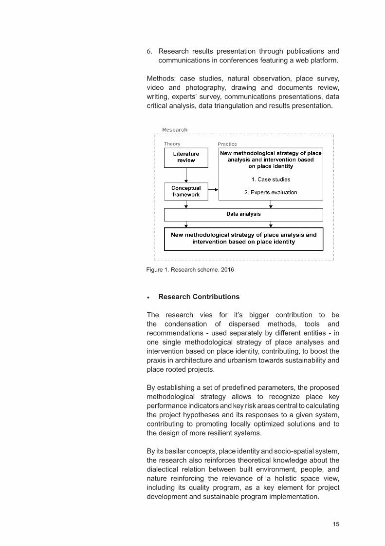
In M2 we analyzed 10 architecture studios project methodologies and we cross obtained data with the one obtained from the literature review resulting in the methodological strategy of place analysis and intervention based on place identity. We proceeded as follows:
1. Architecture studios choice: Since we aimed more sustainable and place rooted projects, for the first sample of architecture studios we only considered the world leaders in sustainability. A total of 149 studios were analyzed
14
trough the information available on respective website, in the about section, regarding their project methodologies/approaches. For the final sample 10 studios were considered - the ones who had more solid information available - and crossing data tables conducted.
2. Literature review and architecture studios crossing data: The obtained data from the 10 studios was crossed with the one found in the literature review, resulting in the methodological strategy of place analysis and intervention based on place identity.
Methods: Literature review (scientific papers, books, inter-views, architecture studios selection, review, and practices analysis), data critical analyses and cross.
In L2 (practical synthesis) we tested the operability of proposed methodological strategy of place analysis and intervention based on place identity through two case studies, the first in Mumbai (India) and the second in Nyeri (Kenya). The results gave rise to the stabilized methodological strategy of place analysis and intervention; later presented to architects, urban planners and academics, under a survey form and confer-ences communications, aiming their feedback featuring the methodological strategy revision and final version.
3. Case studies: The case studies primary data was collected between the periods of April 2015 to April 2016. For the case studies choice, we prioritized slums inside urban context; they represent the must unfavorable urban scenario and for that reason the best environment to test proposed methodological strategy. The case studies were conducted in India (Mumbai) and Africa (Kenya), representing the continents with the biggest and growing number of informal settlements and urban population.
4. Reviewing and triangulating: As the case studies evolved proposed the methodological strategy of place analysis and intervention based on place identity changed, given rising to its stabilized version later presented to experts’ (architects, planners, academics) in order to obtain a feed-back of its utility.
5. Methodological strategy validation: The methodological strategy of place analysis and intervention was presented to experts’ (architects, planners, and academics) through conferences and an email survey conducted from 10 to 20 January 2017. It was intended to obtain the maximum feedbacks regarding methodological strategy utility, for the development of sustainable and place rooted projects, aiming its revision and final version.
15
Figure 1. Research scheme. 2016
6. Research results presentation through publications and communications in conferences featuring a web platform.
Methods: case studies, natural observation, place survey, video and photography, drawing and documents review, writing, experts’ survey, communications presentations, data critical analysis, data triangulation and results presentation.
Research Contributions
The research vies for it’s bigger contribution to be the condensation of dispersed methods, tools and recommendations - used separately by different entities - in one single methodological strategy of place analyses and intervention based on place identity, contributing, to boost the praxis in architecture and urbanism towards sustainability and place rooted projects.
By establishing a set of predefined parameters, the proposed methodological strategy allows to recognize place key performance indicators and key risk areas central to calculating the project hypotheses and its responses to a given system, contributing to promoting locally optimized solutions and to the design of more resilient systems.
By its basilar concepts, place identity and socio-spatial system, the research also reinforces theoretical knowledge about the dialectical relation between built environment, people, and nature reinforcing the relevance of a holistic space view, including its quality program, as a key element for project development and sustainable program implementation.

16
References
3XN, (2010). Mind our Behaviour: ow Architecture Shapes Behaviour. 3 NRelaterd link: http://gxn.3xn.com/ /
Bennett, J. G. (1966). The dramatic universe. vol. 3: Man and his nature, London: Stoddard and Watkins
Buttimer, Anne (1976). Grasping the ynamism of Lifeworld. Annals of the Association of American Geographers, 66: 277-92
Buttimer, Anne; Seamon, avid (1980). The human experi-ence of space and place. London: Croom elm
Calthorpe, Peter; Lerup, Lars (2005). New Urbanism: Peter Calthorpe vs. Lars Lerup, ed. University of Michigan
Cohen, Barney (2003). Urban Growth in eveloping Coun-tries: A Review of Current Trends and a Caution Regarding Existing Forecasts, World evelopment ol. 32, 33
Cohen, Barney (2006). Urbanization in developing countries: Current trends, future projections, and key challenges for sustainability. Technology in Science Journal 28, 64-65-66-69-70-73
European Landscape Convention (2000). Convenção Europeia da Paisagem, feita em Florença em 20 de Outubro de 2000, iário da Republica – série-A, p 1017, n 31, 14 de Fevereiro
Frampton, Kenneth (1983). Towards a Critical Regionalism: Six Points for an Architecture of Resistance. 1. Culture and Civilization. The Anti-Aesthetic Essays on Post Modern Culture. Edit by al Foster, 16-26
Heidegger, M. (1962). Being and time. J. Macquarrie and E. Robinson, trans. New ork: arper Row
ICOMOS, Conseil International des Monuments et des Sites (2013). Accessed 15.07.2013 at: http://www.icomos.org/fr/notre-action/participation-aux-conventions-internationales/patrimoine-culturel-immateriel
Ingles, Bjarke (2015). Council on Tall Buildings and urban abitat ideo Series. 27, October. Accessed 21.07.2016, at:
http://www.ctbuh.org/TallBuildings/ ideoLibrary/Monthly ide-oSeries/tabid/4165/language/en-GB/ efault.aspx
17
Kéré, iébédo Francis (2015). Kéré architecture/Burkina Faso: Louisiana Canopy. AFRICA: Archiecture, Culture, Iden-tity. Louisiana Museum of Modern Art, 161
Koolhas, Rem (2016). Meetings on Architecture. Teatro Piccolo Arsenale, enice. Biennale Architettura (28 May). Accessed 15.06.2016 at: https://www.youtube.com/watch v Kpj8 soySJ0
Loukaki, A. (1997). Whose genius loci Contrasting interpre-tations of the sacred rock of the Athenian Acropolis . Annals of the Association of American Geographers, vol. 87, issue 2. 306-329
Lyon, Brian Mac-kay (2013). The illage Architect. Accessed on 17.07.2016 at: https://www.youtube.com/watch v ekhBb-vOS lo
Peñalosa, Enrique (2013). Bogota, Building a Sustainable City PBS esign e2. Accessed on 13.07.2016 at: https://www.youtube.com/watch v C E3ClCA1m4
Relph, Edward (2009). A pragmatic sense of place. Environ-mental and Architectural Phenomenology, vol. 20, n 3, 24-31
Relph, Edward (1981). Rational Landscapes and umanistic Geography. New ork: Barnes and Noble
Relph, Edward (1976). Place and Placelessness. London: Pion
Rigby, K. (2003). Tuning in to spirit of place. In J. Cameron (ed.), Changing places: Re-Imagining Australia, ouble Bay, New South Wales: Longueville Books
Seamon, . (2011). Place, Place Identity, and Phenomenology: A Triadic Interpretation Based on J. G. Bennett’s Systematics.
ernan Casakin, Ombretta Romice, Sergio Porta, editors. London: Betham Science Publishers
Seamon, . (2012). Merleau-Ponty, perception, and environ-mental embodiment: Implications for architectural and envi-ronmental studies. In R. McCann P. M. Locke (Eds.). Carnal echoes: Merleau-Ponty and the flesh of architecture. New
ork: Routledge, forthcoming
Schulz, Christian Norberg- (1971). Existence, Space Archi-tecture. London: Studio ista Limited
Schulz, Christian Norberg- (1980). Genius Loci. New ork: Rizzoli International Publications INC
18
Yi-Fu, Tuan (1974). Space and place: umanistic perspective, Progress in geography, vol. 6, London: Edward Arnold
UNESCO, United Nations Educational, Science and Cultural Organization (2013). What is Intangible Cultural eritage Accessed 08.07.2017 at: http://www.unesco.org/culture/ich/index.php pg 00002
United Nations (2014). World Urbanization Prospects, the 2014 Revision, ighlights . Economic and Social Affairs. Population ivision. United Nations New ork, 1
United Nations (2015). World Urbanization Prospects, the 2014 Revision. Economic and Social Affairs. Population ivi-sion. United Nations New ork, xxi-3
Vidal, Tomeu; Troffa, Renato; alera, Sergi; Fornara, Ferdi-nando (2012). Place Identity as a Useful Psychological Construct for Approaching Modern Social Challenges and New People-Environment Relations: Residential Mobility, Restorative Environments, and Landscape. In: The Role of Place Identity in the Perception, Understanding, and esign of Built Environment. erman CasaKin and Fátima Bernardo editors, Ben Than e-books, 45
Walter, E. . (1988). Placeways: A Theory of the uman Envi-ronment. The University of North Carolina Press
Wood, Antony (2015). Rethinking the Skyscraper in the Ecological Age: esigning Principles for a New igh-Rise
ernacular. International Journal of igh-Rise Buildings. June, ol 4, N 2, 91-101

Chapter I: Context and Concepts


21
Chapter Introduction
This chapter begins with ‘Research, Data and Methods’, in this section we find major reports and authors supporting our work and vision. The research was conducted on two moments (M). M1 relates to an objective observation of the contemporary urban context; M2 is linked to a phenomenological vision of the concepts shaping our research - place identity; genius loci, and socio-spatial system. From these moments arose, respectively, the two research core sections ‘Contemporary Cities - Global Overview, Trends and Challenges’ and ‘From Landscape to Place Identity’ each composed by several sub-themes.
On ‘Contemporary Cities - Global Overview, Trends and Challenges’ we explore the current urban context in order to detect emergent working fronts with the objective to test our methodological strategy of place analyses and intervention inside them. We start by exploring urban transition process and its effects in the cities built environment. In addition, two major groups of urbanization are discussed; the first relates with upper-middle-income-countries whose rate of urbanization is expected to increase from 63% in 2014 to 79% in 2050 and the second within Europe and the low-fertility countries of Asia where urbanization is slowing down.
In this section global urban population increasing is highlighted, currently, 54% of the world’s population lives in urban areas and by 2050 it is expected that 66% of the world’s population to be urban. In this context, we argue about the consequences of this sharp increase leading us to reflect on major urban challenges according to three different and interconnected groups: natural resources management, transportation and urban mobility and urban poverty increasing.
‘From Landscape to Place Identity’ is the second core section of this chapter in which we underline research concepts and ideas. We start by debating the concept of landscape emerged from the 70’s, of the last century, highlighting Tuan
i-Fu; Buttimer and Edward Relph, where the need to explore the concept of place associated with its social dimension arose for the first time. It was the need of a systematic space understanding leading to an expanded field of reflection where we continue to dissect the concept of landscape including augmented and virtual reality, technology and information, culture, globalization and climate change. Transformative forces shaping the built environment, the society and pointing future grounds of project action. In this context, the vision of Toyo Ito, Sou Fujimoto, Rem Koolhaas and Bjarke Ingels architects are emphasized.

22
In addition, we argue on the mutual influence between environment and human behavior as a central element of space production, reinforced by an intrinsic and emotional bond that connects us to other living organisms and systems as the claimed by the biologist Edward O. Wilson. To classify this mutual influence octor Osmond created the terms ‘Sociofugal’ and ‘Sociopetal’ as forces that may, respectively, drive people apart or together through space. According to the historian E. . Walter, the sharp environment degradation is linked with the meaningless places that we have been building, proposing a return to a place understanding where natural and built environment is read as a system that gives meaning to places. We argue on the relevance of this standpoint by the fact that the landscapes of today will be the vernacular of tomorrow, thus this statement works as an awaking call to new project approaches based on a holistic place understanding, helping to promote sustainable livability of places as the perceived in Bogotá.
Following this perspective ‘Place Identity’, the last chapter item, appeals to space holistic understanding beginning with the multiple significances of the word ‘place’ ( arvey, 1996; Sack, 1997, Massey, 1994). It is a phenomenological place interpretation charged with meaning and character the ‘place atmosphere’ referred by the architect Paul Grillo and Norberg-Schulz. Space and character are linked to ‘orientation’ and ‘identification’ basica functions for people to relate to their environment. The place is embedded in human existence and even composed by tangible elements - its environmental character - place is a unique qualitative experience connecting whit the eidegger’s understanding of the being-in-the-world. A perspective linked to the Roman concept of genius loci (Schulz, 1971; 1980; Rigby 2003) here discussed as a permanent space quality that can be used to intensify the ‘sense of place’ through place natural attributes. According to Frampton, it involves a dialectical relation with nature - local qualities as light, topography, and climate. An expanded idea of place and place intensification that we quote through the architects Francis Kéré, Rick Joy and Brian Mac-kay Lyon works.
The sections are followed by the ‘Research iscussion and Conclusions’ where in the ‘Final Considerations and Future Outcomes’ we state our vision and guidelines within the research and the next chapter’s dialogues; the creation of a new methodological strategy of place analysis and intervention based on place identity.
Key words: Contemporary Cities Trends and Challenges, Contemporary Landscape, Environment and umanBehaviour, Place Identity
23
Research, Data and Methods
The research is based on a qualitative approached divided in two central moments (M). In M1 the researche presents an analysis of the global contemporary cities context, in M2 we present, under a phenomenological perspective, the concepts structuring the research.
In M1 several reports on contemporary cities trends and challenges were analyzed in order to detect common patterns of urban growth. This information was central to get a contemporary cities global overview and to detect emergent working fronts defining the research field of action.
M1 heavily falls on the United Nation publications - highlighting the World Urbanization Prospects. The 2014 Revision, the Planning, and esigning for Sustainable Urban Mobility and the Global Report on uman Settlements 2013. The United Nations reports were an important source of information on global urban data, therefore, at a global level, the most complete. owever, due to the time that data takes to be collected, analyzed, and presented time gaps exist, and data doden’t always corresponds to real-time numbers. When analyzing United Nations previsions - on urban population growth - we kept in mind that a prevision is something that may happen, thus data was taken as an indicator of cities general trends and challenges.
Barney Cohen was a significant reference; the author is very critical, showing the two sides of the same reality, helpful to be acuter when questioning the literature. Other papers and sources of information were studied introducing new and important data for work development. The Mega-cities documentaries where priceless links between what is mentioned in the literature and what is happening in reality. By showing cities context they brought new inputs to the work, allowing to establish close associations from disperse information.
In analyzed documents, we focused on three topics: trends, challenges, and urban growth sustainable solutions. After information critical analyses and cross-check only common points wore considered, generating a broader space of reflection on contemporary cities context helpful to increase the awareness of the need for new methodological project approaches and to rethink the concepts of landscape, place, and identity.
In (M2) a phenomenological approach of the concepts in which research is based was adopted. A necessity arising from the need to understand holistically the concept of landscape and
24
its influence on human behavior as well as the concept of place identity and it’s potential.
We began with a critical literature review relating both: 1. to a theoretical framework defining the ground of our thinking from which we highlight Tuan i-Fu, Eduard Relph, avid Seamon, Kevin Lynch, Christian Norberg-Schulz and Kenneth Frampton; 2. linked to a contemporary vision of the architectural context and its approaches rising through the practices, highlighting the architects Francis Kéré, Rem Koolhaas, Bjark Ingles and Brian Mac-kay works.
In addition, this section was, also, nourished by recent documentaries, interviews, and conference proceedings on the subject; an attempt to keep the maximum of updated information on contemporary architecture context in order to structure our argumentation.
From the crossing of the different ideas and concepts, explored in these two groups, raised our theoretical framework providing a broader field for the research problem insights, central for the research question developement, futuring a quantitative research approach.

Contemporary Cities: Global
Overview, Trends and Challenges
26
Urban Transition Process and Urbanization
Since major time’s cities represent a human joined effort to survive. They gather people from all around the world with multiple socio-cultural backgrounds in one single space. Cities are amazing places and some of them are so amazingly big that they can be seen from space. Through their infrastruc-tures and education access cities help generate the essential skills for development and knowledge creation. Cities are hubs of economic growth but most of hall centres of opportunities.
Cities, highlighting capital cities, is where the majority of the productive activities and employment opportunities take place and for that where we find the highest population concen-tration. In general cities are ‘’ centres of modern living ( ) where indicators of general health and well-being, literacy, women’s status, and social mobility are typically highest. Finally, cities are also important social and cultural centers that house museums, art galleries, film industries, theaters, fashion houses, and other important cultural centers’’ (Cohen, 2006). The process of urban transition relates to a process of population transition from rural to urban areas. In fact, cities history begins far away from them. People moved from small and disperse villages - where agriculture, generally, is the main activity - to bigger settlements, i.e. towns and cities, whose industrial activities and services represent the basis of the economy (Montgomery et al., 2004). Urban transi-tion process gathers a huge amount of people in the cities being, thus, an urbanization engine. For countries to achieve a middle-income it is necessary a significant shift of popu-lation to urban areas. Conventionally cities are good for the economy, by attracting international investment and tourism, by their markets for business. Cities help to generate more income sources and employment opportunities improving the country gross domestic product (G P). There is an evident relation between the level of urbanization of a country and it’s G P. istorically, urban transition and economic growth have been linked. To prove it, the constructions of cities itself comprises workers and materials from all around the world moving global markets.
Although this relation it’s not always proportional in terms of benefits. On one hand urban transition process brings people to cities increasing manpower and cultural exchange leading to new ideas and new business opportunities. On the other hand, especially when transition process is followed by stress migration, authorities decrease their response capacity regarding the citizen’s access to education, health, and housing. Cities have long ago started to exceed their capacity to provide adequate basic services and life quality to their citi-zens. An uncontrolled urban expansion started to occur and

27
sometimes cities grow more in terms of physical area than in terms of population. Urban sprawl has many consequences; ecosystems destruction, environment quality decreasing and unregulated patterns of consumption - highlighting land and water. With stress migration, new settlements start to prolif-erate in the city’s outskirts, far from the city business district (CB ). In those places, generally informal settlements, public transportation supply is very poor leading to car usage, air pollution increasing, and to social segregation; a visible reality in the cities of Mumbai and São Paulo.
Initially formed by seven islands populated by fishermen’s, currently, Mumbai is the financial core of India. ue to its cinema industry (Bollywood), the big number of national and international companies, banks and its vibrant port - one of the largest in the world - the city is responsible for 70% of the country commercial and financial transactions. Mumbai high concentrations of commercial and financial activity represent more employment opportunities. Every day someone migrates to the city - Greater Mumbai area overall population reaches 21.5 million. A big number of Mumbai inhabitants are migrants, poor people coming mainly from the states hinterland or other Indian states, in search of jobs. Regardless its economic pros-perity over the years, the city doesn’t have the capacity to absorb all of its inhabitants and workers. As a consequence, the number of slums increases so as urban poverty. Currently, Mumbai hosts more than 50% of squatters among its popula-tion facing underemployment and unemployment; especially among women whose condition implies harder access to education.
Founded in 1554 by Jesuit priests currently, São Paulo holds 20% from the Brazilian Gross National Product (GNP). Among hotels, banks, universities and a vast range of companies the financial capital of Brazil, and South America houses one of the largest Stock Exchange in the world, the BM F Bovespa - Bolsa de alores, Mercadorias e Futuros de São Paulo. The city economic prosperity, broadly speaking, started with the coffee business that during the Second World War was already declining. In 1900 the manufacturing industry was established in the city and from that time São Paulo rein-forced its economic flourish and urban population growth - also increased by different waves of immigration from Europe and hinterland. espite its economic and financial prosperity São Paulo, as Mumbai, only absorbs a small part of its popula-tion facing, everyday, overcrowded, the lack of house, unem-ployment and the difficult access to culture, health care, and education. et, every day migrants arrive in cities, everyday urban population grows, and between the periods of 2010 to 2015, it was estimated that nearly 200,000 people migrate daily to cities worldwide accelerating the urban transition process. Currently, 54% of the world’s population lives in urban areas
High-income countries according the United Nation 2014 World Urbanization Prospects:
Andorra, Antigua and BarbudaAruba, Australia, Austria
Bahamas, Bahrain, BarbadosBelgium, Bermuda, Brunei
arussalam
Canada, Cayman IslandsChannel Islands, Chile. China,
ong Kong SAR Macao SARCroatia, Curaçao, Cyprus, Czech Republic
Denmark
Equatorial Guinea, Estonia
Faroe Islands, Finland, France, French Polynesia
Germany, Greece, Greenland, Guam
Iceland, Ireland, Isle of Man, Israel Italy
Japan
Kuwait
Latvia, Liechtenstein, Lithuania, Luxembourg
Malta, Monaco
Netherlands, New Caledonia, New ealand, Northern Mariana Islands,
Norway
Oman
Poland, Portugal, Puerto Rico
Qatar

28
Republic of Korea, Russian Federation
Saint Kitts and Nevis, San Marino, Saudi Arabia, Singapore, Sint Maarten ( utch part), Slovakia, Slovenia, Spain, Sweden, Switzerland
Trinidad and Tobago, Turks and Caicos Islands
United Arab Emirates, United Kingdom, United States of America, United States irgin Islands, Uruguay
Low-income countries according the United Nation 2014 World Urbanization Prospects:
Afghanistan
Bangladesh, Benin, Burkina Faso, Burundi
Cambodia, Central African Republic, Chad, Comoros
emocratic People’s Republic of Korea, emocratic Republic of the Congo
Eritrea, Ethiopia
Gambia, Guinea, Guinea-Bissau
aiti
Kenya, Kyrgyzstan
Liberia
Madagascar, Malawi, Mali, Mozambique, Myanmar
Nepal, Niger
pushing cities growth. It is a process of global urbanization where the economy is just one of the agents, demographics (birth and death rate), migration, governance, globalization - boosted by transport and communication advances - and climate change also represents a significant share (UN, 2015).
According to the United Nation 2014 World Urbanization Pros-pects, igh-income countries are expected to rise from an 80% of urbanization, in 2014, to an 86% in 2050. In contrast with Algeria, China, Brazil, Mexico, South Africa, enezuela, among other upper-middle-income-countries, whose rate of urbanization is expected to increase from 63% in 2014 to 79% in 2050. In Europe by the 50’s, of the last century, the majority of the population lived in urban areas in fact ‘’during the period since the Second World War, the urban land area in devel-oped countries has doubled’’ (UN- , 2013), and from 1990 the levels of urbanization started to slow down. The high period of urbanization in the developed world has finished; currently, 76% of its population lives in urban areas. owever, a shift has been occurring and people are moving back to smaller places and in ‘’Eastern Europe and the Commonwealth of Inde-pendent States have actually experienced a recent decline in their urban growth rates as people move back from city to farm, for the first time in half a century’’(Urban 21, 2000).
Urbanization is not a locked process; urban patterns depend on a big number of variables changing across countries and time. For instance, the definition of the urban population depends on how and where the city administrative bound-aries are drawn and each country has its own rules. Same happens for urban settlements; an area with 2000 inhabitants may be rural in one country and in other urban. The definition of urban settlements also depends on ‘’ any number of ways including by population size, population density, administrative or political boundaries, or economic function ’’ (Cohen, 2006) infrastructures presence, healthcare, culture and education access. In Finland, an area to be considered urban must have a minimum of 15,000 inhabitants. On the other hand, India Census 2011 defined urban settlements as the ones with a minimum population of 5,000; a minimum of 75% of the male working population engaged in non-agricultural pursuits and with a population density of at least of 400 persons per sq. km (Census of India, 2011).
The awareness of urban patterns elasticity it’s extremely impor-tant because it shows how hard it is to compare the urbanity of cities worldwide, and at the same time helps to be more critical related to urban data (Cohen, 2006). In fact, it is very heterogeneous information. In many low-income-countries we find cities presenting big levels of urbanization although they relate in terms of population size instead of territory extension or built environment quality.
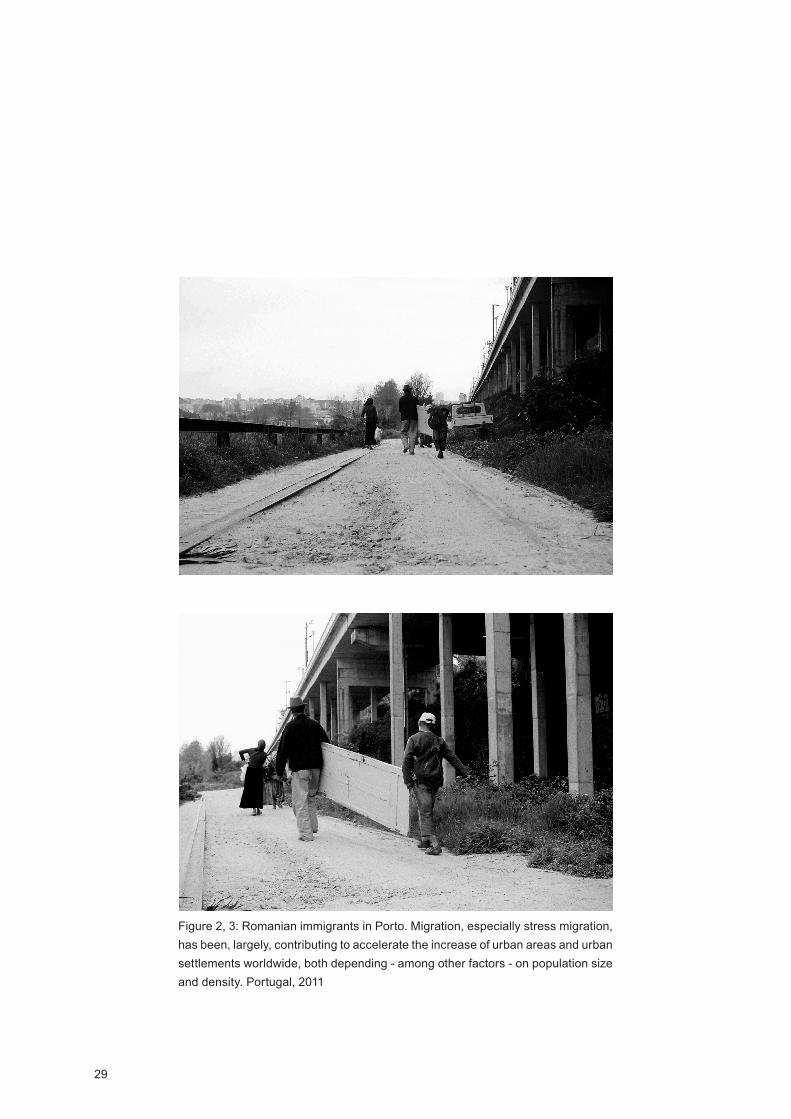
29
Figure 2, 3: Romanian immigrants in Porto. Migration, especially stress migration, has been, largely, contributing to accelerate the increase of urban areas and urban settlements worldwide, both depending - among other factors - on population size and density. Portugal, 2011
30
Rwanda
Sierra Leone, Somalia, South Sudan
Tajikistan, Togo
Uganda, United Republic of Tanzania
imbabwe
Between mentioned lists – igh and Low-income countries - the United Nation considers two more countries categories: Upper-middle-income-countries and Lower-middle-income-countries.
Contemporary Cities Trends
As previously mentioned, currently, 54% of the world’s popu-lation lives in urban areas and in 2050 it is expected that 66% of the world’s population to be urban. In 1950 only 30% of the world’s population was urban and from that date, the rural population started to slow down; in fact, the rural population has been sharply decreasing with an estimation of rising from less than 2 billion, since 1950, to almost 3.4 billion in 2014. These predictions show a urbanized world where in ‘’Northern America (82 percent living in urban areas in 2014), Latin America and the Caribbean (80 percent), and Europe (73 per cent). In contrast, Africa and Asia remain mostly rural, with 40 and 48 per cent of their respective populations living in urban areas ’’ (UN, 2015). Over the next decades it is expected that all regions to become more urbanized; however Africa and Asia by 2050 are estimated become 56% and 64% urban comprising, by that time, nearly 90% of the world’s urban population which is estimated to increase more than two-thirds – i.e. 2.5 billion people (UN, 2014). China, India, and Nigeria between 2014 and 2050 are projected to house 37% of the increased global urban population - India will have more 404 million urban dwellers, China 292 million and Nigeria 212 million more.
In 2014, 18 countries accommodated 28 mega-cities, i.e. urban agglomerations with 10 million, or more, inhabitants ‘’China and India, the two largest countries in the world in terms of population, host six and three of these largest cities respectively. Brazil, Japan, and the United States have two mega-cities each, and the remaining 13 countries have one mega-city each’’ (UN, 2015). By 2030 it is expected that the world has 41 mega-cities comprising more them 10 million inhabitants. Currently, worldwide, one in five urban inhabit-ants resides in a medium-sized city comprising 1 to 5 million inhabitants (UN, 2014), medium cities are expected to become mega-cities. Between 1990 and 2014 the global population living in medium-sized cities almost doubled and it is expected that between 2014 and 2030 same population will grow from 827 million to 1.1 billion. Mega-cities and urban population growing number give a clear picture of the challenges that governments, town planners, and citizens have to face. A profound change in the shape and size of our cities will occur as well as in terms of population distribution.
owever, in recent years there are cities worldwide losing population. Mainly, they are located in the low-fertility countries of Asia and Europe where the population is declining. Between the periods of 2014 and 2050 biggest population decrease is projected to be in Japan and Russia. A few decades ago the highest number of urban agglomerations was found in the more developed regions, as Europe, currently biggest and fastest
31
urban agglomerations growth are, manly, located in Asia and Africa. Population decreasing relates with many factors, the rate of deaths and births, contraception, family planning and unfavorable socio-economic conditions. In Europe economic contraction was a key factor for population decline. Since the beginning of 2008, there was a huge loss of industry and jobs forcing many to migrate. Portugal, as many other European countries, has been struggling with huge levels of migration. The Observatório da Emigração (2015) indicates that in 2014, for the first time, Portugal surpassed the barrier of the 4 million people migrating. Climate change, natural disasters – earth-quakes and hurricanes for instance - are also major keys in country’s population decline.
At global scale massive fluxes of people flock to cities, every day migrants arrive in cities, everyday urban population grows. It was estimated by the United Nations that between the period of 2010 and 2015 nearly 200,000 people migrated daily to cities worldwide. Those new migrants ‘ together with the increasing native population, expand the number of squatter settlements and shanty towns, exacerbating the problems of urban congestion and sprawl and hampering local authorities’ (Cohen, 2006). In order to answer to population demands, contemporary cities have to grow smart. Currently, they become giants consuming an extra-large amount of resources due to its high concentration of industry, transports, and build-ings. Cities consume between 60 and 80% of the commercial energy leading us to an urban future where energy, natural resources, and humanitarian crises will be keywords. Unfor-tunately for India, as for other countries, this urban context arrived earlier.
espite contemporary cities context and forecast, it is wrong to think that from now on population will be living only in mega cities. Mega cities will display an important role on population absortion; however, people will be distributed in all settlement sizes from smaller towns to medium size ones. In reality, the world largest cities are not the fast growing ones. Currently the ‘ world’s fastest growing cities are, usually, smaller cities because they started out with a much smaller base population. It is not uncommon to find examples of double-digit growth rates for small cities or towns but it is rare to find cities of several million inhabitants growing by as much as 5% per annum ’ (Cohen, 2003). The bigger is the city, the more difficult it will be to manage it. owever high popula-tion concentration in urban areas, in general, it’s beneficial. Regardless of the number of people living in informal settle-ments in cities as the city of Mexico, elhi or Rio de Janeiro, on average, people have better access to education, culture, health and job opportunities. Cities population concentration also releases ecosystems from human action contributing to natural resources and land saving, especially for agricultural
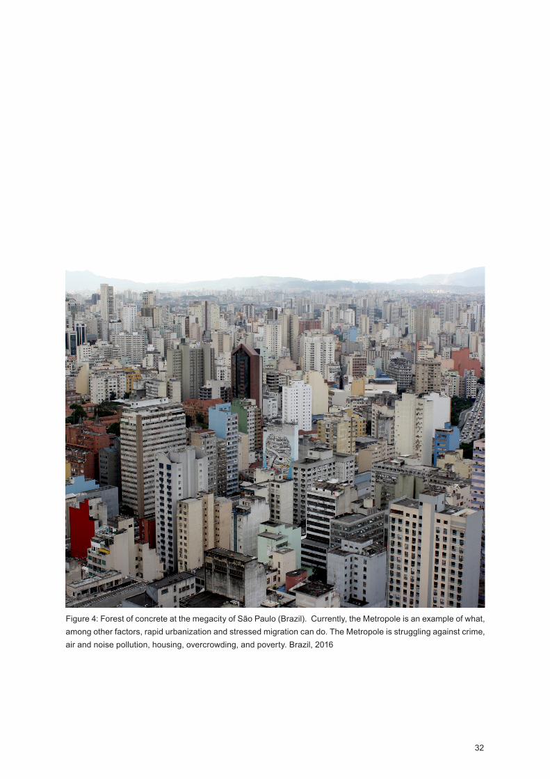
32
Figure 4: Forest of concrete at the megacity of São Paulo (Brazil). Currently, the Metropole is an example of what, among other factors, rapid urbanization and stressed migration can do. The Metropole is struggling against crime, air and noise pollution, housing, overcrowding, and poverty. Brazil, 2016
33
proposes. At last in terms of infrastructures and basic services a high concentration of people living in the same place it is less expensive.
Contemporary Cities Challenges
In order to grow, contemporary cities will face several chal-lenges related to the economy, environment, natural and social resources management, transportation, housing, and urban poverty. No country as economically prospered without being urbanized; the global economy is a strong agent inside urban-ization process. The progressive integration of the world’s economies has been forcing smaller economies to change and leveling up by them. Globalization is a very perverse process, by one hand due to technology evolution one can access a vast range of global services and knowledge repre-senting new business and learning opportunities. On the other hand, it takes everything by the same measurement forcing to dramatic economic changes that, most of the time, don’t fit in countries socio-economic background. Currently, and ‘over the last two decades, globalization ( ) and a positive political climate has created a global economy characterized by unprecedented levels of urbanization and more and bigger cities than ever before’ (Choen, 2006). In China, the result of the global economy its been both astonishing and sad. China as is the second world’s strongest economy, only surpassed by the United States of America, and it is estimated to become the first one until 2030. From the last 25 years, China is the country in the world that has shown the biggest economic growth. In order to create a strong economy, China had to urbanize. The country urban population it’s been an ascending arrow and in 2030 it is estimated the Chinese cities to absorb, more or less, 70% of country’s population. In anticipation of the future, the Chinese government started to build actively; extending cities, creating new ones and consuming gigantic areas of cropland. Broadly speaking, instead of a social and environmental vision, the Chinese cities are being built under an increasing gross domestic product perspective. The result is a shocking number of ‘Ghost Towns’. Not all of the ‘Ghost Towns’ are desert; some as Kangbashi - projected to house 1 million currently hardly reaches the 70 thousand inhabitants - show very small rates of urban population i.e. another way to become a ghost. It is very paradoxical and ironic how the most populous country in the world reaches such situation.
In the global urban growth race, it is not surprising that many cities, as elhi and São Paulo, face problems related to clean water access, sanitation, crime, air and noise pollution, housing and overcrowding. By contemporary cities environ-ment rapid degradation one can easily guess that an effective collaboration between land use, natural and social resources management and sustainable urban planning is needed.
34
Contemporary cities, sometimes, are getting bigger in terms of area than in terms of population ‘such urban expansion threatens to destroy habitats in key biodiversity hotspots and contributes to carbon emissions associated with tropical deforestation and land use change’ (UN, 2014). In order to grow sustainable contemporary cities have to integrate, from its earlier planning, practices that incorporate water and land management - for agriculture, housing and industrial purposes - two finite resources whose exhaustion leads to the extinction of life. Land use and management implies a deeper under-standing of a place natural resources - for instance wind, water, sun, geothermal and soil fertility - helping to focus on sources of renewable energy and for food supply; the last one a scarce resource highlighting the continents of Africa and Asia where thousands of people die from starvation. Between the periods of 7th and 11th May 2016 Portugal was entirely fed on renewable energy; a total of 107 hours nourished by sun, wind, and hydropower. By understanding its natural resources and favorable weather conditions in 2015 48% of the country energy came from renewable sources and in the next 15 years, Portugal will export renewable energy (APREN, 2016).
Understanding the potential of land management has a high positive impact on the economic growth of a country allowing, for instance, to classify less fertile land areas that can serve cities expansion - i.e. improving the sustainable physical plan-ning of cities allowing a balanced growth between natural and built environment. In this perspective, one of the first contem-porary cities challenge it will be addressing natural resources management as a key agent for an environmental urban future. In many countries, unplanned or poor urban planning led to urban sprawl triggering uncontrolled natural resources consumption. In India; Industrialization and urban growth have led to more than 40% of the country’s available surface water being used every year. alf of the country is facing severe water stress and India water supplies are expected to fall 50% by 2030 (World Resources Institute, 2015).
Addressing natural resources management and built environ-ment quality requires a space holistic approach integrating public sanitation, infrastructures, services, waste manage-ment - including recycling policies - and transportation. An inefficient public sanitation, garbage collection, and solid waste management make it finish in giant open-air landfills, instead of waste facilities disposals. It is a lethal ecosys-tems process through the contamination of soil, water and air creating the perfect atmosphere for virus propagation. A large number of people living in Nairobi, Kenya, came from the country’s most poor rural areas. This fact relates with to major reasons: 1. the scarcity of means in Kenya rural areas; 2. the urban areas development as the government priority. The amount of people arriving to Nairobi surpassed the capacity

35
of the city s physical space to absorb them; together urban sprawl, political instability and unemployment forces many to live in segregated areas under the poverty line. Slums poor environmental conditions - as the lack of sanitation, draining, poor drinking water distribution, inappropriate housing, and garbage collection absence - create hazardous conditions to health and well-being. The rate of infection is high so as the risk of epidemic. Statistics show a big number of people contracting, among other diseases, respiratory illnesses, diar-rhea and tuberculosis leading, in most cases, to death (Gulis et al, 2004). Nairobi is just one example of emergent need for built environment quality improvement and natural resources management when it comes to planning the future of our cities. In that context, São Paulo took the lead by showing how a mega-city that produces thousands of tons of trash per day can be fed on waste. Currently the city recycles moun-tains of trash to produce energy. In Bandeirantes, the metrop-olis’s garbage lies in compressed layers whose methane gas, resulting from its decomposition, is extracted producing clean energy feeding the giant slice of São Paulo’s diet (Mega-cities, 2005 - 2011).
In order to grow environmentally friend, contemporary cities also have to rethink the transport sector. Transportation is essential for a city development, without transport there is no economic growth. In fact, from ancient times cites are located in strategic points near rivers or the sea because these water lines are natural highways vital for commercial transitions and, consequently, for the cities health. Currently, transportation it’s one of the biggest greenhouse gas emission source and a major agent on climate change ’globally, 13 per cent of all greenhouse gas emissions come from the transport sector and three-quarters of this is caused by road transport ’ (UN- , 2013). Climate change, play a key role in urban transi-tion process. In Bangladesh, one of the most climate vulner-able countries in the world, the high level of migration from rural to urban areas is related with this phenomenon. In the last few decades Bangladesh It’s been buffeted by cyclones in coastal areas, severe storms, extreme river bank erosion and floods - devastating crops, land and killing cattle and people. In Bangladesh natural hazards are expected to increase in frequency and intensity; severe weather changes every year displace more people to haka than war conflicts (BCCRF, 2016), constituting an impediment for the country socio-eco-nomic development (C B, 2012).
Likewise, motorized vehicles are also responsible for health decreasing. ue to air noise and traffic jams they cause high levels of stress as well as respiratory diseases due to the concentration of carbon monoxide in the air. In order to be sustainable, the transportation sector has to address the environmental, the economic and the social dimension. In

36
other words, it requires an inter and transdisciplinary space approach integrating urban planning with transport planning at all scales. From the macro level (i.e. the territory scale) to the micro level (i.e. the city scale) we should focus on reducing the use of motorized vehicles. From the country’s level an efficient railways network combined with an efficient public transport interface would be an asset for monoxide carbon emission reduction. At the city level, streets design should prioritize walkability and the usage of non-motorized vehicles. (UN- , 2013). Streets play an important role, due to sunlight, the relation between buildings height and street width, colors, green, resting areas and/or bike-ways, streets may encourage or discourage pedestrian mobility. Promoting walkability and urban mobility it is increasing the socio-economic dimension of the cities. With incom getting lower and urban poverty rising, even within the European cities, people privilege their own feet as the primary mean of transportation. A big number of people in the developing world ‘ are ‘captive walkers’, meaning that they walk because they cannot afford an alternative. For them, having a well-connected and safe pedestrian environment is critical to meeting their daily needs’ (UN- , 2013). Also, inside car overcrowded contemporary cities, such as elhi, it repre-sents the fast mean to go from point A to point B. Non-motor-ized vehicles display a major role in urban mobility ‘in 2005, about 37 per cent of urban trips worldwide were made by foot or bicycle, which are the two major modes of urban non-mo-torized transport ( ) for very short trips, walking is the main mode of transport in both developed and developing coun-tries’ (UN- , 2013).
Transportation development and the maintenance of their infrastructures - railways, roads, highways, etc. - create more jobs opportunities and promotes the circulation of people and goods boosting local economies, business and tourism. Trans-portation plays a central role in poverty eradication; same for urban mobility. By embedding measures as trips cost reduc-tion linked to the implementation of non-motorized vehicles ways mobility ensures a more equity right to the city usage. Cycling, for instance, is an affordable mean to reduce public transportation monthly expense and to provide accessibility for a bigger number of citizens. In some European countries as the Netherlands, bicycles cover an average of 40% of the daily urban trips and in some countries of Asia, for instance, India and China, they are a mass transport for people and goods.
Another urban challenge relates with housing. As we previously mentioned the city s physical space, as well as authorities, do not have the capacity to respond to the high levels of migration in demanded short period of time. Also, real-estate prices, the lack of coordination of different authorities related to urban planning and development as well
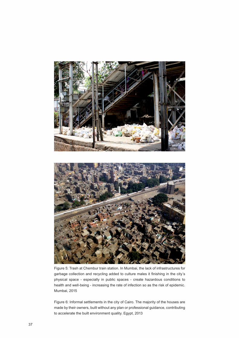
37
Figure 5: Trash at Chembur train station. In Mumbai, the lack of infrastructures for garbage collection and recycling added to culture males it finishing in the city s physical space - especially in public spaces - create hazardous conditions to health and well-being - increasing the rate of infection so as the risk of epidemic. Mumbai, 2015
Figure 6: Informal settlements in the city of Cairo. The majority of the houses are made by their owners, built without any plan or professional guidance, contributing to accelerate the built environment quality. Egypt, 2013

38
as the governments’ incapacity to provide affordable house for the most disadvantaged groups represents key points for the origin of informal urban settlements. owever, there are cites where slums are almost inexistent. Tokyo is one of them. But everything comes with a price. Greater Tokyo struggles to house around 35 million people. The land is scarce and real-estate prices extremely high as a result many live in boxes of 25 sq.m shaping their social practices and mental health. In fact in Tokyo loneliness became a new business. Japanese now can rent friends to go for a drink, coffee or wedding. It is very sad that in the most sophisticated and advanced city in the world human condition has regressed so much.
Together, increased urban poverty, socio-economic decreasing and current housing crises - for instance in Mexico City, Cairo, São Paulo, haka, and Tokyo - make us questioning the general belief that the population average living conditions are better in bigger cities than in small ones (Choen, 2006). The 2016 Pritzker Alejandro Aravena states that ‘’if there s any power in design is the power of synthesis’’ (Aravena, 2014). Known for its work on social housing, the architect engages local population as part of the project solution. People are assets and they possess many skills, being construction one of them. Most of the slums around the world have been built for people with their own hands, people build wherever they can and without any professional orientation. Thus illegal settle-ments proliferate on the outskirts of the cities without basic living conditions, services and facilities. Slums simply sprawl.
With an unprecedented running to cities, currently, we face many challenges related to the scale and the speed of urban transformation. Authorities alone don’t have the capacity to solve the general house crisis in demanded compressed time - each turn the answer must be faster. Maybe this is an indi-cator that a shift in the process of thinking urban solutions is needed. Cities belong to citizens and they have an incred-ible transformation power if cities are overcrowded maybe it is time for architects, urban planners and authorities to coop-erate with the citizens and to understand the asset they repre-sent. In ietnam, to the city of o Chi Minh migration points to an average of 50,000 people, annually, moving to the city. Without access to house or means to afford it people finish by being homeless or living in slums. Slums represent 15% of housing supply.
The danger of the housing crises does not relate to mere shelter crises vs. human rights; it represents the fertile soil to epidemics proliferation at a global scale. It is a very delicate matter and a public health question. First, for the owners of the slums houses they represent an individual achievement; place becomes part of their identity. Second, most of the slums are built in the worst pieces of land such as swamps,
39
for instance the haka slums, or in railways side, in Mumbai, whose natural factors and the lack of sanitation create the perfect environment to diseases spread (Urban 21, 2000). The city of haka is the home of 15 million people - fore-casting an increase to 25 million until the year 2025 - 60% of its population are immigrants and 65% live in slums (Alamgir et al, 2009). As in many other cities worldwide, the slums in
haka do not have drainage, sanitation, energy, public infra-structures, piped water and policies for waste management. Most of the toilets are public and the droppings go to open-air latrines, same for the garbage. In addition, the city is located just north of the Buriganga River in a very swampy and irri-gated area. When monsoons strike the city and raise up the water level all the dirt it’s transported by it. haka’s contami-nated water has been killing much and sickening many more; the rates of deaths by infections are tragic and the risk of a pandemic is always on the edge. It is the perfect environment for rats and mosquitos to grow; feeding on trash and highly contagious they are a major source of diseases spreading. The city is at constant risk and, at the global scale, so as the rest of the world’s population.
Nevertheless, the world still has good examples of solutions for facing housing challenges in dense cities. In order to achieve the goals for the country economic development, Singa-pore planed its urbanization growth. In February of 1960, in order to respond to the country house crisis, the government established a program of public houses with the objective of replacing slums by liveable places providing sanitary, services and proper infrastructures. In addition, since late 70’s, of last century, the program includes the mix of different ethnic groups - mainly Chinese, Malay and Indian - in order to avoid social segregation and to promote the richness of mixed communi-ties. Currently, the public housing program provides home for 80% of the Singapore population, in a couple of decades they were able to deliver more than 1 million houses all over the country. Today Singapore has minimal slum rate, with an 82% of inhabitants living in proper homes and an average of 93% of its population ownership them; indeed it is the highest rate in the world ( B, 2016).
Singapore may be seen as an example to follow when it comes to coordination among authorities, planners, architects and the citizens in a world where urban growth is clearly increasing in terms of scale and complexity. Cities are the stage of tremen-dous challenges; they are fragile systems constantly on the edge leading us to question the landscapes we are building and their environmental and sociological impact. Most of all, they make us question our jobs as planners and architects.
Inside contemporary context, the urban and the architectural paradigm are no longer uncontrolled consummation of phys-
40
ical and social resources but their sustainable optimization. In this context, sustainability no longer relates, exclusively, with the ecological dimension but with a holistic approach including social, environmental, political and economic dimensions.
If walking towards a green and inclusive urban future requires a systematic thinking and, for that so, the urgency to rethink new project practices including sustainability goals and multi-disciplinary approaches we argue that: if natural, built and social resources are transversal to places – and major agents towards a sustainable and inclusive future - how can we inte-grate a methodological strategy of place analysis and inter-vention, based on the three claimed dimensions, that would contribute to the implementation of more sustainable and place rooted projects
From Landscape to Place Identity
42
Contemporary Built Landscape
As the previously stated, contemporary cities are sharply increasing in number and area building fragile ecosystems constantly on the edge. They are paradigms of which people come attracted by employment opportunities in order to improve their lives, even knowing that the probability of having a worse quality of life is extremely high. In general cities are consumers, not producers, and currently, they become extremely expensive regarding basic services as housing, education, healthcare and food supply.
Since the 70’s, of the last century, there was the need to explore the concept of place associated with its social dimen-sion ( i-Fu, 1974; Buttimer, 1976, 1980 and Relph, 1976, 1981) - the everyday life and its impact on the built and social environment. The concept of landscape became the result of a place economic and social transformation related to its population cultural activity. It is a concept of landscape that cannot be read as a mere area where people live but as an area that expresses the result of living (European Landscape Convention, 2000).
This definition of landscape allows recognizing a system-atic view of space where all the parts - geographical, built and social - are interconnected and interdependent. In this perspective, and inside this research, this interdependence is seen as a system - the socio-spatial-system - where the geographical, built and social environment are major compo-nents constituted by several variables, whose interaction will affect the environment behavior.
This space approach requires a holistic space thinking central for a deeper understanding of the human being in the world, by other words the asein of Martin eidegger ( eidegger, 1962; Seamon, 2011; 2012); whose actions not only impact the built environment but also can build new ones. This perspec-tive is particularly relevant in an era, as the current one, ruled by tremendous social, economic, political and technological complexity with a profound impact on society - in constant motion - expressing it into a space of diffuse boundaries (Ito, 2007).
Architecture is about people (Kéré, 2015) and outside them, architecture does not exist or make sense, thus it is particu-larly important to be aware of this relationship because social changings give rise both new orders and disorders. Two driven movement’s central to project development because ’in every dysfunction, there is the potential of new functionali-ties and new ways of working ’ (Koolhaas, 2016). This field of forces represents a major challenge for architects, especially
43
when new demands - climate change, new technologies and the instability of contemporary human condition - hipper-com-press the time of answer which architecture, by its buildable nature, is unable to achieve. owever, technology has been an ally, and a landscape transformative force, first with the indus-trial revolution and currently with technological advances. If industrial revolution brought great advances in materials - mostly iron and glass - and the concept of mass production allowing new structures and new buildings typologies, current technologies go further as they create physical and virtual landscapes; changing the way we relate and produce space.
The advances in technology are so amazingly speeded that goals as colonizing Mars currently are tangible. The contem-porary landscape has embedded another dimension - the outside space. We always dream on alien landscapes, comics and cinema have been feeding our imagination, but this time it is so real that scientists developed a new concrete to build on Mars (MIT, 2016) - if we are going to live on the red planet we will need shelter. In 2015 the America Makes in collabora-tion with NASA organized the competition ’NASA’s Centen-nial Challenge’ (NASA, 2015), integrated into a multi-phase 3 -printed habitat challenge whose goals are to put humans on Mars and to promote the design of sustainable homes in and outside Earth. More than 165 proposals were submitted and the three finalists comprised: in first-place the Team Space Exploration Architecture and Clouds Architecture with the Ice ouse project (CA, 2015, page 44); in second Foster Partners (Team Gamma) with an habitat made on regolith i.e. soil and rocks found on the surface of Mars (F P, 2015) and in third place Team Lava ive - proposing dwellings using a tech-nique called ‘lava-casting’ and has building material regolith as well (L , 2015).
It is interesting to observe the human need for other land-scapes, currently so developed that we don’t need to go outside our planet to experience ‘alien’ environments. Recent progresses in virtual and augmented reality allow us to expe-rience space through new places and dimensions where real and virtual merge. The augmented reality phenomena ‘Pokémon Go ’ is the ultimate experience, at a global scale, of living these new places. Supported by sound, graphics, videos and GPS information, augmented reality is the creation of an artificial environment overwritten, in real time, into the user s physical one ( elaqua, 2016). The biological body is placed in the physical world, but the perception responds to another; the user is in two different places at same time. This way of experiencing space bring new landscapes that can be both virtual and physical; offering the possibility to (re)discover the last ones by encouraging people to go places that, generally, they would not access because of the daily rush, for instance, as it happens in the mentioned game.
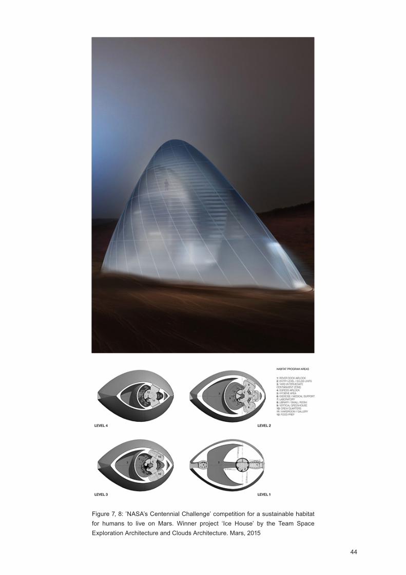
44
Figure 7, 8: ’NASA’s Centennial Challenge’ competition for a sustainable habitat for humans to live on Mars. Winner project ‘Ice ouse’ by the Team Space Exploration Architecture and Clouds Architecture. Mars, 2015
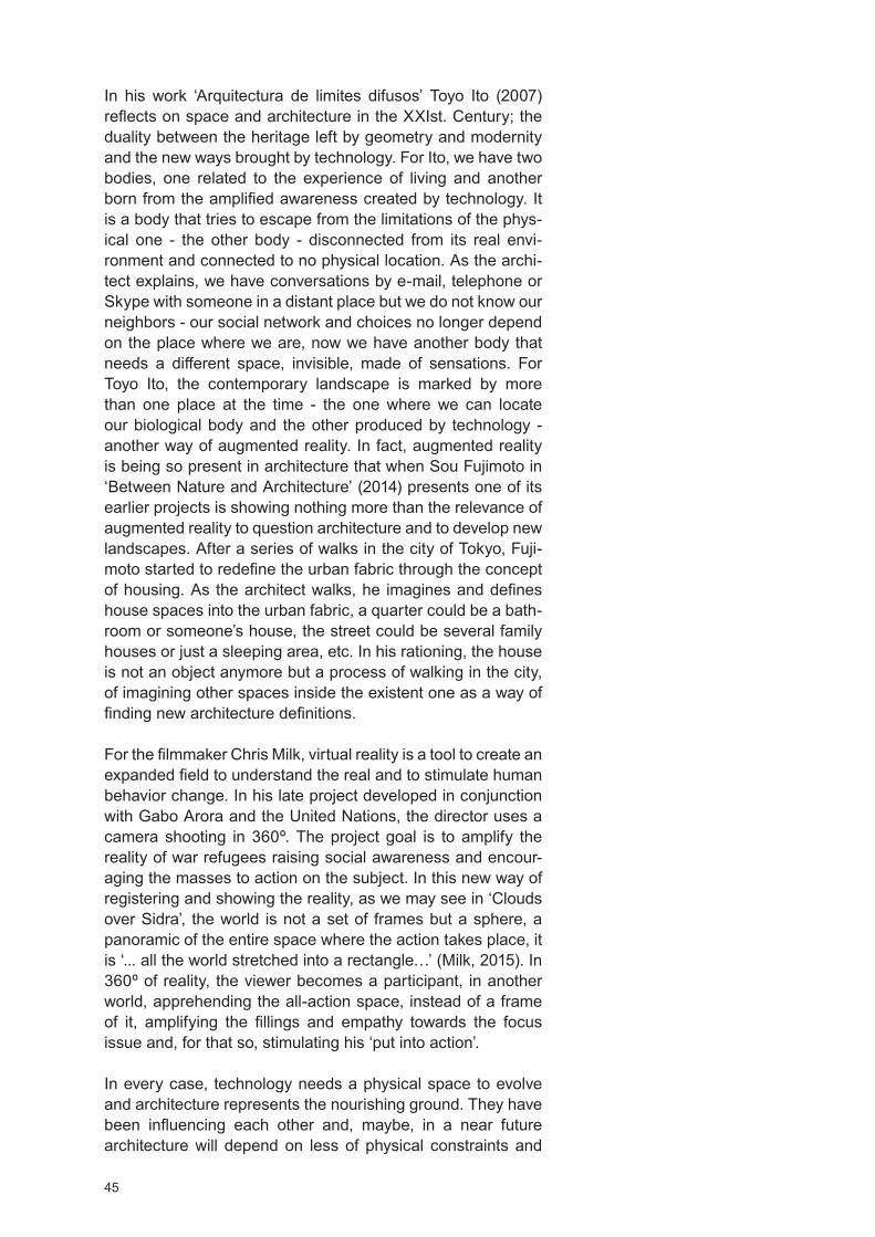
45
In his work ‘Arquitectura de limites difusos’ Toyo Ito (2007) reflects on space and architecture in the Ist. Century; the duality between the heritage left by geometry and modernity and the new ways brought by technology. For Ito, we have two bodies, one related to the experience of living and another born from the amplified awareness created by technology. It is a body that tries to escape from the limitations of the phys-ical one - the other body - disconnected from its real envi-ronment and connected to no physical location. As the archi-tect explains, we have conversations by e-mail, telephone or Skype with someone in a distant place but we do not know our neighbors - our social network and choices no longer depend on the place where we are, now we have another body that needs a different space, invisible, made of sensations. For Toyo Ito, the contemporary landscape is marked by more than one place at the time - the one where we can locate our biological body and the other produced by technology - another way of augmented reality. In fact, augmented reality is being so present in architecture that when Sou Fujimoto in ‘Between Nature and Architecture’ (2014) presents one of its earlier projects is showing nothing more than the relevance of augmented reality to question architecture and to develop new landscapes. After a series of walks in the city of Tokyo, Fuji-moto started to redefine the urban fabric through the concept of housing. As the architect walks, he imagines and defines house spaces into the urban fabric, a quarter could be a bath-room or someone’s house, the street could be several family houses or just a sleeping area, etc. In his rationing, the house is not an object anymore but a process of walking in the city, of imagining other spaces inside the existent one as a way of finding new architecture definitions.
For the filmmaker Chris Milk, virtual reality is a tool to create an expanded field to understand the real and to stimulate human behavior change. In his late project developed in conjunction with Gabo Arora and the United Nations, the director uses a camera shooting in 360 . The project goal is to amplify the reality of war refugees raising social awareness and encour-aging the masses to action on the subject. In this new way of registering and showing the reality, as we may see in ‘Clouds over Sidra’, the world is not a set of frames but a sphere, a panoramic of the entire space where the action takes place, it is ‘... all the world stretched into a rectangle ’ (Milk, 2015). In 360 of reality, the viewer becomes a participant, in another world, apprehending the all-action space, instead of a frame of it, amplifying the fillings and empathy towards the focus issue and, for that so, stimulating his ‘put into action’.
In every case, technology needs a physical space to evolve and architecture represents the nourishing ground. They have been influencing each other and, maybe, in a near future architecture will depend on less of physical constraints and
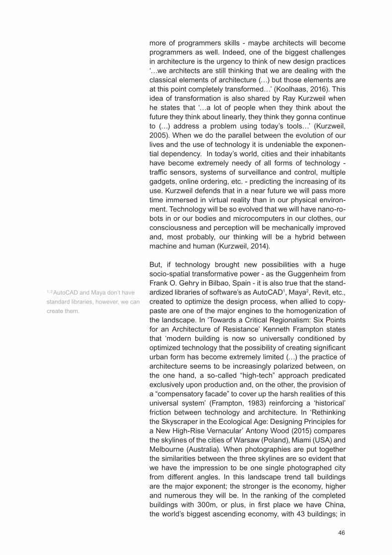
46
more of programmers skills - maybe architects will become programmers as well. Indeed, one of the biggest challenges in architecture is the urgency to think of new design practices ‘ we architects are still thinking that we are dealing with the classical elements of architecture ( ) but those elements are at this point completely transformed ’ (Koolhaas, 2016). This idea of transformation is also shared by Ray Kurzweil when he states that ‘ a lot of people when they think about the future they think about linearly, they think they gonna continue to ( ) address a problem using today’s tools ’ (Kurzweil, 2005). When we do the parallel between the evolution of our lives and the use of technology it is undeniable the exponen-tial dependency. In today’s world, cities and their inhabitants have become extremely needy of all forms of technology - traffic sensors, systems of surveillance and control, multiple gadgets, online ordering, etc. - predicting the increasing of its use. Kurzweil defends that in a near future we will pass more time immersed in virtual reality than in our physical environ-ment. Technology will be so evolved that we will have nano-ro-bots in or our bodies and microcomputers in our clothes, our consciousness and perception will be mechanically improved and, most probably, our thinking will be a hybrid between machine and human (Kurzweil, 2014).
But, if technology brought new possibilities with a huge socio-spatial transformative power - as the Guggenheim from Frank O. Gehry in Bilbao, Spain - it is also true that the stand-ardized libraries of software’s as AutoCA 1, Maya2, Revit, etc., created to optimize the design process, when allied to copy-paste are one of the major engines to the homogenization of the landscape. In ‘Towards a Critical Regionalism: Six Points for an Architecture of Resistance’ Kenneth Frampton states that ‘modern building is now so universally conditioned by optimized technology that the possibility of creating significant urban form has become extremely limited ( ) the practice of architecture seems to be increasingly polarized between, on the one hand, a so-called high-tech approach predicated exclusively upon production and, on the other, the provision of a compensatory facade to cover up the harsh realities of this universal system’ (Frampton, 1983) reinforcing a ‘historical’ friction between technology and architecture. In ‘Rethinking the Skyscraper in the Ecological Age: esigning Principles for a New igh-Rise ernacular’ Antony Wood (2015) compares the skylines of the cities of Warsaw (Poland), Miami (USA) and Melbourne (Australia). When photographies are put together the similarities between the three skylines are so evident that we have the impression to be one single photographed city from different angles. In this landscape trend tall buildings are the major exponent; the stronger is the economy, higher and numerous they will be. In the ranking of the completed buildings with 300m, or plus, in first place we have China, the world’s biggest ascending economy, with 43 buildings; in
1; 2 AutoCA and Maya don’t have standard libraries, however, we can create them.
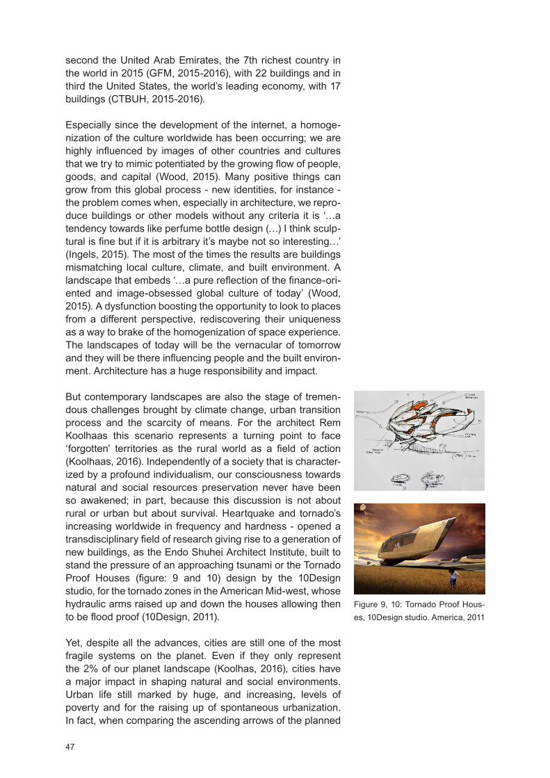
47
second the United Arab Emirates, the 7th richest country in the world in 2015 (GFM, 2015-2016), with 22 buildings and in third the United States, the world’s leading economy, with 17 buildings (CTBU , 2015-2016).
Especially since the development of the internet, a homoge-nization of the culture worldwide has been occurring; we are highly influenced by images of other countries and cultures that we try to mimic potentiated by the growing flow of people, goods, and capital (Wood, 2015). Many positive things can grow from this global process - new identities, for instance - the problem comes when, especially in architecture, we repro-duce buildings or other models without any criteria it is ‘ a tendency towards like perfume bottle design ( ) I think sculp-tural is fine but if it is arbitrary it’s maybe not so interesting ’ (Ingels, 2015). The most of the times the results are buildings mismatching local culture, climate, and built environment. A landscape that embeds ‘ a pure reflection of the finance-ori-ented and image-obsessed global culture of today’ (Wood, 2015). A dysfunction boosting the opportunity to look to places from a different perspective, rediscovering their uniqueness as a way to brake of the homogenization of space experience. The landscapes of today will be the vernacular of tomorrow and they will be there influencing people and the built environ-ment. Architecture has a huge responsibility and impact.
But contemporary landscapes are also the stage of tremen-dous challenges brought by climate change, urban transition process and the scarcity of means. For the architect Rem Koolhaas this scenario represents a turning point to face ‘forgotten’ territories as the rural world as a field of action (Koolhaas, 2016). Independently of a society that is character-ized by a profound individualism, our consciousness towards natural and social resources preservation never have been so awakened; in part, because this discussion is not about rural or urban but about survival. eartquake and tornado’s increasing worldwide in frequency and hardness - opened a transdisciplinary field of research giving rise to a generation of new buildings, as the Endo Shuhei Architect Institute, built to stand the pressure of an approaching tsunami or the Tornado Proof ouses (figure: 9 and 10) design by the 10 esign studio, for the tornado zones in the American Mid-west, whose hydraulic arms raised up and down the houses allowing then to be flood proof (10 esign, 2011).
et, despite all the advances, cities are still one of the most fragile systems on the planet. Even if they only represent the 2% of our planet landscape (Koolhas, 2016), cities have a major impact in shaping natural and social environments. Urban life still marked by huge, and increasing, levels of poverty and for the raising up of spontaneous urbanization. In fact, when comparing the ascending arrows of the planned
Figure 9, 10: Tornado Proof ous-es, 10 esign studio. America, 2011

48
urbanization with the spontaneous urbanization, worldwide, the last one is increasing faster than the planned one (Clos, 2016). It is a crescent model of urbanization reflecting a built landscape where no one wins - slums, patterns of natural resources consumption, and social segregation tend to inten-sify largely. What is paradoxical is the fact that now we are more aware of what we should do towards a sustainable future and yet we are ’ increasing our urban footprint with less plan-ning than 20 years ago ’ (Clos, 2016). espite green build-ings and persistence towards a sustainable future, at a global scale, we still do the same mistakes with notorious repercus-sion on climate change - a key agent for sprawl and migration. At a smaller scale, the city scale, the loss of public space, the current house crises and the increasing of gated communities are the major consequences (Clos, 2016). Gated communities have been rising sharply, a phenomenon closely related to the high levels of criminality and a trend that is no longer exclusive of the richest, in Mexico City it is usual low-income communi-ties to gather in order to pay for their safety.
Environment and Human Behaviour
If these are the landscapes that we still produce, it means that as architects and planners we failed and that cities are becoming less democratic and more dehumanized. When the United Nations started abitat I, in 1976, the conference was about the need to reflect on rapid urbanization, especially in developing countries, it was a call for sustainable human settle-ments (UN- , 2016). abitat I was trying to keep the people in the rural areas when urbanization process was, for the first time, a global concern. Since then, urbanization process didn t slow down, and people massively left the rural areas. Thus, in habitat II the central question was about sustainable cities and adequate shelter for everyone, the equitable right to the benefits of living in the city (Clos, UN- , 2016). UN-hab-itat failed again; cities haven’t got more inclusive, in fact, they have become the opposite in both developed and developing countries.
The question is inevitable: why did abitat fail According to Simon when UN goals and key issues were established - despite the skills of the UN experts on gathering, analysing and crossing information - there was an ‘ isolation from the daily pressures and realities of urban local authorities and other agencies that will be required to collect, compute and report on the indicators’ (Simon et. al, 2016). Maybe the same ‘isolation’ is happening in architecture representing one of the reasons why the gap between what people think and need and what architects think people need still growing; by other words the reason why we still ‘respond right to the wrong question’ (Aravena, 2016). For the architect Bjarke Ingels the problem goes deeper calling our attention for the blindness that may
49
be caused by the experience leading us to believe that we ‘know the answer before even heard the question that stops you from questioning the question or even ( ) listening care-fully the question because you already know the answer’ (Ingels, 2015). This concern is relevant because this ‘friction’ has been creating built environments and they influence both individual and group behavior.
For the historian E. . Walter (1988) the sharp environment degradation has a clear link with the meaningless places we have been building over and over. For Walter a shift is needed in the way we understand places, proposing a return to a holistic place understanding where natural and built environment was read as a system, giving meaning to places and creating affec-tive bonds. Walking toward an urban and sustainable future, also, means to promote a better society and as architects and planners, our contribution can be done through the production of space. Architects Mun Summ Wong and Richard assell, from WO A Architects, call it ‘civic generosity’; the power that a new space has in adding value to the existing one. The city is a living organism and new spaces must improve the life of all city (WO A, 2016) i.e. social, natural and built dimensions. Spatial elements are so strong that in dictatorship regimes architecture is the main vehicle of social control, political ideologies spreading and power. To classify this mutual influ-ence, people driving apart or together through space, octor
umphry Osmond introduced in his work ‘The relationship between architect and psychiatrist’ (Osmond, 1959) the terms ‘Sociofugal’ and ‘Sociopetal’.
Environment impact on human behavior can be designed in a variety of ways; if we think of churches, hospitals, libraries, theme parks and shopping malls, for instance, we will quickly note that we behave differently in each typology. Even if our perception is highly influenced by cultural standards and literacy rate the right color, scale, light, and symbols will always affect the way we perform in a certain space. Johan Stenebo (2010) explains how IKEA space is carefully planned and constantly updated, to influence shopper’s consumption. But the company goes further and extends the notion of space, and its influence, to the media where through familiar adver-tisements and resources to companies as the Greenpeace, creates a mental space of influence with which customers identify, trust and purchase.
The idea that human behavior is influenced by different spaces and different elements patterns is central to the project devel-opment of the anish firm 3 N. In ‘Mind our Behaviour: ow Architecture Shapes Behaviour’ (2010) 3 N explains how the physical elements interfere with people - from the scale of architecture to the surroundings, the city scale. By using psychology as a tool to improve environments design - archi-

50
tectural psychology - 3 N are able to forecast with more effec-tiveness the effect that a certain space will have on people’s behavior and well-being. Each design is a calculated ‘experi-ment’ whose results will help to update future spaces, tending to be more functional, inclusive and holistic. A concept espe-cially present in the firm Green esign Strategy, requiring a true understanding of how new buildings impact social, natural and built context. ere, the focus is to transform the nega-tive impacts of a building into positive by designing new ones who produce green energy or that consume recycled and recyclable materials. It is an effort to create a positive impact on social, ecological, and economic local spheres by going beyond the internal space of a building and trying to be viral at the city scale.
Independently of the external stimulus, humans have an intrinsic instinctive and emotional bond connecting them to other living organisms and systems. It is an innate neces-sity developed from our interaction, over time, with the envi-ronment that the biologist Edward O. Wilson classified as biophilia. The biophilia hypothesis (Wilson, 1995) it’s being extended to design and the ‘practice of biophilic design has been growing and there are now many exemplary examples of buildings that seek to integrate natural features and qualities ( ) healing gardens and spaces in hospitals, and for homes and apartments that provide abundant daylight, natural venti-lation, plants and greenery’ (Cities, 2016). Currently, biophilic design concept it’s also extending to the city scale - the Biophilic Cities - promoting the increase and the protection of green spaces into the urban fabric and to keep daily contact whit the natural world that, among other positive effects, helps to reduce the stress level in humans.
At a bigger scale, studies also have been conducted to deter-mine the influence between urban environments and public behavior (Goffman, 1963). ere, and due to the nature of the scale and the anonymity of individuals, it’s more difficult to determine the patterns. owever there are some common ground, an effective net of supportive services - health care, education and culture - an operative public transportation network, abundance of public and green Infrastructures to promote social life, safe walking and car-free zones, access to water, sanitation and air quality can largely contribute to improving human life quality and rational behaviour. A big scale example came from Bogotá; in a period of 100 years the city grew from 100.000 people to 7.000.000 (Gonzales, 2013) leading to the city’s illegal urban expansion - urban settlements and slums started to sprawl. Bogotá began to face several problems related to extreme poverty increasing, over the years the capital became characterized by crime and social segregation - one of the worst quality of life both in Colombia and Latin America.
51
The shift occurred when Enrique Pe alosa in 1998 was elected the city’s Mayor (re-elected in 2016) introducing a new vision of an inclusive city ‘the way we created cities would really determine the way how people would be, how happy they would be’ (Pe alosa, 2013). The Mayor refused to (re)think the city for the minority who had a car and a good life standard - more or less 15% of the capital population - while 1.000.000 people lived in extreme poverty. Pe alosa started by reforming the public transportation net through a poli-trans-portation system they named TransMilenio. A new model of public transportation based on one central line feed by secondary lines that would allow people from slums to access the city - urban mobility and accessibility were the priorities. This measure had a huge impact on poverty reduction, for many people it was the first time they had the opportunity to access to employment as well as the rest of city. In addition, the trip cost was reduced; now people only had to pay for one ticket that allowed them to access the entire bus net and not for two or three as they had to pay before of having just a bus company. Another factor that also contributes to the poorest savings and geographical expansion - people were no longer constrained to their district space.
The next step was the (re)transformation of the public space, including new functionalities as sidewalks for blind and people in wheelchair, the redefinition of the parking areas and the improvement of green areas as well as the introduction of new ones started to rebuilt a new city identity based on social cohesion and environmental variety. In 10 years Bogotá crim-inality and murders rate decreased 70% and, due to public safety and urban comfort levels, people started to get more engaged with their built environment. The building of an inclusive and non-car oriented city was a driven force when the construction of the Alameda El Porvenir - the biggest in America Latina with 17 km exclusively for bicycles and pedes-trian - Pe alosa instead of demolishing the illegal settlements proposed their integration into the life of the city. The new structure would traverse the poorest settlements of Bogotá creating facilities - libraries, nurseries, schools, public spaces for resting and sport and cycling and walkways - serving both slum and city dwellers. For many people it was the discovering of a new metropolis, the segregated area of Bogotá now was connecting 3.000.000 people (Pe alosa, 2013; Bogotá .C., 2015).
By understanding the dynamics of the people-in-space Pe a-losa realized that the richest can go to the beach, to the coun-tryside, etc. but the poor only have the city and its public space. By shifting dynamics and priorities the capital of Colombia, currently, holds no more the title of the worlds must chaotic city, it started to be remarked as a model of civic-mind and has a sustainable city - here who rides a bicycle is so impor-
52
tant has the one who rides a Ferrari. Pe alosa understood that when we improve the built environment we are improving people’s lives and, simultaneously, creating new identities.
Place Identity
In fact, place identity is one of the most effective tools when it comes to engaging people with space as well as one of the key foundations for sustainable environments. At the architect, Francis Kéré work it is also a transformative force defining a practice based on site-specific. With interventions world-wide, the architect is highlighted for his projects in Africa based on the combination of the traditional Burkinabé building techniques with modern engineering methods. The Canopy3
installation at the exhibition of ‘AFRICA: Architecture, Culture, Identity’ it was a metaphor of is work bringing to the front an ‘invisible’ vital place that Kéré explained as ‘ a special place ( ) where the elders gather to discuss important matters ( ) a small gathering place made of wood and plant fibers. From an architectural perspective, it appears almost insignificant ( ) It is completely open with no walls or doors. The thatch roof creates a shadow on the ground which makes up the boundary between inside and outside. As a child, my friends and I were allowed to enter and play inside except for when the elders gathered to discuss important village matters. When this happens, the nature of the space completely changes and the children understand that they are no longer allowed inside. When the elders gather, the entire village becomes aware of what is happening because it is completely open around to see what is happening. In this way, the event has the magic power to expand this little place, to include the whole commu-nity’ (Kéré, 2015). In this profound significance of place, local identity is a story-book reinventing new places inside the existent one. This is particularly visible in the project ‘School Library’ of Gando, the building is not just about a building, it is about a story of the local handicraft earthenware pots sawed and applied into the ceiling of the library. The pots are not pots anymore; they became architectural elements creating a unique universe of light and shadow patterns shaping the built environments and the people’s imagination (kéré, 2016). The most remarkable in this building is the dislocation of the local earthenware pots from their usual function to rebuild part of the Gando iden-tity - it’s not only about the site, it is about people. In Kéré’s work, local communities are engaged in the project since the concept to the construction. It is a community-oriented approach taking into account a specific set of parameters including climate, available resources (material and social) and indigenous buildings construction techniques; essential to keep a low-based construction and to ensure the mainte-nance of the future constructions.
3 The Canopy is the given name to a small a place in the village of Gando, Burkina Faso, where the village elders and leaders gather to discuss important community matters.

53
Francis Kéré claims a holistic space understanding; his work is not about what can be built but about what should be built in order to respond to the community, the site, the surroundings and the environment present and future needs. A philosophy, in part, also followed by the Rural Studio Work; the off-campus design-build program of the School of Architecture, Plan-ning and Landscape Architecture at the Auburn University. The program was established in 1993, following the philos-ophy of a community-oriented work centered in assisting the poor population of West Alabama’s Black Belt region. To the students it’s given a real hands-on work following the princi-ples of recycling, reusing and remaking. The program heavily falls in the architecture social responsibility through a dialogue between students and the locals to define solutions, design and, later, to build affordable homes for the poor commu-nities ( ean, 2002; R.S., 2016). Over time Rural Studio it’s been transforming the ‘Black Belt’ social environment through spaces defined by less aesthetic judgments and more aware of their capacity to add value to the region - It is the building of new identity that enhancing place potential rather than ignore it. Focused on place identity as a project driven force, for Lake I Flato it is crucial that new projects respond in a meaningful way to the natural and built environment. Local building mate-rials, adaptive reuse, comprehensive understanding of the environmental, cultural context and region’s climate adapta-tion are the main tools ensuring a language that privileges the protection of the natural environment and the foundation of the studio sustainable design - present in the ixon Water Foundation Josey Pavilion project (figure: 11, page 54). It is a fluent language between the inside and the outside linking the natural, built and social dimensions whose goal is to enhance the ‘sense of place’ and the connectedness between people and the natural environment (LF, 2016).
Place identity is not a static tool, rather, different places offer different cultures and for that so different languages and narratives upgrading the architectural discourse enriching place diversity and the people’s conceptual experience of living. Place identity tells the number of stories that a place contains, it is up to the designers to give them a form. istory, topography, demography, culture, and climate are just some of the parameters specific to each place, combined they formed a specific place atmosphere - the place character - whose experience, highly individual and phenomenological, may contribute to placing detachment or proximity. owever, archi-tecture and place can be made outside these parameters; the work of the architect Koen Olthuis centers on climate change and sea level rising. For Olthuis sea level rising is the future field of architecture as well as the answer diminishing the congestion of contemporary cities - where the lack of space is a real problem - by facing water as the next urban expansion opportunity. is projects are based on floating structures -
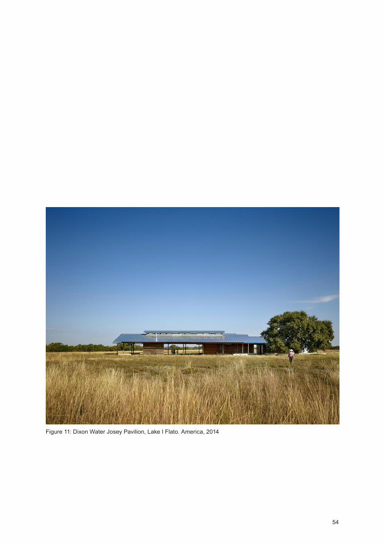
54
Figure 11: ixon Water Josey Pavilion, Lake I Flato. America, 2014

55
water is the building ground - from the single residential build-ings as the ‘Water villa Aalsmeer’, in the Netherlands, to the artificial islands and equipment’s as the ‘Floating Mosque’ in
ubai. Opposing to the static space vision Olthuis claims urban components (buildings, streets, parks, etc.) as dynamic parts of the city system - the City Apps - formed by ‘ floating urban components adding a particular function to the existing static grid of a city ( ) relieves space for a new density, providing worldwide opportunities for cities to respond flexibly to climate change and urbanization’ (Waterstudio, 2016). By moving the focus of its attention, the architect is able to design solutions capable of building places in the most improbable scenarios and to preserve and improve others, as is work in the floating slums of haka, ensuring the continuation of their livelihood.
Place is a very subjective thing, whose concept varies from a social construction ( arvey, 1996) to the foundation of the social life (Sack, 1997), or the place of memory, the sum of GPS coordinates (a geographical place), a religious place, a space that as became significant by love, fear, etc. ( i-Fu, 1997) or, even, the place of a woman (Massey, 1994). In any case places ‘ are never static; they are constantly being made and remade. Attentive researchers examine the social forces, individual agency, and political-economic structures that both encourage and constrict the transformation of space into place’ ( oelscher, 2011). Equally subjective is its character, the place character, a unique atmosphere that the architect Paul Grillo in his book ‘Form, Function and esign’ refers to a ‘rare quality’. The character of a place ‘ was rarely defined generally referring both artistic individuality and functional or symbolic expression of the purpose for which the building was intended (Pires, 2006). For the architect and theorist Norberg-Schulz place and character are interconnected, the place is divided in space and character. The character is the comprehensive side of the place, the one we see and appre-hend, and space the structure of the place itself. For Norberg-Schulz space and character are linked to ‘orientation’ and ‘identification’ needed functions for people to relate to their environment. In fact, his notion of ‘existential space’ cannot exist outside of this system; for Schulz there is no existence if a person can’t locate and identify in a certain place; by other words to know where and how one is in a place (Schulz, 1971; 1980; Pires, 2006). The existential space it is a set of images that people interpret and recognize in order to build an ‘objec-tive space’ essential for human development.
It is a qualitative and phenomenological place perspective arising as opposite to the aseptic way of thinking the world and the architecture. Place is embedded in human existence and even if place is composed by tangible elements - color, scale, area, texture, plants, etc. - the place ‘environmental character’ is a qualitative experience that goes beyond spatial
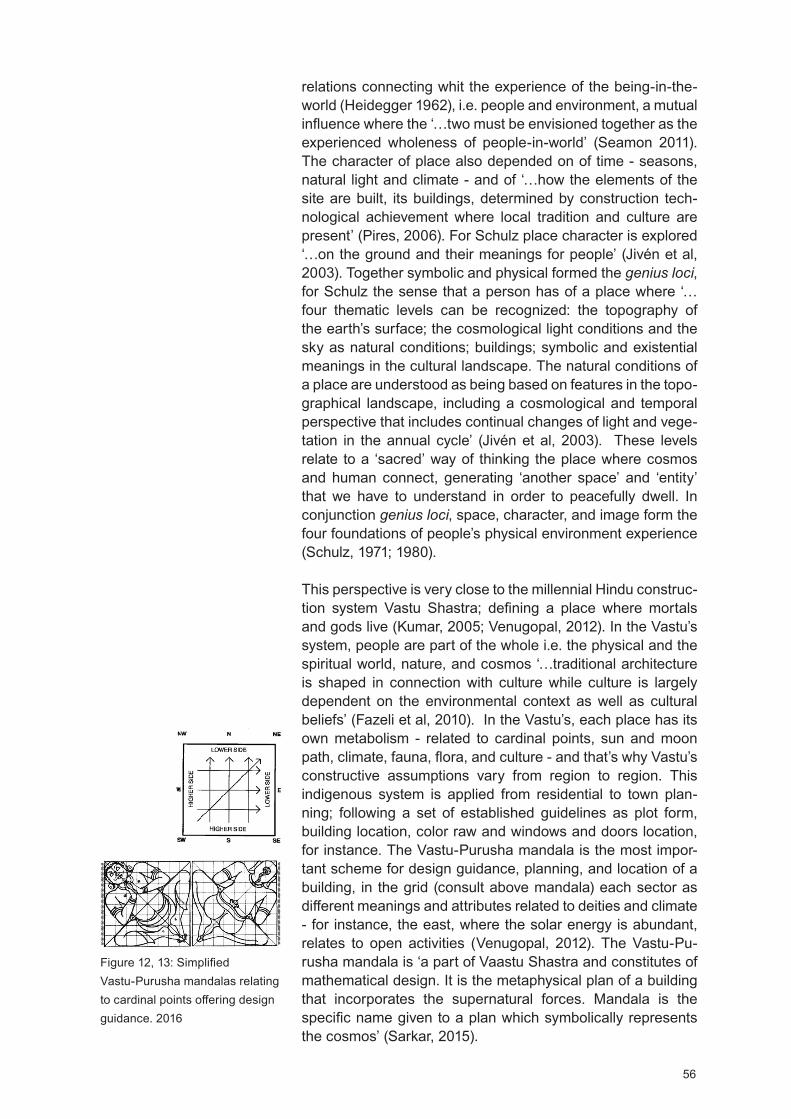
56
relations connecting whit the experience of the being-in-the-world ( eidegger 1962), i.e. people and environment, a mutual influence where the ‘ two must be envisioned together as the experienced wholeness of people-in-world’ (Seamon 2011). The character of place also depended on of time - seasons, natural light and climate - and of ‘ how the elements of the site are built, its buildings, determined by construction tech-nological achievement where local tradition and culture are present’ (Pires, 2006). For Schulz place character is explored ‘ on the ground and their meanings for people’ (Jivén et al, 2003). Together symbolic and physical formed the genius loci, for Schulz the sense that a person has of a place where ‘four thematic levels can be recognized: the topography of the earth’s surface; the cosmological light conditions and the sky as natural conditions; buildings; symbolic and existential meanings in the cultural landscape. The natural conditions of a place are understood as being based on features in the topo-graphical landscape, including a cosmological and temporal perspective that includes continual changes of light and vege-tation in the annual cycle’ (Jivén et al, 2003). These levels relate to a ‘sacred’ way of thinking the place where cosmos and human connect, generating ‘another space’ and ‘entity’ that we have to understand in order to peacefully dwell. In conjunction genius loci, space, character, and image form the four foundations of people’s physical environment experience (Schulz, 1971; 1980).
This perspective is very close to the millennial indu construc-tion system astu Shastra; defining a place where mortals and gods live (Kumar, 2005; enugopal, 2012). In the astu’s system, people are part of the whole i.e. the physical and the spiritual world, nature, and cosmos ‘ traditional architecture is shaped in connection with culture while culture is largely dependent on the environmental context as well as cultural beliefs’ (Fazeli et al, 2010). In the astu’s, each place has its own metabolism - related to cardinal points, sun and moon path, climate, fauna, flora, and culture - and that’s why astu’s constructive assumptions vary from region to region. This indigenous system is applied from residential to town plan-ning; following a set of established guidelines as plot form, building location, color raw and windows and doors location, for instance. The astu-Purusha mandala is the most impor-tant scheme for design guidance, planning, and location of a building, in the grid (consult above mandala) each sector as different meanings and attributes related to deities and climate - for instance, the east, where the solar energy is abundant, relates to open activities ( enugopal, 2012). The astu-Pu-rusha mandala is ‘a part of aastu Shastra and constitutes of mathematical design. It is the metaphysical plan of a building that incorporates the supernatural forces. Mandala is the specific name given to a plan which symbolically represents the cosmos’ (Sarkar, 2015).
Figure 12, 13: Simplified astu-Purusha mandalas relating
to cardinal points offering design guidance. 2016
57
Not far, from this perspective, is the Roman concept of genius loci that stands for the belief that every place and human being has a ‘genius’ a guardian spirit from the birth until death - a divinity (Rigby 2003). The concept has been changing over time and in the 18th century in England, it was related to rural and garden landscape aesthetic appreciation and later the concept was applied to any landscape (Jivén et al, 2003). In time, due local culture and history, any place acquires specific genius loci expressing local community’s aspirations into the built landscape. In his book ‘Placeways: A Theory of the uman Environment’ E. . Walter (1988) presents the genius loci as a quality of the places that can be perceived by the senses and processed by memory, imagination, and intel-lect. Sometimes the genius loci have no word to describe it ‘in Mozambique languages there’s no word to describe nature. There is nothing called society or culture apart from nature’ (Couto, 2015). Currently the ‘sense of place’ is, probably, the most used expression to describe the atmosphere of an envi-ronment - i.e. the place qualities.
owever, the place can also be analyzed outside people ‘meanings’, Kevin Lynch (1976) focused on the place structure introducing the concepts of ‘landmark, ‘path’, edge or ‘district’ as key actors for peoples’ orientation. For Lynch orientation and identification - despite the fact of being connected - had a certain independence, one could be orientated without truly identify. et, for a true sense of belonging, orientation and iden-tification should be entirely developed in relation to a certain space - but that doesn’t mean that space was devoid of qual-ities. On Critical Regionalism, Kenneth Frampton defends the emphasis of place particular qualities. According to Frampton Critical Regionalism involves a dialectical relation with nature; value should be placed on the buildings geographical context - i.e. local qualities as light, topography, and climate - rather than scenography. It is a strategy between critically adopting modern architecture and the place qualities; by other worlds ‘is to mediate the impact of universal civilization with elements derived indirectly from the peculiarities of a particular place’ Frampton (1983). This idea of place intensification through the geographical context formalizes in the works of the architects Rick joy and Brian Mac-kay Lyon. In Casa Jax project, Rick Joy brings a peculiar sense of belonging through the established dialogue between the natural and the artificial environment. The set is formed by three block houses lifted from the ground to allowed nature, water and animals to coexist in a fluent way with the built structure. A simple gesture helping to reinforce the connection between the outside and the inside amplified by the carefully planned single windows view framing the land-scape - the building is the site and vice versa. This peculiar sense of belonging is generated by the strange sense of the ‘banal’ that Kenneth Frampton mentions when referring to the Messenger house’ of Brian Lyon. Maybe this comes from the
58
fact that both houses were designed with the place in mind, evoking a dialogue of buildings that seems to be already there even when they were just built.
In order to deeply understand a place for the architect Brian Mac-kay is it vital to spend time talking and learning with local’s, studying how they adapt to climate, how they responded to the environment. The vernacular embeds all site knowledge by integrating buildings with landscape and local culture, taking into account the wind, the natural light, local scales and mate-rials that are what produces buildings with a minimal envi-ronmental impact. In his work the element barn is the voice claiming for less ‘objects’ and more buildings; ‘we become so conditioned to be a society of consumers in the west that it seems like for the most part the way of thinking about sustain-ability has to do with the consumption of gadgets, 80% of the green thinking it’s passive and it’s what the farmers knew and it cost 20% of the money ( ) positioning your building prop-erly, taking account of where the sun and the wind ( ) are the things that pay off ’ (Lyon, 2013). The architect defends that architecture is landscape because it’s going to stay there shaping environment and mentalities, it is something with a huge impact, so one cannot be selfish and think only about aesthetic standards, there is an environmental responsibility, a moral obligation to use the past to go forward.
By moving the focus from a static to a dynamic holistic space understanding we avoid a place narrow perspective, ampli-fying the project response capacity to its social, geographical and built environment context. Taking space as a mere set of quantitative data - functional organization and list needs - is to exclude its qualities (Adrião, 2006) given rise, most of the times, too fragile projects disintegrated from their cultural and natural surroundings. Mere pieces of territory turning into non-places (Augé, 1992) weakening the socio-spatial system; which in time will contribute to the destruction of cities as in the case of etroit (Seamon, 2008).
Chapter Discussion and Conclusions
In this research we claim for space holistic understanding based on place identity; we call this ‘more’ profound way of thinking space as systematic. Space is seen as a system - the social-spatial system (figure: 14, page 59). By system, we designate a holistic space experience which cannot be reduced to the unity (Bennett, 1966) divided into three compo-nents: the geographical, the built and the socio-cultural envi-ronment (Seamon, 2011); whose relation allows amplifying or decreasing the functioning of place socio-spatial system and, consequently, its identity.
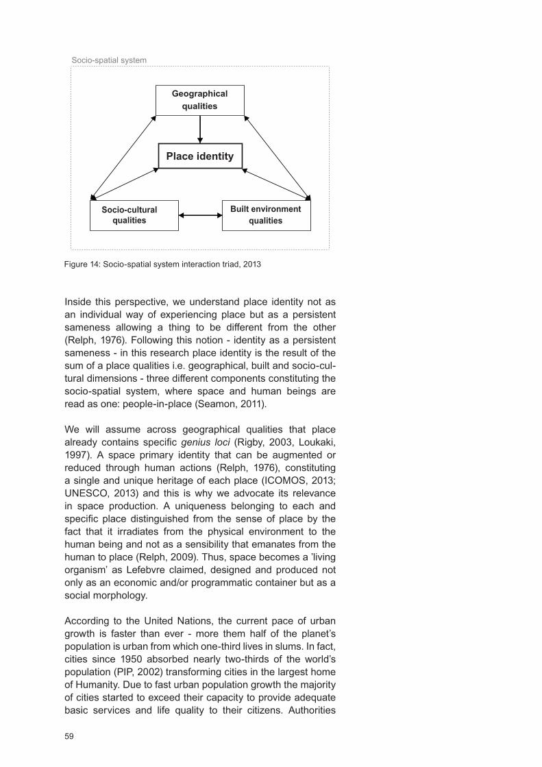
59
Geographical qualities
Socio-cultural qualities
Socio-spatial system
Place identity
Built environment qualities
Figure 14: Socio-spatial system interaction triad, 2013
Inside this perspective, we understand place identity not as an individual way of experiencing place but as a persistent sameness allowing a thing to be different from the other (Relph, 1976). Following this notion - identity as a persistent sameness - in this research place identity is the result of the sum of a place qualities i.e. geographical, built and socio-cul-tural dimensions - three different components constituting the socio-spatial system, where space and human beings are read as one: people-in-place (Seamon, 2011).
We will assume across geographical qualities that place already contains specific genius loci (Rigby, 2003, Loukaki, 1997). A space primary identity that can be augmented or reduced through human actions (Relph, 1976), constituting a single and unique heritage of each place (ICOMOS, 2013; UNESCO, 2013) and this is why we advocate its relevance in space production. A uniqueness belonging to each and specific place distinguished from the sense of place by the fact that it irradiates from the physical environment to the human being and not as a sensibility that emanates from the human to place (Relph, 2009). Thus, space becomes a ’living organism’ as Lefebvre claimed, designed and produced not only as an economic and/or programmatic container but as a social morphology.
According to the United Nations, the current pace of urban growth is faster than ever - more them half of the planet’s population is urban from which one-third lives in slums. In fact, cities since 1950 absorbed nearly two-thirds of the world’s population (PIP, 2002) transforming cities in the largest home of umanity. ue to fast urban population growth the majority of cities started to exceed their capacity to provide adequate basic services and life quality to their citizens. Authorities

60
have been decreasing their response capacity regarding the citizen’s access to education, health, and housing and many urban inhabitants find themselves without jobs. In addition, the metropolis peripheral areas have been growing wildly, consuming unnecessary resources due to sprawl and the accentuation of the abandonment of the urban centers. Lisbon had in 2008 4.000 abandoned buildings from a total of 55.000 (Relea, 2010). Inside contemporary urban context slums are dominant and the degradation of the built environment image it’s an ascending arrow.
At a global scale, the landscape is tending to become mean-ingless and, consequently, dehumanized. A trend increased by the instability of contemporary condition that tends to hipper-compress the time of answer which architecture, by its buildable nature, is unable to achieve; contributing to projects mismatching local culture, climate, and built environment. A landscape-oriented towards finance and the image-obsessed that characterizes contemporary culture (Wood, 2015). As result, cultural and landscape homogenization is inevitable and architecture starts to reproduce buildings without any criteria - a design tendency towards a ‘bottle of perfume’ (Ingels, 2015). An ‘amorphous’ way of thinking space amplified by the aware-ness created by the other body (Ito, 2007) disconnected from its real environment and connected to no physical location. It is thus a dysfunction potentiating new functionalities and ways of working (Koolhaas, 2016) boosting the opportunity to look to places from a different perspective, rediscovering their uniqueness as a way to break of the homogenization of space experience. For Walter (1988) the sharp environment degra-dation has a clear link with the meaningless places that we design, proposing a return to a holistic place understanding where natural and built environment is understood as a system giving meaning to places and creating affective bonds.
Walking towards an urban and sustainable future, also, means to promote a better society. The way we design plays a key role on how people will behave (Pe alosa, 2013) and how much they will relate and respect their environment. This is particularly relevant because we live in an era where the global speed of urban transformation process presents great challenges brought, mainly, the scarcity of means and by climate change. Natural environment comprises place natural resources management i.e. water distribution, saving and decontamination, land protection and management and local green areas protection. Built environment will highlight sani-tation and drainage improvement and implementation, power distribution, water treatment facilities, garbage and recycling policies, public transport promotion, slums or squatter settle-ments eradication, streets and roads walkability and mobility improvement. Social environment includes social promotion, crime decreasing and the equity right to the benefits of living
61
in the city.
Inside contemporary context, the urban and the architectural paradigm are no longer uncontrolled consummation of phys-ical and social resources but their sustainable optimization, only possible through a place deep understanding. This new paradigm shift requires cities to respond hurriedly, through new practices facing sustainability goals and programs that would consider its spatial qualities/identity as a project foun-dation (Calthorpe et al, 2005). ifferent places offer different Stories, topography, demography, culture, and climate, specific atmospheres upgrading the architectural discourse and, consequently, people’s conceptual experience of living.
Sustainability no longer relates to the ecological dimension, in fact, it embeds economic, social, cultural, political and built environment dimensions, it is thus multi-dimensional and this is why we claim place identity as a central tool to project devel-opment. In addition, the weakening of place identity leads to its abandonment, therefore its comprehension and preservation can be a method for the intensification of its usage and space qualities preservation. Ignoring place identity it’s to ignore that people have an innate sense for genius loci and, existentially, gravitate toward it (Seamon, 2011).
For being a place permanent core, place identity helps to reinforce the bonds between people and place - becoming a substructure of the self - translated into space permanent appropriation. A way of felling space as our belonging and extension contributing to maintaining the life of and in places by promoting a ‘’ sense of familiarity, a perception of envi-ronmental stability, and feelings of control and environmental safety. Consequently, people may describe themselves in terms of their belonging to specific places ( ) belonging becomes a component of our personal identity...’’ ( idal et al, 2012). In fact, the notion of ‘existential space’ cannot exist outside of this system; for Schulz, there is no existence if a person can’t locate and identify itself in a certain place (Schulz, 1971; 1980). The existential space became a set of images that people interpret and recognized in order to build an ‘objective space’ essential for human development.
Final Considerations and Future Outcomes
Our research opposes to an architecture that reflects the maker instead of the world, the tendency of a design towards a ‘bottle of perfume’ as claimed by the architect Bjarke Ingels. Not because it cannot exist, it is also valid to create objects centered in themselves, many times this approach generates fantastic results. owever, because of the permanent char-acter of architecture and since we are facing an era of scarce resources, affecting all life forms, we will stand for the concept

62
of ‘civic generosity’, from the WO A Architects, which is the architecture moral obligation in leaving each place better than before; an architecture that takes into consideration present and future social and environment needs.
Using place identity to think a new methodological strategy of place analyses and intervention is an attempt, as the architect Alejandro Aravena states, to avoid the wrong response to the right question. By representing a constant place quality, and since people have an innate sense to feel it, we advocate is relevance in space production, especially inside contempo-rary urban context whose instability is a strong agent of envi-ronmental degradation. Walking towards a sustainable future implies taking care of natural and social resources; place identity, due its holistic nature; it represents an accurate tool towards a more green and inclusive space production.
As the previously stated, contemporary cities are sharply increasing in area and number and losing abruptly their capacity to guarantee life quality to everyone. Even if they only represent 2% of the planet landscape, cities have a major impact in shaping natural and social environments. Globally, urban life is marked by increasing levels of poverty, crime, exacerbation of natural resources consumptions and the ascendant house crises. Because contemporary cities are fragile systems constantly on the edge, we want to test our methodological strategy of place analyses and intervention inside this context - it represents the most unfavorable percen-tile and for that so a system with complex variables helpful to its calibration. A holistic approach towards a sustainable and inclusive urban future is claimed - through resources manage-ment, infrastructures improvement, housing increasing and the development of economies of scale – thus it makes no sense that our methodological strategy doesn’t make part of it.
Inside contemporary urban context, two major groups of urban trends were found; the first relates with the continents of Africa and Asia where the population tends to increase and urban-ization process to be faster. The second within Europe and to the low-fertility countries of Asia where population tends to decline and urbanization process to slow down. In the first group spontaneous urbanization and slums sprawl, in the second the abandonment of urban centres and buildings tend to increase - as in the case of Lisbon. We would like to test the operability of our methodological strategy in both urban scenarios, but, if time constrains occur we will give priority to slums as a case study.
Our research claims a vision of space as a system - the socio-spatial system - a living entity that cannot be reduced to the sum of units. In this perspective, we hope the research provides an expanded space of reflection for the practice and
63
the theory in Urbanism and Architecture, reinforcing knowl-edge about a holistic reading of space including its quality program - space identity - as a key element for project devel-opment and program implementation. This way, we hope to ensure projects more effective integration and sustainability within the inherent social-spatial system, through the new methodological strategy of place analyses and intervention, further design and presented in this research.
In this Chapter, we have stabilized the concept of place identity - inside this research the interaction of the place qualities, i.e. the geographical, the built environment and the socio-cultural dimensions - and the concept of socio-spatial system. In this work, the socio-spatial system is formed by the three claimed space qualities appealing to a systematic understanding where space and human beings are read as one: people-in-place.
For the design of the first draft of our methodological strategy of place analyses and intervention, we used the information extract from the literature review and our professional experience as central development tools. From both a list of parameters was design and divided into two different phases (F1 and F2). F1 will deliver recommendations related to site analysis and the measurement of its qualities - i.e. its identity. Measuring place qualities implies the identification and group of geographical, socio-cultural and built environment qualities. In F2, we will deliver recommendations for the project proposal developed and sustainable implementation.
The selected parameters rise from the literature review, from which we highlight the works of Frampton (1983), Lacy (1995), Kurtuncu (2009), armon (2010), Seamon (2011), Lyon (2013), Pernão (2013) and Kéré (2015). The first draft of proposed methodological strategy is, for a matter of information systematization, presented at the beginning of Chapter II (pages 79, 80) dedicated from the draft to the test of the methodological strategy.
Limitations
On contemporary cities global overview important reports from the World Bank and from the ARUP group where left behind.
ue to time constraints and accuracy of information on global urban data research heavily fall in the United Nations reports, risking a narrow view of the complexity of the contemporary cities context.
The heterotopic space of Michel Foucault and the social space of enri Lefevre could have introduced new layers of informa-tion to create a more expanded field of knowledge, especially in the ‘Environment and uman Behaviour’ topic.
64
Place Identity is a very wide-ranging matter, it was never our intention to make an extensive statement on the subject, however, we would like to had more time to deepen on Martin
eidegger and Christian Norberg-Schulz ‘sense of place’ and ‘dwelling’ concepts through the books ‘The Concept of
welling. On the way to figurative architecture’ and the ‘Archi-tecture: Meaning and Place, Selected Essays’. Also, a broader understanding of the theoretical work of the architect Kenneth Frampton and the architecture of ittorio Gregotti and Juhani Pallasmaa, with his vision of an architecture that should be a mediator between the men and the environment, would consti-tute a plus for the research. Lastly, we highlight the particular work and teaching practices of the architect Glenn Murcutt and the Gordon Cullen ‘Townscape’ work. Thoughts and practices that we will do our best to (re)visit in next research chapters.

65
References
3XN (2010). Mind our Behaviour: ow Architecture Shapes Behaviour. 3 N. Relaterd link:http://gxn.3xn.com/ /
10Design (2011). Erupting Stability: Tornado Proof ouse. Accessed 16.08.2016 at: http://www.10design.co/press-re-leases/tornado-proof-house; http://www.10design.co/work/cgi
Augé, M. (1992). Non-lieux. Introduction à une anthropologie de la surmodernité. ditions du Seuil. Paris
Adrião, Carvalho (2006). Jornal dos arquitectos, n 222, Janei-ro-Março
Alamgir, M. S; Jabbar, M; Islam, M. S. (2009). Assessing the livelihood of slum dwellers in haka city. Journal of the Bang-ladesh Agricultural University, ol 7, 2, 373-380
APREN, Associação Portuguesa de Energias Renováveis (2016). Portugal just went 4 straight days running completely on renewable energy. Accessed 5.26.2016 at: http://www.apren.pt/pt/noticias/detalhes.php id 1521
Aravena, Alejandro (2014). My architectural philosophy Bring the community into the process. TE talks. Accessed 25.03.2016 at:https://www.ted.com/talks/alejandro aravenamy architectural philosophy bring the community intothe process language pt
Bennett, J. G. (1966). The dramatic universe. vol. 3: Man and his nature, London: Stoddard and Watkins
Bogotá, .C. (2015). Modificación Plan Parcial El Porvenir, Localilade de Engativá Bogotá .C. Formulación, ocumento Técnico de Suporte. Octubre
Buttimer, Anne (1976). Grasping the ynamism of Lifeworld. Annals of the Association of American Geographers, 66: 277-92
Buttimer, Anne; Seamon, avid (1980). The human experi-ence of space and place. London: Croom elm
BCCRF, The Bangladesh Climate Change Resilience Fund (2016). Accessed on 23.05.2016 at: http://www.gcca.eu/national-programmes/asia/gcca-bangladesh-climate-change-resilience-fund-bccrf
Calthorpe, Peter; Lerup, Lars (2005). New Urbanism: Peter Calthorpe vs. Lars Lerup, ed. University of Michigan

66
Census of India (2011). Provisional Population Totals Urban Agglomerations and Cities. Accessed 21.11.2015 at: http://censusindia.gov.in/2011-prov-results/paper2/data files/India2/1.%20 ata%20 ighlight.pdf
Cities, Biophilic (2016). Biophilic Cities. Accessed 20.08.2016 at: http://biophiliccities.org/what-are-biophilic-cities/Related link: http://biophiliccities.org/
Cohen, Barney (2006). Urbanization in developing countries: Current trends, future projections, and key challenges for sustainability. Technology in Science Journal 28, 64-65-66-69-70-73
Cohen, Barney (2003). Urban Growth in eveloping Coun-tries: A Review of Current Trends and a Caution Regarding Existing Forecasts, World evelopment ol. 32; 33
Couto, Mia (2015). Quem e que não tem um pouco de real-ismo mágico Journal Publico, suplemento Ipsilon. Sexta-feira, 30 Outubro
CDB, Climate isplacement in Bangladesh (2012). The Need for Urgent ousing, Land and Property ( LP) Rights Solu-tions, isplacement Solution. Report, May
Clos, Joan (2016). Biennale Architettura. Meetings on Archi-tecture (28 May). Accessed 17.06.2016 at: https://www.youtube.com/watch v Kpj8 soySJ0
CA, Clouds Architecture (2015). Mars Ice ouse. Accessed 01.08.2016 at: http://www.cloudsao.com/MARS-ICE- OUSE
CTBUH, Council on Tall Buildings and uman abitat (2015-2016). Countries Ranked by Number of 300m Completed Buildings. The Skyscraper Center. The Global Tall Building
ata Base of the CTBU . Accessed 06.07.2016 at: http://skyscrapercenter.com/countries list buildings-300
David, Seamon (2012). Merleau-Ponty, perception, and envi-ronmental embodiment: Implications for architectural and environmental studies. In R. McCann P. M. Locke (Eds.). Carnal echoes: Merleau-Ponty and the flesh of architecture. New ork: Routledge, forthcoming
Delaqua, ictor (2016). O que Bj rk, Pokémon e a história de uma refugiada podem nos ensinar sobre o futuro da arquitetura 20, July. Accessed 02.08.2016 at: http://www.archdaily.com.br/br/791702/o-que-bjork-pokemon-e-a-histo-ria-de-uma-refugiada-pode-nos-ensinar-sobre-o-futuro-da-arquitetura
67
Dean, Andrea Oppenheimer; ursley, Timothy (2002). Rural Studio: Samuel Mockbee and an Architecture of ecency. Princeton Architectural Press
EUROPEAN, European Landscape Convention (2005). Convenção Europeia da Paisagem, feita em Florença em 20 de Outubro de 2000, iário da Republica – série-A, p 1017, n 31-14 de Fevereiro
Fazeli; .; Goodarzi, A. (2010). The principles of astu as a traditional architectural belief system from an environmental perspective. WIT Transactions on Ecology and the Environ-ment, ol 128
Frampton, Kenneth (1983). Towards a Critical Regionalism: Six Points for an Architecture of Resistance. 1. Culture and Civilization. The Anti-Aesthetic Essays on Post Modern Culture. Edit by al Foster, 16; 26
F+P, Foster Partners (2015). Modular abitat on Mars. 24, Septembre. Accessed 01.08.2016 at: http://www.fosterandpar-tners.com/news/archive/2015/09/foster-partners-new-york-is-one-of-30-finalists-in-mars-habitat-design-competition/
Fujimoto, Sou (2014). Between Nature and Architecture. In the Great all of the Cooper Union. April 15. Accessed 15.08.2016 at: https://www.youtube.com/watch v Pe 4l1tdjs
GFM, Global Finance Magazine (2015-2016). The Richest Countries in the World. Accessed 16.08.2016 at: https://www.gfmag.com/global-data/economic-data/richest-countries-in-the-world page 12
Goffman, Erving (1963). Behavior in Public Places. The Free Press
Gonzale, Filipe (2013). Bogota, Building a Sustainable City PBS esign e2. Accessed on 13.07.2016 at: https://www.youtube.com/watch v C E3ClCA1m4; http://www.mgp.com.co/
Gulis, Gabriel; Mulumba, Joshua Anam Amos; Juma, Olivia; Kakosova, Beatrica (2004). ealth status of people of slums in Nairobi, Kenya. Environmental Research, 96, 219-227
Harvey, avid (1996). Justice, Nature, and the Geography of ifference. Blackwell Publishers Cambrige, MA
Heidegger, M. (1962). Being and time. J. Macquarrie and E. Robinson, trans. New ork: arper Row
68
Hoelscher, Steven (2011). The Wiley-Blackwell Companion to uman Geography. Chapter 16, Place, Part II. Edited by John
A. Agnew, James S. uncan. Blackwell Publishing Ltd. First Edition, 252
HDB, ousing and evelopment Board (2016). Accessed 15.05.2016 at: http://www.hdb.gov.sg/cs/infoweb/homepage
ICOMOS, Conseil International des Monuments et des Sites (2013). Accessed 15.07.2013 at: http://www.icomos.org/fr/notre-action/participation-aux-conventions-internationales/patrimoine-culturel-immateriel
Ingles, Bjarke (2015). Council on Tall Buildings and urban abitat ideo Series. 27, October. Accessed 21.07.2016, at:
http://www.ctbuh.org/TallBuildings/ ideoLibrary/Monthly ide-oSeries/tabid/4165/language/en-GB/ efault.aspx
Ito, Toyo (2007). Arquitectura de Limites ifusos. Gustavo Gili
Jivén, Gunila; Larkham, Peter J. (2003). Sense of Place, Authenticity and Character: A Commentary. Journal of Urban
esign, ol. 8, No. 1, 67–81, 2003 – Carfax publishing
Kéré, iébédo Francis (2015). Architecture is About People. Louisiana Channel. Accessed 24.07.2016, at: https://www.youtube.com/watch v J C QLbGSA
Kéré, iébédo Francis (2015). Kéré architecture/Burkina Faso: Louisiana Canopy. AFRICA: Archiecture, Culture, Iden-tity. Louisiana Museum of Modern Art, 161
Kéré, iébédo Francis (2016). School Library / Gando / Burkina Faso. Accessed 27.08.2016, at:http://www.kere-ar-chitecture.com/projects/school-library-gando/
Koolhas, Rem (2016). The Future of The Way We Live, Love And Work. Accessed 11.07.2016 at: https://www.youtube.com/watch v v9CEO7pApg
Koolhas, Rem (2016). Arquitectura: Cambio de Clima. Cuarta edición del Congreso Internacional de la Fundación Arquitec-tura y Sociedad de Pamplona, Espa a. Accessed 17.07.2016 at:http://arquitecturaysociedad.org/ congreso-arquitectu-ra-cambio-de-clima/ idioma es
Koolhas, Rem (2016). Meetings on Architecture. Teatro Piccolo Arsenale, enice. Biennale Architettura (28 May). Accessed 15.06.2016 at: https://www.youtube.com/watch v Kpj8 soySJ0

69
Kumar, Ashwini (2005). aastu: The Art And Science Of Living. New elhi: Sterling Publishers Private Limited
Kurzweil, Ray (2005). The accelerating power of technology. Ted Talks. Accessed 04.08.2016 at:https://www.ted.com/talks/ray kurzweil on how technology will transform us t-226974
Kurzweil, Ray (2014). Ray Kurzweil: Get ready for hybrid thinking. Ted Talks. Accessed 04.08.2016 at: https://www.ted.com/talks/ray kurzweil get ready for hybrid thinkingRelated link: http://www.kurzweilai.net/
Loukaki, A. (1997). Whose genius loci Contrasting interpre-tations of the sacred rock of the Athenian Acropolis. Annals of the Association of American Geographers, vol. 87, issue 2. 306-329
Lyon, Brian Mac-kay (2013). The illage Architect. Accessed on 17.07.2016 at:https://www.youtube.com/watch v ekhBb-vOS lo
Lynch, Kevin (1976) A Imagem da Cidade, Edições 70
LF, Lake I Flato (2016). http://www.lakeflato.com/
LH, Lava ive (2015). Modular abitat on Mars. Accessed 01.08.2016 at:http://www.lavahive.com/concept/
Massey, oreen (1994). A Global Sense of Place. From Space, Place and Gender. Minneapolis: University of Minne-sota Press
Megacities (2005-2011). Megacities: São Paulo. Produced by National Geographic
Milk, Chris (2015). ow virtual reality can create the ultimate empathy machine. Filmed March 2015 at TE 2015. Accessed 01.08.2016 at: https://www.ted.com/talks/chris milk howvirtual reality can create the ultimate empathy machine; Related link: http://with.in/watch/clouds-over-sidra/
MIT, Massachusetts Institute of Technology (2016). Materials Scientists Make Martian Concrete. A iew from Emerging Technology from the ar iv. MIT Technology Review. January,05. Accessed 01.08.2016 at:https://www.technology-review.com/s/545216/materials-scientists-make-martian-con-crete/
Montgomery, R. Mark, and others, eds. (2004). Cities Trans-formed: emographic Change and its Implications in the
eveloping World. London: Earthscan
70
NASA, National Aeronautics and Space Administration (2015). NASA’s Centennial Challenges: 3 -Printed abitat Chal-lenge. Accessed 01.08.2016 at:http://www.nasa.gov/directo-rates/spacetech/centennial challenges/3 P ab/index.htmlRelated link:http://www.nasa.gov/directorates/spacetech/centennial challenges/3 P ab/2015winners.html
Observatório da Emigração (2015). Quatro milhões estão emigrados. Accessed 17.12.2015 at:http://www.observatori-oemigracao.pt/np4/4509.html
Osmond, . (1959). The relationship between architect and psychiatrist. in C. Goshen, (Ed.). Psychiatric Architecture. Wash, C: American Psychiatric Association
Peñalosa, Enrique (2013). Bogota, Building a Sustainable City PBS esign e2. Accessed on 13.07.2016 at: https://www.youtube.com/watch v C E3ClCA1m4
PIP, Population information program (2002). Center for Communication Programs, the Johns opkins Bloomburg School of Public ealth, Meeting the Urban Challenge, Popu-lation Reports, vol. 30, n 4, Baltimore
Pires, Amílcar de Gil e (2006). Carácter da Arquitectura e do Lugar. ARTiTE TOS06. Julho, 8 - free translation by Filomena Nascimento
Relea, Francesc (2010). Lisboa, la capital del vacío. El Pais. Accessed 20.05.2013 at: http://elpais.com/diario/2010/08/01/domingo/1280634758 850215.html
Relph, Edward (2009). A pragmatic sense of place. Environ-mental and Architectural Phenomenology, vol. 20, n 3. 24-31
Relph, Edward (1981). Rational Landscapes and umanistic Geography. New ork: Barnes and Noble
Relph, Edward (1976). Place and Placelessness. London: Pion
Rigby, K. (2003). Tuning in to spirit of place. In J. Cameron (ed.), Changing places: Re-Imagining Australia, ouble Bay, New South Wales: Longueville Books
R.S., Rural Studio (2016). Rural Studio: http://www.ruralstudio.org/
Seamon, . (2011). Place, Place Identity, and Phenomenology: A Triadic Interpretation Based on J. G. Bennett’s Systematics.
ernan Casakin, Ombretta Romice, Sergio Porta, editors.

71
London: Betham Science Publishers
Seamon, . (2008). Place, placelessness, insideness, and outsideness, in John Sayles’ Sunshine State. Aether: Journal of Media Geography,1-19
Sack, Robert, . (1997). omo Geographicus: A Framework for Action, Awareness, and Moral Concern. Johns opkins University Press, Baltimore
Sarkar, Ar. Kaninika ey (2015). Indian ernacular Plan-ning. Civil Engineering and Urban Planning: An International Journal. ol.2. n1, March, 39
Simon, avid ; Arfvidsson, eien ; Anand, Geetlka ; BAzaz, Amlr ; Fenna, Gill, Foster, Kevin; Jaln, Garlma; ansson, Stlna ; Evans, M. Iouise; Moodiey, Nishendra; Nyanbuga, Charles; Oioko, Michael; Ombara, C . oris; Patel, arina; Perry, Beth; Primo, Natasha; Revi, Aromar; Niekerk, an, Brendon; Wharton, Alex; Wright, Carol (2016). eveloping and testing the Urban Sustainable evelopment Goal’s targets and indi-cators – a five-city study. Environment Urbanization, ol 28, No 1 April
Schulz, Christian Norberg- (1971). Existence, Space Archi-tecture. London: Studio ista Limited
Schulz, Christian Norberg- (1980). Genius Loci. New ork: Rizzoli International Publications INC
Stenebo, John (2010). The Truth about Ikea: The Secret Behind the World’s Fifth Richest Man and the Success of the Flatpack Giant Paperback. Kindle Edition
Venugopal, Jayadevi (2012). astu Purusha Mandala – A uman Ecological Framework for esign Living Environ-
ments. Paper. International Conference on Advances in Archi-tecture and Civil engineering - June
Vidal, Tomeu; Troffa, Renato; alera, Sergi; Fornara, Ferdi-nando (2012). Place Identity as a Useful Psychological Construct for Approaching Modern Social Challenges and New People-Environment Relations: Residential Mobility, Restorative Environments, and Landscape. In: The Role of Place Identity in the Perception, Understanding, and esign of Built Environment. erman CasaKin and Fátima Bernardo editors, Ben Than e-books, 45
Walter, E. . (1988). Placeways: A Theory of the uman Envi-ronment. The University of North Carolina Press
72
Waterstudio (2016). http://www.waterstudio.nl/. Accessed on 29.08.2016 at: http://www.waterstudio.nl/vision
Wood, Antony (2015). Rethinking the Skyscraper in the Ecological Age: esigning Principles for a New igh-Rise
ernacular. International Journal of igh-Rise Buildings. June, ol 4, N 2, 91-01
Wilso, Edward, O. (1995). The Biophilia ypothesis. Edited by Stephen R. Kellert and Edward Osborne Wilson
WOHA (2016). 17, March. Accessed 13.07.2016 at:http://www.ctbuh.org/TallBuildings/ ideoLibrary/tabid/486/language/en-US/ efault.aspx /videos/watch/2764 Related link: http://www.woha.net/
World Resources Institute (2015); 3 Maps Explain India’s Growing Water Risks. Accessed 5.09.2015 at: http://www.wri.org/blog/2015/02/3-maps-explain-india%E2%80%99s-grow-ing-water-risks
Yi-Fu, Tuan (1974). Space and place: umanistic perspective, Progress in geography, vol. 6, London: Edward Arnold
Yi-Fu, Tuan (1977). Space and Place: The Perspective of Experience. University of Minnesota Press, Minneapolis
Urban 21 (2000). Global Conference on Urban Future. Back-ground Report on the World Report on the Urban Future 21. Federal Ministry of Transport, Building and ousing of the Federal Republic of Germany. The Urban Future 21 – Chapeter I: The Millenial Challenge, 5
UNESCO, United Nations Educational, Science and Cultural Organization (2013). What is Intangible Cultural eritage Accessed 08.07.2017 at: http://www.unesco.org/culture/ich/index.php pg 00002
UN-H, UN- abitat (2013). Planning and esigning for Sustain-able Urban Mobility. Global Report on uman Settlements 2013. Routledge, 7-8-11-12
UN-H, UN- abitat (2016). Accessed 07.08.2016 at: http://mirror.unhabitat.org/categories.asp catid 831
UN, United Nations (2014). World Urbanization Prospects, the 2014 Revision, ighlights . Economic and Social Affairs. Population ivision. United Nations New ork, 1
UN, United Nations (2015). World Urbanization Prospects, the 2014 Revision. Economic and Social Affairs. Population ivi-sion. United Nations New ork, xxi-3

73
Documentaries
Andrew Marr’s Megacities (BBC), Episodes: Sustaining the CityCities on the EdgeLiving in the City
Megacities: National Geographic Channel, Episodes (2005-2011):
Megacities: Mexico CityMegacities: LondonMegacities: São Paulo
Sites
America Makes: https://www.americamakes.us/Associação Sistema Terrestre Sustentável: http://zero.ong/ Associação Portuguesa de Energias Renováveis: http://www.apren.pt/pt/Bangladesh Water evelopment Board: http://www.bwdb.gov.bd/Biophilic Cities: http://biophiliccities.org/CiIT LAB: http://www.citylab.com/City population: http://www.citypopulation.de/ Endo Shuhei Architect Institute: http://www.paramodern.com/index.htmlGlobalization and World Cities Research Network: http://www.lboro.ac.uk/gawc/
arassmap: http://harassmap.org/en/ousing and evelopment Board: http://www.hdb.gov.sg/cs/
infoweb/homepageMIT: http://web.mit.edu/Rede Eléctrica Nacional: http://www.ren.pt/Rural Studio: http://www.ruralstudio.org/UN- abitat: http://unhabitat.org/World ealth Organization: http://www.who.int/en/
Related Sites
AzuKo:http://azuko.org/ gclid CK323N77-M0CFUK Gwodp-PYIrgIndian Institute for uman Settlements – Transform Urban India: http://iihs.co.in/PBS, Public Broadcasting Service: http://www.pbs.org/e2/design.htmlStart Mistra Urban Futures: http://www.mistraurbanfutures.org/enUnited Cities and Local Governments: https://www.uclg.org/World Urban Campaign: http://www.worldurbancampaign.org/

Chapter II: From the Draft to the Operability of the New Methodological Strategy of Place Analysis
and Intervention Based on Place Identity
75
Chapter Introduction
Following chapter is composed of two central sections. The first ‘Place, Place Analysis and Place Intervention’ is dedicated to the draft of the methodological strategy. The second ‘Testing the Operability of the Methodological Strategy of Place Analysis and Intervention’ centers in testing its operability and recalibration in order to constitute the final methodological strategy of place analysis and intervention based on place identity - lately sent to architecture studios and presented in communications in order to be evaluated and reviewed.
‘Place, Place Analysis and Place Intervention’ presents the first draft of the methodological strategy designed, mainly, based on Chapter I literature review. We argue on the relevance of space holistic approach and parameters as project development tools. We claim that parameters when inscribed in the three proposed groups - i.e. the geographical, the socio-cultural and the built environment - correspond to space qualities whose interdependency improve or decrease the livelihoods of a place. In addition, parameters help to break off the ‘universal idea’ of a design as an ideal solution by helping to focus on place identity - the place uniqueness - improving, thus, the design towards locally optimized solutions. By their mutual influence, parameters demand a holistic and strategic space vision particularly relevant inside the contemporary urban context where, mainly, we will be operating in existent systems; comprising a strong and complex multidimensional network claiming a resilient process.
This section is followed by the ‘Methods and Methodologies of Place Analysis and Intervention - Crossing Data’. Here we explain the methods behind our choice and analysis of different architecture studios and respective project methodologies, and how obtained data was triangulated with the first draft of our methodological strategy. A necessary step to upgrade and improve the new version of the proposed methodological strategy of place analysis and intervention based on place identity, later tested trough the case studies.
In ‘Testing the Operability of the New Methodological Strategy of Place Analysis and Intervention’, two case studies were conducted; Mumbai (India) and Nyeri (Kenya). We argue on obtained results and on the (re)calibration of the predefined steps and parameters constituting the final version of our methodological strategy of place analysis and intervention presented in the research conclusions pointing its future outcomes. Key words: Methodological Strategy, Parameters, Place Analysis and Intervention, Place Identity
76
Research, Data and Methods
In this research several methods were used, emphasizing the literature review and the case studies. The final methodological strategy was based on both qualitative and quantitative research; using secondary and primary data.
Since research major concerns relate with promoting sustainability and place rooted projects, we surveyed - using google - the architecture leader studios on the subject. The analysis was conducted between the periods of February 2015 and October 2016; growing organically, and in parallel, with the first case study - Mumbai. Several Rankings were analyzed in order to obtain the list of the leader practices, and the best-ranked firms considered. Selected rankings comprised the ‘Journal of the American Institute of Architecture’, the ‘Architectural Record’, and the Engineering New-Record Ranking; chosen by their transparency on used methodologies.
Our first sample comprised 149 architecture studios/firms. After several reviews, from the 149 architecture studios, 10 were selected. For each selected studio a ‘Crossing Data Table’ was designed and completed according to the three research main groups, i.e. geographical; built environment and socio-cultural, and, in some cases, notes on the company were considered in order to reinforce data. Obtained information was crossed with the first draft of the methodological strategy resulting in the new methodology of place analysis and intervention based on place identity; later tested through two case studies.
The case studies were conducted in India and Kenya between the periods April 2015 to April 2016; using both qualitative and quantitative data. For the case studies choice, we prioritized slums inside urban context; they represented the must unfavourable urban scenario and for that reason the best environment to test our methodological strategy. In April 2015 we had the opportunity to work in India, we were based in Mumbai, and we were astonished by the scale of poverty and lack of human rights. We felt the necessity to intervene, to propose a strategy of sustainable urban development with the potential to improve its socio-spatial system; this is why South Mumbai became our first case study. The Mumbai case study results were presented in the ‘II Congresso Internacional de Habitação Coletiva Sustentável’ in April 2016 in São Paulo - Brazil; an important feedback for the research development.
The Nyeri case study, Kenya, arose from the competition promoted by the UN-habitat with the Ministry of Land, Housing & Urban Development Department of Kenya - the International
77
Design Collaboration for Kenya - and it was developed between the periods of 1st February to 20th April 2016. We chose to participate because it represented a unique opportunity to test the methodological strategy obtained through the Mumbai case study, since the environments were similar, and to continue working on slums.
In both case studies, the methodological strategy of place analysis and intervention based on place identity was reviewed and recalibrated, resulting in its final version later sent to several architecture studios in order to be presented and validated.

Place, Place Analysis and Place Intervention

79
Drafting a New Methodological Strategy of Place Analysis and Intervention Based on Place Identity
As previously stated, at Chapter I, we stand for a definition of place identity as a place persistent sameness; the result of the interaction of specific place qualities i.e. geographical, built environment and socio-cultural. We also assume, across geographical qualities, that place already contains a primary identity - a specific genius loci - irradiating from the physical environment to the human being and not as a sensibility that emanates from the human to place.
Inside this context, based on the literature review and our professional experience, we draw ( as the indicated at Chapter I page 63) the first draft of the methodological strategy of place analysis and intervention based on place identity divided into two different phases (F1 and F2) as follows:
In F1 we will measure the place qualities - place identity - aiming the design of more sustainable and place rooted projects. Measuring place qualities implies the identification and grouping of geographical, socio-cultural and built environ-ment qualities.
Geographical qualities will be used as a recommendation for future definition of a program that would respect and optimize place natural resources. The measurement of the socio-cul-tural qualities will reinforce users’ interaction with space ensuring projects’ greater sustainability and dynamical liva-bility of a future program that, after the analysis completion with built environment qualities, will be proposed.
Geographical qualities refer to natural environmental place qualities, interpreted as an engine for buildings passive climate adaptation, boosting green and sustainable project thinking: Topography, natural light, and landscape, wind, climate, flora, fauna (Frampton, 1983; Seamon, 2011; Lyon, 2013).
Methods: Literature review, natural observation, topographical survey, photography and video recording, climate data.
Socio-cultural qualities relate to people-in-place, the human world unfolding in the geographical ensemble (Seamon, 2011): Actions, routines, events, atmosphere (Kurtuncu et al, 2009), memory, place history, soundscape, cultural landscapes and vernacular architecture (Lyon, 2013) local knowledge and local technologies (Kéré, 2015).
Methods: iagrammatic drawings, photographic and video recordings, historical and literature review, interview, sound-scapes recording, actions citizen participation, natural

80
observation, phenomenological methodology.
We know that architecture is a tool of social empowerment and a vehicle of collective expression and place livelihood; working closely with local communities or surveying groups’ preferences create more identity places helpful to rise up awareness towards sustainability.
Built environment qualities include constructions and their spatial configurations: Local-scale (Lyon, 2013), proportion, space context, structure, local materials and local construc-tion knowledge mixing contemporary technologies (Kéré, 2015), indigenous buildings (Lyon, 2013) spatial articulation and syntax, color pallet, background/figure, shape, buildings conservation status, full/empty relation (Kurtuncu, 2009) and perceptual unity.
Methods: Natural observation, photography, diagrammatic drawings and maps (Lacy, 1995; armon et al, 2010), entropic and sensory maps, studies of color/light (Pernão, 2013), survey, literature review, built environment drawings analyses, methodology of space syntax, local materials survey (Kéré, 2016) and vernacular architecture studies (Lyon, 2013).
Vernacular architecture is used as a foundation to create more place rooted projects. Indigenous buildings work both as a fount of inspiration that uses the past to go further, with a crit-ical eye on local culture, and as a catalogue of local materials and construction techniques essential to keep a low-based construction and buildings maintenance.
In F2, we comprise the data critical analysis and selection, and the project proposal developed according collected results.
Methods: Participatory methods, social considerations, envi-ronmental considerations, planning, developing drawings with measurements and construction details, selecting materials and the positioning of the building according to geographical qualities, selecting of the construction techniques, costs.
Space Holistic Approach and Parameters as Project Development Tools
Within each group - geographical, socio-cultural and built environment - listed parameters, i.e. place qualities, influence the project response to its particular socio-spatial system. Hamdi argues that communities are nothing more than systems comprising social and spatial dimensions (Hamdi et al, 1997). Understanding space as a system means to recog-nize that every space parameter - buildings, roads, culture, wind, rain, etc. - work in interdependency, whose interrelations can improve or decrease the livelihoods of the place (figure:
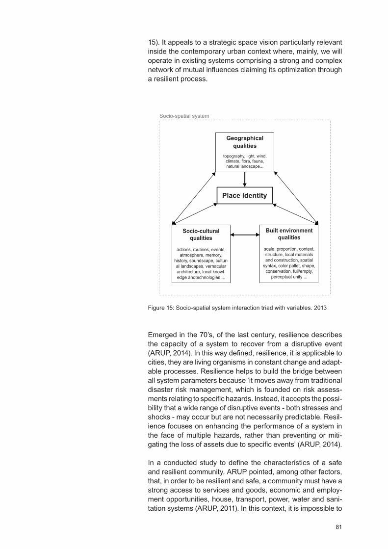
81
15). It appeals to a strategic space vision particularly relevant inside the contemporary urban context where, mainly, we will operate in existing systems comprising a strong and complex network of mutual influences claiming its optimization through a resilient process.
Geographical qualities
topography, light, wind, climate, flora, fauna,natural landscape...
Socio-cultural qualities
actions, routines, events, atmosphere, memory,
history, soundscape, cultur-al landscapes, vernacular architecture, local knowl-edge andtechnologies ...
Socio-spatial system
Place identity
Built environment qualities
scale, proportion, context, structure, local materials and construction, spatial
syntax, color pallet, shape, conservation, full/empty,
perceptual unity ...
Emerged in the 70’s, of the last century, resilience describes the capacity of a system to recover from a disruptive event (ARUP, 2014). In this way defined, resilience, it is applicable to cities, they are living organisms in constant change and adapt-able processes. Resilience helps to build the bridge between all system parameters because ‘it moves away from traditional disaster risk management, which is founded on risk assess-ments relating to specific hazards. Instead, it accepts the possi-bility that a wide range of disruptive events - both stresses and shocks - may occur but are not necessarily predictable. Resil-ience focuses on enhancing the performance of a system in the face of multiple hazards, rather than preventing or miti-gating the loss of assets due to specific events’ (ARUP, 2014).
In a conducted study to define the characteristics of a safe and resilient community, ARUP pointed, among other factors, that, in order to be resilient and safe, a community must have a strong access to services and goods, economic and employ-ment opportunities, house, transport, power, water and sani-tation systems (ARUP, 2011). In this context, it is impossible to
Figure 15: Socio-spatial system interaction triad with variables. 2013
82
be resilient without a holistic space understanding and it will be equally unsuccessful to plan an urban sustainable future without using space holistic view as a development tool. When analyzing contemporary global urban context, one realizes that we are facing the biggest urban transition process ever and one of its key factors relates to climate change. Climate change amends the patterns of wind and rain, typhoons, and torrential rains have largely increased in number and strength, destroying goods and crops forcing people moving massively to the cities. Stress migration has been increasing the number of urban poor that, due to the lack of resources, generally fixed in the cities most vulnerable locations contributing to sprawl, to the exacerbation of the natural resources consumption, to ecosystems destruction and, at last, to accentuate climate change - it is thus a cycle (UN, 2014).
The Same reasoning can be applied to a smaller system, for instance, a city. According to the United Nations sustainable urbanization entails a big number of factors such as the devel-opment of economies of scale, the increasing of employment opportunities in both rural and urban, equal access to educa-tion and healthcare, the improvement and expansion of infra-structures, the sufficient housing quality and the eradication of people living in slums (UN, 2014; UN- , 2016). A set claiming a holistic planning that ‘in order to produce meaningful results, metrics must be tailored to reflect unique sociocultural char-acteristics of contexts and locations, hindering the adoption of any one common measurement’ (UN-H, 2013). Through the broader field of information created by a space holistic approach it is possible to recognize the particularities of each place - culture, microclimate, fauna, etc. - and by addressing questions of scale, interdependence, and interconnection of the different parameters, one may predict more accurately the response of a project into a given system.
We are not arguing on parametrical design assisted by computer, yet we center in its principle that, literally, means to design taking into account different parameters whose interdependency is used to study and improve the relation-ship between the proposed design and the design response. Thus, parametric design describes a vast range of a place parameters/qualities whose mutual influence is crucial to fore-cast possibilities/risks into a system, calculating the design best hypothesis instead of only its configuration. According to Bjarke Ingels (2012) the key parameters that, in the begin-ning of a project we identify, will become project development tools and the ones that we miss, later, will come back and bite design in a process of revision and costs increasing.
In order to design one must understand the demand and the place. In order to understand one must know, and a set of pre-established space groups comprising pre-defined param-
83
eters is crucial to rapidly acquire and gather knowledge about the place where we are going to intervene. Designing with parameters is an organic and evolving task ‘…since most complex design problems in practice are continually reacting to addition and deletion of inputs at multiple scales and levels of complexity. Setting up a parametric model requires defining the major parameters in the initial stage, but this initial set of parameters continues to grow and change as the project develops into different stages’ (Park, 2011), in this context we advocate the relevance of a methodological strategy instead a methodology, because it gives the necessary flexibility for to be recalibrated as we introduce new parameters and (re)define their relationships. In addition, parametrical design helps to break off the danger of the ‘universal idea’ of a design as an ideal solution, the projects copy/paste that makes us lose ‘…problems and potentials of the fact that you have different contexts, different cultures, different economies, different climates, different landscapes, different programs. Each parameter changes the equation and distorts the solu-tion away from the universal perfect solution towards the set of locally optimized solutions’ (Ingels, 2012). Thinking para-metrically requires an algorithmic raesoning, establishing a set of steps and goals in order to optimize the design process and the place resources.
Methods and Methodologies of Place Analysis and Intervention - Crossing Data
The first draft of the methodological strategy of place analysis and intervention was designed taking into consideration the studies of different authors and works found in the literature review; plateful as a reference to relate and group different parameters, representing our starting point towards a new methodological strategy of place analysis and intervention based on place identity.
The following analysis was conducted between the period of February 2015 to October 2016. In 2015 we started to survey and select green architecture studios - i.e. studios strongly compromised with the environment and sustainability. It was an organic search growing in parallel with our first case study, Mumbai (an exploratory case study as we will describe further ahead). At this stage we already had a set of selected param-eters, however, due to time constraints, the tables of ‘Crossing Data’ (Annex II) were only stabilized in 2016, after both cases study ending; this is way in referred tables we choose to indi-cate the last revision date. Conducted study followed the next steps: 1. selection of practices prioritizing sustainability and place rooted projects (google survey); 2. study their method-ologies of place analysis and intervention (trough data avail-able on the respective websites); 3. cross obtained data with the one found in the literature review in order to stabilize the
84
methodological strategy of place analysis and intervention based on place identity; 4. test the operability of the meth-odological strategy through the case studies of Mumbai and Witemere; 5. if necessary, recalibrate the methodological strategy; 6. present the result to architects, urban planners and academics, through a survey and communications, and 7. present the research conclusions.
For the studio’s selection, we focus on the ones who had a stronger compromise with sustainability; the concept appeals to space holistic approach comprising the ecological, the social, the political, the economic, and the environmental dimension - matching with research theoretical framework helpful to avoid dispersal. In addition, research stands for the promotion of more place rooted projects based on local identity, thus, comprising a selection of studios prevailing place/project integrated thinking would reinforce that goal. The studio’s selection started with a Google survey in order to detect architecture studios/firms’ world leaders on sustainability. Several rankings were used namely: the Journal of the American Institute of Architect (2014, 2015), the Architectural Record (2014) and the Engineering New-Record ranking (2015). Presented rankings were chosen by their transparency on used methodologies and consistency of given information.
The first sample included 149 architecture studios/firm’s whose major services comprise architecture, urban plan-ning and engineering (Annex I). In the correspondent file, the studios without color weren’t considered after the first review, the orange ones were excluded after the second revision, and the greens considered. In the 149 studios sample we analyzed their practices through the information available on the respec-tive website - generally, in the About/Approach section - and accessible projects in order to collect more data. In the first review, we excluded the ones who didn’t have, or had, little information about their sustainability approach. In the second round, we excluded the ones whose information was dubious and we privilege the ones who had accurate information about respective sustainability approach (including methods and tools) complemented trough projects description. Selected firms do not center in slums improvement; they do center in built environment/people/environment relationship improve-ment trough sustainability, the center of our attention. We stand for the fact that built environment/people/environment relationship improvement should be a principle transversal to any project representing, by is holistic and strategic vision, one of the most accurate projects development tools. In the end 10 firms were selected, for each a ‘Crossing ata Table’ was designed considering research three claimed groups, i.e. geographical; built environment and socio-cultural - as in the table below (to consult the tables go to Annex II) - and in
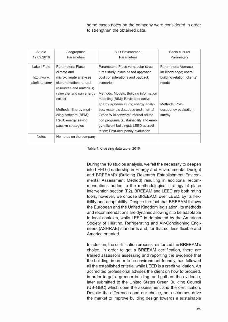
85
During the 10 studios analysis, we felt the necessity to deepen into LEE (Leadership in Energy and Environmental esign) and BREEAM’s (Building Research Establishment Environ-mental Assessment Method) resulting in additional recom-mendations added to the methodological strategy of place intervention section (F2). BREEAM and LEE are both rating tools, however, we choose BREEAM, over LEE , by its flex-ibility and adaptability. espite the fact that BREEAM follows the European and the United Kingdom legislation, its methods and recommendations are dynamic allowing it to be adaptable to local contexts, while LEE is dominated by the American Society of eating, Refrigerating and Air-Conditioning Engi-neers (AS RAE) standards and, for that so, less flexible and America oriented.
In addition, the certification process reinforced the BREEAM’s choice. In order to get a BREEAM certification, there are trained assessors assessing and reporting the evidence that the building, in order to be environment-friendly, has followed all the established criteria, while LEE is a credit validation. An accredited professional advises the client on how to proceed, in order to get a greener building, and gathers the evidence, later submitted to the United States Green Building Council (US-GBC) which does the assessment and the certification.
espite the differences and our choice, both schemes drive the market to improve building design towards a sustainable
Studio 19.09.2016
Geographical Parameters
Built Environment Parameters
Socio-cultural Parameters
Lake I Flato
http://www.lakeflato.com/
Parameters: Place climate and micro-climate analyses; site orientation; natural resources and materials; rainwater and sun energy collect
Methods: Energy mod-eling software (BEM); Revit; energy saving passive strategies
Parameters: Place vernacular struc-tures study; place based approach; cost considerations and payback scenarios
Methods: Models; Building information modeling (BIM); Revit; best active energy systems study; energy analy-ses, materials database and internal Green Wiki software; internal educa-tion programs (sustainability and ener-gy-efficient buildings); LEE accredi-tation; Post-occupancy evaluation
Parameters: ernacu-lar Knowledge; users/building relation; clients’ needs
Methods: Post-occupancy evaluation; survey
Notes
Table 1: Crossing data table. 2016
some cases notes on the company were considered in order to strengthen the obtained data.
No notes on the company
86
people/environment relationship.
After information gathering, the 10 crossing data tables were fulfilled and the different architecture studios methods compared. At this point, we also compared the data tables (Annex II) with the data from the methodological strategy extract from the literature review (pages 77/78) and new infor-mation was added to correspondent fields. When adding the new information we separated the tools (mostly software’s) from the methods since they represent different matters. Thus, the new methodological strategy of place analysis and intervention based on place identity presents as it follows:
F1. Methodological strategy of place analysis - measuring place qualities/identity
Geographical qualities parameters: Climate change - effects on the region, place climate and micro-climate, site orien-tation, natural resources (rainwater, water bodies and lines, daily sunlight and prevailing wind direction), local materials and regional materials (tables I to , Annex II), flood areas (Cox Architecture, table IX, Annex II), topography, natural landscape, place character (Substance Architecture, table IV, Annex II), biodiversity (fauna and flora), land use and land use change (Taylor et al, 2016).
Methods: Literature review, natural observation, research and survey on place natural resources and local materials (Substance Architecture, table IV, Annex II), multi and trans-disciplinary teams, photography and video recording.
Topographical survey operationalization - 3D models (AutoCA , Rhino, etc. ( OK, table III; Cox Architecture, table IX, Annex II)), GIS (Quantum GIS, ArcGIS, etc.), photography and video.
Climate analyses operationalization - any free sun and wind chart software (Meteonorm, etc. (SOM, table II, Annex II)) or any other suitable software ( asari - Ecotect, Passive esign Assistant - PDA, etc.).
Passive strategies and natural resources saving - from project early design stage energy modeling analyses including an accurate study of the place climate and micro-climate, site orientation, natural resources, passive ventilation and shading, daylight, rainwater collection, local materials (Lake I Flato, table I, Annex II), renewable energy usage and long-term strategies for environmental design (Allies & Morrison, table VI, Annex II) in order to detect the payback scenarios. Active systems only come after passive strategies and should centre in low energy and water consumption, low carbon emission and self-energy generation (Lake I Flato, 2016) including - energy modelling
87
software (BEM) helpful to trace and determine the best energy solutions, grey water management and recycling strategies, biodiversity promotion and place adding value through the use of green roofs and soft landscaping (AHMM, table VII, Annex II).
At BREEAM methodology environmental sustainability also covers air pollution. For indoor air quality control and improve-ment, a strategy mixing both passive and active resources must be tailored to each project. For outdoor air quality data we can easily assess through online databases as the World-wide Air Quality Monitoring Data Coverage, or to the country’s online databases on air pollution measurements; thus indi-vidual research is required.
Socio-cultural qualities parameters: ernacular construction knowledge - including local technologies, local communities (Allies & Morrison, Table VI, Annex II) including traditions (routines, events, atmosphere, memory, aspirations (Fentress Architects, Table X, Annex II)), place history, soundscape, cultural landscapes, users/building relationship (tables I to , Annex II) as well as people and place environment relation-ship (NBBJ, Table V, Annex II).
Methods: iagrammatic drawings and sensory-relations maps, photographic and video recordings, interviews and/or surveys, soundscapes recording, space use observations (SOM, Table II, Annex II), active research on place overview including - historical and literature review, cognitive performance studies (NBBJ, Table V, Annex II) - including perception, intuition, and reasoning, phenomenological methodology.
End-user relation with space trough Post-occupancy eval-uation (tables I to X, Annex II) including - thermal comfort, acoustic comfort, safety, cultural identification, visual comfort and indoor air quality (Taylor et al, 2016). Post-occupancy surveys don’t have a specific formula, depending on what we want to evaluate.
Adding value to places requires - multidisciplinary approach including artists to add space cultural value, public education on sustainability (HOK, Table III, Annex II), working closely with local authorities, local communities and local organiza-tions (Allies & Morrison, Table VI, AHMM, Table VII, Annex II) and measurements of the social and economic impact of investment in the historic environment (Allies & Morrison, Table VI, Annex II) or in any other type of environment.
Usually, the social impact of the built environment can be considered at a local level, relating to the permanent users of a certain space, and at a macro level, the surrounding areas (Taylor et al, 2016). Inside this sphere, we consider, despite

88
the economic impacts of the new interventions, the built envi-ronment lack of maintenance. The more degraded is the built environment, tendentiously, the more services will decline, weakening micro-economies and, in time, moving people away incrementing the domino effect of the built environment degradation.
Built environment qualities parameters: Place built environ-ment context - including transport network (AHMM, table VII, Annex II), sidewalks and public spaces, proportion, structure, vernacular structures study (Lake I Flato, table I, Annex II), architectonics, spatial articulation and syntax, color pallet, background/figure, shape, buildings conditions, full/empty relation, perceptual unity, place built resources (including disable places) and local scale.
Methods: and drawing, including diagrammatic drawings and maps, entropic and sensory maps, natural observation, notes on the place, photography and video recording.
Place-based approach operationalization - cost consider-ations and payback scenarios. Active research and studies on local collective knowledge, studies of color/light, comfort and safety trough surveys, transport net, public transport net, services and distribution, green and public spaces, local materials for construction survey and vernacular architecture knowledge mixing contemporary technologies - (AutoCAD, BIM, GIS, etc. (tables I to X, Annex II; Cox Architecture, table IX, Annex II), bespoke interactive tools that both analyse and visualize collected data (NBBJ, Table V, Annex II) in order to be correlated.
F2. Methodological strategy of place intervention
Project proposal development and implementation; recom-mendations: A studios portfolio and Post-occupancy eval-uation reports assessment should be done. This measure-ment clarifies previously used methods, methodologies, and project solutions efficiency, helpful to prioritize new working fronts and to (re)define new project development strategies and solutions reducing costs and generating more efficient strategies towards sustainability. A constant active research is recommended for any project; avoiding a narrowing perspec-tive that often leads to the wrong social, spatial and environ-mental assumptions. We recommend working with inter and transdisciplinary teams in order to define the sustainability goals and guidelines (comprising short, medium and long-term goals) as well as respective analyses tools - that may be bespoke sustainability kits or BIM and BEM technologies. Ideally, the teams should comprise, LEE (or equivalent) accredited professionals and green experts. However, not all the studios have the means to keep this permanent teams
89
typology, an alternative can be a conjoint research with univer-sities, research groups/centers on the subject or consulting with sustainability external experts (tables I to X, Annex II). In addition, at the BREEAM official web page, we may find guidelines on several assessment methods, papers and case studies on the subject and directions to better achieve green goals; representing an alternative tool.
An active research and strategic thinking from the project’s earliest stage is extremely relevant, it creates an expanded field of the environment data helpful to optimize all the resources from the macro to the micro scale - the scale of the building. Through accurate urban analysis, one may under-stand better the transports network - vital when committed to reducing carbon emission - for instance, one can incorporate in the project ways for cycling or better connections to public transport point reducing, this way, the car usage.
Three-dimensional platforms of data collection and crossing with interactive tools that both analyze and visualize infor-mation and/or urban site evaluation tools can be tailored to a specific project and/or to fulfill specific analysis necessities of an office as the NBBJ studio (NBBJ, Table , Annex II). We do realize that not all architecture studios can afford full-time programmers and technology developers. An alternative way is a cooperation with research centers of architecture or/and computer science, or other companies and studios providing same services, in order to deliver the necessary technology or the digested results obtained from the crossing data.
Passive energy strategies must be tailored for each project in order to define the active energy strategies comprising renew-able energy sources. In addition the materials choice it is also very important, the usage of local or regional materials has a significant impact on cost reduction. At Alford all Monaghan Morris (Table VII, Annex II) construction materials are less than 50 miles away from the intervention place. In addition recyclable, recycled and low toxicity materials are critical to reducing the building’s negative impact on the environment.
Methods: epending on the projects nature participatory methods including local population, organizations and govern-ment can be done. Ideas sharing, brainstorm and collabora-tive development, extensive studies on best active energy systems and strategies trough energy analyses focusing on indoor air quality, sustainable design, and high-performance design. Operationalization: Manual crafted including hand-sketching, detailed models at large scale (range from 1:5000 to 1:1), advanced 3D prototyping, GIS (Quantum GIS, ArcGIS, etc.), computer-generated analysis - including parametric model-
90
ling, 3 visualization (3 Studio Max, Sketchup, Rhino 3 , Grasshopper, etc. (tables I to X, Annex II). The integration of augmented reality and virtual reality systems can be a plus for developing the best way to represent any facet of design for a particular context (NBBJ, Table V, Annex II).
For drawings development with measurements and construc-tion details (Revit, Navisworks, ico, Tekla, AutoCA , etc.), for any other graphic representation (Pack Adobe Creative Suite, etc. (tables I to X, Annex II).
For passive strategies design - including extensive use of natural daylight and natural ventilation, water saving strate-gies, renewable energy strategies and the combination of traditional with up-to-date technical knowledge - (Vasari - Ecotect software, Passive esign Assistant (P A), etc.).
Despite previous recommendations, it is imperative that acquired knowledge is shared. AHMM studio has an Intranet monthly Green Bulletin (AHMM, table VII, Annex II) where information on green thinking and studio’s update may be found. A strong green materials library it is also a central tool towards sustainability projects. Internal education programs on sustainability, energy-efficient buildings, green thinking, project management and technology and innovation are required. For offices with lower budget solid solutions may be found on the internet, for instance, the Autodesk Sustainability Workshop is the constant update on the referred subject and it can be freely accessed at: http://sustainabilityworkshop.autodesk.com/buildings/ecotect-vasari-climate-analysis.
To boost the efficiency of a project’s sustainability long life it is crucial to embed the social dimension on it. This, also, can be done through an occupant engagement program where workshops on sustainability, natural resources saving actions, energy management, etc. can take place. Post-occupancy evaluation (surveys format vary on the evaluation goals taking the form of interviews, surveys and space use observation) should be a common practice. It is a critical tool to ensure that the building is performing as the plan given valuable feed-backs as occupant’s behavior or the building performance in the real world (Lake I Flato, 2016); vital to improving future projects design.
We have stabilized the primary methodological strategy of place analysis and intervention based on place identity, resulting from the crossed data of the literature review with the one obtained from the studio’s analyses. Thus, we will follow to test its operability and the ways it can contribute to improve sustainability and place rooted projects through the Mumbai and Witemere case studies.
Testing the Operability of the New Methodological Strategy of Place Analysis
and Intervention

92
Methodological Strategy of Sustainable Urban Growth for Cities in Lower-Income Countries. Case Study: South Mumbai
Research, Data and Methods
This research was exploratory and the case study raised from the necessity to understand Mumbai’s built environment during our stay in town from 5 April to 15 June 2015. Work was developed as a large-scale study aiming both: 1st. to understand the behavior of proposed methodological strategy when embedded in a lower-income-country context, and 2nd. to identify the necessary procedures to improve Mumbai built environment at a micro and macro scale. South Mumbai was the chosen area.
Research begins with an expanded India overview, subse-quently narrowing on Mumbai socio-spatial current situation, in order to create an expanded field of contextualization and local information. Inside this context, we felt the necessity to explore authors and works intervening in similar frameworks. In order to avoid research shortcomings the range of selected works had one condition: they had to be already built, tested and/or shown useful results - because we knew that we had no time, and the means, to operationalize our case study.
Our choice fell on entities and architects whose practices allowed for the constant recalibration of their intervention methods and sustainable urban growth recommendations for lower-income countries. The India Council of Architecture with its publications on the India urban growth topic and the research works on cityscapes and urban planning focusing on Mumbai from the Urban esign Research Institute, Mumbai (U RI) helped to detect emergent questions to be addressed namely: housing, infrastructures and resources management. Neelima Risbud’s research: ‘The case study of Mumbai, India. Understanding Slums: Case Studies for the Global Report on uman Settlements 2003’ and the 2011 Census of India statistics were vital to getting a deeper slums over-view - history, inhabitants, numbers, locations, house condi-tions and materials. The GA Collaborative project ‘Mapping Rwanda’ displayed relevant subjects to take into account when mapping and designing a development strategy for lower-income countries. Charles Correa urban planning work to restructure Bombay in the 1970’s, as well as its urban and architectural recommendations helped this work to focus on the relevance of architecture climate and society adaptation in order to achieve sustainability. The United Nations reports - World Urbanization Prospects, the 2014 Revision - updated information on the world’s urban population growth, pointed important directions for sustainable urban growth on lower-in-
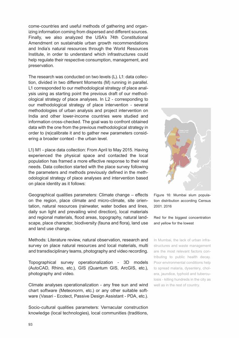
93
come-countries and useful methods of gathering and organ-izing information coming from dispersed and different sources. Finally, we also analyzed the USA’s 74th Constitutional Amendment on sustainable urban growth recommendations and India’s natural resources through the World Resources Institute, in order to understand which infrastructures could help regulate their respective consumption, management, and preservation.
The research was conducted on two levels (L). L1: data collec-tion, divided in two different Moments (M) running in parallel. L1 corresponded to our methodological strategy of place anal-ysis using as starting point the previous draft of our method-ological strategy of place analyses. In L2 - corresponding to our methodological strategy of place intervention - several methodologies of urban analysis and project intervention on India and other lower-income countries were studied and information cross-checked. The goal was to confront obtained data with the one from the previous methodological strategy in order to (re)calibrate it and to gather new parameters consid-ering a broader context - the urban level.
L1) M1 - place data collection: From April to May 2015. aving experienced the physical space and contacted the local population has framed a more effective response to their real needs. Data collection started with the place survey following the parameters and methods previously defined in the meth-odological strategy of place analyses and intervention based on place identity as it follows:
Geographical qualities parameters: Climate change – effects on the region, place climate and micro-climate, site orien-tation, natural resources (rainwater, water bodies and lines, daily sun light and prevailing wind direction), local materials and regional materials, flood areas, topography, natural land-scape, place character, biodiversity (fauna and flora), land use and land use change.
Methods: Literature review, natural observation, research and survey on place natural resources and local materials, multi and transdisciplinary teams, photography and video recording.
Topographical survey operationalization - 3D models (AutoCA , Rhino, etc.), GIS (Quantum GIS, ArcGIS, etc.), photography and video.
Climate analyses operationalization - any free sun and wind chart software (Meteonorm, etc.) or any other suitable soft-ware ( asari - Ecotect, Passive esign Assistant - P A, etc.).
Socio-cultural qualities parameters: ernacular construction knowledge (local technologies), local communities (traditions,
Figure 16: Mumbai slum popula-tion distribution according Census 2001. 2016
Red for the biggest concentration and yellow for the lowest
In Mumbai, the lack of urban infra-structures and waste management are the most relevant factors con-tributing to public health decay. Poor environmental conditions help to spread malaria, dysentery, chol-era, jaundice, typhoid and tubercu-losis - killing hundreds in the city as well as in the rest of country.
94
routines, events, atmosphere, memory, aspirations), place history, soundscape, cultural landscapes, users/building rela-tionship and people/place environment relationship.
Methods: iagrammatic drawings and sensory-relations maps, photographic and video recordings, interviews and/or surveys, soundscapes recording, space use observations, active research on place overview (historical and literature review), cognitive performance studies (perception, intuition, and reasoning), phenomenological methodology and end-user relation with space studies trough Post-occupancy evaluation (thermal comfort, acoustic comfort, safety, cultural identifica-tion, visual comfort and indoor air quality)
Built environment qualities parameters: Place built environ-ment (transport network, sidewalks and public spaces, propor-tion, structure), vernacular structures study, architectonics, spatial articulation and syntax, color pallet, background/figure, shape, buildings conditions, full/empty relation, perceptual unity, place built resources (including disable places) and local scale.
Methods: and drawing, including diagrammatic drawings and maps, entropic and sensory maps, natural observation, notes on the place, photography and video recording.
However, and as we will see further in this case study proposed parameters have change due to local specificities. In addition, during this phase, especially because of our cultural disloca-tion, we felt the necessity to deepen knowledge in the current context of India and Mumbai in order to frame a cultural, economic and political baseline essential for to understand social patterns and the socio-spatial network.
L1) M2 - sources data collection: From April to May 2015. We used the United Nations, the India Council of Architecture, the 15th Indian Census (2011), the World Resources Institute databases and reports and the Neelima Risbud’s (Risbud’s, 2003) research to complete M1 information at local and terri-tory levels.
Methods: and drawings, photographic and video recordings, natural observation, research, critical data selection, critical reviews of reports and papers (always trying to work on cred-ible data as peer review papers or UN reports), data crossing, data critical review.
In L2, we studied the methodologies of place analysis, inter-vention and sustainable urban growth recommendations of the United Nations, the 74th Constitutional Amendment, the architect Charles Correa and the GA Collaborative architects, aiming the upgrade of proposed methodological strategy as a
In India, social differences between men and woman are colossal; one important indicator is gender access to culture and education.
Literacy is not only about reading or writing, it is also about expanding our mental geography and helping to relate and understand environment as well as our actions upon it.
List of slum house materials:GrassThatchBambooWoodMudPlasticPolytheneHandmade tilesBurnt BrickStone/SlateMetal/Asbestos sheetsConcrete
Source: Census 2011, http://www.censusindia.gov.in/2011census/hlo/Slum table/Slum table.html
95
development tool for lower-income-countries and the identifi-cation of the best recommendations to improve Mumbai built environment.
Methods: Sources critical choice, data crossing, patterns crit-ical analysis, data review.
India Overview
Attending to its land mass, India is the 7th largest country in the world, the third largest in Asia, and the second most popu-lated one, while concurrently ranking among the poorest on the planet. By 2022, India’s population will surpass China’s - China currently being the most populated country in the world - and by ‘’2050 they will represent 19% of the world’s popu-lation, whilst China is expected to account for 18% of that’’ (Público, 2015). With population increasing, hunger, pollution, and differences between social classes are also expected to increase as well.
Known as the world’s largest democracy, India contains many religions - indus (80.5% of the population), Muslims (13.4%), Christians (2.3%), Sikhs (1.9%), Buddhists (0.8%), Jains (0.4%), other religions (0.6%) and unstated religions (0.1), (Census, 2011). This issue is thus extremely important. In India, reli-gion is not just something to be followed; it’s a way of living that determines the relationship between humans, nature, and construction. Despite needing to allow for climate adaptation, the Vastu Shastra is, through its spiritual approach, an attempt to gather men and gods in one single built space - the image of religion weighing in space planning.
Another important factor is the way the country’s society is divided. The caste system comprises four major Varnas (classes) – the Brahmana (Brahmana people are engaged in teaching and knowledge preservation), the Kshatriya (engaged in public service, law, and order), the Vaishya (engaged in commercial activity) and the Shudra (semi or unskilled workers). Within this very simplified form of explaining India’s society, the most important factor, broadly speaking, is that caste system determines the type of occupation and social interactions that a person may have. One person ‘‘already’’ knows since the day he is born his geographical, social and educational limitations, something that has a profound impact in both space appropriation and usage.
According to the 2011 Census of India, the country’s’ total population is 1 210 193 422 people of which 833 087 662 live in rural areas and 377 105 760 live in urban ones. An over-loaded country where, for now, the majority of its population still lives in rural areas mostly because they do not have theInformation systematization: Written documents, photography
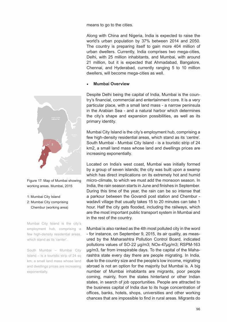
96
means to go to the cities.
Along with China and Nigeria, India is expected to raise the world’s urban population by 37% between 2014 and 2050. The country is preparing itself to gain more 404 million of urban dwellers. Currently, India comprises two mega-cities, Delhi, with 25 million inhabitants, and Mumbai, with around 21 million, but it is expected that Ahmadabad, Bangalore, Chennai, and Hyderabad, currently ranging 5 to 10 million dwellers, will become mega-cities as well.
Mumbai Overview
Despite Delhi being the capital of India, Mumbai is the coun-try’s financial, commercial and entertainment core. It is a very particular place, with a small land mass - a narrow peninsula in the Arabian Sea - and a natural harbor which determines the city’s shape and expansion possibilities, as well as its primary identity.
Mumbai City Island is the city’s employment hub, comprising a few high-density residential areas, which stand as its ‘centre’. South Mumbai - Mumbai City Island - is a touristic strip of 24 km2, a small land mass whose land and dwellings prices are increasing exponentially.
Located on India’s west coast, Mumbai was initially formed by a group of seven islands; the city was built upon a swamp which has direct implications on its extremely hot and humid micro-climate, to which we must add the monsoon season. In India, the rain season starts in June and finishes in September. During this time of the year, the rain can be so intense that a parkour between the Govandi post station and Chembur - wadavli village that usually takes 15 to 20 minutes can take 1 hour. alf the city gets flooded, including the railways, which are the most important public transport system in Mumbai and in the rest of the country.
Mumbai is also ranked as the 4th most polluted city in the word - for instance, on September 9, 2015, its air quality, as meas-ured by the Maharashtra Pollution Control Board, indicated pollutions values of SO-22 g/m3; NOx-47 g/m3; RSPM-163
g/m3, far from irrespirable days. To the capital of the Maha-rashtra state every day there are people migrating. In India, due to the country size and the people’s low income, migrating abroad is not an option for the majority but Mumbai is. A big number of Mumbai inhabitants are migrants, poor people coming, mainly, from the states hinterland or other Indian states, in search of job opportunities. People are attracted to the business capital of India due to its huge concentration of offices, banks, hotels, shops, universities and other working chances that are impossible to find in rural areas. Migrants do
Figure 17: Map of Mumbai showing working areas. Mumbai, 2015
1: Mumbai City Island 2: Mumbai City comprising Chembur (working area)
Mumbai City Island is the city’s employment hub, comprising a few high-density residential areas, which stand as its ‘center’.
South Mumbai – Mumbai City Island – is a touristic strip of 24 sq km, a small land mass whose land and dwellings prices are increasing exponentially.
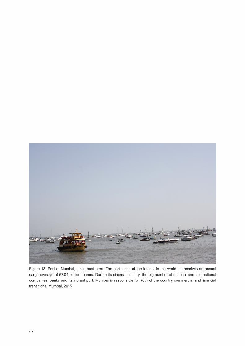
97
Figure 18: Port of Mumbai, small boat area. The port - one of the largest in the world - it receives an annual cargo average of 57.04 million tonnes. ue to its cinema industry, the big number of national and international companies, banks and its vibrant port, Mumbai is responsible for 70% of the country commercial and financial transitions. Mumbai, 2015
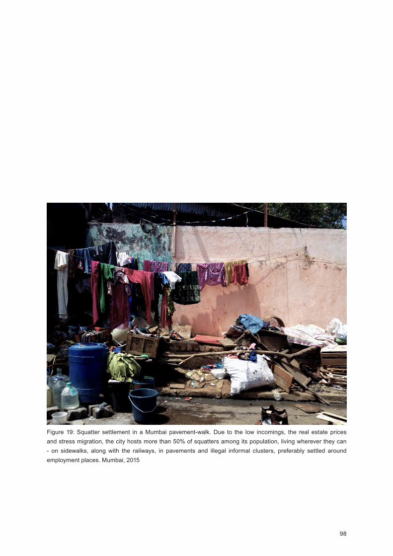
98
Figure 19: Squatter settlement in a Mumbai pavement-walk. ue to the low incomings, the real estate prices and stress migration, the city hosts more than 50% of squatters among its population, living wherever they can - on sidewalks, along with the railways, in pavements and illegal informal clusters, preferably settled around employment places. Mumbai, 2015
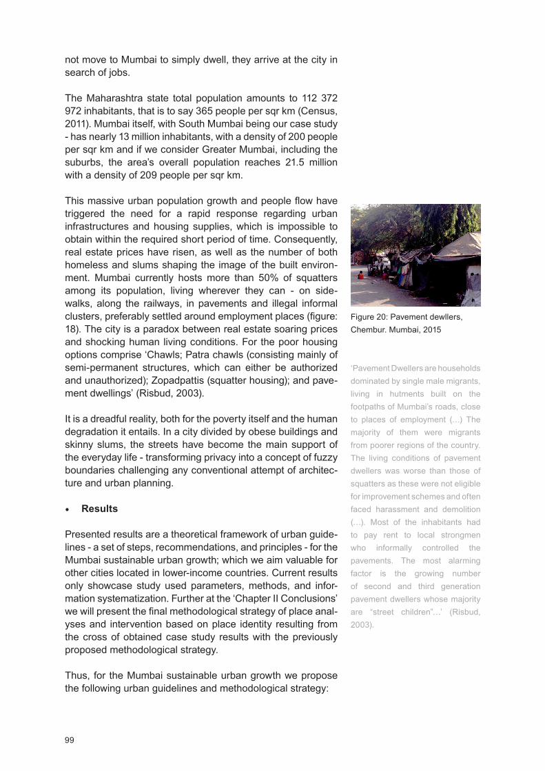
99
not move to Mumbai to simply dwell, they arrive at the city in search of jobs.
The Maharashtra state total population amounts to 112 372 972 inhabitants, that is to say 365 people per sqr km (Census, 2011). Mumbai itself, with South Mumbai being our case study - has nearly 13 million inhabitants, with a density of 200 people per sqr km and if we consider Greater Mumbai, including the suburbs, the area’s overall population reaches 21.5 million with a density of 209 people per sqr km.
This massive urban population growth and people flow have triggered the need for a rapid response regarding urban infrastructures and housing supplies, which is impossible to obtain within the required short period of time. Consequently, real estate prices have risen, as well as the number of both homeless and slums shaping the image of the built environ-ment. Mumbai currently hosts more than 50% of squatters among its population, living wherever they can - on side-walks, along the railways, in pavements and illegal informal clusters, preferably settled around employment places (figure: 18). The city is a paradox between real estate soaring prices and shocking human living conditions. For the poor housing options comprise ‘Chawls; Patra chawls (consisting mainly of semi-permanent structures, which can either be authorized and unauthorized); Zopadpattis (squatter housing); and pave-ment dwellings’ (Risbud, 2003).
It is a dreadful reality, both for the poverty itself and the human degradation it entails. In a city divided by obese buildings and skinny slums, the streets have become the main support of the everyday life - transforming privacy into a concept of fuzzy boundaries challenging any conventional attempt of architec-ture and urban planning.
Results
Presented results are a theoretical framework of urban guide-lines - a set of steps, recommendations, and principles - for the Mumbai sustainable urban growth; which we aim valuable for other cities located in lower-income countries. Current results only showcase study used parameters, methods, and infor-mation systematization. Further at the ‘Chapter II Conclusions’ we will present the final methodological strategy of place anal-yses and intervention based on place identity resulting from the cross of obtained case study results with the previously proposed methodological strategy.
Thus, for the Mumbai sustainable urban growth we propose the following urban guidelines and methodological strategy:
Figure 20: Pavement dewllers, Chembur. Mumbai, 2015
‘Pavement Dwellers are households dominated by single male migrants, living in hutments built on the footpaths of Mumbai’s roads, close to places of employment (…) The majority of them were migrants from poorer regions of the country. The living conditions of pavement dwellers was worse than those of squatters as these were not eligible for improvement schemes and often faced harassment and demolition (…). Most of the inhabitants had to pay rent to local strongmen who informally controlled the pavements. The most alarming factor is the growing number of second and third generation pavement dwellers whose majority are street children ’ (Risbud, 2003).
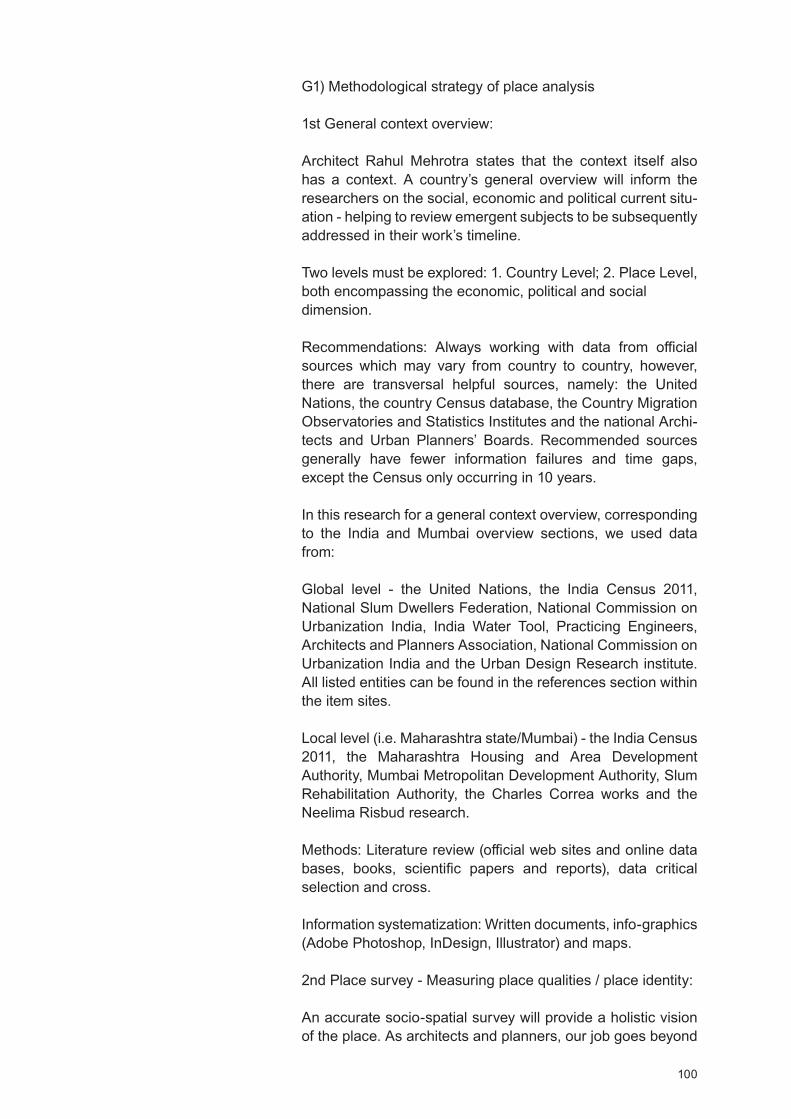
100
G1) Methodological strategy of place analysis
1st General context overview:
Architect Rahul Mehrotra states that the context itself also has a context. A country’s general overview will inform the researchers on the social, economic and political current situ-ation - helping to review emergent subjects to be subsequently addressed in their work’s timeline.
Two levels must be explored: 1. Country Level; 2. Place Level, both encompassing the economic, political and social dimension.
Recommendations: Always working with data from official sources which may vary from country to country, however, there are transversal helpful sources, namely: the United Nations, the country Census database, the Country Migration Observatories and Statistics Institutes and the national Archi-tects and Urban Planners’ Boards. Recommended sources generally have fewer information failures and time gaps, except the Census only occurring in 10 years.
In this research for a general context overview, corresponding to the India and Mumbai overview sections, we used data from:
Global level - the United Nations, the India Census 2011, National Slum Dwellers Federation, National Commission on Urbanization India, India Water Tool, Practicing Engineers, Architects and Planners Association, National Commission on Urbanization India and the Urban esign Research institute. All listed entities can be found in the references section within the item sites.
Local level (i.e. Maharashtra state/Mumbai) - the India Census 2011, the Maharashtra Housing and Area Development Authority, Mumbai Metropolitan Development Authority, Slum Rehabilitation Authority, the Charles Correa works and the Neelima Risbud research.
Methods: Literature review (official web sites and online data bases, books, scientific papers and reports), data critical selection and cross.
Information systematization: Written documents, info-graphics (Adobe Photoshop, InDesign, Illustrator) and maps.
2nd Place survey - Measuring place qualities / place identity:
An accurate socio-spatial survey will provide a holistic vision of the place. As architects and planners, our job goes beyond
101
detecting what is malfunctioning as it also entails to understand this malfunctions reasons and setting it critically right. Thus we propose a place survey covering socio-cultural, geographical and built environment dimensions. This survey allows us to recognize the various layers of the place, permitting a deeper understanding of the socio-spatial system showing the place fragilities and assets.
Socio-cultural qualities parameters: Population growing esti-mation (UN, 2015); place history, cultural landscapes, users/building relation as well as people and place environment, economies of scale brought by agglomeration (UN, 2015), funding and governance (GA Collaborative, 2015); local communities including - number of tribes, religions and castes (Census, 2011), income average, cultural preferences (UN, 2015), socio-cultural practices (by tribe, religion and caste), age average, literacy, traditions and routines, vernacular construction knowledge including construction skill and local technologies.
Methods: iagrammatic drawings and sensory-relations maps, photographic and video recordings, space use obser-vations, research on place overview including - historical and literature review (Census and further population studies, rele-vant organizations research and statistics reviews), phenome-nological methodology.
Information systematization: Written documents, photography/video, any Computer Aided Design software that suits the project needs (AutoCAD) and info-graphics (Adobe Photo-shop, InDesign, Illustrator).
Geographical qualities parameters: Climate change - effects on the region, place climate and micro-climate, air pollution, site orientation, natural resources (rain season, rain water and flood areas, water bodies and lines, daily sun light and prevailing wind/wind direction), local materials and regional materials, topography. Methods: Literature review, natural observation, photograph and video recording, climate change effects on the region studies (Census, United Nations), place climate, micro-climate and air pollution studies (Maharashtra Pollution Control Board, World-wide Air Quality Monitoring Data Coverage - Pollution in World: Real-time Air Quality Index isual Map section, Meteonorm, literature review on the subjects: rain season and water supplies, CAIT Climate ata Explorer); passive strate-gies studies including - day light, passive ventilation, shading and rain water collection (Charles Correa work review), natural resources including local materials survey (India Water Tool, World Resources Institute).
Figure 21: Slum house. Mumbai (South) 2015
Listed materials: WoodMudPlasticHandmade tilesTissue

102
and info-graphics (Adobe Photoshop, InDesign, Illustrator).
Built environment qualities parameters: Place built environ-ment context - encompassing city location (UN, 2015), density distribution, number of houses/slums including - living condi-tions, number of persons living (Census, 2011), traditional and modern materials and techniques (GA. Collaborative, 2015), sanitation, main light sources, water source and distribution (Census, 2011), accessibility/mobility, conservation status, roads fluency and walking/mobility, traffic mobility and public urban transport network, public spaces, services and govern-ance (GA. Collaborative, 2015), proportion, structure, color pallet, background/figure, full/empty, perceptual unity, place built resources (including disable places), local scale.
Figure 22: Built environment qualities measurement. Mumbai major public transportation net. Mumbai, 2015
The public transportation net was broadly drew, its main objective was to create a visual overall of the cur-rent Mumbai public transport distribution.
Figure 23: Built environment qualities measurement. Correlation between public transportation net and slums concentration distribution. People, preferably settle around employment and transportation hubs. Mumbai, 2015
Slums highest concentration Slums high concentration Slums lowest concentration
We did not find data on slums percentage per sqm.
Major roads
Port
Airport
Mumbai Central Railway Station and Churchgate Train Station
Arabian Sea
Arabian Sea
NaviMumbai
NaviMumbai

103
Methods: and drawing, including diagrammatic drawings and maps, entropic and sensory maps, natural observa-tion, notes on the place, photography and video recording and conversations with local architects and planners. Active research on local collective knowledge, survey on number of houses/slums including - living conditions, number of persons living (Census, 2011, Slum Rehabilitation Authority, Mumbai Metropolitan Development Authority), survey on sanitation, main light sources, water source and distribution, accessi-bility/mobility, conservation status, urban network including – services, public spaces, roads fluency and walking mobility, traffic mobility and public urban transport network (Census, 2011, Maharashtra Housing and Area Development Authority, Mumbai Metropolitan Development Authority), organic trans-port net and public transport net (Mumbai Urban Trans-port Project, Mumbai Metropolitan Development Authority), services and distribution, green and public spaces, local materials for construction survey (Census, 2011).
Information systematization: Written documents, photography, data crossing, CAD software that suits the project needs (AutoCAD), infographics (Adobe Photoshop, InDesign, Illus-trator).
Recommendation: Survey or simple conversations with local people registrations are beneficial as well as working closely with local authorities and organizations.
3rd Principles as project tools:
For Charles Correa (2000), in India, housing was a bill of rights. We shared the same conviction by introducing and digesting its cardinal principles as project development tools helpful to determine the dwellings’ shape and urban design features.
Incrementality; Disaggregation and Malleability - stressing migration factor, every day brings someone new to a slum, who is accommodated in a relative’s or a friend’s house. Thus, both the number of people in a ‘family’ and available space can rapidly change. Dwellings must be adaptable, modular and evolutionary structures, made of light mate-rials so one can rapidly transform space according to new needs. Another advantage of modular and evolutionary structures is that they can afford the basic modular living unit (for instance, a ground floor module with bathroom, social area, kitchen and two rooms) and in time people can buy one or two more;
Pluralism - India has many religions and tribes sharing different ways of living. Space must foster maximum neutrality while remaining permeable to different appropri-ations and pluralisms;

104
Participation - participatory methods include the loca populations collaboration for slums improvement and housing construction, a faster, economic and sustainable way of developing the built environment due the cross of both contemporary and ancient construction knowledge;
Income generation - features income and socio-spatial needs, urban population growth patterns and income averages;
Equity - we do not project for the rich or the poor, we project for people;
Open-to-sky-space - less built mass, more climate adap-tation.
G2) Methodological strategy of place intervention
4th Preparing the project - Urban planning level tasks:
The tasks at urban planning level are about creating a stronger and efficient space structure, improving place qualities and livability. These tasks are the first step to eradicate urban poverty and to create an urban development strategy towards a sustainable and inclusive future.
Sustainable Urban Planning including town planning (Jain, 2011) – networking cities, towns and villages, including agricultural fields – land use and land use change, land management and comprehensive planning;
Vital statistics on urban and population growing estima-tions - including registration of births and deaths (USA’s 74th Constitutional Amendment, 2010);
Third world urban growth patterns recognition - densities optimization and land use readjustment and regulation, saving land for urban expansion, agriculture, industrial production and ecological reservations;
Networking plans – development of infrastructures, roads and bridges plans (USA’s 74th Constitutional Amendment, 2010) - deployment and development of transportation networks, sidewalks and streets;
Development of energy and water supply plans for housing, industrial and commercial purposes (USA’s 74th Consti-tutional Amendment, 2010), including renewable energy sources and water recycling;
Development of public health plans for sanitation, conserv-ancy and solid waste management (USA’s 74th Constitu-
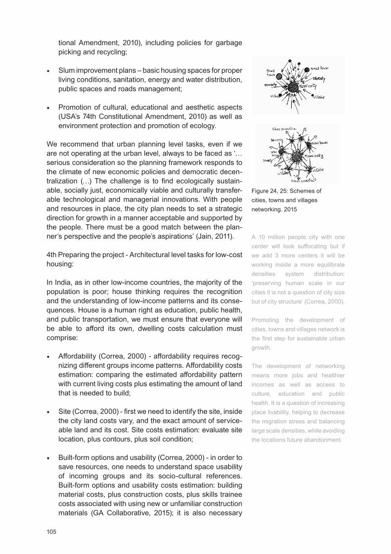
105
tional Amendment, 2010), including policies for garbage picking and recycling;
Slum improvement plans – basic housing spaces for proper living conditions, sanitation, energy and water distribution, public spaces and roads management;
Promotion of cultural, educational and aesthetic aspects (USA’s 74th Constitutional Amendment, 2010) as well as environment protection and promotion of ecology.
We recommend that urban planning level tasks, even if we are not operating at the urban level, always to be faced as ‘…serious consideration so the planning framework responds to the climate of new economic policies and democratic decen-tralization ( ) The challenge is to find ecologically sustain-able, socially just, economically viable and culturally transfer-able technological and managerial innovations. With people and resources in place, the city plan needs to set a strategic direction for growth in a manner acceptable and supported by the people. There must be a good match between the plan-ner’s perspective and the people’s aspirations’ (Jain, 2011).
4th Preparing the project - Architectural level tasks for low-cost housing:
In India, as in other low-income countries, the majority of the population is poor; house thinking requires the recognition and the understanding of low-income patterns and its conse-quences. House is a human right as education, public health, and public transportation, we must ensure that everyone will be able to afford its own, dwelling costs calculation must comprise:
Affordability (Correa, 2000) - affordability requires recog-nizing different groups income patterns. Affordability costs estimation: comparing the estimated affordability pattern with current living costs plus estimating the amount of land that is needed to build;
Site (Correa, 2000) - first we need to identify the site, inside the city land costs vary, and the exact amount of service-able land and its cost. Site costs estimation: evaluate site location, plus contours, plus soil condition;
Built-form options and usability (Correa, 2000) - in order to save resources, one needs to understand space usability of incoming groups and its socio-cultural references. Built-form options and usability costs estimation: building material costs, plus construction costs, plus skills trainee costs associated with using new or unfamiliar construction materials (GA Collaborative, 2015); it is also necessary
Figure 24, 25: Schemes of cities, towns and villages networking. 2015
A 10 million people city with one center will look suffocating but if we add 3 more centers it will be working inside a more equilibrate densities system distribution; ‘preserving human scale in our cities it is not a question of city size but of city structure’ (Correa, 2000).
Promoting the development of cities, towns and villages network is the first step for sustainable urban growth.
The development of networking means more jobs and healthier incomes as well as access to culture, education and public health. It is a question of increasing place livability, helping to decrease the migration stress and balancing large scale densities, while avoiding the locations future abandonment.
106
to add streets and roads specifications, plus energy and water supply and sanitation infrastructures.
Recommendations: epending on the projects nature partic-ipatory methods including local population, organizations, and government. We also recommend previous projects on the same environment assessment (active research) a measurement helpful to clarify used methods, methodolo-gies and project solutions efficiency contributing to (re)define new project development strategies and solutions that may reduce costs and generate strategies towards sustainability. When possible always work with inter and transdisciplinary teams in order to define the sustainability goals and guidelines (comprising short, medium and long-term goals at the city and city surroundings scale).
Discussion and Conclusions
As previously stated presented case study was exploratory aiming to understand the behavior, utility, and changes that would occur in previous proposed methodological strategy when embedded in a lower-income-country context as well as the identification of the necessary procedures - steps and recommendations - to improve Mumbai built environment at a micro and macro scale.
Regarding previously proposed methodological strategy this case study, by its nature, focused in the place survey section/place analysis. The formerly established socio-cul-tural, geographical and built environment parameters were our starting point to survey on Mumbai. Has research evolve, and since we were operating in a socio-spatial system highly complex and different from our European references, we felt the need to add and adjust pre-established parameters in order to form a new set helpful for the Mumbai socio-spa-tial system analysis. Due to this necessity we discover, when surveying on Mumbai, that there are ‘transversal parameters’ - i.e. the ones we maintained regarding our previous meth-odological strategy - and ‘changing parameters’, rising from the fact that different contexts have different demands and, for that so, different sets of parameters.
At the socio-cultural parameters level transversal parame-ters comprised: Place history, cultural landscapes, users/building relation as well as people and place environment, local communities (later upgraded), routines and vernacular construction knowledge (including construction skill and local technologies).
Regarding new socio-cultural parameters, we added: Popula-tion growth estimation, economies of scale brought by agglom-eration, funding and governance, income average, cultural
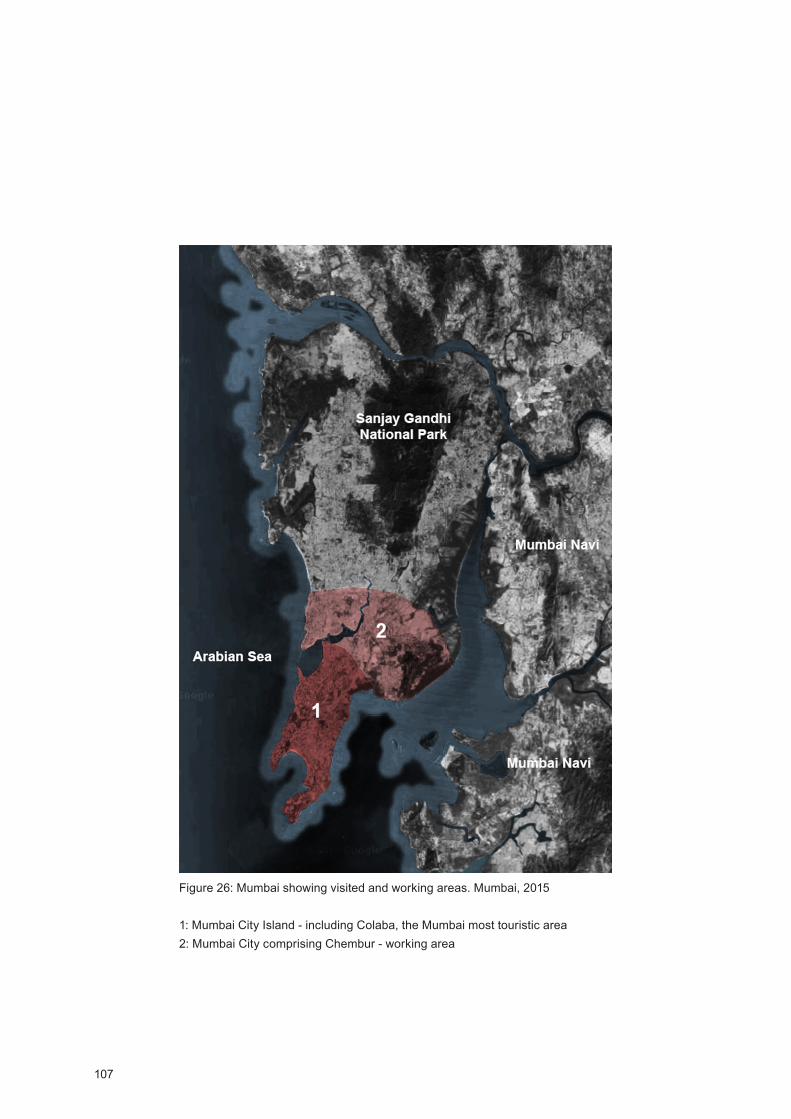
107
Figure 26: Mumbai showing visited and working areas. Mumbai, 2015
1: Mumbai City Island - including Colaba, the Mumbai most touristic area2: Mumbai City comprising Chembur - working area
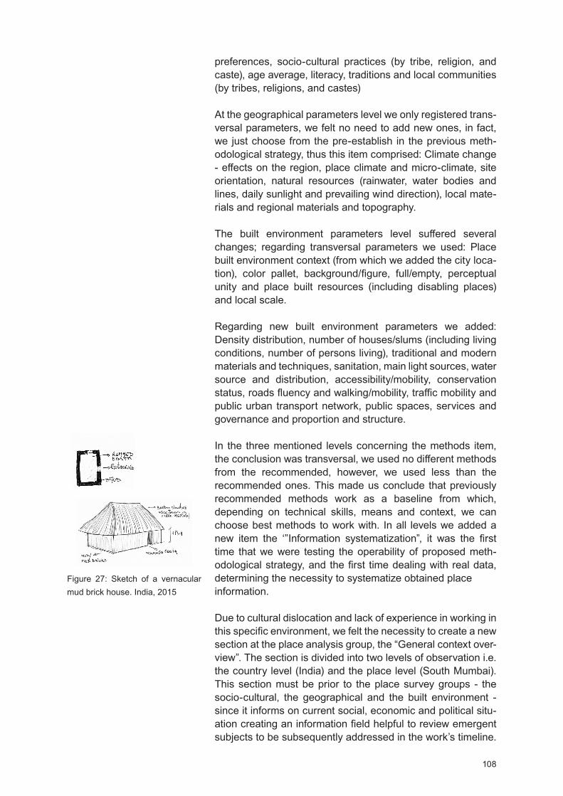
108
preferences, socio-cultural practices (by tribe, religion, and caste), age average, literacy, traditions and local communities (by tribes, religions, and castes)
At the geographical parameters level we only registered trans-versal parameters, we felt no need to add new ones, in fact, we just choose from the pre-establish in the previous meth-odological strategy, thus this item comprised: Climate change - effects on the region, place climate and micro-climate, site orientation, natural resources (rainwater, water bodies and lines, daily sunlight and prevailing wind direction), local mate-rials and regional materials and topography.
The built environment parameters level suffered several changes; regarding transversal parameters we used: Place built environment context (from which we added the city loca-tion), color pallet, background/figure, full/empty, perceptual unity and place built resources (including disabling places) and local scale.
Regarding new built environment parameters we added: ensity distribution, number of houses/slums (including living
conditions, number of persons living), traditional and modern materials and techniques, sanitation, main light sources, water source and distribution, accessibility/mobility, conservation status, roads fluency and walking/mobility, traffic mobility and public urban transport network, public spaces, services and governance and proportion and structure.
In the three mentioned levels concerning the methods item, the conclusion was transversal, we used no different methods from the recommended, however, we used less than the recommended ones. This made us conclude that previously recommended methods work as a baseline from which, depending on technical skills, means and context, we can choose best methods to work with. In all levels we added a new item the ‘ Information systematization , it was the first time that we were testing the operability of proposed meth-odological strategy, and the first time dealing with real data, determining the necessity to systematize obtained place information.
Due to cultural dislocation and lack of experience in working in this specific environment, we felt the necessity to create a new section at the place analysis group, the “General context over-view”. The section is divided into two levels of observation i.e. the country level (India) and the place level (South Mumbai). This section must be prior to the place survey groups - the socio-cultural, the geographical and the built environment - since it informs on current social, economic and political situ-ation creating an information field helpful to review emergent subjects to be subsequently addressed in the work’s timeline.
Figure 27: Sketch of a vernacular mud brick house. India, 2015

109
It also opens a space for reflection helpful to recognize that in order to answer one must know and in order to know one must to listen which is particularly relevant to center on locally optimized solutions and not to jump to conclusions before we even questioning the context - by other words it promotes crit-ical thinking.
Proposed place analysis - composed by the general context overview and a place survey covering the socio-cultural, geographical and built environment dimensions - is extremely important to detect real needs in order to design more effec-tive and sustainable responses. The proposed place survey is not only about architecture or town planning, it also encom-passes a systematic view of place useful to anticipate design issues that will need to be addressed. Within this context, the United Nations reports were a valuable source; in fact, their reports are always updated on world’s situation comprising credible information on continents, countries, and cities as well as estimations on world population growth fundamental to predict the Mumbai expansion - or other cities expansion.
The socio-cultural survey will brief helpful information on space users and their socio-spatial-practices - income, literacy, reli-gion, events, routines, actions, tribe, etc. The socio-cultural survey allows us to become closer to incoming groups and to study the people’s cultural preferences, showing how space is used by different population patterns. Understanding the socio-cultural context and preferences will reinforce a design that promotes a more effective space/users engagement, ensuring greater sustainability and the dynamical livability of the future program. This survey also allows determining urban population growth patterns. Working with Census information was extremely important by helping to predict urban population growth estimation; a vital statistic, for instance, to estimate the amount of land to save for the city expansion and its expan-sion possibilities. In fact, many forces help determine urban form, for instance the surrounding topography, but ‘population growth can be both a determinant and a result of the evolution of such “urban form” over time’ (UN, 2015).
In addition urban population growth it was also useful for us to understand that climate change and the severe India water stress lead many people to abandon agricultural fields and running Indian cities in search of employment and better living options; contributing largely for the Mumbai hyper occupation. In that context, we also realized that urban population growth estimations it is also a relevant tool to establish policy prior-ities to stimulate equitable urban and rural development that should entail land use, land use change, and land manage-ment plans.
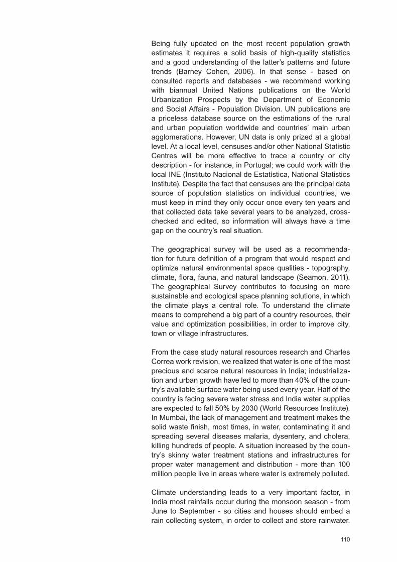
110
Being fully updated on the most recent population growth estimates it requires a solid basis of high-quality statistics and a good understanding of the latter’s patterns and future trends (Barney Cohen, 2006). In that sense - based on consulted reports and databases - we recommend working with biannual United Nations publications on the World Urbanization Prospects by the epartment of Economic and Social Affairs - Population ivision. UN publications are a priceless database source on the estimations of the rural and urban population worldwide and countries’ main urban agglomerations. However, UN data is only prized at a global level. At a local level, censuses and/or other National Statistic Centres will be more effective to trace a country or city description - for instance, in Portugal; we could work with the local INE (Instituto Nacional de Estatística, National Statistics Institute). Despite the fact that censuses are the principal data source of population statistics on individual countries, we must keep in mind they only occur once every ten years and that collected data take several years to be analyzed, cross-checked and edited, so information will always have a time gap on the country’s real situation.
The geographical survey will be used as a recommenda-tion for future definition of a program that would respect and optimize natural environmental space qualities - topography, climate, flora, fauna, and natural landscape (Seamon, 2011). The geographical Survey contributes to focusing on more sustainable and ecological space planning solutions, in which the climate plays a central role. To understand the climate means to comprehend a big part of a country resources, their value and optimization possibilities, in order to improve city, town or village infrastructures.
From the case study natural resources research and Charles Correa work revision, we realized that water is one of the most precious and scarce natural resources in India; industrializa-tion and urban growth have led to more than 40% of the coun-try’s available surface water being used every year. Half of the country is facing severe water stress and India water supplies are expected to fall 50% by 2030 (World Resources Institute). In Mumbai, the lack of management and treatment makes the solid waste finish, most times, in water, contaminating it and spreading several diseases malaria, dysentery, and cholera, killing hundreds of people. A situation increased by the coun-try’s skinny water treatment stations and infrastructures for proper water management and distribution - more than 100 million people live in areas where water is extremely polluted.
Climate understanding leads to a very important factor, in India most rainfalls occur during the monsoon season - from June to September - so cities and houses should embed a rain collecting system, in order to collect and store rainwater.
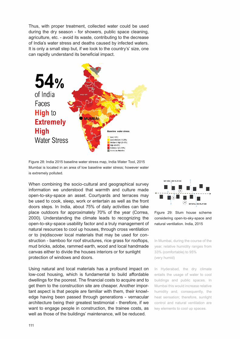
111
Thus, with proper treatment, collected water could be used during the dry season - for showers, public space cleaning, agriculture, etc. - avoid its waste, contributing to the decrease of India’s water stress and deaths caused by infected waters. It is only a small step but, if we look to the country’s’ size, one can rapidly understand its beneficial impact.
Figure 28: India 2015 baseline water stress map, India Water Tool, 2015Mumbai is located in an area of low baseline water stress; however water is extremely polluted.
When combining the socio-cultural and geographical survey information we understood that warmth and culture made open-to-sky-space an asset. Courtyards and terraces may be used to cook, sleep, work or entertain as well as the front doors steps. In India, about 75% of daily activities can take place outdoors for approximately 70% of the year (Correa, 2000). Understanding the climate leads to recognizing the open-to-sky-space usability factor and a truly management of natural resources to cool up houses, through cross ventilation or to (re)discover local materials that may be used for con-struction - bamboo for roof structures, rice grass for rooftops, mud bricks, adobe, rammed earth, wood and local handmade canvas either to divide the houses interiors or for sunlight protection of windows and doors.
Using natural and local materials has a profound impact on low-cost housing, which is fundamental to build affordable dwellings for the poorest. The financial costs to acquire and to get them to the construction site are cheaper. Another impor-tant aspect is that people are familiar with them, their knowl-edge having been passed through generations - vernacular architecture being their greatest testimonial - therefore, if we want to engage people in construction, the trainee costs, as well as those of the buildings’ maintenance, will be reduced.
Figure 29: Slum house scheme considering open-to-sky-space and natural ventilation. India, 2015
In Mumbai, during the course of the year, relative humidity ranges from 33% (comfortable) to 95% (very humid)
In Hyderabad, the dry climate entails the usage of water to cool buildings and public spaces. In Mumbai this would increase relative humidity and, consequently, the heat sensation; therefore, sunlight control and natural ventilation are key elements to cool up spaces.
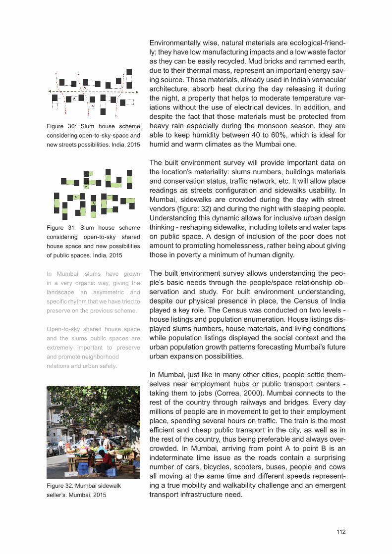
112
Figure 31: Slum house scheme considering open-to-sky shared house space and new possibilities of public spaces. India, 2015
In Mumbai, slums have grown in a very organic way, giving the landscape an asymmetric and specific rhythm that we have tried to preserve on the previous scheme.
Open-to-sky shared house space and the slums public spaces are extremely important to preserve and promote neighborhoodrelations and urban safety.
Figure 30: Slum house scheme considering open-to-sky-space and new streets possibilities. India, 2015
Figure 32: Mumbai sidewalk seller’s. Mumbai, 2015
Environmentally wise, natural materials are ecological-friend-ly; they have low manufacturing impacts and a low waste factor as they can be easily recycled. Mud bricks and rammed earth, due to their thermal mass, represent an important energy sav-ing source. These materials, already used in Indian vernacular architecture, absorb heat during the day releasing it during the night, a property that helps to moderate temperature var-iations without the use of electrical devices. In addition, and despite the fact that those materials must be protected from heavy rain especially during the monsoon season, they are able to keep humidity between 40 to 60%, which is ideal for humid and warm climates as the Mumbai one.
The built environment survey will provide important data on the location’s materiality: slums numbers, buildings materials and conservation status, traffic network, etc. It will allow place readings as streets configuration and sidewalks usability. In Mumbai, sidewalks are crowded during the day with street vendors (figure: 32) and during the night with sleeping people. Understanding this dynamic allows for inclusive urban design thinking - reshaping sidewalks, including toilets and water taps on public space. A design of inclusion of the poor does not amount to promoting homelessness, rather being about giving those in poverty a minimum of human dignity.
The built environment survey allows understanding the peo-ple’s basic needs through the people/space relationship ob-servation and study. For built environment understanding, despite our physical presence in place, the Census of India played a key role. The Census was conducted on two levels - house listings and population enumeration. House listings dis-played slums numbers, house materials, and living conditions while population listings displayed the social context and the urban population growth patterns forecasting Mumbai’s future urban expansion possibilities.
In Mumbai, just like in many other cities, people settle them-selves near employment hubs or public transport centers - taking them to jobs (Correa, 2000). Mumbai connects to the rest of the country through railways and bridges. Every day millions of people are in movement to get to their employment place, spending several hours on traffic. The train is the most efficient and cheap public transport in the city, as well as in the rest of the country, thus being preferable and always over-crowded. In Mumbai, arriving from point A to point B is an indeterminate time issue as the roads contain a surprising number of cars, bicycles, scooters, buses, people and cows all moving at the same time and different speeds represent-ing a true mobility and walkability challenge and an emergent transport infrastructure need.
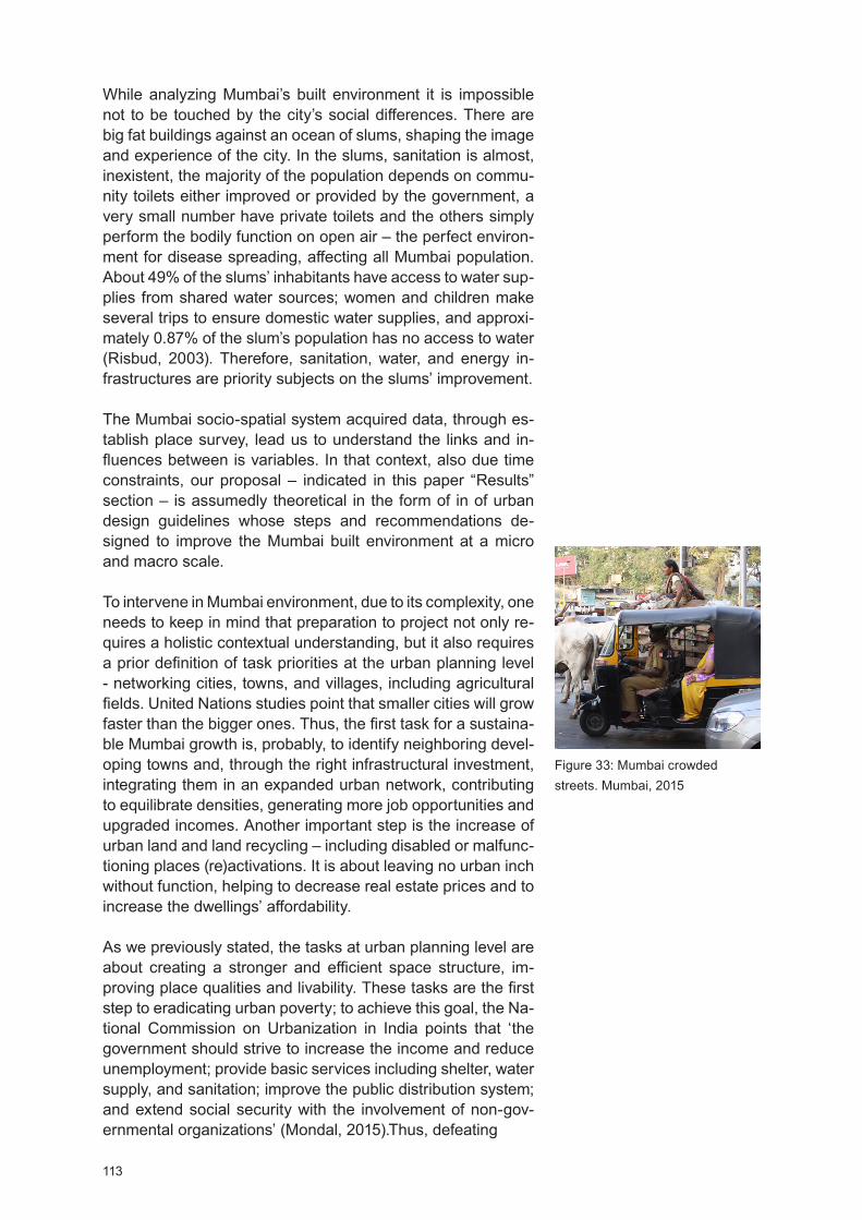
113
While analyzing Mumbai’s built environment it is impossible not to be touched by the city’s social differences. There are big fat buildings against an ocean of slums, shaping the image and experience of the city. In the slums, sanitation is almost, inexistent, the majority of the population depends on commu-nity toilets either improved or provided by the government, a very small number have private toilets and the others simply perform the bodily function on open air – the perfect environ-ment for disease spreading, affecting all Mumbai population. About 49% of the slums’ inhabitants have access to water sup-plies from shared water sources; women and children make several trips to ensure domestic water supplies, and approxi-mately 0.87% of the slum’s population has no access to water (Risbud, 2003). Therefore, sanitation, water, and energy in-frastructures are priority subjects on the slums’ improvement.
The Mumbai socio-spatial system acquired data, through es-tablish place survey, lead us to understand the links and in-fluences between is variables. In that context, also due time constraints, our proposal – indicated in this paper Results section – is assumedly theoretical in the form of in of urban design guidelines whose steps and recommendations de-signed to improve the Mumbai built environment at a micro and macro scale.
To intervene in Mumbai environment, due to its complexity, one needs to keep in mind that preparation to project not only re-quires a holistic contextual understanding, but it also requires a prior definition of task priorities at the urban planning level - networking cities, towns, and villages, including agricultural fields. United Nations studies point that smaller cities will grow faster than the bigger ones. Thus, the first task for a sustaina-ble Mumbai growth is, probably, to identify neighboring devel-oping towns and, through the right infrastructural investment, integrating them in an expanded urban network, contributing to equilibrate densities, generating more job opportunities and upgraded incomes. Another important step is the increase of urban land and land recycling – including disabled or malfunc-tioning places (re)activations. It is about leaving no urban inch without function, helping to decrease real estate prices and to increase the dwellings’ affordability.
As we previously stated, the tasks at urban planning level are about creating a stronger and efficient space structure, im-proving place qualities and livability. These tasks are the first step to eradicating urban poverty; to achieve this goal, the Na-tional Commission on Urbanization in India points that ‘the government should strive to increase the income and reduce unemployment; provide basic services including shelter, water supply, and sanitation; improve the public distribution system; and extend social security with the involvement of non-gov-ernmental organizations’ (Mondal, 2015).Thus, defeating
Figure 33: Mumbai crowded streets. Mumbai, 2015

114
Figure 34: In Mumbai, sidewalks are crowded during the day with street vendors. Govandi, Mumbai, 2015

115
Figure 35, 36: ideo frames showing Mumbai built environment degradation. Mumbai, 2015

116
poverty is not limited to upgrade slums as it must also counter the lack of infrastructures and technologies, education, the dif-ficult access to culture and public health care, poor aesthetic and sensory environments and, most of all, the growing sense of social hopelessness.
Preparing to undertake architectural level tasks for low-cost housing means to recognize and understand low-income pat-terns and different ways of using space, facing affordability and open-to-sky-space as project tools. Open-to-sky-space also has a price, in the city, there is no free land, but by taking its usability factor it is possible to save energy costs. A house doesn’t have to be a static and enclosed structure. In India, a dwelling simplistic vision leads directly to a pile of boxes rather than a desirable living place (Correa, 2000).
Final Considerations and Future Outcomes
We observed that in need to survive, home is anywhere in the city - a pavement, a sidewalk or a slum. Houses shelter humans and when shelter need is bigger than the number of available houses, slums will shape the city. Their impact is astonishing, dehumanizing landscapes where people just survive their everyday lives. In Mumbai facing housing as the main unit for thinking space, it’s not just about promoting sus-tainable development growth, it is an issue of human rights.
It has become clear that to achieve sustainable urban growth, Mumbai has to address urban poverty eradication as a key priority. It is essential to take a holistic approach that takes into account climate and culture and policies that improve both ru-ral and urban areas. Fast and unplanned urban growth leads to a high number of socio-spatial demands and resources consumption - for instance, water - representing an obstacle to sustainable development, especially when the necessary infrastructures and policies aren’t implemented and developed enough in order to protect the environment and to ensure the equity use of the benefits of city living.
In the preformed case study we centered - in terms of the previously proposed methodological strategy - in the test of the place analysis group, while place intervention staid at the recommendations level. Previous proposed methodological strategy of place analysis and intervention resulted, mostly, from the analysis of big American and European architecture studios, as well as from the literature review that followed the same trend, thus, we had to review previous place survey pa-rameters - in order to form a new parameters set helpful for the Mumbai analysis - which allowed us to understand that there are two types of parameters the ‘transversal’ ones so far common to places analysis and the ‘new’ ones which are dictated by the specificities of the place where we are
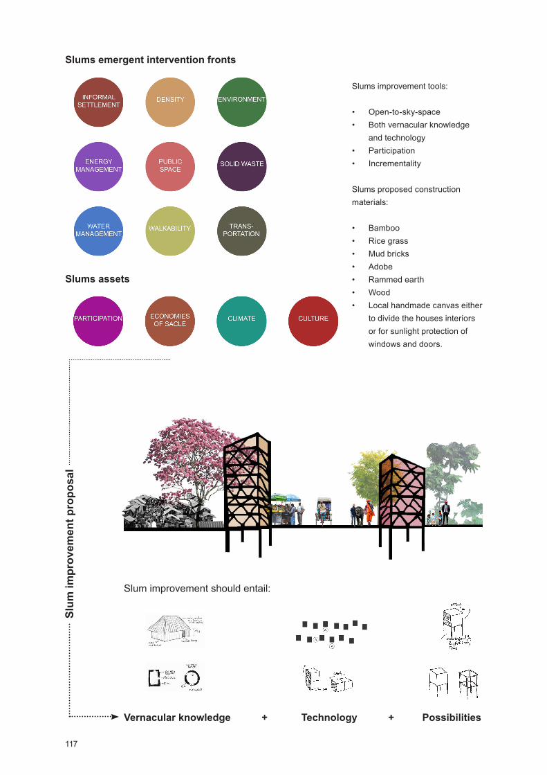
117
Slums improvement tools:
Open-to-sky-space Both vernacular knowledge
and technology Participation Incrementality
Slums proposed construction materials:
Bamboo Rice grass Mud bricks Adobe Rammed earth Wood Local handmade canvas either
to divide the houses interiors or for sunlight protection of windows and doors.
Slums emergent intervention frontsSl
um im
prov
emen
t pro
posa
l
Slum improvement should entail:
Slums assets
Vernacular knowledge + Technology + Possibilities
118
intervening. In that sense, the proposed methodological strat-egy of place analysis it is flexible.
At proposed place intervention, from given recommendations, we will highlight the third step; i.e. principles as project tools. We understood that in India, more specifically in Mumbai, ex-treme poverty is a major social condition with little room for hu-man rights. In that context, we hope principles to act as tools for the built environment development aiming a level of space flexibility to foster all cultural and social diversity. Introducing a set of principles as project tools - comprising incrementali-ty, pluralism, participation, income generation and equity - is central to develop affordable and inclusive design solutions with people in mind. In addition, working with a methodolog-ical strategy of place analysis aggregating the geographical, socio-cultural and built environment dimensions produces a place specific information field based on its unique charac-teristics and thus on its own identity, contributing to generate more sustainable and place rooted projects.
The purpose of this case study was to confront predefined methodological strategy of place analysis and intervention with case needed and obtained data, as well as proposed recommendations, aiming its recalibration. In addition, attend-ing to research state of art on contemporary cities trends and challenges, it was our intention to provide a broader field of action on urban sustainable development for cities located in lower-income countries. In this context, research vies for its bigger contribution to be the condensation of dispersed meth-ods, tools and recommendations that were used separately by different entities in one single methodological strategy.
As future developments, we recognized Mumbai case study results need to be tested through another case study; representing, thus, the research next step.
Research Limitations
We spent two months in Mumbai, which is a short time to cover the city; therefore we have circumscribed our research to South Mumbai, while also having had a glimpse of the city’s suburbs.
ue to language barriers – we spoke English while the local predominantly spoke Hindi or Marathi - we couldn’t obtain a closer approach with the local people, in order to get a deeper understanding of space usage. Thus, our space reading was highly influenced by our own European standards.
We worked with the most recent data; however, there is a time lag of 1 to 4 years in said data - the Census of India, for instance, only takes place every 10 years.

119
Culture and identity are always very complex matters, especially in India, due to religious and societal divisions. We didn’t have a deeper background on Indian history so we were stuck in the first layer of the country identity - religion, society division, economy, politics, cultural preferences and differences between regions (music, dance, clothing, and festivals - risking a narrow vision of their complex culture.

120
Figure 40: Map showing the location of the nine given competition cities. Kenya, 2016
International Design Collaboration for Kenya - The Site and the City. Nyeri, a New Bill of Rights. Case Study: Witemere
Competition, Terms and Conditions
The following case study was integrated into the ‘International Design Collaboration for Kenya’; a competition promoted by the UN-Habitat with the Ministry of Land, Housing & Urban Development Department of Kenya. The competition - devel-oped between 1st February to 20th April 2016 - intended to reinforce Kenya’s Integrated Strategic Urban Development Plans (ISUDPs) aiming, until 2030, to decrease the country´s poverty levels and to boost the domestic economy.
The teams were challenged to propose a strategy of urban development, in the form of urban design guidelines or as a project proposal, emphasizing a conceptual idea instead of a detailed solution. The competition was open to undergrad-uate, postgraduate, Masters and Ph.D. students enrolled in a program during the 2015 academic year. The teams were intended to be interdisciplinary and students from Urban Planning, Urban Design, Architecture, Landscape Architec-ture, Urban Economy, Sociology, and Environment encour-aged to participate. Applicants could apply individually or in a group, later teamed up by the Competition Secretariat. Teams comprised both Kenyan-based and non-Kenya students.
Applicants had to choose 3 cities from the nine given: Embu, Kitui, Machakos, Malindi, Mombasa, Naivasha, Nakuru, Nyeri, and Thika. Our choice comprised Machakos, Malindi, and Nyeri, selected by their specific challenges. Machakos repre-sented a major chance to explore densities optimization and land-use readjusting/regulation in order to save land for agri-culture, urban expansion, and industrial production. Malindi, by appealing to social inclusion, economic productivity, public space, and environmental sustainability, requiring the break of place fragmented view demanding a space holistic approach, and Nyeri, the chosen city, required the informal settlements integration into the wider urban development - including infra-structures and technologies lack, education, culture and public health care difficult access, poor aesthetic and sensory environments and, most of all, the social growing sense of hopelessness - demanding an expanded socio-spatial system understanding.
We applied individually and we were teamed up in the Nyeri group constituted by: Filomena Nascimento (architect from Portugal - University of Lisbon), Tilda Kirstersson (architect from Sweden - Lund University), Kevin Ngumbao (geography/architecture from Kenya - Kenya University-based student)

121
and Flora Oloo (landscape architect from Kenya - Kenya University-based student). Despite the improvement of the Kenya Integrated Strategic Urban Development Plans the competition also intended to promote international inter-uni-versity collaboration as a platform for knowledge exchange.
Research, Data and Methods
Work was organized in two central groups, the (G1) theoret-ical synthesis, corresponding to Kenya’s and Nyeri’s overview, and (G2) the practical synthesis, corresponding to the project development. The competition was based on weekly meetings using Skype - we were from different countries - scheduled according to GMT time zone. Dropbox, Google doc´s, email and WhatsApp were severely used to exchange information and files.
For G1 (theoretical systems), research heavily dropped in the data given by the competition commission, comprising the Students Competition Brochure (SCB, 2016), briefing with major competition keys and the 9 cities overview, the Nyeri Town Strategic Urban evelopment Plan (2014 – 2036), the Topo sheets (Annex III) and the GIS files comprising infor-mation on the Nyeri built environment (roads, services, public spaces and housing) and about its natural environment (water lines, topography, green areas and agriculture fields). This information, later completed with the Google Earth Pro data, helped us to establish an integrated view of the Nyeri built environment and to identify less documented areas and issues that later we prioritized to survey and research.
Kenya and Nyeri population statistics were given by the UN Population Division, at the brochure and the ISUDP docu-ments, whose information was reinforced by our research on the 2009 Kenya Population and ousing Census (2010). We proceeded with more research on slums and Kenya current situation by studying the Huruma Slum Upgrading Project (2016) and through the ‘Nairobi Planning Innovations’, the ‘Kenya Open Data’, the ‘Virtual Kenya’ and the ‘Centre for Urban Research and Innovation’ websites and the ‘Kenya Slum Upgrading Program’ (2007) report; briefing us with more details on Kenya social, economic and political condition.
After obtaining an expanded field on the country current situ-ation, we analyzed the Nyeri Town Strategic Urban Develop-ment Plan (2014 - 2036) and given graphic material. The Nyeri Town Strategic Urban development Plan comprised vital infor-mation on future government investments in the region, land use and management, population number, natural resources, the town built environment and economy. In addition, research on climate, vernacular architecture and Nyeri population socio-cultural background was conducted.

122
The practical synthesis (G2) comprised the place survey, the proposal development, and the submission phases. For place survey completion the two Kenyan based team members went to Witemere to take site pictures, measurements and to meet with the locals. A questioner was prepared (Annex III) in order to explore the environment-people-relationship, living condi-tions, and emergent needs; since little information was given on the subject.
Since we had been researching on a methodological strategy of place analysis and intervention based on place identity, we explained to the group the purpose of our research and the Mumbai case study, since Mumbai and Nyeri/Witemere had many common points, and proposed to use the Mumbai results as a guideline for work development. To us, this inter-vention was the opportunity to recalibrate and to test the oper-ability of proposed methodological strategy.
1st Team tasks definition - (G1) Place survey phase (from 02 to 13.02.2016)
Filomena and Tilda Global context overview research, comprising the local and the site level, using the Mumbai case study recommendations and steps;Revision of the ISU P documents;GIS files analysis.
Flora and Kevin Place survey taking into account the geographical, socio-cul-tural and built environment dimensions, using the Mumbai case study recommendations and steps;Conduct questionnaire to Witemere locals.
14.02.2016 Skype meeting: brainstorm and tasks definition
Global context overview taking into account:
Two levels: 1. Global: Kenya; 2. Local: Nyeri / Witemere, both encompassing the economic, political and social dimension.
Methods: Literature review (official websites and online data-bases, books, scientific papers and reports), data critical selection and cross.
(G1) Place survey - Measuring place qualities/place identity:
Socio-cultural qualities parameters: Population growing esti-mation, place history, cultural landscapes, users/building relationships as well as people and place environment, econ-omies of scale brought by agglomeration, funding and govern-ance, local communities including (by tribe, religion and caste,
123
income average, cultural preferences, socio-cultural practices (by tribe, religion and caste), age average, literacy, traditions and routines, vernacular construction knowledge including construction skill and local technologies.
Methods: iagrammatic drawings and sensory-relations maps, photographic and video recordings, space use obser-vations, research on place overview including - historical and literature review (Census and further population studies, rele-vant organizations research and statistics reviews), phenome-nological methodology.
Geographical qualities parameters: Climate change – effects on the region, place climate and micro-climate, air pollution, site orientation, natural resources (rain season, rainwater and flood areas, water bodies and lines, daily sunlight and prevailing wind/wind direction), local materials and regional materials, topography. Methods: Literature review, natural observation, photograph and video recording, climate change effects on the region studies, place climate, micro-climate, and air pollution studies, passive strategies studies (including daylight, passive venti-lation, shading and rainwater collection), natural resources including local materials survey.
Built environment qualities parameters: Place built environ-ment context - encompassing city location, density distribu-tion, number of houses/slums (including living conditions, number of persons living), traditional and modern materials and techniques, sanitation, main light sources, water source and distribution, accessibility/mobility, conservation status, roads fluency and walking/mobility, traffic mobility and public urban transport network, public spaces, services and govern-ance, proportion, structure, color pallet, background/figure, full/empty, perceptual unity, place built resources (including disable places), local scale.
Methods: and drawing, including diagrammatic drawings and maps, entropic and sensory maps, natural observation, notes on the place, photography and video recording and conver-sations with local architects and planners. Active research on local collective knowledge, survey on number of houses/slums including - living conditions, number of persons living, survey on sanitation, main light sources, water source and distribu-tion, accessibility/mobility, conservation status, urban network (including services, public spaces, roads fluency and walking mobility, traffic mobility and public urban transport network), organic transport net and public transport net, services and distribution, green and public spaces, local materials for construction survey.
124
Recommendation: whenever possible, survey or simple conversations with local people registrations are beneficial as well as working closely with local authorities and organiza-tions.
2nd Team tasks definition - (G1) Reviewing/systematizing data (from 15 to 26.02.2016)
Filomena and Tilda Systematize ISUDP information; Sketching Witemere intervention proposal.
Flora and Kevin Select and systematize place survey information; Sketching Witemere intervention proposal.
28.02.2016 Skype meeting: brainstorm and tasks definition
3trd Team tasks definition – (G2) Project development:Filomena, Tilda, Flora, and Kevin (29.02-19.04.2016) Project development was conducted according to previous Mumbai case study steps and recommendations, thus we followed:
To establish a set of principles as tools;To define the sustainable tasks and goals at the urban level;To define the architectural level tasks for low-cost housing (participatory methods including local population, organiza-tions, and government);Witemere urban guidelines establishment - presented at the paper ‘Results’ section.
4th Project panels deliver - 20.04.2016 - through the compe-tition website.
Kenya Overview
Kenya is an African country classified as a lower-middle in-come country. Nairobi, the capital, is the most populated city and the country’s financial core. Many people migrate to the city, mostly poor farmers hoping to find better jobs, educa-tion and healthcare access; many of them find shelter in the city gigantic slums. In Africa approximately 16 % of the world population is living; Kenya has a total of 47. 626. 690 inhabi-tants comprising, more or less, 50% of male and female (WM, 2016; WPP, 2015). The majority of Kenyans are Christian with a multiple traditions background nourished by the country’s different communities - the Swahili, the Bantu, the Nilotic and the Maasai.
125
The Kenya’s urban population is low, however, in the next few years, it is expected to double; the UN population division in 2014 projected that 25.6% of the country’s population will be urban (SCB, 2016).
The majority of the country’s population is poor; Kenya is well known for being one of the most unequal countries in the world. Child labor is common, mostly in agriculture, do-mestic activities and prostitution; poverty is the main reason. Child mortality is a major issue in Kenya; malnutrition, the lack of access to clean water and deplorable living conditions are the key causes for diseases spreading including epidemics of cholera (UNICEF, 2015).
Agriculture is a key source of employment - tea, coffee, hor-ticultural and recently flowers are the main produced and ex-ported products. After the service sector, agriculture, includ-ing forestry and fishing, is the second source of the country’s gross domestic product. Kenya is located in the east-central Africa, characterized by a warm and humid climate, ranging from tropical, along with the coast, to temperate, inland, and arid in the north/northeast. The long rain season occurs from March to June and the short rains from October to December. The rains often are heavy and due the dryness of the soil and the lack of infrastructures floods occur washing away goods, crops, cattle and human lives.
The Kenyan urban centers are facing several challenges; poverty irradiation and sprawl are the major ones. Over time inadequate planning, poor governance and under-investment in infrastructure and affordable housing contributed largely to the country’s current trials including the high levels of environ-mental degradation (inadequate and lack of public spaces of infrastructure such as roads, water and sanitation, solid waste management, electricity, recreation facilities, parking spaces and inadequate housing), the unequal distribution of social and commercial services, the high rates of unemployment, the urban safety challenges, the lack of integration of informal economic activities and the ineffective land administration and land-use planning (SCB, 2016).
In this context, in 2006, the Kenyan government launched the Kenya Vision 2030, an economic development programme aiming to transform Kenya into a middle-income country (SCB, 2016). In addition in 2013 Kenyan government also launched the National Climate Change Action Plan, facing climate as a development tool - reinforced by the renewable energies’ bet and the projected, at a national scale, new urbanization plans.
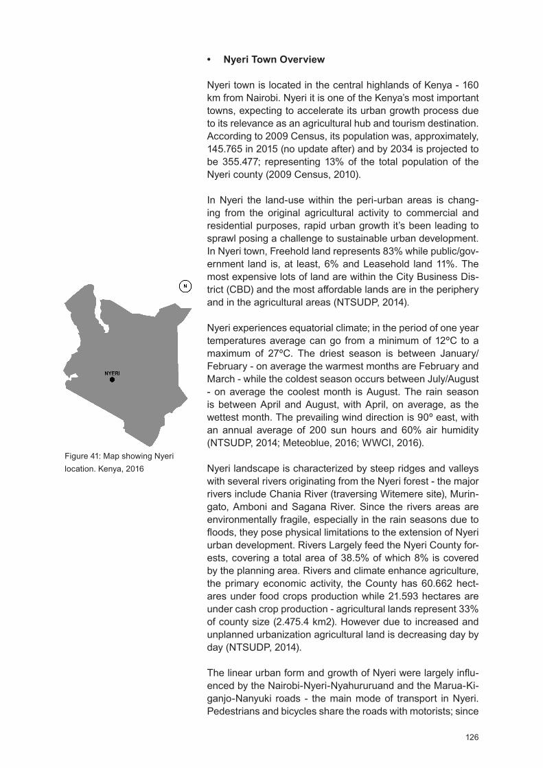
126
Figure 41: Map showing Nyeri location. Kenya, 2016
Nyeri Town Overview
Nyeri town is located in the central highlands of Kenya - 160 km from Nairobi. Nyeri it is one of the Kenya’s most important towns, expecting to accelerate its urban growth process due to its relevance as an agricultural hub and tourism destination. According to 2009 Census, its population was, approximately, 145.765 in 2015 (no update after) and by 2034 is projected to be 355.477; representing 13% of the total population of the Nyeri county (2009 Census, 2010).
In Nyeri the land-use within the peri-urban areas is chang-ing from the original agricultural activity to commercial and residential purposes, rapid urban growth it’s been leading to sprawl posing a challenge to sustainable urban development. In Nyeri town, Freehold land represents 83% while public/gov-ernment land is, at least, 6% and Leasehold land 11%. The most expensive lots of land are within the City Business Dis-trict (CB ) and the most affordable lands are in the periphery and in the agricultural areas (NTSU P, 2014).
Nyeri experiences equatorial climate; in the period of one year temperatures average can go from a minimum of 12ºC to a maximum of 27 C. The driest season is between January/February - on average the warmest months are February and March - while the coldest season occurs between July/August - on average the coolest month is August. The rain season is between April and August, with April, on average, as the wettest month. The prevailing wind direction is 90 east, with an annual average of 200 sun hours and 60% air humidity (NTSU P, 2014; Meteoblue, 2016; WWCI, 2016).
Nyeri landscape is characterized by steep ridges and valleys with several rivers originating from the Nyeri forest - the major rivers include Chania River (traversing Witemere site), Murin-gato, Amboni and Sagana River. Since the rivers areas are environmentally fragile, especially in the rain seasons due to floods, they pose physical limitations to the extension of Nyeri urban development. Rivers Largely feed the Nyeri County for-ests, covering a total area of 38.5% of which 8% is covered by the planning area. Rivers and climate enhance agriculture, the primary economic activity, the County has 60.662 hect-ares under food crops production while 21.593 hectares are under cash crop production - agricultural lands represent 33% of county size (2.475.4 km2). owever due to increased and unplanned urbanization agricultural land is decreasing day by day (NTSU P, 2014).
The linear urban form and growth of Nyeri were largely influ-enced by the Nairobi-Nyeri-Nyahururuand and the Marua-Ki-ganjo-Nanyuki roads - the main mode of transport in Nyeri. Pedestrians and bicycles share the roads with motorists; since

127
Percentage of dwellings bedrooms
Single room – 13%Bed Sitter – 5%1 Bedroom – 17%2 Bedrooms – 28%3 Bedrooms – 29%3 Bedrooms and above – 8%
Source: Nyeri Town Strategic Urban development Plan (2014 – 2036)
The majority of the houses in Nyeri (71%) have ordinary Mabati roofing, 63.5% have their wall made of stones, and 67% have a cemented floor.
Source: Nyeri Town Strategic Urban development Plan (2014 – 2036)
the majority is made of rammed earth they are impassable during the rainy season and dusty while the dry season. Rail and Air transport facilities are available but not operational (NTSU P, 2014).
The residential area is concentrated on the periphery of the CBD - where land is less expensive and slums, as the Wite-mere site, rise. In Nyeri, house ownership is mainly rental 53.8% and 43.8% of the population own their house. The average number of building structures per household is 2, commonly with 3 and 2 bedrooms. People are skilled to work wood and earth as construction materials. The town serves as a tourist destination for both local and international tourist in part due to its nature and conservation areas including the Nyeri hill, the Nyeri forest and Kiganjo forest and rivers ar-eas. The main recreation facilities include the Dedan Kimathi and Runing’u Stadiums, the Whispers Park and the Sungura Park. Nyeri town is the commercial hub of Nyeri County, and the areas with more commercial activity are centered in the CBD. The main public facilities include educational facilities as the Dedan Kimathi University and primary’s and secondary’s schools. Health facilities include Provincial General Hospital, side by side with the intervention site, the Mathari Mission-ary hospital and religious facilities, churches and mosques accommodating Christian, Muslims, and Hindus (NTSUDP, 2014).
Dwelling characteris-tic by the type.
Roof Finish % Wall Type % Floor Finish %
Ordinary Mabati 71.0 Bricks 3.8 Tiles 14.1
Improved Mabati 21.7 Mud 7 Earth 16.5
Tiles 5.5 Stones 63.5 Cement 67.0
Asbestos 1.7 Timber 30.2 Timber 2.4
Table 2: welling characteristic by the type of Roof / Wall / Floor. 2016
Despite the fact of electricity being cheap (not everyone can afford it) the major sources of energy for heating and cooking are charcoal, electricity, liquefied petroleum gas, and kero-sene. For lighting the majority of people, 94.9%, uses elec-tricity and 59.6% kerosene (and some of them both electricity and kerosene). Another important mark regards to the skinny solid waste management, comprising, mostly, the Nyeri CBD and Kiganjo town. There is one designated dumping site near the Asian Quarter estate, the site is not licensed and is un-suitable for the residents in the area (NTSU P, 2014). Waste
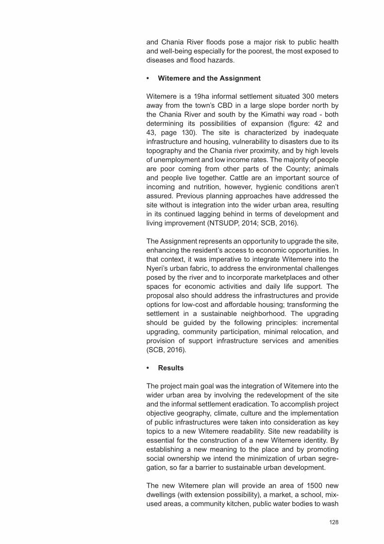
128
and Chania River floods pose a major risk to public health and well-being especially for the poorest, the most exposed to diseases and flood hazards.
Witemere and the Assignment
Witemere is a 19ha informal settlement situated 300 meters away from the town’s CBD in a large slope border north by the Chania River and south by the Kimathi way road - both determining its possibilities of expansion (figure: 42 and 43, page 130). The site is characterized by inadequate infrastructure and housing, vulnerability to disasters due to its topography and the Chania river proximity, and by high levels of unemployment and low income rates. The majority of people are poor coming from other parts of the County; animals and people live together. Cattle are an important source of incoming and nutrition, however, hygienic conditions aren’t assured. Previous planning approaches have addressed the site without is integration into the wider urban area, resulting in its continued lagging behind in terms of development and living improvement (NTSU P, 2014; SCB, 2016).
The Assignment represents an opportunity to upgrade the site, enhancing the resident’s access to economic opportunities. In that context, it was imperative to integrate Witemere into the Nyeri’s urban fabric, to address the environmental challenges posed by the river and to incorporate marketplaces and other spaces for economic activities and daily life support. The proposal also should address the infrastructures and provide options for low-cost and affordable housing; transforming the settlement in a sustainable neighborhood. The upgrading should be guided by the following principles: incremental upgrading, community participation, minimal relocation, and provision of support infrastructure services and amenities (SCB, 2016).
Results
The project main goal was the integration of Witemere into the wider urban area by involving the redevelopment of the site and the informal settlement eradication. To accomplish project objective geography, climate, culture and the implementation of public infrastructures were taken into consideration as key topics to a new Witemere readability. Site new readability is essential for the construction of a new Witemere identity. By establishing a new meaning to the place and by promoting social ownership we intend the minimization of urban segre-gation, so far a barrier to sustainable urban development.
The new Witemere plan will provide an area of 1500 new dwellings (with extension possibility), a market, a school, mix-used areas, a community kitchen, public water bodies to wash
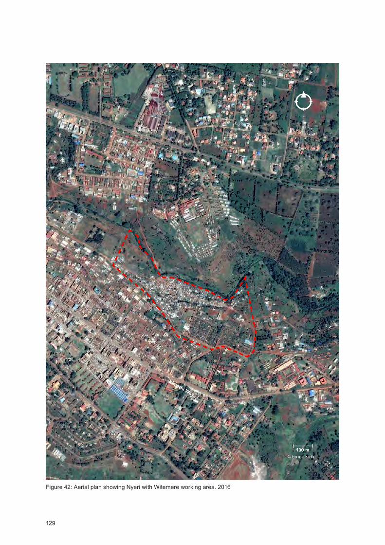
129
Figure 42: Aerial plan showing Nyeri with Witemere working area. 2016
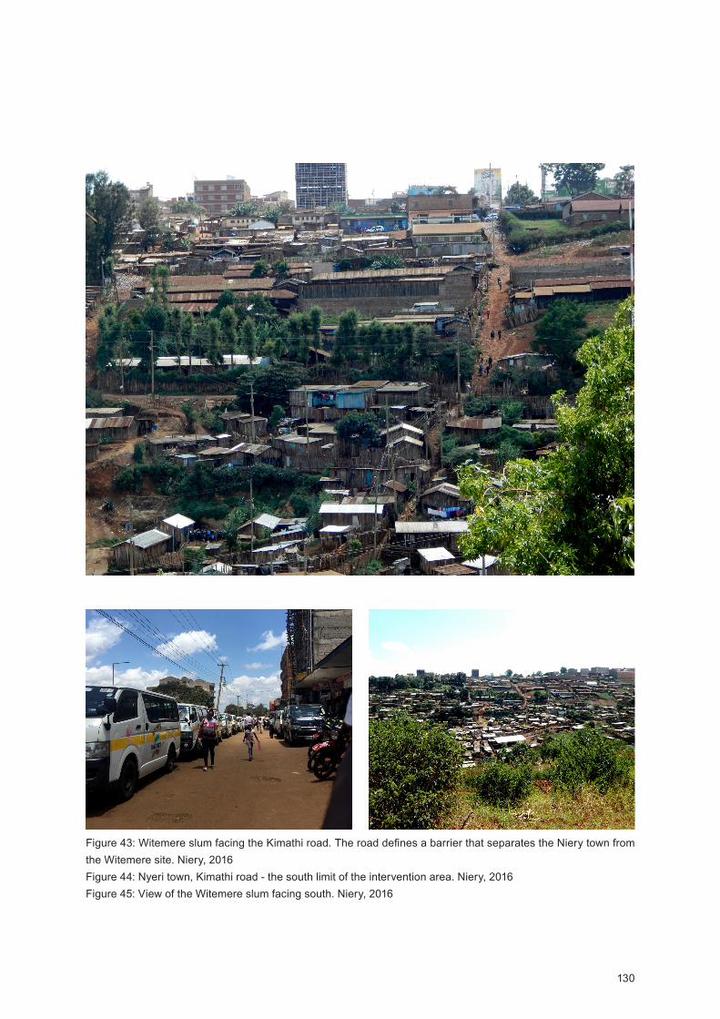
130
Figure 43: Witemere slum facing the Kimathi road. The road defines a barrier that separates the Niery town from the Witemere site. Niery, 2016Figure 44: Nyeri town, Kimathi road - the south limit of the intervention area. Niery, 2016 Figure 45: iew of the Witemere slum facing south. Niery, 2016
131
and to dry clothes, sports green public areas as well as urban agricultural plots. Together, proposed built environment and existent landscape will help to establish new spatial and social connections plateful to create a stronger and efficient Nyeri town network, opposing to the current fragmented city.
Presented results are urban guidelines - a set of steps, recommendations, and principles - for the Witemere slum irradication pointing sustainable directions for the Nyeri town urban growth. Current results only showcase used parame-ters, methods, and information systematization. Further, at the ‘Chapter II Conclusions’, we will present the final methodologi-cal strategy of place analyses and intervention based on place identity resulting from the cross of obtained case studies re-sults with the proposed methodological strategy resulting from the literature review with the 10 studios analyses.
Thus, for the Nyeri town sustainable urban growth and Wite-mere slum irradication we propose the following urban guide-lines and methodological strategy:
(G1) Methodological strategy of place analysis
1st General context overview:
Two levels must be explored: 1. Country Level; 2. Place Level, both encompassing the economic, political and social dimen-sion.
In this research for a general context overview, corresponding to the Kenya and Nyeri/Witemere overview sections, we used data from:
Global level (Kenya) - Students Competition Brochure, UN Population Division data, the ‘Nairobi Planning Innovations’, the ‘Kenya Open Data’, the ‘Virtual Kenya’ and the ‘Centre for Urban Research and Innovation’ websites and the Kenya 2007 Slum Upgrading Program.
Local level (Nyeri/Witemere) - Students Competition Bro-chure, Nyeri Town Strategic Urban Development Plan, Topo sheets, GIS files, UN Population ivision data, 2009 Kenya Population and Housing Census.
Methods: Literature review (official websites and online data-bases and the competition commission reports), GIS files data revision and data critical selection and cross.
Information systematization: Written documents, info-graph-ics (Adobe Photoshop, InDesign, Illustrator) and maps.

132
2nd Place survey - Measuring place qualities/place identity:
Socio-cultural parameters: Population growing estimation, place history and cultural landscapes, people/place environ-ment relationship, prevailing economic activities (including: economies of scale and income average, funding), local com-munities (including: tribe, religion), cultural preferences and socio-cultural practices (by tribe on religion), age average, lit-eracy, traditions and routines, community aspirations and ver-nacular construction knowledge (including: construction skill and local technologies).
Methods: Photography, space use observations, local people survey and conversation, Census and UN population statistics review, research on the place (including historical and litera-ture review), working closely with local authorities and organi-zations (UN in Kenya), comprehensive planning, phenomeno-logical methodology.
Information systematization: Written documents, photography, info-graphics (Adobe Photoshop, InDesign, Illustrator) and maps.
Geographical parameters: Climate change - effects on the re-gion, place micro-climate (including: site orientation, sun path and sunlight number of hours, rainy and dry season, prevailing wind, air humidity and pollution), natural resources (including: forest, hills, rivers/water bodies, prevailing agricultural activi-ties and productions, fauna and flora, energy main sources), local materials, topography, place character and land use, change and classification (rural, urban, agriculture and natural reserves). Methods: Literature review, natural observation, photography, climate change - effects on the region research (Students Competition Brochure, Nyeri Town Strategic Urban Develop-ment Plan (2014 - 2036)), place micro-climate and air pollution research (Worldwide Air Quality Monitoring Data Coverage, Nyeri Town Strategic Urban evelopment Plan (2014 - 2036), Meteoblue and the Word Weather and Climate Information), natural resources including local materials research (Nyeri Town Strategic Urban evelopment Plan (2014 - 2036).
Information systematization: Written documents, photography, info-graphics (Adobe Photoshop, InDesign, Illustrator), GIS (Geographic Information Systems).
Built environment parameters: City location, density distribu-tion, users/buildings relationship, number of houses/slums (including: safety, number of persons living, materials and techniques, sanitation, main light sources, number of depend-encies, water source and distribution) urban network (includ-
Figure 46: Air temperature, humidity and wind rose charts. Nyeri climate studies. 2016
Figure 47: Nyeri sunrise and sunset diagram. 2016
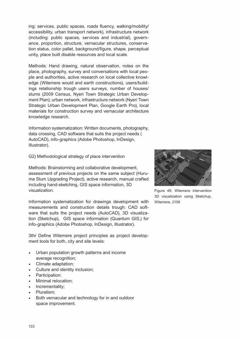
133
ing: services, public spaces, roads fluency, walking/mobility/accessibility, urban transport network), infrastructure network (including: public spaces, services and industrial), govern-ance, proportion, structure, vernacular structures, conserva-tion status, color pallet, background/figure, shape, perceptual unity, place built disable resources and local scale.
Methods: and drawing, natural observation, notes on the place, photography, survey and conversations with local peo-ple and authorities, active research on local collective knowl-edge (Witemere would and earth constructions), users/build-ings relationship trough users surveys, number of houses/slums (2009 Census, Nyeri Town Strategic Urban evelop-ment Plan); urban network, infrastructure network (Nyeri Town Strategic Urban evelopment Plan, Google Earth Pro), local materials for construction survey and vernacular architecture knowledge research. Information systematization: Written documents, photography, data crossing, CAD software that suits the project needs (AutoCAD), info-graphics (Adobe Photoshop, InDesign, Illustrator).
G2) Methodological strategy of place intervention
Methods: Brainstorming and collaborative development, assessment of previous projects on the same subject (Huru-ma Slum Upgrading Project), active research, manual crafted including hand-sketching, GIS space information, 3D visualization.
Information systematization for drawings development with measurements and construction details trough: CA soft-ware that suits the project needs (AutoCAD), 3D visualiza-tion (Sketchup), GIS space information (Quantum GIS,) for info-graphics (Adobe Photoshop, InDesign, Illustrator).
3thr efine Witemere project principles as project develop-ment tools for both, city and site levels:
Urban population growth patterns and income average recognition;
Climate adaptation;Culture and identity inclusion; Participation; Minimal relocation;Incrementality; Pluralism;Both vernacular and technology for in and outdoor
space improvement.
Figure 48: Witemere intervention 3D visualization using Sketchup. Witemere, 2106
134
4th Urban planning level tasks - city level (no participatory elements; however if needed a conjoint work with local author-ities can be done):
Urban growth patterns recognition, densities optimization and land use readjustment and regulation - policies for saving land to urban expansion, for agriculture purposes and for public and recreational spaces;
Networking plans improvement, roads and streets deploy-ment and development; provision of sidewalks, parking places and public transport provision;
Development of energy (focusing on renewable energy sources) and water supply plans for housing, commercial, public spaces and agricultural purposes;
Development of public health plans comprising sanitation and solid waste management (including recycling points);
Promotion of cultural, educational and aesthetic aspects as well as environment protection and promotion of ecol-ogy trough green spaces and Chania River’s flood area protection;
Redevelopment of informal settlements housing by phas-es starting with most vulnerable houses location - the flood area of the Chania River.
(F1 - phase 1): 5th Witemere level tasks - site infrastructures (no participatory elements):
Soil stabilization: Warrantying buildings stabilization and people safety especially during monsoons;
Implementation of infrastructures: I.e. water and ener-gy distribution (preferably renewable energy), sanitation, drainage and waste collecting points including recycling and rain collecting points associated with main public spaces/facilities;
Implementation and improvement of public infrastructures: I.e. sidewalks, streets and proper roads for motorized vehi-cles (mobility and walkability hierarchy), public spaces (for recreational purposes);
Public facilities implementation: Proposed facilities are not a Witemere exclusive, they are open to Nyeri’s inhabitants; their purpose is to promote site integration into the social and spatial life of the city. We recommend, before hous-es intervention, that public facilities implementation come first. Public structures will allow, from the beginning, the

135
Figure 49, 50: The Witemere site lack of infrastructures is visible, the roads and streets are made of rammed earth and the hoses of wood, without any kind of foundations or basic sanitation. Nyeri, 2016Figure 51: Inhabitants of Witemere watching clothes in the Chania river, a practice contributing to increasing environmental disasters and health hazards. Nyeri, 2016

136
improvement of Witemere inhabitants daily life. The struc-tures can be used for people to dwell during the housing intervention warranting minimal relocation.
Public facilities program:
1 market (program: 20 sailing open spaces, 10 stores, 4 water points, 1 rain collector, 2 toilets blocks,
1 storage room,1 account office); 1 community kitchen working closely with neighbourhood association (program: 1coffee shop, 1 grocery, 1public phone and internet point, car park and public toilets bloc); 1 public water body for clothes washing and dry (program: 3 water tanks, 2 spaces for clothes drying); 4 public rain collector structures; 3 car parking; 1 health care centre (program: 2 medical rooms, 1 nursery room, 1 waiting room, 2 toilets block and 1 pharmacy); 1 school (program: 6 class rooms, 1 meeting room, 1 library, toilets block, canteen, kindergarten and playground).
Figure 52, 53: Witemere concept development scheme including F1 (phase 1), regarding the Witemere level tasks - site infrastructures and public facilities program (F) areas. 2016
New connections Public spaces and green belts Facilities and land saving
F1: Market + community kitchen + water body + rain collector + car parkF2: Health care centre + neighbourhood association F3: School
F1
F3F2
To the agricultural fields

137
(F2 - phase 2): 6th Witemere level tasks - low cost housing (participatory elements):
Recommendations: Low-cost housing must address climate adaptation, culture and identity inclusion, participation, min-imal relocation, incrementality, pluralism, vernacular knowl-edge and open-to-sky-space as project development tools. We recommend a housing cooperative creation in order to build the bridge between stakeholders, architects/planners, and Witemere inhabitants as well as to support residents housing choices and purchase.
We recommend a place-based approach centered in local re-sources management. It is equally important to ensure place adding value through culture integration, soft landscaping, and other green spaces.
For housing costs decreasing we recommend the usage of lo-cal/regional materials for housing construction - in Nyeri peo-ple are familiar with wood (main material construction).
Another important step to achieving sustainable urban growth is climate understanding contributing to focus on more sus-tainable and ecological planning solutions based on wind, sun, rain and site location as main tools to design buildings lighting and cooling passive strategies. Climate adaptation promotes living typologies based on open-to-sky-space us-ability, improving built environment diversity by creating a broader range of public and semi-public areas to support the everyday life.
Passive strategies and natural resources management must be taken into account in order to detect payback scenar-ios. Active systems only come after passive strategies and should center in low energy and water consumption, low car-bon emission and self-energy generation - renewable energy. When possible always working with recyclable, recycled and low toxicity materials.
(F2 - phase 2) 7th Housing (re)construction; this step is com-posed of 4 intervention moments (M):
M1 - Chania River reconstruction area; we recommend the housing reconstruction phase to start from the river area; due to flood and soil instability it represents the most fragile area.
M2 and M3 - Witemere core reconstruction area; if at the time of the intervention it reveals more costs and time efficient M2 and M3 can be merged in one single moment (M2).
M4 - Blue alley reconstruction; we point the Blue alley as the last reconstruction area because of its structured imple-
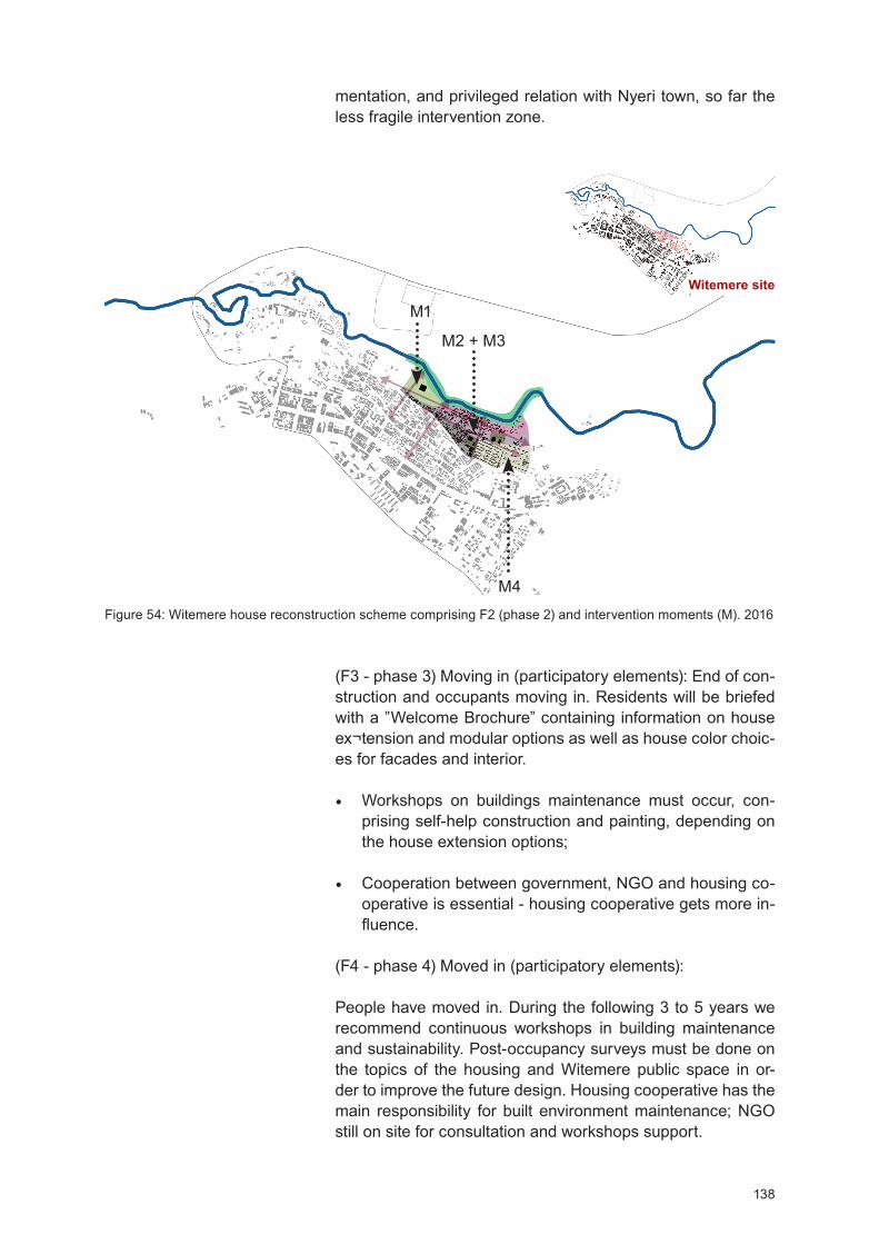
138
Figure 54: Witemere house reconstruction scheme comprising F2 (phase 2) and intervention moments (M). 2016
M1
M2 + M3
M4
(F3 - phase 3) Moving in (participatory elements): End of con-struction and occupants moving in. Residents will be briefed with a ”Welcome Brochure” containing information on house ex¬tension and modular options as well as house color choic-es for facades and interior.
Workshops on buildings maintenance must occur, con-prising self-help construction and painting, depending on the house extension options;
Cooperation between government, NGO and housing co-operative is essential - housing cooperative gets more in-fluence.
(F4 - phase 4) Moved in (participatory elements):
People have moved in. During the following 3 to 5 years we recommend continuous workshops in building maintenance and sustainability. Post-occupancy surveys must be done on the topics of the housing and Witemere public space in or-der to improve the future design. Housing cooperative has the main responsibility for built environment maintenance; NGO still on site for consultation and workshops support.
mentation, and privileged relation with Nyeri town, so far the less fragile intervention zone.
Witemere site
139
Discussion and conclusions
This research had two main objectives, to answer to the competition challenge and to test the obtained Mumbai results aiming the recalibration of proposed methodological strategy. Regarding the competition objective, for Nyeri to achieve a sustainable urban growth the improvement and implementation of infrastructures at the city and site level are crucial. Solar and wind energy should be the main feeding sources for public and private electricity consumption; water recycling, rain water collecting, and waste policies management, including waste recycling, must be key priorities. These topics alongside with land management and land saving - for future urban expansion - mobility and walkability improvement, comprising streets and roads design for pedestrian, cycling, and motorized vehicles, will support the basis for an effective space structure improving place livability and urban resilience capacity. At the new Witemere, streets and roads aren’t the negatives of the built environment, together with the new public spaces and facilities, they will form a stronger net of urban connectivity.
After infrastructures, urban guidelines recommend the public facilities implementation - central spaces for Nyeri Town to achieve the Strategic Urban development Plan and sustainability goals. The market area, combined with the mix-used spaces, will increase food, goods and daily services supplies, at the site and the city levels, as well as jobs and employment opportunities. Public water bodies for clothes watching and drying are key for environment protection; they will release the river from the Witemere inhabitant’s daily activities including bath and clothes washing. In addition, these structures, due to favorable weather conditions, allow drying the clothes at the open, saving energy from mechanical devices working, at the same time, as social hubs where woman’s meet and chat while doing laundry.
Alongside with proposed market, the Community Kitchen will display an important role to streamline Witemere agricultural products. Community Kitchen will have a major focus on social dynamization; horticultural surplus can be used to cook communitarian meals and workshops on low-cost meals can be proffered, helping residents to save money and to prevent malnutrition - so far children and elders cause of death. In addition, this space can be used to support major events as weddings and birthdays, community meetings, etc. When working close to the Neighbourhood Association, the Community Kitchen has the potential to strengthen the community social life. Public facilities also can be used by the Witemere people to dwell during the site reconstruction works, warranting minimal relocation, and later as a space to support the participatory process.
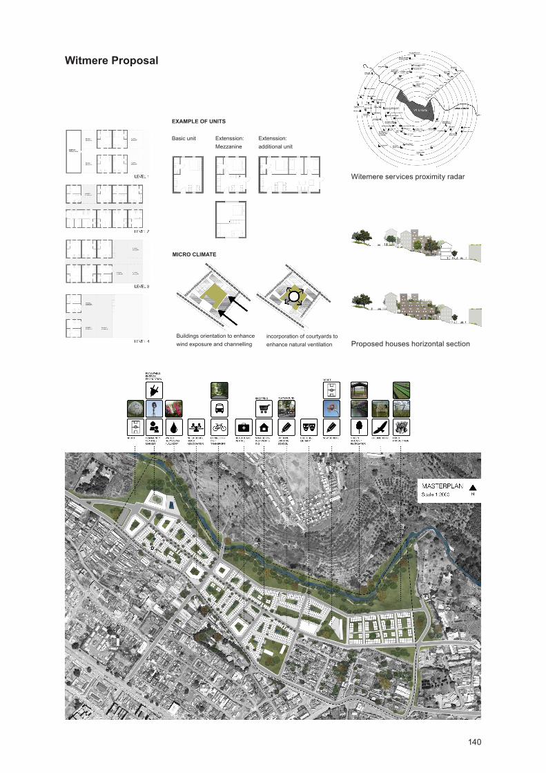
140
Witmere Proposal
Witemere services proximity radar
Proposed houses horizontal section
Basic unit
EXAMPLE OF UNITS
Extenssion: Mezzanine
Extenssion: additional unit
MICRO CLIMATE
Buildings orientation to enhance wind exposure and channelling
incorporation of courtyards to enhance natural ventilation
141
Agricultural activities are strategic to strengthen and enhance Witemere economies of scale; river area will work both as a turn and linking point between the rural and urban ares. Public green areas and Chania River green belt will address the Witemere environmental and ecological problems contributing to site temperature regulation and soil stabilization. Adding thick layers of trees will help, especially in monsoons time, to slow down soil erosion ensuring buildings stabilization. Creating a green belt along the river will permit to design a new public zone combining sports facilities with leisure spaces working as a magnet to attract people from the city. Chania s River area (re)designing is critical for Witemere urban rehabilitation, besides ecotourism and social life improvement it will address public safety issues by releasing the flood area from construction.
Witemere urban requalification goes beyond a mere space issue; it is a bill of human rights. This is why in the first place we establish a set of principles as project development tools - because they help to focus on more sustainable and social solutions tailored for a specific place. In Witemere, 22 new quarters of incremental housing combined with mix-used will give rise to a vibrant community. The sets are composed of various buildings types and sizes in order to fit better slope configuration. The requalification of the public and the semi-public areas, the last provided by the courtyards of the new residential blocks, took in account the cattle brought by the people. Quarter´s internal courtyards are provided with water points for animals to drink and bath. Climate and culture make open-to-sky-space usage as an extension of the house plateful to cook, read, etc. allowing to reduce the electrical consumption overall, and, by its social nature, to enhance the neighborhood and social safety, both vital to the community well-being.
Residential units privilege the increasing of the living and services areas. By minimizing circulation will optimize space overall and reduce residential dwellings built mass; a process of densification contributing to increasing the Witemere number of houses. In order to foster different space appropriation and needs dwellings are incremental, owners may choose a basic unit, provided to all families, of 5x6sqm or 5x8sqm, with extension possibility of one more level with the same area. If family desires to have its own business mix-used sets are provided; when buying a first residential unit level the owner may choose to have, at the ground level, his own store or just to extend the house. espite different typologies, all structural buildings elements have the ability to associate conveniently in modules, facilitating its construction and reducing works final costs.
142
The presented urban development guidelines were projected not only to redefine a new Witemere socio-spatial system but to promote an urban entity that - by its infrastructure, economy and social network - has the capacity to be resilient. In that context, comprehensive planning is a tool relating with the community economic prosperity, so far a resilience-building block. By determining the community goals and aspirations, in terms of community development, comprehensive planning is more efficient when it comes to restructuring policies related to transport, facilities, land use, public spaces, and housing - comprehensive planning is one of the most efficient tools to address and readjust the constant evolution of a community.
Urban population growth patterns support the number of persons to plan for; ensuring the adequate provision of infrastructure and land for urban expansion. Equally important is the recognition of the land use and management patterns; in order to address spatial challenges ensuring, at the same time, the control and decreasing of natural resources consumption by regulating and ensuring conservation plans for forests, and other ecosystems, reviling essential to boost local economies and people’s well-being. Place water resource is a fundamental data for sustainable planning regarding water management; it helps to centre in alternative ways, as rain, to store water for public spaces and agricultural purposes, in addition, water flow direction is critical to determine a drainage pattern helpful to place dump-sites and sewer systems (NTSU P, 2014).
It is extremely difficult to feel the place without being there. When it comes to working on a project without having the possibility to go on site the project development heavily depends on the quality of place survey given material. In that context, we felt that working with a pre-established set of parameters was helpful to concentrate on needed information and a way to ensure that we will have minimum information failure when it comes to placing survey information and research collection.
Regarding the methodological strategy, parameters steps and recommendations, resulting from the Mumbai case study - used in the presented case study as a starting point - very little changed. However, and since Nyeri in terms of city location, surroundings, and natural resources is distinguished from Mumbai, at the place survey phase, at the geographical parameters section we added to the natural resources issue new items, namely the forests, hills, rivers/water bodies, prevailing agricultural activities and productions, fauna and flora and energy main sources. Parameters allowing deepening understanding on Nyeri future investment lines and their potential, especially at the ecotourism level, to generate more employment opportunities and healthier incomings; so far basilar stones to resilient communities.
143
Concerning the principles as project development tools, we will highlight minimal relocation. It is essential to respect and understand the affective human bonds to places in order to keep them alive. Witemere it may be a slum, but it is also the new home of climate change and skinny living conditions migrants. For the poorest to achieve a city dwelling, even if it is a slum, it is an achievement amplifying the connection between people and place, becoming, this way, the base for an effective socio-spatial system recovery.
Final Considerations and Future Outcomes
The presented Witemere case study was also the opportunity to (re)explore Google Earth Pro, a very useful tool to complete built environment information. For climate analyses, we explored the Meteoblue and the Word Weather information databases. These weather databases complete each other, we recommend its simultaneous usage. Word Weather and Climate Information, have good statistics on the country’s climate situation (average per year of minimum and maximum temperature, sunlight hours, precipitation, rainy days, and wind speed) and the graphical data are clear and simple to interpret. Meteoblue, despite regular weather data on temperature, air humidity, etc., also informs on thermal sensation and wind direction and speed (km/h), in addition, it has an archive of previous weather data useful when there is the need to tailor weather statistics or to go deeper into local climate change.
aving a predefined set of parameters and recommendations helped the project research and survey process to be faster and place oriented. It also aids creating an expanded field of place information crucial to understanding the context of the context, extremely relevant to design solutions that - despite having the place in mind - are embedded in a larger system, for instance, the country sustainability goals. Each given parameter changes the equation and helps to center in a set of locally optimized solutions enhancing the uniqueness of each place - inside of our research its identity. Independently of the context, even if we are familiar with, it is always fundamental to listen to the question, not being assumptive; due to the scarcity of means in lower-income countries ‘’to listen’’ becomes a development tool. Parameters made us realize that good design doesn’t have to be ‘big and shiny’ rather, it must be flexible fostering all types of appropriation, empowering people, culture, and environment as a way of place adding value.
Regarding proposed methodological strategy of place analysis and intervention resulting from the literature review with the 10 studios analyses information cross, new sections and parameters whore added. It is crucial, as a research future outcome to define its final version, so we can present it to
144
architects, urban planners, and researchers in the field aiming its validation.
Limitations
Although our efforts, trips from Nairobi to Nyeri Town were expensive and slow, thus Kenyan team based members only went 2 times to the intervention site.
The United Nations stated that for each given town Kenyan members of the UN Youth would be assigned and available to respond group’s requests, however when we contacted the UN to go to Witemere - in order to distribute the proposed survey and to take more site pictures - no answer was returned.
The GIS data on Nyeri built environment was incomplete, again, when United Nations were contacted in order to update files no answer was returned.
If being from different countries with a virtual meeting point, (Skype) for project development was extremely challenging, by another hand it revealed extremely difficult to reach an agreement on projects directions and development. We spent much time in assigning tasks and the project graphical image was little developed. However, we have learned how and what to prioritize when developing a project of such nature - for us that was the most important.
Chapter Discussion and Conclusions
For the design of the methodological strategy, despite the literature review, a sample of 10 architecture studios was analyzed representing a specific market slice; big offices with full-time trans and multidisciplinary teams, tailored software packs and innovation centers, and high budget levels, distant from the majority of regular architecture studios. However, from this analysis, there are ‘low-cost’ recommendations that we may adopt: the staff education on sustainability and green thinking, the continuous portfolio assessment, and the Post-occupancy evaluation. Recommendations allowing the constant (re)calibration of used methods and methodologies of project development through a direct feedback on, for instance, materials performance in the real world, and user’s building satisfaction level.
In the analyzed 10 studios sample the attention to social dimension is, mainly, centered in the Post-occupancy phase, as a result the proposed place survey at the socio-cultural item suffered significant changes when tested through the case studies. It is our belief, reinforced by the case studies experience, that since a project early stage the social dimension
145
must have the same influence, for project development, as the geographical and the built environment one. In order to warrant an effective project long life and sustainability goals, projects must embed from the beginning the socio-cultural dimension of each place ‘…fundamentally, we are all mythical beings. And the idea of a building that we call architecture is as close as it can be to this idea of mythical being and the fact that it is really an extension of the human body, not that different from the cloth that we wear (…) architecture is a physical and material manifestation and precise representation of what it means to be human’ (Jain, 2016).
Having a methodological strategy encompassing the 3 claimed dimensions, and respective parameters, it helps to deeply understand the interdependency of the different space qualities. In addition, it also aids to focus on place uniqueness - inside this researches its identity - improving the design towards locally optimized solutions. Parameters demand a holistic and strategic space vision addressing questions of scale and interconnection helpful to predict the response of a project into a given system; which is particularly relevant if we want to design resilient socio-spatial systems. However, we consider that what is more relevant in using a set of pre-established parameters is the certainty that we will not miss one, the parameters that in the beginning of a project we will not take into account they will come back later demanding a project revision, or worst, contributing to the project’s flop; especially after its construction.
It was interesting to observe how the methodological strategy of place analysis and intervention resulting from the crossing of the literature review with the 10 architecture studios analysis behaved over the case studies. Our first methodological strategy draft was designed based on American and European architecture studios whose projects are developed, mainly, in their respective environments (higher-income countries) and the case studies were developed in India and Kenya (lower-income countries). From this experience, we were able to distinguish two groups of parameters i.e. the transversal ones, common to “any” environment, and the new ones added by the need to operate in a different environment, in our research lower-income countries - demanding new space readings, and, for that so, new parameters. Transversal parameters include: Climate change, place micro-climate, natural resources, local materials, topography, place character, land use and change, city location, density distribution, users/buildings relationship, urban network, infrastructure, governance, proportion, structure, vernacular structures, conservation status, color pallet and background/figure. New parameters include: Population growing estimation, prevailing economic activities (including: economies of scale and income average, funding), local communities (including: number of tribes, religions and

146
castes), age average, literacy and the number of houses/slums (including: safety, number of persons living, materials and techniques, sanitation, main light sources, number of dependencies, water source and distribution). Parameters which, also, may be used in other contexts.
As the presented in the state of the art, due to the global lack of resources, migration and house crises, cities have become a giant melting pot with sprawl and slums increasing day-by-day. Currently, European cities are facing similar problems as the ones located in lower-income countries and, tendentiously, they will increase. Inside this context, we defend that the 2 mentioned groups of parameters must be merged in one, i.e. in the same methodological strategy of place analysis at the place survey section, constituting the necessary set of tools to face, despite local demands, transversal urban problems - helping to create a stronger and larger urban network of open-knowledge so we can learn trough others experiences best strategies and practices.
Final Considerations and Future Outcomes
Proposed methodological strategy it’s not only about a specific place, program or scale; it is about bringing to the front primitive knowledge and common sense, negotiating with the place and its dimensions in order to create, or strengthen, a resilient and sustainable place rooted socio-spatial system - it is about adding place value instead mere objects. The proposed methodological strategy of place analysis and intervention must be understood as a flexible recommendation for future interventions - prioritizing the optimization of existing resources - instead of a hermetic solution for every place or program.
As previously stated, in order to design one most understand the place, and in order to understand one most know. Having a methodological strategy comprising a set of pre-defined parameters is crucial to rapidly acquire and gather knowledge about the location where we are going to intervene. Thus, resulting methodological strategy of place analysis and intervention based on place identity is structured as it follows; presented version will be later sent under a survey form to architects, planners, and researchers - in named areas - and presented in conferences, so (if needed) it can be reviewed and validated
G1) Methodological strategy of place analysis 1 – Step1: General Context Overview
The goal of this step is to break of the danger of thinking that we know the answer before we even listen to the question;

147
supportive to minimize the social, economic and environmental impact of a project.
A country’s general overview will inform on the social, economic and political current situation, helpful to review emergent subjects to be subsequently addressed in the work’s timeline. Two levels must be explored: 1. Global Level (relating with the country); 2. Local Level (relating with the place where we are going to intervene) encompassing the economic, political and social dimension.
Methods: Literature review (scientific papers, reports, official websites and online statistics databases - the United Nations, the World Resources Institute and the country’s Census, Migration Observatories and Statistics Institutes are credible data sources; however it always requires specific research on the country official data sources), data critical selection and crossing.
Information systematization: atabase, written documents, info-graphics (Adobe Photoshop, InDesign, Illustrator, etc.), graphics and maps (Quantum GIS, ArcGIS, etc.).
Step2: Place Survey, Based on Place Identity (socio-cultural, built environment and geographical parameters)
This step aims the measuring of the place qualities - i.e. its identity through the socio-cultural, the geographical and the built environment dimensions - targeting the design of more sustainable and place rooted projects through a deeper understanding of the inherent socio-spatial system. Measuring place qualities implies the identification and grouping of the geographical, socio-cultural and built environment qualities.
Socio-cultural parameters: Population growing estimation, place history and cultural landscapes, people/place environment relationship, prevailing economic activities (including: economies of scale brought by agglomeration and income average), funding and governance, local communities (including: number of tribes, religions and castes, age average, literacy, traditions, routines and community aspirations), cultural preferences and socio-cultural practices (by tribe, religion and caste) and vernacular construction knowledge (including: construction skills and local technologies).
Methods: Multi and transdisciplinary teams, diagrammatic drawings and sensory-relations maps, photographic and video recordings, interviews and/or surveys (including: Post-occupancy evaluation on thermal, visual and acoustic comfort, safety, cultural identification and indoor air quality; cognitive performance studies), further population studies (Census, United Nations Population Division, worldometers), space use
148
observations, research, working closely with local authorities, local communities and local organizations, measurements of the social and economic impact of investment in the historic environment or in any other type of environment, comprehensive planning, phenomenological methodology.
Information systematization: atabase, written documents, photography/video, GIS (Quantum GIS, ArcGIS, etc.), any Computer Aided Design software that suits the project needs (AutoCAD, etc.) and info-graphics (Adobe Photoshop, InDesign, Illustrator, etc.).
Geographical parameters: Climate change – effects on the region, place micro-climate (including: site orientation, sun path and sunlight number of hours, rainy and dry season, prevailing wind, air humidity and pollution), natural resources (including: forest, rivers/water bodies, prevailing agricultural activities and productions, fauna and flora, energy main sources), local materials, topography, place character and land use, change and classification (rural, urban, agriculture and natural reserves).
Methods: Multi and transdisciplinary teams, literature review, natural observation, photograph and video recording, climate and air pollution measurements (World-wide Air Quality Monitoring ata Coverage or the official country’s online databases on air pollution measurements, Meteonorm, CAIT Climate ata Explorer, Meteoblue, Word Weather and Climate Information, World Resources Institute), topographical survey (using 3D models), geographic data crossing.
Information systematization: atabase, written documents, photography, geographic data crossing through GIS (Quantum GIS, ArcGIS, Google Earth Pro, etc.), 3 visualization (3 Studio Max, Sketchup, Rhino 3 , Grasshopper, etc.), CA software that suits the project needs (AutoCAD, etc.) and info-graphics (Adobe Photoshop, InDesign, Illustrator, etc.).
Built environment parameters: City location, densities distribution, number of slums (including: safety, number of persons living, materials and techniques, sanitation, main light sources, number of dependencies, water source and distribution), urban network (including: services, public spaces, roads fluency, walking/mobility/accessibility, urban transport network including public transportation and non-motorized vehicles), infrastructure network (including: public spaces, services and industrial), proportion, structure, vernacular structures, conservation status, colour pallet, background/figure, shape, perceptual unity, place built disable resources and local scale.
Methods: and drawing, natural observation, photography,
149
sound and video recording, surveys and conversations with local people/authorities/NGO’s. Always a place-based approach including - cost considerations and payback scenarios studies, active research and studies on local collective knowledge, studies of color/natural light, comfort and safety trough users surveys analysis, survey on number of slums, urban networks and infrastructure networks (Census or other official source information depending on the country), studies/research and critical data interpretation on: water source and distribution, roads fluency and walking mobility, traffic mobility and public urban transport network, green and public spaces, local materials for construction survey and vernacular architecture knowledge mixing contemporary technologies, built environment data crossing.
Information systematization: atabase, written documents, photography, data crossing and mapping through CAD software that suits the project needs (AutoCAD, etc.) and GIS (Quantum GIS, ArcGIS, Google Earth Pro, etc.), BIM (ARC ICA , Revit, etc.), 3 visualization (3 Studio Max, Sketchup, Rhino 3 , Grasshopper, etc.), info-graphics (Adobe Photoshop, InDesign, Illustrator, etc.) and bespoke interactive tools that both analysis and visualize collected data.
G2) Methodological strategy of place intervention
Step3: Urban Level Sustainability Tasks
The sustainability tasks at the urban level vary according to the type of project and system we will intervene; however we always most consider short, medium and long-term goals.
These tasks are about creating a stronger and efficient space structure, improving place livability and the first step to eradicate urban poverty and to develop an urban strategy towards a sustainable and inclusive future.
We recommend, even for microscale projects, always to consider the urban level sustainability tasks. Not because we are going to intervene at the urban level, but because it will give the awareness of how the new intervention will relate and affect the existent system.Sustainability tasks at the urban level:
Vital statistics on urban population growth estimations;
Urban growth patterns recognition (including: densities optimization and land use readjustment and regulation, saving land for urban expansion, agriculture, industrial production and ecological reservations);
150
Development of infrastructures (roads, streets, public spaces and facilities, water and energy distribution and management, solid waste management, sanitation);
Slums/informal settlements improvement plans;
Promotion and inclusion of cultural, social, educational and aesthetic aspects;
Environment protection and promotion of ecology and green spaces/belts.
Step4: Principles as Tools
The goal of establishing a set of principles as project development tools is for them to work as a reminder that architecture is for people, helping to generate more social and cultural inclusive projects. We recommend following principles, however they are not limited to varying on project, program and location.
Principles as tools:
Urban population growth patterns and income average recognition;Both vernacular and technology for in and outdoor space improvement; Climate adaptation; Culture and identity inclusion; Participation; Minimal relocation; Incrementality; Pluralism; Equity.
Step5: Architectural Level Tasks
To define the architectural level tasks - participatory methods and low-cost house plans may be included depending on the context and program.
Architectural level tasks depend on the program; we recommend including payback scenarios and affordability (entailing site costs and incoming generation) as central tools for architectural level tasks development.
Step6: Placed Based Project evelopment
We recommend a place-based approach centered in local resources management. It is equally important to ensure place adding value through cultural integration, the use of green roofs, soft landscaping and/or any other green space.

151
Passive strategies and natural resources management must be taken into account in order to detect payback scenarios. Active systems only come after passive strategies and should center in low energy and water consumption, low carbon emission and self-energy generation - renewable energy. We also recommend the usage of local materials, since they have a significant impact on cost reduction; when possible always working with recyclable, recycled and low toxicity materials.
Methods: Inter and transdisciplinary teams (LEE and/or green professionals, conjoint research with universities, research groups/centres on sustainability, consulting with external experts), previous projects assessment, brainstorm and collaborative development, manual crafted including hand-sketching, detailed models at large scale (range from 1:5000 to 1:1), advanced 3 prototyping, GIS space information, computer-generated analysis (including parametric modelling), 3D visualization. The integration of augmented and virtual reality can be a plus for developing the best way to represent any facet of design for a particular context.
Information systematization for drawings development with measurements and construction details trough: CA software that suits the project needs (AutoCA , etc.), BIM (ARC ICA , Revit, Navisworks, ico, Tekla, etc.), 3 visualization (3 Studio Max, Sketchup, Rhino 3 , Grasshopper, etc.), GIS space information (Quantum GIS, ArcGIS, etc.) for info-graphics (Adobe Photoshop, InDesign, Illustrator, etc.) and for passive and mechanical strategies design BEM ( asari – Ecotect, Passive esign Assistant, etc.).
Step7: Post-occupancy
After project’s completion, we recommend an occupant’s engagement program entailing workshops on sustainability, natural resources saving and energy management, improving public education on green thinking. In a range from 3 to 5 years of buildings occupancy, we recommend its Post-occupancy evaluation (surveys format vary on the evaluation goals taking the form of interviews, surveys and/or space use observation) in order to improve the future design.
Limitations
We recognize that staying more time in Mumbai and presenting the work to local architects and/or organizations would be a plus for the research development; especially to accomplish our primary objective of hands-on trough project. However, in our time in India we met several architects and urban plan-ners, thus our intention is to contact them and explore the possibilities of further get the project done.

152
The 10 studios sample, initially, was projected to comprise 30 studios; due to the lack of information of the architecture studios and our narrow timeline we shorten the sample for the most relevant studios in terms of available information. Still, we did not felt any inconsistency in terms of data; however, there is the risk of parameters and recommendations, that would be relevant for the development of the methodological strategy, have been left behind.
153
References
2009 Kenya Population and Housing Census (2010). Counting Our People for the Implementation of Vision 2030.
OLUME IC. Population istribution by Age, Sex and Admin-istrative Units. August More statistics and reports accessed on 23.03.2016 at: http://www.knbs.or.ke/index.php op-tion com phocadownload view category id 109:popula-tion-and-housing-census-2009 Itemid 599
Architectural Record (2014). 2014 Top 300 Architecture Firms. Accessed on 17.09.2015 at: http://www.architectural-record.com/Top300/2014-Top-300-Architecture-Firms-1
ARUP (2011). Characteristics of a Safe and Resilient Commu-nity. Community Based isaster Risk Reduction Study ARUP International Development. September
ARUP (2014). City Resilience Framework. The Rockefeller Foundation, 3
Census of India (2011). Population by Religious Commu-nity. Accessed on 06.08.2015 at: http://www.censusindia.gov.in/2011census/c-01.html
Census of India (2011). Provisional Totals ata on Rural & Urban areas Figures at a Glance, India. Accessed on 23.06.2015 at: http://www.censusindia.gov.in/2011-prov-re-sults/paper2/data files/mah/5-fig-india-8.pdf
Census of India (2011). Provisional Population Totals Paper 1 of 201: Maharashtra. Accessed on 23.06.2015 at: http://www.censusindia.gov.in/2011-prov-results/prov data productsmaha.html
Census of India (2011). State profiles: ata on houses, ousehold Amenities and Assets for each State/union Terri-
tory. Accessed on 10.06.2015 at: http://www.censusindia.gov.in/Census ata2001/States at glance/State Links/27 mah .pdf
Cohen, Barney (2006). Urbanization in developing countries: Current trends, future projections, and key challenges for sustainability, Technology in Science Journal, ol. 28
Correa, Charles (2000). ousing and Urbanization: Building Solutions for People and Cities. Thomas and Hudson
Engineering New-Record ranking (2015). The 2015 Top 100 Green Buildings esign Firms. Accessed on 15.09.2016 at: http://www.enr.com/toplists/2015 Top 100 Green Build-

154
ings_Design_Firms
Frampton, Kenneth (1983). Towards a Critical Regionalism: Six Points for an Architecture of Resistance. 1. Culture and Civilization. The Anti-Aesthetic Essays on Post Modern Culture. Edit by al Foster, 16; 26
GA Collaborative (2015). Mapping Rwanda project. Accessed on 25.10.2015 at: http://www.gacollaborative.org/mapping-rwanda/
Global Property Guide (2015). India’s residential property yields at an all-time low. Accessed on 21.07.2015 at: http://www.globalpropertyguide.com/Asia/India/Rental- ields
Hamdi, E. ; Amin . ; Abou-Saleh MT (1997). Problems in vali-dating endogenous depression in the Arab culture by contem-porary diagnostic criteria. Journal of Affective isorders. ol 44, 131-143
Harmon, Katharine; Clemans, Gayle (2010). The Map as Art:-Contemporary Artists Explore Cartography. Pub. Princeton Architectural press
Huruma Slum Upgrading Project (2016). Accessed from 25.02.2016 to 16.03.2016 at: https://www.youtube.com/watch v 2EsoJAnip A
Center for Urban Research and Innovation http://www.centreforurbaninnovations.com/content/systemati-zation-huruma-situ-housing-upgrading-project
Slum Architects http://slumarchitects.org/about-us/2-uncategorised/6-case-study-huruma-slum-upgrading-project-with-close-reference-to-kambi-moto
Jain, Bijoy (2016). “Architecture Is Not About an Image, It Is About Sensibility . Interview. Accessed 29.10.2016 at: http://www.archdaily.com/798179/bijoy-jain-architecture-is-not-about-an-image-it-is-about-sensibility
Ingels, Bjarke (2012). CTBUH Journal, International Journal on Tall Buildings and Urban abitat, Tall buildings: design, construction and operation. Issue I , 42 – 45
Jain, A. K. (2011). Sustainable Urban Planning Recognizing the potential and needs to address urban development in a dynamic practical manner. ARC ITECTURE – Time Space People, Jan

155
Journal of the American Institute of Architect (2014). The 2014 Architect 50. Accessed on 27.02.2015 at: http://www.architectmagazine.com/practice/architect-50/the-2014-archi-tect-50_o
Journal of the American Institute of Architect (2015). The 2015 Architect 50: The Top 50 in Sustainability. Accessed on 02.10.2015 at: http://www.architectmagazine.com/practice/architect-50/the-2015-architect-50-the-top-50-in-sustainabili-ty_o
Kenya Slum Upgrading Programme (2007). UN-HABITAT and the Kenya Slum Upgrading Programme. United Nations Human Settlements Programme (UN-HABITAT)
Kéré, Diébédo Francis (2016). Kéré Architecture web site at the Projects section. Accessed on 13.09.2016 at: http://www.kere-architecture.com/projects/
Kurtuncu, B.; Koknar, S. and urson, P. (2009). ecoding Spatial Knowledge and Spatial Experience. Proceedings of the 7th International Space Syntax Symposium. Edited by
aniel Koch, Lars Marcus and Jesper Steen, Stockholm: KT
Lake I Flato (2016). Accessed on 23.07.2016 at: TTP://WWW.LAKEFLATO.COM/ ISION/SUSTAINABILIT
Lacy, Susanne (1995). Mappin the Terrain. New Genre Public Art. Bay press, Seatle Washington
Lyon, Brian Mac-kay (2013). The Village Architect. Accessed on 17.07.2016 at: https://www.youtube.com/watch v ekhBb-vOSXlo
Meteoblue (2016). Accessed on 20.02.2016 at: https://www.meteoblue.com/pt/tempo/previsao/semana/nyeriqu%C3%AAnia 182701
Mondal, Puja (2015). The Role of National Commission on Urbanization in India. Accessed on 07.12.2015 at: http://www.yourarticlelibrary.com/ecology/the-role-of-national-commis-sion-on-urbanization-in-india/4701/
Nascimento, Filomena (2015). The Mumbai Project - Unpub-lished.
NTSUDP, Nyeri Town Strategic Urban development Plan (2014). Nyeri Town Strategic Urban development Plan (2014 – 2036). Final Plan Report
Park, Kat; Holt, Nicholas (2011). Parametric Design Process of a Complex Building In Practice Using Programmed Code As
156
Master Model. International journal of architectural computing. Issue 03, vol 8. March, 3
Pernão, joão (2013). Light and Colour as the Genesis of a aily Metamorphosis: Night and day in Urban Landscape
Perception. Accessed on 23.10.2013 at: http://www.academia.edu/5047586/Light and Colour as the Genesis of aDaily_Metamorphosis_NIGHT_AND_DAY_in_Urban_Land-scape_Perception
Público (2015). Daqui a sete anos a Índia vai ultrapassar a China em população. Accessed on 12.09.2015 at: http://www.publico.pt/mundo/noticia/daqui-a-sete-anos-a-india-vai-ultra-passar-a-china-em-populacao-1703587
Risbud, Neelima (2003). The case study of Mumbai, India UN ERSTAN ING SLUMS: Case Studies for the Global Report on uman Settlements, 2003. Accessed on 18.05.2015 at:http://www.ucl.ac.uk/dpuprojects/Global Report/pdfs/Mumbai.pdf
Seamon, . (2011). Place, Place Identity, and Phenomenology: A Triadic Interpretation Based on J. G. Bennett’s Systematics.
ernan Casakin, Ombretta Romice, Sergio Porta, editors. London: Betham Science Publishers
SCB, Students Competition Brochure (2016). International Design Collaboration for Kenya
Taylor, Tom; Ward, Chris (2016). New Methodology for Gener-ating BREEAM Category Weightings. Appendix 1 – Weight-ings Methodology
UNICEF (2015). UNICEF Annual Report 2015 Kenya. Retrieved from: http://www.unicef.org/about/annualreport/files/Kenya 2015 COAR.pdf
UN-H, UN-Habitat (2013). Planning and Designing for Sustain-able Urban Mobility. Global Report on uman Settlements 2013. Routledge, 108
UN-H, UN- abitat (2016). Urbanization and evelopment: Emerging Futures. World Cities Report 2016
UN, United Nations (2015). World Urbanization Prospects, the 2014 Revision Economic and Social Affairs, Population ivi-sion, United Nations, New York
UN, United Nations (2014). World Urbanization Prospects, the 2014 Revision, ighlights . Economic and Social Affairs. Population Division. United Nations New York

157
USAID (2010). Primer of Implementing the 74th Constitu-tional Amendment and Integrating City Planning with Service
elivery, JNNURM State-Level Reform. Final Report 21. Accessed on 20.07.2015 at: http://pdf.usaid.gov/pdf docs/pnaea768.pdf
World Resources Institute (2015). 3 Maps Explain India’s Growing Water Risks. Accessed on 5.09.2015 at: http://www.wri.org/blog/2015/02/3-maps-explain-india%E2%80%99s-growing-water-risks
WWCI, Word Weather and Climate Information (2016). Accessed on 21.10.2016 at: https://weather-and-climate.com/average-monthly-Rainfall-Temperature-Sunshine,nyeri-cen-tral-ke,Kenya
WPP, World Population Prospects (2015). Key finding and advance tables. 2015 Revision. epartment of Economic and Social Affairs. United Nations
WM, Worldometers (2016). Kenya Population (live). Accessed on 20.10.2016 at: http://www.worldometers.info/world-popula-tion/kenya-population/
Sites
II Congresso Internacional de abitação Coletiva Sustentável: http://laboratoriovivienda21.com/congreso2/ page id 65Autodesk Sustainability Workshop: http://sustainabilitywork-shop.autodesk.com/BREEAM: http://www.breeam.com/CAIT Climate ata Explorer: http://www.wri.org/our-work/project/cait-climate-data-explorerCenter for Urban Research and Innovation: http://www.centre-forurbaninnovations.com/Cities Alliance – Cities without slums: http://www.citiesalli-ance.org/ Environmental Improvement of Urban Slums: http://indi-anexpress.com/tag/environmental-improvement-of-ur-ban-slums-eius/India Census 2011: http://www.censusindia.gov.in/2011-common/census 2011.htmlIndia Water Tool: http://www.wbcsd.org/indiawatertool.aspxKenya National Bureau of Statistics: http://www.knbs.or.ke/index.phpKenya Open ata: https://opendata.go.ke/Maharashtra Pollution Control Board: http://mpcb.gov.in/Maharashtra ousing and Area evelopment Authority: https://mhada.maharashtra.gov.in/Meteoblue:https://www.meteoblue.com/pt/tempo/previsao/semana/nair%C3%B3bi qu%C3%AAnia 184745Mumbai Urban Transport Project: https://mmrda.maharashtra.

158
gov.in/mumbai-urban-transport-project1Mumbai Metropolitan evelopment Authority: https://mmrda.maharashtra.gov.in/National Slum wellers Federation: http://www.sparcindia.org/aboutnsdf.phpNational Commission on Urbanization India: http://www.yourarticlelibrary.com/Nairobi Planning Innovations: https://nairobiplanninginnova-tions.com/Practicing Engineers, Architects and Planners Association: http://www.peataindia.org/PennState: http://www.psu.edu/ at: BIM Execution Planning: http://bim.psu.edu/Uses/Site Analysis.aspxSociety for Promotion of Area Resource Centre: http://www.sparcindia.org/Slum Rehabilitation Authority: http://www.sra.gov.in/Slum Architects: http://slumarchitects.org/UNESCO: Poverty Alleviation through Community Participa-tion – UBSP India: http://www.unesco.org/most/asia12.htmUNICEF: https://data.unicef.org/Urban esign Research institute: http://www.udri.org/Pollution in World: Real-time Air Quality Index isual Map section: http://aqicn.org/map/world/ g/29.5986/120.8222/2z The World Bank: Country and Leading Groups: http://data.worldbank.org/about/country-and-lending-groups Lowermiddle_income
irtual Kenya: http://maps.virtualkenya.org/World Resources Institute: http://www.wri.org/Worldometers: http://www.worldometers.info/World-wide Air Quality Monitoring ata Coverage: https://aqicn.org/sources/ at the AirWord Weather and Climate Information: https://weath-er-and-climate.com/

Chapter III: Methodological Strategy Revisited


161
Chapter Introduction
This chapter describes the process of revision of the meth-odological strategy of place analysis and intervention based on place identity, aiming its final version. The methodological strategy arose from the concern related to the contemporary urban environment sharp degradation, mostly, fed by climate change, stressed migration and poor governance; contrib-uting to life quality decreasing, natural resources exhaustion and, eventually, to cities collapse.
l In this context, the research seeks to create a methodological strategy of place analysis and intervention helps to prevent built environment sharp degradation by promoting more sustain-able and place rooted projects. The proposed methodological strategy must be understood as a flexible recommendation for project improvement instead of a hermetic solution for every place and/or program, and parameters as development tools for later to be correlated in order to boost the design response into a given system.
Thus, we propose a methodological strategy structured by two main groups (G): G1: methodological strategy of place anal-ysis (encompassing the general context overview and place survey based on its identity) and G2: methodological strategy of place intervention (encompassing the urban level sustain-ability tasks, the principles as tools, the architectural level tasks, the placed-based project development and the post-oc-cupancy evaluation).
After its presentation to architects, urban planners and academics, a process described in the ‘Research, Data and Methods’ section, the ARUP Sustainable Project Appraisal Routine tool (SPeAR) revision and research feedbacks obtained at the 2013 Rede Lusófona de Morfologia Urbana (PNUM), the 2016 II International Congress on Sustainable Collective Housing and the 22nd International Sustainable Development Research Society Conference (ISDRS), the methodological strategy was critically reviewed given rise to its final version presented at the ‘Chapter III iscussion and Conclusions’ section.
Key words: Methodological Strategy, Survey, Revision

162
Research, Data and Methods
In order to present and evaluate the methodological strategy of place analyses and intervention based on place identity, we designed a survey sent to architecture and urban planning studios from the 10th to the 20th January 2017. In order to ensure the needed metrics for statistics and conclusions, we asked for the help of the Research Centre for Architecture, Urban Planning and Design (CIAUD) - Faculty of Architecture from the University of Lisbon - through its respective mailing list comprising academics and professionals in the field.
The survey was sent to 168 architecture studios; references in the sustainability field. The selection was based in the previ-ously 149 chosen architecture studios (Annex I) to conduct the ‘Methods and Methodologies of Place Analysis and Inter-vention – Crossing ata’ section of chapter II. To the previous architecture studios, we added 19 more also focusing on sustainability; our main selection criteria.
The survey (Annex IV) was constituted by 12 sections comprising the introduction and the evaluation of the two main groups, i.e. place analysis and place intervention, according to a 6 value scale, ranging from totally disagree to strongly agree and not applicable. Evaluated groups were divided as it follows: G1, methodological strategy of place analysis comprising the Step1: general context overview and the Step2: place survey - based on place identity - where we ask to evaluate socio-cultural, geographical and built environment parameters as well as correspondent methods and informa-tion systematization. Finishing with the G1 group evaluation and suggestions section.
G2, methodological strategy of place intervention encom-passed the Step3: urban level sustainability tasks; the Step4: principles as tools; the Step5: architectural level tasks; the Step6: placed based project development and the Step7: post-occupancy evaluation. Also followed by the G2 group evaluation and suggestions section.
For conference’s communications, we sent respective abstracts describing proposed work that, after the scientific broad acceptance, were publicly presented and discussed, exposing us to architects, urban planners, students, and researchers relevant feedbacks for the work revision.
In addition, in a recent ARUP website search we discov-ered the Sustainable Project Appraisal Routine (SPeAR), a sustainability decision-making tool integrating a set of indica-tors - transport, biodiversity, culture, employment and skills, etc. - that, by its similar principles with prosed methodological
163
strategy, we analysed aiming our work improvement.
These three steps provided a space of reflection too (re)calibrate the methodological strategy of place analysis and intervention based on place identity, whose final version is presented at these chapter discussion and conclusions. We also isolated the methodological strategy parameters and recommendations from its methods and information system-atization (Table 3) giving rise to new conclusions related to its usability, and to new research pathways.
Chapter Discussion and Conclusions
As previously stated, research, as it evolved, was presented in conferences - the 2013 PNUM, the 2016 II International Congress on Sustainable Collective Housing and the 22nd ISDRS - the scope was to obtain feedbacks from architects, urban planners, and researchers, aiming to understand the pros and cons of our work targeting its revision and new direc-tions. In respective presentations obtained feedbacks were positive, however, we were advised always to define what is place and identity, since both are highly subjective. The fact that the research was an effort to critically gather dispersal methods and methodologies, that were used separately by different architecture offices and entities, was highlighted. In this context research was indicated as a helpful synthesis pointing useful principles and recommendations for the improvement of the best design practices towards a project effective integration into a given socio-spatial system. In addi-tion the concepts of place identity (the result of the interac-tion of a place qualities - geographical, built and socio-cul-tural dimensions) and socio-spatial system (constituted by the three mentioned dimensions where space and human beings are read as one: people-in-place) were underlined by their relevance in reinforcing a spaced holistic perspective helpful to design local optimized solutions; so much needed inside an era where the scarcity of resources is imminent.
In sent surveys a total of 14 answers were obtained, a low number to be considered for statistic validation or conclusions making; however given feedbacks formed a significant space of reflection for critical work revision. The average of the meth-odological strategy groups classification ranged from ‘agree’ to ‘strongly agree’ (Annex IV) and in same survey sections ‘disagree’ and not ‘applicable’ were registered. In each survey section participants were asked to give a rank to presented steps including its methods and information systematization; the rank comprised the following scale: Strongly disagree, Disagree, Neither agrees nor disagrees, Agree, Strongly agree and Not applicable. At the G1 (methodological strategy of place analysis) the ‘Step1: General Context Overview’ was ranked with a 50% overall of ‘agree’, regarding its ‘methods’
164
and ‘information systematization’ a 10% of ‘disagree’ and ‘note applicable’ were registered. By the ‘General Context Over-view’ score, we assume participants agreed that this step is a helpful recommendation for the context and the context of the context, deeply understanding; very relevant to review emer-gent subjects to be subsequently addressed in the project timeline. At the Step2 we asked participants to evaluate socio-cultural, geographical and built environment parame-ters; comprising respective methods and information systema-tization. The socio-cultural parameters item overall score was tied between 50% ‘agree’ and 50% ‘strongly agree’, we also registered 40% of ‘not applicable’ for the ‘methods’ and ‘infor-mation systematization’ evaluation. Geographical parameters item was scored with the overall of 60% of ‘agree’. espite that value, the ‘geographical parameters’, ‘methods’ and ‘informa-tion systematization’ evaluation were very uniform ranging between the values 30 to 40% of ‘agree’, ‘strongly agree’ and ´not applicable’, showing that participants were divided rela-tively to the presented set of parameters and methods. For us, this was a surprise, since geographical parameters comprise specific data (climate, topography, etc.) that we assumed gave no opening to doubt, yet, and after a section critical revi-sion, we felt no necessity to changed geographical parame-ters. The built environment section overall was 50% ‘agree’, however, and despite the fact that the majority of participants agreed with proposed methods and information systematiza-tion, we registered 30% of ‘neither agrees or disagrees’. The Step2 overall was 50% ‘agree’ leading us to conclude that participants recognize that the measurement of place iden-tity - i.e. the socio-cultural, geographical and built environment dimensions - is a fundamental key to improve design towards more sustainable and place rooted projects through a deeper understanding of the inherent socio-spatial system. The G1 overall score was 60% ‘agree’ reinforcing the need to be intro-duced at the project earliest stage – i.e. the place survey - a place holistic approach as a project development tool.
The G2 (methodological strategy of place intervention) starts with the ‘Step3: Urban Level Sustainability Tasks’ ranked with 70% ‘agree’, standing out from the 20% of the ‘neither agrees or disagrees’, the 10% of the ‘strongly agree’ and the 40% of the ‘not applicable’ recorded in this section. By the overall score, we assume that participants recognize the relevance of this step for the creation of a stronger and efficient space struc-ture for the improvement of place livability, aiming to decrease urban poverty and to develop an urban strategy towards a sustainable and inclusive future. Step4 ‘Principles as Tools’ was, also, ranked with 60% ‘agree’, concluding that partici-pants agree on the fact that establishing a set of principles as project development tools is a pace that may contribute to generating more social and cultural inclusive projects. At the ‘Step5: Architectural Level Tasks’ the overall score was also

165
60% ‘agree’ and for the first time we registered a ‘disagree’, corresponding to 10% of the given answers. Through the overall score, we conclude that participants recognized the need to direct architectural level tasks, as the recommended at this section, so produced space can be more economic, social and environmentally friendly. The ‘Step6: Placed Based Project Development’ was diveded in two items comprising the presented ‘methods’ ranked with 50% ‘agree’ and the ‘information systematization’ ranked with the overall of 70% ‘agree’, leading us to conclude that participants agree that this step is central to ensure a place-based approach centred in local resources management. The ‘Step7: Post-occupancy’ was ranked as an overall of 60% ‘strongly agree’, recognizing, thus, the urgent need of a post-occupancy program as an effective tool for future design improvement. The G2 group had a score of 70% ‘agree’, showing that participants agreed with the need for a place-based approach as a way to design more resilient systems.
The methodological strategy average rank was 65% ‘agree’, a value giving a glimpse of its utility and relevance as a project development tool towards more sustainable and place rooted projects. espite the punctuation, in some steps, comments were left. In Step1 we were suggested to add local biological ecosystem analysis in presented methods and in the Step2 (place survey, based on place identity socio-cultural parame-ters) we were advised to add bio-climatic data; we decided to include both at the geographical parameters section, where we already had considered the place micro-climate. The Bio-climatic analysis gives a climate broader perspective allowing the calculation between variables helpful to estimate bio-climate predictors and to define project future directions on climate adaptation bio-climate data gives the annual or a quarter of the year (three months) climate trends. This data also can be used for ecological modeling and it can be mapped by Geographic Information Systems (GIS); data includes the following variables: the annual mean temperature, the mean diurnal range (maximum and minimum temperature), isother-mally, the temperature seasonality, the maximum temperature of the warmest month, the minimum temperature of the coldest month, the temperature annual range, the mean temperature of the wettest quarter, the mean temperature of the driest quarter, the mean temperature of the warmest quarter, the mean temperature of the coldest quarter, the annual precipi-tation, the precipitation of the wettest month, the precipitation of driest month, the precipitation seasonality, the precipita-tion of the wettest quarter, the precipitation of driest quarter, the precipitation of warmest quarter and the precipitation of coldest quarter (O’ onnell, 2012). In addition, returning to Step1, after the SPeAR revision (as we will see further) we included the natural resources topic (main resources, supply, and management) by its relevance in developing strategies
166
based on natural resources protection pointing investment lines that can impact the project’s direction.
At G2, the methodological strategy of place intervention, Step3 (urban level sustainability tasks), it was commented as being an important recommendation by integrating the part in the whole; fundamental to promote strategic thinking when it comes to urban planning. In Step5 (architectural level tasks) we were recommended to include the environmental impact scenario by its relevance in generating more sustainable and resilient systems. At Step6 (place-based project development) the need for interviews on locals was remarked, we decided not to include this parameter because we already had consid-ered it at the methodological strategy of place analysis (G1) regarding the socio-cultural qualities parameters. We consider that interviews and surveys on locals must be contemplated from the beginning of the project, since they are helpful to determine project’s development, and depending on the type of project they can be done all along the design process. The Step7 (Post-occupancy evaluation) was commented as much needed measurement.
The SPeAR (2000) is a tool, created by ARUP, to boost sustainability decision-making by showing the different tension between given indicators. The SPeAR analysis was very rele-vant for our research compelling us to look to our research from a different perspective contributing to new conclusions. The SPeAR uses a set of established indicators given by the UK Sustainable Development Indicators from ‘Quality of Life Counts’, the EU and UN indicator sets, the Global Reporting Initiative indicators - from the Organization for Economic Co-operation and Development - and rating tools including LEE , BREEAM, and CEEQUAL. Their core indicators include economic effect, facilities management, site selection, employment and skills, equality, governance and reporting, risk, procurement, community facilities, culture, form and space, health and well-being, transport, stakeholder engage-ment, soil and land, biodiversity, waste, materials, water use, wastewater, energy, climate change and air quality, from which we can add, modify or remove indicators depending the type of project. This specific characteristic influenced us to isolate the methodological strategy parameters from respective methods and information systematization (Table 3). With this experi-ence we realized that given parameters, also, may be used as a baseline assessment, from which - like at the SPeAR - we can select or add parameters, in order to form a new parameters set whose correlation may be helpful to decode new data supportive to deepen knowledge on the inherent socio-spatial system. Until here, we only used the method-ological strategy parameters set as a ‘database’ consulted in order to warranty that we would not miss one - like a checklist. This new perspective allowed us to think in a bigger range of
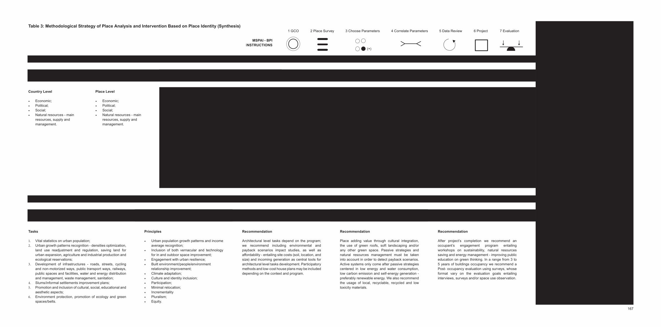
Table 3: Methodological Strategy of Place Analysis and Intervention Based on Place Identity (Synthesis)
G1 - Methodological Strategy of Place Analysis
G2 - Methodological Strategy of Place Intervention
Step 1 General Context Overview (GCO)
Country Level
Economic; Political;Social;Natural resources - main resources, supply and management.
Place Level
Economic; Political;Social;Natural resources - main resources, supply and management.
Steps goals
G1 – Step 1 goal: To inform on the social, economic and political country current situation as well as resources, helping to review emergent subjects to be subsequently addressed in the work’s timeline.
Step 2 goal: To measure place identity through the socio-cultural, the geographical and the built environment dimensions, targeting the design of more sustainable and place rooted projects through a deeper understanding of the inherent socio-spatial system.
G2 – Step 3 goal: To create a stronger and efficient space structure improving place livability aiming to decrease urban poverty and to develop an urban strategy towards a sustainable and inclusive future - always consider short, medium and long-term goals.
Step 4 goal: To establish a set of principles as project development tools helpful to generate more social and cultural inclusive projects - recommended principles are not limited to.
Step 5 goal: To direct architectural level tasks so produced space can be more economic, social and environmentally friendly.
Step 6 goal: To ensure a place-based approach centered in local resources management.
Step 7 goal: To improve future design response to a given environment.
Step 2 Place Survey Based on Place Identity (PSPI)
Socio-cultural parameters
Population growth estimation - country/region/city projections - rate of births and deaths;Place history; Cultural landscapes - sound and visual;People/environment relationship;Prevailing economic activities - economies of scale brought by agglomeration, income average, employment opportunities and skills, education opportunities for men and women;Funding, governance, and reporting;Local communities - number of tribes, religions, castes, age average, literacy rate, traditions, routines, community aspira-tions, skills; Cultural preferences - indigenous / non-indigenous culture; Socio-cultural practices - by tribe, religion, caste;Vernacular construction knowledge - construction skills, local technologies, technologies skills and access.
Geographical parameters
Climate change - causes and economic, social and environ-mental impact on the region;Bio-climate - annual mean temperature, mean diurnal range, isothermally, temperature seasonality, warmest month maximum temperature, coldest month minimum tempera-ture, temperature annual range, wettest, driest, warmest and coldest year quarter mean temperature, wettest and driest month annual precipitation, precipitation seasonality, wettest, driest, warmest and coldest quarter precipitation;Place micro-climate - site orientation, sun path, quarter of a year/year sunlight hours average, rainy and dry season, prevailing wind, air humidity, and pollution;Natural resources - forests, rivers and flood areas, water bodies, agricultural activities and productions, food supply, indigenous/non-indigenous fauna and flora, clean energy sources, local natural construction materials; Topography, land use, change, and classification - rural, urban, agriculture and nature reserves; Place character.
Built environment parameters
City location, urban growth patterns recognition - densities distribution, urban population growth; Urban network - green spaces/belts, facilities, and services distribution, public spaces, waste, roads fluency, walking/mobility/accessibility, urban transport network including public transportation, non-motorized and non-motorized vehicles, rush hours;Urban infrastructure network - roads, streets, bridges and railway network, services, industrial, public spaces and facilities network, water and energy distribution/manage-ment (including consumer demand, generation, and supply), waste management and recycling policies, sanitation, disable resources;Number of slums/ informal settlements - health, safety, number of persons living, materials and techniques, sanitation, light sources, number of dependencies, water source, distribution;Proportion, structure, color pallet, background/figure, shape, local scale, perceptual unity;Vernacular structures, conservation status.
Step 3Sustainability Tasks - Urban Level (STUL)
Step 4Principles as Tools (PT)
Step 5 Architectural Level Tasks (ATL)
Step 6 Placed Based Project Development (PBPD)
Tasks
Vital statistics on urban population; Urban growth patterns recognition - densities optimization, land use readjustment and regulation, saving land for urban expansion, agriculture and industrial production and ecological reservations; Development of infrastructures - roads, streets, cycling and non-motorized ways, public transport ways, railways, public spaces and facilities, water and energy distribution and management, waste management, sanitation; Slums/informal settlements improvement plans;Promotion and inclusion of cultural, social, educational and aesthetic aspects;Environment protection, promotion of ecology and green spaces/belts.
Step 7 Post-Occupancy Evaluation (POE)
Principles
Urban population growth patterns and income average recognition;Inclusion of both vernacular and technology for in and outdoor space improvement;Engagement with urban resilience;Built environment/people/environment
relationship improvement;Climate adaptation;Culture and identity inclusion;Participation;Minimal relocation;Incrementality Pluralism; Equity.
Recommendation
Architectural level tasks depend on the program; we recommend including environmental and payback scenarios impact studies, as well as affordability - entailing site costs (soil, location, and size) and incoming generation as central tools for architectural level tasks development. Participatory methods and low-cost house plans may be included depending on the context and program.
Recommendation
After project’s completion we recommend an occupant’s engagement program entailing workshops on sustainability, natural resources saving and energy management - improving public education on green thinking. In a range from 3 to 5 years of buildings occupancy we recommend a Post- occupancy evaluation using surveys, whose format vary on the evaluation goals entailing interviews, surveys and/or space use observation.
Recommendation
Place adding value through cultural integration, the use of green roofs, soft landscaping and/or any other green space. Passive strategies and natural resources management must be taken into account in order to detect payback scenarios. Active systems only come after passive strategies centered in low energy and water consumption, low carbon emission and self-energy generation - preferably renewable energy. We also recommend the usage of local, recyclable, recycled and low toxicity materials.
(+)
1 GCO 2 Place Survey 3 Choose Parameters 4 Correlate Parameters 5 Data Review 7 Evaluation6 Project
MSPAI - BPI INSTRUCTIONS
167

168
projects where we may use proposed methodological strategy as well as in new ways that we can explore it. For instance, if I want to create a strategy for the implementation of sustainable urban mobility models in the city of Lisbon (Portugal) we could choose from socio-cultural parameters - population growth estimation (city - projections), income average, local commu-nities (age average, literacy rate, routines, community aspi-rations); from geographical parameters - place micro-climate (site orientation, sun path, rainy and dry season, prevailing wind and air and pollution), topography, land use and land use change; and from the built environment parameters - city loca-tion, urban growth patterns recognition (densities distribution), urban network (green spaces/belts, facilities and services distribution, public spaces, roads fluency, walking/mobility/accessibility, urban transport network including public trans-portation, non-motorized and non-motorized vehicles, rush hours), urban infrastructure network (roads, streets, bridges and railway network, services, industrial, public spaces and facilities network, energy distribution/management (including consumption demand, generation and supply), structure and local scale. In addition, if needed, we also could add more parameters and extract from the G2 group matching project recommendations, as the environmental and payback scenarios impact studies, and the Post-occupancy evaluation.
When comparing the SPeAR to proposed methodological strategy the biggest difference relates to the fact that method-ological strategy offers a range of parameters allowing a place deeper analysis - from the macro to the micro scale - while SPeAR indicators are based on global sustainability stand-ards; less focused in the place itself. Thus, the methodological strategy focuses on sustainability solutions for a specific place while the SPeAR focuses on ensuring that global sustaina-bility standards are accomplished. Both tools promote inte-grated project thinking and holistic vision as project develop-ment tools, however, the proposed methodological strategy was created inside the contemporary urban environment sharp degradation context targeting its prevention, it is thus, unlike the SPeAR, a side effect the possibility to be used in other contexts and programs.
After the revision process and in order to simplify the usage of the methodological strategy two new items were added to its sections - the goals and the recommendations items. Thus, the final version of the methodological strategy of place analysis and intervention based on place identity presents as it follows:
G1 – Step 1: General Context Overview (GCO)
Goal: To inform on the social, economic and political country current situation as well as resources, helping to review emer-

169
gent subjects to be subsequently addressed in the work’s timeline.
Two levels must be explored: 1. Country Level; 2. Place Level, both encompassing the economic, political and social dimen-sion as well as natural resources (main resources, supply, and management).
Methods: Literature review (scientific papers, reports, offi-cial websites and online statistics - the United Nations, the World Resources Institute and the country’s Census, Migra-tion Observatories and Statistics Institutes are credible data sources; however it always requires specific research on the country official data sources), data critical selection and crossing.
Information systematization: Database, written documents, info-graphics (for instance: Adobe Photoshop, InDesign, Illus-trator, etc.), graphics and maps (for instance: Quantum GIS, ArcGIS, etc.).
G1 – Step 2: Place Survey Based on Place Identity (PSPI)
Goal: To measure place identity through the socio-cultural, the geographical and the built environment dimensions, targeting the design of more sustainable and place rooted projects through a deeper understanding of the inherent socio-spatial system.
Socio-cultural parameters: Population growth estimation (country/region/city projections - rate of births and deaths), place history, cultural landscapes (sound and visual; people/environment relationship), prevailing economic activities (econ-omies of scale brought by agglomeration), income average, employment opportunities and skills, education opportuni-ties for men and women, funding, governance and reporting, local communities (number of tribes, religions, castes, age average, literacy rate, traditions, routines, community aspi-rations, skills), cultural preferences (indigenous / non-indige-nous culture), socio-cultural practices (by tribe, religion and caste), vernacular construction knowledge (construction skills, local technologies, technologies skills and access).
Methods: Multi and transdisciplinary teams, diagrammatic drawings and sensory-relations maps, photographic and video recordings, locals interviews and/or surveys (including: Post-occupancy evaluation on thermal, visual and acoustic comfort, safety, cultural identification and indoor air quality; cognitive performance studies), further population studies (Census, United Nations Population Division, worldometers), space use observations, research, working closely with local authorities, local communities and local organizations,
170
measurements of the social and economic impact of invest-ment in the historic environment or in any other environment, comprehensive planning, phenomenological methodology.
Information systematization: Database, written documents, photography/video, GIS (for instance: Quantum GIS, ArcGIS, etc.), any Computer Aided esign software that suits the project needs (for instance: AutoCA , etc.) and info-graphics (for instance: Adobe Photoshop, In esign, Illustrator, etc.).
Geographical parameters: Climate change (causes and economic, social and environmental impact on the region),bio-climate - annual mean temperature, mean diurnal range, isothermally, temperature seasonality, warmest month maximum temperature, coldest month minimum tempera-ture, temperature annual range, wettest, driest, warmest and coldest year quarter mean temperature, wettest and driest month annual precipitation, precipitation seasonality, wettest, driest, warmest and coldest quarter precipitation), place micro-climate (site orientation, sun path, quarter of a year/year sunlight hours average, rainy and dry season, prevailing wind, air humidity and pollution), natural resources (forests, rivers and flood areas, water bodies, agricultural activities and productions, food supply, indigenous / non-indigenous fauna and flora, clean energy sources, local natural construc-tion materials), topography, land use, change and classifi-cation (rural, urban, agriculture and natural reserves), place character.
Methods: Multi and transdisciplinary teams, literature review, natural observation, photograph and video recording, biolog-ical ecosystem analysis, bio-climatic data analysis, climate and air pollution measurements (Worldwide Air Quality Monitoring
ata Coverage or the official country’s online databases on air pollution measurements, Meteonorm, CAIT Climate Data Explorer, Meteoblue, Word Weather and Climate Information, World Resources Institute), topographical survey (using 3 models), geographic data crossing.
Information systematization: Database, written documents, photography, geographic data crossing through GIS (for instance: Quantum GIS, ArcGIS, Google Earth Pro, etc.), country bio-climatic database, 3D visualization (for instance: 3 Studio Max, Sketchup, Rhino 3 , Grasshopper, etc.), CA software that suits the project needs (for instance: AutoCAD, etc.) and info-graphics (for instance: Adobe Photoshop, In e-sign, Illustrator, etc.).
Built environment parameters: City location, urban growth patterns recognition (densities distribution, urban population growth), urban network (green spaces/belts, facilities and services distribution, public spaces, waste, roads fluency,

171
walking/mobility/accessibility, urban transport network including public transportation, non-motorized and non-mo-torized vehicles, rush hours), urban infrastructure network (roads, streets, bridges and railway network, services, indus-trial, public spaces and facilities network, water and energy distribution/management (including consumption demand, generation, and supply), waste management and recycling policies, sanitation, disable resources), number of slums/informal settlements - health, safety, number of persons living, materials and techniques, sanitation, light sources, number of dependencies, water source, distribution), proportion, struc-ture, colour pallet, background/figure, shape, local scale, perceptual unity, vernacular structures and conservation status.
Methods: Hand drawing, natural observation, photography, sound and video recording, surveys and conversations with local people/authorities/NGO’s. Always a place-based approach including - cost considerations and payback scenarios studies, active research and studies on local collec-tive knowledge, studies of colour/natural light, comfort and safety trough users surveys analysis, survey on number of slums, urban networks and infrastructure networks (Census or other official source information depending on the country), studies/research and critical data interpretation on: water source and distribution, roads fluency and walking mobility, traffic mobility and public urban transport network, green and public spaces, local materials for construction survey and vernacular architecture knowledge mixing contemporary tech-nologies, built environment data crossing.
Information systematization: Database (regarding urban data), written documents, photography, data crossing and mapping through CAD software that suits the project needs (for instance: AutoCA , etc.) and GIS (for instance: Quantum GIS, ArcGIS, Google Earth Pro, etc.), BIM (for instance: ARC ICA , Revit, etc.), 3 visualization (for instance: 3 Studio Max, Sketchup, Rhino 3 , Grasshopper, etc.), info-graphics (for instance: Adobe Photoshop, In esign, Illustrator, etc.) and bespoke interactive tools that both analysis and visualize collected and previous existent data.
G2 – Step 3: Sustainability Tasks - Urban Level (STUL)
Goal: To create a stronger and efficient space structure - the part in the context of the all - improving place livability aiming to decrease urban poverty and to develop an urban strategy towards a sustainable and inclusive future.
Recommendations: The sustainability tasks must vary according to the type of project and system we will intervene; however we always most consider short, medium and

172
long-term goals.
Sustainability tasks at the urban level:
1. Vital statistics on urban population; 2. Urban growth patterns recognition - densities optimiza-
tion, land use readjustment and regulation, saving land for urban expansion, agriculture and industrial production and ecological reservations;
3. Development of infrastructures - roads, streets, cycling and non-motorized ways, public transport ways, railways, public spaces and facilities, water and energy distribution and management, waste management, sanitation;
4. Slums/informal settlements improvement plans;5. Promotion and inclusion of cultural, social, educational
and aesthetic aspects;6. Environment protection, promotion of ecology and green
spaces/belts.
G2 – Step 4: Principles as Tools (PT)
Goal: To establish a set of principles as project development tools helpful to generate more social and cultural inclusive projects.
Recommendations: We recommend following principles, however, they are not limited and they must be adjusted depending on project, program, culture, and location.
Principles:
Urban population growth patterns and income average recognition;Inclusion of both vernacular and technology for in and outdoor space improvement;Engagement with urban resilience;Built environment/people/environment relationship improvement;Climate adaptation;Culture and identity inclusion;Participation;Minimal relocation;Incrementality; Pluralism; Equity.
G2 – Step 5: Architectural Level Tasks (ATL)
Goal: To direct architectural level tasks so produced space can be more economic, social and environmentally friendly.
173
Recommendations: Architectural level tasks depend on the program; we recommend including environmental and payback scenarios impact studies, as well as affordability - entailing site costs (soil, location, and size) and incoming generation as central tools for architectural level tasks development. Partic-ipatory methods and low-cost house plans may be included depending on the context and program.
G2 – Step 6: Placed Based Project evelopment (PBP )
Goal: To ensure a place-based approach centered in local resources management.
Recommendations: Place adding value through cultural inte-gration, the use of green roofs, soft landscaping and/or any other green space. Passive strategies and natural resources management must be taken into account in order to detect payback scenarios. Active systems only come after passive strategies centered in low energy and water consumption, low carbon emission and self-energy generation - preferably renewable energy. We also recommend the usage of local, recyclable, recycled and low toxicity materials.
Methods: Inter and transdisciplinary teams (LEE and/or green professionals, conjoint research with universities, research groups/centres on sustainability or other relevant discipline, consulting with external experts), previous projects assessment, brainstorm and collaborative development, manual crafted including hand-sketching, detailed models at large scale (range from 1:5000 to 1:1), advanced 3D proto-typing, GIS space information, computer-generated analysis (including parametric modelling), 3 visualization. The inte-gration of augmented and virtual reality can be a plus for developing the best way to represent any facet of design for a particular context.
Information systematization for drawings development with measurements and construction details trough: CAD software that suits the project needs (for instance: AutoCA , etc.), BIM (for instance: ARCHICAD, Revit, Navisworks, Vico, Tekla, etc.), 3 visualization (for instance: 3 Studio Max, Sketchup, Rhino 3 , Grasshopper, etc.), GIS space information (for instance: Quantum GIS, ArcGIS, etc.) for info-graphics (for instance: Adobe Photoshop, In esign, Illustrator, etc.) and for passive and mechanical strategies design BEM (for instance:
asari – Ecotect, Passive esign Assistant, etc.).
G2 – Step 7: Post-occupancy evaluation (POE)
Goal: To improve future design response to a given environment.
174
Recommendation: After project’s completion we recommend an occupant’s engagement program entailing workshops on sustainability, natural resources saving and energy manage-ment - improving public education on green thinking. In a range from 3 to 5 years of buildings occupancy, we recommend a post-occupancy evaluation using surveys, whose format vary on the evaluation goals entailing interviews, surveys and/or space use observation.
Final Considerations and Future Outcomes According to the feedback obtained from uttered commu-nications, research vies for its bigger contribution to be the condensation of dispersed methods, tools and recommen-dations that are used separately, by different entities, in one single methodological strategy.
Having a methodological strategy comprising the place anal-ysis and intervention, encompassing parameters, steps, and recommendations, it helps to shorten the working time in the place survey and project concept development phase. Parameters help to identify faster and accurately the place key strengths and risk areas improving the process of sustaina-bility decision-making, expanding, at the same time, the place field of information supportive to design more social and envi-ronmental inclusive projects.
Working with parameters allow us to choose and create (by adding or subtracting parameters) the parameters set we need, given the necessary flexibility to adapt the methodo-logical strategy according to the project type. Parameters promote holistically and integrated place/project thinking towards a set of locally optimized solutions helpful to identify payback scenarios as well as future investment areas.
As future outcomes, we want to introduce the methodological strategy into the architecture praxis as a sustainability project development tool. We will present it to software development companies to study the possibility of transforming it in soft-ware - a digital skeleton - so that it is easier to use. Then, we need to present the digital application near architecture/urban planning offices and check their availability to introduce it in respective projects, so we can trace its performance aiming its update into a more efficient tool.
Limitations
A survey process was, also, needed for us to present, review and validate the methodological strategy near architects, urban planners, and academics in the field. owever, few answers were received - only fourteen. In this process, we learn: 1st. the urgency of being more creative regarding surveys and
175
2nd. the need to be more proactive in searching other chan-nels and methods for a validation process.
We assumed that by sending the questionnaire to architecture and urban planning studios only architects and urban planners would respond. This assumption was wrong; in an architec-ture studio also work, among other professionals, engineers and designers. We learn not to assume the obvious as being true - especially inside a scientific process - and to be even more rigorous when it comes to collect data. Thus, for future questionnaires we will add a participant’s information field (comprising: age, profession, academic degree, etc.) in order to trace data more accurately and, if necessary, to correlate participant’s information with given answers aiming the detec-tion of patterns helpful to better improve work.
For the survey sending, we also asked for the Portuguese Architects Board help (Ordem dos Arquitectos - OA) in order to disseminate the survey through its respective mailing list. However OA was in elections time - for the new social bodies - thus respective help was not possible.
We sent our survey, mostly, for architecture studios leaders in sustainability - the majority big and busy studios - since our main concern was to boost the project process in order to deliver more sustainable and place rooted design solutions we prioritized target studios. We learned that we should open the sample spectrum and to include smaller and, probably, less busy studios increasing our chances of responses as well as the diversity of points of view.
176
References
SPeAR, ARUP (2000). Sustainable Project Appraisal Routine. Accessed on 05.01.2017 at: http://www.arup.com/projects/spear
http://www.oasys-software.com/spearapp/app/flash.html
O’Donnell, Michael; Ignizio, rew A. (2012). Bioclimatic Predic-tors for Supporting Ecological Applications in the Contermi-nous United States. ata Series 691. U.S. epartment of the Interior. U.S. Geological Survey. enver Publishing Service Center.
Sites
Rede Lusófona de Morfologia Urbana (PNUM): http://www.pnum2013.dec.uc.pt/
PNUM: http://pnum.fe.up.pt/pt/
2016 II International Congress on Sustainable Collective ousing: http://laboratoriovivienda21.com/congreso2/ page
id=89II Congresso Internacional de Habitação Coletiva Sustentável: http://laboratoriovivienda21.com/congreso2/
22nd International Sustainable Development Research Society Conference (Rethinking Sustainability Models and Practices: Challenges for the New and Old World Contexts):http://isdrs2016.sites.exordo.com/
International Sustainable Development Research Society: http://isdrs.org/
BREEAM: http://www.breeam.com/CEEQUAL: http://www.ceequal.com/LEE : http://www.usgbc.org/leedOrganization for Economic Co-operation and evelopment: https://www.oecd.org/

Chapter IV: Research Conclusions

179
Research Discussion and Conclusions
At Chapter I, we have defined the basilar concepts of this research, ‘Place Identity’ and ‘Socio-spatial system’. The concept of place identity refers to the interaction of the place qualities, i.e. the geographical, the built environment and the socio-cultural dimensions. The concept of the socio-spatial system is defined by a system formed by the three claimed space qualities - i.e. the geographical, the built environment and the socio-cultural dimensions - appealing to a systematic understanding where space and human beings are read as one: people-in-place.
By its basilar concepts - place identity and the socio-spatial system - research reinforces knowledge about a holistic reading of space that includes its quality program (place identity) as a key element for project development and program implementation, opening a space for reflection and debate helpful for the advances in architecture and urbanism.
We call this ‘more’ profound way of thinking space as systematic. By system, we designate a holistic space experience which cannot be reduced to the unity divided into three components: the geographical, the built, and the socio-cultural environment, whose relation allows amplifying or decreasing the functioning of the place socio-spatial system and, consequently, its identity.
Inside this research, as the previously stated, we understand place identity not as an individual way of experiencing place but as a persistent sameness allowing a thing to be different from the other. In this context, we assume across geographical qualities that the place already contains specific genius loci, a space primary identity that can be augmented or reduced through human actions constituting a single and unique heritage of each place, and this is why we advocate its relevance in space production. A uniqueness belonging to each and specific place, distinguished from the sense of place by the fact that it irradiates from the physical environment to the human being and not as a sensibility that emanates from the human to the place.
Place identity acts as a reminder of the fact that different places offer different cultures, languages, and narratives upgrading the architectural discourse, enriching place diversity and the people’s conceptual experience of living; contributing to promote more place rooted projects, crucial to building inclusive and resilient environments. Inside contemporary context, the urban and the architectural paradigm are no longer uncontrolled consummation of physical and social resources but their sustainable optimization, only possible through a
180
place deep and holistic understanding. This new paradigm shift requires cities to respond hurriedly through new practices facing sustainability goals and programs considering its spatial qualities as a project foundation, promoting locally optimized solutions to the design more resilient systems.
In this context, at Chapter II we tested the methodological strategy of place analysis and intervention based on place identity - whose first version was drafted in Chapter I after the literature review. At Chapter II we analyzed the sustainable project methodologies of 10 architecture studios in order to reinforce and stabilize our first draft of the proposed methodological strategy, later tested to two case studies Mumbai (India) and Nyeri (Kenya).
From this experience, we were able to distinguish 2 groups of parameters i.e. the transversal ones, common to any environment, and the new ones added by the need to operate in a different environment, in our research lower-income countries - demanding new space readings, and, for that so, new parameters. Transversal parameters include: Climate change, place micro-climate, natural resources, local materials, topography, place character, land use and change, city location, density distribution, users/buildings relationship, urban network, infrastructure, governance, proportion, structure, vernacular structures, conservation status, color pallet and background/figure. New parameters include: Population growth estimation, prevailing economic activities (including: economies of scale and income average, funding), local communities (including: number of tribes, religions and castes), age average, literacy and the number of houses/slums (including: safety, number of persons living, materials and techniques, sanitation, main light sources, number of dependencies, water source and distribution). Parameters which, also, may be used in other contexts.
As we started to argue in the beginning of our research, cities have become very complex systems facing huge and global challenges related to sustainable development - encompassing the lack of space, life quality degradation and the urgency of their resources management. More than ever cities are environments demanding systematic and global thinking, requiring strategies in detriment of ‘’static’’ solutions. A strategy applies to an algorithmic reasoning, establishing a set of steps and goals that must be understood as a flexible recommendation for future interventions. In this context, the proposed methodological strategy is faced as a flexible project development tool composed of 2 different groups G1 and G2, and a set of 7 steps, respectively: G1 Place Analysis, composed by Step 1 - General Context Overview and Step 2 - Place Survey Based on Place Identity. G2 Place Intervention, constituted by Step 3 - Sustainability Tasks - Urban Level,
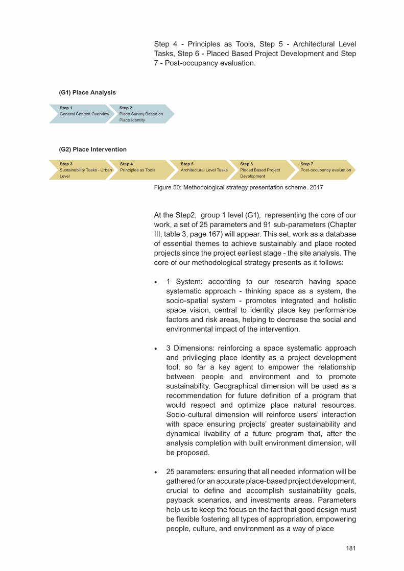
181
Step 4 - Principles as Tools, Step 5 - Architectural Level Tasks, Step 6 - Placed Based Project evelopment and Step 7 - Post-occupancy evaluation.
At the Step2, group 1 level (G1), representing the core of our work, a set of 25 parameters and 91 sub-parameters (Chapter III, table 3, page 167) will appear. This set, work as a database of essential themes to achieve sustainably and place rooted projects since the project earliest stage - the site analysis. The core of our methodological strategy presents as it follows:
1 System: according to our research having space systematic approach - thinking space as a system, the socio-spatial system - promotes integrated and holistic space vision, central to identity place key performance factors and risk areas, helping to decrease the social and environmental impact of the intervention.
3 imensions: reinforcing a space systematic approach and privileging place identity as a project development tool; so far a key agent to empower the relationship between people and environment and to promote sustainability. Geographical dimension will be used as a recommendation for future definition of a program that would respect and optimize place natural resources. Socio-cultural dimension will reinforce users’ interaction with space ensuring projects’ greater sustainability and dynamical livability of a future program that, after the analysis completion with built environment dimension, will be proposed.
25 parameters: ensuring that all needed information will be gathered for an accurate place-based project development, crucial to define and accomplish sustainability goals, payback scenarios, and investments areas. Parameters help us to keep the focus on the fact that good design must be flexible fostering all types of appropriation, empowering people, culture, and environment as a way of place
(G1) Place Analysis
(G2) Place Intervention
Step 1 General Context Overview
Step 2 Place Survey Based on Place Identity
Step 3Sustainability Tasks - Urban Level
Step 4Principles as Tools
Step 5Architectural Level Tasks
Step 6Placed Based Project
evelopment
Step 7Post-occupancy evaluation
Figure 50: Methodological strategy presentation scheme. 2017
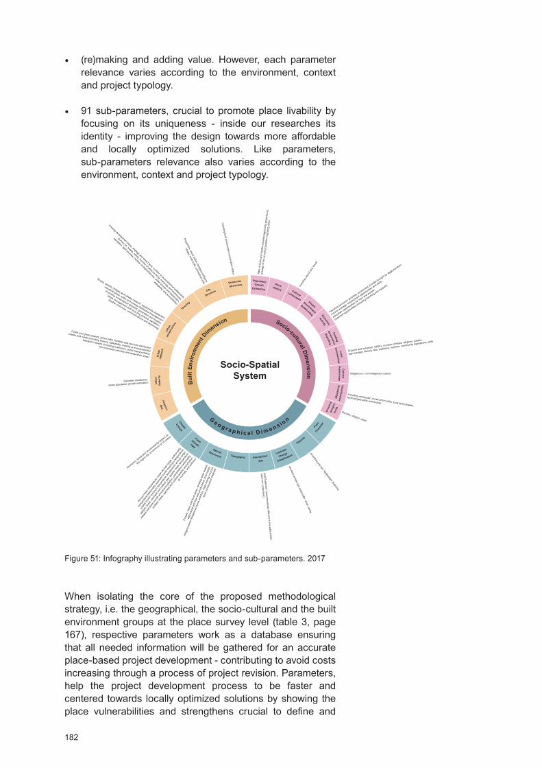
182
(re)making and adding value. owever, each parameter relevance varies according to the environment, context and project typology.
91 sub-parameters, crucial to promote place livability by focusing on its uniqueness - inside our researches its identity - improving the design towards more affordable and locally optimized solutions. Like parameters, sub-parameters relevance also varies according to the environment, context and project typology.
When isolating the core of the proposed methodological strategy, i.e. the geographical, the socio-cultural and the built environment groups at the place survey level (table 3, page 167), respective parameters work as a database ensuring that all needed information will be gathered for an accurate place-based project development - contributing to avoid costs increasing through a process of project revision. Parameters, help the project development process to be faster and centered towards locally optimized solutions by showing the place vulnerabilities and strengthens crucial to define and
Socio-Spatial System
Built
Env
ironm
ent D
imension Socio-cultural Dim
ension
G e o g r a p h i c a l D i m e n s i on
Population Growth
Estimation
Place History CulturalLandscapes People
Environment
Relationship Economic
Activity
Funding
Governance
Reporting
Local
Comm
unities Cultural
Preferences Socio
Cultural Practices
Construction Know
ledge
City
Loca
tion
Urba
n Pa
ttern
s
Urba
n
Urba
n
Netw
ork
In
frast
ruct
ure
Housing
Structure City
Vernacular
Structures
Change Climate
Data
Climate
Place
Site Intervention
Resources
Natural
Classification Change Land Use
Chara
cter
Hazards
Topography
Place
Economic, socia
l and environmental im
pact on
the region (fo
r a m
inimum of 10 ye
ars)
Annu
al mea
n tem
pera
ture,
mean d
iurna
l rang
e, iso
therm
ally,
tempe
ratur
e sea
sona
lity, w
armes
t mon
th max
imum
tempe
ratur
e,
colde
st mon
th mini
mum te
mpera
ture,
tempe
ratur
e ann
ual ra
nge,
wettes
t, drie
st, w
armes
t and
colde
st ye
ar qu
arter
mea
n tem
pera
ture,
wett
est a
nd dr
iest m
onth
annu
al pr
ecipi
tation
, pre
cipita
tion s
easo
nality
,
wettes
t, drie
st, w
armes
t and
colde
st qu
arter
prec
ipitat
ion,
air hu
midity
and p
olluti
on
Orie
ntat
ion,
sun
pat
h,
natu
ral l
ight
hou
rs a
vera
ge (w
inte
r/sum
mer
), pr
evai
ling
win
d
Fore
sts,
rive
rs a
nd fl
ood
area
s, d
rinkin
g wa
ter b
odie
s,
agr
icultu
ral a
ctivi
ties
and
prod
uctio
ns, f
ood
supp
ly,
indi
geno
us/n
on-in
dige
nous
faun
a an
d flo
ra, c
lean
ene
rgy
sour
ces,
loca
l con
stru
ctio
n m
ater
ials
Rura
l, ur
ban,
agr
icultu
re a
nd n
atur
al re
serv
es
Includ
ing vu
lnera
bility
, risk
and f
requ
ency
Densities distribution,
urban population growth estimation
Public and green spaces, green belts, facilities and services distribution,
streets and roads (including fluency, walkability, mobility and accessibility)
transport network (including rushhours, public transportation,
non-motorized vehicles and pedestrian ways)
Roads, streets, bridges and railway network, equipments distribution,
industrial areas, water and energy distribution/management
(including consumption demand, generation and supply),
waste management and recycling policies, sanitation,
disable resources, communications and technology
housing development plans, strategy and saved land, number of slums/informal settlements
(survey on: health, safety, number of persons living, materials and techniques,
sanitation, light sources, number of dependencies, water source and distribution,
walkability and accessibility)
Proportion, colour pallet, background/figure,
shape, local scale, perceptual unity
Including built environment conservation status R
ate
of b
irths
and
dea
ths
(cou
ntry
/regi
on/c
ity p
roje
ctio
ns),
aver
age
of th
e an
nual
pop
ulat
ion
mig
ratin
g ci
ties
Inclu
ding
soun
d an
d vis
ual
Pevailing economic activities, economies of scale brought by agglomeration,
income average, employment opportunities and skills,
education opportunities for m
en and women,
bussines opportunities (in
cluding planning and support)
Support and cohesion, ONG’s, number of tribes, religions, castes,
age average, literacy rate, traditions, routines, community aspirations, skills
Indigenous / non-indigenous culture
Including vernacular, construction skills, local technologies,
technologies skills and access
By tribe, religion, caste
Figure 51: Infography illustrating parameters and sub-parameters. 2017
183
accomplish sustainability goals, and to calculate the project responses to a given system. To understand space as a system (the socio-spatial system) means to recognize that every space parameter - i.e. buildings, roads, culture, wind, rain, etc. - work in interdependency improving or decreasing the livelihoods of the place. It appeals to an integrated space vision particularly relevant inside the contemporary urban context where, mainly, we will operate in existent systems comprising a strong and complex network of mutual influences claiming its optimization through a sustainable and resilient process.
Sustainability no longer relates to the ecological dimension, in fact, it embeds economic, social, cultural, political and built environment dimensions - it is thus multi-dimensional - and this is why we claim place identity as a central tool to project development. For being a place permanent core, place identity helps to reinforce the bonds between people and place - becoming a substructure of the self, amplifying the sense of belonging.
The proposed methodological strategy can be used by architects, urban planners, sustainability consultants, infrastructure designers, and Cities Municipal Councils. The tool has the capacity to cover the design, delivery, and evaluation of Infrastructures, master-plans, and individual buildings. It was designed to promote sustainability decision making across all project stages - concept, inception, and evaluation. In an early stage, the place survey, it can be used to identify the place key performance parameters, risk areas, and payback scenarios. uring the design stage, though the given set of parameters, one can better understand the potential of a place resources and respective patterns of interdependence. A process central to calculate the project design hypotheses and to better predict their performance in the real world, improving, for that so, the design response to its environment. After project’s completion, it can be used to undertake project performance evaluation, informing on different approaches and results, increasing knowledge on sustainability and project development towards locally optimized solutions.
Through the case studies, we also realize that having a predefined set of parameters and recommendations helped the project research and survey process to be faster and place oriented. It aids creating an expanded field of information, regarding the place, crucial to understanding the context of the context, relevant to design responses that are embedded in a larger system. Each given parameter changes the equation and helps to center in a set of locally optimized solutions enhancing the uniqueness of each place - inside of our research its identity. Independently of the context, even if we are familiar with, it is always fundamental to listening the
184
question, not being assumptive; due to the scarcity of means, especially, in lower-incoming countries ‘’to listen’’ becomes a development tool. Parameters made us realize that good design doesn’t have to be ‘shiny’ rather, it must be flexible fostering all types of appropriation, empowering people, culture, and environment as a way of place adding value.
Presented methodological strategy arose from the concern related to the urban built environment and life quality sharp degradation - particularly in developing countries - and it was designed to become a development tool inside this context.
owever, it presents as a positive side effect the possibility to be applicable to other programs, scales, and environments. In any case, it must be understood as a flexible recommendation from which we can add, or subtract, parameters and steps in order to be adjusted to the place and project needs.
The proposed methodological strategy supports sustainable decision-making throughout project different stages, promoting strategic and holistic sustainability thinking. The methodological strategy is not only about a specific place, program or scale; it is about bringing to the front primitive knowledge and common sense, negotiating with the place and its dimensions in order to create, or strengthen, a resilient and sustainable place rooted socio-spatial system. It is about adding value to place instead of mere objects. The proposed methodological strategy of place analysis and intervention must be understood as a flexible recommendation for future interventions, prioritizing the optimization of existing resources, instead of a hermetic solution for every place or program.
According to communications feedback, the research biggest contribution is the condensation of dispersed methods, tools and recommendations, that are usually used separately by different entities, in one single methodological strategy of place analyses and intervention representing, for that so, an important space for reflection and for the advances of the praxis and the theory in architecture and urbanism.
Research Limitations
Major research limitations were related to time and resources. We do recognize that case studies, especially the Mumbai one, needed more time and resources - such as budget and a permanent core team treating data while we were researching on the subject. owever, those limitations taught us to be more focused and selective, to create tangible timelines with realistic tasks and to be creative with available resources in order to accomplish research goals.
Another limitation related whit available data - and its quality - arose when analyzing the architecture studios methodologies.

185
In the studio’s websites very little is said about the respective approach and, the majority of times, what is available is quite poor regarding the content. When contacting studios, to obtain more information, we noted that many emails whore outdated and many did not reply. From this experience, we learn two things. First, it is equally important to study the studio’s projects in order to complete website information regarding respective practices. Second, as architects and planners, we should be more collaborative and to make practices information available reinforcing, that way, the collective knowledge about new approaches. Thus, we decided that research will be available on a digital platform to be consulted and improved - open source model - contributing to reinforce the knowledge in the praxis and in the theory of sustainable projects development.
At least, the research validation through an email survey also imposed a limitation for the methodological strategy (re)calibration and usability feedback. In order to be validated the methodological strategy was sent an email survey to architects, urban planners, and academics. The emails, even after insisting, weren’t replied and some answered advising to contact other time for a job application, meaning they didn’t read the email. We learned that ‘’architecture praxis crises’’ it’s not only due to financial instability, or paradigm shifts it also relates to the fact that we don’t care, we don’t listen, we assume and then we reply wisely to the wrong question. This is also a metaphor for our research. We learn that, in future researches, our validation will not depend, mostly, of a survey and that we need to count whit the professional’s lack of time, among other factors, as a development tool for new and more creative ways to obtain feedback.
Research Pathways
We want to continue to develop the present research, thus, we are studying the possibility to transform the research results - i.e. the methodological strategy of place analysis and intervention based on place identity - into a software. An idea influenced by the ARUP SPeAR software analysis and, later, reinforced by the EMEL meeting.
In February 2017, we had a meeting with part of the EMEL project managers’ board - the Lisbon Municipal Mobility and Parking Company – where we presented the methodological strategy as a project development tool, also useful, to design sustainable mobility projects. The board was very receptive regarding the presented methodological strategy, however, they suggested the transformation of its core parameters into software in order to be more easily used. They offered their support to test the software in their respective projects, as well as to build a bridge with the Lisbon City all, in order the

186
methodological strategy to be also tested in urban planning and urban recovery projects.
Currently, the proposed methodological strategy is running for the ‘ ubai International Awards for Best Practice’ ( IABP) in the category ‘University Research Award on Legislation, Rules, Regulations Governance Systems’. The ubai international award is a prestigious prize that recognizes works and research relevance for the advances towards sustainable projects. We know (due to the organization’s email) that in October 2017, the proposed methodological strategy was approved, referred, and forwarded by the IABP Award Secretariat for the Technical Advisory Committee (TAC) - in order to proceed to its final evaluation, leading to the final prize. owever, the final results will only be available in ecember 2017.
187
Research Bibliography
Aecom Consult (2006). International urban road pricing. Final report prepared for Office of Transportation Policy Studies, Federal ighway Administration, US epartment of Transportation, Fairfax, irginia
Aoun, A. (2010). Traffic and transit in Beirut, Lebanon. Unpublished Master’s thesis, Energy Resources Group, University of California, Berkeley
Allan, P. M. (1997). Cities and Regions as Self-Organized Systems: Models of Complexity, London, UK, Routledge
Albalate, .; G. Bel and J. Calzada (2012). Governance and regulation of urban bus transportation: Using partial privatization to achieve the better of two worlds. Regulation Governance, 63. 83-100
Alberta Health Services (2008). ‘Land use planning and health’, ealthy public policy information sheet. Accessed 25.03.2013 at: http://www.albertahealthservices.ca/poph/hi-poph-hppinfo-land-use.pdf
Altshuler, A. (1979). The Urban Transportation System: Politics and Policy Innovation, MIT Press, Cambridge, Massachusetts
Andreson, E. (2006). Urban landscapes and sustainable cities. Ecology and Society
Angel, S.; J. Parent; .L. Civco; A. Blei and . Potere (2011). The dimensions of global urban expansion: Estimates and projections for all countries, 2000-2050. Progress in Planning
ol. 75
Angel, Schlomo; Jason Parent; aniel L. Civco and Alejandro M. Blei (2011). Making Room for a Planet of Cities, policy focus report. Cambridge, MA: Lincoln Institute of Land Policy
Antrop, Marc (2004). Landscape change and the urbanization process in Europe. Landscape and Urban Planning, 67. 9-26
Bailey, L. (2004). Aging Americans: Stranded withoutOptions, Surface Transportation Policy Project 2004. Accessed 25.03.2013 at: http://www.apta.com/resources/reportsandpublications/ ocuments/aging stranded.pdfv
Banister, . (1992). Energy use, transport and settlement patterns. Sustainable evelopment and Urban Form. M. J. Breheny. London, UK, Pion Ltd
188
Balassiano, R. and R.W.C. Alexandre (2011). Informal motorized trans port in Rio de Janeiro, Brazil. Unpublished case study prepared for the Global Report on: uman Settlements 2013, www.unhabitat.org/grhs/2013
Balk, .; M.R. Montgomery; G. McGranahan; . Kim; . Mara; M. Todd; T. Buettner and A. orelien (2009). Mapping Urban Settlements and the Risks of Climate Change in Africa, Asia and South America. In: Population ynamics and Climate Change, edited by J.M.Guzmán; G. Martine; G. McGranahan;
. Schensul and C. Tacoli. New ork: UNFPA, London: IIE , 80 -103
Banister, . (1998). Transport Policy and the Environment.Spon, London
Banister, . (2005). Unsustainable Transport: City Transportin the New Century. Routledge, London
Barter, P. A. (1999). Transports and urban poverty in Asia. A brief Introduction to the Key issues
Batty, Michael (2008). The size, scale, and shape of cities. Science, n. 5864, ol. 319
Becker, C.M. (2008). Urbanization and Rural-Urban Migration. In International andbook of evelopment Economics. A.
utt, J. Ros, Eds. Edward Elgar Publishing, Northampton, MA
Becker, C. M., Morrison, A. R. (1999). Urbanization in transforming economies. In P. Cheshire E. S. Mills (Eds.),
andbook of regional and urban economics. Amsterdam: North- olland. Applied urban economics, vol3
Becker, .-J.; S. Stark and M. Abraham (2008). Bicycle Parking in Berlin – A Planning Guide. Accessed 18.04.2013 at: http://130.149.80.38/spicycles/dokumente/ws4/Guide%20BikeParking%20Berlin%20.pdf
Bloom, .; Canning ., and G. Fink (2008). Urbanization and the Wealth of Nations. Science, ol. 319
BMRDA (1994). raft Regional Plan for Mumbai Metropolitan Region 1996-2011 Mumbai
Bronfenbrenner, U. (1994). Ecological models of human development International encyclopedia of education. Oxford, Elsevier. 2 ed., ol. 3
Cohen, Barney (2006). Urbanization in developing countries: Current trends, future projections, and key challenges for sustainability. Technology in Science ol. 28

189
Cohen, R. B. (1981). The new international division of labor, multinational corporations and urban hierarchy. In M. ear A. J. Scott (Eds.), Urbanization and urban planning in capitalist society. London: Methuen
Coombes, M. Raybould, S. (2001). Public policy and population distribution: developing appropriate indicators of settlement patterns. Environment and Planning C: Government and Policy
Champion, A.G. (1989). Counter urbanization: The Changing Pace and Nature of Population econcentration. London: Edward Arnold
Day, Christopher (2004). Places of the Soul: Architecture and Environmental esign as a ealing Art. S.l : Architectural Press
de Vries, Jan (1990). Problems in the measurement, description, and analysis of historical urbanization. In A. van der Woude, A. ayami, and J. de ries Eds. Urbanization in
istory. Oxford: Clarendon Press
Desai, Padma Asit (2001). The Mumbai Urban evelopment Programme, Mumbai, India. Third World Planning Review
Desai, andana (1995). Community Participation and Slum ousing - A Study of Mumbai Sage Publications, New elhi
Dili, A. S.; Naseer, M. A.; acharia, . T. (2011). Passive control methods for a comfortable indoor environment: Comparative investigation of traditional and modern architecture of Kerala in summer. Energy and Buildings. 43 (2-3), 653-664.
Dodman, avid; Brown, onald; Francis, Katie; ardoy, Jorgelina; Johnson, Cassidy; Satterthwaite, avid (2013). Understanding the nature and scale of urban risk in low- and middleincome countries and its implications for humanitarian preparedness, planning and response. uman Settlements
iscussion Paper Series Climate Change and Cities. 4. International Institute for Environment and evelopment.
uman Settlements Group. March.
Duranton, G. and . Puga (2004). Micro-foundations of Urban Agglomeration Economies. . enderson and J.F. Thisse, eds. Amsterdam: North olland. Chp. 48 in andbook of Regional and Urban Economics, ol. 4
European Commission, irectorate General for Regional Policy (2011). Cities of tomorrow - Challenges, visions, ways forward, European Commission
190
Fay, Marianne and Charlotte Opal (1999). Urbanization without growth: A not-so-uncommon phenomenon. World Bank Policy Research Working Paper No. 21412, World Bank, Washington, C
Friedmann, J. (1986). The world city hypothesis. evelopment and Change ol. 17, no. 1
Friedmann, J. (1995). Where we stand: a decade of world city research. In P. L. Knox P. J. Taylor (Eds.), World cities in a world-system. Cambridge University Press. 21-47
Friedmann, J. Wolff, G. (1982). World city formation: an agenda for research and action. International Journal of Urban and Regional Research
Frey, W. . immer, . (2001). efining the city. In R. Paddison, andbook of urban studies. London: SAGE Publications
Gill, Rajesh (1994). Slums as Urban illages Rawat Publications, New elhi
Grübler, Arnulf and avid Fisk (2013). Energizing Sustainable Cities: Assessing Urban Energy. Abingdon, United Kingdom: Routledge
Gray, John N (2006). omestic mandala: architecture of lifeworlds in Nepal. S.l: Ashgate Publishing, Ltd
Hall, P (1966). The world cities. London: World University Press
Hall, P., Pfeiffer, U. (2000). Urban future 21: a global agenda for twenty-first century cities. London and New ork: E FN Spon
Hari, A. R. (2000). Amazing science of vaastu. S.l: A.R
Hoornweg, aniel; Lorraine Sugar and Claudia Lorena Trejos Gomez (2011). Cities and greenhouse gas Emissions: moving forward. Environment and Urbanization, ol. 23, no.1
Hugo, G.; Champion, A. Lattes, A. (2001). New conceptualisation of settlement for demography: beyond the rural/urban dichotomy. Paper presented at the International Union for the Scientific Study of Population (IUSSP) general population conference, Bahia, Brazil, August 2001. Mimeographed, Adelaide University
Holman, N. (2009). Incorporating local sustainability indicators into structures of local governance: a review of the literature.
191
Local Environment ol 14, No 4, 365-375. Accesse 08.9.2015 at: http://eprints.lse.ac.uk/30803/
International Organization for Migration (2015). Migrants and Cities: New Partnerships to Manage Mobility. 2015 International Organization for Migration (IOM)
Jones, G. W.; Tsay, C. L. Bajracharya, B. (2000). emographic and employment change in the megacities of
Southeast and East Asia. Third World Planning Review
Jha, S.S. (1986). Structure of Urban Poverty - The Case of Mumbai Slums Mumbai Popular Prakashan, Mumbai
, N. (1981). The limits of population forecasting. Population and evelopment Review
Krishna, Talavane (2001). The aastu Workbook: Using the Subtle Energies of the Indian Art of Placement to Enhance
ealth, Prosperity, and appiness in our ome. S.l : Inner Traditions
Knok, Paul; L. Taylor, Peter, J. (2003). World Cities in a World-system. Cambridge University Press. igital print. Edit by Paul Know and Peter Taylor
Lawlor, Robert (2002). Sacred Geometry: Philosophy and Practice. S.l: Thames and udson
Lin, G. C. S. (2002). Urbanization and the changing system of cities in Socialist China: a historical and geographic assessment. Journal of Population Studies ol 24 (June)
Linden, E. (1996). The exploding cities of the developing regions. Foreign Affairs
Loulanski, T (2006), Revising the Concept of Cultural eritage: The Argument for a Functional Approach. International Journal of Cultural Property ol 13, no 2. 207-233
Marriot, M. (1976). indu transactions: diversity without dualism. In B. Kapferer Ed. Transaction and meaning: directions in the anthropology of exchange and symbolic behaviour Montgomery, R. Mark, and others (2004). Cities Transformed:
emographic Change and its Implications in the eveloping World. London: Earthscan
Murcutt, Glenn (2006). A singular architectural practice. By aig Beck and Jackie Cooper, Images Publishing, Melbourne
MMRDA (2002). Mumbai Urban Transport Project -
192
Resettlement Action Plan, Unpublished Report, Mumbai
National Research Council (2000). Beyond six billion: forecasting the world’s population. J. Bongaarts R. A. Bulatao (Eds.), Panel on population projections. Committee on Population. Washington, C: National Academy Press
Organization for Economic Co-operation and Development (2012). Redefining Urban : A New Way to Measure Metropolitan Areas, OEC Publishing
Orr, . (2007). Architecture, ecological design, and human ecology. In K. Tanzer R. Longoria (Eds.), The Green Braid: Towards an Architecture of Ecology, Economy and Equity
Perry, B and T May (2010), Urban knowledge exchange: devilish dichotomies and active intermediation. International Journal of Knowledge-Based evelopment ol 1. 6-24
Rapport, A. (2005). Culture, architecture, and design: Locke Science Pub. Co
Russell, Beverly; Maddox, Eva L.; Ameen, Farooq (2015). Fifty Under Fifty: Innovators of the 21st Century. Images Publishing
Sassen, S. (2000). Cities in a world economy (2nd ed.). Thousand Oaks, CA: Pine Forge Press
Sassen, S. (2001). Cities in the global economy. In R. Paddison (Ed.), andbook of urban studies (pp. 256-272). London: Sage Publications
Sassen, S. (2002). Global networks, linked cities. New ork: Routledge
Savitch, . . (1996). Cities in a global era: a new paradigm for the next millennium. In M. A. Cohen, B. A. Ruble, J. S. Tulchin, A. M. Garland (Eds.), Preparing for the urban future: global pressures and local forces. 39-65. Washington, C: Woodrow Wilson Center Press
Seto, K., B. Guneralp and L.R. utyra (2012). Global forecasts of urban expansion to 2030 and direct impacts on biodiversity and carbon pools. PNAS ol. 09, no. 40
Schlappa, ans and William J. . Neill (2013). From crisis to choice: re-imagining the future shrinking cities, URBACT, European Union
Scott, A. J. (2001). Global city-regions: trends, theory, policy. Oxford: Oxford University Press
193
SPARC (1985). We, the Invisible: A Census of Pavement wellers, Bombay
Taylor, P. J. Walker, . R. F. (2001). World cities: a first multivariate analysis of their service complexes. Urban Studies
ol 38, no. 1
UCLG (2014), ow to Localize Targets and Indicators for the Post-2015 Agenda. Accessed 23.5.2015 at: http://www.uclg.org/sites/default/files/localization targets indicator web.pdf.
UNH, UN- abitat (2011). ot cities: Battle-ground for climate change. UN- abitat, Nairobi
UNH, UN- abitat (2011).Cities and Climate Change. Global report on human settlements 2011. United Nations uman Settlements Programme. Edit by UN- abitat, London. Washington, C
UN, United Nations (2014), The Millennium evelopment Goals Report 2014. Accessed 23.5.2015 at: http://www.un.org/millenniumgoals/2014%20M G%20report/M G%202014%20English%20web.pdf
UN, United Nations (2015). The Millennium evelopment Goals Report 2015. United Nations new ork, 2015
UNH, UN- abitat (2015). Understanding Urbanisation: Monitoring urban dynamics in a fragile and resource-constrained context. Accessed 23.5.2015 at: http:// unhabitat.org/understanding-urbanisationmonitoring-urban-dynamics-in-a-fragile-andresource-constrained-context-discussion-paper-9/
Visaria, L. isaria, P. (1995). India’s population in transition. Population Bulletin ol 50, no.3 Wakely, Patrick (2014). Urban public housing strategies in developing countries: whence and whither paradigms, policies, programmes and projects. The Bartlett evelopment Planning Unit. PU60 Working Paper Series: Reflections NO. 163/60. July
World Energy (2015). World Energy Outlook Special Report 2015: Energy and Climate Change
Wu, W. usuf, S. (2001). Shanghai: rising in a globalizing world. In J. Gugler Ed. World cities in poor countries. Cambridge: Cambridge University Press
Yeung, . M. (1995). Globalization and world cities in developing countries. In R. Stren J. K. Bell (Eds.). Urban

194
research in the developing world: ol. 4. Perspectives on the city. Toronto: University of Toronto Press. 189–226
Yeung, . M. (2002). New challenges for development and modernization: ong Kong and the Asia- Pacific Region in the new millennium. ong Kong: The Chinese University Press
Yuva Montgomery (2001). Final Report for Slum Sanitation undertaken for Mumbai Sewerage isposal Project (MS P) Mumbai - Watson Consultants
On-line articles
Mother Jones: http://www.motherjones.com/environment/2016/06/climate-manifesto
Na Noruega já não se abatem árvores: http://p3.publico.pt/actualidade/ambiente/20869/na-noruega-ja-nao-se-abatem-arvores
Projectos de Bairros de lata que são tanto dos arquitectos como da comunidade: https://www.publico.pt/culturaipsilon/noticia/os-projectos-de-bairros-de-lata-que-sao-tanto-dos-arquitectos-como-da-comunidade-1736398
Spain empty cities: http://www.huffingtonpost.com/entry/spain-empty-cities us 56ba6221e4b0b40245c47dff
ow we built unhappiness: http://www.planetizen.com/node/83313/critique-built-environment-how-we-built-unhappiness
The modern built environment: https://www.adbusters.org/article/the-modern-built-environment/
Sites
Foreign Affairs: https://www.foreignaffairs.com/arassMap: http://harassmap.org/
International Energy Agency: https://www.iea.org/International Institute for Environment and evelopment: http://www.iied.org/International Organization for Migration: http://www.iom.int/International Institute for Sustainable evelopment: http://www.iisd.org/National Research Council: http://www.nationalacademies.org/nrc/Organization for Economic Co-operation and evelopment (OEC ): http://www.oecd.org/The World Bank: http://www.worldbank.org/United Nations: http://www.un.org/en/index.html
195
UNESCO: http://en.unesco.org/World Resources Institute: http://www.wri.org/en/worldometers: http://www.worldometers.info/
Related sites
Architecture for Astronauts: http://www.architectureforastronauts.com/ European Space Agency: http://www.esa.int/ESA
arvard University Graduate School of esign – arvard.edu: http://www.gsd.harvard.edu/ /media/videos/Arbuckle Industries: http://www.arbuckle-industries.com/Article 25: http://www.article-25.org/Planetizen: http://www.planetizen.com/

ANNEXES

ANNEX I

STUDIOS / COMPANY WEB SITES AVAILABLE METHODOLOGIESAECOM http://www.aecom.com/uk/GENSLER http://www.gensler.com/HOK http://www.hok.com/ http://www.hok.com/about/sustainability/SKIDMORE OWINGS & MERRILL LLP http://www.som.com/ http://www.som.com/ideas/research/regenerative_la_los_angeles_beyond_sustainabilityARUP http://www.arup.com/JACOBS http://www.jacobs.com/HKS INC http://www.hksinc.com/offices/london/CH2M HILL https://www.ch2m.com/PERKINS+WILL http://perkinswill.com/EYP INC. http://eypaedesign.com/SMITHGROUPJJR http://www.smithgroupjjr.com/WSP | PARSONS BRINCKERHOFF http://www.wsp-pb.com/HATCH MOTT MACDONALD https://www.hatch.com/KOHN PEDERSEN FOX ASSOCIATES PC http://www.kpf.com/NBBJ http://www.nbbj.com/ http://www.nbbj.com/about/digital-practice/ http://www.nbbj.com/about/sustainability/RTKL ASSOCIATES http://www.callisonrtkl.com/STANTEC INC. http://www.stantec.com/THORNTON TOMASETTI INC. http://www.thorntontomasetti.com/ http://www.thorntontomasetti.com/about/ http://www.thorntontomasetti.com/process/ADRIAN SMITH + GORDON GILL ARCHITECTURE http://smithgill.com/PERKINS EASTMAN http://www.perkinseastman.com/HAMMEL GREEN AND ABRAHAMSON INC. https://hga.com/PAGE http://pagethink.com/DLR GROUP http://www.dlrgroup.com/LPA INC. https://www.lpainc.com/HDR http://www.hdrinc.com/FENTRESS ARCHITECTS http://fentressarchitects.com/CORGAN http://www.corgan.com/SYSKA HENNESSY GROUP http://www.syska.com/CANNON DESIGN http://www.cannondesign.com/ZGF ARCHITECTS LLP https://www.zgf.com/KIEWIT CORP. http://www.kiewit.com/M-E ENGINEERS INC. http://www.me-engineers.com/FLAD ARCHITECTS, MADISON http://www.flad.com/BLACK & VEATCH http://bv.com/ROBERT A.M. STERN ARCHITECTS LLP (RAMSA) http://www.ramsa.com/GANNETT FLEMING http://www.gannettfleming.com/AFFILIATED ENGINEERS INC. http://www.aeieng.com/index.php/homeGOETTSCH PARTNERS INC. http://www.gpchicago.com/DESIMONE CONSULTING ENGINEERS http://www.de-simone.com/GRESHAM, SMITH AND PARTNERS http://www.greshamsmith.com/THE MILLER HULL PARTNERSHIP http://www.millerhull.com/html/home.htmVOA ASSOCIATES INC. http://www.voa.com/LS3P http://www.ls3p.com/COOPER ROBERTSON http://www.cooperrobertson.com/RDG PLANNING & DESIGN https://www.rdgusa.com/SMALLWOOD REYNOLDS STEWART STEWART & ASSOCS. http://www.srssa.com/index.phpMATHES BRIERRE ARCHITECTS http://www.mathesbrierre.com/intro.htmlSSOE GROUP http://www.ssoe.com/
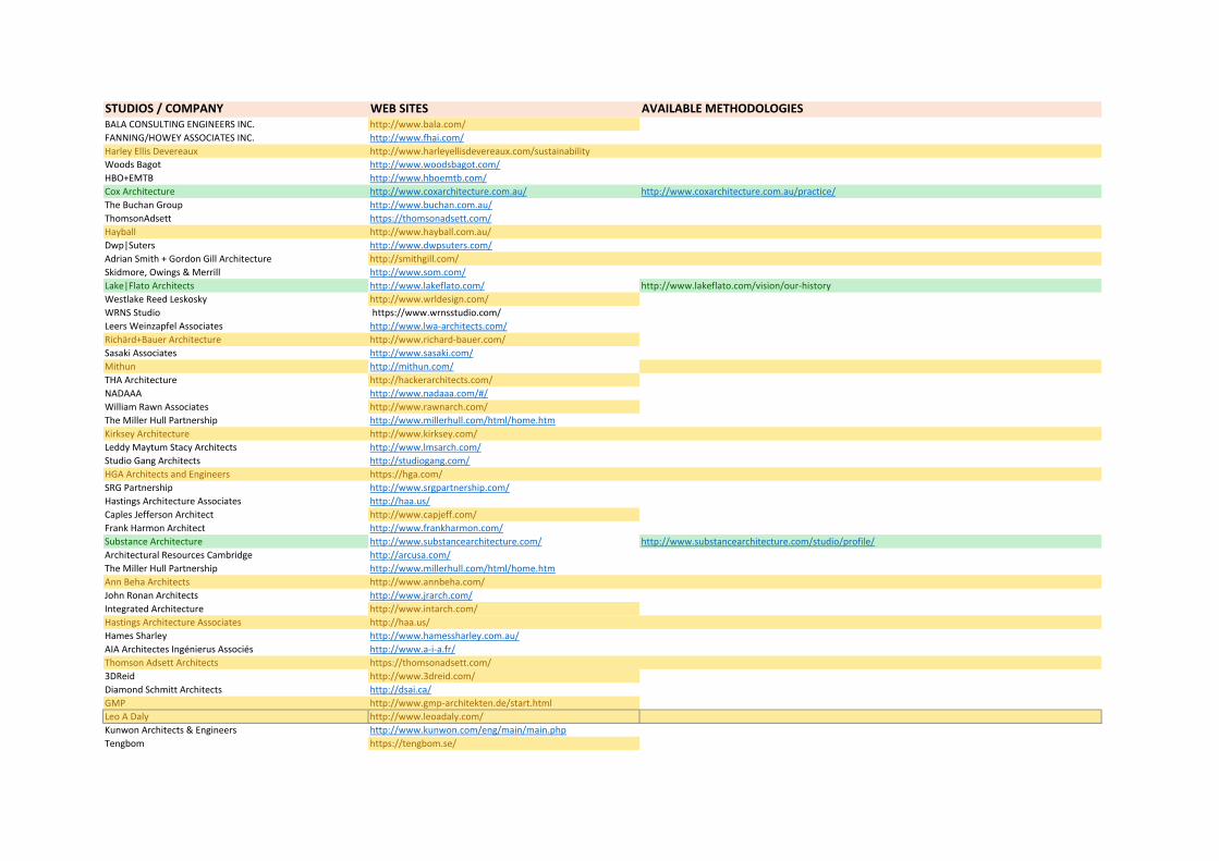
STUDIOS / COMPANY WEB SITES AVAILABLE METHODOLOGIESBALA CONSULTING ENGINEERS INC. http://www.bala.com/FANNING/HOWEY ASSOCIATES INC. http://www.fhai.com/Harley Ellis Devereaux http://www.harleyellisdevereaux.com/sustainabilityWoods Bagot http://www.woodsbagot.com/HBO+EMTB http://www.hboemtb.com/Cox Architecture http://www.coxarchitecture.com.au/ http://www.coxarchitecture.com.au/practice/The Buchan Group http://www.buchan.com.au/ThomsonAdsett https://thomsonadsett.com/Hayball http://www.hayball.com.au/Dwp|Suters http://www.dwpsuters.com/Adrian Smith + Gordon Gill Architecture http://smithgill.com/Skidmore, Owings & Merrill http://www.som.com/Lake|Flato Architects http://www.lakeflato.com/ http://www.lakeflato.com/vision/our-historyWestlake Reed Leskosky http://www.wrldesign.com/WRNS Studio https://www.wrnsstudio.com/Leers Weinzapfel Associates http://www.lwa-architects.com/Richärd+Bauer Architecture http://www.richard-bauer.com/Sasaki Associates http://www.sasaki.com/Mithun http://mithun.com/THA Architecture http://hackerarchitects.com/NADAAA http://www.nadaaa.com/#/William Rawn Associates http://www.rawnarch.com/The Miller Hull Partnership http://www.millerhull.com/html/home.htmKirksey Architecture http://www.kirksey.com/Leddy Maytum Stacy Architects http://www.lmsarch.com/Studio Gang Architects http://studiogang.com/HGA Architects and Engineers https://hga.com/SRG Partnership http://www.srgpartnership.com/Hastings Architecture Associates http://haa.us/Caples Jefferson Architect http://www.capjeff.com/Frank Harmon Architect http://www.frankharmon.com/Substance Architecture http://www.substancearchitecture.com/ http://www.substancearchitecture.com/studio/profile/Architectural Resources Cambridge http://arcusa.com/The Miller Hull Partnership http://www.millerhull.com/html/home.htmAnn Beha Architects http://www.annbeha.com/John Ronan Architects http://www.jrarch.com/Integrated Architecture http://www.intarch.com/Hastings Architecture Associates http://haa.us/Hames Sharley http://www.hamessharley.com.au/AIA Architectes Ingénierus Associés http://www.a-i-a.fr/Thomson Adsett Architects https://thomsonadsett.com/3DReid http://www.3dreid.com/Diamond Schmitt Architects http://dsai.ca/GMP http://www.gmp-architekten.de/start.htmlLeo A Daly http://www.leoadaly.com/Kunwon Architects & Engineers http://www.kunwon.com/eng/main/main.phpTengbom https://tengbom.se/
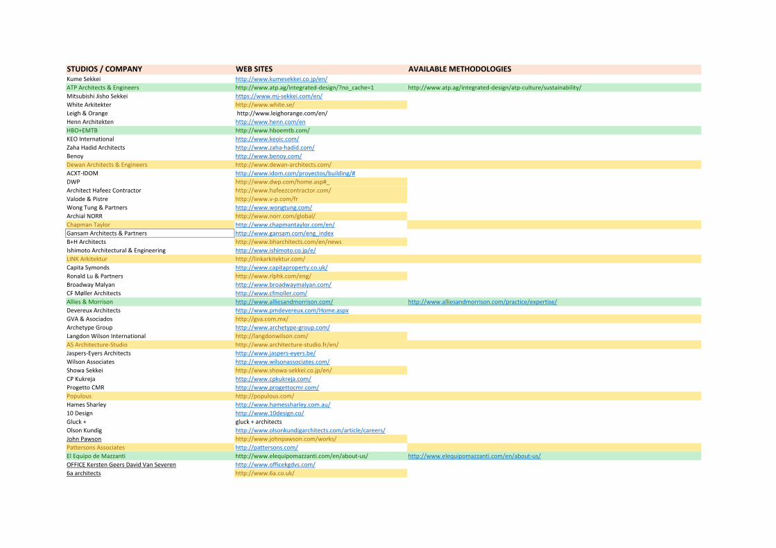
STUDIOS / COMPANY WEB SITES AVAILABLE METHODOLOGIESKume Sekkei http://www.kumesekkei.co.jp/en/ATP Architects & Engineers http://www.atp.ag/integrated-design/?no_cache=1 http://www.atp.ag/integrated-design/atp-culture/sustainability/Mitsubishi Jisho Sekkei https://www.mj-sekkei.com/en/White Arkitekter http://www.white.se/Leigh & Orange http://www.leighorange.com/en/Henn Architekten http://www.henn.com/enHBO+EMTB http://www.hboemtb.com/KEO International http://www.keoic.com/Zaha Hadid Architects http://www.zaha-hadid.com/Benoy http://www.benoy.com/Dewan Architects & Engineers http://www.dewan-architects.com/ACXT-IDOM http://www.idom.com/proyectos/building/#DWP http://www.dwp.com/home.asp#_Architect Hafeez Contractor http://www.hafeezcontractor.com/Valode & Pistre http://www.v-p.com/frWong Tung & Partners http://www.wongtung.com/Archial NORR http://www.norr.com/global/Chapman Taylor http://www.chapmantaylor.com/en/Gansam Architects & Partners http://www.gansam.com/eng_indexB+H Architects http://www.bharchitects.com/en/newsIshimoto Architectural & Engineering http://www.ishimoto.co.jp/e/LINK Arkitektur http://linkarkitektur.com/Capita Symonds http://www.capitaproperty.co.uk/Ronald Lu & Partners http://www.rlphk.com/eng/Broadway Malyan http://www.broadwaymalyan.com/CF Møller Architects http://www.cfmoller.com/Allies & Morrison http://www.alliesandmorrison.com/ http://www.alliesandmorrison.com/practice/expertise/Devereux Architects http://www.pmdevereux.com/Home.aspxGVA & Asociados http://gva.com.mx/Archetype Group http://www.archetype-group.com/Langdon Wilson International http://langdonwilson.com/AS Architecture-Studio http://www.architecture-studio.fr/en/Jaspers-Eyers Architects http://www.jaspers-eyers.be/Wilson Associates http://www.wilsonassociates.com/Showa Sekkei http://www.showa-sekkei.co.jp/en/CP Kukreja http://www.cpkukreja.com/Progetto CMR http://www.progettocmr.com/Populous http://populous.com/Hames Sharley http://www.hamessharley.com.au/10 Design http://www.10design.co/Gluck + gluck + architectsOlson Kundig http://www.olsonkundigarchitects.com/article/careers/John Pawson http://www.johnpawson.com/works/Pattersons Associates http://pattersons.com/El Equipo de Mazzanti http://www.elequipomazzanti.com/en/about-us/ http://www.elequipomazzanti.com/en/about-us/OFFICE Kersten Geers David Van Severen http://www.officekgdvs.com/6a architects http://www.6a.co.uk/
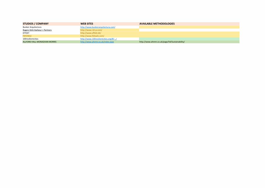
STUDIOS / COMPANY WEB SITES AVAILABLE METHODOLOGIESBunker Arquitectura http://www.bunkerarquitectura.com/Rogers Stirk Harbour + Partners http://www.rsh-p.com/EFFEKT http://www.effekt.dk/FXFOWLE http://www.fxfowle.com/100resilientcities http://www.100resilientcities.org/#/-_/ALLFORD HALL MONAGHAN MORRIS http://www.ahmm.co.uk/index.aspx http://www.ahmm.co.uk/page/54/Sustainability/

ANNEX II
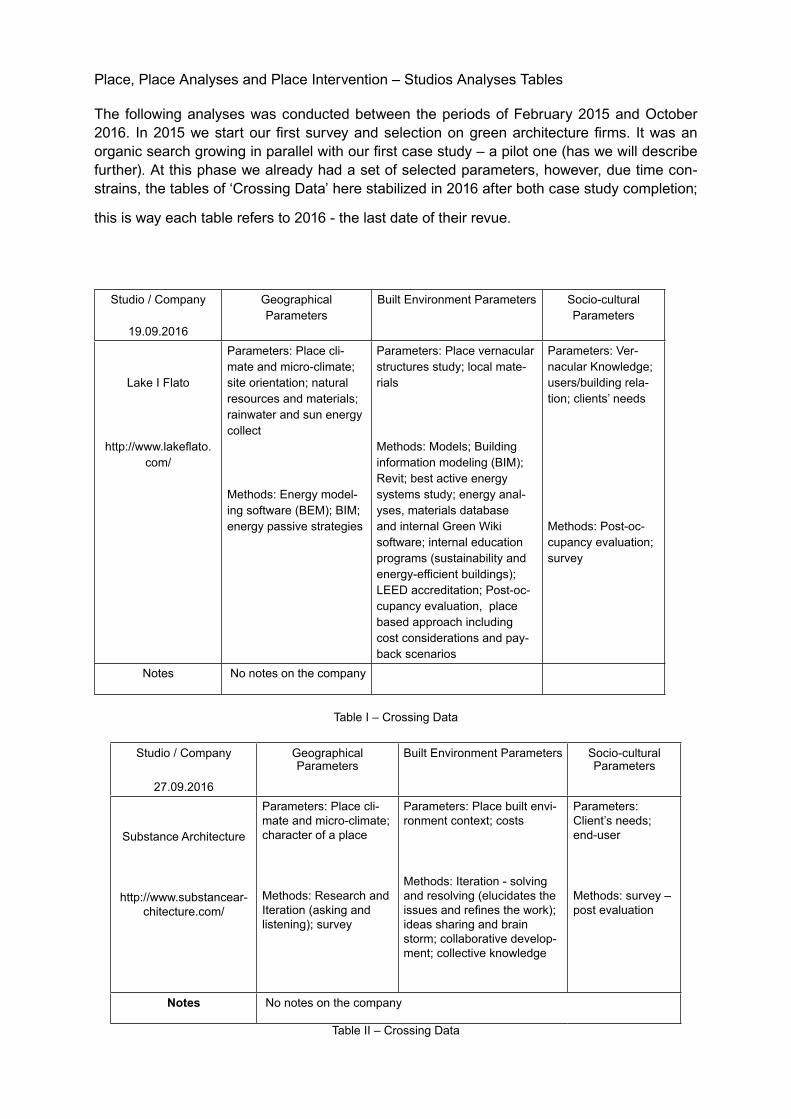
Place, Place Analyses and Place Intervention – Studios Analyses Tables
The following analyses was conducted between the periods of February 2015 and October 2016. In 2015 we start our first survey and selection on green architecture firms. It was an organic search growing in parallel with our first case study – a pilot one (has we will describe further). At this phase we already had a set of selected parameters, however, due time con-strains, the tables of ‘Crossing ata’ here stabilized in 2016 after both case study completion;
this is way each table refers to 2016 - the last date of their revue.
Studio / Company
19.09.2016
Geographical Parameters
Built Environment Parameters Socio-cultural Parameters
Lake I Flato
http://www.lakeflato.com/
Parameters: Place cli-mate and micro-climate; site orientation; natural resources and materials; rainwater and sun energy collect
Methods: Energy model-ing software (BEM); BIM; energy passive strategies
Parameters: Place vernacular structures study; local mate-rials
Methods: Models; Building information modeling (BIM); Revit; best active energy systems study; energy anal-yses, materials database and internal Green Wiki software; internal education programs (sustainability and energy-efficient buildings); LEE accreditation; Post-oc-cupancy evaluation, place based approach including cost considerations and pay-back scenarios
Parameters: er-nacular Knowledge; users/building rela-tion; clients’ needs
Methods: Post-oc-cupancy evaluation; survey
Notes No notes on the company
Table I – Crossing Data
Studio / Company
27.09.2016
Geographical Parameters
Built Environment Parameters Socio-cultural Parameters
Substance Architecture
http://www.substancear-chitecture.com/
Parameters: Place cli-mate and micro-climate; character of a place
Methods: Research and Iteration (asking and listening); survey
Parameters: Place built envi-ronment context; costs
Methods: Iteration - solving and resolving (elucidates the issues and refines the work); ideas sharing and brain storm; collaborative develop-ment; collective knowledge
Parameters: Client’s needs; end-user
Methods: survey – post evaluation
Notes No notes on the company
Table II – Crossing Data
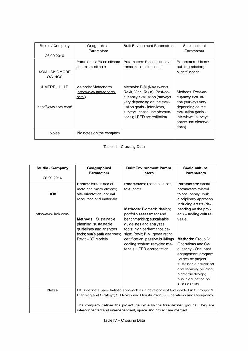
Studio / Company
26.09.2016
Geographical Parameters
Built Environment Parameters Socio-cultural Parameters
SOM - SKIDMORE OWINGS
& MERRILL LLP
http://www.som.com/
Parameters: Place climate and micro-climate
Methods: Meteonorm (http://www.meteonorm.com/)
Parameters: Place built envi-ronment context; costs
Methods: BIM (Navisworks, Revit, ico, Tekla); Post-oc-cupancy evaluation (surveys vary depending on the eval-uation goals - interviews, surveys, space use observa-tions); LEE accreditation
Parameters: Users/building relation; clients’ needs
Methods: Post-oc-cupancy evalua-tion (surveys vary depending on the evaluation goals - interviews, surveys, space use observa-tions)
Notes No notes on the company
Table III – Crossing Data
Studio / Company
26.09.2016
Geographical Parameters
Built Environment Param-eters
Socio-cultural Parameters
HOK
http://www.hok.com/
Parameters: Place cli-mate and micro-climate; site orientation; natural resources and materials
Methods: Sustainable planning; sustainable guidelines and analyzes tools; sun’s path analyses; Revit – 3 models
Parameters: Place built con-text; costs
Methods: Biometric design; portfolio assessment and benchmarking; sustainable guidelines and analyzes tools; high performance de-sign; Revit; BIM; green rating certification; passive buildings cooling system; recycled ma-terials; LEE accreditation
Parameters: social parameters related to occupancy; multi-disciplinary approach including artists (de-pending on the proj-ect) – adding cultural value
Methods: Group 3: Operations and Oc-cupancy - Occupant engagement program (varies by project); sustainable education and capacity building; biometric design; public education on sustainability
Notes OK define a pace holistic approach as a development tool divided in 3 groups: 1. Planning and Strategy; 2. esign and Construction; 3. Operations and Occupancy.
The company defines the project life cycle by the tree defined groups. They are interconnected and interdependent, space and project are merged.
Table I – Crossing ata
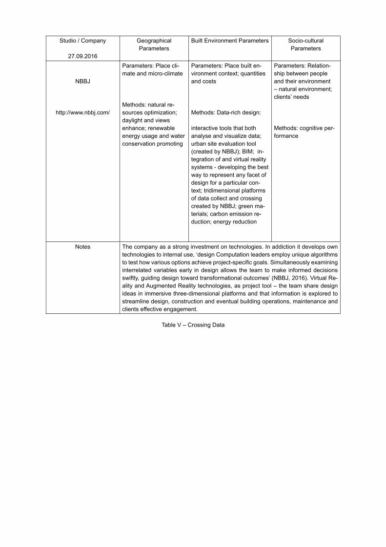
Studio / Company
27.09.2016
Geographical Parameters
Built Environment Parameters Socio-cultural Parameters
NBBJ
http://www.nbbj.com/
Parameters: Place cli-mate and micro-climate
Methods: natural re-sources optimization; daylight and views enhance; renewable energy usage and water conservation promoting
Parameters: Place built en-vironment context; quantities and costs
Methods: Data-rich design:
interactive tools that both analyse and visualize data; urban site evaluation tool (created by NBBJ); BIM; in-tegration of and virtual reality systems - developing the best way to represent any facet of design for a particular con-text; tridimensional platforms of data collect and crossing created by NBBJ; green ma-terials; carbon emission re-duction; energy reduction
Parameters: Relation-ship between people and their environment – natural environment; clients’ needs
Methods: cognitive per-formance
Notes The company as a strong investment on technologies. In addiction it develops own technologies to internal use, ‘design Computation leaders employ unique algorithms to test how various options achieve project-specific goals. Simultaneously examining interrelated variables early in design allows the team to make informed decisions swiftly, guiding design toward transformational outcomes’ (NBBJ, 2016). irtual Re-ality and Augmented Reality technologies, as project tool – the team share design ideas in immersive three-dimensional platforms and that information is explored to streamline design, construction and eventual building operations, maintenance and clients effective engagement.
Table – Crossing ata
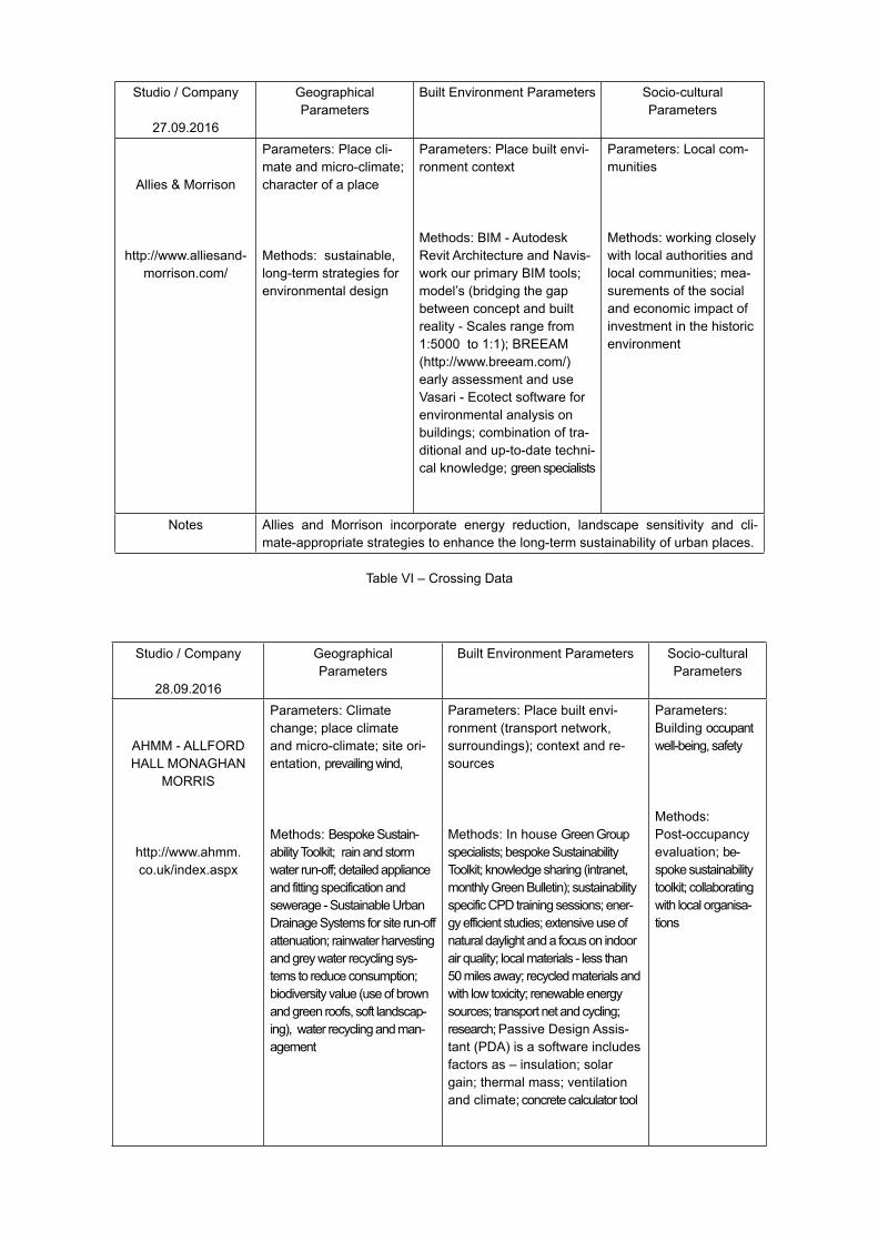
Studio / Company
27.09.2016
Geographical Parameters
Built Environment Parameters Socio-cultural Parameters
Allies & Morrison
http://www.alliesand-morrison.com/
Parameters: Place cli-mate and micro-climate; character of a place
Methods: sustainable, long-term strategies for environmental design
Parameters: Place built envi-ronment context
Methods: BIM - Autodesk Revit Architecture and Navis-work our primary BIM tools; model’s (bridging the gap between concept and built reality - Scales range from 1:5000 to 1:1); BREEAM (http://www.breeam.com/) early assessment and use
asari - Ecotect software for environmental analysis on buildings; combination of tra-ditional and up-to-date techni-cal knowledge; green specialists
Parameters: Local com-munities
Methods: working closely with local authorities and local communities; mea-surements of the social and economic impact of investment in the historic environment
Notes Allies and Morrison incorporate energy reduction, landscape sensitivity and cli-mate-appropriate strategies to enhance the long-term sustainability of urban places.
Table I – Crossing ata
Studio / Company
28.09.2016
Geographical Parameters
Built Environment Parameters Socio-cultural Parameters
AHMM - ALLFORD HALL MONAGHAN
MORRIS
http://www.ahmm.co.uk/index.aspx
Parameters: Climate change; place climate and micro-climate; site ori-entation, prevailing wind,
Methods: Bespoke Sustain-ability Toolkit; rain and storm water run-off; detailed appliance and fitting specification and sewerage - Sustainable Urban
rainage Systems for site run-off attenuation; rainwater harvesting and grey water recycling sys-tems to reduce consumption; biodiversity value (use of brown and green roofs, soft landscap-ing), water recycling and man-agement
Parameters: Place built envi-ronment (transport network, surroundings); context and re-sources
Methods: In house Green Group specialists; bespoke Sustainability Toolkit; knowledge sharing (intranet, monthly Green Bulletin); sustainability specific CP training sessions; ener-gy efficient studies; extensive use of natural daylight and a focus on indoor air quality; local materials - less than 50 miles away; recycled materials and with low toxicity; renewable energy sources; transport net and cycling; research; Passive esign Assis-tant (P A) is a software includes factors as – insulation; solar gain; thermal mass; ventilation and climate; concrete calculator tool
Parameters: Building occupant well-being, safety
Methods: Post-occupancy evaluation; be-spoke sustainability toolkit; collaborating with local organisa-tions
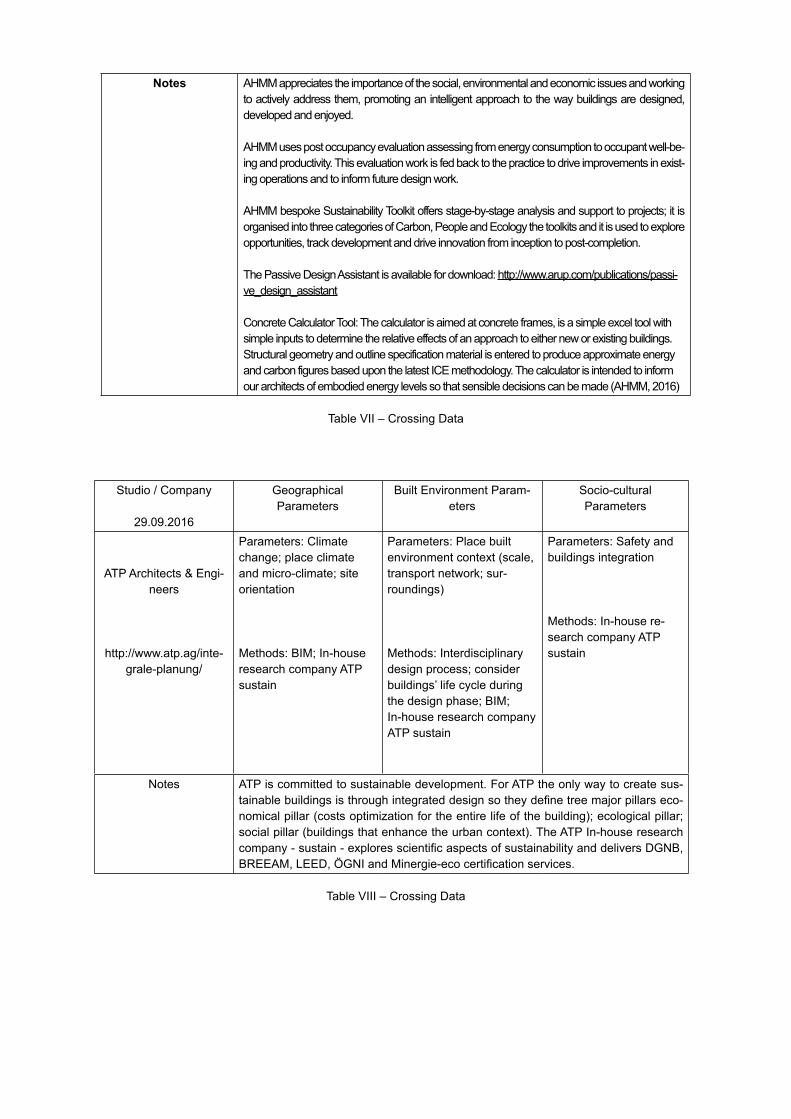
Notes A MM appreciates the importance of the social, environmental and economic issues and working to actively address them, promoting an intelligent approach to the way buildings are designed, developed and enjoyed.
A MM uses post occupancy evaluation assessing from energy consumption to occupant well-be-ing and productivity. This evaluation work is fed back to the practice to drive improvements in exist-ing operations and to inform future design work.
A MM bespoke Sustainability Toolkit offers stage-by-stage analysis and support to projects; it is organised into three categories of Carbon, People and Ecology the toolkits and it is used to explore opportunities, track development and drive innovation from inception to post-completion.
The Passive Design Assistant is available for download: http://www.arup.com/publications/passi-ve_design_assistant
Concrete Calculator Tool: The calculator is aimed at concrete frames, is a simple excel tool with simple inputs to determine the relative effects of an approach to either new or existing buildings. Structural geometry and outline specification material is entered to produce approximate energy and carbon figures based upon the latest ICE methodology. The calculator is intended to inform our architects of embodied energy levels so that sensible decisions can be made (A MM, 2016)
Table II – Crossing ata
Studio / Company
29.09.2016
Geographical Parameters
Built Environment Param-eters
Socio-cultural Parameters
ATP Architects & Engi-neers
http://www.atp.ag/inte-grale-planung/
Parameters: Climate change; place climate and micro-climate; site orientation
Methods: BIM; In-house research company ATP sustain
Parameters: Place built environment context (scale, transport network; sur-roundings)
Methods: Interdisciplinary design process; consider buildings’ life cycle during the design phase; BIM; In-house research company ATP sustain
Parameters: Safety and buildings integration
Methods: In-house re-search company ATP sustain
Notes ATP is committed to sustainable development. For ATP the only way to create sus-tainable buildings is through integrated design so they define tree major pillars eco-nomical pillar (costs optimization for the entire life of the building); ecological pillar; social pillar (buildings that enhance the urban context). The ATP In-house research company - sustain - explores scientific aspects of sustainability and delivers GNB, BREEAM, LEE , GNI and Minergie-eco certification services.
Table III – Crossing ata
Studio / Company
29.09.2016
Geographical Parameters
Built Environment Param-eters
Socio-cultural Parameters
Cox Architecture
http://www.coxarchi-tecture.com.au/
Parameters: Topograph-ical information / built information; floods; winds - climate change; site ori-entation, natural and local materials, place climate and micro climate
Methods: GIS
Parameters: Place built environment context (from the scale of the city to that of a building or interior)
Methods: Manual (crafted) and technological (com-puter-generated) analysis; parametric modelling; AutoCA and RE IT with Navisworks; augmented by advanced 3D proto-typing; 3 visualisation; hand-sketching; 3 Studio Max; Adobe Creative Suite; Sketchup; Grasshopper; GIS and Rhino 3 ; conjoint research with universities; urban planning firms; engi-neers; artists and industrial designers; detailed models at large scale
Parameters:
Methods:
Notes CO Architecture is a multidisciplinary practice integrating architecture, planning, urban design and interior design; defining design ethos in all studios based upon principles of structure, craft, art and nature (http://www.coxarchitecture.com.au/practice/)
Table IX – Crossing Data
Studio / Company
29.09.2016
Geographical Parameters
Built Environment Param-eters
Socio-cultural Parameters
FENTRESS ARCHITEC-TS
http://fentressarchitects.com/
Parameters: Place natural context; natural resourc-es; site orientation; place climate and micro-climate
Methods: Context as a way of identity creation; active research; local and regional materials usage
Parameters: Place built environment context
Methods: In-house LEED Accredited Professionals; continuing education in five areas: architectural and interior design; sustainable design; technology and innovation; project man-agement; and leadership; sustainable design; active research; renewable energy strategies; local and region-al materials usage; multidis-ciplinary teams; BIM; low-E glass; recycled materials; water saving strategies
Parameters: Sense of community – traditions and aspirations
Methods: Observation; survey; active research
Notes For Fentress the context draws on the senses, the sights, smells and memories that defining a place and making it unique - context grows from community, and peo-ple respond to it. Local culture can be an engine to capture and reflect the shared strengths of a community, reinforcing pride in residents. A community gains a voice, and the architect translates, using their vocabulary to design a timeless building for the common good’’ (FENTRESS, 2016)
Table X – Crossing Data
References:
AHMM (2016). Sustainability R . Accessed on 28.09.2016 at: http://www.ahmm.co.uk/page/57/Sus-tainability-R-D
FENTRESS ARCHITECTS (2016). Accessed on 29.09.2016 at:
http://fentressarchitects.com/design-philosophy
NBBJ, (2016). igital Practice. Taking technology further for better design. Accessed on 27.09.2016 at: http://www.nbbj.com/about/digital-practice/

ANNEX III
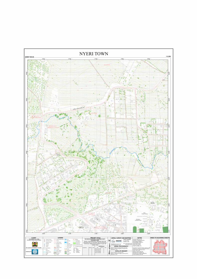
=
=
=
6390
1356
571 BLOCK 2
6390
1356
6390
7585/25
1355
6390
1105/6
2.
750
1279
1318
187
406
191
193
186
403
751
1045
183
215
219
404752
1023
1687
181
1280
194
190
183
1251
1281
201
1284
950
192
1046
1254
1026
186
185.
201
1686
1253
1250
1047
1136
1283
1255
1025
1032
104
1249
1263
1037
1256
1686
1319
1043
1252
1254
1282
1250
7585/22
181
1285
1034 1035
1031
1032
1029 1030
1290
1253
13001292
1028
1042
1027
4071302
10381039
10401041
1320
1024
1291
1300
1267
1293
181
181
MAJENGO
1764
1762
1766
1768
1744
1746
1748
1772
1774
1752
1754
1756
1776
1758
1778
1788
1786
1784
1782
1742
1792
1738
1736
1794
1734
1796
1732
1798
1802
1732
1786
1788
1734
1732
1798
NY7
NY4
271250.000000
271250.000000
271500.000000
271500.000000
271750.000000
271750.000000
272000.000000
272000.000000
272250.000000
272250.000000
9954
750.0
0000
0
9954
750.0
0000
0
9955
000.0
0000
0
9955
000.0
0000
0
9955
250.0
0000
0
9955
250.0
0000
0
9955
500.0
0000
0
9955
500.0
0000
0
9955
750.0
0000
0
9955
750.0
0000
0
9956
000.0
0000
0
9956
000.0
0000
0
9956
250.0
0000
0
9956
250.0
0000
0
NYERI TOWNSHEET NO.92 1:2,500
³GATITU
= Primary Controls
: Secondary Controls
!! !! Fuel Pipeline
River
Pond
Water Pan
Dam
Fish Pond
Riverine Trees
l Scattered Trees
Hedge
Farm Lands
Forest
Wall
_ Borehole
! ! Sewer line
Railway
Openground
Playground
Quarry
Greenhouse
Sewer Lagoon
!!
!
! ! ! ! !!
!!!!!!
National Park
Tarmac
Footpath
Loose Surface
Motorable Track
Buildings
Project Area Boundary
1200 Contours
Mkt - MarketSch - SchoolGov't - GovernmentPri - PrimarySec - Secondary
Airstrip
Cadastral Boundary
Property Boundary
Hospital
School
®v
5Area Name.....
CLIENT
THE COUNTY GOVERNMENT OF NYERI
FINANCED BY:
THE MINISTRY OF LANDS,HOUSING & URBAN DEVELOPMENT
LEGEND INDEX TO ADJOINING SHEETSNOTESArc1960 UTM Zone 37SProjection: Transverse MercatorFalse Easting: 500000.0False Northing: 10000000.0Central Meridian: 39.0Scale Factor: 0.9996Latitude Of Origin: 0.0Linear Unit: Meter (1.0)
Geographic Coordinate System: GCS Arc 1960Angular Unit: Degree (0.0174532925199433)Prime Meridian: Greenwich (0.0)Datum: D Arc 1960Spheroid: Clarke 1880 RGSSemimajor Axis: 6378249.145Semiminor Axis: 6356514.869549776Inverse Flattening: 293.465
AERIAL SURVEY AND MAPPINGPOSTAL ADDRESSP.O. BOX 9562NAIROBI - GPO
TEL:+254-(20)2721726 +254-(20)2721943www.highlandsurveyors.co.ke
AERIAL PHOTOGRAPHYAreal Coverage: The high density Town AreaBased on Aerial Photographs of August 2014Resolution: 12cm
SATELLITE IMAGERYAreal Coverage: The Project AreaBased on WorldView Imagery of January 2014Resolution: 0.5m
PROJECT TITLE
DIGITAL TOPOGRAPHICAL MAPPING AND THE PREPARATION OF REGIONAL AND INTEGRATED STRATEGIC URBAN DEVELOPMENT PLAN FOR
NYERI TOWN
THE KENYA MUNICIPAL PROGRAM (K.M.P)CLUSTER FOUR
APPROVALS
Project Surveyor
Project Manager
Director UD Dpt.
Project Planner
Date SignDate TitleUpdated By EditionBridge, Culvert
Thicket
Market
Shrub/Scrub
Swamp/Marsh
Irrigation Canal
654321
987 11
78
23
14131210
26252422212019181715
414039383736353433323130292827
5655545352515049484746454342
727170
73
686766656463626159 6057 58
87 88 89 90 91 92 93 95 96 97 98 99
8674 75 76 77
69
79 80 81 82 83 84 85
94
16
44
111
115
114113112110
119118117116
149
100
109108107105104103102101
130129128127126125124123122121120
146145144143142141140139138137136135134133132131
160159158157156155154153152151150148147
167166165164163162161
106
Coffee Plantation
MURINGATO FOREST NURSERY
CULTS ESTATE
River M
uring
ato
KIANJOYA
P.C.E.A Jitegemea
Nyeri Primary School
LAWNS
WANANCHI SAW MILLS
MURINGATO SHOPPING CENTER
NYERI-NYAHURURU RD
Moi Nyeri Complex primary
Zambezi Dormitory
KING'ONG'O
KENOL SERVICE STATION KING'ONG'O
Bridgestone Warehouses

=
=
6392/34
6392/11
6392/9
12548
6392/37
6390
6392/34
6392/7/5
571 BLOCK 2
6392/34
9133
6392/47
6392/12
6392/38
1969
5736392/16
6392/38
6392/34
986
7585/25
985
970
7585/22
971
MAJENGO
1744
1758
1742
1738
1736
1734
1756
1754
1752
1748
1746
1762
1764
1766
1768
1772
1774
1732
1776
1778
1782
1728
1726
1784
1786
1788
1724
1722
1792
1718
1726
1732
1728
1758
1724
NY4
272500.000000
272500.000000
272750.000000
272750.000000
273000.000000
273000.000000
273250.000000
273250.000000
273500.000000
273500.000000
9954
750.0
0000
0
9954
750.0
0000
0
9955
000.0
0000
0
9955
000.0
0000
0
9955
250.0
0000
0
9955
250.0
0000
0
9955
500.0
0000
0
9955
500.0
0000
0
9955
750.0
0000
0
9955
750.0
0000
0
9956
000.0
0000
0
9956
000.0
0000
0
9956
250.0
0000
0
9956
250.0
0000
0
NYERI TOWNSHEET NO.93 1:2,500
³GATITU
= Primary Controls
: Secondary Controls
!! !! Fuel Pipeline
River
Pond
Water Pan
Dam
Fish Pond
Riverine Trees
l Scattered Trees
Hedge
Farm Lands
Forest
Wall
_ Borehole
! ! Sewer line
Railway
Openground
Playground
Quarry
Greenhouse
Sewer Lagoon
!!
!
! ! ! ! !!
!!!!!!
National Park
Tarmac
Footpath
Loose Surface
Motorable Track
Buildings
Project Area Boundary
1200 Contours
Mkt - MarketSch - SchoolGov't - GovernmentPri - PrimarySec - Secondary
Airstrip
Cadastral Boundary
Property Boundary
Hospital
School
®v
5Area Name.....
CLIENT
THE COUNTY GOVERNMENT OF NYERI
FINANCED BY:
THE MINISTRY OF LANDS,HOUSING & URBAN DEVELOPMENT
LEGEND INDEX TO ADJOINING SHEETSNOTESArc1960 UTM Zone 37SProjection: Transverse MercatorFalse Easting: 500000.0False Northing: 10000000.0Central Meridian: 39.0Scale Factor: 0.9996Latitude Of Origin: 0.0Linear Unit: Meter (1.0)
Geographic Coordinate System: GCS Arc 1960Angular Unit: Degree (0.0174532925199433)Prime Meridian: Greenwich (0.0)Datum: D Arc 1960Spheroid: Clarke 1880 RGSSemimajor Axis: 6378249.145Semiminor Axis: 6356514.869549776Inverse Flattening: 293.465
AERIAL SURVEY AND MAPPINGPOSTAL ADDRESSP.O. BOX 9562NAIROBI - GPO
TEL:+254-(20)2721726 +254-(20)2721943www.highlandsurveyors.co.ke
AERIAL PHOTOGRAPHYAreal Coverage: The high density Town AreaBased on Aerial Photographs of August 2014Resolution: 12cm
SATELLITE IMAGERYAreal Coverage: The Project AreaBased on WorldView Imagery of January 2014Resolution: 0.5m
PROJECT TITLE
DIGITAL TOPOGRAPHICAL MAPPING AND THE PREPARATION OF REGIONAL AND INTEGRATED STRATEGIC URBAN DEVELOPMENT PLAN FOR
NYERI TOWN
THE KENYA MUNICIPAL PROGRAM (K.M.P)CLUSTER FOUR
APPROVALS
Project Surveyor
Project Manager
Director UD Dpt.
Project Planner
Date SignDate TitleUpdated By EditionBridge, Culvert
Thicket
Market
Shrub/Scrub
Swamp/Marsh
Irrigation Canal
654321
987 11
78
23
14131210
26252422212019181715
414039383736353433323130292827
5655545352515049484746454342
727170
73
686766656463626159 6057 58
87 88 89 90 91 92 93 95 96 97 98 99
8674 75 76 77
69
79 80 81 82 83 84 85
94
16
44
111
115
114113112110
119118117116
149
100
109108107105104103102101
130129128127126125124123122121120
146145144143142141140139138137136135134133132131
160159158157156155154153152151150148147
167166165164163162161
106
Coffee Plantation
Dedan KimathiResource Center
River Muringato
P.C.E.A .King'ong'o
Parish
NYERI-N
YAHURURU
RD
GUNYUMU FARM
Mt.Kenya Bottlers
Office Blocks Nyeri GoodSherphad Academy
Dedan KimathiAcademic Block
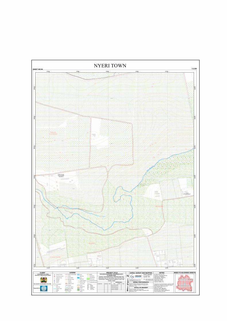
=
6392/34
12548
12548
6392/34
6392/12
5104
3223
6392/11
3223
MAJENGO
THUNGUMA
1718
1722
174817
24
1726
1728
1746
17321734
1744
1736
1742
1738
1752
1716
1714
1712
1708
1706
1754
1756
1704
1758
1702
1698
1696
1762
1694
1746
1702
1704
1758
1702
1756
1756
1698
1696
273750.000000
273750.000000
274000.000000
274000.000000
274250.000000
274250.000000
274500.000000
274500.000000
274750.000000
274750.000000
9954
750.0
0000
0
9954
750.0
0000
0
9955
000.0
0000
0
9955
000.0
0000
0
9955
250.0
0000
0
9955
250.0
0000
0
9955
500.0
0000
0
9955
500.0
0000
0
9955
750.0
0000
0
9955
750.0
0000
0
9956
000.0
0000
0
9956
000.0
0000
0
9956
250.0
0000
0
9956
250.0
0000
0
NYERI TOWNSHEET NO.94 1:2,500
³GATITU
= Primary Controls
: Secondary Controls
!! !! Fuel Pipeline
River
Pond
Water Pan
Dam
Fish Pond
Riverine Trees
l Scattered Trees
Hedge
Farm Lands
Forest
Wall
_ Borehole
! ! Sewer line
Railway
Openground
Playground
Quarry
Greenhouse
Sewer Lagoon
!!
!
! ! ! ! !!
!!!!!!
National Park
Tarmac
Footpath
Loose Surface
Motorable Track
Buildings
Project Area Boundary
1200 Contours
Mkt - MarketSch - SchoolGov't - GovernmentPri - PrimarySec - Secondary
Airstrip
Cadastral Boundary
Property Boundary
Hospital
School
®v
5Area Name.....
CLIENT
THE COUNTY GOVERNMENT OF NYERI
FINANCED BY:
THE MINISTRY OF LANDS,HOUSING & URBAN DEVELOPMENT
LEGEND INDEX TO ADJOINING SHEETSNOTESArc1960 UTM Zone 37SProjection: Transverse MercatorFalse Easting: 500000.0False Northing: 10000000.0Central Meridian: 39.0Scale Factor: 0.9996Latitude Of Origin: 0.0Linear Unit: Meter (1.0)
Geographic Coordinate System: GCS Arc 1960Angular Unit: Degree (0.0174532925199433)Prime Meridian: Greenwich (0.0)Datum: D Arc 1960Spheroid: Clarke 1880 RGSSemimajor Axis: 6378249.145Semiminor Axis: 6356514.869549776Inverse Flattening: 293.465
AERIAL SURVEY AND MAPPINGPOSTAL ADDRESSP.O. BOX 9562NAIROBI - GPO
TEL:+254-(20)2721726 +254-(20)2721943www.highlandsurveyors.co.ke
AERIAL PHOTOGRAPHYAreal Coverage: The high density Town AreaBased on Aerial Photographs of August 2014Resolution: 12cm
SATELLITE IMAGERYAreal Coverage: The Project AreaBased on WorldView Imagery of January 2014Resolution: 0.5m
PROJECT TITLE
DIGITAL TOPOGRAPHICAL MAPPING AND THE PREPARATION OF REGIONAL AND INTEGRATED STRATEGIC URBAN DEVELOPMENT PLAN FOR
NYERI TOWN
THE KENYA MUNICIPAL PROGRAM (K.M.P)CLUSTER FOUR
APPROVALS
Project Surveyor
Project Manager
Director UD Dpt.
Project Planner
Date SignDate TitleUpdated By EditionBridge, Culvert
Thicket
Market
Shrub/Scrub
Swamp/Marsh
Irrigation Canal
654321
987 11
78
23
14131210
26252422212019181715
414039383736353433323130292827
5655545352515049484746454342
727170
73
686766656463626159 6057 58
87 88 89 90 91 92 93 95 96 97 98 99
8674 75 76 77
69
79 80 81 82 83 84 85
94
16
44
111
115
114113112110
119118117116
149
100
109108107105104103102101
130129128127126125124123122121120
146145144143142141140139138137136135134133132131
160159158157156155154153152151150148147
167166165164163162161
106
Coffee Plantation
Dedan KimathiUniversityStaff
Residence
River M
uringato
Chania Primary School
COFFEE PLANTATION
JUNGLE ESTATE

337
239
951
955
175
1060
19
407
17
571 BLOCK 2
18
82
1059
23
23
12
25
967
1316
20
2
16
32
405
70
177
15
7
51
224
99
987
456
185
1270
660
986
2.
181
1398
400
41
348
179
100
321
732
24
321
322
210
404
100
323
1326
408
332
45
368
1000
1667
1667
323
1
6
1113
367
1199
8
1111
30
1110
331
991
341
59
440.
1112
1058
16
257
336
28
330
221
910
342
966
1667
80
94
365
336
406
26
5
231
1190
101
93
5
362
363
344
8
91
6
338
343
329
294
337
353 340
25
366
339
1375
390
100
9
1288
1056
24
50
85
357
1201
81
362
853
958
46
64
178
852
92
232
1145
80
741
559
79
364
876
100
74
361
215
1324
49
97
1691
375
1207
1028
875
3
376
4
39
358
1214
42
51 876
96
82
389
22
55
90
73
205
67
70
1048
8388
56
60
942
988
89
30
87
47
52
53
192
41
910
59
48
360
71
86
20
54
224
25
27
278
1323
222
374
49
911
99
391
250
70
47
58
392
46
68
766
1094
1639
746
66
69
877
78
44
45
219
221
61
1057
11
63
285
393
66
186
28
0
44
757
1323
444
21
70
23
72
34
42
41
271
37
871
1323
304
24
43
62
113
223
201
37
35
1363
443
881
200
1322
29
31
1640
33
47
52
370
241
35
54
755
70
305
104
40
13
72
16
44
65
34
33
32
26
30
369
742
36
1331
60
43
70
371
55
34
32
50
455
1049
35
73
542
695
204
39
38
57
42
45
14
38
51
48
445
638
62
696
327
77
68
305
765
181
752
10
962
37
31
202
55
59
5658
842
53
323
870
1207
316
52
19
38
56
1312
966
54
53
234
287
990
351
872
320
636
350
85
48
279
323
275
84
199
1313
943
745
75
724
194 946
639
653
27
191
65
40
238
706
944
233
14
272
760
964
1321
757
212
293
641
352
33
1311
707
1063
326
660
758
325
356
235
1310
239
193
49
905
640
912
214
762
354
810
274
1068
805
353
753
62
273
777
761
43
887
720
277
754
283
704
60
185
752
286
237
728
57
325
240
307
194
763
779
58
757
63
654
768
64
290
196
349
221
59
803
905
292
1293
203
236
291
280
197
714
315
807
195
61
334
308
309
1106
782
963
15
29
960
1103
757
324
952
322
284
1298
965
76
809
225
355
1315
190
941
781
306
200
722
303 189
191
808
716
938
761
889
769
1100
928
289
1295
767
1062
313
750
1296
940
36
314
816
718
67
296
1299
790
734
830
211
741 734
729
300
298
844
225
1015
301
814
1146
1295
877
789
923
311
838
834
68
302310
802
806
821
791
801
812
1323
778
312
319
710
947
210
720
299
730
822
864
317
811
1150
1148
1105
880.
867
1108
1153
724
772
788
858
7131262
318
885
780
844
729
756729
1070
1230
285
1124
1304
297
879
326
843
871
1068
773
835
841
717
1116
737
828
332
813
783
886
731
831
818
637
862
836819
737
878
823
869
851
866
829
1119
316
712
786
826
787
865
678
824
1228
882
795
830
884
1148
862
832
856
705
657
698
790
827
1093
775
1686
1112
312
655
774
384
853
886
709
771
739
1089
711
1164
890
844
1115
656
1243
699
861
702
719
1151
857
1269
1234
1121
1073
658
871
1079
908
1065
1140
1111
798
770
1104
1125
1109
382
1460
1114
815
1120
1100
1080
797
794
703
736
883
1170
400
1104
397
1323
1305
242
796
1131
659
1087
1245
10961130
700
1126
792
1085
1246
1064
409
1097
1084
1123
681
213
241
1152
1133
1154
697
793
1120
1238
849
872
736
801
1135
1238
905
1134
1110
1242
1132
1144
1228
1117
331
1229
1047
1227
1276
1232
1275
21
1231
1095
1098
1102
1274
1233
7574
1071
724
1294
1069
1072
873
817
1687
820
1122
224
784
1077
1139
1076
1262
1091
1087
825
1088
785
1138
1141
870
1137
804
939
1129
1142
837
1090
1143
1118
1074
1092
1078
741
1150
854
1244
1075
1136
1083
1081
711
1147
276
961
701
1080
868
1125
863
1148
744
869
849
843
1027
1082
708708
1236
1235
39
700
1237
701
702
855
1272
1236
1235
12701271
1278
1302
1277
902
891
1273
1155
1157
1237
904
1300
286
99
1292
459
282
1201
294
223
MAJENGO
KARIACBD
1788
1762
1786
1764
1766
1784
1768
1782
1774
1772
1776
1778
1758
1792
1756
1754
1794
1796
17981802
1804
1806
1752
1808
1748
1746
1812
1814
1744
1742
1816
1738
1818
1736
1822
1752
1748
1796
1744
271250.000000
271250.000000
271500.000000
271500.000000
271750.000000
271750.000000
272000.000000
272000.000000
272250.000000
272250.000000
9953
250.0
0000
0
9953
250.0
0000
0
9953
500.0
0000
0
9953
500.0
0000
0
9953
750.0
0000
0
9953
750.0
0000
0
9954
000.0
0000
0
9954
000.0
0000
0
9954
250.0
0000
0
9954
250.0
0000
0
9954
500.0
0000
0
9954
500.0
0000
0
NYERI TOWNSHEET NO.106 1:2,500
River Chania
KING'ONG'O
Kenya Urban Roads Authority Training Center
Our Lady Of Consolata Catholic
CathedralPolice Lines
Nyeri Golf Course
Municipal Hall
King'ong'o Primary School
Ministry OfRoads
KABURINI RD
KIAWARA
Timber Stores
NYERI-NYAHURURU RD
Ministry Of Works Camp
Ministry Of Agriculture
Lands Office
NyeriLaw Courts
Wakiawa Hse
Nyeri Provincial Admnistration
Standard Chartered
Bank
White Rhino Hotel
Kenya Commercial
Bank
Salvation Army Church
NYERI OPEN AIR FARMERS MARKET
Green Hills Hotel
Nyeri TechnicalTraining l Institute
Dan JuniorAcademy
Primary School
Nyeri Central Police Station
KENYATTA RD
NYERI- NANYUKI RD
GAKERE- RD
Diana Hse
Soko Mjinga
Tabby Plaza
Zebra Pub
S.W Kigo
Nairobi Eagles Electrical Services
Starehe Cafe
Friends Pub Joint
GikondiBar
PetwelPlace
Imperial Guest Hse
Main StageI1
Mudavadi Market
Rware Building
Jesus Exaltation
Center
Kenya NationalLibrary
County Governor's
Office
Kang'aru Corner
Hse
Airtel Nyeri
Maru C Bldg
BatianNyeri Municipal
Council Enclosed Market
Whispers Park
KIMATHI WAY
Premier Plaza
Admnistration Police
Nyeri Shopping Complex
Safaricom Bldg
Kiandu Hse
Maru A Bldg
Nyeri Technical Teachers Quarters
RING ROAD ESTATE
Maji Hse
St.Paul Anglican
Baden Powel
GathiiHse
Vera Plaza
Joanne'sHse
Caledonia Hse
Orange Hse
Meghirutshi Bldg
P.C.E.AChurch
Nyeri Town Health Center
IC
Bahai Faith
Hindu Temple
RING
RD
Itara Garden
Josani Ladies Hostel
Stage Ya Katikati
I1
Garage
Samrat
SullivianCafe
N.D.C.U Bldg
Laikipia Hse
Anju Plaza
Mountain View Bldg
SamratSupermarket
Nyeri Traffic Inspectorate
MagitHotel
Glory Hotel
Mairweh Hse
Equity Bank
Upper StageI1
Bahati Bldg
Family Bank
Kimathi University
Stage
I1
Umoja Business Center Block"A"
Nyeri MedicalCenter
Town HealthCenter
Iriani Trad Med Clinic
Dr.Anand Gupta
Cooperative Bank
Eco Bank Atm
Islamic Foundation
Center
House Of Glory Church
Magutu Peag's Hotel
Uptown Bldg
OusmannAlluStores
NyeriTownViewHotel
Sweet Bite Cafe
Eland Safari Hotel Jawa
Cafe
Home Cafe
UmojaChambersBldg
Dedan KimathiUniversity Town
Campus
Samaka Cafe
Green Oaks Cafe
Sohan Plaza
St.Peter's Anglican ChurchStima
Hse
Central Hotel
Kenya Revenue Authority
Mawaidha Hse
P.A.G Church
Nyeri CatholicSecretariate
!O
Shell Filling Station
King'ong'o Nursery School
A.I.P.C.EA Church
Muitong'o Bldg
Prime MinistryInternationalKenya
KenolServiceStation King'ong'o
HighlandsMineralWaterLtd
Chania Place Hotel
Living Faith
Ministries
Full Gospel Church
NyeriKindergatten
Provincial Commissioner's Residence
MAJENGO
KABURINI RD
Tetu Housing Cooperative
SaccoGatemu
Bldg
³GATITU
= Primary Controls
: Secondary Controls
!! !! Fuel Pipeline
River
Pond
Water Pan
Dam
Fish Pond
Riverine Trees
l Scattered Trees
Hedge
Farm Lands
Forest
Wall
_ Borehole
! ! Sewer line
Railway
Openground
Playground
Quarry
Greenhouse
Sewer Lagoon
!!
!
! ! ! ! !!
!!!!!!
National Park
Tarmac
Footpath
Loose Surface
Motorable Track
Buildings
Project Area Boundary
1200 Contours
Mkt - MarketSch - SchoolGov't - GovernmentPri - PrimarySec - Secondary
Airstrip
Cadastral Boundary
Property Boundary
Hospital
School
®v
5Area Name.....
CLIENT
THE COUNTY GOVERNMENT OF NYERI
FINANCED BY:
THE MINISTRY OF LANDS,HOUSING & URBAN DEVELOPMENT
LEGEND INDEX TO ADJOINING SHEETSNOTESArc1960 UTM Zone 37SProjection: Transverse MercatorFalse Easting: 500000.0False Northing: 10000000.0Central Meridian: 39.0Scale Factor: 0.9996Latitude Of Origin: 0.0Linear Unit: Meter (1.0)
Geographic Coordinate System: GCS Arc 1960Angular Unit: Degree (0.0174532925199433)Prime Meridian: Greenwich (0.0)Datum: D Arc 1960Spheroid: Clarke 1880 RGSSemimajor Axis: 6378249.145Semiminor Axis: 6356514.869549776Inverse Flattening: 293.465
AERIAL SURVEY AND MAPPINGPOSTAL ADDRESSP.O. BOX 9562NAIROBI - GPO
TEL:+254-(20)2721726 +254-(20)2721943www.highlandsurveyors.co.ke
AERIAL PHOTOGRAPHYAreal Coverage: The high density Town AreaBased on Aerial Photographs of August 2014Resolution: 12cm
SATELLITE IMAGERYAreal Coverage: The Project AreaBased on WorldView Imagery of January 2014Resolution: 0.5m
PROJECT TITLE
DIGITAL TOPOGRAPHICAL MAPPING AND THE PREPARATION OF REGIONAL AND INTEGRATED STRATEGIC URBAN DEVELOPMENT PLAN FOR
NYERI TOWN
THE KENYA MUNICIPAL PROGRAM (K.M.P)CLUSTER FOUR
APPROVALS
Project Surveyor
Project Manager
Director UD Dpt.
Project Planner
Date SignDate TitleUpdated By EditionBridge, Culvert
Thicket
Market
Shrub/Scrub
Swamp/Marsh
Irrigation Canal
654321
987 11
77
23
14131210
26252422212019181715
414039383736353433323130292827
5655545352515049484746454342
727170
99
6867666564636260
73
58 59
86
57
87 88 89 90 91 92 93 95 96 97 98
61
8574 75 76
69
78 79 80 81 82 83 84
94
16
44
111 114113
115 118117
112110
119116
113
149
120
100
109108107105104103102101
130129128127126125124123122121
146145144143142141140139138137136135134133132131
160159158157156155154153152151150148147
167166165164163162161
106
Coffee Plantation
IC
IC
IC
IC
Dr.Mansukh Shah Clinic
IC
Kenyatta University
Raybells Cafe
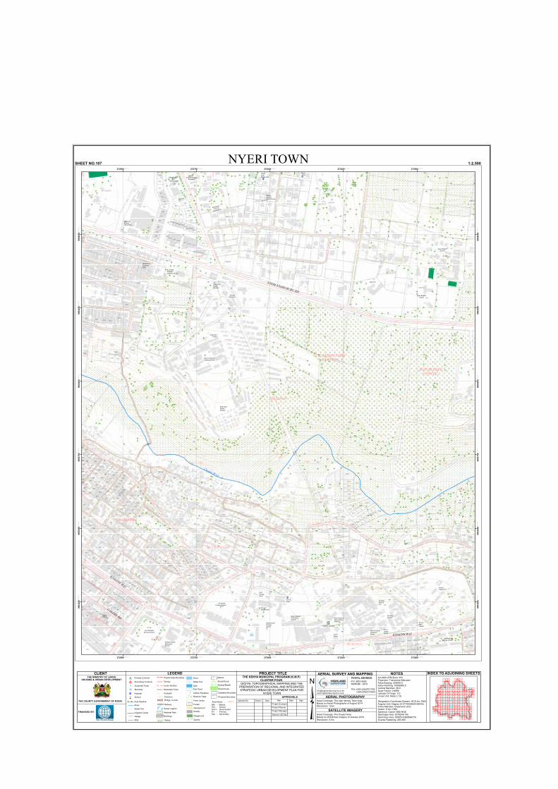
178
6384/1
21
230
187
20
573
670
45
6
105
8
83
7
6392/58
570
6392/14
2
136
6392/16
11
21
571 BLOCK 2 6392/15
273
24
851
80
6392/41
99
100
136
3728
9
41
986
4
19
5
3727
610
3726
6392/17
104
10
124
19
124
2546
1163
1162
196
126
12
100
2549
2551
23
97
100
1199
98
857
172
70
2548
2597
124
2553
175
2547
2554
1049
2550
6392/32
95
4188
77
2552
922
910
858
855
2599
322103
3652
856
3721
1538
173
85
96
3722.
96
82
938
936
854
3720
72
3723
91
152
79
153
89
174
82
164
4190
282
206
93
37
1156
38
83
206
911
91
1448
987
2413
82
68
1202
90
36
1447
931
81
171
98
73
1539
92
4189
172
271
97
35
1268
92
87
1157
3651
4191
2996
1538
90
1662
4176
1203
4192
86
967
6392/32
932.
39
270
1158
1011
989
3013
4175
935
942
988
88
4182
943
946
72
944
212
928
995
905
117
1189
912
600
3020
286
125
973
285
132
887
6392/17
933
1008
925
905
978
968
213
78
929
1052
129
94
980
1010
3011
88
1058
966
1198
122
981
928
993
976
118
1010
977
1056
135
992
919
4168
1009
1051
4180
1007
133
642
965
930
132
1050
889
216
119
134
932
3023
1061
4492
123
86
132
979 994
3018
972
934
1205
1057
127
890
914
926
211
899
4179
908
4168
1208
90
4491
917
121
904
3016
4186
939
3017
4187
1159
915
30243027
1217
985
891
3015
210
215
982
4184931
87
834
921.
892
4185
3010
4181
858
11611020
898
1187
971
3025
1017
170
4173
1204
4183
1160
3019
4172
864
4177
1062
900886
974
856
92
975
114
896
110111
4171
851893
34
126
920902
3029
991
1013
139
678
918
895
165
2643028
964
903
3026
984
862
116
916
583584
853
1159
905
681
901
113
886
647
2995
857
112
861
3021
683
897
903
688
107
683
601
140
895
103
3031
145
115
167
855
150
894
885
601.
1055
148
1005
998
138142
1021
149
3030265
147
151
108144
143
141
4178
137
106
70
1004
146
835
48
6392/22
7574
4174
218
1657.
4174
1161
101
924923
30123014
89
3022.
1016
1006
217
924
1015
854
999997
99
996
920
600.
894
863
3719
924
10011003
1269
1000
1002
266
1207
867
862
1014
104
167
100
102
166
120109
1260
105
168
1245
832
102
42
268 3035.
1270
165992
836
970
865
1271
868
49
267
831
33
1272
1205
6384/1
2413
98
915
273
MAJENGO
CBD
KARIARURINGU
1738
1762
1758
17421756
1754
1752
1748
1746
1744
1764
1766
1768
1772
1736 1734
1732
1774
1776
1778
1728
1782
1784
1786
1726
1724
1788
1722
1718
1792
17281726
1724
1788
1782
1726
1722
1718
272500.000000
272500.000000
272750.000000
272750.000000
273000.000000
273000.000000
273250.000000
273250.000000
273500.000000
273500.000000
9953
250.0
0000
0
9953
250.0
0000
0
9953
500.0
0000
0
9953
500.0
0000
0
9953
750.0
0000
0
9953
750.0
0000
0
9954
000.0
0000
0
9954
000.0
0000
0
9954
250.0
0000
0
9954
250.0
0000
0
9954
500.0
0000
0
9954
500.0
0000
0
NYERI TOWNSHEET NO.107 1:2,500
KIMATHI WAY
MAJENGO
Chania River
G.K PRISON FARM (COFFEE )
Quarry
NYERI-NYAHURURU RD
KIHURI FARM(COFFEE )
BLUE VALLEY
King'ong'o Prison
D.E.B Muslim Primary School
Consolata Primary School
Nyamachaki PrimarySchool
GithwarigaPrimary School
Nyeri General Hospital
M-pesa WimTech
P.C.E.ANyamachaki
Gulf EnergyNyeri
Nyeri HospitalOutPatientDivision
Nyeri HospitalAdmnistrativeOffices
F.E.P.Nyeri
Nyeri HospitalInpatientsWards
M.T.C LadiesHostel
NursingSchool
M.T.CMenHostel
CoollinkServiveL.td
InternsFlat(P.G.H)
St.Mary's BoysSecondary School
M-pesa Buzzline
King'ong'oPrison Mosque
Nyeri IndustrialTraining Center
King'ong'oPrison Mosque
St.JosephCaffassoCatholic Church
Wamatemo FurnitureKing
Mt.KenyaBottlers OfficeBlock
Africana Bar And
Restaurant
Nyeri GoodShepherd
Academy
King'ong'o
P.C.E.A
Apartments
Flotune CountryGuest House
Nyeri BaptistSchool
Nyeri BaptistStudio
Nyeri Inn
BatianGrand
GAKERE RD
KIMATHI WAY
³GATITU
= Primary Controls
: Secondary Controls
!! !! Fuel Pipeline
River
Pond
Water Pan
Dam
Fish Pond
Riverine Trees
l Scattered Trees
Hedge
Farm Lands
Forest
Wall
_ Borehole
! ! Sewer line
Railway
Openground
Playground
Quarry
Greenhouse
Sewer Lagoon
!!
!
! ! ! ! !!
!!!!!!
National Park
Tarmac
Footpath
Loose Surface
Motorable Track
Buildings
Project Area Boundary
1200 Contours
Mkt - MarketSch - SchoolGov't - GovernmentPri - PrimarySec - Secondary
Airstrip
Cadastral Boundary
Property Boundary
Hospital
School
®v
5Area Name.....
CLIENT
THE COUNTY GOVERNMENT OF NYERI
FINANCED BY:
THE MINISTRY OF LANDS,HOUSING & URBAN DEVELOPMENT
LEGEND INDEX TO ADJOINING SHEETSNOTESArc1960 UTM Zone 37SProjection: Transverse MercatorFalse Easting: 500000.0False Northing: 10000000.0Central Meridian: 39.0Scale Factor: 0.9996Latitude Of Origin: 0.0Linear Unit: Meter (1.0)
Geographic Coordinate System: GCS Arc 1960Angular Unit: Degree (0.0174532925199433)Prime Meridian: Greenwich (0.0)Datum: D Arc 1960Spheroid: Clarke 1880 RGSSemimajor Axis: 6378249.145Semiminor Axis: 6356514.869549776Inverse Flattening: 293.465
AERIAL SURVEY AND MAPPINGPOSTAL ADDRESSP.O. BOX 9562NAIROBI - GPO
TEL:+254-(20)2721726 +254-(20)2721943www.highlandsurveyors.co.ke
AERIAL PHOTOGRAPHYAreal Coverage: The high density Town AreaBased on Aerial Photographs of August 2014Resolution: 12cm
SATELLITE IMAGERYAreal Coverage: The Project AreaBased on WorldView Imagery of January 2014Resolution: 0.5m
PROJECT TITLE
DIGITAL TOPOGRAPHICAL MAPPING AND THE PREPARATION OF REGIONAL AND INTEGRATED STRATEGIC URBAN DEVELOPMENT PLAN FOR
NYERI TOWN
THE KENYA MUNICIPAL PROGRAM (K.M.P)CLUSTER FOUR
APPROVALS
Project Surveyor
Project Manager
Director UD Dpt.
Project Planner
Date SignDate TitleUpdated By EditionBridge, Culvert
Thicket
Market
Shrub/Scrub
Swamp/Marsh
Irrigation Canal
654321
987 11
77
23
14131210
26252422212019181715
414039383736353433323130292827
5655545352515049484746454342
727170
99
6867666564636260
73
58 59
86
57
87 88 89 90 91 92 93 95 96 97 98
61
8574 75 76
69
78 79 80 81 82 83 84
94
16
44
111 114113
115 118117
112110
119116
113
149
120
100
109108107105104103102101
130129128127126125124123122121
146145144143142141140139138137136135134133132131
160159158157156155154153152151150148147
167166165164163162161
106
Coffee Plantation
Amani Clinic
Police LineDispensary
F.P.A.K. Clinic
IC
IC
IC
IC
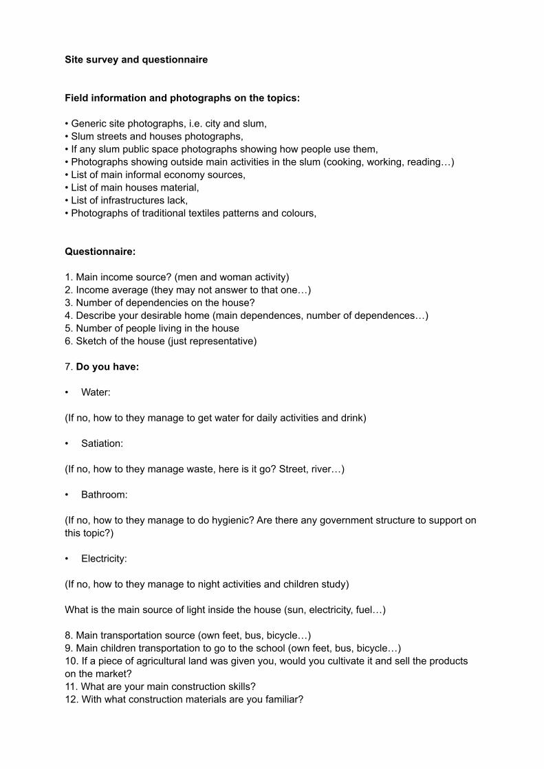
Site survey and questionnaire
Field information and photographs on the topics:
Generic site photographs, i.e. city and slum, Slum streets and houses photographs, If any slum public space photographs showing how people use them, Photographs showing outside main activities in the slum (cooking, working, reading ) List of main informal economy sources, List of main houses material, List of infrastructures lack, Photographs of traditional textiles patterns and colours,
Questionnaire:
1. Main income source (men and woman activity)2. Income average (they may not answer to that one )3. Number of dependencies on the house4. escribe your desirable home (main dependences, number of dependences )5. Number of people living in the house6. Sketch of the house (just representative)
7. Do you have:
Water:
(If no, how to they manage to get water for daily activities and drink)
Satiation:
(If no, how to they manage waste, here is it go Street, river )
Bathroom:
(If no, how to they manage to do hygienic Are there any government structure to support on this topic )
Electricity:
(If no, how to they manage to night activities and children study)
What is the main source of light inside the house (sun, electricity, fuel )
8. Main transportation source (own feet, bus, bicycle )9. Main children transportation to go to the school (own feet, bus, bicycle )10. If a piece of agricultural land was given you, would you cultivate it and sell the products on the market11. What are your main construction skills12. With what construction materials are you familiar

ANNEX IV

18/11/2016 Methodological Strategy of Place Analysis and Intervention Based on Place Identity Survey
https://docs.google.com/forms/d/1Nf0RNnGYdO2XC_26v8Ucf31Al44OdIybT5gAm7npAQ/edit 1/8
Methodological Strategy of Place Analysis and
Intervention Based on Place Identity Survey
This survey is integrated in a research centered in the fields of architecture and urban planning. The scope is creating a methodological strategy of place analysis and intervention based on place identity – inside this research the sum of the geographical, builtenvironment and sociocultural dimensions – in order to generate more sustainable and place rooted projects.
The proposed methodological strategy must be understood as a flexible recommendation prioritizing the optimization of existent resources instead of a hermetic solution for every place and/or program. Thus, we propose a methodological strategy of place intervention and analysis based on place identity structured by two main groups (G) as follows:
G1. Methodological Strategy of Place Analysis
Step1: General Context Overview; Step2: Place survey based on place identity.
G2. Methodological Strategy of Place Intervention
Step3: Urban level sustainability tasks; Step4: Principles as tools; Step5: Architectural level tasks; Step6: Placed based project development; Step7: Postoccupancy evaluation.
*Required
G1. Methodological Strategy of Place Analysis Step1: General
Context OverviewA country's general overview will inform on the social, economic and political current situation – helpful to review emergent subjects to be subsequently addressed in the work's timeline. The goal of this step is to break of the dangerous of thinking that we know the answer before we even listening the question; supportive to minimize the social, economic and environmental impact of a project. Two levels must be explored: 1. Global Level (relating with the country); 2. Local Level (relating with the place where we going to intervene); encompassing the economic, political and social dimension.
1. Please tell us your opinion about the previous sentence *Mark only one oval per row.
Stronglydisagree Disagree Neither agrees
nor disagrees Agree Stronglyagree
Notapplicable
General ContextOverview
2. Please tell us your opinion about the presented methods *
Methods: Literature review (scientific papers, reports, official web sites and online statistics databases – the United Nations, the World Resources Institute and the country’s Census, MigrationObservatories and Statistics Institutes are credible data sources; however it always requiresspecific research on the country official data sources); data critical selection and cross.Mark only one oval per row.
Stronglydisagree Disagree Neither agrees nor
disagrees Agree Stronglyagree
Notapplicable
Methods
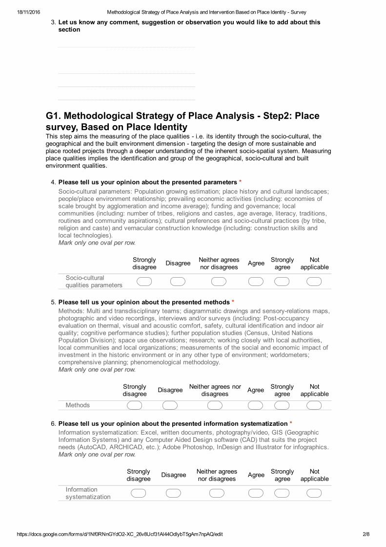
18/11/2016 Methodological Strategy of Place Analysis and Intervention Based on Place Identity Survey
https://docs.google.com/forms/d/1Nf0RNnGYdO2XC_26v8Ucf31Al44OdIybT5gAm7npAQ/edit 2/8
3. Let us know any comment, suggestion or observation you would like to add about this
section
G1. Methodological Strategy of Place Analysis Step2: Place
survey, Based on Place IdentityThis step aims the measuring of the place qualities i.e. its identity through the sociocultural, the geographical and the built environment dimension targeting the design of more sustainable and place rooted projects through a deeper understanding of the inherent sociospatial system. Measuring place qualities implies the identification and group of the geographical, sociocultural and built environment qualities.
4. Please tell us your opinion about the presented parameters *
Sociocultural parameters: Population growing estimation; place history and cultural landscapes;people/place environment relationship; prevailing economic activities (including: economies ofscale brought by agglomeration and income average); funding and governance; localcommunities (including: number of tribes, religions and castes, age average, literacy, traditions,routines and community aspirations); cultural preferences and sociocultural practices (by tribe,religion and caste) and vernacular construction knowledge (including: construction skills andlocal technologies).Mark only one oval per row.
Stronglydisagree Disagree Neither agrees
nor disagrees Agree Stronglyagree
Notapplicable
Socioculturalqualities parameters
5. Please tell us your opinion about the presented methods *
Methods: Multi and transdisciplinary teams; diagrammatic drawings and sensoryrelations maps,photographic and video recordings, interviews and/or surveys (including: Postoccupancyevaluation on thermal, visual and acoustic comfort, safety, cultural identification and indoor airquality; cognitive performance studies); further population studies (Census, United NationsPopulation Division); space use observations; research; working closely with local authorities,local communities and local organizations; measurements of the social and economic impact ofinvestment in the historic environment or in any other type of environment; worldometers;comprehensive planning; phenomenological methodology.Mark only one oval per row.
Stronglydisagree Disagree Neither agrees nor
disagrees Agree Stronglyagree
Notapplicable
Methods
6. Please tell us your opinion about the presented information systematization *
Information systematization: Excel, written documents, photography/video, GIS (GeographicInformation Systems) and any Computer Aided Design software (CAD) that suits the projectneeds (AutoCAD, ARCHICAD, etc.); Adobe Photoshop, InDesign and Illustrator for infographics.Mark only one oval per row.
Stronglydisagree Disagree Neither agrees
nor disagrees Agree Stronglyagree
Notapplicable
Informationsystematization
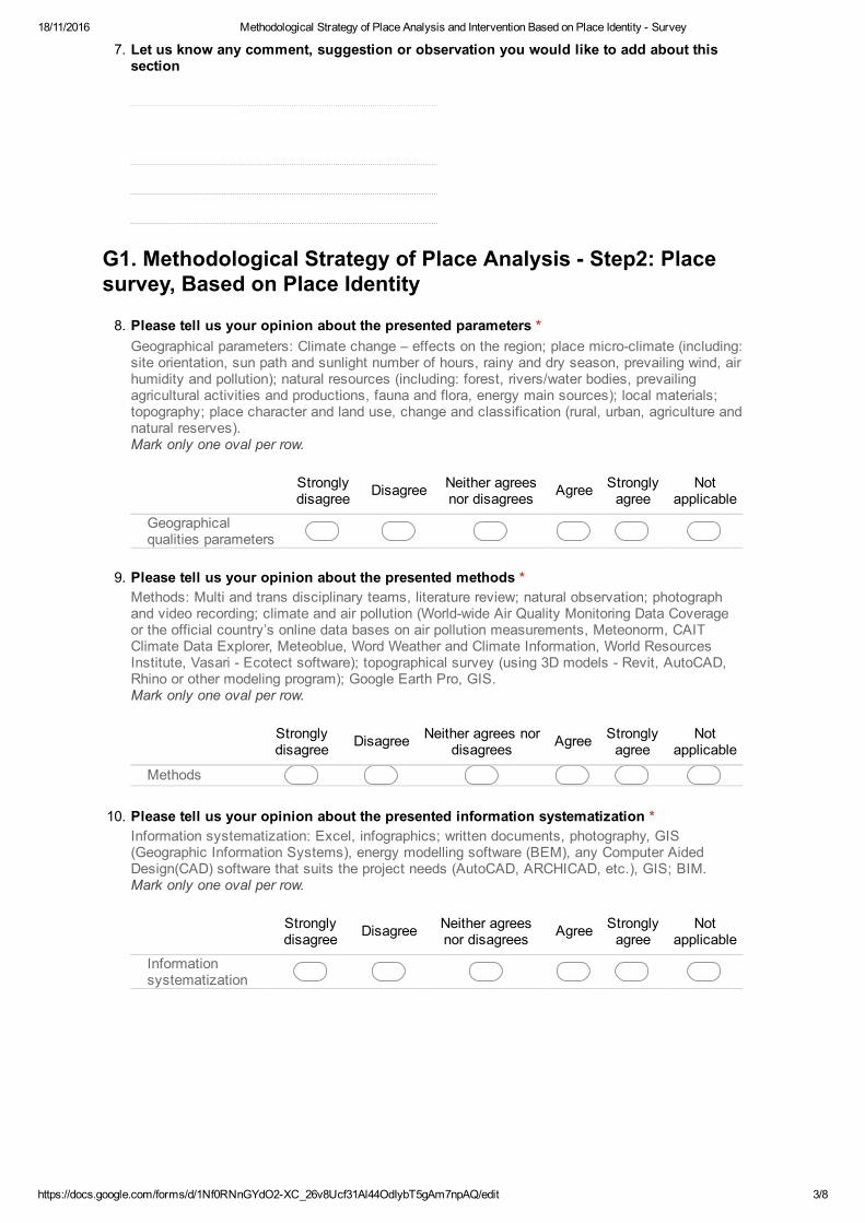
18/11/2016 Methodological Strategy of Place Analysis and Intervention Based on Place Identity Survey
https://docs.google.com/forms/d/1Nf0RNnGYdO2XC_26v8Ucf31Al44OdIybT5gAm7npAQ/edit 3/8
7. Let us know any comment, suggestion or observation you would like to add about this
section
G1. Methodological Strategy of Place Analysis Step2: Place
survey, Based on Place Identity
8. Please tell us your opinion about the presented parameters *
Geographical parameters: Climate change – effects on the region; place microclimate (including:site orientation, sun path and sunlight number of hours, rainy and dry season, prevailing wind, airhumidity and pollution); natural resources (including: forest, rivers/water bodies, prevailingagricultural activities and productions, fauna and flora, energy main sources); local materials;topography; place character and land use, change and classification (rural, urban, agriculture andnatural reserves).Mark only one oval per row.
Stronglydisagree Disagree Neither agrees
nor disagrees Agree Stronglyagree
Notapplicable
Geographicalqualities parameters
9. Please tell us your opinion about the presented methods *
Methods: Multi and trans disciplinary teams, literature review; natural observation; photographand video recording; climate and air pollution (Worldwide Air Quality Monitoring Data Coverageor the official country’s online data bases on air pollution measurements, Meteonorm, CAITClimate Data Explorer, Meteoblue, Word Weather and Climate Information, World ResourcesInstitute, Vasari Ecotect software); topographical survey (using 3D models Revit, AutoCAD,Rhino or other modeling program); Google Earth Pro, GIS.Mark only one oval per row.
Stronglydisagree Disagree Neither agrees nor
disagrees Agree Stronglyagree
Notapplicable
Methods
10. Please tell us your opinion about the presented information systematization *
Information systematization: Excel, infographics; written documents, photography, GIS(Geographic Information Systems), energy modelling software (BEM), any Computer AidedDesign(CAD) software that suits the project needs (AutoCAD, ARCHICAD, etc.), GIS; BIM.Mark only one oval per row.
Stronglydisagree Disagree Neither agrees
nor disagrees Agree Stronglyagree
Notapplicable
Informationsystematization
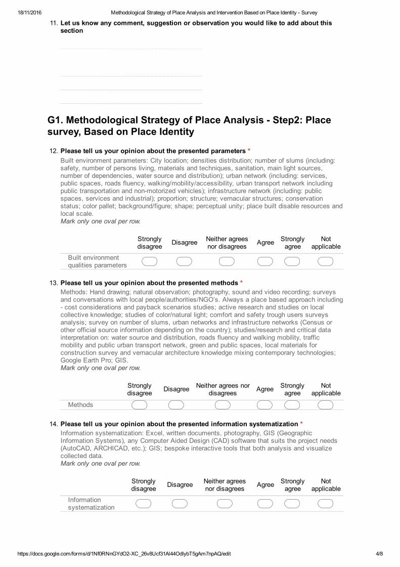
18/11/2016 Methodological Strategy of Place Analysis and Intervention Based on Place Identity Survey
https://docs.google.com/forms/d/1Nf0RNnGYdO2XC_26v8Ucf31Al44OdIybT5gAm7npAQ/edit 4/8
11. Let us know any comment, suggestion or observation you would like to add about this
section
G1. Methodological Strategy of Place Analysis Step2: Place
survey, Based on Place Identity
12. Please tell us your opinion about the presented parameters *
Built environment parameters: City location; densities distribution; number of slums (including:safety, number of persons living, materials and techniques, sanitation, main light sources,number of dependencies, water source and distribution); urban network (including: services,public spaces, roads fluency, walking/mobility/accessibility, urban transport network includingpublic transportation and nonmotorized vehicles); infrastructure network (including: publicspaces, services and industrial); proportion; structure; vernacular structures; conservationstatus; color pallet; background/figure; shape; perceptual unity; place built disable resources andlocal scale.Mark only one oval per row.
Stronglydisagree Disagree Neither agrees
nor disagrees Agree Stronglyagree
Notapplicable
Built environmentqualities parameters
13. Please tell us your opinion about the presented methods *
Methods: Hand drawing; natural observation; photography, sound and video recording; surveysand conversations with local people/authorities/NGO’s. Always a place based approach including cost considerations and payback scenarios studies; active research and studies on localcollective knowledge; studies of color/natural light; comfort and safety trough users surveysanalysis; survey on number of slums, urban networks and infrastructure networks (Census orother official source information depending on the country); studies/research and critical datainterpretation on: water source and distribution, roads fluency and walking mobility, trafficmobility and public urban transport network, green and public spaces, local materials forconstruction survey and vernacular architecture knowledge mixing contemporary technologies;Google Earth Pro; GIS.Mark only one oval per row.
Stronglydisagree Disagree Neither agrees nor
disagrees Agree Stronglyagree
Notapplicable
Methods
14. Please tell us your opinion about the presented information systematization *
Information systematization: Excel, written documents, photography, GIS (GeographicInformation Systems), any Computer Aided Design (CAD) software that suits the project needs(AutoCAD, ARCHICAD, etc.); GIS; bespoke interactive tools that both analysis and visualizecollected data.Mark only one oval per row.
Stronglydisagree Disagree Neither agrees
nor disagrees Agree Stronglyagree
Notapplicable
Informationsystematization
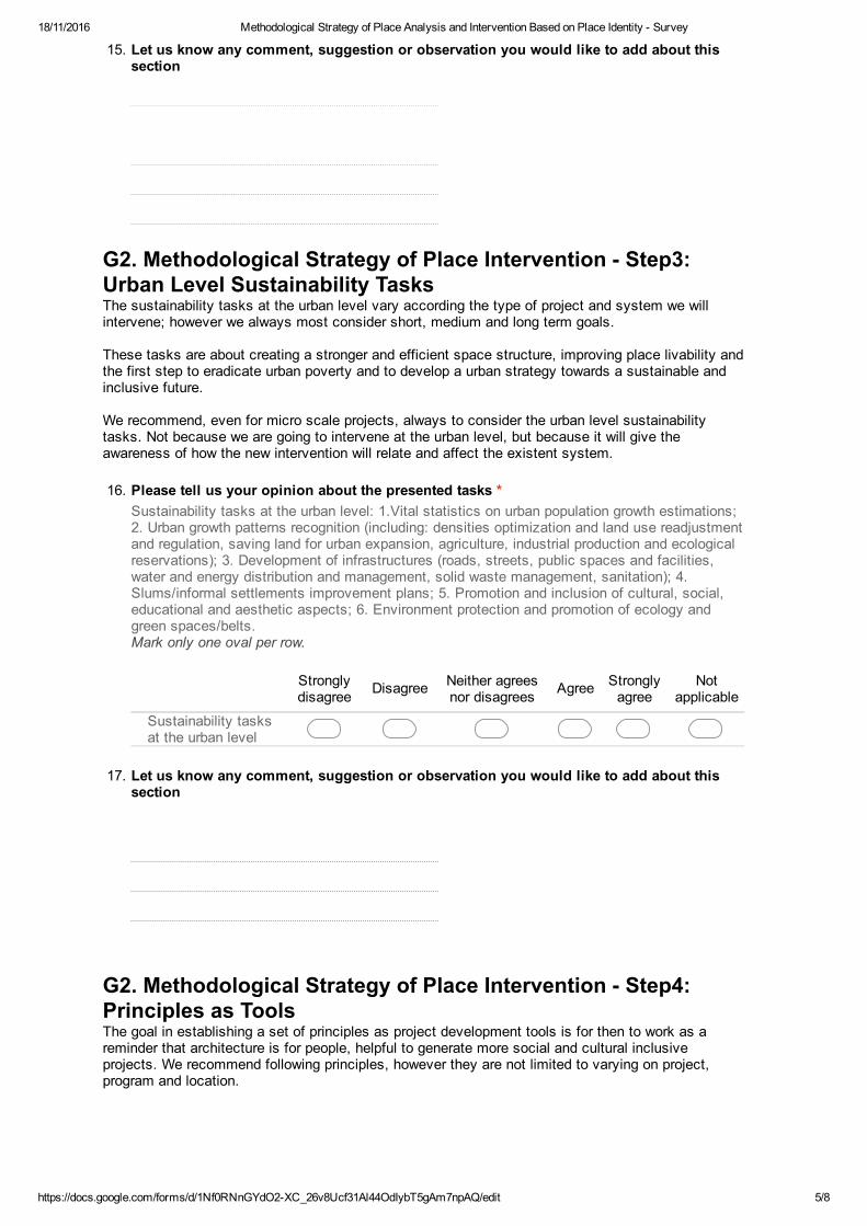
18/11/2016 Methodological Strategy of Place Analysis and Intervention Based on Place Identity Survey
https://docs.google.com/forms/d/1Nf0RNnGYdO2XC_26v8Ucf31Al44OdIybT5gAm7npAQ/edit 5/8
15. Let us know any comment, suggestion or observation you would like to add about this
section
G2. Methodological Strategy of Place Intervention Step3:
Urban Level Sustainability TasksThe sustainability tasks at the urban level vary according the type of project and system we will intervene; however we always most consider short, medium and long term goals. These tasks are about creating a stronger and efficient space structure, improving place livability and the first step to eradicate urban poverty and to develop a urban strategy towards a sustainable and inclusive future. We recommend, even for micro scale projects, always to consider the urban level sustainability tasks. Not because we are going to intervene at the urban level, but because it will give the awareness of how the new intervention will relate and affect the existent system.
16. Please tell us your opinion about the presented tasks *Sustainability tasks at the urban level: 1.Vital statistics on urban population growth estimations;2. Urban growth patterns recognition (including: densities optimization and land use readjustmentand regulation, saving land for urban expansion, agriculture, industrial production and ecologicalreservations); 3. Development of infrastructures (roads, streets, public spaces and facilities,water and energy distribution and management, solid waste management, sanitation); 4.Slums/informal settlements improvement plans; 5. Promotion and inclusion of cultural, social,educational and aesthetic aspects; 6. Environment protection and promotion of ecology andgreen spaces/belts.Mark only one oval per row.
Stronglydisagree Disagree Neither agrees
nor disagrees Agree Stronglyagree
Notapplicable
Sustainability tasksat the urban level
17. Let us know any comment, suggestion or observation you would like to add about this
section
G2. Methodological Strategy of Place Intervention Step4:
Principles as ToolsThe goal in establishing a set of principles as project development tools is for then to work as a reminder that architecture is for people, helpful to generate more social and cultural inclusive projects. We recommend following principles, however they are not limited to varying on project, program and location.
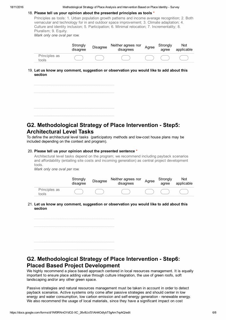
18/11/2016 Methodological Strategy of Place Analysis and Intervention Based on Place Identity Survey
https://docs.google.com/forms/d/1Nf0RNnGYdO2XC_26v8Ucf31Al44OdIybT5gAm7npAQ/edit 6/8
18. Please tell us your opinion about the presented principles as tools *Principles as tools: 1. Urban population growth patterns and income average recognition; 2. Bothvernacular and technology for in and outdoor space improvement; 3. Climate adaptation; 4.Culture and identity inclusion; 5. Participation; 6. Minimal relocation; 7. Incrementality; 8.Pluralism; 9. Equity.Mark only one oval per row.
Stronglydisagree Disagree Neither agrees nor
disagrees Agree Stronglyagree
Notapplicable
Principles astools
19. Let us know any comment, suggestion or observation you would like to add about this
section
G2. Methodological Strategy of Place Intervention Step5:
Architectural Level TasksTo define the architectural level tasks (participatory methods and lowcost house plans may be included depending on the context and program).
20. Please tell us your opinion about the presented sentence *Architectural level tasks depend on the program; we recommend including payback scenariosand affordability (entailing site costs and incoming generation) as central project developmenttools.Mark only one oval per row.
Stronglydisagree Disagree Neither agrees nor
disagrees Agree Stronglyagree
Notapplicable
Principles astools
21. Let us know any comment, suggestion or observation you would like to add about this
section
G2. Methodological Strategy of Place Intervention Step6:
Placed Based Project DevelopmentWe highly recommend a place based approach centered in local resources management. It is equally important to ensure place adding value through culture integration, the use of green roofs, soft landscaping and/or any other green space. Passive strategies and natural resources management must be taken in account in order to detect payback scenarios. Active systems only come after passive strategies and should center in low energy and water consumption, low carbon emission and selfenergy generation renewable energy. We also recommend the usage of local materials, since they have a significant impact on cost
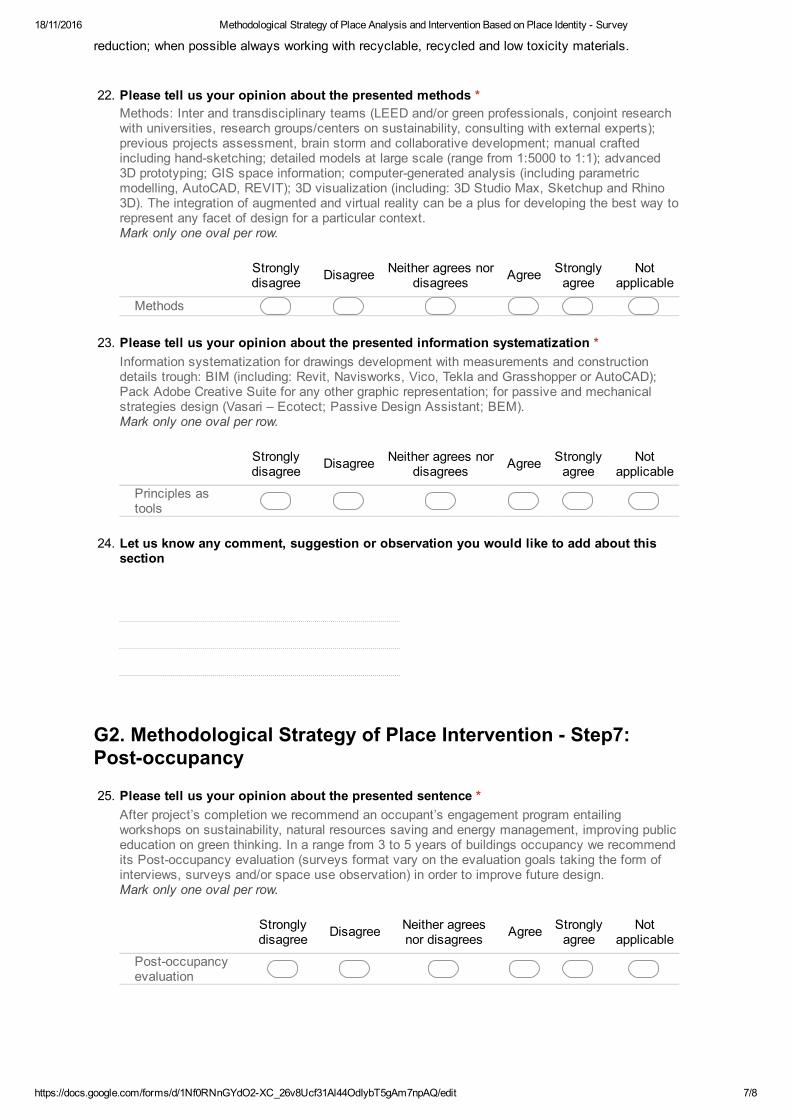
18/11/2016 Methodological Strategy of Place Analysis and Intervention Based on Place Identity Survey
https://docs.google.com/forms/d/1Nf0RNnGYdO2XC_26v8Ucf31Al44OdIybT5gAm7npAQ/edit 7/8
reduction; when possible always working with recyclable, recycled and low toxicity materials.
22. Please tell us your opinion about the presented methods *
Methods: Inter and transdisciplinary teams (LEED and/or green professionals, conjoint researchwith universities, research groups/centers on sustainability, consulting with external experts);previous projects assessment, brain storm and collaborative development; manual craftedincluding handsketching; detailed models at large scale (range from 1:5000 to 1:1); advanced3D prototyping; GIS space information; computergenerated analysis (including parametricmodelling, AutoCAD, REVIT); 3D visualization (including: 3D Studio Max, Sketchup and Rhino3D). The integration of augmented and virtual reality can be a plus for developing the best way torepresent any facet of design for a particular context.Mark only one oval per row.
Stronglydisagree Disagree Neither agrees nor
disagrees Agree Stronglyagree
Notapplicable
Methods
23. Please tell us your opinion about the presented information systematization *
Information systematization for drawings development with measurements and constructiondetails trough: BIM (including: Revit, Navisworks, Vico, Tekla and Grasshopper or AutoCAD);Pack Adobe Creative Suite for any other graphic representation; for passive and mechanicalstrategies design (Vasari – Ecotect; Passive Design Assistant; BEM).Mark only one oval per row.
Stronglydisagree Disagree Neither agrees nor
disagrees Agree Stronglyagree
Notapplicable
Principles astools
24. Let us know any comment, suggestion or observation you would like to add about this
section
G2. Methodological Strategy of Place Intervention Step7:
Postoccupancy
25. Please tell us your opinion about the presented sentence *After project’s completion we recommend an occupant’s engagement program entailingworkshops on sustainability, natural resources saving and energy management, improving publiceducation on green thinking. In a range from 3 to 5 years of buildings occupancy we recommendits Postoccupancy evaluation (surveys format vary on the evaluation goals taking the form ofinterviews, surveys and/or space use observation) in order to improve future design.Mark only one oval per row.
Stronglydisagree Disagree Neither agrees
nor disagrees Agree Stronglyagree
Notapplicable
Postoccupancyevaluation
18/11/2016 Methodological Strategy of Place Analysis and Intervention Based on Place Identity Survey
https://docs.google.com/forms/d/1Nf0RNnGYdO2XC_26v8Ucf31Al44OdIybT5gAm7npAQ/edit 8/8
Powered by
26. Let us know any comment, suggestion or observation you would like to add about this
section
Methodological Strategy of Place Intervention Observações
27. Let us know any comment, suggestion or
observation you would like to add about this
methodological strategy
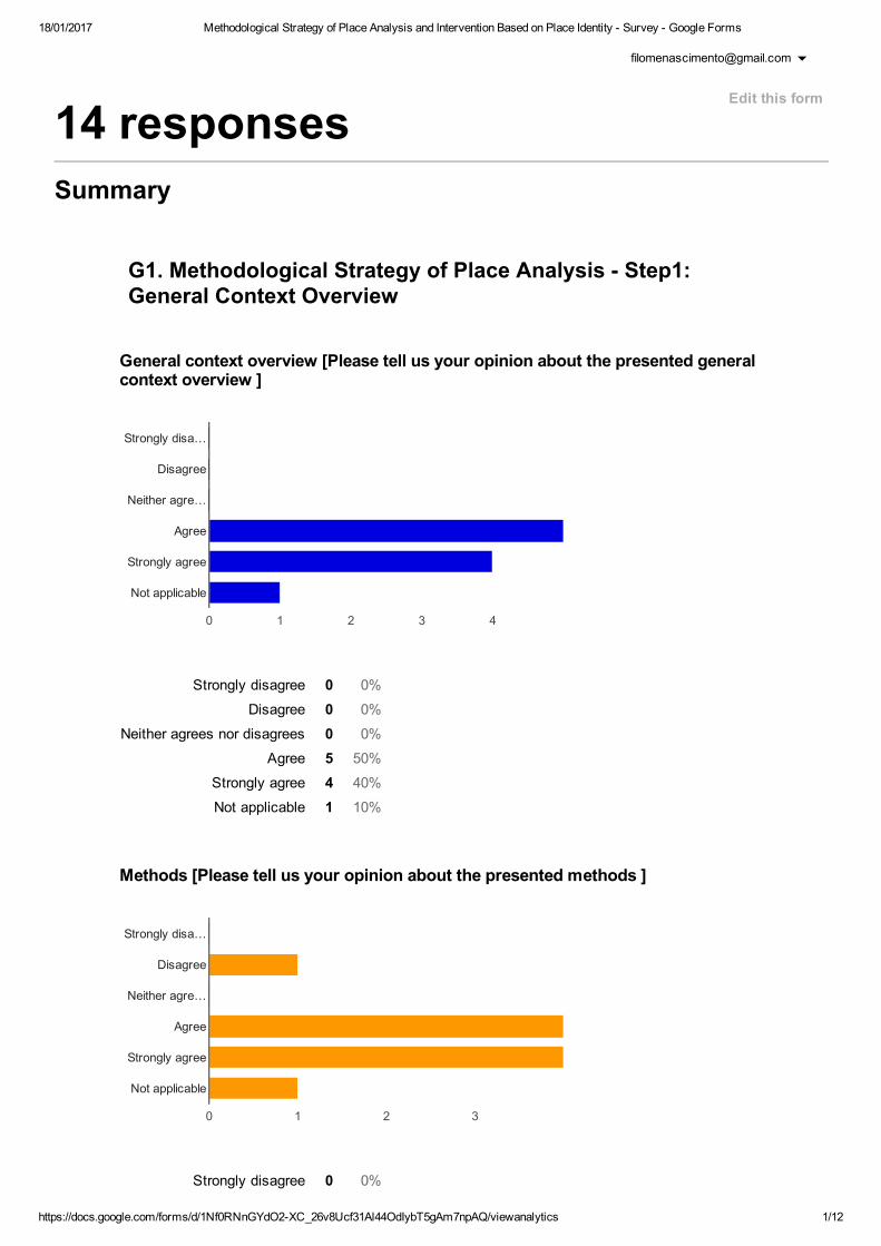
18/01/2017 Methodological Strategy of Place Analysis and Intervention Based on Place Identity Survey Google Forms
https://docs.google.com/forms/d/1Nf0RNnGYdO2XC_26v8Ucf31Al44OdIybT5gAm7npAQ/viewanalytics 1/12
Strongly disagree 0 0%
Disagree 0 0%
Neither agrees nor disagrees 0 0%
Agree 5 50%
Strongly agree 4 40%
Not applicable 1 10%
Strongly disagree 0 0%
14 responses
Summary
G1. Methodological Strategy of Place Analysis Step1:
General Context Overview
General context overview [Please tell us your opinion about the presented general
context overview ]
Methods [Please tell us your opinion about the presented methods ]
Edit this form
0 1 2 3 4
Strongly disa…
Disagree
Neither agre…
Agree
Strongly agree
Not applicable
0 1 2 3
Strongly disa…
Disagree
Neither agre…
Agree
Strongly agree
Not applicable
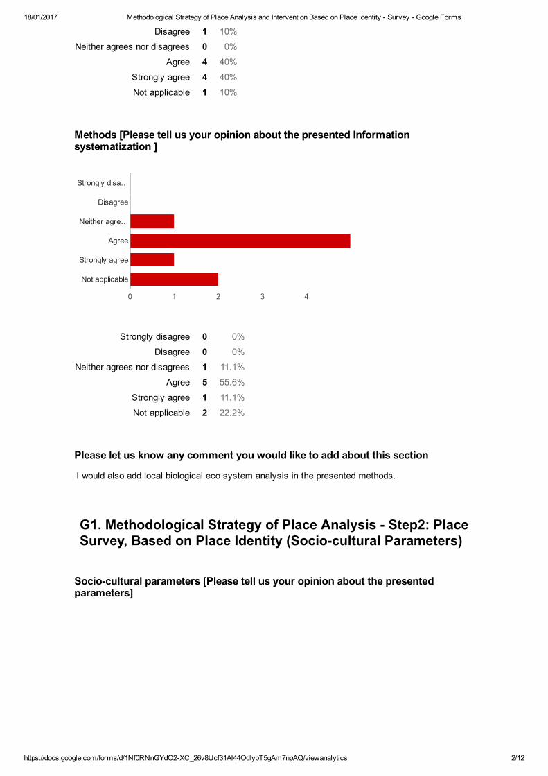
18/01/2017 Methodological Strategy of Place Analysis and Intervention Based on Place Identity Survey Google Forms
https://docs.google.com/forms/d/1Nf0RNnGYdO2XC_26v8Ucf31Al44OdIybT5gAm7npAQ/viewanalytics 2/12
Disagree 1 10%
Neither agrees nor disagrees 0 0%
Agree 4 40%
Strongly agree 4 40%
Not applicable 1 10%
Strongly disagree 0 0%
Disagree 0 0%
Neither agrees nor disagrees 1 11.1%
Agree 5 55.6%
Strongly agree 1 11.1%
Not applicable 2 22.2%
Methods [Please tell us your opinion about the presented Information
systematization ]
Please let us know any comment you would like to add about this section
I would also add local biological eco system analysis in the presented methods.
G1. Methodological Strategy of Place Analysis Step2: Place
Survey, Based on Place Identity (Sociocultural Parameters)
Sociocultural parameters [Please tell us your opinion about the presented
parameters]
0 1 2 3 4
Strongly disa…
Disagree
Neither agre…
Agree
Strongly agree
Not applicable
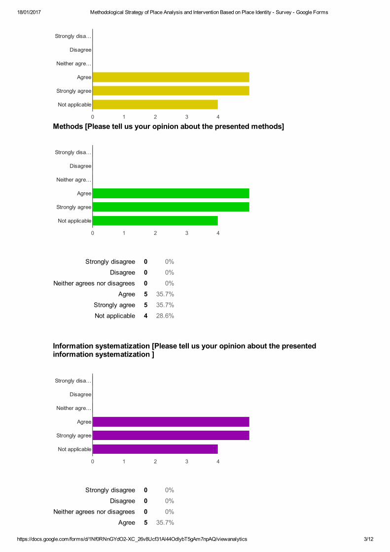
18/01/2017 Methodological Strategy of Place Analysis and Intervention Based on Place Identity Survey Google Forms
https://docs.google.com/forms/d/1Nf0RNnGYdO2XC_26v8Ucf31Al44OdIybT5gAm7npAQ/viewanalytics 3/12
Strongly disagree 0 0%
Disagree 0 0%
Neither agrees nor disagrees 0 0%
Agree 5 35.7%
Strongly agree 5 35.7%
Not applicable 4 28.6%
Strongly disagree 0 0%
Disagree 0 0%
Neither agrees nor disagrees 0 0%
Agree 5 35.7%
Strongly agree 5 35.7%
Not applicable 4 28.6%
Strongly disagree 0 0%
Disagree 0 0%
Neither agrees nor disagrees 0 0%
Agree 5 35.7%
Methods [Please tell us your opinion about the presented methods]
Information systematization [Please tell us your opinion about the presented
information systematization ]
0 1 2 3 4
Strongly disa…
Disagree
Neither agre…
Agree
Strongly agree
Not applicable
0 1 2 3 4
Strongly disa…
Disagree
Neither agre…
Agree
Strongly agree
Not applicable
0 1 2 3 4
Strongly disa…
Disagree
Neither agre…
Agree
Strongly agree
Not applicable

18/01/2017 Methodological Strategy of Place Analysis and Intervention Based on Place Identity Survey Google Forms
https://docs.google.com/forms/d/1Nf0RNnGYdO2XC_26v8Ucf31Al44OdIybT5gAm7npAQ/viewanalytics 4/12
Strongly agree 5 35.7%Not applicable 4 28.6%
Strongly disagree 0 0%
Disagree 0 0%
Neither agrees nor disagrees 0 0%
Agree 5 35.7%
Strongly agree 5 35.7%
Not applicable 4 28.6%
Strongly disagree 0 0%
Please let us know any comment you would like to add about this section
ljhrt6du6dfif9
Same as earlier do survey and analyse bioclimatic local data.
G1. Methodological Strategy of Place Analysis Step2: Place
survey, Based on Place Identity (Geographical Parameters)
Geographical parameters [Please tell us your opinion about the presented
parameters]
Methods [Please tell us your opinion about the presented methods ]
0 1 2 3 4
Strongly disa…
Disagree
Neither agre…
Agree
Strongly agree
Not applicable
0 1 2 3 4 5
Strongly disa…
Disagree
Neither agre…
Agree
Strongly agree
Not applicable
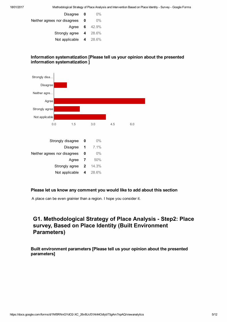
18/01/2017 Methodological Strategy of Place Analysis and Intervention Based on Place Identity Survey Google Forms
https://docs.google.com/forms/d/1Nf0RNnGYdO2XC_26v8Ucf31Al44OdIybT5gAm7npAQ/viewanalytics 5/12
Disagree 0 0%
Neither agrees nor disagrees 0 0%
Agree 6 42.9%
Strongly agree 4 28.6%
Not applicable 4 28.6%
Strongly disagree 0 0%
Disagree 1 7.1%
Neither agrees nor disagrees 0 0%
Agree 7 50%
Strongly agree 2 14.3%
Not applicable 4 28.6%
Information systematization [Please tell us your opinion about the presented
information systematization ]
Please let us know any comment you would like to add about this section
A place can be even grainier than a region. I hope you consider it.
G1. Methodological Strategy of Place Analysis Step2: Place
survey, Based on Place Identity (Built Environment
Parameters)
Built environment parameters [Please tell us your opinion about the presented
parameters]
0.0 1.5 3.0 4.5 6.0
Strongly disa…
Disagree
Neither agre…
Agree
Strongly agree
Not applicable

18/01/2017 Methodological Strategy of Place Analysis and Intervention Based on Place Identity Survey Google Forms
https://docs.google.com/forms/d/1Nf0RNnGYdO2XC_26v8Ucf31Al44OdIybT5gAm7npAQ/viewanalytics 6/12
Strongly disagree 0 0%
Disagree 0 0%
Neither agrees nor disagrees 0 0%
Agree 5 38.5%
Strongly agree 5 38.5%
Not applicable 3 23.1%
Strongly disagree 0 0%
Disagree 0 0%
Neither agrees nor disagrees 1 7.7%
Agree 5 38.5%
Strongly agree 4 30.8%
Not applicable 3 23.1%
Strongly disagree 0 0%
Disagree 0 0%
Neither agrees nor disagrees 2 15.4%
Methods [Please tell us your opinion about the presented methods ]
Information systematization [Please tell us your opinion about the presented
information systematization ]
0 1 2 3 4
Strongly disa…
Disagree
Neither agre…
Agree
Strongly agree
Not applicable
0 1 2 3 4
Strongly disa…
Disagree
Neither agre…
Agree
Strongly agree
Not applicable
0 1 2 3 4
Strongly disa…
Disagree
Neither agre…
Agree
Strongly agree
Not applicable
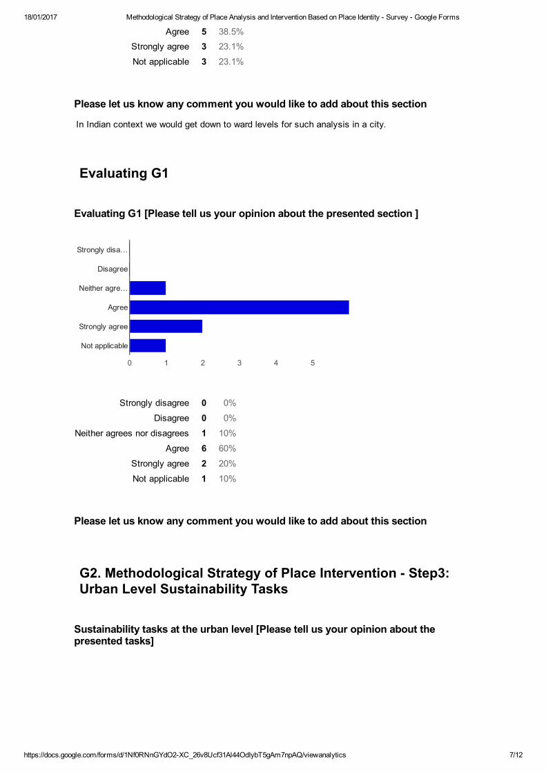
18/01/2017 Methodological Strategy of Place Analysis and Intervention Based on Place Identity Survey Google Forms
https://docs.google.com/forms/d/1Nf0RNnGYdO2XC_26v8Ucf31Al44OdIybT5gAm7npAQ/viewanalytics 7/12
Agree 5 38.5%Strongly agree 3 23.1%
Not applicable 3 23.1%
Strongly disagree 0 0%
Disagree 0 0%
Neither agrees nor disagrees 1 10%
Agree 6 60%
Strongly agree 2 20%
Not applicable 1 10%
Please let us know any comment you would like to add about this section
In Indian context we would get down to ward levels for such analysis in a city.
Evaluating G1
Evaluating G1 [Please tell us your opinion about the presented section ]
Please let us know any comment you would like to add about this section
G2. Methodological Strategy of Place Intervention Step3:
Urban Level Sustainability Tasks
Sustainability tasks at the urban level [Please tell us your opinion about the
presented tasks]
0 1 2 3 4 5
Strongly disa…
Disagree
Neither agre…
Agree
Strongly agree
Not applicable
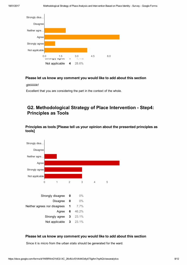
18/01/2017 Methodological Strategy of Place Analysis and Intervention Based on Place Identity Survey Google Forms
https://docs.google.com/forms/d/1Nf0RNnGYdO2XC_26v8Ucf31Al44OdIybT5gAm7npAQ/viewanalytics 8/12
Strongly disagree 0 0%
Disagree 0 0%
Neither agrees nor disagrees 2 14.3%
Agree 7 50%
Strongly agree 1 7.1%
Not applicable 4 28.6%
Strongly disagree 0 0%
Disagree 0 0%
Neither agrees nor disagrees 1 7.7%
Agree 6 46.2%
Strongly agree 3 23.1%
Not applicable 3 23.1%
Please let us know any comment you would like to add about this section
gbtiiiiiiiikf
Excellent that you are considering the part in the context of the whole.
G2. Methodological Strategy of Place Intervention Step4:
Principles as Tools
Principles as tools [Please tell us your opinion about the presented principles as
tools]
Please let us know any comment you would like to add about this section
Since it is micro from the urban stats should be generated for the ward.
0.0 1.5 3.0 4.5 6.0
Strongly disa…
Disagree
Neither agre…
Agree
Strongly agree
Not applicable
0 1 2 3 4 5
Strongly disa…
Disagree
Neither agre…
Agree
Strongly agree
Not applicable
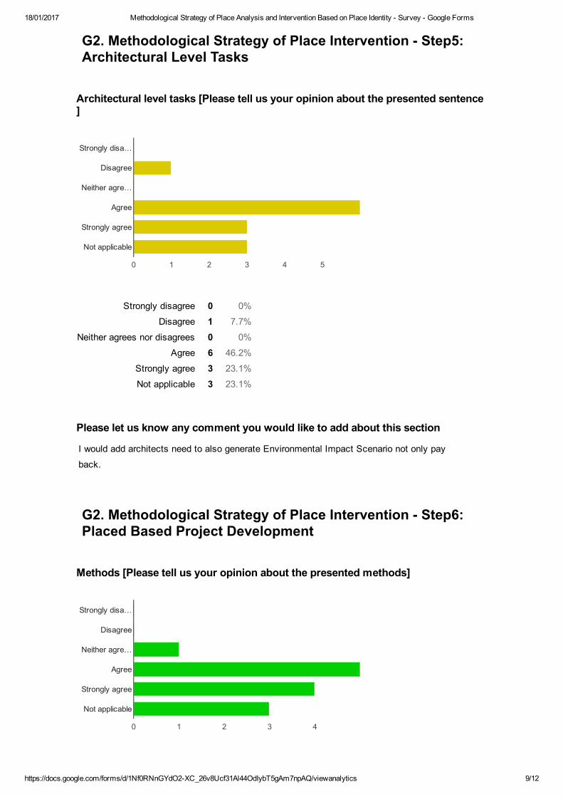
18/01/2017 Methodological Strategy of Place Analysis and Intervention Based on Place Identity Survey Google Forms
https://docs.google.com/forms/d/1Nf0RNnGYdO2XC_26v8Ucf31Al44OdIybT5gAm7npAQ/viewanalytics 9/12
Strongly disagree 0 0%
Disagree 1 7.7%
Neither agrees nor disagrees 0 0%
Agree 6 46.2%
Strongly agree 3 23.1%
Not applicable 3 23.1%
G2. Methodological Strategy of Place Intervention Step5:
Architectural Level Tasks
Architectural level tasks [Please tell us your opinion about the presented sentence
]
Please let us know any comment you would like to add about this section
I would add architects need to also generate Environmental Impact Scenario not only pay
back.
G2. Methodological Strategy of Place Intervention Step6:
Placed Based Project Development
Methods [Please tell us your opinion about the presented methods]
0 1 2 3 4 5
Strongly disa…
Disagree
Neither agre…
Agree
Strongly agree
Not applicable
0 1 2 3 4
Strongly disa…
Disagree
Neither agre…
Agree
Strongly agree
Not applicable
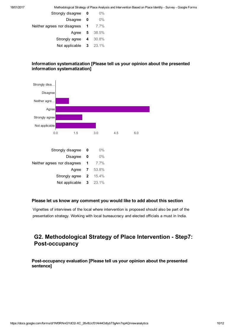
18/01/2017 Methodological Strategy of Place Analysis and Intervention Based on Place Identity Survey Google Forms
https://docs.google.com/forms/d/1Nf0RNnGYdO2XC_26v8Ucf31Al44OdIybT5gAm7npAQ/viewanalytics 10/12
Strongly disagree 0 0%Disagree 0 0%
Neither agrees nor disagrees 1 7.7%
Agree 5 38.5%
Strongly agree 4 30.8%
Not applicable 3 23.1%
Strongly disagree 0 0%
Disagree 0 0%
Neither agrees nor disagrees 1 7.7%
Agree 7 53.8%
Strongly agree 2 15.4%
Not applicable 3 23.1%
Information systematization [Please tell us your opinion about the presented
information systematization]
Please let us know any comment you would like to add about this section
Vignettes of interviews of the local where intervention is proposed should also be part of the
presentation strategy. Working with local bureaucracy and elected officials a must in India.
G2. Methodological Strategy of Place Intervention Step7:
Postoccupancy
Postoccupancy evaluation [Please tell us your opinion about the presented
sentence]
0.0 1.5 3.0 4.5 6.0
Strongly disa…
Disagree
Neither agre…
Agree
Strongly agree
Not applicable

18/01/2017 Methodological Strategy of Place Analysis and Intervention Based on Place Identity Survey Google Forms
https://docs.google.com/forms/d/1Nf0RNnGYdO2XC_26v8Ucf31Al44OdIybT5gAm7npAQ/viewanalytics 11/12
Strongly disagree 0 0%
Disagree 0 0%
Neither agrees nor disagrees 0 0%
Agree 4 30.8%
Strongly agree 6 46.2%
Not applicable 3 23.1%
Strongly disagree 0 0%
Disagree 0 0%
Neither agrees nor disagrees 0 0%
Agree 7 70%
Strongly agree 2 20%
Not applicable 1 10%
Please let us know any comment you would like to add about this section
Much needed so as to be possible to replicate.
Evaluating G2
Evaluating G2 [Please tell us your opinion about the presented section ]
Please let us know any comment you would like to add about this section
buiojllfg0aofDWFGRYITLF,FÇP+R
Number of daily responses
0 1 2 3 4 5
Strongly disa…
Disagree
Neither agre…
Agree
Strongly agree
Not applicable
0.0 1.5 3.0 4.5 6.0
Strongly disa…
Disagree
Neither agre…
Agree
Strongly agree
Not applicable

18/01/2017 Methodological Strategy of Place Analysis and Intervention Based on Place Identity Survey Google Forms
https://docs.google.com/forms/d/1Nf0RNnGYdO2XC_26v8Ucf31Al44OdIybT5gAm7npAQ/viewanalytics 12/12
0
1
2
3
4