Towards a Methodology to Guide the Spatial Change of Land Use In Terms of Value" Using the Casual...
10
Towards a Methodology to Guide the Spatial Change of Land Use In Terms of Value "Using the Casual Loop Diagram" MOHAMED M. EL-BARMELGY Department of Architecture Cairo University Faculty of Engineering, Giza EGYPT [email protected] AHMAD M. SHAL BY Department of Architecture Cairo University Faculty of Engineering, Giza EGYPT [email protected] http:// cairo.academia.edu/ahmedshalaby USAMA A. NASSAR Department of Architecture and Urban Planning Suez Canal University Faculty of Engineering, Ismailia EGYPT [email protected] http://scuegypt.academia.edu/UsamaNassar SHAIMAA M. ALY Department of Architecture and Urban Planning Suez Canal University Faculty of Engineering, Ismailia EGYPT [email protected] http://scuegypt.academia.edu/ShimaaAli Abstract: - The paper explores the relationships between land value, land use, and other variables affecting land use functional structure of the city. It draws on a causal loop diagram with explaining and analyzing these relationships through the causal loop diagram. The paper discusses the relationships between land use, land value, and all other variables namely accessibility, population, density, use density, air pollution, public benefits, price mechanism and supply and demand in the urban land market. Then the paper analyzes the variables affecting land use functional structure of the city namely geographical, economic, urban, laws, political, environmental, social, public interest, and demographic variables. Finally, the paper develops a causal loop diagram for land value as a tool for guiding the spatial change of land use in valuable areas, this causal loop diagram tries to explain and analyzes the efficiency of applying land value and its role in controlling land use. Key-Words: Land Use – Land Value – Variables – Guiding the Spatial Change – Casual Loop Diagram. 1 Framework 1.1 Introduction Land is the main element on which important projects are built. It must be available to match the needs of urban operations and growth. Land is the key element to human and urban development. Thus, land is considered one of the important resources that need to be effectively managed for better urban development. Egypt is one of the developing countries that currently suffers from the exposure to a lot of changes and influences, which are accelerated to the point that such variables are ahead of all management and control plans. Greater Cairo Region is groaning under the weight of population and construction pressures, complaining of the intensity of activity and movement, and suffering from the multiplicity and conflict of interests, and the effects of environmental pollution. Recent Researches in Urban Sustainability, Architecture and Structures ISBN: 978-960-474-331-5 185
Transcript of Towards a Methodology to Guide the Spatial Change of Land Use In Terms of Value" Using the Casual...

Towards a Methodology to Guide the Spatial Change of Land Use In Terms of Value "Using the Casual Loop Diagram"
MOHAMED M. EL-BARMELGY Department of Architecture
Cairo University Faculty of Engineering, Giza
EGYPT [email protected]
AHMAD M. SHAL BY Department of Architecture
Cairo University Faculty of Engineering, Giza
EGYPT [email protected] http:// cairo.academia.edu/ahmedshalaby
USAMA A. NASSAR Department of Architecture and Urban Planning
Suez Canal University Faculty of Engineering, Ismailia
EGYPT [email protected] http://scuegypt.academia.edu/UsamaNassar
SHAIMAA M. ALY Department of Architecture and Urban Planning
Suez Canal University Faculty of Engineering, Ismailia
EGYPT [email protected] http://scuegypt.academia.edu/ShimaaAli
Abstract: - The paper explores the relationships between land value, land use, and other variables affecting land use functional structure of the city. It draws on a causal loop diagram with explaining and analyzing these relationships through the causal loop diagram. The paper discusses the relationships between land use, land value, and all other variables namely accessibility, population, density, use density, air pollution, public benefits, price mechanism and supply and demand in the urban land market. Then the paper analyzes the variables affecting land use functional structure of the city namely geographical, economic, urban, laws, political, environmental, social, public interest, and demographic variables. Finally, the paper develops a causal loop diagram for land value as a tool for guiding the spatial change of land use in valuable areas, this causal loop diagram tries to explain and analyzes the efficiency of applying land value and its role in controlling land use. Key-Words: Land Use – Land Value – Variables – Guiding the Spatial Change – Casual Loop Diagram. 1 Framework 1.1 Introduction Land is the main element on which important projects are built. It must be available to match the needs of urban operations and growth. Land is the key element to human and urban development. Thus, land is considered one of the important resources that need to be effectively managed for better urban development.
Egypt is one of the developing countries that currently suffers from the exposure to a lot of changes and influences, which are accelerated to the point that such variables are ahead of all management and control plans. Greater Cairo Region is groaning under the weight of population and construction pressures, complaining of the intensity of activity and movement, and suffering from the multiplicity and conflict of interests, and the effects of environmental pollution.
Recent Researches in Urban Sustainability, Architecture and Structures
ISBN: 978-960-474-331-5 185
The region currently suffers from many problems and negative consequences as a result of the concentration of many activities and different uses (administrative / sovereign / cultural / commercial / residential .........) with high density. As a result of the size of the movement, the traffic congestions have increased; this has been negatively reflected in the performance of the city for its various functions.
In addition, the deterioration of the urban structure in some regions does not match to their land value, and a lot of historical buildings have been neglected and left without maintenance. Hence, the modification of land use in these areas can contribute significantly to solving Cairo's problems.
Therefore, the idea of the re-employment of land with high urban value in the centre of Cairo can be proposed on the basis that the large area of land available in many distinct- locations at the heart of the capital can help solving the problems of the region bearing in mind that their current uses do not match with their value. These un-matched uses can be transferred to other sites on the edges of the city, in parallel with removing the un-valuable buildings, and preserving the distinct historical ones only. This will provide a massive area of land in these remarkable places, which can be re-employed for new purposes that are suitable to the future requirements in order to achieve environmental, traffic and urban improvements.
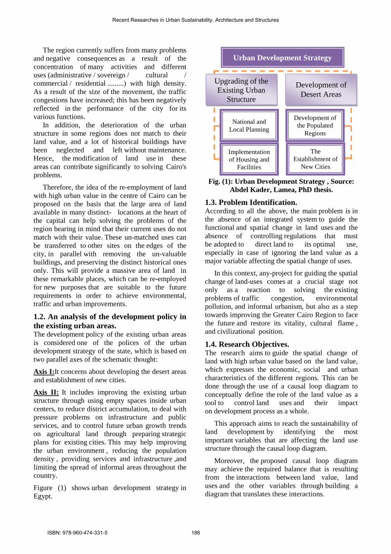
1.2. An analysis of the development policy in the existing urban areas. The development policy of the existing urban areas is considered one of the polices of the urban development strategy of the state, which is based on two parallel axes of the schematic thought:
Axis I:It concerns about developing the desert areas and establishment of new cities.
Axis II: It includes improving the existing urban structure through using empty spaces inside urban centers, to reduce district accumulation, to deal with pressure problems on infrastructure and public services, and to control future urban growth trends on agricultural land through preparing strategic plans for existing cities. This may help improving the urban environment , reducing the population density , providing services and infrastructure ,and limiting the spread of informal areas throughout the country.
Figure (1) shows urban development strategy in Egypt.
Fig. (1): Urban Development Strategy , Source:
Abdel Kader, Lamea, PhD thesis.
1.3. Problem Identification. According to all the above, the main problem is in the absence of an integrated system to guide the functional and spatial change in land uses and the absence of controlling regulations that must be adopted to direct land to its optimal use, especially in case of ignoring the land value as a major variable affecting the spatial change of uses.
In this context, any-project for guiding the spatial change of land-uses comes at a crucial stage not only as a reaction to solving the existing problems of traffic congestion, environmental pollution, and informal urbanism, but also as a step towards improving the Greater Cairo Region to face the future and restore its vitality, cultural flame , and civilizational position.
1.4. Research Objectives. The research aims to guide the spatial change of land with high urban value based on the land value, which expresses the economic, social and urban characteristics of the different regions. This can be done through the use of a causal loop diagram to conceptually define the role of the land value as a tool to control land uses and their impact on development process as a whole.
This approach aims to reach the sustainability of land development by identifying the most important variables that are affecting the land use structure through the causal loop diagram.
Moreover, the proposed causal loop diagram may achieve the required balance that is resulting from the interactions between land value, land uses and the other variables through building a diagram that translates these interactions.
Urban Development Strategy
Upgrading of the Existing Urban
Structure
Development of Desert Areas
Development of the Populated
Regions
National and Local Planning
The Establishment of
New Cities
Implementation of Housing and
Facilities
Recent Researches in Urban Sustainability, Architecture and Structures
ISBN: 978-960-474-331-5 186

1.5. Research Hypotheses. The research proposes a developed methodology to guide spatial change of land use in terms of land value. This means that the land value, with its economic, social, and urban dimensions can control spatial and functional change of land use.
It also has a strong influence on determining the optimal use of land plots.
1.6. Research Structure. Figure (2) shows the concept map of the research to achieve the previous objectives.
Fig. (2): the concept map of the research Source: Researchers
3: A Causal Loop Diagram for Land Value as a Tool for Guiding Spatial Change of Land Uses in Valuable Areas.
2: Variables Affecting Land Use Functional Structure of the City.
4: Research Findings and Conclusions
1: Relationships between Land Value, Land Use, and Other Variables.
Research Structure
Research Objectives
Research Hypotheses
Development Strategy
Problem Identification
Introduction
- The relationship between land value, land use, accessibility, and other variables. - The relationship between population density and land value. - The relationship between population density, land value and public benefits. - The relationship between land value and use density. - The relationship between land value and air pollution. - The relationship between land value , land use, and public benefits. - The relationship between price mechanism and how it is related to supply and demand in the urban land market.
Anal
ytic
al
Des
crip
tive
Appr
oach
An
alyt
ical
Co
mpa
rativ
- Geographical Variables. -Environnemental Variables.
- Economic Variables. - Social Variables. - Urban Variables. - Public Iinterest Variables. - Laws and Legislation Variables. -Demographic Variables. - Political Variables.
- Concept of Causal Loop Diagram for Land Value.
- Causal Loop Diagram Definition and Relations.
- The Main Elements of the Causal Loop Diagram.
- The Causal Loop Diagram and the Relations Between its Elements.
Anal
ytic
al
Ded
uctiv
e &
Explaining and Analyzing the efficiency of applying land value
and its role in controlling land use "Guiding the spatial change of land use"
Research Introduction
Recent Researches in Urban Sustainability, Architecture and Structures
ISBN: 978-960-474-331-5 187

2. Relations between Land Value, Land Use and Other Variables.
All economists , urban planners , geologists and geographers agreed with that: - The land value is a site function within the city. - The competition on the site determines the land value through the competition between users. - The land value distributes the land uses according to their potential to the rent payment and depends on
the level of the site and its relationships to revenue and accessibility. - The higher rent always is in the central areas. Hence, the research in this part is interested in trying to monitor and analyze all relationships between variables affecting directly or indirectly, whether on the land value or the distribution of land uses as shown in Table (1), as a conceptual approach to classify these variables in the following part.
Table (1), Analytical summary of specialists' views and concepts about land values -Source: researcher
2.1. The relationship between land value, land use, accessibility and other variables. [1] Douglass Lee sees that the theoretical relationship between land value, land use, and accessibility is only Location Theory
Geographical Douglass Lee
Truman and Hartshorn agree with Lee and also believe that major determinants of land value are location and accessibility factors, and see that land use respond strongly to land value that is eventually linked to accessibility
Geographical Truman and Hartshorn
Hans Blumenfeld believes that the major determinants of land value is accessibility in addition to natural characteristics of soil, climate, and visual level, where soil quality plays a role in construction costs, and climate and prevailing wind direction have an impact on land values, as well as on visual level for both region and view
Urban Hans
Blumenfeld
Drabkin H.Darin thinks that there are many factors that affect land values, and these factors differ according to economic and macro-economic factors' impact. He has focused on the following factors - Location factor and accessibility. -Use and investment of land factor in construction purposes and land use type. -Land economic costs are land major infrastructure investments and public and private services, and the difference between total land value and economic costs is one urban major profit Land value = total income - total expenses / capitalist rate
Economist Drabkin H. Darin
Palchin thinks that there are effects on land values, which are Inflation, population density, social, economic and cultural variables, and accessibility Palchin
Ahmed Khaled sees that land value reduces when location is being more remote from main roads and there are several factors that affect land value which are -Land value changes with location changing whether it is on the corner or more and for its neighbourhood, view. - Land value changes by changing use (legislation and use determination requirements) - Land value changes by keeping away from activities centers - Land value is affected by its development density (applied legislation like hight rules) - Development density affects land with the change of time.
Dr / Ahmed Khaled Allam
Barlev believes that land investment is increasing through increasing its development density, which has a major role in raising land value. Decreasing land value leads to reducing its opportunity for development.
Planner Barlev
The factors affecting urban land use and land value are: 1 – Accessibility (public - private accessibility). 2 - Additional factors which are the socio-economic characteristics, the social features and the topographic features of the site. 3 - Dynamics of change resulting from the process of change in the income of the population, transportation and modern technology. 4 - Administrative factors: which are the role of government decisions on the location, use, and land values through tax policy and legislation (the green areas, maintenance, transportation, traffic, housing, schools, and public goods).
Harvey .J.
Recent Researches in Urban Sustainability, Architecture and Structures
ISBN: 978-960-474-331-5 188
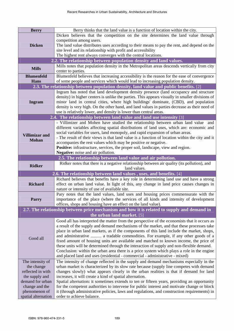
Berry thinks that the land value is a function of location within the city. Berry Dicken believes that the competition on the site determines the land value through competition among users. The land value distributes uses according to their means to pay the rent, and depend on the site level and its relationship with profit and accessibility The highest rent always converges with the central locations.
Dicken
2.2. The relationship between population density and land values. Mills notes that population density in the Metropolitan areas descends vertically from city center to parties Mills Blumenfeld believes that increasing accessibility is the reason for the ease of convergence of some people and services which would lead to increasing population density.
Blumenfeld Hans 2.3. The relationship between population density, land value and public benefits. [2]
Ingram has noted that land development density presence (land occupancy and structure density) in higher centers is unlike the parties. This appears visually in smaller divisions of minor land in central cities, where high buildings' dominate, (CBD), and population density is very high. On the other hand, and land values in parties decrease as their need of use is relatively lower, and density is lower than central areas.
Ingram
2.4. The relationship between land value and land use intensity [3] - Villimizer and Mohen have studied the relationship between urban land value and different variables affecting spatial distributions of land uses, which are: economic and social variables for users, land monopoly, and rapid expansion of urban areas - The result of their views is that land value is a function of location within the city and it accompanies the rest values which may be positive or negative. Positive: infrastructure, services, the proper soil, landscape, view and region. Negative: noise and air pollution
Villimizar and Mohan
2.5. The relationship between land value and air pollution. Ridker notes that there is a negative relationship between air quality (its pollution), and
land values. Ridker
2.6. The relationship between land values , uses, and benefits. [4] Richard believes that benefits have a key role in determining land use and have a strong effect on urban land value. In light of this, any change in land price causes changes in nature or intensity of use of available site
Richard
Pary notes that the land values, land uses and housing prices commensurate with the importance of the place (where the services of all kinds and intensity of development offices, shops and housing have an effect on the land value).
Parry
2.7. The relationship between price mechanism and how it is related to supply and demand in the urban land market. [5]
Good all has interpreted the matter from the perspective of the economists that it occurs as a result of the supply and demand mechanisms of the market, and that these processes take place in urban land markets, as if the components of this land include the market, shops, and administrative .......... a tradable commodities. For example, if any other goods of a fixed amount of housing units are available and matched to known income, the price of these units will be determined through the interaction of supply and non-flexible demand. Conclusion: within the urban area there is a price system which plays a role in the engine and placed land and uses (residential - commercial - administrative - mixed)
Good all
The intensity of change reflected in the supply and demand mechanisms especially in the urban market is characterized by its slow rate because (supply line competes with demand changes slowly) what appears clearly in the urban realities is that if demand for land increases, it will create a kind of spatial alternation. Spatial alternation: it sometimes extends to ten or fifteen years, providing an opportunity for the competent authorities to intervene for public interest and motivate change or block it (through administrative policies, laws and regulations, and construction requirements) in order to achieve balance.
The intensity of the change
reflected in with the supply and
demand for urban change and the phenomenon of
spatial alternation
Recent Researches in Urban Sustainability, Architecture and Structures
ISBN: 978-960-474-331-5 189

3. Variables Affecting Land Use Functional Structure of the City. The previous sections have introduced all specialists’ views and concepts about the relationship between land use, land value and other variables. Consequently, this section will be mainly concerned with determining the different variables constituting the list of variables affecting land use functional structure of the city, based on all the previously presented concepts. The variables that are affecting land use, land value and other variables are classified into geographical, environmental, economic, social, urban, public interest, logistic, demographic, political variables.
3.1. Environmental Variables.[6] Environmental influence is defined as any change in environmental characteristics or the emergence of new ones due to the project or the activity suggested. This influence may be positive, reflected in the improvement of the environment, or negative as appears in the damage that happens to air, water, or the decrease of land fertility.
3.2. Economic Variables.[6] Spatial change for land uses can be understood in the light of the economic variables , especially variables that are related to the population density that represents the utmost capability of using the place as an economic source as long as it has infrastructure suitable for use. Thus, changing the type of use is the direct outcome of the change of land prices, ability to pay , and the extent of exploiting the piece of land.
3.3. Social Variables.[6] Social variables are considered a double-edged issue, the first and essential part is the social human entity that is presented in inhabitants and the second is presented in the urban materialistic entity. In this connection, the social perspective tackles non-materialistic entity by applying some social concepts and elements related to the vital variables participating in the distribution of density. Such social concepts include the reasons of movement, the code of ethics and its influence, and understanding the motives and behaviors existing in the background of such behaviors.
3.4. Urban Variables.[6] Land value is one of the important tools used in urban management and the quality of the urban environment as it has an important role in evaluating and developing the land needs. A group
of urban variables ( roads ,traffic network, buildings and public services ……) has a great relation with the land value as a result of the exchanging relations among them. As well as the modality of developing these areas as every group contains a set of subsidiary variables that interact with each other to change the land value ,subsequently we can distribute the urban variables into three important groups: the road and transportation network, development density, public services in the area and land uses.
3.5. Public Interest Variables.[7] Public interest considerations are a considerations group involving values , principles, standards, concessions and restrictions that are taken by the community itself from its reality and economic, social, political, urban and religious concepts to achieve its public goals. Thus, public interest values are related to economic and social values of individuals and groups. It also includes an additional dimension which is how effectively intervene "by law" to achieve general objectives and its impact on structuring and restructuring of land use, including major five key elements, namely: Public Health Safety / ConvenienceEconomy Amenity.
3.6. Laws and Logistic Variables.[7] The role of domestic or central government appears overtly in all the decisions related to locations and land values; this is reflected through its policy concerning taxes or laws. For example, this factor appears in such matters as: spaces, green belts, open spaces, maintenance, transportation, traffic-jam problems, housing schools, universities or public utilities. 3.7. Demographic Variables.[7] Their impact appears in dimension form or "demographic factor" in the light of population increasing and through its urban structure and its uses required to satisfy different age groups' needs. In the light of this development, we can say that population concentration is based on two elements that have impact on urban structure change of Egyptian city.
3.8. Political Events.[7] For the first time, it may seem that there is no connection between population density and type of use on one hand and political events (wars and political crises) on the other. However, Kennth,G .H. confirms the importance of these events and their impact on the distribution of population as a result of the migrations that occur because of such
Recent Researches in Urban Sustainability, Architecture and Structures
ISBN: 978-960-474-331-5 190

wars. Also, population dwelling in smaller parts of a country away from the colonizing authority which controls the greater parts of it, and the change of uses structure as a result of troubles, revolutions and demonstrations may affect the type of use and land values in this area. 4. A Causal Loop Diagram for Land Value as A Tool for Guiding Spatial Change of Land Uses in Valuable Areas. The research uses the causal loop diagram to guide the spatial change of land uses in high-value areas. Such diagram is one of the means through which the real status is analyzed and the impact of various changes on this reality with the progression of a certain time is studied. It also analyzes urban, economic, and social variables in a complementary and developed way.
The suggested diagram aims at studying and analyzing the various relations between the set of variables which affect the functional land use structure of the city; such variables include environmental, physical, urban, social, political, cultural, and technological variables, as well as development density. This is done through investigating the extent of the impact of such variables on the basic elements of the diagram, bearing in mind time differences which result in a difference in the value of the basic variable in the diagram related to land value. Thus, the suggested causal diagram is considered the most effective tool in explaining and analyzing the relation between land value, land use and other variables.[8]
In addition to the main factors and the basic elements of the diagram, the diagram explained the external factors which are represented by the development framework which affects putting urban control plans into practice. It also shows the relationships between these factors helping in determining the political decision suitable to the state’s real urban development (from an investing point of view). This is done through evaluating advantages and disadvantages of such a decision and its impact on the basic element of land value model. This also helps in controlling the state’s real urban development (available urbanization) through determining the type of the utmost use of high-value urban areas according to the basic element in land value model.
4.1. Causal Diagrams Definition.[9] Causal diagrams are a powerful tool for representing the feedback structure of complex systems in our
life. A causal diagram consists of variables connected by arrows denoting the causal influences among the variables (Sterman, 2000).
Figure (3) shows that each causal link is assigned a polarity, either positive or negative to indicate how the effect changes when the cause changes. A positive link means that is the cause increases, the effect increases above what it would otherwise have been, and if the cause decreases, the effect decreases below what it would otherwise have been.
Similarly, a negative link means that if the cause increases the effect decreases below what it would otherwise have been, and if the cause decreases, the effect increases above what it would otherwise have been(Sterman,2000). Causal diagrams are helpful in the early phases of preparing a system. They help understand the main relations in the system, and the factors that control the behavior of the different variables in the system.[9] Fig. (3), An Example Explains The Positive and Negative effects of The Causal Loop Diagram.
Source: Sterman J. D., 2000
4.2. The Basic Elements of the Causal Loop Diagram. [10] The previous sections have explained the relationships between land use, land value and other variables, then represented the different variables affecting land use functional structure of the city. Consequently, this section will be mainly concerned with determining the basic elements of the causal loop diagram from all above. Figure (4) shows the basic elements of the causal loop diagram.
1. The basic element in this study: land value and land use.
2. The basic factors in the study: the variables affecting land uses functional structure of the city.
3. The external factors in this study: the development body for urban regeneration projects.
This refers to the structures which should be presented to help supporting the treatment with centralized lands with high urban value so as to be put into practice. The external factors related to the study of the causal diagram relationships.
Birth Rate
Death Rate Population
Mortality Rate
Fertility Rate
+
+ + + +
-
R B
Recent Researches in Urban Sustainability, Architecture and Structures
ISBN: 978-960-474-331-5 191

Fig. (4): The Basic Elements of the Causal Loop Diagram , Source: Researchers
City Challenge (CC): It demonstrated a commitment for a comprehensive approach to regeneration. It encourages synergies between departments and reduces overlap in service delivering and programming efforts.
Enter prize Zone (EZ): Using the economic incentives of the EZ package in the development process, utilities and land reclamation.
Single Regeneration Budget (SRB): The overlapping philosophy of the SRB is “People Based, which means an explicit emphasis on improvement of the social rather than the physical environment.
New Deal for community (NDC): It targets city’s most deprives communities through neighborhood based regeneration.
Public Private Partnership(PPP): The new national force for regeneration was instrumental in broadening the scope and the content of regeneration efforts through (PPP) which focused on the regeneration of former industrial sites.
Urban Development Corporation (UDC): UDC gives considerable powers to regenerate land for high urban value by bringing land and buildings into effective use. It encourages the development of existing and new industry and commerce, creating an attractive environment, while ensuring that housing and social facilities are available to encourage people to live and work in the area.UDC focused on the regeneration of former industrial sites.
Land value is considered to be the basic element in studying causal relations of the model which help control and guide towards the utmost use of the land (the director towards spatial change for land uses).
Geographical & Environmental Variables. Economic Variables.
Social Variables. Urban Variables.
Public Interest Variables. Laws and Legislation Variables.
Demographic Variables. Political Variables.
Bas
ic E
lem
ents
of t
he
Cau
sal L
oop
Dia
gram
2. Affecting Factors on Land Use Functional Structure of the city
1. Land Value & Land Use : There is a direct and strong relationship between land value and the type of use of it.
Mai
n E
lem
ent
of th
e C
ausa
l
3. The Development Body of Urban Regeneration Projects
The
Ext
erna
l Fac
tors
of C
ausa
l Loo
p D
iagr
am
Measuring the efficiency of applying land value and its role in controlling land use "Directing the spatial change of land use"
Recent Researches in Urban Sustainability, Architecture and Structures
ISBN: 978-960-474-331-5 192

4.3. The Causal Loop Diagram Explains the Relation Between Land Use, Land Value and Other Variables.
Fig. (5), The Causal Loop Diagram which illustrates the Relation Between Land Use , Land Value and other variables.
Source: Researchers The Study of the Suggested Causal Loop Diagram and its Relations in Fig. (5) Shows that:
1. The population density is positively related to the change of development density, environmental, geographical, social, and accessibility variables.
2. Population density in valuable areas is positively influenced by the change in development density variables (building’s heights, construction density, construction pattern, land use and populated areas spaces). The former variables have a positive effect on both population density and construction density.
3. Population density is positively related by physical variables (geographical and environmental); it is positively influenced by the change in climate, soil, natural resources, whereas the increase in population density negatively affects the environmental context.
4. Population density is variously affected by a group of social variables, whether positively
because of the change in properties or negatively due to the qualitative change of population.
5. Population density affects human behavior negatively.
6. Population density is positively influenced by political events, whereas it positively affects public utilities and air pollution.
7. There is a strong mutual relationship between population density variable and urban variables.
8. Population density is positively affected by accessibility and street width, whereas it positively affects traffic density, and negatively the variables of traffic flow and accessibility.
9. The land value in valuable lands which need urban regeneration projects is positively related to the change of population density, accessibility, political events, environmental pollution, economic, governmental, and cultural variables. All previous
Recent Researches in Urban Sustainability, Architecture and Structures
ISBN: 978-960-474-331-5 193

elements affect in determine land value with the existence of the exogenous factors which help the projects come in true.
10. The major determinant of land value is accessibility. Accessibility variable (represented by the variables of public benefits, trails variables, transit options, and infrastructure) is positively affected by street width and technological variables. It also positively affects the variables of land value and type of use.
11. The land use, the basic element of the causal loop diagram, is positively related to land value. As well as the land value express all the variables which affecting the type of the use and guiding land use to develop the residential areas or public services. So, we can guide the urban development projects in better way.
12. There is a strong mutual relationship between the land value and the land use. Land value is the site function in the city. The increase or decrease of economic revenue and usage costs represent land value which guide the type of use. On the other hand, all uses compete in order to determine land value.
13. In addition, the above-mentioned variables may have different influences based on a group of exogenous factors, such as urban development corporation, enterprises zone, city challenge, single regeneration budget, public and private partnerships, new deal for community. All these factors push forward urban regeneration projects and increase the rates of development in the existing urban through the utmost use of land.
14. That is, guiding the spatial change of land use in urban regeneration projects in terms of land value.
5. Results and Conclusions: - The planners, economists, and socialists interested in their specialists in guiding the spatial change of land use include: Trunman – Doglas – Dicken – Lee – Ahmed Khaled Allam and others, they all agree that land values, accessibility, and the type of use represent the traditional location theory and its reciprocal influences on the uses and location of the city.
- Land value with all its economic, social, and urban dimensions controls the spatial and functional change of land use.
- Spatial distributions of land uses is not linked to the basic principles of the site theory (Alonso Model), but otherwise is linked to a number of
factors which have similar direction in common, including many variables working together and are different in their impact and direction; such variables affect and are affected by each other.
- The causal loop diagram is a proposed methodology between variables to understand and guide the change phenomenon through conceptual diagram in terms of land values. The causal loop diagram expresses the type of relationship between all the variables to study the extent of influence change based on the reason of change. References: [1] Alonso, W., 1968, “Location And Land Use:
Towards A General Theory of Land Rent”, Hatvard University Press, Cambridge Mass.
[2] Lim, H.S., 2002, “ A Study on the Relationship between Spatial Configuration and Land Prices”, Journal of Architectural Institute of Korea, Vol. 18, No.7, pp.133-141.
[3] Mills E.S., 1972, “ Studies in the structure of the Urban Economy”, John Hopkines, University Press, Baltimore.
[4] Briassoulis, H., “Analysis of Land Use Change: theoretical and Modeling Approaches” Ph.D. Thesis, Regional Research Institute, West Virginia University.
[5] Brown D.G. , Pijanowski B.C. , Duh J.D. , “Modeling the Relationships between Land Use and Land Cover on Private Lands in the Upper Midwest, USA.” , Journal of Environmental Management 2000. Also available on line at http://www.idealibrary.com IDEAL
[6] Kyoung M.M., Jong M.M. , Young O.K., “The Effect of Spatial Configuration on Land Use and Land Value in Seoul”, Proceedings , 6th international Space Syutax Symposium , Istanbul , 2007.
[7] Koomen E., Burman J., “ Economic Theory and Land Prices in Land Use Modeling”, 5th AGILE Conference Geographical Information Sciences, Palma (Balearic Islands Spain), April (25-27 )2002.
[8] Shalaby A., 2003, “Strategic Urban Planning: Managing Egypt’s New Cities”, Unpublished Ph.D. Thesis, Faculty of Engineering, Cairo University, Giza.
[9] Sterman J. D., 2000, “Business Dynamics: Systems Thinking and Modeling for a Complex World”, Irwin MeGraw-Hill, Boston.
[10] Shalaby A., 2005, “City and Regional Planning Lectures” Cornell University, Ithaca, New York.
Recent Researches in Urban Sustainability, Architecture and Structures
ISBN: 978-960-474-331-5 194