
This Page Intentionally Blank - Horry County Government
243
-
Upload
khangminh22 -
Category
Documents
-
view
0 -
download
0
Transcript of This Page Intentionally Blank - Horry County Government


1
2

3
4

5

6

7

8

9

10
11

12

13

14

15

16

17

18

19

20
21

22
23

24
25

26

27

28

29

30

31
32

33

34

35

36

37

38

39

40

41
42

43

44

45

46

47
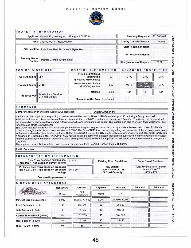
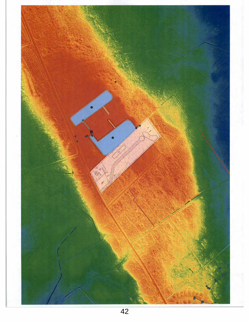
48
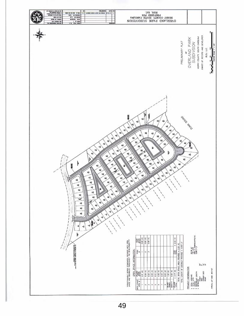
49

50

51
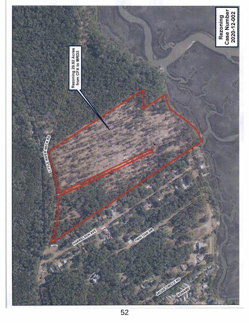
52

53

54

55

56

57

58

59
60

61

62

63

64

65

66
67

68

69

70

71

72

73

74

75

76

77

78

79

80

81

82

83

84

85

86

87
88

89


This Page Intentionally Blank

ACKNOWLEDGMENTS Horry County would like to thank the following individuals, groups, and organizations that have generously committed their time and knowledge to the development of the Horry County Parks and Open Space Plan. Special thanks is espe-cially extended to the hundreds of Horry County residents that participated in the Health and Recreation Initiative Sur-vey, in addition to individuals and organizations that partic-ipated in regional focus groups, as there are far too many residents and subject matter experts to thank.
PARKS AND OPEN SPACE BOARDDistrict 1 Suzanne PritchardDistrict 2 Austin CookeDistrict 3 Kevin KielyDistrict 4 Robert ZieglerDistrict 6 Lisa DavisDistrict 8 Dr. Sarah BanksDistrict 9 Thomas MezzapelleDistrict 10 William Kevin Gause, ChairmanDistrict 11 Samuel Johnson, Jr, Vice Chairman
Horry County would also like to thank former Parks and Open Space Board members for their role in the development of this Plan, including Pamela Dawson, Tony Hernandez, Thom-as Buckhannon IV, Bobby Page, Jerome Randall, Carolyn Raines-Harbin, and Nancy Seeds.
Horry County would like to especially thank Dr. Claudia Miles, former Vice Chairman and District 2 Parks and Open Space Board member. Her dedication to the County and the Board was greatly cherished and her memory will live on in the work accomplished through this Plan.
CONSERVATION AND PRESERVATION PARTNERSWaccamaw Riverkeeper – Winyah Rivers AllianceWaccamaw National Wildlife Refuge American RiversThe Nature ConservancyThe Low Country Land TrustPee Dee Land TrustSouth Carolina Department of Natural ResourcesSouth Carolina Forestry CommissionWildlife Action – Horry County Chapter
COASTAL CAROLINA UNIVERSITYDr. Sharon Thompson, Professor of Public Health and Swain Scholars Program DirectorChristina Auth, 2014-2015 Swain Scholar, BS Health Promotion Kerry Dittmeier, Planning & Zoning Intern, BS Public Health Briana Laws, 2014-2015 Swain Scholar, BS in BiologyJason Lee, Horry County Planning & Zoning Intern, BS Public HealthDeVariay White, 2014-2015 Swain Scholar, BS in Exercise & Sport Science
STAFFPlanning Director David SchwerdParks & Recreation Director Paul McCulloch Planning Deputy Director John Danford Principal Planner Leigh KaneSenior Planner Ashley Cowen
PLANNING COMMISSIONDistrict 1 Hunter PlattDistrict 2 Pam CecalaDistrict 3 Chuck RhomeDistrict 4 Pamela DawsonDistrict 5 Joey Ray, Vice ChairmanDistrict 6 Steven Neeves, ChairmanDistrict 7 Chris HenniganDistrict 8 Burnett OwensDistrict 9 Martin DawseyDistrict 10 Jody PrinceDistrict 11 Charles Brown
COUNTY COUNCILChairman Johnny GardnerDistrict 1 Harold WorleyDistrict 2 Bill HowardDistrict 3 Dennis DiSabatoDistrict 4 Gary LoftusDistrict 5 Tyler ServantDistrict 6 Cam CrawfordDistrict 7 Orton BellamyDistrict 8 Johnny VaughtDistrict 9 R. Mark CauseyDistrict 10 Danny HardeeDistrict 11 Al Allen
Additional thanks to the staff and representatives from neigh-boring jurisdictions, and the people of Horry County.

This Page Intentionally Blank

--------------------------------------------------------------------------------------------------------------------------------------------------------------------------------------------------------------------------------------------------------------------------------------------------------------------------------------- Table of Contents
INTRODUCTION..............................................................................
PARKS AND RECREATION FACILITY TYPES.................................... BEACH ACCESSES TRAILS AND GREENWAYS BOAT LANDINGS AND BLUEWAYS NEIGHBORHOOD PARKS COMMUNITY PARKS MAJOR COUNTY PARKS REGIONAL RECREATION FACILITIES SPECIALIZED RECREATION FACILITIES RECREATION CENTERS
PROGRAMMING............................................................................ ATHLETICS AEROBIC CLASSES AFTER SCHOOL AND SUMMER CAMPS OTHER PROGRAMS SENIOR CENTERS
OPERATIONS AND ADMINISTRATION........................................... BUDGET AND FUNDING.................................................................
PAGE NUMBERi
PAGE NUMBER1.1
1.1 - 1.31.1 - 1.21.21.2 - 1.31.31.3
1.3 - 1.61.3 - 1.61.6
1.6 - 1.7
1.7
EXECUTIVE SUMMARY...................................................................
INTRODUCTION...............................................................................
BENEFITS OF PARKS AND OPEN SPACE........................................ HEALTHY LIFESTYLES PUBLIC SAFETY ECONOMIC GROWTH HABITAT AND ECOSYSTEM FUNCTIONS RESILIENCE AND SUSTAINABILITY
PURPOSE AND GUIDING PRINCIPLES OF PLAN........................... PLANNING PROCESS ADOPTION
HORRY COUNTY PARKS AND OPEN SPACE BOARD....................
RELATED PLANNING EFFORTS........................................................
CHAPTER 2: PARKS AND RECREATION
CHAPTER 1: INTRODUCTION
PAGE NUMBER2.1
2.2 - 2.202.3 - 2.42.5 - 2.62.7 - 2.92.102.112.122.132.14 - 2.152.16 - 2.20
2.20 - 2.222.202.212.212.21 - 2.222.22
2.22
2.23 - 2.25

INTRODUCTION..............................................................................
GROWTH TRENDS.......................................................................... FACILITY DEMAND........................................................................ SWOT ANALYSIS
PRIORITY RECREATION AREAS AND FACILITY GAPS...................
FUNDING NEEDS............................................................................ OPERATIONAL NEEDS.................................................................... PROGRAMMING MARKETING MAINTENANCE AND SAFETY COMMUNITY INVOLVEMENT
OPPORTUNITIES FOR STEWARDSHIP..............................................
GREEN INFRASTRUCTURE NEEDS................................................... INTERCONNECTED OPEN SPACE CONSERVATION SUBDIVISION BEST MANAGEMENT PRACTICES CONTINUED PARTNERSHIPS
CONCLUSIONS..............................................................................
CHAPTER 4: NEEDS ASSESSMENT PAGE NUMBER4.1
4.1 - 4.2
4.2 - 4.34.3
4.3 - 4.5
4.5 - 4.6
4.7 - 4.74.74.74.74.7 - 4.8
4.8 - 4.9
4.9 - 4.104.94.94.9 - 4.104.10
4.10 - 4.11
Table of Contents ----------------------------------------------------------------------------------------------------------------------------------------------------------------------------------------------------------------------------------------------------------------------------------------------------------------------------------
INTRODUCTION..............................................................................
OPEN SPACE CONSERVATION..................................................... PUBLIC CONSERVATION PRIVATE CONSERVATION
ENVIRONMENTALLY SENSITIVE LAND........................................... INTERCONNECTIVITY AND FRAGMENTATION WETLANDS BEACHES AND MARSHES SPECIES HABITAT
GREEN INFRASTRUCTURE.............................................................. FOCUS GROUP GREEN INFRASTRUCTURE PRIORITIES
PRIORITY CONSERVATION AREAS................................................
CHAPTER 3: OPEN SPACE AND CONSERVATION PAGE NUMBER
3.1
3.1 - 3.63.1 - 3.43.4 - 3.6
3.7 - 3.123.73.8 - 3.93.93.9 - 3.12
3.13 3.13
3.13 - 3.16
--------------------------------------------------------------------------------------------------------------------------------------------------------------------------------------------------------------------------------------------------------------------------------------------------------------------------------------- Table of Contents
INTRODUCTION.............................................................................. GOALS AND IMPLEMENTATION STRATEGIES
ACCESS EQUITY, AND USERS........................................................
RESPONSIBLE STEWARDSHIP..........................................................
OPERATIONS & ADMINISTRATION................................................ MAINTENANCE & SAFETY SUPPORT.............................................. RESPONSIVE PROGRAMMING & TARGETED MARKETING...........
ACTIVE COMMUNITY ENGAGEMENT...........................................
SUSTAINABLE FUNDING.................................................................
CHAPTER 5: GOALS AND STRATEGIES PAGE NUMBER
5.15.1
5.1- 5.2
5.3
5.4
5.4
5.5
5.5 - 5.6
5.6 - 5.7
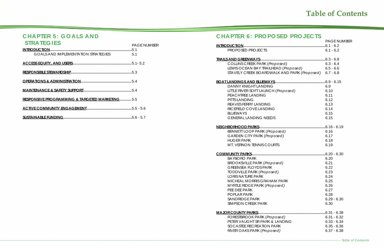
INTRODUCTION.............................................................................. PROPOSED PROJECTS
TRAILS AND GREENWAYS.............................................................. COLLINS CREEK PARK (Proposed) LEWIS OCEAN BAY TRAILHEAD (Proposed) STAVELY CREEK BOARDWALK AND PARK (Proposed) BOAT LANDINGS AND BLUEWAYS................................................ DANNY KNIGHT LANDING LITTLE RIVER SOFT LAUNCH (Proposed) PEACHTREE LANDING PITTS LANDING REAVES FERRY LANDING RICEFIELD COVE LANDING BLUEWAYS GENERAL LANDING NEEDS
NEIGHBORHOOD PARKS............................................................... BENNETT LOOP PARK (Proposed) GARDEN CITY PARK (Proposed) HUGER PARK MT. VERNON TENNIS COURTS
COMMUNITY PARKS...................................................................... BAYBORO PARK BROOKSVILLE PARK (Proposed) GREENSEA FLOYDS PARK TODDVILLE PARK (Proposed) LORIS NATURE PARK MICHEAL MORRIS GRAHAM PARK MYRTLE RIDGE PARK (Proposed) PEE DEE PARK POPLAR PARK SANDRIDGE PARK SIMPSON CREEK PARK
MAJOR COUNTY PARKS................................................................ FORESTBROOK PARK (Proposed) PETER VAUGHT SR PARK & LANDING SOCASTEE RECREATION PARK RIVER OAKS PARK (Proposed)
CHAPTER 6: PROPOSED PROJECTSPAGE NUMBER6.1 - 6.26.1 - 6.2
6.3 - 6.86.3 - 6.46.5 - 6.66.7 - 6.8
6.9 - 6.156.9 6.106.116.126.136.146.156.15
6.16 - 6.196.166.176.186.19
6.20 - 6.306.206.216.226.236.246.256.266.276.286.29 - 6.306.30
6.31 - 6.386.31 - 6.326.33 - 6.346.35 - 6.366.37 - 6.38

Table of Contents ----------------------------------------------------------------------------------------------------------------------------------------------------------------------------------------------------------------------------------------------------------------------------------------------------------------------------------
REGIONAL RECREATION FACILITIES............................................. LITTLE RIVER WATERFRONT PARK (Proposed) VEREEN MEMORIAL GARDENS AND CB BERRY COMMUNITY CENTER
SPECIALIZED RECREATION FACILITIES.......................................... CAROLINA FOREST BIKE AND RUN PARK OUTDOOR SHOOTING RANGE (Proposed) MULTI-PURPOSE CIVIC ARENA WITH EQUESTRIAN FACILITIES (Proposed)
RECREATION CENTERS................................................................... AYNOR RECREATION CENTER (Proposed) CAROLINA FOREST RECREATION CENTER JAMES R. FRAZIER COMMUNITY CENTER LORIS RECREATION CENTER (Proposed) NORTH STRAND RECREATION CENTER SOUTH STRAND RECREATION CENTER
AMENITIES AND COST ESTIMATES.................................................
TOTAL COST ESTIMATES: ALL PROJECTS BY TYPE.........................
TOTAL COST ESTIMATES: PROPOSED NEW PROJECTS ONLY.......
TOTAL COST ESTIMATES: UPGRADES & EXPANSION PROJECTS ONLY..............................................................................................
TOTAL COST ESTIMATES: PROJECTS BY COUNCIL DISTRICT........
PAGE NUMBER6.40 - 6.436.40 - 6.416.42 - 6.43
6.45 - 6.506.45 - 6.466.47 - 6.486.49 - 6.50
6.51 - 6.626.51 - 6.526.53 - 6.546.55 - 6.566.57 - 6.586.59 - 6.606.61 - 6.62
6.63 - 6.65
6.66 - 6.67
6.68
6.69
6.70
(continued...)RESOURCES....................................................................................
RESOURCES PAGE NUMBER1-2

-------------------------------------------------------------------------------------------------------------------------------------------------------------------------------------------------------------------------------------------------------------------------------------------------------------------------------- Executive Summary - i
EXECUTIVE SUMMARYHorry County has a wealth of active and passive recreation op-portunities to offer its residents and visitors, including 35 parks, 3 recreation centers, 2 community centers, 27 boat landings, and 22 beach accesses. In addition, there are approximately 67,817 acres of public and privately protected lands for wildlife protection and outdoor recreation within the County, includ-ing over 45,000 acres of which are protected floodplain.
The Parks and Open Space Board developed a 2008 Parks and Open Space Plan to guide future land acquisition for park de-velopment and open space conservation (Ordinance #67-08). This document is a rewrite of that plan. It identifies recreation fa-cility needs through at least 2040. It also identifies environmen-tally sensitive lands to be targeted for preservation through land acquisition, conservation easements, wetland mitigation, and neighborhood open space. Projections of need are based upon an analysis of current facilities, community input, historic development patterns, and projected growth.
The Plan identifies projects to meet the recreational needs of existing and future populations, provides guidance on areas in which to expand open space acquisition, and provides rec-ommendations on how to meet programming, maintenance, operational and funding needs.
Residents identified the need to upgrade and expand existing recreational facilities, improve their safety and maintenance, as well as provide and increase the variety of programming options. The public also desired additional access to natural lands and waterways through the development of trails, and both motorized and non-motorized boating accesses.
This Plan focuses primarily on the need to provide multi-pur-pose, multi-generational facilities so that people of all ages and athletic abilities can enjoy the same recreational space.
New playground at South Strand Recreation Center
The Plan calls for the development of 3 new Greenway parks, 2 new Neighborhood Parks, 3 new Community Parks, 2 new Major County Parks, 1 new Regional Recreation Fa-cility, 2 new Specialized Recreation Facilities, and 2 new Recreation Centers, estimated at $95.9 million. The Plan also identifies the need to expand and upgrade existing recreation facilities, estimated at $57.6 million. In summa-ry, this Plan identifies the potential need for $161 million in recreational capital improvements. While this is the cost to implement the Plan in its entirety, Horry County Council may opt to implement just a portion of the capital invest-ments defined in Chapter 6: Proposed Projects.
In FY20, Horry County approved an increase in Business License fees and the partial use of those fees to fund Parks and Recre-ation. In the Spring of FY20, the Business License fee increase was revoked and County Council voted to fund the lost reve-nue for Parks and Recreation through the General Fund with the intention of finding alternate means of funding for FY21.
To meet these needs and promote a high quality of life for our residents, Horry County must be committed to investing in the long-term maintenance, adequate operation and administra-tion, and the future development of recreational amenities.
The Recreational Needs Assessment for 1999-2009, the County’s initial parks and recreation plan which called for $90,337,121 in Capital Improvements not including land ac-quisitions, grossly underestimated population growth in Horry County. Due in part to this underestimation, there is already a gap in facilities and personnel. In addition, significant natu-ral resources have been developed at a much greater pace than anticipated, fragmenting habitat and wildlife corridors. The combination of these two factors stress the importance of expanding the County’s parks and open space network. While the Horry County Parks and Recreation Department serves as the primary entity in which to implement this Plan, the County will rely upon local jurisdictions, grants, partners, and private enterprise to meet some of the facility, conservation, preserva-tion, and programming needs. If implemented in full, this Plan should meet the needs of Horry County through 2040.
This Plan also identifies the opportunity for the Parks and Rec-reation Department to embrace environmental stewardship in park infrastructure, maintenance, and future development as well as the importance of involving community stakeholders throughout programming, planning, and the design process-es. Sandford D. Cox Sr. Community Park Boardwalk

Executive Summary - ii -------------------------------------------------------------------------------------------------------------------------------------------------------------------------------------------------------------------------------------------------------------------------------------------------------------------------
------------------------------------------------------------------------------------------------------------------------------------------------------------------------------------------------------------------------------------------------------------------------------------------------------------------------------------------ Introduction - 1.1
INTRODUCTIONThe Horry County Parks and Recreation Department was created in 1997 to meet the immediate and long-term rec-reation needs of County residents. In 1999, County Coun-cil adopted the Horry County Recreation Needs Assess-ment for 1999-2009. This Plan revealed that the County’s active and passive recreational facilities had not caught up with the rapid growth of the region. It also identified areas where new facilities should be developed. In close succession, County Council established the Parks and Open Space Board and the Open Space Fund in 2000 to support natural resource and open space preservation. In 2001, the County established Fund 90 to provide dedicat-ed millage to support recreation capital improvements, land acquisition, and staffing of the Parks and Recreation Department.
While the Parks and Recreation Department has devel-oped many of the recreational facilities recommended within the Recreation Needs Assessment, this initial plan underestimated population growth by nearly 100,000 people, resulting in gaps in recreational facilities through-out the County. In 2008, the County developed the Horry County Parks and Open Space Plan. While this Plan pro-vided a strong analysis of conservation needs, it did not address recreational needs and opportunities.
This Plan serves as a rewrite of both the initial Recreation Needs Assessment and the previous Parks and Open Space Plan. It was developed as a comprehensive guide to acquire, develop, and expand recreation and open space conservation. It also provides programming, oper-ations, maintenance, and funding recommendations to ensure that our recreational facilities meet the needs of our growing population.
The goal of this Plan is to provide guidance on maintaining and expanding quality parks and programming to meet the emo-tional, mental, and physical recreational needs of the citizens in unincorporated areas of Horry County, while recognizing and accommodating the growing desire, as well as the importance, to preserve and protect natural open spaces.
The Horry County Parks and Open Space Plan was developed with input from the community, current recreation facility users, and local conservation and preservation partners. Public input was gathered through a countywide health and recreational needs survey that obtained insight from over 900 residents, repre-senting all geographic areas within the County and a variety of demographics. Focus groups were also held to better refine the recreational needs of each district within the County. In addition, a conservation-based focus group meeting was held to identify the location of sensitive lands and primary habitat corridors that would be appropriate for land conservation or low intensity de-velopment. Input gathered from the IMAGINE 2040 Comprehen-sive Plan Community Survey was also incorporated into this Plan.
Staff concurrently conducted an inventory of all County recre-ation facilities to identify amenities available at each site, along with their condition. The public input results and inventory iden-tified the existing needs and desires of Horry County residents. Combined with development trends and projected growth, staff was able to identify where there are gaps in recreation oppor-tunities and where significant natural resources and habitats are most likely to be developed in the near future. Beyond facilities, this Plan addresses programming, marketing, operations, envi-ronmental stewardship, and funding to ensure that actions are taken to meet parks, recreation, and open space needs into the future to maintain a high quality of life for Horry County residents.
The goals, implementation strategies, and proposed proj-ects identified in this Plan were developed with input from the public, neighboring parks and recreation departments, Horry County Parks and Recreation, and public and private partner organizations.
BENEFITS OF PARKS AND OPEN SPACEParks and open space provide a variety of public safety, health, economic, and environmental benefits. By provid-ing quality recreation facilities and preserving open space, Horry County will ensure a high quality of life for existing and future residents and visitors.
HEALTHY LIFESTYLESThe availability of parks and access to natural spaces has been proven to have a positive influence on physical and mental health. Community design with the availability of open spaces and recreation areas strongly influence peo-ple’s level of physical activity, which directly correlates to weight. Individuals that live in walkable communities spend more time doing physical activities than those that live in neighborhoods that are not walkable.
In 2013, the South Carolina Department of Health and En-vironmental Control found that on average 32 percent of adults (age 18 and older) in Horry County were overweight, while 37.4 percent were obese. Comparatively, the SC av-erages were 34.7 percent and 31.8 percent respectively. This means that while Horry County has fewer adults who are overweight, there are approximately 5.6 percent more obese compared to the entire state. Children’s overweight and obese percentages were comparable to state averag-es.

Introduction - 1.2 ----------------------------------------------------------------------------------------------------------------------------------------------------------------------------------------------------------------------------------------------------------------------------------------------------------------------------------
The availability of parks and access to natural spaces has been proven to have a positive influence on physical and mental health. Community design with the availability of open spaces and recreation areas strongly influence peo-ple’s level of physical activity, which directly correlates to weight. Individuals that live in walkable communities spend more time doing physical activities than those that live in neighborhoods that are not walkable.
cess to recreational facilities and open spaces consistently relates to higher activity levels for adults and youth (Robert Wood Johnson Foundation, 2010). Horry County adult obe-sity rates exceed state and national trends, reconfirming the need to provide recreation opportunities throughout the County and for a variety of athletic abilities.
While the beach is the most commonly used recreational amenity in the County, it cannot be expected to meet the physical and mental health needs of all Horry County resid-ents.
Living in areas with walkable green spaces positively influ-enced the longevity of senior citizens. In encourage healthy lifestyles, greenery filled public areas and semi-private areas in neighborhoods that are nearby and easy to walk in should be further emphasized in planning for the development and re-development of densely populated areas.
Mental HealthWhile there are many physical health benefits of living near and utilizing recreational assets, the mental health benefits of spending time in nature do not always require the same physical activity. Scenic views, such as the beach or wa-terways, are known to have restorative and mental health benefits (Lothian, 2010). For so many people, this is why they vacation at the beach and eventually retire here. Numerous studies document the positive impacts that recreation can have on mental health, from reducing depression and reliev-ing stress, to improving quality of life in a variety of ways, to helping people to feel better about both their surroundings and themselves. Increased happiness and respect for the natural environment can also result in an increased sense of community pride.
PUBLIC SAFETYWith increasing populations, fighting crime is a continual battle. Well-maintained and highly programmed parks and recreation facilities help reduce crime in a community (The Conversation, 2019). Low crime rates in turn raise proper-ty values and help residents feel more secure. In addition, providing youth with recreational opportunities, such as ath-letics, afterschool activities, and recreational programming helps deter negative behaviors and plays a positive role in preventing juvenile crime. Research specialists with the Na-tional Recreation and Park Association have documented studies showing the relationship between reduced juvenile delinquency and structured, supervised recreational pro-graming. Data has also shown that students who report-ed spending no time in afterschool extracurricular activities were 57 percent more likely to drop out of high school, 49 percent more likely to use drugs and 27 percent more likely to have been arrested than students who spend as little as four hours in structured activities (NRPA, 2015).
ECONOMIC GROWTHThe prime economic base for the County depends on the beach and golf industry. Approximately 18 million people visit the Grand Strand each year and led all areas in South Carolina in travel expenditures in 2016 with roughly $4.8 mil-lion in direct tourist related spending (Myrtle Beach Eco-nomic Impact Study, 2016). Horry County also leads the State in second home ownership, making up forty percent of the State’s second homes. While many people vacation or spend part of the year in Horry County, the year-round population continues to increase. Over the last 15 years, Hor-ry County has increased by more than 100,000 permanent residents. These numbers are only expected to escalate, as population is projected to grow to 584,500 by 2040.
Source: South Carolina Department of Health and Environmental Control, 2013 Horry County Obesity Fact Sheet
Percentage of Overweight and Obese Residents in Horry County and South Carolina
In addition, living close to parks and other recreational facil-ities consistently correlates to higher activity levels for adults and youth, resulting in lower obesity rates (Robert Wood Johnson Foundation, 2016). Designing walkable communi-ties with access to outdoor spaces is important to consider with future development. Providing access to recreation and natural spaces will have a positive influence on the physical health of residents and visitors of the County.
The availability of parks and access to natural spaces has proven to have a positive influence on physical and men-tal health. Rates of obesity have increased nationwide since the 1970s, and there is growing evidence that community design can impact health. Walkable communities with ac-

------------------------------------------------------------------------------------------------------------------------------------------------------------------------------------------------------------------------------------------------------------------------------------------------------------------------------------------ Introduction - 1.3
Simply living near natural or recreational spaces, like the beach, area waterways, parks or trails, has the potential to result in higher property values, marketability, and faster sales. Additionally, access to recreation is often considered by companies seeking to expand or relocate to a new re-gion. While Horry County will always serve as a tourist des-tination, providing a variety of recreational opportunities in close proximity to residential areas has the ability to attract higher wage industries while also resulting in quality growth.
HABITAT AND ECOSYSTEM FUNCTIONSThe inherent benefits of open space protection include, but are not limited to, increased water and air quality, soil stabi-lization, and wildlife habitat protection. The US Forest Service calculated that over a 50-year lifetime, one tree generates $31,250 worth of oxygen, provides $62,000 worth of air pol-lution control, recycles $37,500 worth of water, and controls $31,250 worth of soil erosion (The Trust for Public Land, 2006). These benefits result in cost savings to the County and to res-idents, as open space protection can assist with filtration of increased air pollution due to increasing carbon emissions, reduce the cost to filter drinking water and stormwater, and can assist in holding eroding sand and soil. Open space pro-tection, especially if done in a comprehensive manner that targets large areas for conservation, minimizes habitat frag-mentation. Preservation of areas that are large enough to sustain wildlife populations could also provide passive rec-reational opportunities for bird watchers, hunters, paddlers, fishermen, hikers, mountain bikers, and others.
RESILIENCE AND SUSTAINABILITYOpen Space also has the ability to increase resilience and sustainability against environmental hazards and the rising threat of climate change. They can provide flood hazard re-duction, reduce heat island effect in more urbanized areas,
minimize flood damage, and reduce flood insurance rates. Many, especially those with natural wetlands, have the abili-ty to capture, filter, and infiltrate storm water that could oth-erwise have flooded homes, neighborhoods, or urban areas. This is just one of the many reasons that the IMAGINE 2040 Comprehensive Plan advises against more intense develop-ment in the Scenic and Conservation Areas defined in the Future Land Use map, except in cases where more specific information can be provided to show that a property is not environmentally constrained.
PURPOSE AND GUIDING PRINCIPLES OF PLANThis Plan was developed to provide comprehensive guid-ance on how to provide adequate recreational facilities and conservation or preservation of open space as our County rapidly grows. The Plan supports principles of green infra-structure by interconnecting existing and new recreational facilities into the natural landscape. Ultimately, this Plan has two distinct objectives:
Improve the health and quality of life of all Horry County residents by increasing availability and access to rec-reational facilities and outdoor spaces; and
Maintain and protect the natural landscape through ecological biodiversity, floodplain conservation, and watershed quality and function.
These objectives are directly tied to the role of the Horry County Parks and Open Space Board.
PLANNING PROCESSIn early 2015, the Horry County Parks and Open Space Board initiated the update to the Parks and Open Space Plan. A draft of the Plan was completed in October 2017 and a Resolution recommending its adoption signed by both the
Parks and Open Space Board and the Horry County Plan-ning Commission. Shortly after that time, the planning ef-fort for IMAGINE 2040, the County’s new Comprehensive Plan, began. It was at that time that the Parks and Open Space Board made the decision to hold the adoption of the Parks and Open Space Plan until after IMAGINE 2040 was adopted. This would allow the Parks and Open Space Plan to be adopted as an amendment to the new Compre-hensive Plan and relevant moving forward. After a 2-year planning process, IMAGINE 2040 was adopted in December 2019. In March 2020, the Parks and Open Space Board voted to re-initiate the planning process for the Parks and Open Space Plan.
1
2
Conceptual representation of the Planning Process
Introduction - 1.4 ----------------------------------------------------------------------------------------------------------------------------------------------------------------------------------------------------------------------------------------------------------------------------------------------------------------------------------
Public InputHorry County partnered with Coastal Carolina University’s Swain Scholars Program to develop and administer the Rec-reational Needs Assessment survey in early 2015. This in-depth survey was completed by over 900 residents and included representation from all geographic areas of the County. Staff analyzed results by zip code and by age of respondents to ensure that facility recommendations in this Plan coincide with siting of future facilities and improvements. The most de-sired types of facilities did not vary by area of the County and were only slightly different based upon age group.
Public input was focused on unincorporated areas and in-cluded six focus groups in differing areas of the County total-ing over 50 participants, including representation from sports leagues, sportsmen, equestrians, seniors, handicapped users, public and private conservation organizations, representa-tion from neighboring jurisdictions, chambers of commerce, and eco-tourism, sports tourism, and other recreation-based businesses. County Parks and Recreation Department staff and Parks and Open Space Board members also attended to obtain input from the community and provide their insight on existing operations and needs.
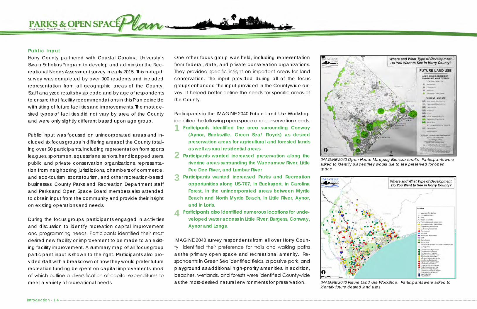
During the focus groups, participants engaged in activities and discussion to identify recreation capital improvement and programming needs. Participants identified their most desired new facility or improvement to be made to an exist-ing facility improvement. A summary map of all focus group participant input is shown to the right. Participants also pro-vided staff with a breakdown of how they would prefer future recreation funding be spent on capital improvements, most of which outline a diversification of capital expenditures to meet a variety of recreational needs.
One other focus group was held, including representation from federal, state, and private conservation organizations. They provided specific insight on important areas for land conservation. The input provided during all of the focus groups enhanced the input provided in the Countywide sur-vey. It helped better define the needs for specific areas of the County.
Participants in the IMAGINE 2040 Future Land Use Workshop identified the following open space and conservation needs:
Participants identified the area surrounding Conway (Aynor, Bucksville, Green Sea/ Floyds) as desired preservation areas for agricultural and forested lands as well as rural residential areas
Participants wanted increased preservation along the riverine areas surrounding the Waccamaw River, Little Pee Dee River, and Lumbar River
Participants wanted increased Parks and Recreation opportunities along US-707, in Bucksport, in Carolina Forest, in the unincorporated areas between Myrtle Beach and North Myrtle Beach, in Little River, Aynor, and in Loris.
Participants also identified numerous locations for unde-veloped water access in Little River, Burgess, Conway, Aynor and Longs.
IMAGINE 2040 survey respondents from all over Horry Coun-ty identified their preference for trails and walking paths as the primary open space and recreational amenity. Re-spondents in Green Sea identified fields, a passive park, and playground as additional high-priority amenities. In addition, beaches, wetlands, and forests were identified Countywide as the most-desired natural environments for preservation.
1
2
3
4
IMAGINE 2040 Open House Mapping Exercise results. Participants were asked to identify places they would like to see preserved for open space
IMAGINE 2040 Future Land Use Workshop. Participants were asked to identify future desired land uses

------------------------------------------------------------------------------------------------------------------------------------------------------------------------------------------------------------------------------------------------------------------------------------------------------------------------------------------ Introduction - 1.5
IMAGINE 2040 Survey Results
Source: IMAGINE 2040 Community Survey, Question asking about open space and recre-ation preferences.
This map represents the summation of all means of public input for this Plan

Introduction - 1.6 ----------------------------------------------------------------------------------------------------------------------------------------------------------------------------------------------------------------------------------------------------------------------------------------------------------------------------------
Parks and Open Space InventoryConcurrently with obtaining community input, staff invento-ried the condition and amenities at all County-owned and maintained recreational facilities. Staff also obtained infor-mation on all municipal recreation facilities and conserva-tion properties located throughout the County. This inventory resulted in the development of the Horry County Parks and Open Space Inventory, which the Parks and Open Space Board approved in 2016 and is responsible for maintaining. That inventory is integrated into Chapter 2: Parks and Recre-ation and Chapter 3: Open Space and Conservation of this Plan.
Needs AssessmentBaseline data collected through public input and the Parks and Open Space Inventory was compared alongside pop-ulation growth, historic and future development trends, and land availability to identify goals and implementation strate-gies, priority recreation and conservation areas, and capital improvement projects which are outlined within Chapter 6: Proposed Projects.
SWOT AnalysisCommunity input and an evaluation of existing County Parks and Recreation facilities informed the development of a SWOT (Strengths, Weaknesses, Opportunities, and Threats) Analysis. A SWOT analysis sheds light not only on the posi-tive elements of a community, but also on the negatives. If not addressed, the weaknesses and threats could have both direct and indirect consequences on the quality of life of our residents. The results of the SWOT Analysis are included in Chapter 4: Needs Assessment of this Plan.
ADOPTIONThe Plan was reviewed and unanimously recommended for adoption by the Horry County Parks and Open Space Board on November 10, 2021.
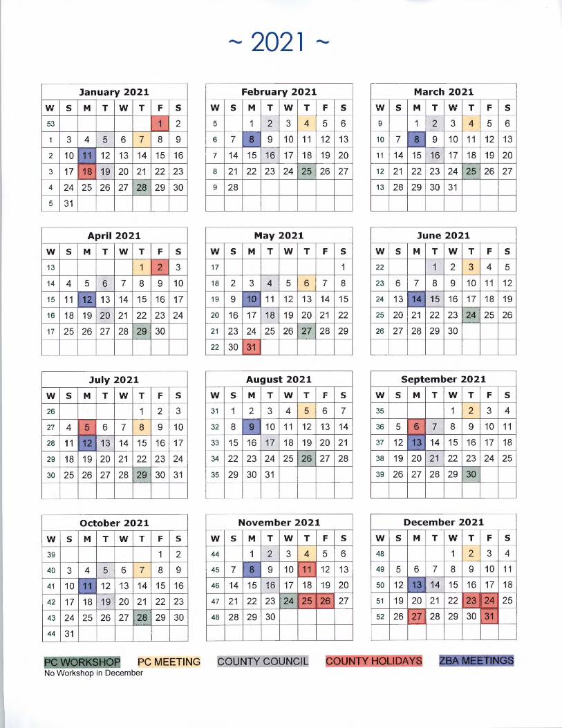
The Draft Parks and Open Space Plan was recommended for approval by the Planning Commission on DATE. The Plan-ning Commission held a workshop in addition to the public hearing and 15-day public comment period. The following were the meeting dates: January 28, 2021 3:00-5:00pm Workshop February 4, 2021 5:30-7:00pm Public Hearing
After recommendation by the Parks and Open Space Board and the Planning Commission, the Plan was presented to Horry County Council on the following dates: DATE 6:00pm First Reading 15-Day Public Comment Period DATE 6:00pm Second Reading and Public Hearing DATE 6:00pm Third Reading and Adoption
This document should be used by the County when develop-ing and upgrading recreation facilities, reviewing rezoning requests for new development, and when seeking locations for wetland mitigation and open space acquisition.
To ensure the Plan remains up to date, the Parks and Open Space Board should revisit the Plan every 5 years. A com-plete Plan rewrite should be completed by 2040, or soon-er, to reflect changes in population growth, development trends, funding, and community needs.
HORRY COUNTY PARKS AND OPEN SPACE BOARDThe Horry County Parks and Open Space Board was estab-lished in 2000 to promote the following:
The preservation of open space, scenic areas and vistas, greenways, squares, or village greens;
The protection and conservation of environmental or natural resources;
The expansion of quality open space for a wide range of recreational opportunities including playgrounds, playfields, plazas, parks, mini-parks, picnic areas, bi-cycle or hiking trails, or golf courses for all county res-idents;
Tourism emphasizing open space, recreational sites, and natural resources of Horry County;
Education, awareness, and research relating to environ-mental and natural resources.
The primary task of the Horry County Parks and Open Space Board is to prepare and submit to the Horry County Council a Parks and Open Space Plan as a comprehensive guidance for areas of open space, significant environmental and nat-ural resources, and recreational sites to be acquired, leased, preserved, protected, maintained, or developed through County funds, such as the Horry County Open Space Fund. This provides the County with guidance on land acquisition to help meet parks and open space needs. This Plan is in-tended to support the Board’s purpose and duties as out-lined above.
The Parks and Open Space Board is also responsible for de-veloping and maintaining a Parks and Open Space Invento-ry and list of properties to consider for acquisition. This Plan is intended to provide that guidance. The implementation of this Plan will strongly rely upon the support of Horry County Council, Horry County Parks and Recreation, public and pri-
123
45
------------------------------------------------------------------------------------------------------------------------------------------------------------------------------------------------------------------------------------------------------------------------------------------------------------------------------------------ Introduction - 1.7
vate partnerships, and federal, state and private conserva-tion organizations.
In addition to these tasks, the Parks and Open Space Board is tasked with assisting in the coordination of activities with oth-er local and regional organizations, businesses and govern-mental agencies active in the preservation of open space, recreational sites, and natural resources. One method by which the Board accomplishes this coordination is through participation with the Upper Waccamaw Task Force, a col-lective group of conservation and preservation partners with particular interest in the Waccamaw River. Another method of achieving cooperation is through projects like the North Coast Resilience Project, a collaborative focus group and mapping project that predicts potential flood areas into 2035 and 2060 based on recent storm flooding (see the IMAGINE 2040 Comprehensive Plan, Chapter 4: Natural Resources or The Nature Conservancy, Coastal resilience Project for more information).
RELATED PLANNING EFFORTSThis Plan reflects a number of recommendations made with-in previously adopted County plans and regulations. It also supports recommendations made within the SC Outdoor Recreation Plan (2019), SC Wildlife Action Plan (2015), SC Statewide Forest Resource Assessment and Strategy (2010), the National Recreation and Parks Association Agency Per-formance Review (2020), and the Waccamaw National Wildlife Refuge Land Protection Plan (2019). The following is a brief description of locally adopted plans and regulations.
• IMAGINE 2040: In December 2018, Horry County Plan-ning Commission initiated the IMAGINE 2040 Compre-hensive Plan Steering Committee to guide the planning process for the 10 year re-write of the County’s Compre-
hensive Plan. IMAGINE 2040 is the main guiding decision making document for Horry County in relation to future projects, land use decisions, capital investments, poli-cy decisions, and long term community planning. The Parks and Open Space Plan is adopted as an amend-ment to IMAGINE 2040.
• East Coast Greenway Master Plan: In 2003, the Wac-camaw Regional Council of Governments developed a master plan for Horry and Georgetown counties that identifies routing and construction guidelines for the East Coast Greenway (ECG), which is a multi-purpose trail that runs from Maine to the Florida Keys.
• Horry County Bicycle and Pedestrian Plan: The Horry County Bicycle and Pedestrian Plan was adopted in 2012 and includes recommendations for the Carolina Forest Community. It was amended in 2016 to incor-porate bicycle and pedestrian needs for the Burgess Community. It will continue to be expanded on to en-compass bicycle and pedestrian needs throughout un-incorporated Horry County. The Horry County Transpor-tation Plan and update to the Horry County Bicycle and Pedestrian Plan are scheduled to begin in 2021.
• Horry County Beachfront Management Plan: In 2013, Horry County updated its Beachfront Management Plan, as required by South Carolina’s Office of Ocean and Coastal Resource Management (SC-OCRM), to identify measures to protect wildlife and ensure public accessibility to the beach. This Plan is required in order to receive financial assistance from the state for beach renourishment and beach access improvements.
• Area and Neighborhood Plans: Horry County has mul-tiple Area and Neighborhood Plans to guide quality growth, such as the Bennett Loop Revitalization Plan, Burgess Area Plan, Little River Neighborhood Plan, and Racepath Revitalization Plan. These plans typically ad-
dress recreation and/or natural resource protection. • Zoning and Land Development Regulations: Horry Coun-
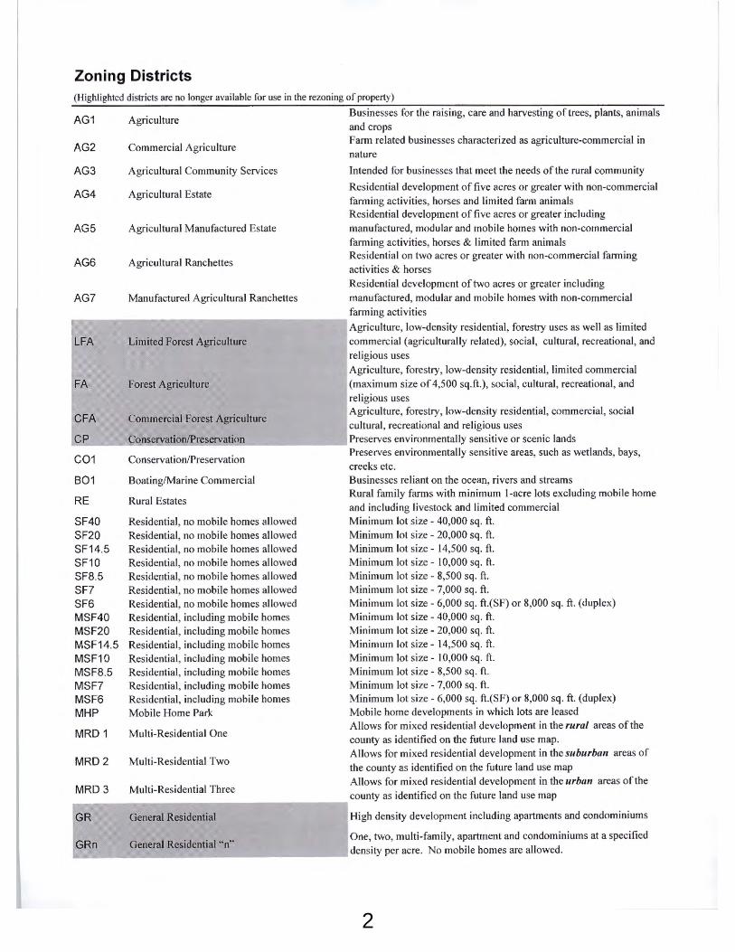
ty has a number of zoning districts that require dedicat-ed open space for recreation and natural resource protection, as does the County’s Land Development Regulations for all major subdivisions. If the open space is not provided within a proposed subdivision, the devel-oper has the option to pay a fee-in-lieu to the County or participate in an open space mitigation bank. Three developments have opted for the fee-in-lieu option since 2001, with one development utilizing the option for two unique phases.

Introduction - 1.8 ----------------------------------------------------------------------------------------------------------------------------------------------------------------------------------------------------------------------------------------------------------------------------------------------------------------------------------
This Page Intentionally Blank

----------------------------------------------------------------------------------------------------------------------------------------------------------------------------------------------------------------------------------------------------------------------------------------------------------- Chapter 2: Parks and Recreation - 2. 1
INTRODUCTIONHorry County has many active and passive recreation op-portunities to offer its residents and visitors. The County alone provides over 80 recreational facilities, including parks, rec-reation centers, beach accesses, and boat landings. In ad-dition, County residents benefit from all of the recreational amenities available in area municipalities, along its water-ways, and within 67,817 acres of protected open space within the County (with 65,188 of those acres being in the unincorpo-rated County). Please see Chapter 3: Open Space and Con-servation for more information about protected open space.
“Horry County Parks and Recreation Department is dedi-cated to providing the highest quality of active and passive recreational opportunities. These opportunities encompass
diverse programs and facilities to promote the mental, physi-cal and social well-being of its citizens.”
- Horry County Parks and Recreation Department Mission
The Horry County Parks and Recreation Department was cre-ated in 1997 to meet the immediate and long-term recre-ation needs of residents in unincorporated Horry County. At that time, Horry County had few recreational facilities and programs. In 1999, County Council funded the development of the Horry County Recreation Needs Assessment for 1999-2009. At the time, there were roughly 275.8 acres of public parkland serving roughly 133,300 residents. The County has worked diligently over the last two decades to implement the recommendations within that assessment. Today, Horry Coun-ty Parks and Recreation operates more than 35 parks on over 704 acres of land, offering 35 baseball/softball fields, 11 tennis courts, 10 multi-purpose fields, 13 outdoor basketball courts, 24 playgrounds, 1 football field, 6 soccer fields, 3 volleyball courts, and 1 disc golf course. Horry County Parks and Recre-ation Department also maintains 27 boat landings, while Hor-ry County Public Works and Engineering maintain 22 beach accesses and an expanding bicycle and pedestrian network.

Chapter 2: Parks and Recreation - 2. 2 ----------------------------------------------------------------------------------------------------------------------------------------------------------------------------------------------------------------------------------------------------------------------------------------------------
PARKS AND RECREATION FACILITY TYPESHorry County operates ten (10) different types of recreational park/facility types:
1. Beach Accesses2. Trails and Greenways3. Boat Landings and Blueways4. Neighborhood Parks5. Community Parks6. Major County Parks7. Regional Recreation Facilities8. Specialized Facilities9. Recreation Centers10. Conservation Areas (discussed in Chapter 3: Open Space and Conservation)
Despite this classification system defining ten (10) individual park/facility types, the types are not mutually exclusive. As an example, a boat landing may contain Neighborhood or Com-munity Park components, such as children’s play equipment or an outdoor basketball court. Similarly, a Major County Park may contain characteristics identified with both Communi-ty and Regional Parks. In addition, sports tourism events may take place at any number of facility types.
The classification system is not meant to limit the flexibility of park design or potential funding sources. Ultimately, the com-ponents that make up a particular park will be driven by citizen demand and community input to meet the needs of the ac-tual users as opposed to providing amenities based upon the rigid definition of the classification system.
Most County parks are undersized compared to the National Recreation and Parks Association’s standards. Many Neigh-borhood and Community Parks have overgrown their capac-ity and are serving more people from a farther distance than they were designed to accommodate.
CLASSIFICATION DESCRIPTION LOCATION CRITERIA SIZE CRITERIABeach Accesses Beach access sites should include parking for cars,
handicapped users, golf carts, and cyclists. Amenities include dune walkovers or boardwalks, beach wheel-chairs, shower towers, benches, and waste/ recycling receptacles.
Every ½ mile minimum A typical street end or vacant beach front lot
Trails and Greenways Greenways are multi-purpose paths, typically 8 to 12 feet wide and constructed of asphalt, coquina, or other sturdy base. Greenways are intended to travel between and/or through natural areas. Trails can be a variety of surfaces and 8’-12’ wide.
Natural Areas OR in urban/ suburban areas where semi-natural or constructed natural areas can be connected via trails
8 feet minimum,10 -12 feet wide ideal to accommodate cyclists
Boat Landings and Blueways
Boat landings can include a variety of amenities, in-cluding boat ramps, soft landings, docks, boardwalks, and picnic areas. Boat landings serve as trail heads for Blueways.
Strategically located based on popula-tion distribution and projected demand.
Variable
Neighborhood Parks Neighborhood parks are the basic unit of the park system and serve as the recreational and social focus of the neighborhood. Focus is on informal active and passive recreation.
1/2 - 3 road miles -Typically within walking or short drive dis-tance (5 minute travel distance average)
½ acre to 10 acres
Community Parks Community Parks are larger than neighborhood parks and typically incorporate space for fields, outdoor courts, playgrounds, and passive recreation. They can also include community centers to ensure residents have formal gathering space.
3 - 5 road miles - Typically within a cycling or short drive distance (10 minute travel distance aver-age)
10 to 50 acres
Recreation Centers Recreation Centers should include a gymnasium, class-room, and meeting space. They should also incorporate athletic fields for tournaments, outdoor courts, play-grounds, and passive areas for walking and picnicing.
Strategically located to meet needs of the most number of residents
20 to 100 acres
Major County Parks Major County Parks are larger than community parks and typically have multiple fields, outdoor courts, larger playgrounds, additional amenities such as disk golf, shel-ters, dog parks, etc.
5 - 10 road miles -Easily accessible to major intersections or population centers (15 minute travel distance average)
50-100 acres
Regional Recreation Facilities
Regional Recreation Facilities cater to a large area and large population. Often, these facilities draw not only residents, but also visitors from beyond the County boundary. These facilities are often associated with natu-ral landscapes and offer passive recreation, but can also include active features like athletic fields. Many of these facilities offer a specific “draw” or interest for visitors to see or experience while at the facility.
Easily accessible to major intersections and/or population centers
* Sports Tourism Facilities could fit into this category *
100 to 1,000 acres
Specialized Recreation Facilities
Specialized Recreation Facilities cater to a specific user group, but often a large population. These facilities have the ability to draw in tourism as they can bring visi-tors from a variety of areas for many reasons. These facil-itates can be associated with both natural or urbanized areas, depending on their purpose. Often, these facili-ties require specialized skills to operate and maintain.
Appropriate to the activity being provid-ed. Accessible to the population being served
* Sports Tourism Facilities could fit into this category *
Range in size de-pending on type and services provided
Conservation Areas Lands set aside for the preservation of significant natural resources, open space, and passive use.
Based upon resource location Variable
Parks and Recreation Facility Classification based off of National Parks and Recreation Association and American Planning Association Standards

--------------------------------------------------------------------------------------------------------------------------------------------------------------------------------------------------------------------------------------------------------------------------------------------------------- Chapter 2: Parks and Recreation - 2. 3
County parks provide a combination of active and passive recreation amenities, like playgrounds, fields, basketball or tennis courts, and picnic areas. Many of the County’s parks are in need of equipment replacement and upgrades, as they are actively used and constantly aging. A facility as-sessment completed in 2016 revealed the need to replace basketball, tennis, and volleyball nets, bleachers, resurface basketball and tennis courts, aging playground equipment, and repair field fencing. In addition, community input has re-vealed a desire for restrooms and water fountains, field light-ing, and improved public safety measures.
BEACH ACCESSESThere are over 30 miles of beachfront and more than 300 public beach access sites in Horry County, the majority of which are located within local municipalities. Horry County government maintains 22 sites within the unincorporated ar-eas of the County, mainly within Garden City and Arcadian Shores. In recent years, the County has used parking fees and grant funding to make improvements to its beach ac-cess sites. Such improvements have included: resurfacing parking areas and adding pervious pavers; improving hand-icap accessibility through ramp replacement and offering beach wheelchairs; adding golf cart parking and bike racks; and adding shower towers, seating, landscaping, and re-stroom facilities, where feasible.
A comprehensive list and map of all public beach access-es, their amenities, and beach water quality conditions for the South Carolina coast can be found at https://gis.dhec.sc.gov/beachaccess/.
Because the economic vitality of Horry County is highly de-pendent upon the experience of beach goers, the County should continue to make strides to expand public beach ac-
cess parking areas, improve and install dune walkovers, improve handicap accessibility, reduce litter, improve beach water quality, and maintain a wide beach through beach nourishment and dune restoration. A more detailed analysis of Beach Access needs and existing conditions is included in the Horry County Beach Management Plan.
Fishing PiersThere are multiple fishing piers along the Grand Strand, most of which are privately operated, including Garden City, Spring-maid Pier, 2nd Ave Pier, 14th Ave Pier, Apache Pier, and Cherry Grove Pier. Public piers include Surfside Pier and the pier at Myrtle Beach State Park. Only Garden City, Springmaid, and the Myrtle Beach State Park piers are in unincorporated Horry County.
County Maintained Beach AccessesSouth Strand:
Cedar AvenueHolly AvenueAzalea AvenueMagnolia AvenueYaupon AvenuePine AvenueOak AvenueCypress AvenueAnglers AvenueHoliday DriveSunset DriveRainbow DriveSeabreeze DriveCalhoun DriveWoodland DriveHawes Ave
Myrtle Beach:Nash Street
North Strand:Sands Ocean Club SouthSands Ocean Club NorthCottage BeachMaison Drive

Chapter 2: Parks and Recreation - 2. 4 ---------------------------------------------------------------------------------------------------------------------------------------------------------------------------------------------------------------------------------------------------------------------------------------------------
Horry CountyMaintainedBeach Accesses
BOA
RDW
ALK
PAV
ED P
ATH
SAN
D P
ATH
SHO
WER
S
BEN
CH
REST
ROO
M
WA
TER
FOUN
TAIN
OFF
STR
EET
PARK
ING
ON
STR
EET
PARK
ING
HAN
DIC
APP
ED P
ARK
ING
SEA
SON
AL
PAY
LOT
GO
LF C
ART
PA
RKIN
G
BIKE
RA
CK
ROA
D S
IGN
AC
CES
S SI
GN
# T
RASH
CA
NS
DUN
E TY
PE
SAN
D F
ENC
E
AD
OPT
ED
AC
RES
#O
FF S
TREE
T PA
RKIN
G S
POTS
# H
AN
DIC
AP
PARK
ING
SP
OTS
#O
N S
TREE
T PA
RKIN
G S
POTS
# T
OTA
L PA
RKIN
G (N
OT
INC
LUD
ING
GO
LF C
ART
)
# G
OLF
CA
RT P
ARK
ING
CO
UNC
IL D
ISTR
ICT
PARK
ING
MET
ERS
& S
TORM
-W
ATE
R D
ETEN
TION
(SEA
SON
-A
L M
ETER
S)
Cedar Ave T X S X X X X X X 1 D X .21 5 1 23 29 0 5
Holly Ave X T X S X X X X X X X 1 D X X .21 9 2 25 36 5 5
Azalea X F S X X X X X X 1 D X X .19 13 1 23 37 0 5 50 parking meters in adjacent lot
Magnolia Ave X X T X X X X X X X D X X .06 58 4 18 80 0 5
Yaupon Ave X T S X X X X X X D X X .24 6 1 59 66 7 5
Pine Ave X T X S X X X X X X X 1 D X X .17 14 1 79 94 5 5
Oak Ave X T S X X X X X 1 D X X .17 4 1 32 37 0 5
Cypress Ave X T X X X 1 D X .03 0 0 6 6 0 5
Anglers Dr X T S X X X X X 1 DRW X X .25 9 1 8 18 0 5
Holiday Dr X T S X X X X X 1 DRW X .26 8 1 8 17 0 5
Sunset Dr X T S X X X X X 1 DW X X .26 7 1 10 18 0 5
Rainbow Dr X T S X X X X 1 RW .26 5 0 8 13 0 5
Seabreeze Dr X T S X X X X 1 RW .25 6 1 0 7 0 5
Calhoun Dr X T S X X X X X X 1 DRW X X .56 15 2 11 28 9 5
Woodland Dr X F S X X X X D X X .26 0 0 0 0 18 5
Hawes Ave X T S X X X X X 1 DW X X .24 11 1 0 12 3 5
Nash St X F S X X X X X 2 D X .75 35 0 0 35 12 2
Sands Ocean Club South X T S X X X X X X 1 D X .29 20 1 0 21 21 2 22 parking meters
Sands Ocean Club North X T S X X X X X 1 D X .44 20 1 0 21 2 2 20 parking meters
Cottage Beach X T S X X X X D X .3 16 0 0 16 2 2 16 parking meters
Maison Dr X T S X X X X X X 1 D X .43 7 0 0 7 15 2 7 parking meters
Hibben Memorial Park X X T X P X X X 2 D X .31 0 0 2 2 0 2
X = Yes/Present S = SeasonalP = Permanent
D= Sand DuneR= RockW= Wall
T = Tower ShowerF = Flat Wall Shower

--------------------------------------------------------------------------------------------------------------------------------------------------------------------------------------------------------------------------------------------------------------------------------------------------------- Chapter 2: Parks and Recreation - 2. 5
TRAILS AND GREENWAYSTrails are a growing amenity in Horry County and until recently have consisted mainly of nature trails in area parks and wild-life management areas. Popular nature trails include those at Myrtle Beach State Park, Vereen Memorial Gardens, and Cox Ferry Lake Recreation Area. Walking paths can also be found at various municipal facilities and Playcard Environmental Center, which is operated by Horry County Schools.
Unpaved County maintained trails can be found at Vereen Memorial Gardens, Vereen Memorial Gardens, Socastee Recreation Park, and the Horry County Bike and Run Park. A newly installed unpaved trail at the Carolina Forest Recreation Center, called the Panther Trail, is a temporary use until addi-tional site amenities can be installed. Unpaved trails can also be found at heritage preserves, wildlife refuges, and the Hor-ry County Schools Playcard Environmental Education Center, none of which are maintained by Horry County Government.
Currently, SC Department of Natural Resource’s Heritage Preserves are the only public venues that provide access for equestrians. While Horry County may allow horseback riding on the beach during the off-season with the use of a special permit, these permits are typically utilized for large scale spe-cial events.
The East Coast Greenway (ECG) is one of the most well-known series of trails in Horry County. This multi-use trail system ex-tends from Maine to the Florida Keys, connecting urban areas with open spaces. In Horry County, the ECG is designed for pedestrians and cyclists with a mix of on-road and off-road sections. There is an ECG Master Plan for Horry and George-town Counties that identifies routing and design criteria for the various sections of the trail and for the location of future trailheads. The Bike and Run Park (also known as The Hulk) has over 7 miles of mountain biking/hiking trails and serves as
one Trail Head for the ECG. In addition, the Town Centre Mul-tipurpose Path, the River Oaks Drive Multipurpose Path, and the Carolina Forest Blvd Multipurpose Path will all connect into the ECG network. Multiple other segments were completed in North Myrtle Beach, Myrtle Beach, Garden City, Litchfield, and Pawleys Island through the financial support from the Grand Strand Area Transportation Study (GSATS) Transportation Alter-natives Program (TAP). There remains the need to connect these various segments to allow for a continuous path through our region.
Residents have shown interest and demand for additional rec-reational trails and bicycle and pedestrian facilities through-out the County. The East Coast Greenway, in addition to other pedestrian and cycling facilities, are discussed in further detail in Chapter 8: Transportation of IMAGINE 2040, Horry County’s Comprehensive Plan, and in the Horry County Bicycle and Pe-destrian Plan. At this time, the Bicycle and Pedestrian Plan and Northeast Area Transportation Plan only identifies proposed sidewalks, trails, and multipurpose paths in Carolina Forest and Burgess. Additional areas of the County should continue to be added to this plan over time. While a plan can be effective
Horry County and SCDOT MaintainedTrai ls And Greenways(Does not include Municipal t rai l s and Green-ways)
DIS
TRIC
T
LIN
EAR
MIL
ES
Little River Neck Road Multipurpose Path (Funded) 1 2Kings Hwy - Briarcliffe - Trail 1 .38
Vereen Memorial Gardens 1 3
Bike and Run Park (The Hulk) 2 7
The Panther Trail (New) 2 3.5
Town Centre Multipurpose Path 2 1.7
River Oaks Multipurpose Path (Funded) 2 2
Carolina Forest Blvd Multipurpose Path (In Progress- Completion 2022)
2/3 11.6
South Strand Recreation Center (In Progress- Completion 2021)
4 1.6
Atlantic Ave - Trail and Boardwalk 5 1.25
Waccamaw Drive Sidewalk & Multipurpose Path 5 1.3
James R. Frazier Community Center 7 .45Kings Road Multipurpose Path 2 2.4
Loris Nature Park - Sidewalks and Trails 9 1
Julius Goodson Ave/ Aynor Overpass Trail 11 2Waccamaw Drive Multipurpose Path - portion of the East Coast Green-way
to identify community needs, the County has not dedicated funding specifically to the development and maintenance of the bicycle and pedestrian network. Projects are typically funded in part by local governments, but often rely upon grants, private developments, or the GSATS, which have long waiting lists defined by regional priorities.
To address growing demand for recreational and commut-er trails in Horry County, opportunities to utilize existing utili-ty easements and rail line infrastructure should be explored. These opportunities will be explored in greater detail in the upcoming Horry County Transportation Plan.

Chapter 2: Parks and Recreation - 2. 6 ---------------------------------------------------------------------------------------------------------------------------------------------------------------------------------------------------------------------------------------------------------------------------------------------------
County and SCDOT Maintained Trails & GreenwaysDistrict 1:
Vereen Memorial GardensLittle River Neck Road (Future)Kings Hwy- Briarcliffe Acres
District 2:Bike & Run Park (The Hulk)The Panther TrailTown Centre Multipurpose PathRiver Oaks Multipurpose Path (Future)Kings Road Multipurpose Path
District 2/3:Carolina Forest Blvd Multipurpose Paths (Future)
District 4:South Strand Recreation Center (Future)
District 5:Waccamaw Drive Sidewalk & Multipurpose PathAtlantic Ave
District 7:James R. Frazier Community Center
District 9:Loris Nature Park
District 11:Julius Goodson Ave/ Aynor Overpass Trail
Image used on Horry County Parks & Recre-ation social media for National Trails Day 2020

---------------------------------------------------------------------------------------------------------------------------------------------------------------------------------------------------------------------------------------------------------------------------------------------------------- Chapter 2: Parks and Recreation - 2. 7
BOAT LANDINGS AND BLUEWAYSThere are 35 public boat landings throughout Horry County, 27 of which are managed by Horry County Parks and Rec-reation. Most of the County maintained landings were orig-inally built and managed by the SC Department of Natural Resources and were later given to the County to maintain. The majority of County maintained landings are located in rural areas, along the black waters of the Waccamaw, Pee Dee, Little Pee Dee and Lumber Rivers. In total, there are 17 boat landings in the rural parts of Horry County. These facilities serve as the primary public recreational amenity in the areas they serve. A handful of landings are located along the In-tracoastal Waterway and are heavily used by residents and visitors in the more urbanized part of the County.
Both rural and urban landings are popular places for residents. Despite the availability of trash receptacles at more urban landings, many facilities have an ongoing litter problem. Con-tinual maintenance and replacement of signage is neces-sary to maintain the County’s anti-litter messages at landings. Community partners, like American Rivers, the Waccamaw Riverkeeper and Keep Horry County Beautiful, are working to beautify and pick up litter at area landings. Horry County has installed security cameras at many landings, which can allow for the monitoring of illegal activity and facility usage.
BluewaysHorry County’s rivers serve as scenic resources for its residents and are a draw for outdoor recreational enthusiasts. Not only is a portion of the Little Pee Dee River designated as a Sce-nic River, there are also two nationally recognized paddling trails that traverse Horry County, including the Waccamaw River Blue Trail and the Southeast Coast Saltwater Paddling Trail. Branding and marketing the facilities along these water trails will improve user experience and encourage expansion of eco-tourism businesses.
The Waccamaw River Blue Trail begins in North Carolina and travels 140 miles. Chris Anderson Landing on Hwy 9 in Horry County is the first access in South Carolina. The Trail extends to East Bay Park in the City of Georgetown. This trail mean-ders through the protected bottomland hardwood swamps of the Waccamaw National Wildlife Refuge and the histor-ic riverfront cities of Conway and Georgetown. The Blue Trail was established in 2013 by the National Parks Service with the leadership of American Rivers. To date, American Rivers and its partners, Pee Dee Land Trust and the Waccamaw River-keeper Program, have developed detailed, waterproof maps and installed signage along the trail. For more information about the blue trail, visit: https://www.nps.gov/WaterTrails/Trail/Info/45.
The Southeast Coast Saltwater Paddling Trail (SECT) is another blueway that traverses Horry County. It spans from the Ches-apeake Bay to the Georgia-Florida border, following the In-tracoastal Waterway. For over 800 miles, the SECT hugs the coastal waters of Virginia, North Carolina, South Carolina, and Georgia, providing a unique opportunity for paddlers to experience an unbroken trail through four states in the tidal marshes and rivers of the southern USA. The National Parks Service, along with a number of agencies in Georgia, South Carolina, North Carolina, and Virginia, were involved in the establishment of this paddling trail. While this trail is of region-al significance, paddling along the Intracoastal Waterway in Horry County is difficult and there are few places to stop along the route. The banks of the Intracoastal Waterway are bluffed in many parts of the County and the wake generated from boat traffic is difficult to manage. This presents an oppor-tunity to improve the experience for paddlers along this route.
CAMPINGThere are numerous private campgrounds in Horry County that cater to visitors with recreational vehicles (RVs), pro-viding over 9,000 campsites. Such campgrounds are prev-alent near Surfside Beach and off of Kings Road. RV camp-ing is so popular that it makes up a total of 9 percent of the vacation accommodations in the Grand Strand. There is a high demand for additional RV and tent camping in Hor-ry County. Tent camping is limited and mainly available at resorts along the beach. Myrtle Beach State Park is the only public park facility in the County that offers tent sites. At this time, there are no campgrounds located along the Lumber, Little Pee Dee, and Waccamaw Rivers in Horry County. There is, however, a growing interest among pad-dlers and local residents for such facilities, as many people would like to paddle extensive lengths of these scenic riv-ers with overnight stays along the water’s edge.
Socastee Yacht Basin on the Intracoastal Waterway

Chapter 2: Parks and Recreation - 2. 8 ---------------------------------------------------------------------------------------------------------------------------------------------------------------------------------------------------------------------------------------------------------------------------------------------------
Horry CountyMaintainedBoat Landings
LAUN
CH
LAN
ES
PAD
DLE
AC
CES
S
MA
P
DO
CK
PARK
ING
SUR
FAC
E
HAN
DIC
AP
PARK
ING
REST
ROO
MS
SHEL
TERS
PIC
NIC
TA
BLES
GRI
LLS
ROA
D S
IGN
S
ENTR
AN
CE
SIG
N
LIG
HTIN
G
CA
MER
AS
TEN
TS O
R C
AM
PERS
REM
NA
NTS
OF
BON
-FI
RES
TRA
SH C
AN
S
FISH
ING
LIN
E RE
CY-
CLI
NG
AD
OPT
ED
CO
UNC
IL D
ISTR
ICT
AD
DRE
SS
ALS
O K
NO
WN
AS
Galivants Ferry Landing UNPVD 2 11 105 Hwy 501 W, Galivants Ferry, SC 29544
Gunters Lake Landing 1 1 UNPVD 11 4219 Gunter Lake Rd, Galivants Ferry,SC 29544
Huggins Landing 1 1 UNPVD PORT 1 X 11 799 Huggins Landing Rd, Galivants Ferry, SC 29544
Hughes Landing 2 1 UNPVD 2 X X 11 10000 Hughes Landing Rd, Galivants Ferry, SC 29544
Jordan Lake Landing 1 1 UNPVD 11 8594 Jordan Lake Rd, Conway, SC 29527
Pitts Landing 2 1 UNPVD 2 X X 11 6933 Hwy 378, Conway, SC 29527
Punch Bowl Landing 2 1 1 UNPVD X X 11 7099 Punch Bowl Rd, Conway, SC 29527
Sandy Bluff Landing 1 1 1 UNPVD 11 10650 Church Landing Rd, Nichols, SC 29581
Yauhannah Landing 2 1 PVD X 11 9300 Hwy 701 S, Conway, SC 29527
Causey Landing 1 UNPVD 10 10399 Griffins Landing, Nichols, SC 29581
Lee's Landing 1 UNPVD 1 1 1 X 10 485 River Rd, Conway, SC 29526
Reaves Ferry Landing 1 1 1 PVD X PORT 2 X X X 1 X 10 5880 Old Reaves Ferry Rd, Conway, SC 29526
Ricefield Cove Landing 1 1 1 UNPVD PORT 2 10 3575 River Rd, Nichols, SC 29581 Nichols Landing
Chris Anderson Landing 2 1 1 1 PVD X PORT 1 1 X X X 2 X 9 1112 E Hwy 9, Longs, SC 29568
Danny Knight Landing 2 1 PVD X PORT X X X 1 X 9 204 Hwy 31, Longs, SC 29568 Red Bluff Landing
Billy Witherspoon Landing 2 1 1 PVD PORT 1 X X X 7 990 Waccamaw Dr, Conway, SC 29526 Savannah Bluff
Bucksville Landing 2 1 PVD 2 X 7 500 Landing Rd, Conway, SC 29527
Pitch Landing 2 1 1 PVD PORT 2 X X 2 X X 7 100 Pitch Landing Rd, Conway, SC 29527
Port Harrelson Landing 1 1 UNPVD 2 X 1 X 7 1900 Big Bull Landing Rd, Conway, SC 29527
Peachtree Landing 1 1 PVD 2 X X 2 X X 6 6652 Peachtree Rd, Myrtle Beach, SC 29588
Rosewood Landing 1 1 UNPVD 1 1 X X 1 6 4698 Peachwood, Myrtle Beach, SC 29588
Socastee Yacht Basin 2 1 PVD X PERM 3 2 X 2 X 6 Peachtree Rd, under 544 Bridge
Stanley Drive Landing 1 UNPVD 5 290 Stanley Dr, Garden City Beach, SC 29576
Enterprise Landing 2 1 PVD PORT 1 X X X 2 X 4 7999 Bay Rd, Myrtle Beach, SC 29588
Peter Vaught Sr Landing 2 1 PVD X PORT 1 X X X 4 2 10923 Schulz Way, Myrtle Beach, SC 29572 Hwy 22 Landing
Johnny Causey Landing 2 1 PVD X PORT 2 2 X 2 X 1 Little River Neck Rd, Under 17 Bridge
T. Craig Campbell Landing 2 1 PVD X PORT 1 2 X X 2 X 1 148 Morgan Ave, Little River, SC 29588
X = Yes/ Present PVD = Paved UNPVD = Unpaved PORT = Portable Toilet PERM = Permanent Toilet

---------------------------------------------------------------------------------------------------------------------------------------------------------------------------------------------------------------------------------------------------------------------------------------------------------- Chapter 2: Parks and Recreation - 2. 9
County Maintained Boat LandingsCausey LandingRicefield Cove LandingSandy Bluff LandingGalivants Ferry LandingHuggins LandingsGunters Lake LandingHughes LandingJordan Lake LandingPitts LandingPunch Bowl LandingYauhannah LandingPort Harrelson LandingEnterprise LandingPeachtree LandingBucksville LandingPitch LandingBilly Witherspoon LandingLees LandingReaves Ferry LandingDanny Knight LandingChris Anderson LandingJohnny Causey LandingT. Craig Campbell LandingPeter Vaught Sr. LandingRosewood LandingSocastee Yacht Basin & ParkStanley Drive Landing
Kayak on the water - image used on social media for National Parks & Recre-ation Month 2020
Socastee Yacht Basin Park
Peter Vaught Sr Landing - image used on social media for National Parks & Recre-ation Month 2020

NEIGHBORHOOD PARKSA Neighborhood Park is the basic unit of a park system and the smallest type of Horry County park. They are meant to serve the cit-izens living within walking or cycling distance of the park. Neighbor-hood Parks, the core facility of the park system, help initiate healthy interaction between neighbors, and should serve as an extension of residential activities throughout the County. The County’s network of Neighborhood Parks works in coordination with privately main-tained neighborhood open space provided within many residen-tial subdivisions. While the County does not maintain subdivision parks, as that is the duty of the HOA/POA, the County relies on the recreational amenities provided by these residential subdivisions to fill some recreational needs of urban or suburban populations.
Neighborhood Parks are typically small in nature (between ½ acre and 10 acres in size) and located within ½ mile to 3 miles of the res-idents they serve. This allows residents to walk or cycle to the park. One critical aspect of a neighborhood park is the relationship be-tween the park and the street. Adequate street frontage is essen-tial for the development of a quality neighborhood park. Frontage is directly correlated to the level of use and type of use of the park. Parks must be aesthetically pleasing, easily accessible, generally inviting, and most importantly provide a sense of security for vulner-able users such as women, elderly, and children. Street frontage is also essential in establishing unique community character within the park, which will allow residents to take pride and share in re-sponsibility for the care and protection of the neighborhood park.
The goal of a neighborhood park is to facilitate informal recreation-al activities, encourage social interaction among neighborhood residents, preserve usable open space, create identifying neigh-borhood characteristics, create a shared responsibility and sense of pride among the neighborhood residents, and improve the overall quality of life for residents within the service radius.
Horry County Neighborhood Parks Burgess Park* Dog Bluff Park Frink Park Huger Park Little River Neck Park Mt. Vernon Tennis Courts* Newtown Park Racepath Park* Socastee Yacht Basin & Park Sandford Cox Jr. Park
*These parks are on land leased by Horry County, but currently under own-ership by another entity.
Common and Optional Amenities • Multipurpose field and/or Baseball/
Softball Field or single Basketball or Tennis Court
• Playground• Picnic area• Multipurpose Path or walking paths• Bike Skills Park• Paved Parking Area• Passive recreational space - open
grassy areas• Benches
Example Conceptual Neighborhood Park (represents ideal conceptual design, not exist-ing parks)
Chapter 2: Parks and Recreation - 2. 10 ---------------------------------------------------------------------------------------------------------------------------------------------------------------------------------------------------------------------------------------------------------------------------------------------------

COMMUNITY PARKSA Community Park is slightly larger than a Neigh-borhood Parks and is meant to serve a larger geo-graphic area than the surrounding neighborhood. These parks are designed to engage families and visitors for approximately half a day and often in-clude athletic fields, courts, and amenities not typ-ically included in Neighborhood Parks. They serve a broader purpose than Neighborhood Parks and focus on meeting a wide variety of commu-nity-based recreation needs. Community parks are typically greater than 10 acres in size but less than 50 acres. They cater to residents living within 3-5 miles who can either bike or drive to the Park. However, there is a lack of safe bike and pedestri-an access to most Horry County Community Parks.
The primary purpose of a Community Park is to consolidate the programmed youth athletic field with associated facility needs while serving a spe-cific community group. These parks should spe-cifically identify with community landmarks and not be industrious in appearance, but rather well maintained and unique to the character of their community. A Community Park should also be integrated into multiple residential neighborhoods providing both vehicular and non-vehicular ac-cess to the entire area.
Horry County’s Community Parks are critically un-dersized and have too few amenities based on the population being served by each facility. The County has a number of Community Parks that need expansion and a handful of new parks that need to be developed to fill gaps where no public Example Conceptual Community Park (represents ideal conceptual design, not existing parks)
recreation facilities exist and neighborhoods did not develop with recreational amenities.
Horry County Community Parks Bayboro Park Green Sea Floyds Ballfields Loris Nature Park* McNeil Park Micheal Morris Graham Park Pee Dee Park Poplar Park* Sandridge Park Simpson Creek Park White Oak Park Waccamaw/ Sam Cox Park
*These parks are on land leased by Horry County, but currently under ownership by another entity.
Common and Optional Amenities • Multipurpose field(s) and/or Baseball/Soft-
ball Field(s)• Playground• Community Center or Small Gathering
Building• Picnic area• Multipurpose Path or walking paths• Tennis or Basketball Court(s)• Outdoor Exercise Equipment• Dog Park• Bike Skills Park• Paved Parking Area• Disc Golf Course• Access to or on a main road
---------------------------------------------------------------------------------------------------------------------------------------------------------------------------------------------------------------------------------------------------------------------------------------------------------- Chapter 2: Parks and Recreation - 2. 11

MAJOR COUNTY PARKSMajor County Parks are typically large (50-100 acres in size) and serve a wide population base. Park users should be within a 15 minute drive of the park, relatively a 5-10 mile distance. This allows residents to drive to the park and participate in a diverse range of activities for either a half-day or a full day. Major County Parks typically serve residents and rarely serve County visitors unless the site is being used for sports tourism related events.
The main purpose of a Major County Park is to consol-idate the programmed adult and youth athletic field and associated facility needs of a residential commu-nity. These types of parks can also provide amenities such as skate parks or bike skills parks, disc golf courses, nature viewing, picnic areas, etc. In Horry County, these parks can serve as excellent opportunities for pub-lic-private partnerships for field leasing, maintenance, and use for all types of leagues. The main difference between a Major County Park and a Regional Recre-ation Facility is that Major County Parks primarily service County residents. Regional Recreation Facilities, on the other hand, are of a scale and design to specifically target users from beyond the County boundaries in ad-dition to residents.
Major County Parks are integrated into areas where many different residential neighborhoods can have easy access, providing the greatest usership possible. The park includes amenities that will serve the needs of citizens of all ages and abilities. Ideally, these parks will have a geometric configuration in order to accom-modate the greatest number of athletic fields. It is also critical that these parks maintain adequate street front- Example Conceptual Major County Park (represents ideal conceptual design, not existing parks)
age and high visibility for security of vulnerable users. At this time, Horry County’s is lacking in Major County Park facilities and those that do exist are in need of expansion and up-grades.
Horry County Major County ParksInternational Drive Ballfields Peter Vaught Sr. Landing*Socastee Recreation Park
*Peter Vaught Sr. Landing is a land-ing as built. Current master plans for the facility include many rec-reational components that when implemented will allow this facility to be classified as a Major Coun-ty Park. These improvements are unfunded.
Typical and Optional Amenities • Multipurpose field(s)• Baseball/Softball Field(s)• Community Center• Playground(s)• Picnic area(s)• Multipurpose Path or walking
paths• Tennis and/or Basketball Court(s)• Bike Skills Park or Skate Park• Paved Parking Area(s)• Disc Golf Course
Chapter 2: Parks and Recreation - 2. 12 --------------------------------------------------------------------------------------------------------------------------------------------------------------------------------------------------------------------------------------------------------------------------------------------------

REGIONAL RECREATION FACILITIESThe Regional Park is the largest park type in the park classi-fication system and is intended to draw users from beyond the County boundary, as well as County residents. Typically, Regional Recreation Facilities are 100 to 1,000 acres in size and cater to a large population, attracting people from throughout the community and beyond.
Regional Recreation Facilitites can be resource-based, unique user-oriented facilities, or tourism focused landmarks. Resource-based Regional Parks tend to be large swaths of land designated for preservation and allow passive recre-ational uses. Horry County currently owns and operates one regional recreation facility that fits this category: Vereen Memorial Gardens. Many of these types of facilities in Horry County are owned and managed by the South Carolina De-partment of Natural Resources or the United States Fish and Wildlife Service. These types of facilities will be discussed in greater detail in Chapter 3: Open Space and Conservation.
While Sports Tourism facilities can typically fit into the catego-ry of Regional Recreational Facilities, for the purposes of this plan, they have been included in the discussion of Special-ized Recreation Facilities. Another example of a Regional Recreation Facility is a waterfront park. These customarily draw regional recreation dollars into the local economy and are marketed to organizations to host tournaments, festivals, and other social-based events.
While the County’s Regional Recreation Facilities are small-er in size than national standards, the community is supple-mented by the Regional Recreation Facilities located with-in the City of Myrtle Beach and City of North Myrtle Beach. However, as the population grows, there will be a greater need for additional regional parks to serve the residents in
unincorporated Horry County. New Regional Recreation Fa-cilities should expand the variety of recreational offerings in the County and improve access to natural lands and/or wa-terways. The County should ensure that the niches it seeks to fill are not already being met by area municipalities.
Horry County Regional Recreation FacilityVereen Memorial Gardens
Waterfront ParksThere are a number of waterfront facilities that serve as an attraction for residents and visitors to the Grand Strand.
Conway RiverwalkThe City of Conway’s Riverwalk provides waterfront access to the Waccamaw River. This passive park is helping to revi-talize the City of Conway, as it serves as a venue for commu-nity festivals and special events.
Murrel ls Inlet MarshwalkWhile located in Georgetown County, the Murrells Inlet Mar-shwalk attracts people from throughout the region to enjoy its waterfront views, boating access, shops and restaurants.
Myrt le Beach BoardwalkThe Myrtle Beach Boardwalk is a 1.2 mile oceanfront board-walk that provides access to the beach, along with shop-ping and dining experiences.
Other Regional Recreation Faci l i t iesThere are a number of facilities that serve as an attraction residents and visitors from neighboring counties as well as tourists.
Myrt le Beach State ParkMyrtle Beach State park consists of 312 acres of maritime forests and includes a 250-site campground, cabins, picnic areas, trails, fishing pier, and nature center. This facility is dis-cussed in greater detail in Chapter 3: Open Space and Con-servation.
Vereen Memorial Gardens
Vereen Memorial Gardens, Source: Tripadvisor
---------------------------------------------------------------------------------------------------------------------------------------------------------------------------------------------------------------------------------------------------------------------------------------------------------- Chapter 2: Parks and Recreation - 2. 13

Chapter 2: Parks and Recreation - 2. 14 --------------------------------------------------------------------------------------------------------------------------------------------------------------------------------------------------------------------------------------------------------------------------------------------------
SPECIALIZED RECREATION FACILITIESSpecialized Recreation Facilities are important to create well-rounded recreational amenities for residents and visitors alike. These type of facilities may be considered for a loca-tion outside a typical park setting. If possible, future Special-ized Recreation Facility elements should be integrated into existing park expansions, in addition to stand alone new fa-cilities. Specialized Recreation Facilities can also be user ori-ented and built to house more active recreation. Examples of this type of facility could be a disk golf course, equestri-an center, civic center, the Horry County Bike and Run Park, skate parks, water parks, golf courses, and a sports complex which is specifically built to house regional athletic events.
Horry County Specialized Recreation FacilityHorry County Bike and Run Park
Sports TourismCurrently, sports tourism events in the Grand Strand utilize the Horry County Recreation Center fields as overflow venues. While this allows the County to benefit from sports tourism rev-enue, there is still substantial opportunity to grow the Coun-ty’s portion of the sports tourism share. While this Plan does not address a specific project to be undertaken to address this opportunity, future study is warranted to improve Horry County’s ability to compete in the sports tourism industry.
Municipal Sports TourismThe cities of Myrtle Beach and North Myrtle Beach have cap-italized on the tourist economy of our region by building re-gional complexes that cater to both local and tourist pop-ulations. In the last decade alone, these communities have dedicated extensive amounts of funding to develop Grand Park, the Myrtle Beach Sports Complex, and the North Myrtle Beach Park & Sports Complex. Other sports tourism attrac-
tions include the Pelicans’ Ticketreturn.com Stadium, the Cal Ripken Experience, and the dozens of golf courses through-out the Grand Strand.
Grand ParkGrand Park Complex at Market Commons features seven large multipurpose fields and two youth fields. All have syn-thetic grass and lights and are designed to accommodate a variety of sports, including baseball, softball, lacrosse, soc-cer and football. Grand Park hosts dozens of national athlet-ic tournaments annually and is located adjacent to Crab-tree Memorial Gymnasium, Base Recreation Center, a roller hockey rink, and nearby Barc Park South. Savannah’s Play-ground and Linear Park are part of an extensive open space network within Market Common.
Myrt le Beach Sports ComplexThis indoor athletic complex opened in 2015, adjacent to the Myrtle Beach Convention Center. It includes eight basket-ball courts, 16 volleyball courts, a café and retail area, an entertainment zone complete with a climbing wall, and a 1500-seat telescopic bleacher system. It is configurable for numerous indoor sports and is primarily dedicated to com-petitive events. In 2020, Myrtle Beach announced that the parcel directly adjacent to the Sports Complex would be leased to become a large wavepool waterpark. Plans are forthcoming.
North Myrt le Beach Park & Sports ComplexThe newly developed North Myrtle Beach Sports Complex offers 4 regulation youth baseball/collegiate softball fields, 2 regulation high school/collegiate baseball fields, 8 regula-tion soccer/lacrosse fields, 8 batting tunnels, picnic shelters, 3 playgrounds, amphitheater, walking/bike trails, 3 acre dog park, 25 acre lake for water-related activities, and a 10 acre
meadow. An additional parcel for soccer fields is under ac-quisition. Go Ape, a ropes course, and Shark Wake Park, a wake board facility, are two private entities that operate from the NMB Park & Sports Complex.
Cal Ripken ExperienceThe Ripken Experience is a privately owned ballpark com-plex that hosts tournaments throughout the year. It includes 9 fields, with 4 being regulation size and 5 being youth dia-monds.
Pel icans’ T icketReturn.Com StadiumThe Pelicans are a minor league baseball team for the Chi-cago Cubs. Their 6,599 seat stadium sits on land owned by Horry County and the City of Myrtle Beach. In the off-season, this facility serves the area by housing special sporting events and a holiday lights festival.
GolfGolf is a long-standing recreational activity in the Grand Strand, starting with the development of Pine Lakes Country Club in 1927. There are more than 30 golf courses located throughout the County, including the City of Myrtle Beach’s Whispering Pines Golf Club. For many visitors to Horry County, vacations center on the sport of golf. From modest begin-nings nearly 80 years ago, Myrtle Beach has become one of the best known and most popular golf resort areas in the country with over four million rounds played annually. While the development of golf communities has slowed recently, the game of golf remains popular among residents and vis-itors alike.
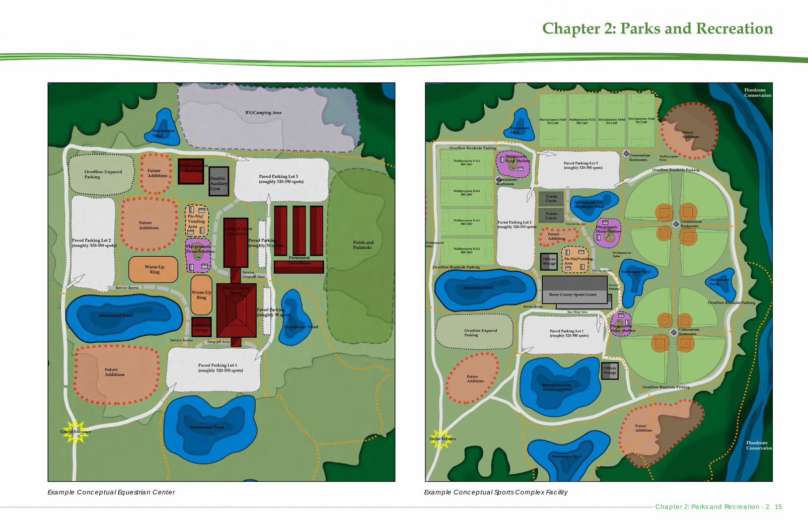
---------------------------------------------------------------------------------------------------------------------------------------------------------------------------------------------------------------------------------------------------------------------------------------------------------- Chapter 2: Parks and Recreation - 2. 15
Example Conceptual Sports Complex FacilityExample Conceptual Equestrian Center

Chapter 2: Parks and Recreation - 2. 16 --------------------------------------------------------------------------------------------------------------------------------------------------------------------------------------------------------------------------------------------------------------------------------------------------
RECREATION CENTERSThe County has 3 recreation and 2 community centers, includ-ing North Strand Recreation Center & Park, Carolina Forest Recreation Center, James Frazier Community Center, CB Berry Community Center, and the South Strand Recreation Center. These facilities often provide active and passive recreation, as well as programming through indoor gymnasiums, meet-ing rooms, athletic fields, outdoor courts, playgrounds, walking trails, and a variety of additional amenities that vary by facility and community demand. Each of these centers are in need of expansions, as the buildings and outdoor amenities do not have enough space to meet existing demand. There is a de-sire for additional fields, field lighting, outdoor courts, covered seating and picnic areas, trails, and play areas. There is also demand to co-locate swim facilities at some of these sites. Rural communities could benefit from the development of community recreation centers and/or community centers as a central gathering space and for recreational programming.
In 2020, the County began the process of identifying prop-erties for the future Loris Recreation Center and Aynor Rec-reation Center. Although these two projects have been planned since 1999, they are not included until the FY2023 and FY2027 10-year Capital Improvement Plan. Currently all new larger capital projects have been placed on hold due to the COVID-19 pandemic. A property tax increase would be necessary to operate any additional recreation center.
Municipal Recreation Centers and ParksThere are 9 municipal and 1 private recreation center that al-low residents in unincorporated Horry County to use their facil-ities. Recreational programming and leagues can be enjoyed by County residents for slightly higher fees than municipal resi-dents are charged. The County simply does not have enough facilities to cater to the programming and league demands that local municipalities can provide. Furthermore, the Con-
Horry County Recreation and Community Centers
Carolina Forest Recreation Center CB Berry Community Center James R. Frazier Community Center North Strand Recreation Center & ParkSouth Strand Recreation Center
Typical and Optional Amenities • Multipurpose fields• Baseball/Softball Fields• Concession stands• Gymnasium• Meeting Rooms• Offices• Overflow Parking• Paved Parking• Playground• Picnic Shelter(s)• Tennis Court(s)• Volleyball Court(s)• Indoor Pool• Stormwater Ponds• Multipurpose Path
Example Conceptual Recreation Center Site Plan (represents ideal conceptual design, not existing parks)

---------------------------------------------------------------------------------------------------------------------------------------------------------------------------------------------------------------------------------------------------------------------------------------------------------- Chapter 2: Parks and Recreation - 2. 17
way Recreation Center, Smith Jones Rec-reation Center, NMB Aquatic & Fitness Center, Claire Chapin Epps Family YMCA, Pepper Geddings Recreation Center, and Mary Canty Recreation Centers are the only recreation facilities that offer aquat-ics classes and swim team practice areas. Coastal Carolina University also allows swim teams to train at the Williams-Brice PE Center Pool when space is available. Some high school teams utilize partner-ships with private HOA/POA pools for practices.
Many recreation centers are located ad-jacent to other municipal facilities, provid-ing a conglomeration of services and a variety of recreational offerings. For exam-ple, Pepper Geddings Recreation Center is located adjacent to Ned Donkle Field Complex, the Myrtle Beach Tennis Cen-ter, and Myrtle Beach High School’s Doug Shaw Memorial Stadium. This property also houses a field for the Grand Strand Mira-cle League that provides recreational ac-tivities for youth with disabilities.
Recreational facilities can also be found at Market Common, where Crabtree Me-morial Gymnasium and Base Recreation Center are located adjacent to Grand Park. The North Myrtle Beach Aquatics & Fitness Center is housed adjacent to mu-nicipal offices, library, boat landing and Waccamaw Market facility. Such collec-
County ParksDistrict 11:
Dog Bluff ParkMicheal Morris Graham ParkPee Dee Park
District 10:Bayboro ParkGreen Sea Floyds BallfieldsMcNeil ParkMt. Vernon Tennis CourtsWaccamaw Park
District 9:Loris Nature ParkPoplar ParkSimpson Creek Park
District 7:Sandridge Park
District 6:Socastee Yacht Basin & ParkSocastee Recreation Park
District 5:Burgess ParkSam Cox Park
District 3:New Town ParkRacepath Park
District 2:Bike & Run ParkHuger ParkInternational Drive Ballfields
District 1:Frink ParkLittle River Neck ParkVereen Memorial Gardens

Chapter 2: Parks and Recreation - 2. 18 --------------------------------------------------------------------------------------------------------------------------------------------------------------------------------------------------------------------------------------------------------------------------------------------------
Horry CountyParks
FAC
ILITY
SQ
UARE
FEE
T
PLA
YGRO
UND
S
PIC
NIC
SHE
LTER
S
PIC
NIC
TA
BLES
AM
PHITH
EATE
R
GRI
LLS
BEN
CHE
S
BASK
ETBA
LL C
OUR
TS
TEN
NIS
CO
URTS
VO
LLEY
BALL
CO
URTS
YOUT
H BA
SEBA
LL F
IELD
STD
BA
SEBA
LL F
IELD
BATT
ING
CA
GES
SOC
CER
FIE
LDS
MUL
TI-PU
RPO
SE F
IELD
S
FIEL
D L
IGHT
ING
IRRI
GA
TION
SCO
REBO
ARD
S
FEN
CIN
G
BLEA
CHE
RS
CO
NC
ESSI
ON
S
DO
CK/
BOA
RDW
ALK
DIS
C G
OLF
TRA
ILS
MO
UNTA
IN B
IKIN
G
TRA
IL M
APS
WO
RKO
UT E
QUI
PMEN
T
PARK
ING
SUR
FAC
E
HAN
DIC
APP
ED S
PAC
ES
BIKE
RA
CKS
REST
ROO
MS
WA
TER
FOUN
TAIN
S
ROA
D S
IGN
ENTR
AN
CE
SIG
N
LIG
HTIN
G
CA
MER
AS
TRA
SH C
AN
S
PET
WA
STE
DIS
PEN
SERS
CO
UNC
IL D
ISTR
ICT
AC
RES
Dog Bluff Park 91,476 1 1 UNPVD 11 2.1
Michael Morris Graham Park
871,200 1 1 6 4 2 3 3 X X X X X X UNPVD X PERM X 2 X X X 13 11 20
Pee Dee Park 217,800 2 1 4 3 X X X X X X UNPVD PERM 1 X 6 11 5
Bayboro Park 287,496 2 1 4 1 1 X X X X X UNPVD PERM 2 2 10 6.6
Green Sea Floyds Ballfields 993,168 1 1 8 1 4 1 1 X X X X X X UNPVD X X PERM 2 X X 13 10 22.8
McNeil Park 413820 1 1 3 3 1 X X X X X UNPVD X PERM X 2 1 X 8 10 9.5
Mt. Vernon Tennis Courts 143,748 1 PVD 10 3.3
Waccamaw/ Sam Cox Park 239,580 1 1 5 3 1 X X X X X UNPVD PERM X 2 1 X 7 10 5.5
Loris Nature Park 940,896 2 3 10 1 2 2 X X UNPVD X PERM X 1 X X 6 9 21.6
Poplar Park 182,952 2 2 14 5 2 2 1 X X X X X UNPVD 1 PERM X 2 X X 9 4.2
Simpson Creek Park 435,600 1 1 9 1 1 1 1 X X X UNPVD X PERM 1 X 4 9 10Sandridge Park 435,600 1 5 6 2 2 2 1 X X X UNPVD PERM 1 X 3 7 5.1
Socastee Landing & Park 243,936 1 3 7 X PVD X PERM X 2 X 2 6 5.6
Socastee Recreation Park
3,985,740 4 20 4 8 2 2 1 3 X X X X X X X X X X PVD X PERM X 2 X X X 13 6 91.5
Burgess Park 143,748 1 PVD X 1 5 3.3
Sandford Cox Jr. Park 17,424 1 1 1 X PVD X PORT 2 X X 3 5 0.4
X = Yes/ Present PVD = Paved UNPVD = Unpaved PORT = Portable Toilet PERM = Permanent Toilet
tions of facilities not only make it easier for residents to ac-cess a variety of recreation and leisure activities, but it also makes facilities easier to maintain.

---------------------------------------------------------------------------------------------------------------------------------------------------------------------------------------------------------------------------------------------------------------------------------------------------------- Chapter 2: Parks and Recreation - 2. 19
Horry CountyParks
FAC
ILITY
SQ
UARE
FEE
T
PLA
YGRO
UND
S
PIC
NIC
SHE
LTER
S
PIC
NIC
TA
BLES
BEN
CHE
S
BASK
ETBA
LL C
OUR
TS
YOUT
H BA
SEBA
LL F
IELD
STD
BA
SEBA
LL F
IELD
BATT
ING
CA
GES
FIEL
D L
IGHT
ING
IRRI
GA
TION
SCO
REBO
ARD
S
FEN
CIN
G
BLEA
CHE
RS
CO
NC
ESSI
ON
S
DO
CK/
BOA
RDW
ALK
DIS
C G
OLF
SPLA
SH P
AD
TRA
ILS
MO
UNTA
IN B
IKIN
G
TRA
IL M
APS
WO
RKO
UT R
OO
MS
PARK
ING
SUR
FAC
E
HAN
DIC
APP
ED S
PAC
ES
BIKE
RA
CKS
REST
ROO
MS
WA
TER
FOUN
TAIN
S
ROA
D S
IGN
ENTR
AN
CE
SIG
N
LIG
HTIN
G
TRA
SH C
AN
S
PET
WA
STE
DIS
PEN
SERS
CO
UNC
IL D
ISTR
ICT
AC
RES
New Town Park 653400 1 X NONE 3 1.5
Racepath Park 139,392 1 1 1 1 UNPVD 3 3.2
Bike & Run Park 3,114,540 1 2 X X X UNPVD X PORT 2 X 2 2 71.5
Huger Park (Under Construction)
217,800 X X 2 5
International Drive Ballfields
1,049,796 1 2 4 2 X X X X X X PVD X PERM X 1 16 2 24.1
Frink Park 4,356 1 X NONE PORT X 1 0.1
Little River Neck Park 108,900 7 NONE 2 1 2.5
Vereen Memorial Gardens
479,2600 1 3 12 5 X X X PVD X PERM X 2 X 7 2 1 110
X = Yes/ Present PVD = Paved UNPVD = Unpaved PORT = Portable Toilet PERM = Permanent Toilet
Horry CountyMaintainedRecreation and Community Centers
RESI
DEN
T D
ATA
NO
N R
ESID
ENT
DA
TA
FAC
ILITY
SQ
UARE
FE
ET (I
NC
LUD
ING
G
ROUN
DS)
PLA
YGRO
UND
S
PIC
NIC
SHE
LTER
S
PIC
NIC
TA
BLES
AM
PHITH
EATE
R
GRI
LLS
BEN
CHE
S
BASK
ETBA
LL C
OUR
TS
TEN
NIS
CO
URTS
VO
LLEY
BALL
CO
URTS
STD
BA
SEBA
LL F
IELD
SOC
CER
FIE
LDS
FOO
TBA
LL F
IELD
S
MUL
TI-PU
RPO
SE F
IELD
S
FIEL
D L
IGHT
ING
IRRI
GA
TION
SCO
REBO
ARD
S
FEN
CIN
G
BLEA
CHE
RS
CO
NC
ESSI
ON
S
DO
CK/
BOA
RDW
ALK
TRA
ILS
GYM
NA
SIUM
CO
MM
UNITY
CEN
TER
MEE
TING
RO
OM
S
WO
RKO
UT E
QUI
PMEN
T
WO
RKO
UT R
OO
MS
PARK
ING
SUR
FAC
E
BIKE
RA
CKS
ROA
D S
IGN
LIG
HTIN
G
TRA
SH C
AN
S
PET
WA
STE
DIS
PEN
SERS
AD
OPT
ED
CO
UNC
IL D
ISTR
ICT
AC
RES
Carolina Forest Recreation Center
80% 20% 1,319,868 1 3 8 2 X X X X X PVD 1 3 X 2 30.3
CB Berry Communi-ty Center
50% 50% 4,792,600 1 3 12 5 X X X X X PVD 2 7 2 X 1 110
James R. Frazier Community Center
90% 10% 378,972 1 1 6 2 2 2 1 X X X X PVD 2 1 2 7 8.7
North Strand Recre-ation Center
60% 40% 810,216 1 7 2 1 3 1 2 X X 1 X X X X PVD 1 12 9 18.6
South Strand Rec-reation Center
70% 30% 1,202,256 1 1 9 1 1 3 3 X X X X X X X X X X X PVD 9 2 1 12 2 4 & 5
27.6
X = Yes/ Present PVD = Paved

Chapter 2: Parks and Recreation - 2. 20 --------------------------------------------------------------------------------------------------------------------------------------------------------------------------------------------------------------------------------------------------------------------------------------------------
Coastal Carolina University’s HTC Student Recreation & Convoca-tion Center offers aquatics, club sports, outdoor activity rentals, in-tramural sports, fitness facilities, and access to fields as well as oth-er area recreation. More information can be found here: https://www.coastal.edu/recreation/
In addition to recreation centers, area municipalities offer numerous parks, many of which are within walking distance of area residents.
PROGRAMMINGHorry County Parks and Recreation offers a variety of recreation programs and services to Horry County residents. Growing trends in Horry County present a challenge for recreation service provision as increasing population puts pressure on already at-or-beyond ca-pacity facilities. By using advertising for programing through Face-book and the HCConnect app has become increasingly important. Utilizing these social media platforms into the future and expanding the capabilities of the HCConnect app will be come increasingly important for programming in light of COVID-19 if in person advertis-ing and word-of-mouth will become less reliable ways of marketing.
While the County strives to keep league and program costs down, there is a great need to revisit program offerings, schedules and fees to ensure the needs of end users are being met. To support programming needs, the Parks and Recreation Department should expand sponsorship and advertising opportunities, in addition to developing franchise agreements for private enterprise to offer programming when the County does not have the capability to dedicate staffing.
ATHLETICSAthletics make up a large portion of the programming that the County offers, accounting for approximately 18,000 annual recre-ational users. This includes participants involved in leagues orga-nized by the County, in addition to those provided by athletic as-
sociations like the Aynor and Pee Dee Athletic Associations. Recreation leagues are primarily available for youth and typically cost $35 - $55 to participate, usually including equipment and a uniform. Horry Coun-ty Parks and Recreation is dedicated to ensuring the affordability of its leagues to ensure equitable access for all participants.
In addition to leagues, the County allows other organizations to offer leagues or use County facilities for tournaments. While the County cur-rently charges a fee to use its facilities, there is no cancellation policy or fee. Tournament use has increased in recent years, as the County pro-vides fields when tournaments exceed the capacity of Myrtle and North Myrtle Beach facilities. Because many fields are not lit for night time use,
Example Social Media post from Horry County Parks and Recreation Facebook page advertising Soccer League registration
Youth and Adult athletics are the most popular programming
Example Social Media post from Horry County Parks and Recreation Facebook page advertising the L.I.T. Program Interest Meeting
there is high demand and competition for daytime field use. Providing lighting for all fields, more teams could compete on high demand days.

---------------------------------------------------------------------------------------------------------------------------------------------------------------------------------------------------------------------------------------------------------------------------------------------------------- Chapter 2: Parks and Recreation - 2. 21
AEROBIC CLASSESBeyond organized sports, Horry County Parks and Recreation of-fers a variety of classes, programming, and special events. The number of classes or programs that are offered are based upon facility availability and funding. These classes are typically of-fered by private instructors, who are paid regardless if the class fills up. Classes are reserved according to teacher availability as opposed to the times when the target user group would prefer to participate. Survey respondents indicated that the best times to offer programs are on the weekends and on weekday evenings (5 – 11 pm). Responses did vary by age with 20-29 year olds pre-ferring weekday evenings from 5 – 11 pm and seniors preferring weekday afternoons from 12 – 5 pm. Typical classes include Zum-ba, pickleball, and yoga.
The Turkey Shoot at both Loris Nature Park and LW Paul Living Farm are popular fall events
The Holiday Parties thrown at the Recreation Centers as well as the Candy Cane Hunt are popular winter events
Horry County Parks and Recreation Quilting Guild donations to the Quilts of Valor Foundation in 2020
Floyds Senior Center, Michael Morris Graham Park, and the Cochran Building (Parks and Recreation’s administration build-ing). Program costs have recently been increased to compare with other local afterschool and summer camp program costs. Changes due to COVID-19 will need to be monitored for any long-term impacts and potential long term trends.
OTHER PROGRAMMINGOutside of regular programming, residents indicated a desire for more outdoor recreational programming, such as kayaking and canoeing, birding, trail hikes, and photography. In addi-tion, expanding holiday events, scavenger hunts, movie nights, field days, travel excursions, and races has the ability to gener-ate revenue to support other programming, while also helping to build a sense of community among residents. The Parks and Recreation Department has also integrated resident requests for additional programing into their offerings. New standards for sanitation and distancing have been integrated into program-ming to adapt existing programs to new COVID-19 standards.
Fest ivals and EventsThe Parks and Recreation Department has expanded their pro-graming to include additional community benefit events and festivals, many with holiday themes. These events include holi-day parties, trick-or-treating events, meet-and-greets, and dog related events. One such event is the fall Turkey Shoot, where children use BBGuns to shoot at targets, held at both the LW Paul Living Farm and at the Loris Nature Park. Other events in-clude Dino Digs, Power Wheels Drag Racing, Father Daughter and Mother Son Dances, and L.I.T. (Leaders in Training- a pro-gram for teens).
Race SeriesThe Horry County Race Series began in 2018 as a single road
Classes available at the Recreation Centers. Many have been made free for Horry County Employees
AFTERSCHOOL AND SUMMER CAMPSCounty recreation centers also offer afterschool and summer camps, some of which have historically had waiting lists. After-school care at each location runs from 2:45 PM to 6:00 PM and offers students ages 5-12 the opportunity to complete homework and participate in exciting educational activities. The program is offered at North Strand Recreation Center, South Strand Rec-reation Center, Carolina Forest Recreation Center, Green Sea

Chapter 2: Parks and Recreation - 2. 22 --------------------------------------------------------------------------------------------------------------------------------------------------------------------------------------------------------------------------------------------------------------------------------------------------
race along the newly completed International Drive. Since that time, Horry County Parks and Recreation has grown this event from a single race into a six race series that includes running, kayaking, biking, paddle boarding and canoeing. The race series currently in-cludes a Pier-to-Pier Beach Run, the International Drive Road Race, the Battle for the Paddle Kayak, Canoe & Stand-Up Paddleboard Race, the World Famous Blue Crab 5k at Vereen Memorial Gardens, the Don’t Fall Trail Classic, and the Independent Republic Adventure Race. Additional races inlcude fun runs during holiday season events.
Clubs, HOAs, and Community GroupsHorry County Parks and Recreation provides meet-ing spaces and cultivation of clubs and guilds for se-niors groups all over Horry County. This includes quilt-ing guilds and a sewing club that meet in Little River, the North Strand Recreation Center, and in Conway, a scrapbooking group that meets in Carolina Forest, crafting groups that meet at various centers all over the County, the Travel Club which meets in Conway, the “Red Hots” (a club for women over 50) which meets in Burgess and in Conway, and book clubs in both Conway and Little River. In addition, HOAs and community groups such as the Carolina Forest Com-munity Association and the Greater Burgess Communi-ty Association frequently utilize Recreation Centers for monthly meetings and events.
SENIOR CENTERSThe Horry County Council on Aging Inc. (HCCOA), a non-profit organization, was founded in 1975 to provide senior care services. The Council on Aging receives lo-cal, state and federal funding to provide meals, activ-
ities and other services to the County’s seniors. They currently serve over 10,000 senior citizens throughout Horry County. Programs and activities include: meal services, transportation assistance, housekeeping assistance, senior activities/recreation, exercise pro-grams/health promotion, basic health checks, telephone reassurance, in-home visitation, group counseling, employment opportu-nities, and field trips/local outings.
Senior Center locations include: Aynor, Bucksport, Burgess, Carolina Forest, Conway, Grand Strand, Green Sea/Floyds, Loris, North Strand, and South Strand. The HCCOA currently operates a senior center out of a small storefront in Carolina Forest, with plans to open a larger senior center facility beside the Carolina Forest Recreation Center and Library.
OPERATIONS AND ADMINISTRATIONThe Horry County Parks and Recreation Department is operated similarly to other County departments. In total, the Department is set up to employ a total of 124 people, although it is rare that this many staff are employed at any given time. The Department is headed by the Parks and Recreation Director whom is immediately supported by the Deputy Director, Parks/Facility Supervisor, and Recreation Superintendent. Additional support is provided by 3 District Supervisors, 2 Supervisor II positions, an Administrative Services Coordinator, a Program Specialist, a Supervisor II, 2 Grounds Crew Chiefs, 8 Program Coordinators, 14 Trades Workers, and 89 Part-Time Recreation Leaders. In 2019, the Department worked cooperatively with the Public Information Office to utilize the services of a Public Information employee to head-up advertising and social media for the department. While this employee is of-ficially housed in PIO, they are a critical part of the Parks and Recreation Department team.
FY 2
008
FY 2
009
FY 2
010
FY 2
011
FY 2
012
FY 2
013
FY 2
014
FY 2
015
FY 2
016
FY 2
017
FY 2
018
FY 2
019
FY 2
020
Authorized Positions 52 77 87 95 119 119 119 124 124 124 124 124 124
Full Time Positions 18 77 55 57 62 62 68 67 60 63 65 57 57
Number of Programs 161 180 187 193 216 223 227 245 248 319 414 519
Fields Maintained 50 50 59 69 69 65 60 60 62 63 63 63
Parks Maintained 20 35 35 35 35 35 35 35 35 34 34 34 35
PlaygroundsMaintained 15 19 17 20 20 22 22 22 23 23 23 23
Horry County Parks and Recreation Department Operations Statistics
Operations and corresponding staff-ing, maintenance of fields, parks, and playgrounds, as well as programming has continued to increase over the past decade.

---------------------------------------------------------------------------------------------------------------------------------------------------------------------------------------------------------------------------------------------------------------------------------------------------------- Chapter 2: Parks and Recreation - 2. 23
BUDGET AND FUNDINGThe FY 2021 Budget for the Parks and Recreation Department is $7,469,507. This maintains the FY 2020 budget at current service levels due to the COVID-19 pandemic economic uncertainty. This budget includes an estimated $3,953,507 from property taxes (54.93%), $200,000 in fines and fees (2.68%), $2,130,000 from the General Fund (28.52%, future location of funds to be determined), $36,000 from interest on investments (.48%), and $1,150,000 from other (15.40%). The current millage rate is 1.6.
Approximately $3,228,646 (43.22%) of the budget is predicted to be used on personnel costs, which includes regular pay and benefits, including state mandated retirement and health insurance contri-butions. This leaves roughly $4,200,000 for regular operations and maintenance of the Department and County recreational facilities.
Descript ion FY 2019Actual
FY2020Projected
FY2021Projected
Property Taxes $3,843,856 $3,953,507 $3,953,507Intergovernmental $93,525 - -Fees & Fines - $200,000 $200,000Licenses & Permits - $2,130,000 -General Fund - - $2,130,000Interest on Investments $62,027 $36,000 $36,000Misc Programs - - -Other $1,041,491 $1,150,000 $1,150,000
TOTAL $5,040,899 $7,469,507 $7,469,507
Transfers In $290,500 - -TOTAL $5,331,399 $7,469,507 $7,469,507
Recreation Fund RevenuesDescript ion FY 2019
ActualFY2020
ProjectedFY2021
ProjectedPersonnel Costs $2,178,021 $3,228,646 $3,228,646Contractual Services $533,811 $634,266 $634,266Supplies & Materials $250,662 $702,160 $702,160Business $ Transportation $135,348 $154,500 $154,500Capital Outlay $84,407 $275,000 $275,000Contingency - $253,845 $253,845Indirect Cost Allocation $655,825 $563,000 $563,000Other $104,849 $116,000 $116,000Other-Disaster Expense $14,687 - -Distribution to Municipal $200,000 $200,000 $200,000Contribution to Agen- $43,000 $46,000 $46,000Programs $216,429 $373,480 $373,480Athletics $119,220 $172,650 $172,650Transfers Out $33,493 $750,000 $750,000Fund Balance $761,647 - -
TOTAL $5,331,399 $7,469,507 $7,469,507
Recreation Fund Expenditures
FY20
03
FY 2
004
FY 2
005
FY 2
006
FY 2
007
FY 2
008
FY 2
009
FY 2
010
FY 2
011
FY 2
012
FY 2
013
FY 2
014
FY 2
015
FY 2
016
FY 2
017
FY 2
018
FY 2
019
FY 2
020
Millage Rate 1.5 1.5 1.3 1.3 1.3 2.3 2.3 2.3 2.2 1.7 1.7 1.7 1.7 1.7 1.7 1.7 1.7 1.6
Horry County Recreation Special Revenue - Fund Millage Rate
County Recreation Special Revenue FundThe County Recreation Fund, also known as Fund 90, was established on July 1, 2001. Prior to that, the Recreation Program was financially supported through the General Fund. County Council established a separate millage to ensure that a commitment to recreation was maintained into the future. Since the establishment of Fund 90, the Parks and Recreation Department’s opera-tional budget has remained relatively flat. The property tax rate for the County Recreation Fund was decreased from 2.3 mills to 1.7 mills. This decrease is the result of .5 mills being moved to another fund to cover debt services to construct the South Strand, Carolina Forest, and North Strand Recreation Centers. Between FY 2019 and FY 2020, the millage decreased an additional .1 as a result of property tax reassessments.
Cost allocation, which pays for maintenance and custodial services has steadily increased with the development of new facilities, growing from 12 percent of the Parks and Recreation Depart-ment’s budget in 2010 to 17 percent in 2015; further constricting the Parks and Recreation Department’s operational budget. Decreasing maintenance travel time and costs remains a high pri-

Chapter 2: Parks and Recreation - 2. 24 --------------------------------------------------------------------------------------------------------------------------------------------------------------------------------------------------------------------------------------------------------------------------------------------------
ority to the Department. Routine maintenance and grounds keeping needs should be taken into consideration prior to the construction of any new facilities to determine impacts to the annual budget. They should also be taken into consid-eration when determining assigned maintenance coverage areas and as facility improvements and enhancements are prioritized.
Capital ImprovementsEach year, the County adopts a Capital Improvements Bud-get which is intended to coincide with the County’s Priori-ty Investment Element of the Comprehensive Plan. Funding to support recreational capital improvements are derived from Sunday Liquor Sales Taxes. In a typical year, approxi-mately $500,000 is available for land acquisition and capi-tal improvements. Funding for boat landing and ramp im-provements are typically funded through SC Department of Natural Resources with fishing license revenue.
Community Recreation Special Tax Distr ictState law allows for the establishment of special tax districts dedicated towards capital improvements, maintenance, and operations of recreation facilities within the district. Such a district can be established via petition or referendum in areas of the County with fewer than 50,000 residents. At this time, there are no recreation special tax districts.
County Council Community Benefi t FundsEvery year, each County Council Member is allocated $20,000 to disperse at their discretion for the recreational and community needs in their districts or the County as a whole. Funding is often allocated for programming, athletics, and special events being provided by non-profits, schools, and other outside organizations. At times, these funds are direct-ed back to the Horry County Parks and Recreation Depart-
ment to assist with their programming and spe-cial event needs. Non-profit organizations may submit an application through the Administration Division or through their County Council Mem-ber. Council Members have the option to accrue funds over the duration of their service and dedi-cate large sums towards an individual project.
Open Space FundIn 2000, the Horry County Open Space Fund was established to provide developers with an option to pay a fee-in-lieu of required neighborhood open space. The fund can also include appro-priations from County Council or donations. The Open Space Fund must be spent according to guidelines from the County’s Land Development Regulations. A developer also has the option to establish an Open Space Mitigation Bank to meet existing and future open space requirements through an offsite location within priority acquisi-tion areas that meet the criteria list for significant properties defined within the Parks and Open Space Board’s establishing Ordinance (Sec. 15-126). To date, the fund has received $41,727.
As of November, 2020 the Horry County Open Space Fund has a $33,977.00 account balance. These funds must be spent according to 2008 Hor-ry County Land Development Regulations which states that funds from each fee must be used in according to the chart to the right.
Development Name Distr ict Open Space Fee
Amount Spent
Project Spent On District Spent In
Kayak Cove Ph 1, District 5, Fee : $19,920
$1,000* 3.96 acre Bike & Run 2
$1,750 Born Learning Trail Side-walk – JR Frazier 7
$2,000 Loris Nature Park - Amphi-theater 9
$4,000 South Strand Rec Center -
RTP Grant Match Discovery Trail
4 & 5
Kayak Cove Ph 2, District 5, Fee: $9,920
The Cottages at Carolina Forest, District 2, Fee: $5,165
Liberty Oaks, District 5, Fee: $6,722
* $1,000 was used from the Tree Mitigation Fund instead
Manner which funds MUST be used Total Spent to
Date Remaining
Funds
#1Fifty (50) percent will go to pur-chase open space throughout Horry County.
$20,863.50 $0.00 $20,863.50
#2
Twenty-five (25) percent will go to the Horry County Recreation Fund for acquisition, improve-ment, expansion, implementa-tion and maintenance of parks and recreational facilitates
$10,431.75 $3,750.00 $6,681.75
#3
Twenty-five (25) percent may go to other uses such as grant matching for natural resourc-es or recreational purchases, purchasing access to beach-es, rivers or waterways, or the acquisition of right-of-ways for or installation of the East Coast Greenway.
$10,431.75 $4,000 $6,431.75
Open Space Funds must be used according to the Land Development Regulations

---------------------------------------------------------------------------------------------------------------------------------------------------------------------------------------------------------------------------------------------------------------------------------------------------------- Chapter 2: Parks and Recreation - 2. 25
GrantsHorry County Parks and Recreation has secured a number of grants to support capital improvement costs, especially for facilities in rural and low-to-moderate income commu-nities. Grant funds have also supported the development of trails and neighborhood parks. Some such grants include Community Development Block Grants, Recreational Trails Program Grants, Parks and Recreation Development Fund, and the Land and Water Conservation Fund. While these funding sources have assisted with capital costs, grants are not a reliable funding source for capital improvements, as they are often capped at $200,000 or less and cannot meet the needs of most major projects. In addition, the County remains responsible for their daily upkeep and long-term maintenance, which should be accounted for through the County’s Recreation Fund.
PARD - Parks and Recreation Development FundsLWCF- Land and Water Conservation FundsRTP- Recreational Trails Program GrantPALMETTOPRIDE - Tree Grant, Litter Prevention Grant,
Affiliate Grant (for Affiliates only)CDBG - Community Development Block GrantCAIG - Coastal Access Improvement GrantWSFRP - Wildlife and Sport Fish Restoration ProgramBIG - Boating Infrastructure Grant

This Page Intentionally Blank
Chapter 2: Parks and Recreation - 2. 26 ---------------------------------------------------------------------------------------------------------------------------------------------------------------------------------------------------------------------------------------------------------------------------------------------

--------------------------------------------------------------------------------------------------------------------------------------------------------------------------------------------------------------------------------------------------------------------------------------------- Chapter 3: Open Space and Conservation - 3. 1
INTRODUCTIONWhile Horry County is renowned for its beaches and golf re-sorts, the majority of the County is characterized by its black-water rivers, wetlands, forestlands, and farmland. As more people continue to locate to and visit the Grand Strand, it will be more important than ever to ensure that these unique resources are protected and enhanced as recreational amenities and for their ecologically vital resources.
Horry County’s sandy beaches, meandering estuaries and swashes, blackwater rivers, and Carolina Bays provide for a variety of native species and offer scenic views and outdoor recreational opportunities for area residents. There are nu-merous Federal, State, and non-profit organizations involved in conserving these unique habitats and wildlife corridors, in addition to the development community.
Combined, there are over 67,817 acres of protected lands in Horry County, of which 45,000 are within the regulatory flood zone.
Additional information on local natural resources and habi-tats can be found in Chapter 4: Natural Resources of IMAG-INE 2040, Horry County’s Comprehensive Plan.
OPEN SPACEHorry County depends on a number of conservation part-ners and homeowners associations in order to preserve and maintain critical habitats and natural open space.
Approximately 8.44 percent of Horry County is preserved as conservation land through both public and private entities.
Acreage of protected land is tracked and updated annual-ly by County staff. US Fish and Wildlife and SC Department
of Natural Resources own the majority of these lands, many of which were established through wetland mitigation from major road projects. The Nature Conservancy and the Open Space Institute often holds title to these lands until they are transferred over to state or federal agencies. Other organi-zations that have preserved lands in Horry County include the US Department of Agriculture, Pee Dee Land Trust, North American Land Trust, Wildlife Action, Historic Ricefields Asso-ciation, Winayh Rivers Foundation (Winyah Rivers Alliance), the Open Space Institute, and Horry County Conservation Foundation.
Horry County Government also owns protected lands, main-ly in the form of flood mitigation, dredge spoil, and donated properties. In the past, Horry County has not sought owner-ship of open space properties, as these lands need to be managed based upon the wildlife they are intended to support. Moving into the future, the County is willing to take ownership of wetland mitigation banks for public projects so the benefit returns to our watersheds and jurisdictions. One such project is the Independent Republic Heritage Preserve wetland mitigation bank, which is part of the Ride 3 projects implementation. This site is ultimately intended to transfer to SC Department of Natural Resources.
While there are numerous conservation properties in the County, they are often protected in a piecemeal fashion as each organization has their own missions to support, such as farmland or wetland protection. Their acquisitions also depend on land availability and willing sellers. This plan at-tempts to identify where there are conservation gaps to help these organizations and Horry County identify target areas for future acquisitions.
PUBLIC CONSERVATIONPublic conservation lands make up the majority of protected open space in Horry County. Many of these lands have been acquired through grants and the dedication of wetland mit-igation land to US Fish and Wildlife Service (USFWS) and the SC Department of Natural Resources (SCDNR). Partners, like the Nature Conservancy, often serve as pass through orga-nization by using grant funding to purchase lands, and then donating them to the US Fish and Wildlife Service or the SC Department of Natural Resources.
Waccamaw National Wildl i fe RefugeThe US Fish and Wildlife Service (USFWS) established the Wac-camaw National Wildlife Refuge (NWR) in December 1997. The refuge was established to protect and manage diverse habitat components within an important coastal river eco-system for the benefit of endangered and threatened spe-cies, freshwater and anadromous fish, migratory birds, and forest wildlife. The Refuge includes a wide array of plants and animals associated with bottomland hardwood habitats and provides compatible wildlife-dependent recreational activi-ties, including hunting, fishing, wildlife observation, photogra-phy, and environmental education.
Located in portions of Horry, Georgetown, and Marion County, the Waccamaw NWR acquisition boundary spans over 55,000 acres and includes large sections of the Wac-camaw and Great Pee Dee Rivers and a small section of the Little Pee Dee River. The USFWS is actively acquiring lands within this acquisition boundary from willing sellers and has acquired 27,000 acres thus far (USFW, 2019).
In 2019, the Waccamaw National Wildlife Refuge’s Boundary Modification was approved allowing the Refuge to remove 6,849 acres from the current Approved Acquisition Boundary

Chapter 3: Open Space and Conservation - 3. 2 -------------------------------------------------------------------------------------------------------------------------------------------------------------------------------------------------------------------------------------------------------------------------------------
Added in 2016Horry County- Micheal Morris Graham Park - 9.5 acres adjacent to existing park
North American Land Trust- 663.68 acres - 9 easements near North Myrtle Beach west of the Intracoastal Waterway
Added in 2017SC Department of Transportation- Gunter’s Island 6,258 acres
North American Land Trust- 144.85 acres - Tupelo Grove- 49.94 acres - Birkdale Landing- 31.67 acres - Myrtle Cove Resort- 63.24 acres
Winyah Rivers Foundation- Singleton Tract 116.54 acres
Added in 2018Horry County- Independent Republic Heritage Preserve 3,686.93 Acres
Pee Dee Land Trust- 374.63 Acres
North American Land Trust- 884.87 Acres - Cotton Patch- 714.86 acres - Cottonwood Cove- 59.42 acres
Added in 2019Holiday Associates LLC- 353 acres and 110.09 acres
SC DNR – 300.4 acres and 222 acres
ASL INC – 36.69 acre wetland mitigation bank
City of Conway – 152.11 acres
Open Space Institute – 50 acres and 38.61 acres

------------------------------------------------------------------------------------------------------------------------------------------------------------------------------------------------------------------------------------------------------------------------------------------- Chapter 3: Open Space and Conservation - 3. 3
and adding 6,638 acres. This Boundary adjustment will allow the NWR to focus acquisition efforts on critically important habitat areas and remove those areas which have unwilling sellers or are in already developed areas protected by other organizations (like DNR).
Cox Ferry Lake Recreation AreaCox Ferry Lake Recreation Area, part of the Waccamaw National Wildlife Refuge, is located along Jackson Bluff in Conway and is owned and operated by US Fish and Wildlife. It has three trails of varying lengths including a boardwalk which allows hikers to meander through a flooded cypress swamp. Additional trails were recently added to this passive recreation area, including a loop for mountain biking. The property also has a pavilion, fishing dock, and launch area for non-motorized boats.
SC DNR Heri tage Trust PreservesThe South Carolina Department of Natural Resources’ Heri-tage Trust Program was created in 1976 to preserve natural features and cultural remains, which are quickly disappear-ing as the state’s population increases. The program’s pur-pose is to identify, evaluate, and protect the elements con-sidered the most outstanding representatives of the state’s heritage. There are currently four heritage preserves in Horry County (SCDNR, 2014).
Waccamaw River Heritage Preserve – This preserve is 5,347 acres, which includes 30 miles of protected river wetlands and bottomland hardwood forests. The property contains examples of rare and threatened plant species, including the dwarf fimbry. It also contains mature hardwood forest.
Cartwheel Bay Heritage Preserve – This 568 acre preserve protects one of the few known Carolina bay-longleaf pine savannah complexes in South Carolina. The longleaf pine savannahs contain white fringed, yellow fringed and rose-bud orchids, Venus’ flytraps, pitcher plants and a diverse ar-ray of wildflowers.
Lewis Ocean Bay Heritage Preserve – This 10,444 acre pre-serve contains a group of 23 Carolina Bays. This preserve includes habitats for black bears, red-cockaded wood-peckers, Venus flytraps and a pond pine pocosin plant com-munity.
Little Pee Dee Heritage Preserve – These tracts total 9,000 acres in both Marion and Horry Counties. This property pro-tects the rare sarvis holly, a mature floodplain forest, and scenic frontage along the Little Pee Dee River. The preserve includes Knife Island and four scenic oxbow lakes (SCDNR, Heritage Preserves).
Jackson Bluff area of the Cox Ferry Lake Recreation Area.
Myrt le Beach State ParkMyrtle Beach State Park was built in the 1930s by the Civil Con-servation Corps, as the first state park in South Carolina. The park consists of 312 acres of maritime forest and includes a 250-site campground, cabins, picnic areas, trails, fishing pier, and nature center. There is a mile of beachfront and nearly 400 parking spaces for beach goers. The park’s beachfront is an inviting location for sea turtles to nest during the summer months. Park rangers work with area volunteers to ensure the nests are safely sited and use this as an educational oppor-tunity to teach park users about these endangered species. Park rangers also use the nature center and park grounds as an interactive learning environment to provide a variety of programs throughout the school year, as well as programs geared towards tourists during the summer months.
Playcard Environmental Education CenterHorry County Schools operates Playcard Environmental Ed-ucation Center. The purpose of the facility is to educate stu-dents about the plants, animals, soil, and water in a black-water swamp environment. Playcard is surrounded by lands that are protected by the Horry County Conservation Foun-
Playcard Environmental Education Center, operated by Horry County Schools

Chapter 3: Open Space and Conservation - 3. 4 -------------------------------------------------------------------------------------------------------------------------------------------------------------------------------------------------------------------------------------------------------------------------------------
dation that serve as a living laboratory for area youth. Play-card serves a critical function in teaching Horry County chil-dren about the ecological functions in rural Horry County. This facility serves a critical function for Environmental Educa-tion for Horry County Schools, but there is need for a similar facility in the more urbanized part of Horry County.
In contrast to teaching children to view ecological functions as a pristine landscapes apart from the city, urban environ-mental education and projects that emphasize the interde-pendent relationships of humans and natural systems within urban and suburban growth areas can help teach children to assess the quality of the environment and to act to im-prove it.
Flood Resi l ience and Mit igation Propert iesHorry County Government owns 38 properties that were pur-chased with the assistance of FEMA hazard mitigation grant funds, mainly in the wake of Hurricane Floyd. These proper-ties once had homes on them, which were removed from the properties. Federal funding restrictions prohibit new de-velopment on these sites, as they are intended to revert to their natural state or serve as parks to provide flood reten-tion and minimize future flood losses. As more homes are purchased through buyout programs in Horry County, these parcels should be considered for conglomeration into park amenities to serve remaining residents and as floodplain res-toration. It is also possible to utilize these parcels for further flood water retention and stormwater Best Management Practices (BMPs). Further recommendations on reuse strat-egies of flood buyout properties are available in the Horry County Flood Resilience Master Plan. These properties can also transfer to conservation organizations like SCDNR, USF-WS, to be restored to their natural state.
Dredge Spoi l BasinsThe US Army Corps of Engineers has established dredge spoil sites along the Intracoastal Waterway to ensure there are sites to dispose of sediment in the event that the Intracoastal Wa-terway is dredged in the future. Development is prohibited on these sites, unless the Army Corps approves otherwise. The county owns 22 dredge spoil basins, totaling 319 acres, many of which have reverted to wetlands.
PRIVATE CONSERVATIONThere are numerous privately protected lands in Horry County through conservation partners, like The Nature Conservancy, the Open Space Institute, the United States Department of Ag-riculture, Ducks Unlimited, Pee Dee Land Trust, North American Land Trust, and Wildlife Action. These conservation partners pro-tect a variety of lands that coincide with their individual mis-sions. Most private conservation lands are protected through conservation easements, providing a tax incentive to the prop-erty owner, while allowing them to retain ownership and man-age the land, but limiting their use.
Easements are ideal for farmland preservation, as it can allow the land to continue as a working farm or timberlands as long as best management practices are instituted. In Horry County, US Department of Agriculture has protected over 4,000 acres of land. The Pee Dee Land Trust also supports agricultural pres-ervation and holds conservation easements on thousands of acres mostly near the Pee Dee River. Easements are also ideal for properties with a great deal of wetlands that cannot be de-veloped, but provide significant habitat for wildlife, especially migratory waterfowl. The Nature Conservancy, Open Space In-stitute, and Ducks Unlimited currently own or have easements on more than 8,000 acres of wetlands in Horry County. These organizations often target areas in close proximity to existing conservation lands in order to preserve a contiguous network.
Buyout reuse strategy concepts for small groupings of parcels
Buyout reuse strategy concepts for large groupings of parcels

-------------------------------------------------------------------------------------------------------------------------------------------------------------------------------------------------------------------------------------------------------------------------------------------- Chapter 3: Open Space and Conservation - 3. 5
Farmland PreservationOften, lands that are most at risk for development are farm-lands and timberlands. As farmers age and farming becomes less economically viable for them, many are opting to sell their land for development rather than continuing to farm. When this happens, benefits such as flood control, ground-water recharge and wildlife habitat are replaced by the so-cial costs of infrastructure. In 2011, Horry County developed the Highway 319 Rural Area Plan to protect the rural and agricultural heritage of the corridor between Conway and Aynor. Rural communities throughout the County are being encroached upon by new suburban leap-frog develop-ment, potentially threatening the agricultural heritage of the County. Targeted agricultural preservation is one means to minimize the subdivision and sale of farmland for large scale, residential development.
Farmers can participate in several state and federal pro-grams that can help protect the cultural heritage and eco-logical benefits derived from farming. One such program is the Farmlands Protection Program, which is managed by the USDA’s Natural Resources Conservation Service. Through this program and upon the request of the property owner, the USDA can purchase conservation easements on productive farm and ranch land through the Farm Bill. Farmers receive financial assistance in exchange for preserving their farm-land and protecting the habitat, wetlands and streams on their property. In exchange for utilizing best management practices, farmers can improve their economic situation and simultaneously protect the environment.
Beyond land conservation, the South Carolina Code of Laws Title 46- Agriculture, Chapter 45, also known as the “Right to Farm Act” issues specific directives to conserve, promote, and encourage the development and improvement of its
agricultural operations. The act keeps active farms from be-ing deemed a nuisance and being shut down. It is enacted to reduce the loss to the state of its agricultural resources by limiting the circumstances under which agricultural facil-ities and operations may be considered a nuisance. It only provides protections for commercial agricultural facilities, not personal use agriculture. Horry County’s code relating to chickens, bees and other typically agricultural in nature animals can be found in Chapter 4; Animals and Fowl of the Code of Ordinances of Horry County.
Neighborhood Open SpaceIn addition to publicly operated facilities, newer planned subdivisions over 10 lots are required to provide active and passive open space within their communities, minimally equating to 500 sq ft per single family residence or 20 per-cent of a property for a multi-family residential development. Horry County’s Land Development Regulations require that 25 percent of the required open space provide for active recreation, such as a neighborhood pool or playground. The remaining open space often consists of wetlands and forest-land. While these regulations have been in place since 2000, to date no analysis has been conducted on the amount of natural open space that has been protected through the regulations.
In 2018, Horry County Planning & Zoning worked with an in-tern from Clemson University utilizing the Coastal Communi-ties Initiative Grant from SC SeaGrant to conduct a neigh-borhood open space comparative analysis. This analysis compared Horry County’s open space requirements for res-idential development to other urbanizing coastal counties including Charleston County SC, Chatham County GA, Bald-win County AL, Mobile County AL, Virginia Beach VA, Norfolk
VA, Onslow County NC, Pender County NC, Volusia County FL, and St. Johns County FL. The type of open space required by the counties was most often cited as ‘passive’ or ‘active’. These categories were frequently broken down further to in-clude types such as natural, environmentally sensitive, conser-vation, hazard, waterways, recreational, gardens, plazas and more. Many of the counties had lists of what were permitted as allowable uses or unacceptable uses, as well as had certain percentages that must be met for certain types of uses.
Requiring a percent of the development’s land dependent on the zoning or type of development was the strategy most frequently used for determining the amount of open space required. This was different from Horry County’s approach (in both the current and proposed Land Development Regula-tions) which require a certain square footage of open space per dwelling unit. These are different approaches, but both result in dedicated open space and are a means of getting open space within developments. As seen in the table on the following page, there are many ways to determine the amount of open space developments must dedicate. Some are simple flat rates and some require the amount be dependent on the exact size, use, and/or location of the development.
Horry County is the only one of the selected counties that makes direct reference to green infrastructure within their reg-ulations. Both the City of Norfolk and Baldwin County require efforts be made to link open spaces, making them as contig-uous as possible within developments. Linking these spaces could also provide for improved pedestrian and bicyclist ac-cess. The analysis indicated that Horry County is addressing the need for neighborhood open space, but may have room improve regulations to link open spaces between develop-ments to create a more integrated network.

Chapter 3: Open Space and Conservation - 3. 6 ------------------------------------------------------------------------------------------------------------------------------------------------------------------------------------------------------------------------------------------------------------------------------------
Location What is it required for? How much is required?
Horry County, current Land Development Regulations
1. Residential and multi-family developments classi-fied as major development greater than or equal to two units per acre.2. All other land non-residential developments in excess of five acres excluding developments that are solely for the construction of new public or private road rights-of-way.
Residential (11+ units) - 500 ft2 per unitMulti-family - 20%Conservation Development - 20% minimumMixed-use (commercial, industrial, office) - 5%Commercial, Office, Industrial - 5% minimumPlanned Unit Development – 1,001 ft2 recreational open space per dwelling unit and 500.5 ft2 common open space per dwelling unit (In Zoning Ordinance)
Horry County, proposed Land Develop-ment Regulations
The requirements of this section shall apply to all major developments greater than or equal to two units per acre gross density.
All applicable developments - 500 ft2 per unitMixed-use (commercial, industrial, office) - 5%Planned Unit Development – 1,001 ft2 recreational open space per dwelling unit and 500.5 ft2 common open space per dwelling unit
Baldwin County, AL Residential and non-residential dependent on zoning designation.
High Density Residential - 10% minimumMixed-use - 30% minimumPlanned Development - 20% minimumIndustrial PD - 10% minimumConservation Development - At least 20% of the buildable area plus primary conservation areas
City of Norfolk, VA New development including residential and non-res-idential development, dependent on the location (character district) and use.
Downtown character district: Multi-family - 10% Mixed-use & non-residential - 10%Townhouse & single family semi-detached: 10ft by 6ft per dwelling unit Two-family - 10%Traditional character district: Multi-family - 15% Mixed-use & non-residential - 10%Townhouse & single family semi-detached: 10ft by 6ft per dwelling unit Two-family - 15%Suburban and Coastal character districts:Multifamily - 20%Mixed-use & non-residential - 15%Townhouse & Single Family Semi-detached - 20%Two-family - 20%
City of Virginia Beach, VA Residential subdivisions. > 40,000 ft2 = 3%30,000-39,999 ft2 = 5%20,000-29,999 ft2 = 6%15,000-19,999 ft2 = 7%10,000 - 14,999 ft2 = 8%7,500 - 9,999 ft2 = 10%5,000 - 7499 ft2 = 12%< 5,000 ft2 = 15%
Pender County, NC Subdivisions that have at least 11 units. 0.03 acres per dwelling unitCharleston County, SC Planned Development Districts. PDDs, single family and mixed style residential - 0.05 acres of common open space per dwelling unit plus
10% of the land area designated for office, commercial, and/or industrial uses
Onslow County, NC Planned Unit Developments. PUD - 25% of the residential areas
Volusia County, FL Subdivisions and Planned Unit Developments. Conservation Subdivision - 60% minimumCluster Subdivision - 70% minimumRural PUD - 20%Mixed-use PUD - 20% of residential portion
St. Johns County, FL Planned Unit Development. PUD - 20% minimum
Comparative Analysis of Neigh-borhood Open Space Regu-lations provided by SeaGrant intern.
*Mitigation Banks allow for off site open space, but are only viable if square footage re-quirement increases or the cost of land increases. Mitigation Banks may be an opportunity for Horry County to fill in conser-vation need gaps.

-------------------------------------------------------------------------------------------------------------------------------------------------------------------------------------------------------------------------------------------------------------------------------------------- Chapter 3: Open Space and Conservation - 3. 7
ENVIRONMENTALLY SENSITIVE LANDThe conservation of the floodplain, wetlands, forestland, dunes, and fragmented habitat is critical for the ecological and economical future of Horry County. Residents and visi-tors of the County rely on safe and stable ecological services to sustain the tourism and housing industry that provides eco-nomic success to our area. Many of these environmentally sensitive areas also serve as passive recreational lands, ei-ther through direct public management or as private lands for hunting, fishing, or personal family recreation.
Conserving land in the floodplain is important both along the coast and along inland waterways. The protection and con-servation of environmental and natural resources becomes increasingly important with growth pressures and as services become in higher demand. Undeveloped, forested land provides an area to slow down and absorb floodwaters as well as provide passive recreational benefits. These areas can also contribute to decreasing Community Rating System (CRS) scores which decrease Flood Insurance Rates for resi-dents Countywide. Wetlands act as an essential natural wa-ter infiltration system. Dune systems and wetlands also serve as protection against floodwaters. Protecting farmland also carries numerous ecological benefits. It also safeguards ag-ricultural heritage and economic resources. The rural areas of Horry County are particularly vulnerable to development. Farmers need ways in which to be able to keep their farms amid the growing pressures for development. By protecting these natural assets, Horry County can simultaneously pro-tect its citizens, properties, and tax base while also providing open space for potential recreation.
INTERCONNECTIVITY AND FRAGMENTATIONAs research continues, it is becoming clear that for many types of wildlife, it is not the total acreage of habitat that counts, but how much of that habitat exists in large, undisturbed tracts. According to ecologists, large areas of continuous, un-fragmented natural lands with a diversity of habitat types are needed (also called “hubs”). Experts also suggest that scat-tering moderate sized natural lands is also necessary (also called “links”). These smaller preserves can support species that do not require large forests in which to breed, and may even support small populations of the more sensitive species. Ideally, these smaller tracts should be as close as possible to larger tracts, contain a diversity of habitat/landscape types, and be connected to other natural areas. Isolated pockets of natural lands are of value to the community, but to maxi-mize ecological value it is important to connect open space wherever possible. Parcels contiguous to existing large and medium-sized tracts should be given high priority for conser-vation. Riverine floodplains should be targeted as these ar-eas serve as critical habitat, recreational waters connections, and wildlife corridors for almost 70% of all vertebrate species.
While state and federal agencies, in addition to many private land holders, have protected their lands from development, many native species remain threatened by habitat fragmen-tation, which is the largest threat to wildlife in Horry County. Unfragmented open space could also provide a contiguous network of recreational opportunities, including a connective network of alternative transportation through trails (both blue-ways and greenways). Retaining the environmental, social and economic benefits of unfragmented open land requires a strategy that combines natural resource-based community planning and design, land conservation, with wise manage-ment of both developed and natural areas. This strategy is called Green Infrastructure.
Graphic representation of Green Infrastructure explaining the relation-ship between habitat corridors, hubs, and links.
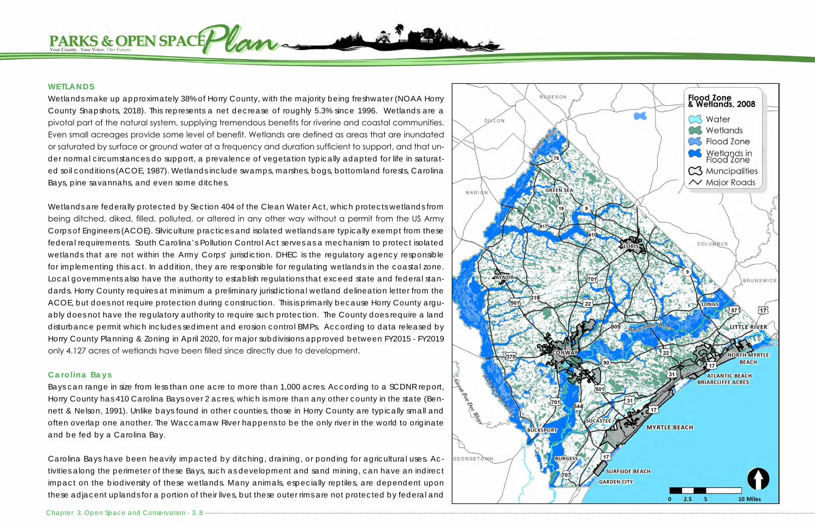
Chapter 3: Open Space and Conservation - 3. 8 ------------------------------------------------------------------------------------------------------------------------------------------------------------------------------------------------------------------------------------------------------------------------------------
WETLANDSWetlands make up approximately 38% of Horry County, with the majority being freshwater (NOAA Horry County Snapshots, 2018). This represents a net decrease of roughly 5.3% since 1996. Wetlands are a pivotal part of the natural system, supplying tremendous benefits for riverine and coastal communities. Even small acreages provide some level of benefit. Wetlands are defined as areas that are inundated or saturated by surface or ground water at a frequency and duration sufficient to support, and that un-der normal circumstances do support, a prevalence of vegetation typically adapted for life in saturat-ed soil conditions (ACOE, 1987). Wetlands include swamps, marshes, bogs, bottomland forests, Carolina Bays, pine savannahs, and even some ditches.
Wetlands are federally protected by Section 404 of the Clean Water Act, which protects wetlands from being ditched, diked, filled, polluted, or altered in any other way without a permit from the US Army Corps of Engineers (ACOE). Silviculture practices and isolated wetlands are typically exempt from these federal requirements. South Carolina’s Pollution Control Act serves as a mechanism to protect isolated wetlands that are not within the Army Corps’ jurisdiction. DHEC is the regulatory agency responsible for implementing this act. In addition, they are responsible for regulating wetlands in the coastal zone. Local governments also have the authority to establish regulations that exceed state and federal stan-dards. Horry County requires at minimum a preliminary jurisdictional wetland delineation letter from the ACOE, but does not require protection during construction. This is primarily because Horry County argu-ably does not have the regulatory authority to require such protection. The County does require a land disturbance permit which includes sediment and erosion control BMPs. According to data released by Horry County Planning & Zoning in April 2020, for major subdivisions approved between FY2015 - FY2019 only 4.127 acres of wetlands have been filled since directly due to development.
Carol ina BaysBays can range in size from less than one acre to more than 1,000 acres. According to a SCDNR report, Horry County has 410 Carolina Bays over 2 acres, which is more than any other county in the state (Ben-nett & Nelson, 1991). Unlike bays found in other counties, those in Horry County are typically small and often overlap one another. The Waccamaw River happens to be the only river in the world to originate and be fed by a Carolina Bay.
Carolina Bays have been heavily impacted by ditching, draining, or ponding for agricultural uses. Ac-tivities along the perimeter of these Bays, such as development and sand mining, can have an indirect impact on the biodiversity of these wetlands. Many animals, especially reptiles, are dependent upon these adjacent uplands for a portion of their lives, but these outer rims are not protected by federal and

-------------------------------------------------------------------------------------------------------------------------------------------------------------------------------------------------------------------------------------------------------------------------------------------- Chapter 3: Open Space and Conservation - 3. 9
state wetland regulations. Because Carolina Bays are considered a threatened ecosystem, South Carolina Department of Natural Resources (SCD-NR) has incorporated Lewis Ocean Bay and Cart-wheel Bay into their Heritage Preserve Program.
BEACHES AND MARSHESOur beaches and marshes not only support wild-life habitat and recreation, they also serve as the primary draw for tourists and the influx of people moving to the area.
The South Carolina Office of Ocean and Coastal Resource Management (OCRM) is responsible for the protection and permitting of activities in the Critical Areas of South Carolina’s coast, including tidelands, beaches, and dunes. OCRM is also re-sponsible for permitting non-jurisdictional fill and mitigation. At the local level, Horry County and the municipalities within it, are responsible for pro-viding public access to these coastal resources and for the development that occurs in these ar-eas. Maintaining these critical resources is part of a cooperative effort between local governments and state and federal agencies. More information about Beach accesses, mitigation, and manage-ment practices can be found in the Horry County Beach Management Plan.
SPECIES HABITATHorry County’s diverse landscape supports a va-riety of plant and animal species. In many cases, the rich biodiversity found throughout the County can be directly associated with the abundance of water resources. Biodiversity is a sign of a healthy
ecosystem, as it supports ecosystem productivity and ensures the greater capability to withstand and recover from disasters. Plant life is some of the most beneficial for ecosystem stability when it comes to absorbing flood waters. Plant life is somewhat ses-sile and unable to relocate making it very vulnera-ble to development pressures. A changing climate alone could have very heavy negative implications for such sessile life forms. According to South Car-olina Department of Natural Resources, the land along the Lumber, Little Pee Dee, and Waccamaw Rivers have the potential to support the greatest va-riety of species in the County. For a species richness map please see SCDNR’s SC State Wildlife Action Plan (SWAP) maps.
Threatened and Endangered SpeciesHorry County has a variety of rare, threatened and endangered plant and animal species. Develop-ment, logging, the use of pesticides, fishing and hunting are just a handful of reasons why some plant and animal populations have declined throughout the County. Invasive plants and animals that out compete and consume similar resources are anoth-er reason for the decline in certain plant and animal species.
The loggerhead sea turtle is a well-known endan-gered species. Their populations began to rebound with the use of Turtle Excluder Devices in commer-cial fishing nets and through volunteer efforts to protect and monitor nests along the beach. There are a number of threatened and endangered birds that reside or migrate through Horry County. The red-cockaded woodpecker is a well-known endan-

Chapter 3: Open Space and Conservation - 3. 10 ----------------------------------------------------------------------------------------------------------------------------------------------------------------------------------------------------------------------------------------------------------------------------------
Scientific Name Common Name
Acipenser brevirostrum Shortnose SturgeonAcipenser oxyrinchus Atlantic SturgeonAlligator mississippiensis American AlligatorAlosa aestivalis Blueback HerringBalaenoptera physalus Finback WhaleCalidris canutus rufa Red KnotCaretta caretta LoggerheadCharadrius melodus Piping PloverChelonia mydas Green Sea TurtleClemmys guttata Spotted TurtleCorynorhinus rafinesquii Rafinesque's Big-eared BatDanaus plexippus Monarch ButterflyDermochelys coriacea Leatherback Sea TurtleElassoma boehlkei Carolina Pygmy SunfishElliptio congaraea Carolina SlabshellEubalaena glacialis Atlantic Right WhaleFundulus diaphanus Banded KillifishHaliaeetus leucocephalus Bald EagleHeterodon simus Southern Hognose SnakeLampsilis splendida Rayed Pink FatmucketLaterallus jamaicensis Black RailLepidochelys kempii Kemp's Ridley Sea TurtleMegaptera novaeangliae Humpback WhaleMoxostoma robustum Robust RedhorseMycteria americana Wood StorkPerimyotis subflavus Tricolored BatPicoides borealis Red-cockaded WoodpeckerPituophis melanoleucus Pine or Gopher SnakePterodroma hasitata Black-capped PetrelSterna antillarum Least TernTrichechus manatus Florida ManateeUrsus americanus Black BearVillosa delumbis Eastern Creekshell
Rare, Threatened, and Endangered Species of Horry County: Animals
Scientific Name Common Name
Agalinis aphylla Coastal Plain False-foxgloveAgalinis maritima Salt-marsh False-foxgloveAmaranthus pumilus Seabeach AmaranthAndropogon mohrii BroomsedgeAnthaenantia rufa Purple SilkyscaleAsclepias pedicellata Savannah MilkweedBalduina uniflora One-flower BalduinaCalamovilfa brevipilis Pine-barrens Reed-grassCeratiola ericoides Sandhills RosemaryCeratiola ericoides Sandhills RosemaryCoreopsis integrifolia Ciliate-leaf TickseedCoreopsis rosea Rose CoreopsisCrotonopsis linearis Narrowleaf RushfoilDionaea muscipula Venus' Fly-trapEchinodorus tenellus Dwarf BurheadEupatorium recurvans Coastal-plain Thorough-wortFimbristylis perpusilla Harper's FimbryHelenium brevifolium Shortleaf SneezeweedIlex amelanchier Sarvis HollyLygodium palmatum Climbing FernMacbridea caroliniana Carolina Bird-in-a-nestMinuartia godfreyi Godfrey's StitchwortNuphar sagittifolia Narrowleaf PondlilySabatia bartramii Bartram's Rose-gentianSabatia kennedyana Plymouth GentianSarracenia rubra Sweet Pitcher-plantSchwalbea americana ChaffseedScleria baldwinii Baldwin NutrushSolidago pulchra Carolina GoldenrodSporobolus teretifolius Wire-leaved DropseedStylisma pickeringii Pickering Morning-gloryTofieldia glabra White False-asphodelXyris flabelliformis Savannah Yellow-eyed
Grass
Rare, Threatened, and Endangered Species of Horry County: Selected Plants

-------------------------------------------------------------------------------------------------------------------------------------------------------------------------------------------------------------------------------------------------------------------------------------------- Chapter 3: Open Space and Conservation - 3. 11
gered species in this region, as they rely upon old growth long leaf pines, which nearly disap-peared from Horry County in the late 1800s. Similarly, the bald eagle remains threatened in South Carolina, although it has been taken off the endangered list at the federal level. Bald eagle populations declined drastically from the 1940s through the 1970s due to the loss of hab-itat, shooting, and pollutants like DDT. Through conservation and habitat restoration efforts, many plant and animal species are on the road to recovery. Despite these efforts, additional rare, threatened, and endangered species continue to be added to state and federal listings. For a more complete list please see SCDNR’s species lists.
Invasive SpeciesInvasive species are non-native plant, insect or animal species that have been introduced into an area outside of their original range and compete with native species for resources. Invasive species are recognized as one of the leading threats to biodiversity and impose enormous costs to human enterprises, as well as to human health. Most recent estimates indicate that 42% of the nation’s endangered and threatened species have declined as a result of encroaching exotic invasive species (SCDNR, 2008).
Not all non-native species are invasive, as many have become naturalized over time. Exot-ic plants are only a problem when they escape cultivation, spread rapidly and aggressively compete with native species. One example is bamboo. Unfortunately, many of these plants continue to be sold in nurseries.
The Asian Longhorned Beetle, Emerald Ash Borer, Brown Marmorated Stink Bug, and the Fire Ant are just a few of the commonly found invasive insects in South Carolina. In 2011, the Kudzu Bug arrived in South Carolina and quickly spread to every county in the state within the year, dam-aging soybean crops. Untreated soybeans were estimated to have a 20% loss in South Carolina (Clemson, 2014). Invasive animals can also be found in Horry County, including, but not limited to feral hogs, coyotes, and the apple snail. Problems stemming from invasive animals include competing with native wildlife for food, damaging upland and wetland habitats, preying on small game, outdoor pets and deer, and altering the natural balance of the ecosystem.
New invasive species will likely be introduced into our County. Preventing further spread of invasive species and restoring impacted sites is a monumental task that depends on public awareness, eradication measures, and ongoing monitoring.
Scientific Name Common Name Type Origin
Melia azedarach Chinaberry Shade Tree ChinaImperata cylindrica Cogongrass Grass Southeast AsiaAgrilus planipennis Emerald Ash Borer Insect Eastern AsiaPaulownia tomentosa Empress (Princess) Tree Ornamental Tree Central ChinaHeracleum mantegazzianum Giant Hogweed Biennial CaucasusPhyllostachys aurea Golden Bamboo Perennial reed ChinaLymantria dispar Gypsy Moth Insect Asia & Europe Lygodium japonicum Japanese Climbing Fern Perennial Fern AsiaLonicera japonica Japanese Honeysuckle Ornamental Shrub JapanAlbiza julibrissin Mimosa Tree Ornamental Tree -Rosa multiflora Multiflora Rose Shrub JapanNandina domestica Nandina Shrub China/JapanMicrostegium vimineum Nepalese Browntop Grass AsiaLigustrum sp. Privet Shrub/Tree Asia/EuropeLycorma delicatula Spotted Lanternfly Insect AsiaTricadica sbifera Tallow Tree Tree EuropeAilanthus altissima Tree of Heaven Tree -Vinca major, Vinca minor Vina Vine (Periwinkle) Vine -Eleagnus sp Wild Olive Shrub Asia/EuropeWisteria sinensis Chinese Wisteria Vine ChinaTriadica sebifera Chinese Tallowtree Tree -Polygonum cuspidatum Japanese Knotweed Shrub -Cytisus scoparius Scotch Broom Shrub -Hedera helix English Ivy Vine -Pueraria montana Kudzu Vine -Rottboellia conchinchinesis Itchgrass Grass -Microstegium vimineum Japanese Stilt Grass Grass AsiaSolanum viarum Tropical Soda Apple Perennial -Nymphoides cristata Crested Floating Heart Floating Plant -
Selected Invasive Species of Horry County

Chapter 3: Open Space and Conservation - 3. 12 ----------------------------------------------------------------------------------------------------------------------------------------------------------------------------------------------------------------------------------------------------------------------------------
SC DNR Aquatic Nuisance Program - Water HyacinthSince 1982 when the program was first started over 32,000 acres of Water hyacinth has been treated in South Carolina’s public waters at a cost of approximately $3 million dollars. Special thanks to the many volunteers and organiza-tions along the river that continue the effort to try and keep this plant at bay by manual remov-al for the last several years. Without treatment, the plant will continue to grow and cause major problems up and down the river
Water Hyacinth- invasive water species
were assessed to determine some of the most nat-urally constrained areas within the County. The fol-lowing factors were taken into consideration when developing this analysis:• Regulatory Floodzone• Poorly Drained Soils (NRCS, Soils Data)• Vegetation Indicative of Wetlands (HC Landcover,
2008)
The following map identifies areas that are likely envi-ronmentally constrained. Because all of data sources utilized in this analysis have not been evaluated at the parcel level and the landscape changes over time, there is a continued need to update this analysis as new data becomes available. In addition, wetland delineations of a site may be utilized to determine the exact location of a wetland. This information was utilized to inform the Future Land Use Map adopted within IMAGINE 2040. Specifically, the Scenic and Conservation land use designation was developed to limit development in environmentally sensitive or highly constrained areas while also encouraging de-sign that utilizes low-impact principles to support en-vironmental preservation and avoidance of natural hazards. These areas include environmentally sen-sitive and scenic areas, such as Carolina Bays, estu-arine and forested wetlands, undeveloped beach-front, forestlands, floodplains, agricultural lands, and natural recreational and open spaces. These areas are important for the ecosystem services (flood con-trol, stormwater filtration, clean air), educational and research opportunities, and for nature-based recre-ation. Many of these areas are either flood or wildfire prone, so development within and adjacent to these areas should take these hazards into consideration.
Environmental ConstraintsThrough the IMAGINE 2040 planning process, a Geographic Information Systems mapping anal-ysis was conducted to inform decision-makers of land areas that are likely environmentally con-strained. Horry County is made up of 38% wet-lands and contains extensive floodplains. It is also vulnerable to wildfires. In order to protect properties and lives from natural hazards, the fol-lowing environmental development constraints
-------------------------------------------------------------------------------------------------------------------------------------------------------------------------------------------------------------------------------------------------------------------------------------------- Chapter 3: Open Space and Conservation - 3. 13
GREEN INFRASTRUCTURE Green Infrastructure can be defined as a network of natural lands, such as forests, grasslands, wetlands, and waterways, that work together to preserve habitat, minimize stormwa-ter runoff and flooding, protect water quality, and provide opportunities for outdoor recreation. Establishing an inter-connected green infrastructure network relies on both land-scape scale planning and site level design. Preserving an effective green infrastructure network will rely upon:
Conserving large areas of significant habitat and areas adjacent to existing conservation lands;
Siting future parks along waterways, beaches, and other natural areas;
Protecting wetlands, floodplains, and woodlands within neighborhood open space; and
Establishing linear connections between conservation ar-eas, parks, and neighborhoods.
This plan identifies the significant habitat hubs and wildlife corridors that exist throughout the County in order to inform future land conservation efforts, siting of future parks, and the set aside of neighborhood open space.
FOCUS GROUP GREEN INFRASTRUCTURE PRIORITIESFuture development and road construction has the greatest likelihood to fragment habitats and sever critical habitat cor-ridors. Staff met with representatives from public and private conservation organizations to obtain input about significant habitats and wildlife corridors to consider for future protec-tion. Participants discussed wetlands, forestlands, and flood-plains and their interconnectivity throughout the County. The following were considered high priority to improve connec-tivity and expand the open space network in Horry County: • Highway 90 Corridor: The wetlands and habitat corridors
that are bisected by the roadway. The habitat corridors
link wildlife from Lewis Ocean Bay Heritage Preserve to the Waccamaw River.
• Hog Inlet and Waties Island: This area has significant his-torical and ecological significance and is one of the last undeveloped shorelines in the Grand Strand. Much of this area also has flood insurance restrictions, making it prob-lematic if new development were to occur.
• Lake Busbee: This man-made lake has become a fixture in the community. Since the closing of the Santee Coo-per Grainger Plant water levels have been allowed to self regulate, fluctuating from relatively dry to fully inundated during flood events. Preservation of areas along the Wac-camaw River were identified of high level importance for wildlife, water quality, flood control, and recreation.
• Conway to Coastal Carolina University: Developing an interconnected trail system from the City of Conway to Coastal Carolina University and Cox Ferry Lake Recreation Area was identified as high priority, as it would increase mobility across the Waccamaw River and improve ac-cess to nature.
• Improved Access to Open Space: By improving signage to and within SC Department of Natural Resource Heri-tage Preserves and other public lands, it will improve op-portunities for people to access nature and existing trail systems.
• Floodplain Preservation: Conservation partners and the County will benefit from preserving land within the flood-plain. Not only will it protect flood storage, it will help de-crease flood insurance premiums through the Communi-ty Rating System.
• Wetland Mitigation: Partners reiterated the importance of coordination with SC Department of Transportation, US Army Corps of Engineers, and SC Department of Health and Environmental Control to redirect wetland mitigation
back to Horry County and the watershed in which wet-land impacts occur.
• Conservation Design: Participants also discussed oppor-tunities to increase conservation through development regulations and zoning.
PRIORITY CONSERVATION AREASPriority conservation acquisition areas were identified through an iterative process. First, all existing public and pri-vate conservation properties and easements were identified and mapped. County landcover data was then utilized to identify areas with wetlands and forestlands. For this anal-ysis, Carolina Bays and bottomland hardwood forests were targeted for conservation because of their significant hab-itat. After mapping significant habitats, conservation part-ners, including representatives from the Waccamaw Nation-al Wildlife Refuge, SC Department of Natural Resources, SC Forestry Commission, American Rivers, Winyah Rivers Foun-dation, The Nature Conservancy, and the City of Conway, participated in a focus group to identify areas that would be valuable to add to the existing conservation network. Focus group attendees and subject matter experts confirmed the location of key habitat corridors, hubs, and linkages. These areas were transcribed and included in the Priority Conser-vation Areas Conceptual Map on the following page. While the map details these priority areas, it does not rank them, as conservation efforts are voluntary and depend on will-ing property owners. While there are some minor develop-ments within these priority conservation areas, most are un-developed and do not have development plans in place. If development is pursued in these areas, the County may encourage open space dedication or encourage low den-sity zoning. Identifying conservation priorities will also help leverage funding for conservation partners, target areas for
1234

Chapter 3: Open Space and Conservation - 3. 14 ----------------------------------------------------------------------------------------------------------------------------------------------------------------------------------------------------------------------------------------------------------------------------------

-------------------------------------------------------------------------------------------------------------------------------------------------------------------------------------------------------------------------------------------------------------------------------------------- Chapter 3: Open Space and Conservation - 3. 15
wetland mitigation banks, and even help reduce local flood insurance rates through the National Flood Insurance Pro-gram’s Community Rating System.
Habitat Corr idors Beachfront - The entire beachfront serves as a significant habitat for sea turtles, a resting location for migratory birds, and home to a variety of other wildlife. Because of devel-opment intensity along the beach, conservation is limited. Public education serves as a primary means to protect this resource.
Hog Inlet - Hog Inlet links the Intracoastal Waterway and Lit-tle River to the Atlantic Ocean. This area is the last remaining, undeveloped beachfront and tidal marsh in Horry County. (moderate future land development likelihood)
Lumber and Little Pee Dee Rivers - The Lumber and Little Pee Dee Rivers and their adjacent uplands all serve as significant habitat corridors within Horry County, linking waters as far north as Virginia down to Winyah Bay in Georgetown Coun-ty. Lake Swamp serves as a corridor to link upland habitats. (long-range land development potential)
Socastee Greenway - Socastee Greenway is a wetland corri-dor that links Lewis Ocean Bay to the Intracoastal Waterway. The Socastee Greenway is already surrounded by develop-ment or proposed development. (Imminent land develop-ment likelihood)
Waccamaw River - The Waccamaw River and its adjacent uplands serve as a significant habitat corridor within Horry County, linking to Lake Waccamaw in North Carolina. Steritt, Tilly, Jones Big Swamps and Buck, Simpson, and Bull Creeks all link surrounding upland areas to the Waccamaw River.
(Imminent to long-range land development depending upon location.)
Conservation Hubs Lewis Ocean Bay Heritage Preserve - Lewis Ocean Bay Her-itage Preserve protects a number of large, intact Carolina Bays, which provide habitat for the black bear and exotic plants, like the venus flytrap and the pitcher plant. Develop-ment already exists along the southern end of the Heritage Preserve. There is a large number of Carolina Bays within this area that remain to be protected. This area includes the Independent Republic Heritage Preserve, a wetland bank parcel purchased by Horry County for the Ride 3 road im-provement projects. (Imminent land development around existing protected lands)
Little Pee Dee Heritage Preserve - The Little Pee Dee Heritage Preserve includes the northern reaches of the Little Pee Dee River and southern reach of the Lumber River in Horry County. Habitat includes bottomland hardwood forests. (long-range land development potential)
Waccamaw National Wildlife Refuge - The Waccamaw Na-tional Wildlife Refuge includes lower portions of the Wac-camaw River in Horry and Georgetown Counties. The Refuge serves as the most northern habitat for the swallow-tailed kite and other significant wildlife. The Refuge also includes Cox Ferry Recreation Area, which provides paddling, moun-tain biking, and hiking opportunities near Coastal Carolina University and the City of Conway. Development potential is great along the Hwy 544 and 707 corridors which follow the Waccamaw River. (Imminent to moderate land devel-opment)
Waccamaw River Heritage Preserve - Waccamaw River
Heritage Preserve includes a conglomeration of state and private conservation efforts targeted to protect the upper extent of the blackwater river and the surrounding swamps. (Imminent land development likelihood)
Conservation Gaps Cartwheel Bay - Cartwheel Bay Heritage Preserve is surround-ed by a number of intact or nearly intact Carolina Bays inter-mixed with active farmland. These bays are in close proximi-ty to the Little Pee Dee Heritage Preserve and Lake Swamp. (long-range land development potential)
Gunter’s Island - Gunter’s Island consists of bottomland hard-wood forest along the Little Pee Dee River. There are just a few landholders in this area, consisting mainly of timber oper-ations. (long-range land development potential)
Lower Little Pee Dee River - Lower Little Pee Dee River is lo-cated between Hwy 378 and Bull Creek. This area is part of the Pee Dee River Scenic River, but to date, conservation initiatives have not been pursued in this portion of the river. (long-range land development potential)
Middle Waccamaw - The Waccamaw River is designated as a national blue trail through the National Parks Service. In addition, the river has a great deal of conservation north of Hwy 22 and south of Hwy 501. The Middle Waccamaw River has not been targeted for conservation, despite the fact that it provides multiple points of connection to Lewis Ocean Bay Heritage Preserve. (Imminent land development likelihood)
Habitat L inks Bull Creek - Bull Creek is the junction of the Little Pee Dee, Great Pee Dee, Waccamaw River, and Intracoastal Water-

Chapter 3: Open Space and Conservation - 3. 16 ----------------------------------------------------------------------------------------------------------------------------------------------------------------------------------------------------------------------------------------------------------------------------------
way. This area serves as nesting grounds for the Ameri-can Swallow-Tailed Kite. The majority of the remaining land is owned by Grand Strand Water and Sewer and The May Company. Development potential will remain low until the Southern Evacuation Lifeline (SELL) is con-structed through this area. (long-range land develop-ment potential)
Steritt, Tilly, and Jones Big Swamps - Steritt Swamp, Tilly Swamp, and Jones Big Swamp all serve as critical hab-itat corridors that link Lewis Ocean Bay Heritage Pre-serve with the Waccamaw River. These swamps are all bisected by Highway 90, an area that is expected to experience increased development in the near future. (imminent land development likelihood)
Hog Inlet (Waties Island) - Hog Inlet is the northern most point of the Atlantic Intracoastal Waterway in South Carolina and serves as the County’s only navigable waterway that directly links to the Atlantic Ocean. This area provides spawning grounds for marine wildlife and includes historically significant properties that are linked with Native American settlements and a Civil War en-campment. While the majority of the undeveloped land in this area falls within the Coastal Barrier Resource System and cannot obtain a federally backed mort-gage because flood insurance is not allowed nor the use of federal funds for infrastructure. (moderate land development likelihood)
Kingston Lake – Kingston Lake is a branch of the Wac-camaw River that extends north through the City of Conway. This area is a high hazard flood area and also serves a habitat link miles upstream. (imminent land de-velopment likelihood)
Lake Swamp - Lake Swamp serves as a major link between the Little Pee Dee River and upstream conservation, Carolina Bays, and land historically farmed for tobacco and cotton. Habitat and wildlife corridors may be impacted by the development of I-73, which is anticipated to traverse Lake Swamp. (long-range land development potential)

-------------------------------------------------------------------------------------------------------------------------------------------------------------------------------------------------------------------------------------------------------------------------------------------------------------- Chapter 4: Needs Assessment - 4. 1
INTRODUCTIONYouth and senior populations are growing rapidly, along with the growing seasonal population that lives here for mul-tiple months out of the year. These populations often have high demand for activities to enrich their lives. Programming, additional park space, and amenities available at County parks, open spaces, and recreational facilities serve all of these age groups and also provide people with the oppor-tunity to develop a greater sense of community. They also provide a means to develop and maintain good physical and mental health through exercise and socialization.
As the population continues to grow, especially in these de-mographics, it will become increasingly important to provide quality programming, parks, open space, and recreational amenities. Existing park spaces need to be expanded and existing amenities need to be updated and maintained to provide adequate recreational services to existing residents. New parks and additional amenities need to be pursued in order to meet growing demands on existing infrastructure and address the widening gap in services provided between the coastal urban area and the rural western portion of the County.
As residents and visitors become more connected to their digital mobile devices, marketing and program manage-ment must also become adapted to utilizing digital media to advertise the County’s parks and recreation opportuni-ties. While the HC Connect app, recent improvements to the Parks and Recreation registration page, and the Horry County Parks and Recreation real-time Boat Landing status page have moved a long way towards digital involvement with residents and visitors, there is still progress that can be made.
Population Growth in Horry County, 1910-2040
Sources: Historic population – Census. Projections - SC Revenue and Fiscal Affairs Office and Research, and Horry County Planning & Zoning.
Operationally, the Parks and Recreation Department must be able to rise to the growing need by implementing ap-propriate strategies to maintain, operate, and improve facil-ities and programing. The County must also strive to provide sstable funding sources to the Parks and Recreation Depart-ment which can both grow with demand and address ex-isting needs for improvements to level of service, operation-al increases, and growing maintenance needs as facilities age. To begin this process, the Department must to address staffing needs including necessary skills training.
While Horry County offers over 80 recreation facilities, there are many factors that limit use of these facilities and partici-pation in programming. In order to address these concerns, this portion of the Plan will identify existing demand for rec-reation facilities, identify where there is already inadequate recreation facilities, maintenance and safety concerns, an overview of programming and marketing needs, and a sum-mary and assessment of funding mechanisms to support fa-cility and program expansion.
GROWTH TRENDSAccording to 2020 population estimates, Horry County has approximately 354,800 permanent residents. The County has experienced rapid growth since the 1970s, adding over 250,000 permanent residents since that time. In just the last 15 years, there has been an influx of over 100,000 residents. The County has one of the highest population growth rates in the State and is now the fourth most populous county in South Carolina, behind Greenville, Richland, and Charleston counties respectively.
The 2015 total population estimate reflects a 14.8% increase or 39,908 more people since 2010. This reflects growth that
occurred even during a major economic downturn. These numbers are only expected to escalate. The population is projected to grow to 584,500 by 2040. Note that these pop-ulation numbers and projections do not account for season-al population, including snowbirds that live in the area for the cooler months and tourist and seasonal work population during the summer months. If seasonal population is includ-ed, these numbers easily reach over 1/2 million on any given day during peak tourist season.
Population projections enable the County to take present action to accommodate future conditions. Projections can help determine the demand for future facilities and services. Making plans in a rapidly changing, high growth area such as Horry County is difficult. Population projections through

Chapter 4: Needs Assessment - 4. 2 ---------------------------------------------------------------------------------------------------------------------------------------------------------------------------------------------------------------------------------------------------------------------------------------------------------
2035 were derived from the SC Revenue and Fiscal Af-fairs Office. The 2040 projections and distribution of growth throughout the County was further refined by Horry County Planning and Zoning. Estimates show that the Myrtle Beach CCD (County Census Division) and Floyds CCD will grow the least, both with 55.7% increases. The Conway CCD will grow the second least with a 63.2% increase. The highest popula-tion growth rates are projected to be Conway East CCD with
130.5% and the Longs CCD with a 367.6% increase. By far, the greatest number of residents will live in Conway East and Myrtle Beach CCDs, accounting for roughly 60% of the pop-ulation by 2040. In addition to meeting the existing needs of communities, the needs brought on by population growth will also need to be addressed. Pressure for additional rec-reation will be felt especially strong in those areas which will see the greatest population growth and in areas which are already lacking in sufficient recreational amenities.
FACILITY DEMANDThe Countywide Recreational Needs Assessment Survey and focus groups revealed that existing residents are seeking parks that offer a variety of recreational options for all ages and provide options for people with varying physical capa-bilities. The community conveyed that parks should be within close proximity to their residence and should include walking trails, playground equipment, picnic areas, access to natural areas or waterways, as well as active components, such as fields and outdoor courts. Residents want multi-use facilities that cater to the recreational needs of their entire family, including grandparents, parents, and children, and can of-fer outdoor gathering space for family reunions and special events.
Beyond neighborhood and community parks, both urban and rural communities desired the development of nature trails, improved access to waterways, and increased pro-gramming at existing recreation facilities. There was also a strong desire for improved handicapped accessibility at parks and beach accesses, beyond providing handicap parking.
Rural communities indicated a need for basic recreational amenities, including community recreation centers and ad-
ditional ballfields. They also had a stronger interest in capi-talizing on their natural surroundings, as they desired hiking and ATV trails, camping areas, retreat center, and guided paddling programs along area rivers. Equestrian trails were also desired in these areas.
Consistently throughout the County, residents desired the ex-pansion of existing recreation and community centers. Ball-field users also consistently expressed the need for field light-ing to allow for night time play, thus allowing for additional leagues and tournament play without having to construct new fields. Passive recreation opportunities were also consis-tently recommended, including picnic areas, scenic views, and unprogrammed open space.
Beyond typical park and recreation facilities, residents ex-pressed a strong interest in the development of nature trails and an outdoor shooting range. An outdoor shooting range was most desired by those in rural parts of the County. An ice rink and aquatic center were also desired by some mem-bers of the community. A feasibility study conducted by the Myrtle Beach Area Chamber of Commerce concluded that these would not currently be economically feasible opportu-nities. Further study may be warranted in the future.
While an Equestrian Center was not specifically called out among residents, survey and focus group input identified a demand for nature and equestrian trails, wildlife viewing ar-eas, and camping. In addition, previous studies have identi-fied that Horry County could benefit from the development of an equestrian and agricultural facility. If such facilities were combined, the County could ensure it were used year-round and could generate revenue. In late 2019, the Coun-ty’s Infrastructure and Regulation Committee formed a Rural Civic Arena Subcommittee to address the potential creation

-------------------------------------------------------------------------------------------------------------------------------------------------------------------------------------------------------------------------------------------------------------------------------------------------------------- Chapter 4: Needs Assessment - 4. 3
of such a center. The process is still evolving with the cooperation of Horry Electric, Clemson Extension, Horry County Council, and additional community partners.
SWOT ANALYSISCommunity input and an evaluation of existing County Parks and Recreation facilities informed the development of a SWOT (Strengths, Weaknesses, Opportunities, and Threats) Analysis. A SWOT analysis sheds light not only on the positive elements of a community, but also on the negatives. If not addressed, the weakness and threats could have both direct and indirect conse-quences on the quality of life of our residents. The analysis revealed a strong desire to expand and provide quality parks and open spaces. Establishing a reliable funding source for capital improvements and staffing serves as the greatest gap in meet-
ing existing and future recreational needs. Increased public and private partnerships also serves as a clear opportunity to provide quality parks and open spaces.
PRIORITY RECREATION AREAS AND FACILITY GAPSA mapping analysis was conducted to determine the most appropriate areas for the siting of new recreational facili-ties and to determine where there are existing gaps in the County’s existing open space network. The first step includ-ed a gap analysis to determine areas of the County that currently lack recreation facilities. A service area analysis was completed for each park type. Boating and waterfront access needs were determined based upon a reasonable paddling distance between access points. Public input and an analysis of existing facility conditions were incorporated into this analysis to determine where renovation and expan-sion of existing facilities will help meet future needs. Growth trends, historically underserved communities, and areas of the County that were developed prior to the County’s Sub-division Open Space Requirements were also incorporated. Proximity to other community amenities, transportation and walkable access, and availability of land were also consid-ered.
ParksThrough this analysis, there is a clear need for the develop-ment of Community, Major, Specialized, and Regional Parks, especially in older, established portions of the County. The land for future parks should be acquired in the near future, as land is quickly being developed east of the Waccamaw Riv-er. In addition, many Neighborhood, Community, and Major County Parks are in need of expansion, as they are already undersized for the population that they serve.
The County should consider incorporating splash areas into
Strengths (Current) Weaknesses (Current) Opportunities (Future) Threats (Future)
Engaged residents with highdemand for additional rec-reational facilities, program-ming, and leagues.
Deteriorating recreation facil-ities and equipment.
Linking recreation, natural spaces, and neighborhoods.
Liability associated with dete-riorating infrastructure.
Abundance of public beach and waterway access points.
Perception of unsafe facili-ties.
Increased open space con-servation to protect habitat connectivity.
Increasing travel time and lack of multi-modal access facilities.
Existing recreation facilities have room to grow.
Litter and waste manage-ment.
Signage, branding, and webbased information about recreational facilities.
Limited land availability east of the Waccamaw River.
Federal designation of the Waccamaw River Blue Trail.
Lack of handicap accessibil-ity.
Sponsorships and franchise agreements of county facili-ties.
Potential loss of new industry if County cannot provide the recreational amenities and open space their employees seek.
Strong recreation partnership with Horry County Schools.
Lack of indoor space to grow recreation programming.
Increased public-private partnerships.
Poor physical and mental health of residents.
Strong public and private land conservation partner-ships.
Understaffed Parks and Rec-reation Department.
Diversified and dedicated funding mechanisms.
Loss of access to natural ar-eas as development increas-es.
67,800+ acres total protected open space.
Residents unaware of recre-ation facility locations and offerings.
Improved land development regulations and incentives to protect contiguous natural systems.
Long-term funding for recre-ation and conservation.
45,000+ acres of protected floodplain.
Parks and open space fund-ing not competitive with similar counties.
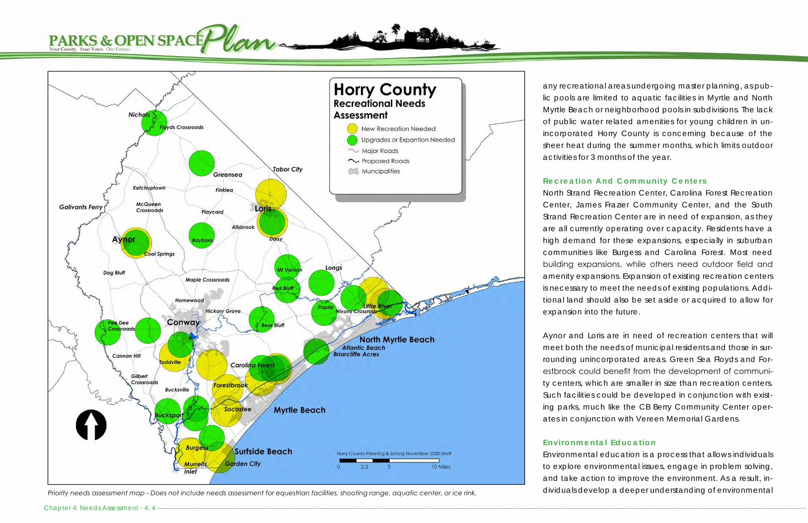
Chapter 4: Needs Assessment - 4. 4 --------------------------------------------------------------------------------------------------------------------------------------------------------------------------------------------------------------------------------------------------------------------------------------------------------
Priority needs assessment map - Does not include needs assessment for equestrian facilities, shooting range, aquatic center, or ice rink.
any recreational areas undergoing master planning, as pub-lic pools are limited to aquatic facilities in Myrtle and North Myrtle Beach or neighborhood pools in subdivisions. The lack of public water related amenities for young children in un-incorporated Horry County is concerning because of the sheer heat during the summer months, which limits outdoor activities for 3 months of the year.
Recreation And Community CentersNorth Strand Recreation Center, Carolina Forest Recreation Center, James Frazier Community Center, and the South Strand Recreation Center are in need of expansion, as they are all currently operating over capacity. Residents have a high demand for these expansions, especially in suburban communities like Burgess and Carolina Forest. Most need building expansions, while others need outdoor field and amenity expansions. Expansion of existing recreation centers is necessary to meet the needs of existing populations. Addi-tional land should also be set aside or acquired to allow for expansion into the future.
Aynor and Loris are in need of recreation centers that will meet both the needs of municipal residents and those in sur-rounding unincorporated areas. Green Sea Floyds and For-estbrook could benefit from the development of communi-ty centers, which are smaller in size than recreation centers. Such facilities could be developed in conjunction with exist-ing parks, much like the CB Berry Community Center oper-ates in conjunction with Vereen Memorial Gardens.
Environmental EducationEnvironmental education is a process that allows individuals to explore environmental issues, engage in problem solving, and take action to improve the environment. As a result, in-dividuals develop a deeper understanding of environmental

-------------------------------------------------------------------------------------------------------------------------------------------------------------------------------------------------------------------------------------------------------------------------------------------------------------- Chapter 4: Needs Assessment - 4. 5
issues and have the skills to make informed and responsible decisions. Environmental education does not advocate a particular viewpoint or course of action. Rather, environ-mental education teaches individuals how to weigh various sides of an issue through critical thinking and it enhances their own problem-solving and decision-making skills. While Horry County Schools operates the Playcard Environmental Education Center in Loris which showcases rural ecosystem functions, there is a district lack of urban and suburban eco-logical function environmental education in Horry County. Such a facility could function to teach residents to view ecological functions as interdependent with urban and sub-urban growth. It can also teach children to assess the quality of the environment and to act to improve it.
Trai ls and GreenwaysThere is a clear desire among residents and visitors to ex-pand the bicycle and pedestrian infrastructure network. This can partially be accomplished through an interconnected open space network with trails, through implementation of the projects outlined in Chapter 6: Proposed Projects, and through the implementation of projects outlined in the Horry County Bicycle and Pedestrian Plan.
Boat LandingsBeyond parks, there is a need for at least one new boat landing along the Intracoastal Waterway, as there is current-ly a fifteen (15) mile gap in public boating access between Socastee and Arcadian Shores. There is also a need for soft boat launches throughout the County to cater to paddlers and swimmers, minimizing user conflicts with motorized boat-ers. At the beach, public access has been maximized, but there remains a need for additional public parking in proxim-ity to the access points.
Proposed ProjectsThe facility recommendations within this Plan are intended to close the gap in facilities, but there may be instances when unanticipated population growth may merit more facilities or amenities than identified within this Plan. Filling these rec-reational gaps are not the only recreational improvements that need to be considered, as numerous upgrades and ex-pansions are needed within existing facilities. These upgrades are detailed within Chapter 6: Proposed Projects.
FUNDING NEEDSHorry County Parks and Recreation Department is funded through a variety of avenues. Parks and Recreation oper-ations, maintenance and programming is funded through dedicated millage and supplemented by user fees. Addi-tionally, the County utilizes Sunday Liquor Sales revenues and grants to support capital improvement projects. While Horry County currently does not set aside funding for conserva-tion, there are a number of federal, state, and private part-ners that the County works with to fulfill these needs.
As Horry County Parks and Recreation facilities have grown, there are more properties to maintain and more programs available to the public. As recreation opportunities expand, additional funding will be necessary to keep pace with facil-ity usage and demand. Because many recreation facilities are reaching 20 years in age or greater, Capital Improve-ment Funds are going towards both new facilities and the renovations of existing facilities. The County will need to iden-tify additional funding streams to support future capital im-provements.
Capital Improvements Each year, the County adopts a Capital Improvements Bud-get which is intended to coincide with the County’s Priori-
ty Investment Element of the Comprehensive Plan. Funding to support recreational capital improvements are derived from Sunday Liquor Sales Taxes. In a typical year, approxi-mately $500,000 is available for land acquisition and capi-tal improvements. Funding for boat landing and ramp im-provements are typically funded through SC Department of Natural Resources with fishing license revenue. In addition, grant funding is available from the state to conduct at least one boat ramp renovation.
Capital Improvement Projects must cost more than $100,000. Typically large scale projects which cannot be paid-in-full, such as Recreation Center are bonded over a period of time and the cost of the bond is paid through the Recreation Special Fund. The need for additional capital improvement funds to accomplish large scale projects and land acquisi-tion will grow as population and demand increases.

Chapter 4: Needs Assessment - 4. 6 --------------------------------------------------------------------------------------------------------------------------------------------------------------------------------------------------------------------------------------------------------------------------------------------------------
Impact FeesIn early 2019, Horry County retained TischlerBise to prepare a Capital Improvement Plan and Development Impact Fee Study. The study addresses Horry County’s Parks and Recreation, Public Safety, Transportation, Solid Waste, and Stormwater facilities. The study reiterated that impact fees have limitations and should not be regarded as the total solution for infrastructure funding. Instead, they should be used as a component of a comprehensive funding strategy to ensure the provision of adequate public facilities.
Development impact fees may only be used for capital improvements or debt service for growth related in-frastructure. Under South Carolina development Impact Fee enabling legislation (Section 6-1-910), fees may not be used for operations, maintenance, replacement of infrastructure, or to correct existing deficiencies.
For the purposes of the study, TishlerBise utilized the Incremental Expansion method for calculating impact fees for Parks and Recreation projects. This basically means that revenue would be used to expand or pro-vide additional facilities as needed to accommodate new development.
The first step in developing an impact fee calculation for Parks and Recreation facilities was to determine an appropriate service demand indicator. An appropriate indicator of the demand for park facilities is popu-lation growth, and the increase in population can be estimated from the average number of residents per housing unit. The second step was to determine infrastructure units per service unit, typically called level of service (LOS) standards. For parks this would be the number of park acres per resident. The third step was the cost of various system improvements which would establish the cost per acreage for acquiring new parkland.
According to the calculations provided by TishlerBise the following would be applicable to Horry County Parks and Recreation projects, if adopted by County Council:
• Trails: $7.06 per person • Boat Landings: $14.30 per person• Parks: $158.52 per person• Recreation Centers: $132.24 per person
TOTAL: $321.63 PER PERSONAccording to TischlerBise’s projections, impact fees will provide an annual capital improvements revenue of approximately $3,470,385 towards Parks and Recreation. This is the equivalent of a millage increase of 1.4 and would effectively add approximately 50% of the current Parks and Recreation buget back into the expendable fund (bringing the total to roughly $10,800,000 annually). Over a 10 year period, TishlerBise pre-dicted impact fees to bring Parks and Recreation $33,000,141.
Impact Fee Component Cost Per Person Cost Per Person (Outdoor
Components Only)
Beach Accesses $9.51 $9.51Trails $7.06 $7.06Boat Landings $14.30 $14.30Park Land and Improvements $158.52 $158.52Recreation Centers $132.24 $0.00Credit for Debt Payments $0.00 $0.00
TOTAL $321.63 $189.39
Housing Type Demand Persons per Demand Unit
Maximum Supportable
Impact Fee Per Demand Unit
Single Family DU 2.53 $814Multifamily DU 2.11 $679
Lodging Room .72 $135
TishlerBise Impact Fee Calculations
Residential
While implementation of impact fees would greatly enhance the abilities of the Parks and Recreation Department to meet the demands of grow-ing recreational needs, it would need to be supplemented with operation-al and maintenance funds raised through a millage increase or alternate sources.

-------------------------------------------------------------------------------------------------------------------------------------------------------------------------------------------------------------------------------------------------------------------------------------------------------------- Chapter 4: Needs Assessment - 4. 7
OPERATIONAL NEEDSQuantitative metrics are needed to assess recreational op-erations. An assessment specific to operations, manage-ment, and administration of Parks and Recreation may be necessary to fully understand the operational needs of the department. At the very least, filling vacant staff positions with qualified and dedicated professionals will help with op-erational deficiencies.
PROGRAMMINGQuantitative level-of-service metrics are needed to assess recreational programming. A needs assessment specific to programming may be necessary to fully understand the is-sues and future of recreational programs. Service levels for all programs should be closely monitored as demographics shift in communities around the County. While the public benefit of programs is of utmost importance, policy decisions regarding specific recreation programs should also consid-er the potential to recover the cost to deliver the program. Community benefit programs differ from individual benefit programs in that the latter provide benefits that are gener-ally exclusive to the individual while the former enhance the health, safety and livability of the entire community. It will become increasingly important for the Parks and Recreation Department to identify how programs and services compare in terms of community and individual benefits as well as high and low degree of cost recovery.
Horry County has many opportunities to pursue public-pri-vate, public-nonprofit, and public-public partnerships. To sustain programming over the long term, the County should consider continuing to expand partnerships as well as culti-vate and strategically manage existing cooperations.
In order to minimize duplication of services, recreation and
community centers, libraries, and senior centers should work together to expand their programming in a strategic man-ner and to capitalize on their combined capabilities. They should not define their boundaries by their individual build-ings, and should share each other’s resources and space when possible.
MARKETINGWhile Horry County Parks and Recreation has a great deal of facilities and offers a variety of leagues and programs, 76 percent of survey respondents indicated a lack of knowl-edge about existing facilities and programs. Over 60 percent indicated that they currently learn about programs by word of mouth, while most, regardless of age, would prefer to re-ceive information via the internet, email, or newsletter, fol-lowed by social media.
Horry County Parks and Recreation is already working to ad-dress these concerns by improving its website to convey the location of all facilities in addition to providing information on beaches, water trails, and trails. The website also includes the ability for people to register for programs and events online. Improving the Horry County Parks and Recreation website is just one avenue to improve citizens’ knowledge of the variety of facilities and programs that Horry County Parks and Recreation has to offer. Other avenues to consid-er should be the development of a professionally branded newsletter, annual report, and the creation of a Parks and Recreation list-serv.
MAINTENANCE AND SAFETYThere are a number of consistent needs across all County recreation facilities, especially in regards to facility mainte-nance, safety, accessibility, and identification. These needs
include, but are not limited to:• Regular mowing and facility beautification. • Field lighting, fence repairs, scoreboard and bleacher re-
placement.• Resurfacing of outdoor courts.• Addition of water fountains and restrooms where feasible.• Improved waste management, availability of recycling,
and litter reduction. • Improved safety and sense of safety through lighting, se-
curity cameras, and emergency call boxes. • Improved and consistent directional and entrance sig-
nage.• Clearing of excessive underbrush in forested areas as well
as regular tree trimming
All new facilities and facility upgrades should ensure handicap accessibility by providing handicapped parking, restrooms, signage and amenities, such as wheelchair accessible picnic tables, water fountains, and playground equipment. Other considerations that are valuable to physically handicapped users and all other users include, but are not limited to, soft playground surfaces, paved walking paths that meet ADA accessible guidelines, and shaded sitting areas.
COMMUNITY INVOLVEMENTCommunity participation is the cornerstone of park planning and critical to park management. Working across organiza-tions, interest groups, ethnicities and political spectrum often does not come easily, but for stakeholders with an ultimate shared interest (the park) such cooperation often comes more naturally. This makes cooperative park planning an often beneficial process. While such involvement is not al-ways conflict-free, public participation and the successful adaptation of community created park plans are more used

Chapter 4: Needs Assessment - 4. 8 --------------------------------------------------------------------------------------------------------------------------------------------------------------------------------------------------------------------------------------------------------------------------------------------------------
and often more successful long-term than those that do not involve public input.
When it comes to parks, people only protect what they care about and rarely use what they don’t want to protect. For this reason, public participation cannot be limited just to public hearings and 30-day comment periods. Priority rec-reation, facilities, and improvements addressed in this Plan should be integrated into a comprehensive community in-volvement process which seeks to engage stakeholders and park users to double-check the current validity of desired amenities and future needs before implementation of large or expensive projects.
PartnershipsThe County’s parks and open space network relies heavily upon partners and volunteers. Area municipalities are strong partners, as they allow non-residents to use their facilities and participate in their programs, although often at a high-er rate than their residents. Horry County Parks and Recre-ation should not compete with the established tourism niche within these communities. Instead, it should springboard off of their success by filling other recreational niches that are appropriate in rural areas, like an outdoor shooting range or equestrian center. In addition, Horry County Parks and Rec-reation should also serve as a partner with cities and busi-nesses to fulfill high cost, yet high demand facilities, such as an ice rink or aquatic center.
Horry County Schools has been a vital partner, especially in rural areas of the County, by jointly sharing recreational facil-ities with area residents. Horry County Parks and Recreation should continue to coordinate with Horry County Schools to maintain the facilities that we currently jointly provide. Fu-ture partnerships will be limited as most new school facilities
do not have additional land to accommodate public rec-reation areas, nor does Horry County Schools keep all of its facilities unlocked and accessible to the public during non-school hours because of the security challenges that it pres-ents.
idents. Maintaining existing and fostering new partnerships will be necessary to provide the level of programming and athletics that this community desires.
OPPORTUNITIES FOR STEWARDSHIPHorry County’s parks are uniquely positioned to encourage environmental stewardship. Park infrastructure should utilize cutting edge best management practices to address storm-water management, invasive species, habitat restoration, urban heat island effect, and many additional environmen-tal issues. The National Recreation and Parks Association (NRPA) suggests that parks and recreation departments are uniquely poised to embrace the role of natural resource leaders when it comes to environmental stewardship.
Parks and public lands serve an essential role in preserving natural resources and wildlife habitats, protecting clean water and clean air, and providing open space for current and future generations. Parks provide an essential connec-tion for residents and visitors of all ages and abilities to the life-enhancing benefits of nature and the outdoors. The en-vironmental benefits that come from an increase in trees, wildflowers and other native vegetation are also numerous: reduced flooding and erosion, air pollution filtration, air cool-ing and protection of biodiversity, to name a few. Sustain-able development, which incorporates more native green-ery along with other environmental considerations, improves the quality of life for the present without compromising the ability of future generations to meet their needs.
A recommendation of the plan is for the Parks and Recre-ation Department, as well as Horry County, to seek to be environmental stewards in all new projects which are con-structed as public amenities. This should include following 12 key principals:
Community volunteers and Horry County staff install a butterfly garden at the South Strand Recreation Center as part of United Way’s Day of Caring in October 2019.
There are a number of organizations in the area that partner with Horry County Parks and Recreation to offer programs and tournaments. Pee Dee and Aynor Athletic Associations are two primary providers for baseball in Horry County. Coast FA and local YMCAs also offer soccer. There are also a num-ber of running and mountain biking organizations that utilize the Horry County Bike and Run Park for races and special events. In return, they often provide volunteer hours to ex-pand and maintain the trail system. Without these organiza-tions, Horry County would not be able to provide the level of athletic programming to meet the needs of current res-

-------------------------------------------------------------------------------------------------------------------------------------------------------------------------------------------------------------------------------------------------------------------------------------------------------------- Chapter 4: Needs Assessment - 4. 9
Retain as much pre-existing landscape vegetation as possible.
Maintain high-quality soils that will hold water and sup-ply plants with needed nutrients post construction.
Connect new landscape components with the surround-ing native vegetation to create larger contiguous areas of habitat.
Create natural stormwater management system and other green infrastructure, such as rain gardens and swales with native grasses.
Protect wetlands from infill and disturbance. Provide buf-fers when possible.
Use Integrated Pest Management (IPM) Strategies to minimize chemical pesticides to control plant and in-sect pests when possible.
Minimize non-porous surfaces and utilize permeable sur-faces when possible.
Use green building practices in new and retrofit con-struction projects.
Reduce use of turf to only those areas which are critical for recreation.
Use native plants.
Identify and remove invasive plant species.
Plant trees.
GREEN INFRASTRUCTURE NEEDSThe International Union for Conservation of Nature (IUCN) defines nature-based solutions as including “actions to pro-tect, sustainably manage, and restore natural or modified eco-systems, that address societal challenges effectively and adaptively, simultaneously providing human well-being and biodiversity benefits.” Nature-based solutions support and safeguard human well-being in ways that enhance resil-ience of ecosystems and their capacity. They are designed
to address food security, climate change, water security, hu-man health, disaster risk, social and economic development. The following sections outline recommended nature-based solutions in Horry County.
INTERCONNECTED OPEN SPACELinking parks, greenways, river corridors, and other natural or restored lands together to create an interconnected green space system provides far greater benefits for peo-ple, wildlife, and the economy. It helps connect people and neighborhoods, provides opportunities for exercise that can counter today’s trends in obesity and adult onset diabetes, and enhances emotional well-being by bringing nature clos-er to homes. According to results from the IMAGINE 2040 community survey, residents of Horry County preferred to see additional walking trails, passive park areas, waterways and wetlands, and woodlands closer to their homes. Utilization of neighborhood open space to provide these amenities, as well as the conservation of environmentally sensitive lands to create a connected network of open space would help to satisfy this community need.
CONSERVATION SUBDIVISIONConservation subdivisions are a design strategy that attempts to preserve undivided, buildable tracts of land as communal open space for residents. Ideally, in a conservation subdivi-sion, 50-70% of the buildable land is set aside as open space by grouping homes on the developed portions of the land in exchange for alleviation of typical design requirements. These types of subdivisions offer additional economic and environmental benefits when compared to conventional subdivisions. Not only do homes in such subdivisions typically have higher home values, but reducing the developed land area can also decrease the infrastructure and engineering costs, benefit wildlife corridors, result in decreased impervi-
ous surface (thereby decreasing stormwater management needs), and increased access to open space. Open space in these subdivisions could be transfered to the County for maintenance through the Stormwater department or as part of the park system.
123
4
56
789101112
Example conceptual designs showing pre-residential development, traditional residential development design and two versions of Conser-vation Subdivision Design
BEST MANAGEMENT PRACTICESLandscapes should be treated as interconnected spaces that share water, soil, vegetation, and topographic systems. By viewing these systems together and using a holistic ap-proach, parks can be designed in a way that helps repair ecosystems, provide green infrastructure, and improve main-tenance efficiency. Thus, sustainable park design should ulti-mately strive for connectivity of ecosystems within a commu-nity’s park system. This can also be translated into how sites are managed. From pesticide use to mowing techniques, best management techniques should be employed to ad-dress ecological needs and interconnectivity of specific sites within the context of the larger system. In this way, the park system for the County can act as both a steward for the en-vironment, but also an example of sustainable site design and management.

Chapter 4: Needs Assessment - 4. 10 -------------------------------------------------------------------------------------------------------------------------------------------------------------------------------------------------------------------------------------------------------------------------------------------------------
Sustainability is the paramount quality of a prudently de-signed park. Sustainable park design ensures responsible en-vironmental practices, while also developing social benefits and reducing the cost of maintenance and management. Sustainable design practices enhance public health by em-ploying design techniques that utilize best management practices that also reduce environmental impacts and foot-print. Sustainable design practices also consider a park’s natural systems within its surrounding context.
CONTINUED PARTNERSHIPSHorry County relies upon conservation entities, such as US Fish and Wildlife, SC Department of Natural Resources, US Department of Agriculture, the Nature Conservancy, Pee Dee Land Trust and other area non-profit conservation or-ganizations to acquire and manage conservation lands. While these lands are often tax exempt, US Fish and Wildlife provides the County with a fee in lieu of taxes ranging from $20,000 - 40,000 each year. These funds have the ability to be redirected towards improving outdoor recreation ameni-ties adjacent to the Refuge, whether through trail develop-ment or boat landing enhancements. Horry County can also partner with these organizations to ensure that wetland mit-igation associated with local road projects is redirected to land conservation in our own County. Coordination can also occur to target land conservation in the flood hazard areas, which will help lower flood insurance through the County’s participation in the Community Rating System.
Conservation, preservation, and restoration of our natural re-sources is important for Horry County’s future. People locate to Horry County in part due to access to the beach and nat-ural areas. As population continues to rise, water quality, impacts of development on waterways, habitat fragmenta-tion, natural resilience to flooding and fires, and the preser-
vation of forestland are key issues that the County will need to address.
CONCLUSIONSHorry County Parks and Recreation has grown immensely since it was established in 1997. The Parks and Recreation Department has grown in the number of facilities it main-tains, and with that, there is an increased need for staffing to support programming and maintenance. Compared to other communities of Horry County’s size, Horry County Parks and Recreation offers a great number of amenities with few-er resources. Until FY2020, Horry County Parks and Recreation Department has seen relatively flat levels of funding, even with the ad-dition of new parks and recreation centers and extensive growth in recreational programs and athletic leagues. This has stymied facility maintenance, completion of parks, and availability of programs and sports leagues. It has also lim-ited the Department’s capability to provide much desired recreation centers in rural areas of the County. While there is a strong desire for sports tourism facilities, including the addi-tion of a Rural Civic Arena, additional funding mechanisms will be necessary to viably offer these amenities to residents and cater to non-residents. While it is imperative that the County provide equitable recreation opportunities for all Horry County residents, it is also advisable that existing rec-reational facilities be consistently maintained before adding to existing financial burden.
The Recreation Department’s staffing and operational costs have increased dramatically over 20 years. Unless the oper-ating budget is maintained into the future and opportunities for budget expansion implemented, the County will not be able to maintain its existing facilities and recreational pro-grams, let alone, expand its facilities to meet the needs of fu-
ture growth. Without expanding funding, limited recreation will result in a lower quality of life for our residents. If addition-al funding is not addressed in the near future, the increase in land value and consumption of land for development may result in land not being available for future recreation facili-ties, especially east of the Waccamaw River.
Based upon the results of the County-wide survey for this Plan and the IMAGINE 2040 Community Survey, there is general support for a small tax increase and allocation of General Fund dollars for Parks and Recreation. This was consistent throughout most of the County. Interest in a special tax dis-trict had the greatest support in the Carolina Forest area. Prior to moving forward with any funding changes, there will be a need to educate the public on the varying revenue streams and potential restrictions on their use for capital im-provements versus ongoing maintenance expenses.
In the short term, the County has the option to consider re-directing General Fund dollars to support merit based raises. It could also find another avenue to pay for the outstanding bonds on the South Strand, Carolina Forest, and North Strand Recreation Centers. That millage could then be redirected back to the Parks and Recreation Department for opera-tions.
In the mid-term, Horry County should consider a small tax in-crease in the Recreation Fund’s millage to improve staffing levels and ensure comparable salaries with area municipal-ities. The County may also consider developing new recre-ation tax districts in Burgess and Carolina Forest, where there is the greatest demand for recreational improvements and the greatest support for such a district. Another option would be to consider establishing impact fees to cover projected capital improvement costs. Such a fee would be accom-

-------------------------------------------------------------------------------------------------------------------------------------------------------------------------------------------------------------------------------------------------------------------------------------------------------------- Chapter 4: Needs Assessment - 4. 11
panied with new residential construction and could only equate to the pro rata portion of the cost to construct new or expand existing recreation facilities. Impact fees cannot be back charged to existing development.
For new facility development, the County may also consid-er a sales tax referendum. A referendum could support im-provements and expansion of existing facilities, the develop-ment of new parks, and construction of major recreational investments, like an outdoor shooting range and equestrian center or even an aquatic center and ice rink. Similar sales tax referendums exist in other parts of the state, often with transportation sales tax referendums. Business partnerships should also be considered in the development of high cost facilities, as the Parks and Recreation Department would have to expand staffing even further to manage and main-tain such facilities.
The County should revisit the Parks and Recreation Depart-ment’s fiscal outlook every year to ensure it can provide quality programs and services to the community. Without additional funding, staffing needs will not be met, even if no new facilities are developed or expansions pursued. Without additional funding, quality of life will be compromised for County residents.

Chapter 4: Needs Assessment - 4. 12 -------------------------------------------------------------------------------------------------------------------------------------------------------------------------------------------------------------------------------------------------------------------------------------------------------
This Page Intentionally Blank

------------------------------------------------------------------------------------------------------------------------------------------------------------------------------------------------------------------------------------------------------------------------------------------------------------ Chapter 5: Goals and Strategies - 5.1
INTRODUCTIONThis Chapter provides a summary of the recommendations of this Plan and highlights the major opportunities and chal-lenges that were identified through the planning process. From land acquisition to daily maintenance, the Horry Coun-ty Recreation Department needs a positive, consistent, and recognizable presence in the community. Marketing will play a major role in ensuring the success of the initiatives outlined in this Plan, from securing partners and sponsorships to ensur-ing residents are aware of the location and programs avail-able at County facilities. Success will also rely upon broad-ening involvement of volunteers and community members in the planning and development process. Continued input from the community is needed to ensure future amenities, programs, and facilities will serve the communities needs. These are just a few of the areas that are addressed in the goals and implementation strategies outlined in this Chapter.
The County alone cannot be expected to fulfill all of the rec-reation and open space conservation needs identified with-in this Plan. Effective implementation will require partnerships between public, private and corporate entities. It will also re-quire continued partnerships with area conservation groups, like the Waccamaw National Wildlife Refuge, Myrtle Beach State Park, SC Department of Natural Resources, and area non-profits.
In order to ensure this Plan and the Goals and Strategies here-in remain relevant and reflects the needs of the com-munity, the County should continually monitor availability of land and availability of financial resources. As such, the goals and priorities of this Plan should continually be re-examined to ensure they reflect the evolving needs of the County.
GOALS AND IMPLEMENTATION STRATEGIESNumerous challenges and opportunities were identified through community input, analysis of existing recreation trends, and assessment of existing recreation facilities and conservation lands. They serve as strategic guidance for Hor-ry County for implementing this Plan. The following goals and strategies address the overarching needs of the community and their desire for quality recreation and open space.
ACCESS, EQUITY, AND USERSA prime concern of any parks and recreation department is that recreational opportunities be available to everyone, regardless of economic circumstances or physical ability. Horry, like many other counties, does not own the necessary recreational amenities to support their growing population. While Horry County’s rich landscape provides an opportunity to intertwine natural areas into urban and suburban commu-nities through trails, bikeways, blueways, and open space, there also remains a need for traditional neighborhood and community parks in many parts of the County. In addition, community input has identified the desire for specialty fa-cilities, like additional recreation centers and an outdoor shooting range. The following goals and implementation strategies should be considered to ensure that future parks and open space meet the needs of the community and are integrated into the County’s natural landscape.
Objective: Provide multi-use, family oriented recreational amenities which are suitable for all age groups and activity levels.• Develop new and expand existing recreation centers to
provide a suite of recreation options for all user groups to enjoy.
• Specifically target the creation of outdoor amenities to-wards teenage residents.
• Incorporate multiple recreational elements, i.e. basket-ball courts, fields, playground, picnic area, and a walking trail, into the development and expansion of appropriate neighborhood and community parks.
• Strategically incorporate specialty interests, like dog parks, skate parks, and mountain biking, ATV, and eques-trian trails, into appropriate park levels.
• Expand rural boat landings where feasible to incorporate additional recreational amenities, such as picnic shelters, docks, trails, boardwalks, fire rings, and campsites.
• Improve beach accesses to include shower towers, benches, bike racks, interpretive signage, and improved handicap accessibility.
• Consider the development of waterfront parks, walking trails, scenic overlooks, picnic areas, fishing docks, board-walks, and environmental learning experiences where space allows.
• Evaluate handicap accessibility at all recreation sites and find ways to improve access.
Objective: Prioritize land acquisition to meet existing and growing community needs.• Prioritize land acquisition for park expansions and for the
development of new parks, especially in rapidly develop-ing parts of the County and those that are already under-served.
• Ensure that all recreational land purchases and donations to the County are recommended by the Horry County Parks and Open Space Board and fall within the recom-mendations of this plan.
• Consider acquiring properties adjacent to existing parks to allow for future expansion.
• Update land acquisition and capital improvement priori-ties every five years.

Chapter 5: Goals and Strategies - 5.2 ------------------------------------------------------------------------------------------------------------------------------------------------------------------------------------------------------------------------------------------------------------------------------------------------------
• Determine if the County should purchase or extend agreements to operate parks on land that the County does not own.
• Coordinate land acquisition efforts with appropriate de-partments to ensure adequate facilities are available in future growth areas.
• Acquire 100 acres through FY25 for new parks, park ex-pansions and open space additions through land dona-tions, coordination with developers, and use of existing County-owned property.
• Coordinate with area municipalities on an ongoing basis to maintain the Recreation Inventory and assist with the siting and development of future recreational facilities.
• Acquire land for future recreation facilities as soon as pos-sible, especially for new facilities east of the Waccamaw River.
Objective: Improve access to public recreation areas throughout Horry County.• Create connective corridors between existing and pro-
posed open space and recreation projects and facilities.• Revise the open space criteria within the Land Develop-
ment Regulations and Zoning Ordinance to ensure that open space is more integral to neighborhood design.
• Revise Land Development Regulations to require that the lot width, frontage, and lot size of the open space area be equal to the minimum required for a building lot within that zoning district.
• Revise the Land Development Regulations so that 50% of the required open space be active, uplands to ensure public access to recreation within a walkable distance of new homes.
• Revise the Land Development Regulations so that Access to all residential open space be made available through at least one fee simple platted access to ensure that
residents can all access the open space without going through private property.
• Evaluate the quality of neighborhood open space devel-oped using the Horry County Land Development Regula-tions and how much has gone to tax sale or been con-verted to other uses through design modifications.
• Coordinate with area developers, land owners, and busi-nesses on the donation of land and equipment to support future recreational facilities.
• Prioritize new recreation or community center develop-ment in rural areas where there is a gap in services com-pared to other parts of the County.
• Locate new neighborhood parks within reasonable travel distances of intended users.
• Develop shared-use facilities in conjunction with other public facilities if land is available.
• Develop cooperations with other municipalities or part-ners to provide mutually beneficial services at existing and/or new facilities.
• Coordinate with federal and state agencies and conser-vation organizations to expand passive recreation oppor-tunities on existing conservation land by providing walk-ing trails, wildlife viewing areas, picnic sites, fishing docks, boardwalks, interpretive signage, and eco-learning ex-periences.
• Develop and maintain a database of neighborhood open space properties.
Objective: Improve and expand cycling and pedestrian trail network throughout Horry County.• Pursue the designation of Pee Dee Highway as a SC Sce-
nic Byway as a cycling route.• Develop a Blueways Plan and Greenways Master Plan
as a part of the Bicycle and Pedestrian Plan to identify existing and potential trail systems for paddlers, cyclists,
pedestrians, and equestrians.• Identify and develop trails that accommodate all user
types.• Acquire land and/or easements for greenway and trail
development to link residential areas to existing and pro-posed recreation facilities and conservation lands.
• Add 10 miles of trails and greenways by FY25.• Pursue the potential of a Rails-to-Trails program.• Pursue the potential of connecting recreation amenities
with existing and future educational facilities through trails and sidewalks.
• Pursue the potential for utilizing utility easements to create a comprehensive trail network throughout Horry County.
Objective: Improve access to Blueways throughout Horry County.• Add 3 paddling accesses by FY2025• Upgrade launches to include floating docks and pad-
dling access, including handicap accessibility.• Upgrade and replace if needed Blue Trail signage by
FY2025.• Develop partnerships with local, state, community and
non profit groups to maintain boat landings and signage along Blueways.
• Consider the potential to utilize Boat Landings for eco-tourism opportunities and cooperate with partners to de-velop branding and signage for Blueways
• Consider partnering with the SC Department of Natural Resources in designating the Little Pee Dee River as a Wild and Scenic River.

• Actively support SCDNR, USFWS, and area partners to protect lands between already preserved tracts of land.
• Identify and maintain a list of priority properties to pre-serve the County’s green infrastructure network.
• Encourage efforts to create a comprehensive state pro-gram for wetland protection.
• Ensure the future growth of the Refuge System through mutual cooperation and turnover of County-owned open space parcels within the Refuge Acquisition Boundaries.
Objective: Ensure recreation facilities reflect ecologically sensitive design principles. • Improve the aesthetics and environmental quality of rec-
reational facilitates through preservation of trees and in-stallation of native landscaping.
• Remove invasive plant species from recreational facilities.• Develop County Integrated Pest Management Plan to in-
clude maintenance at P&R facilities.• Incorporate low impact design techniques and stormwa-
ter best management practices into future park design and park improvement projects.
• Work with the Stormwater department to develop a plan to perform stream restoration by improving capacity and flow of streams and channels on County properties, if any, and by removing artificial barriers and returning them to natural conditions.
• Promote stewardship of resources by prioritizing projects that include rehabilitation of existing parks and recre-ational areas.
• Install canopy trees on Parks and Recreation properties.• Acquire land within the flood zone to serve as both flood
mitigation and park land.
------------------------------------------------------------------------------------------------------------------------------------------------------------------------------------------------------------------------------------------------------------------------------------------------------------- Chapter 5: Goals and Strategies - 5.3
RESPONSIBLE STEWARDSHIPHorry County is rapidly growing, in large part due to the at-tractiveness of its beaches and waterways, outdoor recre-ation, and warm climate. The County’s green infrastructure not only reflects the physical characteristics of the County’s geographic profile, it is also an intrinsic, defining aspect of the County’s identity. These same natural assets that at-tract people to our County should be protected and inte-grated into our recreation system. Future recreational facil-ities should be constructed to minimize adverse impacts to water quality, flooding, habitat and wildlife and should aim at increasing the positive benefits that these natural spac-es can provide to Horry County residents. Conserving Hor-ry County’s natural resources will continue to be a critical component long range planning efforts, especially in areas with significant population growth and urban development. Additions to the open space network should be strategically targeted to decrease fragmentation and increase intercon-nectivity of natural systems.
Objective: Conserve environmentally sensitive lands for the enjoyment of future generations. • Ensure that all open space land donations to the Coun-
ty are approved by the Horry County Parks and Open Space Board and fall within the priority conservation ar-eas of this Plan.
• Incentivize preservation of large, contiguous areas of nat-ural vegetation and wetlands within the priority acquisi-tion areas, especially when adjacent to protected and/or sensitive habitats.
• Encourage agricultural landowners to protect their prop-erty’s agricultural use through conservation easements.
• Distribute conservation easement information to priority conservation properties.
• Mitigate the impacts of existing and future transportation
corridors to ensure that wildlife habitat fragmentation is minimized.
• Consider the development of a County Tree Canopy Sur-vey to establish monetary and ecologically measurable values for current tree cover and set goals to restore lost benefits of tree canopy post future development.
• Consider utilizing Tree Mitigation Funds to prioritize forest-land protection to purchase forestlands for County benefit.
• Adopt a Riparian Buffer Ordinance, water quality buffers, and wildlife habitat buffers that limits disturbance on both sides of streams and rivers and enhancing wildlife habitat.
• Discourage development in habitats for South Carolina’s endangered or threatened species.
• Consider adopting additional restrictions for invasive plant and animal species Countywide.
Objective: Ensure the development of a comprehensive and contiguous open space network by working with Federal, State, municipal, nonprofit, and local entities. • Evaluate the effectiveness of the County’s Land Develop-
ment Regulations to protect sensitive habitats and signifi-cant wildlife corridors through its open space requirements for major subdivisions.
• Evaluate the County’s Zoning ordinance for PDD open space and amenity centers.
• Evaluate the County’s parking standards to provide for incentives for small scale Low Impact Development stan-dards and stormwater BMPs integration.
• Coordinate with natural resource agencies and trained volunteer organizations to protect and restore critical hab-itats for threatened or endangered species.
• Coordinate with SCDOT, SCDNR, and other partners to site future wetland mitigation banks within the priority conser-vation areas defined within this Plan.

Chapter 5: Goals and Strategies - 5.4 ------------------------------------------------------------------------------------------------------------------------------------------------------------------------------------------------------------------------------------------------------------------------------------------------------
OPERATIONS & ADMINISTRATIONIn order to provide the highest level of service the Parks and Recreation Department must be able to rise to the growing need by operating at its full capacity. This includes address-ing staffing shortfalls and providing additional opportunities to existing staff.
Objective: Ensure that the Parks and Recreation Department is operating at its maximum operational and administrative efficiency. • Fill vacant staff positions with qualified and dedicated
professionals to meet operational and administrative de-ficiencies.
• Hire a Parks and Recreation Deputy Director to assist with management, delegate divisional duties, and manage future projects.
• Develop and implement an internal cross training educa-tional program.
• Participate actively in cross departmental planning activ-ities for projects that have Countywide impacts.
• Provide timely quantitative data and completed projects for the release of the Annual Report to County Council and the public.
• Contribute to the creation of a department newsletter by actively writing, editing, and providing to the publication.
• Actively participate and seek out additional funding op-portunities.
• Actively participate in community events and engage in presentations to community groups.
• Assist with the development of at least one recreational master plan annually.
• Develop a standardized hold harmless agreement to al-low for the public and community groups to assist with park construction and maintenance of land.
• Ensure adequate staffing is available to meet the year-
round and seasonal fluctuations in programming and maintenance demands.
• Utilize volunteers and non-profit organizations to assist with programming demands and needs.
MAINTENANCE & SAFETY SUPPORTIn order to maintain public support and trust, existing parks and facilities need to be maintained and upgraded to en-sure users have high quality and safe experiences. Mainte-nance and safety must be consistent across all Horry County Parks and Recreation facilities. While such improvements are expensive, they are critical to protect the equipment life, re-duce liabilities, and minimize long-term costs.
Objective: Ensure all County recreation facilities are main-tained to provide a safe and enjoyable experience for ev-eryone.• Develop a Recreational Maintenance Plan to project
the short-term, long-term, and anticipated maintenance needs and costs of existing and planned facilities.
• Develop and adhere to park and facility maintenance standards. Institute regular safety audits to ensure safety and compliance with standards.
• Develop Special Projects Maintenance Plans to address the short-term and long-term maintenance needs of ex-isting and planned special projects, such as beautifica-tion projects, community enhancement projects, and one-time installation projects by volunteers or grants.
• Renovate aging park facilities to provide high quality public recreation venues.
• Ensure that playgrounds, parks, and other recreational spaces meet the latest National Safety Guidelines and ADA accessibility regulations.
• Ensure that playgrounds and other facilities for small chil-dren incorporate fencing and safety matting.
• Provide outdoor lighting at appropriate County recre-ation facilities. Utilize solar lighting where necessary and feasible.
• Ensure that ballfields are appropriately lit for evening play. • Install security cameras and emergency call boxes where
the greatest need exists. Consider solar power where electricity is not accessible.
• Ensure rule signage and park signs are installed at all County recreation facilities.
• Install bathrooms and water fountains where demand, accessibility and space allows.
• Consider elements of Safety through Environmental De-sign to ensure landscaping, fencing, and lighting is man-aged in a way to minimize criminal activity.
Objective: Reduce litter and encourage user stewardship at Horry County recreation facilities. • Provide and maintain waste and recycling receptacles
at County beach accesses, parks, and landings. • Install ‘pack in, pack out’ principles at rural County recre-
ation facilities. • Promote the ‘pack in, pack out’ principals utilizing social
media and other free means of advertising.• Provide for and manage fishing line recycling at County
boat landings, fishing areas, and beach accesses.• Prohibit smoking at County recreation facilities to reduce
health risks and abundance of cigarette litter.• Utilize recreation facilities to educate residents and visi-
tors about the impacts of litter. • Engage area businesses, churches, and community
groups to lead and support litter reduction and beautifi-cation initiatives.
• Designate one day each year for volunteers and County staff to beautify recreation facilities through landscaping, painting, and litter and graffiti removal.

------------------------------------------------------------------------------------------------------------------------------------------------------------------------------------------------------------------------------------------------------------------------------------------------------------ Chapter 5: Goals and Strategies - 5.5
RESPONSIVE PROGRAMMING & TARGETED MARKETINGProviding quality programs is one of the core responsibili-ties of the Parks and Recreation Department. Programming ranges from leagues and tournaments to community events and one-time classes. Cultural programs, trends and alter-native recreation activities must also be supported. Horry County Parks and Recreation must make a concerted effort to provide for and maximize its diverse offerings. In addition, targeted efforts must be made to improve community knowl-edge and visibility of recreational facilities and offerings.
Objective: Provide well-orchestrated recreation programs focus.• Develop and maintain a Programming Needs Assess-
ment for each community recreation center to inform recreation managers of the programming needs of the communities they serve.
• Continually evaluate the quality and the demand of pro-grams and special events to inform necessary improve-ments.
• Schedule recreation programs at times convenient to tar-geted intended users.
• Market programs, leagues, and special events through multiple avenues to reach intended users.
• Continue to provide and maintain the Horry County Rec-reation Online Registration website and functionality.
• Actively recruit volunteers and coaches for leagues and special events.
Objective: Ensure desired recreation and leisure activities are available for all age groups and interests. • Provide and manage a variety of sports leagues for youth
and adults.• Coordinate with Horry County Schools to provide after
school programs and summer camps that incorporate
educational milestones.• Continue to develop new programs and training, such as
dance, theater, music, crafts, outdoor and nature-based programs, and first aid and babysitter training.
• Continue to develop new programs for seniors, especially in areas where senior centers are not available.
• Expand competitive event offerings, such as races, mud runs, and various types of sport tournaments.
• Expand holiday and seasonal events at County recre-ation centers.
• Continue to build a sense of community by providing meeting locations for local residents and organizations.
• Provide support infrastructure for local farmers markets at recreational facilities.
• Coordinate with Horry County Council on Aging and Hor-ry County Libraries to ensure that senior program offering is not duplicative and meets the needs of residents.
Objective: Develop a marketing strategy to inform residents of available recreation opportunities. • Improve user recognition of Horry County Parks and Rec-
reation facilities by branding park entrance signs, website, brochures, staff uniforms and other outreach materials.
• Update the Horry County Parks and Recreation website to include maps and descriptions of all County-maintained recreational facilities.
• Improve roadside signage to navigate to County recre-ational facilities.
• Name new recreation facilities and open spaces based upon their geographic location or historic figures to main-tain a sense of place and ensure the community can eas-ily locate them.
• Install electronic messages boards at recreation centers to easily share upcoming programs, classes, and events.
• Ensure staff is trained in various ways to market recreation-al opportunities.
• Incorporate the Waccamaw River Blue Trail logo and in-formation about the nationally designated Blueway at all landings along the Waccamaw River.
• Ensure the East Coast Greenway is clearly marked and that map kiosks, rest stations, and trailheads are incorpo-rated into County recreation facilities that are located along its route.
• Maintain a community listserv interested in receiving tar-geted information about recreational program offerings. All for people to opt in.
ACTIVE COMMUNITY INVOLVEMENTBecause Horry County is a changing and dynamic commu-nity, there is a constant need to engage the public in plan-ning efforts and infrastructure projects as well as inform the residents and visitors of ongoing community efforts in which they may be interested in being involved in. By engaging the public through meetings, public forums, and online resourc-es, Horry County will create a more inviting and transparent atmosphere in which the community feels more engaged in the process, is educated about important topics, and likely to be involved in volunteer and partnership opportunities.
Objective: Increase community engagement and commu-nications. • Host interactive community workshops to capture the
preferred form and design for new or expanding services or facilities.
• In an effort to foster community building and reduce costs, engage citizen groups and businesses in the plan-ning, development and maintenance of County recre-ational facilities.

• Coordinate social media outlets to maintain the highest reach and reaction.
• Coordinate and maintain listserv information of communi-ty groups, volunteers, and businesses that can be shared between departments for communication and public engagement.
• Serve as a partner and host major events to attract tour-ism to areas beyond the beach.
• Advertise volunteer efforts on the County’s website and HC Connect app and listserv.
• Install signage in areas where projects over $50,000 are being conducted so the public is aware the County is working to make improvements.
Objective: Adapt to changes in recreation demand to best serve the changing public needs. • Conduct community surveys to gauge public opinions
and obtain public input about important efforts and proj-ects.
• Utilize exit surveys and satisfaction surveys after events and post-programs to identify how and why various de-mographic segments participate in recreation activities.
• Prioritize projects that address over-capacity issues by es-tablishing new parks or recreation areas, or by expanding existing parks or recreation areas.
Chapter 5: Goals and Strategies - 5.6 -----------------------------------------------------------------------------------------------------------------------------------------------------------------------------------------------------------------------------------------------------------------------------------------------------
SUSTAINABLE FUNDINGParks and recreation funding remained uniform much of the last decade. More resources for capital improvements will ensure that projects are done more efficiently and not com-pleted in a piecemeal fashion. There is a recurring need to finding a sustainable long term funding source for the Coun-ty’s Parks and Recreation needs. Not only to fund the in-creasing staff capacity required to operate and manage recreational facilities, but also operational funding, and funds for long term maintenance needs. The County will also need to address rising costs of meeting increasing level of service needs as populations continue to increase in unin-corporated parts of the County.
Objective: Identify means to construct and expand recre-ational facilities and amenities. • Horry County Parks and Recreation should provide Coun-
ty Council and the Parks and Open Space Board an op-erations and maintenance cost analysis prior to expand-ing existing or developing new recreation facilities.
• Consider utilizing public-private Ecotourism partnerships to expand the County’s tourism opportunities.
• Consider implementing Impact Fees to fund develop-ment driven increases in recreational needs.
• Actively seek grants to help fund the development of new recreational facilities.
• Consider a County-wide sales tax referendum to con-struct new and improve existing recreational facilities, trails, and bicycle and pedestrian facilities in unincorpo-rated Horry County.
• Continue to incorporate recreational facility develop-ment and improvements into the Horry County Capital Improvements Plan.
• Hire staff within the Parks and Recreation Department to actively apply for and manage grant projects to devel-
op, expand and enhance recreational facilities. • Increase open space requirements within the Land De-
velopment Regulations to increase recreation opportuni-ties and passive open space within new developments.
• Coordinate with area developers, land owners, and busi-nesses on the donation of land and equipment to support future and current recreational facilities.
• Explore the use of accommodations taxes to assist with the development of new or upgrades to existing facilities that will be frequented by tourists, such as an equestrian and retreat center, ice rink, and ballfields.
• Consider long-term lease agreements on County land for the development of privately run aquatic facilities, out-door shooting range, or other facilities that are costly to build and manage, but are identified by this Plan or on-going community input.
• Seek a boating infrastructure grant from SCDNR annually to make launch lanes and floating dock upgrades.
Objective: Establish long-term and supplemental funding sources to meet facility maintenance and programming needs. • Tap into the sports tourism market by adding lighting to
the County athletic fields that could host tournaments.• In the short-term, consider a County-wide property tax in-
crease to support immediate and on-going facility main-tenance and programming needs.
• Consider transferring Sandridge Park to the City of Con-way, as it is directly adjacent to the City of Conway and primarily caters to City residents.
• Consider transferring New Towne Park to the City of Myrtle Beach, as it is directly adjacent to a City Park and within an unincorporated pocket of the city.
• Establish Recreational Tax Districts, via referendum, in ar-

------------------------------------------------------------------------------------------------------------------------------------------------------------------------------------------------------------------------------------------------------------------------------------------------------------ Chapter 5: Goals and Strategies - 5.7
eas where recreational needs exceed or are projected to exceed the services and facilities that are currently be-ing provided.
• Consider a tiered user fee structure for activities and facil-ities to ensure equal access for all County residents.
• Establish sponsorship tiers to support a variety of program-ming needs, in addition to the development of facility amenities. Recognize sponsors through plaques, newslet-ters, field banners, and/or the Parks and Recreation web-site.
• Expand outdoor recreational programming by establish-ing a franchise agreement program.
• Expand and consistently provide a combination of art, music, dance, aerobics, pilates, and other classroom based programs by offering recreational space rentals for qualified providers.

Chapter 5: Goals and Strategies - 5.8 -----------------------------------------------------------------------------------------------------------------------------------------------------------------------------------------------------------------------------------------------------------------------------------------------------
This Page Intentionally Blank

---------------------------------------------------------------------------------------------------------------------------------------------------------------------------------------------------------------------------------------------------------------------------------------------------------------- Chapter 6: Proposed Projects - 6.1
INTRODUCTIONThis chapter provides detailed cost estimates for the pro-posed projects identified based on the needs outlined in previous chapters of this Plan. These projects were tailored to meet the needs of current and future residents. The estimates will inform both the County’s Capital Improvements Plan and the Horry County Parks and Recreation Department’s annu-al budget. These estimates will be useful when the County seeks grants, sponsorships, and donations to support these projects. In addition, it is helpful to know where new proj-ects and additional land for park expansion is required in ar-eas where new development is occurring, as development agreements and impact fees may present opportunities for land acquisition.
Cost estimates are based upon industry standards, as well as the historic cost of developing similar facilities in Horry County and the region. Land costs are based upon 2019 land values with an associated 20% contingency to account for market changes. In addition, this portion of the Plan addresses es-timated Parks and Recreation Department’s regular main-tenance and operating costs, which should be considered and accounted for prior to committing to new facilities and to inform phased improvements.
The projects within this Plan are listed according to facility type. They are not listed in order of priority. The decision to develop these facilities will largely depend upon additional funding for capital improvements. While these projects have not been prioritized, the County should consider land ac-quisition as a first priority. Land for priority conservation has been outlined in previous chapters. Focusing on land acqui-sition in the short term will ensure land availability when the County does have the funding to develop and program a site. Many parts of the County are developing quickly; there-
fore, acquiring land in the near future will reduce project costs in the long run. Land acquisition will depend on willing sellers and may have to occur opportunistically. It may also occur through development agreements, property dona-tion, partnerships with other entities, or as a result of impact fee utilization.
Beyond land acquisition, communities that currently lack ad-equate recreation should be prioritized for the construction of new facilities over areas of the County where there are public recreation facilities already available. Recreational opportunities in areas of low-to-moderate income and more established communities where land for public facilities are becoming scarce should also be prioritized.
Because capital improvements funding is limited, many of these projects can be developed in phases. This will allow multiple projects in varying parts of the County to be pursued simultaneously. It will also provide a mechanism to equita-bly make need-based recreation improvements through-out multiple communities, instead of focusing all capital im-provement funding to one project in any given year. The time frame in which these improvements need to be made are not tied to a specific timeline; however, if land acquisi-tion does not occur in the near future, new parks in urbaniz-ing areas may no longer be a possibility.
PROPOSED PROJECTSThe following list of projects should be revisited annually when the Horry County Capital Improvements Plan is being developed. In total, this Plan calls for $161,275,500 of expan-sions, upgrades, and new parks or facilities.
Beach AccessesA full list of needed Beach Access improvements can be found in the Horry County Beach Management Plan.
Trai ls and GreenwaysA full list of needed trail improvements will be evaluated as part of the Horry County Bicycle and Pedestrian section of the Horry County Transportation Plan. This Plan is forthcom-ing. Please see Chapter 5: Goals and Strategies of this Plan for more. Greenways that are part of a larger park are out-lined in this chapter as follows:
Collins Creek Trail and Park: New - pg 6.3 - 6.4Lewis Ocean Bay Trailhead: New - pg 6.5 - 6.6Stavely Creek Boardwalk and Park: New - pg 6.7 - 6.8
Boat Landings and BluewaysDanny Knight Landing (Upgrades) - pg 6.9Little River Launch (Proposed) - pg 6.10Peachtree Landing (Upgrades) - pg 6.11Pitts Landing (Upgrades) - pg 6.12Reaves Ferry Landing (Upgrades) - pg 6.13Ricefield Cove Landing (Upgrades) - pg 6.14Blueways - pg 6.15General Boat and Kayak Launch Needs - pg 6.15
Neighborhood ParksBennett Loop Park (Proposed) - pg 6.16Garden City Beach Park (Proposed) - 6.17Huger Park - pg 6.18Mt. Vernon Tennis Courts (Upgrades)- pg 6.19
Community ParksBayboro Park (Upgrades) - pg 6.20Brooksville Park (Proposed) - pg 6.21

Chapter 6: Proposed Projects - 6.2 ---------------------------------------------------------------------------------------------------------------------------------------------------------------------------------------------------------------------------------------------------------------------------------------------------------
Green Sea Floyds Park (Expansion & Upgrades) - pg 6.22Toddville Park (Proposed) - pg 6.23Loris Nature Park (Upgrades) - pg 6.24Micheal Morris Graham Park (Upgrades) - pg 6.25Myrtle Ridge Park (Proposed)- pg 6.26Pee Dee Park (Expansion & Upgrades) - pg 6.27Poplar Park (Expansion & Upgrades)- pg 6.28Sandridge Park (Expansion & Upgrades)- pg 6.29 - 6.30Simpson Creek Park (Upgrades) - pg 6.30
Major County ParksForestbrook Park (Proposed)- pg 6.31 - 6.32Peter Vaught Sr. Park & Landing (Expansion &
Upgrades) - pg 6.33 - 6.34Socastee Recreation Park (Upgrades) - pg 6.35 - 6.36River Oaks Park (Proposed)- pg 6.37 - 6.38
Regional Recreation Faci l i t iesLittle River Waterfront Park (Proposed) - pg 6.40
- 6.41Vereen Memorial Gardens and CB Berry Com-
munity Center (Upgrades) - pg 6.42 - 6.43
Special ized Recreation Faci l i t iesCarolina Forest Bike and Run Park (Expansion
& Upgrades) - pg 6.45 - 6.46Outdoor Shooting Range (Proposed) - pg 6.47
- 6.48Rural Civic Arena with Equestrian Facilities (Proposed)- pg 6.49 - 6.50
Proposed expansion and upgrade projects Proposed new projects
Recreation CentersAynor Recreation Center (Proposed)- pg 6.51 - 6.52Carolina Forest Recreation Center (Upgrades) - pg 6.53 - 6.54James R. Frazier Community Center: (Upgrades) - pg 6.55 - 6.56Loris Recreation Center (Proposed) - pg 6.57 - 6.58North Strand Recreation Center (Expansion & Upgrades)- pg 6.59 - 6.60South Strand Recreation Center (Expansion & Upgrades) - pg 6.61 - 6.62

TRAILS AND GREENWAYSTrails are a growing amenity in Horry County and until recent-ly have consisted mainly of nature trails in area parks and wildlife management areas. Residents have shown interest and demand for additional trails and bicycle and pedes-trian facilities throughout the County. Greenways have the ability to integrate the need for additional trails with needed recreational amenities. This chapter, as part of the Parks and Open Space Plan, only addresses trails and greenways with propsed adjacent park amenities.
The East Coast Greenway, in addition to other pedestrian and cycling facilities, are discussed in further detail in Chapter 8: Transportation of IMAGINE 2040, Horry County’s Compre-hensive Plan. Detailed analysis of the Burgess and Carolina Forest community needs can be found in the Horry County Bicycle and Pedestrian Plan (2016 and 2013 respectively). A full list of needed trail improvements as they relate to com-muter and connection needs will be evaluated as part of the upcoming Horry County Bicycle and Pedestrian section of the Horry County Transportation Plan.
COLLINS CREEK PARK: PROPOSEDThe Burgess Community currently has limited opportunities to access recreation beyond the amenities that are available within residential subdivisions and South Strand Recreation Center. Because Burgess is one of the fastest growing com-munities in the County, available properties that are appro-priate for park development are quickly being developed into housing. In addition to the need for parks, the commu-nity has a high level of interest in walking trails and access to nature. Burgess has a large number of retirees who want to be able to spend time outdoors and with their grandchil-dren.
Cost Est imate
Multi-Purpose Path & Boardwalk $ 470,000
Playground $ 100,000
Picnic Shelters $ 50,000
Bocce Ball/Horseshoes $ 2,500
Beautification $ 10,000
Lighting $ 25,000
Signage $ 5,000
Site Furnishings (picnic tables, benches, receptacles, etc) $ 20,000
Parking (Unpaved) $ 10,000
Land Acquisition (25 Acres) $ 1,500,000
Total Estimate $ 2,192,500
Collins Creek Park Future Location
Example of Boardwalk to be used through wetland areas
------------------------------------------------------------------------------------------------------------------------------------------------------------------------------------------------------------------------------------------------------------------------------------------------------------------ Chapter 6: Proposed Projects - 6.3
The County should consider acquiring a minimum of 25 acres along Collins Creek and near Hwy 707 for the development of a passive park with picnic areas and trails. This site would serve as a trailhead for a network of trails that have been proposed in the Burgess Community and are detailed with-in the Horry County Bicycle and Pedestrian Plan. This facili-ty should also have areas for horseshoes and bocce ball, in addition to playground equipment. Acquisition along Collins Creek would dually serve as a form of floodplain mitigation.
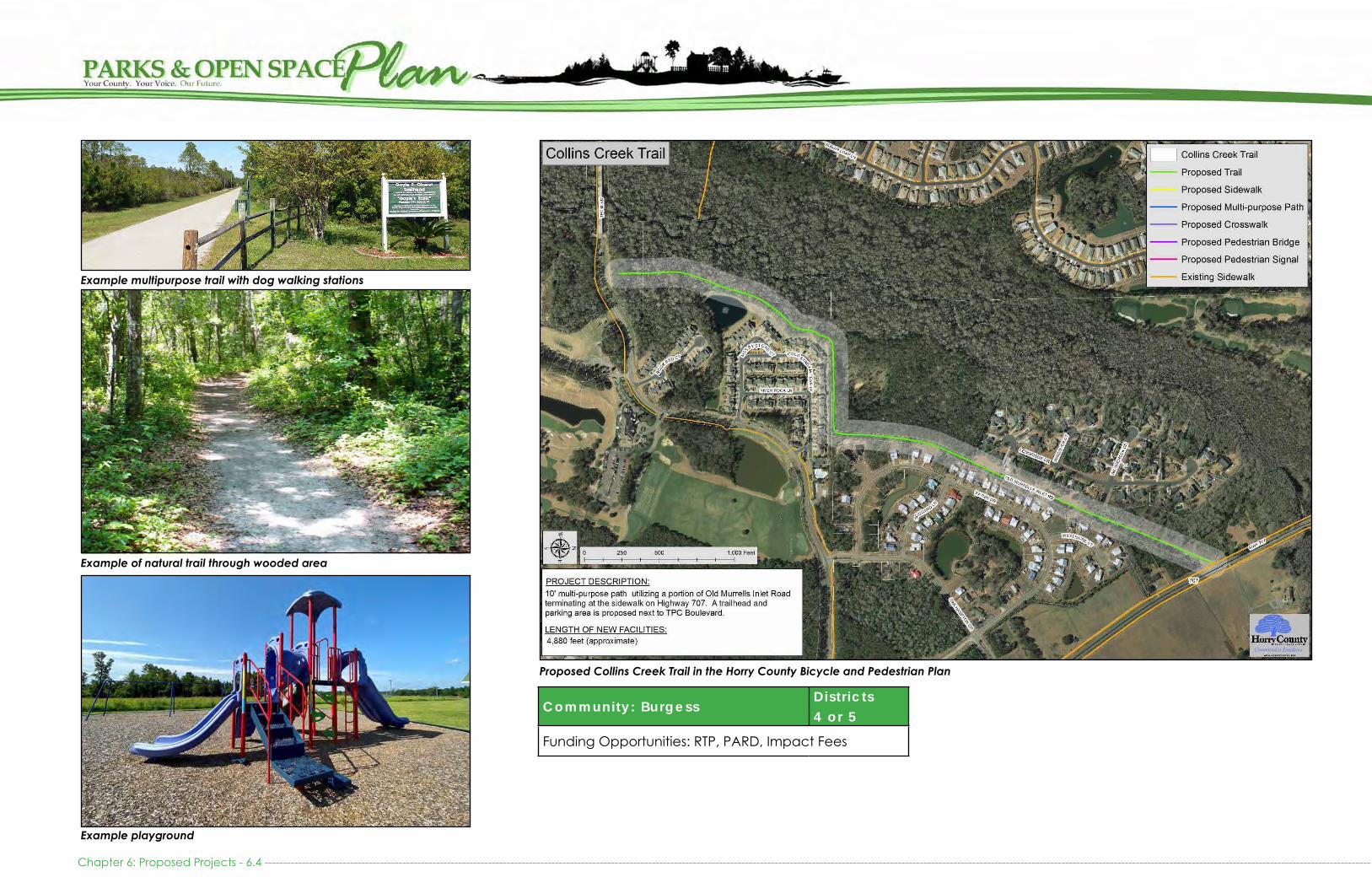
Chapter 6: Proposed Projects - 6.4 ---------------------------------------------------------------------------------------------------------------------------------------------------------------------------------------------------------------------------------------------------------------------------------------------------------
Community: BurgessDistr icts 4 or 5
Funding Opportunities: RTP, PARD, Impact Fees
Proposed Collins Creek Trail in the Horry County Bicycle and Pedestrian Plan
Example of natural trail through wooded area
Example playground
Example multipurpose trail with dog walking stations

LEWIS OCEAN BAY TRAILHEAD: PROPOSEDThe East Coast Greenway travels through Horry County, and many portions of the planned route have been completed through financial assistance of the Grand Strand Area Trans-portation Study (GSATS). One of the largest gaps in the route is the development of the three mile section of the green-way from Carolina Forest through Lewis Ocean Bay Heritage Preserve to North Myrtle Beach. Horry County has many proj-ects underway to complete the greenway in Carolina For-est, and the connection through Lewis Ocean Bay is one of the County’s next projects to pursue. The County will need to develop a trailhead on the southern end of the Preserve. This will give people a place to park and depart from or a place to stop and rest as they travel this portion of the 2,300 mile route. Shelters, benches, and shaded areas should also be privided along the 3 mile section of trail before the next trail-head to provide trail users opportunity to rest.
The County will need to acquire a ½ acre of land off of Cog-gin Court to create parking, install a restroom, construct a picnic shelter, and display information about the greenway. Public access into the Heritage Preserve will only be by foot or bike. No motorized vehicles, with the exception of emer-gency vehicles, will be allowed. The County should consider partnering with McLeod Seacoast on the development of the trailhead because of the close proximity to its new Car-olina Forest complex.
See the East Coast Greenway Masterplan for Horry and Georgetown County for the full interim and envisioned routes.
Cost Est imate
Picnic Shelter $ 50,000
Beautification $ 25,000
Lighting $ 10,000
Parking (Gravel) $ 50,000
Signage, Including Interpretive Signage $ 7,500
Site Furnishings (picnic tables, benches, receptacles, etc) $ 15,000
Land Acquisition (1/2 acre) $ 75,000
Greenway Improvements - unpaved (3 miles) $ 500,000
Total Estimate $ 732,500
Community: Carol ina Forest Distr ict 2
Funding Opportunities: RTP, GSATS, Impact Fees
Est imated Annual Costs
Maintenance Costs $ 10,000
Total Estimate $ 10,000
Lewis Ocean Bay Trailhead Location
----------------------------------------------------------------------------------------------------------------------------------------------------------------------------------------------------------------------------------------------------------------------------------------------------------------- Chapter 6: Proposed Projects - 6.5
Park Trailhead - Carolina Forest Bike and Run Park (The Hulk)
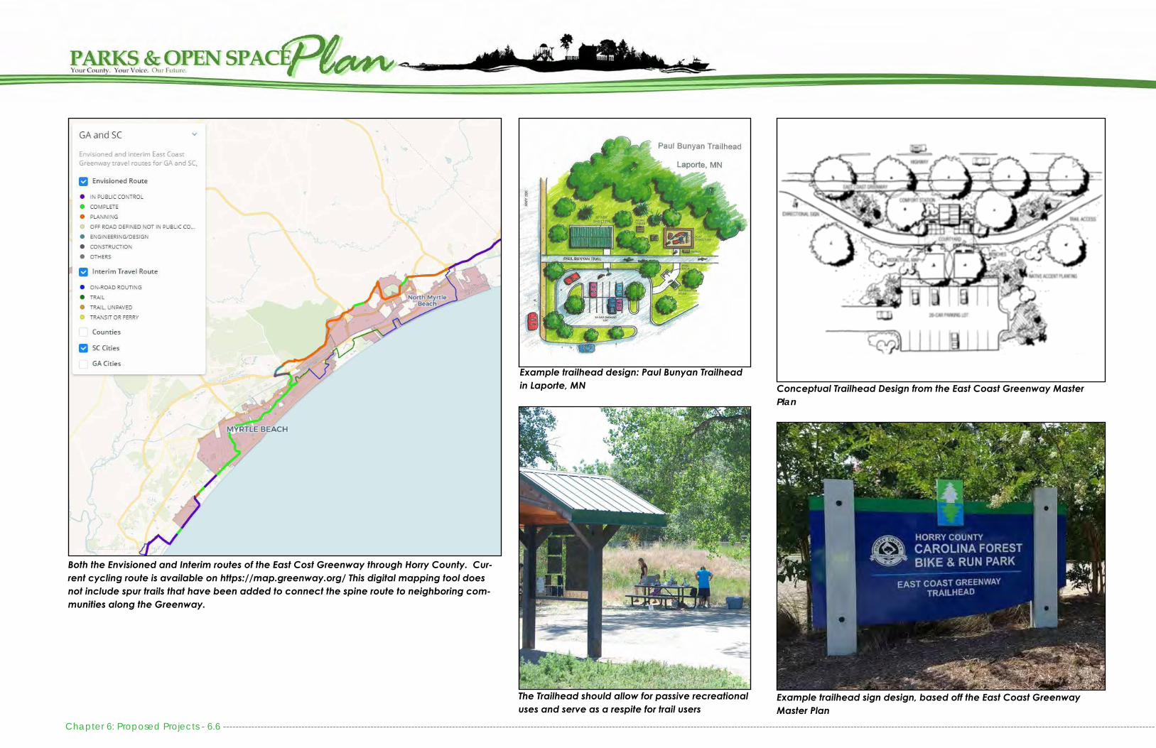
Conceptual Trailhead Design from the East Coast Greenway Master Plan
Example trailhead sign design, based off the East Coast Greenway Master Plan
Both the Envisioned and Interim routes of the East Cost Greenway through Horry County. Cur-rent cycling route is available on https://map.greenway.org/ This digital mapping tool does not include spur trails that have been added to connect the spine route to neighboring com-munities along the Greenway.
Example trailhead design: Paul Bunyan Trailhead in Laporte, MN
The Trailhead should allow for passive recreational uses and serve as a respite for trail users
Chapter 6: Proposed Projects - 6.6 ---------------------------------------------------------------------------------------------------------------------------------------------------------------------------------------------------------------------------------------------------------------------------------------------------------
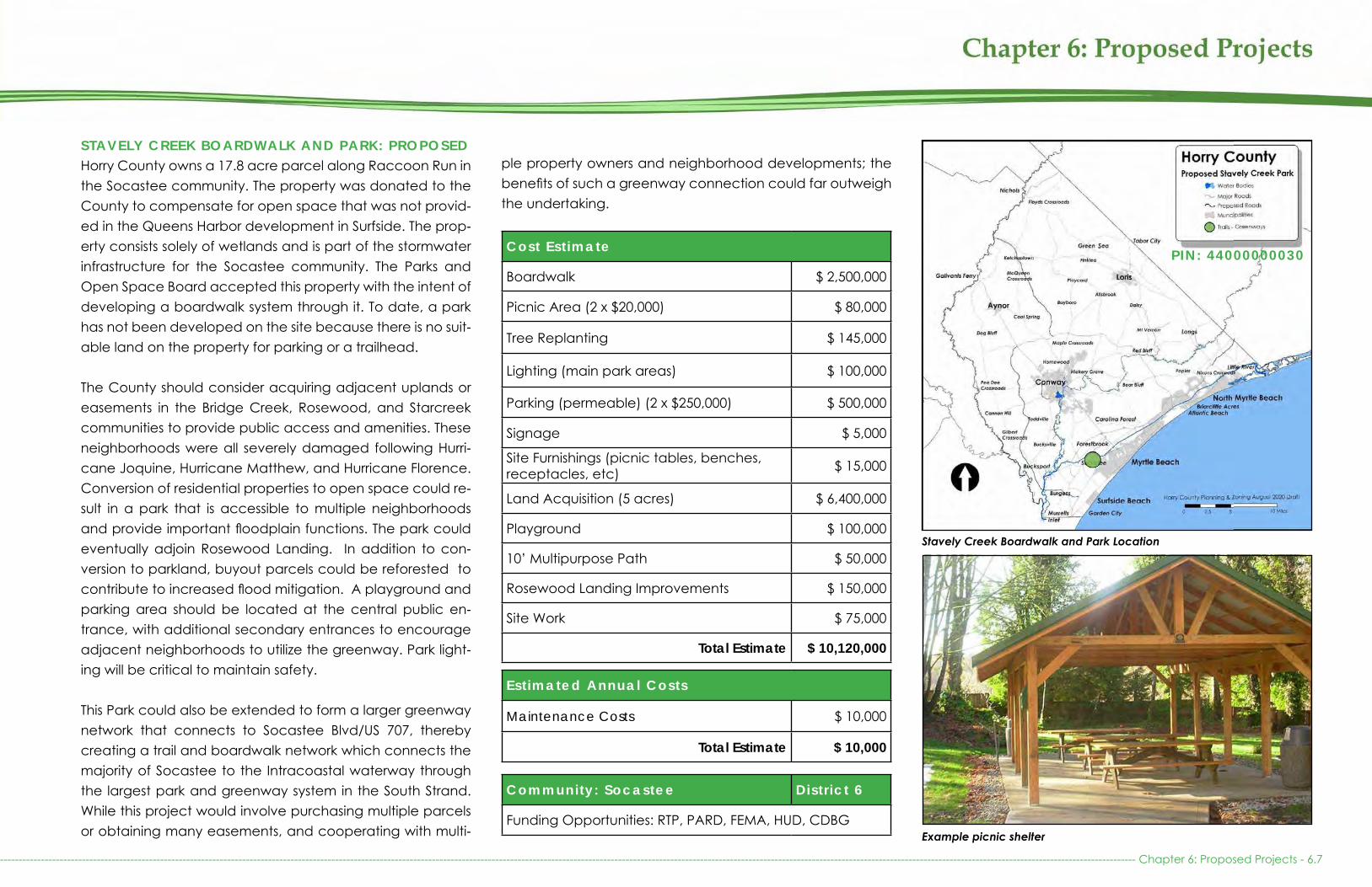
STAVELY CREEK BOARDWALK AND PARK: PROPOSEDHorry County owns a 17.8 acre parcel along Raccoon Run in the Socastee community. The property was donated to the County to compensate for open space that was not provid-ed in the Queens Harbor development in Surfside. The prop-erty consists solely of wetlands and is part of the stormwater infrastructure for the Socastee community. The Parks and Open Space Board accepted this property with the intent of developing a boardwalk system through it. To date, a park has not been developed on the site because there is no suit-able land on the property for parking or a trailhead.
The County should consider acquiring adjacent uplands or easements in the Bridge Creek, Rosewood, and Starcreek communities to provide public access and amenities. These neighborhoods were all severely damaged following Hurri-cane Joquine, Hurricane Matthew, and Hurricane Florence. Conversion of residential properties to open space could re-sult in a park that is accessible to multiple neighborhoods and provide important floodplain functions. The park could eventually adjoin Rosewood Landing. In addition to con-version to parkland, buyout parcels could be reforested to contribute to increased flood mitigation. A playground and parking area should be located at the central public en-trance, with additional secondary entrances to encourage adjacent neighborhoods to utilize the greenway. Park light-ing will be critical to maintain safety.
This Park could also be extended to form a larger greenway network that connects to Socastee Blvd/US 707, thereby creating a trail and boardwalk network which connects the majority of Socastee to the Intracoastal waterway through the largest park and greenway system in the South Strand. While this project would involve purchasing multiple parcels or obtaining many easements, and cooperating with multi-
Cost Est imate
Boardwalk $ 2,500,000
Picnic Area (2 x $20,000) $ 80,000
Tree Replanting $ 145,000
Lighting (main park areas) $ 100,000
Parking (permeable) (2 x $250,000) $ 500,000
Signage $ 5,000
Site Furnishings (picnic tables, benches, receptacles, etc) $ 15,000
Land Acquisition (5 acres) $ 6,400,000
Playground $ 100,000
10’ Multipurpose Path $ 50,000
Rosewood Landing Improvements $ 150,000
Site Work $ 75,000
Total Estimate $ 10,120,000
Community: Socastee Distr ict 6
Funding Opportunities: RTP, PARD, FEMA, HUD, CDBG
Est imated Annual Costs
Maintenance Costs $ 10,000
Total Estimate $ 10,000
Stavely Creek Boardwalk and Park Location
Example picnic shelter
----------------------------------------------------------------------------------------------------------------------------------------------------------------------------------------------------------------------------------------------------------------------------------------------------------------- Chapter 6: Proposed Projects - 6.7
ple property owners and neighborhood developments; the benefits of such a greenway connection could far outweigh the undertaking.
PIN: 44000000030

Stavely Creek Boardwalk Future Potential Location - AerialStavely Creek Boardwalk Concept
Example Boardwalk over wetlands in Horry County Example Playground Example Boardwalk with railings in Florida Chapter 6: Proposed Projects - 6. 8 --------------------------------------------------------------------------------------------------------------------------------------------------------------------------------------------------------------------------------------------------------------------------------------------------------

BOAT LANDINGS AND BLUEWAYSThe County maintains 27 Boat Landings. Many of these boat landings are located along the existing Waccamaw River Blue Trail and serve as trailheads. These boat landings serve the growing ecotourism industry and are in need of addition-al monitoring as tourism along the Waccamaw becomes more popular.
Concrete boat launches typically require refurbishment ev-ery 25 years, whereas soft launches need refurbishment more frequently as river banks erode. Nearly every boat launch will need to be refurbished by 2040, so there is an anticipated $2 million worth of known needs to maintain the facilities that the County already operates, equating to roughly $100,000 annually. Beyond maintaining current conditions and ame-nities, there are many other opportunities to improve the County’s landings by making them more inviting and by of-fering other types of recreation in conjunction with the boat ramps and soft launches. Besides developing additional hard launches for motorized boats, the County should also devel-op additional soft launches for kayaks, canoes, and paddle-boards. The following details expansions and improvements that improve the County’s landings to accommodate needs as the demand grows over the next 20 years.
DANNY KNIGHT LANDING: UPGRADESDanny Knight Landing is a heavily used landing off of Hwy 905 and SC Hwy 31. Known by locals as Red Bluff Landing, it is on the Waccamaw River and includes two hard launch lanes and a floating dock. Residents often use this landing for swimming and fishing, which causes user conflicts with boats. The County should consider acquiring land on the adjacent to the Danny Knight Landing for the development of a designated area for swimmers, including a picnic area.
Cost Est imate
Picnic Area $ 20,000
Lighting $ 10,000
Beautification $ 5,000
Signage $ 5,000
Site Furnishings (picnic tables, receptacles, etc) $ 5,000
Land Acquisition $150,000
Total Estimate $ 195,000
Community: Distr ict 9
Funding Opportunities: RTP, PARD
Approximate Annual Costs
Maintenance Costs $ 3,500
Approximate Total $ 3,500
Floating Dock at Danny Knight Landing
Danny Knight Landing Location
Danny Knight Landing
------------------------------------------------------------------------------------------------------------------------------------------------------------------------------------------------------------------------------------------------------------------------------------------------------------------ Chapter 6: Proposed Projects - 6.9
PIN: 44000000030

LITTLE RIVER LAUNCH: PROPOSEDThe Little River community is quickly growing and the resi-dents have an interest in having a soft landing to tidal creeks and the Intracoastal Waterway. While the City of North Myrtle Beach provides access in Cherry Grove, there are no places in the unincorporated area of Horry County for people to safely launch a canoe or kayak. An ideal location would be sited towards the end of Little River Neck Road with access to either Dunn Sound or Hog Inlet.
Cost Est imate
Lighting $ 10,000
Parking (Gravel) $ 50,000
Launch $ 25,000
Signage $ 2,500
Land Acquisition (1/2 acre) $ 75,000
Total Estimate $ 162,500
Community: L i t t le River Distr ict 1
Funding Opportunities: WSFRP
Est imated Annual Costs
Maintenance Costs $ 3,000
Total Estimate $ 3,000Little River Launch Future Location
Socastee Park could serve as an example for Boardwalk and soft launch
The Little River Launch location could be integrated into the Little Riv-er Waterfront Park (See section detailing this proposal under Regional Recreation Facilities)
The launch could be integrated into a park like setting similar to Water-front Memorial Park in Mt. Pleasant
Chapter 6: Proposed Projects - 6.10 --------------------------------------------------------------------------------------------------------------------------------------------------------------------------------------------------------------------------------------------------------------------------------------------------------
Example soft launch
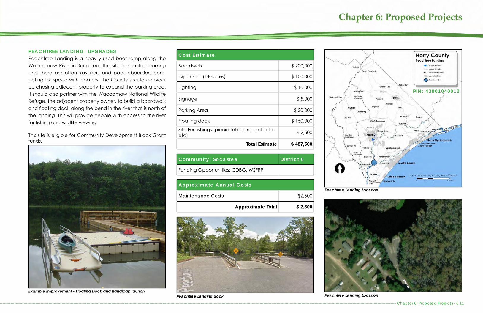
PEACHTREE LANDING: UPGRADESPeachtree Landing is a heavily used boat ramp along the Waccamaw River in Socastee. The site has limited parking and there are often kayakers and paddleboarders com-peting for space with boaters. The County should consider purchasing adjacent property to expand the parking area. It should also partner with the Waccamaw National Wildlife Refuge, the adjacent property owner, to build a boardwalk and floating dock along the bend in the river that is north of the landing. This will provide people with access to the river for fishing and wildlife viewing.
This site is eligible for Community Development Block Grant funds.
Cost Est imate
Boardwalk $ 200,000
Expansion (1+ acres) $ 100,000
Lighting $ 10,000
Signage $ 5,000
Parking Area $ 20,000
Floating dock $ 150,000
Site Furnishings (picnic tables, receptacles, etc) $ 2,500
Total Estimate $ 487,500
Community: Socastee Distr ict 6
Funding Opportunities: CDBG, WSFRP
Approximate Annual Costs
Maintenance Costs $2,500
Approximate Total $ 2,500
Example Improvement - Floating Dock and handicap launch
Peachtree Landing Location
Peachtree Landing LocationPeachtree Landing dock-------------------------------------------------------------------------------------------------------------------------------------------------------------------------------------------------------------------------------------------------------------------------------------------------------------- Chapter 6: Proposed Projects - 6.11
PIN: 43901040012

PITTS LANDING: UPGRADESPitts Landing is located off of Hwy 378 on the Little Pee Dee River. This site is heavily used and often a site that campers can be found, along with campfire remnants where people have burned their trash. The site would benefit from the in-stallation of a picnic area, trash receptacles, fire rings, and pedestal grills. The County should also consider establishing formal campsites here, as there are over 20 acres of land at this site. If camping is not formalized, the County should con-sider fencing off the area around the landing to minimize li-abilities or transfer the property to SC Department of Natural Resources as part of the Little Pee Dee Heritage Preserve.
Cost Est imate
Lighting $ 10,000
Signage $ 5,000
Picnic Area $ 20,000
Site Furnishings (picnic tables, receptacles, etc) $ 2,500
Fencing $ 50,000
Total Estimate $ 87,500
Community: Pee Dee Crossroads Distr ict 11
Funding Opportunities: RTP, PARD
Approximate Annual Costs
Maintenance Costs $ 2,500
Approximate Total $ 2,500
Pitts Landing Location
Campers frequent Pitts Landing
Pitts Landing Location
Popular bank locations on both sides of the LandingExample Picnic area improvement
Chapter 6: Proposed Projects - 6.12 --------------------------------------------------------------------------------------------------------------------------------------------------------------------------------------------------------------------------------------------------------------------------------------------------------
PIN: 37405020001
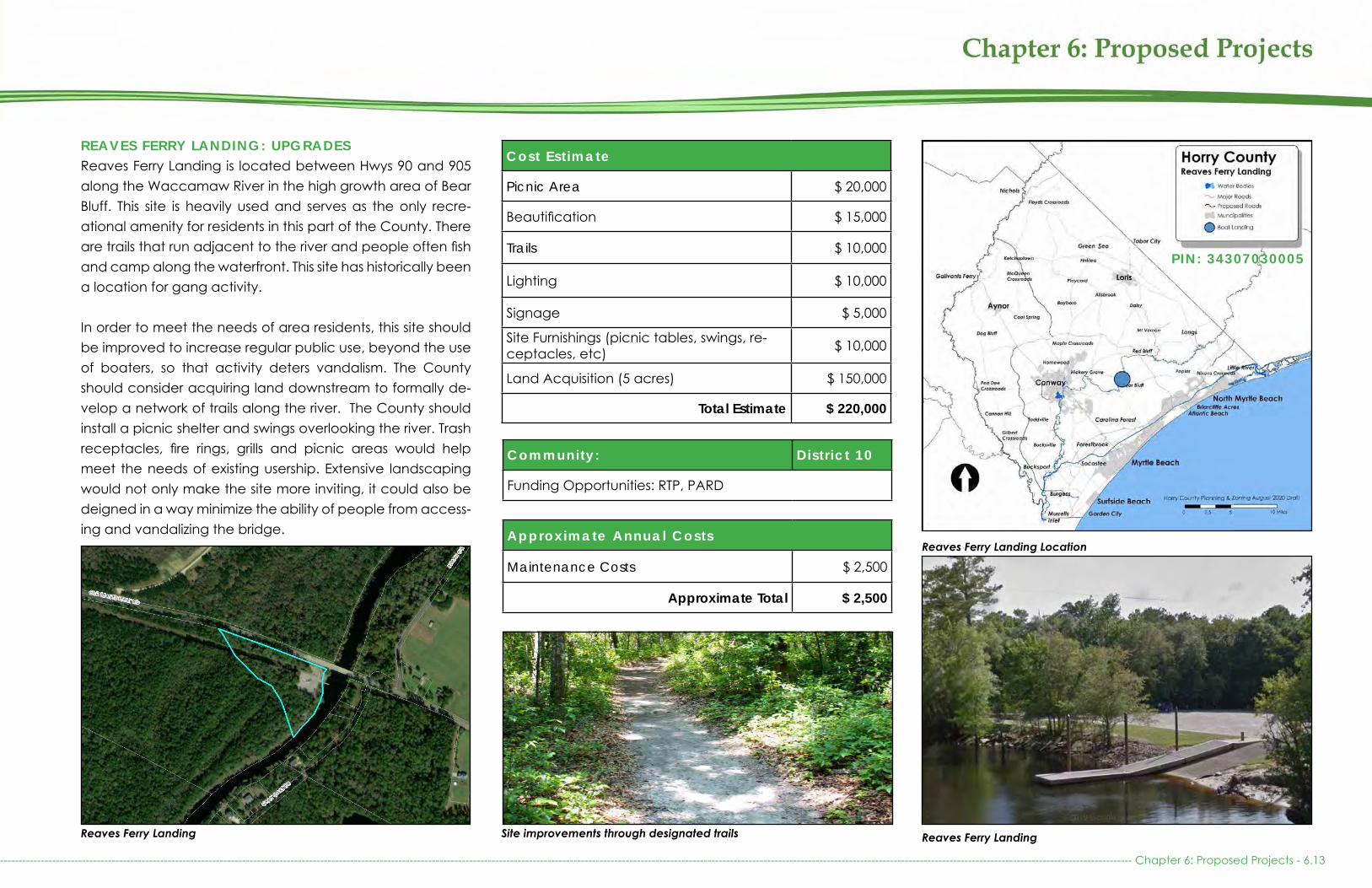
REAVES FERRY LANDING: UPGRADESReaves Ferry Landing is located between Hwys 90 and 905 along the Waccamaw River in the high growth area of Bear Bluff. This site is heavily used and serves as the only recre-ational amenity for residents in this part of the County. There are trails that run adjacent to the river and people often fish and camp along the waterfront. This site has historically been a location for gang activity.
In order to meet the needs of area residents, this site should be improved to increase regular public use, beyond the use of boaters, so that activity deters vandalism. The County should consider acquiring land downstream to formally de-velop a network of trails along the river. The County should install a picnic shelter and swings overlooking the river. Trash receptacles, fire rings, grills and picnic areas would help meet the needs of existing usership. Extensive landscaping would not only make the site more inviting, it could also be deigned in a way minimize the ability of people from access-ing and vandalizing the bridge.
Cost Est imate
Picnic Area $ 20,000
Beautification $ 15,000
Trails $ 10,000
Lighting $ 10,000
Signage $ 5,000
Site Furnishings (picnic tables, swings, re-ceptacles, etc) $ 10,000
Land Acquisition (5 acres) $ 150,000
Total Estimate $ 220,000
Community: Distr ict 10
Funding Opportunities: RTP, PARD
Approximate Annual Costs
Maintenance Costs $ 2,500
Approximate Total $ 2,500
Reaves Ferry Landing
Reaves Ferry Landing Location
Reaves Ferry LandingSite improvements through designated trails
---------------------------------------------------------------------------------------------------------------------------------------------------------------------------------------------------------------------------------------------------------------------------------------------------------------- Chapter 6: Proposed Projects - 6.13
PIN: 34307030005

RICEFIELD COVE LANDING: UPGRADESRicefield Cove Landing is located near Floyds Crossroads and Nichols, along the Lumber River. The site is currently un-dersized for its users, and litter has been a concern made known by local residents. The County should consider ac-quiring land adjacent to the landing to provide a formal parking area. In addition, the site could benefit from trash receptacles and a picnic area. This part of Horry County was heavily damaged by Hurricane Matthew and Florence, and investment in this community could uplift its residents. This site is eligible for Community Development Block Grant funds.
Cost Est imate
Lighting $10,000
Signage $5,000
Picnic Shelter $50,000
Site Furnishings (picnic tables, receptacles, etc) $2,500
Land Acquisition (2 acres) $50,000
Total Estimate $117,500
Community: Nichols Distr ict 10
Funding Opportunities: CDBG, WSFRP
Approximate Annual Costs
Maintenance Costs $ 2,500
Approximate Total $ 2,500Ricefield Cove Landing Location
Signage similar to Horry County’s other Boat Landings and Parks should be added Ricefield Cove LandingA Picnic shelter similar to the shelter pictured above should be added
Chapter 6: Proposed Projects - 6.14 --------------------------------------------------------------------------------------------------------------------------------------------------------------------------------------------------------------------------------------------------------------------------------------------------------
PIN: 11701020011

---------------------------------------------------------------------------------------------------------------------------------------------------------------------------------------------------------------------------------------------------------------------------------------------------------------- Chapter 6: Proposed Projects - 6.15
BLUEWAYSHorry County should consider partnering with the SC Depart-ment of Natural Resources in designating the Little Pee Dee River as a Wild and Scenic River. Ecotourism opportunities along the County’s waterways are vast and utilizing them to expand the County’s tourism offerings could lead to pub-lic-private partnerships. This could also generate revenue and bring visitors into the western part of the County lead-ing to additional economic revitalization. These partnerships could also aide in generating needed funds to renovate existing boat landings or create new landings. The County should continue to support this growing industry by support-ing expansion and upgrades at existing Blueways as well as encouraging future Blueway establishment.
This chapter, as part of the Parks and Open Space Plan, only addresses Blueways as recreational amenities. A full list of Blueway needs and improvements, as they relate to com-muter and connection needs, will be evaluated as part of the upcoming Horry County Transportation Plan.
GENERAL LANDING NEEDSBoat ramps typically need to be replaced every 25 years to ensure user experience and minimize damage to boats. Grants are often available from the state to assist with the cost to repair boat launches, but are not guaranteed. In ad-dition, the entrance signage at the boat landings will need to be replaced over this same timeframe. Due to increased demand and use of these facilities many are in need of pav-ing, re-paving, or expansion of their parking facilities.
To adequately meet the growing need for riverine and In-tracoastal access, this Plan recommends the addition of 2 Soft Boat Launches and 2 Hard Boat Launches on the Wac-camaw River, 2 Soft Boat Launches and 1 Hard Boat Launch
Cost Est imate
Boat Ramps (27 x $75,000) $ 2,025,000
Entrance Signage (27 x $5,000) $ 135,000
Cameras $ 265,000
Soft Boat Launch on Waccamaw River (2 x $70,000)*
$140,000
Boat Landings with Hard Launches on Waccamaw Riv-er (2 x $400,000)*
$800,000
Soft Boat Launch on PeeDee River (2 x $70,000)*
$140,000
Boat Landing with Hard Boat Launch on PeeDee River*
$250,000
Boat Landings with Hard Boat Lauch on Intracoastal Water-way (2 x $2,000,000)*
$4,000,000
Total Estimate $ 7,755,000
Waccamaw River Blue Trail, numbers indicate access points along the trail.
on the Pee Dee River, and 2 Hard Boat Launch-es on the Intracoastal Waterway. These launch projects should be constructed at new Landing locations or in coordination with existing land purchases from other public or private entities. These launches could also be constructed as part of park expansions, improvements, or new park construction.
*Because the location of these landings has yet to be determined, they have not been identi-fied on the maps at the beginning of this chap-ter.
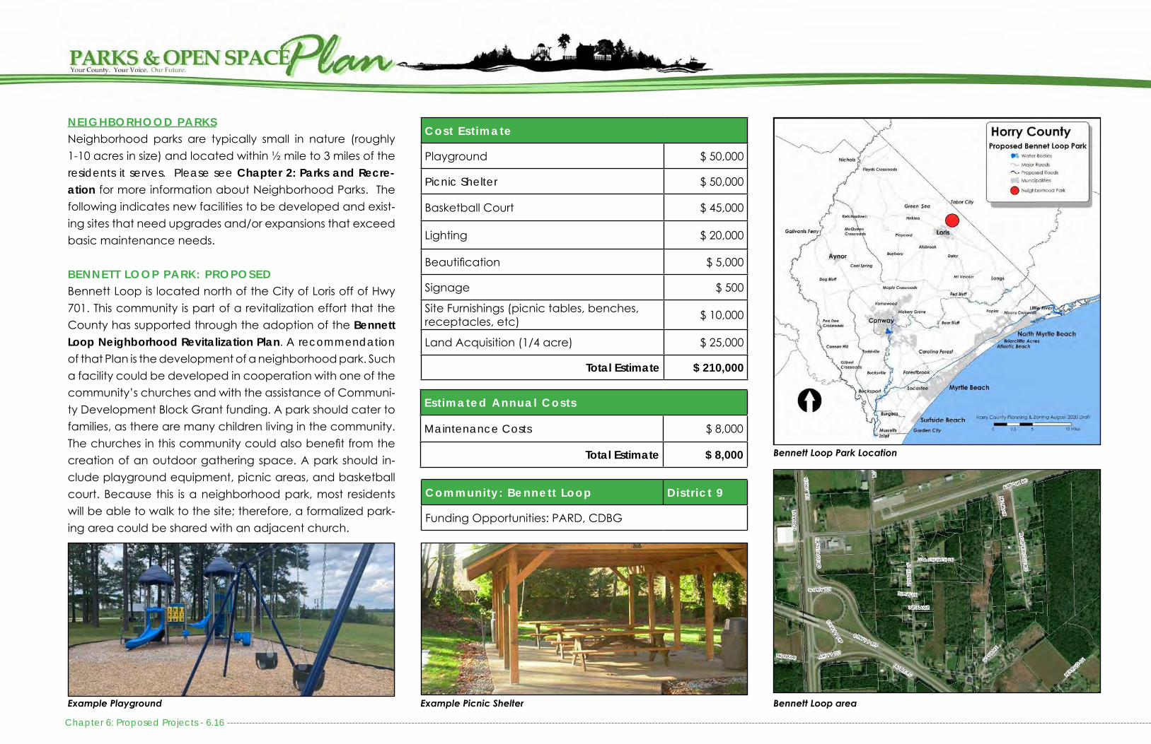
NEIGHBORHOOD PARKSNeighborhood parks are typically small in nature (roughly 1-10 acres in size) and located within ½ mile to 3 miles of theresidents it serves. Please see Chapter 2: Parks and Recre-ation for more information about Neighborhood Parks. The following indicates new facilities to be developed and exist-ing sites that need upgrades and/or expansions that exceed basic maintenance needs.
BENNETT LOOP PARK: PROPOSEDBennett Loop is located north of the City of Loris off of Hwy 701. This community is part of a revitalization effort that theCounty has supported through the adoption of the Bennett Loop Neighborhood Revitalization Plan. A recommendation of that Plan is the development of a neighborhood park. Such a facility could be developed in cooperation with one of the community’s churches and with the assistance of Communi-ty Development Block Grant funding. A park should cater to families, as there are many children living in the community. The churches in this community could also benefit from the creation of an outdoor gathering space. A park should in-clude playground equipment, picnic areas, and basketball court. Because this is a neighborhood park, most residents will be able to walk to the site; therefore, a formalized park-ing area could be shared with an adjacent church.
Cost Est imate
Playground $ 50,000
Picnic Shelter $ 50,000
Basketball Court $ 45,000
Lighting $ 20,000
Beautification $ 5,000
Signage $ 500
Site Furnishings (picnic tables, benches, receptacles, etc) $ 10,000
Land Acquisition (1/4 acre) $ 25,000
Total Estimate $ 210,000
Community: Bennett Loop Distr ict 9
Funding Opportunities: PARD, CDBG
Est imated Annual Costs
Maintenance Costs $ 8,000
Total Estimate $ 8,000 Bennett Loop Park Location
Example Playground Example Picnic Shelter Bennett Loop area
Chapter 6: Proposed Projects - 6.16 --------------------------------------------------------------------------------------------------------------------------------------------------------------------------------------------------------------------------------------------------------------------------------------------------------

GARDEN CITY BEACH PARK: PROPOSEDGarden City Beach attracts residents and vacationers alike. Because Garden City is such a destination, the County should consider developing a park within walking distance of the beach and area residences. Land acquisition opportunities are limited in Garden City, so the County should consider partnering with Garden City Chapel or buying out repeti-tive flood loss properties to construct a park. The park would include sand volleyball courts, a playground, picnic areas, and public gathering areas for special events. Other ameni-ties are dependent upon whether the facility is located on the beachfront or on the inlet side of Garden City. Further opportunities for the development of a public park should be explored when the Garden City Area Plan is revisited and community input obtained.
Cost Est imate
Playground $ 100,000
Picnic Shelters (2x $50,000) $ 100,000
Gazebo $ 30,000
Shade Sails $ 100,000
Volleyball Courts $ 30,000
Boardwalk or Dune Walkover $ 50,000
Lighting $ 10,000
Beautification $ 10,000
Signage $ 5,000
Restrooms $ 150,000
Site Furnishings (picnic tables, benches, receptacles, etc) $ 10,000
Land Acquisition (1/2 acre) $ 1,500,000
Potential Demolition $ 500,000
Total Estimate $ 2,595,000
Community: Distr ict 5
Funding Opportunities: PARD, CAIG
Est imated Annual Costs
Maintenance Costs $ 10,000
Total Estimate $ 10,000
Example Changing huts and shower areas, Coligny Beach Park, Hilton Head Island
Garden City Beach Park Location
Garden City Beach area
------------------------------------------------------------------------------------------------------------------------------------------------------------------------------------------------------------------------------------------------------------------------------------------------------------- Chapter 6: Proposed Projects - 6.17
Example restrooms and seating areas - Coligny Beach Park, Hilton Head Island

HUGER PARK: IN PROGRESSHuger Park, also referred to as Ten Oaks Park, is a future park located in The Parks, a planned subdivision off of Carolina Forest Blvd. The land was donated to Horry County to pre-serve the ten live oak trees on the site and to use it to com-memorate the revolutionary war history of General Isaac Huger. A site design has been completed for the project and some funding has been identified within the County’s Cap-ital Improvements Budget for its development. Completion of the park will follow the development of The Parks neigh-borhood. The developer for The Parks has agreed to partner with the County to install sod, an irrigation system, and mulch at the park until the final site design is implemented.
Cost Est imate
Veterans Memorial $ 100,000
Beautification $ 20,000
Lighting $ 25,000
Signage $ 15,000
Site Furnishings (picnic tables, benches, receptacles, etc)
$ 10,000
Tree Care $ 50,000
Total Estimate $ 220,000
Community: Carol ina Forest Distr ict 2
Funding Opportunities: PARD
View of the Live Oaks pre-construction at Huger Park
Temporary site landscaping, to be implemented until final site construc-tionHuger Park Location
Chapter 6: Proposed Projects - 6.18 --------------------------------------------------------------------------------------------------------------------------------------------------------------------------------------------------------------------------------------------------------------------------------------------------------
The Parks at Carolina Forest Example park fence materials
PIN: 41904020002
Early concept rendering of Huger Park

--------------------------------------------------------------------------------------------------------------------------------------------------------------------------------------------------------------------------------------------------------------------------------------------------------------- Chapter 6: Proposed Projects - 6.19
MT. VERNON TENNIS COURTS: UPGRADESHorry County developed tennis courts in the Mt. Vernon Com-munity in the 1980s. The tennis courts are in disrepair and are not used. There are no other recreational facilities within 6 miles of this site. Currently, Scout Troops meet at the commu-nity center that is on site. In all, the facility needs to be repur-posed to cater to the community. The tennis courts could be resurfaced as a pump track or basketball courts, depending on community desire. In addition, the County should add a playground and picnic area. Because the land is owned by the Mt. Vernon Community Association, the County could either purchase the property and lease the community cen-ter back to the association or the property could be subdi-vided with the park area as a separate property. This would ensure the facility remains a park, and it will minimize liability concerns.
Cost Est imate
Repurpose Tennis Courts to Pump Track $ 50,000
Upgrade Parking Lot $ 100,000
Playground $ 50,000
Picnic Shelter $ 50,000
Signage $ 5,000
Site Furnishings (picnic tables, benches, receptacles, etc) $ 10,000
Total Estimate $ 265,000
Community: Mt. Vernon Distr ict 10
Funding Opportunities: PARD
Approximate Annual Costs
Maintenance Costs $ 2,500
Approximate Total $ 2,500
Mt. Vernon Community Center and Courts
Mt. Vernon Tennis Courts
Mt Vernon Tennis Courts Location
Repurposed Tennis Courts turned into a Pump Track Example playground
PIN: 25509010006

Chapter 6: Proposed Projects - 6. 20 -------------------------------------------------------------------------------------------------------------------------------------------------------------------------------------------------------------------------------------------------------------------------------------------------------
COMMUNITY PARKSCommunity parks are typically greater than 10 acres in size and cater to residents living 3-5 miles from the park. Please see Chapter 2: Parks and Recreation for more information about Community Parks. Horry County has a number of community parks that need expansion and a handful of new parks that need to be developed.
BAYBORO PARK: UPGRADESBayboro Park is located off of Joyner Swamp Rd near Hwy 410. The park includes a baseball field, basketball court, pic-nic area, and a playground. The park needs field and fenc-ing improvements. Recently, the site recieved a new play-ground, picnic tables, and grills utilizing a PARD grant. The site also needs an entrance sign, lighting and water foun-tains. This site was developed with Land and Water Conser-vation Funds and is eligible for additional funds to repair the amenities that were originally developed with those funds. This funding requires a 50% match.
Cost Est imate
Field Improvements $ 100,000
Signage $ 5,000
Site Furnishings (benches, receptacles, etc) $ 20,000
Total Estimate $ 125,000
Community: Bayboro Distr ict 10
Funding Opportunities: RTP, PARD
Approximate Annual Costs
Maintenance Costs $ 10,000
Approximate Total $ 10,000
Bayboro Park Location
Bayboro Park LocationNew Playground installed in 2019 Field improvements needed
PIN: 20712010001

------------------------------------------------------------------------------------------------------------------------------------------------------------------------------------------------------------------------------------------------------------------------------------------------------------- Chapter 6: Proposed Projects - 6. 21
BROOKSVILLE PARK: PROPOSEDBesides Vereen Memorial Gardens and the proposed water-front park included in this plan, Little River does not have any community or neighborhood parks. Older communities do not have neighborhood amenity centers, and newer com-munities only provide access to their residents. Because Little River is continuing to grow rapidly, Horry County should con-sider developing a neighborhood park off of Hwy 111, west of Hwy 17.
The development of a park should cater to those living within close proximity to it. The park should be at least 10 acres in size and be easily accessible from adjacent neighborhoods, either through sidewalks or trails. Land acquisition could coin-cide with right of way acquisition for the extension of Hwy 31 to North Carolina. Purchasing property with a large amount of wetlands may be a means to provide wetland mitigation for the extension of the roadway and accommodate a park on the same land. However, acquisition may need to occur soon, as land on Hwy 111 is rapidly developing.
Cost Est imate
Baseball Field $ 500,000
Multi-purpose Field $ 175,000
Field Lighting (2 x $175,000) $ 350,000
Multi-Purpose Path (Paved) $ 50,000
Tennis Courts (1 Double) $ 50,000
Outdoor Basketball Courts $ 45,000
Picnic Shelters $ 50,000
Playground $ 100,000
Restrooms and Water Fountains $ 150,000
Beautification $ 25,000
Lighting $ 25,000
Parking (Unpaved) $ 20,000
Signage $ 5,000
Site Furnishings (picnic tables, benches, bleachers, receptacles, etc)
$ 30,000
Land Acquisition (10 acres) $ 400,000
Total Estimate $ 1,975,000
Community: L i t t le River Distr ict 1
Funding Opportunities: RTP, PARD
Est imated Annual Costs
Maintenance Costs $ 10,000
Total Estimate $ 10,000
Brooksville Park Future Location
Example playground Brooksville Park area

Chapter 6: Proposed Projects - 6. 22 -------------------------------------------------------------------------------------------------------------------------------------------------------------------------------------------------------------------------------------------------------------------------------------------------------
GREEN SEA FLOYDS PARK: EXPANSION & UPGRADESGreen Sea Floyds Park is located adjacent to Green Sea Floyds Elementary and High Schools and near Green Sea Floyds Library. The County ballfields and tennis courts are shared with the schools and are heavily used throughout the year. This area is in need of a community center or an exten-sion of the County Library to provide space for recreation-al programming and community gatherings. The site would also benefit from the development of a walking trail around the ballfields and schools. Providing additional picnic areas, playground equipment, and water fountains near the tennis courts would make this shared space more useful for fami-lies. Improvements should be coordinated with Horry County Schools, as they own most of the underlying property. Addi-tional land may need to be acquired if the development of a separate Community Center is necessary.
This site was developed with Parks and Recreation Develop-ment funds and is also eligible for Community Development Block Grant funds.
Cost Est imate
Community Center $ 4,000,000
Field Improvements $ 100,000
Multi-Purpose Path (Paved) $ 50,000
Outdoor Basketball Court (2x $45,000) $ 90,000
Picnic Shelter $ 50,000
Beautification $ 20,000
Lighting $ 25,000
Parking (Paved) $ 100,000
Signage $ 5,000
Site Furnishings (picnic tables, benches, bleachers, receptacles, etc) $ 5,000
Land Acquisition (3 Acres) $ 5,000
Total Estimate $ 4,450,000
Community: Green Sea Floyds Distr ict 10
Funding Opportunities: PARD, CDBG
Approximate Annual Costs
Maintenance Costs $ 35,000
Expected Additional Costs $ 5,000
Approximate Total $ 40,000
Green Sea Floyds Park Location
Green Sea Floyds Park LocationGreen Sea Floyds LibraryField improvements, including lighting are necessary
PIN: 13200000047

-------------------------------------------------------------------------------------------------------------------------------------------------------------------------------------------------------------------------------------------------------------------------------------------------------------- Chapter 6: Proposed Projects - 6. 23
TODDVILLE PARK: PROPOSEDA site in Toddville should be developed into a community park with playground, basketball courts, baseball and/or multipurpose field, picnic areas, and walking trails. The use of a parcel in a flood hazard area for recreation space could serve as a duel purpose to also allow for potential flood mit-igation. This park should serve as both passive and active recreation for the south Conway area.
If Sandridge Park or Pee Dee Park expand to include more athletic fields it will become less crucial to develop athletic fields in Toddville. There are currently no recreational ameni-ties off of Hwy 701, besides boat landings that do not have the space to accommodate the development of a park. Increasing subdivisions of large tracts and minor develop-ments in this area will increase the demand for recreational amenities, especially as the Conway Perimeter Road nears implementation.
In 1984, Horry County was donated 10 acres of land south of Conway off of J & S Countryside Road. This site, called Gree-wood Park has yet to develop and the road to access it is unpaved. The County should consider developing this park to offset some of the burden on Pee Dee Park and to meet the needs of residents along Hwy 701. The development of
Cost Est imate
Baseball Field $ 500,000
Multipurpose Field $ 175,000
Field Lighting $ 350,000
Multi-Purpose Path (Paved) $ 100,000
Outdoor Basketball Court $ 45,000
Picnic Shelters $ 50,000
Playground $ 100,000
Restrooms and Water Fountains $ 100,000
Beautification $ 10,000
Lighting $ 25,000
Parking (Unpaved) $ 20,000
Signage $ 5,000
Site Furnishings (picnic tables, benches, bleachers, receptacles, etc)
$ 30,000
Total Estimate $ 1,510,00
Community: South Conway Distr ict 7
Funding Opportunities: RTP, PARD
Est imated Annual Costs
Maintenance Costs $ 10,000
Total Estimate $ 10,000
Toddville Park Future Location
Existing Greenwood Park Location Example future playground
PIN: 38000000009
this park should coincide with the paving of J & S Country-side Rd to ensure public accessibility.

Chapter 6: Proposed Projects - 6.24 --------------------------------------------------------------------------------------------------------------------------------------------------------------------------------------------------------------------------------------------------------------------------------------------------------
LORIS NATURE PARK: UPGRADESLoris Nature Park is located across from Loris High School on 21 acres of land that is owned by Horry County School Dis-trict. It includes a small dog park, amphitheater, playground, picnic areas, and restrooms. The site also has an extensive tree canopy, making it an enjoyable place to visit. This facil-ity is a model park that should be replicated throughout the County. Very few improvements need to be made to this site, besides minor renovations to the amphitheater, installa-tion of a park sign and directional signage to the site, add-ing a map of the disc golf course, planting a native plant garden, and providing interpretive signage about the plants and wildlife. Most of these improvements can be done with very little financial investment and are ideal for small grants.
Because there are so many amenities already available at Loris Nature Park, it would be beneficial to site a future rec-reation center adjacent to it. This would minimize the need for duplication of amenities and would ensure that staffing would be nearby to monitor and maintain the park. The County should acquire the land from Horry County Schools to minimize liability concerns.
Cost Est imate
Signage $ 5,000
Dog Park Improvements $ 10,000
Picnic Shelter $ 50,000
Beautification $ 10,000
Site Furnishings (picnic tables, benches, receptacles, etc) $ 10,000
Trail Improvements $ 50,000
Total Estimate $ 130,000
Community: Lor is Distr ict 9
Funding Opportunities: RTP, PARD
Approximate Annual Costs
Maintenance Costs $ 20,000
Approximate Total $ 20,000
Playground, shelter, and Born Learning Trail
Loris Nature Park Location
Loris Nature Park LocationRestrooms and trailhead
PIN: 18500000012

------------------------------------------------------------------------------------------------------------------------------------------------------------------------------------------------------------------------------------------------------------------------------------------------------------- Chapter 6: Proposed Projects - 6. 25
MICHEAL MORRIS GRAHAM PARK: UPGRADESMichael Morris Graham Park is located outside of Aynor, near Hwy 319 and Vereen Rd. This site has 6 baseball fields that are heavily used. Beyond ballfields, the site has batting cages, a playground, picnic area, and concessions with re-strooms. In early 2017, the County acquired an additional 9.5 acres to add more ballfields and provide adequate parking. The site now is 30 acres in size. Funding is needed to develop additional fields, improve the existing fields, construct a walk-ing trail, expand the playground, and add signage. Ensuring that the fields are properly lit for night games will improve the overall use of the facility. Because of the existing amenities, this site would be a good location for the Aynor Recreation Center. If demand merits, the County should partner with SC Forestry Commission, who owns an adjacent property, to de-velop walking trails and diversify the offerings at the park.
A new parking lot with an additional 250 parking bumpers was added in FY2019. In addition, Tee Ball Bleachers and dugouts were installed along with other field renovations.
Cost Est imate
Multipurpose Fields (3x $175,000) $ 525,000
Baseball Field $ 500,000
Existing Field Improvements $ 150,000
Field Lighting (10 total Fields x $ 175,000 each) $ 1,750,000
Walking Path (paved) $ 50,000
Playground $ 150,000
Concessions/Restroom/Water Fountains $ 250,000
Beautification $ 10,000
Signage $ 5,000
Site Furnishings (picnic tables, bleachers, benches, receptacles, etc) $ 20,000
Land Acquisition (7+ Acres) $50,000
Total Estimate $ 3,460,000
Community: Aynor Distr ict 11
Funding Opportunities: RTP, PARD
Approximate Annual Costs
Maintenance Costs $ 35,000
Expected Additional Costs $ 50,000
Approximate Total $ 85,000
Michael Morris Graham Park
Micheal Morris Graham Park Location
Example Playground
PIN: 23400000048

Chapter 6: Proposed Projects - 6. 26 -------------------------------------------------------------------------------------------------------------------------------------------------------------------------------------------------------------------------------------------------------------------------------------------------------
MYRTLE RIDGE PARK: PROPOSEDThe communities between Hwy 501 and Hwy 544, and along Hwy 544, currently lack recreation facilities besides those available at Coastal Carolina University and through the Waccamaw National Wildlife Refuge. The neighborhoods abutting Singleton Ridge Road, Myrtle Ridge Road, and Hwy 544 consist of college students, families, and retirees. Be-cause of the demographics in this area, a new park should cater to a variety of interests. Such a facility would ideally be modeled after Loris Nature Park, including a playground, picnic area, walking trails, and disc golf course.
The County should considered purchasing a minimum of 20 acres of land, centrally located along Myrtle Ridge Rd or off of 544 where an existing sidewalk network would ensure the facility can easily be accessed on foot. Utilizing an exist-ing conservation easement or redeveloping golf course for such a project could be ideal. In addition, park land that abuts existing conservation, such as a SCDNR or USFWS par-cel would be ideal. Development agreements and land do-nations may serve a vital role in establishing this park. If a park where sited within the conservation easement, parking might need to be within the powerline easement, along with other facilities that would need a paved surface, such as basketball courts.
The Legends has a conservation easement on its open space that abuts Myrtle Ridge Rd and that is directly adjacent to a transmission line (PIN 40000000019). If the Legends HOA is agreeable and the conservation permit allows, this park could also incorporate an additional emergency ingress/egress for that community.
Cost Est imate
Picnic Shelter (2 x $50,000) $ 100,000
Playground $ 100,000
Walking Trail (Unpaved) $ 50,000
Basketball Court $ 45,000
Disc Golf Course $ 15,000
Dog Park $ 50,000
Restrooms and Water Fountains $ 250,000
Beautification $ 25,000
Lighting $ 25,000
Parking (Unpaved) $ 50,000
Signage $ 5,000
Site Furnishings (picnic tables, benches, receptacles, etc)
$ 40,000
Land Acquisition (20+ acres) $ 600,000
Total Estimate $ 1,355,000
Community: South Conway Distr ict 8
Funding Opportunities: PARD
Est imated Annual Costs
Maintenance Costs $ 10,000
Total Estimate $ 10,000
Myrtle Ridge Park Future Location
Transmission Line Park Example

-------------------------------------------------------------------------------------------------------------------------------------------------------------------------------------------------------------------------------------------------------------------------------------------------------------- Chapter 6: Proposed Projects - 6. 27
PEE DEE PARK: EXPANSIONPee Dee Park a 5 acre park, located off of Hwy 378. This un-dersized community park primarily consists of ballfields, most of which do not meet regulation standards. The fields are programmed and used by the Pee Dee Athletic Association. There is a need to expand the park for additional field space, batting cages, and adequate parking. The site could be di-versified by adding basketball and volleyball courts, addi-tional playground equipment, and a walking path. Most site improvements depend on adjacent land acquisition, which could be impacted by the construction of the Southern Evacuation Lifeline Transportation Project (SELL).
In FY2019, Parks and Recreation purchased and installed new bleachers on newly poured bleacher pads, completed infield lip renovations, and completed fence repairs.
Cost Est imate
Ballfields (2 x $500,000) $ 1,000,000
Existing Field Improvements $ 50,000
Field Lighting (5 x $175,000) $ 875,000
Batting Cages $ 15,000
Outdoor Courts $ 45,000
Walking Path $ 20,000
Playground $ 50,000
Picnic Area $ 80,000
Beautification $ 10,000
Signage $ 5,000
Site Furnishings (picnic tables, bleachers, benches, receptacles, etc) $ 20,000
Parking $ 50,000
Land Acquisition (5+ acres) $ 100,000
Total Estimate $ 2,320,000
Community: Pee Dee Distr ict 11
Funding Opportunities: LWCF, PARD
Approximate Annual Costs
Maintenance Costs $ 25,000
Additional Expected Costs $ 5,000
Approximate Total $ 30,000
Pee Dee Park Location
Pee Dee Park Location
Playground at Pee Dee Park
PIN: 37104030020

Chapter 6: Proposed Projects - 6. 28 -------------------------------------------------------------------------------------------------------------------------------------------------------------------------------------------------------------------------------------------------------------------------------------------------------
POPLAR PARK: EXPANSION & UPGRADESPoplar Park is a 4.4 acre, undersized community park off of Hwy 90. The park is located on land owned by Horry County School District and includes a baseball field, basketball courts, playground, and picnic shelters. The playground equipment was recently upgraded and the basketball courts were also recently resurfaced.
Beyond recent improvements, the residents in this area are interested in the development of a small community cen-ter. In addition, there is a need for space to accommodate a multipurpose field. The existing site is not large enough to accommodate these needs; therefore, additional land ac-quisition will be necessary to accommodate future growth. The wetlands that surround this site may inhibit where the park can expand and the suitability to develop. The site also needs signage to ensure the public is aware that this is a County recreation facility. The County should acquire the land from Horry County Schools and seek ownership of sur-rounding lands to expand the facility.
Cost Est imate
Community Center $4,000,000
Field Improvements $200,000
Walking Path $50,000
Playground $100,000
Beautification $10,000
Signage $5,000
Site Furnishings (picnic tables, benches, bleachers, receptacles, etc) $10,000
Land Acquisition (5+ Acres) $150,000
Total Estimate $ 4,525,000
Community: Poplar Distr ict 9
Funding Opportunities: RTP, PARD
Approximate Annual Costs
Maintenance Costs $ 10,000
Additional Expected Costs $ 5,000
Approximate Total $ 15,000
Ballfield at Poplar Park
Poplar Park Location
Poplar Park
The CB Berry Community Center could serve as an excellent example of a model Community Center which should be added to Poplar Park
PIN: 34703040015

SANDRIDGE PARK: EXPANSION & UPGRADESSandridge Park is a 5-acre park located directly outside of the City of Conway, along Cates Bay Highway. This park was devel-oped with Land and Water Conservation Funds and Parks and Recreation Development grants. The site has a baseball field, basketball courts, playground, and multiple picnic areas. With the development of the Ride 3 Conway Perimeter Road (also called the El Bethel Road Extension), approximately .73 acres of Sandridge Park will be acquired for roadway construction and right-of-way. As a result, SCDOT and Horry County will be acquiring a portion of a neighboring parcel to the park to compensate for the lost parkland, as required by the Land and Water Conservation Fund which originally funded the park. The park will also be reconfigured and reconstructed.
The site is in need of signage , expansion, and playground improvements. Instead of improving the existing underutilized basket-ball courts and baseball field, the County should consider replacing them with a dog park, splash pad, and walking trails. The County should also consider removing dilapidated structures including the concessions building and the old barn on an adja-cent property that is a safety concern for park users. Working with existing community groups and residents, as well as the city of Conway will be critical to the success of the park.
Cost Est imate
Dog Park $ 50,000
Splash Pad $ 100,000
Walking Trail $ 125,000
Water Fountains $ 15,000
Parking $ 50,000
Signage $ 15,000
Bike Skills Park/ Pump Track $ 50,000
Senior Adult Outdoor Exercise Equipment $ 40,000
Playground $ 100,000
Fishing Dock $ 25,000
Site Furnishings (picnic tables, bleachers, benches, receptacles, etc) $ 10,000
Land Acquisition $ 120,000
Total Estimate $700,000
Community: Sandridge Distr ict 7
Funding Opportunities: PARD, LWCF, SCDBG, Ride 3
Approximate Annual Costs
Maintenance Costs $ 8,000
Approximate Total $ 8,000
Sandridge Park Conceptual Master Plan including expansion - Public Input will be sought for Final Master Plan
------------------------------------------------------------------------------------------------------------------------------------------------------------------------------------------------------------------------------------------------------------------------------------------------------------ Chapter 6: Proposed Projects - 6. 29
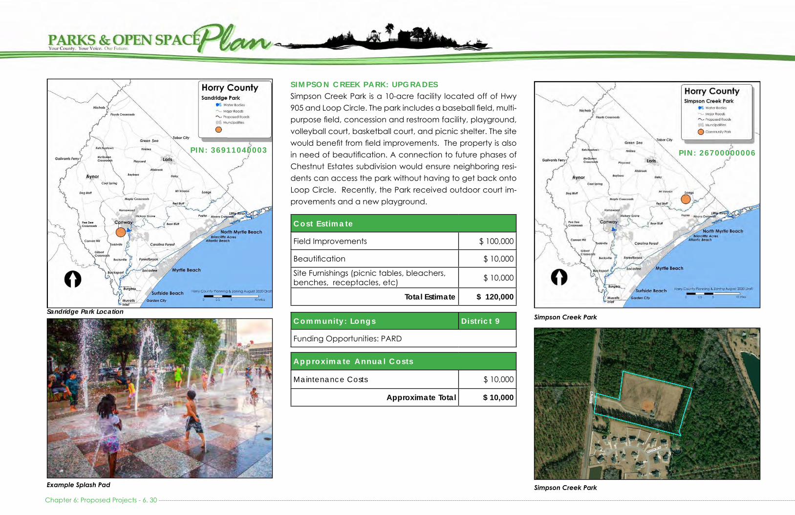
SIMPSON CREEK PARK: UPGRADESSimpson Creek Park is a 10-acre facility located off of Hwy 905 and Loop Circle. The park includes a baseball field, multi-purpose field, concession and restroom facility, playground, volleyball court, basketball court, and picnic shelter. The site would benefit from field improvements. The property is also in need of beautification. A connection to future phases of Chestnut Estates subdivision would ensure neighboring resi-dents can access the park without having to get back onto Loop Circle. Recently, the Park received outdoor court im-provements and a new playground.
Cost Est imate
Field Improvements $ 100,000
Beautification $ 10,000
Site Furnishings (picnic tables, bleachers, benches, receptacles, etc) $ 10,000
Total Estimate $ 120,000
Community: Longs Distr ict 9
Funding Opportunities: PARD
Approximate Annual Costs
Maintenance Costs $ 10,000
Approximate Total $ 10,000
Simpson Creek Park
Simpson Creek Park
Chapter 6: Proposed Projects - 6. 30 -------------------------------------------------------------------------------------------------------------------------------------------------------------------------------------------------------------------------------------------------------------------------------------------------------
Sandridge Park Location
Example Splash Pad
PIN: 36911040003 PIN: 26700000006

-------------------------------------------------------------------------------------------------------------------------------------------------------------------------------------------------------------------------------------------------------------------------------------------------------------- Chapter 6: Proposed Projects - 6. 31
MAJOR COUNTY PARKSMajor County Parks are typically 50-100 acres in size, cater to residents living 5-10 miles from the park and are easily ac-cessible to major intersections or population centers in or-der to serve the greatest population. Please see Chapter 2: Parks and Recreation for more information about Major County Parks. Horry County is currently lacking an adequate number of Major County Parks. While municipal services and County Recreation Centers currently serve as substitutes for Major County Parks, growing demand and increasing popu-lation will soon necessitate the development and expansion of Major County Park services.
FORESTBROOK PARK: PROPOSEDForestbrook is one of the remaining areas of the County that does not have recreation facilities within a reasonable distance of its residents. In addition, many of the older sub-divisions lack neighborhood amenities because they were developed prior to the Open Space requirements for major subdivisions. This community is continuing to grow, and there is a need for a large park with a community center. This fa-cility should meet the needs of all ages by offering a variety of recreational opportunities. First and foremost, a property of at least 10-20 upland acres should be acquired and be suitable for the development of fields, outdoor courts, picnic areas, playground, and walking trails. Ideally, the site would be located along the Socastee Greenway to provide storm-water filtration, improved flood storage and conveyance projects, and floodplain functions through preservation of natural open space. The development of the community center should be pursued after the development of the out-door facilities as they are a more immediate need.
Cost Est imate
Community Center $ 6,000,000
Multi-Purpose Fields (2x $175,000 each) $ 350,000
Baseball Fields (2x $500,000 each) $ 1,000,000
Field Lighting (4x $175,000 each) $ 700,000
Multi-Purpose Path (Paved) & Boardwalk $ 250,000
Tennis Court (1 x $50,000) $ 50,000
Outdoor Basketball Court $ 45,000
Playground $ 100,000
Picnic Shelters (3 x $50,000) $ 150,000
Concessions/Restrooms/Water Fountains $ 250,000
Beautification & Lighting $ 50,000
Children’s Bicycle Skills Park $ 25,000
Parking (Paved) $ 500,000
Signage $ 5,000
Site Furnishings (picnic tables, benches, bleachers, receptacles, etc)
$ 20,000
Land Acquisition (20+ acres) $ 800,000
Total Estimate $ 10,270,000
Forestbrook Park Future Location
Example playground

Forestbrook Park ConceptForestbrook Area
Example Boardwalk
Chapter 6: Proposed Projects - 6. 32 -------------------------------------------------------------------------------------------------------------------------------------------------------------------------------------------------------------------------------------------------------------------------------------------------------
Community: ForestbrookDistr icts 4, 6 or 8
Funding Opportunities: PARD, HUD, FEMA
Est imated Annual Costs
Maintenance Costs $ 20,000
Operational Costs $ 565,000
Total Estimate $ 585,000

PETER VAUGHT SR PARK & LANDING: EXPANSION & UPGRADESThe Peter Vaught Sr Landing, also known as 17 & 22 Landing, was recently constructed and is heavily used throughout the year. Adjacent to the landing is a large interchange with am-ple open space below it to develop a regional park. An initial site design was completed in 2013 and includes multi-pur-pose trails, fishing piers, a canoe/kayak launch, playgrounds, picnic areas, outdoor fitness equipment, public art displays, restrooms, and extensive beautification and lighting. Inter-est has also been expressed in the development of a dog park. This park space could support a variety of recreational events and festivals. Because the area is located within the SC Department of Transportation Right of Way, the County will need to obtain permission for the development of a park.
This site is directly adjacent to the Myrtle Beach Mall (also known as the Briarcliffe Mall). The preliminary plans for the redevelopment at Myrtle Beach Mall incorporates an active waterfront, outdoor retail, hotel, and multifamily residential into the project design. This will increase the demand for park use. The integration of cycling and sidewalk facilities around this facility, as well as its integration into the East Coast Greenway, will be addressed in the Bicycle and Pe-destrian portion of the upcoming Transportation Plan.
Cost Est imate
Multi-Purpose Paths (Paved) $ 500,000
Pond Piers with Gazebos (2 x $100,000) $ 200,000
Playgrounds (2 x $100,000) $ 200,000
Picnic Shelters $ 380,000
Open Lawn (Unprogrammed) $ 75,000
Dog Park $ 50,000
Outdoor Fitness Equipment $ 70,000
Public Art Area $ 200,000
Canoe/Kayak Launch (Handicap Accessi-ble) $ 150,000
Restrooms/Water Fountains $ 200,000
Beautification & Irrigation $ 750,000
Fountains with Lighting $ 100,000
Lighting $ 100,000
Parking (Paved) $ 200,000
Signage $ 5,000
Site Furnishings (picnic tables, benches, receptacles, etc)
$ 80,000
Encroachment Permit from SCDOT
Total Estimate $ 3,060,000
Community: Arcadian Shores Distr ict 2
Funding Opportunities: PARD
Peter Vaught Sr Park & Landing Location
Approximate Annual Costs
Maintenance Costs $ 10,000
Additional Expected Costs $ 50,000
Approximate Total $ 60,000
-------------------------------------------------------------------------------------------------------------------------------------------------------------------------------------------------------------------------------------------------------------------------------------------------------------- Chapter 6: Proposed Projects - 6. 33
PIN: 39010010001

Conceptual Master Plan for Peter Vaught Sr Park & Landing
Example Playground
Myrtle Beach Mall Redevelopment Plan
Example dog park amenities Example outdoor fitness equipment
Chapter 6: Proposed Projects - 6. 34 -------------------------------------------------------------------------------------------------------------------------------------------------------------------------------------------------------------------------------------------------------------------------------------------------------
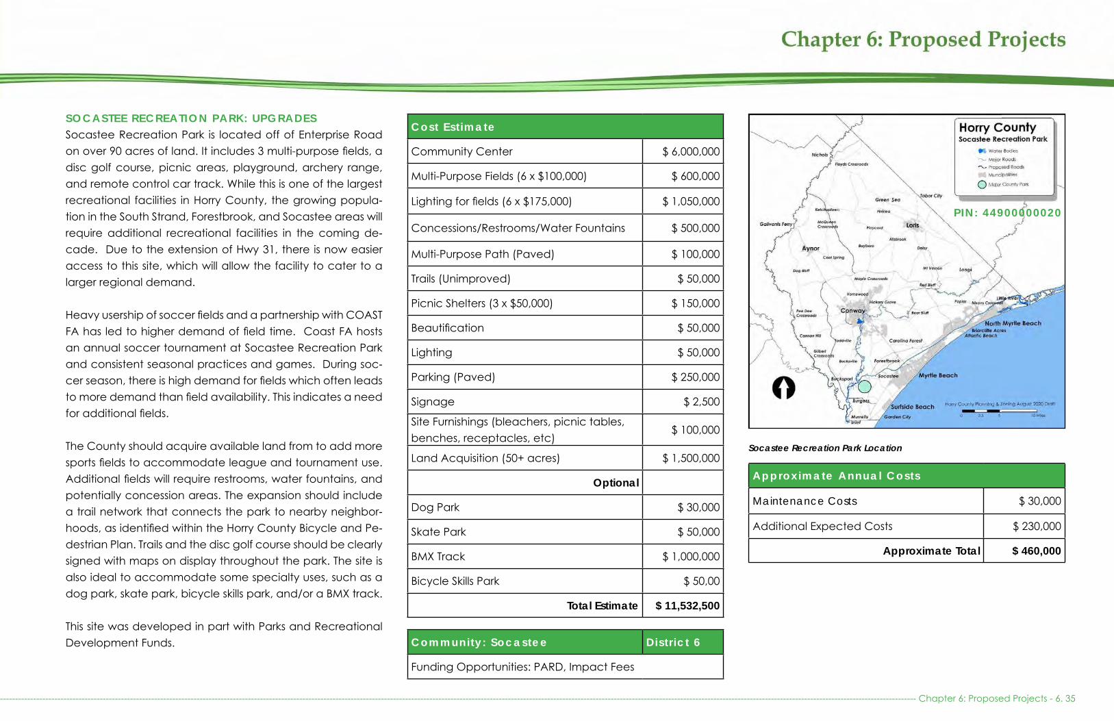
SOCASTEE RECREATION PARK: UPGRADESSocastee Recreation Park is located off of Enterprise Road on over 90 acres of land. It includes 3 multi-purpose fields, a disc golf course, picnic areas, playground, archery range, and remote control car track. While this is one of the largest recreational facilities in Horry County, the growing popula-tion in the South Strand, Forestbrook, and Socastee areas will require additional recreational facilities in the coming de-cade. Due to the extension of Hwy 31, there is now easier access to this site, which will allow the facility to cater to a larger regional demand.
Heavy usership of soccer fields and a partnership with COAST FA has led to higher demand of field time. Coast FA hosts an annual soccer tournament at Socastee Recreation Park and consistent seasonal practices and games. During soc-cer season, there is high demand for fields which often leads to more demand than field availability. This indicates a need for additional fields.
The County should acquire available land from to add more sports fields to accommodate league and tournament use. Additional fields will require restrooms, water fountains, and potentially concession areas. The expansion should include a trail network that connects the park to nearby neighbor-hoods, as identified within the Horry County Bicycle and Pe-destrian Plan. Trails and the disc golf course should be clearly signed with maps on display throughout the park. The site is also ideal to accommodate some specialty uses, such as a dog park, skate park, bicycle skills park, and/or a BMX track.
This site was developed in part with Parks and Recreational Development Funds.
Cost Est imate
Community Center $ 6,000,000
Multi-Purpose Fields (6 x $100,000) $ 600,000
Lighting for fields (6 x $175,000) $ 1,050,000
Concessions/Restrooms/Water Fountains $ 500,000
Multi-Purpose Path (Paved) $ 100,000
Trails (Unimproved) $ 50,000
Picnic Shelters (3 x $50,000) $ 150,000
Beautification $ 50,000
Lighting $ 50,000
Parking (Paved) $ 250,000
Signage $ 2,500
Site Furnishings (bleachers, picnic tables, benches, receptacles, etc)
$ 100,000
Land Acquisition (50+ acres) $ 1,500,000
Optional
Dog Park $ 30,000
Skate Park $ 50,000
BMX Track $ 1,000,000
Bicycle Skills Park $ 50,00
Total Estimate $ 11,532,500
Community: Socastee Distr ict 6
Funding Opportunities: PARD, Impact Fees
Approximate Annual Costs
Maintenance Costs $ 30,000
Additional Expected Costs $ 230,000
Approximate Total $ 460,000
Socastee Recreation Park Location
--------------------------------------------------------------------------------------------------------------------------------------------------------------------------------------------------------------------------------------------------------------------------------------------------------------- Chapter 6: Proposed Projects - 6. 35
PIN: 44900000020

Socastee Recreation Park Location
Example picnic shelter
Example paved multipurpose path
Socastee Recreation Park Multipurpose Field Plan
CB Berry Community Center should serve as an example Example bicycle skills park/ BMX track
Chapter 6: Proposed Projects - 6. 36 -------------------------------------------------------------------------------------------------------------------------------------------------------------------------------------------------------------------------------------------------------------------------------------------------------

RIVER OAKS PARK: PROPOSEDWhile there are a number of parks in the Carolina Forest community, there remains a lack of public recreation facili-ties off of River Oaks Blvd and in close proximity to Hwy 501. This area has a high potential for growth and already has a large number of multi-family units. The County owns multiple dredge spoil basins adjacent to the Intracoastal Waterway that may be suitable for the development of a community park. There are also a number of conservation properties with the intention of becoming public parks in the River Oaks area. These properties may be ideal for partnerships or as future donations to the County for the development of this park.
The County should consider the development of a multi-pur-pose park with a nature theme similar to the Loris Nature Park. The park should include trails, picnic areas, playground, dog park, and boardwalk. If the site is suitable, the County should construct a boat launch, as there are no public boat launches along the waterway for a 7 mile distance between Socastee and Peter Vaught Sr Landing near Restaurant Row. Depending on the wetland constraints and remaining avail-able land, the County should also consider the development of a disc golf course.
Cost Est imate
Picnic Areas $ 150,000
Playground $ 100,000
Walking Trails (Unpaved) $ 40,000
Disc Golf Course $ 15,000
Boat Launch (2 Lanes) $ 500,000
Boardwalk $ 250,000
Restrooms and Water Fountains $ 100,000
Beautification and Lighting $ 50,000
Dog Park $ 50,000
Parking (Gravel) $ 50,000
Signage $ 5,000
Site Furnishings (picnic tables, benches, receptacles, etc)
$ 30,000
Total Estimate $ 1,340,000
Community: Carol ina Forest/ River Oaks
Distr ict 3
Funding Opportunities: RTP, PARD, WSFRP
Est imated Annual Costs
Maintenance Costs $ 20,000
Total Estimate $ 20,000
River Oaks Park Future Location
Example nature themed playgroundWalking trails should be included as site amenities--------------------------------------------------------------------------------------------------------------------------------------------------------------------------------------------------------------------------------------------------------------------------------------------------------------- Chapter 6: Proposed Projects - 6. 37

River Oaks Area
Example cleared area under trees with water access
Disk Golf should serve as an additional amenity if space allows
Socastee Park could serve as a partial example Example dog park
Chapter 6: Proposed Projects - 6. 38 -------------------------------------------------------------------------------------------------------------------------------------------------------------------------------------------------------------------------------------------------------------------------------------------------------

REGIONAL RECREATION FACILITIESTypically, regional parks are 100 to 1,000 acres in size and cater to a large population, attracting people from throughout the County and beyond. These facilities are often associated with natural landscapes and provide passive recreation. While the County’s Regional Parks are smaller in size than national standards, the County’s passive Regional Recreation Facilities are supplement-ed by the Department of Natural Resources, the State Park System, and Fish and Wildlife.
Sports tourism facilities are also often considered Re-gional Recreation Facilities. Sports tourism facilities can fit within both the Regional Facilities or the Specialized Facilities section of this Plan. While the County does not maintaion any facilities which are solely for sports tour-ism, the Recreation Centers and Major County Parks of-ten serve as overflow locations for regional sports tour-ism events. In addition, located within the City of Myrtle Beach and City of North Myrtle Beach, large Region-al Recreation Facilities supplement the active sports needs of County residents.
As the unincorporated population grows, there will be a greater need for additional regional parks to serve the residents in unincorporated Horry County. New regional parks should expand the variety of recreational offer-ings in the County and improve access to natural lands and/or waterways. The County should ensure that the niches it seeks to fill are not already being met by area municipalities.
Please see Chapter 2: Parks and Recreation for more information about Regional Recreation Facilities Parks.
-------------------------------------------------------------------------------------------------------------------------------------------------------------------------------------------------------------------------------------------------------------------------------------------------------------- Chapter 6: Proposed Projects - 6. 39
Example Waterfront Revitalization project in Redondo Beach, CA
Kerry Park Concept, Seattle, WA - Source: P+A Landscape Architects Cannon Waterfront Park Masterplan - Baltimore, MD

LITTLE RIVER WATERFRONT PARK: PROPOSEDLittle River serves as the only active working waterfront in Horry County, with the next closest facility located in Murrells Inlet. While Horry County prides itself on its natural beauty, there is no public access to the ocean and saltmarsh in Downtown Little River. There is also no way for recreational and visiting boaters to access the businesses in Downtown Little River. Be-cause the downtown serves as a location for special events, like the Blue Crab Festival and the Shrimp Festival, there is a need for recreation and economic development along this historic waterfront. This facility was also recomended within the Little River Neighborhood Plan.
The County should acquire land along the Intracoastal Wa-terway in Downtown Little River to develop a waterfront park and adjoining public boardwalk. The park could include a covered picnic and gazebo area, swings overlooking the water, and playground equipment. It could provide rental space and parking for a farmers market, weddings, and oth-er special events. The site could also include a canoe/kayak launch. The adjoining boardwalk could include short-term docking space for transient boaters and fisherman to access Little River downtown.
The boardwalk could be developed in phases to connect the park to the existing commercial dock system and one mile north to Vereen Memorial Gardens. The dock and boardwalk system could be similar to the City of Georgetown’s Harbour-walk. A variety of funding mechanisms could be leveraged to fund the development of this facility, such as a USFWS Boat-ing Infrastructure/Wildlife and Sport Fish Restoration Program Grant, Accommodation Taxes and Admission Taxes, and business partnerships. Improving public access to the water will have a positive economic impact and provide residents with park space within walking distance of their homes.
Cost Est imate
Large Picnic Shelter for Special Events $ 100,000
Playground $ 100,000
Canoe/Kayak Launch $ 50,000
Boardwalk and Dock $ 5,000,000
Restrooms/Water Fountains $ 250,000
Beautification $ 20,000
Lighting $ 100,000
Parking (Unpaved) $50,000
Signage $ 5,000
Site Furnishings (picnic tables, swings, re-ceptacles, mounted binoculars, etc)
$ 50,000
Land Acquisition and Easements (15 acres) $ 2,000,000
Total Estimate $ 7,725,000
Community: L i t t le River Distr ict 1
Funding Opportunities: Impact Fees
Est imated Annual Costs
Maintenance Costs $ 100,000
Total Estimate $ 100,000
Little River Waterfront Future Location
Festival taking place at the Little River Waterfront
Chapter 6: Proposed Projects - 6. 40 -------------------------------------------------------------------------------------------------------------------------------------------------------------------------------------------------------------------------------------------------------------------------------------------------------
The development for such a park will be further revisited with an update to the Little River Neighborhood Plan

Little River Waterfront Area
Memorial Waterfront Park in Mt. Pleasant, SC
The Georgetown Harbourwalk should serve as an example for Board-walk development
Georgetown, SC Downtown Waterfront Boardwalk Memorial Waterfront Park in Mt. Pleasent, SC-------------------------------------------------------------------------------------------------------------------------------------------------------------------------------------------------------------------------------------------------------------------------------------------------------------- Chapter 6: Proposed Projects - 6. 41

VEREEN MEMORIAL GARDENS AND CB BERRY COMMUNITY CENTER: UPGRADES Vereen Memorial Historical Gardens is located on 115 acres of forest and marshland in Little River. This passive park has over 3 miles of walking trails and boardwalks. It also includes picnic areas and swings. The CB Berry Community Center is located at the front of the property and provides space for special events and programming. The park does not have space to expand, as it is surrounded by development. All im-provements must be made within the confines of the existing property.
To meet current demand, outdoor picnic areas and an am-phitheater should be located nearby. Trail maps, wayfinding and interpretive signage should be added along the trails, in addition to historical information regarding the Olde Kings Highway, which runs across the front of the property. An offi-cial trailhead for the East Coast Greenway (ECG) should be added to the front parking area. Restrooms, water fountains, a gazebo, and soft landing should be added along the wa-terfront. The park boarwalk system could be tied into the proposed Little River Boardwalk on the previous page, thus continuing the recreational expanse of the park
Cost Est imate
Amphitheater $ 100,000
Picnic Shelters $ 50,000
Public Art (Nature-Based) $ 50,000
Gazebo $ 50,000
Restrooms/Water Fountains $ 250,000
Canoe/Kayak Launch $ 50,000
Beautification $ 10,000
Lighting $ 50,000
Signage $ 5,000
Site Furnishings (picnic tables, benches, receptacles, mounted binoculars, etc) $ 50,000
On-Site Debris/Mulching Area $ 10,000
Boardwalk Repairs $500,000
Total Estimate $ 1,175,000
Community: L i t t le River Distr ict 1
Funding Opportunities: PARD, Impact Fees
Vereen Memorial Gardens Boardwalk needs repair
Approximate Annual Costs
Maintenance Costs $ 50,000
Operational Costs $ 140,000
Additional Expected Costs $ 11,000
Approximate Total $ 201,000
Vereen Memorial Gardens and CB Berry Community Center Location
Chapter 6: Proposed Projects - 6. 42 -------------------------------------------------------------------------------------------------------------------------------------------------------------------------------------------------------------------------------------------------------------------------------------------------------
PIN: 31100000009
Vereen Memorial Gardens is in need of a soft kayak launch

Vereen Memorial Gardens and CB Berry Community Center Location
Vereen Memorial Gardens Oyster Tree
Example picnic shelter
Water access at Vereen Memorial Gardens should be improved by adding a kayak launch
Example of nature-based public art by Patrick Dougherty in Houston
Example of nature-based public art by Will Beckers--------------------------------------------------------------------------------------------------------------------------------------------------------------------------------------------------------------------------------------------------------------------------------------------------------------- Chapter 6: Proposed Projects - 6. 43

SPECIALIZED RECREATION FACILITIESSpecialized recreation facilities range in size from large to small and cater to a variety of demographics. These types of facilities have no specific service size and their size is largely dependent on their purpose.
The public input process for the development of the Parks and Open Space Plan indicated a strong desire for recreational facilities that offer a variety of active and passive recreational opportunities. The community recommended the expansion of Carolina Forest Bike and Run Park. Residents have also expressed a strong desire for an aquatic center and an ice rink. These fa-cilities could be developed as sports tourism facilities to accommodate sporting events and local use. Minimal-ly, each of these facilities are estimated to cost $8 to $10 million to develop, not including the ongoing staff-ing and maintenance costs. Because these facilities are expensive to construct and manage, the County should conduct further feasibility studies and identify opportunities for partnerships and private investors prior to committing public tax dollars into their development. At this time, they are not included as capital projects within the Parks and Open Space Plan, although this can be revisited if further study confirms that the Coun-ty can viably provide and manage these facilities.
Please see Chapter 2: Parks and Recreation for more information about Specialized Recreation Facilities.
Chapter 6: Proposed Projects - 6. 44 -------------------------------------------------------------------------------------------------------------------------------------------------------------------------------------------------------------------------------------------------------------------------------------------------------
The North Myrtle Beach Sports Complex is an example of a Regional Recreation Facility or Specialized Recreation Facility. This is not a Horry County facility, but services Horry County Residents and can serve as an example model for future Regional Recreation Facilities. Source: https://nmbpark.com/about/
Miami University Equestrian Center World Equestrian Center Ocala, FL
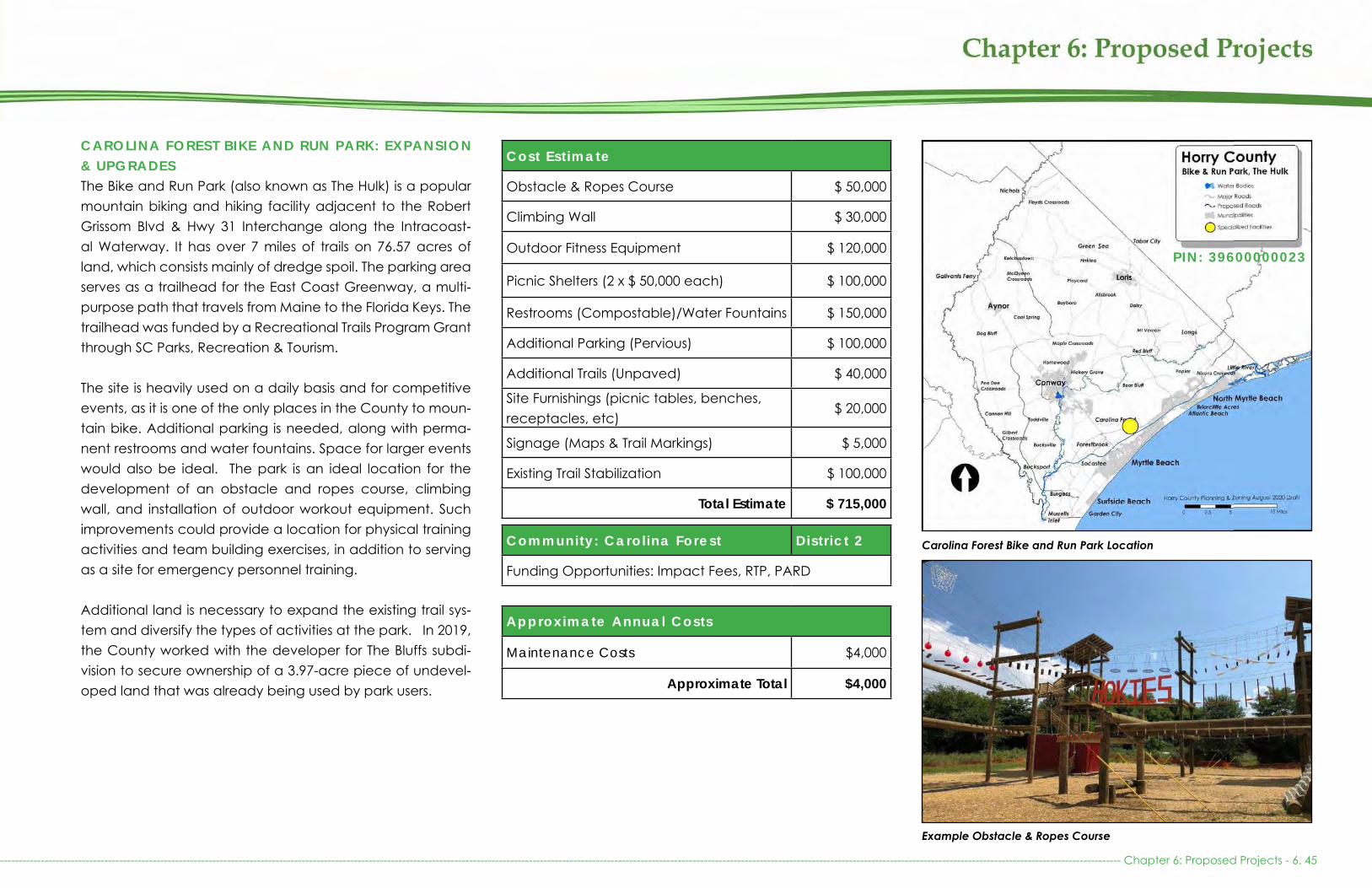
Cost Est imate
Obstacle & Ropes Course $ 50,000
Climbing Wall $ 30,000
Outdoor Fitness Equipment $ 120,000
Picnic Shelters (2 x $ 50,000 each) $ 100,000
Restrooms (Compostable)/Water Fountains $ 150,000
Additional Parking (Pervious) $ 100,000
Additional Trails (Unpaved) $ 40,000
Site Furnishings (picnic tables, benches, receptacles, etc)
$ 20,000
Signage (Maps & Trail Markings) $ 5,000
Existing Trail Stabilization $ 100,000
Total Estimate $ 715,000
Community: Carol ina Forest Distr ict 2
Funding Opportunities: Impact Fees, RTP, PARD
Approximate Annual Costs
Maintenance Costs $4,000
Approximate Total $4,000
Carolina Forest Bike and Run Park Location
Example Obstacle & Ropes Course
CAROLINA FOREST BIKE AND RUN PARK: EXPANSION & UPGRADESThe Bike and Run Park (also known as The Hulk) is a popular mountain biking and hiking facility adjacent to the Robert Grissom Blvd & Hwy 31 Interchange along the Intracoast-al Waterway. It has over 7 miles of trails on 76.57 acres of land, which consists mainly of dredge spoil. The parking area serves as a trailhead for the East Coast Greenway, a multi-purpose path that travels from Maine to the Florida Keys. The trailhead was funded by a Recreational Trails Program Grant through SC Parks, Recreation & Tourism.
The site is heavily used on a daily basis and for competitive events, as it is one of the only places in the County to moun-tain bike. Additional parking is needed, along with perma-nent restrooms and water fountains. Space for larger events would also be ideal. The park is an ideal location for the development of an obstacle and ropes course, climbing wall, and installation of outdoor workout equipment. Such improvements could provide a location for physical training activities and team building exercises, in addition to serving as a site for emergency personnel training.
Additional land is necessary to expand the existing trail sys-tem and diversify the types of activities at the park. In 2019, the County worked with the developer for The Bluffs subdi-vision to secure ownership of a 3.97-acre piece of undevel-oped land that was already being used by park users.
------------------------------------------------------------------------------------------------------------------------------------------------------------------------------------------------------------------------------------------------------------------------------------------------------------- Chapter 6: Proposed Projects - 6. 45
PIN: 39600000023

October 2018 Conceptual Plan for the Queens Cove Passive Park, open space which is privately owned, located on the property adjacent to the Carolina Forest Bike & Run Park
Example outdoor fitness equipment Example picnic shelter
The County should consider working with the adjacent property owner for The Battery sub-division to develop additional trails, as the property already has a conservation easement through North American Land Trust that allows for passive, public recreational use. This site has previously been used as overflow parking and for large scale race series events.
Chapter 6: Proposed Projects - 6. 46 -------------------------------------------------------------------------------------------------------------------------------------------------------------------------------------------------------------------------------------------------------------------------------------------------------
Carolina Forest Bike and Run Park and Queens Cove Passive Park location
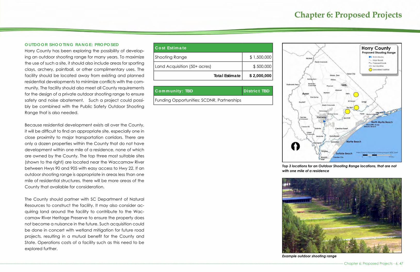
OUTDOOR SHOOTING RANGE: PROPOSEDHorry County has been exploring the possibility of develop-ing an outdoor shooting range for many years. To maximize the use of such a site, it should also include areas for sporting clays, archery, paintball, or other complimentary uses. The facility should be located away from existing and planned residential developments to minimize conflicts with the com-munity. The facility should also meet all County requirements for the design of a private outdoor shooting range to ensure safety and noise abatement. Such a project could possi-bly be combined with the Public Safety Outdoor Shooting Range that is also needed.
Because residential development exists all over the County, it will be difficult to find an appropriate site, especially one in close proximity to major transportation corridors. There are only a dozen properties within the County that do not have development within one mile of a residence, none of which are owned by the County. The top three most suitable sites (shown to the right) are located near the Waccamaw River between Hwys 90 and 905 with easy access to Hwy 22. If an outdoor shooting range is appropriate in areas less than one mile of residential structures, there will be more areas of the County that available for consideration.
The County should partner with SC Department of Natural Resources to construct the facility. It may also consider ac-quiring land around the facility to contribute to the Wac-camaw River Heritage Preserve to ensure the property does not become a nuisance in the future. Such acquisition could be done in concert with wetland mitigation for future road projects, resulting in a mutual benefit for the County and State. Operations costs of a facility such as this need to be explored further.
Cost Est imate
Shooting Range $ 1,500,000
Land Acquisition (50+ acres) $ 500,000
Total Estimate $ 2,000,000
Community: TBD Distr ict TBD
Funding Opportunities: SCDNR, Partnerships
Top 3 locations for an Outdoor Shooting Range locations, that are not with one mile of a residence
------------------------------------------------------------------------------------------------------------------------------------------------------------------------------------------------------------------------------------------------------------------------------------------------------------- Chapter 6: Proposed Projects - 6. 47
Example outdoor shooting range

Perry Towhship Game Association Range
Conecuh Shooting Range- Alabama
Roger G. Sykes Outdoor Heritage Complex in Nebraska
Wisconsin DNR Columbia County Shooting Range
Chapter 6: Proposed Projects - 6. 48 -------------------------------------------------------------------------------------------------------------------------------------------------------------------------------------------------------------------------------------------------------------------------------------------------------

M U L T I - P U R P O S E C I V I C A R E N A W I T H E Q U E S T R I A N F A C I L I T I E S : PROPOSEDHorry County currently lacks facilities for equestrian events and agricultural shows. The County also lacks a retreat facil-ity for overnight camps, summer outdoor programs, scouts, churches, and businesses. These niches are best filled within the rural part of the County.
The facility should include an arena, show rings, fields, pad-docks, stalls (permanent or temporary), and equestrian trails. In addition, Recreational Vehicle (RV) and primitive camp-ing, meeting spaces, and additional recreational facilities should be built to accommodate event participants, group retreats, and summer camps. The property should be large enough to accommodate a mix of uses to ensure year-round use, from traditional camp activities to allowing for livestock and agricultural shows, farmers markets, festivals and fairs.
There are a number of other sites in the County that may be suited for the development of this facility. Close proxim-ity to intersections along Highway 22 or Highway 501 would provide easy access to the conveniences and attractions available at the beach and within the municipalities. A fa-cility of this type could be a good revenue generator for the County and help support other facilities through the income it generates. The County may consider approaching other
Cost Est imate
Arena and Site Utilities $ 12,000,000
All weather warm up ring $ 100,000
Portable Stalls $ 25,000
Equestrian and Nature Trails $ 35,000
Fields and Paddocks $ 150,000
Playground $ 100,000
Picnic Shelters (4 x $50,000) $ 200,000
Outdoor Rings $ 600,000
RV Sites $ 1,000,000
Primitive Campsites (Clearing) $ 75,000
Covered Open Air Arena $ 1,500,000
Beautification $ 25,000
Lighting $ 50,000
Overflow Parking (Unpaved) $ 500,000
Permanent Parking $ 3,000,000
Signage $ 7,500
Cattle Auction Building w/ meeting rooms $ 5,000,000
400+ Permanent Horse Stalls/ Barns $ 5,000,000
Schooling Rings $ 200,000
Land Acquisition (100+ acres) $ 1,300,000
Total Estimate $ 30,867,500
Location: Western Port ion of Horry County
Distr ict TBD
Funding Opportunities: Horry Electric, Partnerships
T Ed Garrison Livestock Arena, Clemson University
Est imated Annual Costs
Operational Costs $ 1,550,000
Total Estimate $ 1,550,000
Multi-Purpose Rural Civic Center Potential Locations
--------------------------------------------------------------------------------------------------------------------------------------------------------------------------------------------------------------------------------------------------------------------------------------------------------------- Chapter 6: Proposed Projects - 6. 49

T Ed Garrison Livestock Arena during Presidential Rally T Ed Garrison Livestock Arena Warm-Up All-Weather Ring
Chapter 6: Proposed Projects - 6.50 --------------------------------------------------------------------------------------------------------------------------------------------------------------------------------------------------------------------------------------------------------------------------------------------------------
Potential Conceptual Rural Civic Arena Master Plan - Site # 4
Potential Conceptual Rural Civic Arena Master Plan - Site # 7
Potential Conceptual Rural Civic Arena Master Plan - Site # 8

RECREATION AND COMMUNITY CENTERSHorry County currently operates 4 recreation and 2 com-munity centers. All 4 recreation centers and 1 community center are in need of expansion. In addition, Aynor and Loris are also in need of recreation centers to meet the needs of residents in both incorporated and unincorporated areas.
AYNOR RECREATION CENTER: PROPOSEDResidents in the Aynor and Galivants Ferry part of rural Horry County do not have access to recreation beyond what is available at area boat landings, within the Town of Aynor, and the fields at Michael Morris Graham Park. The residents in this area have a continued interest in the development of a recreation center, as this project was proposed in the County’s 1999 Recreation Needs Assessment.
While there is property available within the Town’s limits, it would not meet the growing demand undoubtedly faced by this recreation center. The County could utilize property already owned at Micheal Morris Graham Park to build the Center. This would reduce the expenses necessary to create an entire complex because the facility could take advan-tage of the existing athletic fields, parking, and playground. The Center itself could be modeled after the North Strand Recreation Center, which would meet the size and indoor amenity demands for the Aynor area. There are multiple ad-jacent properties that could be perused in the future if ex-pansion is needed. There is potential interest in purchasing the SC Forestry Commission property with the Fire Tower and coordinating with the Historic Preservation Commission to re-store/preserve the fire tower. This acquisition could include passive recreational space.
The County should develop a recreation center, including a gymnasium, multi-purpose rooms, classrooms, weight and
Cost Est imate
Recreation Center with Parking $ 8,000,000
Splash Pad $ 100,000
Multipurpose Field and Lighting $ 275,000
Multipurpose Path (paved) $ 50,000
Concessions/Restrooms/Water Fountains $ 250,000
Baseball Field (2x $500,000 each) $ 1,000,000
Field Lighting (4x $175,000 each) $ 700,000
Multipurpose Fields (2x $175,000 each) $ 350,000
Outdoor Basketball Court $ 45,000
Playground $ 100,000
Picnic Shelter $ 50,000
Beautification $ 25,000
Lighting $ 25,000
Site Furnishings $ 20,000
Digital Signage $ 15,000
Land Acquisition (10+ Acres) $ 125,000
Total Estimate $ 11,120,000Community: 11 Distr ict 11
Funding Opportunities: PARD, Impact Fees
Est imated Annual Costs
Operational Costs $ 575,000
Total Estimate $ 575,000
Aynor Recreation Center Potential Location
exercise room, kitchen, offices, and storage. The outdoor amenities should include a multi-purpose field, playground, outdoor courts, picnic area, splash area, and walking trail.
-------------------------------------------------------------------------------------------------------------------------------------------------------------------------------------------------------------------------------------------------------------------------------------------------------------- Chapter 6: Proposed Projects - 6. 51
PIN: 23400000048
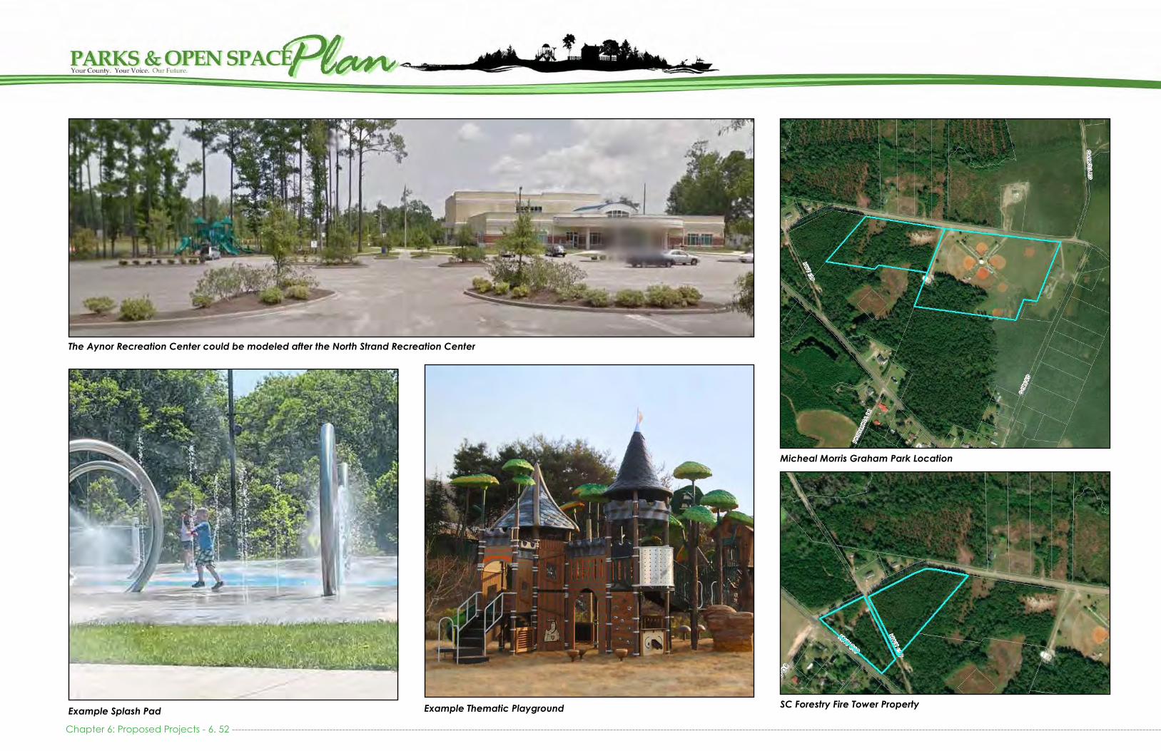
Micheal Morris Graham Park Location
The Aynor Recreation Center could be modeled after the North Strand Recreation Center
Example Thematic PlaygroundExample Splash PadSC Forestry Fire Tower Property
Chapter 6: Proposed Projects - 6. 52 -------------------------------------------------------------------------------------------------------------------------------------------------------------------------------------------------------------------------------------------------------------------------------------------------------

CAROLINA FOREST RECREATION CENTER: EXPANSION & UPGRADESThe Carolina Forest Recreation Center is co-located on 34 acres of land with the Carolina Forest Library and the PAL Playground. County Council has also approved for the Council on Aging to construct a new senior center on the site, adjacent to the library. The Environmental Assessment for the center was completed in 2020. While there remains a great deal of undeveloped land on this site for additional amenities, the demand for recreation exceeds the capac-ity for the site. The community desires the development of the open space behind the recreation center to include outdoor courts (basketball, volleyball, and tennis), splash area, walking trails, and a large picnic area for commu-nity events. Interest has also been expressed in the devel-opment of a dog park and skate park. This site could also serve as an alternative location for the development of an obstacle and ropes course, climbing wall, and installation of outdoor workout equipment.
The County acquired an additional 15.5 acres of adjoin-ing land to accommodate five (5) regulation size soccer fields for league and tournament play. Restrooms and wa-ter fountains should be dispersed throughout the outdoor amenities. In addition, lighting and landscaping should be used to ensure the space is inviting. Beyond the develop-ment of outdoor space, the existing recreation center will need to be expanded to include an auxiliary gym, addi-tional classroom space, storage space, and potentially an Olympic-size pool, if space permits.
In 2019, the County responded to increased demand and interest for trails in the Carolina Forest community by utiliz-ing the site for the implementation of the 3.2 mile Panther Trail. The Panther Trail is a temporary installation until the
Cost Est imate
Auxiliary Gym $ 3,000,000
Mulitpurpose Fields (5 x $175,000) $ 875,000
Field Lighting (7 x $175,000) $ 1,225,000
Parking expansion and paving $ 350,000
Picnic Shelter with Stage and Kitchen $ 300,000
Picnic Shelters (3 x $50,000) $ 150,000
Splash Pad $ 150,000
Changing Rooms/Restrooms/Water Foun-tains $ 250,000
Lighting $ 40,000
Electronic Signage $ 15,000
Site Furnishings (picnic tables, benches, receptacles, etc) $ 40,000
Dog Park $ 50,000
Skate Park $ 50,000
Playground $ 150,000
Total Estimate $ 11,145,000
Community: Carol ina Forest Distr ict 2
Funding Opportunities: PARD, Impact Fees
Approximate Annual Costs
Maintenance Costs $ 75,000
Operational Costs $ 820,000
Additional Expected Costs $ 365,000
Approximate Total $ 1,260,000
Carolina Recreation Center Location
installation of the multipurpose fields. Completion of the East Coast Greenway connection along Carolina Forest Blvd will undoubtedly increase the demand for the expansion of this Recreation Center.
--------------------------------------------------------------------------------------------------------------------------------------------------------------------------------------------------------------------------------------------------------------------------------------------------------------- Chapter 6: Proposed Projects - 6. 53
PIN: 39700000010

Example Splash Pad
DR Horton’s Plan for connection between Huger Park and the Carolina Forest Recreation Center.
Playground improvements will be neededA Dog Park is needed
Example picnic shelter with grillPanther Trail
Chapter 6: Proposed Projects - 6. 54 -------------------------------------------------------------------------------------------------------------------------------------------------------------------------------------------------------------------------------------------------------------------------------------------------------

JAMES R FRAZIER COMMUNITY CENTER: UPGRADESJames Frazier Community Center is located in the Bucksport Community. It includes a gymnasium and classroom space, in addition to a baseball field, outdoor courts, picnic areas, and a playground. To meet existing demand, the County in-stalled a splash pad, and with the assistance of United Way and PalmettoPride installed a Born Learning Trail, Butterfly Gardens, and Community Gardens in 2019. Additional im-provements to the basketball courts, addition of outdoor fitness equipment, and improvements or repurposing of the baseball field are needed to meet the growing and chang-ing demand in the community.
This site was developed in part with Land and Water Conser-vation Funds and Parks and Recreation Development Funds, making it eligible for these grants in the future.
Cost Est imate
Baseball Field Improvements $ 100,000
Lighting $ 25,000
Field Lighting $ 175,000
Resurface Outdoor Courts $ 15,000
Outdoor Fitness Equipment $ 20,000
Total Estimate $ 335,000.00
Community: Bucksport Distr ict 7
Funding Opportunities: PARD, LWCF
Approximate Annual Costs
Maintenance Costs $ 30,000
Operational Costs $ 235,000
Additional Expected Costs $ 12,000
Approximate Total $ 277,000
James R. Frazier Community Center Location
Splash Pad installed in 2018Arbor Day Tree Planting with Chairman Johnny Gardner and District 7 Councilman Orton Bellamy in April 2019
-------------------------------------------------------------------------------------------------------------------------------------------------------------------------------------------------------------------------------------------------------------------------------------------------------------- Chapter 6: Proposed Projects - 6. 55
PIN: 43716020012
Butterfly Garden in July 2020

Community Vegetable Garden
James R. Frazier Community Center Master Plan
James R. Frazier improvements installed in 2018 and 2019
Example of outdoor exercise equipment Herbs planted as edible plants in gardens
Chapter 6: Proposed Projects - 6. 56 -------------------------------------------------------------------------------------------------------------------------------------------------------------------------------------------------------------------------------------------------------------------------------------------------------

LORIS RECREATION CENTER: PROPOSEDWhile the City of Loris offers some recreational programming to the residents of Loris, the area is still largely underserved. Many residents in the unincorporated area surrounding the City of Loris do not have access to recreation in a reason-able driving distance. The City has expressed interest in part-nering with Horry County in establishing a Recreation Center to serve both jurisdiction’s interests. This project was original-ly proposed in the County’s 1999 Recreation Needs Assess-ment.
The Loris Recreation Center should include a gymnasium, multi-purpose rooms, weight and exercise room, kitch-en, offices, and storage. Outdoor amenities could include multi-purpose fields, playground, outdoor courts, picnic area, and walking trails. The Recreation Center should be sited in close proximity to the Loris Nature Park and Loris High School or adjacent to Loris Elementary School to maximize shared facilities with the Town of Loris and Horry County Schools. It will also minimize the need for excessive parking areas.
Cost Est imate
Recreation Center with Parking $ 8,000,000
Splash Pad $ 100,000
Multipurpose Field and Lighting $ 575,000
Multipurpose Path (paved) $ 50,000
Baseball Field (2x $500,000) $ 1,000,000
Concessions/Restrooms/Water Fountains $ 250,000
Field Lighting (4x $400,000) $ 800,000
Multipurpose Fields (2x $175,000) $ 350,000
Outdoor Basketball Court $ 45,000
Playground $ 100,000
Picnic Shelter $ 50,000
Beautification $ 25,000
Lighting $ 25,000
Site Furnishings $ 20,000
Electronic Signage $ 15,000
Skate or Bike Park $ 50,000
Land Acquisition (20+ acres) $ 250,000
Total Estimate $ 11,705,000
Community: Lor isDistr ict 9 or 10
Loris Recreation Center Future Location
Est imated Annual Costs
Operational Costs $ 575,000
Total Estimate $ 575,000
-------------------------------------------------------------------------------------------------------------------------------------------------------------------------------------------------------------------------------------------------------------------------------------------------------------- Chapter 6: Proposed Projects - 6. 57Example Bike ParkExample Skate Park

The Loris Recreation Center should be placed within a 1 mile radius of existing Loris Schools
The Loris Recreation Center could be modeled after the North Strand Recreation Center
Chapter 6: Proposed Projects - 6. 58 --------------------------------------------------------------------------------------------------------------------------------------------------------------------------------------------------------------------------------------------------------------------------------------------------------
Example Picnic shelterExampleSplash Pad Example Playground

NORTH STRAND RECREATION CENTER: EXPANSIONNorth Strand Recreation Center is located near the inter-section of Hwy 9 and Hwy 57. It includes a recreation cen-ter, playground, baseball field, and one multi-purpose field. The Solid Waste Authority owns a storm debris site adjacent to the park and allows for overflow activities on makeshift multipurpose fields. The recreation center is undersized and needs to expand to include an auxiliary gym and weight room. The property is also in need of additional fields and lighting that can be used for night time play. Other needed improvements include the addition of outdoor courts, walk-ing path, improved playground, additional restrooms, and picnic areas.
Acquisition of the immediately adjacent 2 acres on Highway 57 would be the ideal course of action to ensure availability of upland tract for construction of an auxiliary gym and pool. Additional property for expansion of athletic fields can be acquired as vacant parcels in the surrounding community to create a conglomerate of accessible recreation land.
Cost Est imate
Auxiliary Gym $ 3,000,000
Grounds Expansion (3+ Acres) $ 2,000,000
Multipurpose Field $ 175,000
Parking expansion and paving $ 350,000
Field Lighting (2 x $175,000) $ 350,000
Multipurpose Path $ 50,000
Outdoor Basketball Court $ 45,000
Picnic Shelters $ 50,000
Concessions/Restrooms/Water Fountains $ 150,000
Beautification $ 10,000
Lighting $ 25,000
Electronic Signage $ 15,000
Site Furnishings (bleachers, picnic tables, benches, receptacles, etc)
$ 20,000
Total Estimate $ 6,690,000
Community: Stevens Crossroads Distr ict 9
Funding Opportunities: PARD, CDBG
North Strand Recreation Center Location
Approximate Annual Costs
Maintenance Costs $ 20,000
Operational Costs $ 595,000
Additional Expected Costs $ 135,000
Approximate Total $ 750,000
--------------------------------------------------------------------------------------------------------------------------------------------------------------------------------------------------------------------------------------------------------------------------------------------------------------- Chapter 6: Proposed Projects - 6. 59
PIN: 30400000019
Example Multipurpose PathExample Picnic Shelter

North Strand Recreation Center
North Strand Recreation Center Playground Vacant 2 acre Adjacent Parcel
North Strand Recreation Center and fields
Chapter 6: Proposed Projects - 6. 60 -------------------------------------------------------------------------------------------------------------------------------------------------------------------------------------------------------------------------------------------------------------------------------------------------------
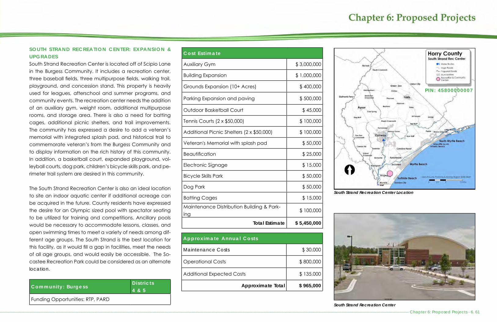
SOUTH STRAND RECREATION CENTER: EXPANSION & UPGRADESSouth Strand Recreation Center is located off of Scipio Lane in the Burgess Community. It includes a recreation center, three baseball fields, three multipurpose fields, walking trail, playground, and concession stand. This property is heavily used for leagues, afterschool and summer programs, and community events. The recreation center needs the addition of an auxiliary gym, weight room, additional multipurpose rooms, and storage area. There is also a need for batting cages, additional picnic shelters, and trail improvements. The community has expressed a desire to add a veteran’s memorial with integrated splash pad, and historical trail to commemorate veteran’s from the Burgess Community and to display information on the rich history of this community. In addition, a basketball court, expanded playground, vol-leyball courts, dog park, children’s bicycle skills park, and pe-rimeter trail system are desired in this community.
The South Strand Recreation Center is also an ideal location to site an indoor aquatic center if additional acreage can be acquired in the future. County residents have expressed the desire for an Olympic sized pool with spectator seating to be utilized for training and competitions. Ancillary pools would be necessary to accommodate lessons, classes, and open swimming times to meet a variety of needs among dif-ferent age groups. The South Strand is the best location for this facility, as it would fill a gap in facilities, meet the needs of all age groups, and would easily be accessible. The So-castee Recreation Park could be considered as an alternate location.
Cost Est imate
Auxiliary Gym $ 3,000,000
Building Expansion $ 1,000,000
Grounds Expansion (10+ Acres) $ 400,000
Parking Expansion and paving $ 500,000
Outdoor Basketball Court $ 45,000
Tennis Courts (2 x $50,000) $ 100,000
Additional Picnic Shelters (2 x $50,000) $ 100,000
Veteran's Memorial with splash pad $ 50,000
Beautification $ 25,000
Electronic Signage $ 15,000
Bicycle Skills Park $ 50,000
Dog Park $ 50,000
Batting Cages $ 15,000
Maintenance Distribution Building & Park-ing
$ 100,000
Total Estimate $ 5,450,000
Community: BurgessDistr icts4 & 5
Funding Opportunities: RTP, PARD
South Strand Recreation Center Location
South Strand Recreation Center
Approximate Annual Costs
Maintenance Costs $ 30,000
Operational Costs $ 800,000
Additional Expected Costs $ 135,000
Approximate Total $ 965,000
--------------------------------------------------------------------------------------------------------------------------------------------------------------------------------------------------------------------------------------------------------------------------------------------------------------- Chapter 6: Proposed Projects - 6. 61
PIN: 45800000007
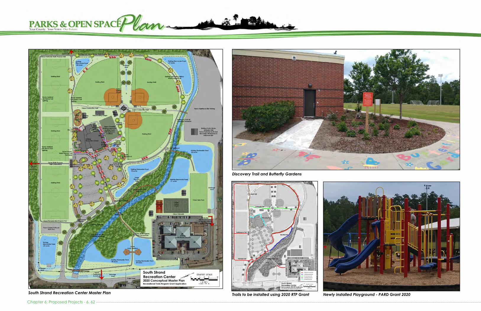
Discovery Trail and Butterfly Gardens
South Strand Recreation Center Master Plan
Chapter 6: Proposed Projects - 6. 62 -------------------------------------------------------------------------------------------------------------------------------------------------------------------------------------------------------------------------------------------------------------------------------------------------------
Trails to be installed using 2020 RTP Grant Newly installed Playground - PARD Grant 2020

AMENITY UNIT DIMENSIONS COST ESTIMATE
Buildings New Recreation Center- modeled from North Strand Recreation Center $ 8,000,000
Recreation Center Expansion/Auxiliary Gym Varies $ 1,000,000 - $ 3,000,000
Community Center Varies $ 6,000,000
Concessions, Restrooms, and Water Fountains 75’ x 75’ $ 250,000 - $ 500,000
Restrooms and Water Fountains Min 10’ x 20’ $ 100,000 - $ 250,000
Fields 1 Baseball/Softball Field Min 3 -3.85 acres $ 500,000
1 Multi-Purpose Field 240’ x 360’ $ 100,000
1 Field Lighting LED 4 poles w/ LED lights $ 175,000
Landings 1 Boat Ramp & Parking 1 – 2 acres $ 75,000
2 Boat Ramps & Parking 2 – 3 acres $ 100,000 - $ 150,000
1 Soft Launch (sandy shore v marsh) & Parking ≤ ½ acre $ 10,000 - $ 50,000
Floating Dock $ 75,000 - $ 150,000
Playground Age 1-5 Varies $ 100,000
Age 5-13 Varies $ 100,000
Picnic Shelters Small 10’ x 30’ $ 20,000
Medium 30’ x 30’ $ 40,000
Large 30’ x 50’ $ 100,000
Extra Large, Specialty > 30’ x 50’ Up to $ 300,000
Outdoor Courts Basketball 50’ x 84’ $ 45,000
Tennis (Double) 36’ x 78’ $ 50,000
Volleyball 30’ x 60’ $ 15,000
AMENITIES AND COST ESTIMATES
-------------------------------------------------------------------------------------------------------------------------------------------------------------------------------------------------------------------------------------------------------------------------------------------------------------- Chapter 6: Proposed Projects - 6. 63

AMENITY UNIT DIMENSIONS COST ESTIMATE
Signage Standard Park Entrance Sign 1 Sign Up to $ 4,500
Electronic Park Entrance Sign 1 Sign Up to $ 15,000
Boat Landing Sign 1 Sign $ 500 – $ 2,500
Wayfinding/Roadside Signage 2 Signs $ 500
Rule Signage 1 Sign $ 50- $ 150
Site Furnishings Bench, Galvanized 1 Bench $ 500
Bike Rack 1 Rack $ 500 – $ 1,000
Map Kiosk 1 Kiosk $ 1,000 or more
Picnic Table, Wooden 1 Table $ 100
Picnic Table, Galvanized 1 Table $ 1,000
Trash Receptacle, Drum 1 Receptacle $ 100
Trash Receptacle, Galvanized with Lid 1 Receptacle $ 500- $ 1,000
Lighting Varies Varies
Outdoor Fitness Equipment Varies $ 20,000 - $120,000
Splash Pad Varies based on Components Varies $ 60,000 – $ 500,000
Dog Park Varies based on size Varies $ 30,000 - $50,000
Specialty Parks Skills Park Varies $ 50,000
Children’s Skills Park Varies $ 10,000
BMX Varies $ 1,000,000
Skate Park Varies $ 50,000
AMENITIES AND COST ESTIMATES (continued)
Chapter 6: Proposed Projects - 6. 64 -------------------------------------------------------------------------------------------------------------------------------------------------------------------------------------------------------------------------------------------------------------------------------------------------------

AMENITY UNIT DIMENSIONS COST ESTIMATE
Trails & Paths Nature Trail, clearing Varies Varies
8 – 10 ft Wide Multi-Purpose Path, Paved 1 Mile $ 500,000
Boardwalk 1 Mile $ 2,500,000
Equestrian Facilities Arena and Training/Show Rings 80,000 sq ft Arena w/ 5,000 seats $ 12,000,000
Barns and Stables, Stalls 10 x 10 stalls $ 1,000,000
Equestrian and Nature Trails $ 35,000
Fields and Paddocks Varies $ 150,000
Outdoor Rings 300 x 146, 276 x 144, 256 x 140 $ 600,000
RV Sites $ 1,000,000
Primitive Campsites (Clearing) $ 75,000
Covered Open Air Arena 155 x 300 $ 1,500,000
All-Weather Warm Up Ring 130 x 245 $ 100,000
AMENITIES AND COST ESTIMATES (continued)
--------------------------------------------------------------------------------------------------------------------------------------------------------------------------------------------------------------------------------------------------------------------------------------------------------------- Chapter 6: Proposed Projects - 6. 65

Chapter 6: Proposed Projects - 6. 66 -------------------------------------------------------------------------------------------------------------------------------------------------------------------------------------------------------------------------------------------------------------------------------------------------------
Trai ls and Greenways: Cost Est imates
Collins Creek Trail and Park (Proposed) $ 2,192,500
Lewis Ocean Bay Trailhead (Proposed) $ 732,500
Stavely Creek Boardwalk and Park (Proposed)
$ 10,120,000
Total Estimate $ 13,045,000
Boat Landings and Blueways: Cost Est imates
Danny Knight Landing: Upgrades $ 195,000
Little River Soft Launch (Proposed) $ 162,500
Peachtree Landing: Upgrades $ 487,500
Pitts Landing: Upgrades $ 87,500
Reaves Ferry Landing: Upgrades $ 220,000
Ricefield Cove Landing: Upgrades $ 117,500
General Boat and Kayak Launch Needs $ 7,755,000
Total Estimate $ 9,025,000
Neighborhood Parks: Cost Est imates
Bennett Loop Park (Proposed) $ 205,500
Garden City Beach Park (Proposed) $ 2,595,000
Huger Park $ 220,000
Mt. Vernon Tennis Courts: Upgrades $265,000
Total Estimate $ 3,285,500
Community Parks: Cost Est imates
Bayboro Park: Upgrades $ 125,000
Brooksville Park (Proposed) $ 1,975,000
Green Sea Floyds Park: Expansion & Up-grades
$ 4,450,000
Toddville Park (Proposed) $ 1,510,000
Loris Nature Park: Upgrades $ 130,000
Micheal Morris Graham Park: Upgrades $ 3,460,000
Myrtle Ridge Park (Proposed) $ 1,355,000
Pee Dee Park: Expansion $ 2,320,000
Poplar Park: Expansion & Upgrades $ 4,525,000
Sandridge Park: Expansion & Upgrades $ 700,000
Simpson Creek Park: Upgrades $ 240,000
Total Estimate $ 20,790,000
Major County Parks: Cost Est imates
Forestbrook Park (Proposed) $ 10,270,000
Peter Vaught Sr. Park & Landing: Expansion & Upgrades
$ 3,060,000
Socastee Recreation Park: Upgrades $ 11,532,500
River Oaks Park (Proposed) $ 1,340,000
Total Estimate $ 26,202,500
Regional Recreation Faci l i t ies: Cost Est imates
Little River Waterfront Park (Proposed) $ 7,725,000
Vereen Memorial Gardens and CB Berry Community: Upgrades
$ 1,175,000
Total Estimate $ 8,900,000
TOTAL COST ESTIMATES: ALL PROJECTS BY TYPE
Special ized Recreation Faci l i t ies: Cost Est imates
Carolina Forest Bike and Run Park: Expan-sion & Upgrades
$ 715,000
Outdoor Shooting Range (Proposed) $ 2,000,000
Rural Civic Arena with Equestrian Facilities (Proposed)
$ 30,867,500
Total Estimate $ 33,582,500
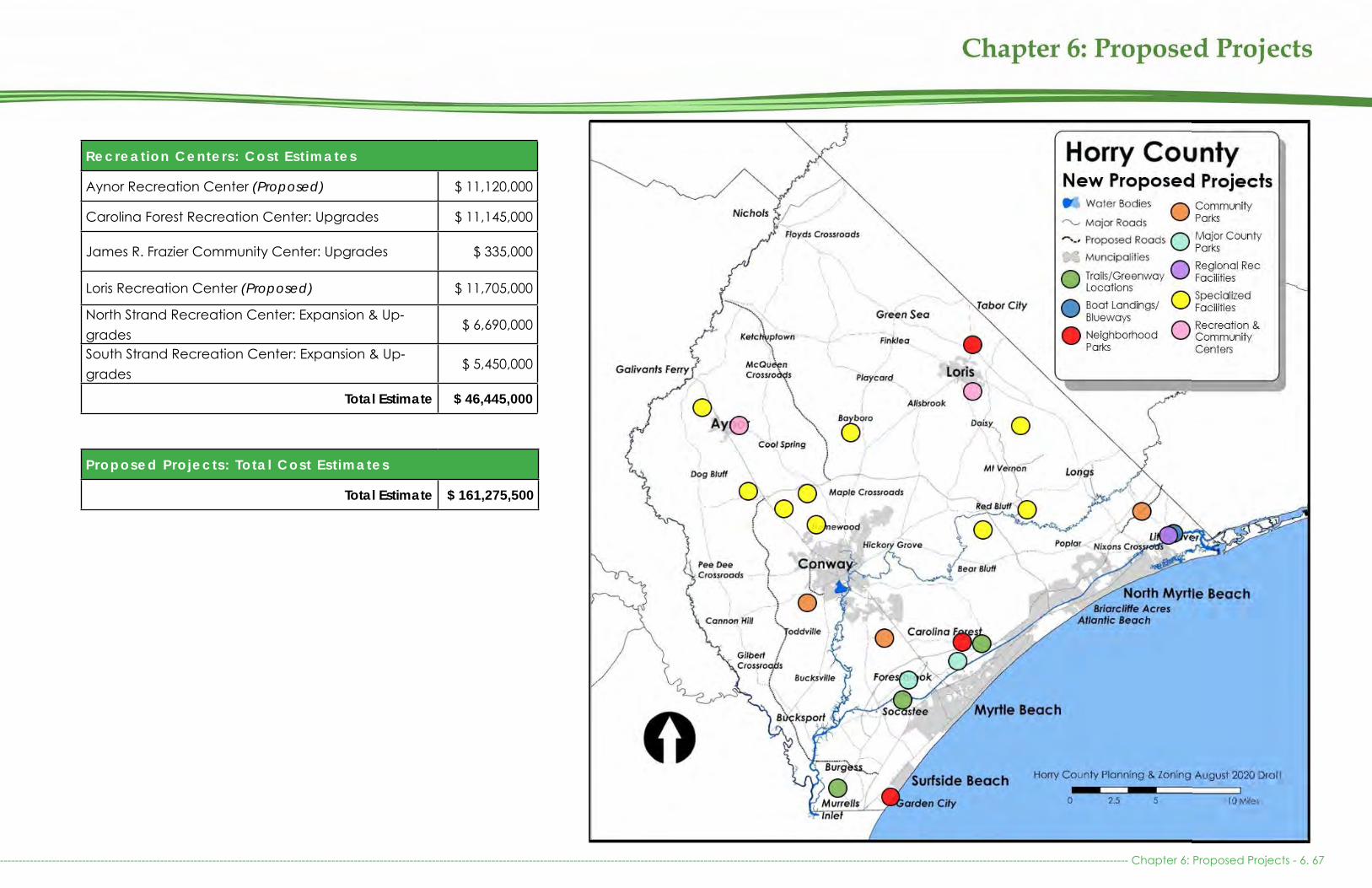
--------------------------------------------------------------------------------------------------------------------------------------------------------------------------------------------------------------------------------------------------------------------------------------------------------------- Chapter 6: Proposed Projects - 6. 67
Proposed Projects: Total Cost Est imates
Total Estimate $ 161,275,500
Recreation Centers: Cost Est imates
Aynor Recreation Center (Proposed) $ 11,120,000
Carolina Forest Recreation Center: Upgrades $ 11,145,000
James R. Frazier Community Center: Upgrades $ 335,000
Loris Recreation Center (Proposed) $ 11,705,000
North Strand Recreation Center: Expansion & Up-grades
$ 6,690,000
South Strand Recreation Center: Expansion & Up-grades
$ 5,450,000
Total Estimate $ 46,445,000
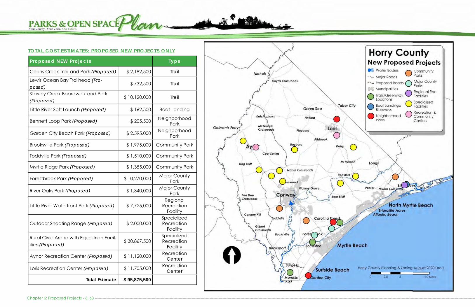
Chapter 6: Proposed Projects - 6. 68 -------------------------------------------------------------------------------------------------------------------------------------------------------------------------------------------------------------------------------------------------------------------------------------------------------
Proposed NEW Projects Type
Collins Creek Trail and Park (Proposed) $ 2,192,500 Trail
Lewis Ocean Bay Trailhead (Pro-posed)
$ 732,500 Trail
Stavely Creek Boardwalk and Park (Proposed)
$ 10,120,000 Trail
Little River Soft Launch (Proposed) $ 162,500 Boat Landing
Bennett Loop Park (Proposed) $ 205,500 Neighborhood Park
Garden City Beach Park (Proposed) $ 2,595,000 Neighborhood Park
Brooksville Park (Proposed) $ 1,975,000 Community Park
Toddville Park (Proposed) $ 1,510,000 Community Park
Myrtle Ridge Park (Proposed) $ 1,355,000 Community Park
Forestbrook Park (Proposed) $ 10,270,000 Major County Park
River Oaks Park (Proposed) $ 1,340,000 Major County Park
Little River Waterfront Park (Proposed) $ 7,725,000 Regional
Recreation Facility
Outdoor Shooting Range (Proposed) $ 2,000,000 Specialized Recreation
Facility
Rural Civic Arena with Equestrian Facil-ities (Proposed)
$ 30,867,500 Specialized Recreation
Facility
Aynor Recreation Center (Proposed) $ 11,120,000 Recreation Center
Loris Recreation Center (Proposed) $ 11,705,000 Recreation Center
Total Estimate $ 95,875,500
TOTAL COST ESTIMATES: PROPOSED NEW PROJECTS ONLY

------------------------------------------------------------------------------------------------------------------------------------------------------------------------------------------------------------------------------------------------------------------------------------------------------ Chapter 6: Proposed Projects - 6. 69
Proposed Upgrade & Expansion Projects Type
Danny Knight Landing: Upgrades $ 195,000 Boat Landing
Peachtree Landing: Upgrades $ 487,500 Boat Landing
Pitts Landing: Upgrades $ 87,500 Boat Landing
Reaves Ferry Landing: Upgrades $ 220,000 Boat Landing
Ricefield Cove Landing: Upgrades $ 117,500 Boat Landing
Huger Park $ 220,000 Neighborhood Park
Mt. Vernon Tennis Courts: Upgrades $265,000 Neighborhood Park
Bayboro Park: Upgrades $ 125,000 Community ParkGreen Sea Floyds Park: Expansion & Upgrades $ 4,450,000 Community Park
Loris Nature Park: Upgrades $ 130,000 Community Park
Micheal Morris Graham Park: Upgrades $ 3,460,000 Community Park
Pee Dee Park: Expansion $ 2,320,000 Community Park
Poplar Park: Expansion & Upgrades $ 4,525,000 Community Park
Sandridge Park: Expansion & Upgrades $ 700,000 Community Park
Simpson Creek Park: Upgrades $ 240,000 Community ParkPeter Vaught Sr. Park & Landing: Expan-sion & Upgrades $ 3,060,000 Major County Park
Socastee Recreation Park: Upgrades $ 11,532,500 Major County ParkVereen Memorial Gardens and CB Berry Community: Upgrades $ 1,175,000 Regional Facility
Carolina Forest Bike and Run Park: Ex-pansion & Upgrades $ 715,000 Regional Facility
Carolina Forest Recreation Center: Up-grades $ 11,145,000 Recreation Center
James R. Frazier Community Center: Upgrades $ 335,000 Recreation Center
North Strand Recreation Center: Expan-sion & Upgrades $ 6,690,000 Recreation Center
South Strand Recreation Center: Expan-sion & Upgrades $ 5,450,000 Recreation Center
Total Estimate $ 57,645,000
TOTAL COST ESTIMATES: UPGRADES & EXPANSION PROJECTS ONLY
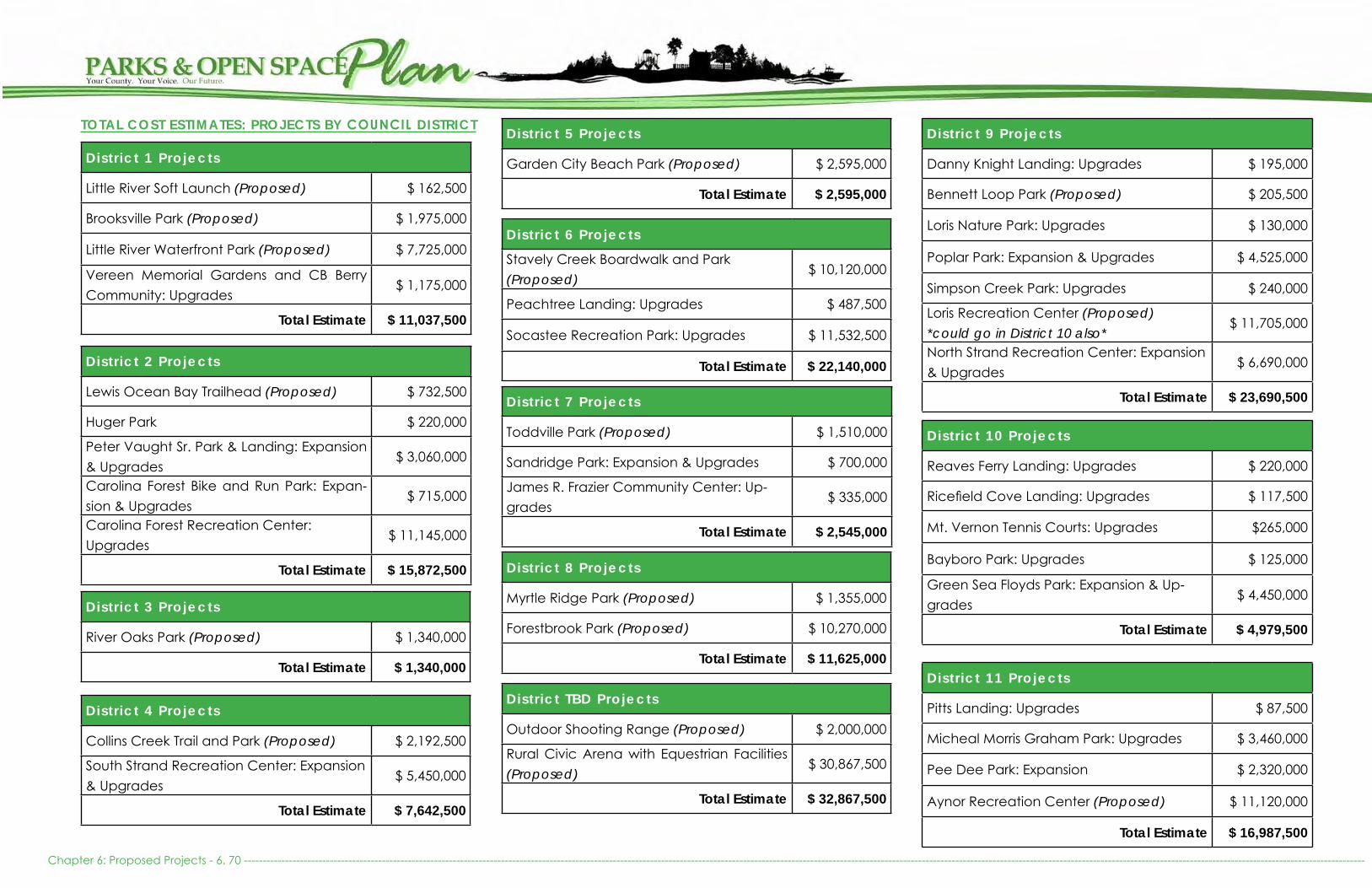
Chapter 6: Proposed Projects - 6. 70 -------------------------------------------------------------------------------------------------------------------------------------------------------------------------------------------------------------------------------------------------------------------------------------------------------------
Distr ict 1 Projects
Little River Soft Launch (Proposed) $ 162,500
Brooksville Park (Proposed) $ 1,975,000
Little River Waterfront Park (Proposed) $ 7,725,000
Vereen Memorial Gardens and CB Berry Community: Upgrades
$ 1,175,000
Total Estimate $ 11,037,500
Distr ict 2 Projects
Lewis Ocean Bay Trailhead (Proposed) $ 732,500
Huger Park $ 220,000
Peter Vaught Sr. Park & Landing: Expansion & Upgrades
$ 3,060,000
Carolina Forest Bike and Run Park: Expan-sion & Upgrades
$ 715,000
Carolina Forest Recreation Center: Upgrades
$ 11,145,000
Total Estimate $ 15,872,500
Distr ict 3 Projects
River Oaks Park (Proposed) $ 1,340,000
Total Estimate $ 1,340,000
Distr ict 4 Projects
Collins Creek Trail and Park (Proposed) $ 2,192,500
South Strand Recreation Center: Expansion & Upgrades
$ 5,450,000
Total Estimate $ 7,642,500
Distr ict 5 Projects
Garden City Beach Park (Proposed) $ 2,595,000
Total Estimate $ 2,595,000
Distr ict 6 Projects
Stavely Creek Boardwalk and Park (Proposed)
$ 10,120,000
Peachtree Landing: Upgrades $ 487,500
Socastee Recreation Park: Upgrades $ 11,532,500
Total Estimate $ 22,140,000
Distr ict 7 Projects
Toddville Park (Proposed) $ 1,510,000
Sandridge Park: Expansion & Upgrades $ 700,000
James R. Frazier Community Center: Up-grades
$ 335,000
Total Estimate $ 2,545,000
Distr ict 8 Projects
Myrtle Ridge Park (Proposed) $ 1,355,000
Forestbrook Park (Proposed) $ 10,270,000
Total Estimate $ 11,625,000
Distr ict 9 Projects
Danny Knight Landing: Upgrades $ 195,000
Bennett Loop Park (Proposed) $ 205,500
Loris Nature Park: Upgrades $ 130,000
Poplar Park: Expansion & Upgrades $ 4,525,000
Simpson Creek Park: Upgrades $ 240,000
Loris Recreation Center (Proposed) *could go in District 10 also*
$ 11,705,000
North Strand Recreation Center: Expansion & Upgrades
$ 6,690,000
Total Estimate $ 23,690,500
Distr ict 10 Projects
Reaves Ferry Landing: Upgrades $ 220,000
Ricefield Cove Landing: Upgrades $ 117,500
Mt. Vernon Tennis Courts: Upgrades $265,000
Bayboro Park: Upgrades $ 125,000
Green Sea Floyds Park: Expansion & Up-grades
$ 4,450,000
Total Estimate $ 4,979,500
Distr ict 11 Projects
Pitts Landing: Upgrades $ 87,500
Micheal Morris Graham Park: Upgrades $ 3,460,000
Pee Dee Park: Expansion $ 2,320,000
Aynor Recreation Center (Proposed) $ 11,120,000
Total Estimate $ 16,987,500
Distr ict TBD Projects
Outdoor Shooting Range (Proposed) $ 2,000,000
Rural Civic Arena with Equestrian Facilities (Proposed)
$ 30,867,500
Total Estimate $ 32,867,500
TOTAL COST ESTIMATES: PROJECTS BY COUNCIL DISTRICT

Arendt, Randall. (2012). Conservation Design for Subdivisions.
Bennett, S.H. and J. B. Nelson. (1991). Distribution and Status of Carolina Bays in South Carolina. SC Wildlife and Marine Resources Department. Nongame and Heritage Trust Publications.
The Conversation. (2019). “Can parks help cities fight crime?” NC State University.
Horry County (HC). (2012). Horry County, SC Comprehensive Annual Financial Report. Prepared by the Finance Department. http://www.horrycounty.org/portals/0/docs/finance/2012cafr.pdf
Leggitt, Jim. Quick Drawings for Parks and Open Spaces. http://jimleggitt.typepad.com/jim-leggitt-draw ing-shortcuts/2011/12/drawing-parks-and-open-spac es.html
Lothian, A. (2010). Health and Restorative Benefits of Viewing Landscapes. http://www.scenicsolutions.
com.au/Attached%20PDFs/Restorative%20and%20health%20benefits.pdf
Myrtle Beach Economic Impact Study. (2016). Myrtle Beach Area Chamber of Commerce.
National Park Service (NPS). (1995). Economic Impacts of Protecting Rivers, Trails, and Greenway Corridors. Real Property Values. 4th Edition, Revised.
National Recreation and Parks Association (NRPA). (2015) “Structured Recreation Programming Can Help Reduce Juvenile Crime.” Parks & Recreation Magazine. September edition
..... (2016). “Using Design to Reduce Crime.” Parks & Recreation Magazine. March edition
..... (2020). 2020 National Recreation Parks Association Agency Performance Review.
Outdoor Industry Association (OIA). (2012). The Outdoor Recreation Economy: South Carolina.
http://outdoorindustry.org/images/ore_reports/ SC-southcarolina-outdoorrecreationeconomy-oia.pdf
Robert Wood Johnson Foundation. (2016). Culture of Health Blog: 6 Reasons Why Parks Matter for Health.
..... (2010). The Economic Benefits of Open Space, Recreation Facilities and Walkable Community Design. Active Living Research. A Program of the Robert Wood Johnson Foundation.
South Carolina Department of Parks, Recreation and Tourism. (2019). South Carolina Statewide Comprehensive Outdoor Recreation Plan.
SC Department of Health and Environmental Control. (2013). Horry County Obesity Fact Sheet.
https://www.scdhec.gov/Health/docs/Epi/obesity/ Horry.pdf
SC Department of Natural Resources (SCDNR). (2014). SCDNR Managed Lands Program. http://www.dnr.
sc.gov/mlands/hpprogram.html
..... (2015). South Carolina Wildlife Action Plan.
….. (2013). Wildlife Species- Black Bear. http://www.dnr. sc.gov/wildlife/species/bear.html
….. (2012). Rare, Threatened, and Endangered Species and Communities Known to Occur in Horry County, SC.
http://www.dnr.sc.gov/species/pdf/Horry2012.pdf
….. (2008). South Carolina Aquatic Invasive Species Management Plan. http://www.dnr.sc.gov/invasiveweeds/aisfiles/SCAISplan.pdf
SC Department of Parks, Recreation, and Tourism et al. (1988). South Carolina Public Beach and Coastal Access Guide.
South Carolina Forestry Commission. (2010). South Carolina Statewide Forest Resource Assessment and Strategy.
Takano, Nakamura, Watanabe. (2002). “Urban residential environments and senior citizens’ longevity in megacity areas: the importance of walkable green
spaces.” Epidemiol Community Health.
The Trust for Public Land. (2006). “Why America Needs More City Parks and Open Space: The Benefits of Parks.”
Waccamaw River Blue Trail. http://www.americanrivers. org/initiative/blue-trails/projects/waccamaw-river- blue-trail/
----------------------------------------------------------------------------------------------------------------------------------------------------------------------------------------------------------------------------------------------------------------------------------------------------------------------------------------- Resources - 1

US Fish and Wildlife Service (USFWS). (2013). Waccamaw National Wildlife Refuge. http://www.fws.gov/ waccamaw/
US Department of the Interior Fish and Wildlife Service (2019). Land Protection Plan for the Proposed Boundary Modification of the Waccamaw National Wildlife Refuge.
..... (2019). Environmental Assessment for the Minor Boundary Modification of Waccamaw National Wildlife Refuge.
Resources - 2 ---------------------------------------------------------------------------------------------------------------------------------------------------------------------------------------------------------------------------------------------------------------------------------------------------------------------------------------