The Working Plan for Nagpur Forest Division (Part I and II)
268
Government of Maharashtra The Working Plan for Nagpur Forest Division (NAGPUR DISTRICT) 2004 For the period (2004-05 to 2013-14) VOLUME - I (Part I and II) By Jarnail Singh, IFS & S S Mishra, IFS Office of the Conservator of Forests Working Plan Division, Nagpur (Near Government Printing Press Civil Lines, Nagpur 440 001)
-
Upload
khangminh22 -
Category
Documents
-
view
1 -
download
0
Transcript of The Working Plan for Nagpur Forest Division (Part I and II)

Government of Maharashtra
The Working Plan
for
Nagpur Forest Division
(NAGPUR DISTRICT)
2004
For the period
(2004-05 to 2013-14)
VOLUME - I
(Part I and II)
By
Jarnail Singh, IFS
&
S S Mishra, IFS
Office of the Conservator of Forests Working Plan Division,
Nagpur (Near Government Printing Press
Civil Lines, Nagpur 440 001)

Persons Associated With Preparation of Nagpur Working Plan 2004
Office of the Conservator of Forests, Working Plan Circle, Nagpur
Shri J. S. Grewal
Shri S. Bahadur
Shri N. M. Daksh
Shri R. T. Dhabekar
Shri B. V. Selukar
Shri V. M. Sahare
Conservator of Forests, Working Plan Circle, Nagpur
Conservator of Forests, Working Plan Circle, Nagpur
Assistant Conservator of Forests, Database
Range Forest Officer, Database
Range Forest Officer, Database
Forest Guard
Office of the Deputy Conservator of Forests, Working Plan Division, Nagpur
Shri A. N. Dhote
Shri S. G. Bhowate
Shri T.U.Shewate
Shri B. T. More
Range Forest Officer
Range Forest Officer
Range Forest Officer
Ranger Surveyor
Shri R.K. Wagde
Shri H. R. Nasare
Shri M. B. Thote
Shri L.V. Gehani
Surveyor
Surveyor
Surveyor
Surveyor
Shri A. C. Gondane
Shri N T Ikhankar
Clerk-Typist
Clerk-Typist
Survey teams of the 'Survey of Forest Resources Unit ' at Amravati; Chandrapur , Officers
and staff of the Nagpur Forest Division.
© All rights reserved*
*The Conservator of Forests, Working Plan Circle at Nagpur may grant the copyright
permissions on behalf of the Government of Maharashtra.

Drafting team
Jarnail Singh, IFS.1
S.S.Mishra, IFS. 2
Citation
Full citation: WPO, Nagpur. The Working Plan for the Nagpur Forest Division, 2003. Office of
the Principal Chief Conservator of Forests, Maharashtra State, Seminary Hills, Nagpur
This plan may be referred as the 'Nagpur Working Plan 2003' in the text.
Government of Maharashtra
The Working Plan
for
Nagpur Forest Division
(NAGPUR DISTRICT)
2004
For the period
(2004-05 to 2013-14)
VOLUME - II
(Appendices)
By
Jarnail Singh, IFS
&
S S Mishra, IFS
Office of the Conservator of Forests Working Plan Division,
Nagpur (Near Government Printing Press
Civil Lines, Nagpur 440 001)
Preface
The present working plan of Nagpur Forest Division as revised by Shri Jarnail Singh,
IFS and Shri S. S. Mishra, IFS envisages scientific management to the forest areas in charge of
Deputy Conservator of Forests, Nagpur and hence it excludes the area transferred to Wildlife
wing and FDCM. This working plan also includes Zudapi Jungle area, which has been
transferred to forest department as compensatory land. However, no Silvicultural treatment has
been prescribed for these areas because they contain crop, which is too young to respond to any
such system and further authentic field data in regard to zudapi jungles is yet to be collected.
Whole forest area has been divided into 6 area specific and 3 overlapping working
circles. The six area specific working circles are-
Selection cum Improvement,
Improvement,
Old Teak Plantations,
Rootstock Management and Afforestation,
Protection and Catchment Area Management and
Grass and Fodder Resource Management.
Yield has been prescribed both in SCI and P&CAM working circles because forests put
under these working circles are fit for commercial production but yield prescribed under
P&CAM working circle is on very conservative side. Planting of teak by canopy removal
followed with artificial regeneration (within the SCI coupes), as already being done in FDCM
areas, has also been prescribed on a limited scale. This is because, being strong light demander,
teak can be successfully regenerated artificially only after creating sufficient openings in the
forests. SCI areas (also some IMP areas) have therefore been considered for plantation of of
about 250 ha. of teak annually.
Maps have been generated in Geo-media cell. Village maps for each village were
registered for generating maps of protected forests and, in case of reserve forests, survey of India
sheets were used. Thus digitized maps are stored permanently with the CF, Working Plans,
Nagpur and requisite number of sets have been provided to the division.
I congratulate Shri Jarnail Singh, IFS and Shri S S Mishra, IFS and their highly
motivated team for accomplishing this assignment.
(Shailendra Bahadur)
Conservator of Forests,
Working Plan Circle,
Nagpur.

Introduction
The Working Plan 2004 for Nagpur Forest Division is the combined plan for
Reserve and Protected forests in charge of Nagpur Forest division i.e. 1721.268 sq km
of forest area. Jwala Prasad's plan, 1990-91 to1999-2000 (extended upto 2003-2004)
has been revised in the form of present plan. This plan will be in force from 2004-05
to 2013-2014.
The preliminary working plan was prepared by Shri A. Ashraf and Shri V. K.
Sinha and was approved by the state level committee on 22.08.2000. On the basis of
the preliminary working plan approved, the draft plan was prepared by Shri Jarnail
Singh.
Major changes which have been affected in the present working plan are:
Shift from CWR working to Selection working in major areas because the
coppicing vigor has drastically reduced due to 3-4 coppice rotations in the
past.
Shelter-wood system, which was introduced for the first time in the previous
plan in some well stocked areas capable of producing large sized
commercial timber, has been discontinued because of its unsuitability for
the area and complexity of the prescriptions.
The plantation area has been drastically reduced because of past poor
results of plantations and more emphasis is now laid on natural
regeneration which will include rootstock management.
The condition of grasslands (pasture areas and grass birs) is not
encouraging. Yet the area under grass birs has been retained and, that
under pasture, increased because of increase in local demands.
This plan particularly lays emphasis on evolving site specific mechanisms
for protection and development of forests through Joint Forest Management.
Afterwards, following changes have been incorporated in the draft by the
undersigned.
1. Growth statistics of 26 miscellaneous species which included 11 species
that do not form in annual rings and local volume table for teak as well as
13 miscellaneous species has been given in chapter 6.
2. A separate chapter on management of Old Teak Plantations.
3. Artificial plantation of teak after removal of over-wood in suitable patches
for maximization of commercial productivity of forests.

The computerized inventory management system as evolved by the then
Conservator of Forests Shri J S Grewal has been extensively used in analyzing the
enumeration data obtained from the field by SOFR team, Amravati. The digitized maps
have been generated in the Geomedia cell in the office of the Conservator of Forests,
Working Plans, Nagpur and partly in the office of the Deputy conservator of Forests,
Working Plans Division, Nagpur. The inventory management system has been linked
to the digitized maps for easy accessibility of the data.
The introduction of teak plantation after creating gaps in the canopy by
removing over-wood has been a matter of much discussion during the finalization of
this plan. Besides the Govt of India having allowed the FDCM to take up such activity
in their area, it is a common knowledge that teak does not grow in shade. Past efforts
of gap plantation of teak have resulted in failures. On the other hand, its plantation
after creation of gaps in the canopy is a time tested technique. Considering the pros
and cons of this aspect and the issue in regard to bio-diversity conservation vis-a-vis
mono-culture plantations, it has been thought to be prudent to have a conservative
target of teak plantation in Nagpur forests division after putting a few safeguards in
place. Those safeguards will be in the form of patches not being more than 20 ha at a
place and learning sufficiently vide strips of forests in between.
I express my deep sense of gratitude for the valuable guidance and advice
provided by Shri J S Grewal and Shri S Bahadur, Conservators of Forests, Working
Plans , Nagpur. This plan is a combined output due to the efforts made by them. The
inventory management system developed by Shri J S Grewal has been very handy and
user friendly in analyzing the enumeration data. Shri S Bahadur as personally guided
in all the analytical works involving long and cumbersome mathematical calculations
and has been a source of inspiration in finalization of this plan. It was only because
of incessant efforts made by the above senior officers as Conservators of Forests,
Working Plans, Nagpur that this task could be completed satisfactorily.
A large number of other officials have made valuable contribution during the
preparation of this plan but it will not be possible to name each and every person
associated. List of officials formally associated with work is enclosed. However, I shall
be failing in my duty if I do not make special mention of a few of them.
Shri A N Dhote, RFO and Shri B T More, Ranger Surveyor deserve special appreciation
for their untiring work in analysis of data, digitization of maps and in guiding others
in various related activities. My special appreciation is also due to Shri A C Gondane,
Clerk in typing, printing, binding and other related works.
( S S Mishra ) Deputy conservator of Forests Working Plans Division

Nagpur
Table of Contents Page no.
I) Executive Summary i - x II) Abbreviation used in the Plan a III) Glossary of Local Terms b IV) Local and Botanical names of Plants occurring in Nagpur Division c - h V) Common and Zoological names of Animals and Birds i - j
Part–I: Facts of which proposals are based
Chapter 1. Name and Situation
1.1. Introduction 1
1.2. Configuration of the ground 2
1.3. Geology, Rock and Soil 2
1.4. Climate 5
1.5. Water Supply 6
1.6. Distribution and Area 7
1.7. State Boundaries 12
1.8. Legal Position 12
1.9 Rights and Concession 13
Chapter 2. The forests
2.1. Composition and condition of the crop 17
2.2. Dry teak bearing forests 18
2.3. The Mixed forest 19
2.4. Scrub Forests 21
2.5. Reproduction in General 22
2.6. Injuries to which crop is liable 23
Chapter 3. Utilization of forest produce
3.1. Agriculture customs and wants of people 27
3.2. Wants of the people 30
3.3. Occupation and industries 31
3.4. Collection of Non-wood Forest Produce 32
3.5. Market and Marketable Produce 32
3.6. Lines of Export 34
3.7. Method of exploitation and their cost 34
3.8. Method of Felling and Extraction 34
3.9. Cost of Harvesting 35
3.10 Past and Current Prices 36

Table of Contents Page no.
Chapter 4. Manpower availability
4.1. Manpower 37
4.2. Labour Supply 38
Chapter 5. Past systems of management
5.1. General history of Management 40
5.2. First Working Plan by Dobbs: 1895 to 1912 41
5.3. Second Working Plan by Dunbar Brander : 1912 to 1935 41
5.4. Third Working Plan : 1935-36 to 1946-47 44
5.5. Treatment prescribed 44
5.6. Fourth Working Plan: 1947-48 to 1964-65 47
5.7. Fifth Working Plan: 1965-66 to 1975-76 50
5.8. Sixth Working Plan: 1990-91 to 1999-2000 54
5.9. Ex-Proprietary Forests 60
5.10. Regulation of Grazing 63
5.11. Results of Past Working 67
5.12. Construction of Roads, Buildings, Tanks, Wells and Nurseries 72
5.13. Plantations Works 72
5.14. Past Yield 72 5.15. Past Revenue and Expenditure 72
Chapter 6. Statistics of growth and yield
6.1. Growth of Teak 73
6.2. Teak Plantation 76
6.3. Growth Statistics of the miscellaneous species 76
6.4.Stock Mapping 85
6.5. Enumeration 85
6.6. Local volume tables 87
6.7. Analysis of the crop 88
Chapter 7. Wildlife preservation
7.1. Distribution of the wildlife 89
7.2. General history of the wildlife 90
7.3. Legal position 90
7.4. Rights and concession 92
7.5 Injuries to wildlife 96
7.6 Measures of protection of wildlife 97
Table of Contents Page no.
Part-II: Future Management Discussed and Prescribed
Chapter 8. Basis of Proposal
8.1 The National Forest Policy 99
8.2 Functional Classification of Forest 100
8.3 Factors Influencing Objects of Management 101
8.4 General Objects of Management 102
8.5 Treatment Prescribed 103
8.6 Analysis and Valuation of the Crop 104
8.7 Working Circles and Their Distribution 105
8.8 Blocks and Compartments 110
8.9 Period of Plan 112
Chapter 9. Treatment Types and Common Prescriptions
9.1 Demarcation and Marking 113
9.2 Treatment Types and Preparation of Treatment Map 113
9.3 The Common Treatment Prescriptions For Various Treatment Types 114
9.4 Treatments in A - Type Areas 115
9.5 Treatments in B - Type Areas 116
9.6 Treatments in C - Type Areas 116
9.7 Treatments in D - Type Areas 116
9.8 Treatments in E - Type Areas 117
9.9 Valuable Species for Retention 117
9.10 Guidelines for the Rootstock Management 117
9.11 Cut Back Operations (CBO) 118
9.12 Guidelines for Cleaning in Sixth Year 118
Chapter 10. The Selection – cum - Improvement Working Circle
10.1 General Constitution of the Working Circle 119
10.2 General Character of the Vegetation 119
10.3 Blocks and Compartments 121
Table of Contents Page no.
10.4 Special Object of Management 121
10.5 Analysis and Valuation of the Crop 121
10.6 Silvicultural System 123
10.7 Yield Calculation 123
10.8 Choice of Species 125
10.9 Felling Cycle, Felling Series and Annual Coupes 126
10.10 Coupe Demarcation, Treatment Map and Marking 126
10.11 Marking Rules and Prescriptions 127
10.12 Methods of Regeneration 129
10.13 Closure to Grazing and Fire Protection 130
10.14 Agency for Executing work 130
Chapter 11. The Improvement Working Circle 11.1 General Constitution of the Working Circle 131
11.2 General Character of the Vegetation 132
11.3 Blocks and Compartments 133
11.4 Special Object of Management 133
11.5 Analysis and Valuation of the Crop 133
11.6 Silvicultural System 134
11.7 Harvestable Girth 134
11.8 Felling Cycle, Felling Series and Annual Coupes 135
11.9 Coupe Demarcation, Treatment Map and Marking 135
11.10 Marking Rules and Prescriptions 136
11.11 Methods of Regeneration 138
11.12 Cut Back Operations, Cleaning and Thinning 138
11.13 Closure to Grazing and Fire Protection 138
11.14 Agency for Executing work 138 Chapter 12. Old Teak Plantation Working Circle 12.1 General Constitution of the Working Circle 139 12.2 General Character of the Vegetation 140
12.3 Blocks and Compartments 140
12.4 Special Object of Management 140
12.5 Analysis and Valuation of the Crop 140
12.6 Silvicultural of Teak 141
Table of Contents Page no.
12.7 Flowering, Fruiting and Seed set in Teak 142
12.8 Natural Regeneration of Teak 142
12.9 Silvicultural Operations 143
12.10 Agency of Exploitation 146
Chapter 13. The Rootstock Management and Afforestation Working Circle 13.1 General Constitution of the Working Circle 147
13.2 General Character of the Vegetation 147
13.3 Blocks and Compartments 149
13.4 Special Object of Management 149
13.5 Analysis and Valuation of the Crop 150
13.6 Silvicultural System 150
13.7 Choice of Species 151
13.8 Treatment Cycle, Series and Annual Coupes 152
13.9 Demarcation and Treatment Prescriptions 152
13.10 Marking Rules and Prescriptions 153
13.11 Methods of Regeneration 154
13.12 Small Wood, Fuel, Fodder and Pasture Development Works 155
13.13 Agency of Implementation 155
Chapter 14. Protection and Catchment Area Management Working Circle
14.1 General Constitution of the Working Circle 156
14.2 General Character of the Vegetation 157
14.3 Blocks and Compartments 158
14.4 Special Object of Management 158
14.5 Analysis and Valuation of the Crop 159
14.6 Method of Treatment 159
14.7 Treatment Cycle, Series and Annual Coupes 160
14.8 Demarcation, Treatment Map and Marking 161
14.9 Marking Rules and Prescriptions 161
14.10 Method of Regeneration 162
14.11 Grazing Closure, Fire Protection and Other Regulations 163
14.12 Agency for Executing work 163

Table of Contents Page no.
Chapter 15. Grass and Fodder Resource Management Working Circle
15.1 General Constitution of the Working Circle 164
15.2 General Character of the Vegetation 165
15.3 Analysis of the Tree Crop 166
15.4 Special Object of Management 168
15.5 Silvicultural System 168
15.6 Blocks and Compartments 169
15.7 Method of Treatment 169
15.8 Formation of Fodder Series and Coupes; Demarcation of Coupes
and Preparation of Treatment Map 170
15.9 Other Regulation 171
15.10 Agency for Executing work 171
Chapter 16. Bamboo (Overlapping) Working Circle
16.1 General Constitution of the Working Circle 172
16.2 General Character of the Vegetation 173
16.3 Blocks and Compartments 173
16.4 Special Object of Management 173
16.5 Method of Treatment 173
16.6 Cutting Cycle and Sequence of Cutting 174
16.7 Agency of Harvesting 174
16.8 Treatment Map and Enumeration 174
16.9 Clump Cleaning and Bamboo Harvesting 174
16.10 Prescriptions for Bamboo Harvesting 174
16.11 Treatment of Gregariously Flowered Areas 176
16.12 Collection of Bamboo Seeds 176
16.13 Tending Operation of Natural Crop 176
16.14 Control of Injuries Due by Insects 177
Chapter 17. Non-wood Forest Produce (Overlapping) Working Circle
17.1 General Constitution of the Working Circle 178
17.2 Non-Timber Forest Produce Available in Tract 178
17.3 Special Object of Management 178
17.4 Ownership and Monopoly Procurement of the NWFP 178
17.5 Agency for the NWFP Collection 180
Table of Contents Page no.
17.6 Agency of Harvesting for NWFP 184
17.7 Future Management Proposed 184
Chapter 18. The Wildlife (Overlapping) Working Circle
18.1 General Constitution of the Working Circle 186
18.2 General Condition of Flora and Fauna 186
18.3 Special Object of Management 186
18.4 Treatment Prescribed 187
Chapter 19. Miscellaneous Regulations
19.1 Boundary Demarcation 193
19.2 The Miscellaneous Area Management 197
19.3 Demarcation, Preparation of Treatment Map and Marking of Coupes 198
19.4 Forest Protection 202
19.5 Fire Protection 203
19.6 Grazing Regulation 205
19.7 Illicit Cutting 206
19.8 Forest Encroachment 206
19.9 Soil and Moisture Conservation 207
19.10 Plantation Guideline 208
19.11 Thinning Guideline 210
19.12 The Rules for Gum Tapping 214
19.13 Road, Cart Tracks and Culverts 216
19.14 Harvesting and Disposal 216
19.15 Irregular Harvesting 217
19.16 Maintenance of the Forest Land Record 218
19.17 Joint Forest Management 219
19.18 Checklist of Information Required for NWFP Management 223
Chapter 20. Establishment and Manpower
20.1 Establishment 224
20.2 Manpower Availability 225
20.3 Buildings 225
20.4 Water Supply 226

Table of Contents Page no.
20.5 Meteorological Observations 226
Chapter 21. Deviation, Control and Records
21.1 Deviation Proposals and Procedure for Obtaining Sanction 227
21.2 Survey and Maps 227
21.3 Control and Records 229
Chapter 22. Financial Forecast
22.1 Cost of the Plan 231
22.2 Cost Benefit Analysis 231
22.3 Financial Forecast 232
*******

Nagpur Working Plan 2004
i
Executive Summary
Nagpur Working Plan, 2004 is the 7th working plan for the Nagpur division. Jwala
Prasad’s plan was under implementation in the division from 1990-2000, which was extended
upto 2003-2004. Hence, Nagpur Working Plan, 2004 comes into force from 2004-05 and shall
remain in force upto 2013-14. It is written for 1721.268 sq.km. of forest area of Nagpur district,
which comprises –
i. 878.529 sq. of RF 417 comptt.
ii. 700.426 sq. of PF of 596 villages. 501 comptt.
iii. 145.170 sq. of Zudapi Jungle 621 villages.
iv. 2.935 sq. of of non-forest land
(made available in 3 ranges as compensatory land)
Jwala Prasad’s plan was for 2218.913 sq.km., from which forest area that has been finally transferred to wildlife wing and FDCM has been subtracted and remaining area
(1721.268 sq.km.) is covered under this plan.
2. Two types of rock formations are distinguishable in the district. These are metamorphic
rocks in Deolapar, Ramtek, Parseoni, Khapa, Kuhi and parts of Kondhali range and deccan
trap zone in rest of the area. Soils found in the first category are generally deep and support
good quality forests, both teak and mixed. Trap zone in Narkhed, Kondhali, Hingna, Umred
ranges is categorized by shallow and refractory soils and hence this region contains poor
quality forests. However, in the sheltered low lying areas of these regions like southern parts
of South Umred range deep black cotton soils are formed from softer basaltic rocks. Such
areas support good quality teak forests.
3. The 417 compartments in 48 blocks are numbered as 1-38, 60-96, 276-313 and 331-
799. These include comptt. 715 of Seminary Hills, 716-789 New RF formed in 1977 and newly
assigned comptt. Nos. 790-799 of Ambazari and Gorewada.
PF areas are serially divided into 486 comptt. and there a total of 501 comptt. (some of
the comptts having parts A, B etc). To have a distinction from RF comptts., a new series
starting from 1001 is proposed to be given to these comptts. Under this series, distinct
patches under the same comptt. are proposed to be numbered as 1001/11 1001/2 etc.
The division has also recently acquired a total of 15974.03 ha of non-forest and zudapi
jungle lands. Not much of information about most of these lands is available as yet but
proposals to notify zudapi jungles under section 4 of Indian Forest Act, 1927 have been sent
in 2003-04. Non-forest land admeasuring 2640.45 ha has already been notified under section
4 in 1990 but remaining non-forest land (293.48 ha) is yet to be notified.
Nagpur Working Plan 2004
ii
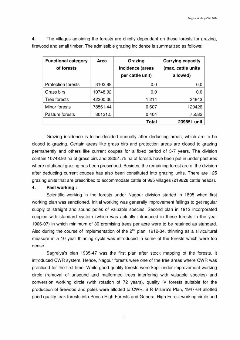
4. The villages adjoining the forests are chiefly dependant on these forests for grazing,
firewood and small timber. The admissible grazing incidence is summarized as follows:
Functional category
of forests
Area Grazing
incidence (areas
per cattle unit)
Carrying capacity
(max. cattle units
allowed)
Protection forests 3102.89 0.0 0.0
Grass birs 10748.92 0.0 0.0
Tree forests 42300.00 1.214 34843
Minor forests 78561.44 0.607 129426
Pasture forests 30131.5 0.404 75582
Total 239851 unit
Grazing incidence is to be decided annually after deducting areas, which are to be
closed to grazing. Certain areas like grass birs and protection areas are closed to grazing
permanently and others like current coupes for a fixed period of 3-7 years. The division
contain 10748.92 ha of grass birs and 28051.75 ha of forests have been put in under pastures
where rotational grazing has been prescribed. Besides, the remaining forest are of the division
after deducting current coupes has also been constituted into grazing units. There are 125
grazing units that are prescribed to accommodate cattle of 995 villages (219828 cattle heads).
4. Past working :
Scientific working in the forests under Nagpur division started in 1895 when first
working plan was sanctioned. Initial working was generally improvement fellings to get regular
supply of straight and sound poles of valuable species. Second plan in 1912 incorporated
coppice with standard system (which was actually introduced in these forests in the year
1906-07) in which minimum of 30 promising trees per acre were to be retained as standard.
Also during the course of implementation of the 2nd plan, 1912-34, thinning as a silvicultural
measure in a 10 year thinning cycle was introduced in some of the forests which were too
dense.
Sagreiya’s plan 1935-47 was the first plan after stock mapping of the forests. It
introduced CWR system. Hence, Nagpur forests were one of the tree areas where CWR was
practiced for the first time. While good quality forests were kept under improvement working
circle (removal of unsound and malformed trees interfering with valuable species) and
conversion working circle (with rotation of 72 years), quality IV forests suitable for the
production of firewood and poles were allotted to CWR. B R Mishra’s Plan, 1947-64 allotted
good quality teak forests into Pench High Forests and General High Forest working circle and

Nagpur Working Plan 2004
iii
continued to keep quality IV areas capable of producing firewood and poles into CWR working
circle. These systems were also continued in the Thosare;s Plan, 1965-80.
The PF in the division were brought under regular and scientific working in the year
1970 when working scheme prepared by Shri S S Parasnis was approved. Sizable area of PF
(21615.38 ha) was kept under Pasture working circle under this scheme. The current plan for
the year 1990-2003, which is under revision has combined RF and PF under one plan.
6. Brief Review of the plan under Revision, that is, Jwala Prasad’s Plan for 1990 to 2003-04.
i. Selection-cum-Improvement Working Circle
It was introduced for the first time in one FS. Hence, it is premature to judge
system’s suitability particularly because-
- marking rules are seen to have not been adhered to scrupulously,
- CBO were not done due to paucity of funds,
- Artificial regeneration failed because of wrong choice of species and biotic
pressures.
ii. Shelterwood system: It was found to be unsuitable due to-
- complex nature of prescriptions which resulted in large scale deviations,
- teak being light demander was not found to be suitable for the system,
- subsidiary operations could not be done due to lack of funds,
- forests lacked sufficient natural regeneration of valuable species, that is,
teak, due to biotic pressures.
iii. Coppice with Reserve working circle: It was found that trees have lost their
coppicing vigor. To compensate this, planting 4 years prior to main felling was
prescribed but it has not been done.
iv. Re-afforestation and Soil Conservation working circle
The performance of the plantations has not been encouraging because of
wrong choice of species, problems of protection and grazing pressure.
v. Pasture and Grass Bir working circles.
Grazing pressure on all forests including Pastures and Grass birs is very high.
7. Following criteria have been developed for the future management:
i. Plan is to be based on primacy of environmental concerns and biodiversity
conservation.
ii. Achieving the Selection forests, in the ultimate analysis, has to be the objective
of management (in the good quality forests) and other systems are basically
intermediary ones.

Nagpur Working Plan 2004
iv
iii. Poor quality forests are incapable of producing commercial timber and, on the
other hand, they are progressively getting degraded due to unregulated grazing
and other biotic factors.
This has resulted in large-scale failures of plantation schemes in the
past. Such forests are therefore generally proposed for rotational grazing
regulations and conservative exploitation to meet the firewood and small timber
requirements of the local people.
iv. JFM arrangements are proposed to be put in place extensively.
v. The working plan prescribed implementation of Wildlife (Protection) 1972 in
letter and spirit and efforts to have certain inputs of wildlife conservation in
managed forests as wildlife management has become synonymous with
biodiversity conservation.
8. Accordingly following working circles have been proposed.
Area specific Overlapping
1. SCI 1. Bamboo
2. IMP 2. NWFP
3. Old Teak Plantation 3. Wildlife
4. Rootstock Management & Afforestation
5. Protection and Catchment Area Management
7. Grass and Fodder Resource
Management
9. Selection and Improvement working circle
i. The areas allotted to this working circle are
Good quality forests containing mature crop. All site quality III and major
portion of quality IV.
Those previously under SCI, shelterwood and CWR.
Compartments having B.A. more than 10.
ii. Silvicultural system is the felling of trees that have attained harvestable girth.
A. Species Site Quality Harvestable girth
Teak II 135
III 120
IV 105
Group 2 Ain, Bija, Haldu, Karam 135
Group 3 Tiwas, Dhawra, Sivan etc. 105
Group 4 Garari, Lendia, Khair 60
Nagpur Working Plan 2004
v
B. No fellings of those species which are less than 1% in their stocking. e.g.
Kulu, Shisham, Semal.
iii. Number of felling series are 24 and average size of the coupe is 115 ha.
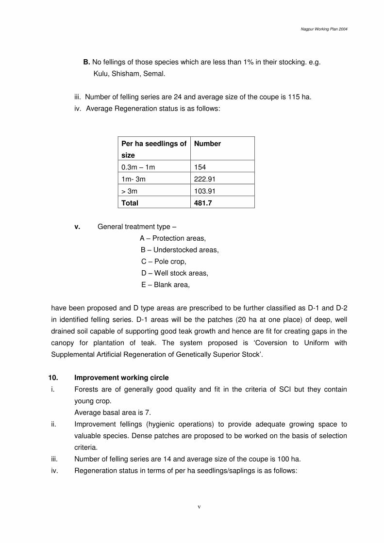
iv. Average Regeneration status is as follows:
Per ha seedlings of
size
Number
0.3m – 1m 154
1m- 3m 222.91
> 3m 103.91
Total 481.7
v. General treatment type –
A – Protection areas,
B – Understocked areas,
C – Pole crop,
D – Well stock areas,
E – Blank area,
have been proposed and D type areas are prescribed to be further classified as D-1 and D-2
in identified felling series. D-1 areas will be the patches (20 ha at one place) of deep, well
drained soil capable of supporting good teak growth and hence are fit for creating gaps in the
canopy for plantation of teak. The system proposed is ‘Coversion to Uniform with Supplemental Artificial Regeneration of Genetically Superior Stock’.
10. Improvement working circle
i. Forests are of generally good quality and fit in the criteria of SCI but they contain
young crop.
Average basal area is 7.
ii. Improvement fellings (hygienic operations) to provide adequate growing space to
valuable species. Dense patches are proposed to be worked on the basis of selection
criteria.
iii. Number of felling series are 14 and average size of the coupe is 100 ha.
iv. Regeneration status in terms of per ha seedlings/saplings is as follows:

Nagpur Working Plan 2004
vi
Per ha seedlings of
size
Number
0.3m – 1m 133.61
1m- 3m 225.66
> 3m 94.34
Total 453.61
v. General treatment type –
A – Protection areas,
B – Understocked areas,
C – Pole crop,
D – Well stock areas,
E – Blank area,
have been proposed and D type areas are prescribed to be further classified as D-1 and D-2
in identified felling series. D-1 areas will be the patches (20 ha at one place) of deep, well
drained soil capable of supporting good teak growth and hence are fit for creating gaps in the
canopy for plantation of teak. The system proposed is ‘Coversion to Uniform with Supplemental Artificial Regeneration of Genetically Superior Stock’.
11. Old Teak Plantation working circle
i. 159 old plantations of teak with an area of 4934.24 ha in 8 ranges have been listed.
ii. Treatment prescribed is-
A. 10th year mechanical thinning in which one of the three diagonally located poles
shall be removed. (in plantations raised in 1993 and afterwards)
B. Silvicultural thinnings in 15th, 25th, 35th, 45th year etc.
iii. As plantations (prior to 1993) have not been thinned in the past, first thinning will be of
B grade only.
iv. For the silvicultural thinning, the criteria will be to compare the actual basal area and
stocking of the plantation with that given in the yield and stand table.
v. Actual mapping of all plantations during the currency of this plan with the help of GPS
has been proposed.
12. Rootstock Management and Afforestation working circle
i. 13465.29 ha of understocked areas are prescribed under afforestation programme and
they are proposed to be covered in 20 years. Rootstock management will be given
priority over plantations.
ii. Average basal area of the forests under this working circle is 4 or less.
iii. 9 felling series with an average coupe size of 75 ha have been formed.
Nagpur Working Plan 2004
vii
iv. Ecological index for Nagpur division indicates planting of 900 seedlings per ha.
v. Choice of species will be for the locally valuable ones and those which are fit for the
particular soil type.
vi. Rootstock Management
Well distributed 400 established seedlings/saplings per ha will be identified.
Healthy and promising coppice shoots (one per stump) will also be s\retained.
Mulching, weeding and soil working of the above seedlings and coppice shoots is
proposed.
vii. Two stage planting technique – poorer areas consisting of refractory soils have been
proposed. It is –
A. Restorative Phase from 1st to 4th year
Year 1 : SMC and Protection measures.
Year 2 : Seed sowing and planting average, Khus
B. Planting place
Year 4 : PPO/Pyo
Year 5 : Planting
The 2nd and 6th year cleaning are prescribed to be undertaken in the 5th and 11th year
of coupe working.
13. Protection and Catchment Area Management Working Circle
i. Compartment with more than half of their area as steep slopes and streams.
Compartments forming catchments of medium and major dams.
ii. Generally good quality forests with average basal area 11.84.
iii. Regeneration status
Per ha seedlings of
size
Number
0.3m – 1m 214.66
1m- 3m 278.38
> 3m 156.22
Total 644.62
iv. The areas not in the steep slopes, that is, those forming catchments are proposed to
be worked on conservative harvesting basis, which is removal of 2 trees of harvestable
size per ha.
However, this harvesting will be done in indirect catchment only so as
not to lead to increase in soil erosion. Therefore, coupes are laid only in indirect
catchment.

Nagpur Working Plan 2004
viii
v. Catchment areas are proposed to be given special attention for soil and moisture
conservation work and under plantation programme.
Plantation of species suitable for soil and water conservation has been
prescribed.
vi. Water body may be included under eco-tourism programme as well.
14. Grass and Fodder Resource Management working circle
i. Working circle includes 12 treatment series of Grass birs with an area of 10210.73 ha
which are to be permanently closed. (37 Grass birs)
16 pasture series with an average coupe size of 480 ha and total area of 30131.5.
ii. Average basal area is 3.6.
iii. Rotational grazing in a 4 years cycle has been proposed in pasture series.
iv. Grass improvement works in grass birs by way of removal of woody growth and weeds
as well as seed sowing of improved grasses has been proposed.
v. The tree crop is proposed to be worked under coppice selection system, in which 1 out
of 3 stems available silviculturally (those above 45 cm. GBH, 30 cm in case of Garari)
and malformed and over-mature trees shall be removed and in which regeneration in
mostly of coppice origin.
The material removed as above is intended to meet the local requirements of
firewood and small timber.
15. Bamboo (overlapping)
Previous plans show bamboo in 80 compartments but major bamboo area having gone
to wildlife (Pench tiger reserve) & FDCM, bamboo working is not very significant now in
Nagpur division. It occurs occasionally scattered in 10527.25 ha in 39 compartments of three
ranges viz Deolapar, Ramtek and Parseoni and in some of old bamboo plantations throughout
the division. Hence, such areas are kept under this working circle.
16 cutting series, each having 3 coupes – A, B and C.
16. NWFP
Official NWFP collection figures which are mostly for gum (Dhawada) are not very
encouraging.
Kullu gum collection (illegal) needs to be strictly controlled and stopped completely.
NWFP species like Dhawada (even if their % is high) need reservation against felling.
Identification of non-traditional NWFP species needs attention.
Regeneration NWFP trees through their inclusion in plantation programme and
manipulating NR (root suckers).
Nagpur Working Plan 2004
ix
There is a need to improve tapping technique for gum. FRI method of gum tapping has
been proposed and only 50% of mature trees are prescribed to be tapped.
Proposed to link it with JFM programme to increase stocking of NWFP trees, methods of
collection as well as exploration of non-traditional NWFPs.
NWFPs other than tendu, and those reserved for TDC, need to be identified and a
mechanism to control their production and disposal need to be developed.
Creation of database in this regard has been proposed.
17. Wildlife (overlapping)
i. Wildlife is in effect synonymous with bio-diversity conservation. Wildlife
(Protection) Act 1972 provide elaborate provisions for wildlife conservation
outside the PAs also that is in managed forests.
ii. Forests of Nagpur division occupy an important place in wildlife management on
following counts.
Organizing special and effective anti-poaching measures in Central India.
Providing corridor to PTR as well as Bor WLS.
Developing eco-tourism in Vidarbha area.
iii. Implementation of standing order 001 from PCCF (WL) in letter and spirit is
suggested, which mandates.
preparing inventory of water holes and special vigilance there
Sensitizing and strengthening anti-poaching machinery
timely and effective dealing of compensation cases of injury due to wildlife.
iv. Identification of ecologically sensitive sites which are important from wildlife
management point of view.
v. Development of eco-tourism in 45 sites and 20 circuits identified.
vi. Development of following facilities at Gorewada.
Zoo
Nature Interpretation Center
Forest Park
vii. Special conservation of alternative home of GIB in Nagpur-Mauda-Umred-
Butibori-Nagpur as designated PPA-Pilot Project Area, with the NGO
intervention.
18. Miscellaneous regulations
1. Fixation of outer boundaries
Priority areas
Erstwhile Forest villages,
Zudapi jungle and non-forest land made available as compensatory land,

Nagpur Working Plan 2004
x
Protected forests.
2. Management of miscellaneous area (Zudapi jungle and Non-forest land).
Besides the demarcation and fixation of boundaries of these lands, attempts
will be made to collect scientific information during the currency of this plan so
that regular management of these lands is started as early as possible. For the
areas of Ambazari and Gorewada, prescriptions have however been given
under P&CAM&CAM as well as wildlife overlapping working circle.
3. The RF and PF have been digitized fully and the geo-media cell in the officer of
the Conservator of Forests, Working Plans Circle, Nagpur is now the custodian
of this information. PF ahs been digitized using village maps. Hence, these
maps should be very handy for management as well as for fixing the boundary.
However, some validation prior to routine use of these maps is recommended.
4. JFM arrangements are recommended to be given due place of prominence
while deciding the agency of harvesting / working. GFRM, RSM&A and NWFP
working circles are specially recommended for this purpose. Areas under other
working circles, and activities prescribed therein, may be assigned to JFMCs
on case to case basis. However, due to the high skill and periodical monitoring,
working in old teak plantations has been prescribed to be through departmental
agency only.
It is recommended that different categories of forests (areas under
different working circles) may be assigned to a JFMC; the needs of the village/s
identified and quantified on the basis of nistar partak and wazib-ul-arz; and
such needs/dependences are met from the forests assigned. These aspects
will be covered in the micro-plan developed and formulated for each village.
19. Reorganization constituting two divisions - North and South Nagpur, which is long
overdue, has been reiterated in this plan also. The division in its present form is unwieldy and
hence is recommended to be split into two during this plan period.
*******

Nagpur Working Plan 2004
c
IV. Local and Botanical names of Plants occurring in
Nagpur Forest Division
Local Name Botanical Name Family
A. Trees
Achar Buchanania latifolia (Spr.) Anacardiaceae
Amaltas/Bahawa Cassia fistula, (L.) Caesalpiniaceae
Apta / Kachnar Bauhunia racemosa, ( Lam.) Caesalpiniaceae
Aonia Phyllanthus emblica, (L.) Euphorblaceae
Aran Cassine glauca, (Rottb.) Calastraceae
Arjun / Kahu Terminalia arjuna, (DC.) Wight Combretaceae
Ain Terminalia tomentosa Combretaceae
Babul / Babhool Acacia arabica, (L.) Wild ex Del. Mimoseae
Bad/Wad Ficus bengalensis(L.) Moraceae
Behada Terminalia belerica (Gaertn.) Roxb. Combretaceae
Bel Aegle marmelos (L.) Corr. Rutaceae
Bhirra Chloroxylon swietenia (Roxb.) DC Rutaceae
Biba/Bhilawa Semecarpus anacardium Anacardiaceae
Bija Pterocarpus marsupium, (Roxb.) Fabaceae
Bistendu Diospyros montana, (Roxb.) Ebenaceae
Bor/Ber Ziziphus mauritiana, (Lam.) Rhamnaceae
Chichwa Albizzia odoratissima, (Lf.) Bth Mimoseae
Chinch/Imli Tamarindus Indica,(L.) Caesalpinaceae
Datrangi Ehretia laevis, (Roxb.) Ephretiaceae
Dhaman Grewia tiliaefolia, (vahl.) Tiliaceae
Dhaora/Dhawada Anogeissus latifolia, (R.Br. ex. DC) Combretaceae
Dhoban Dalbergia paniculata, (Roxb.) Fabaceae
Garari Clelstanthus collinus, (Roxb.) Euphorbiaceae
Bth. ex. Hook. F.
Ghogar Gardinia latifolia, (Soland.) Rubiaceae
Ghoti/Ghot Ziziphus xylopyra, (Sedgw) Sant Rhamnaceae
Nagpur Working Plan 2004
d
Local Name Botanical Name Family
Gogal/Gongal Cochlospermum religiosum, (L.) Chlorospermaceae
Gular Ficus glomerata,(Roxb.) Urticaceae
Haldu Adina cordifolia, (Roxb.) Rubiaceae
Hiwar Acacia leucophloea Mimoseae
Hirda/Harra Terminalia chebula, (Retz.) Wild Combretaceae
Jambhul/Jamun Eugenia Jambolana, (L.) Skeels Myrtaceae
Kalakarai Casearia elliptica, (Wild.) Fabaceae
Kalaphetra Randia uliginosa, (DG) Rubiaceae
Kakad Garuga pinnata,(Roxb) Burseraceae
Kakai Flacourtia indica,(Burm. f.) Flacourtiaceae
Karai Miliusa velutina,(Dunal) Anonaceae
Karam/Mundi Mitragyna parviflora,(Roxb) Rubiaceae
Karanj Pongamia pinnata, (L.) Prerre Fabaceae
Kashid Cassia siamea, (Lam.) Caesalpiniaceae
Kateain/Kasai Bridelia retusa , (L.) spr. Euphorbiaceae
Katsawar/Semal Bombax ceiba, (L.) Bombaceae
Khair Acacia catechu, (L.F.) Wild Minosaceae
Khirni Manilkara hexandra, (Roxb.) Sapotaceae
Kullu/Kulu Sterculia urens,(Roxb.) Sterculiaceae
Kumbhi Careya arborea, (Roxb.) Lecythidiaceae
Kusum Schleichera oleosa, (Lour.) Sapotaceae
Lendia/Lenda Lagerstroemia parviflora, (Roxb.) Lythraceae
Lokhandi Ixora arborea, (Roxb.) ex.J.E.sm Rubiaceae
Maharukh Ailanthus excelsa, (Roxb.) Simaroubaceae
Medsing Dolichandrone falcata, (Seem.) Bignoniaceae
Moha/Mahuwa Madhuca longifolia, (Koen.) Macbride Sapotaceae
Mokha Schrebera swietenioides, (Roxb.) Aristolochiaceae
Moyen/Mowai Lannea coromandelica (Houtt.) Anacardiaceae

Nagpur Working Plan 2004
e
Local Name Botanical Name Family
Neem Azadirachta indica, (A.Juss.) Maliaceae
Padar Stereospermum susveolens Bignoniaceae
Palas Butea frondosa (Lam.)Taub Fabaceae
Pangara Erythrina variegata (L.) Fabaceae
Rohan Soymida febrifuga (Roxb.) Meliaceae
Sag/ Sagwan/Teak Tectona grandis, (L.F.) Verbenaceae
Saja/Ain Terminalia tomentosa, (Heyne ex. Roth) Combretaceae
Salai Boswellia serrata, (Roxb.ex. Colebr) Burseraceae
Shisham Dalbergia latifolia, (Roxb.) Fabaceae
Shiwan/Siwan Gmelina arborea, (Roxb.) Verbenaceae
Siras (Black) Albizzia lebbek, (L.) Bth. Mimosaceae
Siras (White) Albizzia procera, (Roxb.) Bth. Mimosaceae
Sissoo Dalbergia sissoo (Roxb.) Fabaceae
Sitaphal Annona squamosa, (L.) Annonaceae
Subabul Leucaena leucocephala (L.) Mimosaceae
Surya Xylia xylocarpa, (Roxb) Mimosaceae
Tendu Diospyros malanoxylon (Roxb) Ebenaceae
Tiwas/Tinsa Ougeinia dalbergioides, (Roxb.) Fabaceae
Tondri Casearia tomentosa, (Roxb.) Samydaceae
Umber Ficus glomerata, (L.) Moraceae
Wandra/Bainsa Salix tetraperma, (Roxb) Salicaceae
Warang/Baranga Kydia calycina, (Roxb.) Malvaceae
White kuda/Satkuda/ Holarrhena pubescens Apocynaceae
Kuda (Buch. Ham.) Wall. ex. G. Don
B. Shrub
Aal Moringa citrifolia, (Linn.) Celastraceae
Bharati Maytenus emarginata, (Wild) Celastraceae
Bhawarmal Hamlitonia suaveolens, (Roxb.) Rubiaceae
Nagpur Working Plan 2004
f
Local Name Botanical Name Family
Dikamali Gardenia resinfera, (Roxb.) Rubiaceae
Dudhi/Kalakuda Wrightia tinctoria, (Roxb) Apocyanaceae
Gautri Grewia hirsuta (Vahl, symb.) Tiliaaceae
Ghaneri/Ulta Lantena Camera, (Linn.) Verbenaceae
Jilbili Woodfordia fruticosa, (Kurz) Lythraceae
Kaladhotra Datura metel, (Linn) Solanaceae
Katekolati Barleria prionites, (Linn.) Acanthaceae
Katumber Ficus hispida, (Linn) Moraceae
Kharata Dodonea viscosa, (Linn.) Sapinadaceae
Kharasani/Kharasi Nyctanthes arbortristis, (L.) Astraceae
Muradsheng/ Marophal Helicteres isora, (L.) Sterculaceae
Neel Indigofera tinctoria, (Linn.) Fabaceae
Nirgudi Vitex negundo, (L.) Verbanaceae
Phetra (Safed) Gardenia turgida, (Roxb) Rubiaceae
Rui Calotropis procera, (AitI) R. Br. Asclepiadaceae
Sindhi/Chhindi Phoenix sylvestris, (Linn) Areacaceae
(Palmae)
Waghnakhi Martynia annua, (Linn) Martyniaceae
C. Herbs
Divali Tephrosia hamiltonil, (Drumm) Fabaceae
Gajargawat Parthenium hysterophorus (Linn) Astraceae
Gokru Tribulus terrestris (Linn) Zygophyllaceae
Hamata Stylosanthes hamata (L.)
Kamarmodi Tridax procumbens (Linn) Astraceae
Pivla dhotra Argemone mexicana (L.) Papaveraceae
Pivilitilwan Cleome viscosa (Linn) Cleomaceae
Rantulasi/Bantulasi Hyptis suaveolins (Linn) Lamiaceae
Rantur Atylosia scarabaeoides, (L.) Fabaceae

Nagpur Working Plan 2004
g
Local Name Botanical Name Family
D. Bamboo and Grasses
Bans/Bamboo Dendrocalmus strictus, (Roxb) Poaceae/ (Gramineae)
Bhurbhusi Eragrostic tenella, (L.) Poaceae/(Gramineae)
Dab/Dabat/ Phylpya Imperata cylindrica, (Beauv) Poaceae/(Gramineae)
Diwartan Andropogan pumilus, (Roxb) Poaceae/(Gramineae)
Duswa/Hariyalli/Doob Cynodon dactylon, (prs) Poaceae/(Gramineae)
Gadasheda Chrysopogon fulvus, (Spr) Poaceae/(Gramineae)
Ghonad Themeda quadrivalvis (L.), O.ktze Poaceae/(Gramineae)
Fuler Arundinella setosa, (Trin) Poaceae/(Gramineae)
Katanbahari/Kusara Aristida funiculata, (Trin. et. Rupr) Poaceae/(Gramineae)
Katang bamboo Bamboosa arundinacea, (Willd) Poaceae/(Gramineae)
Khas Vetiveria zizaniodes, (Linn) Nesh Poaceae/(Gramineae)
Kusal Hetropogon contortus, (Linn) Dicanthium
Marvel (Small) Dicanthium annulatum, (Forssk) Poaceae/(Gramineae)
Marvel (Big) Dicanthium aristaum (Poir) Poaceae/(Gramineae)
Mushan Iseilema laxum (Heck) Poaceae/(Gramineae)
Paonia Schima sulcatum (Heck) Poaceae/(Gramineae)
Phulkia Apluda mutica, (Linn) Poaceae/(Gramineae
Sabai / Sum Ischaemum angustifolium (Heck) Poaceae/(Gramineae)
Sheda Sehima nervosum (Rottl.) Poaceae/(Gramineae)
Tikhadi Cymbopogon martini (Roxb.) Poaceae/(Gramineae)
D. Climber
Aradphari Olax scandens, (Roxb.) Olacaceae
Chilati Mimosa hamata (Willd) Mimoseae
Dhimarwel/Malkagni Celastrus paniculatus (Willd) Celastruseae
Dhudhi/ Bokadwel/ Cryptolepis buchanani, R. & S. Periplocaceae
Nagwel
Eruni Zizyphus oenoplia, (L.) Mill Rhomnaceae

Nagpur Working Plan 2004
h
Local Name Botanical Name Family
Gunj Abrus trecatorius, (L.) Fabaceae
Gulvel Tinospora coardifolia, (Willd) Menispermaceae
Kajkuri Mucuna pruriens, (L.) D.C. Fabaceae
Khadyanag/ Langali Gloriosa superba, (L.) Liliaceae
Khobarvel Hemidesmus indicus, (L.) Ait. Periplocacea
Kukudranji Calicopteris floribunda, (Land) Combretaceae
Mahulbel Bauhinia vahli, (Wand. A) Caesalpiniaceae
Nasbel Milletia extensa, (Bth.) Baker Papilionaceae
Papri Lalbel Vantilago denticulata, (Willd) Rhamnaceae
Palasvel Butea superba (Roxb) Liliaceae
Piwarvel Combretum ovalifolium (Roxb) -------------
Ramdaton Smilax macrophylla, Smilaceae
Vasanvel Cocculus hirsutus, (L.) Diels. Menispermaceae
F. Parasites
Amarvel Cuscuta reflexa, (Roxb) Cuscutaceae
Bandha/ Bandh Vanda tessellata, (Roxb) Orchidaceae
Scabra Stylosanthes scabra ----------------
Tarota Casia tora, (Linn) Caesalpiniaceae
******
Nagpur Working Plan 2004
i
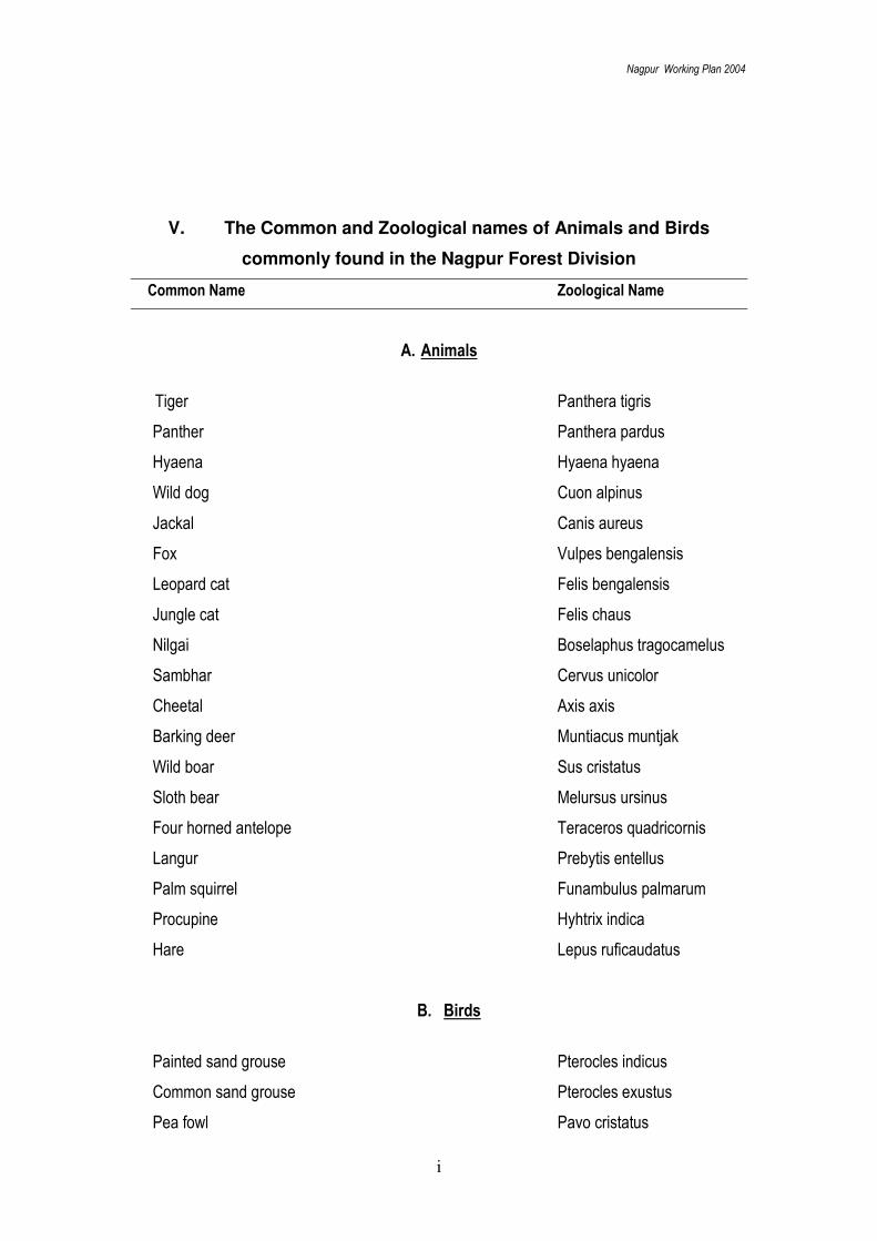
V. The Common and Zoological names of Animals and Birds
commonly found in the Nagpur Forest Division
Common Name Zoological Name
A. Animals
Tiger Panthera tigris
Panther Panthera pardus
Hyaena Hyaena hyaena
Wild dog Cuon alpinus
Jackal Canis aureus
Fox Vulpes bengalensis
Leopard cat Felis bengalensis
Jungle cat Felis chaus
Nilgai Boselaphus tragocamelus
Sambhar Cervus unicolor
Cheetal Axis axis
Barking deer Muntiacus muntjak
Wild boar Sus cristatus
Sloth bear Melursus ursinus
Four horned antelope Teraceros quadricornis
Langur Prebytis entellus
Palm squirrel Funambulus palmarum
Procupine Hyhtrix indica
Hare Lepus ruficaudatus
B. Birds
Painted sand grouse Pterocles indicus
Common sand grouse Pterocles exustus
Pea fowl Pavo cristatus
Nagpur Working Plan 2004
j
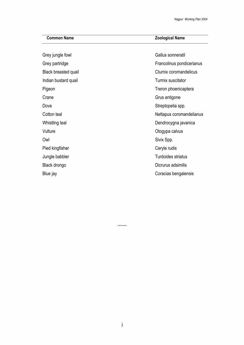
Common Name Zoological Name
Grey jungle fowl Gallus sonneratil
Grey partridge Francolinus pondicerianus
Black breasted quail Cturnix coromandelicus
Indian bustard quail Turmix suscitator
Pigeon Treron phoenicaptera
Crane Grus antigone
Dove Streptopelia spp.
Cotton teal Nettapus coromandelianus
Whistling teal Dendrocygna javanica
Vulture Otogypa calvus
Owl Sivix Spp.
Pied kingfisher Ceryle rudis
Jungle babbler Turdoides striatus
Black drongo Dicrurus adsimilis
Blue jay Coracias bengalensis
*******

Nagpur Working Plan 2004
1
Draft Working Plan Report of the Nagpur Forest Division
Part – I: Summary of the Facts on which the Proposals are based
Chapter 1. NAME AND SITUATION
1.1. INTRODUCTION
1.1.01. This working plan deals with all the forest areas of the Nagpur district except
those forest areas which have been transferred to the Pench National Park, Bor Wildlife
Sanctuary and the Forest Development Corporation of Maharastra (FDCM). The total
forest areas of the division are 2388.857 sq km of which 273.479 sq km constitute the
Protected Areas of Pench National Park and Bor Sanctuary and 394.110 sq km are with
the FDCM. It constitutes 24.14 percent of geographical area of the district, which extends
over to 9,892 sq km.
1.1.02. The forest
areas included in this
working plan is
1721.268 sq km, out of
which 852.124 sq km
are the Reserved
Forests, 26.405 sq. km
are the new Reserved
Forest, 700.426 sq km
are the Protected
Forests and 146.17 sq
km are the Zudupi
Jungles and 2.935 sq
km as the Non Forest
lands. The Jawala
Prasad’s Plan for these forests expired in 2000, leading to its revision in the shape of this plan. The Division
constitutes a compact forest block in North-eastern part while in the remaining areas of
the Division, forests patches are found scattered and interspersed with non-forest areas.
1.1.03. The boundary of the Nagpur Division is coterminous with the boundary of the
Nagpur district. The Nagpur Division extends over to 20º 35' to 21º 44' North as latitude
and 78º 15' to 79º 40' East as longitude. The boundaries of the tract dealt with are given,
as under:
North Chhindwara and Seoni Districts of Madhya Pradesh
East Bhandara District of Maharashtra
South Chandrapur and Wardha Districts of Maharashtra
West Amaravati and Wardha Districts of Maharashtra
Deolapar
Hingna
Kondhali
Narkher
ParseoniRamtek
Khapa
S'Hills
Kuhi
S/Umred
N/Umred
Pench
Bor
M.P.
BHANDARA
CHANDRAPUR
WARDHA

Nagpur Working Plan 2004
2
1.2. CONFIGURATION OF THE GROUND
1.2.01. The forests are widely spread and mainly situated on hilly slopes surrounded
by cultivated plains. The majority of forest areas in the Division are plain and undulating,
whereas, West and North-east portions are hilly. Altitude in the Division varies from 274
meters to 652 meters above Mean Sea Level. The highest point falls in the Narkhed
Range along the boundary with Madhya Pradesh.
1.2.02. Major hill ranges of the Division are the Satpura Range, the Ambagarh Hills
and the Pilkapar Hills. Southern fringes of the Satpura Range extend to the Nagpur
District. This range is narrow in the West while it widens towards the East. The
Ambagarh Hills having famous Ramtek temple are located to the South of Satpura hills.
The Pilkapar Hills, consisting of low hills in the western part, continues towards South-
east part of Umrer after cutting off the valley of Nand on its southern side, and crosses
the Katol Tahsil from North to South.
1.2.03. The Division is well drained and falls in the catchments of the Wardha and the
Wainganga rivers. Jam, Kar and Vina rivers drain the western part before draining into
the Wardha river. Southern part of Umrer Tahsil is drained by Nand river, which meets
Vena and ultimately drains into the Wardha river. Pench and Kanhan drain the central
part and Koilar joins them at Kamptee. Thereafter, Kanhan flows at boundary of Kamptee
and Kuhi Tahsils and drains into the Wainganga river. Nag and Amb drain Umrer and
Kuhi Tahsils. Nag joins Kanhan, while Amb drains directly into the Wainganga river.
Bhiwapur Tahsil is drained by Mau, which flows along the North and eastern boundary of
the division and discharges into the Wainganga river. Sur after flowing along Ramtek
Tahsil also drains into the Wainganga river.
1.3. GEOLOGY, ROCK AND SOIL
Geological formation
1.3.01. Ancient crystalline rock mainly consisting of gneiss and granulate occupy
North-east portion, and a 25-km wide East-west stretch in North-central part of the
division. The Deccan Trap volcanic flow lies in western and southern parts of the division.
In addition, a large number of sedimentary rock formations including some coal bearing
beds are also found (Table 1.1).
Table 1.1. Rock formations in Nagpur District (Source: The Geological Survey of India)

Nagpur Working Plan 2004
3
Geological formation Rock assemblage Geological Period
Alluvium Soil, Kankar and Laterite Recent.
Deccan Trap Volcanic flow with partings of sedimentary rocks like
limestone and sandstone
Upper cretaceous Eocene
Lameta Conglomerate, Sandstone, limestone and clay Upper cretaceous
Gondwana super group Dark brownish and Grey sandstone Permian
Sausar group
(i) Bichua fomation
(ii) Junewani formation
(iii) Chorbaoli formation
(iv) Mansar formation
(v) Lohangi formation
(vi) Sitasaongi formation
Crystalline lime stone and dolomite
Muscovite-biotite schist and dolomite.
Quartzite & quartz
Muscovite-biotite schist with manganese ores
Calc-gneisses and black manganiferous marble
with some manganese ores
Quartz-muscovite schist feldspar-muscovite schist
and intercalated quartzite.
Middle proterozoic
----do---
----do---
----do---
----do---
----do---
Geological formation Rock assemblage Geological Period
Sakoli group Chlorite-muscovite schist and middle
phyllite (undifferentiated)-proterozoic
(a) Chlorite schist with andalusite porphyroblast
(b) Chlorite schist with chloritoid porphyroblast
(c) Chlorite schist with magnetite
(d) Phyllite
(e) Chlorite schist with chloritoid,staurolite garnet
(f) Rutile-quartz-tourmaline-muscovite schist with
kyanite,dumortierite or sillimanite
(g) Biotite gneisses, granulite and biotite aplite
Middle proterozoic
----do---
----do---
----do---
----do---
----do---
----do---
Granite gneiss Granite, quartzite, amphibolites and granite gneiss Archean lower proterozoic
1.3.02. The Tirodi-biotite gneiss, streaky gneiss consisting of Hornblende gneiss and
amphibolite, is found in the central part. Northern part has a fairly wide East–west stretch
of banded and foliated crystalline rocks. Manganese bearing rocks are found in the
Sausar group. Metamorphosed rocks of the Sakoli group are located in the southern
part. These rocks are intruded by tourmaline-garnet-muscovite granite. The Sakoli
group, at places, has indications of base metals and Tungsten mineralisation near
Bhiwapur and Agargaon in Umrer Tahsil, respectively.
1.3.03. The Deccan Trap occupies almost half of the division and gives rise to
characteristics plateau-type hills separated by broad valleys in West and Southwest. The
Trap is a thick pile of basaltic flow sometimes up to 60 km thick with sedimentary Inter-
Trappean beds of limestone, and sandstone deposited during breaks in volcanic
activities. Trap basalt is usually dark grey compact and fine grained rock with clinkery
surface and irregular to sub-rounded blocks. Laterite capping tops the Trap zone areas
at places.
Nagpur Working Plan 2004
4
1.3.04. Conglomerates and sandstone of the Vindhyan super-group are exposed over
a stretch of about 3 (three) kilometres in southern part of the Dongal ridge South of
Tarna and around Deni in Umrer Tahsil. Narrow and disconnected stretch of exposed
fosilliferrous sandy and gritty lime stones constituting the well known Lameta beds are
found at about 40 km south-east of Nagpur and about 10 km north-west of Umrer.
These are succeeded by the Deccan Trap volcanic flows. Towns of Kamptee and Umrer
have coal bearing sandy-clayey rocks belonging to the Godwana super-group. Many
important coal-fields of the Central India are yielding coal from these beds. Alluvium with
thickness up to 30 meter at places occupies the Wainganga basin.
Mineral Deposits
1.3.05. Nagpur district is well known for its minerals of economic importance. In
addition to coal, clay and building stones, major minerals in the district include
manganese, copper and tungsten ores.
1.3.06. Coal occurs near Kamptee and Umrer in the Barakar rocks of the Gondwana
super-group. Coal found here is of low non-coking grade having high moisture content.
However, it is quite useful for steam generation; and is used in two major thermal power
stations, namely, the Koradi and Khaperkheda in the district. This coal is also supplied to
the Indian Railways and to some steel plants, primarily, for steam generation.
1.3.07. Clay deposits are associated with the Kamthi formation of the Gondwana
Supper-Group. Estimated clay reserve is 1.2 million tonnes. It is used for manufacturing
pipes and stoneware, and one such unit is at Kanhan. Kamthi sandstone yields good
building stones and a number of quarries are located at Silewara and Bokhara. Trap
basalt is also used for road metal, concrete aggregate and blocks. Marble of the Sausar
Group extracted near Koradi and Kandri is used for lime production and marble chips.
1.3.08. About 55 known deposits of manganese ore having 3.33 million tonnes of
recoverable ore is found in 50 km. long and 17 km. wide stretch in Ramtek Tahsil. The
known sites include Gumgaon, Ramdongri, Kodegaon, Kandri, Satak, Mandi, Lohdongri,
Kachurwahi, Waregaon, Bhandarbodi, Manegaon, Maudekasa and Hiwara. A part of the
extracted ore is used for manufacturing ferromanganese in a plant at Kanhan. Most of
the mined ore is consumed in various steel plants within the country while a small part is
exported also.
1.3.09. Copper mineralisation had occurred along contact zone between quartzite and
phylite of Sakoli group near Pular and Parsori in Umrer Tahsil. Tungsten bearing
Wolframite and schists in chloritic schists of Sakoli group is found at Agargaon in Umrer
Tahsil over a belt of 1400 meter. Gold is found in Bluish-grey quartz veins in Sakoli
formation. Stream sands near Mokhabardi and Kolari in Umrer Tahsil also have grains
of gold.
Nagpur Working Plan 2004
5
Soil types
1.3.10. Soil types in the division are strongly influenced by the dominant underlying
rock types – the ancient metamorphic rocks and the Deccan Trap. The metamorphic
rocks are found in Ramtek, Deolapar, Parseoni, Khapa, Kuhi and north east of North
Umrer ranges. The Archean rocks produce a variety of soils. Slow decomposition and
small soil movement produces rich ‘Kankar’ soil, but rapid disintegration and much flux produces coarse and sandy soil. Alluvium derived from this rock is never stiff as the fine
particles of sand prevent the blocking of the soil pore space. Alluvium in metamorphic
zone is very good for the tree growth. Soil is mostly sandy-loam, which is eminently
suited to the tree growth.
1.3.11. Deccan Trap is found in Narkhed, Kondhali, Hingna, South Umrer ranges and
in the parts of North Umrer range. Soils derived from the Trap differ on the basis of the
compactness of the source rock. Two kinds of Trap rocks are distinguishable. Compact,
hard and homogeneous type. Such rocks weather very slowly and process of soil
formation is extremely slow. These soils can support poor quality tree growth. Other
rocks are softer basalt exfoliating in concentric flakes. It decomposes rapidly yielding fine
yellowish brown loamy soil capable of supporting valuable tree crop. Finer soil grains
and decomposed organic matter are gradually washed away and deposited in the lower
sheltered regions forming ‘Regur’ patches or black cotton soil. This is a fine-grained dark
soil, which varies greatly in colour, consistency and fertility. It becomes highly adhesive
when wet and contracts to an unusual extent under influences of heat and drought.
Being clayey in nature, ‘Regur’ is highly hygroscopic, that is, absorbs large quantity of
moisture when it is dry and the soil particles begin to swell at the saturation point
reducing considerably the soil pore space. This causes water logging. Although this soil
is chemically rich, it is not always suited to raise plantation unless the drainage is good.
For instance, good forests on such soils can be seen along streams with vertical cutting.
Presence of kankar (calcareous content) in ‘Regur’ generally indicates high alkalinity and such soil are less suitable for growth of vegetation. The proportion of SiO2/ RiO2 in such
soils is very high and these soils also have high dispersion constant. Sand and silt are
the products of physical weathering and clay is the product of chemical weathering and it
is clay which determines the quality of soil like high water holding capacity, acidity etc.
1.3.12. The inter-trappean formation disintegrates into fertile loam capable of
supporting good forest growth. The soil derived from Lametas does not seem to be
influencing the vegetation. Micaceous schists of Sakoli series produce rich loam that
supports valuable mixed forests of the division. Laterite, a vesicular mixture of hydrated
oxides of iron and aluminium, is found at some places. After weathering, it retains much
moisture in the wet seasons and dries quickly in the dry period. Hence, it is generally
poorly suited for teak growth.
Nagpur Working Plan 2004
6
1.4. CLIMATE
1.4.01. Nagpur has hot and dry climate with distinct three seasons: summer, rainy and
winter seasons. The summer starts from mid-February and continues till onset of the
monsoon in the middle of June. April and May are very hot and day temperature may
soar up to 45º C. For instance, in the year 1998 the maximum temperature was 46.8º C
in the month of May and the minimum temperature was 6.60C in the month of December.
Rains start in the middle of June and continue up to the end of September. Few showers
are common in October and November. The winter starts from the end of November and
lasts till mid-February. Diurnal temperature range is maximum during March and
minimum during August. Very hot summer adversely affects vegetation growth more so
because of highly radiating exposed quartzite and basalt in the tract (Appendix 1.1).
RAINFALL AND HUMIDITY
1.4.02. The rainy season generally starts from the second week of June and continues
up to the end of September every year. About 85 percent of rainfall is received during the
summer monsoons. Maximum rainfall, about 29% of the total, is received during the
month of August. The average annual rainfall in the division is about 1,100 mm. Rainfall
is usually higher on ridges of the Satpura in (Deolapar ~1200 mm), Ramtek and Parseoni
ranges, and gradually decreases towards the west. Rainfall in Katol is about 869.95 mm.
The number of rainy days varies from 59 to 82 per annum. (Appendix 1.2). It is mostly
the south-west monsoon originating in Arabian sea. Winter rains are negligible.
1.4.03. The relative humidity is the highest in the month of August, generally,
decreases till the month of April, thereafter, it begins to increase again with the onset of
the summer monsoon.
FROST, DROUGHT AND WIND
1.4.04. Although rare, the frost occurs occasionally in Khapa, Parseoni, Deolapar and
Ramtek ranges, along the Pench River and other low lying areas. Occurrence of frost
causes injuries to the young forest crop especially that of teak, lendia and garari. Some
frost damage to young growth in low-lying patches has been recorded in 1928-29, 1936-
37, 1942-45 and 1945-46. The damage is less as the tropical species have an adaptation
to pass into dormant phase during the winter.
1.4.05. The worst damage to the forest crop due to drought was occurred in 1939-40
and 1941- 42. Mature and established crops are seldom affected by drought. However,
natural regeneration and the young crops are affected severely due to lack of soil
moisture, that is, physiological dryness and increased probability of occurrence of forest
fires.
1.4.06. The winds are generally moderate, but occasional storms occur in the pre-
monsoon period. Six months from October to March experience North-easterly wind, and
the months of April to September have South-westerly wind.

Nagpur Working Plan 2004
7
1.5. WATER SUPPLY
1.5.01. High temperature, existence of only a few perennial rivers and quick draining
off of the rainwater causes acute water scarcity in the division during the summer
months. It is estimated that rainfall more than 5 cms per day usually results in surface
runoff. Drinking water in many villages is supplied by tankers. However, construction of
many dams, both big and small, has eased out the situation to some extent over a large
area. The Forest Department has also built many anicuts and tanks in the forest areas
(Appendix 1.3a).
1.5.02. There are many dug-wells and bore-wells to tap the groundwater. Depth of
dug-wells varies from 12 to 15 meters, and their yield is 45,000 – 1,00,000 litres per day.
Most of the wells, however, go dry after March. Bore-wells are generally 50 to 60 meters
deep, and have yield in the range of 11,000 – 75,000 litres per day. Metamorphic rocks
have good groundwater storage with well-defined water table, but the groundwater in the
Deccan Trap zone is confined to joints and sheeted zones along the flow contacts and
the bole beds. Interconnected vesicles in vesicular basalt may make such rocks
permeable and good aquifer. (Appendix 1.3b).
1.6. DISTRIBUTION AND AREA
RESERVED FORESTS
1.6.01. The total Reserved Forests (RF) in the undivided Nagpur division was
1,87,191.55 hectare in 72 blocks, till 1959, when the Wardha division was carved out by
transferring 52,657.33 hectares in 217 compartments of the Reserved Forests. The
balance Reserved Forests with the Nagpur Division at that time was 1,27,881.55
hectares, in 497 compartments. These Reserved Forests are often referred as Old
Reserved Forests (ORF). Subsequently, 11,270.71 hectares of the Protected Forests
was notified as Reserved Forests during 1977-78. These forests are, referred as, the
New Reserved Forests (NRF). (Appendix 1.4).The net balance Reserved Forests in the
charge of Nagpur Division constitute 85,212.41 ha in 407 compartments and is given in
Table 1.4. The area 2640.45 ha. of Gorewada and Ambazari has been notified in 1990
under section 4 of IFA, 1927. This has been constituted into 10 compartments.
PROTECTED FORESTS
1.6.02. Consequent to the abolition of the proprietary rights in 1951, the ex-
proprietary forests were taken over by the Government. Subsequently,
97,492.228 hectares of the ex-proprietary forests in 594 villages was handed over
to the Forest Department and declared as the Protected Forests in 1955. A total
of 2,784.06 hectares of the Protected Forests was deforested for various
purposes in different villages during 1970-73. As described above 11,270.71
hectare of the Protected Forests in 72 villages were declared as the Reserved
Forests in 1977-78. The balance area of the Protected Forests in this division is
70042.60 hectares, distributed in 594 villages of the division have been organized
in 501 compartments. The net Protected Forests in the charge of Nagpur Division
have been given in Table 1.4. The matter relating to regulation of removal of
Nagpur Working Plan 2004
8
forest produce and grant of licenses etc. for such removal by local people from
these protected forests is provided in the Bombay Protected Forests (Vidarbha
Area) Rules, 1959. Area of 2 villages (Dhawalapur-mal & Pardi - rithi) were
excluded in previous plan. The necessary corrections have been done under this
plan for including this area and 2 compartments have been added accordingly.
(Appendix 1.5).
ZUDUPI JUNGLE TAKEN OVER BY THE DIVISION
1.6.03. The Revenue Department has transferred 14,516.74 hectares of Zudupi
Jungles in 621 villages to the division for management. The Range-wise Zudupi
Jungles in the division are given in Table 1.4. (Appendix 1.6).
Non Forest Areas for Compensatory Afforestation The Division received 293.48 ha of
Non-forest land for raising compensatory afforestation in lieu of forest areas diverted
from the division for various non-forestry purposes. The details of non forest lands in the
division are given in Table 1.4.
AREAS TRANSFERRED TO THE WILDLIFE DIVISION
1.6.04. Total forest area, falling in the Pench National Park and the Bor Wildlife
Sanctuary measuring 27,347.91 hectares, was transferred to the Nagpur Wildlife
Division. The Pench National Park has 25,220.45 hectares of the Reserved Forests in 90
compartments and 118.44 hectares in one compartment of the Protected Forests.
Similarly 1,590.62 hectares the Reserved Forests, in 10 compartments; and 418.40
hectares the Protected Forests in 5 compartments, falls in the Bor Wildlife Sanctuary.
The details of range-wise areas transferred to the Wildlife division have been given in
Table 1.2 and 1.3. It has been noticed that a part of the compartment number 115 PF -
in Malkapur village, covering area 75.74 ha, has wrongly been included and notified as
Bor Sanctuary. The said compartment is far away from the outer periphery of the Bor
Sanctuary, leading to management problems. It is therefore proposed that the Nagpur
division would move a proposal to de-notify this area from the Bor Sanctuary, on priority
basis. (Appendix 1.7).
Table 1.2. Net Forest Area of Division included in this Working Plan (in ha)
S.N
Range
Gross Area of Nagpur Division
Area transferred to
FDCM
Area transferred to
Wildlife
Net Area of Nagpur Division
1 Narkhed 14,663.10 -- -- 14,663.10
2 Kondhali 22,739.55 1,882.88 7,5.74 20,780.93
3 Hingna 20,356.51 -- 1,933.28 18,423.23
4 Khapa 10,115.58 1,747.84 -- 8,367.74
5 Kuhi 12,730.00 4,769.14 -- 7,960.86
6 S. Umrer 28,361.86 3,705.64 -- 24,656.22
7 N. Umrer 24,155.58 3975.18 -- 20,180.40
8 Ramtek 33,085.27 11,499.73 -- 21,585.54

Nagpur Working Plan 2004
9
9 Deolapar 33,987.88 -- 14,588.93 19,398.95
10 Parseoni 35,372.28 11,830.56 10,749.96 12,791.76
11 S. Hills 3,318.06 -- -- 3,318.06
Total 2,38,885.67 39,410.97 27,347.91 172126.79
AREAS TRANSFERRED TO F.D.C.M.
1.6.05. In accordance with of years 1978 and the 1980 Government Resolutions,
24,067.53 hectares of the Reserved Forests in 85 compartments was transferred to the
Forest Development Corporation of Maharashtra Limited (FDCM) vide Principal Chief
Conservator of Forests' letter No.773 dated 05/12/95. Later, Government Resolution
dated 23/07/97 shows that 3,132.64 hectares of Reserved Forests in 12 compartments
and 12,091.09 hectares of Protected Forests in 44 compartments, thus 15,223.73
hectares of additional forest areas is to be transferred to FDCM (No. FDC/1094/ case/
578/ F-5). Therefore, 39,302.16 hectares forest area, including, 27,028.74 hectares of
the Reserved Forests in 96 compartments; and 12,273.42 hectares of the Protected
Forest in 47 compartments has been earmarked for transfer to FDCM. The details of
range-wise areas transferred to the FDCM have been given in Table 1.2 and 1.3. Area
transferred to the FDCM and the Wildlife Division Nagpur (Table 1.3) has been shown for
the purpose to maintain area statistics of this division. (Appendix 1.8).
Table 1.3. Area transferred to FDCM and Wildlife Division (in ha)
Range
FDCM Wild Life
RF PF Total RF PF Total
Com* Area Com Area Area Com Area Com Area Area
Narkhed --- ---- --- --- --- -- -- --- -- --
Kondhali 9 1370.45 3 512.43 1882.88 -- -- 1 75.74 75.74
Hingana -- --- -- --- -- 10 1,590.62 4 342.66 1933.28
Khapa 6 1747.84 --- --- 1,747.84 -- --- -- -- -----
Kuhi -- -- 18 4,769.14 4,769.14 -- --- -- -- --
S. Umrer 2 680.28 12 3,025.36 3705.64 --
N. Umrer ---- 14 3,975.18 3975.18 --- --- -- -- --
Ramtek 40 11499.73 -- --- 11499.73 -- --- -- -- --
Deolapar --- --- --- --- 56 14,588.93 --- -- 14,588.93
Parseoni 39 11830.56 11,830.56 34 10631.52 1 118.44 10749.96
S. Hills -- -- -- --- --- --- --- --- --- ---
Total 96 27,128.86 47 12282.11 39,410.97 100 26,811.07 6 536.84 27,347.91
Where, Com* is the Nos of Compartments.
AREA FOR MANAGEMENT BY THE NAGPUR DIVISION
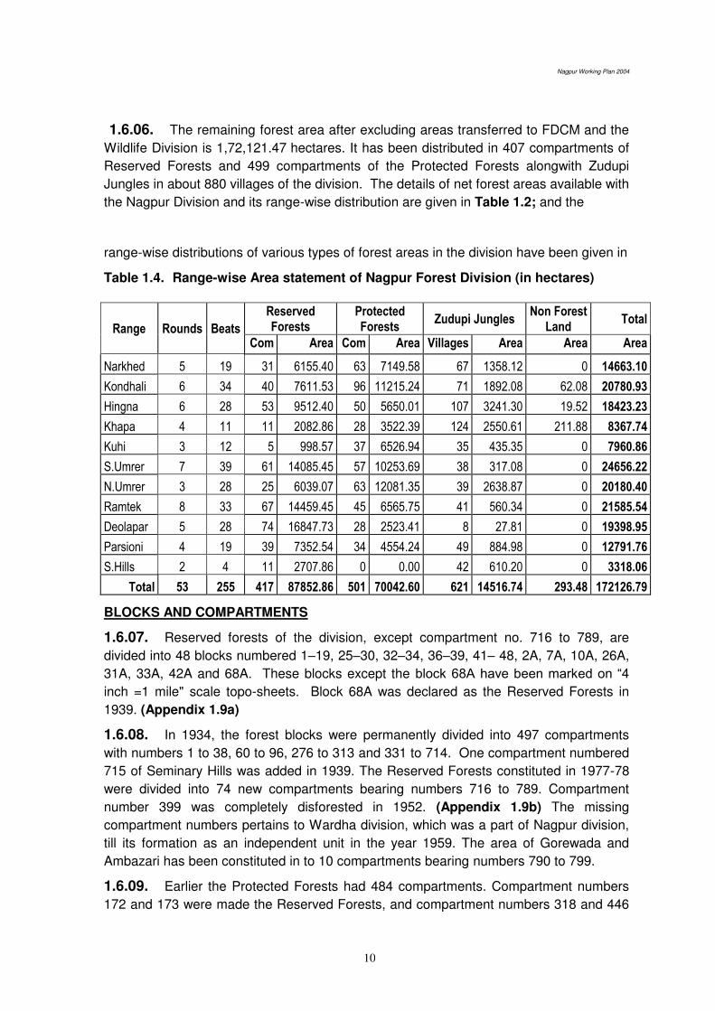
Nagpur Working Plan 2004
10
1.6.06. The remaining forest area after excluding areas transferred to FDCM and the
Wildlife Division is 1,72,121.47 hectares. It has been distributed in 407 compartments of
Reserved Forests and 499 compartments of the Protected Forests alongwith Zudupi
Jungles in about 880 villages of the division. The details of net forest areas available with
the Nagpur Division and its range-wise distribution are given in Table 1.2; and the
range-wise distributions of various types of forest areas in the division have been given in
Table 1.4. Range-wise Area statement of Nagpur Forest Division (in hectares)
Range Rounds Beats
Reserved Forests
Protected Forests
Zudupi Jungles Non Forest
Land Total
Com Area Com Area Villages Area Area Area
Narkhed 5 19 31 6155.40 63 7149.58 67 1358.12 0 14663.10
Kondhali 6 34 40 7611.53 96 11215.24 71 1892.08 62.08 20780.93
Hingna 6 28 53 9512.40 50 5650.01 107 3241.30 19.52 18423.23
Khapa 4 11 11 2082.86 28 3522.39 124 2550.61 211.88 8367.74
Kuhi 3 12 5 998.57 37 6526.94 35 435.35 0 7960.86
S.Umrer 7 39 61 14085.45 57 10253.69 38 317.08 0 24656.22
N.Umrer 3 28 25 6039.07 63 12081.35 39 2638.87 0 20180.40
Ramtek 8 33 67 14459.45 45 6565.75 41 560.34 0 21585.54
Deolapar 5 28 74 16847.73 28 2523.41 8 27.81 0 19398.95
Parsioni 4 19 39 7352.54 34 4554.24 49 884.98 0 12791.76
S.Hills 2 4 11 2707.86 0 0.00 42 610.20 0 3318.06
Total 53 255 417 87852.86 501 70042.60 621 14516.74 293.48 172126.79
BLOCKS AND COMPARTMENTS
1.6.07. Reserved forests of the division, except compartment no. 716 to 789, are
divided into 48 blocks numbered 1–19, 25–30, 32–34, 36–39, 41– 48, 2A, 7A, 10A, 26A,
31A, 33A, 42A and 68A. These blocks except the block 68A have been marked on “4 inch =1 mile" scale topo-sheets. Block 68A was declared as the Reserved Forests in
1939. (Appendix 1.9a)
1.6.08. In 1934, the forest blocks were permanently divided into 497 compartments
with numbers 1 to 38, 60 to 96, 276 to 313 and 331 to 714. One compartment numbered
715 of Seminary Hills was added in 1939. The Reserved Forests constituted in 1977-78
were divided into 74 new compartments bearing numbers 716 to 789. Compartment
number 399 was completely disforested in 1952. (Appendix 1.9b) The missing
compartment numbers pertains to Wardha division, which was a part of Nagpur division,
till its formation as an independent unit in the year 1959. The area of Gorewada and
Ambazari has been constituted in to 10 compartments bearing numbers 790 to 799.
1.6.09. Earlier the Protected Forests had 484 compartments. Compartment numbers
172 and 173 were made the Reserved Forests, and compartment numbers 318 and 446
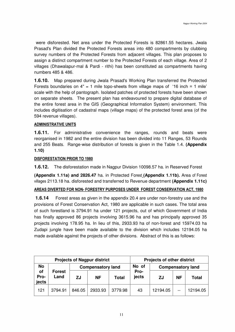
Nagpur Working Plan 2004
11
were disforested. Net area under the Protected Forests is 82861.55 hectares. Jwala
Prasad's Plan divided the Protected Forests areas into 480 compartments by clubbing
survey numbers of the Protected Forests from adjacent villages. This plan proposes to
assign a distinct compartment number to the Protected Forests of each village. Area of 2
villages (Dhawalapur-mal & Pardi - rithi) has been constituted as compartments having
numbers 485 & 486.
1.6.10. Map prepared during Jwala Prasad's Working Plan transferred the Protected
Forests boundaries on 4" = 1 mile topo-sheets from village maps of ‘16 inch = 1 mile’ scale with the help of pantograph. Isolated patches of protected forests have been shown
on separate sheets. The present plan has endeavoured to prepare digital database of
the entire forest area in the GIS (Geographical Information System) environment. This
includes digitisation of cadastral maps (village maps) of the protected forest area (of the
594 revenue villages).
ADMINISTRATIVE UNITS
1.6.11. For administrative convenience the ranges, rounds and beats were
reorganised in 1982 and the entire division has been divided into 11 Ranges, 53 Rounds
and 255 Beats. Range-wise distribution of forests is given in the Table 1.4. (Appendix
1.10)
DISFORESTATION PRIOR TO 1980
1.6.12. The disforestation made in Nagpur Division 10098.57 ha. in Reserved Forest
(Appendix 1.11a) and 2826.47 ha. in Protected Forest (Appendix 1.11b). Area of Forest
villages 2113.18 ha. disforested and transferred to Revenue department (Appendix 1.11c)
AREAS DIVERTED FOR NON- FORESTRY PURPOSES UNDER FOREST CONSERVATION ACT, 1980
1.6.14 Forest areas as given in the appendix 20.4 are under non-forestry use and the
provisions of Forest Conservation Act, 1980 are applicable in such cases. The total area
of such forestland is 3794.91 ha under 121 projects, out of which Government of India
has finally approved 86 projects involving 3615.96 ha and has principally approved 35
projects involving 178.95 ha. In lieu of this, 2933.93 ha of non-forest and 15974.03 ha
Zudapi jungle have been made available to the division which includes 12194.05 ha
made available against the projects of other divisions. Abstract of this is as follows:
Projects of Nagpur district Projects of other district
No of
Pro-jects
Forest Land
Compensatory land No of Pro-jects
Compensatory land
ZJ NF Total ZJ NF Total
121 3794.91 846.05 2933.93 3779.98 43 12194.05 -- 12194.05

Nagpur Working Plan 2004
12
No of Projects
Total Compensatory Area
ZJ NF Total
164 13040.10 2933.93 15974.03
1.7. STATE OF BOUNDARIES
1.7.01. The total length of the of external boundaries of the Reserved Forests in the
division is 1804.01 km, of which 105.461 kms of the external boundary follows the
permanent natural features. The remaining boundary is demarcated by artificial lines, 12
meters wide cleared and cut-strips; and marked by pillars at suitable intervals. All pillars
have been serially numbered in anti-clockwise direction. If the boundary line is shared by
other forest areas, centre of this width lies on the boundary, otherwise, the entire width
lies within the Reserved Forest. The NRF do not have well-defined demarcation by
pillars, at a number of places.
1.7.02. The total length of the boundary line of the Protected Forests extends over to
5,374.978 km. The boundaries of the Protected Forests have not been demarcated and
maintained properly. Records of survey and demarcation done in 1958, as mentioned in
the previous plan, are not available. These areas require survey and demarcation by fix
boundary marks on priority basis to ensure the integrity and protection of the tracts under
the Protected Forests. (Appendix 1.12). The position is likely to improve now as the
fixation of permanent boundary marks on the outer boundary of the forests has been
given a priority in the light of the directives given by the Hon. Supreme Court in the writ
petition No.202/95 and 171/96. This work is being facilitated with the creation of a
separate land cell in the office of the PCCF,M.S. Nagpur.
1.8. LEGAL POSITION
1.8.01. The forests of Nagpur district were declared as the 'Reserved Forests' and
the 'Protected Forests' under the provisions of the Indian Forest Act, Chapter VII of
1878 as well as under the provisions of Indian Forest (Protection) Act, 1927. The
relevant notifications, to this effect, have been listed, as follows:
A) RESERVED FORESTS
i) Notification no. 917 (b) dated 24/1/1879
ii) Notification no. 116 dated 11/3/1887
iii) Notification no. 1585 dated 3/4/1893
iv) Notification no. 1193 dated 7/3/1893
v) Notification no. 2629 dated 30/5/1895
vi) Notification no. 700-562-XI dated 18/7/1939 (Compartment 715)
vii) Notification no. FLD-3470/6975/F-2 dated 23/11/1977 notified 11,270.71 hectares
of Protected Forests in 72 villages as the Reserved Forests.
Nagpur Working Plan 2004
13
B) PROTECTED FORESTS
i) Notification no. FLD-3057-853-XI dated 4/6/1955 declared the ex-proprietary
forests taken over by the government as the Protected Forests.
C) SECTION 4 NOTIFICATIONS
The position regarding section 4 notification for the non-forest and Zudapi
jungle lands made available to the division as indicated under para 1.6.14 and as
explained under para 20.2 is as follows:
i) Notification No. FLD-3490/143390/CR101/F-3, dt. 25.10.1990.
Ambazari and Gorewada forests area 2640.45 ha
ii) Proposals for notification under section 4 for Zudapi jungle (14516.74 ha) has
been sent by the Deputy Conservator of Forests, Nagpur through following
letters:
1) Desk-13/Survey/3365, Nagpur, dt. 26.09.03
2) Desk-13/Survey/3401, Nagpur, dt. 29.09.03
3) Desk-13/Survey/4157, Nagpur, dt. 29.10.03
4) Desk-13/Survey/4928, Nagpur, dt. 02.12.03
5) Desk-13/Survey/4950, Nagpur, dt. 04.12.03
6) Desk-13/Survey/6131, Nagpur, dt. 31.01.04
7) Desk-13/Survey/6145, Nagpur, dt. 03.02.04
8) Desk-13/Survey/6987, Nagpur, dt. 20.03.04
iii) Non-forest land of 293.48 ha is yet to the notified.
1.9. RIGHTS AND CONCESSIONS
A) RESERVED FORESTS
1.9.01. No rights in the Reserved Forests has been recognized, except right to way
and access to water. There is no commutation of nistar or paidawar in the Nagpur Forest
Division. Various concessions have been granted to the agriculturists and to others local
inhabitants by the erstwhile Government of Madhya Pradesh and Government of
Maharashtra, from time to time. The following, concessions have been allowed to the
local inhabitants.
The grazing of cattle belonging to the agriculturists of certain villages in the vicinity of
the Reserved Forests in accordance with the grazing rules in force.
Agriculturists of villages in the vicinity of the Reserved Forests have been provided
with the facility of certain quantity of timber, bamboo and firewood for their bonafide
domestic use at concessional rates from the coupes under working. None of these
concessions is a legal right and these may be withdrawn by the government if the
need so arises.
Nagpur Working Plan 2004
14
B) PROTECTED FORESTS
1.9.02. Before abolition of the proprietary rights, the rights and concessions were
governed by the ‘Wazib-ul-arz’ - a village record for settlements; showing the survey
numbers and areas set apart for each particular purpose. The Central Province Land
Revenue Code 1917, in section 202, provided punishment for violation of the recorded
customs. After enacting of the Madhya Pradesh Abolition of Proprietary Rights (Estates,
Mahala, Alienated Lands) Act, 1950 (Act I of 1951), all communal and other wastelands
became property of the Government. In order to distinguish between the rights existing
on such lands, the Madhya Pradesh Land Revenue Code, 1957 prescribed preparation of
the 'Nistar Patrak' and 'Wazib-ul-arz' for every village. The Nistar Patrak deals
exclusively with management and use of the government land while the Wazib-ul-arz
deals with community and customary use over private land. The nistar patraks are
applicable to all the Protected Forests in the division.
Xerox copy of Nistar patrak and Wazib-ul-arz of Chargaon, (P.C.No.27) of
Ramtek taluka is given in (Appendix 1.12a.)
1.9.03. The nistar inquiry had been conducted in Nagpur district during 1954-1956,
and this inquiry included villages having the Protected Forests. The nistar officers had
formed 'grazing zones' and 'nistar zones' by clubbing together surplus villages with deficit
villages while self-sufficient villages had been treated as individual zones. Villages
assigned to particular zone can exercise their nistar rights within that zone only. The
classification of the villages into surplus, deficit or self sufficient for the exercise of nistar
rights was made on the following basis:
A village having tree clad area equal to half the occupied area was considered to be
self-sufficient.
A village having tree clad area more than half the occupied area was considered to
be surplus village.
A village having tree clad area less than half the occupied area considered to be a
deficit village.
GRAZING CONCESSIONS
1.9.04. For the purpose of forming grazing zones, each head of cattle in the cotton-
jowar tract should have 0.2 hectare grazing area and that in other tracts it should have
0.4 hectare, was taken as the basis. Villages in which the grazing lands are less than the
above requirement was clubbed with the neighbouring village in which such area exceeds
the above standard. In villages, where grazing lands was just sufficient for the needs of
the cattle of that village, no rights for persons residing in other villages to graze their
cattle have been recognised unless already recorded in the ‘Wazib-ul-arz.’
1.9.05. Villages clubbed as above constituted a grazing zone. The clubbing of the
villages was done in such a way that the villagers were not required to take cattle to a
distance longer than the distance, which the cattle can easily cover in a day. Within a
specific zone all persons are at liberty to graze their cattle free until, otherwise, ordered
by the Collector. (Appendix 1.13).

Nagpur Working Plan 2004
15
1.9.06. The directives contained in the Madhya Pradesh Land Reforms Department's
memorandum no. 1290-1227-XXVIII, dated 4th September 1953 prohibited grazing by
sheep and goats in forests meant for production of big timber and even in the forest
areas where villagers generally exercise their nistar rights. This ban is because while
grazing in the forests, these animals also uproot seedling regeneration of the important
species. However, subsequent directives from the Government have allowed grazing by
sheep in specified areas but continued complete prohibition on grazing by goats.
Following norms of concessional grazing have been prescribed under the Protected
Forests (Vidarbha Area) Rules, 1959:
a) Cultivators-2 plough cattle per plough plus 4 others including one she-buffalo.
b) Agricultural artisans and labourers –
4 cattle including one she-buffalo;
Provided further that all animals in excess of those specified in 5;
Provided that a calf under one year shall not be counted;
Provided further that all animals in excess of those specified in clauses (a)
and (b) shall be charged at such rates as the State Government may from
time to time sanction in this behalf.
OCCUPATIONAL NISTAR
1.9.07. In the nistar patraks, the occupational rights of the Kumbhars, Chambars,
Gonds, Mahars, Pradhan and Lohar communities have been recorded and recognised in
several villages and their entries are found in the ‘wazib-ul-arz’- the village instrument
prepared for each village.
1.9.08. The nistar is required by the villagers for bona fide domestic and agricultural
purposes. Forest nistar generally includes timber of certain species and sizes for
agricultural implements, houses and cattle sheds, fire woods, bamboo, thatching and
fodder grasses, fencing material, bark, fibre, minor minerals and paidawar i.e. edible
fruits, flowers and roots, honey wax, etc. The rights and concessions are governed by
the provisions made in the Nistar Patrak for each village. Generally, agriculturists and
agricultural labourers are entitled to kinds of forest produce given in the following paras,
for their nistar either free of charge or at concessional rates fixed by the Collector, from
their nistar zones only.
SMALL TIMBER AND POLES
1.9.09. According to the zone arrangement made by the Nistar Officers, the villagers
are entitled to obtain their nistar requirements of small timber and poles from the
available material from the forests included in a particular zone either free or on payment
up to a certain quantum fixed by the Collector. In order to meet the demand of the
cultivators of the villages which were not included in the zone, the nistar officers have
prescribed that in the event of supply being in excess in a particular zone after meeting
the demand of zone villages, the excess could be given to persons outsides the zone on
payment at the rates fixed by the Collector

Nagpur Working Plan 2004
16
TIMBER FOR CONSTRUCTION OF NEW HOUSES FROM EX-PROPRIETORY FORESTS
1.9.10. Madhya Pradesh Government through their Memo No.2525/650/C.R. (Land
Reform Department) dated 29/10/1956, decided that timber for construction of new
houses can be supplied to the agriculturists on a certificate issued by the Revenue
Officer, on the concessional rates equal to half the market rates.
SUPPLY OF SALAI WOOD IN MARRIAGE CEREMONIES
1.9.11. Several communities use green salai poles as kham, adam and thuni in
marriage ceremonies. The villagers are permitted to remove their requirement up to the
maximum limit of two trees on permits.
FIREWOOD, BAMBOOS AND OTHER USUFRUCTS
1.9.12. Removal of firewood from Khasra numbers, set aside for meeting the nistar
requirements, have been permitted free of cost as per rights recorded in Nistar Patraks to
the prescribed extent for bona fide use of the assigned villages.
1.9.13. Dry bamboo is allowed to be removed free from the ex-proprietary forests for
bona fide nistar needs. Green bamboo is permitted on payment of the prescribed royalty.
Where thorns are not available, removal of brushwood such as lops and tops of the felled
trees and bamboo are permitted. Where removal of thorns and brushwood is allowed free
of cost or at nominal rates, the existing practice continues.
1.9.14. Bark, fibre and roots are allowed to be removed where it is customary to allow
their removal for cordage.
1.9.15. Moha, achar, tendu or other edible fruits, flowers and roots are allowed to be
removed free of cost from all over the forests for domestic consumption. The removal
however, is permitted by head loads only. This concession however does not include
harra, lac, rosha grass, tendu leaves and gums as they are not included in nistar but
villagers are allowed to collect these forest produce found in their land in a protected
forests. These provisions are contained in the Protected Forests (Vidarbha Area) Rules,
1959.
1.9.16. As regard occupational nistar, ghont; fruits and dhaora leaves are allowed to
be removed by the charmakers free of charge. They are also allowed to remove the
bakkal and kahu bark on nominal payment from trees marked for felling.
1.9.17. In the Nistar Patrak of each village the khasara numbers set-aside for nistar
and grazing are recorded. The details regarding quantum of nistar, period during which it
is to be allowed, payment if any to be made, etc. are generally not given in the nistar
patraks. The Protected Forests are no longer in a position to meet most of the nistar
requirements of the people because of unsustainable exploitation, illicit removal and
heavy grazing in the past. Most forest areas have been severely degraded, and need
immediate rehabilitation to restore their health and productivity. Much of these forests
have been encroached because the outer boundary of the forests are not clear.

Nagpur Working Plan 2004
17
1.9.18. Misuse of right in reserved forests is covered under section 24(2) of IFA,
1927, read with section 77 and in protected forests under section 33 of IFA, 1927 and
under section 167 of Maharashtra Land Revenue Code, 1966
******
Nagpur Working Plan 2004
17
Chapter 2. THE FORESTS
2.1. COMPOSITION AND CONDITION OF THE CROP
2.1.01. The forests of Nagpur division belong to the Sub Group 5A - Southern
Tropical Dry Deciduous Forests as per the revised classification of ‘Champion and
Seth’. Underneath this main sub group, considerable local variations occur depending primarily upon the edaphic factors such as parent rock and consequent soil types;
topography of the tract and the past treatment provided to these forest crops. The
aspect also plays an important part in determining the character of the vegetation in
the hilly areas. In the hilly tracts, the western and northern slopes are generally better
stocked than the eastern and the southern slopes. This is because the moist
conditions exist for a longer period in such tracts. The geology, soil type and depth
also plays an important role in determining the composition and quality of the forest
crops. The biotic factors like grazing and fires also contribute to the variations in the
crop composition; leading to forest degradation in many areas of the Division and
seriously damaging the natural regeneration of tree species and other micro flora.
Table 2.1. Forest types found in the Nagpur Division (Champion and Seth’s classification)
Type Notation Type description
Group 5 Tropical Dry Deciduous Forests
Sub-group 5 A Southern Tropical Dry Deciduous Forests.
Climate types
5A/ci
5A/cia
5A/cib
Dry Teak Bearing Forests
Very Dry Teak Forests
Dry Teak Forests.
5A/c-3 Southern Dry Mixed Deciduous Forests
Edaphic types
5/E-2
5/E-4
5/E-5
Bosewellia Forests
Hardwickia Forests
Butea Forests
Degradation stages 5/D S1
5/D S2
Dry Deciduous Scrub Forests.
Dry Savannah Forests
Primary serial type 5/ISI Dry Tropical Riverain Forests
2.1.02. Teak is predominantly found as pure crop in South Umrer, Hingna, Kondhali
and Narkhed ranges as well as in parts of the Parseoni, Deolapar and Ramtek ranges.
Mixed forests with scattered teak are found in Ramtek, Khapa, Kuhi, Deolapar, North
Umrer and Parseoni ranges. Teak is a calcicolous plant growing well in soil rich in
CaCO3. Teak is a best example of a migratory plant species following the deposition of
lime.
2.1.03. Soils derived from different geological formations viz. the metamorphic
rocks and the Deccan Trap; varies in chemical composition and structure and,
thereby, strongly influences the quality, density and composition of forest vegetation
cover they supports. The different forest types found in the division based on distinct
geological formation are given, as under;
Nagpur Working Plan 2004
18
A) FORESTS IN THE METAMORPHIC ZONE
2.1.04. The forest areas falling in the metamorphic zone of this division support, the
following, types of forests;
i). Good quality teak forests.
ii). Good quality mixed forests interspersed with teak.
iii). Poor quality mixed forests with scattered teak; the local variations (edaphico-
biotic) found within this subtype are given, as follows;
(a) Bhirra forests
(b) Garari forests
(c) Rohan forests
(d) Moha and Palas forests
(e) Mowai forests
B) THE FORESTS IN THE TRAP ZONE 2.1.05 The forest areas falling in the Trap zone of this division support, the following, types of forests:
(i) Good quality teak forests.
(ii) Poor quality teak forests.
(iii) Mixed forests; comprising of the following types due to local (edaphico-biotic)
variations in the forest tracts of this zone;
(a) Ain forests.
(b) Kalam forests
(c) Salai forests.
2.2. DRY TEAK BEARING FORESTS
2.2.01. Three distinct types of Teak forests can be recognised: (A) Good quality
teak forests in the Metamorphic zone, (B) Good quality teak forests in the Trap zone
and (C) Poor quality teak forests in the Trap zone
(A) GOOD QUALITY TEAK FORESTS IN THE METAMORPHIC ZONE
2.2.02. These forests are found in the Parseoni and Deolapar ranges where the soil
is sandy loam, deep and well drained. As the conditions are favourable for the growth
of teak, it forms about 20--60% of the stocking. The site quality of the crop varies from
IVa to II; as the top height is varies 13 m to 24 m. The density of the crop varies from
0.6 to 0.8. The over-wood consists of teak, ain, tendu, dhaora, bija, salai etc. The
middle storey consists of khair, ghot, achar, gararai, ghoghar, karai, etc. Bamboo is
also found in a few compartments in Parseoni range. The under-wood consists of
neel, muradsheng, kharasi, etc. The common climbers found are piwarbel, mahulbel,
palasbel, malkagni, ramdatun, etc. Metamorphic rocks like granite, gneiss, schestose,
limestone carry high proportion of teak because they are associated with limestone.
(B) GOOD QUALITY TEAK FORESTS IN THE TRAP ZONE
2.2.03. This type of forests is mainly found in the southern part of South Umrer
range. Teak is the predominant species forming about 40 to 80% of the stocking of

Nagpur Working Plan 2004
19
the forest crops. The density varies from 0.4 to 0.7 and the top height varies from
10m to 18m. The site quality of the crop is primarily IVa and IVb. The common
associates of teak found in these forests are ain, dhaora, tendu, salai and mowai.
The soil is black cotton and gets waterlogged during the rainy season. The trees
mainly found in the middle storey are ghot, achar, aonla and dhaman. Trap is a natural
home of the teak.
( C ) POOR QUALITY TEAK FORESTS IN THE TRAP ZONE
2.2.04. This type of forest is found mainly in Kondhali, Narkhed, Hingna; and part of
South Umrer ranges. The forest tracts in these ranges constitute refractory areas
having shallow soil layer, which are prone to heavy grazing and frequent fires. The
quality of the forests is mainly IVb. Teak is the predominant species consisting about
50 to 70 percent of the crop. The density of the crop varies from 0.4 to 0.6. The main
associates of teak in the over-wood are dhaora, lendia, ain, movai, bhirra, achar, bel,
etc. The common shrubs found are zilbili, bharati, kharasi, ber and neel. The main
climbers found in such areas are chilati and eroni. Usually such soils are either very
dry or very moist. The post climax changes in such soils have resulted in poor growth
of teak.
2.3. THE MIXED FORESTS
2.3.01. The mixed forests may be divided into the following 2 categories:
(A) Mixed forests with scattered Teak in the Metamorphic Zone
(B) Mixed forests in the Trap Zone.
(A) MIXED FORESTS WITH SCATTERED TEAK IN THE METAMORPHIC ZONE
2.3.02. The forests are composed mainly of miscellaneous species and teak occurs
scattered or in patches spread through out the crop. These types of forests are found
in Khapa, Parseoni, Deolapar and Ramtek ranges. The over-wood consists of ain,
lendia, dhaora, rohan, garari, bhirra, salai, bel, aonla, etc. The site quality varies from
III to IVa/IVb; whereas density of the crop varies from 0.4 to 0.8. The state of
regeneration is far from satisfactory in the areas adjoining the villages. The under
wood consists of khair, ber, ghot, dikamali, gogal, etc. The main shrubs are bharati,
zilbili, kharasani and neel. The common climbers found are piwarbel, ramdatun,
chilati and mahul.
The local variations (edapho-biotic) types found within the this sub type are given, as
follows:
BHIRRA FORESTS
2.3.03. Bhirra is the main species found in the areas where the soil is shallow,
sandy and arid. The common associates of bhira are lendia, dhaora and garari. The
forest crop is generally of IVb quality. It is common in plateaux.
Nagpur Working Plan 2004
20
GARARI FORESTS
2.3.04. Large patches of garari are found in the Reserved Forests, north of Bhakari
in Deolapar range; and also in the Protected Forests of Manegaon, Bandra and
Chawri villages. It also occurs as under-storey in the Teak and Mixed forests in
Deolapar range and also in the Protected Forests of North Umrer and Kuhi ranges.
The site quality of these forests is generally found to be IVb.
ROHAN FORESTS
2.3.05. In the forest tracts, where the soil is calcareous and coarse, Rohan has
been found to grow well. Good patches of Rohan are found in some eroded areas of
Deolapar and Ramtek ranges, as well. The usual associates found are bel, mowai,
bhirra and dhaora; while bharati and zilbili occurs as the undergrowth. It is mainly
found in water logged areas containing lime.
(B) MIXED FORESTS IS THE TRAP ZONE
2.3.06. These forests are mainly confined to the areas having poorly drained clayey
soil. The over-wood consists mainly of ain, dhaora, tendu, lendia, moha, mowai,
bhirra, rohan, salai etc, whereas, the under-wood comprises of mainly Kharasi,
bharati, zilbili and kuda. The density of the forest crops varies from 0.2 to 0.5; and the
site quality is IVb.
The local variations (edaphic) found within this sub type are given, as follows;
AIN FORESTS
2.3.07. Ain is found to thrive in the low-lying areas with heavy soil, where drainage
is poor due to the presence of clay. The site quality of forests in such patches is
generally poor. These forests are found in the Reserved Forests of Dhamangaon,
Dhighori and Amghat felling series of South Umrer range as well as in the Protected
Forests of Lohara, Pandhartal, Sedeshwar, Kachalkuhi, Nandra in South Umrer range
and Tekadi and Salaimendha in North Umrer range.
EDAPHIC TYPES
5/E 2 - SALAI FORESTS
2.3.08. In these forests salai forms the over wood and sometimes well grown
medium to large trees occur on the flatter tops of the hills. It is generally 12m to 15m
in height and 1.2 m to 1.8 m in girth. The only species that equalize it, in size, is kullu.
In these forests salai is found with ghogal, dhaora, kullu, lendia, mowai and aonla.
This type occurs on a variety of rocks, particularly, on the crystalline rocks and
sometimes lateritic rocks as well as on the trap. The soil is shallow and dry and
usually consists of boulders or pebbles. Hill tops, ridges, spurs and the well-drained
plateaus are the usual sites. Reproduction of salai in such forests has been found to
be scanty and, often, non-existing.
Nagpur Working Plan 2004
21
5/E 4 - ANJAN FORESTS
2.3.09. This type is found in small patches in the forest areas of the Seminary Hills
where anjan is the predominant species. The soil is hard and gravelly overlying the
trap rock formation. The other species occurring with it are teak, salai and shisham.
Most of the anjan trees are middle-aged to mature; and the regeneration of these
forests is found to be scanty or absent.
5/E 5 - PALAS FORESTS
2.3.10. This sub-type is found in the stiff badly drained very dry clayey soils and
particularly in black cotton soils in the ill-drained flats and depressions. On the flat
ground this sub-type presents a savannah appearance; with scattered stunted and
malformed trees or thickets standing over the short grass or the bare ground.
2.4. SCRUB FORESTS
5/D S I - DRY DECIDUOUS SCRUB FORESTS
2.4.01. It consists of a low broken soil cover of shrubby growth 3m to 6m high,
including some trees species reduced to similar conditions usually having many stems
emerging out from the base. The grass occurs throughout in these forest tracts. In
this type, two sub-types have been distinguished.
DRY TEAK SCRUB FORESTS
2.4.02. In these forests teak is found in the crooked and stunted form, due to
maltreatment of the crop as a consequence of unregulated felling, lopping, grazing
and fires. Here teak is associated with ain, bhirra, palas, etc.; with bharati being the
thorny species. Such types of forests are found at several places in the Protected
Forests of Kondhali and Narkhed ranges mainly on the badly eroded hillsides.
Surface boulders are usually found exposed in such areas.
DRY MIXED SCRUB FORESTS
2.4.03. A considerable variety of degenerated forests could be included in this type.
These forests are the result of long continued maltreatment, of which excessive
grazing and repeated cutting are the chief factors. These forests usually grow under
heavy grazing conditions. Ain-dhaora-lendia are the most common species found in
the Protected Forests of Jabalpani, Tarana, Wag, Sonpuri, Ruyad, Mandhal, Weltur,
Kitodi, Makheburdi, Salai-mendha villages. The other associates are tendu, moha,
palas, hiwar, khair, ber, ghoti, bhirra, etc. The trees hardly reach the height of 6 metre
in such areas. The other sub types found in this type are Palas-khair-dhaoda in the
Protected Forests of Masalkund and Bhiwapur village. Ain, garari, salai and mowai
are found in the Protected Forests of the Devlikala village.
5/D S2 - DRY SAVANNAH FORESTS
2.4.04. These are usually open forests and the trees stand far apart singly or in
small groups in the heavy grasses. The trees have very short stems and are usually
crooked, unsound and hollow. Thorny shrubs are also of common occurrence in

Nagpur Working Plan 2004
22
these forests. This type of forests is found in the Protected Forests of Kuhi and North
Umrer ranges. The grass-birs at Champa and pasture areas at Matkazari are the
typical examples. These forests are also found in the Protected Forests of Bhijpur,
Sasegaon, Salesawari. Tuthanbori, Barwha, Borda, Salwa, Haladgaon, Bodkhipeth,
Kharbi and Pratapgarh villages of the Kuhi range.
PRIMARY SERAL TYPE- 1S1- DRY TROPICAL RIVERAIN FOREST
2.4.05. These forests consist of an irregular over-wood of greater height than the
climax Dry Deciduous Forests. The trees are of larger size and are found in narrow
strips along the hilly section of the larger streams; and the strips become widened as
the valleys get broader. Soils are sandy, often overlying more or less impervious rock
formation, liable to be temporarily submerged during monsoon period and usually
retain adequate water supply during most of the year. Arjun (Terminalia arjuna) is
found in the over-wood and it is associated with a few species found in the
underground such as Kalam, Palas, Imli (Tamarindus indica), Sitaphal (Anona
squamosa), Karanj (Pongamia pinnata), Jamun (Syzygium cumini), Aam (Mangifera
indica) etc. At places, Tamarix diocia is found as a shrub.
2.5. REGENERATION IN GENERAL
2.5.01. In the Metamorphic Zone coppice regeneration of teak, lendia, garari,
bhirra, aonla, dhaman, khair, palas, ghot and baranga is satisfactory, while that of ain,
dhaora, tendu and tinsa is inadequate. The seedling regeneration of teak, in the better
quality areas of metamorphic zone, occurs in patches while in the trap zone it is quite
inadequate and occurs singly and scattered in the well drained areas. Teak
regeneration is found satisfactory in good quality areas of metamorphic zone.
2.5.02. Seedling regeneration of lendia, ain, dhaora, bhirra and gongal, is fairly
satisfactory and occurs well distributed over most of the areas in the metamorphic
zone except areas heavily grazed and contain thick growth of shrubs, climbers,
grasses and areas severely eroded. Seedling reproduction of bhirra is particularly
noticeable in the sandy and open areas of metamorphic zone. In trap zone areas
where teak is tending to be pure, seedling regeneration of teak and other species is
absent and the coppice regeneration is also inadequate to restock the area.
2.5.03. TEAK & ROCK
Teak is the predominant timber species found in the region and is associated
with many species of varied importance and it is usually associated with metamorphic
(calcareous, crystalline phyltite, schists and granite gneiss) rocks and Deccan trap
(sills, dykes, flows, inter-trappean beds). It’s associated with rocks of volcanic origin as they are rich in calcium. Teak is absent from sedimentary rocks due to leaching of
calcium from such rocks. Chemical properties rather than structural geology of soils
are more important for the teak to grow. Teak is usually absent from sandstone belt
and therefore trap-Gondawana line is a perfectly separates teak and non-teak
vegetation. Teak is present in such alluvium deposits while are rich in lime. The trap in
this region contain 46.4% felspar. It is found growing best in it pH between 6.5 to 7.5
Nagpur Working Plan 2004
23
but subsoil acidity is not a dominating factor for the presence of teak. Teak is a
calcium accommodating plant. It is found doing well is soils with high SiO2/R2O3 ratio,
a high dispersion coefficient and high moisture retention. It is replaced by Lagestromia
parviflora in the swampy conditions, and by Xylea xylocarpa in lateretic soils.
2.6. INJURIES TO WHICH CROP IS LIABLE
2.6.01. The forests are subjected to injuries caused by a number of factors. They
can be classified as injuries caused by man, wild animals and parasites as well as by
factors like frost, drought, fire, etc.
A) DAMAGE BY THE MAN
2.6.02. Man causes primarily, the following, two types of injuries.
(1) Illicit Cutting: The illicit cutting of forests for timber, poles and firewood is a
major factor causing serious problems of protection of forests throughout the division.
It is heavy in areas adjoining the inhabited pockets of the division. The main
consumption centres are Nagpur, Hingna, Kamptee, Katol, Umrer, where construction
activities consumes the major share. Due to phenomenal increase in timber price of
teak and other commercial species, inter-state illicit transport of timber and other
forest produce from the division is a major challenge to deal with. Demand for
firewood has also increased due to the increase in population compounded by the lack
of an alternate and economical sources of energy. Increase in network of roads in
forested tracts has further compounded the problem. During tendu season cutting
and lopping of tendu trees is a common practice to enable easy collection of leaves.
In addition to timber, illicit felling of bamboo has also increased due to the increase in
population of Burads, who earn their livelihood by making bamboo mats and other
bamboo articles. As a consequence, bamboo clumps have become malformed and
deteriorated leading to poor culms growth and slow clump formation. Illicit felling has
become a major cause for the deterioration of forests and depletion of the growing
stock in the inhabited regions of the division. The illicit cutting has led to a serious
deterioration of forest. The extent of illicit cutting during the last 10 years is given in
the (Appendix. 2.1)
(2) Encroachment: The hunger for land is a main cause of forest encroachments
carried out by the local inhabitants by clearing the forests, primarily, for agricultural
purposes. Regularisation of encroachments in the forest areas in past has served as
motivation for encroachments upon forest areas in anticipation of regularisation
sometimes, in future. Enactment of the Forest Conservation Act, 1980 and its strict
implementation, however, has reduced this tendency, to an extent. Recently, the state
government through the resolution no. PWR-1196/296/17/L-2 dated 18/1/1997 has
delegated the power of summary eviction of encroachment in forest areas to the forest
officials of the rank of the Assistant Conservator of Forests and the Deputy
Conservator of Forests.
2.6.03. Moreover, boundaries of the Protected Forests have not been well
demarcated, at most of the places. As a result, the problem of encroachment in the

Nagpur Working Plan 2004
24
Protected Forests has become a thorny issue for the Department. Thus, prevention,
detection and eviction of encroachment in forest areas in time can not be ensured due
to lack of proper demarcation of these areas with permanent marks. In view of the
cognisance taken by the Supreme Court, the issue requires addressal on priority
basis.
DAMAGE BY CATTLE
2.6.04. Due to the manifold increase in the population of the cattle, which is very
much in excess of the carrying capacity fixed by the grazing settlement, the pressure
on the forests has increased to an alarming proportion. The nistar rights granted in
the malgujari forests continued even after these forests were declared as the
Protected Forests and hence the scenario in the Protected Forests is more severe as
compared to the Reserved Forests. As a result of continuous and heavy grazing
beyond sustainable limits, the soil gets compacted, which adversely affects the
survival and growth of natural regeneration as well as plantations.
DAMAGE BY WILD ANIMALS
2.6.05. The damage by the wild animals has been found to be nominal only.
Primarily, the damage is caused by wild boars who dig up the bamboo rhizomes, while
the chital and nilgai cause damage by nibbling the young seedlings.
DAMAGE BY INSECTS, PARASITES AND CLIMBERS
2.6.06. The attack by defoliator (Hyblia purea) and skeletonizer (Hapalia
macharalis) is of common occurrence in forest tracts having substantial percentage of
teak. It is estimated that such insect attack causes 10% loss of increment. Hyblaea
puera is a teak defoliator and it attacks forests of this region during the period of July
and August i.e. during the rainy season. The attack is more sever in teak plantations.
The teak trees practically become leafless. However new leaves soon emerge and
remain on the tree up to November i.e. more than usual period of their existence on a
tree and it has been observed in some experiments that the acquired longevity of
leaves compensates loss due to attack of defoliator and hence net loss is
insignificance.
The use of chemicals for the control of these insects is not feasible
because of the short life cycle of these insects and extensive areas where teak forests
exist. Biological control is advised and may be more effective. The parasites that feed
on these insects are harboured on the following tree species.
1. Anogeisses latifilia,
2. Careya arborea
3. Cassia fistula,
4. Garuga pinnata
5. Grevia telifolia
6. Helicteres isora,
7. Lagestroemia parviflora
8. Xylia xylocorpa,
9. Terminaliatomentosa
Nagpur Working Plan 2004
24
Hence, the above species should be retained in considerable number in the teak
forests.
Vitex negunda is the alternate host of above two pests.
Teak skeletonizor usually attacks during the end of rainy season i.e. around
September. Because of this reason, loss due to skeletonizor attack is also not very
significant. However, such damage on the growth of the teak has not been quantified.
2.6.07. Termite attack has also been observed in some parts of the division, leading
to the mortality in the weaker plants. The fallen logs of Terminalia tomentosa are
attacked by the insect called Aeolesthes holosericea usually in the month of June and
July. The insects attacks the bark and hence as a protection the logs should be
debarked kept in the open. Terminalia tomentosa as well as Terminalia bellerica is
attacked by the insect Sinoxylon anale and S. crassam of family Bostrycideae (powder
pest beatles that convert starchy sapwood into powder like substance), Acaolesthus
holosericea of family Cerambycideae (insects that make a large tunnel inside the
sapwood as well as hearwood), Sphenoptera kombicernis of family Buprestidaceae
(instects that convert sapwood in to powder and Platyblis solidus of family
Platypodilaceae (the insects damage timber by making black stem pin holes into it).
The beatles however do not attack logs. The felled logs of Adina cordifolia (Haldu) is
attacked by Xylotrechus smei. Very less number of pest species attacks Jamun.
Lymexylonid borer and Atractocerus reversus attack Salai logs. In this attack, the
insect makes a long sinuous tunnel inside the logs. Bija logs are attacked by
Xylotrechus smei and Chrysobothrus species but logs are not attacked if they are
debarked. Xylotrechus smei and Sepalus hypocritia attack Maharukh logs. The
phenomenon of dying back of leading and lateral shoots of teak is noticed mainly due
to attack of insect called Aelcides ludificator. Zanzera coffece attacks the young leaf of
teak. Termites attack the collar of the small seedlings of teak. They also attack
seedlings of Dhawada and Aonla. Dhawada is also attacked by bark eating caterpillars
of Inderbela quadrinotales. Leaves of Garuga pinnata and Ficus glomerata are
attacked by gall insects. Teak in nursery attacked by the whit grub called hototrcacher
serrcta.
Fungal attack is also very common. The fungus usually enters through the
damaged branches or through roots and usually destroys heartwood. Fungal attack is
not common in softwood species. The affected tree does not die but is uprooted due
to the wind pressure. Polyporus gilvus attacks the sapwood of Dalbergia sissoo, D.
latifolia, Acacia arabica, Katha, bija, sirus (A. procera) and it causes white rot. In this
fungal attack, heartwood is affected in a limited way. Ganoderma lucidum attacks
Dalbergia sissoo, neem and Acrocarpus fraxinifolus. It being a root parasite attacks
the tree through roots. The roots become brittle and leaves turn yellow. The other
species of Ganoderma, G. applanitum attacks usually the dead logs but few living
trees of species like sissoo, babul, bamboo and Jackfruit are also attacked by this
fungus. It renders the wood spongy. Such affected tree becomes lighter and is thrown

Nagpur Working Plan 2004
25
away by wind. Fornes rimosus attacks Beheda, ain, dhawda and lendia. It is a
facultative (opportunistic) parasite and enters the tree through injury. Only the
heartwood is affected.
In very dry locality, teak develop hollowness at base while may go even upto
2-4 meter in height in heart wood and is caused due to decay active by Fungus Forres
lividres and Polyporeus Zonates.
2.6.08. Parasite plant, bandh (Loranthus longiflora) was found on some trees
especially achar, hiwar, etc.
2.6.09. The common climbers found are Chilati, Palasbel, Bokadbel, Yeruni,
Kukutranj and Mahurbel. The damage is caused by strangling of trees when they
entwine a sapling or a tree. If is climbers are not cut in the initial stages. They cause
deterioration in the value of trees.
DAMAGE BY DROUGHT, FROST, WIND AND HAILSTORMS
2.6.10. Lowering of the water table caused by scanty or irregular rainfall cause
drought like conditions and damage seedlings, saplings and occasionally young trees.
Frost is quite uncommon. Occasionally, strong winds cause uprooting of trees.
Hailstorms in the month of May cause damage to tendu leaves making them unfit for
bidi making.
DAMAGE BY FIRE
2.6.11. The incidences of fire are very common in Nagpur Division due to
deciduous nature of forests that provide a large quantity of combustible matter in the
form of dried leaves, grasses and twigs. Considerable damage is caused by scorching
heat, which kills the saplings, seedlings, ground flora and micro-fauna. Surface
organic matter, which is the source of nitrogen to the plants, is destroyed in fire.
However phosphorus, alkaline salts and alkaline oxides are returned to the soil.
Alkaline ash containing higher percentage of these salts and oxides neutralises the
acidity of soil. High temperature causes breaking up of colloidal clay complex leaving
an inert material which has less moisture retention capacity. Besides such burnt soils
become stiff and this leads to increased surface water run off. The silicate gel, which
is available in soil, is burnt leading to laterization of such sides. Protozoan organisms
are also killed in the fire. Repeated fires lead to reduced aeration.
2.6.12. All most all incidences are man-made. Tendu contractors set fires during
tendu season to obtain profuse flush of leaves on the tendu shoots. Villagers also set
fires to clear under growth under the Moha and gum-yielding trees to facilitate
collection of moha flowers and gum. Sometimes, villagers also set fire to get good
flush of grasses. Such fires if left unattended spread to the adjoining forest areas.
(Appendix 2.2).

Nagpur Working Plan 2004
26
******

Nagpur Working Plan 2004
27
Chapter 3. UTILIZATION OF THE PRODUCE
3.1. AGRICULTURE CUSTOMS AND WANTS OF THE POPULATION
3.1.01. The Nagpur city was established in the eighteenth century by a Gond king,
named as Bakhat Buland. Later, the Bhosle rulers made Nagpur its capital and ruled
over the area till 1817, when Bhosle were defeated by the British forces. British took
over the administration of Nagpur region in 1853 and made it capital of Central
Province and Berar. After independence, it served as the capital of Madhya Pradesh
till 1956, when reorganization of states was undertaken on language basis. Berar
region was attached to Bombay State; and the Nagpur city lost its stature as a capital
city. Subsequently, Maharastra state was formed on 1st May 1960 and the Nagpur City
was provided the stature of second capital of the State. The Nagpur district has been
named after the name of Nagpur city. Nag river originates in the western part, and
flows through the middle, of the city but because of the disposal of city wastage and
effluents into it, the river is highly polluted and has practically lost its character.
3.1.02. Nagpur is also known for its strategic location as the central point of the
country viz. the city of Zero Mile. It is well connected with other major cities of the
country through an elaborate network of roads, rails and Airways.
3.1.03. The boundary of the Nagpur Forest Division is coterminous with the
boundaries of Nagpur district. It extends over to 9,892 sq. km. as the Geographical
Area, forming 3.23 percent of Maharastra State; of which the forest areas extend over
to about 2765 sq km; forming about 21.95% of its Geographical Area.
3.1.04. As per Socio-Economic Survey Report (2000-2001) of Nagpur District, the
population of Nagpur district as per 2001 census is 40,51,444; of which, 64.36% live in
the urban area while 35.64% live in the rural areas (Table 3.1). It forms about 4.19
percent of the total population of Maharashtra State. The rare of increase for the last
ten years since 1991 census is 23.24 percent. The scheduled castes and scheduled
tribe populations forms about 18.53% and 13.93% of the total population of the
district, respectively.
Table 3.1. Taluka Wise Breakup of the Population of Nagpur District
Taluka Area in square
kilometer Male population (in thousands)
Female population (in thousands)
Total Population (in thousands)
Nagpur City 218 847 778 1,625
Nagpur rural 684 63 71 134
Saoner 612 98 89 187
Parseoni 919 66 60 126
Ramtek 734 66 62 128
Mouda 952 56 52 108
Kamptee 455 95 88 183
Kuhi 829 55 53 108
Bhiwapur 692 38 37 75
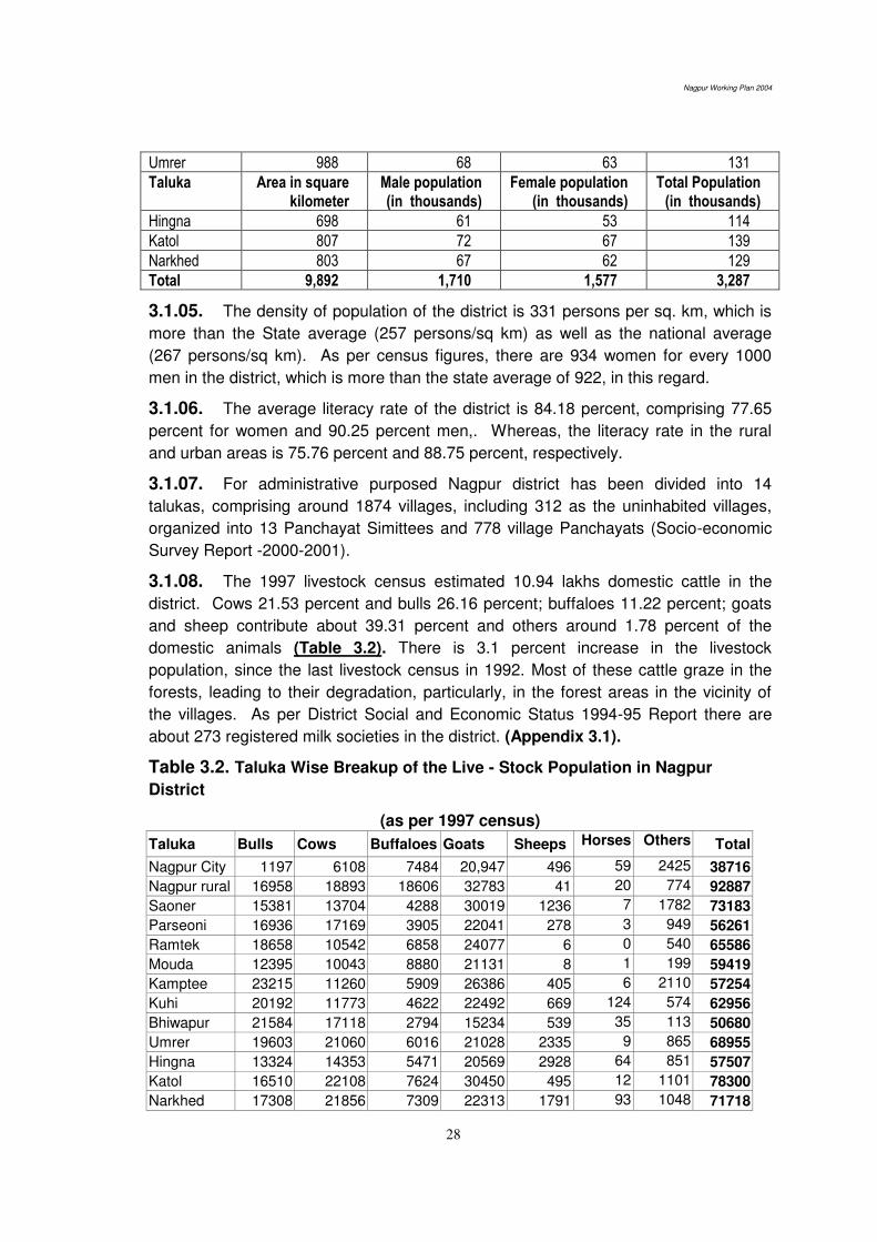
Nagpur Working Plan 2004
28
Umrer 988 68 63 131
Taluka Area in square kilometer
Male population (in thousands)
Female population (in thousands)
Total Population (in thousands)
Hingna 698 61 53 114
Katol 807 72 67 139
Narkhed 803 67 62 129
Total 9,892 1,710 1,577 3,287
3.1.05. The density of population of the district is 331 persons per sq. km, which is
more than the State average (257 persons/sq km) as well as the national average
(267 persons/sq km). As per census figures, there are 934 women for every 1000
men in the district, which is more than the state average of 922, in this regard.
3.1.06. The average literacy rate of the district is 84.18 percent, comprising 77.65
percent for women and 90.25 percent men,. Whereas, the literacy rate in the rural
and urban areas is 75.76 percent and 88.75 percent, respectively.
3.1.07. For administrative purposed Nagpur district has been divided into 14
talukas, comprising around 1874 villages, including 312 as the uninhabited villages,
organized into 13 Panchayat Simittees and 778 village Panchayats (Socio-economic
Survey Report -2000-2001).
3.1.08. The 1997 livestock census estimated 10.94 lakhs domestic cattle in the
district. Cows 21.53 percent and bulls 26.16 percent; buffaloes 11.22 percent; goats
and sheep contribute about 39.31 percent and others around 1.78 percent of the
domestic animals (Table 3.2). There is 3.1 percent increase in the livestock
population, since the last livestock census in 1992. Most of these cattle graze in the
forests, leading to their degradation, particularly, in the forest areas in the vicinity of
the villages. As per District Social and Economic Status 1994-95 Report there are
about 273 registered milk societies in the district. (Appendix 3.1).
Table 3.2. Taluka Wise Breakup of the Live - Stock Population in Nagpur
District
(as per 1997 census)
Taluka Bulls Cows Buffaloes Goats Sheeps Horses Others Total
Nagpur City 1197 6108 7484 20,947 496 59 2425 38716
Nagpur rural 16958 18893 18606 32783 41 20 774 92887
Saoner 15381 13704 4288 30019 1236 7 1782 73183
Parseoni 16936 17169 3905 22041 278 3 949 56261
Ramtek 18658 10542 6858 24077 6 0 540 65586
Mouda 12395 10043 8880 21131 8 1 199 59419
Kamptee 23215 11260 5909 26386 405 6 2110 57254
Kuhi 20192 11773 4622 22492 669 124 574 62956
Bhiwapur 21584 17118 2794 15234 539 35 113 50680
Umrer 19603 21060 6016 21028 2335 9 865 68955
Hingna 13324 14353 5471 20569 2928 64 851 57507
Katol 16510 22108 7624 30450 495 12 1101 78300
Narkhed 17308 21856 7309 22313 1791 93 1048 71718
Nagpur Working Plan 2004
29
Kalmeshwar 12595 14252 4568 21150 3741 189 1159 57654
Total 225856 210239 94334 330620 14968 622 14490 891119
Percent 25.34 23.59 10.58 37.10 1.68 0.07 1.62 100
3.1.09. Land use pattern of the district reveal that about 71.60 percent of the total
geographical area is suitable for the cultivation; and about 5.76 percent constitutes the
grazing lands. In addition, around 11.25 percent area was not available for cultivation.
In the year 1998-99, out of the 706 thousands hectares areas suitable for cultivation,
only 544 thousands hectares (77.05 percent) were sown under various crops; of which
around 11.19 percent area was under double cropping.
3.1.10. The main agricultural crops are Jowar, Wheat, Rice, Pulses, Cotton, Tur,
Ground-Nut, Chillies, linseed and Oranges. The paddy is the main crop grown in the
district. There are over ten (10) Agricultural Produce Marketing Committees where the
agriculturists bring their excess material for sale. In the Tribal Sub-Plan Areas, as per
the (Maharashtra Tribal Economic Conditions Upliftment Act (1956), the Government
has declared monopoly over the purchase of food grains as well as the minor forest
produce with the exception of Tendu. The Maharashtra Government has recently
passed an Act. called Maharashtra Transfer of Ownership of M.F.P. in the Scheduled
Areas and the Maharashtra M.F.P. (Regulation of trade) (Amended) Act, 1997 as Act.
No. XIX of 1997 on 10th December 1997. According to section 4 of the Ordinance the
ownership of the M.F.P. found in the Government lands in the scheduled areas,
excluding the National Parks and Sanctuaries, shall vest in the Village Panchayats
within whose jurisdiction such area falls. However the ownership of M.F.P does not
include the ownership of land or trees in that Panchayat areas. The list of M.F.P
covered under the ordinance is specified in the schedule. Tendu, Apata, Bamboo
have been excluded from the purview of this ordinance and still remain the property of
the State Government.
3.1.11. There are 1 major project, 15 medium projects and over 48 minor irrigation
projects, in the district. In addition to this, works of several medium and minor
irrigation tanks are in progress. In spite of this, the irrigation facilities in the district are
not sufficient to meet the irrigation needs of the district. In the year 1998-99 around
15.92% of cultivated area was under irrigation. The total irrigation capacity of these
projects is 2,47,823 ha, whereas, in the year 2000-01 only 58139 ha was brought
under irrigation forming about 23.36 percent of the capacity.
3.1.12. There are over 7,73,170 households in the district, including 3,13,700
households in rural areas and in the 4,59,470 households in the urban areas. About
600 villages inhabit in the vicinity of the forest areas; and over 60 percent of the
inhabitants of these villages depend on the forests to sustain their livelihood.
3.1.13. The rural population consists mainly of agriculturists and agricultural
labourers such as mahars, gonds, kunbis, telis, etc. The way of life of the people in
rural areas has direct bearing to the forests as they depend on forests for timber,
poles, firewood, bamboo and grasses for constructing their housed and cattle sheds
and making agricultural implements. They also require fodder, flowers and fruits as
Nagpur Working Plan 2004
30
well as variety of other non timber forest produce such as moha, gum, lac, honey,
tendu leaves, herbs, roots etc for food and medicinal purposes.
3.2. WANTS OF THE PEOPLE
3.2.01. Teak is the most valuable species used for building purposes. However due
to its prohibitive cost, other species like Bija, Ain, Tiwas, Haldu, Kalam, Siwan Rohan,
Dhaora etc are being used as timber for various household purposes. Teak poles are
used for centring purposes as well as for making houses, sheds etc.
TIMBER
3.2.02. Timber It is required for construction purposes and for making furniture for
households and business enterprises. The most preferred timber species is Teak.
Other species used are Bija, Ain, Tiwas, Haldu, Kalam, Dhaora, Bhirra, Lendia, Garari,
Siwan and Bamboos. Demand is heavy in intensively cultivated plains of Ramtek,
Saoner, Narkhed, Kondhali, Katol and Umrer talukas. In hilly areas of Deolapar and
Khapa demand is limited.
3.2.03. For the construction of carts, teak is preferred for making the body, tiwas,
ain, dhaman, lendia, dhaora or tendu for shaft, dhaora for axles, tiwas, kusum or
kahu for naves, teak for spokes and shiwan for yokes; mowai and salai are also used
if shiwan is not available in the required quantity. For the purposes of agriculture
implements such as ploughs; tiwas, shiwan, khair and babul are preferred. Dhaman is
usually used for axe handles and semal for dugouts.
FIREWOOD
3.2.04. The demand for firewood has greatly increased throughout the division.
Large quantity of firewood is consumed in Nagpur and adjoining urban areas.
Dhaora, khair, ain, garari and bhirra are the main species used as firewood in the
division. Due to heavy demand, even the inferior firewood of soft wood species like
salai, mowai and dhoban are also extracted to fulfill the demand. Local villagers
usually remove dry fallen firewood on rated passes. However, it is a common sight to
see the local people bringing head loads of firewood each day without passes from the
adjoining forest areas, many a times by cutting the live trees as well.
BAMBOO
3.2.05. Bamboo is generally available in the forests of Parseoni, Khapa, Ramtek
and Deolapar ranges. Bamboos are in great demand, locally, for providing support to
fruit laden branches in the orange gardens and also for making mats, baskets and
dholis. They are also use for making roofs and walls of their huts as well as the cattle
sheds by the local inhabitants.
GRAZING
3.2.06. The cattle population has gone up many times in recent times while the
carrying capacity of forests have remained the same. As a result there is lot of illicit
Nagpur Working Plan 2004
31
grazing in the forests. Even goats and sheep have been found grazing in the
Reserved Forests. The demand for grazing is heavy in Kondhali, Narkhed , Hingna,
Kuhi and South Umrer ranges. The grazing incidences in these areas are far beyond
their carrying capacity leading to their deterioration in the process. Many Kathiawadis
people with their large herds of cattle also settle near the large water bodies in these
areas and frequently graze their cattle unauthorizedly, both, in the Reserved Forests
and the Protected forests including the grass-birs and kurans of this division.
Unauthorized grazing by the Kathiawadis and the local inhabitants is the main reason
of deterioration of site conditions and carrying capacity of forest areas near the
habitations. The issue requires a comprehensive strategy and approach for
satisfactorily addressal, which is the sole cause for lack of regeneration and
degradation of site conditions of majority of forest areas in this region.
NON TIMBER FOREST PRODUCE
3.2.07. The main NWFPs required by the villagers from the forests are Moha
flowers and seeds, fruits, gum, bark, flowers, fibers, roots, leaves, thorns etc. Leaves
of teak, palas, palasbel, mahul and mahua are used for various purposes such as for
making donas, plates, patrabalis and covering the roofs of cattle sheds. The thorny
branches of ber, bharati, babul, chilati, eruni, ghot, hiwar, kharasi etc. are used for
fencing purposes to protect the crops from both the domestic and the wild animals.
The vegetable growers use the thorny branches of dikamali and khakri as support for
beans creepers. Cordage and lashing are made out from the bark of kuda, palas,
mahul and piwarbel.
3.3. OCCUPATION AND INDUSTRIES
3.3.01. Besides agriculture, many small occupations and industries in the villages
and the urban areas depend on various type of forest produce harvested from the
forests. Orange gardens in Narkhed, Katol, Kalmeshwar, Saoner and Hingna talukas
extensively use small poles and bamboo for supporting fruit-laden tree branches.
Bamboo baskets or soft wood packing cases are also required for packing the
oranges for transport to other areas. Similarly, Betal pans growers in Ramtek taluka
need small poles or bamboo for spreading the climbers.
As the bamboos are confined to a few ranges in the division. It is not
possible to fulfil the entire bamboo requirement of the people from the forests of
Nagpur division.
3.3.02. Bidi making is an important small scale industry in this area. Kamptee and
Nagpur are the important bidi manufacturing centres in the division. They depend
solely on the forests areas to provide for the raw material – tendu leaves- required for
wrapping tobacco. Moreover, tendu leaves collection is a main source of employment
for rural poor and tribal living in the vicinity of forest areas.
3.3.03. There are over 522 sawmills in the Nagpur district which depend on the
forests areas of the division for regular supply of timber. A large quantity of timber,
Nagpur Working Plan 2004
32
mainly teak, is consumed by these sawmills and the furniture shops in the rural and
the urban areas. Furniture industry and carpentry, provide job opportunities to the
hundreds of skilled carpenters engaged in furniture-making, joinery works, house
construction etc. In addition, veneer and plywood board industry requires good
quality teak and other miscellaneous species from the forest areas of this division for
their sustenance and balanced growth. These sawmills are increasingly being
dependent on the material being brought from the private land holdings.
3.4. COLLECTION OF NON WOOD FOREST PRODUCE
3.4.01. Some of the villagers, living nearby the forests, collect various NWFPs such
as moha, charoli, gum, honey, roots, bark, leaves etc and sell them locally. Firewood,
bamboos and grass are also collected on rated passes and sold locally. Most of the
dhabas along the highways and hotels and shops in rural areas use firewood as a fuel
for their preparations. Collection of NWFPs constitutes a substantial part of the
income of tribal populations and other inhabitants living in and around in the vicinity of
the forest areas.
3.5. MARKETS AND MARKETABLE PRODUCE
3.5.01. Markets: The forests of Nagpur are rich in valuable timber species, like,
teak, bija, saja, haldu, kalam, rohan, bhirra, dhaora etc. The various products such as
timber, poles, firewood and bamboos, after extraction from the forest coupes are
brought to the forest depots for sale by public auction. The timber and other forest
produce is partly consumed locally and mostly exported to Mumbai, Pune, Chennai,
Kolkata, Delhi, Raipur and other consuming centres in the country. For local supply
Nagpur, Kondhali, Umrer, Hingna, Katol, Saoner, Kamtee and Ramtek are the main
market centres.
3.5.02. The major timber depots of Nagpur division are at Paoni, Nara, Sirmi,
Ambazari, Umrer and Seoni. In the forest depots the timber is arranged species-wise,
in distinct girth and length classes for the purpose of formation of lots for sale. After
formation of the lots, grading of lots in distinct quality classes is done by the senior
officers in the rank of Assistant Conservator of Forests. Deputy Conservator of
Forests proposes the upset price for each lot on the basis of the grading proposed by
the Assistant Conservator of Forests and the prevailing market price.
3.5.03. Firewood and bamboos are also brought to these depots for sale by public
auction. Indora is a major bamboo depot in the division. The nistar material is also
supplied from these depots. The forests area of this division is, however, inadequate
to meet the fuel wood, bamboo and other nistar needs of the people of the district.
3.5.04. Various NWFPs such as gum, moha fruits, charoli, amla etc are sold in
various weekly markets held through out at various places in the division. Tendu
leaves also find their way in the market centres in Gondia, Bhandara, Pune and other
major cities in Maharastra, Gujarat and Andhra Pradesh.

Nagpur Working Plan 2004
33
3.5.05. The materials seized, as a result of offence cases, are usually sold
at the temporary depots at the range or round head quarters.
Marketable Forest Produce
3.5.06. TIMBER AND POLES: Teak wood is in the maximum demand due to its
multiple utility and durability and material of any dimension is saleable. The timber and
poles of Bija, Tiwas, Haldu, Saja, Chichwa, Shisham, Siwan, Dhaman, Khair, etc are
also readily saleable. Due to steep rise in the prices of the teak and superior
miscellaneous species, the species like Dhaora, Bhirra, Rohan, Kahu, Kusum and
Kasai are also in demand. The softwoods species like Salai, Mowai, Semal, etc. are
usually used for the purpose of making of the packing cases. Semal logs over 75 cm
girth provide raw material for match making industry. Poles of Teak, Garari, Lendia
and Dhaora are in demand; and are mainly used for making agricultural implements,
rural housing, sheds etc. The production of timber in the year 1997-98 was around
8204.00 cm.
3.5.07. FIREWOOD: Due to increase in population, the subsistence need and
market demand for firewood has gone up, over the years. Almost all the villagers in
and around the forest areas entirely depend on firewood for their household energy
needs. Small dhabas and hotels along main roads and in small towns also consume
firewood to a large extent. The wood of species like Garari, Dhaora, Salai, Mowai,
Palas and Dikamali is considered as a good firewood because of their high calorific
value. In the depots, fuelwood is normally stacked in beats of ‘2m x 1.20m x 1m’ dimension and sold in the open public auction. The average annual productive
potential of the fuel wood in the Division is 30,500 cu m.
3.5.08. BAMBOO: Bamboo is mainly found in Khapa, Parseoni, Ramtek and part
of Deolapar ranges. Dendrocalamus strictus is the main species found in the forests
of this division. It is used by the burads for making mats, baskets, thatas etc. During
the year 1997-98 over 3,62,548 bamboos was harvested in the entire division.
3.5.09. TENDU LEAVES: Nagpur is a major tendu leaves producing division and
earns substantial revenue for the state exchequer. There are 67 tendu units in the
division having annual productive potential of over 50,000 standard bags amounting to
over Rs 3 crores revenue for the division. The total tendu collection for the year 1998-
99 was 53,934.220 standard bags and the revenue realised was Rs 30,062,803.
Tendu leaves collection and bidi making are the major employment generating
occupations for the people in the division.
3.5.10. GRASS: The main grass species used as fodder in the division are paonia,
sheda, marvel and mushan. Due to tremendous pressure of livestock on the adjoining
forest areas the productive capacity of the forests for quality grasses have been
severely affected. The productivity of even the kurans and grass-birs has been
seriously impaired due to excessive unregulated grazing by both the local and the
Nagpur Working Plan 2004
34
kathiawadi cattle. The khus grass is usually used for making the mats which are
used in coolers in summer.
3.5.11. MAHUA FLOWERS AND SEEDS: Mahua flowers and seeds are collected
by the villagers who use them partly for their domestic consumption while the excess
quantity is sold to supplement their incomes. The other NWFPs such as gum, lac,
wax, honey, fruits, roots, bark, fencing material etc. are mainly collected by the
villagers for their domestic bona-fide use.
3.5.12. MINERALS: The Nagpur forests are rich in mineral deposits. Manganese,
coal, dolomite are the important minerals found in the division. However, after the
enactment of the Forest Conservation Act 1980, prior approval of Government of India
is required for mining or quarrying in the forest areas. Instances of illegal quarrying
have also been noticed in the division. The issue require serious attention and focus of
the department for its satisfactorily addressal.
3.6. LINES OF EXPORT
3.6.01. The division has very good network of rails and roads and are being used in
transporting forest produce and movement of manpower in the division.
RAILWAY AND ROADS
3.6.02. The broad-gauge railway lines which pass through the division are Calcutta-
Bombay via Raipur and Delhi-Chennai main lines as well as the Nagpur-Ramtek
branch line. Three narrow gauge railway routes passing through the division are
Nagpur-Nagbhir (Distt. Chadrapur) via Umrer and Nagpur-Chhindwara via Saoner.
These railway lines help carry forest produce to various consumption centres both
within the state and in the country.
3.6.03. The division is well connected by a network of 'National and State
Highways' These are extensively used by timber merchants for transport of timber,
firewood and other forest produce to the market places within the state and elsewhere
in the country. There is a very good net work of forest roads, metalled as well as fair-
weather roads, throughout the division .
3.7. METHODS OF EXPLOITATION AND THEIR COST.
AGENCY FOR HARVESTING
3.7.01. With the abolition of the contractor system for timber harvesting vide
Government Resolution R & F D No. FCT/1581/93544-F-1 dated 4.4.1981 forest
coupes are worked either through the Forest Labourers Co-operative Societies
(FLCS) or directly by the Forest Department by engaging local labour. Annual coupes
of other subsidiary cultural operations are normally worked departmentally and the
produce obtained is disposed of by public auction. During the year 1995-96; over 76
coupes were allotted to 28 Forest Labour Cooperative Societies.
Nagpur Working Plan 2004
35
3.8. METHODS OF FELLING AND EXTRACTION
3.8.01. As per practice, the vogue in the Department, marking of the coupes due
for working is done a year in advance. Estimates are prepared and approved by the
competent authority as per due process before starting the coupe operations. The
harvesting is normally undertaken after the rainy season.
3.8.02. Trees marked for fellings are categorized as timber or fuel wood trees for
the purpose of volume estimation of timber and fuel wood. The local volume tables
are used for preparing the estimated volume of the timber and the fuel wood;
expected to be harvested from the coupes. Chalk timber is sold separately.
3.8.03. The timber and pole wood trees are felled first; followed by firewood
species. Saw is used for felling and conversion of timber while axe is used for
fashioning purposes. After conversion of the felled trees into logs of merchantable
sizes, their measurements are taken after carting to the jungle depot and are
embossed at the butt end of the logs using digit nails. The volume read off from the
ready reckoner along with the tree number and the log number are also embossed on
the butt end.
3.8.04. The firewood is cut into billets of length 1.2 m and stacked as standard
sized beats 2 meter long, 1.2 meter wide and 1 meter high. The beat stacks are
normally formed in distinct girth classes. After taking entry in the jungle register,
timber, poles and firewood are transported to the main sale depots. At the depots, the
logs are measured again and assigned new serial numbers. The difference in two
measurements reconciled later to ensure the accuracy of the material produced in the
coupes and transported to the sale depot.
3.9. COST OF HARVESTING:-
3.9.01. All the coupe operations ranging from coupe marking to the transport of
forest produce are carried out at the rates fixed by the Wage Board, for the current
year. While fixing the wage rates for harvesting operations, wages sanctioned by the
Government of Maharashtra and cost of living allowance (Rahniman Bhatta) are also
taken into consideration.
3.9.02. BAMBOO: The bamboo is extracted from the coupes departmentally using
local workforce as per prescriptions of bamboo working. The rates for cutting,
fashioning, stacking and transporting are fixed by the Wage Board.
3.9.03. TENDU LEAVES: Tendu leaves trade has been nationalized by
Government of Maharashtra Act No. LVII of 1969. These are in total 67 tendu units in
the division, which are sold on lump-sum basis by way of open tender. The rates of
collection of tendu leaves and target are fixed by the Government. The collection
charges for 2001 season was Rs. 46 in Government lands and Rs. 48 in private lands
for 100 bundles of 75 leaves each. The tendu leaves after collection by the local
villagers are purchased from them by the agents of the tendu contractor at the
collection centers known as phadis. The leaves after drying and curing are packed in
Nagpur Working Plan 2004
36
gunny bags. A bag containing 1000 pudas is known as a standard bag. Thereafter,
the gunny bags are transported from the phadis to the approved go-downs for storage
and subsequent transport to consumption centres.
3.9.04. The other NWFPs such as Gum, Sitaphal etc. are being sold by public
auction. The Maharashtra Government has recently passed an ordinance called
Maharashtra Transfer of Ownership of M.F.P in the Scheduled Areas and the
Maharashtra M.F.P (Regulation of trade) Ordinance, 1997 as Ordinance No. XIX of
1997 on 10th December 1997. According to section 4 of the Ordinance the ownership
of the M.F.P found in the Government lands in the scheduled areas, excluding the
Nagar Panchayat and Samitee, shall vest in the Panchayat within whose jurisdiction
such areas falls. However, the ownership of M.F.P does not include the ownership of
land or trees in that Panchayat areas. The list of M.F.P covered under the ordinance
is specified in the schedule. The species of state significance such as Tendu, Apata
and Bamboo have been excluded from the purview of the ordinance.
3.9.05. GRASS: The grass from Grass birs, closed coupes and plantation areas
are available on cutting basis. As per existing Government order annual lease of
grass birs for removal of grass on cutting basis, is first offered to Gram-Panchayats,
Co-operative societies and other Public Bodies at a price fixed by Forest Department
considering current market trend and the availability of grass. The lease of grass birs
which could not be disposed of in this way is sold by auction. Grass from the birs
which could not be allotted to Societies or sold by auction is sold on rated passes. In
the drought year the grass from grass birs is kept reserved under the order of the
Collector and is cut and supplied to the drought affected areas. Due to excessive
cattle pressure the site conditions of grass-birs have been deteriorated severely; and
hence are not in position to meet the demand of the entire division as well as to fulfil
objective of producing quality grass in their present shape.
3.10. PAST AND CURRENT PRICES
3.10.01. Due to the increase in construction activities coupled with increasing
requirement for furniture items for house interiors the demand for timber is steadily
going up. As the supply position is not commensurate with the demand, the price of
timber has shown a steep rising trend, over the years (Appendix 3.2).
******
Nagpur Working Plan 2004
37
CHAPTER 4. MANPOWER AVAILABILITY
4.1 MANPOWER
4.1.01 The present Nagpur Division constitute a part of the original Nagpur Forest
Division which was reorganized on 24.12.1959 by delineating the forest areas of
Wardha district as a separate unit of forest management. It is coterminous with the
district boundaries having its headquarters at Nagpur. It is headed by an officer in the
rank of the Deputy Conservator of Forests. (Appendix 4.1).
4.1.02 Further reorganisation of the Forest Department was done in 1981-82 with a
view to remove unwieldiness of administrative charges by making them compact and
manageable units for efficient administration. Government of Maharastra vide its G R
No FDN-1081/76/03-F-2, dated 11.6.1981 sanctioned reorganisation of ranges, round
and beats with effect from 1.9.1981. The new posts of accountants were created vide
G R No FDM-1879/17-F-2 dated 11.6.81 and each range was provided with an
accountant to cope with the increased quantum of work and to increase the efficiency
in the range offices. One post of Junior Statistical Assistant was created in each
Division vide G R No FDM-1081/76710-F-2 dated 12.5.1981, to have timely and
accurate statistical data needed for the formulation and implementation of forestry
development programmes and diversifying the forest management.
4.1.03 Jawla Prasad’s plan (1990-1991 to 1999-2000 and extended upto 2003-2004)
had also proposed bifurcation of the division into two – North Nagpur Division and
South Nagpur Division. As per this proposal, the two divisions were to be formed as
follows:
North Nagpur South Nagpur
DCF 1 1
ACF 3 3
Ranges 8 7
Rounds 34 29
Beats 169 157
Mobile Squads 1 1
Depots 2 2
4.1.04 On the basis of recommendations made by the Tata Consultancy Services,
administrative charges upto the Range levels have been further reorganized into two
distinct categories, namely, the ‘Protection charges’ and the ‘Development charges’,
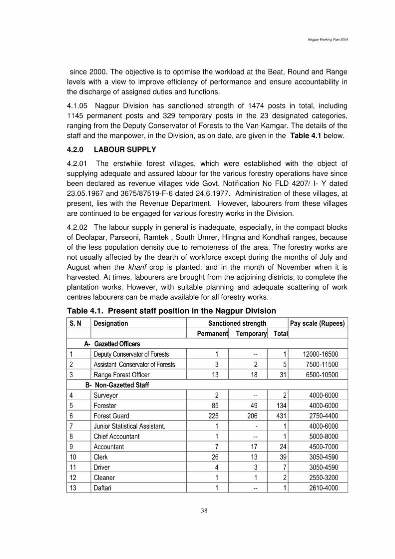
Nagpur Working Plan 2004
38
since 2000. The objective is to optimise the workload at the Beat, Round and Range
levels with a view to improve efficiency of performance and ensure accountability in
the discharge of assigned duties and functions.
4.1.05 Nagpur Division has sanctioned strength of 1474 posts in total, including
1145 permanent posts and 329 temporary posts in the 23 designated categories,
ranging from the Deputy Conservator of Forests to the Van Kamgar. The details of the
staff and the manpower, in the Division, as on date, are given in the Table 4.1 below.
4.2.0 LABOUR SUPPLY
4.2.01 The erstwhile forest villages, which were established with the object of
supplying adequate and assured labour for the various forestry operations have since
been declared as revenue villages vide Govt. Notification No FLD 4207/ I- Y dated
23.05.1967 and 3675/87519-F-6 dated 24.6.1977. Administration of these villages, at
present, lies with the Revenue Department. However, labourers from these villages
are continued to be engaged for various forestry works in the Division.
4.2.02 The labour supply in general is inadequate, especially, in the compact blocks
of Deolapar, Parseoni, Ramtek , South Umrer, Hingna and Kondhali ranges, because
of the less population density due to remoteness of the area. The forestry works are
not usually affected by the dearth of workforce except during the months of July and
August when the kharif crop is planted; and in the month of November when it is
harvested. At times, labourers are brought from the adjoining districts, to complete the
plantation works. However, with suitable planning and adequate scattering of work
centres labourers can be made available for all forestry works.
Table 4.1. Present staff position in the Nagpur Division
S. N Designation Sanctioned strength Pay scale (Rupees)
Permanent Temporary Total
A- Gazetted Officers
1 Deputy Conservator of Forests 1 -- 1 12000-16500
2 Assistant Conservator of Forests 3 2 5 7500-11500
3 Range Forest Officer 13 18 31 6500-10500
B- Non-Gazetted Staff
4 Surveyor 2 -- 2 4000-6000
5 Forester 85 49 134 4000-6000
6 Forest Guard 225 206 431 2750-4400
7 Junior Statistical Assistant. 1 - 1 4000-6000
8 Chief Accountant 1 -- 1 5000-8000
9 Accountant 7 17 24 4500-7000
10 Clerk 26 13 39 3050-4590
11 Driver 4 3 7 3050-4590
12 Cleaner 1 1 2 2550-3200
13 Daftari 1 -- 1 2610-4000

Nagpur Working Plan 2004
39
14 Peon 4 2 6 2550-3200
15 Chaukidar 7 7 14 2610-4000
16 Police constable -- 1 1 4000-6000
17 Sweeper -- 1 1 2550-3200
18 Mali -- 6 6 2550-3200
19 Khansama -- 2 2 2750-4400
20 Mini Train Driver -- 1 1 3050-4590
21 Mini Train Cleaner -- 1 1 2550-3200
22 Tractor Driver -- 1 1 3050-4590
23 Van Kamgar 763 -- 763 2550-3200
Total 1,144 329 1,473
******
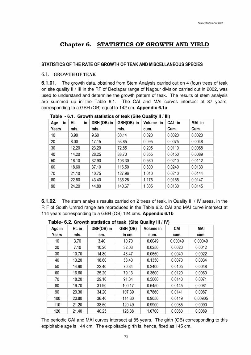
Nagpur Working Plan 2004
73
Chapter 6. STATISTICS OF GROWTH AND YIELD
STATISTICS OF THE RATE OF GROWTH OF TEAK AND MISCELLANEOUS SPECIES
6.1. GROWTH OF TEAK
6.1.01. The growth data, obtained from Stem Analysis carried out on 4 (four) trees of teak
on site quality II / III in the RF of Deolapar range of Nagpur division carried out in 2002, was
used to understand and determine the growth pattern of teak. The results of stem analysis
are summed up in the Table 6.1. The CAI and MAI curves intersect at 87 years,
corresponding to a GBH (OB) equal to 142 cm. Appendix 6.1a
Table - 6.1. Growth statistics of teak (Site Quality II / III)
Age in
Years
Ht. in
mts.
DBH (OB) in
mts.
GBH(OB) in
mts.
Volume in
cum.
CAI in
Cum.
MAI in
Cum.
10 3.90 9.60 30.14 0.020 0.0020 0.0020
20 8.00 17.15 53.85 0.095 0.0075 0.0048
30 12.20 23.20 72.85 0.205 0.0110 0.0068
40 14.20 28.25 88.70 0.355 0.0150 0.0089
50 16.10 32.90 103.30 0.560 0.0210 0.0112
60 18.60 37.10 116.50 0.800 0.0240 0.0133
70 21.10 40.75 127.96 1.010 0.0210 0.0144
80 22.80 43.40 136.28 1.175 0.0165 0.0147
90 24.20 44.80 140.67 1.305 0.0130 0.0145
6.1.02. The stem analysis results carried on 2 trees of teak, in Quality III / IV areas, in the
R F of South Umred range are reproduced in the Table 6.2. CAI and MAI curve intersect at
114 years corresponding to a GBH (OB) 124 cms. Appendix 6.1b
Table- 6.2. Growth statistics of teak (Site Quality III / IV)
Age in
Years
Ht. in
mts.
DBH(OB) in
cm.
GBH (OB)
in cm.
Volume in
cum.
CAI
cum.
MAI
cum.
10 3.70 3.40 10.70 0.0049 0.00049 0.00049
20 7.10 10.20 32.03 0.0250 0.0020 0.0012
30 10.70 14.80 46.47 0.0650 0.0040 0.0022
40 13.20 18.60 58.40 0.1350 0.0070 0.0034
50 14.90 22.40 70.34 0.2400 0.0105 0.0048
60 16.60 25.20 79.13 0.3600 0.0120 0.0060
70 18.20 29.10 91.34 0.5000 0.0140 0.0071
80 19.70 31.90 100.17 0.6450 0.0145 0.0081
90 20.30 34.20 107.39 0.7860 0.0141 0.0087
100 20.80 36.40 114.30 0.9050 0.0119 0.00905
110 21.20 38.50 120.49 0.9900 0.0085 0.0090
120 21.40 40.25 126.38 1.0700 0.0080 0.0089
The periodic CAI and MAI curves intersect at 85 years. The girth (OB) corresponding to this
exploitable age is 144 cm. The exploitable girth is, hence, fixed as 145 cm.

Nagpur Working Plan 2004
74
6.1.03. Stem analysis of teak on the site quality IV area was carried out by CF Nagpur
Circle, in Compartment No. 265, of Hingna Range of Nagpur Division. On the basis of this
work the exploitable girth in site quality IV areas is fixed as 120 cm.
TABLE - 6.3. Growth statistics of teak (Site Quality IV)
Age in
Years
Height in
mtrs.
GBH (OB) in
mts.
DBH (OB) in
mts.
Stem vol. in
cm.
Periodic in
Cm
MAI in
Cm
10 2.8 10 3 0.01 0.001 0.001
20 5.2 37 12 0.03 0.002 0.0015
30 7 54 17 0.07 0.004 0.0023
40 9 69 22 0.13 0.006 0.0033
50 9.8 81 26 0.2 0.007 0.004
60 11.4 91 29 0.26 0.006 0.0043
70 12.8 101 32 0.34 0.008 0.0049
80 14.5 110 35 0.41 0.007 0.0051
90 15.6 116 37 0.46 0.005 0.0051
100 17.5 121 39 0.49 0.003 0.0049
110 -- 125 40 0.52 0.003 0.0047
6.1.04 Local volume table for teak has been developed by the FDCM in the year 2003.
This table is useful for calculating standing volume in a coupe either by actual measurement
of number of trees girth class wise or by wedge prism and then reading the volume from this
table. The table is given below:

Nagpur Working Plan 2004
76
6.2. TEAK PLANTATION
The height and girth of teak trees in plantations in site quality IVb has been
calculated in Prasad's plan by using regression equations worked out from the
measurement in old plantations of Deolapar and Ramtek ranges. It is given in Table 6.4
below:
TABLE - 6.4. Growth statistics of teak Plantations
Age in
years
Height in
mtrs.
Girth b.h.o.b in
cms
Age in
years
Height in
mtrs.
Girth b.h.o.b in
cms
5 4.82 16 10 7.60 26
15 9.61 35 20 10.86 43
25 11.35 50 30 (11.80) (57)
35 (12.10) (62) 40 (12.30) (67)
45 (12.40) (70) 50 (12.50) (73)
*The figure in the brackets are obtained from the extrapolation
6.3. GROWTH STATISTICS OF THE MISCELLANEOUS SPECIES
6.3.1 Growth statistics of 26 miscellaneous species is tabulated as follows:
Table - 6.5 1Growth statistics of Non-Teak Species forming Annual Growth Rings
(Stem Analysis in the Year 2002)
1. Shiwan
Age( in Years) 10 20 30 40 50 60 70 80
Ht. In mtrs. 4.5 10.2 16.3 20.2 22.6 23.6
Dbh.ob.(cms) 9.2000 18.2000 25.8000 32.8000 38.5000 44.4000 49.2000 52.8000
Volume(cumt) 0.0680 0.1620 0.4740 0.9420 1.1460 1.3200 1.4000 0.0000
CAI(cumt) 0.0048 0.0124 0.0392 0.0436 0.0172 0.0160 0.0040 0.0000
MAI(cumt) 0.0068 0.0081 0.0158 0.0235 0.0229 0.0220 0.0200 0.0000
Diam.Incr. 15.7575 4.6625 3.8216 1.9169 1.2315 1.1111 1.0000 0.5374
Volume Incr. 8.5714 9.4656 10.4255 4.6975 1.5593 1.2500 0.2877 0.0000
Rate 800 9300 11600 12900 13700 15400 16100 16100
Amt in Rs. 54 1507 5498 12152 15700 20328 22540 0
Price CAI 6.99 10.80 12.05 1.02 2.48 0.00 0.00
Price MAI 5.44 75.33 183.28 303.80 314.00 338.80 322.00 0.00
2. Sissam
Ht. In mtrs. 6.60 11.30 15.00 18.30 21.00 23.20 24.50 25.00
Dbh.ob.(cms) 7.5000 14.8000 22.4000 28.8000 34.3000 38.7000 42.8000 46.8000
Volume(cumt) 0.0400 0.1000 0.0200 0.3400 0.5400 0.7900 1.0800 1.2800
CAI(cumt) 0.0080 0.0060 0.0120 0.0140 0.0220 0.0240 0.0320 0.0160
MAI(cumt) 0.0040 0.0050 0.0067 0.0085 0.0108 0.0132 0.0154 0.0160
Diam.Incr. 16.0748 6.9841 4.0295 2.4309 1.5129 1.3904 1.2530 0.8734
Volume Incr. 15.1724 7.0588 7.0588 4.5902 4.5361 3.2877 3.2000 1.2903
Rate 280 550 2600 2875 3350 3500 3500 3625
Amt. In Rs. 11.20 55.00 52.00 977.50 1809.00 2765.00 3780.00 4640.00
Price MAI 1.12 2.75 5.20 24.44 36.18 46.08 54.00 58.00
Price CAI 0.16 0.25 1.92 1.17 0.99 0.79 0.40 -5.80
3. Dhawada
Ht. In mtrs. 4.40 7.80 10.70 13.40 15.90 18.00 19.50 20.40

Nagpur Working Plan 2004
77
Dbh.ob.(cms) 8.8000 18.7000 27.8000 35.2000 43.2000 53.8000 58.6000
Volume(cumt) 0.0350 0.1400 0.2450 0.2950 0.3270 0.3700 0.3880
CAI(cumt) 0.0040 0.0140 0.0070 0.0042 0.0030 0.0000 0.0000
MAI(cumt) 0.0035 0.0070 0.0082 0.0073 0.0065 0.0000 0.0000
Diam.Incr. 10.2857 5.8895 3.2684 2.2188 1.5763 1.0687 0.8362
Volume Incr. 16.0000 13.3330 3.0769 1.4762 0.9389 0.5479 0.4166
Rate 280 425 700 825 1050 1150 1150
Amt in Rs. 9.80 59.50 171.50 243.38 343.35 425.50 446.20
Price MAI 0.98 2.98 5.72 6.08 6.87 7.09 6.37
Price CAI 0.20 0.27 0.04 0.08 0.02 -0.07 -0.64
4. Lendia
Ht. In mtrs. 2.00 5.50 7.80 9.80 11.90 13.80 15.50 14.80
Dbh.ob.(cms) 8.9000 18.8000 27.8000 35.6000 40.6000 45.0000 48.4000 51.2000
Volume(cumt) 0.0180 0.1420 0.2640 0.3000 0.3270 0.3570 0.0000 0.0000
CAI(cumt) 0.0012 0.0052 0.0150 0.0120 0.0070 0.0061 0.0000 0.0000
MAI(cumt) 0.0010 0.0035 0.0088 0.0080 0.0070 0.0067 0.0000 0.0000
Diam.Incr. 14.7692 6.4197 3.6935 1.7595 1.0101 0.9090 0.6722 0.4743
Volume Incr. 40.0000 23.8202 3.6363 1.3793 0.7476 0.7417 0.0000 0.0000
Rate 280 425 700 825 1050 1150 1150 1150
Age( in Years) 10 20 30 40 50 60 70 80
Amt in Rs. 5.04 60.35 184.80 247.50 343.35 410.55 0.00 0.00
Price MAI 0.50 3.02 6.16 6.19 6.87 6.84 0.00 0.00
Price CAI 0.25 0.31 0.00 0.07 0.00 -0.68 0.00 0.00
5. Khair
Ht. In mtrs. 4.80 9.80 12.90 14.60 15.10
Dbh.ob.(cms) 9.2000 15.6000 22.0000 28.7000 34.5000 39.7000 44.7000 48.3000
Volume(cumt) 0.0450 0.1000 0.1950 0.3400 0.5500 0.7800 1.0400 1.2200
CAI(cumt) 0.0040 0.0070 0.0110 0.0155 0.0225 0.0280 0.0263 0.0180
MAI(cumt) 0.0028 0.0045 0.0062 0.0080 0.1020 0.1220 0.0143 0.0152
Diam.Incr. 16.6153 4.4128 3.2432 2.8358 2.0091 1.5706 1.1507 0.6736
Volume Incr. 15.3846 5.7142 3.9436 6.1016 6.3157 2.4489 2.2335 1.3559
Rate 3400 5300 7200 9000 12200 13600 13600 13600
Amt. In Rs. 153 530 1404 3060 6710 10608 14144 16592
Price CAI 1.12 2.03 2.97 5.77 4.26 2.53 0.53
Price MAI 15.3 26.5 46.8 76.5 134.2 176.8 202.1 207.4
6. Tendu
Ht. In mtrs. 6.20 11.80 16.50 20.00 22.30 23.50
Dbh.ob.(cms) 7.9000 16.4000 25.1000 31.1000 36.1000 41.1000 45.1000 47.5000
Volume(cumt) 0.0440 0.1000 0.1640 0.3200 0.5200 0.6200 0.6740 0.7000
CAI(cumt) 0.0048 0.0056 0.0068 0.0160 0.0220 0.0080 0.0048 0.0000
MAI(cumt) 0.0044 0.0050 0.0054 0.0080 0.0100 0.0100 0.0096 0.0000
Diam.Incr. 10.9677 6.5248 3.7472 1.6053 1.1396 1.3065 0.7223 0.4255
Volume Incr. 15.0000 6.5116 4.6258 5.7142 4.7311 1.3333 0.7250 0.2877
Rate 280 425 700 825 1050 1150 1150 1150
Amt. In Rs. 12.32 42.50 114.80 264.00 546.00 713.00 775.10 805.00
Price MAI 1.23 2.13 3.83 6.60 10.92 11.88 11.07 10.06
Price CAI 0.09 0.17 0.28 0.43 0.10 -0.08 -0.10 -1.01
7. Chichawa
Ht. In mtrs. 5.00 10.00 13.50 17.00 19.70 21.50 22.50
Dbh.ob.(cms) 9.3000 15.8000 20.2000 24.0000 27.4000 30.6000 34.0000

Nagpur Working Plan 2004
78
Volume(cumt) 0.0800 0.2100 0.2850 0.3260 0.0000 0.0000
CAI(cumt) 0.0023 0.0090 0.0140 0.0090 0.0075 0.0000
MAI(cumt) 0.0021 0.0050 0.0084 0.0084 0.0075 0.0000
Diam.Incr. 10.6122 3.4364 1.9740 1.5584 1.3584 0.9364 0.9638
Volume Incr. 15.6521 8.2758 2.2222 1.1356 0.4000 0.0000 0.0000
Rate 280 425 700 825 1050 1150 1150
Amt in Rs. 22.40 89.25 199.50 268.95 0.00 0.00 0.00
Price MAI 2.24 4.46 6.65 6.72 0.00 0.00 0.00
Price CAI 0.22 0.22 0.01 -0.67 0.00 0.00 0.00
8. Black Shiras
Ht. In mtrs. 2.10 6.00 8.70 11.20 13.60 15.70
Dbh.ob.(cms) 9.7000 17.6000 25.6000 32.2000 39.2000 44.6000 50.0000 55.0000
Volume(cumt) 0.0500 0.1200 0.2450 0.4050 0.5040 0.5600 0.6050 0.6500
CAI(cumt) 0.0060 0.0070 0.0150 0.0140 0.0068 0.0050 0.0050 0.0040
MAI(cumt) 0.0050 0.0060 0.0081 0.0101 0.0100 0.0093 0.0086 0.0081
Diam.Incr. 12.7891 5.4193 3.0252 1.8181 2.0375 1.2962 0.9836 0.8921
Volume Incr. 17.1428 6.8292 7.2289 3.7838 1.3963 0.9132 0.8438 0.6250
Rate 280 425 700 825 1050 1150 1150 1150
Amt in Rs. 14.00 51.00 171.50 334.13 529.20 644.00 695.75 747.50
Price MAI 1.40 2.55 5.72 8.35 10.58 10.73 9.94 9.34
Price CAI 0.12 0.32 0.26 0.22 0.01 -0.08 -0.06 -0.93
Age( in Years) 10 20 30 40 50 60 70 80
9. Bahawa
Ht. In mtrs. 6.70 10.40 12.60 13.90
Dbh.ob.(cms) 9.4000 15.9000 21.4000 26.4000 30.8000 34.6000 37.8000 0.0000
Volume(cumt) 0.0280 0.0800 0.1500 0.2080 0.2400 0.2670 0.2870 0.3050
CAI(cumt) 0.0026 0.0005 0.0081 0.0052 0.0048 0.0044 0.0000 0.0000
MAI(cumt) 0.0002 0.0038 0.0005 0.0052 0.0050 0.0043 0.0000 0.0000
Diam.Incr. 12.2222 5.2669 2.5870 2.9268 1.3422 1.0680 0.7547 0.4000
Volume Incr. 17.4359 10.3937 6.6926 2.4489 1.2903 0.9195 0.7092 0.5315
Rate 280 425 700 825 1050 1150 1150 1150
Amt in Rs. 7.84 34.00 105.00 171.60 252.00 307.05 330.05 350.75
Price MAI 0.78 3.40 10.50 17.16 25.20 30.71 33.01 35.08
Price CAI 0.26 0.71 0.67 0.80 0.55 0.23 0.21 -3.51
10. Hiwar
Ht. In mtrs. 4.20 9.100 13.00 16.60 19.50 21.50 22.40
Dbh.ob.(cms) 8.6000 16.5000 24.1000 31.3000 36.7000 39.7000 42.5000 45.5000
Volume(cumt) 0.0440 0.1000 0.1640 0.3200 0.5200 0.6200 0.6740 0.0000
CAI(cumt) 0.0052 0.0064 0.0128 0.0272 0.0096 0.0052 0.0028 0.0000
MAI(cumt) 0.0046 0.0055 0.0074 0.0115 0.0118 0.0100 0.0090 0.0000
Diam.Incr. 15.9349 7.8260 4.0182 1.7333 0.8913 0.7179 0.6698 0.6250
Volume Incr. 15.0000 6.5116 4.6258 5.7142 4.7311 1.3333 0.7250 0.0000
Rate 280 425 700 825 1050 1150 1150 1150
Amt in Rs. 12.32 42.50 114.80 264.00 546.00 713.00 775.10 0.00
Price MAI 1.23 2.13 3.83 6.60 10.92 11.88 11.07 0.00
Price CAI 0.09 0.17 0.28 0.43 0.10 -0.08 -1.11 0.00
11. Kinhi
Ht. In mtrs. 3.00 9.20 13.00 16.90 19.30 21.60 23.50 24.60
Dbh.ob.(cms) 10.5000 20.9000 29.2000 36.4000 42.8000 48.4000 53.8000 58.2000
Volume(cumt) 0.0100 0.0280 0.0550 0.1150 0.1930 0.2400 0.2650 0.2840
CAI(cumt) 0.0006 0.0016 0.0028 0.0044 0.0080 0.0064 0.0028 0.0017
MAI(cumt) 0.0010 0.0013 0.0014 0.0022 0.0034 0.0040 0.0038 0.0035
Diam.Incr. 11.5337 5.9340 2.5500 1.9596 1.5533 1.1040 1.0687 0.8421
Volume Incr. 13.3333 6.6666 6.8085 7.9166 4.2406 1.2903 0.8477 0.6440
Rate 280 425 700 825 1050 1150 1150 1150

Nagpur Working Plan 2004
79
Amt. In Rs. 2.80 11.90 38.50 94.88 202.65 276.00 304.75 326.60
Price MAI 0.28 0.60 1.28 2.37 4.05 4.60 4.35 4.08
Price CAI 0.03 0.07 0.11 0.17 0.05 -0.02 -0.03 -0.41
12. Ajan
Ht. In mtrs. 3.00 10.10 14.00 17.60 20.50 22.80 24.50 25.30
Dbh.ob.(cms) 11.3000 21.6000 29.5000 36.9000 43.9000 46.9000 50.5000 53.7000
Volume(cumt) 0.0400 0.1000 0.2500 0.8000 1.3000 1.4400 0.0000 0.0000
CAI(cumt) 0.0060 0.0060 0.0180 0.0740 0.0360 0.0120 0.0000 0.0000
MAI(cumt) 0.0040 0.0050 0.0083 0.0200 0.0260 0.0260 0.0000 0.0000
Diam.Incr. 12.8655 5.2356 2.2939 2.0512 1.4492 0.8714 0.7258 0.6818
Volume Incr. 24.0000 7.0588 8.7804 12.0325 2.9752 1.1428 0.4000 0.0000
Rate 280 425 700 825 1050 1150 1150 1150
Amt in Rs. 11.20 42.50 175.00 660.00 1365.00 1656.00 0.00 0.00
Price MAI 1.12 2.13 5.83 16.50 27.30 27.60 0.00 0.00
Price CAI 0.10 0.37 1.07 1.08 0.03 -2.76 0.00 0.00
13. Karanj
Ht. In mtrs. 5.60 8.90 11.10 12.40
Dbh.ob.(cms) 5.3000 10.6000 15.6000 20.5000 24.7000 28.4000
Volume(cumt) 0.0370 0.1750 0.2700 0.3050 0.3340 0.3560
Age( in Years) 10 20 30 40 50 60 70 80
CAI(cumt) 0.0022 0.0055 0.0080 0.0042 0.0030 0.0017
MAI(cumt) 0.0022 0.0048 0.0080 0.0072 0.0064 0.0057
Diam.Incr. 14.3589 5.5913 3.4843 2.2680 1.6877 1.3843
Volume Incr. 8.8888 7.8260 0.7643 -11.2821 -3.0769 -6.8292
Rate 280 425 700 825 1050 1150
Amt in Rs. 10.36 74.38 189.00 251.63 350.70 409.40
Price MAI 1.04 7.44 18.90 25.16 35.07 40.94
Price CAI 0.64 1.15 0.63 0.99 0.59 -4.09
14. Mango
Age( in Years) 10 20 30 40 50 60 70 80
Ht. In mtrs. 5.20 9.20 12.00 13.80 14.70
Dbh.ob.(cms) 7.4000 13.9000 20.7000 28.1000 35.3000 41.7000 47.5000 53.1000
Volume(cumt) 0.0300 0.0750 0.1500 0.3700 0.8200 1.1000 1.2200 1.3200
CAI(cumt) 0.0022 0.0055 0.0150 0.0200 0.0300 0.0200 0.0200 0.0100
MAI(cumt) 0.0013 0.0030 0.0051 0.0100 0.0100 0.0200 0.0200 0.0100
Diam.Incr. 13.8180 5.3880 3.3510 2.9000 2.0200 1.2900 1.1300 1.0000
Volume Incr. 20.0000 12.1740 5.4550 9.0100 7.8800 1.9000 1.0100 0.7700
Rate 280 425 700 825 1050 1150 1150 1150
Amt. In Rs. 8.40 31.88 105.00 305.25 861.00 1265.00 1403.00 1518.00
Price MAI 0.84 1.59 3.50 7.63 17.22 21.08 20.04 18.98
Price CAI 0.08 0.19 0.41 0.96 0.39 -0.10 -0.11 -1.90
15. Prosopis
Ht. In mtrs. 5.70 9.20 11.40 12.70
Dbh.ob.(cms) 5.4000 10.6000 14.5000 17.5000 20.1000 22.3000 24.5000
Volume(cumt) 0.0120 0.0280 0.0520 0.1080 0.1800 0.2200 0.2540 0.2740
CAI(cumt) 0.0009 0.0027 0.0047 0.0066 0.0067 0.0042 0.0024 0.0000
MAI(cumt) 0.0004 0.0001 0.0016 0.0024 0.0025 0.0037 0.0021 0.0000
Diam.Incr. 13.3333 5.1063 3.1226 1.7910 1.3367 0.9174 0.8333 0.0000
Volume Incr. 10.5263 4.8000 6.2222 7.4725 3.9024 1.4117 1.4693 0.8823
Rate 280 425 700 825 1050 1150 1150 1150
Amt in Rs. 3.36 11.90 36.40 89.10 189.00 253.00 292.10 315.10
Price MAI 0.34 0.60 1.21 2.23 3.78 4.22 4.17 3.94
Price CAI 0.026 0.062 0.101 0.155 0.044 -0.004 -0.023 -0.394
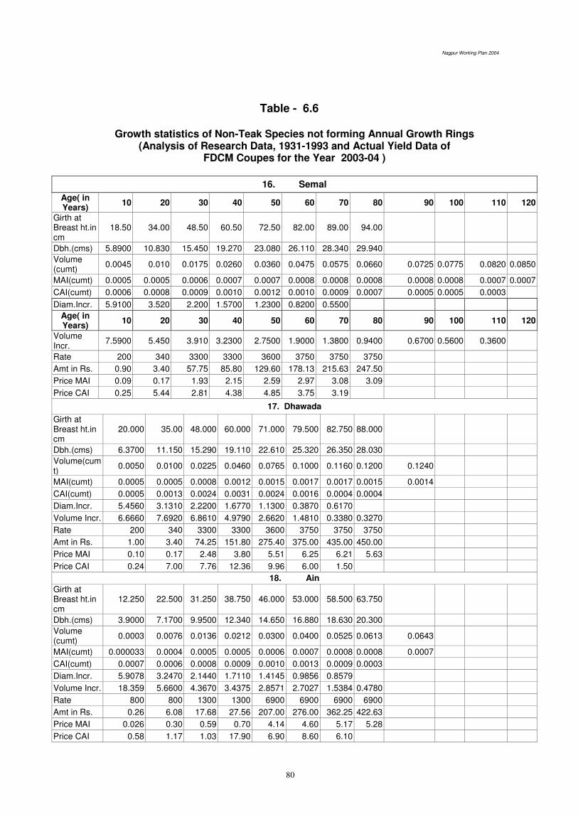
Nagpur Working Plan 2004
80
Table - 6.6
Growth statistics of Non-Teak Species not forming Annual Growth Rings (Analysis of Research Data, 1931-1993 and Actual Yield Data of
FDCM Coupes for the Year 2003-04 )
16. Semal
Age( in Years)
10 20 30 40 50 60 70 80 90 100 110 120
Girth at Breast ht.in cm
18.50 34.00 48.50 60.50 72.50 82.00 89.00 94.00
Dbh.(cms) 5.8900 10.830 15.450 19.270 23.080 26.110 28.340 29.940
Volume (cumt)
0.0045 0.010 0.0175 0.0260 0.0360 0.0475 0.0575 0.0660 0.0725 0.0775 0.0820 0.0850
MAI(cumt) 0.0005 0.0005 0.0006 0.0007 0.0007 0.0008 0.0008 0.0008 0.0008 0.0008 0.0007 0.0007
CAI(cumt) 0.0006 0.0008 0.0009 0.0010 0.0012 0.0010 0.0009 0.0007 0.0005 0.0005 0.0003
Diam.Incr. 5.9100 3.520 2.200 1.5700 1.2300 0.8200 0.5500
Age( in Years)
10 20 30 40 50 60 70 80 90 100 110 120
Volume Incr.
7.5900 5.450 3.910 3.2300 2.7500 1.9000 1.3800 0.9400 0.6700 0.5600 0.3600
Rate 200 340 3300 3300 3600 3750 3750 3750
Amt in Rs. 0.90 3.40 57.75 85.80 129.60 178.13 215.63 247.50
Price MAI 0.09 0.17 1.93 2.15 2.59 2.97 3.08 3.09
Price CAI 0.25 5.44 2.81 4.38 4.85 3.75 3.19
17. Dhawada
Girth at Breast ht.in cm
20.000 35.00 48.000 60.000 71.000 79.500 82.750 88.000
Dbh.(cms) 6.3700 11.150 15.290 19.110 22.610 25.320 26.350 28.030
Volume(cumt)
0.0050 0.0100 0.0225 0.0460 0.0765 0.1000 0.1160 0.1200 0.1240
MAI(cumt) 0.0005 0.0005 0.0008 0.0012 0.0015 0.0017 0.0017 0.0015 0.0014
CAI(cumt) 0.0005 0.0013 0.0024 0.0031 0.0024 0.0016 0.0004 0.0004
Diam.Incr. 5.4560 3.1310 2.2200 1.6770 1.1300 0.3870 0.6170
Volume Incr. 6.6660 7.6920 6.8610 4.9790 2.6620 1.4810 0.3380 0.3270
Rate 200 340 3300 3300 3600 3750 3750 3750
Amt in Rs. 1.00 3.40 74.25 151.80 275.40 375.00 435.00 450.00
Price MAI 0.10 0.17 2.48 3.80 5.51 6.25 6.21 5.63
Price CAI 0.24 7.00 7.76 12.36 9.96 6.00 1.50
18. Ain
Girth at Breast ht.in cm
12.250 22.500 31.250 38.750 46.000 53.000 58.500 63.750
Dbh.(cms) 3.9000 7.1700 9.9500 12.340 14.650 16.880 18.630 20.300
Volume (cumt)
0.0003 0.0076 0.0136 0.0212 0.0300 0.0400 0.0525 0.0613 0.0643
MAI(cumt) 0.000033 0.0004 0.0005 0.0005 0.0006 0.0007 0.0008 0.0008 0.0007
CAI(cumt) 0.0007 0.0006 0.0008 0.0009 0.0010 0.0013 0.0009 0.0003
Diam.Incr. 5.9078 3.2470 2.1440 1.7110 1.4145 0.9856 0.8579
Volume Incr. 18.359 5.6600 4.3670 3.4375 2.8571 2.7027 1.5384 0.4780
Rate 800 800 1300 1300 6900 6900 6900 6900
Amt in Rs. 0.26 6.08 17.68 27.56 207.00 276.00 362.25 422.63
Price MAI 0.026 0.30 0.59 0.70 4.14 4.60 5.17 5.28
Price CAI 0.58 1.17 1.03 17.90 6.90 8.60 6.10
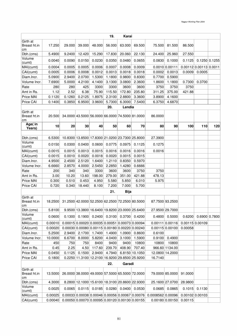
Nagpur Working Plan 2004
81
19. Karai
Girth at Breast ht.in cm
17.250 29.000 39.000 48.000 56.000 63.000 69.500 75.500 81.500 86.500
Dbh.(cms) 5.4900 9.2400 12.420 15.290 17.830 20.060 22.130 24.400 25.960 27.550
Volume (cumt)
0.0040 0.0090 0.0150 0.0230 0.0350 0.0480 0.0655 0.0830 0.1000 0.1125 0.1250 0.1255
MAI(cumt) 0.0004 0.0005 0.0005 0.0006 0.0007 0.0008 0.0009 0.0010 0.00111 0.00112 0.00113 0.0011
CAI(cumt) 0.0005 0.0006 0.0008 0.0012 0.0013 0.0018 0.0018 0.0002 0.0013 0.0009 0.0005
Diam.Incr. 5.0900 2.9400 2.0700 1.5300 1.1800 0.9800 0.8300 0.7700 0.5900
Volume Incr. 7.6900 5.0000 4.2100 4.1400 3.1300 3.0800 2.3600 1.8600 1.1800 0.7300 0.3700
Rate 280 280 425 3300 3300 3600 3600 3750 3750 3750
Amt in Rs. 1.12 2.52 6.38 75.90 115.50 172.80 235.80 311.25 375.00 421.88
Price MAI 0.1120 0.1260 0.2125 1.8975 2.3100 2.8800 3.3600 3.8900 4.1600
Price CAI 0.1400 0.3850 6.9500 3.9600 5.7300 6.3000 7.5400 6.3750 4.6870
20. Lendia
Girth at Breast ht.in cm
20.500 34.0000 43.5000 56.0000 66.0000 74.5000 81.0000 86.0000
Age( in Years)
10 20 30 40 50 60 70 80 90 100 110 120
Dbh.(cms) 6.5300 10.8300 13.8500 17.8300 21.0200 23.7300 25.8000 27.3900
Volume (cumt)
0.0150 0.0300 0.0400 0.0600 0.0775 0.0975 0.1125 0.1275
MAI(cumt) 0.0015 0.0015 0.0013 0.0015 0.0016 0.0016 0.0016 0.0016
CAI(cumt) 0.0015 0.0010 0.0020 0.0018 0.0020 0.0015 0.0015
Diam.Incr. 4.9500 2.4500 2.5120 1.6400 1.2110 0.8350 0.5970
Volume Incr. 6.6660 2.8570 4.0000 2.5450 2.2850 1.4280 0.6666
Rate 200 340 340 3300 3600 3600 3750 3750
Amt in Rs. 3.00 10.20 13.60 198.00 279.00 351.00 421.88 478.13
Price MAI 0.300 0.510 0.453 4.950 5.580 5.850 6.010 5.975
Price CAI 0.720 0.340 18.440 8.100 7.200 7.000 5.700
21. Bija
Girth at Breast ht.in cm
18.2500 31.2500 42.0000 52.2500 62.2500 72.2500 80.5000 87.7500 93.2500
Dbh.(cms) 5.8100 9.9500 13.3800 16.6400 19.8200 23.0000 25.6400 27.9500 29.7000
Volume (cumt)
0.0600 0.1300 0.1900 0.2400 0.3100 0.3700 0.4200 0.4800 0.5000 0.6200 0.6900 0.7800
MAI(cumt) 0.00010 0.00015 0.00020 0.00035 0.00051 0.00073 0.00094 0.00111 0.00116 0.00115 0.00109
CAI(cumt) 0.00020 0.00030 0.00080 0.00115 0.00180 0.00220 0.00240 0.00115 0.00100 0.00058
Diam.Incr. 5.2500 2.9400 2.1700 1.7400 1.4900 1.0900 0.8600 0.6100
Volume Incr. 10.0000 6.6700 8.0000 5.8200 4.0400 3.1000 1.5900 0.9100 0.4900
Rate 450 750 750 8400 9400 9400 10800 10800 10800
Amt in Rs. 0.45 2.25 4.50 117.60 239.70 408.90 707.40 966.60 1134.00
Price MAI 0.0450 0.1125 0.1500 2.9400 4.7940 6.8150 10.1050 12.0800 14.2000
Price CAI 0.1800 0.2250 11.3100 12.2100 16.9200 29.8500 25.9200 16.7140
22. Garadi
Girth at Breast ht.in cm
13.5000 26.0000 38.0000 49.0000 57.5000 65.5000 72.0000 79.0000 85.0000 91.0000
Dbh.(cms) 4.3000 8.2800 12.1000 15.6100 18.3100 20.8600 22.9300 25.1600 27.0700 28.9800
Volume (cumt)
0.0025 0.0065 0.0115 0.0185 0.0280 0.0400 0.0530 0.0685 0.0865 0.1015 0.1130
MAI(cumt) 0.00025 0.00033 0.00038 0.00046 0.00056 0.00067 0.00076 0.0008562 0.00096 0.00102 0.00103
CAI(cumt) 0.00040 0.00050 0.00070 0.00095 0.00120 0.00130 0.00155 0.00180 0.00150 0.00115
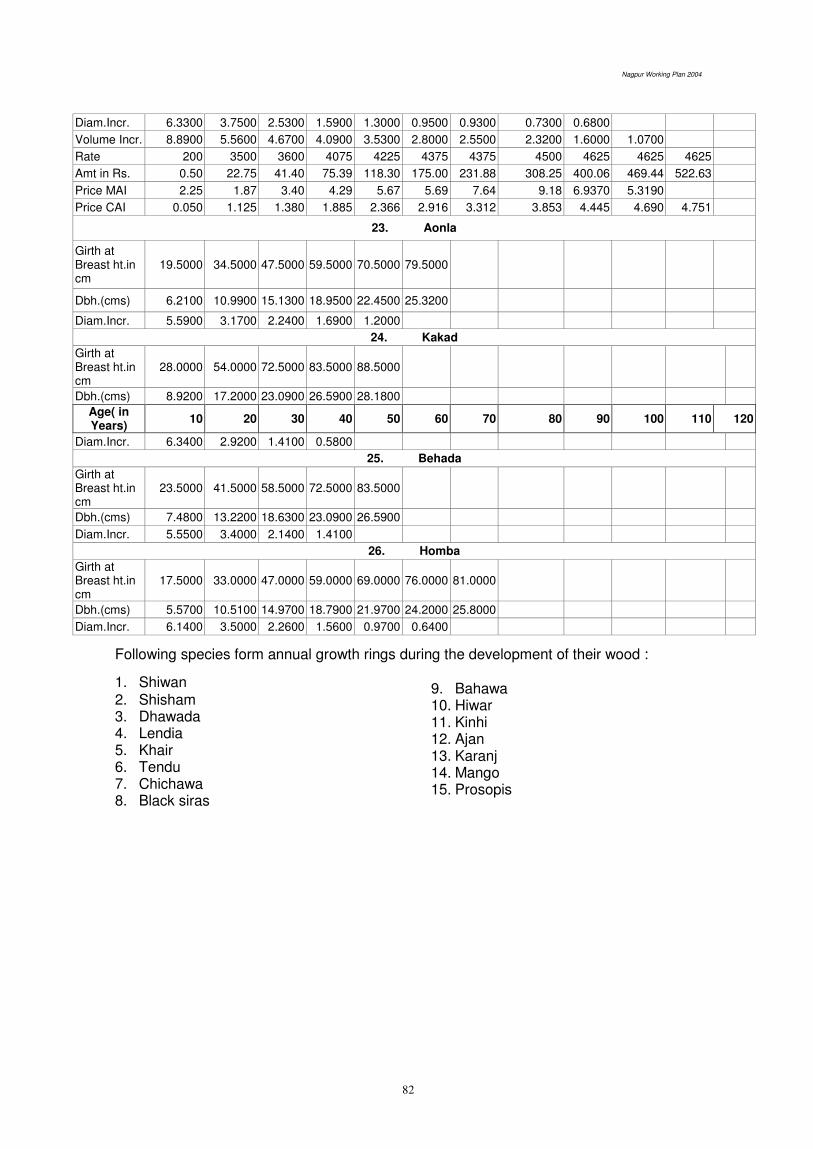
Nagpur Working Plan 2004
82
Diam.Incr. 6.3300 3.7500 2.5300 1.5900 1.3000 0.9500 0.9300 0.7300 0.6800
Volume Incr. 8.8900 5.5600 4.6700 4.0900 3.5300 2.8000 2.5500 2.3200 1.6000 1.0700
Rate 200 3500 3600 4075 4225 4375 4375 4500 4625 4625 4625
Amt in Rs. 0.50 22.75 41.40 75.39 118.30 175.00 231.88 308.25 400.06 469.44 522.63
Price MAI 2.25 1.87 3.40 4.29 5.67 5.69 7.64 9.18 6.9370 5.3190
Price CAI 0.050 1.125 1.380 1.885 2.366 2.916 3.312 3.853 4.445 4.690 4.751
23. Aonla
Girth at Breast ht.in cm
19.5000 34.5000 47.5000 59.5000 70.5000 79.5000
Dbh.(cms) 6.2100 10.9900 15.1300 18.9500 22.4500 25.3200
Diam.Incr. 5.5900 3.1700 2.2400 1.6900 1.2000
24. Kakad
Girth at Breast ht.in cm
28.0000 54.0000 72.5000 83.5000 88.5000
Dbh.(cms) 8.9200 17.2000 23.0900 26.5900 28.1800
Age( in Years)
10 20 30 40 50 60 70 80 90 100 110 120
Diam.Incr. 6.3400 2.9200 1.4100 0.5800
25. Behada
Girth at Breast ht.in cm
23.5000 41.5000 58.5000 72.5000 83.5000
Dbh.(cms) 7.4800 13.2200 18.6300 23.0900 26.5900
Diam.Incr. 5.5500 3.4000 2.1400 1.4100
26. Homba
Girth at Breast ht.in cm
17.5000 33.0000 47.0000 59.0000 69.0000 76.0000 81.0000
Dbh.(cms) 5.5700 10.5100 14.9700 18.7900 21.9700 24.2000 25.8000
Diam.Incr. 6.1400 3.5000 2.2600 1.5600 0.9700 0.6400
Following species form annual growth rings during the development of their wood :
1. Shiwan 2. Shisham 3. Dhawada 4. Lendia 5. Khair 6. Tendu 7. Chichawa 8. Black siras
9. Bahawa 10. Hiwar 11. Kinhi 12. Ajan 13. Karanj 14. Mango 15. Prosopis
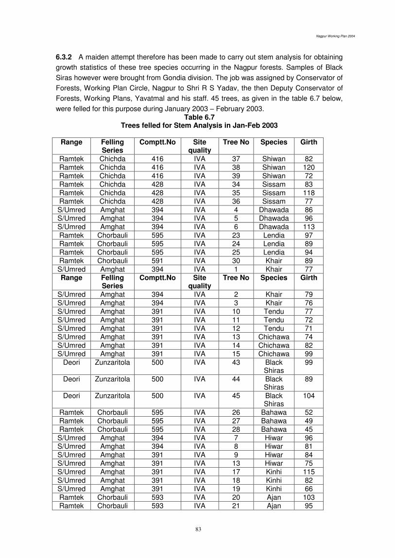
Nagpur Working Plan 2004
83
6.3.2 A maiden attempt therefore has been made to carry out stem analysis for obtaining
growth statistics of these tree species occurring in the Nagpur forests. Samples of Black
Siras however were brought from Gondia division. The job was assigned by Conservator of
Forests, Working Plan Circle, Nagpur to Shri R S Yadav, the then Deputy Conservator of
Forests, Working Plans, Yavatmal and his staff. 45 trees, as given in the table 6.7 below,
were felled for this purpose during January 2003 – February 2003. Table 6.7
Trees felled for Stem Analysis in Jan-Feb 2003
Range Felling Series
Comptt.No Site quality
Tree No Species Girth
Ramtek Chichda 416 IVA 37 Shiwan 82 Ramtek Chichda 416 IVA 38 Shiwan 120 Ramtek Chichda 416 IVA 39 Shiwan 72 Ramtek Chichda 428 IVA 34 Sissam 83 Ramtek Chichda 428 IVA 35 Sissam 118 Ramtek Chichda 428 IVA 36 Sissam 77 S/Umred Amghat 394 IVA 4 Dhawada 86 S/Umred Amghat 394 IVA 5 Dhawada 96 S/Umred Amghat 394 IVA 6 Dhawada 113 Ramtek Chorbauli 595 IVA 23 Lendia 97 Ramtek Chorbauli 595 IVA 24 Lendia 89 Ramtek Chorbauli 595 IVA 25 Lendia 94 Ramtek Chorbauli 591 IVA 30 Khair 89 S/Umred Amghat 394 IVA 1 Khair 77 Range Felling
Series Comptt.No Site
quality Tree No Species Girth
S/Umred Amghat 394 IVA 2 Khair 79 S/Umred Amghat 394 IVA 3 Khair 76 S/Umred Amghat 391 IVA 10 Tendu 77 S/Umred Amghat 391 IVA 11 Tendu 72 S/Umred Amghat 391 IVA 12 Tendu 71 S/Umred Amghat 391 IVA 13 Chichawa 74 S/Umred Amghat 391 IVA 14 Chichawa 82 S/Umred Amghat 391 IVA 15 Chichawa 99
Deori Zunzaritola 500 IVA 43 Black Shiras
99
Deori Zunzaritola 500 IVA 44 Black Shiras
89
Deori Zunzaritola 500 IVA 45 Black Shiras
104
Ramtek Chorbauli 595 IVA 26 Bahawa 52 Ramtek Chorbauli 595 IVA 27 Bahawa 49 Ramtek Chorbauli 595 IVA 28 Bahawa 45 S/Umred Amghat 394 IVA 7 Hiwar 96 S/Umred Amghat 394 IVA 8 Hiwar 81 S/Umred Amghat 391 IVA 9 Hiwar 84 S/Umred Amghat 391 IVA 13 Hiwar 75 S/Umred Amghat 391 IVA 17 Kinhi 115 S/Umred Amghat 391 IVA 18 Kinhi 82 S/Umred Amghat 391 IVA 19 Kinhi 66 Ramtek Chorbauli 593 IVA 20 Ajan 103 Ramtek Chorbauli 593 IVA 21 Ajan 95

Nagpur Working Plan 2004
84
Ramtek Chorbauli 593 IVA 22 Ajan 109 Ramtek Chorbauli 591 IVA 31 Karanj 62 Ramtek Chorbauli 591 IVA 32 Karanj 59 Ramtek Chorbauli 591 IVA 33 Karanj 88 Ramtek Chorbauli 595 IVA 29 Mango 136 Ramtek MPWP
Ramtek 273 IVA 40 Prosopis 42
Ramtek MPWP Ramtek
273 IVA 41 Prosopis 38
Ramtek MPWP Ramtek
273 IVA 42 39
6.3.3 The analysis of the data followed subsequently. Detail analysis is given in the
Appendix 6.2 Thus the information on the growth statistics of these species was provided
for incorporation into this plan by Shri R S Yadav and his team of dedicated staff. Summary
of this information is what is shown in the table 6.5 above.
A totally different approach to obtain growth statistics was adopted in case of the
tree species, which do not form annual rings. The list of such species is as follows:
1. Ain 2. Bija 3. Lendia 4. Dhawada
5. Garadi 6. Semal 7. Karai
8. Kakad
9. Aonla 10. Behada 11. Homba
6.3.4 The research wing of the Maharashtra Forest Department maintains a few
permanent research plots wherein tree wise growth measurements (measurement of
GBH) are recorded every five years. One such plot was established at Kanhargaon in
Chandrapur district in November 1931 in comptt. No. 16 of Chandrapur division (presently
Central Chandrapur division) in an area of 2.66 ha and containing 1043 trees. All the tree
species occurring in this plot are numbered and the GBH measurements of 11 such tree
species from 1931 to 1993, approximately at 5 years interval, were made available to us
by the Director, MVSS, Chandrapur. This data has been used to generate increment table.
Diameter increment and GBH(Age) curves are drawn using this data. (Appendix No. 6.3)
Then GBH-volume curve was obtained by using actual data of felling (from jungle register)
done in the recent coupes by the FDCM in Nagpur district. (Deolapar, Ramtek and Khapa
ranges). The comparison of GBH-volume and GBH-age relationship gives Age - Volume
relationship. These curves and related information age - volume relation is given under
Appendix 6.4 and summarized information is given in the table 6.6 above.
This analysis was done in the year 2003 by Shri S G Bhowate, RFO, in the office of
Deputy Conservator of Forests, Working Plan Division, Nagpur and a few forest guards
available in this office. Shri Shailendra Bahadur, Conservator of Forests, Working Plan
Circle, Nagpur personally provided all the guidance for this analysis.
While incorporating the above information about the growth statistics of the 26
species, an attempt has been made to fix the rotation, in addition to on the basis of
biological considerations of CAI intersecting MAI, in the light of maximum realization of
yield in commercial terms. Thus, MAI and CAI is replaced by actual sale data from the
schedule of rate of Nagpur circle for the corresponding volume in case of a few species.
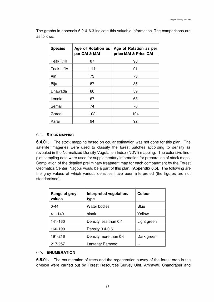
Nagpur Working Plan 2004
85
The graphs in appendix 6.2 & 6.3 indicate this valuable information. The comparisons are
as follows:
Species Age of Rotation as
per CAI & MAI
Age of Rotation as per
price MAI & Price CAI
Teak II/III 87 90
Teak III/IV 114 91
Ain 73 73
Bija 87 85
Dhawada 60 59
Lendia 67 68
Semal 74 70
Garadi 102 104
Karai 94 92
6.4. STOCK MAPPING
6.4.01. The stock mapping based on ocular estimation was not done for this plan. The
satellite imageries were used to classify the forest patches according to density as
revealed in the Normalized Density Vegetation Index (NDVI) mapping. The extensive line-
plot sampling data were used for supplementary information for preparation of stock maps.
Compilation of the detailed preliminary treatment map for each compartment by the Forest
Geomatics Center, Nagpur would be a part of this plan. (Appendix 6.5). The following are
the grey values at which various densities have been interpreted (the figures are not
standardised).
Range of grey
values
Interpreted vegetation/
type
Colour
0-44 Water bodies Blue
41 -140 blank Yellow
141-160 Density less than 0.4 Light green
160-190 Density 0.4-0.6 --
191-216 Density more than 0.6 Dark green
217-257 Lantana/ Bamboo --
6.5. ENUMERATION
6.5.01. The enumeration of trees and the regeneration survey of the forest crop in the
division were carried out by Forest Resources Survey Unit, Amravati, Chandrapur and
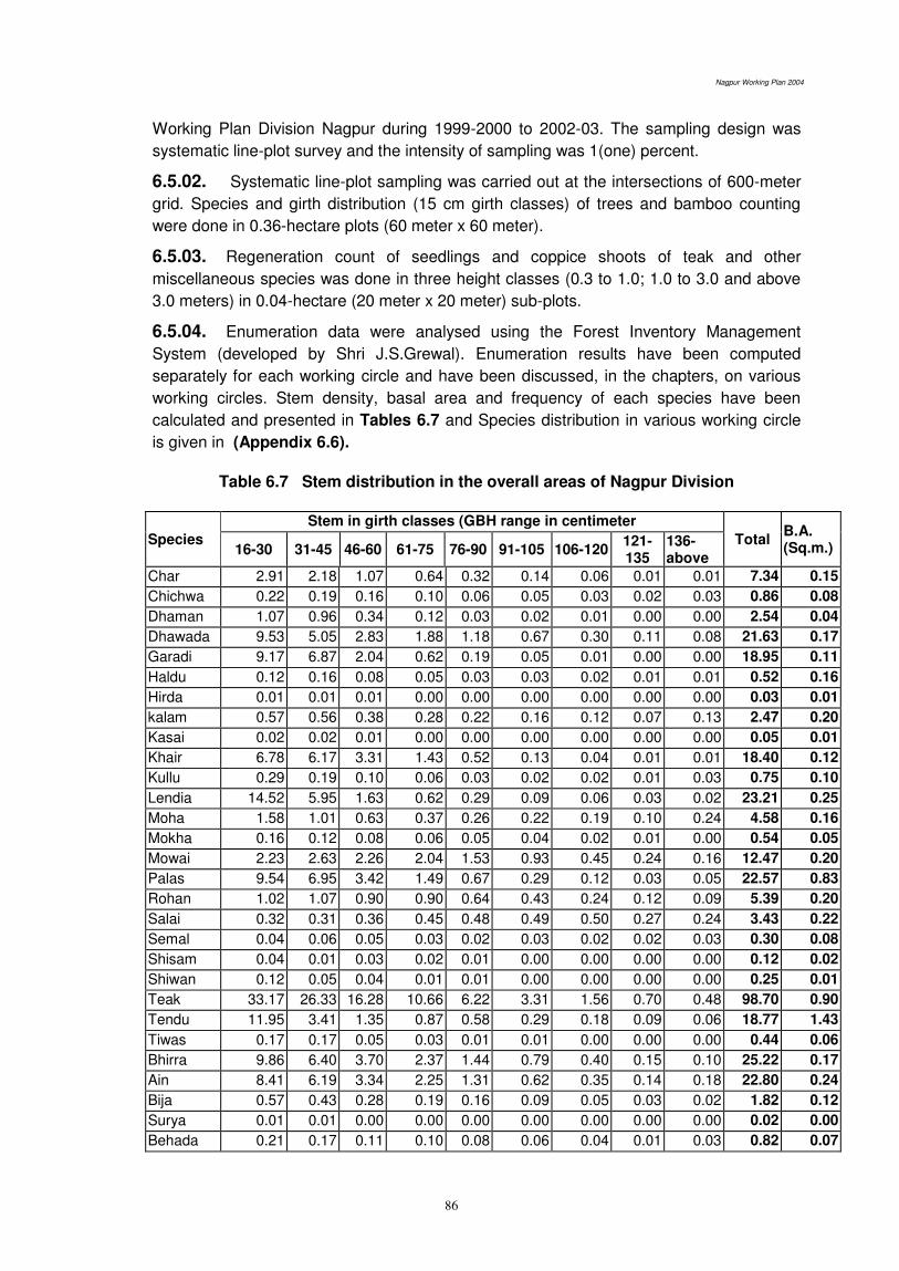
Nagpur Working Plan 2004
86
Working Plan Division Nagpur during 1999-2000 to 2002-03. The sampling design was
systematic line-plot survey and the intensity of sampling was 1(one) percent.
6.5.02. Systematic line-plot sampling was carried out at the intersections of 600-meter
grid. Species and girth distribution (15 cm girth classes) of trees and bamboo counting
were done in 0.36-hectare plots (60 meter x 60 meter).
6.5.03. Regeneration count of seedlings and coppice shoots of teak and other
miscellaneous species was done in three height classes (0.3 to 1.0; 1.0 to 3.0 and above
3.0 meters) in 0.04-hectare (20 meter x 20 meter) sub-plots.
6.5.04. Enumeration data were analysed using the Forest Inventory Management
System (developed by Shri J.S.Grewal). Enumeration results have been computed
separately for each working circle and have been discussed, in the chapters, on various
working circles. Stem density, basal area and frequency of each species have been
calculated and presented in Tables 6.7 and Species distribution in various working circle
is given in (Appendix 6.6).
Table 6.7 Stem distribution in the overall areas of Nagpur Division
Species
Stem in girth classes (GBH range in centimeter
Total B.A. (Sq.m.) 16-30 31-45 46-60 61-75 76-90 91-105 106-120
121-135
136-above
Char 2.91 2.18 1.07 0.64 0.32 0.14 0.06 0.01 0.01 7.34 0.15
Chichwa 0.22 0.19 0.16 0.10 0.06 0.05 0.03 0.02 0.03 0.86 0.08
Dhaman 1.07 0.96 0.34 0.12 0.03 0.02 0.01 0.00 0.00 2.54 0.04
Dhawada 9.53 5.05 2.83 1.88 1.18 0.67 0.30 0.11 0.08 21.63 0.17
Garadi 9.17 6.87 2.04 0.62 0.19 0.05 0.01 0.00 0.00 18.95 0.11
Haldu 0.12 0.16 0.08 0.05 0.03 0.03 0.02 0.01 0.01 0.52 0.16
Hirda 0.01 0.01 0.01 0.00 0.00 0.00 0.00 0.00 0.00 0.03 0.01
kalam 0.57 0.56 0.38 0.28 0.22 0.16 0.12 0.07 0.13 2.47 0.20
Kasai 0.02 0.02 0.01 0.00 0.00 0.00 0.00 0.00 0.00 0.05 0.01
Khair 6.78 6.17 3.31 1.43 0.52 0.13 0.04 0.01 0.01 18.40 0.12
Kullu 0.29 0.19 0.10 0.06 0.03 0.02 0.02 0.01 0.03 0.75 0.10
Lendia 14.52 5.95 1.63 0.62 0.29 0.09 0.06 0.03 0.02 23.21 0.25
Moha 1.58 1.01 0.63 0.37 0.26 0.22 0.19 0.10 0.24 4.58 0.16
Mokha 0.16 0.12 0.08 0.06 0.05 0.04 0.02 0.01 0.00 0.54 0.05
Mowai 2.23 2.63 2.26 2.04 1.53 0.93 0.45 0.24 0.16 12.47 0.20
Palas 9.54 6.95 3.42 1.49 0.67 0.29 0.12 0.03 0.05 22.57 0.83
Rohan 1.02 1.07 0.90 0.90 0.64 0.43 0.24 0.12 0.09 5.39 0.20
Salai 0.32 0.31 0.36 0.45 0.48 0.49 0.50 0.27 0.24 3.43 0.22
Semal 0.04 0.06 0.05 0.03 0.02 0.03 0.02 0.02 0.03 0.30 0.08
Shisam 0.04 0.01 0.03 0.02 0.01 0.00 0.00 0.00 0.00 0.12 0.02
Shiwan 0.12 0.05 0.04 0.01 0.01 0.00 0.00 0.00 0.00 0.25 0.01
Teak 33.17 26.33 16.28 10.66 6.22 3.31 1.56 0.70 0.48 98.70 0.90
Tendu 11.95 3.41 1.35 0.87 0.58 0.29 0.18 0.09 0.06 18.77 1.43
Tiwas 0.17 0.17 0.05 0.03 0.01 0.01 0.00 0.00 0.00 0.44 0.06
Bhirra 9.86 6.40 3.70 2.37 1.44 0.79 0.40 0.15 0.10 25.22 0.17
Ain 8.41 6.19 3.34 2.25 1.31 0.62 0.35 0.14 0.18 22.80 0.24
Bija 0.57 0.43 0.28 0.19 0.16 0.09 0.05 0.03 0.02 1.82 0.12
Surya 0.01 0.01 0.00 0.00 0.00 0.00 0.00 0.00 0.00 0.02 0.00
Behada 0.21 0.17 0.11 0.10 0.08 0.06 0.04 0.01 0.03 0.82 0.07
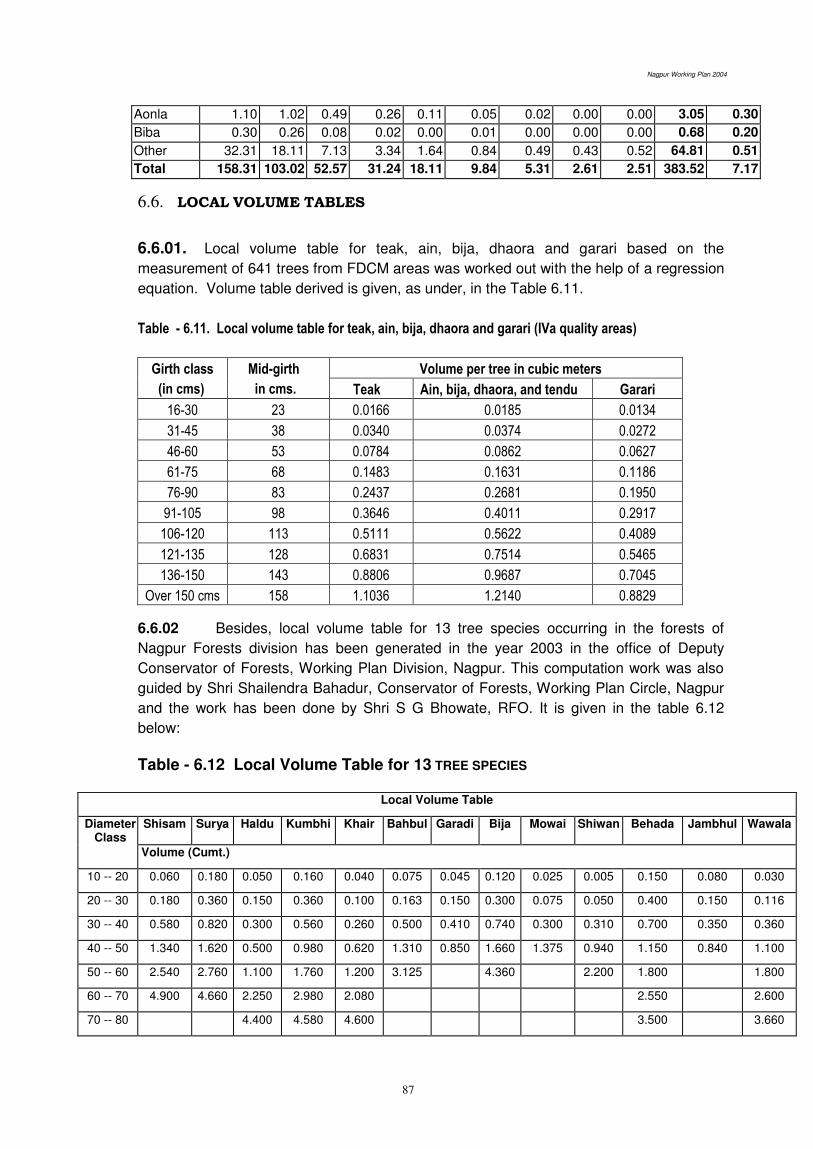
Nagpur Working Plan 2004
87
Aonla 1.10 1.02 0.49 0.26 0.11 0.05 0.02 0.00 0.00 3.05 0.30
Biba 0.30 0.26 0.08 0.02 0.00 0.01 0.00 0.00 0.00 0.68 0.20
Other 32.31 18.11 7.13 3.34 1.64 0.84 0.49 0.43 0.52 64.81 0.51
Total 158.31 103.02 52.57 31.24 18.11 9.84 5.31 2.61 2.51 383.52 7.17
6.6. LOCAL VOLUME TABLES
6.6.01. Local volume table for teak, ain, bija, dhaora and garari based on the
measurement of 641 trees from FDCM areas was worked out with the help of a regression
equation. Volume table derived is given, as under, in the Table 6.11.
Table - 6.11. Local volume table for teak, ain, bija, dhaora and garari (IVa quality areas)
Girth class
(in cms)
Mid-girth
in cms.
Volume per tree in cubic meters
Teak Ain, bija, dhaora, and tendu Garari
16-30 23 0.0166 0.0185 0.0134
31-45 38 0.0340 0.0374 0.0272
46-60 53 0.0784 0.0862 0.0627
61-75 68 0.1483 0.1631 0.1186
76-90 83 0.2437 0.2681 0.1950
91-105 98 0.3646 0.4011 0.2917
106-120 113 0.5111 0.5622 0.4089
121-135 128 0.6831 0.7514 0.5465
136-150 143 0.8806 0.9687 0.7045
Over 150 cms 158 1.1036 1.2140 0.8829
6.6.02 Besides, local volume table for 13 tree species occurring in the forests of
Nagpur Forests division has been generated in the year 2003 in the office of Deputy
Conservator of Forests, Working Plan Division, Nagpur. This computation work was also
guided by Shri Shailendra Bahadur, Conservator of Forests, Working Plan Circle, Nagpur
and the work has been done by Shri S G Bhowate, RFO. It is given in the table 6.12
below:
Table - 6.12 Local Volume Table for 13 TREE SPECIES
Local Volume Table
Diameter Class
Shisam Surya Haldu Kumbhi Khair Bahbul Garadi Bija Mowai Shiwan Behada Jambhul Wawala
Volume (Cumt.)
10 -- 20 0.060 0.180 0.050 0.160 0.040 0.075 0.045 0.120 0.025 0.005 0.150 0.080 0.030
20 -- 30 0.180 0.360 0.150 0.360 0.100 0.163 0.150 0.300 0.075 0.050 0.400 0.150 0.116
30 -- 40 0.580 0.820 0.300 0.560 0.260 0.500 0.410 0.740 0.300 0.310 0.700 0.350 0.360
40 -- 50 1.340 1.620 0.500 0.980 0.620 1.310 0.850 1.660 1.375 0.940 1.150 0.840 1.100
50 -- 60 2.540 2.760 1.100 1.760 1.200 3.125 4.360 2.200 1.800 1.800
60 -- 70 4.900 4.660 2.250 2.980 2.080 2.550 2.600
70 -- 80 4.400 4.580 4.600 3.500 3.660

Nagpur Working Plan 2004
88
To arrive at the above values, we have used Standard Volume tables for
various species (available from FRI, Dehradun) and DBH-volume curve for different
heights was drawn. Then diameter and height measurements of the various tree species
were done in Ramtek and Deolapar ranges. This field data is then interpolated on the
same curves. Volume for different diameter (girth) obtained from this curve is then
tabulated girth class wise which is the local volume table. Field data of diameter and
height measurement as well as the curves generated are given in the Appendix 6.6
6.7 ANALYSIS OF THE CROP
6.7.01 Reserved Forests of the division were stock mapped for the first time in the years
1931-1933 at the time of revision of the working plan by Dunbar Brander. The stock maps
were revised with each revision of the working plan. Protected Forests of the division were
stock mapped for the first time during preparation of the working scheme by S.S. Parsanis.
The latest revision of stock mapping was made at the time of the revision of the working
plan by Jwala Prasad.
6.7.02 The Conservator of Forests, Working Plan, Nagpur has directed to replace ocular
and subjective stock mapping with objective inventory based on the systematic line-plot
sampling on 600 meter grid. The standard size of the sample plot is of 0.36 hectares and
located at the grid intersections, in the NE quadrant. Inventory work includes complete
enumeration of all trees species in these plots in 15cm girth classes. Regeneration
counting is done in 0.04-hectare sub-plots. Recording of forest type, site quality, density
and nature of forest damage have been included as an integral part of the enumeration
exercise. Accordingly, SOFR (Survey of Forest Resource) Unit, Amravati in collaboration
with the field staff of Nagpur Working Plan Division has carried out the comprehensive
inventory in forests of Nagpur division. The Inventory Management System developed by J
S Grewal was used for analysis of the inventory data leading to provide, the following,
statements for the purpose of estimation of the growing stock for treatment under various
working circles;
1. Girth class-wise estimated growing stock in respect of important 18-20 tree species
and rest of species together.
2. Estimated growing stock per hectare separately for ain, bija, lendia, shisham, tiwas,
teak, kalam, khair, salai, semal, dhaora, garari and rest of species together.
3. Girth class-wise percentage distribution of each of the above species in the growing
stock
6.7.03 The inventory data, so obtained, have been prescribed to be dynamically linked
with compartment maps in the GIS environment; showing the necessary stocking and
management related details. Resulting interactive digital maps of the compartments will
serve as site-specific decision support system for preparation of the working plan. These
maps prepared in the GIS environment are cartographically more accurate than traditional
stock maps based on ocular estimation. The process has been fairly standardised in the
Forest Geomatics Center at Nagpur and has been used in preparation of stock maps for
working plans of Gondia, Chadrapur, Pandharkawada and Yeotmal Forest Divisions.
******
Nagpur Working Plan 2004
89
Chapter 7. The BIODIVERSITY CONSERVATION AND WILD LIFE
PRESERVATION
Biodiversity conservation is an important mandate of the forest department and
with the enactment of Wildlife (Protection) Act, 1972, wildlife management has become
synonymous with biodiversity conservation. The history of wildlife management, summary
of Wildlife (Protection) Act, 1972 and other important issues of man-animal interface have
been summarized under this chapter.
7.1. DESCRIPTION OF THE FAUNA
7.1.01. Almost all the forest areas of the division have a fairly good distribution of wild
animals, but population density varies with the availability of habitat conditions like food,
water and shelter. Deolapar, Parseoni, Ramtek, Khapa and Hingna ranges, that is, the
areas adjoining to the Pench National Park and Bor Sanctuary and also the South Umred
range are particularly rich in wildlife. In Narkhed, Kondhali, North Umred and Kuhi ranges,
wild animals are less in number, where they are seen in better patches of the forests.
Representative Central Indian fauna is found in the division and the category wise list of
the animals usually found is as shown below :
CARNIVORA: (i) Tiger (Panthera tigiris) (ii) Panther (Panthara pardus) (iii) Hyaena
(Hyaena hyaena) (iv) Wild Dog (Cuon alpinus) (v) Indian Wolf (Canis lupas pallipes) (vi)
Jackal (Canis aureus) (vii) Common Fox (Vulpes bengalensis) (viii) Leopard Cat (Felis
bengalnsis (ix) Jungle Cat (Felis chaus).
HERBIVORA: (i) Bison-Gaur (Bos gaurus) (ii) Sambhar (Cervus unicolor) (iii) Cheetal
(Axis axis) (iv) Nilgai (Boselaphus tragocamelus) (v) Barking Deer (Muntiacus muntjak) (vi)
Wild pig (Sus scrofa) (vii) Sloth bear (Melursus ursinus) (viii) Black Buck (Antilope
cervicapra) (ix) Four horned antelope (Tetraceros quadricornis) (x) Chinkara or Indian
gazelle (Gazella gazella bennettil), (xi) Mouse deer (Tragulus memina).
RODENTS: (i) Flying squirrel (Pteromya fimbriatus) (ii) Three striped palm squirrel
(Funambulus palmarun) (iii) Porcupine.
BIRDS: (i) Painted sand grouse (Pterocles indicus) (ii) Common sand grouse (Pterocles
exustus) (iii) Pea fowl (Pavo cristatus) (iv) Grey jungle fowl (Gallus sonne ratil) (v) Painted
partridges (Francolinus pictus) (vi) Grey partridges (Francolinus pondicerianus) (vii)
Jungle bush quail (Pardicula aisstics) (viii) Black breasted Rain quail (Cturnix
coronandelicus) (ix) Indian Bustard quail (Turnix suscitator) (x) Indian or yellow legged
button quail (Turnix tanki) (xi) Red spur fowl (Galloperdix spadices) (xii) Crane (Grus
antigone) (xiii) Spotted bill duck (Anas poecilorhyncha) (xiv) Pigeon (Treron
phoonicoptera) (xv) Dove (Streptpotia spps) (xvi) Cotton teal (Nettapus coromandelianus)
(xvii) Whistling teal (Dendrocugna javanica).
7.1.02. Tiger is usually found in Ramtek, Khapa, Parseoni and Deolapar ranges and
Panther in almost all the ranges. Hyena, Jackal and Foxes are seen frequenting near the
inhabited areas. Packs of wild dogs are seen in the Ramtek, Parseoni, Deolapar and
Khapa ranges.
Nilgai, Chital and Sambhar are found all over the division. Gaurs are mainly
found in Parseoni, Ramtek and Deolapar ranges. Bears are found usually in the valleys of
Nagpur Working Plan 2004
90
Deolapar and Ramtek ranges and also in the Ranbodi block of North Umred range.
Typical Central Indian avifauna is also found in the forest tracts of this division and
waterfowl are seen in the water bodies within as well as those located outside the forests.
In fact, there are many large water bodies, some even close to Nagpur city like Koradi
lake, which provide good habitat to many migratory winter visiting water birds.
7.2. HISTORY OF THE WILD LIFE MANAGEMENT IN GENERAL
From time immemorial the wild animals have occupied a place of pride in the
folklore of Indian culture. They were respected and protected by the tribals who never
used to kill the animals for fun or pleasure. However, hunting became an important
pastime for the Rajas and Maharajas who used to hunt and kill the animals for meat as
well as for preparing trophies. In the Reserved Forests, hunting was restricted and
licenses were used to be issued for small game, big game, etc. and shooting blocks were
set apart, where the animals specified in the license only could be hunted.
Prior to the abolition of the proprietary rights, hunting in the malgujari forests was
done with the permission of the malgujars. Consequent to the vesting of these forests in
the government as Protected Forests, hunting in these forests was also regulated by fixing
shooting blocks and by issuing licenses.
However, after the enactment of the Wildlife (Protection) Act, 1972 and subsequent
amendments in this act particularly those in 1991 and 2002, no permission for hunting of
wild animals, as game or sport, can be granted. Hunting of wild animals however can be
allowed for special purposes but only in exceptional circumstances. This act also enjoins
on us the responsibility for wildlife conservation outside the protected areas.
The wildlife, which used to flourish in the forests of the division, is threatened due
to various factors like population explosion, encroachments, improved network of roads
and availability of sophisticated weapons. Due to increase in demand for wildlife products
all over the world, poaching problems have increased over the years and Nagpur, the
head quarters of this division being a very big city and an important centre of central India,
special efforts are required to be made by the division to protect the wildlife in the region.
7.3. LEGAL POSITION
7.3.01. The first step towards the protection of wildlife was taken by including certain
provisions, in this regard, in the Berar Forest Act of 1886. Under Section (3) sub section
7, the definition of forest produce incorporated the ‘skins, tusks, bones and horns’ and as per Section 10, sub section 4, ‘The residency by orders may regulate any part of the State Forests for hunting, shooting, fishing, poisoning water and setting up traps or snares.”
The Berar Forest Act, 1886 amended in 1891 provided under section 7(b) that
forest produce includes the following when found in or brought from a forest:
“Wild animals, skins, tusks, horns, bones, silk cocoons, honey and wax and all
other parts or produce of animal.”
Section 7(2)(b) of this act after this amendment provided that any one who hunts,
shoots, fishes, poisons water or sets traps or snares, shall be punishable with the fine
which may extend upto fifty rupees or, when the damage resulting from the offence
amounts to more than twenty five rupees, to double the amount of such damage. Section
Nagpur Working Plan 2004
91
10(4)(iii) of this act empowered the resident to frame the rules regarding regulation of
hunting, shooting, fishing, poisoning water and setting traps and snares.
7.3.02. Vide Notification G.I.F.D. No. 2197-1-B, dated 13th October 1911, the Indian
Forest Act, 1878 was also made applicable. The section 2(b)(iii) included wildlife in its
definition of the forest produce. Section 25 (i) provided that any person in contravention of
any rules, which the local Government may from time to time prescribe, kills or catches
elephants, hunts or shoots fishes, poisons water or sets traps or snares shall be
punishable with imprisonment for a term which may extend to six months or with fine not
exceeding five hundred rupees or with both in addition to compensation for damage done
to the forests.
7.3.03. After the promulgation of the Indian Forest Act 1927, rules relating to wildlife
regulations were framed under section 26(I) and 76(d). These were essentially to regulate
hunting of wild animals and were given in the appendix VIII of MP Forest Manual Vol. II.
Wild Birds and Animal Protection Act 1912 as amended in 1935 also ensured protection to
certain animals and a check on hunting of others. Shooting block system of hunting was
started from 1927. Under the provisions of the two acts, the Conservator of Forests in
consultation with the DCF concerned used to declare areas having abundant game as
open to hunting. The DCF accordingly used to issue shooting permits, wherein the type of
game and their number allowed to be hunted together with other relevant conditions were
used to be mentioned.
7.3.04. The Bombay Wild Animals and Wild Birds Protection Act, 1951 was extended to
Vidarbha region from 1.6.1961. Though this act did not propose a significant change in
the management of game in the Reserved and the Protected Forests, yet it incorporated
following significant provisions:
1. Its provisions were also applicable out side the Reserve and the Protected Forests.
2. Arms license holders for sports were to register themselves with the Wildlife
Preservation Officer.
3. This Act prescribed a closed season for hunting and classified game into four
categories, viz. small game, big game, special big game, and pet animals.
4. It also sought to control transaction in trophies and other wildlife products.
5. Wildlife Advisory Board was constituted under this act to advise the government on
various important matters concerning wildlife.
7.3.05. DEVELOPMENTS AFTER 1972
At the national level, the Indian Board for wildlife was constituted in 1952. Its main
object was to devise ways and means for conservation of wildlife through co-ordinated
legislative and practical measures and sponsoring setting up of National Parks and Wildlife
Sanctuaries. A comprehensive and unified National and State Park Act, 1971 was passed
which provided for appointment of an Advisory Committee to advise in regard to the
constitution and declaration of National Parks and Sanctuaries and formulation of policy
for their administration and management. The Parliament then enacted the Wildlife
(Protection) Act, 1972, which came into force in the State of Maharashtra with effect from
1st June 1973. With this, other acts relating to any matter contained in this Act and in force
in the State stood repealed. This act as amended from time to time as well as the various
Nagpur Working Plan 2004
92
regulations made under this act and guidelines issued by the central and the state govt.
provide for establishment of a network of national parks and sanctuaries representing
various habitats and for giving protection to all type of wildlife in the state. These
provisions also address issues relating to the management of wildlife outside the protected
areas. Following rules have so far been enacted under the relevant sections of this act.
i) The Wildlife (Stock Declaration) Rules, 1973 (became effective in Maharashtra with
effect from 1.6.1973).
ii) The Wildlife (Transactions and Taxidermy) Rules, 1973 (became effective in
Maharashtra w.e.f. 16.1973).
iii) Wildlife (Protection) (Maharashtra) Rules, 1975 (became effective from 6.3.1975).
iv)The Wildlife (Protection) Rules and Licensing (Additional matters for consideration)
Rules, 1983 (became effective w.f. 13.4.1983).
v) Wildlife (Protection) Rules, 1995
vi) Wildlife ( Specified Plants-Condition for Possession by License) Rules, 1995
vii) Recognition of Zoos Rules, 1992.
viii) Declaration of Wildlife Stock Rules, 2003.
Besides the above specific legal framework available for wildlife management,
provisions contained in Indian Forest Act, 1927, Forest Conservation Act, 1980 and The
Environment (Protection) Act, 1986 may go a long way in protecting and conserving the
biodiversity of this division. Pench National Park is geographically located within the
Deolapar and Parseoni ranges and part of the Bor sanctuary within Hingna range.
Clearance under the Environment Protection Act, 1986 from environmental angle is
required from the govt. of India for any project (other than those relating to improvement of
forests and particularly the projects relating to industrial activities damaging the
environment of these Protected Areas) including an industry located within 10 km from
these PAs. Hence, such clearance is obligatory in case of many of the projects involving
forestland of this division because large part of its forests is located in the vicinity of these
protected areas.
7.4 SUMMARY OF WILDLIFE (PROTECTION) ACT, 1972
The Wildlife (Protection) Act 1972 provides for effective protection and
conservation of wildlife, that is, fauna as well as flora, total ban on hunting of wild animals
and severe restrictions on wildlife related trade. The act has been amended from time to
time and its amendments done in 1991 and recently in 2002 have brought far-reaching
changes in it. Summary of salient features particularly the provisions regarding ban on
hunting, restrictions on trade, powers and duties of forest officers and conservation of
wildlife outside the protected areas is given below.
1. The scope of the Wildlife (Protection) Act, 1972 has been widened appreciably, which
can be summarised as follows:
(i) The objective of Wildlife (Protection) Act 1972 is Protection of Wild animals,
Birds and Plants with a view to ensuring the ecological and environmental
security of the country.
(ii) The words and phrases related to hunting like game and game reserve are
now totally removed from wildlife management.
Nagpur Working Plan 2004
93
(iii) New categories of PAs have been added. ‘Chapter IV – Sanctuaries, National
Parks and Closed area’, has been changed to ‘Chapter IV – Protected Areas’ and Protected area has been defined under Section 2(24A). These categories
are –
1) Sanctuary (Section 2(26) and 18)
2) National Park (Section 2(21) and 35)
3) Conservation Reserve (Section 36A)
4) Community Reserve (Section 36C)
(iv) The category of game reserve was deleted from this chapter by the 1991
amendment and that of closed area has now been deleted through the 2002
amendment.
(v) The 1991 amendment brought zoos under its jurisdiction and the 2002
amendment makes norms for proper upkeep of animals applicable to zoos,
also applicable to circus and rescue centres.
2. A wild animal can be hunted only under special and exceptional circumstances and
that too after following elaborate procedure prescribed for the purpose.
3. When an animal included in the schedule I becomes dangerous to human life or is
disabled/ diseased beyond recovery, it may be hunted but while doing so, it will be
killed only when it can not be captured, tranquillised or translocated and further such
captured animal shall not be kept in captivity unless it is established that it can not be
rehabilitated.
Animals belonging to other schedules however can be allowed to be hunted in
cases where they become dangerous to human property.
4. Penalties for the wildlife offences have been made much more severe and
amendments done in the year 2002 have inserted a new chapter “V A- Forfeiture of
Property Derived from Illegal Hunting and Trade” containing 25 sections. These
provisions can be invoked if an illegal property has been acquired by carrying on
business involving animals included in schedule I and Part II of schedule II.
5. No one is allowed to carry on trade relating to any animal or animal article etc. included
in Schedule I and Part II of Schedule II and severe restrictions are put even on the
trade relating to other wild animals. It is for this reason that the antler trade going on in
Nagpur city for many years, and which the Nagpur Forest Division was required to
regulate, has virtually discontinued now due to the restrictions put on this trade by
various Central as well as State Govt. orders issued under this act.
6. The Wildlife (Protection) Act, 1972 does not allow acquiring of any wild animal, animal
article etc. now, yet a large number of individuals do possess the same having owned
it prior to promulgation of this act. The act therefore required such individuals to
declare these articles within 30 Days of coming into force of this act. CWLW was to
issue ownership certificate as per those declarations and after doing the necessary
scrutiny. This did not happen due to lack of publicity of the act and consequent
ignorance among the public in general about its relevant provisions.

Nagpur Working Plan 2004
94
The 2002 amendment to the act has identified this problem and a new section
‘40A-Immunity in certain cases’ has been inserted to provide another chance to such holders of captive animal/animal article etc. Declaration of Wildlife Stock Rules, 2003
have been promulgated to prescribe the time, form and the manner through which
such declarations can be made and ownership certificates can be obtained even now.
According to these rules, declaration under Section 40A could be done within 180 days
from the date of coming into force of these rules. The CWLW shall, as far as possible,
decide such cases within 6 months from the date of declaration.
No animal except live elephant or animal article can now be acquired except by way of
inheritance.
7. Delegation of Powers to Forest Officers
The CWLW of the state has been authorised to delegate his powers, except those
which authorised him to permit hunting of an animal under Schedule I that has become
dangerous to human life or is so disabled or diseased as to be beyond recovery, under
various sections of the act to various forest officers with previous approval of the state
government. Besides the state government has conferred powers of Wildlife Wardens
(Govt. Order No.WLP/1077/86854/F-1, dt.5.5.1977) as follows:
1) Chief Wildlife Warden (CWLW) PCCF(WL)
2) Addl. Chief Wildlife Warden CF/CF(WL)/RM
3) Dy. Chief Wildlife Warden DCF/DFO/DM
4) Wildlife Warden ACF
5) Asstt. Wildlife Warden RFO
The present delegation under practice is the one which is in force from 18.8.1993
and was ordered vide CCF(Wildlife (Protection) Act 1972) letter No.D-
22(D)(1)/C.No.117/1180, dt.18.8.1993. This delegation empowers the forest officers in
the field for the various purposes narrated in the act and the manner in which they are
to be achieved. This may be summarised as below:
1) Receive declaration of animal/ animal article and applications for different
purposes under the act. Also power to deal with matters ancillary to the
above.
2) Deal with wildlife offences as well as their compounding.
3) Registration of arms license holder.
4) Power to make complaint in the court.
5) Power to grant permit for hunting of an animal other than specified in
schedule I, which has become dangerous to human life and property.
6) Power to deal with a wild animal live or dead, which is a government
property.
8. Any person (that is, common man) is authorised to make a complaint regarding the
commission of a wildlife offence and the competent court shall take cognisance of
such complaint provided complaint is made 60 days after such person must have
given a notice to wildlife warden concerned.

Nagpur Working Plan 2004
95
9. The 1991 amendment introduced a provision for payment of a 50% of fine (imposed
under Section 51) or of compensation (accepted and paid while compounding of a
case under Section 54) as reward to a person who renders assistance in detection of
offence/apprehension of offenders and the amendment of 2002 has now introduced
the provision under Section 60B for arrangement of money to facilitate giving reward
upto Rs.10,000/- to the informer, that is, the person who renders assistance in
detection of offence or the apprehension of the offenders.
10. Definition of livestock has been appreciably widened to include animals like camel,
donkey, horses, mules and pigs, and 2002 amendment has specifically made a
mention under this definition that livestock does not include any animal included under
Schedule I – V of the act.
11. The 1991 amendment to the act also addressed to the conservation of floral bio-
diversity, although present scheduled plants (under the schedule VI) are not found in
Maharashtra.
12. Zoos have been brought under the perview of the act. No zoo can operate without
being recognised by the Central Zoo Authority and no new zoo can be established
without obtaining prior approval of this authority. CZA has framed regulations providing
elaborate procedure, norms and set of conditions under which a zoo can be
established and run. A zoo under the act means a facility where captured animals are
kept for exhibition to the public and it also includes Circus (where such animals are
used wholly or mainly for performing tricks) and rescue centres.
13. All the arms license holders within 10 km radius from the PA boundary are to be
registered with wildlife wardens and no new license in this area can be issued without
prior concurrence of the Chief Wildlife Warden.
14. The Wildlife (Protection) Act, 1972 does not recognise rights and concessions of local
people over wild animals or articles made from them except things like peacock
feathers. In fact any wild animal found live or dead and/ or animal articles etc. are a
government property. However, State Wildlife Advisory Board may advise the state
govt. in regard to harmonising the needs of the tribals and other dwellers of the forest
with protection and conservation of wildlife. The act also provides that any forest
produce removed from a PA can be used for meeting the bonafide needs of people
living in and around the PA but the same cannot be sold for commercial purposes.
15. Only Central Govt. can alter entries in the various schedules. However, the act
empowers the CWLW to state to take appropriate management measures including
hunting for an animal/group of animals (of schedule II, III, IV) as a part of scientific
management of such animals which have become abundant in a localised area. This
may include translocating such animal/group of animals for the purpose of population
management from a specified area to other suitable places.
16. The Wildlife (Protection) Amendment Act, 2002 has inserted Section 36A to 36D for
constitution and management of Conservation and Community Reserves. Thus, the
areas linking various PAs may be formed into a Conservation Reserve and private/
community lands, wherein the owner (individual/community) volunteers to conserve
wildlife, may be formed into a Community Reserve.

Nagpur Working Plan 2004
96
17. Sanctuaries have been brought to almost same conservation status as of National
Parks through 1991 and now through the of 2002 amendment -
There is a complete ban on sale of forest produce recovered for PAs;
No construction of tourist facilities or establishment of Zoos etc. inside a PA without
prior approval of the National Board for Wildlife is allowed;
Forest officers have been empowered to remove encroachments from PAs;
Boundary of PAs cannot be altered without National Board’s recommendation.
18. Tourism is not recognised as an objective in this Act. Nor is it so under forest acts,
namely Indian Forest Act, 1927 and Forest Conservation Act, 1980. Tourism facilities
on the other hand within a PA can be established only after concurrence from National
Board for Wildlife. National Board for Wildlife is also expected to frame policies on
promoting wildlife conservation, impact assessment of various projects as well as
matters relating to resolution of disputes in PAs. The National Wildlife Action Plan,
2002-2016 however discusses eco-tourism but in relation to PAs where it is supposed
to be subservient to conservation. However, tourism in forest areas outside the PAs is
also gathering momentum and hence the strategy and action plan developed under
this document (National Wildlife Action Plan, 2002-2016) may become a guideline for
forest tourism albeit with lesser restrictions.
7.5 INJURIES TO WILD LIFE
7.5.1 POACHING:
In spite of stringent provisions as aforesaid, poaching for skin, bones and flesh
continues to be the most important reason for destruction of wildlife in the division.
Poachers usually shoot the animals when they (wild animals) come to waterhole.
Therefore the animals are particularly vulnerable during summer, when number of such
water holes is drastically reduced and also water in a water hole recedes to minimum.
It has been recently noticed that a new and very dangerous method of
poaching through poisoning of drinking water by mixing urea in large concentration has
been innovated by the poachers. When an animal drinks such water, it dies within hours
due to intense gas formation in stomach and chocking of breathing organs. The poachers
then remove skin or bones of the dead animal for trafficking.
Setting of nets and traps for catching birds, hares and sometimes small
animals like deer has been employed in the past but of late the poachers have been found
using the improvised traps for killing the large animals like tigers very effectively and
regularly.
Electrocuting the animals including tigers by laying electric wires on the tracks
followed frequently by wild animals and by drawing electric current from the high tension
lines passing through the forests is another new method which is proving to be a potential
threat to animals, besides sometimes being hazardous to local people.
7.5.2 DISEASES TO WHICH WILDLIFE IS LIABLE:
The livestock from the villages in the forests regularly frequent the forests and
share the water holes used by wild animals. Therefore various diseases common in
domestic cattle, and which spread through contact and are water borne (contagious
Nagpur Working Plan 2004
97
diseases) are passed from livestock to wild animals. Most frequent is ¼rksaM[kqjh½ foot and
mouth disease. Other diseases which may occur are (1) ¼dkGiqjh½ Anthrax (2) Rabies (3)
¼?kVliZ½ HS (4) ¼cqGdkaMh½ (5) Canine distemper. FMD has a potential to wipe out large
populations, while rinderpest, anthrax and Rabies are highly infectious and lead to certain
death.
7.5.3 FIRES
Fires are major culprit reducing food availability for the herbivores very
drastically. Thus, wild animal habitats are very adversely affected due to recurrence of
fires every year. Besides fires pose a major danger of wiping out of floral bio-diversity from
the region.
7.6 INJURIES DUE TO WILDLIFE
The carnivores, tigers and panthers particularly sometimes kill domestic cattle
grazing in the forests. There are also cases of human injury and even death due to attacks
from wild animals. The villagers sometimes indulge in poisoning the carcass to take
revenge and cases of electrocution of wild animals by the villagers to kill the animal
suspected to have killed the cattle have also been reported. In such cases the persons
involved in illegal killings of the wild animals do not have any intention of poaching or trade
but such activities on the part of local people pose grave danger to animal populations in
the forests. The govt. of Maharashtra therefore have evolved a policy of compensating for
the loss of livestock as well as for the injury to and loss of human life. This is summarised
below:
COMPENSATION FOR THE LOSS OF LIVESTOCK
The scheme, which was introduced for the first time in 1971, covers the loss of
Cow, Buffalo, Bullock, Sheep, Goat and other livestock (as per definition given under
Section 2(18A)) due to attack of a Tiger, Panther or any other wild animal. The present
rates of compensation as per the GR No.WLP-1002/C.No.258/F-1 of 27.1.2003 are as
follows and compensation is to be paid within 3 months.
1) Cow, Buffalo, Bullock 75% of the market price or Rs.9000/-
and whichever is less;
2) Sheep, Goat, other livestock 75% of the market price or Rs.3000/-
and whichever is less.
The conditions to be fulfilled are:
1) Death to be reported within 48 hours.
2) Carcass is not to be removed before case is made.
3) No death of any wild animal within 10 km radius area in the next 6 days.
4) Immediate investigation by forest officers as to the wild animal, which killed the cattle as well as likely amount of compensation.
5) Compensation to be sanctioned by an officer not below DCF/DFO.
6) No compensation in case the livestock was grazing illegally.
COMPENSATION FOR THE INJURY TO AND LOSS OF HUMAN LIFE
Introduced through GR dated 27.1.1986, the scheme covers death as well as injury
including minor injury caused to any individual in an attack by a wild animal. Any such
Nagpur Working Plan 2004
98
attack by Tiger, Panther, South Bear, Bison, Wild Pigs, Wolf, Hyena, Jackal and wild dogs
is covered under the scheme. Present rates of compensation have been fixed through GR
No.WLP-1002/C.No.258/F-1, dt.17.1.2003 and dt.20.5.2003. These are as follows:
1) Death or permanent disability Rs.2.00 lakhs to legal heir.
(Adult as well as minor)
2) Major injury Rs.50000/- to the individual injured.
3) Minor injury Cost of medication preferably in govt. hospital but in case of unavoidable private
medication, limit should be up to Rs.7500/- per individual.
Following are the conditions put for claiming and deciding above compensation:
1) Such attack should not have occurred when the individual was indulging in violating the Wildlife (Protection) Act 1972.
2) Relative/friend should report the attack within 36 hours.
3) Police/forest officer to investigate within 3 days.
4) Death/injury due to wild animal is to be certified by the govt. medical officer.
5) Compensation due to death is to be given only to legal heir and compensation due to injury is to be given to individual concerned.
6) Compensation is to be sanctioned by the officer not below the rank of DCF/DFO.
******

Nagpur Working Plan 2004
40
Chapter 5. PAST SYSTEMS OF MANAGEMENT
5.1. GENERAL HISTORY OF MANAGEMENT
5.1.01. Nagpur was under the control of Maratha till 1854, when the district was
lapsed to British under the Doctrine of Lapse. Short-term settlements of land revenue
were carried out during the Maratha rule by the appointment of Mamlatdars who
collected the land revenue. British government conferred Zamindari rights on the
persons who had held possession of land for a long time and were capable of paying
the land revenue.
5.1.02. Forests were open to uncontrolled felling and unregulated grazing by any
one paying the prescribed fee to those having the proprietary rights over the land.
Though the fee for removal of forest produce fetched considerable revenue however
forest management was not introduced by such zamindars. Furthermore, the areas
near villages were excessively harvested and grazed upon. Practice of shifting
cultivation was also common.
5.1.03. Protection of these forests was considered essential and regular forest
management began with survey, demarcation and map preparation of forest areas in
1862. The same year was the beginning of the Forest Department in Nagpur.
5.1.04. Forest produce constituted a major source of revenue for the government.
After enactment of the Indian Forest Act in 1878 large tracts of good forests in
possession of the malgujars and zamindars were declared as Reserved Forests in
1879 while the remaining forest areas continued with them for management and use.
Trees of superior species like teak, bija, shisham, kusum, haldu and kullu were
reserved, and their removal without license was prohibited. The felling of fruit trees
was also banned. However, absence of any felling regulation resulted into over-
harvesting in accessible areas, while inaccessible areas remained unworked. The
working plan for management of Reserved Forests of the Nagpur Division was
introduced in 1895 and, since then, six working plans have been implemented in the
division (Table 5.1).
Table 5.1. List of working plans for the reserved forests of Nagpur Division
S.N Working plans in chronological order Plan period
1
2
3
4
5
6
Dobbs’ Working Plan
Dunbar Brander’s Working Plan
P. Sagreiya’s Working Plan
R. Mishra’s Working Plan
G. Thosre’s Working Plan
Jwala Prasad’s Working Plan
1895 – 1912
1912 – 1934
1935 – 1946
1947 – 1964
1965 – 1980
1990 – 2000

Nagpur Working Plan 2004
41
5.1.05. Management of the Reserved Forests of the Nagpur Division can be
categorised into three distinct periods:
(1) Pre-reservation period from 1853 to 1878,
(2) Early reservation period from 1879 to 1895, and
(3) Forest management under regular working plans since 1895.
5.1.06. With enactment of the Madhya Pradesh Abolition of Proprietary Rights
(Estates, Mahals and Alienated Lands) Act, 1950, rights over private forests under
zamindars were vested in the state government with effect from 1st April 1951. Good
forest patches in ex-proprietary lands were subsequently transferred to the Forest
Department for the management. Such forests were notified as Protected Forests
under Section 29 of the Indian Forest Act, 1927. Subsequently, some of these
Protected Forests were notified as the Reserved Forests under Section 20 of Indian
Forest Act, 1927. While the Reserved Forests were scientifically managed for more
than a hundred years, the Protected Forests were brought under working plan
management at a much later stage.
5.2. FIRST WORKING PLAN BY DOBBS: 1895 TO 1912
5.2.01. The first Working Plan for management of 718 square miles of forests of
the Nagpur division was prepared by Dobbs in 1895. The Nagpur Division was divided
into five ranges, and separate plans were prepared for each range. Working circle
allocation was based on stocking and accessibility of the forest crops. Degraded
areas having scanty tree growth near villages were set aside as permanent pasture.
The remote forests were opened for removal of poles and the areas having demand
for timber, firewood and grazing were divided into different felling series, each
containing 30 compartments serving as annual extraction coupe. Removal of bamboo,
dry firewood and grass was permitted on license. The management aimed at
providing a regular supply of straight and sound poles of valuable species. To this
end, improvement fellings were prescribed. The system of improvement fellings was
changed to coppice-with-standard system In 1906-07.
5.2.02. Only half of the coupes could be worked during the currency of the plan.
Cultural operations prescribed in the plan were not carried out in the worked coupes.
Due to excessive removal of poles from the coupes, growing stock became
considerably irregular and deficient in stocking. Attempts to restock blank areas,
especially, in the Pench range by sowing grass seeds and teak seeds were found
unsuccessful.
5.3. SECOND WORKING PLAN BY DUNBAR BRANDER: 1912 TO 1935
5.3.01. Dunbar Brander revised the Dobbs plan for the Reserved Forests of the
Nagpur Division. He divided the entire forest into three working circles, namely, the
Teak Working Circle, the Mixed Working Circle and the Grazing Working Circle.
Nagpur Working Plan 2004
42
Teak Working Circle
5.3.02. The forest comprising of good quality teak forests in the trap zone were
assigned to this working circle and were divided into 8 felling series having 45 coupes
in each. The treatment prescribed was to reserve atleast 20 promising trees per acre
and to coppice the rest of the crops.
Mixed Working Circle
5.3.03. All the areas containing tree growth of miscellaneous species, poor teak
areas and scattered patches of better teak were allotted to this working circle.
Coppice with standard was the silviculture system adopted. Out of the 21 felling series
formed; 5 felling series were not worked due to lack of demand; while each of the
remaining felling series was divided into 30 coupes. The treatment prescribed was to
reserve at least 30 of promising trees per acre as standard and to clear fell the rest of
the crop. However, the following conditions were prescribed for strict compliance.
In felling series I to VII of East Pench ranges, all well grown salai trees of 4 ½ ft
girth and under were not be felled. These salai trees were not to be included
within the prescribed number of standard.
In felling series I to V and VIII to X of East Pench ranges and in felling series II to
V of West Pench ranges, teak trees in these areas were not be felled under the
ordinary coppice felling. The felling of teak in these areas was to be confined to a
purely cultural operation with the object to increase the stocking of teak in the
crop.
5.3.04. Sowing of teak seed in the medium and well-stocked areas of the mixed
forests in the Pench range was also prescribed to increase the proportion of teak in
the stocking.
Grazing Working Circle
5.3.05. The degraded areas incapable of producing good timber as well as isolated
patches of forests near the villages were allotted to this working circle to meet the
increasing demand for grazing. No fellings were prescribed in this working circle, but
it was laid down that if demand arose, the tree growth could be harvested with the
sanction of the Conservator of Forests.
Modification In The Prescriptions Of Main Felling
5.3.06. The felling rules were modified in 1922-23 when it was found that it was not
desirable to leave a minimum no of trees per acre as standard in the teak and mixed
working circles. Retention of trees was considered necessary only as seed bearers
and for obtaining increment in the standards and it was prescribed that only vigorous
saplings of the more valuable species under a prescribed girth limit should be
reserved. In 1927-28, it was found that the annual yield in certain felling series was
exceeding the demand, especially, for fuel wood in the areas. It was also feared that
the short cycle of 30 years, on which some of the forests were being exploited, might
Nagpur Working Plan 2004
43
weaken the stools to produce vigorous coppice reproduction in the next rotation. The
prescriptions were therefore, modified as follows;
(1) Kondhali mixed felling series I, worked on a cycle of 30 years, was split into two
felling series with 45 annual coupes.
(2) In West Pench felling series II, only half a coupe was to be worked each year.
(3) In Hingna teak felling series II, mixed felling series I, West Pench felling series
the Arvi-Kondhali, and I felling series only two third of a coupe was to be worked
each year.
(4) Umrer mixed felling series II was divided into two felling series with 30 annual
coupes in each. At the same time the system was changed from coppice with-
standard to simple coppice in Teak.
5.3.07. No clear rules were laid down for the transition felling but the inspection of
worked areas, showed that they aimed at the removal of malformed, dead and dying
trees to improve the hygiene of the crops.
5.3.08. In 1928-29, prescriptions for the forest of the East Pench Ranges were
again modified. Dense and moderately dense patches of teak, bija and ain, attaining a
height of more than 50 at maturity, were to be subjected to crown thinning. All groups
of advance growth of areas of teak and mixed forest were to be clear-felled as far as
the demand justified it but no felling were to be made in poor open forests.
INTRODUCTION OF THINNING
5.3.09. During a review held in 1924-25, it was found that some of the forests were
becoming too dense. Thus it was decided to introduce thinning as a silvicultural
measure. 10-year thinning cycle was prescribed before and after main felling at the
ages 10, 20 and 30 year in the teak forest worked on 45 years rotation. Of these
thinning those prescribed 10 years before the main felling in the mixed forests and
those at the age of 20 years in teak forests were optional and were to be carried out
only if silviculturally necessary while the other were compulsory. The prescriptions
given in the plan helped to improve the forest but there were some shortcomings.
(a) In coppice-with-standard system the reservation of a prescribed minimum number
of uniformly distributed standard was not always possible and this resulted in the
retention of many unsuitable stems in the poorer forests and the sacrifice of many
immature trees of valuable species in better forests. Also the standard retained
occupied more growing space and developed knotty boles and epicormic
branches.
(b) Simple coppice system tried in teak and mixed forests led to sacrifice of a large
number of young and middle aged trees unduly exposed the soil leading to growth
of grasses and weeds. Moreover, incidences of serious fires resulted in severe
damage to the regeneration and the growing stock.
(c) Transition felling though gave satisfactory results but as the prescriptions were
vague, the fellings were not done in a uniform manner. Thinning introduces since
Nagpur Working Plan 2004
44
1924-25, had been heavy and in some areas amounted to regeneration felling and
exposed the soil.
5.4. THIRD WORKING PLAN 1935-36 TO 1946 47
5.4.01. The first systematic Working Plan based on the result of stock mapping was
written by K.P. Sagreiya. The entire forest was stock mapped on 4”=1 mile scale and classified into tree, scrub and miscellaneous forests. The entire area was divided into
five (5) working circles. A few compartments in each working circle were kept un-
allotted over which no coupes were laid out either to provide facilities for grazing or
because of lack of demand. The distribution of area by working circle is given in the
Table 5.2.
TABLE 5.2. Distribution of areas in various working circles in Sagreiya's Plan
(i) Improvement working circle 13396.451 ha.
(ii) Conversion working circle 14888.948.ha.
(iii) Coppice-with-Reserve working circle 85128.226 ha
(iv) Open Pasture working circle 11648.956 ha
(v) Miscellaneous working circle
(a) Grass birs
(b) Forest villages
3701.896 ha
3939.088 ha.
(vi) Bamboo (overlapping) working circle
(vii) Semal (overlapping) working circle.
Total Area 132703.559 ha.
5.5. TREATMENTS PRESCRIBED
IMPROVEMENT WORKING CIRCLE
5.5.01. Area under this working circle was confined to the remote and hilly tracts of
forests in both the Pench ranges. The treatment prescribed was to improve the crop
by removing the unsound and malformed trees along with the inferior species
interfering with the growth of valuable species. The working was to be mainly
confined to the teak patches and to such areas of miscellaneous forests as can be
profitably exploited. The felling cycle was fixed as 24 years. No cultural operations
were prescribed after felling.
CONVERSION WORKING CIRCLE
5.5.02. All areas containing teak of site quality III and IV (a) were included in this
working circle. A rotation of 72 years was fixed and each felling series was divided
into 72 coupes. The first 24 coupes from (1 to 24) containing mainly mature trees
were to be taken up for main-felling. If the coppice was sufficient to restock the area,
the clear felling was prescribed while retaining the young recruits and advanced
growth. In areas lacking established regeneration, thinning was to be carried out.
The balance 48 coupes which were not allotted to the regeneration block were called
the unallotted areas. Coupes 25 to 48 contained middle age crop while coupes 49 to
72 contained young crop. In one coupe from both these groups improvement felling

Nagpur Working Plan 2004
45
and light crown thinning were to be carried out annually in favour of the age class to
which the group belonged.
5.5.03. The improvement cum thinning operations prescribed in the unallotted
areas resulted in over felling and adversely affected the future crop. While the rotation
of 72 years was found to be shorter for forests in the Pench ranges it was found to be
higher for the forest tracts in Kondhali, Hingni and Umrer ranges.
COPPICE-WITH-RESERVE WORKING CIRCLE
5.5.04. All quality IV areas suitable for the production of firewood and poles were
allotted to this working circle. A rotation of 48 years was prescribed and the felling
series were classified as mixed or teak.
5.5.05. All the trees except the following reserved trees, existing individually or in
groups, were prescribed for felling in these areas.
(a) In poor and open area all healthy trees of any species were to be retained.
(b) All healthy fruit species were to be retained.
(c) All seedlings and saplings of the species except garari up to 23 cm in girth were
to be reserved.
(d) Groups of well grown, healthy immature trees of timber species were to be
reserved and thinned, wherever, necessary.
(e) A belt of trees along nalas and rivers were to be retained.
(f) Well grown poles of miscellaneous species were to be retained in areas where
teak tended to be pure.
5.5.06. In teak felling series two thinning were to be carried out in the 16th and 32
nd
year after main felling. The first thinning operation consisted of light crown thinning,
climber cutting and removal of inferior species interfering with teak except where teak
tended to be pure. In the second thinning, the aim was to induce rapid girth increment
on the stems retained for the future and for this purpose, heavy crown thinning was to
be carried out. The crown of all well grown teak trees had to be freed but no growth
below the level of this crown was to be thinned as congestion in the lower canopy was
desirable to prevent the growth of epicorpic branches in the dominant trees. In the
mixed felling series one thinning at half the rotation age viz. 24 years was prescribed,
as miscellaneous species were slow growing. A light crown thinning was to be carried
out to favour the vigorously growing poles of the more valuable timber species and
coppice shoots were to be reduced to one or two per tool. However it was prescribed
that these thinning were to be carried out only in these areas where it was absolutely
necessary. Cutting back operation in the year following the main felling was also
prescribed.
PASTURE WORKING CIRCLE
5.5.07. The forest areas close to habitations and incapable of producing valuable
timber were included in this working circle. The main object was to improve the
pasture by periodic closure to grazing assisted by felling. In total 27 grazing units were
Nagpur Working Plan 2004
46
formed; out of which only 23 were divided into 4 coupes each, namely, A B, C and D.
After carrying out felling with the object of improving the pasture and of removing over
mature trees if present, each worked coupe was to be successively closed to grazing
for a period of 4 year. All dead, dying and over mature trees prone to decay were to
be removed by working ¼ of the coupe every year. D grade thinning was to be carried
out in the dense patches of forests found in these coupes.
5.5.08. The temporary gain obtained by periodical closure was lost soon after the
area was opened to grazing because of excessive grazing. This led to the growth of
weeds like tarota, rantulsi and poor quality grasses.
MISCELLANEOUS WORKING CIRCLE
5.5.09. All grass birs and forest villages were included in this working circle. The
forest villages were to be managed as per the prescription in the paragraph 68 and 69
of Central Provinces Forest Manual.
BAMBOO (OVERLAPPING) WORKING CIRCLE
5.5.10. Bamboo occurs in appreciable quantity only in the Pench Ranges and
hence Bamboo overlapping working circle comprising of these areas was formed. An
area of 30185.12 ha in the East Pench Ranges and 28722.99 ha have in the West
Pench Ranges, were divided into 4 coupes each. Cutting cycle of 4 year was
prescribed. The felling rules prescribed were, as follows;
(a) No culms, less than one year old, were to be felled.
(b) The height at which culms were to be cut should not exceed 45 cm from the
ground.
(c) A minimum of 8 culms over one year of age was to be retained in each clump.
(d) As far as possible no dead bamboo was to be left in any clump.
(e) The digging of rhizomes was prohibited.
SEMAL (OVERLAPPING) WORKING CIRCLE
5.5.11. Due to the increase in demand for semal wood for match industries, an
overlapping working circle was created in the East Pench Range except in
compartment number 405. The whole area was divided into 20 coupes, which were to
be worked on a 20 years felling cycle. Semal trees above 40 cm diameter were to be
marked for felling. However no coupes could be worked as the contractors were not
ready to fell a few trees occurring on vast areas. Due to the sudden increase in
demand for semal trees in 1943-44, the semal trees were harvested departmentally
and supplied to contractors at railheads.
5.5.12. The on going world war II caused a heavy demand for timber and, hence,
heavy thinning were carried out over larger areas and as a consequence best stems
were harvested to meet the demand during the period from 1940-41 to 1945-46.
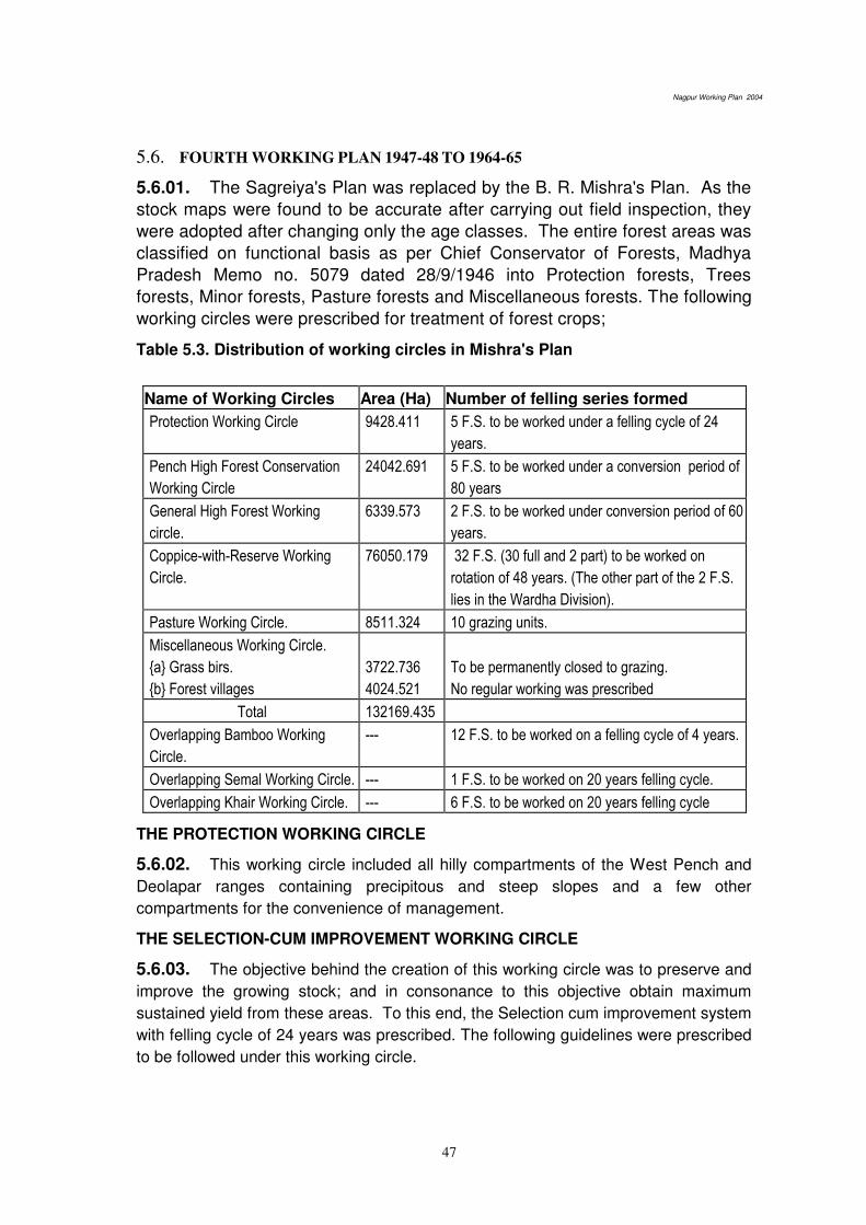
Nagpur Working Plan 2004
47
5.6. FOURTH WORKING PLAN 1947-48 TO 1964-65
5.6.01. The Sagreiya's Plan was replaced by the B. R. Mishra's Plan. As the
stock maps were found to be accurate after carrying out field inspection, they
were adopted after changing only the age classes. The entire forest areas was
classified on functional basis as per Chief Conservator of Forests, Madhya
Pradesh Memo no. 5079 dated 28/9/1946 into Protection forests, Trees
forests, Minor forests, Pasture forests and Miscellaneous forests. The following
working circles were prescribed for treatment of forest crops;
Table 5.3. Distribution of working circles in Mishra's Plan
Name of Working Circles Area (Ha) Number of felling series formed
Protection Working Circle 9428.411 5 F.S. to be worked under a felling cycle of 24
years.
Pench High Forest Conservation
Working Circle
24042.691 5 F.S. to be worked under a conversion period of
80 years
General High Forest Working
circle.
6339.573 2 F.S. to be worked under conversion period of 60
years.
Coppice-with-Reserve Working
Circle.
76050.179 32 F.S. (30 full and 2 part) to be worked on
rotation of 48 years. (The other part of the 2 F.S.
lies in the Wardha Division).
Pasture Working Circle. 8511.324 10 grazing units.
Miscellaneous Working Circle.
{a} Grass birs.
{b} Forest villages
3722.736
4024.521
To be permanently closed to grazing.
No regular working was prescribed
Total 132169.435
Overlapping Bamboo Working
Circle.
--- 12 F.S. to be worked on a felling cycle of 4 years.
Overlapping Semal Working Circle. --- 1 F.S. to be worked on 20 years felling cycle.
Overlapping Khair Working Circle. --- 6 F.S. to be worked on 20 years felling cycle
THE PROTECTION WORKING CIRCLE
5.6.02. This working circle included all hilly compartments of the West Pench and
Deolapar ranges containing precipitous and steep slopes and a few other
compartments for the convenience of management.
THE SELECTION-CUM IMPROVEMENT WORKING CIRCLE
5.6.03. The objective behind the creation of this working circle was to preserve and
improve the growing stock; and in consonance to this objective obtain maximum
sustained yield from these areas. To this end, the Selection cum improvement system
with felling cycle of 24 years was prescribed. The following guidelines were prescribed
to be followed under this working circle.
Nagpur Working Plan 2004
48
{1} Inaccessible areas, areas having precipitous and very step slopes and under-
stocked areas were excluded from working. In such areas only improvement felling
was prescribed.
{2} Along the river banks, no trees were to be felled up to a width of 30 m.
{3} After making reservation as in (1) and (2) from the remaining areas all dead and
half of the teak trees 120 cm and above at gbh were to be removed, if silviculturally
available.
{4} Improvement felling consisting of removal of miscellaneous species interfering
with teak and suitable thinning in even aged patched of teak were proposed.
{5} Advanced growth of teak (up to 30 cm in girth) which was malformed was to be
cut back.
PENCH HIGH FOREST CONVERSION WORKING CIRCLE
5.6.04. All the areas having good quality teak and mixed forests (III and IV) except
those included in the protection working circle were allotted to this working circle. The
system prescribed was conversion to uniform with adequate safeguards to retain a
suitable mixture of teak and miscellaneous species. However, no felling were to be
carried out in the steep and precipitous slopes as well as in the under-stocked areas.
Conversion period of 80 years was adopted and the entire area was divided into 4 PBs
depending on the age of the crops. All the 4 PBs were allotted. One twentieth of the
workable area of PB-I was to be taken up for conversion each year. Cultural
operations and thinning were to be carried out on 1/20 of the workable areas of the
PBS II, III and IV. Regeneration of PB -I was to depend mainly on the existing NR to
be supplemented by the coppice seedlings. However as a safeguard in PB-I coupes
groups of well-grown advance growth and poles were to be retained as part of future
crop. SCI felling was to be carried out in the hilly and inadequately stocked areas.
Climber cutting was to be carried out 3 years in advance of main felling and the
coupes were to be closed to grazing a year after felling. Climber cuttings, cleaning
and suitable thinning were to be carried out when the forest crops attained the age of
5 and 10 years.
THE GENERAL HIGH FOREST WORKING CIRCLE
5.6.05. The better quality forests in the trap zone of Hingna, Kondhali and Umrer
ranges were included in this working circle. Conversion to uniform was the treatment
prescribed with a conversion period of 60 years. Safeguard measures like retention of
a mixture of teak with miscellaneous species in ratio of 50:50, no felling on steep
slopes and precipitous areas as well as in under-stocked area were provided. To
improve the natural regeneration in the coupes, climber-cutting 3 years in advance of
main felling as well as closure of coupes to grazing was also provided. In addition to
all these, well-grown poles up to 45 cm in girth of all miscellaneous species except
garari subject to a minimum of 40 per acre was to be retained in the mixed forests. In
areas having pole crop, poles up to 60 cm in girth and 45 cm in girth were to be
retained in good quality and poor quality areas, respectively, as part of future crop.
Improvement fellings were to be carried out on steep slopes, poorly stocked areas and

Nagpur Working Plan 2004
49
area having inadequate regeneration. The subsidiary silvicultural operations such as
CBO one year after main felling, climber cutting and cleaning at the age of 5 year and
thinning at 10, 20 and 40 years were also prescribed.
COPPICE-WITH-RESERVE WORKING CIRCLE
5.6.06. The forests capable of producing small to medium sized timber, poles and
firewood were put in this working circle. The rotation of 48 years was continued as
was in Sagreiya’s plan. Mature trees were prescribed for felling, all advance growth up to 23 cm GBH except of garari were to be retained. Healthy well grown poles up to 60
cm were to be reserved to the extent of 30 poles per acre. The CBO, after one year of
main felling was prescribed. Climber-cutting and cleaning after 8 years and thinning
after 24 years were also prescribed.
PASTURE WORKING CIRCLE
5.6.07. Areas incapable of producing timber or fuel wood and where grazing
pressure was high were put in this working circle. No felling unless required for the
improvement of pasture was to be carried out. Fodder yielding species like anjan,
mowai and bija along with grasses like sheda, paonia and marvel were prescribed to
be planted. Closure for grazing was proposed in alternate years to provide time for
establishing the fodder yielding species.
MISCELLANEOUS WORKING CIRCLE
5.6.08. The grass birs and the forest villages were included in this working circle.
The grass birs were created with the intention of providing good fodder to the nearby
villages and hence were permanently closed for grazing. For the purpose of
improvement of the grass birs, periodical burning once in 5 years, sowing of seeds of
high yielding grasses like paonia, sheda, marvel etc, alongwith the removal of weeds
and climbers were proposed. The areas of the forest villages were meant for
cultivation and also for meeting the nistar requirements of the villagers.
OVERLAPPING BAMBOO WORKING CIRCLE
5.6.09. The workable bamboo areas of Pench range were included in this working
circle. The 12 felling series formed were worked on 4 year felling cycle.
OVERLAPPING SEMAL WORKING CIRCLE
5.6.10. One felling series in East Pench range was formed. The felling cycle was
fixed at 20 years. All Semal trees above 135 cm gbh were to be exploited
departmentally. However as the Semal trees occurred scattered over the entire felling
series, extraction became uneconomical and hence after the 12th coupe the work was
stopped.
OVERLAPPING KHAIR WORKING CIRCLE
5.6.11. Six felling series were formed over the entire division as the Khair occurred
scattered or in pure patches in teak and mixed forests in all the ranges. The felling
series was fixed as 20 years. The Khair trees above 45 cm girth at BH were to be

Nagpur Working Plan 2004
50
exploited for manufacturing katha. However as the Khair trees mainly occurred in
degraded areas, not much working was carried out to prevent further degradation of
the areas.
RESULTS OF THE WORKING
5.6.12. The prescription of this plan helped to improve the forests in general.
Natural regeneration except in the dry localities also improved. The semal and khair
working circles could not be properly worked as the trees were scattered over the
entire area. Some of the short comings of the plan were as listed below:
{1} Procedure for demarcating the various areas as well as the method for marking
and recording the trees to be felled or reserved were not specified.
{2} No soil conservation measures were proposed for erosion prone areas.
{3} The method of carrying out the cultural operation was not prescribed.
{4} Retention of miscellaneous species in the areas having profuse reproduction of
teak was not proposed.
{5} No prescription was given for raising plantations of valuable species in the good
areas of Pench ranges.
5.7. FIFTH WORKING PLAN: FROM 1965-66 TO 1975-76
5.7.01. The Fifth Working Plan was prepared by J.G. Thosre. The period of the
plan was from 1965-66 to 1975-76 for twenty years but was subsequently extended up
to 1987-88. The entire forest was restock mapped on 4”=1 mile scale maps. As per the resolution of the M.P. Govt. no. 3952-2624-XI, dated 10/12/1952 the forests were
classified on functional basis as below.
Table - 5.4 Functional classification of the forests in Thosre's Plan
Classes of forests Area in Hectares
Tree Forests. 30382.264
Minor Forests. 76050.179
Protection Forests 9429.411
Pasture Lands. 8511.324
Remaining Forest
(a) Grass birs
(b) Forest Villages
(c) Seminary hills
3615.673
4024.521
67.410
Total 1,32,080.782
5.7.02. The following working circles were created taking into account the
silvicultural requirement of the forest crops as well as the demand for timber, fuel
wood and grazing in the division.
Table - 5.5 Distribution of working circles in Thosre's Plan
S.N Working Circle Area (in ha) Nos of FS formed
1 Protection working circle 9429.411 5 F.S. to be worked under a

Nagpur Working Plan 2004
51
felling cycle of 24 years.
2 Pench High Forest conversion
working circle.
24042.691 5 F.S. to be worked under 80
year conversion period.
3 General High Forest working
circle.
6339.573 2 F.S. to be worked on a rotation
of 60 years
4 Coppice-with-Reserve working
circle
76054.229 33 F.S. (30 full and 3 part) to be
worked on a rotation of 48
years.
5 Pasture working circle. 8799.542 Pasture series.
6 Miscellaneous working circle.
Grass birs.
Seminary hills.
Forest villages
3615.673
67.410
4024.521
Permanently closed to grazing.
Total 132080.782 ha
S.N Working Circle Area (in ha) Nos of FS formed
7 Overlapping Bamboo working
circle
-- 16 F.S. to be worked under 4
year felling cycle.
8 Overlapping Khair working
circle.
-- 6 F.S. to be worked on a felling
cycle of 20 years.
PROTECTION WORKING CIRCLE
5.7.03. The forests in the hilly and undulating areas on both sides of the Pench
River as well as the areas having sandy to sandy loam soils prone to erosion were
included in this working circle. The crops consisted of mainly middle-aged trees with a
large number of unsound old teak trees in the remote areas. The special objects of
management were (1) conservation of soil and moisture by retaining tree cover (2)
preservation and improvement of existing growing stock (3) to increase the value of
forests by increasing the proportion of valuable species and (4) to achieve maximum
sustained yield. SCI silviculture system was adopted to meet these objectives. The
exploitable girth for the different species was fixed, as follows:
Teak & Haldu – 120 cm,
Bija & Ain – 135 cm,
Dhaora, Shisham, Tendu & Bhirra – 90 cm,
Tinsa – 75 cm.
5.7.04. Area was divided into 5 Felling Series and 24 years felling cycle was
prescribed. As a safety measure it was proposed that the trees required for protection
as well as for seed purposes along with healthy trees of species like moha, tendu,
achar, harra, kullu and khair were to be retained all over the area. In the steep slopes,
under-stocked areas as well as areas prone to erosion no living trees were to be
felled. In the frost prone areas, frost hardly species like ain, dhaora, moha, kusum
and mowai were to be retained. In the workable areas one out of two mature teak
Nagpur Working Plan 2004
52
trees and all mature trees of other valuable species were to be marked for felling.
Other operations prescribed were light crown thinning in the immature crop, removal
of dead, dying and diseased trees as well as inferior trees interfering with the growth
of teak and other superior species. The subsidiary silvicultural operations prescribed
included anti-erosion measures in the erosion prone areas, CBO, climber cutting and
addressing of stools. In the 6th year cleaning, climber cutting, cutting back of
malformed saplings, singling of coppice shoots and removal of inferior species
interfering with the growth of superior species were also prescribed. Thinning, in the
13th year, as per the formula; D = 3/2 (d+3) was also prescribed.
PENCH HIGH FOREST WORKING CIRCLE
5.7.05. The good quality forests of Khapa and Deolapar ranges except those
allotted to the Protection working circle were allotted to this working circle. The crop
was mainly of teak and mixed forests of III and IV a quality. The special objects of
management were to convert the forests to a normal series of age classes, to produce
big sized timber of teak and other superior species, to extent the area under teak by
planting and also to maintain a suitable mixture of teak and miscellaneous species in
the areas tending to be pure teak forests. The silvicultural system adopted was
conversion to uniform. The conversion period was fixed as 80 years and 4 PBs were
created each having 20 coupes. The clear felled areas were to be regenerated
artificially.
5.7.06. In the protection and unworkable areas in the PB I coupe improvement
felling were prescribed. Minimum 10 acres of area were to be clear felled and planted
with teak. Areas having young pole crop of teak were to be thinned so as to bring the
inter spacing distance to 1/3rd of the height. The dead, dying, diseased and
malformed poles were also to be removed. Improvement felling consisting of removal
of dead, dying, unsound and over-mature trees were proposed in areas having density
between 0.4 and 0.6. C/D grade thinning was proposed in congested patches. In the
other areas, well grown poles of teak and other valuable species up to 60 cm gbh,
healthy fruit trees and all semal, khair and kulu trees were to be reserved and the
balance trees were to be felled. Climber cutting was proposed at the time of making.
5.7.07. In the PB II areas light crown thinning, climber cutting and removal of dead
trees were proposed. In PB III areas thinning to maintain a mixture of teak and
miscellaneous species as well as improvement fellings were prescribed. In PB IV
areas climber cutting and cleaning operation were prescribed in the 6th year. Light
crown thinning to attain a spacement of 3m x 3m was proposed in the 20th year.
GENERAL HIGH FOREST WORKING CIRCLE
5.7.08. The better quality forest areas of Umrer, Kondhali and Hingni ranges were
included in this working circle. The crop was mainly teak of quality IVa and IVb. The
special objects of management were (1) conversion of the forest to a normal series of
age classes. (2) production of large size timber (3) improvement of the crop by
planting as well as by taking up suitable cultural operations. 60 years rotation was
fixed and 60 annual coupes were formed.

Nagpur Working Plan 2004
53
5.7.09. The well stocked areas (>0.6) were to be clear felled after retaining (a) well
grown poles up to 30m, 45cm and 60cm gbh in IVb, IV and quality III areas
respectively (b) trees of any size necessary for silvicultural purposes (c) all healthy
fruit bearing trees (d) Khair, Kulu and well grown Salai trees. Teak plantation was to
be taken up in open patches where teak was absent.
5.7.10. Subsidiary silvicultural operations like gully plugging and CBO in the 1st year
of main felling, cleaning in the 6th year and thinning in the 11
th year were prescribed.
COPPICE- WITH- RESERVE WORKING CIRCLE
5.7.11. The areas capable of producing mainly small timber, poles and fuel wood
were included in this working circle. Rotation was fixed as 48 years and yield was
regulated by area. Coupes were to be demarcated 3 years in advance to be followed
by climber cutting. It was prescribed that in Khapa, Deolapar and Ramtek ranges
minimum 10 acres of suitable areas were to be clear felled followed by planting while
in other ranges a minimum of 5 acres was proposed for clear felling. Subsidiary
silvicultural operations like gully plugging and CBO in the 1st year, cleaning in the 6
th
year and thinning in the 12th and 24
th years were also prescribed.
PASTURE WORKING CIRCLE
5.7.12. Areas where demand for grazing was high and which were not capable of
producing timber were put in this working circle. No commercial felling was prescribed
here. Leaf fodder species like anjan, mowai and bija and edible grasses like sheda,
paonia and marvel were recommended for planting in these areas.
MISCELLANEOUS WORKING CIRCLE
5.7.13. The various grass birs, forest villages and the compartments number 715 of
Seminary Hills were included in this working circle. In the plantations raised in the
compartment number 715, the DFO was authorized to do improvement felling and
thinning on 10 years cycle. The forest villages were to be managed as provided in the
MP Forest Manual, while the grass birs were closed for grazing. Only works required
for the improvement of the grasses was prescribed in the grass birs.
OVERLAPPING BAMBOO WORKING CIRCLE
5.7.14. The forest areas of Ramtek, Deolapar and Khapa, where bamboos were
present in workable quantity were included in this working circle. 12 felling series were
formed and a cutting cycle of 4 years was fixed. 4 coupes viz. A, B, C, & D were
formed in each felling series. Clumps having less than 10 culms were not prescribed
for exploitation. Bamboo planting was also prescribed in suitable areas.
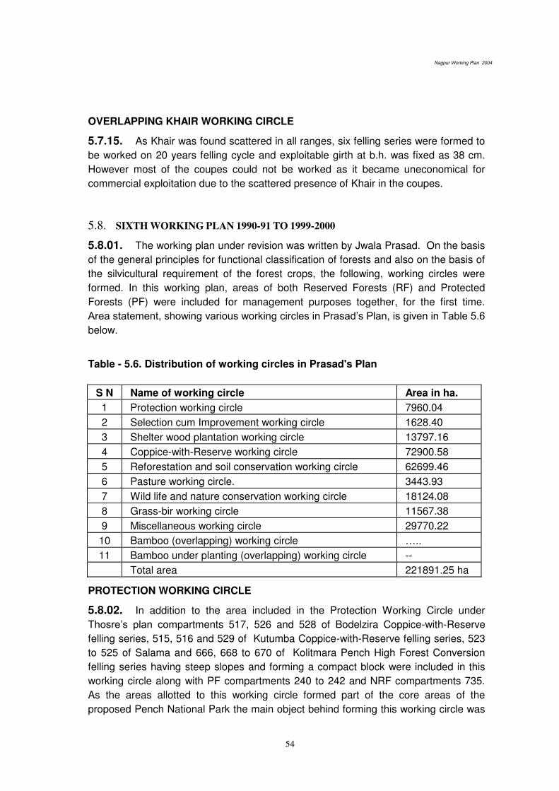
Nagpur Working Plan 2004
54
OVERLAPPING KHAIR WORKING CIRCLE
5.7.15. As Khair was found scattered in all ranges, six felling series were formed to
be worked on 20 years felling cycle and exploitable girth at b.h. was fixed as 38 cm.
However most of the coupes could not be worked as it became uneconomical for
commercial exploitation due to the scattered presence of Khair in the coupes.
5.8. SIXTH WORKING PLAN 1990-91 TO 1999-2000
5.8.01. The working plan under revision was written by Jwala Prasad. On the basis
of the general principles for functional classification of forests and also on the basis of
the silvicultural requirement of the forest crops, the following, working circles were
formed. In this working plan, areas of both Reserved Forests (RF) and Protected
Forests (PF) were included for management purposes together, for the first time.
Area statement, showing various working circles in Prasad’s Plan, is given in Table 5.6
below.
Table - 5.6. Distribution of working circles in Prasad's Plan
S N Name of working circle Area in ha.
1 Protection working circle 7960.04
2 Selection cum Improvement working circle 1628.40
3 Shelter wood plantation working circle 13797.16
4 Coppice-with-Reserve working circle 72900.58
5 Reforestation and soil conservation working circle 62699.46
6 Pasture working circle. 3443.93
7 Wild life and nature conservation working circle 18124.08
8 Grass-bir working circle 11567.38
9 Miscellaneous working circle 29770.22
10 Bamboo (overlapping) working circle ….. 11 Bamboo under planting (overlapping) working circle --
Total area 221891.25 ha
PROTECTION WORKING CIRCLE
5.8.02. In addition to the area included in the Protection Working Circle under
Thosre’s plan compartments 517, 526 and 528 of Bodelzira Coppice-with-Reserve
felling series, 515, 516 and 529 of Kutumba Coppice-with-Reserve felling series, 523
to 525 of Salama and 666, 668 to 670 of Kolitmara Pench High Forest Conversion
felling series having steep slopes and forming a compact block were included in this
working circle along with PF compartments 240 to 242 and NRF compartments 735.
As the areas allotted to this working circle formed part of the core areas of the
proposed Pench National Park the main object behind forming this working circle was
Nagpur Working Plan 2004
55
to preserve and improve the existing growing stock for conserving soil and moisture,
the total area allotted to this working circle was 7960.04 ha.
5.8.03. Conforming to the objective, no tree felling was prescribed in this working
circle. The emphasis was laid on soil conservation and erosion prevention measures.
In the degraded areas dibbling of seeds of suitable species as well as bush sowing of
the seeds of neem, bakain, maharukh and sandal was proposed to be carried out by
the concerned Beat Guard.
5.8.04. The whole area was divided into 4 working series each containing 10
coupes to be worked on 10 years working cycle. The coupes to be worked were to be
demarcated one year in advance and a treatment map showing (a) the areas eroded
or liable to erosion (b) road passing through the area and (c) under-stocked areas was
to be prepared, climber cutting was also to be done at the time of demarcation. In the
year of working, the following operations were prescribed to be carried out in the
different types of areas. In the A type areas nala bunding and gully plugging were to
be carried out. In B type areas only maintenance works were to be carried out. In the
C type areas seeds of neem, maharukh, salai, dhaora, sitaphal and other local
species was were to dibbled at 2m x 2m spacing
SELECTION CUM IMPROVEMENT WORKING CIRCLE
5.8.05. The compartments of Deolapar range having density > 0.4 and lying
between 15° and 25° slopes were included in this working circle. The object of
management envisaged under this working circle were (1) to reduce soil erosion and
run off water along the hilly slopes by improving the soil cover (2) to enrich the
growing stock by tending the NR or by planting (3) to obtain the maximum sustained
yield of timber. The total area allotted to this working circle was 1628.40 ha.
5.8.06. Only one felling series was formed and the felling cycle was fixed as 20
years. The exploitable girth for various species was retained as prescribed in Thosre’s plan, as given under.
Bija and Ain – 135 cm. Shisham, Dhaora, Bhirra – 90 cm
Teak and Haldu – 120 cm. Tinsa – 75 cm.
5.8.07. The silvicultural system adopted was group selection system. The coupes
due for working were to be demarcated one year in advance and a treatment map
showing the (a) protection areas (b) under-stocked area and (c) area containing pre-
selection and exploitable trees was to be prepared. C type areas were further
proposed for division as follows;
(i) Areas containing pole crop and middle aged crop to the extent of 300 stems / ha
and natural regeneration up to 750 / ha.
(ii) Areas containing pre selection and selection girth trees but not young crop.

Nagpur Working Plan 2004
56
5.8.08. In the ‘C’ type areas marking was to be done in-groups of the size 5 chain x
1 chain. The distance between the 2 groups was kept as 100m. In the groups
selected for felling all exploitable trees were to be marked for felling, while the pre-
selection trees were to be marked rarely if found necessary to aid regeneration. All
malformed stems were to be cut back. To prevent over marking it was prescribed that
number of trees to be marked should not exceed the prescribed limit of number of
trees per coupe. The total area of the group selected will not exceed the area worked
out under the Safe - guard Formula. Trees of Tendu, Hara, Kullu, Semal and Khair
were to be reserved. To supplement the natural regeneration, planting was also
proposed by pit-trench method at the rate of 1100 plants / ha. Subsidiary silvicultural
operation like CBO one year after main felling, cleaning in the 6th and 11
th years; and
thinning in the 20th year was also proposed.
SHELTERWOOD PLANTATION WORKING CIRCLE
5.8.09. The better quality forest of Deolapar, Ramtek, South Umrer, Kondhali and
Narkhed ranges were included in this working circle. While Akola, Bandhara and
Manegaon felling series are made up of mainly miscellaneous forests. Dhamangaon
and Kodimet - Parsodi felling series containing mainly teak forests. The total area
included in this working circle was 13797.16 ha.
5.8.10. THE SPECIAL OBJECTS OF MANAGEMENT OF THIS WORKING
CIRCLE: Production of large sized timber of teak and other miscellaneous species.
Enrichment of crop by planting teak and other valuable species.
5.8.11. The silvicultural system adopted to achieve these objectives was modified
shelter wood system using floating P.B. method. The working circle was divided into 3
PBs. The areas having mature crop were put in PB I (Regeneration PB) while the
compartment containing young crop and which had been regenerated during the last
20 years were put in PB III (PB Young). The remaining areas of this working circle
were put in PB II (PB Intermediate). On the basis of the stump analysis carried out,
the rotation was fixed as 60 years
THE OPERATIONS PRESCRIBED FOR THE 3 PBs
5.8.12. PB I: In the coupes allotted to P.B I the operations were to be carried out in
3 phases, viz. primary felling, artificial regeneration works and final felling. During
primary felling the crop was to be exploited so as to bring the over wood density up to
0.4 for this purpose the forest was to be divided into parallel strips of width 20 mts in
East-west direction. Along the center of each strip all the trees were to be felled on
both sides up to the width depending on the crown density as specified. In the second
phase, teak was to be planted on the felled strip while shade bearing species were to
be under planted in the rest of the areas. The final felling, during which the entire over
wood was to be removed, was to be carried out after 4 years, over those areas only
where regeneration had established successfully.
Nagpur Working Plan 2004
57
5.8.13. P.B II: Only cultural operations like climber cutting and removal of
undergrowth to improve the regeneration of teak and other valuable species were
prescribed in the areas allotted to this PB.
5.8.14. P.B.III: Thinning to benefit the young crop and removal of malformed and
decaying stems interfering with the growth of teak and other valuable species were
proposed to improve the young crop present in this P.B. Climber cutting was proposed
on a 5 year cycle.
5.8.15. The areas in which main felling had been carried out were to be artificially
regenerated by digging 1660 staggered trenches / ha.
5.8.16. The subsidiary silvicultural operations prescribed were CBO in the year after
main felling, soil and moisture conservation works in the year following primary felling,
cleaning operation in the 17th, 30
th, 35
th, 40
th and 45
th year after felling and thinning in
the 12th and 25
th years.
COPPICE-WITH-RESERVE WORKING CIRCLE
5.8.17. The forest of Narkhed, South and North Umrer, Khapa, Kuhi, Ramtek,
Hingna, Deolapar and Kondhali ranges having density greater than 0.4 and of quality
IVa and IVb which were capable of producing small to medium sized timber, poles and
firewood were put in the working circle. The total area included was 72,900.58 ha.
5.8.18. THE SPECIAL OBJECTS OF MANAGEMENT: {1} Production of maximum
sustained yield of small sized timber, poles and fuelwood. {2} Improvement of the
forests by carrying out under planting and tending operations.
5.8.19. The entire area was divided into 42 felling series. The rotation was fixed as
48 years for Reserved Forests areas and 40 years for the Protected Forests areas.
Taking into account the poor status of regeneration in the areas allotted to this
working circle, it was proposed that the areas should be regenerated in advance i.e.
before felling, by resorting to under planting in the under-stocked areas while gap
planting to be carried out in trench pits. The planted coupes were to be closed for
grazing for 3 years after planting.
5.8.20. Main felling was to be carried out in the 4th years only in those patches,
which had been successfully regenerated. Trees like Semal, Kulu healthy Salai trees
up to 90cm, Moha, Achar, Tendu, Aonla along with well grown advance growth of
Teak, Shisham, Bija, Bhirra and Ain were to be reserved.
5.8.21. Subsidiary silvicultural operations like anti-erosion works, CBO, cleaning of
coupes in the 6th year and thinning in the 12
th and 24
th years were prescribed. Old
plantations were also to be thinned along with main felling so as bring the spacement
between adjacent trees to 1/3rd of the average height of these trees.
REFORESTATION AND SOIL CONSERVATION WORKING CIRCLE
5.8.22. All poorly stocked areas having density below 0.4 were put in this working
circle. The total area included in this working circle was 62,699.46 ha. The special
objects of management envisaged are as follows:
Nagpur Working Plan 2004
58
(a) Conservation of soil and moisture by taking up plantation and other suitable
measures
(b) Enhancement of the productivity of the forest lands and availability of fuel, poles,
bamboo and small timber for the local populations and fodder for their livestock.
(c) Restoration of ecological balance by increasing the vegetal cover.
5.8.23. To improve the condition of the crop, cutting back of malformed stems as
well as improvement felling on well-stocked areas was proposed. Hardy species were
to be planted in the under-stocked and degraded areas. Soil conservation measures
were also proposed to improve the moisture regime and to check soil erosion.
5.8.24. As plantation was the main operation prescribed in this working circle, the
demarcation of coupes was to be carried out least 2 years before planting. A
treatment map showing the various types of areas as well as zonations based on soil
depth was also to be prepared. In the patches of forests having density greater than
0.4, improvement felling as well as singling of coppice shoots was proposed. Thinning
was also proposed in the patches of congested advance growth. The felling and
extraction operations were to be completed in the same year in which demarcation
was to be done. Different plantation techniques were proposed depending on the
zonation.
5.8.25. Apart from the customary casualty replacement, weeding and soil working
in the plantation was prescribed. Cleaning operations were proposed in the 5th year.
Ordinary D-grade thinning was proposed in the zone III area if the number of plants /
ha was more than 1250.
PASTURE WORKING CIRCLE
5.8.26. The degraded forest areas incapable of producing either timber or
fuelwood; and which were subject to heavy grazing demand were included in this
working circle. The total area allotted to this working circle was about 3443.93 ha in
extent.
5.8.27. These forests were to be managed primarily with the aim of meeting the
grazing demand of the livestock of the local people. Thus it was proposed to improve
the quality of fodder by introducing better variety of grasses, legumes and fodder
trees.
5.8.28. Only dead trees were to be removed from the under-stocked areas while
over mature and malformed trees were to be removed from the better patches. Water
absorption trenches (WATs) and grass beds were to be prepared in these areas
followed by the sowing of seeds of superior variety of grasses and legumes. In the
under-stocked areas having more than 30 cm deep soil, plantations of suitable fodder
species were to be taken. After carrying out special improvement works for the
development.
Grass-birs Working Circle

Nagpur Working Plan 2004
59
5.8.29. Areas under permanent grass-birs and kurans as well as some areas from
other working circles which are good for conversion into grass birs were included in
this working circle. The total area allotted to this working circle was 11567.38 ha.
5.8.30. These areas as they were near to villages and towns were set apart so as
to cater to the fodder needs of the local livestock. Thus the objects of management
were (1) to improvement of the fodder quality by introducing better and high yielding
grasses, (2) to protect vulnerable areas by maintaining suitable soil cover and to
increase fodder yield.
5.8.31. The works proposed in the grass birs are, as follows:
(a) Fencing of the grass birs in a phased manner of 10 years.
(b) Taking up adequate soil and moisture conservation measures.
(c) Ploughing the areas followed by sowing of improved variety of grasses.
(d) Planting of fodder tree species.
(e) Climber cutting as well as removal of weeds.
MISCELLANEOUS WORKING CIRCLE
5.8.32. The Reserved Forests and Protected Forests areas not included in any
other working circle but which were set apart for certain specific purposes were
included in this working circle. The total area allotted to this working circle was
29,770.22 ha (Table 5.7).
Table - 5.7. area allocation in Prasad's miscellaneous working circle
Areas earmarked for FDCM Ltd 27,169.19 ha
Compartment No. 715 of Seminary Hills 67.41 ha
Compartment No. 421. 98.34 ha
Area under submergence of various irrigation projects. 2435.28 ha
Total 29770.22 ha
BAMBOO (OVERLAPPING) WORKING CIRCLE
5.8.33. Eighty compartments of Ramtek, Parseoni and Deolapar ranges where
bamboo was available in adequate workable quantities were included in this working
circle. The total area allotted to this working circle was 22,999.58 ha. The entire area
divided into 6 felling series was to be worked on a 3 -year cutting cycle. The object of
management was to harvest bamboo in a scientific manner to get maximum sustained
annual yield. Special precautions to be taken while harvesting bamboo as well as
during gregarious flowering if it occurred were prescribed.
BAMBOO UNDER PLANTING (OVERLAPPING) WORKING CIRCLE
5.8.34. All the areas suitable for under planting bamboo were included in this
working circle. The total area allotted to this working circle was 15,867.75 ha. The
special object of management was to increase the percentage of bamboo in the
Nagpur Working Plan 2004
60
selected areas by resorting to plantation by digging pits of size 45 cm3 at 6m x 6m
spacing.
5.9. EX-PROPRIETARY FORESTS
5.9.01. These forests were initially under the ownership of the malgujars and
Zamindars. These forests were not scientifically managed and the owners used to sell
the forest produce as they think fit. However, villagers were allowed to take the forest
produce or graze their cattle on payment. The proprietary rights over these forests
were abolished in 1951 and, thereafter, these forests were brought under systematic
management. The history and management of these forests can be divided into three
distinct periods.
Management during the pre-abolition period i.e. from 1854 to 1950.
Management during early post-abolition period i.e. from 1951 to 1970.
Period of regular working under Working Scheme from 1970-71 onwards.
MANAGEMENT BEFORE THE PRE-ABOLITION PERIOD 1854 TO 1950
5.9.02. The private forests were not managed scientifically prior to the abolition of
the proprietary rights. The proprietors who were given the Zamindari rights used to
manage the forests according to their whims and fancies. In some Zamindari areas
Ranwa system was followed while in others Batai system was in practice. Though the
local people had different kinds of nistar rights yet they could exercise them only as
per the wishes of the malguzars. In the Central Provinces districts a village
administration paper called ‘Wazib-ul-arz’ was prepared which showed the rights the
local people could exercise over the land. The increased demand for timber, fuelwood
etc. during the Second World War led to unregulated heavy felling in these forests.
The malguzars resorted to indiscriminate felling of major timber species during the
pre-abolition period viz. from 1948 to 1950; as there were rumours about the
abolishment of proprietary rights over the lands
POST ABOLITION PERIOD 1951 TO 1970
5.9.03. After the abolition of the proprietary rights in 1951; about 6,98,572.80 acres
or 2,79,476.81 ha of private forests in Nagpur district were vested in the State
Government. Out of these, around 96,857.04 ha of forests were transferred to the
Forest Department for management from 1951 to 1954 as per the instructions
contained in MP Revenue Department order no. 2249-286-XII dt 6th April 1951 and
No. 7177-CR-617-XII dt 24th Dec, 1951.
5.9.04. The process of take over was completed by the year 1954. These forests
were subsequently declared as PF under section 29 of I.F.A. 1927 vide Govt. of MP
Notification No. 3057-853-XII dt 4/6/1955. The Notification reserving trees u/s 30 and
32 of IFA 1927 was issued and subsequently rules were framed by the Government of
Bombay vide notification No. FLD-4657/103065-E, dated nil December 1958 and 19th
Dec, 1958, respectively.
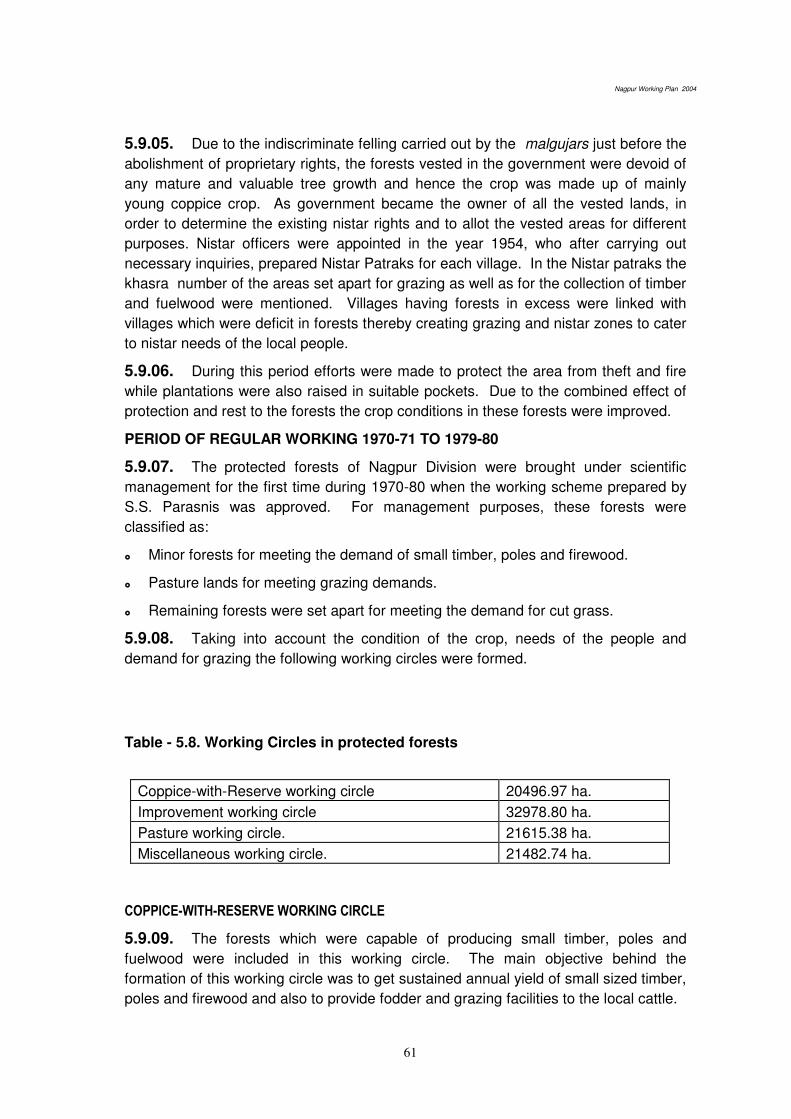
Nagpur Working Plan 2004
61
5.9.05. Due to the indiscriminate felling carried out by the malgujars just before the
abolishment of proprietary rights, the forests vested in the government were devoid of
any mature and valuable tree growth and hence the crop was made up of mainly
young coppice crop. As government became the owner of all the vested lands, in
order to determine the existing nistar rights and to allot the vested areas for different
purposes. Nistar officers were appointed in the year 1954, who after carrying out
necessary inquiries, prepared Nistar Patraks for each village. In the Nistar patraks the
khasra number of the areas set apart for grazing as well as for the collection of timber
and fuelwood were mentioned. Villages having forests in excess were linked with
villages which were deficit in forests thereby creating grazing and nistar zones to cater
to nistar needs of the local people.
5.9.06. During this period efforts were made to protect the area from theft and fire
while plantations were also raised in suitable pockets. Due to the combined effect of
protection and rest to the forests the crop conditions in these forests were improved.
PERIOD OF REGULAR WORKING 1970-71 TO 1979-80
5.9.07. The protected forests of Nagpur Division were brought under scientific
management for the first time during 1970-80 when the working scheme prepared by
S.S. Parasnis was approved. For management purposes, these forests were
classified as:
Minor forests for meeting the demand of small timber, poles and firewood.
Pasture lands for meeting grazing demands.
Remaining forests were set apart for meeting the demand for cut grass.
5.9.08. Taking into account the condition of the crop, needs of the people and
demand for grazing the following working circles were formed.
Table - 5.8. Working Circles in protected forests
Coppice-with-Reserve working circle 20496.97 ha.
Improvement working circle 32978.80 ha.
Pasture working circle. 21615.38 ha.
Miscellaneous working circle. 21482.74 ha.
COPPICE-WITH-RESERVE WORKING CIRCLE
5.9.09. The forests which were capable of producing small timber, poles and
fuelwood were included in this working circle. The main objective behind the
formation of this working circle was to get sustained annual yield of small sized timber,
poles and firewood and also to provide fodder and grazing facilities to the local cattle.

Nagpur Working Plan 2004
62
5.9.10. The rotation was fixed as 40 years and the entire area was divided into 10
full and 27 half felling series. The coupes were to be demarcated one year in advance
of felling. A treatment map, showing the unworkable areas, patches of poles crop,
inadequately stocked areas; and the remaining areas were to be prepared. From the
unworkable areas only dead and dying trees were to be removed, cutting back of high
stools was also proposed. The patches containing the pole crop were to be thinned
so as to bring the spacement equal to 1/3 of the average height of the trees.
5.9.11. Improvement felling consisting of the removal of dead, dying, diseased and
malformed trees was to be carried out in, inadequately, stocked forest areas.
5.9.12. From the remaining areas all the trees except the trees to be reserved were
to be felled. The trees to be reserved were (a) Trees required for silvicultural
purposes (b) All healthy fruits trees along with Kullu and Khair (c) All advance growth
except that of garari up to 23 cm gbh (d) All well grown poles of teak and other
valuable species up to 45 cm in quality III areas and 30 cm in quality IV areas.
5.9.13. The subsidiary silvicultural operations like CBO and climber cutting in the
year following the year of main felling, cleaning of coupes in the 6th year and thinning
in the 20th year were prescribed.
IMPROVEMENT WORKING CIRCLE
5.9.14. The degraded forests as well as the hilly areas with steep slopes were
included in this working circle. The forests were characterized by large number of
malformed, diseased, crooked and unsound trees.
5.9.15. The main object behind the formation of this working circle were (1) the
improvement of the growing stock (2) meeting the demand of nistar and grazing and
(3) to check soil erosion and conserve moisture.
5.9.16. A felling cycle of 20 years was fixed and the entire area was divided into 21
felling series. In order to meet the object of management, the following, operations
were prescribed.
All dead, dying, diseased and malformed trees were to be removed.
The inferior species interfering with the growth of teak and other valuable species
were to be removed.
Thinning was to be done in congested patches.
Singling of coppice shoots.
Cutting back of stumps of illicitly felled trees
Trees along the nala banks were to be retained up to a length of 20 m.
All fruit trees were to be retained.
Subsidiary silvicultural operations like CBO and climber cutting were to be carried
out one year after the working of coupes.
Nagpur Working Plan 2004
63
PASTURE WORKING CIRCLE
5.9.17. The forest areas which were incapable of producing timber of fuelwood and
where grazing demand was high were put in this working circle. This working circle
was formed mainly with the objective of providing maximum grazing facilities to the
local cattle as well as to improve the pasture. Each grazing series was divided into 4
coupes, each of which was to be closed in rotation for 3 years. The operations
prescribed were climber cutting, improvement felling in the protection and unworkable
areas, heavy thinning in the dense crop to encourage the growth of grasses as well as
retention of fruit, folder and shade bearing trees. Climber cutting and uprooting of
weeds all over the coupes were to be followed by ploughing on the patches containing
good soil before monsoon. Seeds of high yielding grasses like sheda, Paonia, marvel
etc. were to be sown on the ploughed areas after the onset of monsoon.
MISCELLANEOUS WORKING CIRCLE
5.9.18. Scattered patches of forests less than 200 acres, grass birs and the areas
to be handed over to Revenue Department were included in this working circle. In the
scattered patches thinning and improvement felling were prescribed to meet the local
demand for fuel and poles. Grass birs were to be managed for the supply of fodder
grasses on cut and carry basis. Thus they were permanently closed to grazing.
Sowing of the seeds of good variety of grasses was prescribed after light soil working
in these areas.
5.10. REGULATION OF GRAZING
RESERVED FORESTS
5.10.01. PRIOR TO 1875: Prior to the reservation of the forests, as there was no
grazing control, a large number of animals used to graze in the accessible areas.
However, during the early reservation period grazing by goat and sheep was stopped.
No restriction however was imposed on cattle till 1875.
5.10.02. FROM 1875 TO 1895: As unregulated grazing began to take their toll on
the forests, the need to protect forests from heavy grazing was felt. As a consequence
in 1875 about 66.5 sq. miles of forest in the East Pench and in 1881,63 sq miles of
forest in the West Pench were closed to grazing.
5.10.03. FROM 1895 TO 1912: With the increase in the extent of cultivation
followed by the reduction of grazing grounds, the pressure on the forests increased.
Moreover, it was noticed that continuous grazing was not favourable for the
reproduction of valuable species. Hence in the 1st Working Plan, it was prescribed
that coupes after working will be closed to grazing for 10 to 15 years and could remain
open to grazing for the rest of the rotation.
5.10.04. FROM 1912 TO 1934: In the Working Plan prepared by Mr. Dunbar
Brander, grazing was regulated as per the scheme prepared by Mr. Leftwitch, I.C.S.
in 1912-13. This was the first grazing scheme prepared and served as a basis for the
subsequent settlements. As per this scheme, the forests of the division were divided

Nagpur Working Plan 2004
64
into 34 grazing units and in each grazing unit, the grazing was regulated so as to
preserve the tree growth and improve pasture. While preparing the grazing units, the
grazing requirement of the villages was examined and the villages were attached to
the different units depending upon their proximity to the forests. In order to restrict the
number of cattle they were categorized into privileged, ordinary and commercial
cattle depending on their use and different rates were fixed for grazing for each
category. Preference was to be given to privileged and ordinary cattle while issuing
grazing passes
5.10.05. The grazing restrictions imposed by this scheme were slightly reduced in
1928 owing to the pressure from the local villagers due to the increase in the number
of cattle.
5.10.06. From 1935-36 to 1946-47: In the Working Plan prepared by Sagreyia, the
grazing settlement was done as per the new grazing policy issued in the year 1933.
5.10.07. TREE FOREST: This was further divided into (i) Moist type (annual rainfall
above 114.3 cm): grazing incidence was fixed as 1.6 ha per animal unit, and (ii) Dry
type (annual rainfall below 114.3 cm): grazing incidence for this type was fixed as 0.8
ha per animal unit.
5.10.08. SCRUB FOREST: This included forests primarily meant for grass and
grazing. This was further divided into: (i) Pasture forests: This included wooded
forests which were capable of producing some poles and fuelwood also, besides
grasses. The incidence of grazing for this type was fixed as 0.4 ha per animal unit. (ii)
Open forests: These forests were primarily meant for grazing. No limit was fixed for
grazing in these areas. As the primary aim of above classification was to meet grazing
demand, the forests subjected to heavy grazing were classified as scrub forests.
5.10.09. The grazing settlement was prepared by Y.C. Sukhtankar I.C.S. in the
year 1934. The size of the grazing units was reduced while the number was
increased from 34 to 70, excluding, 26 units of the forest villages and 14 units of the
grass birs.
5.10.10. FROM 1947-48 TO 1964: In 1946, the Chief Conservator of Forests C.P
and Berar issued a memorandum No.5079 Dt 28/9/1946 classifying the forests on
functional basis. On the basis of this memo, the forests were classified as Protection
forests, Tree Forests, Minor Forests, Pasture Forests and Miscellaneous Forests. The
grazing incidences, for various types of forests were, as follows.
Protection Forests – no grazing was permitted,
Tree Forests – 3 acres per cow unit
Minor Forests – 2 acres per cow unit,
Pasture forests – 1 acre pre cow unit.
5.10.11. FROM 1965-66 TO 1974-75: In the Working Plan prepared by J.G.
Thosre functional classification of forests followed in the previous plan was adopted in

Nagpur Working Plan 2004
65
toto. The grazing incidences and closure of the working coupes to grazing were, as
below.
5.10.12. TREE FORESTS: Grazing incidence was restricted to 3 acres per cattle
units. The coupes were to remain closed for grazing 2 year in advance of main felling
followed by a closure for 6 years.
5.10.13. MINOR FORESTS: The maximum grazing incidence permitted was 2
acres per cattle units. All worked coupes were to remain closed for grazing for a
period of 6 year after felling.
5.10.14. PASTURE FORESTS: The maximum grazing incidence permitted in the
areas was one acre per cattle unit.
5.10.15. The grass birs were permanently closed to grazing
5.10.16. FROM 1990-91 TO 1999-2000: In the Working Plan written by Jwala
Prasad, the grazing incidence for various types of forests were foxed according to the
grazing policy of 1968.
5.10.17. In the protection as well as Wild life and Nature Conservation Working
Circle grazing was prohibited as the forests allotted to this working circle were
classified as Protection Forests.
SECLECTION CUM IMPROVEMENT WORKING CIRCLE
5.10.18. In this working circle maximum grazing incidence permitted was 1.2
ha/cattle unit. The worked coupes were to be closed for a period of 7 years after
working with a provision to extend the closure if the status of NR was found
unsatisfactory.
SHELTERWOOD PLANTATION WORKING CIRCLE
5.10.19. As the forests allotted to this working circle belonged to the type tree
forests, maximum grazing incidence permitted was 1.2 ha per cattle unit. After
primary felling, the coupes were to remain closed for a period of 10 years from the
year of primary felling.
COPPICE-WITH-RESERVE WORKING CIRCLE
5.10.20. The maximum grazing incidence permitted in this working circle was 0.4
ha per cattle unit. The worked coupes were to remain closed to grazing for a period of
10 years.
5.10.21. The grass birs were to remain permanently closed to grazing
5.10.22. As the Protected Forests areas were included in the plan for the first time,
the grazing units were revised and in all 125 grazing units were formed of which 40
are in the Reserved Forests and 80 in the Protected Forests
B - PROTECTED FORESTS (PF)
5.10.23. PRIOR TO 1951: Before the abolition of the proprietary rights, the
malgujars permitted unlimited grazing by charging fees.

Nagpur Working Plan 2004
66
5.10.24. BETWEEN 1951 TO 1970: After the abolition of the proprietary rights,
Nistar Officers were appointed in 1954 to determine the existing rights over the land.
From 1954 to 1956, they carried out inquiries and prepared “Nistar Patraks” for each village. In the Nistar Patraks, Khasra numbers allotted for grazing of cattle, were
mentioned. In the villages where grazing land was just sufficient for the need of the
cattle of that village no right of persons residing in other villages to graze their cattle
was recognized unless already recorded in ‘Wazib-ul-arz’. Villages in which the areas of grazing land were less than half acres per head of cattle in cotton-jowar tract and
one acre in the remaining tracts were clubbed with the neighbouring village in which
such area exceeded the above standard. Villages so clubbed constituted a grazing
zone. The clubbing of the villages was done in such a way that the villagers were not
required to take the cattle to a distance longer than the distance the cattle can easily
cover in a day. Within a specific zone all persons were at liberty to graze their cattle
free until otherwise ordered by the Deputy Commissioner.
5.10.25. FROM 1970-71 TO 1979-80: In the Working Scheme written by
Parasnis, the grazing control was affected as follows
COPPICE-WITH-RESERVE WORKING CIRCLE
5.10.26. All coupes after final felling were to remain closed to grazing for a period
of 5 years beginning with the year of working. After mid rotational thinning the coupes
were to remain closed to grazing for a period of 3 years from the year in which
thinning was carried out.
FROM 1990-91 TO 1999-2000
5.10.27. As the Working Plan prepared by Jwala Prasad was a comprehensive
plan comprising of both Reserved Forests and Protected Forests; a unified grazing
control was effected for all the entire forest areas.
5.11. RESULTS OF PAST WORKING
RESULTS OF TREATMENTS PRESCRIBED IN JWALA PRASAD PLAN
5.11.01. As the present Working Plan was sanctioned in the year 1991 and the
implementation was started in the year 1992, only eight years have passed since the
coupe working was started. Hence it is too early to objectively comment about the
effects of treatments prescribed in this plan. However, the observations made, during
the field visits, on the treatments prescribed in Jwala Prasad’s plan is given, as follows.
PROTECTION WORKING CIRCLE
5.11.02. Treatment maps dividing the areas into 3 categories were not prepared at
all. The soil and moisture conservation measures prescribed in the working plan have
not been fully carried out in the coupes allotted to the working circle. Dribbling of
seeds of local species in the under-stocked areas has not been carried out.
Nagpur Working Plan 2004
67
SELECTION CUM IMPROVEMENT WORKING CIRCLE
5.11.03. The areas allotted to this working circle were to be worked under Group
Selection System by dividing the workable areas into areas containing (a) pole crop
and middle aged crop and (b) pre selection and exploitable trees. The both type of
areas were to be divided into groups of size 100m x 100 m; keeping the distance
between the two groups as 100m. Only the groups containing mature trees were to
be selected for felling. However, this type of working was not at all followed. Marking
was done without properly adhering to the marking rules and many pre-selection trees
were also felled. The plantations taken up have not been really successful mainly due
to wrong selection of species, grazing and recurrent fires. Cutting back operations
have not been carried out in many cases due to paucity of funds.
SHELTER WOOD PLANTATION WORKING CIRCLE
5.11.04. Better quality forests other than those allotted to SCI working circle were
allotted to this working circle. The silvicultural system prescribed was modified shelter
wood system using floating periodic blocks by dividing the area into 3 PBs i.e., P.B.I
(regeneration P.B.), P.B.III (P.B. Young) and P.B.II (P.B. intermediate). In P.B.I
coupes, the fellings were to be carried out in two stages i.e. primary felling and final
felling. The primary felling during which the crop was to be opened up to
approximately 0.4 density was to be followed up by artificial regeneration using a
mixture of teak and other valuable species. Final felling was to be carried out only if
the felled areas had been successfully regenerated. As the yield was to be regulated
by volume, coupe boundaries had not been demarcated and shown in the maps. The
areas included in this working circle were predominantly teak areas and as teak is a
light demander species were not suitable for the system adopted. Due to complex
nature of the prescriptions there were large-scale deviations from the prescriptions.
Instead of adopting strip felling (width of strip to vary with the density) during the
primary felling stage, mature trees were marked for felling, as is done in other systems
from all over the coupe. Artificial regeneration which was another major objective of
the system was not carried out in many areas. Even in coupes where it was carried
out final felling was resorted to without caring for the state of regeneration in spite of
the prescriptions that final felling should be deferred till such time the crop is
regenerated fully. The subsidiary silvicultural operations and soil and moisture
conservation works were not carried out in many coupes due to lack of funds. Due to
heavy grazing regeneration status in many coupes has become poor.
COPPICE-WITH-RESERVE WORKING CIRCLE
5.11.05. The areas (both the Reserved Forests and the Protected Forests) which
had been previously worked mainly under Coppice-with-Reserve Working Circle as
well as Improvement working circle were included in this working circle. The
prescriptions that planting should be carried out 4 years prior to felling were not at all
carried out. For e.g. coupe No. 4 of Ahemednagar felling series in Kondhali range
was worked in 1997 while coupe No. 5 was worked in 1998. But planting was done in
both these coupes in the year 1998 only; though as per the working plan prescriptions,

Nagpur Working Plan 2004
68
plantations should have been taken in the years 1994-95, 1995-96, respectively. On
account of conservative marking, in some of these coupes, large number of mature
trees is still left in the coupes. Moreover, due to continuos working under one form or
the other of coppice system, the trees have lost their coppicing vigour due to which the
coppice shoots have become crooked and malformed. The C.B.O and cleaning
operations were not properly carried out. Thinning of old plantations though
prescribed was not carried out as a result of which some of the old plantations have
become congested. The trees, which do not coppice, have been enumerated.
REFORESTATION AND SOIL CONSERVATION WORKING CIRCLE
5.11.06. This working circle was created with the intention of improving the soil and
moisture regime by taking up suitable measures to be supplemented by plantations.
Not much yield was expected from the coupes as most of the areas allotted to this
working circle were supposed to be under-stocked and devoid of good tree growth. In
most of the areas plantations have become a failure due to wrong species selection
coupled with heavy grazing. The status of natural regeneration is poor in most of the
areas.
PASTURE WORKING CIRCLE
5.11.07. Due to excessive grazing the pasture development works have not
become successful. The forest areas that were incapable of producing timber or fuel
and where grazing demand was high were put in this working circle. The main object
behind the creation of this working circle was the improvement of the quality and
quantity of fodder grasses by taking out plantations and by imposing strict control over
grazing. However the works as proposed in the working circle were not carried out in
most of the coupe citing lack of funds as the main reason. Wherever, some Plantation
works were carried out, that have become a failure due to heavy grazing and recurrent
fires.
GRASS BIR WORKING CIRCLE
5.11.08. Some of the areas allotted to this working circle are unfit for being retained
in the working circle due to the fact that the areas are not open due to the presence of
large number of trees e.g. Basbodi grass-bir in Kondhali range. In grass bir areas
no works, as prescribed in the plan, have been carried out due to the paucity of funds.
BAMBOO (OVERLAPPING) WORKING CIRCLE
5.11.09. Not much works was done in this working circle as the occurrence of
bamboo is sporadic in the allotted coupes. However, as no cleaning work was
provided for the naturally occurring bamboos, congestion has taken place in the
clumps in the areas that were not allotted to this working circle.
BAMBOO (UNDERPLANTING) WORKING CIRCLE
5.11.10. Bamboo plantations have come up very well in some of the areas where
timely operations were carried out. However damages due to the attack of wild boar
was observed in many areas.
Nagpur Working Plan 2004
69
SPECIAL WORKS OF IMPROVEMENT UNDERTAKEN
5.11.11. The special works of improvement undertaken in the past are: (1) Cultural
operations (thinning, cut-back operation, climber cutting and cleaning), (2) fire
protection, (3) protection from illicit felling, illegal timber transport and encroachment,
(4) construction of roads, buildings, tanks, wells, etc., and (5) plantations and
afforestation works.
CULTURAL OPERATIONS
5.11.12. (a) Thinning: In the Reserved Forests a scheme of thinning was introduced
in the year 1925. Before the introduction of Sagreiya’s plan thinning had been very heavy and almost all the valuable and accessible forests had been gone over at least
once. The thinning in the Pench ranges was so heavy that they amounted to almost
regeneration felling. During the currency of Sagreiya's plan, thinning prescribed in the
unallotted areas of conversion working circle and in the Coppice-with-Reserve working
circle, was to be carried out only, if necessary. During the period of Second World
War (1940-41 to 1945-46), heavy thinning was carried out to meet the requirement of
the Defence Department. This resulted in the removal of the best stems of the future
crop to a great extent. In the working plan by B.R. Mishra and J.S.Thosre thinning
operations were prescribed for forests allotted to Protection Working Circle. Pench
High Forest working circle, General High Forest working circle and Coppice-with-
Reserve working circle. In the Working Scheme for the ex-protected forests by Shri
S.S. Parasnis, thinning operations were prescribed in the Coppice-with-Reserve
working circle. After inspection of some of the thinned coupes it is found that heavy
thinning have been carried out at a number of places. At some places, these thinning
are even heavier than the main felling. This had depleted the growing stock and it is
feared that at the time of next main felling lesser out turn will be available. To guard
against this, marking shall be strictly done departmentally and under close supervision
as prescribed under para 20.3 of the miscellaneous regulations.
5.11.13. (b) CUTTING BACK OPERATIONS, CLIMBER CUTTING AND
CLEANING: These operations have not been carried out over major part of the area
during the currency of present working plan. These are very important operations
leading to inducement of natural regeneration and any negligence in theses
operations may result in not getting the areas regenerated properly. These operations
requires due importance and focus in the subsequent plans.
FIRE PROTECTION
5.11.14. An elaborate scheme of fire protection was introduce in East Pench Range
(Deolapar and Ramtek ranges) in 1875. According to this the forests were divided into
blocks of convenient size by cutting and cleaning external and internal fire lines of
12m width. These lines were kept clear of inflammable material throughout the fire
season and special staffs of fire watches were employed. The scheme worked well
and was gradually extended to the rest of the division: (a) East Pench covering

Nagpur Working Plan 2004
70
present Deolapar and Ramtek Ranges in 1875, (b) Kondhali in 1894, (c) West Pench
covering present Parseoni and Khapa in 1878 and (d) Umrer in 1895. In 1911, the
scheme was modified. Complete protection was restricted to areas closed to grazing
and early burning was allowed elsewhere. From 1935 Central Provisions and Berar
Forest Manual under which the forests are divided in to the following three classes:
Class-I (Complete or Special protection): It involves isolation of the protected
areas by fire lines and cut guidelines which are patrolled watchers.
Class-II (General Protection): It involves isolation of the areas from the
surrounding areas by fire lines and its divisions into convenient blocks by inter fire
lines. No guide lines are cut.
Boundary of the Reserved Forests and closed coupes in them, plantations and
roads passing through the Reserved forests are included in class-I area and the
Protected forests, roads passing through them and also the coupes in the
Protected forests are included in class-II areas.
PROTECTION FROM ILLICIT FELLING AND ENCROACHMENT
5.11.15. There is one Mobile squad unit consisting of a Range Forest Officer and 2
Foresters, working in the division whose main task is to prevent and detect the cases
of illicit felling and transport. Besides this, there are 40 Forest Check - Nakas which
are erected with the purpose of preventing the illicit transport of forest produce. In
addition to this, a battalion of SRP has been placed at the disposal of the Deputy
Conservator of Forests whose main job is to provide assistance of the field staff for
forest protection. The Table 5.9, indicates the extent of illicit felling cases recorded in
the area.
TABLE - 5.9. Statement of Offence Cases in the Nagpur Division
Year Offence
cases
Trees in offence cases Values
(Rs.)
Material seized Value
(Rs.) Teak Non-
teak
Total Timber
m³
Fuel Beat Other
1989-90 2,030 – – 32,080 49,10,205 713.796 1,140 – 32,89,275
1990-91 3,424 – – 33,785 82,38,133 1254 27 * 1,200 kg# 53,34,897
1991-92 2,876 – – 25,211 83,53,000 1321 – – 54,64,774
1992-93 2,980 15,221 15,161 30,382 1,25,51,527 990.561 298.5 696 bamboo 74,95,722
1993-94 2,883 20,568 19,411 39,975 82,29,765 1,753.087 290.5 – 68,06,214
1994-95 2,804 12,189 9,992 22,181 72,73,263 596.466 – – 49,23,353
1995-96 2,316 9,053 7,324 16,377 42,38,128 519.991 – – 48,94,064
1996-97 1,639 6,051 4,397 10,448 27,60,175 299 – – 32,53,625
1997-98 1,677 6,771 6,448 13,219 33,31,685 221.737 – – 29,35,796
1998-99 1,549 4,184 8,745 7,929 24,75,692 199.441 – – 21,81,897
1999-200000 NA NA NA NA NA NA NA
2000-01 1801 4166 2759 6925 2051330 146.18 - -- 2377657

Nagpur Working Plan 2004
71
2001-02 2178 4885 5331 10216 2430302 188.805 -- -- 1966592
2002--03 5076 4819 6713 11532 2722035 224.569 -- -- 2127497
Note – * 36 Cart load firewood; # Sandalwood
5.11.16. Though the scheme for 1/5th boundary demarcation exists both for
Reserved Forests and Protected Forests and large sums are spent on it each year but
hardly any works seem to have been carried out to repair the damaged boundary
pillars. The condition is pathetic for the Protected Forests, where over major part of
the area even the demarcation is not done. If at all some demarcation is done in such
areas, the boundary pillars are hardly traceable. However a decision to demarcate the
outer boundaries with fixation of permanent boundary pillars in a phased manner has
been taken and Government of Maharashtra has sanctioned a scheme in the year
2002 - 2003 to this effect .
5.11.17. In order to effectively tackle the problem of illicit felling caused by armed
gangs, a company of SRP under the control of a Police Inspector is stationed at
Umrer. The help of this unit is taken, whenever, necessity occurs in any part of the
division.
5.12. CONSTRUCTION OF ROADS, BUILDINGS, TANKS, WELLS & NURSERIES
5.12.01. Details of the roads, (Appendix 5.1) buildings, (Appendix 5.2), Check
Nakas, (Appendix 5.3), nurseries (Appendix 5.4), and expenditure incurred on
roads, buildings, tanks, and wells are given in the (Appendix 5.5).
5.13. PLANTATIONS WORKS
5.13.01. The details of the plantation undertaken in the division over the years are
given in the (Appendix 5.6)
5.14. PAST YIELD
5.14.01. The annual outturn of timber, fuelwood as well as various NWFPs in the
division is given in the (Appendix 5.7 to 5.10).
5.15. PAST REVENUE AND EXPENDITURE
5.15.01. The gross revenue and expenditure position including the surplus or
deficit, if any, is given in the (Appendix 5.11)
*****

Nagpur Working Plan 2004
99
Part-II: Future Management Discussed and Prescribed
Chapter 8. Basis of Proposal
8.1. THE NATIONAL FOREST POLICY:
8.1.1. The National Forest Policy was first enunciated in 1894 and it was revised in 1952
after independence. The National Forest Policy, 1952 was further revised and The National
Forest Policy, 1988 was formulated, which is presently in force.
8.1.2. The basic objectives and thrust areas enshrined in the National Forest Policy, 1988
are given as under:
Maintenance of environmental stability through preservation and, where necessary, restoration of the ecological balance that has been adversely disturbed by serious depletion of forests.
Conserving the natural heritage of the country by preserving the remaining natural forests with the vast variety of flora and fauna, which represent the remarkable biodiversity and genetic resources of the country.
Checking the soil erosion and denudation in the catchment area of the rivers, lakes and reservoirs in the interest of soil and water conservation for mitigating flood and droughts and for retardation of siltation of reservoirs.
Checking the extension of sand dunes in the desert areas and along the coastal tracts.
Increasing substantially the forest/ tree cover in the country through massive afforestation and social forestry programmes, especially on all denuded, degraded and unproductive lands.
Meeting the requirements of fuel wood, fodder, minor forest produce and small timber of the rural and tribal populations.
Increasing productivity of forests to meet essential national needs.
Encouraging efficient utilization of forest produce and maximizing substitution of wood.
Creating a massive people’s movement with the involvement of women, for achieving these objectives and to minimize pressure on existing forests.
The principal aim of the Forest Policy must be to ensure environmental stability and maintenance of ecological balance including atmospheric equilibrium, which is vital for sustenance of all life forms, human, animal and plant. The derivation of direct economic benefit must be subordinated to this principal aim.
8.1.3. Essentials of Forest Management embodied in the National Forest Policy 1988, are
given as follows:
Existing forests and forestlands should be fully protected and their productivity improved. Forests and vegetal cover should be increased rapidly on hill slopes, in catchment of the rivers, lakes and reservoirs and ocean shores and on semi arid, arid and desert tracts.
Nagpur Working Plan 2004
100
For conservation of biodiversity, network of national parks, sanctuaries, biosphere reserves and other protected areas should be strengthened and extended adequately.
Provision of sufficient fodder, fuel and pasture, especially, in areas adjoining to forests is necessary in order to prevent depletion of forests beyond sustainable limit.
Minor forest produce provide sustenance to the tribal population and to other communities residing in and around the forests. Such produce should be protected, improved and their production enhanced with due regard to generation of employment and income.
Schemes and projects, which interfere with forests that clothe steep slopes, catchments of rivers, lakes and reservoirs, geologically unstable terrain and other ecologically sensitive areas, should be severely restricted.
No forest should be permitted to be worked without the Government having approved the management plan, which should be in keeping with the National Forest Policy.
The rights and concessions enjoyed by the tribal and other rural poor living within and near the forests should be fully protected. Their domestic requirements of fuel wood, fodder, minor forest produce and construction timber should be the first charge on forest produce.
Inculcate in the people, a direct interest in forests and make them conscious of the value of trees, wildlife and nature in general through forest extension, education and training.
8.2. FUNCTIONAL CLASSIFICATION OF FORESTS:
8.2.1. The broad principles of classification of forests on functional basis have been
embodied in Resolution No. MRF-1365/132211-Y, dated December 6, 1968 issued by
Government of Maharastra. The following, functional classes have been recognized by the
state. The same is reproduced below:
(A) Protection Forests : This category will include steep and precipitous forests
(especially those in the catchment areas of important river valley projects and
also the denuded lands which are in dire need of soil conservation and
afforestation, grazing should be altogether prohibited in these forests save in
exceptional cases, when too the incidence should not exceed one cattle unit for
10 acres (a cattle unit is defined in para (2) below).
(B) Tree Forests: This category will include forests where production of timber is the
main object of management. The grazing incidence for these forests should be
one cattle unit for 3 areas.
(C) Minor Forests: This category will comprise forests in which production of
firewood on a sustained basis is the prime object of management. The grazing
incidence for these forests should be one cattle unit for 1.5 to 2 acres.
(D) Pasture lands: This category will include openly stocked forests or lands that
have ceased to yield even small timber but which are conveniently situated for
providing grazing to the adjoining cattle population. The grazing incidence for
these lands should be one cattle unit per acre.

Nagpur Working Plan 2004
101
(E) Grass reserves: This category will include all forest areas set apart for the
production of good fodder grass. Grazing should be completely eliminated from
these areas, but cutting of grass may be permitted according to Rules.
The functional classification of forests of Nagpur division under various categories is
given in the table 8.1 below:
Table 8.1 Functional categories of forests in the Nagpur Division (in hectares)
Category Reserved
Forests
New
Reserved
Protected
Forests
Other
forests
Total area Percentage
Tree forests 35742.09 6558.32 – 42300.41 24.57
Minor forests 39030.02 54931.14 – 93961.16 54.58
Pasture forests 2107.20 2640.45 2200.55 --- 6948.20 4.03
Protection forests 2473.63 628.26 – 3101.89 1.80
Grass Bir 5859.47 5724.33 11583.80 6.72
Miscellaneous 0 14231.33 14231.33 8.26
(Zudapi jungle)
Total 85,212.41 2640.45 70042.60 14231.33 1,72,126.79 100.0
8.3. FACTORS INFLUENCING OBJECTS OF MANAGEMENT:
8.3.1 The forests of the division are primarily mixed in nature having low proportion of
valuable species, especially, in the Metamorphic Zone and need enrichment by valuable
species like teak, in the stocking. In the Trap Zone, however, the forests are primarily poor
in quality, having high proportion of teak and need enrichment by miscellaneous species in
the stocking. A large chunk of forest tract, is under stocked, open and degraded that needs
improvement in stocking through tending of existing natural regeneration and rootstock as
well as by plantations.
8.3.2 The coppice vigor of teak and other miscellaneous species have declined due to
repeated coppice system for 3 to 4 rotations leading to deterioration in growth and quality of
teak and other valuable species. It also has led to increase in proportion of teak in the
stocking leading to pure patches of teak, at places, in the trap zone of the division. Hacking
of forests particularly near villages for removal of firewood and small timber has also
deteriorated the quality of forests appreciably.
8.3.3 The natural regeneration of teak and miscellaneous species is not up to the mark.
Seedling and sapling were observed at places but far short of required numbers as the
established natural regeneration to serve as the future crop.
8.3.4 A large extent of forest areas falls in the catchments of irrigation projects and water
bodies, thereby, need specific treatment in the interest of longevity of these water bodies
having focus on soil and moisture conservation to check siltation and to improve the water
regime of these tracts.

Nagpur Working Plan 2004
102
8.3.5 A large portion of forests of the division adjoins the Protected Areas, namely, Pench
National Park and Bor Wildlife Sanctuary, thereby, require treatment in conformity with the
wildlife and bio-diversity conservation and eco-tourism.
8.3.6 The forests suffer heavy biotic pressure especially due to uncontrolled grazing,
which results in compaction of soil, loss of humus and trampling of the seedlings and
saplings. Excessive grazing and uncontrolled fires are the main factors causing degradation
of forests. Illicit cutting both for commercial purposes and for removal of firewood and small
timber need to be curbed in all its earnestness. Formation of JFMCs and framing of area
specific mirco-plans addressing to the bonafide needs of the people as well as to the
requirements of controlling illicit cutting are expected to be effective in minimizing the
unscientific hacking of forests. Additionally, for controlling commercial illicit cutting,
strengthening of protection machinery- providing more vehicles and sufficient funds for
running them as well as provision of firearms and concerted training in their use, is
suggested. For control of illicit cutting and poaching as well as for efficient fire control
measures during the fire season, round the clock patrolling and its effective monitoring
through wireless system, which has already been established, needs to be evolved as part
of routine duties of the frontline staff. In any case, the situation requires some bold measures
to minimize these adverse influences.
8.3.7 The NWFPs species form a substantial proportion of the forest crops that contribute
substantially to the livelihood of local communities especially the tribal. The forest areas rich
in NWFPs require special thrust for their sustainable management and use in the interest of
local communities, by involving them through JFMCs and local NGOs; having the skill of
processing and value addition.
8.4 GENERAL OBJECTS OF MANAGEMENT
8.4.1 The following general objectives of forest management have been identified in
pursuance of the National Forest Policy, 1988; and other directives issued by the state and
the union governments, from time to time:
i) To preserve forest cover on hill slopes, along streams, watercourses and water bodies in
order to prevent soil erosion and to check siltation in reservoirs; and to maintain their
essential protective and life support functions, including, regulation of the water regime.
ii) To meet expectations of wildlife protection and biodiversity conservation from managed
forests.
iii) To restore and augment tree cover in under-stocked and degraded forests, and to
improve productivity and growing stock of natural forests using appropriate modes of
management and techniques.
iv) To enhance productivity of firewood, fodder, non-wood forest produce, small timber and
other construction wood required for meeting local household demands, particularly of
the tribal communities.
v) To improve fodder and grazing availability to local communities.

Nagpur Working Plan 2004
103
vi) To ensure optimum sustained yield of desirable forest produce and services consistent
with other objectives as well as national and State forest policies.
8.5 TREATMENTS PRESCRIBED
8.5.1 Management treatment will depend upon requirements of environment stability,
protection of topography, biodiversity conservation, characteristics of the growing stock in
the forests and forest produce utilisation.
8.5.2 Existing protection forests will be preserved and augmented. Soil and moisture
conservation works have been proposed to improve moisture regime and prevent soil
erosion and siltation in the water bodies.
8.5.3 Suitable tending and soil working operations will be carried out to stimulate the
growth of the naturally regenerated seedlings.
8.5.4 Timber, if otherwise available, will be extracted from dense tree forests capable of
producing large timber on sustained basis.
8.5.5 Open forest areas and traditional pastures will be managed with active participation
of tribal and village communities for meeting local domestic needs.
General approach of the treatment has been described, as follows;
8.5.6 The entire forests on steep and precipitous slopes will be protected from harvesting.
Thirty (30) meters wide strip on both sides of streams and watercourses will also be
protected from harvesting in the similar manner.
8.5.7 Forest areas susceptible to erosion and falling in catchments areas of medium and
large irrigation projects and reservoirs shall be protected.
8.5.8 Soil and moisture conservation works have been proposed to restore ecological
balance and ensure biodiversity conservation.
8.5.9 Special habitat management for wildlife conservation will receive high priority.
Riparian zones and mesic sites, important for wildlife management, will receive added
protection and treatment. Adequate buffer will be provided to such sites while preparing
treatment maps for coupe extraction. Snag, den trees and down logs shall be sufficiently
protected, to meet the habitat requirement of birds and small animals. Wildlife requirements
shall be the most important consideration for water hole management in forest areas.
8.5.10 The division will co-ordinate compilation of a comprehensive database of floral and
faunal resources as well as ecologically sensitive sites in the division.
8.5.11 Preference will be accorded to natural regeneration and rootstock management.
Natural regeneration and promising coppice growth will receive suitable tending and soil
working to stimulate growth and development. Areas having good natural regeneration of
valuable species shall be protected from fire and grazing. Artificial regeneration will be used
as the last resort and supplementary activity at places where natural regeneration is
inadequate or is not likely to succeed.
Nagpur Working Plan 2004
104
8.5.12 Non-wood timber forest produce (NWFPs) has great potential for sustainable
economic improvement of local communities with conservation of forest resources.
Sustainable NWFPs production will be given high priority in the forest management.
8.5.13 Sustainability of forest resources serves as the guiding principle for managing
demands for forest produce and services. Various government and non-government
agencies will be engaged in identification and promotion of ecologically sound and
economically feasible alternatives like wood saving technology, stall-feeding and livestock
improvement.
8.5.14 Involving local people in managing forests and generating awareness in rural and
tribal areas is considered indispensable for the forest conservation.
8.5.15 Reducing biotic pressure on forests, particularly, illicit felling, unsustainable grazing
and encroachment near villages will be considered on priority basis.
8.5.16 Forests capable of producing large sized timber will be harvested under the
selection-cum-improvement management system.
8.5.17 Boundary demarcation will be carried out in time-bound manner for ensuring
territorial integrity of forests. The Revenue and Forest Departments shall ensure maintaining
forest boundaries, updating land records and reconciling revenue records in accordance to
forest notifications.
8.6 ANALYSIS AND VALUATION OF THE CROP
8.6.1 The first stage analysis of forest crop is based on the species and tree girth
distribution obtained from the enumeration data and density distribution observed in satellite
imageries.
8.6.2 Areas susceptible to high erosion due to fragile geological formation, steep slopes,
areas in close proximity to Protected Areas and those falling in the catchments of medium
and large water bodies have been included in the Protection cum Catchments Area
Management Working Circles (P&CAM).
8.6.3 Compartments having sufficient dense tree cover and mature trees fit for harvesting
are allotted to the Selection-Cum-Improvement Working Circles (SCI). This working
circle is expected to produce timber and firewood.
8.6.4 Compartments having preponderance of pole crop, dense tree cover without enough
mature trees have been assigned to the Improvement Working Circles (IWC). These
compartments are expected to produce poles, small timber and firewood to cater to local
nistar requirements.
8.6.5 Areas having sparse tree crops, open areas without tree growth and isolated small
forest patches are included in the Rootstock Management & Afforestation Working
Circle (A&RSM). In such areas the focus would be upon tending of existing rootstock
supplemented by seedling plantation, wherever necessary. Involvement of the local
communities is considered focal for management of such areas as well as afforestation of
open forest areas and isolated patches in the division.
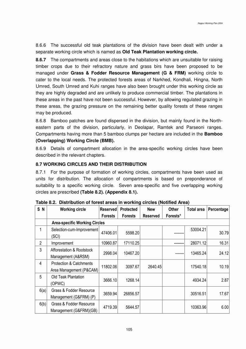
Nagpur Working Plan 2004
105
8.6.6 The successful old teak plantations of the division have been dealt with under a
separate working circle which is named as Old Teak Plantation working circle.
8.6.7 The compartments and areas close to the habitations which are unsuitable for raising
timber crops due to their refractory nature and grass birs have been proposed to be
managed under Grass & Fodder Resource Management (G & FRM) working circle to
cater to the local needs. The protected forests areas of Narkhed, Kondhali, Hingna, North
Umred, South Umred and Kuhi ranges have also been brought under this working circle as
they are highly degraded and are unlikely to produce commercial timber. The plantations in
these areas in the past have not been successful. However, by allowing regulated grazing in
these areas, the grazing pressure on the remaining better quality forests of these ranges
may be produced.
8.6.8 Bamboo patches are found dispersed in the division, but mainly found in the North-
eastern parts of the division, particularly, in Deolapar, Ramtek and Parseoni ranges.
Compartments having more than 5 bamboo clumps per hectare are included in the Bamboo
(Overlapping) Working Circle (BMB).
8.6.9 Details of compartment allocation in the area-specific working circles have been
described in the relevant chapters.
8.7 WORKING CIRCLES AND THEIR DISTRIBUTION
8.7.1 For the purpose of formation of working circles, compartments have been used as
units for distribution. The allocation of compartments is based on preponderance of
suitability to a specific working circle. Seven area-specific and five overlapping working
circles are prescribed (Table 8.2). (Appendix 8.1).
Table 8.2. Distribution of forest areas in working circles (Notified Area)
S N Working circle Reserved
Forests
Protected
Forests
New
Reserved
Other
Forests*
Total area Percentage
Area-specific Working Circles
1 Selection-cum-Improvement
(SCI) 47406.01 5598.20
--------
53004.21
30.79
2 Improvement 10960.87 17110.25 -------- 28071.12 16.31
3 Afforestation & Rootstock
Management (A&RSM) 2998.04 10467.20
------- 13465.24 24.12
4 Protection & Catchments
Area Management (P&CAM) 11802.06 3097.67 2640.45 17540.18 10.19
5 Old Teak Plantation
(OPWC) 3666.10 1268.14
4934.24 2.87
6(a) Grass & Fodder Resource
Management (G&FRM) (P) 3659.94 26856.57
30516.51 17.67
6(b) Grass & Fodder Resource
Management (G&FRM)(GB) 4719.39 5644.57
10363.96 6.00
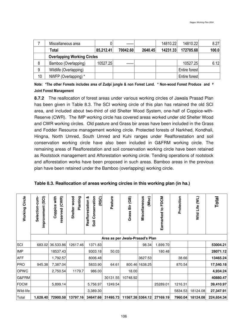
Nagpur Working Plan 2004
106
7 Miscellaneous area 0 ------ 14810.22 14810.22 8.27
Total 85,212.41 70042.60 2640.45 14231.33 172705.68 100.0
Overlapping Working Circles
8 Bamboo (Overlapping) 10527.25 ------ 10527.25 6.12
9 Wildlife (Overlapping) Entire forest
10 NWFP (Overlapping) * Entire forest
Note: *The other Forests includes area of Zudpi jungle & non Forest Land. * Non-wood Forest Produce and #
Joint Forest Management
8.7.2 The reallocation of forest areas under various working circles of Jawala Prasad Plan
has been given in Table 8.3. The SCI working circle of this plan has retained the old SCI
area, and included about two-third of old Shelter Wood System, one-half of Coppice-with-
Reserve (CWR). The IMP working circle has covered areas worked under old Shelter Wood
and CWR working circles. Old pasture and Grass bir areas have been included in the Grass
and Fodder Resource management working circle. Protected forests of Narkhed, Kondhali,
Hingna, North Umred, South Umred and Kuhi ranges under Reafforestation and soil
conservation working circle have also been included in G&FRM working circle. The
remaining areas of Reafforestation and soil conservation working circle have been retained
as Rootstock management and Afforestation working circle. Tending operations of rootstock
and afforestation works have been proposed in such areas. Bamboo areas in the previous
plan have been retained under the Bamboo (overlapping) working circle.
Table 8.3. Reallocation of areas working circles in this working plan (in ha.)
Wo
rkin
g C
irc
le
Se
lec
tio
n-c
um
-
imp
rov
em
en
t (S
CI)
Co
pp
ice
wit
h
res
erv
ed
(C
WR
)
Sh
elt
er
wo
od
Pla
nti
ng
Rea
ffo
res
tati
on
&
So
il C
on
se
rva
tio
n
(RS
C)
Pa
stu
re
Gra
ss
Bir
(G
B)
Mis
ce
lla
ne
ou
s
(Mis
c)
Ea
rma
rke
d t
o F
DC
M
Pro
tec
tio
n
Wil
d L
ife
(W
L)
To
tal
Area as per Jwala-Prasad's Plan
SCI 683.02 36.533.86 12617.46 1371.83 98.34 1,699.70 53004.21
IMP 18537.43 9303.18 50.03 180.48 28071.12
AFF 1,792.57 8006.48 3627.53 38.66 13465.24
PRO 945.38 7,387.04 5833.90 64.61 800.46 1638.25 870.54 17,540.18
OPWC 2,750.54 1179.7 986.00 18.00 4,934.24
G&FRM 30131.55 10748.92 40880.47
FDCM 5,899.14 5,756.97 1249.54 25289.01 1216.31 39,410.97
Wild-life 3,389.30 5834.53 18124.08 27,347.91
Total 1,628.40 72900.58 13797.16 34647.66 31495.73 11567.38 5364.12 27169.19 7960.04 18124.08 224,654.34
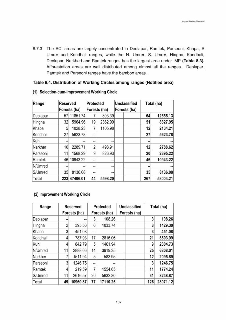
Nagpur Working Plan 2004
107
8.7.3 The SCI areas are largely concentrated in Deolapar, Ramtek, Parseoni, Khapa, S
Umrer and Kondhali ranges, while the N. Umrer, S. Umrer, Hingna, Kondhali,
Deolapar, Narkhed and Ramtek ranges has the largest area under IMP (Table 8.3).
Afforestation areas are well distributed among almost all the ranges. Deolapar,
Ramtek and Parseoni ranges have the bamboo areas.
Table 8.4. Distribution of Working Circles among ranges (Notified area)
(1) Selection-cum-improvement Working Circle
Range Reserved
Forests (ha)
Protected
Forests (ha)
Unclassified
Forests (ha)
Total (ha)
Deolapar 57 11851.74 7 803.39 64 12655.13
Hingna 32 5964.96 19 2362.99 51 8327.95
Khapa 5 1028.23 7 1105.98 12 2134.21
Kondhali 27 5623.78 -- -- 27 5623.78
Kuhi -- -- -- -- -- --
Narkher 10 2289.71 2 498.91 12 2788.62
Parseoni 11 1568.29 9 826.93 20 2395.22
Ramtek 46 10943.22 -- -- 46 10943.22
N/Umred -- -- -- -- -- --
S/Umred 35 8136.08 -- -- 35 8136.08
Total 223 47406.01 44 5598.20 267 53004.21
(2) Improvement Working Circle
Range Reserved
Forests (ha)
Protected
Forests (ha)
Unclassified
Forests (ha)
Total (ha)
Deolapar -- -- 3 108.26 3 108.26
Hingna 2 395.56 6 1033.74 8 1429.30
Khapa 3 451.08 -- -- 3 451.08
Kondhali 4 787.93 17 2816.06 21 3603.99
Kuhi 4 842.79 5 1461.94 9 2304.73
N/Umred 11 2888.66 14 3919.35 25 6808.01
Narkher 7 1511.94 5 583.95 12 2095.89
Parseoni 3 1246.75 -- -- 3 1246.75
Ramtek 4 219.59 7 1554.65 11 1774.24
S/Umred 11 2616.57 20 5632.30 31 8248.87
Total 49 10960.87 77 17110.25 126 28071.12

Nagpur Working Plan 2004
108
(3) Rootstock Management and Afforestation Working Circle
Range Reserved
Forests (ha)
Protected
Forests (ha)
Unclassified
Forests (ha)
Total (ha)
Deolapar 8 271.55 17 1370.41 25 1641.96
Hingna -- -- -- -- -- --
Khapa 2 394.97 20 2139.05 22 2534.02
Kondhali 9 1124.82 -- -- 9 1124.82
Kuhi -- -- -- -- -- --
N/Umred -- -- -- -- -- --
Narkher -- -- -- -- -- --
Parseoni 9 680.32 18 2432.64 27 3112.96
Ramtek 7 526.38 38 4525.10 45 5051.48
S/Umred -- -- -- -- -- --
Total 35 2998.04 93 10467.20 128 13465.24
(4) Protection & Catchments Area Management Working Circle
Range Reserved
Forests (ha)
Protected
Forests (ha)
New Reserved
Forest
Total (ha)
Deolapar 9 2498.31 1 11.21 -- -- 10 2509.52
Hingna 8 1294.61 4 539.16 -- -- 12 1833.77
Khapa 1 188.58 1 172.36 -- -- 2 360.94
Kondhali -- -- 3 816.72 -- -- 3 816.72
S' Hills 1 67.41 -- -- 10 2640.45 11 2707.86
Kuhi -- -- -- -- -- -- -- --
N/Umred 2 388.50 3 387.55 -- 5 776.05
Narkher 6 849.43 -- -- -- 6 849.43
Parseoni 15 3605.15 7 1170.67 -- 22 4775.82
Ramtek 8 1695.95 -- -- -- 8 1655.95
S/Umred 4 1254.12 -- -- -- 4 1254.12
Total 54 11802.06 19 3097.67 10 2640.45 83 17540.18

Nagpur Working Plan 2004
109
(5) Old Teak Plantation Working Circle
Sr
No
Ran
ge
No
of
sit
es in
Res
erv
e
Fo
rest
Co
mp
art
men
ts (
RF
)
Are
a (
in h
a)
No
of
sit
es in
Pro
tecte
d
Fo
rest
Co
mp
art
men
ts (
PF
)
Are
a
(in
ha)
To
tal P
lan
tati
on
sit
es
To
tal A
rea
(in
ha)
1 Deolapar 54 32 2226.13 11 7 230.14 65 2456.27
2 Ramtek 39 15 917.97 17 10 486.00 56 1403.97
3 Parseoni 9 7 202.00 4 3 124.00 13 326.00
4 Khapa 1 1 20.00 3 2 105.00 4 125.00
5 Hingna 5 5 145.00 2 2 33.00 7 178.00
6 Kondhali 3 3 75.00 2 2 50.00 5 125.00
7 Kuhi 1 1 50.00 6 6 240.00 7 290.00
8 S.Umred 2 2 30.00 - -- -- 2 30.00
Total 114 66 3666.10 32 1268.14 159 4934.24
(6) Grass & Fodder Resource Management Working Circle
Range Reserved
Forests (ha)
Protected
Forests (ha)
Unclassified
Forests (ha)
Total (ha)
Deolapar -- -- -- -- -- --
Hingna 12 1712.27 21 1681.12 33 3393.39
Khapa -- -- -- -- -- --
Kondhali -- -- 76 7532.46 76 7532.46
Kuhi 1 105.78 32 4825.00 33 4930.78
N/Umred 12 2761.91 47 7794.32 59 10556.23
Narkher 8 1504.32 56 6066.72 64 7571.04
Parseoni 1 50.03 -- -- 1 50.03
Ramtek 1 196.34 -- -- 1 196.34
S/Umred 11 2048.68 36 4601.52 47 6650.20
Total 46 8379.33 268 32501.14 314 40880.47
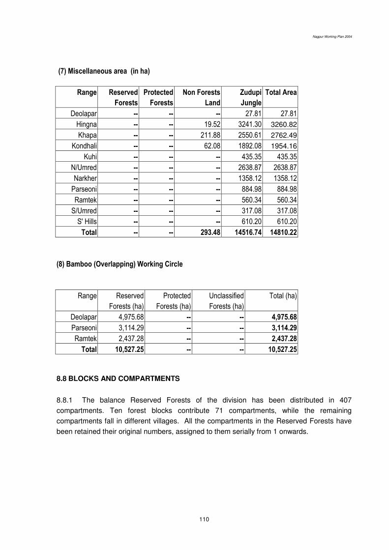
Nagpur Working Plan 2004
110
(7) Miscellaneous area (in ha)
Range Reserved
Forests
Protected
Forests
Non Forests
Land
Zudupi
Jungle
Total Area
Deolapar -- -- -- 27.81 27.81
Hingna -- -- 19.52 3241.30 3260.82
Khapa -- -- 211.88 2550.61 2762.49
Kondhali -- -- 62.08 1892.08 1954.16
Kuhi -- -- -- 435.35 435.35
N/Umred -- -- -- 2638.87 2638.87
Narkher -- -- -- 1358.12 1358.12
Parseoni -- -- -- 884.98 884.98
Ramtek -- -- -- 560.34 560.34
S/Umred -- -- -- 317.08 317.08
S' Hills -- -- -- 610.20 610.20
Total -- -- 293.48 14516.74 14810.22
(8) Bamboo (Overlapping) Working Circle
Range Reserved
Forests (ha)
Protected
Forests (ha)
Unclassified
Forests (ha)
Total (ha)
Deolapar 4,975.68 -- -- 4,975.68
Parseoni 3,114.29 -- -- 3,114.29
Ramtek 2,437.28 -- -- 2,437.28
Total 10,527.25 -- -- 10,527.25
8.8 BLOCKS AND COMPARTMENTS
8.8.1 The balance Reserved Forests of the division has been distributed in 407
compartments. Ten forest blocks contribute 71 compartments, while the remaining
compartments fall in different villages. All the compartments in the Reserved Forests have
been retained their original numbers, assigned to them serially from 1 onwards.
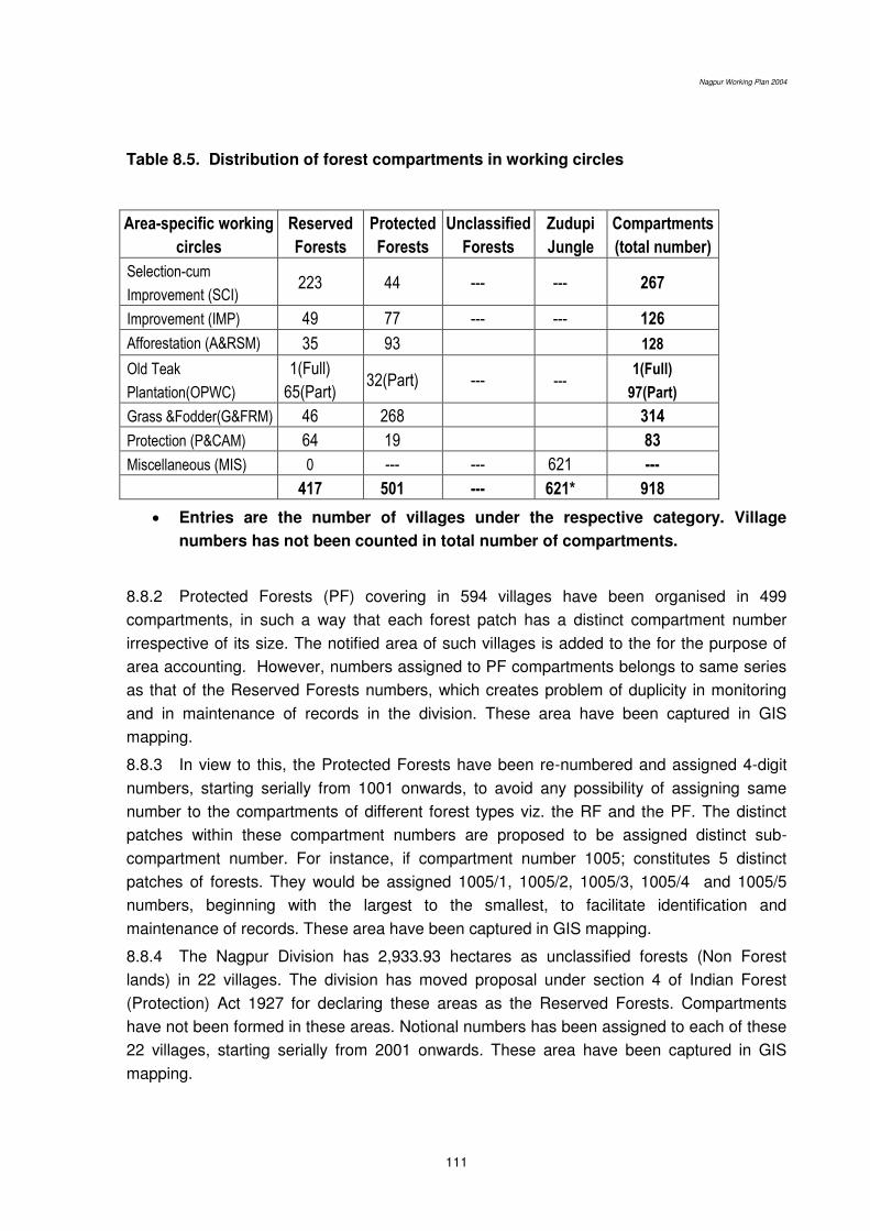
Nagpur Working Plan 2004
111
Table 8.5. Distribution of forest compartments in working circles
Area-specific working
circles
Reserved
Forests
Protected
Forests
Unclassified
Forests
Zudupi
Jungle
Compartments
(total number)
Selection-cum
Improvement (SCI) 223 44 --- --- 267
Improvement (IMP) 49 77 --- --- 126
Afforestation (A&RSM) 35 93 128
Old Teak
Plantation(OPWC)
1(Full)
65(Part) 32(Part) --- ---
1(Full)
97(Part)
Grass &Fodder(G&FRM) 46 268 314
Protection (P&CAM) 64 19 83
Miscellaneous (MIS) 0 --- --- 621 ---
417 501 --- 621* 918
Entries are the number of villages under the respective category. Village
numbers has not been counted in total number of compartments.
8.8.2 Protected Forests (PF) covering in 594 villages have been organised in 499
compartments, in such a way that each forest patch has a distinct compartment number
irrespective of its size. The notified area of such villages is added to the for the purpose of
area accounting. However, numbers assigned to PF compartments belongs to same series
as that of the Reserved Forests numbers, which creates problem of duplicity in monitoring
and in maintenance of records in the division. These area have been captured in GIS
mapping.
8.8.3 In view to this, the Protected Forests have been re-numbered and assigned 4-digit
numbers, starting serially from 1001 onwards, to avoid any possibility of assigning same
number to the compartments of different forest types viz. the RF and the PF. The distinct
patches within these compartment numbers are proposed to be assigned distinct sub-
compartment number. For instance, if compartment number 1005; constitutes 5 distinct
patches of forests. They would be assigned 1005/1, 1005/2, 1005/3, 1005/4 and 1005/5
numbers, beginning with the largest to the smallest, to facilitate identification and
maintenance of records. These area have been captured in GIS mapping.
8.8.4 The Nagpur Division has 2,933.93 hectares as unclassified forests (Non Forest
lands) in 22 villages. The division has moved proposal under section 4 of Indian Forest
(Protection) Act 1927 for declaring these areas as the Reserved Forests. Compartments
have not been formed in these areas. Notional numbers has been assigned to each of these
22 villages, starting serially from 2001 onwards. These area have been captured in GIS
mapping.
Nagpur Working Plan 2004
112
8.8.5 The Revenue Authorities has handed 140.39 km2 of Zudupi Jungle in 880 villages to
the Nagpur Division in the year 1990. Compartments have not been formed in such areas.
Notional numbers has been assigned to each of these 880 villages, stating serially from
2101 onwards. These area have been captured in GIS mapping.
8.9 PERIOD OF THE PLAN
8.9.1 This plan is for 10 years from the year of approval. The operations, however, have
been prescribed for a period of 20 years except for the areas allotted to Root Stock
Management and Afforestation wherein 40 year cycle has been prescribed. Areas under
Grass and Fodder Resource Management working circle are prescribed to be worked on a 4
year rotation. Mid-term review of prescriptions of the plan is proposed in the fifth year of its
implementation, on receipt of proposal from the Conservator of Forests, Nagpur Circle. The
Add. Principal Chief Conservator of Forests (Production and Management), Maharashtra
State may issue necessary supplementary instructions on aspects not covered in the plan.
*******
Nagpur Working Plan 2004
113
Chapter 9. Treatment Types and Common Prescriptions
9.1 DEMARCATION AND MARKING
9.1.1 The annual coupes for harvesting, tending and various other site specific treatment
are prescribed to be demarcated one year in advance. Then the treatment Map, as
prescribed in the following paragraphs, will be prepared, verified and approved in the same
year. The marking of the coupes will also be undertaken one year in advance and it will
follow the demarcation.
9.1.2 The detail procedure for demarcation, preparation of treatment map and marking
has been given in the chapter on Miscellaneous Regulations.
9.2 TREATMENT TYPES AND PREPARATION OF TREATMENT MAP
9.2.1 For the site-specific silvicultural treatment, annual operations in a coupe are
proposed to be carried out after dividing it into various treatment Types on the basis of
criteria given in the following table.
Table 9.1 Treatment types for coupe operations and site-specific treatment.
Treatment
areas
Symbol Characteristics Minimum
patch size
GIS Map
generated
Protection areas A1–type
A2–type
A3–type
Area having more than 250 slope
30 meter wide strip on both sides of streams
Area susceptible to excessive erosion
Any size Yes
Yes
Yes
Open forests B1–type
B2–type
Open forests (density < 0.4) with rootstock
Open forests (density < 0.4) without rootstock
5 hectare Only
density
Pole Crop C–type
Pole crop of the identified valuable species,
suitable for retention as future crop, having density
0.4 or more.
1 hectare No
Well-stocked
area
D1 type
D2 type
Area fit for teak plantation after canopy removal
i.e. areas with deep, well-drained loamy soil
containing well-stocked mature forests with scanty
natural regeneration.
Remaining well stocked areas having density 0.4
and over.
5 hectare Yes
Forest blanks E type Forest blanks 5 hectare Yes
9.2.2 Distinct patches of the B, D or E-type areas shall have minimum area of 5 (five)
hectares in extent. The minimum extent prescribed for the C-type areas is 1 (one) hectare.
The A-type- Protection areas would be delineated irrespective of the patch size. Smaller
patches proposed to be merged with the adjoining larger areas having similar crop
conditions.

Nagpur Working Plan 2004
114
9.2.3 The treatment maps are proposed to show areas having adequate regeneration
(400 or above established seedlings) as B1 type, those suitable for planting of teak, bamboo
and miscellaneous species as B 2 and forest blanks as E type. Natural blanks (under E type
areas) however are not to be considered for plantations as rocks, soil and water regime their
generally does not support tree growth.
9.2.4 Delineation of areas of various treatment types will be in accordance with the
following general guidelines:
An area having more than 25º slope and more than ¼ of a hectare in extent is proposed
to be delineated as the A1-type: steep slope. The maps showing such areas have been
generated through GIS.
30 meters wide buffer along streams will be measured from the bank or the high flood
mark. Rivers or streams shown on the base maps of the compartments or on topo-
sheets of the Survey of India at 1:15,840 or smaller scales (such as 1:50,000) would
suffice the purpose. Similar buffer of the A2-type areas will be marked along water
bodies and tanks. Such areas are shown in the maps generated through GIS.
The A3-type (excessive erosion prone) includes seasonally flooded. Such areas are
shown in the maps generated through GIS
Natural regeneration would be considered adequate if at least 400 saplings per hectare
are present. This criterion will be applied while delineating B1 type areas.
The C type areas would include groups of naturally grown trees having 15 to 45 cm
GBH.
The E-type areas (forest blanks) are areas devoid of trees and those having with crown
density as 0.1 and below.
9.3 COMMON PRESCRIPTIONS FOR VARIOUS TREATMENT TYPES
Following prescriptions are common to all treatment types except A-type: protection areas:
9.3.1 Soil and Moisture Conservation works: Soil and moisture conservation works such
as Check-dams, Gully plugging, etc. shall be carried out as prescribed in the chapter of
Miscellaneous Regulations.
9.3.2 Coppice Management: Dressing of high stumps and other methods of coppice
management are not suggested in SCI because the selection system is expected to facilitate
high forest character of the crop. However, coppice shoots will be allowed in open areas lest
the large openings may lead to deterioration of site and weed infestation. In other working
circles, it will have to be generally allowed. Natural regeneration through coppice
management in the following ways is prescribed:
Dressing of live high stumps of valuable species: It will be done in areas devoid of
natural regeneration and where it needs to be covered with tree growth. The purpose of
dressing will be to encourage coppicing close to the ground so that they will not topple
after gaining height, will be able to develop root system of their own and will grow into a
promising tree.
Nagpur Working Plan 2004
115
Singling of coppice shoots: One healthy and promising coppice shoot will be retained
per stump. Coppice shoots interfering with promising seedlings and saplings of seed
origin will be removed.
Coppice management of damaged and malformed saplings: The saplings and poles
up to 45 cm GBH having one third of the stem damaged and malformed shall be
coppiced by cutting flush to the ground. Such coppicing, however, should not expose the
ground, cause erosion and lead to soil loss. Poles having at least 2.50 meter of clean
bole will be not be treated as malformed.
9.3.3 Climber cutting and shrub clearance: Climber cutting of Chilati, Eruni, Kukudranji,
Mahulbel, Palasbel, Nagvel and Gunj and shrub cutting of Lantana, Rantulsi, Bharati,
Nirgudi, Kharata, Kuda, Jilbili, Neel, Kharasani and Phetra may be carried out wherever the
operation is warranted for the development of tree crop. Partial removal of Dikamali may be
allowed unless local villagers regularly collect its gum and desire to protect it. Cutting of
climbers and shrubs should generally be avoided within 30 m strips from the edge of the
forests and along the roads.
However, no climber having medicinal value will be removed even if it is hindering
tree growth.
9.3.4 Bamboo working outside Bamboo (Overlapping) Working Circle : Bamboo
clumps in areas outside Bamboo (overlapping) working circle will also be worked in the
manner prescribed in Bamboo harvesting under Bamboo (overlapping) working circle.
9.3.5 Control data: Pre-treatment and the post-treatment basal area as well as other
relevant parameters from the well dispersed sample plots will be recorded in the Divisional
register by an officer not below the rank of Range Forest Officer.
The Prescribed Type-specific Treatment:
Specific prescriptions for various treatment types will be as follows:
9.4 TREATMENTS IN A-TYPE AREAS
9.4.1 Soil and moisture conservation: Gully plugging and other soil and moisture
conservation works, as described in the chapter of Miscellaneous Regulations will be taken
in the A3-type areas. Such works may be taken up in the A2-type areas, but without
damaging the riparian ecosystem.
9.4.2 Bush sowing: Bush sowing of Khair, Neem, Maharukh, Salai, Dhaoda, sandal and
other local seeds is prescribed to be carried out by the regular forest staff and Van Majoors.
Any one species should not constitute more than one-third of the total seed sowing.
9.4.3 Stake planting: In the A3-type areas, vegetative propagation of suitable soil binding
species may be attempted. Stake planting of Vad, Umber, Pimpran etc. is suggested.
9.4.4 Harvesting prohibited: Generally the harvesting of standing trees is prohibited in
the A-type areas. Wind fallen trees of the valuable species such as Teak, Shisham and Bija
will be removed as a protection measure against illicit cutting.
Nagpur Working Plan 2004
116
9.5 TREATMENTS IN B-TYPE AREAS
9.5.1 Rootstock management: Tending of rootstock in the B1-type will be carried out in
accordance the guidelines for the rootstock management described in section 9.10 of this
chapter. Necessary soil working and mulching will be carried out to promote rootstock
growth.
9.5.2 Plantations: Suitable sites of the B2-type areas in afforestation working circle may
be brought under the plantations. Choice of species, planting and other operations will be in
accordance with the plantation guidelines given in the chapter on Miscellaneous
Regulations.
9.6 TREATMENT IN C-TYPE
9.6.1 The successful old teak plantations have been separately covered under Old Teak
Plantation Working Circle. However, for removal of congestion, groups of advance growth of
teak and valuable non-teak species in a coupe will be thinned to 1/3 of the top height of
predominant trees present in the group and as per the thinning guidelines. Adequate
retention of non-teak poles will be ensured in clusters containing more than 20% Teak. The
valuable species given in the list under paragraph 9.9.1 will be followed for retention.
9.6.2 Preference of girth class: Marking in the C-type areas for the purpose of spacing
out saplings and poles will be carried out from lower girth class upward.
9.7 TREATMENT IN D-TYPE
9.7.1 Enumeration in annual coupes: Species and girth-class of all trees above
harvestable girth be enumerated.
9.7.2 Marking for harvesting: Mature trees (those above harvestable girth) to the extent
fixed in the relevant working circles will be marked for felling. Well-formed and vigorous trees
will be preferred for retention. Species listed as valuable species given in the paragraph
9.9.1 will determine the order of priority for retention.
9.7.3 B-grade Thinning: If the congestion is expected to persist in some patches after the
harvesting, the B-grade thinning will be carried out in such patches. B-grade or moderate
thinning is defined as removal of dead, dying, diseased, suppressed, defective dominated
stems and whips in this order1. Removal of inferior individuals will start from suppressed
class and then to some of the dominated class of the crop. Advanced growth having too
many branches not desirable to prune or lop may also be removed.
9.7.4 Tending of natural regeneration: Singling and spacing out of the established
seedlings/ saplings of teak and other valuable species will be carried out much in the same
way as in case of the rootstock management. It should leave nearly 400 saplings per
hectare. Soil working and mulching around these saplings will be also be carried out in
accordance with the guidelines for the rootstock management.
1 FRI. 1983. Abridged Glossary of Technical Terms. Forest Research Institute & Colleges, Dehra Dun. Page
224.

Nagpur Working Plan 2004
117
9.7.5 Preference of girth class: Marking of trees in the D-type areas above harvestable
girth and those which are silviculturally available will be done from the higher girth class
downwards.
9.8 TREATMENT IN E-TYPE
9.8.1 Plantation: Plantation of suitable species as indicated under the plantation
guidelines will be taken up. However, natural blanks, wherein rocks, soil and water regime is
such that does not support tree growth, should not be covered under plantation programme.
9.9 VALUABLE SPECIES FOR RETENTION
9.9.1 Order of priority among desirable species for retention is prescribed as: Teak, Tiwas,
Shisham, Haldu, Bija, Saja, Karam, Khair, Siwan, Kasai, Dhaora, Bhirra, Rohan, Tendu,
Mowai, Salai, Surya, Mokha, Dhaman, Bhilawa, Chichwa, Bhorsal, Lendia and Garari. The
species with population less than 1% in the coupe will not be marked for felling.
9.10 GUIDELINES FOR ASSISTING NATURAL REGENERATION
It will constitute identification of established seedlings/ saplings and nursing them as
well as coppice management in areas devoid of natural regeneration in the form of
seedlings/ saplings but containing plenty of rootstock which needs tending.
9.10.1 Nursing of seedlings/ saplings of seed origin: All seedlings and saplings of
valuable species (listed in the following section for the rootstock management) more than 60
centimetre in height will be nursed as future crop. Spacing operations, if required, will be
carried out to leave nearly 400 saplings per hectare at an average of 5 metre spacing. The
growth of the naturally occurring seedlings will also be assisted and encouraged by soil
working and mulching around them. Following yearwise operations are prescribed:
First year operations: Weeds in one-meter diameter around saplings of valuable
species should be cleared during the first week of July. Uprooted weed, grasses and
leaf-litter should be mixed in the upper layer of soil as the organic mulch and facilitate
loosening and aeration of the soil by worms and insects. One soil working should be
carried out in October.
Second year operations: Singling of coppice shoots, if any, management of damaged
and malformed saplings, climber cutting and shrub clearance of unwanted species are
prescribed.
9.10.2 TENDING OF ROOTSTOCK
It involves dressing of live high stumps, singling of coppice shoots and coppice
management of damaged and malformed saplings as well as climber cutting and shrub
clearance, which will be done in the same way as prescribed as common treatment under
para 9.3 above.

Nagpur Working Plan 2004
118
9.11 CUT BACK OPERATIONS (CBO)
9.11.1 Cut back operations are prescribed to be carried out in the annual coupes in the
year following the main felling.
9.11.2 All the left over marked trees during the main coupe operations shall be harvested.
Such trees, if less than 2 percent of original marking, can be felled after inspection of the
Range Forest Officer. Deputy Conservator of Forests may sanction felling up to 5 percent of
the original marking, and a higher proportion would require prior permission of the Chief
Conservator of Forests (Territorial) Nagpur.
9.11.3 All trees damaged during the main coupe felling shall be marked for removal.
9.11.4 All left over multiple poles shall be reduced to one per stool.
9.11.5 Coppice shoots shall be removed to encourage establishment of seedling
regeneration.
9.12 GUIDELINES FOR CLEANING IN THE SIXTH YEAR
9.12.1 Cleaning will be carried out in the annual coupes in the sixth year of the coupe
working and in plantations in the sixth year of its formation. No cleaning is prescribed in
failed plantations which are treated so as per Evaluation Code.
9.12.2 All inferior species including the unwanted undergrowth interfering or likely to
interfere with the growth of NR of teak and other valuable species shall be cut back.
9.12.3 It will include climber cutting, shrub clearance, dressing of high stumps, extraction of
marketable down logs, and cleaning of bamboo clumps (in areas outside Bamboo
(overlapping) working circle). These operations will be carried out as prescribed above under
common prescriptions.
9.12.4 Coppicing of damaged and malformed saplings and singling of coppice shoots shall
be carried out. All newly risen teak coppice shoots shall be removed.
9.12.5 Established seedling regeneration of teak and other miscellaneous species shall be
spaced out suitably. Spacing of dense growth will follow the stand table of the concerned
species. In absence of the stand table, thumb-rule of keeping the spacing at one-third of the
average height will be followed.
*****
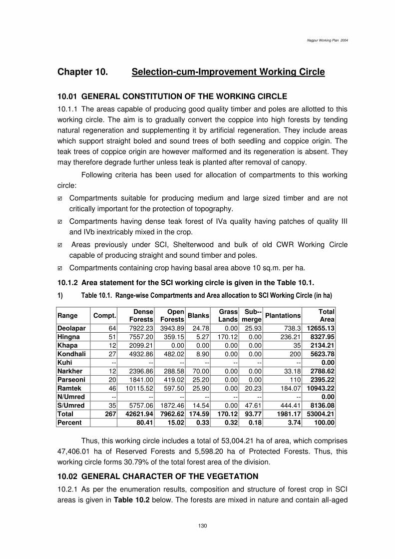
Nagpur Working Plan 2004
130
Chapter 10. Selection-cum-Improvement Working Circle
10.01 GENERAL CONSTITUTION OF THE WORKING CIRCLE
10.1.1 The areas capable of producing good quality timber and poles are allotted to this
working circle. The aim is to gradually convert the coppice into high forests by tending
natural regeneration and supplementing it by artificial regeneration. They include areas
which support straight boled and sound trees of both seedling and coppice origin. The
teak trees of coppice origin are however malformed and its regeneration is absent. They
may therefore degrade further unless teak is planted after removal of canopy.
Following criteria has been used for allocation of compartments to this working
circle:
Compartments suitable for producing medium and large sized timber and are not
critically important for the protection of topography.
Compartments having dense teak forest of IVa quality having patches of quality III
and IVb inextricably mixed in the crop.
Areas previously under SCI, Shelterwood and bulk of old CWR Working Circle
capable of producing straight and sound timber and poles.
Compartments containing crop having basal area above 10 sq.m. per ha.
10.1.2 Area statement for the SCI working circle is given in the Table 10.1.
1) Table 10.1. Range-wise Compartments and Area allocation to SCI Working Circle (in ha)
Range Compt. Dense
Forests Open
Forests Blanks
Grass Lands
Sub--merge
Plantations Total Area
Deolapar 64 7922.23 3943.89 24.78 0.00 25.93 738.3 12655.13
Hingna 51 7557.20 359.15 5.27 170.12 0.00 236.21 8327.95
Khapa 12 2099.21 0.00 0.00 0.00 0.00 35 2134.21
Kondhali 27 4932.86 482.02 8.90 0.00 0.00 200 5623.78
Kuhi -- -- -- -- -- -- -- 0.00
Narkher 12 2396.86 288.58 70.00 0.00 0.00 33.18 2788.62
Parseoni 20 1841.00 419.02 25.20 0.00 0.00 110 2395.22
Ramtek 46 10115.52 597.50 25.90 0.00 20.23 184.07 10943.22
N/Umred -- -- -- -- -- -- -- 0.00
S/Umred 35 5757.06 1872.46 14.54 0.00 47.61 444.41 8136.08
Total 267 42621.94 7962.62 174.59 170.12 93.77 1981.17 53004.21
Percent 80.41 15.02 0.33 0.32 0.18 3.74 100.00
Thus, this working circle includes a total of 53,004.21 ha of area, which comprises
47,406.01 ha of Reserved Forests and 5,598.20 ha of Protected Forests. Thus, this
working circle forms 30.79% of the total forest area of the division.
10.02 GENERAL CHARACTER OF THE VEGETATION
10.2.1 As per the enumeration results, composition and structure of forest crop in SCI
areas is given in Table 10.2 below. The forests are mixed in nature and contain all-aged
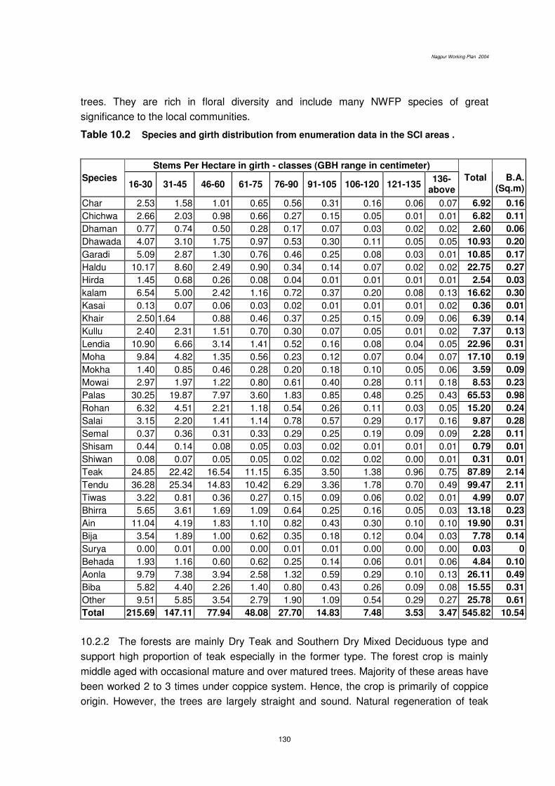
Nagpur Working Plan 2004
130
trees. They are rich in floral diversity and include many NWFP species of great
significance to the local communities.
Table 10.2 Species and girth distribution from enumeration data in the SCI areas .
Species
Stems Per Hectare in girth - classes (GBH range in centimeter)
16-30 31-45 46-60 61-75 76-90 91-105 106-120 121-135 136-
above
Total B.A. (Sq.m)
Char 2.53 1.58 1.01 0.65 0.56 0.31 0.16 0.06 0.07 6.92 0.16
Chichwa 2.66 2.03 0.98 0.66 0.27 0.15 0.05 0.01 0.01 6.82 0.11
Dhaman 0.77 0.74 0.50 0.28 0.17 0.07 0.03 0.02 0.02 2.60 0.06
Dhawada 4.07 3.10 1.75 0.97 0.53 0.30 0.11 0.05 0.05 10.93 0.20
Garadi 5.09 2.87 1.30 0.76 0.46 0.25 0.08 0.03 0.01 10.85 0.17
Haldu 10.17 8.60 2.49 0.90 0.34 0.14 0.07 0.02 0.02 22.75 0.27
Hirda 1.45 0.68 0.26 0.08 0.04 0.01 0.01 0.01 0.01 2.54 0.03
kalam 6.54 5.00 2.42 1.16 0.72 0.37 0.20 0.08 0.13 16.62 0.30
Kasai 0.13 0.07 0.06 0.03 0.02 0.01 0.01 0.01 0.02 0.36 0.01
Khair 2.50 1.64 0.88 0.46 0.37 0.25 0.15 0.09 0.06 6.39 0.14
Kullu 2.40 2.31 1.51 0.70 0.30 0.07 0.05 0.01 0.02 7.37 0.13
Lendia 10.90 6.66 3.14 1.41 0.52 0.16 0.08 0.04 0.05 22.96 0.31
Moha 9.84 4.82 1.35 0.56 0.23 0.12 0.07 0.04 0.07 17.10 0.19
Mokha 1.40 0.85 0.46 0.28 0.20 0.18 0.10 0.05 0.06 3.59 0.09
Mowai 2.97 1.97 1.22 0.80 0.61 0.40 0.28 0.11 0.18 8.53 0.23
Palas 30.25 19.87 7.97 3.60 1.83 0.85 0.48 0.25 0.43 65.53 0.98
Rohan 6.32 4.51 2.21 1.18 0.54 0.26 0.11 0.03 0.05 15.20 0.24
Salai 3.15 2.20 1.41 1.14 0.78 0.57 0.29 0.17 0.16 9.87 0.28
Semal 0.37 0.36 0.31 0.33 0.29 0.25 0.19 0.09 0.09 2.28 0.11
Shisam 0.44 0.14 0.08 0.05 0.03 0.02 0.01 0.01 0.01 0.79 0.01
Shiwan 0.08 0.07 0.05 0.05 0.02 0.02 0.02 0.00 0.01 0.31 0.01
Teak 24.85 22.42 16.54 11.15 6.35 3.50 1.38 0.96 0.75 87.89 2.14
Tendu 36.28 25.34 14.83 10.42 6.29 3.36 1.78 0.70 0.49 99.47 2.11
Tiwas 3.22 0.81 0.36 0.27 0.15 0.09 0.06 0.02 0.01 4.99 0.07
Bhirra 5.65 3.61 1.69 1.09 0.64 0.25 0.16 0.05 0.03 13.18 0.23
Ain 11.04 4.19 1.83 1.10 0.82 0.43 0.30 0.10 0.10 19.90 0.31
Bija 3.54 1.89 1.00 0.62 0.35 0.18 0.12 0.04 0.03 7.78 0.14
Surya 0.00 0.01 0.00 0.00 0.01 0.01 0.00 0.00 0.00 0.03 0
Behada 1.93 1.16 0.60 0.62 0.25 0.14 0.06 0.01 0.06 4.84 0.10
Aonla 9.79 7.38 3.94 2.58 1.32 0.59 0.29 0.10 0.13 26.11 0.49
Biba 5.82 4.40 2.26 1.40 0.80 0.43 0.26 0.09 0.08 15.55 0.31
Other 9.51 5.85 3.54 2.79 1.90 1.09 0.54 0.29 0.27 25.78 0.61
Total 215.69 147.11 77.94 48.08 27.70 14.83 7.48 3.53 3.47 545.82 10.54
10.2.2 The forests are mainly Dry Teak and Southern Dry Mixed Deciduous type and
support high proportion of teak especially in the former type. The forest crop is mainly
middle aged with occasional mature and over matured trees. Majority of these areas have
been worked 2 to 3 times under coppice system. Hence, the crop is primarily of coppice
origin. However, the trees are largely straight and sound. Natural regeneration of teak

Nagpur Working Plan 2004
130
and its prominent associates is found at places but it is far from adequate. Establishment
of natural regeneration is an issue of concern due to fires and heavy grazing.
10.2.3 Teak is the predominant species, which is found in well-drained areas having
good loamy soil. It constitutes over 60 to 80 percent of crop and forms pure patches at
places. The common associates of teak are; Bija, Tinsa, Rohan, Kalam, Haldu, Bhirra,
Dhaora, Lendia, Saja, Tendu, Mowai, Kalam, Bel and Aonla. Tendu, Moha, Achar, Aonla,
Bel and Chinch is common edible fruit-bearing species.
10.2.4 The crop contains mostly the middle-aged trees but mature and over-mature
trees are found occasionaliy. Dominant site quality is IVa but areas of site quality III and
IVb are also found mixed in the crop. The density varies from 0.4 to 0.8.
10.2.5 Natural regeneration of teak and other common species, which is mostly of
coppice origin, is scanty and is found in well-drained areas having good soil and less
biotic interference. Depending upon the extent of damage due to fire and grazing,
establishment of NR varies from place to place. Proportion of teak has increased
because of its prolific coppicing nature and fire hardiness as well as the past system of
working favouring teak. However, crop has undergone 2 to 3 rotations under coppice
system leading to reduction in coppice vigour. Also regeneration of miscellaneous
species requires focus for restoring mixed nature of the crop.
10.3 BLOCKS AND COMPARTMENTS
Allotment of compartments to this working circle has been given in (Appendix 10.1)
10.4 SPECIAL OBJECTS OF MANAGEMENT
The special objects of management of forest areas under SCI Working Circle are as
follows:
i) The coppice crop of teak is generally stunted and has lost its vigor. Hence, it is to be
gradually converted into ‘high forest’ by appropriate silvicultural techniques, which will include tending of existing natural regeneration of seed origin.
ii) To obtain sustained supply of medium and large-sized timber and poles.
iii) To plant teak from genetically superior stock in suitable areas with an objective of
improving productivity.
iv) To involve local people in the management and protection of forests through JFMC’s.
10.5 ANALYSIS AND VALUATION OF THE CROP
Stock mapping: The extensive enumeration exercise and crown density mapping
through image analysis of satellite imageries has been employed for the stock mapping.
This is described in Chapter 6. Enumeration details have been shown in the GIS
generated maps.

Nagpur Working Plan 2004
130
Age and density: The crop is mostly middle aged to mature having density varying from
0.4 to 0.8. The dense forest areas form about ¾th of the crop in SCI areas.
Site quality: Site quality governs the harvestable girth. It has been mapped by
Geomatics Centre, Nagpur. It can be determined by average height of about 100 mature
dominant trees of Teak or its associates in the forest patches of consistent
characteristics. However, site quality dose not change much in the time span of 20 years
and hence the information from the previous plan has been used to delineate and digitise
the various site quality classes.
Enumeration: Enumeration for the collection of data on forest crop has been carried out
by laying plots of the size of 0.36 ha (60M X 60M) on the 600 metre X 600 metre grid
lines. This data has been analysed to obtain parameters like basal area, number of
mature trees per ha. and girth class wise stocking. These parameters have been used for
allocating compartments to various working circles and for setting out prescriptions for the
forests in those compartments.
Regeneration: While doing the enumeration work described as above, the data on
regeneration status has been collected by laying 0.04 ha sub-plots within the enumeration
plots. The seedlings have been enumerated in three categories. This data has been
analysed and used to prescribe methods for regeneration of forest areas both by natural
and artificial means. The focus of these methods will be on tending of existing natural
regeneration and rootstock management. Plantation has however been proposed to
improve stocking of commercially important species as well as to increase the capital
value of the forests. For this purpose, it has been proposed that teak will be planted in
small patches after creating gaps by removal of over wood (canopy removal). This has
been dealt with in detail under para 10.12.
Table 10.3 Average Seedlings and saplings per hectare in the SCI areas
Range Seedlings (R1) 0.3–1.0 meter
Saplings (R2) 1.0–3.0 meter
Saplings (R3) > 3.0 meter
Total
Deolapar 279.58 235.56 230.39 745.53
Khapa 16.17 222.17 106.08 344.42
Kondhali 95.18 152.74 26.79 274.71
Narkher 126.00 171.85 46.62 344.46
Parsioni 33.90 72.25 69.30 175.45
Ramtek 258.73 327.85 134.73 721.31
Hingna 182.94 170.56 29.71 383.21
Kuhi 0 524.50 244.38 768.88
N/Umred 90.68 436.84 124.68 652.21
S/Umred 62.83 161.212 51.95 276.00
Average 154.88 222.91 103.91 481.70
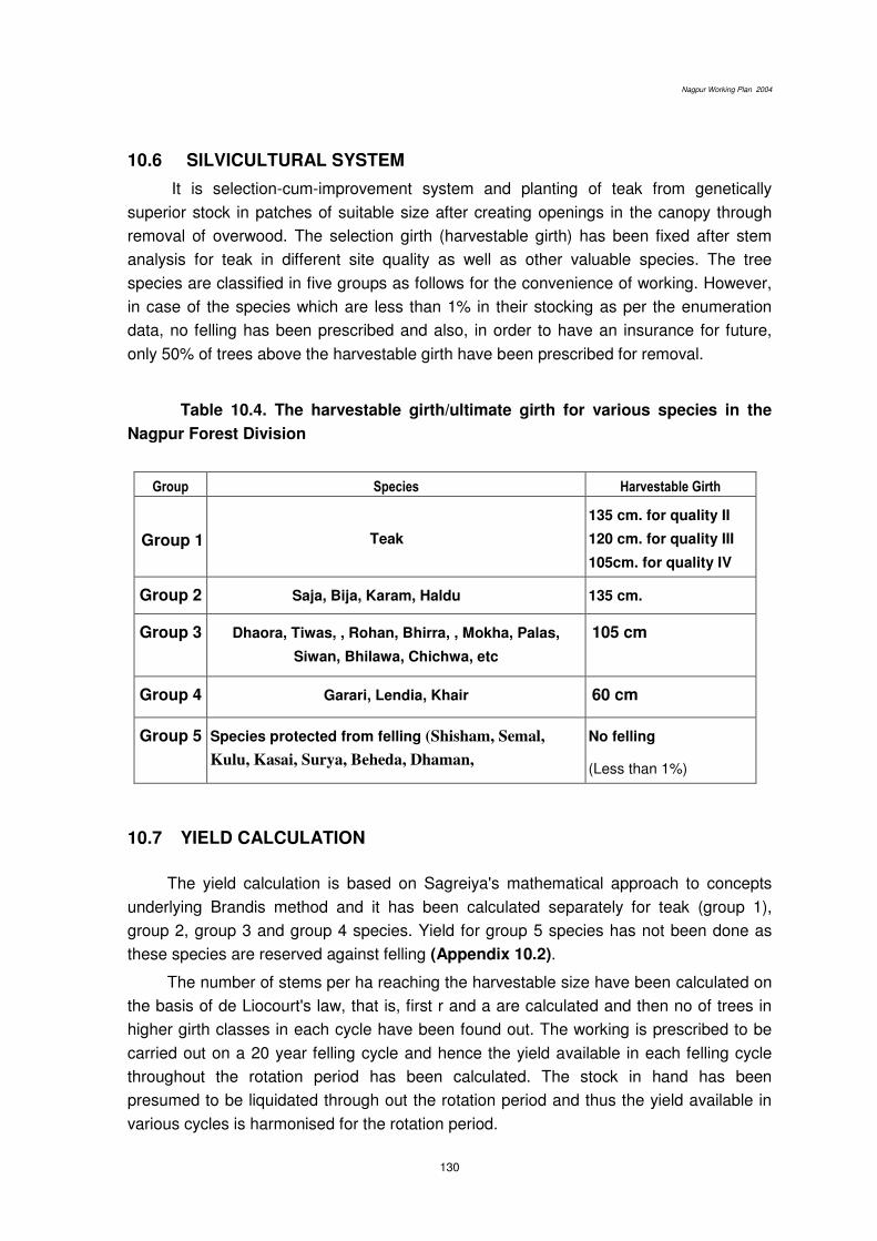
Nagpur Working Plan 2004
130
10.6 SILVICULTURAL SYSTEM
It is selection-cum-improvement system and planting of teak from genetically
superior stock in patches of suitable size after creating openings in the canopy through
removal of overwood. The selection girth (harvestable girth) has been fixed after stem
analysis for teak in different site quality as well as other valuable species. The tree
species are classified in five groups as follows for the convenience of working. However,
in case of the species which are less than 1% in their stocking as per the enumeration
data, no felling has been prescribed and also, in order to have an insurance for future,
only 50% of trees above the harvestable girth have been prescribed for removal.
Table 10.4. The harvestable girth/ultimate girth for various species in the
Nagpur Forest Division
Group Species Harvestable Girth
Group 1
Teak
135 cm. for quality II
120 cm. for quality III
105cm. for quality IV
Group 2 Saja, Bija, Karam, Haldu 135 cm.
Group 3 Dhaora, Tiwas, , Rohan, Bhirra, , Mokha, Palas,
Siwan, Bhilawa, Chichwa, etc
105 cm
Group 4 Garari, Lendia, Khair 60 cm
Group 5 Species protected from felling (Shisham, Semal,
Kulu, Kasai, Surya, Beheda, Dhaman,
No felling
(Less than 1%)
10.7 YIELD CALCULATION
The yield calculation is based on Sagreiya's mathematical approach to concepts
underlying Brandis method and it has been calculated separately for teak (group 1),
group 2, group 3 and group 4 species. Yield for group 5 species has not been done as
these species are reserved against felling (Appendix 10.2).
The number of stems per ha reaching the harvestable size have been calculated on
the basis of de Liocourt's law, that is, first r and a are calculated and then no of trees in
higher girth classes in each cycle have been found out. The working is prescribed to be
carried out on a 20 year felling cycle and hence the yield available in each felling cycle
throughout the rotation period has been calculated. The stock in hand has been
presumed to be liquidated through out the rotation period and thus the yield available in
various cycles is harmonised for the rotation period.

Nagpur Working Plan 2004
130
1. On this basis, the annual yield per ha is 0.0532 trees. The per tree volume from
the local volume table of teak in Nagpur forests may be taken as 1.03 m3. Thus, annual
yield for teak in a coupe will be as follows:
0.0532 x 1.03 x 53000
----------------------------- = 121.008 m3
24
As only 50% of trees of the harvestable class are to be removed, 60.504 m3 material
of teak will be available.
2. Similarly, yield for Group 2 species is as follows
0.0062 x 1.03 x 53000
----------------------------- = 14.102 m3
24
That is, 7.051 m3 of material of Group 2 species i.e. Bija, Ain, Kalam, Haldu will be
available.
3. In case of Group 3 species i.e. Dhawda, Tiwas etc., the harvestable girth is fixed
at 105 cm and, hence, per tree volume from the local volume table is 0.555, Therefore,
the yield available is as follows:
0.04145 x 0.555 x 53000
--------------------------------- = 508.022 m3
24
That is, the yield available should be 254.011 m3. Such a huge quantity can be
explained in the light of lower harvestable girth due to which number of trees available
have suddenly increased. Such a heavy felling is not advisable and hence 1 out of every
3 available trees of this class are prescribed to be removed.
4. In case of Group 4 species i.e. Garadi, Lendia and Khair, the harvestable girth is
60 cm. Therefore, per tree volume from the local volume table is 0.14 and the available
yield is:
1.33 x 0.14 x 53000
----------------------------- = 411.192 m3
24

Nagpur Working Plan 2004
130
That is, the yield available should be 205.596 m3. Such a huge quantity can be
explained in the light of lower harvestable girth due to which number of trees available
have suddenly increased. Such a heavy felling is not advisable and hence 1 out of every
3 available trees of this class are prescribed to be removed.
10.8 CHOICE OF SPECIES
Teak will receive top priority for retention. When it, however, makes more than 50% of
stems above 120 cm GBH, other healthy stems of valuable species will be considered for
retention. The order of priority for non-teak species will be Tiwas, Bija, Haldu, karam,
Saja, Siwan, Dhaora, Bhirra, Mowai, Salai, Dhaman, Lendia, Rohan, Khair, etc. and the
order may be fixed/ altered from time to time by CCF(T) Nagpur. All fruit trees and those
whose population in forest crop is less than 1% will always be retained. When we,
however, attempt to create normal forests by altering the method of working as described
under para 10.6.2, choice of species has a lesser significance as all the species and girth
classes will get attention according to their weightage worked out but whenever a choice
will have to be made, the above prescriptions will be followed.
10.9 FELLING CYCLE, FELLING SERIES AND ANNUAL COUPES
Felling Cycle: The common species in the area are light demander in nature, and the
higher proportion of teak suggests the need for creating greater openings to introduce
other valuable species in stocking. Further, long spell of dry months also intensifies
competition in these forests. In view to this, 20 (twenty) years felling cycle of has been
retained.
Felling series and annual coupes: The entire area of this working circle has been
divided into 24 felling series, and each felling series will have 20 annual coupes.
(Appendix 10.3)
Regulation of yield: The yield is prescribed by number/ volume and regulated by area
and therefore coupes broadly of equal area have been formed.
10.10 COUPE DEMARCATION, TREATMENT MAP AND MARKING
10.10.1 The coupe demarcation, preparation of treatment maps and marking will
be according to prescriptions incorporated in the chapter of Miscellaneous Regulations.
10.10.2 Main annual coupes shall be demarcated one year in advance along with
coupes due for cleaning and thinning. The coupe shall be divided into four sections, if
necessary, to effectively control the various coupe operations.
Nagpur Working Plan 2004
130
10.10.3 Treatment Map shall be prepared by the RFO and verified by the ACF.
This will be in accordance with the criteria and prescriptions of the Chapter 9. Areas
under various treatment types shall be shown distinctively on the map, and those, which
are suitable for planting, and also those, which have adequate and promising NR and
rootstock, shall be shown prominently.
10.10.4 Treatment Prescribed: The treatment map will be prepared showing the
following categories of area.
A Type Areas (Protection Areas)
They will include-
A1 type areas, which have slope more than 25°,
A2 type areas, i.e. 30 m wide strip on both sides of streams,
A3 type areas, which are susceptible to excessive erosion.
B Type Areas (Under-stocked Areas)
The open forests with root stock as well as without root stock shall be shown in the
treatment map.
C Type Areas (pole crop)
Areas with sufficient pole crop of valuable species which can be retained as future
crop shall be marked separately.
D Type Areas (Well-stocked Areas)
The well-stocked areas will be shown in the treatment map to facilitate teak plantation
in identified patches and selection working in the rest of the area. Hence, delineation
of following 2 categories in felling series identified for this purpose are prescribed.
D1 type areas: well-stocked areas, predominantly having coppice crop of third
rotation or more and also the areas having mature trees with scanty regeneration,
with deep and well drained soil having site quality IVA or above, to the extent of
20 ha in a coupe in one or more patches, which are fit for overwood removal and
planting with teak.
In addition following points shall also be kept under consideration while selecting
and delineating these areas.
Areas adjoining (in the vicinity of) to successful old plantations.
Forests containing scattered teak and its associates indicating potential for
good teak growth.
Sites in steep slopes and flat plateau and soils containing quartzite /
sandstone are to be avoided.
Hence, the treatment map for areas suitable for teak plantation will indicate steep
slopes, eroded areas and water logged and blank areas as unworkable.
Nagpur Working Plan 2004
130
D2 type areas: the remaining well stocked areas will be worked under selection
system.
E -Type Areas (Blank Areas)
Blanks will be separately shown in the treatment map.
10.11 MARKING RULES AND PRESCRIPTIONS
10.11.1 Marking technique and prescriptions described in the chapter of the
Miscellaneous Regulations shall be followed, with modifications, described in the
following paragraphs.
10.11.2 Marking shall be carried out under the close supervision of the RFO and under
guidance of ACF concerned. DCF shall himself inspect majority of coupes to ensure
proper marking and to guard against excessive marking, if any.
10.11.3 The following rules shall be observed strictly for marking in various treatment
type areas prescribed in chapter 8:
A Type Areas No tree shall be marked for felling.
B Type Areas
1 All dead and malformed over mature trees, retaining 2 trees / ha as snags and
dens for nesting and resting of wildlife.
2. All live high stumps shall be marked.
3. All multiple coppice poles; retaining only one, the most promising / stool, shall
be marked.
C Type Areas
1. The congested pole crop shall be marked for thinning to maintain spacing
equal to 1/3rd of the crop height and/or to bring down stem number as per the
yield table.
2. The dead, dying and malformed poles shall be marked for thinning
3. Unwanted undergrowth interfering or likely to interfere the seed based NR of
teak and other valuable species shall be removed.
D Type Areas
D1 (areas suitable for overwood removal)
Mature well stocked forests (to be decided on the basis of critical crop girth) are to
be selected for the purpose and overwood from these areas will be cleared to create
sufficient openings for growth of teak. For this purpose all except the following categories
of teak shall be marked for removal.
i. All young to middle aged fruit bearing trees upto 20 trees per hectare will be
retained.
Nagpur Working Plan 2004
130
ii. Young middle aged trees of Semal, Khair, Rosewood and superior misc. trees
upto 20 trees per hectare uniformly spread over the area will be retained.
iii. No removal of overwood upto 20 m on either side of nalas, streams and
riverbanks is to be done.
Only dead trees from such strips shall be removed.
iv. 20 m. wide strip of natural forest is to be retained on all sides of the section and
between such section.
D2 (areas suitable for selection working)
1. All Teak (group1), Ain, Bija, Karam, Haldu (group 2) and the Group 3 (listed
species) trees above the harvestable girth and approach class are prescribed
to be enumerated in 15 cm girth-classes before marking.
2. All edible fruit bearing species yielding species, such as, moha, achar, tendu,
aonla, sitafal, chinch, bel, etc, and minor forest produce species such as kullu,
Semal, Salai, etc. shall be reserved against felling.
3. All dead and malformed trees, retaining 2 trees per hectare, shall be marked
for felling. To avoid excessive felling it is prescribed that malformed trees
having straight clear bole exceeding 2.5 metre height from ground level shall
not be marked for felling.
4. All live high stumps and all but one vigorously growing coppice pole per stool
shall be marked for felling.
5. Marking of trees for felling will be limited to only 50% of the enumerated trees
over harvestable girth. Trees of seedling origin shall be preferred for retention.
6. Marking is prescribed to proceed from highest girth-class to lower girth-
classes; and no tree shall be marked for felling unless silviculturally available.
7. ‘Malformed tree’: A tree with a badly shaped and defective stem and
occupying more space than its future value warrants.
This type of working is also prescribed for the strips left under D1 areas.
However, strips along the nalas are not to be worked except for the removal of dead trees.
E Type Areas: Blank Areas- Marking is not prescribed.
10.11.4 CUTBACK OPERATIONS, CLEANING AND THINNING
Cutback operations as prescribed in Chapter 9 shall be carried out in the 2nd year after
the main felling in the annual coupe.
Cleaning in the 6th year after main felling in the annual coupes and also in the 6th year
after planting in D 1 type areas will be as per prescriptions given in Chapter 9.
(Appendix 10.4).
Nagpur Working Plan 2004
130
10.12 METHODS OF REGENERATION
10.12.1 It will be to facilitate the natural regeneration for maintaining the ‘high forest’ status of the crop. Therefore, tending of the future crop and rootstock management is to be given preference over plantations. The areas having promising NR and rootstock
will be identified, marked and treated as described in chapter 9.
10.12.2 ARTIFICIAL REGENERATION OF TEAK FROM GENETICALLY SUPERIOR
STOCK
Artificial plantations of teak however have been prescribed in D1 type areas to
maximise productivity of forests from commercial angle. This has particularly been
considered essential because forests in the division do not have adequate natural
regeneration of teak but performance of the old teak plantations is encouraging. Current
coupes of SCI (also some IMP coupes) have been considered for this purpose. A 20 ha
patch at an average in such coupes found suitable for growth of teak shall be taken up for
creating teak plantations from genetically improved stock.
The Deputy Conservator of Forests, Nagpur will personally select suitable areas
to create such plantations in approximately 2500 ha in the plan period (at an average 250
ha per year). The various felling series (Appendix 10.4) under SCI working circle in
Deolapar, Ramtek, Parseoni and South Umred ranges are considered suitable for this
purpose. This is because firstly, as mentioned above, these are generally the ranges
having successful old plantations of teak and secondly past results relating to
management of teak in Central India indicate that plantations in dry teak areas like
Hingna and Kondhali ranges are not successful. The dry teak areas, that is, majority of
the area in Hingna, Narkhed, Kondhali, North Umred are therefore not considered
suitable for the foregoing prescriptions.
The felling series provisionally identified for this purpose are:
i. Bandra
ii. Goreghat
iii. Deolapar
iv. Bawanthadi
v. Belda
vi. Chorbaoli
vii. Khubala
viii. Belarpar
ix. Dhamangaon
Planting stock raised from the genetically superior source will be used for artificial
regeneration. Teak will be planted at a spacing of 2Mx2M but care shall be taken that no
tree which has been retained (as described under paras (i) and (ii) under D1 Type) falls
within a distance of 1M.
It is suggested that Old teak plantations as discussed under chapter 12 and the
new ones to be raised after over wood removal should be managed to form a uniform
system containing various age gradations and such system is intended to supply
commercial timber perpetually. Therefore, when sufficient information for both old

Nagpur Working Plan 2004
130
plantations regarding past performance of teak and newly established ones regarding
their survival is available, the two are to be merged under one working circle in the
succeeding working plans. However, new sites for plantations are to be selected in the
next rotation.
10.13 CLOSURE TO GRAZING AND FIRE PROTECTION
Protection from fire and grazing is essential for success of natural and artificial
regeneration. All annual coupes shall remain closed to grazing and shall be provided
strict fire protection till completion of coupe cleaning operations in the 6th year.
10.14 AGENCY FOR EXECUTING WORKS
The annual coupes in the division are traditionally harvested by FLCS. In view of
the present guidelines for the joint forest management, harvesting along with other coupe
works –CBO as well as rootstock management in understocked areas, may be done
through JFMCs. This may need alterations in the area of operation of various FLCS as
well as changes in certain rules governing their (FLCS) working. These changes should
allow usufruct sharing and benefits of coupe working to the village community. Also,
through their respective JFMCs, the villages in general will be entitled for being engaged
on the employment generated in the coupe operations. The prescriptions under this
chapter and FLCS working need to be dovetailed with those necessary for management
and protection of forests through JFMCs. Hence, this aspect is to be covered and
elaborated in the village wise micro-plans.
*****
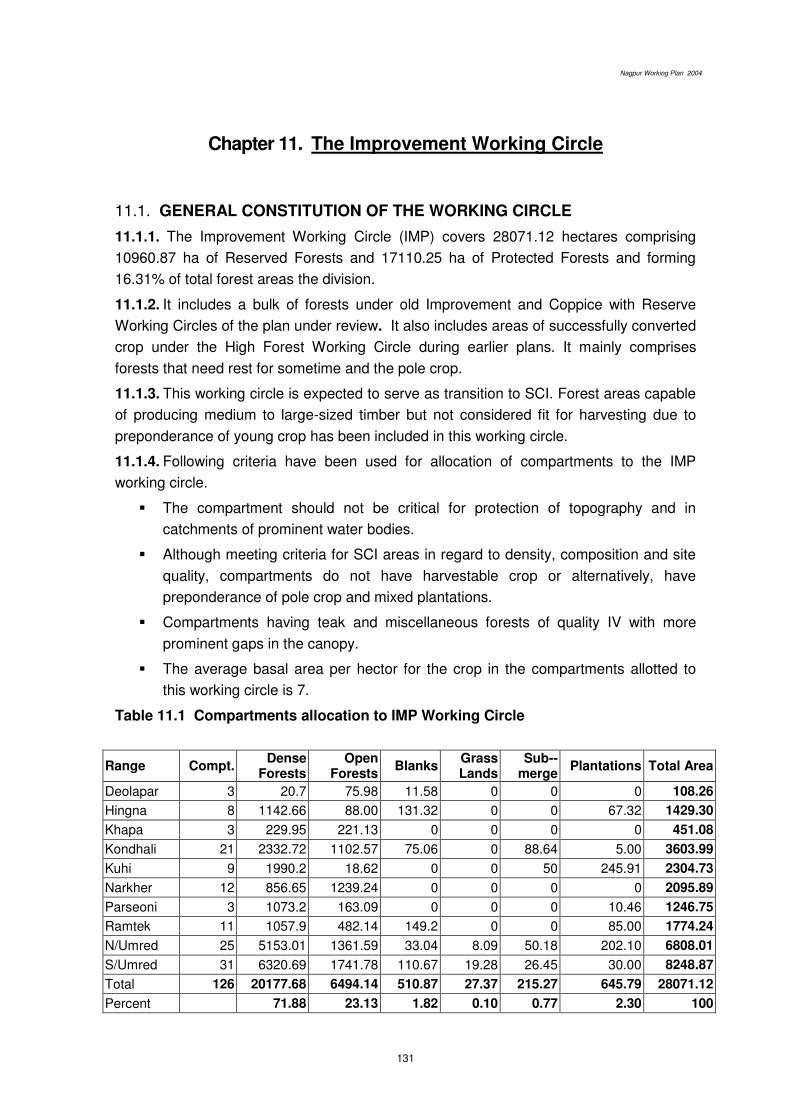
Nagpur Working Plan 2004
131
Chapter 11. The Improvement Working Circle
11.1. GENERAL CONSTITUTION OF THE WORKING CIRCLE
11.1.1. The Improvement Working Circle (IMP) covers 28071.12 hectares comprising
10960.87 ha of Reserved Forests and 17110.25 ha of Protected Forests and forming
16.31% of total forest areas the division.
11.1.2. It includes a bulk of forests under old Improvement and Coppice with Reserve
Working Circles of the plan under review. It also includes areas of successfully converted
crop under the High Forest Working Circle during earlier plans. It mainly comprises
forests that need rest for sometime and the pole crop.
11.1.3. This working circle is expected to serve as transition to SCI. Forest areas capable
of producing medium to large-sized timber but not considered fit for harvesting due to
preponderance of young crop has been included in this working circle.
11.1.4. Following criteria have been used for allocation of compartments to the IMP
working circle.
The compartment should not be critical for protection of topography and in
catchments of prominent water bodies.
Although meeting criteria for SCI areas in regard to density, composition and site
quality, compartments do not have harvestable crop or alternatively, have
preponderance of pole crop and mixed plantations.
Compartments having teak and miscellaneous forests of quality IV with more
prominent gaps in the canopy.
The average basal area per hector for the crop in the compartments allotted to
this working circle is 7.
Table 11.1 Compartments allocation to IMP Working Circle
Range Compt. Dense
Forests Open
Forests Blanks
Grass Lands
Sub--merge
Plantations Total Area
Deolapar 3 20.7 75.98 11.58 0 0 0 108.26
Hingna 8 1142.66 88.00 131.32 0 0 67.32 1429.30
Khapa 3 229.95 221.13 0 0 0 0 451.08
Kondhali 21 2332.72 1102.57 75.06 0 88.64 5.00 3603.99
Kuhi 9 1990.2 18.62 0 0 50 245.91 2304.73
Narkher 12 856.65 1239.24 0 0 0 0 2095.89
Parseoni 3 1073.2 163.09 0 0 0 10.46 1246.75
Ramtek 11 1057.9 482.14 149.2 0 0 85.00 1774.24
N/Umred 25 5153.01 1361.59 33.04 8.09 50.18 202.10 6808.01
S/Umred 31 6320.69 1741.78 110.67 19.28 26.45 30.00 8248.87
Total 126 20177.68 6494.14 510.87 27.37 215.27 645.79 28071.12
Percent 71.88 23.13 1.82 0.10 0.77 2.30 100

Nagpur Working Plan 2004
132
11.2. GENERAL CHARACTER OF THE VEGETATION
11.2.1 On the basis of enumeration results the species composition and their girth
distribution in forest areas under this working circle is given in Table 11.2
Table 11.2 Species and girth distribution in the IMP areas per ha.
Species and girth distribution in the IMP areas per ha.
16-30 31-45 46-60 61-75 76-90 91-105 106-120 121-135 136-above
Total B.A. (Sq.m)
Char 2.76 2.02 1.52 0.79 0.47 0.29 0.11 0.05 0.04 8.06 0.17
Chichwa 0.38 0.16 0.29 0.09 0.07 0.06 0.03 0.03 0.03 1.13 0.03
Dhaman 0.33 0.27 0.11 0.12 0.06 0.04 0.05 0.00 0.00 0.98 0.02
Dhawada 5.97 3.43 1.27 0.58 0.61 0.34 0.10 0.04 0.02 12.36 0.19
Garadi 2.95 1.46 0.39 0.25 0.18 0.03 0.02 0.02 0.01 5.31 0.07
Haldu 0.47 0.34 0.32 0.30 0.16 0.13 0.03 0.01 0.00 1.77 0.05
kalam 2.73 1.35 0.77 0.50 0.28 0.22 0.11 0.11 0.05 6.13 0.13
Kasai 0.07 0.02 0.02 0.01 0.00 0.01 0.01 0.00 0.01 0.14 0.00
Khair 3.14 2.39 0.91 0.70 0.44 0.30 0.08 0.07 0.10 8.14 0.17
Kullu 0.32 0.61 0.45 0.16 0.08 0.04 0.01 0.00 0.00 1.65 0.03
Lendia 9.78 6.53 2.53 0.96 0.25 0.11 0.07 0.05 0.08 20.36 0.26
Moha 4.93 2.84 0.79 0.32 0.25 0.10 0.07 0.02 0.16 9.49 0.14
Mokha 0.01 0.01 0.03 0.02 0.02 0.01 0.01 0.00 0.01 0.11 0.01
Mowai 4.34 1.83 1.53 1.12 0.87 0.58 0.35 0.19 0.17 10.98 0.29
Palas 22.16 15.74 6.13 2.66 1.31 0.89 0.43 0.25 0.36 49.93 0.78
Rohan 7.98 3.95 2.25 1.03 0.46 0.27 0.11 0.17 0.08 16.29 0.26
Salai 0.95 0.59 0.63 0.72 0.51 0.25 0.39 0.18 0.22 4.44 0.20
Semal 0.10 0.15 0.08 0.04 0.01 0.01 0.01 0.01 0.00 0.42 0.01
Shisam 0.00 0.01 0.05 0.10 0.08 0.02 0.01 0.00 0.00 0.26 0.01
Shiwan 0.13 0.01 0.00 0.00 0.01 0.00 0.00 0.00 0.00 0.15 0.00
Teak 11.84 11.20 7.06 4.43 2.56 1.42 0.75 0.37 0.25 39.89 0.91
Tendu 23.74 16.57 9.75 5.40 3.21 1.48 0.60 0.43 0.24 61.41 1.15
Tiwas 0.85 0.25 0.15 0.12 0.04 0.02 0.03 0.01 0.00 1.46 0.02
Bhirra 1.85 1.31 0.68 0.48 0.32 0.23 0.18 0.07 0.04 5.16 0.12
Ain 3.82 2.51 1.27 0.84 0.49 0.30 0.16 0.10 0.08 9.57 0.20
Bija 0.77 0.54 0.47 0.54 0.47 0.31 0.14 0.11 0.00 3.35 0.12
Behada 0.30 0.39 0.30 0.32 0.22 0.11 0.02 0.02 0.01 1.67 0.05
Aonla 1.76 1.29 0.64 0.47 0.29 0.19 0.07 0.07 0.05 4.83 0.11
Biba 1.85 1.61 0.77 0.51 0.37 0.20 0.10 0.02 0.02 5.45 0.11
Other 7.66 3.51 1.77 1.53 1.14 0.58 0.36 0.25 0.41 17.21 0.41
Total 123.94 82.88 42.91 25.13 15.24 8.54 4.40 2.63 2.42 308.08 6.02
11.2.2 The crop consists of mixed type varying from pure teak to pure miscellaneous
forests and varies considerably in composition, density and growth. The prominent
associates of Teak are; Saja, Bija, Dhaora, Lendia, Tinsa, Semal, Mowai, Salai, Tendu,

Nagpur Working Plan 2004
133
Rohan, Char, Haldu, Karam, Khair, Bhirra, Bel etc. Proportion of teak is high varying
from 20 to 80 percent. The areas are potentially suitable for teak forests and other
valuable miscellaneous species. Natural regeneration of common species is present, but
its establishment varies, depending upon fire and grazing damage. Natural regeneration
is poor for teak as well as for its associates.
11.2.3. The site quality ranges from IVa to IVb. The density of forests varies from 0.4 to
0.8. The crop is young to middle aged with occasional mature trees. Stems in lower girth
classes are proportionately higher in number.
11.3 BLOCK AND COMPARTMENTS
11.3.1 Details of the IMP compartments have been given in (Appendix 11.1)
11.4. SPECIAL OBJECTS OF MANAGEMENT
11.4.1. The special object of management for this working circle is to improve the
existing crops by tending operations and supplementary plantations. Improvement
measures aims at nursing back these forests to normalcy.
11.4.1 To check soil erosion and conserve soil moisture, essential for creating conditions
conducive for rejuvenation and growth of NR and rootstock.
11.4.2 The hygienic tending and thinning operations are expected to provide small
timber, poles and firewood to meet bona fide needs of the local people.
11.5 ANALYSIS AND VALUATION OF THE CROP
11.5.1 Stock mapping: The stock mapping has been proposed to be done by the
extensive enumeration exercise and crown density mapping through image analysis of
satellite imageries as described in para 6.4 of Chapter 6.
11.5.2 Age and density: The crop is mostly young to middle with scattered mature trees
aged having density 0.4 to 0.6.
11.5.3 Enumeration: Enumeration has been carried out as per systematic line-plots
sampling on 600 metre grid lines. The data has been analysed through computerised
Inventory Management System.
11.5.4 Regeneration: Average numbers of seedlings and saplings per hectare in the
IMP areas were found out from regeneration survey which was carried out along with the
enumeration of the crop. This analysis has been arranged and given in Table 11.3.
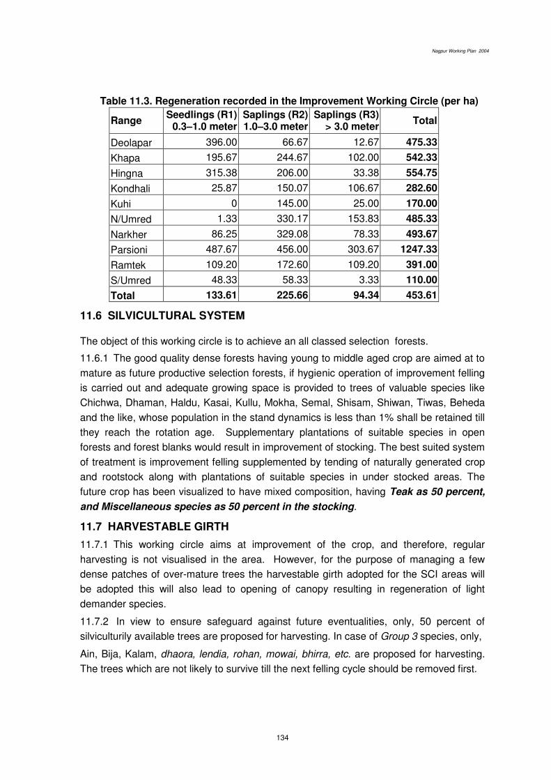
Nagpur Working Plan 2004
134
Table 11.3. Regeneration recorded in the Improvement Working Circle (per ha)
Range Seedlings (R1)
0.3–1.0 meter Saplings (R2) 1.0–3.0 meter
Saplings (R3) > 3.0 meter
Total
Deolapar 396.00 66.67 12.67 475.33
Khapa 195.67 244.67 102.00 542.33
Hingna 315.38 206.00 33.38 554.75
Kondhali 25.87 150.07 106.67 282.60
Kuhi 0 145.00 25.00 170.00
N/Umred 1.33 330.17 153.83 485.33
Narkher 86.25 329.08 78.33 493.67
Parsioni 487.67 456.00 303.67 1247.33
Ramtek 109.20 172.60 109.20 391.00
S/Umred 48.33 58.33 3.33 110.00
Total 133.61 225.66 94.34 453.61
11.6 SILVICULTURAL SYSTEM The object of this working circle is to achieve an all classed selection forests.
11.6.1 The good quality dense forests having young to middle aged crop are aimed at to
mature as future productive selection forests, if hygienic operation of improvement felling
is carried out and adequate growing space is provided to trees of valuable species like
Chichwa, Dhaman, Haldu, Kasai, Kullu, Mokha, Semal, Shisam, Shiwan, Tiwas, Beheda
and the like, whose population in the stand dynamics is less than 1% shall be retained till
they reach the rotation age. Supplementary plantations of suitable species in open
forests and forest blanks would result in improvement of stocking. The best suited system
of treatment is improvement felling supplemented by tending of naturally generated crop
and rootstock along with plantations of suitable species in under stocked areas. The
future crop has been visualized to have mixed composition, having Teak as 50 percent,
and Miscellaneous species as 50 percent in the stocking.
11.7 HARVESTABLE GIRTH
11.7.1 This working circle aims at improvement of the crop, and therefore, regular
harvesting is not visualised in the area. However, for the purpose of managing a few
dense patches of over-mature trees the harvestable girth adopted for the SCI areas will
be adopted this will also lead to opening of canopy resulting in regeneration of light
demander species.
11.7.2 In view to ensure safeguard against future eventualities, only, 50 percent of
silviculturily available trees are proposed for harvesting. In case of Group 3 species, only,
Ain, Bija, Kalam, dhaora, lendia, rohan, mowai, bhirra, etc. are proposed for harvesting.
The trees which are not likely to survive till the next felling cycle should be removed first.
Nagpur Working Plan 2004
135
11.7.3 CHOICE OF SPECIES
11.7.4 The choice of species for retention in order of importance will be Teak, tiwas, bija,
saja, shisham, karam, haldu, siwan, bhirra, dhaora, lendia, salai, mowai, etc. No fruit
trees will be cut.
11.7.5 The choice of species for plantation will depend on the soil suitability is proposed
to include Teak, siwan, maharukh, kinhi, semal, shisham, bija, ain, babool, neem, khair
etc. For fodder grasses, such as, paonia, marvel and sheda are proposed. Bamboos are
proposed for planting at suitable sites in the entire areas.
11.8 FELLING CYCLE, FELLING SERIES AND ANNUAL COUPES
11.8.1 Felling cycle: The entire area in this working circle is proposed to be covered for
prescribed treatment in 20 (twenty) years.
11.8.2 Felling series and annual coupes: The entire area of this working circle has
been divided into 14 felling series. The area of each felling series is proposed to be
further divided into 20 (twenty) annual coupes. (Appendix 11.2).
11.8.3 Regulation of yield: The treatment is not adapted for yield. The silvicultural
tending operations will be regulated by area.
11.9 COUPE DEMARCATION, TREATMENT MAP AND MARKING
11.9.1 The coupe demarcation of annual coupes shall be carried out one year in advance
of main working as per prescriptions described in the Chapter of Miscellaneous
Regulations.
11.9.2 Treatment Map has been provided by GIS cell, Nagpur. This will shows non-
workable areas like those having slope more than 25o and a 30m belt on both sides of
perennial nallah (the nalas flowing upto January); crops having crown density < 0.4 as
well as > 0.4 with a sub class between 0.6 to 0.8 and the forest blanks. Such maps are
required to be updated by showing regeneration status manually and such a treatment
map shall be cartographically accurate.
11.9.3 Treatment Prescribed : The treatment proposed for various treatment type areas
marked on treatment map will be, as follows:
A Type Areas (Protection Areas)
They will include-
A1 type areas, which have slope more than 25°,
A2 type areas, i.e. 30 m wide strip on both sides of streams,
A3 type areas, which are susceptible to excessive erosion.
B Type Areas (Under-stocked Areas)
The open forests with root stock as well as without root stock shall be shown in the
treatment map.

Nagpur Working Plan 2004
136
C Type Areas (pole crop)
Areas with sufficient pole crop of valuable species which can be retained as future
crop shall be marked separately.
D Type Areas (Well-stocked Areas)
The well-stocked areas containing comparatively young crop (less number of stems
of higher girth class as well as of harvestable girth which is indicated by lower basal area)
will be shown in the treatment map to facilitate improvement fellings as well as teak
plantation in identified patches. Hence, delineation of following 2 categories is prescribed.
D1 type areas: Dhamna (North Umred) and Karandala (Kuhi Range) felling series only.
Well-stocked areas predominantly having coppice crop of third or more rotations and
mature trees with scanty regeneration. Such areas should have deep and well drained
soil with site quality IVA or above to the extent of 20 ha in a coupe in one or more patches
and which are fit for overwood removal and planting with teak.
In addition following points shall also be kept under consideration while selecting and
delineating these areas.
Areas adjoining (in the vicinity of) to successful old plantations.
Forests containing scattered teak and its associates indicating potential for good teak
growth.
Sites in steep slopes and flat plateau and soils containing quartzite / sandstone are to
be avoided.
Hence, the treatment map for areas suitable for teak plantation shall indicate
steep slopes, eroded areas and water logged and blank areas as unworkable.
D2 type areas: improvement fellings will be carried out in the remaining well stocked
areas containing comparatively young crop.
E -Type Areas (Blank Areas)
Blanks will be separately shown in the treatment map.
11.10 MARKING RULES AND PRESCRIPTIONS
11.10.1 Marking technique and prescriptions described in the Chapter of the
Miscellaneous Regulations shall be followed.
11.10.2 Marking shall be carried out under the close supervision of the RFO and under
guidance of ACF concerned. DCF shall himself inspect majority of coupes to ensure
proper marking and to guard against excessive marking, if any.
11.10.3 The following rules are proposed to be observed strictly for marking in various
treatment type areas;
A Type Areas: Protection Areas: No tree shall be marked for felling.
B Type Areas: Under stocked Areas:
1 All dead and malformed over mature trees, retaining 2 trees / ha as snags and
dens for nesting and resting of wildlife.
Nagpur Working Plan 2004
137
2. All live high stumps shall be marked.
3. All multiple coppice poles; retaining only one, the most promising / stool, shall
be marked.
C Type Areas: groups of young poles:
1. The congested pole crop shall be marked for thinning to maintain spacing
equal to 1/3rd of the crop height.
2. Unwanted undergrowth interfering or likely to interfere the seed based NR of
teak and other valuable species shall be removed.
D Type Areas: Well-stocked Areas:
D1 Type areas: Dhamna (North Umred) and Karandla (Kuhi) felling series only.
Mature well stocked forests (to be decided on the basis of critical crop girth) are to be
selected for the purpose and overwood from these areas will be cleared to create
sufficient openings for growth of teak. For this purpose all except the following categories
of teak shall be marked for removal.
i. All young to middle aged fruit bearing trees upto 20 trees per hectare will be retained.
ii. Young middle aged trees of Semal, Khair, Rosewood and superior misc. trees upto 20
trees per hectare uniformly spread over the area will be retained.
iii. No removal of overwood upto 20 m on either side of nalas, streams and riverbanks is
to be done.
Only dead trees from such strips shall be removed.
iv. 20 m. wide strip of natural forest is to be retained on all sides of the section and
between such section.
D2 (areas suitable for improvement working).
1. All Teak, Ain, Bija, Dhaoda, kalam, Bhirra, Garadi, Khair, Mowai, Palas, Rohan,
Salai, Biba, trees are prescribed to be enumerated in 15 cm girth-classes before
marking.
2. Trees having population less than 1% will not be felled.
3. All healthy edible fruit bearing species, such as, moha, achar, tendu, anola, sitafal,
chinch, bel and minor forest produce yielding species kullu, semal and salai shall be
reserved.
4. All dead and malformed over-mature trees after retaining 2 trees per hectare and all
live high stumps shall be marked for felling.
5. Mature trees (above harvestable girth as defined in SCI) that have developed
hollowness and show visual sign of decay will be marked for felling if silviculturally
available.
6. All but one vigorously, growing coppice pole per stool shall be marked for felling.
7. Marking is prescribed to proceed from highest girth-class to lower girth-classes; and
no tree shall be marked for felling unless silviculturally available.
E-Type Areas: Blank Areas- No marking is prescribed
Nagpur Working Plan 2004
138
11.11 METHODS OF REGENERATION
Natural regeneration shall be given preference over the plantations. The existing
NR and rootstock shall be tended as per prescriptions on rootstock management. Teak
plantations however are prescribed in 2 felling series - Dhamna (North Umred) and
Karandala (Kuhi) because soil in these areas is very much suited for the growth of teak
and supports some good teak plantations of the past.
Planting stock raised from genetically superior source (known and certified
source) will be used for artificial regeneration of teak. Prior to that, overwood will be
removed from the identified areas to create gaps of appropriate size in the canopy so that
growth of teak is facilitated by allowing sufficient sun light to reach the forest floor.
Such plantations are to be merged with the old teak plantations already existing
under the same system in due course of time and such system is expected to give yield
of the commercial timber on sustained basis.
11.12 CUTBACK OPERATIONS, CLEANING AND THINNING
11.12.1 The cutback operations shall be a part of the coupe working and will be carried
out in the 2nd year of coupe working, as prescribed in Chapter 9.
11.12.2 Cleaning in 6th year in the annual coupes will follow the prescriptions as
described in Chapter 9. (Appendix 11.3).
11.13 CLOSURE TO GRAZING AND FIRE PROTECTION
11.13.1 Protection from fire and grazing is essential for success of natural and artificial
regeneration.
11.13.2 All annual coupes will be provided strict fire protection and will remain closed to
grazing, till completion of the 6th year cleaning operations.
11.14 AGENCY FOR EXECUTING WORKS
The annual coupes in the division are traditionally harvested by FLCS. In view of
the present guidelines for the joint forest management, harvesting along with other coupe
works –CBO as well as rootstock management in understocked areas, may be done
through JFMCs. This may need alterations in the area of operation of various FLCS as
well as changes in certain rules governing their (FLCS) working. These changes should
allow usufruct sharing and benefits of coupe working to the village community. Also,
through their respective JFMCs, the villages in general will be entitled for being engaged
on the employment generated in the coupe operations. The prescriptions under this
chapter and FLCS working need to be dovetailed with those necessary for management
and protection of forests through JFMCs. Hence, this aspect is to be covered and
elaborated in the village wise micro-plans.
******

Nagpur Working Plan 2004
139
Chapter 12. Old Teak Plantation Working Circle
12.1 General Constitution
12.1.1 Teak and other plantations have been raised in Nagpur Forest Division in the
past and as the teak plantations require altogether different treatment and periodical
cultural, thinning and tending operations for the optimum commercial production on a
sustained basis, old and successful teak plantations are proposed to be dealt with under
a separate working circle. These efforts together with creation of new plantations
proposed under chapter 10 para 10.12.2 and chapter 11 para 11.11 are expected to
result in normal growing stock of even aged forests. However, as the plantations have not
been done successively but intermittently, and, as all plantations have not been
successful, attempt to achieve normal distribution of age classes has not been made in
this working plan. The areas of old teak plantations seem to have been irregularly
selected and hence the plantations are found scattered through out the division.
12.1.2 The list of various plantations was compiled by the Nagpur Forest Division for
submission before the Supreme Court.(Appendix 5.6) This list indicates year wise teak
plantations raised from the year 1960 to 1998. The stock maps as indicated in working
plan written by Shri Jwala Prasad also show old plantations prior to 1990. Taking this list
as the basis, efforts were made to obtain up to date maps of old teak plantations needing
attention under this plan. The information about these plantations is given under appendix
5.6 and the range wise abstract is as follows:
Sr
No
Ran
ge
No
of
sit
es in
Rese
rve
Fo
rest
Are
a (
in h
a)
No
of
sit
es in
Pro
tecte
d F
ore
st
Are
a
(in
ha)
To
tal P
lan
tati
on
sit
es
To
tal A
rea
(in
ha)
1 Deolapar 54 2226.13 11 230.14 65 2456.27
2 Ramtek 39 917.97 17 486.00 56 1403.97
3 Parseoni 9 202.00 4 124.00 13 326.00
4 Khapa 1 20.00 3 105.00 4 125.00
5 Hingna 5 145.00 2 33.00 7 178.00
6 Kondhali 3 75.00 2 50.00 5 125.00
7 Kuhi 1 50.00 6 240.00 7 290.00
8 S.Umred 2 30.00 - -- 2 30.00
Total 3666.10 1268.14 159 4934.24

Nagpur Working Plan 2004
140
12.1.3 As per the list mentioned above, plantations till the year 1996 were raised in
40595.14 ha. This includes teak plantations of 10,815.88 ha. This information was
discussed in the various meetings with the staff of Nagpur division and attempts were
also made during the field visits to get the maximum information about old teak
plantations in the division. As an outcome, maps of 4934.24 ha of such plantations at 159
locations in 8 ranges were made available. Thus, for the purpose of this chapter, only
these teak plantations have been considered. No prescriptions have been given for the
remaining plantations because of the lack of information.
Plantations proposed to be raised during the plan period under Selection-cum-
Improvement and Improvement working circles (Chapter 10 para 10.12.2 and chapter 11
para 11.11) are, for the purposes of their silvicultural management, also to be included
under this working circle during the next revision.
12.1.4 Considering the above situation regarding the lack of clarity about the
plantations in the division, it is felt necessary to create database of the old and successful
plantations and to begin this work with teak plantations. Teak plantations, which could not
be included under this chapter due to the lack of information, shall be identified on the
ground and mapped accurately during this plan period. It may be worthwhile to locate and
map the plantations with the help of GPS. Nagpur forest division will, with the help of
Nagpur Working Plan division, jointly endeavour to reconcile the records and create an
accurate database of the successful plantations during the course of implementation of
this plan. The teak plantations not included in this working circle due to lack of information
shall also be thinned according to the thinning regime prescribed in this chapter.
12.2 General Character of the vegetation
The plantations are located scattered in the various compartments. Separate
enumeration of the plantations was not done. The various compartments in which these
plantations are located contain the representative forest crop of the particular working
circle, which that compartment has been allotted to.
12.3 Blocks and compartments
12.3.1 Details of these plantations have been given in Appendix 12.1.
12.4 Special object of Management
To maintain perpetual growth in the plantations throughout their growing phase
by carrying out silvicultural thinnings as per the thinning regime prescribed for the
purpose.
12.5 Analysis and valuation of the crop
These plantations have been shown on the map generated through GIS.
Nagpur Working Plan 2004
141
12.6 SILVICULTURE OF TEAK
12.6.1 Teak (Tectona grandis Linn.f.) belongs to the family Verbenaceae and is
mostly distributed in the peninsular parts of India. The first teak plantations popularly
known as Conolly’s teak plantations were raised in 1846 in the state of Kerala. Teak tree is strong light demander and it requires for its proper development complete overhead as
well as fair amount of side ways light. Teak does not tolerate suppressed light at any
stage of its life. There is a direct relationship between light and growth, branching and
flowering of teak. Single tree or trees bordering the plantations produce profuse
branching, but in close stands, flowering occurs only in dominant and co-dominant trees,
and is confined to the upper parts which are exposed to bright sunlight; i.e. other trees
and lower branches of dominant trees do not produce inflorescence because they do not
get direct sunlight. Curtailment of light also delays development of fruits. Seedlings
require over 90 per cent light intensity. Saplings are often found growing under the light
shade of bamboos, and even to some extent under other trees, but the growth of such
plants is generally found to be slower than the plants with complete overhead light.
Saplings growing under bamboos endeavor to make their way through but they are often
found with their leading shoots damaged or killed. This is because bamboo acts as a
‘whip’. Leading shoot of the teak is very intolerant to irritation of any kind.
12.6.2 Teak is capable of thriving on variety of soils and geological formations, but it
requires good sub-soil drainage. It produces large and deep root system. At first a long
and thick taproot is formed. This may persist or may disappear, but in either case strong
lateral roots are produced. Teak is sensitive to frost. Seedlings and coppice-shoots are
particularly liable to frost injury. In its natural habitat, however, severe frost seldom
occurs. Frost results in poles being killed at the top or down up to the ground level but
experiments carried out showed that trees badly damaged by frost were capable, when
coppiced, of producing vigorous stool-shoots. Teak is also sensitive to drought. In the
abnormal droughts, which occurred from time to time in the Peninsula, it suffered more
severely than any other species.
12.6.3 Teak coppices and pollards vigorously. Coppice shoots originate in two ways-
(1) Callus growth that develops inside the bark and between the bark and the
wood. In such a development of the coppice shoot, it emerges from the edge
of the cut surface. ‘Callus shoots’ are of adventitious origin.
(2) From the side of the stool below the cut surface, new shoots appear through
the bark. ‘side shoots’, appear to originate from dormant buds.
High coppicing appears to prevent the formation of callus shoots owing to the
rapid drying and shrinking of the wood at the cut surface. The shrinking of wood
separates bark from it. Also, subject to further confirmation, present evidence seems to
show that it is best to coppice teak low shortly before the commencement of vegetative
activity (growing period). However, if the felling is required to be done during the season

Nagpur Working Plan 2004
142
of rest (that is before the start of the growing season), high felling may be preferred so
that the base of the stump will remain alive even if the upper part dies.
12.7 FLOWERING, FRUITING AND SEED SET IN TEAK:
12.7.1 Flowering in teak is always terminal and limited only to sunlit branches. The
species is naturally adapted with very low fruit to flower and seed to fruit ratio. Flowers
are bisexual. Fruiting is mostly limited to 1-3% and seed filling is limited to 1-2 seeds per
drupe. This is basically a complex biological adaptation to procure highly out-crossed
seeds. Thus, there are limitations in improving fruit set. There are no significant
differences in regard to flowering and fruiting in natural and artificially raised teak.
12.7.2 Most of the early flowers within an inflorescence produce better fruit and seed
and thus for teak seed collections meant for genetic trials, fruit harvesting can be limited
to first three inter-nodes of the inflorescence. In this way, maximum out-crossed seed can
be obtained.
12.7.3 Flowering in teak is of two major types. In the first type, inflorescence is of
different age group and different inflorescence matures at different time. In the second
type inflorescences are of the same reproductive age and mature simultaneously.
12.7.4 Teak trees have clear male and female functions. Thus, it is important, while
managing breeding populations such as CSOs and SSOs, to quantify reproductive output
of a clone or a family. This aspect is extremely important as it results in fertility variation
within orchards.
12.7.5 Seed emptiness is mainly due to self-pollination that occurs within a crown. A
major reason for high abortiveness is due to endosperm related abnormalities. However,
this problem is inherent (physio-genetic) and therefore it cannot be overcome.
12.7.6 Synchrony in flowering between clones need to be worked on the basis of
number of flowering days overlapping between clones.
12.7.7 Minimum spacement between fruiting trees should be 10Mx10M. Application
of nitrate fertilisers for at least 4-5 years (100-250 gms of urea/ plant with 2 waterings) is
recommended during pre-monsoon showers. In general, larger inflorescence size leads
to exponential increase in pollen production. Pollarding of the main stem results in
physiological shock.
12.8 NATURAL REGENERATION OF TEAK
12.8.1 In the moist type of forests, that is, where canopy is complete, teak forms a small
proportion of crop alongwith tall well formed and scattered bamboo clumps. This is mainly
because the closed canopy does not allow a teak seedling to grow. Natural regeneration
of teak is poor or wanting in the dry type areas, where it is found in association with
Anogeissus latifolia. The factors affecting natural regeneration are climate, soil, altitude
and aspect, germination capacity of the seed, conditions favouring establishment of
seedlings and the methods of management. The climate in India, is distinguished into dry

Nagpur Working Plan 2004
143
and wet seasons which is beneficial for the regeneration of teak. The seeds shed in drier
season soak moisture from the pre-monsoon rains of April and May, get dried before
arrival of monsoon and are again soaked in water when monsoon breaks. Because of the
natural and alternate soaking and drying in this way, hard seed coat gets broken and
seed germination is facilitated.
12.8.2 Physical structure of the soil especially its porosity is responsible for success of
natural regeneration. Granite, gneiss and trap formations produce favorable soils. Basalt
and sandstone develop adequate porosity in the soil but the humus disintegrates very
rapidly in such soils. Teak regeneration does not thrive in laterite soils because humus is
leached out rapidly from such soils and also due to their high acidic nature. In
metamorphic soils, which are predominantly present in the area, the characteristic of the
rock beneath plays an important and decisive role in determining the nature of surviving
forests and the future crop. Trap is a natural home of teak and such area are present at
many places. Teak grows well when the soil conforms to certain physical and chemical
properties and therefore the soil should be tested before taking up teak plantations. Teak
prefers slightly basic to neutral soils with high exchangeable calcium and magnesium. It
grows well in humus rich sandy loam soils due to plasticity index. Northern and eastern
aspects are favourable for teak growth.
12.8.3 In moist deciduous forests, the forest floor is covered with dense undergrowth and
therefore prevents the radicle to reach the ground and thus the seedlings fail to establish.
The opening of the forest canopy may lead to increase in the growth of grasses and other
weeds, which will again prevent establishment of natural regeneration.
12.8.4 In natural forests, the annual ground fire scorches the seeds and helps in natural
regeneration. The establishment of teak seedlings depends on sunlight but sudden
exposure may cause death of the young seedlings. The drip from the trees also adversely
affects the young plants. The early development of strong taproot requires a soft friable
soil.
12.8.5 The natural regeneration in teak is better in cooler northern and eastern
aspects. Deficiency of soil moisture is one of the hurdles in the establishment of natural
regeneration. Weed growth and ground vegetation are the greatest obstacles in the
establishment of natural regeneration.
12.8.6 Shoots of the seedlings are killed by frost but stock remains alive and therefore
a stronger shoot is formed each season until it is able to rise above the ground level.
12.9 SILVICULTURAL OPERATIONS
12.9.1 The Silvicultural operations are the regular thinnings and the schedule is 10th,
15th, 25th, 35th, 45th, 55th and 65th year of formation of the plantation. The first thinning, that
is, in the 10th year is supposed to be mechanical followed by silvicultural thinnings.
However, it is seen that the plantations in Nagpur Division have not been thinned in the
past and therefore a thinning regime different from the traditional one is required to be

Nagpur Working Plan 2004
144
developed. This is also important because sudden and large openings in the canopy due
to heavy thinning in old plantations may have adverse effect on growth. Hence, the
schedule has been altered accordingly and 1st thinning in plantations except those which
are formed in the year 1993 and afterwards will be B grade silvicultural thinning. This will
be followed by C grade thinnings every 10th year subsequently till the plantations attain
the age of 65 years. In case of plantations raised in 1993 and afterwards, the first
thinning, which will be done in the 10th year of its formation, will be mechanical followed
by first silvicultural thinning (C grade) in the 15th year and every 10th year subsequently.
This schedule is given in Appendix 12.2.
(A) MECHANICAL THINNING: Teak is traditionally planted at a spacing of 2m x 2m
i.e. 2500 seedlings per hectare and, in ideal conditions, it would have required a thinning
at an age of 5 years of its formation. Two mechanical thinnings of removing alternate
rows before the start of C (low) grade silvicultural thinning were prescribed earlier. The
Indian Forest Record 1957 mentions two mechanical thinnings at the age of 5 and 10
years. It prescribed following standard:
Year No/ha (for site quality-III) Spacement
1st year 2500 2m x 2m
5th year 1767 (after 1st Mechanical thinning 2 x 2√2 m
of removing alternate diagonal)
10th year 1250 (after 2nd Mechanical thinning 2√2 x 2√2 m
of removing alternate diagonal)
It has however been experienced that the teak plantations do not follow the
growth in a copybook fashion. The plantation of teak, which is supposed to have survived
100% till its 5th year of its existence, actually contains only 65-75% seedlings. Rest are
eliminated in their race for survival. The canopy competition in real sense does not start
at this stage. There are limiting factors like moisture availability and root competition. The
sigmoid growth curve between Age (on X axis) and Volume (on Y axis) for teak indicates
that its growth follows a moderate slope till 10th year and then it picks up and forms a
steep curve upto 50 years. Hence, first mechanical thinning at the age of 10 years of the
plantation has been prescribed. As a result, the stems will be free from canopy
interference and also the poles produced from the thinning operations shall be saleable.
The mechanical thinning will be done by considering a cluster of three poles in diagonals.
One of them will be removed. However, if one of the poles in this cluster is absent
removal may be differed.
Nagpur Working Plan 2004
145
(B) PRESCRIPTIONS FOR SILVICULTURAL THINNINGS
The various operations required for thinning in a teak plantation are summarised
below.
1. Stock mapping and delineation of the area of different site quality classes of the
plantation to be thinned will be done before actual operations are started.
2. Cleanings to remove undesirable undergrowth which hinders proper growth of
planted teak and which may obstruct the thinning work is to precede actual
thinning operations. Extent of cleaning as well as the species to be removed is to
be decided by the Deputy Conservator of Forests himself. Cleaning should include
systematic climber cutting.
3. Sample plots will be laid for detail measurements and total enumeration in such
plots to work out entire growing stock (planted as well as naturally regenerated
trees) will be carried out girth class wise. Basal area per ha. of such plots shall
also be measured. Also average crop diameter shall be calculated.
4. Yield and stand tables will be used to compare girth class wise actual stocking
and basal area of the plantation under consideration. If such comparison indicates
that basal area measured exceeds that given in the yield table for the same site
quality, this would necessitate removal of material to the extent basal area given
in the yield table is achieved. What girth classes and their extent to be removed
can be ideally found out by comparing actual stocking with the stand table (main
crop) for the particular site quality and age.
5. The average crop diameter may be taken as guiding rule to decide the individual
trees to be marked for removal, that is, trees below average crop diameter only
are to be marked for removal and only when they are silviculturally available.
Following order of marking regarding silvicultural availability of a tree shall be
maintained.
Non-teak coppice trees are first to be marked.
Teak coppice trees till all are marked.
Non-teak trees of seed origin till all are marked.
Trees of Shisham, Bija, Semal and other trees, which are less than 1 % in
their stocking in the forests and fruit bearing trees, are not to be marked for
felling.
Sound teak trees of seed origin to be marked for felling only in the last.
6. (1) As mentioned above, since no tending and thinning have been done in the
plantations in the past, the first thinning (B grade) in plantations raised before
1993 will therefore include the removal of the following:
Dead, dying, diseased and suppressed trees.
Defective, dominated stems and whips.

Nagpur Working Plan 2004
146
Branchy and badly shaped advance growth, which cannot be, or is
undesirable to be, pruned.
Trees having defective stems or crowns, that is, those trees whose crown
space is cramped by neighboring trees; those trees whose main stem is
forked or has other defects. Such category of trees do not have much
promise for future due to above defects and hence they shall be removed.
2. Subsequent thinnings will be done every 10 years after B grade thinning
prescribed above and these will be according to prescriptions in paras 1 to 5.
In the younger plantations, that is, those formed in the year 1993 and
afterwards, however, all the silvicultural thinnings will be according to
prescriptions in paras 1 to 5 above.
General guidelines for thinning and description of technical words and
operations have been incorporated under miscellaneous regulation.
12.10 Agency of Exploitation: The operations for tending and thinning of teak
plantations are highly skilled and require regular monitoring through recording and
analysis of growth measurements periodically. The working therefore is proposed to be
done strictly through departmental agency.
******
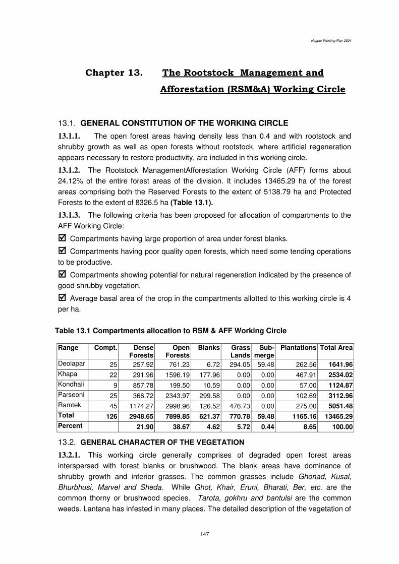
Nagpur Working Plan 2004
147
Chapter 13. The Rootstock Management and
Afforestation (RSM&A) Working Circle
13.1. GENERAL CONSTITUTION OF THE WORKING CIRCLE
13.1.1. The open forest areas having density less than 0.4 and with rootstock and
shrubby growth as well as open forests without rootstock, where artificial regeneration
appears necessary to restore productivity, are included in this working circle.
13.1.2. The Rootstock ManagementAfforestation Working Circle (AFF) forms about
24.12% of the entire forest areas of the division. It includes 13465.29 ha of the forest
areas comprising both the Reserved Forests to the extent of 5138.79 ha and Protected
Forests to the extent of 8326.5 ha (Table 13.1).
13.1.3. The following criteria has been proposed for allocation of compartments to the
AFF Working Circle:
Compartments having large proportion of area under forest blanks.
Compartments having poor quality open forests, which need some tending operations
to be productive.
Compartments showing potential for natural regeneration indicated by the presence of
good shrubby vegetation.
Average basal area of the crop in the compartments allotted to this working circle is 4
per ha.
Table 13.1 Compartments allocation to RSM & AFF Working Circle Range Compt. Dense
Forests Open
Forests Blanks Grass
Lands Sub-
merge Plantations Total Area
Deolapar 25 257.92 761.23 6.72 294.05 59.48 262.56 1641.96
Khapa 22 291.96 1596.19 177.96 0.00 0.00 467.91 2534.02
Kondhali 9 857.78 199.50 10.59 0.00 0.00 57.00 1124.87
Parseoni 25 366.72 2343.97 299.58 0.00 0.00 102.69 3112.96
Ramtek 45 1174.27 2998.96 126.52 476.73 0.00 275.00 5051.48
Total 126 2948.65 7899.85 621.37 770.78 59.48 1165.16 13465.29
Percent 21.90 38.67 4.62 5.72 0.44 8.65 100.00
13.2. GENERAL CHARACTER OF THE VEGETATION
13.2.1. This working circle generally comprises of degraded open forest areas
interspersed with forest blanks or brushwood. The blank areas have dominance of
shrubby growth and inferior grasses. The common grasses include Ghonad, Kusal,
Bhurbhusi, Marvel and Sheda. While Ghot, Khair, Eruni, Bharati, Ber, etc. are the
common thorny or brushwood species. Tarota, gokhru and bantulsi are the common
weeds. Lantana has infested in many places. The detailed description of the vegetation of
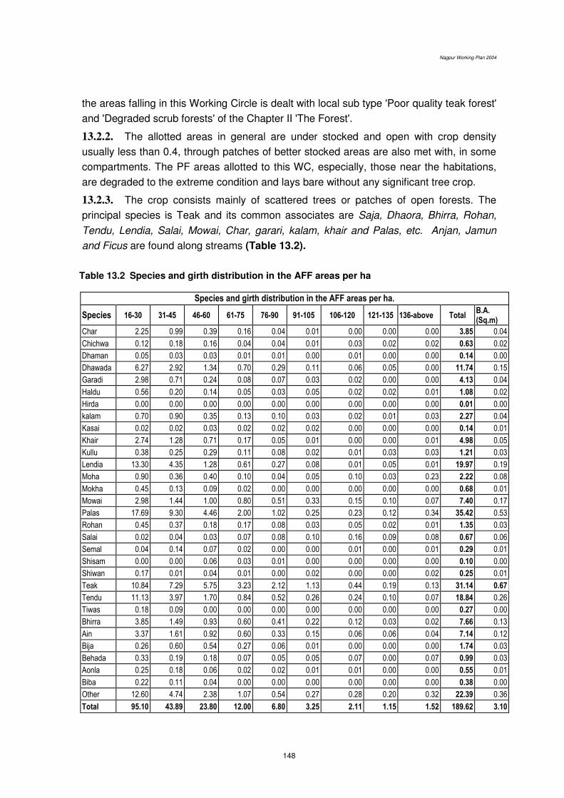
Nagpur Working Plan 2004
148
the areas falling in this Working Circle is dealt with local sub type 'Poor quality teak forest'
and 'Degraded scrub forests' of the Chapter II 'The Forest'.
13.2.2. The allotted areas in general are under stocked and open with crop density
usually less than 0.4, through patches of better stocked areas are also met with, in some
compartments. The PF areas allotted to this WC, especially, those near the habitations,
are degraded to the extreme condition and lays bare without any significant tree crop.
13.2.3. The crop consists mainly of scattered trees or patches of open forests. The
principal species is Teak and its common associates are Saja, Dhaora, Bhirra, Rohan,
Tendu, Lendia, Salai, Mowai, Char, garari, kalam, khair and Palas, etc. Anjan, Jamun
and Ficus are found along streams (Table 13.2).
Table 13.2 Species and girth distribution in the AFF areas per ha
Species and girth distribution in the AFF areas per ha.
Species 16-30 31-45 46-60 61-75 76-90 91-105 106-120 121-135 136-above Total B.A. (Sq.m)
Char 2.25 0.99 0.39 0.16 0.04 0.01 0.00 0.00 0.00 3.85 0.04
Chichwa 0.12 0.18 0.16 0.04 0.04 0.01 0.03 0.02 0.02 0.63 0.02
Dhaman 0.05 0.03 0.03 0.01 0.01 0.00 0.01 0.00 0.00 0.14 0.00
Dhawada 6.27 2.92 1.34 0.70 0.29 0.11 0.06 0.05 0.00 11.74 0.15
Garadi 2.98 0.71 0.24 0.08 0.07 0.03 0.02 0.00 0.00 4.13 0.04
Haldu 0.56 0.20 0.14 0.05 0.03 0.05 0.02 0.02 0.01 1.08 0.02
Hirda 0.00 0.00 0.00 0.00 0.00 0.00 0.00 0.00 0.00 0.01 0.00
kalam 0.70 0.90 0.35 0.13 0.10 0.03 0.02 0.01 0.03 2.27 0.04
Kasai 0.02 0.02 0.03 0.02 0.02 0.02 0.00 0.00 0.00 0.14 0.01
Khair 2.74 1.28 0.71 0.17 0.05 0.01 0.00 0.00 0.01 4.98 0.05
Kullu 0.38 0.25 0.29 0.11 0.08 0.02 0.01 0.03 0.03 1.21 0.03
Lendia 13.30 4.35 1.28 0.61 0.27 0.08 0.01 0.05 0.01 19.97 0.19
Moha 0.90 0.36 0.40 0.10 0.04 0.05 0.10 0.03 0.23 2.22 0.08
Mokha 0.45 0.13 0.09 0.02 0.00 0.00 0.00 0.00 0.00 0.68 0.01
Mowai 2.98 1.44 1.00 0.80 0.51 0.33 0.15 0.10 0.07 7.40 0.17
Palas 17.69 9.30 4.46 2.00 1.02 0.25 0.23 0.12 0.34 35.42 0.53
Rohan 0.45 0.37 0.18 0.17 0.08 0.03 0.05 0.02 0.01 1.35 0.03
Salai 0.02 0.04 0.03 0.07 0.08 0.10 0.16 0.09 0.08 0.67 0.06
Semal 0.04 0.14 0.07 0.02 0.00 0.00 0.01 0.00 0.01 0.29 0.01
Shisam 0.00 0.00 0.06 0.03 0.01 0.00 0.00 0.00 0.00 0.10 0.00
Shiwan 0.17 0.01 0.04 0.01 0.00 0.02 0.00 0.00 0.02 0.25 0.01
Teak 10.84 7.29 5.75 3.23 2.12 1.13 0.44 0.19 0.13 31.14 0.67
Tendu 11.13 3.97 1.70 0.84 0.52 0.26 0.24 0.10 0.07 18.84 0.26
Tiwas 0.18 0.09 0.00 0.00 0.00 0.00 0.00 0.00 0.00 0.27 0.00
Bhirra 3.85 1.49 0.93 0.60 0.41 0.22 0.12 0.03 0.02 7.66 0.13
Ain 3.37 1.61 0.92 0.60 0.33 0.15 0.06 0.06 0.04 7.14 0.12
Bija 0.26 0.60 0.54 0.27 0.06 0.01 0.00 0.00 0.00 1.74 0.03
Behada 0.33 0.19 0.18 0.07 0.05 0.05 0.07 0.00 0.07 0.99 0.03
Aonla 0.25 0.18 0.06 0.02 0.02 0.01 0.01 0.00 0.00 0.55 0.01
Biba 0.22 0.11 0.04 0.00 0.00 0.00 0.00 0.00 0.00 0.38 0.00
Other 12.60 4.74 2.38 1.07 0.54 0.27 0.28 0.20 0.32 22.39 0.36
Total 95.10 43.89 23.80 12.00 6.80 3.25 2.11 1.15 1.52 189.62 3.10

Nagpur Working Plan 2004
149
13.2.4. The site quality varies between IVb and IVa. The canopy density of the
vegetation varies from 0.0 to 0.4. The crop is generally young with occasional middle
aged or mature trees.
13.2.5. Natural regeneration of common species is present but its extent is far from
being adequate (Table 13.3). Heavy grazing pressure has resulted in compaction of the
soil with little sub-soil moisture. Young recruits of species like Ain, Dhaoda, Bhirra and
Teak, etc. are found in many compartments but die-back without getting established. Due
to excessive grazing, fires and refractory nature of areas establishment of NR is very poor
and issue of concern for the department .
Table 13.3 Average Regeneration recorded in the Afforestation and Rootstock
Management Working Circle. (each hector)
Range Seedlings (R1)
0.3–1.0 meter Saplings (R2) 1.0–3.0 meter
Saplings (R3) > 3.0 meter
Total
Deolapar 41.92 35.28 35.20 112.40
Hingna 85.44 64.33 0 149.78
Khapa 0 260.82 15.91 276.73
Kondhali 2.22 16.50 11.30 30.02
Kuhi 0 0 0 0
N/Umred 0 52.16 15.09 67.25
Narkher 0.78 159.73 35.32 195.83
Parsioni 320.84 309.52 99.84 730.20
Ramtek 10.00 64.80 62.91 137.71
S/Umred 74.94 68.06 28.71 171.71
Average 39.42 89.22 30.87 59.51
13.3. BLOCK AND COMPARTMENTS
13.3.1. Details of the compartments in the working circle have been given in
Appendix 13.1.
13.4. SPECIAL OBJECTS OF MANAGEMENT
13.4.1. The special objectives of management of this working circle has been proposed,
as follows:
To restore the vegetative cover and of degraded and open areas and increase their
productivity by site protection and tending of natural regeneration and rootstock,
supplementing it with plantations, wherever, necessary.
Nagpur Working Plan 2004
150
To check the loss of top soil by adopting suitable soil and moisture conservation
measures and to increase the water absorption capacity of the soil.
To provide for the local demands of fuel wood, small timber and poles through active
involvement Gram Panchayats and other village institutions.
To improve the quantity and quality of fodder by planting fodder tree species and
introducing superior and high yielding fodder grasses and legumes.
13.4.2. The site protection will induce natural regeneration; and tending operations will
lead to improvement and establishment of existing saplings, rootstock and poles. The
successful results would provide services of the life-support system and improve the site
conditions, along with providing small timber, poles and firewood to meet bona fide future
needs of the local people, including the nistar.
13.5. ANALYSIS AND VALUATION OF THE CROP
13.5.1. Stock mapping: The conventional stock mapping has been replaced by the
extensive enumeration exercise and crown density mapping through image analysis of
satellite imageries as described in Chapter 6.
13.5.2. Age and density: The crop of forest areas under this working circle is mostly
young to middle aged with occasional mature trees having density below 0.4.
13.5.3. Enumeration: Most of the areas under this Working Circle belong to the PF,
which are mainly barren with little growth. Teak constitutes over 15% of the total stock in
the forest. The enumeration of the growing stock has been carried out by the SOFR, Unit,
Amaravati and intensity of sampling was nearly 1%. The plots of size 60m x 60m were
laid at a distance of 600m x 600m. Analysis of the data collected from these sample plots
is given in table 12.2.
13.6. SILVICULTURAL SYSTEM
13.6.1. The area will be regenerated with both the Teak miscellaneous tree species and
Bamboos. No harvesting is required in this working circle. Tending of existing rootstock
viz. the saplings, coppice shoots and poles, supplemented by plantations have been
proposed as the main activities in this working circle.
Old plantation, which has failed in the past shall not be taken up again under
fresh plantation scheme unless reasons of failure are examined and removed.
13.6.2. In view of vicinity of these areas to habitations, fuel wood and fodder availability
will be expanded through plantation of fuel wood and fodder species and by involving
people in their management.
13.6.3. The areas of this working circle are, primarily, in bad shape. Inadequate sub-soil
moisture, highly compact soil structure and heavy biotic pressure are the main limiting
factors for the establishment of seedling in this area. Top soil has been washed away

Nagpur Working Plan 2004
151
and as a result vast areas do not have even adequate soil-depth to support tree crop. As
a consequence, a large chunk of these areas lay bare without any significant vegetation.
Hence, intensive soil and moisture conservation measures and tending of existing
rootstock have been proposed to be given priority over plantation.
13.6.4. In addition, concept of 'Ecological Index' has been proposed for deciding the
number if seedlings to be planted per hectare, over the traditional method of planting
based only on soil-depth zonation approach. Ecological Index of a site gives us an idea
as to number of plants which could be sustained per hectare on a particular site
depending upon the various locality factors of the area. It is based upon the climatic and
edaphic conditions prevailing in the area and is determined by the formula, as follows: P x D Ecological Index = ------------- Tr x EPT Where P = Annual precipitation in mm. D = Number of rainy days in a year. Tr = Range of maximum temperature averages. EPT = Potential evapo-transpiration in mm.
13.6.5. There is no need for planting more seedlings per ha than those could be
sustained on a particular site. The emphasis is to grow the optimum number of seedlings
per ha, which should grow into a healthy future stock with little mortality. Ecological Index
for these areas is proposed to calculate on the basis of data at Nagpur station to
determine the number seedlings to be planted per hectare in these areas. A sample
calculation of the Ecological index has been shown in Appendix 13.2.
13.7. CHOICE OF SPECIES
13.7.1. Order of priority among desirable species for retention is prescribed as: Teak,
Tiwas, Saja, Bija, Karam, Haldu, Bhirra, Dhaora, Shisham, Khair, Siwan, Rohan, Salai,
Mowai, Dhaman, Lendia, Semal, Kulu, etc.
13.7.2. Valuable local species suitable for the site and favoured by the local village
communities will be preferred in plantations. Teak, Shisham, Khair, Siwan, Sisoo, Siris,
Chichwa, Karanj, Ain, Bija, Dhaora, Aonla, Chinch, Neem, Maharukh, karak, semal
Sitaphal, etc. and bamboos should be considered among the recommended species. In
poorly drained areas Arjun, Babul, Jamun and Ain shall be preferred. Seedlings of edible
fruit-yielding forest species may constitute up to 20 percent and seedlings of medicinal
plants up to 5 percent of the stock. Two stakes per hectare of suitable species such as
Ficus spp. should also be used in plantations. An officer not below the rank of Assistant
Conservator of Forests should approve the final choice of species. The broad information
of the different species growing in different types of soil conditions is given in Appendix
13.3 as different species show their preference for the particular soil.
Nagpur Working Plan 2004
152
13.7.3. Mixed species plantations will include fairly good proportion of fodder and
firewood yielding species, like, Anjan, Neem, Sissoo, Ficus, babul, Gular, Pakar,
Maharukh, Kinhi, Siwan, Karanj, Siris, Sitaphal, etc.
13.7.4. Contour trenches are proposed to be sown with seeds of Sheda, Paonia, Marvel
and Stylo hemata.
13.8. TREATMENT CYCLE, SERIES AND ANNUAL COUPES
13.8.1. Treatment period: The entire area of this working circle will be covered in a
period of 20 (twenty) years.
13.8.2. Treatment series and annual coupes: The entire area of this working circle
has been divided into 9 treatment series. Each treatment series has been further divided
into 20 (twenty) annual coupes. Details are provided in the Appendix 13.4.
13.8.3. Regulation of yield: No yield is prescribed for this working circle. The treatment
will be regulated by area.
13.9. DEMARCATION AND TREATMENT PRESCRIPTIONS
13.9.1. The coupe demarcation, preparation of treatment maps and marking will abide
by the prescriptions mentioned in the chapter of Miscellaneous Regulations.
13.9.2. The main annual coupes shall be demarcated one year in advance along with
coupes due for Cleaning and Thinning. The coupe shall be divided into four sections, if
necessary, to effectively control the various operations.
13.9.3. Treatment Map: It has been provided by GIS cell, Nagpur. This shows non-
workable areas like those having slope more than 45o, 30m belt on both sides of
perennial nallah (the one flowing up to January); crops having density < 0.4 as well as >
0.4 and forest blanks. Such maps are required to be updated by showing regeneration
status manually and such a treatment map shall be cartographically accurate.
13.9.4. Treatment Prescribed: Action Plan shall be prepared for each working coupe
on the basis of treatment prescribed for various Treatment-types areas marked on the
treatment map and got it approved by the competent authority, well before the start of
main coupe operations. The treatment proposed for various treatment-type areas marked
on treatment map are proposed, as follows:
A Type Areas (Protection Areas)
They will include-
A1 type areas, which have slope more than 25°,
A2 type areas, i.e. 30 m wide strip on both sides of streams,
A3 type areas, which are susceptible to excessive erosion.
Nagpur Working Plan 2004
153
B Type Areas (Under-stocked Areas)
The open forests with root stock as well as without root stock shall be shown in
the treatment map.
The areas which were earlier planted but the plantations have failed.
C Type Areas (pole crop)
Areas with sufficient pole crop of valuable species which can be retained as future
crop shall be marked separately.
D - Type Areas: Well-stocked Areas
Well stocked areas shall be separately shown in the treatment map.
E - Type Areas: Blank Areas
Blanks will be separately shown in the treatment map.
Extent of plantation: Generally it will be around 400 ha. for the working circle but
more areas may be undertaken if more funds are available.
13.10. MARKING RULES AND PRESCRIPTIONS
13.10.1. Marking technique and prescriptions described in the Chapter of the
Miscellaneous Regulations shall be followed, with modifications, proposed in the following
paragraphs.
13.10.2. Marking shall be carried out under the close supervision of the RFO and under
guidance of ACF concerned. DCF shall himself inspect majority of coupes to ensure
proper marking and to guard against excessive marking, if any.
13.10.3. The following rules shall be observed strictly for marking the trees for felling in
various treatment type areas, prescribed in Chapter 9;
A- Type Areas: Protection Areas:
1. No tree shall be marked for felling.
2. Stump planting of Neem and Shishoo as well as seed sowing of Neem and
Maharukh is prescribed.
B - Type Areas: Under stocked Areas:
1 No standing tree shall be marked for felling except dead and wind fallen trees
retaining at least 2 trees/ha.
2. All live high stumps shall be marked.
3. All but one, the most promising, multiple coppice poles per stool shall be marked
for felling.
4. Plantations in the areas which do not contain sufficient natural regeneration will
be done as per the suitability of species described under para 13.7 and as given
in the appendix 13.3.

Nagpur Working Plan 2004
154
In case of old plantations which have failed, they will be covered under
fresh plantation scheme only after the factors responsible for the past failures
have been examined and it is found that those factors has now been eliminated.
C -Type Areas: groups of young poles:
1. The congested pole crop shall be marked for thinning to maintain spacing equal
to 1/3rd of the crop height. Poles of seedling origin shall be preferred for
retention over the poles of coppice origin.
2. The dead, dying and malformed poles shall be marked for thinning.
3. Multiple poles shall be thinned to one, the most promising one, per stool.
D - Type Areas: Well-stocked Areas:
1. All dead, hallow and malformed trees, with visual signs of decay, shall be
marked for felling but 2 such trees per hectare shall be retained.
2. All live high stumps shall be cut back to the ground level.
3. All but one (the most promising one) coppice pole per stool in multiple coppice
teak crops shall be marked for felling.
13.11. METHODS OF REGENERATION
13.11.1. Tending of Natural Regeneration and existing rootstock is prescribed to be given
preference over plantations. The areas having promising NR and rootstock patches shall
be identified and marked on the treatment map. The treatment, as prescribed under para
9.10 in Chapter 9, shall be given to such areas. Tending operations as prescribed for
natural regeneration in the D-type areas and rootstock management in the B1-type areas
will be taken up with the coupe operations.
13.11.2. Soil and moisture conservation works in the areas put under this working circle
will be done as prescribed in the relevant paras under Miscellaneous Regulations and in
accordance with specific guidelines issued from time to time in this regard. Hence, no
specific quantum of such works has been prescribed. Such quantum of work may also be
dependent on the fund availability.
13.11.3. Plantations shall be taken in the B2-type and the E-type areas (but not in natural
blanks wherein geology, soil and water regime does not support tree growth) and only in
those sites, which have good soil depth and are well drained. The plantations raised in
the under stocked areas of Narkehd, Kondhali, Hingna, South and North Umred and Kuhi
range in the past are failure. Hence, new sites in these ranges must be selected very
carefully. Extensive grazing pressure coupled with little soil depth in these areas may
result in failures in future as well. Most of the understocked areas of these ranges have
therefore been included under pastures and prescriptions in that regard have been
separately given under Chapter 15. Only root stock management and complete protection
from grazing in the remaining areas of these ranges under this working circle is therefore
prescribed.
Nagpur Working Plan 2004
155
13.12 CLOSURE TO GRAZING AND FIRE PROTECTION
13.12.1 Protection from fire and grazing is essential for success of natural and artificial
regeneration.
13.12.2 All annual coupes will be provided strict fire protection and will remain closed to
grazing till the seedlings reach a minimum height of 10 feet.
13.13 AGENCY OF IMPLEMENTATION: The works under this working
circle are to be entrusted to JFMCs
It is therefore suggested that the areas falling under the various felling series of
this working circle may be assigned to various villages which willingly form the JFMCs.
Hence, the annual coupes may be treated as the area available for assignment to nearest
village. The field staff will endeavour to facilitate formation of JFMCs prior to taking up of
work in that coupe. The removal of material from C and D type areas of that coupe as
well as employment generated through labour requirement on those activities and those
in A and B areas should form the direct benefit to members of JFMCs. Besides, the
JFMCs should also take full responsibility of protection of plantations to be raised in B
type areas and will be entitled proportionate remuneration available for this item in the
estimate. The choice of species for plantation will be need based locally and will be
decided through PRA.
******
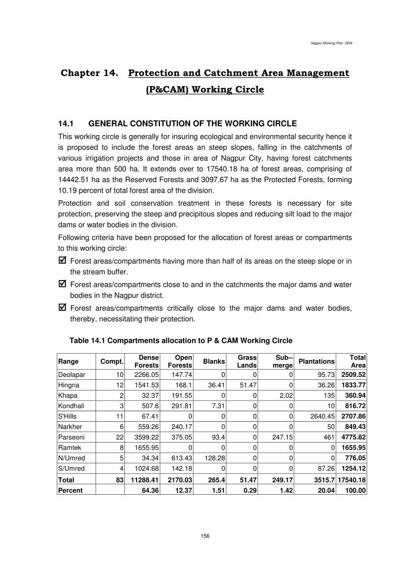
Nagpur Working Plan 2004
156
Chapter 14. Protection and Catchment Area Management
(P&CAM) Working Circle
14.1 GENERAL CONSTITUTION OF THE WORKING CIRCLE
This working circle is generally for insuring ecological and environmental security hence it
is proposed to include the forest areas an steep slopes, falling in the catchments of
various irrigation projects and those in area of Nagpur City, having forest catchments
area more than 500 ha. It extends over to 17540.18 ha of forest areas, comprising of
14442.51 ha as the Reserved Forests and 3097.67 ha as the Protected Forests, forming
10.19 percent of total forest area of the division.
Protection and soil conservation treatment in these forests is necessary for site
protection, preserving the steep and precipitous slopes and reducing silt load to the major
dams or water bodies in the division.
Following criteria have been proposed for the allocation of forest areas or compartments
to this working circle:
Forest areas/compartments having more than half of its areas on the steep slope or in
the stream buffer.
Forest areas/compartments close to and in the catchments the major dams and water
bodies in the Nagpur district.
Forest areas/compartments critically close to the major dams and water bodies,
thereby, necessitating their protection.
Table 14.1 Compartments allocation to P & CAM Working Circle
Range Compt. Dense
Forests Open
Forests Blanks
Grass Lands
Sub--merge
Plantations Total Area
Deolapar 10 2266.05 147.74 0 0 0 95.73 2509.52
Hingna 12 1541.53 168.1 36.41 51.47 0 36.26 1833.77
Khapa 2 32.37 191.55 0 0 2.02 135 360.94
Kondhali 3 507.6 291.81 7.31 0 0 10 816.72
S'Hills 11 67.41 0 0 0 0 2640.45 2707.86
Narkher 6 559.26 240.17 0 0 0 50 849.43
Parseoni 22 3599.22 375.05 93.4 0 247.15 461 4775.82
Ramtek 8 1655.95 0 0 0 0 0 1655.95
N/Umred 5 34.34 613.43 128.28 0 0 0 776.05
S/Umred 4 1024.68 142.18 0 0 0 87.26 1254.12
Total 83 11288.41 2170.03 265.4 51.47 249.17 3515.7 17540.18
Percent 64.36 12.37 1.51 0.29 1.42 20.04 100.00
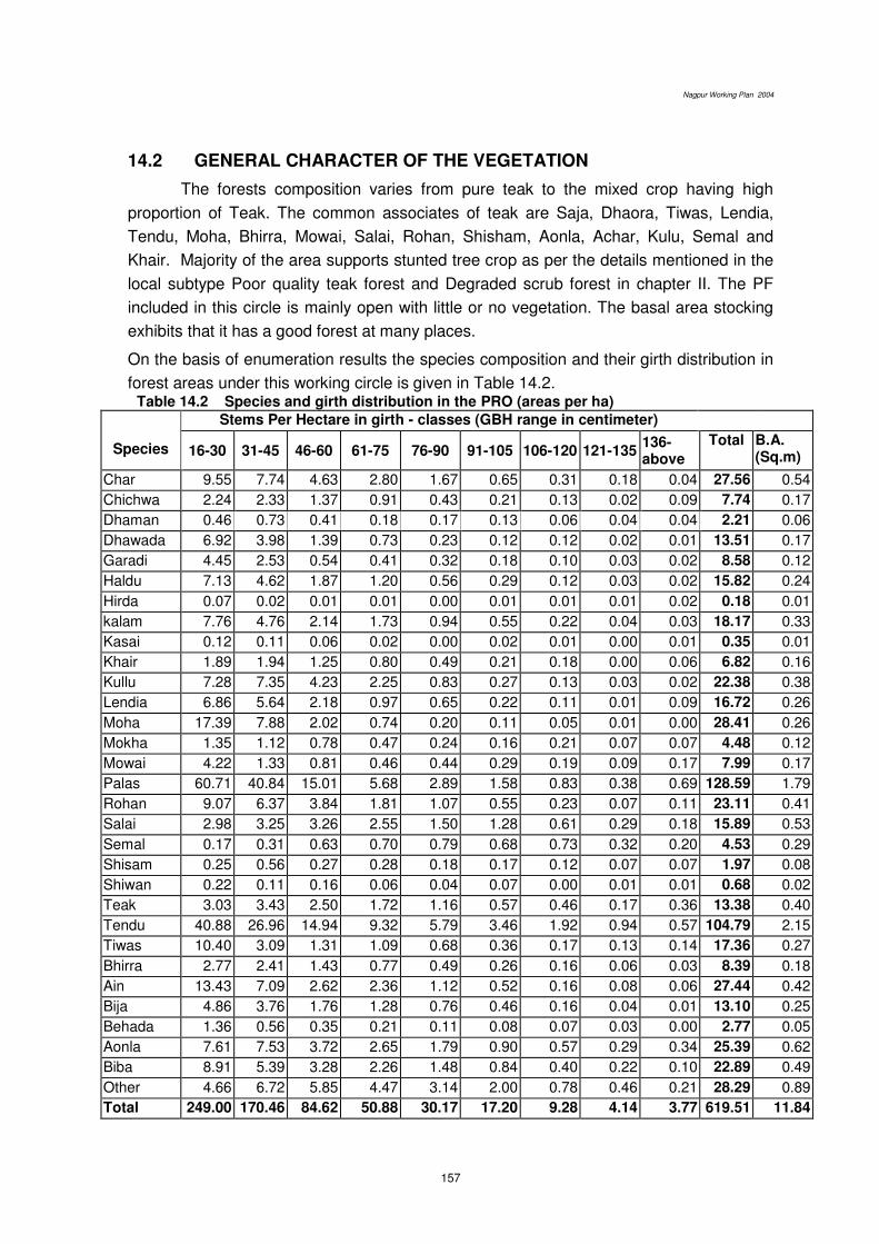
Nagpur Working Plan 2004
157
14.2 GENERAL CHARACTER OF THE VEGETATION
The forests composition varies from pure teak to the mixed crop having high
proportion of Teak. The common associates of teak are Saja, Dhaora, Tiwas, Lendia,
Tendu, Moha, Bhirra, Mowai, Salai, Rohan, Shisham, Aonla, Achar, Kulu, Semal and
Khair. Majority of the area supports stunted tree crop as per the details mentioned in the
local subtype Poor quality teak forest and Degraded scrub forest in chapter II. The PF
included in this circle is mainly open with little or no vegetation. The basal area stocking
exhibits that it has a good forest at many places.
On the basis of enumeration results the species composition and their girth distribution in
forest areas under this working circle is given in Table 14.2. Table 14.2 Species and girth distribution in the PRO (areas per ha)
Species
Stems Per Hectare in girth - classes (GBH range in centimeter)
16-30 31-45 46-60 61-75 76-90 91-105 106-120 121-135 136-above
Total B.A. (Sq.m)
Char 9.55 7.74 4.63 2.80 1.67 0.65 0.31 0.18 0.04 27.56 0.54
Chichwa 2.24 2.33 1.37 0.91 0.43 0.21 0.13 0.02 0.09 7.74 0.17
Dhaman 0.46 0.73 0.41 0.18 0.17 0.13 0.06 0.04 0.04 2.21 0.06
Dhawada 6.92 3.98 1.39 0.73 0.23 0.12 0.12 0.02 0.01 13.51 0.17
Garadi 4.45 2.53 0.54 0.41 0.32 0.18 0.10 0.03 0.02 8.58 0.12
Haldu 7.13 4.62 1.87 1.20 0.56 0.29 0.12 0.03 0.02 15.82 0.24
Hirda 0.07 0.02 0.01 0.01 0.00 0.01 0.01 0.01 0.02 0.18 0.01
kalam 7.76 4.76 2.14 1.73 0.94 0.55 0.22 0.04 0.03 18.17 0.33
Kasai 0.12 0.11 0.06 0.02 0.00 0.02 0.01 0.00 0.01 0.35 0.01
Khair 1.89 1.94 1.25 0.80 0.49 0.21 0.18 0.00 0.06 6.82 0.16
Kullu 7.28 7.35 4.23 2.25 0.83 0.27 0.13 0.03 0.02 22.38 0.38
Lendia 6.86 5.64 2.18 0.97 0.65 0.22 0.11 0.01 0.09 16.72 0.26
Moha 17.39 7.88 2.02 0.74 0.20 0.11 0.05 0.01 0.00 28.41 0.26
Mokha 1.35 1.12 0.78 0.47 0.24 0.16 0.21 0.07 0.07 4.48 0.12
Mowai 4.22 1.33 0.81 0.46 0.44 0.29 0.19 0.09 0.17 7.99 0.17
Palas 60.71 40.84 15.01 5.68 2.89 1.58 0.83 0.38 0.69 128.59 1.79
Rohan 9.07 6.37 3.84 1.81 1.07 0.55 0.23 0.07 0.11 23.11 0.41
Salai 2.98 3.25 3.26 2.55 1.50 1.28 0.61 0.29 0.18 15.89 0.53
Semal 0.17 0.31 0.63 0.70 0.79 0.68 0.73 0.32 0.20 4.53 0.29
Shisam 0.25 0.56 0.27 0.28 0.18 0.17 0.12 0.07 0.07 1.97 0.08
Shiwan 0.22 0.11 0.16 0.06 0.04 0.07 0.00 0.01 0.01 0.68 0.02
Teak 3.03 3.43 2.50 1.72 1.16 0.57 0.46 0.17 0.36 13.38 0.40
Tendu 40.88 26.96 14.94 9.32 5.79 3.46 1.92 0.94 0.57 104.79 2.15
Tiwas 10.40 3.09 1.31 1.09 0.68 0.36 0.17 0.13 0.14 17.36 0.27
Bhirra 2.77 2.41 1.43 0.77 0.49 0.26 0.16 0.06 0.03 8.39 0.18
Ain 13.43 7.09 2.62 2.36 1.12 0.52 0.16 0.08 0.06 27.44 0.42
Bija 4.86 3.76 1.76 1.28 0.76 0.46 0.16 0.04 0.01 13.10 0.25
Behada 1.36 0.56 0.35 0.21 0.11 0.08 0.07 0.03 0.00 2.77 0.05
Aonla 7.61 7.53 3.72 2.65 1.79 0.90 0.57 0.29 0.34 25.39 0.62
Biba 8.91 5.39 3.28 2.26 1.48 0.84 0.40 0.22 0.10 22.89 0.49
Other 4.66 6.72 5.85 4.47 3.14 2.00 0.78 0.46 0.21 28.29 0.89
Total 249.00 170.46 84.62 50.88 30.17 17.20 9.28 4.14 3.77 619.51 11.84
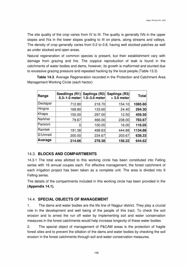
Nagpur Working Plan 2004
158
The site quality of the crop varies from IV to III. The quality is generally IVb in the upper
slopes and IVa in the lower slopes grading to III on plains, along streams and valleys.
The density of crop generally varies from 0.2 to 0.8, having well stocked patches as well
as under stocked and open areas.
Natural regeneration of common species is present, but their establishment vary with
damage from grazing and fire. The coppice reproduction of teak is found in the
catchments of water bodies and dams, however, its growth is malformed and stunted due
to excessive grazing pressure and repeated hacking by the local people.(Table 13.3)
Table 14.3. Average Regeneration recorded in the Protection and Catchment Area
Management Working Circle (each hector)
Range Seedlings (R1)
0.3–1.0 meter Saplings (R2) 1.0–3.0 meter
Saplings (R3) > 3.0 meter
Total
Deolapar 712.80 218.70 154.10 1085.60
Hingna 168.80 133.60 24.40 294.30
Khapa 150.00 297.00 12.50 459.50
Narkher 79.67 466.00 238.00 783.67
Parsioni 0 100.05 16.00 116.05
Ramtek 191.38 498.63 444.88 1134.88
S/Umred 200.00 234.67 203.67 638.33
Average 214.66 278.38 156.22 644.62
14.3. BLOCKS AND COMPARTMENTS
14.3.1 The total area allotted to this working circle has been constituted into Felling
series with 16 annual coupes each. For effective management, the forest catchment of
each irrigation project has been taken as a complete unit. The area is divided into 9
Felling series.
The details of the compartments included in this working circle has been provided in the
(Appendix 14.1).
14.4. SPECIAL OBJECTS OF MANAGEMENT
1. The dams and water bodies are the life line of Nagpur district. They play a crucial
role in the development and well being of the people of this tract. To check the soil
erosion and to arrest the run off water by implementing soil and water conservation
measures in the forest catchments would help increase longevity of these water bodies
2. The special object of management of P&CAM areas is the protection of fragile
forest sites and to prevent the siltation of the dams and water bodies by checking the soil
erosion in the forest catchments through soil and water conservation measures.
Nagpur Working Plan 2004
159
3. To preserve and increase the vegetal cover and to help enhance water regime of
the forest tracts.
4. To develop and optimise the natural biodiversity, wildlife and scenic potential of
these areas to cater to the nature and wildlife conservation and education as well as eco-
tourism needs of the people of this region.
14.5. ANALYSIS AND VALUATION OF THE CROP
Stock mapping: The conventional stock mapping has been replaced by the extensive
enumeration exercise and crown density mapping through image analysis of satellite
imageries as described in Chapter 6.
Age and density: The crop is mostly middle aged with scattered patches of mature and
young crop. The density of the crop varies from 0.2 to 0.6 having fair share of open and
dense patches. The dense areas make a significant part of the crop.
Enumeration: Enumeration has been carried out by SOFR, Amravati, in accordance with
the systematic line-plot sampling on 600M x 600M grid, as in practice in the Forest
Department. Analysis has been done by Inventory Data Management System, in vogue,
in the circle. The sampling intensity is about 1%.
14.6. METHOD OF TREATMENT
The forest areas allotted to this working circle are those which fall in the
catchments areas of various irrigation projects irrespective of its crop consideration so the
allotted areas are well-stocked in patches as well as under stocked and open in others.
On the pattern of watershed management approach viz. ridge to base in systematic
steps; soil and moisture conservation works along with the afforestation have been
proposed to prevent further soil erosion, siltation of reservoirs and to enhance the
vegetation cover and ground water table. The forest areas falling in the catchments of
each irrigation project or water body are included in this working circle has been proposed
to be treated as a complete unit on the basis of watershed management approach. For
convenience of management catchments of each water body is further proposed to be
divided into Management series of 16 annual management units on the watershed basis
viz. starting from ridge ending up to touching the water bodies.
Table 14.2 tabulating the girth wise and species wise compartment of this working
circle shows that the area allotted to the working circle has a good forest, with a basal
area/hector equal to 11.84, which match favourably with the area allotted to selection cum
Improvement working circle. Hence a preservation approach to these areas has not been
prescribed. Conservation aspect of management for these forests has been envisaged.
The area will therefore be exploited as a regular working circle. This will promote
openings in the canopy to facilitate regeneration of light demander species. The removal
will be according to the formula worked out below.
Nagpur Working Plan 2004
160
Yield calculation: A simplified method of yield calculation given here is the one adopted
from Indian Forest Record for the selection forests of India (appendix 14.2). The following
is the mathematical calculation:
1. Let X be the number of trees in the oldest girth class that will survive to reach
exploitable size.
n= number of years a tree will take to pass though penultimate girth class i.e. (below
exploitable girth class)
Then the number of trees annually become exploitable over the whole area will be x / n
trees
2. If the felling cycle is of r years, then the number of trees which annually become
exploitable in each coupe will be x /n/ r
And if r=n then
x /n/ r
3. Consequently if x/n trees are felled from the stock of exploitable trees, the trees,
which must always be standing on the area will be-
Nx x/n = x/n in the first coupe,
n
(n-1) x x/n in the second coupe
n
and so on, i. e.,
o in nth coupe
= (x/r x n/2) – (x/2) for the whole forests.
4. The exploitable girth is 120 cm. and above and it takes 16 years for the
penultimate class to reach to exploitable class. Hence, 16 coupes have been iaid by
taking the rotation as 16 years. x is equal to 4.14 trees/ hector. Annually 2.07 /ha. i.e. two
trees/ hector above exploitable girth will therefore be removed. Appendix 14.2. shows
the coupes of this working circle.
14.7 TREATMENT CYCLE, TREATMENT SERIES AND ANNUAL COUPES
14.7.1 Treatment cycle: The entire area is proposed to be treated in 16 year period.
(Appendix 14.2).
14.7.2 Treatment series and annual coupes: The area of this working circle is comprises
of catchments of various water bodies. The catchments of the various water bodies are
proposed to be considered as independent unit for management. Each unit is divided into
16 annual units of manageable size preferably matching the size of the compartment.
Annual coupes for felling are laid in areas, which form indirect catchment only. No
coupe and hence no felling in the direct catchment areas will be done.

Nagpur Working Plan 2004
161
14.8 DEMARCATION, TREATMENT MAP AND MARKING
14.8.1 The coupe demarcation, preparation of treatment maps and marking will abide by
the prescriptions mentioned in the chapter of Miscellaneous Regulations.
14.8.2 The main annual coupes shall be demarcated one year in advance along with
coupes due for Cleaning and Thinning. The coupe shall be divided into four sections, if
necessary, to effectively control the various operations.
14.8.3 Treatment Map It has been provided by GIS cell as.. This shows non-workable
areas like those having slope more than 45 o, 30 m. belt on both sides of perennial nallah
( the one flowing upto January); crops having density < 0.4 as well as > 0.4 and forest
blanks. Such maps are required to be updated by showing regeneration status manually
and such a treatment map shall be cartographically accurate.
14.8.4 Treatment Prescribed : The treatment proposed for various treatment-type areas
marked on treatment map shall be, as follows:
1. A Type Areas (Protection Areas)
They will include-
A1 type areas, which have slope more than 25°,
A2 type areas, i.e. 30 m wide strip on both sides of streams,
A3 type areas, which are susceptible to excessive erosion.
Areas forming catchments of reservoirs.
A Type areas
B Type Areas (Under-stocked Areas)
The open forests with root stock as well as without root stock shall be shown in the
treatment map.
C Type Areas (pole crop)
Areas with sufficient pole crop of valuable species which can be retained as future crop
shall be marked separately.
D - Type Areas: Well-stocked Areas
Well stocked areas shall be separately shown in the treatment map.
E - Type Areas: Blank Areas
Blanks will be separately shown in the treatment map.
14.9 MARKING RULES AND PRESCRIPTIONS
14.9.1 Marking technique and prescriptions described in the Chapter of the Miscellaneous
Regulations shall be followed, with modifications, described in the following paragraphs.
Marking shall be carried out under the close supervision of the RFO and under
guidance of ACF concerned. DCF shall himself inspect majority of coupes to ensure
proper marking and to guard against excessive marking, if any.

Nagpur Working Plan 2004
162
The following rules shall be observed strictly for marking in various treatment type
areas prescribed in the Chapter 8;
A Type Areas: Protection Areas: No tree shall be marked for felling.
Soil and moisture conservation works shall be taken up extensively.
B Type Areas:
1 Only dead and malformed over mature teak trees, retaining 2 trees / ha as snags
and dens for nesting and resting of wildlife.
2. (i) Live high stumps will be marked for felling and for facilitating good coppice
growth.
(ii) Multiple coppice poles except the most promising one will be marked for felling.
(iii) Growth of seedlings/ saplings of seed origin will be encouraged by soil
working, weeding etc. as usual.
3. The areas devoid of NR and rootstock will be covered under plantation of species
suitable for soil and water conservation. Such plantations will be carried out only in
understocked areas of direct catchment. General plantation guidelines (guidelines for
regeneration given under miscellaneous regulations and relevant prescriptions under
RSM & A working circle will be followed.
C Type Areas: groups of young poles:
The congested pole crop shall be marked for thinning to maintain spacing equal to 1/3rd of
the crop height. Care should be taken to remove the poles of coppice origin first while
retaining the poles of seedling origin.
D Type Areas: Well-stocked Areas: Enumeration of trees above exploitable girth will be
done as in case of SCI but only two trees per ha as prescribed under para 14.4 will be
marked for felling.
Coupes for felling have been laid only in areas of indirect catchment. No
felling in direct catchment is prescribed.
E Type Areas: Blank Areas- Marking is not prescribed.
14.10 METHODS OF REGENERATION
14.10.1 Tending of NR and rootstock management as prescribed in Chapter 9 will be
given preference over plantations.
14.10.2 The plantation will be restricted to the suitable sites under B2 and E type (not
natural blanks) areas and were deep well drained soil if found. Seed sowing of Neem and
Chandan in bushes will be done. In addition seedlings of Wad, Pimpal, Umber and
Pimperan will be planted.
14.10.3 Since these areas fall in the water shed of medium of major arrigation project it
will required a catchment area treatment, where the plantation is the most important

Nagpur Working Plan 2004
163
activity. Usually funds are provided by the user agency at the time of forest and
environment clearance. In absence of any provision, a scheme under interpreted water
shed development will be preferred for treating these areas.
14.10.4 Each water body / reservoir is a unique ecological site having endowed
with varied and rich biodiversity as well as natural and scenic beauty. Due to proximity of
water there is a great diversity of flora and fauna around these water bodies as well as
along the water courses. These forest areas also support a substantial number of NWFP
species, which are of great significance for the livelihood needs of the local people.
Therefore, these sites are ideally suitable for developing Ecological Centres (Eco-centres)
for purpose of disseminating information, generating sensitivity and developing
understanding of the complex issues and concerns associated with sustainable forestry,
wildlife conservation and environment conservation. These Eco-centres will cater to the
eco-tourism needs of the people of this region and will, in addition, open up employment
opportunities and new means of livelihood for local people. Involvement of local people
and NGOs in development and management of these areas as focal points of nature
interpretation and eco-tourism is crucial and will pave the way to generate good will about
forests and wildlife in the local communities.
14.11 GRAZING CLOSURE, FIRE PROTECTION AND OTHER REGULATIONS
Protection from fire and grazing is essential for success of natural and artificial
regeneration. Grazing closure will be enforced in the entire A -type areas. The entire PRT
areas will be provided the Class-I fire protection.
All annual coupes will remain closed to grazing till completion of the sixth-year cleaning
operations and provided strict fire protection.
These areas are proposed to receive strict protection from grazing and fire and unwanted
human interference.
Five-year protection from the plantation year will be provided to all plantations.
No new roads will be constructed in the P&CAM areas. Cross-drains at appropriate
interval should be maintained.
14.12 Agency for executing works
The areas allotted to this working circle may be generally away from villages.
Besides only conservative felling and some planting is prescribed. Hence, these areas
may more suitably be attended to through departmental agency. However, JFMCs
coming forward voluntarily may be associated in executing various works.
******
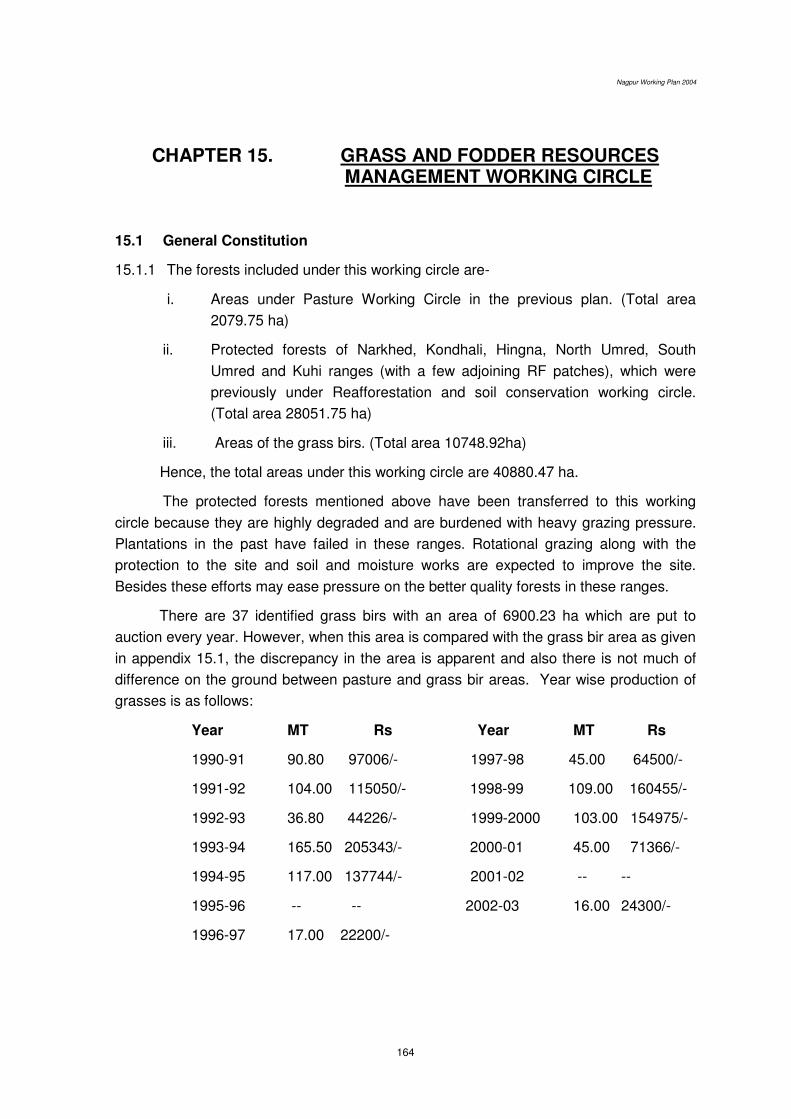
Nagpur Working Plan 2004
164
CHAPTER 15. GRASS AND FODDER RESOURCES MANAGEMENT WORKING CIRCLE
15.1 General Constitution
15.1.1 The forests included under this working circle are-
i. Areas under Pasture Working Circle in the previous plan. (Total area
2079.75 ha)
ii. Protected forests of Narkhed, Kondhali, Hingna, North Umred, South
Umred and Kuhi ranges (with a few adjoining RF patches), which were
previously under Reafforestation and soil conservation working circle.
(Total area 28051.75 ha)
iii. Areas of the grass birs. (Total area 10748.92ha)
Hence, the total areas under this working circle are 40880.47 ha.
The protected forests mentioned above have been transferred to this working
circle because they are highly degraded and are burdened with heavy grazing pressure.
Plantations in the past have failed in these ranges. Rotational grazing along with the
protection to the site and soil and moisture works are expected to improve the site.
Besides these efforts may ease pressure on the better quality forests in these ranges.
There are 37 identified grass birs with an area of 6900.23 ha which are put to
auction every year. However, when this area is compared with the grass bir area as given
in appendix 15.1, the discrepancy in the area is apparent and also there is not much of
difference on the ground between pasture and grass bir areas. Year wise production of
grasses is as follows:
Year MT Rs
1990-91 90.80 97006/-
1991-92 104.00 115050/-
1992-93 36.80 44226/-
1993-94 165.50 205343/-
1994-95 117.00 137744/-
1995-96 -- --
1996-97 17.00 22200/-
Year MT Rs
1997-98 45.00 64500/-
1998-99 109.00 160455/-
1999-2000 103.00 154975/-
2000-01 45.00 71366/-
2001-02 -- --
2002-03 16.00 24300/-
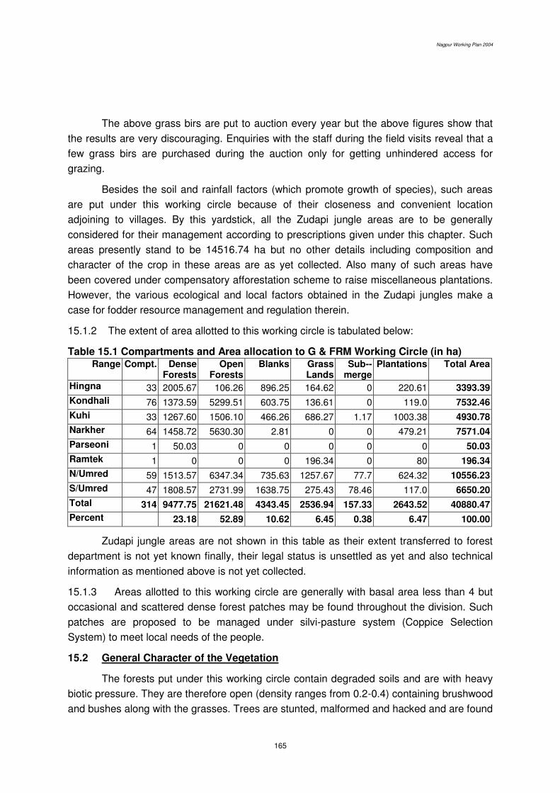
Nagpur Working Plan 2004
165
The above grass birs are put to auction every year but the above figures show that
the results are very discouraging. Enquiries with the staff during the field visits reveal that a
few grass birs are purchased during the auction only for getting unhindered access for
grazing.
Besides the soil and rainfall factors (which promote growth of species), such areas
are put under this working circle because of their closeness and convenient location
adjoining to villages. By this yardstick, all the Zudapi jungle areas are to be generally
considered for their management according to prescriptions given under this chapter. Such
areas presently stand to be 14516.74 ha but no other details including composition and
character of the crop in these areas are as yet collected. Also many of such areas have
been covered under compensatory afforestation scheme to raise miscellaneous plantations.
However, the various ecological and local factors obtained in the Zudapi jungles make a
case for fodder resource management and regulation therein.
15.1.2 The extent of area allotted to this working circle is tabulated below:
Table 15.1 Compartments and Area allocation to G & FRM Working Circle (in ha) Range Compt. Dense
Forests Open
Forests Blanks Grass
Lands Sub--
merge Plantations Total Area
Hingna 33 2005.67 106.26 896.25 164.62 0 220.61 3393.39
Kondhali 76 1373.59 5299.51 603.75 136.61 0 119.0 7532.46
Kuhi 33 1267.60 1506.10 466.26 686.27 1.17 1003.38 4930.78
Narkher 64 1458.72 5630.30 2.81 0 0 479.21 7571.04
Parseoni 1 50.03 0 0 0 0 0 50.03
Ramtek 1 0 0 0 196.34 0 80 196.34
N/Umred 59 1513.57 6347.34 735.63 1257.67 77.7 624.32 10556.23
S/Umred 47 1808.57 2731.99 1638.75 275.43 78.46 117.0 6650.20
Total 314 9477.75 21621.48 4343.45 2536.94 157.33 2643.52 40880.47
Percent 23.18 52.89 10.62 6.45 0.38 6.47 100.00
Zudapi jungle areas are not shown in this table as their extent transferred to forest
department is not yet known finally, their legal status is unsettled as yet and also technical
information as mentioned above is not yet collected.
15.1.3 Areas allotted to this working circle are generally with basal area less than 4 but
occasional and scattered dense forest patches may be found throughout the division. Such
patches are proposed to be managed under silvi-pasture system (Coppice Selection
System) to meet local needs of the people.
15.2 General Character of the Vegetation
The forests put under this working circle contain degraded soils and are with heavy
biotic pressure. They are therefore open (density ranges from 0.2-0.4) containing brushwood
and bushes along with the grasses. Trees are stunted, malformed and hacked and are found

Nagpur Working Plan 2004
166
scattered throughout. Stocking of tree species is thus poor but a few small patches of good
tree growth may be found occasionally.
Main grass species found are Kusal, Bhurbhushi, Ghonad, Sheda, Marvel.
Tree species found are Teak, Palas, Lendia, Bhirra, Ain, Bor, Dhawda, Movai, Salai,
Char, Moha, Sitaphal, Rohan, Khair. Thorny and bushy species like Bor, Khair, Bharrati,
Eruni, Ghot, Chilati, Phetra are also common.
Rantulasi and Tarota as weeds have extensively invaded these forests. There are
other herbs and shrubs also which are spreading fast as weeds in the areas which were
used as pasture lands and grass birs in the past. Lantana has also invaded in large areas
and in some places it has virtually replaced all other bushes, grass and fodder plants.
Besides there are regular and repeated fires every year. The palatability of the vegetation
and availability of the grasses from such areas is therefore drastically reduced.
15.3 Analysis and Valuation of the Tree Crop
15.3.1 i) Area allocation along with the extent of dense and open forests, grass lands and
blanks has been given in the table 15.1 above. The enumeration results, which
relate to the valuation of the tree crop, are given in the table (table 12.2) below:
Table 15.2: Species and girth distribution from enumeration data of
the compartments allotted to GFRM working circle. Species and girth distribution in the G&FRM areas per ha.
Species 16-30 31-45 46-60 61-75 76-90 91-105 106-120 121-135 136-above
Total B.A . (Sq.m)
Char 0.64 0.33 0.30 0.15 0.09 0.06 0.03 0.02 0.00 1.62 0.03
Chichwa 0.00 0.03 0.01 0.01 0.01 0.00 0.03 0.00 0.00 0.09 0.00
Dhaman 0.02 0.06 0.06 0.04 0.03 0.00 0.00 0.00 0.00 0.22 0.01
Dhawada 2.26 1.53 0.92 0.24 0.12 0.17 0.05 0.01 0.05 5.35 0.09
Garadi 0.13 0.45 0.44 0.31 0.13 0.13 0.09 0.00 0.00 1.66 0.05
Haldu 0.04 0.04 0.01 0.00 0.01 0.01 0.00 0.00 0.00 0.12 0.00
kalam 0.96 0.69 0.49 0.30 0.12 0.18 0.02 0.00 0.26 3.03 0.10
Kasai 0.39 0.49 0.30 0.15 0.04 0.03 0.00 0.00 0.00 1.40 0.02
Khair 2.12 1.13 0.50 0.26 0.19 0.17 0.17 0.09 0.11 4.75 0.11
Lendia 11.23 6.03 1.37 0.43 0.09 0.06 0.06 0.03 0.02 19.32 0.19
Moha 1.79 1.39 0.96 0.44 0.20 0.19 0.05 0.08 0.29 5.39 0.15
Mokha 0.01 0.05 0.01 0.01 0.00 0.03 0.00 0.01 0.04 0.17 0.01
Mowai 0.84 0.20 0.27 0.40 0.31 0.10 0.13 0.07 0.05 2.39 0.08
Palas 12.16 5.24 2.17 0.91 0.43 0.29 0.13 0.08 0.18 21.59 0.29
Rohan 1.52 1.22 0.93 0.29 0.19 0.10 0.01 0.01 0.01 4.27 0.07
Salai 4.04 1.72 1.02 0.25 0.15 0.03 0.02 0.00 0.01 7.25 0.08
Shisam 0.06 0.13 0.03 0.00 0.00 0.00 0.00 0.00 0.00 0.22 0.00
Shiwan 0.00 0.00 0.00 0.00 0.00 0.03 0.00 0.00 0.00 0.03 0.00
Teak 17.21 18.61 8.30 2.92 1.10 0.68 0.38 0.23 0.13 49.57 0.78
Tendu 9.41 4.56 2.91 2.54 2.04 1.50 0.90 0.45 0.34 24.65 0.68
Tiwas 0.30 0.05 0.00 0.00 0.00 0.00 0.00 0.00 0.00 0.35 0.00
Bhirra 1.07 0.75 0.94 0.89 0.63 0.55 0.10 0.03 0.05 5.01 0.17
Ain 3.43 1.14 0.74 0.26 0.38 0.13 0.10 0.01 0.02 6.21 0.10

Nagpur Working Plan 2004
167
Species 16-30 31-45 46-60 61-75 76-90 91-105 106-120 121-135 136-above
Total B.A . (Sq.m)
Bija 0.03 0.06 0.08 0.06 0.09 0.00 0.01 0.00 0.00 0.33 0.01
Behada 1.64 1.16 0.78 0.62 0.44 0.22 0.16 0.06 0.12 5.19 0.14
Aonla 0.18 0.37 0.22 0.15 0.06 0.11 0.06 0.02 0.00 1.17 0.04
Biba 0.01 0.03 0.05 0.06 0.01 0.08 0.01 0.03 0.03 0.32 0.02
Other 6.99 3.12 1.40 1.31 1.10 0.87 0.56 0.22 0.31 15.88 0.41
Total 77.87 50.22 24.90 12.86 7.87 5.64 3.02 1.40 2.01 185.80 3.60
ii) Stock maps indicating density of tree crop have been generated using LISS
II data and through NDVI technique. These maps were generated in the
GIS cell.
iii) Regeneration status of the tree crop in the forests allocated to this working
circle is given in table 15.3 below:
Table 15.3: Average seedlings and saplings per ha in GFRM areas
Range Seedlings (R1)
0.3–1.0 meter
Saplings (R2)
1.0–3.0 meter
Saplings (R3)
> 3.0 meter
Total
Hingna 61.04 44.13 2.33 107.50
Kondhali 3.26 105.96 155.61 264.83
N/Umred 0.06 28.09 1.31 29.47
Narkher 40.00 208.92 43.04 291.96
Parsioni 0 121.00 8.00 129.00
S/Umred 6.23 38.62 7.23 52.08
Average 22.04 86.06 40.80 148.90
15.3.2 Analysis and Valuation of Grass and Fodder Resources
Present enumeration primarily valuates tree crop and this has been given under para
15.3.1 above. However, for the proper management of grass and fodder resources and for
their further development, different valuation method is required to be used. It should include
valuation of soil type suitable for grassland management and its moisture content. This will
help in deciding the grass species most suitable for a site to give optimum production. Extent
of grazing and other biotic pressures as well as their effect on grass composition and yield
should also be the part of such valuation.
The valuation of the present status of the pasture lands/ grass birs and then
formulation of area specific prescriptions is a must and the prerequisite for their scientific
management. However, such a valuation is beyond the scope of present enumeration
methodology.

Nagpur Working Plan 2004
168
15.4 Special Object of Management
1) The forests put under this working circle are primarily intended to augment fodder
requirements of the villages. Mostly it is grass resources, which are to be
supplemented, wherever required, with palatable legumes and tree fodder.
2) As mentioned under para 15.1.1(ii) above, availability of fodder resources is
drastically reduced. Introduction of suitable improved varieties of grasses as well as
legumes and fodder tree species in selected areas is therefore proposed.
3) These areas being close to villages and local people being still dependant to a large
extent for their fuelwood and small timber requirements on the forests, may also
manage such areas to supply these forest produce, though these tracts are primarily
meant to act as grazing grounds and grasslands.
4) As the above objects link forest management to people, active involvement of Gram
Panchayat and other village institutions is a must. Hence eliciting peoples
participation in such management and evolution of site specific and need based JFM
mechanisms shall be attempted. This aspect has been separately discussed under
Chapter 18 for JFM (overlapping) Working for various dependencies of the villagers
on forests.
15.5 Silvicultural System
Despite large area under grass birs (cut and carry-away grasslands permanently
closed to grazing), grass production as the above account shows is very low. Also these
forestlands are burdened with huge grazing pressure and secondly, the demand for grass
resources on cut and carry- away basis is very low. Official grass production figures show
declining trend. It is due to various reasons. One of these reasons may be that grass
availability has gone down so much that it is not economically beneficial to harvest grass
resources. Another reason is that fodder resources from agricultural sector are available at
cheaper rates and readily. Therefore, a long term strategy and sustained efforts are required
to bring back grasslands of the Nagpur forest division to the level of their optimum
production.
Based on the grass and forest resources of the site as well as the objectives of the
management, the silvicultural systems to be followed may be classified in the following
categories:
1. Regulated and rotational grazing in pasture areas including the protected
forests freshly brought under this working circle.
2. Grassland management and development by regulating seeding and grass
cutting and through complete closure to grazing in identified grass birs.
3. Silvi-pasture practices (Coppice Selection System) for tending and removal of
tree growth from the dense patches of forests in the compartments allotted to
this working circle.

Nagpur Working Plan 2004
169
15.6 Blocks and Compartments
The blocks and compartments allotted to this working circle are shown in Appendix
15.1.
15.7 Method of Treatment
15.7.1 The method of treatment to improve grasses shall be two pronged i.e. rotational
grazing in pasture areas and augmenting natural grasses in areas close to grazing.
ROTATIONAL GRAZING IN PASTURE LANDS
i) Major area under this working circle shall be regulated for controlled grazing as per
prevailing grazing rules.
ii) Pasture lands have been divided in to 37 pasture series and each series will have 4
coupes, namely A, B, C and D. Each coupe shall remain closed to grazing for two
years and therefore half of the area (approximately 15,000 ha) shall always be
available. The details are given in appendix 15.2.
iii) The coupe will be demarcated one year before the due date of closure and the period
of the closure will be prominently displayed at the convenient places.
iv) In the closed coupe, works for facilitating improvement in grass and fodder
productivity such as removal of weeds and woody growth will be taken up. Soil and
moisture conservation works may be taken up extensively for improving the site.
AUGMENTING NATURAL GRASSES IN GRASS BIRS
i Areas containing palatable natural grasses shall be closed to grazing and work of
removal of weeds to facilitate these grasses to come up naturally will be taken up. It
has been seen that as a result of protection to grasslands, a lot of shrubs invade the
area as weeds resulting in reduction in grass production. Hence, only the removal of
such weeds manually/ mechanically is therefore suggested from the sites, which
already contain palatable grasses and where artificial seed sowing is not necessary.
ii It will require complete and permanent closure from grazing but with a provision of
drawing fodder resources from it on 'cut and carry-away' basis. It is therefore
prescribed for grass birs.
iii. It is well established that grasses when young, that is, prior to their flowering are
most nutritious (highest protein content) but management requirements are that they
should be removed (grazed or cut) only after grass seeding. Grasslands developed
as grass birs (permanent grasslands) are therefore to be allowed for grass cutting
either after October or on rotational basis and 4 years after their establishment.
iV The quantity of fodder resources and their palatability in the pasture areas under this
working circle) may also be improved on the similar lines but areas selected for that
purpose shall also be required to be closed for grazing for 4 years after their
establishment and rotational closure thereafter.

Nagpur Working Plan 2004
170
SILVI-PASTURE SYSTEM FOR DENSE FOREST PATCHES WITHIN GRASSLANDS
(Coppice Selection System in the Areas Classified under Category B & C)
The areas included in this working circle occasionally contain dense tree growth in
small patches. Such areas if existing interspersed with pasture lands and grass birs, may be
worked according to Coppice Selection System. The removal of material by this method will
enable us to meet the needs of fuel wood and small timber of the villages. Coppice selection
system envisages removal of available trees as per the principles of selection working (i.e.
fixation of exploitable girth according to the material required and of felling cycle) and
regeneration through coppice. Removal of material above the size of 45 cm GBH to meet the
demands of small timber and firewood is suggested. However, GBH of Garari trees to be
removed is fixed at 30 cm. One out of the 3 stems available silviculturally shall be removed
but the patches containing largely the pole crop shall be worked, as far as practicable,
according to the rules prescribed under other working circles in regard to tending of the pole
crop. The dead and dying as well as malformed, over maturing and/ or mature trees
occurring singly and scattered in the coupe shall also be felled, if silviculturally required and
available.
The above working is prescribed in the first year of closure in pasture areas and in
the current coupes of grass birs. Then afterwards same coupe shall be worked in the
alternate rotation i.e. after 8 years.
While the tree growth is worked in the above manner, trees of fodder value will be
given preference in retention as well as in facilitating their natural regeneration through
nursing of seedlings of seed origin and coppice management.
15.8 Formation of Fodder series and coupes; Demarcation of coupes and
Preparation of Treatment map
The working circle has been divided into various fodder series (the term ‘felling series’ has been replaced with ‘fodder series’). There are 28 fodder series. As all the pastures and grass birs are proposed to be managed on a three years rotation, each such
series will have 4 coupes Appendix 15.2.
The general treatment types, A to E are proposed to be slightly changed, which is as
follows:
A) Protection areas- steep slopes and those forming catchment of some
reservoir. They shall be shown as unworkable but soil and moisture
conservation may be taken up.
B) Understocked and blank areas (with reference to tree crop) – The
grazing and grass production areas.

Nagpur Working Plan 2004
171
C) Pole crop- suitable for meeting local needs of small timber and firewood.
D) Well stock patches – suitable for meeting local needs of small timber and
firewood.
15.9 Other regulations: The areas will be protected from grazing and fire with the
involvement of the local people. Some areas may be developed with better varieties of
grasses through ploughing and broadcast sowing where the local people agree not graze
their cattle there. The extent of such areas per JFMC may be around 20 ha and such grass
development activity should be if demanded by the village community and may be
internalised through schemes like FDA.
15.10 Agency for executing the works
The forest areas allotted to this working circle are, in general, those which are in the
vicinity of villages. Hence, they are major thrust areas for formation of JFMCs and evolving
JFM mechanisms. Regulation of grazing and improvement of grass and fodder availability is
to be achieved by involving the JFMCs. Whatever tree growth occurring in these forests is to
be managed scientifically to yield firewood and small timber requirements sustainably. The
JFMCs will also be persuaded to endeavor in finding out ways and means to reduce
traditional dependencies on forests. For this, they will be encouraged to create awareness
and for adopting fuel efficient as well as alternate sources of energy. The village wise micro-
plan will list and elaborate such activities.
******

Nagpur Working Plan 2004
172
Chapter 16. Bamboo (Overlapping) Working Circle
16.1. GENERAL CONSTITUTION OF THE WORKING CIRCLE
16.1.1. Natural bamboo is found in hilly areas along Pench and other rivers in Khapa,
Parseoni, Ramtek and Deolapar ranges. Compartments 690, 691 and 692 (Parseoni
range) contain dense bamboo growth. In other parts of division, bamboo occurs
occasionally along nalas or on small hillocks in the form of thinly scattered chumps.
However, such bamboo growth is often damaged due to biotic pressure- gazing and fire.
There are also old surviving bamboo plantations. Many such plantations were raised as
under-planting in old teak plantations. Many important bamboo areas however are
transferred to wildlife (as part of Pench National Park) and FDCM and, as a result,
12472.63 ha in 41 compartments is now not available under this working circle. Thus, out
of the original bamboo area of 80 compartments (22999.88 ha), 12472.63 ha in 41
compartments is either included in Pench National Park or transferred to FDCM. Hence,
an area of 10527.25 ha in 39 compartments is allotted to this working circle
16.1.2. In this plan the areas, where bamboo was noticed during the enumeration,
have been included in the Bamboo (overlapping) Working Circle (BMB). Total BMB area
extends over to 22999.88 hectares in 80 compartments forming 10.36% of division area.
The areas under successful old bamboo plantations suitable for harvesting have also
been included in this working circle. It comprises of 20500 hectares is the Reserved
Forests and 1216.17 hectares Protected Forests {Table 16.1}.
16.1.3. The criteria used for the allotment of compartments are as follows:
The compartments having more than 5 exploitable clumps per hectare of area.
The compartments should not be a part of the Protection Working Circles.
Table 16.1. Area allotment to the Bamboo (Overlapping) Working Circle
Range Compartments (number)
Notified area in hectare
Number of plots
Clumps/ ha
Available culms/ ha
Dead culms/ha
Deolapar 19 4975.68 54 30.15 97.92 134.85
Ramtek 9 2437.28 39 22.03 22.8 57.25
Parseoni 11 3114.29 - - - -
Total 39 10527.25 Average 26.09 60.36 96.05
Visits in the division show some old bamboo plantations, some of which are not
growing due to congestion. Details of these plantations not available. Hence, these areas
could not be shown here but they are proposed to be worked as per the prescriptions
given in this working circle.

Nagpur Working Plan 2004
173
16.2. GENERAL CHARACTER OF THE VEGETATION
16.2.1. Dendrocalamus strictus is the main bamboo species in the area, which occurs
naturally as an under stories in the areas allotted to this working circle. Bamboo crop is
of both natural and planted in origin. Katang bamboo (Bambusa Arundinacea) was
introduced in small quantities in some stretches along the streams, rivers and water
bodies viz. near Chorbaoli tank, along Ambakhori nala near salama and near Mogarkasa
tank in compartment 439. Pure patches of bamboos have not been noticed. It is usually
associated with ain, lendia, dhaora and teak. The quality of bamboos found in Khapa and
Parseoni ranges is better than those found in Deolapar and Ramtek ranges.
16.2.2. The growing stock has been considerably damaged due to over harvesting,
frequent fires, illicit cutting and over grazing. The irregular working has resulted in
extensive damage to the bamboo clumps at places, and shrinkage of the bamboo area
over the years. Approachable areas have been heavily exploited and the interior clumps
suffer from congestion. Many of the successful plantations have not been worked leading
to deformation and congestion of clumps.
16.2.3. The BMB areas have about 17.7 clumps per hectare and per hectare yield is
expected at 89.3 culms.
16.3. BLOCK AND COMPARTMENTS
16.3.1. The compartments allotted to this working circle have been listed in the
(Appendix 16.1).
16.4. SPECIAL OBJECTS OF MANAGEMENT
16.4.1. Bamboo has a significant place in local economy. Local tribal and non-tribal
families use bamboo for construction, fencing and for making variety of implements.
16.4.2. Bamboo has a great potential as an alternative to the timber and supports
handicraft artisans called Burads for their livelihood. It has significant value for interior
decoration, furniture making and manufacture of other articles of domestic use. Hence,
increasing the bamboo productivity, in the division, is very important for the development
of local inhabitants of this region.
16.4.3. This working circle aims at improving the bamboo productivity for meeting local
needs and demand in the surrounding areas.
16.5. METHOD OF TREATMENT
16.5.1. Each clump is prescribed to be treated as an independent entity for the
treatment. Silvicultural system shall be the culm selection system, each culm to be
treated as a stem. Clump cleaning is prescribed as an integral part of bamboo harvesting
Nagpur Working Plan 2004
174
operation. Successful old bamboo plantations and patches of gregariously flowered areas
are prescribed to be cleaned as per para 16.10 under bamboo harvesting.
16.6. CUTTING CYCLE AND SEQUENCE OF CUTTING
16.6.1. Cutting cycle of 3 year duration is proposed for the bamboo harvesting.
16.6.2. The entire area in the working circle has been divided into 16 cutting series of
average size 21.80.36 hectares. Each cutting series is further divided into three cutting
sections of average size 726.73 hectares in the cyclic order viz. A, B and C; that will
serve as annual coupes in each cutting series. The sequence of cutting is given in the
(Appendix 16.2).
16.7. AGENCY OF HARVESTING
16.7.1. The Deputy Conservator of Forests, Nagpur Forest Division will decide the
agency of harvesting according to the government policy and regulations.
16.8. TREATMENT MAP AND ENUMERATION
16.8.1. The treatment map for the BMB coupes will show bamboo areas, staking sites
(temporary coupe depot) and the extraction roads.
16.8.2. Each bamboo clumps will be numbered and two percent of clumps in each
compartment of the coupe will be enumerated for the current year, previous year, mature
and dead culms as well as intensity of cleaning operations.
16.8.3. High cleaning intensity will mean presence of badly twisted culms, and moderate
cleaning intensity would indicate presence of malformed and dead culms exceeding four
in number. Fewer malformed and dead bamboos will suggest low intensity cleaning.
16.9. CLUMP CLEANING AND BAMBOO HARVESTING
16.9.1. Cleaning of bamboo clumps and harvesting of culms shall be carried out in
accordance with the prescriptions given in para 16.10.
16.10. PRESCRIPTIONS FOR BAMBOO HARVESTING
16.10.1. Harvesting Season: Bamboo harvesting will not be permitted during 15th June
to 30th September, the period new culm formation.
16.10.2. Cutting Implements: Bamboo cutting will be done with sharp axe or other
suitably designed instruments. A bamboo culm must be cut in a single stroke with a slant
cut so that cutting is above the first inter-node and height of the cut is between 15 cm to
45 cm above the ground, to avoid drying of rhizome due to capillary action.
16.10.3. Clump as units: Each clump is an independent entity for the treatment.

Nagpur Working Plan 2004
175
16.10.4. Cleaning operations: All clumps will be cleaned during the coupe working.
Cleaning operations in bamboo clumps will include following elements:
(a) Climbers infesting bamboo clumps will be removed.
(b) All dead, decayed and dry culms will be removed.
(c) All culms, cut high above the ground, will be cut above the first inter-node.
(d) Twisted culms will be removed.
(e) Top-broken culms, with more than half of the top damaged, and malformed culms
will be removed.
16.10.5. Harvestable clump size: No clump shall be considered fit for harvesting unless
it contains more than 12 (twelve) culms of one year or older in age.
16.10.6. Even working: While extraction of bamboo it should be ensured that the
reserved culms are evenly spaced and some mature culms are present on the periphery
of the clumps.
16.10.7. Immature culms: All current year and previous year culms will be retained.
Current year culms have the culm sheath on the lower half and abundant bloom (white
powdery dust), which comes off easily when touched. Previous year culms do not have
the culm sheath, and the patchy bloom does not come off easily. Older or mature culms
have blackish-grey bloom.
16.10.8. Reserved culms: The mature culms, equal in number to the current year culms
subject to minimum of 8 culms, must be retained to provide support to the younger culms.
16.10.9. Culm harvesting: The remaining mature culms after reserving as described in
the preceding paragraph may be harvested. No culm shall be extracted without cleaning
the clump, which should be an integral part of the bamboo harvesting.
16.10.10. Debris clearance: Debris of the cutting should be stacked at least 3 meter
away from clumps.
16.10.11. Prohibited activities: Digging of rhizomes, removing tender parts of older
culms or cutting current year or previous year culms will be strictly prohibited.
16.10.12. Authority: The bamboo management will follow the orders dated 13th April
1994 of the Chief Conservator of Forests (Production) as modified from time to time. It is
as follows:
1. The culms at the periphery of the clump will not be removed except where it is
absolutely necessary for facilitating working in the interior portion of the clump.
2. The leading exterior culms may not be cut under any circumstances, even if they
are malformed. Their relation is in the interest of the outward growth of rhizome
and clump and they also support new culms.
3. In order to make whole of the clump accessible, removal of all the culms in the
form of a wedge may be permitted but the width of the wedge shall not be more
than one meter.
Nagpur Working Plan 2004
176
4. The working of the clump will be such that the culms after working are well
spaced.
5. The bamboo extraction should end by March, when the culms are almost devoid
of starch and attract less insect borers.
16.10.13. Gregarious flowering: Period, extent and location of the flowering will be
recorded in the divisional notebook. Extraction of bamboo will be deferred for one year in
case of the gregarious flowering. The clumps will be clear felled after seeds are mature
and have been collected. Strict protection from fire and grazing will be provided for 7
years to the area where bamboo seeds would be found viable. Gregarious flowering in
areas larger than one 1000 hectares should be reported to the Chief Conservator of
Forests, (T) Nagpur Circle, who should issue necessary instructions for management of
the flowered area. The incidence of gregarious flowering should also be brought to the
notice of the Working Plan Officer, the Conservator of Forests, Research Circle and the
Officers-in-charge of specialised seed units in FDCM and the Department. Seed
collection, disposal of bamboo from dried clumps after flowering and tending operations
for bamboo seedlings requires extensive planning and timely action. Very often seeds
after the gregarious flowering are subjected to fungus attack and if such incidence is
noticed, following treatment should be effected:
The area should be sprayed with a very light solution of fungicide like Bevestein.
16.11. TREATMENT OF GREGARIOUSLY FLOWERED AREAS
16.11.1. The area of gregarious flowering must be closed to grazing and special fire
protection measures must be implemented.
16.11.2. The bamboo seeds falling on the ground should germinate and establish into
seedlings. The resultant clump formation generally takes nearly 8 years to reach at the
harvestable stage. Hence, the grazing closure should continue for 7 years in areas,
where bamboo seedlings would be found adequate.
16.11.3. Once the seeding is over, all the flowered clumps will be clear felled and
removed in the year following the gregarious flowering.
16.12. COLLECTION OF BAMBOO SEEDS
16.12.1. Fresh and viable seeds of bamboo are proposed to be collected from the areas
near the clumps. The seed collection should preferably be organised under the
management of the specialised seed units.
16.13. TENDING OPERATION OF NATURAL CROP
16.13.1. The gregariously flowered areas will be tended in every 3rd year matching with
the annual bamboo coupes. The tending operation will cease, if the new clump foci fall
Nagpur Working Plan 2004
177
below 100 per hectare, clumps become harvestable, or eight years after the bamboo
seeding.
Bamboo seedlings 1-3 years old
16.13.2. To induce formation of healthy clumps, evenly distributed, 250 clump foci of 80-
cm diameter will be formed in the area having good bamboo regeneration. Groups of
bamboo seedlings showing good growth will be preferred for the foci formation. Weeds,
climbers and other bamboo seedlings up to 1.50 meter around bamboo foci should be
cleared in July-August to assist growth of bamboo seedlings in the selected foci. The
entire area will strictly be protected from fire.
Beginning of the clump formation: 4–8 years old
16.13.3. Immature crop will receive cleaning operations till the crop becomes
harvestable. All badly grown, twisted and damaged culms will be removed from the
selected foci. Weeds, climbers and other bamboo seedlings up to 1.50 meter around
bamboo foci should be cleared, and soil working should be carried out in August. The
entire area will continue to receive protection from fire and grazing.
Mature bamboo crop
16.13.4. Fully mature clumps may be harvested in the eighth year onward depending
upon location in the annual coupe.
16.14. CONTROL OF INJURIES DUE TO INSECTS
16.14.1. The bamboo culms damaged by the insects Estigmina Chinensis,
Chrysomelidac colioptera and Brytotrachelus longipipes should be cut and burnt during
the winter, when these insects hibernate. The insects hide under the debris, and can be
eliminated by causing light ground fire during the winter in the affected areas. Bamboos
are highly susceptible to insect attack and moderately susceptible to fungal attack. They
are also often attacked by Lyctus (powder pest beetle) and by Dinoderus minutus.
Dendrocalamus strictus responds well when it is treated with a mixture of boric acid,
Copper sulphate, Zinc chloride and Sodium dichromate in a ratio of 3:1:5:6.
******

Nagpur Working Plan 2004
178
Chapter 17. Non-Wood Forest Produce (NWFP) {Overlapping}
Working Circle
17.1. GENERAL CONSTITUTION OF THE WORKING CIRCLE
17.1.1. The prescriptions of this will be applicable to the entire division.
17.2. AVAILABLITY OF NON-WOOD FOREST PRODUCE
17.2.1. Sizable portion the forests of this division are of mixed type, supporting various
species of NWFP value, namely, tendu, mahua, achar, kulu, dhaora, khair, salai, aonla.
NWFP trees are found scattered and mixed with other species. NWFP collection also
generates employment opportunities and supplementary income and, hence, it plays an
important role in the rural economy particularly in the tribal villages.
17.2.2. The important NWFPs found and collected in this tract are Moha flowers, Moha
seeds, Tendu leaves, Kullu gum, Dhaora gum, Salai gum, Dikemali gum, etc.
17.3. SPECIAL OBJECTS OF MANAGEMENT
17.3.1. Sustainable management of the marketable NWFPs and to ensure reasonable
returns to the local villagers especially the tribal communities.
17.3.2. Improve stocking of various NWFP species in the forest areas.
17.3.3. Enhance collection of various NWFPs by improvement in collection techniques.
17.3.4. Enhancement in economic returns through training on value addition techniques
and by providing better market facilities.
17.4. MONOPOLY PROCUREMENT AND OWNERSHIP OF THE NWFP
17.4.1. Ownership rights over certain NWFPs in the Scheduled Areas have been vested
in the village communities through statutory provisions. Rights over the trees and the land
however remain with the government. Tendu, Apta and Bamboo are presently excluded
from this list. These provisions also affirm that the working plan prescriptions shall be
applicable for the harvesting of such NWFPs. However, there are no scheduled areas
presently in the Nagpur district.
17.4.2. Tendu leaf collection has been nationalised and units are sold through public
auction every year.
17.4.3. The Maharashtra Tribals’ Economic Condition (Improvement) Act, 1976 empowers the state government to enforce monopoly procurement of certain goods
including the NWFPs in the Tribal Sub-plan Areas. Under these provisions, the Tribal
Development Corporation (TDC) serves as the chief procurement agent for the

Nagpur Working Plan 2004
179
government. accordingly. Moha flowers, Moha seeds, have been reserved for Tribal
Development Corporation.
17.4.4. In case of the remaining NWFPs, the Deputy Conservator of Forests decides the
agency for collection in accordance with the existing rules and the policies of the
department. Kullu gum collection has been banned in Nagpur Circle because of the
drastic reduction in the number of mature Kullu trees. Gum unit, which is the whole
division, is thus auctioned for Dhawada Gum collection only. The information regarding
Gum collection in the division is given in the table below:
Table 17.1 : Year wise Gum collection and revenue
Year Quantity
(in quintals)
Revenue
(in Rs)
1992-93 28 100,651.00
1993-94 39 142,900.00
1994-95 43 162,300.00
1995-96 29 117,500.00
1996-97 33 140,900.00
1997-98 23 110,300.00
1998-99 16.5 75,000.00
1999-00 21 100,900.00
2000-01 8 40,400.00
2001-02 7 39,400.00
2002-03 8 43,200.00
As the figures in the above table indicate, the revenue realised from the gum
collection is meagre and further it shows declining trend in gum availability. It will
therefore be preferable to stop this auction and earmark gum collection to the FPCs
under JFM. For even if no statutory scheduled area in the division exists at present, local
people have first charge on NWFP as per the National Forest Policy. The JFM guidelines
provide for such arrangement. Therefore the division shall endeavour to move the govt.
for framing specific rules in this regard.
17.4.5. There may be many other forest species which yield various products or leaves,
flowers, fruits etc. of such trees are of some use or the other including medicinal uses.
However systematic information in this respect is not available at present. But such
NWFPs should also ideally find their due place in the JFM micro-plan. Proper grading,
value addition and exploring new markets for the traditional NWFPs (such as gum) as
well as exploring the marketability of new NWFPs hitherto unknown (such as medicinal
plants) will form important activity under the JFM programme in the division. The
possibility of involvement of NGOs in such an endeavour should be explored.

Nagpur Working Plan 2004
180
17.5. METHODS OF TREATMENT
17.5.1. Fire protection measures: Collection of NWFPs is often associated with forest
fires, because the villagers set fire around the NWFP yielding trees for clearance of leaf
litter and undergrowth. Fires are also caused by agents of tendu contractors under the
belief to get better flush of tendu leaves. This takes a heavy toll on NWFP trees.
The Village Panchayats and JFMCs shall be involved in awareness generation
programme to help control forest fires.
17.5.2. Training for NWFP collection: Training programmes for proper NWFP
collection, value addition and marketing is proposed to be organised to help ensure their
sustainable harvest and use. This is specifically required in order to develop non-
destructive gum collection techniques. The Education Circle is proposed to prepare and
oversee the training modules.
17.5.3. Documentation of NWFP collection: There is presently no systematic and
reliable data available in respect of-
Percentage stocking of NWFP yielding trees and mature trees of such species.
Unit (Beat, Range, Division) wise potential and production for various NWFPs.
Various NWFPs other than traditional ones and their uses.
This database shall be created systematically and on priority.
17.5.4. Non-destructive collection: As long as it is not detrimental to the wildlife
conservation and site conditions, sustainable harvesting and non-destructive removal of
herbs and flowers, fruits and other parts of medicinal importance can be permitted in the
division. However what is being presently harvested has to be first documented.
17.5.5. Method of regeneration and improvement in stocking: While carrying out
various operations in the annual coupes, promising regeneration of identified NWFP
species shall be given priority in tending operations and congestion shall be removed,
wherever required, to assist in proper growth. Also depending up on the suitability of site
and local needs, NWFP species shall be given due weightage (10 to 15 percent) in
various plantations schemes.
NWPF trees shall not be marked for felling unless they are dead. It is for this
reason that the trees like Dhaora are not to be marked for felling even if their percentage
stocking is high.
It is proposed that only 50% of the mature and available gum yielding trees shall
be blazed. This will ensure firstly optimum stocking and secondly seed bearers for natural
regeneration of NWFP species.

Nagpur Working Plan 2004
181
Management of Tendu
17.5.6. Collection of Tendu leaves:
Tendu is the prominent revenue generating NWFP of this tract. The collection season
is short and it is hardly over a month from the last week of April to the last week of
May.
The division has potential to yield 30,000 standard bags of tendu leaves amounting to
annual revenue of about Rs. 2 crores.
Tendu leaf collection is the monopoly of the state government under the Maharashtra
Minor Forest Produce (Regulation of Trade) Act, 1969.
It is an income generating activity for most of the local communities including tribals. It
supports their livelihood to a great extent.
Pruning of young tendu plants does help in increasing leaf yield. However,
unsupervised pruning often leads to serious and permanent damage to the tendu
saplings and trees. A few tendu trees shall be identified as future crop and seed
source. They shall be marked with red band and given number and shall not be
pruned. The felling of tendu trees or unauthorized pruning of branches should be dealt
with firmly as per provisions of Indian Forest Act, 1927.
17.5.7. Tendu regeneration: In view of importance of tendu to support the livelihood of
forest dwelling communities and its economic value for the region, sustainable
management and use of tendu is prescribed. This can be achieved by ensuring
regeneration of tendu and its subsequent protection. Wherever good tendu regeneration
is found, soil working, singling of shoots and other tending operations are to be carried
out as part of the various operations under the rootstock and afforestation working circle
areas. Similar operations shall also be carried out in the annual coupes of the other
working circles. This will improve the stocking of tendu trees and thereby the tendu leaf
as well as fruit availability in the forests.
It is also proposed to ensure to include sufficient proportion of tendu in mixed
plantations prescribed under various area-specific working circles.
Soil working to regenerate tendu trees through root suckers: Digging of 30 cm deep
circular trenches encircling tendu trees and having the diameter matching the tree crown
has been found useful to regenerate the species from root suckers. Root suckers are
injured by doing this and shoots come out profusely from such injured portions. Singling
and tending of such shoots will follow. This way the population of Tendu in forests can be
increased.
Management of Moha
17.5.8. Moha collection: Moha trees are generally in substantial number in the forests.
The villagers have a local system of allocating the collection rights of Moha flowers and
fruits. This traditional approach is a viable system and hence no intervention in allocation

Nagpur Working Plan 2004
182
of collection rights of the local communities is warranted in the process of Moha flower
and fruit collection in the division. However, being a very important commercial MFP
yielding tree and particularly because of the place of importance Moha has amongst the
local people, it is proposed to prepare its inventory. This will enable us in initiating
documentation of its production potential and regeneration status.
17.5.9. Moha regeneration: Moha regeneration is proposed to be achieved in the same
way as in case of Tendu, that is, through tending of natural regeneration in annual
coupes, its inclusion in the plantation programme and through Soil working around Moha
trees to cause injuries to the root suckers, which would initiate emergence of new shoots.
Management of gum yielding trees
17.5.10. Salai (Boswellia serrata), Dhaora (Anogeissus latifolia) and Kullu (Sterculia
urens) are main sources of gum in the area. These gums are used in medicines,
chemicals, cosmetics, food industries and incense.
17.5.11. Salai gum is mostly used in the Indian medicines for the treatment of
rheumatism and nervous diseases. It has the potential of becoming mounting media by
substituting imported Canada balsam in the preparation of microscopic slides and hence
has the possibility of becoming an important substitute for imported Canada balsam.
Dhaora gum is used in food industry for making sweets. It may also be suitable in
the manufacture of elastic adhesive, lacquers, oilcloth compositions, ink and perfumery.
Dhaora and Salai trees are quite common in the forest crop of this tract. Hence,
collection of Dhaora and Salai gum is to be continued and methods prescribed under
para 17.5.5 shall be followed, as far as they are applicable, for regeneration and
maintenance of stocking. However it can be seen from the enumeration results given
under various working circles that though percentage of Dhawada trees it quite high in the
forests of this division, the number of mature trees is quite low. Therefore no felling of
Dhawada trees except dead ones is to be allowed.
17.5.12. Method of extraction: No scientific method for tapping has been applied so far
in this area. Therefore, FRI Gum Tapping Rules described in the Chapter of
Miscellaneous Regulations are proposed to be adopted for the tapping of gum.
In addition, tapping of trees below 90 cm GBH shall be prohibited and only 50%
such available trees shall be tapped. The collection period will be confined from
November to May. These measures are expected to minimise the damage to the trees as
well as to the crop. The areas around the trees should be cleaned to facilitate gum
collection and to prevent fire in the forests. A strict watch is necessary to enforce tapping
rules and check unauthorized collection of gum. No gum producing trees should be felled.
No tapping of gum should be carried out during the period of rest.
Nagpur Working Plan 2004
183
The agency- the organisation or the individual, collecting the Dhaora or Salai gum
in violation of the prescribed tapping rules should be charged under the Indian Forest Act,
1927 for causing wilful damage to the gum-yielding trees.
17.5.13. Formation of gum units: The present gum unit is the whole division. However,
it is proposed to be revised in the light of the prescriptions given under para 17.4.5 above.
17.5.14. Kullu gum: Kullu (Sterculia urens) is a fairly large sized tree but it now has very
sparse distribution in the forest crop. Due to this, extraction of Kullu gum is presently not
allowed in the Nagpur Circle. This ban on Kullu gum collection in Nagpur division is
proposed to be very strictly implemented during this plan period and an inventory of Kullu
trees is to be prepared during coupe operations. This will enable the review of the status
of the occurrence of kullu trees at the end of the plan period.
17.5.15. Regeneration of gum-yielding trees:
Dhaora and Salai: They are not very uncommon. However, mature trees of these
species as mentioned above are less in number and present method of gum extraction
not being totally non-destructive, no felling of these trees has been prescribed. This is
expected to ensure satisfactory stocking of these species. Timber of these species is also
not very valuable and not in demand. In addition, the DCF may include, particularly
Dhaora, in plantation programme depending on the field conditions and local
requirements.
Kullu: Kullu regeneration is proposed to be achieved in the same way as in case of
Tendu and Moha, that is, through tending of natural regeneration in annual coupes, its
inclusion in the plantation programme and through Soil working around mature Kullu trees
to cause injuries to the root suckers, which would initiate emergence of new shoots.
17.5.16. Dikemali collection: Some areas of the division yield Dikemali, which is used in
medicinal preparations. Local villagers will be allowed to collect Dikemali for their own
use as well as for sale.
Management of Hirada, Beheda, Aonla, Char and other NWFPs
17.5.17. Collection of Hirada, Beheda, Aonla, Char and other NWFPs: Fruits of
Hirada, Beheda, Aonla and Char are marketable items. Similarly, fruits, flowers and
leaves of certain shrubs and trees are used for variety of purposes. Current level of
collection is quite erratic and not much of the information about these produce is
presently available.
17.5.18. The production of non-traditional NWFPs (that is, those which are presently not
identified as MFPs yielding revenue in the division.) shall be quantified and their market
shall be explored. This shall be integrated into the JFM arrangements.
17.5.19. Removal of NWFPs shall be within the sustainable limits of production. Felling of
trees and lopping of branches shall not be permitted for NWFP collection. Destructive
removal shall not be permitted. Whenever it requires digging up of plant roots, branch
cutting, debarking and other destructive harvesting, specific norms and terms and
Nagpur Working Plan 2004
184
conditions shall be formulated for each species to that there is no permanent damage to
trees and/ or it does not irreversibly reduce the population of a particular species.
17.5.20. Regeneration of Hirada, Beheda, Aonla and Char : Compartments having
good regeneration of Hirada, Beheda, Aonla, Char and other NWFPs are proposed to be
listed species-wise. Saplings of Hirada, Beheda, Aonla and Char shall be tended to
remove congestion on priority. Soil working and mulching of natural seedlings and
saplings shall also be carried out. Sufficient proportion of these species is proposed to be
included in the plantation programme under area-specific working circles.
17.6 Agency of harvesting for NWFP
1. Procurement of tendu leaves has been nationalised and units are sold every
year through public auction. It is one of the major sources of revenue in the
division.
2. Moha flowers, Aonla fruits (dried), Behada fruits, Neem seeds, Karanj seeds,
Bahava seeds, Tamarind, Palas lac in the tribal area of Ramtek taluka are
reserved for Tribal Development Corporation and it pays royalty to the
department. However, the production and the revenue realised, as the official
figure of 1.2 quintal production of moha flowers in Nagpur district made available
from the office of the Chief Conservator of Forests (Territorial) Nagpur for the
year 2002-2003 indicates, is insignificant.
3. NWFPs other than the above may be identified and assigned to JFMCs, which
will be the sole agency to harvest them. This aspect may be covered under the
micro-plan proposed to be prepared to implement JFM programme as
mentioned under miscellaneous regulations.
17.7 Future management proposed
A. For building the data of NWFPs, it is proposed that weekly markets will be
surveyed extensively to find out the types of NWFP coming from forest area, their
extent, purpose of utilisation, rate, chain and the agency of marketing and final
destination. The local schools, village level functionaries and NGOs are proposed
to be associated in building up this database.
The detail checklist of the information to be collected from the point of view
of NWFP management is given under miscellaneous regulations.
It is proposed that the above information should be used to formulate
correct prescriptions at the time of next revision. Depending upon the speed with
which the information is made available, working plan division may be asked to
revise this chapter even during the currency of this plan - at the time of mid term
review.
Nagpur Working Plan 2004
185
B. To make a beginning towards NWFP cultivation, each forest (Beat) guard and his
vanmajoor will be given target of collecting seed material of most traded NWFP
and to propagate it as part of his beat patrolling duties.
C. The division will endeavour the following:
(1) Explore possibility of fixing fees/ royalty for the removal of each and every
NWFP from the forests.
(2) Each NWFP purchaser to maintain a register, in which the information like the
type of NWFP; person/s who collected it; quantity, rate and place of collection
(comptt.); rate at which and to whom it has been sold, will be maintained.
******

Nagpur Working Plan 2004
186
Chapter 18 The Wildlife (Overlapping) Working Circle
18.1 GENERAL CONSTITUTION OF THE WORKING CIRCLE
This is basically an overlapping working circle but a few exclusive areas are
proposed for identification. The prescriptions given in this chapter therefore will apply to
the entire forest area of the division as well as to the issues relating to control of illegal
trade in wild animal articles in and around Nagpur city.
18.2 GENERAL CONDITION OF FLORA AND FAUNA
The composition and the general condition of vegetation had been prescribed in
‘Chapter 2 – The Forests’ and in various area-specific working circles. Information about
the wild animals has been given in Chapter 7. The background including legal framework
necessary for the wildlife management in general has also been described under
Chapter 7.
18.3 SPECIAL OBJECTS OF MANAGEMENT
1) As mentioned in the chapter 7, maintenance of Biological diversity is the new
mandate of National Forest Policy, 1988. Restoration of degraded habitats outside
protected areas is one of the strategies for action listed in the National Wildlife Action
Plan (2002-2016). Therefore, entire plan is proposed to be based on the primacy of
environmental concerns and biodiversity conservation but the issues not specifically
addressed in other working circles have been dealt with in this chapter. Even after the
establishment of a network of protected areas, wild animals continue to be much more in
number outside the protected areas, that is, in managed forests. It is true for Nagpur
division also. Tiger and panther population in the division and its adjoining protected
areas as per 2001 census have shown the following trend:
Tiger Panther
1. Pench Tiger Reserve 15 9
2. Bor Sanctuary 5 8
3. Nagpur Division 13 10
Forests of Nagpur division provide effective corridor to the Pench National Park
and Bor Sanctuary. Thus, the specific objective of this working circle is to ensure wildlife
protection and biodiversity conservation in the managed forests of the division. For this
purpose, it is proposed to undertake measures like habitat management, water hole
monitoring and development and monitoring of populations of the wild animals on a
limited scale, as an integral part of works prescribed under various chapters of this plan
and from the available resources of manpower and funds of the division. For this purpose,
ecologically sensitive areas and special habitat sites such as, riparian zones, mesic sites
(natural water seepage sites), perennial water holes and wallows, salt licks, natural
breeding and nesting sites like caves, snags, overhangs, groves of old Ficus trees, thick

Nagpur Working Plan 2004
187
bamboo groves and small evergreen patches found occasionally may be given special
attention and protected from any kind of interference.
2) Nagpur is a big city and being located in the middle of the country and central
India having dense and extensive forest areas, it becomes a sensitive place to check
illegal wildlife trade, which is supposed to be next only to narcotics and illegal arms trade
in the country. Hence, special and effective anti-poaching measures are an important
mandate of the division.
3) Vidarbha area boasts of an attractive place for forest and wildlife tourism (Eco-
tourism). Forests of Nagpur division being close to this big city, and some of these
forests, being epitomes of unique serenity, tranquillity and naturalness, offer a unique
opportunity to develop eco-tourism. This is particularly important because a lot of
restrictions on tourism are put inside the PAs and therefore certain activities, which are
not allowed in PAs, may be offered in the forests of the division. Entry restrictions as
regards the timings, which often become major irritant in offering eco-tourism package,
may be relaxed or even done away with in the areas outside PAs.
18.4 TREATMENTS PRESCRIBED
1) WILDLIFE PROTECTION AND CONSERVATION IN GENERAL
The PCCF (WL) MS, Nagpur has issued a standing order (Wildlife) No.001
(Appendix 18.1). This order prescribes duties and lists measures for the protection and
conservation of the wildlife outside PAs. Following are the general prescriptions, majority
of which are based on the guidelines under this standing order, for the protection of
wildlife in the areas out side the protected areas. The territorial staff of the Nagpur
Division shall scrupulously implement these prescriptions.
1) Duties of Forest Guard, Forester, RFO and ACF include-
Keeping information of waterholes, particularly in summer and watch on the same,
that is, special vigilance at all the water holes in the division is proposed.
Keeping a watch on the electric lines passing through forests.
Ensuring registration of arms licenses as required under Wildlife (Protection) Act
1972.
Cognizance of cases of injury due to wild animals as per govt. orders from time to
time.
Keeping a track of animals like tiger particularly tigress with cubs and a watch on
such vulnerable animals.
Proper disposal of carcass of wild animals found dead or killed.
2) Local staff should maintain record of sensitive wildlife areas such as areas with
heavy wild animal concentration. These areas will be given special attention for anti
poaching efforts.
3) Establishing network of information system. (Provisions of 60A and 60B may be
invoked in this regard.)

Nagpur Working Plan 2004
188
Establishment of cells under RFO (MS) and also under DFO (Vigilance) for
handling wildlife offence cases. There shall be regular short-term training/ workshops in
anti-poaching activities and legal requirements in dealing with wildlife offence cases.
Case studies from the point of view of important intelligence gathering cases of the
wildlife wing should be used in such training programmes. Such information from the
wildlife wing should be used to supplement and coordinate anti-poaching activities out
side PAs.
Forest check posts shall be sensitized for keeping a watch on wildlife offences.
Any transit of wildlife articles etc. from these check posts should be scrupulously stopped.
4) Taking up nature education programme in the villages adjoining forests and in
schools and colleges.
5) Identification of sensitive habitats and their protection as described under para
18.4(2) below.
6) Antler trade is now banned. Hence, no collection of shed antlers is to be allowed.
Similarly collection of shed peacock feathers is to be allowed only for domestic purposes
i.e. within country.
7) Measures against crop damage by wild animals are to be taken as per govt.
orders from time to time.
8) Soliciting help and involvement of honorary wildlife warden in activities like nature
education programme, in establishing network of informers and in eliciting people’s participation.
9) It will be insured that cattle grazing in forests near the important wildlife habitats
are inoculated against contagious diseases.
10) In the sensitive sites identified as wildlife habitat by the division, removal of
NWFP-flowers, fruits and medicinal parts and harvesting of herbs shall not be allowed.
The NWFP harvesting in general should also be watched and monitored to
prevent any permanent loss of genetic material from the forest area.
11) Any person possessing fire arms will register his name with the wildlife officer
concerned/ with the Deputy Conservator of Forests, Nagpur, as the case may be, in
accordance with the provisions of the Wildlife Protection Act. 1972.
12) In addition to all India Tiger and Panther census every four years, the division will
under take regular estimation of wild animal populations at a frequency decided by the
CCF, Nagpur.
13) While marking of dead and fallen trees in the various annual coupes, two trees per
ha. shall be reserved against their removal. These trees will act as snags and hence shall
provide shelter and nesting site to many small animals and birds.
Similarly at least two hollow trees per ha. shall also be reserved against felling for
the same purposes.
14) Tendu collection centers and labour camps shall not be established near the
water holes. Also such labour camps shall be established away from the areas of high
wildlife density.
Nagpur Working Plan 2004
189
15) Maintenance and development of Water holes: Water availability, or the lack of
it, is one of the major factors that decides the health of the habitat. Its non-availability at
sufficient places in the forests also increases probability of animals being found on the
limited water holes and thereby increases their susceptibility to poaching.
Maintenance of existing water holes and development of new ones even in
managed forests therefore becomes essential. It would be desirable to map all the
perennial as well as ephemeral water holes. The activity of developing the water holes
should consist of augmenting sub surface water level through nala bunds, underground
bunds and similar other methods as part of general soil and moisture conservation
measures. This should also consist of creating water storage facilities like forest tanks
with small submergence, say, half a hectare and such measures as are in practice in the
wildlife areas. These facilities shall be created on priority in the identified sites and in their
vicinity.
16) Augmenting fodder resources for wild animals: An attempt shall be made to
determine the carrying capacity for the purposes of livestock grazing in the division after
excluding fodder requirements of wild animals.
Special schemes of fodder development in the vicinity of irrigation projects (draw-
down zones) benefiting herbivores may be considered and attempts shall be made to
persuade the project authorities through nodal cell in the PCCF office to finance such
schemes. Regular plantation schemes under various working circles shall include
sufficient percentage of fodder and fruit trees preferred by wild animals and birds. A few
such species are Gular, Umber, Bor, Anjan and their extent to begin with should be
minimum 5%.
2) WILDLIFE IN MANAGED FORESTS
As explained under para 19.3(1), there is a case for attempts to be made for
conservation of wildlife in the managed forests also. However, because of the human
dimensions obtained in these forests, it is not possible, though desirable, to have a full
range of habitat management practices some inputs of wildlife management as practiced
in PAs may be incorporated in the forestry practices. Wildlife management in PAs is being
done on a bigger scale but in the adjoining forests of the Pench National Park and Bor
Sanctuary and also in other key areas in the division (the division should endeavor to
identify such areas while implementing this plan), activities on a lesser scale and as
described below are prescribed. No stoppage or alteration of any forestry practice in
such areas is intended.
Ecologically sensitive areas and key habitats shall be identified as follows:
A) Management Indicator species (MIS) such as the flying squirrel in old and moist
riparian zones, keystone species such as year round fruiting ficus groves and
flagship species such as Tiger will be indicated for the whole division or for
smaller management units as the case may be.
B) Identification of unique habitats (Caves, dens, overhangs in rocks usually along
nalas and rivers, cliffs); riparian zones; mesic sites (Swamps); biological hotspots

Nagpur Working Plan 2004
190
(natural blanks); plantation sites offering edges and ecotones; old growth stands;
forests adjoining irrigation projects (those between HFL and FTL).
2) The area frequently occupied by the species identified under A above and critical
habitats identified under B shall be first listed and mapped during the course of
implementation of this plan as no such systematic information exists today. Because of
this reason no specific prescriptions are given in this chapter for the time being. However,
first requirement of the conservation is to protect these sites and to remove all outside
interference from such identified sites. Depending upon the requirement and the funds
available, development activities may be planned on year to year basis during this plan
period and in consultation with, and as per guidelines from, the Chief Wildlife Warden.
3) Sites identified as above may be designated as unworkable areas from the point of
view of forestry operations and shown in the treatment map of the coupe in which they
are located.
4) A comprehensive database of the above sites along with the relevant maps shall the
created.
5) No felling of trees or harvesting of other forest produce shall be allowed in the
identified sites and also within 50 mtr radius buffer around these sites.
6) There is a general restriction on felling of fruit trees like Aonla, Beheda, Hirda, Char,
Tendu. Other trees bearing fruits and forming food to the wild animals and birds shall be
identified and shall be reserved against felling particularly in the identified sites.
(3) ECO-TOURISM IN FOREST AREAS
1. A proposal submitted to govt. in regard to development of eco-tourism by the
PCCF (WL), MS, Nagpur has incorporated 45 sites and 24 circuits in Nagpur division.
This programme shall be developed fully during the plan period. The details of these eco-
sites and eco-circuits along with their map are given in (Appendix 18.2).
a) A model eco-centre may include -
Nature interpretation center;
Providing audio-visual aids and other equipments like binoculars;
Camping facilities;
Nature trails near the center;
Watch towers;
Water sport facilities wherever such centre is located closed to the water body.
It is proposed that such eco-centres shall be developed at one or more places
(depending upon the demand and the resource availability) included in the
appendix 18.2 and shall be run by the village community, preferably through an FPC,
that is, an eco- development approach (the integration between eco-tourism and JFM
programmes) will be aimed.
b) Cultural sites including places of worship as well as archeological sites of tourism
importance within the forest area, if any, shall be marked on the map and shall be
integrated within the various tourist circles proposed. According to a study commissioned
Nagpur Working Plan 2004
191
by the Chief Wildlife Warden of Maharashtra, no sacred groves, as they are understood in
the context of Western Ghats in general and western Maharashtra in particular, exist in
Nagpur district. However, there are many sacred places within the forests and floristic
there resembles in many ways with that found in sacred groves. Such places may have
be the places of warship since long time and hence unattended and uncontrolled human
activities there may very adversely affect these sensitive locations. It will therefore be
preferable to regulate these activities and integrate such areas into a sustainable eco-
tourism programme. A register of cultural/archeological sites at the division level is
proposed to be maintained in order to create a permanent database for these sites in
future.
2. Seminary hills, comptt. No. 715 (area 67.41 ha) containing Anjan and Teak forests
is located within the Nagpur city. This forest area gives it a unique distinction of being one
of the few cities in the country that can boast of beautiful and dense forests within its
surrounds.
3. Besides, forests in Ambazari and Gorewada catchments, new compartment
numbers 790 to 799 with a total area of 2618.6 ha. are situated near Nagpur. In fact
major portion of these forests is also within the corporation limits. These areas are a
green belt for the city and are therefore intended to be included in the list of 204 heritage
buildings /precipitin in Nagpur Municipal Corporation limits vide gazette notification dated
10.2.2000 under section 37(1) of the Maharashtra Regional and Town Planning Act,
1966. The two areas have been kept in grade-I in these list, meaning thereby that they
are of national importance from aesthetic point of view and are the prime landmarks of
the Nagpur city. These areas richly deserve careful preservation. A committee called as
Heritage Conservation Committee has been constituted under these provisions for
regulating inter alia matters relating to granting permissions for development of these
precincts in the overall interest of the environmental conservation.
Therefore, Ambazari and Gorewada forest areas along with reserve forests of
Seminary Hills (area 67.41-compartment no. 715) are the appropriate places where city
based eco-tourism activities can be developed. Hence, this area is specifically allotted
under this working circle for eco-tourism purposes. Maharashtra has a unique concept of
forest parks and there are 43 such parks in the state, which include Seminary Hills Forest
Park also. These forest parks are a major attraction particularly in a large city like Nagpur.
However, Seminary Hills has many limitations including area constraints. There is a
proposal to establish a zoo of national standards at Gorewada. Gorewada forests are
spread in extensive area and, hence, they are an ideal location for establishment of
nature interpretation center on the lines of the one developed in Borivali or in some other
PAs. Hence following activities in Gorewada are envisaged:
Establishment of modern Zoo of national standards.
Establishment of Nature interpretation center.
Establishment of Forest park.
Nagpur Working Plan 2004
192
(4) CONSERVATION OF GREAT INDIAN BUSTARD (ARDEOTIS NIGRICAPS)
Great Indian Bustard (GIB) is one of the rarest birds and is kept in Schedule I of
Wildlife (Protection) Act 1972 (P) Act, 1980. Maharashtra is however one of the few
States, which has taken significant steps in its protection. Conservation of habitats of GIB
was on the agenda of 10th five year plan and identification of suitable alternative homes of
isolated populations of species like GIB is identified as an action under National wildlife
action plan 2002-2016. Gazetteer of Nagpur district has mentioned abundance of this bird
in this district. The bird had been seen in this area till 1980. However, thickly forested
areas in charge of the deptt. under this division do not have suitable GIB habitats of much
significance. However, certain grasslands in Umred ranges, community lands and
uncultivated private lands in and around Umred even now offer conditions conducive to
existence of GIB. A solitary bird was spotted in one such area on 4.11.1991 in presence
of the then CWLW. One of the authors of this plan who was working as Deputy
Conservator of Forests (W L) Nagpur at that time had accompanied him and thus was
part of the team, consisting of a few members of an NGO-VNHSC, Nagpur, CWLW and
ex CWLW of MP, which had spotted the bird on that day.
Under the Maharashtra Forestry Project, a study to find out the existence and
suitable habitats of GIB in this region was conducted. The scope of this study was later
on widened to study suitable and potential habitats of GIB in whole of Vidarbha and also
that of lesser florican (LF) and Jerdon’s courser (JC). The Pilot Project Area (PPA), which fell within the geographical limits of Nagpur Forests Division encompassed areas around
the place where the bird was seen on 4.11.1991 and included grasslands of the forest
area in this region as well as community and private lands. It is designated as Nagpur-
Mauda- Umred- Butibori- Nagpur PPA comprising 900 sq. km area of 6 talukas of Nagpur
district. This PPA includes some forest area, many patches of community land including
zudapi jungle and private lands containing sizable uncultivated lands.
By identifying GIB as flagship species for conservation intervention in this area,
we may further investigate existence or otherwise this bird in the region. Besides such an
effort may help in investigating existence/ occurrence of other upland birds, that is, JC &
LF in the region. These management inputs shall also go a long way in the conservation
of other grassland avifauna along with lesser carnivores, reptiles etc. of the region.
However, the area, as mentioned above, predominantly contains private lands and no
systematic basic data in respect of bio-diversity of the area and threats to it is available.
Hence, no possible legal framework and direct intervention is proposed. There are
however NGOs in Nagpur, which continue to explore this area. Therefore, the division
shall endeavor to facilitate and encourage those non-governmental efforts and be an
active partner in this exploration. It may take up sustained Nature Education Programs
with on emphasis on discovering and conserving GIB in the region.
*****
Nagpur Working Plan 2004
193
Chapter 19. Miscellaneous Regulations
19.1 BOUNDARY DEMARCATION
In order to keep the integrity of forests areas intact, strict vigilance over the
forest boundary and periodic verification of the demarcation on the ground for the
entire forest area has been prescribed. However, in view of the position of
demarcation and boundary pillars on the ground, priority areas for the demarcation
work have been identified. For the purpose of boundary demarcation, the following
areas have been identified in the order of priority;
Reserved Forests notified during 1977–78.
All the Protected Forests.
Outer boundary of remaining forest of compartment in which erstwhile forest
villages are located (Appendix 19.1)
All unclassified forests with the division.
Zudupi Jungles transferred to the division.
Disforestation areas of the various reservoirs and other non-forestry
projects of which disforestation maps are not available.
Forest areas where exact boundaries are not shown on the forest maps.
The priority will be the areas while at the interface with the private land.
19.1.2 THE SPECIAL OBJECTIVE OF MANAGEMENT
1. To maintain territorial integrity of forestlands in the division by delineating their
boundaries by permanent pillar marks to act as psychological barriers.
2. To ensure effective protection of the forest resources of the entire division against
adverse influences.
19.1.3 APPROACH TO THE FOREST DEMARCATION
1. Well-defined forest boundary is a prerequisite for effective forest protection and
its sustainable management. However, in most of PF the forest boundary marks
are either missing or in a very poor state. Forest areas vulnerable to boundary
obliteration need to be identified for survey and demarcation so that forest
encroachment on the forest fringes could be detected, promptly. Presence of
boundary marks also serves as psychological barrier against the forest
encroachment. Artificial boundaries adjoining private land are proposed to
receive the highest priority to ensure protection of these areas.
2. The gaps in the land records, such as, incomplete disforestation maps or
unavailability of the authentic forest maps should be closed as soon as possible.

Nagpur Working Plan 2004
194
3. The forest maps by using GIS software has been developed and the total
external boundaries is being calculated, by digitising external boundaries in
Geometic software.
4. The Zudupi jungle areas were taken over by the division, without due verification
of records and demarcation on the site. Most of these areas were not
demarcated before taking over the area. Hence, examination of record, collection
of authentic maps and demarcation of the area is essential for the entire Zudupi
Jungle. Majority of these areas have by now been proposed for notification under
section 4 of IFA, 1927. This process shall be completed expeditionary and
enquiry will have to be conducted in a time bound manner.
5. Fixing Boundary of the Erstwhile Forest villages
There were 15 forest villages, which were located within the reserve forest
compartments. They have been formed into the revenue villages in the year 1970
by disforesting the requisite area of the reserve forest of the respective
compartments. These details are given in the Appendix 11.1c. The boundaries
between the forest land and the village within these compartments however are
not clear on the ground. A sample checking in case of Van Paoni ¼ou iouh½
village of Ramtek range (RF comptt. 421) was done physically when it was
revealed that old pillars of the erstwhile outer RF boundary near this village are
being maintained as 1/5th boundary demarcation programme. The numbers on
these pillars lead to an impression that village Van Paoni is still within the forest
area. Therefore, it is necessary that outer boundary of this village is surveyed,
new pillars bearing revised series of numbers of RF boundary are fixed and these
details are shown on the map. Similar work may be required in other erstwhile
forest villages.
19.1.4 FORMATION OF DEMARCATION WORKING SERIES
It is proposed to cover the entire boundary in 5 years period i.e. the period of
this plan. The entire boundary is proposed to be worked under 5 years working
series. Details of the compartment boundaries, for survey and demarcation purposes
will be included in the final draft. (Appendix 19.2).
19.1.5 SURVEY AND DEMARCATION OF BOUNDARIES
1. Demarcation of the external forest boundaries: The entire area shall be
tackled during the ten-year plan period. The length of the external boundary of
the Reserved Forests is 786.91 km of which about 41.27 km, is formed by
permanent natural features. Whereas, the boundary line of Protected Forests is
2132.10 km, out of this 15.80 km from permanent natural features. The boundary
common with Reserved Forest is 283.80 km. In addition, boundary length of
Unclassified Forests is 117.05 km, out of which, 41.55 km is common with
Reserved Forests and 67.90 km is common with Protected Forests.
(Appendix 19.3).
Nagpur Working Plan 2004
195
2. The Principal Chief Conservator of Forests has approved in May 2001 a
demarcation model using a series of concrete pillars. This model as modified, till
date, shall be followed for the external boundary.
3. Cement-concrete pillars at bends and corners of the artificial boundaries should
be raised immediately after the boundary survey. This work will require
substantial fund allocation, as it will need sizeable manpower and resources.
4. Some of the forest staff can be trained at the training institutes of the Land
Records Departments, and engaged for boundary survey and demarcation work
in undisputed sections. There is a need to delegate the power under section 136
of Maharashtra Land Revenue Low, 1966 to the forest surveys.
5. The protection staff shall continue with traditional demarcation using stone Cairns
or earthen Cairns of standard size till such permanent boundary marks are
created or re-established in the field. The specifications of a boundary cairn are
given in the paragraph 19.1.5 (13). The traditional demarcation work will be
checked at least once a year. Hence, this plan considers the 1/5 boundary
demarcation schedule as irrelevant, and this schedule is thus dispensed with.
6. Demarcation of the internal forest boundaries: Internal boundaries between
compartments or those between the Reserved Forests and the Protected Forests
may be demarcated using traditional stone cairn, earthen cairn or standard
wooden pillar (paragraph 19.1.5 (13)). Fund allocation for this work is generally
discouraged because it is a part of the responsibilities entrusted to the protection
staff. This work should not be unmanageable in light of the manpower available
in the Forest Labourers.
7. Routine boundary maintenance: The Beat Guard after his personal inspection
of the entire compartment must submit the ‘Compartment Inspection Certificates’ every month before disbursement of the monthly salary. The certificate must
record forest encroachments, illicit cutting and condition of forest boundaries
including pillar numbers and inter-pillar visibility conditions. Separate certificate
should be submitted for each compartment.
8. The Round Officer should submit similar certificates for his inspections. Half of his
certification should involve checking of the work done during the previous month
by the Beat Guards in his jurisdictions, and the other half should involve checking
of the compartments not reported by the Beat Guards during the months. He
should also submit monthly report regarding the action taken on the forest
offences recorded and the progress of forest enquiries entrusted to him.
9. The Range Forest Officer can allow the delay not exceeding 15 days for reasons
recorded in writing. Default on this account for consecutive 2 months should be
viewed as dereliction of duty and should attract disciplinary action.
10. The Range Forest Officer should check accuracy of the ‘Compartment Inspection Certificates’ according to the prescribed norms covering each round. He should
Nagpur Working Plan 2004
196
personally check at least 2 (two) vulnerable compartments other than those
covered by the Beat Guards and the Foresters during the previous month.
11. The Range Forest Officer, Mobile Squad will co-ordinate cross-checking of
‘Compartment Inspection Certificates’.
12. These guidelines shall be applied along with other directives issued for the forest
protection from time to time. Other field officers will carry out their field
inspections according to these guidelines as modified from time to time.
13. Specification of boundary pillars: The prescribed design must be followed to
carry out the task of fixing the boundary pillars as prescribed. According to
provisions contained in the BFM Vol. III, Conservator of Forests is empowered to
give sanction to the design of the pillars. However, May 2001 instructions referred
to as above have given uniform specification for this purpose. Accordingly 1.40-
meter long cement concrete pillars at roughly 50 meters interval on the external
forest boundaries will be erected. Wherever the external boundary is shared with
other government land, the interval should be increased to 100-150 meters and
intermediate pillars may be 0.90 meter long. Both types of pillars should be
embedded to 0.40-meter depth in the cement-concrete base. The prescribed
tapering cross-section of the 1.40-meter pillar is 0.10 x 0.15 meter at the top and
0.15 x 0.23 meter at the base. The 0.90 - meter pillars are parallel pipe with 0.15-
meter width and thickness.
14. Specification of a boundary cairn: Artificial boundaries should be marked with
a series of boundary Cairns. A Cairn should be made of loose stones upon
excavated foundation to a depth of 30 (thirty) centimetres and shaped like a
truncated cone. Interspaces between the large stones should be filled in with
small stones, and the outer stones will be wedged with stone chips. A cairn will
be 1.20 meter high, and have 1.20 meter top diameter and 1.80 meter base
diameter, as described in the Central Province and Berar Forest Manual. A slab
stone (0.20 x 0.20 x 0.90 meter) or a timber stake projecting 1/2 (half) meter in
the centre will be fixed firmly on the top of the cairn, and marked with cairn serial
number. Each boundary marks (cairns) must be visible from its neighbouring
ones on both sides. Distance between two consecutive boundary marks should
not exceed 250 meters. The cairn stone or post should be colour washed white
for the open forests and red for the closed forests. The cairn tops should have
direction of boundary lines shown by the same colour lines radiating from the
centre. Such Cairns can be made of earthen mass, where stone boulders are not
available.
15. Recording locations of the boundary pillars or Cairns: The location of the
boundary pillars and Cairns along with their numbers should be shown on the
maps. The numbering will follow the convention communicated by the Chief
Conservator of Forests in charge of the land matters. The numbers shown on

Nagpur Working Plan 2004
197
the topo-sheets will be maintained unless warranted by the compelling reasons.
Such reasons must be reduced in writing and entered as a note on the master set
of the maps. This master set will be made available to the Working Plan Division
for updating the working maps and the digital database.
16. Clearance for the boundary line: Boundary line clearance on the artificial
boundaries will follow the standard width as described in the directives on the
subject. Trees should not be felled for the boundary line, but shrubby
undergrowth should be cleared. Norm for the external boundary line is 12
meters. The internal compartment boundary lines should be 3 meter wide.
17. Compartment plates: Metal plates on the boundary trees at a height of 2.5 to
3.0 meters will be fixed on the corners and roughly at half-kilometre interval on
the side away from the compartment. The colour of the plate and lettering should
agree with the state-level general guidelines. Till such guidelines are available,
red letters on white plates will be used. Size of the plate and letters should not
be less than 15 cm and 10 cm, respectively. Strokes should be at least 2 cm
wide.
18. Colour wash on the boundary marks: The Beat Guard will be responsible for
annual freshening of the pillar numbers, the compartment plates and the colour-
wash of the boundary pillars carried out in September-October. He must submit
details for work done in each compartment in his Annual Colour-Wash Report.
The Round officer will carry out sample checking of the report in the manner
decided by the Range Forest Officer. Only material cost should be admissible for
the purpose.
19.2 MISCELLANEOUS AREA MANAGEMENT
19.2.1 The previous plan constituted miscellaneous working circle comprising
various forest areas not specifically allotted to other working circle. Major portion of
area under this working circle was that which was either transferred or was
earmarked to FDCM. The process of transfer of forest area to FDCM is now
complete and hence this area has been under mentioned in Appendix 1.8 and has
been fully explained under paras 1.6.06 of chapter 1. Besides plan has been
prepared for the forest area of 1721.267 sq.km. which is administratively with Nagpur
division. Hence, it excludes area transferred to FDCM (394.109 sq.km.) and to
wildlife wing (273.485 sq.km). Other areas under miscellaneous working circle in the
previous plan like RF compartments 421 (Ramtek range) and 715 (Seminary Hills)
have been allotted to appropriate working circles. Continuance of this working circle
therefore was not required.
However, 14516.74 ha of Zudapi jungle and 2933.93 ha of non-forest land
(para 1.6.14 of chapter 1) have been recently transferred to the division and the
process of issuing notification under section 4 of IFA, 1927 in regard to these areas

Nagpur Working Plan 2004
198
has been initiated Appendix 1.6. But due to lack of necessary maps and other
relevant information, these areas (Zudapi jungle areas) could not be allotted to any
working circle. NF land (2933.93) includes 2640.45 ha of forest land of Ambazari and
Gorewada which has been notified under section 4 in the year 1990 and hence has
been included in the P&CAM working circle. Thus, no prescriptions could be given in
this plan in regard to the Zudapi jungle and the balance NF land (293.48 ha). Aspects
of survey, demarcation and map preparation for these areas have already been dealt
with under para 19.1 above and as per the latest available information, these areas
are categorised as follows
1) Zudapi jungle already proposed under various projects (13040.10 ha).
2) Zudapi jungle where plantations have been already raised (398.58 ha).
3) Zudapi jungle available for projects in future (1476.64 ha).
19.2.2 The details of Zudupi jungle areas under Category I, are given in
Appendix 19.4. These areas are characterised by blanks and sparse vegetation
having few dense patches scattered over entire area. The areas have been proposed
for compensatory afforestation under various projects by the division. In the event of
approval of projects, these areas will be taken up for plantations under compensatory
afforestation scheme, as per prescriptions of the Afforestation Working Circle (AFF).
However, till then, it seems logical and hence proposed to carry out works of soil and
water conservation and tending operations in these areas.
19.2.3 Areas under Category II include plantation areas (Appendix 19.5). These
areas have been proposed for scheduled cleaning and thinning operations along with
other plantations as per Appendix 12.2
19.2.4 The areas under Category III form the part of land bank intended to be used
as areas for compensatory afforestation against future projects. However, it seems
logical and hence proposed to carry out works of soil and water conservation and
tending operations in these areas Appendix 19.6.
19.2.5 Due to their proximity to the habitations these areas require close watch and
proposed to be provided protection against forest fires, over grazing, illicit cutting and
encroachment. It is proposed that these areas shall be managed to primarily meet
the local needs of fuel wood, fodder and small timber by involving local communities
through JFMCs and other authorised village bodies.
19.3 DEMARCATION, PREPARATION OF TREATMENT MAP AND
MARKING OF COUPES.
19.3.1 DEMARCATION OF COUPE:
1. The annual coupes for the harvesting and tending operations will be demarcated
one year in advance, and each coupe, if so required, is proposed to be
subdivided into four sections for effective management and control. The Range
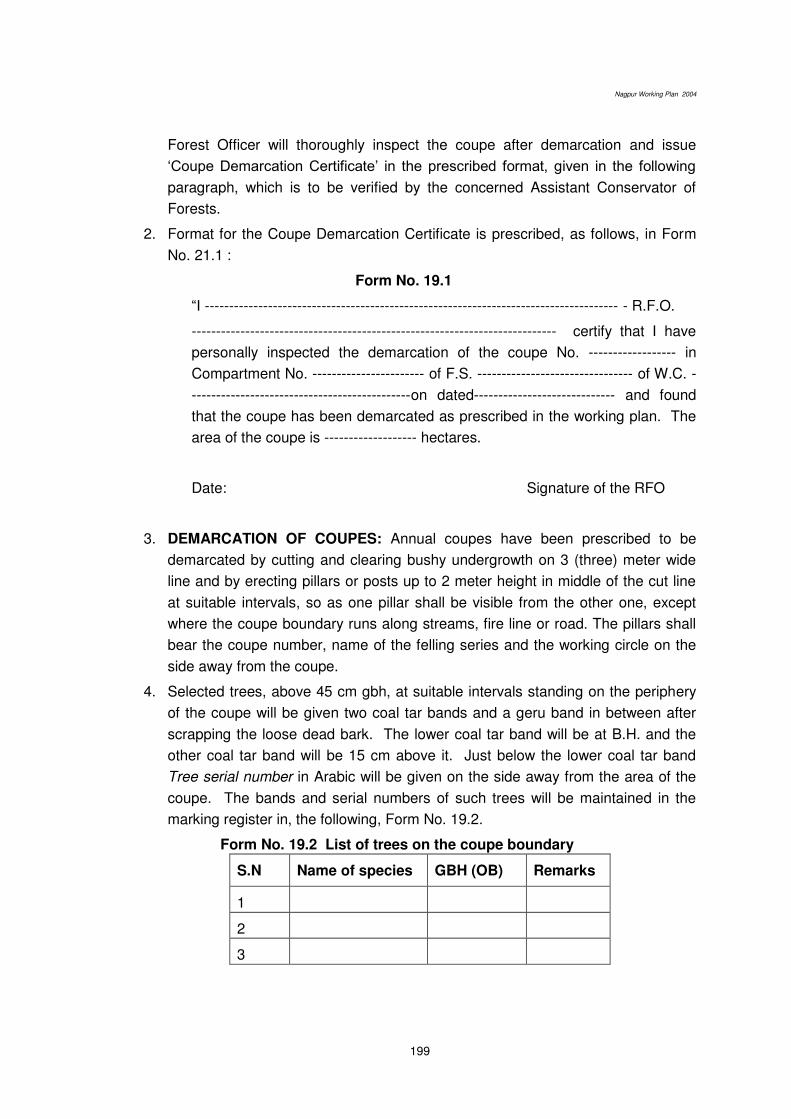
Nagpur Working Plan 2004
199
Forest Officer will thoroughly inspect the coupe after demarcation and issue
‘Coupe Demarcation Certificate’ in the prescribed format, given in the following paragraph, which is to be verified by the concerned Assistant Conservator of
Forests.
2. Format for the Coupe Demarcation Certificate is prescribed, as follows, in Form
No. 21.1 :
Form No. 19.1
“I ------------------------------------------------------------------------------------- - R.F.O.
--------------------------------------------------------------------------- certify that I have
personally inspected the demarcation of the coupe No. ------------------ in
Compartment No. ----------------------- of F.S. -------------------------------- of W.C. -
---------------------------------------------on dated----------------------------- and found
that the coupe has been demarcated as prescribed in the working plan. The
area of the coupe is ------------------- hectares.
Date: Signature of the RFO
3. DEMARCATION OF COUPES: Annual coupes have been prescribed to be
demarcated by cutting and clearing bushy undergrowth on 3 (three) meter wide
line and by erecting pillars or posts up to 2 meter height in middle of the cut line
at suitable intervals, so as one pillar shall be visible from the other one, except
where the coupe boundary runs along streams, fire line or road. The pillars shall
bear the coupe number, name of the felling series and the working circle on the
side away from the coupe.
4. Selected trees, above 45 cm gbh, at suitable intervals standing on the periphery
of the coupe will be given two coal tar bands and a geru band in between after
scrapping the loose dead bark. The lower coal tar band will be at B.H. and the
other coal tar band will be 15 cm above it. Just below the lower coal tar band
Tree serial number in Arabic will be given on the side away from the area of the
coupe. The bands and serial numbers of such trees will be maintained in the
marking register in, the following, Form No. 19.2.
Form No. 19.2 List of trees on the coupe boundary
S.N Name of species GBH (OB) Remarks
1
2
3
Nagpur Working Plan 2004
200
5. No tree, bearing the coupe demarcation bands, is proposed to be marked for
felling.
6. DEMARCATION OF SECTIONS: For effective monitoring and control of the
harvesting operations, each coupe marked for felling in SCI and Improvement
Working Circles will normally be divided into four approximately equal sections.
Sections will be demarcated by 1.5 m. wide cut lines by clearing brushwood,
unless the section line runs along a permanent feature.
7. Trees above 45 cm girth, selected at suitable intervals on the inner edge of the
1.5 m wide cleared section line will be given two coal tar bands 15 cm apart, the
lower coal tar band being at breast height. Just below the lower coal tar band
section number will be given on the side away from the area they would denote.
8. DEMARCATION OF PROTECTION AREAS: Selected trees, on the periphery of
the Protection areas will be given two geru bands 15 cm apart, lower band being
at B.H. In addition, a cross in geru colour between the bands will also be given
on the side away from the protection areas. All those trees will be serially
numbered. The serial number will be given on the side away from the protection
area just below the lower geru band, on the side bearing the cross. All the
protection areas will be numbered in Roman numerals and the trees standing on
the periphery of each protection area will be numbered in Arabic, adopting
separate series for each areas, so that the trees on periphery of Protection Area
No.I will bear the Sr. no. I/1, I/2, I/3, etc. and the similar trees on the periphery of
Protection Area No. II will bear the Sr. no. II/1, II/2, II/3, etc. The protection area
will also include sample plot and presentation plot, shown in Red. These are to
be excluded from the marking.
9. DEMARCATION OF OTHER AREAS GIVEN IN THE TREATMENT MAP: The
other categories of areas shown in the treatment map will be marked by giving
one geru band at B.H and one coal tar band 5 cm above it.
19.3.2 TREATMENT MAP:
1. Immediately, after completion of demarcation of the coupe, RFO will prepare the
Treatment map of the coupe by clearly showing the various Treatment-type areas
as prescribed in the chapter 9. The concerned ACF will verify the treatment map
and make corrections, if necessary, before submission to the DCF Nagpur for
approval.
The treatment map will bear the date of preparation by the Range Forest
Officer and the of verification by the Assistant Conservator of Forests.
2. The compartment maps prepared in the Forest Geomatics Centre, Nagpur should
serve as the base maps, which would be used for marking areas suitable for
different treatment types. Corrections in the base maps, if any, and observations
on crop conditions in the coupe should be recorded and send to the Working Plan
Officer for verification and updating the digital database.
Nagpur Working Plan 2004
201
3. Preparation of treatment map will preferably be done one year, in advance, of the
coupe working. Timely preparation would facilitate necessary checking and
corrections, if any in time.
4. Immediately after seeking approval of the treatment map, site-specific Work Plan
for the entire coupe shall be prepared by RFO, incorporating all the prescribed
activities under various treatment-type areas marked on the map, entailing
quantum of work involved, estimated amount required and period of operation for
each activity. The Work Plan is proposed to be verified by the ACF concerned
and submitted for approval by the DCF Nagpur or CCF (Territorial) Nagpur, as
the case may be, depending upon the extent of amount involved. The work plan
is prescribed be got approved sufficiently, in advance, the commencement of
coupe working in the respective coupes.
19.3.3 MARKING OF TREES FOR HARVESTING.
1. After approval of treatment map, marking of trees for harvesting shall be carried
out as per prescriptions given in respective working circles. Marking of trees for
harvesting shall be done one year in advance of the coupe working and it shall be
done departmentally. Timely marking would facilitate necessary checking and
corrections, if any, in time.
2. Marking is prescribed to be done by the forester concerned under the close
supervision of RFO and constant guidance of ACF concerned. The DCF shall
himself inspect majority of coupes to ascertain proper marking as per
prescriptions of working plan as well as to guard against the excessive marking.
To ensure this close supervision, a marking certificate in following format is
prescribed.
Form 19.3
I, ……………………… RFO, ………………… personally inspected the marking of the coupe No. ………….. in compartment No …………… of felling series ……………… in ……………. Working circle …………….. on dt………….. and found that marking of trees for felling has been done as prescribed in the working plan.
Date : Signature of the RFO
These certificates shall be regularly and frequently checked and verified by
ACF as well as Deputy Conservator of Forests.
3. Trees marked for felling will be given geru bands at breast height and will bear
marking hammer impression at the B H (breast height) as well as at the base on
the blazes of sizes 10 cm x 10 cm.
Nagpur Working Plan 2004
202
4. Following trees in addition will bear digit serial numbers both at BH (Breast
Height) and at the base.
a) All trees of Teak, Bija, Shisham, Ain, Tiwas, Haldu, Kalam, Dhaora and
Siwan of 45 cm and above, girth at b.h (o.b).
b) Trees of all other species, of and above, 60 cm girth at b.h.
5. The remaining trees marked will bear serial numbers, which will be given by coal
tar. The digit and coal tar serial numbers will form separate series.
6. The number of the tree marked shall be written vertically on the blaze, shown as
under:
7. All trees bearing serial numbers will be individually recorded in marking
(recording) book in, the following, Form No 19.3. Serial number given in coal tar
must be recorded in the marking book.
Form No. 19.3 Format for marking of trees for harvesting
Tree
Digit No.
Serial No.
Coal tar
Name of species GBH (OB) Remarks
8. Abstract of trees marked for felling will be made in 15 cm girth classes. Timber,
poles and firewood trees will be shown, separately.
9. Malformed trees alone will be recorded as fuel trees, except that of teak. A tree
will be classified as fuel tree only when it is incapable of yielding any useful sawn
timber or pole.
19.4 FOREST PROTECTION
19.4.1 Status of forest offence cases: The Range Forest Officer, the Assistant
Conservator of Forests and the Deputy Conservator of Forests will take review of
forest offence cases at least once, every month. Shifting of boundary marks along
the forest boundary shall be viewed seriously, and the adjoining landholders or
encroachers would be charged in the court for omission or commission causing
For Tree no. 210
XX (Hammer mark)
2
1
0

Nagpur Working Plan 2004
203
obliteration of the forest boundary. Charges regarding all cases of forest
encroachments must be submitted before the Judicial Magistrates within 3 months.
Similar time-bound action is recommended in all cases of timber theft. All cases of
violation of the Forest (Conservation) Act, 1980 shall be referred to the Nodal Officer
for suitable directives.
19.4.2 Routine monitoring: The Deputy Conservator of Forests shall personally
carry out routine checking of the Range Offence Register and the Round Enquiry
Reports in at least 4 Ranges every year. Similarly, the Conservator of Forests shall
check these records in at least one Range every year, and circulate the inspection
report to all the Ranges.
19.4.3 Regular training: The Deputy Conservator of Forests and the Assistant
Conservator of Forests will periodically convene staff meeting to review and impart
training for the boundary management and for effective disposal of offence cases.
Training should be organised locally with the help of the Education Circle.
19.4.4 JFM activities: JFM activities open up communication channel, discourage
forest offences and provide village bodies an opportunity for direct involvement in
forest protection. Therefore, JFM activities should be encouraged, and taken
advantage of as a workable strategy for effective forest protection.
19.5 FIRE PROTECTION
19.5.1 Fire adversely affects natural regeneration, forest growth, ground flora, soil
organisms and site productivity. Effective fire control as prescribed in the plan is
essential for the forest development. The division officials and local people should
be sensitised about the need of effective fire control. All fire incidences must be
meticulously recorded and investigated to assess the damage caused. Records of
fire exceeding 100 ha proposed to be sent to the Forest Geomatics Centre, Nagpur
for random cross-verification using the satellite imageries.
19.5.2 Classification of fire control
Class-I (Complete Fire Protection): The Class-I fire control areas include all felling
coupes (six years), thinning coupes (six years), plantations (five years), the A-type
areas (permanent), forest depots (permanent), forest nurseries (permanent), Special
habitat areas (permanent) and any other areas of special importance decided as
such by the Chief Conservator of Forests (Territorial) Nagpur.
Class-II (General Fire Protection): The Class-II fire control areas include the
remaining areas of the Selection-Cum-Improvement and the Improvement Working
Circle as well as any other areas, which deserve this protection in the opinion of the
Chief Conservator of Forests (Territorial) Nagpur.
Class-III (General vigilance): The remaining forest areas (that is, areas not
included in the above two classes) and pasture areas are identified as the Class-III

Nagpur Working Plan 2004
204
fire control areas. Any special measure for the fire protection is not undertaken, but
deliberate setting of fire and burning the forest is prohibited.
19.5.3 Fire control measures
1. A fire protection scheme for the entire division shall be prepared before
February each year, identifying the watch points (including watch towers), strategic
locations, strength of fire watchers at each location, deployment of vehicles, use of
wireless sets, supervising of the forest staff and the co-ordination protocol.
2. Each location is proposed to have 5 to 10 persons including regular staff and fire
watchers. The staff should be trained in the application of modern fire-fighting tools.
The fire prevention should be treated as a high priority item. The scheme should be
implemented sincerely during the fire season.
3. Areas deliberately burnt for silvicultural reasons under the sanction of the Chief
Conservator of Forests (Territorial) Nagpur will be excluded from the fire protection
scheme. Fire in such areas need not be reported unless spreads beyond such area.
4. All the Class-I and Class-II areas will have external fire lines and internal fire lines
dividing the forest area into convenient blocks. The Class-I areas will also have cut
and cleared guidelines.
5. Fire Watchers and local forest staff will constantly patrolled the Class-I and
Class-II fire control areas. The directives require that fire in the Class-I areas be
reported to the Deputy Conservator of Forests, immediately, along with details of the
area burnt and the damage inflicted on the forest crop.
6. The group of fire watchers shall immediately rush to the site and extinguish fire
as soon the fire spot is located by upcoming smoke in their area of operation. Modern
fire fighting tools should be used for extinguishing the fire. The supervising officials
should mobilise reinforcement in case of large fire. Utmost care will be taken to
quench the smouldering material. Providing a thick layer of soil over such material is
generally effective.
7. The fire lines will be kept clear of all growth and combustible material during the
fire season. Leaf litter and other dry material on the fire lines will be collected
periodically along the edge and burnt before the fire season starts.
8. The cutting of fire lines should be completed in December. Fire tracing (burning)
should be completed in February, and thereafter should require permission of
the Deputy Conservator of Forests and physical presence of a gazetted officer.
9. The division office shall maintain a “Register of fire lines,” and enter the period
of cutting and burning of fire lines. The register will be kept up to date and
checked every year, in March. (Appendix 2.2).
10. Standard widths of fire lines are prescribed in the Table 19.2. The supervising
officer will decide the width unit for carrying out the fire line work on the shared
boundary.

Nagpur Working Plan 2004
205
Table 19. 2. Standard width of various types of fire lines
S N Characteristics of the area Width of fire line
1 External Reserved & Protected Forests boundary 12 meter
2 Naturally or artificially regenerated areas (For 5 years) 6 meter
3 Remaining coupe boundary 3 meter
4 Both sides of roads and cart tracks passing through the forests 6 meter
5 Timber, bamboo and firewood depots 40 meter
11. Negligence in the fire protection by the staff should be taken as dereliction of
duties. The supervisory officers have been proposed to, extensively, verify the fire
control measures.
19.6 GRAZING REGULATIONS
19.6.1 Due to absence of revised grazing settlement for the tract under
consideration, the grazing in the division is prescribed to be regulated as per the
guidelines of Grazing Policy 1968; and Grazing Rules 1973 of Maharashtra state.
19.6.2 Heavy cattle pressure adversely affects the forest regeneration and soil
condition. The statutory provisions regulating grazing are difficult to apply in the
entirety. The present political economy of domestic animals in the area throws up
strong challenge and implementation of the grazing regulations in its current form.
19.6.3 The situation may be substantially improved by establishing effective
communication with the local people, awareness generation and efficient animal
husbandry programme. The forest officers should take up these preventive measures
in co-ordination with the Animal Husbandry Officers.
19.6.4 Maximum admissible grazing incidence according to the current policy has
been shown for various working circles in Table 19.3. A systematic survey of fodder
availability is recommended during the plan period in each protection round.
(Appendix 19.7).
Table 19.3. Admissible grazing incidence in various working circles
Working Circle Functional classification
Maximum grazing incidence (hectare per cattle unit)
Special areas (overlapping)
1. Protection areas (A1 & A2) &
2. Special habitat areas
Protection forest Nil Permanent
3. Flowered bamboo area Protection forest Nil Till seventh year
4. Annual coupes Protection forest Nil Till six year
5. Plantations Protection forest Nil Till fifth year

Nagpur Working Plan 2004
206
Other areas (under Working Circles)
6. Selection-cum-Improvement Tree forest 1.2
7. Improvement Tree forest 1.2
8. Afforestation Open forest 0.4 0.8 after plantation
9. Miscellaneous Minor forest 0.8 Except plantations
10. Protection Protection forest Nil Permanent Note: Area required for wildlife population should be calculated accordingly, and deducted from the available for the domestic cattle. If relevant data is not available 20% area should be marked for the wildlife.
19.6.5 The carrying capacity and period of closure should be calculated for the forest
areas falling in each village. The grazing passes, free or otherwise, to individual
families proposed to be distributed on this basis. These village bodies should also be
engaged in the implementation of grazing regulations.
19.6.6 The surplus cattle should be kept under regular watch, and villagers should
be encouraged to adopt stall-feeding or other means to address mismatch between
cattle-heads and fodder availability.
19.6.7 Fodder development on the community lands and translocation of surplus
cattle may be encouraged.
19.6.8 The Animal Husbandry and the Dairy Development agencies should be
motivated and influenced to take up breed improvement programme. Fodder in the
plantation areas should be made available free of cost on cut-and-carry basis.
19.7 ILLICIT CUTTING
19.7.1 Illicit felling in the forest area is growing at alarming rate. Since the subject is
dealt separately according to a series of directives for the purpose, recommendations
of this plan are of a little consequence. However, faster communication including
vehicle facilities, adequate defence capabilities, frequent training and establishment
of forest stations at strategic places are recommended to control illicit felling and
wildlife offences. Establishing intelligence network for the purpose is strongly
recommended.
19.7.2 In addition to addressing supply-side management by augmenting wood
production on forest and other community land, the demand-side management
should take up efficient wood utilisation and energy efficient alternatives like
smokeless chulhas, biogas, solar cookers, etc.
19.8 FOREST ENCROACHMENT
19.8.1 The causes of forest encroachment should be examined thoroughly and
addressed in a comprehensive manner. All the necessary support should be
provided, and encroachment should be evicted as early as feasible. The boundary
management and standard administrative guidelines will help contain encroachment.
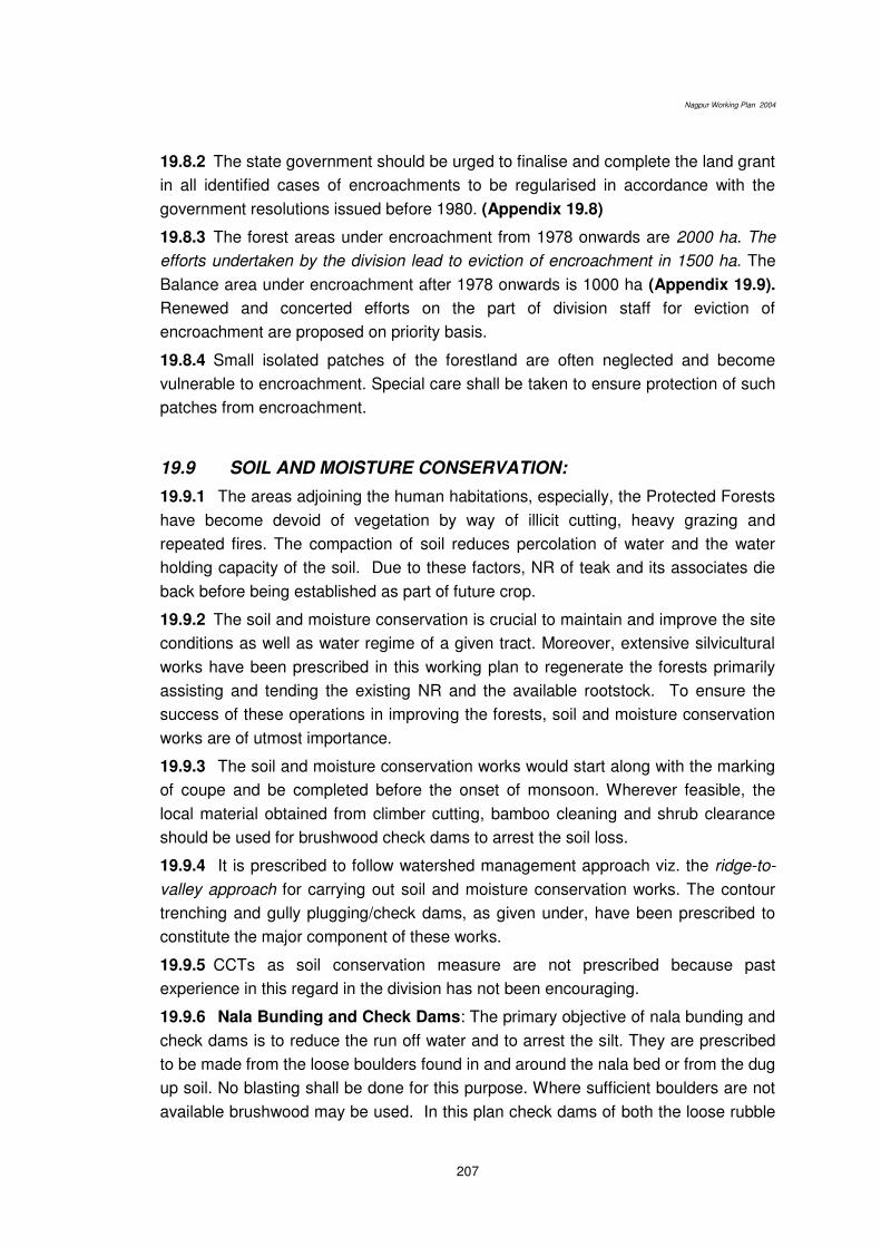
Nagpur Working Plan 2004
207
19.8.2 The state government should be urged to finalise and complete the land grant
in all identified cases of encroachments to be regularised in accordance with the
government resolutions issued before 1980. (Appendix 19.8)
19.8.3 The forest areas under encroachment from 1978 onwards are 2000 ha. The
efforts undertaken by the division lead to eviction of encroachment in 1500 ha. The
Balance area under encroachment after 1978 onwards is 1000 ha (Appendix 19.9).
Renewed and concerted efforts on the part of division staff for eviction of
encroachment are proposed on priority basis.
19.8.4 Small isolated patches of the forestland are often neglected and become
vulnerable to encroachment. Special care shall be taken to ensure protection of such
patches from encroachment.
19.9 SOIL AND MOISTURE CONSERVATION:
19.9.1 The areas adjoining the human habitations, especially, the Protected Forests
have become devoid of vegetation by way of illicit cutting, heavy grazing and
repeated fires. The compaction of soil reduces percolation of water and the water
holding capacity of the soil. Due to these factors, NR of teak and its associates die
back before being established as part of future crop.
19.9.2 The soil and moisture conservation is crucial to maintain and improve the site
conditions as well as water regime of a given tract. Moreover, extensive silvicultural
works have been prescribed in this working plan to regenerate the forests primarily
assisting and tending the existing NR and the available rootstock. To ensure the
success of these operations in improving the forests, soil and moisture conservation
works are of utmost importance.
19.9.3 The soil and moisture conservation works would start along with the marking
of coupe and be completed before the onset of monsoon. Wherever feasible, the
local material obtained from climber cutting, bamboo cleaning and shrub clearance
should be used for brushwood check dams to arrest the soil loss.
19.9.4 It is prescribed to follow watershed management approach viz. the ridge-to-
valley approach for carrying out soil and moisture conservation works. The contour
trenching and gully plugging/check dams, as given under, have been prescribed to
constitute the major component of these works.
19.9.5 CCTs as soil conservation measure are not prescribed because past
experience in this regard in the division has not been encouraging.
19.9.6 Nala Bunding and Check Dams: The primary objective of nala bunding and
check dams is to reduce the run off water and to arrest the silt. They are prescribed
to be made from the loose boulders found in and around the nala bed or from the dug
up soil. No blasting shall be done for this purpose. Where sufficient boulders are not
available brushwood may be used. In this plan check dams of both the loose rubble
Nagpur Working Plan 2004
208
for arresting silt and soil loss and earthen gully plugging (nala bunds) for moisture
conservation and water harvesting are prescribed.
19.9.7 The structure and quantum of work will depend upon various factors such as
the erosion status, ground conditions, local availability of suitable materials.
However, to narrow the wide variations in implementation, the norm for gully plugging
or nala bunding is proposed as 5 meter3/hectare of loose rubble filling or earthwork
unless otherwise prescribed in the specific scheme.
19.9.8 The streambeds more than 8 meters in width shall not be covered under the
nala bunding. Nalas more than 8 meter wide at the top should normally require
elaborate engineering structures for bunding, and therefore, such bunds should not
be considered as part of the quantity prescribed here. Each of such nala bunds, if
required, should be treated as an independent project.
19.9.9 The forest tanks are proposed to be taken up in exceptional circumstances
without causing damage to the tree crop either during construction or due to
submergence.
19.10 GUIDELINES FOR REGENERATION
It has been observed that the soil depth in areas covered under plantation
programme in the division generally is very shallow and therefore the efforts made in
the past in raising plantations (particularly the miscellaneous plantations) have
resulted in failures. Hence, the plantations should be taken up on selective basis and
only in the areas having good soil depth and which are well drained. Also the areas
selected should have no or negligible grazing pressure. If the area was already
planted and resulted in failure, such sites should be avoided. B2 type areas in the
various working circles i.e. the under-stocked areas with scanty natural regeneration
are prescribed to be considered but such areas should specifically be put to above
tests before taking up plantation there. In the rest of the under-stocked areas,
attempts will be made to encourage natural regeneration.
Broad criteria for regeneration in general have been developed in the foregoing
paragraphs.
Local people should be involved in all types of afforestation activities.
19.10.1 Tending of natural regeneration: Preference will be to encourage natural
regeneration and considering existence of sufficient rootstock in majority of areas
and successful experience in its management, it will be given preference. Natural
regeneration is proposed to be achieved in two ways:
i) Identifying seedlings and saplings (those having attained a height of 60 cm
and occurring roughly at a spacement of 5 m, that is, about 400 seedlings per
ha) of valuable species. Growth of these seedlings/ saplings shall be
encouraged by way of weeding, singling, soil working and mulching in the
same way as in case of plantations.
Nagpur Working Plan 2004
209
ii) The areas devoid of seedlings/saplings of seed origin but containing sufficient
rootstock shall be tended (stool dressing, singling, removal of congestion etc.)
in favour of valuable species. While doing so, the species, which are less in
number in stocking (as indicated by enumeration results) shall however be
given preference.
19.10.2 Artificial Plantations: Only the areas neither having sufficient seedlings/
saplings of seed origin nor sufficient root stock but are found to be suitable for
plantation of miscellaneous species shall be covered under the plantation
programme. Two-stage plantation approach is proposed. The idea is to give the
nature a fare chance to regenerate itself and to intervene by way of artificial
plantation only as a last resort. Thus, the plantations are prescribed to fill the deficit
of natural regeneration in under stocked and blank areas.
19.10.3 Two-Stage Plantation in Afforestation areas: Under the Afforestation,
Protection and also B type areas of other working circles in the trap zone (Narkhed,
Kondhali, Hingna), that is, the areas, which are refractory in nature and have
relatively poor soil and site quality, the plantations are proposed to be carried out in
two stages, that is, the restorative phase followed by planting phase.
19.10.4 Restorative Phase: Restorative phase is proposed to include the soil and
moisture conservation works and fencing in the year of coupe operations. Seed
sowing of neem, chandan, maharukh and babul will be done in bushes and planting
of Agave on TCM and of Khus on earthen soil conservation structures will be carried
out in the following year. The restorative phase will be judged in the fourth year of the
coupe working. Effectiveness of fencing and success of the soil and moisture
conservation measures will mark the completion of the restorative phase.
19.10.5 Switch over from restorative phase to planting phase is not to be
automatic: All the areas covered under restorative phase shall not be allowed to be
switched over in the fourth year to the planting phase. It shall be only after evaluation
of the restorative phase and the tests for the success of the restorative phase shall
be those made applicable by evaluation wing. The areas failing these tests shall not
be covered under plantation programme.
19.10.6 Planting Phase: The effective completion of restorative phase will mark the
beginning of planting phase. Presence of 600 seedlings per hectare obtained from
the seed sowing should be considered adequate for the purpose. Areas having
adequate regeneration from rootstock and seed sowing will be tended as described
for the rootstock management. The plantation will be taken up in the area, which
could not have adequate regeneration from the rootstock or seed sowing. PPO/PYO
(pre-planting operations) shall be taken up in the fourth year of coupe working, while
the seedling planting and other FYO (first year operations) activities shall be carried
out in the following year, that is, the fifth year of coupe working. Other plantation
Nagpur Working Plan 2004
210
works will follow in the sequence. The cleaning and thinning operations in plantations
will be done in the fifth and eleventh year of plantations.
19.10.7 One stage plantation in other areas: Plantations in the remaining areas –Ramtek, Parsheoni, Deolapar, Khapa and parts of North Umred, South Umred and
Kuhi ranges, that is, generally those in the metamorphic zone containing good soil
and better site quality will be taken up in the single stage. The PPO/PYO (pre-
planting operations) will be taken up in the year of coupe working, while FYO (first
year operations) will be carried out in the following year. Other plantation works will
follow in the sequence. The cleaning and thinning operations in plantations will be
done in the sixth and 10th year of plantations. The extent of plantation should not
exceed the prescribed norms.
19.10.8 Choice of species in artificial regeneration: Naturally occurring local
species will be preferred for the plantations. In addition, plantation of Neem,
Maharukh, Aonla, Karanj and Babool is suggested in two stage plantation areas and
of Neem, Bamboo, Aonla, Khair, Chandan, Siris, Siwan, Shisham, Teak (in open
patches only), Chichwa, Moha in one stage plantation areas.
19.11 Thinning Guidelines
19.11.1 1. Objective: Thinning may be defined as felling made without
permanently breaking the canopy in an immature stand and for the purpose of
improving the growth and form as well as maximum volume production of the
remaining trees in the stand. Thus, the production of timber, which may though be
substantial considering 2500 plants being planted initially, is not the prime objective
of thinning.
2. General considerations: Thinning is proposed to be carried out in plantations
and patches of dense pole crop and, by doing it, average spacing is to be maintained
at one-third of the crop height. The post-thinning crop should have basal area and
number as close to the relevant stand or yield table for that site quality as possible.
It is prescribed to be carried out in the plantations having at least 50% survival in
the 6th year, that is, after the sixth-year cleaning. Such areas shall be recorded in
the divisional notebook.
The first thinning shall be carried out in the 10th -year of the coupe working and it
shall be of mechanical in nature. Subsequent thinnings will be silvicultural in
nature and will be done in 15th, 25th, 35th year and so on till the 65th. By this time
such areas are expected to merge with the adjacent natural growth.
All thinnings will be done either at the beginning or at the end of the growing
season.
The expected results of the thinnings is available in FRI publication No Volume
9,Yr.1957.

Nagpur Working Plan 2004
211
19.11.2 Observable Factors as the basis for Thinning Procedure
(a) Tree classification: To describe the nature and intensity of a thinning, there is a
choice between qualitative and quantitative methods; the former being almost mainly
subjective. The older procedures were all of former category, as would be expected
from the fact that the latter calls for standards of reference which are still only
available for a few species. The individual trees in a crop were classified by height
and size of crown, whilst the thinning prescriptions laid down which classes were to
be removed. The standard adopted is, as follows:
I. DOMINANT TREES (D): All trees which form the uppermost leaf canopy and
have their shoots free. These are usually subdivided as follows:
(1) Pre-dominant trees comprising all the tallest trees which determine the
general top level of the canopy, and
(2) Co-dominant trees which fall short of this, averaging about 5/6 of the height of
predominant.
(a) Trees with normal crown development and good stem form.
(b) Trees with defective stems or crowns, e.g. :
1) Trees with crown space cramped by neighbouring trees,
2) Badly shaped old advance growth,
3) Trees with forked leader and similar defects
(c) Trees with very defective stems or crowns, i.e. with same defects as (b) to
such an extent that they are of little or no present value or promise.
(d) Whips -Trees with very thin bole and very constricted crown incapable of
existence without the support of the neighbouring tree
II. DOMINATED TREES (d): These trees do not form part of the upper most leaf
canopy, but the leading shoots of which are not definitely overtopped by the
neighbouring trees. Their height is about ¾ that of the tallest trees.
(a) Trees with normal crown development and good stem form.
(b) Trees with defective crowns or stems.
III. SUPPRESSED TREES (s), which reach only about ½ to 5/8 of the height trees,
with their leading shoots definitely over-topped by their neighbours or at least
shaded on all sides by them.
IV. DEAD AND MORIBUND TREES (m). This class also includes bent over and
badly leaning trees usually of the whip type.
V. DESEASED TREES (k): This class includes those trees which are infected with
parasites to such an extent that their growth is seriously affected or that they are
a danger to their neighbours.
(a) Dominant.
(b) Dominated and suppressed.

Nagpur Working Plan 2004
212
19.11.3 THINNING METHODS
General considerations: When a plantation is made, silvicultural requirements,
particularly, the restoration or creation of a tree cover to the soil dictate spacing than
would be adopted if economy is not the immediate cause and number of plants
required had alone to be considered. Many of the original number planted have to be
cut out when they are of little or no sale value to permit satisfactory development of
those retained. Even so, the number of stems still standing after the first thinning or
two, will be far greater than the final number at maturity, and somewhat irregular
spacing is, relatively, un-important as it can be adjusted in later thinning.
(1) Mechanical Thinning: There may accordingly be little objection to provide extra
growing space by the mechanical removal of complete lines of plants, or every
alternate plant subject to provision to cover cases of local gaps. Where spacing is
irregular, the “stick” method used in natural regeneration is a possibility whereby one
tree of every pair of adjoining trees is removed if the distance between them is less
than a prescribed length.
(i) Only one mechanical thinning has been prescribed and it will be removal of one
pole in a diagonal cluster of three poles.
(ii) It is usually provided that where there is a gap in the retained line, an adjoining
plant in the cleared line should be retained.
(iii) This method is only practicable where casualties are very few and growth is
both good and even under such conditions but it is out of question in poor or uneven
plantations.
(iv) It is not suitable for mixed plantations. However, in rare cases, similar operation
may be done in mixed plantations where one species has been introduced
essentially to help cover the ground quickly and its removal or cutting back is
necessary in the interest of the major species.
(2) Silvicultural Thinning: Alternatively, thinning may be selective, the case for
removal or retention being considered for each tree in turn according to a set of rules
drawn up for the purpose. This is the most usual procedure even where additional
checks are applied, being often described as a “silvicultural” thinning.
(3) Thinning Schedule: The other possibility is to be guided by thinning schedule
which lay down the number of stems that should remain standing after thinning
according to various criteria of dimensions, site quality and/or age. Such criteria
should ideally be based on a wide range of growth studies to reveal the development
to be expected to take place under the conditions concerned.
19.11.4 TYPES OF THINNING
(a) ORDINARY THINNING (i) The mechanical thinning meet the initial requirements
of plantations. It soon ceases to be a practical proposition owing to the unequal
Nagpur Working Plan 2004
213
development of the trees and their smaller numbers, and hence calls for other
methods for thinning operations.
(ii) The most usual method has been to view each tree in relation to its neighbours,
and to remove those which appears already to have shown their inferiority by
dropping behind, taking first the suppressed trees, then the dominated ones, and
finally some of the dominants with restricted or, otherwise, inferior crowns. As this
method begins with the removal of the lowest canopy class and then works upwards,
it has been called Low thinning, but it is now known, on account of its widespread
application, as Ordinary Thinning.
(iii) The smaller dominated and suppressed trees are usually removed, they may be
retained as soil cover and as insurance against casualties among the larger trees
standing over them.
(iv) Most foresters tend, at first, to thin very lightly corresponding to something
between B and C grades, after experience however they mark heavily up to a full C-
grade and D-grade. The term ‘heavy thinning’ implies the C-grade thinning.
(b) The standard grade of ordinary thinning:
(1) Light thinning (A-grade): This is limited to the removal of dead, dying, diseased
and suppressed trees, i.e. classes V, IV and III. Grade A is of no practical use, it
serves as the initial stage, especially, in comparative research on the effect of
thinning on increment.
(2) Moderate thinning (B-grade): This consists in the further removal of defective
dominated stems and whips. Branchy advance growth which it is impracticable or not
desirable to prune may also be taken, i.e. classes V, IV, III, II(b) and I(d) and an
occasional I(c). B-grade is also of little use in practice, due to its having little influence
on the increment of the remaining stems.
(3) Heavy thinning (C-grade): This consists in the further removal of the remaining
dominated stems and some defective dominants without making lasting gaps in the
canopy, i.e. classes V, IV, III, II and I(b), (c) and (d).
(4) Very heavy thinning (D-grade): It consists further removal of some of the good
dominants, subject to the condition of not making any lasting gap in the canopy. The
trees for removal are selected in such a way that the remaining crop consists of
trees, with good boles and crowns, well and evenly distributed over the area, and
with space for further development, i.e. classes V, IV, III, II and I(b), (c), (d) and some
I(a). If their removal is of no economic or hygienic value, class V, IV and III trees are
not removed, in heavier grades.
(5) Very very heavy thinning (E-grade): For research purposes it has been found
desirable to make ordinary thinning even heavier than the standard D-grade. It
prescribes removal of more of the dominant stems even in class I(a), so that all
retained have ample room for further development. It goes as far as possible within
the rule for avoiding permanent gaps in the canopy.

Nagpur Working Plan 2004
214
(6) It is often inadvisable to make a full C-grade or D-grade thinning in a dense crop
in which thinning has been unduly delayed. The first thinning in such cases should be
lighter than is ultimately intended.
19.11.5 CROWN THINNING: This method of thinning looks first of all to the
dominants, and removes such of them, beginning with the least promising
individuals, as are hindering the development of the best individuals. Due regards are
paid to obtaining as even a distribution of good dominants over the area as possible.
It requires special skill and acumen in carrying it out.
(a) Grades of Crown Thinning: Only two grades of crown thinning have been
standardized; they are defined as follows:
(1) Light Crown Thinning (LC - grade): This consists in the removal of dead,
dying and diseased trees, with such of the defective, after them the better dominants,
as are necessary to leave room for the further development of the best available
trees evenly distributed over the area, i.e. classes V, IV, I(d), (c), many of I(b) and
few of I(a) but not III and II. This is similar to D-grade ordinary thinning, but retains all
III and II, and is not quite so heavy on I.
(2) Heavy Crown Thinning (HC- grade): This grade pays even more attention to
favouring the selected best stems by removing all the remaining I(b) which can be
taken without creating permanent gaps, and more of I(a), i.e. classes V, IV, I(d), (c),
most of I(b), some of I(a); but not III and II.
(3) Crown thinning is well adapted to moderately shade-tolerant species in which
the retention of the lower canopy presents no difficulty.
19.12 THE RULES FOR GUM TAPPING (FRI, DEHRADUN)
19.12.1 The tapping season will commence from November to end of May each
year. No tree below 90 cm in girth will be tapped.
19.12.2 Tapping will be confined to the main bole of trees between 15 cm from
ground level to the point from which first branch is given off.
19.12.3 Each tree shall be tapped continuously for 3 years; and, thereafter, will be
given rest for 3 years.
19.12.4 The initial blazed 20 cm wide and 30 cm in length or height may be made
in the month of November on trees at 15 cm above ground level with a sharp axe
having 7.5-cm wide blade. The blaze is made 0.6 cm deep in the bark.
19.12.5 Blaze may be made horizontally leaving approximately equal space
between the blazes. The blazes should not have any loose fiber. The lower surface
of the blaze should be slightly slopping outwards to avoid lodging of guggul in the
blazed pocket, in case, initial blazing is done by axe.
19.12.6 The guggul starts oozing out soon after blazes are made and may be
collected initially after a month, that is, by about December when the blazes may also
Nagpur Working Plan 2004
215
be freshened. Subsequent collections and freshening may be done fortnightly up to
May. Overall, 12 freshening are required to be made, during the year.
19.12.7 In each freshening, the lower surface is not to be freshened. The edges may
be scraped so that only 3.8 cm is increased on either side in width, at the end of 12th
freshening. This means that about 0.3 cm should be scraped off from either side in
width in each freshening.
19.12.8 The lowest row of blazes will be at one meter above the ground level. The
next row of blazes will be made at the height of 60 cm from the lower that is, at a total
height of 1.6 meter from the ground level. The vertical portion of the blaze of upper
row will alternate with similar portion of the row and no two blazes of the two rows will
be directly one above the other.
19.12.9 The number of blazes to be made on each tree will depend on its girth at
breast height, as given below:
19.12.10 No fresh blaze will be made on the partially healed up surface or old
wounds.
19.12.11 Each blaze will be in a shape of parabola with a 2.5 cm wide base. The
curved side of the parabola will be upwards and of height not more than 7.50 cm and
the depth of the blaze will not exceed 0.6 cm in the wood.
19.12.12 At the end of the season, the height of the blaze shall not be greater than
12.50 cm. Maximum permissible dimension of each blaze shall be 10cm x 12.5cm x
0.6 cm in width, height and depth, respectively.
19.12.13 Since the tapping is to be done continuously for three years the total height
of the blaze at the end of three years of tapping will be 37.50 cm, the width and depth
remaining the same.
19.12.14 In the second cycle that is, in the 7th year (after three-year rest) new blazes
will be made in the same way in the un-blazed portion, in between the blazed
portions of the first cycle. This blazing will continue for another three years in the
manner described above and the operations will be repeated till un-blazed portion is
fully covered.
Category Girth at BH Maximum blazes allowed on each tree
I 0.9 m to 1.3 m 2
II 1.3 m to 2.0 m 3
III 2.0 m to 3.0 m 4
IV Over 3 m One blaze for each 45 cm girth in addition to
the category III, above.

Nagpur Working Plan 2004
216
19.13 ROADS, CART TRACKS AND CULVERTS
19.13.1 The forest areas of the division have a good network of roads and cart
tracks. The Public Works Department of the state government or the Zilla Parishad
maintains large number of roads passing through the forest area. Some stretches
have been permanently transferred to the Department. The division is proposed to
compile a comprehensive records for all roads passing through the forest area and
the roads transferred to the division for maintenance, on priority basis.
19.13.2 The extent of forestry operations and gravity of forest protection concerns
should determine the priority for maintenance of the forest roads.
19.13.3 Unwarranted up-gradation of the forest roads should be discouraged, but
required culverts may be constructed in stretches useful for the forest protection.
19.14 HARVESTING AND DISPOSAL
19.14.1 Agency for harvesting: The Deputy Conservator of Forests, Nagpur shall
decide the agency for harvesting in accordance with the applicable policies and
regulations. Present policy prohibits the sale of standing trees. Estimation of bamboo
yield should be based on actual enumeration carried out a year prior to the beginning
of bamboo harvesting.
19.14.2 Disposal at timber depots: Harvested timber and firewood are proposed to
be transported to the established forest depots for sale by auction or allocation
according to the prevailing policies and guidelines. Bamboos are also sold at these
depots. The National Forest Policy, 1988 acknowledges the first charge on the forest
produce in the local tribal and village community living in and around the forest areas.
Hence, decision for the disposal of the forest produce should be guided by the
philosophy of the first right of the local village communities, which is also recognised
in the nistar patraks. For facilitating nistar distribution, temporary depots can be
created at the Range Headquarters.
19.14.3 Stacking for the nistar supply: Each established or temporary depots is
prescribed to have designated areas for stacking small timber, poles, firewood and
bamboo for the nistar supply at the special low sanctioned rates to local people
including agriculturists and artisans. The Deputy Conservator of Forests can approve
additional nistar depots at suitable places in the division, preferably the round or beat
headquarters, so that villagers may not be required to traverse large distance to
procure the nistar materials. The Deputy Conservator of Forests in consultation with
the District Collector fixes the nistar rate. Supplies of small timber, firewood etc. as
well as the forest produce required for occupational nistar will be governed by nistar
partak of each village (also refer to para 1.9 of chapter I in this regard). Availability of
the nistar material will to be informed to the Taluka Panchayats and the material left
unused for three months will be sold through open auction.

Nagpur Working Plan 2004
217
19.15 IRREGULAR HARVESTING
19.15.1 Restriction on irregular harvesting: Irregular harvesting of timber,
firewood and other NWFPs is prohibited, except in the following cases:
19.15.2 Harvesting for the fire lines and the transmission line: The Deputy
Conservator of Forests may permit felling of trees within the prescribed width of the
established fire lines and the approved power transmission line. The prescribed width
in the guidelines for the Forest (Conservation) Act, 1980 and rules, there under, will
be applicable to the transmission lines. Creation of new fire lines shall require prior
permission of the Conservator of Forests.
19.15.3 Felling for the haulage roads: The Deputy Conservator of Forests may
permit felling of trees for the purpose of haulage roads, which should be aligned
properly to ensure minimum possible felling of trees.
19.15.4 Harvesting in forest areas diverted for non-forestry purposes: Felling of
trees on forest land required by the other departments such as Irrigation, PWD, etc.,
will only be undertaken after the proposals for the use of forest land for non-forest
purposes are approved by the Government of India under the provisions of the
Forest Conservation Act,1980. The Deputy Conservator of Forests may permit
felling of trees on forestland diverted for the non-forestry purposes as approved
under the provisions of the Forest (Conservation) Act, 1980. The material obtained
from such harvesting will be brought to the depots and will be disposed off as regular
coupe material.
19.15.5 Any plantations done because of separate scheme in that regard which
are located outside the annual coupes will not be considered as irregular working.
19.15.6 Harvesting for wood supply after the natural calamities: At the
instruction of the State government, the Principal Chief Conservator of Forests may
sanction advance working of coupes, up to two years, for supply of timber, poles and
bamboos to the areas affected by the natural calamities.
19.15.7 Bamboo clumps outside the area of Bamboo overlapping working circle
can also be harvested and the material so obtained may be utilised for meeting the
local demands.
19.15.8 Harvesting of dead fallen and uprooted trees in the storm: Removal of
dead fallen firewood and trees uprooted by wind or storm from all parts of the forests,
except the coupes due for working, will be done in the following manner. Every year
in the month of October each beat guard will report the availability of dead fallen
firewood and trees uprooted by wind or storm to the concerned Range office. The
Range Forest Officer will estimate availability for such material in each compartment
and ACF concerned will verify the same. If more than 2 (two) such trees per hectare
is estimated, proper marking will be carried out. Two dead and fallen trees are
required for retention from wildlife conservation. Wood removal will be carried out
from the compartment after approval of the Deputy Conservator of Forests. The

Nagpur Working Plan 2004
218
details of material obtained from each compartment and revenue realised from it will
be entered in the respective Compartment History Form. Harvesting of dead and
fallen firewood is governed by the nistar rights and privileges as admitted in the nistar
patrak or directed by the government from time to time. The nistar holders are
proposed to be allowed to collect such material directly from the forests on rated
passes or in the manner determined by the DCF Nagpur through the written
directives.
19.15.9 No irregular harvesting for the purpose of undertaking
plantations/afforestation works under schemes outside the scope of this working plan
will be taken up in any of the areas under the working plan.
19.16 MAINTENANCE OF THE FOREST LAND RECORDS
19.16.1 Maintenance of the land records and forest maps: The forestland
records and the forest maps will be brought up to date, and maintained as such. A
certificate to this affect will be recorded annually in the Form No 1- Register during
the month of June.
19.16.2 Forest notification: Unclassified forests and non-forest areas transferred
for the compensatory afforestation shall be, immediately, proposed for notification as
the Protected Forests, and the reservation process shall be initiated with the section
4 notification under the provisions of Indian Forest (Protection) Act 1927.
19.16.3 Reconciliation of the revenue records: The revenue records will be
reconciled on the basis of the forest notifications. The Collector and the Deputy
Conservator of Forests will jointly ensure that the Revenue Records are brought up
to date according to the forest notifications. Since the Divisional Commissioner
issues the forest notifications, there is no apparent need to issue separate orders for
the mutation entries. The Revenue Department will provide a certified copy of the
Records of Rights to the Nagpur Division to mark completion of the process.
19.16.4 Along with the reconciliation, the details of land grants (patta) issued on the
forestland will also be made available to the Nagpur Division. The Collector and the
Deputy Conservator of Forests shall send the details of all grants or occupancies
rights issued since 1980 to the Nodal Officer at Nagpur.
19.16.5 DIGITAL DATABASE: Geomatics Centre, Nagpur shall convert all the
forest maps into the digital format for analysis and quick retrieval. Map procurement
shall be the responsibility of the territorial division. Similarly, all primary land-related
records will be scanned at suitable resolution not less than 150 dpi, and stored in
digital form on CDs (Compact Discs). Copies of such CDs will be made available to
the Conservator of Forests and the Deputy Conservator of Forests as well as the
Deputy Conservator of Forests, Working Plan and the Land Cell, at Nagpur.
Nagpur Working Plan 2004
219
19.17 JOINT FOREST MANAGEMENT
19.17.1 BACKGROUND OF THE JOINT FOREST MANAGEMENT
The National Forest Policy 1988 envisages massive people’s movement for conservation of forest resources. Thus, the government of India advised state
governments in June 1990 to involve local people in protection and development of
forests. Participatory management strategy envisaged in forestry sector is known as
Joint Forest Management (JFM). Therefore, instructions have been issued for
incorporation of prescriptions of joint forest management in the working plan. Hence,
separate chapter has been proposed.
Through the government resolution no. SLF–1091/199/F-11 dated 16th March
1992, this approach was adopted for degraded forest areas of the state and now new
guidelines have been issued vide GR No.MSC/2000/C.No.143/F-2, dt.25.4.03.
Villagers themselves are required to voluntarily participate in the programme.
Forest protection committee (FPC) is to be formed in each village. The members of
the committee will help in protection and development of forests and they will receive
in turn a share in the usufructs and output from the forest areas assigned to such
committee. The JFM areas will be managed according to the micro-plans prepared
jointly by the Deputy Conservator of Forests and members of the FPC. These micro-
plans shall contain the details of forest and village development. This has to be
sustainable, should cater to aspirations of local communities and, at the same time,
the silvicultural requirements of the forests are to be met properly.
Later, the government of India also advised the state governments to take up the
Joint Forest Management in well stocked forest areas on experimental basis and
accordingly guidelines dt.25.4.03 mentioned above have authorised the forest
department in the state in this respect. Summary of these guidelines is as follows:
1) Good forests within 2 km from a village are to be covered under the programme
on experimental basis and stage by stage other villages containing good forests
are to be brought under it.
2) JFM is to be implemented with the help of gram panchayat and forest produce
available is to be provided on priority to meet bonafide local needs. (Hence, local
rights as enshrined in Nistar Patrak and Wazib-ul-arj are not to be curtailed.)
3) Non-forestland available in the village, which has agreed to participate in the
programme, may be brought under the scheme if villagers and the panchayat
agree to do so.
4) Help of institutions of local self-govt., NGO, environmental expert, if any
available locally, may be solicited.
5) The scheme though does not intend to facilitate agriculture based professions
but non-irrigated horticulture schemes in (private) wastelands may be
encouraged if approved in the micro-plan.

Nagpur Working Plan 2004
220
6) The programme underlines conservation of forests and wildlife and therefore
any activity/ agreement etc. that is not consistent with Forest Conservation
Act, 1980 should not be incorporated in the micro-plan.
19.17.2 PRESENT EXPERIENCE WITH THE JFM IN THE DIVISION
1. The JFM concept was for the first time made operational in the state through
World Bank assisted Maharashtra Forestry Project from the year 1992-1993 to
1999-2000. The list of villages alongwith the forests covered under this
programme as well as future proposals are given in (Appendix 19.10).
2. Forest Development Agency:
It is an instrument through which JFM can be achieved. Its implementation in the
division so far is summarized below:
(i) FDA of 50 villages of the division (list and other details of these villages
are given in Appendix 18.1 with works of Rs. 362.33 lakhs planned for 5
years, 2002-03 to 2006-07 has been approved by the govt, of India vide
its letter No. CSS-FDA/171/02-03 dated 20.01.2003. First installment of
Rs.59.42 lakhs has accordingly been received on 19.3.2003.
(ii) Rs.50.40 lakhs were distributed to FPCs in these villages by the end of
June 2003 and this money was transferred to their bank accounts in
nationalized banks, which are being operated jointly by the Secretary and
the Treasurer of the FPC concerned.
(iii) The activities in brief are given in table below.
Sr No Particulars Physical Financial
(in lakhs)
1 Aided Natural
Regeneration
900 ha 53.89
2 Pasture
Development
100 ha 6.17
3 Bamboo Plantation 700 ha 45.90
4 Misc. Plantation 800 ha 88.36
5 Other works -- 168.01
iv) The activities have been short listed based on PRA and therefore it can
be seen that SMC and plantation works are also planned on hitherto
community lands, Zudapi jungle.
Nagpur Working Plan 2004
221
3. Other participatory programme
(i) An area specific and intensive INTEGRATED WATERSHED
DEVELOPMENT PROGRAMME (IWDP), which is also financed by the
govt. of India, is presently under implementation in the watershed
designated as WRJ-4 comprising 24 villages of Katol taluka. The
elements of JFM like people's participation and micro planning are an
integral part of this programme.
(ii) The area falls in Kondhali range and the scheme is being implemented
in 9 forest villages (area 5102 ha) by the forest department as PIA
(Programme Implementing Agency) 2 and in 15 non-forested villages or
in villages having negligible forest area (area 5456 ha) by the Social
Forestry Department as PIA 1.
(iii) Works under this scheme are planned for 5 years, 2001-02 to 2005-06,
with the total outlay for various activities under this plan being Rs.633.48
lakhs. It includes Rs.306.12 lakhs for 9 villages allotted to forest
department and Rs 327.36 lakhs for 15 villages being covered by the
Social Forestry Department.
This programme thus has already entered third year of its
implementation.
(iv) The scheme envisages preparation of micro water shed plans for each
village through PRA and containing entry point activities, training and
awareness etc. and treatment to non-forest (Private and Community
Lands) as well as forestlands. Land treatment includes SMC works,
bund line plantations, pasture development and block plantations.
(v) The scheme also envisages self-help groups, formation of watershed
committee and its registration, identifying volunteers etc. and
development and improvement of civic amenities. Thus it is essentially
JFM in approach. Further improvements in that approach can be aimed
at by including private and non- forestlands and village development
approach in to the scheme.
19.17.3 POTENTIAL AREAS FOR THE JFM PROGRAM
1) Areas under Rootstock Management & Afforestation and Grass & Fodder
Resource Management working circles are ideal for this, though under the new
guidelines dt. 24.3.2003 all areas are the potentially fit for JFM and hence JFMCs
as one of the implementing agencies in all except Old Teak Plantation working
circle and as the exclusive implementing agency in GFRM and NWFP have been
considered. This has been covered under relevant chapters.

Nagpur Working Plan 2004
222
2) Zudupi Jungles, though not much information is available as yet and though
exact extent of Zudupi jungles finally to be owned by forest department is yet to
be worked out, are generally found close to villages and, hence, are other
potential areas which can really meet people’s needs. Therefore, villages having sufficient zudapi jungle may desire or expect such arrangements on these
forestlands.
3) Local communities and institutions/ bodies of the local self-government as
well as NGOs interested and experienced in the field may be associated in the
programme.
19.17.4 TREATMENT PRESCRIBED
Based on the nature of work in the various working circles and local
requirements, role of a JFMC will have to be identified and defined in the micro-plan.
While doing that, following points may be taken into consideration:
1) While formulating micro-plans, silvicultural management, maintenance of forest
boundary, removal of forest encroachment and control over illicit cutting should
receive high priority.
2) The micro-plans should be prepared in such a manner as to ensure meaningful
participation of all the stakeholders including disadvantaged groups like women,
scheduled tribes, scheduled castes and locally backward groups.
3) Participatory methods, that is, PRA shall be used to adequately address the
concerns and apprehensions of all the groups.
4) The forest department should play only co-ordinating and catalytic role for the
village development works recommended in the micro-plans and should also
involve other government agencies and non-government organisations for
efficient and effective execution of these works. Actual works should be executed
by the FPC.
5) The area kept under SCI, IWC, P&CAM are essentially for forest and bio-diversity
conservation and for forest productivity. However, material removed from the
annual coupes from these working circles may be considered for its diversion to
meet the bonafide local needs. However, primary areas from where local needs
are to be fulfilled are other working circles namely Fodder Resource,
Afforestation and Zudupi jungles. The local needs may be identified and
quantified on the basis of what has been allowed in the nistar patrak and Wazib-
ul-arz of the JFM villages.
It will therefore be advisable to assign different categories of forests to a
JFM village and fix a scale for dependences on each category of forests. Such
aspects will have to be elaborated in each micro-plan and mirco-plans so formulated
shall be the basis of implementation of JFM programme.
Nagpur Working Plan 2004
223
19.18 CHECKLIST OF INFORMATION REQUIRED FOR NWFP
MANAGEMENT
A database for the NWFP management is proposed to be created at the
division level incorporating the following information:
1) Red data plants of Maharashtra vis-à-vis concerned division (district).
2) Endemic plants.
3) District (division) flora as published by BSI.
Information in regard to the most traded plants and plants used as traditional
medicine, their trade name, local name and Marathi names is to be obtained.
4) Identification of bare foot botanist for the above purposes.
5) Recorded MFP collection.
Estimation of unrecorded MFP (NWFP) collection
Quality and collection for 10 years is to be found out.
6) Establishment of 1 ha plot in each division; monthly monitoring of occurrence,
flowering and fruiting of NWFP plants.
7) Identification of areas capable of supplying seed material (Seed/ Rhizome/ Tuber)
of common NWFP species.
8) Survey of weekly markets regarding
Type of NWFP
Extent
Purpose of utilisation
Rate
Chain and agency of marketing
Final destination and processing
To maintain information of all vendors, purchasers, manufactures etc.
associated with NWFP trade as obtained in the above survey and through other
means. Creation of database of the above in the division office.
9) Compilation of traditional knowledge about NWFP plants and their utilisation.
10) NWFP species, which are harvested through unscientific and destructive
methods shall be identified at the division level and shall be referred to to the
research wing of the department to explore non-destructive methods.
11) Database creation by each JFMC regarding NWFP collection and it will be linked
to the database proposed at the division level.
******

Nagpur Working Plan 2004
224
Chapter 20. The Establishment and Manpower
20.1 THE ESTABLISHMENT
20.1.1 The recent range, round and beat reorganisation during 2000-2001 is based on
the policy of separating protection and development functions at the range-level.
However, operational details of two functional units are still evolving and the arrangement
is under transition phase and hence a new proposal incorporating 16 ranges, 78 rounds
and 317 beats has been submitted to the government in the year 2003. It has been
presumed that the division has adequate staff strength for implementation of provisions
of this plan. (Appendix 20.1).
The division is proposed to be split into two namely North Nagpur and South
Nagpur with Head Quarters at Nagpur. Formation of these two divisions was also
prescribed in the last plan. Hence, the same proposal after incorporating the relevant
reorganisation aspects in the field as proposed in the year 2003 is given below:
North Nagpur South Nagpur
DCF 1 1
ACF 3 3
Ranges 8 8
Rounds 34 44
Beats 148 169
Mobile Squads 1 1
Depots 2 2
North Nagpur is proposed to be comprised of Narkhed, Katol, Kalmeshwar,
Khapa, Parshioni, Ramtek, Paoni and Deolapar ranges while South Nagpur will have
Kondhali, Hingna, Butibori, North Umred, South Umred, Kuhi, Bhiwapur and Seminary
Hills ranges. The details of this proposal are incorporated in appendix 20.1.
20.1.2 The division has a large cadre of the Forest Labourers, whose nature of duties
changes quite frequently. Since their posts are supernumerary in nature, expenditure on
their establishment does not reflect in routine budget. Hence, it is recommended that the
Deputy Conservator of Forests should identify and assign their services to different
schemes for efficient utilisation of their services. It is expected that at least a major
proportion of the Forest Labourers are engaged in execution of plantation, fire protection
and other such works resulting in substantial saving in the labour component.
20.1.3 Adequate education and health facilities are usually not available at the beat
and round headquarters in the interior areas, and majority of the field staff keep their
Nagpur Working Plan 2004
225
families at a different stations. These conditions demand special efforts for the staff
welfare programme. Sufficient facilities should be provided for quality education to the
minor children of the field staff.
20.1.4 Skill up-gradation training or exposures on various aspects of forest
management such as nursery management, plantations management and organising and
managing coupe operations like marking, felling, logging, etc. are proposed for the staff to
improve their efficiency as well as keep them fully toned and abreast.
20.1.5 Trainings of field staff and village communities, in collaboration with NGOs, is
essential and will be proposed for NWFPs collection, grading and value addition
mechanisms to upgrade their skill in NWFPs management.
20.2 MANPOWER AVAILABILITY
20.2.1 Most of the schemes have some amount on labour welfare. These amounts
should be pooled, and utilised for the community welfare programme in concerned
villages by involving local communities.
20.2.2 Some schedule adjustment should be sufficient for execution of the forestry
operations. Temporary manpower shortage may be experienced during the paddy
transplanting and harvesting seasons.
20.2.3 Sometimes persons from adjoining districts come to the area for tendu collection
and other works executed through contractors. Care should be taken to ensure adequate
employment availability to the local people. The Forest Labourer Co-operative Societies
(FLCS) often engage large manpower of non-members in coupe working allotted to the
Societies, and the proportion of the work done by the non-members should be recorded.
20.3 BUILDINGS
20.3.1 The problem of accommodation is acute, as the existing buildings are not
sufficient to house all the staff, especially the field staff. Many residential quarters for the
Forest Guards and the Foresters working in the field are in poor conditions, and many
beat and round headquarters do not have residential facilities. The field staffs are forced
to occupy private accommodation. Although a number of buildings were constructed
under the Maharashtra Forestry Project, more residential buildings are required in the
field, especially, in the interior locations. Sufficient funds should be made available for
the maintenance and construction of buildings in the field. Funds will also be required for
developing eco-centres and camping facilities for eco-tourists as prescribed in the chapter
of Wildlife Management (Overlapping) Working Circle.
Nagpur Working Plan 2004
226
20.4 WATER SUPPLY
20.4.1 The availability of water for drinking as well as for agriculture depends mainly on
the pattern of monsoon. Whenever the rainfall in scanty, water scarcity is experienced
throughout the division. Adequate arrangements should be made to supply drinking water
to staff , especially, at the interior places. The existing nursery sites are near the
perennial water sources. The new nursery sites, if required, shall be selected near the
perennial water sources.
20.5 METEOROLOGICAL OBSERVATIONS
20.5.1 Since meteorological observatories are in existence in all the talukas and the
district headquarters, there is no need for a separate observatory for the department.
However, record of the rainy days will be maintained in each plantation register.
******
Nagpur Working Plan 2004
227
Chapter 21. The Deviation, Control and Records
21.1 DEVIATION PROPOSALS AND PROCEDURE FOR OBTAINING
SANCTION
21.1.1 All the deviation proposals require sanction as per process and guidelines of
Government of India. Application for sanction to such deviation shall be submitted
sufficiently, in advance, so that it may be obtained as far as possible before the deviation
occurs; and/or without fail before the annual list of deviations is submitted along with the
Control Forms. (Appendix 21.1).
21.1.2 Provisions of the Forest (Conservation) Act, 1980 and directives of the Central
and the State governments, in this regard, including those with respect to deviations from
prescriptions of approved working plans, must be strictly followed.
21.1.3 The Deputy Conservator of Forests territorial will submit 8 copies of the deviation
proposals to Conservator of Forests through Deputy Conservator of Forests, Working
Plan, who after scrutinising the proposals will submit them to the Conservator of Forests
of the territorial circle with his opinion. The Conservator of Forests will then pass on the
proposal to the Chief Conservator of Forests through the Conservator of Forest, Working
Plan Circle with his remarks.
21.1.4 The Government of India has created a Working Plan Cell in the Ministry of
Environment & Forests under the Inspector General of Forests. This cell has to be
associated while considering any deviation from the prescriptions of the approved
working plans and the deviation will be allowed only after obtaining the approval of the
Inspector General of Forests. All proposals for deviations must be entered in a Register
of Deviation maintained by the Division office.
21.2 SURVEY AND MAPS
Survey and Digital database
21.2.1 The digital database, described in the Chapter 6, requires series of corrections
and revision to make it accurate and up-to-date. It is proposed that the DCF Nagpur in
consultation with the DCF Working Plan, Nagpur and the Deputy Conservator of Forests
(Database) will undertake this work and make it accurate and complete in the first 5 years
of this Plan.

Nagpur Working Plan 2004
228
Preparation of Maps
21.2.2 The maps on the 4” = 1 Mile scale, have been prescribed to be prepared on the 1:15,000 scale for metric setting. In pursuance of the Standing Order No. 55 of the
Conservator of Forests, Working Plans, the following, sets of maps have been prepared
and proposed for distribution to the concerned offices:
21.2.3 Divisional maps: The following six (6) sets of divisional maps, on 1:15,000
scale, have been prepared by Geomatics Centre, Nagpur O/o CF (WP) Nagpur for
distribution to the Divisional and the Range offices.
Management maps: 4 sets (2 cut and mounted + 2 uncut and mounted)
Stock maps : 2 sets (1 cut and mounted + 1 uncut and mounted)
These maps are proposed to be distributed, as follows:
21.2.4 Working Plan Office will retain 2 set of uncut and mounted maps, as given
under, as the Master sets.
Management maps: 1 master set (uncut and mounted)
Stock maps : 1 master set (uncut and mounted)
The Stock Maps show the compartment boundaries, density, site quality, age
classes and other stocking details, including nature and composition of crop; and the
Management Maps show the coupes, compartments, felling series, working circle, ranges
and other management details.
21.2.5 Nagpur Division will be provided, the following, set of maps showing the
management details for office use.
Management maps: 3 sets (2 cut and mounted + 1 uncut and mounted)
Stock maps : 1 set ( cut and mounted)
The Division office will retain 1 (one) set (cut and mounted) of Management maps for
office purposes, and provide 1 (one) set (cut and mounted) of Management maps to the
concerned Range Office.
21.2.6 The Chief Conservator of Forests (Territorial) and the Conservator of
Forests, Working Plan each will be supplied 1 (one) set of the Management Maps on
1:50,000 scale, showing management details viz. compartments, working circles, felling
series, range boundaries and other administrative details.
21.2.7 Reference maps: The reference map on 1: 250,000 scale, showing range
boundaries, compartments, working circles, felling series, roads and other prominent
reference features will be enclosed with the working plan.
21.2.8 Grazing maps: Grazing maps showing grazing areas / series is proposed to be
prepared on 1:250,000 scale. Working Plan Division will retain on set, while other one will
be supplied to the Nagpur division.

Nagpur Working Plan 2004
229
21.3 CONTROL AND RECORDS
21.3.1 The following records are prescribed to be maintained in the division office:
Control Forms
Compartment History Forms
Plantations and Nursery Registers; and
Divisional Note Book
21.3.2 Control Forms: The records of harvesting, subsidiary silvicultural operations,
regeneration works and soil and moisture conservation works carried out as per working
plan prescriptions, will be maintained in the Control Forms given in (Appendix 21.2)
21.3.3 Two sets of Control Forms will be prepared by the division. One set will is
prescribed to be kept in division office, while the other set will be the flying set for the use
of Working Plan division. The flying set will be sent to Working Plan division not later than
1st September, every year by the Nagpur division. All entries showing deviations from the
prescriptions will be underlined in red. The DCF Working Plan will examine it and forward
the reports with his remarks to the territorial CF, latest by 1st October. The territorial CF
will forward the report with his remarks to CF Working Plan, Nagpur not later than 1st
December. The CF Working Plan in turn will forward them to CCF (Production) for
perusal and necessary orders, where required.
21.3.4 Compartment History: A set of the compartment history forms for the division
was prepared with the earlier working plans. The revised history was not made available
to the working plan officer at the time of preparing this plan. The Compartment History
Forms are the significant documents that keep the records of past management practices
and their effect on the growing stock. It is, therefore, prescribed the division office must
maintain the updated compartment history in, the following, standard Forms I to V, given
in the (Appendix 21.3)
Form I Descriptions of the Compartment.
Form II Records of Plantations and Changes in Growing Stock.
Form III Records of Operations and Outturns
Form IV Records of Observations.
Form V Records of injuries
Each compartment must have a separate file for its records. The revised compartment
number must be marked on each record. Every year in July , the Range Forest Officer
will fill in the necessary information and will send to the Deputy Conservator of Forests for
examination and scrutiny, through the concerned Assistant Conservator of Forests, who
will get them typed and sign them, in three sets. One set of these Forms will be kept in
Nagpur Working Plan 2004
230
Divisional Compartment History File, while one set each will be send to the Working Plan
Division and the concerned Range Forest Office, in the month of August.
21.3.5 Plantation Register and Nursery Register: The Plantation Registers are
prescribed to be maintained for all the areas regenerated artificially in the Form Nos. 1 to
9 as given in Appendix 21.4. Plantation Registers must show dates of the rainy days
and survival count. The Nursery Registers are prescribed to be maintained in Form No. 1
to 10 as given in Appendix 21.5.
21.3.6 Divisional Note Book: The matters of the divisional importance will be recorded
in the Divisional Note Book under standard heading for records and ready reference. The
standard format of the Divisional Note Book is given in Appendix 21.6.
*****
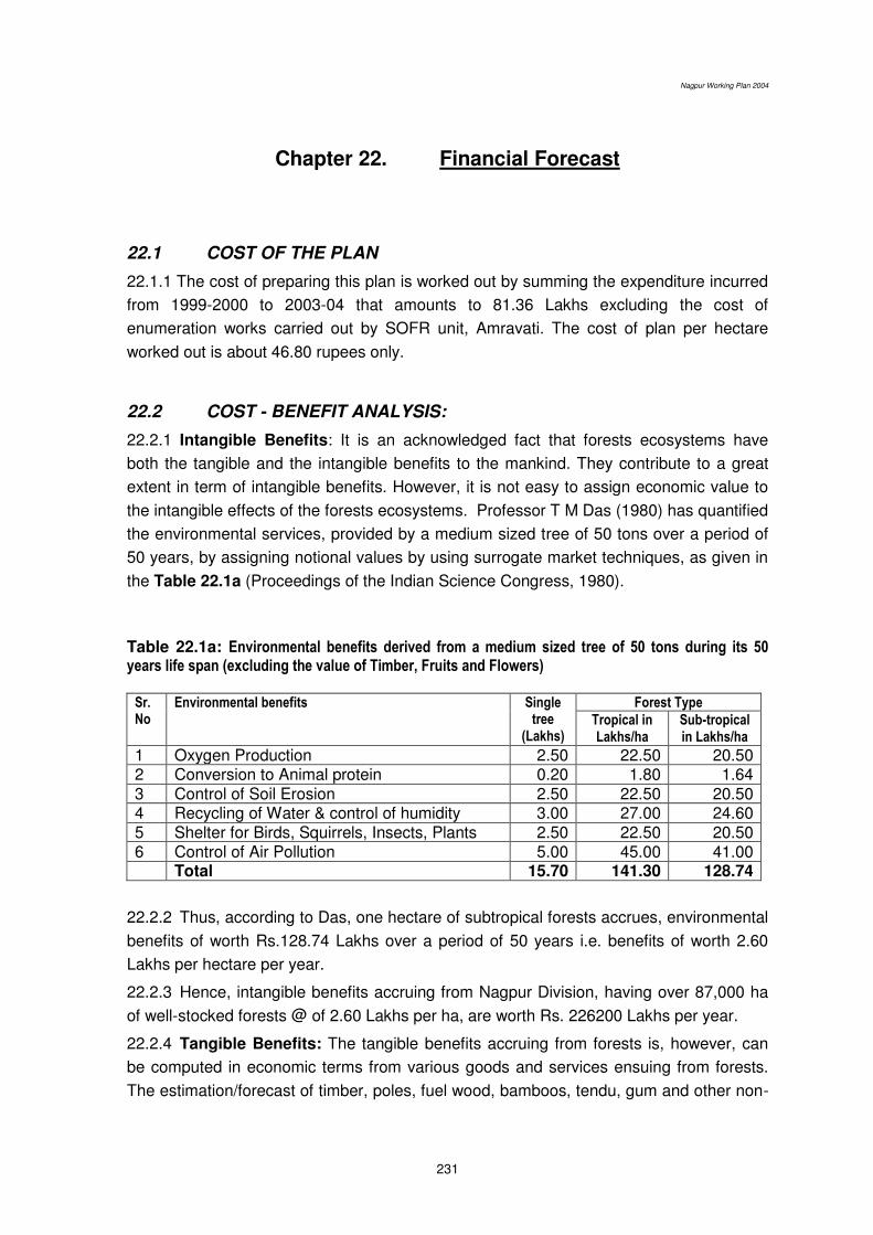
Nagpur Working Plan 2004
231
Chapter 22. Financial Forecast
22.1 COST OF THE PLAN
22.1.1 The cost of preparing this plan is worked out by summing the expenditure incurred
from 1999-2000 to 2003-04 that amounts to 81.36 Lakhs excluding the cost of
enumeration works carried out by SOFR unit, Amravati. The cost of plan per hectare
worked out is about 46.80 rupees only.
22.2 COST - BENEFIT ANALYSIS:
22.2.1 Intangible Benefits: It is an acknowledged fact that forests ecosystems have
both the tangible and the intangible benefits to the mankind. They contribute to a great
extent in term of intangible benefits. However, it is not easy to assign economic value to
the intangible effects of the forests ecosystems. Professor T M Das (1980) has quantified
the environmental services, provided by a medium sized tree of 50 tons over a period of
50 years, by assigning notional values by using surrogate market techniques, as given in
the Table 22.1a (Proceedings of the Indian Science Congress, 1980).
Table 22.1a: Environmental benefits derived from a medium sized tree of 50 tons during its 50 years life span (excluding the value of Timber, Fruits and Flowers)
Sr. No
Environmental benefits Single tree
(Lakhs)
Forest Type
Tropical in Lakhs/ha
Sub-tropical in Lakhs/ha
1 Oxygen Production 2.50 22.50 20.50 2 Conversion to Animal protein 0.20 1.80 1.64 3 Control of Soil Erosion 2.50 22.50 20.50 4 Recycling of Water & control of humidity 3.00 27.00 24.60 5 Shelter for Birds, Squirrels, Insects, Plants 2.50 22.50 20.50 6 Control of Air Pollution 5.00 45.00 41.00 Total 15.70 141.30 128.74
22.2.2 Thus, according to Das, one hectare of subtropical forests accrues, environmental
benefits of worth Rs.128.74 Lakhs over a period of 50 years i.e. benefits of worth 2.60
Lakhs per hectare per year.
22.2.3 Hence, intangible benefits accruing from Nagpur Division, having over 87,000 ha
of well-stocked forests @ of 2.60 Lakhs per ha, are worth Rs. 226200 Lakhs per year.
22.2.4 Tangible Benefits: The tangible benefits accruing from forests is, however, can
be computed in economic terms from various goods and services ensuing from forests.
The estimation/forecast of timber, poles, fuel wood, bamboos, tendu, gum and other non-
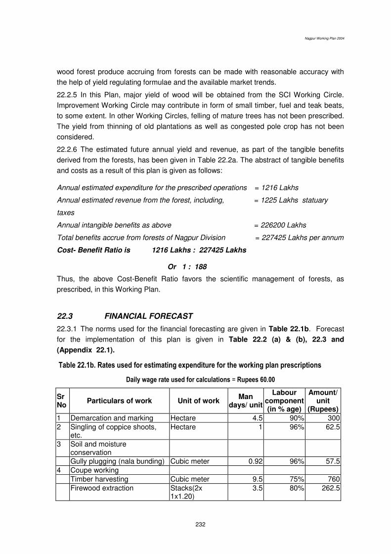
Nagpur Working Plan 2004
232
wood forest produce accruing from forests can be made with reasonable accuracy with
the help of yield regulating formulae and the available market trends.
22.2.5 In this Plan, major yield of wood will be obtained from the SCI Working Circle.
Improvement Working Circle may contribute in form of small timber, fuel and teak beats,
to some extent. In other Working Circles, felling of mature trees has not been prescribed.
The yield from thinning of old plantations as well as congested pole crop has not been
considered.
22.2.6 The estimated future annual yield and revenue, as part of the tangible benefits
derived from the forests, has been given in Table 22.2a. The abstract of tangible benefits
and costs as a result of this plan is given as follows: Annual estimated expenditure for the prescribed operations = 1216 Lakhs
Annual estimated revenue from the forest, including, = 1225 Lakhs statuary
taxes
Annual intangible benefits as above = 226200 Lakhs
Total benefits accrue from forests of Nagpur Division = 227425 Lakhs per annum
Cost- Benefit Ratio is 1216 Lakhs : 227425 Lakhs
Or 1 : 188
Thus, the above Cost-Benefit Ratio favors the scientific management of forests, as
prescribed, in this Working Plan.
22.3 FINANCIAL FORECAST
22.3.1 The norms used for the financial forecasting are given in Table 22.1b. Forecast
for the implementation of this plan is given in Table 22.2 (a) & (b), 22.3 and
(Appendix 22.1).
Table 22.1b. Rates used for estimating expenditure for the working plan prescriptions
Daily wage rate used for calculations = Rupees 60.00
Sr No
Particulars of work Unit of work Man
days/ unit
Labour component (in % age)
Amount/ unit
(Rupees)
1 Demarcation and marking Hectare 4.5 90% 300 2 Singling of coppice shoots,
etc. Hectare 1 96% 62.5
3 Soil and moisture conservation
Gully plugging (nala bunding) Cubic meter 0.92 96% 57.5 4 Coupe working Timber harvesting Cubic meter 9.5 75% 760 Firewood extraction Stacks(2x
1x1.20) 3.5 80% 262.5

Nagpur Working Plan 2004
233
Long Bamboo No. 0.06 80% 4.5 Bamboo bundles No. 0.12 80% 9 5 Removal of wind fallen Timber Cubic meter 9.5 75% 760 Fuel Stacks(2x
1x1.20) 4.5 80% 337.5
6 Thinning Cubic meter 9.5 75% 760 7 Cutback Operations Hectare 6 96% 375 8 Cleaning Hectare 8 96% 500 9 Natural Regeneration Nursing of seedling and
coppice management Hectare 10 96% 625
10 Afforestation /plantation Fencing including live hedge Hectare 43 85% 3035.29 Planting & sowing on fencing Hectare 2 75% 160 PPO/PYO (including fencing) Hectare 60 85% 4235.29 FYO (First year operations) Hectare 95.1 77% 7410.39 SYO (Second year
operations) Hectare 40.9 92% 2667.39
TYO (Third year operations) Hectare 20.7 93% 1335.48 4th YO (Fourth year
operations) Hectare 15.15 93% 977.42
5th YO (Fifth year operations) Hectare 15.15 93% 977.42 11 Bamboo under planting PPO/PYO (including fencing) Hectare 64.5 90% 4300 FYO (First year operations) Hectare 34.65 90% 2310 SYO (Second year
operations) Hectare 20.77 93% 1340
TYO (Third year operations) Hectare 16.53 93% 1066.45 12 Maintenance 13 Road Kilometre 38 95% 2400 14 1/5th boundary demarcation Kilometre 7 80% 525 15 Fire protection Kilometre 6.5 96% 406.25 Fire protection Hectare 1 96% 62.5 16 Joint Forest Management Awareness generation Village 12 20% 3600 Micro plan preparation Village 88 50% 10560 Supplementary development Village 1400 75% 112000 17 Training for NWFP collection Round 30 50% 3600 18 Wildlife habitat improvement Round 20 75% 1600 19 Fixing boundary pillars Kilometre 70 30% 14000 20 Grass & Fodder
Weed extraction and woody growth removal
Hectare 20 93% 1284
*****