‘“The White Men Bought the Forests”: Conservation and Contestation in Guinea-Bissau, West...
14
-
Upload
isa-ulisboa -
Category
Documents
-
view
1 -
download
0
Transcript of ‘“The White Men Bought the Forests”: Conservation and Contestation in Guinea-Bissau, West...

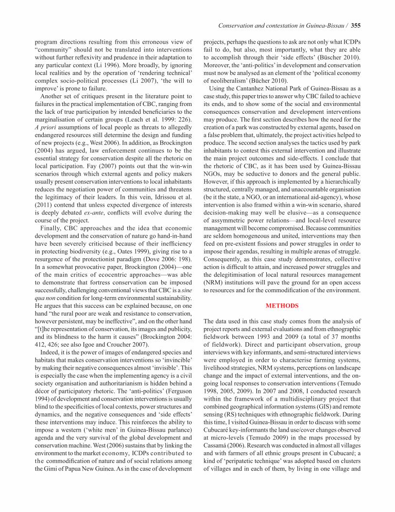
Conservation and Society 10(4): 354-366, 2012
Article
“The White Men Bought the Forests”: Conservation and Contestation in Guinea-Bissau, Western Africa
Marina Padrão Temudo
Tropical Research Institute, Lisbon, Portugal and African Studies Center, University of Oxford, UK
E-mail: [email protected], [email protected]
Copyright: © Temudo 2012. This is an open access article distributed under the terms of the Creative Commons Attribution License, which permits unrestricted use and distribution of the article, provided the original work is cited.
AbstractBoth fortress and community-based approaches to conservation have shown poor (sometimes negative) results in terms of environmental protection and poverty reduction. Either approach can also trigger grassroots resistance. This article is centered on an allegedly ‘community-based’ conservation and development project (and its successive follow-ups) intended to create a national park in Guinea-Bissau. It discusses how external agents have constructed the need for intervention, and explores the negative consequences of the practical solutions adopted for a non-existing problem, as well as the on-going shifting and multiple responses of local people. The article aims to demonstrate that supposedly community-based approaches can be as authoritarian and ineffective as fortress conservation, and that resistance generated by them can be fruitless in terms of collective empowerment and welfare, while also being harmful for the environment. The only genuine winner is the aid industry.
Keywords: conservation approaches, parks, power relations, resistance and compliance, Guinea-Bissau, western Africa
Access this article onlineQuick Response Code:
Website: www.conservationandsociety.org
DOI: 10.4103/0972-4923.105563
INTRODUCTION
Narratives of severe environmental crises—sometimes based on flawed assumptions—have been triggering actions to protect biodiversity hotspots from human destruction (e.g., Leach and Fairhead 2000). This is one of the reasons for the extraordinary increase in the number of protected areas worldwide (West et al. 2006: 252–253). Differences in knowledge, practices, perceptions, representations, and concerns about nature usually generate conflicts among local populations, and between local populations and external actors wishing to introduce new conservation practices. Descriptions of tensions between protected areas inhabitants/neighbors and conservation agents are common in the literature (e.g., Sharpe 1998; Igoe 2004; Igoe and Croucher 2007; Walker and Peters 2007: 75–76;
Sodikoff 2009: 448). ‘Weapons of the weak’ (Scott 1985) used by rural populations to oppose conservation measures include poaching, setting fires, and harvesting of wood and other natural resources. In Africa, as also illustrated by this case study, collective outright struggle has been uncommon (see West cited in Brockington 2004: 415; Igoe 2004: 19, 22; Idrissou et al. 2011).
Community-based conservation (CBC) approaches and integrated conservation and development projects (ICDPs) were adopted since the 1990s, although their implementation faced several and complex difficulties, failing in numerous instances to attain their objectives (e.g., Dove 2006: 198). Among the critiques raised by scholars to CBC and ICDPs, some are particularly interesting for the case study at hand. Perhaps the most common (e.g., Sharpe 1998; Agrawal and Gibson 1999) is the lack of questioning of the very concept of “community”—one that has been associated with the idea of small, territorially-bounded social groups, homogeneous in social structure, and sharing norms and interests. However, Li (1996) contends that this idealised representation was strategically conceived within the framework of political struggles aimed at defending the resource rights and livelihoods of powerless people. Nonetheless, broad policy shifts and
Conservation and contestation in Guinea-Bissau / 355
program directions resulting from this erroneous view of “community” should not be translated into interventions without further reflexivity and prudence in their adaptation to any particular context (Li 1996). More broadly, by ignoring local realities and by the operation of ‘rendering technical’ complex socio-political processes (Li 2007), ‘the will to improve’ is prone to failure.
Another set of critiques present in the literature point to failures in the practical implementation of CBC, ranging from the lack of true participation by intended beneficiaries to the marginalisation of certain groups (Leach et al. 1999: 226). A priori assumptions of local people as threats to allegedly endangered resources still determine the design and funding of new projects (e.g., West 2006). In addition, as Brockington (2004) has argued, law enforcement continues to be the essential strategy for conservation despite all the rhetoric on local participation. Fay (2007) points out that the win-win scenarios through which external agents and policy makers usually present conservation interventions to local inhabitants reduces the negotiation power of communities and threatens the legitimacy of their leaders. In this vein, Idrissou et al. (2011) contend that unless expected divergence of interests is deeply debated ex-ante, conflicts will evolve during the course of the project.
Finally, CBC approaches and the idea that economic development and the conservation of nature go hand-in-hand have been severely criticised because of their inefficiency in protecting biodiversity (e.g., Oates 1999), giving rise to a resurgence of the protectionist paradigm (Dove 2006: 198). In a somewhat provocative paper, Brockington (2004)—one of the main critics of ecocentric approaches—was able to demonstrate that fortress conservation can be imposed successfully, challenging conventional views that CBC is a sine qua non condition for long-term environmental sustainability. He argues that this success can be explained because, on one hand “the rural poor are weak and resistance to conservation, however persistent, may be ineffective”, and on the other hand “[t]he representation of conservation, its images and publicity, and its blindness to the harm it causes” (Brockington 2004: 412, 426; see also Igoe and Croucher 2007).
Indeed, it is the power of images of endangered species and habitats that makes conservation interventions so ‘invincible’ by making their negative consequences almost ‘invisible’. This is especially the case when the implementing agency is a civil society organisation and authoritarianism is hidden behind a décor of participatory rhetoric. The ‘anti-politics’ (Ferguson 1994) of development and conservation interventions is usually blind to the specificities of local contexts, power structures and dynamics, and the negative consequences and ‘side effects’ these interventions may induce. This reinforces the ability to impose a western (‘white men’ in Guinea-Bissau parlance) agenda and the very survival of the global development and conservation machine. West (2006) sustains that by linking the environment to the market economy, ICDPs contributed to the commodification of nature and of social relations among the Gimi of Papua New Guinea. As in the case of development
projects, perhaps the questions to ask are not only what ICDPs fail to do, but also, most importantly, what they are able to accomplish through their ‘side effects’ (Büscher 2010). Moreover, the ‘anti-politics’ in development and conservation must now be analysed as an element of the ‘political economy of neoliberalism’ (Bücher 2010).
Using the Cantanhez National Park of Guinea-Bissau as a case study, this paper tries to answer why CBC failed to achieve its ends, and to show some of the social and environmental consequences conservation and development interventions may produce. The first section describes how the need for the creation of a park was constructed by external agents, based on a false problem that, ultimately, the project activities helped to produce. The second section analyses the tactics used by park inhabitants to contest this external intervention and illustrate the main project outcomes and side-effects. I conclude that the rhetoric of CBC, as it has been used by Guinea-Bissau NGOs, may be seductive to donors and the general public. However, if this approach is implemented by a hierarchically structured, centrally managed, and unaccountable organisation (be it the state, a NGO, or an international aid-agency), whose intervention is also framed within a win-win scenario, shared decision-making may well be elusive—as a consequence of assymmetric power relations—and local-level resource management will become compromised. Because communities are seldom homogeneous and united, interventions may then feed on pre-existent fissions and power struggles in order to impose their agendas, resulting in multiple arenas of struggle. Consequently, as this case study demonstrates, collective action is difficult to attain, and increased power struggles and the delegitimisation of local natural resources management (NRM) institutions will pave the ground for an open access to resources and for the commodification of the environment.
METHODS
The data used in this case study comes from the analysis of project reports and external evaluations and from ethnographic fieldwork between 1993 and 2009 (a total of 37 months of fieldwork). Direct and participant observation, group interviews with key informants, and semi-structured interviews were employed in order to characterise farming systems, livelihood strategies, NRM systems, perceptions on landscape change and the impact of external interventions, and the on-going local responses to conservation interventions (Temudo 1998, 2005, 2009). In 2007 and 2008, I conducted research within the framework of a multidisciplinary project that combined geographical information systems (GIS) and remote sensing (RS) techniques with ethnographic fieldwork. During this time, I visited Guinea-Bissau in order to discuss with some Cubucaré key-informants the land use/cover changes observed at micro-levels (Temudo 2009) in the maps processed by Cassamá (2006). Research was conducted in almost all villages and with farmers of all ethnic groups present in Cubucaré; a kind of ‘peripatetic technique’ was adopted based on clusters of villages and in each of them, by living in one village and
356 / Temudo
working there and in the ones around for relatively small periods of time (around two weeks in each cluster). During the first two years of fieldwork I also participated in project meetings (trying to scale up), but some of the comments I made to the NGO staff about the problems the project was facing, made me a persona non grata. My publications reinforced their idea and after the creation of the park, I was no longer allowed to conduct research inside the park, despite the will of farmers and the local state representative (presidente de sector). Since then, many farmers tried to keep me informed of what is happening by meeting me outside the park or over the telephone. Most of their statements were also confirmed by personal communication with my colleagues Joana Roque de Pinho and Joana Sousa, who are now doing fieldwok on the park. In order to protect their identities, the names of the informants are not provided in this paper. All quotations are translated from Kriol by me.
CONSTRUCTING A NEED FOR INTERVENTION: THE LAST SUB-HUMID FORESTS
OF GUINEA-BISSAU
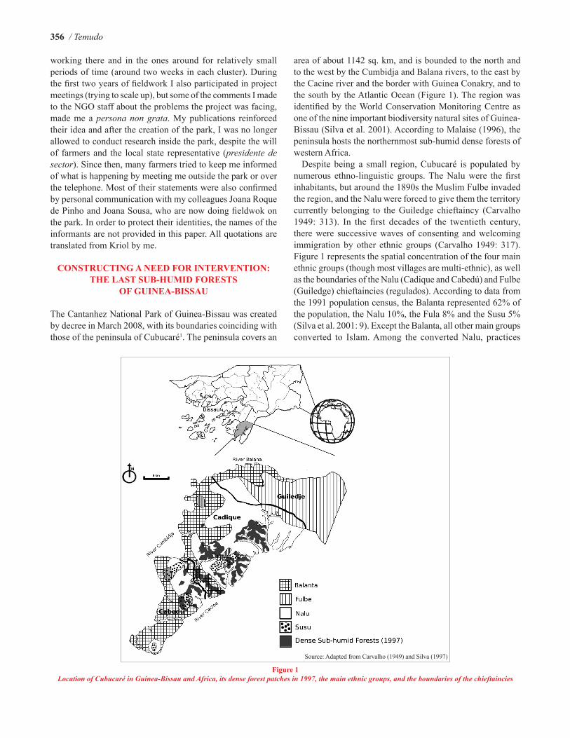
The Cantanhez National Park of Guinea-Bissau was created by decree in March 2008, with its boundaries coinciding with those of the peninsula of Cubucaré1. The peninsula covers an
area of about 1142 sq. km, and is bounded to the north and to the west by the Cumbidja and Balana rivers, to the east by the Cacine river and the border with Guinea Conakry, and to the south by the Atlantic Ocean (Figure 1). The region was identified by the World Conservation Monitoring Centre as one of the nine important biodiversity natural sites of Guinea-Bissau (Silva et al. 2001). According to Malaise (1996), the peninsula hosts the northernmost sub-humid dense forests of western Africa.
Despite being a small region, Cubucaré is populated by numerous ethno-linguistic groups. The Nalu were the first inhabitants, but around the 1890s the Muslim Fulbe invaded the region, and the Nalu were forced to give them the territory currently belonging to the Guiledge chieftaincy (Carvalho 1949: 313). In the first decades of the twentieth century, there were successive waves of consenting and welcoming immigration by other ethnic groups (Carvalho 1949: 317). Figure 1 represents the spatial concentration of the four main ethnic groups (though most villages are multi-ethnic), as well as the boundaries of the Nalu (Cadique and Cabedú) and Fulbe (Guiledge) chieftaincies (regulados). According to data from the 1991 population census, the Balanta represented 62% of the population, the Nalu 10%, the Fula 8% and the Susu 5% (Silva et al. 2001: 9). Except the Balanta, all other main groups converted to Islam. Among the converted Nalu, practices
Figure 1Location of Cubucaré in Guinea-Bissau and Africa, its dense forest patches in 1997, the main ethnic groups, and the boundaries of the chieftaincies
Source: Adapted from Carvalho (1949) and Silva (1997)

Conservation and contestation in Guinea-Bissau / 357
linked to local spirits and ancestors coexist with a Muslim religious culture.
The process that resulted in the creation of the park began in 1992, when three NGOs newly created by previous public servants—following the course of political and economic liberalisation (see Temudo 2005)—decided to implement a project aimed to ‘Safeguard the last sub-humid forests of Cantanhez’ with the support of the local office of the International Union for Conservation of Nature (IUCN) and several other donors. In the project proposal it was claimed that “repressive measures” (administrative and legislative) were compatible with the “full participation of the population in every stage of the project” (AD et al. 1992: 28, author translation from Portuguese). As so, it aimed to “rehabilitate, review and update” the former colonial legal statutes that
defined the forests of Cantanhez as a “nature reserve” (AD et al. 1992: 29, author translation from Portuguese).
A full range of development and conservation activities was proposed by the project (AD et al. 1992: 9)—studies of flora and fauna biodiversity; delimitation of the boundaries of the sub-humid dense forest reserves; credit schemes for the rehabilitation of swamp rice polders; the diffusion of mango orchards, and of valley-swamp rice production in order to reduce slash-and-burn upland rice cultivation; support for the creation of farmers’ associations; support for fishing and apiculture initiatives; promotion of eco-tourism; advances in health services; and environmental education and sensitisation, including the creation of forest community guards and forest management committees. Nonetheless, the project only invested a small share (29%) of its budget in development
Figure 2Forest cover change in the peninsula of Cubucaré between 1953 and 2003.; 1: Boundaries of the dense forest patches demarcated by Silva in 1997;
2: Forests; 3: Savannah woodlands
Source: Adapted from Cassamá (2006) and Silva (1997)

358 / Temudo
activities, as most of the funds were assigned to salaries, per diems, fees, houses, and vehicles (AD et al. 1992: 45).
The strategies used by the NGOs to obtain initial compliance by local populations included the concealment of future negative livelihood outcomes of the project (e.g., restrictions in resource use, evictions of inhabitants living in core zones and fauna corridors), and the use of a win-win scenario in which inhabitants would be compensated through ecotourism gains (see Igoe and Croucher 2007, for the use of similar strategies in another context). The need for intervention was constructed around the argument of a growing rate of deforestation of the ‘last relics’ of the Cantanhez sub-humid forest (that had to be protected from population growth and shifting cultivation), and an implicit assumption that no NRM institutions existed in place. In what follows, I analyse the inconsistencies inherent in the project’s discourse on ‘environmental crisis’, and reveal that this case is—as Goldman (2011: 65) would put it—one more ‘conservation opportunity lost’.
Forest depletion
Rapid tropical deforestation is one of the primary causes of global climate change and biodiversity loss. For this reason, crises narratives have a high currency in the aid-market. Before Cassamá (2006) conducted his master’s thesis research on land-cover changes in Cubucaré, all statements by conservationists, development agents, and scholars on the alleged Cantanhez deforestation crisis were based on rough and biased estimates of forest cover change. Malaise (1996: 72)—a renowned Belgian botanist who carried out numerous studies in collaboration with the Guinea-Bissau development and conservation NGOs—uncritically quotes the National Forestry Master Plan of 1992, where it is stated that there has been a decrease in the area occupied by the sub-humid dense forests of Cubucaré from 177,500 ha in 1978 to 135,431 ha in 1985. However, the entire peninsula has a surface of only 114,200 ha; furthermore, according to oral history, it has never been entirely covered by forests.
Cassamá (2006) created land cover vegetation maps, spanning a period of 50 years, from the aerial photography map of reference (1953) and the Landsat satellite images MSS (1973), TM (1986, 1994) and ETM+ (2000, 2003). The story revealed by observing the maps is a perfect counter-narrative of the Cubucaré deforestation crisis. Figure 2 shows the evolution of forest cover throughout the years under study, and traces its relation to the dense sub-humid forest patches identified and mapped by Silva (1997).
By analysing the 1953 map elaborated by Cassamá (2006), complemented with data from oral history accounts, one can describe the peninsula’s landscape as being constituted 50 years ago by parallel strips of different land-cover types. Along the full length of the peninsula we have: i) in the Cacine river bank strip, mangroves, few mangrove swamp rice fields, most of the dense forest patches (77.6% of the area mapped by Silva in 1997), and a few upland agricultural fields; ii) in the central strip, a mosaic of small patches of dense forests,
savannah woodlands and grasslands, and upland agricultural fields; and iii) in the Cumbidja and the Balana river banks strip, mangroves, a very large expanse of mangrove swamp rice fields, savannah woodlands and grasslands.
On the contrary, if the analysis is done on strips perpendicular to the length of the peninsula, the divisions one can make in relation to particular land cover mosaics are approximately coincident with the chieftaincies: i) in the northeastern Guiledge chieftaincy, the landscape is constituted by a great concentration of savannah woodlands and grasslands, small forest patches, and upland agricultural lands; ii) in the central Cadique chieftaincy, in contrast, we find the greatest concentration, and the biggest patches, of dense forest (mostly along the Cacine river bank; Figure 1); iii) in the southern Cabedú chieftaincy, the territory is constituted by the largest cover of mangrove forests (on the Cacine river side and the southern edge), the biggest area of mangrove swamp rice fields (on the Cumbidja river side), few and small dense forest patches, savannah, and upland agricultural fields.
By observing the six maps elaborated by Cassamá (2006) one can conclude that, over the past 50 years, although the above described double landscape fragmentation in parallel strips remained relatively stable, profound changes have also occurred. The first striking conclusion is that the forest cover of Cubucaré grew from 1953 to 1986, particularly in the Guiledge chieftaincy and in the central longitudinal strip of the peninsula where the most complex mosaic of land cover types were found. From 1986 onwards, these same locations have presented alternate processes of thinning and thickening of ‘forest’ cover. Cassamá (2006: 92–93) shows that “the main changes [in the forest cover] occurred around settlements and along the main roads”.
More importantly, if we overlap the dense forest patches delineated by Silva (1997)—that were later defined as reserves for the future park—on Cassamá’s maps we have to conclude that, during the fifty years under study, there has not been a thinning (as claimed by the project proponents), but, on the contrary, a thickening of the core forest patches and an enlargement of the forest area around them (Figure 2). In what follows, I will explain the constellation of forces that have fashioned this outcome.
Population growth and shifting cultivation
In the last 50 years, the population of Cubucaré increased from about 10,000 inhabitants in 1949 (Carvalho 1949: 308) to more than 25,000 by 2007 (INEP and INEC 2007). Figure 3 shows a concentration of the population along the banks of Balana and Cumbidja rivers, where the Balanta population is settled (see also Figure 1), and where the more productive mangrove swamp rice fields are located. In contrast, the margins of the Cacine river—where the mangrove soils are rocky and infertile, and where the majority of the dense forest patches are situated—are sparsely populated. While the Balanta villages were in the savannas that border the mangrove rice fields, during colonial times, most settlements of other ethnic
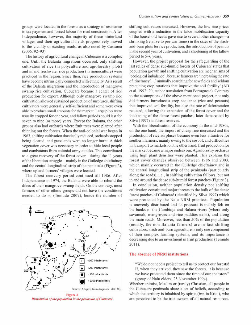
Conservation and contestation in Guinea-Bissau / 359
groups were located in the forests as a strategy of resistance to tax payment and forced labour for road construction. After Independence, however, the majority of these hinterland villages and their agricultural fields progressively moved to the vicinity of existing roads, as also noted by Cassamá (2006: 92–93).
The history of agricultural change in Cubucaré is a complex one. Until the Balanta migrations occurred, only shifting cultivation of rice (in polyculture and agroforestry plots) and inland freshwater rice production (in monoculture) were practiced in the region. Since then, rice production systems have become intrinsically connected with ethnicity. As a result of the Balanta migrations and the introduction of mangrove swamp rice cultivation, Cubucaré became a center of rice production for export. Although only mangrove swamp rice cultivation allowed sustained production of surpluses, shifting cultivators were generally self-sufficient and some were even able to produce small amounts for the market. Large plots were usually cropped for one year, and fallow periods could last for seven to nine (or more) years. Except the Balanta, the other groups also had orchards where fruit trees were planted after thinning out the forests. When the anti-colonial war began in 1963, shifting cultivation drastically reduced, orchards stopped being cleared, and grasslands were no longer burnt. A thick vegetation cover was necessary in order to hide local people and combatants from colonial army attacks. This contributed to a great recovery of the forest cover—during the 11 years of the liberation struggle—mainly in the Guiledge chieftaincy and the central longitudinal strip of the peninsula (Figure 2), where upland farmers’ villages were located.
The forest recovery period continued till 1986. After Independence in 1974, the Balanta were able to rebuild the dikes of their mangrove swamp fields. On the contrary, most farmers of other ethnic groups did not have the conditions needed to do so (Temudo 2009), hence the number of
shifting cultivators increased. However, the low rice prices coupled with a reduction in the labor mobilisation capacity of the household heads gave rise to several other changes—a shrinking (relative to pre-war times) in the sizes of the slash-and-burn plots for rice production; the introduction of peanuts in the second year of cultivation; and a shortening of the fallow period to 5–6 years.
However, the project proposal for the safeguarding of the last relics of dense sub-humid forests of Cubucaré states that population growth and shifting cultivation are mechanisms of ‘ecological imbalance’, because farmers are ‘increasing the rate of itinerancy[…] annually searching for new fields and seldom practicing crop rotations that improve the soil fertility’ (AD et al. 1992: 20, author translation from Portuguese). Contrary to the assumptions of the above mentioned project, not only did farmers introduce a crop sequence (rice and peanuts) that improved soil fertility, but also the rate of deforestation reduced, allowing the expansion of the forest cover and the thickening of the dense forest patches, later demarcated by Silva (1997) as forest reserves.
With the liberalisation of the economy in the mid-1980s, on the one hand, the import of cheap rice increased and the production of rice surpluses became even less attractive for southern farmers, mainly owing to the cost of, and difficulties in, transport to markets; on the other hand, fruit production for the market became a major endeavour. Agroforestry orchards using high plant densities were planted. This explains the forest cover changes observed between 1986 and 2003, which mainly occurred in the Guiledge chieftaincy and in the central longitudinal strip of the peninsula (particularly along the roads), i.e., in shifting cultivation fallows, but not in and around the dense sub-humid forest patches (Figure 3).
In conclusion, neither population density nor shifting cultivation constituted major threats to the bulk of the dense forest patches of Cubucaré (identified by Silva 1997) which were protected by the Nalu NRM practices. Population is unevenly distributed and its pressure is mainly felt on the banks of the Cumbidja and Balana rivers (where only savannah, mangroves and rice paddies exist), and along the main roads. Moreover, less than 50% of the population (mostly, the non-Balanta farmers) are in fact shifting cultivators; slash-and-burn agriculture is only one component of their complex farming systems, and its importance is decreasing due to an investment in fruit production (Temudo 2011).
The absence of NRM institutions
“We do not need a project to tell us to protect our forests! If, when they arrived, they saw the forests, it is because we have protected them since the time of our ancestors” (group of Nalu elders, 25 November 1994).
Whether animist, Muslim or (rarely) Christian, all people in the Cubucaré peninsula share a set of beliefs, according to which the territory is inhabited by spirits (ira, in Kriol), who are perceived to be the true owners of all natural resources.
Figure 3Distribution of the population in the peninsula of Cubucaré
Source: Adapted from Anginot (1989: 38)
360 / Temudo
The world of the iras is divided into several regions whose boundaries are clearly defined—what several anthropologists have called ‘spirit provinces’ (e.g., Crowley 1990). In each of these ‘spirit provinces’, access to land and to other natural resources is controlled by a Nalu djagra, the head of the founding descent group that putatively arrived first, establishing a contract with the ira that owns all natural resources in the territory.
Concerning the relationship between humans and nature, Nalu cosmology is based on a set of rules that help maintain an ecological balance (Temudo 1998: Volume I—434–435). Within each ‘spirit province’, the territory is divided into three major classes—i) land belonging to each village for housing and for cultivation; ii) the ‘sacred forests’ (matu malgosse)2, which are small forest niches (located in the dense sub-humid forests), where the shrines are placed; and iii) forest areas that function as buffer zones surrounding the ‘sacred forests’. Access to these buffer forest areas is surrounded by a magico-religious aura that limits the entry and use of resources. These areas are also considered land reserves, which can, in the future, be partially distributed for agricultural use. According to tradition, any household group living in the region has right of access to a plot of land large enough to ensure the sustenance of its members. Neither land nor trees are considered commodities and therefore cannot be sold (Temudo 2005).
Over time, the dense sub-humid forests along the Cacine river have been safeguarded by the Nalu system of NRM. Moreover, in the memory of elders, the savannah longitudinal strip along the Cumbidja and Balana rivers was in fact larger and less woody in the past. The larger pressure exerted by a growing population—coupled with the above mentioned increase in the number of shifting cultivators after the war—led to changes in the rules for attributing land to newcomers, aimed at controlling the reduction of the buffer zones around the ‘sacred forests’ (Temudo 2009). Although the region had effective NRM institutions, the documents of the project for the safeguarding of Cubucaré’s dense forests did not mention them. Instead, in the external agents’ vision, farmers’ associations and NGOs would become the main ‘protagonists’ of the project (AD et al. 1992: 4, 43). Another document argued that one of the goals of the project was ‘to show that the protection of the forests is dependent upon the participation of organised communities (interest groups and associations)’ (AD 1992: 10, author translation and author emphasis). The reality, however, was quite different. Not only were the leaders of the associations generally perceived as unaccountable by their members (see Temudo 1998: Volume II—95–109), but also the djagras were until then considered by the entire population of Cubucaré to be legitimate managers of all natural resources. It was precisely the delegitimisation of the djagras and the destruction of the symbolic value and ‘magical aura’ of the dense forests that took place in conjunction with it, that was vital in creating the belief that forests could be bought by the conservationist outsiders—the ‘white men’. As illustrated in the next section, the erosion of the power of the djagras in NRM and the increased power struggles among stakeholders paved the ground for open access
to resources, and the commodification of the relationship between park inhabitants and the environment.
A WEB OF TACTICS: RESISTANCE, COMPLIANCE,
BRIBES, AND SALARIES
One of the elders dreamed that the white men were coming in order to buy our forests, but we convened a secret meeting [at a shrine] to make an end to the project (Nalu elder, 21 May 1994).We are black men, we have courage to face a war, but we do not have courage to say the truth! When a problem arises we prefer to go to a marabout or to the shrines (Jakanke elder, 15 May 1996).Everyone who stands up to organise a revolt is ‘bought’ [bribed] by the NGOs. This thing [bribes] was sown like a plant and nobody can put an end to it anymore! (Susu young man3, 1 April 2009).
The Nalu hegemony over the management of natural resources in the Cadique and Cabedu chieftaincies prevails in a framework of legal pluralism, and of permanent adaptability and negotiation of power. In the Guiledge chieftaincy, where the Fulbe are considered to be the landlords since the early colonial occupation, there is a purely material relationship with natural resources, and there are no ‘sacred forests’. However, the fear of the iras may prevent the clearing of some forest patches.
In the local worldview, contracts with the iras are the source of most power, wealth, and fame. All important politicians, all famous and invincible war combatants, all rich people, all scientists are said to obtain their power through iras. In the course of many years of fieldwork, I have heard countless stories of local people accused of having more children, more cows, gold items and the like, through such contracts with the iras. Stories were also told about the way some colonial officials were able to bring powerful iras to Europe, either by offering them better contracts, or by tricking them to enter a bottle, thus getting captured, and being easily transported. The djagras are also said to have obtained their power to manage natural resources through contracts with the iras. These must be renewed periodically by the observance of certain rituals. However, Nalu conversion to Islam led to either the gradual abandonment of certain ritual practices (such as libations with alcoholic beverages), or an increase of secrecy around others.
Religion has been used by the more Islamised ethnic groups as a political weapon to challenge Nalu hegemony over the territory and their NRM system. Islamisation has also led to an increased demand for wealth, and to a greater individualism, something that is against the ethics of the Nalu NRM. These tensions over the rules of access to natural resources, not only set the Nalu against the other ethnic groups, but also the Nalu elders against the more Islamised, individualistic, and cash-oriented youth. Nonetheless, until the project started, violations of the main rules of access and use of resources (e.g., slash-and-

Conservation and contestation in Guinea-Bissau / 361
burn of a new forest plot without permission of the djagra or the selling of land or trees) were either subject to huge fines and punishments imposed by traditional authorities, or marked by a sequence of misfortunes, and even death, allegedly imposed by the iras (Temudo 1998: Volume I—450–453).
Farmers’ reactions to this particular project, for the safeguarding of the dense forests of Cubucaré, were also permeated by their perception of the difference between post-war and post-liberalisation external interventions. As other scholars have showed, the way people perceive and respond to new interventions is strongly influenced by former experiences—what has been called ‘historical imprint’ (Long and van der Ploeg 1989: 230)—and by relations of power among stakeholders, as will become evident below.
After Independence, donors and international solidarity organisations made offerings of food, clothes, radios, trucks, etc. In the neoliberal era, farmers observed the continuing increase in wealth of national development agents (mainly high-ranking staff of NGOs). On the contrary, for them most of the activities of the development and conservation projects were implemented through credit schemes. ‘This is not aid; this is business!’ some farmers argued. However, as commonly stated, ‘a well with little water is better than a dry one!’; new projects also meant that roads were going to be maintained, for ‘with bad roads, no trucks will come and we cannot sell our fruit’4. Further, post-colonial interventions also created a dependency attitude among rural populations by promoting the idea that their problems can only be solved with external aid (Temudo 1998: Volume II—63–153). So, even when farmers perceived new projects as providing no advantages—even those contrary to their own interests—they accepted them at first, but later began complaining and making demands.
Reactions by farmers to projects and/or project activities perceived as contrary to their interests and needs seldom assumed the form of collective action, and when that happened it was sporadic and momentary. Many reasons were given to explain their constant vocal manifestations of discontent and their lack of organised reactions. First, they are a multi-ethnic society and collective organisation is difficult to achieve; second, although they compete for funding, NGOs also defend each other from external attacks and if the farmers protested too much against the NGOs that were implementing projects at that time, these NGOs would ‘destroy their [farmers’] prestige’ and other, ‘good’ NGOs would not come to the region anymore in the future; third, only few project beneficiaries were ‘invited’ to meetings and to talk with donors, and the rest of the population believed they had no right to attend meetings and to protest; fourth, the project beneficiaries could interpret the protest of other farmers as an expression of envy, and react against the plaintiffs causing them misfortunes by using magic (djanfa); fifth, they claimed that magic could also be used to terminate a particularly ‘bad’ project, or to remove or make ill, a greedy, unaccountable external agent (for the case of Madagascar, see Sodikoff 2009: 443).
In the first phase of the project for the safeguarding of the dense forests of Cubucaré (1993–1997) different sources of
tension and different stakeholders emerged (Temudo 1998: Volume II—113–119). The Nalu did not feel the need for a project that would tell them how to protect their forests. Elders also suspected that the true—if undeclared—aim of external agents and donors was to steal their most powerful iras. This suspicion was reinforced by the fact that external agents and scientists working for the project entered the forests without obtaining permission from the djagras and without being accompanied by one of their representatives. Moreover, for easy location of the studied plots, botanists frequently marked some trees with red ink, and buried iron bars in forest areas that they wanted to monitor in the future, and both items (red colour and iron) are connected to the establishment of contracts with the iras. The djagras also considered that the NGOs and the leaders of the main farmers’ association bypassed them, both in the decision-making stage for the project approval and in the nomination of forests guards5, which were chosen by the NGOs from among members of all ethnic groups. These nominations were thought to bestow power on people from other ethnic groups, whose members do not enjoy the same cosmological relation to the forests, and whose objective is to maximise resource use.
The second group of stakeholders was composed of the shifting cultivators of all ethnic groups (the Nalu included) who considered that the project did not offer them any training, or any economic benefits that could compensate for abandoning slash-and-burn agriculture. They also complained that planting mangoes and growing freshwater swamp rice were not alternative production strategies, especially because the price of rice had increased a lot locally in recent years during pre-harvest times, because freshwater swamp rice has several production constraints (besides being grown as a monoculture). Additionally, only a few farmers were benefiting from project support to produce mangoes. Considering that the project aimed to reduce shifting cultivation and forbade hunting of the most important crop pests (namely wild pigs, and monkeys), farmers also requested metallic fences to protect their fields.
Another group with a stake in the project was the community forest guards created by the NGOs. They wanted to be paid a salary, and to be provided with uniforms and credentials that would reinforce their authority. To the guards, the 1,000 USD salary paid to the project’s young coordinator in 1993 was simply unacceptable, as they were not being paid any salary at all. The NGOs’ head staff sustained that they did not want to transform the guards into public servants, for they should work for the common good of the community and be paid later by tourists. Indeed, as Sodikoff (2009: 451) remarked, the logic of the ‘common good’ is hard to accept by a conservation ‘worker-peasant’, who is either unpaid or under-paid. Further, the project puts them in an ambiguous situation, not only because they belong to the societies they are supposed to control, but also because many are themselves shifting cultivators, hunters, fan-palm tree wine tappers who may have to incur transgressions to secure their own livelihoods.
Besides the guards, many other farmers wanted the project coordinator to be replaced because he showed lack of
362 / Temudo
engagement, displayed an arrogant attitude towards farmers, and received a huge salary and other amenities that had a negative effect on the project budget. In 1995, farmers started to complain about the meagre economic compensations and the reduced number of beneficiaries of the project activities, while the creation of the park was having a negative impact on the livelihoods of all Cubucaré inhabitants. Moreover, the delimitation by the project of forest reserves exceeding the area traditionally interdicted by the djagras was considered unacceptable. Finally, the NGOs’ claims about the project achievements, broadcasted in one urban radio station, were also severely criticised, for they were considered to be propaganda and outright lies.
Other stakeholders, the beneficiaries of the project actions, held an ambiguous position that changed according to circumstances. They were usually selected by the NGOs to praise project achievements in front of donors’ representatives and thus became nicknamed the project ‘praise singers’ (djidios) by the rest of the population, in an analogy to traditional Mande praise singers of kings and ‘big men’. However, in project meetings and in informal conversations they protested about the totally unfavorable credit conditions and the meagre benefits brought by the project.
The implementation of the project for the safeguarding of the dense forests of Cubucaré coincided with the discussion of the new national land law and with the availability of
credit facilities for ‘modern’, large scale agriculture. These formulations caused a land rush by the ruling elite in other parts of the country, and provoked conflicts between smallholders and land concessionaires (Tanner 1991). Among the Cubucaré villagers, the fear that both the future park and the new land law could allow the usurpation of household land assets—such as long-lasting fallows and plots never previously deforested—led to the development of several land tenure security strategies. Among them was the division, through inheritance mechanisms, of all household land that was then attributed to every married and unmarried male son, who could promptly begin planting orchards; or the thinning out of the forest canopy to plant some cashew trees as land markers. But the djagras also felt they had to take measures, and began attributing land parcels (mostly to people of their own descent groups) inside forests that, until then, had been kept as land reserves for use by future generations and/or migrants. In sum, land insecurity promoted a ‘forest rush’.
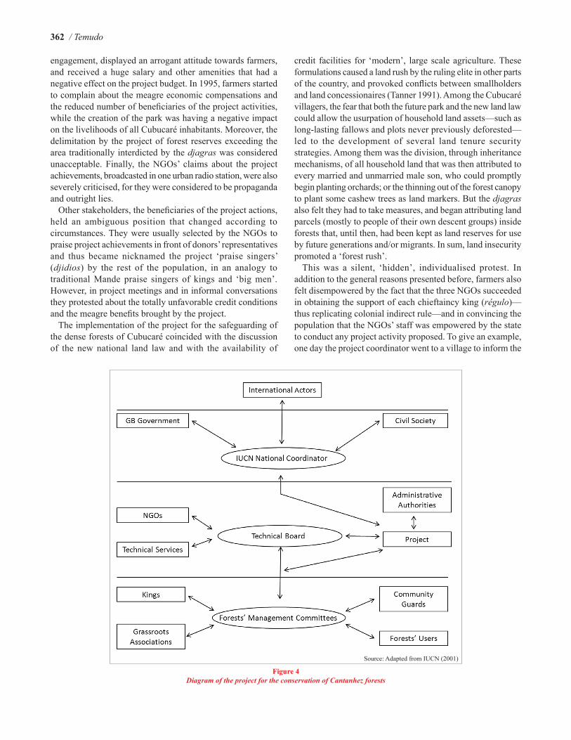
This was a silent, ‘hidden’, individualised protest. In addition to the general reasons presented before, farmers also felt disempowered by the fact that the three NGOs succeeded in obtaining the support of each chieftaincy king (régulo)—thus replicating colonial indirect rule—and in convincing the population that the NGOs’ staff was empowered by the state to conduct any project activity proposed. To give an example, one day the project coordinator went to a village to inform the
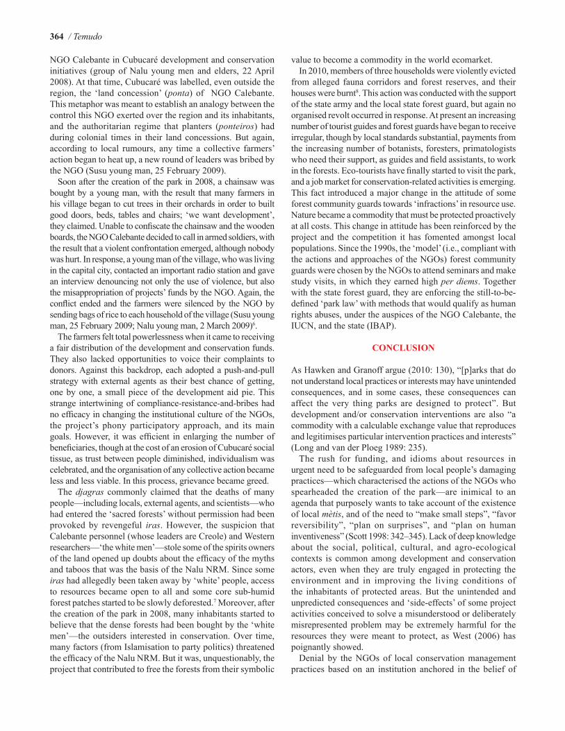
Figure 4Diagram of the project for the conservation of Cantanhez forests
Source: Adapted from IUCN (2001)

Conservation and contestation in Guinea-Bissau / 363
inhabitants that researchers would be coming soon to study the surrounding forest. Because the forest housed an important shrine, the elders standing for the djagra said they would not authorise such a study. The project coordinator then replied that with or without their authorisation, the researchers would enter the forests because they were entitled to do so by the state, and even if the elders tried to prevent it, the NGOs were going to use airplanes in order to take photographs of the forests (group of Nalu elders, 1 May 1996).
Finally, in 1996, these unsolved tensions between the population and the three NGOs came to a head, and caused the farmers to revolt more openly. Contrary to the recommendations of the NGOs—who wanted the forests along main roads to be protected and agricultural fields to be located in the hinterlands far from the view of donors—farmers started to slash-and-burn rice plots along the main roads (a process also observed in remote sensing images by Cassamá 2006). This response happened at a very critical moment when the NGOs were negotiating with donors the funding of the second phase of the project (Iniciativa de Cantanhez 1996).
In 1998, after the above mentioned project was interrupted for two years—allegedly due to disagreements among the three NGOs—the representatives of the IUCN in Guinea-Bissau began efforts to provide continuity to the previous attempt to create a national park in Cubucaré (IUCN 2000: 1). But the civil war of 1998–1999 interrupted this process, contributing to new developments in local power relations. After the end of the conflict, the African Party for the Liberation of Guinea (PAIGC) was for the first time overthrown since Independence. The victory of a party composed of a Balanta majority—an ethnic group with long-lasting grievances against the PAIGC, the party still supported by the Nalu—introduced a major challenge to the management of Cubucaré’s natural resources. ‘The land has no owners now!’ was a common statement made by the Balanta, as they tried to open up access to the forests for the creation of orchards. The roads were also totally impassable due to lack of maintenance for two years. Therefore, when the IUCN staff contacted the Nalu kings to proceed with the project to classify the Cubucaré peninsula as a park, the initiative was well received by the Nalu elders. The project management continued to be in the hands of one of the previous NGOs (pseudonym Calebante) and it maintained the same hierarchical structure (Figure 4) and top-down decision-making. The djagras remained bystanders, while the kings, the forest community guards, and the leaders of farmers’ associations were considered the main project partners; only ‘invited’ farmers could attend project meetings, and project staff continued to have a major role in selecting forest guards and tourist guides.
In 2002, under a proposal from the IUCN and the NGO Calebante, a renewed effort was made to re-elect ‘forest management committees’ and ‘forest community guards’. Farmers followed the already known recommendations and expectations of outsiders—namely, to appoint persons of different ethnic groups and genders, some of them suggested by the staff of the NGO Calebante—in an attempt to re-attract
‘projects’ for the region, which could result in the repair of the main roads. The new guards did not ask for a salary, but requested credentials, equipment (bycicles, galoshes, plastic garments, lamps, and machetes), study visits to Senegal, and the provison that no external agent or researcher enter the forests without being accompanied by them (a condition that, according to them, would guarantee their payment). They received the credentials, but only the kings were given bicycles by the NGOs, whose staff continued to enter the forests with researchers and donor representatives without the permission and presence of a guard (Nalu youngster, 7 March 2003; Nalu youngster, 3 February 2004). The feeling that the NGO Calebante with the support of the kings—who were often bribed by external agents—were taking decisions contrary to the general interest of the population led them to create the ‘Union of Committees of Co-Management of the Cantanhez Reserved Forests’ (Nalu young man, 3 February 2004; Tanda and Fulbe young men, 19 February 2004; Union of the Committees meeting, 29 February 2004). If the ‘white men’ and the staff of the IUCN and the NGO Calebante believed that their forests had value, then they would have to compensate farmers properly so that the forests could be preserved; otherwise, they said, ‘the forests could be cleared in one day!’ (Tanda and Fulbe young men, 19 February 2004; Nalu young man, 31 January 2007). In many ways, the creation of this organisation also represented a struggle between the youth and the elders for the control of development and conservation benefits. However, in 2004, Calebante staff threatened some young men that they would take them to court, under the suspiction that they had approached a donor organisation accusing the NGO of embezzling funds, and of diverting them for party politics. This new revolt was quickly dispelled (Tanda youngster, 6 February 2007).
The Institute of Biodiversity and Protected Areas (IBAP) was created in 2004 (IBAP 2006: 3). Due to relations of kith and kin among high ranking staff of both organisations, the creation of IBAP did not generate any competition between the state organisation and the NGO Calebante for the management of the park. On the contrary, it became one more example of the blurred boundaries between the weak, unaccountable Guinea-Bissau state and civil society organisations (see Temudo 2005), reinforcing the presence of the state at a local level, as the NGO could better claim to have state support to impose any authoritarian, unconsensual measure. In this way, the main ‘side effect’ of the ‘anti-politics machine’ pointed out by Ferguson (1994) became a reality in neoliberal Guinea-Bissau.
In 2008, before the creation of the park, a new group of young protesters came together with the support of some elders. Their aim was to create a local structure that would control all development and conservation interventions in the region (Nalu young men, 5 March 2007). Some of the young men were literate, so they were able to analyse project budgets, and to monitor the way funds were applied. They also began to list their direct observations of instances when the Calebante staff diverted World Food Program food into their own hands. In addition, they were challenging the quasi monopoly of the
364 / Temudo
NGO Calebante in Cubucaré development and conservation initiatives (group of Nalu young men and elders, 22 April 2008). At that time, Cubucaré was labelled, even outside the region, the ‘land concession’ (ponta) of NGO Calebante. This metaphor was meant to establish an analogy between the control this NGO exerted over the region and its inhabitants, and the authoritarian regime that planters (ponteiros) had during colonial times in their land concessions. But again, according to local rumours, any time a collective farmers’ action began to heat up, a new round of leaders was bribed by the NGO (Susu young man, 25 February 2009).
Soon after the creation of the park in 2008, a chainsaw was bought by a young man, with the result that many farmers in his village began to cut trees in their orchards in order to built good doors, beds, tables and chairs; ‘we want development’, they claimed. Unable to confiscate the chainsaw and the wooden boards, the NGO Calebante decided to call in armed soldiers, with the result that a violent confrontation emerged, although nobody was hurt. In response, a young man of the village, who was living in the capital city, contacted an important radio station and gave an interview denouncing not only the use of violence, but also the misappropriation of projects’ funds by the NGO. Again, the conflict ended and the farmers were silenced by the NGO by sending bags of rice to each household of the village (Susu young man, 25 February 2009; Nalu young man, 2 March 2009)6.
The farmers felt total powerlessness when it came to receiving a fair distribution of the development and conservation funds. They also lacked opportunities to voice their complaints to donors. Against this backdrop, each adopted a push-and-pull strategy with external agents as their best chance of getting, one by one, a small piece of the development aid pie. This strange intertwining of compliance-resistance-and-bribes had no efficacy in changing the institutional culture of the NGOs, the project’s phony participatory approach, and its main goals. However, it was efficient in enlarging the number of beneficiaries, though at the cost of an erosion of Cubucaré social tissue, as trust between people diminished, individualism was celebrated, and the organisation of any collective action became less and less viable. In this process, grievance became greed.
The djagras commonly claimed that the deaths of many people—including locals, external agents, and scientists—who had entered the ‘sacred forests’ without permission had been provoked by revengeful iras. However, the suspicion that Calebante personnel (whose leaders are Creole) and Western researchers—‘the white men’—stole some of the spirits owners of the land opened up doubts about the efficacy of the myths and taboos that was the basis of the Nalu NRM. Since some iras had allegedly been taken away by ‘white’ people, access to resources became open to all and some core sub-humid forest patches started to be slowly deforested.7 Moreover, after the creation of the park in 2008, many inhabitants started to believe that the dense forests had been bought by the ‘white men’—the outsiders interested in conservation. Over time, many factors (from Islamisation to party politics) threatened the efficacy of the Nalu NRM. But it was, unquestionably, the project that contributed to free the forests from their symbolic
value to become a commodity in the world ecomarket.In 2010, members of three households were violently evicted
from alleged fauna corridors and forest reserves, and their houses were burnt8. This action was conducted with the support of the state army and the local state forest guard, but again no organised revolt occurred in response. At present an increasing number of tourist guides and forest guards have began to receive irregular, though by local standards substantial, payments from the increasing number of botanists, foresters, primatologists who need their support, as guides and field assistants, to work in the forests. Eco-tourists have finally started to visit the park, and a job market for conservation-related activities is emerging. This fact introduced a major change in the attitude of some forest community guards towards ‘infractions’ in resource use. Nature became a commodity that must be protected proactively at all costs. This change in attitude has been reinforced by the project and the competition it has fomented amongst local populations. Since the 1990s, the ‘model’ (i.e., compliant with the actions and approaches of the NGOs) forest community guards were chosen by the NGOs to attend seminars and make study visits, in which they earned high per diems. Together with the state forest guard, they are enforcing the still-to-be-defined ‘park law’ with methods that would qualify as human rights abuses, under the auspices of the NGO Calebante, the IUCN, and the state (IBAP).
CONCLUSION
As Hawken and Granoff argue (2010: 130), “[p]arks that do not understand local practices or interests may have unintended consequences, and in some cases, these consequences can affect the very thing parks are designed to protect”. But development and/or conservation interventions are also “a commodity with a calculable exchange value that reproduces and legitimises particular intervention practices and interests” (Long and van der Ploeg 1989: 235).
The rush for funding, and idioms about resources in urgent need to be safeguarded from local people’s damaging practices—which characterised the actions of the NGOs who spearheaded the creation of the park—are inimical to an agenda that purposely wants to take account of the existence of local mètis, and of the need to “make small steps”, “favor reversibility”, “plan on surprises”, and “plan on human inventiveness” (Scott 1998: 342–345). Lack of deep knowledge about the social, political, cultural, and agro-ecological contexts is common among development and conservation actors, even when they are truly engaged in protecting the environment and in improving the living conditions of the inhabitants of protected areas. But the unintended and unpredicted consequences and ‘side-effects’ of some project activities conceived to solve a misunderstood or deliberately misrepresented problem may be extremely harmful for the resources they were meant to protect, as West (2006) has poignantly showed.
Denial by the NGOs of local conservation management practices based on an institution anchored in the belief of

Conservation and contestation in Guinea-Bissau / 365
spirits as owners of natural resources, and its substitution by the ‘modern’, western-like farmers’ associations and forest community guards, led to a weakening of local institutions and fashioned the idea that the forests could be bought by the western powerful conservationists. This case also challenges the received wisdom, according to which CBC means grassroots participation, and which shows that (hidden) enforcement continues to be the essential strategy in conservation interventions—as argued by Brockington (2004). Furthermore, this case also exemplifies the ease with which CBC interventions can be imposed through authoritarian approaches—resulting in negative outcomes in terms of environmental conservation—feeding as they do on an erroneous idea of community. In this case, the ‘anti-politics’ (Ferguson 1994) of community development and conservation efforts ignored the existence of local power struggles and divergent interests, and overlooked the fact that the rural poor are always at a disadvantage with relation to external agents.
Indeed, a monolithic and cohesive view of ‘community’ can strategically help to advocate rural people’s right to manage natural resources (Li, 1996). However, as this case study also illustrates, the same view can be used to impose a new western-like power structure that external interventions can better influence and control—a kind of ‘indirect rule’ similar to that introduced in colonial times (Mamdani 1996). Within a heterogeneous and increasingly divided community resulting from external interventions, grassroots resistance is more likely than not to be cautious, calculated, hidden, sporadic, and seldom assuming the shape of a collective, organised ‘public’ struggle. This ‘infra-politics’ of resistance (Scott 1990: 184) is often perceived by local farmers as being more advantageous than direct confrontation with power holders. Farmers are well aware of the asymmetry of power, and of their own helplessness to be heard and to shape their priorities, objectives, and needs, as Büscher (2010: 49; see also Ribot 2009) also stated. However, in their own perceptions their tactics often succeed in forcing external agents to broaden the number of project beneficiaries, further establishing clientelistic relationships and a “moral economy of corruption” (Olivier de Sardan 1999). As Büscher (2010: 43) argues, “pragmatic anti-politics” is used to conceal farmers “political agenda to secure livelihood gains”.
This case study highlights the fact that community development and conservation initiatives can not only be ineffective in terms of environmental protection and poverty reduction, but also produce negative outcomes. While serious tensions between external agents and local inhabitants are usually silenced, the project implementers only recognise the minimal degree of failure in project achievements necessary to guarantee the continuation of funding (see Long and van der Ploeg 1989: 234; Sodikoff 2009: 444). Quoting Sodikoff (2009: 453), “[a]s the value of rare biodiversity rises, so does the scale of conservation and development intervention. And as aid agencies and organisations reinvent their relevance, they help engineer the very ‘brink of extinction’ that capitalism now claims to repair”. In the end, it is usually those who work for
the development and conservation machine who win, not the ‘communities’ in all their complexity, and not the environment.
ACKNOWLEDGEMENTS
This article was written within the framework of the project ‘Land cover changes and successional pathways in the forests of Cantanhez, Guinea-Bissau’ funded by the Portuguese Foundation for Science (FCT; Fundação para a Ciência e a Tecnologia). I gratefully acknowledge the Department of Anthropology, Yale University, USA, where I was hosted as a Visiting Fellow (2010–2011). I am also thankful for the ever-present support of many friends and colleagues, namely Olga Linares, Eric Gable, Ramon Sarró, Joana Roque de Pinho, Vincent Foucher, Joana Sousa, Jesse Ribot; to my students Manuel Abrantes and Pedro Varela; and to the editors and the reviewers of Conservation & Society who made extremely valuable comments. A first draft of the paper was presented at the Agrarian Studies Colloquium, Yale University, and benefited from comments made by James Scott, Mike McGovern, Michael Degani, Uday Chandra, and Danielle Dinovelli-Lang, among others. I will remain forever indebted to the Cubucaré farmers who, for almost two decades, welcomed me in their homes.
Notes
1. Cantanhez is now the name by which the entire peninsula of Cubucaré is known in Guinea-Bissau, though prior to the park that name only included the territory of Nalu chieftancies of Cadique and Cabedú.
2. In this paper I use the concept of “sacred forest” for the sake of simplicity. Matu malgosse is the Kriol concept. Malgosse means with a bad taste, bitter, but when applied to a forest (matu) it implies that it has a shrine (baloba) and it is ritually protected (mangidu) by the djagra of the ethnic group that first arrived to the ‘spirit province’. Matu mangidu is indeed the literal transalation from Nalu to Kriol.
3. Following local convention, in this paper I use the broad concept (between 20 and 50 years old) of ‘young man’.
4. In 1996, the 300 km that separate Cubucaré from the capital city could take 12 hours of journey at the start or the end of the rainy season, and more than one day at the height of the rainy season.
5. The existence of the djagras and the need to include them in all decision-making was not even mentioned three years later, when the NGOs prepared a new document to apply for funding (Iniciativa de Cantanhez 1996).
6. See Ribot (2009), on the use of coercion and bribes to impose outside agendas on local institutions in forestry decentralisation contexts.
7. This statement is not only based on my own interviews with farmers, but also based on observations of Landsat satellite images (Maria Vasconcelos and Luís Catarino pers. comm. 2008).
8. The area of the fauna corridors is not mentioned in any park document. Their delimitation/identification was not based on actual wildlife surveys, but on oral accounts by local people, observation of colonial maps, and localisation of purported wildlife drinking points.
REFERENCES
AD. 1992. Relatório e contas da direcção do exercício de 1991–92. Bissau: AD.AD, Tiniguena and Alternag. 1992. Salvaguarda das últimas florestas primárias
sub-húmidas da Guiné-Bissau. Documento de projecto (1992–1994). Bissau: AD, Tiniguena, Alternag.

366 / Temudo
Agrawal, A. and C. Gibson 1999. Enchantment and disenchantment: the role of community in natural resource conservation. World Development 27(4): 629–649.
Anginot, E. 1989. Análise da diversidade dos sistemas de produção: a zonagem. Metodologia e estudo de caso na República da Guiné-Bissau. Bissau: DEPA, EDI-IRFED.
Brockington, D. 2004. Community conservation, inequality and injustice: myths of power in protected area management. Conservation and Society 2(2): 411–432.
Büscher, B. 2010. Anti-politics as political strategy: neoliberalism and transfrontier conservation in Southern Africa. Development and Change 41(1): 29–51.
Carvalho, J. 1949. Nota sobre a distribuição e história dos povos da área do posto de Bedanda. Boletim Cultural da Guiné Portuguesa 5(14): 307–318.
Cassamá, V. 2006. Alterações do coberto do solo na Mata do Cantanhez (Guiné-Bissau) de 1953 a 2003. M.Sc. Thesis. Instituto Superior Técnico, Lisboa, Portugal.
Crowley, E. 1990. Contracts with the spirits: religion, asylum, and ethnic identity in the Cacheu region of Guinea-Bissau. Ph.D. thesis. Yale University, New Haven, CT, USA.
Dove, M. 2006. Indigenous people and environmental politics. Annual Review of Anthropology 35: 191–208.
Fay, D. 2007. Mutual gains and distributive ideologies in South Africa: theorizing negotiations between communities and protected areas. Human Ecology 35: 81–95.
Ferguson, J. 1994. The anti-politics machine: ‘development’, depoliticization, and bureaucratic power in Lesotho. Minneapolis, MN and London: University of Minnesota Press.
Goldman, M. 2011. Strangers in their own land: Maasai and wildlife conservation in Northern Tanzania. Conservation and Society 9(1): 65–79.
Hawken, I. and I. Granoff 2010. Reimagining park ideals: toward effective human-inhabited protected areas. Journal of Sustainable Forestry 29: 122–134.
IBAP. 2006. Atelier de planificação estratégico do Instituto de Biodiversidade e das Áreas Protegidas (IBAP). Bissau: IBAP.
Idrissou, L., N. Aarts, A. van Paassen and C. Leeuwis. 2011. The discursive construction of conflict in participatory forest management: the case of the Agoua forest restoration in Benin. Conservation and Society 9(2): 119–113.
Igoe, J. 2004. Conservation and globalization: a study of national parks and indigenous communities from East Africa to South Dakota. Belmont, CA: Wadsworth/Thomson Learning.
Igoe, J. and B. Croucher. 2007. Conservation, commerce and communities: the story of community-based wildlife management areas in Tanzania’s northern tourist circuit. Conservation and Society 5(4): 432–449.
INEP and INEC (Instituto Nacional de Estudos e Pesquisa and Instituto Nacional de Estatística e Censos). 2007. Recenseamento e estudo sócio-económico e ambiental das áreas protegidas. Bissau: Instituto Nacional de Estudos e Pesquisa and Instituto Nacional de Estatística e Censos.
Iniciativa de Cantanhez. 1996. Plano de desenvolvimento integrado de Cantanhez: documento de projecto. Bissau: AD.
IUCN (International Union for Conservation of Nature). 2000. Project de conservation des forêts de Cantanhez (Guinée-Bissau): proposition de gestion et de classement en aire protégée des derniers massifs des forêts subhumides. Plan d’action 2001–2005. Bissau: International Union for Conservation of Nature.
IUCN (International Union for Conservation of Nature). 2001. Projet de conservation des forêts de cantanhez (Guiné-Bissau): proposition de gestion et de classement en Aire protégée des derniers massifs de forêts subhumides du pays: Plan d’action 2001-2005. Bissau, International Union for Conservation of Nature.
Leach, M. and J. Fairhead 2000. Challenging neo-Malthusian deforestation
analyses in West Africa’s dynamic forest landscapes. Population and Development Review 26(1): 17–43.
Leach, M., R. Mearns and I. Scoones 1999. Environmental entitlements: a framework for understanding the institutional dynamics of environmental change. IDS Discussion Paper No. 359.
Li, T.M. 1996. Images of community: discourse and strategy in property relations Development and Change 27: 501–527.
Li, T.M. 2007. The will to improve. gGovernmentality, development and the practice of politics. Durham, NC: Duke University Press.
Long, N. and J. van der Ploeg. 1989. Demythologising planned intervention: an actor perspective. Sociologia Ruralis 29(3–4): 226–249.
Malaise, F. 1996. Caractérisations phytogéographique et écologique des forêts de Cantanhez (Région de Tombali, Guinée-Bissau). Bissau: AD.
Mamdani, M. 1996. Citizen and subject: contemporary Africa and the legacy of late colonialism. Princeton, NJ: Princeton University Press.
Oates, J. 1999. Myth and reality in the rain forest: how conservation strategies are failing in West Africa. Berkeley, CA: University of California Press.
Olivier de Sardan, J.P. 1999. A moral economy of corruption in Africa? Journal of Modern African Studies 37(1): 25–52.
Ribot, J. 2009. Authority over forests: empowerment and subordination in Senegal’s democratic decentralization. Development and Change 40(1): 105–129.
Scott, J. 1985. Weapons of the weak: everyday forms of peasant resistance. New Haven, CT: Yale University Press.
Scott, J. 1990. Domination and the arts of resistance: hidden transcripts. New Haven, CT: Yale University Press.
Scott, J. 1998. Seeing like a state: how certain schemes to improve the human condition have failed. New Haven, CT and London: Yale University Press.
Sharpe, B. 1998. ‘First the forest’: conservation, ‘community’ and ‘participation’ in Southwest Cameroon. Africa 68(1): 25–45.
Silva, A.S. 1997. Identificação e delimitação cartográfica dos grandes maciços florestais de Cantanhez. Bissau: AD.
Silva, A., L. Cardoso and A.S. da Silva 2001. Um tipo de área protegida. Bissau: Gabinete De Planificação Costeira and International Union for Conservation of Nature.
Sodikoff, G. 2009. The low-wage conservationist: biodiversity and perversities of value in Madagascar. American Anthropologist 111(4): 443–455.
Tanner, C. 1991. Relations between ponteiros and tabancas: implications for a new land law in Guinea-Bissau. Cambridge: SEPR Associates.
Temudo, M.P. 1998. Inovação e mudança em sociedades rurais africanas. Gestão dos recursos naturais, saber local e instituições de desenvolvimento induzido. Ph.D. Thesis. 2 volumes. Instituto Superior de Agronomia, Lisboa, Portugal.
Temudo, M.P. 2005. Western beliefs and local myths: a case study on the interface between farmers, NGOs and the state in Guinea-Bissau rural development interventions. In: Between a rock and a hard place: NGOs, donors and the state in Africa (eds. Kersall, T. and J. Igoe). Pp. 253–277. Durham, NC: Carolina Academic Press.
Temudo, M.P. 2009. A narrativa da degradação ambiental no sul da Guiné-Bissau: uma desconstrução etnográfica. Etnográfica 13(2): 237–264.
Temudo, M.P. 2011. Planting knowledge, harvesting agro-biodiversity: a case study on southern Guinea-Bissau rice farming. Human Ecology 39(3): 309–321.
Walker, P. and P. Peters. 2007. Making sense in time: remote sensing and the challenges of temporal heterogeneity in social analysis of environmental change—cases from Malawi. Human Ecology 35: 69–80.
West, P. 2006. Conservation is our government now: the politics of ecology in Papua New Guinea. Durham, NC and London: Duke University Press.
West, P., J. Igoe and D. Brockington. 2006. Parks and peoples: the social impact of protected areas. Annual Review of Anthropology 35: 251–277.