The westfrisian bronze age, lohof en roessingh
28
The Westfrisian Bronze Age: a view from Enkhuizen-Kadijken E. Lohof & W. Roessingh Review data Submission: // Revision: // nd submission: // available online at www.jalc.nl and www.jalc.be Abstract The eastern part of West Frisia, in the northwest of the Netherlands, was densely inhabited in the Middle and Late Bronze Age (c. - BC). Forty years ago large-scale excavations were carried out in the region and extensive settlement areas were investigated. None of these excavations are fully published, but nevertheless a model for Bronze Age habitation of West Frisia was presented in the s. In , and a total area of ha to the northwest of the town of Enkhuizen was excavated. The results of these excavations present us with an opportunity to evaluate some current ideas about the wide distribution and development of the settlements, the house building traditions and economic aspects of Bronze Age farmers in West Frisia. At least a few centuries before the estuary at Bergen closed, Bronze Age habita- tion appeared, both on sanded up creek ridges and on the low lying clay areas adjacent to, and between the creek ridges. The extent of habitation appears to be on a much wider scale than was previously suggested. House plans are remarkably similar, but there is substantially less repairing and rebuilding than previously thought. Also, there are new considerations about the generality of changes in subsistence strategy, the presumed landscape openness and the way the habitation came to an end just before the start of the Iron Age. If it is not a higher groundwater level that caused the inhabitants to build the ’ terps’ in the second half of the Late Bronze Age, it may well have been inundations, though not necessarily of a marine origin. Keywords: Bronze Age, the Netherlands, West Frisia, Enkhuizen, settlements . Introduction West Frisia, today part of the province of North Holland, is for the Bronze Age one of the most interesting regions in the Netherlands, due to its extended habitation and the generally excellent preservation of archaeological remains, despite the destruction brought about by modern developments. Since a new housing estate northwest of the town of Enkhuizen (location ‘Kadijken’) has been developed (fig. ). This town development led to excavations in , and , of what proved to be part of an extended settlement site from the Middle
-
Upload
independent -
Category
Documents
-
view
2 -
download
0
Transcript of The westfrisian bronze age, lohof en roessingh
The Westfrisian Bronze Age: a view fromEnkhuizen-Kadijken
E. Lohof & W. Roessingh
Review dataSubmission: //Revision: //nd submission: //
available online at www.jalc.nl and www.jalc.be
Abstract
The eastern part of West Frisia, in the northwest of the Netherlands, was densely inhabited inthe Middle and Late Bronze Age (c. - BC). Forty years ago large-scale excavationswere carried out in the region and extensive settlement areas were investigated. None of theseexcavations are fully published, but nevertheless a model for Bronze Age habitation of WestFrisia was presented in the s. In , and a total area of ha to the northwestof the town of Enkhuizen was excavated. The results of these excavations present us with anopportunity to evaluate some current ideas about the wide distribution and development ofthe settlements, the house building traditions and economic aspects of Bronze Age farmers inWest Frisia. At least a few centuries before the estuary at Bergen closed, Bronze Age habita-tion appeared, both on sanded up creek ridges and on the low lying clay areas adjacent to,and between the creek ridges. The extent of habitation appears to be on a much wider scalethan was previously suggested. House plans are remarkably similar, but there is substantiallyless repairing and rebuilding than previously thought. Also, there are new considerationsabout the generality of changes in subsistence strategy, the presumed landscape opennessand the way the habitation came to an end just before the start of the Iron Age. If it is not ahigher groundwater level that caused the inhabitants to build the ’terps’ in the second half ofthe Late Bronze Age, it may well have been inundations, though not necessarily of a marineorigin.
Keywords: Bronze Age, the Netherlands, West Frisia, Enkhuizen, settlements
. Introduction
West Frisia, today part of the province of North Holland, is for the Bronze Age one of themost interesting regions in the Netherlands, due to its extended habitation and the generallyexcellent preservation of archaeological remains, despite the destruction brought about bymodern developments. Since a new housing estate northwest of the town of Enkhuizen(location ‘Kadijken’) has been developed (fig. ). This town development led to excavations in, and , of what proved to be part of an extended settlement site from the Middle
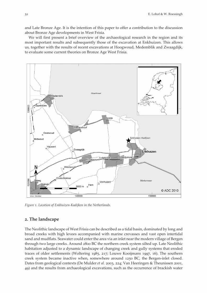
and Late Bronze Age. It is the intention of this paper to offer a contribution to the discussionabout Bronze Age developments in West Frisia.We will first present a brief overview of the archaeological research in the region and its
most important results and subsequently those of the excavation at Enkhuizen. This allowsus, together with the results of recent excavations at Hoogwoud, Medemblik and Zwaagdijk,to evaluate some current theories on Bronze Age West Frisia.
Figure . Location of Enkhuizen-Kadijken in the Netherlands.
. The landscape
TheNeolithic landscape ofWest Frisia can be described as a tidal basin, dominated by long andbroad creeks with high levees accompanied with marine crevasses and vast open intertidalsand andmudflats. Seawater could enter the area via an inlet near themodern village of Bergenthrough two large creeks. Around BC the northern creek system silted up. Late Neolithichabitation adjusted to a dynamic landscape of changing creek and gully systems that erodedtraces of older settlements (Woltering , ; Louwe Kooijmans , ). The southerncreek system became inactive when, somewhere around BC, the Bergen-inlet closed.Dates from geological contexts (De Mulder et al. , ; Van Heeringen & Theunissen ,) and the results from archaeological excavations, such as the occurrence of brackish water
E. Lohof & W. Roessingh

at Hoogkarspel (Bakker et al. , ), the existence of a tidal gully in the vicinity of Hoog-woud (Lohof & Vaars , ) and possibly near Medemblik (Schurmans , ) make itmore likely that the final closing of the estuary took place at a considerably younger date.The Bronze Age landscape of West Frisia can therefore be described as a former salt marsh
area, which had transformed into a freshwater environment with a patchwork of lakes, mar-shy areas and arable soils with high natural fertility. The old creeks consisted of sand depositsand their banks formed higher elements in the landscape. In the course of time, the streambedsilted up and the ridges became even more prominent in the landscape due to the ‘shrinkage’of the surrounding clayish flat planes, consisting of layers of peat and clay. This landscape wassupposedly rather treeless, with occasional willow and alder bushes (Buurman , ).
. Earlier Bronze Age research in West Frisia
The first recognized features of Bronze Age occupation in West Frisia were the barrows. In three burial mounds located near the village of Zwaagdijk were excavated, and in thefollowing decennia more barrows and several flat graves were investigated (Van Giffen ,, ; Modderman , ). The location of these barrows seems to follow the sandyor loamy silted up creeks and gullies. As the presently-known distribution is based solely onthe visible barrows and their soil marks on aerial photographs, an unknown number of le-velled barrows may remain invisible.The widespread existence of settlements became evident during a soil survey of the region
by P.J. Ente in the period - (Ente ). In the years - the University of Amster-dam excavated several locations, in total about ha, of a settlement near the village of Hoog-karspel (the most important being Tolhuis and Watertoren; Bakker et al. , ; Fokkensb, ). Barrows, houses, ditches, a large amount of rather small round structures (ringditches and pit circles) and ard marks were found, dating to the second half of the MiddleBronze Age and the Late Bronze Age (- BC). The excavators distinguished two phases,mainly on the basis of pottery, of which the first was supposed to be in the Middle Bronze Ageuntil halfway in to the Late Bronze Age (Bakker et al. , , ; Butler & Fokkens ,, fig. .).In advance of drastic land re-allotment in the eastern part of West Frisia, archaeologists of
the State Service undertook an intensive field survey campaign between and in thepolder ‘Het Grootslag’. This resulted in the identification of new Bronze Age sites (Metz, ). Two small excavations were carried out in near the village of Andijk, wherean area of ha was investigated. The excavations yielded settlement features and two bar-rows, dating to the Middle Bronze Age (IJzereef & Van Regteren Altena , -). In
the excavation of a settlement northwest of the village of Bovenkarspel started. It continueduntil and in total ha were investigated of the large settlement that became known asBovenkarspel-Het Valkje (IJzereef ; IJzereef & Van Regteren Altena ; Fokkens b,). The site was occupied during the Middle and Late Bronze Age, between and
BC. From , and especially in and , W. Metz discovered more barrows and manyBronze Age settlement features using aerial photography (Metz ). In the present century,excavations were conducted near the village of Hoogwoud (. ha, Lohof & Vaars ), nearthe village of Zwaagdijk (. ha, Ufkes & Veldhuis ; De Wit & Stokkel ), southwest ofthe town of Medemblik (. ha, Schurmans ) and northwest of the town of Enkhuizen (ha, Roessingh & Lohof ; Roessingh & Vermue ). In another ha was excavatedon an adjacent parcel west of Enkhuizen-Kadijken (Van der Linden & Hamburg in print).When we also take some smaller (published and unpublished) excavations into account, atleast ha of Westfrisian settlement sites have been excavated. The location of the BronzeAge settlements sites mentioned in the text can be found on figure .
The Westfrisian Bronze Age: a view from Enkhuizen-Kadijken
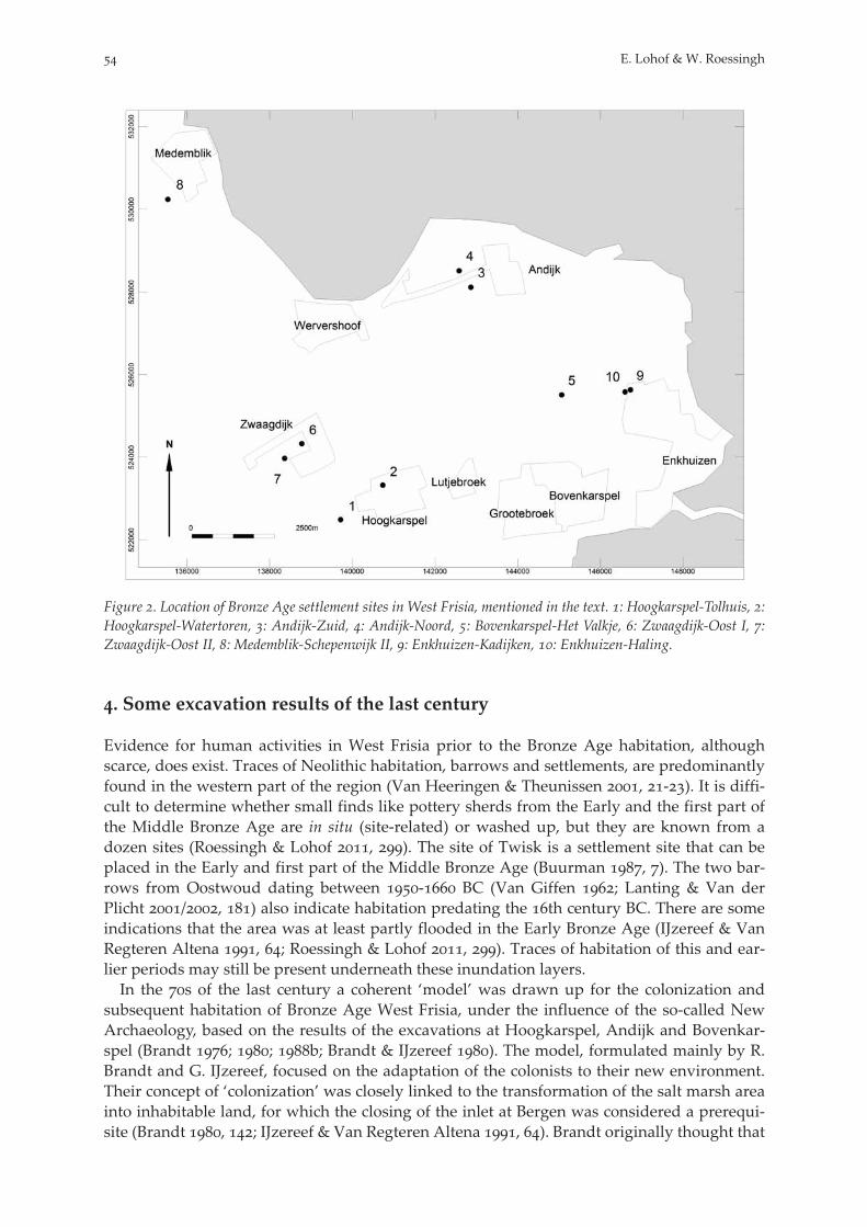
Figure . Location of Bronze Age settlement sites in West Frisia, mentioned in the text. : Hoogkarspel-Tolhuis, :Hoogkarspel-Watertoren, : Andijk-Zuid, : Andijk-Noord, : Bovenkarspel-Het Valkje, : Zwaagdijk-Oost I, :Zwaagdijk-Oost II, : Medemblik-Schepenwijk II, : Enkhuizen-Kadijken, : Enkhuizen-Haling.
. Some excavation results of the last century
Evidence for human activities in West Frisia prior to the Bronze Age habitation, althoughscarce, does exist. Traces of Neolithic habitation, barrows and settlements, are predominantlyfound in the western part of the region (Van Heeringen & Theunissen , -). It is diffi-cult to determine whether small finds like pottery sherds from the Early and the first part ofthe Middle Bronze Age are in situ (site-related) or washed up, but they are known from adozen sites (Roessingh & Lohof , ). The site of Twisk is a settlement site that can beplaced in the Early and first part of the Middle Bronze Age (Buurman , ). The two bar-rows from Oostwoud dating between - BC (Van Giffen ; Lanting & Van derPlicht /, ) also indicate habitation predating the th century BC. There are someindications that the area was at least partly flooded in the Early Bronze Age (IJzereef & VanRegteren Altena , ; Roessingh & Lohof , ). Traces of habitation of this and ear-lier periods may still be present underneath these inundation layers.In the s of the last century a coherent ‘model’ was drawn up for the colonization and
subsequent habitation of Bronze Age West Frisia, under the influence of the so-called NewArchaeology, based on the results of the excavations at Hoogkarspel, Andijk and Bovenkar-spel (Brandt ; ; b; Brandt & IJzereef ). The model, formulated mainly by R.Brandt and G. IJzereef, focused on the adaptation of the colonists to their new environment.Their concept of ‘colonization’ was closely linked to the transformation of the salt marsh areainto inhabitable land, for which the closing of the inlet at Bergen was considered a prerequi-site (Brandt , ; IJzereef & Van Regteren Altena , ). Brandt originally thought that
E. Lohof & W. Roessingh
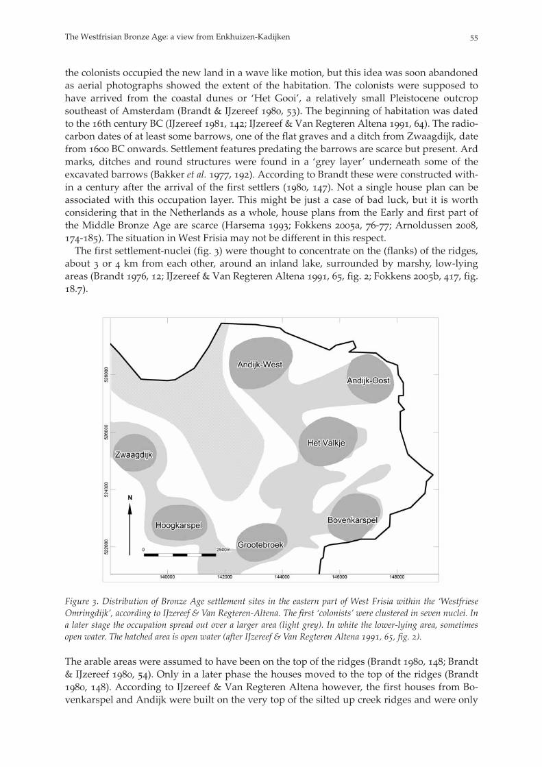
the colonists occupied the new land in a wave like motion, but this idea was soon abandonedas aerial photographs showed the extent of the habitation. The colonists were supposed tohave arrived from the coastal dunes or ‘Het Gooi’, a relatively small Pleistocene outcropsoutheast of Amsterdam (Brandt & IJzereef , ). The beginning of habitation was datedto the th century BC (IJzereef , ; IJzereef & Van Regteren Altena , ). The radio-carbon dates of at least some barrows, one of the flat graves and a ditch from Zwaagdijk, datefrom BC onwards. Settlement features predating the barrows are scarce but present. Ardmarks, ditches and round structures were found in a ‘grey layer’ underneath some of theexcavated barrows (Bakker et al. , ). According to Brandt these were constructed with-in a century after the arrival of the first settlers (, ). Not a single house plan can beassociated with this occupation layer. This might be just a case of bad luck, but it is worthconsidering that in the Netherlands as a whole, house plans from the Early and first part ofthe Middle Bronze Age are scarce (Harsema ; Fokkens a, -; Arnoldussen ,-). The situation in West Frisia may not be different in this respect.The first settlement-nuclei (fig. ) were thought to concentrate on the (flanks) of the ridges,
about or km from each other, around an inland lake, surrounded by marshy, low-lyingareas (Brandt , ; IJzereef & Van Regteren Altena , , fig. ; Fokkens b, , fig..).
Figure . Distribution of Bronze Age settlement sites in the eastern part of West Frisia within the ‘WestfrieseOmringdijk’, according to IJzereef & Van Regteren-Altena. The first ‘colonists’ were clustered in seven nuclei. Ina later stage the occupation spread out over a larger area (light grey). In white the lower-lying area, sometimesopen water. The hatched area is open water (after IJzereef & Van Regteren Altena , , fig. ).
The arable areas were assumed to have been on the top of the ridges (Brandt , ; Brandt& IJzereef , ). Only in a later phase the houses moved to the top of the ridges (Brandt, ). According to IJzereef & Van Regteren Altena however, the first houses from Bo-venkarspel and Andijk were built on the very top of the silted up creek ridges and were only
The Westfrisian Bronze Age: a view from Enkhuizen-Kadijken

later moved down to the flanks of ridges and the flat lands further from (and between) thecreek ridges (, ).The successful adaptation of the colonists to their new environment was represented in the
numerous ditches around their houses, yards and fields. The flat, lower-lying areas were usedas pasture and commons, where the animals grazed all year (sheep and goat) or in de summermonths (cattle). For some sites, more complex settlement dynamics were reconstructed suchas for Hoogkarspel-Tolhuis, where in a few centuries, houses and fields were thought to haveswitched locations on two nearby, parallel creek ridges (Brandt b, ).IJzereef identified two occupation phases at Bovenkarspel (, ). The early phase
started with the ‘colonization’ in the th century and lasted until the th century BC. All ofthe houses and most of the other features could be dated within this period. The late phaselasted from the th century BC until c. BC. Originally, an interruption in habitation wasassumed between and BC (IJzereef , ; Woltering , ; Schurmans ,, ), that is between the first serious consequences of an increasing wetness of the areaand the building of raised mounds or terps, but this was later called into question (Woltering, ; IJzereef & Van Regteren Altena , ).The shape of the house ditches was assumed to have a chronological meaning (Brandt ,
; IJzereef , ; IJzereef & Van Regteren-Altena , ). The ‘oldest’ house plans havea rather narrow, bracket-shaped ditch, whereas ‘later’ house plans have straight, rectangularditches and the ‘youngest’ houses have wide and straight ditches, very often situated a littlefarther from and only along the long sides of the house. It was assumed that houses wererepeatedly rebuilt and repaired at rather short intervals (IJzereef & Van Regteren Altena ,). The economy consisted of a mixed farming system of animal husbandry (in which cattledominated) and arable farming with emmer and barley as the main crops.IJzereef also suggested that over time the house plans at Bovenkarspel became shorter (IJ-
zereef , ). Since this was attended with a slight increase in the number of slaughteredyoung cattle in the Late Bronze Age, he assumed this was due to a change from an emphasison meat production in the early period to one on dairy production in the late phase (IJzereef, , , , -; Louwe Kooijmans , ; Buurman , ). Also, in the lastphase, increasing humidity and flooding forced the inhabitants to focus on hulled (instead ofnaked) barley and to give up on wheat (Buurman , ).Houses were presumably divided into a living quarter and a byre for up to cattle (Brandt
; ; Brandt & IJzereef ; IJzereef , ) or even forty (Louwe Kooijmans ,). Manure from the byre was used to fertilize the arable land (IJzereef & Van Regteren Alte-na , ; Buurman , ). It is also remarkable that four- or six-post granaries (Dutchspiekers), that elsewhere appear after BC (Arnoldussen , ) are completely absentin West Frisia.The Westfrisian Bronze Age pottery was subdivided into Hoogkarspel-old and Hoogkar-
spel-young pottery (Brandt a; Butler & Fokkens , , fig. .). The Hoogkarspel-old group consists mainly of thick-walled barrel and bucket shapes with coarse temperingand dates to the Middle and early stage of the Late Bronze Age (- BC; Brandt a).The Hoogkarspel-young pottery includes thin-walled bucket and biconical shapes, dishes,bowls, miniature pots, spoons, discs and conical artefacts. It is divided into two phases: onefrom - BC and the second from the actual ‘terp-period’, - BC (Brandt a).According to the traditional view the end of the Bronze Age habitation in West Frisia was
caused by a combined rising of seawater and groundwater levels and insufficient drainage ofthe area. The inhabitants reacted by moving their houses to the top of the creek ridges andeventually by raising terps on which they built their houses. The terps were assumed to be acouple of decimetres to one meter high (IJzereef & Van Regteren Altena , ). These haveall been levelled since medieval times and are now only recognizable by the broad and deepparallel ditches that originally surrounded them. In a few cases turf sods, supposedly from
E. Lohof & W. Roessingh
the mound, were found in these ditches (Brandt , afb. ; IJzereef & Van Regteren Altena, , fig. b; Woltering , ). Not a single convincing house plan is known from theterps. On the Pleistocene outcrop on the island of Texel, houses became shorter around
BC (Woltering /, , , table ). Though this transition is recognized around thesame time in the whole country (Roymans & Fokkens , ; Arnoldussen , ), it is notknown whether it also took place in West Frisia.Radiocarbon dates from the terp ditches range from – BC (Lanting & Van der Plicht
/, ). This is consistent with the exclusive presence of Hoogkarspel-young potteryin these ditches. When the environmental situation deteriorated further and started to affectcrops and the health of animals, the inhabitants left the area altogether, shortly after BC(IJzereef , ; IJzereef & Van Regteren Altena , , ). Only in a few elevated parts ofthe landscape (near Medemblik and Opperdoes) habitation continued at least into the EarlyIron Age (Woltering , -).
. Excavations at Enkhuizen-Kadijken
. The landscape
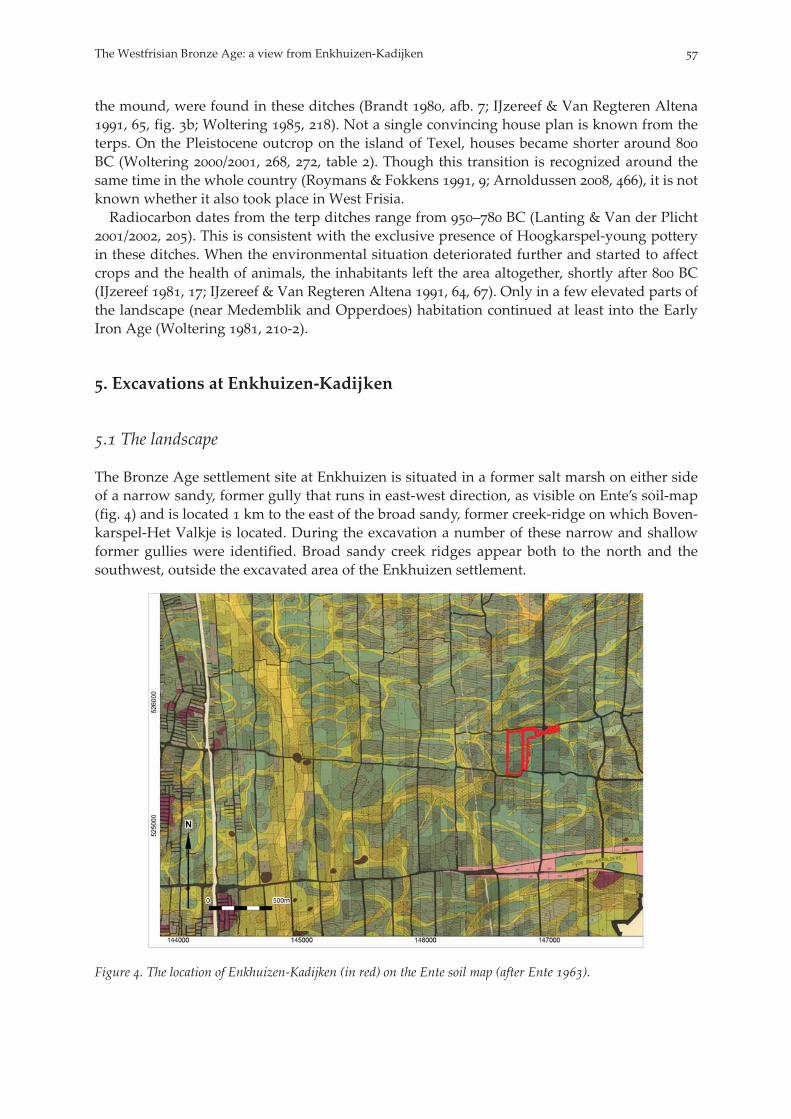
The Bronze Age settlement site at Enkhuizen is situated in a former salt marsh on either sideof a narrow sandy, former gully that runs in east-west direction, as visible on Ente’s soil-map(fig. ) and is located km to the east of the broad sandy, former creek-ridge on which Boven-karspel-Het Valkje is located. During the excavation a number of these narrow and shallowformer gullies were identified. Broad sandy creek ridges appear both to the north and thesouthwest, outside the excavated area of the Enkhuizen settlement.
Figure . The location of Enkhuizen-Kadijken (in red) on the Ente soil map (after Ente ).
The Westfrisian Bronze Age: a view from Enkhuizen-Kadijken
. Dating of the main settlement phases
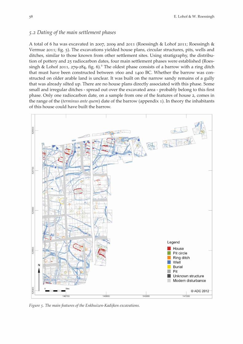
A total of ha was excavated in , and (Roessingh & Lohof ; Roessingh &Vermue ; fig. ). The excavations yielded house plans, circular structures, pits, wells andditches, similar to those known from other settlement sites. Using stratigraphy, the distribu-tion of pottery and radiocarbon dates, four main settlement phases were established (Roes-singh & Lohof , -, fig. ). The oldest phase consists of a barrow with a ring ditchthat must have been constructed between and BC. Whether the barrow was con-structed on older arable land is unclear. It was built on the narrow sandy remains of a gullythat was already silted up. There are no house plans directly associated with this phase. Somesmall and irregular ditches - spread out over the excavated area - probably belong to this firstphase. Only one radiocarbon date, on a sample from one of the features of house , comes inthe range of the (terminus ante quem) date of the barrow (appendix ). In theory the inhabitantsof this house could have built the barrow.
Figure . The main features of the Enkhuizen-Kadijken excavations.
E. Lohof & W. Roessingh

Figure . Suggested habitation phases of the Enkhuizen-Kadijken settlement.
On the basis of radiocarbon dates and pottery (table ), nearly all the other house plans can bedated to the second phase (- BC). Two house plans can be dated in phase (- BC): house in the north and house in the west. Hoogkarspel-young pottery wasfound in a house ditch of house that dates to phase (Roessingh & Vermue , ). Thisis one of the very few occasions that Hoogkarspel-young sherds have been associated with ahouse. The barrow must still have been an important feature in this phase, since an inhuma-tion was placed in a burial pit in its northwest flank. The skeletal remains belonged to a manof - years, whose femur was dated between - BC (Boston , ).There are no house plans associated with the last phase (- BC). The vast majority of
Hoogkarspel-young pottery (c. %) came from a supposed ‘terp ditch’ in the upper northeastpart of the excavation plan. A possible terp ditch in the lower southeast part yielded the re-maining Hoogkarspel-young pottery.
. House plans and house sites
It is useful to distinguish between a house plan and a house site. A house plan can be definedas the remains of a single house (i.e. post holes, surrounded by a house ditch). The house site
The Westfrisian Bronze Age: a view from Enkhuizen-Kadijken
or yard is a limited area around the house plan. House sites may contain multiple successiveindividual houses. In Enkhuizen on two house sites at least three subsequent houses werebuilt. In all, fifteen house sites and at least nineteen individual houses were found. The housesites in the central and southern parts of the excavation plan all show a clearly recognizableyard boundary with modest dimensions (c. x m). In the north such boundaries are lessclearly identifiable.
House Radiocarbon date( σ range)
Hoogkarspel-old pottery(gram)
Hoogkarspel-young pottery(gram)
Hoogkarspel-unknown(gram)
HS - BC - -HS - BC - -HS - BC - -
HS - BC - -HS - BC - -HS - BC - -HS - BC - -HS - BC - -HS - BC - -
HS - BC - -HSa - BC - - -HSb - BC - -HSc - - -HS - - -HS - - - -HS - BC - -HSa - BC - - -HSb - - - -HSc - BC - -
Table . Hoogkarspel-old and -young pottery recovered from house features at Enkhuizen-Kadijken. For the loca-tion of the houses see appendix .
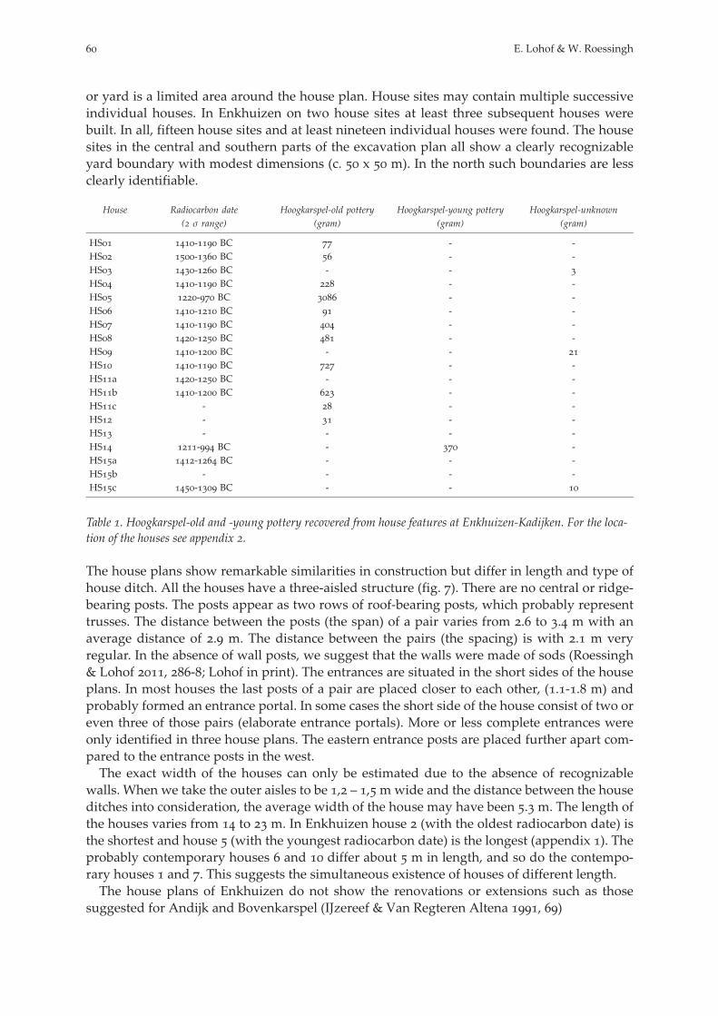
The house plans show remarkable similarities in construction but differ in length and type ofhouse ditch. All the houses have a three-aisled structure (fig. ). There are no central or ridge-bearing posts. The posts appear as two rows of roof-bearing posts, which probably representtrusses. The distance between the posts (the span) of a pair varies from . to . m with anaverage distance of . m. The distance between the pairs (the spacing) is with . m veryregular. In the absence of wall posts, we suggest that the walls were made of sods (Roessingh& Lohof , -; Lohof in print). The entrances are situated in the short sides of the houseplans. In most houses the last posts of a pair are placed closer to each other, (.-. m) andprobably formed an entrance portal. In some cases the short side of the house consist of two oreven three of those pairs (elaborate entrance portals). More or less complete entrances wereonly identified in three house plans. The eastern entrance posts are placed further apart com-pared to the entrance posts in the west.The exact width of the houses can only be estimated due to the absence of recognizable
walls. When we take the outer aisles to be , – ,mwide and the distance between the houseditches into consideration, the average width of the house may have been .m. The length ofthe houses varies from to m. In Enkhuizen house (with the oldest radiocarbon date) isthe shortest and house (with the youngest radiocarbon date) is the longest (appendix ). Theprobably contemporary houses and differ about m in length, and so do the contempo-rary houses and . This suggests the simultaneous existence of houses of different length.The house plans of Enkhuizen do not show the renovations or extensions such as those
suggested for Andijk and Bovenkarspel (IJzereef & Van Regteren Altena , )
E. Lohof & W. Roessingh
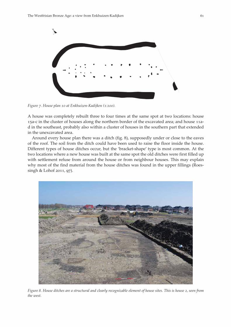
Figure . House plan at Enkhuizen-Kadijken (:).
A house was completely rebuilt three to four times at the same spot at two locations: housea-c in the cluster of houses along the northern border of the excavated area; and house a-d in the southeast, probably also within a cluster of houses in the southern part that extendedin the unexcavated area.Around every house plan there was a ditch (fig. ), supposedly under or close to the eaves
of the roof. The soil from the ditch could have been used to raise the floor inside the house.Different types of house ditches occur, but the ‘bracket-shape’ type is most common. At thetwo locations where a new house was built at the same spot the old ditches were first filled upwith settlement refuse from around the house or from neighbour houses. This may explainwhy most of the find material from the house ditches was found in the upper fillings (Roes-singh & Lohof , ).
Figure . House ditches are a structural and clearly recognizable element of house sites. This is house , seen fromthe west.
The Westfrisian Bronze Age: a view from Enkhuizen-Kadijken

In six house plans at Enkhuizen, four to six smaller posts were placed between the trusses inthe western part of the construction (fig. ). This was also observed in some house plans fromBovenkarspel (IJzereef & Van Regteren Altena , ). Since among house plans the numberof these posts varies they are not all contemporary. They seem to belong to a construction withtwo or four posts at a minimum. These constructions are too irregularly placed to be a part ofthe house structure and therefore they must have had another function, for example a loom ora construction around a fireplace (Roessingh & Lohof , -; Lohof in print). For Enkhui-zen, house plans with these constructions do not seem to be restricted to a certain period, ashas been suggested for the house plans at Bovenkarspel (IJzereef & Van Regteren Altena ,).
. Pit circles and ring ditches
One of the most striking features of the Westfrisian Bronze Age settlements are the pit circlesand ring ditches (Bakker & Metz ). At Enkhuizen, over of these structures, with anaverage diameter of , m, were found dispersed over the excavated area. Some predatehouses, others were built on top of abandoned house sites. The pit circles consist of small pitsthat are dug at a regular interval to form a circle (fig. ).The function of these pit circles and ring ditches has been debated for a long time (e.g.
Buurman ; ). The absence of recognizable granaries on Westfrisian Bronze Age sitesdoes suggest an interpretation as storage facility. Pit circles and small ring ditches howeverare a much earlier phenomenon than spiekers, since they have been found underneath housesand barrows that are much older than the appearance of spiekers elsewhere. Since there areindications that grain was reaped by pulling it out with stalks and roots from the clayey soil,it is assumed the pit circles and small ring ditches can be interpreted as stooks to let the grainsheaves dry. This would happen after or even before the first thresh in the field, but certainlybefore the second thresh in or near the house and the processing of the amount needed for theday (Bakker & Metz ; Buurman ; Buurman , ; Buurman , , ).
Figure . Pit circles in Enkhuizen-Kadijken.
. Long ditches and land partitioning
As in all other Westfrisian Middle and Late Bronze age settlements the most conspicuousfeatures are the numerous ditches in the form of (multiple) yard boundaries, ditches sur-rounding parcels and longer ditches bordering settlement areas or house clusters. They musthave had an important drainage function. Reaching an average depth of cm below theexcavated level (suggesting an original depth of to cm), it must have been a substantialtask to dig these ditches in the clayey soil. It is unknown what happened to the excavated soil.
E. Lohof & W. Roessingh
Possibly a small bank was constructed alongside the ditches, but this could not be establishedin the field. Many ditches were repeatedly dug out, probably for maintenance or cleaning. Themud and refuse of these periodically cleaned ditches could have been used to raise a bank.The humid and fertile soil in the ditches was easily accessible and could therefore also havebeen used to fertilize the arable fields, as has been suggested by Kooistra (, ). Neitherthe ditch nor the bank would have kept animals out. If ever intended to do so, there musthave been a fence on top of the bank since no fence-lines along the ditches were found.Some small and irregular ditches, both in the north and in the south of the excavated area
probably belong to the first phase. In the second phase (- BC) a number of long, wideand deep ditches were dug. One runs northeast-southwest through the north part of the ex-cavation plan. This ditch was dug out more than once, in places six times, and must have beenin use over a long period of time.In the absence of ard marks, it is not immediately clear where arable fields can be located.
On the excavation plan, possible arable parcels surrounded by ditches can be seen west of(and in line with) some yards. Other plots can be found in the central part of the excavationplan where houses are absent. Although the complete layout of the settlement site is un-known, it looks like the inhabitants structured their landscape from different nuclei aroundthe barrow towards all four main quarters.Only a few ditches can be associated with phase (- BC). It is possible that in this
phase most of the excavated area consisted of arable fields and pasture. In phase , the finalphase of occupation (- BC), two ditch systems can be identified in the northeast andsouthwest of the excavation. The ditch in the northeast is most likely a so-called terp ditch.
. Subsistence
A total of . finds was recovered from Enkhuizen-Kadijken, consisting of fragments ofbone, stone, flint and pottery. Some . of these are pottery sherds, but the vast majority(over . fragments) are animal bones, primarily of cattle, both in number and in weight.
Species MBA (% number) LBA (% number) MBA (% weight) LBA (% weight)
Cattle . . . .Sheep/goat . . .Pig . . .
Table . Bones of cattle, sheep/goat, pigs from Enkhuizen-Kadijken. MBA: Middle Bronze Age, LBA: Late BronzeAge.
In addition, remains of sheep, goats, pigs, dogs and horses are present. A few bones of non-domesticated animals such as wild boar, deer, beaver, elk and a brown bear have also beenidentified. It is clear however that hunting hardly played any role.In Enkhuizen we see a small increase in sheep/goat from the Middle to the Late Bronze Age
(table ).Small animal bones, discovered mostly by wet sieving ditch fills, comprise remains of var-
ious birds like duck and goose, hawk, woodcock, ruff and a thrush. The more than . fishbones are from fresh water species like bream, roach, carp, catfish, pike and perch. Bones ofeel (a catadromous species) are also well represented. The find of an almost complete fish trapto catch eel demonstrates the importance of this species for the menu (fig. ). Only one fishbone could be identified as a true salt-water species: the grey gurnard.
The Westfrisian Bronze Age: a view from Enkhuizen-Kadijken

Figure . A fish trap for catching eel, found on the bottom of a deep pit.
That emmer wheat and hulled barley were the main crops in the Middle and (probablyhulled) barley in the Late Bronze Age bears no surprise. It is remarkable to discover sevenspecies of wood among determinable fragments, recovered from a small number of wells(table ). Among the wood fragments were several wooden artefacts, of which four woodenplanks are worth mentioning, all dating to the Middle Bronze Age. One of the planks waspointed and found on the bottom of a well. All of the planks had a row of rectangular holesin the middle and they could have been used as a ladder to dig out the steep wells, but thiswas not their primary constructional function. They may have been part of a dry-rack forgrass or reed (fig. ). The origin of the wood fragments could be driftwood, imported orlocal. If local, this would have implications for our image of the landscape around the settle-ments.In connection with the use of wood on the site, more than stake holes (i.e. fences)
should be mentioned. Some rows of stakes could be followed over more than m. It is possi-ble that stake fences were also set on the banks, which would have left no traces at the exca-vated level.Cow dung was probably used as fuel for the hearth (Buurman , ). Small fragments
of fossilized cow dung from Enkhuizen, however, turned out to have burned at the remark-able high temperature of c. ºC. Since this is above the melting point of bronze, it is possi-ble that these fragments result from dung used as fuel in the context of metallurgical activ-ities.
Species Alder Willow Oak Birch Ash Pine Poplar
Number
Table . Species of wood from Enkhuizen-Kadijken
E. Lohof & W. Roessingh
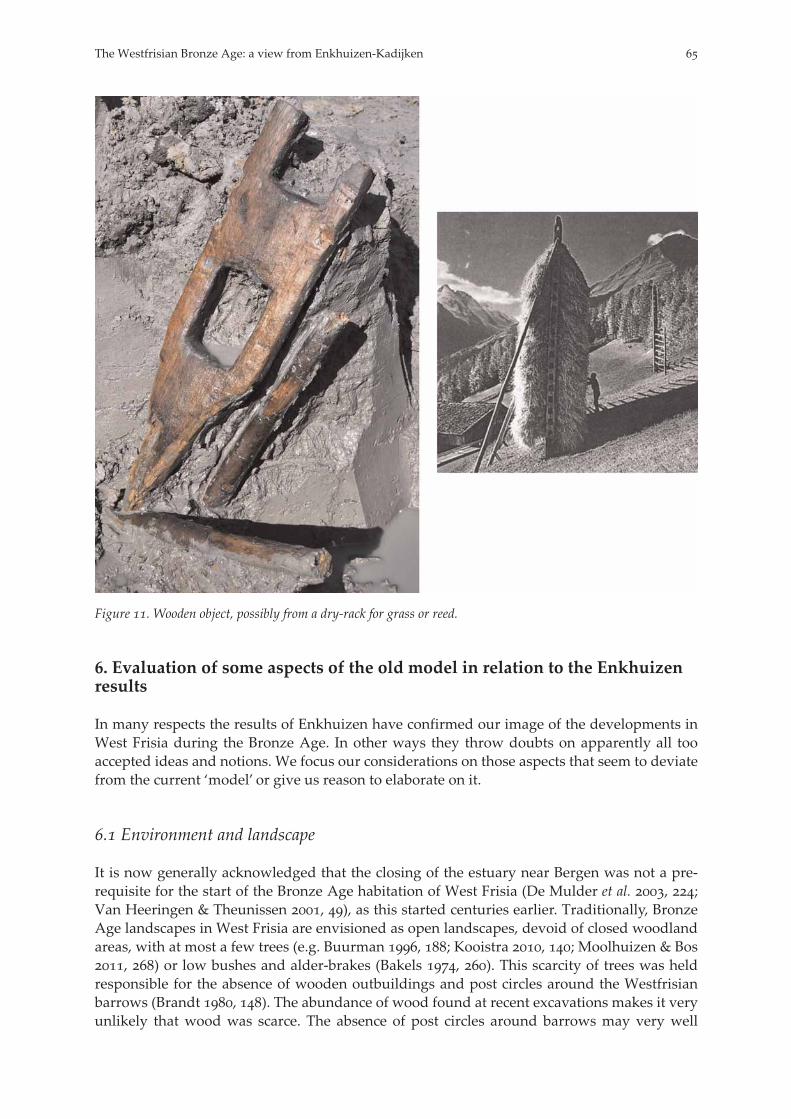
Figure . Wooden object, possibly from a dry-rack for grass or reed.
. Evaluation of some aspects of the old model in relation to the Enkhuizenresults
In many respects the results of Enkhuizen have confirmed our image of the developments inWest Frisia during the Bronze Age. In other ways they throw doubts on apparently all tooaccepted ideas and notions. We focus our considerations on those aspects that seem to deviatefrom the current ‘model’ or give us reason to elaborate on it.
. Environment and landscape
It is now generally acknowledged that the closing of the estuary near Bergen was not a pre-requisite for the start of the Bronze Age habitation of West Frisia (De Mulder et al. , ;Van Heeringen & Theunissen , ), as this started centuries earlier. Traditionally, BronzeAge landscapes in West Frisia are envisioned as open landscapes, devoid of closed woodlandareas, with at most a few trees (e.g. Buurman , ; Kooistra , ; Moolhuizen & Bos, ) or low bushes and alder-brakes (Bakels , ). This scarcity of trees was heldresponsible for the absence of wooden outbuildings and post circles around the Westfrisianbarrows (Brandt , ). The abundance of wood found at recent excavations makes it veryunlikely that wood was scarce. The absence of post circles around barrows may very well
The Westfrisian Bronze Age: a view from Enkhuizen-Kadijken
have a cultural background. Substantial numbers of stake rows possibly representing fenceshave not only been found in Enkhuizen (Roessingh & Lohof , -), they are also pre-sent in Medemblik-Schepenwijk II (Schurmans , -) and at Andijk and Bovenkar-spel (Roessingh in prep.). Furthermore, the various finds of wood fragments at Enkhuizenand Medemblik-Schepenwijk II (Schurmans , ) and animal remains of red deer,goshawk and beaver do not tally with a completely treeless landscape (Roessingh & Lohof, ). Of course, none of this is conclusive evidence for the local presence of trees on anyscale. The use of driftwood may well be the explanation for the appearance of large pieces ofoak such as at Enkhuizen.More important however, is that we still have a rather limited amount of information about
the environment at this time. It is apparent that West Frisia was densely inhabited in the Mid-dle and Late Bronze Age with hundreds of houses being built in the region. Botanical andpollen samples originated mainly from within the settlement area (with two exceptions fromthe Klokkeweel Bog (Pals et al. ) and the Westfriese Zeedijk (Van Geel et al. ). Botani-cal and palynological studies on the environment outside the settlements remain vital to ourunderstanding of what the landscape of West Frisia looked like beyond the as yet unknownboundaries of the settlements. Present results feed reservations about a rather uniform, tree-less landscape and its changes during the period concerned. Centuries of habitation may havehad a strong (possibly devastating) effect on the vegetation in West Frisia. So far, we knowvery little about the changes in the landscape that took place during the Bronze Age.
. First settlements
In both Bovenkarspel and Enkhuizen, Middle Bronze Age habitation started on the low-lyingclayey basins of the salt marshes, somewhere between and BC, as soon as sedimen-tation had ceased. The barrow at Enkhuizen with a terminus ante quem of - BC, is oneof the oldest barrows in West Frisia. If barrows were raised within a century after the arrivalof the first settlers, they may well be the graves of the ‘founding fathers’ of the habitationnuclei. No contemporary house plans are yet known. Post depositional processes or a differ-ent way of building houses (irregular construction or the use of sill-beams) could be put for-ward for the present lack of those house plans (Arnoldussen , ).According to IJzereef, habitation started from residential nuclei around a shallow lake (IJ-
zereef & Van Regteren Altena , , fig. ). With the extensive and contemporaneous set-tlement traces at Enkhuizen it is now clear that more nuclei must have existed (Roessingh &Van Zijverden , ). Also, in addition to habitation on the silted up creek ridges, habita-tion had started already at an early age on the clayish lower-lying areas between the ridges.The oldest radiocarbon dates for house plans date around BC. At that time houses
were built both on the creek ridges as in Bovenkarspel and on the clayish flats in between theridges as in Enkhuizen (house ) and Zwaagdijk-Oost (Ufkes & Veldhuis , , , ).Since we do not know the boundaries of the Enkhuizen settlement and those of Bovenkarspel,both settlements, now a little more than one kilometre apart, could very well be linkedthrough continuous habitation. The impression this leaves is less of nucleated villages than ofan extended field of small groups of houses surrounded by arable fields, which filled thespaces in between, though they roughly remained at the same location. In some of the clustersa house was rebuilt three to four times on the same spot (as was the case for two house sites inEnkhuizen). Similar examples can be found in Andijk and Bovenkarspel. This suggests thataround such houses with indications for a prolonged longevity (as evidenced by rebuilding),clusters of additional, younger, houses developed. These clusters around a multi-phasedhouse site suggest an on-going branching-off of households around a nucleus that remains inexistence for a long period of time. The actual lifespan of Westfrisian Bronze Age houses is
E. Lohof & W. Roessingh
unknown. If we assume that houses stood for to years, this would imply that somehouse sites were in use for about years. The multi-phased house, as appeared to form -% of houses, may represent the core lineage residence. There is a formal resemblance tobarrows with multiple additions or ‘periods’ on them. Most later periods from barrows else-where in the country appear to be contemporary with Middle Bronze Age houses (Arnoldus-sen & Scheele , ). Whether there is an actual relationship must await further researchof the settlement dynamics.In Enkhuizen, as elsewhere, features like postholes are extremely well visible because of a
very dark, almost black filling, that is typical of the Middle Bronze Age layers postdating thebarrows and is markedly different from the light grey layer underneath the barrows (Bakker). The dark colour appeared to emanate from fragments of charcoal, supposedly originat-ing with large-scale burning of vegetation (Van Geel et al. , , ) during the BronzeAge habitation. Since there are indications that grain were reaped by pulling it out (stalks,roots and all: Buurman , ; Buurman , ), there were no stubble fields. It is morelikely that the charcoal originated from burned weeds or grass. This may have been done toimprove the quality of the pastures, or as preparation before ploughing in a three-course rota-tion system (Bakker et al. , ). In this last case however, it must be noted that featureslike ard-marks within this layer are absent. It is obvious that this black layer can not be achronological marker; as an irregular practice it may have quite different dates at differentlocations (Van Geel et al. , , ). At Enkhuizen this incorporation of charcoal is alsofound in deposits that sealed the Late Bronze Age surface. For this, the intentional burning ofgrassland after the Bronze Age is the most likely explanation (Exaltus & Kortekaas ).
. Houses and house ditches
All the houses in West Frisia are remarkable similar in construction, and are therefore thoughtto form a specific Westfrisian type (Arnoldussen , , fig. .; Lohof in print). Thehouses from Enkhuizen are no exception and the study of the house plans led us to the fol-lowing four observations.First, as far as the house plans are concerned, we accept (with reservations) the current idea
of the existence of an internal bipartitioning, but we also emphasize that there is no indicationat all for the existence of a byre or cattle boxes. The assumption that the living quarters are inthe western or northern (depending of the orientation of the house) part of the house is basedon a single hearth in house plan from Bovenkarspel (IJzereef & Van Regteren Altena ,). Fireplaces have not been identified in the Enkhuizen houses. There is little to add to that,except that entrances in the western short sides of the houses at Enkhuizen are narrower thanthe entrances in the opposite sides, suggesting a difference in function.Second, in relation to the construction of houses, the absence of any wall indication in the
Enkhuizen houses lead us believe that the walls were completely made of sods (Roessingh &Lohof , -; Lohof in print). The wooden stakes, as found within the house plans and in Enkhuizen, do not contribute to the wall construction proper. They were sometimesplaced on the inside against the wall of sods as a kind of panelling or wainscoting, as can beseen in the reconstruction of IJzereef & Van Regteren Altena (, , fig. ). The use ofthese stakes should not be seen as a regular phenomenon, but can more likely be seen as aregional tradition or a matter of individual taste. Examination of all the house plans from thesites Andijk-North (n = ), Andijk-South (n = ) and Bovenkarspel-Het Valkje (n = c. ) hasrevealed that only three house-plans at Andijk-North and two plans at Bovenkarspel-HetValkje yielded stakes at the inner location of the wall. These are the house plans that wererepeatedly published. The general absence of stakes in other houses cannot be related to badpreservation conditions (see for example IJzereef & Van Regteren Altena , ) because the
The Westfrisian Bronze Age: a view from Enkhuizen-Kadijken

stake holes have a considerable depth (sometimes up to cm) and other ‘fragile feature’categories like rows of stakes or plough marks are present at the afore mentioned sites.Though trusses can bear the weight of the roof, a wall of stakes and wattle is not strong
enough to stabilize and to withstand any pressure lengthways from the trusses (Huijts ,). A wall of sods on which the roof’s eaves rest would certainly have stabilized the structure.A third consideration is about an assumed constant repairing and extending or shortening
of a house in Bovenkarspel and Andijk. In Enkhuizen there is an almost complete absence ofrepairs and no indication of extending or shortening of any house, though the time range ofhabitation is nearly the same as that of Bovenkarspel-Het Valkje. A survey of the (unpub-lished) house plans from Bovenkarspel-Het Valkje and Andijk, resulted in ‘only’ about convincing house plans in Bovenkarspel (instead of nearly double that amount), and also inthe observation that the amount of repairs is not exceptional as compared to contemporaryhouse plans from the Pleistocene part of the country or the central river area. The amount ofrepairs, extensions and multi-phased houses, as mentioned for West Frisia by Arnoldussen(, , -) certainly will have to be adjusted. This has of course implications for theway we look at settlement dynamics. Instead of repairing the house, people may have pre-ferred building a complete new house.The fourth observation concerns the assumption that houses became shorter in the begin-
ning of the Late Bronze Age compared to the Middle Bronze age (IJzereef , ; IJzereef &Van Regteren Altena , ; summary in Louwe Kooijmans , ). In Enkhuizen how-ever, at least three of the early house plans are two meters shorter than three younger ones.This number of well-established lengths of houses from Enkhuizen may be too small to drawany general conclusions. It appeared, however, that the existence of extremely long houses atBovenkarspel and Andijk (up to m) is due to a disputable interpretation of two or morehouses build on the same spot. Another example is found at Hoogkarspel, where house plan is assumed to be the youngest at the site, but is also the longest house (Bakker et al. , afb.). We see therefore no clear proof of the assumption that houses became shorter in the begin-ning of the Late Bronze Age. On the contrary, we must not exclude the possibility of thesimultaneous existence of houses of different length, as is known from settlements on thePleistocene soils (Elp, Waterbolk ; Hattemerbroek, Hamburg et al. ) and in the centralriver area (Zijderveld: Knippenberg ; Arnoldussen , ).A closer look at the shape of the house ditches, in short hand ’bracket or rectangular’, up-
holds a chronological meaning only in a very general way. According to stratigraphy andradiocarbon dates their occurrence seems to overlap in time to a great extent.
. Subsistence
The slaughtering practices at Enkhuizen show that more cattle were killed at an older agethan in Bovenkarspel. In numbers of bones % of butchered cattle were older than ,-years. This is % more than in Bovenkarspel (Zeiler & Brinkhuizen , ). In Bovenkar-spel nearly a quarter of cattle bones were from animals younger than –, years. In Enkhui-zen this was less than %. The numbers for Bovenkarspel led to assume a (slight) change frommeat production towards dairy production in the Late Bronze Age (IJzereef , , , -). Lipid analysis on residues on the surface of pottery fragments from Enkhuizen attestedthe presence of milk products on a Hoogkarspel-young sherd. Analysis of residues on otherfragments from both Hoogkarspel-old and young pottery were not conclusive (Roessingh &Bloo , ; Heron & Hancox , ). Nevertheless, even though dairy production wasnot absent in Enkhuizen, it did not play any major role in cattle management (Zeiler & Brink-huizen , ). Also in Medemblik (Groot , ) and Zwaagdijk-Oost (Halıcı & Buiten-huis , ) there seems to be no indication for a shift towards dairy production. Of course,
E. Lohof & W. Roessingh
economic developments do not have to occur in a similar way everywhere, but here it is re-markable because the settlements of Enkhuizen and Bovenkarspel are so close to each other. Ifthese developments did occur, they must have been a very local phenomenon.The sizes of the Bronze Age herds are unknown. Neither is known whether all cattle were
kept indoors all year through or only in wintertime. The appearance of hoof prints as in Enk-huizen and in several other settlements, suggests a seasonal stabling, likely to collect manureand to take care of cows in calf. In fact, with rather mild winters, there is no compelling reasonto keep all cattle indoors at any time a year. It is, apart from the size of the herd, unlikely thatone half of the floorspace of every house at any time was filled with cattle. On the Pleistocenesoils only a third of the floor space in contemporary Emmerhout type houses is regarded asbyre (Huijts , , ; Kooi /, ). In Elp type houses of the Late Bronze Age thisamount of byre space had in fact increased, but is not yet half the floor space (Huijts , ,; Arnoldussen , ). Not necessarily every house contained a byre for cattle, or a byreat all. From the inner constructions found in some houses at Enkhuizen and Bovenkarspel,that are not part of the house structure, it can be concluded that different activities in differenthouses were carried out. For example, weaving may be restricted to some houses. It is unli-kely that these settlements were made up of unrelated competing households. They werecommunities (German Gemeinschaften) of closely related people, with very little or no indica-tions for internal social differentiation beyond those of age, gender and kinship. Their house-hold activities may partly have been complementary. They had different subsistence strate-gies, as for example some fished in a semi-marine (Hoogwoud, Medemblik) and other in afresh water environment (Enkhuizen, Bovenkarspel). Hamlets vary in their use of domesticanimals, in that for example, people close to the tidal inlet of Bergen (like Hoogwoud andSchagen) depended more on sheep/goat while people living farther inland depended moreon cattle (Zeiler & Brinkhuizen , , afb. .). In Hoogkarspel there is a remarkable highpercentage of pig bones as compared to other sites (Bakker et al , ).
. Pottery
The pottery from Enkhuizen has little to add to what is already known about the West FrisianBronze Age pottery. Nonetheless, a few remarks can be made. It is still too early to determinewhether the Hoogkarspel-old pottery has closer affinities with that of the so-called Elp-pot-tery from the Pleistocene landscape of the northeast or with the Laren or Drakenstein varietyof the so-called Hilversum-pottery from the south (for a discussion of this pottery see Arnol-dussen , -). It is even questionable whether such affinities exist at all beyond thesimilar thick wall, coarse tempering and poor quality. Neither Elp- nor the later Hilversumpottery has been published in substantial detail. The Hoogkarspel-young pottery is predomi-nantly found in terp ditches and rarely associated with known houses. This pottery shows anew variety in form and manufacture, starting around BC (Brandt a). The renewal instyle and manufacture is not local, but has occurred under a strong influence from outside theregion, probably from the east and northeast (Van Heeringen , ; Roessingh & Bloo, ). It is a development in accordance with changes in pottery in the rest of the country(Van den Broeke ) and, for that matter, in all of Central Europe (Lanting & Van der Plicht/, ; Van den Broeke a, ; b, ). By c. BC some of the forms arespecific to West Frisia (Roessingh & Bloo , ). The differences with pottery from sur-rounding coastal areas, in particular the Heemskerk pottery group to the south, however, maynot be as significant as was originally assumed (Van Heeringen , ).Within the Hoogkarspel-young group, Brandt made a distinction in two phases based on
two contexts at Hoogkarspel-Tolhuis; a terp ditch at Hoogkarspel-site D (first phase) and aterp ditch at Hoogkarspel-site F (second phase). According to Brandt, sherds of the first phase
The Westfrisian Bronze Age: a view from Enkhuizen-Kadijken
are more frequently decorated in comparison to the sherds of the second phase. Biconicalshapes are dominant in the second phase (a, , ). The exact dating of these contextsis problematic because only a few radiocarbon dates are available. Further research and moreradiocarbon dates will shed more light on developments within the Hoogkarspel-young pot-tery. The contexts with Hoogkarspel-young sherds at Enkhuizen, for example, could be datedfrom - BC. A sub- phase (or first phase) within this pottery could not be identified.Nearly all terp ditches produce an abundant amount of pottery, bones and various other
finds. It is certainly not only the better quality of the pottery that is responsible for this in-crease in finds compared to what we find in ditches from the Middle Bronze Age. Differentexcavation methods, like sieving, add to the discrepancy. It is conceivable that a regular clean-ing of ditches is responsible for the scarcity of finds in those from the Middle Bronze Age. Theabandonment of terp ditches where cleaning is neglected in the last stage of habitation may atleast be partly responsible for the abundance of finds.
. A decline in habitation of the th – th century BC?
For a few settlements in West Frisia a decline of habitation between and BC wasassumed and sometimes the word hiatus was used (IJzereef , ). At the settlement siteof Medemblik an interruption of habitation between and BC is assumed (Schurmans, ). The features at Hoogkarspel-Watertoren are divided into two phases; an olderphase in the late Middle and early Late Bronze Age and a younger phase, represented by thepresence of Hoogkarspel-young pottery from the ‘terp phase’ (Bakker et al. , ; ).Between these phases the excavators assumed the existence of a hiatus. Also for Bovenkarspelan interruption was assumed, but later called in question (IJzereef & Van Regteren Altena, ; Woltering , ). The possible hiatus seems to coincide with the appearance ofthe Hoogkarspel-young pottery assemblage.The results of Enkhuizen show a decline in habitation for this period but this may be decep-
tive. Most of the houses at Enkhuizen are dated between - BC. For the period - BC, there are only two houses (table ). This means, roughly or houses in a periodof three centuries compared to two houses for the subsequent two centuries. The assumptionthat habitation moved to the slightly higher creek ridges because of a rise in groundwatertable, is not supported by the existence of the two house plans in the clayish flatland. Thathouses from this period are scarce, yet not completely absent, is also illustrated at Zwaagdijkand Medemblik (appendix ).The cause or causes of this assumed population decline remain unclear, but environmental
factors may have affected individual locations differently. It may be of importance that one ofthe sections at the excavation of Enkhuizen show indications for an inundation during habita-tion, but it is not yet known whether we can date this layer to c. BC (Van Zijverden ,-). This could have been a one-time event, that drove no inhabitants away, but if it indi-cates a more general deterioration of the environmental situation, parts of the population mayhave been encouraged to relocate to higher ground or leave the region entirely. An inundationlayer in Hoogkarspel (Bakker et al. , ) is not dated either. Far from being catastrophic,these developments gave parts of the population sufficient time to leave the area (Van Heer-ingen , -). We suspect that at Enkhuizen (as elsewhere) at least part of the communitystayed, both on the higher ground of the ridges, and in the lower clayey parts.
E. Lohof & W. Roessingh
. The last phase and end of habitation
Terps or raised dwellings were mainly erected near or on the slightly higher silted up creekridges from shortly after BC until BC (Lanting & Van der Plicht, /, ; Roes-singh & Lohof , ). These are the oldest known raised house sites in the country, possi-bly along the whole North Sea coast line. There are indications for the existence of terps onmost of the sites where there is also an earlier habitation. Only in Andijk-North & South andZwaagdijk-Zuid there seems to be no habitation prior to the terp phase, though there areindications of older activities in the vicinity (Ufkes & Veldhuis , ). During the finalstage of the Late Bronze Age the terps were extended and probably heightened again (VanGeel et al. , ; Schurmans , -).The causes of the end of the habitation are still heavily debated. In general, wetter condi-
tions and a rise in groundwater level are held responsible (Pals et al. ; Roep & Van Regte-ren Altena , ). It is assumed that this caused the growth of peat all over West Frisiafrom c. BC (Van Geel et al. , ), about the time the terps were raised. However, atEnkhuizen there is no indication for peat formation before or after the region was deserted.The formation of peat seems to have been in great extend the result of local conditions (VanZijverden , ). Apart from raising terps there are few clues to how the inhabitants ad-justed their subsistence strategy. The slight increase in the number of sheep/goat towards theend of the Late Bronze Age in both Enkhuizen (table ; Zeiler & Brinkhuizen , ), Me-demblik (Groot , , , -) and Bovenkarspel (IJzereef , ) at the cost of cattle,does not seem appropriate for a wetter environment, since sheep/goat do not cope well withthese conditions (with the chance of catching liver fluke being considerably enlarged in thesekinds of environments; Zeiler & Brinkhuizen , ). Only in Zwaagdijk-Oost II a slightdecrease in sheep/goat in the last phase can be shown (Buitenhuis , ). A rise in groundwater level is difficult to prove, because the occurrence of stagnant water or water-plants inditches and wells is not necessarily an indication for such a phenomenon (Moolhuizen & Bos, ). Assessment of the ground water table depends on an adequate dating of wells(Van Geel et al. , ). Results so far do not fit the situation at Enkhuizen (Roessingh &Lohof , ), which would have been under water by current estimates.It is obvious that the inhabitants, while living on terps, had no problem growing their cer-
eals in the vicinity and tending their sheep. The presence of some Late Bronze Age potteryfragments in ring ditches, presumably used for storing cereals, is an indication for agriculturalactivities near the terps. This in turn leads to the question why the inhabitants needed terps inthe first place when the ground water level was apparently low enough to grow their crops?The building of terps and the continuing use of agricultural fields points rather at seasonal orirregular flooding, which improved soil fertility and brought higher yields, in turn making itworthwhile building the terp in the first place. This could be a marine inundation through theformer Bergen estuary or a fresh water inundation from the (later) ‘Zuiderzee area’ to the east(Van Zijverden , ). The fish bones from Bovenkarspel and Enkhuizen, all from terpditches, are almost exclusively from fresh water fish (Zeiler & Brinkhuizen , -). Thisdoes not point at marine influence in the immediate surroundings, but does not exclude iteither. Finally, a permanent raise in groundwater level must have affected their crops and thehealth of their animals in such a way that the inhabitants left altogether.
. Conclusion
The Bronze Age habitation in West Frisia appears to have been prosperous, given its densepopulation and long history of six or seven centuries. Settlements were permanent, but showvariation in subsistence patterns. The inhabitants were connected to supra-regional networks
The Westfrisian Bronze Age: a view from Enkhuizen-Kadijken
as is shown by the imports of flint sickles (apparently for cutting the sods for the terps; Roes-singh & Lohof , ) and bronzes (socketed axes and spearheads are only known as strayfinds, but there is a sword from a grave; Modderman ). While we have considerable in-formation on the nature and clustering of house sites for the Middle Bronze Age in WestFrisia and the general subsistence activities, our information on house site usage as well asthe interrelations of fields and house site and older funerary sites is still limited. Secondly, thedating, chronology and internal dynamics of Bronze Age settlement sites is still an open ques-tion as long as we do not know the extent of a single settlement. We know little about thecharacter of the cultural landscape between the settlements, where we may expect ritual, de-positional and funerary features. There are new results to be expected from the research proj-ect ‘Farmers of the coast’ at Leiden University that involves a critical re-evaluation of geophy-sical and environmental data and an analysis of several older excavations. This can only be anencouragement for purposive excavation in the future to tackle these problems.
Acknowledgements
Without the contributions of the persons involved in the fieldwork and analyses, this articlecould not have been written. We are very grateful for the efforts they have made. Furthermorewe like to thank Gavin Williams for editing our English text.
Eric LohofArcheoBegeleiding, [email protected]
Wouter RoessinghFaculty of Archaeology, Leiden [email protected]
Notes
. The radiocarbon samples from Andijk, and some from Bovenkarspel, are considered unreliable,because they have been treated with a preservative (Lanting & Van der Plicht , -). We haveignored them in this paper.
. See appendix for the location of the houses with house number.. Only a few Hoogkarspel-young sherds from Bovenkarspel could be associated with a house site.. In Medemblik-Schepenwijk II five fragments of what was supposed to be ’metal slag’ were found in
Bronze Age context (Boreel ). After publication, some samples from Medemblik were analysedby F. Braadbaart (Utrecht University). The chemical composition of the fragments appeared to bethe same as the Enkhuizen samples.
. Together with the sample of charcoal from a ring ditch at Bovenkarspel-Het Valkje (tumulus I);GrN-, ± (Van Regteren Altena et al. , -, table ).
. The second author is studying the original field drawings from Bovenkarspel and Andijk for hisPhD research in the research project ‘Farmers of the coast’ at Leiden University.
References
Arnoldussen, S. , A Living Landscape. Bronze Age settlement sites in the Dutch river area (c. -BC). Sidestone Press, Leiden.
Arnoldussen, S. & E.E. Scheele , The Ancestors nearby. The domestic and funerary landscape ofAngelso-Emmerhout. In: H.M. van der Velde, N.L. Jaspers, E. Drenth & H.B.G. Scholte Lubberink
E. Lohof & W. Roessingh

(eds), Van graven in de prehistorie en dingen die voorbij gaan. Studies aangeboden aan Eric Lohof bij zijnpensionering in de archeologie. Sidestone Press, Leiden, -.
Bakels, C. , Enkele milieu-aspecten van grafheuvel Ia te Hoogkarspel. West Frieslands Oud en Nieuw, -.
Bakker, J.A. , A black soil in Bronze Age Noord-Holland. In: J. Libra & A. Zakoscielna (eds), Przezpradzieje i wczesne sredniowiecze, Lublin, -.
Bakker J.A. & W. Metz , Opgravingen te Hoogkarspel IV: Het onderzoek in van vindplaats Ften ZW van het Medemblikker-Tolhuis (voorlopige mededeling). (Westfriese Oudheden X), West-Frieslands Oud en Nieuw , -.
Bakker, J.A., Ph.J. Woltering & W.J. Manssen , Opgravingen te Hoogkarspel (V). Het onderzoekvan vindplaats F in (voorlopige mededeling), (Westfriese Oudheden, XI), West-Frieslands Ouden Nieuw , -.
Bakker, J.A., R.W. Brandt, B. van Geel, M.J. Jansma, W.J. Kuijper, P.J.A. van Mensch, J.P. Pals & G.F.IJzereef , Hoogkarspel-Watertoren: towards a reconstruction of ecology and archaeology of anagrarian settlement of BC. In: B.L. van Beek, R.W. Brandt & W. Groenman-van Waateringe(eds) Ex Horreo. (Cingula, IV), Amsterdam, -.
Boreel, G. : Metaal en metaalslakken. In: M. Schurmans (ed.), Een nederzetting uit de Midden en LateBronstijd te Medemblik-Schepenwijk II, gemeente Medemblik. (Zuidnederlandse Archeologische Rappor-ten ), Amsterdam, -.
Boston, C. , Human remains. In: W. Roessingh & E. Lohof (eds), Bronstijdboeren op de kwelders.Archeologisch onderzoek in Enkhuizen-Kadijken. (ADC-rapport ), Amersfoort, -.
Brandt, R.W. , Landbouw en veeteelt in de late bronstijd van West-Friesland. Westerheem XXV, (),-.
Brandt, R.W. , De kolonisatie van West-Friesland in de Bronstijd. Westerheem XXIX, (), -.Brandt, R.W. a, Aardewerk uit enkele Bronstijdnederzettingen in West-Friesland. In: J.H.F. Bloe-
mers (ed.), Archeologie en ecologie van Holland tussen Rijn en Vlie. (Studies in prae- en protohistorie ),Assen, -.
Brandt, R.W. b, Nieuwe landschappen en kolonisatie: de rol van perceptie. In: M. Bierma, O.H.Harsema & W. van Zeist (eds), Archeologie en landschap, Biologisch-Archeologisch Instituut, Gronin-gen, -.
Brandt, R.W. & G.F. IJzereef , West-Friesland in de Bronstijd. Leven en sterven `binnen de grenzenvan een model’. In: M. Chamalaun & H.T. Waterbolk (eds), Voltooid verleden tijd? Een hedendaagse kijkop de prehistorie. Uitgeverij Dr. W. Backhuys, Amsterdam, -.
Buitenhuis, H. , Faunaresten. In: M.J.M. de Wit & P.J.A. Stokkel, Bronstijdboeren te Zwaagdijk-Oost.Een definitief archeologisch onderzoek in plangebied Zwaagdijk-Oost II, gemeente Wervershoof (NH). (ARC-Publicaties ), Groningen, -.
Butler, J. & H. Fokkens , From stone to bronze. Technology and material culture. In: L.P. LouweKooijmans, P.W. van den Broeke, H. Fokkens & A.L. van Gijn (eds), The Prehistory of the Netherlands.Amsterdam University Press, Amsterdam, -.
Buurman, J. , Cereals in Circles. Crop Processing Activities in Bronze Age Bovenkarspel (the Neth-erlands). In: U. Körber-Grohne (ed.), Festschrift Maria Hopf zum . Geburtstag am . September .(Archaeo-Physika, ), Rheinland Verlag, Keulen, -.
Buurman, J. , A Middle Bronze Age Corn-Stack at Twisk, Province of North Holland. Berichten vande Rijksdienst voor het Bodemkundig Bodemonderzoek , -.
Buurman, J. , Economy and Environment in Bronze Age West-Friesland, Noord-Holland (fromWetland to Wetland). In: P. Murphy & C. French (eds), The Exploitation of Wetlands. (British Archae-ological Reports, British Series ), Archaeopress, Oxford, -.
Buurman, J. , The eastern part of West-Friesland in later prehistory. Agricultural and environmental as-pects (Diss. University of Leiden), Leiden.
De Mulder, E.F.J., M.C. Geluk, I.L. Ritsema, W.E. Westerhoff & T.E. Wong , De ondergrond vanNederland. Wolters-Noordhoff, Groningen/Houten.
De Wit, M.J.M. & P.J.A. Stokkel (eds), , Bronstijdboeren te Zwaagdijk-Oost. Een definitief archeologischonderzoek in plangebied Zwaagdijk-Oost II, gemeente Wervershoof (NH). (ARC-Publicaties ), Gronin-gen.
Ente, P.J. , Een bodemkartering van het tuinbouwcentrum ‘De Streek’. (Verslagen van Landbouwkun-dige Onderzoekingen .). Wageningen.
Exaltus, R.P. & G.L.G.A. Kortekaas , Prehistorische branden op Groningse kwelders. Paleo-Aktueel, -.
The Westfrisian Bronze Age: a view from Enkhuizen-Kadijken
Fokkens, H. a, De positie van West-Friesland in de Nederlandse Bronstijd. In: M. H. van den Dries& W.J.H. Willems (eds), Innovatie in de Nederlandse Archeologie. Liber amicorum voor Roel W. Brandt.SIKB, Gouda, -.
Fokkens, H. b, Longhouses in unsettled settlements. Settlements in Beaker period and Bronze Age.In: L.P. Louwe Kooijmans, P.W. van den Broeke, H. Fokkens & A.L. van Gijn (eds), The Prehistory ofthe Netherlands. Amsterdam University Press, Amsterdam, -.
Groot, M. , Dierlijk bot. Zoogdieren en vogels. In: M. Schurmans (ed.), Een nederzetting uit de Mid-den en Late Bronstijd te Medemblik-Schepenwijk II, gemeente Medemblik. (Zuidnederlandse Archeolo-gische Rapporten ), Amsterdam. -.
Halıcı, H. & H. Buitenhuis , Faunaresten. In: A. Ufkes & J.R. Veldhuis (eds), Nederzettingssporen uitde Bronstijd bij Zwaagdijk-Oost. Een definitief archeologisch onderzoek in het Plangebied Zwaagdijk-Oost,gemeente Wervershoof (N.-H.). (ARC-Publicaties ), Groningen, -.
Hamburg, T., E. Lohof & B. Quadflieg (eds) , Bronstijd opgespoord. Archeologisch onderzoek op Be-drijventerrein-Zuid te Hattemerbroek. (Archol-rapport /ADC-rapport ), Leiden/Amersfoort.
Harsema, O.H. , Het nieuwe Drentse bouwbesluit van v.Chr. Westerheem , (), -.Heron, C. & H. Hancox , Lipid analysis of pottery. In: W. Roessingh & E. Lohof (eds), Bronstijdboe-
ren op de kwelders. Archeologisch onderzoek in Enkhuizen-Kadijken. (ADC-rapport ), Amersfoort,-.
Huijts, C.S.T.J. , De voor-historische boerderijbouw in Drenthe. Reconstructiemodellen van vóór tot na Chr. Stichting Historisch Boerderij-onderzoek, Arnhem.
IJzereef, G.F. , Bronze Age Animal Bones from Bovenkarspel. The excavation at Het Valkje. (NederlandseOudheden ), ROB, Amersfoort.
IJzereef, G.,& J-F. van Regteren Altena , Nederzettingen uit de midden- en late bronstijd bij Andijken Bovenkarspel. In: H. Fokkens & N. Roymans (eds), Nederzettingen uit de bronstijd en de vroegeijzertijd in de lage landen. (Nederlandse Archeologische Rapporten ), ROB, Amersfoort, – .
Knippenberg, S. , The Bronze Age cultural landscape at Zijderveld. In: S. Arnoldussen & H. Fok-kens (eds): Bronze Age Settlements in the Low Countries. Oxbow books, Oxford, -.
Kooi, P. / (), Nederzettingen uit de bronstijd en ijzertijd in Angelslo-Emmerhout (gem.Emmen). Palaeohistoria /, -
Kooistra, L. , Botanische materialen. In: M. Schurmans (ed.), Een nederzetting uit de Midden en LateBronstijd te Medemblik-Schepenwijk II, gemeente Medemblik. (Zuidnederlandse Archeologische Rappor-ten, ), Amsterdam, -.
Lanting, J.N. & J. van der Plicht / (), De C-chronologie van de Nederlandse pre- enprotohistorie IV: bronstijd en vroege ijzertijd. Palaeohistoria /, -.
Lohof, E. in print, Huisplattegronden uit de Brons- en IJzertijd in West Friesland en op Texel, in print,(NAR publication), RCE, Amersfoort.
Lohof, E. & J. Vaars , Een nederzetting uit de Bronstijd te Hoogwoud, gemeente Opmeer. (ADC-rapport), Amersfoort.
Louwe Kooijmans, L.P. , Wetland Exploitation and Upland Relations of Prehistoric Communitiesin the Netherlands. In: J. Gardiner (ed.), Flatlands and Wetlands. Current Themes in East Anglian Ar-chaeology. (East Anglian Archaeology ), Norwich, -.
Louwe Kooijmans, L.P. , Denkend aan Holland… Enige overwegingen met betrekking tot de pre-historische bewoning in de Nederlandse delta, aangeboden aan Francois van Regteren Altena. In: D.P. Hallewas, G.H. Scheepstra & P.J. Woltering (eds), Dynamisch Landschap. Archeologie en geologie inhet Nederlandse kustgebied. ROB/Van Gorcum, Amersfoort/Assen, -.
Metz, W.H. , Luchtfoto-archeologie in oostelijk West-Friesland. Mogelijkheden en resultaten van archeolo-gische Remote Sensing in een verdwijnend prehistorisch landschap. (Diss. Universiteit Amsterdam), Am-sterdam.
Modderman, P.J.R. , Middle Bronze Age Graves and Settlement Traces at Zwaagdijk, gemeenteWervershoof, Prov. North Holland. Berichten van de Rijksdienst voor het Oudheidkundig Bodemonder-zoek , -.
Modderman, P.J.R. , Een drieperiodenheuvel uit de Midden Bronstijd op het Bullenland te Hoog-karspel. West Frieslands Oud en Nieuw , -.
Moolhuizen, C. & J.A.A. Bos , Macrobotanische resten, vruchten en zaden. In: W. Roessingh & E.Lohof, Bronstijdboeren op de kwelders. Archeologisch onderzoek in Enkhuizen-Kadijken. (ADC-rapport), Amersfoort, -.
Pals, J.P., B. van Geel & A. Delfos , Palaeoecological Studies in the Klokkeweel Bog near Hoogkar-spel (Prov. of Noord-Holland). Review of Palaeobotany and Palynology , -.
E. Lohof & W. Roessingh
Regteren Altena, J.F. van, P.J.A. van Mensch & G.F. IJzereef , Bronze Age clay animals. In B.L. vanBeek, R.W. Brandt & W. Groenman-van Waateringe (eds), Ex Horreo, Amsterdam, -.
Roep, Th. B. & J.F. van Regteren Altena , Palaeotidal Levels in Tidal Sediments (- BP):Compaction, Sea level Rise and Human occupation (- BP) at Bovenkarspel, NW-Nether-lands. In: P.L. de Boer, A. van Gelder & J.D. Nio (eds), Tide Influenced Sedimentary Environments andFacies. D. Reidel Publ. Co., Dordrecht, -.
Roessingh, W. & S.B.C. Bloo , Bronstijdaardewerk. In: W. Roessingh & E. Lohof (eds), Bronstijdboe-ren op de kwelders. Archeologisch onderzoek in Enkhuizen-Kadijken. (ADC-rapport ), Amersfoort,-.
Roessingh, W. & E. Lohof (eds) , Bronstijdboeren op de kwelders. Archeologisch onderzoek in Enkhuizen-Kadijken. (ADC-rapport ), Amersfoort.
Roessingh, W. & F.J. Vermue (eds) , Enkhuizen, aanvullend onderzoek langs de westzijde van Kadijken-B. (ADC-rapport ), Amersfoort.
Roessingh, W. & W. van Zijverden , Begraven in het Westfriese land. In: H.M. van der Velde, N.L.Jaspers, E. Drenth & H.B.G. Scholte Lubberink (eds), Van graven in de prehistorie en dingen die voorbijgaan. Studies aangeboden aan Eric Lohof bij zijn pensionering in de archeologie. Sidestone Press, Leiden,-.
Roymans, N. & F. Fokkens , Een overzicht van veertig jaar nederzettingsonderzoek in de lage land-en. In: H. Fokkens & N. Roymans (eds), Nederzettingen uit de bronstijd en de vroege ijzertijd in de lagelanden. (Nederlandse Archeologische Rapporten ), Amersfoort, -.
Schurmans, M. (ed.) , Een nederzetting uit de Midden en Late Bronstijd te Medemblik-Schepenwijk II,gemeente Medemblik. (Zuidnederlandse Archeologische Rapporten ), Amsterdam.
Ufkes, A. & J.R. Veldhuis (eds) , Nederzettingssporen uit de Bronstijd bij Zwaagdijk-Oost. Een definitiefarcheologisch onderzoek in het Plangebied Zwaagdijk-Oost, gemeente Wervershoof (N.-H.). (ARC-Publica-ties ), Groningen.
Van den Broeke, P.W. , Nederzettingsaardewerk uit de late bronstijd in Zuid-Nederland. In: H.Fokkens & N. Roymans (eds), Nederzettingen uit de bronstijd en de vroege ijzertijd in de lage landen.(Nederlandse Archeologische Rapporten ), Amersfoort, -.
Van den Broeke, P.W. a, Late Bronze Age and Iron Age: introduction. In: L.P. Louwe Kooijmans, P.W. van den Broeke, H. Fokkens & A.L. van Gijn (eds), , The Prehistory of the Netherlands. Amster-dam University Press, Amsterdam, -.
Van den Broeke, P. b, Blacksmiths and potters. Material culture and technology. In: L.P. LouweKooijmans, P.W. van den Broeke, H. Fokkens & A.L. van Gijn (eds), The Prehistory of the Netherlands.Amsterdam University Press, Amsterdam, -.
Van der Linde, C., & T. Hamburg in print, Bronstijdbewoning in Gommerwijk West-West. Archeologischonderzoek in Enkhuizen-Haling . (Archol-rapport ), Leiden.
Van Geel, B., J. Buurman & H.T. Waterbolk , Abrupte veranderingen in delta C rond BP inpaleo-klimatologisch en archeologisch perspectief. In: D.P. Hallewas, G.H. Scheepstra & P.J. Wolter-ing (eds), Dynamisch Landschap. Archeologie en geologie van het Nederlandse kustgebied. Van Gorcum/ROB, Assen/Amersfoort, -.
Van Geel, B., D.P. Hallewas & J.P. Pals , A Late Holocene Deposit under the Westfriese Zeedijknear Enkhuizen (Prov. of Noord-Holland, the Netherlands): Palaeoecological and ArchaeologicalAspects. Review of Palaeobotany and Palynology , -.
Van Giffen, A.E. , Grafheuvels te Zwaagdijk gem. Wervershoof (N.H.). West-Frieslands Oud enNieuw, XVII, -.
Van Giffen, A.E. , Onderzoek van drie bronstijdgrafheuvels bij Grootebroek, gem. Grootebroek,Noord-Holland. West-Frieslands Oud en Nieuw XXI, -.
Van Giffen, A.E. , Grafheuvels uit de Midden-Bronstijd met nederzettingssporen van de klokbe-kercultuur bij Oostwoud.West-Frieslands Oud en Nieuw XXIX, -.
Van Heeringen, R.M. , The Iron Age in the Western Netherlands. ROB, Amersfoort.Van Heeringen, R.M. & E.M. Theunissen , De ontwikkeling van het landschap en de fasering van
de bewoning tussen en BP. In: R.M. van Heeringen & E.M. Theunissen (eds), Kwaliteitsbe-palend onderzoek ten behoeve van duurzaam behoud van neolithische terreinen in West-Friesland en de kopvan Noord-Holland. Deel : Waardestelling. (Nederlandse Archeologische Rapporten ), Amersfoort,-.
Waterbolk, H.T. , Terug naar Elp. In: F.C.J. Ketelaar (ed.), De historie herzien. Vijfde bundel ’Histor-ische Avonden’ uitgegeven door het Historisch Genootschap te Groningen ter gelegenheid van zijn honderd-jarig bestaan. Hilversum, -.
The Westfrisian Bronze Age: a view from Enkhuizen-Kadijken

Woltering, P.J. , Polder Grootslag en Bovenkarspel. Archeologische kroniek van Noord-Hollandover . Holland , -.
Woltering, P.J. , Archeologische kroniek van Noord-Holland over . Holland , -.Woltering, P.J. , Prehistorie en Romeinse tijd in West-Friesland. West-Frieslands Oud en Nieuw ,
-.Woltering, P.J. /, Occupation History of Texel, IV. Middle Bronze Age – Late Iron Age (-
BC). Berichten van de Rijksdienst voor het Oudheidkundig Bodemonderzoek , -.Zeiler, J.T. & D.C. Brinkhuizen , Archeozoölogisch onderzoek. In: W. Roessingh & E. Lohof (eds),
Bronstijdboeren op de kwelders. Archeologisch onderzoek in Enkhuizen-Kadijken. (ADC-rapport ),Amersfoort, -.
Zijverden, W.K. van , Landschap. In: W. Roessingh & E. Lohof (eds), Bronstijdboeren op de kwelders.Archeologisch onderzoek in Enkhuizen-Kadijken. (ADC-rapport ), Amersfoort, -.
E. Lohof & W. Roessingh
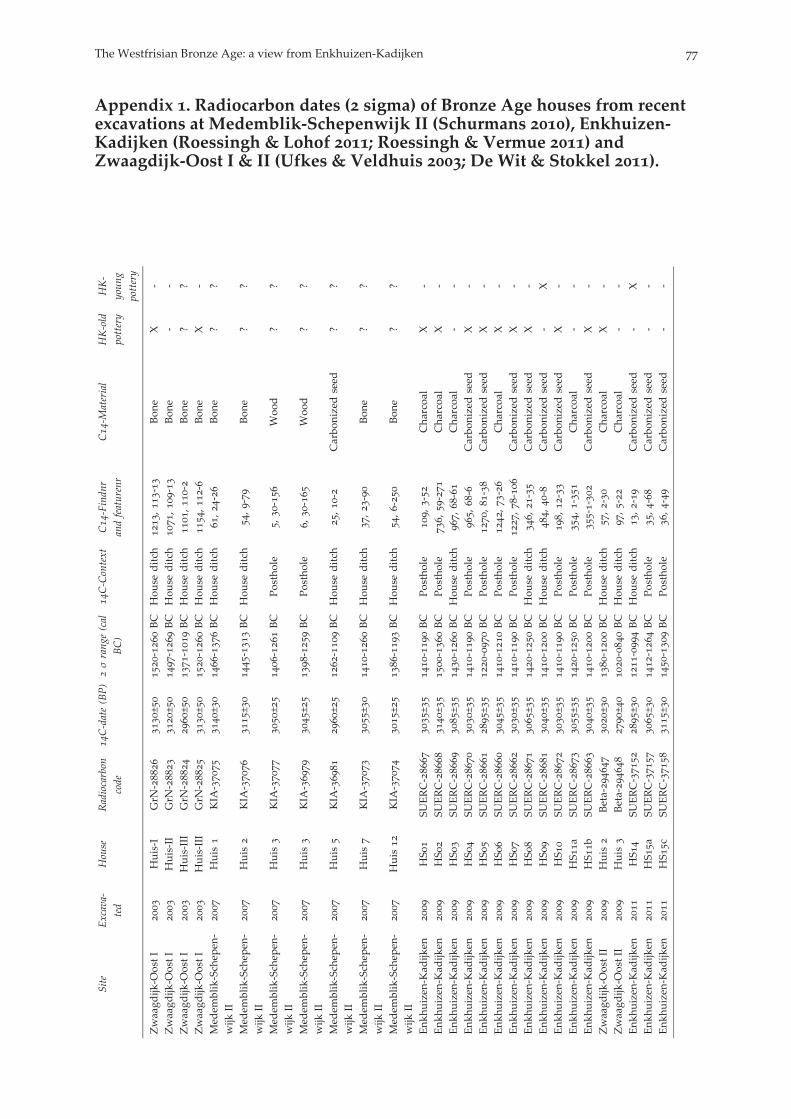
Appendix . Radiocarbon dates ( sigma) of Bronze Age houses from recentexcavations at Medemblik-Schepenwijk II (Schurmans ), Enkhuizen-Kadijken (Roessingh & Lohof ; Roessingh & Vermue ) andZwaagdijk-Oost I & II (Ufkes & Veldhuis ; De Wit & Stokkel ).
Site
Excava-
ted
House
Radiocarbon
code
C-date(BP)
σrang
e(cal
BC)
C-Context
C-Findn
randfeaturenr
C-M
aterial
HK-old
pottery
HK-
youn
gpottery
Zwaagd
ijk-O
ostI
Huis-I
GrN
-
±
-BC
Hou
seditch
,
-
Bon
eX
-Zwaagd
ijk-O
ostI
Huis-II
GrN
-
±
-BC
Hou
seditch
,
-
Bon
e-
-Zwaagd
ijk-O
ostI
Huis-III
GrN
-
±
-BC
Hou
seditch
,
-
Bon
e?
?Zwaagd
ijk-O
ostI
Huis-III
GrN
-
±
-BC
Hou
seditch
,
-
Bon
eX
-Med
emblik-Sch
epen
-wijk
II
Huis
KIA
-
±
-BC
Hou
seditch
,
-
Bon
e?
?
Med
emblik-Sch
epen
-wijk
II
Huis
KIA
-
±
-BC
Hou
seditch
,
-
Bon
e?
?
Med
emblik-Sch
epen
-wijk
II
Huis
KIA
-
±
-BC
Postho
le,
-
Woo
d?
?
Med
emblik-Sch
epen
-wijk
II
Huis
KIA
-
±
-BC
Postho
le,
-
Woo
d?
?
Med
emblik-Sch
epen
-wijk
II
Huis
KIA
-
±
-BC
Hou
seditch
,
-
Carbo
nizedseed
??
Med
emblik-Sch
epen
-wijk
II
Huis
KIA
-
±
-BC
Hou
seditch
,
-
Bon
e?
?
Med
emblik-Sch
epen
-wijk
II
Huis
KIA
-
±
-BC
Hou
seditch
,
-
Bon
e?
?
Enk
huizen
-Kad
ijken
HS
SU
ERC-
±
-BC
Postho
le,
-
Cha
rcoa
lX
-Enk
huizen
-Kad
ijken
HS
SU
ERC-
±
-BC
Postho
le,
-
Cha
rcoa
lX
-Enk
huizen
-Kad
ijken
HS
SU
ERC-
±
-BC
Hou
seditch
,
-
Cha
rcoa
l-
-Enk
huizen
-Kad
ijken
HS
SU
ERC-
±
-BC
Postho
le,
-
Carbo
nizedseed
X-
Enk
huizen
-Kad
ijken
HS
SU
ERC-
±
-BC
Postho
le,
-
Carbo
nizedseed
X-
Enk
huizen
-Kad
ijken
HS
SU
ERC-
±
-BC
Postho
le,
-
Cha
rcoa
lX
-Enk
huizen
-Kad
ijken
HS
SU
ERC-
±
-BC
Postho
le,
-
Carbo
nizedseed
X-
Enk
huizen
-Kad
ijken
HS
SU
ERC-
±
-BC
Hou
seditch
,
-
Carbo
nizedseed
X-
Enk
huizen
-Kad
ijken
HS
SU
ERC-
±
-BC
Hou
seditch
,
-
Carbo
nizedseed
-X
Enk
huizen
-Kad
ijken
HS
SU
ERC-
±
-BC
Postho
le,
-
Carbo
nizedseed
X-
Enk
huizen
-Kad
ijken
HS
a
SUERC-
±
-BC
Postho
le,
-
Cha
rcoa
l-
-Enk
huizen
-Kad
ijken
HS
b
SUERC-
±
-BC
Postho
le--
Carbo
nizedseed
X-
Zwaagd
ijk-O
ostII
Huis
Beta-
±
-BC
Hou
seditch
,
-
Cha
rcoa
lX
-Zwaagd
ijk-O
ostII
Huis
Beta-
±
-BC
Hou
seditch
,
-
Cha
rcoa
l-
-Enk
huizen
-Kad
ijken
HS
SU
ERC-
±
-BC
Hou
seditch
,
-
Carbo
nizedseed
-X
Enk
huizen
-Kad
ijken
HS
a
SUERC-
±
-BC
Postho
le,
-
Carbo
nizedseed
--
Enk
huizen
-Kad
ijken
HS
c
SUERC-
±
-BC
Postho
le,
-
Carbo
nizedseed
--
The Westfrisian Bronze Age: a view from Enkhuizen-Kadijken
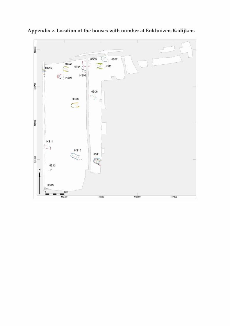
Appendix . Location of the houses with number at Enkhuizen-Kadijken.