Data-Use-Training-Wood-Badge-Packet.pdf - Montclair State ...
The Weather Merit Badge - Arkansas State Legislature
24
Emergency Management and Emergency Management and Communication Communication Presented by: Presented by: Steve Steve Drillette Drillette, Meteorologist , Meteorologist-in in-Charge Charge National Weather Service, Little Rock, AR National Weather Service, Little Rock, AR
-
Upload
khangminh22 -
Category
Documents
-
view
0 -
download
0
Transcript of The Weather Merit Badge - Arkansas State Legislature

Emergency Management and Emergency Management and CommunicationCommunication
Presented by:Presented by:
Steve Steve DrilletteDrillette, Meteorologist, Meteorologist--inin--ChargeCharge
National Weather Service, Little Rock, AR National Weather Service, Little Rock, AR

National Weather Service
Who are we??
Since 1870

weath
er.
go
v/
weath
er.
go
v/r
gv
rgv
Government Closest to the People, Serves Best!

Our Mission Our Mission
To protect life and property by issuing
timely warnings (i.e. for tornadoes, severe
thunderstorms, flash flooding, etc).
To protect life and property by issuing
timely warnings (i.e. for tornadoes, severe
thunderstorms, flash flooding, etc).
Tornado WarningTornado Warning
Severe Thunderstorm WarningSevere Thunderstorm Warning

When We Are Open When We Are Open
Weather never stops, so we are open
24 hours a day/7 days a week (even on
Christmas, Thanksgiving, etc).
Weather never stops, so we are open
24 hours a day/7 days a week (even on
Christmas, Thanksgiving, etc).
Our TeamOur Team
10 Forecasters (2 per shift)10 Forecasters (2 per shift)
2 Meteorologist Interns2 Meteorologist Interns
1 Hydrologist1 Hydrologist
3 Electronic Technicians3 Electronic Technicians
1 Electronic Systems Administrator 1 Electronic Systems Administrator
1 Information Technology Officer1 Information Technology Officer
1 Observation Program Leader 1 Observation Program Leader
1 Warning Coordination Meteorologist1 Warning Coordination Meteorologist
1 Science and Operations Officer1 Science and Operations Officer
1 Meteorologist1 Meteorologist--inin--ChargeCharge
1 Administrative Assistant 1 Administrative Assistant

Typical Forecaster Typical Forecaster
WorkstationWorkstation
Additionally Additionally MonitorMonitor
*Aviation *Rivers/Lakes *Fire Weather

Weather Impacts
on Society
Weather Impacts
on Society

Offices Serving Arkansas
Five National Five National
Weather Service Weather Service
Forecast Offices Forecast Offices
serve serve the the state of state of
Arkansas.Arkansas.

5 Offices –> 5 Briefings

One Briefing for the State of Arkansas

Severe Briefing Example Risk of Severe Storms Define Risk Timing of Storms

DSS Webpage
http://www.srh.noaa.gov/lzk/?n=dssarkansas.htm

When Watches/Warnings are Issued

NOAA Weather Radio
Transmitter Frequency Cherokee Village 162.475
El Dorado 162.525
Fayetteville 162.475
Fort Smith 162.550
Fountain Hill 162.475
Gurdon 162.475
Harrison 162.525
High Peak 162.425
Jonesboro 162.550
Little Rock 162.550
Marvell 162.525
Mena 162.400
Morrilton 162.475
Mountain View 162.450
Russell 162.400
Russellville 162.525
Springdale 162.400
Star City 162.400
Texarkana 162.550
Yellville 162.500

Relay Watch/Warning Relay Watch/Warning
The National Warning System (NAWAS) and
AWIN (Arkansas Wireless Information Network)
Mutual Aid Channel Pool (MAC) phones are used
to convey watches/warnings to Federal, State
and local governments, as well as law
enforcement.
The National Warning System (NAWAS) and
AWIN (Arkansas Wireless Information Network)
Mutual Aid Channel Pool (MAC) phones are used
to convey watches/warnings to Federal, State
and local governments, as well as law
enforcement.

Relay Watch/Warning Relay Watch/Warning
During significant events (such as when
Tornado Warnings are issued), phone calls
are often made to affected counties. That was
the case on April 27, 2014 (the Mayflower/Vilonia
Tornado), when the Faulkner County Sheriff was
contacted.
During significant events (such as when
Tornado Warnings are issued), phone calls
are often made to affected counties. That was
the case on April 27, 2014 (the Mayflower/Vilonia
Tornado), when the Faulkner County Sheriff was
contacted.

On April 27, 2014 On April 27, 2014
At 743 pm CDT, the WSR-88D (Doppler Weather
Radar) showed strong rotation to the southwest
Of Vilonia (Faulkner County). A Dual-Pol
Correlation Coefficient (CC) image indicated a
Tornado Debris Signature (TDS).
At 743 pm CDT, the WSR-88D (Doppler Weather
Radar) showed strong rotation to the southwest
Of Vilonia (Faulkner County). A Dual-Pol
Correlation Coefficient (CC) image indicated a
Tornado Debris Signature (TDS).

Tornado Emergency Tornado Emergency
Given information from the radar, and also from
trained storm spotters, a rare “Tornado
Emergency” was declared.
Given information from the radar, and also from
trained storm spotters, a rare “Tornado
Emergency” was declared.

Social Media Social Media
Storm reports rolled in from social media
outlets such as Twitter and Facebook.
Storm reports rolled in from social media
outlets such as Twitter and Facebook.

HAM Radio HAM Radio
Amateur radio operators were asked to come
to the office during this event to collect
valuable information from the public.
Amateur radio operators were asked to come
to the office during this event to collect
valuable information from the public.
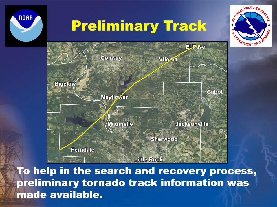
Preliminary Track Preliminary Track
To help in the search and recovery process,
preliminary tornado track information was
made available.
To help in the search and recovery process,
preliminary tornado track information was
made available.

Flying the Track Flying the Track
To get a better (more clear) understanding of
what happened, forecasters flew over the
damage with the Civil Air Patrol.
To get a better (more clear) understanding of
what happened, forecasters flew over the
damage with the Civil Air Patrol.

On the Web On the Web
An extensive reported was posted to the
office website.
An extensive reported was posted to the
office website.
http://www.srh.noaa.gov/lzk/?n=svr0414cyr.htm

The End The End
Thanks for coming!
Any questions?
Thanks for coming!
Any questions?