The U.S. Department of Veterans Affairs, Final Supplemental ...
427
Proposed Construction and Operation of the Phase 5 Expansion Indiantown Gap National Cemetery, Annville, PA Final Supplemental Environmental Assessment Appendices Appendix A – Environmental Survey Reports
-
Upload
khangminh22 -
Category
Documents
-
view
0 -
download
0
Transcript of The U.S. Department of Veterans Affairs, Final Supplemental ...

Proposed Construction and Operation of the Phase 5 Expansion Indiantown Gap National Cemetery, Annville, PA
Final Supplemental Environmental Assessment Appendices
Appendix A – Environmental Survey Reports

DEPARTMENT OF VETERANS AFFAIRS CONSTRUCTION AND FACILITIES MANAGEMENT OFFICE
WASHINGTON DC
August 5, 2021
U.S. Fish & Wildlife Service Attn: Ms. Jennifer Kagel Pennsylvania Field Office 110 Radnor Rd., Suite 101 State College, PA 16801 Re: Phase 1 Bog Turtle Habitat Survey Report (October 2020)
Phase 2 Presence/Probable Absence Bog Turtle Survey Report (June 2021) and Phase 1 Additional Project Area Bog Turtle Habitat Survey Report (July 2021) Indiantown Gap National Cemetery Phase 5 Expansion Project PNDI # 737860
Dear Ms. Kagel, The U.S. Department of Veterans Affairs (VA), National Cemetery Administration (NCA) is currently preparing a Supplemental Environmental Assessment (SEA) in accordance with VA policy for compliance with the National Environmental Policy Act (NEPA). The SEA evaluates the potential impacts of the proposed Phase 5 expansion within the Indiantown Gap National Cemetery (IGNC). The proposed Phase 5 expansion area covers approximately 45 acres and is located east of the existing developed portion of the cemetery. The IGNC is located in Annville, Lebanon County with approximate coordinates of 40.423871, 76.558388. Indiantown Gap National Cemetery is approximately 20-miles northeast of Harrisburg, in the Lebanon Valley of central-southern Pennsylvania. Project Purpose The purpose of the Phase 5 expansion is to extend the longevity of the Indiantown Gap National Cemetery and provide future generations of eligible Veterans and their families with long-term, reasonable access to burial benefits at a National Cemetery in the east central Pennsylvania region. Surveys Completed To-Date In 2020, VA began designing the alignment for the proposed 45-acre Phase 5 expansion area within a larger 120-acre area. Accordingly, VA performed a bog turtle habitat survey throughout this 120acre area (120-Acre Project Area). The survey identified potential bog turtle habitat (PBTH). Subsequently, a Phase 2 Presence/Absence Survey (Phase 2) was completed and determined that no bog turtles were present within the 120-acre Project Area. No bog turtles were identified in the PBTH. The Phase 1 Bog Turtle Habitat Assessment (Phase 1) and Phase 2 Presence/Absence Survey (Phase 2) reports are included as Attachments 1 and 2, respectively, to this letter.
Indiantown Gap National Cemetery Page 1 of 3 Proposed Phase 5 Expansion
Cover Page

United States Fish and Wildlife Service Pennsylvania Field Office
August 5, 2021
Subsequently, VA selected a design in early 2021. By July 2021, the design team proposed other minor surficial improvements (e.g. repaving) within the existing developed western portion of IGNC. Accordingly, a PBTH survey was performed in the western portion of the developed cemetery; the area of this survey is identified as the “Additional Project Area” in the attached report dated July 2021 (attachment 3). The survey determined that the Additional Project Area contained PBTH within 300 feet of where proposed improvements would occur. The proposed disturbance to areas within 300feet of the identified PBTH would be limited to widening of existing paved walkways within the mowed and maintained cemetery grounds, installation of informational signage along existing roadways, and non-structural cosmetic maintenance of existing monuments and bridge structures. Additionally, VA notes there are no proposed direct impacts to wetlands or watercourses in the Additional Project Area. However, due to the presence of PBTH, VA has elected to assume presence of bog turtles in these additional wetlands for the purposes of this Proposed Action and to employ avoidance measures during improvements to grounds located within 300 feet of the PBTH to ensure no adverse effects to bog turtles. These avoidance measures, for which we request USFWS concurrence, are as follows:
• To avoid adverse effects to bog turtles, all disturbance within 300-feet of the PBTH identified in the Additional Project Area on June 10, 2021, would be conducted during the bog turtle time-of year restriction period between October 01 and March 31, OR conducted under the supervision of a Recognized Qualified Bog Turtle Surveyor.
• Due to the currently mowed and maintained conditions adjacent to the PBTH wetlands and the limited disturbance required to complete the work proposed for the Additional Project Area, we find that installing bog turtle habitat exclusion fencing would result in additional unnecessary disturbance and extend the duration of work time needed to complete the maintenance and upgrades in the areas adjacent to the PBTH. As such, we request USFWS’s additional concurrence with the recommendation of TES&P’s Recognized Qualified Bog Turtle Surveyor that habitat exclusion measures should not be required if the work is conducted under the supervision of a Recognized Qualified Bog Turtle Surveyor. If additional unanticipated changes to the proposed improvements are encountered, the use of habitat exclusion measures would be utilized at the digression of the onsite Recognized Qualified Bog Turtle Surveyor and would be reported to the USFWS immediately.
A summary of the attached reports detailing and supporting the above findings is as follows: 1) Indiantown Gap National Cemetery Expansion Project Phase 1 Bog Turtle Habitat
Survey Report (October 2020). Potential bog turtle habitat identified in wetland INC-W002; Phase 2 Survey initiated.
2) Indiantown Gap National Cemetery Phase 5 Expansion Project, Phase 2 Bog Turtle Presence/Probable Absence Survey Report (June 2021). Phase 2 survey completed for wetland INC-W-002 and probable absence of bog turtles is assumed.
3) IGNC Phase 5 Expansion Project-Additional Project Area Phase 1 Bog Turtle Habitat Survey (July 2021). Habitat identified; wetland will be assumed to be occupied and approval of avoidance measures is requested.
Additionally, a signed copy of the final PNDI receipt #737860 is provided as an attachment following the attached survey reports.
Indiantown Gap National Cemetery Page 2 of 3 Proposed Phase 5 Expansion

Indiantown Gap National Cemetery Expansion Project Phase 1 Bog Turtle Habitat Survey Report (October 2020)
Indiantown Gap National Cemetery Phase 5 Expansion Project, Phase 2 Bog Turtle Presence/Probable Absence Survey Report (June 2021)
IGNC Phase 5 Expansion Project-Additional Project Area Phase 1 Bog Turtle Habitat Survey (July 2021)
FERNANDO L.
United Stales Fish and Wildlife Service Pennsylvania Field Office
August 5, 2021
VA is requesting your review of the attached bog turtle reports and concurrence with the avoidance measures described above and supported by the findings presented in the survey reports attached.
VA appreciates your lime and attention to this request. Should you have any questions or concerns, please contact me at (202) 632-5529 or via email at [email protected].
Sincerely,
FERNANDEZ336237
Digitally signed by FERNANDO L. FERNANDEZ 336237Date: 2021,08.12 10:21:05 -04'00'
Fernando Fernandez, REMEnvironmental EngineerU.S. Department of Veterans AffairsConstruction and Facilities Management Office
CC: Emma Fernandes, Mabbett & Associates, Inc.Bridger Thompson, Thompson Environmental Surveys & Permitting, LLC
Attachments:
1)
2)
3)
4) PNDI # 737860
Indiantown Gap National Cemetery Proposed Phase 5 Expansion
Page 3 of 3

United States Fish and Wildlife Service Pennsylvania Field Office
August 5, 2021
ATTACHMENT 1
Phase 1 Bog Turtle Habitat Survey Report
Indiantown Gap National Cemetery Attachments Proposed Phase 5 Expansion

U.S. Department of Veterans Affairs
Proposed Phase 5 Cemetery Expansion at the
Indiantown Gap National Cemetery
Annville, Lebanon County, Pennsylvania
Phase 1 Bog Turtle Habitat Survey Report
Prepared for:
AE Works, Ltd.
Prepared by:
Mabbett & Associates, Inc.
Thompson Environmental Surveys & Permitting, LLC.
October 2020

I.0
INDIANTOWN GAP NATIONAL CEMETERY – Phase 5 EXPANSION PROJECT PHASE 1 BOG TURTLE HABITAT SURVEY REPORT
Contents
1 Introduction......................................................................................................................... 1 2 Background......................................................................................................................... 1 3 Phase 1 Survey Methodology ............................................................................................. 2 4 Habitat Survey Results........................................................................................................ 2 5 Summary............................................................................................................................. 8 6 References........................................................................................................................... 9
Tables Table 1 Project Sites ..................................................................................................................................... 2 Table 2 Wetland Identification Table ......................................................................................................... 10
Appendices Appendix A Figure 1 – Project LocationMap
Figure 2 – Phase 1 Bog Turtle Survey Study Area Map
Appendix B USFWS Phase 1 Bog Turtle Habitat Survey Field Forms for the Northern Population Range
Appendix C Resource Photographs
Appendix D PNDI Receipt
Thompson Environmental Surveys & Permitting,LLC. October 2020

INDIANTOWN GAP NATIONAL CEMETERY EXPANSION PROJECT PHASE 1 BOG TURTLE HABITAT SURVEY REPORT
1 Introduction
Mabbett & Associates, Inc. (Mabbett) and subcontractor Thompson Environmental Surveys & Permitting, LLC. (TES&P) recently conducted a Phase 1 Bog Turtle (Glyptemys muhlenbergii) Habitat Survey (Phase 1) at the Indiantown Gap National Cemetery for the proposed Phase 5 expansion (hereafter referred to as the Project). The Phase 1 survey was conducted to determine if the conditions of potential bog turtle habitat (PBTH) are present within the vicinity of the Project area. The information derived from this survey will be used for future project planning and design purposes. This report documents the methodology and results of the Phase 1 Bog Turtle Habitat Survey performed for the Project by TES&P in October, 2020.
2 Background
The Project is located within the United States Geological Survey (USGS) Indiantown Gap, PA 7.5-minute series topographical quadrangle (USGS, 2013). Land cover within the Project area consists of mowed maintained open areas, forest, wetlands, watercourses, and floodplain/riparian areas. Land uses in the vicinity of the Project consist of developed military training ranges and facilities, cemetery, transmission line right-of-way, and primary and secondary roadways. The Project area drains to north and east Aires Run which is located inSwatara Creek Watershed and the Lower Susquehanna River basin.
Federal law, specifically the Endangered Species Act (ESA) of 1973, mandates that all federal agencies undertaking projects that have an effect or have the potential to have an effect on threatened, endangered, or candidate species, be it through direct or indirect jurisdiction, such as a federal license or permit, must undergo Section 7 ESA Review. The Section 7 consultation process requires that federal agencies, or those entities seeking a federal license or permit, consider how their undertakings may affect endangered species and allow the United States Fish and Wildlife Service (USFWS) or National Marine Fisheries Service (NMFS), if applicable, the opportunity to comment on such undertakings. Additionally, any projects in Pennsylvania that are within the known range of bog turtles, a state threatened species, and may require a Pennsylvania Department of Environmental Protection (PADEP) Chapter 105 Individual Permit, or a General Permit (GP) 5, 6, 7, 8, 9 or 11, must comply with the bog turtle screening requirements of the PA State Programmatic General Permit (PASPGP), and are required to conduct a Phase 1 Bog Turtle Habitat Survey as part of the permit review process. The known range of the bog turtle in Pennsylvania includes: Adams, Berks, Bucks, Carbon, Chester, portions of Cumberland (Yellow Breeches Watershed), Delaware, portions of Dauphin (Conewago, and Spring Creek Watersheds), Franklin, Lancaster, Lebanon, Lehigh, Monroe, Montgomery, Northampton, Schuylkill (Swatara Creek Watershed), and York Counties (USFWS 2018; USACE,2008).
The Project is within the known range of bog turtles in Pennsylvania. As such, a Phase 1 Bog Turtle Habitat Survey is required for any potential developments in or adjacent to the Project area.
Thompson Environmental Surveys &Permitting, LLC. October 2020
1

INDIANTOWN GAP NATIONAL CEMETERY EXPANSION PROJECT PHASE 1 BOG TURTLE HABITAT SURVEY REPORT
3 Phase 1 Survey Methodology
On October 07 and 08, 2020, TES&P biologist, Bridger Thompson, a USFWS and Pennsylvania Fish and Boat Commission (PFBC) Recognized Qualified Bog Turtle Surveyor (RQBTS) conducted a Phase 1 survey for the above referenced Project to identify PBTH. PBTH is recognized by three criteria: suitable hydrology (including spring seeps, shallow surface water, persistently saturated soils, subsurface flow, and rivulets); suitable soils (including a bottom substrate of soft muck, a critical criterion) and; suitable vegetative structure (including dominant vegetation of low grasses and sedges, reed canary grass, cattail, rice cut grass, phragmites, or skunk cabbage, and possibly a scrub-shrub wetland component with a relatively open canopy).
Based on information provided by AE Works, Ltd., the Phase 1 Study Area (Study Area) was determined. The Study Area includes all wetlands identified within 300 feet of the proposed Project limits-of-disturbance. The approximately 216-acre Study Area is located adjacent to the Indiantown Gap National Cemetery, south of Biddle Drive and west of Indiantown Road in East Hanover and Union Townships, Lebanon County, Pennsylvania (Figure 1 - Project Location Map). Prior to conducting the onsite survey, TES&P conducted a desktop review for the Project and investigated current and historic aerial imagery of the Study Area. An aquatic resources delineation survey was conducted concurrently with the Phase 1 survey. During the onsite surveys TES&P identified eighteen (18) wetlands within the Study Area. Each resource was assessed in its entirety for the conditions required to be considered PBTH. If a wetland was determined to be PBTH, the Designated Survey Area (DSA) within the wetland was determined. DSA is defined as all areas of the wetland where soft muck-like soils are present. Information recorded during the Phase 1 survey for each wetland is presented on the USFWS Phase 1 Bog Turtle Habitat Survey Field Forms for the Northern Population Range (Revised April 2020), including dominant plant species, substrate characteristics, and hydrology (Attachment B). Representative habitat conditions within the wetlands were photographed and are included in the attached photo log (Attachment C).
4 Habitat Survey Results
During the on-site survey, TES&P investigated eighteen wetlands identified within the Study Area. The following is a brief description of the investigated resources and their potential to be considered bog turtle habitat.
Wetland (INC-W-001)
Wetland INC-W-001 is an approximately 0.14-acre palustrine emergent (PEM) wetland located in a topographic depression at the edge of the existing mowed maintained cemetery boundary. The wetland is situated at the discharge of a small seasonal ground water seep that is the origin of a downslope perennial channel. The primary source of hydrology to the wetland is the seasonal groundwater discharge and seasonally high ground water table. Surface water runoff from adjacent uplands also contributes to the wetland hydrology. The wetland vegetation is dominated Japanese stilt grass (Microstegium vimineum), clearweed (Pilea pumila), and fowl managrass (Glyceria striata). The substrate of the wetland contains silt loam underlain by clay loam material and was not mucky. The wetland is not dominated by species common to areas identified as PBTH and, it does not contain the appropriate habitat structure including surface flow in rivulets, subsurface flow, and micro habitat conditions. Additionally, the wetland is located in an area that has been historically disturbed. Due to the lack of spring fed hydrology and mucky soil substrate, and the historically disturbed condition lacking an appropriate habitat structure wetland INC-W-001 is not considered PBTH. The location of the wetland is depicted on Page 5 of Figure 2, additional wetland information is provided in Table 2.
Thompson Environmental Surveys &Permitting, LLC. October 2020
2

INDIANTOWN GAP NATIONAL CEMETERY EXPANSION PROJECT PHASE 1 BOG TURTLE HABITAT SURVEY REPORT
Wetland (INC-W-002)
Wetland INC-W-002 is an approximately 0.52-acre PEM wetland located in a topographic depression at the toe of the fill slope of Biddle Drive. The wetland is situated at the discharge of multiple seasonal ground water seeps that contribute to a downslope perennial channel. The primary source of hydrology to the wetland is the persistent groundwater discharge, seasonal high ground water table, and a surface water runoff from adjacent uplands. The wetland vegetation is dominated by Japanese stilt grass, dark green bulrush (Scirups atrovirens), and cattail (Typha latifolia). The substrate of the wetland contained silt and silt loam underlain by clay loam and contained areas of mucky substrate measuring to depths of 3-to-10 inches associated with the persistent groundwater fed hydrology. The wetland contains species common to areas identified as PBTH and areas with the appropriate habitat structure including surface flow in rivulets, subsurface flow, and micro habitat conditions. While portions of the wetland have been historically disturbed by road construction enough microhabitat conditions and vegetative structure remain to potentially support bog turtles. Due to the presence of persistently ground water fed hydrology and mucky soil substrate and the presence of a vegetative structure containing microhabitat conditions wetland INC-W-002 is considered PBTH. Approximately 0.12-acres of DSA was identified within the wetland. The location of the wetland and associated DSA is depicted on Page 1 of Figure 2, additional wetland information is provided in Table 2.
Wetland (INC-W-003)
Wetland INC-W-003 is an approximately 0.01-acre PEM wetland located along the floodplain of a small intermittent watercourse that flows through a natural swale on a wooded hillslope. The primary source of hydrology to the wetland is the seasonal ground water flow within the watercourse and surface water runoff from adjacent uplands. The wetland vegetation is dominated by Japanese stilt grass, bulrush, and jewelweed (Impatiens capensis). The substrate of the wetland was saturated and contained silt loam but, was not mucky per association with persistent spring fed hydrology. The wetland did contain species common to areas identified as PBTH however, it did not contain the appropriate habitat structure including surface flow in rivulets, subsurface flow, and micro habitat conditions. Additionally, the wetland is located in an area that has been historically disturbed by logging. Due to the lack of spring fed hydrology and mucky soil substrate, and the historically disturbed condition of surrounding area wetland INC-W-003 is not considered PBTH. The location of the wetland is depicted on Page 3 of Figure 2, additional wetland information is provided in Table 2.
Wetland (INC-W-004)
Wetland INC-W-004 is an approximately 0.02-acre PEM wetland located at the origin of a small intermittent watercourse that flows through a natural swale on a wooded hillslope. The primary source of hydrology to the wetland is the seasonal ground water discharge within the wetland and surface water runoff from adjacent uplands. The wetland vegetation is dominated by Japanese stilt grass, jewelweed, and sensitive fern (Onoclea sensibilis). The substrate of the wetland was not saturated and contained silt loam that was not mucky per association with persistent spring fed hydrology. The wetland did contain some species common to areas identified as PBTH however, it did not contain the appropriate habitat structure including surface flow in rivulets, subsurface flow, and micro habitat conditions. Additionally, the wetland is located in an area that has been historically disturbed by logging. Due to the lack of spring fed hydrology and mucky soil substrate, and the historically disturbed condition of surrounding area wetland INC-W-004 is not considered PBTH. The location of the wetland is depicted on Page 1 of Figure 2, additional wetland information is provided in Table 2.
Wetland (INC-W-005)
Wetland INC-W-005 is an approximately 0.01-acre PEM resource located in the central portion of the Study Area. The wetland is situated in a topographic depression within a periodically maintained transmission right-of-way area adjacent to a wooded/shrubby hillslope. The primary source of wetland hydrology is provided by a seasonal groundwater discharge and surface water runoff collection within the right-of-way. The wetland vegetation is dominated by Japanese stiltgrass, sensitive fern, and ironweed (Vernonia altissima). The substrate of the wetland was not saturated and contained silt loam underlain by a clay loam that was not mucky per
Thompson Environmental Surveys &Permitting, LLC. October 2020
3

INDIANTOWN GAP NATIONAL CEMETERY EXPANSION PROJECT PHASE 1 BOG TURTLE HABITAT SURVEY REPORT
association with persistent spring fed hydrology. The wetland did contain some species common to areas identified as PBTH however, it did not contain the appropriate habitat structure including surface flow in rivulets, subsurface flow, and micro habitat conditions. Additionally, the wetland is located in an area that has been historically disturbed by right-of-way clearing and maintenance. Due to the lack of spring fed hydrology and mucky soil substrate, and the historically disturbed condition of surrounding area wetland INC-W-006 is not considered PBTH. The location of the wetland is depicted on Page 1 of Figure 2, additional wetland information is provided in Table2.
Wetland (INC-W-006)
Wetland INC-W-006 is an approximately 0.04-acre PEM wetland located at the origin of a small intermittent watercourse that flows through a natural swale on a wooded hillslope. The primary source of hydrology to the wetland is the seasonal ground water discharge within the wetland and surface water runoff from adjacent uplands. The wetland vegetation is dominated by Japanese stilt grass, jewelweed, and arrowleaf tearthumb (Persicaria sagittata). The substrate of the wetland was saturated and contained silt loam underlain by a clay loam but, the substrate was not mucky per association with persistent spring fed hydrology. The wetland did contain some species common to areas identified as PBTH however, it did not contain the appropriate habitat structure including surface flow in rivulets, subsurface flow, and micro habitat conditions. Additionally, the wetland is located in an area that has been historically disturbed by logging. Due to the lack of spring fed hydrology and mucky soil substrate, and the historically disturbed condition of surrounding area wetland INC-W-006 is not considered PBTH. The location of the wetland is depicted on Page 2 of Figure 2, additional wetland information is provided in Table 2.
Wetland (INC-W-007)
Wetland INC-W-007 is an approximately 0.10-acre PEM resource located in the southeast portion of the Study Area. This wetland is associated with the seasonal groundwater discharge from several intermittent channels that are loosely defined throughout a forested bottomland. The surrounding area contains thick scrub-shrub vegetation resulting from historic use of the area for military training activities and recent logging. The wetland vegetation is dominated by Japanese stilt grass, jewelweed, sensitive fern, and bulrush and the surrounding forested area contains ash species (Fraxinus sp.), red maple (Acer rubrum), and spice bush (Lindera benzoin). The wetland contains some vegetation commonly observed in PBTH however, there is no mucky soil substrate. Due to the historic disturbances, lack of a mucky soil substrate, spring fed hydrology, and appropriate micro-habitat conditions, wetland INC-W-007 is not considered PBTH. The location of the wetland is depicted on Page 8 of Figure 2. Additional wetland information is provided in Table2.
Wetland (INC-W-008)
Wetland INC-W-008 is an approximately 0.08-acre PEM resource located in the southwest portion of the Study Area. The wetland is located natural depressional topography within a drainage in a wooded shrubby lot. The wetland hydrology is associated with seasonal ground water discharge, seasonally high groundwater, and surface water runoff from upslope-maintained cemetery grounds. The wetland vegetation is dominated by arrowleaf tearthumb, jewelweed, Japanese stiltgrass, sensitive fern, and bulrush. The wetland substrate soft due to the persistently saturated conditions however, it is not mucky. The vegetative structure is not consistent with the conditions typically observed in PBTH and no subsurface flow or microhabitat conditions were observed. Due to the lack of a spring fed hydrology, mucky soil substrate, and appropriate vegetative and micro-habitat conditions, wetland INC-W-008 is not considered potential bog turtle habitat. The location of the wetland is depicted on Page 7 of Figure 2. Additional wetland information is provided in Table 2.
Wetland (INC-W-009)
Wetland INC-W-009 is an approximately 0.04-acre PEM resource located in the southwest portion of the Study Area. The wetland is located in an excavated swale that receives stormwater discharge form the upslope-maintained cemetery grounds. The wetland hydrology is associated with seasonal groundwater discharge, seasonally high groundwater table and surface water runoff that collects constructed swale. The wetland
Thompson Environmental Surveys &Permitting, LLC. October 2020
4

INDIANTOWN GAP NATIONAL CEMETERY EXPANSION PROJECT PHASE 1 BOG TURTLE HABITAT SURVEY REPORT
vegetation is dominated by Japanese stiltgrass, cattail, bulrush, and willowherb (Epilobium ciliatum). The wetland substrate is saturated however, it is not mucky and the vegetative structure was not consistent with the conditions typically observed in PBTH. Due to disturbed wetland conditions and the lack of a spring fed hydrology, mucky soil substrate, and appropriate vegetative and micro-habitat conditions, wetland INC-W-009 is not considered potential bog turtle habitat. The location of the wetland is depicted on Page 7 of Figure 2. Additional wetland information is provided in Table 2.
Wetland (INC-W-010)
Wetland INC-W-010 is an approximately 0.01-acre PEM wetland located along the discharge of a small ephemeral watercourse flows through natural low topography on a wooded hillslope. The primary source of hydrology to the wetland is the surface water runoff from adjacent uplands. The wetland vegetation is dominated by Japanese stilt grass, jewelweed, willowherb, beggars tick (Bidens frondosa). The substrate of the wetland is not saturated and contained silt loam underlain by a clay loam that was not mucky per association with persistent spring fed hydrology. The wetland did contain some species common to areas identified as PBTH however, it did not contain the appropriate habitat structure including surface flow in rivulets, subsurface flow, and micro habitat conditions. Additionally, the wetland is located in an area that has been historically disturbed by logging. Due to the lack of spring fed hydrology and mucky soil substrate, and the historically disturbed condition of surrounding area wetland INC-W-010 is not considered PBTH. The location of the wetland is depicted on Page 5 of Figure 2, additional wetland information is provided in Table 2.
Wetland (INC-W-011)
Wetland INC-W-011 is an approximately 0.02-acre PEM resource located in the central portion of the Study Area. The wetland is located in depressional topography downslope of a graded filled storage site. The primary source of wetland hydrology is the surface water runoff collection from the surrounding uplands and disturbed fill areas. The wetland is only vegetated on its fringes and could be more precisely classified as a vernal pool as it has evidence of an algal mat in the central non-vegetated concave areas. The fringe vegetation is dominated by Japanese stiltgrass, bulrush, and Pennsylvania smartweed (Polygonum pensylvanicum). The wetland substrate was not saturated and was primarily composed of silt deposited from erosion. The vegetative structure in the wetland was not consistent with the conditions typically observed in potential bog turtle habitat. Due to the lack of a mucky soil substrate, spring fed hydrology, and appropriate vegetative and micro-habitat conditions, wetland INC-W-011 is not considered PBTH. The location of the wetland is depicted on Page 5 of Figure 2. Additional wetland information is provided inTable 2.
Wetland (INC-W-012)
Wetland INC-W-012 is an approximately 0.20-acre PEM wetland located in a wooded shrubby lot at the edge of a mowed maintained cemetery boundary. The wetland is situated at the discharge of several small seasonal ground water seeps that create a heavily incised downslope intermittent channel. The primary source of hydrology to the wetland is the seasonal groundwater discharge and seasonal high ground water. Surface water runoff from adjacent uplands also contributes to the wetland hydrology. The wetland vegetation is dominated Japanese stilt grass and jewelweed. The substrate of the wetland was saturated and contains silt loam underlain by clay loams material that was not mucky. The wetland is not dominated by species common to areas identified as PBTH and, it does not contain the appropriate habitat structure including surface flow in rivulets, subsurface flow, and micro habitat conditions. Additionally, the wetland is located in an area that has been historically disturbed. Due to the lack of spring fed hydrology and mucky soil substrate, and the historically disturbed condition lacking an appropriate habitat structure wetland INC-W-012 is not considered PBTH. The location of the wetland is depicted on Page 5 of Figure 2, additional wetland information is provided in Table 2.
Wetland (INC-W-013)
Wetland INC-W-013 is an approximately 0.01-acre PEM wetland located at the origin of a small ephemeral watercourse flows through a natural swale on a wooded hillslope. The primary source of hydrology to the wetland is the surface water runoff from adjacent uplands. The wetland vegetation is dominated by Japanese
Thompson Environmental Surveys &Permitting, LLC. October 2020
5

INDIANTOWN GAP NATIONAL CEMETERY EXPANSION PROJECT PHASE 1 BOG TURTLE HABITAT SURVEY REPORT
stilt grass, jewelweed, and sensitive fern. The substrate of the wetland was not saturated and contained silt loam underlain by a clay loam that was not mucky per association with persistent spring fed hydrology. The wetland did contain some species common to areas identified as PBTH however, it did not contain the appropriate habitat structure including surface flow in rivulets, subsurface flow, and micro habitat conditions. Additionally, the wetland is located in an area that has been historically disturbed by logging. Due to the lack of spring fed hydrology and mucky soil substrate, and the historically disturbed condition of surrounding area wetland INC-W-013 is not considered PBTH. The location of the wetland is depicted on Page 5 of Figure 2, additional wetland information is provided inTable 2.
Wetland (INC-W-014)
Wetland INC-W-014 is an approximately 0.02-acre PEM resource located in the northwest portion of the Study Area. This wetland is situated along the interface of a toe of slope and the floodplain of a small perennial watercourse. The wetland vegetation is dominated by Japanese stiltgrass, and spicebush (Lindera benzoin). The primary source of wetland hydrology is seasonal groundwater discharge at the toe of slope and surface water runoff collection from periodic flood flow. The wetland substrate was saturated and consists of a is a silt loam and sandy alluvial deposits. The wetland does not contain a mucky soil substrate or spring fed hydrology. The vegetative structure and micro habitat conditions are not consistent with the conditions typically associated with PBTH. Due to the lack of a spring fed hydrology and mucky soil substrate wetland INC-W-014 is not considered PBTH. The location of the wetland is depicted on Page 1 of Figure 2. Additional wetland information is provided in Table 2.
Wetland (INC-W-015)
Wetland INC-W-015 is an approximately 0.04-acre PEM resource located north-central portion of the Study Area. This wetland is situated along the interface of a toe of slope and the floodplain of a small intermittent watercourse within a disturbed transmission line right-of-way. The wetland vegetation is dominated by Japanese stiltgrass and cattail. The primary source of wetland hydrology is seasonal groundwater discharge at the toe of slope and surface water runoff collection from periodic flood flow. The wetland substrate is saturated and consists of a silt loam and sandy alluvial deposits. The wetland does not contain a mucky soil substrate or spring fed hydrology. The vegetative structure and micro habitat conditions are not consistent with the conditions typically associated with PBTH. Due to the lack of a spring fed hydrology and mucky soil substrate wetland INC-W-015 is not considered PBTH. The location of the wetland is depicted on Page 3 of Figure 2. Additional wetland information is provided inTable 2.
Wetland (INC-W-016)
Wetland INC-W-016 is an approximately 0.14-acre PEM resource located in the north-central portion of the Study Area. This wetland is situated on a low-lying floodplain bench along a small perennial watercourse. The primary source of wetland hydrology is the seasonally high groundwater table and periodic flooding from the perennial channel. The wetland substate was not saturated and consists of a silt loam. The wetland vegetation is dominated by Japanese stiltgrass and spice bush. The wetland does contain the vegetative structure and micro habitat conditions typically associated with PBTH and the wetland does not contain a mucky soil substrate or persistent spring fed hydrology. Due to the lack of a spring fed hydrology, mucky soil substrate, and appropriate vegetative structure and microhabitat conditions wetland INC-W-016 is not considered PBTH. The location of the wetland is depicted on Page 3 of Figure 2. Additional wetland information is provided in Table2.
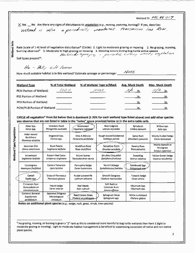
Wetland (INC-W-017)
Wetland INC-W-017 is an approximately 0.02-acre PEM resource located northeast portion of the Study Area. The wetland is situated at the interface between a toe of slope and a floodplain bench within a disturbed transmission line right-of-way. The primary source of wetland hydrology is seasonal toe of slope ground water discharge and seasonally high groundwater table. The wetland vegetation is dominated by Japanese stilt grass, cattail, and arrow leaved tearthumb. The wetland substrate is saturated and consists of a silt loam. The substrate is soft due to the persistent saturated conditions however no deep mucky areas were observed. The wetland does
Thompson Environmental Surveys &Permitting, LLC. October 2020
6

INDIANTOWN GAP NATIONAL CEMETERY EXPANSION PROJECT PHASE 1 BOG TURTLE HABITAT SURVEY REPORT
contain the vegetative structure commonly associated with PBTH. However, the micro habitat conditions in the wetland are not consistent with the conditions typically observed in PBTH. Due to the lack of a mucky soil substrate, persistent spring fed hydrology, and appropriate and micro-habitat conditions, wetland INC-W-017 is not considered PBTH. The location of the wetland is depicted on Page 3 of Figure 2. Additional wetland information is provided in Table 2.
Wetland (INC-W-018)
Wetland INC-W-018 is an approximately 0.24-acre PEM resource located in the northwest extent of the Study Area. The wetland is situated in a periodically maintained roadside ditch along Biddle Drive. The primary source of wetland hydrology is associated with seasonal groundwater discharge that collects in the ditch at the toe of the fill slope for the road. Additional hydrology is provided by stormwater discharge from roadside culverts and surface water collection in the low-lying topography. The wetland vegetation is dominated by cattail Japanese stilt grass, cattail, sensitive fern, and arrowleaf tearthumb. The wetland does not contain a persistent spring fed hydrology or mucky soil substrate, and lacks the micro habitat conditions associated with PBTH. Due to the lack of a spring fed hydrology, mucky soil substrate, and lacking vegetative structure and micro habitat conditions, and the periodic and historic disturbances wetland INC-W-018 is not considered PBTH. The location of the wetland is depicted on Page 4 of Figure 2. Additional wetland information is provided in Table 2.
Table 2- Wetland Identification Table
Resource ID Type (PEM/PFO/PSS)1 Latitude Longitude
Approximate Wetland
Acreage (ac.)
Potential Bog Turtle
Habitat or Travel
Corridor (Y / N / UK)2
Approx. Acreage of
DSA
(ac.)
INC-W-001 PEM 40.423065 -76.562842 0.14 N N/A
INC-W-002 PEM 40.424842 -76.566119 0.52 Y 0.12
INC-W-003 PEM 40.424552 -76.565716 0.01 N N/A
INC-W-004 PEM 40.424179 -76.565654 0.02 N N/A
INC-W-005 PEM 40.424046 -76.565338 0.01 N N/A
INC-W-006 PEM 40.425187 -76.560155 0.04 N N/A
INC-W-007 PEM 40.420372 -76.557410 0.10 N N/A
INC-W-008 PEM 40.419790 -76.561134 0.08 N N/A
INC-W-009 PEM 40.419976 -76.561614 0.04 N N/A
INC-W-010 PEM 40.420604 -76.559229 0.01 N N/A
INC-W-011 PEM-Vernal 40.421766 -76.560199 0.02 N N/A
INC-W-012 PEM 40.421950 -76.561219 0.20 N N/A
Thompson Environmental Surveys &Permitting, LLC. October 2020
7

INDIANTOWN GAP NATIONAL CEMETERY EXPANSION PROJECT PHASE 1 BOG TURTLE HABITAT SURVEY REPORT
Resource ID Type (PEM/PFO/PSS)1 Latitude Longitude
Approximate Wetland
Acreage (ac.)
Potential Bog Turtle
Habitat or Travel
Corridor (Y / N / UK)2
Approx. Acreage of
DSA
(ac.)
INC-W-013 PEM 40.423140 -76.560306 0.01 N N/A
INC-W-014 PEM 40.425439 -76.564939 0.04 N N/A
INC-W-015 PEM 40.425980 -76.556861 0.04 N N/A
INC-W-016 PEM 40.426610 -76.556800 0.14 N N/A
INC-W-017 PEM 40.426539 -76.555554 0.02 N N/A
INC-W-018 PEM 40.424629 -76.567777 0.24 N N/A
1. PEM-PALUSTRINE EMERGENT, PFO-PALUSTRINE FORESTED PSS-PALUSTRINE SCRUB-SHRUB, PUB PALUSTRINE UNCONSOLIDATED BOTTOM.
2. Y-YES, N-NO, UK-UNKNOWN.
5 Summary
Eighteen (18) wetlands were investigated during the Phase 1 Bog Turtle Habitat Survey performed on October 07 and 08, 2020 for Mabbett and Associates, Inc. at the Indiantown Gap National Cemetery proposed Phase 5 Expansion Project. One wetland (INC-W-002) was determined to be potential bog turtle habitat. No additional resources within the Phase 1 bog turtle habitat survey study area were determined to be potential bog turtle habitat.
This report was prepared by: Thompson Environmental Surveys & Permitting, LLC.
Bridger J. Thompson
Senior Biologist/Owner
Thompson Environmental Surveys &Permitting, LLC. October 2020
8

INDIANTOWN GAP NATIONAL CEMETERY EXPANSION PROJECT PHASE 1 BOG TURTLE HABITAT SURVEY REPORT
6 References
Cowardin, L.M., Charter, V., Golet, F.C., LaRoe, E.T. 1979. Classification of Wetlands and Deepwater Habitats of the United States, Report No. FWS/OBL-97/31. United States Department of the Interior, Fish and Wildlife Service, Washington, District of Columbia.
Natural Resources Conservation Service (NRCS). 2015. Soil Survey Geographic (SSURGO) Database for Montgomery and Berks County, Pennsylvania. Accessed at http://websoilsurvey.nrcs.usda.gov/app/HomePage.htm in October 2020.
U.S. Fish and Wildlife Service (USFWS). 2019. National Wetlands Inventory. United States Department of the Interior, Fish and Wildlife Service, Washington, District of Columbia. Accessed at http://www.fws.gov/wetlands/ in October 2020. USFWS. 2020 (revised). Guidelines for Bog Turtle Surveys. Accessed at
USFWS. 2001. Bog Turtle (Clemmys muhlenbergii), Northern Population Recovery Plan. Hadley, Massachusetts.
United State Geological Survey (USGS) 2013. Perkiomenville, and Milford Square, Pennsylvania 7.5-Minute Series Topographic Quadrangle Maps. Reston, Virginia.
Thompson Environmental Surveys &Permitting, LLC. October 2020
9
www.fws.gov/northeast/nyfo/es/btsurvey.pdf

INDIANTOWN GAP NATIONAL CEMETERY EXPANSION PROJECT
PHASE 1 BOG TURTLE HABITAT SURVEY REPORT
Appendix A
Figures
Thompson Environmental Surveys & Permitting, LLC. October 2020

Approximate Project Center:40.42369°, -76.56007°
Aires Run(WWF, MF)
UNT to Aires Run(WWF, MF)
Copyright:© 2013 National Geographic Society, i-cubed
0 2,000Feet
±
INDIANTOWN GAP NATIONAL CEMETERYFigure 1: Location Map
Date: 10/18/2020 Created By: CMG
UNT to Aires Run(WWF, MF)
USGS 7.5' Quadrangle: Indiantown Gap East Hanover and Union Townships
Lebanon County, Pennsylvania

INC-S-008 (INT)
INC-S-009 (EPH)INC-S-006 (INT)INC-S-005 (INT)
INC-S-007 (EPH)
INC-W-002 (PEM)
INC-W-018 (PEM)
INC-SB-001
INC-W-004 (PEM)
INC-W-014 (PEM)
INC-W-003 (PEM)
INC-W-005 (PEM)
BIDDLE DRENGINEER RD
±
INDIANTOWN GAP NATIONAL CEMETERY
Figure 2: Phase 1 Bog Turtle Habitat Survey Page 1 of 8
0 15075Feet Date: 10/27/2020
Created By: CMG
LegendApproximate Open End
Approximate Watercourse
Potential Bog Turtle Habitat
Designated Survey Area
Approximate Watercourse Area
Stormwater Basin
Approximate Wetland Cowardin ClassificationPalustrine Emergent (PEM)
PEM/Vernal Pool
Study Area

PH)
INC-S-009 (EPH)
INC-W-006 (PEM)
BIDDLE DR
SMATHERS RD
LYNCH RD±
INDIANTOWN GAP NATIONAL CEMETERY
Figure 2: Phase 1 Bog Turtle Habitat Survey Page 2 of 8
0 15075Feet Date: 10/27/2020
Created By: CMG
LegendApproximate Open End
Approximate Watercourse
Potential Bog Turtle Habitat
Designated Survey Area
Approximate Watercourse Area
Stormwater Basin
Approximate Wetland Cowardin ClassificationPalustrine Emergent (PEM)
PEM/Vernal Pool
Study Area

INC-S-002 (INT)
INC-S-010 (EPH)
INC-S-003 (EPH)
INC-S-004 (EPH)
INC-S-001 (PER)
INC-W-017 (PEM)
INC-W-016 (PEM)
INC-W-015 (PEM)BIDDLE DR
SMATHERS RD
IND
IAN
TOW
N R
D
BIDDLE RD
CO
ULT
ER
RD
RICHARDS RD
LYNCH RD
MEANS ST
±
INDIANTOWN GAP NATIONAL CEMETERY
Figure 2: Phase 1 Bog Turtle Habitat Survey Page 3 of 8
0 15075Feet Date: 10/27/2020
Created By: CMG
LegendApproximate Open End
Approximate Watercourse
Potential Bog Turtle Habitat
Designated Survey Area
Approximate Watercourse Area
Stormwater Basin
Approximate Wetland Cowardin ClassificationPalustrine Emergent (PEM)
PEM/Vernal Pool
Study Area

±
INDIANTOWN GAP NATIONAL CEMETERY
Figure 2: Phase 1 Bog Turtle Habitat Survey Page 4 of 8
0 15075Feet Date: 10/27/2020
Created By: CMG
LegendApproximate Open End
Approximate Watercourse
Potential Bog Turtle Habitat
Designated Survey Area
Approximate Watercourse Area
Stormwater Basin
Approximate Wetland Cowardin ClassificationPalustrine Emergent (PEM)
PEM/Vernal Pool
Study Area

INC-S-012 (PER)
INC-S-016 (EPH)
INC-S-017 (INT)
INC-S-018 (EPH)
INC-S-019 (EPH)
INC-S-016A (EPH)
INC-S-012 (PER)
INC-W-012 (PEM)
INC-W-001 (PEM)
INC-W-010 (PEM)
INC-W-011 (PEM/VERNAL POOL)
INC-W-013 (PEM)
±
INDIANTOWN GAP NATIONAL CEMETERY
Figure 2: Phase 1 Bog Turtle Habitat Survey Page 5 of 8
0 15075Feet Date: 10/27/2020
Created By: CMG
LegendApproximate Open End
Approximate Watercourse
Potential Bog Turtle Habitat
Designated Survey Area
Approximate Watercourse Area
Stormwater Basin
Approximate Wetland Cowardin ClassificationPalustrine Emergent (PEM)
PEM/Vernal Pool
Study Area

INC-S-010 (EPH)
INC-S-011 (EPH)
INC-S-013 (INT) INC-S-012 (PER)
INC-W-007 (PEM)
±
INDIANTOWN GAP NATIONAL CEMETERY
Figure 2: Phase 1 Bog Turtle Habitat Survey Page 6 of 8
0 15075Feet Date: 10/27/2020
Created By: CMG
LegendApproximate Open End
Approximate Watercourse
Potential Bog Turtle Habitat
Designated Survey Area
Approximate Watercourse Area
Stormwater Basin
Approximate Wetland Cowardin ClassificationPalustrine Emergent (PEM)
PEM/Vernal Pool
Study Area

INC-S-015 (INT)
INC-W-008 (PEM)
INC-W-009 (PEM)
BOUNDARY RD
±
INDIANTOWN GAP NATIONAL CEMETERY
Figure 2: Phase 1 Bog Turtle Habitat Survey Page 7 of 8
0 15075Feet Date: 10/27/2020
Created By: CMG
LegendApproximate Open End
Approximate Watercourse
Potential Bog Turtle Habitat
Designated Survey Area
Approximate Watercourse Area
Stormwater Basin
Approximate Wetland Cowardin ClassificationPalustrine Emergent (PEM)
PEM/Vernal Pool
Study Area

INC-S-016 (EPH)
INC-S-014 (EPH)
INC-S-013 (INT)
INC-S-016A (EPH)
INC-S-016B (EPH)
INC-S-012 (PER)
INC-W-007 (PEM)
INC-W-010 (PEM)
BOUNDARY RD
I- 81
±
INDIANTOWN GAP NATIONAL CEMETERY
Figure 2: Phase 1 Bog Turtle Habitat Survey Page 8 of 8
0 15075Feet Date: 10/27/2020
Created By: CMG
LegendApproximate Open End
Approximate Watercourse
Potential Bog Turtle Habitat
Designated Survey Area
Approximate Watercourse Area
Stormwater Basin
Approximate Wetland Cowardin ClassificationPalustrine Emergent (PEM)
PEM/Vernal Pool
Study Area

INDIANTOWN GAP NATIONAL CEMETERY EXPANSION PROJECT
PHASE 1 BOG TURTLE HABITAT SURVEY REPORT
Appendix B USFWS Phase 1 Bog Turtle Habitat Survey Field Forms for the Northern
Population Range
Thompson Environmental Surveys & Permitting, LLC. October 2020


INDIANTOWN GAP NATIONAL CEMETERY EXPANSION PROJECT
PHASE 1 BOG TURTLE HABITAT SURVEY REPORT
Appendix C
Photo Log
Thompson Environmental Surveys & Permitting, LLC. October 2020

Photographic Log Thompson Environmental Surveys & Permitting, LLC.
Photograph: 1
Date: 10/08/20
Feature ID: Wetland INC W-001
Direction: Northwest
Description: View of wetland INC-W-001
showing vegetative conditions.
Photograph: 2
Date: 10/08/20
Feature ID: Wetland INC-W-002
Direction: Southwest
Description: View of wetland INC-W-002
showing the vegetative structure.
Phase 1 Bog Turtle Habitat Survey Mabbett & Associates, Inc. Indiantown Gap National Cemetery Expansion Project

Photographic Log Thompson Environmental Surveys & Permitting, LLC.
Photograph: Date: 3 10/08/20
Feature ID: Wetland INC-W-003
Direction: East
Description: View of the vegetative
conditions in wetland INC-W003 located wooded swale.
Photograph: 4
Date: 10/08/20
Feature ID: Wetland INC-W-004
Direction: South
Description: View of the vegetative conditions in wetland
INC-W-004.
Phase 1 Bog Turtle Habitat Survey Mabbett & Associates, Inc. Indiantown Gap National Cemetery Expansion Project

Photographic Log Thompson Environmental Surveys & Permitting, LLC.
Photograph: 5
Date: 10/08/20
Feature ID: Wetland INC-W-005
Direction: North
Description: View of the vegetative conditions in wetland
INC-W-005.
Photograph: 6
Date: 10/08/20
Feature ID: Wetland INC-W-006
Direction: South
Description: View of wetland INC-W-006 located in a wooded/shrubby
lot at the origin of a small intermittent watercourse.
Phase 1 Bog Turtle Habitat Survey Mabbett & Associates, Inc. Indiantown Gap National Cemetery Expansion Project

Photographic Log Thompson Environmental Surveys & Permitting, LLC.
Photograph: 7
Date: 10/08/20
Feature ID: Wetland INC-W-007
Direction: West
Description: View of the vegetative conditions in wetland
INC-W-007.
Photograph: 8
Date: 10/08/20
Feature ID: Wetland INC-W-008
Direction: North
Description: View of the vegetative conditions in wetland
INC-W-008.
Phase 1 Bog Turtle Habitat Survey Mabbett & Associates, Inc. Indiantown Gap National Cemetery Expansion Project

Photographic Log Thompson Environmental Surveys & Permitting, LLC.
Photograph: 9
Date: 10/08/20
Feature ID: Wetland INC-W-009
Direction: North
Description: View of the vegetative conditions in wetland
INC-W-009.
Photograph: 10
Date: 10/08/20
Feature ID: Wetland INC-W-010
Direction: South
Description: View of the vegetative conditions in wetland
INC-W-010.
Phase 1 Bog Turtle Habitat Survey Mabbett & Associates, Inc. Indiantown Gap National Cemetery Expansion Project

Photographic Log Thompson Environmental Surveys & Permitting, LLC.
Photograph: 11
Date: 10/08/20
Feature ID: Wetland INC-W-011
Direction: North
Description: View of wetland INC- W-011.
Photograph: 12
Date: 10/08/20
Feature ID: Wetland INC-W-012
Direction: North
Description: View of the vegetative conditions in wetland
INC-W-012.
Phase 1 Bog Turtle Habitat Survey Mabbett & Associates, Inc. Indiantown Gap National Cemetery Expansion Project

Photographic Log Thompson Environmental Surveys & Permitting, LLC.
Photograph: 13
Date: 10/08/20
Feature ID: Wetland INC-W-013
Direction: South
Description: View of wetland INC-W-013.
Photograph: 14
Date: 10/08/20
Feature ID: Wetland INC-W-014
Direction: West
Description: View of the vegetative conditions in wetland
INC-W-014.
Phase 1 Bog Turtle Habitat Survey Mabbett & Associates, Inc. Indiantown Gap National Cemetery Expansion Project

Photographic Log Thompson Environmental Surveys & Permitting, LLC.
Photograph: 15
Date: 10/08/20
Feature ID: Wetland INC-W-015
Direction: East
Description: View of the vegetative conditions in wetland
INC-W-015.
Photograph: 16
Date: 10/08/20
Feature ID: Wetland INC-W-016
Direction: South
Description: View of wetland INC-W-016.
Phase 1 Bog Turtle Habitat Survey Mabbett & Associates, Inc. Indiantown Gap National Cemetery Expansion Project

Photographic Log Thompson Environmental Surveys & Permitting, LLC.
Photograph: 17
Date: 10/08/20
Feature ID: Wetland INC-W-017
Direction: North
Description: View of the vegetative conditions in wetland
INC-W-017.
Photograph: 18
Date: 10/08/20
Feature ID: Wetland INC-W-018
Direction: East
Description: View of the vegetative conditions in wetland
INC-W-018.
Phase 1 Bog Turtle Habitat Survey Mabbett & Associates, Inc. Indiantown Gap National Cemetery Expansion Project

INDIANTOWN GAP NATIONAL CEMETERY EXPANSION PROJECT
PHASE 1 BOG TURTLE HABITAT SURVEY REPORT
Appendix D
PNDI Receipt
Thompson Environmental Surveys & Permitting, LLC. October 2020

Pennsylvania Department of Conservation and Natural Resources Project Search ID: PNDI-719137 PNDI Receipt: project_receipt_indiantown_gap_national_c_719137_DRAFT_1.pdf
1. PROJECT INFORMATION
Project Name: Indiantown Gap National Cemetery Date of Review: 9/28/2020 11:42:33 AM Project Category: Development, Additions/maintenance to existing development facilities Project Area: 130.95 acres County(s): Lebanon Township/Municipality(s): EAST HANOVER; UNION ZIP Code: 17003 Quadrangle Name(s): INDIANTOWN GAP Watersheds HUC 8: Lower Susquehanna-Swatara Watersheds HUC 12: Reeds Run-Swatara Creek Decimal Degrees: 40.423356, -76.560188 Degrees Minutes Seconds: 40° 25' 24.819" N, 76° 33' 36.6756" W
This is a draft receipt for information only. It has not been submitted to jurisdictional agencies for review.
2. SEARCH RESULTS
Agency Results Response PA Game Commission No Known Impact No Further Review Required
PA Department of Conservation and No Known Impact No Further Review Required Natural Resources
PA Fish and Boat Commission No Known Impact No Further Review Required
U.S. Fish and Wildlife Service Potential Impact MORE INFORMATION REQUIRED, See Agency Response
As summarized above, Pennsylvania Natural Diversity Inventory (PNDI) records indicate there may be potential impacts to threatened and endangered and/or special concern species and resources within the project area. If the response above indicates "No Further Review Required" no additional communication with the respective agency is required. If the response is "Further Review Required" or "See Agency Response," refer to the appropriate agency comments below. Please see the DEP Information Section of this receipt if a PA Department of Environmental Protection Permit is required.
Page 1 of 7
Indiantown Gap National Cemetery
Service Layer Credits: Source: Esri, Maxar, GeoEye, Earth star Geographies, CNES/AirbusDS, USDA, USGS, AeroGRID, IGN, and the GIS User Community Esri, HERE, Garmin, (c) Open StreetMap contributors, and the GIS user community Sources: Esri, HERE, Garmin, intermap, increment P Corp., GEBCO, USGS, FAO, NPS, NRCAN, GeoBase, IGN, Kadaster NL, Ordnance Survey, Esri Japan, METI, Esri China
Pennsylvania Department of Conservation and Natural Resources Project Search ID: PNDI-719137 PNDI Receipt: project_receipt_indiantown_gap_national_c_719137_DRAFT_1.pdf
Page 2 of 7

Indiantown Gap National Cemetery
Service Layer Credits: Sources: Esri, HERE, Garmin, Intermap, increment P Corp., GEBCO, USGS, FAO, NPS, NRCAN, GeoBase, IGN, Kadaster NL, Ordnance Survey, Esri Japan, METI, Esri China (Hong Kong), (c) OpenStreetMap contributors, and the GIS User Community
Pennsylvania Department of Conservation and Natural Resources Project Search ID: PNDI-719137 PNDI Receipt: project_receipt_indiantown_gap_national_c_719137_DRAFT_1.pdf
Page 3 of 7

Pennsylvania Department of Conservation and Natural Resources Project Search ID: PNDI-719137 PNDI Receipt: project_receipt_indiantown_gap_national_c_719137_DRAFT_1.pdf
RESPONSE TO QUESTION(S) ASKED
Q1: Which of the following closest describes the proposed project? Your answer is: No groundwater extraction (e.g., water supply well, well for irrigation, groundwater pumping to facilitate mining, pump-and-treat operation) is proposed in order to implement or support this project.
Q2: Are there any perennial or intermittent waterways (rivers, streams, creeks, tributaries) in or near the project area, or on the land parcel? Your answer is: Yes
Q3: Describe how wastewater (effluent) will be handled (select one). For the purpose of this question, wastewater/effluent does not include stormwater runoff. If the project involves solely the renewal or modification of an existing discharge permit (e.g., NPDES permit), select from options 3, 4, 5, or 6 below. Your answer is: This project/activity (including construction, maintenance, and operation of the completed project) will not generate any wastewater/effluent; therefore, none will be discharged.
Q4: Accurately describe what is known about wetland presence in the project area or on the land parcel by selecting ONE of the following. "Project" includes all features of the project (including buildings, roads, utility lines, outfall and intake structures, wells, stormwater retention/detention basins, parking lots, driveways, lawns, etc.), as well as all associated impacts (e.g., temporary staging areas, work areas, temporary road crossings, areas subject to grading or clearing, etc.). Include all areas that will be permanently or temporarily affected -- either directly or indirectly -- by any type of disturbance (e.g., land clearing, grading, tree removal, flooding, etc.). Land parcel = the lot(s) on which some type of project(s) or activity(s) are proposed to occur. Your answer is: The project area (or land parcel) has not been investigated by someone qualified to identify and delineate wetlands, or it is currently unknown if the project or project activities will affect wetlands.
3. AGENCY COMMENTS Regardless of whether a DEP permit is necessary for this proposed project, any potential impacts to threatened and endangered species and/or special concern species and resources must be resolved with the appropriate jurisdictional agency. In some cases, a permit or authorization from the jurisdictional agency may be needed if adverse impacts to these species and habitats cannot be avoided.
These agency determinations and responses are valid for two years (from the date of the review), and are based on the project information that was provided, including the exact project location; the project type, description, and features; and any responses to questions that were generated during this search. If any of the following change: 1) project location, 2) project size or configuration, 3) project type, or 4) responses to the questions that were asked during the online review, the results of this review are not valid, and the review must be searched again via the PNDI Environmental Review Tool and resubmitted to the jurisdictional agencies. The PNDI tool is a primary screening tool, and a desktop review may reveal more or fewer impacts than what is listed on this PNDI receipt. The jursidictional agencies strongly advise against conducting surveys for the species listed on the receipt prior to consultation with the agencies.
PA Game Commission RESPONSE: No Impact is anticipated to threatened and endangered species and/or special concern species and resources.
PA Department of Conservation and Natural Resources RESPONSE: No Impact is anticipated to threatened and endangered species and/or special concern species and resources.
PA Fish and Boat Commission RESPONSE: No Impact is anticipated to threatened and endangered species and/or special concern species and resources.
Page 4 of 7

Pennsylvania Department of Conservation and Natural Resources Project Search ID: PNDI-719137 PNDI Receipt: project_receipt_indiantown_gap_national_c_719137_DRAFT_1.pdf
U.S. Fish and Wildlife Service RESPONSE: Information Request: Conduct a Bog Turtle Habitat (Phase 1) Survey in accordance with USFWS Guidelines for Bog Turtle Surveys (April 2020). Evaluate all wetlands within 300 feet of the project area, which includes all areas that will be impacted by earth disturbance or project features (e.g., roads, structures, utility lines, lawns, detention basins, staging areas, etc.). IF THE PHASE 1 SURVEY IS DONE BY A QUALIFIED BOG TURTLE SURVEYOR (see https://www.fws.gov/northeast/pafo/endangered/surveys.html): 1) Send positive results to USFWS for concurrence, along with a project description documenting how impacts will be avoided. OR, conduct a Phase 2 survey and send Phase 1 and 2 results to USFWS for concurrence. 2) Send a courtesy copy of negative results to USFWS (label as "Negative Phase 1 Survey Results by Qualified Bog Turtle Surveyor: USFWS Courtesy Copy"). USFWS approval of negative results is not necessary when a qualified surveyor does the survey in full accordance with USFWS guidelines. IF THE PHASE 1 SURVEY IS NOT DONE BY A QUALIFIED SURVEYOR: Send ALL Phase 1 results to USFWS for concurrence, and if potential habitat is found, also send a project description documenting how impacts will be avoided. As a qualified bog turtle surveyor, I _________________ (name) certify that I conducted a Phase 1 survey of all wetlands in and within 300 feet of the project area on ____________(date) and determined that bog turtle habitat is absent. ____________________________ (Signature)
Avoidance Measure: Do not conduct this project/activity within 50 feet of any streams, rivers, creeks, or tributaries. This includes both perennial and intermittent waterways.
As the project proponent or applicant, I certify that I will implement the above Avoidance Measure: ___________________________(Signature)
SPECIAL NOTE: If you agree to implement the above Avoidance Measure and if applicable, any Information Requests, no further coordination with this agency regarding threatened and endangered species and/or special concern species and resources is required. If you are not able to comply with the Avoidance Measures, you are required to coordinate with this agency - please send project information to this agency for review (see "What to Send" section).
WHAT TO SEND TO JURISDICTIONAL AGENCIES
If project information was requested by one or more of the agencies above, upload* or email* the following information to the agency(s). Instructions for uploading project materials can be found here. This option provides the applicant with the convenience of sending project materials to a single location accessible to all three state agencies. Alternatively, applicants may email or mail their project materials (see AGENCY CONTACT INFORMATION).
Check-list of Minimum Materials to be submitted: ____Project narrative with a description of the overall project, the work to be performed, current physical characteristics of the site and acreage to be impacted. ____A map with the project boundary and/or a basic site plan(particularly showing the relationship of the project to the physical features such as wetlands, streams, ponds, rock outcrops, etc.) In addition to the materials listed above, USFWS REQUIRES the following ____SIGNED copy of a Final Project Environmental Review Receipt
The inclusion of the following information may expedite the review process. ____Color photos keyed to the basic site plan (i.e. showing on the site plan where and in what direction each photo was taken and the date of the photos) ____Information about the presence and location of wetlands in the project area, and how this was determined (e.g., by a qualified wetlands biologist), if wetlands are present in the project area, provide project plans showing the location of all project features, as well as wetlands and streams.
Page 5 of 7

Pennsylvania Department of Conservation and Natural Resources Project Search ID: PNDI-719137 PNDI Receipt: project_receipt_indiantown_gap_national_c_719137_DRAFT_1.pdf
4. DEP INFORMATION The Pa Department of Environmental Protection (DEP) requires that a signed copy of this receipt, along with any required documentation from jurisdictional agencies concerning resolution of potential impacts, be submitted with applications for permits requiring PNDI review. Two review options are available to permit applicants for handling PNDI coordination in conjunction with DEP’s permit review process involving either T&E Species or species of special concern. Under sequential review, the permit applicant performs a PNDI screening and completes all coordination with the appropriate jurisdictional agencies prior to submitting the permit application. The applicant will include with its application, both a PNDI receipt and/or a clearance letter from the jurisdictional agency if the PNDI Receipt shows a Potential Impact to a species or the applicant chooses to obtain letters directly from the jurisdictional agencies. Under concurrent review, DEP, where feasible, will allow technical review of the permit to occur concurrently with the T&E species consultation with the jurisdictional agency. The applicant must still supply a copy of the PNDI Receipt with its permit application. The PNDI Receipt should also be submitted to the appropriate agency according to directions on the PNDI Receipt. The applicant and the jurisdictional agency will work together to resolve the potential impact(s). See the DEP PNDI policy at https://conservationexplorer.dcnr.pa.gov/content/resources.
Page 6 of 7

Powered by TCPDF (www.tcpdf.org)
Pennsylvania Department of Conservation and Natural Resources Project Search ID: PNDI-719137 PNDI Receipt: project_receipt_indiantown_gap_national_c_719137_DRAFT_1.pdf
5. ADDITIONAL INFORMATION The PNDI environmental review website is a preliminary screening tool. There are often delays in updating species status classifications. Because the proposed status represents the best available information regarding the conservation status of the species, state jurisdictional agency staff give the proposed statuses at least the same consideration as the current legal status. If surveys or further information reveal that a threatened and endangered and/or special concern species and resources exist in your project area, contact the appropriate jurisdictional agency/agencies immediately to identify and resolve any impacts.
For a list of species known to occur in the county where your project is located, please see the species lists by county found on the PA Natural Heritage Program (PNHP) home page (www.naturalheritage.state.pa.us). Also note that the PNDI Environmental Review Tool only contains information about species occurrences that have actually been reported to the PNHP.
Page 7 of 7

United States Fish and Wildlife Service Pennsylvania Field Office
August 5, 2021
ATTACHMENT 2
Phase 2 Bog Turtle Presence/Probable Absence Survey Report
Indiantown Gap National Cemetery Attachments Proposed Phase 5 Expansion

Indiantown Gap National Cemetery Phase 5 Expansion Project
PHASE 2 BOG TURTLE PRESENCE/ PROBABLE
ABSENCE SURVEY REPORT
PREPARED BY:
THOMPSON ENVIRONMENTAL SURVEYS & PERMITTING, LLC.
FOR:
MABBETT & ASSOCIATES, INC.,
June 2021

TABLE OF CONTENTS
SECTION 1 INTRODUCTION................................................................................................................................. 1
1.1 INTRODUCTION................................................................................................................................................. 1
SECTION 2 SURVEY METHODS................................................................................................................................ 2
2.1 PHASE 2 SURVEY METHODOLOGY ........................................................................................................................2
SECTION 3 WETLAND DESCRIPTIONS.................................................................................................................. 3
3.1 WETLAND DESCRIPTIONS ....................................................................................................................................3
SECTION 4 RESULTS ............................................................................................................................................ 4
4.1 PHASE 2 RESULTS..............................................................................................................................................4
SECTION 5 CONCLUSIONS................................................................................................................................... 6
5.0 PROJECT RESULTS AND CONCLUSIONS ................................................................................................................... 6
SECTION 6 REFERENCES...................................................................................................................................... 7
INDIANTOWN GAP
CEMEMTERY EXPANSION PROJECT ii

Phase 2 Bog Turtle Survey Report
FIGURES
FIGURE 1 PROJECT LOCATION MAP
FIGURE 2 BOG TURTLE HABITAT MAP
APPENDICIES
APPENDIX A PHOTOGRAPHIC LOG
INDIANTOWN GAP
CEMEMTERY EXPANSION PROJECT iii

Phase 2 Bog Turtle Survey Report
INDIANTOWN GAP
CEMETERY EXPANSION PROJECT 1
SECTION 1 INTRODUCTION
1.1 INTRODUCTION
On November 4, 1997 under the provisions of the Endangered Species Act of 1973 the United States Fish and Wildlife Service (USFWS) listed the bog turtle (Glyptemys muhlenbergii), as threatened. In Pennsylvania pursuant to Pennsylvania Code, Title 58, Chapter 75: Endangered Species the bog turtle is listed as endangered. Due to the bog turtles’ federal and state protected status, any project in Pennsylvania that may potentially impact wetlands or waters in watersheds listed as known or likely occurrence of bog turtles will require a Phase 1 Bog Turtle Habitat Survey (Phase 1). The results of the Phase 1 habitat survey will determine if potential bog turtle habitat is in or within proximity to the proposed impacts for the project. If potential bog turtle habitat is identified and direct or indirect impacts are unavoidable a Phase 2 Presence/Probable Absence Bog Turtle Survey (Phase 2) is required to determine the presence or probable absence of bog turtles within the evaluated wetland. The time and duration of the Phase 2 surveys is dependent on the identified average of designated survey area (DSA) within the wetland. DSA can be defined as the portion of the wetland that contains the appropriate hydrology and soil substrate conditions to support bog turtles. In addition to a Phase 2 bog turtle survey, wetlands identified as potential bog turtle habitat that contain greater than 2 acres (ac) of DSA or wetlands that contain difficult survey conditions may require a Phase 3 Bog Turtle Trapping Survey (Phase 3) depending on USFWS and Pennsylvania Fish and Boat Commission (PFBC) review.
On October 7, 2021 Thompson Environmental Surveys & Permitting (TES&P) performed a Phase 1 bog turtle habitat survey for Mabbett & Associates, Inc (Mabbett) to support the proposed Phase 5 Indiantown Gap National Cemetery Expansion Project (Project). The results of this investigation revealed one wetland within the Project study area that met the criteria to be considered potential bog turtle habitat (PBTH). The results of the Phase 1 bog turtle habitat survey were reported to Mabbett in May 2021. While the proposed Project will require minimal land disturbances and no aquatic resource impacts are anticipated due to the limited timeframe available to conduct Phase 2 bog turtle surveys in the 2021 survey season Mabbett elected to conduct a Phase 2 bog turtle survey for this wetland prior to receiving concurrence on the Phase 1 survey results. TES&P’s USFWS/PFBC Recognized Qualified Bog Turtle Surveyor (RQBTS) David Brotherton conducted the Phase 2 survey under the purview of his PFBC Type III, Scientific Collectors Permit (Permit Number 2021-03-0302), and associated Chapter 75.4 Special Permit for Collection of Threatened and Endangered Species. completed the Phase 2 bog turtle survey in April and May 2021. This report documents the results and conclusions of the Phase 2 bog turtle survey conducted for the Project.
1.2 PROJECT DESCRIPTION
The Project is located along the south side of Biddle Drive along the northern border of the Indiantown Gap National Cemetery in East Hanover and Union Townships, Lebanon County, Pennsylvania (Figure 1). The coordinates for the approximate Project center are 40.42484° and -76.56614°. The Project is located on the United States Geological Survey (USGS) Indiantown Gap, PA 7.5-minute topographical quadrangle (USGS, 2013). Land cover within the Project area consists of mowed maintained open areas, forest, wetlands, watercourses, and floodplain/riparian areas. Land uses in the vicinity of the Project consist of

Phase 2 Bog Turtle Survey Report
INDIANTOWN GAP
CEMETERY EXPANSION PROJECT 2
developed military training ranges and facilities, cemetery, transmission line right-of-way, and secondary roadways. The Project drains south via an unnamed tributary (UNT) to Aires Run which is located within the Susquehanna River Basin.
SECTION 2 SURVEY METHODS
2.1 PHASE 2 SURVEY METHODOLOGY
This section discusses the methods used to complete the Phase 2 bog turtle survey described within this report. During the 2021 Phase 2 bog turtle survey season, TES&P biologists conducted Phase 2 bog turtle surveys in one wetland (Wetland INC-W-002) identified as PBTH within the Project area. A total of 0.12-acres of DSA were surveyed (Figure 2). The Phase 2 bog turtle surveys in accordance with the USFWS Guidelines for Bog Turtle Surveys (Revised April 2020).
For wetlands designated as PBTH, TES&P biologists identified areas of DSA and estimated the approximate acreage. The Phase 2 survey consisted of four site visits to the identified PBTH wetlands with four to six person hours of survey effort conducted per acre of DSA. The Phase 2 survey was performed between April 15 and June 15 during days with suitable weather conditions and at least two survey visits were conducted in May.
Survey methods included random opportunistic sampling and a modified grid search. Initially, the entire DSA was quietly walked through and probed with hands and probing sticks, while visually searching for basking or foraging turtles. While conducting the walk through a visual assessment of the wetland was conducted to identify areas that appeared to contain the best habitat conditions, typically containing all three bog turtle habitat characteristics: spring fed hydrology with subsurface flow, tussock vegetative structure, and mucky soils. Following the initial walk-through, the areas of best habitat in the DSA were further investigated by lifting and looking under dead or loose vegetation covering the ground surface, muddling with hands in the muck and under vegetation while feeling for submerged turtles, and probing deep subsurface soil pipes with hands. A modified grid-like fashion and random opportunistic survey method ensured the entire DSA was thoroughly surveyed. Following a thorough search of the DSA, a final walk through of the entire DSA was again conducted to visually search for turtles that may have moved away from the areas where the intensive search was being conducted. During the final walk-through, vegetation was lifted and deep mucky areas were probed using a probing stick and hands.
The TES&P biologist recorded the date, number of survey crew members, total survey time and the current weather conditions including; air temperature (in the shade) at the start and end of the survey, precipitation and percent cloud cover. Additionally, all herptiles species and the number encountered during the surveys were recorded. Representative photos of the wetlands, DSA, and herptiles were taken and are located in Appendix A. While no bog turtles were encountered during the surveys, had they been, the turtles would have been processed on site following USFWS guidelines and immediately released in the exact location from where they were found and the Phase 2 survey would have concluded.

Phase 2 Bog Turtle Survey Report
SECTION 3 WETLAND DESCRIPTIONS
3.1 WETLAND DESCRIPTIONS
Brief descriptions of the wetlands and DSAs investigated during the Phase 2 bog turtle survey are below including; wetland size, location within the landscape, surrounding land use, wetland conditions, and acreage of DSA. Table 1 provides a summary of the wetland characteristics.
Wetland INC-W-002 (PEM) Wetland INC-W-002 is an approximately 0.52-acre palustrine emergent (PEM) resource situated in a depression at a toe slope that is the origin of multiple intermittent channels. The wetland is located on the south side of Biddle Drive and along the northern border of Indiantown Gap National Cemetery and is within 300-feet of the proposed limits of disturbance for the proposed Phase 5 expansion. The primary source of wetland hydrology is provided by a seasonal ground water spring seeps and seasonally high groundwater table. Portions of the wetland receive hydrology from surface water runoff from a roadside culvert and stormwater discharge from the cemetery, located upslope from the wetland. The dominant vegetation in the wetland included sensitive fern (Onoclea sensibilis), broadleaf cattail (Typha latifolia), rice cutgrass (Leersia oryzoides), fox sedge (Carex vulpinoidea), jewelweed (Impatiens capensis), black willow (Salix nigra) and silky dogwood (Cornus amomum). The wetland soil substrate consists of silt loam with a mucky substrate that can be probed to depths of 4 to 10 inches. The wetland contains vegetative species common to bog turtle habitat and the vegetative structure and micro-habitat conditions are consistent with the conditions commonly observed in bog turtle habitat including rivulets and pockets of standing surface water. Due to the presence of mucky soil conditions, spring-fed hydrology, and a vegetative structure with micro-habitat conditions Wetland INC-W-002 is considered PBTH. Approximately 0.12-acre of DSA was identified in the wetland. The location of the wetland and respective DSA is depicted on Figure 2. A summary of the wetland characteristics is provided in Table 1.
Table 1- Wetland Identification Table
Wetland ID
- -
Size (acres)
Total DSA
(acres)
Wetland Types and
Percentage1
Extent of Mucky soils (<3"deep)
DSA Latitude / Longitude
Bog Turtles Found2
DSINC W 002
0.52 0.12 PEM – 100% PEM – 25% 1 40.424842°,-76.566119°
No ( A 1)
1. PEM-Palustrine emergent, PFO-Palustrine forested PSS-Palustrine scrub-shrub, PUB-Palustrine unconsolidated bottom. 2. Y-Yes, N-No, UK-unknown.
INDIANTOWN GAP
CEMETERY EXPANSION PROJECT 3

Phase 2 Bog Turtle Survey Report
SECTION 4 RESULTS
4.1 PHASE 2 RESULTS
TES&P conducted the Phase 2 bog turtle surveys for Wetland INC-W-002 within a 0.12-acre area of DSA within the Project Area. A description of the survey results for the wetland are below. TES&P biologist identified common herpetological species during the Phase 2 survey. The photolog in Appendix A contains representative photographs of the species observed. Table 2 provides a summary of the herpetofauna observed during the survey efforts. Table 3 summarizes the dates of surveys, number of surveyors, survey effort, weather conditions, and species observed.
Wetland INC-W-002
The TES&P biologist conducted four Phase 2 surveys with a total of 34.44 survey hours per acre for the 0.12-acres of DSA in Wetland INC-W-002. Biologists encountered a few common herpetofauna while conducting the surveys; however, no bog turtles, or signs of bog turtle activity (tracks, shells, or nests) were observed within the identified DSAs during the 2021 survey efforts.
Table 2: Common and Scientific Names of Herpetofauna Observed during the Phase 2 Surveys
Common Name Scientific Name
Green Frog Lithobates clamitans
Northern Dusky Salamander Desmognathus fuscus
Eastern Box Turtle Terrapene carolina
Grey Treefrog Hyla versicolor
INDIANTOWN GAP
CEMETERY EXPANSION PROJECT 4

Phase 2 Bog Turtle Survey Report
INDIANTOWN GAP
CEMETERY EXPANSION PROJECT 5
Table 3: Phase 2 Bog Turtle Survey Results
Wetland Name Survey Date Time
(Start - Stop) Search-Effort
(Hours) Number of Surveyors
DSA Size (acres)
Total Hours of Search-Effort (per-
acre) 1
Weather Survey Start - Survey Stop
Cloud Cover estimate
No. of Bog Turtles Found
Other Species observed
Wetland INC-W-002
4/28/2021 01:10 – 02:10 1.00 1
0.12
8.33 Start - 86° F with 15% cloud cover, wind 0 mph Stop - 86° F with 10% cloud cover, wind 0 mph
0 Green Frog (1)
N. Dusky Salamander (1)
5/04/2021 12:58 – 02:02 1.07 1 8.89 Start - 78° F with 20% cloud cover, wind 1 mph Stop - 85° F with 20% cloud cover, wind 1 mph
0 Green Frog (1)
E. Box Turtle (3) Gray Treefrog (calling)
5/12/2021 01:35 – 02:35 1.00 1 8.33 Start - 65° F with 10% cloud cover, wind 3 mph Stop - 67° F with 10% cloud cover, wind 1 mph
0 none
05/19/2021 11:56 – 01:00 1.07 1 8.89 Start - 81° F with 0% cloud cover, wind 1 mph Stop - 82° F with 0% cloud cover, wind 0 mph
0 Green Frogs (2)
1 Total Hours of Search Effort Per Acre = Search Effort x Number of Surveyors / DSA Size

Phase 2 Bog Turtle Survey Report
SECTION 5 CONCLUSIONS
5.0 PROJECT RESULTS AND CONCLUSIONS
During the 2021 bog turtle survey season, TES&P conducted Phase 2 bog turtle surveys for Wetland INCW-002 identified as PBTH for the Indiantown Gap National Cemetery Expansion Project. No bog turtles, or signs of bog turtle activity (tracks, shells, or nests) were identified during the 2021 survey efforts. Therefore, based on the Phase 2 bog turtle survey results, TES&P is confident that the probable absence of the species for the surveyed wetlands has been determined.
INDIANTOWN GAP
CEMETERY EXPANSION PROJECT 6

Phase 2 Bog Turtle Survey Report
SECTION 6 REFERENCES
Cowardin, L.M., V. Carter, F.C. Golet, and E.T. Roe. 1979. Classification of Wetlands and Deepwater
Habitats of the United States, FWS/OBS-79/31. USFWS, Office of Biological Services, Washington, District of Columbia.
Environmental Laboratory. 1987. Corps of Engineers Wetlands Delineation Manual, Technical Report Y
87-1. U.S. Army Corps of Engineers Waterways Experiment Station, Vicksburg, Mississippi.
U.S. Army Corps of Engineers (USACE). 2012. Regional Supplement to the Corps of Engineers Wetland
Delineation Manual: Eastern Mountains and Piedmont Region (Version 2.0). U.S. Army Engineer Research and Development Center, Vicksburg, Mississippi.
U.S. Fish and Wildlife Service (USFWS). 2001. Bog Turtle (Clemmys muhlenbergii), Northern Population
Recovery Plan. Hadley, Massachusetts.
USFWS. 2020 (revised). Guidelines for Bog Turtle Surveys for the Northern Population Range. Accessed at www.fws.gov/northeast/nyfo/es/btsurvey.pdf
INDIANTOWN GAP
CEMETERY EXPANSION PROJECT 7

FIGURES

Approximate Project Center:40.42484°, -76.56614°
Aires Run(WWF, MF)
UNT to Aires Run(WWF, MF)
Copyright:© 2013 National Geographic Society, i-cubed
0 2,000Feet
±
INDIANTOWN GAP NATIONAL CEMETERYFigure 1: Location Map
Date: 6/20/2021 Created By: CMG
UNT to Aires Run(WWF, MF)
USGS 7.5' Quadrangle: Indiantown Gap East Hanover Township
Lebanon County, Pennsylvania

INC-S-008 (INT)
INC-S-005 (INT)
INC-S-006 (INT)
INC-W-002 (PEM)
BIDDLE DR
±
INDIANTOWN GAP NATIONAL CEMETERY
Figure 2: Phase 2 Bog Turtle Presence Survey Page 1 of 1
0 4020Feet Date: 6/20/2021
Created By: CMG
LegendApproximate Watercourse
Potential Bog Turtle Habitat
Designated Survey Area
Approximate Wetland Cowardin ClassificationPalustrine Emergent (PEM)

Appendix A
Photographic log

Photographic Log Thompson Environmental Surveys & Permitting, LLC.
Photograph: 1
Date: 04/28/21
Feature ID: Wetland INC-W-002 (DSA)
Direction: East
Description: View of open emergent
portion of Wetland INC-W-002 in DSA 1 with mucky
substrates and several spring seeps on the 1st Phase 2
survey visit.
Photograph: 2
Date: 04/28/21
Feature ID: Wetland INC-W-002 (DSA)
Direction: West
Description: View of open emergent area
with muck and seeps in Wetland INC-W-002 (DSA 1) dominated by sensitive fern and rice cutgrass on the 1st
Phase 2 survey visit.
Phase 2 Presence/Probable Absence Bog Turtle Survey Mabbett & Associates, Inc. Indiantown Gap National Cemetery Expansion Project

Photographic Log Thompson Environmental Surveys & Permitting, LLC.
Photograph: 3
Date: 05/04/21
Feature ID: Wetland INC-W-002 (DSA)
Direction: East
Description: View of open emergent area
with muck and seeps in Wetland INC-W-002 (DSA 1) dominated by sensitive fern,
rice cutgrass and soft rush on the 2nd Phase 2 survey visit.
Photograph: 4
Date: 05/12/21
Feature ID: Wetland INC-W-002 (DSA)
Direction: East
Description: View of open emergent area
with muck and seeps in Wetland INC-W-002 (DSA 1) dominated by sensitive fern,
rice cutgrass and soft rush on the 3rd Phase 2 survey visit.
Phase 2 Presence/Probable Absence Bog Turtle Survey Mabbett & Associates, Inc. Indiantown Gap National Cemetery Expansion Project

Photographic Log Thompson Environmental Surveys & Permitting, LLC.
Photograph: 5
Date: 05/12/21
Feature ID: Wetland INC-W-002
Direction: West
Description: View of emergent area in the western portion of Wetland
INC-W-002 (DSA) dominated by cattail, rice cutgrass and
sensitive fern on the 3rd
Phase 2 survey visit.
Photograph: 6
Date: 05/19/21
Feature ID: Wetland INC-W-002 (DSA)
Direction: East
Description: View of emergent area with muck and seeps in Wetland
INC-W-002 (DSA 1) dominated by sensitive fern,
rice cutgrass and soft rush on the 4th Phase 2 survey visit.
Phase 2 Presence/Probable Absence Bog Turtle Survey Mabbett & Associates, Inc. Indiantown Gap National Cemetery Expansion Project

Photographic Log Thompson Environmental Surveys & Permitting, LLC.
Photograph:7
Date: 05/190/21
Feature ID: Wetland INC-W-002 (DSA)
Direction: West
Description: View of emergent area with mucky soils and seeps in
Wetland INC-W-002 (DSA 1) dominated by sensitive fern and rice cutgrass on the 4th
Phase 2 survey visit.
Photograph: 8
Date: 05/04/21
Feature ID: Eastern Box Turtle (female)
Direction: NA
Description: Photo of Eastern Box Turtle found in the western portion
of Wetland INC-W-002 during the surveys.
Phase 2 Presence/Probable Absence Bog Turtle Survey Mabbett & Associates, Inc. Indiantown Gap National Cemetery Expansion Project

Photographic Log Thompson Environmental Surveys & Permitting, LLC.
Photograph: 8
Date: 05/04/21
Feature ID: Eastern Box Turtle (juvenile)
Direction: NA
Description: Photo of Eastern Box Turtle found in the western portion
of Wetland INC-W-002 during the surveys.
Photograph: 8
Date: 05/04/21
Feature ID: Eastern Box Turtle (male)
Direction: NA
Description: Photo of Eastern Box Turtle found in the western portion
of Wetland INC-W-002 during the surveys.
Phase 2 Presence/Probable Absence Bog Turtle Survey Mabbett & Associates, Inc. Indiantown Gap National Cemetery Expansion Project

United States Fish and Wildlife Service Pennsylvania Field Office
August 5, 2021
ATTACHMENT 3
Additional Project Area Phase 1 Bog Turtle Habitat Survey
Indiantown Gap National Cemetery Attachments Proposed Phase 5 Expansion

July 22, 2021
U.S. Fish and Wildlife Service Pennsylvania Field Office 110 Radnor Rd #101, State College, PA 16801
RE: (POSITIVE) Phase 1 Bog Turtle Habitat Survey Conducted by a Recognized Qualified Bog Turtle SurveyorIndiantown Gap National Cemetery Phase 5 Expansion Project, Additional ProjectAreas East Hanover Township, Lebanon County, PennsylvaniaPNDI # 737860
To Whom it May Concern:
Thompson Environmental Surveys & Permitting, LLC. (TES&P) recently conducted Phase 1 Bog Turtle (Glyptemys muhlenbergii) Habitat Surveys (Phase 1) for Mabbett & Associates, Inc. (Mabbett) on behalf of the U.S Department of Veterans Affairs (VA). The Phase 1 survey covered Additional Project Areas identified in June 2021 for the Indiantown Gap National Cemetery (IGNC) Phase 5 Expansion Project (Project). The purpose of the Project is to expand the existing cemetery to include additional burial sites and to upgrade and maintain existing cemetery walkways, monuments, and structures.
PROJECT BACKGROUND The initial IGNC Project encompasses areas located east of the existing developed cemetery boundary in a non-developed portion of the IGNC Property (Figure 1).
Phase 1 Bog Turtle Habitat Assessment were completed for this initial Project Area in 2020. Phase 2 Presence/Absence Surveys (Phase 2) were completed for one wetland identified as potential bog turtle habitat in the 2021 Phase 2 bog turtle survey season. Reports were completed to document the results of these surveys and are included in a separate submission. However, due to recently proposed design refinements an Additional Project Area is required (Figure 2). This report discusses the results of Phase 1 surveys conducted for this Additional Project Area.
The Additional Project Area is located in East Hanover, Township, Lebanon County, Pennsylvania. The coordinates for the approximate Additional Project Area center are 40.42033o and -76.568297o. The Additional Project Area is located on the United States Geological Survey (USGS) Indiantown Gap, PA 7.5-minute topographical quadrangle (USGS, 2013). Land cover within proximity to the Additional Project Area consists of open land and small wooded lots. Land use in the vicinity of the Additional Project Area consists of developed and maintained cemetery grounds, visitor centers and monuments, and paved and maintained walkways and secondary roadways. The Additional Project Area drains east to an unnamed tributary (UNT) to Aires Run and west to an UNT to Indiantown Run both of which are located within the Swatara Creek watershed and Lower Susquehanna River Basin.

Page 2
1110 Creek Road, Carlisle, PA 17015 | 717-609-3301 | [email protected]
The Phase 1 bog turtle habitat survey described herein conforms to the survey methodology outlined in the United States Fish and Wildlife Service (USFWS) guidelines for conducting Phase 1 Bog Turtle Habitat Surveys pursuant to the Bog Turtle Recovery Plan (USFWS, 2001) and Guidelines for Bog Turtle Surveys (USFWS, Revised April 2020). This letter report discusses the results of the Phase 1 bog turtle habitat survey.
REGULATORY BACKGROUND Federal law, specifically the Endangered Species Act (ESA) of 1973, mandates that all federal agencies undertaking projects that have an effect or have the potential to have an effect on threatened, endangered, or candidate species, be it through direct or indirect jurisdiction, such as a federal license or permit, must undergo Section 7 ESA Review. The Section 7 consultation process requires that federal agencies, or those entities seeking a federal license or permit, consider how their undertakings may affect endangered species and allow the USFWS or National Marine Fisheries Service (NMFS), if applicable, the opportunity to comment on such undertakings.
The PA Natural Diversity Inventory (PNDI) Environmental Review receipt (PNDI # 737860) for the Project was updated on July 9, 2021 to include the Additional Project Area. Based on the PNDI response receipt it was anticipated that there may be potential impacts to bog turtle a federally threatened and state endangered special. As, such a Phase 1 Bog Turtle habitat Survey was completed for the Project. No known impacts to threatened and endangered and/or special concerns species and resources under jurisdiction of the Pennsylvania Game Commission, PA Department of Conservation and Natural Resources, or Pennsylvania Fish and Boat Commission were identified, therefore no additional communication with those respective agencies is required. A copy of the PNDI receipt is provided as (Attachment A).
SURVEY METHODOLOGY On June 10, 2021 TES&P Biologist, Bridger Thompson, a USFWS and Pennsylvania Fish and Boat Commission (PFBC) Recognized Qualified Bog Turtle Surveyor (RQBTS) conducted Phase 1 bog turtle habitat surveys for the above referenced Additional Project Area to identify potential bog turtle habitat (PBTH). Bog turtle habitat is recognized by three criteria: suitable hydrology including spring seeps, shallow surface water, persistently saturated soils, subsurface flow, rivulets, suitable soils (including a bottom substrate of soft muck, a critical criterion), suitable vegetative structure (including dominant vegetation of low grasses and sedges, reed canary grass, cattail, rice cut grass, phragmites, or skunk cabbage), and possibly a scrub-shrub wetland component with a relatively open canopy. The Phase 1 bog turtle habitat survey included all wetlands identified by TES&P within the Phase 1 Study Areas for the Additional Project Area(Figure 3).
In June 2021 Mabbett provided TES&P with mapping depicting the boundaries of the Additional Project Area and proposed limits-of-disturbance (LOD) for the Additional Project Area. Prior to conducting an on-site Phase 1 survey, TES&P conducted a desktop review for the Additional Project Area and reviewed historic aerial imagery for the Project. During onsite inspection TES&P surveyed all area within 300-feet of the proposed LOD and Additional Project Area for wetland resources. All wetlands observed were assessed in their entirety for the conditions required to be considered PBTH. If a wetland was determined to be PBTH the Designated Survey Area (DSA) within the wetland was determined. DSA is defined as all areas of the wetland where soft muck-like soils are present. Information recorded for the habitat assessment for each wetland is presented on the USFWS Phase 1 Bog Turtle Habitat Survey Field Forms for the Northern Population Range (Revised April 2020), including dominant plant species, substrate characteristics, and hydrology (Attachment B). Representative conditions within Study Areas and the wetlands were photographed, and are included in the attached photo log (Attachment C).

Page 3
1110 Creek Road, Carlisle, PA 17015 | 717-609-3301 | [email protected]
HABITAT ASSESSMENT RESULTS During on-site surveys, TES&P identified a total of nineteen wetlands within 300-feet of the proposed LOD for the Additional Project Area. For the purposes of this report the investigated wetlands are identified as (INC-W-021 through INC-W-039). The following is a brief description of the investigated resources and their potential to be considered bog turtle habitat.
Wetland INC-W-021 Wetland INC-W-021 is approximately 2.21-acre palustrine emergent (PEM) resource located in the southeast corner of the Additional Project Area. The wetland situated in a wooded shrubby gully that extends along the floodplain of Aires Run. The primary source of wetland hydrology is provided by seasonal groundwater discharge that originates along the toe-of-slope of the gully and a seasonal ground water connection to Aires Run. Additional hydrology is attributed to seasonal flood flow from Aires Run. The dominant vegetation in the wetland is composed of reed canary grass (Phalaris arundinacea) and Japanese stilt grass (Microstegium vimineum). The wetland contained pockets of soft saturated soil substrate associated with the seasonal groundwater discharge and small pockets of standing surface water. However, no mucky substrate was observed. The wetland contains vegetative species common to bog turtle habitat but lacks the vegetative structure and micro-habitat conditions to be considered potential bog turtle habitat. Due to the lack of mucky soil conditions, persistent spring-fed hydrology, and a vegetative structure with micro-habitat conditions, and the evidence of seasonal flooding Wetland INC-W-021 is not considered PBTH. The location of the wetland is depicted on Figure 3. Additional wetland information is provided in Table 1.
Wetland INC-W-022 Wetland INC-W-022 is approximately 0.49-acre PEM resource located on the eastern edge of the Additional Project Area east of Indiantown Road. The wetland is situated in wooded shrubby area that follows the floodplain of Aires Run. The wetland extends along a small high flow channel of Aires Run that contains pockets of perched surface water from seasonal flooding. The primary source of wetland hydrology is provided by seasonal flood flow from Aires Run. The majority of the wetland is non-vegetated but is bordered by skunk cabbage (Symplocarpus foetidus), jewelweed (Impatiens capensis), and fringe sedge (Carex crinita). The wetland contained areas of soft soil substrate associated with the perched surface water and collected organic debris however, no mucky substrate was observed. The wetland micro-habitat conditions are not consistent with the conditions commonly observed in bog turtle habitat. Due to the evidence of seasonal flooding, lack of mucky soil conditions, or a persistent spring-fed hydrology, and lack of a vegetative structure with micro-habitat conditions Wetland INC-W-022 is not considered PBTH. The location of the wetland is depicted on Figure 3. Additional wetland information is provided in Table 1.
Wetland INC-W-023 Wetland INC-W-023 is approximately 0.03-acre PEM resource located in the southeast corner of the existing cemetery grounds. The wetland is situated in a man-made storm water swale in a mowed and maintained area of the cemetery. The primary source of wetland hydrology is provided by seasonal groundwater discharge that is conveyed to the swale by a concrete storm drain. The wetland vegetation is dominated by cattail (Typha latifolia). The wetland soil substrate contained soft areas associated with the seasonal groundwater hydrology however, no mucky deep substrate was observed. The wetland contains vegetative species common to bog turtle habitat however, the vegetative structure and micro-habitat conditions are not consistent with the conditions commonly observed in bog turtle habitat. Due to the man-made conditions and the lack of mucky soil substrate, the lack of a persistent spring-fed hydrology, and lack of a vegetative structure with micro-habitat conditions Wetland INC-W-023 is not considered PBTH.The location of the wetland is depicted on Figure 3. Additional wetland information is provided in Table 1.

Page 4
1110 Creek Road, Carlisle, PA 17015 | 717-609-3301 | [email protected]
Wetland INC-W-024 Wetland INC-W-024 is approximately 0.12-acre PEM resource located in the southeast portion of the Additional Project Area. The wetland is situated on the upstream side of a small bridge structure that crosses an intermittent drainage. The wetland originates from a seasonal hillslope groundwater seep within a wooded shrubby lot and extends to the floodplain of a small intermittent drainage feature. The surrounding landscape consists of mowed maintained cemetery grounds. The primary source of wetland hydrology is provided by the seasonal groundwater discharge that originates within the wooded lot and drains in a naturally depressional area towards the channel. The dominant vegetation in the wetland contained cattail, and jewelweed. The wetland soil substrate contained areas of soft soils associated with the seasonal groundwater hydrology and collected silt deposits and organic debris at the bridge abutment however, no deep mucky substrate was observed. The wetland contains vegetative species common to bog turtle habitat however, portions of the wetland have been disturbed by the bridge crossing and evidence suggests the wetland size has increased as a result of the disturbance. While the micro-habitat conditions are consistent with the conditions commonly observed in bog turtle habitat due to the evidence of historic disturbance, the lack of persistent mucky soil conditions, and the lack of a persistent spring-fed hydrology, Wetland INC-W-024 is not considered PBTH. The location of the wetland is depicted on Figure 3. Additional wetland information is provided in Table 1.
Wetland INC-W-025 Wetland INC-W-025 is approximately 0.13-acre PEM resource located in the southeast portion of the Additional Project Area. The wetland is situated on the downstream side of a small bridge structure that crosses an intermittent drainage. The wetland originates from a persistent hillslope groundwater seep at the edge of the mowed maintained cemetery grounds and extends to the floodplain of a small intermittent drainage feature. The surrounding landscape consists of mowed maintained cemetery grounds. The primary source of wetland hydrology is provided by the persistent groundwater discharge that drains along a vegetated hillslope area towards the channel. The wetland vegetation is dominated by soft rush (Juncus effusus), sedges (Carex sp.), and jewelweed fringed by willow (Salix sp.) and silky dogwood (Cornus amomum). The wetland soil substrate contains soft areas associated with the persistent groundwater hydrology and mucky areas measuring to depth of six inches were observed. In addition to the mucky soils evidence suggests that the wetland contains sub-surface flows associated with the groundwater seeps. The wetland contains vegetative species common to bog turtle habitat and the wetland lacks the level of disturbance observed in the upstream areas. Additionally, the micro-habitat conditions are consistent with the conditions commonly observed in bog turtle habitat. Due to the presence of a persistent groundwater hydrology with sub-surface flow, the presence of persistent mucky soil conditions, and microhabitat conditions Wetland INC-W-025 is considered PBTH. Approximately 0.01-acre of DSA was identified. The location of the wetland is depicted on Figure 3. Additional wetland information is provided in Table 1.
Wetland INC-W-026 Wetland INC-W-026 is approximately 0.43-acre PEM resource located in the southeast portion of the Additional Project Area. The wetland is situated a wide flattened depressional area within a wooded/shrubby gully that conveys an intermittent drainage. The wetland originates from a persistent hillslope groundwater seeps at the edge of the mowed maintained cemetery grounds and extends to the floodplain of a small intermittent drainage feature. The surrounding landscape consists of mowed maintained cemetery grounds and the wooded/shrubby lot. The primary source of wetland hydrology is provided by the persistent groundwater discharge that drains along a vegetated hillslope area towards the channel and a piezometric water table connection with the intermittent channel. The wetland vegetation is dominated by cattail, sedges, and sweet flag (Acorus calamus) and is fringed by willow and silky dogwood. The wetland soil substrate contains soft areas associated with the persistent groundwater hydrology and

Page 5
1110 Creek Road, Carlisle, PA 17015 | 717-609-3301 | [email protected]
mucky areas measuring to depth of ten inches were observed. In addition to the mucky soils evidence suggests that the wetland contains sub-surface flows associated with the groundwater seeps and piezometric water table connection with the intermittent channel. The wetland contains vegetative species common to bog turtle habitat and the micro-habitat conditions are consistent with the conditions commonly observed in bog turtle habitat. Due to the presence of a persistent groundwater hydrology with sub-surface flow and the persistent mucky soil conditions, and microhabitat conditions Wetland INC-W-026 is considered PBTH. Approximately 0.10-acre of DSA was identified. The location of the wetland is depicted on Figure 3. Additional wetland information is provided in Table 1.
Wetland INC-W-027 Wetland INC-W-027 is approximately 0.10-acre PEM resource located in the central portion of the Additional Project Area. The wetland is situated on the downstream side of a small bridge structure that crosses an intermittent drainage. The wetland originates from seasonal hillslope groundwater seeps and extends to the floodplain of a small heavily eroded intermittent drainage feature. The surrounding landscape consists of mowed maintained cemetery grounds. The primary source of wetland hydrology is provided by the seasonal groundwater discharge that originates along the edge of the maintained areas and drains in a naturally depressional area towards the heavily eroded channel. The wetland vegetation is dominated by cattail and sweet flag fringed by willow and dogwood. The wetland soil substrate contained areas of soft soils associated with the saturated conditions however, no deep mucky substrate was observed. The wetland contains vegetative species common to bog turtle habitat however, the micro-habitat conditions are not consistent with the conditions commonly observed in bog turtle habitat. Due to the lack of persistent mucky soil conditions, and the lack of a persistent spring-fed hydrology, Wetland INC-W-027 is not considered PBTH. The location of the wetland is depicted on Figure 3. Additional wetland information is provided in Table 1.
Wetland INC-W-028 Wetland INC-W-028 is approximately 0.27-acre PEM resource located in the central portion of the Additional Project Area. The wetland is situated in a narrow swale that extends from the upstream side of a small bridge structure that crosses an intermittent drainage. The wetland originates at a persistent groundwater seep at the edge of the mowed maintained cemetery grounds and extends within the swale that conveys the small intermittent drainage feature. The surrounding landscape consists of mowed maintained cemetery grounds. The primary source of wetland hydrology is provided by the persistent groundwater discharge that drains along the swale. The wetland vegetation is dominated by cattail, sweet flag, soft rush, and sedges, with small pockets of willow and silky dogwood. The wetland soil substrate contains soft mucky areas associated with the persistent groundwater hydrology and mucky substrate measuring to depth of twelve inches was observed. In addition to the mucky soils evidence suggests that the wetland contains sub-surface flows associated with persistent groundwater seeps. The wetland contains vegetative species common to bog turtle habitat and the micro-habitat conditions are consistent with the conditions commonly observed in bog turtle habitat. Due to the presence of a persistent groundwater hydrology with sub-surface flow and the persistent mucky soil conditions, and microhabitat conditions Wetland INC-W-028 is considered PBTH. Approximately 0.10-acre of DSA was identified. The location of the wetland is depicted on Figure 3. Additional wetland information is provided in Table 1.
Wetland INC-W-029 Wetland INC-W-029 is approximately 0.25-acre PEM resource located in the central portion of the Additional Project Area. The wetland is situated in a wide depression between two small bridge structures that cross an intermittent drainage. The wetland is the downstream extent of wetland INC-W-028 and is also associated with the persistent groundwater seeps and intermittent drainage feature that is conveyed in the natural swale. The surrounding landscape consists of mowed maintained cemetery grounds. The wetland vegetation is dominated by cattail, sweet flag, soft rush, and sedges, with small pockets of willow

Page 6
1110 Creek Road, Carlisle, PA 17015 | 717-609-3301 | [email protected]
and silky dogwood. The wetland soil substrate contains soft mucky areas associated with the persistent groundwater hydrology and mucky substrate measuring to depth of twelve inches was observed. In addition to the mucky soils evidence suggests that the wetland contains sub-surface flows associated with persistent groundwater seeps. The wetland contains vegetative species common to bog turtle habitat and the micro-habitat conditions are consistent with the conditions commonly observed in bog turtle habitat. Due to the presence of a persistent groundwater hydrology with sub-surface flow and the persistent mucky soil conditions, and microhabitat conditions Wetland INC-W-029 is considered PBTH. Approximately 0.10-acre of DSA was identified. The location of the wetland is depicted on Figure 3. Additional wetland information is provided in Table 1.
Wetland INC-W-030 Wetland INC-W-030 is approximately 0.04-acre PEM resource located in the northeast portion of the Additional Project Area. The wetland situated in a shallow depression on downslope edge of a narrow-wooded strip within the mowed and maintained cemetery grounds. The wetland extends along the shallow depression with compacted soils at the location of a seasonal ground water discharge. The primary source of wetland hydrology is provided by the seasonal groundwater discharge and surface water runoff collection in the compacted soils. The wetland vegetation is dominated by Japanese stilt grass, and bulrush (Scirpus atrovirens). The wetland soil substrate was firm and lacked any mucky substrate. The wetland contains vegetative species common to bog turtle habitat however, the vegetative structure and micro-habitat conditions are not consistent with the conditions commonly observed in bog turtle habitat. Due the lack of a mucky soil conditions, persistent spring-fed hydrology, or a vegetative structure with micro-habitat conditions Wetland INC-W-30 is not considered PBTH. The location of the wetland is depicted on Figure 3. Additional wetland information is provided in Table 1.
Wetland INC-W-031 Wetland INC-W-031 is approximately 0.10-acre PEM resource located in the northeast portion of the Additional Project Area. The wetland situated in a shallow depression within a narrow-wooded strip in a mowed and maintained area of the cemetery grounds. The wetland extends along the shallow depression that conveys seasonal ground water discharge and stormwater water runoff from an upslope storm drain. The primary source of wetland hydrology is provided by the seasonal groundwater discharge and storm water runoff that collects in the shallow depression. The wetland vegetation is dominated by Japanese stilt grass, jewel weed, and arrow-leafed tearthumb (Polygonum sagittatum). The wetland soil substrate was firm and lacked any mucky substrate. The wetland contains vegetative species common to bog turtle habitat however, the vegetative structure and micro-habitat conditions are not consistent with the conditions commonly observed in bog turtle habitat. Due the lack of a mucky soil conditions, persistent spring-fed hydrology, or a vegetative structure with micro-habitat conditions Wetland INC-W-31 is not considered PBTH. The location of the wetland is depicted on Figure 3. Additional wetland information is provided in Table 1.
Wetland INC-W-032 Wetland INC-W-032 is approximately 0.56-acre PEM resource located in the north central portion of the Additional Project Area. The wetland is situated in a narrow swale that extends from a mowed and maintained area of the cemetery to into a wooded shrubby lot. The wetland originates at a seasonal groundwater seep at the edge of the mowed maintained cemetery grounds and extends within the swale that conveys a small heavily eroded intermittent drainage feature. The primary source of wetland hydrology is provided by the seasonal groundwater discharge that drains along the swale with contribution from additional groundwater seeps that originate within the wooded lot. While the wetland does contain some evidence of sub-surface flows, due to the heavily eroded condition of the intermittent channel the wetland soils are not persistently saturated and no mucky conditions were observed. The wetland vegetation is dominated by cattail, sweet flag, soft rush, sedges, and Japanese stilt grass. The wetland contains vegetative

Page 7
1110 Creek Road, Carlisle, PA 17015 | 717-609-3301 | [email protected]
species common to bog turtle habitat however, the micro-habitat conditions are not consistent with the conditions commonly observed in bog turtle habitat. Due to the lack of persistent mucky soil conditions, and the lack of appropriate microhabitat conditions Wetland INC-W-032 is not considered PBTH. Approximately 0.10-acre of DSA was identified. The location of the wetland is depicted on Figure 3. Additional wetland information is provided in Table 1.
Wetland INC-W-033 Wetland INC-W-033 is approximately 0.11-acre PEM resource located in a bermed man-made basin on the north central edge of the Additional Project Area. The wetland is situated on the downstream side of a small bridge structure that crosses an intermittent drainage. The wetland originates from upslope seasonal hillslope groundwater seeps that is conveyed within a small heavily eroded intermittent drainage feature. The surrounding landscape consists of a maintained access drive and a small wooded lot. The wetland vegetation is dominated by cattail and reed canary grass bordered by willow and dogwood. The wetland soil substrate contained areas of soft soils associated with the saturated conditions however, no deep mucky substrate was observed. The wetland contains vegetative species common to bog turtle habitat however, the micro-habitat conditions are not consistent with the conditions commonly observed in bog turtle habitat. Due to the man-made conditions and the lack of persistent mucky soil conditions, or a persistent spring-fed hydrology, Wetland INC-W-033 is not considered PBTH. The location of the wetland is depicted on Figure 3. Additional wetland information is provided in Table 1.
Wetland INC-W-034 Wetland INC-W-034 is approximately 0.10-acre PEM resource located on the north central edge of the Additional Project Area. The wetland situated in a shallow depression within a wooded/shrubby lot outside of the mowed and maintained cemetery grounds. The wetland extends along the shallow depression that receives seasonal ground water discharge and collects surface water runoff in the depressional topography. The wetland vegetation is dominated by rice cutgrass (Leersia oryzoides), fowl mana grass (Glyceria striata), and moneywort (Lysimachia nummularia). The wetland soil substrate was firm and lacked any mucky substrate. The wetland contains vegetative species common to bog turtle habitat however, the vegetative structure and micro-habitat conditions are not consistent with the conditions commonly observed in bog turtle habitat. Due the lack of a mucky soil conditions, persistent spring-fed hydrology, or a vegetative structure with micro-habitat conditions Wetland INC-W-34 is not considered PBTH. The location of the wetland is depicted on Figure 3. Additional wetland information is provided in Table 1.
Wetland INC-W-035 Wetland INC-W-035 is approximately 0.10-acre PEM resource located on the north central edge of the Additional Project Area. The wetland situated in a shallow depression within a wooded/shrubby lot outside of the mowed and maintained cemetery grounds. The wetland extends along the shallow depression that receives seasonal ground water discharge and collects surface water runoff in the shallow depression. The wetland vegetation is dominated by sensitive fern (Onoclea sensibilis), fowl mana grass, and moneywort. The wetland soil substrate was firm and lacked any mucky substrate. The wetland contains vegetative species common to bog turtle habitat however, the vegetative structure and micro-habitat conditions are not consistent with the conditions commonly observed in bog turtle habitat. Due the lack of a mucky soil conditions, persistent spring-fed hydrology, or a vegetative structure with micro-habitat conditions Wetland INC-W-35 is not considered PBTH. The location of the wetland is depicted on Figure 3. Additional wetland information is provided in Table 1.
Wetland INC-W-036 Wetland INC-W-036 is approximately 0.37-acre palustrine unconsolidated bottom (PUB) resource located on the north central edge of the Additional Project Area. The wetland consists of a man-made impoundment at the edge of the maintained cemetery grounds. The wetland contains surface water that is greater than

Page 8
twenty inches in depth. The wetland vegetation on the fringe of the impoundment is dominated by cattail. The wetland soil substrate was firm and lacked any mucky substrate. Due the man-made conditions and lack of a mucky soil conditions, persistent spring-fed hydrology, or a vegetative structure with micro-habitat conditions Wetland INC-W-36 is not considered PBTH. The location of the wetland is depicted on Figure 3. Additional wetland information is provided in Table 1.
Wetland INC-W-037 Wetland INC-W-037 is approximately 0.15-acre PEM resource located in a bermed man-made storm water basin on the southwest corner of the Additional Project Area. The wetland is situated in the man-made depression that contains a small intermittent drainage. The wetland receives additional hydrology from several seasonal hillslope groundwater seeps that originate at the toe -of slope on the edge of the bermed impoundment. The surrounding landscape consists of a small wooded/shrubby lot and periodically mowed impoundment edges. The wetland vegetation is dominated by skunk cabbage, jewel weed, and rice cutgrass and is bordered by willow and dogwood. The wetland soil substrate contained areas of soft soils associated with the saturated conditions however, no deep mucky substrate was observed. The wetland contains vegetative species common to bog turtle habitat however, the micro-habitat conditions are not consistent with the conditions commonly observed in bog turtle habitat. Due to the man-made conditions and the lack of persistent mucky soil conditions, or a persistent spring-fed hydrology, Wetland INC-W-033 is not considered PBTH. The location of the wetland is depicted on Figure 3. Additional wetland information is provided in Table 1.
Wetland INC-W-038 Wetland INC-W-038 is approximately 0.10-acre PSS resource located in the northwest corner of the Additional Project Area. The wetland situated in a shallow depression within a wooded/shrubby lot outside of the maintained cemetery grounds. The wetland extends along the shallow depression that abutting a small heavily eroded intermittent channel. The primary source of wetland hydrology is provided by the seasonal groundwater discharge and storm water runoff that collets in the shallow depression. The wetland vegetation is dominated by lurid sedge (Carex lurida), Japanese stilt grass, jewel weed, and spice bush (Lindera benzoin). The wetland soil substrate was firm and lacked any mucky substrate. The wetland contains vegetative species common to bog turtle habitat however, the vegetative structure and micro-habitat conditions are not consistent with the conditions commonly observed in bog turtle habitat. Due the lack of a mucky soil conditions, persistent spring-fed hydrology, or a vegetative structure with micro-habitat conditions Wetland INC-W-38 is not considered PBTH. The location of the wetland is depicted on Figure 3. Additional wetland information is provided in Table 1.
Wetland INC-W-039 Wetland INC-W-039 is approximately 0.001-acre PEM resource located in the northwest edge of the Additional Project Area. The wetland situated in a shallow depression on upslope edge of a narrow-wooded strip within the mowed and maintained cemetery grounds. The wetland extends along the shallow depression with compacted soils at the location of a seasonal ground water discharge. The primary source of wetland hydrology is provided by the seasonal groundwater discharge and surface water runoff collection in the compacted soils. The wetland vegetation is dominated by sedges, and Japanese stilt grass. The wetland soil substrate was firm and lacked any mucky substrate. The wetland contains vegetative species common to bog turtle habitat however, the vegetative structure and micro-habitat conditions are not consistent with the conditions commonly observed in bog turtle habitat. Due the lack of a mucky soil conditions, persistent spring-fed hydrology, or a vegetative structure with micro-habitat conditions Wetland INC-W-39 is not considered PBTH. The location of the wetland is depicted on Figure 3. Additional wetland information is provided in Table 1.
1110 Creek Road, Carlisle, PA 17015 | 717-609-3301 | [email protected]

Page 9
Table 1- Wetland Identification Table
Resource ID / DSA1 ID
Type (PEM/PFO/P
SS)2
(EPH, INT, PER)3
Latitude Longitude
Approximat e Wetland
Acreage w/in Phase 1
Study Area (ac.)
Potential Bog Turtle Habitat or
Travel Corridor
Approx. Acreage of DSA
(Y / N/ UK)4 (ac.) INC-W-021
PEM 40.419000° -76.554185° 2.21 N N/A
INC-W-022 PEM 40.420917° -76.553552° 0.49 N N/A
INC-W-023 PEM 40.419725° -76.562735° 0.03 N N/A
INC-W-024 PEM 40.420635° -76.564835° 0.12 N N/A
INC-W-025 PEM 40.420268° -76.564792° 0.13 Y 0.01
INC-W-026 PEM 40.419494° -76.565813° 0.43 Y 0.10
INC-W-027 PEM 40.419953° -76.567548° 0.10 N N/A
INC-W-028 PEM 40.420921° -76.568350° 0.27 Y 0.10
INC-W-029 PEM 40.420197° -76.568141° 0.25 Y 0.10
INC-W-030 PEM 40.421705° -76.565821° 0.04 N N/A
INC-W-031 PEM 40.420949° -76.565383° 0.10 N N/A
INC-W-032 PEM 40.421140° -76.571387° 0.56 N N/A
INC-W-033 PEM 40.421161° -76.573448° 0.11 N N/A
INC-W-034 PEM 40.422194° -76.574443° 0.10 N N/A
INC-W-035 PEM 40.423552° -76.571282° 0.10 N N/A
INC-W-036 PUB 40.423215° -76.570849° 0.37 N N/A
INC-W-037 PEM 40.418551° -76.576455° 0.15 N N/A
INC-W-038 PSS 40.421182° -76.574895° 0.10 N N/A
INC-W-039 PEM 40.420337° -76.576480° 0.001 N N/A1. PEM-Palustrine emergent, PFO-Palustrine forested PSS-Palustrine scrub-shrub, PUB-Palustrine unconsolidated bottom. 2. EPH-Ephemeral, INT-Intermittent, PER-Perennial. 3. Y-Yes, N-No, UK-unknown.
CONCLUSIONS AND COMMENTS In October 2020 a Phase 1 Bog Turtle Habitat Assessment was completed for the Indiantown Gap National Cemetery Proposed Phase 5 Expansion Project. The results of this survey identified one wetland (INC-W002) as potential bog turtle habitat. Due to the imminent project schedule a Phase 2 survey was completed for this wetland in the 2021 Phase 2 bog turtle survey season prior to receiving concurrence on the Phase 1 survey results from the USFWS. The results of the Phase 2 survey indicate the probable absence of bog
1110 Creek Road, Carlisle, PA 17015 | 717-609-3301 | [email protected]

Page 10
turtle in the surveyed wetland. Reports documenting the results of these surveys and are included in a separate submission.
In June 2021 due to recently proposed design refinements an Additional Project Area was added to the Project. As result, on June 10, 2021 a supplemental Phase 1 bog turtle survey was conducted for areas within 300-feet of the proposed LOD for the Additional Project Area. During this survey nineteen wetlands (INC-W-021 through INC-W-39) were investigated. Four wetlands (INC-W-025, INC-W-026, INC-W028, and INC-W-029) were determined to be PBTH.
Because the Additional Project Area and PBTH was identified after the May requirements of the 2021 Phase 2 bog turtle survey season, conducting Phase 2 surveys for the additional wetlands was not feasible. As such, to try to maintain the proposed project schedule, with the approval of the USFWS, the VA has elected to assume presence of bog turtles in these additional wetlands for the purposes of this Project and employ avoidance measures to ensure no adverse effects to bog turtles. There are no proposed direct impacts to wetlands or watercourses in the Additional Project Area. The proposed disturbance to areas within 300-feet of the identified PBTH will be limited to widening of existing paved walk ways within the mowed and maintained cemetery grounds, installation of informational signage along existing roadways, and non-structural cosmetic maintenance of existing monuments and bridge structures. To avoid adverse effects to bog turtles, all disturbance within 300-feet of the PBTH identified on June 10, 2021, will be conducted during the bog turtle time-of year restriction period between October 01 and March 31, or will be conducted under the supervision of a Recognized Qualified Bog Turtle Surveyor. Due to the currently mowed and maintained conditions adjacent to the PBTH wetlands and the limited disturbance required to complete the work proposed for the Additional Project Area, it is suggested that installation of bog turtle habitat exclusion fencing would result in additional unnecessary disturbance and extend the duration of work time needed to complete the maintenance and upgrades in the areas within 300-feet of the PBTH. As such, it is the recommendation of TES&P’s Recognized Qualified Bog Turtle Surveyor that habitat exclusion measures should not be required if the work is conducted under the supervision of a Recognized Qualified Bog Turtle Surveyor, or completed between October 1 and March 31. If additional unanticipated changes to the proposed improvements are encountered the use of habitat exclusion measures will be utilized at the digression of the onsite Recognized Qualified Bog Turtle Surveyor and would be reported to the USFWS immediately.
Thank you for your consideration of these proposed measures. If you have any questions regarding the
Glucksman of Mabbett at [email protected].
Sincerely, Thompson Environmental Surveys & Permitting, LLC.
Bridger Thompson USFWS/PFBC Qualified Bog Turtle Surveyor [email protected] (717) 609-3301
1110 Creek Road, Carlisle, PA 17015 | 717-609-3301 | [email protected]
Project, please feel free to contact me at any time at [email protected] or contact Andrew

Page 11
Enclosures (4) Figure 1: Original Project Location Map Figure 2: Additional Project Area Location Map Figure 3: Phase 1 Bog Turtle Survey Study Area Maps Attachment A: PNDI Receipt Attachment B: USFWS Phase 1 Bog Turtle Habitat Survey Field Forms Attachment C: Photolog
1110 Creek Road, Carlisle, PA 17015 | 717-609-3301 | [email protected]

Page 12
REFERENCES
National Geographic Society. 2013. Seamless Layer 2013 (Topo Source: Seamless Digital Raster Graphic-N.P.S. Natural Physical Map & U.S.G.S. Topographic Map i-cubed USGS Quad: Glen Rock, PA).
U.S. Fish and Wildlife Service (USFWS). 2001. Bog Turtle (Clemmys muhlenbergii), Northern Population Recovery Plan. Hadley, Massachusetts.
USFWS. 2020 (revised). Guidelines for Bog Turtle Surveys. Accessed at www.fws.gov/northeast/nyfo/es/btsurvey.pdf
1110 Creek Road, Carlisle, PA 17015 | 717-609-3301 | [email protected]

Page 13
Figures
Figure 1:Original Project Location Map
Figure 2: Additional Project Area Project Location Map
Figure 2: Phase 1 Bog Turtle Habitat Survey Map
1110 Creek Road, Carlisle, PA 17015 | 717-609-3301 | [email protected]

Approximate Project Center:40.42369°, -76.56007°
Aires Run(WWF, MF)
UNT to Aires Run(WWF, MF)
Copyright:© 2013 National Geographic Society, i-cubed
0 2,000Feet
±
INDIANTOWN GAP NATIONAL CEMETERYFigure 1: Original Project Location Map
Date: 10/18/2020 Created By: CMG
UNT to Aires Run(WWF, MF)
USGS 7.5' Quadrangle: Indiantown Gap East Hanover and Union Townships
Lebanon County, Pennsylvania

Approximate Project Center:40.42033°, -76.568297°
Aires Run(WWF, MF)
UNT to Aires Run(WWF, MF)
UNT to Aires Run(WWF, MF)
UNT to Indiantown Run(WWF, MF)
Copyright:© 2013 National Geographic Society, i-cubed
0 2,000Feet
±
INDIANTOWN GAP NATIONAL CEMETERY
Figure 2: Location Map
Date: 7/19/2021 Created By: CMG
UNT to Aires Run(WWF, MF)
LegendStudy AreaProposed LOD
USGS 7.5' Quadrangle: Indiantown Gap East Hanover Township
Lebanon County, Pennsylvania

254
31
I- 81
FISH
ER
AVE
BIDDLE DR
SERVICE RD
BOUNDARY RD
UTILIT
Y R
D
STAT
E R
TE 9
34
SMATHERS RD
LYNCH RD
COULTER RD
BIDDLE RD
LAKOTA LN
REED'S CREEK RD
INDIANTOW
N GAP R
D
WILE
Y R
D
SHOP RD
BROAD ST
ASHER MINER RD
ILA
ND
AV
E
ENGINEER RD
FIE
LDS
AV
E
1ST
ST
STAHR AVE
INDIANTOWN RD
RICKARDS RD
LEETCH STK
ING
RD
MEANS ST
TRO
OP
ER
ST
5TH AV
E
GARRISON RD
RICHARDS RD
JEN
KIN
S A
VE
SH
ELD
ON
AV
EBALLAMY AVE
2ND
ST
CR
OO
KS
TOW
N A
VE
RE
ED
S C
RE
EK
RD
CH
ES
TN
UT
ST
I- 81
IND
IAN
TOW
N R
D
STAT
E R
TE 9
34
±
INDIANTOWN GAP NATIONAL CEMETERY
Figure 3: Phase 1 Bog Turtle Habitat Survey Overview
0 800400Feet Date: 7/21/2021
Created By: CMG
LegendPotential Bog Turtle Habitat
Designated Survey Area
Approximate Wetland Cowardin ClassificationPalustrine Emergent (PEM)
Palustrine Scrub-Shrub
Palustrine Unconsolidated Bottom (PUB)
Proposed LOD
Study Area
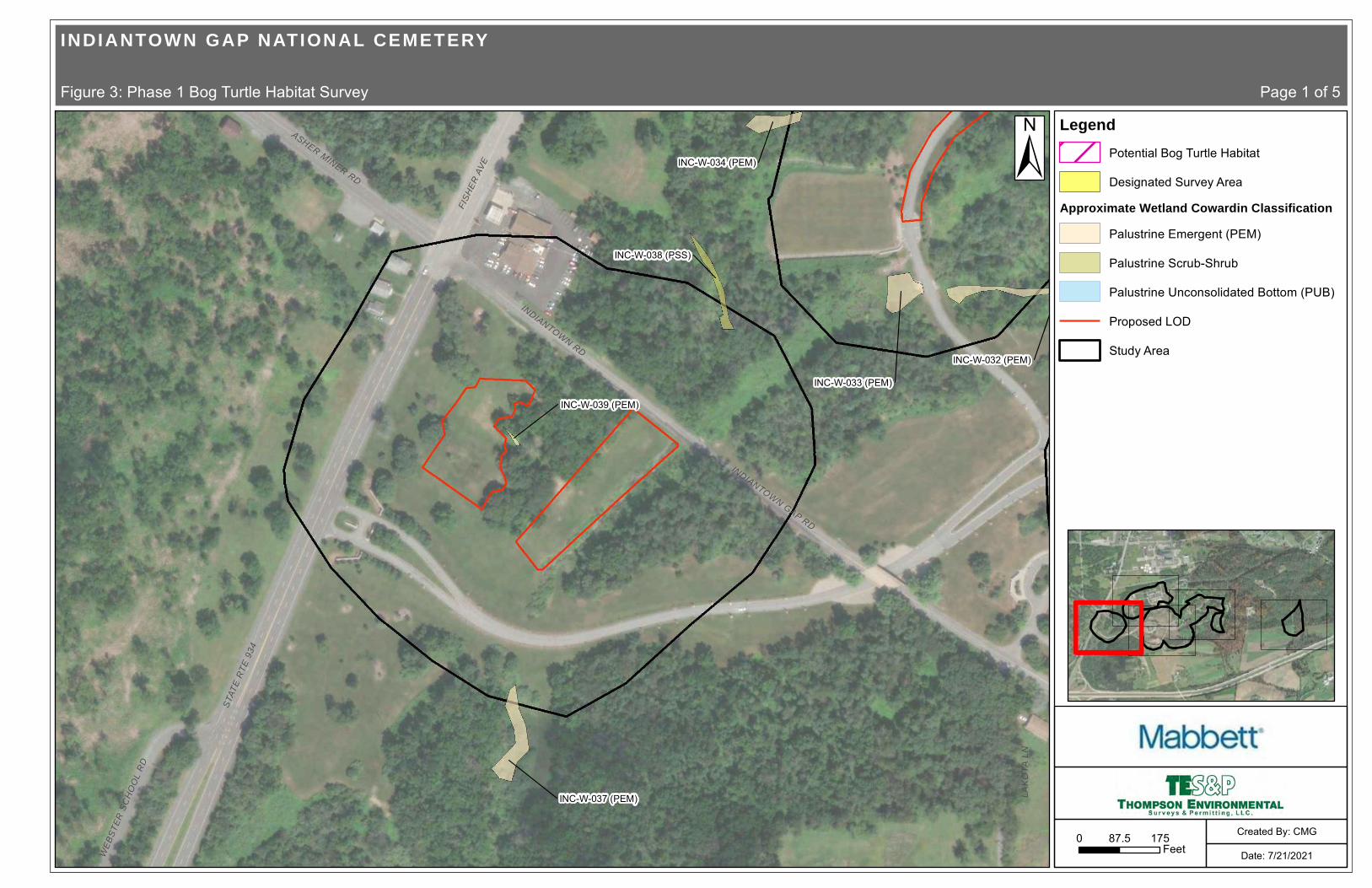
INC-W-032 (PEM)
INC-W-037 (PEM)
INC-W-033 (PEM)
INC-W-034 (PEM)
INC-W-038 (PSS)
INC-W-039 (PEM)
FISH
ER A
VE
INDIANTOWN RD
INDIANTOWN GAP RD
STAT
E R
TE 9
34
LAK
OTA
LN
ASHER MINER RD
WE
BSTE
R S
CH
OO
L R
D
±
INDIANTOWN GAP NATIONAL CEMETERY
Figure 3: Phase 1 Bog Turtle Habitat Survey Page 1 of 5
0 17587.5Feet Date: 7/21/2021
Created By: CMG
LegendPotential Bog Turtle Habitat
Designated Survey Area
Approximate Wetland Cowardin ClassificationPalustrine Emergent (PEM)
Palustrine Scrub-Shrub
Palustrine Unconsolidated Bottom (PUB)
Proposed LOD
Study Area

INC-W-032 (PEM)
INC-W-036 (PUB)
INC 028 (PEM)
INC-W-033 (PEM)
INC-W-034 (PEM)
INC-W-038 (PSS)
INC-W-035 (PEM)
(PEM)
BIDDLE DR
FISH
ER A
VE
INDIANTOWN RD
±
INDIANTOWN GAP NATIONAL CEMETERY
Figure 3: Phase 1 Bog Turtle Habitat Survey Page 2 of 5
0 17587.5Feet Date: 7/21/2021
Created By: CMG
LegendPotential Bog Turtle Habitat
Designated Survey Area
Approximate Wetland Cowardin ClassificationPalustrine Emergent (PEM)
Palustrine Scrub-Shrub
Palustrine Unconsolidated Bottom (PUB)
Proposed LOD
Study Area
INC-W-029 (PEM)

INC-W-032 (PEM)
INC-W-028 (PEM)
INC-W-029 (PEM)
(PEM)
INC-W-027 (PEM)
BOUNDARY RD
LAK
OTA
LN
INDIANTOWN RD
IND
IAN
TOW
N G
AP
RD
±
INDIANTOWN GAP NATIONAL CEMETERY
Figure 3: Phase 1 Bog Turtle Habitat Survey Page 3 of 5
0 17587.5Feet Date: 7/21/2021
Created By: CMG
LegendPotential Bog Turtle Habitat
Designated Survey Area
Approximate Wetland Cowardin ClassificationPalustrine Emergent (PEM)
Palustrine Scrub-Shrub
Palustrine Unconsolidated Bottom (PUB)
Proposed LOD
Study Area

INC-W-026 (PEM)
INC-W-028 (PEM)
INC-W-029 (PEM)
INC-W-012 (PEM)
INC-W-001 (PEM)
INC-W-025 (PEM)
INC-W-024 (PEM)
INC-W-031 (PEM)
INC-W-027 (PEM)
INC-W-030 (PEM)
INC-W-023 (PEM)
BOUNDARY RD
±
INDIANTOWN GAP NATIONAL CEMETERY
Figure 3: Phase 1 Bog Turtle Habitat Survey Page 4 of 5
0 17587.5Feet Date: 7/21/2021
Created By: CMG
LegendPotential Bog Turtle Habitat
Designated Survey Area
Approximate Wetland Cowardin ClassificationPalustrine Emergent (PEM)
Palustrine Scrub-Shrub
Palustrine Unconsolidated Bottom (PUB)
Proposed LOD
Study Area
INC-W-008 (PEM)
INC-W-009 (PEM)

INC-W-021 (PEM)
INC-W-022 (PEM)
INC-W-007 (PEM)
I- 81
BOUNDARY RD
I- 81
±
INDIANTOWN GAP NATIONAL CEMETERY
Figure 3 Phase 1 Bog Turtle Habitat Survey Page 5 of 5
0 17587.5Feet Date: 7/21/2021
Created By: CMG
LegendPotential Bog Turtle Habitat
Designated Survey Area
Approximate Wetland Cowardin ClassificationPalustrine Emergent (PEM)
Palustrine Scrub-Shrub
Palustrine Unconsolidated Bottom (PUB)
Proposed LOD
Study Area

Page 14
Attachment A
PNDI Receipt
1110 Creek Road, Carlisle, PA 17015 | 717-609-3301 | [email protected]

Pennsylvania Department of Conservation and Natural Resources Project Search ID: PNDI-737860 PNDI Receipt: project_receipt_final_indiantown_gap_nati_737860_FINAL_1.pdf
1. PROJECT INFORMATION
Project Name: Final Indiantown Gap National Cemetery Phase 5 Expansion Date of Review: 7/9/2021 02:59:43 PM Project Category: Development, Additions/maintenance to existing development facilities Project Area: 147.28 acres County(s): Lebanon Township/Municipality(s): EAST HANOVER TOWNSHIP; UNION TOWNSHIP ZIP Code: Quadrangle Name(s): INDIANTOWN GAP Watersheds HUC 8: Lower Susquehanna-Swatara Watersheds HUC 12: Bow Creek-Swatara Creek; Reeds Run-Swatara Creek Decimal Degrees: 40.423303, -76.560872 Degrees Minutes Seconds: 40° 25' 23.8910" N, 76° 33' 39.1392" W
2. SEARCH RESULTS
Agency Results Response PA Game Commission No Known Impact No Further Review Required
PA Department of Conservation and No Known Impact No Further Review Required Natural Resources
PA Fish and Boat Commission No Known Impact No Further Review Required
U.S. Fish and Wildlife Service Potential Impact FURTHER REVIEW IS REQUIRED, See Agency Response
As summarized above, Pennsylvania Natural Diversity Inventory (PNDI) records indicate there may be potential impacts to threatened and endangered and/or special concern species and resources within the project area. If the response above indicates "No Further Review Required" no additional communication with the respective agency is required. If the response is "Further Review Required" or "See Agency Response," refer to the appropriate agency comments below. Please see the DEP Information Section of this receipt if a PA Department of Environmental Protection Permit is required.
Page 1 of 6

Final Indiantown Gap National Cemetery Phase 5 Expansion
Service Layer Credits: Source: Esri, Maxar, GeoEye, Earthstar Geographies, CNES/Airbus DS, USDA, USGS, AeroGRID, IGN, and the GIS User Community Esri, HERE, Garmin, (c) Open StreetMap contributors, and the GIS user community Sources: Esri, HERE, Garmin, intermap, increment P Corp., GEBCO, USGS, FAO, NPS, NRCAN, GeoBase, IGN, Kadaster NL, Ordnance Survey, Esri Japan, METI, Esri China
Pennsylvania Department of Conservation and Natural Resources Project Search ID: PNDI-737860 PNDI Receipt: project_receipt_final_indiantown_gap_nati_737860_FINAL_1.pdf
Page 2 of 6
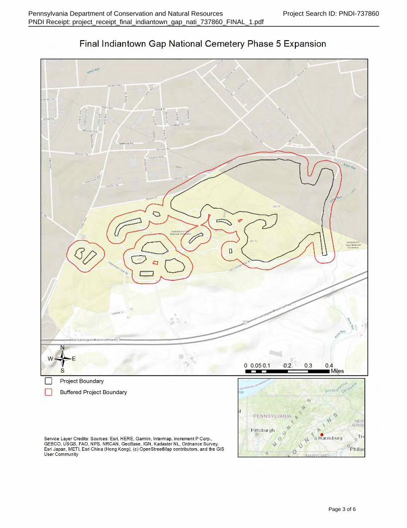
Final Indiantown Gap National Cemetery Phase 5 Expansion
Service Layer Credits: Sources: Esri, HERE, Garmin, Intermap, increment P Corp., GEBCO, USGS, FAO, NPS, NRCAN, GeoBase, IGN, Kadaster NL, Ordnance Survey, Esri Japan, METI, Esri China (Hong Kong), (c) OpenStreetMap contributors, and the GIS User Community
Pennsylvania Department of Conservation and Natural Resources Project Search ID: PNDI-737860 PNDI Receipt: project_receipt_final_indiantown_gap_nati_737860_FINAL_1.pdf
Page 3 of 6

Pennsylvania Department of Conservation and Natural Resources Project Search ID: PNDI-737860 PNDI Receipt: project_receipt_final_indiantown_gap_nati_737860_FINAL_1.pdf
RESPONSE TO QUESTION(S) ASKED
Q1: Which of the following closest describes the proposed project? Your answer is: A well or other groundwater extraction (e.g., groundwater pumping to facilitate mining, pump-andtreat operation) is proposed as part of this project, or in order to support some aspect of the project, and more than 1000 gallons per day will be extracted.
Q2: Are there any perennial or intermittent waterways (rivers, streams, creeks, tributaries) in or near the project area, or on the land parcel? Your answer is: Yes
Q3: Describe how wastewater (effluent) will be handled (select one). For the purpose of this question, wastewater/effluent does not include stormwater runoff. If the project involves solely the renewal or modification of an existing discharge permit (e.g., NPDES permit), select from options 3, 4, 5, or 6 below. Your answer is: All wastewater/effluent from this project/activity will be routed to an existing municipal wastewater treatment plant.
Q4: Accurately describe what is known about wetland presence in the project area or on the land parcel by selecting ONE of the following. "Project" includes all features of the project (including buildings, roads, utility lines, outfall and intake structures, wells, stormwater retention/detention basins, parking lots, driveways, lawns, etc.), as well as all associated impacts (e.g., temporary staging areas, work areas, temporary road crossings, areas subject to grading or clearing, etc.). Include all areas that will be permanently or temporarily affected -- either directly or indirectly -- by any type of disturbance (e.g., land clearing, grading, tree removal, flooding, etc.). Land parcel = the lot(s) on which some type of project(s) or activity(s) are proposed to occur. Your answer is: Someone qualified to identify and delineate wetlands has investigated the site, and determined that wetlands ARE located in or within 300 feet of the project area. (A written report from the wetland specialist, and detailed project maps should document this.)
3. AGENCY COMMENTS Regardless of whether a DEP permit is necessary for this proposed project, any potential impacts to threatened and endangered species and/or special concern species and resources must be resolved with the appropriate jurisdictional agency. In some cases, a permit or authorization from the jurisdictional agency may be needed if adverse impacts to these species and habitats cannot be avoided.
These agency determinations and responses are valid for two years (from the date of the review), and are based on the project information that was provided, including the exact project location; the project type, description, and features; and any responses to questions that were generated during this search. If any of the following change: 1) project location, 2) project size or configuration, 3) project type, or 4) responses to the questions that were asked during the online review, the results of this review are not valid, and the review must be searched again via the PNDI Environmental Review Tool and resubmitted to the jurisdictional agencies. The PNDI tool is a primary screening tool, and a desktop review may reveal more or fewer impacts than what is listed on this PNDI receipt. The jursidictional agencies strongly advise against conducting surveys for the species listed on the receipt prior to consultation with the agencies.
PA Game Commission RESPONSE: No Impact is anticipated to threatened and endangered species and/or special concern species and resources.
PA Department of Conservation and Natural Resources RESPONSE: No Impact is anticipated to threatened and endangered species and/or special concern species and resources.
PA Fish and Boat Commission RESPONSE:
Page 4 of 6

Pennsylvania Department of Conservation and Natural Resources Project Search ID: PNDI-737860 PNDI Receipt: project_receipt_final_indiantown_gap_nati_737860_FINAL_1.pdf
No Impact is anticipated to threatened and endangered species and/or special concern species and resources.
U.S. Fish and Wildlife Service RESPONSE: Further review of this project is necessary to resolve the potential impact(s). Please send project information to this agency for review (see WHAT TO SEND).
WHAT TO SEND TO JURISDICTIONAL AGENCIES
If project information was requested by one or more of the agencies above, upload* or email the following information to the agency(s) (see AGENCY CONTACT INFORMATION). Instructions for uploading project materials can be found here. This option provides the applicant with the convenience of sending project materials to a single location accessible to all three state agencies (but not USFWS). *If information was requested by USFWS, applicants must email, or mail, project information to [email protected] to initiate a review. USFWS will not accept uploaded project materials.
Check-list of Minimum Materials to be submitted: ____Project narrative with a description of the overall project, the work to be performed, current physical characteristics of the site and acreage to be impacted. ____A map with the project boundary and/or a basic site plan(particularly showing the relationship of the project to the physical features such as wetlands, streams, ponds, rock outcrops, etc.) In addition to the materials listed above, USFWS REQUIRES the following ____SIGNED copy of a Final Project Environmental Review Receipt
The inclusion of the following information may expedite the review process. ____Color photos keyed to the basic site plan (i.e. showing on the site plan where and in what direction each photo was taken and the date of the photos) ____Information about the presence and location of wetlands in the project area, and how this was determined (e.g., by a qualified wetlands biologist), if wetlands are present in the project area, provide project plans showing the location of all project features, as well as wetlands and streams.
4. DEP INFORMATION The Pa Department of Environmental Protection (DEP) requires that a signed copy of this receipt, along with any required documentation from jurisdictional agencies concerning resolution of potential impacts, be submitted with applications for permits requiring PNDI review. Two review options are available to permit applicants for handling PNDI coordination in conjunction with DEP’s permit review process involving either T&E Species or species of special concern. Under sequential review, the permit applicant performs a PNDI screening and completes all coordination with the appropriate jurisdictional agencies prior to submitting the permit application. The applicant will include with its application, both a PNDI receipt and/or a clearance letter from the jurisdictional agency if the PNDI Receipt shows a Potential Impact to a species or the applicant chooses to obtain letters directly from the jurisdictional agencies. Under concurrent review, DEP, where feasible, will allow technical review of the permit to occur concurrently with the T&E species consultation with the jurisdictional agency. The applicant must still supply a copy of the PNDI Receipt with its permit application. The PNDI Receipt should also be submitted to the appropriate agency according to directions on the PNDI Receipt. The applicant and the jurisdictional agency will work together to resolve the potential impact(s). See the DEP PNDI policy at https://conservationexplorer.dcnr.pa.gov/content/resources.
Page 5 of 6

________________________________________________________ _______________________________
Powered by TCPDF (www.tcpdf.org)
Pennsylvania Department of Conservation and Natural Resources Project Search ID: PNDI-737860 PNDI Receipt: project_receipt_final_indiantown_gap_nati_737860_FINAL_1.pdf
5. ADDITIONAL INFORMATION The PNDI environmental review website is a preliminary screening tool. There are often delays in updating species status classifications. Because the proposed status represents the best available information regarding the conservation status of the species, state jurisdictional agency staff give the proposed statuses at least the same consideration as the current legal status. If surveys or further information reveal that a threatened and endangered and/or special concern species and resources exist in your project area, contact the appropriate jurisdictional agency/agencies immediately to identify and resolve any impacts.
For a list of species known to occur in the county where your project is located, please see the species lists by county found on the PA Natural Heritage Program (PNHP) home page (www.naturalheritage.state.pa.us). Also note that the PNDI Environmental Review Tool only contains information about species occurrences that have actually been reported to the PNHP.
6. AGENCY CONTACT INFORMATION PA Department of Conservation and Natural U.S. Fish and Wildlife Service Resources Pennsylvania Field Office Bureau of Forestry, Ecological Services Section Endangered Species Section 400 Market Street, PO Box 8552 110 Radnor Rd; Suite 101 Harrisburg, PA 17105-8552 State College, PA 16801 Email: [email protected] Email: [email protected]
NO Faxes Please
PA Fish and Boat Commission PA Game Commission Division of Environmental Services Bureau of Wildlife Habitat Management 595 E. Rolling Ridge Dr., Bellefonte, PA 16823 Division of Environmental Planning and Habitat Email: [email protected] Protection
2001 Elmerton Avenue, Harrisburg, PA 17110-9797 Email: [email protected] NO Faxes Please
7. PROJECT CONTACT INFORMATION
Name:______________________________________________________________ Company/Business Name:______________________________________________ Address:____________________________________________________________ City, State, Zip:_______________________________________________________ Phone:(_____)_________________________Fax:(______)___________________ Email:_____________________________________________________________
8. CERTIFICATION I certify that ALL of the project information contained in this receipt (including project location, project size/configuration, project type, answers to questions) is true, accurate and complete. In addition, if the project type, location, size or configuration changes, or if the answers to any questions that were asked during this online review change, I agree to re-do the online environmental review.
applicant/project proponent signature date
Page 6 of 6
202 632-5529
U.S. Department of Veterans Affairs, Office of Construction and Facilities Management
Mr. Fernando Fernández 425 I (eye) Street, NW, Room 6W317D
Washington, D.C. 20001

Page 15
Attachment B
Phase 1 Bog Turtle Habitat Survey Field Forms for the Northern Population Range
1110 Creek Road, Carlisle, PA 17015 | 717-609-3301 | [email protected]


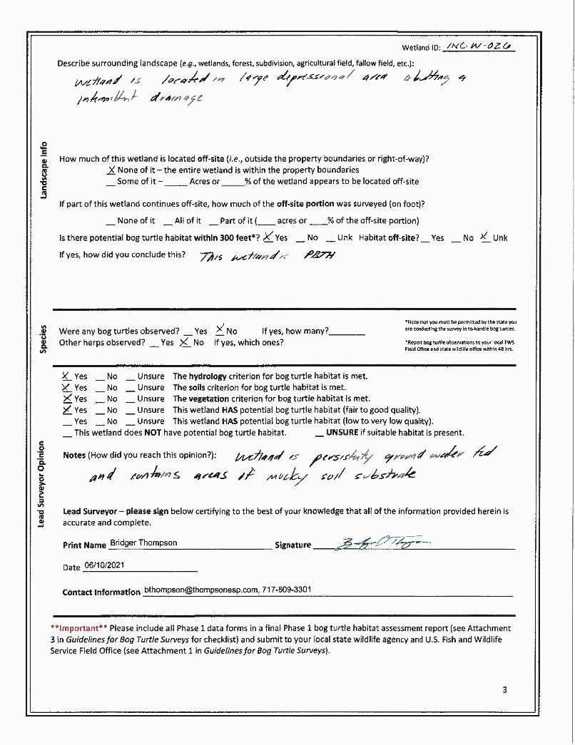


Page 16
Attachment C
Photo Log
1110 Creek Road, Carlisle, PA 17015 | 717-609-3301 | [email protected]

Photographic Log Thompson Environmental Surveys & Permitting, LLC.
Photograph: 1
Date: 06/10/21
Feature ID: Existing Conditions
Direction: Southwest
Description: View of the existing
conditions in the mowed maintained cemetery
grounds.
Photograph: 2
Date: 06/10/21
Feature ID: Wetland INC-W-021
Direction: South
Description: View of the vegetative conditions in wetland
INC-W-021.
Phase 1 Bog Turtle Habitat Survey Mabbett & Associates, Inc. IGNC Phase 5 Expansion Project-Additional Project Area

Photographic Log Thompson Environmental Surveys & Permitting, LLC.
Photograph: Date: 3 06/10/21
Feature ID: Wetland INC-W-022
Direction: North
Description: View of the vegetative and surface water conditions in
wetland INC-W-022.
Photograph: 4
Date: 06/10/21
Feature ID: Wetland INC-W-023
Direction: North
Description: View of wetland INC-W-023.
Phase 1 Bog Turtle Habitat Survey Mabbett & Associates, Inc. IGNC Phase 5 Expansion Project-Additional Project Area

Photographic Log Thompson Environmental Surveys & Permitting, LLC.
Photograph: 5
Date: 06/10/21
Feature ID: Wetland INC-W-024
Direction: North
Description: View of the vegetative conditions in wetland
INC-W-024.
Photograph: 6
Date: 06/10/21
Feature ID: Wetland INC-W-025
Direction: North
Description: View of the vegetative
conditions in wetland INC-W025.
Phase 1 Bog Turtle Habitat Survey Mabbett & Associates, Inc. IGNC Phase 5 Expansion Project-Additional Project Area

Photographic Log Thompson Environmental Surveys & Permitting, LLC.
Photograph: 7
Date: 06/10/21
Feature ID: Wetland INC-W-025
Direction: N/A
Description: View of the mucky soil
substrate and hydrologic conditions in wetland
INC-W-025.
Photograph: 8
Date: 06/10/21
Feature ID: Wetland INC-W-026
Direction: East
Description: View of the vegetative conditions in wetland
INC-W-026.
Phase 1 Bog Turtle Habitat Survey Mabbett & Associates, Inc. IGNC Phase 5 Expansion Project-Additional Project Area

Photographic Log Thompson Environmental Surveys & Permitting, LLC.
Photograph: 9
Date: 06/10/21
Feature ID: Wetland INC-W-027
Direction: Northwest
Description: View of the vegetative conditions in wetland
INC-W-027.
Photograph: 10
Date: 06/10/21
Feature ID: Wetland INC-W-028
Direction: North
Description: View of the vegetative conditions in wetland
INC-W-028.
Phase 1 Bog Turtle Habitat Survey Mabbett & Associates, Inc. IGNC Phase 5 Expansion Project-Additional Project Area

Photographic Log Thompson Environmental Surveys & Permitting, LLC.
Photograph: 11
Date: 06/10/21
Feature ID: Wetland INC-W-029
Direction: North
Description: View of wetland INC-W-029.
Photograph: 12
Date: 06/10/21
Feature ID: Wetland INC-W-030
Direction: East
Description: View of the vegetative conditions in wetland
INC-W-030.
Phase 1 Bog Turtle Habitat Survey Mabbett & Associates, Inc. IGNC Phase 5 Expansion Project-Additional Project Area

Photographic Log Thompson Environmental Surveys & Permitting, LLC.
Photograph: 13
Date: 06/10/21
Feature ID: Wetland INC-W-031
Direction: South
Description: View of wetland INC-W-031.
Photograph: 14
Date: 06/10/21
Feature ID: Wetland INC-W-032
Direction: West
Description: View of the vegetative conditions in the swale
portion of wetland INC-W-032.
Phase 1 Bog Turtle Habitat Survey Mabbett & Associates, Inc. IGNC Phase 5 Expansion Project-Additional Project Area

Photographic Log Thompson Environmental Surveys & Permitting, LLC.
Photograph: 15
Date: 06/10/21
Feature ID: Wetland INC-W-032
Direction: West
Description: View of the vegetative
conditions in the wooded lot portion of wetland
INC-W-032.
Photograph: 16
Date: 06/10/21
Feature ID: Wetland INC-W-033
Direction: North
Description: View of the man-made basin
identified as wetland INC-W-033.
Phase 1 Bog Turtle Habitat Survey Mabbett & Associates, Inc. IGNC Phase 5 Expansion Project-Additional Project Area

Photographic Log Thompson Environmental Surveys & Permitting, LLC.
Photograph: 17
Date: 06/10/21
Feature ID: Wetland INC-W-034
Direction: Northwest
Description: View of the vegetative conditions in wetland
INC-W-034.
Photograph: 18
Date: 06/10/21
Feature ID: Wetland INC-W-035
Direction: East
Description: View of the vegetative conditions in wetland
INC-W-035.
Phase 1 Bog Turtle Habitat Survey Mabbett & Associates, Inc. IGNC Phase 5 Expansion Project-Additional Project Area

Photographic Log Thompson Environmental Surveys & Permitting, LLC.
Photograph: 19
Date: 06/10/21
Feature ID: Wetland INC-W-036
Direction: West
Description: View of the impoundment
identified as wetland INC-W-036.
Photograph: 20
Date: 06/10/21
Feature ID: Wetland INC-W-037
Direction: Southwest
Description: View of the man-made storm water structure identified as
wetland INC-W-037.
Phase 1 Bog Turtle Habitat Survey Mabbett & Associates, Inc. IGNC Phase 5 Expansion Project-Additional Project Area

Photographic Log Thompson Environmental Surveys & Permitting, LLC.
Photograph: Date: 21 06/10/21
Feature ID: Wetland INC-W-038
Direction: Southwest
Description: View of vegetative conditions
in wetland INC-W-038.
Photograph: 22
Date: 06/10/21
Feature ID: Wetland INC-W-039
Direction: Southwest
Description: View of vegetative conditions
in wetland INC-W-039.
Phase 1 Bog Turtle Habitat Survey Mabbett & Associates, Inc. IGNC Phase 5 Expansion Project-Additional Project Area

United States Fish and Wildlife Service Pennsylvania Field Office
August 5, 2021
ATTACHMENT 4
PNDI # 737860
Indiantown Gap National Cemetery Attachments Proposed Phase 5 Expansion

Pennsylvania Department of Conservation and Natural Resources Project Search ID: PNDI-737860 PNDI Receipt: project_receipt_final_indiantown_gap_nati_737860_FINAL_1.pdf
1. PROJECT INFORMATION
Project Name: Final Indiantown Gap National Cemetery Phase 5 Expansion Date of Review: 7/9/2021 02:59:43 PM Project Category: Development, Additions/maintenance to existing development facilities Project Area: 147.28 acres County(s): Lebanon Township/Municipality(s): EAST HANOVER TOWNSHIP; UNION TOWNSHIP ZIP Code: Quadrangle Name(s): INDIANTOWN GAP Watersheds HUC 8: Lower Susquehanna-Swatara Watersheds HUC 12: Bow Creek-Swatara Creek; Reeds Run-Swatara Creek Decimal Degrees: 40.423303, -76.560872 Degrees Minutes Seconds: 40° 25' 23.8910" N, 76° 33' 39.1392" W
2. SEARCH RESULTS
Agency Results Response PA Game Commission No Known Impact No Further Review Required
PA Department of Conservation and No Known Impact No Further Review Required Natural Resources
PA Fish and Boat Commission No Known Impact No Further Review Required
U.S. Fish and Wildlife Service Potential Impact FURTHER REVIEW IS REQUIRED, See Agency Response
As summarized above, Pennsylvania Natural Diversity Inventory (PNDI) records indicate there may be potential impacts to threatened and endangered and/or special concern species and resources within the project area. If the response above indicates "No Further Review Required" no additional communication with the respective agency is required. If the response is "Further Review Required" or "See Agency Response," refer to the appropriate agency comments below. Please see the DEP Information Section of this receipt if a PA Department of Environmental Protection Permit is required.
Page 1 of 6

Final Indiantown Gap National Cemetery Phase 5 Expansion
Service Layer Credits: Source: Esri, Maxar, GeoEye, Earthstar Geographies, CNES/AirbusDS, USDA, USGS, AeroGRID, IGN, and the GIS User Community Esri, HERE, Garmin, (c) OpenStreetMap contributors, and the GIS user community Sources: Esri, HERE, Garmin, Intermap, increment P Corp., GEBCO, USGS, FAO, NPS, NRCAN, GeoBase, IGN, Kadaster NL, Ordnance Survey, Esri Japan, METI, Esri China
Pennsylvania Department of Conservation and Natural Resources Project Search ID: PNDI-737860 PNDI Receipt: project_receipt_final_indiantown_gap_nati_737860_FINAL_1.pdf
Page 2 of 6

Final Indiantown Gap National Cemetery Phase 5 Expansion
Service Layer Credits: Sources: Esri, HERE, Garmin, Intermap, increment P Corp., GEBCO, USGS, FAO, NPS, NRCAN, GeoBase, IGN, Kadaster NL, Ordnance Survey, Esri Japan, METI, Esri China (Hong Kong), (c) OpenStreetMap contributors, and the GIS User Community
Pennsylvania Department of Conservation and Natural Resources Project Search ID: PNDI-737860 PNDI Receipt: project_receipt_final_indiantown_gap_nati_737860_FINAL_1.pdf
Page 3 of 6

Pennsylvania Department of Conservation and Natural Resources Project Search ID: PNDI-737860 PNDI Receipt: project_receipt_final_indiantown_gap_nati_737860_FINAL_1.pdf
RESPONSE TO QUESTION(S) ASKED
Q1: Which of the following closest describes the proposed project? Your answer is: A well or other groundwater extraction (e.g., groundwater pumping to facilitate mining, pump-andtreat operation) is proposed as part of this project, or in order to support some aspect of the project, and more than 1000 gallons per day will be extracted.
Q2: Are there any perennial or intermittent waterways (rivers, streams, creeks, tributaries) in or near the project area, or on the land parcel? Your answer is: Yes
Q3: Describe how wastewater (effluent) will be handled (select one). For the purpose of this question, wastewater/effluent does not include stormwater runoff. If the project involves solely the renewal or modification of an existing discharge permit (e.g., NPDES permit), select from options 3, 4, 5, or 6 below. Your answer is: All wastewater/effluent from this project/activity will be routed to an existing municipal wastewater treatment plant.
Q4: Accurately describe what is known about wetland presence in the project area or on the land parcel by selecting ONE of the following. "Project" includes all features of the project (including buildings, roads, utility lines, outfall and intake structures, wells, stormwater retention/detention basins, parking lots, driveways, lawns, etc.), as well as all associated impacts (e.g., temporary staging areas, work areas, temporary road crossings, areas subject to grading or clearing, etc.). Include all areas that will be permanently or temporarily affected -- either directly or indirectly -- by any type of disturbance (e.g., land clearing, grading, tree removal, flooding, etc.). Land parcel = the lot(s) on which some type of project(s) or activity(s) are proposed to occur. Your answer is: Someone qualified to identify and delineate wetlands has investigated the site, and determined that wetlands ARE located in or within 300 feet of the project area. (A written report from the wetland specialist, and detailed project maps should document this.)
3. AGENCY COMMENTS Regardless of whether a DEP permit is necessary for this proposed project, any potential impacts to threatened and endangered species and/or special concern species and resources must be resolved with the appropriate jurisdictional agency. In some cases, a permit or authorization from the jurisdictional agency may be needed if adverse impacts to these species and habitats cannot be avoided.
These agency determinations and responses are valid for two years (from the date of the review), and are based on the project information that was provided, including the exact project location; the project type, description, and features; and any responses to questions that were generated during this search. If any of the following change: 1) project location, 2) project size or configuration, 3) project type, or 4) responses to the questions that were asked during the online review, the results of this review are not valid, and the review must be searched again via the PNDI Environmental Review Tool and resubmitted to the jurisdictional agencies. The PNDI tool is a primary screening tool, and a desktop review may reveal more or fewer impacts than what is listed on this PNDI receipt. The jursidictional agencies strongly advise against conducting surveys for the species listed on the receipt prior to consultation with the agencies.
PA Game Commission RESPONSE: No Impact is anticipated to threatened and endangered species and/or special concern species and resources.
PA Department of Conservation and Natural Resources RESPONSE: No Impact is anticipated to threatened and endangered species and/or special concern species and resources.
PA Fish and Boat Commission RESPONSE:
Page 4 of 6
Pennsylvania Department of Conservation and Natural Resources Project Search ID: PNDI-737860 PNDI Receipt: project_receipt_final_indiantown_gap_nati_737860_FINAL_1.pdf
No Impact is anticipated to threatened and endangered species and/or special concern species and resources.
U.S. Fish and Wildlife Service RESPONSE: Further review of this project is necessary to resolve the potential impact(s). Please send project information to this agency for review (see WHAT TO SEND).
WHAT TO SEND TO JURISDICTIONAL AGENCIES
If project information was requested by one or more of the agencies above, upload* or email the following information to the agency(s) (see AGENCY CONTACT INFORMATION). Instructions for uploading project materials can be found here. This option provides the applicant with the convenience of sending project materials to a single location accessible to all three state agencies (but not USFWS). *If information was requested by USFWS, applicants must email, or mail, project information to [email protected] to initiate a review. USFWS will not accept uploaded project materials.
Check-list of Minimum Materials to be submitted: ____Project narrative with a description of the overall project, the work to be performed, current physical characteristics of the site and acreage to be impacted. ____A map with the project boundary and/or a basic site plan(particularly showing the relationship of the project to the physical features such as wetlands, streams, ponds, rock outcrops, etc.) In addition to the materials listed above, USFWS REQUIRES the following ____SIGNED copy of a Final Project Environmental Review Receipt
The inclusion of the following information may expedite the review process. ____Color photos keyed to the basic site plan (i.e. showing on the site plan where and in what direction each photo was taken and the date of the photos) ____Information about the presence and location of wetlands in the project area, and how this was determined (e.g., by a qualified wetlands biologist), if wetlands are present in the project area, provide project plans showing the location of all project features, as well as wetlands and streams.
4. DEP INFORMATION The Pa Department of Environmental Protection (DEP) requires that a signed copy of this receipt, along with any required documentation from jurisdictional agencies concerning resolution of potential impacts, be submitted with applications for permits requiring PNDI review. Two review options are available to permit applicants for handling PNDI coordination in conjunction with DEP’s permit review process involving either T&E Species or species of special concern. Under sequential review, the permit applicant performs a PNDI screening and completes all coordination with the appropriate jurisdictional agencies prior to submitting the permit application. The applicant will include with its application, both a PNDI receipt and/or a clearance letter from the jurisdictional agency if the PNDI Receipt shows a Potential Impact to a species or the applicant chooses to obtain letters directly from the jurisdictional agencies. Under concurrent review, DEP, where feasible, will allow technical review of the permit to occur concurrently with the T&E species consultation with the jurisdictional agency. The applicant must still supply a copy of the PNDI Receipt with its permit application. The PNDI Receipt should also be submitted to the appropriate agency according to directions on the PNDI Receipt. The applicant and the jurisdictional agency will work together to resolve the potential impact(s). See the DEP PNDI policy at https://conservationexplorer.dcnr.pa.gov/content/resources.
Page 5 of 6

________________________________________________________ _______________________________
Powered by TCPDF (www.tcpdf.org)
Pennsylvania Department of Conservation and Natural Resources Project Search ID: PNDI-737860 PNDI Receipt: project_receipt_final_indiantown_gap_nati_737860_FINAL_1.pdf
5. ADDITIONAL INFORMATION The PNDI environmental review website is a preliminary screening tool. There are often delays in updating species status classifications. Because the proposed status represents the best available information regarding the conservation status of the species, state jurisdictional agency staff give the proposed statuses at least the same consideration as the current legal status. If surveys or further information reveal that a threatened and endangered and/or special concern species and resources exist in your project area, contact the appropriate jurisdictional agency/agencies immediately to identify and resolve any impacts.
For a list of species known to occur in the county where your project is located, please see the species lists by county found on the PA Natural Heritage Program (PNHP) home page (www.naturalheritage.state.pa.us). Also note that the PNDI Environmental Review Tool only contains information about species occurrences that have actually been reported to the PNHP.
6. AGENCY CONTACT INFORMATION PA Department of Conservation and Natural U.S. Fish and Wildlife Service Resources Pennsylvania Field Office Bureau of Forestry, Ecological Services Section Endangered Species Section 400 Market Street, PO Box 8552 110 Radnor Rd; Suite 101 Harrisburg, PA 17105-8552 State College, PA 16801 Email: [email protected] Email: [email protected]
NO Faxes Please
PA Fish and Boat Commission PA Game Commission Division of Environmental Services Bureau of Wildlife Habitat Management 595 E. Rolling Ridge Dr., Bellefonte, PA 16823 Division of Environmental Planning and Habitat Email: [email protected] Protection
2001 Elmerton Avenue, Harrisburg, PA 17110-9797 Email: [email protected] NO Faxes Please
7. PROJECT CONTACT INFORMATION
Name:______________________________________________________________ Company/Business Name:______________________________________________ Address:____________________________________________________________ City, State, Zip:_______________________________________________________ Phone:(_____)_________________________Fax:(______)___________________ Email:_____________________________________________________________
8. CERTIFICATION I certify that ALL of the project information contained in this receipt (including project location, project size/configuration, project type, answers to questions) is true, accurate and complete. In addition, if the project type, location, size or configuration changes, or if the answers to any questions that were asked during this online review change, I agree to re-do the online environmental review.
applicant/project proponent signature date
Page 6 of 6
U.S. Department of Veterans Affairs, Office of Construction and Facilities Management Mr. Fernando Fernández 425 I (eye) Street, NW, Room 6W317D
Washington, D.C. 20001

PREPARED FOR:
MABBETT & ASSOCIATES, INC. 40 OLD LOUISQUISSET PIKE, SUITE 200, BOX 13
NORTH SMITHFIELD, RHODE ISLAND 02896
PHASE I ARCHAEOLOGICAL SURVEY
FOR THE PROPOSED PHASE 5 EXPANSION AT
THE INDIANTOWN GAP NATIONAL CEMETERY, ANNVILLE, EAST HANOVER TOWNSHIP,
LEBANON COUNTY, PENNSYLVANIA
PROJECT NUMBER 2021PR03892
CONTAINS PRIVILEGED INFORMATION – DO NOT RELEASE
FINAL REPORT JUNE 2, 2021
R. CHRISTOPHER GOODWIN & ASSOCIATES, INC. 241 EAST FOURTH STREET, SUITE 100 FREDERICK, MD 21701

PHASE I ARCHAEOLOGICAL SURVEY FOR THE PROPOSED PHASE 5 EXPANSION
AT THE INDIANTOWN GAP NATIONAL CEMETERY, ANNVILLE, EAST HANOVER TOWNSHIP,
LEBANON COUNTY, PENNSYLVANIA
PROJECT NUMBER 2021PR03892
FINAL REPORT
________________________________________
MICHAEL B. HORNUM, PH.D.
PRINCIPAL INVESTIGATOR
BY
MICHAEL B. HORNUM, PH.D. AND THOMAS WAMBACH, M.A.
R. CHRISTOPHER GOODWIN & ASSOCIATES, INC.
241 EAST FOURTH STREET, SUITE 100
FREDERICK, MARYLAND 21701
JUNE 2021
FOR
MABBETT & ASSOCIATES, INC. 40 OLD LOUISQUISSET PIKE, SUITE 200, BOX 13
NORTH SMITHFIELD, RHODE ISLAND 02896
Contains Privileged Information – Do Not Release

Executive Summary
This report presents the results of the Phase I archaeological survey for the proposed Phase 5 Expansion at the Indiantown
Gap National Cemetery, Annville, East Hanover Township, Lebanon County, Pennsylvania. The project is located on federal property. As a fed-eral undertaking, it will be reviewed under Sec-tion 106 of the National Historic Preservation Act of 1966. All work was completed following standards promulgated in Archaeology and His-toric Preservation: The Secretary of the Interior’s Standards and Guidelines, and in the revised Guidelines for Archaeological Investigations in Pennsylvania (PA SHPO 2017).
The Phase I survey was undertaken by R. Christopher Goodwin & Associates, Inc. (RCG&A) on behalf of Mabbett & Associates, Inc. from April 20 – 23, 2021. Approximately 8.5 acres (3.4 hectares) of the area of potential ef-fects (APE) has been surveyed for archaeological
resources previously and reviewed by the Penn-sylvania State Historic Preservation Office (PA SHPO), and were not resurveyed. RCG&A com-pleted a pedestrian reconnaissance of the remain-ing approximately 21.5 acres (8.7 hectares) of the APE. In undisturbed areas of 15 percent slope or less, systematic survey was undertaken using shovel tests excavated at 15 m (49.2 ft) intervals. Geomorphological review had indicated that no deep testing was needed. A total of 224 shovel tests were excavated. No archaeological artifacts were recovered and no archaeological sites were identified.
Since no artifacts were recovered and no ar-chaeological sites were identified within the pro-posed project area, the proposed project will have no impact to archaeological historic properties, as defined in 36 CFR 800.16(l), in the studied areas. No further archaeological investigation is war-ranted or recommended.
ii R. Christopher Goodwin & Associates, Inc. Contains Privileged Information -- Do Not Release
Table of Contents
Executive Summary . . . . . . . . . . . . . . . . . . . . . . . . . . . . . . . . . . . . . . . . . . . . . . . . ii
List of Figures . . . . . . . . . . . . . . . . . . . . . . . . . . . . . . . . . . . . . . . . . . . . . . . . . . . . . v
List of Tables . . . . . . . . . . . . . . . . . . . . . . . . . . . . . . . . . . . . . . . . . . . . . . . . . . . . . . vi
I. Introduction . . . . . . . . . . . . . . . . . . . . . . . . . . . . . . . . . . . . . . . . . . . . . . . . . 1 Project Location and Description . . . . . . . . . . . . . . . . . . . . . . . . . . . . . . . . . . . . . . . . . . . . . . . . . . .1 Research Objectives and Design. . . . . . . . . . . . . . . . . . . . . . . . . . . . . . . . . . . . . . . . . . . . . . . . . . . .1 Project Personnel . . . . . . . . . . . . . . . . . . . . . . . . . . . . . . . . . . . . . . . . . . . . . . . . . . . . . . . . . . . . . . .1 Organization of the Report . . . . . . . . . . . . . . . . . . . . . . . . . . . . . . . . . . . . . . . . . . . . . . . . . . . . . . . .1
II. Natural and Cultural Setting . . . . . . . . . . . . . . . . . . . . . . . . . . . . . . . . . . . 4 Physiography and Geology. . . . . . . . . . . . . . . . . . . . . . . . . . . . . . . . . . . . . . . . . . . . . . . . . . . . . . . .4 Soils . . . . . . . . . . . . . . . . . . . . . . . . . . . . . . . . . . . . . . . . . . . . . . . . . . . . . . . . . . . . . . . . . . . . . . . . .4 Drainage and Hydrology. . . . . . . . . . . . . . . . . . . . . . . . . . . . . . . . . . . . . . . . . . . . . . . . . . . . . . . . . .5 Vegetation and Climate . . . . . . . . . . . . . . . . . . . . . . . . . . . . . . . . . . . . . . . . . . . . . . . . . . . . . . . . . .5 Previous Cultural Resources Investigations . . . . . . . . . . . . . . . . . . . . . . . . . . . . . . . . . . . . . . . . . .5
Watershed and Pre-Contact Predictive Model . . . . . . . . . . . . . . . . . . . . . . . . . . . . . . . . . . .5 Previous Survey and Previously Recorded Sites and Built Resources . . . . . . . . . . . . . . . .5
Prehistoric Cultural Sequence. . . . . . . . . . . . . . . . . . . . . . . . . . . . . . . . . . . . . . . . . . . . . . . . . . . . . .5 Paleo-Indian/Early Archaic (ca. 13,000 - 6,500 B.C) . . . . . . . . . . . . . . . . . . . . . . . . . . . . .7 Middle Archaic (6,500 – 3,000 B.C.) . . . . . . . . . . . . . . . . . . . . . . . . . . . . . . . . . . . . . . . .10 Late Archaic (3,000 – 1,000 B.C.) . . . . . . . . . . . . . . . . . . . . . . . . . . . . . . . . . . . . . . . . . .11 Early Woodland (1,000 - 500 B.C.)/ Middle Woodland (500 B.C A.D. 1000) . - . . . . . . .13 Late Woodland (A.D. 1000 - 1500) . . . . . . . . . . . . . . . . . . . . . . . . . . . . . . . . . . . . . . . . .14 European Contact (A.D. 1500 – 1750) . . . . . . . . . . . . . . . . . . . . . . . . . . . . . . . . . . . . . . .16
Historic Cultural Sequence . . . . . . . . . . . . . . . . . . . . . . . . . . . . . . . . . . . . . . . . . . . . . . . . . . . . . . .16 Colonial Period (1681-1785) . . . . . . . . . . . . . . . . . . . . . . . . . . . . . . . . . . . . . . . . . . . . . . .16 Agrarian Expansion and Town Development (1785 – 1861) . . . . . . . . . . . . . . . . . . . . . .17 Civil War (1861 – 1865) . . . . . . . . . . . . . . . . . . . . . . . . . . . . . . . . . . . . . . . . . . . . . . . . . .18 Post-War Period (1865 – 1918) . . . . . . . . . . . . . . . . . . . . . . . . . . . . . . . . . . . . . . . . . . . . .18 Modern Period (1918 – Present). . . . . . . . . . . . . . . . . . . . . . . . . . . . . . . . . . . . . . . . . . . .19
III. Research Design and Methods . . . . . . . . . . . . . . . . . . . . . . . . . . . . . . . . . 21 Research Design and Objectives. . . . . . . . . . . . . . . . . . . . . . . . . . . . . . . . . . . . . . . . . . . . . . . . . . .21 Archival Research Methods . . . . . . . . . . . . . . . . . . . . . . . . . . . . . . . . . . . . . . . . . . . . . . . . . . . . . .21 Archaeological Field Methods . . . . . . . . . . . . . . . . . . . . . . . . . . . . . . . . . . . . . . . . . . . . . . . . . . . .21 Records and Curation . . . . . . . . . . . . . . . . . . . . . . . . . . . . . . . . . . . . . . . . . . . . . . . . . . . . . . . . . . .22
iii R. Christopher Goodwin & Associates, Inc. Contains Privileged Information -- Do Not Release

Table of Contents
IV. Results of Archaeological Survey Investigations . . . . . . . . . . . . . . . . . . 23 Project Specific Archival Investigation Results . . . . . . . . . . . . . . . . . . . . . . . . . . . . . . . . . . . . . . .23 Field Investigation Results . . . . . . . . . . . . . . . . . . . . . . . . . . . . . . . . . . . . . . . . . . . . . . . . . . . . . . .23
Survey Area 1 . . . . . . . . . . . . . . . . . . . . . . . . . . . . . . . . . . . . . . . . . . . . . . . . . . . . . . . . . .23 Survey Area 2 . . . . . . . . . . . . . . . . . . . . . . . . . . . . . . . . . . . . . . . . . . . . . . . . . . . . . . . . . .23
Statewide Pre-Contact Probability Model Comparison . . . . . . . . . . . . . . . . . . . . . . . . . . . . . . . . .30
V. Summary and Recommendations . . . . . . . . . . . . . . . . . . . . . . . . . . . . . . 31 Summary . . . . . . . . . . . . . . . . . . . . . . . . . . . . . . . . . . . . . . . . . . . . . . . . . . . . . . . . . . . . . . . . . . . .31 Recommendations. . . . . . . . . . . . . . . . . . . . . . . . . . . . . . . . . . . . . . . . . . . . . . . . . . . . . . . . . . . . . .31
References Cited . . . . . . . . . . . . . . . . . . . . . . . . . . . . . . . . . . . . . . . . . . . . . . . . . . 32
Acknowledgments . . . . . . . . . . . . . . . . . . . . . . . . . . . . . . . . . . . . . . . . . . . . . . . . 41
Resumes of Key Project Personnel . . . . . . . . . . . . . . . . . . . . . . . . . . . . Appendix I
iv R. Christopher Goodwin & Associates, Inc. Contains Privileged Information -- Do Not Release

List of Figures
Figure 1. Map of Pennsylvania showing the project area locations . . . . . . . . . . . . . . . . . . . . . . . . . .2
Figure 2. Excerpts from the USGS 7.5 minute 1979 Indiantown Gap, Pennsylvania quadrangle showing the proposed project area in Lebanon County . . . . . . . . . . . . . . . . . .3
Figure 3. Excerpts from Beers’ 1875 County Atlas of Lebanon, Pennsylvania, East Hanover and Union Townships, showing the project area . . . . . . . . . . . . . . . . . . . . . . . .24
Figure 4. Aerial photograph, showing Survey Area 1 archaeological testing. . . . . . . . . . . . . . . . . .25
Figure 5. Photograph of Survey Area 1, looking west . . . . . . . . . . . . . . . . . . . . . . . . . . . . . . . . . . .26
Figure 6. Aerial photograph, showing Survey Area 2 archaeological testing. . . . . . . . . . . . . . . . . .27
Figure 7. Photograph of Survey Area 2, looking north through disturbed area . . . . . . . . . . . . . . . .28
Figure 8. Photograph of Survey Area 2, looking south from the southeastern section of project . .28
Figure 9. Photograph of Survey Area 2, looking south. . . . . . . . . . . . . . . . . . . . . . . . . . . . . . . . . . .29
Figure 10. Photograph of Survey Area 2, looking west at concrete block foundation . . . . . . . . . . . .29
v R. Christopher Goodwin & Associates, Inc. Contains Privileged Information -- Do Not Release

List of Tables
Table 1. Previously recorded archaeological sites located within 0.5 mi (0.8 km) of the proposed project area. . . . . . . . . . . . . . . . . . . . . . . . . . . . . . . . . . . . . . . . . . . . . . . . .6
Table 2. Statewide Pre-Contact Probability Model comparison . . . . . . . . . . . . . . . . . . . . . . . . . . .30
vi R. Christopher Goodwin & Associates, Inc. Contains Privileged Information -- Do Not Release

1 R. Christopher Goodwin & Associates, Inc. Contains Privileged Information -- Do Not Release
This report presents the results of the Phase I archaeological survey for the proposed Phase 5 Expansion at the Indiantown
Gap National Cemetery, Annville, East Hanover Township, Lebanon County, Pennsylvania (Fig-ure 1). The project is located on federal property. As a federal undertaking, it will be reviewed un-der Section 106 of the National Historic Preser-vation Act of 1966. All work was completed fol-lowing standards promulgated in Archaeology and Historic Preservation: The Secretary of the Interi-or’s Standards and Guidelines, and in the revised Guidelines for Archaeological Investigations in Pennsylvania (PA SHPO 2017).
Project Location and Description The U.S. Department of Veterans Affairs
(VA) National Cemetery Administration (NCA) is proposing to construct and operate the Phase 5 expansion within the existing Indiantown Gap National Cemetery. The undertaking consists of the construction and operation of the Phase 5 cemetery expansion within an approximately 30-acre (12.1-hectare) area of potential effects (APE) (Figure 2). The Phase 5 expansion would provide burial capacity for approximately the next 10 years. Within the proposed Phase 5 ex-pansion area boundary, the undertaking would provide new casket, columbarium, and in-ground cremation burial sites for veterans. Addition-ally, development would provide physical infra-structure improvements including new roadways to connect existing and new burial areas; new stormwater management features; extension of the irrigation utility; and landscaping at the new burial areas.
Research Objectives and Design The objectives of the Phase I survey inves-
tigation were: (1) to locate, identify, and delin-
Chapter I
Introduction
eate all prehistoric and historic cultural resources within the project area; (2) to make preliminary assessments of the potential significance of those resources, applying the National Register Criteria for Evaluation [36 CFR 60.4 (a-d)]; (3) to assess the impact of proposed development activities on the cultural resources situated within the project boundaries; and (4) to formulate management rec-ommendations concerning those resources. These objectives were accomplished through a combina-tion of archival research and archaeological in-vestigations that included systematic sub-surface shovel testing.
Project Personnel The Phase I survey was undertaken by
R. Christopher Goodwin & Associates, Inc. (RCG&A) on behalf of Mabbett & Associates, Inc. from April 20 – 23, 2021. Michael B. Hor-num, Ph.D., served as Principal Investigator and Project Manager, and supervised all aspects of the study. Field investigations were directed by Thomas Wambach, M.A., and also included the participation of Kevin Clark, B.A., Dan Grose, B.A., and Hanah Romsburg, B.A. Kristopher R. West, M.A. was the project geomorphological consultant. Archival investigations were under-taken by Katherine Grandine, M.A.
Organization of the Report Chapter I contains a brief description of the
project. The natural and cultural settings of the project area are described in Chapter II, which also contains a discussion of previous research in the vicinity. Chapter III reviews the research methods used in these investigations. Chapter IV presents the results of the Phase I investigations. Chapter V summarizes the report and presents management recommendations. Appendix I con-tains resumes of key project personnel.

2R. Christopher Goodwin & Associates, Inc. Contains Privileged Information -- Do Not Release
Chapter I: Introduction
Proj
ect
Are
a
020
Kilo
met
ers
020
Mile
s
Scal
e 1:
2,50
0,00
0
Penn
sylv
ania
Sta
te L
ocat
or
Proj
ect A
rea
Leba
non
Cou
nty
Penn
sylv
ania
Sta
te B
ound
ary
Penn
sylv
ania
Cou
nty
Boun
dary
Adja
cent
Sta
te B
ound
arie
s
Indi
anto
wn
Gap
Nat
iona
l Cem
eter
y
Figu
re 1
. M
ap o
f Pen
nsyl
vani
a sh
owin
g th
e pr
ojec
t are
a lo
catio
ns

Chapter I: Introduction
Indiantown Gap 1979
Survey Area 1
Survey Area 2
0 400 Meters
0 2,000 Feet
Scale 1:24,000
Project Area
Quad Sheet Boundary
Indiantown Gap National Cemetery USGS 7.5' Quadrangle
Figure 2. Excerpts from the USGS 7.5 minute 1979 Indiantown Gap, Pennsylvania quadrangle showing the proposed project area in Lebanon County
3 R. Christopher Goodwin & Associates, Inc. Contains Privileged Information -- Do Not Release

4 R. Christopher Goodwin & Associates, Inc. Contains Privileged Information -- Do Not Release
Chapter II
Natural and Cultural Setting
The Indiantown Gap National Cemetery property is located in Lebanon County, Pennsylvania, roughly 10 miles (mi) (16
kilometers [km]) northwest of the city of Leba-non. The major elements of the natural environ-ment were important determinants of both pre-historic and historic settlement and subsistence patterns in the Susquehanna River watershed. Specific environmental parameters, such as ge-ology, soils, and relative proximity to water, af-fected the quantity and variety of resources ac-cessible to prehistoric populations. The earliest Euro-American settlers venturing into the region likewise sought out soils with properties advan-tageous to particular agricultural practices, se-lecting parcels neighboring major waterways, or emerging arterial road systems to facilitate trade and commerce. Thus, factors of climate, distribu-tion of fauna and flora, the nature and distribution of soils, terrain and topography, and proximity to aquatic resources all have determined in part where people have settled and how they have ex-ploited their surroundings (Evans 1978).
Physiography and Geology The Indiantown Gap National Cemetery lies
within the Great Valley section of the Ridge and Valley physiographic province (Pennsylvania Ar-chaeological Research Unit 2). The terrain for the project area is characterized by ridges and slopes adjacent to unnamed tributaries of Qureg Run. Ground surface elevations range from approxi-mately 420 to 514 ft (128 to 157 m) above mean sea level.
The bedrock deposits that underlie the In-diantown Gap National Cemetery property are composed of sediments of unequal hardness that crumpled and subsequently uplifted; erosion cut away valleys, leaving the harder strata as ridges. The bedrock deposits derive from four periods of geological development. Bedrock underlying the
valley floors is Ordovician in age and includes shale, sandstone, limestone, and dolomite. The red and gray sandstones, conglomerates, and shales of the lower ridge slopes date from the Silurian period, while Devonian red sandstone, gray and black shales, limestone, and chert form the upper slopes. Ridgetop bedrock deposits are comprised of sandstone, shale, clay, coal, and limestone of the Mississippian and Devonian pe-riods (Willard 1933:12, Map 7). A list of lithic resources that would have been available for pre-historic utilization included bedded and nodular cherts from the limestone and dolomite forma-tions within the Great Valley; cobbles of quartz, quartzite, and metabasalt deposited by high or-der steams like the Susquehanna River; rhyolite in the Great Valley to the southwest; and jasper deposits located in Lehigh and Berks Counties to the north and east (Stewart 1980:7-8; Hatch et al. 1985:98).
Soils The major soil association occurring within
the Indiantown Gap National Cemetery study area is identified as the Berks-Weikert-Bedington As-sociation (Holzer 1981). Soils of this association occupy convex tops, side slopes, and foot slopes of dissected ridges and hills in the west-central and northern portion of Lebanon County, and are formed from acid shale, sandstone, and silt-stone (Holzer 1981:4 – 5). The soil series mapped in the project area include Bedington shaly silt loam, 3 to 8 percent slopes (BeB) and 15 to 25 percent slopes (BeD), Berks channery silt loam, 3 to 8 percent slopes (BkB), Comly silt loam 3 to 8 percent slopes (CmB), and Weikert channery silt loam, 3 to 8 percent slopes (WeB) and 15 to 25 percent slopes (WeD) (USDA NRCS 2021). The representative profiles for the soil series, as encountered in the field, are discussed with refer-ence to the survey results in Chapter IV below.

Drainage and Hydrology The project area falls within Lower Susque-
hanna (7) Watershed D (Swatara Creek sub-ba-sin). The project area is drained by Qureg Run, which flows southward into Reeds Creek, which eventually empties into the Swatara Creek, a ma-jor tributary of the Susquehanna River.
Vegetation and Climate Current vegetation in the project area includ-
ed wooded areas that were mainly mixed decidu-ous trees, with some scattered conifers, and mani-cured grassy lawns. Humid, continental weather conditions characterize the climate of Lebanon County. Systems developed over the central Unit-ed States, or Atlantic Ocean are mitigated signifi-cantly before reaching the project area. The city of Lebanon has recorded average daily maximum temperatures of 37oF in January and 86oF in July. Documented annual average precipitation at Leba-non is 42.3 inches (in) (107.4 centimeters [cm]), and is evenly distributed throughout the year. The frost-free growing season comprises 176 days, and typically extends from the end of April through mid-October (Holzer 1981:3).
Previous Cultural Resources Investigations Watershed and Pre-Contact Predictive Model
The project area is located in Watershed 7D of the Lower Susquehanna River. The smaller watershed sub-basin associated with Swatara Creek currently features 60 archaeological sites recorded in Pennsylvania’s State Historic and Ar-chaeological Resource Exchange (PA-SHARE) (https://share.phmc.pa.gov/pashare). PA-SHARE also depicts Pre-Contact model probabilities of the APE. The model generally classifies the proj-ect area has having a moderate to high potential for Pre-Contact sites, with 61 percent having moderate potential, 20.7 percent high potential, and 18.3 percent no coding or presumed low po-tential.
Previous Survey and Previously Recorded Sites and Built Resources
Portions of the current project area, mea-suring approximately 8.5 acres (3.4 hectares) in total, are overlapped by a previous 2010 survey by MACTEC (Avery 2010; A.D. Marble and
Chapter II: Natural and Cultural Setting
MACTEC 2012). This survey was conducted for a proposed expansion of the Indiantown Gap Na-tional Cemetery, and included two alternatives that totaled 36.5 acres (14.8 hectares). Three archaeological sites were identified and are dis-cussed below. Three other surveys are located within 0.5 mi (0.8 km) of the current project area. These studies included an addendum archaeolog-ical survey for proposed training facilities at the National Guard Training Center at Fort Indian-town Gap (French 2001), a larger archaeological survey for the National Guard Training Center at Fort Indiantown Gap (Hunter 2007), both located north of the current study, and a small archaeo-logical survey for a sewer south of the current project area (Young 2003).
The project area mostly is within the Fort In-diantown Gap Historic District (Key # 107363), which the PA SHPO has determined to be eli-gible for the inclusion on the National Register of Historic Places (NRHP). Previous survey has resulted in the recordation of 15 archaeological sites within a 0.5 mi (0.8 km) radius of the project (Table 1). Nine of the sites were prehistoric period occupations and six of the sites were historic pe-riod occupations. Four sites have been determined by the PA SHPO to not be eligible for inclusion on the NRHP, ten of the sites have not been evalu-ated for eligibility for the NRHP, and one has been destroyed. Two sites, 36LE0516 and 36LE0517, are located within or immediately adjacent to the project footprint. Both of these sites have been de-termined by the PA SHPO to not be eligible for inclusion on the NRHP. Site 36LE0518, located southwest of one of the current project area, is an historic house site that was considered po-tentially NRHP eligible by the surveyors (Avery 2010; A.D. Marble and MACTEC 2012). Prehis-toric components, when identifiable by time pe-riod, include the Late Archaic, Transitional, and Late Woodland periods, while historic sites range from the nineteenth to twentieth centuries.
Prehistoric Cultural Sequence Prehistoric cultural periods recognized for
Pennsylvania traditionally have included the Paleo-Indian (ca. 13,000 – 8,000 B.C.), Archaic (ca. 8,000 – 1,000 B.C.), the Woodland (ca. 1,000 B.C. – A.D. 1500), and Contact (ca. A.D. 1500 –
5 R. Christopher Goodwin & Associates, Inc. Contains Privileged Information -- Do Not Release

6R. Christopher Goodwin & Associates, Inc. Contains Privileged Information -- Do Not Release
Chapter II: Natural and Cultural Setting
Tabl
e 1.
Pr
evio
usly
rec
orde
d ar
chae
olog
ical
site
s loc
ated
with
in 0
.5 m
i (0.
8 km
) of t
he p
ropo
sed
proj
ect a
rea
Site
Num
ber
Site
Nam
eSi
te T
ype
Chr
onol
ogic
al
Peri
odTo
pogr
aphi
c Se
ttin
gL
evel
of
Inve
stig
atio
nIn
vest
igat
ion
Met
hod
NR
HP
Stat
us /
Det
erm
inat
ion
of
Elig
ibili
ty (D
OE
)
Com
men
ts/
Sour
ces
36LE
0030
Unk
now
nO
pen
Hab
itatio
n, P
re-C
onta
ctU
nkno
wn
Preh
isto
ricSt
ream
ben
chA
mat
eur
Col
lect
ion
Une
valu
ated
36LE
0031
Unk
now
nO
pen
Hab
itatio
n, P
re-C
onta
ctA
rcha
ic, T
rans
ition
alSt
ream
ben
chA
mat
eur
Col
lect
ion
Une
valu
ated
36LE
0032
Unk
now
nO
pen
Hab
itatio
n, P
re-C
onta
ctA
rcha
ic, T
rans
ition
alTe
rrac
eA
mat
eur
Col
lect
ion
Une
valu
ated
36LE
0033
Unk
now
nO
pen
Hab
itatio
n, P
re-C
onta
ctA
rcha
ic, L
ate
Arc
haic
, Tra
nsiti
onal
Stre
am b
ench
Am
ateu
rC
olle
ctio
nU
neva
luat
ed
36LE
0034
Unk
now
nO
pen
Hab
itatio
n, P
re-C
onta
ctW
oodl
and
Terr
ace
Am
ateu
rC
olle
ctio
nD
estro
yed
36LE
0052
Unk
now
nO
pen
Hab
itatio
n, P
re-C
onta
ctTr
ansi
tiona
l, La
te
Woo
dlan
dSt
ream
ben
chA
mat
eur
Col
lect
ion
Une
valu
ated
36LE
0053
Unk
now
nO
pen
Hab
itatio
n, P
re-C
onta
ctU
nkno
wn
Preh
isto
ricH
ill ri
dge/
toe
Am
ateu
rC
olle
ctio
nU
neva
luat
ed
36LE
0361
Unk
now
nO
pen
Hab
itatio
n, P
re-C
onta
ctU
nkno
wn
Preh
isto
ricSt
eam
ben
chA
mat
eur
Col
lect
ion
Une
valu
ated
36LE
0501
FS-0
6-22
His
toric
Dom
estic
Site
19th
cen
tury
Not
list
edPh
ase
ISh
ovel
test
ing
Une
valu
ated
36LE
0502
FS 0
6-25
His
toric
- U
nkno
wn/
Oth
er/M
ultip
le
Type
s19
th -
20th
cen
turie
sN
ot li
sted
Phas
e I
Not
list
edSH
PO: N
ot
Elig
ible
Low
den
sity
36LE
0503
FS 0
6-26
His
toric
- U
nkno
wn/
Oth
er/M
ultip
le
Type
sU
nkno
wn
His
toric
Not
list
edPh
ase
IN
ot li
sted
SHPO
: Not
El
igib
leLo
w d
ensi
ty
36LE
0516
Indi
anto
wn
Gap
Nat
iona
l C
emet
ery
2H
isto
ric -
Unk
now
n/O
ther
/Mul
tiple
Ty
pes
20th
cen
tury
Mid
dle
slop
esPh
ase
ISh
ovel
test
ing
SHPO
: Not
El
igib
le36
LE05
17In
dian
tow
n G
ap N
atio
nal
Cem
eter
y 3
Ope
n H
abita
tion,
Pre
-Con
tact
Unk
now
n Pr
ehis
toric
Upp
er sl
opes
Phas
e I
Shov
el te
stin
gSH
PO: N
ot
Elig
ible
36LE
0518
Ger
beric
h/ B
ombe
rger
His
toric
Far
mst
ead
19th
cen
tury
Hill
ridg
e/to
ePh
ase
ISh
ovel
test
ing
Une
valu
ated
36LE
0566
Ger
beric
h Si
teH
isto
ric F
arm
stea
d19
th -
20th
cen
turie
sN
ot li
sted
Phas
e I
Not
list
edU
neva
luat
ed

1750). Originally developed as cultural historical units, these traditions are defined by diagnostic artifact forms and assemblages. In recent years this scheme has been adjusted, with an empha-sis on cultural adaptations to changing ecological conditions modifying a system primarily intend-ed to treat temporal and spatial questions. As a result, the various terms continue to be used, but their use is now as much behavioral as classifica-tory.
Although the terms “Paleo-Indian,” “Archa-ic,” and so on are the same throughout the eastern United States, the corresponding use of McKern’s (1939) Midwestern Taxonomic Method, even as revised by Willey and Phillips (1958), has been abandoned over most of the Mid-Atlantic region. In Pennsylvania especially, this was a conscious decision by Witthoft (e.g., 1952), who found it more useful to substitute the term “period” for “tradition.” Recently this has been systematized to some extent by Custer (1984) who, in addition to the term “period,” uses “complex” to replace “phase.” This alternative to McKern’s system is well established in the regional literature and is the basis of Pennsylvania’s State Plan for the Conservation of Archaeological Resources (Ra-ber 1985a, 1985b).
More recently, many archaeologists (e.g., Custer 1996) have combined these periods into new groupings on cultural and ecological grounds. In particular, Custer (1985, 1996), Gard-ner (1980), and Stewart (1980) all have combined the traditional Paleo-Indian period with the Early Archaic. Earlier dates for the onset of the tradi-tionally defined Paleo-Indian period currently are in a state of flux, particularly since the discovery of a pre-Clovis or “proto-Clovis” component at the Cactus Hill site in Sussex County, Virginia (Boyd 2003:68). Custer (1996) has proposed to group the Paleo-Indian and Early Archaic as Hunter-Gatherer I, described the Middle Archaic as Hunter-Gatherer II, posited the Late Archaic and Traditional as Intensive Gathering-Formative Culture Period I, changed the Early - Middle Woodland to Intensive Gathering-Formative Cul-tural Period II, and transformed the Late Wood-land into the Village Life Cultural Period. The following synthesis of prehistoric cultural change follows the diachronic framework proposed by
Chapter II: Natural and Cultural Setting
Custer (1996), and it utilizes data from the Ridge and Valley physiographic province of Pennsyl-vania, as well as from similar geomorphologic settings within neighboring areas of the Middle Atlantic region.
Paleo-Indian/Early Archaic (ca. 13,000 - 6,500 B.C)
This period corresponds to Custer’s (1996) Hunter-Gather I Cultural Period. The Paleo-Indi-an/Early Archaic period is defined as the time from about 13,000 B.C. to 6,500 B.C. The somewhat early designation for the onset of this period is seen as a median date falling between the earliest dates advanced by researchers such as Adovasio (et al. 1977) and later dates proposed by more conservative investigators (Custer 1985:27). The 13,000 B.C. time frame also corresponds with C-14 and other dates recently obtained for the pre-Clovis levels at the Cactus Hill site (Boyd 2003:68). Technologically, the earliest, pre-Clo-vis phases of this period have been documented as a collection of blade flakes, possibly utilized as tools, from the Cactus Hill site. Traditionalists mark the onset of the Paleo-Indian period with the appearance of the Clovis, Mid-Paleo, and Dalton projectile point styles. Diagnostic point types after 8,000 B.C. include the side-notched and corner-notched projectile points tradition-ally assigned to the Early Archaic, including the Palmer, Charleston, Amos, and Kirk corner-notched point types (Gardner 1980:3; Custer 1996:96). Despite these apparent technological and stylistic differences in projectile point manu-facture, investigations conducted at the Flint Run Paleo-Indian Complex in the Shenandoah Valley suggest a continuity of general adaptive patterns throughout this period (Gardner 1979, 1983).
In North America, the Paleo-Indian period is defined as the way of life associated with the earliest, terminal Pleistocene human inhabitants. It has been commonly believed that these people migrated from eastern Siberia into the North-ern Great Plains by way of an ice free corridor thought to have existed in western Canada be-tween the Cordillarian and Laurentide ice sheets. The time for this initial occupation was thought to be around 13,000 B.P., based on two sets of evidence. First, access along the ice free corridor
7 R. Christopher Goodwin & Associates, Inc. Contains Privileged Information -- Do Not Release

was thought to be possible only between 13,500 - 11,850 B.P. Second, the earliest agreed upon evidence of a human presence in North America occurred at a series of mammoth kill sites in the southwestern United States. These sites, located directly south of the southern end of the ice free corridor, returned radiocarbon dates that all fell between 11,650 - 11,000 B.C.
Contained within those kill sites was a dis-tinctive type of fluted spear point, a Clovis point, examples of which had been found in every state in the United States, in every country in Central America, and in most countries in South Ameri-ca. In most of those cases, however, the Clovis points were not in datable contexts (if they were in context at all, which was seldom the case out-side of the western United States). Consequently, the interpretation of the so called Clovis sites in the western United States came to be applied to all situations in which Clovis points occurred.
Clovis points were, and often still are, viewed as associated with small bands of migra-tory hunters who focused on Pleistocene mega-fauna, particularly proboscinians: mammoths in the western United States, mastodons in the eastern United States. This association of large Pleistocene game with Clovis points was rein-forced by the simultaneous disappearance of both around 11,000 B.C., a disappearance that led Martin (1967) to propose that the extinction of the megafauna was a consequence of overkill by the people using the Clovis points.
In the western United States there was a switch after 11,000 B.C. to the hunting of bison, which continued as late as 8,500 B.C. and is con-sidered part of the Paleo-Indian period. In the eastern United States, it is believed that there was a similar switch, although one focusing on the use of forest resources. This would be considered the start of the Archaic Tradition.
The reason that Hatch et al. (1985) com-bines Paleo-Indian with Early Archaic is that the general interpretation of the Paleo-Indian Tradi-tion breaks down in the eastern United States. Traditionally the earliest that people could have been in North America, given a migratory path between the ice sheets, was 11,850 B.C. when the ice free corridor was thought to have closed due to what was termed the Valderan readvance. Re-
Chapter II: Natural and Cultural Setting
examination of the stratigraphic evidence for the Valderan by Evenson et al. (1976) indicated that it never happened: There was no advance; there was no quick opening and closing of access to the Northern Plains. In addition, dates were ob-tained from occupations in the East: 12,570 B.P. from Duchess Quarry Cave in New York (Funk et al. 1969); 12,010 B.C. from Little Salt Spring in Florida (Clausen et al. 1979); and 16,175 B.C. from Meadowcroft Rockshelter in western Penn-sylvania (Adovasio et al. 1977). Of these, the most telling is the date from Little Salt Spring in Florida, which indicated that people had been present in that area long enough to develop the cultural practices necessary to survive in what was then a xerophytic ecosystem.
In addition to the evidence suggesting a much older (if not longer) occupation in the east-ern United States, there is still no known asso-ciation of Paleo-Indian artifacts with Pleistocene megafauna in the eastern United States. There is also little direct evidence about subsistence. Grif-fin (1977) summarized the general feeling that hunting was probably the most important sub-sistence activity, and this is consistent with the caribou remains from Duchess Quarry Cave. The ascription of hunting, however, remains based on a functional interpretation of stone tools that were analyzed before the advent of high-mag-nification analysis (Keeley 1980). The results from the Shawnee-Minisink Site in northeastern Pennsylvania (Kauffman and Dent 1982) do not contradict the idea of hunting, although there is sufficient evidence to indicate the use of black-berry, ground-cherry, and hawthorn plum as well as fish.
The image that is now emerging, which forms the basis of the cultural adaptive model used by Hatch et al. (1985), is one analogous to the Subarctic cultures like the Ojibwa (Rog-ers 1962), Cree (Rogers 1969), and Slave (Ho-nigmann 1946) on the Canadian Shield. These have dispersed family hunting groups during the late fall, winter, and early spring, with a focus on hunting and trapping. From the late spring through the early fall the family hunting groups gather at fish spawning sites, and it is during that time that plant foods high in ascorbic acid, such as blackberry, are collected. Subarctic peoples
8 R. Christopher Goodwin & Associates, Inc. Contains Privileged Information -- Do Not Release

tend to operate in well defined, if extensive ter-ritories, and Eisenberg’s (1978; cf. Stewart 1979) interpretation of raw material acquisition for Clo-vis points in the Delaware basin suggests that this may have been the case for Paleo-Indians as well.
The environmental setting for this 8,500-year time span was conditioned by the Late Pleis-tocene/Holocene transition. Climatic episodes defined by Carbone (1976) for the Shenandoah Valley are broadly applicable to the study area (Kavanagh 1982). Climatic episodes include the Late Glacial (ca. 15,000 - 8,500 B.C.) and the Pre-Boreal/Boreal (8,500 - 6,700 B.C.) (Custer 1984, Kavanagh 1982).
The Late Glacial episode represents the Ter-minal Pleistocene and the “last effects of the gla-ciers upon climate in the Middle Atlantic area” (Custer 1984:44). Pollen data and faunal remains suggest a mosaic of varied environments, includ-ing grasslands mixed with coniferous spruce-pine forest, and deciduous forest along streams, rivers, and wetlands (Carbone 1976; Watts 1983; Custer 1996:97-98). In the Piedmont areas of eastern Pennsylvania, grasslands would have been re-stricted to swampy floodplains, scattered upland bogs, and specialized soil areas, and deciduous forest would have dominated the major river ter-races (Custer 1996:98). Carbone (1976) described Late Glacial vegetation in the Shenandoah Val-ley, which is continuous with the Great Valley in Maryland and Pennsylvania, as composed of microhabitats, including mixed deciduous gallery forests near the rivers, mixed coniferous-decidu-ous forest and grasslands in the foothills and on valley floors, coniferous forest on the high ridges, and alpine tundra in the mountains (Kavanagh 1982:8).
The Pre-Boreal/Boreal climatic episode was a period of transition from the late Pleistocene into the full Holocene. Climatic change involved warmer summer temperatures and continued wet winters, and vegetation shifted in response. In the Shenandoah Valley, the period was characterized by “the expansion of coniferous and deciduous elements and a reduction in open habitats” (Car-bone 1976:186). Similarly, eastern Pennsylvania saw a reduction of open grasslands and a spread of forests dominated with pine, spruce, and some oak (Custer 1996:99-100).
Chapter II: Natural and Cultural Setting
Gardner (1979, 1983) has identified distinc-tive site types in the Shenandoah Valley Paleo-In-dian settlement system, and Custer (1984, 1996) has suggested that these types may be more wide-ly applicable to the entire Middle Atlantic region, including eastern Pennsylvania. The site types in-clude: (1) quarry sites, located at lithic outcrops or cobble beds; (2) quarry reduction stations, on level ground near quarries; (3) base camps, in-cluding quarry-related base camps near stream confluences within 1 - 2 km of quarries, and non-quarry base camps, centrally located within areas of maximum game availability; (4) base camp maintenance stations, at game-attractive loca-tions within a 3 km radius of a base camp; and (5) outlying hunting stations, located more than 3 km from base camp locations (Custer 1985:31; 1996:108-109). Isolated point finds also are fre-quent. If a Subarctic culture analog is applicable, the only site type missing is a large warm season fishing camp that, if preserved, would be in the floodplain sediments. Sites in eastern Pennsylva-nia include seasonal riverine base camps, interior quarry sites, and upland hunting stations.
The largest documented Paleo-Indian site in Pennsylvania, the Shoop Site in Dauphin County, east of the Susquehanna River, does not support Gardner’s model. Carr (1989) notes that the Shoop Site is located far from potential lithic sources; this settlement may have served as a spot for the hunting of a variety of migratory game. Several Paleo-Indian and Early Archaic sites have been identified in floodplain and terrace set-tings along the Delaware River, and at quarries, low-order streams, springs, and sinkholes.
The riverine sites include the Shawnee-Minisink Site, the Upper Shawnee Island Site (36MR45), and the Harry’s Farm Site in the Upper Delaware River Valley, as well as Site 36BU44 in the Middle Delaware River Valley (Custer 1996:110-115). While Site 36BU44 has yielded fluted points, the assemblage from the Shawnee-Minisink Site (36MR43) produced a richer assemblage of Paleo-Indian and Early Ar-chaic materials (McNett 1985). The Paleo-Indian levels yielded radiocarbon dates of 8800+/-600 B.C. and 8640+/-300 B.C., as well as hearths, lithic reduction areas, a Clovis point, side and endscrapers, spokeshaves, retouched flakes; flake
9 R. Christopher Goodwin & Associates, Inc. Contains Privileged Information -- Do Not Release

knives, discoidal and tabular cores, and hammer-stones. Various types of carbonized seeds and fish bones were recovered from the hearths (Dent and Kauffman 1985). The Early Archaic deposits recovered from the site produced a more diverse lithic artifact assemblage, including a greater variety of lithic raw material types, than those recovered from the Paleo-Indian phase. Plant re-mains from the Early Archaic occupations indi-cated a continuity of resource exploitation with the earlier Paleo-Indian phase (Dent and Kauff-man 1985).
The Early Archaic, then, is seen to be a con-tinuation of Paleo-Indian in the sense that it rep-resents populations responding to the collapsing spruce and spruce-pine forests (Dumont 1981). The low carrying capacity of these forests, com-bined with the changing ecological community, are seen by Funk and Wellman (1984) as the rea-sons for the low frequency of Early Archaic sites in the upper Susquehanna basin.
Middle Archaic (6,500 – 3,000 B.C.) This period corresponds to Custer’s (1996)
Hunter-Gather II Cultural Period. Custer (1985, 1996) departs from the traditional tripartite divi-sion of the Archaic period. In addition to expand-ing the previously accepted chronological param-eters of the Middle Archaic, dating the period between ca. 6,500 and 3,000 B.C. (Stewart and Cavallo 1991), Custer also includes the tradition-al Late Archaic subperiod (ca. 3,000 - 1,000 B.C.) with the Early and Middle Woodland periods, labeling them the “transitional phase” (Custer 1985) or the “Intensive Gathering-Formative Culture Period” (Custer 1996).
The Archaic Tradition in the eastern United States generally refers to pre-ceramic sites asso-ciated with the nomadic hunter-gatherer popula-tions that occupied the emerging Holocene decid-uous forests. The Woodland period was originally defined by the appearance of ceramics and the as-sumed presence of maize and sedentary villages, since at the time the term was devised (the 1930s) it was believed that ceramics, agriculture/horti-culture, and village life were mutually inclusive.
Linking the Archaic and Woodland is the Transitional Period, first defined by Witthoft (1953) and restricted in appellation to the ar-
Chapter II: Natural and Cultural Setting
chaeology of the northeastern and mid-Atlantic regions of the United States. The Transitional Period is exactly what the name suggests: a time during which the life styles associated with the Archaic began to switch over to those associated with the Woodland. Research over the last two decades has revealed that, with the exception of pottery manufacture, the changes in cultural ad-aptation from the Archaic through the Woodland were not as great as first thought, being more of a degree in the efficiency of using deciduous for-est resources than in the kind of resources used (Caldwell 1958; Ford 1974; Custer 1984). The Middle Archaic - Early Woodland Phase, as set forth by Hatch et al. (1985), reflects the current understanding of a progressively improving cul-tural adaptation to a deciduous forest ecosystem.
The majority of species typical of the mod-ern temperate deciduous forest were re-estab-lished across the eastern United States between 8,500 B.C. and 4,000 B.C., depending on the type of tree and location being considered. The one general feature that all of the eastern forests have in common is the large number of oak present. This ranges from around 30 percent of the mature fruiting canopy trees in the maple-beech forests of Ohio and Indiana to 60 percent in the oak-chestnut forests that existed along the east coast (Braun 1950). Combining the oak with other nut trees like hickory, chestnut, and beech (walnut seldom makes up more than 2 percent of a mature deciduous forest); these forests represented a vast abundance of food. The autumn nut crop is now, and in all likelihood was in the past, at the base of most food chains in the eastern forest ecosystem, the productivity of which directly determines the population size and reproductive rates of deer, raccoon, turkey, and squirrel.
The Middle Archaic represents the inception of what Caldwell (1958) termed primary forest efficiency. Caldwell stressed the vast bounty and variety of food sources in the eastern forests, not-ing that prehistoric peoples need only have moved to the proper location during a given season to maximize resource acquisition. Thus, in the east-ern United States in general the Middle and Late Archaic is seen to represent mobile hunting gath-ering peoples who were exploiting seasonal re-sources and scheduling their movements accord-
10 R. Christopher Goodwin & Associates, Inc. Contains Privileged Information -- Do Not Release

ingly: tree nuts (mast), deer, and waterfowl in the fall; deer and small game in the winter; small game and waterfowl in the spring; and fish in the summer. In many parts of the southeastern and midwestern United States the Middle Archaic is also associated with large freshwater bivalve middens.
Human groups of the Archaic period were adjusting to evolving Post-Pleistocene mesic oak-hemlock forest environments. More het-erogeneous faunal and floral communities were available for exploitation in the moderating cli-mate of the Holocene (Raber 1985b:11). Archaic lifeways were characterized by a broadening of the subsistence base, which presumably included a greater reliance on small game, fish, shellfish, and plant foods (Cleland 1976). New technolo-gies and tools, including grinding stones, axes, and adzes, accompanied these changes. A wider of variety of lithic materials was used during the Middle Archaic than during earlier periods, in-cluding more frequent use of non-cryptocrystal-line materials such as argillite, quartzite, quartz, and rhyolite (Stewart and Cavallo 1991:30-34).
The major temporally diagnostic artifacts for the Middle Archaic have been divided into three chronological groups, at least in eastern Pennsyl-vania (Custer 1996:134 – 145). During the early part of the period (ca. 6,500 – 5,500 B.C.) the dominant point types are bifurcates (Kanawha, LeCroy, St. Albans), and Kirk stemmed. During the period from ca. 5,500 – 4,500 B.C., various stemmed and notched types are common, includ-ing the Morrow Mountain I and II, Otter Creek, Stark, Vosburg, and Piney Island types. The late Middle Archaic (ca. 4,500 – 3,000 B.C.) is rep-resented by types that continue into the Late Ar-chaic, such as the Lamoka, Halifax and Kittatin-ny types, and the Brewerton series. The earliest triangular projectile points/knives, including the so-called Hunterbrook type, have been found in Middle Archaic contexts (Stewart and Cavallo 1991:25, 31).
Groundstone tool technology makes its ini-tial appearance in the assemblages from Middle Archaic sites. In addition to this change in tech-nology is a notable shift in lithic raw material preference. Previously, exploitation was focused exclusively on high quality cryptocrystalline ma-
Chapter II: Natural and Cultural Setting
terials; in the Middle Archaic Period, exploitation patterns appear to emphasize the expedient use of locally available lithic materials, such as rhyolite, local chert and other comparatively low grade materials for tools. Grooved axes, atlatl weights, and milling stones support the idea of increased importance of plants in the diet.
Human populations appear to have increased during the Archaic Period. According to Kratzer et al. (1987:7-8), the increased occurrence of bifurcated-base projectile points during the early Middle Archaic period may have been related to the development of new subsistence strategies geared to the emerging deciduous forests and their resources. The increase in human popula-tions may have led to more intensive utilization of specific territories and to greater reliance upon more localized sources of lithic raw materials. Custer (1996:155-156) currently recognizes two major types of sites associated with the Middle Archaic: the base camp, which includes Custer’s earlier (1985) macro-band and micro-band base camps, and the procurement site. Stewart and Ca-vallo (1991:29-30) suggest a significant focus on interior and riverine wetland areas.
Evidence of Middle Archaic settlement in central Pennsylvania is limited to small collec-tions of projectile points taken from the surfaces of multi-component sites. These Archaic com-ponents indicate “a pattern of widely scattered, relatively small occupations” (Archaeological and Historical Consultants 1987:3-4). Lithic pro-curement in the Adams and Franklin counties re-gion probably focused on the abundant rhyolite sources available at the interface of the Uplands and the Ridge and Valley provinces. As early as 1933, Henry Deisher wrote about a rhyolite Indi-an quarry located “ten miles southwest of Gettys-burg” (Deisher 1933:18-19). Frost’s (1935) sur-vey of Adams County point collections showed that over 90 percent of the projectile points recov-ered from sites within the county were fabricated from gray rhyolite, while an additional 2.9 per-cent were made of red rhyolite (Frost 1935:20).
Late Archaic (3,000 – 1,000 B.C.) Following Witthoft (1953), Custer (1985:36)
combined the time periods traditionally labeled Late Archaic, Early Woodland, and Middle
11 R. Christopher Goodwin & Associates, Inc. Contains Privileged Information -- Do Not Release

Woodland, into one culturally distinct chronolog-ical unit that he has termed “Transitional.” Re-cently, Custer (1996:163) has re-termed this pe-riod the Intensive Gathering-Formative Culture Period, and designated the earlier stages of this period as Intensive Gathering-Formative Culture Period I.
During the earlier phases of this expanded period, human adaptation in Pennsylvania re-quired increasingly specialized hunting and gath-ering practices. Sites that focused principally on the procurement of mast or fish began to appear in the archaeological record. Base camp settle-ments were located near reliable surface water, on floodplains and terraces near rivers and high order streams, and appear to have been repeated-ly reoccupied seasonally (Custer 1996:187-189). Evidence suggests that a number of other sites were frequented regularly for scheduled subsis-tence and other tasks. The resultant small tran-sient camps are found in several kinds of upland and lowland settings within restricted territo-ries, and contain varied tool assemblages (Raber 1985b; Kratzer et al. 1987:8; Custer 1996:189).
Technological changes during the Late Ar-chaic include an increase in the number and va-riety of groundstone tools, including axes, celts, adzes, pestles, and net weights. These artifacts, together with steatite vessels, bespeak a greater reliance on plant resources and fish than in previ-ous periods. The caching of artifacts suggests that sites were repeatedly revisited. The appearance of storage pits implies longer-term occupations, and the use of large platform hearths may be associ-ated with fish processing (Custer 1996:183-187). Stewart (1988) and others argue that Late Archaic peoples initiated the first concerted exchange of goods in the Middle Atlantic region, perhaps in response to the marked territoriality of the peri-od. Rhyolite from the South Mountain area of the Pennsylvania and Maryland Blue Ridge, argillite from the Middle Delaware Valley, and steatite from the Pennsylvania and Maryland Piedmont all have been found in eastern and central Penn-sylvania (Custer 1996:190).
Two cultural traditions have been identified in Pennsylvania during the Late Archaic: Lauren-tian (Ritchie 1965) and Piedmont (Kinsey 1972). Both traditions have been identified primarily
Chapter II: Natural and Cultural Setting
through the distribution of projectile point styles (Dragoo 1959; Michaels and Smith 1967). The Laurentian tradition is associated with notched Laurentian points, including Brewerton Corner Notched, Brewerton Ear Notched, Brewerton Side Notched, Lamoka, Otter Creek, and Vos-burg (Graybill 1993; Justice 1987; Ritchie 1961). The Piedmont Tradition is associated with nar-row bladed, stemmed projectile points, includ-ing Bare Island (Kinsey 1959; Ritchie 1961); Lackawaxen Stemmed (Kinsey 1972); Lamoka (Ritchie 1961); Merrimack Stemmed (Dincauze 1976); Normanskill (Ritchie 1961); Squibnock-et Stemmed (Ritchie 1965); Sylvan Stemmed and Side Notched (Funk 1965); Wading River (Ritchie 1965); and other stemmed varieties. In Pennsylvania, the two traditions may reflect broad territories of Late Archaic hunters and gatherers, with those of the Laurentian tradition focused on the mixed deciduous and coniferous forests of northern regions of the state, and those of the Piedmont tradition concentrated in the var-ied hardwood forests in the southern portion of the state (Custer 1996:190).
During the Late Archaic/Early Woodland Transitional period (2,000-1,000 B.C.), ceremo-nial objects such as gorgets, bannerstones, and birdstones appeared for the first time. Mortuary ceremonialism also has been associated with this period. Cremated burials with grave goods, including steatite vessels presumably filled with food offerings, have been identified in formal cemeteries at sites dating to this period through-out the northeast United States [New England (Dincauze 1968); New Jersey, New York, and Pennsylvania (Hawkes and Linton 1916; Regens-burg 1970; Ritchie 1959)].
Pottery also first appears in the archaeologi-cal record during the Transitional Period. Marcey Creek Plain, a steatite tempered with plain ex-terior surface, has been recovered from Orient Phase Transitional Archaic Period sites (Manson 1948; Smith 1971). Vessel forms mimic the ste-atite bowls from earlier periods. Some research-ers associate the appearance of Marcey Creek Plain ceramics with increasing sedentism and the need for longer-term storage capacity (Gardner 1981; Ritchie 1965). Although the introduction of ceramic technology has been used to mark a
12 R. Christopher Goodwin & Associates, Inc. Contains Privileged Information -- Do Not Release

transition between the Archaic and Woodland pe-riods it has become apparent that ceramics were adopted at widely different times, even by groups in the same region. Therefore the latter portion of the Late Archaic and the early portion of the Early Woodland period may be characterized as a Transitional Period.
Transitional period sites, like those of the Late Archaic, are found in riverine alluvial de-posits and in upland locations, suggesting a con-tinuation of Late Archaic lifeways that included a broad-based subsistence pattern founded es-sentially on forest and riverine products (Dragoo 1959). However, settlement in upland and inte-rior areas decreased. The increase in floodplain settlements may be due to the transition towards semi-sedentism (Gardner 1981; Kinsey 1972; Turnbaugh 1975, 1977; Witthoft 1953), or an in-creased reliance on streams and rivers for water travel and trade networks.
Early Woodland (1,000 - 500 B.C.)/ Middle Woodland (500 B.C. - A.D. 1000)
The remainder of Custer’s Intensive Gath-ering-Formative Culture Period (Intensive Gath-ering-Formative Culture Period II) encompasses what traditionally has been known as the Early and Middle Woodland phases. Trends previously associated with the Late Archaic period appear to have intensified during this time. Early and Mid-dle Woodland peoples relied increasingly on riv-erine food resources, covering relatively long dis-tances in their subsistence pursuits (Mayer-Oakes 1955; Archaeological and Historical Consultants 1987:3-5).
Fishtail points/knives already had occurred in deposits from the last portion of the Late Ar-chaic, and they also commonly are found with the earliest ceramic types that mark the Early Woodland period. Fishtail points/knives tradi-tionally have been associated with the so-called Transitional or Orient Phases (Kinsey 1972:355-361; Kraft 1975:41). Other temporally diagnostic lithic artifacts for the Early Woodland include the Adena, Hellgrammite, and Meadowood point/ knife types, as well as various stemmed and notched points that appear to represent continu-ations of the broadspear and Normanskill types common in the later part of the Late Archaic.
Chapter II: Natural and Cultural Setting
Middle Woodland diagnostic point/knife types include the Jack’s Reef pentagonal, Jack’s Reef corner-notched, Fox Creek stemmed, Rossville, and Snyder’s Dovetail types. Towards the end of the Middle Woodland period, triangular points/ knives, which become the dominant Late Wood-land form, begin to appear (Custer 1996:227-232), likely in association with the more wide-spread inclusion of bow-and-arrow technologies in Woodland subsistence patterns.
The traditional Early Woodland (1,000 B.C. – A.D. 200) and Middle Woodland (A.D. 200 - 1000) periods are marked by a more intensive use of ceramics. The earliest ceramics generally were steatite tempered. One such ceramic type, Marcey Creek ware, has been recovered from sites across the entirety of the state of Pennsyl-vania. By ca. 800 B.C., regional variations ap-pear. In the Susquehanna Valley, ceramic varia-tion has permitted the definition of two cultural complexes – the Bare Island during the Early Woodland and the Three Mile Island during the Middle Woodland (Custer 1996:244-247). The former has yielded a variety of ceramic types including the steatite tempered Bare Island cord-marked and the crushed quartz tempered Vinette I and Accokeek wares (Custer 1996:219-227). The latter is associated with crushed quartz tempered Susquehanna net and fabric impressed, sand/grit tempered Susquehanna cord-marked and Popes Creek, and later shell tempered Mockley, sand/ grit Point Peninsula, and advanced mica-schist tempered and grit/sand tempered corded varieties (Custer 1996:219-227).
Regional settlement patterns show that dur-ing the Early and Middle Woodland periods, floodplains and terraces along major and mi-nor drainages were the foci of multifamily base camps. Platform hearths continue to appear. Large numbers of small hearths, deep storage pits, and refuse pits occur at these base camps. Above ground lodges constructed of post sup-ports and semi-subterranean pit dwellings both have been documented on various sites from the period. Hatch et al. (1985) propose a “multiple base camp/radial pattern secondary site model,” similar to the kind suggested by Custer (1984, 1987). Base camps would be located on valley floors, in places that would maximize access to
13 R. Christopher Goodwin & Associates, Inc. Contains Privileged Information -- Do Not Release

as many different microenvironmental zones as possible. Radiating out from those base camps and located in each of those zones would be spe-cial and/or limited activity campsites, the func-tion of which would have been to provide the raw materials needed for everyday activities life at the base camp. This kind of settlement pattern was common across the eastern and midwestern United States, being well documented in Illinois (Roper 1979), Wisconsin, and Iowa (Alex 1980).
There are no well defined Adena, Meado-wood or Middlesex sites in eastern Pennsyl-vania, but there is some evidence from sites in the Susquehanna Valley for participation in Ad-ena and Hopewell related trade networks. For example, pipes and birdstones typical of Adena and Meadowood sites do occur in caches or as-sociated with cremation burials. Some stone burial mounds also have been identified (Custer 1996:246).
The Middle Woodland, at least at the start, appears to be a continuation of the Late Archaic - Early Woodland trajectory of increasing popu-lation, social organizational complexity, and ma-terial culture elaboration. The subsistence base remained the same as that found in the Late Ar-chaic: heavy use of tree nuts; continued use of indigenous cultigens; selective or preferential predation on those terrestrial fauna most involved in the feeding on tree nuts; extensive fishing; and the hunting of waterfowl. The late Middle Woodland represents the abandonment of at least millennia of elaboration. Ceramics are often de-scribed as poorly made and decorated (e.g., Grif-fin 1952 ed.). The extensive trading network dis-appeared. In the Midwest the evidence suggests a return to egalitarian sociopolitical organizations: tribes and bands. The population appears to have declined.
No special reference is made by Hatch et al. (1985) to Middle Woodland settlement patterns for the Ridge and Valley Province, and the best that can be said for the moment is that, like ear-lier times, there were seasonally occupied base camps located in lowland areas, and a series of limited activity sites scattered throughout tribu-tary drainages. Thematically this is a “hollow exploitation model,” discussed most recently by Stevenson (1982) for Pennsylvania. Consistent
Chapter II: Natural and Cultural Setting
with Fehr (1983), Middle Woodland base camps sites in somewhat similar ecological settings in the forested Midwest tend to be found at the base of slopes (Struever 1968).
Research in the upper Susquehanna general-ly is consistent with the Hatch et al. (1985) model. Funk and Rippeteau (1977) discuss eleven Late Archaic through Middle Woodland sites. Of the 63 components encountered, 56 (88.9 percent) were located directly along the Susquehanna at the time of occupation. Many of these contained indirect evidence of fishing, usually in the form of netsinkers. Botanical remains often included black walnut (Juglans nigra) shells, indicative of a floodplain orientation. Funk and Rippeteau (1977) suggest that during the Late Archaic the sites were occupied in the spring and/or summer, but by the Middle Woodland they were being used in the fall and/or winter. This interpretation was based on the presence of the charred nut-shells, which they evidently felt were processed and consumed at the time of collection.
Late Woodland (A.D. 1000 - 1500) Custer (1996) has designated this period as
the Village Life Cultural Period. The Late Wood-land is generally used to denote egalitarian, tribal, village-dwelling populations dependent to some extent on maize. The appearance of the Late Woodland, or the emergence of the lifestyle evi-denced by Late Woodland sites, corresponds with both the sudden adoption of maize as food by peoples in the eastern United States (ca. A.D. 850 in the lower Mississippi basin to ca. A.D. 1000 elsewhere). This also corresponds to the start of the Neo-Atlantic climatic optimum.
With a relatively moderate climate com-pared to preceding centuries as well as a longer growing season, the amount of energy avail-able in the eastern forest ecosystems increased. The late Middle Woodland Tradition appears to have included values premised on a lower ener-gy flow, such that human populations increased during the Neo-Atlantic. This was a case of cli-matically induced system enrichment, a common byproduct of which is population growth (Frisch 1978). The increased energy flow represented by a more moderate climate, combined with an ad-ditional food source within the system -- maize
14 R. Christopher Goodwin & Associates, Inc. Contains Privileged Information -- Do Not Release

-- that was more efficient in converting solar en-ergy to biomass than the native temperate plants, appear to have literally fueled increased cultural elaboration. The previous subsistence regime was not abandoned. Tree nuts still formed an impor-tant part of the diet. The prey selectively hunted -- deer, turkey, raccoon -- are equally heavy con-sumers of maize as they are of tree nuts. Fish-ing and fowling persist. However, of the earlier indigenous cultigens, only sunflower would con-tinue in use.
Around A.D. 1200 - 1250 the climate again started to shift into a minimum, with cooler an-nual temperatures and shorter growing seasons. This minimum, known as the Pacific I Episode in North America, corresponds globally to ma-jor cultural changes. Populations decreased; for-tification of villages increased. It is at this time that Late Woodland peoples in the northeastern United States began to locate their villages in defendable positions and/or surround them with stockades.
Most of what is know about prehistoric peoples in the Ridge and Valley Province and ad-jacent regions is of Late Woodland peoples. For instance, of the 15 sites selected by Hatch et al. (1985) as examples of excavated sites in the Ridge and Valley Province, eleven are Late Woodland. This kind of bias toward later sites is common in the eastern United States and is a consequence of the accessibility of the sites themselves: They tend to be located in heavily plowed floodplain areas; they are close to the present soil/sediment surface; and they are productive in the number of artifacts produced. Thus, knowledge of the Late Woodland in the Susquehanna basin is, by com-parison with previous traditions/periods, very good.
In Central Pennsylvania there are two main chronological subdivisions: Clemson Island and Shenk’s Ferry. The first part of the Late Wood-land, more clearly evident in the Upper than the Lower Susquehanna Valley, is associated with the Clemson Island culture. Clemson Island people continued the earlier Woodland practice of ag-riculture, hunting, fishing, and gathering wild plants. They also made grit-tempered pottery and broad-based, triangular projectile points. Their settlements consist of small villages with several
Chapter II: Natural and Cultural Setting
oval or sub-rectangular huts (Archaeological and Historical Consultants 1987:3-6). Some of the Clemson Island (and later Late Woodland) sites also contain semisubterranean features known as “keyhole” structures. Smith (1976) interpret-ed these features as sweathouses, but Hatch and Daugirda (1980) have argued for their utilization as smoking facilities. Jones (1931) excavated the Clemson Island type site near the Dauphin Coun-ty village of Halifax in 1929. There he investi-gated a plow disturbed earthen mound, which originally might have been 40 ft in diameter and 8 ft high. Skeletal remains of 19 individuals were present, as were a small number of lithic artifacts and much pottery. The pottery frequently exhib-ited rows of deep punctuations just below the rim of the vessel.
The later Late Woodland period is domi-nated by the Shenks Ferry cultural complex. The main ceramic types associated with that complex are the Shenks Ferry Series, the Lanc-sater Incised Series, and the Funk Incised Series (Custer 1996:266-267). After A.D. 1300, the Shenks Ferry ceramic repertoire begins to add collars and triangular plat designs, probably un-der the influence of the Iroquoian styles (Custer 1996:270-272). Diagnostic lithic artifacts include Levanna and Madison triangular points/knives (Custer 1996:265). Three phases of the Shenks Ferry Complex have been defined for the Lower Susquehanna Valley – the Blue Rock, Lancaster, and Funk. A final Grubb Creek Phase also has been suggested. Some scholars (e.g., Stewart 1990) have suggested that Shenks Ferry emerges from early Late Woodland Clemson Island tra-ditions of the Upper Susquehanna, while others (e.g., Graybill 1989) have suggested that it is more closely related to the Montgomery Focus of the Maryland Piedmont; the issue has not been resolved (Custer 1996:274-275).
The Shenks Ferry settlement pattern in-cludes seasonal encampments of short duration, hamlets, and villages. During the Blue Rock Phase, seasonal camps and hamlets are the only sites identified. Seasonal camps occur in a variety of topographic settings and appear as lithic scat-ters in the archaeological record. Hamlets also appear in a variety of settings and include post molds, hearths, small sheet middens, and graves.
15 R. Christopher Goodwin & Associates, Inc. Contains Privileged Information -- Do Not Release

Wild plants and animals continued to comprise a significant portion of the subsistence effort during this phase, although some corn and bean domes-ticates also appear to have been utilized (Custer 1996:276-278). By the Lancaster and Funk phas-es, villages with a floodplain association have generally replaced hamlets as the dominant site type. The villages are stockaded and houses, stor-age/refuse pits, hearths, and graves are common. Examples of Shenks Ferry villages include the Frey Farm-Haverstick Site, the Kauffman II Site, the Murry Site, the Schultz-Funk Site, and the Slackwater Site (Custer 1996:278-285).
European Contact (A.D. 1500 – 1750) The Contact Period can be divided into an
early phase (A.D. 1500 – 1675), during which the Susquehannocks became the dominant socio-economic force in eastern Pennsylvania, and a later phase (A.D. 1675 - 1750) during which the effects of epidemic diseases on Native American populations were profound and these populations were gradually forced to the west by European settlement expansion. The Susquehannock cul-ture gradually replaced that of Shenks Ferry. The Susquehannocks were historically known Indians who began to build large stockaded villages near the major rivers of central Pennsylvania during the sixteenth century.
Characteristic artifacts of the Susquehan-nocks include shell-tempered pottery and small, narrow triangular projectile points (Archaeologi-cal and Historical Consultants 1987:3-6). These small upper Susquehanna River villages evi-dently were abandoned by 1575 as the Susque-hannock moved south into Lancaster County and constructed large stockaded villages includ-ing the Schultz Site near Manor Township (Kent 1984:319-333). Their southward migration is theorized to be related to pressure from the Five Nations Iroquois and/or the better trade oppor-tunities of the south (Jennings 1978). They con-trolled the fur trade throughout Pennsylvania dur-ing the early seventeenth century, and, through warfare with adjacent tribes, they became the dominant Indian population within the region be-tween 1610 and 1660 (Becker 1985:45-47). The Susquehannocks also established hegemony over a vast area that included the Delaware and upper
Chapter II: Natural and Cultural Setting
Potomac rivers. The Lenape of the Middle and Lower Delaware basin appear to have been their subjects. The Susquehannocks competed with the Seneca and other groups in New York for control over the lucrative fur trade with the Europeans, and Susquehannock sites show significant quan-tities of European trade goods. In 1675, these people were forced out of central Pennsylvania into the lower Potomac Valley. The Lenape do not appear to have been active in the fur trade, and fewer European goods are found at Contact Period Lenape sites (Custer 1996:305-315). Most Native Americans had left eastern Pennsylvania by 1750 (Custer 1996:316).
Historic Cultural Sequence Colonial Period (1681-1785)
In 1681, William Penn received a land grant from King Charles II for land west of the Dela-ware River, and established the proprietorship of Pennsylvania (Klein and Hoogenboom 1980:21). A devout Quaker, Penn administered the colony as a refuge from religious persecution, and in-tended the colony to be a land of ethnic and reli-gious diversity. Between 1681 and the outbreak of the Revolutionary War, English, Germans, and Scots-Irish colonists sought a new life in Penn’s colony, one that would be free from religious and political unrest (Klein and Hoogenboom 1980:45).
Penn’s land policy was complicated by the presence of the Native Americans living within the boundaries of his original settlement. Penn initially had negotiated mutually acceptable land transactions with the indigenous populations to ensure peaceful relations. By 1683, the thousands of settlers who flocked to the colony forced Penn to purchase additional land from the colony’s Na-tive American tribes, including the Delawares, Shawnees, Susquehannocks, and other Iroquoian groups. However, Penn’s generous and fair-minded policies began to erode during the early eighteenth century as demands for additional land continued to escalate (Cuff et al. 1989:82). Even-tually, Native American discontent with Europe-an trading practices and additional purchases of land led to conflict and mass emigration toward Ohio. European colonials known as the “Paxton Boys” murdered the remaining Susquehannocks
16 R. Christopher Goodwin & Associates, Inc. Contains Privileged Information -- Do Not Release

near Conestoga in 1763 (Jennings 1978:366). The present boundary of Lebanon County is located within William Penn’s original land grant from King Charles II. Lebanon County is bordered by Schuylkill and Berks Counties to the northeast, Dauphin County to west, and Lancaster County to the south.
The fertile valleys east of the Susquehanna River along tributaries such as the Swatara Creek, attracted settlers beginning in the 1720s. A group of fifteen German Palatine families who had been living at Schoharie, New York, migrated to the Lebanon Valley in 1723. As Conrad Weiser later wrote, the group proceeded
. . .from schochary to the SusqueHana River.
. .and descended the stream to the Mouth of Suartaro Creek. . . .From there they came to tulpehockin. . .others followed [and] took lands without permission of the authorities. . .and against the will of the Indians for the land had not yet been bought from Them, there was no one among the People to control them, everyone did as he liked. . . . (quoted in Wallace 1945:31).
The Tulpehocken settlement was located midway between the present cities of Lebanon and Read-ing; at the time of the German migration from New York, this region was virtually uninhabited. Wallace (1945:36) observes that, when Conrad Weiser arrived there in 1729, “from crest to crest of the Blue and South Mountains that flanked it the forest stretched unbroken except where some Delawares or Shawnees had made clearings for their corn, or where the Palatines were setting up their homesteads and extending their planta-tions.” The first purchases of land on the Blue Mountain, which at that time was incorporated as part of Lancaster County, were made ca. 1736 (U.S. Army Corps of Engineers 1995:III-11).
The French and Indian War, which began in 1754, devastated the settlements along the Susquehanna and its tributaries. In 1755, a com-bined force of 1,500 French and Indians left Fort Duquesne (Pittsburgh) to raid the settlements to the east. By October, this force had reached the Susquehanna Valley, where they proceeded to raid and burn settlements at Penn’s Creek (Selin-sgrove), and then reportedly crossed the Susque-hanna. By November, 1755, the French and their
Chapter II: Natural and Cultural Setting
Indian allies were raiding settlements and planta-tions along the Blue Mountains and along Swata-ra Creek (Wallace 1945:404-412).
Despite repeated petitions, the Assembly in Philadelphia lagged in sending assistance to the frontier settlements. As refugees streamed east in advance of the enemy, residents of the Lebanon Valley sought to organize their own defenses. Finally, at a January, 1756, conference at Carl-isle, the Assembly agreed to establish three major forts along the Blue Mountain range at Lehigh Gap, at the Schuylkill River, and at Tolihaio on the Shamokin Trail (Wallace 1945:424). Smaller defenses also were established; a force of 50 was stationed at Manada Gap (Wallace 1945:425) and Brown’s Fort was located near Indiantown Gap (U.S. Army Corps of Engineers 1995:III-13). De-spite these defensive measures, however, Indian raids continued to take their toll in the Indian-town area, and home sites frequently were aban-doned (Wallace 1945:489; U.S. Army Corps of Engineers 1995:III-12). The Blue Mountain fron-tier remained insecure until the conclusion of the war in 1763.
By 1776, approximately 300,000 European settlers inhabited the commonwealth (Klein and Hoogenboom 1980:45), principally between the Delaware and Susquehanna Rivers. By 1785, population in the area east of the Susquehanna had grown sufficiently to warrant the creation of Dauphin County by dividing off the northern sections of what had been Lancaster County; the area included that portion that now is incorpo-rated in Fort Indiantown Gap. John Harris’ Ferry was selected as the seat of the new county. The town, laid out in 200 quarter-acre lots by John Harris’s son-in-law William Maclay, originally was named Louisbourg in honor of Louis XVI, but it was renamed Harrisburg in 1791.
Agrarian Expansion and Town Development (1785 – 1861)
Although the Revolutionary War slowed the process of Pennsylvania settlement, communities established before the war experienced steady de-velopment during the 1770s and 1780s (Cuff et al. 1989:83). By February 16, 1813, the regions east of Harrisburg had acquired sufficient population
17 R. Christopher Goodwin & Associates, Inc. Contains Privileged Information -- Do Not Release

to warrant the creation of Lebanon County by an Act of Assembly (U.S. Army Corps of Engineers 1995:III-11). The county seat, Lebanon, was laid out in 1750, chartered as a borough on February 20, 1821, and then as a city in 1885.
The regions east of Harrisburg, including the Lebanon Valley, remained primarily agrarian. Local crops consisted of wheat and corn (Hatch et al. 1985:107), and lumbering developed as a profitable enterprise on the wooded slopes of mountain ridges like the Blue Mountains. Home sites and agricultural complexes were located in valleys between the mountain ridges; grist and lumber mill sites were located close to streams to exploit the readily available water power (U.S. Army Corps of Engineers 1995:III-13).
In 1836, one industrial complex was estab-lished within the present boundaries of Fort In-diantown Gap. This was the Manada Furnace, which went into blast in 1836. A small company town, with tenant housing for furnace workers and their families, was established at the furnace. The principal reason for locating an iron-manu-facturing complex in this location was the avail-ability of large amounts of timber for charcoal, and small cabin and hut sites associated with charcoal burning dotted the mountain slopes. Iron ore was obtained from the Cornwall mines in southern Lebanon County, and limestone for flux could be acquired from quarries in the Val-ley approximately 10 miles south of Manada (U.S. Army Corps of Engineers 1995:III-14). The Manada Furnace continued to operate until 1875; in common with other charcoal-fired furnaces of the region like the one at Cornwall, it could no longer operate profitably in the era of modern hot-blast anthracite furnaces (Bitner 1990:23).
Civil War (1861 – 1865) Pennsylvania played a crucial role in influ-
encing both political and military events of the Civil War. This influence was due in large mea-sure to the industrial development and innovation of the decade preceding the war. Ships, blankets, cannons, locomotives, rifles, and agricultural pro-duce all helped to sustain the Union war effort. The state was considered “the Union’s arsenal” (Stevens 1960:201). Almost 360,000 men served in the 248 battalions which formed the Pennsyl-
Chapter II: Natural and Cultural Setting
vania regiments, with more than 33,000 killed or mortally wounded in combat operations (Licht 2002:211).
In late June of 1863, believing that the Union army was south of the Potomac, General Robert E. Lee’s Army of Northern Virginia entered Ad-ams County. Lee’s objectives included cutting the Pennsylvania Railroad to disrupt Union com-munications, scattering Union forces, threatening the state capital at Harrisburg, and replenishing much-needed supplies (Wiley 1897:40; Klein and Hoogenboom 1980:283). One objective of the Confederate raiding party led by General Richard Ewell was the capture of the Camelback Bridge which was built by Theodore Burr in 1817, and spanned the Susquehanna River by way of City Island. After a number of small skirmishes on the western shore of the river during 28 – 29 June the Rebel force withdrew without accomplishing their goal of seizing the state capital, and then marched south to join the fierce battle at Gettys-burg.
Post-War Period (1865 – 1918) From the Civil War to the turn of the twenti-
eth century, Pennsylvania experienced its “Golden Age” as the leading industrial state of the nation. The economic and technological developments of the late nineteenth century transformed Pennsyl-vania. The period was characterized by the rapid displacement of agriculture in the region by major industries and the concomitant development of a transportation infrastructure. After the Civil War period, numerous communities had been estab-lished within the Lebanon Valley itself; the prin-cipal centers of population lay in the middle of the valley along the present day US Rt. 422 and the Reading Railroad. The smaller contiguous val-leys of the Blue Mountain chain also contained a fully developed complement of churches, mills, schools, roadways, and home and farm sites. By 1875, communities within the immediate Fort Indiantown Gap region included Manada Fur-nace, Indiantown Gap, Ranktown, Bordnersville, and Keiserstown. Of particular interest were the settlements of Africa, a community of freedmen, and St. Joseph’s Spring, a resort hotel complex lo-cated on the north slope of Blue Mountain (U.S. Army Corps of Engineers 1995:13-14). The use
18 R. Christopher Goodwin & Associates, Inc. Contains Privileged Information -- Do Not Release

of the mountain ridges adjacent to the Lebanon Valley for development of resorts was a relatively common late nineteenth century phenomenon; for example, the present resort community of Mount Gretna, located on South Mountain, was first es-tablished in 1884 (Bitner 1990:24-26).
Modern Period (1918 – Present). For the Commonwealth of Pennsylvania, the
period after World War I can be characterized as one of “enormous industrial development, exten-sive resource exploitation, and rapid urbaniza-tion.” These three forces, which actually originat-ed during the preceding period, intensified. This intensification brought about major social and economic changes. Chief among these was the dramatic increase in population. Around the turn of the century, road systems were improved and the automobile became a viable means of quick, affordable, and efficient transportation through-out the state. Electric trolley lines also linked the smaller communities of the Lebanon Valley like Annville with major cities such as Lebanon and Harrisburg (Martha Rudnicki, personal communi-cation, 1995). The completion of the Pennsylva-nia Turnpike in 1940 capped numerous decades of road system improvement; the turnpike was the first of its kind in the country (Hatch et al. 1985:105).
During the early twentieth century, however, farming began to decline in importance in the re-gion. This agricultural decline related directly to the establishment of the installation known today as Fort Indiantown Gap, because it presented the potential for the purchase of large tracts of land at relatively inexpensive prices. The installation at Fort Indiantown Gap was established by the State of Pennsylvania in 1931 to replace an older, inadequate, Pennsylvania National Guard (PNG) facility at Mount Gretna (U.S. Army Corps of En-gineers 1995:III-14-15).
The first PNG encampment in the Lebanon Valley region had been established at Mount Gretna as Camp Siegfried in 1885, on a tract of land encompassing 120 ac. (Bitner 1990:28-29), and the PNG presence there quickly escalated. The annual encampment at Gretna contributed materially to the development of the resort facili-ties there; troop parades and other activities were
Chapter II: Natural and Cultural Setting
major events for viewing by vacationers. How-ever, by 1930, the Gretna facility lacked sufficient room to accommodate the requirements for oper-ating modern weapons systems and the increased numbers of troops involved. The movement of the PNG training site to Indiantown Gap, coupled with the Great Depression, was responsible for the decline of Mount Gretna as a resort (Bitner 1990:155-156).
As initial construction of the facilities at Indi-antown Gap began in 1932, the state government continued to expand the installation’s boundaries. By 1934, the installation encompassed 10,000 ac. Activities at the installation included field artil-lery, cavalry, and infantry training. Through the 1930s, both the physical plant and the scope of training were enlarged. By 1939, the installation incorporated an aircraft landing field, a quarter-master’s depot, several regimental camp sites, and numerous support buildings, most of which were constructed by the Civil Works Administra-tion (CWA) and the Public Works Administration (PWA) programs of the federal government (U.S. Army Corps of Engineers 1995:III-16-18). Also worthy of note was the construction of the Ap-palachian Trail, a Civilian Conservation Corps (CCC) project; portions of the trail extended along the boundary of the installation on the southern slope of Blue Mountain.
In 1940, as World War II began in Europe and the possibility loomed that the United States could become involved in the conflict, the Indiantown Gap facility was leased by the State of Pennsyl-vania to the federal government. During the war, over 1,000 temporary buildings were constructed within the cantonment, and training areas were enlarged. At the end of the war, Fort Indiantown Gap served as a separation center until it was de-clared inactive in 1946 (U.S. Army Corps of En-gineers 1995:22-24).
The outbreak of the Korean War in 1951 saw reactivation of the installation under federal au-thority, and in 1957 the facility became the head-quarters of the 21st Army Corps, with responsi-bility to supervise Army Reserve units. The camp again was pressed into federal service during the 1970s and 1980s, when it served as a resettlement center for almost 200,000 Cuban, Vietnamese and Cambodian refugees (U.S. Army Corps of Engi-
19 R. Christopher Goodwin & Associates, Inc. Contains Privileged Information -- Do Not Release

Chapter II: Natural and Cultural Setting
neers 1995:24-25). The Indiantown Gap National terment was in 1982 (A.D. Marble and MACTEC Cemetery was established through a land transfer 2012). of 677 acres (274 hectares) in 1976. The first in-
20 R. Christopher Goodwin & Associates, Inc. Contains Privileged Information -- Do Not Release

21 R. Christopher Goodwin & Associates, Inc. Contains Privileged Information -- Do Not Release
Chapter III
Research Design and Methods
Research Design and Objectives The objectives of the Phase I survey in-vestigation were: (1) to locate, identify,
and delineate all prehistoric and historic cultural resources within the project area; (2) to make pre-liminary assessments of the potential significance of those resources, applying the National Register Criteria for Evaluation [36 CFR 60.4 (a-d)]; (3) to assess the impact of proposed development activi-ties on the cultural resources situated within the project boundaries; and (4) to formulate manage-ment recommendations concerning those resourc-es.
Archival Research Methods Background research provided data on pre-
viously recorded resources in the project area and within a 0.5 mile (0.8 km) vicinity, and identi-fied historic contexts and themes that provided guidance in assessing the potential significance of archaeological sites identified in or near the project area. PA-SHARE, the online inventory of architectural and archaeological sites and cultural resource surveys maintained by the Pennsylvania Bureau for Historic Preservation, provided infor-mation on previously recorded sites, structures, and surveys in the project area and the vicinity. Archival research focused on secondary-source county histories and historic maps. The results of the site file research are summarized at the begin-ning of Chapter II in the section, Previous Inves-tigations.
Archaeological Field Methods Approximately 8.5 acres (3.4 hectares) of
the APE had been surveyed for archaeological resources previously and reviewed by the PA SHPO, and was not resurveyed. RCG&A com-pleted a pedestrian reconnaissance of the remain-
ing approximately 21.5 acres (8.7 hectares) of the APE. The reconnaissance complemented the background research by documenting slopes, dis-turbances, and any potential surface archaeologi-cal features. In undisturbed areas of 15 percent slope or less, systematic survey was undertaken. Since the study area was largely wooded and none of it was under active cultivation, the systematic survey consisted of shovel tests excavated at 15 meter (m) (49.2 foot [ft]) intervals.
In accordance with the PA SHPO guidelines, shovel tests measured a minimum of 57 cm (22.4 in) in diameter and were excavated to a minimum depth of 10 cm (3.9 in) into culturally sterile sub-soil, except where soil conditions prevented full excavation. Soil were removed according to natu-ral stratigraphic horizons and screened through 0.635 cm (0.25 in) hardware cloth. The location of each shovel test within the sampling pattern, the depths of the stratigraphic zones, and the presence or absence of cultural materials were recorded in the field. Soil characteristics, includ-ing color and texture, were recorded following standard soil nomenclature. Standard records and catalogues followed the revised Guidelines for Archaeological Investigations in Pennsylvania (PA SHPO 2017).
Prior to the archaeological survey, a geo-archaeological and geomorphological review of the proposed project area was conducted to as-sess the potential for cultural deposits buried be-yond the depth of standard archaeological shovel testing. The review consisted of an initial map study to locate alluvial landforms in the project area. Data examined to locate alluvial landforms included topographic maps, Natural Resources Conservation Service (NRCS) soil series data, and the National Hydrology Dataset (NHD). The geoarchaeological and geomorphological review

Chapter III: Research Design and Methods
identified no alluvial land in the project area. The results of the review indicated it was unlikely that any deeply buried cultural deposits would exist beyond the depth of Phase I shovel testing for the proposed project area. Therefore, no deep testing was recommended or undertaken.
Records and Curation No artifacts were identified or recovered.
Upon completion of the project, all records, photo-graphs, and field notes will be curated at the Penn-sylvania State Museum.
22 R. Christopher Goodwin & Associates, Inc. Contains Privileged Information -- Do Not Release

Survey Area 1 measured approximately 1.5 acres (0.61 hectares), and is situated south of Biddle Drive, and east of Committal Shelter 1 and the Honor Guard Building. An additional approximately 1.0 acre (0.40 hectares) of area proposed for the Phase 5 expansion was surveyed previously (A.D. Marble and MACTEC 2012) and was not resurveyed. The project area is par-tially wooded and partially grass covered.
Chapter IV
Results of Archaeological Survey Investigations
Project Specific Archival Investigation Results The proposed Phase 5 cemetery expansion
includes two areas, measuring approximately 2.5 acres (1.0 hectare) and 27 acres (10.9 hect-ares), respectively. As noted above in Chapter II, two previously recorded archaeological sites, 36LE0516 and 36LE0517, are located within or immediately adjacent to the larger project area. Site 36LE516 consisted of a poured concrete foundation with deep fill composed of dark gray shale inside. Site 36LE517 consisted of a small lithic scatter at the edge of a steep slope. Both of these sites have been determined by the PA SHPO to not be eligible for the inclusion on the NRHP.
No structures are present in either area on the 1979 Indiantown Gap quadrangle map (cf. Figure 2). Other topographic maps, extending back to 1892, similarly depict no structures in ei-ther project area (NETRonline 2021). The 1875 Beers County Atlas of Lebanon, Pennsylvania shows one structure, noted as belonging to “DU. Gerberich,” on the eastern edge of the larger proj-ect area (Figure 3). No evidence for this occupa-tion was encountered during the survey.
Field Investigation Results Survey Area 1
A total of 15 shovel tests were excavated at 15 m (49.2 ft) intervals (Figure 4). Eight planned shovel tests were not excavated due to distur-bances resulting from paved roads, gravel roads, road ditches, and slope inclines greater than 15 percent (Figure 5). The typical soil profile (ST N1030 E1030) consisted of 28 cm (11 in) of dark brown (10YR 3/3) silt loam underlain by at least 10 cm (3.9 in) of yellowish brown (10YR 5/4) silty clay loam. In some cases, the upper stratum was dark yellowish brown (10YR 4/4) or brown (10YR 4/3) and the lower one in one case was light olive brown (2.5Y 5/6). These strata varia-tions all reflect the range of Ap and Bt horizons belonging to the Comly soil series mapped in the survey area (USDA NRCS 2021).
No archaeological artifacts were recovered and no archaeological sites were identified. Since no artifacts were recovered and no archaeological sites were identified within Survey Area 1, the pro-posed project will have no impact to archaeological historic properties, as defined in 36 CFR 800.16(l), in the studied area. No further archaeological in-vestigation is warranted or recommended.
Survey Area 2 Survey Area 2 measured approximately 20
acres (8.09 hectares), and is situated north of Old Cumberland Street, west of Indiantown Road, and east of the existing cemetery drive. An ad-ditional approximately 7 acres (2.83 hectares) of area proposed for the Phase 5 expansion was surveyed previously (A.D. Marble and MACTEC 2012) and was not resurveyed. The project area included deciduous forest, an area of previ-ous landscape modification (approximately 2.8 acres), and actively disturbed zones (approxi-mately 0.5 acres).
23 R. Christopher Goodwin & Associates, Inc. Contains Privileged Information -- Do Not Release

24R. Christopher Goodwin & Associates, Inc. Contains Privileged Information -- Do Not Release
Chapter IV: Results of Archaeological Survey Investigations
0 400Meters
0 2,000Feet
Scale 1:24,000
Project AreaAtlas of Lebanon County, PA, East Hanover
and Union Twps. (Beers 1875) (Excerpt)
Indiantown GapNational Cemetery
Survey Area 1
Survey Area 2
Figure 3. Excerpts from Beers’ 1875 County Atlas of Lebanon, Pennsylvania, East Hanover and Union Townships, showing the project area

25R. Christopher Goodwin & Associates, Inc. Contains Privileged Information -- Do Not Release
Chapter IV: Results of Archaeological Survey Investigations
E1060
E1045
E1030
E1015
E1000
N103
0
N100
0
N101
5
N104
5
Surv
ey A
rea
Neg
ativ
e S
hove
l Tes
t
Not
Exc
avat
ed S
hove
l Tes
t
Pede
stria
n S
urve
yA
rea
1: S
urve
y Re
sults
030
Met
ers
010
0Feet
Scal
e 1:
1,00
0
Indi
anto
wn
Gap
Nat
iona
l Cem
eter
y
Figu
re 4
. A
eria
l pho
togr
aph,
show
ing
Surv
ey A
rea
1 ar
chae
olog
ical
test
ing

Chapter IV: Results of Archaeological Survey Investigations
Figure 5. Photograph of Survey Area 1, looking west
A total of 209 shovel tests were excavated at 15 m (49.2 ft) intervals (Figure 6). A total of 135 planned shovel tests were not excavated due to disturbances resulting from artificial landform development, gravel roads, active construction, and to wet areas and slope inclines greater than 15 percent (Figures 7 – 9). Area 2 is mapped as containing three different soil series. Weikert channery silt loams make up the majority of the surveyable area, followed by Berks channery silt loam, and Bedington shaly silt loam. The typical soil profile (ST E1120 E1210) for the Weikert soil series consisted of 28 cm (11 in) of brown (10YR 4/3) silt loam underlain by at least 10 cm (3.9 in) of yellowish brown (10Y 5/6) silty clay loam. Both soil horizons include varying percentages of channery with Ap and Bw horizons contain-ing 5-10 percent channery. The typical soil profile (ST E1330 N1045) for the Berks soil series con-sisted of 25 cm (9.8 in) of brown (10YR 4/3) silty loam underlain by at least 10 cm (3.9 in) of yel-lowish brown (10YR 5/6) silty clay loam. While the soil consistency of the typical shovel test and its neighbors was silty clay loam, both the Ap and Bw1 horizons contain 10 percent rock inclusions, aligning well within the Berks soil series chan-
nery texture. Finally, the typical soil profile (ST E1405 N1135) for the Bedington soil series con-sisted of 30 cm (11.8 in) of dark brown (10YR 3/2) silt loam underlain by at least 10 cm (3.9 in) of yellowish brown (10YR 5/6) silt loam. Both the Ap and Bt1 horizons contain 15 percent rock, aligning well within the soil series descriptions for Bedington shaly silt loam. These strata reflect the range of soil horizons belonging to their re-spective soil series mapped in multiple portions of the survey area (USDA NRCS 2021).
A concrete block foundation was identified near ST N955 E1135 (cf. Figure 6). This foun-dation measured 1.38 x 3.20 m (4.53 x 10.50 ft) and was 1.05 m (3.44 ft) deep inside (Figure 10). No artifacts were identified inside nor around the foundation, either on the surface or in the nearby shovel test. With the absence of artifacts, the date of this foundation is uncertain, but the appear-ance of the blocks was modern, and the remains were not defined as an archaeological site.
No archaeological artifacts were recovered and no archaeological sites were identified. Since no artifacts were recovered and no archaeologi-cal sites were identified within Survey Area 2, the proposed project will have no impact to archaeo-
26 R. Christopher Goodwin & Associates, Inc. Contains Privileged Information -- Do Not Release

Chapter IV: Results of Archaeological Survey Investigations
27R. Christopher Goodwin & Associates, Inc. Contains Privileged Information -- Do Not Release
³
E1195E1180
E1435E1450
E1420E1405E1390
E1375E1360E1345E1330E1315E1300E1285E1270E1255E1240E1225E1210
E1165E1150E1135
E1120E1105E1090E1075
E1060E1045E1030E1015E1000
N985N970N955
N1225N1210
N1240
N1000N1015
N1045N1030
N1060N1075N1090
N1120N1105
N1150N1135
N1180N1165
N940
N910N925
N895
N1195
Survey Area
Previous Survey
Negative Shovel Test
Not Excavated Shovel Test
³ Concrete Block Foundation (Modern)Area 2: Survey Results
0 60Meters
0 200Feet
Scale 1:2,200
Indiantown GapNational Cemetery
Figure 6. Aerial photograph, showing Survey Area 2 archaeological testing

Chapter IV: Results of Archaeological Survey Investigations
Figure 7. Photograph of Survey Area 2, looking north through disturbed area
Figure 8. Photograph of Survey Area 2, looking south from the southeastern section of project
28 R. Christopher Goodwin & Associates, Inc. Contains Privileged Information -- Do Not Release

Chapter IV: Results of Archaeological Survey Investigations
Figure 9. Photograph of Survey Area 2, looking south
Figure 10. Photograph of Survey Area 2, looking west at concrete block foundation
29 R. Christopher Goodwin & Associates, Inc. Contains Privileged Information -- Do Not Release

logical historic properties, as defined in 36 CFR 800.16(l), in the studied area. No further archaeo-logical investigation is warranted or recommend-ed.
Statewide Pre-Contact Probability Model Comparison
The Pre-Contact Model generally classified the project area has having a moderate to high
Chapter IV: Results of Archaeological Survey Investigations
potential for Pre-Contact sites, with 61 per cent having moderate potential, 20.7 per cent high po-tential, and 18.3 per cent no coding or presumed low potential (Table 2). The survey did not confirm the prediction of moderate to high archaeological potential as no Pre-Contact artifacts were recovered. No evidence of the historic oc-cupation along the eastern edge of Survey Area 2 was identified either.
Table 2. Statewide Pre-Contact Probability Model comparison
Sensitivity Tier Area within this Tier Percent of Total Project Area Method(s) Used to test this tier Number of
Sites Located High 18,009 sq. m. 20.7 per cent STPs (15 m) – 72.4%; Pedestrian – 27.6% (more
sloped or disturbed than expected) 0
Moderate 53,054 sq. m. 61 per cent STPs (15 m) – 60.9%; Pedestrian – 39.1% (more sloped or disturbed than expected)
0
No Coding (Low) 15,945 sq. m. 18.3 per cent STPs (15 m) – 43.7%; Pedestrian – 56.3% 0
30 R. Christopher Goodwin & Associates, Inc. Contains Privileged Information -- Do Not Release

31 R. Christopher Goodwin & Associates, Inc. Contains Privileged Information -- Do Not Release
Chapter V
Summary and Recommendations
Summary This report has presented the results of the Phase I archaeological survey for the
proposed Phase 5 Expansion at the Indiantown Gap National Cemetery, Annville, East Hanover Township, Lebanon County, Pennsylvania. The project is located on federal property. As a fed-eral undertaking, it will be reviewed under Sec-tion 106 of the National Historic Preservation Act of 1966. All work was completed following standards promulgated in Archaeology and His-toric Preservation: The Secretary of the Interior’s Standards and Guidelines, and in the revised Guidelines for Archaeological Investigations in Pennsylvania (PA SHPO 2017).
The Phase I survey was undertaken by RCG&A on behalf of Mabbett & Associates, Inc. from April 20 – 23, 2021. Approximately 8.5 acres (3.4 hectares) of the APE has been sur-veyed for archaeological resources previously
and reviewed by the PA SHPO, and were not re-surveyed. RCG&A completed a pedestrian recon-naissance of the remaining approximately 21.5 acres (8.7 hectares) of the APE. In undisturbed areas of 15 percent slope or less, systematic sur-vey was undertaken using shovel tests excavated at 15 m (49.2 ft) intervals. Geomorphological re-view had indicated that no deep testing was need-ed. A total of 224 shovel tests were excavated. No archaeological artifacts were recovered and no archaeological sites were identified.
Recommendations Since no artifacts were recovered and no ar-
chaeological sites were identified within the pro-posed project area, the proposed project will have no impact to archaeological historic properties, as defined in 36 CFR 800.16(l), in the studied areas. No further archaeological investigation is war-ranted or recommended.

References Cited
A.D. Marble & Company and MACTEC 2012 FINAL Tiered Environmental Assessment for Phased Development at the Indiantown Gap
National Cemetery, Annville, Pennsylvania. Prepared for the Department of Veterans Affairs by A.D. Marble & Company and MACTEC
Adovasio, J.M., J.D. Gunn, J. Donahue, and R. Stuckenrath 1977 Meadowcroft Rockshelter: retrospective 1976. Pennsylvania Archaeologist 47 (2-3):1-93.
Alex, Lynn M. 1980 Exploring Iowa’s Past: A Guide to Prehistoric Archaeology. University of Iowa Press,
Iowa City.
Archaeological and Historical Consultants, Inc. 1987 Lock Haven Phase I and II Prehistoric Cultural Resources Inventory and Intensive Survey.
Volumes I and II. Prepared for Greiner Engineering Services, Inc., and submitted to the U.S. Army Corps of Engineers, Baltimore District.
Avery, P. 2010 Phase I Archaeological Survey of Two Proposed Expansion Areas, Indiantown Gap Na-
tional Cemetery, East Hanover Township, Lebanon County. Report prepared by MACTEC.
Becker, Marshall 1985 The European Contact/Early Historic Period in the Lenape Realm of Pennsylvania’s Pied-
mont and Coastal Plain. In A Comprehensive State Plan for the Conservation of Archaeo-logical Resources, Vol. I edited by Paul A. Raber, pp. 41-52. Historic Preservation Plan-ning Series, No. 1. Pennsylvania Historical and Museum Commission, Harrisburg.
Beers, Frederick W. 1875 County Atlas of Lebanon, Pennsylvania. F.A. Davis, Reading and Philadelphia, Pennsylva-
nia.
Bitner, Jack 1990 Mount Gretna: A Coleman Legacy. Special Publication of the Lebanon County Historical
Society, Lebanon.
Boyd, C. Clifford, Jr. 2003 PaleoIndian Research in Virginia and Beyond. Quarterly Bulletin of the Archeological
Society of Virginia 58 (2): 58-93.
Braun, E.L. 1950 Deciduous Forests of Eastern North America. Hafner, New York.
32 R. Christopher Goodwin & Associates, Inc. Contains Privileged Information -- Do Not Release

References Cited
Caldwell, Joseph 1958 Trend and Tradition in the Prehistory of the Eastern United States. American Anthropo-
logical Association Memoir No. 88.
Carbone, Victor A. 1976 Environment and Prehistory in the Shenandoah Valley. Unpublished Ph.D. dissertation,
The Catholic University of America. University Microfilms, Ann Arbor.
Carr, K.W. 1989 The Shoop Site: Thirty-Five Years After. In New Approaches to Other Pasts, edited by
W.F. Kinsey, III and R.W. Moeller, pp. 5-28. Archaeological Services, Inc., Bethlehem, Connecticut.
Clausen, C.J., A.D. Cohen, C. Emiliani, J.A. Holman, and J.S. Stipp 1979 Little Salt Spring, Florida: a unique underwater site. Science 203:609-614.
Cleland, Charles E. 1976 The focal-diffuse model: An evolutionary perspective on the prehistoric cultural adapta-
tions of the eastern United States. Midcontinental Journal of Archaeology 1:59-75.
Cuff, David J., William J. Young, Edward K. Muller, Wilbur Zelinsky, Ronald F. Abler, eds. 1989 The Atlas of Pennsylvania. Temple University Press, Philadelphia, Pennsylvania.
Custer, Jay F. 1984 Delaware Prehistoric Archaeology. University of Delaware Press, Newark.
1985 Prehistoric Archaeological Resources of Pennsylvania’s Piedmont and Coastal Plain. In A Comprehensive State Plan for the Conservation of Archaeological Resources, Vol. I edited by Paul A. Raber, pp. 25-41. Historic Preservation Planning Series, No. 1. Pennsylvania Historical and Museum Commission, Harrisburg.
1987 New perspectives on the Delmarva Adena Complex. Midcontinental Journal of Archaeology 12: 33-53.
1996 Prehistoric Cultures of Eastern Pennsylvania. The Pennsylvania Historical and Museum Commission, Harrisburg.
Deisher, Henry K. 1933 South Mountain Indian Quarries. Pennsylvania Archaeologist 3:6-7, 18-19.
Dent, Richard J. and Barbara E. Kauffman 1985 Aboriginal Subsistence and Site Ecology as Interpreted from Microfloral and Faunal Re-
mains. In Shawnee Minisink, A Stratified Paleoindian-Archaic site in the Upper Delaware Valley of Pennsylvania, edited by. Charles W. McNett, Jr., pp. 55-82. Academic Press, Inc., Orlando.
Dincauze, D.F 1968 Cremation Cemeteries in Eastern Massachusetts. Harvard University, Peabody Museum of
Archaeology and Ethnology, Papers 59(1)
33 R. Christopher Goodwin & Associates, Inc. Contains Privileged Information -- Do Not Release

References Cited
1976 The Neville Site, 8,000 Years at Amoskeag, Manchester New Hampshire. Harvard Univer-sity, Peabody Museum, Monographs 4.
Dragoo, D.W. 1959 Archaic Hunters of the Upper Ohio Valley. Carnegie Museum, Annals 35.
Dumont, John 1981 The Paleo Indian-Early Archaic continuum: an environmental approach. Archaeology of
Eastern North America. 9:18-37.
Eisenberg, L. 1978 Paleo-Indian Settlement Pattern in the Hudson and Delaware River Drainages. Occasional
Publications in Northeastern Anthropology No. 4. Franklin Pierce College, Rindge, NH.
Evans, J. G. 1978 An Introduction to Environmental Archaeology. Cornell University Press, Ithaca, N.Y.
Evenson, Edward B., William R. Farrand, Donald F. Eschman, David M. Mickelson, and Louis J. Maher 1976 Greatlakian Substage: a replacement for Valderan Substage in the Lake Michigan Basin.
Quaternary Research 6:411-424.
Fehr, April M. 1983 Riverine adaptive phases and environmental stress during the Woodland Period in the
northern Shenandoah Valley. Paper presented at the Annual Meeting of the Archeological Society of Virginia, Manassas, Virginia.
Ford, Richard I. 1974 Northeastern archaeology: past and future directions. Annual Review of Anthropology
3:385-413.
French, M. 2001 An Addendum Phase I Archaeological Investigation of Proposed Training Facilities at the
National Guard Training Center at Fort Indiantown Gap. Report prepared by AMEC.
Frisch, Rose E. 1978 Population, food intake, and fertility. Science 199:22-30.
Frost, S. W. 1935 Indian Sites of Adams County, Pennsylvania. Pennsylvania Archaeologist 4:14-20.
Funk, Robert E. 1965 The Archaic of the Hudson Valley--New Evidence and New Interpretations. Pennsylvania
Archaeologist 35(3-4):139-160.
Funk, Robert E. and Beth Wellman 1984 Evidence of early Holocene occupations in the upper Susquehanna Valley, New York state.
Archaeology of Eastern North America 12: 81-109.
34 R. Christopher Goodwin & Associates, Inc. Contains Privileged Information -- Do Not Release

References Cited
Funk, Robert E. and B.E. Rippeteau 1977 Adaptation, Continuity, and Change in Upper Susquehanna Prehistory. Man in the North-
east Occasional Publications in Anthropology No. 3.
Funk, Robert F., George R. Walters, William F. Ehlers, Jr., John E. Guilday, and G. Gordon Connaly 1969 The archaeology of Duchess Quarry Cave, Orange County, New York. Pennsylvania Ar-
chaeologist 39 (1-4):7-22.
Gardner, William M. 1979 Paleoindian Settlement Patterns and Site Distribution in the Middle Atlantic (Preliminary
version). Unpublished manuscript.
1980 The Archaic. Paper presented at the 10th Middle Atlantic Conference, Dover, Delaware.
1981 Paleoindian Settlement Pattern and Site Distribution in the Middle Atlantic. In Anthropo-logical Careers: Essays Presented to the Anthropological Society of Washington During Its Centennial Year 1979, edited by R. Landman, pp. 51-73. Anthropological Society of Washington, Washington, D.C.
1983 Get Me to the Quarry on Time: the Flint Run Paleoindian Model Revisited (Again). Paper presented at the 48th Annual Meeting of the Society for American Archaeology, Pittsburgh, Pennsylvania.
Graybill, J.R. 1989 Shenks Ferry Settlement Patterns in Southern Lancaster County. The Kithuwan, Journal of
the Anthropology Club, Franklin and Marshall College 5:7-24.
1993 Cultural Background. In Archaeological Investigations at the Memorial Park Site (36CN164), Clinton County, Pennsylvania (Preliminary Report), edited by John P. Hart, pp. 29-52. GAI Consultants, Inc., Monroeville, Pennsylvania.
Griffin, James B., editor 1952 Archaeology of Eastern United States. University of Chicago Press, Chicago.
1977 A commentary on Early Man Studies in the Northeast. In Amerinds and their Paleoenvi-ronments in Northeastern North America, edited by Walter S. Newman and Bert Salwen, pp. 3-15. Annals of the New York Academy of Sciences 288.
Hatch, James W., and Joyce Daugirda 1980 The semi-subterranean keyhole structure at Fisher Farm -- Feature 28. In The Fisher Farm
Site: A Late Woodland Hamlet in Context, edited by James W. Hatch, pp. 171-190. The Pennsylvania State University Department of Anthropology Occasional Papers No. 12.
Hatch, James W., Christopher Hamilton, Linda Ries, and Christopher Stevenson 1985 The Ridge and Valley Province. In A Comprehensive State Plan for the Conserva-tion of Archaeological Resources, Vol. I. Edited by Paul A. Raber, pp. 83-163. Historic Preservation Planning Series No. 1. Pennsylvania Historical and Museum Commission, Harrisburg.
35 R. Christopher Goodwin & Associates, Inc. Contains Privileged Information -- Do Not Release

References Cited
Hawkes, E.W. and R. Linton 1916 A Pre-Lenape Site in New Jersey. University of Pennsylvania Museum, Anthropological
Papers 6(3).
Holzer, Donald B. 1981 Soil Survey of Lebanon County, Pennsylvania. United States Department of Agriculture,
Soil Conservation Service, in cooperation with Pennsylvania State University, College of Agriculture, and Pennsylvania Department of Environmental Resources, Harrisburg.
Honigmann, John J. 1946 Ethnography and Acculturation of the Fort Nelson Slave. Yale University Publications in
Anthropology No. 33.
Hunter, J. 2007 Results of the 2006 Phase I Archaeological Survey at the National Guard Training Center
at Fort Indiantown Gap, Dauphin and Lebanon Counties. Report prepared by AMEC.
Jennings, Francis P. 1978 Susquehannock. In Handbook of North American Indians 15: Northeast, edited by Bruce
Trigger, pp. 362-367. Smithsonian Institution, Washington, D.C.
Jones, R.W. 1931 Report of Excavations at the Clemson and Book Mounds. Fifth Report of the Pennsylvania
Historical and Museum Commission, pp. 97-111. Harrisburg.
Justice, Noel D. 1987 Stone Age Spear and Arrow Points of the Midcontinental and Eastern United States. Indi-
ana University Press, Bloomington, Indiana.
Kauffman, Barbara and Joseph Dent 1982 Preliminary floral and faunal recovery and analysis at the Shawnee-Minisink Site (36MR43).
In Practicing Environmental Archaeology: Methods and Interpretations, edited by Roger W. Moeller, pp. 7-11. American Indian Archaeological Institute, Washington, CT.
Kavanagh, Maureen 1982 Archeological Resources of the Monocacy River Region, Frederick and Carroll Counties,
Maryland. Final report prepared for the Maryland Historical Trust, the Frederick County Planning Commission, and the Carroll County Planning and Zoning Commission.
Keeley, Lawrence H. 1980 Experimental Determination of Stone Tool Uses, A Microwear Analysis. Prehistoric Ar-
cheology and Ecology Series. The University of Chicago Press, Chicago.
Kent, Barry C. 1984 Susquehanna’s Indians. Pennsylvania Historical and Museum Commission, Harrisburg.
Kinsey, W. Fred III 1959 Recent Excavations on Bare Island in Pennsylvania: The Kent-Hally Site. Pennsylvania
Archaeologist 29(3-3):109-133.
36 R. Christopher Goodwin & Associates, Inc. Contains Privileged Information -- Do Not Release

References Cited
1972 Archeology in the Upper Delaware Valley. Anthropological Series Number 2. The Penn-sylvania Historical and Museum Commission, Harrisburg.
Klein, Philip S. and Ari Hoogenboom 1980 A History of Pennsylvania. Second edition. Pennsylvania State University Press, Univer-
sity Park.
Kraft, Herbert C. 1975 The Archaeology of the Tocks Island Area. Archaeological Research Center, Seton Hall
University Museum, South Orange.
Kratzer, Judson, Ingrid Wuebber, and Michael Stewart 1987 Phase IA Cultural Resource Survey, Chest Creek Bridge Replacement, S.R. 3006, Section
A01, Westover Borough, Clearfield Borough, Clearfield County, Pennsylvania. Berger Bur-kavage, Clarks Summit, Pennsylvania. Submitted to Pennsylvania Department of Trans-portation, District 2-0, Clearfield.
Licht, Walter. 2002 Civil Wars: 1850-1900. In Pennsylvania: A History of the Commonwealth, edited by Ran-
dall M. Miller and William Pencak, pp. 203-256. The Pennsylvania State University Press, University Park, PA.
Manson, C. 1948 Marcey Creek Site: An Early Manifestation in the Potomac Valley. American Antiquity
13(3):223-227.
Martin, Paul S. 1967 Prehistoric overkill. In Pleistocene Extinctions: The Search for a Cause, edited by P.S.
Martin and H.E. Wright, Jr., pp. 75-120. Yale University Press, New Haven.
Mayer-Oaks, W.J. 1955 Prehistory of the Upper Ohio Valley. Carnegie Museum, Annals 34.
McKern, William C. 1939 The Midwestern Taxonomic Method as an aid to archaeological study. American Antiquity
4:310-317.
McNett, Charles W. Jr. 1985 Artifact Morphology and Chronology at the Shawnee Minisink Site. In Shawnee Minisink,
A Stratified Paleoindian-Archaic site in the Upper Delaware Valley of Pennsylvania, edited by. Charles W. McNett, Jr., pp. 83-122. Academic Press, Inc., Orlando.
Michaels, J.W. and I.F. Smith, III 1967 Archaeological Investigations of Sheep Rock Shelter, Huntingdon County, Pennsylvania
(Vols. 1 and 2). Department of Sociology and Anthropology, Pennsylvania State University, University Park.
NETRonline 2021 Historic aerials and topographic maps, accessed in May 2021 at https://www.historicaerials.
com/
37 R. Christopher Goodwin & Associates, Inc. Contains Privileged Information -- Do Not Release

References Cited
Pennsylvania State Historic Preservation Office (PA SHPO) 2017 Guidelines for Archaeological Investigations in Pennsylvania. Pennsylvania Historical
and Museum Commission, Harrisburg, Pennsylvania.
Raber, Paul 1985a A Comprehensive Plan for the Conservation of Archaeological Resources. Volume 1. Penn-
sylvania Historical and Museum Commission, Harrisburg.
1985b Environmental and Cultural History of Pennsylvania. In A Comprehensive State Plan for the Conservation of Archaeological Resources, Volume 2, edited by Paul Raber, pp. 5-22. Pennsylvania Historical and Museum Commission, Harrisburg.
Regensburg, R.A. 1970 Savich Farm Site: A Preliminary Report. Massachusetts Archaeological Society, Bulletin
32(1-2):20-23.
Ritchie, William A. 1959 The Stoney Brook Site and Its Relation to Archaic and Transitional Cultures on Long Is-
land. New York State Museum and Science Service, Bulletin 372.
1961 A Typology and Nomenclature for New York Projectile Points. New York State Museum and Science Service, Bulletin 384.
1965 The Archaeology of New York State. The Natural History Press, Garden City.
Rogers, Edward S. 1962 The Round Lake Ojibwa. Division of Art and Archaeology. Royal Ontario Museum Oc-
casional Papers No. 5.
1969 Band organization among the Indians of Eastern Subarctic Canada. In Contributions to Anthropology: Band Societies, edited by David Dumas, pp 21-50. National Museums of Canada Bulletin 230.
Roper, Donna C. 1979 Archaeological Survey and Settlement Pattern Models in Central Illinois. Midcontinental
Journal of Archaeology Special Paper No. 2.
Smith, I.F., III 1971 Early Pottery of the Lower Susquehanna Valley. In Proceedings of the Middle Atlantic Ar-
chaeological Conference, edited by C.W. McNett, Jr., and W.M. Gardner, pp. 40-41. The Catholic University of America, Washington, D.C.
1976 A functional interpretation of keyhole” structures in the Northeast. Pennsylvania Archae-ologist 46 (1-2): 1-12.
Stevens, Sylvester K. 1960 Pennsylvania History in Outline. Third Edition. Pennsylvania Historical and Museum
Commission, Harrisburg.
38 R. Christopher Goodwin & Associates, Inc. Contains Privileged Information -- Do Not Release

References Cited
Stevenson, Christopher M. 1982 Patterns of hollow exploitation along the Allegheny Front, Centre County, Pennsylvania.
Pennsylvania Archaeologist 52 (3-4):1-16.
Stewart, R. Michael 1979 Review of “Paleo-Indian Settlement Pattern in the Hudson and Delaware River Drain-
ages,” by L. Eisenberg. Pennsylvania Archaeologist 49 (4):45-46.
1980 An Archaeological Evaluation of the Penbrook 138KV Transmission Line and Substation Study Area, Cumberland, Dauphin, and Perry Counties, Pennsylvania. R. Michael Stew-art, Waynesboro, Pennsylvania. Submitted to Pennsylvania Power and Light Company, Allentown.
1988 Late Archaic through Late Woodland Exchange in the Middle Atlantic Region. Ms. On file, Louis Berger and Associates, East Orange.
1990 Clemson Island Studies in Pennsylvania: A Perspective. Pennsylvania Archaeologist 60(1):79-107.
Stewart, R. Michael and John Cavallo 1991 Delaware Valley Middle Archaic. Journal of Middle Atlantic Archaeology 7:19-42.
Struever, Stuart 1968 Woodland settlement subsistence system in the Lower Illinois Valley. In New Perspectives
in Archaeology, edited by S.R. and L.R. Binford, pp. 285-312. Aldine, Chicago.
Turnbaugh, William H. 1975 Cultural Prehistory and Patterns in North-Central Pennsylvania. Unpublished dissertation,
Harvard University, Cambridge, MA.
1977 Man, Land, and Time. Lycoming County Historical Society, Williamsport, PA.
United States Army Corps of Engineers 1995 Fort Indiantown Gap: Pennsylvania Historic Resource Survey Forms. Prepared for U.S.
Army Corps of Engineers, Baltimore District by KFS Historic Preservation Group and Hunter Research, Inc.
United States Department of Agriculture (USDA) Natural Resources Conservation Service (NRCS) 2021 http://websoilsurvey.nrcs.usda.gov/app/WebSoilSurvey.aspx
Wallace, Paul A. W. 1945 Weiser: Friend of Colonist and Mohawk. University of Pennsylvania Press, Philadelphia.
Watts, W.A. 1983 Vegetational History of the Eastern United States 25,000 to 10,000 Years Ago. In Late
Quaternary Environments of the United States, Vol. II: The Late Pleistocene, edited by H.E. Wright, pp. 294—310. University of Minnesota Press, Minneapolis.
39 R. Christopher Goodwin & Associates, Inc. Contains Privileged Information -- Do Not Release

References Cited
Wiley, Samuel T. 1897 Biographical Cyclopedia of the Nineteenth Congressional District, Pennsylvania. C.A.
Ruoff Co., Philadelphia.
Willard, Bradford 1933 Pennsylvania Geology Summarized. Reprint 1986. Educational Series No. 4. Pennsylva-
nia Geological Survey, Harrisburg.
Willey, G.R. and P. Phillips 1958 Method and Theory in American Archaeology. University of Chicago Press, Chicago.
Witthoft, J. 1952 A Paleo-Indian Site in Eastern Pennsylvania: An Early Hunting Culture. American Philo-
sophical Society, Proceedings 96(4):464-495.
1953 Broad Spearpoints and the Transitional Period Cultures. Pennsylvania Archaeologist 23:4-31.
Young, M. 2003 Phase I Archaeological Survey, Ono Sewer System, E. Hanover and Union Townships,
Lebanon County, Pennsylvania. Report prepared by Richard Grubb & Associates.
40 R. Christopher Goodwin & Associates, Inc. Contains Privileged Information -- Do Not Release

Acknowledgments
This report was prepared with the assis-tance and support of many individuals, agencies, and institutions. R. Christopher
Goodwin & Associates, Inc. would like to thank the staff of the Pennsylvania State Historic Pres-ervation Office, Harrisburg, for providing infor-mation regarding previously recorded cultural resources near the project area. We also extend thanks to Mr. Andrew Glucksman of Mabbett & Associates, Inc., Ms. Tiffany Haile of AE Works, and all of the U.S. Department of Veterans Af-fairs personnel who have helped to facilitate all aspects of this project.
Michael B. Hornum, Ph.D., served as Princi-pal Investigator and Project Manager, and super-vised all aspects of the study. Field investigations were directed by Thomas Wambach, M.A., and also included the participation of Kevin Clark, B.A., Dan Grose, B.A., and Hanah Romsburg, B.A. Kristopher R. West, M.A. was the project geomorphological consultant. Archival investi-gations were undertaken by Katherine Grandine, M.A. The report graphics were done by Kristo-pher R. West, M.A. The report was produced by Ms. Sharon Little.
41 R. Christopher Goodwin & Associates, Inc. Contains Privileged Information -- Do Not Release

APPENDIX I
RESUMES OF KEY PROJECT PERSONNEL

MICHAEL B. HORNUM, PH.D. SENIOR PROJECT MANAGER
Dr. Michael Hornum earned a Ph.D. in Classical and Near Eastern Archaeology from Bryn Mawr College.
Dr. Hornum has served as field supervisor or project manager on dozens of projects for a variety of private, county,
state, and federal clients. He has directed or managed projects in Florida, Indiana, Kentucky, Maryland, New Jersey,
North Carolina, Ohio, Pennsylvania, Tennessee, Virginia, and West Virginia. His experience cuts across all phases of
archeological investigation, including surveys, evaluations, data recoveries, and archaeological damage assessments.
Since joining R. Christopher Goodwin & Associates, Inc. in 1993, Dr. Hornum’s projects have included
investigations at prehistoric and historic sites, ranging from the late Paleo-Indian through the Late Woodland periods,
and from the late seventeenth through the early nineteenth centuries.
Dr. Hornum has extensive experience in ensuring Sections 106 and 110 compliance on Federal installations.
His projects have included large Phase I surveys at Aberdeen Proving Ground, Fort George G. Meade, Naval Surface
Warfare Center Carderock, Naval Air Station (NAS) Oceana, Naval Security Group Activity (NSGA) Northwest,
Naval Radio Transmitter Facility (NRTF) Driver, and Naval Weapons Station (NWS) Yorktown. Dr. Hornum also
has managed archaeological evaluations at Aberdeen Proving Ground, NSGA Northwest, the USDA's Beltsville
Agricultural Research Center (BARC), and Naval Air Station (NAS) Patuxent River. Dr. Hornum has guided data
recovery excavations at Aberdeen Proving Ground, NSGA Northwest, BARC, and NAS Patuxent River. He also has
designed interpretative exhibits for Navy installations in Virginia, West Virginia, and Puerto Rico. These exhibits
have included panels, artifact display cases, and in one case, an interactive computer kiosk. Dr. Hornum also has
worked with Aberdeen Proving Ground, NAS Oceana, NWS Yorktown, and NSGA Northwest to create Integrated
Cultural Resources Management Plans (ICRMPs) for managing archaeological resources at these installations.
Dr. Hornum has considerable experience in establishing archaeological compliance for major pipeline
projects. During the FGT Phase III expansion project, Dr. Hornum directed three archaeological evaluations of
prehistoric sites, and served as project manager for the data recovery at Site 8LE2105. Dr. Hornum managed the
Pennsylvania portion of the Independence Pipeline project, which included survey and archaeological evaluations of
six sites. Dr. Hornum also served as project manager for over 50 miles of pipeline replacement (Line 1278) in eastern
Pennsylvania, including survey, archaeological evaluations of thirteen sites, and data recovery at three sites. Dr. Hornum
managed Phase I through III investigations for both the Eastern Market Expansion Project in Ohio, West Virginia, and
Virginia, and the Rockies Express East Project in Ohio and Indiana. Dr. Hornum managed the data recovery
investigations at Site 46MR139 in Marshall County, West Virginia for the Appalachian Gateway Project. Dr. Hornum
managed the archaeological investigations for the TEMAX, TEAM 2012, and TEAM 2014 projects across southern
Pennsylvania, the East Side Expansion Project in eastern Pennsylvania and New Jersey, the Line MB Extension Project in
Maryland, the Leach XPress Project in Kentucky, Ohio, Pennsylvania, and West Virginia, the WB XPress Project in
Virginia and West Virginia, and the Eastern Panhandle Project in Maryland, Pennsylvania, and West Virginia.
Dr. Hornum also has worked with other private clients, and with state and local agencies to bring their
projects into compliance. Among his Maryland projects were archaeological data recovery at Site 18HO284 in
Howard County, nine evaluations at Chapman’s Landing in Charles County, and archaeological survey at the
proposed Tanyard Cove, Beech Tree, and Willow Grove developments in Anne Arundel and Prince George’s
counties. His Virginia and West Virginia projects include archaeological surveys at several properties for Virginia
Natural Gas, Inc., Eastern Associated Coal Corporation, and Norfolk and Southern Railroad. In Pennsylvania, Dr.
Hornum directed archaeological survey for Pennsylvania DOT’s proposed Kittanning Bypass, and was instrumental
in creating an Archaeological Protection Plan for the City of Pittsburgh.


U.S. Department of Veterans Affairs
Indiantown Gap National Cemetery Phase 5 Expansion Project
Aquatic Resource Delineation Report
Prepared by:
Thompson Environmental Surveys & Permitting, LLC.
July 2021

I.0
INDIANTOWN GAP NATIONAL CEMETERY EXPANSION PROJECT
AQUATIC RESOURCE DELINEATION REPORT
Table of Contents
Sections 1-7 Page
1 Introduction......................................................................................................................... 1 2 Background......................................................................................................................... 1 3 Methodology....................................................................................................................... 2 4 Results................................................................................................................................. 3 6 Summary............................................................................................................................. 6 7 References........................................................................................................................... 7
Tables Table 1 Study Area Soils .............................................................................................................................. 2 Table 2 Field Identified Wetlands................................................................................................................. 3 Table 3 Field Identified Watercources.......................................................................................................... 5
Appendices Appendix A Figures
Figure 1 – Project Location Map
Figure 2 – NWI Wetlands and Soils Map
Figure 3 – Delineated Aquatic Resource Maps
Appendix B USACE Regional Supplement Wetland Determination Data Forms
Appendix C Site and Resource Photographs
Thompson Environmental Surveys & Permitting, LLC. May 2021

INDIANTOWN GAP NATIONAL CEMETERY EXPANSION PROJECT
AQUATIC RESOURCE DELINEATION REPORT
1 Introduction
Thompson Environmental Surveys & Permitting, LLC. (TES&P) has prepared this Aquatic Resource Delineation Report to document studies conducted for Mabbett & Associates, Inc. (Mabbett) at the Indiantown Gap National Cemetery Phase 5 Expansion Project (Project). The studies were preformed to identify existing conditions within the Project area for future project planning, design, and permitting purposes. The delineation results will allow future project teams to modify project plans and avoid/minimize potential impacts to regulated resources. The Project area consists of an approximately 250-acre site located at Fort Indiantown Gap, south of Biddle Drive and west of Indiantown Road in Union and East Hanover Townships, Lebanon County, Pennsylvania (Figure 1 - Project Location Map). The Study Area boundaries are depicted on Figures 1, 2, and 3. The coordinates for the approximate Project center are 40.42360° and -76.55986°. This report documents the methodology and results of the aquatic resource investigations performed by TES&P for the Project.
2 Background
The Project is located within the United States Geological Survey (USGS) Indiantown Gap, PA 7.5-minute series topographical quadrangle (USGS, 2013). Land cover within the Project area consists of mowed maintained open areas, forest, wetlands, watercourses; and floodplain/riparian areas. Land uses in the vicinity of the Project consisted of developed military training ranges and facilities, maintained cemetery grounds, transmission line right-of-way, and primary and secondary roadways. The Project area drains north and east to Aires Run and south to mindianyown Run both of which are located in Swatara Creek Watershed and the Lower Susquehanna River basin.
Both Aires Run and Indiantown Run have a PA Code, Title 25, Chapter 93 designated protected aquatic life uses of Warm Water Fishes, Migratory Fishes (WWF, MF) (Commonwealth of PA, 2018a). The Pennsylvania Department of Environmental Protection (PADEP) does not list Aires Run, Indiantown Run or any of their tributaries located within the vicinity of the Project as having an Existing Use Classification (PADEP, 2019).
The Pennsylvania Fish and Boat Commission (PFBC) does not list Aires Run or Indiantown Run as Stocked Trout Waters (PFBC, 2018a and 2018b), or as Wild Trout Waters (PFBC, 2018c). However, wetlands which serve as habitat for fauna or flora listed as ‘‘threatened’’ or ‘‘endangered’’ under the Endangered Species Act of 1973, or wetlands that are hydrologically connected to or located within 1/2-mile of wetlands identified as habitat for flora or fauna listed as ‘‘threatened’’ or ‘‘endangered’’ are considered Exceptional Value.
According to the 2016 Final Pennsylvania Integrated Water Quality Monitoring and Assessment Report, no watercourses within the vicinity of the Project are listed as siltation impaired waterbodies (PADEP, 2016).
Three (3) wetlands identified by the United States Fish and Wildlife Service (USFWS) National Wetlands Inventory (NWI) are located within proximity to the Project Study Area. These wetlands are classified as riverine, unknown perennial, unconsolidated bottom, permanently flooded (R5UBH) and riverine, intermittent, unconsolidated bottom, permanently flooded (R4SBC) (Figure 2 – Soil and NWI Map).
Study Area Soils were investigated and one soil unit within the Study Area was determined to be hydric, three soil units were determined to have hydric inclusions. Table 1 contains a comprehensive list of soil map units located within the Study Area and lists their hydric ratings (NRCS, 2018). Soil map units are depicted in Figure 2.
Thompson Environmental Surveys & Permitting, LLC July 2021 1

INDIANTOWN GAP NATIONAL CEMETERY EXPANSION PROJECT
AQUATIC RESOURCE DELINEATION REPORT
Table 1 Study Area Soils
Soil MapUnit Description Hydric Rating
BeB Bedington shaly silt loam, 3 to 8 percent slopes No
BeD Bedington shaly silt loam, 15 to 25 percent slopes No
BkB Berks channery silt loam, 3 to 8 percent slopes Inclusions of Brinkerton
BkD Berks channery silt loam, 15 to 25 percent slopes Inclusions of Brinkerton
CmB Comly silt loam, 3 to 8 percent slopes Inclusions of Brinkerton
Ho Holly silt loam Yes
WeB Weikert channery silt loam, 3 to 8 percent slopes Inclusions of Brinkerton
WeD Weikert channery silt loam, 15 to 25 percent slopes No
3 Methodology
TES&P identified and delineated wetlands and watercourses within the Study Areas on October 07, 08, 2020, April 28, 2021, and June 10, 2021. The resources identified by TES&P are potentially regulated under the Clean Water Act of 1972 as Waters of the United States and under PA Code, Title 25, Chapter 105 as Regulated Waters of this Commonwealth (Clean Water Act of 1972; Commonwealth of PA, 2009b,). During field investigations all wetlands and watercourses located within the Study Area were identified and delineated. The location of each identified resource was recorded using a high-precision, handheld GPS receiver.
Prior to initiating the field delineation efforts, TES&P conducted a detailed desktop review of the Project area. The existing sources used for the desktop investigation included: United States Geological Survey (USGS), PA 7.5-minute series topographical quadrangle, (USGS, 2013); the United States Department of Agriculture (USDA) Natural Resources Conservation Service (NRCS, 2018) Soil Survey Geographic (SSURGO) Database for Lebanon County, Pennsylvania, the United States Fish and Wildlife Service (USFWS, 2018) National Wetland Inventory (NWI) polygon for Pennsylvania, and aerial imagery.
During field investigations wetlands were identified and delineated using the Modified Routine Wetland Delineation Method described in the United States Army Corps of Engineers’ (USACE) Wetland Delineation Manual, Technical Report Y-87-1, using criteria described in the Regional Supplement to the Corps of Engineers Wetland Delineation Manual: Eastern Mountains and Piedmont Region (Version 2.0) (Environmental Laboratory, 1987a; USACE 2012). During field investigations, data was collected for each delineated wetland and an adjacent upland sample point including dominant vegetation, soil characteristics, hydrology, and other information necessary to complete USACE (2012) Wetland Determination Data Forms.
Wetlands within the Study Area were classified according to the USFWS Classification of Wetlands and Deepwater Habitats for the United States. Wetland classifications were based upon vegetation type and dominance: palustrine emergent (PEM), palustrine scrub-shrub (PSS), palustrine forested (PFO), and palustrine unconsolidated bottom (PUB). Dominant vegetation was evaluated on percent aerial cover for each stratum: tree, sapling/shrub, herbaceous, and woody vine (Cowardin et al., 1979).
Each plant species was assigned an indicator status based on the National Wetland Plant List (Lichvar et al., 2016). The following indicator statuses were assigned: obligate (OBL), facultative wet (FACW), facultative (FAC), facultative upland (FACU), upland (UPL), no status (NS), or not indicated (NI). The Munsell Soil-Color Chart (Munsell, 2009) was utilized to assess soils.
Thompson Environmental Surveys & Permitting, LLC July 2021 2

INDIANTOWN GAP NATIONAL CEMETERY EXPANSION PROJECT
AQUATIC RESOURCE DELINEATION REPORT
Once TES&P biologists determined that an area met the criteria to be considered a wetland, data and photos were collected, and the resource boundary was surveyed. A high-precision, handheld, global positioning system (GPS) receiver (model GeoXH handheld, Trimble, Sunnyvale, CA) was used to record the boundaries of each wetland.
To identify and delineate watercourses, TES&P performed an on-site evaluation based on typical watercourse characteristics such as defined streambed and streambanks, exclusion of terrestrial vegetation, hydrologically-sorted substrate material, and the presence of an ordinary high-water mark (OHWM). If a watercourse was delineated, information was collected for each resource including but not limited to approximate top of bank width, approximate channel depth, flow depth, channel substrate, and channel morphology. The extent of each watercourse was recorded with a GPS unit. For watercourses exhibiting an average width at the OHWM of ten feet or greater, both left and right banks were recorded. For watercourses with average width at the OHWM of less than ten feet, the centerline of the channel was recorded.
4 Results
Fourteen (14) wetlands, nineteen (19) watercourses and one (1) constructed storm basin were identified and delineated within the Study Area. Locations of the identified resources are depicted on Figure 3. Data forms for the individual wetlands are included in Appendix B. Photographs of the resources are included in Appendix C. Descriptions of the identified wetlands and watercourses are summarized below.
Wetlands
A total of (16) wetlands were located and delineated within the Study Area. All of the fourteen wetlands, were classified as PEM. The total area of wetlands identified within the study area was 1.09 acres. The landform/geomorphic settings of these wetlands included floodplains, hillside seep/springs and closed topographic depressions/isolated systems. According to PA Code, Title 25, Chapter 105.17 (1, paragraph i), Wetlands which serve as habitat for fauna or flora listed as ‘‘threatened’’ or ‘‘endangered’’, or wetlands that are hydrologically connected to or located within 1/2-mile of habitat for fauna or flora listed as ‘‘threatened’’ or ‘‘endangered’’ are considered EV under the Endangered Species Act of 1973. An initial Phase 1 Bog Turtle Habitat Survey was completed by TES&P concurrently with the Aquatic Resources Survey one wetland INCW-002 was identified as potential bog turtle habitat. F second Phase 1 survey was conducted in June of 2021 and four assitional wetlands were identified as potential bog turtle habiat. Phase 1 Bog Turtle Habitat Survey Report and Phase 1 Bog Turtle Addendum were completed by TES&P and submitted to the United States Fish and Wildlife Service (USFWS) under separate cover. The results of these reports are currently under review by the USFWS, pending the results of the USFWS review all wetlands identified within the Study Area are considered EV until a Phase 2 Bog Turtle Presence/Probable Absence Survey has determined the probable absence of bog turtles in wetlands identified as potential bog turtle habitat. Refer to Table 2 for classifications and sizes of the field-identified wetlands. Detailed wetland information is provided on the wetland data forms in Appendix B. Photographs of each wetland can be found in Appendix C.
Table 2 Field Identified Wetlands
Wetland ID Classification Delineated Size (ac)
Total Delineated Size (ac)
INC-W-001* ** PEM 0.14 0.14
INC-W-002* ** PEM 0.37 0.37
INC-W-003** PEM 0.01 0.01
INC-W-004** PEM 0.02 0.02
Thompson Environmental Surveys & Permitting, LLC July 2021 3

INDIANTOWN GAP NATIONAL CEMETERY EXPANSION PROJECT
AQUATIC RESOURCE DELINEATION REPORT
Wetland ID Classification Delineated Size (ac)
Total Delineated Size (ac)
INC-W-005** PEM 0.01 0.01
INC-W-006** PEM 0.04 0.04
INC-W-007* ** PEM 0.10 0.10
INC-W-008* ** PEM 0.08 0.08
INC-W-009* ** PEM 0.04 0.04
INC-W-010** PEM 0.01 0.01
INC-W-011** PEM 0.02 0.02
INC-W-012** PEM 0.20 0.20
INC-W-013** PEM 0.01 0.01
INC-W-015** PEM 0.04 0.04
INC-W-019** PEM 0.02 0.02
INC-W-020** PEM 0.01 0.01
Total Wetlands: 14 Total Area PEM: 1.12
* Wetlands extend outside the Study Area. ** Exceptional Value Wetland PEM – Palustrine Emergent PFO – Palustrine Forested PSS – Palustrine Scrub-Shrub
Total Area PSS 0.00
Total Area PFO 0.00
Total Area PUB 0.00
Total Wetland Area 1.12
Wetlands in the Project Area were typical of systems located in areas with historically disturbed land use including residential/developed areas, agriculture, or forested lowlands. The areas with steep slopes or low-lying topography and saturated soil conditions are generally unsuitable for development so these areas frequently remained as forested or wooded lots. In the areas that have been developed the natural hydrology has commonly been manipulated to maximize suitable areas for building. Subsequently, the Study Area contains multiple man-induced and disturbed areas that have been identified as wetlands. The areas that have not been utilized or developed typically are bordered by wooded gullies containing perennial or intermittent watercourses and wetlands. A combination of these characteristics was evident throughout the Study Area. Typical wetland vegetation, soil characteristics, and hydrology identified within the identified wetlands are discussed below.
Vegetation
Wetlands in the project area displayed a combination of the vegetative species common to the region. The most common herbaceous plant species observed were Japanese stilt grass (Microstegium vimineum), jewelweed (Impatiens capensis), cattail (Typha Latifolia), and arrowleaved tearthumb (Persicaria sagittata). The most common shrub species observed were spicebush (Lindera benzoin) and multiflora rose (Rosa multiflora). The most common tree species observed were green ash (Fraxinus pennsylvanica), and red maple (Acer rubrum).
Soils
Wetland soils varied by wetland, but some generalizations can be made. The most common matrix hues were 10YR or 7.5YR with low chroma (≤ 2) and values between 4 and 6 with redox concentrations. Depleted Matrix (F3) was the most common hydric soil indicator observed. The most common soil texture was silt loam underlain
Thompson Environmental Surveys & Permitting, LLC July 2021 4

INDIANTOWN GAP NATIONAL CEMETERY EXPANSION PROJECT
AQUATIC RESOURCE DELINEATION REPORT
by a clay loam layer. Upland soils typically displayed hues of 10YR or 7.5YR with values between 4 and 6 with chroma ranging from 3 to 4.
Hydrology
The most common primary indicators of hydrology observed within the Project Area wetlands were Surface Water (A1), High Water Table (A2), and Saturation (A3). However, the region has experience very dry conditions over the last three months and observed indicators of hydrology were difficult to determine in many circumstances. The most common secondary indicators observed were Saturation Visible on Aerial Imagery (C9), and Drainage Patterns (B10). The primary sources of hydrology differed between wetland types. Seasonal high groundwater, groundwater discharge, and surface water runoff collection were the primary sources of hydrology observed.
Watercourses
TES&P identified and delineated ten (10) ephemeral (EPH) watercourses, seven (7) intermittent (INT) watercourses, and two (2) perennial (PER) watercourses within the Study Area (Figure 3). A summary of the delineated watercourses is provided in Table 3. Photographs of each watercourse can be found in Appendix C.
Thompson Environmental Surveys & Permitting, LLC July 2021 5
Table 3 Field Identified Watercourses
Resource ID Classification Total Delineated Size (lf)
INC-S-001 PER 1279.51
INC-S-002 INT 1214.26
INC-S-003 EPH 426.90
INC-S-004 EPH 56.51
INC-S-005 INT 165.43
INC-S-006 INT 53.26
INC-S-007 EPH 25.73
INC-S-008 INT 588.83
INC-S-009 EPH 133.43
INC-S-010 EPH 589.44
INC-S-011 EPH 311.85
INC-S-012 PER 2485.74
INC-S-013 INT 80.13
INC-S-014 EPH 343.15
INC-S-015 INT 285.04
INC-S-016 EPH 485.85
INC-S-017 INT 189.98
INC-S-018 EPH 164.31
INC-S-019 EPH 136.00
Totals: 19 8877.35

INDIANTOWN GAP NATIONAL CEMETERY EXPANSION PROJECT
AQUATIC RESOURCE DELINEATION REPORT
Watercourses within the Study Area ranged from small EPH surface water drainage courses, INT watercourses that convey seasonal ground water hydrology, and PER watercourses that contain persistent surface water flow. Generally a watercourse that only conveys surface water from precipitation events was considered EPH, watercourses that originate in wetlands or at the discharge of seasonal groundwater seeps were classified as INT and watercourses that contained a persistent surface flow associated with connection to the ground water table were classified as PER. PER watercourses also typically contained species of aquatic organisms including finfish and macroinvertebrate species that require persistent surface water for survival.
6 Summary
TES&P conducted aquatic resource delineations on October 2020, April 2021, and June 2021 within the approximately 250-acre Study Area for the Indiantown Gap national Cemetery Expansion Project. This field effort resulted in the delineation of sixteen (16) wetlands and nineteen (19) watercourses.
This report was prepared by: Thompson Environmental Surveys & Permitting, LLC.
Bridger J. Thompson
Senior Biologist/Owner
Thompson Environmental Surveys & Permitting, LLC July 2021 6

INDIANTOWN GAP NATIONAL CEMETERY EXPANSION PROJECT
AQUATIC RESOURCE DELINEATION REPORT
Thompson Environmental Surveys & Permitting, LLC 7 July 2021
7 References
Clean Water Act of 1972, 33 U.S.C. § 1251 et seq. (2002). Accessed at http://epw.senate.gov/water.pdf in August 2019.
Commonwealth of Pennsylvania. 2009a. The Pennsylvania Code, Title 25: Environmental Protection. Chapter 93: Water Quality Standards, Section 93.9, Designated Water Uses and Water Quality Criteria. Accessed at http://www.pacode.com/secure/browse.asp in August 2019.
Commonwealth of Pennsylvania. 2009b. The Pennsylvania Code, Title 25: Environmental Protection. Chapter 105: Dam Safety and Waterway Management. Accessed at http://www.pacode.com/secure/browse.asp in October 2020.
Cowardin, L.M., Charter, V., Golet, F.C., LaRoe, E.T. 1979. Classification of Wetlands and Deepwater Habitats of the United States, Report No. FWS/OBL-97/31. United States Department of the Interior, Fish and Wildlife Service, Washington, District of Columbia.
Environmental Laboratory. 1987a. Corps of Engineers Wetlands Delineation Manual, Technical Report U-87-1. United States Army Engineer Waterways Experiment Station, Vicksburg, Mississippi.
Environmental Laboratory. 1987b. Wetland Evaluation Technique (WET), Volume II, Operational Draft. United States Army Engineer Waterways Experiment Station, Vicksburg, Mississippi.
Munsell Color. 2009. Munsell Soil-Color Charts. X-rite, Grand Rapids, Michigan.
Natural Resources Conservation Service (NRCS). 2018. Soil Survey Geographic (SSURGO) Database for Cumberland County, Pennsylvania. Accessed at http://websoilsurvey.nrcs.usda.gov/app/HomePage.htm in August 2019.
Pennsylvania Department of Conservation and Natural Resources (PADCNR), Bureau of Topographic and Geologic Survey. 2005 and 2008. PAMAP Program I-Cubed Pennsylvania 2010. Accessed online at http://www.pasda.psu.edu in October 2020.
Pennsylvania Department of Environmental Protection (PADEP). 2019. Pennsylvania Statewide Existing Use Classifications. Last Revised March 21, 2019. Accessed at: http://files.dep.state.pa.us/Water/Drinking%20Water%20and%20Facility%20Regulation/WaterQualityPortalFiles/Existing%20Use/EU%20table%20list.pdf in October 2020.
Pennsylvania Department of Environmental Protection (PADEP). 2016. 2016 Pennsylvania Integrated Water Quality Monitoring and Assessment Report. Accessed at http://www.depweb.state.pa.us/portal/server.pt/community/water_quality_standards/10556/draft_integrated_water_quality_report_-_2014/1702856 in October 2020.
Pennsylvania Fish and Boat Commission (PFBC). 2019a. 2019 Pennsylvania Summary of Fishing Regulations and Laws. Trout Fishing Regulations: Approved Trout Waters. Accessed at https://www.fishandboat.com/Fish/PennsylvaniaFishes/Trout/Pages/TroutWaterClassifications.aspx in October 2020.
Pennsylvania Fish and Boat Commission (PFBC). 2018b. Pennsylvania Wild Trout Waters (Natural Reproduction) – October 2020. Accessed at http://fishandboat.com/trout_repro.pdf in October 2020.
The Pennsylvania State University (PSU). 2007. PAMAP Program Land Cover for Pennsylvania, 2005. Penn State University, University Park, Pennsylvania. Accessed at ftp://www.pasda.psu.edu/pub/pasda/orser in October 2020.
United State Geological Survey (USGS). 2013. Slatedale and New Tripoli, Pennsylvania 7.5-Minute Series Topographic Quadrangle Maps. Reston, Virginia.

INDIANTOWN GAP NATIONAL CEMETERY EXPANSION PROJECT
AQUATIC RESOURCE DELINEATION REPORT
United States Army Corps of Engineers (USACE). 2016. National Wetland Plant List, Version 3.2. Accessed at http://wetland-plants.usace.army.mil/nwpl_static/v33/home.html on October 2020.
United States Army Corps of Engineers (USACE). 2012. Regional Supplement to the Corps of Engineers Wetland Delineation Manual: Eastern Mountains and Piedmont Region (Version 2.0), ed. J. S. Wakeley, R. W. Lichvar, C. V. Noble, and J. F. Berkowitz. ERDC/EL TR-12-9. Vicksburg, Mississippi: United States Army Engineer Research and Development Center.
United States Department of Agriculture (USDA) Farm Service Agency (FSA) Aerial Photography Field Office. 2008-2010. National Agricultural Imagery Program (1-meter resolution). USDA FSA Aerial Photography Field Office, Salt Lake City, Utah. Accessed online at http://www.pasda.psu.edu/data/naip/ in October 2020.
United States Fish and Wildlife Service (USFWS). 2014. National Wetlands Inventory. United States Department of the Interior, Fish and Wildlife Service, Washington, District of Columbia. Accessed at http://www.fws.gov/wetlands/ in October 2020.
United States Geological Survey (USGS). 2015. Pennsylvania StreamStats. Accessed at http://water.usgs.gov/osw/streamstats/pennsylvania.html in October 2020.
Thompson Environmental Surveys & Permitting, LLC July 2021 8

INDIANTOWN GAP NATIONAL CEMETERY EXPANSION PROJECT
AQUATIC RESOURCE DELINEATION REPORT
Appendix A
Figures
Thompson Environmental Surveys & Permitting, LLC July 2021

Approximate Project Center: 40.42360°, -76.55986°
Aires Run(WWF, MF)
UNT to Aires Run(WWF, MF)
UNT to Aires Run(WWF, MF)
UNT to Indiantown Run(WWF, MF)
Copyright:© 2013 National Geographic Society, i-cubed
0 2,000Feet
±
INDIANTOWN GAP NATIONAL CEMETERYFigure 1: Location Map
Date: 7/19/2021 Created By: CMG
UNT to Aires Run(WWF, MF)
USGS 7.5' Quadrangle: Indiantown Gap East Hanover and Union Townships
Lebanon County, Pennsylvania

I- 81
BIDDLE DR
SERVICE RD
FISH
ER A
VE
BOUNDARY RD
SMATHERS RD
LAKOTA LN
LYNCH RD
ILA
ND
AV
E
ENGINEER RD
WILE
Y R
D
FIE
LDS
AV
E
INDIANTOWN RD
INDIANTOWN GAP RD
RICKARDS RD
LEETCH STK
ING
RD
MEANS ST
TRO
OP
ER
ST
5TH AV
E
GARRISON RD
RICHARDS RD
CO
ULT
ER
RD
BE
AR
TY
AV
E
JEN
KIN
S A
VE
SH
ELD
ON
AV
E
BALLAMY AVE
HENDERSON ST
MA
RK
ET S
T
IND
IAN
TOW
N G
AP
RD
ENGINEER RD
I- 81
IND
IAN
TOW
N R
D
WeD
HoCmB
BkD
BkC BeC
UkgD
UkgB
BeB
WeD
BkB
Ho
UzcB
UkgB
UkgB
BeC
BkD
WeD
WeD
WeD
BeB
CmB
BkB
BegC
CmB
BrB
BeD
BeC
BrB
UdgB
BeB
UkgB
WeB CmB
WeD
CmB
BegC
BkB
BrB
CmB BeB
BegB
BeC
BkB
BkD
BegC
BeB
BegB
BkC
BkC
BegC
WeD
BegC
WeDWeD
WeD
BkD
UggB
MaA
BkC
BeC
BrB
BrB
CagD
BeC
WeC
BegC
WeD
WeDHeCHbC
BkD
WeC
R2UBH
R4SBC
R4SBC
R4SBC
R5UBH
R4SBC
R4SBC
R5UBH
PEM1C
PEM1CR4SBC
R4SBC
PEM1C
R4SBC
±
INDIANTOWN GAP NATIONAL CEMETERY
Figure 2: National Wetlands Inventory (NWI) Wetlands and Soil Map Units
Data Source:
http://www.fws.gov/wetlands/
Page 1 of 1
0 600300Feet Date: 7/19/2021
Created By: CMG
LegendNWI Wetland
Soil Map Unit
Study Area
Soil Survey Staff, Natural Resources Conservation Service, United States Department of Agriculture. Soil Survey Geographic (SSURGO) Database for Lebanon County, Pennsylvania. Available online. Accessed September 15, 2018.
U.S. Census Bureau. TIGER Products website. September 15, 2018 U.S. Department of Commerce, Census Bureau, Washington, D.C. https://www.census.gov/geo/maps-data/data/tiger.html
U.S. Fish and Wildlife Service. May 1, 2018. National Wetlands Inventory website. U.S. Department of the Interior, Fish and Wildlife Service, Washington, D.C.

71 3
6
2
4
5 8
9
10
I- 81
BIDDLE DR
FISHER A
VE
SERVICE RD
BOUNDARY RD
UTILIT
Y R
D
LYNCH RD
SMATHERS RD
WILE
Y R
D
LAKOTA LN
BROAD ST
ILA
ND
AV
E
ENGINEER RD
FIE
LDS
AV
E
STAHR AVE
INDIANTOWN RD
COULTER RD
BIDDLE RD
SH
OP
RD
STAT
E R
TE 9
34
IND
IAN
TOW
N G
AP R
D
RICKARDS RD
LEETCH ST
ASHER MINER RD
KIN
G R
D
MEANS ST
TRO
OP
ER
ST
5TH AV
E
GARRISON RD
RICHARDS RD
JEN
KIN
S A
VE
BE
AR
TY A
VE
SIG
NA
L S
T
SH
ELD
ON
AV
E
BALLAMY AVE
HENDERSON ST
CR
OO
KS
TOW
N A
VE C
HE
ST
NU
T S
T
I- 81
IND
IAN
TOW
N R
D
GARRISON RD
±
INDIANTOWN GAP NATIONAL CEMETERY
Figure 3: Delineated Aquatic Resources Overview
0 670335Feet Date: 8/26/2021
Created By: CMG
Legend!( Upland Sample Point
!( Wetland Sample Point
Open End
Delineated Watercourse
Delineated Watercourse Area
Stormwater Basin
Delineated Wetland Cowardin ClassificationPalustrine Emergent (PEM)
PEM/Vernal Pool
Study Area

FISH
ER A
VEINDIANTOWN RD
INDIANTOWN GAP RD
ASHER MINER RD
STAT
E R
TE 9
34
LAK
OTA
LN
±
INDIANTOWN GAP NATIONAL CEMETERY
Figure 3: Delineated Aquatic Resources Page 1 of 10
0 15075Feet Date: 8/26/2021
Created By: CMG
Legend!( Upland Sample Point
!( Wetland Sample Point
Open End
Delineated Watercourse
Delineated Watercourse Area
Stormwater Basin
Delineated Wetland Cowardin ClassificationPalustrine Emergent (PEM)
PEM/Vernal Pool
Study Area

INDIANTOWN RD
±
INDIANTOWN GAP NATIONAL CEMETERY
Figure 3: Delineated Aquatic Resources Page 2 of 10
0 15075Feet Date: 8/26/2021
Created By: CMG
Legend!( Upland Sample Point
!( Wetland Sample Point
Open End
Delineated Watercourse
Delineated Watercourse Area
Stormwater Basin
Delineated Wetland Cowardin ClassificationPalustrine Emergent (PEM)
PEM/Vernal Pool
Study Area

BOUNDARY RDLAK
OTA
LN
INDIANTOWN GAP NAT IONAL CEMETERY
Figure 3: Delineated Aquatic Resources Page 3 of 10
±Legend
!( Upland Sample Point
!( Wetland Sample Point
Open End
Delineated Watercourse
Delineated Watercourse Area
Stormwater Basin
Delineated Wetland Cowardin Classification Palustrine Emergent (PEM)
PEM/Vernal Pool
Study Area
0 75 150 Feet
Created By: CMG
Date: 8/26/2021

INC-S-008 (INT)
I
INC-S-009 (EPH)
INC-S-006 (INT)INC-S-005 (INT)
INC-S-007 (EPH)
INC-W-002 (PEM)
INC-SB-001
INC-W-014 (PEM)
INC-W-003 (PEM)
INC-W-005 (PEM)INC-W-004 (PEM)
BIDDLE DR
ENGINEER RD
±
INDIANTOWN GAP NATIONAL CEMETERY
Figure 3: Delineated Aquatic Resources Page 4 of 10
0 15075Feet Date: 8/26/2021
Created By: CMG
Legend!( Upland Sample Point
!( Wetland Sample Point
Open End
Delineated Watercourse
Delineated Watercourse Area
Stormwater Basin
Delineated Wetland Cowardin ClassificationPalustrine Emergent (PEM)
PEM/Vernal Pool
Study Area
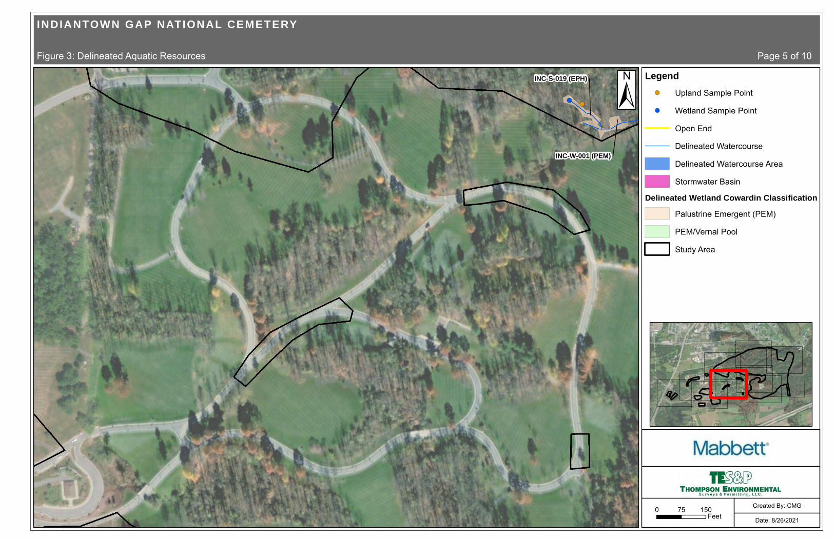
INC-S-019 (EPH)
INC-W-001 (PEM)
±
INDIANTOWN GAP NATIONAL CEMETERY
Figure 3: Delineated Aquatic Resources Page 5 of 10
0 15075Feet Date: 8/26/2021
Created By: CMG
Legend!( Upland Sample Point
!( Wetland Sample Point
Open End
Delineated Watercourse
Delineated Watercourse Area
Stormwater Basin
Delineated Wetland Cowardin ClassificationPalustrine Emergent (PEM)
PEM/Vernal Pool
Study Area

INC-S-002 (INT)
INC-S-003 (EPH
INC-S-004 (EPH)
INC-S-001 (PER)
INC-W-006 (PEM)
BIDDLE DR
SMATHERS RD
±
INDIANTOWN GAP NATIONAL CEMETERY
Figure 3: Delineated Aquatic Resources Page 6 of 10
0 15075Feet Date: 8/26/2021
Created By: CMG
Legend!( Upland Sample Point
!( Wetland Sample Point
Open End
Delineated Watercourse
Delineated Watercourse Area
Stormwater Basin
Delineated Wetland Cowardin ClassificationPalustrine Emergent (PEM)
PEM/Vernal Pool
Study Area

INC-S-012 (PER)
INC-S-016 (EPH)
INC-S-017 (INT)
INC-S-018 (EPH)
INC-S-019 (EPH)
INC-S-016B (EPH)INC-S-016A (EPH)
INC-S-012 (PER)
INC-W-012 (PEM)
INC-W-001 (PEM)
INC-W-010 (PEM)
INC-W-011 (PEM/VERNAL POOL)
INC-W-013 (PEM)
±
INDIANTOWN GAP NATIONAL CEMETERY
Figure 3: Delineated Aquatic Resources Page 7 of 10
0 15075Feet Date: 8/26/2021
Created By: CMG
Legend!( Upland Sample Point
!( Wetland Sample Point
Open End
Delineated Watercourse
Delineated Watercourse Area
Stormwater Basin
Delineated Wetland Cowardin ClassificationPalustrine Emergent (PEM)
PEM/Vernal Pool
Study Area

INC-S-016 (EPH)INC-S-014 (EPH)
INC-S-017 (INT)
INC-S-015 (INT)
INC-S-013 (INT)
INC-S-016B (EPH)INC-S-016A (EPH)
INC-S-012 (PER)
INC-S-012 (PER)
INC-W-012 (PEM)
INC-W-007 (PEM)
INC-W-008 (PEM)
INC-W-009 (PEM)
INC-W-010 (PEM)
INC-W-011 (PEM/VERNAL POOL)
INC-W-020 (PEM)
INC-W-019 (PEM)
BOUNDARY RD
±
INDIANTOWN GAP NATIONAL CEMETERY
Figure 3: Delineated Aquatic Resources Page 8 of 10
0 15075Feet Date: 8/26/2021
Created By: CMG
Legend!( Upland Sample Point
!( Wetland Sample Point
Open End
Delineated Watercourse
Delineated Watercourse Area
Stormwater Basin
Delineated Wetland Cowardin ClassificationPalustrine Emergent (PEM)
PEM/Vernal Pool
Study Area

INC-S-002 (INT)
INC-S-010 (EPH)
INC-S-003 (EPH)
INC-S-011 (EPH)
INC-S-004 (EPH)
INC-W-015 (PEM)
IND
IAN
TOW
N R
D
BIDDLE RD
BIDDLE DR
±
INDIANTOWN GAP NATIONAL CEMETERY
Figure 3: Delineated Aquatic Resources Page 9 of 10
0 15075Feet Date: 8/26/2021
Created By: CMG
Legend!( Upland Sample Point
!( Wetland Sample Point
Open End
Delineated Watercourse
Delineated Watercourse Area
Stormwater Basin
Delineated Wetland Cowardin ClassificationPalustrine Emergent (PEM)
PEM/Vernal Pool
Study Area

INC-S-016 (EPH)INC-S-014 (EPH)
INC-S-011 (EPH)
INC-S-013 (INT)
INC-S-012 (PER)
INC-S-012 (PER)
INC-W-007 (PEM)
INC-W-020 (PEM)
INC-W-019 (PEM)
BOUNDARY RD
±
INDIANTOWN GAP NATIONAL CEMETERY
Figure 3: Delineated Aquatic Resources Page 10 of 10
0 15075Feet Date: 8/26/2021
Created By: CMG
Legend!( Upland Sample Point
!( Wetland Sample Point
Open End
Delineated Watercourse
Delineated Watercourse Area
Stormwater Basin
Delineated Wetland Cowardin ClassificationPalustrine Emergent (PEM)
PEM/Vernal Pool
Study Area

INDIANTOWN GAP NATIONAL CEMETERY EXPANSION PROJECT
AQUATIC RESOURCE DELINEATION REPORT
Appendix B USACE Regional Supplement Wetland Determination Data Forms
Thompson Environmental Surveys & Permitting, LLC July 2021

Are climatic/hydrologic conditions on the site typical for this time of year?
INC-W-001 (PEM)
07-Oct-20
5.2
Yes No
Yes No
Yes No
Yes No
Yes No Yes No
Lat.:
Hydric Soil Present?
Sampling Point:
Summary of Findings - Attach site map showing sampling point locations, transects, important features, etc.
State:
°Landform (hillslope, terrace, etc.):
T
(If no, explain in Remarks.)
Are Vegetation
Are "Normal Circumstances" present?
Datum:
naturally problematic?
Hydrophytic Vegetation Present?
Remarks:
R
Are Vegetation
Long.:
significantly disturbed?
Local relief (concave, convex, none): Slope:
Investigator(s):
(If needed, explain any answers in Remarks.)
City/County:
, Soil
% /
Soil Map Unit Name:
, or Hydrology
, Soil , or Hydrology
NWI classification:
Subregion (LRR or MLRA):
Project/Site:
Wetland Hydrology Present?
Section, Township, Range: S
Is the Sampled Area within a Wetland?
Applicant/Owner:
Sampling Date:
WETLAND DETERMINATION DATA FORM - Eastern Mountains and Piedmont Region
Indiantown Gap National Cemetery Expansion Project
Mabbett & Associates, Inc.
Bridger Thompson
Channel (active)
MLRA 147 in LRR S
East Hanover, Lebanon Co.
PA
-76.5631122540.42326035
WeD-Weikert channery silt loam, 15 to 25 percent slopes R4SBC
NAD-83
concave
Wetland data point collected to document the existing conditions. The data point is located in a shallow depression along a small watercourse discharge in a disturbed wooded shrubby lot. The wetland boundary is defined by the saturated soil conditions with low chroma redox soils.
Eastern Mountains and Piedmont - Version 2.0 US Army Corps of Engineers
3.0
0.5
0
Yes No
Yes No
Yes No Yes No
Hydrology
Surface Water (A1)
High Water Table (A2)
Saturation (A3)
Water Marks (B1)
Sediment Deposits (B2)
Drift deposits (B3)
Algal Mat or Crust (B4)
Water-Stained Leaves (B9)
Dry Season Water Table (C2)
True Aquatic Plants (B14)
Hydrogen Sulfide Odor (C1)
Oxidized Rhizospheres along Living Roots (C3)
Presence of Reduced Iron (C4)
Recent Iron Reduction in Tilled Soils (C6)
Other (Explain in Remarks)
Drainage Patterns (B10)
Aquatic Fauna (B13)
Saturation Visible on Aerial Imagery (C9)
Crayfish Burrows (C8)
Moss Trim Lines (B16)
Primary Indicators (minimum of one required; check all that apply)
Wetland Hydrology Indicators:
Field Observations:
Surface Water Present?
Water Table Present?
Saturation Present? (includes capillary fringe)
Depth (inches):
Depth (inches):
Depth (inches): Wetland Hydrology Present?
Describe Recorded Data (stream gauge, monitoring well, aerial photos, previous inspections), if available:
Remarks:
Secondary Indicators (minimum of two required)
Iron Deposits (B5)
Surface Soil Cracks (B6)
Stunted or Stressed Plants (D1)
Inundation Visible on Aerial Imagery (B7)
Sparsely Vegetated Concave Surface (B8)
Thin Muck Surface (C7)
Shallow Aquitard (D3)
FAC-neutral Test (D5)
Geomorphic Position (D2)
Microtopographic Relief (D4)
The primary source of hydrology is associated with the discharge of a seasal groundwater seep that is confined in a eroded channel.

0
0
0
0
0
0
0
0
0
10
0
0
0
0
50
20
10
0
0
0
0
Yes No
30.0%
0.0%
30.0%
0.0%
100.0%
0
0.0%
0.0%
0.0%
20 20
0.0%
10 20
0.0%
60 180
0 0
10
0 0
100.0% FAC
90 220
0.0%
2.444
0.0%
0.0%
0.0%
62.5% FAC
25.0% OBL
12.5% FACW
0.0%
0.0%
80
0.0%
0.0%
0
0 0.0%
Eastern Mountains and Piedmont - Version 2.0
Woody Vine Stratum
(B)
= Total Cover
= Total Cover
Prevalence Index is ≤3.0
= Total Cover
Hydrophytic Vegetation Present?
US Army Corps of Engineers
Dominance Test worksheet:
Total Number of Dominant Species Across All Strata:
Prevalence Index worksheet:
Prevalence Index = B/A =
(A/B)
1 Indicators of hydric soil and wetland hydrology must be present, unless disturbed or problematic.
Problematic Hydrophytic Vegetation 1 (Explain)
Herb Stratum
= Total Cover
Number of Dominant Species That are OBL, FACW, or FAC:
Hydrophytic Vegetation Indicators:
Remarks: (Include photo numbers here or on a separate sheet.)
OBL species
FACW species
FAC species
FACU species
UPL species
Column Totals:
x 1 =
x 2 =
x 3 =
x 4 =
x 5 =
(A)
(A)
Percent of dominant Species That Are OBL, FACW, or FAC:
Total % Cover of: Multiply by:
(B)
Tree Stratum
Shrub Stratum
*Indicator suffix = National status or professional decision assigned because Regional status not defined by FWS.
Dominance Test is > 50%
0
0
0
0
0
0.0%
0.0%
0.0%
0.0%
0.0%
0
0
0
0
0
0.0%
0.0%
0.0%
0.0%
0
0.0%
= Total Cover
Sapling-Sapling/Shrub Stratum
1.
0
0
0.0%
0.0%
0
0
0.0%
0.0%
0
0
0.0%
0.0%
Definition of Vegetation Strata:
Tree - Woody plants, excluding woody vines, approximately 20 ft (6 m) or more in height and 3 in. (7.6 cm) or larger in diameter at breast height (DBH). Sapling stratum – Consists of woody plants, excluding woody vines, approximately 20 ft (6 m) or more in height and less than 3 in. (7.6 cm) DBH. Shrub stratum – Consists of woody plants, excluding woody vines, approximately 3 to 20 ft (1 to 6 m) in height. Herb stratum – Consists of all herbaceous (non-woody) plants, including herbaceous vines, regardless of size, and woody species, except woody vines, less than approximately 3 ft (1 m) in height.
Woody vines – Consists of all woody vines, regardless of height.
INC-W-001 (PEM)Sampling Point:
)
)
)
)
)
Morphological Adaptations 1 (Provide supporting data in Remarks or on a separate sheet)
Rapid Test for Hydrophytic Vegetation
0 0.0%
0
0
0.0%
0.0%
0 0.0%
VEGETATION (Five/Four Strata)- Use scientific names of plants.
0 0.0%
Tree stratum – Consists of woody plants, excluding vines, 3 in. (7.6 cm) or more in diameter at breast height (DBH), regardless of height. Sapling/shrub stratum – Consists of woody plants, excluding vines, less than 3 in. DBH and greater than 3.28 ft (1 m) tall. Herb stratum – Consists of all herbaceous (non-woody) plants, regardless of size, and all other plants less than 3.28 ft tall.
Woody vines – Consists of all woody vines greater than 3.28 ft in height.
Four Vegetation Strata:
Five Vegetation Strata:
(Plot size:
(Plot size:
(Plot size: 15 feet
Lindera benzoin
(Plot size: 10 feet
Microstegium vimineum
Glyceria striata
Pilea pumila
(Plot size:
Dominant Species? Rel.Strat. Cover
Absolute % Cover
Indicator Status
1
1
1
1
2. 3. 4. 5. 6. 7. 8.
1. 2. 3. 4. 5. 6. 7. 8. 9.
10.
1. 2. 3. 4. 5. 6. 7.
1. 2. 3. 4. 5. 6. 7. 8. 9.
10. 11. 12.
1. 2. 3. 4. 5. 6.

INC-W-001 (PEM)Soil Sampling Point:
Profile Description: (Describe to the depth needed to document the indicator or confirm the absence of indicators.)
Depth (inches) Color (moist) Color (moist)
Matrix Redox Features
% Loc² Texture RemarksType%
Yes No
Hydric Soil Indicators: Indicators for Problematic Hydric Soils :
Restrictive Layer (if observed):
Hydric Soil Present?
Indicators of hydrophytic vegetation and wetland hydrology must be present,
unless disturbed or problematic.
Histosol (A1)
Histic Epipedon (A2)
Black Histic (A3)
Hydrogen Sulfide (A4)
Depleted Below Dark Surface (A11)
Thick Dark Surface (A12)
Sandy Muck Mineral (S1) (LRR N, MLRA 147, 148)
Sandy Gleyed Matrix (S4)
Sandy Redox (S5)
Stripped Matrix (S6)
Loamy Gleyed Matrix (F2)
Depleted Matrix (F3)
Redox Dark Surface (F6)
Depleted Dark Surface (F7)
Type:
Depth (inches):
Remarks:
US Army Corps of Engineers Eastern Mountains and Piedmont - Version 2.0
Dark Surface (S7)
Stratified Layers (A5)
Polyvalue Below Surface (S8) (MLRA 147,148)
Redox Depressions (F8)
1
1
3
3
Thin Dark Surface (S9) (MLRA 147, 148)
Iron-Manganese Masses (F12) (LRR N, MLRA 136)
Umbric Surface (F13) (MLRA 136, 122)
Piedmont Floodplain Soils (F19) (MLRA 148)
Type: C=Concentration. D=Depletion. RM=Reduced Matrix, CS=Covered or Coated Sand Grains ²Location: PL=Pore Lining. M=Matrix
2 cm Muck (A10) (LRR N)
12-20
4-12
0-4
10YR
10YR
10YR
5/1
4/1
4/2
80
80
100
2.5YR
2.5YR
5/8
5/8 20
20 C
C M
M
Silt Loam
Silty Clay
Clay Loam
Surface water infiltration is slightly restricted by a shallow clay layer.
Other (Explain in Remarks)
2 cm Muck (A10) (MLRA 147)
Piedmont Floodplain Soils (F19) (MLRA 136, 147)
Very Shallow Dark Surface (TF12)
Coast Prairie Redox (A16) (MLRA 147,148)
Red Parent Material (F21) (MLRA 127, 147)

WETLAND DETERMINATION DATA FORM - Eastern Mountains and Piedmont Region
Project/Site: Indiantown Gap National Cemetery Expansion Project City/County: East Hanover, Lebanon Co. Sampling Date: 07-Oct-20
Applicant/Owner: Mabbett & Associates, Inc. State: PA Sampling Point: INC-W-001 (UPL)
Investigator(s): Bridger Thompson Section, Township, Range: S T R
Landform (hillslope, terrace, etc.): Undulating Local relief (concave, convex, none): flat Slope: 0.0 % / 0.0 °
Subregion (LRR or MLRA): MLRA 147 in LRR S Lat.: 40.42322812 Long.: -76.56297435 Datum: NAD-83
Soil Map Unit Name: WeD-Weikert channery silt loam, 15 to 25 percent slopes NWI classification: N/A
Are climatic/hydrologic conditions on the site typical for this time of year? Yes No (If no, explain in Remarks.)
Are Vegetation , Soil , or Hydrology significantly disturbed? Are "Normal Circumstances" present? Yes No
Are Vegetation , Soil , or Hydrology naturally problematic? (If needed, explain any answers in Remarks.)
Summary of Findings - Attach site map showing sampling point locations, transects, important features, etc.
Yes No
Yes No
Yes No
Hydric Soil Present?
Hydrophytic Vegetation Present?
Wetland Hydrology Present?
Yes No Is the Sampled Area within a Wetland?
Remarks:
Upland data point collected to verify the wetland boundary. The data point is located in a wooded/shrubby lot adjacent to a maintained cemetery grounds.
Hydrology
Surface Water (A1)
High Water Table (A2)
Saturation (A3)
Water Marks (B1)
Sediment Deposits (B2)
Drift deposits (B3)
Algal Mat or Crust (B4)
Water-Stained Leaves (B9)
Dry Season Water Table (C2)
True Aquatic Plants (B14)
Hydrogen Sulfide Odor (C1)
Oxidized Rhizospheres along Living Roots (C3)
Presence of Reduced Iron (C4)
Recent Iron Reduction in Tilled Soils (C6)
Other (Explain in Remarks)
Drainage Patterns (B10)
Aquatic Fauna (B13)
Saturation Visible on Aerial Imagery (C9)
Crayfish Burrows (C8)
Moss Trim Lines (B16)
Primary Indicators (minimum of one required; check all that apply)
Wetland Hydrology Indicators: Secondary Indicators (minimum of two required)
Iron Deposits (B5)
Surface Soil Cracks (B6)
Stunted or Stressed Plants (D1)
Inundation Visible on Aerial Imagery (B7)
Sparsely Vegetated Concave Surface (B8)
Thin Muck Surface (C7)
Shallow Aquitard (D3)
FAC-neutral Test (D5)
Geomorphic Position (D2)
Microtopographic Relief (D4)
Yes No
Yes No
Yes No Yes No
Field Observations:
Surface Water Present?
Water Table Present?
Saturation Present? (includes capillary fringe)
Depth (inches):
Depth (inches):
Depth (inches): Wetland Hydrology Present?
Describe Recorded Data (stream gauge, m onitoring well, aerial photos, previous inspections), if a vailable:
Remarks:
No evidence of hydrology. The region is experiencing very dry drought like conditions.
Eastern Mountains and Piedmont - Version 2.0 US Army Corps of Engineers

30
10
0
0
0
0
0
0
0
10
0
0
0
0
60
0
0
0
0
0
0
Yes No
375.0% FACU
25.0% FAC
50.0%
0.0%
60.0%
40
0.0%
0.0%
0.0%
0 0
0.0%
0 0
0.0%
80 240
40 160
20
0 0
50.0% FACU
120 400
0.0%
3.333
0.0%
0.0%
0.0%
100.0% FAC
0.0%
0.0%
0.0%
0.0%
60
0.0%
0.0%
0
0 0.0%
Eastern Mountains and Piedmont - Version 2.0
Woody Vine Stratum
(B)
= Total Cover
= Total Cover
Prevalence Index is ≤3.0
= Total Cover
Hydrophytic Vegetation Present?
US Army Corps of Engineers
Dominance Test worksheet:
Total Number of Dominant Species Across All Strata:
Prevalence Index worksheet:
Prevalence Index = B/A =
(A/B)
1 Indicators of hydric soil and wetland hydrology must be present, unless disturbed or problematic.
Problematic Hydrophytic Vegetation 1 (Explain)
Herb Stratum
= Total Cover
Number of Dominant Species That are OBL, FACW, or FAC:
Hydrophytic Vegetation Indicators:
Remarks: (Include photo numbers here or on a separate sheet.)
OBL species
FACW species
FAC species
FACU species
UPL species
Column Totals:
x 1 =
x 2 =
x 3 =
x 4 =
x 5 =
(A)
(A)
Percent of dominant Species That Are OBL, FACW, or FAC:
Total % Cover of: Multiply by:
(B)
Tree Stratum
Shrub Stratum
*Indicator suffix = National status or professional decision assigned because Regional status not defined by FWS.
Dominance Test is > 50%
0
0
0
0
0
0.0%
0.0%
0.0%
0.0%
0.0%
0
0
0
0
0
0.0%
0.0%
0.0%
0.0%
0
0.0%
= Total Cover
Sapling-Sapling/Shrub Stratum
1.
0
0
0.0%
0.0%
0
0
0.0%
0.0%
10
0
50.0% FAC
0.0%
Definition of Vegetation Strata:
Tree - Woody plants, excluding woody vines, approximately 20 ft (6 m) or more in height and 3 in. (7.6 cm) or larger in diameter at breast height (DBH). Sapling stratum – Consists of woody plants, excluding woody vines, approximately 20 ft (6 m) or more in height and less than 3 in. (7.6 cm) DBH. Shrub stratum – Consists of woody plants, excluding woody vines, approximately 3 to 20 ft (1 to 6 m) in height. Herb stratum – Consists of all herbaceous (non-woody) plants, including herbaceous vines, regardless of size, and woody species, except woody vines, less than approximately 3 ft (1 m) in height.
Woody vines – Consists of all woody vines, regardless of height.
INC-W-001 (UPL)Sampling Point:
)
)
)
)
)
Morphological Adaptations 1 (Provide supporting data in Remarks or on a separate sheet)
Rapid Test for Hydrophytic Vegetation
0 0.0%
0
0
0.0%
0.0%
0 0.0%
VEGETATION (Five/Four Strata)- Use scientific names of plants.
0 0.0%
Tree stratum – Consists of woody plants, excluding vines, 3 in. (7.6 cm) or more in diameter at breast height (DBH), regardless of height. Sapling/shrub stratum – Consists of woody plants, excluding vines, less than 3 in. DBH and greater than 3.28 ft (1 m) tall. Herb stratum – Consists of all herbaceous (non-woody) plants, regardless of size, and all other plants less than 3.28 ft tall.
Woody vines – Consists of all woody vines greater than 3.28 ft in height.
Four Vegetation Strata:
Five Vegetation Strata:
Carya ovata
Acer rubrum
(Plot size: 30 feet
(Plot size:
(Plot size: 15 feet
Cornus florida
Lindera benzoin
(Plot size: 10 feet
Microstegium vimineum
(Plot size:
Dominant Species? Rel.Strat. Cover
Absolute % Cover
Indicator Status
1
1
1
1
2. 3. 4. 5. 6. 7. 8.
1. 2. 3. 4. 5. 6. 7. 8. 9.
10.
1. 2. 3. 4. 5. 6. 7.
1. 2. 3. 4. 5. 6. 7. 8. 9.
10. 11. 12.
1. 2. 3. 4. 5. 6.

INC-W-001 (UPL)Soil Sampling Point:
Profile Description: (Describe to the depth needed to document the indicator or confirm the absence of indicators.)
Depth (inches) Color (moist) Color (moist)
Matrix Redox Features
% Loc² Texture RemarksType%
Yes No
Hydric Soil Indicators: Indicators for Problematic Hydric Soils :
Restrictive Layer (if observed):
Hydric Soil Present?
Indicators of hydrophytic vegetation and wetland hydrology must be present,
unless disturbed or problematic.
Histosol (A1)
Histic Epipedon (A2)
Black Histic (A3)
Hydrogen Sulfide (A4)
Depleted Below Dark Surface (A11)
Thick Dark Surface (A12)
Sandy Muck Mineral (S1) (LRR N, MLRA 147, 148)
Sandy Gleyed Matrix (S4)
Sandy Redox (S5)
Stripped Matrix (S6)
Loamy Gleyed Matrix (F2)
Depleted Matrix (F3)
Redox Dark Surface (F6)
Depleted Dark Surface (F7)
Type:
Depth (inches):
Remarks:
US Army Corps of Engineers Eastern Mountains and Piedmont - Version 2.0
Dark Surface (S7)
Stratified Layers (A5)
Polyvalue Below Surface (S8) (MLRA 147,148)
Redox Depressions (F8)
1
1
3
3
Thin Dark Surface (S9) (MLRA 147, 148)
Iron-Manganese Masses (F12) (LRR N, MLRA 136)
Umbric Surface (F13) (MLRA 136, 122)
Piedmont Floodplain Soils (F19) (MLRA 148)
Type: C=Concentration. D=Depletion. RM=Reduced Matrix, CS=Covered or Coated Sand Grains ²Location: PL=Pore Lining. M=Matrix
2 cm Muck (A10) (LRR N)
12-20
0-12
10YR
10YR
5/3
5/3
95
100
2.5YR 5/6 5 C M
Silt Loam
Clay Loam
Other (Explain in Remarks)
2 cm Muck (A10) (MLRA 147)
Piedmont Floodplain Soils (F19) (MLRA 136, 147)
Very Shallow Dark Surface (TF12)
Coast Prairie Redox (A16) (MLRA 147,148)
Red Parent Material (F21) (MLRA 127, 147)

WETLAND DETERMINATION DATA FORM - Eastern Mountains and Piedmont Region
Project/Site: Indiantown Gap National Cemetery Expansion Project City/County: East Hanover, Lebanon Co. Sampling Date: 07-Oct-20
Applicant/Owner: Mabbett & Associates, Inc. State: PA Sampling Point: INC-W-002 (PEM)
Investigator(s): Bridger Thompson Section, Township, Range: S T R
Landform (hillslope, terrace, etc.): Footslope Local relief (concave, convex, none): concave Slope: 3.5 % / 2.0 °
Subregion (LRR or MLRA): MLRA 147 in LRR S Lat.: 40.42458409 Long.: -76.56640268 Datum: NAD-83
Soil Map Unit Name: CmB-Comly silt loam, 3 to 8 percent slopes NWI classification: N/A
Are climatic/hydrologic conditions on the site typical for this time of year? Yes No (If no, explain in Remarks.)
Are Vegetation , Soil , or Hydrology significantly disturbed? Are "Normal Circumstances" present? Yes No
Are Vegetation , Soil , or Hydrology naturally problematic? (If needed, explain any answers in Remarks.)
Summary of Findings - Attach site map showing sampling point locations, transects, important features, etc.
Yes No
Yes No
Yes No
Hydric Soil Present?
Hydrophytic Vegetation Present?
Wetland Hydrology Present?
Yes No Is the Sampled Area within a Wetland?
Remarks:
Wetland data point collected to document the existing conditions. The data point is located in a shallow depression along a roadside fillslope. The wetland contains multiple persistent groundwater discharge areas. The wetland boundary is defined by the saturated soil conditions with low chroma redox soils and vegetation dominatedby bulrush and sensitive fern.
Hydrology
Surface Water (A1)
High Water Table (A2)
Saturation (A3)
Water Marks (B1)
Sediment Deposits (B2)
Drift deposits (B3)
Algal Mat or Crust (B4)
Water-Stained Leaves (B9)
Dry Season Water Table (C2)
True Aquatic Plants (B14)
Hydrogen Sulfide Odor (C1)
Oxidized Rhizospheres along Living Roots (C3)
Presence of Reduced Iron (C4)
Recent Iron Reduction in Tilled Soils (C6)
Other (Explain in Remarks)
Drainage Patterns (B10)
Aquatic Fauna (B13)
Saturation Visible on Aerial Imagery (C9)
Crayfish Burrows (C8)
Moss Trim Lines (B16)
Primary Indicators (minimum of one required; check all that apply)
Wetland Hydrology Indicators: Secondary Indicators (minimum of two required)
Iron Deposits (B5)
Surface Soil Cracks (B6)
Stunted or Stressed Plants (D1)
Inundation Visible on Aerial Imagery (B7)
Sparsely Vegetated Concave Surface (B8)
Thin Muck Surface (C7)
Shallow Aquitard (D3)
FAC-neutral Test (D5)
Geomorphic Position (D2)
Microtopographic Relief (D4)
1.5
3
0
Yes No
Yes No
Yes No Yes No
Field Observations:
Surface Water Present?
Water Table Present?
Saturation Present? (includes capillary fringe)
Depth (inches):
Depth (inches):
Depth (inches): Wetland Hydrology Present?
Describe Recorded Data (stream gauge, monitoring well, aerial photos, previous inspections), if available:
Remarks:
The region is experiencing very dry and drought like conditions.
Eastern Mountains and Piedmont - Version 2.0 US Army Corps of Engineers

0
0
0
0
0
0
0
0
0
0
0
0
0
0
50
20
10
10
10
0
0
Yes No
20.0%
0.0%
20.0%
0.0%
100.0%
0
0.0%
0.0%
0.0%
30 30
0.0%
20 40
0.0%
50 150
0 0
0
0 0
0.0%
100 220
0.0%
2.200
0.0%
0.0%
0.0%
50.0% FAC
20.0% OBL
10.0% OBL
10.0% FACW
10.0% FACW
100
0.0%
0.0%
0
0 0.0%
Eastern Mountains and Piedmont - Version 2.0
Woody Vine Stratum
(B)
= Total Cover
= Total Cover
Prevalence Index is ≤3.0
= Total Cover
Hydrophytic Vegetation Present?
US Army Corps of Engineers
Dominance Test worksheet:
Total Number of Dominant Species Across All Strata:
Prevalence Index worksheet:
Prevalence Index = B/A =
(A/B)
1 Indicators of hydric soil and wetland hydrology must be present, unless disturbed or problematic.
Problematic Hydrophytic Vegetation 1 (Explain)
Herb Stratum
= Total Cover
Number of Dominant Species That are OBL, FACW, or FAC:
Hydrophytic Vegetation Indicators:
Remarks: (Include photo numbers here or on a separate sheet.)
OBL species
FACW species
FAC species
FACU species
UPL species
Column Totals:
x 1 =
x 2 =
x 3 =
x 4 =
x 5 =
(A)
(A)
Percent of dominant Species That Are OBL, FACW, or FAC:
Total % Cover of: Multiply by:
(B)
Tree Stratum
Shrub Stratum
*Indicator suffix = National status or professional decision assigned because Regional status not defined by FWS.
Dominance Test is > 50%
0
0
0
0
0
0.0%
0.0%
0.0%
0.0%
0.0%
0
0
0
0
0
0.0%
0.0%
0.0%
0.0%
0
0.0%
= Total Cover
Sapling-Sapling/Shrub Stratum
1.
0
0
0.0%
0.0%
0
0
0.0%
0.0%
0
0
0.0%
0.0%
Definition of Vegetation Strata:
Tree - Woody plants, excluding woody vines, approximately 20 ft (6 m) or more in height and 3 in. (7.6 cm) or larger in diameter at breast height (DBH). Sapling stratum – Consists of woody plants, excluding woody vines, approximately 20 ft (6 m) or more in height and less than 3 in. (7.6 cm) DBH. Shrub stratum – Consists of woody plants, excluding woody vines, approximately 3 to 20 ft (1 to 6 m) in height. Herb stratum – Consists of all herbaceous (non-woody) plants, including herbaceous vines, regardless of size, and woody species, except woody vines, less than approximately 3 ft (1 m) in height.
Woody vines – Consists of all woody vines, regardless of height.
INC-W-002 (PEM)Sampling Point:
)
)
)
)
)
Morphological Adaptations 1 (Provide supporting data in Remarks or on a separate sheet)
Rapid Test for Hydrophytic Vegetation
0 0.0%
0
0
0.0%
0.0%
0 0.0%
VEGETATION (Five/Four Strata)- Use scientific names of plants.
0 0.0%
Tree stratum – Consists of woody plants, excluding vines, 3 in. (7.6 cm) or more in diameter at breast height (DBH), regardless of height. Sapling/shrub stratum – Consists of woody plants, excluding vines, less than 3 in. DBH and greater than 3.28 ft (1 m) tall. Herb stratum – Consists of all herbaceous (non-woody) plants, regardless of size, and all other plants less than 3.28 ft tall.
Woody vines – Consists of all woody vines greater than 3.28 ft in height.
Four Vegetation Strata:
Five Vegetation Strata:
(Plot size:
(Plot size:
(Plot size:
(Plot size: 10 feet
Microstegium vimineum
Typha latifolia
Scirpus atrovirens
Juncus effusus
Onoclea sensibilis
(Plot size:
Dominant Species? Rel.Strat. Cover
Absolute % Cover
Indicator Status
1
1
1
1
2. 3. 4. 5. 6. 7. 8.
1. 2. 3. 4. 5. 6. 7. 8. 9.
10.
1. 2. 3. 4. 5. 6. 7.
1. 2. 3. 4. 5. 6. 7. 8. 9.
10. 11. 12.
1. 2. 3. 4. 5. 6.

INC-W-002 (PEM)Soil Sampling Point:
Profile Description: (Describe to the depth needed to document the indicator or confirm the absence of indicators.)
Depth (inches) Color (moist) Color (moist)
Matrix Redox Features
% Loc² Texture RemarksType%
Yes No
Hydric Soil Indicators: Indicators for Problematic Hydric Soils :
Restrictive Layer (if observed):
Hydric Soil Present?
Indicators of hydrophytic vegetation and wetland hydrology must be present,
unless disturbed or problematic.
Histosol (A1)
Histic Epipedon (A2)
Black Histic (A3)
Hydrogen Sulfide (A4)
Depleted Below Dark Surface (A11)
Thick Dark Surface (A12)
Sandy Muck Mineral (S1) (LRR N, MLRA 147, 148)
Sandy Gleyed Matrix (S4)
Sandy Redox (S5)
Stripped Matrix (S6)
Loamy Gleyed Matrix (F2)
Depleted Matrix (F3)
Redox Dark Surface (F6)
Depleted Dark Surface (F7)
Type:
Depth (inches):
Remarks:
US Army Corps of Engineers Eastern Mountains and Piedmont - Version 2.0
Dark Surface (S7)
Stratified Layers (A5)
Polyvalue Below Surface (S8) (MLRA 147,148)
Redox Depressions (F8)
1
1
3
3
Thin Dark Surface (S9) (MLRA 147, 148)
Iron-Manganese Masses (F12) (LRR N, MLRA 136)
Umbric Surface (F13) (MLRA 136, 122)
Piedmont Floodplain Soils (F19) (MLRA 148)
Type: C=Concentration. D=Depletion. RM=Reduced Matrix, CS=Covered or Coated Sand Grains ²Location: PL=Pore Lining. M=Matrix
2 cm Muck (A10) (LRR N)
16-20
0-16
2.5Y
2.5Y
5/4
5/2
90
95 5YR
5YR
5/6
5/6 10
5 C
C M
M Silt Loam
Clay Loam
Surface water infiltration is slightly restricted by a shallow clay layer.
Other (Explain in Remarks)
2 cm Muck (A10) (MLRA 147)
Piedmont Floodplain Soils (F19) (MLRA 136, 147)
Very Shallow Dark Surface (TF12)
Coast Prairie Redox (A16) (MLRA 147,148)
Red Parent Material (F21) (MLRA 127, 147)

WETLAND DETERMINATION DATA FORM - Eastern Mountains and Piedmont Region
Project/Site: Indiantown Gap National Cemetery Expansion Project City/County: East Hanover, Lebanon Co. Sampling Date: 07-Oct-20
Applicant/Owner: Mabbett & Associates, Inc. State: PA Sampling Point: INC-W-002 (UPL)
Investigator(s): Bridger Thompson Section, Township, Range: S T R
Landform (hillslope, terrace, etc.): Footslope Local relief (concave, convex, none): concave Slope: 7.0 % / 4.0 °
Subregion (LRR or MLRA): Lat.: 40.424616 Long.: -76.566243 Datum: NAD-83
Soil Map Unit Name: CmB-Comly silt loam, 3 to 8 percent slopes NWI classification: N/A
Are climatic/hydrologic conditions on the site typical for this time of year? Yes No (If no, explain in Remarks.)
Are Vegetation , Soil , or Hydrology significantly disturbed? Are "Normal Circumstances" present? Yes No
Are Vegetation , Soil , or Hydrology naturally problematic? (If needed, explain any answers in Remarks.)
Summary of Findings - Attach site map showing sampling point locations, transects, important features, etc.
Yes No
Yes No
Yes No
Hydric Soil Present?
Hydrophytic Vegetation Present?
Wetland Hydrology Present?
Yes No Is the Sampled Area within a Wetland?
Remarks:
Upland data point collected to verify the wetland boundary. The data point is located in a wooded/shrubby area adjacent to the wetland boundary.
Hydrology
Surface Water (A1)
High Water Table (A2)
Saturation (A3)
Water Marks (B1)
Sediment Deposits (B2)
Drift deposits (B3)
Algal Mat or Crust (B4)
Water-Stained Leaves (B9)
Dry Season Water Table (C2)
True Aquatic Plants (B14)
Hydrogen Sulfide Odor (C1)
Oxidized Rhizospheres along Living Roots (C3)
Presence of Reduced Iron (C4)
Recent Iron Reduction in Tilled Soils (C6)
Other (Explain in Remarks)
Drainage Patterns (B10)
Aquatic Fauna (B13)
Saturation Visible on Aerial Imagery (C9)
Crayfish Burrows (C8)
Moss Trim Lines (B16)
Primary Indicators (minimum of one required; check all that apply)
Wetland Hydrology Indicators: Secondary Indicators (minimum of two required)
Iron Deposits (B5)
Surface Soil Cracks (B6)
Stunted or Stressed Plants (D1)
Inundation Visible on Aerial Imagery (B7)
Sparsely Vegetated Concave Surface (B8)
Thin Muck Surface (C7)
Shallow Aquitard (D3)
FAC-neutral Test (D5)
Geomorphic Position (D2)
Microtopographic Relief (D4)
Yes No
Yes No
Yes No Yes No
Field Observations:
Surface Water Present?
Water Table Present?
Saturation Present? (includes capillary fringe)
Depth (inches):
Depth (inches):
Depth (inches): Wetland Hydrology Present?
Describe Recorded Data (stream gauge, monitoring well, aerial photos, previous inspections), if available:
Remarks:
The region is experiencing very dry and drought like conditions.
Eastern Mountains and Piedmont - Version 2.0 US Army Corps of Engineers

1
1
1
VEGETATION (Five/Four Strata)- Use scientific names of plants. Dominant Sampling Point: INC-W-002 (UPL) Species?
0
0
0
0
0
0
0.0%
0.0%
0.0%
0.0%
0
0.0%
0.0%
= Total Cover
Tree Stratum
0
0
0
0
0
0.0%
0.0%
0.0%
0.0%
0.0%
Sapling-Sapling/Shrub Stratum
1.
0
0
0.0%
0.0%
0
0
0.0%
0.0%
)
)
(Plot size:
(Plot size:
Rel.Strat. Cover
Absolute % Cover
Indicator Status
2. 3. 4. 5. 6. 7. 8.
1. 2. 3. 4. 5. 6. 7.
1
3
33.3%
Dominance Test worksheet:
Total Number of Dominant Species Across All Strata:
(A/B)
Number of Dominant Species That are OBL, FACW, or FAC: (A)
Percent of dominant Species That Are OBL, FACW, or FAC:
(B)
0 0
0 0
60 180
10 40
30 150
100 370
3.700
(B)
Prevalence Index worksheet:
Prevalence Index = B/A =
OBL species
FACW species
FAC species
FACU species
UPL species
Column Totals:
x 1 =
x 2 =
x 3 =
x 4 =
x 5 =
(A)
Total % Cover of: Multiply by:
Hydrophytic Vegetation Indicators: 0 0.0% 8. Rapid Test for Hydrophytic Vegetation 0 0.0% 9. Dominance Test is > 50% 0 0.0% 10. Prevalence Index is ≤3.0 1
Shrub Stratum 0 = Total Cover )(Plot size: 15 feet Morphological Adaptations (Provide supporting1
30 75.0% UPL Elaeagnus umbellata 1. data in Remarks or on a separate sheet)
10 25.0% FACU Crataegus crus-galli 2. Problematic Hydrophytic Vegetation (Explain) 1
0 0.0% 3. Indicators of hydric soil and wetland hydrology must1
0
0
0
0
10
50
10
0
0
0
0
40
0.0%
0.0%
0.0%
0.0%
14.3% FAC
71.4% FAC
14.3%
0.0%
0.0%
0.0%
0.0%
0 0.0%
= Total Cover Herb Stratum
0
0
0.0%
0.0%
)(Plot size: 10 feet
Setaria pumila
Microstegium vimineum
4. 5. 6. 7.
1. 2. 3. 4. 5. 6. 7. 8. 9.
10.
be present, unless disturbed or problematic.
Definition of Vegetation Strata:
Tree - Woody plants, excluding woody vines, approximately 20 ft (6 m) or more in height and 3 in. (7.6 cm) or larger in diameter at breast height (DBH). Sapling stratum – Consists of woody plants, excluding woody vines, approximately 20 ft (6 m) or more in height and less than
Tree stratum – Consists of woody plants, excluding vines, 3 in. (7.6 cm) or more in diameter at breast height (DBH), regardless of height. Sapling/shrub stratum – Consists of woody plants, excluding vines, less than 3 in. DBH and greater than 3.28 ft (1 m) tall. Herb stratum – Consists of all herbaceous (non-woody) plants, regardless of size, and all other plants less than 3.28 ft tall.
Woody vines – Consists of all woody vines greater than 3.28 ft in height.
Four Vegetation Strata:
Five Vegetation Strata:
70
0
Woody Vine Stratum = Total Cover
= Total Cover
0
0
0
0.0%
0.0%
0.0%
)
0 0.0%
0
0
0.0%
0.0%
0 0.0%
0 0.0%
(Plot size:
11. 12.
1. 2. 3. 4. 5. 6.
3 in. (7.6 cm) DBH. Shrub stratum – Consists of woody plants, excluding woody vines, approximately 3 to 20 ft (1 to 6 m) in height. Herb stratum – Consists of all herbaceous (non-woody) plants, including herbaceous vines, regardless of size, and woody species, except woody vines, less than approximately 3 ft (1 m) in height.
Woody vines – Consists of all woody vines, regardless of height.
Yes No
Hydrophytic Vegetation Present?
Remarks: (Include photo numbers here or on a separate sheet.)
*Indicator suffix = National status or professional decision assigned because Regional status not defined by FWS.
US Army Corps of Engineers Eastern Mountains and Piedmont - Version 2.0

INC-W-002 (UPL)Soil Sampling Point:
Profile Description: (Describe to the depth needed to document the indicator or confirm the absence of indicators.)
Depth (inches) Color (moist) Color (moist)
Matrix Redox Features
% Loc² Texture RemarksType%
Yes No
Hydric Soil Indicators: Indicators for Problematic Hydric Soils :
Restrictive Layer (if observed):
Hydric Soil Present?
Indicators of hydrophytic vegetation and wetland hydrology must be present,
unless disturbed or problematic.
Histosol (A1)
Histic Epipedon (A2)
Black Histic (A3)
Hydrogen Sulfide (A4)
Depleted Below Dark Surface (A11)
Thick Dark Surface (A12)
Sandy Muck Mineral (S1) (LRR N, MLRA 147, 148)
Sandy Gleyed Matrix (S4)
Sandy Redox (S5)
Stripped Matrix (S6)
Loamy Gleyed Matrix (F2)
Depleted Matrix (F3)
Redox Dark Surface (F6)
Depleted Dark Surface (F7)
Type:
Depth (inches):
Remarks:
US Army Corps of Engineers Eastern Mountains and Piedmont - Version 2.0
Dark Surface (S7)
Stratified Layers (A5)
Polyvalue Below Surface (S8) (MLRA 147,148)
Redox Depressions (F8)
1
1
3
3
Thin Dark Surface (S9) (MLRA 147, 148)
Iron-Manganese Masses (F12) (LRR N, MLRA 136)
Umbric Surface (F13) (MLRA 136, 122)
Piedmont Floodplain Soils (F19) (MLRA 148)
Type: C=Concentration. D=Depletion. RM=Reduced Matrix, CS=Covered or Coated Sand Grains ²Location: PL=Pore Lining. M=Matrix
2 cm Muck (A10) (LRR N)
3-20
0-3
2.5Y
2.5Y
5/4
4/4
100
100 Silt Loam
Clay Loam
Other (Explain in Remarks)
2 cm Muck (A10) (MLRA 147)
Piedmont Floodplain Soils (F19) (MLRA 136, 147)
Very Shallow Dark Surface (TF12)
Coast Prairie Redox (A16) (MLRA 147,148)
Red Parent Material (F21) (MLRA 127, 147)

WETLAND DETERMINATION DATA FORM - Eastern Mountains and Piedmont Region
Project/Site: Indiantown Gap National Cemetery Expansion Project City/County: East Hanover, Lebanon Co. Sampling Date: 07-Oct-20
Applicant/Owner: Mabbett & Associates, Inc. State: PA Sampling Point: INC-W-003 (PEM)
Investigator(s): Bridger Thompson Section, Township, Range: S T R
Landform (hillslope, terrace, etc.): Channel (active) Local relief (concave, convex, none): concave Slope: 10.5 % / 6.0 °
Subregion (LRR or MLRA): MLRA 147 in LRR S Lat.: 40.42455362 Long.: -76.56571245 Datum: NAD-83
Soil Map Unit Name: CmB-Comly silt loam, 3 to 8 percent slopes NWI classification: N/A
Are climatic/hydrologic conditions on the site typical for this time of year? Yes No (If no, explain in Remarks.)
Are Vegetation , Soil , or Hydrology significantly disturbed? Are "Normal Circumstances" present? Yes No
Are Vegetation , Soil , or Hydrology naturally problematic? (If needed, explain any answers in Remarks.)
Summary of Findings - Attach site map showing sampling point locations, transects, important features, etc.
Yes No
Yes No
Yes No
Hydric Soil Present?
Hydrophytic Vegetation Present?
Wetland Hydrology Present?
Yes No Is the Sampled Area within a Wetland?
Remarks:
Wetland data point collected to document the existing conditions. The data point is located in a slight gully on a moderately sloped hillside. The wetland is associoated with seasonal groundwater discharge within the gully. The wetland boundary is defined by the saturated soil conditions and the flat topography within the gully.
Hydrology
Surface Water (A1)
High Water Table (A2)
Saturation (A3)
Water Marks (B1)
Sediment Deposits (B2)
Drift deposits (B3)
Algal Mat or Crust (B4)
Water-Stained Leaves (B9)
Dry Season Water Table (C2)
True Aquatic Plants (B14)
Hydrogen Sulfide Odor (C1)
Oxidized Rhizospheres along Living Roots (C3)
Presence of Reduced Iron (C4)
Recent Iron Reduction in Tilled Soils (C6)
Other (Explain in Remarks)
Drainage Patterns (B10)
Aquatic Fauna (B13)
Saturation Visible on Aerial Imagery (C9)
Crayfish Burrows (C8)
Moss Trim Lines (B16)
Primary Indicators (minimum of one required; check all that apply)
Wetland Hydrology Indicators: Secondary Indicators (minimum of two required)
Iron Deposits (B5)
Surface Soil Cracks (B6)
Stunted or Stressed Plants (D1)
Inundation Visible on Aerial Imagery (B7)
Sparsely Vegetated Concave Surface (B8)
Thin Muck Surface (C7)
Shallow Aquitard (D3)
FAC-neutral Test (D5)
Geomorphic Position (D2)
Microtopographic Relief (D4)
Yes No
Yes No
Yes No Yes No
Field Observations:
Surface Water Present?
Water Table Present?
Saturation Present? (includes capillary fringe)
Depth (inches):
Depth (inches):
Depth (inches): Wetland Hydrology Present?
Describe Recorded Data (stream gauge, monitoring well, aerial photos, previous inspections), if available:
Remarks:
The region is experiencing very dry and drought like conditions.
Eastern Mountains and Piedmont - Version 2.0 US Army Corps of Engineers

0
0
0
0
0
0
0
0
0
0
0
0
0
0
50
20
10
10
10
0
0
Yes No
20.0%
0.0%
20.0%
0.0%
100.0%
0
0.0%
0.0%
0.0%
20 20
0.0%
30 60
0.0%
50 150
0 0
0
0 0
0.0%
100 230
0.0%
2.300
0.0%
0.0%
0.0%
50.0% FAC
20.0% OBL
10.0% FACW
10.0% FACW
10.0% FACW
100
0.0%
0.0%
0
0 0.0%
Eastern Mountains and Piedmont - Version 2.0
Woody Vine Stratum
(B)
= Total Cover
= Total Cover
Prevalence Index is ≤3.0
= Total Cover
Hydrophytic Vegetation Present?
US Army Corps of Engineers
Dominance Test worksheet:
Total Number of Dominant Species Across All Strata:
Prevalence Index worksheet:
Prevalence Index = B/A =
(A/B)
1 Indicators of hydric soil and wetland hydrology must be present, unless disturbed or problematic.
Problematic Hydrophytic Vegetation 1 (Explain)
Herb Stratum
= Total Cover
Number of Dominant Species That are OBL, FACW, or FAC:
Hydrophytic Vegetation Indicators:
Remarks: (Include photo numbers here or on a separate sheet.)
OBL species
FACW species
FAC species
FACU species
UPL species
Column Totals:
x 1 =
x 2 =
x 3 =
x 4 =
x 5 =
(A)
(A)
Percent of dominant Species That Are OBL, FACW, or FAC:
Total % Cover of: Multiply by:
(B)
Tree Stratum
Shrub Stratum
*Indicator suffix = National status or professional decision assigned because Regional status not defined by FWS.
Dominance Test is > 50%
0
0
0
0
0
0.0%
0.0%
0.0%
0.0%
0.0%
0
0
0
0
0
0.0%
0.0%
0.0%
0.0%
0
0.0%
= Total Cover
Sapling-Sapling/Shrub Stratum
1.
0
0
0.0%
0.0%
0
0
0.0%
0.0%
0
0
0.0%
0.0%
Definition of Vegetation Strata:
Tree - Woody plants, excluding woody vines, approximately 20 ft (6 m) or more in height and 3 in. (7.6 cm) or larger in diameter at breast height (DBH). Sapling stratum – Consists of woody plants, excluding woody vines, approximately 20 ft (6 m) or more in height and less than 3 in. (7.6 cm) DBH. Shrub stratum – Consists of woody plants, excluding woody vines, approximately 3 to 20 ft (1 to 6 m) in height. Herb stratum – Consists of all herbaceous (non-woody) plants, including herbaceous vines, regardless of size, and woody species, except woody vines, less than approximately 3 ft (1 m) in height.
Woody vines – Consists of all woody vines, regardless of height.
INC-W-003 (PEM)Sampling Point:
)
)
)
)
)
Morphological Adaptations 1 (Provide supporting data in Remarks or on a separate sheet)
Rapid Test for Hydrophytic Vegetation
0 0.0%
0
0
0.0%
0.0%
0 0.0%
VEGETATION (Five/Four Strata)- Use scientific names of plants.
0 0.0%
Tree stratum – Consists of woody plants, excluding vines, 3 in. (7.6 cm) or more in diameter at breast height (DBH), regardless of height. Sapling/shrub stratum – Consists of woody plants, excluding vines, less than 3 in. DBH and greater than 3.28 ft (1 m) tall. Herb stratum – Consists of all herbaceous (non-woody) plants, regardless of size, and all other plants less than 3.28 ft tall.
Woody vines – Consists of all woody vines greater than 3.28 ft in height.
Four Vegetation Strata:
Five Vegetation Strata:
(Plot size:
(Plot size:
(Plot size:
(Plot size: 10 feet
Microstegium vimineum
Scirpus atrovirens
Persicaria pensylvanica
Pilea pumila
Impatiens capensis
(Plot size:
Dominant Species? Rel.Strat. Cover
Absolute % Cover
Indicator Status
1
1
1
1
2. 3. 4. 5. 6. 7. 8.
1. 2. 3. 4. 5. 6. 7. 8. 9.
10.
1. 2. 3. 4. 5. 6. 7.
1. 2. 3. 4. 5. 6. 7. 8. 9.
10. 11. 12.
1. 2. 3. 4. 5. 6.

INC-W-003 (PEM)Soil Sampling Point:
Profile Description: (Describe to the depth needed to document the indicator or confirm the absence of indicators.)
Depth (inches) Color (moist) Color (moist)
Matrix Redox Features
% Loc² Texture RemarksType%
Yes No
Hydric Soil Indicators: Indicators for Problematic Hydric Soils :
Restrictive Layer (if observed):
Hydric Soil Present?
Indicators of hydrophytic vegetation and wetland hydrology must be present,
unless disturbed or problematic.
Histosol (A1)
Histic Epipedon (A2)
Black Histic (A3)
Hydrogen Sulfide (A4)
Depleted Below Dark Surface (A11)
Thick Dark Surface (A12)
Sandy Muck Mineral (S1) (LRR N, MLRA 147, 148)
Sandy Gleyed Matrix (S4)
Sandy Redox (S5)
Stripped Matrix (S6)
Loamy Gleyed Matrix (F2)
Depleted Matrix (F3)
Redox Dark Surface (F6)
Depleted Dark Surface (F7)
Type:
Depth (inches):
Remarks:
US Army Corps of Engineers Eastern Mountains and Piedmont - Version 2.0
Dark Surface (S7)
Stratified Layers (A5)
Polyvalue Below Surface (S8) (MLRA 147,148)
Redox Depressions (F8)
1
1
3
3
Thin Dark Surface (S9) (MLRA 147, 148)
Iron-Manganese Masses (F12) (LRR N, MLRA 136)
Umbric Surface (F13) (MLRA 136, 122)
Piedmont Floodplain Soils (F19) (MLRA 148)
Type: C=Concentration. D=Depletion. RM=Reduced Matrix, CS=Covered or Coated Sand Grains ²Location: PL=Pore Lining. M=Matrix
2 cm Muck (A10) (LRR N)
0-20 2.5Y 5/1 90 5YR 5/6 10 C M Silt Loam
Other (Explain in Remarks)
2 cm Muck (A10) (MLRA 147)
Piedmont Floodplain Soils (F19) (MLRA 136, 147)
Very Shallow Dark Surface (TF12)
Coast Prairie Redox (A16) (MLRA 147,148)
Red Parent Material (F21) (MLRA 127, 147)

WETLAND DETERMINATION DATA FORM - Eastern Mountains and Piedmont Region
Project/Site: Indiantown Gap National Cemetery Expansion Project City/County: East Hanover, Lebanon Co. Sampling Date: 07-Oct-20
Applicant/Owner: Mabbett & Associates, Inc. State: PA Sampling Point: INC-W-003 (UPL)
Investigator(s): Bridger Thompson Section, Township, Range: S T R
Landform (hillslope, terrace, etc.): Gulch or Gully Local relief (concave, convex, none): convex Slope: 10.5 % / 6.0 °
Subregion (LRR or MLRA): MLRA 147 in LRR S Lat.: 40.42457045 Long.: -76.56566819 Datum: NAD-83
Soil Map Unit Name: CmB-Comly silt loam, 3 to 8 percent slopes NWI classification: N/A
Are climatic/hydrologic conditions on the site typical for this time of year? Yes No (If no, explain in Remarks.)
Are Vegetation , Soil , or Hydrology significantly disturbed? Are "Normal Circumstances" present? Yes No
Are Vegetation , Soil , or Hydrology naturally problematic? (If needed, explain any answers in Remarks.)
Summary of Findings - Attach site map showing sampling point locations, transects, important features, etc.
Yes No
Yes No
Yes No
Hydric Soil Present?
Hydrophytic Vegetation Present?
Wetland Hydrology Present?
Yes No Is the Sampled Area within a Wetland?
Remarks:
Upland data point collected to verify the wetland boundary. The data point is located in a shallow gully in a wooded/shrubby area adjacent to the wetland boundary.
Hydrology
Surface Water (A1)
High Water Table (A2)
Saturation (A3)
Water Marks (B1)
Sediment Deposits (B2)
Drift deposits (B3)
Algal Mat or Crust (B4)
Water-Stained Leaves (B9)
Dry Season Water Table (C2)
True Aquatic Plants (B14)
Hydrogen Sulfide Odor (C1)
Oxidized Rhizospheres along Living Roots (C3)
Presence of Reduced Iron (C4)
Recent Iron Reduction in Tilled Soils (C6)
Other (Explain in Remarks)
Drainage Patterns (B10)
Aquatic Fauna (B13)
Saturation Visible on Aerial Imagery (C9)
Crayfish Burrows (C8)
Moss Trim Lines (B16)
Primary Indicators (minimum of one required; check all that apply)
Wetland Hydrology Indicators: Secondary Indicators (minimum of two required)
Iron Deposits (B5)
Surface Soil Cracks (B6)
Stunted or Stressed Plants (D1)
Inundation Visible on Aerial Imagery (B7)
Sparsely Vegetated Concave Surface (B8)
Thin Muck Surface (C7)
Shallow Aquitard (D3)
FAC-neutral Test (D5)
Geomorphic Position (D2)
Microtopographic Relief (D4)
Yes No
Yes No
Yes No Yes No
Field Observations:
Surface Water Present?
Water Table Present?
Saturation Present? (includes capillary fringe)
Depth (inches):
Depth (inches):
Depth (inches): Wetland Hydrology Present?
Describe Recorded Data (stream gauge, monitoring well, aerial photos, previous inspections), if available:
Remarks:
The region is experiencing very dry and drought like conditions.
Eastern Mountains and Piedmont - Version 2.0 US Army Corps of Engineers

20
0
0
0
0
0
0
0
0
20
10
0
0
0
10
0
0
0
0
0
0
Yes No
2100.0% FACU
0.0%
40.0%
0.0%
50.0%
20
0.0%
0.0%
0.0%
0 0
0.0%
0 0
0.0%
40 120
30 120
60
20 100
33.3% UPL
90 340
16.7% FAC
3.778
0.0%
0.0%
0.0%
100.0% FAC
0.0%
0.0%
0.0%
0.0%
10
0.0%
0.0%
0
0 0.0%
Eastern Mountains and Piedmont - Version 2.0
Woody Vine Stratum
(B)
= Total Cover
= Total Cover
Prevalence Index is ≤3.0
= Total Cover
Hydrophytic Vegetation Present?
US Army Corps of Engineers
Dominance Test worksheet:
Total Number of Dominant Species Across All Strata:
Prevalence Index worksheet:
Prevalence Index = B/A =
(A/B)
1 Indicators of hydric soil and wetland hydrology must be present, unless disturbed or problematic.
Problematic Hydrophytic Vegetation 1 (Explain)
Herb Stratum
= Total Cover
Number of Dominant Species That are OBL, FACW, or FAC:
Hydrophytic Vegetation Indicators:
Remarks: (Include photo numbers here or on a separate sheet.)
OBL species
FACW species
FAC species
FACU species
UPL species
Column Totals:
x 1 =
x 2 =
x 3 =
x 4 =
x 5 =
(A)
(A)
Percent of dominant Species That Are OBL, FACW, or FAC:
Total % Cover of: Multiply by:
(B)
Tree Stratum
Shrub Stratum
*Indicator suffix = National status or professional decision assigned because Regional status not defined by FWS.
Dominance Test is > 50%
0
0
0
0
0
0.0%
0.0%
0.0%
0.0%
0.0%
0
0
0
0
0
0.0%
0.0%
0.0%
0.0%
0
0.0%
= Total Cover
Sapling-Sapling/Shrub Stratum
1.
0
0
0.0%
0.0%
0
0
0.0%
0.0%
20
10
33.3% FAC
16.7% FACU
Definition of Vegetation Strata:
Tree - Woody plants, excluding woody vines, approximately 20 ft (6 m) or more in height and 3 in. (7.6 cm) or larger in diameter at breast height (DBH). Sapling stratum – Consists of woody plants, excluding woody vines, approximately 20 ft (6 m) or more in height and less than 3 in. (7.6 cm) DBH. Shrub stratum – Consists of woody plants, excluding woody vines, approximately 3 to 20 ft (1 to 6 m) in height. Herb stratum – Consists of all herbaceous (non-woody) plants, including herbaceous vines, regardless of size, and woody species, except woody vines, less than approximately 3 ft (1 m) in height.
Woody vines – Consists of all woody vines, regardless of height.
INC-W-003 (UPL)Sampling Point:
)
)
)
)
)
Morphological Adaptations 1 (Provide supporting data in Remarks or on a separate sheet)
Rapid Test for Hydrophytic Vegetation
0 0.0%
0
0
0.0%
0.0%
0 0.0%
VEGETATION (Five/Four Strata)- Use scientific names of plants.
0 0.0%
Tree stratum – Consists of woody plants, excluding vines, 3 in. (7.6 cm) or more in diameter at breast height (DBH), regardless of height. Sapling/shrub stratum – Consists of woody plants, excluding vines, less than 3 in. DBH and greater than 3.28 ft (1 m) tall. Herb stratum – Consists of all herbaceous (non-woody) plants, regardless of size, and all other plants less than 3.28 ft tall.
Woody vines – Consists of all woody vines greater than 3.28 ft in height.
Four Vegetation Strata:
Five Vegetation Strata:
Carya ovata
(Plot size: 30 feet
(Plot size:
(Plot size: 15 feet
Elaeagnus umbellata
Lindera benzoin
Berberis thunbergii
Rubus idaeus
(Plot size: 10 feet
Microstegium vimineum
(Plot size:
Dominant Species? Rel.Strat. Cover
Absolute % Cover
Indicator Status
1
1
1
1
2. 3. 4. 5. 6. 7. 8.
1. 2. 3. 4. 5. 6. 7. 8. 9.
10.
1. 2. 3. 4. 5. 6. 7.
1. 2. 3. 4. 5. 6. 7. 8. 9.
10. 11. 12.
1. 2. 3. 4. 5. 6.

INC-W-003 (UPL)Soil Sampling Point:
Profile Description: (Describe to the depth needed to document the indicator or confirm the absence of indicators.)
Depth (inches) Color (moist) Color (moist)
Matrix Redox Features
% Loc² Texture RemarksType%
Yes No
Hydric Soil Indicators: Indicators for Problematic Hydric Soils :
Restrictive Layer (if observed):
Hydric Soil Present?
Indicators of hydrophytic vegetation and wetland hydrology must be present,
unless disturbed or problematic.
Histosol (A1)
Histic Epipedon (A2)
Black Histic (A3)
Hydrogen Sulfide (A4)
Depleted Below Dark Surface (A11)
Thick Dark Surface (A12)
Sandy Muck Mineral (S1) (LRR N, MLRA 147, 148)
Sandy Gleyed Matrix (S4)
Sandy Redox (S5)
Stripped Matrix (S6)
Loamy Gleyed Matrix (F2)
Depleted Matrix (F3)
Redox Dark Surface (F6)
Depleted Dark Surface (F7)
Type:
Depth (inches):
Remarks:
US Army Corps of Engineers Eastern Mountains and Piedmont - Version 2.0
Dark Surface (S7)
Stratified Layers (A5)
Polyvalue Below Surface (S8) (MLRA 147,148)
Redox Depressions (F8)
1
1
3
3
Thin Dark Surface (S9) (MLRA 147, 148)
Iron-Manganese Masses (F12) (LRR N, MLRA 136)
Umbric Surface (F13) (MLRA 136, 122)
Piedmont Floodplain Soils (F19) (MLRA 148)
Type: C=Concentration. D=Depletion. RM=Reduced Matrix, CS=Covered or Coated Sand Grains ²Location: PL=Pore Lining. M=Matrix
2 cm Muck (A10) (LRR N)
0-20 2.5Y 4/3 100 Silt Loam
Other (Explain in Remarks)
2 cm Muck (A10) (MLRA 147)
Piedmont Floodplain Soils (F19) (MLRA 136, 147)
Very Shallow Dark Surface (TF12)
Coast Prairie Redox (A16) (MLRA 147,148)
Red Parent Material (F21) (MLRA 127, 147)

WETLAND DETERMINATION DATA FORM - Eastern Mountains and Piedmont Region
Project/Site: Indiantown Gap National Cemetery Expansion Project City/County: East Hanover, Lebanon Co. Sampling Date: 07-Oct-20
Applicant/Owner: Mabbett & Associates, Inc. State: PA Sampling Point: INC-W-004 (PEM)
Investigator(s): Bridger Thompson Section, Township, Range: S T R
Landform (hillslope, terrace, etc.): Hillside Local relief (concave, convex, none): concave Slope: 8.7 % / 5.0 °
Subregion (LRR or MLRA): MLRA 147 in LRR S Lat.: 40.42421048 Long.: -76.56566246 Datum: NAD-83
Soil Map Unit Name: CmB-Comly silt loam, 3 to 8 percent slopes NWI classification: N/A
Are climatic/hydrologic conditions on the site typical for this time of year? Yes No (If no, explain in Remarks.)
Are Vegetation , Soil , or Hydrology significantly disturbed? Are "Normal Circumstances" present? Yes No
Are Vegetation , Soil , or Hydrology naturally problematic? (If needed, explain any answers in Remarks.)
Summary of Findings - Attach site map showing sampling point locations, transects, important features, etc.
Yes No
Yes No
Yes No
Hydric Soil Present?
Hydrophytic Vegetation Present?
Wetland Hydrology Present?
Yes No Is the Sampled Area within a Wetland?
Remarks:
Wetland data point collected to document the existing conditions. The data point is located in a shallow depression on a wooded/shrubby hillside adjacent to a transmission ROW. The wetland is associated with a seasonal groundwater discharge in a shallow depression. The wetland boundary is defined by the low chroma redox and saturated soil conditions.
Hydrology
Surface Water (A1)
High Water Table (A2)
Saturation (A3)
Water Marks (B1)
Sediment Deposits (B2)
Drift deposits (B3)
Algal Mat or Crust (B4)
Water-Stained Leaves (B9)
Dry Season Water Table (C2)
True Aquatic Plants (B14)
Hydrogen Sulfide Odor (C1)
Oxidized Rhizospheres along Living Roots (C3)
Presence of Reduced Iron (C4)
Recent Iron Reduction in Tilled Soils (C6)
Other (Explain in Remarks)
Drainage Patterns (B10)
Aquatic Fauna (B13)
Saturation Visible on Aerial Imagery (C9)
Crayfish Burrows (C8)
Moss Trim Lines (B16)
Primary Indicators (minimum of one required; check all that apply)
Wetland Hydrology Indicators: Secondary Indicators (minimum of two required)
Iron Deposits (B5)
Surface Soil Cracks (B6)
Stunted or Stressed Plants (D1)
Inundation Visible on Aerial Imagery (B7)
Sparsely Vegetated Concave Surface (B8)
Thin Muck Surface (C7)
Shallow Aquitard (D3)
FAC-neutral Test (D5)
Geomorphic Position (D2)
Microtopographic Relief (D4)
0.5
0
Yes No
Yes No
Yes No Yes No
Field Observations:
Surface Water Present?
Water Table Present?
Saturation Present? (includes capillary fringe)
Depth (inches):
Depth (inches):
Depth (inches): Wetland Hydrology Present?
Describe Recorded Data (stream gauge, monitoring well, aerial photos, previous inspections), if available:
Remarks:
The region is experiencing very dry and drought like conditions.
Eastern Mountains and Piedmont - Version 2.0 US Army Corps of Engineers

0
0
0
0
0
0
0
0
0
0
0
0
0
0
30
20
10
20
20
0
0
Yes No
40.0%
0.0%
40.0%
0.0%
100.0%
0
0.0%
0.0%
0.0%
20 20
0.0%
50 100
0.0%
30 90
0 0
0
0 0
0.0%
100 210
0.0%
2.100
0.0%
0.0%
0.0%
30.0% FAC
20.0% FACW
10.0% FACW
20.0% FACW
20.0% OBL
100
0.0%
0.0%
0
0 0.0%
Eastern Mountains and Piedmont - Version 2.0
Woody Vine Stratum
(B)
= Total Cover
= Total Cover
Prevalence Index is ≤3.0
= Total Cover
Hydrophytic Vegetation Present?
US Army Corps of Engineers
Dominance Test worksheet:
Total Number of Dominant Species Across All Strata:
Prevalence Index worksheet:
Prevalence Index = B/A =
(A/B)
1 Indicators of hydric soil and wetland hydrology must be present, unless disturbed or problematic.
Problematic Hydrophytic Vegetation 1 (Explain)
Herb Stratum
= Total Cover
Number of Dominant Species That are OBL, FACW, or FAC:
Hydrophytic Vegetation Indicators:
Remarks: (Include photo numbers here or on a separate sheet.)
OBL species
FACW species
FAC species
FACU species
UPL species
Column Totals:
x 1 =
x 2 =
x 3 =
x 4 =
x 5 =
(A)
(A)
Percent of dominant Species That Are OBL, FACW, or FAC:
Total % Cover of: Multiply by:
(B)
Tree Stratum
Shrub Stratum
*Indicator suffix = National status or professional decision assigned because Regional status not defined by FWS.
Dominance Test is > 50%
0
0
0
0
0
0.0%
0.0%
0.0%
0.0%
0.0%
0
0
0
0
0
0.0%
0.0%
0.0%
0.0%
0
0.0%
= Total Cover
Sapling-Sapling/Shrub Stratum
1.
0
0
0.0%
0.0%
0
0
0.0%
0.0%
0
0
0.0%
0.0%
Definition of Vegetation Strata:
Tree - Woody plants, excluding woody vines, approximately 20 ft (6 m) or more in height and 3 in. (7.6 cm) or larger in diameter at breast height (DBH). Sapling stratum – Consists of woody plants, excluding woody vines, approximately 20 ft (6 m) or more in height and less than 3 in. (7.6 cm) DBH. Shrub stratum – Consists of woody plants, excluding woody vines, approximately 3 to 20 ft (1 to 6 m) in height. Herb stratum – Consists of all herbaceous (non-woody) plants, including herbaceous vines, regardless of size, and woody species, except woody vines, less than approximately 3 ft (1 m) in height.
Woody vines – Consists of all woody vines, regardless of height.
INC-W-004 (PEM)Sampling Point:
)
)
)
)
)
Morphological Adaptations 1 (Provide supporting data in Remarks or on a separate sheet)
Rapid Test for Hydrophytic Vegetation
0 0.0%
0
0
0.0%
0.0%
0 0.0%
VEGETATION (Five/Four Strata)- Use scientific names of plants.
0 0.0%
Tree stratum – Consists of woody plants, excluding vines, 3 in. (7.6 cm) or more in diameter at breast height (DBH), regardless of height. Sapling/shrub stratum – Consists of woody plants, excluding vines, less than 3 in. DBH and greater than 3.28 ft (1 m) tall. Herb stratum – Consists of all herbaceous (non-woody) plants, regardless of size, and all other plants less than 3.28 ft tall.
Woody vines – Consists of all woody vines greater than 3.28 ft in height.
Four Vegetation Strata:
Five Vegetation Strata:
(Plot size:
(Plot size:
(Plot size:
(Plot size: 10 feet
Microstegium vimineum
Juncus effusus
Pilea pumila
Impatiens capensis
Scirpus atrovirens
(Plot size:
Dominant Species? Rel.Strat. Cover
Absolute % Cover
Indicator Status
1
1
1
1
2. 3. 4. 5. 6. 7. 8.
1. 2. 3. 4. 5. 6. 7. 8. 9.
10.
1. 2. 3. 4. 5. 6. 7.
1. 2. 3. 4. 5. 6. 7. 8. 9.
10. 11. 12.
1. 2. 3. 4. 5. 6.

INC-W-004 (PEM)Soil Sampling Point:
Profile Description: (Describe to the depth needed to document the indicator or confirm the absence of indicators.)
Depth (inches) Color (moist) Color (moist)
Matrix Redox Features
% Loc² Texture RemarksType%
Yes No
Hydric Soil Indicators: Indicators for Problematic Hydric Soils :
Restrictive Layer (if observed):
Hydric Soil Present?
Indicators of hydrophytic vegetation and wetland hydrology must be present,
unless disturbed or problematic.
Histosol (A1)
Histic Epipedon (A2)
Black Histic (A3)
Hydrogen Sulfide (A4)
Depleted Below Dark Surface (A11)
Thick Dark Surface (A12)
Sandy Muck Mineral (S1) (LRR N, MLRA 147, 148)
Sandy Gleyed Matrix (S4)
Sandy Redox (S5)
Stripped Matrix (S6)
Loamy Gleyed Matrix (F2)
Depleted Matrix (F3)
Redox Dark Surface (F6)
Depleted Dark Surface (F7)
Type:
Depth (inches):
Remarks:
US Army Corps of Engineers Eastern Mountains and Piedmont - Version 2.0
Dark Surface (S7)
Stratified Layers (A5)
Polyvalue Below Surface (S8) (MLRA 147,148)
Redox Depressions (F8)
1
1
3
3
Thin Dark Surface (S9) (MLRA 147, 148)
Iron-Manganese Masses (F12) (LRR N, MLRA 136)
Umbric Surface (F13) (MLRA 136, 122)
Piedmont Floodplain Soils (F19) (MLRA 148)
Type: C=Concentration. D=Depletion. RM=Reduced Matrix, CS=Covered or Coated Sand Grains ²Location: PL=Pore Lining. M=Matrix
2 cm Muck (A10) (LRR N)
0-20 2.5Y 5/1 90 5YR 5/6 10 C M Silt Loam
Other (Explain in Remarks)
2 cm Muck (A10) (MLRA 147)
Piedmont Floodplain Soils (F19) (MLRA 136, 147)
Very Shallow Dark Surface (TF12)
Coast Prairie Redox (A16) (MLRA 147,148)
Red Parent Material (F21) (MLRA 127, 147)

WETLAND DETERMINATION DATA FORM - Eastern Mountains and Piedmont Region
Project/Site: Indiantown Gap National Cemetery Expansion Project City/County: East Hanover, Lebanon Co. Sampling Date: 07-Oct-20
Applicant/Owner: Mabbett & Associates, Inc. State: PA Sampling Point: INC-W-004 (UPL)
Investigator(s): Bridger Thompson Section, Township, Range: S T R
Landform (hillslope, terrace, etc.): Hillside Local relief (concave, convex, none): convex Slope: 8.7 % / 5.0 °
Subregion (LRR or MLRA): MLRA 147 in LRR S Lat.: 40.42419661 Long.: -76.56575307 Datum:
Soil Map Unit Name: CmB-Comly silt loam, 3 to 8 percent slopes NWI classification: N/A
Are climatic/hydrologic conditions on the site typical for this time of year? Yes No (If no, explain in Remarks.)
Are Vegetation , Soil , or Hydrology significantly disturbed? Are "Normal Circumstances" present? Yes No
Are Vegetation , Soil , or Hydrology naturally problematic? (If needed, explain any answers in Remarks.)
Summary of Findings - Attach site map showing sampling point locations, transects, important features, etc.
Yes No
Yes No
Yes No
Hydric Soil Present?
Hydrophytic Vegetation Present?
Wetland Hydrology Present?
Yes No Is the Sampled Area within a Wetland?
Remarks:
Upland data point collected to verify the wetland boundary. The data point is located in a in a wooded/shrubby area adjacent to the wetland boundary.
Hydrology
Surface Water (A1)
High Water Table (A2)
Saturation (A3)
Water Marks (B1)
Sediment Deposits (B2)
Drift deposits (B3)
Algal Mat or Crust (B4)
Water-Stained Leaves (B9)
Dry Season Water Table (C2)
True Aquatic Plants (B14)
Hydrogen Sulfide Odor (C1)
Oxidized Rhizospheres along Living Roots (C3)
Presence of Reduced Iron (C4)
Recent Iron Reduction in Tilled Soils (C6)
Other (Explain in Remarks)
Drainage Patterns (B10)
Aquatic Fauna (B13)
Saturation Visible on Aerial Imagery (C9)
Crayfish Burrows (C8)
Moss Trim Lines (B16)
Primary Indicators (minimum of one required; check all that apply)
Wetland Hydrology Indicators: Secondary Indicators (minimum of two required)
Iron Deposits (B5)
Surface Soil Cracks (B6)
Stunted or Stressed Plants (D1)
Inundation Visible on Aerial Imagery (B7)
Sparsely Vegetated Concave Surface (B8)
Thin Muck Surface (C7)
Shallow Aquitard (D3)
FAC-neutral Test (D5)
Geomorphic Position (D2)
Microtopographic Relief (D4)
Yes No
Yes No
Yes No Yes No
Field Observations:
Surface Water Present?
Water Table Present?
Saturation Present? (includes capillary fringe)
Depth (inches):
Depth (inches):
Depth (inches): Wetland Hydrology Present?
Describe Recorded Data (stream gauge, monitoring well, aerial photos, previous inspections), if available:
Remarks:
The region is experiencing very dry and drought like conditions.
Eastern Mountains and Piedmont - Version 2.0 US Army Corps of Engineers

20
20
0
0
0
0
0
0
0
20
20
0
0
0
30
0
0
0
0
0
0
Yes No
250.0% FACU
50.0% FACU
50.0%
0.0%
40.0%
40
0.0%
0.0%
0.0%
0 0
0.0%
0 0
0.0%
60 180
50 200
60
20 100
33.3% FAC
130 480
33.3% UPL
3.692
0.0%
0.0%
0.0%
100.0% FAC
0.0%
0.0%
0.0%
0.0%
30
0.0%
0.0%
0
0 0.0%
Eastern Mountains and Piedmont - Version 2.0
Woody Vine Stratum
(B)
= Total Cover
= Total Cover
Prevalence Index is ≤3.0
= Total Cover
Hydrophytic Vegetation Present?
US Army Corps of Engineers
Dominance Test worksheet:
Total Number of Dominant Species Across All Strata:
Prevalence Index worksheet:
Prevalence Index = B/A =
(A/B)
1 Indicators of hydric soil and wetland hydrology must be present, unless disturbed or problematic.
Problematic Hydrophytic Vegetation 1 (Explain)
Herb Stratum
= Total Cover
Number of Dominant Species That are OBL, FACW, or FAC:
Hydrophytic Vegetation Indicators:
Remarks: (Include photo numbers here or on a separate sheet.)
OBL species
FACW species
FAC species
FACU species
UPL species
Column Totals:
x 1 =
x 2 =
x 3 =
x 4 =
x 5 =
(A)
(A)
Percent of dominant Species That Are OBL, FACW, or FAC:
Total % Cover of: Multiply by:
(B)
Tree Stratum
Shrub Stratum
*Indicator suffix = National status or professional decision assigned because Regional status not defined by FWS.
Dominance Test is > 50%
0
0
0
0
0
0.0%
0.0%
0.0%
0.0%
0.0%
0
0
0
0
0
0.0%
0.0%
0.0%
0.0%
0
0.0%
= Total Cover
Sapling-Sapling/Shrub Stratum
1.
0
0
0.0%
0.0%
0
0
0.0%
0.0%
10
10
16.7% FACU
16.7% FAC
Definition of Vegetation Strata:
Tree - Woody plants, excluding woody vines, approximately 20 ft (6 m) or more in height and 3 in. (7.6 cm) or larger in diameter at breast height (DBH). Sapling stratum – Consists of woody plants, excluding woody vines, approximately 20 ft (6 m) or more in height and less than 3 in. (7.6 cm) DBH. Shrub stratum – Consists of woody plants, excluding woody vines, approximately 3 to 20 ft (1 to 6 m) in height. Herb stratum – Consists of all herbaceous (non-woody) plants, including herbaceous vines, regardless of size, and woody species, except woody vines, less than approximately 3 ft (1 m) in height.
Woody vines – Consists of all woody vines, regardless of height.
INC-W-004 (UPL)Sampling Point:
)
)
)
)
)
Morphological Adaptations 1 (Provide supporting data in Remarks or on a separate sheet)
Rapid Test for Hydrophytic Vegetation
0 0.0%
0
0
0.0%
0.0%
0 0.0%
VEGETATION (Five/Four Strata)- Use scientific names of plants.
0 0.0%
Tree stratum – Consists of woody plants, excluding vines, 3 in. (7.6 cm) or more in diameter at breast height (DBH), regardless of height. Sapling/shrub stratum – Consists of woody plants, excluding vines, less than 3 in. DBH and greater than 3.28 ft (1 m) tall. Herb stratum – Consists of all herbaceous (non-woody) plants, regardless of size, and all other plants less than 3.28 ft tall.
Woody vines – Consists of all woody vines greater than 3.28 ft in height.
Four Vegetation Strata:
Five Vegetation Strata:
Juglans nigra
Carya ovata
(Plot size: 30 feet
(Plot size:
(Plot size: 15 feet
Lindera benzoin
Berberis thunbergii
Rubus idaeus
Elaeagnus umbellata
(Plot size: 10 feet
Microstegium vimineum
(Plot size:
Dominant Species? Rel.Strat. Cover
Absolute % Cover
Indicator Status
1
1
1
1
2. 3. 4. 5. 6. 7. 8.
1. 2. 3. 4. 5. 6. 7. 8. 9.
10.
1. 2. 3. 4. 5. 6. 7.
1. 2. 3. 4. 5. 6. 7. 8. 9.
10. 11. 12.
1. 2. 3. 4. 5. 6.

INC-W-004 (UPL)Soil Sampling Point:
Profile Description: (Describe to the depth needed to document the indicator or confirm the absence of indicators.)
Depth (inches) Color (moist) Color (moist)
Matrix Redox Features
% Loc² Texture RemarksType%
Yes No
Hydric Soil Indicators: Indicators for Problematic Hydric Soils :
Restrictive Layer (if observed):
Hydric Soil Present?
Indicators of hydrophytic vegetation and wetland hydrology must be present,
unless disturbed or problematic.
Histosol (A1)
Histic Epipedon (A2)
Black Histic (A3)
Hydrogen Sulfide (A4)
Depleted Below Dark Surface (A11)
Thick Dark Surface (A12)
Sandy Muck Mineral (S1) (LRR N, MLRA 147, 148)
Sandy Gleyed Matrix (S4)
Sandy Redox (S5)
Stripped Matrix (S6)
Loamy Gleyed Matrix (F2)
Depleted Matrix (F3)
Redox Dark Surface (F6)
Depleted Dark Surface (F7)
Type:
Depth (inches):
Remarks:
US Army Corps of Engineers Eastern Mountains and Piedmont - Version 2.0
Dark Surface (S7)
Stratified Layers (A5)
Polyvalue Below Surface (S8) (MLRA 147,148)
Redox Depressions (F8)
1
1
3
3
Thin Dark Surface (S9) (MLRA 147, 148)
Iron-Manganese Masses (F12) (LRR N, MLRA 136)
Umbric Surface (F13) (MLRA 136, 122)
Piedmont Floodplain Soils (F19) (MLRA 148)
Type: C=Concentration. D=Depletion. RM=Reduced Matrix, CS=Covered or Coated Sand Grains ²Location: PL=Pore Lining. M=Matrix
2 cm Muck (A10) (LRR N)
12-20
0-12
2.5Y
2.5Y
5/4
4/4
100
100 Silt Loam
Silty Clay
Other (Explain in Remarks)
2 cm Muck (A10) (MLRA 147)
Piedmont Floodplain Soils (F19) (MLRA 136, 147)
Very Shallow Dark Surface (TF12)
Coast Prairie Redox (A16) (MLRA 147,148)
Red Parent Material (F21) (MLRA 127, 147)
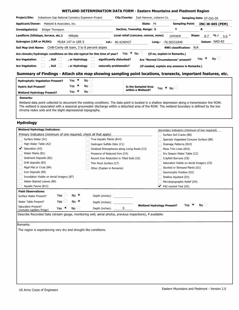
WETLAND DETERMINATION DATA FORM - Eastern Mountains and Piedmont Region
Project/Site: Indiantown Gap National Cemetery Expansion Project City/County: East Hanover, Lebanon Co. Sampling Date: 07-Oct-20
Applicant/Owner: Mabbett & Associates, Inc. State: PA Sampling Point: INC-W-005 (PEM)
Investigator(s): Bridger Thompson Section, Township, Range: S T R
Landform (hillslope, terrace, etc.): Hillside Local relief (concave, convex, none): concave Slope: 8.7 % / 5.0 °
Subregion (LRR or MLRA): MLRA 147 in LRR S Lat.: 40.4240437 Long.: -76.56531849 Datum: NAD-83
Soil Map Unit Name: CmB-Comly silt loam, 3 to 8 percent slopes NWI classification: N/A
Are climatic/hydrologic conditions on the site typical for this time of year? Yes No (If no, explain in Remarks.)
Are Vegetation , Soil , or Hydrology significantly disturbed? Are "Normal Circumstances" present? Yes No
Are Vegetation , Soil , or Hydrology naturally problematic? (If needed, explain any answers in Remarks.)
Summary of Findings - Attach site map showing sampling point locations, transects, important features, etc.
Yes No
Yes No
Yes No
Hydric Soil Present?
Hydrophytic Vegetation Present?
Wetland Hydrology Present?
Yes No Is the Sampled Area within a Wetland?
Remarks:
Wetland data point collected to document the existing conditions. The data point i s located in a shallow depression a long a transmission line ROW. The wetland is associated with a seasonal grounwater discharge within a disturbed area of t he ROW. T he wetland boundary is defined by the low chroma redox soils and the slight depressional topography.
Hydrology
Surface Water (A1)
High Water Table (A2)
Saturation (A3)
Water Marks (B1)
Sediment Deposits (B2)
Drift deposits (B3)
Algal Mat or Crust (B4)
Water-Stained Leaves (B9)
Dry Season Water Table (C2)
True Aquatic Plants (B14)
Hydrogen Sulfide Odor (C1)
Oxidized Rhizospheres along Living Roots (C3)
Presence of Reduced Iron (C4)
Recent Iron Reduction in Tilled Soils (C6)
Other (Explain in Remarks)
Drainage Patterns (B10)
Aquatic Fauna (B13)
Saturation Visible on Aerial Imagery (C9)
Crayfish Burrows (C8)
Moss Trim Lines (B16)
Primary Indicators (minimum of one required; check all that apply)
Wetland Hydrology Indicators: Secondary Indicators (minimum of two required)
Iron Deposits (B5)
Surface Soil Cracks (B6)
Stunted or Stressed Plants (D1)
Inundation Visible on Aerial Imagery (B7)
Sparsely Vegetated Concave Surface (B8)
Thin Muck Surface (C7)
Shallow Aquitard (D3)
FAC-neutral Test (D5)
Geomorphic Position (D2)
Microtopographic Relief (D4)
0
Yes No
Yes No
Yes No Yes No
Field Observations:
Surface Water Present?
Water Table Present?
Saturation Present? (includes capillary fringe)
Depth (inches):
Depth (inches):
Depth (inches): Wetland Hydrology Present?
Describe Recorded Data (stream gauge, monitoring well, aerial photos, previous inspections), if available:
Remarks:
The region is experiencing very dry and drought like conditions.
Eastern Mountains and Piedmont - Version 2.0 US Army Corps of Engineers

0
0
0
0
0
0
0
0
0
0
0
0
0
0
50
40
10
0
0
0
0
Yes No
20.0%
0.0%
20.0%
0.0%
100.0%
0
0.0%
0.0%
0.0%
0 0
0.0%
50 100
0.0%
50 150
0 0
0
0 0
0.0%
100 250
0.0%
2.500
0.0%
0.0%
0.0%
50.0% FAC
40.0% FACW
10.0% FACW
0.0%
0.0%
100
0.0%
0.0%
0
0 0.0%
Eastern Mountains and Piedmont - Version 2.0
Woody Vine Stratum
(B)
= Total Cover
= Total Cover
Prevalence Index is ≤3.0
= Total Cover
Hydrophytic Vegetation Present?
US Army Corps of Engineers
Dominance Test worksheet:
Total Number of Dominant Species Across All Strata:
Prevalence Index worksheet:
Prevalence Index = B/A =
(A/B)
1 Indicators of hydric soil and wetland hydrology must be present, unless disturbed or problematic.
Problematic Hydrophytic Vegetation 1 (Explain)
Herb Stratum
= Total Cover
Number of Dominant Species That are OBL, FACW, or FAC:
Hydrophytic Vegetation Indicators:
Remarks: (Include photo numbers here or on a separate sheet.)
OBL species
FACW species
FAC species
FACU species
UPL species
Column Totals:
x 1 =
x 2 =
x 3 =
x 4 =
x 5 =
(A)
(A)
Percent of dominant Species That Are OBL, FACW, or FAC:
Total % Cover of: Multiply by:
(B)
Tree Stratum
Shrub Stratum
*Indicator suffix = National status or professional decision assigned because Regional status not defined by FWS.
Dominance Test is > 50%
0
0
0
0
0
0.0%
0.0%
0.0%
0.0%
0.0%
0
0
0
0
0
0.0%
0.0%
0.0%
0.0%
0
0.0%
= Total Cover
Sapling-Sapling/Shrub Stratum
1.
0
0
0.0%
0.0%
0
0
0.0%
0.0%
0
0
0.0%
0.0%
Definition of Vegetation Strata:
Tree - Woody plants, excluding woody vines, approximately 20 ft (6 m) or more in height and 3 in. (7.6 cm) or larger in diameter at breast height (DBH). Sapling stratum – Consists of woody plants, excluding woody vines, approximately 20 ft (6 m) or more in height and less than 3 in. (7.6 cm) DBH. Shrub stratum – Consists of woody plants, excluding woody vines, approximately 3 to 20 ft (1 to 6 m) in height. Herb stratum – Consists of all herbaceous (non-woody) plants, including herbaceous vines, regardless of size, and woody species, except woody vines, less than approximately 3 ft (1 m) in height.
Woody vines – Consists of all woody vines, regardless of height.
INC-W-005 (PEM)Sampling Point:
)
)
)
)
)
Morphological Adaptations 1 (Provide supporting data in Remarks or on a separate sheet)
Rapid Test for Hydrophytic Vegetation
0 0.0%
0
0
0.0%
0.0%
0 0.0%
VEGETATION (Five/Four Strata)- Use scientific names of plants.
0 0.0%
Tree stratum – Consists of woody plants, excluding vines, 3 in. (7.6 cm) or more in diameter at breast height (DBH), regardless of height. Sapling/shrub stratum – Consists of woody plants, excluding vines, less than 3 in. DBH and greater than 3.28 ft (1 m) tall. Herb stratum – Consists of all herbaceous (non-woody) plants, regardless of size, and all other plants less than 3.28 ft tall.
Woody vines – Consists of all woody vines greater than 3.28 ft in height.
Four Vegetation Strata:
Five Vegetation Strata:
(Plot size:
(Plot size:
(Plot size:
(Plot size: 10 feet
Microstegium vimineum
Onoclea sensibilis
Vernonia noveboracensis
(Plot size:
Dominant Species? Rel.Strat. Cover
Absolute % Cover
Indicator Status
1
1
1
1
2. 3. 4. 5. 6. 7. 8.
1. 2. 3. 4. 5. 6. 7. 8. 9.
10.
1. 2. 3. 4. 5. 6. 7.
1. 2. 3. 4. 5. 6. 7. 8. 9.
10. 11. 12.
1. 2. 3. 4. 5. 6.

INC-W-005 (PEM)Soil Sampling Point:
Profile Description: (Describe to the depth needed to document the indicator or confirm the absence of indicators.)
Depth (inches) Color (moist) Color (moist)
Matrix Redox Features
% Loc² Texture RemarksType%
Yes No
Hydric Soil Indicators: Indicators for Problematic Hydric Soils :
Restrictive Layer (if observed):
Hydric Soil Present?
Indicators of hydrophytic vegetation and wetland hydrology must be present,
unless disturbed or problematic.
Histosol (A1)
Histic Epipedon (A2)
Black Histic (A3)
Hydrogen Sulfide (A4)
Depleted Below Dark Surface (A11)
Thick Dark Surface (A12)
Sandy Muck Mineral (S1) (LRR N, MLRA 147, 148)
Sandy Gleyed Matrix (S4)
Sandy Redox (S5)
Stripped Matrix (S6)
Loamy Gleyed Matrix (F2)
Depleted Matrix (F3)
Redox Dark Surface (F6)
Depleted Dark Surface (F7)
Type:
Depth (inches):
Remarks:
US Army Corps of Engineers Eastern Mountains and Piedmont - Version 2.0
Dark Surface (S7)
Stratified Layers (A5)
Polyvalue Below Surface (S8) (MLRA 147,148)
Redox Depressions (F8)
1
1
3
3
Thin Dark Surface (S9) (MLRA 147, 148)
Iron-Manganese Masses (F12) (LRR N, MLRA 136)
Umbric Surface (F13) (MLRA 136, 122)
Piedmont Floodplain Soils (F19) (MLRA 148)
Type: C=Concentration. D=Depletion. RM=Reduced Matrix, CS=Covered or Coated Sand Grains ²Location: PL=Pore Lining. M=Matrix
2 cm Muck (A10) (LRR N)
10-20
0-10
2.5Y
2.5Y
5/2
4/1
90
90 5YR
5YR
5/6
5/6 10
10 C
C M
M Silt Loam
Clay Loam
Surface water infiltration is slightly restricted by a shallow clay layer.
Other (Explain in Remarks)
2 cm Muck (A10) (MLRA 147)
Piedmont Floodplain Soils (F19) (MLRA 136, 147)
Very Shallow Dark Surface (TF12)
Coast Prairie Redox (A16) (MLRA 147,148)
Red Parent Material (F21) (MLRA 127, 147)

WETLAND DETERMINATION DATA FORM - Eastern Mountains and Piedmont Region
Project/Site: Indiantown Gap National Cemetery Expansion Project City/County: East Hanover, Lebanon Co. Sampling Date: 07-Oct-20
Applicant/Owner: Mabbett & Associates, Inc. State: PA Sampling Point: INC-W-005 (UPL)
Investigator(s): Bridger Thompson Section, Township, Range: S T R
Landform (hillslope, terrace, etc.): Hillside Local relief (concave, convex, none): convex Slope: 8.7 % / 5.0 °
Subregion (LRR or MLRA): MLRA 147 in LRR S Lat.: 40.42399472 Long.: -76.56533848 Datum: NAD-83
Soil Map Unit Name: CmB-Comly silt loam, 3 to 8 percent slopes NWI classification: N/A
Are climatic/hydrologic conditions on the site typical for this time of year? Yes No (If no, explain in Remarks.)
Are Vegetation , Soil , or Hydrology significantly disturbed? Are "Normal Circumstances" present? Yes No
Are Vegetation , Soil , or Hydrology naturally problematic? (If needed, explain any answers in Remarks.)
Summary of Findings - Attach site map showing sampling point locations, transects, important features, etc.
Yes No
Yes No
Yes No
Hydric Soil Present?
Hydrophytic Vegetation Present?
Wetland Hydrology Present?
Yes No Is the Sampled Area within a Wetland?
Remarks:
Upland data point collected to verify the wetland boundary. The data point is located in a in a periodically maintained transmission line ROW adjacent to the wetland boundary.
Hydrology
Surface Water (A1)
High Water Table (A2)
Saturation (A3)
Water Marks (B1)
Sediment Deposits (B2)
Drift deposits (B3)
Algal Mat or Crust (B4)
Water-Stained Leaves (B9)
Dry Season Water Table (C2)
True Aquatic Plants (B14)
Hydrogen Sulfide Odor (C1)
Oxidized Rhizospheres along Living Roots (C3)
Presence of Reduced Iron (C4)
Recent Iron Reduction in Tilled Soils (C6)
Other (Explain in Remarks)
Drainage Patterns (B10)
Aquatic Fauna (B13)
Saturation Visible on Aerial Imagery (C9)
Crayfish Burrows (C8)
Moss Trim Lines (B16)
Primary Indicators (minimum of one required; check all that apply)
Wetland Hydrology Indicators: Secondary Indicators (minimum of two required)
Iron Deposits (B5)
Surface Soil Cracks (B6)
Stunted or Stressed Plants (D1)
Inundation Visible on Aerial Imagery (B7)
Sparsely Vegetated Concave Surface (B8)
Thin Muck Surface (C7)
Shallow Aquitard (D3)
FAC-neutral Test (D5)
Geomorphic Position (D2)
Microtopographic Relief (D4)
Yes No
Yes No
Yes No Yes No
Field Observations:
Surface Water Present?
Water Table Present?
Saturation Present? (includes capillary fringe)
Depth (inches):
Depth (inches):
Depth (inches): Wetland Hydrology Present?
Describe Recorded Data (stream gauge, monitoring well, aerial photos, previous inspections), if available:
Remarks:
The region is experiencing very dry and drought like conditions.
Eastern Mountains and Piedmont - Version 2.0 US Army Corps of Engineers

0
0
0
0
0
0
0
0
0
10
0
0
0
0
30
30
10
0
0
0
0
Yes No
20.0%
0.0%
30.0%
0.0%
66.7%
0
0.0%
0.0%
0.0%
0 0
0.0%
0 0
0.0%
60 180
10 40
10
10 50
100.0% UPL
80 270
0.0%
3.375
0.0%
0.0%
0.0%
42.9% FAC
42.9% FAC
14.3% FACU
0.0%
0.0%
70
0.0%
0.0%
0
0 0.0%
Eastern Mountains and Piedmont - Version 2.0
Woody Vine Stratum
(B)
= Total Cover
= Total Cover
Prevalence Index is ≤3.0
= Total Cover
Hydrophytic Vegetation Present?
US Army Corps of Engineers
Dominance Test worksheet:
Total Number of Dominant Species Across All Strata:
Prevalence Index worksheet:
Prevalence Index = B/A =
(A/B)
1 Indicators of hydric soil and wetland hydrology must be present, unless disturbed or problematic.
Problematic Hydrophytic Vegetation 1 (Explain)
Herb Stratum
= Total Cover
Number of Dominant Species That are OBL, FACW, or FAC:
Hydrophytic Vegetation Indicators:
Remarks: (Include photo numbers here or on a separate sheet.)
OBL species
FACW species
FAC species
FACU species
UPL species
Column Totals:
x 1 =
x 2 =
x 3 =
x 4 =
x 5 =
(A)
(A)
Percent of dominant Species That Are OBL, FACW, or FAC:
Total % Cover of: Multiply by:
(B)
Tree Stratum
Shrub Stratum
*Indicator suffix = National status or professional decision assigned because Regional status not defined by FWS.
Dominance Test is > 50%
0
0
0
0
0
0.0%
0.0%
0.0%
0.0%
0.0%
0
0
0
0
0
0.0%
0.0%
0.0%
0.0%
0
0.0%
= Total Cover
Sapling-Sapling/Shrub Stratum
1.
0
0
0.0%
0.0%
0
0
0.0%
0.0%
0
0
0.0%
0.0%
Definition of Vegetation Strata:
Tree - Woody plants, excluding woody vines, approximately 20 ft (6 m) or more in height and 3 in. (7.6 cm) or larger in diameter at breast height (DBH). Sapling stratum – Consists of woody plants, excluding woody vines, approximately 20 ft (6 m) or more in height and less than 3 in. (7.6 cm) DBH. Shrub stratum – Consists of woody plants, excluding woody vines, approximately 3 to 20 ft (1 to 6 m) in height. Herb stratum – Consists of all herbaceous (non-woody) plants, including herbaceous vines, regardless of size, and woody species, except woody vines, less than approximately 3 ft (1 m) in height.
Woody vines – Consists of all woody vines, regardless of height.
INC-W-005 (UPL)Sampling Point:
)
)
)
)
)
Morphological Adaptations 1 (Provide supporting data in Remarks or on a separate sheet)
Rapid Test for Hydrophytic Vegetation
0 0.0%
0
0
0.0%
0.0%
0 0.0%
VEGETATION (Five/Four Strata)- Use scientific names of plants.
0 0.0%
Tree stratum – Consists of woody plants, excluding vines, 3 in. (7.6 cm) or more in diameter at breast height (DBH), regardless of height. Sapling/shrub stratum – Consists of woody plants, excluding vines, less than 3 in. DBH and greater than 3.28 ft (1 m) tall. Herb stratum – Consists of all herbaceous (non-woody) plants, regardless of size, and all other plants less than 3.28 ft tall.
Woody vines – Consists of all woody vines greater than 3.28 ft in height.
Four Vegetation Strata:
Five Vegetation Strata:
(Plot size:
(Plot size:
(Plot size: 15 feet
Elaeagnus umbellata
(Plot size: 10 feet
Microstegium vimineum
Setaria pumila
Solidago canadensis
(Plot size:
Dominant Species? Rel.Strat. Cover
Absolute % Cover
Indicator Status
1
1
1
1
2. 3. 4. 5. 6. 7. 8.
1. 2. 3. 4. 5. 6. 7. 8. 9.
10.
1. 2. 3. 4. 5. 6. 7.
1. 2. 3. 4. 5. 6. 7. 8. 9.
10. 11. 12.
1. 2. 3. 4. 5. 6.

INC-W-005 (UPL)Soil Sampling Point:
Profile Description: (Describe to the depth needed to document the indicator or confirm the absence of indicators.)
Depth (inches) Color (moist) Color (moist)
Matrix Redox Features
% Loc² Texture RemarksType%
Yes No
Hydric Soil Indicators: Indicators for Problematic Hydric Soils :
Restrictive Layer (if observed):
Hydric Soil Present?
Indicators of hydrophytic vegetation and wetland hydrology must be present,
unless disturbed or problematic.
Histosol (A1)
Histic Epipedon (A2)
Black Histic (A3)
Hydrogen Sulfide (A4)
Depleted Below Dark Surface (A11)
Thick Dark Surface (A12)
Sandy Muck Mineral (S1) (LRR N, MLRA 147, 148)
Sandy Gleyed Matrix (S4)
Sandy Redox (S5)
Stripped Matrix (S6)
Loamy Gleyed Matrix (F2)
Depleted Matrix (F3)
Redox Dark Surface (F6)
Depleted Dark Surface (F7)
Type:
Depth (inches):
Remarks:
US Army Corps of Engineers Eastern Mountains and Piedmont - Version 2.0
Dark Surface (S7)
Stratified Layers (A5)
Polyvalue Below Surface (S8) (MLRA 147,148)
Redox Depressions (F8)
1
1
3
3
Thin Dark Surface (S9) (MLRA 147, 148)
Iron-Manganese Masses (F12) (LRR N, MLRA 136)
Umbric Surface (F13) (MLRA 136, 122)
Piedmont Floodplain Soils (F19) (MLRA 148)
Type: C=Concentration. D=Depletion. RM=Reduced Matrix, CS=Covered or Coated Sand Grains ²Location: PL=Pore Lining. M=Matrix
2 cm Muck (A10) (LRR N)
12-20
0-12
2.5Y
2.5Y
5/4
4/4
100
100 Silt Loam
Clay Loam
Other (Explain in Remarks)
2 cm Muck (A10) (MLRA 147)
Piedmont Floodplain Soils (F19) (MLRA 136, 147)
Very Shallow Dark Surface (TF12)
Coast Prairie Redox (A16) (MLRA 147,148)
Red Parent Material (F21) (MLRA 127, 147)
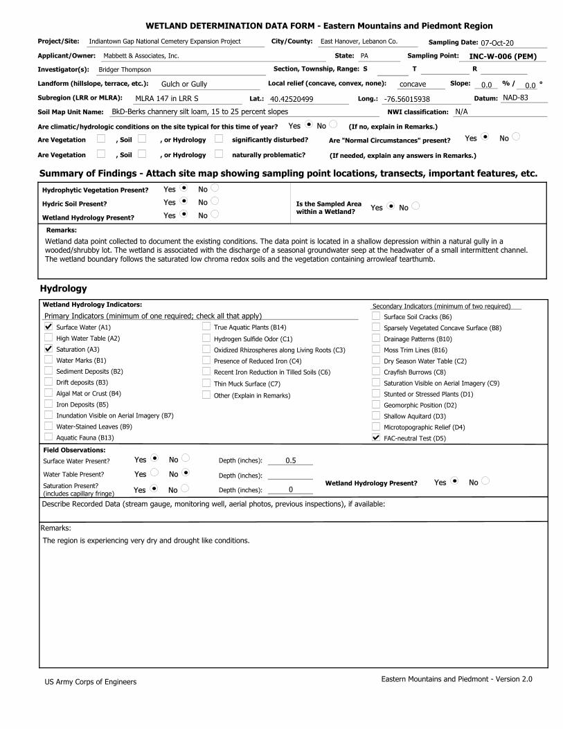
WETLAND DETERMINATION DATA FORM - Eastern Mountains and Piedmont Region
Project/Site: Indiantown Gap National Cemetery Expansion Project City/County: East Hanover, Lebanon Co. Sampling Date: 07-Oct-20
Applicant/Owner: Mabbett & Associates, Inc. State: PA Sampling Point: INC-W-006 (PEM)
Investigator(s): Bridger Thompson Section, Township, Range: S T R
Landform (hillslope, terrace, etc.): Gulch or Gully Local relief (concave, convex, none): concave Slope: 0.0 % / 0.0 °
Subregion (LRR or MLRA): MLRA 147 in LRR S Lat.: 40.42520499 Long.: -76.56015938 Datum: NAD-83
Soil Map Unit Name: BkD-Berks channery silt loam, 15 to 25 percent slopes NWI classification: N/A
Are climatic/hydrologic conditions on the site typical for this time of year? Yes No (If no, explain in Remarks.)
Are Vegetation , Soil , or Hydrology significantly disturbed? Are "Normal Circumstances" present? Yes No
Are Vegetation , Soil , or Hydrology naturally problematic? (If needed, explain any answers in Remarks.)
Summary of Findings - Attach site map showing sampling point locations, transects, important features, etc.
Yes No
Yes No
Yes No
Hydric Soil Present?
Hydrophytic Vegetation Present?
Wetland Hydrology Present?
Yes No Is the Sampled Area within a Wetland?
Remarks:
Wetland data point collected to document the existing conditions. The data point i s located in a shallow depression w ithin a natural gully in a wooded/shrubby lot. The wetland is associated with the discharge of a seasonal groundwater seep at t he headwater of a small intermittent c hannel. The wetland boundary follows the saturated low chroma redox soils and the vegetation c ontaining arrowleaf tearthumb.
Hydrology
Surface Water (A1)
High Water Table (A2)
Saturation (A3)
Water Marks (B1)
Sediment Deposits (B2)
Drift deposits (B3)
Algal Mat or Crust (B4)
Water-Stained Leaves (B9)
Dry Season Water Table (C2)
True Aquatic Plants (B14)
Hydrogen Sulfide Odor (C1)
Oxidized Rhizospheres along Living Roots (C3)
Presence of Reduced Iron (C4)
Recent Iron Reduction in Tilled Soils (C6)
Other (Explain in Remarks)
Drainage Patterns (B10)
Aquatic Fauna (B13)
Saturation Visible on Aerial Imagery (C9)
Crayfish Burrows (C8)
Moss Trim Lines (B16)
Primary Indicators (minimum of one required; check all that apply)
Wetland Hydrology Indicators: Secondary Indicators (minimum of two required)
Iron Deposits (B5)
Surface Soil Cracks (B6)
Stunted or Stressed Plants (D1)
Inundation Visible on Aerial Imagery (B7)
Sparsely Vegetated Concave Surface (B8)
Thin Muck Surface (C7)
Shallow Aquitard (D3)
FAC-neutral Test (D5)
Geomorphic Position (D2)
Microtopographic Relief (D4)
0.5
0
Yes No
Yes No
Yes No Yes No
Field Observations:
Surface Water Present?
Water Table Present?
Saturation Present? (includes capillary fringe)
Depth (inches):
Depth (inches):
Depth (inches): Wetland Hydrology Present?
Describe Recorded Data (stream gauge, monitoring well, aerial photos, previous inspections), if available:
Remarks:
The region is experiencing very dry and drought like conditions.
Eastern Mountains and Piedmont - Version 2.0 US Army Corps of Engineers

0
0
0
0
0
0
0
0
0
0
0
0
0
0
30
30
10
10
10
0
0
Yes No
20.0%
0.0%
20.0%
0.0%
100.0%
0
0.0%
0.0%
0.0%
30 30
0.0%
20 40
0.0%
40 120
0 0
0
0 0
0.0%
90 190
0.0%
2.111
0.0%
0.0%
0.0%
33.3% OBL
33.3% FAC
11.1% FAC
11.1% FACW
11.1% FACW
90
0.0%
0.0%
0
0 0.0%
Eastern Mountains and Piedmont - Version 2.0
Woody Vine Stratum
(B)
= Total Cover
= Total Cover
Prevalence Index is ≤3.0
= Total Cover
Hydrophytic Vegetation Present?
US Army Corps of Engineers
Dominance Test worksheet:
Total Number of Dominant Species Across All Strata:
Prevalence Index worksheet:
Prevalence Index = B/A =
(A/B)
1 Indicators of hydric soil and wetland hydrology must be present, unless disturbed or problematic.
Problematic Hydrophytic Vegetation 1 (Explain)
Herb Stratum
= Total Cover
Number of Dominant Species That are OBL, FACW, or FAC:
Hydrophytic Vegetation Indicators:
Remarks: (Include photo numbers here or on a separate sheet.)
OBL species
FACW species
FAC species
FACU species
UPL species
Column Totals:
x 1 =
x 2 =
x 3 =
x 4 =
x 5 =
(A)
(A)
Percent of dominant Species That Are OBL, FACW, or FAC:
Total % Cover of: Multiply by:
(B)
Tree Stratum
Shrub Stratum
*Indicator suffix = National status or professional decision assigned because Regional status not defined by FWS.
Dominance Test is > 50%
0
0
0
0
0
0.0%
0.0%
0.0%
0.0%
0.0%
0
0
0
0
0
0.0%
0.0%
0.0%
0.0%
0
0.0%
= Total Cover
Sapling-Sapling/Shrub Stratum
1.
0
0
0.0%
0.0%
0
0
0.0%
0.0%
0
0
0.0%
0.0%
Definition of Vegetation Strata:
Tree - Woody plants, excluding woody vines, approximately 20 ft (6 m) or more in height and 3 in. (7.6 cm) or larger in diameter at breast height (DBH). Sapling stratum – Consists of woody plants, excluding woody vines, approximately 20 ft (6 m) or more in height and less than 3 in. (7.6 cm) DBH. Shrub stratum – Consists of woody plants, excluding woody vines, approximately 3 to 20 ft (1 to 6 m) in height. Herb stratum – Consists of all herbaceous (non-woody) plants, including herbaceous vines, regardless of size, and woody species, except woody vines, less than approximately 3 ft (1 m) in height.
Woody vines – Consists of all woody vines, regardless of height.
INC-W-006 (PEM)Sampling Point:
)
)
)
)
)
Morphological Adaptations 1 (Provide supporting data in Remarks or on a separate sheet)
Rapid Test for Hydrophytic Vegetation
0 0.0%
0
0
0.0%
0.0%
0 0.0%
VEGETATION (Five/Four Strata)- Use scientific names of plants.
0 0.0%
Tree stratum – Consists of woody plants, excluding vines, 3 in. (7.6 cm) or more in diameter at breast height (DBH), regardless of height. Sapling/shrub stratum – Consists of woody plants, excluding vines, less than 3 in. DBH and greater than 3.28 ft (1 m) tall. Herb stratum – Consists of all herbaceous (non-woody) plants, regardless of size, and all other plants less than 3.28 ft tall.
Woody vines – Consists of all woody vines greater than 3.28 ft in height.
Four Vegetation Strata:
Five Vegetation Strata:
(Plot size:
(Plot size:
(Plot size:
(Plot size: 10 feet
Persicaria sagittata
Microstegium vimineum
Setaria pumila
Juncus effusus
Mentha arvensis
(Plot size:
Dominant Species? Rel.Strat. Cover
Absolute % Cover
Indicator Status
1
1
1
1
2. 3. 4. 5. 6. 7. 8.
1. 2. 3. 4. 5. 6. 7. 8. 9.
10.
1. 2. 3. 4. 5. 6. 7.
1. 2. 3. 4. 5. 6. 7. 8. 9.
10. 11. 12.
1. 2. 3. 4. 5. 6.

INC-W-006 (PEM)Soil Sampling Point:
Profile Description: (Describe to the depth needed to document the indicator or confirm the absence of indicators.)
Depth (inches) Color (moist) Color (moist)
Matrix Redox Features
% Loc² Texture RemarksType%
Yes No
Hydric Soil Indicators: Indicators for Problematic Hydric Soils :
Restrictive Layer (if observed):
Hydric Soil Present?
Indicators of hydrophytic vegetation and wetland hydrology must be present,
unless disturbed or problematic.
Histosol (A1)
Histic Epipedon (A2)
Black Histic (A3)
Hydrogen Sulfide (A4)
Depleted Below Dark Surface (A11)
Thick Dark Surface (A12)
Sandy Muck Mineral (S1) (LRR N, MLRA 147, 148)
Sandy Gleyed Matrix (S4)
Sandy Redox (S5)
Stripped Matrix (S6)
Loamy Gleyed Matrix (F2)
Depleted Matrix (F3)
Redox Dark Surface (F6)
Depleted Dark Surface (F7)
Type:
Depth (inches):
Remarks:
US Army Corps of Engineers Eastern Mountains and Piedmont - Version 2.0
Dark Surface (S7)
Stratified Layers (A5)
Polyvalue Below Surface (S8) (MLRA 147,148)
Redox Depressions (F8)
1
1
3
3
Thin Dark Surface (S9) (MLRA 147, 148)
Iron-Manganese Masses (F12) (LRR N, MLRA 136)
Umbric Surface (F13) (MLRA 136, 122)
Piedmont Floodplain Soils (F19) (MLRA 148)
Type: C=Concentration. D=Depletion. RM=Reduced Matrix, CS=Covered or Coated Sand Grains ²Location: PL=Pore Lining. M=Matrix
2 cm Muck (A10) (LRR N)
16-20
0-16
7.5YR
7.5YR
5/2
4/1
90
90 5YR
5YR
5/8
5/8 10
10 C
C M
M Silt Loam
Clay Loam
Other (Explain in Remarks)
2 cm Muck (A10) (MLRA 147)
Piedmont Floodplain Soils (F19) (MLRA 136, 147)
Very Shallow Dark Surface (TF12)
Coast Prairie Redox (A16) (MLRA 147,148)
Red Parent Material (F21) (MLRA 127, 147)

WETLAND DETERMINATION DATA FORM - Eastern Mountains and Piedmont Region
Project/Site: Indiantown Gap National Cemetery Expansion Project City/County: East Hanover, Lebanon Co. Sampling Date: 07-Oct-20
Applicant/Owner: Mabbett & Associates, Inc. State: PA Sampling Point: INC-W-006 (UPL)
Investigator(s): Bridger Thompson Section, Township, Range: S T R
Landform (hillslope, terrace, etc.): Hillside Local relief (concave, convex, none): convex Slope: 7.0 % / 4.0 °
Subregion (LRR or MLRA): MLRA 147 in LRR S Lat.: 40.42525837 Long.: 40.42525837 Datum: NAD-83
Soil Map Unit Name: BkD-Berks channery silt loam, 15 to 25 percent slopes NWI classification: N/A
Are climatic/hydrologic conditions on the site typical for this time of year? Yes No (If no, explain in Remarks.)
Are Vegetation , Soil , or Hydrology significantly disturbed? Are "Normal Circumstances" present? Yes No
Are Vegetation , Soil , or Hydrology naturally problematic? (If needed, explain any answers in Remarks.)
Summary of Findings - Attach site map showing sampling point locations, transects, important features, etc.
Yes No
Yes No
Yes No
Hydric Soil Present?
Hydrophytic Vegetation Present?
Wetland Hydrology Present?
Yes No Is the Sampled Area within a Wetland?
Remarks:
Upland data point collected to verify the wetland boundary. The data point is located in a in a wooded/shrubby lot adjacent to the wetland boundary.
Hydrology
Surface Water (A1)
High Water Table (A2)
Saturation (A3)
Water Marks (B1)
Sediment Deposits (B2)
Drift deposits (B3)
Algal Mat or Crust (B4)
Water-Stained Leaves (B9)
Dry Season Water Table (C2)
True Aquatic Plants (B14)
Hydrogen Sulfide Odor (C1)
Oxidized Rhizospheres along Living Roots (C3)
Presence of Reduced Iron (C4)
Recent Iron Reduction in Tilled Soils (C6)
Other (Explain in Remarks)
Drainage Patterns (B10)
Aquatic Fauna (B13)
Saturation Visible on Aerial Imagery (C9)
Crayfish Burrows (C8)
Moss Trim Lines (B16)
Primary Indicators (minimum of one required; check all that apply)
Wetland Hydrology Indicators: Secondary Indicators (minimum of two required)
Iron Deposits (B5)
Surface Soil Cracks (B6)
Stunted or Stressed Plants (D1)
Inundation Visible on Aerial Imagery (B7)
Sparsely Vegetated Concave Surface (B8)
Thin Muck Surface (C7)
Shallow Aquitard (D3)
FAC-neutral Test (D5)
Geomorphic Position (D2)
Microtopographic Relief (D4)
Yes No
Yes No
Yes No Yes No
Field Observations:
Surface Water Present?
Water Table Present?
Saturation Present? (includes capillary fringe)
Depth (inches):
Depth (inches):
Depth (inches): Wetland Hydrology Present?
Describe Recorded Data (stream gauge, monitoring well, aerial photos, previous inspections), if available:
Remarks:
The region is experiencing very dry and drought like conditions.
Eastern Mountains and Piedmont - Version 2.0 US Army Corps of Engineers

1
1
ft
1
VEGETATION (Five/Four Strata)- Use scientific names of plants. Dominant Sampling Point: INC-W-006 (UPL) Species?
20
0
0
0
0
0
100.0% FACU
0.0%
0.0%
0.0%
20
0.0%
0.0%
= Total Cover
Tree Stratum
0
0
0
0
0
0.0%
0.0%
0.0%
0.0%
0.0%
Sapling-Sapling/Shrub Stratum
1.
0
0
0.0%
0.0%
0
0
0.0%
0.0%
)
)
Juglans nigra
(Plot size: 30 feet
(Plot size:
Rel.Strat. Cover
Absolute % Cover
Indicator Status
2. 3. 4. 5. 6. 7. 8.
1. 2. 3. 4. 5. 6. 7.
2
5
40.0%
Dominance Test worksheet:
Total Number of Dominant Species Across All Strata:
(A/B)
Number of Dominant Species That are OBL, FACW, or FAC: (A)
Percent of dominant Species That Are OBL, FACW, or FAC:
(B)
0 0
0 0
60 180
30 120
20 100
110 400
3.636
(B)
Prevalence Index worksheet:
Prevalence Index = B/A =
OBL species
FACW species
FAC species
FACU species
UPL species
Column Totals:
x 1 =
x 2 =
x 3 =
x 4 =
x 5 =
(A)
Total % Cover of: Multiply by:
Hydrophytic Vegetation Indicators: 0 0.0% 8. Rapid Test for Hydrophytic Vegetation 0 0.0% 9. Dominance Test is > 50% 0 0.0% 10. Prevalence Index is ≤3.0 1
Shrub Stratum 0 = Total Cover )(Plot size: 15 feet Morphological Adaptations (Provide supporting1
10 25.0% FACU Rosa multiflora 1. data in Remarks or on a separate sheet)
20 50.0% UPL Elaeagnus umbellata 2. Problematic Hydrophytic Vegetation (Explain) 1
10 25.0% FAC Lindera benzoin 3. Indicators of hydric soil and wetland hydrology must1
0
0
0
0
50
0
0
0
0
0
0
40
0.0%
0.0%
0.0%
0.0%
100.0% FAC
0.0%
0.0%
0.0%
0.0%
0.0%
0.0%
0 0.0%
= Total Cover Herb Stratum
0
0
0.0%
0.0%
)(Plot size: 10 feet
Microstegium vimineum
4. 5. 6. 7.
1. 2. 3. 4. 5. 6. 7. 8. 9.
10.
be present, unless disturbed or problematic.
Definition of Vegetation Strata:
Tree - Woody plants, excluding woody vines, approximately 20 ft (6 m) or more in height and 3 in. (7.6 cm) or larger in diameter at breast height (DBH). Sapling stratum – Consists of woody plants, excluding woody vines, approximately 20 ft (6 m) or more in height and less than
Tree stratum – Consists of woody plants, excluding vines, 3 in. (7.6 cm) or more in diameter at breast height (DBH), regardless of height. Sapling/shrub stratum – Consists of woody plants, excluding vines, less than 3 in. DBH and greater than 3.28 ft (1 m) tall. Herb stratum – Consists of all herbaceous (non-woody) plants, regardless of size, and all other plants less than 3.28 ft tall.
Woody vines – Consists of all woody vines greater than 3.28 ft in height.
Four Vegetation Strata:
Five Vegetation Strata:
50
0
Woody Vine Stratum = Total Cover
= Total Cover
0
0
0
0.0%
0.0%
0.0%
)
0 0.0%
0
0
0.0%
0.0%
0 0.0%
0 0.0%
(Plot size:
11. 12.
1. 2. 3. 4. 5. 6.
3 in. (7.6 cm) DBH. Shrub stratum – Consists of woody plants, excluding woody vines, approximately 3 to 20 (1 to 6 m) in height. Herb stratum – Consists of all herbaceous (non-woody) plants, including herbaceous vines, regardless of size, and woody species, except woody vines, less than approximately 3 ft (1 m) in height.
Woody vines – Consists of all woody vines, regardless of height.
Yes No
Hydrophytic Vegetation Present?
Remarks: (Include photo numbers here or on a separate sheet.)
*Indicator suffix = National status or professional decision assigned because Regional status not defined by FWS.
US Army Corps of Engineers Eastern Mountains and Piedmont - Version 2.0

INC-W-006 (UPL)Soil Sampling Point:
Profile Description: (Describe to the depth needed to document the indicator or confirm the absence of indicators.)
Depth (inches) Color (moist) Color (moist)
Matrix Redox Features
% Loc² Texture RemarksType%
Yes No
Hydric Soil Indicators: Indicators for Problematic Hydric Soils :
Restrictive Layer (if observed):
Hydric Soil Present?
Indicators of hydrophytic vegetation and wetland hydrology must be present,
unless disturbed or problematic.
Histosol (A1)
Histic Epipedon (A2)
Black Histic (A3)
Hydrogen Sulfide (A4)
Depleted Below Dark Surface (A11)
Thick Dark Surface (A12)
Sandy Muck Mineral (S1) (LRR N, MLRA 147, 148)
Sandy Gleyed Matrix (S4)
Sandy Redox (S5)
Stripped Matrix (S6)
Loamy Gleyed Matrix (F2)
Depleted Matrix (F3)
Redox Dark Surface (F6)
Depleted Dark Surface (F7)
Type:
Depth (inches):
Remarks:
US Army Corps of Engineers Eastern Mountains and Piedmont - Version 2.0
Dark Surface (S7)
Stratified Layers (A5)
Polyvalue Below Surface (S8) (MLRA 147,148)
Redox Depressions (F8)
1
1
3
3
Thin Dark Surface (S9) (MLRA 147, 148)
Iron-Manganese Masses (F12) (LRR N, MLRA 136)
Umbric Surface (F13) (MLRA 136, 122)
Piedmont Floodplain Soils (F19) (MLRA 148)
Type: C=Concentration. D=Depletion. RM=Reduced Matrix, CS=Covered or Coated Sand Grains ²Location: PL=Pore Lining. M=Matrix
2 cm Muck (A10) (LRR N)
16-20
0-16
7.5YR
7.5YR
5/3
4/4
100
100 Silt Loam
Clay Loam
Other (Explain in Remarks)
2 cm Muck (A10) (MLRA 147)
Piedmont Floodplain Soils (F19) (MLRA 136, 147)
Very Shallow Dark Surface (TF12)
Coast Prairie Redox (A16) (MLRA 147,148)
Red Parent Material (F21) (MLRA 127, 147)

WETLAND DETERMINATION DATA FORM - Eastern Mountains and Piedmont Region
Project/Site: Indiantown Gap National Cemetery Expansion Project City/County: East Hanover, Lebanon Co. Sampling Date: 08-Oct-20
Applicant/Owner: Mabbett & Associates, Inc. State: PA Sampling Point: INC-W-007 (PEM)
Investigator(s): Bridger Thompson Section, Township, Range: S T R
Landform (hillslope, terrace, etc.): Gulch or Gully Local relief (concave, convex, none): concave Slope: 5.2 % / 3.0 °
Subregion (LRR or MLRA): MLRA 147 in LRR S Lat.: 40.42042552 Long.: -76.55724517 Datum: NAD-83
Soil Map Unit Name: WeD-Weikert channery silt loam, 15 to 25 percent slopes NWI classification: N/A
Are climatic/hydrologic conditions on the site typical for this time of year? Yes No (If no, explain in Remarks.)
Are Vegetation , Soil , or Hydrology significantly disturbed? Are "Normal Circumstances" present? Yes No
Are Vegetation , Soil , or Hydrology naturally problematic? (If needed, explain any answers in Remarks.)
Summary of Findings - Attach site map showing sampling point locations, transects, important features, etc.
Yes No
Yes No
Yes No
Hydric Soil Present?
Hydrophytic Vegetation Present?
Wetland Hydrology Present?
Yes No Is the Sampled Area within a Wetland?
Remarks:
Wetland data point collected to document the existing conditions. The data point is located in a slight depression within a natural gully that contains multiple chanelized seasonal groundwater seeps. The wetland boundary is defined by the saturated soil conditions and the vegetation containging arrowleaf tearthumb.
Hydrology
Surface Water (A1)
High Water Table (A2)
Saturation (A3)
Water Marks (B1)
Sediment Deposits (B2)
Drift deposits (B3)
Algal Mat or Crust (B4)
Water-Stained Leaves (B9)
Dry Season Water Table (C2)
True Aquatic Plants (B14)
Hydrogen Sulfide Odor (C1)
Oxidized Rhizospheres along Living Roots (C3)
Presence of Reduced Iron (C4)
Recent Iron Reduction in Tilled Soils (C6)
Other (Explain in Remarks)
Drainage Patterns (B10)
Aquatic Fauna (B13)
Saturation Visible on Aerial Imagery (C9)
Crayfish Burrows (C8)
Moss Trim Lines (B16)
Primary Indicators (minimum of one required; check all that apply)
Wetland Hydrology Indicators: Secondary Indicators (minimum of two required)
Iron Deposits (B5)
Surface Soil Cracks (B6)
Stunted or Stressed Plants (D1)
Inundation Visible on Aerial Imagery (B7)
Sparsely Vegetated Concave Surface (B8)
Thin Muck Surface (C7)
Shallow Aquitard (D3)
FAC-neutral Test (D5)
Geomorphic Position (D2)
Microtopographic Relief (D4)
0
Yes No
Yes No
Yes No Yes No
Field Observations:
Surface Water Present?
Water Table Present?
Saturation Present? (includes capillary fringe)
Depth (inches):
Depth (inches):
Depth (inches): Wetland Hydrology Present?
Describe Recorded Data (stream gauge, monitoring well, aerial photos, previous inspections), if available:
Remarks:
The region is experiencing very dry and drought like conditions.
Eastern Mountains and Piedmont - Version 2.0 US Army Corps of Engineers

0
0
0
0
0
0
0
0
0
0
0
0
0
0
20
20
30
10
10
0
0
Yes No
30.0%
0.0%
30.0%
0.0%
100.0%
0
0.0%
0.0%
0.0%
40 40
0.0%
30 60
0.0%
30 90
0 0
0
0 0
0.0%
100 190
0.0%
1.900
0.0%
0.0%
0.0%
20.0% OBL
20.0% OBL
30.0% FAC
10.0% FACW
10.0% FACW
100
0.0%
0.0%
0
10 10.0% FACW
Eastern Mountains and Piedmont - Version 2.0
Woody Vine Stratum
(B)
= Total Cover
= Total Cover
Prevalence Index is ≤3.0
= Total Cover
Hydrophytic Vegetation Present?
US Army Corps of Engineers
Dominance Test worksheet:
Total Number of Dominant Species Across All Strata:
Prevalence Index worksheet:
Prevalence Index = B/A =
(A/B)
1 Indicators of hydric soil and wetland hydrology must be present, unless disturbed or problematic.
Problematic Hydrophytic Vegetation 1 (Explain)
Herb Stratum
= Total Cover
Number of Dominant Species That are OBL, FACW, or FAC:
Hydrophytic Vegetation Indicators:
Remarks: (Include photo numbers here or on a separate sheet.)
OBL species
FACW species
FAC species
FACU species
UPL species
Column Totals:
x 1 =
x 2 =
x 3 =
x 4 =
x 5 =
(A)
(A)
Percent of dominant Species That Are OBL, FACW, or FAC:
Total % Cover of: Multiply by:
(B)
Tree Stratum
Shrub Stratum
*Indicator suffix = National status or professional decision assigned because Regional status not defined by FWS.
Dominance Test is > 50%
0
0
0
0
0
0.0%
0.0%
0.0%
0.0%
0.0%
0
0
0
0
0
0.0%
0.0%
0.0%
0.0%
0
0.0%
= Total Cover
Sapling-Sapling/Shrub Stratum
1.
0
0
0.0%
0.0%
0
0
0.0%
0.0%
0
0
0.0%
0.0%
Definition of Vegetation Strata:
Tree - Woody plants, excluding woody vines, approximately 20 ft (6 m) or more in height and 3 in. (7.6 cm) or larger in diameter at breast height (DBH). Sapling stratum – Consists of woody plants, excluding woody vines, approximately 20 ft (6 m) or more in height and less than 3 in. (7.6 cm) DBH. Shrub stratum – Consists of woody plants, excluding woody vines, approximately 3 to 20 ft (1 to 6 m) in height. Herb stratum – Consists of all herbaceous (non-woody) plants, including herbaceous vines, regardless of size, and woody species, except woody vines, less than approximately 3 ft (1 m) in height.
Woody vines – Consists of all woody vines, regardless of height.
INC-W-007 (PEM)Sampling Point:
)
)
)
)
)
Morphological Adaptations 1 (Provide supporting data in Remarks or on a separate sheet)
Rapid Test for Hydrophytic Vegetation
0 0.0%
0
0
0.0%
0.0%
0 0.0%
VEGETATION (Five/Four Strata)- Use scientific names of plants.
0 0.0%
Tree stratum – Consists of woody plants, excluding vines, 3 in. (7.6 cm) or more in diameter at breast height (DBH), regardless of height. Sapling/shrub stratum – Consists of woody plants, excluding vines, less than 3 in. DBH and greater than 3.28 ft (1 m) tall. Herb stratum – Consists of all herbaceous (non-woody) plants, regardless of size, and all other plants less than 3.28 ft tall.
Woody vines – Consists of all woody vines greater than 3.28 ft in height.
Four Vegetation Strata:
Five Vegetation Strata:
(Plot size:
(Plot size:
(Plot size:
(Plot size: 10 feet
Persicaria sagittata
Scirpus atrovirens
Microstegium vimineum
Onoclea sensibilis
Impatiens capensis
Persicaria pensylvanica
(Plot size:
Dominant Species? Rel.Strat. Cover
Absolute % Cover
Indicator Status
1
1
1
1
2. 3. 4. 5. 6. 7. 8.
1. 2. 3. 4. 5. 6. 7. 8. 9.
10.
1. 2. 3. 4. 5. 6. 7.
1. 2. 3. 4. 5. 6. 7. 8. 9.
10. 11. 12.
1. 2. 3. 4. 5. 6.

INC-W-007 (PEM)Soil Sampling Point:
Profile Description: (Describe to the depth needed to document the indicator or confirm the absence of indicators.)
Depth (inches) Color (moist) Color (moist)
Matrix Redox Features
% Loc² Texture RemarksType%
Yes No
Hydric Soil Indicators: Indicators for Problematic Hydric Soils :
Restrictive Layer (if observed):
Hydric Soil Present?
Indicators of hydrophytic vegetation and wetland hydrology must be present,
unless disturbed or problematic.
Histosol (A1)
Histic Epipedon (A2)
Black Histic (A3)
Hydrogen Sulfide (A4)
Depleted Below Dark Surface (A11)
Thick Dark Surface (A12)
Sandy Muck Mineral (S1) (LRR N, MLRA 147, 148)
Sandy Gleyed Matrix (S4)
Sandy Redox (S5)
Stripped Matrix (S6)
Loamy Gleyed Matrix (F2)
Depleted Matrix (F3)
Redox Dark Surface (F6)
Depleted Dark Surface (F7)
Type:
Depth (inches):
Remarks:
US Army Corps of Engineers Eastern Mountains and Piedmont - Version 2.0
Dark Surface (S7)
Stratified Layers (A5)
Polyvalue Below Surface (S8) (MLRA 147,148)
Redox Depressions (F8)
1
1
3
3
Thin Dark Surface (S9) (MLRA 147, 148)
Iron-Manganese Masses (F12) (LRR N, MLRA 136)
Umbric Surface (F13) (MLRA 136, 122)
Piedmont Floodplain Soils (F19) (MLRA 148)
Type: C=Concentration. D=Depletion. RM=Reduced Matrix, CS=Covered or Coated Sand Grains ²Location: PL=Pore Lining. M=Matrix
2 cm Muck (A10) (LRR N)
12-20
4-12
0-4
2.5Y
2.5Y
2.5Y
5/4
5/1
4/2
80
90
100
5YR
5YR
5/6
5/6 20
10 C
C M
M
Silt Loam
Silty Clay
Clay Loam
Surface water infiltration is slightly restricted by a shallow clay layer.
Other (Explain in Remarks)
2 cm Muck (A10) (MLRA 147)
Piedmont Floodplain Soils (F19) (MLRA 136, 147)
Very Shallow Dark Surface (TF12)
Coast Prairie Redox (A16) (MLRA 147,148)
Red Parent Material (F21) (MLRA 127, 147)

WETLAND DETERMINATION DATA FORM - Eastern Mountains and Piedmont Region
Project/Site: Indiantown Gap National Cemetery Expansion Project City/County: East Hanover, Lebanon Co. Sampling Date: 08-Oct-20
Applicant/Owner: Mabbett & Associates, Inc. State: PA Sampling Point: INC-W-007 (UPL)
Investigator(s): Bridger Thompson Section, Township, Range: S T R
Landform (hillslope, terrace, etc.): Gulch or Gully Local relief (concave, convex, none): concave Slope: 5.2 % / 3.0 °
Subregion (LRR or MLRA): MLRA 147 in LRR S Lat.: 40.42048333 Long.: -76.55722319 Datum: NAD-83
Soil Map Unit Name: BkD-Berks channery silt loam, 15 to 25 percent slopes NWI classification: N/A
Are climatic/hydrologic conditions on the site typical for this time of year? Yes No (If no, explain in Remarks.)
Are Vegetation , Soil , or Hydrology significantly disturbed? Are "Normal Circumstances" present? Yes No
Are Vegetation , Soil , or Hydrology naturally problematic? (If needed, explain any answers in Remarks.)
Summary of Findings - Attach site map showing sampling point locations, transects, important features, etc.
Yes No
Yes No
Yes No
Hydric Soil Present?
Hydrophytic Vegetation Present?
Wetland Hydrology Present?
Yes No Is the Sampled Area within a Wetland?
Remarks:
Upland data point collected to verify the wetland boundary. The data point is located in wooded shrubby gully adjacent to the wetland boundary.
Hydrology
Surface Water (A1)
High Water Table (A2)
Saturation (A3)
Water Marks (B1)
Sediment Deposits (B2)
Drift deposits (B3)
Algal Mat or Crust (B4)
Water-Stained Leaves (B9)
Dry Season Water Table (C2)
True Aquatic Plants (B14)
Hydrogen Sulfide Odor (C1)
Oxidized Rhizospheres along Living Roots (C3)
Presence of Reduced Iron (C4)
Recent Iron Reduction in Tilled Soils (C6)
Other (Explain in Remarks)
Drainage Patterns (B10)
Aquatic Fauna (B13)
Saturation Visible on Aerial Imagery (C9)
Crayfish Burrows (C8)
Moss Trim Lines (B16)
Primary Indicators (minimum of one required; check all that apply)
Wetland Hydrology Indicators: Secondary Indicators (minimum of two required)
Iron Deposits (B5)
Surface Soil Cracks (B6)
Stunted or Stressed Plants (D1)
Inundation Visible on Aerial Imagery (B7)
Sparsely Vegetated Concave Surface (B8)
Thin Muck Surface (C7)
Shallow Aquitard (D3)
FAC-neutral Test (D5)
Geomorphic Position (D2)
Microtopographic Relief (D4)
Yes No
Yes No
Yes No Yes No
Field Observations:
Surface Water Present?
Water Table Present?
Saturation Present? (includes capillary fringe)
Depth (inches):
Depth (inches):
Depth (inches): Wetland Hydrology Present?
Describe Recorded Data (stream gauge, monitoring well, aerial photos, previous inspections), if available:
Remarks:
Eastern Mountains and Piedmont - Version 2.0 US Army Corps of Engineers

30
0
0
0
0
0
0
0
0
50
0
0
0
0
30
0
0
0
0
0
0
Yes No
1100.0% FACU
0.0%
30.0%
0.0%
33.3%
30
0.0%
0.0%
0.0%
0 0
0.0%
0 0
0.0%
30 90
30 120
50
50 250
100.0% UPL
110 460
0.0%
4.182
0.0%
0.0%
0.0%
100.0% FAC
0.0%
0.0%
0.0%
0.0%
30
0.0%
0.0%
0
0 0.0%
Eastern Mountains and Piedmont - Version 2.0
Woody Vine Stratum
(B)
= Total Cover
= Total Cover
Prevalence Index is ≤3.0
= Total Cover
Hydrophytic Vegetation Present?
US Army Corps of Engineers
Dominance Test worksheet:
Total Number of Dominant Species Across All Strata:
Prevalence Index worksheet:
Prevalence Index = B/A =
(A/B)
1 Indicators of hydric soil and wetland hydrology must be present, unless disturbed or problematic.
Problematic Hydrophytic Vegetation 1 (Explain)
Herb Stratum
= Total Cover
Number of Dominant Species That are OBL, FACW, or FAC:
Hydrophytic Vegetation Indicators:
Remarks: (Include photo numbers here or on a separate sheet.)
OBL species
FACW species
FAC species
FACU species
UPL species
Column Totals:
x 1 =
x 2 =
x 3 =
x 4 =
x 5 =
(A)
(A)
Percent of dominant Species That Are OBL, FACW, or FAC:
Total % Cover of: Multiply by:
(B)
Tree Stratum
Shrub Stratum
*Indicator suffix = National status or professional decision assigned because Regional status not defined by FWS.
Dominance Test is > 50%
0
0
0
0
0
0.0%
0.0%
0.0%
0.0%
0.0%
0
0
0
0
0
0.0%
0.0%
0.0%
0.0%
0
0.0%
= Total Cover
Sapling-Sapling/Shrub Stratum
1.
0
0
0.0%
0.0%
0
0
0.0%
0.0%
0
0
0.0%
0.0%
Definition of Vegetation Strata:
Tree - Woody plants, excluding woody vines, approximately 20 ft (6 m) or more in height and 3 in. (7.6 cm) or larger in diameter at breast height (DBH). Sapling stratum – Consists of woody plants, excluding woody vines, approximately 20 ft (6 m) or more in height and less than 3 in. (7.6 cm) DBH. Shrub stratum – Consists of woody plants, excluding woody vines, approximately 3 to 20 ft (1 to 6 m) in height. Herb stratum – Consists of all herbaceous (non-woody) plants, including herbaceous vines, regardless of size, and woody species, except woody vines, less than approximately 3 ft (1 m) in height.
Woody vines – Consists of all woody vines, regardless of height.
INC-W-007 (UPL)Sampling Point:
)
)
)
)
)
Morphological Adaptations 1 (Provide supporting data in Remarks or on a separate sheet)
Rapid Test for Hydrophytic Vegetation
0 0.0%
0
0
0.0%
0.0%
0 0.0%
VEGETATION (Five/Four Strata)- Use scientific names of plants.
0 0.0%
Tree stratum – Consists of woody plants, excluding vines, 3 in. (7.6 cm) or more in diameter at breast height (DBH), regardless of height. Sapling/shrub stratum – Consists of woody plants, excluding vines, less than 3 in. DBH and greater than 3.28 ft (1 m) tall. Herb stratum – Consists of all herbaceous (non-woody) plants, regardless of size, and all other plants less than 3.28 ft tall.
Woody vines – Consists of all woody vines greater than 3.28 ft in height.
Four Vegetation Strata:
Five Vegetation Strata:
Juglans nigra
(Plot size: 30 feet
(Plot size:
(Plot size: 15 feet
Elaeagnus umbellata
(Plot size: 10 feet
Microstegium vimineum
(Plot size:
Dominant Species? Rel.Strat. Cover
Absolute % Cover
Indicator Status
1
1
1
1
2. 3. 4. 5. 6. 7. 8.
1. 2. 3. 4. 5. 6. 7. 8. 9.
10.
1. 2. 3. 4. 5. 6. 7.
1. 2. 3. 4. 5. 6. 7. 8. 9.
10. 11. 12.
1. 2. 3. 4. 5. 6.

INC-W-007 (UPL)Soil Sampling Point:
Profile Description: (Describe to the depth needed to document the indicator or confirm the absence of indicators.)
Depth (inches) Color (moist) Color (moist)
Matrix Redox Features
% Loc² Texture RemarksType%
Yes No
Hydric Soil Indicators: Indicators for Problematic Hydric Soils :
Restrictive Layer (if observed):
Hydric Soil Present?
Indicators of hydrophytic vegetation and wetland hydrology must be present,
unless disturbed or problematic.
Histosol (A1)
Histic Epipedon (A2)
Black Histic (A3)
Hydrogen Sulfide (A4)
Depleted Below Dark Surface (A11)
Thick Dark Surface (A12)
Sandy Muck Mineral (S1) (LRR N, MLRA 147, 148)
Sandy Gleyed Matrix (S4)
Sandy Redox (S5)
Stripped Matrix (S6)
Loamy Gleyed Matrix (F2)
Depleted Matrix (F3)
Redox Dark Surface (F6)
Depleted Dark Surface (F7)
Type:
Depth (inches):
Remarks:
US Army Corps of Engineers Eastern Mountains and Piedmont - Version 2.0
Dark Surface (S7)
Stratified Layers (A5)
Polyvalue Below Surface (S8) (MLRA 147,148)
Redox Depressions (F8)
1
1
3
3
Thin Dark Surface (S9) (MLRA 147, 148)
Iron-Manganese Masses (F12) (LRR N, MLRA 136)
Umbric Surface (F13) (MLRA 136, 122)
Piedmont Floodplain Soils (F19) (MLRA 148)
Type: C=Concentration. D=Depletion. RM=Reduced Matrix, CS=Covered or Coated Sand Grains ²Location: PL=Pore Lining. M=Matrix
2 cm Muck (A10) (LRR N)
6-20
0-6
10YR
10YR
5/4
4/4
90
100
5YR 5/6 10 C M
Silt Loam
Clay Loam
Other (Explain in Remarks)
2 cm Muck (A10) (MLRA 147)
Piedmont Floodplain Soils (F19) (MLRA 136, 147)
Very Shallow Dark Surface (TF12)
Coast Prairie Redox (A16) (MLRA 147,148)
Red Parent Material (F21) (MLRA 127, 147)

WETLAND DETERMINATION DATA FORM - Eastern Mountains and Piedmont Region
Project/Site: Indiantown Gap National Cemetery Expansion Project City/County: East Hanover, Lebanon Co. Sampling Date: 08-Oct-20
Applicant/Owner: Mabbett & Associates, Inc. State: PA Sampling Point: INC-W-008 (PEM)
Investigator(s): Bridger Thompson Section, Township, Range: S T R
Landform (hillslope, terrace, etc.): Channel (active) Local relief (concave, convex, none): concave Slope: 5.2 % / 3.0 °
Subregion (LRR or MLRA): MLRA 147 in LRR S Lat.: 40.41976273 Long.: -76.56112754 Datum: NAD-83
Soil Map Unit Name: WeD-Weikert channery silt loam, 15 to 25 percent slopes NWI classification: N/A
Are climatic/hydrologic conditions on the site typical for this time of year? Yes No (If no, explain in Remarks.)
Are Vegetation , Soil , or Hydrology significantly disturbed? Are "Normal Circumstances" present? Yes No
Are Vegetation , Soil , or Hydrology naturally problematic? (If needed, explain any answers in Remarks.)
Summary of Findings - Attach site map showing sampling point locations, transects, important features, etc.
Yes No
Yes No
Yes No
Hydric Soil Present?
Hydrophytic Vegetation Present?
Wetland Hydrology Present?
Yes No Is the Sampled Area within a Wetland?
Remarks:
Wetland data point collected to document the existing conditions. The data point is located in a shallow depression along a small intermittent channel. The wetland contains multiple persistent groundwater discharge areas. The wetland boundary is defined by the saturated soil conditions and the low topography.
Hydrology
Surface Water (A1)
High Water Table (A2)
Saturation (A3)
Water Marks (B1)
Sediment Deposits (B2)
Drift deposits (B3)
Algal Mat or Crust (B4)
Water-Stained Leaves (B9)
Dry Season Water Table (C2)
True Aquatic Plants (B14)
Hydrogen Sulfide Odor (C1)
Oxidized Rhizospheres along Living Roots (C3)
Presence of Reduced Iron (C4)
Recent Iron Reduction in Tilled Soils (C6)
Other (Explain in Remarks)
Drainage Patterns (B10)
Aquatic Fauna (B13)
Saturation Visible on Aerial Imagery (C9)
Crayfish Burrows (C8)
Moss Trim Lines (B16)
Primary Indicators (minimum of one required; check all that apply)
Wetland Hydrology Indicators: Secondary Indicators (minimum of two required)
Iron Deposits (B5)
Surface Soil Cracks (B6)
Stunted or Stressed Plants (D1)
Inundation Visible on Aerial Imagery (B7)
Sparsely Vegetated Concave Surface (B8)
Thin Muck Surface (C7)
Shallow Aquitard (D3)
FAC-neutral Test (D5)
Geomorphic Position (D2)
Microtopographic Relief (D4)
1
3
0
Yes No
Yes No
Yes No Yes No
Field Observations:
Surface Water Present?
Water Table Present?
Saturation Present? (includes capillary fringe)
Depth (inches):
Depth (inches):
Depth (inches): Wetland Hydrology Present?
Describe Recorded Data (stream gauge, monitoring well, aerial photos, previous inspections), if available:
Remarks:
The region is experiencing very dry and drought like conditions.
Eastern Mountains and Piedmont - Version 2.0 US Army Corps of Engineers

0
0
0
0
0
0
0
0
0
10
0
0
0
0
50
20
20
0
0
0
0
Yes No
40.0%
0.0%
40.0%
0.0%
100.0%
0
0.0%
0.0%
0.0%
20 20
0.0%
20 40
0.0%
60 180
0 0
10
0 0
100.0% FAC
100 240
0.0%
2.400
0.0%
0.0%
0.0%
55.6% FAC
22.2% FACW
22.2% OBL
0.0%
0.0%
90
0.0%
0.0%
0
0 0.0%
Eastern Mountains and Piedmont - Version 2.0
Woody Vine Stratum
(B)
= Total Cover
= Total Cover
Prevalence Index is ≤3.0
= Total Cover
Hydrophytic Vegetation Present?
US Army Corps of Engineers
Dominance Test worksheet:
Total Number of Dominant Species Across All Strata:
Prevalence Index worksheet:
Prevalence Index = B/A =
(A/B)
1 Indicators of hydric soil and wetland hydrology must be present, unless disturbed or problematic.
Problematic Hydrophytic Vegetation 1 (Explain)
Herb Stratum
= Total Cover
Number of Dominant Species That are OBL, FACW, or FAC:
Hydrophytic Vegetation Indicators:
Remarks: (Include photo numbers here or on a separate sheet.)
OBL species
FACW species
FAC species
FACU species
UPL species
Column Totals:
x 1 =
x 2 =
x 3 =
x 4 =
x 5 =
(A)
(A)
Percent of dominant Species That Are OBL, FACW, or FAC:
Total % Cover of: Multiply by:
(B)
Tree Stratum
Shrub Stratum
*Indicator suffix = National status or professional decision assigned because Regional status not defined by FWS.
Dominance Test is > 50%
0
0
0
0
0
0.0%
0.0%
0.0%
0.0%
0.0%
0
0
0
0
0
0.0%
0.0%
0.0%
0.0%
0
0.0%
= Total Cover
Sapling-Sapling/Shrub Stratum
1.
0
0
0.0%
0.0%
0
0
0.0%
0.0%
0
0
0.0%
0.0%
Definition of Vegetation Strata:
Tree - Woody plants, excluding woody vines, approximately 20 ft (6 m) or more in height and 3 in. (7.6 cm) or larger in diameter at breast height (DBH). Sapling stratum – Consists of woody plants, excluding woody vines, approximately 20 ft (6 m) or more in height and less than 3 in. (7.6 cm) DBH. Shrub stratum – Consists of woody plants, excluding woody vines, approximately 3 to 20 ft (1 to 6 m) in height. Herb stratum – Consists of all herbaceous (non-woody) plants, including herbaceous vines, regardless of size, and woody species, except woody vines, less than approximately 3 ft (1 m) in height.
Woody vines – Consists of all woody vines, regardless of height.
INC-W-008 (PEM)Sampling Point:
)
)
)
)
)
Morphological Adaptations 1 (Provide supporting data in Remarks or on a separate sheet)
Rapid Test for Hydrophytic Vegetation
0 0.0%
0
0
0.0%
0.0%
0 0.0%
VEGETATION (Five/Four Strata)- Use scientific names of plants.
0 0.0%
Tree stratum – Consists of woody plants, excluding vines, 3 in. (7.6 cm) or more in diameter at breast height (DBH), regardless of height. Sapling/shrub stratum – Consists of woody plants, excluding vines, less than 3 in. DBH and greater than 3.28 ft (1 m) tall. Herb stratum – Consists of all herbaceous (non-woody) plants, regardless of size, and all other plants less than 3.28 ft tall.
Woody vines – Consists of all woody vines greater than 3.28 ft in height.
Four Vegetation Strata:
Five Vegetation Strata:
(Plot size:
(Plot size:
(Plot size: 15 feet
Lindera benzoin
(Plot size: 10 feet
Microstegium vimineum
Impatiens capensis
Persicaria sagittata
(Plot size:
Dominant Species? Rel.Strat. Cover
Absolute % Cover
Indicator Status
1
1
1
1
2. 3. 4. 5. 6. 7. 8.
1. 2. 3. 4. 5. 6. 7. 8. 9.
10.
1. 2. 3. 4. 5. 6. 7.
1. 2. 3. 4. 5. 6. 7. 8. 9.
10. 11. 12.
1. 2. 3. 4. 5. 6.

INC-W-008 (PEM)Soil Sampling Point:
Profile Description: (Describe to the depth needed to document the indicator or confirm the absence of indicators.)
Depth (inches) Color (moist) Color (moist)
Matrix Redox Features
% Loc² Texture RemarksType%
Yes No
Hydric Soil Indicators: Indicators for Problematic Hydric Soils :
Restrictive Layer (if observed):
Hydric Soil Present?
Indicators of hydrophytic vegetation and wetland hydrology must be present,
unless disturbed or problematic.
Histosol (A1)
Histic Epipedon (A2)
Black Histic (A3)
Hydrogen Sulfide (A4)
Depleted Below Dark Surface (A11)
Thick Dark Surface (A12)
Sandy Muck Mineral (S1) (LRR N, MLRA 147, 148)
Sandy Gleyed Matrix (S4)
Sandy Redox (S5)
Stripped Matrix (S6)
Loamy Gleyed Matrix (F2)
Depleted Matrix (F3)
Redox Dark Surface (F6)
Depleted Dark Surface (F7)
Type:
Depth (inches):
Remarks:
US Army Corps of Engineers Eastern Mountains and Piedmont - Version 2.0
Dark Surface (S7)
Stratified Layers (A5)
Polyvalue Below Surface (S8) (MLRA 147,148)
Redox Depressions (F8)
1
1
3
3
Thin Dark Surface (S9) (MLRA 147, 148)
Iron-Manganese Masses (F12) (LRR N, MLRA 136)
Umbric Surface (F13) (MLRA 136, 122)
Piedmont Floodplain Soils (F19) (MLRA 148)
Type: C=Concentration. D=Depletion. RM=Reduced Matrix, CS=Covered or Coated Sand Grains ²Location: PL=Pore Lining. M=Matrix
2 cm Muck (A10) (LRR N)
4-20
0-4
N
2.5Y
5/1
5/1
90
90 5YR
5YR
5/6
5/6 10
10 C
C M
M Silt Loam
Silty Clay
Other (Explain in Remarks)
2 cm Muck (A10) (MLRA 147)
Piedmont Floodplain Soils (F19) (MLRA 136, 147)
Very Shallow Dark Surface (TF12)
Coast Prairie Redox (A16) (MLRA 147,148)
Red Parent Material (F21) (MLRA 127, 147)

WETLAND DETERMINATION DATA FORM - Eastern Mountains and Piedmont Region
Project/Site: Indiantown Gap National Cemetery Expansion Project City/County: East Hanover, Lebanon Co. Sampling Date: 08-Oct-20
Applicant/Owner: Mabbett & Associates, Inc. State: PA Sampling Point: INC-W-008 (UPL)
Investigator(s): Bridger Thompson Section, Township, Range: S T R
Landform (hillslope, terrace, etc.): Gulch or Gully Local relief (concave, convex, none): concave Slope: 7.0 % / 4.0 °
Subregion (LRR or MLRA): MLRA 147 in LRR S Lat.: 40.41973822 Long.: -76.56124892 Datum: NAD-83
Soil Map Unit Name: BkD-Berks channery silt loam, 15 to 25 percent slopes NWI classification: N/A
Are climatic/hydrologic conditions on the site typical for this time of year? Yes No (If no, explain in Remarks.)
Are Vegetation , Soil , or Hydrology significantly disturbed? Are "Normal Circumstances" present? Yes No
Are Vegetation , Soil , or Hydrology naturally problematic? (If needed, explain any answers in Remarks.)
Summary of Findings - Attach site map showing sampling point locations, transects, important features, etc.
Yes No
Yes No
Yes No
Hydric Soil Present?
Hydrophytic Vegetation Present?
Wetland Hydrology Present?
Yes No Is the Sampled Area within a Wetland?
Remarks:
Upland data point collected to verify the wetland boundary. The data point is located on a slight slope in a wooded/shrubby lot adjacent to the wetland boundary.
Hydrology
Surface Water (A1)
High Water Table (A2)
Saturation (A3)
Water Marks (B1)
Sediment Deposits (B2)
Drift deposits (B3)
Algal Mat or Crust (B4)
Water-Stained Leaves (B9)
Dry Season Water Table (C2)
True Aquatic Plants (B14)
Hydrogen Sulfide Odor (C1)
Oxidized Rhizospheres along Living Roots (C3)
Presence of Reduced Iron (C4)
Recent Iron Reduction in Tilled Soils (C6)
Other (Explain in Remarks)
Drainage Patterns (B10)
Aquatic Fauna (B13)
Saturation Visible on Aerial Imagery (C9)
Crayfish Burrows (C8)
Moss Trim Lines (B16)
Primary Indicators (minimum of one required; check all that apply)
Wetland Hydrology Indicators: Secondary Indicators (minimum of two required)
Iron Deposits (B5)
Surface Soil Cracks (B6)
Stunted or Stressed Plants (D1)
Inundation Visible on Aerial Imagery (B7)
Sparsely Vegetated Concave Surface (B8)
Thin Muck Surface (C7)
Shallow Aquitard (D3)
FAC-neutral Test (D5)
Geomorphic Position (D2)
Microtopographic Relief (D4)
Yes No
Yes No
Yes No Yes No
Field Observations:
Surface Water Present?
Water Table Present?
Saturation Present? (includes capillary fringe)
Depth (inches):
Depth (inches):
Depth (inches): Wetland Hydrology Present?
Describe Recorded Data (stream gauge, monitoring well, aerial photos, previous inspections), if available:
Remarks:
Eastern Mountains and Piedmont - Version 2.0 US Army Corps of Engineers

20
0
0
0
0
0
0
0
0
10
30
0
0
0
20
0
0
0
0
0
0
Yes No
2100.0% FACU
0.0%
60.0%
0.0%
33.3%
20
0.0%
0.0%
0.0%
0 0
0.0%
0 0
0.0%
30 90
40 160
60
30 150
16.7% FACU
100 400
50.0% UPL
4.000
0.0%
0.0%
0.0%
100.0% FAC
0.0%
0.0%
0.0%
0.0%
20
0.0%
0.0%
0
0 0.0%
Eastern Mountains and Piedmont - Version 2.0
Woody Vine Stratum
(B)
= Total Cover
= Total Cover
Prevalence Index is ≤3.0
= Total Cover
Hydrophytic Vegetation Present?
US Army Corps of Engineers
Dominance Test worksheet:
Total Number of Dominant Species Across All Strata:
Prevalence Index worksheet:
Prevalence Index = B/A =
(A/B)
1 Indicators of hydric soil and wetland hydrology must be present, unless disturbed or problematic.
Problematic Hydrophytic Vegetation 1 (Explain)
Herb Stratum
= Total Cover
Number of Dominant Species That are OBL, FACW, or FAC:
Hydrophytic Vegetation Indicators:
Remarks: (Include photo numbers here or on a separate sheet.)
OBL species
FACW species
FAC species
FACU species
UPL species
Column Totals:
x 1 =
x 2 =
x 3 =
x 4 =
x 5 =
(A)
(A)
Percent of dominant Species That Are OBL, FACW, or FAC:
Total % Cover of: Multiply by:
(B)
Tree Stratum
Shrub Stratum
*Indicator suffix = National status or professional decision assigned because Regional status not defined by FWS.
Dominance Test is > 50%
0
0
0
0
0
0.0%
0.0%
0.0%
0.0%
0.0%
0
0
0
0
0
0.0%
0.0%
0.0%
0.0%
0
0.0%
= Total Cover
Sapling-Sapling/Shrub Stratum
1.
0
0
0.0%
0.0%
0
0
0.0%
0.0%
10
10
16.7% FAC
16.7% FACU
Definition of Vegetation Strata:
Tree - Woody plants, excluding woody vines, approximately 20 ft (6 m) or more in height and 3 in. (7.6 cm) or larger in diameter at breast height (DBH). Sapling stratum – Consists of woody plants, excluding woody vines, approximately 20 ft (6 m) or more in height and less than 3 in. (7.6 cm) DBH. Shrub stratum – Consists of woody plants, excluding woody vines, approximately 3 to 20 ft (1 to 6 m) in height. Herb stratum – Consists of all herbaceous (non-woody) plants, including herbaceous vines, regardless of size, and woody species, except woody vines, less than approximately 3 ft (1 m) in height.
Woody vines – Consists of all woody vines, regardless of height.
INC-W-008 (UPL)Sampling Point:
)
)
)
)
)
Morphological Adaptations 1 (Provide supporting data in Remarks or on a separate sheet)
Rapid Test for Hydrophytic Vegetation
0 0.0%
0
0
0.0%
0.0%
0 0.0%
VEGETATION (Five/Four Strata)- Use scientific names of plants.
0 0.0%
Tree stratum – Consists of woody plants, excluding vines, 3 in. (7.6 cm) or more in diameter at breast height (DBH), regardless of height. Sapling/shrub stratum – Consists of woody plants, excluding vines, less than 3 in. DBH and greater than 3.28 ft (1 m) tall. Herb stratum – Consists of all herbaceous (non-woody) plants, regardless of size, and all other plants less than 3.28 ft tall.
Woody vines – Consists of all woody vines greater than 3.28 ft in height.
Four Vegetation Strata:
Five Vegetation Strata:
Carya glabra
(Plot size: 30 feet
(Plot size:
(Plot size: 15 feet
Rosa multiflora
Rubus idaeus
Cornus florida
Elaeagnus umbellata
(Plot size: 10 feet
Microstegium vimineum
(Plot size:
Dominant Species? Rel.Strat. Cover
Absolute % Cover
Indicator Status
1
1
1
1
2. 3. 4. 5. 6. 7. 8.
1. 2. 3. 4. 5. 6. 7. 8. 9.
10.
1. 2. 3. 4. 5. 6. 7.
1. 2. 3. 4. 5. 6. 7. 8. 9.
10. 11. 12.
1. 2. 3. 4. 5. 6.

INC-W-008 (UPL)Soil Sampling Point:
Profile Description: (Describe to the depth needed to document the indicator or confirm the absence of indicators.)
Depth (inches) Color (moist) Color (moist)
Matrix Redox Features
% Loc² Texture RemarksType%
Yes No
Hydric Soil Indicators: Indicators for Problematic Hydric Soils :
Restrictive Layer (if observed):
Hydric Soil Present?
Indicators of hydrophytic vegetation and wetland hydrology must be present,
unless disturbed or problematic.
Histosol (A1)
Histic Epipedon (A2)
Black Histic (A3)
Hydrogen Sulfide (A4)
Depleted Below Dark Surface (A11)
Thick Dark Surface (A12)
Sandy Muck Mineral (S1) (LRR N, MLRA 147, 148)
Sandy Gleyed Matrix (S4)
Sandy Redox (S5)
Stripped Matrix (S6)
Loamy Gleyed Matrix (F2)
Depleted Matrix (F3)
Redox Dark Surface (F6)
Depleted Dark Surface (F7)
Type:
Depth (inches):
Remarks:
US Army Corps of Engineers Eastern Mountains and Piedmont - Version 2.0
Dark Surface (S7)
Stratified Layers (A5)
Polyvalue Below Surface (S8) (MLRA 147,148)
Redox Depressions (F8)
1
1
3
3
Thin Dark Surface (S9) (MLRA 147, 148)
Iron-Manganese Masses (F12) (LRR N, MLRA 136)
Umbric Surface (F13) (MLRA 136, 122)
Piedmont Floodplain Soils (F19) (MLRA 148)
Type: C=Concentration. D=Depletion. RM=Reduced Matrix, CS=Covered or Coated Sand Grains ²Location: PL=Pore Lining. M=Matrix
2 cm Muck (A10) (LRR N)
10-20
0-10
10YR
10YR
5/4
4/4
90
100
5YR 5/6 10 C M
Silt Loam
Clay Loam
Other (Explain in Remarks)
2 cm Muck (A10) (MLRA 147)
Piedmont Floodplain Soils (F19) (MLRA 136, 147)
Very Shallow Dark Surface (TF12)
Coast Prairie Redox (A16) (MLRA 147,148)
Red Parent Material (F21) (MLRA 127, 147)

WETLAND DETERMINATION DATA FORM - Eastern Mountains and Piedmont Region
Project/Site: Indiantown Gap National Cemetery Expansion Project City/County: East Hanover, Lebanon Co. Sampling Date: 08-Oct-20
Applicant/Owner: Mabbett & Associates, Inc. State: PA Sampling Point: INC-W-009 (PEM)
Investigator(s): Bridger Thompson Section, Township, Range: S T R
Landform (hillslope, terrace, etc.): Swale Local relief (concave, convex, none): concave Slope: 3.5 % / 2.0 °
Subregion (LRR or MLRA): MLRA 147 in LRR S Lat.: 40.41996921 Long.: -76.56162197 Datum: NAD-83
Soil Map Unit Name: BkD-Berks channery silt loam, 15 to 25 percent slopes NWI classification: N/A
Are climatic/hydrologic conditions on the site typical for this time of year? Yes No (If no, explain in Remarks.)
Are Vegetation , Soil , or Hydrology significantly disturbed? Are "Normal Circumstances" present? Yes No
Are Vegetation , Soil , or Hydrology naturally problematic? (If needed, explain any answers in Remarks.)
Summary of Findings - Attach site map showing sampling point locations, transects, important features, etc.
Yes No
Yes No
Yes No
Hydric Soil Present?
Hydrophytic Vegetation Present?
Wetland Hydrology Present?
Yes No Is the Sampled Area within a Wetland?
Remarks:
Wetland data point collected to document the existing conditions. The data point is located in a excevated swale that receives surface water runoff from an upslope culvert and maintained cemetery grounds. The wetland boundary is defined by the topography of the swale and the saturated soil conditions.
Hydrology
Surface Water (A1)
High Water Table (A2)
Saturation (A3)
Water Marks (B1)
Sediment Deposits (B2)
Drift deposits (B3)
Algal Mat or Crust (B4)
Water-Stained Leaves (B9)
Dry Season Water Table (C2)
True Aquatic Plants (B14)
Hydrogen Sulfide Odor (C1)
Oxidized Rhizospheres along Living Roots (C3)
Presence of Reduced Iron (C4)
Recent Iron Reduction in Tilled Soils (C6)
Other (Explain in Remarks)
Drainage Patterns (B10)
Aquatic Fauna (B13)
Saturation Visible on Aerial Imagery (C9)
Crayfish Burrows (C8)
Moss Trim Lines (B16)
Primary Indicators (minimum of one required; check all that apply)
Wetland Hydrology Indicators: Secondary Indicators (minimum of two required)
Iron Deposits (B5)
Surface Soil Cracks (B6)
Stunted or Stressed Plants (D1)
Inundation Visible on Aerial Imagery (B7)
Sparsely Vegetated Concave Surface (B8)
Thin Muck Surface (C7)
Shallow Aquitard (D3)
FAC-neutral Test (D5)
Geomorphic Position (D2)
Microtopographic Relief (D4)
0.5
0
Yes No
Yes No
Yes No Yes No
Field Observations:
Surface Water Present?
Water Table Present?
Saturation Present? (includes capillary fringe)
Depth (inches):
Depth (inches):
Depth (inches): Wetland Hydrology Present?
Describe Recorded Data (stream gauge, monitoring well, aerial photos, previous inspections), if available:
Remarks:
The region is experiencing very dry and drought like conditions.
Eastern Mountains and Piedmont - Version 2.0 US Army Corps of Engineers

0
0
0
0
0
0
0
0
0
0
0
0
0
0
50
20
10
10
10
0
0
Yes No
20.0%
0.0%
20.0%
0.0%
100.0%
0
0.0%
0.0%
0.0%
20 20
0.0%
30 60
0.0%
50 150
0 0
0
0 0
0.0%
100 230
0.0%
2.300
0.0%
0.0%
0.0%
50.0% FAC
20.0% FACW
10.0% FACW
10.0% OBL
10.0% OBL
100
0.0%
0.0%
0
0 0.0%
Eastern Mountains and Piedmont - Version 2.0
Woody Vine Stratum
(B)
= Total Cover
= Total Cover
Prevalence Index is ≤3.0
= Total Cover
Hydrophytic Vegetation Present?
US Army Corps of Engineers
Dominance Test worksheet:
Total Number of Dominant Species Across All Strata:
Prevalence Index worksheet:
Prevalence Index = B/A =
(A/B)
1 Indicators of hydric soil and wetland hydrology must be present, unless disturbed or problematic.
Problematic Hydrophytic Vegetation 1 (Explain)
Herb Stratum
= Total Cover
Number of Dominant Species That are OBL, FACW, or FAC:
Hydrophytic Vegetation Indicators:
Remarks: (Include photo numbers here or on a separate sheet.)
OBL species
FACW species
FAC species
FACU species
UPL species
Column Totals:
x 1 =
x 2 =
x 3 =
x 4 =
x 5 =
(A)
(A)
Percent of dominant Species That Are OBL, FACW, or FAC:
Total % Cover of: Multiply by:
(B)
Tree Stratum
Shrub Stratum
*Indicator suffix = National status or professional decision assigned because Regional status not defined by FWS.
Dominance Test is > 50%
0
0
0
0
0
0.0%
0.0%
0.0%
0.0%
0.0%
0
0
0
0
0
0.0%
0.0%
0.0%
0.0%
0
0.0%
= Total Cover
Sapling-Sapling/Shrub Stratum
1.
0
0
0.0%
0.0%
0
0
0.0%
0.0%
0
0
0.0%
0.0%
Definition of Vegetation Strata:
Tree - Woody plants, excluding woody vines, approximately 20 ft (6 m) or more in height and 3 in. (7.6 cm) or larger in diameter at breast height (DBH). Sapling stratum – Consists of woody plants, excluding woody vines, approximately 20 ft (6 m) or more in height and less than 3 in. (7.6 cm) DBH. Shrub stratum – Consists of woody plants, excluding woody vines, approximately 3 to 20 ft (1 to 6 m) in height. Herb stratum – Consists of all herbaceous (non-woody) plants, including herbaceous vines, regardless of size, and woody species, except woody vines, less than approximately 3 ft (1 m) in height.
Woody vines – Consists of all woody vines, regardless of height.
INC-W-009 (PEM)Sampling Point:
)
)
)
)
)
Morphological Adaptations 1 (Provide supporting data in Remarks or on a separate sheet)
Rapid Test for Hydrophytic Vegetation
0 0.0%
0
0
0.0%
0.0%
0 0.0%
VEGETATION (Five/Four Strata)- Use scientific names of plants.
0 0.0%
Tree stratum – Consists of woody plants, excluding vines, 3 in. (7.6 cm) or more in diameter at breast height (DBH), regardless of height. Sapling/shrub stratum – Consists of woody plants, excluding vines, less than 3 in. DBH and greater than 3.28 ft (1 m) tall. Herb stratum – Consists of all herbaceous (non-woody) plants, regardless of size, and all other plants less than 3.28 ft tall.
Woody vines – Consists of all woody vines greater than 3.28 ft in height.
Four Vegetation Strata:
Five Vegetation Strata:
(Plot size:
(Plot size:
(Plot size:
(Plot size: 10 feet
Microstegium vimineum
Epilobium coloratum
Persicaria pensylvanica
Scirpus atrovirens
Typha latifolia
(Plot size:
Dominant Species? Rel.Strat. Cover
Absolute % Cover
Indicator Status
1
1
1
1
2. 3. 4. 5. 6. 7. 8.
1. 2. 3. 4. 5. 6. 7. 8. 9.
10.
1. 2. 3. 4. 5. 6. 7.
1. 2. 3. 4. 5. 6. 7. 8. 9.
10. 11. 12.
1. 2. 3. 4. 5. 6.

INC-W-009 (PEM)Soil Sampling Point:
Profile Description: (Describe to the depth needed to document the indicator or confirm the absence of indicators.)
Depth (inches) Color (moist) Color (moist)
Matrix Redox Features
% Loc² Texture RemarksType%
Yes No
Hydric Soil Indicators: Indicators for Problematic Hydric Soils :
Restrictive Layer (if observed):
Hydric Soil Present?
Indicators of hydrophytic vegetation and wetland hydrology must be present,
unless disturbed or problematic.
Histosol (A1)
Histic Epipedon (A2)
Black Histic (A3)
Hydrogen Sulfide (A4)
Depleted Below Dark Surface (A11)
Thick Dark Surface (A12)
Sandy Muck Mineral (S1) (LRR N, MLRA 147, 148)
Sandy Gleyed Matrix (S4)
Sandy Redox (S5)
Stripped Matrix (S6)
Loamy Gleyed Matrix (F2)
Depleted Matrix (F3)
Redox Dark Surface (F6)
Depleted Dark Surface (F7)
Type:
Depth (inches):
Remarks:
US Army Corps of Engineers Eastern Mountains and Piedmont - Version 2.0
Dark Surface (S7)
Stratified Layers (A5)
Polyvalue Below Surface (S8) (MLRA 147,148)
Redox Depressions (F8)
1
1
3
3
Thin Dark Surface (S9) (MLRA 147, 148)
Iron-Manganese Masses (F12) (LRR N, MLRA 136)
Umbric Surface (F13) (MLRA 136, 122)
Piedmont Floodplain Soils (F19) (MLRA 148)
Type: C=Concentration. D=Depletion. RM=Reduced Matrix, CS=Covered or Coated Sand Grains ²Location: PL=Pore Lining. M=Matrix
2 cm Muck (A10) (LRR N)
4-20
0-4
N
2.5Y
5/1
4/1
90
90 5YR
5YR
5/6
5/6 10
10 C
C M
M Silt Loam
Silty Clay
Other (Explain in Remarks)
2 cm Muck (A10) (MLRA 147)
Piedmont Floodplain Soils (F19) (MLRA 136, 147)
Very Shallow Dark Surface (TF12)
Coast Prairie Redox (A16) (MLRA 147,148)
Red Parent Material (F21) (MLRA 127, 147)

WETLAND DETERMINATION DATA FORM - Eastern Mountains and Piedmont Region
Project/Site: Indiantown Gap National Cemetery Expansion Project City/County: East Hanover, Lebanon Co. Sampling Date: 08-Oct-20
Applicant/Owner: Mabbett & Associates, Inc. State: PA Sampling Point: INC-W-009 (UPL)
Investigator(s): Bridger Thompson Section, Township, Range: S T R
Landform (hillslope, terrace, etc.): Swale Local relief (concave, convex, none): concave Slope: 8.7 % / 5.0 °
Subregion (LRR or MLRA): MLRA 147 in LRR S Lat.: 40.41995301 Long.: -76.56166132 Datum: NAD-83
Soil Map Unit Name: BkD-Berks channery silt loam, 15 to 25 percent slopes NWI classification: N/A
Are climatic/hydrologic conditions on the site typical for this time of year? Yes No (If no, explain in Remarks.)
Are Vegetation , Soil , or Hydrology significantly disturbed? Are "Normal Circumstances" present? Yes No
Are Vegetation , Soil , or Hydrology naturally problematic? (If needed, explain any answers in Remarks.)
Summary of Findings - Attach site map showing sampling point locations, transects, important features, etc.
Yes No
Yes No
Yes No
Hydric Soil Present?
Hydrophytic Vegetation Present?
Wetland Hydrology Present?
Yes No Is the Sampled Area within a Wetland?
Remarks:
Upland data point collected to verify the wetland boundary. The data point is located ion the edge of a constructed swale adjacent to the wetland boundary.
Hydrology
Surface Water (A1)
High Water Table (A2)
Saturation (A3)
Water Marks (B1)
Sediment Deposits (B2)
Drift deposits (B3)
Algal Mat or Crust (B4)
Water-Stained Leaves (B9)
Dry Season Water Table (C2)
True Aquatic Plants (B14)
Hydrogen Sulfide Odor (C1)
Oxidized Rhizospheres along Living Roots (C3)
Presence of Reduced Iron (C4)
Recent Iron Reduction in Tilled Soils (C6)
Other (Explain in Remarks)
Drainage Patterns (B10)
Aquatic Fauna (B13)
Saturation Visible on Aerial Imagery (C9)
Crayfish Burrows (C8)
Moss Trim Lines (B16)
Primary Indicators (minimum of one required; check all that apply)
Wetland Hydrology Indicators: Secondary Indicators (minimum of two required)
Iron Deposits (B5)
Surface Soil Cracks (B6)
Stunted or Stressed Plants (D1)
Inundation Visible on Aerial Imagery (B7)
Sparsely Vegetated Concave Surface (B8)
Thin Muck Surface (C7)
Shallow Aquitard (D3)
FAC-neutral Test (D5)
Geomorphic Position (D2)
Microtopographic Relief (D4)
Yes No
Yes No
Yes No Yes No
Field Observations:
Surface Water Present?
Water Table Present?
Saturation Present? (includes capillary fringe)
Depth (inches):
Depth (inches):
Depth (inches): Wetland Hydrology Present?
Describe Recorded Data (stream gauge, monitoring well, aerial photos, previous inspections), if available:
Remarks:
The region is experiencing very dry and drought like conditions.
Eastern Mountains and Piedmont - Version 2.0 US Army Corps of Engineers

0
0
0
0
0
0
0
0
0
10
0
0
0
0
80
10
0
0
0
0
0
Yes No
20.0%
0.0%
20.0%
0.0%
100.0%
0
0.0%
0.0%
0.0%
0 0
0.0%
0 0
0.0%
90 270
10 40
10
0 0
100.0% FAC
100 310
0.0%
3.100
0.0%
0.0%
0.0%
88.9% FAC
11.1% FACU
0.0%
0.0%
0.0%
90
0.0%
0.0%
0
0 0.0%
Eastern Mountains and Piedmont - Version 2.0
Woody Vine Stratum
(B)
= Total Cover
= Total Cover
Prevalence Index is ≤3.0
= Total Cover
Hydrophytic Vegetation Present?
US Army Corps of Engineers
Dominance Test worksheet:
Total Number of Dominant Species Across All Strata:
Prevalence Index worksheet:
Prevalence Index = B/A =
(A/B)
1 Indicators of hydric soil and wetland hydrology must be present, unless disturbed or problematic.
Problematic Hydrophytic Vegetation 1 (Explain)
Herb Stratum
= Total Cover
Number of Dominant Species That are OBL, FACW, or FAC:
Hydrophytic Vegetation Indicators:
Remarks: (Include photo numbers here or on a separate sheet.)
OBL species
FACW species
FAC species
FACU species
UPL species
Column Totals:
x 1 =
x 2 =
x 3 =
x 4 =
x 5 =
(A)
(A)
Percent of dominant Species That Are OBL, FACW, or FAC:
Total % Cover of: Multiply by:
(B)
Tree Stratum
Shrub Stratum
*Indicator suffix = National status or professional decision assigned because Regional status not defined by FWS.
Dominance Test is > 50%
0
0
0
0
0
0.0%
0.0%
0.0%
0.0%
0.0%
0
0
0
0
0
0.0%
0.0%
0.0%
0.0%
0
0.0%
= Total Cover
Sapling-Sapling/Shrub Stratum
1.
0
0
0.0%
0.0%
0
0
0.0%
0.0%
0
0
0.0%
0.0%
Definition of Vegetation Strata:
Tree - Woody plants, excluding woody vines, approximately 20 ft (6 m) or more in height and 3 in. (7.6 cm) or larger in diameter at breast height (DBH). Sapling stratum – Consists of woody plants, excluding woody vines, approximately 20 ft (6 m) or more in height and less than 3 in. (7.6 cm) DBH. Shrub stratum – Consists of woody plants, excluding woody vines, approximately 3 to 20 ft (1 to 6 m) in height. Herb stratum – Consists of all herbaceous (non-woody) plants, including herbaceous vines, regardless of size, and woody species, except woody vines, less than approximately 3 ft (1 m) in height.
Woody vines – Consists of all woody vines, regardless of height.
INC-W-009 (UPL)Sampling Point:
)
)
)
)
)
Morphological Adaptations 1 (Provide supporting data in Remarks or on a separate sheet)
Rapid Test for Hydrophytic Vegetation
0 0.0%
0
0
0.0%
0.0%
0 0.0%
VEGETATION (Five/Four Strata)- Use scientific names of plants.
0 0.0%
Tree stratum – Consists of woody plants, excluding vines, 3 in. (7.6 cm) or more in diameter at breast height (DBH), regardless of height. Sapling/shrub stratum – Consists of woody plants, excluding vines, less than 3 in. DBH and greater than 3.28 ft (1 m) tall. Herb stratum – Consists of all herbaceous (non-woody) plants, regardless of size, and all other plants less than 3.28 ft tall.
Woody vines – Consists of all woody vines greater than 3.28 ft in height.
Four Vegetation Strata:
Five Vegetation Strata:
(Plot size:
(Plot size:
(Plot size: 15 feet
Rubus idaeus
(Plot size: 10 feet
Microstegium vimineum
Solidago canadensis
(Plot size:
Dominant Species? Rel.Strat. Cover
Absolute % Cover
Indicator Status
1
1
1
1
2. 3. 4. 5. 6. 7. 8.
1. 2. 3. 4. 5. 6. 7. 8. 9.
10.
1. 2. 3. 4. 5. 6. 7.
1. 2. 3. 4. 5. 6. 7. 8. 9.
10. 11. 12.
1. 2. 3. 4. 5. 6.

INC-W-009 (UPL)Soil Sampling Point:
Profile Description: (Describe to the depth needed to document the indicator or confirm the absence of indicators.)
Depth (inches) Color (moist) Color (moist)
Matrix Redox Features
% Loc² Texture RemarksType%
Yes No
Hydric Soil Indicators: Indicators for Problematic Hydric Soils :
Restrictive Layer (if observed):
Hydric Soil Present?
Indicators of hydrophytic vegetation and wetland hydrology must be present,
unless disturbed or problematic.
Histosol (A1)
Histic Epipedon (A2)
Black Histic (A3)
Hydrogen Sulfide (A4)
Depleted Below Dark Surface (A11)
Thick Dark Surface (A12)
Sandy Muck Mineral (S1) (LRR N, MLRA 147, 148)
Sandy Gleyed Matrix (S4)
Sandy Redox (S5)
Stripped Matrix (S6)
Loamy Gleyed Matrix (F2)
Depleted Matrix (F3)
Redox Dark Surface (F6)
Depleted Dark Surface (F7)
Type:
Depth (inches):
Remarks:
US Army Corps of Engineers Eastern Mountains and Piedmont - Version 2.0
Dark Surface (S7)
Stratified Layers (A5)
Polyvalue Below Surface (S8) (MLRA 147,148)
Redox Depressions (F8)
1
1
3
3
Thin Dark Surface (S9) (MLRA 147, 148)
Iron-Manganese Masses (F12) (LRR N, MLRA 136)
Umbric Surface (F13) (MLRA 136, 122)
Piedmont Floodplain Soils (F19) (MLRA 148)
Type: C=Concentration. D=Depletion. RM=Reduced Matrix, CS=Covered or Coated Sand Grains ²Location: PL=Pore Lining. M=Matrix
2 cm Muck (A10) (LRR N)
16-20
4-16
0-4
10YR
10YR
10YR
5/6
5/4
3/4
100
100
100 Silt Loam
Silty Clay
Clay Loam
Other (Explain in Remarks)
2 cm Muck (A10) (MLRA 147)
Piedmont Floodplain Soils (F19) (MLRA 136, 147)
Very Shallow Dark Surface (TF12)
Coast Prairie Redox (A16) (MLRA 147,148)
Red Parent Material (F21) (MLRA 127, 147)
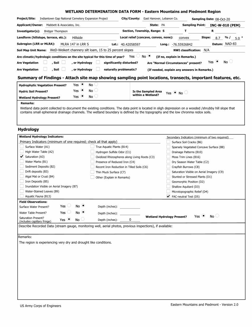
WETLAND DETERMINATION DATA FORM - Eastern Mountains and Piedmont Region
Project/Site: Indiantown Gap National Cemetery Expansion Project City/County: East Hanover, Lebanon Co. Sampling Date: 08-Oct-20
Applicant/Owner: Mabbett & Associates, Inc. State: PA Sampling Point: INC-W-010 (PEM)
Investigator(s): Bridger Thompson Section, Township, Range: S T R
Landform (hillslope, terrace, etc.): Hillside Local relief (concave, convex, none): convex Slope: 8.7 % / 5.0 °
Subregion (LRR or MLRA): MLRA 147 in LRR S Lat.: 40.42058597 Long.: -76.55926842 Datum: NAD-83
Soil Map Unit Name: WeD-Weikert channery silt loam, 15 to 25 percent slopes NWI classification: N/A
Are climatic/hydrologic conditions on the site typical for this time of year? Yes No (If no, explain in Remarks.)
Are Vegetation , Soil , or Hydrology significantly disturbed? Are "Normal Circumstances" present? Yes No
Are Vegetation , Soil , or Hydrology naturally problematic? (If needed, explain any answers in Remarks.)
Summary of Findings - Attach site map showing sampling point locations, transects, important features, etc.
Yes No
Yes No
Yes No
Hydric Soil Present?
Hydrophytic Vegetation Present?
Wetland Hydrology Present?
Yes No Is the Sampled Area within a Wetland?
Remarks:
Wetland data point collected to document the existing conditions. The data point is located in sligh depression on a wooded /shrubby hill slope that contains small ephemeral drainage channels. The wetland boundary is defined by the topography and the low chronma redox soils.
Hydrology
Surface Water (A1)
High Water Table (A2)
Saturation (A3)
Water Marks (B1)
Sediment Deposits (B2)
Drift deposits (B3)
Algal Mat or Crust (B4)
Water-Stained Leaves (B9)
Dry Season Water Table (C2)
True Aquatic Plants (B14)
Hydrogen Sulfide Odor (C1)
Oxidized Rhizospheres along Living Roots (C3)
Presence of Reduced Iron (C4)
Recent Iron Reduction in Tilled Soils (C6)
Other (Explain in Remarks)
Drainage Patterns (B10)
Aquatic Fauna (B13)
Saturation Visible on Aerial Imagery (C9)
Crayfish Burrows (C8)
Moss Trim Lines (B16)
Primary Indicators (minimum of one required; check all that apply)
Wetland Hydrology Indicators: Secondary Indicators (minimum of two required)
Iron Deposits (B5)
Surface Soil Cracks (B6)
Stunted or Stressed Plants (D1)
Inundation Visible on Aerial Imagery (B7)
Sparsely Vegetated Concave Surface (B8)
Thin Muck Surface (C7)
Shallow Aquitard (D3)
FAC-neutral Test (D5)
Geomorphic Position (D2)
Microtopographic Relief (D4)
0
Yes No
Yes No
Yes No Yes No
Field Observations:
Surface Water Present?
Water Table Present?
Saturation Present? (includes capillary fringe)
Depth (inches):
Depth (inches):
Depth (inches): Wetland Hydrology Present?
Describe Recorded Data (stream gauge, monitoring well, aerial photos, previous inspections), if available:
Remarks:
The region is experiencing very dry and drought like conditions.
Eastern Mountains and Piedmont - Version 2.0 US Army Corps of Engineers

1
1
1
VEGETATION (Five/Four Strata)- Use scientific names of plants. Dominant Sampling Point: INC-W-010 (PEM) Species?
0
0
0
0
0
0
0.0%
0.0%
0.0%
0.0%
0
0.0%
0.0%
= Total Cover
Tree Stratum
0
0
0
0
0
0.0%
0.0%
0.0%
0.0%
0.0%
Sapling-Sapling/Shrub Stratum
1.
0
0
0.0%
0.0%
0
0
0.0%
0.0%
)
)
(Plot size:
(Plot size:
Rel.Strat. Cover
Absolute % Cover
Indicator Status
2. 3. 4. 5. 6. 7. 8.
1. 2. 3. 4. 5. 6. 7.
4
4
100.0%
Dominance Test worksheet:
Total Number of Dominant Species Across All Strata:
(A/B)
Number of Dominant Species That are OBL, FACW, or FAC: (A)
Percent of dominant Species That Are OBL, FACW, or FAC:
(B)
20 20
50 100
30 90
0 0
0 0
100 210
2.100
(B)
Prevalence Index worksheet:
Prevalence Index = B/A =
OBL species
FACW species
FAC species
FACU species
UPL species
Column Totals:
x 1 =
x 2 =
x 3 =
x 4 =
x 5 =
(A)
Total % Cover of: Multiply by:
Hydrophytic Vegetation Indicators: 0 0.0% 8. Rapid Test for Hydrophytic Vegetation 0 0.0% 9. Dominance Test is > 50% 0 0.0% 10. Prevalence Index is ≤3.0 1
Shrub Stratum 0 = Total Cover )(Plot size: Morphological Adaptations (Provide supporting1
0 0.0% 1. data in Remarks or on a separate sheet)
0 0.0% 2. Problematic Hydrophytic Vegetation (Explain) 1
0 0.0% 3. Indicators of hydric soil and wetland hydrology must1
0
0
0
0
30
20
20
10
20
0
0
0
0.0%
0.0%
0.0%
0.0%
30.0% FAC
20.0% FACW
20.0% OBL
10.0% FACW
20.0% FACW
0.0%
0.0%
0 0.0%
= Total Cover Herb Stratum
0
0
0.0%
0.0%
)(Plot size: 10 feet
Microstegium vimineum
Epilobium coloratum
Scirpus atrovirens
Persicaria pensylvanica
Bidens frondosa
4. 5. 6. 7.
1. 2. 3. 4. 5. 6. 7. 8. 9.
10.
be present, unless disturbed or problematic.
Definition of Vegetation Strata:
Tree - Woody plants, excluding woody vines, approximately 20 ft (6 m) or more in height and 3 in. (7.6 cm) or larger in diameter at breast height (DBH). Sapling stratum – Consists of woody plants, excluding woody vines, approximately 20 ft (6 m) or more in height and less than
Tree stratum – Consists of woody plants, excluding vines, 3 in. (7.6 cm) or more in diameter at breast height (DBH), regardless of height. Sapling/shrub stratum – Consists of woody plants, excluding vines, less than 3 in. DBH and greater than 3.28 ft (1 m) tall. Herb stratum – Consists of all herbaceous (non-woody) plants, regardless of size, and all other plants less than 3.28 ft tall.
Woody vines – Consists of all woody vines greater than 3.28 ft in height.
Four Vegetation Strata:
Five Vegetation Strata:
100
0
Woody Vine Stratum = Total Cover
= Total Cover
0
0
0
0.0%
0.0%
0.0%
)
0 0.0%
0
0
0.0%
0.0%
0 0.0%
0 0.0%
(Plot size:
11. 12.
1. 2. 3. 4. 5. 6.
3 in. (7.6 cm) DBH. Shrub stratum – Consists of woody plants, excluding woody vines, approximately 3 to 20 ft (1 to 6 m) in height. Herb stratum – Consists of all herbaceous (non-woody) plants, including herbaceous vines, regardless of size, and woody species, except woody vines, less than approximately 3 ft (1 m) in height.
Woody vines – Consists of all woody vines, regardless of height.
Yes No
Hydrophytic Vegetation Present?
Remarks: (Include photo numbers here or on a separate sheet.)
*Indicator suffix = National status or professional decision assigned because Regional status not defined by FWS.
US Army Corps of Engineers Eastern Mountains and Piedmont - Version 2.0

INC-W-010 (PEM)Soil Sampling Point:
Profile Description: (Describe to the depth needed to document the indicator or confirm the absence of indicators.)
Depth (inches) Color (moist) Color (moist)
Matrix Redox Features
% Loc² Texture RemarksType%
Yes No
Hydric Soil Indicators: Indicators for Problematic Hydric Soils :
Restrictive Layer (if observed):
Hydric Soil Present?
Indicators of hydrophytic vegetation and wetland hydrology must be present,
unless disturbed or problematic.
Histosol (A1)
Histic Epipedon (A2)
Black Histic (A3)
Hydrogen Sulfide (A4)
Depleted Below Dark Surface (A11)
Thick Dark Surface (A12)
Sandy Muck Mineral (S1) (LRR N, MLRA 147, 148)
Sandy Gleyed Matrix (S4)
Sandy Redox (S5)
Stripped Matrix (S6)
Loamy Gleyed Matrix (F2)
Depleted Matrix (F3)
Redox Dark Surface (F6)
Depleted Dark Surface (F7)
Type:
Depth (inches):
Remarks:
US Army Corps of Engineers Eastern Mountains and Piedmont - Version 2.0
Dark Surface (S7)
Stratified Layers (A5)
Polyvalue Below Surface (S8) (MLRA 147,148)
Redox Depressions (F8)
1
1
3
3
Thin Dark Surface (S9) (MLRA 147, 148)
Iron-Manganese Masses (F12) (LRR N, MLRA 136)
Umbric Surface (F13) (MLRA 136, 122)
Piedmont Floodplain Soils (F19) (MLRA 148)
Type: C=Concentration. D=Depletion. RM=Reduced Matrix, CS=Covered or Coated Sand Grains ²Location: PL=Pore Lining. M=Matrix
2 cm Muck (A10) (LRR N)
12-20
6-12
0-6
10YR
10YR
10YR
5/2
4/2
4/2
80
80
90 5YR
5YR
5YR
5/6
5/6
5/6 10
10
10 C
C
C M
M
M Silt Loam
Silty Clay
Clay Loam
Surface water infiltration is slightly restricted by a shallow clay layer.
Other (Explain in Remarks)
2 cm Muck (A10) (MLRA 147)
Piedmont Floodplain Soils (F19) (MLRA 136, 147)
Very Shallow Dark Surface (TF12)
Coast Prairie Redox (A16) (MLRA 147,148)
Red Parent Material (F21) (MLRA 127, 147)

WETLAND DETERMINATION DATA FORM - Eastern Mountains and Piedmont Region
Project/Site: Indiantown Gap National Cemetery Expansion Project City/County: East Hanover, Lebanon Co. Sampling Date: 08-Oct-20
Applicant/Owner: Mabbett & Associates, Inc. State: PA Sampling Point: INC-W-010 (UPL)
Investigator(s): Bridger Thompson Section, Township, Range: S T R
Landform (hillslope, terrace, etc.): Hillside Local relief (concave, convex, none): convex Slope: 8.7 % / 5.0 °
Subregion (LRR or MLRA): MLRA 147 in LRR S Lat.: 40.4205541 Long.: -76.55922625 Datum: NAD-83
Soil Map Unit Name: WeD-Weikert channery silt loam, 15 to 25 percent slopes NWI classification: N/A
Are climatic/hydrologic conditions on the site typical for this time of year? Yes No (If no, explain in Remarks.)
Are Vegetation , Soil , or Hydrology significantly disturbed? Are "Normal Circumstances" present? Yes No
Are Vegetation , Soil , or Hydrology naturally problematic? (If needed, explain any answers in Remarks.)
Summary of Findings - Attach site map showing sampling point locations, transects, important features, etc.
Yes No
Yes No
Yes No
Hydric Soil Present?
Hydrophytic Vegetation Present?
Wetland Hydrology Present?
Yes No Is the Sampled Area within a Wetland?
Remarks:
Upland data point collected to verify the wetland boundary. The data point is located on a slight hill slope a in a wooded/shrubby lot adjacent to the wetland boundary.
Hydrology
Surface Water (A1)
High Water Table (A2)
Saturation (A3)
Water Marks (B1)
Sediment Deposits (B2)
Drift deposits (B3)
Algal Mat or Crust (B4)
Water-Stained Leaves (B9)
Dry Season Water Table (C2)
True Aquatic Plants (B14)
Hydrogen Sulfide Odor (C1)
Oxidized Rhizospheres along Living Roots (C3)
Presence of Reduced Iron (C4)
Recent Iron Reduction in Tilled Soils (C6)
Other (Explain in Remarks)
Drainage Patterns (B10)
Aquatic Fauna (B13)
Saturation Visible on Aerial Imagery (C9)
Crayfish Burrows (C8)
Moss Trim Lines (B16)
Primary Indicators (minimum of one required; check all that apply)
Wetland Hydrology Indicators: Secondary Indicators (minimum of two required)
Iron Deposits (B5)
Surface Soil Cracks (B6)
Stunted or Stressed Plants (D1)
Inundation Visible on Aerial Imagery (B7)
Sparsely Vegetated Concave Surface (B8)
Thin Muck Surface (C7)
Shallow Aquitard (D3)
FAC-neutral Test (D5)
Geomorphic Position (D2)
Microtopographic Relief (D4)
Yes No
Yes No
Yes No Yes No
Field Observations:
Surface Water Present?
Water Table Present?
Saturation Present? (includes capillary fringe)
Depth (inches):
Depth (inches):
Depth (inches): Wetland Hydrology Present?
Describe Recorded Data (stream gauge, monitoring well, aerial photos, previous inspections), if available:
Remarks:
Eastern Mountains and Piedmont - Version 2.0 US Army Corps of Engineers

30
0
0
0
0
0
0
0
0
30
0
0
0
0
30
0
0
0
0
0
0
Yes No
1100.0% FACU
0.0%
40.0%
0.0%
25.0%
30
0.0%
0.0%
0.0%
0 0
0.0%
0 0
0.0%
40 120
50 200
60
30 150
50.0% UPL
120 470
0.0%
3.917
0.0%
0.0%
0.0%
100.0% FAC
0.0%
0.0%
0.0%
0.0%
30
0.0%
0.0%
0
0 0.0%
Eastern Mountains and Piedmont - Version 2.0
Woody Vine Stratum
(B)
= Total Cover
= Total Cover
Prevalence Index is ≤3.0
= Total Cover
Hydrophytic Vegetation Present?
US Army Corps of Engineers
Dominance Test worksheet:
Total Number of Dominant Species Across All Strata:
Prevalence Index worksheet:
Prevalence Index = B/A =
(A/B)
1 Indicators of hydric soil and wetland hydrology must be present, unless disturbed or problematic.
Problematic Hydrophytic Vegetation 1 (Explain)
Herb Stratum
= Total Cover
Number of Dominant Species That are OBL, FACW, or FAC:
Hydrophytic Vegetation Indicators:
Remarks: (Include photo numbers here or on a separate sheet.)
OBL species
FACW species
FAC species
FACU species
UPL species
Column Totals:
x 1 =
x 2 =
x 3 =
x 4 =
x 5 =
(A)
(A)
Percent of dominant Species That Are OBL, FACW, or FAC:
Total % Cover of: Multiply by:
(B)
Tree Stratum
Shrub Stratum
*Indicator suffix = National status or professional decision assigned because Regional status not defined by FWS.
Dominance Test is > 50%
0
0
0
0
0
0.0%
0.0%
0.0%
0.0%
0.0%
0
0
0
0
0
0.0%
0.0%
0.0%
0.0%
0
0.0%
= Total Cover
Sapling-Sapling/Shrub Stratum
1.
0
0
0.0%
0.0%
0
0
0.0%
0.0%
20
10
33.3% FACU
16.7% FAC
Definition of Vegetation Strata:
Tree - Woody plants, excluding woody vines, approximately 20 ft (6 m) or more in height and 3 in. (7.6 cm) or larger in diameter at breast height (DBH). Sapling stratum – Consists of woody plants, excluding woody vines, approximately 20 ft (6 m) or more in height and less than 3 in. (7.6 cm) DBH. Shrub stratum – Consists of woody plants, excluding woody vines, approximately 3 to 20 ft (1 to 6 m) in height. Herb stratum – Consists of all herbaceous (non-woody) plants, including herbaceous vines, regardless of size, and woody species, except woody vines, less than approximately 3 ft (1 m) in height.
Woody vines – Consists of all woody vines, regardless of height.
INC-W-010 (UPL)Sampling Point:
)
)
)
)
)
Morphological Adaptations 1 (Provide supporting data in Remarks or on a separate sheet)
Rapid Test for Hydrophytic Vegetation
0 0.0%
0
0
0.0%
0.0%
0 0.0%
VEGETATION (Five/Four Strata)- Use scientific names of plants.
0 0.0%
Tree stratum – Consists of woody plants, excluding vines, 3 in. (7.6 cm) or more in diameter at breast height (DBH), regardless of height. Sapling/shrub stratum – Consists of woody plants, excluding vines, less than 3 in. DBH and greater than 3.28 ft (1 m) tall. Herb stratum – Consists of all herbaceous (non-woody) plants, regardless of size, and all other plants less than 3.28 ft tall.
Woody vines – Consists of all woody vines greater than 3.28 ft in height.
Four Vegetation Strata:
Five Vegetation Strata:
Juglans nigra
(Plot size: 30 feet
(Plot size:
(Plot size: 15 feet
Elaeagnus umbellata
Lonicera tatarica
Rubus idaeus
(Plot size: 10 feet
Microstegium vimineum
(Plot size:
Dominant Species? Rel.Strat. Cover
Absolute % Cover
Indicator Status
1
1
1
1
2. 3. 4. 5. 6. 7. 8.
1. 2. 3. 4. 5. 6. 7. 8. 9.
10.
1. 2. 3. 4. 5. 6. 7.
1. 2. 3. 4. 5. 6. 7. 8. 9.
10. 11. 12.
1. 2. 3. 4. 5. 6.

INC-W-010 (UPL)Soil Sampling Point:
Profile Description: (Describe to the depth needed to document the indicator or confirm the absence of indicators.)
Depth (inches) Color (moist) Color (moist)
Matrix Redox Features
% Loc² Texture RemarksType%
Yes No
Hydric Soil Indicators: Indicators for Problematic Hydric Soils :
Restrictive Layer (if observed):
Hydric Soil Present?
Indicators of hydrophytic vegetation and wetland hydrology must be present,
unless disturbed or problematic.
Histosol (A1)
Histic Epipedon (A2)
Black Histic (A3)
Hydrogen Sulfide (A4)
Depleted Below Dark Surface (A11)
Thick Dark Surface (A12)
Sandy Muck Mineral (S1) (LRR N, MLRA 147, 148)
Sandy Gleyed Matrix (S4)
Sandy Redox (S5)
Stripped Matrix (S6)
Loamy Gleyed Matrix (F2)
Depleted Matrix (F3)
Redox Dark Surface (F6)
Depleted Dark Surface (F7)
Type:
Depth (inches):
Remarks:
US Army Corps of Engineers Eastern Mountains and Piedmont - Version 2.0
Dark Surface (S7)
Stratified Layers (A5)
Polyvalue Below Surface (S8) (MLRA 147,148)
Redox Depressions (F8)
1
1
3
3
Thin Dark Surface (S9) (MLRA 147, 148)
Iron-Manganese Masses (F12) (LRR N, MLRA 136)
Umbric Surface (F13) (MLRA 136, 122)
Piedmont Floodplain Soils (F19) (MLRA 148)
Type: C=Concentration. D=Depletion. RM=Reduced Matrix, CS=Covered or Coated Sand Grains ²Location: PL=Pore Lining. M=Matrix
2 cm Muck (A10) (LRR N)
12-20
6-12
0-6
10YR
10YR
10YR
5/3
4/3
4/4
95
100
100
5YR 5/6 5 C M
Silt Loam
Silty Clay
Clay Loam
Other (Explain in Remarks)
2 cm Muck (A10) (MLRA 147)
Piedmont Floodplain Soils (F19) (MLRA 136, 147)
Very Shallow Dark Surface (TF12)
Coast Prairie Redox (A16) (MLRA 147,148)
Red Parent Material (F21) (MLRA 127, 147)

WETLAND DETERMINATION DATA FORM - Eastern Mountains and Piedmont Region
Project/Site: Indiantown Gap National Cemetery Expansion Project City/County: East Hanover, Lebanon Co. Sampling Date: 08-Oct-20
Applicant/Owner: Mabbett & Associates, Inc. State: PA Sampling Point: INC-W-011 (PEM)
Investigator(s): Bridger Thompson Section, Township, Range: S T R
Landform (hillslope, terrace, etc.): Bench Local relief (concave, convex, none): concave Slope: 0.0 % / 0.0 °
Subregion (LRR or MLRA): MLRA 147 in LRR S Lat.: 40.42180631 Long.: -76.56021074 Datum: NAD-83
Soil Map Unit Name: WeD-Weikert channery silt loam, 15 to 25 percent slopes NWI classification: N/A
Are climatic/hydrologic conditions on the site typical for this time of year? Yes No (If no, explain in Remarks.)
Are Vegetation , Soil , or Hydrology significantly disturbed? Are "Normal Circumstances" present? Yes No
Are Vegetation , Soil , or Hydrology naturally problematic? (If needed, explain any answers in Remarks.)
Summary of Findings - Attach site map showing sampling point locations, transects, important features, etc.
Yes No
Yes No
Yes No
Hydric Soil Present?
Hydrophytic Vegetation Present?
Wetland Hydrology Present?
Yes No Is the Sampled Area within a Wetland?
Remarks:
Wetland data point collected to document the existing conditions. The data point is located in a shallow depression that receives surface water runoff from an upslope fill area . The wetland boundary is defined by the topography of the depression and the non-vegetated concave surface. The wetland can be more percisely classified as a vernal pool.
Hydrology
Surface Water (A1)
High Water Table (A2)
Saturation (A3)
Water Marks (B1)
Sediment Deposits (B2)
Drift deposits (B3)
Algal Mat or Crust (B4)
Water-Stained Leaves (B9)
Dry Season Water Table (C2)
True Aquatic Plants (B14)
Hydrogen Sulfide Odor (C1)
Oxidized Rhizospheres along Living Roots (C3)
Presence of Reduced Iron (C4)
Recent Iron Reduction in Tilled Soils (C6)
Other (Explain in Remarks)
Drainage Patterns (B10)
Aquatic Fauna (B13)
Saturation Visible on Aerial Imagery (C9)
Crayfish Burrows (C8)
Moss Trim Lines (B16)
Primary Indicators (minimum of one required; check all that apply)
Wetland Hydrology Indicators: Secondary Indicators (minimum of two required)
Iron Deposits (B5)
Surface Soil Cracks (B6)
Stunted or Stressed Plants (D1)
Inundation Visible on Aerial Imagery (B7)
Sparsely Vegetated Concave Surface (B8)
Thin Muck Surface (C7)
Shallow Aquitard (D3)
FAC-neutral Test (D5)
Geomorphic Position (D2)
Microtopographic Relief (D4)
0
Yes No
Yes No
Yes No Yes No
Field Observations:
Surface Water Present?
Water Table Present?
Saturation Present? (includes capillary fringe)
Depth (inches):
Depth (inches):
Depth (inches): Wetland Hydrology Present?
Describe Recorded Data (stream gauge, monitoring well, aerial photos, previous inspections), if available:
Remarks:
The region is experiencing very dry and drought like conditions.
Eastern Mountains and Piedmont - Version 2.0 US Army Corps of Engineers

0
0
0
0
0
0
0
0
0
0
0
0
0
0
10
10
10
0
0
0
0
Yes No
30.0%
0.0%
30.0%
0.0%
100.0%
0
0.0%
0.0%
0.0%
10 10
0.0%
10 20
0.0%
10 30
0 0
0
0 0
0.0%
30 60
0.0%
2.000
0.0%
0.0%
0.0%
33.3% FAC
33.3% OBL
33.3% FACW
0.0%
0.0%
30
0.0%
0.0%
0
0 0.0%
Eastern Mountains and Piedmont - Version 2.0
Woody Vine Stratum
(B)
= Total Cover
= Total Cover
Prevalence Index is ≤3.0
= Total Cover
Hydrophytic Vegetation Present?
US Army Corps of Engineers
Dominance Test worksheet:
Total Number of Dominant Species Across All Strata:
Prevalence Index worksheet:
Prevalence Index = B/A =
(A/B)
1 Indicators of hydric soil and wetland hydrology must be present, unless disturbed or problematic.
Problematic Hydrophytic Vegetation 1 (Explain)
Herb Stratum
= Total Cover
Number of Dominant Species That are OBL, FACW, or FAC:
Hydrophytic Vegetation Indicators:
Remarks: (Include photo numbers here or on a separate sheet.)
OBL species
FACW species
FAC species
FACU species
UPL species
Column Totals:
x 1 =
x 2 =
x 3 =
x 4 =
x 5 =
(A)
(A)
Percent of dominant Species That Are OBL, FACW, or FAC:
Total % Cover of: Multiply by:
(B)
Tree Stratum
Shrub Stratum
*Indicator suffix = National status or professional decision assigned because Regional status not defined by FWS.
Dominance Test is > 50%
0
0
0
0
0
0.0%
0.0%
0.0%
0.0%
0.0%
0
0
0
0
0
0.0%
0.0%
0.0%
0.0%
0
0.0%
= Total Cover
Sapling-Sapling/Shrub Stratum
1.
0
0
0.0%
0.0%
0
0
0.0%
0.0%
0
0
0.0%
0.0%
Definition of Vegetation Strata:
Tree - Woody plants, excluding woody vines, approximately 20 ft (6 m) or more in height and 3 in. (7.6 cm) or larger in diameter at breast height (DBH). Sapling stratum – Consists of woody plants, excluding woody vines, approximately 20 ft (6 m) or more in height and less than 3 in. (7.6 cm) DBH. Shrub stratum – Consists of woody plants, excluding woody vines, approximately 3 to 20 ft (1 to 6 m) in height. Herb stratum – Consists of all herbaceous (non-woody) plants, including herbaceous vines, regardless of size, and woody species, except woody vines, less than approximately 3 ft (1 m) in height.
Woody vines – Consists of all woody vines, regardless of height.
INC-W-011 (PEM)Sampling Point:
)
)
)
)
)
Morphological Adaptations 1 (Provide supporting data in Remarks or on a separate sheet)
Rapid Test for Hydrophytic Vegetation
0 0.0%
0
0
0.0%
0.0%
0 0.0%
VEGETATION (Five/Four Strata)- Use scientific names of plants.
0 0.0%
Tree stratum – Consists of woody plants, excluding vines, 3 in. (7.6 cm) or more in diameter at breast height (DBH), regardless of height. Sapling/shrub stratum – Consists of woody plants, excluding vines, less than 3 in. DBH and greater than 3.28 ft (1 m) tall. Herb stratum – Consists of all herbaceous (non-woody) plants, regardless of size, and all other plants less than 3.28 ft tall.
Woody vines – Consists of all woody vines greater than 3.28 ft in height.
Four Vegetation Strata:
Five Vegetation Strata:
(Plot size:
(Plot size:
(Plot size:
(Plot size: 10 feet
Microstegium vimineum
Scirpus atrovirens
Persicaria pensylvanica
(Plot size:
Dominant Species? Rel.Strat. Cover
Absolute % Cover
Indicator Status
1
1
1
1
2. 3. 4. 5. 6. 7. 8.
1. 2. 3. 4. 5. 6. 7. 8. 9.
10.
1. 2. 3. 4. 5. 6. 7.
1. 2. 3. 4. 5. 6. 7. 8. 9.
10. 11. 12.
1. 2. 3. 4. 5. 6.

INC-W-011 (PEM)Soil Sampling Point:
Profile Description: (Describe to the depth needed to document the indicator or confirm the absence of indicators.)
Depth (inches) Color (moist) Color (moist)
Matrix Redox Features
% Loc² Texture RemarksType%
Yes No
Hydric Soil Indicators: Indicators for Problematic Hydric Soils :
Restrictive Layer (if observed):
Hydric Soil Present?
Indicators of hydrophytic vegetation and wetland hydrology must be present,
unless disturbed or problematic.
Histosol (A1)
Histic Epipedon (A2)
Black Histic (A3)
Hydrogen Sulfide (A4)
Depleted Below Dark Surface (A11)
Thick Dark Surface (A12)
Sandy Muck Mineral (S1) (LRR N, MLRA 147, 148)
Sandy Gleyed Matrix (S4)
Sandy Redox (S5)
Stripped Matrix (S6)
Loamy Gleyed Matrix (F2)
Depleted Matrix (F3)
Redox Dark Surface (F6)
Depleted Dark Surface (F7)
Type:
Depth (inches):
Remarks:
US Army Corps of Engineers Eastern Mountains and Piedmont - Version 2.0
Dark Surface (S7)
Stratified Layers (A5)
Polyvalue Below Surface (S8) (MLRA 147,148)
Redox Depressions (F8)
1
1
3
3
Thin Dark Surface (S9) (MLRA 147, 148)
Iron-Manganese Masses (F12) (LRR N, MLRA 136)
Umbric Surface (F13) (MLRA 136, 122)
Piedmont Floodplain Soils (F19) (MLRA 148)
Type: C=Concentration. D=Depletion. RM=Reduced Matrix, CS=Covered or Coated Sand Grains ²Location: PL=Pore Lining. M=Matrix
2 cm Muck (A10) (LRR N)
10-20
0-10
2.5Y
2.5Y
5/3
5/1
80
80 5YR
5YR
5/6
5/6 20
20 C
C M
M Silt Loam
Clay Loam
Other (Explain in Remarks)
2 cm Muck (A10) (MLRA 147)
Piedmont Floodplain Soils (F19) (MLRA 136, 147)
Very Shallow Dark Surface (TF12)
Coast Prairie Redox (A16) (MLRA 147,148)
Red Parent Material (F21) (MLRA 127, 147)

WETLAND DETERMINATION DATA FORM - Eastern Mountains and Piedmont Region
Project/Site: Indiantown Gap National Cemetery Expansion Project City/County: East Hanover, Lebanon Co. Sampling Date: 08-Oct-20
Applicant/Owner: Mabbett & Associates, Inc. State: PA Sampling Point: INC-W-011 (UPL)
Investigator(s): Bridger Thompson Section, Township, Range: S T R
Landform (hillslope, terrace, etc.): Bench Local relief (concave, convex, none): concave Slope: 0.0 % / 0.0 °
Subregion (LRR or MLRA): MLRA 147 in LRR S Lat.: 40.42174219 Long.: -76.56029029 Datum: NAD-83
Soil Map Unit Name: WeD-Weikert channery silt loam, 15 to 25 percent slopes NWI classification: N/A
Are climatic/hydrologic conditions on the site typical for this time of year? Yes No (If no, explain in Remarks.)
Are Vegetation , Soil , or Hydrology significantly disturbed? Are "Normal Circumstances" present? Yes No
Are Vegetation , Soil , or Hydrology naturally problematic? (If needed, explain any answers in Remarks.)
Summary of Findings - Attach site map showing sampling point locations, transects, important features, etc.
Yes No
Yes No
Yes No
Hydric Soil Present?
Hydrophytic Vegetation Present?
Wetland Hydrology Present?
Yes No Is the Sampled Area within a Wetland?
Remarks:
Upland data point collected to verify the wetland boundary. The data point is located in a wooded area adjacent to the wetland boundary.
Hydrology
Surface Water (A1)
High Water Table (A2)
Saturation (A3)
Water Marks (B1)
Sediment Deposits (B2)
Drift deposits (B3)
Algal Mat or Crust (B4)
Water-Stained Leaves (B9)
Dry Season Water Table (C2)
True Aquatic Plants (B14)
Hydrogen Sulfide Odor (C1)
Oxidized Rhizospheres along Living Roots (C3)
Presence of Reduced Iron (C4)
Recent Iron Reduction in Tilled Soils (C6)
Other (Explain in Remarks)
Drainage Patterns (B10)
Aquatic Fauna (B13)
Saturation Visible on Aerial Imagery (C9)
Crayfish Burrows (C8)
Moss Trim Lines (B16)
Primary Indicators (minimum of one required; check all that apply)
Wetland Hydrology Indicators: Secondary Indicators (minimum of two required)
Iron Deposits (B5)
Surface Soil Cracks (B6)
Stunted or Stressed Plants (D1)
Inundation Visible on Aerial Imagery (B7)
Sparsely Vegetated Concave Surface (B8)
Thin Muck Surface (C7)
Shallow Aquitard (D3)
FAC-neutral Test (D5)
Geomorphic Position (D2)
Microtopographic Relief (D4)
Yes No
Yes No
Yes No Yes No
Field Observations:
Surface Water Present?
Water Table Present?
Saturation Present? (includes capillary fringe)
Depth (inches):
Depth (inches):
Depth (inches): Wetland Hydrology Present?
Describe Recorded Data (stream gauge, monitoring well, aerial photos, previous inspections), if available:
Remarks:
The region is experiencing very dry and drought like conditions.
Eastern Mountains and Piedmont - Version 2.0 US Army Corps of Engineers

20
10
0
0
0
0
0
0
0
10
0
0
0
0
10
10
0
0
0
0
0
Yes No
166.7% FACU
33.3% FACU
50.0%
0.0%
20.0%
30
0.0%
0.0%
0.0%
0 0
0.0%
0 0
0.0%
10 30
50 200
10
0 0
100.0% FACU
60 230
0.0%
3.833
0.0%
0.0%
0.0%
50.0% FAC
50.0% FACU
0.0%
0.0%
0.0%
20
0.0%
0.0%
0
0 0.0%
Eastern Mountains and Piedmont - Version 2.0
Woody Vine Stratum
(B)
= Total Cover
= Total Cover
Prevalence Index is ≤3.0
= Total Cover
Hydrophytic Vegetation Present?
US Army Corps of Engineers
Dominance Test worksheet:
Total Number of Dominant Species Across All Strata:
Prevalence Index worksheet:
Prevalence Index = B/A =
(A/B)
1 Indicators of hydric soil and wetland hydrology must be present, unless disturbed or problematic.
Problematic Hydrophytic Vegetation 1 (Explain)
Herb Stratum
= Total Cover
Number of Dominant Species That are OBL, FACW, or FAC:
Hydrophytic Vegetation Indicators:
Remarks: (Include photo numbers here or on a separate sheet.)
OBL species
FACW species
FAC species
FACU species
UPL species
Column Totals:
x 1 =
x 2 =
x 3 =
x 4 =
x 5 =
(A)
(A)
Percent of dominant Species That Are OBL, FACW, or FAC:
Total % Cover of: Multiply by:
(B)
Tree Stratum
Shrub Stratum
*Indicator suffix = National status or professional decision assigned because Regional status not defined by FWS.
Dominance Test is > 50%
0
0
0
0
0
0.0%
0.0%
0.0%
0.0%
0.0%
0
0
0
0
0
0.0%
0.0%
0.0%
0.0%
0
0.0%
= Total Cover
Sapling-Sapling/Shrub Stratum
1.
0
0
0.0%
0.0%
0
0
0.0%
0.0%
0
0
0.0%
0.0%
Definition of Vegetation Strata:
Tree - Woody plants, excluding woody vines, approximately 20 ft (6 m) or more in height and 3 in. (7.6 cm) or larger in diameter at breast height (DBH). Sapling stratum – Consists of woody plants, excluding woody vines, approximately 20 ft (6 m) or more in height and less than 3 in. (7.6 cm) DBH. Shrub stratum – Consists of woody plants, excluding woody vines, approximately 3 to 20 ft (1 to 6 m) in height. Herb stratum – Consists of all herbaceous (non-woody) plants, including herbaceous vines, regardless of size, and woody species, except woody vines, less than approximately 3 ft (1 m) in height.
Woody vines – Consists of all woody vines, regardless of height.
INC-W-011 (UPL)Sampling Point:
)
)
)
)
)
Morphological Adaptations 1 (Provide supporting data in Remarks or on a separate sheet)
Rapid Test for Hydrophytic Vegetation
0 0.0%
0
0
0.0%
0.0%
0 0.0%
VEGETATION (Five/Four Strata)- Use scientific names of plants.
0 0.0%
Tree stratum – Consists of woody plants, excluding vines, 3 in. (7.6 cm) or more in diameter at breast height (DBH), regardless of height. Sapling/shrub stratum – Consists of woody plants, excluding vines, less than 3 in. DBH and greater than 3.28 ft (1 m) tall. Herb stratum – Consists of all herbaceous (non-woody) plants, regardless of size, and all other plants less than 3.28 ft tall.
Woody vines – Consists of all woody vines greater than 3.28 ft in height.
Four Vegetation Strata:
Five Vegetation Strata:
Carya ovata
Quercus alba
(Plot size: 30 feet
(Plot size:
(Plot size: 15 feet
Rosa multiflora
(Plot size: 10 feet
Microstegium vimineum
Alliaria petiolata
(Plot size:
Dominant Species? Rel.Strat. Cover
Absolute % Cover
Indicator Status
1
1
1
1
2. 3. 4. 5. 6. 7. 8.
1. 2. 3. 4. 5. 6. 7. 8. 9.
10.
1. 2. 3. 4. 5. 6. 7.
1. 2. 3. 4. 5. 6. 7. 8. 9.
10. 11. 12.
1. 2. 3. 4. 5. 6.

INC-W-011 (UPL)Soil Sampling Point:
Profile Description: (Describe to the depth needed to document the indicator or confirm the absence of indicators.)
Depth (inches) Color (moist) Color (moist)
Matrix Redox Features
% Loc² Texture RemarksType%
Yes No
Hydric Soil Indicators: Indicators for Problematic Hydric Soils :
Restrictive Layer (if observed):
Hydric Soil Present?
Indicators of hydrophytic vegetation and wetland hydrology must be present,
unless disturbed or problematic.
Histosol (A1)
Histic Epipedon (A2)
Black Histic (A3)
Hydrogen Sulfide (A4)
Depleted Below Dark Surface (A11)
Thick Dark Surface (A12)
Sandy Muck Mineral (S1) (LRR N, MLRA 147, 148)
Sandy Gleyed Matrix (S4)
Sandy Redox (S5)
Stripped Matrix (S6)
Loamy Gleyed Matrix (F2)
Depleted Matrix (F3)
Redox Dark Surface (F6)
Depleted Dark Surface (F7)
Type:
Depth (inches):
Remarks:
US Army Corps of Engineers Eastern Mountains and Piedmont - Version 2.0
Dark Surface (S7)
Stratified Layers (A5)
Polyvalue Below Surface (S8) (MLRA 147,148)
Redox Depressions (F8)
1
1
3
3
Thin Dark Surface (S9) (MLRA 147, 148)
Iron-Manganese Masses (F12) (LRR N, MLRA 136)
Umbric Surface (F13) (MLRA 136, 122)
Piedmont Floodplain Soils (F19) (MLRA 148)
Type: C=Concentration. D=Depletion. RM=Reduced Matrix, CS=Covered or Coated Sand Grains ²Location: PL=Pore Lining. M=Matrix
2 cm Muck (A10) (LRR N)
12-20
6-12
0-6
2.5Y
2.5Y
2.5Y
5/4
5/3
4/4
100
100 Silt Loam
Silty Clay
Clay Loam
Other (Explain in Remarks)
2 cm Muck (A10) (MLRA 147)
Piedmont Floodplain Soils (F19) (MLRA 136, 147)
Very Shallow Dark Surface (TF12)
Coast Prairie Redox (A16) (MLRA 147,148)
Red Parent Material (F21) (MLRA 127, 147)

WETLAND DETERMINATION DATA FORM - Eastern Mountains and Piedmont Region
Project/Site: Indiantown Gap National Cemetery Expansion Project City/County: East Hanover, Lebanon Co. Sampling Date: 08-Oct-20
Applicant/Owner: Mabbett & Associates, Inc. State: PA Sampling Point: INC-W-012 (PEM)
Investigator(s): Bridger Thompson Section, Township, Range: S T R
Landform (hillslope, terrace, etc.): Gulch or Gully Local relief (concave, convex, none): concave Slope: 5.2 % / 3.0 °
Subregion (LRR or MLRA): MLRA 147 in LRR S Lat.: 40.42201072 Long.: -76.56113794 Datum: NAD-83
Soil Map Unit Name: CmB-Comly silt loam, 3 to 8 percent slopes NWI classification: N/A
Are climatic/hydrologic conditions on the site typical for this time of year? Yes No (If no, explain in Remarks.)
Are Vegetation , Soil , or Hydrology significantly disturbed? Are "Normal Circumstances" present? Yes No
Are Vegetation , Soil , or Hydrology naturally problematic? (If needed, explain any answers in Remarks.)
Summary of Findings - Attach site map showing sampling point locations, transects, important features, etc.
Yes No
Yes No
Yes No
Hydric Soil Present?
Hydrophytic Vegetation Present?
Wetland Hydrology Present?
Yes No Is the Sampled Area within a Wetland?
Remarks:
Wetland data point collected to document the existing conditions. The data point is located in a natural gully in a wooded/shrubby lot that receives surface water runoff from an upslope maintained cemetery grounds. The area also contains multiple seasonal groundwater discharge areas that confluence into a heavily eroded channel.The wetland boundary is defined by the saturated soil conditions.
Hydrology
Surface Water (A1)
High Water Table (A2)
Saturation (A3)
Water Marks (B1)
Sediment Deposits (B2)
Drift deposits (B3)
Algal Mat or Crust (B4)
Water-Stained Leaves (B9)
Dry Season Water Table (C2)
True Aquatic Plants (B14)
Hydrogen Sulfide Odor (C1)
Oxidized Rhizospheres along Living Roots (C3)
Presence of Reduced Iron (C4)
Recent Iron Reduction in Tilled Soils (C6)
Other (Explain in Remarks)
Drainage Patterns (B10)
Aquatic Fauna (B13)
Saturation Visible on Aerial Imagery (C9)
Crayfish Burrows (C8)
Moss Trim Lines (B16)
Primary Indicators (minimum of one required; check all that apply)
Wetland Hydrology Indicators: Secondary Indicators (minimum of two required)
Iron Deposits (B5)
Surface Soil Cracks (B6)
Stunted or Stressed Plants (D1)
Inundation Visible on Aerial Imagery (B7)
Sparsely Vegetated Concave Surface (B8)
Thin Muck Surface (C7)
Shallow Aquitard (D3)
FAC-neutral Test (D5)
Geomorphic Position (D2)
Microtopographic Relief (D4)
0
Yes No
Yes No
Yes No Yes No
Field Observations:
Surface Water Present?
Water Table Present?
Saturation Present? (includes capillary fringe)
Depth (inches):
Depth (inches):
Depth (inches): Wetland Hydrology Present?
Describe Recorded Data (stream gauge, monitoring well, aerial photos, previous inspections), if available:
Remarks:
The region is experiencing very dry and drought like conditions.
Eastern Mountains and Piedmont - Version 2.0 US Army Corps of Engineers

0
0
0
0
0
0
0
0
0
0
0
0
0
0
80
10
10
0
0
0
0
Yes No
10.0%
0.0%
10.0%
0.0%
100.0%
0
0.0%
0.0%
0.0%
10 10
0.0%
10 20
0.0%
80 240
0 0
0
0 0
0.0%
100 270
0.0%
2.700
0.0%
0.0%
0.0%
80.0% FAC
10.0% OBL
10.0% FACW
0.0%
0.0%
100
0.0%
0.0%
0
0 0.0%
Eastern Mountains and Piedmont - Version 2.0
Woody Vine Stratum
(B)
= Total Cover
= Total Cover
Prevalence Index is ≤3.0
= Total Cover
Hydrophytic Vegetation Present?
US Army Corps of Engineers
Dominance Test worksheet:
Total Number of Dominant Species Across All Strata:
Prevalence Index worksheet:
Prevalence Index = B/A =
(A/B)
1 Indicators of hydric soil and wetland hydrology must be present, unless disturbed or problematic.
Problematic Hydrophytic Vegetation 1 (Explain)
Herb Stratum
= Total Cover
Number of Dominant Species That are OBL, FACW, or FAC:
Hydrophytic Vegetation Indicators:
Remarks: (Include photo numbers here or on a separate sheet.)
OBL species
FACW species
FAC species
FACU species
UPL species
Column Totals:
x 1 =
x 2 =
x 3 =
x 4 =
x 5 =
(A)
(A)
Percent of dominant Species That Are OBL, FACW, or FAC:
Total % Cover of: Multiply by:
(B)
Tree Stratum
Shrub Stratum
*Indicator suffix = National status or professional decision assigned because Regional status not defined by FWS.
Dominance Test is > 50%
0
0
0
0
0
0.0%
0.0%
0.0%
0.0%
0.0%
0
0
0
0
0
0.0%
0.0%
0.0%
0.0%
0
0.0%
= Total Cover
Sapling-Sapling/Shrub Stratum
1.
0
0
0.0%
0.0%
0
0
0.0%
0.0%
0
0
0.0%
0.0%
Definition of Vegetation Strata:
Tree - Woody plants, excluding woody vines, approximately 20 ft (6 m) or more in height and 3 in. (7.6 cm) or larger in diameter at breast height (DBH). Sapling stratum – Consists of woody plants, excluding woody vines, approximately 20 ft (6 m) or more in height and less than 3 in. (7.6 cm) DBH. Shrub stratum – Consists of woody plants, excluding woody vines, approximately 3 to 20 ft (1 to 6 m) in height. Herb stratum – Consists of all herbaceous (non-woody) plants, including herbaceous vines, regardless of size, and woody species, except woody vines, less than approximately 3 ft (1 m) in height.
Woody vines – Consists of all woody vines, regardless of height.
INC-W-012 (PEM)Sampling Point:
)
)
)
)
)
Morphological Adaptations 1 (Provide supporting data in Remarks or on a separate sheet)
Rapid Test for Hydrophytic Vegetation
0 0.0%
0
0
0.0%
0.0%
0 0.0%
VEGETATION (Five/Four Strata)- Use scientific names of plants.
0 0.0%
Tree stratum – Consists of woody plants, excluding vines, 3 in. (7.6 cm) or more in diameter at breast height (DBH), regardless of height. Sapling/shrub stratum – Consists of woody plants, excluding vines, less than 3 in. DBH and greater than 3.28 ft (1 m) tall. Herb stratum – Consists of all herbaceous (non-woody) plants, regardless of size, and all other plants less than 3.28 ft tall.
Woody vines – Consists of all woody vines greater than 3.28 ft in height.
Four Vegetation Strata:
Five Vegetation Strata:
(Plot size:
(Plot size:
(Plot size:
(Plot size: 10 feet
Microstegium vimineum
Scirpus atrovirens
Impatiens capensis
(Plot size:
Dominant Species? Rel.Strat. Cover
Absolute % Cover
Indicator Status
1
1
1
1
2. 3. 4. 5. 6. 7. 8.
1. 2. 3. 4. 5. 6. 7. 8. 9.
10.
1. 2. 3. 4. 5. 6. 7.
1. 2. 3. 4. 5. 6. 7. 8. 9.
10. 11. 12.
1. 2. 3. 4. 5. 6.

INC-W-012 (PEM)Soil Sampling Point:
Profile Description: (Describe to the depth needed to document the indicator or confirm the absence of indicators.)
Depth (inches) Color (moist) Color (moist)
Matrix Redox Features
% Loc² Texture RemarksType%
Yes No
Hydric Soil Indicators: Indicators for Problematic Hydric Soils :
Restrictive Layer (if observed):
Hydric Soil Present?
Indicators of hydrophytic vegetation and wetland hydrology must be present,
unless disturbed or problematic.
Histosol (A1)
Histic Epipedon (A2)
Black Histic (A3)
Hydrogen Sulfide (A4)
Depleted Below Dark Surface (A11)
Thick Dark Surface (A12)
Sandy Muck Mineral (S1) (LRR N, MLRA 147, 148)
Sandy Gleyed Matrix (S4)
Sandy Redox (S5)
Stripped Matrix (S6)
Loamy Gleyed Matrix (F2)
Depleted Matrix (F3)
Redox Dark Surface (F6)
Depleted Dark Surface (F7)
Type:
Depth (inches):
Remarks:
US Army Corps of Engineers Eastern Mountains and Piedmont - Version 2.0
Dark Surface (S7)
Stratified Layers (A5)
Polyvalue Below Surface (S8) (MLRA 147,148)
Redox Depressions (F8)
1
1
3
3
Thin Dark Surface (S9) (MLRA 147, 148)
Iron-Manganese Masses (F12) (LRR N, MLRA 136)
Umbric Surface (F13) (MLRA 136, 122)
Piedmont Floodplain Soils (F19) (MLRA 148)
Type: C=Concentration. D=Depletion. RM=Reduced Matrix, CS=Covered or Coated Sand Grains ²Location: PL=Pore Lining. M=Matrix
2 cm Muck (A10) (LRR N)
12-20
6-12
0-6
10YR
10YR
10YR
5/2
4/1
4/3
80
90
100
5YR
5YR
5/6
5/6 20
10 C
C M
M
Silt Loam
Silty Clay
Clay Loam
Other (Explain in Remarks)
2 cm Muck (A10) (MLRA 147)
Piedmont Floodplain Soils (F19) (MLRA 136, 147)
Very Shallow Dark Surface (TF12)
Coast Prairie Redox (A16) (MLRA 147,148)
Red Parent Material (F21) (MLRA 127, 147)

WETLAND DETERMINATION DATA FORM - Eastern Mountains and Piedmont Region
Project/Site: Indiantown Gap National Cemetery Expansion Project City/County: East Hanover, Lebanon Co. Sampling Date: 08-Oct-20
Applicant/Owner: Mabbett & Associates, Inc. State: PA Sampling Point: INC-W-012 (UPL)
Investigator(s): Bridger Thompson Section, Township, Range: S T R
Landform (hillslope, terrace, etc.): Gulch or Gully Local relief (concave, convex, none): concave Slope: 5.2 % / 3.0 °
Subregion (LRR or MLRA): MLRA 147 in LRR S Lat.: 40.42177665 Long.: -76.56149774 Datum: NAD-83
Soil Map Unit Name: CmB-Comly silt loam, 3 to 8 percent slopes NWI classification: N/A
Are climatic/hydrologic conditions on the site typical for this time of year? Yes No (If no, explain in Remarks.)
Are Vegetation , Soil , or Hydrology significantly disturbed? Are "Normal Circumstances" present? Yes No
Are Vegetation , Soil , or Hydrology naturally problematic? (If needed, explain any answers in Remarks.)
Summary of Findings - Attach site map showing sampling point locations, transects, important features, etc.
Yes No
Yes No
Yes No
Hydric Soil Present?
Hydrophytic Vegetation Present?
Wetland Hydrology Present?
Yes No Is the Sampled Area within a Wetland?
Remarks:
Upland data point collected to verify the wetland boundary. The data point is located in a in a wooded area upsope and adjacent to the wetland boundary.
Hydrology
Surface Water (A1)
High Water Table (A2)
Saturation (A3)
Water Marks (B1)
Sediment Deposits (B2)
Drift deposits (B3)
Algal Mat or Crust (B4)
Water-Stained Leaves (B9)
Dry Season Water Table (C2)
True Aquatic Plants (B14)
Hydrogen Sulfide Odor (C1)
Oxidized Rhizospheres along Living Roots (C3)
Presence of Reduced Iron (C4)
Recent Iron Reduction in Tilled Soils (C6)
Other (Explain in Remarks)
Drainage Patterns (B10)
Aquatic Fauna (B13)
Saturation Visible on Aerial Imagery (C9)
Crayfish Burrows (C8)
Moss Trim Lines (B16)
Primary Indicators (minimum of one required; check all that apply)
Wetland Hydrology Indicators: Secondary Indicators (minimum of two required)
Iron Deposits (B5)
Surface Soil Cracks (B6)
Stunted or Stressed Plants (D1)
Inundation Visible on Aerial Imagery (B7)
Sparsely Vegetated Concave Surface (B8)
Thin Muck Surface (C7)
Shallow Aquitard (D3)
FAC-neutral Test (D5)
Geomorphic Position (D2)
Microtopographic Relief (D4)
Yes No
Yes No
Yes No Yes No
Field Observations:
Surface Water Present?
Water Table Present?
Saturation Present? (includes capillary fringe)
Depth (inches):
Depth (inches):
Depth (inches): Wetland Hydrology Present?
Describe Recorded Data (stream gauge, monitoring well, aerial photos, previous inspections), if available:
Remarks:
The region is experiencing very dry and drought like conditions.
Eastern Mountains and Piedmont - Version 2.0 US Army Corps of Engineers

30
10
0
0
0
0
0
0
0
20
0
0
0
0
80
10
0
0
0
0
0
Yes No
175.0% FACU
25.0% FACU
40.0%
0.0%
25.0%
40
0.0%
0.0%
0.0%
0 0
0.0%
0 0
0.0%
80 240
70 280
20
0 0
100.0% FACU
150 520
0.0%
3.467
0.0%
0.0%
0.0%
88.9% FAC
11.1% FACU
0.0%
0.0%
0.0%
90
0.0%
0.0%
0
0 0.0%
Eastern Mountains and Piedmont - Version 2.0
Woody Vine Stratum
(B)
= Total Cover
= Total Cover
Prevalence Index is ≤3.0
= Total Cover
Hydrophytic Vegetation Present?
US Army Corps of Engineers
Dominance Test worksheet:
Total Number of Dominant Species Across All Strata:
Prevalence Index worksheet:
Prevalence Index = B/A =
(A/B)
1 Indicators of hydric soil and wetland hydrology must be present, unless disturbed or problematic.
Problematic Hydrophytic Vegetation 1 (Explain)
Herb Stratum
= Total Cover
Number of Dominant Species That are OBL, FACW, or FAC:
Hydrophytic Vegetation Indicators:
Remarks: (Include photo numbers here or on a separate sheet.)
OBL species
FACW species
FAC species
FACU species
UPL species
Column Totals:
x 1 =
x 2 =
x 3 =
x 4 =
x 5 =
(A)
(A)
Percent of dominant Species That Are OBL, FACW, or FAC:
Total % Cover of: Multiply by:
(B)
Tree Stratum
Shrub Stratum
*Indicator suffix = National status or professional decision assigned because Regional status not defined by FWS.
Dominance Test is > 50%
0
0
0
0
0
0.0%
0.0%
0.0%
0.0%
0.0%
0
0
0
0
0
0.0%
0.0%
0.0%
0.0%
0
0.0%
= Total Cover
Sapling-Sapling/Shrub Stratum
1.
0
0
0.0%
0.0%
0
0
0.0%
0.0%
0
0
0.0%
0.0%
Definition of Vegetation Strata:
Tree - Woody plants, excluding woody vines, approximately 20 ft (6 m) or more in height and 3 in. (7.6 cm) or larger in diameter at breast height (DBH). Sapling stratum – Consists of woody plants, excluding woody vines, approximately 20 ft (6 m) or more in height and less than 3 in. (7.6 cm) DBH. Shrub stratum – Consists of woody plants, excluding woody vines, approximately 3 to 20 ft (1 to 6 m) in height. Herb stratum – Consists of all herbaceous (non-woody) plants, including herbaceous vines, regardless of size, and woody species, except woody vines, less than approximately 3 ft (1 m) in height.
Woody vines – Consists of all woody vines, regardless of height.
INC-W-012 (UPL)Sampling Point:
)
)
)
)
)
Morphological Adaptations 1 (Provide supporting data in Remarks or on a separate sheet)
Rapid Test for Hydrophytic Vegetation
0 0.0%
0
0
0.0%
0.0%
0 0.0%
VEGETATION (Five/Four Strata)- Use scientific names of plants.
0 0.0%
Tree stratum – Consists of woody plants, excluding vines, 3 in. (7.6 cm) or more in diameter at breast height (DBH), regardless of height. Sapling/shrub stratum – Consists of woody plants, excluding vines, less than 3 in. DBH and greater than 3.28 ft (1 m) tall. Herb stratum – Consists of all herbaceous (non-woody) plants, regardless of size, and all other plants less than 3.28 ft tall.
Woody vines – Consists of all woody vines greater than 3.28 ft in height.
Four Vegetation Strata:
Five Vegetation Strata:
Carya ovata
Juglans nigra
(Plot size:
(Plot size:
(Plot size: 15 feet
Rosa multiflora
(Plot size: 10 feet
Microstegium vimineum
Solidago canadensis
(Plot size:
Dominant Species? Rel.Strat. Cover
Absolute % Cover
Indicator Status
1
1
1
1
2. 3. 4. 5. 6. 7. 8.
1. 2. 3. 4. 5. 6. 7. 8. 9.
10.
1. 2. 3. 4. 5. 6. 7.
1. 2. 3. 4. 5. 6. 7. 8. 9.
10. 11. 12.
1. 2. 3. 4. 5. 6.

INC-W-012 (UPL)Soil Sampling Point:
Profile Description: (Describe to the depth needed to document the indicator or confirm the absence of indicators.)
Depth (inches) Color (moist) Color (moist)
Matrix Redox Features
% Loc² Texture RemarksType%
Yes No
Hydric Soil Indicators: Indicators for Problematic Hydric Soils :
Restrictive Layer (if observed):
Hydric Soil Present?
Indicators of hydrophytic vegetation and wetland hydrology must be present,
unless disturbed or problematic.
Histosol (A1)
Histic Epipedon (A2)
Black Histic (A3)
Hydrogen Sulfide (A4)
Depleted Below Dark Surface (A11)
Thick Dark Surface (A12)
Sandy Muck Mineral (S1) (LRR N, MLRA 147, 148)
Sandy Gleyed Matrix (S4)
Sandy Redox (S5)
Stripped Matrix (S6)
Loamy Gleyed Matrix (F2)
Depleted Matrix (F3)
Redox Dark Surface (F6)
Depleted Dark Surface (F7)
Type:
Depth (inches):
Remarks:
US Army Corps of Engineers Eastern Mountains and Piedmont - Version 2.0
Dark Surface (S7)
Stratified Layers (A5)
Polyvalue Below Surface (S8) (MLRA 147,148)
Redox Depressions (F8)
1
1
3
3
Thin Dark Surface (S9) (MLRA 147, 148)
Iron-Manganese Masses (F12) (LRR N, MLRA 136)
Umbric Surface (F13) (MLRA 136, 122)
Piedmont Floodplain Soils (F19) (MLRA 148)
Type: C=Concentration. D=Depletion. RM=Reduced Matrix, CS=Covered or Coated Sand Grains ²Location: PL=Pore Lining. M=Matrix
2 cm Muck (A10) (LRR N)
12-20
0-12
10YR
10YR
5/3
4/4
100
100 Silt Loam
Silty Clay
Other (Explain in Remarks)
2 cm Muck (A10) (MLRA 147)
Piedmont Floodplain Soils (F19) (MLRA 136, 147)
Very Shallow Dark Surface (TF12)
Coast Prairie Redox (A16) (MLRA 147,148)
Red Parent Material (F21) (MLRA 127, 147)

WETLAND DETERMINATION DATA FORM - Eastern Mountains and Piedmont Region
Project/Site: Indiantown Gap National Cemetery Expansion Project City/County: East Hanover, Lebanon Co. Sampling Date: 08-Oct-20
Applicant/Owner: Mabbett & Associates, Inc. State: PA Sampling Point: INC-W-013 (PEM)
Investigator(s): Bridger Thompson Section, Township, Range: S T R
Landform (hillslope, terrace, etc.): Hillside Local relief (concave, convex, none): concave Slope: 3.5 % / 2.0 °
Subregion (LRR or MLRA): MLRA 147 in LRR S Lat.: 40.42312287 Long.: -76.56027776 Datum: NAD-83
Soil Map Unit Name: CmB-Comly silt loam, 3 to 8 percent slopes NWI classification: N/A
Are climatic/hydrologic conditions on the site typical for this time of year? Yes No (If no, explain in Remarks.)
Are Vegetation , Soil , or Hydrology significantly disturbed? Are "Normal Circumstances" present? Yes No
Are Vegetation , Soil , or Hydrology naturally problematic? (If needed, explain any answers in Remarks.)
Summary of Findings - Attach site map showing sampling point locations, transects, important features, etc.
Yes No
Yes No
Yes No
Hydric Soil Present?
Hydrophytic Vegetation Present?
Wetland Hydrology Present?
Yes No Is the Sampled Area within a Wetland?
Remarks:
Wetland data point collected to document the existing conditions. The data point is located in a shallow depression that receives surface water runoff from an upslope maintenance area. The wetland boundary is defined by the slight topography and the saturated low chroma redox soils.
Hydrology
Surface Water (A1)
High Water Table (A2)
Saturation (A3)
Water Marks (B1)
Sediment Deposits (B2)
Drift deposits (B3)
Algal Mat or Crust (B4)
Water-Stained Leaves (B9)
Dry Season Water Table (C2)
True Aquatic Plants (B14)
Hydrogen Sulfide Odor (C1)
Oxidized Rhizospheres along Living Roots (C3)
Presence of Reduced Iron (C4)
Recent Iron Reduction in Tilled Soils (C6)
Other (Explain in Remarks)
Drainage Patterns (B10)
Aquatic Fauna (B13)
Saturation Visible on Aerial Imagery (C9)
Crayfish Burrows (C8)
Moss Trim Lines (B16)
Primary Indicators (minimum of one required; check all that apply)
Wetland Hydrology Indicators: Secondary Indicators (minimum of two required)
Iron Deposits (B5)
Surface Soil Cracks (B6)
Stunted or Stressed Plants (D1)
Inundation Visible on Aerial Imagery (B7)
Sparsely Vegetated Concave Surface (B8)
Thin Muck Surface (C7)
Shallow Aquitard (D3)
FAC-neutral Test (D5)
Geomorphic Position (D2)
Microtopographic Relief (D4)
0
Yes No
Yes No
Yes No Yes No
Field Observations:
Surface Water Present?
Water Table Present?
Saturation Present? (includes capillary fringe)
Depth (inches):
Depth (inches):
Depth (inches): Wetland Hydrology Present?
Describe Recorded Data (stream gauge, monitoring well, aerial photos, previous inspections), if available:
Remarks:
The region is experiencing very dry and drought like conditions.
Eastern Mountains and Piedmont - Version 2.0 US Army Corps of Engineers

0
0
0
0
0
0
0
0
0
0
0
0
0
0
80
10
10
0
0
0
0
Yes No
10.0%
0.0%
10.0%
0.0%
100.0%
0
0.0%
0.0%
0.0%
0 0
0.0%
20 40
0.0%
80 240
0 0
0
0 0
0.0%
100 280
0.0%
2.800
0.0%
0.0%
0.0%
80.0% FAC
10.0% FACW
10.0% FACW
0.0%
0.0%
100
0.0%
0.0%
0
0 0.0%
Eastern Mountains and Piedmont - Version 2.0
Woody Vine Stratum
(B)
= Total Cover
= Total Cover
Prevalence Index is ≤3.0
= Total Cover
Hydrophytic Vegetation Present?
US Army Corps of Engineers
Dominance Test worksheet:
Total Number of Dominant Species Across All Strata:
Prevalence Index worksheet:
Prevalence Index = B/A =
(A/B)
1 Indicators of hydric soil and wetland hydrology must be present, unless disturbed or problematic.
Problematic Hydrophytic Vegetation 1 (Explain)
Herb Stratum
= Total Cover
Number of Dominant Species That are OBL, FACW, or FAC:
Hydrophytic Vegetation Indicators:
Remarks: (Include photo numbers here or on a separate sheet.)
OBL species
FACW species
FAC species
FACU species
UPL species
Column Totals:
x 1 =
x 2 =
x 3 =
x 4 =
x 5 =
(A)
(A)
Percent of dominant Species That Are OBL, FACW, or FAC:
Total % Cover of: Multiply by:
(B)
Tree Stratum
Shrub Stratum
*Indicator suffix = National status or professional decision assigned because Regional status not defined by FWS.
Dominance Test is > 50%
0
0
0
0
0
0.0%
0.0%
0.0%
0.0%
0.0%
0
0
0
0
0
0.0%
0.0%
0.0%
0.0%
0
0.0%
= Total Cover
Sapling-Sapling/Shrub Stratum
1.
0
0
0.0%
0.0%
0
0
0.0%
0.0%
0
0
0.0%
0.0%
Definition of Vegetation Strata:
Tree - Woody plants, excluding woody vines, approximately 20 ft (6 m) or more in height and 3 in. (7.6 cm) or larger in diameter at breast height (DBH). Sapling stratum – Consists of woody plants, excluding woody vines, approximately 20 ft (6 m) or more in height and less than 3 in. (7.6 cm) DBH. Shrub stratum – Consists of woody plants, excluding woody vines, approximately 3 to 20 ft (1 to 6 m) in height. Herb stratum – Consists of all herbaceous (non-woody) plants, including herbaceous vines, regardless of size, and woody species, except woody vines, less than approximately 3 ft (1 m) in height.
Woody vines – Consists of all woody vines, regardless of height.
INC-W-013 (PEM)Sampling Point:
)
)
)
)
)
Morphological Adaptations 1 (Provide supporting data in Remarks or on a separate sheet)
Rapid Test for Hydrophytic Vegetation
0 0.0%
0
0
0.0%
0.0%
0 0.0%
VEGETATION (Five/Four Strata)- Use scientific names of plants.
0 0.0%
Tree stratum – Consists of woody plants, excluding vines, 3 in. (7.6 cm) or more in diameter at breast height (DBH), regardless of height. Sapling/shrub stratum – Consists of woody plants, excluding vines, less than 3 in. DBH and greater than 3.28 ft (1 m) tall. Herb stratum – Consists of all herbaceous (non-woody) plants, regardless of size, and all other plants less than 3.28 ft tall.
Woody vines – Consists of all woody vines greater than 3.28 ft in height.
Four Vegetation Strata:
Five Vegetation Strata:
(Plot size:
(Plot size:
(Plot size:
(Plot size: 10 feet
Microstegium vimineum
Impatiens capensis
Onoclea sensibilis
(Plot size:
Dominant Species? Rel.Strat. Cover
Absolute % Cover
Indicator Status
1
1
1
1
2. 3. 4. 5. 6. 7. 8.
1. 2. 3. 4. 5. 6. 7. 8. 9.
10.
1. 2. 3. 4. 5. 6. 7.
1. 2. 3. 4. 5. 6. 7. 8. 9.
10. 11. 12.
1. 2. 3. 4. 5. 6.

INC-W-013 (PEM)Soil Sampling Point:
Profile Description: (Describe to the depth needed to document the indicator or confirm the absence of indicators.)
Depth (inches) Color (moist) Color (moist)
Matrix Redox Features
% Loc² Texture RemarksType%
Yes No
Hydric Soil Indicators: Indicators for Problematic Hydric Soils :
Restrictive Layer (if observed):
Hydric Soil Present?
Indicators of hydrophytic vegetation and wetland hydrology must be present,
unless disturbed or problematic.
Histosol (A1)
Histic Epipedon (A2)
Black Histic (A3)
Hydrogen Sulfide (A4)
Depleted Below Dark Surface (A11)
Thick Dark Surface (A12)
Sandy Muck Mineral (S1) (LRR N, MLRA 147, 148)
Sandy Gleyed Matrix (S4)
Sandy Redox (S5)
Stripped Matrix (S6)
Loamy Gleyed Matrix (F2)
Depleted Matrix (F3)
Redox Dark Surface (F6)
Depleted Dark Surface (F7)
Type:
Depth (inches):
Remarks:
US Army Corps of Engineers Eastern Mountains and Piedmont - Version 2.0
Dark Surface (S7)
Stratified Layers (A5)
Polyvalue Below Surface (S8) (MLRA 147,148)
Redox Depressions (F8)
1
1
3
3
Thin Dark Surface (S9) (MLRA 147, 148)
Iron-Manganese Masses (F12) (LRR N, MLRA 136)
Umbric Surface (F13) (MLRA 136, 122)
Piedmont Floodplain Soils (F19) (MLRA 148)
Type: C=Concentration. D=Depletion. RM=Reduced Matrix, CS=Covered or Coated Sand Grains ²Location: PL=Pore Lining. M=Matrix
2 cm Muck (A10) (LRR N)
12-20
4-12
0-4
2.5YR
2.5Y
2.5Y
5/3
4/2
4/3
80
90
100
5YR
5YR
5/6
5/6 20
10 C
C M
M
Silt Loam
Silty Clay
Clay Loam
Other (Explain in Remarks)
2 cm Muck (A10) (MLRA 147)
Piedmont Floodplain Soils (F19) (MLRA 136, 147)
Very Shallow Dark Surface (TF12)
Coast Prairie Redox (A16) (MLRA 147,148)
Red Parent Material (F21) (MLRA 127, 147)

WETLAND DETERMINATION DATA FORM - Eastern Mountains and Piedmont Region
Project/Site: Indiantown Gap National Cemetery Expansion Project City/County: East Hanover, Lebanon Co. Sampling Date: 08-Oct-20
Applicant/Owner: Mabbett & Associates, Inc. State: PA Sampling Point: INC-W-013 (UPL)
Investigator(s): Bridger Thompson Section, Township, Range: S T R
Landform (hillslope, terrace, etc.): Hillside Local relief (concave, convex, none): concave Slope: 7.0 % / 4.0 °
Subregion (LRR or MLRA): MLRA 147 in LRR S Lat.: 40.42316726 Long.: -76.56034244 Datum:
Soil Map Unit Name: CmB-Comly silt loam, 3 to 8 percent slopes NWI classification: N/A
Are climatic/hydrologic conditions on the site typical for this time of year? Yes No (If no, explain in Remarks.)
Are Vegetation , Soil , or Hydrology significantly disturbed? Are "Normal Circumstances" present? Yes No
Are Vegetation , Soil , or Hydrology naturally problematic? (If needed, explain any answers in Remarks.)
Summary of Findings - Attach site map showing sampling point locations, transects, important features, etc.
Yes No
Yes No
Yes No
Hydric Soil Present?
Hydrophytic Vegetation Present?
Wetland Hydrology Present?
Yes No Is the Sampled Area within a Wetland?
Remarks:
Upland data point collected to verify the wetland boundary. The data point is located adjacent to the wetland in a in a wooded /shrubby lot downslope of a maintenance area.
Hydrology
Surface Water (A1)
High Water Table (A2)
Saturation (A3)
Water Marks (B1)
Sediment Deposits (B2)
Drift deposits (B3)
Algal Mat or Crust (B4)
Water-Stained Leaves (B9)
Dry Season Water Table (C2)
True Aquatic Plants (B14)
Hydrogen Sulfide Odor (C1)
Oxidized Rhizospheres along Living Roots (C3)
Presence of Reduced Iron (C4)
Recent Iron Reduction in Tilled Soils (C6)
Other (Explain in Remarks)
Drainage Patterns (B10)
Aquatic Fauna (B13)
Saturation Visible on Aerial Imagery (C9)
Crayfish Burrows (C8)
Moss Trim Lines (B16)
Primary Indicators (minimum of one required; check all that apply)
Wetland Hydrology Indicators: Secondary Indicators (minimum of two required)
Iron Deposits (B5)
Surface Soil Cracks (B6)
Stunted or Stressed Plants (D1)
Inundation Visible on Aerial Imagery (B7)
Sparsely Vegetated Concave Surface (B8)
Thin Muck Surface (C7)
Shallow Aquitard (D3)
FAC-neutral Test (D5)
Geomorphic Position (D2)
Microtopographic Relief (D4)
Yes No
Yes No
Yes No Yes No
Field Observations:
Surface Water Present?
Water Table Present?
Saturation Present? (includes capillary fringe)
Depth (inches):
Depth (inches):
Depth (inches): Wetland Hydrology Present?
Describe Recorded Data (stream gauge, monitoring well, aerial photos, previous inspections), if available:
Remarks:
The region is experiencing very dry and drought like conditions.
Eastern Mountains and Piedmont - Version 2.0 US Army Corps of Engineers
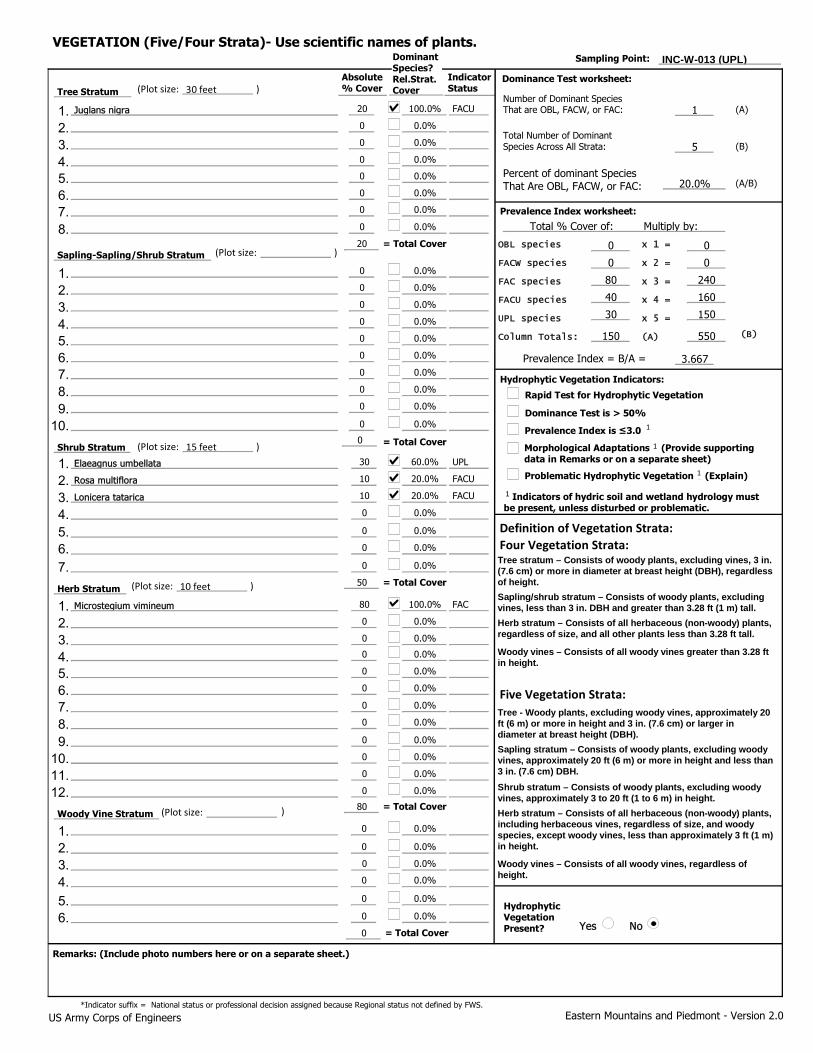
20
0
0
0
0
0
0
0
0
30
0
0
0
0
80
0
0
0
0
0
0
Yes No
1100.0% FACU
0.0%
50.0%
0.0%
20.0%
20
0.0%
0.0%
0.0%
0 0
0.0%
0 0
0.0%
80 240
40 160
50
30 150
60.0% UPL
150 550
0.0%
3.667
0.0%
0.0%
0.0%
100.0% FAC
0.0%
0.0%
0.0%
0.0%
80
0.0%
0.0%
0
0 0.0%
Eastern Mountains and Piedmont - Version 2.0
Woody Vine Stratum
(B)
= Total Cover
= Total Cover
Prevalence Index is ≤3.0
= Total Cover
Hydrophytic Vegetation Present?
US Army Corps of Engineers
Dominance Test worksheet:
Total Number of Dominant Species Across All Strata:
Prevalence Index worksheet:
Prevalence Index = B/A =
(A/B)
1 Indicators of hydric soil and wetland hydrology must be present, unless disturbed or problematic.
Problematic Hydrophytic Vegetation 1 (Explain)
Herb Stratum
= Total Cover
Number of Dominant Species That are OBL, FACW, or FAC:
Hydrophytic Vegetation Indicators:
Remarks: (Include photo numbers here or on a separate sheet.)
OBL species
FACW species
FAC species
FACU species
UPL species
Column Totals:
x 1 =
x 2 =
x 3 =
x 4 =
x 5 =
(A)
(A)
Percent of dominant Species That Are OBL, FACW, or FAC:
Total % Cover of: Multiply by:
(B)
Tree Stratum
Shrub Stratum
*Indicator suffix = National status or professional decision assigned because Regional status not defined by FWS.
Dominance Test is > 50%
0
0
0
0
0
0.0%
0.0%
0.0%
0.0%
0.0%
0
0
0
0
0
0.0%
0.0%
0.0%
0.0%
0
0.0%
= Total Cover
Sapling-Sapling/Shrub Stratum
1.
0
0
0.0%
0.0%
0
0
0.0%
0.0%
10
10
20.0% FACU
20.0% FACU
Definition of Vegetation Strata:
Tree - Woody plants, excluding woody vines, approximately 20 ft (6 m) or more in height and 3 in. (7.6 cm) or larger in diameter at breast height (DBH). Sapling stratum – Consists of woody plants, excluding woody vines, approximately 20 ft (6 m) or more in height and less than 3 in. (7.6 cm) DBH. Shrub stratum – Consists of woody plants, excluding woody vines, approximately 3 to 20 ft (1 to 6 m) in height. Herb stratum – Consists of all herbaceous (non-woody) plants, including herbaceous vines, regardless of size, and woody species, except woody vines, less than approximately 3 ft (1 m) in height.
Woody vines – Consists of all woody vines, regardless of height.
INC-W-013 (UPL)Sampling Point:
)
)
)
)
)
Morphological Adaptations 1 (Provide supporting data in Remarks or on a separate sheet)
Rapid Test for Hydrophytic Vegetation
0 0.0%
0
0
0.0%
0.0%
0 0.0%
VEGETATION (Five/Four Strata)- Use scientific names of plants.
0 0.0%
Tree stratum – Consists of woody plants, excluding vines, 3 in. (7.6 cm) or more in diameter at breast height (DBH), regardless of height. Sapling/shrub stratum – Consists of woody plants, excluding vines, less than 3 in. DBH and greater than 3.28 ft (1 m) tall. Herb stratum – Consists of all herbaceous (non-woody) plants, regardless of size, and all other plants less than 3.28 ft tall.
Woody vines – Consists of all woody vines greater than 3.28 ft in height.
Four Vegetation Strata:
Five Vegetation Strata:
Juglans nigra
(Plot size: 30 feet
(Plot size:
(Plot size: 15 feet
Elaeagnus umbellata
Rosa multiflora
Lonicera tatarica
(Plot size: 10 feet
Microstegium vimineum
(Plot size:
Dominant Species? Rel.Strat. Cover
Absolute % Cover
Indicator Status
1
1
1
1
2. 3. 4. 5. 6. 7. 8.
1. 2. 3. 4. 5. 6. 7. 8. 9.
10.
1. 2. 3. 4. 5. 6. 7.
1. 2. 3. 4. 5. 6. 7. 8. 9.
10. 11. 12.
1. 2. 3. 4. 5. 6.

INC-W-013 (UPL)Soil Sampling Point:
Profile Description: (Describe to the depth needed to document the indicator or confirm the absence of indicators.)
Depth (inches) Color (moist) Color (moist)
Matrix Redox Features
% Loc² Texture RemarksType%
Yes No
Hydric Soil Indicators: Indicators for Problematic Hydric Soils :
Restrictive Layer (if observed):
Hydric Soil Present?
Indicators of hydrophytic vegetation and wetland hydrology must be present,
unless disturbed or problematic.
Histosol (A1)
Histic Epipedon (A2)
Black Histic (A3)
Hydrogen Sulfide (A4)
Depleted Below Dark Surface (A11)
Thick Dark Surface (A12)
Sandy Muck Mineral (S1) (LRR N, MLRA 147, 148)
Sandy Gleyed Matrix (S4)
Sandy Redox (S5)
Stripped Matrix (S6)
Loamy Gleyed Matrix (F2)
Depleted Matrix (F3)
Redox Dark Surface (F6)
Depleted Dark Surface (F7)
Type:
Depth (inches):
Remarks:
US Army Corps of Engineers Eastern Mountains and Piedmont - Version 2.0
Dark Surface (S7)
Stratified Layers (A5)
Polyvalue Below Surface (S8) (MLRA 147,148)
Redox Depressions (F8)
1
1
3
3
Thin Dark Surface (S9) (MLRA 147, 148)
Iron-Manganese Masses (F12) (LRR N, MLRA 136)
Umbric Surface (F13) (MLRA 136, 122)
Piedmont Floodplain Soils (F19) (MLRA 148)
Type: C=Concentration. D=Depletion. RM=Reduced Matrix, CS=Covered or Coated Sand Grains ²Location: PL=Pore Lining. M=Matrix
2 cm Muck (A10) (LRR N)
12-20
0-12
10YR
10YR
5/3
4/4
100
100 Silt Loam
Clay Loam
Other (Explain in Remarks)
2 cm Muck (A10) (MLRA 147)
Piedmont Floodplain Soils (F19) (MLRA 136, 147)
Very Shallow Dark Surface (TF12)
Coast Prairie Redox (A16) (MLRA 147,148)
Red Parent Material (F21) (MLRA 127, 147)

WETLAND DETERMINATION DATA FORM - Eastern Mountains and Piedmont Region
Project/Site: Indiantown Gap National Cemetery Expansion Project City/County: East Hanover, Lebanon Co. Sampling Date: 08-Oct-20
Applicant/Owner: Mabbett & Associates, Inc. State: PA Sampling Point: INC-W-015 (PEM)
Investigator(s): Bridger Thompson Section, Township, Range: S T R
Landform (hillslope, terrace, etc.): Channel (active) Local relief (concave, convex, none): concave Slope: 10.5 % / 6.0 °
Subregion (LRR or MLRA): MLRA 147 in LRR S Lat.: 40.425976 Long.: -76.556871 Datum: NAD-83
Soil Map Unit Name: BkD-Berks channery silt loam, 15 to 25 percent slopes NWI classification: N/A
Are climatic/hydrologic conditions on the site typical for this time of year? Yes No (If no, explain in Remarks.)
Are Vegetation , Soil , or Hydrology significantly disturbed? Are "Normal Circumstances" present? Yes No
Are Vegetation , Soil , or Hydrology naturally problematic? (If needed, explain any answers in Remarks.)
Summary of Findings - Attach site map showing sampling point locations, transects, important features, etc.
Yes No
Yes No
Yes No
Hydric Soil Present?
Hydrophytic Vegetation Present?
Wetland Hydrology Present?
Yes No Is the Sampled Area within a Wetland?
Remarks:
Wetland data point collected to document the existing conditions. The data point is located in a a natural gully within a transmission line ROW that contains a small intermittent channel. The wetland is associated with a narrow floodplain for the channel and toe-of-slope ground water discharge. The wetland boundary is defined by the topography of the floodplain and the saturated soil conditions.
Hydrology
Surface Water (A1)
High Water Table (A2)
Saturation (A3)
Water Marks (B1)
Sediment Deposits (B2)
Drift deposits (B3)
Algal Mat or Crust (B4)
Water-Stained Leaves (B9)
Dry Season Water Table (C2)
True Aquatic Plants (B14)
Hydrogen Sulfide Odor (C1)
Oxidized Rhizospheres along Living Roots (C3)
Presence of Reduced Iron (C4)
Recent Iron Reduction in Tilled Soils (C6)
Other (Explain in Remarks)
Drainage Patterns (B10)
Aquatic Fauna (B13)
Saturation Visible on Aerial Imagery (C9)
Crayfish Burrows (C8)
Moss Trim Lines (B16)
Primary Indicators (minimum of one required; check all that apply)
Wetland Hydrology Indicators: Secondary Indicators (minimum of two required)
Iron Deposits (B5)
Surface Soil Cracks (B6)
Stunted or Stressed Plants (D1)
Inundation Visible on Aerial Imagery (B7)
Sparsely Vegetated Concave Surface (B8)
Thin Muck Surface (C7)
Shallow Aquitard (D3)
FAC-neutral Test (D5)
Geomorphic Position (D2)
Microtopographic Relief (D4)
0
Yes No
Yes No
Yes No Yes No
Field Observations:
Surface Water Present?
Water Table Present?
Saturation Present? (includes capillary fringe)
Depth (inches):
Depth (inches):
Depth (inches): Wetland Hydrology Present?
Describe Recorded Data (stream gauge, monitoring well, aerial photos, previous inspections), if available:
Remarks:
The region is experiencing very dry and drought like conditions.
Eastern Mountains and Piedmont - Version 2.0 US Army Corps of Engineers

0
0
0
0
0
0
0
0
0
0
0
0
0
0
80
10
10
0
0
0
0
Yes No
10.0%
0.0%
10.0%
0.0%
100.0%
0
0.0%
0.0%
0.0%
0 0
0.0%
10 20
0.0%
80 240
10 40
0
0 0
0.0%
100 300
0.0%
3.000
0.0%
0.0%
0.0%
80.0% FAC
10.0% FACW
10.0% FACU
0.0%
0.0%
100
0.0%
0.0%
0
0 0.0%
Eastern Mountains and Piedmont - Version 2.0
Woody Vine Stratum
(B)
= Total Cover
= Total Cover
Prevalence Index is ≤3.0
= Total Cover
Hydrophytic Vegetation Present?
US Army Corps of Engineers
Dominance Test worksheet:
Total Number of Dominant Species Across All Strata:
Prevalence Index worksheet:
Prevalence Index = B/A =
(A/B)
1 Indicators of hydric soil and wetland hydrology must be present, unless disturbed or problematic.
Problematic Hydrophytic Vegetation 1 (Explain)
Herb Stratum
= Total Cover
Number of Dominant Species That are OBL, FACW, or FAC:
Hydrophytic Vegetation Indicators:
Remarks: (Include photo numbers here or on a separate sheet.)
OBL species
FACW species
FAC species
FACU species
UPL species
Column Totals:
x 1 =
x 2 =
x 3 =
x 4 =
x 5 =
(A)
(A)
Percent of dominant Species That Are OBL, FACW, or FAC:
Total % Cover of: Multiply by:
(B)
Tree Stratum
Shrub Stratum
*Indicator suffix = National status or professional decision assigned because Regional status not defined by FWS.
Dominance Test is > 50%
0
0
0
0
0
0.0%
0.0%
0.0%
0.0%
0.0%
0
0
0
0
0
0.0%
0.0%
0.0%
0.0%
0
0.0%
= Total Cover
Sapling-Sapling/Shrub Stratum
1.
0
0
0.0%
0.0%
0
0
0.0%
0.0%
0
0
0.0%
0.0%
Definition of Vegetation Strata:
Tree - Woody plants, excluding woody vines, approximately 20 ft (6 m) or more in height and 3 in. (7.6 cm) or larger in diameter at breast height (DBH). Sapling stratum – Consists of woody plants, excluding woody vines, approximately 20 ft (6 m) or more in height and less than 3 in. (7.6 cm) DBH. Shrub stratum – Consists of woody plants, excluding woody vines, approximately 3 to 20 ft (1 to 6 m) in height. Herb stratum – Consists of all herbaceous (non-woody) plants, including herbaceous vines, regardless of size, and woody species, except woody vines, less than approximately 3 ft (1 m) in height.
Woody vines – Consists of all woody vines, regardless of height.
INC-W-015 (PEM)Sampling Point:
)
)
)
)
)
Morphological Adaptations 1 (Provide supporting data in Remarks or on a separate sheet)
Rapid Test for Hydrophytic Vegetation
0 0.0%
0
0
0.0%
0.0%
0 0.0%
VEGETATION (Five/Four Strata)- Use scientific names of plants.
0 0.0%
Tree stratum – Consists of woody plants, excluding vines, 3 in. (7.6 cm) or more in diameter at breast height (DBH), regardless of height. Sapling/shrub stratum – Consists of woody plants, excluding vines, less than 3 in. DBH and greater than 3.28 ft (1 m) tall. Herb stratum – Consists of all herbaceous (non-woody) plants, regardless of size, and all other plants less than 3.28 ft tall.
Woody vines – Consists of all woody vines greater than 3.28 ft in height.
Four Vegetation Strata:
Five Vegetation Strata:
(Plot size:
(Plot size:
(Plot size:
(Plot size: 10 feet
Microstegium vimineum
Onoclea sensibilis
Festuca rubra
(Plot size:
Dominant Species? Rel.Strat. Cover
Absolute % Cover
Indicator Status
1
1
1
1
2. 3. 4. 5. 6. 7. 8.
1. 2. 3. 4. 5. 6. 7. 8. 9.
10.
1. 2. 3. 4. 5. 6. 7.
1. 2. 3. 4. 5. 6. 7. 8. 9.
10. 11. 12.
1. 2. 3. 4. 5. 6.

INC-W-015 (PEM)Soil Sampling Point:
Profile Description: (Describe to the depth needed to document the indicator or confirm the absence of indicators.)
Depth (inches) Color (moist) Color (moist)
Matrix Redox Features
% Loc² Texture RemarksType%
Yes No
Hydric Soil Indicators: Indicators for Problematic Hydric Soils :
Restrictive Layer (if observed):
Hydric Soil Present?
Indicators of hydrophytic vegetation and wetland hydrology must be present,
unless disturbed or problematic.
Histosol (A1)
Histic Epipedon (A2)
Black Histic (A3)
Hydrogen Sulfide (A4)
Depleted Below Dark Surface (A11)
Thick Dark Surface (A12)
Sandy Muck Mineral (S1) (LRR N, MLRA 147, 148)
Sandy Gleyed Matrix (S4)
Sandy Redox (S5)
Stripped Matrix (S6)
Loamy Gleyed Matrix (F2)
Depleted Matrix (F3)
Redox Dark Surface (F6)
Depleted Dark Surface (F7)
Type:
Depth (inches):
Remarks:
US Army Corps of Engineers Eastern Mountains and Piedmont - Version 2.0
Dark Surface (S7)
Stratified Layers (A5)
Polyvalue Below Surface (S8) (MLRA 147,148)
Redox Depressions (F8)
1
1
3
3
Thin Dark Surface (S9) (MLRA 147, 148)
Iron-Manganese Masses (F12) (LRR N, MLRA 136)
Umbric Surface (F13) (MLRA 136, 122)
Piedmont Floodplain Soils (F19) (MLRA 148)
Type: C=Concentration. D=Depletion. RM=Reduced Matrix, CS=Covered or Coated Sand Grains ²Location: PL=Pore Lining. M=Matrix
2 cm Muck (A10) (LRR N)
14-20
6-14
0-6
10YR
10YR
10YR
5/2
4/2
4/3
90
90
100
5YR
5YR
5/6
5/6 10
10 C
C M
M
Silt Loam
Silty Clay
Clay Loam
Other (Explain in Remarks)
2 cm Muck (A10) (MLRA 147)
Piedmont Floodplain Soils (F19) (MLRA 136, 147)
Very Shallow Dark Surface (TF12)
Coast Prairie Redox (A16) (MLRA 147,148)
Red Parent Material (F21) (MLRA 127, 147)

WETLAND DETERMINATION DATA FORM - Eastern Mountains and Piedmont Region
Project/Site: Indiantown Gap National Cemetery Expansion Project City/County: East Hanover, Lebanon Co. Sampling Date: 08-Oct-20
Applicant/Owner: Mabbett & Associates, Inc. State: PA Sampling Point: INC_W-015 (UPL)
Investigator(s): Bridger Thompson Section, Township, Range: S T R
Landform (hillslope, terrace, etc.): Toeslope Local relief (concave, convex, none): concave Slope: 36.4 % / 20.0 °
Subregion (LRR or MLRA): MLRA 147 in LRR S Lat.: 40.426018 Long.: -76.556949 Datum: NAD-83
Soil Map Unit Name: BkD-Berks channery silt loam, 15 to 25 percent slopes NWI classification: N/A
Are climatic/hydrologic conditions on the site typical for this time of year? Yes No (If no, explain in Remarks.)
Are Vegetation , Soil , or Hydrology significantly disturbed? Are "Normal Circumstances" present? Yes No
Are Vegetation , Soil , or Hydrology naturally problematic? (If needed, explain any answers in Remarks.)
Summary of Findings - Attach site map showing sampling point locations, transects, important features, etc.
Yes No
Yes No
Yes No
Hydric Soil Present?
Hydrophytic Vegetation Present?
Wetland Hydrology Present?
Yes No Is the Sampled Area within a Wetland?
Remarks:
Upland data point collected to verify the wetland boundary. The data point is located on a steep hillslope adjacent to the wetland in periodically maintained transmission line ROW.
Hydrology
Surface Water (A1)
High Water Table (A2)
Saturation (A3)
Water Marks (B1)
Sediment Deposits (B2)
Drift deposits (B3)
Algal Mat or Crust (B4)
Water-Stained Leaves (B9)
Dry Season Water Table (C2)
True Aquatic Plants (B14)
Hydrogen Sulfide Odor (C1)
Oxidized Rhizospheres along Living Roots (C3)
Presence of Reduced Iron (C4)
Recent Iron Reduction in Tilled Soils (C6)
Other (Explain in Remarks)
Drainage Patterns (B10)
Aquatic Fauna (B13)
Saturation Visible on Aerial Imagery (C9)
Crayfish Burrows (C8)
Moss Trim Lines (B16)
Primary Indicators (minimum of one required; check all that apply)
Wetland Hydrology Indicators: Secondary Indicators (minimum of two required)
Iron Deposits (B5)
Surface Soil Cracks (B6)
Stunted or Stressed Plants (D1)
Inundation Visible on Aerial Imagery (B7)
Sparsely Vegetated Concave Surface (B8)
Thin Muck Surface (C7)
Shallow Aquitard (D3)
FAC-neutral Test (D5)
Geomorphic Position (D2)
Microtopographic Relief (D4)
Yes No
Yes No
Yes No Yes No
Field Observations:
Surface Water Present?
Water Table Present?
Saturation Present? (includes capillary fringe)
Depth (inches):
Depth (inches):
Depth (inches): Wetland Hydrology Present?
Describe Recorded Data (stream gauge, monitoring well, aerial photos, previous inspections), if available:
Remarks:
The region is experiencing very dry and drought like conditions.
Eastern Mountains and Piedmont - Version 2.0 US Army Corps of Engineers

0
0
0
0
0
0
0
0
0
10
0
0
0
0
60
10
20
10
0
0
0
Yes No
20.0%
0.0%
40.0%
0.0%
50.0%
0
0.0%
0.0%
0.0%
0 0
0.0%
0 0
0.0%
70 210
40 160
20
0 0
50.0% FAC
110 370
0.0%
3.364
0.0%
0.0%
0.0%
60.0% FAC
10.0% FACU
20.0% FACU
10.0%
0.0%
100
0.0%
0.0%
0
0 0.0%
Eastern Mountains and Piedmont - Version 2.0
Woody Vine Stratum
(B)
= Total Cover
= Total Cover
Prevalence Index is ≤3.0
= Total Cover
Hydrophytic Vegetation Present?
US Army Corps of Engineers
Dominance Test worksheet:
Total Number of Dominant Species Across All Strata:
Prevalence Index worksheet:
Prevalence Index = B/A =
(A/B)
1 Indicators of hydric soil and wetland hydrology must be present, unless disturbed or problematic.
Problematic Hydrophytic Vegetation 1 (Explain)
Herb Stratum
= Total Cover
Number of Dominant Species That are OBL, FACW, or FAC:
Hydrophytic Vegetation Indicators:
Remarks: (Include photo numbers here or on a separate sheet.)
OBL species
FACW species
FAC species
FACU species
UPL species
Column Totals:
x 1 =
x 2 =
x 3 =
x 4 =
x 5 =
(A)
(A)
Percent of dominant Species That Are OBL, FACW, or FAC:
Total % Cover of: Multiply by:
(B)
Tree Stratum
Shrub Stratum
*Indicator suffix = National status or professional decision assigned because Regional status not defined by FWS.
Dominance Test is > 50%
0
0
0
0
0
0.0%
0.0%
0.0%
0.0%
0.0%
0
0
0
0
0
0.0%
0.0%
0.0%
0.0%
0
0.0%
= Total Cover
Sapling-Sapling/Shrub Stratum
1.
0
0
0.0%
0.0%
0
0
0.0%
0.0%
10
0
50.0% FACU
0.0%
Definition of Vegetation Strata:
Tree - Woody plants, excluding woody vines, approximately 20 ft (6 m) or more in height and 3 in. (7.6 cm) or larger in diameter at breast height (DBH). Sapling stratum – Consists of woody plants, excluding woody vines, approximately 20 ft (6 m) or more in height and less than 3 in. (7.6 cm) DBH. Shrub stratum – Consists of woody plants, excluding woody vines, approximately 3 to 20 ft (1 to 6 m) in height. Herb stratum – Consists of all herbaceous (non-woody) plants, including herbaceous vines, regardless of size, and woody species, except woody vines, less than approximately 3 ft (1 m) in height.
Woody vines – Consists of all woody vines, regardless of height.
INC_W-015 (UPL)Sampling Point:
)
)
)
)
)
Morphological Adaptations 1 (Provide supporting data in Remarks or on a separate sheet)
Rapid Test for Hydrophytic Vegetation
0 0.0%
0
0
0.0%
0.0%
0 0.0%
VEGETATION (Five/Four Strata)- Use scientific names of plants.
0 0.0%
Tree stratum – Consists of woody plants, excluding vines, 3 in. (7.6 cm) or more in diameter at breast height (DBH), regardless of height. Sapling/shrub stratum – Consists of woody plants, excluding vines, less than 3 in. DBH and greater than 3.28 ft (1 m) tall. Herb stratum – Consists of all herbaceous (non-woody) plants, regardless of size, and all other plants less than 3.28 ft tall.
Woody vines – Consists of all woody vines greater than 3.28 ft in height.
Four Vegetation Strata:
Five Vegetation Strata:
(Plot size:
(Plot size:
(Plot size: 15 feet
Rubus idaeus
Lonicera japonica
(Plot size: 10 feet
Microstegium vimineum
Solidago canadensis
Festuca rubra
(Plot size:
Dominant Species? Rel.Strat. Cover
Absolute % Cover
Indicator Status
1
1
1
1
2. 3. 4. 5. 6. 7. 8.
1. 2. 3. 4. 5. 6. 7. 8. 9.
10.
1. 2. 3. 4. 5. 6. 7.
1. 2. 3. 4. 5. 6. 7. 8. 9.
10. 11. 12.
1. 2. 3. 4. 5. 6.
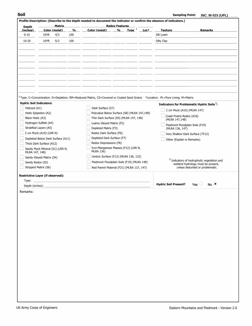
INC_W-015 (UPL)Soil Sampling Point:
Profile Description: (Describe to the depth needed to document the indicator or confirm the absence of indicators.)
Depth (inches) Color (moist) Color (moist)
Matrix Redox Features
% Loc² Texture RemarksType%
Yes No
Hydric Soil Indicators: Indicators for Problematic Hydric Soils :
Restrictive Layer (if observed):
Hydric Soil Present?
Indicators of hydrophytic vegetation and wetland hydrology must be present,
unless disturbed or problematic.
Histosol (A1)
Histic Epipedon (A2)
Black Histic (A3)
Hydrogen Sulfide (A4)
Depleted Below Dark Surface (A11)
Thick Dark Surface (A12)
Sandy Muck Mineral (S1) (LRR N, MLRA 147, 148)
Sandy Gleyed Matrix (S4)
Sandy Redox (S5)
Stripped Matrix (S6)
Loamy Gleyed Matrix (F2)
Depleted Matrix (F3)
Redox Dark Surface (F6)
Depleted Dark Surface (F7)
Type:
Depth (inches):
Remarks:
US Army Corps of Engineers Eastern Mountains and Piedmont - Version 2.0
Dark Surface (S7)
Stratified Layers (A5)
Polyvalue Below Surface (S8) (MLRA 147,148)
Redox Depressions (F8)
1
1
3
3
Thin Dark Surface (S9) (MLRA 147, 148)
Iron-Manganese Masses (F12) (LRR N, MLRA 136)
Umbric Surface (F13) (MLRA 136, 122)
Piedmont Floodplain Soils (F19) (MLRA 148)
Type: C=Concentration. D=Depletion. RM=Reduced Matrix, CS=Covered or Coated Sand Grains ²Location: PL=Pore Lining. M=Matrix
2 cm Muck (A10) (LRR N)
10-20
0-10
10YR
10YR
5/3
4/3
100
100 Silt Loam
Silty Clay
Other (Explain in Remarks)
2 cm Muck (A10) (MLRA 147)
Piedmont Floodplain Soils (F19) (MLRA 136, 147)
Very Shallow Dark Surface (TF12)
Coast Prairie Redox (A16) (MLRA 147,148)
Red Parent Material (F21) (MLRA 127, 147)

WETLAND DETERMINATION DATA FORM - Eastern Mountains and Piedmont Region
Project/Site: Indiantown Gap National Cemetery Expansion Project City/County: East Hanover, Lebanon Co. Sampling Date: 28-Apr-21
Applicant/Owner: Mabbett & Associates, Inc. State: PA Sampling Point: INC-W-019 (PEM)
Investigator(s): Bridger Thompson Section, Township, Range: S T R
Landform (hillslope, terrace, etc.): Floodplain Local relief (concave, convex, none): concave Slope: 8.7 % / 5.0 °
Subregion (LRR or MLRA): MLRA 147 in LRR S Lat.: 40.421396° Long.: -76.557350° Datum: NAD-83
Soil Map Unit Name: WeD-Weikert channery silt loam, 15 to 25 percent slopes NWI classification: R4SBC
Are climatic/hydrologic conditions on the site typical for this time of year? Yes No (If no, explain in Remarks.)
Are Vegetation , Soil , or Hydrology significantly disturbed? Are "Normal Circumstances" present? Yes No
Are Vegetation , Soil , or Hydrology naturally problematic? (If needed, explain any answers in Remarks.)
Summary of Findings - Attach site map showing sampling point locations, transects, important features, etc.
Yes No
Yes No
Yes No
Hydric Soil Present?
Hydrophytic Vegetation Present?
Wetland Hydrology Present?
Yes No Is the Sampled Area within a Wetland?
Remarks:
Wetland data point collected to document the existing conditions. The data point is located in and along the floodplain of a small perennial watercourse. The wetland boundary follows the saturated soils conditions and tussock sedge.
Hydrology
Surface Water (A1)
High Water Table (A2)
Saturation (A3)
Water Marks (B1)
Sediment Deposits (B2)
Drift deposits (B3)
Algal Mat or Crust (B4)
Water-Stained Leaves (B9)
Dry Season Water Table (C2)
True Aquatic Plants (B14)
Hydrogen Sulfide Odor (C1)
Oxidized Rhizospheres along Living Roots (C3)
Presence of Reduced Iron (C4)
Recent Iron Reduction in Tilled Soils (C6)
Other (Explain in Remarks)
Drainage Patterns (B10)
Aquatic Fauna (B13)
Saturation Visible on Aerial Imagery (C9)
Crayfish Burrows (C8)
Moss Trim Lines (B16)
Primary Indicators (minimum of one required; check all that apply)
Wetland Hydrology Indicators: Secondary Indicators (minimum of two required)
Iron Deposits (B5)
Surface Soil Cracks (B6)
Stunted or Stressed Plants (D1)
Inundation Visible on Aerial Imagery (B7)
Sparsely Vegetated Concave Surface (B8)
Thin Muck Surface (C7)
Shallow Aquitard (D3)
FAC-neutral Test (D5)
Geomorphic Position (D2)
Microtopographic Relief (D4)
0
Yes No
Yes No
Yes No Yes No
Field Observations:
Surface Water Present?
Water Table Present?
Saturation Present? (includes capillary fringe)
Depth (inches):
Depth (inches):
Depth (inches): Wetland Hydrology Present?
Describe Recorded Data (stream gauge, monitoring well, aerial photos, previous inspections), if available:
Remarks:
Eastern Mountains and Piedmont - Version 2.0 US Army Corps of Engineers

0
0
0
0
0
0
0
0
0
10
0
0
0
0
30
30
0
0
0
0
0
Yes No
30.0%
0.0%
40.0%
0.0%
75.0%
0
0.0%
0.0%
0.0%
30 30
0.0%
0 0
0.0%
40 120
10 40
20
0 0
50.0% FAC
80 190
0.0%
2.375
0.0%
0.0%
0.0%
50.0% OBL
50.0% FAC
0.0%
0.0%
0.0%
60
0.0%
0.0%
0
0 0.0%
Eastern Mountains and Piedmont - Version 2.0
Woody Vine Stratum
(B)
= Total Cover
= Total Cover
Prevalence Index is ≤3.0
= Total Cover
Hydrophytic Vegetation Present?
US Army Corps of Engineers
Dominance Test worksheet:
Total Number of Dominant Species Across All Strata:
Prevalence Index worksheet:
Prevalence Index = B/A =
(A/B)
1 Indicators of hydric soil and wetland hydrology must be present, unless disturbed or problematic.
Problematic Hydrophytic Vegetation 1 (Explain)
Herb Stratum
= Total Cover
Number of Dominant Species That are OBL, FACW, or FAC:
Hydrophytic Vegetation Indicators:
Remarks: (Include photo numbers here or on a separate sheet.)
OBL species
FACW species
FAC species
FACU species
UPL species
Column Totals:
x 1 =
x 2 =
x 3 =
x 4 =
x 5 =
(A)
(A)
Percent of dominant Species That Are OBL, FACW, or FAC:
Total % Cover of: Multiply by:
(B)
Tree Stratum
Shrub Stratum
*Indicator suffix = National status or professional decision assigned because Regional status not defined by FWS.
Dominance Test is > 50%
0
0
0
0
0
0.0%
0.0%
0.0%
0.0%
0.0%
0
0
0
0
0
0.0%
0.0%
0.0%
0.0%
0
0.0%
= Total Cover
Sapling-Sapling/Shrub Stratum
1.
0
0
0.0%
0.0%
0
0
0.0%
0.0%
10
0
50.0% FACU
0.0%
Definition of Vegetation Strata:
Tree - Woody plants, excluding woody vines, approximately 20 ft (6 m) or more in height and 3 in. (7.6 cm) or larger in diameter at breast height (DBH). Sapling stratum – Consists of woody plants, excluding woody vines, approximately 20 ft (6 m) or more in height and less than 3 in. (7.6 cm) DBH. Shrub stratum – Consists of woody plants, excluding woody vines, approximately 3 to 20 ft (1 to 6 m) in height. Herb stratum – Consists of all herbaceous (non-woody) plants, including herbaceous vines, regardless of size, and woody species, except woody vines, less than approximately 3 ft (1 m) in height.
Woody vines – Consists of all woody vines, regardless of height.
INC-W-019 (PEM)Sampling Point:
)
)
)
)
)
Morphological Adaptations 1 (Provide supporting data in Remarks or on a separate sheet)
Rapid Test for Hydrophytic Vegetation
0 0.0%
0
0
0.0%
0.0%
0 0.0%
VEGETATION (Five/Four Strata)- Use scientific names of plants.
0 0.0%
Tree stratum – Consists of woody plants, excluding vines, 3 in. (7.6 cm) or more in diameter at breast height (DBH), regardless of height. Sapling/shrub stratum – Consists of woody plants, excluding vines, less than 3 in. DBH and greater than 3.28 ft (1 m) tall. Herb stratum – Consists of all herbaceous (non-woody) plants, regardless of size, and all other plants less than 3.28 ft tall.
Woody vines – Consists of all woody vines greater than 3.28 ft in height.
Four Vegetation Strata:
Five Vegetation Strata:
(Plot size:
(Plot size:
(Plot size: 15 feet
Lindera benzoin
Rosa multiflora
(Plot size: 10 feet
Carex stricta
Microstegium vimineum
(Plot size:
Dominant Species? Rel.Strat. Cover
Absolute % Cover
Indicator Status
1
1
1
1
2. 3. 4. 5. 6. 7. 8.
1. 2. 3. 4. 5. 6. 7. 8. 9.
10.
1. 2. 3. 4. 5. 6. 7.
1. 2. 3. 4. 5. 6. 7. 8. 9.
10. 11. 12.
1. 2. 3. 4. 5. 6.

INC-W-019 (PEM)Soil Sampling Point:
Profile Description: (Describe to the depth needed to document the indicator or confirm the absence of indicators.)
Depth (inches) Color (moist) Color (moist)
Matrix Redox Features
% Loc² Texture RemarksType%
Yes No
Hydric Soil Indicators: Indicators for Problematic Hydric Soils :
Restrictive Layer (if observed):
Hydric Soil Present?
Indicators of hydrophytic vegetation and wetland hydrology must be present,
unless disturbed or problematic.
Histosol (A1)
Histic Epipedon (A2)
Black Histic (A3)
Hydrogen Sulfide (A4)
Depleted Below Dark Surface (A11)
Thick Dark Surface (A12)
Sandy Muck Mineral (S1) (LRR N, MLRA 147, 148)
Sandy Gleyed Matrix (S4)
Sandy Redox (S5)
Stripped Matrix (S6)
Loamy Gleyed Matrix (F2)
Depleted Matrix (F3)
Redox Dark Surface (F6)
Depleted Dark Surface (F7)
Type:
Depth (inches):
Remarks:
US Army Corps of Engineers Eastern Mountains and Piedmont - Version 2.0
Dark Surface (S7)
Stratified Layers (A5)
Polyvalue Below Surface (S8) (MLRA 147,148)
Redox Depressions (F8)
1
1
3
3
Thin Dark Surface (S9) (MLRA 147, 148)
Iron-Manganese Masses (F12) (LRR N, MLRA 136)
Umbric Surface (F13) (MLRA 136, 122)
Piedmont Floodplain Soils (F19) (MLRA 148)
Type: C=Concentration. D=Depletion. RM=Reduced Matrix, CS=Covered or Coated Sand Grains ²Location: PL=Pore Lining. M=Matrix
2 cm Muck (A10) (LRR N)
4-20
0-4
5GY
10YR
4/1
4/4
80
100
2.5YR 5/8 20 C M
Silt Loam
Silt Loam
Other (Explain in Remarks)
2 cm Muck (A10) (MLRA 147)
Piedmont Floodplain Soils (F19) (MLRA 136, 147)
Very Shallow Dark Surface (TF12)
Coast Prairie Redox (A16) (MLRA 147,148)
Red Parent Material (F21) (MLRA 127, 147)

WETLAND DETERMINATION DATA FORM - Eastern Mountains and Piedmont Region
Project/Site: Indiantown Gap National Cemetery Expansion Project City/County: East Hanover, Lebanon Co. Sampling Date: 28-Apr-21
Applicant/Owner: Mabbett & Associates, Inc. State: PA Sampling Point: INC-W-019 (UPL)
Investigator(s): Bridger Thompson Section, Township, Range: S T R
Landform (hillslope, terrace, etc.): Hillside Local relief (concave, convex, none): convex Slope: 8.7 % / 5.0 °
Subregion (LRR or MLRA): MLRA 147 in LRR S Lat.: 40.421467° Long.: -76.557340° Datum: NAD-83
Soil Map Unit Name: WeD-Weikert channery silt loam, 15 to 25 percent slopes NWI classification: N/A
Are climatic/hydrologic conditions on the site typical for this time of year? Yes No (If no, explain in Remarks.)
Are Vegetation , Soil , or Hydrology significantly disturbed? Are "Normal Circumstances" present? Yes No
Are Vegetation , Soil , or Hydrology naturally problematic? (If needed, explain any answers in Remarks.)
Summary of Findings - Attach site map showing sampling point locations, transects, important features, etc.
Yes No
Yes No
Yes No
Hydric Soil Present?
Hydrophytic Vegetation Present?
Wetland Hydrology Present?
Yes No Is the Sampled Area within a Wetland?
Remarks:
Upland data point collected to verify the wetland boundary. The data point is located adjacent to the wetland in a in a wooded /shrubby lot upslope of the floodplain.
Hydrology
Surface Water (A1)
High Water Table (A2)
Saturation (A3)
Water Marks (B1)
Sediment Deposits (B2)
Drift deposits (B3)
Algal Mat or Crust (B4)
Water-Stained Leaves (B9)
Dry Season Water Table (C2)
True Aquatic Plants (B14)
Hydrogen Sulfide Odor (C1)
Oxidized Rhizospheres along Living Roots (C3)
Presence of Reduced Iron (C4)
Recent Iron Reduction in Tilled Soils (C6)
Other (Explain in Remarks)
Drainage Patterns (B10)
Aquatic Fauna (B13)
Saturation Visible on Aerial Imagery (C9)
Crayfish Burrows (C8)
Moss Trim Lines (B16)
Primary Indicators (minimum of one required; check all that apply)
Wetland Hydrology Indicators: Secondary Indicators (minimum of two required)
Iron Deposits (B5)
Surface Soil Cracks (B6)
Stunted or Stressed Plants (D1)
Inundation Visible on Aerial Imagery (B7)
Sparsely Vegetated Concave Surface (B8)
Thin Muck Surface (C7)
Shallow Aquitard (D3)
FAC-neutral Test (D5)
Geomorphic Position (D2)
Microtopographic Relief (D4)
Yes No
Yes No
Yes No Yes No
Field Observations:
Surface Water Present?
Water Table Present?
Saturation Present? (includes capillary fringe)
Depth (inches):
Depth (inches):
Depth (inches): Wetland Hydrology Present?
Describe Recorded Data (stream gauge, monitoring well, aerial photos, previous inspections), if available:
Remarks:
No evidence of hydrology.
Eastern Mountains and Piedmont - Version 2.0 US Army Corps of Engineers

0
0
0
0
0
0
0
0
0
20
0
0
0
0
50
20
0
0
0
0
0
Yes No
10.0%
0.0%
40.0%
0.0%
25.0%
0
0.0%
0.0%
0.0%
0 0
0.0%
0 0
0.0%
50 150
40 160
30
10 50
66.7% FACU
100 360
0.0%
3.600
0.0%
0.0%
0.0%
71.4% FAC
28.6% FACU
0.0%
0.0%
0.0%
70
0.0%
0.0%
0
0 0.0%
Eastern Mountains and Piedmont - Version 2.0
Woody Vine Stratum
(B)
= Total Cover
= Total Cover
Prevalence Index is ≤3.0
= Total Cover
Hydrophytic Vegetation Present?
US Army Corps of Engineers
Dominance Test worksheet:
Total Number of Dominant Species Across All Strata:
Prevalence Index worksheet:
Prevalence Index = B/A =
(A/B)
1 Indicators of hydric soil and wetland hydrology must be present, unless disturbed or problematic.
Problematic Hydrophytic Vegetation 1 (Explain)
Herb Stratum
= Total Cover
Number of Dominant Species That are OBL, FACW, or FAC:
Hydrophytic Vegetation Indicators:
Remarks: (Include photo numbers here or on a separate sheet.)
OBL species
FACW species
FAC species
FACU species
UPL species
Column Totals:
x 1 =
x 2 =
x 3 =
x 4 =
x 5 =
(A)
(A)
Percent of dominant Species That Are OBL, FACW, or FAC:
Total % Cover of: Multiply by:
(B)
Tree Stratum
Shrub Stratum
*Indicator suffix = National status or professional decision assigned because Regional status not defined by FWS.
Dominance Test is > 50%
0
0
0
0
0
0.0%
0.0%
0.0%
0.0%
0.0%
0
0
0
0
0
0.0%
0.0%
0.0%
0.0%
0
0.0%
= Total Cover
Sapling-Sapling/Shrub Stratum
1.
0
0
0.0%
0.0%
0
0
0.0%
0.0%
10
0
33.3% UPL
0.0%
Definition of Vegetation Strata:
Tree - Woody plants, excluding woody vines, approximately 20 ft (6 m) or more in height and 3 in. (7.6 cm) or larger in diameter at breast height (DBH). Sapling stratum – Consists of woody plants, excluding woody vines, approximately 20 ft (6 m) or more in height and less than 3 in. (7.6 cm) DBH. Shrub stratum – Consists of woody plants, excluding woody vines, approximately 3 to 20 ft (1 to 6 m) in height. Herb stratum – Consists of all herbaceous (non-woody) plants, including herbaceous vines, regardless of size, and woody species, except woody vines, less than approximately 3 ft (1 m) in height.
Woody vines – Consists of all woody vines, regardless of height.
INC-W-019 (UPL)Sampling Point:
)
)
)
)
)
Morphological Adaptations 1 (Provide supporting data in Remarks or on a separate sheet)
Rapid Test for Hydrophytic Vegetation
0 0.0%
0
0
0.0%
0.0%
0 0.0%
VEGETATION (Five/Four Strata)- Use scientific names of plants.
0 0.0%
Tree stratum – Consists of woody plants, excluding vines, 3 in. (7.6 cm) or more in diameter at breast height (DBH), regardless of height. Sapling/shrub stratum – Consists of woody plants, excluding vines, less than 3 in. DBH and greater than 3.28 ft (1 m) tall. Herb stratum – Consists of all herbaceous (non-woody) plants, regardless of size, and all other plants less than 3.28 ft tall.
Woody vines – Consists of all woody vines greater than 3.28 ft in height.
Four Vegetation Strata:
Five Vegetation Strata:
(Plot size:
(Plot size:
(Plot size: 15 feet
Rosa multiflora
Elaeagnus umbellata
(Plot size: 10 feet
Microstegium vimineum
Alliaria petiolata
(Plot size:
Dominant Species? Rel.Strat. Cover
Absolute % Cover
Indicator Status
1
1
1
1
2. 3. 4. 5. 6. 7. 8.
1. 2. 3. 4. 5. 6. 7. 8. 9.
10.
1. 2. 3. 4. 5. 6. 7.
1. 2. 3. 4. 5. 6. 7. 8. 9.
10. 11. 12.
1. 2. 3. 4. 5. 6.

INC-W-019 (UPL)Soil Sampling Point:
Profile Description: (Describe to the depth needed to document the indicator or confirm the absence of indicators.)
Depth (inches) Color (moist) Color (moist)
Matrix Redox Features
% Loc² Texture RemarksType%
Yes No
Hydric Soil Indicators: Indicators for Problematic Hydric Soils :
Restrictive Layer (if observed):
Hydric Soil Present?
Indicators of hydrophytic vegetation and wetland hydrology must be present,
unless disturbed or problematic.
Histosol (A1)
Histic Epipedon (A2)
Black Histic (A3)
Hydrogen Sulfide (A4)
Depleted Below Dark Surface (A11)
Thick Dark Surface (A12)
Sandy Muck Mineral (S1) (LRR N, MLRA 147, 148)
Sandy Gleyed Matrix (S4)
Sandy Redox (S5)
Stripped Matrix (S6)
Loamy Gleyed Matrix (F2)
Depleted Matrix (F3)
Redox Dark Surface (F6)
Depleted Dark Surface (F7)
Type:
Depth (inches):
Remarks:
US Army Corps of Engineers Eastern Mountains and Piedmont - Version 2.0
Dark Surface (S7)
Stratified Layers (A5)
Polyvalue Below Surface (S8) (MLRA 147,148)
Redox Depressions (F8)
1
1
3
3
Thin Dark Surface (S9) (MLRA 147, 148)
Iron-Manganese Masses (F12) (LRR N, MLRA 136)
Umbric Surface (F13) (MLRA 136, 122)
Piedmont Floodplain Soils (F19) (MLRA 148)
Type: C=Concentration. D=Depletion. RM=Reduced Matrix, CS=Covered or Coated Sand Grains ²Location: PL=Pore Lining. M=Matrix
2 cm Muck (A10) (LRR N)
4-20
0-4
10YR
10YR
5/4
4/4
100
100 Silt Loam
Silty Clay
Other (Explain in Remarks)
2 cm Muck (A10) (MLRA 147)
Piedmont Floodplain Soils (F19) (MLRA 136, 147)
Very Shallow Dark Surface (TF12)
Coast Prairie Redox (A16) (MLRA 147,148)
Red Parent Material (F21) (MLRA 127, 147)

WETLAND DETERMINATION DATA FORM - Eastern Mountains and Piedmont Region
Project/Site: Indiantown Gap National Cemetery Expansion Project City/County: East Hanover, Lebanon Co. Sampling Date: 28-Apr-21
Applicant/Owner: Mabbett & Associates, Inc. State: PA Sampling Point: INC-W-020 (PEM)
Investigator(s): Bridger Thompson Section, Township, Range: S T R
Landform (hillslope, terrace, etc.): Floodplain Local relief (concave, convex, none): convex Slope: 8.7 % / 5.0 °
Subregion (LRR or MLRA): MLRA 147 in LRR S Lat.: 40.421677° Long.: -76.557662° Datum: NAD-83
Soil Map Unit Name: WeD-Weikert channery silt loam, 15 to 25 percent slopes NWI classification: R4SBC
Are climatic/hydrologic conditions on the site typical for this time of year? Yes No (If no, explain in Remarks.)
Are Vegetation , Soil , or Hydrology significantly disturbed? Are "Normal Circumstances" present? Yes No
Are Vegetation , Soil , or Hydrology naturally problematic? (If needed, explain any answers in Remarks.)
Summary of Findings - Attach site map showing sampling point locations, transects, important features, etc.
Yes No
Yes No
Yes No
Hydric Soil Present?
Hydrophytic Vegetation Present?
Wetland Hydrology Present?
Yes No Is the Sampled Area within a Wetland?
Remarks:
Wetland data point collected to document the existing conditions. The data point is located in a a natural gully that contains a small perennial channel. The wetland is associated with a narrow floodplain for the channel.
Hydrology
Surface Water (A1)
High Water Table (A2)
Saturation (A3)
Water Marks (B1)
Sediment Deposits (B2)
Drift deposits (B3)
Algal Mat or Crust (B4)
Water-Stained Leaves (B9)
Dry Season Water Table (C2)
True Aquatic Plants (B14)
Hydrogen Sulfide Odor (C1)
Oxidized Rhizospheres along Living Roots (C3)
Presence of Reduced Iron (C4)
Recent Iron Reduction in Tilled Soils (C6)
Other (Explain in Remarks)
Drainage Patterns (B10)
Aquatic Fauna (B13)
Saturation Visible on Aerial Imagery (C9)
Crayfish Burrows (C8)
Moss Trim Lines (B16)
Primary Indicators (minimum of one required; check all that apply)
Wetland Hydrology Indicators: Secondary Indicators (minimum of two required)
Iron Deposits (B5)
Surface Soil Cracks (B6)
Stunted or Stressed Plants (D1)
Inundation Visible on Aerial Imagery (B7)
Sparsely Vegetated Concave Surface (B8)
Thin Muck Surface (C7)
Shallow Aquitard (D3)
FAC-neutral Test (D5)
Geomorphic Position (D2)
Microtopographic Relief (D4)
4
Yes No
Yes No
Yes No Yes No
Field Observations:
Surface Water Present?
Water Table Present?
Saturation Present? (includes capillary fringe)
Depth (inches):
Depth (inches):
Depth (inches): Wetland Hydrology Present?
Describe Recorded Data (stream gauge, monitoring well, aerial photos, previous inspections), if available:
Remarks:
Eastern Mountains and Piedmont - Version 2.0 US Army Corps of Engineers

0
0
0
0
0
0
0
0
0
0
0
0
0
0
50
10
10
10
0
0
0
Yes No
10.0%
0.0%
10.0%
0.0%
100.0%
0
0.0%
0.0%
0.0%
20 20
0.0%
0 0
0.0%
50 150
10 40
0
0 0
0.0%
80 210
0.0%
2.625
0.0%
0.0%
0.0%
62.5% FAC
12.5% OBL
12.5% FACU
12.5% OBL
0.0%
80
0.0%
0.0%
0
0 0.0%
Eastern Mountains and Piedmont - Version 2.0
Woody Vine Stratum
(B)
= Total Cover
= Total Cover
Prevalence Index is ≤3.0
= Total Cover
Hydrophytic Vegetation Present?
US Army Corps of Engineers
Dominance Test worksheet:
Total Number of Dominant Species Across All Strata:
Prevalence Index worksheet:
Prevalence Index = B/A =
(A/B)
1 Indicators of hydric soil and wetland hydrology must be present, unless disturbed or problematic.
Problematic Hydrophytic Vegetation 1 (Explain)
Herb Stratum
= Total Cover
Number of Dominant Species That are OBL, FACW, or FAC:
Hydrophytic Vegetation Indicators:
Remarks: (Include photo numbers here or on a separate sheet.)
OBL species
FACW species
FAC species
FACU species
UPL species
Column Totals:
x 1 =
x 2 =
x 3 =
x 4 =
x 5 =
(A)
(A)
Percent of dominant Species That Are OBL, FACW, or FAC:
Total % Cover of: Multiply by:
(B)
Tree Stratum
Shrub Stratum
*Indicator suffix = National status or professional decision assigned because Regional status not defined by FWS.
Dominance Test is > 50%
0
0
0
0
0
0.0%
0.0%
0.0%
0.0%
0.0%
0
0
0
0
0
0.0%
0.0%
0.0%
0.0%
0
0.0%
= Total Cover
Sapling-Sapling/Shrub Stratum
1.
0
0
0.0%
0.0%
0
0
0.0%
0.0%
0
0
0.0%
0.0%
Definition of Vegetation Strata:
Tree - Woody plants, excluding woody vines, approximately 20 ft (6 m) or more in height and 3 in. (7.6 cm) or larger in diameter at breast height (DBH). Sapling stratum – Consists of woody plants, excluding woody vines, approximately 20 ft (6 m) or more in height and less than 3 in. (7.6 cm) DBH. Shrub stratum – Consists of woody plants, excluding woody vines, approximately 3 to 20 ft (1 to 6 m) in height. Herb stratum – Consists of all herbaceous (non-woody) plants, including herbaceous vines, regardless of size, and woody species, except woody vines, less than approximately 3 ft (1 m) in height.
Woody vines – Consists of all woody vines, regardless of height.
INC-W-020 (PEM)Sampling Point:
)
)
)
)
)
Morphological Adaptations 1 (Provide supporting data in Remarks or on a separate sheet)
Rapid Test for Hydrophytic Vegetation
0 0.0%
0
0
0.0%
0.0%
0 0.0%
VEGETATION (Five/Four Strata)- Use scientific names of plants.
0 0.0%
Tree stratum – Consists of woody plants, excluding vines, 3 in. (7.6 cm) or more in diameter at breast height (DBH), regardless of height. Sapling/shrub stratum – Consists of woody plants, excluding vines, less than 3 in. DBH and greater than 3.28 ft (1 m) tall. Herb stratum – Consists of all herbaceous (non-woody) plants, regardless of size, and all other plants less than 3.28 ft tall.
Woody vines – Consists of all woody vines greater than 3.28 ft in height.
Four Vegetation Strata:
Five Vegetation Strata:
(Plot size:
(Plot size:
(Plot size:
(Plot size: 10 feet
Microstegium vimineum
Symplocarpus foetidus
Alliaria petiolata
Carex stricta
(Plot size:
Dominant Species? Rel.Strat. Cover
Absolute % Cover
Indicator Status
1
1
1
1
2. 3. 4. 5. 6. 7. 8.
1. 2. 3. 4. 5. 6. 7. 8. 9.
10.
1. 2. 3. 4. 5. 6. 7.
1. 2. 3. 4. 5. 6. 7. 8. 9.
10. 11. 12.
1. 2. 3. 4. 5. 6.

INC-W-020 (PEM)Soil Sampling Point:
Profile Description: (Describe to the depth needed to document the indicator or confirm the absence of indicators.)
Depth (inches) Color (moist) Color (moist)
Matrix Redox Features
% Loc² Texture RemarksType%
Yes No
Hydric Soil Indicators: Indicators for Problematic Hydric Soils :
Restrictive Layer (if observed):
Hydric Soil Present?
Indicators of hydrophytic vegetation and wetland hydrology must be present,
unless disturbed or problematic.
Histosol (A1)
Histic Epipedon (A2)
Black Histic (A3)
Hydrogen Sulfide (A4)
Depleted Below Dark Surface (A11)
Thick Dark Surface (A12)
Sandy Muck Mineral (S1) (LRR N, MLRA 147, 148)
Sandy Gleyed Matrix (S4)
Sandy Redox (S5)
Stripped Matrix (S6)
Loamy Gleyed Matrix (F2)
Depleted Matrix (F3)
Redox Dark Surface (F6)
Depleted Dark Surface (F7)
Type:
Depth (inches):
Remarks:
US Army Corps of Engineers Eastern Mountains and Piedmont - Version 2.0
Dark Surface (S7)
Stratified Layers (A5)
Polyvalue Below Surface (S8) (MLRA 147,148)
Redox Depressions (F8)
1
1
3
3
Thin Dark Surface (S9) (MLRA 147, 148)
Iron-Manganese Masses (F12) (LRR N, MLRA 136)
Umbric Surface (F13) (MLRA 136, 122)
Piedmont Floodplain Soils (F19) (MLRA 148)
Type: C=Concentration. D=Depletion. RM=Reduced Matrix, CS=Covered or Coated Sand Grains ²Location: PL=Pore Lining. M=Matrix
2 cm Muck (A10) (LRR N)
4-20
0-4
2.5YR
10YR
5/1
4/4
80
100
2.5YR 5/8 20 C M
Silt Loam
Silty Clay
Other (Explain in Remarks)
2 cm Muck (A10) (MLRA 147)
Piedmont Floodplain Soils (F19) (MLRA 136, 147)
Very Shallow Dark Surface (TF12)
Coast Prairie Redox (A16) (MLRA 147,148)
Red Parent Material (F21) (MLRA 127, 147)

WETLAND DETERMINATION DATA FORM - Eastern Mountains and Piedmont Region
Project/Site: Indiantown Gap National Cemetery Expansion Project City/County: East Hanover, Lebanon Co. Sampling Date: 28-Apr-21
Applicant/Owner: Mabbett & Associates, Inc. State: PA Sampling Point: INC-W-020 (UPL)
Investigator(s): Bridger Thompson Section, Township, Range: S T R
Landform (hillslope, terrace, etc.): Floodplain Local relief (concave, convex, none): concave Slope: 8.7 % / 5.0 °
Subregion (LRR or MLRA): MLRA 147 in LRR S Lat.: 40.421727° Long.: -76.557720° Datum: NAD-83
Soil Map Unit Name: WeD-Weikert channery silt loam, 15 to 25 percent slopes NWI classification: N/A
Are climatic/hydrologic conditions on the site typical for this time of year? Yes No (If no, explain in Remarks.)
Are Vegetation , Soil , or Hydrology significantly disturbed? Are "Normal Circumstances" present? Yes No
Are Vegetation , Soil , or Hydrology naturally problematic? (If needed, explain any answers in Remarks.)
Summary of Findings - Attach site map showing sampling point locations, transects, important features, etc.
Yes No
Yes No
Yes No
Hydric Soil Present?
Hydrophytic Vegetation Present?
Wetland Hydrology Present?
Yes No Is the Sampled Area within a Wetland?
Remarks:
Upland data point collected to verify the wetland boundary. The data point is located adjacent to the wetland in along the floodplain.
Hydrology
Surface Water (A1)
High Water Table (A2)
Saturation (A3)
Water Marks (B1)
Sediment Deposits (B2)
Drift deposits (B3)
Algal Mat or Crust (B4)
Water-Stained Leaves (B9)
Dry Season Water Table (C2)
True Aquatic Plants (B14)
Hydrogen Sulfide Odor (C1)
Oxidized Rhizospheres along Living Roots (C3)
Presence of Reduced Iron (C4)
Recent Iron Reduction in Tilled Soils (C6)
Other (Explain in Remarks)
Drainage Patterns (B10)
Aquatic Fauna (B13)
Saturation Visible on Aerial Imagery (C9)
Crayfish Burrows (C8)
Moss Trim Lines (B16)
Primary Indicators (minimum of one required; check all that apply)
Wetland Hydrology Indicators: Secondary Indicators (minimum of two required)
Iron Deposits (B5)
Surface Soil Cracks (B6)
Stunted or Stressed Plants (D1)
Inundation Visible on Aerial Imagery (B7)
Sparsely Vegetated Concave Surface (B8)
Thin Muck Surface (C7)
Shallow Aquitard (D3)
FAC-neutral Test (D5)
Geomorphic Position (D2)
Microtopographic Relief (D4)
Yes No
Yes No
Yes No Yes No
Field Observations:
Surface Water Present?
Water Table Present?
Saturation Present? (includes capillary fringe)
Depth (inches):
Depth (inches):
Depth (inches): Wetland Hydrology Present?
Describe Recorded Data (stream gauge, monitoring well, aerial photos, previous inspections), if available:
Remarks:
Eastern Mountains and Piedmont - Version 2.0 US Army Corps of Engineers

0
0
0
0
0
0
0
0
0
10
0
0
0
0
60
20
0
0
0
0
0
Yes No
20.0%
0.0%
40.0%
0.0%
50.0%
0
0.0%
0.0%
0.0%
0 0
0.0%
0 0
0.0%
70 210
30 120
20
0 0
50.0% FAC
100 330
0.0%
3.300
0.0%
0.0%
0.0%
75.0% FAC
25.0% FACU
0.0%
0.0%
0.0%
80
0.0%
0.0%
0
0 0.0%
Eastern Mountains and Piedmont - Version 2.0
Woody Vine Stratum
(B)
= Total Cover
= Total Cover
Prevalence Index is ≤3.0
= Total Cover
Hydrophytic Vegetation Present?
US Army Corps of Engineers
Dominance Test worksheet:
Total Number of Dominant Species Across All Strata:
Prevalence Index worksheet:
Prevalence Index = B/A =
(A/B)
1 Indicators of hydric soil and wetland hydrology must be present, unless disturbed or problematic.
Problematic Hydrophytic Vegetation 1 (Explain)
Herb Stratum
= Total Cover
Number of Dominant Species That are OBL, FACW, or FAC:
Hydrophytic Vegetation Indicators:
Remarks: (Include photo numbers here or on a separate sheet.)
OBL species
FACW species
FAC species
FACU species
UPL species
Column Totals:
x 1 =
x 2 =
x 3 =
x 4 =
x 5 =
(A)
(A)
Percent of dominant Species That Are OBL, FACW, or FAC:
Total % Cover of: Multiply by:
(B)
Tree Stratum
Shrub Stratum
*Indicator suffix = National status or professional decision assigned because Regional status not defined by FWS.
Dominance Test is > 50%
0
0
0
0
0
0.0%
0.0%
0.0%
0.0%
0.0%
0
0
0
0
0
0.0%
0.0%
0.0%
0.0%
0
0.0%
= Total Cover
Sapling-Sapling/Shrub Stratum
1.
0
0
0.0%
0.0%
0
0
0.0%
0.0%
10
0
50.0% FACU
0.0%
Definition of Vegetation Strata:
Tree - Woody plants, excluding woody vines, approximately 20 ft (6 m) or more in height and 3 in. (7.6 cm) or larger in diameter at breast height (DBH). Sapling stratum – Consists of woody plants, excluding woody vines, approximately 20 ft (6 m) or more in height and less than 3 in. (7.6 cm) DBH. Shrub stratum – Consists of woody plants, excluding woody vines, approximately 3 to 20 ft (1 to 6 m) in height. Herb stratum – Consists of all herbaceous (non-woody) plants, including herbaceous vines, regardless of size, and woody species, except woody vines, less than approximately 3 ft (1 m) in height.
Woody vines – Consists of all woody vines, regardless of height.
INC-W-020 (UPL)Sampling Point:
)
)
)
)
)
Morphological Adaptations 1 (Provide supporting data in Remarks or on a separate sheet)
Rapid Test for Hydrophytic Vegetation
0 0.0%
0
0
0.0%
0.0%
0 0.0%
VEGETATION (Five/Four Strata)- Use scientific names of plants.
0 0.0%
Tree stratum – Consists of woody plants, excluding vines, 3 in. (7.6 cm) or more in diameter at breast height (DBH), regardless of height. Sapling/shrub stratum – Consists of woody plants, excluding vines, less than 3 in. DBH and greater than 3.28 ft (1 m) tall. Herb stratum – Consists of all herbaceous (non-woody) plants, regardless of size, and all other plants less than 3.28 ft tall.
Woody vines – Consists of all woody vines greater than 3.28 ft in height.
Four Vegetation Strata:
Five Vegetation Strata:
(Plot size:
(Plot size:
(Plot size: 15 feet
Lindera benzoin
Rosa multiflora
(Plot size: 10 feet
Microstegium vimineum
Alliaria petiolata
(Plot size:
Dominant Species? Rel.Strat. Cover
Absolute % Cover
Indicator Status
1
1
1
1
2. 3. 4. 5. 6. 7. 8.
1. 2. 3. 4. 5. 6. 7. 8. 9.
10.
1. 2. 3. 4. 5. 6. 7.
1. 2. 3. 4. 5. 6. 7. 8. 9.
10. 11. 12.
1. 2. 3. 4. 5. 6.

INC-W-020 (UPL)Soil Sampling Point:
Profile Description: (Describe to the depth needed to document the indicator or confirm the absence of indicators.)
Depth (inches) Color (moist) Color (moist)
Matrix Redox Features
% Loc² Texture RemarksType%
Yes No
Hydric Soil Indicators: Indicators for Problematic Hydric Soils :
Restrictive Layer (if observed):
Hydric Soil Present?
Indicators of hydrophytic vegetation and wetland hydrology must be present,
unless disturbed or problematic.
Histosol (A1)
Histic Epipedon (A2)
Black Histic (A3)
Hydrogen Sulfide (A4)
Depleted Below Dark Surface (A11)
Thick Dark Surface (A12)
Sandy Muck Mineral (S1) (LRR N, MLRA 147, 148)
Sandy Gleyed Matrix (S4)
Sandy Redox (S5)
Stripped Matrix (S6)
Loamy Gleyed Matrix (F2)
Depleted Matrix (F3)
Redox Dark Surface (F6)
Depleted Dark Surface (F7)
Type:
Depth (inches):
Remarks:
US Army Corps of Engineers Eastern Mountains and Piedmont - Version 2.0
Dark Surface (S7)
Stratified Layers (A5)
Polyvalue Below Surface (S8) (MLRA 147,148)
Redox Depressions (F8)
1
1
3
3
Thin Dark Surface (S9) (MLRA 147, 148)
Iron-Manganese Masses (F12) (LRR N, MLRA 136)
Umbric Surface (F13) (MLRA 136, 122)
Piedmont Floodplain Soils (F19) (MLRA 148)
Type: C=Concentration. D=Depletion. RM=Reduced Matrix, CS=Covered or Coated Sand Grains ²Location: PL=Pore Lining. M=Matrix
2 cm Muck (A10) (LRR N)
4-20
0-4
10YR
10YR
5/3
4/3
100
100 Silt Loam
Silty Clay
Other (Explain in Remarks)
2 cm Muck (A10) (MLRA 147)
Piedmont Floodplain Soils (F19) (MLRA 136, 147)
Very Shallow Dark Surface (TF12)
Coast Prairie Redox (A16) (MLRA 147,148)
Red Parent Material (F21) (MLRA 127, 147)

INDIANTOWN GAP NATIONAL CEMETERY EXPANSION PROJECT
AQUATIC RESOURCE DELINEATION REPORT
Appendix C
Photo Log
Thompson Environmental Surveys & Permitting, LLC July 2021

Photographic Log Thompson Environmental Surveys & Permitting, LLC.
Photograph: 1
Date: 10/07/20
Feature ID: Existing Conditions
Direction: Southwest
Description: View of the existing facing southwest from the edge of
the Study Area into the maintained cemetery
grounds.
Photograph: 2
Date: 10/08/20
Feature ID: Existing Conditions
Direction: North
Description: View of the typical
wooded/shrubby conditions found throughout the Study
Area.
Aquatic Resource Delineation Mabbett & Associates, Inc. Indiantown Gap National Cemetery Expansion Project

Photographic Log Thompson Environmental Surveys & Permitting, LLC.
Photograph: Date: 3 10/08/20
Feature ID: Existing Conditions
Direction: South
Description: View of the open forested
conditions found throughout the Study Area.
Photograph: 4
Date: 10/08/20
Feature ID: Existing Conditions
Direction: Northeast
Description: View of the existing
transmission line right-of-way that bisects the Study Area
running east to west.
Aquatic Resource Delineation Mabbett & Associates, Inc. Indiantown Gap National Cemetery Expansion Project

Photographic Log Thompson Environmental Surveys & Permitting, LLC.
Photograph: 5
Date: 10/07/20
Feature ID: Wetland INC-W-001 (PEM)
Direction: Northwest
Description: View of wetland data point
INC-W-001 (PEM).
Photograph: 6
Date: 10/07/20
Feature ID: Upland INC-W-001 (UPL)
Direction: East
Description: View of upland data point
INC-W-001 (UPL).
Aquatic Resource Delineation Mabbett & Associates, Inc. Indiantown Gap National Cemetery Expansion Project

Photographic Log Thompson Environmental Surveys & Permitting, LLC.
Photograph: 7
Date: 10/07/20
Feature ID: Wetland INC-W-002 (PEM)
Direction: North
Description: View of the vegetative conditions in wetland INC-W-002 (PEM).
Photograph: 8
Date: 10/07/20
Feature ID: Upland INC-W-002 (UPL)
Direction: East
Description: View of upland data point
INC-W-002 (UPL).
Aquatic Resource Delineation Mabbett & Associates, Inc. Indiantown Gap National Cemetery Expansion Project

Photographic Log Thompson Environmental Surveys & Permitting, LLC.
Photograph: 9
Date: 10/07/20
Feature ID: Wetland INC-W-003 (PEM)
Direction: South
Description: View of wetland data point INC-W-003 (PEM) facing
upstream along the intermittent channel.
Photograph: 10
Date: 10/07/20
Feature ID: Upland INC-W-003 (UPL)
Direction: East
Description: View of upland data point
INC-W-003 (UPL).
Aquatic Resource Delineation Mabbett & Associates, Inc. Indiantown Gap National Cemetery Expansion Project

Photographic Log Thompson Environmental Surveys & Permitting, LLC.
Photograph: 11
Date: 10/07/20
Feature ID: Wetland INC-W-004 (PEM)
Direction: East
Description: View of wetland data point
INC-W-004 (PEM).
Photograph: 12
Date: 10/07/20
Feature ID: Upland INC-W-004 (UPL)
Direction: West
Description: View of upland data point
INC-W-004 (UPL) facing west from the wetland core.
Aquatic Resource Delineation Mabbett & Associates, Inc. Indiantown Gap National Cemetery Expansion Project

Photographic Log Thompson Environmental Surveys & Permitting, LLC.
Photograph: 13
Date: 10/07/20
Feature ID: Wetland INC-W-005 (PEM)
Direction: North
Description: View of the vegetative
conditions in wetland INC-W005 facing north within the
transmission line right-of-way.
Photograph: 14
Date: 10/07/20
Feature ID: Upland INC-W-005 (UPL)
Direction: East
Description: View of upland data point
INC-W-005 (UPL) facing east along the transmission line
right-of-way.
Aquatic Resource Delineation Mabbett & Associates, Inc. Indiantown Gap National Cemetery Expansion Project

Photographic Log Thompson Environmental Surveys & Permitting, LLC.
Photograph: 15
Date: 10/07/20
Feature ID: Wetland INC-W-006 (PEM)
Direction: Southwest
Description: View of the vegetative
conditions in wetland INC-W006.
Photograph: 16
Date: 10/07/20
Feature ID: Upland INC-W-006 (UPL)
Direction: West
Description: View of upland data point
INC-W-006 (UPL).
Aquatic Resource Delineation Mabbett & Associates, Inc. Indiantown Gap National Cemetery Expansion Project

Photographic Log Thompson Environmental Surveys & Permitting, LLC.
Photograph: 17
Date: 10/08/20
Feature ID: Wetland INC-W-007 (PEM)
Direction: North
Description: View of the vegetative conditions in wetland
INC-W-007.
Photograph: 18
Date: 10/07/20
Feature ID: Upland INC-W-007 (UPL)
Direction: West
Description: View of upland data point
INC-W-007 (UPL).
Aquatic Resource Delineation Mabbett & Associates, Inc. Indiantown Gap National Cemetery Expansion Project

Photographic Log Thompson Environmental Surveys & Permitting, LLC.
Photograph: 19
Date: 10/08/20
Feature ID: Wetland INC-W-008 (PEM)
Direction: Northwest
Description: View of the vegetative conditions in wetland
INC-W-008.
Photograph: 20
Date: 10/08/20
Feature ID: Upland INC-W-008 (UPL)
Direction: West
Description: View of upland data point
INC-W-008 (UPL) facing west from the wetland edge.
Aquatic Resource Delineation Mabbett & Associates, Inc. Indiantown Gap National Cemetery Expansion Project

Photographic Log Thompson Environmental Surveys & Permitting, LLC.
Photograph: 21
Date: 10/08/20
Feature ID: Wetland INC-W-009 (PEM)
Direction: North
Description: View of wetland INC-W-009
facing north toward the maintained cemetery
grounds.
Photograph: 22
Date: 10/08/20
Feature ID: Upland INC-W-009 (IPL)
Direction: West
Description: View of upland data point INC-W-009 (UPL) facing
upslope from the center of the constructed swale that contains the wetland.
Aquatic Resource Delineation Mabbett & Associates, Inc. Indiantown Gap National Cemetery Expansion Project

Photographic Log Thompson Environmental Surveys & Permitting, LLC.
Photograph: 23
Date: 10/08/20
Feature ID: Wetland INC-W-010 (PEM)
Direction: Northwest
Description: View of the vegetative
conditions at wetland data point INC-W-010 (PEM).
Photograph: 24
Date: 10/08/20
Feature ID: Upland INC-W-010 (UPL)
Direction: North
Description: View of upland data point
INC-W-010 (UPL).
Aquatic Resource Delineation Mabbett & Associates, Inc. Indiantown Gap National Cemetery Expansion Project
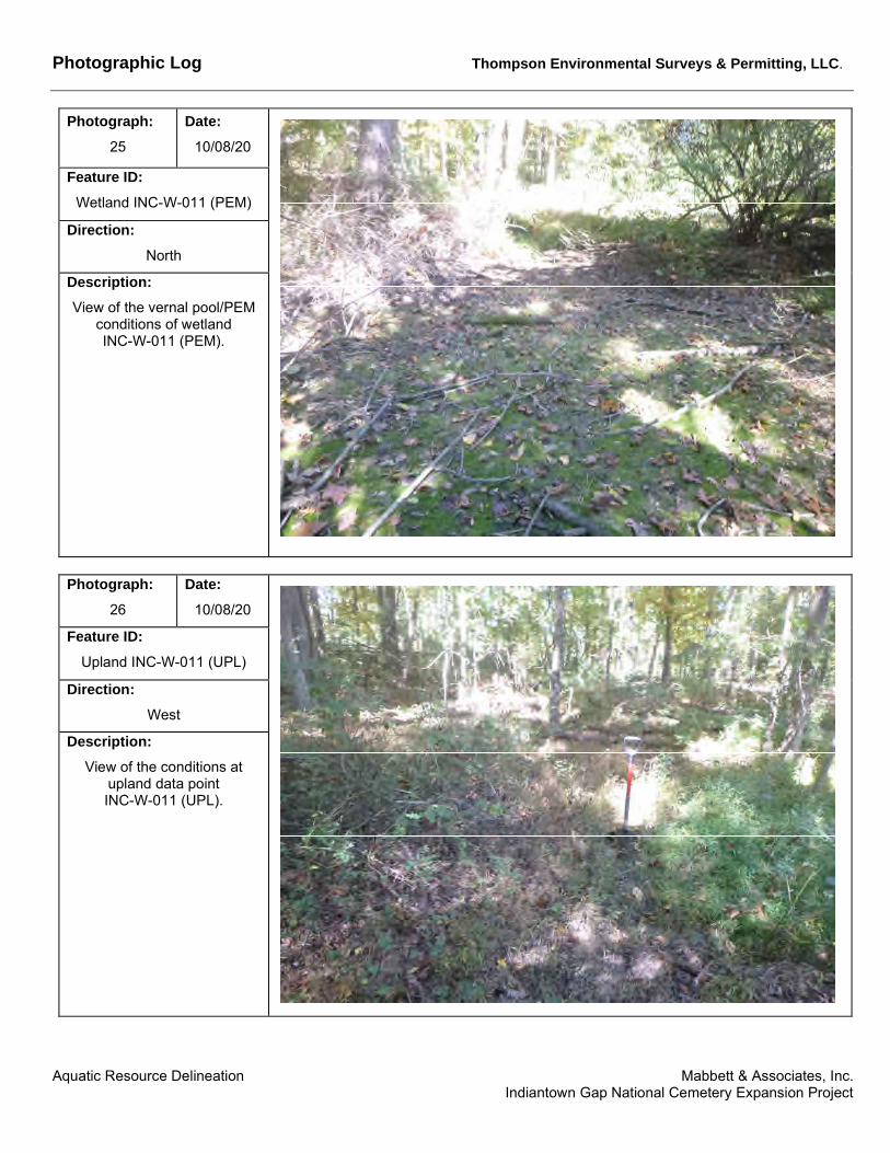
Photographic Log Thompson Environmental Surveys & Permitting, LLC.
Photograph: 25
Date: 10/08/20
Feature ID: Wetland INC-W-011 (PEM)
Direction: North
Description: View of the vernal pool/PEM
conditions of wetland INC-W-011 (PEM).
Photograph: 26
Date: 10/08/20
Feature ID: Upland INC-W-011 (UPL)
Direction: West
Description: View of the conditions at
upland data point INC-W-011 (UPL).
Aquatic Resource Delineation Mabbett & Associates, Inc. Indiantown Gap National Cemetery Expansion Project

Photographic Log Thompson Environmental Surveys & Permitting, LLC.
Photograph: 27
Date: 10/08/20
Feature ID: Wetland INC-W-012 (PEM)
Direction: East
Description: View of the vegetative
conditions at wetland data point INC-W-012 (PEM).
Photograph: 28
Date: 10/08/20
Feature ID: Upland INC-W-012 (UPL)
Direction: Northeast
Description: View of upland data point
INC-W-012 (UPL).
Aquatic Resource Delineation Mabbett & Associates, Inc. Indiantown Gap National Cemetery Expansion Project

Photographic Log Thompson Environmental Surveys & Permitting, LLC.
Photograph: 29
Date: 10/08/20
Feature ID: Wetland INC-W-013 (PEM)
Direction: North
Description: View of wetland data point
INC-W-013 (PEM).
Photograph: 30
Date: 10/08/20
Feature ID: Upland INC-W-013 (UPL)
Direction: East
Description: View of upland data point
INC-W-013 (UPL).
Aquatic Resource Delineation Mabbett & Associates, Inc. Indiantown Gap National Cemetery Expansion Project

Photographic Log Thompson Environmental Surveys & Permitting, LLC.
Photograph: 31
Date: 10/07/20
Feature ID: Wetland INC-W-015 (PEM)
Direction: Northwest
Description: View of the typical vegetative conditions found in wetland
INC-W-015.
Photograph: 32
Date: 10/07/20
Feature ID: Upland INC-W-015 (UPL)
Direction: Southwest
Description: The vegetative conditions at the upland data point INC-W
015 (UPL)
Aquatic Resource Delineation Mabbett & Associates, Inc. Indiantown Gap National Cemetery Expansion Project
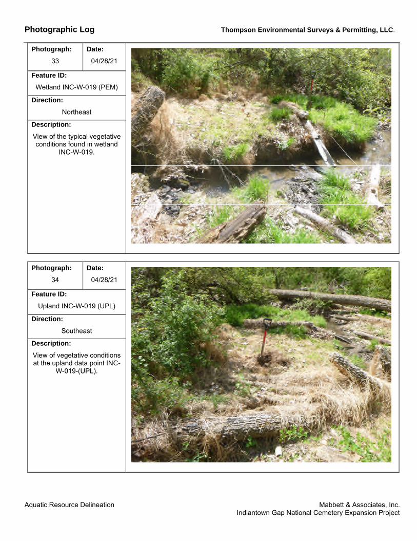
Photographic Log Thompson Environmental Surveys & Permitting, LLC.
Photograph: Date: 33 04/28/21
Feature ID: Wetland INC-W-019 (PEM)
Direction: Northeast
Description: View of the typical vegetative conditions found in wetland
INC-W-019.
Photograph: 34
Date: 04/28/21
Feature ID: Upland INC-W-019 (UPL)
Direction: Southeast
Description: View of vegetative conditions at the upland data point INC
W-019-(UPL).
Aquatic Resource Delineation Mabbett & Associates, Inc. Indiantown Gap National Cemetery Expansion Project

Photographic Log Thompson Environmental Surveys & Permitting, LLC.
Photograph: Date: 35 04/28/21
Feature ID: Wetland INC-W-020 (PEM)
Direction: Southeast
Description: View of the typical vegetative conditions found in wetland
INC-W-020.
Photograph: 36
Date: 04/28/21
Feature ID: Upland INC-W-020 (UPL)
Direction: Northwest
Description: View of the vegetative
condition at the upland data point INC-W-020 (UPL).
Aquatic Resource Delineation Mabbett & Associates, Inc. Indiantown Gap National Cemetery Expansion Project

Photographic Log Thompson Environmental Surveys & Permitting, LLC.
Photograph: 37
Date: 10/07/20
Feature ID: Watercourse INC-S-001 (PER)
Direction: Northwest
Description: View facing upstream on watercourse INC-S-001.
Photograph: 38
Date: 10/07/20
Feature ID: Watercourse INC-S-002 (INT)
Direction: South
Description: View facing upstream on watercourse INC-S-002.
Aquatic Resource Delineation Mabbett & Associates, Inc. Indiantown Gap National Cemetery Expansion Project

Photographic Log Thompson Environmental Surveys & Permitting, LLC.
Photograph: 39
Date: 10/07/20
Feature ID: Watercourse INC-S-003 (EPH)
Direction: North
Description: View facing downstream on
watercourse INC-S-003.
Photograph: 40
Date: 11/02/20
Photo Not Currently Available
Feature ID: Watercourse INC-S-004 (EPH)
Direction: North
Description: View of channel INC-S-004.
Aquatic Resource Delineation Mabbett & Associates, Inc. Indiantown Gap National Cemetery Expansion Project

Photographic Log Thompson Environmental Surveys & Permitting, LLC.
Photograph: 41
Date: 10/08/20
Feature ID: Watercourse INC-S-005 (INT)
Direction: East
Description: View facing downstream on
watercourse INC-S-005.
Photograph: 42
Date: 10/08/20
Feature ID: Watercourse INC-S-006 (INT)
Direction: North
Description: View of facing upstream on
watercourse INC-S-006 where it connects to wetland INC-W
002.
Aquatic Resource Delineation Mabbett & Associates, Inc. Indiantown Gap National Cemetery Expansion Project

Photographic Log Thompson Environmental Surveys & Permitting, LLC.
Photograph: 43
Date: 10/08/20
Feature ID: Watercourse INC-S-007 (EPH)
Direction: North
Description: View facing upstream on
watercourse INC-S-007from the confluence with INC-S
005.
Photograph: 44
Date: 10/08/20
Feature ID: Watercourse INC-S-008 (INT)
Direction: South
Description: View of the watercourse INCS-008 facing upstream from the confluence with INC-S
005.
Aquatic Resource Delineation Mabbett & Associates, Inc. Indiantown Gap National Cemetery Expansion Project

Photographic Log Thompson Environmental Surveys & Permitting, LLC.
Photograph: Date: 45 10/07/20
Feature ID: Watercourse INC-S-009 (PER)
Direction: South
Description: View facing upstream on watercourse INC-S-009.
Photograph: 46
Date: 10/07/20
Feature ID: Watercourse INC-S-010 (EPH)
Direction: East
Description: View of watercourse INC-S010 facing downstream from
the its origin.
Aquatic Resource Delineation Mabbett & Associates, Inc. Indiantown Gap National Cemetery Expansion Project

Photographic Log Thompson Environmental Surveys & Permitting, LLC.
Photograph: 47
Date: 10/07/20
Feature ID: Watercourse INC-S-011 (EPH)
Direction: South
Description: View facing upstream on
watercourse INC-S-0.
Photograph: 48
Date: 10/08/20
Feature ID: Watercourse INC-S-012 (PER)
Direction: North
Description: View of watercourse INC-S
012 facing upstream.
Aquatic Resource Delineation Mabbett & Associates, Inc. Indiantown Gap National Cemetery Expansion Project

Photographic Log Thompson Environmental Surveys & Permitting, LLC.
Photograph: 49
Date: 10/08/20
Feature ID: Watercourse INC-S-013 (INT)
Direction: North
Description: View facing upstream on
watercourse INC-S-013 where it drains from wetland INC-W
007.
Photograph: 50
Date: 10/08/20
Feature ID: Watercourse INC-S-014 (EPH)
Direction: West
Description: View facing upstream on watercourse INC-S-014.
Aquatic Resource Delineation Mabbett & Associates, Inc. Indiantown Gap National Cemetery Expansion Project

Photographic Log Thompson Environmental Surveys & Permitting, LLC.
Photograph: 51
Date: 10/08/20
Feature ID: Watercourse INC-S-015 (INT)
Direction: South
Description: View facing upstream on
watercourse INC-S-015 where it drains from wetland INC-W
009.
Photograph: 52
Date: 10/08/20
Feature ID: Watercourse INC-S-016 (EPH)
Direction: South
Description: View facing downstream on
INC-S-016.
Aquatic Resource Delineation Mabbett & Associates, Inc. Indiantown Gap National Cemetery Expansion Project
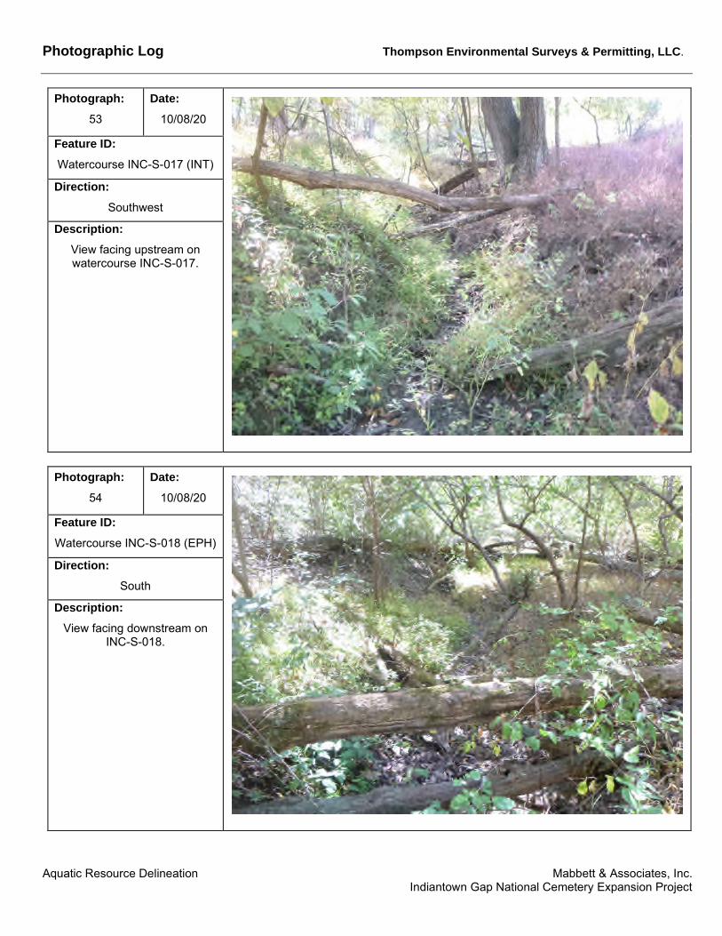
Photographic Log Thompson Environmental Surveys & Permitting, LLC.
Photograph: 53
Date: 10/08/20
Feature ID: Watercourse INC-S-017 (INT)
Direction: Southwest
Description: View facing upstream on watercourse INC-S-017.
Photograph: 54
Date: 10/08/20
Feature ID: Watercourse INC-S-018 (EPH)
Direction: South
Description: View facing downstream on
INC-S-018.
Aquatic Resource Delineation Mabbett & Associates, Inc. Indiantown Gap National Cemetery Expansion Project

Photographic Log Thompson Environmental Surveys & Permitting, LLC.
Photograph: 55
Date: 10/08/20
Feature ID: Watercourse INC-S-019 (PER)
Direction: North
Description: View of the typical channel conditions on INC-S-019.
Aquatic Resource Delineation Mabbett & Associates, Inc. Indiantown Gap National Cemetery Expansion Project