The Sustainable Use of Wetland Resources - IUCN Portal
236
The IUCN Wetlands Programme Conservation and Development: The Sustainable Use of Wetland Resources Proceedings of the Third International Wetlands Conference E. Maltby, P.J. Dugan and J.C. Lefeuvre
-
Upload
khangminh22 -
Category
Documents
-
view
3 -
download
0
Transcript of The Sustainable Use of Wetland Resources - IUCN Portal
The IUCN Wetlands Programme
Conservation and Development: The Sustainable Use of Wetland Resources
Proceedings of the Third International Wetlands Conference
E. Maltby, P.J. Dugan and J.C. Lefeuvre


Conservation and Development: The Sustainable Use of Wetland Resources

IUCN—The World Conservation Union Founded in 1948, IUCN - The World Conservation Union brings together States, government agencies and a diverse range of non-governmental organizations in a unique world partnership: some 650 members in all, spread across 120 countries. As a union, IUCN exists to serve its members - to represent their views on the world stage and to provide them with the concepts, strategies and technical support they need to achieve their goals. Through its six Commissions, IUCN draws together over 5,000 expert volunteers in project teams and action groups. A central secretariat coordinates the IUCN Programme and leads initiatives on the conservation and sustainable use of the world's biological diversity and the management of habitats and natural resources, as well as providing a range of services. The Union has helped many countries to prepare National Conservation Strategies, and demonstrates the application of its knowledge through the field projects it supervises. Operations are increasingly decentralized and are carried forward by an expanding network of regional and country offices, located principally in developing countries. IUCN - The World Conservation Union - seeks above all to work with its members to achieve development that is sustainable and that provides a lasting improvement in the quality of life for people all over the world.
IUCN Wetlands Programme The IUCN Wetlands Programme coordinates and reinforces activities of the Union concerned with the management of wetland ecosystems. The Programme focuses upon the conservation of ecological and hydrological processes, in particular by developing, testing, and promoting, means of sustainable utilisation of wetlands. It does so in collaboration with IUCN members and partners, in particular those other international institutions with a specific wetland mandate, especially the Ramsar Convention Bureau, and the International Waterfowl and Wetlands Research Bureau (IWRB).
The core of the Programme is a series of field projects which develop the methodologies for wetland management, in particular in the countries of the developing world where wetlands are used intensively by local communities which depend upon these for their well-being. Related strategic and policy initiatives draw upon the results of these projects and present their conclusions in a fonn useful for government decision makers and planners. The activities of the Programme are designed on the basis of the concerns and information provided by IUCN members. To facilitate this, the Programme works through IUCN's regional offices. The Programme also works closely with the major development assistance agencies to ensure that conservation considerations are adequately addressed in their projects. The Wetlands Programme receives generous financial support from the World Wide Fund For Nature (WWF), the Swiss Directorate of Development Cooperation and Humanitarian Aid (DDA), the Finnish International Development Agency (FINNIDA) and the Government of the Netherlands. Project support has been received from the Swedish International Development Authority (SIDA), Norwegian Agency for Development Cooperation (NORAD), United States Agency for International Development (USAID), the Ford Foundation and a number of IUCN members including the Finnish Association for Nature Conservation (FANC), Institut Francais pour le Developpement en Cooperation (ORSTOM), the Royal Society for the Protection of Birds (RSPB), the United States National Park Service (USNPS) and the World Wide Fund For Nature (WWF). It is coordinated from the IUCN Headquarters in Switzerland, with regional coordinators in Central America, South America, Brazil, West Africa, southern Africa and Asia.
The conference was organized with the aid of the following Internation Organizations: LNTECOL, UNESCO/MAB, IUCN and WWF-France French Organizations: Ministry of Environment: Department of Environmental Reasearch (SRETIE), Department for the Protection of Nature (DPN); Ministry of Foreign Affairs: Department for Scientific and Technical Cooperation; Ministry of Agriculture: Service of Exterior Relations: Ministry of National Education; National Museum of Natural History; University of Rennes I; National Office of Hunting (ONC); National Institute of Agricultural Research (INRA); National Centre of Scientific Research (CNRS) and Interdisciplinary Program for Environmental Research (PIREN). Regional and Local Authorities: Conseil General of Ille-et-Vilaine; Conseil General of Loire-Atlantique; Conseil General of la Manche; and City of Rennes Associations: Western Hunting Region; Federation of the Hunters of Ille-et-Vilaine.

Conservation and Development: The Sustainable Use of Wetland Resources
Proceedings of the Third International Wetlands Conference Rennes, France, 19-23 September, 1988
Organisers
University of Rennes and National Museum of Natural History, France
Editors
E. Maltby, P.J. Dugan and J.C. Lefeuvre
IUCN 1992

Published by: IUCN
IUCN Thi World Conservation Union
Copyright: 1992. International Union for Conservation of Nature and Natural Resources This publication may be produced in whole or part and in any form for education or non-profit uses, without special permission from the copyright holder, provided acknowledgement of the source is made. IUCN would appreciate receiving a copy of any publication which uses this publication as a source
No use of this publication may be made for resale or other commercial purpose without the prior written permission of IUCN
Citation E . Maltby, P.J. Dugan and J . C Lefeuvre (Eds), 1992. Conservation and Development: The Sustainable Use of Wetland Resources. Proceedings of the Third International Wetlands Conference, Rennes, France, 19-23 September, 1988. IUCN, Gland, Switzerland, xii + 219 pp.
ISBN: 2-8317-0108-2
Designed and typeset: Samara Publishing Ltd., Tresaith, Dyfed, SA43 2JG, UK
Cover design: Sarah Skinner
Cover photograph: WWF—P. Jackson
Available from: IUCN Comminications Division, Rue Mauverney 28, 1196 Gland, Switzerland
The designations of geographical entities in this book, and the presentation of the material, do not imply the expression of any opinion whatsoever on the part of the participating organizations concerning the legal status of any country, territory, or area, or of its authorities, or concerning the delimitation of its frontiers or boundaries The opinions expressed by the authors in this publication do not necessarily represent the view of IUCN
Contents
Foreword
Avant-Propos
Section 1: Wetland conservation and resource use
Research priorities in wetland science, wetland conservation and agricultural development P.J. Dugan
Sustainable agricultural development and wetland conservation in Northern Nigeria W.M. Adams
Utilization of wetland plant resources by rice farmers in Indonesia M. Soerjani
The exploitation of wetland resources by traditional communities in the Kafue Flats and Bangweulu Basin H. Weza Chabwela
Conservation in the Inner Niger Delta, Mali: the interdependence of ecological and socio-economic research J.R. Skinner
Peatlands - dilemmas of use and conservation Edward Maltby
Research and management in the Pantanal of Brazil J . Adamoli
Revised American strategies to reduce wetland conversions to agriculture R.W. Nelson
Ugandan wetlands and their management P. Denny and F. Turyatunga

Section 2: Coastal zone conservation and management
Managing Brazil's coastal wetlands: the contribution of research amid the realities of politics Antonio Carlos Diegues 87
Coastal processes and littoral environment in the region of the Banc d'Arguin (Mauritania) Francis Cuq and Pierre Campredon 97
Planning the management of coastal lagoons in Ghana Y. Ntiamoa-Baidu and G.E. Hollis 113
Environmental modifications, research and management in the estuaries and mangroves of the 'Southern Rivers' (West Africa) E.S. Diop 123
Section 3: Wetlands and fisheries management
Research priorities in fisheries management as a tool for wetlands conservation and rural development in Africa G.M. Bernacsek 131
Estuarine-related fisheries in Terminos Lagoon and adjacent continental shelf (southern gulf of Mexico) A. Yafiez-Arancibia, A. Aguirre-Leon and G. Soberon-Chaavez 145
The northern Cameroon floodplain: influence of hydrology on fish production V.Benech 155
Fish communities and fishing in a floodplain lake of Central Amazonia B. de Merona 165
Changing tropical marshlands into agro-piscicultural ecosystems J.-C. Micha, H. Halen et J.-L. Rosado Couoh 179
Notes on the role of research in addressing the potential and problems of aquaculture in the Casamance region of Senegal S.Gilles 187

Section 4: Managing wetland hydrology
The impact of drought and dams on the functions of the Hadejia-Gashua Floodplain, Nigeria: a preliminary study G.E.Hollis 193
Deterioration of wetlands caused by groundwater exploitation: two case histories in Spain M.R. Llamas 211


Foreword
Wetland conservation and management: priorities and problems
Once the concern of a relatively small group of dedicated wildlife enthusiasts, hunters and scientists, wetland conservation has today reached presidential agendas, is the subject of heated political debate and the focus of millions of dollars of development assistance funds each year. While the precise mechanisms through which this change has come about varies from country to country and region to region, the ultimate cause is the unprecedentedly high rate of wetland loss in both the industrialized and developing nations in recent years, and its environmental, economic, and social consequences. While in the past our societies tolerated wetland loss because of perceived and real economic benefits, there is today growing alarm at the loss of the ecological and hydrological services once provided free by wetlands and the cost of replacing these with flood control structures, storm barriers, water purification facilities, and increased prices for wetland produce. In many poorer countries such alternatives are quite simply not available.
Building upon this growing awareness of the importance of wetlands, many nations have substantially increased investment in their conservation. However, review of this investment has shown that there are many obstacles to effective conservation of wetland resources. These obstacles can generally be grouped into four main issues - limited information and awareness, inefficient and conflicting policies, planning deficiencies and institutional weaknesses. All of these issues feature in the present volume - a selection of papers presented at the Third International Wetlands Conference, held in Rennes, 19-23 September 1988. This meeting sought to provide an opportunity for exchange of experience between individuals and institutions seeking to address these and, in particular, to examine the role of science in addressing these. Editorial change to some contributions from authors whose first language is not English has been necessary. However, in seeking to convey the meeting to a wider audience, the editors have made every attempt to keep editing to a minimum in order to retain the views as originally expressed. The volume is divided into four sections which deal successively with conservation and resource use with particular emphasis on agriculture, coastal zone conservation and management, fisheries management and the management problems of wetland hydrology. Individual papers are short. They were prepared not with the intention of appearing in the traditional scientific or conservation journals but with a deliberate purpose of highlighting new cases, assessments and examples of wetland conservation needs, problems and priorities. Authors have been encouraged to express individual opinions based on direct experiences which often fail to enter conventional publications. For this reason the editors feel that the contents provide a unique contribution to and information base for the development of new policies for wetland conservation worldwide.
E. Maltby, P. Dugan and J.C. Lefeuvre
ix

Sustainable use of wetland resources
x
Avant-Propos
Conservation et gestion des zones humides: priorites et problemes
Dans les pays en voie de developpement, les zones humides sont des ecosystemes d'une importance particuliere parce que la dependance des communautes humaines vis-a-vis de leurs ressources naturelles y est plus directe et vitale qu'ailleurs. Sans conteste, les zones humides du Tiers Monde subissent les menaces les plus fortes remettant en cause leur maintien en tant qu'ecosystemes naturels. Leur survie est un imperatif en terme de conservation, et ceci non seulement pour sauvegarder la biodiversite et leurs valeurs traditionnelles pour la faune sauvage, mais aussi comme un element cle pour promouvoir des operations de developpement durable viables, dans certains de ces pays les plus pauvres du monde. En conservation, les demarches classiques developpees en Amerique du Nord et en Europe sont fondees sur des criteres tels que le caractere typique, unique, et la rarete, se concretisant par une hierarchie globale des sites proteges. Ces criteres sont generalement inadaptes aux cas de figure rencontres dans les pays en voie de developpement. De nouvelles approches sont necessaires si Ton veut que la conservation des zones humides reussisse pleinement ailleurs que dans les pays les plus riches. Les causes du manque d'efficacite de la conservation sont multiples mais peuvent etre schematiquement regroupees en quatre questions principales: insuffisance de l'information et de l'eveil des consciences, inefficacite et caractere conflictuel des politiques, mauvaises planifications et faiblesses institutionnelles. Tous ces sujets figurent dans ce volume comprenant une selection des communications presentees a la Troisieme conference internationale sur les zones humides, qui s'est tenue a Rennes (France) du 19 au 23 septembre 1988. Les editeurs ont du modifier les contributions de quelques auteurs dont la langue maternelle n'etait pas l'anglais. Cependant, tout a ete fait pour que ces modifications soient minimes par rapport aux points de vue exprimes par les auteurs. Le volume est divise en quatre parties qui traitent successivement de la conservation et de l'usage des ressources, l'accent etant mis particulierement sur l'agriculture, de la conservation et de la gestion des zones humides littorales, de la gestion des peches et des problemes de gestion hydrologique des zones humides. Les articles sont courts, lis n'ont pas ete rediges dans le but d'etre publies par des revues traditionnelles scientifiques ou traitant de la conservation, mais dans l'objectif delibere de faire connaitre de nouveaux cas concrets, des evaluations et des exemples de besoins, de problemes et de priorites en conservation des zones humides. Les auteurs ont ete encourages a exprimer leurs opinions personnelles fondees sur leurs propres experiences sous une forme qui bien souvent ne convient pas pour une publication
xi

Sustainable use of wetland resources
conventionnelle. Pour cette raison, les editeurs pensent que les exposes de cet ouvrage constituent une contribution originale et une source d'information utile au developpement de nouvelles politiques pour la conservation des zones humides du monde entier.
E. Maltby, P. Dugan et J.C. Lefeuvre
Deux autres publications regroupent les actes de cette conference. Le premier volume, edite en 1989 par le Museum national d'histoire naturelle, regroupe les allocutions de bienvenue, les textes des posters presentes, les syntheses des huit sessions et des deux ateliers ainsi que les resumes des communications orales. Le second est un numero du Bulletin d'Ecologie qui regroupe treize communications. D'autres articles ont ete soumis a la revue Wetlands Ecology and Management. Citations bibliographiques de ces documents: Lefeuvre, J.C. (Ed). 1989. Troisieme conference internationale sur les zones
humides. Conservation et developpement: gestion integree des zones humides. Third international wetlands conference. Conservation and Development: The Sustainable Use of Wetland Resources. Rennes, 19-23 septembre 1988. Editions du Museum national d'histoire naturelle, laboratoire d'Evolution des systemes naturels et modifies, Paris, p. 371.
Anonyme. 1990. Troisieme conference internationale sur les zones humides dTNTECOL, Rennes 1988. Bull. Ecol., 21 (3): 1-80.
xii

Section 1
Wetland Conservation and Resource Use


Research priorities in wetland science, wetland conservation and agricultural development*
P.J. Dugan
IUCN Avenue du Mont-Blanc 1196 Gland Switzerland
Resume
Recherche scientifique, conservation des zones humides et developpement agricole: bilan des priorites de recherche a partir d'exemples indonesiens
Une gestion environnementale judicieuse peut ameliorer de maniere significative les productions agricoles durables. Toutefois, jusqu'a present, la plupart des interventions agricoles dans les zones humides ont conduit a leur degradation et a leur disparition. Afin d'eviter de tels impacts negatifs du point de vue de l'environnement et d'aboutir a une gestion plus efficace des zones humides pur le bien des societes humaines, il est necessaire de developper une information de qualite sur les ecosystemes zones humides. L'auteur passe on revue les types d'information les plus pertinents et se demande si la recherche scientifique actuelle est concue pour rependre a ces priorites.
Introduction: the crisis in agriculture
In 1974, the World Food Conference pledged to end hunger within 10 years. Yet in 1985 more than 730 million people did not eat enough to lead fully productive working lives. Responding to this situation, the World Commission on Environment and Development (WCED) concluded: "Agriculture does not lack resources; it lacks policies to ensure that the food is produced where it is most needed and in a manner that sustains the livelihoods
* Accepted for publication, September 1988
3
Sustainable use of wetland resources
of the rural poor. We can meet this challenge'by building on our achievements and devising new strategies for sustaining food and livelihood security." (WCED, 1987). This challenge can, and indeed must, be taken up at many levels. Governments must recognise the acute need for such policies and devote the time and resources required to develop them. Agricultural technicians and development planners need to examine why many past efforts have failed and others succeeded, and build upon the lessons from these. Resource managers and other conservation professionals must consider how natural ecosystems can contribute to resolving the world's food needs, and identify how conservation can combine with development investment to improve food production without damaging the resource base upon which this depends. And scientists should consider how their work can most effectively contribute to resolving these issues. However, despite the pressing need for such change, the recent past suggests that if we are to achieve real progress much more will have to be done to revise the attitudes of government officials, agricultural experts, planners, conservation professionals, as well as scientists. Responding to this challenge, the present paper uses the case of agricultural development in Indonesia to explore how wetlands science might more effectively contribute to improving wetland management, so enhancing the contribution of these ecosystems to sustainable development.
Example - development pressures in Indonesia
With a population of 162 million, Indonesia is the world's fifth most populous nation; and at the present growth rate of 2 % it is expected to reach 220 million by the year 2000. It is estimated that approximately 15.4 million ha of new agricultural land will need to be developed by the year 2000 to meet the needs of this rising population. This represents an increase of 47% with a rate of expansion of 1 million ha per year. Further, as 65% of the total population lives on the islands of Java, Madura, and Bali, only 7% of the land area, agricultural expansion will necessitate exploitation of the less heavily populated outer islands (Burbridge etal., 1988). This demographic pattern is a major factor governing the elaboration of the government's fifth five-year development plan. Specifically, the rapidity at which new agricultural production will need to be expanded to meet the needs of the rising population will require huge investments of capital, manpower and technology. This investment must be targeted towards activities and resources which will yield the largest possible sustainable yield with the minimum environmental impact. It is essential, therefore, that it is made on the basis of the best possible understanding of the functioning of the ecosystems within which the investment will be targeted, of the services which they provide, and of the extent to which intensive investment will alter these functions and reduce the resulting benefits. In many cases, however, the investment required for intensive agricultural development is not available. As an alternative, many development efforts have invested in the promotion of forestry, fisheries and other primary resource uses in the less populous outer islands to meet the growing demand for cash income.
4

Research priorities
If this investment in the exploitation of Indonesia's natural resources is not to lead to a long-term decline in the benefits which the nation obtains from these resources, greatest possible care will have to be exercised in selecting sites for intensive exploitation and in designing the activities which will be carried out there. A series of steps towards environmentally sound management of natural wetland ecosystems are reviewed (i) to see how this objective can be met from the strongest possible information base and (ii) to determine what further research is required to complement this.
Integrating wetland conservation with development
Although most natural wetlands yield some benefits to human society, these vary greatly between and within each category of wetland habitat. In some instances the wetland is so immensely rich, and any alternative will have such detrimental impact, that every possible measure should be taken to preserve that system in its natural state. In others, the natural productivity of the wetland can be enhanced by environmentally sensitive management which increases the value of one or more functions of the system without significant and irreversible impact on the others. And in others, assessment of the costs and benefits of development may reveal that conversion of the wetlands for agricultural or industrial development is the most effective means by which this system can contribute to the well-being of the human population of the country in question. These three options are, of course, three points on a continuum from 'no use' to total conversion. The vast majority of wetlands will fit somewhere along this, rather than at either of the extremes; they will be able to undergo some exploitive activity, which if carried out in an environmentally sound manner, can bring sustainable benefits to many. There is therefore no single blueprint for wetland conservation. Rather the full range of available options should be explored, with the final decision being based upon an evaluation of how the proposed modifications to each wetland will affect the natural benefits being provided, who will earn the benefits of modification, and who will pay the costs. This analysis argues that effective integration of wetland conservation with agricultural development in Indonesia will result from a careful analysis of the range of wetlands in that country, of the functions which these provide, their capacity to support extensive and intensive agricultural management, and the value of a range of possible conservation measures. Four principal activities would provide this information.
(i) Wetland inventory and classification A national wetland inventory, and classification of these resources according to their biological and physical characteristics, is a desirable first step in planning environmentally sound management of wetland resources. The resulting directories which locate individual wetlands, and describe their characteristics, provide a primary tool for planners and conservationists concerned with managing the wetland resource. In Indonesia a preliminary wetland inventory was completed in 1987 by the Directorate General of Forest Protection and Nature Conservation and the Asian Wetland Bureau (Silvius et at, 1987). This describes 231 wetland sites which are known or thought to be
5

Sustainable use of wetland resources
of national or international importance. Much further work is needed, however, to compile better information on these sites and to complement this with a more broadly based survey of the distribution of critical wetland ecosystems within the national landscape of Indonesia. A comprehensive inventory can be extremely costly and delay much-needed conservation action by several years. Thus rather than expend large sums of money on effecting a nationwide inventory, it is in many cases better to proceed to address the conservation problems of priority sites which have already been identified. Such efforts are now beginning in Indonesia in conjunction with work to complete the inventory (PHPA/AWB, 1988).
(ii) Assessment of wetland functions and values In order that planning decisions which affect wetlands are based upon a full understanding of their socio-economic implications, wetland inventories should be complemented by functional evaluation of these resources. Such evaluation provides the means whereby the role of different wetlands in providing goods and services to society can be properly assessed. This information is crucial in forecasting accurately the scale and consequence of various impacts. Attempts to develop wetland assessment procedures have been restricted largely to the United States and Canada, where the most comprehensive system so far developed is that of Adamus (Adamus and Stockwell, 1983). This system identifies 75 biophysical characteristics for which there is some published evidence to relate them to 11 publicly valuable functions of wetlands. The user of the system obtains an estimate of the probability that a given freshwater or marine wetland is providing one of these functions. However despite the success and wide acceptance of the Adamus system, it was designed to address temperate latitudes in North America, and is of limited value outside of this region. No similar system currently exists for other continents and there is now a major need to develop comparable techniques for each major biogeographical region, so providing decision-makers and managers with more effective tools for planning and implementing conservation measures. Such an assessment system will provide an essential tool in Indonesia.
(iii) Assessment of the management potential of wetland systems Wetlands are being lost worldwide because of human intervention. However, there are many types of human intervention which have little impact upon the natural properties of the system; others of course are irreversibly destructive. Those activities which are sustainable, and the level of exploitation at which this is so, vary from system to system and site to site. In order that investment in wetlands is environmentally sound, planners need to be able to identify those activities which are possible in different wetlands and at what intensities. Thus while in Indonesia alluvial soils and shallow peats adjacent to major river systems have been successfully colonised, attempts to develop deep peats have met with much less evident success. Because of their low fertility and the large investment required in site maintenance, these wetlands are in general not suitable for development. Many sites have been abandoned already with the loss of investment capital, hardship for the farmers, loss of other land-use options, and off-site environmental impacts. These
6

Research priorities
include disruption of estuarine and coastal systems because of changes in the quality and quantity of water draining out of the peat system (Burbridge, 1988). Better information on what is, and what is not, possible is needed if these problems are to be avoided in future.
(iv) Assessment of threats and identifying solutions Wetlands are threatened not only by poor management and by conversion to other uses, but by disruption of the hydrological system upon which the wetland depends. In assessing priorities for action, specific attention must be given to threats which originate beyond the boundary of the wetland, as well as those which act more directly. Each threat should be assessed, and its precise origin identified. On the basis of this analysis, actions required to address the threats can be identified and specific measures initiated. These measures will include site specific actions, but should include also actions designed to improve the capacity of existing planning structures to manage wetlands in an environmentally sound manner.
Wetland science as a tool for conservation and development
Planning agencies should draw upon the available science base in assessing wetland values and their capacity for sustainable use. Ironically there is today increasing concern that neither the science base, nor its availability, is adequate to meet this demand. In pursuing the planning process described, resource managers in Indonesia are required to ask a series of questions. This paper cannot attempt to answer these questions for Indonesia, but rather asks whether the wetland research being carried out throughout the world is that which will make the most useful contributions to answering these types of questions in Indonesia and elsewhere.
- Has the inventory been established on a sufficiently strong scientific base? Will this allow the inventory to identify all critical sites, or only those which can be more readily assessed on the basis of faunistic criteria? If the latter, how might future inventory work improve upon this?
- What functions do specific types of wetlands serve? For example: to what extent do floodplains such as Danau Sentarum in the upper Kapaua River Basin of Kalimantan regulate waterflow downstream? Do the mangroves of Way Kambas Game Reserve in Sumatra, or Lorenz National Park in Irian Jaya, play a substantial role in supporting offshore fisheries? If so, in what ways?
- What is the socio-economic value of these functions? For example: how many people benefit from the water regulating role of Danau Sentarum, and how much would it cost to replace this natural function with artificial flood control structures? What is the value to the local and national economies of that portion of the offshore fishery dependent upon Way Kambas and Lorenz?
- How fragile are the ecological and hydrological processes upon which these functions depend, and how will different types of agricultural activity impact these different processes in different wetland ecosystems? For example: what is
7

Sustainable use of wetland resources
the impact of traditional rice cultivation upon the fish production of Danau Sentarum? What is the impact of irrigated rice cultivation upon waterflow and nutrient cycles in the same floodplain system? What is the impact of this upon the natural productivity of the floodplain and the coastal wetlands dependent upon this river system?
- Which wetland functions can be restored readily and at little cost, and which cannot? If Danau Sentarum is converted for intensive rice cultivation, can its role in supporting fisheries, or in retaining floodwaters, be restored easily?
The scientist's dilemma
Despite the quantity of wetland research being carried out today, most available evidence indicates that only a relatively small proportion of this is of direct relevance to the types of decisions which managers of natural resources are required to take. For example in Europe and North America, the identification of critical wetlands is based often on traditional conservation values or at best upon a rudimentary system of functional analysis of these wetlands. Much more information on the ecological and hydrological processes of wetland systems is required if functional analysis is to contribute more effectively to environmentally sound management of wetlands and to effective assessment of the impact of specific development initiatives. No similar system exists for assessing the functions of tropical wetlands. The need for research into the functioning of such wetland systems is therefore even more urgent. Even when appropriate research is being carried out, only rarely is it communicated in a form which is usable by resource managers. Invariably the work of a scientist stops with publication of research results in scientific journals, often one which is inaccessible to managers. And even if accessible, the information contained in the paper is presented in such a way as to convince fellow academics of the quality of the work, and appropriateness of the conclusions, rather than to communicate what these results mean for the resource manager. In view of these considerations there is today a challenge to wetland scientists to examine whether their work is useful for conservation purposes, and whether it is effectively communicated to the resource managers who most need it. In meeting this challenge the following questions might prove helpful:
- What is the most urgent requirement for wetland conservation in my country -inventory, functional or economic analysis, or assessment of management needs and threats?
- Is the available scientific base adequate for effective pursuit of these priorities? - If not, what types of research will most readily yield the information to address
these priorities on a solid science base? - Does my present research and that of my colleagues meet this criterion?
8

Research priorities
It will not always be possible for the wetland manager to await further research; indeed there will always be a need for more detailed understanding of how wetland ecosystems function. However, by asking the questions set out here, and acting upon the answers, the scientific community can help managers and planners to reduce considerably the number of occasions when decisions are taken in the absence of any scientific foundation. Simultaneously, closer cooperation between scientists and managers will help ensure that the considerable body of knowledge that exists already is used in the most effective manner possible.
Conclusion
As the world community seeks to meet the food needs of a rising population, wetland ecosytems will play an increasingly important role in contributing to sustainable agricultural production. However, in order that human society can exploit the full potential of these highly productive ecosystems, much greater attention must be paid to ensuring that agricultural development is based upon a full assessment of the socio-economic value of different wetland ecosystems. In turn such assessment must be based upon the strongest possible science base. At the present time these objectives can only be pursued in a very incomplete manner. In no country is the science base sufficiently strong for planning decisions to be based upon a full understanding of the alternatives and of the impact of the activities proposed. Sound investment in wetland conservation and in wetland agricultural activities will benefit greatly from scientifc research which is directed towards critical gaps in the science base. The suggestions of this paper will hopefully provide a useful starting point from which such issues and the associated research can be identified.
Acknowledgements
The ideas expressed here have benefitted from discussion with a wide range of colleagues including P.R. Burbridge, G.E. Hollis, J. Larson, E. Maltby and D. Parish. I also thank the World Wide Fund for Nature, and the Governments of Switzerland and Finland for support to the IUCN Wetlands Programme.
References
Adamus, P.R. and L.T. Stockwell. 1983. A Method for Wetland Functional Assessment. Report No. FHWA-IP-82-23. US Dept. Transportation Federal Highway Administration, Washington DC.
AWB/PHPA. 1988. Improving Wetland Management and Conservation in Indonesia. Project proposal. Bogor, Indonesia. 94 pp.
9

Sustainable use of wetland resources
Burbridge, P.R. 1988. Coastal and Marine Resource Management in the Strait of Malacca. Ambio 18:170-177.
Burbridge, P.R., Koesoebiono and R. Dahuri. 1988. Problems and Issues in Coastal Resources Management and Planning in Eastern Sumatra and the Strait of Malacca. Pages 8-117. In: P.R. Burbridge, Koesoebiono, H. Dirschl and B. Patton (Eds). Coastal Zone Management in the Strait of Malacca. Dalhousie University, Halifax, Nova Scotia.
Silvius, M.J., A.P.J.M. Steeman, E. Berczy, E.T. Djuharsa and A.W. Taufik. 1987. The Indonesian Wetland Inventory. A Preliminary Compilation of Existing Information on Wetlands of Indonesia. PHPA, AWB/INTERWADER, EDWIN, Bogor, Indonesia.
WCED. 1987. Our Common Future: World Commission on Environment and Development. Oxford University Press, Oxford/New York. 383 pp.
10

Sustainable agricultural development and wetland conservation in Northern Nigeria*
W.M. Adams
Department of Geography University of Cambridge Cambridge CB2 3EN United Kingdom
Resume
Developpement agricole a long terme et conservation des zones humides au Nigeria
Notre etude a ete menee dans les plaines d'inondation des fleuves Hadejia et Jama'are, au nord du Nigeria. Dans ces zones humides, le riz est cultive en periode de decrue. A la saison seche, elles sont utilisees pour la peche et le paturage. Sur le plan de la conservation de la nature, elles presentent un grand interet, notamment en raison de leur fonction d'accueil pour les oiseaux migrateurs de la region palearctique. La construction de barrages et l'irrigation a grande echelle, bases du developpement agricole du bassin versant, posent des problemes economiques (faible rapport benefice/cout) et ecologiques (reduction des surfaces cultivees dans les zones humides et degradation des ressources naturelles). Ce type de developpement est incompatible avec la conservation des zones humides et ne peut deboucher sur une gestion integree des ressources naturelles. Nous presentons une solution de developpement alternative ('fadama rehabilitation') fondee sur les connaissances des indigenes qui utilisent de petits barrages contre l'inondation afin d'augmenter la production de riz et d'irriguer en saison seche. Nous discutons de sa faisabilite et de ses consequences.
Introduction
The natural resources of the wetlands of the Sahel/Sudan Zones of West Africa are the subject of three separate and often conflicting evaluations: first, by indigenous producers who use the area for agriculture, fishing, grazing or hunting/gathering; second, by
* Accepted for publication, September 1988
11

Sustainable use of wetland resources
Development and conservation in Northern Nigeria
national-level planners and foreign aid and development experts who wish to intensify production through irrigation or river control; third, by conservationists concerned about the role of such wetlands in local, regional and inter-continental ecological systems, most obviously in the case of the Sahel in Palaearctic bird migration systems. These appraisals of wetland resources obviously represent markedly different ideologies of nature and of development. They frequently diverge, and often conflict. Large-scale development, e.g. dam construction, can have significant adverse impacts on ecological systems, and also serious implications for indigenous people and existing small-scale and informal economic activity. That indigenous activity itself, however, can also have adverse impacts on conservation, e.g. if fishing effort rises, and in some circumstances can prejudice larger-scale development, eg. through soil erosion in an upstream catchment. The designation of protected areas for conservation can constrain development programmes and have socio-economic impacts if existing rights are extinguished (Adams, 1990). Sustainable development, as presented in the World Conservation Strategy (IUCN/UNEP/WWF, 1980) and Brundtland Report (World Commission on Environment and Development, 1987) is that which seeks to avoid these mutual pitfalls and offer environmentally sound, socially benign, and economically effective strategies for development. The rhetoric of sustainable development can be questioned on a theoretical level (Redclift 1984 and 1987), and in practical terms. This paper examines current pressures and the practical feasibility of sustainable development strategies in the Hadejia-Nguru Wetlands of Borno, Bauchi and Kano States, Nigeria.
Unsustainable development in Northern Nigeria
The Hadejia-Nguru Wetlands are an extensive series of swamps, grasslands and woodland created by the passage of the Hadejia and Jama'are Rivers through late Quaternary dune systems. The area floods annually, to an extent determined by river discharge (Hollis, 1988; Adams and Hollis, 1989). It supports diverse economic activities. These include wet season cultivation (mainly of rice); residual soil moisture cultivation following the falling flood; dry season irrigation (using simple wells, shadufs and petrol pumps); dry season grazing, fishing and hunting. The socio-economic relationship between these activities is complex, since while ethnic groups, villages and households tend to specialise in certain activities, many engage in more than one. The pattern of resource use is also complex in space, because of the physical diversity of the floodplain, and in time, because patterns of flooding change, as does the economic position of different households. Existing formal development of wetland resources in the Hadejia Jama'are and Koma-dugu Yobe River systems has many of the hallmarks of unsustainable development. It has been based on large scale irigation, much criticised in northern Nigeria for poor economic performance and adverse socio-economic and environmental impacts (Adams and Grove, 1984; Adams, 1985; Andrae and Beckman, 1985; Beckman, 1986; Kolawole, 1987 and 1988). The economic problems of large-scale irrigation in Nigeria include inflated costs, delayed implementation, low yields, and erratic water supply. Socio-economic problems include problems of resettlement and compensation and low farm
13

Sustainable use of wetland resources
Figure 2 Layout of Maza Fadama
incomes. Environmental problems include the desiccation of Lake Chad, and the resulting failure to irrigate more than 3% of the South Chad Irrigation Project between 1979 and 1986 (Kolawole, 1986), increased disease incidence, and downstream impacts of dams built to supply irrigation schemes. There are a series of formal irrigation schemes relevant to the Hadejia-Nguru Wetlands (Adams and Hollis, 1989). The most notable is the Kano River Project (KRP), a gravity-fed surface irrigation scheme supplied from the Tiga Dam on the Kano River upstream of the Hadejia-Nguru Wetlands (Wallace, 1980 and 1981; Palmer-Jones ,1984). Plans were drawn up in the late 1970s for KRP Phase I I , but because of financial stringency, development is still restricted to a 90 ha pilot farm at Wudil (HJRBDAReport, 1982). Closer to the Hadejia-Nguru Wetlands, there are a series of small irrigation schemes. The area cropped (172 ha) is actually a small proportion of the potentially irrigable area (727 ha), largely because of difficulties with pump maintenance. Also at Hadejia is the Hadejia Valley Project, a polder scheme begun in 1982 (Brouwer, 1982). This depends on the release of water from the Tiga Dam and the Challawa Gorge Dam
14

Development and conservation in Northern Nigeria
(also not yet completed) into the River Hadejia which will act as a supply canal for the project 200 km downstream. Upstream water control, water extraction, and drought, have had significant impacts on the extent of flooding in the Hadejia-Nguru Wetlands (Hollis, this volume). This appears to have had serious impacts on wet season rice production and dry season irrigation. The area of small-scale informal irrigation in Nigeria is estimated to be 850,000 ha (FAO, 1985), 96% of the total irrigated. It is likely that there is between 5,000 and 10,000 ha of small-scale informal irrigation in the Hadejia-Nguru Wetlands themselves, plus a further 1,000 ha irrigated downstream. In addition there are 5,000-10,000 ha of flood rice cultivation and 10,000 ha of beans and other crops grown under residual soil moisture in the Hadejia-Nguru Wetlands. There has also been a dramatic expansion of small-scale irrigation using imported petrol pumps in the wetlands, as elsewhere in northern Nigeria, over the 1980s (Kimmage and Adams, 1990). This irrigation brings its own problems of equity and sustainability, particularly where wheat cultivation is involved (Kimmage 1990, and in press), but its extent and rapid growth are remarkable. The wetlands already are a vast natural irrigation scheme, one that requires very little government money, yields large amounts of produce and supports a large population. The importance and potential appeal of an alternative 'sustainable' development strategy in the wetlands is clear.
Fadama rehabilitation: a sustainable approach?
Such an approach is represented in the work of the Kano State Agricultural and Rural Development Authority (KNARDA), which plans to develop some 60% of the estimated 60,000-100,000 ha of seasonally damp or fadama land in Kano State. KNARDA promotes new technology, pumps, seeds, fertiliser and pesticides, and builds improved water supplies and feeder roads. By mid-1987, KNARDA had dug 2017 jetted boreholes, 896 shallow tubewells and supplied 32,000 motorised pumps. In the wetlands KNARDA is also attempting 'fadama rehabilitation' in a series of areas (Figure 1). This involves the opening or reopening and improvement of natural water courses to carry water into suitable fadama areas. KNARDA estimates that over 3,000 ha were flooded before the construction of the Tiga Dam, and are now dry. Rehabilitation is pictured as re-establishing a 'natural' flooding pattern. The KNARDA initiative reflects growing awareness of the sophistication of wetland cultivation systems in Africa (e.g. Boutillier and Schmitz, 1987; Gallais and Sidikou, 1978; Richards, 1985; Adams and Carter, 1987). The possibility of fadama reclamation in the Hadejia-Nguru Wetlands was recognised by Clayton (1957), and similar developments are being used elsewhere in Africa, with varying degrees of success, for example in the Okavango Delta (Oosterbaan et al, 1986). The fadama consists of a series of more or less closed basins, flooded from a river channel. The depth and duration of flooding can in theory be controlled by clearing, dredging, or the construction of control structures such as weirs. Thus Maza Fadama, 15 km NE of Hadejia town, is fed at high stage levels through a 2.5 km canal from the
15

Sustainable use of wetland resources
River Hadejia (Figure 2). Farmers complained of low water levels following the closure of the Tiga Dam. Survey of the intake channel in 1984 confirmed that water did not penetrate the fadama. A complete topographic survey of the fadama was therefore carried out to determine the areas which the channel could command, and a hydrograph of water levels at the intake was simulated. In 1985 the intake channel was dredged to a width of 4 m. A natural spillway took excess water into the next fadama basin, and recharged Maza Fadama when its levels were low. Rice and residual soil moisture crops were grown, but in 1985 some rice was lost because of untimely and rapid flooding. Sandbags proved inadequate to protect crops, and in 1986 a simple concrete and wood sluice was built, and the 1986 crop was good. A more ambitious development was attempted at Kissingin Fadama, 20 km southwest of Hadejia, in 1984. Phase 1 of the project involved the dredging of the intake channel, and constructing an earth bank 0.5 km downstream of the intake channel to raise water level and allow rice farming to re-start on 1,600 ha. Subsequent dams elsewhere might allow development of the rest of the area (4,655 ha), with shallow tubewells to allow dry season ('winter') cropping and the use of rice nurseries for transplanting. Small-scale irrigation using petrol pumps expanded dramatically in the wetland over the 1980s.
Problems with fadama rehabilitation?
In principle fadama rehabilitation is simple and straightforward. It is development which is triggered by locally expressed need, and is responding flexibly to problems as they emerge. These are necessary hallmarks of sustainable development (Adams, 1987). However, there are numerous problems. Some of these are technical, either agronomic like the damage to the 1987 crop at Maza Fadama from grasshoppers, or engineering, for example the loss of the earth bund at Kissingin in floods in 1985. The small scale of the fadama projects does not eradicate such problems. Relatively simple structures can have extensive effects on flooding over wide areas, and may have implications for ecology or wetland agriculture, and fishing both nearby and at greater distances. Furthermore, it is not known to what extent relatively intensive rice cultivation in fadama land is compatible with wildlife conservation. The use of pesticides, disturbance, hunting, increased spraying against bird pests and loss of suitable feeding habitat may all be important. Other difficulties are essentially political. Power to control water levels in the fadama has created conflict: first, between farmers with higher land (who want more flooding) and those lower down (who want less); second, between farmers who want to delay flooding until broadcast rice has germinated by rainfall, and fishermen who want early flooding to bring in fish; third, between farmers wanting access to fields over a longer post-flood season and pastoralists wanting early dry season access to fadama grazing. At Kissingin, conflict broke out in 1987 between Kanuri farmers growing rice and Fulani herdsmen wanting access to fadama grazings. A number of people were injured and some killed (Cline-Cole, 1988). Flood control has also created conflict between farmers in different areas. Farmers downstream of Kissingin destroyed the bund rebuilt in 1985 because they claimed it was retaining floodwater which should have reached them. It
16

Development and conservation in Northern Nigeria
was rebuilt again in 1986, but with a sluice to allow downstream flow. However, in the 1987 flood season, after further complaints, the bund was removed and the control structure sealed-off. Fadama rehabilitation exacerbates existing conflicts about access to wetland resources between farmers, fishermen and pastoralists. Externally-imposed development, even if superficially 'low tech' and simply does not avoid such conflicts. Such problems are not unusual. Similar small-scale water control works in the Sokoto valley, between 1917 and 1921, eventually failed because of a combination of technical problems relating to flood damage and political opposition reflecting conflict over floodplain resource use (Adams, 1987). There have also been significant technical difficulties in swamp development in the Okavango Delta (Oosterban et ai, 1986). In the Hadejia-Nguru Wetlands, KNARDA's response has been to push political problems back to the relevant village head, and to seek technical solutions such as the transplanting of rice. However, the seriousness of opposition to the relatively simple intervention of fadama rehabilitation indicates that there is no magic 'sustainable' solution to wetland development.
Conclusion
Fadama rehabilitation seems to offer a feasible operational strategy for sustainable development, but no automatic freedom from familiar social and environmental problems. Sustainable development of wetlands in the Sudan/Sahel must involve three basic elements. First, it must be based on research, on hydrological and ecological impacts of fadama rehabilitation (looking in particular at those remote from the development), on rights in and access to wetland resources (especially in land, trees and fishing), and on the nature and extent of conflict between different users of wetland resources (farmers, irrigators, pastoralists and fishermen). Second, development will obviously have to be slow and gradual so that research knowledge can be integrated into development interventions. Third, decisions about investment and intervention must be made by those people who are living in the area. It is important that they are not simply 'participants' in planning, which too often means only that they are informed (or 'consulted') at quite a late stage. Rather they should initiate and run that planning themselves. Without this 'bottom-up planning', or 'development from inside', what is packaged as sustainable development is simply the old externally-imposed modernisation in a new wrapping.
Acknowledgements
The author visited the Hadejia-Nguru Wetlands Project in Nigeria in November and December 1987 for the International Union for Conservation of Nature and Natural Resources, at the invitation of the Nigerian Conservation Foundation. Dr. Hadi Mustapha, Baba Grema and Bill Knight gave enormous help with this visit. Ted Hollis shared all the pleasures of fieldwork and writing-up.
17

Sustainable use of wetland resources
References
Adams, W.M. 1985. The Downstream Impacts of Dam Construction: A Case Study from Nigeria. Transactions of the Institute of British Geographers N.S. 10:292-302.
Adams, W.M. 1987. Approaches to Water Resource Development, Sokoto Valley, Nigeria: The Problem of Sustainability. In: D.M. Anderson and R.H. Grove (Eds). Conservation in Africa: people, policies and practice. Cambridge University Press, Cambridge.
Adams, W.M. 1990. Green Development: Environment and Sustainability Issues in the Third World. Routledge, London 1989.
Adams, W.M. and A.T. Grove (Eds). 1984. Irrigation in Tropical Africa: Problems and Problem-solving. University of Cambridge African Studies Centre, Cambridge. African Monographs No. 3.
Adams, W.M. and R.C. Carter. 1987. Small-scale Irrigation in Sub-Saharan Africa. Progress in Physical Geography 11:1-27.
Adams, W.M. and G.E. Hollis. 1989. Hydrology and Sustainable Resource Development of a Sahelian Floodplain Wetland. Hadejia-Nguru Wetlands Conservation Project. London.
Andrae, G. and B. Beckman. 1985. The Wheat Trap: Bread and Underdevelopment in Nigeria. Zed Press, London.
Beckman, B. 1986. Bakolori: Peasants Versus the State and Industry in Nigeria. In: E. Goldsmith and N. Hildyard (Eds). The Social and Environmental Effects of Large Dams, Volume I I : Case Studies. Wadebridge Ecological Centre, Wadebridge, England.
Boutillier, J-L. and J. Schmitz. 1987. Gestion Traditionelle des Terres (Systeme de Decrue/Systeme Pluvial) et Transition vers l'lrrigation. Cah. Sci. Hum. 23:533-554.
Brouwer, R. 1982. Hadejia Valley Irrigation and Drainage Project. In: Polders of the World. International Institute for Land Reclamation and Development, Wageningen.
Cline-Cole, R. 1988. Sowing Seeds of Discord: Induced Wet Rice Cultivation and Fadama Land Use Conflcits in the Hadejia Valley, Nigeria. Paper to 1988 Conference of the African Studies Association of the United Kingdom, Cambridge, September 1988.
Clayton, W.D. 1957. Ecological Survey of Hadejia. Unpublished manuscript.
FAO. 1985. Irrigation in Africa South of the Sahara: A Study, with Particular Reference to Food Production. Investment Centre and Land and Water Division, Food and Agricultural Organisation of the United Nations, Rome. Report 111/85 CP-SSA.
18
Development and conservation in Northern Nigeria
Gallais J. and A.H. Sidikou.1978. Traditional Strategies, Modern Decision-Making and Management of Natural Resources in the Sudan-Sahel. In: Managment of Natural Resources in Africa: Traditional Strategies and Modern Decision-Making. UNESCO, Paris
HJRBDA. 1986. Annual Report. Hadejia-Jama'are River Basin Development Authority, Kano.
Hollis, G.E. 1988. The impact of Drought and Dams on the Functions of the Hadejia-Gashua Floodplain, Nigeria: A Preliminary Study. Pages 193-210. In: E. Maltby, P. Dugan and J.C. Lefeuvre (Eds). Conservation and Development: the Sustainable Use of Wetland Resources. Proceedings of the Third International Wetlands Conference, Rennes, September 1988. IUCN, Gland, Switzerland.
IUCN/UNEP/WWF. 1980. World Conservation Strategy. International Union for Conservation of Nature and Natural Resources, United Nations Environment Programme, World Wildlife Fund, Geneva.
Kimmage, K. 1990. Nigeria's Home-grown Dust-bowl. New Scientist 42:4.
Kimmage, K. In press. Small-scale Irrigation Initatives: the Problems of Equity and Sustainability. Applied Geography.
Kimmage, K. and W.M. Adams. 1990. Small-scale Farmer-managed Irrigation in Northern Nigeria. Geoforum 20(3):435-443.
Kolawole, A. 1987. Environmental Change and the South Chad Irrigation Project (Nigeria). Journal of Arid Environments 13:169-176
Kolawole, A. 1988. Cultivation of the Floor of Lake Chad: A Response to Environmental Hazard in Eastern Borno, Nigeria. GeographicalJournal 154:243-250.
Oosterbaan, R.J., L.F. Kortenhorst and L.H. Sprey. 1986. Development of Flood-recession Cropping in the Molapo's of the Okavango Delta, Botswana. Annual Report. International Institute for Land Reclamation and Development, Wageningen, Netherlands.
Palmer-Jones, R. 1984. Mismanaging the Peasants: Some Origins of Low Productivity on Irrigation Schemes in Northern Nigeria. In: W.M. Adams and A.T. Grove (Eds) op. cit.
Redclift, M. 1984. Development and the Environmental Crisis: Red or Green Alternatives! Methuen, London.
Redclift, M. 1987. Sustainable Development: Exploring the Contradictions. Methuen, London.
Richards, P. 1985. Indigenous Agricultural Revolution: Ecology and Food Production in West Africa. Longman, London.
Wallace, T. 1980. Agricultural Projects and Land in Northern Nigeria. Review of African Political Economy 17:59-70.
19

Sustainable use of wetland resources
Wallace, T. 1981. The Kano River Project: the Impact of an Irrigation Scheme on Productivity and Welfare. In: J. Heyer, P. Roberts and G. Williams (Eds). Rural development in tropical Africa. Macmillan, London.
World Commission on Environment and Development. 1987. Our Common Future. Oxford University Press, Oxford.
20

Utilization of wetland plant resources by rice farmers in Indonesia*
M. Soerjani
Centre for Research of Human Resources and the Environment University of Indonesia Japan Salemba 4 Jakarta 10430 Indonesia
Resume
Utilisation des ressources vegetales des zones humides par les riziculteurs en Indonesie
Sur les millions d'hectares de zones humides recensees en Indonesie, plus de sept millions sont consacres a la culture du riz: 3,85 millions d'ha (60%) de cultures irriguees, 1,77 million d'ha (27%) de cultures pluviales et 0,92 million d'ha (14%) de cultures en eau profonde (1 a 3 m ou plus). Selon le mode d'exploitation, la production de riz varie de 0,4 a 9 tonnesnes/ha. Cette riziculture a ete intensifiee et etendue et, depuis 1983, le pays subvient a ses besoins en riz. La flore des rizieres est riche et diversifiee, et comprend des plantes considerees comme des mauvaises herbes. Les riziculteurs, grace a leur savoir traditionnel, saisissent les opportunites et utilisent ces plantes de maniere benefique quoique souvent marginale. Presque toutes les especes de mauvaises herbes sont utilisees comme fourrage pour les animaux. D'autres sont consommees comme legumes, par exemple Eichhornia crassipes, Ipomoea aquatica, Limnocharis flava, Marsilea crenata, Monochoria vaginalis, Nelumbo nucifera, Phragmites australis, Saggitaria saggittifolia et Typha angustifolia. Certaines sont utilisees comme plantes medicinales (contre-poisons, toniques, antipyretiques, diuretiques, traitement des he-morroides, etc.) par exemple Cyperus iria, I. aquatica, M. hastata, N. nucifera, et Pistia stratiotes. D'autres especes, qui ne sont pas utilisees directement, servent comme engrais vert dans les rizieres, par exemple Salvinia molesta, E.crassipes, et Hydrilla verticillata. La mauvaise herbe aquatique la plus largement distribute est E. crassipes. Pour cette raison, et grace a des programmes scientifiques, elle est actuellement utilisee de diverses manieres: fourrage pour le Detail, culture des champignons, pulpe de pate a papier, biogaz, artisanat et elevage de poissons herbivores.
* Accepted for publication, September 1988
21

Sustainable use of wetland resources
Introduction
Rice grows in the tropics and subtropics between the latitude of 39°S and 50°N, from sea level to 2,500 m. The climatic conditions in which rice grows vary from hot wet valleys such as in Assam to irrigated deserts such as in Pakistan; with temperatures between 35°C and 41°C and the cool hill zones as in the northern part of India where temperatures may decline to between 3.9°C and 7.5°C (Wirjahardja, 1987). Soil texture ranges from sand to clay, from pH 3 to 10 with organic matter content from 1 to 5 %, salt content from 0-1 %, and nutrient availability from acutely deficient to surplus (deDatta, 1981). Rice is the most important staple food in Indonesia. The land used for rice production exceeds all land used for other food staples including maize, cassava, sweet potatoes, peanuts, and soybean together. Out of a total land area of 2,019,360 km2, about 14,168,000 ha are agricultural farm lands (GTZ, 1978). Over half of this total farmland or about 7.7 million ha are devoted to rice production (Wirjahardja, 1987). Most of these are cultivated in wetlands.
Table 1 The total area of wetland habitats in Indonesia
Total land area (ha)
Original wetland area
(ha)
Remaining wetland area
(ha)
Area included in reserves
(ha)
1. Sumatra 47,361,000 13,548,000 6,458,000 657,000
2. Java & Bali 13,782,300 119,000 12,200 3,850
3. Kalimantan 53,946,000 10,209,000 6,322,000 724,000
4. Sulawesi 18,922,000 605,000 311,000 15,700
5. Maluku 7,450,000 189,500 125,000 36,700
6. Nusa Tenggara
6,797,700 51,000 24,000 3,000
7. Irian Jaya 42,198,000 12,841,000 12,558,000 2,213,100
Total 190,457,000 37,562,500 25,810,200 3,653,350
% of total land area 100 19 13.5 1.9
% of original area - 100 68.7 9.7
Source: PHPA/AWB 1987
22

Utilization of wetland plants in Indonesia
Wetlands and wetland rice fields
Indonesia has some of the most extensive wetlands of Asia (PHPA/AWB, 1987). Lakes, rivers, marshes, swamps, and many small ponds cover large areas of the country. These lands include those which are inundated on a daily (tidal) or seasonal basis. The main wetland types are peat-, freshwater-, and mangrove-swamps. The main wetland habitats in the seven major geographical regions consists of 231 sites which are described in the Indonesian Wetland Inventory published by the Directorate General of Forest Protection and Nature Conservation and the Asian Wetland Bureau (PHPA/AWB, 1987). The present state of the main wetlands is shown in Table 1. Most of these wetlands are natural wetlands, however, some are exploited or converted for human purpose and become man-made wetlands.
Out of 7.7 million ha of land that are used for rice production almost 7 million, or approximately 85%, are cultivated as wetland rice fields. The rest which is less than one million ha (or 15%) is upland or non-wetland rice fields. The wetlands used for rice production consists of 3.85 million ha (59%) irrigated rice fields, 1.77 million ha (27%) rainfed rice fields and 0.92 million ha (14%) of deep water rice fields with 1-3 m or deeper water depth (Wirjahardja, 1987).
Rice cultivation and weeds
Methods of rice cultivation A small-scale farm in East and South-East Asia manages on average no more than 1 to 3 ha of agricultural land (Noda, 1982). Indonesian farmers are at the lower side of this range. The smallest crop farmers occupy only 0.50 ha, while the largest cropfarmers have 4.84 ha. and the overall average is only 0.94 ha. In Java there are farm sizes with less than 0.10 ha, and there are a substantial number of landless farmers (GTF, 1978). Rice is the main crop in Asia which accounts for about 93% of world rice production. It is grown on these small-scale farms, and about 95% of this are grown by the transplantation method. With the range of rice cultivation methods used, rice production in Indonesia varies from 0.4 to 9.0 tonnes/ha. The increatsirng trend in rice yield in recent years is the result of efforts to intensify rice production to reach self-sufficiency. The programmes of BIMAS (Bimbingan Masai meaning mass guidance programme) and INMAS (Intensifikasi Masai meaning mass intensification programme) started in 1974, and are both aimed at intensifying rice production by using high-yielding varieties, intensive fertilizer application, and appropriate pest management. As a result, since 1984 Indonesia has become self-sufficient in rice production, and rice production has kept pace with population growth. The need for long-term food security, however, requires the development of new patterns of agricultural production capable of making a positive and lasting impact on the income and nutritional requirements of the poor (IIED/WRI, 1987).
23

Sustainable use of wetland resources
Rice plant community management In a cropping system plants other than crops are considered as weeds, i.e. 'plants growing where and when they are not wanted'. This is because 'the function (read: the benefit) of those plants from the human perspective is unknown' (Soerjani, 1986 and 1987a). There are crops such as rice which are considered as weeds in another cropping area such as soybean. There are species of plants considered as weeds in one area, but in another place may be harvested for human use (e.g. the water cress Ipomoea aquatica Forsk.). With the unique biodiversity of its tropical rain forest condition, Indonesia has a tremendous natural richness. Rice fields can be regarded as artificially established and maintained systems in which man tries to modify the environment to the optimum possible benefit of the crops. Weeds, however, are successful invaders. Weeds have a regeneration system that enables them to survive unfavourable periods and to multiply rapidly, in order to establish a large population, so that the death rate due to human interference, can be compensated (Ponds et al., 1987). Farmers therefore make a considerable effort to control these plants, using manual techniques to remove them from the cropping system. With a substantial amount of labour put into pre-harvest work, mostly for weed management, rice farmers in Central Java have tiny garden-like weedless rice plots, in contrast to the predominance of weeds over rice plants in Thailand (Castillo, in Sayogyo, 1982). With labour input levels of 150-200 man-days per hectare in pre-harvest work Java's wetland rice farmers are putting in roughly twice as much labour as their Philippine counterparts (Sayogyo, 1982). The weeding process is not entirely consistent with a conventional 'Western' perception. Traditionally, the farmers have a certain balanced wisdom. They see problems as opportunities. With the belief, that God always created everything good for those who believe in and pledge obedience to him, the farmers try to see if there is a 'hidden' or 'unknown' role of these invading plants. This is the basis of the efforts of farmers to utilize 'weedy' or non-crop plants in their agricultural or man-made system. Therefore, weed management in rice fields is actually a rice-plant-community management to achieve an optimum sustainable yield from as many components as possible in a given system (Soerjani, 1987b).
Non-crop plant utilization
Rice-fish culture
Fish management in rice-fish cultures, particularly those practised by rice farmers in West Java, may utilize and manage the weed biomass by the introduction of an appropriate fish (Soerjani, 1986). Tilapia or Sarotherodon mossambicus (Peters) and silver carp or Hypophthalmichtys molitrix Val., cultivated in rice-fish culture may utilize and feed on algae and other weeds and will make nutrients more readily available to the rice crop (Grist, 1978; Soerjani, 1986). When there is no crop, herbivorous fish such as grass carp (Ctenopharyngodon idella Val.) can be introduced, and these will consume the aquatic plants. However, herbivorous fish such as grass carp are very voracious. In
24

Utilization of wetland plants in Indonesia
a system where there is a crop, such as rice, the fish cannot be introduced, since in a water depth of 20 cm or more they will consume and damage the rice plants.
Weeding and utilization Weeding of non-crop plants is aimed partly at the elimination of the weed-crop competition for space and resources. This means that part of the resources, such as nutrient and other forms of organic matters are fixed in the biomass of the non-crop plants. This is the basis of the unexpressed wisdom by the farmers that they always try to see if this biomass can be beneficially utilized. Through long experience and tradition, it is known that there are a variety of prospects utilizing this non-crop biomass. One of the reasons often offered for the delay in weeding in the traditional rice farming system is the fact that farmers utilize many kinds of weeds for food, forage, and household purposes (Soerjani, 1987b). These weeds can even be regarded as intercrops as opposed to the weed-free rice production system (Moody, 1982). In the description of the 54 families and 266 species of weeds of rice in Indonesia (Kosterman et al, 1987), there are species of 38 families (70%) that can be utilized for various purposes. Approximately 17% have potential as medicine, 15% of the species are utilized for cattle fodder, 15% may be consumed as vegetables, 8% for other household purposes, and a smaller percentage for fish feeding and ornamentals. About 3.7% are described to have nutritional value for the crop if used as manure, although in general all kinds of plant species found in rice fields can be utilized as green manure, either after being composted, dried, or as a mulch. The variety of known uses of the non-crop plants found in rice fields is shown in Appendix I .
Conclusion
There is a need to evaluate information from traditional wisdom of peasant farmers in Indonesia (and other developing countries), so that with additional scientific information this can be further developed for the future wealth and health of mankind in harmony with nature. It is hoped that in this way there may be a possibility to obtain optimum sustainable yield from limited resources in a given system. Scientific knowledge and modern technology are very important and badly needed. However, efforts must be made by scientists and extension workers to simplify their findings for the farmers, and introduce them appropriately, since only innovations simple to understand and to implement will be effective in persuading farmers in the foreseeable future (Soerjani, 1987b).
References
de Datta, S.K. 1981. Principles and Practices of Rice Production. John Wiley, New York. 618 pp.
25
Sustainable use of wetland resources
Grist, D.H. 1987. Rice (5th edition). Longman, London. 601 pp.
GTZ. 1978. Statistical Information on Indonesian Agriculture. German Agency for Technical Cooperation Ltd., Singapore. 245 pp.
HED/WRI. 1987. World Resources 1987. International Institute for Environment and Development and World Resource Institute. Basic Books, New York. 369 pp.
Kosterman, A.J.G.H., S. Wirjahardja and R.J. Dekker. 1987. The Weeds: Description, Ecology and Control. Pages 24-565. In: M. Soerjani, A.J.G.H. Kosterman and G. Tjitrosoepomo (Eds). Weeds of Rice in Indonesia. BIOTROP, Bogor.
Moody, K. 1982. The Status of Weed Control in Rice in Asia. FAO Plant Production and Protection Paper. No. 44:114-134.
PHPA/AWB. 1987. The Indonesian Wetland Inventory. A Preliminary Compilation of Information on Wetlands of Indonesia (Vol. II). PHPA-AWB/Interwader and Edwin. Bogor. 268 pp.
Ponds, T.L., J.H.H. Eussen and I.H. Utomo. 1987. Ecology of Weeds of Rice. Pages 15-23. In: M. Soerjani, A.J.G.H. Kosterman and G. Tjitrosoepomo (Eds). Weeds of Rice in Indonesia. BIOTROP, Bogor.
Sayogyo. 1982. Socio-cultural factors in weed management. Pages 9-14. In: M. Soerjani, D.E. Barnes and T.O. Robson (Eds). Weed Control in Small Farms. Asian Pacific Weed Science Soc.
Soerjani, M. 1986. Environmental Consideration in the Novel Approaches of Aquatic Vegetation Management. Pages 33-39. In: K. Noda and B.L. Mercado (Eds). Weeds and the Environment in the Tropics. Asian Pacific Weed Science Soc.
Soerjani, M. 1987a. Water Enrichment and the Possible Utilization of Aquatic Plants. Arch. Hydrobiol. Beih. Ergebn. Limnol. 28: 227-236.
Soerjani, M. 1987b. An Introduction to the Weeds of Rice in Indonesia. Pages 1-4. In: M. Soerjani, A.J.G.H. Kosterman and G. Tjitrosoepomo (Eds). Weeds of Rice in Indonesia. BIOTROP, Bogor.
Wirjahardja, S. 1987. Rice Cultivation in Indonesia. Pages 5-13. In: M. Soerjani, A.J.G.H. Kosterman and G. Tjitrosoepomo (Eds). Weeds of Rice in Indonesia. BIOTROP, Bogor.
26

Utilization of wetland plants in Indonesia
Appendix I List of possible utilization of non-crop plants in rice fields in Indonesia (Source: Kosterman et al., 1987)
Used for Species
A Vegetables Alternanthera sessilis (L.) D.C.; Amaranthus gracilis Desf.; A.spinosus L ; Centella asiatica (L.) Urb.; Emilia sonchifolia (L.) D.C. ex Wright; Galinsoga parviflora Cav.; Limnocharis flava (L.) Buchenan; Murdania nudiflora (L.) Brennan; M. spirata (L.) Bruchner; Ipomoea aquatica L ; Ottelia alismoides (L.) Pers.; Marsilea crenata Presl.; Melastoma affine D. Don; Passiflora foetida L ; Eichhomia crassipes (Mart.) Solms; Monochoria hastata (L.) Solms; M. vaginalis (Burm. f.) Presl.; Portulaca oleracea L ; Limnophylla erecta Bunth.; Nelumbo nucifera Gaertn.; corms of Sagittaria sagittifolia L ; Typha angustifolia L.
B Famine food Oryza rufipogon Griff.; Physalis angulata L ; Echinochloa crus-galli (L.) Beauv.; E. stagnina (Retz) Beauv.; Eleocharis dulchis (Burm.f.) Hersche.
C Chips Cyperus rutandus L ; nuts of Eleocharis dulchis (Brum.f.) Henschel.
D Cattle food Erigeron sumatrensis Retz.; Tridax procumbens L ; Cyperus brevifolius (Rottb.) Hassk.; C. kyllingia Endl.; Scirpus juncoides Roxb.; Hydrilla verticillata (L.f.) Royle; Axonopus compressus (Sw.). Beaw.; Leersia hexandra Sw.; Leptochloa chinensis (L.) Nees.; Paspalum conjugatum Berg.; P. vaginatum Sw.; Pennisetum polystachion (L.) Schult.; Polytrias amaura (Buese) O.K.; Eichhomia crassipes (Mart.) Solms.
27

Sustainable use of wetland resources
Used for Species
E Medicine (a) Diarrhoea, dysentery, other stomach ache
Seeds of Celosia argentea L ; roots of Scirpus grossus L.f.; Pistia stratiotes L.; Veronia cinerea (L.) Less.; Rorippa indica (L.) Hiern.; Euphorbia hirta L.; Melastoma affine D. Don; Alternanthera sessilis (L.) D C ; Monochoria vaginalis (Burm.f.) Presl; Salvia riparia H.B.K.
(b) Skin diseases, gonorrhoea, syphilis, others
Hydrocolyle sibthorpioides Lamk.; Pistia stratiotes L ; Typhonium trilobatum (L.) Schott.; Ageratum conyzoides L.; Phyllanthus debilis Klein ex Willd.; P. urinaria L.; Polygala paniculata L.; Stachytarpeta indica (L.) Vahl.
(c) Abortifacient Commelina diffusa Burm.f.; Phyllanthus debilis Klein ex Willd.; P. urinaria L ; roots of Sida rhombifolia L. and S. acuta Burm.f.
(d) Eye and ear sores
Emilia sonchifolia (L.) DC. ex wright; Cleome viscosa L ; latex of Euphorbia hirta L.
(e) Toothache Bidenspilosa L ; Spilanthes paniculata Wall ex D C ; roots of Sida rhombifolia L.
(0 Scyptic; antipyretic
Ageratum conyzoides L ; seeds of Nelumbo nucifera Gaertn.; Eclipta prostrata (L.) L.
(g) Rheumatism Synedrella nodiflora (L.) Gaertn.; Hyptis suaveolens (L.) Poit.
(h) Liver ailment Monochoria vaginalis (Burm.f.) Presl.
(i) Lung disease Leaves of Ageratum conyzoides L.
G) Leprosy Heliotropium indicum L.
(k) Heart disease Phyla nodiflora (L.) Greene.
(1) Haemorrhoids Ofe///a alismoides (L.) Pers.; roots of Ipomoea aquatica Forsk.
(m) Diureticum Phyllanthus debilis Klein ex Willd.; P. urinaria L ; Elephantopus scaber L.; rhizomes of Imperata cylindrica (L.) Beauv.
28

Utilization of wetland plants in Indonesia
Used for Species
E Medicine (n) (cont)
Reduction of sexual libido in animals
Ammania baccifera L.
(o) Tonic, aphrodisiac
Sphaeranthus indicus L ; rizomes of Imperata cylindria (L ) Beauv.; Monochoria hastata (L.) Solms.; Artemisia vulgaris L ; Cyperus iria L ; C . rotandus L; Striga asiatica (L ) O.K.
(P) Coughing Scoparis dulchis
(q) Kidney stone Sonchus arvensis L.
(r) Hair tonic Eclipta prostata (L.) L.
(s) Irregular menses
Grangea maderaspatana (L.) Pers.
(t) Cancer Pogostemon auriculata (L.) ex El Gazzar and L. Watson.
F Others (a) Ornamentals Flowers of Celiosa argentea L ; Myriophyllum aquaticum (Vail.) Verde; Eichhomia crassipes (Mart.) Solms; flowers of Imperata cylindria (L.) Beauv.
(b) Mats, robes, bags, shoes, etc.
Eichhomia crassipes (Mart.) Solms.; Cyperus imbricatus Retz.; C. malaccensis Lamk.
(c) Manure, compost, mulch, etc.
Pistia stratiotes L ; Azolla pinnata R. Br.; Hydrilla verticillata (LA.) Royle; Mimosa invisa Mart, ex Colla.; M. pudica L ; Salvinia motesta D.S. Mitchell; Eichhomia crassipes (Mart.) Solms.
(d) In the preparation of mushroom, fermented food (tempe bongkrek)
Eichhomia crassipes (Mart.) Solms; Oxalis corniculata L.
(e) Paper pulp Eichhomia crassipes (Mart.) Solms; Imperata cylindrica (Mart.) Solms; Pennisetum purpureum Schum.
(0 Biogas production
Eichhomia crassipes (Mart.) Solms.
29

Sustainable use of wetland resources
30

The exploitation of wetland resources by traditional communities in the Kafue Flats and Bangweulu Basin*
H. Weza Chabwela
National Parks and Wildlife Service PO Box 1 Chilanga Zambia
Resume
L'exploitation des ressources des zones humides par les communautes traditionnelles des Kafue Flats et du bassin de Bangweulu
Dans les Kafue Flats et le bassin de Bangweulu (Zambie), d'un point de vue general, le choix des zones protegees a ete fait en depit du bon sens. L'etablissement de zones protegees a reduit les droits des tribus locales. Les methodes traditionnelles d'exploita-tion des ressources telles que la peche, la chasse ou le paturage ont ete decouragees car considerees comme archai'ques ou destructives. En realite, le developpement de plus de quinze tribus demeurant dans ces deux regions depend des ressources naturelles locales. En outre, les reglementations ne sont pas satisfaisantes: elles mettent l'accent sur les interdictions en ignorant les liens historiques entre les communautes tribales et les zones humides. Selon notre experience, i l est possible d'etablir un compromis entre l'exploi-tation des ressources naturelles par les communautes tribales et la protection de renvironnement lorsque les habitants sont impliques dans la gestion de ces zones protegees.
Introduction
The existence of nearly 300,000 inhabitants of the Kafue Hats and Bangweulu Basin owes much to their inter-relationship with the wetland environments. But their rate of
* Accepted for publication, September 1988
31

Sustainable use of wetland resources
growth and their methods of exploitation have resulted in the modification of this relationship, and led to criticism and concern among planners and resource users about the long-term future for resource use in these two areas. Nearly 12% of Zambia is covered by wetlands, and these occur as floodplains, flats, swamps, bogs, pans and dambos. Of these, the Kafue Rats and Bangweulu Swamps are the largest and most important. Both areas are generally settled, and high population densities occur on islands and along the fringes of the wetlands (Kalapula, 1992). The actual growth of a community depends largely on enhancing and sustaining the productivity of natural systems. This paper explores the reasons for these criticisms and describes the current situation in which a project is trying to develop an appropriate mechanism for the conservation and management of both areas.
Resources and patterns of settlements
Resources
The Kafue Flats are located in the south of Zambia where they cover an area of approximately 6,500 km2. The dominant vegetation types are the woodland savanna, termitaria grassland, floodplain and permanent swamp (Rees, 1978; Perera, 1980; Chabwela and Siwela, 1986). Although the surrounding area is densely populated, the flats are generally protected by a Game Management Area and two National Parks; the Blue Lagoon and Lochinvar. While Kafue Flats are important for the conservation of wildlife, they also provide a major freshwater fishery, and have traditionally been used for livestock grazing. The water resources of the Kafue River have become an important component in the development of the country especially for hydroelectric development and for irrigated agriculture in Kafue Flats. The Bangweulu Basin is roughly circular with an area of approximately 31,000 km2, and of this, 11,960 km2 is covered by wetland. The Bangweulu Swamps are widely populated, mostly on islands and on the edges of the swamp. While the area is dominated by a number of vegetation types (Grimsdell and Bell, 1975), Bangweulu Basin is generally covered by Miombo woodland, termitaria savanna woodland, floodplain grasslands, and permanent swamp. The economy of the area is mainly sustained by fisheries and wildlife (Mulongo, 1979) but the woodland vegetation and hydrophytes are also used extensively for fuelwood, fibre and food.
Pattern of settlements
Although the patterns of settlement in both Kafue Flats and Bangweulu Basin are determined by a wide range of factors, the most important are the availability of natural resources, physical limitations and rainfall (Kalapula, 1992). Communities which are located in the low rainfall areas, mostly the southern wetlands such as the Kafue Flats, are predominantly cattle herdsmen, whereas those located in the high rainfall area in the northern part of the country are predominantly fishermen.
32

Exploitation of wetland resources in Kafue and Bangweulu
The people of the Kafue Flats belong to four tribes - Ha, Tonga, Sala and Batwa. Only the Batwa are fully established on the levees of the Kafue main channel and lagoons. The other three tribes are located around and along the edges of the floodplain. The Kafue Flats community is considered to be among the earliest group of inhabitants in Zambia and is believed to have migrated from East or North-East Africa. The settlements of Kafue Flats are centred upon the individual households which form the principal units in each village. Villages are in fact loose associations of these households, and, although appearing to be widely scattered, are conveniently located so that people have access to the resources in the flats during the dry season with minimum conflict among families. In about July of each year, large herds of cattle are driven on to the flats to graze, and seasonal camps are constructed for that purpose. Herding of animals and camping may continue until October or November at the onset of the rainy season. The upland area is used for rainy season grazing, collection of fuelwood and building materials, and for cultivation, mostly of maize and cotton. Hunting and fishing has also helped to determine the distribution pattern of household units, but the influence has reduced with declining wildlife populations and increased protection. The Has or Batwas might carry out some fishing, but generally this is an insignificant activity among them. Most inhabitants consider fishing as a poor man's occupation. The fishing camps currently established along the main river are not usually part of the settlement patterns of the Has or Batwas, but are constructed and used by migrant fishermen from other parts of the country (Lehmann, 1977). The settlements of the Bangweulu Basin consist of the Bisa, Ushi, Unga, Kabende and Batwa tribes, which according to records originated in Zaire in what was the Katanga Kingdom (Roberts, 1976). Because the economy of the Bangweulu tribes is sustained by fish, the location of settlements is along the shores of Lakes Bangweulu and Kampolombo, along the levees of the Chambeshi and Luapula Rivers, on swamp islands, and along the edges of the swamps and floodplain. In contrast to those of the Kafue Hats, the Bangweulu villages are large and in some cases the population may exceed 500 inhabitants. The most striking feature however of the Bangweulu settlement, is that these are two types; the seasonal or temporary fishing villages or fishing camps located inside the swamp and the permanent villages located at the edge of the wetland. The permanent villages are strategically located so that while it becomes possible for the inhabitants to have access to both the swamps and upland resources, the villages are also safe from high level flooding. During the rainy season, people become actively involved in subsistence agriculture, mostly for cassava. In addition to the extraction of building materials, the upland location is used for collecting fuelwood needed in the swamps for fish processing. The temporary settlements in the swamp provide landing areas for fish catches. Long distances and poor accessibility have necessitated the development of such settlements. Most of these are seasonally established on anthills, and their location is determined by the levels of floods and the density and movement of fish.
33

Sustainable use of wetland resources
Patterns of exploitation
The activities of wetland inhabitants are very seasonal being adjusted to rainfall, patterns of flooding, and seasonal behaviour of the resources being exploited (Table 1). During the wet season, species of fish become more mobile as this is the time when they breed. The wet season is more important to fishermen in the Bangweulu Swamps primarily because many areas become accessible and available for exploitation. Studies by Brelsford (1946), Mortimer (1965) and Subramaniam (1992) show that fishermen catch most fish during this period, and generally very little time is spent on other activities such as agriculture. In contrast, the Kafue Flats community is engaged mostly in farming and herding of cattle during the wet season. Fishing, which is done predominantly by migrant fishermen from Luapula, northern and western parts of Zambia, is usually more active during the dry season. This is because Kafue fisheries are confined to the main river channel and lagoons, and this area is usually accessible only during the dry season.
Table 1 Patterns of exploitation in Kafue Flats and Bangweulu Basin
Activity Season Status
Dry Wet Subsistence Commercial
Kafue Flats
Grazing xxx 0 XXX 0
Hunting xxx xxx XXX XX
Fishing xxx XX XXX XXX
Agriculture 0 XXX XXX XXX
Tourism xxx 0 0 xxx
Bangweulu Basin
Grazing 0 0 0 0
Hunting xxx XXX XXX XX
Fishing xxx XXX XXX xxx
Agriculture 0 X XXX 0
Tourism xxx 0 0 xxx
xxx Very active
xx Active
x Moderate
0 No activity
34

Exploitation of wetland resources in Kafue and Bangweulu
Wildlife is hunted throughout the year, but most hunting is done during the dry season. The reasons for this differ between the two areas. In the Bangweulu Swamps, communities turn to hunting because during the dry season fish catches are lowest. But in the Kafue Flats, this is not the case because wildlife species such as lechwe become more easily accessible during the dry season, and it is during this period that cattle herdsmen camp in the Kafue Flats.
Tools of exploitation Brelsford (1946) and Mortimer (1965) have described the methods and tools which are commonly used for exploiting fisheries in wetlands. Until recently, most traditional methods have been largely passive, relying on the movements of fish or an animal to effect its own capture (Welcomme, 1983). However, these methods are only effective when animals are abundant or during the period when fish are migrating. Active methods, in which tools are used to effect capture, must be used in periods when resources become more scarce. In general, traditional methods include a variety of techniques specifically adapted for use in the swamps. Fishing traps (using weirs or barriers), baskets, hooks, spears and arrows, and poisons are some of the tools used in exploiting the fisheries. Similarly, until the 1950s wildlife was hunted using muzzle loading guns, snares, dogs or drowning. While in fishing most of the traditional methods are still being practised, almost all of the traditional methods of wildlife hunting have been considered archaic, inefficient, primitive or destructive, and have been prohibited. Instead, a wide range of modern guns have been introduced. These are accurate, powerful and extremely efficient. Whilst it is illegal to hunt with military guns, automatic guns and rifles have been used elsewhere in Zambia. This modernization of hunting techniques has changed dramatically the rate at which wild populations can be exploited.
Types of exploiters The number and type of people fishing varies with area and season. Subsistence fishing is done by almost every member of the family. Fishing with baskets, for example, is done by women, and in some cases women may set nets to trap fish. Groups of permanent fisherfolk who fish for commercial purposes consist predominantly of men. Women do supportive work under this arrangement. In general, however, the social structure of the traditional fishermen is more distinctive in the Bangweulu Basin than it is in the Kafue Flats. Here every person in the village fishes, but the frequency of fishing varies with the abundance of fish populations, availability of fishing gear and the time allocated.
Not many people have the skills to hunt and the activity is dominated by men. The size of a traditional hunting group would vary usually with the type of method used. Large groups would be common if dogs were used, but since this method is no longer prastised, hunting has become a family activity. A hunting party can consist of a man and his children, nephews or brothers, or consist of a man with his friends.
35

Sustainable use of wetland resources
Current constraints on sustainable utilization
Excessive fishing and hunting pressures were reported in 1986 for both the Kafue Hats and Bangweulu Basin. According to Subramaniam (1992) fisheries in both areas had declined considerably by 1985 and this was attributed to poor control and management practices, including lack of catch limits. Most fishermen stopped fishing because it became uneconomical. Similarly, wildlife populations declined severely in the early 1980s because of illegal hunting or poaching. Both local and outside hunters engaged in illegal hunting. The authorities became concerned that the population of wildlife species such as lechwe could be driven towards extinction.
Three major reasons for the general decline of resources were identified: lack of development of wildlife and fisheries resources; lack of local involvement in their management; and the effects of protected areas.
Lack of development of resources It has been pointed out in the World Conservation Strategy (IUCN/UNEP/WWF, 1980) and by Horberry (1984) that people whose very life is precarious and whose prospects of even temporary prosperity are bleak, cannot be expected to respond sympathetically to calls to subordinate their acute short-term needs to the possibility of long-term returns. Underdevelopment and poverty in rural Zambia are significant factors in the decline of wildlife resources. Many reasons have been suggested for underdevelopment and rural poverty, but factors such as isolation, poor accessibility and no workable infrastructure have considerable effect on the welfare of the inhabitants. Wetlands are areas which traditionally have been regarded as sources of diseases and obstacles to development, so it is not surprising that until recently, these areas have not received financial or manpower resources for development and management. As a result, communities, with the restricted support of social services such as medical and educational facilities, are faced with limited choices and consequently will use and may overexploit whatever resources are available.
Lack of local involvement Government policy in Zambia lays stress on rural development. However, to be successful this needs to be viewed as a strategy to enable a specific group of people to gain for themselves and their children more of what they want and need. To achieve this they need to use the resources which occur within their own environment. Horberry (1984) and Chambers (1983) examine how we perceive things through our own eyes and not the way rural communities see their world. To outsiders, like most planners, rural people are viewed as lazy, fatalistic, ignorant, stupid, and responsible for their own poverty (Chambers, 1983), and yet rural development is claimed to be designed for improving the economic and social life for these same people who are held in such low regard. As a result of this bias, there are numerous examples in which some development projects have failed on account of resistance by the target beneficiaries who perceive this development or change as not being in their interest. Chabwela (1992) cited a number of projects in Zambia which were intended for local development to begin with, but
36

Exploitation of wetland resources in Kafue and Bangweulu
whose objectives and methods became totally inappropriate as the project progressed, and hence were eventually abandoned. To address these problems it is essential that rural people are not be left out in development planning. Instead, they should be encouraged to recognize the economic and social circumstances of their communities and that if anything is going to be accomplished in their areas, it must be initiated and sustained by them.
Effects of protected areas Since protected areas (National Parks and Game Management Areas) are administered largely by authorities based in urban centers, rural communities find themselves alienated from these efforts to conserve natural resources. Consequently, under the current arrangements, the benefits of these areas are perceived to be enjoyed by residents in cities who are familiar with regulations and who know how to use modern methods of exploitation. Communities of the Bangweulu Swamps and Kafue Flats who are remotely located, and who have had their traditional methods of exploitation withdrawn, still continue to remain relatively powerless, and adequate administrative arrangements which could allow them direct access to resources, such as wildlife, have not been established. While the creation of protected areas are intended to conserve wildlife, local communities who live around these areas consider National Parks or Game Management Areas as obstructions and unfair interventions into their own way of life.
In some cases, protected areas such as the Lochinvar National Park have seen an endless conflict between authorities and the local people primarily because these have created barriers for inhabitants who now have to travel long distances to visit relatives or to herd cattle into the grazing area. Moreover, most regulations and policies tend to be directed against local inhabitants. An example from Chabwela (1992) illustrates this point. Regulations stipulate that only a gun or a rifle can be used for hunting, but since rural people are poor, and have neither money nor influence, they cannot own firearms, and consequently they cannot hunt. Furthermore, even if one had a gun or a rifle, the arrangements do not allow rural people to buy licences easily. Firstly, local licences are purchased mainly by the District Administators who distribute hunting quotas, and secondly, the procedure to obtain a National Game licence would be too cumbersome for a man in the Bangweulu Swamps. The procedure requires that a person must apply for the licence on the approved standard forms, yet forms are not available in the rural areas. Even those who have managed to complete the application forms would not be able to mail them because these areas do not have post offices. One would have to walk to the nearest post office, a distance which would usually take not less than three days, just to mail the application forms. The application subsequently might not be accepted by the Director of National Parks and Wildlife Service. So rural people see these arrangements as being against them and hence nurture their frustration and resentment. Therefore, unless there are appropriate arrangements which would give local people the direct benefits from resources, the feeling of resignation will persist and wildlife will continue to suffer as a consequence.
37

Sustainable use of wetland resources
Conclusion
The central reason for the lack of sustainable utilization of wetlands rests between the lack of recognition of traditional values and the increased need for modernization. There is a growing school of thought that in most wetland systems the solution to this dilemma lies in enhancing traditional forms of wetland use, rather than in seeking to transform society in the persuit of intensive agricultural development. To achieve this traditional exploitation of wetland resources should not only be enhanced, but also integrated in modern management concepts. Changes should not be too drastic and should conform to the local needs. Afterall, why should we teach these inhabitants to eat 'icecream' when there is no mechanism for producing such a product? Wetland inhabitants have understood the environment in which they have survived for centuries, and it is not for us to teach them how to survive today. What they need is the assurance of availability of the resources on which their populations have grown.
References
Brelsford, W.V. 1946. Fishermen of the Bangweulu Swamps; Study of Fishing Activities of the Unga Tribe. Rhodes - Livingstone Institute, Livingstone. 169 pp.
Chabwela, H.N. 1992. The Ecology and Resource Use of the Kafue Flats and Bangweulu Basin. Pages 11-24. In: R.C.V Jeffery, H.N. Chabwela, G. Howard and P.J. Dugan (Eds). Managing the Wetlands of Kafue Flats and Bangweulu Basin. Proceedings of the WWF-Zambia Wetlands Project Workshop, Zambia 5th-7th November, 1986. IUCN. Gland, Switzerland.
Chabwela, H.N. and A. A. Siwela, 1986. The Vegetation Structure of the Kafue Flats North Bank, after the Construction of the Dams. Pages 61-72 7th International Symposium on Aquatic Weeds. Loughborough University of Technology, Loughborough, England.
Chambers, R. 1983. Rural Development, Putting the Last First. Longman, London. 246 pp.
Grimsdell, J.J.R. and R.H.V. Bell. 1975. Black Lechwe in the Bangweulu Basin of Zambia. Ministry of Agriculture, Lusaka. 175 pp.
Horberry, J. 1984. Summary Paper on Environmental Impact Assessment with Special Emphasis on Rural Development: Its Current Status and Application to Developing Countries. IUCN, Gland, Switzerland. 39 pp.
IUCN/UNEP/WWF. 1980. World Conservation Strategy: Living Resource Conservation for Sustainable Development. International Union for Conservation of Nature and Natural Resources, United Nations Environment Programme and World Wildlife Fund, Gland, Switzerland.
38

Exploitation of wetland resources in Kafue and Bangweulu
Kalapula, E.S. (1992). Settlement Patterns and Resource Utilization in the Bangweulu Basin and Kafue Hats. Pages 25-34. In: R.C.V Jeffery, H.N. Chabwela, G. Howard and P.J. Dugan (Eds). Managing the Wetlands of Kafue Flats and Bangweulu Basin. Proceedings of the WWF-Zambia Wetlands Project Workshop, Zambia, 5th-7th November, 1986. IUCN, Gland, Switzerland.
Lehmann, D.A. 1977. The Twa: People of the Kafue Hats. Pages 41-46. In: G.J. Williams and G.W. Howard (Eds). Development and Ecology in the Lower Kafue Basin in the Nineteen Seventies. University of Zambia. Lusaka.
Mortimer, M.A.E. 1965. The Fish and Fisheries of Zambia. Falcon Press Limited, Ndola. 98 pp.
Mulongo, A.H. 1979. Ecological Constraints in the Economic Development of the Kafue Flats and Bangweulu Swamps. Proceedings of the National Seminar on Environment and Development. Lusaka, pp. 37-46.
Perera, N.P. 1980. Ecological consideration in the Management of the Wetlands of Zambia. Proceedings of the First International Wetlands Conference. New Delhi, pp. 21-30.
Rees, W.A. 1978. The Ecology of the Kafue Lechwe: Soils, Water Levels and Vegetation. J. Ecol. 15:163-178.
Roberts, A. 1976. History of Zambia. Cox and Wyman Ltd., London. 228 pp.
Subramaniam, S.P. 1992. A Brief Review of the Status of the Fishery of the Bangweulu Basin and Kafue Flats. Pages 45-56. In: R.C.V Jeffery, H.N. Chabwela, G. Howard and P.J. Dugan (Eds). Managing the Wetlands of Kafue Flats and Bangweulu Basin. Proceedings of the WWF-Zambia Wetlands Project Workshop, Zambia, 5th-7th November, 1986. IUCN, Gland, Switzerland.
Welcomme, R.L. 1983. River Basins. Paper 202, Fir/T202. Food and Agricultural Organization of the United Nations, Rome. 60 pp.
39

Sustainable use ofwetlahd resources
40

Conservation in the Inner Niger Delta, Mali the interdependence of ecological and socio-economic research*
J.R. Skinner
IUCN Avenue du Mont-Blanc 1196 GLAND Switzerland
Resume
L'interdependance des recherches ecologiques et socio-economiques en conservation de la nature dans le delta interieur du Niger (Mali)
Actuellement, une crise ecologique sevit dans le Delta interieur du Niger, en raison de la diminution des crues de ce fleuve et de la baisse de la productivite qui en resulte. Depuis 1984, un projet de l'UICN vise a promouvoir une meilleure gestion des ressources naturelles dans cette region. Avant toute intervention, des recherches ecologiques et socio-economiques ont ete entreprises. L'une des ressources locales, la plante aquatique perenne Echinochloa stagnina, est examinee en detail. Elle constitue un excellent paturage de decrue et se prete bien au sechage. Nous analysons ici les facteurs ecologiques et socio-economiques qui regissent son utilisation, ainsi que les possibilites de la cultiver par repiquage pour une production commercialisable. Toute action de conservation visant a preserver les pratiques de parcours et a regenerer les ressources naturelles doit tenir compte de reconomie locale qui conditionne Fimpact des populations rurales sur le milieu.
Introduction
The Inner Niger Delta lies in Sahelian Mali where every year the River Niger floods an area of up to 25,000 km2 following the summer rains. The river rises in the hills of Guinea
* Accepted for publication, September 1988
41

Sustainable use of wetland resources
and Cote dTvoire and flows north into the Delta, before skirting the southern fringes of the Sahara Desert and turning southwards to flow into the Gulf of Guinea. Drought in the 1980s throughout West Africa has reduced the area flooded, but has served to emphasize the importance of this river-floodplain system for the 500,000 people of eight ethnic groups who depend on the Delta for their subsistence livelihood. One million cattle and one million sheep and goats graze the floodplain after the retreat of the floods (RIM, 1987) and fish production in recent years has been estimated at 40,000 tonnes (Operation Peche). The resource base, however, is declining due to drought. The increased pressure being brought to bear on the remaining resources and the consequences for the local economy have been investigated by an JUCN project based in the Delta since 1984 (IUCN, 1986). One of the primary objectives of the project was to examine how the complex interplay of political, socio-economic and ecological factors controls use of natural resources and to identify key areas in which the project could intervene to encourage conservation and regeneration of resources through better management at specific sites (e.g. Skinner, 1988). This paper presents one aspect of the project's activities, putting particular emphasis on the problems encountered when trying to put into practice the results of research programmes aimed at sustainable use and conservation of natural resources. All natural products are exploited by people in one way or another at particular times of year and including periods of drought. Floodplain grasslands, fish stocks and woodland resources are obvious natural products of key importance for the local economy. Each of the major resources has some traditional system of access and control associated with it, although some are more effective than others. This together with an efficient system of allocation of land for cultivation creates a framework for examining how traditional land-use patterns have changed with diminishing productivity due to drought and how the local economy has reacted in consequence. This is an essential first step to trying to intervene to reverse damaging trends. Technically, the role of the ecologist must be to assess the usable production of the available resources while taking annual fluctuations in climate and demand into account. In addition, activities which lead to irrational exploitation should be identified and ways found to improve the use of existing resources, or regeneration of resources which have been lost or degraded. The socio-economist, or rural developer, is justifiably interested in improving the well-being of people. Intensifying exploitation of the natural environment through investment in better means of production leads inevitably to a sense of progress, but this is often illusory in the long-term if such intensification is unmatched by natural production and therefore proves unsustainable. Investment in better fishing techniques, for example, may lead to increased production in the short-term but takes no account of fish population dynamics or of the sustainable catch. In the same sense, it is not enough for the ecologist to say, for example, that the carrying capacity of a particular pasture is 4.2 Tropical Livestock Units/ha/season. This may be true, but who is going to count the cows and who decides which cattle should be excluded? Further, how are grazing rights for the poor to be maintained, as they will inevitably be the ones to be excluded?
42
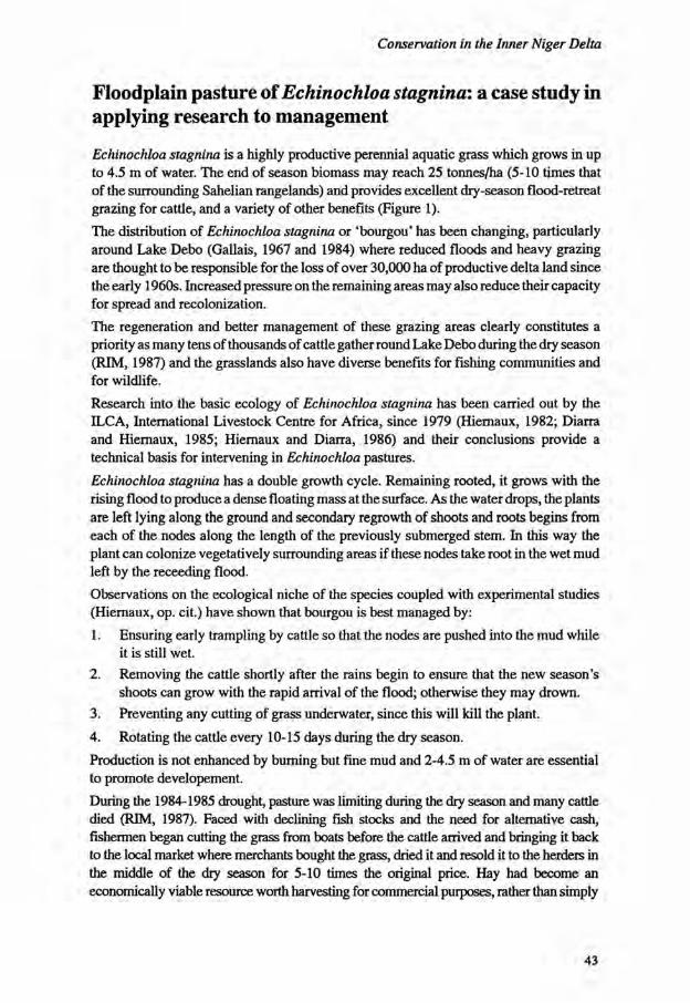
Conservation in the Inner Niger Delta
Floodplain pasture of Echinochloa stagnina: a case study in applying research to management
Echinochloa stagnina is a highly productive perennial aquatic grass which grows in up to 4.5 m of water. The end of season biomass may reach 25 tonnes/ha (5-10 times that of the surrounding Sahelian rangelands) and provides excellent dry-season flood-retreat grazing for cattle, and a variety of other benefits (Figure 1). The distribution of Echinochloa stagnina or 'bourgou* has been changing, particularly around Lake Debo (Gallais, 1967 and 1984) where reduced floods and heavy grazing are thought to be responsible for the loss of over 30,000 ha of productive delta land since the early 1960s. Increased pressure on the remaining areas may also reduce their capacity for spread and recolonization. The regeneration and better management of these grazing areas clearly constitutes a priority as many tens of thousands of cattle gather round Lake Debo during the dry season (RIM, 1987) and the grasslands also have diverse benefits for fishing communities and for wildlife. Research into the basic ecology of Echinochloa stagnina has been carried out by the ILCA, International Livestock Centre for Africa, since 1979 (Hiemaux, 1982; Diarra and Hiernaux, 1985; Hiernaux and Diarra, 1986) and their conclusions provide a technical basis for intervening in Echinochloa pastures. Echinochloa stagnina has a double growth cycle. Remaining rooted, it grows with the rising flood to produce a dense floating mass at the surface. As the water drops, the plants are left lying along the ground and secondary regrowth of shoots and roots begins from each of the nodes along the length of the previously submerged stem. In this way the plant can colonize vegetatively surrounding areas if these nodes take root in the wet mud left by the receeding flood. Observations on the ecological niche of the species coupled with experimental studies (Hiernaux, op. cit.) have shown that bourgou is best managed by: 1. Ensuring early trampling by cattle so that the nodes are pushed into the mud while
it is still wet. 2. Removing the cattle shortly after the rains begin to ensure that the new season's
shoots can grow with the rapid arrival of the flood; otherwise they may drown. 3. Preventing any cutting of grass underwater, since this will kill the plant. 4. Rotating the cattle every 10-15 days during the dry season. Production is not enhanced by burning but fine mud and 2-4.5 m of water are essential to promote developement. During the 1984-1985 drought, pasture was limiting during the dry season and many cattie died (RIM, 1987). Faced with declining fish stocks and the need for alternative cash, fishermen began cutting the grass from boats before the cattle arrived and bringing it back to the local market where merchants bought the grass, dried it and resold it to the herders in the middle of the dry season for 5-10 times the original price. Hay had become an economically viable resource worth harvesting for commercial purposes, rather than simply
43

Sustainable use of wetland resources
S E E D S FOR FISHERMAN
C O V E R FOR FISH S E E D S FOR DUCKS
\ / Echinochloa stagnina
FOOD FOR MANATEES HAY FOR DRY SEASON
GRAZING FOR CATTLE
Figure 1 The multiple uses of Echinochloa stagnina
personal use. The demand was such that merchants were able to hire boats and workers to cut grass by the day. Drought was responsible also for a change in the way agriculturalists and fishermen kept a few small ruminants as an investment. Normally these animals were given to the Peul who took them out to pasture. However, the mistrust which developed between herder and owner when the former were found to have eaten or sold off animals not belonging to them, while passing them off as natural deaths, has meant that many more animals are now kept at home or pastured near villages. As many as 27% of sheep may be village-based (RIM, 1987). In response to the demand for hay, attention was turned towards 'fields' planted specifically for the purpose, particularly as a 'cash crop' for sale in local markets for those not usually part of the herding economy. The vegetative reproduction of bourgou
44

Conservation in the Inner Niger Delta
makes it an easy grass to plant. Post-flood stems which are beginning to show new vegetative shoots at the nodes are simply pressed into the mud left by the declining flood. If these areas remain ungrazed for the first dry season, the flood production in the following year can equal that of natural areas. Following successful regeneration of Echinochloa stagnina in eastern parts of Lake Debo, both IUCN and an NGO,' Veterinaires sans Frontieres', set up demonstration plots to show that areas in western Lake Debo previously too deep for bourgou were now available for planting due to the lowered flood, and that the policy of trying to regenerate bourgou only in area where it previously grew was doomed to failure. The transition from demonstration plots to common practice faces a number of hurdles which have only become obvious through these interventions. They are all of a socioeconomic nature, as the technical ecological information is already available: 1. Traditional land rights on the south shore of Lake Debo where there is ample area
for bourgou, remain with the Peul herders. They wish to maintain those rights but by allowing others to plant bourgou, those rights; will be lost. At the time most suitable for planting, the Peul themselves are unfortunately some 50-60 km away, facing their busiest time of year. They are also not particularly motivated to do intense manual work.
2. Grazing areas are usually communal in nature and individuals are reluctant to invest their personal energy unless they have some g jarantee of exclusive future benefit.
3. Planting of bourgou conflicts in many areas with demand for labour at the rice harvest. However, the consistent failure of rice in recent years has released some labour.
In order to encourage people to plant bourgou, these issues were addressed in a cultivating village on the north shore of Lake Debo which did have traditional access rights to some suitable land. The villagers' solution to these problems, as expressed in discussion with the project, was to divide their land into two parts, one of which was made available to individuals wishing to plant their own fields, and the other retained as communal land. Those wishing individual plots had to participate in planting communal areas and the village council determined that this would happen every Tuesday and Sunday while water levels were suitable.
Income from the first cut of the flood production from private fields went to the owner but animals from the village could graze the subsequent regrowth. Communal areas may be let to outside herders if the village needs a cash income, otherwise it will be grazed by village animals. In this way, communal and individual requirements can be satisfied and the need for a personal return on labour invested is resolved. Personal cash income from fields of 1 ha or so was reported to be of the order of 50,000 CFA (US$ 66) in the first year. The (IUCN) project has made similar as yet unsuccessful proposals to the traditional landowners on the south shore of Lake Debo in an attempt to reach a compromise between the cultivators who want to plant bourgou and the herders who are reluctant to lose control as it threatens their monopoly on pasture access and because they are concerned that bourgou fields may turn into rice fields and marginalize herding interests. This is acting as a block to the replanting of several thousand hectares of suitable land.
45

Sustainable use of wetland resources
A potential spinoff from the successfully replanted areas where people have worked hard at regenerating a resource will be that they want to ensure its perennity through some sort of management scheme adopting the guidelines suggested by Hiernaux (1982). These might then be extended to natural areas if they are found to be successful and acceptable given the constraints of the local economy and of the community.
Conclusions
The conservationist seeking to encourage local people to actively regenerate natural resources which have been lost or degraded has to face a number of constraints which are not only of an ecological but also a socio-economic nature. The approach adopted by the project described here is tailored to the particular conditions of the Inner Niger Delta but there are a number of relevant conclusions to be drawn which are applicable to other areas. One of the key issues is to persuade villagers of the importance of each management activity. Many people feel that the loss of vegetation is entirely due to drought and until rainfall patterns recover there is nothing to be done. For this reason it is important that the maxim of 'seeing is believing' is followed, and that successful demonstration projects are organized, if necessary by paying villagers for the work they do. This is often just a straightforward technical ecological exercise. A case can then be made to the local people, based on an understanding of the local economy and of land tenure issues, for them to extend these activities to other areas. A second important constraint is one of traditional rights and the issue of common land and common resources. Individuals wish to work for their own benefit and are reluctant to invest their time and effort in, for example, planting bourgou, if others who have not contributed will also benefit. Communal replanting of village land requires a consensus which may be difficult to achieve. Privatisation of common land to allow people to plant personal 'fields' may be a viable short-term option but it brings with it the seeds of conflict as existing Malian legislation does not recognize private ownership of natural resources, even if these have been planted by individuals. The third constraint is time and the balance of immediate income against future (unguaranteed) income. Every person is making choices as to how best to invest their energies, based on their own requirements. While numbers of house animals are high and crop yields and floods are low, replanting of bourgou, for example, is an economically viable activity but this may not always be the case. For the successful conservation of floodplain resources in the Inner Niger Delta and other African wetlands where rural people are the main agents of change, it is essential to balance the constraints of the ecology of the main resources (growth cycle, fruiting, regeneration, ecological niche) with the constraints of the local economy (time, income, land tenure) and this can only be done with a thorough knowledge and understanding of both ecology and socio-economy.
46

Conservation in the Inner Niger Delta
References
Diarra, L. and P. Hiernaux. 1985. Catastrophe ecologique dans les plaines du delta interieur du Niger. Suivi de la vegetation d'une dizaine de sites, resultats de la saison seche 1984-1985, CIPEA. Document de programme AZ 97.
Gallais, J. 1967. Le delta interieur du Niger. Etude de geographie regionale, 2 vol. IFAN, Dakar.
Gallais, J. 1984. Homines du Sahel. Collections geographies, Flammarion, Paris.
Hiernaux, P. 1982. La carte des ressources fourrageres des parcours du delta interieur du Niger. CIPEA. Programme des zones arides et semi-arides, Bamako.
Hiernaux, P. and L. Diarra. 1986. Bilan de 5 annees de recherches (1979-1984) sur la production vegetale des parcours des plaines d'inondation du fleuve Niger au Mali central. CIPEA. Document de programme AZ 142.
IUCN. 1986. Conservation de Fenvironnement dans le delta interieur du fleuve Niger: Document de Synthese. Mimeo. 97 pp.
Resource Inventory and Management (RIM) Ltd. 1987. Refuge in the Sahel. Ministere des ressources naturelles et de l'elevage, Mali. 115 pp.
Skinner, J. 1988. Towards Better Wooodland Management in Sahelian Mali. ODI Pastoral Development Network, Paper 25d, March 1988.
47

Sustainable use of wetland resources
48

Peatlands - dilemmas of use and conservation*
Edward Maltby
Department of Geography, University of Exeter Amory Building, Rennes Drive Exeter EX4 4RJ Devon United Kingdom
Resume
Le dilemme des tourbieres: utilisation ou conservation?
Les tourbieres et les sols organiques couvrent sur notre planete une superficie estimee a 500 millions d'hectares. Au cours de l'histoire de l'Occident, l'homme a exploite la tourbe a grande echelle et a ainsi detruit de grandes surfaces de tourbieres sans connaitre leur importance ecologique. De plus, on a decouvert recemment qu'il y avait sous les tropiques des tourbieres beaucoup plus vastes qu'on ne le pensait. Dans ces regions, il est urgent de comprendre les fonctions ecologiques remplies par ces milieux pour mettre sur pied des systemes d'exploitation de la tourbe non-destructeurs. Nous exposons dans cet article les arguments en faveur de 1'implantation de ces nouvelles methodes, respec-tueuses de la valeur ecologique de ces milieux et proposons l'elaboration de politiques nationales de gestion raisonnee de ces ressources.
Nature and extent of the resource
Peat accumulates when decomposition, export or erosion of plant litter fails to balance its rate of production over a certain period of time. The imbalance between decomposition and production may be due to waterlogging, anaerobiosis, low pH, nutrient limitations, low temperatures or some combination of site and environmental factors. A significant proportion of the world's wetland ecosystems are peat-forming. They include not only such characteristic high latitude systems as bogs, muskeg and fen but also marsh and swamp (including tropical and subtropical lake margins), mangroves and
* Accepted for publication, September 1988
49

Sustainable use of wetland resources
associated systems as well as depressional wetlands across wide climatic limits. Actual estimates of the areal extent or mass of peat vary because of differences in the criteria used for defining peat (particularly the minimum depth value used) and availability of improved surveys for the more isolated regions of the world. In 1969 the extent of peatlands was given as only 150 million hectares but little more than a decade later the estimate was 422 million hectares today and indications are that a value of 500 million hectares may be a closer approximation (Kivinen and Pakarinen, 1981). This is equivalent to 3.8% of the world's land surface. Distribution by country has been reviewed recently by Bord na Mona (1984). By far the largest proportion of peatland occurs in the temperate and boreal zones with at least 60% of the total world area in the Soviet Union and Canada.
Peatlands in the tropics were once considered extremely rare by many northern soil and environmental scientists. Whilst their full extent is still largely a matter of speculation there is no doubt that in some regions they constitute considerable areas. Most tropical peat is found in one region bordering the western, southern and eastern extremities of the South China Sea. In Indonesia land with a peat depth of at least 40 cm and with minimum organic matter content of 30% extends over 27 million hectares or 14% of the land surface (Jansen et al, 1985), considerably higher than the earlier estimate of 17 million hectares given by Young (1982). A survey by Bord na Mona (1984) gives conservative estimates of the distribution of peat in developing countries (Table 1) many of which are located in the tropics and where field investigations have generally been limited. However, information has been improving considerably in a growing number of cases where development pressure on the peat resource has increased - such as in Burundi, Rwanda, Jamaica, Indonesia, Malaysia, Uganda and Brazil.
The magnitude of the world's peat deposits may well be significant in relation to the earth's carbon budget (Bramryd, 1979). The dry mass of carbon in deep peat deposits has been estimated as approximately 180 Gt (109) (Kivinen and Pakarinen, 1981). This compares with an atmospheric store of 600-700 Gt, a plant biomass figure of 800 Gt and an annual primary productivity value on land of 50 Gt (Woodwell et al., 1978). A revaluation is currently underway of the scale of the global peatland carbon store and its possible significance in terms of the flux of greenhouse gases (Maltby, Immirzi and MacLaren, 1992).
Historical perspective
Experience from the developed nations Peatlands in developed countries have been altered progressively by two main processes; conversion to agricultural or forestry use and mining of peat for energy and horticulture. Peatlands in their natural condition impose restrictions on intensified agricultural utilisation and other land uses largely because of the high water table and physico-chemical characteristics of the organic profile. Greater agricultural flexibility and higher crop yields require drainage and other forms of management input including cultivation, fertilizer application and use of pesticides.
50

Peatlands - dilemmas of use and conservation
As technological innovation and financial incentives have permitted the modification of peatland hydrology, agricultural conversion has proceeded rapidly over large areas of temperate Europe. The progression of drainage has been particularly well documented from the seventeenth century to the present day in the case of the Fens of eastern England (Darby, 1983) where in some years in the nineteenth century more than 10,000 ha of peatland were drained. Engineers like Joseph Glynn pronounced " I have not only caused two blades of grass to grow where one grew before but I have had the pleasure to see abundant crops of wheat take the place of the sedge and the bulrush. Thus the steam engine permitted conversion of 'the swamp or marsh, exhaling malaria, disease and death' to 'fruitful cornfields and verdant pastures'" (Glynn, 1838). Such reasoning has pervaded and underwritten the agricultural conversion over the last 300 years of hundreds of thousands of hectares of peatland in Britain, The Netherlands, West Germany, France and Ireland. Influenced until recently by artificial price support mechanisms, subsidies and beneficial tax structures, the incentive to turn peatland into agricultural or forestry land with more 'obvious' or direct benefits to the owner has continued in Europe and increased in some parts of North America. In the case of the United States over 200,000 ha of pocosin peatland was cleared between 1973 and 1975, mostly by corporate agricultural and silvicultural concerns. By 1980 only 281,000 ha of pocosins remained in North Carolina out of an original one million hectares (Richardson, 1981). Vast areas of Everglades fenland and marsh in Florida have been drained since the nineteenth century (Blake, 1980) but the peat soils are disappearing fast due to oxidation. Between the middle of the nineteenth century and 1978,84% of lowland raised bog in Britain was lost through afforestation, agricultural reclamation and commercial peat cutting. Only 6% of the original 13,000 ha of such bogs is considered ecologically intact (Nature Conservancy Council, 1986). One of the largest single expanses of blanket bog in the world, the Flow Country of Caithness and Sutherland, northern Scotland has not avoided development pressure despite its relative remoteness. Over the last 20 years, but mainly within the last decade, an original 401,375 ha of blanket bog has been fragmented by coniferous afforestation, deep ploughing and drainage, and the area overall reduced by 16%. Only eight out of forty-one river catchments in the region have no new plantations within them (Stroud et al., 1987). Historically peat has been cut in just sufficient quantities to satisfy the heating and cooking needs of many isolated communities such as on the western islands of Scotland or the Falkland Islands in the South Atlantic. Since the turn of the century, however, the use of peat on an industrial scale for power generation and district heating plants has expanded considerably. Fuel peat production worldwide nearly doubled between 1950 and 1980 from 47 million tonnes to 90 million tonnes (Kalmari, 1982). In the USSR, the largest single producer, 47 state electricity generating stations and 32 combined heat and power plants used milled peat. Yet overall peat contributes less than 1.5% of total Soviet energy consumption (Bord na Mona, 1984). In Finland 90% of the peat cut is used to generate power. Some 3.1 million tonnes were produced in 1980 but 8-10 million tonnes per year was the target for 1990. Again peat provides only about 2 % of the nation's energy requirements (Bord na Mona, 1984) and that proportion seems unlikely to increase
51

Sustainable use of wetland resources
Table 1 Areas of peatland in developing countries (after Bord na Mona, 1984)
Country Area (ha)
Africa Angola -Burundi 14,000
Congo 290,000
Guinea 525,000
Ivory Coast 32,000
Lesotho -
Liberia 40,000
Madagascar 197,000
Malawi 91,000
Mozambique -
Rwanda 80,000
Senegal 1,500
Uganda 1,420,000
Zaire -
Zambia 1,106,000
Asia Bangladesh 60,000
China 4,200,000
Fiji 4,000
Indonesia 17,000,000
India 32,000
Israel 5,000
Korea (DPR) 136,000
Malaysia 2,500,000
Papua New Guinea -
Philippines 6,000
Sri Lanka 2,500
Thailand 68,000
Vietnam 183,000
52

Peatlands - dilemmas of use and conservation
Country Area (ha)
Central America British Honduras 68,000
Costa Rica 37,000
Cuba 767,000
El Salvador 9,000
Honduras 453,000
Jamaica 21,000
Nicaragua 371,000
Panama 787,000
Puerto Rico 10,000
Trinidad and Tobago 1,000
South America Argentina 45,000
Bolivia 900
Brazil 1,500,000
Chile 1,047,000
Colombia 339,000
Falkland Islands 1,151,000
French Guiana 162,000
Guyana 813,880
Surinam 113,000
Uruguay 3,000
Venezuela 1,000,000
significantly over time. Yet it is likely that progressive mining will reduce dramatically the extent of peatlands especially that of the raised bogs of middle Finland. The situation in Ireland is somewhat different. Over 40% of the country's electricity is generated from seven peat-fuel power stations. The Irish Peat Development Authority, Bord na Mona, employed 7,000 people mainly in remote rural areas where other jobs are scarce. Peat contributes significantly to the nation's balance of payments. Ireland exported more than a million cubic metres of horticultural peat worldwide worth IR £16 million in 1983-1984. Grants are offered to private enterprises to exploit bogs not suitable for large-scale development by the Authority. Since 1946 more than 80,000 ha have been mined. Only 1 % of the original 29,000 ha of raised bog in County Mayo remains intact
53

Sustainable use of wetland resources
(Cross and Douglas, 1988). Even blanket bog is festimated to become extinct within 100 years and possibly in a much shorter term when areas of raised bog have been exhausted. The pattern is clear. Large-scale peatland ecosystem loss has occurred historically in the temperate regions of developed nations and has expanded progressively into both higher latitudes (e.g. Finland and USSR) and lower latitudes (e.g. the southeast United States) without significant checks. Only limited examples of intact peat systems remain and decisions to exploit peatlands have never taken significant account of the full roles they play in environmental support. Many of the types that remain are variously protected but often as 'nature reserves' with reduced capabilities as functioning ecosystems.
Changing attitudes?
There are signs of change in attitudes among governments and technical agencies within the developed world. In Britain management agreements and compensation payments within designated peatland areas such as the Somerset Levels, identified as an Environmentally Sensitive Area under European legislation, enable protection from further ploughing and peat extraction for horticulture. Non-governmental organisations such as Friends of the Earth, Plantlife and WWF are campaigning hard to move public opinion against destructive peat harvesting and towards a policy of product substitutes, especially for horticultural peat. Changes in taxation policy have reduced the financial benefits to be obtained from afforestation and drainage of the blanket bogs of Scotland. Arguably, however, it is easy to mobilise conservation effort when the resource already has been grossly depleted.
Dilemmas of developing nations It is now known that a significant proportion of the global peatland area occurs in the tropical and sub-tropical regions of the world, comprising mainly developing countries. Andriesse (1988) estimates the figure at 35.8 million ha, though the basis for national values may vary enormously as a consequence of different definitions for peat in relation to depth of deposit. Nevertheless, this means that more than 8% of the global area is located in these climatic zones and 57% of this is located in southeast Asia alone, principally in Indonesia. Without doubt it is in the Third World where the greatest pressures are currently being applied which may effect major future loss of peat-dominated ecosystems. The arguments are seemingly simple but often incorrect in their underlying assumptions. Typical statements are "We cannot eat peat but we can eat rice or fish harvested from converted peatlands"; "We must do anything which will reduce our budget deficit"; "We must take advantage of the foreign aid and technology package"; "Europe has benefitted from the exploitation of its peat resources - why can't we?". In response to such reasoning vast areas of coastal peatland in Indonesia and Malaysia have been drained for agricultural settlement or converted to fishponds. In the mid-1970s a major drainage scheme supported by the Inter-American Development Bank converted about 2,000 ha of Jamaica's Black River Upper Morass mainly to rice cultivation. Further foreign aid may expand the area of cultivated land not only destroying the 'natural' wetland habitat, but also reducing the locally important fish and shrimp harvests.
54

Peatlands - dilemmas of use and conservation
There are particular pressures in poor countries like Jamaica and Indonesia for the utilisation of peat resources for energy production. The Jamaican government had seen a peat energy programme as a means of saving over US $24 million a year in foreign exchange, providing a breathing space for the development of new energy resources or imports, expanding industry and establishing peat-related activities such as horticultural products. Engineering and environmental feasibility studies supported in part by Swedish and Finnish aid programmes have proceeded since 1981 and were reviewed in detail in an IUCN report (Maltby, 1985). More recently the Indonesian Government has explored Kalimantan and Sumatra to establish the feasibility of mining peat for energy. In the light of such immediate pressures and the recent interest of other developing nations, such as Uganda, to utilise their own peatlands in the wisest way possible, it is essential that policies and guidelines are drawn up which optimise their utilisation and the benefits which will be obtained. The imperative to develop peatlands either by means of alteration and drainage or by direct extraction has usually proceeded on the basis that in their undisturbed state these ecosystems confer little or no value to human communities. No account generally has been taken of the possible economic as well as social importance of natural functions such as regulation of hydrology and atmospheric carbon, absorption of toxicants, alteration of water chemistry, and fisheries support. Yet the goods and services provided by undisturbed or 'appropriately' managed peatlands may outweigh many times the value of benefits from their alteration less the costs of any adverse impacts.
Problems arising from peatland development
Major and potentially devastating ecological and environmental consequences at scales which vary from local to global may result from inappropriate modification or loss of peatland ecosystems (Table 2). More detailed reviews are given in Winkler and deWitt (1985) and Maltby (1989). Drainage results inevitably in subsidence and progressively lower drains or more expensive pumps are required to keep pace with reducing surface elevations and flooding problems. Fen peat in eastern England has been lost at the rate of 3 cm yr"1 since 1848. Drainage and farming south of Lake Okeechobee, Florida has produced a surface lowering of 3.3 m and an estimated rate of subsidence of 2.5 cm yr"1
(Stephens, 1974). Levin and Shoham (1983) report surface losses of 10 cm yr"1 from 1958-1965 and 7.5 cm yr"1 from 1970-1980 in the Hula Valley, Israel. Peats in Indonesia subside by 3.5 cm yr"1 after conversion to agriculture (Haeruman, 1986) although in the first year of drainage of some tropical lowland peats the surface may be lowered by 50 cm or more (Andriesse, 1988). Desiccation can produce hard granules particularly in well humified peat. These may be very difficult to re-wet. In some cases they are irreversibly altered and are highly erodible, combustible and an unstable medium for plant growth. Development of such material has been referred to as 'black death' in Rwanda (Berg, 1950). Chemical transformations can occur which result in the release of toxic leachates such as heavy metals, organic pollutants, and especially in lowland coastal peats, in the
55

Sustainable use of wetland resources
development of acid sulphate soils. Such changes may result in severe deterioration of water quality impacting fisheries as well as potable supplies. Oxidation of drained peat can lead to the formation of nitrates and release of phosphates in concentrations which can induce major environmental problems. In the Everglades agricultural area (EAA) Terry (1983) reports that 1200-1400 kg N ha"1 yr"1 are released by mineralisation although about 90% is still prevented from reaching drainage water because of denitrification. The denitrification figure may well decline with further drainage. In the Hula Valley Raveh (1973) has estimated that 1000-2000 kg NO3-N ha"1 yr"1 accumulates under field conditions in the former peat swamp. Large proportions of this eventually drains into Lake Kinneret, the major source of freshwater for Israel. In Florida the level of phosphate release from the EAA has been linked to ecological imbalance in wetlands downstream of sufficient magnitues to initiate a major lawsuit between Federal and State authorities.
Hydrological changes in modified coastal peatlands have resulted in increased salinity (Haeruman and Damopolii, 1976), and major impacts on fish and shellfish (Richardson, 1983). Loss of habitat and changes in chemical signatures and flow characteristics of streams may disrupt the spawning pattern of anadromous species. Although the development of fish ponds in coastal peatlands, especially in the tropics, may result in apparently high yielding aquacultural systems, the gains must be offset against environmental changes and losses of habitat, nursery and feeding areas for 'wild' stocks.
Table 2 Consequences of peatland change
Scale Examples of impact
Local Habitat
Subsidence
Hydrology
Fire and air quality
Toxic leachates
Organic pollutants
Regional Groundwater supply
Saltwater penetration
Eutrophication
Fisheries
Food chain support
Global Heritage and science
Conservation values and genetic resources
Biogeochemical cycling
'Greenhouse' gas flux
56

Peatlands - dilemmas of use and conservation
Whilst problems such as land subsidence, flooding, reduced water quality, habitat loss and decline in fishery stocks can have important international repercussions, e.g. migratory species and export of fish harvests, the environmental, social and economic impacts of change are primarily restricted to the local or regional scale. There is one consequence of peatland loss, however, which places the problem firmly into the realm of global concern. The scale of human impact in altering the role of organic soils and peat as carbon sinks has been examined by Armentano and Menges (1986). Before human disturbance global storage of carbon was 57-83 million tonnes yr"1. The balance of carbon movement between wetlands and the atmosphere has shifted primarily as a result of agricultural conversion. The shift has two major components - release of previously accumulated carbon and loss of a sink for carbon. Armentano and Menges (1986) suggest that by 1980 the total shift in the carbon balance resulting from agricultural drainage was 63-85 million tonnes carbon with a further 39 million tonnes carbon per year released from peat combustion. Most of the change to date has occurred in temperate and high latitudes but in the future a more significant contribution could be expected from developing countries especially in the tropics. The full significance of peatland orientated carbon shift is not yet clear but possible linkage to global warming and sea level change must not be discounted. Such environmental consequences are relevant worldwide and highlights peatlands as part of the 'global commons'.
The way ahead
Peatlands are a seriously endangered habitat in western Europe where immediate action is required if the last remaining examples of some bog types are to survive. The emphasis must be on more active measures for protection, finance and legislation. These will follow only if public opinion can be mobilised and appropriate product substitutes are found, especially for the horticultural and energy uses of peat. The threats to peatlands in the Third World countries in general and the tropics in particular are increasing. Ironically, the pressures may well increase as conservation becomes more effective in the developed countries. Such is the growing demand on land and natural resources in some countries that a proportion of peatlands inevitably must be developed. It is essential that development of these areas is cognizant of the full functional and conservation values of the peat resources (to local inhabitants, the country and internationally) and takes account of these in the allocation of alternative land use regimes. We are still very deficient, however, in our level of knowledge of ecological and environmental processes in tropical peatlands. An urgent need exists for: 1. National programmes for the wise use of peat resources. Once lost, peatlands cannot
be recovered within human lifetimes. An outline of a model programme is given in Table 3.
2. Specific guidelines for the sustainable utilisation of tropical peatlands which should be drawn up with the intention of influencing donor and development agencies, and national, regional and local planning authorities together with a wide range of professional groups.
57

Sustainable use of wetland resources
As an overall guiding principle it is essential that the economic and social gains of short-term peat exploitation are not outweighed by losses incurred by other sectors of society as a result of environmental changes or resource degradation. This places a premium on detailed environmental impact analysis of proposed development projects for peatlands. The responsibility for wise use of peatlands in the developing countries however is not simply in the hands of their own governments but also is in those of the developed countries from which development and technological assistance is being provided. This represents at least in part self-interest because changes in third world ecosystems may have inevitable repercussions on environmental quality worldwide.
Table 3 Outline for a national management programme for peatlands
1 Map and classify peat resources.
2 Identify the nature and scale of current utilisation and of prospective alternative developments.
3 Evaluate the national and international significance of peatland ecosystems in relation to: (a) ecosystem type; (b) genetic reservoir, community or hydromorphological stage or type; (c) ecological, chemical, biophysical and hydrological processes; (d) wildlife, including migratory species; (e) fisheries support; (f) research, educational, recreational and heritage; (g) other identifiable values. Particular emphasis should be directed towards a functional analysis approach which examines the goods and services provided both 'off-site' as well as 'on-site'.
4 Define the nature and scale of permitted sustainable uses - those which do not impair essential functions - and those peatlands which must be protected for functional and/or conservation purposes.
5 Define the terms under which non-sustainable use of peatland will be permitted prior to any such further development occurring.
6 Advise on the strategies necessary for the sound management of peatland resources and how this can be achieved.
58

Peatlands - dilemmas of use and conservation
References
Andriesse, J.P. 1988. Nature and Management of Tropical Peat Soils. FAO Soils Bulletin 59. Food and Agriculture Organisation of the United Nations, Rome.
Armentano, T.V. and E.S. Menges. 1986. Patterns of Change in the Carbon Balance of Organic Soil-wetlands of the Temperate Zone. J. Ecol. 74:755-774.
Berg. 1950. Cited by K. Thompson. 1973. The ecology of peatlands in East and Central Africa and their classification for agriculture. Pages 60-73. In: R.A. Robertson (Ed.). Classification of peat and peatlands. Proc. Symp. Comm. 1, International Peat Soc, Glasgow, September 1973. Intern. Peat Soc, Helsinki. Paper 8.
Blake, N.M. 1980. Land into Water - Water into Land. University Presses of Florida, Tallahassee.
Bord na Mona. 1984. Fuel Peat in Developing Countries. Bord na Mona, Dublin.
Bramryd, T. 1979. The effects of man on the biogeochemical cycle of carbon in terrestrial ecosystems. Pages 183-218. In: B. Bolin, E.T. Degens, S. Kemp and P. Ketner (Eds.) The Global Carbon Cycle. Wiley, Chichester.
Cross, J.R. and C.S. Douglas . 1988. Character, status and conservation of Ombrogenous Mires in the Republic of Ireland, with particular reference to Raised Bogs. Unpublished manuscript.
Darby, H.C. 1983. The Changing Fenland. Cambridge University Press.
Glynn, J. 1838. Draining land by steam power. Trans. Soc. of Arts, I I . pp. 3-24.
Haeruman, H. and dan J. Damopolii. 1976. Analisa Pengaruh Lingkungen Pembukaan Daerah Pasang Surut Delta Upang Umtuk Pertanian. Cited by Haeruman. 1986.
Haeruman, H.1986. Peatlands utilisation and its environmental impacts. Symposium on Tropical Peat and Peatlands for Development. Yogyakarta, Indonesia. February 1986.
Jansen, J.C, W.H. Diemont and N.J. Koenders. 1985. Peat Development for Power Generation in West Kalimantan - An Ecological and Economic Appraisal. The Netherlands Economic Institute 3.62 RA. Rotterdam, The Netherlands.
Kalmari, A. 1982. Energy Use of Peat in the World and Possibilities in Developing Countries. Seminar on Peat for Energy Use. 29-30 June 1982. Badung, Indonesia.
Kivinen, E. and P. Pakarinen. 1981. Geographical Distribution of Peat Reserves and Major Peatland Complex Types in the World. Ann. Acad. Sci. Fennicae (Geol. Geog)III. 132:1-28.
59

Sustainable use of wetland resources
Levin, I . and D. Shoham. 1983. Ground-surface Elevation Loss in the Reclaimed Hula Swamp in Israel During the Period from 1958 to 1980. Pages 61-69. In: K.M. Schallinger (Ed.). Proc. Second Intern. Symp. Peat in Agriculture and Horticulture. The Hebrew University, Jerusalem.
Maltby, E 1985. Peat Mining for Energy in Jamaica. IUCN Conservation for Development Centre. Special Report SIEP-2, Gland, Switzerland.
Maltby, E. 1989. Development, Agricultural Conversion and Problems of Organic and Waterlogged Soils. Pages 339-389. In: E. Maltby and T. Wollersen (Eds). Soils and their Management. Elsevier.
Maltby, E., CP. Immirzi and D. MacLaren. Do not Disturb! Peatbogs and the Greenhouse Effect. Friends of the Earth, London.
Nature Conservancy Council. 1986. Nature, Conservation and Afforestation in Britain. Nature Conservancy Council, Peterborough, England.
Raveh, A. 1973. Accumulation of Nitrates in the Hula Valley and their Control through Induced Denitrification. Technion, Israel Inst, of Technology, Agric. Eng. Pub. No. 179 (in Hebrew).
Richardson, C.J. (Ed.). 1981. Pocosin Wetlands. Huchinson, Stroudsbourg, Pennsylvania. 364 pp.
Richardson, C.J. 1983. Pocosins: Vanishing wastelands or valuable wetlands? Bioscience 33:626-633.
Stroud, D.A., T.M. Reed, M.W. Pienkowski and R.A. Lindsay. 1987. Birds, Bogs and Forestry. The Peatlands of Caithness and Sutherland. Nature Conservancy Council, Peterborough.
Stephens, J.C. 1974. Subsidence of Organic Soils in the Florida Everglades Region of Florida. Contribution from the Division of Drainage and Water Control, USDA Soil Conservation Science.
Terry, R.E. 1983. Nitrogen Transformation in Histosols. Pages 13-16. In: K.M. Schallinger,(Ed.). Proc. 2nd Intern. Symp. Peat in Agriculture and Horticulture. The Hebrew University, Jerusalem.
Winkler, M.G. and CB. deWitt. 1985. Environmental Impacts of Peat Mining in the United States: Documentation for Wetland Conservation. Environmental Conservation 12:317-330.
Woodwell, G.M., RM. Whittaker, W.A. Reiners, G.E. Likens, C.C. Delwiche and D.B. Botkin. 1978. The Biota and the World Carbon Budget. Science 199:141-146.
Young, R.D. 1982. Peat in Indonesia (Part 1). Presented at a Seminar on Peat for Energy Use. 29-30 June 1982. Bandung.
60

Research and management in the Pantanal of Brazil*
J. Adamoli
GESER (Grupo de Est. Sobre Ecologi'a Regional) Fac. Cienciaas Ciudad Univers. P. II4° Lab. 57 1428 Buenos Aires Argentina
Resume
Importance des recherches fondamentales pour la gestion du Pantanal (Bresil)
Place a un veritable carrefour biogeographique, entre les regions des Cerrados, de 1' Amazonie et du Chaco, le Pantanal presente une diversite biologique particulierement elevee, les especes vegetales et animales natives ayant evolue par rapport aux inonda-tions naturelles. Le Pantanal est une vaste plaine (138 000 km2) soumise a un climat tropical caracterise par des pluies d'ete. En raison des pentes tres faibles (de l'ordre de 10 cm/km), le ruissellement est extremement lent (au cours de la traversee du Pantanal, les pics d'inondation varient de quelques semaines a quatre mois).
Les recherches fondamentales sur la dynamique des inondations apportent des connaiss-ances capitales a tous ceux qui s'interessent au Pantanal. Chaque annee, des vastes surfaces de la region sont inondees mais ce processus n'est absolument pas homogene. Les zones qui subissent les inondations les plus importantes, les plus frequentes et les plus longues representent 16% de la superficie totale du Pantanal, les zones interme-diaires representent 34% et les zones non inondables, ou peu inondees (frequence, amplitude et duree d'inondation faibles), correspondent a 50%. Des inondations exceptionnelles ou tres fortes ont lieu dans 5,5 a 13,2% des cas. Bien qu'elles soient peu frequentes, leurs consequences peuvent etre importantes pour la faune ou pour le betail, cette region ayant une economie fondee sur l'elevage. D est done indispensable de disposer de systemes d'alerte hydraulique pour gerer les troupeaux ou les reserves biologiques.
* Accepted for publication, September 1988
61

Sustainable use ofwettand resources
Figure 1 The Pantanal as a biogeographical crossroad
Introduction
One of the largest wetland areas in the world, the Pantanal lies at a biogeographical crossroads in the middle of South America. The confluence of the faunas and floras of Amazonia, Cerrados and Chaco regions contributes to the biological diversity of an immense tropical lowland region, extending over 138,000 km2, between 16° and 21°S (Figure 1). Savanna components belonging to the region of Cerrados occupy the greater part of the territory, particularly the central and eastern areas, and are mostly always associated with deep, acid, well drained sandy soils, which are seldom, if ever, flooded. Components of Amazonian lineage concentrate basically in the north and extend along rivers especially as part of the gallery forest. Finally, Chaco fauna and flora components show up in the south, commonly associated with alkaline, generally solodic, silty soils, subjected to long-lasting floods and/or water saturation.
62

Research and management in the Pantanal of Brazil
The topography of the region is extremely flat, and gradients are very mild -10-30 cm/km in an eastwest direction - (the highest values being found in the east and the lowest in the west). In the northsouth direction, slope values are even smaller, around 1-5 cm/km, or 0.005% (EDIBAP, 1979; DNOS, 1973). It is in this direction that the main river of the system the Paraguay flows. Drainage is organized into sub-parallel channels and is characterised by the alternation of present, temporary or abandoned courses and by the processes which form the bordering levees. In the alluvial fans, particularly that of Taquari River, courses show a perfect radial distribution, with its centre at the locality of Coxim, where this river leaves the Central Brazilian High Plain to form its huge 250 km fan.
The Pantanal's crystalline base is formed by a sunken block originated in the see-saw displacement of blocks following the rising of the Andes. It was gradually filled in by intensive fluvio-morphological activity (Schobbenhaus et al., 1984). The heterogeneity of the erodible areas at the headwaters cause the variability of the sediments carried by the different streams. In the eastern and central areas of the region sandy sediments prevail, associated with the sandstones that characterize most of the headwaters there. Soils are acid and dystrophic, and have a coarse texture. In the north and south subregions soils are strongly silty eutrophic, alkaline and even solodic, associated particularly in the South, with the calcareous hills where the headwaters flow (Pacheco de Amaral, 1986). The predominant vegetation belongs to the savanna type and includes the various physiognomic forms which are locally called 'Cerrados'. They are found where water saturation of the soil is occasional or non-existent. Where soils remain waterlogged during long periods, vegetation tends to grow in more open physiognomic forms ('campos' - wet-grass fields). Generally, gallery forests grow on the levees bordering the rivers (Figure 2). There is a great faunal diversity in the savannas and wetland environments. Huge bird flocks abound, while capybara, Hydrochoerus hydrochoeris, and jacare, Caiman cro-codilus, are of special significance because of their large populations and wide distribution. The need to introduce appropriate management techniques, and the danger of clandestine hunting, is especially critical in the case of Caiman crocodilus. Another essential component is the presence of over 5 million cattle. Whilst exotic, these are nevertheless an important element of the ecosystem and the basis of the main economic activities of the region. Rainfall, especially its summertime occurrence and intensity, is the main climatic factor affecting floods. For the Paraguay River headwaters region, of which the Pantanal forms part, a mean annual rainfall of 1,301 mm was calculated (EDIBAP, 1979; PNDU, 1973), by means of Thiesen's polygon, using data gathered at 120 stations during the 1965-1976 period. Rainfall is markedly concentrated in the summer. However, peak flood values leaving the Pantanal are recorded about 4 months later, because of the retention of the water by the low slope of the wetland basin.
63

Sustainable use of wetland resources
Unit No.
Surface (km 2 )
% Type of flood Height Duration (months)
Prevailing vegetation
1 21,803 16 Generalised High Long Gallery forest
2 46,863 34 Partial Medium Medium Wet grassland
3 69,334 50 Localised Mild Short Savanna
Figure 2 Areas subjected to flooding in the Pantanal
64

Research and management in the Pantanal of Brazil
Inundations and cattle breeding
Cattle breeding has always co-existed with alternating dry and humid periods. There have been occasional large floods as in 1905 or 1959 (PNUD, 1973). After the latter, there was an exceptional period of low rainfall, which lasted 14 years. The best grasslands in Pantanal are those of the lowlands bordering rivers (Figure 2, units 1 and 2). On the other hand, they are normally waterlogged during 2-4 months and are therefore not available for cattle at that time. During the 1959-1973 period, those fields likely to be reached by normal floods were free of water. Lowland pastures continued to have good grass production as a consequence of soil characteristics the existence of a shallow water table and the presence of native species, adapted to those conditions. However the well drained pastures of the savannas (Figure 2, unit 3) lost their high carrying capacity, because of the reduced amount of rains of that period and subsequent overgrazing.
In 1974 there was a change in the hydrological regime and the first large flood of the new cycle occurred. Particularly since 1977, a pluri-annual cycle of large floods became established in the Pantanal region, and reached its maximum in 1982 and 1988. There were severe cattle losses, due not so much to flood intensity, but because the lack of previous information did not allow people to estimate its magnitude correctly, preventing evacuation of herds at the right time (Adamoli, 1983).
Floods, however, are not an exceptional event. On the contrary, they are quite normal in the Pantanal. Every year large areas are covered by the waters to a greater or lesser extent. Yet, floods do not occur evenly. Figure 2 shows their geographic distribution and main characteristics. Different combinations of environmental factors determine the flood pattern of each subregion.
Basic research for management purposes
One of the key stations for recording the behaviour of each hydrological year in Pantanal is that of Ladario, where daily records have been kept since 1900 (Figure 2). On the basis of statistical analysis of data corresponding to maximum river height, it was possibly to classify floods as shown in Table 1. The mean value for flood rise was 4,074 m, oscillating between 3.75 and 4.50 m. This is defined in our classification, as 'Normal floods', which occurred in 17 of the 91 cases analyzed (17.8% of the cases). 'High', 'Very High' or 'Extremely High' floods were defined by adding 0.5, or 1.0 or 1.5 times the value of the standard deviation to the mean. 'Extremely High' floods are those exceeding a high rise mean of 6 m. On the other hand, 'Low', 'Very Low' and 'Extremely Low' floods were defined by subtracting 0.5, 1.0 or 1.5 times the value of the standard deviation to the mean. The data of Table 1 show that the highest annual levels of Rio Paraguay in Ladario oscillate between a minimum of 1 m and a maximum of 6.5 m. Both natural systems and cattle breeding are adapted to floods. However, exceptional floods represent a problem both for people in charge of wildlife handling and for cattle breeders. For this reason it was necessary to have a hydrological warning system that could be easily used and was at the same time reliable, two approaches were developed:
65

Sustainable use of wetland resources
1. During the 1970s two international projects were carried out in the Pantanal aimed at defining its hydrological characteristics and suggesting alternatives for integrated development alternatives (EDIBAP, 1979; DNOS, 1973). Among other studies, the SSARR (Stream-flow Synthesis and Reservoir Regulation) model was used to simulate the regulatory capacity of the basin under different circumstances. In other words, there is a mathematical model for the region, supplied with data from a dense recording station network, regularly issuing reports. Unfortunately, as a reflection of the nation's economic crisis, this service stopped in March 1990.
2. In the southern Pantanal studies were developed which permitted cattle breeders to interpret hydrological information in order to make decisions about the movement of herds. The system has been in use successfully since 1983, over an area of 260,000 ha (Adamoli, 1983). The predicted alternatives were based on the interactions between the Paraguay River and a tributary, the Miranda River. Additional considerations included channel morphology. The basic purpose was to organize the displacement of herds in relation to the possible inundation level.
Table 1 Flood level classification
Relationship Value (m)
Class Interval Proposed Classification
No of Cases
%
X + 1.5S 6.3375 6 m Extremely High 5 5.5
X + 1 .0S 5.5830 5.25-6.00 m Very High 12 13.2
X + 0.5 S 4.8285 4.50-5.25 m High 23 25.2
X 4.0740 3.75-4.50 m Normal 17 18.7
X - 0.5 S 3.3195 3.00-3.75 m Low 6 6.6
X - 1 . 0 S 2.5650 2.25-3.00 m Very Low 9 9.9
X - 1 . 5 S 1.8110 2.25 m Extremely Low 19 20.9
91 100.0
Paraguay River at Ladario (Mato Grosso do Sul, Brazil).
Period: 1900-1990
N = 91, X = 4.0740, S = 1.509
66

Research and management in the Pantanal of Brazil
The original idea was transferred from a private to a public organization, the Centre for Research of the Pantanal, of the Brazilian Agriculture Research Organization (CPA Pantanal/EMBRAPA) in Corumba (State of Mato Grosso do Sul). The CPA Pantanal is developing a new management system, based on three connected evaluations:
- A probabilisitc model, based on the daily records of 91 years indicating the probability of reaching the levels of 'Normal', 'High' or 'Exceptional' floods (Table 1) in 15-30 and 45 days.
- A deterministic model, analysing the future evolution of river levels, using hydrological data of different stations.
- A control system, based on the analysis of rates of daily increases, in relation to the 91 years series.
An initial approach is now possible, but an increased research effort must be made in order to improve management for the Pantanal region.
References
Adamoli, J. 1983. O Pantanal da Fazenda Bodoquena: a inundagoes e o manejo do gado. Inf. de consultoria. 39 pp.
Adamoli, J. 1988. Sistema de alarma para prevencion de peligros de inundacion en el Pantanal matogrossense (Brasil). Taller Internac. 'Mitigation de peligros debidos a eventos naturales extremos en America'. Nat. Sc. Found., Univ. de Puerto Rico. pp. 177-194.
Brown, Jr. K.S. 1986. Zoogeografia da regido do Pantanal mato-grossense. I Simp. Rec. Nat. e Socio-Econ. do Pantanal. EMBRAPA/UFMS. pp. 137-178.
DNOS. 1973. Estudo hidrologico da bacia do Alto Paraguai. DNOS/Unesco. 4 vol.
EDIBAP. 1979. Estudo de desenvolvimento integrado da bacia do Alto Paraguai. SUDECO-PNUD-BID-OEA, 4 vol.
Pacheco de Amaral, Z. 1986. Solos do Pantanal mato-grossense. I Simp. Rec. Nat. e Socio-Econ. do Pantanal. EMBRAPA/UFMS. pp. 91-104.
RADAM. 1982. Projeto Radambrasil. Levantamento de Recursos Naturais. Folha SE 21, Corumba. 452 pp.
Schobbenhaus, C. et al. (Coord.). 1984. Geologia do Brasil. DNPM Bras. 501 pp.
67

Sustainable use of wetland resources
68

Revised American strategies to reduce wetland conversions to agriculture*
R.W. Nelson
Battelle Memorial Institute, Stapleton Plaza Suite 8900, 3333 Quebec Street Denver Colorado 80207 USA
Resume
Modification des strategies americaines pour reduire la conversion des zones humides en terres agricoles
Au printemps 1988, le Centre national de recherches ecologiques (National Ecology Research Center) a organise un Symposium national sur la protection des zones humides vis-a-vis des effets de l'agriculture. Des specialistes de la gestion de ces zones se sont regroupes en cinq commissions regionales pour determiner les questions de fond les plus astreignantes posees par l'assechement en cours des marais et par la transformation de ces environnements et habitats en zones de production agricole. Nous resumons les strategies inedites ou revisees proposees par les commissions pour resoudre les problemes identifies, en particulier celles qui s'adaptent a la nature unique paysagere et hydrologique des zones humides dans chaque region. Le nombre des zones humides encore presentes dans une region et leur taux de disparition au profit de l'expansion agricole sont pris en consideration. Des strategies sont exposees qui recon-naissent une certaine compatibilite et le conflit inherent entre une agriculture de zone temperee et l'usage durable des ecosystemes zones humides
Introduction: a world wide problem
In the industrialized world a large share of surplus food commodities is grown on dry croplands reclaimed from wetlands, yet their drainage continues, often with government subsidies. On other croplands, grain surpluses are produced using groundwater for
* Accepted for publication, September 1988
69

Sustainable use of wetland resources
irrigation; depleted groundwater reserves have resulted in the degradation of many wetland ecosystems (IUCN, 1988). Agricultural wetland issues in the USA are different from those world wide. Wetland losses to USA agriculture result mainly from direct drainage of native marshes and swamps for cropland expansion, indirect wetland drainage by diverting streamflows and pumping groundwater for irrigation, and the degradation of wetland water quality from runoff which contains agricultural chemicals. Other industrialized countries may experience different primary losses, such as conversions to cropland by deep drainage of previously drained freshwater grazing marsh, or the reclamation of saltmarsh by impol-dering coastal floodplains. Behind the issues of wetland drainage lies a potentially wider conflict between modern agriculture and the environment and a more general question about how we wish to manage the resources of the countryside. For many generations good farming practices and protection of the countryside were seen as largely synonymous, and it is only in the last three decades that the advent of new farming techniques has forced a reappraisal and revealed a divergence of aims (Baldock et al, 1984). In the developing countries the losses may result more from damming rivers to expand irrigated croplands and intensive grazing in the floodplain, thereby preventing the seasonal flooding of riverine wetlands and restricting freshwater inflows to estuarine wetlands. Other large losses may result from converting wetlands to aquaculture, such as rice and shrimp culture, and by impounding coastal and floodplain wetlands behind dikes and dams or polders. Whole communities in the developing nations depend on wetland resources for survival; cultures and lifestyles revolve around flooding cycles and the harvesting of wetland products. Apart from supporting fisheries, wetlands provide the basis of flood recession agriculture and floating rice cultivation, herding of domestic livestock, and hunting of many wild herbivores. Some wetlands can produce up to eight times as much vegetative biomass as an average wheat field, offering the possibility of higher yields of food crop if the fertility of wetland soils can be maintained and the ecosystem is managed to sustain its functions and services (Working Group on International Wetlands, 1988).
A search for better strategies
During the late 1970s, about 162,000 ha of American land were reclaimed each year by surface drainage to increase farmlands. Approximately two-thirds, or between 100,000 and 110,000 ha/year, were estimated to be wetland conversions which continue to this day (Office of Technology Assessment, 1984). In the spring of 1988 the National Ecology Research Center, a branch of the United States Fish and Wildlife Service, convened a National Symposium on the Protection of Wetlands from Agricultural Impacts. The symposium was a first step in fostering a campaign of revision and innovation in strategic planning and policy designed to reduce the ongoing high rate of wetland conversions to agriculture. Such conversions in the USA primarily affect the freshwater wetlands of river floodplains and prairie depressions
70

Revised American strategies
that lie within croplands and livestock range in the country's interior. This new initiative was spurred by the combined potential of the Tax Reform Act of 1986 and especially the 1985 Food Security Act ('Swamp buster') to deprive farmers of the tax benefits and crop subsidies which encourage the drainage and conversion of wetlands to agricultural production. At the symposium, wetland management specialists were organized into regional workshops to identify the most critical issues concerning the impacts of agriculture on wetland environments and habitats. During the preceding plenary sessions the participants identified the top issues; these were recorded, as were their ideas for new or revised strategies designed to better resolve the issues. At the subsequent workshops - there was one for each of five USA regions (Figure 1) - the participants discussed and ranked the issues and strategies which could serve to guide national and regional public policy through the 1990s and beyond. Certain identified issues and strategies were adapted to the unique landscape and hydrologic character of wetlands in each region, while also reflecting the regional abundance of surviving wetlands and the rate of wetland loss from agricultural expansion. Other issues and strategies which were repeated in two or more regions may serve better to guide the reformulation of national policy. Below is a synopsis of the main ideas presented by the national symposium and reported in the symposium proceedings (Nelson, 1988). Strategies are presented which recognize some compatibility, as well as
Figure 1 Wetland regions
71

Sustainable use of wetland resources
any inherent conflict, between temperate-zone agriculture and the sustained use of wetland ecosystems. However, the success of those strategies calling for greatly increased appropriations of funds for public agencies remains in doubt at a time when government deficits demand budgeting restraint.
Region I: Mississippi Valley and Gulf Coast In this region (Figure 1) there is a large proportion of wetlands, the greatest proportion of wetlands loss, and a higher-than-average rate of wetland conversions to agriculture. In contrast to crop production, timber production is intrinsically compatible with some conservation purposes, particularly wildlife management and recreation. The large-scale wetiand ecosystems of major drainage basins call for system-wide management, linking the wetlands with streams and downstream estuaries, and stressing the fishery values. Wetland managers attending the symposium from this region placed a strategic emphasis on withholding government flood and crop insurance and tax benefits that encourage large-scale investments in drainage and clearance of floodplain bottomland hardwood forests, as provided under the Food Security Act or' Swamp buster' law. While approving the use of these economic disincentives, the attendees generally were opposed to increased regulatory intervention. They preferred to create economic incentives to restore marginal croplands to wet bottomland hardwood forests. The participants in this regional workshop promoted the idea of preparing areawide management plans that would account for the potential cumulative impacts of many small wetland losses in the same wetland ecosystem. Management plans, they believed, should also identify where wetland displacement could be tolerated and where it was unacceptable, depending on the scarcity and the utility of different wetland types. There was a conviction that the larger wetland systems have greater value than isolated small wetlands and should receive greater protection. A basic policy position was that no net loss of wetlands should be tolerated within a bottomland hardwood forest, even for government flood control and drainage projects; that is, all losses must be offset with wetland restoration or artifically created wetlands. A proposal was advanced to create a wetlands coordinating committee for the entire Lower Mississippi Valley to coordinate agency policies and programs and private conservation efforts, in as much as poor communication and conflicting missions contribute to wetland loss or degradation. The committee would unify conflicting regulatory definitions, consolidate separate regional planning efforts, preserve interagency agreements on impact mitigation, promulgate information, and recommend legislation and policy.
Region II: Florida and Atlantic Seaboard This region also is characterized by a large share of wetlands and a higher-than-average rate of agricultural conversions, with the second greatest total wetlands loss. There is a close interface with urban development and water quality issues; farmers are converting wetlands to replace cropland losses to urbanization, and wetland water quality has deteriorated from agricultural chemicals in surface runoff.
72

Revised American strategies
Workshop participants in this region indicated a preference for cooperative programmes and voluntary controls, especially working with landowners to conserve farmland soil, prevent wetland sedimentation, and treat selected non point-source agricultural discharges. Proposals were put forward either to earmark property taxes on agricultural wetlands for water quality improvement or to make direct government payments to reduce the impacts. Apparently, greater reliance would be placed on regulatory restrictions, including impact mitigation, if government water quality regulations were better adapted to wetlands protection. Proposals were made to modify the USA Clean Water Act to regulate agricultural drainage of wetlands; to increase agency personnel who administer Section 404 of the Act and increase enforcement and penalties for violations (including incentives for citizen enforcement); to deny certain permits under Section 404(c) that would threaten major impacts; and to create economic incentives to supplement regulation.
Region III: Northern Prairies and Lakes The proportions of wetlands and wetlands loss, as well as the rate of conversions to agriculture, are all near the national average in this region. The hunting community is the principal force in conservation, as wetlands are largely devoted to waterfowl production, especially game species. Isolated, small depression wetlands i.e. 'prairie potholes' call for a strategy to account for cumulative impacts; many small potholes are filled and streams are relocated to make room for center-pivot irrigation systems. Other wetland losses are linked with chemicals in cropland runoff, soil erosion, and stream channelization. Many attendees at the workshop for this region believed that traditional 19th century pioneer social values - wetlands generally were viewed as wastelands - makes landowners insensitive to the environmental ethic. They felt that an effort should be made to cultivate a land ethic in keeping with the environmental values held elsewhere, and that landowners should be in partnership with public management agencies. The workshop participants favoured a legal and regulatory approach resting on a clearcut identification of public and private property rights and providing modified regulations to deal with cumulative impacts. They wanted to closely determine the impact of farmers' economic incentives to convert wetlands to croplands, as well as the influence of the recent Tax Reform Act and Food Security Act ('Swamp buster'). They stressed the need to relieve the economic pressure on farmers to expand their lands under cultivation, and to explore economic incentives to restore drained or degraded wetlands. Improved land management practices, such as for tillage and drainage, were urged, along with measures to control wetland siltation from soil erosion and water pollution caused by saline irrigation return flows. Demonstration projects to promote better practices were recommended.
73
Sustainable use of wetland resources
Region IV: Pacific and Mountain West Here there is a small proportion of wetlands, but the overall losses and agricultural conversions are near the national average, so there is heavy pressure on the scarce remaining wetlands. Issues and strategies in this region are linked with water shortage, salinization, toxic contamination (e.g. selenium and boron) caused by irrigation, and cheap grazing leases. Important opportunities exist for the enhancement of wetlands by agriculture, such as sustaining wetlands by storage of irrigation runoff for subsequent recycling. Participants in this regional workshop highlighted the need to eliminate conflicting wetland definitions used for research and regulatory purposes. They prescribed the use of Cowardin, et al. (1979) as the basis for all wetland classification and mapping, and they proposed to conduct a public dialogue toward reaching a single federal government definition, with regional guidelines for interpretation and methodologies for wetland delineation. The issue of long-term overgrazing of riparian and other wetlands, resulting in soil compaction, poor revegetation, sedimentation, and altered hydrology, was approached with strategies to increase agency enforcement of grazing management guidelines, particularly the requirements for fencing. They advised the increased use of wetland conservation tax incentives and conservation easements, the education of livestock operators and landowners on the benefits of proper management, and the advancement by universities of better livestock management practices. The issue of the availability of water rights ensuring streamflow allocation or wetlands protection was handled by recommending that instream flows for wetland maintenance be defined as a legally beneficial use of water, and that water rights be acquired, by purchase if necessary, to protect wetland conservation easements and wetlands in parks, refuges and other public domains. The use of hunting and fishing leases to assist in wetlands protection was advised. This workshop also grappled with the issue of the effectiveness of Section 404 of the Clean Water Act as it is administered by the Army Corps of Engineers. The recommendations were to replace or amend the regulations to provide for comprehensive wetlands protection, at least to cover wetland excavation and drainage in addition to the current controls on discharges of dredged and fill materials. The attendees believed that the role of the USA Fish and Wildlife Service in wetlands regulation should be strengthened vis-a-vis the role of the Army Corps of Engineers, perhaps by replacing the Army Corps as the administrative agency. A Congressional mandate for regulatory enforcement was proposed, with the necessary funding. Finally, this gathering of wetland managers advocated demonstration projects to be sponsored by university extension programs where agricultural and conservation purposes are compatible, and they recommended audiovisual presentations to communicate their success. An awards program would recognize innovative farming practices which help to protect or restore wetlands.
74
Revised American strategies
Region V: New England and Northeast In this region there also is a small proportion of wetlands, but the losses are proportionately small and agricultural conversions are below the national average. As wetlands are scarce and agriculture is not a dominant force in the economy, the issues are more aligned with problems of urban encroachment into wet farmlands and the conversion of wetlands to create pasture and farm ponds. There are many de minimis wetland fills that escape regulation. The lack of adequate regulation was the key concern expressed by the workshop participants. Proposals were to strengthen existing zoning laws (i.e. land use controls) and water quality protection, particularly the control of farmland discharges into wetlands. New legislation should recognize which uses of wetlands are inherently compatible with agriculture. In addition, the workshop attendees argued for improved economic incentives for wetland protection, such as providing wetland property tax exemptions to farmers and the purchase of the farmers' rights to wetland conversion (i.e. conservation easements). Recreational leases were recommended that would secure income for farmers from hunting or fishing or birdwatching in lieu of the increased farm income from wetland conversions. It is interesting that New England has a tradition of engaging in national policy leadership, and this workshop was no exception. Participants focused on ideas for reformulating national wetlands policy, including conservation goals and wetland definitions, as a basis for stimulating and guiding the states toward consistent regional reform. The main thrust of reform was to rest national policy on broad-based comprehensive land use planning.
Conclusions: A world wide perspective
There were several common themes developed in the regional workshops which pertain more to national than to regional policy change. The dominant theme throughout the symposium was that of educating the public and the agricultural community to the impacts of farming on wetlands and to wetland protection goals. Two important objectives are to generate political support for wetland regulation and to achieve a regional consensus on the desired degree of wetlands conservation. The overall aim is to promote wetlands preservation as a universal societal goal, not merely as the goal of certain public agencies charged with a program mission. In the entire industrialized world, governments should review the ways in which current agricultural drainage policies are contributing to the degradation of the wetlands resource base, to disruption of world food markets, and consequently to the disruption of agricultural investment policies in the developing world. On the basis of these reviews, governments should work to change drainage policies so they contribute to a sustainable future rather than focus upon short-term profit (IUCN, 1988).
75

Sustainable use of wetland resources
As observed by Maltby (1986), the marshes, swamps and floodplains upon which were founded the great civilizations of ancient Egypt, Mesopotamia and Indo-China, and which today continue to support rural communities throughout the world, are menaced by drainage, reclamation and pollution. Yet if we are to feed our growing population we must try again to utilize these wetland resources. We must not only harvest their natural production, but also examine their potential for agriculture and aquaculture.
References
Baldock, D., B. Hermans, P. Kelly and L. Mermet. 1984. Wetland Drainage in Europe: The Effects of Agricultural Policy in four EEC Countries. International Institute for Environment and Development and Institute for European Environmental Policy, London. 166 pp.
Cowardin, L.M., V. Carter, F.C. Golet and E.T. Laroe. 1979. Classification of Wetlands and Deepwater Habitats of the United States. Fish and Wildlife Service, USA Department of the Interior. 103 pp.
IUCN. 1988. Wetlands conservation and sustainable development: Towards environmentally sound management and sustainable utilization of the world's wetlands resources (draft dated 25 January), Gland, Switzerland. 51 pp.
Maltby, E. 1986. Waterlogged Wealth: Why Waste the World's Wet Places? International Institute for Environment and Development, London and Washington. 200 pp.
Nelson, R.W. 1988. Summary of regional workshop issues and strategies, Proceedings of the National Symposium on Protection of Wetlands from Agricultural Impacts (25-29 April, Fort Collins). National Ecology Research Center, USA Fish and Wildlife Service, Fort Collins, Colorado. (In press).
Office of Technology Assessment, United States Congress. 1984. Wetlands: Their Use and Regulation. USA Government Printing Office, Washington. 208 pp.
Working Group on International Wetlands, Natural Resources Defence Council. 1988. Draft policy guidelines for financing projects affecting wetland ecosystems (20 April). Washington. 25 pp.
76

Ugandan wetlands and their management*
P. Denny1 and F. Turyatunga2
[1] English Nature Northminster House Peterborough PE1 1UA United Kingdom
[2] Ministry of Environment Protection P.O. Box 9629 Kampala Uganda
Resume
Les zones humides de I'Ouganda et leur gestion
L'Ouganda a traverse une periode d'instabilite politique au cours de laquelle les problemes concernant renvironnement sont passe au second plan. Le gouvernement actuel a cree un Ministere de la Protection de l'Environnement (M.E.P.) et accorde maintenant une grande importance a la conversation des zones humides, ainsi qu'a la gestion de leurs ressources. Les autre examinent les problemes actuelles et les eventuelles solutions qui permettraient d'atteindre un developpement hamonieux fonde sur les ressources naturelles des zones humides.
Introduction
Over one sixth of Uganda is occupied by wetlands and open water bodies, and these have major domestic, economic and sociological influence on local and national well-being. An excellent survey of the water resources of Uganda was undertaken in 1955 with the object of identifying methods of exploitation (Bigg and Partners, 1955). On the basis of this study, major wetland 'developments' such as those found in the District of Kabale (southwestern Uganda) were undertaken. There is no doubt that some of these have been, at least in the short-term, of considerable benefit to people. However, in 1955 environmental issues and the importance of wetlands in global terms were not considered.
* Accepted for publication, September 1988
77

Sustainable use of wetland resources
Although studies on wetlands continued into the early 1970s, few surveys have been carried out since. In 1986 the Ministry of Environment Protection (MEP), was established and it gave wetlands a high priority for attention. Uncoordinated exploitation at local and national levels, together with poor management had destroyed many wetlands and placed others under threat. The sociological and environmental consequences were alarming. Clearly, a multi-disciplinary, integrated plan for all Ugandan water courses, wetlands and associated catchments was urgently required. The MEP instigated immediately an initiative to assess the current status of Ugandan wetlands with respect to environmental protection and sustainable renewable resource development.
Inl987/1988 under the auspices of the United Nations Environment Programme (UNEP) an initial assessment and report was prepared (Denny, 1988). The Ministry of Environment Protection, in collaboration with the World Conservation Union (IUCN), is now addressing the problems and has established a comprehensive wetlands managment programme. This short communication outlines a few of the findings and proposals of the 1988 report which may be of general interest in tropical countries.
Conflicts in wetland use
Any conservation and management issues must be viewed in the context of the economics and needs of the country. Conservation does not always imply preservation: wetlands are a natural resource to be exploited. Under appropriate management they are a valuable asset providing a productive, multi-purpose sustainable renewable resource for the ever-increasing demands of the people; and yet, they can retain the integrity of an aquatic ecosystem and provide a refuge for wildlife. The most effective approach to conservation and management is firstly, to have a clear national policy for water resources and catchments; secondly, to involve the local communities at all stages of development and exploitation and to make the rewards of direct benefit to them. This must include traditional utilization of the swamps. With rural training and education programmes the people will be able to appreciate the reasons for management policies, and the less obvious benefits such as in disease control and good water quality. In the past, wetland utilisation in Uganda has tended to concentrate on large-scale clearance for crops such as rice and major drainage schemes for the development of grasslands and horticulture. Indeed these formed the basis of the recommendations in the 1955 report. Two examples identify the current problems:
1. Rice schemes Rice schemes have obvious benefits but these must be weighed against other factors. Swamp clearance for rice destroys the natural environment and deprives local people of raw materials, but it does not necessarily damage the flooded soils. The water buffering capacity (sponge effect), for example, which is so important in sediment trapping and
78

Ugandan wetlands and their management
the amelioration of downstream flooding remains. Paddies are an attraction to birds. Professor Pomeroy and Mr Gumonye-Mafabi report that the Kibimba and Doho rice schemes in eastern Uganda support thousands of ducks and geese and large numbers of other birds. Crowned cranes, on the other hand, have been found to require natural swamps for breeding. In Uganda, the production of rice is improved by the addition of fertilizers which are sometimes difficult to obtain and are expensive. Together with the heavy use of pesticides, water pollution and other environmental problems can occur.
2. Upland valley drainage schemes The Kabale District is a hilly region in which high altitude (1,800 m) valley swamps of papyrus and/or Syzygium swamp forests overlay deep organic soils. The 1955 water resources report recommended that many of these valley swamps would be suitable for drainage and subsequent crop production. This was duly carried out. Although crop production has sometimes been high, the programme has not been entirely successful and environmental problems of grave concern have developed. In addition, a natural resource, the reeds, has largely been eliminated and thus rural communities have been deprived of traditional raw materials. The main environmental problems are:
(i) Spring and well water are now not as plentiful as before and are seasonally limited, and the occurrence of hanging boreholes has increased.
(ii) The drained swamps are prone to flooding and serious flooding can occur downstream.
(iii) The drained swamps are not as productive for horticulture as they used to be. (iv) The unique Syzygium swamp forest has been almost completely lost.
Not all these may be the direct result of anthropogenic interference. Local global climate changes may be a factor. However, there is no doubt that poor land management and drainage schemes have had a major impact. The causes can be summarized under two categories; catchment erosion and valley drainage.
(a) Catchment erosion The surrounding hills have been recognised as exceptionally good for crop production since the 1930s, when Dr Purseglove introduced the concept of terraced agriculture. The terraces involved 1.5 m bands of permanent grass valuable for controlling soil erosion and surface run-off. However, the management of the terraces has been neglected over the last twenty years. The grass strips and trees have been removed and the fronts of the terraces have crumbled and eroded. In some cases they have been removed deliberately for additional cultivation. Sediment-loaded surface run-off from the land has increased substantially. This has been magnified by the clearance of forests in the upper catchment.
(b) Valley drainage A valley swamp has a high hydraulic resistance with a large buffering capacity. Crucially, it also acts as a sponge. Water that enters a swamp is absorbed and the excess released
79

Sustainable use of wetland resources
over time. The net result is the well-tempered release of water in time of excess and continued slow release in drier periods. The straight, clear channels through a drained swamp reduce hydraulic resistance and convey water rapidly downstream from the valley: a joy to the engineer. However, the water-holding capacity of the wetland is reduced and it looses its ability to act as a filter and buffer. The combination of rapid run-off from the hills and the efficient drainage channels in the valley encourages the fast removal of water. This has led to seasonal flooding downstream, the washing away of roads and bridges, and a water deficit in the valley. Similarly in dry periods springs may dry up and water levels in the wells may be lowered, thus aggravating the seasonal stress imposed on local communities, their crops and their livestock. Wildlife also suffer. Furthermore, drainage has also caused shrinkage of the soil and oxidation of soil organic matter. Serious acidification of soils has often resulted. After initial high crop yields, production fell due to reduced soil quality as nutrients were lost from the system. This has been aggravated by the removal of fibre waste from crops such as sorghum and maize stalks for building material and fuel. (Reeds which were formerly used are no longer available). Water-soluble nutrients and nutrient-rich silts and clays from the catchment are no longer trapped but tend to be conveyed downstream. The net result is that land which was used for cultivation is now being put to pasture, whilst mature pastures are degenerating to poor pasture dominated by non-palatable swamp sedges such as Cyperus latifolius, and scrub.
Management of Ugandan wetlands
An holistic approach to wetland and their catchments is to be encouraged. Thus physical geographers, engineers, hydrologists, biologists, socio-economists, politicians and local communities all have a contribution to make. It is interesting to note that in Uganda public pressure is beginning to influence decision making at the highest level. In the Kabale District, an overall plan which incorporates management of the rivers, the catchments, the remaining natural swamps and the revitalization of the drained swamps for sustainable resource development, is required. Areas of particular conservation value, such as the remaining patches of Syzygium cordatum swamp forest in the Ishasha Valley, deserve immediate protection.
Management of catchments In the catchment areas, retention of soil structure and stability is of primary importance. The increased population has encroached upon the forest fringes in the hills for cultivation and for collection of fuel for cooking and warmth. Serious decline in soil quality of the cultivated lands exacerbates the pressures on forests and wetlands. There are no quick answers to catchment degradation. Clearing of the rain forests must cease and re-afforestation programmes should be encouraged. Maintenance of the terraces as first perceived by Purseglove and the planting of proven agro-foresty species along the ridges
80

Ugandan wetlands and their management
will have the dual effect of improving the soil stability and providing wood for fuel. Efficient use of the cultivated land should, at the same time, alleviate pressures for more land.
Management of upland valleys Management procedures for the upland valleys are different for those which contain natural swamps and those which have been drained.
(a) Natural swamps There is a dearth of information on the composition, dynamics and functioning of the natural swamps. For their efficient management, baseline data are required. These should include physico-chemical, hydrological and biological data as well as sociological investigations on all aspects of their current usage by the villagers. When the studies have been completed, experiments on multi-purpose sustainable utilization (without destruction) of the swamp can be designed taking into account the needs and wishes of the local people. One such scheme incorporating these ideas is outlined later.
(b) Drained valleys Remedial action on the drained valleys needs to incorporate the positive attributes of the original swamp and the requirements for intensive cultivation; not an easy task. To evolve an effective system, pilot experiments will have to be conducted. At present the drains in the valleys tend to flow along former water courses and the channels are cleared and 'ditched' regularly to maintain water flow. It is suggested that bends and meanders are put in the channels to reduce flow rate and encourage sedimentation in the backwaters. On the banks and edges of the channels natural wetland plants should be allowed to develop. Thus, a swamp, perhaps 10 m wide, could be maintained on each side of the drains. This would increase hydraulic resistance, encourage the sponge effect and reduce flooding downstream. Swamp plants such as papyrus would provide the much-needed raw material for building. The land in between could be cultivated in the traditional manner on raised beds to provide seasonal crops. Carefully managed integrated farming with a few polyculture fish ponds (see later) would provide an additional source of protein.
Management of the Rift Valley/Lake Victoria Basin swamps The Kabale District is a small but important area in Uganda. Much larger areas of swamp, however, are the lowland valley swamps associated with the Rift Valley/Lake Victoria Basin. As organic decomposition is rapid at the lower altitudes these swamps are largely clay-based wetlands. The permanent swamps are dominated by papyrus which grows either as a dense floating raft over water or as a rooted mat of vegetation in shallow water. The fibrous mat is often less than a metre thick, below which is a deep layer of clay or silt/clay. The papyrus swamps are species-poor, can bring about deoxygenation of the water and are often considered 'non-productive' as far as anthropogenic exploitation is concerned. However, the papyrus plant has one of the fastest rates of primary production on record.
81

Sustainable use of wetland resources
Possible options for wetland management in Africa are discussed fully elsewhere (Denny, 1992). In this short communication one only is outlined to provide discussion and evolve a basic philosophy. The swamp is a papyrus swamp associated with the Lake Kyoga Basin at Butaleja in eastern Uganda. Whilst the fringe of the swamp at the interface between the swamp and the open water sustains a rich and diverse plant and animal community, the dense stands of papyrus which occupy many hectares support much less life. The swamp is currently under-utilized whilst the people are in urgent need of more produce from their land. One possible solution is to drain the swamp and regulate the water for rice production. Similar schemes have been undertaken elsewhere in Uganda and they do provide food and profit. But rice schemes are not a renewable resource as they require expensive agrochemicals. Also, paddy rice is not necessarily of much benefit to the immediate rural communities. In fact, whilst the natural wetland satisfies some basic needs, the clearing of the swamp will deprive the local people of these resources.
An alternative method of exploitation which may have wide and far-reaching possibilities in tropical and sub-tropical Africa is that of integrated farming with fish polyculture. It is assumed that comprehensive training and education schemes at rural community and graduate levels are an integral part of any development scheme. The following outlines the evolution of a proposed scheme.
The finger ponds, integrated agriculture - fish polyculture proposal The aim of this proposal is to develop a management scheme for sustainable utilization of a papyrus swamp for the benefit of local inhabitants whilst retaining the structure and integrity of the wetland for future generations. For such a scheme the following criteria have been identified as basic requirements:
(i) To identify the current use of the swamp and the specific requirements of the local people.
(ii) To exploit the natural resources up to, but not beyond, the carrying capacity of the ecosystem, with minimum input from artificial agents such as agro-chemicals.
(iii) To preserve the natural structure and flooding regimes of the wetland (i.e., no large-scale drainage or deliberate changes to the water table).
(iv) To maintain areas of swamp for natural produce such as reeds. (v) To conserve the wetland as far as possible.
Discussions with the villagers revealed that they use the swamp to supply reeds for thatching and matting. Swamp fish such as catfish provide additional protein whilst small areas of swamp around the periphery have been 'reclaimed' for seasonal horticulture. The water is used for cattle and domestic supply. When interviewed, the people listed, in order of priority, their preferences for:
(i) Fish, especially lake fish (tilapia). (ii) Reeds. (iii) Additional land for horticulture.
82

Ugandan wetlands and their management
Denny (1985), has drawn attention to the richness of the interface zone between vegetation and open water. This zone can be exploited more for fisheries by increasing its surface area through indentation or cutting channels into the swamp. This principle can be modified and developed for the Butaleja swamps. Wide channels could be cut into the swamp at right angles to the shore rather like fingers extending into the swamp. The soil removed from the channels would be heaped between the channels to form raised beds. The channels would provide ponds for fish culture and the raised beds would be used for cultivation. The fringe of the ponds would retain a papyrus strip to provide feeding and refuge areas for the fish whilst limiting erosion and soil slip from the raised beds. (See Figure 1).
Fish culture would be based on polycultural techniques successfully used in southeast Asia and now being developed in Africa. As many parts of the aquatic food web as possible should be exploited by stocking with herbivorous fish (phytoplankton, Auf-wuchs and aquatic macrophyte grazers) and zooplankton grazers.
Figure 1 A proposed scheme for development of swamp fringes with 'finger ponds'. The fishponds will be based on polycultural management whilst the raised mounds between the ponds will provide for seasonal cultivation
83

Sustainable use of wetland resources
The swamp water is nutrient-poor but could be enriched with a range of inputs including organic household refuse, organic wastes and manures (including feaces from chickens, ducks, goats, etc.) or decomposing vegetation. Water-borne diseases such as malaria and bilharzia may be transmitted by the ponds, but these diseases are so prevalent in the area the ponds are unlikely to be a significant factor. However, it is strongly recommended that a rural environmental health education programme becomes an integral part of the training schemes. The raised cultivated land will have to receive natural fertilization for sustainable crop yields. A range of treatments can be tested including regular applications of dredgings from the ponds and mulch from cut vegetation. Floating water plants such as Azolla and Lemna growing on the surface of the ponds would make an excellent mulch and put much needed nitrogen back into the soil. As long as the carrying capacity of the system is not exceeded and the swamp is not over-exploited it should provide sustainable resources whilst retaining the integrity of the wetland.
Conclusion
The problems of water and wetland management in Uganda are not unique but occur throughout tropical and subtropical Africa. To overcome the problems an integrated plan for whole water systems which may pass through several countries is required. But schemes must not lose sight of the needs and aspirations of the rural people in local communities. The proper utilization and successful conservation of wetlands depends upon their participation. This paper outlines just a few of the concerns for wetlands and possible remedial actions. A top priority, however, must be a pan-African programme for long-term multi-disciplinary studies in wetland functioning and the development of appropriate management techniques for their sustainable use and conservation.
References
Bigg and Partners, 1955. Water Resources of Uganda, 1954-1955. Applied to Irrigation and Swamp Reclamation. Sir Alexander Bigg and Partners, Nairobi.
Denny, P. 1985. The Ecology and Management of African Wetland Vegetation. Dr W. Junk Publishers. 344 pp.
Denny, P. 1988. Assessment of Ugandan Wetlands with Recommendations for their Management. A Report for the United Nations Environment Programme, Nairobi.
Denny, P. 1992. African Wetands. Pages 115-148. In: M. Finlayson and M. Moser. Wetlands. IWRB, Slimbridge.
84

Section 2
Coastal Zone Conservation and Management

Sustainable use of wetland resources
86

Managing Brazil's coastal wetlands: the contribution of research amid the realities of politics*
Antonio Carlos Diegues
Coordinator of the Programme: "Research and Wetlands Conservation in Brazil" University of Sao Paulo
Resume
La gestion des ressources cotieres au Bresil: interet d'une politique de planification
Les cotes du Bresil, longues de 8 000 km, presentent des zones humides littorales extremement diversifiees, non seulement sur le plan geologique ou biologique mais aussi quant aux formes d'utilisation par l'homme. Certaines d'entre elles restent encore peu exploitees tandis que d'autres subissent des impacts importants en raison de l'implanta-tion de grands centres petrochimiques et metallurgiques. Au cours des vingt dernieres annees, rinstallation sur la cote bresilienne d'industries multinationales tres polluantes (pate a papier, production d'aluminium) qui n'avaient pu s'implanter dans leur pays d'origine a ete encouragee, constituant ainsi de veritables enclaves regionales. Simul-tanement, l'urbanisation et le developpement touristique ont detruit des habitats essentiels a la reproduction de la flore et de la faune cotiere ont ete detruits, provoquant des consequences nefastes pour les populations humaines locales qui vivaient tradition-nellement de l'exploitation de ces ressources naturelles renouvelables. En avril 1988, le Gouvernement a fait voter une loi etablissant le Plan national d'amenagement de la cote bresilienne. En meme temps, la nouvelle Constitution a designe la zone cotiere comme patrimoine national. Ce travail analyse les potentialites des zones humides littorales du Bresil, ainsi que les contraintes existantes, dans l'objectif d'une gestion efficace et d'un developpement durable.
* Accepted for publication, September 1988
87

Sustainable use of wetland resources
Introduction
Brazil has one of the longest coasts in the world (over 8,000 km) with a remarkable variety of wetland ecosystems. Mangroves cover 2,500,000 ha, half located in the tropical north (Amapa, Para, Maranhao and PiauQ, where they support a major fishery. Mangrove vegetation is also abundant, interspersed with numerous estuaries and lagoons (Figure 1), along the northeast and southeast coasts, to latitude 30°S (Santa Catarina). During the colonial period the coastal zones were used as trade centres and as the gateway to conquest of the hinterland where mineral and agricultural resources were abundant. Major cities were usually located on the coastline, thus ensuring communication with the colonial power overseas as well as the hinterland. Marine resources, with the exception of whale hunting, were also exploited at subsistence level. During that period boat construction was one of the few important industries on shore and was responsible for intensive wood cutting in some northeastern provinces. After Independence, and particularly during the second half of the 19th century, most of the important economic activities, such as coffee, rubber and sugar-cane plantations shifted from the coastal zone to the hinterland. At the beginning of the 20th century, industrialization led to the production of goods for the internal market to replace imported products. Small industrial plants to process cotton and food products were concentrated both in the hinterland and on the coast. After the 1950s, Brazil pursued an industrial economic model oriented towards export. Most of the heavy industries (chemical, petrochemical, fertilizer) were and are still located in estuaries and bays and next to other fragile coastal ecosystems. Huge harbours for mineral and grain export were located also in these coastal environments. As a result, pollution has been heavily concentrated in this zone and coastal degradation extensive. At the same time, coastal cities are expanding as poor people migrate from the countryside, where the modernization of Brazilian agriculture has led to an increasing concentration of productive land in the hands of few land owners and groups, both national and multinational. With the expulsion of small land owners and peasants from the countryside, slum areas have been established in large coastal cities, such as Salvador, Recife and Rio de Janeiro. Most sewage systems are inadequate resulting in increasing pollution of coastal rivers, estuaries, lagoons and bays. As industrial development has expanded and slums have grown, coastal space and its numerous natural environmental assets and recreational resources have been lost, either directly, or indirectly as a result of pollution. Huge areas of mangroves, coral reefs and important wetlands have and are being destroyed. Most of the commercially valuable fish species have been overexploited by large boats from firms which have received important subsidies for export (lobster, shrimp, catfish) since 1967 when industrial fisheries received priority over artisanal fisheries. However, even without any substantial aid from the Government, small-scale fishermen are responsible for 50% of the total catch and are important fish suppliers to the internal market.
Because of this fishery policy, biological diversity and important habitats (mangrove, mudflats, coral reefs) are being reduced and important cultural diversity is being destroyed. Small-scale fishermen and peasants are being forced to leave their beaches
88

Managing Brazil's coastal wetlands
. C O S T A N O R T E D O A M A P A
C O L F A O A M A Z O N I C O „
R E E N T R A N C I A S ( P A - M A )
C O L F A O
MARANHENSE
DELTA D O PARNAmA
' F O R T A L E f H
/ • TERESINA
E S T . R I O C E A R A
N A T A L |
J O A O P E S S O A ^
R E C I F E
E S T . R I O P O T E N C I
E S T . R E C I F E - S U A P E
M A C E I O L A G . M U N D A U - M A N C U A B A
L A C . D O S U L D E A L A C O A S
E S T . R I O S . F R A N C I S C O
E S T . R I O S E R C I P E
E S T . D A E S T A N C I A
B A ^ A D E T O D O S O S S A N T O S
E S T U A R I O S
D O
S U L D A B A H I A
V I T O R I A I B A I A D E V I T O R I A
• C U R I T B A S
F L O R I A N O P O L I S '
. P O R T O
• A L E G R A i
R I O D E ;
) A N - R T ^ ^ ™ L A C . F L U M I N E N S E S
B A I A D A C U A N A B A R A
E S T . S A N T O S - C U B A T A O
E S T . I C U A P E • P A R A N A G U A
L A C . DE STA. CATARINA
(REC. CARBONtFERA)
— J
<
SISTEMA LACUNAR D O
SUL D O BRASIL
SCALE 1 : 13 500 000 Diegues, 1986
CRITICAL AREAS
HIGHLY DEGRADED
MODERATELY DEGRADED
SLIGHTLY DEGRADED
MANGROVE AREAS
STATE CAPITALS
Figure 1 Levels of environmental degradation in Brazilian coastal ecosystems
89

Sustainable use of wetland resources
and estuaries and to sell the land of their ancestors. As a result, traditional coastal cultures (such as jangadeiros and caiaras) and their ways of life are being lost.
Coastal ecosystems and their uses
The Brazilian coast is endowed with important and productive coastal wetland ecosystems. On the northern coast, there are extensive areas of mangrove, particularly in the Amazon basin, Maranhao and Para. They are the nursery grounds for many fish species and form the basis for important artisanal and industrial fishing activities. More than 50,000 fishermen live on shrimp fishing on the Maranhao coast. However, since the 1970s, industrial fisheries have exploited intensively important resources such as shrimp and catfish. As a result, conflicts between artisanal and industrial fishermen are becoming more and more frequent. At the same time this biologically rich northern coast, which was rather isolated until recently, started to be used more intensively for siting mineral processing plants, such as Albras in Para, and Alcoa in Maranhao, both for aluminium processing. The northeastern coast is characterized by the presence of sandy beaches, dunes and cliffs and important coral reefs. It is the most important area for small-scale fisheries harvesting lobster and demersal fish. Contrary to the situation to the north, where potential for expansion of fishing activities is high, most commercial species are already overexploited along the northeastern coast. Brazil's most famous beaches and coastal tourist resorts are located along this coast (Fortaleza, Maceio, Natal, Bahia). However, these resources are threatened by sugar-cane residues and other industrial effluents thrown into estuaries and lagoons by recently built chemical and petrochemical industrial centres (Camacari and Aratu in Salvador, Suape in Pernambuco). The southwest and southern coasts present a variety of ecosystems including mangroves' salt marshes, estuaries and lagoons. Industrial fishing activities are concentrated in these areas, where some potential for fisheries expansion still exists for some species (e.g. tuna). Most of the country's industrial activities and modern agriculture is located in this region. Pollution and environmental degradation is consequently very high in places such as Cubatao, Rio de Janeiro and Lagoa dos Patos. However, tourism is still an important economic activity in the area (SEMA, 1984).
Present situation of coastal wetlands and future scenarios
A recent study sponsored by the Interministerial Commission for Sea Resources (CIRM) (Diegues, 1986) revealed a critical situation for renewable coastal resources. This classified coastal wetlands under five different categories according to the present and foreseen levels of resource degradation, as follows (see also Figure 1). (a) Coastal ecosystems in a critical situation are those where important industrial
centres (chemical and petrochemical industries) as well as metropolitan areas (state
90

Managing Brazil's coastal wetlands
capitals) are located. The most seriously affected areas are: Cubatao estuary (Sao Paulo), Guanabara Bay (Rio de Janeiro), the estuary of Vitoria (Espi'rito Santo), the coastal coal mining area of Santa Catarina (Santa Catarina) and Salvador Bay (Bahia). In many of these areas mangrove vegetation has been wiped out, and the remaining fish resources are inedible because of contamination by mercury and heavy metals. The most serious example of this is Cubatao, the most important concentration of highly polluting industries in Brazil. Not only has the natural estuarine ecosystem been seriously affected but also the health of low income groups that live in the area has suffered.
(b) Coastal ecosystems seriously affected by degradation are those located in metropolitan areas where industrial centres are being created or are expanding. Many of these ecosystems are situated in the northeast where heavy industries are being located, taking advantage of the proximity of mineral and oil resources. Many of the industrial centres are still expanding and the trend is towards a repetition of the patterns described above. The Gulf of Maranhao (Maranhao), the lagoas of Mandau and Manguaba in Maceio (Alagoas), the Suape estuary in Pernambuco, the estuary of Aracaju, and Lagoa dos Patos (Rio Grande do Sul) in the southern coast are examples of areas which already have been seriously degraded. They are following the trend of the first set of coastal ecosystems and their situation will degrade further when newly established industrial centres are fully operational. The worst example in this category is the Gulf of Maranhao which until the end of the 1970s was a very important artisanal fishing area. In the 1980s it became the harbour exporting bauxite from the Carajas mine. A large aluminium plant (Alcoa-Allmar) has been set up and several huge metal-lurgic plants are in the pipeline. Thousands of fishermen have been resettled far from their fishing areas and the local farming and fishing economy is being disrupted. As relatively few jobs are being created by this 'cluster' economy, local inhabitants are the most seriously impacted.
(c) Moderately affected coastal ecosystems are those located in areas with urban expansion but without chemical or petrochemical centres. They include the estuarine areas of Belem (Para) and Macapa (AMAPA), estuary of Natal (Rio Grande do Norte), the lagoon area of Rio de Janeiro State and the northern coast of Sao Paulo. Most of the pollution in these areas is generated by urban expansion, harbour development and tourism. Some of these ecosystems are very important areas for food production, especially for fisheries and aquaculture.
(d) Slightly affected coastal ecosystems are those situated in isolated areas, with relatively small urban centres surrounded by agricultural activities. These include the Iguape-Paranagua estuarine area (Sao Paulo/Parana), the Amazon delta (excluding Belem and Macapa), the northern coast of Maranhao and the northern coast of Para, and the estuarine areas of southern Bahia. These are highly productive areas for fishery, aquaculture and forest gathering activities. Most of the human impacts originate from overfishing, pollution from pesticides, and mining operations.
(e) National parks and reserves. A large proportion of national parks and reserves are located close to the shoreline. Although they are protected by law, lack of surveill-
91

Sustainable use of wetland resources
ance has meant that many of these areas are being affected by illegal wood cutting, mining operations, and other human activities.
In summary, in the last two decades land in coastal zones has been appropriated by strong national and multinational groups from the recreational, mining, energy and urban/industrial sectors. As a result members of the coastal population of small-scale fishermen, peasants, and mangrove dwellers are being expelled from their homes, very often by force. Important coastal wetlands are being destroyed at a rate and speed never seen before in Brazil. Biological and cultural diversities are being reduced dramatically every year.
Social movements and institutional arrangements for coastal management in Brazil
Since the middle of the 1970s concern for coastal conservation has gathered momentum in Brazil. There are two basic factors that explain this rising concern: (a) The action of environmentalist groups. The position of the Brazilian Government
at the Stockholm Conference in 1972 was 'Brazil welcomes polluting industries'. Yet despite the presence of an authoritarian military regime favouring industrialization at any social or ecological cost, many environmental groups were created in the 1970s. In the last years of the military regime (until 1984) national campaigns organized by environmental movements concerned issues including the destruction of the Amazon and Atlantic Forest, the Pantanal, pollution in urban centres (such as Sao Paulo and Rio de Janeiro), and the establishment of nuclear plants along the coast. Hundreds of small groups blossomed to oppose whale hunting, tree cutting in urban areas, and destruction of national parks. Although many of these groups, formed by the middle class, were urban biased, they were instrumental in raising the level of environmental consciousness among the larger population. In 1982, environmentalists succeeded in electing a few representatives in the Provincial Parliaments of the more urbanized states such as Sao Paulo, Rio de Janeiro and Rio Grande do Sul. In 1986, some candidates with strong environmental concern were elected to the National Congress that is elaborating the new Constitution (adopted in 1988). And for the first time, specific consideration of the conservation of coastal ecosystems was included in the Constitution.
(b) The new perspectives for people's participation opened by the redemocratiz-ation: (abertura democratica) of the political institutions (end of the 1970s). By the end of the military regime, a political space had been opened for environmental issues. Secretariats for Environment are now being created in many Brazilian States. At the Federal level, SEMA - Special Secretariat for the Environment (created in 1973) has been designated the agency for the new National Environmental System. This System has been established by the National Environmental Policy Act of 1981. SEMA (recently replaced by IBAMA - Brazilian Institute for the Environment) plays a role in the management of Brazilian coastal resources. It is empowered to set, monitor and enforce pollution standards; to assist other agencies in the conservation of natural resources; and to assist other agencies in the rehabili-
92

Managing Brazil's coastal wetlands
tation of adversely affected ecosystems. It has created some coastal reserves such as Taim, in Rio Grande do Sul, and Jureia, in Sao Paulo State.
The role of the state in the management of sea resources
In the 1970s, Brazil played an important role in several international meetings concerning the UN Convention on the Law of the Sea, and with other Latin American countries it declared the 200 miles Exclusive Economic Zone. However, although oceanographic and sea resources research was encouraged in that period, there were no national policies for the marine sector (Pires Filho and Cycon, 1987). In order to establish this policy, the Interministerial Commission for Marine Resources (CIRM) was created in 1974. CIRM's main responsibilities are the promotion of research and the rational management of marine resources. The Commission is formed by representatives of eight ministries (Navy, Foreign Relations, Agriculture, Transport, Education, Industry and Commerce, Mines and Energy, and Interior) and the Planning Office and the National Council for Scientific and Technological Development. In 1979, a Secretariat was established (SECIRM) and it is chaired by the Navy. Presently CIRM has three main programmes:
(i) PSRM-Sectoral plan for marine resources In 1980 a National Ocean Resources Policy, designed to promote rational utilization of marine resources, was approved by the Government. This stated the exclusive right of the Brazilian Government to guide, coordinate, and control scientific and commercial research and the management of living resources, minerals and energy in the Brazilian territorial sea and the continental shelf (PNRM, Diretrizes Gerais). The first Sectoral Plan for Marine Resources covered the period 1982-1985. The main objectives were to increase seafood production, mineral extraction and energy production. Brazilian Universities were called on to cooperate in these efforts through the improvement of scientific knowledge. Special attention was given to training and to improving institutional support for marine research. For the second Marine Resources Sectoral Plan, a study analysed trends in resource use up until the year 2000. The main objectives of this second plan (1986-1989) are an increase in output from marine resources, a better understanding of coastal and marine ecosystems and improvement of fish landing facilities and fish processing. Special emphasis was given to integrated research in important coastal ecosystems, in particular the estuarine area of Maranhao, and Lagoa dos Patos lagoon and the coastal ecosystems of the southeast coast (Ubatuba). Considerable funds were allocated to Universities for studies that ought to improve scientific knowledge of the biotic, abiotic and socio-economic factors affecting these ecosystems.
93

Sustainable use ofwetldnd resources
(ii) Antarctic programme In 1975 Brazil joined the Antarctic Treaty and in 1982 a first research programme was elaborated by CIRM. In December of the same year a research expedition was organized and a site was chosen to set up physical research facilities (King George Island). Since then CIRM has maintained a special secretariat for this programme (Proantar) and has organized several scientific expeditions in cooperation with several Brazilian Universities.
(iii) Programme of coastal management In 1985 CIRM created an official programme on coastal management (GERCO) and a special Sub-Secretariat to implement the programme. Six coastal States were selected to start management plans: Rio de Janeiro, Sao Paulo, Rio Grande do Norte, Rio Grande do Sul, Bahia and Santa Catarina. This choice was based upon the need for urgent coastal management measures in highly urbanized and industrialized coastal areas, political willingness to join the programme, and the existence of multi-disciplinary teams and institutions capable of producing zoning plans. The programme has four major components:
- Preparation of preliminary coastal zoning plans for the six selected states. These plans will be discussed, at provincial level, with a coastal committee where representatives from the Community and the Government will be represented. These plans will then be implemented according to specific legislation.
- Setting up of a computerized data system at Provincial level. This will serve as the basis for a monitoring system.
- Training programmes. In order to train multi-disciplinary teams at Provincial level, a series of training courses and workshops have been organized.
- Infrastructure support. This is designed to provide logistic support to the planning teams.
Coastal zone management legislation
A first Coastal Zone Management Bill was drafted in 1984 by CIRM and sent to Congress. Whilst it was being analyzed by Congress, the Bill was withdrawn by the Navy, the reason given being that a new Ministry of Urban Development and Environment was being created and should assess the terms of the proposed Bill. In 1987 the Bill was sent again to Congress which made several amendments. Members of the Conservative Party (PDS) made a proposal that changed the previous text and would have made the Bill totally ineffective. Members of the Congress linked to the Environmentalist movement reacted to this proposal and finally by the end of April 1988 Congress approved the text presented by CIRM. The Bill states that a National Coastal Management Plan will be established aiming at proposing rational uses of coastal resources for the benefit of local population and the conservation of coastal ecosystems.
94

Managing Brazil's coastal wetlands
In the first draft the 'coastal zone' was defined as "the area where the ocean interacts with the land, including marine and terrestrial resources within a twelve mile maritime belt in width and two mile wide land belt to be measured from the average high water mark of 1831". This coastal belt could be widened by subsequent zoning. In the recently approved Bill the limits of the coastal zone were not determined and will be defined by the zoning plans. This change most probably weakens the Bill because it will become more difficult to define the management of coastal zones in some states, particularly in the north and northeast where local lobbies and interest groups are powerful.
The Bill defines areas and ecosystems that should be priorities for protection, such as mangroves, reefs, coastal and oceanic islands, barrier systems, deltas, lagoons, estuaries, dunes, bays, beaches, coastal forests and wildlife sanctuaries, as well as monuments that constitute the Brazilian historical, archaeologic, artistic and cultural heritage (Pires Filho and Cycon, 1987). There are also general guidelines that will help orientate the coastal zone management plan. This should contain criteria for coastal use, land tenure, energy and transportation systems, sewage and criteria for the conservation of national heritage. State and municipal plans will complement the National CZM Plan and will contain more detailed guidelines. CIRM will verify the consistency of these plans with the general guidelines. Permits for coastal activities will be issued by the States and must take into consideration existing federal laws on environmental protection. An important provision is that access to sea and beaches is free and open to all. In 1990, responsibility for the elaboration of the management plan passed from the Navy to the Ministry of Science and Technology. However, little progress has been made so far.
Potential problems and conflicts in the application of the Coastal Zone Management Law in Brazil
The first problem with the approved Bill is that Congress is in the process of drafting the new Brazilian Constitution. State Constitutions will also be drafted shortly. It remains to be seen how many changes the new constitutions will introduce that may affect the CZM Law. The second problem is that conflict of jurisdiction may appear between CIRM and SEMA (Federal Secretariat for Environment). As the CZM Bill is strongly environmental protection oriented, one may argue that SEMA should play a stronger role, particularly in monitoring and evaluating the plan and in the designation of special areas for protection. These roles are assigned to CIRM by the Bill. In practice, however, SEMA is considered to be a weak institution and lacks technical and financial means to establish and control a coastal management plan. The third problem concerns the coordination of the responsibilities of Federal, State and Municipal agencies that have specific roles as far as zoning and environmental issues are concerned. Municipalities in Brazil enjoy significant zoning and planning autonomy in the administration of their territory. However, at municipal level the lobbies of tourism, land speculation, and construction are very strong. Historically, local authorities are
95

Sustainable use of wetland resources
influenced strongly by economic and financial interest groups that have very little concern with environmental matters. In Sao Paulo, for instance, the State Government which is frequently more concerned with environmental issues has to block decisions taken by municipal authorities that have authorized private constructions or public works that would have strong negative impact on the coastal environment. The fourth problem is that implementation of the zoning plans will be difficult in a period of economic recession when any activity that creates jobs may be welcome by the population even when their environmental impacts are not desirable. The fifth problem is to ensure the effective mobilization of local communities in support of coastal management measures. Although CIRM is encouraging the creation of coastal committees where different interest groups are represented (fishermen and peasant associations, investor groups, universities, public agencies, etc.), local groups such as fishermen and peasants are, for the moment, politically weak. It will be a formidable task to mobilize them to participate in such committees (Diegues, 1989).
Conclusions
Coastal zone management issues have become a concern for a part of Brazilian public opinion and for several Government agencies. The existence of an Interministerial Commission presently chaired by the Navy can be considered an asset for coastal management. The recent approval by Congress of a Coastal Management Bill has laid the legal foundation for the implementation of coastal zoning plans that are being elaborated by state agencies. However, major constraints exist in the actual implementation of the plans in view of potential resistance from strong lobbies (public work contractors, construction and industrial interest groups). The success of the plans will depend on ability to raise overall consciousness of Brazilian society of the need to harmonize different uses of the coastal zone and their resources and to protect them against rapid degradation. Environmental education, surveillance and control are urgently needed in view of the rapid destruction of many important coastal wetlands in Brazil.
References
Diegues, A.C. 1986. Conservacao e Recursos Vivos do Mar. CIRM/COPPE, Brasilia.
Pires Filho, I . and D. Cycon. 1987. Planning and Managing Brazil's Coastal Resources. In: Coastal Management .15: 61-74.
SEMA. 1984. Relatorio da Qualidade do Meio-Ambiente. RQMA, Brasilia. 1984.
96

Coastal processes and littoral environment in the region of the Banc d'Arguin (Mauritania)*
Francois Cuq1 and Pierre Campredon2
[1] Laboratoire IMAGEO 191 rue Saint Jacques F-75005 Paris
[2] IUCN Representative in Guinea Bissau BP 32 1031 Bissau
Resume
Processus cotiers et milieux de la region du Banc d'Arguin (Mauritanie)
L'analyse de renvironnement cotier et des paysages littoraux du Golfe d'Arguin a l'aide d'images satellitaires enregistrees par les capteurs AVHRR, MSS et HRV fournit les bases de l'inventaire des paysages intertidaux et des causes de revolution morphody-namique du trait de cote. Elle permet aussi d'analyser les echanges des masses d'eaux entre l'ocean et le littoral. L'etude de la distribution des temperatures de surface de la mer revele le balancement des influences nord et sud durant Fete et montre bien la place originale qu'occupe le Golfe d'Arguin, situe a 1'interface entre les influences tropicales et les influences temperees. Le traitement d'images NOAAacquises durant l'hiver, au moment de la pleine expansion du phenomene d'upwelling situe au large au Cap Blanc, montre pour la premiere fois la penetration des matieres en suspension originaires de l'upwelling au niveau de la partie mediane du Golfe d'Arguin. Ce phenomene confirme les etudes biologiques deja realisees qui montrent que l'ecosysteme du Golfe d'Arguin est caracterise par de fortes productions primaires et secondaires et etaye l'hypothese suivant laquelle ce secteur cotier represents une zone de nurserie d'une importance considerable pour la Mauritanie.
* Accepted for publication, September 1988
97

Sustainable use of wetland resources
Figure 1 Location of the Banc d'Arguin
98
Coastal processes of the Banc d'Arguin
Introduction
The region of the Banc d'Arguin lies in the North of Mauritania between Cap Blanc and Cap Timiris (Figure 1). This region possesses a number of unique characteristics, the most remarkable of which is the Banc d'Arguin, a vast complex of intertidal flats, sub-tidal shallows, and rock and sand islands. The area attained notoriety when the frigate "La Meduse" was wrecked in 1816 at its western end. The Banc d'Arguin shelters a coastal zone with a dynamic undersea morphology, 10 m deep on average, and covered partly with intertidal and submarine seagrass. After Savigny and Correard (1818), we give the name of Golfe d'Arguin to this coastal zone delineated to the north by Cap Blanc and the Baie du Levrier, to the south by Cap Timiris, to the west by the Banc d'Arguin and to the east by the Mauritanian shoreline. The Banc d'Arguin lies in a region of tropical coastal desert at the interface between the northern and southern climatic and oceanic influences. The first studies of the ecology of this were focussed principally on the vertebrates, and particularly on marine mammals and birds. Among the birds, nearly 50,000 pairs belonging to 15 different species reproduce on the islands of the Golfe d'Arguin (Campredon, 1987). Sixty to 70% of them are piscivorous nesting from September to February and feeding essentially on juvenile fish. The Gulf also accommodates considerable numbers of wintering shorebirds, with more than 2 million visiting the Banc d'Arguin from September to March, feeding mostly on molluscs and benthic crustaceans.
These studies led in June 1976 to the creation of the Banc d'Arguin National Park. However, no matter how important, this work did nothing more than reveal the importance of the upper trophic level, giving little overall functional understanding of the ecosystem. There is therefore need for further research on a wider range of topics which will give a more accurate description of the Gulf's ecological system and of its exchanges with its surroundings. As a contribution towards addressing this need, the work upon which this paper reports is designed to survey the littoral features and undersea landscapes, describe the physical and biological exchanges between the Gulf and the marine and continental expanses around it, and throw light on the evolution of the environment by analyzing the impact of the geodynamic factors that form it. We give below the first findings of the analysis of images transmitted from the NOAA (AVHRR) (Advanced Very High Resolution Radiometer) and SPORT (HRV) (Multi spectral scanner) satellites, describing successively the movements of water masses and of suspended load in the open sea and along the coast, and also the typology of the littoral landscapes.
99

Sustainable use of wetland resources
8
CM
03
3
100

Coastal processes of the Banc d'Arguin
Movements of water masses
Based on a set of 26 NOAA-09 images recorded in LAC (High Resolution Radiometer) mode, covering the rainy season of 1986 and two winter situations in 1987, we first analyzed changes of sea-surface temperatures during the summer and secondly the upwelling that occurs off Cap Blanc and the transfer of suspended matter towards the coast. The AVHRR sensor carried on board the NOAA satellites collects data in five wavebands:
Band 1 : 0.58 - 0.68 um Band 2: 0.72 - 1.10 um Band 3 : 3.53 - 3.93 um Band 4: 10.30 - 11.30 um Band 5 : 11.50 - 12.50 um
Bands 1 and 2 belong to the visible and near infra-red part of the electromagnetic spectrum, band 3 to the middle infra-red and bands 4 and 5 to the thermal infra-red. The sensor's ground resolution is 1.1 km in LAC mode. Image processing included:
- data calibration and geometric rectification in the form of geographic coordinates; - temperature calibration and correction of the atmospheric effects using bands
4 and 5 by application of split-window algorithm. This algorithm takes the form:
Tcorr = Tn (l + a ( r a M - T12 M) + b
Coefficients Aand B are those recommended by Deschamps and Phulpin (1980); - 10 days syntheses of images, selecting maximum temperature in order to elimi
nate most of the clouds. Twenty-four images covering 10 day periods were processsed. The resulting syntheses describe the reversal of the northern and southern influences in the summer. During July the gradual intrusion of the Guinea Current is evident with the opposition of water masses clearly marked by cyclonic eddies (Figure 2b). From the end of July to mid-September, water circulation along the coast is subject to the South-Equatorial Current. Between the end of August and the end of September, the mode of the currents is reversed as shown by the gradual advance of the cold water of the Canaries Current with the confrontation of the water masses illustrated by anticyclonic eddies (Figure 2f). The dislocation of the thermal structure of the South-Equatorial Current is carried out by temporary insulating homogenous water cells that are hotter and less dense than the surrounding water (Figures 2g and h). This analysis reveals four facts relating to the distribution of sea-surface temperatures:
- Cap Blanc appears to be the limit of the northern and southern influences during the raising of the ITCZ (Inter Tropical Convergence Zone);
- There is always cold water to the north of Cap Blanc during the summer, a feature that has a direct impact on the location adopted by the colony of monk seals
101

Sustainable use of wetland resources
102

Coastal processes of the Banc d'Arguin
(Monachus monachus) for which Cap Blanc is the southernmost limit of its distribution;
- The south-east equatorial influence lasts for a relatively short time, about 1.5 months every year;
- The position and the direction of the swirling shapes describe the confrontation of the water masses and their respective forces.
The images of 19 February and 9 March 1987 (Figure 3) illustrate two upwelling situations that are confirmed by vertical thermal profiles taken from ships. Upwelling is due to a combination of the North-East tradewinds that push the surface waters westwards, and the deviation of the Canaries Current driven towards the west by the Coriolis Force, causing the intermediate water to rise up to the surface.
Suspended load
Analysis of the two visible bands of the image of 9 March reveals a significant concentration of suspended matter that is partly carried towards the coast (Figure 3c). The radiometric characteristics of bands AVHRR 1 and 2 do not allow analysis of the composition of the suspended load. We see, however, that the position of the turbidity is associated directly with upwelling cells.
These findings provide important information on the exchanges between the water in the open sea and that in the Golfe d'Arguin. The suspended materials are partly carried from the west to the east towards the coast by the combined actions of the tides and the swell, showing that when the phytoplankton blooms, part of it enters the gulf and furnishes a major biological contribution during winter and spring. To produce more details of the suspended materials obtained from the NOAA data, we processed a Landsat MSS image taken on 20 February 1987, illustrating an upwelling situation observed already on NOAA images, in order to try to establish a qualitative distinction of the suspended load. The Landsat-satellite MSS sensor operates in four bands of visible and near infra-red parts of the spectrum:
Band 1 : 0.5 • • 0.6 urn Band 2 : 0.6 • - 0.7 urn Band 3 : 0.7 • • 0.8 um Band 4: 0.9 • - 1.0 urn
Resolution of each MSS pixel is 80 m x 60 m. Data processing includes:
- calibration and illumination correction; - geometric rectification in accordance with the UTM reference and sampling at
the resolution of 80 m x 80 m; - image classification.
103

Sustainable use of wetland resources
Digital counts
10-
MSS band 1 2 4
Figures 4 & 5 Typology of water masses based on digital analysis of Landsat MSS Imagery
104

Coastal processes of the Banc d'Arguin
Analysis of the classification results allows three types of water masses to be distinguished (Figs 4 and 5):
- water with low content of suspended matter, type 1; - water with high content of suspended matter, characterized by a low radiometric
deviation between Bands 1 and 2, type 2; - water with high contents of suspended matter, characterized by a high radiometric
deviation between Bands 1 and 2, type 3.
Waters of type 1 illustrate the boundary between the open sea and the Golfe d'Arguin. Waters of type 2 reveal seagrass at shallow depths, and coastal turbid water. Waters of type 3 have spectral characteristics indicating high reflectance in band 1 (green) and a more marked absorption in band 2 (yellow-orange). These optical properties seem to indicate a concentration of chlorophyll pigments illustrating the penetration of phytoplankton in the coastal zone, which is associated with the development of upwelling. Note that the waters of high suspended load content on the steep edge of the bank correspond to the position of an upwelling cell on the NOAA image during the same period. The spectral resolution and the choice of the bands of the MSS sensor cannot furnish a quantitative analysis of the optical properties of the water. MSS is in fact a sensor designed for general observation of the Earth, in contrast to CZC (Coastal zone color scanner carried on the NIMBUS-7 satellite) of which the much narrower bands were centered on the chlorophyll and seston absorption peaks. We are now considering the further analysis of a sequence of images from this sensor in order to estimate the transfer of suspended materials towards the Golfe d'Arguin during the dry season. Note that waters of type 3 outline the contour of the Banc d'Arguin, particularly in the southern section illustrated on the image where the effect of the swell and of the rising water allows the suspended load held up by the bank to partially cross it. Within the gulf and particularly between Cap d'Arguin and the seagrass around the island of Tidra, the outcropping sandy ridges are clearly revealed. These ridges show that there is a system of hydraulic dunes in the NNE-SSW direction of average length between peaks of 4 km, and heights of 6 to 10 m. The fact that the suspended matter enters the Golfe d'Arguin in the WSW-ENE direction is at first sight surprising, given that the Canaries Current runs in the north-south direction. However, it can be explained by the effect of the rising tide combined with the refraction of the long-wavelength swell on the region where the bottom lies at 50 to 60 metres off Cap Blanc, thus causing the rotation of the wave crests.
105

Sustainable use of wetland resources
Typology of the littoral zone
We have analyzed the intertidal zone with a SPOT image in multi-band mode, recorded 26 October 1987, when fieldwork was being carried out on the ground (Cuq, 1989). The geographic area covered by the image extends from Cap Tagarit to the north, to Gibene island to the south, with Arel island to the west marking the edge of the image. The SPOT multi-band HRV sensor operates in the following three bands:
Band 1 : 0.50 - 0.59 um Band 2 : 0.61 - 0.68 um Band 3 : 0.79 - 0.89 um
The processing applied to this image was similar to that of the MSS image, retaining the HRV pixel resolution of 20 m x 20 m.
Coastal Waters The SPOT image classification furnishes a typology of the coastal waters divided into three distinct groups (Figure 6):
1. Waters of group 1 are found on the mud flats to the West of Tidra island, and are characterized by a low turbidity content because the suspended materials are trapped by the seagrass. In this group, two classes provide descriptions of the beds of the channels and of the temporary ponds, and of the immersed clear and sandy bottoms. The edges of the classes mark the shapes of the mud flats and the nature of the bottom.
2. Waters of group 2 are found in the 'coureau' of Tidra. This designates the channel lying between Tidra island and the coast. It is a vernacular term of the Charentes region of France applied, in a similar morphological situation, to the channel -"le Coureau d'Oleron"- located between Olerone island and the coast. The suspended load of these waters is relatively low with its concentration increasing towards the north in the direction in which the coureau is drained. We note the presence of lens-shaped volumes of water carrying highly turbid load as is indicated by the high reflectancy recorded in band 2, folded back to the north-east shoreline of the Iwik peninsula. The turbid waters were expelled at the maximum ebb effectiveness, four hours previously. The variations of the turbid load together with the shallow depths, identify immersed banks.
3. Group 3 corresponds to waters of the rising tide and their optical properties are very different from the waters of groups 1 and 2. A fairly strong absorption in band 2 (yellow-orange) shows that the seston content is low whereas these waters are highly reflective in band 1 (green). Such optical properties seem to differentiate the green waters from the open sea, which we verified on the ground, with chlorophyll pigment content greater than that of the warmer and less oxygenated coastal waters.
As in the case of the Landsat image, we can only analyze the colour of the water qualitatively. The distinctions resulting from the SPOT image, however, prove that this approach is advantageous.
106

Coastal processes of the Banc d'Arguin
Figure 6
Seagrass coverage This classification throws light on two types of vegetal cover, the first represented by dense seagrasses and the second by sparse or dispersed seagrasses, Spartina spp., Avicennia mangroves and diatoms. Dense seagrasses (Figure 7) are represented by four classes, the first including Zostera and Cymodocea that are immersed at this time of the tide. The second comprises Zostera that partly emerge. The two remaining classes include Zostera beds at different levels of draining.
This typology supplies a description of the morphology and of the hypsometry of the tidal flats. It is thus possible to distinguish between dome-shape and basin-shape tidal flats, the second morphological type being the most widely represented. We note particularly an external bar on the basin-shape tidal flats, facing the flood and illustrating how sediments in suspension are trapped. The total area occupied by the emerging seagrasses or those that are identified at shallow depths is 13,200 ha, representing 50.5% of the intertidal zone analyzed on the image. It is very difficult to discriminate the sparse vegetation types because the bare ground interferes with the spectral response. We have distinguished two classes in relation to their NDVI value. Normalized Difference Vegetation Index: (XS3-XS2)/(XS3+XS2). These two classes reflect the densities and the increasing levels of chlorophyll activity. They include sparse Zostera beds, Spartina stands, relict Avicennia mangroves near to the islands of Nair and Niroumi, and also areas covered with diatoms. These diatoms are due to the presence of relict ponds on the high strand (such as in the center of the island
107

Sustainable use of wetland resources
of Niroumi) filled during the spring tides early in the month (coefficient 1.07 on 8 October). The area covered by sparse seagrass is 5,814 ha, i.e., 22.5% of the intertidal zone. There may be two reasons for these differences: firstly the zonation of the strand, with the areas most frequently emersed generally including the less-dense seagrasses, and secondly a difference of sedimentary nature, more muddy to the west of Tidra and more sandy to the east. We see a fairly clear increase in the density of seagrass coverage, by comparison with the aerial photographs taken in 1955. Irrespective of types, 72.8% of the strand illustrated on the SPOT image is covered by vegetation.
class 4 — 1
sparse vegetation &< bare grounds
Figure 7
108
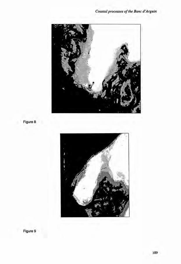
109

Sustainable use of wetland resources
The sedimentary environment of the interdidal zone The classification divides the bare ground basically according to the nature of its sediment, its water content and its salt content. We can thus draw up a gradient of damp sandy-muddy sediments, dry sand and expanses of dry sandy-muddy sebkhas with saline efflorescence. This gradient throws light on the low islands of the Tidra wadden - Niroumi, Nair, Gibene - and also the islets on the high foreshore that are formed and kept stable by marine sedimentary inputs and reinforced by the banks of dead Zostera thrown on the coast. These islands and islets are all shaped in the form of an arc pointing towards the North, i.e., vis-a-vis the flood.
The sedimentary gradient thus illustrates the vast sedimentary accumulation (Figure 8) located under the lee of the flood to the east of the island of Tidra. Conversely, along the tidal channels and on the low strand, small sandy spits are aligned in the direction of the ebb. They are immersed at high tide and are covered by ripple-marks (5 cm high and 40 cm wavelength) formed by the current.
The sebhkas on the high strand are only flooded by exceptional spring tides. They consist of extents of marine muddy alluvial deposits, expanded today by continental windborne deposits. The SPOT image provides a good description of their shapes in the form of festoons denoting significant eolian inputs and little marine action of the long-shore drift. The sebhkas are morphologically characterized by successive alignments of muddy sandy bars of low height (20 cm to 50 cm) between which lie areas of eolian accumulation. The tide rarely reaches these areas and the wind-borne sediment is not significantly reworked, leading to the formation of a very loose and blistered sedimentary texture due to the incomplete mixing of the marine sediments and continental sands. The surface of these areas exhibits saline concretions and efflorescences. We note a zone of sebkha separating the Iwik Peninsula from the mainland (Figure 9), apparently showing that Iwik was once an island, now anchored to the coast. It is likely that it is anchored to the mainland as the damping of the currents encouraged the deposition of sediments between the island and the coast, and the sediments were aligned from east to west by long-shore currents. A sandy spit would have been formed, developing into a tombolo, and then when the coastal bar closed, the part between the island and the coast would have slowly filled in forming a peninsula.
The continental environment
The radiance analysis of the continental environment enables us to distinguish between the principal geological units: the tertiary barred sandstone of Cap Tafarit (terminal continental), the dunes of Azefal, and the clays and calcareous sandstone of the ancient marine quarternary. The SPOT image provides a detailed description of the morphology of the mainland, illustrating the hills and the structural alignments, the course of the old wadis and their outlets, and the dunes.
110

Coastal processes of the Banc d'Arguin
Conclusions
The findings reveal all the advantages of processing satellite images to draw up an inventory of landscapes, to study the causes of morphodynamic evolution, and to analyze the movements and the materials carried by the water masses. The study of sea-surface temperature distribution shows how the northern and southern influences are balanced, as are the exchanges between water in the open sea and water along the coastline. One can thus show that blooms of plankton due to upwelling provide a biological contribution to the gulf during the winter and part of the spring. This is an especially important observation because it has long been believed that the Banc d'Arguin together with the effect of the Canaries Current isolated the gulf from marine biological inputs. The description of the littoral environment illustrates the importance of the areas covered with seagrass. Continuation of the study should moreover improve our insight into the extent of sub-sea plant coverage. Conditions favouring high biological production are present in the Golfe d'Arguin which is probably also an important nursery area. This is confirmed by preliminary biological measurements of the abundance and the age-classes of fish and of crustaceans. At the upper levels of the food chain, it results in the abundance and the specific diversity of predatory marine mammals and birds which have made the region famous. As in most other protected coastal wetlands, the management of the Banc d'Arguin National Park has focused upon meeting the needs of the higher vertebrates. However, in the past 10 years there has been growing realisation that the region's greatest significance for the Mauritanian economy lies in the role that it plays in supporting fisheries. This has led to recognition of the need to protect the critical intertidal and sub-tidal habitats which sustain this fisheries support role. The work described here has played an important part in enhancing this understanding.
References
Campredon, P. 1987. La reproduction des oiseaux d'eau sur le Pare National du Banc d'Arguin (Mauritanie). Alauda 55:187-210
Cuq, F. 1989. Processus coders de la region du Banc d'Arguin (Mauritanie). Actes du colloque du groupe francais de Geomorphologie, bull, du centre de Geom. de Caen. No. 36. pp. 43-46.
Deschamps, P.Y. and T. Phulpin. 1980. Atmospheric correction of infra-red measurements of sea surface temperature using channel at 3-7,11 and 12 um. Bond, layer Met. 18:131.
I l l

Sustainable use of wetland resources
112

Planning the management of coastal lagoons in Ghana*
Y. Ntiamoa-Baidu1 and G.E. Hollis2
[1] Zoology Department University of Ghana P.O.Box 67 Legon Accra Ghana
[2] Ecology and Conservation Unit University College London 26 Bedford Way London WC1E6BT, UK
Resume
Gestion des zones humides littorales au Ghana
Les lagunes de Densu Delta (aussi connues que les Salines de Panbros), de Muni et de Sakumo, sont typiques par rapport aux lagunes cotieres des alentours d'Accra. Elles constituent les parties inondees d'une vallee fluviale et sont separees de la mer par un cordon dunaire. Leur niveau d'eau varie selon les saisons et leur salinite presente des fluctuations spatiales et saisonnieres. Ces lagunes sont importantes pour les oiseaux migrateurs et nicheurs et sont utilisees de maniere intensive par les populations locales. Des plans de gestion preliminaires ont ete elabores au cours d'un stage international, organise dans le cadre du programme Save the Seashore Birds Project-Ghana (SSBPG), regroupant des participants du Ghana, du Royaume-Uni, du Nigeria, du Sierra Leone, du Liberia et de la Gambie, et soutenu financierement par la Royal Society for the Protection of Birds (RSPB) et le WWF. Cette formule s'est revelee efficace sur le plan des contacts internationaux, de la formation et de la preparation de plans de travail. L'utilite a long terme du stage sera evaluee un an apres, afin de guider l'organisation d'autres manifestations de ce genre.
Le plan de gestion de Densu Delta tout en tenant compte de l'industrie de production de sel, de la peche, de la grande densite humaine et du barrage d'alimentation en eau situe en amont, se focalise sur la mise au point de techniques de gestion multi-usage du barrage
* Accepted for publication, September 1988
113

Sustainable use of wetland resources
en vue d'optimiser, dans la lagune, les conditions d'extraction du sel, la peche, les oiseaux et la culture du riz autour de la retenue d'eau. Le plan recommande egalement l'etablissement d'une reserve naturelle a designer en site Ramsar, la creation de structures d'accueil et d'installations a vocation educative, des mesures de gestion de l'ecosysteme et un programme de recherche. Le plan de gestion de Sakumo (qui appartient a la Societe de developpement de la ville de Tema et qui produit du poisson pour la consommation locale ainsi que des coquillages utilises dans la manufacture de tuiles de toiture) recommande l'etablissement d'une reserve naturelle avec un centre d'accueil des visiteurs, la remise en etat d'une ecluse situee a l'exutoire vers la mer, la prise en compte de l'impact hydrologique de la culture du riz et de l'ecoulement des eaux usees dans le bassin versant ainsi que d'autres etudes. La lagune de Muni est la plus 'naturelle' des trois. Un systeme de zonation comprenant une reserve naturelle pourrait s'integrer aux reglementations traditionnelles appliquees a l'utilisation des ressources de la zone.
Introduction
The Save the Seashore Birds Project - Ghana (SSBPG) was launched in 1985 as a joint venture between The Government of Ghana represented by the Game and Wildlife Department, the Royal Society for the Protection of Birds (RSPB) and the International Council for Bird Preservation (ICBP). The SSBPG, through international collaboration during its three year programme, aimed to achieve the conservation of seashore birds in Ghana through coastal surveys, site evaluation, research, species protection, staff training and an education campaign directed at the public. The importance of the Ghanaian coastline for Palearctic migratory seabirds, particularly the roseate tern (Sterna dougallii) whose breeding numbers have declined significantly in Britain and Ireland (Everett et al., 1987), gave the SSBPG a significance beyond Ghana. One element in the SSBPG was a training course in the development of management plans with a focus upon the coastal lagoons of Ghana which were known to be of considerable significance for seashore birds. The course aimed to develop management plans for three lagoons both as a vehicle for teaching and as a contribution to the long-term management of the sites. The participation of the International Waterfowl and Wetlands Research Bureau (IWRB) and further financial support from the World Wide Fund for Nature (WWF) allowed the course to be broadened to include participants from other countries and to take a multi-disciplinary approach to site management. The strategy was to examine the entirety of the physical and social systems that give the lagoons their particular qualities and to emphasize the maintenance of the sustainable human use of the sites within the overall management plans. The development of the sustainable utilization of the sites ranks high in the political decision making process in Ghana. This paper describes the three preliminary management plans developed during the course and outlines some of the lessons to emerge from the training course. The Densu Delta Lagoon (also known as Panbros Salt Pans), the Sakumo Lagoon and the Muni Lagoon (Figure 1) are typical of the coastal lagoons around Accra. They are flooded portions of river valleys separated from the sea by dunes. Their water level varies
114

Planning the management of coastal lagoons in Ghana

Sustainable use of wetland resources
seasonally and salinity shows seasonal and spatial variations (Figure 2). The ecology of the lagoons is probably dominated by extreme or very extreme hydrological conditions such as prolonged desiccation or the breaching of the dune bar by exceptional floods (Figure 2). The lagoons are important for their migratory and breeding birds and all are heavily used by the local people. Since there is little information recorded about the lagoons and there are relatively few published studies, much of the field survey work for the management plans consisted of lengthy interviews with the local people and their chiefs. This provided invaluable qualitative information, such as the date of the last overtopping of the dunes when the informant's sister was swept away, and an insight into local needs and aspirations. Therefore, the 'problem' of minimal written sources proved to be a major benefit within the obvious limitations of anecdoted evidence, when drafting the management plans for both conservation and development. However, it must be emphasized that all of the plans are preliminary and a range of surveys and monitoring work are recommended for each site.
Densu Delta Lagoon
The River Densu drains 2,600 km2 into the water supply reservoir at Weija, and then downstream the river discharges into the 34 km2 complex of coastal wetlands in its delta West of Accra. There are 21 km2 of lagoon and freshwater marsh, 11 km2 of salt pans, 140 ha of scrub and a coastal strip of dunes and beach covering 25 ha. The area exhibits vegetational succession from sand dunes through a brackish lagoon with mangroves to freshwater marsh with fringing scrub. One hundred and twenty two species of birds have been recorded at the site, including 16 of national importance (more than 10% of the Ghanaian coastal population). Two species of waders, curlew sandpiper (Numenius arquata) (max. count 6,424) and little stint (Calidris minuta) (max. count 1,356) are of international importance in the East Atlantic Flyway. The wetland complex has many West African endemic plants that require further study and it provides habitation and livelihood for approximately 1,500 people. The major human uses of the delta are fishing and salt extraction. There are over 1,000 fishermen, the majority making their living from the lagoon, who use cast and draw nets along with fixed traps. The catches are highest when the lagoon has a moderate water level. High water brings low catches and when low water is restricted to the river channels, there is usually no catch at all. The arrival of large numbers of new fishermen at this lagoon, which is open to all without charge, has led to a reported decline in catches and in the size of the fish. Most of the new fishermen have come from the Keta Lagoon to the east of the Volta River mouth where the combined effects of the Akosombo Dam and canalization for oil exploration have led to the desiccation of that lagoon. A large area of salt pans began to be developed in the 1940s and they now employ mainly local casual labour. However, whilst Panbros salt is exported to Burkina Faso, the industry is suffering a recession because salt can be collected freely from the desiccated Keta Lagoon. The isolation and openness of the salt pans gives them considerable importance as roosts for tems.
116

Planning the management of coastal lagoons in Ghana
The Densu Delta also provides people with settlement sites as at the two fishing villages on the dunes, grazing in the scrubland, Imperata cylindrica for roofing and Cyperus spp. and Typha spp. for mats, transportation routes via canoes, a little hunting and some revenue from recreation. The latter consists mainly of European tourists using the beach. The management plan had the water supply dam upstream as one of its foci. This dam controls the flow of water to the lagoon and therefore regulates both the ecology of the lagoon and the livelihood of the people who depend upon it. The effect of the dam is to reduce the volume of flow into the delta and more importantly to change the inflow regime. The floods arrive later than under natural conditions and peak levels can be delayed still further. The dam supplies drinking water to much of Accra and has simple operating rules. These aim to safeguard both the dam, an earlier barrage having been washed away, and a road bridge downstream which could be damaged by excessive releases from the reservoir. The individual who controls the dam comes under pressure from the Salt Company to cease releases when the salt pans are threatened with flooding. If this does not limit water levels in the lagoon, the Salt Company bulldozes the sand dunes to release the flood water out to sea. The fishermen, of course, have to seek a living between the reservoir releases and the low water levels brought by the bulldozer. A multi-purpose operating regime for the dam could optimize conditions in the lagoon for salt extraction, fisheries and birds and aid rice cultivation around the reservoir in zones which are presently flooded to too great a depth. A sluice in the dunes would provide a means whereby the salt pans and the fishery could be assured of water levels adjusted to suit their activities.
The management plan also recommended the establishment of a nature reserve with Ramsar status. Visitor and educational facilities, habitat management and a research programme were also recommended. Once an appropriate regime of releases has been agreed for the Wija Dam, the integration of conservation and development will be relatively easy at this site because it is large, diverse and subject to modest human pressures. The part of the lagoon developed as artificial salt pans retains considerable value as a safe roost for water birds.
Sakumo Lagoon
The 3.5 km2 Sakumo Lagoon, with its 7 km2 of surrounding floodplain, is 25 km east of Accra and 3 km from the industrial port of Tema. The lagoon is saline and separated from the sea by the narrow dune on which is built the Tema-Accra road. A 1953 sluice in the road embankment is not operational, so sea water enters at high tide and lagoon water exists at low tide. Sesuvium-Paspalum spp. and Sesuvium-Sporabolus spp. dominate the saline areas of floodplain whilst Pistia striatiotes and Typha domingensis cover the northeastern corner of the floodplain because two small freshwater streams, draining only 260 km2, bring fresher conditions there. Tern numbers peak at almost 4,000 in September whilst December sees 4,000 waders and 700 herons at the site. At times, Sakumo lagoon holds more than 30% of the Ghanaian population of black heron (Egretta ardesaica), great white egret (Egretta alba), squacco heron (Ardeola ralloides), pratincole (Glareola pratincola), ruff (Philomachus pugnax), marsh sandpiper (Tringa
117

Sustainable use of wetland resources
118

Planning the management of coastal lagoons in Ghana
stagnatilis), wood sandpiper (Tringa glareola), common tern (Sterna hirundo), little tern (Sterna albifrons) and white winged black tern (Chlidonias leucoptera). The lagoon, which is owned by the Tema Development Corporation, produces fish and crabs for local consumption with some 50 fishermen active at times. There is evidence that the birds are seriously disturbed by the fishing activities and at this lagoon the traditional one day per week without fishing was not respected. A group of women collect large numbers of calcareous shells from the floodplain for sale to the building industry. Salt pans originally were planned and partially constructed on the eastern side of the lagoon but these were abandoned many years ago. Similarly clay excavation for ceramics in the southwest comer of the site proved not to be viable. The main features in the lagoon's catchment which affect the site are diversion of the main river to an extensive development of rice fields and the encroachment of the urban area of Tema, with its rubbish and sewage. The reconciliation of these conflicts is not easy since most of the human utilization of the site and of the catchment appears to conflict to some degree with the maintenance of the site for waterbirds. The proximity of Tema with its building work, rubbish, sewage and fishermen also puts considerable pressure on the site. However, the nearby urban area also provides an opportunity to develop the Sakumo site as a visitor centre with a substantial role in education for the public and for school parties. The plan proposed the excavation of some of the southwest comer of the floodplain to create new permanent pools with islands. This area would be free of fishing activity and would be equipped with a visitor centre and classroom. The plan recommended the refurbishment of the sluice to retain fresh water, to raise the water level and to control salinity within the lagoon. The management of the rice cultivation will pose more of a problem because not only is it technically illegal, it is also highly productive and outside the formal limits of the lagoon area.
Muni Lagoon
Muni lagoon and the surrounding scrubby bush was the most 'natural' of the three studied. The site is adjacent to the small town of Winneba, 50 km west of Accra. The lagoon is normally 3 km2 in extent but it expands over the 6 km2 of surrounding floodplain in the wet season. There are three small islands in the lagoon at average water levels and the extensive seaward dunes cover 0.5 km2. The lagoon complex is surrounded by semi-natural scrub including the Yenku Forest Reserve which is safeguarded for the annual Aboakyir Festival of ritual bush buck hunting. There appear to be no higher plant species in the lagoon and the floodplain grassland grades from Sesuvium portulacastrum and Paspalum vaginatum to Imperata, Cyperus, Dactyloctenium and Panicum spp. as moisture levels decrease. The lagoon side of the dunes are dominated by Sporoblus, Remira, Euphorbia, Phoenix spp., and planted groves of coconut palms. The lagoon has held around two dozen herons, three hundred waders and one hundred and fifty terns including over 3% of the Ghanaian population of grey plover (Pluvalis squatarola), kittlitz's plover (Charadriuspecarius), white-fronted sand plover (Charadrius marginatus), bar-tailed godwit (Limosa lapponica), royal tem (Sterna maxima) and sandwich tern (Sterna sandvicensis).
119

Sustainable use of wetland resources
Subsistence and commercial fishing are undertaken both in the lagoon and in the sea by communities which have moved into the area from the Volta Delta region. The lagoon fishery is regulated by the Winneba Traditional Council which owns the lagoon. The weekly no fishing day was well respected on the lagoon during the surveys. The basis of the management plan was a zonation scheme with the inaccessible part of the lagoon, which is of limited value for fishing, being kept as a nature reserve. The remainder of the lagoon would continue under its present traditional management with some investment in further coconut groves on the dunes to fix the dunes and provide food and materials for the villagers. The Head of the Traditional Council saw the establishment of a reserve area as a way of preserving their traditional festival and its values but approaches for a lease for salt pan construction were also being considered.
The training course context
The three management plans were prepared as a practical exercise within a four week international training course. The key elements in the success of the course were that: (i) it was part of a longer term programme that provided both a rationale for the course
and a vehicle for using and developing the skills learned; (ii) it brought together people from a range of backgrounds in West Africa and Britain
whose diversity of views, about for instance the means of achieving bird species conservation and sustainable utilization of resources by humans, created a stimulating atmosphere for debate;
(iii) it stimulated international contacts within West Africa that should lead to the formation of a durable framework for interchanges on conservation matters in the region;
(iv) it produced documents as foundations for further elements in the continuing programme;
(v) its relatively brief duration facilitated complete commitment by all concerned.
Conclusion
There are strong similarities between the three Ghanaian coastal lagoons investigated. All have the same genesis from coastal dunes isolating flooded river valleys, their hydrological regimes are similar and each is of considerable importance for fisheries, terns, waders and herons. The ownership and existing management regime varies and the forces of change affecting each lagoon are different. There is not a single management prescription which can be imposed on these lagoons but in all cases the needs and aspirations of the various human users of the lagoons must be integrated into the management planning process so that the local communities benefit as well as the flora and fauna. For two of the lagoons, the major element requiring management was in the river basin and not within the wetland site itself.
120

Planning the management of coastal lagoons in Ghana
Acknowledgements
The support of the SSBPG by the Game and Wildlife Department in Ghana, RSPB, and ICBP is gratefully acknowledged as is the additional financial support for the training course by WWF. Special thanks are also due to the Ghanaian and foreign participants in the course. They taught us a lot and drafted the management plans.
References
Everett, M.J., I.R. Hepburn, Y. Ntiamoa-Baidu and G.J. Thomas. 1987. Roseate terns in Britain and West Africa. RSPB Conservation Review. 1:56-58.
121

Sustainable use of wetland resources
122
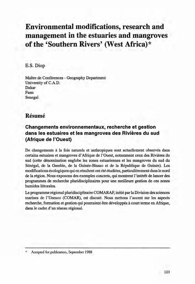
Environmental modifications, research and management in the estuaries and mangroves of the 'Southern Rivers' (West Africa)*
E.S. Diop
Maitre de Conferences - Geography Department University of C.A.D. Dakar Farm Senegal
Resume
Changements environnementaux, recherche et gestion dans les estuaires et les mangroves des Rivieres du sud (Afrique de I'Ouest)
De changements a la fois naturels et anthropiques sont actuellement observes dans certains estuaires et mangroves d'Afrique de I'Ouest, notamment ceux des Rivieres du sud (cette denomination englobe les zones estuariennes et les mangroves du sud du Senegal, de la Gambie, de la Guinee-Bissao et de la Republique de Guinee). Les modifications ecologiques qui en resultent ont ete etudiees, particulierement dans le nord de la region. Nous exposons des exemples concrets, qui montrent l'interet de lancer des programmes de recherche pluridisciplinaires pour une meilleure gestion de ces zones humides littorales. Le programme regional pluridisciplinaire COMARAF, initie par la Division des sciences marines de l'Unesco (COMAR), est discute. Nous mettons l'accent sur les aspects recherche, formation et gestion qui pourraient etre developpes a court terme en Afrique, dans le cadre d'un reseau regional.
* Accepted for publication, September 1988
123

Sustainable use of wetland resources

Environmental modifications, research and management
Introduction
Despite being adapted to the specific environmental conditions of the West Africa coast, in particular high salinity, acidity of the soils and waters, low topography and shortage of fresh water, the mangroves in West Africa, in particular the 'Southern Rivers' (Figure 1) have been exposed for two decades to a series of ecological modifications. These can be explained by two main groups of factors. First, natural changes such as the increased incidence of drought have led to slow degradation of many mangroves, including the mangroves of Senegal's Saloum Delta. Second, anthropogenic factors with, on the one hand, traditional uses of the mangroves including the harvest of firewood and timber, salt exploitation, and small scale agricultural activities such as rice cultivation, and on the other hand, large scale agricultural development projects designed to transform saltflats and mudflats into agricultural land.
Evaluation of environmental modifications and impacts
The estuaries and mangroves of the 'Southern Rivers', are exemplified by the Saloum Islands. From 1980 to 1988, a multidisciplinary team involving geologists, biologists, geomorphologists, hydrologists, oceanographers and socio-economists conducted a study of the whole estuarine and mangrove area. The results of these hydrological, hydrodynamics and biological studies of the Saloum estuary (Diop, 1986;EPEEC, 1982,1983,1984 and 1985) can besummarised as follows:
- an extreme reduction and even absence of fresh water inflow; as a result the downstream stretches of some rivers are more salty than sea water (Figure 2);
- the hydrodynamics are largely a function of the tides with the particular regime of an 'inverse estuary': the flood currents predominate on the ebb, with an increasing gradient of salinity from downstream to upstream;
- the plant and animal associations are adapted to these phenomena of hypersa-linity; many species exhibit a restricted distribution upstream;
- the microfauna sampling has revealed a similar restricted distribution, with a reduction in density upstream and the presence of marine ecophenotypes. The phytoplankton and the macrobenthos follow the same pattern with a reduction of their number from downstream to upstream;
- the distribution of plant species is affected by the salinity patents. In the lower estuary, the mangrove is expansive, healthy and green; in the central region, salinity is high, and the mangroves are smaller; in the east, in the region of Foundiougne, the mangroves decline further with a sharp increase in the proportion of dead individuals; the most severe degradation is in the northern part, where the high death rate has led in places to a complete disappearance of the mangrove vegetation.
125

Sustainable use of wetland resources
BO 9 0 k m v e r s K A O L A C K
Figure 2a Salinity regime of the surface site of the River Saloum Dry season (1982) maximum recorded - 110% at Kaolack Wet season (1982) minimum recorded = 60% at Kaolack
SO 7 5 ~
Z I G U I N C H O R
1 0 0 TFT I S O 175
S E D H I O U
2 0 0 k m
v e r s K O L O <
Figure 2b Salinity regime of the surface site of the River Casamance Dry season salinity (May 1984) Wet season salinity (August 1984)
— — • Salinity profile (February 1977) Salinity profile (October 1976)
126

Environmental modifications, research and management
In summary, a reduction in rainfall and the severe deficit in the hydrological budget has led to unbalanced ecological conditions extending from north to south over the last 15 years and typified in the Casamance and Cacheu estuaries by:
- advance of the salinity front; - hypersalinity of the rivers and an inversion of the estuarine regime; - a large increase in the salt-encrusted surfaces devoid of any vegetation (tannes); - all these phenomena can be observed directly in the field or with aerial photo
graphs and satellite imagery of different dates. In some areas, even the geochemical evolution of the soils has been modified by acidification and oxidation of the soils, loss of the organic matter, and the occasional presence of gypsum.
Role of anthropogenic factors
Despite the dominant role of human action in leading to deforestation in many regions, the adaptative nature of traditional techniques for use of West African mangrove areas for rural agriculture and fishing have been underlined by many authors. However, the ecological conditions are so finely balanced, particularly with the dependence upon rainfall, that the smallest degradation can have significant consequences. This has been the case during the last fifteen years of drought which has affected the region and magnified all the disturbances due to human activities. To address these problems, investments in modern, intensive forms of development have been developed, and include agricultural and dam projects aimed at recovering lost lands, improving drainage systems, or managing lands for rice culture. However, during the last twelve years, few positive results have been obtained, while instead many of these investments have led to major disturbances and have resulted in irreversible changes. In order to preserve the natural equilibrium of the mangroves, particularly during periods of low rainfall, care must be exercised with all kinds of management dealing involving dikes or dam constructions, and deep drainage actions. In many cases, traditional management can be more successful as well as more efficient for the maintenance of the ecological equilibrium of these coastal regions.
COMARAF project
Because of the great potential, but high vulnerability, of African coastal systems, an increasing number of African coastal countries have become particularly conscious of the need for scientific information upon which to base future management decisions. In response, a regional project initiated under the umbrella of UNESCO's programme of Research and Training on Coastal Marine Ecosystems in Africa (COMARAF). The purpose of the COMARAF project is to organize and carry out a multidisciplinary study
127

Sustainable use of wetland resources
of the African coastal marine zone which will contribute to the scientific basis which decision-makers can use in planning the sustainable development of their countries. Specifically, the project will investigate the delicate natural balances (including ecological, geological, hydrological and chemical processes) that characterise the natural coastal marine systems. Priorities include:
- the development of a regional network of collaborating scientific institutions and mumdisciplinary research groups;
- the initiation of joint research programmes on topics of common interest to coastal countries;
- the organization of specialized training courses and workshops for researchers and technicians, in accordance with regional and national needs;
- the exchange of scientists and documentation among the cooperating institutions.
References
Diop, E.S. 1986. Estuaires Holocenes Tropicaux. Etude de geographie physique comparee des 'Rivieres du Sud': du Saloum (Senegal) a la Mellacoree (Republique de Guinee). These de Doctorat d'Etat soutenue a l'ULP de Strasbourg, Vol.2, Vol 1. Texte pp. 522 + annexes, 117, Figure 72 tabl. Vol.2, plaches cartographiques.
EPEEC. 1982, 1983, 1984 and 1985. Etudes des mangroves et estuaires du Senegal -Rapports finaux - Unesco, Division des Sciences de la Mer - Dakar. 175 pp., 219 pp., 88 pp. and 136 pp.
UNESCO. 1988. Coastal Marine Ecosystems of Africa; Objectives and Strategy of the COMARAF Regional Project. Report in Marine Science No. 48, Paris. 62 pp.
128
Section 3
Wetland and Fisheries Management

Sustainable use of wetland resources
130

Research priorities in fisheries management as a tool for wetlands conservation and rural development in Africa*
G.M. Bernacsek
International Development Research Centre P.O. Box 62084 Nairobi Kenya
Resume
Gestion des peches comme moyen de conservation des zones humides et de developpement rural en Afrique: priorites de recherche
En Afrique, une bonne gestion des peches est indispensable sur le plan social et economique. Les efforts de recherche doivent porter sur les points suivants (sans ordre de priorite): mise en place d'une base de donnees nationale sur les zones humides (inventaire, cartographie, caracterisation physique, cWmique, biologique, sociologique et revue bibliographique); rehabilitation des habitats aquatiques (recifs coralliens, zones humides affectees par la secheresse, plaines inondees ou alluviales hydrologiquement regulees); agriculture et sylviculture en lisiere de zones humides; suivi et controle de la pollution; optimisation de la production liee a 1'eutrophisation des zones humides; plans de construction et gestion des barrages pour optirniser les peches; debroussaillage des reservoirs; systemes de peche pour augmenter la production; modeles predictifs pour les introductions d'especes de poisson; micropecheries dans les bassins de faible surface; protection des especes de poissons menacees; systemes statistiques appropries appliques aux peches; methodes de transformation du poisson economes en bois; transfert "sud-sud" de technologies; microeconomie; systemes traditionnels de gestion des peches bases sur les communautes; developpement integre des communautes de pecheurs; divers aspects politiques lies au developpement de la peche (theorie et modeles de gestion, integration intra- et intersectorielle, macroeconomie, evaluation des projets). L'importance de la concertation avec les pecheurs, du renforcement des institutions, de l'application des resultats, ainsi que l'interet d'un journal traitant de la peche en Afrique est dicutee.
* Accepted for publication, September 1988
131

Sustainable use of wetland resources
Introduction
Fisheries are one of the most important economic uses of wetlands in Africa. Inland waters alone yield over 1.5 million tonnes annually, and shallow coastal marine waters at least another 1 million tonnes. Wetlands provide employment for about one million fishermen and perhaps 3 to 5 times as many workers in the secondary sector (processing, transportation and marketing). The economies of many African rural communities are heavily dependent on wetland fisheries for growth and their rational management can be the key to sustained economic development for a significant segment of Africa's rural population. Conservation of wetlands is a prerequisite for long-term sustainability of fisheries development, and rational management is inherently conservation-intensive.
A fishery (senso lato) is a complexity of human economic activities based on a renewable natural resource system. The main elements are: the environment, the commercially exploited fish stocks, the fishing communities, the fish processing industries, the marketing/ distribution network (including international fish trade), and finally, the consumers. Rational fisheries management (senso stricto) addresses the harvesting of biological resources, but also needs to consider comprehensively the forward and backward linkages both within and outside the fisheries sector. Social welfare goals are generally given high priority.
Effective fisheries management generates a continuous demand for new information, technologies and methodologies. However, wetland fisheries research may not be high on the list of priorities of economically-stressed African governments, so allocation of funds for research is in many cases inadequate. Furthermore, a focus on western management approaches has tended to undermine creative development of indigenous African management instruments, which stand a better chance of being effective. Constraints include misalignment of the research topic with management and development needs (i.e. academic bias) and untimeliness of research outputs. Research quality may sometimes be insufficient to solve the problem under investigation. In addressing this complex of constraints it seems logical that a strategy aimed at improving the performance of fisheries management research for African wetlands must be based in the first instance on establishing priorities in research needs. This not only helps to ensure the relevance and potential effectiveness of the outputs, but will also define the manpower training requirement (arguably the second element in the chain of major bottlenecks). It also lends credibility to research programmes, improves their policy stance and should attract better donor and international financial support. The following is an annotated list of what are considered by the present author priority areas for applied research into wetlands fisheries management. The Ramsar Convention definition of wetlands is used throughout.
The environment
Management, conservation and enhancement of the wetland environment are major foundation stones of wetland fisheries management and sustainable development. In the
132
Research priorities in fisheries management
long term, security of the production environment ranks as the single most important factor for assuring the continued existence and economic productivity of both inland as well as coastal fisheries in Africa. Priorities for research include the following.
National wetland databases Despite the widely recognized importance of wetlands inventories and collating available data and reports, many African governments have not yet carried out these tasks due to lack of resources. Regional data summary studies are being prepared by FAO (Bernacsek, manuscript) and IUCN/UNEP (Hughes and Hughes, 1992). Countries should receive assistance where necessary to establish and enhance national wetland databases.
Habitat rehabilitation Wetland habitat loss in Africa is not as severe as in developed countries, but trouble spots exist. Egypt's lagoons are under threat in part from land reclamation (Rowntree et al., 1984; Toews and Ishak, 1984). Mangroves are cut in many areas for fuelwood and building poles, and this can result in increased coastal erosion. The latter is accelerated by river regulation because large dams cut the supply of sediment to coastal deltas and shorelines (Nielsen, 1973). Dynamite fishing has destroyed many shallow coral reefs in East Africa (Bryceson, 1978). Drought has degraded wetlands in the Sahel and increased erosion. Research into methods for rehabilitating damaged wetlands is urgently needed. This must include not merely technical methods, but sociological and economic investigations as well. Implementation of rehabilitation projects will need to be cost effective (i.e. make sense to local economies) and will require the support of local communities whose own economic interests would be profoundly affected by the project goals. In some cases effective technologies exist, but they may need to be adapted to local conditions and resources.
Wetland margin agriculture and forestry Research into optimal agricultural practices both within wetlands (such as rice culture and cattle grazing) and around wetland margins (such as reservoir drawdown agriculture) is required to ensure good use is made of these moist agricultural areas. Fisheries can be affected markedly by wetland agriculture through the fertilizing effects of crop refuse and fertilizer runoff. The effect can be beneficial or detrimental depending on the degree of eutrophication and oxygen depletion. Heavy pesticide use represents a growing hazard which has not been adequately investigated (Alabaster, 1981; Calamari, 1985). Fuel-wood plantations and other silvicultural practices on wetlands require more research to increase their utility to fisheries. Watershed rehabilitation through reforestation is an obvious measure which should be implemented generally. Effects of adjacent forests on wetland micro-climate and environment also needs investigation (shade, windbreak, leaf-fall, bank stabilization). Smoke processing of fish exerts a strong local demand for fuelwood in and around wetlands which could most rationally be met by fuelwood plantations. Research needs to be done to optimize such plantations e.g. on tree species, growth rates, and rotation periods.
133

Sustainable use of wetland resources
Pollution monitoring and control Spiralling urbanization in Africa is resulting in a steadily increasing discharge of untreated domestic sewage which can threaten wetlands (Bernacsek, in press). Industrial discharges are also increasing in some countries. Research is required to monitor the effects of pollution on wetland fisheries and to devise effective treatment processes for tropical conditions.
Optimizing cultural eutrophication of wetlands The controlled use of sewage and agricultural runoff to enhance biological productivity represents a real possibility for increasing African fish production. For example, fish yields of Egyptian lagoons are far above the natural biological production level due to eutrophication from Cairo's sewage and agricultural fertilizers used in the Nile Delta (Toews & Ishak, 1984). There are many opportunities all over Africa for making better use of aqueous eutrophicants, and research into effective and safe methods is required together with proper assessment of its compatability with maintenance of other wetland functions and ecosystem attributes.
Optimizing dam design and operation for fisheries Africa's need to store water as well as generate clean safe power ensures a future for dams in Africa. New dam projects are likely to be smaller and more rational economically than in the past. Possibilities exist for mitigating or neutralizing some of the negative ecological effects of large dams through better dam design and operation. Bernacsek (1984) proposed a series of guidelines for dam engineers to follow in order to obtain more otpimal fishery environments upstream and downstream of dams. Research is needed to test and further develop these guidelines. Separate guidelines also need to be developed for small impoundments and check dams of the type used in Zimbabwe, Ghana and elsewhere (Hickling, 1961).
Bush-clearing in reservoirs Available data on the effects of bush-clearing on fish production in African reservoirs is insufficient to allow rational decision-making by dam project planners. Bush-clearing is expensive and alternative clearing patterns probably have different effects on biological productivity and fish catches. Research into the cost effectiveness and benefits to fisheries of different patterns of bush-clearing in reservoirs is required.
Fish production and processing
Some African wetland fisheries are currently facing a production crisis; fishing effort is becoming so great that stocks are in danger of collapsing through overfishing. The effects of stock collapse on local economies can be devastating. Research into various aspects of wetland fish production aimed at averting and ameliorating this crisis should focus on the following areas:
134

Research priorities in fisheries management
Production enhancement types of fishing systems Maximum sustainable yield (MSY) defines the limit to conventional commercial production of a fish stock. Overfishing results when fishing effort exceeds the level compatible with MSY. Technologies (indigenous to Africa or originating in other regions) exist which allow breaking through the MSY barrier and increasing fish production. These include the acadja brush parks of Benin, the garse system of Cameroon and the hoshas of Egypt (Kapetsky, 1981;Rowntreeer al, 1984; Stauch, 1966). Artificial reefs and fish-attracting devices (FADs) are becoming important components of coastal fisheries in other regions of the world (Anonymous, 1987). Far too little research has gone into studying, developing and popularizing these fishing systems in Africa. This is now an urgent requirement. An added bonus is that production enhancement fishing systems are often inherently conservation intensive.
Predictive models for fish species introductions Vacant ecological niches in many wetlands, especially reservoirs, represent a lost opportunity for fish production - in effect an ecological inefficiency (Eccles, 1975). Introductions have been seen as a cheap and appropriate way to redress this inefficiency and achieve increased fish production. While many past introductions have been highly successful in meeting ecological and economic objectives [for example sardines in Kariba Reservoir (Marshall, 1984)] others have induced unexpected and unwanted ecological imbalances. The recent controversy over the effects of the Nile perch introduction into Lake Victoria has resulted in all introductions currently receiving a 'bad name' (Barel et al, 1985; but see also Welcomme, 1986). This is both myopic and wasteful of resources. A central problem is the lack of good predictive models and codes of practice for introductions into African wetlands (Anonymous, 1985; Bernacsek, 1987 and in press). Research into modelling introductions and assessment of the impacts on native fauna or flora is badly needed.
Microfisheries in small water bodies The more than 20,000 small lakes, rivers, floodplains, swamps, reservoirs and coastal lagoons of Africa have been long neglected by fisheries administrators. In only a few instances has development been advantageously fostered; see Bailey (1966), for successful experiences with small dams in Tanzania. The importance of small water bodies to the many rural communities which live neither on the coast nor near a large inland water body is considerable. Estimated potential fish production from small water bodies over all of Africa is in the range of at least one million tonnes annually, and may be considerably more if production-enhancement fishing systems are applied, an approach to which small water bodies are particularly well suited (Bernacsek, 1986). There has been insufficient research on most aspects of small water body fisheries, ecology, fishing technology, and social and economic factors.
Protection of threatened fish species and stocks African wetlands harbour a very diverse fish fauna including many rare and endemic species such as the cichlid species flocks of the African Great Lakes. Some of these
135

Sustainable use of wetland resources
species are threatened due to a variety of factors including inappropriate introductions, overharvesting for the aquarium trade, pollution, and habitat loss. Research is required to detect those species which are threatened and to establish sanctuaries (natural or artificial, local or international) to prevent these species from becoming extinct. Furthermore, research into the establishment of sanctuaries on breeding grounds of commercial fish stocks is also necessary, utilizing perhaps artificial structures such as acadja brush parks, bamboo reefs and other devices to deter poaching and increase production.
Appropriate fisheries statistics and stock assessment systems Most production models used in fisheries management require continuous inputs of statistical data on fish catch and fishing effort, and biological data on the fish stock. Collection of this information is expensive, and many African countries have difficulty carrying out statistical programmes on a regular basis. Inaccuracy of the collected data is a serious problem, limiting the utility of the existing inland production statistics database (Anon, 1987a; Bernacsek, 1987). Research is therefore needed on designing more appropriate cost-effective fisheries statistics systems which can provide useful and timely outputs when only minimal resources are available. This could include composing statistics on fish production, trade and consumption collected by fisheries departments with similar data collected by other government agencies (Bernacsek, 1986b).
Cost-effective aquaculture systems Despite some 40 years of applied research and development effort, pond aquaculture has gained very limited acceptance in Africa (Bernacsek, 1987; UNDP/NMDC/FAO, 1987). High costs squeeze profit margins, resulting in little incentive for private sector investment compared to the more profitable capture fisheries. Certainly in Africa, producing cheap fish to augment the national food supply through aquaculture remains a dream as current aquaculture production is in the range of only a few tens of thousands of tonnes (FAO data). Indigenous culture practices were routinely dismissed by many colonial and post-colonial fisheries administrations in favour of Western and Oriental methods. In view of their poor acceptance it seems that the latter are not well suited to the existing African socio-economic context. Research is urgently required to upgrade and adapt indigenous African aquaculture methods such as the whedos and ahlos of Benin (Di Palma, 1969). The key must be to define realistic realizable goals for African aquaculture and develop methods which will be cost-effective and capable of implementation given the existing constraints in extension services and financial resources, and the widespread lack of historical precedents.
Wood-conserving fish processing and preparation methods Economic loss due to inefficient use of wood to smoke fish, coupled with declining forest reserves requires that research be conducted into more fuel-conserving methods of preparing dry fish. Existing high efficiency designs for smoking ovens need to be adapted to local materials and resources. Appropriate methods which use no wood at all for selected species i.e. sun-drying of small pelagics on clay or concrete slabs (Bernacsek, 1986a), need to be developed or improved. At the consumer end, research into reducing
136

Research priorities in fisheries management
energy consumption used in cooking fish is also necessary, since dry fish requires more cooking time than fresh fish.
Fishing vessel and gear development and South-South technology transfer There is need for local research to continually ugrade the design of fishing vessels and gear. This includes better sails and more easily maintainable engines with lower costs so as to increase efficiency and output per fishermen (FAO/DANIDA/Norway, 1985; Akester, 1986), coupled with outriggers and floatation for safety. Gear design and fishing technique must usually be adjusted locally for introduced species. There is a need for intermediate level net weaving technology, since high-technology factories suffer from foreign exchange and spare parts shortages, while hand-weaving is too inefficient to satisfy demand. South-South technology transfer is potentially a very fertile area for research. UNIDO (1987) has identified several areas of expertise and competence, including artisanal processing, offshore capture fishing, export processing and marketing, where expertise existing in Asia and Latin America could be advantageously introduced into Africa.
Fishing communities
Social and economic research into the structure and dynamics of fishing communities (see, for an excellent example, Jorion, 1985) has been less extensive than that expended on biological studies of fish stocks. This gap is becoming increasingly apparent as fisheries administrations find that management measures based strictly on biological criteria are sharply resisted by fishing communities. Management measures which are not compatible stance with local fishing community organization, customs and economics may have almost no chance of successful implementation. Research is urgently needed in the following areas:
Micro-economics
Perhaps the most glaring knowledge gap in wetlands fisheries is micro-economics. Without detailed studies of economic forces such as current and expected costs and prices and incentives, little insight can be gained into producer decision-making processes in wetland fisheries. Without such information, attempts by government to increase economic efficiency will almost certainly be misguided. Research into the micro-economics of wetland fisheries is urgently needed to improve the design of management measures.
Community-based 'traditional' fisheries management systems There is evidence that many African wetland fishing communities traditionally practised rational fisheries management (Lawson and Robinson, 1983). The disruptive effect of central fisheries authorities on rational community-based management has been noted by Scudder & Conelly (1985). The designation of wetland fish resources as open access
137

Sustainable use of wetland resources
state property has led to rent-dissipation and this frustrates rent-seeking and capturing efforts by individual fishermen as well as whole fishing communities. Efforts at central fisheries management in Africa during the last few decades have not been especially cost-effective. Serious consideration therefore needs to be given to re-instating community-based, traditional-type management structures. Furthermore the re-instatement of community ownership and locally determined usufructuary rights to the fishery resources (as opposed to central government ownership and licencing of fishing rights) needs to be assessed carefully. Some degree and form of restricted resource ownership in fisheries is now almost universally accepted as a condition for escaping from the so-called 'tragedy of the commons'. This can take diverse locally appropriate forms, including access-restricted community resource ownership. Research is needed to upgrade traditional resource ownership and management systems to meet the more difficult problems of providing employment and food for a much larger population compared to colonial times.
Integrated fishing community development Despite an almost universal high demand for fish in Africa, most fishing communities are caught in a poverty trap (Bernacsek, 1987). Without special broad programmes to address all aspects of community poverty, including health care, education and training, water supply, roads, agriculture, and electrification, narrow sectoral fisheries projects have little hope of elevating wetland fishing communities over the poverty line. It is becoming increasingly obvious that small-scale fisheries development projects must take an integrated, multi-sectoral approach. Rather than remain as narrow sectoral fisheries development projects, they must become integrated fishing community and rural development projects - IFCARDs (Bernacsek and Mudenda, 1987). As resources are usually too limited to achieve all goals, such projects must rely heavily on community participation rather than external capital inputs; scarce available capital must be used 'catalytically'. Community design and control of projects greatly increases the chances for positive development outcomes (Black-Michaud and Johnson, 1986). Research into how best to formulate and execute integrated fishing community development projects is urgently needed. The FAO-executed Programme for Integrated Development of Artisanal Fisheries in West Africa (IDAF), based in Benin, has made important progress in this area (Johnson and Wilkie, 1986).
Fisheries development policy
Government policy towards wetland fisheries can have a decisive impact on their development. Formulation of sound policy requires finding optimal balancing points between diverse conflicting interests and goals. Government policy in Africa for wetland fisheries is often inadequate and therefore ultimately unnecessarily wasteful of valuable resources and damaging to their associated economies. Research can help African governments adopt more progressive policy stances for wetland fisheries. Areas requiring attention include the following:
138
Research priorities in fisheries management
Management theory and models The widely used bionomic management model assumes fishermen are myopic and that an open access fishery automatically lapses into resource-rent dissipation and hence economic inefficiency. However, management policies based on the bionomic model are naive because they ignore rational rent-seeking and entrepreneurial behaviour in fishermen (Wilson, 1986). Such policies may also ignore existing distribution of property rights. Fishery resource-rent dissipation may in reality be less than usually assumed and perhaps no worse than other industries. Research needs to be directed into expanding or replacing the narrow 'effort regulation' focus of the bionomic model by a more comprehensive model which takes into account fisherman behaviour, equity goals, and existing or potential property rights distribution.
Integration of sectoral elements Forward and backward linkages within the fisheries sector are often not well defined or taken adequately into consideration. This can result in imbalances such as procurement of nets of the wrong mesh or twine size for target species, and too few boatyards to build the number of vessels required. Research into linkages within the fisheries sector will allow better project planning. Many research areas are interrelated. Thus, introductions of small cichlids from Lake Victoria or Malawi/Nyasa into reservoirs could help save threatened species as well as increase catches and control disease vectors. Well designed multi-faceted research can have more than one useful output, thus increasing the cost-effectiveness and efficiency of research projects. Furthermore, system modelling will allow more exact prediction of ripple effects of government interventions within the sector e.g. the effect of fuel subsidies on incomes, or motorization on the level of production.
Integration of fisheries sector with other wetlands-dependent sectors The above intrasectoral focus graduates naturally into the intersectoral - the interrelationships between fisheries utilization and other economic utilization of wetlands. These need to be described, and the magnitudes of negative frictional impacts assessed so that mitigation measures can be properly planned (see Petr, 1985, for case studies). Interdependencies between wetland-based sectors also need better elucidation. It is to be expected that the number of uses wetlands are put to will increase, and usage intensify, as Africa's population continues to increase in the future. Research into integrated wetland exploitation is needed to guide governments in the optimal and sustainable utilization of wetlands for multiple uses.
Effects of macro-economic policies on fisheries sector Limited attention has been given to assessing the effects of macro-economic policy instruments on wetland fisheries. These include among others exchange rates, interest rates, taxation, tarifs (Salz, 1986). Inflation and currency over-valuation are undoubtedly major factors (Chhibber and Wilton, 1986), but little research has been done to elucidate their impacts on wetland fisheries for the benefit of policy makers and planners.
139

Sustainable use of wetland resources
Economic, social and financial appraisal and evaluation of development projects Considerable literature exists on project design, appraisal and evaluation (for example: Asian Development Bank, 1978; Casley and Lury, 1982; FAO, 1986). Nonetheless cost-benefit appraisal of many wetland fisheries project proposals leaves much to be desired. Economic cost-effectiveness is conspicuously lacking in some projects, so they take on the nature of transfer payment exercises with no lasting development and growth impact, rather than true development projects which put into place self-sustaining economic structures. Capital-intensive projects may generate insufficient employment in addition to sometimes being economically irrational. Projects which make no contribution to real economic growth will yield few lasting benefits to the recipients. The actual development impacts of projects are often not well evaluated, either during the project's implementation or after completion. Research is urgently needed into why wetland fisheries projets are sometimes ineffective and how project design, implementation and control can be improved.
Conclusions
The list of possible research priorities set out above pertains to Africa as a whole. National priority short-lists must still be drawn-up on a country-by-country basis, with correct sequencing of the priorities. The most effective approach is through direct consultation with fishing communities themselves at local, district, and national levels. For example, WWF and IUCN recently sponsored a very successful popular participation conference for the Kafue Flats and Bangweulu Swamp in Zambia (Jeffery et al., 1992). Examples outside of Africa are the national fisheries policy conferences recently held in Pakistan (MFD, 1986) and Philippines (BEAR, 1987). Thematic national conferences on wetland fisheries serve a very valuable function in allowing the sector to examine its problems and recommend goals and policies directly to government. Potentials, constraints and realistic compromises will become clearer through such discussion and consultation. Orientation of potential donors will also be improved. The employment of outside experts for the purpose of drawing-up research policies and programmes is far less effective and can never replace or substitute for a national consultation/debate process.
Institutional strengthening must rank high in the list of priorities for improving fisheries research. This includes government research institutes including those specialised in fisheries, sociology and economics, and river basin authorities as well as University departments in fisheries, biology, economics, and sociology. Independent NGO fisheries institutes also need encouragement and support. If more interest in wetlands fisheries research were shown at higher political levels e.g. Organization of African Unity and UN Economic Commission for Africa, this would certainly help to speed up sensitization of recipients and donors alike to the need for improving African research capability. Assuming an amelioration in African research output comes about, the ultimate problem is still how to ensure implementation of the research findings. One approach is to have
140

Research priorities in fisheries management
direct links between researchers and users. While some research can be,or needs to be, 'pure', a great deal more should be attached as back-stopping to existing development projects. A researcher thus would proceed not by asking what could possibly be done (an endless list), but would survey what development programme is already in the process of being carried out and then seek to merge with an existing project. Here, provision of adequate funds in project budgets for disbursement locally for research could be an important incentive. Finally, the lack of a journal dedicated to African fisheries prevents fisheries researchers as well as planners, managers, administrators, extension workers, not to mention the private sector, from having a ready region-wide discussion forum and publication outlet.
Acknowledgements
The author is very grateful to Professor Rowena Lawson and Mr John Stoneman for their helpful comments on the draft.
References
Akester, S.J. 1986 Design and Trial of Sailing Rigs for Artisanal Fisheries of Sierra Leone. FAO Programme for the Integrated Development of Artisanal Fisheries in West Africa, IDAF - GCP/RAF/192/DEN - GCP/RAF/198/DEN -GCP/RAF/197/NOR - IDAF/WP. pp. 10-33.
Alabaster, J.S. 1981 Review of the State of Aquatic Pollution of East African Inland Waters. CIFA Occas. Pap. pp. 9-36.
Anonymous. 1985. Introduction of Species and Conservation of Genetic Resources. Sixth session of CIFA, Lusaka, Zambia, 7-11 October 1985, CIFA/85. pp. 13-18.
Anonymous. 1987. Abstracts. Fourth International Conference on Artificial Habitats for Fisheries. November 2-6,1987, Miami, Florida.
Anonymous. 1987a. Improvement of Fishery Statistics. CIFA Seventh Session, Accra, Ghana. 7-11 December 1987. 4 pp.
Asian Development Bank. 1978. Economic and Financial Appraisal of Bank-Assisted Projects. Asian Development Bank, Occ. Pap. pp. 11-43.
Bailey, R.G. 1966. The dam fisheries of Tanzania. East Africa Agricultural Forest. J. 32(1):1-15.
Barel, C.D.N., R. Dorit, P.H. Greenwood, G. Fryer, N. Hughes, P.B.N. Jackson, H. Kawanabe, R.H. Lowe-McConnell, N. Nagoshi, A.J. Ribbink, E. Trewavas, F. Witte and K. Yamaoka 1985. Destruction of Fisheries in Africa's Lakes. Nature, (315) 2 May 1985. pp. 19-20.
141
Sustainable use of wetland resources
Bernacsek, G.M. 1984. Dam Design and Operation to Optimize Fish production in Impounded River Basins, Based on a Review of the Ecological Effects of Large Dams in Africa. CIFA Tech. Pap. (11). 98 pp.
Bernacsek, G.M. 1986. Fisheries in Small Water Bodies: an Overview of their Potential for Supplying Animal Protein to Rural Populations of Africa. FAO Fish. Rep. (360):77-94.
Bernacsek, G.M. 1986a. Evaluation of the Impact of the Feeder Roads for Fisheries Development Project in Northern Zambia on the Fisheries of Lake Tanganyika, Lake Mweru Wantipa, Lake Mweru and the Bangweulu Lakes/Swamp Complex (with special emphasis on stock assessment). CIDA, Lusaka. 205 pp. + plates.
Bernacsek, G.M. 1986b. Kenya, Tanzania and Uganda. Evaluation of Statistical Services for Lake Victoria Fisheries (mission report). FAO/Regional Office for Africa, Accra, Ghana/CIFA/Sub-committee for the Development and Management of the Fisheries of Lake Victoria. 62 pp.
Bernacsek, G.M. 1987. Policy Options for Development of the Fisheries Sector in Africa. FAO, Fisheries Department, Fishery Policy and Planning Division, Rome. 180 pp.
Bernacsek, G.M. 1990. Fisheries Development and Wetland Conservation in Africa. J. West African Fisheries. 3:121-135.
Bernacsek, G.M. (manuscript). Sourcebook for Inland Fisheries Resources of Africa. FAO/CIFA, Rome.
Bernacsek, G.M. and G. Mudenda. 1987. Project Identification Report: Zambia, Integrated Fishing Community and Rural Development Project (IFCARD) for Lake Mweru Wantipa and Bangweulu Lakes/Swamp Complex. CIDA, Rome. 69 pp.
BFAR. 1987. National Conference on Fisheries Policy and Planning, Main Report. Government of the Republic of the Philippines, Department of Agriculture, Bureau of Fisheries and Aquatic Resources, FAO, UNDP, Manila. 115 pp.
Black-Michaud, J. and J. Johnson. 1986. Community Participation in Integrated Small-Scale Fisheries Projects. FAO Fish. Rep. 360:62-76.
Bryceson, I . 1978. Tanzanian Coral Reefs at Risk. New Scientist. 80(1124): 115.
Calamari, D. 1985. Review of the State of Aquatic Pollution of West and Central African Inland Waters. CIFA Occas. Pap. 12:26.
Casley, D.J. and D.A. Lury. 1982. Monitoring and Evaluation of Agriculture and Rural Development Projects (a World Bank publication). Johns Hopkins University Press, Baltimore. 145 pp.
Chhibber, A. and J. Wilton. 1986. Macro-Economic Policies and Agricultural Performance in Developing Countries. Finance and Development, September 1986. pp. 6-9.
142

Research priorities in fisheries management
Di Palma, S. 1969. The Fisheries of Dahomey, 1968. US Dept. Interior, Bureau Commer. Fish., Foreign Fish. Leaflet. (175) 8 pp.
Eccles, D.H. 1975. Fishes of the African Great Lakes as Candidates for Introduction into Large Tropical Impoundments. J. Fish Biol. 7:401-405.
FAO. 1986. Guidelines for Designing Development Projects to Benefit the Rural Poor. FAO, Rome. 119 pp.
FAO/DANIDA/Norway. 1985. A Preliminary Account of Attempts to Introduce Alternative Types of Smallcraft into West Africa. FAO, Programme for the Integrated Development of Artisanal Fisheries in West Africa, GCP/RAF/192/DEN - CP/RAF/ 198/DEN - GCP/RAF/197/NOR/WP. pp. 3-51.
Hickling, C.F. 1961. Tropical Inland Fisheries. Longmans, Green and Co., London. 287 pp.
Hughes, R.H. and J.S. Hughes. 1992. A Directory of African Wetlands. IUCN, Gland. 820 pp.
Johnson, J.P. and M.P. Wilkie. 1986. Pour un Developpement integre des Peches artisanales: du bon usage de la participation et de la planification. FAO, Programme de Developpement integre des Peches artisanales en Afrique de I'Ouest, RAF/192/DEN-RAF/197/NOR, Manuel de terrain, pp. 1-157.
Jorion, P.J.M. 1985. The Influence of Socio-Economic and Cultural Structures on Small-Scale Coastal Fisheries Development in Benin. FAO, Programme for the Integrated Development of Artisanal Fisheries in West Africa, GCP/RAF/192/DEN - GCP/RAF/198/DEN - GCP/RAF/197/NOR, IDAF/WP. 4(En):42.
Kapetsky, J.M. 1981. Some Considerations for the Management of Coastal Lagoon and Estuarine Fisheries. FAO Fish. Tech. Pap. 218:48.
Lawson, R. and M.A. Robinson. 1983. The Needs and Possibilities for the Management of Canoe Fisheries in the CECAF Region. CECAF/Tech 83/47. 47:23.
Marshall, B.E. 1984. Kariba (Zimbabwe/Zambia). CIFA Tech. Pap. 10:105-153.
MFD. 1986. Report of the National Seminar on Fisheries Policy and Planning. Government of Pakistan (Marine Fisheries Department), FAO, UNDP, 21-23 September 1986, Karachi. 54 pp.
Nielsen, E. 1973. Coastal Erosion in the Nile Delta. Nature and Resources. 9:14-18.
Petr, T. (Ed.). 1985. Inland Fisheries in Multi-Purpose River Basin Planning and Development in Tropical Asian Countries: Three Case Studies. FAO Fish. Tech. Pap. 265:166.
Rowntree, J. et al. 1984. Fisheries Management in the Northern Nile Delta Lakes of Egypt: the Case of Hosha. Stud. Rev. GFCM. 61:541-555.
Salz, P. 1986. Policy Instruments for Development of Fisheries. The Hague, Agricultural Economic Research Institute, Publ. No. 5. 74:80.
143

Sustainable use of wetland resources
Scudder, T. and T. Conelly. 1985. Management Systems for Riverine Fisheries. FAO Fish. Tech. Pap. 263:85.
Stauch, A. 1966. Le bassin camerounais de la Benoue et sa piche. ORSTOM, Paris. 152 pp.
Toews, D.R. and M.M. Ishak. 1984. Fishery Transformation on Lake Manzala, a Brackish Egyptian Delta Lake, in Response to Anthropological and Environmental Factors during the Period 1920-80. Stud.Rev. GFCM. 61:347-402.
UNDP/NMDC/FAO. 1987. Thematic Evaluation of Aquaculture. Joint study by UNDP, Norwegian Ministry of Development Cooperation and FAO, Rome. 85 pp.
UNIDO. 1987. Industrial Development Strategies for Fishery Systems in Developing Countries, Vol. 1. United Nations Industrial Development Organization, Sectoral Studies Series. 32:155.
Welcomme, R.L. 1986. Lake Victoria. New Scientist, 24 April 1986.
Wilson, J.R. 1986. Reassessing the Contributions of Economics to the Management of Fisheries: What We Can Learn from the "Institutional" Economists. International Conference on Fisheries, Proceedings. University of Quebec a Rimouski, 10-15 August 1986, Rimouski, Canada, 1:529-554.
144

Estuarine-related fisheries in Terminos Lagoon and adjacent continental shelf (Southern Gulf of Mexico)*
A. Yanez-Arancibia1, A. Aguirre-Leon1 and G. Soberon-Chavez2
[1] Institute- de Ciencias del Mar y Limnologia (UNAM) Ap. postal 70-305 Mexico 04510, D.F.
[2] Institute) Tecnologico y de Estudios Superiores de Monterrey Escuela de Ciencias Maritimas y Alimentarias Ap. postal 484 Guaymas 85400 Sonora Mexico
Resume
Note sur les peches liees a I'estuaire dans la lagune de Terminos et la plate-forme continentale adjacente (sud du Golfe du Mexique)
Le sud du Golfe du Mexique est l'une des plus importantes zones de peche de la region centre-ouest de 1' Atlantique: 34% du total des captures du Golfe et des cotes des Caraibes proviennent de la Sonde de Campeche (Tabasco, region de Campeche). L'ecosysteme de la lagune de Terminos (environ 2 500 km2, comprenant des zones humides, des marais, des eaux libres et des embouchures d'estuaires) et ses zones proches de la plate-forme de Tabasco/Campeche ont un potentiel minimum pour la peche estime a 15 000 tonnes/an de crevettes Peneides, 13 000 tonnes/an de mollusques (huitres, seiches, calmars,...), 16 000 tonnes/an de poissons coders (vivaneaux, bedeches, loups), 100 000 tonnes/an de poissons pelagiques, 6 000 tonnes/an de requins et de raies dans les eaux estuariennes, et environ 180 000 tonnes/an de crustaces captures en meme temps que les poissons. Les resultats pour la periode 1973-1985 montrent que la production totale de la peche et la superficie de la lagune de Terminos sont fortement correlees avec les apports d'eau douce et la physiographic; la zone de balancement des marees est correlee avec la pente de la plate-forme cotiere, la longueur de la cote de I'estuaire et la zone d'eaux cotieres libres;
* Accepted for publication, September 1988
145

Sustainable use of wetland resources
la superficie de vegetation emergee est fonction de la zone intertidale, des precipitations et des regimes fluviaux. Le rendement de peche par unite de surface d'eau libre est fortement correle avec l'ecoulement des fleuves (r = 0,98). Cette region est un ecosys-teme cle, compte tenu de ses ressources biologiques, des peches diversifiees et de Pexploitation du petrole. C'est un systeme ecologique cotier tres interessant pour etudier les peches liees aux estuaires, ainsi que les relations entre les zones humides tropicales, le milieu laguno-estuarien et la plate-forme continentale.
Introduction
The Terminos Lagoon is a large estuarine system located in the southern Gulf of Mexico. The lagoon system is characterized by fluvial-deltaic marshes, broad open inshore water, extensive mangrove forests, seagrass beds, freshwaters marshes, and high riverine inputs. The adjacent Campeche Sound is one of the most important fishing areas on the continental shelf in the west-central Atlantic. Over the past decade, a number of studies have been carried out to characterize the environment and elucidate patterns by which fish species use the shelf and estuarine areas. These works demonstrate that fisheries productivity of the area is related to the nature and variability of the environment and characteristics such as bathymetry, sediment type, food availability and the interactions between the estuary and the sea.
The dynamics of nekton ecology and fisheries in the region are discussed and an extensive bibliography is presented in Soberon-Chavez and Yanez-Arancibia (1985), Yanez-Arancibia et al. (1985a,b), Yanez-Arancibia and Sanchez-Gil (1986), Yanez-Arancibia and Aguirre-Leon (1988), Sanchez-Gil and Yanez-Arancibia (1986), Deegan et al. (1986), and Soberon-Chavez et al. (1986). These works show the relationships of fisheries to river discharge, the coupling of fisheries to the continuum of ecosystems from the fluvial deltaic systems, through Terminos Lagoon, to the continental shelf. This approach allows us to understand the estuarine-related fisheries in the southern Gulf of Mexico.
The diversity, distribution, abundance and variability of fisheries resources in the coastal zone is controlled by diverse and complex physical factors and by biological interactions among many species. The quantitative evaluation of these factors has been discussed by various authors (Turner 1977 and 1979). For the southern Gulf of Mexico, we have developed a hypothesis of 'mechanisms of production' based on a number of studies of the area (Day et al., 1982; Soberon-Chavez and Yanez-Arancibia, 1985; Soberon-Chavez et al, 1986; Yanez-Arancibia et al, 1985b; Deegan et al, 1986). The hypothesis is that fisheries productivity is related to a number of factors including: (1) climate and meteorology, (2) river discharge, (3) tidal range, (4) area of littoral vegetation in coastal lagoons and estuaries, (5) surface area of estuarine systems, (6) sediment types, (7) latitude, (8) physical-chemical conditions of the water, and (9) dynamics of littoral currents. In this paper, we will contribute to this hypothesis and, based on the references cited above, review the general characteristics of fishery resources in the Campeche/Tabasco continental shelf and the relation of these fisheries to ecosystems of Terminos Lagoon
146
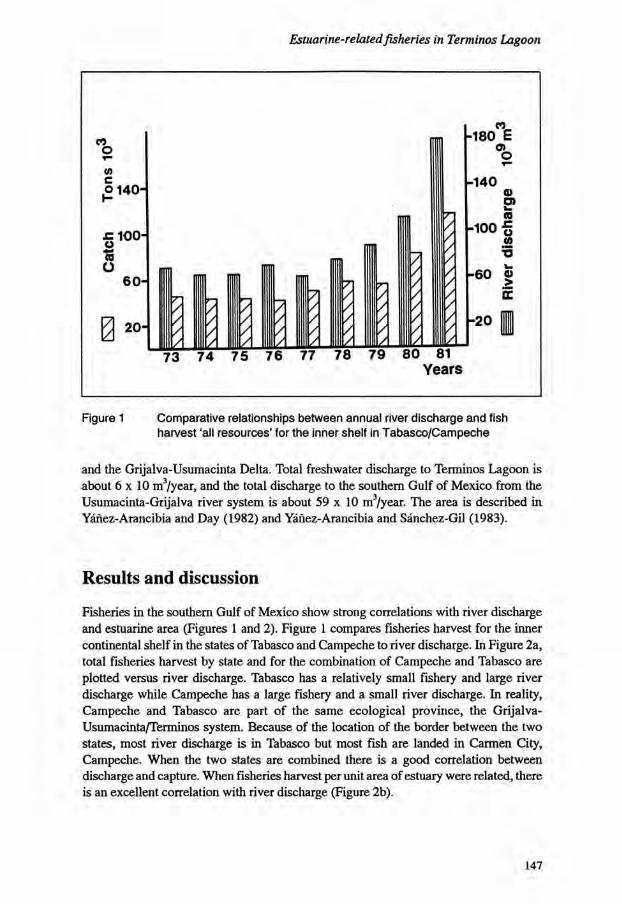
Estuarine-related fisheries in Terminos Lagoon
CO O T -
0) O140H
100-co O
60-
0 20-
Figure 1 Comparative relationships between annual river discharge and fish harvest 'all resources' for the inner shelf in Tabasco/Campeche
and the Grijalva-Usumacinta Delta. Total freshwater discharge to Terminos Lagoon is about 6 x 10 m3/year, and the total discharge to the southern Gulf of Mexico from the Usumacinta-Grijalva river system is about 59 x 10 m3/year. The area is described in Yanez-Arancibia and Day (1982) and Yanez-Arancibia and Sanchez-Gil (1983).
Results and discussion
Fisheries in the southern Gulf of Mexico show strong correlations with river discharge and estuarine area (Figures 1 and 2). Figure 1 compares fisheries harvest for the inner continental shelf in the states of Tabasco and Campeche to river discharge. In Figure 2a, total fisheries harvest by state and for the combination of Campeche and Tabasco are plotted versus river discharge. Tabasco has a relatively small fishery and large river discharge while Campeche has a large fishery and a small river discharge. In reality, Campeche and Tabasco are part of the same ecological province, the Grijalva-Usumacinta/Terminos system. Because of the location of the border between the two states, most river discharge is in Tabasco but most fish are landed in Carmen City, Campeche. When the two states are combined there is a good correlation between discharge and capture. When fisheries harvest per unit area of estuary were related, there is an excellent correlation with river discharge (Figure 2b).
147

Sustainable use of wetland resources
c o - 11.1 <D 3 10.8 a o
10.5
10.2-
9.6
9.3 16.0 16.5 17.0 17.5 18.0 18.5
in x= In River discharge I0 3m 3
• Veracruz lnY= 4.861 +0.325 InX r=0.762 p=0.20
* Tabasco lnY=- 4.997 + 0.818 InX r=0.758 p=O005
• Campeche lnY= 0.314 + 0.611 InX rsO.932 p=0O1
Campeche , w
°Taba*sco , n Y - ; 2 - 4 , 7 , 5 * 0 - 7 3 5 , n X
r=0.922 p = O01
Figure 2a Linear logarithmic correlations between fishery harvest and average river discharge. The unit of Campeche plus Tabasco has the higher relationships
4.1-
"= 3.8 CD a>3.5-eS §3.2-O o> i32.9-
> 2.6
• Veracruz •Tabasco • Campeche
15
lnY=-7.364+0.626 InX r =0.982 p =0.001
i 19
—r-20
,3„3 In x = In River dischargelOJm-
Figure 2b Linear logarithmic correlation between fishery harvest per unit area of open water of lagoon and estuaries, and average river discharge. The data are from the States of Veracruz, Tabasco and Campeche
148

Estuarine-related fisheries in Terminos Lagoon
° gout
* 70-
1 SO"
o 30-
10-
TOTAL CATCH
C a m p e c h e
0 L . d e Terminos
1 73 74 75 76 77 78 79 80 81 82 83 84 85
Years
Figure 3a Proportional relationship of fishery harvest between Campeche coast and Terminos Lagoon - 'all resources'
w ?20-l M K
SHRIMP C a m p e c h e
0 L. de T e r m i n o s
u u 7\
5- /
/
/ / /
Figure 3b Proportional relationship of fishery harvest between Campeche coast and Terminos Lagoon - penaeid shrimps
149

Sustainable use of wetland resources
V) c o
I - 3-
OYSTERS C a m p e c h e
73 74 75 76 77 78 79 80 81 82 83 84 85 Years
Figure 3c Proportional relationship of fishery harvest between Campeche coast and Terminos Lagoon - oysters
T— 70-(0
c ° 50-
o a 30-O
10-
FISHES
C a m p e c h e
L. de T e r m i n o s
73 74 75 76 77 78 79 80 81 82 83 84 85 Years
Figure 3d Proportional relationship of fishery harvest between Campeche coast and Terminos Lagoon - fin-fish
150

Estuarine-related fisheries in Terminos Lagoon
In Figure 3 total fisheries harvest (Figure 3a, fin-fishes, sharks, rays, bivalves, gastropods, cephalopods, crabs and shrimps), and harvest of shrimp (Figure 3b), oysters (Figure 3c), and fin-fishes (Figure 3d) are compared for the State of Campeche and for Terminos Lagoon. The proportion of the total catch from Terminos Lagoon represents 41 % on average of the total catch in Campeche. The proportion for shrimps ranges from 70% in 1976 to 38% in 1983 with an average of 52% of the total harvest of Campeche coming from Terminos Lagoon. For oysters, the figures vary from 56% in 1976 to 99.9% in 1984 and an average of 86%. For fin-fish, the values range from 32% in 1983 to 42% in 1984 with an average of 40% of the total catch of Campeche from Terminos Lagoon.
These variations are dependent on a number of factors including: 1. variation in the optimal utilization of the fishery infrastructure of the region; 2. the variability of annual catch per unit effort; 3. the degree of fishing pressure on juveniles in the lagoon-estuarine system; 4. variation in recruitment; 5. variation in environmental factors which affect fisheries. Nevertheless, it is very clear that freshwater deltaic areas with tidal influence and the Terminos Lagoon have a strong relationship with fisheries on the continental shelf in the southern Gulf of Mexico. The understanding of these fisheries, their administration, means of catch, and management requires an understanding of the important ecological role played by river discharge, mangroves, seagrass beds, and fluvial-deltaic areas in supporting fisheries. These areas are key systems in the life cycles of commercially important species providing habitat for reproduction, feeding, growth, nursery areas, and protection. The value of the total fish harvest in Tabasco/Campeche is estimated as approximately 150 million US$ annually. The fishery resources dependent upon Terminos Lagoon represent between 40 to 50% of this catch volume, indicating that the estuarine system in the southern Gulf of Mexico associated with Tabasco/Campeche continental shelf could represent an estimated annual value of approximately 62 million US$. This demonstrates the economic importance of effective conservation and management systems.
References
Day, Jr., C.S. Hopkinson and W.H. Conner. 1982. An Analysis of Environmental Factors Regulating Community Metabolism and Fisheries Production in a Louisiana Estuary. Pages 121-136. In: V.S. Kennedy (Ed.). Estuarine Comparisons. Academic Press. 710 pp.
Deegan, L.A., J.W. Day Jr., J.G. Gosselink, A. Yanez-Arancibia, G. Soberon-Chavez and P. Sanchez-Gil. 1986. Relationship Among Physical Characteristics, Vegetation, Distribution and Fisheries Yield in Gulf of Mexico Estuaries. Pages 85-100. In: DA. Wolfe (Ed.). Estuarine Variability. Academic Press. 510 pp.
151
Sustainable use of wetland resources
Sanchez-Gil, P. and A. Yanez-Arancibia. 1986. Discusion sobre relaciones de reclutamiento en sistemas lagunares-estuarinos de los peces del sur del Golfo de Mexico. Pages 215-228. In: A. Yanez-Arancibia and D. Pauly (Eds). IOC/FAO Workshop on Recruitment Processes in Tropical Coastal Demersal Communities. Ocean Science and Living Resources (OSRL). International Recruitment Project (IREP) COI/FAO/UNESCO, Workshop report No. 44, Paris. 324 pp.
Soberon-Chavez, G. and A. Yanez-Arancibia. 1985. Control ecologico de los peces demersales: variabilidad ambiental de la zona costera y su influencia en la produccion natural de los recursos pesqueros, Pages 399-486. In: A. Yanez-Arancibia (Ed.). Recursos Pesqueros Potenciales de Mexico: La Pesca Acompahanie del Camaron. Prog. Univ. de Alimentos. Inst. Cienc. del Mar y Limnol., Inst. Nal. de Pesca. UNAM, Mexico, D.F. 748 pp.
Soberon-Chavez, G., A. Yanez-Arancibia, P. Sanchez-Gil, J.W. Day Jr. and L.A. Deegan. 1986. Relaciones entre caracteristicas fisicas-biologicas y reclutamiento pesquero en ecosistemas costeros tropicales. Pages 53-72. In: A. Yanez-Arancibia and D. Pauly (Eds). IOC/FAO Workshop on Recruitment Processes in Tropical Coastal Demersal Communities. Ocean Science and Living Resources (OSRL). International Recruitment Project (IREP) COI/FAO/Unesco. Workshop Report No. 44, Paris. 324 pp.
Turner, R.E. 1977. Intertidal Vegetation and Commercial Yields of Penaeid Shrimp. Trans. Amer. Fish. Soc. 106(5):411-416.
Turner, R.E. 1979. Louisiana's Coastal Fisheries and Changing Environmental Conditions. Pages 363-372. In: J.W. Day Jr., D.D. Culley, R.E. Turner and A.J. Humphry (Eds). Proc. Third Coastal Marsh and Estuary Management Symposium Louisiana State. Div. Continuing Education, Baton Rouge. 512 pp.
Yanez-Arancibia, A. and J.W. Day Jr. 1982. Ecological Characterization of Terminos Lagoon, a Tropical Lagoon-Estuarine System in the Southern Gulf of Mexico. Pages 431-440. In: P. Lasserre and H. Postma (Eds). Coastal Lagoons. Oceanologica Acta. Vol. Spec. 5:462.
Yanez-Arancibia, A. and P. Sanchez-Gil. 1983. Environmental Behaviour of Campeche Sound Ecological System off Terminos Lagoon: Preliminary Results. An. Inst. Cienc. del Mar y Limnol. Univ. Nal. Auton. Mexico. 10(1): 117-136.
Yanez-Arancibia, A. and P. Sanchez-Gil. 1986. Los peces demersales de la plataforma continental del sur del Golfo de Mexico. I . Caracterizacion del ecosistema y ecologia de las especies, poblaciones y comunidades. Inst. Cienc. del mar y Limnol. Univ. Nal. Auton. Mexico, Publ. Esp. 9:230.
Yanez-Arancibia, A. and A. Aguirre-Leon. 1988. Pesquerias en la region de la laguna de terminos. Chap. 22. In: A. Yanez-Arancibia and J.W. Day Jr. (Eds). Ecology of Coastal Ecosystem in the Southern Gulf of Mexico: The Terminos Lagoon Region. Inst. Cienc. del Mar y Limnol. UNAM, Coast Ecol. Inst. LSU, Editorial Universitaria, Mexico (in press).
152

Estuarine-related fisheries in Terminos Lagoon
Yanez-Arancibia, A., G. Soberon-Chavez and P. Sanchez-Gil. 1985a. Ecology of Control Mechanisms of Natural Fish Production in the Coastal Zone. Chap. 27. Pages 571-549. In: A. Yanez-Arancibia (Ed.). Fish Community Ecology in Estuaries and Coastal Lagoons: Towards an Ecosystem Integration. Editorial Universitaria, UNAM/PUAL/ICML, Mexico. 654 pp.
Yanez-Arancibia, A., P. Sanchez-Gil, M. Tapia Garcia and M. de la C. Garcia-Abad. 1985b. Ecology, Community Structure and Evaluation of Tropical Demersal Fishes in the Southern Gulf of Mexico. Cahiers de Biologie Marine. 26:137-163.
153

Sustainable use of wetland resources
154

The Northern Cameroon Floodplain: influence of hydrology on fish production*
V. Benech
ORSTOM B.P. 2528 Bamako MALI
Resume
Influence de I'hydrologie sur la production de poisson dans la plaine d'inondation du Nord Cameroun
Dans le Bassin Tchadien, de nombreuses especes de poissons effectuent des migrations longitudinales et/ou laterales pour exploiter trois types de milieux: le lac Tchad, les fleuves et les zones inondees, en particulier la plaine d'inondation du Nord-Cameroun ('Yaere'), reliee au lac par l'El Be'id ou des pecheries traditionnelles s'exercent sur les juveniles qui quittent la plaine au moment de la decrue. Les rendements de ces pecheries ont ete utilises comme indice pour etudier l'influence de I'hydrologie sur la production du Yaere. De 1968 a 1978, des crues d'amplitude moyenne a tres faible ont foumi les conditions d'une experimentation naturelle sur les effets d'une eventuelle reduction artificielle des crues. La secheresse sahelienne de 1972-1973, en supprimant l'inondation deux annees de suite, a provoque l'assechement des mares residuelles. Par ailleurs, par l'abaissement du niveau du lac Tchad, elle est a l'origine d'une regression lacustre du Tchad Normal en Petit Tchad (marecages predominants) et d'une restructuration de la composition des stocks lacustres. L'influence de la crue annuelle se manifeste a un niveau global par une correlation positive entre production et volume d'inondation. Au niveau specifique, les fortes crues favorisent la croissance individuelle; elles permettent egalement un allongement de la periode de reproduction qui se traduit chez certaines especes par l'individualisation d'une 2e cohorte de jeunes. Dans le cadre d'une succession reguliere des crues, la relation production/crue parait independante de la composition specifique du peuplement du Yaere et du facies lacustre. Les Tilapia-Sarotherodon (sedentaires) sont a l'origine d'une distorsion de cette relation. A la suite de l'assec 1972-1973, ils constituent l'excedent de la production attendue lors
* Accepted for publication, September 1988
155

Sustainable use of wetland resources
Figure 1 Location map. The sampling site is encircled. Migrations of young fishes towards the El Beid are represented by arrows, and the road network is represented by broken lines
156

The Northern Cameroon Floodplain
de la faible crue 1974. L'assec parait favoriser la production de l'annee suivante de facon comparable a l'evolage pratique dans les etangs. A partir de ces elements et malgre des statistiques de peche tres limitees, nous avons tente d'aborder le probleme regional de la gestion des peches dans le contexte d'un amenagement hydro-agricole du Yaere.
Introduction
The Lake Chad Basin experiences great annual variability of rainfall and consequently of flood volume. The shallow water expanses such as Lake Chad and the floodplain of Northern Cameroon ('Yaeres', Figure 1) are particularly sensitive to flood variation which may result in significant ecological disturbance. The floodplains of Northern Cameroon provide a particularity important nursery for fish. As floodwaters subside at the end of the flood season, part of the flow does not recede to the Logone River channel but instead moves towards Lake Chad by the El Beid River. Significant numbers of juvenile fish reach the Lake by this route. A good many species use these interconnected biotopes via fluvio-lacustrine migrations which are important in maintaining fish production in the Chad Basin. The adults go upstream into the river system to reproduce on the floodplain where the alevins first grow. The juveniles meet the traditional fishery in the El Beid River during their downstream migrations towards the Lake Chad (Durand, 1970 and 1971; Benech and Quensiere, 1982 and 1983a,b). The dry season is spent in the lake, which is an important feeding ground The catches of the El Beid fisheries were used to study the influence of hydrology - and of an eventual situation of flood regulation - on the fish production of the Yaeres. The study period (1968-1978) was particularly favourable because the hydrological variations over this time provided a natural experiment that allowed determination of the influence of the state of the lake and the impact of a drying-up of the Yaeres as well as the effect of the flood in the case of a normal flooding occurrence.
Hydrology and definition of the flood index
The Yaeres spread over about 8,000 km2. Every year they are flooded by rainfall and the overflow of the Logone River. LANDSAT imagery allowed examination of the seasonal dynamics and the hydrological variability of the Yaeres (Benech et al., 1982). The flooding can be seen only in September (Figure 2). The waters enter the plain both upstream and downstream of N'Godeni (Figure 1). The upstream overflowings increase when the flood is strong whereas the downstream ones remain approximately constant. The depth of the water which pours into the Yaeres at the flood maximum is not related to the magnitude of the flood which declines from upstream to downstream at fixed rates. The fall which starts in October (Figure 2) is a regular interannual event. The flood of the El Beid outlet reaches a maximum at the end of November at Tilde indicating
157

Sustainable use of wetland resources
DISCHARGE (m 3/s)
Figure 2 The flood in different sites
158

The Northern Cameroon Floodplain
drainage of the Yaeres (Figure 2). In January, flooded areas still remain around the upper part of the El Beid River; and are drained finally towards the end of February. The plain is flooded when a discharge exceeds 1,200 m3/s at Bongor (a site located on the Logone River upstream from the overflows in the Yaeres), but the flood wave reaches the El Beid River only during the years when the flow exceeds 1,500 m3/s. It did not occur in 1972 and 1973 and the El Beid River was not supplied in these two years. A flood index has been established. It corresponds to the water volume determined by the enclosure of the curve of the Logone River discharge at Bongor beyond 1,500 m3/s (Figure. 2). The 1972-1973 Sahelian drought limited the flooding of the Yaeres in the Logone River floodplain which resulted in the drying-up of the residual ponds distant from the river. As these small floods accelerated the lowering of the lake level, they hasten the change from the 'Normal Chad' (18,000 km2) to the 'Lesser Chad' (9,000 km2) characterized by the development of vast marshy areas at the expense of open water areas and archipelagoes (Carmouze and Lemoalle, 1983).
Influence of hydrology on fish production
Definition of an index of fish production The El Beid fisheries are the main traditional fisheries of the Yaeres. Their average annual production amounts to 1,400 tonnes of fresh fish sold after being sun-dried. About 300 fishing dams are found along the river. Standing in front of a dam, the fishermen use a triangular net which is periodically lifted and checked. The fishing season extends from November to February. The Daga Dam catches were observed over six years (Figure 1); first in 1968, the Normal Chad period, and from 1974 to 1978, the Lesser Chad period. A sampling method based on traditional fishing technique was worked out and maintained regularly during the six fishing seasons. Every three days, twelve two-hour fishings were conducted on a diel cycle and this was maintained for the whole fishing season. The weight of our sampling catches from November 27th to February 10th was given as the Yaere fish production index every year. This stands as a good index insofar as this catch per unit effort is a linear function of the production. According to the analysis of the migratory movements and the sampling conditions (Benech and Quensiere, 1982 and 1983a,b), we may consider that this condition was fulfilled. During the study period there was no exceptional flood to modify the fishing conditions.
Influence of the annual flood volume Except for 1974 (a year following the drought and marked by a great abundance of Tilapia-Sarotherodon), a positive correlation between fish production index and the flood index was noticed (Figure 3). If the very high catch of Tilapia-Sarotherodon species in 1974 is not considered, then the catch for other species that year also fits well with the new relationship (Figure 3, 'without Tilapia').
159

Sustainable use of wetland resources
FISH PRODUCTION
19741977 1968 19781976 1975
— I I , r LI—i U-1 2
FLOOD INDEX
Figure 3 Relation between the fishing yield at the Daga Dam and the importance of the Logone flood
^^(Q) 0 BrachygynodontlM bmtmnsoda
• Hatcutmniua cyprinoldmt
80. A 0 Hypmropitua fbm A
A Smrothmrodon mufuz /
I
60. j
I j I
40. ! / a
20.
^ o
0 \1977 1000 1070 1975
0.5 1.0 1.5 2.0 FLOOD JNDEX
Figure 4 Relation between the mean specific individual weight (w) of catches collected at the Daga Dam and the importance of the Logone flood
160

The Northern Cameroon Floodplain
The fish production is a function of both the number of fish and their average weight. In fact, at a species level, strong floods promote individual growth (Figure 4); 1974 is once again not taken into consideration, (see below); floods also allow a longer spawning period which results in the production of a second cohort of juveniles by some species (Benech and Quensiere, 1983b). The year 1968 (Normal Chad period) fits well with the relationship (Figure 3) which is based mainly on data of the Lesser Chad period. The production-flood volume relationship therefore seems independent of species composition and of lake state. In fact, the lake recession has disturbed the structure of the lacustrine fish communities by reducing the stocks of the species, especially the migrators, which were not adapted to the hypoxic conditions. Consequently, the upstream spawning migrations have been reduced. An analysis of the components of the catches of the El Beid fisheries revealed that the structure of the Yaeres fish community has changed markedly after the drought period; species diversity is being reduced and the migratory species are becoming less abundant.
Influence of the drying-up of the Yaeres With the exceptional drought of 1972/1973, only areas adjacent to the river were flooded. This limited flooding prevented the juveniles from entering the main part of the plain for two consecutive years and suppressed the migrations down the El Beid. It also caused the drying-up and the destruction of the fish stocks in the residual ponds which are remote from the river. In 1974, withnormal flooding, the Tilapia-Sarotherodon (the larger part of sedentary species) increased considerably in the El Beid catches, very probably because of the absence of competition. The phenomenon declined the following years as the residual pond populations were restored; the abundance of the Tilapia-Sarotherodon decreased and the species diversity increased again. The Tilapia-Sarotherodon peak in 1974 distorted the production/flood volume relationship, i.e. they supplemented the low production predicted as a result of the small flood of 1974 (Figure 3). The drying-up of the Yaeres, therefore, had a beneficial impact on the following year's production especially by increasing growth (Figure 4). However, it was the Tilapia-Sarotherodon which benefitted most in this situation.
Discussion
The regulation of the Logone River, and subsequent change in the flood pattern would seem, a priori, to be harmful to fish production because the biology of many species is related to the natural hydrology of the basin. In the light of development plans for the basin, the determination of water management operations allowing irrigation without threatening the fisheries potential - an actual richness which is well integrated to the socio-economic life of the area - is therefore required urgently. Recent hydro-agricultural works in the Yaeres, especially those of the SEMRY JJ rice project, have revealed that some water reservoirs used for irrigation constituted an important fisheries
161

Sustainable use of wetland resources
potential spontaneously exploited by the local populations. Thus for the Maga Lake (30,000 ha) fish production was estimated as 2,800 t/year (Artidi et al., 1983) which is twice the production of a fishing season for all El Beid fishing dams. Although the production of Lesser Chad is lower [about 100,000 tonnes regularly from 1975 to 1977 (Durand, 1980)], the yield is higher than that of Normal Chad especially in relation to the quantity of water required (Benech and Quensiere, 1987). On the contrary, flood reduction is detrimental to the El Beid fisheries; this may, in the extreme, suppress totally the production in absence of discharge in the El Beid River as happened in 1972 and 1973. However, the yield increase which follows these drought years is a favourable aspect which deserves attention in the planning of new schemes. The desiccation appears to promote the next year's production in a similar manner as the periodic drying-up of managed ponds. This information on fisheries production suggests that the artificial maintenance of the Chadian fluvio-lacustrine system in its Lesser Chad state must be planned carefully, because this situation may cause long-term harmful effects without necessarily bringing sustainable benefits. Among the possible unfavourable effects are side effects on the regional climate owing to a reduction of evaporation. Reduction of the flooding will also suppress nutrient enrichment of the plain with possible effects on vegetation and the wildlife of the Yaeres which are a natural resource to be protected because of their ecological and economic interests. And last, the perpetuation of Lesser Chad is especially harmful to fluvio-lacustrine migrator fish whose survival strategy is based on the combined exploitation of the lake, rivers and floodplains. It cannot be guaranteed that reduction of these stocks to a very low level might be compensated forever by an increased productivity of the other species along the floodplain, and Lake Chad and Lake Maga. Do the 100,000 tonne annual productions of 1975-1977 correspond to a sustainable production or to a short-lived glut comparable to the phenomenon found in newly built tanks? The data required to provide a comprehensive answer to this question is not available at this time, although the Lesser Chad state has persisted naturally for a decade. A number of recommendations can, however, be made on the water management needs for fisheries in this fluvio-lacustrine system. It is known that at present the lacustrine production of the upstream migrators (especially the 'salanga' species) is negligible because their exploitation strategy of the lake-river-floodplain is maximal only in the Normal Chad conditions. Under present conditions it is therefore not possible to improve production of these species simply by allowing downstream migration through the El Beid River following regular and a sufficient flooding of the Yaeres. The fact that the absence of recruitment through the El Beid River in 1972 and 1973 did not have any quantitative effect on production of Lake Chad supports this hypothesis. Under the conditions of Lesser Chad, a reduction in flooded area along the Yaeres may therefore have a limited impact upon fisheries. Further, if the water is stored in small reservoirs such as Maga Lake, this can be used for both agriculture and fisheries. The biomass and fish production of a river-floodplain system do not depend only on the flooding area but also on the quantity of residual water in the dry season (Welcomme, 1979). The artificial water stocks fulfil this role as a small scale model of Normal Chad.
162

The Northern Cameroon Floodplain
In other words, the Maga Lake shelters important populations of species such as hates, Alestes, Hydrocynus, Schilbe (de Kimpe, 1983), which characterise the fish community of Normal Chad. Thus, under the conditions of Lesser Chad, these reservoirs may play an important role in conserving fish stock density, and providing a resource for rebuilding the potential of the Normal Chad system.
Editor's note After the work reported upon here, the fishery of Lake Maga has been heavily overfished. The optimism expressed here therefore needs to be re-examined.
References
Artidi, C, P. Baris and M. Barnaud. 1983. Evaluation socio-economique du projet SEMPJ au Cameroun. Pages 1-122. In: Evaluations. Republique Francaise, Ministere des Relations exterieures, Cooperation et Developpement.
Benech, V. and J. Quensiere. 1982. Migrations de poissons vers le lac Tchad a la decrue de la plaine inondee du Nord-Cameroun. I - Methodologie d'echantillonnage et resultats generaux. Rev. Hydrobiol. Trop. 15(3):253-270.
Benech, V. and J. Quensiere. 1983a. Migrations de poissons vers le lac Tchad a la decrue de la plaine inondee du Nord-Cameroun. I I - Comportement et rythme d'activite des principales especes. Rev. Hydrobiol. Trop. 16(1):79-101.
Benech, V. and J. Quensiere. 1983b. Migrations de poissons vers le lac Tchad a la decrue de la plaine inondee du Nord-Cameroun. I l l - Variations annuelles en fonction de I'hydrologie. Rev. Hydrobiol. Trop. 16(2):287-316.
Benech, V. and J. Quensiere. 1987. Dynamique des peuplements ichtyologiques de la region du lac Tchad (1966-1978). Influence de la secheresse sahe'lienne. These de Doctorat d'Etat, Universite des Sciences et Techniques de Lille-Flandres-Artois. 658 pp.
Benech, V., J. Quensiere and G. Vidy. 1982. Hydrologie et physico-chimie de la plaine d'inondation du Nord-Cameroun. Cah. ORSTOM, ser. Hydrol. 19(1): 15-35.
Carmouze, J.P. and J. Lemoalle. 1983. The Lacustrine Environment. Pages 27-63. In: J.P. Carmouze, J.R. Durand and C. Leveque (Eds). Lake Chad, Ecology and Productivity of a Shallow Tropical Ecosystem. Junk, The Hague.
Durand, J.R. 1970. Les peuplements ichtyologiques de l'El Beid. Premiere note: Presentation du milieu et resultats generaux. Cah. ORSTOM, ser. Hydrobiol. 4(l):3-26.
Durand, J.R. 1971. Les peuplements ichtyologiques de l'El Beid. Deuxieme note: Variations inter et intraspecifiques. Cah. ORSTOM, ser. Hydrobiol. 5(2): 147-159.
163

Sustainable use of wetland resources
Durand, J.R. 1980. Evolution des captures totales (1962-1977) et devenir des pecheries de la region du lac Tchad. Cah. ORSTOM, ser. Hydrobiol, 13(1):93-111.
de Kimpe, P. 1983. Mission d'appui au pro jet d'amenagement piscicole du barrage de Maga C.T.F.T., janvier 1983. 26 pp.
Welcomme, R.L. 1979. Fisheries Ecology of Floodplain Rivers. Longman, London and New York. 317 pp.
164

Fish communities and fishing in a floodplain lake of Central Amazonia*
B. de Merona
ORSTOM 213 rue Lafayette 75480 Paris Cedex 10 France
and
INPA CP. 478 69011 Manaus-Am Brazil
Resume
Les peuplements de poissons et la peche dans un lac d'inondation d'Amazonie centrale
L'analyse synthetique des resultats d'une etude multidisciplinaire menee sur une ile de la plaine inondee d'Amazonie centrale et sur son lac interieur debouche sur un certain nombre d'observations. La production piscicole actuelle est largement inferieure au potentiel estime. Cette difference peut neanmoins varier amplement d'une annee a l'autre. La composition des captures est sensiblement differente de la composition du peuplement. Outre qu'il existe dans le peuplement de nombreuses especes de petite taille non pechees, les pecheurs se desinteressent nettement de certaines especes abondantes et exploitables. Le regime de crue modifie de maniere prononcee les comportements de peche. II affecte aussi les captures par effort de peche qui, du fait de changements importants de la densite des poissons dans le volume d'eau, ne sont pas proportionnelles a l'abondance en poisson. Lorsque la hauteur d'eau moyenne sur une annee s'accroit, la biomasse totale de poisson augmente egalement, mais les captures par effort de peche diminuent. La production piscicole est done soumise a un certain nombre de contraintes physiques, biologiques, ecologiques, culturelles et econ-omiques qui limitent l'activite de peche. La situation etant complexe, des etudes detaillees sont encore necessaires avant de pouvoir proposer une gestion adaptee.
* First published in: Bull. Ecol., 21(3) 1990
165

Sustainable use of wetland resources
Introduction
Floodplains of tropical rivers are generally considered very productive environments. For their aquatic component and its terminal production, the above assumption is supported by the observed higher fish yields in the rivers with an extensive floodplain than in the ones with a more delimited bed (Welcomme, 1974 and 1979). The Amazon River belongs to the first category with an extensive floodplain representing about 2.9% of the whole basin (about 210,000 km2). In the Brasilian Amazon, fish yield is based primarily on the floodplain productivity (Petrere, 1982; Bayley, 1981 and 1982). With the increase in fishing pressure on the stocks, some indications of over-fishing have been detected for individual species (Merona and Bittencourt, in press). However, Bayley (1981 and 1982) suggests that a broad overall under-exploitation of the fish resource in the Brazilian Amazon occurs. This contribution is an attempt to solve this contradiction based on a particular case: the 'Lago do Rei', a floodplain lake in central Amazonia. This study was part of a multi-disciplinary project developed on the lake and the island which surrounds it, between 1985 and 1987 (ORSTOM/INPA/CEE, 1988).
The study area
Careiro Island is a large alluvial island, located in front of the confluence of 'Rio Negro' and 'Rio Solimoes' (Figure 1). The island has an area of approximately 200 km2 and includes a large lake called the 'Lago do Rei', as well as a number of secondary water-bodies. This aquatic system is connected to the Amazon River by a canal, about 20 km long. The water level in the lake follows the water level fluctuations in the river.
Figure 1 Map of the study area. The square shows the experimental fishing zone
166

Fish communities in a floodplain lake of Central Amazonia
Data collection and treatment
Fish communities The detailed methodology is described in Merona et al. (1988). Experimental fishing with a battery of 13 gill nets of different mesh size was conducted every 2 months between February 1986 and June 1987. At each collection date we sampled the different habitats which could be recognized in a predetermined zone (shown on Figure 1). The specific and total capture was expressed in catch per unit of effort (CPUE = catch in number or weight per 1,300 m 2 during 24 hours). Biomass indices were calculated by correcting the CPUE of the samples by the estimated volume of the lake at the time of collection (see Guillaumet et al, 1988, for the details of volume estimation).
The study is based on daily fish landing data collections at two points: the central market of Manaus city and a traditional settlement on the north coast of Careiro Island (Terra Nova). The detailed methodologies can be found in Petrere (1978) for Manaus market and in Merona and Thery (1988) for the island. These data collections provide information on specific landings, gear used, location of fishing and effort.
Fishing
Other Curimata
Dourada
Acara
Aruana
Sorubim
Cuiu
Mapara Piranha
Branquinha
Tucunare
Pacu
Tambaqui
Pescada
Cubiu Jaraqui
Key to Figure 2 (on next page)
167

Sustainable use of wetland resources
Seines 8 5 / 8 6 Seines 8 6 / 8 7
S m a l l - s c a l e 8 5 / 8 6 Sma l l - sca le 8 6 / 8 7
Community 1st. sem. 86 Community 2nd sem. 86
168

Fish communities in a floodplain lake of Central Amazonia
Other 85 /86 gears
Other 8 6 / 8 7 gears
Total Yield 85 /86 Total Yield 8 6 / 8 7
Community 1st sem. 87 Community Nb species
Figure 2 Catch composition and fish community composition for the 1985/86 and 1986/87 hydrological seasons in the 'Lago do Rei'
169

Sustainable use ofwetldnd resources
Production estimates Estimates of production are based on the work of Bayley (1982). It is assumed in this study that the potential yield lies between 0.3 and 0.5 times the biological production according to the model of Gulland (1970) generalized to an exploited 'multi-specific stock'. The total fish yields of 'Lago do Rei' are calculated from Merona and Thery (1988). The surface and the volume of the lake are estimated from a simple model developed elsewhere (Guillaumet et al., 1988).
Actual catch versus potential yield
The values of total yield observed for the two years of study are markedly lower than the potential yield (Table 1). However, the difference is much less pronounced in the 1985/1986 season where the yield represents 16.5% of the lowest estimation of the potential. The ways biomass and production were calculated implies a direct proportion between the production estimates and the mean surface area of the lake during the respective hydrological year. Some kind of relation may indeed exist. The lower the level in the low water period, the higher the natural and fishing mortality. A high water level favours the recruitment of the young in the community and a rapid growth. However, it is probable that biomass and production are also related to previous years' hydrological regimes which could affect the abundance of age classes of two or more years. This effect is probably very important for the potential yield because fishing pressure is much more directed towards the older fish. Another consideration concerns how much of the biological production can be considered as potentially exploitable. Bayley (1982) estimates at 134,000 tonnes the part of the production of fish greater than 25 cm in length which are basically those recruited by the fishery. This value represents 36.7% of the total biological production and is comparable with the predictions given by the model of Gulland (1970).
Table 1 Estimates of fish production, potential yield and actual yield for the 'Lago do Rei'
1985/1986 1986/1987
Lake area (km2) 80.57 93.63
Biological Production (t/year) 22,560 26,216
Mean Biomass (t) 12,891 14,981
Potential Yield (t/year) [6,678-11,280] [7,865-13,108]
Actual Yield (t) 1,115 552
170

Fish communities in a floodplain lake of Central Amazonia
Catch composition versus community composition
Three types of fishing activities contribute to the total yield: 1. A seine fishery taking place in the canal between the lake and the river captures the
migrating fish. 2. A 'multi-gear' fishery using gill nets, fishing-rod, trident and harpoon, is developed
in the lake itself. 3. A small-scale local fishery with very low investment, takes place in the lake in the
areas near the settlements. Seventeen fish species or groups of species are significantiy represented in the total captures (Figure 2). One of them, the 'Curimata' Prochilodus nigricans was clearly dominant during the two seasons studied. Some fish groups appear sporadically like the 'aracu' Anostomidae spp., the 'cubm'Anodus spp., and Eigenmannina spp., and the 'mapara' Hypophtalmus spp. The seine fishery is responsible for these captures. In the lake itself, catch composition is relatively constant from one year to the next although in 1986/87 a significant decrease of the contribution of 'curimata' and a parallel increase in the relative importance of 'cuiu' Pseudodoras niger are observed. The catch composition of the small-scale local fishery shows a large proportion of some very high priced species like the 'tambaqui' Colossoma macropomum, and the 'tucunare' Cichla monoculus. In the fish community, these 17 fish groups together represented always less than 75% of the mean biomass estimated over three six-month periods. The 17 groups correspond to approximately 41 species, which represents only 30% of the total number of species captured in the lake. The difference between the relative importance of these fish groups products in biomass and in number of species suggests that a significant number of non-exploited species are small-sized and could not be exploitable with the gear currently in use. Considering only the exploited species, it is evident that some species are heavily fished in spite of low representativeness in the community. It is especially true with the 'curimata' whose distribution in the lake is limited to the marginal areas covered with floating meadows (Merona et al., 1988). On the contrary, the 'aracu' and the 'piranha' Serrasalmus spp., are poorly exploited despite their great abundance in the fish community.
Fishing behaviour and hydrological regime
Overall fishing intensity as well as the use of a specific gear (both expressed by the number of trips to the lake) are very variable on a monthly basis (Figure 3). The use of seine is irregular and seems to be opportunistic, taking advantage of local and time-limited fish concentrations. The frequency of the trips into the lake, using gill net, fishing-rod, trident, harpoon or a mixture of these gears is cyclic and regular, showing a maximum during the low water period and a minimum at the time of high waters. There are two possible explanations for the low degree of activity in the high water season. On the one hand, when the water rises in the river, it enters in the lake by the canal, carrying with it a great quantity of tree trunks and other floating plant material which can
171
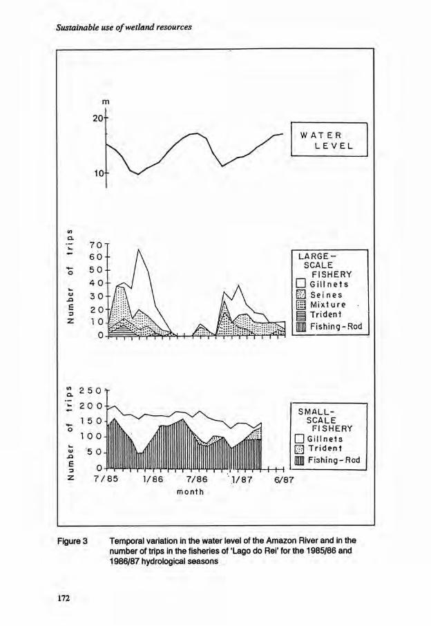
Sustainable use of wetland resources
<n Cl
E •3
L A R G E -S C A L E
F I S H E R Y • G i l l n e t s
3 S e i n e s U M ix ture | Tr ident 1 F i s h i n g - R o d
£. 2 5 0 t ' z 2 0 0 -k
S M A L L -S C A L E
F I S H E R Y • G i l l n e t s fj] T r i d e n t M F i s h i n g - R e d
6/87
Figure 3 Temporal variation in the water level of the Amazon River and in the number of trips in the fisheries of 'Lago do Rei' for the 1985/86 and 1986/87 hydrological seasons
172

Fish communities in a floodplain lake of Central Amazonia
eventually obstruct the channel and prevent the entry of the fishing boats. On the other hand, the increase in lake volume and the inundation of large marginal areas makes many commercial species take refuge in the flooded forest or in the floating vegetation where fishing on a large-scale is not possible. Because of its ability to access the marginal areas, the small-scale local fishery is a much more constant activity.
Temporal variation of catch by effort and biomass
The catch per unit effort (CPUE) of the 3 different fisheries present large seasonal variations (Figure 4). The CPUE of the seine fishery, which can attain high values of 250 kg per fisherman per day, shows two maxima in the hydrological year, one during the recession of the waters and the other at the start of the flood. This seasonality corresponds to the two types of lateral fish migration in the system described by Cox Fernandes and Merona (in press). The patterns of CPUE in the two other types of fisheries are almost parallel. The values are much lower than those of the seine fishery and there is a maximum during the low water period. For all fisheries, the mean value of CPUE is lower in 1986/1987 than in 1985/1986. The CPUE of the experimental fishing (expressed in kg in 1,300 m2 during 24 hours) shows a very sharp increase in the period of low water, but is nearly the same in the two periods of rising water.
Figure 4a Temporal variation in the catch per unit effort in the fisheries and experimental fishing in the 'Lago do Rei" for the 1985/86 and 1986/87 hydrological seasons — Artisanal fishing
173

Sustainable use of wetland resources
C P U E
k g / 1 3 0 0 r r i . 2 4 h
A 5 . 0 - T
4 0 0 ¬
3 5 0 -
3 0 0
2 5 0
2 0 0 -
1 5 0 ¬
1 0 0 ¬
5 0
0 -1—I h H 1 1 r- H 1 1 § / 8 10 12 2 4 6 8 10 12 2 4
8 5 M o n t h
Figure 4b Temporal variation in the catch per unit effort in the fisheries and experimental fishing in the 'Lago do Rei' for the 1985/86 and 1986/87 hydrological seasons — Experimental fishing
I N D
I C E
9 0 j
8 0 ¬
7 0 -
6 0 ¬
5 0 ¬
4 0 - ¬
3 0 ¬
2 0 ¬
1 0 -¬
0 H 1 1 1- H—\—I—I 6 ^ 5 8 10 12 2 4 6 8 10 12 2 4
M o n t h
Figure 4c Temporal variation in the catch per unit effort in the fisheries and experimental fishing in the 'Lago do Rei' for the 1985/86 and 1986/87 hydrological seasons — Biomass indices
174

Fish communities in a floodplain lake of Central Amazonia
The seasonality of biomass appears very different compared to the general variation of CPUE. A very rapid increase during the inundation was observed in the two years of this study. However, a parallel decrease did not occur during the recession of the waters in 1986, resulting in much higher biomass values in 1987. These observations suggest that CPUE cannot be used as an abundance index in this particular case. CPUE, in fact, is proportional to the density of fish in the environment which is in turn dependent on the volume of water present. This volume cannot be considered constant on a yearly basis because of the large interannual variations in the hydrological regime.
Conclusions
The low value of the total yield from the 'Lago do Rei' compared with the estimated potential yield, would suggest that the fisheries under-exploit this fishing ground. However, the great difference observed between the 2 years of this study demand caution in drawing this conclusion. A very dry year may provoke low production together with high natural mortality. The fishing itself takes advantage of the low waters and fishing mortality may, in this hypothetical case, be catastrophic, even with unaltered fishing intensity. Regardless of the degree of under-exploitation, it is obvious that the fishery has a very limited number of target species although almost all the medium and large-size species could be eventually caught. This observation can be explained by the existence of a great variety of constraints limiting the fishing activity. They are related to a number of factors: 1. Hydrological characteristics: the vegetation carried by the rising waters can
prevent access to the fishing ground. In addition, the great increase in volume of the water during the high water season results in a reduction of the efficiency of fishing gear. The use of certain categories of gear is also limited by the characteristics of the water-body.
2. Fish morphology: some very elongated fishes like the 'aracu' or the 'mapara' escape the gillnets used by the fishery. Smaller mesh size cannot be used because they will capture small-size fish which cannot be sold.
3. Fish behaviour: some species (particularly the piranhas) enter in direct competition with fishermen, attacking the fish captured in gill nets and causing heavy losses.
4. Fish ecology: a number of species take refuge in the marginal and inaccessible areas of the floodplain. Lateral migration does not seem to be a regular phenomenon for some populations.
5. Cultural and economical factors: in the region, there are many superstitions about fish. A number of species are not acceptable to the consumer or bring a low price at the market.
This situation leads fishermen to concentrate their effort on a small number of species, the stocks of which could be threatened in the short or medium term. This appears to be the case of the 'pescadas' (Plagioscion spp., which were intensively fished in the period 1976-1979 (Annibal, 1982) and are now scarce.
175

Sustainable use of wetland resources
Scientific management of the fishery is impossible without more information. The annual variations in production must be monitored over a long time period in order to determine a maximum value for the potential yield. There is also an urgent need for detailed studies on the exploitable species in order to determine their contribution to community production and their relationships with other species.
Acknowledgements
This work is part of the bilateral Convenio ORSTOM/CNPq and was partly financed by the Commission of the European Community. The author is very grateful to INPA which provided essential infrastructural support.
References
Annibal, S.R.P. 1982. Avaliagao bio-ecologica e pesqueira das pescadas (Plagioscion squamosissimus Heckel. 1840 e P. Montei Soares. 1978) no 'sistema lago do Rei', Ilha do Careiro, AM, Brasil. Diss. Mestrado INPA/FUA. 113 pp.
Bayley, P.B. 1981. Fish Yield from the Amazon in Brazil: Comparison with African Yields and Management Possibilities. Trans. Amer. Fish. Soc. 110:351-359.
Bayley, P.B. 1982. Central Amazon Fish Populations: Biomass, Production and Some Dynamic Characteristics. PhD Thesis, Dahlousie Univ. 330 pp.
Cox-Fernandes, C. and B. de Merona. (In press). Lateral Migration of Fishes on a Floodplain System in the Central Amazon (Careiro Island, Lake of Rei), AM, BR. Memoria Sociedad Ciencias Naturales La Salle.
Guillaumet, J.L., A.O. Marquets F°, A.C. Tancrede, H.B. Cunha, R.C. Senna, S.M.S. Igreja, and B. de Merona. 1988. Elements d'hydrologie. Pages 21-32. In: Conditions Ecologiques et Economiques de la Production d'une ile de Varzea: Vile de Careiro. ORSTOM/INPA/CEE
Gulland, J.A. 1970. Food chain studies and some problems in world fisheries. In Steele (Ed.). Marine Food Chains. Oliver & Boyd, London, pp. 296-315.
de Merona, B. and M.M. Bittencourt. (In press). A pesca na Amazonia atraves dos desembarques no mercado de Manaus: resultados preliminares. Memoria Sociedad Ciencias Naturales La Salle.
de Merona, B., M. Jegu, M.M. Bittencourt, G.M. dos Santos, A. Bert, C. Cox-Fernandes, P. Petry, E.G. Ferreira and L.H. PY-Daniel. 1988. Les poissons. Pages 72-183. In: Conditions Ecologiques et Economiques de la Production d'une ile de varzea: Vile de Careiro. ORSTOM/INPA/CEE.
176

Fish communities in a floodplain lake of Central Amazonia
de Merona, B. and M. Therry. 1988. Etude de la pecherie. Pages 250-312. In: Conditions Ecologiques et Economiques de la Production d'une ile de varzea: Vile de Careiro. ORSTOM/INPA/CEE.
ORSTOM/INPA/CEE. 1988. Conditions Ecologiques et Economiques de la Production d'une ile de varzea: Vile de Careiro. Rapport terminal. 375 pp.
Petrere, M. Jr. 1978. Pesca e esforco de pesca no estado do Amazonas. I Locais, aparelhos de captura e estatisticas de desembarque. Acta Amazonica, VHI(3), Sup. 2. 54 pp.
Petrere, M. Jr. 1982. Ecology of the Fisheries in the River Amazon and its Tributaries in the Amazonas State (Brazil). Ph.D. Thesis, Univ. East Anglia. 92 pp.
Welcomme, R.L. 1974. Some General and Theoretical Considerations on the Fish Production of African Rivers. CIFA Occas. Pap. 3. 26 pp.
Welcomme, R.L. 1979. Fisheries Ecology of Floodplain Rivers. Longman. 317 pp.
177

Sustainable use of wetland resources
178

Changing tropical marshlands into agro-piscicultural ecosystems*
J.-C. Micha1, H. Halen1 et J.-L. Rosado Couoh2
[1] UNECED/FNDP Rue de Bruxelles, 61 B-5000 Namur Belgium
[2] INIREB Sindicato de Economi'a 108 86040 Villahermosa Mexico
Contract CCE-STD-A-123-B
Resume
Transformation de zones humides tropicales en ecosystemes agro-piscicoles
Pour eviter l'assechement des zones humides tropicales a des fins agricoles, il parait possible de les amenager en ecosystemes agro-piscicoles a productivite elevee. Cette solution alternative conserve au milieu ses caracteristiques essentielles. L'etude d'un tel systeme, amenage mecaniquement (65 ha) dans la plaine alluviale du Tabasco, au Mexique, montre que:
- les sols ont, en surface, des contenus fort variables en phosphore (0 a 65 ppm P assimilable) et en potasse (0,17 a 0,85 meq/100 g) et sont relativement pauvres en matieres organiques (1 a 1,5% C). Seule la couche de sol la plus superficielle (0-20 cm) contient de l'azote mineral (entre 10 et 40 Kg N/ha selon l'epoque de F annee);
- les eaux des canaux presentent une productivite primaire reduite, des concentrations en N mineral limitantes (70 ?g N/1 et N/P - 2 a 3) et une stratification nette des temperatures et de Foxygene dissous durant la moitie de Fannee.
* Accepted for publication, September 1988
179

Sustainable use of wetland resources
En general, l'azote (N) est limitant pour la productivite des terres comme des eaux. Cet element est appele a jouer un role-cle lors d'une valorisation adequate de ce systeme a reaction legerement alcaline (pH-sols: 7,5-8,0; pH-eaux: 7,5-8,5) ou des pertes nettes importantes peuvent avoir lieu par voie de denitrification - a hauteur de la nappe (sols) et des sediments (canaux) - et de volatilisation. Les apports naturels de N par fixation biologique (culture de la fougere Azolla sur une partie des canaux) devraient ameliorer la productivite du systeme.
Introduction
The development of marshlands in tropical regions often becomes a matter of necessity to counter recent demographic pressure. One of the alternatives for tapping the high productive potential of these areas is to change them into 'hortillonnages'. The change consists in raising the soil by making ridges in the marshland using soil taken from below the water. The alternating strips of land and ditches allow an integrated agro-piscicultural development of a semi-intensive type. Quite the opposite of drainage, the technique aims at retaining and controlling the waters (Barbier etai, 1985; Micha, 1985 and 1987). It thus does less to the essential characteristics of the environment and is more compatible with the principles of the World Conservation Strategy (IUCN/UNEP/WWF, 1980) which promotes the conservation of natural resources as the basis for sustainable development. In order to ensure and to maintain the productive potential of these systems, the most compatible agricultural and piscicultural techniques need to be applied in ways which will lead to joint development of the two media of production i.e. soil and water. In general, in order to fertilize the waters, advantage can be taken of:
- farming residues; - nutrients brought in laterally (internal drainage or runoff water) or else leached
as far as the groundwater table and diffused from there; - the mud in the ditches which can be collected at regular intervals and spread on
the land. It is impossible to generalize the techniques to be employed to ensure optimal functioning of the systems at all of the sites which are changed into 'hortillonnages'. There will be marked differences between them according to whether they are, for example, high altitude marshlands giving an acid reaction or lowland marshes. Each region requires research. Several 'hortillonnages' have been constructed over the last few years in the alluvial plain of the State of Tabasco, South-East Mexico, in an attempt to take advantage of the huge flooded areas of this region. Certain changes are still in progress. An exploratory study (Halen et al., 1987) was undertaken on one of these sites, that of the 'camellones chontales' of Tucta. Our objective was to establish the main characteristics of the soils (ridges) and waters (ditches) of these systems and to study the dynamics of the biogenic elements N and P.
180

Changing tropical marshlands
Characteristics of the ecosystem
General characteristics The 'camellones chontales' were constructed mechanically, by means of a dredger, on the edge of Lao Del Horizonte in the commune of Nacajuca, Tucta (Lat. 18°10'N; Long. 93°00'W). The soil of the area is formed from recent alluvial deposits and classed as eutric fluvisol (Palma Lopez and Cisneros, 1985). The climate is of the hot, subhumid type. The annual rainfall is 1,752 mm, with a short dry season occurring between March and May. The temperature remains high throughout the year, with a minimum in January (22.5°C) and a maximum in May (28.5°C). Altitude is generally only several metres above sea level. The ridges, which cover a total of 32 ha are generally 200 m long and 20 m wide. The ditches, also covering 32 ha have identical area and dimensions; their depth varies between 2.5 m and 3.5 m. The ditches cannot be drained due to the absence of a natural slope. The level of water is only slightly controlled: it varies in parallel with that of the lake where ranges are in the order of 0.5 to 0.8 m. The land has been farmed for 7 to 9 years by the Chontales Indians. There are two main crops a year: a com crop (between the end of May and the end of October), and a bean crop during the winter months (between November and March). The other crops (banana, plantain, pawpaw, cassava) cover appoximately 30% of the surface of the ridges. Traditional yields are poor: 1.1 t/haof com grain and 0.9 t/ha of beans on the average (Lobato-Carcamo, 1984). Recourse to mineral fertilization (N-P-K: 100-60-30 units/ha for com and 20-70-90 for beans), combined with improved sowing density, resulted in 1986 in average yields for com of 2.7 t/ha whilst the yields for beans increased only slightly (1 t/ha). Crops of tomatoes and peppers, fertilized with 170-150-230 units, were also introduced in 1986 with average yields of 10.3 t/ha (tomatoes) and 9 t/ha (peppers). Fish farming activities have until now only been conducted experimentally. The first production figures [mixed farming Tilapia (2/3) -Cichlasoma (1/3)] in fertilized ditches (chicken manure and mineral fertilizer: 80 kg N + 8 kg P/h/ha/year) show an average yield of 0.8 t/ha/year of fish of marketable size.
Characteristics of the soils Table 1 gives the general chemical characteristics of the surface soils. The dominant textural class is that of clay loam. The clays are mainly the smectite type and their exchange capacity is high (27 meq/100 g). Organic matter is found in small quantities only at the surface (1.0 < C% < 1.4) and reveals, in the slightly alkaline conditions which occur (pH - 7.8, CaC03 - 2.8), a high degree of humification (C/N - 9). The amounts of assimilable P (from 0 to 66 ppm) and K (0.17 to 0.85 meq/100 g) present are very variable; deficiencies (less than 20 ppm P: less than 0.2 meq/100 g of K) are noted in certain parcels. Soils are highly heterogeneous. An analysis of non-composite samples taken from different profiles or taken both from different parcels show that this heterogeneity is spatial as well as vertical; it is particularly noticeable in the soil texture and in the amounts of phosphorous and organic material present. The organic material is distributed in
181

Sustainable use of wetland resources
Table 1 Chemical characteristics of the surface soil (0-20 cm) in different camellones of Tucta, derived from an analysis of composite samples (s - standard error)
n min. max. mean s
pH water 9 7.55 8.03 7.78 0.14
pH (KCI) 9 6.96 7.15 7.07 0.08
c (%) 9 1.03 1.39 1.19 0.12
N (%) 9 0.105 0.160 0.133 0.016
C/N 9 8.12 9.81 9.01 0.65
P-Olsen (ppm) 8 traces 65.7 30.9 23.7
C E C (meq/100 g) 8 20.8 36.3 26.9 4.6
Na (meq/100 g) 8 0.03 0.06 0.04 0.01
K (meq/100 g) 9 0.17 0.85 0.44 0.22
C a (meq/100 g) 8 16.1 26.3 19.7 3.5
Mg (meq/100 g) 8 3.3 9.1 6.7 2.0
CaC03 7 1.60 3.46 2.78 0.60
random fashion within the soil profile, the amounts deep down sometimes larger than those in the surface layer.
Characteristics of the waters The waters in the ditches are of the 'hard' type, revealing a moderately pronounced degree of mineralisation (conductivity at 25°C ± 700 umhos/cm) and are slightly alkaline (pH - 8.2). There is no marked seasonal variation in the concentrations of dissolved salts largely because of the relative constancy of the climatic conditions. There may be a stratification of temperature and dissolved 0 2 content which may subsist during the first six months of the year, the calmest months. Under these conditions anoxic conditions (1 ppm 0 2) can occur in the bottom two metres of the water column. The digging of the ditches and their closure to the outside have to a great extent affected the natural productivity of the waters. The mean density of phytoplankton (11 ± 3 ug/1 chlorophyll a) is seven times lower in the waters of the ditches than in the exterior waters
182

Changing tropical marshlands
N.min6ral(mg/kg)
20- n 3 0 -
• NO3.N
<0- 2 • NH 4 -N
50¬
6 0 - ]
11 Profondsur (cm)
Figure 1 Mean concentrations of mineral N in a profile of bare-fallow soil of the 'camellones chontales', during the summer farming season (average of seven observations made between the end of May and the end of October 1986)
of the lake. The slight daily variation in the amounts of dissolved 0 2 in the surface waters (max. 1 ppm O2) testifies to the low rate of primary production. The concentrations of mineral N (NH4-N + NO3-N) are very weak (65 ± 28 ug/1). Rather than the phosphorous (mean concentration 32 ± 9 mg/1 PO4-P), it is nitrogen which has a limiting effect (N/P - 2 to 3) on the growth of the phytoplankton. The mud is rich in soluble and exchangeable NH4-N [from 100 to 200 ppm (dry weight)]; it contains moderate amounts of organic matter (52.5%) and available P (48 ± 15 ppm).
Dynamics of nitrogen and phosphorous
In the soil
Analysis of profiles open on bare-fallows reveals that only the most superficial layer of soil (0-20 cm) contains a significant amount of mineral nitrogen (Figure 1), the maximum, observed after the first rain following the dry period, being in the region of 40 kg N/ha and the minimum, observed after heavy rains, being in the order of 10 kg N/ha. Periods favouring the mineralization of the organic matter alternate with periods of leaching therefore no tendency can be noted for the mineral N to accumulate progressively during the growing season. Neither orthophosphates nor nitrates are found
183

Sustainable use of wetland resources
in the groundwater; the concentrations of NIL-N fall between 0.5-1 mg/1 and do not vary with time. The absence of nitrates in the groundwater as well as in the profile below 10 cm (Figure 1) leads to the assumption that significant losses of nitrogen can occur through denitrification. This hypothesis is bom out by laboratory tests: nitrate nitrogen added to soil samples taken from the 40-80 cm layer (layer corresponding to the zone of oscillation of the groundwater table) rapidly disappears (50% in 3 days) when conditions of anaerobiosis (saturation in water) occur. The transfer of significant quantities of N via diffusion from the groundwater towards the waters of the ditch thus appears very unlikely. Other laboratory tests have also revealed that a considerable part of the ammonium applied to the soil by means of ammoniacal fertilizers or urea is liable to be fixed (non-exchangeable NH4) by clays. In the surface samples (0-20 cm), NH4-N, added in quantities of 100 mg per kg of dry soil, is only recovered to approximately 60% in a soluble or exchangeable form, which constitutes a loss of roughly 120 units of N per hectare. It is possible that the fixing power of these soils, linked to the type of clay present, has been accentuated by soil from deep mineral layers being brought to the surface during the mechanical construction of the ridges.
In the waters In the absence of external inputs, there is considerable stability over time in the content of mineral N, of ortho-phosphates, and in the density of phytoplankton. The nitrogen and the phosphorous introduced in the form of mineral fertilizers (2 applications of 40 kg N/ha in the form of urea and 4 kg P/ha in the form of phosphate of ammonia at 3 month intervals) were rapidly assimilated. From this point, considerable variations are recorded in the biomass of algae, with the highest chlorophyll content of 110 to 130 ug/1 at a depth of one metre. At the same time, the stratifications in 0 2 are more marked, with supersaturation in the euphotic zone, no concentration at depth and already considerably reduced concentrations (1 to 4 mg O2/I) at 2 m from the surface. Results, obtained on the basis of total contents of N and P present after fertilization, reveal that definite losses of nitrogen can occur (30% of fertilizer nitrogen). These losses are apparently brought about by denitrification in the sediment and the bottom layer of water, and perhaps also by volatilization from the surface waters when, during the day, the pH rises to 9 following the resumption of photosynthetic activities.
Synthesis and discussion
Changing areas of marshlands in the plain of Tabasco into agro-piscicultural systems is an alternative to drainage which, theoretically, ought to allow the preservation of many of the characteristics of the natural wetland ecosystem. The analysis performed on the pilot site of the commune of Tucta shows that the physico-chemical properties of the soils like those of the water, can undergo profound modifications. Digging the ditches too deep, with the inevitable destruction of the layer of original sediment, has led to a
184

Changing tropical marshlands
notable drop in the productivity of the waters as well as to limiting their degree of movement (clinograde profiles of temperatures). The considerable heterogeneity, the local deficiencies in P and K, as well as the lack of organic matter in the surface soils, are modifications linked to the mechanical means of erecting ridges and to burying the former organic surface soils. More productive sites can be established, if agreement is reached regarding the technical means which will allow the organic surface soil to be preserved, and if the changes are worked out in such a way as to limit the height of the water in the ditches to a maximum of 1.0 to 1.5 m, in order to avoid the formation of a hypolimnic anaerobic zone and to allow the mud to be recovered more easily. In the search for a mode of operation which would allow lasting use of the land and waters managed this way, particular attention must be paid to techniques which allow maximal efficiency in the use of nitrogen. The soil nitrates, if they are not assimilated by the plants or the micro-organisms, could be systematically reduced to gaseous form (N 2, N 20) once they have been drawn out of the surface layer by leaching. In these conditions, losses could be limited by favouring the retention of N in the upper layers. In this sense, the fixing power of these soils gives them an advantage since, until the opposite can be shown, they would allow a sizeable nitrogen reserve to be retained in the surface layers. This reserve would be protected from leaching and be available to the plant (Kowalenko and Ross, 1980; Preston, 1982). A farming technique such as the reorganization of the fertilizer-N, when organic matter with a high C/N ratio is buried, could have an analogous effect, if the reorganized nitrogen remains in a form which can subsequently be mineralized easily (Oliver et al., 1978). In conclusion, it is to be hoped that the losses which occur through denitrification in the soil and in the sediment of the ditches can in part be offset by favouring the definite introduction of N into the system through biological fixation. A promising way in this respect concerns the possible utilization in the ditches of the aquatic floating femAzolla. Research is in progress (Micha, 1987; Micha et al., 1987) to discover to what extent certain species of Tilapia would be able to feed directly and advantageously from the plant. The final aim is to improve the productivity of both the aquatic and the edaphic environment via the Azolla-fish faeces-mud chain and leave soils fertilized by the recovery of mud.
Acknowledgements
This research has been partially granted by EEC, contract n 2 STD-A-123B.
References
Barbier, P., C. Kalimanzira and J.-C. Micha. 1985. L'ame'nagement de zones mare'cageuses en ecosystemes agro-piscicoles. Le projet de Kirarambogo au Rwanda (1980-1985). Ed. FUCID, Namur, Belgique, 35 pp.
185

Sustainable use of wetland resources
Halen, H., L. Rosado Couoh, J.-C. Micha and J. Meyer. 1987. Les sols, les eaux et leur valorisation dans un e'cosysteme agro-piscicole de la region marecageuse de I'Etatde Tabasco. Contrat CCE-TSD-A- 123-B. Rapport UNECED-INIREB, FNDP-Namur. 243 pp.
Halen, H. and L. Rosado Couoh. 1988. La valorisation des sols dans un ecosysteme agro-piscicole de la region marecageuse de l'Etat de Tabasco, Mexique. Pedologie (soumis pour publication).
IUCN/UNEP/WWF. 1980. World Conservation Strategy: Living Resource Conservation for Sustainable Development. International Union for Conservation of Nature and Natural Resources, United Nations Environment Programme and World Wildlife Fund, Gland, Switzerland.
Kowalenko, C.G. and G. J. Ross. 1980. Studies on the Dynamics of Recently Clay-Fixed NH4+ using 1 5 N . Can. J. Soil Sci. 60:61-70.
Lobato Carcamo, J. 1984. La production agricola en camellones chontales (1981-1984). Rapport interne INIREB, Villahermosa. 91 pp.
Micha, J.-C. 1985. L'amenagement de marais tropicaux en ecosystemes agro-piscicoles. Bull. Seances Acad. r. Sci. Outre Mer. 31(3):371-389.
Micha, J.-C. 1987. Essais de valorisation des marais tropicaux en ecosystemes agro-piscicoles. Cahiers Ethologie Appliquee. 7:57-84.
Micha, J.-C, T. Antoine, P. Wery and C. Van Hove. 1987. Growth, Ingestion Capacity, Comparative Appetency and Biochemical Composition of Oreochromis niloticus (L) and Tilapia rendalli (BLGR) fed withAzolla. ISTA I I , Bangkok.
Oliver, R., C. Egoumenides and J. Pichot. 1978. Etude en phase de vegetation de la reorganisation de l'azote engrais dans un sol ferrallitique de Madagascar a l'aide de l'azote 15. Agronomie Tropicale. 33(3):213-220.
Palma Lopez, D.J. and D.J. Cisneros. 1985. Caracterizacion de los suelos de Tabasco. Uso actual, potencial y taxonomia. Desic-Secur, Gob. del Estado de Tabasco, Villahermosa-Tab. 40 pp.
Preston, CM. 1982. The Availability of Residual Fertilizer Nitrogen Immobilized as Clay-fixed Ammonium and Organic N. Can. J. Soil Sci. 62:479-486.
186

Notes on the role of research in addressing the potential and problems of aquaculture in the Casamance region of Senegal*
S. Gilles
ORSTOM Paris
Resume
Potentialites et problemes en aquaculture dans la region de Casamance au Senegal
Les avantages du littoral pour l'aquaculture sont: - une salinite stable pendant toute l'annee; - une maree assez forte pour renouveler l'eau dans les bassins; - des lagunes nombreuses favorables a rinstallation de structures flottantes pour
l'aquaculture; - beaucoup de zones sableuses favorables a l'ostreiculture.
Les desavantages sont: - une baisse de la temperature pendant deux a trois mois par an; - un manque d'emplacements adequats a cause de la superficie des mangroves et
des activites humaines (l'agriculture et le tourisme). Les avantages de l'arriere-pays sont:
- des sites favorables a la construction de bassins en raison de la proliferation des 'tannes';
- des variations de temperature plus faibles. Les desavantages sont:
- une salinite extremement variable; - des marees de moindre amplitude.
* Accepted for publication, September 1988
187

Sustainable use of wetland resources
Introduction
The River Casamance gave its name to the southern region of Senegal which is separated from the rest of the country by Gambia. The river has gradually been invaded by terrestrial alluvium downstream and marine alluvium upstream. The course's gradient is imperceptible for more than 250 km, and the tide's influence is felt far inland. The entire region is covered by a network of what are called 'bolons' which are little arms of the sea. At the end of the rainy season (June to October), the river Casamance discharges freshwater into the Atlantic Ocean. In December, after the start of the dry season evaporation is high, and river flow is low; so low, in fact, that marine water rapidly penetrates into the river. This causes salinization. In June, salinity often reaches 45% a few kilometres from the ocean and 170% at 150 km inland.
Since the end of the 1960s the rains have diminished regularly, inreasing the salinization and causing the disappearance of mangroves. These barren lands, called "tannes", are stripped of vegetation by the salt brought by high tides which periodically invade them. They lie behind the mangroves which border the bolons. Evaporation is very high on these surfaces. When covered by a thin surface of water, the tannes are in turn partly responsible for the salinization of the region's waters. Infra-red SPOT satellite images show two gradients (north-south and west-east) of mangrove regression in the area between Gambia and Guinea Bissau.
Salt dams
Anti-salt dams were recently installed at the junction of the bolons and the river. Their role was to prevent the acidification of potential acid suphate soil materials (through oxidation) by maintaining a constant water level during the dry season. They were also designed to 'desalt' the soil in the rainy season by successive flushing of the dam waters. It now appears that these measures have not slowed the acidification process. Currently, most specialists agree that the development of anti-salt barrages should be pursued, on a small scale basis in order to better control the chemical modification of the soils. Ironically, this was traditional practice among the Diola before the drought; they built their rice fields in the mangrove areas and controlled water levels using a series of small dams.
Aquaculture
Turning tannes into aquacultural basins would have the advantage of rapidly rendering them usable by eliminating salt excesses using water renewal from pumping or by playing on the tides. This would allow improved water circulation from one bolon to another.
188

Potentiality and problems of aquaculture
The Diolas are the dominant people in the lower Casamance, one with a very long tradition of rice farming. The Diolas also practise pisciculture which, although rudimentary, still requires a thorough knowledge of the biology of the species concerned, hydraulics, and above all the periodic maintenance of embankments and channels. The Diolas are more farmers than fishermen, but their knowledge of waters is an important factor in their adaption to a more highly developed aquaculture. The aquaculture basins are usually placed between the rice fields and the mangroves that border the bolons, thus serivg as protective buffer zones. In spite of this, the infiltration of saltwater due to the drought and the regression of the freshwater table has led to the abandonment of many rice fields.
Research needs
For the last four years a pilot experiment raising Penaeid shrimp has been in operation on the border of a bolon near the ocean (French Cooperation, Secretariat d'Etat aux Ressources Animales de la Republique du Senegal, and France Aquaculture). Different species of Asian and American origin were tested. The West African species Penaeus notialis has been proved inadequate because of a pathogenic organism which proliferates under fishery conditions. The species that seems to combine the necessary requirements for commercial and biological success is Penaeus monodon. This tolerates the low winter temperature but growth is stopped. The limiting factor is salinity, and the shrimp fishery would therefore have to be near the ocean, where available land for basins is limited.
The potential for shrimp fisheries in Casamance therefore remains limited to a few sites in the coastal region. In order to make use of inland tannes it will be necesssary to direct research toward euryhaline lagoon species capable of living in an excessively saline environment. Certain fish species need to be considered, as well as small planktonic crustaceans from hypersaline areas, whose eggs (commonly used in aquaria and aquaculture) have a high market value. Studies have shown high primary production at the end of the dry season due to phytoplankton, while few of the local zooplankton species survive this period. However, at present, the absence of primary consumers breaks the food chain. Great quantities of organic matter accumulate, giving rise to the risk of eutrophication. Introduction of Anemia salina will allow utilization of this high primary production.
Oyster harvest
In Lower Casamance, the West African mangrove oyster Crassostrea gasar is found in all of the region from the ocean to Ziguinchor (about 80 km from the river mouth). This oyster is used traditionally by the Diola women by removal of the aerial roots of the mangroves to which it is attached. It is consumed locally after having been dried or smoked. It is attractive in appearance, it's taste is comparable to the Japanese oyster Crassostrea gigas, and it's growth rate is rapid.
189

Sustainable use of wetland resources
Each year the Casamance receives a growing tourist clientele that has created an important market for fresh mangrove oysters. For this reason the Centre de Recherche Oceanographique de Dakar-Thiaroy, Institut Francais de Recherche Scientifique pour le Developpement en Cooperation, ORSTOM, and IUCN have begun an oyster fishing project in Lower Casamance. The project proposes exploitation of the raw oyster market by promoting the fisheries in local villages, while a purification facility would allow hotel keepers to be covered by a sanitation certificate. This requires, after study of the species' biology, improvement of breeding technology as well as of bacteriological purification norms. Hundreds of hectares of sandy intertidal zones are uncovered at low tide and could receive oyster fisheries. Primary production is high and recruitment of spat from natural deposits is sufficient for several fisheries. Lower Casamance can therefore also consider commercial mangrove oyster production in terms of exportation.
References
Besner, M. 1985. Rapport de connaissance sur 1'agriculture. Plan directeur de developpement des peches dans le Sud du Senegal. Annexe technique. Editions Roche.
Cormier-Salem, M.C. 1987. La cueillette des huitres en Casamance; place de cette pratique dans le systeme d'exploitation Diola. Document scientifique numero 106. CRODT/ISRA. Senegal.
Dioh, B.C. 1976. L'Ostreiculture au Senegal. These. Ecole Inter-Etats des Sciences et Medecine Veterinaires de Dakar.
Diouf, P.S.N. Le zooplancton de I'estuaire de la Casamance en periode de deficit pluviometrique. These. Universite CHEIKH ANTA DIOP-DAKAR.
Doumenge, F. 1987. Conservation et Protection de Mangrove en Basse Casamance et Organisation de perimetres de protection de la faune. Rapport de mission a l'UICN.
Equipe pluridisciplinaire d'etude des ecosystemes coders (C.P.E.E.C.). 1986. Etudes des estuaires et lagunes du Senegal: CASAMANCE et JOAL-FADIOUTH. Universite de Dakar.
Le Reste, L., A. Foutana and A. Samba (Eds). L'estuaire de la Casamance: environnement, peche, socio-economie. ISRA/CROST Dakar: 328 pp.
Marius, C. 1985. Mangroves du Senegal et de la Gambie. Editions de l'ORSTOM.
Perrot, J. 1980. Rapport de mission effectuee au Senegal sur les possibilites d'implantation d'aquaculture. Aquaculture, 66 Avenue dTena, 75116 Paris, France.
Vieillefon, J. 1977. Les sols des mangroves et des tannes de Basse Casamance (Senegal). ORSTOM.
190

Section 4
Managing Wetland Hydrology

Sustainable use of wetland resources
192
The impact of drought and dams on the functions of the Hadejia-Gashua Floodplain, Nigeria: a preliminary study*
G.E. Hollis
Ecology and Conservation Unit University College London 26 Bedford Way London WC1H0AP United Kingdom
Resume
L'impact de la secheresse et des barrages sur le fonctionnement de la plaine d'inondation de Hadejia-Gashua, Nigeria: etude preliminaire
L'effet de la secheresse persistante et des barrages deja constants ou en projet sur le regime hydrique des zones humides de Hadejia-Gashua dans les etats de Kano, Bauchi et Borno est analyse du point de vue de son impact sur 1'utilisation par rhomme et sur les richesses naturelles de cette plaine d'inondation. Une comparaison entre le fleuve Hadejia, ou les operations de regulation sont deja terminees, et le fleuve Jama'are, jusqu'a present non regule, revele l'impact duq barrage de Tiga. Un modele de bilan hydrique, developpe pour calculer la superficie de la zone inondee, est calibre sur la base de donnees provenant de cartes d'etat major, de photographies aeriennes, du satellite Landsat et de travaux de terrain. L'application du modele porte sur les annees 1966 a 1987 et comporte des informations sur le debit des cours d'eau. L'auteur presente des previsions sur les conditions futures, grace a la simulation des effets du barrage et des travaux d'irrigation en projet. L'auteur estime qu'une Strategie nationale sur les zones humides du Nigeria doit se fonder sur 1'utilisation durable des ressources derivees des zones humides et sur le maintien du systeme hydrique qui les soutient, plutot que sur l'unique souci de preservation stricte de la flore et de la faune. La productivite intrinseque et la diversite de biens et de services foumis par les zones humides du Nigeria suggerent egalement que ces dernieres sont plus interes-santes que les grands projets d'irrigation exigeant de lourds investissements de capitaux.
* Accepted for publication, September 1988
193

Sustainable use of wetland resources

The Hadejia-Gashua Floodplain
Introduction
The 6,000 km2 of lowland floodplain, wetland and ancient linear dunes centred around Hadejia, N'Guru, Katagum and Gashua in northeast Nigeria is based on the extensive permeable and water-bearing Chad formation. The area is fed by rivers draining the rainier plateaux of the impermeable basement complex to the west and south. The Hadejia river rises east and south of Kano in Kano State whilst the much larger Jama'are river rises near Jos and drains Bauchi State. The lowland floodplain discharges to the River Yobe at Gashua from whence it flows towards Lake Chad (Figure 1). Wet season rainfall in June to September brings flood flows in the headwaters in July and August, a peak inflow to the wetlands with extensive shallow flooding in late August and a maximum, but lower rate of outflow, at Gashua in mid-October. All the rivers flowing over the Chad formation recharge groundwater through infiltration and they have highly mobile channels with many distributaries. Evapotranspiration is high from the well-watered and inundated areas. The whole region has suffered from the widespread Sahelian drought since 1972. The heavy rains of August 1988, however, that destroyed the Bagauda Dam in the headwaters of the Hadejia River, may have marked the end of this prolonged drought. The natural annual cycle of flooding in the wetlands is central to the production of a wide range of goods and services for the population of the region and the nation as a whole. The Chad formation, which provides water for urban and rural wells throughout northeast Nigeria and neighbouring Niger, is only recharged by the rivers when they are in flood. Schultz (1976) confirmed this with an isotopic analysis of waters from various sources. The flooded fadamas produce a wet season crop of rice usually followed by a flood recession crop. Vegetables are often grown in the dry season with the aid of small pumps for irrigation directly from the rivers. Fish abound in the flooded fields and channels and are caught with a wide range of traps and nets. The periodically wet floodplains produce good pasture for the nomadic Fulani herds and the local cattle which also feed on the fadamas after harvest. Riverine woodlands and forest provide fuelwood and timber. Wetland reeds and sedges are used for weaving and building. Bricks are made near to wetland pools. Some 260 species of birds have been recorded in the wetlands (Bentham, 1987). It is likely that hundreds of thousands of Palearctic migrants once visited the wetlands each year but only 27,400 ducks and geese were counted in January/February 1988 (Stowe, 1988). So numerous were ducks some years ago that there are reports of train loads of smoked duck being dispatched to Kano. Adams (1988) develops on these themes in a related paper. There are presently a range of water-related issues that reveal "the situation has deteriorated so steadily and so fast that... it has assumed almost crisis proportion" (Umar, 1985 p. 2). The construction of two major dams at Challawa Gorge and Kafin Zaki and the 12,500 ha Hadejia Valley Project irrigation scheme have been halted because of economic recession. In the Chad formation "the water table dropped between 10 m to 27 m within ... 10 years" (Umar, 1985 p. 49). Villagers from Bauchi State have entered Kano State to destroy water diversion structures and the Governors of Kano and Borno States met on 27 April 1987 to consider "the problems associated with water conveyance
195

Sustainable use of wetland resources
Cumulative deviation from monthly
m M n n k i M a l K m 3.2 , —
1*10 1920 1930 1940 1950 1M0 1970 1<M
| Data
Figure 2 Cumulative deviation from long-term monthly mean rainfall at Kano
Deviation of 12 month rainfalls
Irani their m a n at Nguru
400 _
I M S 1950 19SS 1960 1965 1970 1975 1980
Date
Figure 3 Deviation of 12 month rainfall totals from the mean at N'Guru
196

The Hadejia-Gashua Floodplain
from Hadejia/Jama'are rivers to downstream areas". Repeated failures in the flood and alleged changes to the flood regime have reportedly devastated agricultural, pasture and fish productivity. The large Baturyia Wetland Reserve, an area of groundwater-fed woodland and pastureland with many biological and hydrological functions, is so desiccated that most of the trees are dead. Finally, at the international level, disputes have developed between Niger and Nigeria over the dwindling flow in the lower Yobe where it forms their common frontier.
There are eight completed dams in the headwaters of the Hadejia River. Tiga Dam, completed in 1974, has a live storage of 1,845 x 106 m 3 and an annual total abstraction and evaporation of 896 x 106 m3. The other seven dams have an aggregate live storage of only 90 x 106 m3. Plans exist for seven further dams of which the partially-built Challawa Gorge Dam, with a live storage of 904 x 106 m3, is the largest by two orders of magnitude. The Kano River Phase 1 Irrigation Project of 27,000 ha has been partially completed with 14,000 ha being irrigated from Tiga Dam in 1987. Plans exist for a further 80,000 ha of irrigation within the Hadejia basin but the suspension of construction for the capital intensive Hadejia Valley Project has coincided with the provision of some 38,000 hand-portable pumps by a Kano State Agricultural agency, KNARDA, for small-scale irrigation by individual farmers. The Jama'are river is presently uncontrolled, save by some very minor dams on small tributaries. When work recommences on the Kafin Zaki Dam, live storage of 2,585 x 106 m 3 will be provided for a formal irrigation scheme of 84,050 ha according to the original plans. In addition, plans are well developed for a large dam at Dindima on the river Gongola to the South which will permit the inter-basin transfer of water to the Yobe system via Kafin Zaki or the river Misau. A severely limited impact study, with a particularly narrow focus, showed that in the Gongola basin "water resources comfortably exceed the needs of the irrigable land resources and potable water requirements" (Diyam, 1986). This paper, providing a preliminary summary of a larger analysis (Adams and Hollis, in press) illustrates the severity of the drought since 1972 and comments on the adequacy of the river gauging network of the region for water resources planning. The calibration of a water balance/flood extent model against observed flood extents provides an estimate of the area inundated each month from 1964 to 1987. The model is used also to evaluate the effects of existing, and proposed schemes. A scheme which maintains the existing flooding regime is shown to merit further investigation.
Drought
The cumulative deviation from mean monthly rainfall at Kano Airport for 1904-1987 (Figure 2) shows that 1915 to 1940 and 1950 to 1964 were periods of above-average rainfall. The current population of the region and their parents therefore enjoy recollections of times when water was indeed more plentiful than today. The period 1973 to 1987 can be seen to be one of severely below-average rainfall with a total of almost three metres of rain less than 'normal' falling in that time. N'Guru, too, has seen its most severe spell of below-average rainfall since 1980 after a more mixed period in the 1970s (Figure 3). Most of the ground-water management schemes in the region were designed in the
197

Sustainable use of wetland resources
Hadejia at Wudil
flaffoftft nO P*w month 1.3
1.2 _
1.1 _
1964 1966 1966 1970 1972 1974 1976 1976 I 960 1962 1964 1966
Data (January of year n) marked)
Figure 4 Discharge in the River Hadejia at Wudil: 1964-1987
Hadejia/Bunga Br. DMass
(Cumulative monthly djechargee)
40 _
35 .
X _ jFlSeo
2S _
20 _
F 1976
15 _ 1970
to _ JkT 1 9 6 8
5 _ jM 1968
0 I T I I I I I I I I I I '" I I I I I I I I I I I 0 2 4 6 B 10 12 14 16 10 20 Z
(Thousands) Haosjia Diierivg*
Figure 5 Double mass plot of cumulative monthly discharge at Hadejia (River Hadejia) and Bunga Bridge (River Jama'are): 1964-1987
198

The Hadejia-Gashua Floodplain
middle to late 1970s with data mostly from the 1960s. They can be seen now to have been designed with over-optimistic assumptions.
Quality of river discharge data
The respected Nigerian consulting engineers Diyam (1986), writing about the Hadejia-Jama'are-Yobe basin, were right to conclude that "the operation, maintenance and recording of hydrological stations has generally deteriorated... the overall situation is uncacceptable (for) ... proper planning of water resources". The last published data are for 1973. The manuscript records of level and the rating curve collected for the Bunga Bridge station on the Jama'are for 1986, for example, produce such anomalous flows that the data have had to be patched with average monthly flows. Diyam (1986) said of the discharge in the Hadejia at Wudil (Figure 4) that "these apparent anomalies have been caused by the use of a 1974 rating curve... to work up the flows between 1974 and 1983, which had been extended well beyond the highest measured discharge". This strange rise in base flow at Wudil from 1976 to 1983 cannot be explained with a knowledge of the releases from Tiga Dam. As such it needs investigation, using information from the other numerous gauging points in the basin, to determine the relative contribution of rating curve error and possible releases of unused irrigation water from the Kano River Phase 1 Project. Figure 5 shows that, since Tiga Dam was filled in 1976, there appears to have been a significant rise in discharge at the Hadejia gauging station on the Hadejia river relative to the normally reliable records from Bunga Bridge on the Jama'are!
Water balance - inundation area model
A monthly data matrix for the period January 1964 to November 1987 was formulated for rainfall, evaporation, and riverflow for the stations marked on Figure 1. A standard speadsheet package on a desktop PC was used to solve the following equations (presented in simplified form) for each month of the study period:
Volume of River River Wetland Wetland Ground Volume of River River Wetland Wetland Ground
water in — inflow — outflow + rainfall — evapo- — water wetlands
inflow outflow rainfall transpiration recharge
Area of wetlands inundated - a x Volume of waterb in wetlands
A - a x V b
Groundwater storage
Storage in previous month
Regional flow
Evapotranspiration from
phreatophytes
199
Sustainable use of wetland resources
River flows were based on measured flows at Wudil, Bunga Bridge and Gashua. Inputs of rainfall to the inundated floodplain were calculated from a weighted average of the rainfall at Kano and N'Guru and the area currently flooded. There was also a minor input calculated as runoff from rainfall over the non-inundated parts of the floodplain. Evapotranspiration was based on open water evaporation from the inundated area plus an element for evapotranspiration from any area recently emerged from inundation. Groundwater recharge was based upon an assumed rate of infiltration each month beneath the inundated area. Various values for the constants (a) and (b) in the volume/area relationship were tested. As with Sutcliffe and Parks' (1987) model of flooding in the Sudd, values of 1.0 for both (a) and (b) were found most appropriate. The exponential equation used by Schultz (1976) in their model for the Hadejia-Gashua wetlands was essentially the same as the equation used in this study over the range of flood extents actually simulated by Schultz (1976). Groundwater storage was started at 10 x 109 m3, regional flow of groundwater away from the wetland was set at Schultz's (1976) figure of 41.7 x 10⁵ m 3 per month, and evapotranspiration from groundwater took place via the 416 km2 of phreatophytic woodland. The latter was set at the potential rate of evapotranspiration for N'Guru calculated from the Penman equation with a factor to represent the decline of the phreatophytic woodlands as groundwater levels fell.
The hydrological model was fitted to the observed data described in Table 1. There is a great need for further field, remote sensing and archival research to enlarge upon these limited amounts of data. Figure 6 shows that a satisfactory fit was achieved between simulated flood extent and observed inundations for 1969, August 1974 to February 1975, 1978 and 1987. The apparent substantial error for 1986 is thought to result from the dubious quality of the Bunga Bridge flow data for that year. The model appears to overestimate the area of permanent inundation, with reference to the only data point for this in April 1975. The growth in permanent inundation between 1976 and 1983 results wholly from the dubious flow data for Wudil for those years. Further work to improve the quality of the data matrix and additional studies of the area inundated in both the wet and dry seasons will strengthen the reliability of this model. The model (Figure 6) shows that in the period 1964 to 1971, over 2,000 km2 were flooded in all years save the 1,750 km2 in 1968. From 1972 to 1982, between 1,000 and 2,000 km2 of inundation were normally experienced but since 1983 flooding has covered less than 900 km2 each year with 1984 having under 300 km2 of floods. Figure 7 shows that groundwater storage beneath the floodplain was largely stable between 1964-1971 and 1975-82 but it fell by an estimated aggregate of 5,000 106 m 3 as a result of the drought years and reduced flooding in the early 70s and especially in the 1980s.
Effects of Tiga Dam
Tiga Dam, Kano State, has been heavily criticized, usually by people with interests downstream. Stock (1978) said "the poor floods... started... with the drought, but more
200

The Hadejia-Gashua Floodplain
Table 1 Records of flood extent in the Hadejia-Gashua Wetlands
Date Flood Extent km2 Source
October 1969
2350 1:40,000 air photographs taken by the Directorate of Overseas Surveys and analyzed by Burnett Resource Surveys Ltd., for the Schultz (1976) study
22.08.74 1763
27.09.74
13.10.74
06.11.74
2004
1846
1527
Seven flights between August 22nd 1974 and April 6th 1975 were made by the Schultz (1976) team who marked the flooded area on 1:100,000 DOS map sheets
04.12.74 1085
10.02.75 345
06.04.75 50
November 1978
1825 Landsat MSS image
November 1986
1186 Landsat TM image
September/ October 1987
700 Field and air-borne mapping by W. Bentham
recently have been due to the effects of the Tiga Dam". The Governors of Kano and Borno in a communique on 27 April 1987 said we "will do everything possible to assist the farmers ... who are affected by the construction of Tiga Dam". Schultz (1976) concluded that "the effect of full development of the water available at Tiga Dam will be to reduce the flow at Wudil, Hadejia Town and Gashua on average to 44%, 34% and 74% of the natural flow". Diyam (1986) advanced the rating curve problem to explain their finding that "for several years in the period 1974 to 1985, the computed natural flows (at Wudil) are less than the actual (post Tiga) flows".
In order to estimate the effects of Tiga and other water resources projects on flood extent in the wetlands, a relationship was derived between outflow at Gashua and a weighted aggregate of monthly inflows to the wetlands for that month and the three previous months. Because of the wide range of spate and droughts represented in the data, an excellent relationship was possible. When this synthetic relationship was used in the
201

Sustainable use of wetland resources
Flooded area in Hadejia-Nguru Wetlands
4 Km2 (Observed data marked*)
3.5 _
3 _
2 5 .
1904 I960 1969 1970 1972 1974 1976 1979 1990 1992 1994 1996
Date (January of year marked]
Figure 6 Simulated and observed areas of inundation in the Hadejia-Gashua Floodplain: 1964-1987
Groundwater Storage
Mm3 with arbitrary lero
1964 1996 1999 1970 1972 1974 1979 1979 1990 1962 1994 1996
Date (January of the year ri marked)
Figure 7 Simulated groundwater storage beneath the Hadejia-Gashua Floodplain: 1964-1987
202

The Hadejia-Gashua Floodplain
Figure 8 The effect of Tiga Dam on the extent of flooding in the Hadejia-Gashua Floodplain: 1974-1985 (Note: there are data quality problems 1976-1983)
Groundwater: Tiga.Chall.HVP.KZaki
Mm3 with arbitrary zaro
1964 I960 1968 1970 1972 ,974 1 9 7 6 , 9 7 s , j e o 1992 1994
Date (January ot the year if marked)
Figure 9 The frequency of flood extents in the Hadejia-Gashua Floodplain: 1964-1985, under natural conditions and with the implementation of the schemes detailed in Table 2
203
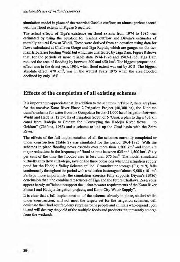
Sustainable use of wetland resources
simulation model in place of the recorded Gashua outflow, an almost perfect accord with the flood extents in Figure 6 resulted. The actual effects of Tiga's existence on flood extents from 1974 to 1985 was estimated by using the equation for Gashua outflow and Diyam's estimates of monthly natural flow at Wudil. These were derived from an equation using data for flows calculated at Challawa Gorge and Tiga Rapids, which are gauges on the two main tributaries feeding Wudil but which are unaffected by Tiga Dam. Figure 8 shows that, for the periods of more reliable data 1974-1976 and 1983-1985, Tiga Dam reduced the area of flooding by between 200 and 450 km2. The biggest proportional effect was in the driest year, 1984, when flood extent was cut by 50%. The biggest absolute effect, 470 km2, was in the wettest years 1975 when the area flooded declined by only 16%.
Effects of the completion of all existing schemes
It is important to appreciate that, in addition to the schemes in Table 2, there are plans for the massive Kano River Phase 2 Irrigation Project (40,300 ha), the Dindima transfer scheme for water from the Gongola, a further 21,000 ha of irrigation between Wudil and Hadejia, 12,390 ha of irrigation South of N'Guru, a plan to dig a 432 km canal from Hadejia to Geidam for "Conveying the Hadejia River flows .... to Geidam" (Chifana, 1985) and a scheme to link up the Chad basin with the Zaire River.
The effects of the full implementation of all the schemes currently completed or under construction (Table 2) was simulated for the period 1964-1985. With the schemes in place flooding never extends over more than 1,500 km2 and there are major reductions in the frequency of flood extents between 625 and 1,500 km2. Sixty per cent of the time the flooded area is less than 375 km2. The model simulated virtually zero flow at Hadejia, save on the three occasions when the irrigation supply pond for the Hadejia Valley Scheme spilled. Groundwater storage (Figure 9) falls continuously throughout the period with a reduction in storage of almost 9,000 x 106 m3. Perhaps more importantly, the simulation exercise fully supports Diyam's (1986) conclusion that "the combined resources of Tiga and the future Challawa Reservoirs appear barely sufficient to support the ultimate water requirements of the Kano River Phase I and Hadejia Irrigation projects, and Kano City Water Supply". It is clear that a full implementation of the schemes already in place, stalled whilst under construction, will not meet the targets set for the irrigation schemes, will desiccate the Chad aquifer, deny supplies to the people and animals who depend upon it, and will destroy the yield of the multiple foods and products that presently emerge from the wetlands.
204
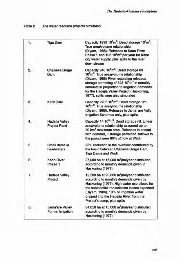
The Hadejia-Gashua Floodplain
Table 2 The water resource projects simulated
1. Tiga Dam Capacity 1898 10 6m 3 . Dead storage 10 6 m 3 . True area/volume relationship (Diyam, 1986). Releases to Kano River Phase 1 and 10310 6 m 3 per year for Kano city water supply, plus spills to the river downstream
2. Challawa Gorge Dam
Capacity 948 10 6m 3 . Dead storage 69 10 6m 3 . True area/volume relationship (Diyam, 1986) River regulating releases storage permitting of 348 10 6 m 3 in monthly amounts in proportion to irrigation demands for the Hadejia Valley Project (Haskoning, 1977), spills were also simulated
3. Kafin Zaki Capacity 2706 10 6m 3 . Dead storage 121 10 6m 3 . True area/volume relationship (Diyam, 1986). Releases to Jama' are Vally Irrigation Schemes only, plus spills
4. Hadejia Valley Project Pond
Capacity 1410 6 m 3 . Dead storage nil. Linear area/volume relationship assumed up to 20 km 2 maximum area. Releases in accord with demand, if storage permitted. Inflows to the pound were 80% of flow at Wudil
5. Small dams in headwaters
25% reduction in the riverflow contributed by the basin between Challawa Gorge Dam, Tiga Dama and Wudil
6. Kano River Phase 1
27,000 ha at 15,000 m3/ha/year distributed according to monthly demands given in Haskoning (1977)
7. Hadejia Valley Project
12,500 ha at 20,000 m3/ha/year distributed according to monthly demands given by Haskoning (1977). High water use allows for the substantial transmission losses expected (Diyam, 1986). 10% of irrigation water drained into the Hadejia River from the Project's sump, plus spills
8. Jama'are Valley Formal Irrigation
84,050 ha at 15,000 m3/ha/year distributed according to monthly demands given by Haskoning (1977)
205

Sustainable use of wetland resources
Table 3 The water resource projects simulated to respect existing conditions and to maintain, natural but highly productive, processes
1. Tiga Dam As Table 2 except a release of 350106m3 is made each August, storage permitting
2. Challawa Gorge Dam As Table 2 except river regulating releases changed to 248 106m3 with an extra 100106m3 in July
3. Kafin Zaki Dam As Table 2 except dam operated as a river regulating reservoir with releases (106m3) of 550 in August and 100 each month, October to March inclusive
4. Hadejia Valley Project Pond
As Table 2 except dam opened in August
5. Small dams in headwaters
No further construction
6. Kano River Phase 1 Reduced to the currently irrigated 14,000 ha
7. Hadejia Valley Project Reduced to the realistic expectation of 8,000 ha
8. Jama'are Valley Formal Irrigation
Cancelled to permit development of small pump irrigation
A regulated natural regime
If the Challawa Gorge and Kafin Zaki Dams are completed, can they be operated in a manner in-keeping with the highly productive natural processes of the area and respecting the undoubted successes of the small pump irrigation schemes run by KNARDA and others? The model was run with the conditions described in Table 3. Figure 10 shows that, whilst the natural floods of over 2,000 km2 are not repeated, the regulated release scheme does largely maintain the frequency of floods between 625 and 1,875 km2. Perhaps more importantly the great certainty of the timing of the arrival of the flood should greatly enhance the production of the floodplain wetlands. The releases appear to maintain 500 km2 as the modal class for inundated area. It is likely that this will, in fact, be taken up by the individual farmers with their small pumps. As such it is possible that the informal irrigated area in this scheme could be 50,000 ha. Figure 11 shows that, as would
206

The Hadejia-Gashua Floodplain
110
Flood Extent: Reservoir Release Scheme
(Frequencies of months)
100
90 _
90 _
70
| 90
IS
3 so
40
30
s*1
ED 500.00 1000.00
Re*. R a b a t * S c t w m Flood tntwit (km2) \// X ^ u r d flood areas
Figure 10 Groundwater storage in the Hadejia-Gashua Floodplain under the impact of the schemes detailed in Table 2
Gashua Natural & Reservoir Releases
Tig 3S0lWChal 100JWKZ lOOOc-MafjSOAu
I f °-5
Natural Flow.Cashua Data (January of year marked)
+ Tiga.Chal.HVP.KZaki
Figure 11 The frequency of flood extents in the Hadejia-Gashua Floodplain: 1964-1985, under natural conditions and with the implementation of the sensitive management regime detailed in Table 3
207

Sustainable use of wetland resources
be expected with reservoir evaporation and irrigation upstream, the flows at Gashua are well below the flows likely under natural conditions. The groundwater simulation element of the model showed a fall in groundwater storage of 1.5 x 10⁹ m 3 more than was simulated for actual conditions from 1964-1985.
Conclusion
The drought since 1972 is the source of most of the water-related concerns in the Hadejia-Gashua wetlands. Tiga Dam has certainly had an adverse effect on the flooding regime but it appears to be smaller than many people have asserted. The schemes presently in the course of construction can barely be supported by the water resources available and then only at the expense of the production of well water, rice, fish, cassava, meat, vegetables, milk, wood, hides cotton and bricks that already come from the wetlands. Tiga and the large dams presently under construction can be operated in a manner suited to the natural rhythms of the wetlands and the needs of small pump irrigation. However, these developments will not return the discharge at Gashua to the level experienced in the 1960s and now demanded by elements within Borno State.
There is clearly a need for fully integrated water resources management in the Hadejia-Jama'are-Yobe Basin. It must recognize the full implications of all projected schemes. It should aim to maintain essential natural processes for the benefit of the various productive systems of traditional resource use in the wetlands, the people downstream, groundwater users, and the considerable nature conservation value of the wetlands. Nature conservationists must work to maintain the hydrological processes of the wetlands because a strategy of merely designating special reserves could result in their complete desiccation. There is a great need to improve the hydrometric network in the area, especially for river flows and groundwater conditions. The utility of existing flow records must be improved and the areas of past inundations need to be measured from existant but unanalyzed records.
Acknowledgements
Bill Adams* insights, assistance and patience have been invaluable. The material and financial assistance of the British Council, Nigerian Conservation Foundation, RSPB, IUCN, FINNIDA, ICBP, and Finnish Association for Nature Protection made the study possible. Ian Hepburn, Willem Rodenburg (1987) and Pat Dugan provided the initial stimulus. University College London gave their blessing and much more.
208

The Hadejia-Gashua Floodplain
References
Adams, W.M. 1992. Sustainable Agricultural Development and Wetland Conservation in Northern Nigeria. Pages 11-20. In: E. Maltby, P. Dugan and J.C. Lefeuvre (Eds). Conservation and Development: The Sustainable Use Of Wetland Resources. Third International Wetlands Conference, Rennes, September 1988. IUCN, Gland, Switzerland.
Adams, W.M. and G.E. Hollis. (In press). Hadejia-N'Guru Wetlands Project: Agriculture and Hydrology. Report to RSPB/ICBP/IUCN/NCF. Mimeo.
Bentham, W. 1987. Hadejia/N'guru Wetlands Project: 5th Report for NCF/ICBP. Mimeo. 14 pp.
Chifana. 1985. Improvement of River channels along River Hadejia between Geidam and Hadejia: Final Report. Fed. Ministry of Water Resources, Nigeria.
Diyam. 1986. Dindima Transfer Planning Report. Federal Ministry of Agriculture, Water Resources and Rural Development, Nigeria. 3 Volumes.
Haskoning. 1977. Hadejia Irrigation Project: Masterplan and Preliminary Design. 6 Volumes.
Rodenburg, W.F. 1987. Report on a Mission to Nigeria and Burkina Faso. CML, University of Leiden. Mimeo. 39 pp.
Schultz, 1976. Hadejia River Basin Study. Canadian International Development Agency. 8 Volumes.
Stock, R.F. 1978. The Impact of the Decline of the Hadejia River Foods in Hadejia Emirate, Kano. Pages 141-146. In: G.J. van Apeldoorn (Ed.). The Aftermath of the 1972-1974 Drought in Nigeria, Fed. Department of Water Resources and Ahmadu Bello University.
Stowe, T.J. 1988. Waterbird Survey: Hadejia Wetlands, Nigeria, 10 January -7 February 1988. Mimeo, RSPB.
Sutcliffe, J. V. and Y.P. Parks. 1987. Hydrological Modelling of the Sudd and Jonglei Canal. Hydrological Sciences Journal. 32:143-159.
Umar, A.A. (Chairman) 1985. Groundwater Monitoring and Imbalance in Kano State. Mimeo, WRECA, Kano. 58 pp.
209

Sustainable use of wetland resources
210

Deterioration of wetlands caused by groundwater exploitation: two case histories in Spain*
M.R. Llamas
Department of Geodynamics Complutense University 28040 Madrid Spain
Resume
La degradation des zones humides causee par I'exploitation des eaux souterraines: deux exemples en Espagne
Les problemes poses par la gestion de deux zones humides, le Pare National de Las Tablas de Daimiel (PNTD) et le Pare National de Donana (PND) sont analyses. Les deux sites sont proteges legalement comme Pares nationaux depuis plus de quinze ans et sont designes comme sites Ramsar. De superficies bien differentes (20 km2 pour le PNTD et 765 km2pour le PND), ces deux sites n'ont ni les memes caracteristiques hydrogeo-logiques et ecologiques, ni le meme statut legal et social, ni le meme degre respectif de degradation. La cause principale de cette degradation est Fabaissement de la nappe phreatique du au pompage de l'eau souterraine pour rapprovisionnement en eau et l'irrigation. Le PNTD est virtuellement detruit alors que les effets externes sur le PND ne sont pas encore evidents (pour les decideurs). Le plan de restauration du PNTD est commente.
Introduction
The warning about the exceptional value of wetland ecosystems was only heard with any conviction a few years ago and has still not successfully reached broad sectors of society. Furthermore, there is rarely sufficiently adequate knowledge of the hydrology of these ecosystems especially in relation to the role of groundwater. This fact might explain why some important wetlands in semi-arid countries, like Spain, have already
* Accepted for publication, September 1988
211

Sustainable use of wetland resources
undergone serious negative impacts or may well do so in the near future. The difficulties encountered in correcting the adverse impacts caused by groundwater extraction are particularly great because of socio-political motives. Problems of this type in two major wetlands in Spain: the Tablas de Daimiel (NPTD) and Coto Donana (NPD) are described. Both sites are officially classified as National Parks which ought to imply clear legal protection. The socio-political factors which have led to the deterioration of these two ecosystems will be dealt with here. The scientific aspects involved can be read in Llamas etal. (1987) and Llamas (1988) for both sites or, in a more general way, in Custodio (1987).
General hydrogeological characteristics of the Donana National Park
The land was first legally protected in 1969 and established as a National Park in 1978. Its surface area covers some 510 km2 plus a buffer zone of 265 km2. It is situated on the extensive geomorphological unit forming the lower valley of the River Guadalquivir, some 3,000 km2 in area. It is an estuary filled with Plioquaternary deposits. There are three main hydrogeomorphic systems in Donana: (a) the stable eolian sands; (b) the moving dunes and (c) the marshlands. The sands and dunes are mainly peripheral and cover some 1,500 km2. The marshlands lie in the centre, are extremely flat and consist of clay sediments. Beneath the marsh clays there is an extensive confined aquifer formed by sands and gravels which are in connection with the sands at the periphery of the marshlands. The ecotone - or contact line between sands and marshland - constitutes a discharge area for the groundwater recharged by rain falling upon the sands. The marshlands are under about 0.3 m of water in winter and totally dry in summer. The permanent moisture of the ecotone makes it the most productive and fertile zone in Donana. Another significant ecosystem directly related to groundwater discharge is the lower valley of La Rocina River.
General hydrogeological characteristics of the Tablas de Daimiel National Park
This was declared a National Park in 1973. Its hydrogeological features are quite different from those of Donana. The 'wetland' areas (also called 'tablas' in Spanish, hence its name) form at the confluence of the Guadiana and Gigiiela Rivers. The wetland covers a surface a little under 20 km2 and used to be a natural discharge zone of the La Mancha aquifer system which has a surface of5,000 km2. Unlike the marshes of Donana, the Tablas used to be covered with a layer of water (about 1 m deep) all the year round. This was the result of the abundant supply of groundwater.
212

Deterioration caused by groundwater exploitation
213

Sustainable use of wetland resources

Deterioration caused by groundwater exploitation
Groundwater exploitation and its effects
Intensive groundwater exploitation from the La Mancha aquifer began some twenty ears ago. At the present time more than 1,200 km2 of land are irrigated. Almost all this transformation has been carried out by private farmers. The rate of groundwater extraction is approximately 500-600 hm3 per annum and it is estimated that this is some 150-200 hm3 per annum over and above the average annual recharge rate. This has caused a constant depletion of the water table (Figure 1). This situation led to the progressive desiccation of the Tablas except during flooding periods after heavy rain. In 1986 a large part of the dry peatbeds of the Tablas began to burn either through spontaneous combustion or because they were set on fire. The existence of the considerable aquifer beneath the lower valley of the Guadalquivir was known at the end of the 1960s. During the seventies the Government designed its most ambitious irrigation project (for 240 km2 of land) using groundwater (150 hm3 per annum) in the proximity of what was subsequently to be the Donana National Park. The warnings from scientists concerned the ecological impact of this project had already reached the Government by 1976. The Government's response has not been very far-reaching. Approximately 100 km2 of land are currently irrigated and pumping proceeds at a rate of 60 hm3 per annum. The forecasts by several digital groundwater flow models point to significant draw-downs of the water table within the next 20 years in extensive areas near the ecotone and the La Rocina creek (Figure 2). The observed draw-downs seem to confirm that desiccation will occur in both sites soon (Figures 3 and 4). It is logical to assume that an ecological disaster similar to the one in the Tablas de Daimiel may occur in this zone of the Donana.
Restoration plans
Warnings voiced by a number of authors (e.g. Anon., 1987 and Llamas, 1987) have led the Government to take several measures. The so-called Regeneration Plan for the NPTD contemplates mainly three alternative or successive phases. The first consists of maintaining water in the Tablas by pumping water from 13 wells drilled in the La Mancha aquifer itself. However, this is considered a provisional or emergency solution because it will cause an even greater depletion of the water table. The second consists of importing some 60 hm3 (over a three-year period) from the canal, transferring water from the basin of the river Tagus to the basin of the Segura. The first diversion was made in spring 1988; about 18 hm3 from the Tagus River have been diverted towards NPTD; this effect is now being studied. A third, longer-term solution, consists of building a reservoir which could supply the area with an average volume, not yet fully defined, but probably betwen 30 and 60 hm3 per annum. Despite the investment made in these efforts it remains difficult to see how any of the three solutions can solve a problem essentially created by an excess of groundwater extraction which is now well over 100 hm3 per annum. The Government has declared also that the groundwater pumpage for irrigation ought to be reduced. In accordance with the new 1985 Water Law, the corresponding Water Authority declared the La Mancha aquifer system overexploited in 1987. This declaration prohibits new
215

Sustainable use of wetland resources
216

Deterioration caused by groundwater exploitation
217

Sustainable use of wetland resources
wells being built without a special licence and demands that a community of groundwater users be set up. To date the effectiveness of both measures seems doubtful (Gonzalez Monterrubio, 1988). In addition the ecological impact of the different chemical characteristics of the imported water has not been assessed yet. In the case of Donana the extraction of groundwater has had no obvious external effect as yet. This is mainly because the current pumping rate is lower and only began with any intensity about ten years ago. In addition, periodic heavy rains can delay the start of the desiccation of the ecotone. The official response to the warnings given has been silence or to decry the warning voices as 'catastrophe alarmists' (see Llamas, 1987). However, the initial plans to irrigate 240 km2 envisaged in 1972 have been reduced to 100 or 150 km2. The most striking fact about Donana is that in this case the groundwater extraction cannot be put down to private farmers action. This pumping has been promoted and controlled by government bodies which, furthermore, have systematically refused to take part in any scientific debate on the problem (Llamas, 1987).
Conclusions
There seems no doubt whatsoever that the main cause of the ecological disaster of the Tablas de Daimiel is excessive groundwater exploitation. The two implemented solutions for water regeneration seem more or less equivalent to creating a zoo on the Tablas site instead of maintaining a National Park. The only real ecological solution would be to reduce the pumping for irrigation. This solution appears to entail considerable political difficulties.
Donana is a different case. In the first place the ecological disaster has not occurred yet. Several years have probably still to pass before the first external signs of adverse impact appear. This could even allow an increase in the irrrigation and new tourist developments in the vicinity. From all the foregoing it seems one clear conclusion can be drawn: it is necessary to spread hydro-geological knowledge further so that it reaches all levels, including decision-makers, government officials as well as the general public.
References
Anon., 1987. Declaration de los participantes. Seminario sobre Bases Cientificas para la proteccion de los humedales en Espana. Real Academia de Ciencias, Madrid, pp. 283-284.
Custodio, E. 1987. Peculiaridades de la Hidrologia de los complejos palustres espafloles. Seminario sobre Bases Cientificas para la proteccion de los humedales en Espana. Real Academia de Ciencias, Madrid, pp. 43-63.
218
Deterioration caused by groundwater exploitation
Gonzalez Monterrubio, J.M. 1988. Las Tablas de Daimiel. Aspectos Sociales y Juridicos. Jornadas sobre la Aplicacion de la Nueva Ley de Aguas en la Gestion de las Aguas Subterrdneas. Grupo Espanol de la Asociacion Internacional de Hidrogeologos, Vol. 1. pp. 329-338.
Llamas, M.R. 1987. Requiem por el Parque Nacional de Donana. YA (daily press), 28 November. 87:12-13.
Llamas, M.R. 1988. Conflicts between Wetland Conservation and Groundwater Exploitation: Two Case Histories in Spain. Environmental Geology. 11:241-251.
Suso, J. and M.R. Llamas. 1988. El impacto de la extraction de aguas subterraneas en los sistemas ecologicos de las proximidades de El Rocio (Parque Nacional de Donana, Espana).
219


The IUCN Wetlands Programme
Other titles in this series
Managing the Wetlands of Kafue Flats and Bangweulu Basin Proceedings of the WWF-Zambia Wetlands Project Workshop
R.C.V. Jeffery, H.N. Chabwela , G. Howard and P.J. Dugan
Conservation and Management of Greek Wetlands Proceedings of the Greek Wetlands Workshop, Thessaloniki, Greece
PA. Gerakis

Third International
Organized by the University of Rennes and National Museum of Natural History, France
Published by IUCN
IUCN The World Conservation Union
This book is part of
T H E IUCN C O N S E R V A T I O N L I B R A R Y
For a free copy of the complete catalogue please write to:
Publications Serv ices Unit, 181a Huntingdon Road, Cambridge, C B 3 O D J , UK
IUCN Communications Division, Rue Mauverney 2 8 , 1 1 9 6 Gland, Switzerland