THE SOCIAL IMPORTANCE AND CONTINUITY OF FALAJ USE IN NORTHERN OMAN
17
International History Seminar on Irrigation and Drainage Tehran-Iran May 2-5, 2007 THE SOCIAL IMPORTANCE AND CONTINUITY OF FALAJ USE IN NORTHERN OMAN Zaher bin Khalid Al Sulaimani 1 , Tariq Helmi 2 and Harriet Nash 3 ABSTRACT Oman has an arid climate with an annual average rainfall less than 100 mm. Agriculture production in Oman is almost fully dependent on irrigation in which more than one third of irrigation water is supplied by aflāj. Prior to the 1970s, falaj (singular of aflāj) systems were the backbone of agriculture in the northern parts of Oman. There are three types of falaj in Oman: ghailī, da'ūdī and c ainī. Among these three types, only the da'ūdī falaj is similar to the qanat irrigation systems of Iran. Aflāj are conduits dug in the ground to convey water by gravity from one place to another; there are more than 4,000 aflāj in the Sultanate of Oman, of which 3,017 are active. Many aflāj in Oman were built over 1,500 years ago and some of them may date back over 2,500 years. There was a major period of construction during the Ya c āriba Dynasty, by Imam Sultan bin Saif Al Yarubi between 1,060 and 1,070 Hijri (1,650- 1,660 AD). However, several aflāj were constructed only 150 years ago. The falaj systems are still focal to agricultural communities in Oman as they represent 36% of the total water consumed in the agricultural sector and 38% of the total available fresh water. Because of their historical and cultural importance, five representative falaj systems, together with associated structures such as defensive towers, mosques sundials and buildings for water auctions, have recently been designated as a UNESCO World Heritage site. Sustainability was the way of life of our ancestors: because falaj systems use gravity flow, water use never exceeded water supply. The Sultanate's traditional methods of water management provide important lessons for the future. Using water fairly in times of plenty and times of scarcity is one of these lessons. Matching water use to water availability, a fundamental characteristic of the falaj system, is an essential element in planning water management in Oman's climatic conditions. 1- Zaher bin Khalid Al Sulaimani, Director General of Water Resources Assessment, Ministry of Regional Municipalities, Environment and Water Resources, Sultanate of Oman, email [email protected] 2- Tariq Helmi, Hydrogeologist Expert, Ministry of Regional Municipalities, Environment and Water Resources, Sultanate of Oman, email [email protected] 3- Harriet Nash, Department of Arabic and Middle Eastern Studies, University of Leeds, UK, email [email protected]
Transcript of THE SOCIAL IMPORTANCE AND CONTINUITY OF FALAJ USE IN NORTHERN OMAN
International History Seminar on Irrigation and Drainage
Tehran-Iran May 2-5, 2007
THE SOCIAL IMPORTANCE AND CONTINUITY OF FALAJ USE IN NORTHERN OMAN
Zaher bin Khalid Al Sulaimani1, Tariq Helmi2 and Harriet Nash3
ABSTRACT
Oman has an arid climate with an annual average rainfall less than 100 mm. Agriculture production in Oman is almost fully dependent on irrigation in which more than one third of irrigation water is supplied by aflāj. Prior to the 1970s, falaj (singular of aflāj) systems were the backbone of agriculture in the northern parts of Oman. There are three types of falaj in Oman: ghailī, da'ūdī and cainī. Among these three types, only the da'ūdī falaj is similar to the qanat irrigation systems of Iran.
Aflāj are conduits dug in the ground to convey water by gravity from one place to another; there are more than 4,000 aflāj in the Sultanate of Oman, of which 3,017 are active. Many aflāj in Oman were built over 1,500 years ago and some of them may date back over 2,500 years. There was a major period of construction during the Yacāriba Dynasty, by Imam Sultan bin Saif Al Yarubi between 1,060 and 1,070 Hijri (1,650-1,660 AD). However, several aflāj were constructed only 150 years ago.
The falaj systems are still focal to agricultural communities in Oman as they represent 36% of the total water consumed in the agricultural sector and 38% of the total available fresh water. Because of their historical and cultural importance, five representative falaj systems, together with associated structures such as defensive towers, mosques sundials and buildings for water auctions, have recently been designated as a UNESCO World Heritage site.
Sustainability was the way of life of our ancestors: because falaj systems use gravity flow, water use never exceeded water supply. The Sultanate's traditional methods of water management provide important lessons for the future. Using water fairly in times of plenty and times of scarcity is one of these lessons. Matching water use to water availability, a fundamental characteristic of the falaj system, is an essential element in planning water management in Oman's climatic conditions.
1- Zaher bin Khalid Al Sulaimani, Director General of Water Resources Assessment, Ministry of Regional Municipalities, Environment and Water Resources, Sultanate of Oman, email [email protected] 2- Tariq Helmi, Hydrogeologist Expert, Ministry of Regional Municipalities, Environment and Water Resources, Sultanate of Oman, email [email protected] 3- Harriet Nash, Department of Arabic and Middle Eastern Studies, University of Leeds, UK, email [email protected]
IRNCID-ICID
2
1. INTRODUCTION
Oman is an arid country: the climate is characterised by hot and dry summers and mild winters, except for the Dhofar region in the south of the country, which is affected by the monsoon. The average annual rainfall is 100 mm/year but reaches 300 mm/year in the mountains in the north. Groundwater is the main water source representing 92% of the total renewable water resources. Agriculture is the major consumer of water (87% of renewable water resources) using a total of 1,124 MCM/year. The total cultivated area is 65,013 hectares, of which 41% (26,484 hectares) is irrigated by falaj systems while the rest is irrigated by wells.
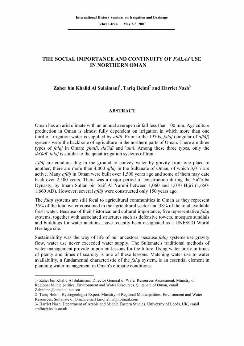
Falaj systems are most commonly found in the foothills and low lands bordering the northern mountains (Hajar Al Gharbī and Hajar Al Sharqī). The locations of the aflāj are shown on Figure 1.
Figure 1. The Location of Aflāj in the Sultanate of Oman
2. HISTORICAL OVERVIEW
The network of falaj systems in Oman may not be the oldest or the largest in the world. There are probably older systems in northern Iran and that country has many thousands of aflāj. Also, this method of irrigation is to be found in many arid zone countries, including parts of China (Xinjiang), Cambodia, central Asia, Pakistan, Turkey, other countries in the Arabian Peninsula and Middle East, in North Africa and Latin America.
IRNCID-ICID
3
It is not known when the first aflāj were constructed in Oman. In legend, the da’ūdī aflāj were created by the Prophet Suleiman bin Da’ūd (King Solomon), who is thought to have lived in the 10th century BC. He is said to have stayed in Oman for 10 days and, because the land was so dry, ordered the jinn (demons) to dig 1000 aflāj (of the qanat type) every day. This explains why the qanat-type aflāj are called “da’ūdī” (Wilkinson 1977). There is archaeological evidence that the earliest period of falaj construction in Oman dates back to 1000 BC. (Al Tikriti 2002), suggesting a pre-Achaemenid origin and consistent with the legend.
Traditionally, however, the origin of aflāj in Oman has been attributed to Persian influence during Achaemenid times (eg English 1997). It is generally accepted that the technique was used in Persia from at least the end of the 8th century BC. During the mid-6th to mid-4th centuries BC. it began to be diffused more widely. This was a period of Persian expansion, especially during the reign of Cyrus the Great, and there is abundant evidence from archaeological and historical records of contact between Persia and Arabia (MRMEWR 2006). Much of Oman came under Achaemenid rule in the mid-6th century BC., and from 226 AD it formed part of the Sassanian Empire of Persia, until the Sassanians were finally driven out of Oman with the coming of Islam in the 7th century AD. It is possible that many aflāj were built in Oman in Achaemenid times, and it appears that it was during the Sassanian period that irrigation by aflāj reached its widest extent (Wilkinson 1977, 1983).
There was a further period of falaj construction during the Yacāriba Imamates in the second half of the 17th century, when the Portuguese were finally expelled from Oman, which became the first independent state in the Arab world. Falaj Al Hamra was constructed during the Yacāriba Dynasty by Imam Sultan bin Saif Al Yarubi between 1060 and 1070 Hijri (1,650-1,660 AD) (Al Shaqsi 1996). Falaj Al Khatmeen near Nizwa was also constructed at this time. Some aflāj have been constructed even more recently, as in the Ibra area, where Falaj Al Yahmady and Falaj Mudhairib are only 150 years old (MRMEWR 2005).
Regardless of the uncertain date of the origin of aflāj in Oman, it appears that these systems have provided communities in this area with water for irrigation and domestic purposes for at least 1500-2000 years.
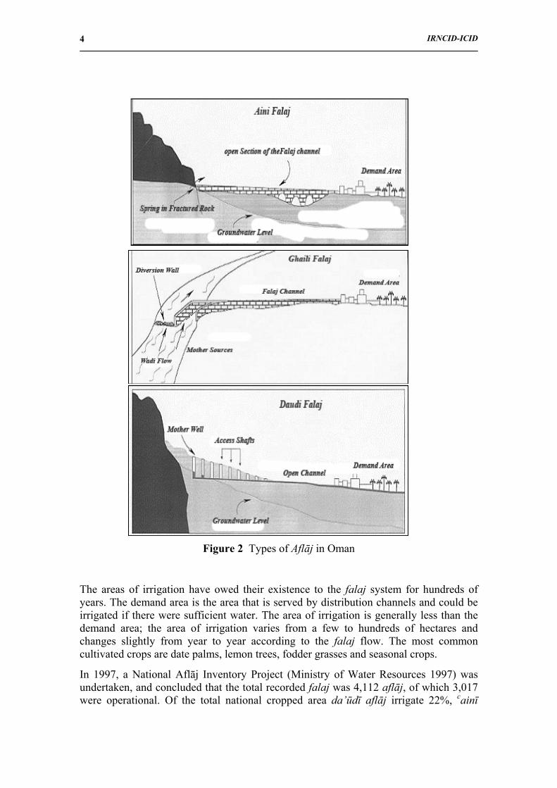
3. TYPES OF AFLĀJ IN OMAN
In Oman, there are three types of falaj: da’ūdī, ghailī and cainī, as illustrated in Figure 2. The da’ūdī falaj (21% of the total number of aflāj), is constructed as an underground tunnel conveying groundwater from the mother well to the irrigated (demand) area.
The ghailī falaj (46% of the total number of aflāj) collects water from the base flow of the wadi and transports it in an open channel to the distribution section. During prolonged dry seasons, the discharge of such a falaj decreases, and sometimes ceases.
The cainī falaj (33% of total aflāj) is fed directly from springs. Many springs which rise from limestone in the mountain areas are reliable sources of good quality water.
IRNCID-ICID
4
Figure 2 Types of Aflāj in Oman
The areas of irrigation have owed their existence to the falaj system for hundreds of years. The demand area is the area that is served by distribution channels and could be irrigated if there were sufficient water. The area of irrigation is generally less than the demand area; the area of irrigation varies from a few to hundreds of hectares and changes slightly from year to year according to the falaj flow. The most common cultivated crops are date palms, lemon trees, fodder grasses and seasonal crops.
In 1997, a National Aflāj Inventory Project (Ministry of Water Resources 1997) was undertaken, and concluded that the total recorded falaj was 4,112 aflāj, of which 3,017 were operational. Of the total national cropped area da’ūdī aflāj irrigate 22%, cainī
IRNCID-ICID
5
11%, ghailī 8% and wells 59%. The total area cultivated by the operational aflāj was estimated as 26,484 hectares (Table1). Most aflāj are found in the wadis leading from Al Hajar Al Gharbi. These mountains are characterized by bold relief and paucity of soil and vegetation: surface runoff is therefore rapid, but is short-lived and does not extend far from the hills.
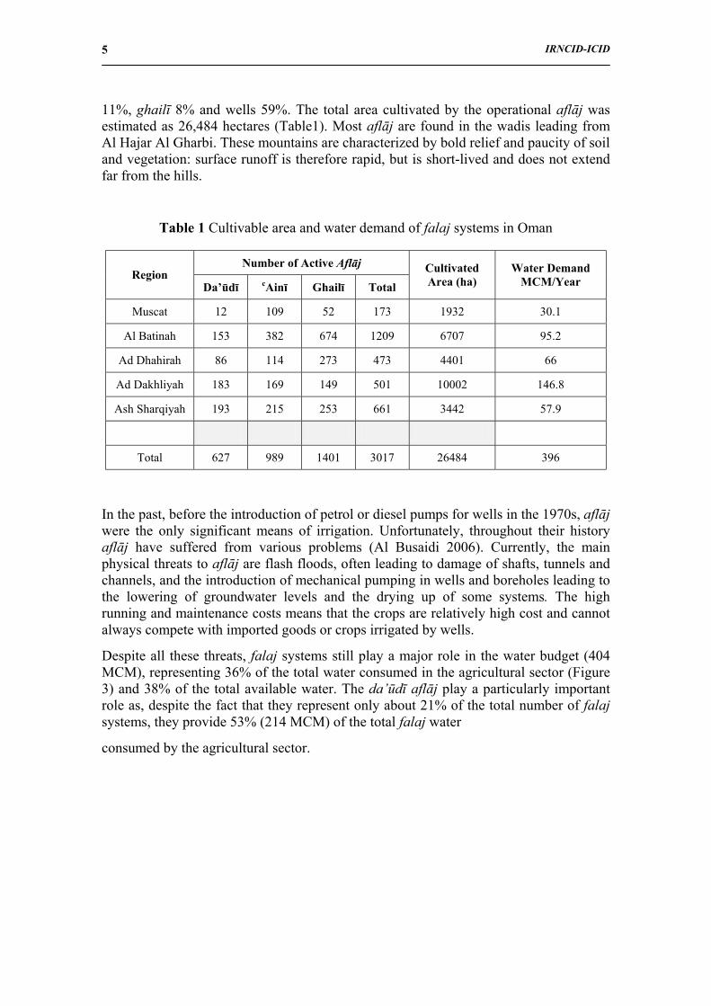
Table 1 Cultivable area and water demand of falaj systems in Oman
In the past, before the introduction of petrol or diesel pumps for wells in the 1970s, aflāj were the only significant means of irrigation. Unfortunately, throughout their history aflāj have suffered from various problems (Al Busaidi 2006). Currently, the main physical threats to aflāj are flash floods, often leading to damage of shafts, tunnels and channels, and the introduction of mechanical pumping in wells and boreholes leading to the lowering of groundwater levels and the drying up of some systems. The high running and maintenance costs means that the crops are relatively high cost and cannot always compete with imported goods or crops irrigated by wells.
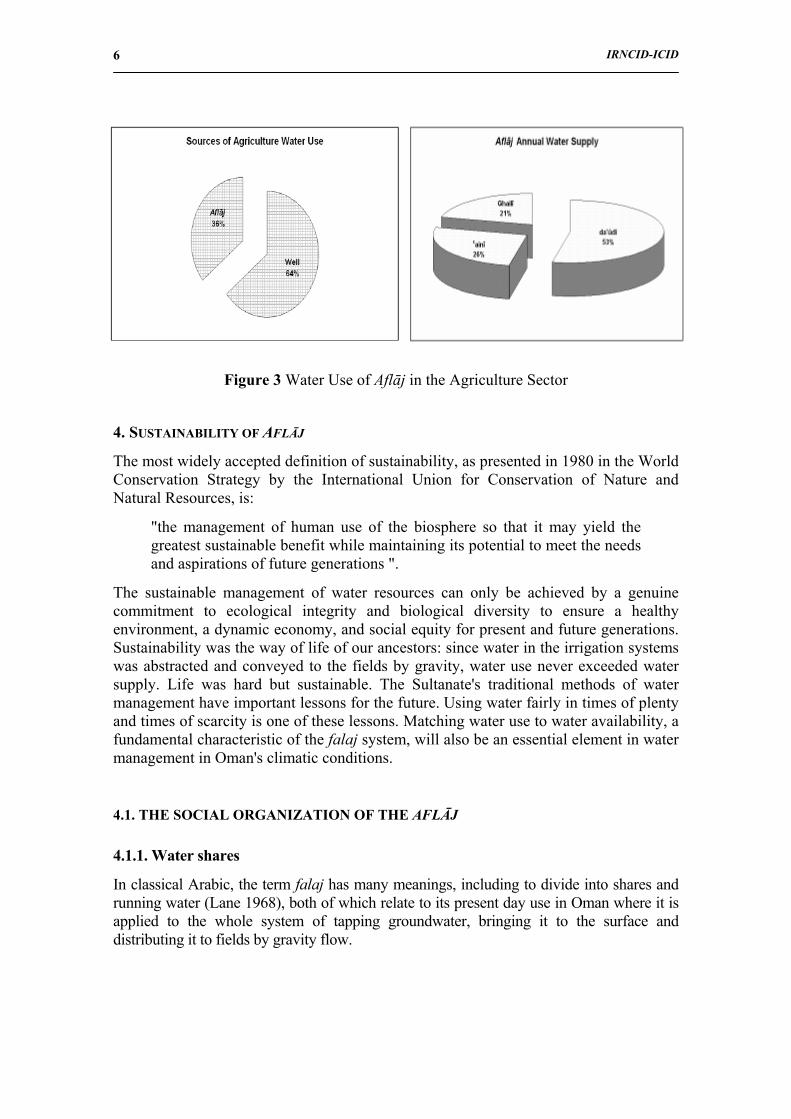
Despite all these threats, falaj systems still play a major role in the water budget (404 MCM), representing 36% of the total water consumed in the agricultural sector (Figure 3) and 38% of the total available water. The da’ūdī aflāj play a particularly important role as, despite the fact that they represent only about 21% of the total number of falaj systems, they provide 53% (214 MCM) of the total falaj water
consumed by the agricultural sector.
Number of Active Aflāj Region
Da’ūdī cAinī Ghailī Total Cultivated Area (ha)
Water Demand MCM/Year
Muscat 12 109 52 173 1932 30.1
Al Batinah 153 382 674 1209 6707 95.2
Ad Dhahirah 86 114 273 473 4401 66
Ad Dakhliyah 183 169 149 501 10002 146.8
Ash Sharqiyah 193 215 253 661 3442 57.9
Total 627 989 1401 3017 26484 396
IRNCID-ICID
6
Figure 3 Water Use of Aflāj in the Agriculture Sector
4. SUSTAINABILITY OF AFLĀJ
The most widely accepted definition of sustainability, as presented in 1980 in the World Conservation Strategy by the International Union for Conservation of Nature and Natural Resources, is:
"the management of human use of the biosphere so that it may yield the greatest sustainable benefit while maintaining its potential to meet the needs and aspirations of future generations ".
The sustainable management of water resources can only be achieved by a genuine commitment to ecological integrity and biological diversity to ensure a healthy environment, a dynamic economy, and social equity for present and future generations. Sustainability was the way of life of our ancestors: since water in the irrigation systems was abstracted and conveyed to the fields by gravity, water use never exceeded water supply. Life was hard but sustainable. The Sultanate's traditional methods of water management have important lessons for the future. Using water fairly in times of plenty and times of scarcity is one of these lessons. Matching water use to water availability, a fundamental characteristic of the falaj system, will also be an essential element in water management in Oman's climatic conditions.
4.1. THE SOCIAL ORGANIZATION OF THE AFLĀJ
4.1.1. Water shares
In classical Arabic, the term falaj has many meanings, including to divide into shares and running water (Lane 1968), both of which relate to its present day use in Oman where it is applied to the whole system of tapping groundwater, bringing it to the surface and distributing it to fields by gravity flow.
IRNCID-ICID
7
An outstanding feature of the falaj system in the Sultanate of Oman is the social and economic structure that has permitted it to function successfully and largely unchanged for centuries. This is based on an accurate system of water distribution which guarantees fair shares to stakeholders. As such it plays an integral role in the socio-economic life of the country. Without it, Oman would never have been able to achieve nationhood, since only the availability of water made it possible for nomadic peoples to adopt a settled way of life, which encouraged the development of agricultural and craft skills. The system is not based on any form of written or statute law, but rather on a traditional system of time-sharing that is passed from one generation to the next. This confers a number of benefits to society as a whole by:
• Maintaining mutual cooperation among those individual who use the falaj water for domestic and agricultural purposes.
• Providing a relatively flexible source of family income by allowing shareholders to put their water shares up for public auction or by leasing those shares for specific periods when they are not needed.
• Providing a constant source of water for a variety of crops, especially date palms.
• Encouraging the development of traditional crafts in the towns and villages through which the aflāj pass and thereby creating employment.
• Strengthening a sense of community and strengthening social relationships between all those benefiting from the supply of water; which traditionally would have been almost everyone in the community.
• Establishing procedures for settling disputes relating to water shares or maintenance obligations in the form of an autonomous administration responsible for the management of each falaj.
The highest executive authority in each system is the falaj agent (wakīl al falaj), often appointed by the local sheikh in consultation with the shareholders in the falaj, or by the falaj community. The wakīl is responsible for the overall management of the falaj: his duties include responsibility for the funds, regulation of the sale and rental of individual shares, and the keeping of records as necessary. He is assisted by one or more carīfs, who are mainly responsible for the distribution of the water shares and will usually know the time for each person’s water. Depending on the size of the falaj, other officials may help with activities such as auctioning shares that are set aside to raise money for running the falaj.
The distribution is carried out by diverting the water flow by applying or removing sluices at the appropriate times of day or night for the agreed periods. The diversion may be carried out by the carīf, by the shareholder or by a farm labourer. Before the advent of clocks, the time for each water share was determined by various methods, including the use of sundials by day and observation of the stars at night (eg Al Ghafri 2003). Sundials are still used in a number of villages, while the use of stars continues in only a few.
The time needed to water all of the cultivated land (the irrigation cycle) and the order of irrigation is generally determined by a group of experienced shareholders, who take into account the rate of flow the water in the falaj and other factors, such as the tolerance of the crops to drought and the water retention characteristics of the soil. The irrigation cycle
IRNCID-ICID
8
commonly ranges from seven to fifteen days and the water is shared among the users on a time basis. One example of the division of time units is given in Table 2. The badda and athar are widely used but other divisions vary from place to place. The length of the time units may be adjusted to periods of drought and high flow: thus, during droughts the athar may be reduced to 15 minutes (athar ghaez), or the length of the irrigation cycle increased, usually doubled, so that shareholders receive half of the normal amount of water.
Table 2 Time division for water distribution
Division Period of time Equivalent in athars Division Period of time Equivalent in
athars
Badda 12 hours 24 athar Rubaca 7.5 minutes 1/4 athar
Kathba 1 ½ hours 3 athar Thāmin 3.75 minutes 1/8 athar
Athar 30 minutes - Qiyās 1.25 minutes 1/24 athar
4.1.2. Water Trade
The trade of water can be effected in a number of ways. People are free to buy, sell and even mortgage their water shares. Water surplus to requirements, and water shares belonging to the falaj, used to raise funds for falaj maintenance, may be auctioned either every irrigation cycle or annually. The prices at auction were found to be influenced by the following factors in Falaj Al Hamra (Al Shaqsi 1996):
•• Prices increase during dry seasons and decrease during wet season.
•• Prices increase if the shares are during day time, and decrease if the shares are during night time, especially after midnight.
•• Prices increase if more than one person wants same shares auctioned.
In Al Hamra, the price of one athar, for one irrigation cycle of seven days, may vary between 0.5 US$ (0.19 O.R) during the wet season to 90 US$ (35 O.R) during the dry season. The price of a permanent share is not influenced by the seasons but by the long term rate of flow of falaj water.
4.1.3. Domestic use of falaj water
Traditionally, many falaj communities took all of their domestic water from the falaj system. The first point of use was the sharīca, where drinking water for people and animals was obtained. Though rarely used for drinking water now, these access points are usually well maintained and protected, and are often used for other domestic purposes. Bathing and washing of clothes and dishes is still carried out in many falaj channels, and several communities have built bath houses over the channels. These uses still provide points of social contact and a focus for community life in addition to that from agricultural activities. The date gardens are still used, as presumably they always
IRNCID-ICID
9
have been, for relaxation and escape from the heat – a popular place for picnics, with children happily occupied playing in the falaj channels.
5. THE FIVE NOMINATED AFLĀJ
As part of the Ministry of Regional Municipalities, Environment and Water Resources (MRMEWR) efforts to improve and protect aflāj, it has been in close cooperation with the World Heritage Committee of UNESCO to record Oman’s aflāj in the World Heritage List. This is so that these hydrological structures can have the international support and recognition they deserve and can continuing to play their role in Oman’s future. The project has started with the nomination and acceptance (inscription) of five aflāj which satisfy the international standard for World Heritage sites. The five aflāj, with all of their water structures and associated traditional buildings, included in the World Heritage site, were selected as representative of the total stock of irrigation systems, demand areas and falaj communities in the Sultanate of Oman. Their inclusion in the World Heritage List is very welcome to the government of Oman and its citizens. This is one way of showing the rest of the world some of the wealth of Omani culture and history, and helps in Oman's efforts to increase tourism, which is of growing economic importance. In recent years, the revenue from the tourist industry has increased as a result of attractive marketing strategies and the plan to lift tourism revenue to three percent of GDP by 2020.
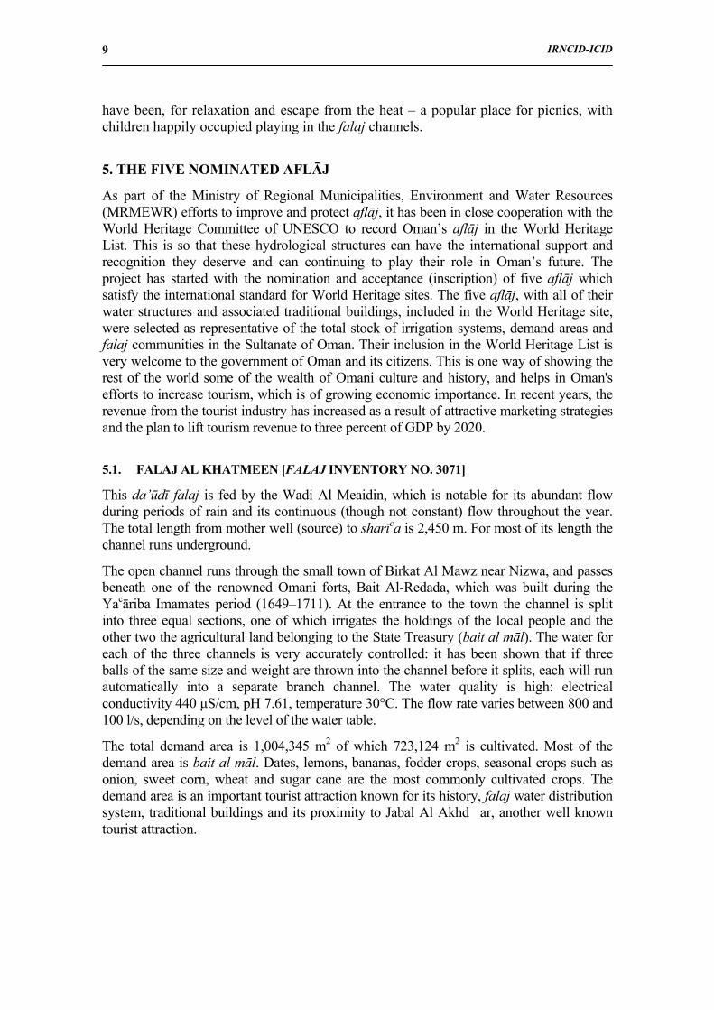
5.1. FALAJ AL KHATMEEN [FALAJ INVENTORY NO. 3071]
This da’ūdī falaj is fed by the Wadi Al Meaidin, which is notable for its abundant flow during periods of rain and its continuous (though not constant) flow throughout the year. The total length from mother well (source) to sharīca is 2,450 m. For most of its length the channel runs underground.
The open channel runs through the small town of Birkat Al Mawz near Nizwa, and passes beneath one of the renowned Omani forts, Bait Al-Redada, which was built during the Yacāriba Imamates period (1649–1711). At the entrance to the town the channel is split into three equal sections, one of which irrigates the holdings of the local people and the other two the agricultural land belonging to the State Treasury (bait al māl). The water for each of the three channels is very accurately controlled: it has been shown that if three balls of the same size and weight are thrown into the channel before it splits, each will run automatically into a separate branch channel. The water quality is high: electrical conductivity 440 µS/cm, pH 7.61, temperature 30°C. The flow rate varies between 800 and 100 l/s, depending on the level of the water table.
The total demand area is 1,004,345 m2 of which 723,124 m2 is cultivated. Most of the demand area is bait al māl. Dates, lemons, bananas, fodder crops, seasonal crops such as onion, sweet corn, wheat and sugar cane are the most commonly cultivated crops. The demand area is an important tourist attraction known for its history, falaj water distribution system, traditional buildings and its proximity to Jabal Al Akhd�ar, another well known tourist attraction.
IRNCID-ICID
10
Falaj Al-Khatmeen: The sharīca passing beneath Bait Al-Redadah Fort (left).
Distribution point at the end of the sharīca (right)
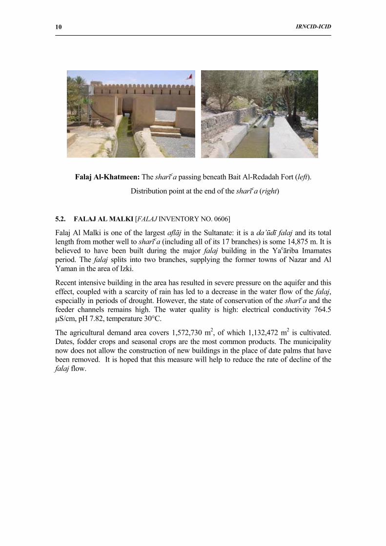
5.2. FALAJ AL MALKI [FALAJ INVENTORY NO. 0606]
Falaj Al Malki is one of the largest aflāj in the Sultanate: it is a da’ūdī falaj and its total length from mother well to sharīca (including all of its 17 branches) is some 14,875 m. It is believed to have been built during the major falaj building in the Yacāriba Imamates period. The falaj splits into two branches, supplying the former towns of Nazar and Al Yaman in the area of Izki.
Recent intensive building in the area has resulted in severe pressure on the aquifer and this effect, coupled with a scarcity of rain has led to a decrease in the water flow of the falaj, especially in periods of drought. However, the state of conservation of the sharīca and the feeder channels remains high. The water quality is high: electrical conductivity 764.5 µS/cm, pH 7.82, temperature 30°C.
The agricultural demand area covers 1,572,730 m2, of which 1,132,472 m2 is cultivated. Dates, fodder crops and seasonal crops are the most common products. The municipality now does not allow the construction of new buildings in the place of date palms that have been removed. It is hoped that this measure will help to reduce the rate of decline of the falaj flow.
IRNCID-ICID
11
Falaj Al Malki: Traditional houses (left). Watchtower (right)
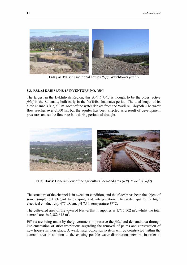
5.3. FALAJ DARIS [FALAJ INVENTORY NO. 0500]
The largest in the Dakhiliyah Region, this da’ūdī falaj is thought to be the oldest active falaj in the Sultanate, built early in the Yacāriba Imamates period. The total length of its three channels is 7,990 m. Most of the water derives from the Wadi Al Abiyadh. The water flow reaches over 2,000 l/s, but the aquifer has been affected as a result of development pressures and so the flow rate falls during periods of drought.
Falaj Daris: General view of the agricultural demand area (left). Sharīca (right)
The structure of the channel is in excellent condition, and the sharīca has been the object of some simple but elegant landscaping and interpretation. The water quality is high: electrical conductivity 477 µS/cm, pH 7.30, temperature 37°C.
The cultivated area of the town of Nizwa that it supplies is 1,715,502 m2, whilst the total demand area is 2,382,642 m2.
Efforts are being made by the government to preserve the falaj and demand area through implementation of strict restrictions regarding the removal of palms and construction of new houses in their place. A wastewater collection system will be constructed within the demand area in addition to the existing potable water distribution network, in order to
IRNCID-ICID
12
protect the quality of water in the falaj. Dates, fodder, sugar cane are the most common crops.
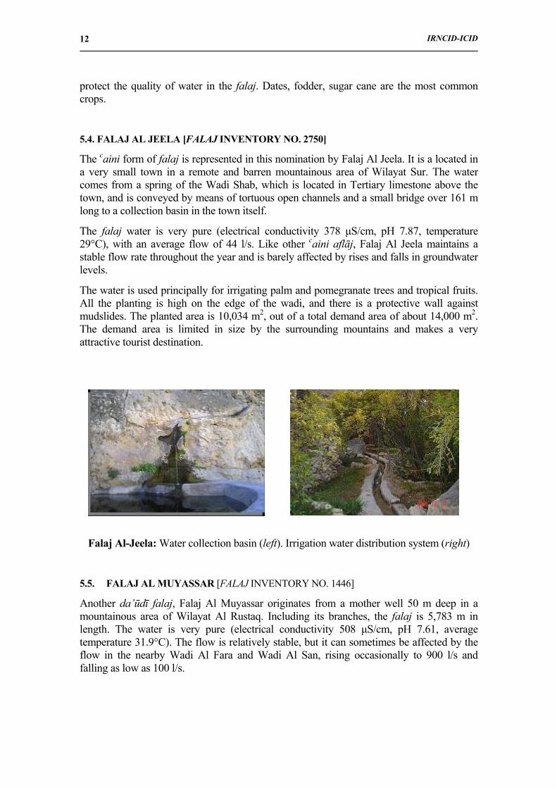
5.4. FALAJ AL JEELA [FALAJ INVENTORY NO. 2750]
The caini form of falaj is represented in this nomination by Falaj Al Jeela. It is a located in a very small town in a remote and barren mountainous area of Wilayat Sur. The water comes from a spring of the Wadi Shab, which is located in Tertiary limestone above the town, and is conveyed by means of tortuous open channels and a small bridge over 161 m long to a collection basin in the town itself.
The falaj water is very pure (electrical conductivity 378 µS/cm, pH 7.87, temperature 29°C), with an average flow of 44 l/s. Like other caini aflāj, Falaj Al Jeela maintains a stable flow rate throughout the year and is barely affected by rises and falls in groundwater levels.
The water is used principally for irrigating palm and pomegranate trees and tropical fruits. All the planting is high on the edge of the wadi, and there is a protective wall against mudslides. The planted area is 10,034 m2, out of a total demand area of about 14,000 m2. The demand area is limited in size by the surrounding mountains and makes a very attractive tourist destination.
Falaj Al-Jeela: Water collection basin (left). Irrigation water distribution system (right)
5.5. FALAJ AL MUYASSAR [FALAJ INVENTORY NO. 1446]
Another da’ūdī falaj, Falaj Al Muyassar originates from a mother well 50 m deep in a mountainous area of Wilayat Al Rustaq. Including its branches, the falaj is 5,783 m in length. The water is very pure (electrical conductivity 508 µS/cm, pH 7.61, average temperature 31.9°C). The flow is relatively stable, but it can sometimes be affected by the flow in the nearby Wadi Al Fara and Wadi Al San, rising occasionally to 900 l/s and falling as low as 100 l/s.
IRNCID-ICID
13
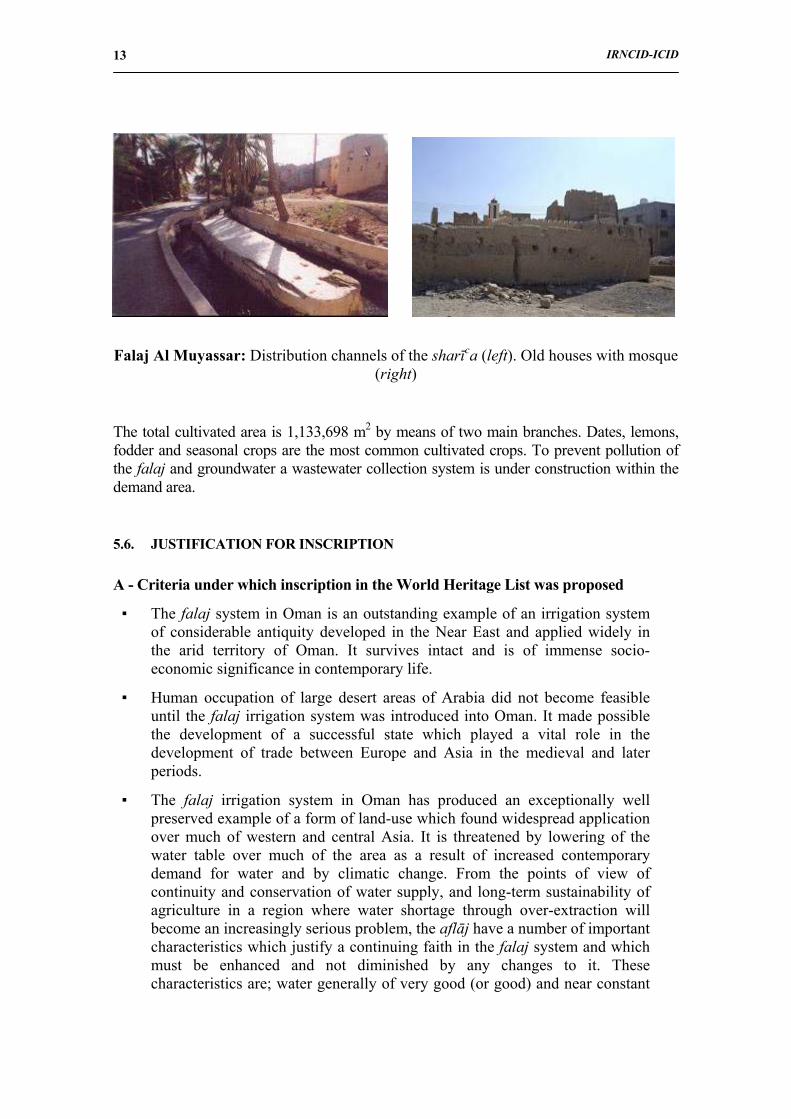
Falaj Al Muyassar: Distribution channels of the sharīca (left). Old houses with mosque (right)
The total cultivated area is 1,133,698 m2 by means of two main branches. Dates, lemons, fodder and seasonal crops are the most common cultivated crops. To prevent pollution of the falaj and groundwater a wastewater collection system is under construction within the demand area.
5.6. JUSTIFICATION FOR INSCRIPTION
A - Criteria under which inscription in the World Heritage List was proposed
▪ The falaj system in Oman is an outstanding example of an irrigation system of considerable antiquity developed in the Near East and applied widely in the arid territory of Oman. It survives intact and is of immense socio-economic significance in contemporary life.
▪ Human occupation of large desert areas of Arabia did not become feasible until the falaj irrigation system was introduced into Oman. It made possible the development of a successful state which played a vital role in the development of trade between Europe and Asia in the medieval and later periods.
▪ The falaj irrigation system in Oman has produced an exceptionally well preserved example of a form of land-use which found widespread application over much of western and central Asia. It is threatened by lowering of the water table over much of the area as a result of increased contemporary demand for water and by climatic change. From the points of view of continuity and conservation of water supply, and long-term sustainability of agriculture in a region where water shortage through over-extraction will become an increasingly serious problem, the aflāj have a number of important characteristics which justify a continuing faith in the falaj system and which must be enhanced and not diminished by any changes to it. These characteristics are; water generally of very good (or good) and near constant
IRNCID-ICID
14
chemical quality; no possibility of endangering the water table (in contrast with wells which are easily deepened) unless by a support well; water is brought to the ground surface by gravity, and therefore without any pumping cost; village falaj land is long nurtured and of good quality; falaj villages are a model of crop water use prioritisation; aflāj are the best example of co-operative water management in Oman - a model of self-funding and self-help; the falaj committees could form the basis of future local water management organisations (in partnership with MRMEWR and its regional offices).
B - Statement of outstanding universal value
The statement in the Holy Quran that ‘…we have made from water every living thing’ epitomizes the dependence of humankind on water. This is nowhere more true than in the arid lands of Arabia, where permanent human settlement did not become possible until the introduction of irrigation systems that permitted the extension of agriculture beyond the immediate surroundings of springs or wells. Relatively constant supplies of water were ensured for large areas of desert throughout the year, and this in turn led to the growth of permanent urban settlements based on an assured agricultural production and water resources for both people and livestock.
The falaj system of irrigation consists of tapping substantial underground water resources and conducting the water by means of deep underground channels, often over long distances, to towns and villages where it is distributed to domestic and agricultural users. The system in use in northern Oman has been developed over many centuries and has resulted in the creation of a strong social and economic structure that has survived intact to the present day.
There are four elements in the Omani falaj systems that justify the attribution of ‘outstanding universal value’. First, without the existence of aflāj there would have been no more than sparse, impoverished settlement in this region (or elsewhere in the desert regions that stretch from Xinjiang to Morocco). Secondly, the technology has been brought to a high level in Oman, and has been functioning successfully for more than two millennia. Thirdly, the organization of the water distribution system is an outstanding example of a traditional structure that is at least a thousand years old and which continues to play a vital role in the social and economic structure of Oman in the 21st century. Fourthly, it is one of the largest concentrations of irrigation systems of this kind anywhere in the world: over four thousand active or defunct systems have been identified.
The agricultural demand area is an outstanding example of sustainable agriculture. The cultivated area is reduced or expanded according to the natural flow of the falaj. No mechanical intervention is required. Water distribution structures are constructed efficiently by mean of open channels adapted to the topographical situation. The aflāj with their demand areas create a unique environment where the man lives in harmony with nature.
IRNCID-ICID
15
C - Authenticity and integrity
The basic layout of the contemporary Omani falāj is wholly authentic. Records and archaeological investigations confirm that this form of water location and distribution has not changed for more than two millennia. Modern techniques are not used in their location, excavation, and design, and modern materials such as concrete are used only for reinforcing the tops of the mother wells and access shafts, at some of the sharīcas, and in the distribution channels to individual agricultural plots.
The authenticity of the management of the aflāj is equally incontrovertible. The traditional system of ownership and management, which is centuries-old, functions efficiently alongside and complements the contemporary administrative and scientific structure for the management of water resources in the Sultanate. It is based on many generations of Omani citizens who have ensured its integrity as a fundamental element in the survival of human society in this arid land.
6. GOVERNMENT ROLE IN PROTECTING FALAJ SYSTEMS
When we realise that the total length of aflāj in the world is comparable to the distance from the Earth to the Moon (MRMEWR 2005), we understand that aflāj are living monuments of the immense effort of our predecessors: The long history of falaj use in Oman indicates that community participation in construction, management and maintenance of these systems has been continuous for many, possibly thousands of, years. There is no doubt that falaj systems demonstrate, throughout their long history, the modern-day concept of Integrated Water Resources Management (IWRM) (Al Busaidi 2006).
Nowadays, falaj systems are affected by many factors which have lead to 25% of them drying up (Al Bakri 2005). These factors include:
• Absence of long-term water allocation or management plans.
• Interference from pumped wells and the impact of other water users in the vicinity of the mother well (source of water) of a falaj.
• Expansion of the irrigated areas (increase of water consumption with respect to the annual recharge water available).
Since 1989 with the establishment of the Ministry of Water Resources, currently the MRMEWR, and its Aflāj Department, the government has been closely involved in reducing the effect of such obstacles to the survival of aflāj, concentrating on the following main issues:
• Establishing protection zones around the “mother well”. the source of water to the falaj.
• Assessing aflāj affected by drought and over-pumping and providing support wells. Up to the end of 2005 the MRMEWR had constructed some 923 support wells, with a peak in the years 1991 to 1994 which coincided with a prolonged dry period (Al Shaqsi 1996).
IRNCID-ICID
16
• Providing support, both financial and technical, for repair and maintenance. Up to the end of 2006 the MRMEWR had supported 669 project for falaj maintenance with a total cost of 5.85 million R.O (14.9 US$).
• Carrying out monitoring of both flow and water quality of 526 representative aflāj.
The Ministry has integrated the traditional methods, developed by the falaj communities, for the repair and maintenance of falaj channels and structures with modern methods and engineering design. The use of mechanical excavation and reinforced concrete means that the works are safer, faster to carry out and last longer. However, with modern methods the cost per unit linear length (m) for underground and open channels is US$ 83-165 and US$ 33-99 respectively (Al Hatmi and Al Amri 2000).
In 2000, the MRMEWR adopted a policy to improve, conserve and protect aflāj in order to stabilize the rural population and retain the national heritage through the Water Resources Master Plan vision 2000 – 2020. In outline, the strategic goals are:
• To continue to support falaj communities with respect to: maintenance of systems to reduce water losses; and security and protection of water supply flow and quality.
• To increase falaj income through optimal usage of water.
• To increase community self-reliance and development.
In order to achieve the above goals, many works and actions through several progressive phases have been actioned:
a. Establish water allocation for each falaj in a catchment management plan that can achieve and sustain the water balance.
b. Increase farm productivity through conservation of water and develop irrigation systems.
c. Implement the principle of minimum water quota for each falaj which should be sufficient to cover the basic needs of the community served by the falaj.
d. Implement the concept of water rights to match demand and this will be based on the sustainable water balance.
In the near future, an agreement with water users is required to improve the management of aflāj water. Regulations need to be applied equally to all villages in order to achieve the strategic goals, while control should remain in the hands of the falaj communities as they are experienced in overcoming both technical and social problems. The falaj committees still play a significant role in water management and aflāj maintenance decisions. They also play a significant role in preventing people from sinking new wells that might impact on falaj water supply. Therefore it is appropriate that the falaj committee should form the basis of new local water management organizations, responsible for both aflāj and wells within their locality or sub-catchment.
IRNCID-ICID
17
REFERENCES
1. Al Bakri, Abdullah bin Nasser, 2005 Water Strategies in Oman. The 7th Gulf Water Conference: 1-20. (in Arabic).
2. Al Busaidi, Khalid bin Mahfoudh, 2006 “The Omani Aflaj: An Ancient Indigenous IWRM System”. World Water Forum, 17-22 March 2006, Mexico.
3. English, Paul Ward, 1997 “Qanats and Life Worlds in Iranian Plateau Villages", in Middle Eastern Natural Environments, Bulletin No. 3, Yale University, USA.
4. Al Ghafri, Abdullah et al., 2003 "Daudi Aflaj: The Qanat of Oman", Proceedings of the Third Symposium on Xinjang Uyghur, China, 11 November, 2003, Chiba, Japan.
5. Al Hatmi, H.K. and Al Amri, S.S., 2000 “Aflaj Maintenance in the Sultanate of Oman”, Proceedings of the First International Symposium on Qanat, Yazd, Iran. May 8-11, Volume IV.
6. Lane, E.E., 1968 An Arabic-English Lexicon, (8 volumes), Beirut: Librarie du Liban.
7. Ministry of Regional Municipalities Environment and Water Resources, 2000 National Water Resources Master Plan, annex F- Aflaj, July 2000.
8. Ministry of Regional Municipalities Environment and Water Resources, 2005 (Internal Report, Nov. 2005) Water Resources in Oman.
9. Ministry of Regional Municipalities Environment and Water Resources, 2006 (Internal Report 2006) The Aflaj Irrigation System of Oman, Sultanate of Oman.
10. Ministry of Water Resources, 1997 National Aflaj Inventory Project (NAIP), Sultanate of Oman.
11. Al Shaqsi, S.R. 1996 Aflaj Management in the Sultanate of Oman. Case study of Falaj al-Hamra (dawoodi) and Falaj al-Kasfah (aini), MSc Thesis, University of Wales, U.K.
12. Al-Tikriti, W.Y. 2002 "The south-east Arabian origin of the falaj system", Proceedings of the Seminar for Arabian Studies 32: 117-138.
13. Wilkinson, J.C. 1977 Water and Tribal Settlement in South-East Arabia: A Study of the Aflāj of Oman, Clarendon Press, Oxford.
14. Wilkinson, J.C. 1983 “The Origins of the Aflāj of Oman”, Journal of Oman Studies, 6 (1): 177-194.