The relevance of psychosocial maps in the study of urban districts
12
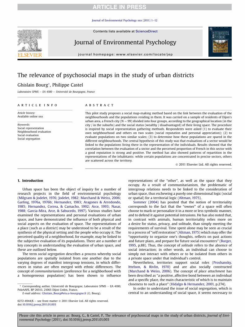
The relevance of psychosocial maps in the study of urban districts Ghislain Bourg * , Philippe Castel Laboratoire SPMS e EA 4180 e Université de Bourgogne, France article info Article history: Available online xxx Keywords: Social representation Neighbourhood evaluation Social evaluation Social segregation abstract This pilot study proposes a social map-making method based on the link between the evaluation of the neighbourhoods and the populations residing in them. It was carried on a sample of residents of Dijon’s urban area, a French city (N ¼ 99) divided into four groups, according to the geographical location (in the city / in the suburbs) and the social status (wealthy / disadvantaged) of their living space. The procedure is inspired by social representation gathering methods. Respondents were asked (1) to evaluate their own neighbourhood and others on two scales (social reputation and personal appreciation); (2) to evaluate populations on two similar scales; (3) to determine how these populations are spared in the different neighbourhoods. The central hypothesis of this study was that evaluations of a sector would be linked to the populations living there in the representation of the individuals. Results showed that the correlation between the evaluation of a sector and the perceived proportion of French in this sector with a good reputation is strong and positive. The method has also showed patterns of repartition in the representations of the inhabitants: while certain populations are concentrated in precise sectors, others are scattered across the territory. Ó 2011 Elsevier Ltd. All rights reserved. 1. Introduction Urban space has been the object of inquiry for a number of research projects in the field of environmental psychology (Milgram & Jodelet, 1976; Jodelet, 1982; Marchand & Weiss, 2006; Garling, 1976a, 1976b; Hernandez, 1983; Aragones & Arredondo, 1985; Hernandez, Correa, & Camacho, 1992; Arce, 1993; Nasar, 1988; Garcia-Mira, Arce, & Sabucedo, 1997). Various studies have examined the representations and personal evaluations of urban space, and have demonstrated the influence of both physical and social aspects on the evaluation of space. The representations of a place (such as a district) may be understood to be a result of the synthesis of the physical setting and the people who occupy it. The perceived quality of a neighborhood, for example, may be linked to the subjective evaluation of its populations. There are a number of key concepts in understanding the evaluation of urban space, and these are outlined below. The term social segregation describes a process whereby social populations are spatially isolated from one another due to the varying degrees of manifest intergroup tensions, in which differ- ences in status are often merged with ethnic differences. The concept of communitarianism (preference for a neighborhood with a homogeneous population) has been shown to influence representations of the “other”, as well as the space that they occupy. As a result of communitarianism, the problematic of intergroup relations needs to be linked to the consideration of urban space, thus eschewing a purely one-dimensional logic (social or spatial) for a territorial logic (Altman, 1975). Sommer (2004) has posited that the notion of territoriality corresponds to the fact that the “owner” of a space will often choose to mark or personalize it in a more or less symbolic manner, and to defend it against potential intrusions. He has also noted that, in contrast with animals, human territoriality relies more on a desire for status, privacy, and solitude, than simply meeting the requirements of survival. Time spent alone may be seen as crucial to a process of “self restoration” (Altman, 1975) which may offer the “opportunity to organize one’s thoughts, reflects on past actions and future plans, and prepare for future social encounters” (Burger, 1995, p.88). Thus, the concept of solitude refers to the absence of social interaction; in other words, an individual can choose to simply not interact with others or to be isolated from others in a private space under that individual’s control. Nevertheless, territories support social roles (Proshansky, Ittelson, & Rivlin, 1970) and are also socially constructed (Marchand & Weiss, 2006). The concept of place attachment has been described as “a positive, affective bond between an individual and a specific place, the main characteristic of which is to maintain closeness to such a place” (Hidalgo & Hernandez, 2001 , p.274). In order to understand the issue of social segregation, which is central to an understanding of social space, it seems necessary to * Corresponding author. Université de Bourgogne, Laboratoire SPMS e EA 4180, PoleAAFE, BP 26513, 21065 Dijon Cedex, France. E-mail address: [email protected] (G. Bourg). Contents lists available at ScienceDirect Journal of Environmental Psychology journal homepage: www.elsevier.com/locate/jep 0272-4944/$ e see front matter Ó 2011 Elsevier Ltd. All rights reserved. doi:10.1016/j.jenvp.2011.01.003 Journal of Environmental Psychology xxx (2011) 1e12 Please cite this article in press as: Bourg, G., & Castel, P., The relevance of psychosocial maps in the study of urban districts, Journal of Envi- ronmental Psychology (2011), doi:10.1016/j.jenvp.2011.01.003
-
Upload
independent -
Category
Documents
-
view
0 -
download
0
Transcript of The relevance of psychosocial maps in the study of urban districts
lable at ScienceDirect
Journal of Environmental Psychology xxx (2011) 1e12
Contents lists avai
Journal of Environmental Psychology
journal homepage: www.elsevier .com/locate/ jep
The relevance of psychosocial maps in the study of urban districts
Ghislain Bourg*, Philippe CastelLaboratoire SPMS e EA 4180 e Université de Bourgogne, France
a r t i c l e i n f o
Article history:Available online xxx
Keywords:Social representationNeighbourhood evaluationSocial evaluationSocial segregation
* Corresponding author. Université de Bourgogne,PoleAAFE, BP 26513, 21065 Dijon Cedex, France.
E-mail address: [email protected].
0272-4944/$ e see front matter � 2011 Elsevier Ltd.doi:10.1016/j.jenvp.2011.01.003
Please cite this article in press as: Bourg, Gronmental Psychology (2011), doi:10.1016/j.je
a b s t r a c t
This pilot study proposes a social map-making method based on the link between the evaluation of theneighbourhoods and the populations residing in them. It was carried on a sample of residents of Dijon’surban area, a French city (N ¼ 99) divided into four groups, according to the geographical location (in thecity / in the suburbs) and the social status (wealthy / disadvantaged) of their living space. The procedureis inspired by social representation gathering methods. Respondents were asked (1) to evaluate theirown neighbourhood and others on two scales (social reputation and personal appreciation); (2) toevaluate populations on two similar scales; (3) to determine how these populations are spared in thedifferent neighbourhoods. The central hypothesis of this study was that evaluations of a sector would belinked to the populations living there in the representation of the individuals. Results showed that thecorrelation between the evaluation of a sector and the perceived proportion of French in this sector witha good reputation is strong and positive. The method has also showed patterns of repartition in therepresentations of the inhabitants: while certain populations are concentrated in precise sectors, othersare scattered across the territory.
� 2011 Elsevier Ltd. All rights reserved.
1. Introduction
Urban space has been the object of inquiry for a number ofresearch projects in the field of environmental psychology(Milgram & Jodelet, 1976; Jodelet, 1982; Marchand & Weiss, 2006;Garling, 1976a, 1976b; Hernandez, 1983; Aragones & Arredondo,1985; Hernandez, Correa, & Camacho, 1992; Arce, 1993; Nasar,1988; Garcia-Mira, Arce, & Sabucedo, 1997). Various studies haveexamined the representations and personal evaluations of urbanspace, and have demonstrated the influence of both physical andsocial aspects on the evaluation of space. The representations ofa place (such as a district) may be understood to be a result of thesynthesis of the physical setting and the people who occupy it. Theperceived quality of a neighborhood, for example, may be linked tothe subjective evaluation of its populations. There are a number ofkey concepts in understanding the evaluation of urban space, andthese are outlined below.
The term social segregation describes a process whereby socialpopulations are spatially isolated from one another due to thevarying degrees of manifest intergroup tensions, in which differ-ences in status are often merged with ethnic differences. Theconcept of communitarianism (preference for a neighborhood witha homogeneous population) has been shown to influence
Laboratoire SPMS e EA 4180,
fr (G. Bourg).
All rights reserved.
., & Castel, P., The relevance onvp.2011.01.003
representations of the “other”, as well as the space that theyoccupy. As a result of communitarianism, the problematic ofintergroup relations needs to be linked to the consideration ofurban space, thus eschewing a purely one-dimensional logic (socialor spatial) for a territorial logic (Altman, 1975).
Sommer (2004) has posited that the notion of territorialitycorresponds to the fact that the “owner” of a space will oftenchoose to mark or personalize it in a more or less symbolic manner,and to defend it against potential intrusions. He has also noted that,in contrast with animals, human territoriality relies more ona desire for status, privacy, and solitude, than simply meeting therequirements of survival. Time spent alone may be seen as crucialto a process of “self restoration” (Altman,1975) whichmay offer the“opportunity to organize one’s thoughts, reflects on past actionsand future plans, and prepare for future social encounters” (Burger,1995, p.88). Thus, the concept of solitude refers to the absence ofsocial interaction; in other words, an individual can choose tosimply not interact with others or to be isolated from others ina private space under that individual’s control.
Nevertheless, territories support social roles (Proshansky,Ittelson, & Rivlin, 1970) and are also socially constructed(Marchand & Weiss, 2006). The concept of place attachment hasbeen described as “a positive, affective bond between an individualand a specific place, the main characteristic of which is to maintaincloseness to such a place” (Hidalgo & Hernandez, 2001, p.274).
In order to understand the issue of social segregation, which iscentral to an understanding of social space, it seems necessary to
f psychosocial maps in the study of urban districts, Journal of Envi-
G. Bourg, P. Castel / Journal of Environmental Psychology xxx (2011) 1e122
adopt a multidisciplinary approach, ie., using the knowledge ofsocial and environmental psychology alongside the knowledgefrom sociology and human geography. From this perspective, theaim of this article is to develop a method of psychosocial mappingof urban spaces, based on the links between the evaluation ofa neighborhood and of the variety of populations that live in it.
1.1. Physical aspects of the subjective evaluation of a place
A number of environmental psychologists have investigated thevarious dimensions that influence the subjective evaluation ofa place. Notably, Garling (1976a, 1976b) has observed that generalaesthetic and social status are among the most important dimen-sions of an evaluation. Hernandez (1983), Aragones and Arredondo(1985), Hernandez et al. (1992), and Arce (1993) all found similarresults concerning the status of place (its social prestige) but alsoidentified other important factors: the level and types of activitiesavailable, the attractiveness and clearness of the physical structures,and the safetyof theplace inquestion. In another study,Nasar (1988)identified that diversity, organization, and openness of space arefundamental to the subjective evaluation of a place. The results ofGarcia-Mira et al. (1997) have indicated that perceived social statusis the most influential aspect of the evaluation of a neighborhood,followed by the quality of maintenance and spaciousness.
Using a case study in A Coruña, Spain, Garcia-Mira et al. (1997)identified a close relationship between the social status of a placeand its centrality. Similarly, Milgram and Jodelet (1976) have shownthat the presence of a central neighborhood plays a fundamentalrole in the representations of Paris, where urban organizationaround a center is not simply a structuring of space, but rathercharged with a rich symbolic meaning that finds its origins in thehistory of the city (Jodelet, 1982). According toMarchand andWeiss(2006), the center can provide a spatial and structural landmark (atopographic center and a concentration of buildings and services),a political and historical landmark (identifying spatially wherepolitical decisions have been made and often with monumentsreflecting the history of the place), and a social landmark (wheredensity and diversity lead to a concentration of social exchange).Geographers have described the center as a “place of maximalproximity” (Lacour, 1998, p.154), and “the place of gathering andconcentration, a place in which what happens is important, a placeof maximum action and interaction” (Huriot & Perreur, 1994, p.47).
Bonnes, Mannetti, Secchiaroli, and Tanucci (1990) have sug-gested that the urban landscape is organized according to a hier-archy of values which is established relative to the proximity of(and the accessibility to) central places. According to thisperspective, the notion of proximity is not only a physical variable,but also has a psychological meaning. This assumption is supportedby the phenomenon of gentrification, which has been described as“the displacement of working-class residents of a neighborhood bywealthier professionals” (Hammel, 2009, p.360). Kern (1981) hasobserved that in New York City, a substantial part of the high-income population (young unmarried and childless couples) rep-resented “a relatively low demand for land and high demand fortrips to the center” (O’Sullivan, 2005, p.74). This preference wasattributed to the goods and cultural amenities offered in the center,and also to a new sense of “attachment to old buildings anda heightened sensibility to space and time” (Zukin, 1987, p.131). Asa consequence, the cost of inner-city land had risen in New York,resulting in increased economic differences between centraldistricts and suburbs.
Nonetheless, gentrification patterns may differ from one city toanother. If the relatively higher value of inner districts compared tosuburbs is often observed in European cities and in some Americancities, it may not necessarily be so in every United States city. It is
Please cite this article in press as: Bourg, G., & Castel, P., The relevance oronmental Psychology (2011), doi:10.1016/j.jenvp.2011.01.003
thus preferable to distinguish between the social status of place andits centrality: social status can create a non-geographical centrality(usually due to historical reasons), in such a way that the typicalrelationship to the geographic center is not the one observed.Geographic centrality and the social status of a neighborhood mayalso have different effects on the appropriation process (Félonneau,Marchand, & Fleury-Bahi, 2004; Moser, Tassara, Félonneau,Marchand, & Okumara, 2005). Appropriation and the practice ofthe neighborhood by its inhabitants are more important in centralplaces than in suburbs, independently of their social status. Theindividuals living in wealthy neighborhoods seem to appropriatethe physical aspects of their space, whereas the inhabitants of poorneighborhoods generally appropriate the social aspects. The socialstatus of a place is not only revealed through its architecture; it mayalso manifest itself in the cost of living and the quality ofmaintenance.
The quality of maintenance, in particular, can influence theattractiveness (Arce, 1993), general aesthetic (Garling, 1976a;1976b), and perceived degree of security (Arce, 1993) of a place.According to the brokenwindow thesis (Wilson&Kelling,1982), thepresenceof abrokenwindowsignals that social control is attenuatedin this area. Perkins, Meeks, and Taylor (1992) have noted that theactual presence of disorder-related cues in a neighborhood can leadindividuals to perceive a prevalence of social problems and crime.Research has also indicated that individuals are less attached toa place if they perceive a strong presence of delinquency or crime(Mesch & Manor, 1998; Taylor, Gottfredson, & Brower, 1984;Sampson, 1989), or if they perceive the neighborhood to be physi-cally disorderly (McGuire, 1997) or deteriorated (LaGrange, Ferraro,& Suspanci, 1992). Félonneau (2004), interviewing students froma big city on their representation of the ideal city, reported twoideologies: urbanophilia, in which the ideal image of the citycorresponds to a traditional city (density and dynamism), andurbanophobia, in which the ideal image of the city comprisesa predominance of quiet and open spaces with green vegetation.This second attitude implies a rejection of the traditional city andindicates a perception of insecurity. Neighborhoods with extensiveopen spaces are often preferred to others because they are morelegible (Lynch, 1960). This concept is related to the notion of thephysical structure of a place: its organization (Hernandez, 1983;Hernandez et al., 1992) and especially its openness (Nasar, 1988).
The three variables of status, maintenance quality, andspaciousness influence each other in a circular causality. Centralspaces, because of their status, benefit from regular maintenance;the presence of wide squares surrounding monuments and otherpatrimonial buildings may serve as a landmark, making a placemore legible and more attractive than other suburban and/or poorneighborhoods (as the latter often exhibit a lesser quality ofmaintenance and less “neatness” in their architecture). Lynch(1960) notes that the presence of differences and physical limitsbetween neighborhoods, whether these are natural (such as a river)or artificial (such as a railroad), can separate the urban space ina more or less brutal manner. Thus, these limits are more thansimple boundaries, and may be described as social fractures(Marchand, 2002, 2005a, 2005b), ie., physical and symbolic barriersthat increase the perceived distance between neighborhoods.
1.2. Social aspects of the subjective evaluation of a place
Hidalgo and Hernandez (2001) have observed that socialattachment may represent a stronger bond than place attachment.The subjects of their study declared that leaving their socialnetwork would affect them more than leaving their neighborhood.Thus, social aspects can have a major impact on the perceivedquality of a neighborhood.
f psychosocial maps in the study of urban districts, Journal of Envi-
G. Bourg, P. Castel / Journal of Environmental Psychology xxx (2011) 1e12 3
Scannell and Gifford (in press) have noted that place attachmentis, in fact, conceived as a social process by urban sociologists(Hunter; 1978; Kasarda & Janowitz, 1974; Gans, 1962), and Woldoff(2002) has indicated that place attachment actually refers to theattachment to the people who live in a place. Lalli (1992) hassuggested that spatial bonds have become more intense largelybecause they symbolize social bonds. Twigger-Ross and Uzzell(1996) have suggested that place attachment and place identityprocesses occur at the same time: an individual may develop anaffective bond with a place because it distinguishes itself fromother places, but also because it allows individuals to affirm thespecificity of their group (Scannell & Gifford, in press). In one study(Brown, Perkins, & Brown, 2003), the inhabitants of a neighborhoodwere revealed to be less attached to it if they did not perceive socialcohesion or control. Hunter (1974) has observed that individuals ofequal social status and age usually choose their life space based oneconomic constraints and lifestyle; as a consequence, neighbor-hoods with relatively homogeneous populations emerge and socialnetworks begin to develop.
Individuals do not only look for homogeneous neighborhoodson the basis of equal status, but also on the basis of ethnic origin.For example, in a study on a Jewish orthodox neighborhood (Rivlin,1987), place attachment was high because of the similarity amongthe inhabitants and the differences between the members of thisgroup and the residents of other spaces. Conversely, attachment toAfro-American neighborhoods has been shown to be low, reflectingconditions of poverty and racial discrimination (Taylor, 1996).Brown et al. (2003) have obtained similar results, outlining lesserplace attachment in a Hispanic neighborhood. In this vein,Bourdieu (1993) has observed that one’s life space is a social markerwhereby the status of a place reflects on the position of socialpopulations in the environment (Bourdieu, 1993; Grafmeyer, 1994;Félonneau, 2003; Marchand & Weiss, 2006).
Humangeographyuses the indexof dissimilarityas ameasure forthe probable distribution of two populations in a given geographicarea (such as the repartition of “blacks” and “whites” in the neigh-borhood of a city). Based on the pioneering study of Duncan andDuncan (1955), this tool has undergone various methodologicalenhancements (Theil & Finizza, 1970; White, 1983; Massey &Denton, 1986) and has demonstrated its usefulness in identifyingnumerous segregation processes. For example, Lieberson (1976)studied the distribution of European immigrants and black Africanimmigrants in American cities, and observed that European immi-grants integrated into the neighborhood over time, whereas segre-gation against Black immigrants only increased. Farley, Schuman,Bianchi, Colasanto, and Hatchett (1978) have shown that pop-ulations were reluctant to remain in or move to a neighborhood inwhich they were a minority. Logan and Stults (2001) have observedthat minorities are less represented in predominantly white-iden-tified neighborhoods, whereas white-identified inhabitants wereless represented in neighborhoods containing different minoritypopulations (where ethnic diversity was seen to bemore common).
Myrdal (1944) has outlined the negative consequences of spatialsegregation (without using empirical evidence) on the basis that itlimits the opportunities for certain populations. Williams (1998),Lobmayer and Wilkinson (2001) have shown that segregation notonly has an effect on social and economic inequalities, but also onaccess to healthcare. Massey and Denton (1992) have found that thepersistence of segregation can be linked to the emergence of a verypoor urban social class (black occupants with very low incomes).Similarly, Quillian (1999) has observed that the migration of non-poor populations from poor neighborhoods has contributed to theformation of very poor neighborhoods and that Afro-Americanmigration into neighborhoods of white-identified populations hasresulted in the retreat of the initial occupants.
Please cite this article in press as: Bourg, G., & Castel, P., The relevance oronmental Psychology (2011), doi:10.1016/j.jenvp.2011.01.003
Recently, Krysan, Couper, and Forman (2009) have shown thatmany Afro-Americans declare that they prefer a mixed neighbor-hood, while the majority of white Americans prefer a homogenousneighborhood, particularly if they subscribe to negative racialstereotypes. Quillian and Pager (2001) have noted that theperception of insecurity in a neighborhood may be influenced bythe stereotypes that are prevalent among individuals and also bythe presence of certainminorities in this neighborhood. Matei, Ball-Rokeach, and Linchuan Qiu (2001) have observed similar resultswhile interrogating the inhabitants of different neighborhoods inLos Angeles: when participants were asked to indicate, on a map ofthe city, the places where they felt either comfortable or insecure,the most feared areas were not those with the highest crime rate,but those occupied by Afro-American and Latino-American pop-ulations. Fear of a neighborhood seems therefore to be “color-coded” in the United States (Allen & Hatchett, 1986; Doob &MacDonald, 1979; Entman, 1992).
Matei et al. (2001) have shown that fear of minorities withinneighborhoods can be influenced by the representation of thoseplaces in the media, although individuals who frequently travelthrough the Afro-American neighborhoods were found to be lessinfluenced by fear of crime. This last finding is consistent with thecontact hypothesis (Amir, 1969; Brown, 1995; Duckitt, 1992), whichsuggests that intergroup conflicts tend to decrease with prolongedcontact between populations, as mutual comprehension isimproved through increased language proficiency and culturalknowledge. This hypothesis is opposed to the theories of conflict,according to which discrimination and prejudice increase witha prolonged contact between populations, as the number ofmembers of a minority group increases and resources becomescarce, thus causing competition (Sherif & Sherif, 1953; Brown,1995; Duckitt, 1992). Liebkind and Jasinskaja-Lahti (2000) haveobserved that the experience of discrimination and prejudice canbe highly predictive of the level of well-being of immigrants and oftheir lack of trust in Finnish authorities. Jasinskaja-Lahti, Liebkind,and Perhoniemi (2006) have also observed that perceiveddiscrimination may be predicted by the cultural proximity of theminority and the majority, the length of residence (long-ago orrecent immigration), and the visibility of the minority.
It thus seems reasonable to suggest that the physical and socialaspects influencing the subjective evaluation of a place are linked.For example, the social status of a place determines the type ofpopulation that can afford to live there. In many European cities,the status of a neighborhood is clearly linked to its geographicalcentrality. Poor neighborhoods are perceived as more dangerousbecause of the lack of maintenance. To give an account of this linkbetween the physical and social aspects of the question, we proposea method which elaborates psychosocial maps, “along with Lynch(1960) [.] geographic images are determined not just by instru-mental-personal orientation goals, but they also carry culturalmeaning in a discursive community” (Matei et al., 2001, p. 434).Thus, a psychosocial map could be seen as an abstract represen-tation of the subjective (psycho) and shared (social) image of a city;this identifies the link between the physical and social aspects ofspace as central to the research.
1.3. Goals and methodology
The goals of the present research are neither purely theoreticalnor purely methodological. Likewise, the aim is not to verify atheoretical hypothesis using empirical data or to develop a methodthat is statistically reliable; rather, the aim is to instigate a meth-odological reflection and to collate the representations towns-people use for their lived space. In contrast with the methods ofenvironmental psychology (which concentrate on the physical
f psychosocial maps in the study of urban districts, Journal of Envi-
Table 1Repartition of sectors (and size of the sample) according to geographical locationand social position.
Advantaged Disadvantaged
Intra muros Park Alleys Grésilles(24) (25)
Extra muros Chevigny Chenôve(25) (25)
G. Bourg, P. Castel / Journal of Environmental Psychology xxx (2011) 1e124
aspects of place) and social psychology (which focus on socialaspects), the proposed method takes into account both the physicaland social aspects of place, and aims to understand how these arelinked in a territorial logic. Whereas the index of dissimilaritymeasures the objective repartition of populations across the city(and the extent to which these populations are exclusive of oneanother), the proposedmethod identifies the subjective repartition,and how this can influence the evaluation of space. In other words,the focus is not on objective data about segregation, but on thepsychological processes of representing and interpreting the urbanspace. With this in mind, we have developed a method inspired bythe various existing procedures for collecting data concerningsocial representation.
Moser (2006) has noted that when conducting researching onthe scale of a city, studies cannot be limited to the individual level,but rathermust be approached in termsof aggregates of individuals.Although individual representations are based on “real-life” expe-rience, andonadaptation to the environment, social representationsare more stable and are shared by a group of individuals (andtherefore give coherency and meaning to the space). According toMoscovici (1984), social representations constitute “implicit” or“naïve” theories: knowledge that concerns a specific object and issocially structured. This socially constructed reality is often nomorethan a simplification, and this can lead to biases in the processing ofinformation and to other exaggerations. The conceptual frameworkhas inspired a large number of studies in France and thereby stim-ulated researchers to create new methods of investigation, witha view to apprehending the structure of social representations.
Classically, investigating social representations has involved twosteps. First, the subject lists a certain number of elements related toan object during a task of free association, and is then led tostructure these different elements. An example of this is themethod of peered evaluation, developed by Le Bouédec (1984), inwhich subjects are asked to cite several elements related to anobject. In the second step, the most frequently occurring elementsare presented in all possible combinations to the subjects whomustjudge every combination. A method developed by Vergès (1992)allows the researcher to distinguish the frequency of citation fora specific element (that is, how many subjects have mentioned it)from its importance in the social representation (whether thesubjects consider it to be a key element). In this method, partici-pants are asked to associate several elements with an object(certain elements will be more frequent than others) and then toclassify these terms according to their importance (which does notnecessarily relate directly to their frequency).
Furthermore, Flament, Guimelli, and Abric (2006) have notedamasking effect.When subjects are placed in a classical context andgiven a verbal association task, they may inhibit certain negativeevaluations in the belief that tolerance is the expected norm for self-presentation. Toaddress this effect, the substitutionmethodasks thesubjects to answer assertions that are not directly related to them-selves (such as “what would ‘others’ do or think?”). This is meant togive access to the mute zone of a representation, in other words, itsnegative non-assumed aspects. In this way, the subjects are neitherpersonally involved nor concerned by the normative stakes, whichallows them to express socially undesirable ideas.
The method that we adopt here is based on these previousprocedures. The assumption that certain elements are more or lesslinked in a representation has been retained from peered evalua-tion. In our case, the links between the places and social pop-ulations are of particular interest to us. As opposed to the socialrepresentation methods (which allow the participants freedom todecide the nature of the associations they make), we directed theparticipants to concentrate on a specific aspect of the representa-tion of their city. Theywere asked to enumerate sectors in a city and
Please cite this article in press as: Bourg, G., & Castel, P., The relevance oronmental Psychology (2011), doi:10.1016/j.jenvp.2011.01.003
the populations living in them. The notion of importance (in otherwords, the existence of a hierarchy between the elements ofa representation) was retained from the Vergès method, however,the original termwas replaced by the notion of affective preference.The reasoning of Flament et al. (2006) in relation to the mute zonehas led us to consider two aspects of representation: the subject’sown representation (the ideas held about an object and used in itsevaluation) and the meta-representation (the representation orreputation that others have in relation to an object).
At an operational level, this method was developed in order toverify two hypotheses. (1) The reputation attributed to sectors orpopulations should be more extreme than the personal evaluation.It should not only bemore negative for negatively evaluated sectorsor populations but should also be more positive for positivelyevaluated sectors or populations. (2) The subjective evaluation andthemeta-evaluation of a sector should be positively correlatedwiththe perceived proportion of French comprising its population.Inversely, the subjective evaluation and the meta-evaluation ofa sector should be negatively correlated with the perceivedproportion of foreign occupants living in the sector in question. Inother words, the personal evaluation and the reputation of a sectorshould increase with the perceived proportion of French inhabi-tants and decrease as the proportion of foreign inhabitants in thepopulation increases.
2. Method
2.1. Overview of the research
Our method, based on the techniques of social representationstudy examined above, made use of a three part questionnaire.First,we asked participants to enumerate the areas of their agglomera-tion and to evaluate each of these areas using two scales. One scalereferred to their own evaluation (personal evaluation) and theother referred to the image they had of the evaluation that theythought other people would have (reputation). Second, the samesubjects were asked to enumerate the populations living in theagglomeration and to evaluate these populations on two scales(similar to those used in the first part). Finally, participants wereasked to distribute the identified populations among the differentsectors. The results made it possible to draw up psychosocial mapswhich chart the personal evaluations of both the sectors and of thepopulations living in them.
2.2. Subjects
The study was carried out in Dijon and its agglomeration. Thiscity (with 153 800 inhabitants in Dijon itself and 262 598 inhabi-tants in the urban area) is the capital of Burgundy, a region ofFrance. Our sample (N ¼ 99) was made up of members ofcommissions or district associations. These participants werechosen based on their residence and on two essential criteria forevaluating a residential area (see Table 1): the geographical locationwith twomodalities (sectors situated in the city itself versus sectorssituated in the suburbs) and social status with two modalities(wealthy sector versus disadvantaged sector). The four
f psychosocial maps in the study of urban districts, Journal of Envi-
G. Bourg, P. Castel / Journal of Environmental Psychology xxx (2011) 1e12 5
administrative units retained are the most prototypical of theircategory according to objective data (presence or absence of lowincome housing and average incomes e based on the New HousingSurvey 2005, carried out by the “Observatoire & Prospectives”project of the Greater Dijon Area). The choice of these variablesallowed us to control for the influence of the status and the positionof a subject’s residence on the evaluation of other places.
Félonneau (1999) interviewed a group of urban experts anda group of non-expert subjects about their representations ofsuburbia. She observed that the experts based their representationon specialized knowledge and theories and described suburbiausing objective and technical terms (such as periphery, housing,and shopping mall). On the contrary, non-expert subjects sharedimplicit theories on suburbia and framed their representation usingan emotional mode based on stereotypes (employing terms such aslow-income housing, melting pot, segregation and immigration)while avoiding certain aspects (such as shopping mall, green space,tranquility, and individual house).
With this in mind, our choice to interview members of commu-nity organizations was motivated by the fact that these were rela-tively long-term inhabitants who possessed a good knowledge ofthe cityandwere interested and involved in the life of their space. Allparticipants had lived inDijon or its surrounding area for at leastfiveyears (m ¼ 40,13; s ¼ 18,63; max ¼ 75). Thus, they were neitherpurely non-expert subjects (whomay have ignored the relationshipbetween the different sectors of the urban space), nor urbanspecialists (who would have had an expert representation of thecity). In addition, all participants weremetropolitan French natives:none were recent immigrants nor members of any of the pop-ulations about which they were interviewed.
2.3. Procedure
The study interview was divided into three parts. In the firstsection, subjects were asked about different neighborhoods. In thesecond section, they were asked about the populations living inDijon and its surrounding areas. In the third section, they wereasked to link these populations to the different neighborhoods byindicating how many people in each group were living in specificplaces. The participants were interviewed orally and individually,and the responses were noted on a scale by the interviewer. Eachsubject had to respond to the entire questionnaire, completing eachsection before moving on to the next.
In the first section, the interviewer asked subjects to enumeratesix areas. These enumerated areas did not refer to administrativedivisions, but rather to spatial unities in the subjects’ mentalrepresentations (such as a Dijon neighborhood or a peripheraltown). The cited areas were noted by the interviewer. Four resi-dential areas (Park Alleys, Grésilles, Chevigny, and Chenôve) andthe downtown area were included if they had not been spontane-ously cited, in order to ensure that sufficient comparative datawereobtained for a few specific sectors between each group of inhabi-tants. The interviewer then asked the subjects to evaluate each ofthe areas they had cited on two scales: its reputation (that is, whatthey thought the judgments of other people were) and theirpersonal evaluation of the area.
The second section was concerned with the human aspects ofthe urban area, andwas constructed using the samemodel as in thefirst section. The subjects were asked to cite six populations and toevaluate each of these using two scales (similar to those used in thefirst section), referring to the notions of social reputation andpersonal evaluation. Once again, five populations were added(these included visible minorities and/or populations of foreignorigin, without considering the generation of immigration) if they
Please cite this article in press as: Bourg, G., & Castel, P., The relevance oronmental Psychology (2011), doi:10.1016/j.jenvp.2011.01.003
had not been spontaneously mentioned: Black Africans, Asians,North Africans (Maghrebis), Eastern Europeans, and Portuguese.
The third section established a link between the spatial and thehuman aspects of the representation of the city in its evaluativedimension. In order to achieve this, the participants were asked bythe interviewer to indicate, for each group, the three sectors inwhich this group was the most prevalent, and to indicate for eachcase the percentage of the overall inhabitants that was representedby this group. The purpose of this section was two-fold:first, to linkthe evaluation of a sector with that of the populations which residein it, and second, to identify typical sectors of certain populations inthe social representations.
2.4. Measures
Our questionnaire led us to consider five measures, which areoutlined below.
Two of the variables concerned the evaluation of the neigh-borhoods. The first corresponds to social reputation, and refers toa meta-evaluation. To determine this measure, the subject attrib-uted a grade on a bipolar scale ranging from �5 (very bad repu-tation) toþ5 (very good reputation). To determine the second scale,that of personal evaluation, the subject also attributed a grade ona bipolar scale ranging from �5 (very bad personal evaluation) toþ5 (very good personal evaluation). Here, the individual gave his orher own evaluation of a particular object. This construction makesit possible to compare the meta-evaluation and the individual’spersonal evaluation and allows us to examine our first hypothesis.Contrary to the reasoning of Flament et al. (2006) in relation to themute zone, we supposed that the social reputation attributed toa sector by a subject would be a more extreme version of thepersonal evaluation attributed to this sector by the same subject.
The two subsequent variables concerned the evaluation of thedifferent populations living in Dijon and its agglomeration. Thesewere fashioned using a bipolar scale similar to that used in the twoprevious items; one scale referred to the reputation of a populationand the other to each subject’s personal evaluation. In both cases,subjects attributed a grade to each population to indicate whetherit had a good or bad reputation or personal evaluation. As previ-ously mentioned for sectors, the comparison of the individual’spersonal evaluation and his or her meta-evaluation of a populationallows us to respond to the questions raised by our first hypothesis.The social reputation attributed to a population by a subject wasexpected to be a more extreme version of the personal evaluationattributed to this population by the same subject.
The last variable examined the link between populations andneighborhoods. As indicated above, subjects were asked to deter-mine the three neighborhoods where each group was the mosthighly represented. Moreover, they were asked to indicate howstrong the link between a population and a neighborhood was, byevaluating the proportion of the neighborhood inhabitants repre-sented by the population in question. This measure allowed us toexamine our second hypothesis: the evaluation (personal evalua-tion and meta-evaluation) of a sector was expected to be positivelycorrelated with the proportion of French inhabitants living thereand negatively correlated with the perceived proportion ofa foreign inhabitants.
3. Results
The following results correspond to the percentages and scoresgiven by the participants questioned on sectors and populations. Ofthe personal evaluation and reputation scores concerning thedifferent sectors, we considered only those sectors cited by more
f psychosocial maps in the study of urban districts, Journal of Envi-
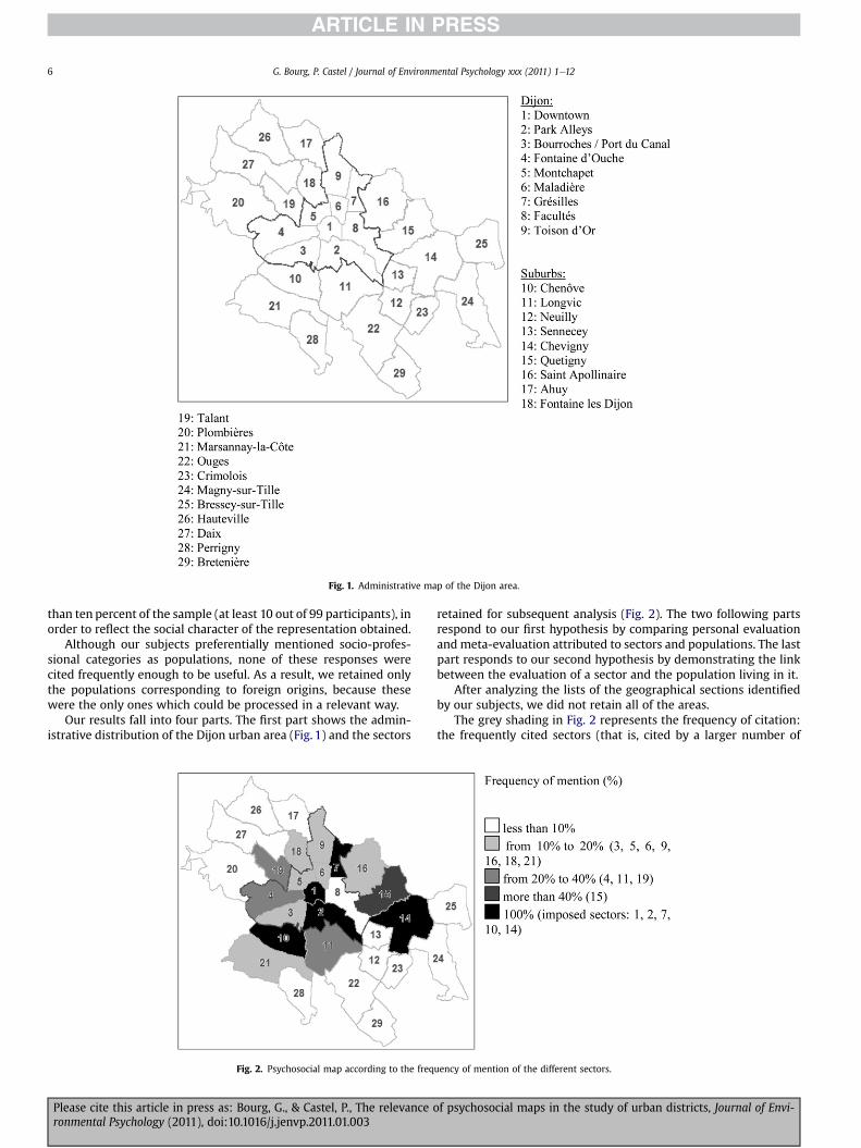
Fig. 1. Administrative map of the Dijon area.
G. Bourg, P. Castel / Journal of Environmental Psychology xxx (2011) 1e126
than ten percent of the sample (at least 10 out of 99 participants), inorder to reflect the social character of the representation obtained.
Although our subjects preferentially mentioned socio-profes-sional categories as populations, none of these responses werecited frequently enough to be useful. As a result, we retained onlythe populations corresponding to foreign origins, because thesewere the only ones which could be processed in a relevant way.
Our results fall into four parts. The first part shows the admin-istrative distribution of the Dijon urban area (Fig. 1) and the sectors
Fig. 2. Psychosocial map according to the freq
Please cite this article in press as: Bourg, G., & Castel, P., The relevance oronmental Psychology (2011), doi:10.1016/j.jenvp.2011.01.003
retained for subsequent analysis (Fig. 2). The two following partsrespond to our first hypothesis by comparing personal evaluationandmeta-evaluation attributed to sectors and populations. The lastpart responds to our second hypothesis by demonstrating the linkbetween the evaluation of a sector and the population living in it.
After analyzing the lists of the geographical sections identifiedby our subjects, we did not retain all of the areas.
The grey shading in Fig. 2 represents the frequency of citation:the frequently cited sectors (that is, cited by a larger number of
uency of mention of the different sectors.
f psychosocial maps in the study of urban districts, Journal of Envi-
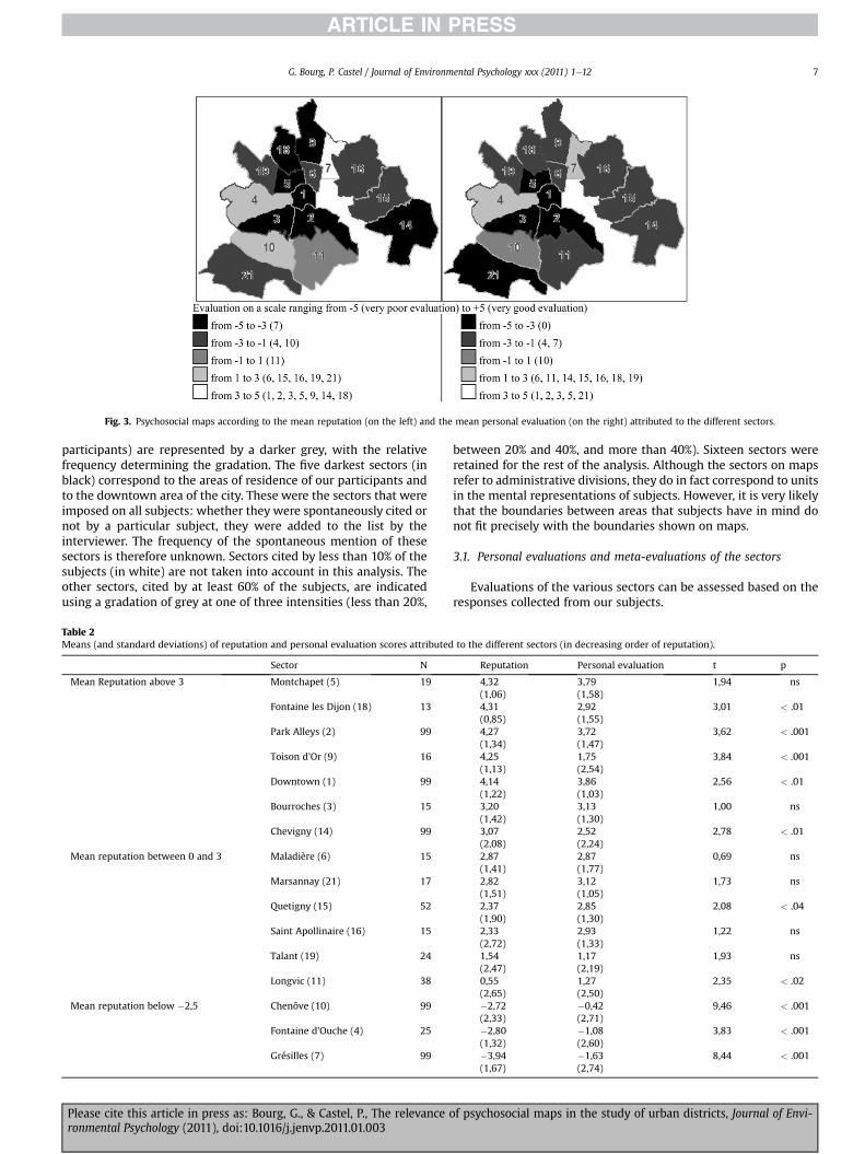
Fig. 3. Psychosocial maps according to the mean reputation (on the left) and the mean personal evaluation (on the right) attributed to the different sectors.
G. Bourg, P. Castel / Journal of Environmental Psychology xxx (2011) 1e12 7
participants) are represented by a darker grey, with the relativefrequency determining the gradation. The five darkest sectors (inblack) correspond to the areas of residence of our participants andto the downtown area of the city. These were the sectors that wereimposed on all subjects: whether they were spontaneously cited ornot by a particular subject, they were added to the list by theinterviewer. The frequency of the spontaneous mention of thesesectors is therefore unknown. Sectors cited by less than 10% of thesubjects (in white) are not taken into account in this analysis. Theother sectors, cited by at least 60% of the subjects, are indicatedusing a gradation of grey at one of three intensities (less than 20%,
Table 2Means (and standard deviations) of reputation and personal evaluation scores attributed
Sector N
Mean Reputation above 3 Montchapet (5) 19
Fontaine les Dijon (18) 13
Park Alleys (2) 99
Toison d’Or (9) 16
Downtown (1) 99
Bourroches (3) 15
Chevigny (14) 99
Mean reputation between 0 and 3 Maladière (6) 15
Marsannay (21) 17
Quetigny (15) 52
Saint Apollinaire (16) 15
Talant (19) 24
Longvic (11) 38
Mean reputation below �2,5 Chenôve (10) 99
Fontaine d’Ouche (4) 25
Grésilles (7) 99
Please cite this article in press as: Bourg, G., & Castel, P., The relevance oronmental Psychology (2011), doi:10.1016/j.jenvp.2011.01.003
between 20% and 40%, and more than 40%). Sixteen sectors wereretained for the rest of the analysis. Although the sectors on mapsrefer to administrative divisions, they do in fact correspond to unitsin the mental representations of subjects. However, it is very likelythat the boundaries between areas that subjects have in mind donot fit precisely with the boundaries shown on maps.
3.1. Personal evaluations and meta-evaluations of the sectors
Evaluations of the various sectors can be assessed based on theresponses collected from our subjects.
to the different sectors (in decreasing order of reputation).
Reputation Personal evaluation t p
4,32 3,79 1,94 ns(1,06) (1,58)4,31 2,92 3,01 < .01(0,85) (1,55)4,27 3,72 3,62 < .001(1,34) (1,47)4,25 1,75 3,84 < .001(1,13) (2,54)4,14 3,86 2,56 < .01(1,22) (1,03)3,20 3,13 1,00 ns(1,42) (1,30)3,07 2,52 2,78 < .01(2,08) (2,24)2,87 2,87 0,69 ns(1,41) (1,77)2,82 3,12 1,73 ns(1,51) (1,05)2,37 2,85 2,08 < .04(1,90) (1,30)2,33 2,93 1,22 ns(2,72) (1,33)1,54 1,17 1,93 ns(2,47) (2,19)0,55 1,27 2,35 < .02(2,65) (2,50)�2,72 �0,42 9,46 < .001(2,33) (2,71)�2,80 �1,08 3,83 < .001(1,32) (2,60)�3,94 �1,63 8,44 < .001(1,67) (2,74)
f psychosocial maps in the study of urban districts, Journal of Envi-
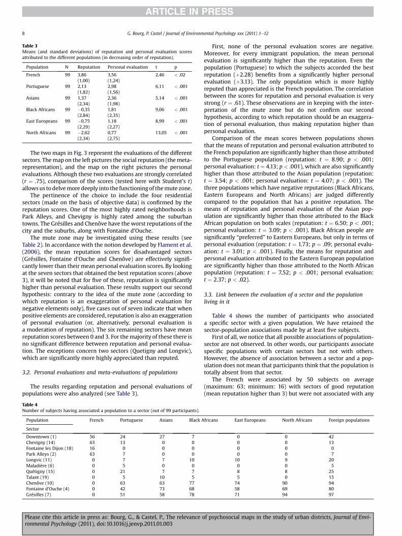
Table 3Means (and standard deviations) of reputation and personal evaluation scoresattributed to the different populations (in decreasing order of reputation).
Population N Reputation Personal evaluation t p
French 99 3,86 3,56 2,46 < .02(1,00) (1,24)
Portuguese 99 2,13 2,98 6,11 < .001(1,82) (1,56)
Asians 99 1,37 2,36 5,14 < .001(2,34) (1,98)
Black Africans 99 �0,35 1,81 9,06 < .001(2,84) (2,35)
East Europeans 99 �0,75 1,18 8,99 < .001(2,29) (2,27)
North Africans 99 �2,62 0,77 13,05 < .001(2,34) (2,75)
G. Bourg, P. Castel / Journal of Environmental Psychology xxx (2011) 1e128
The two maps in Fig. 3 represent the evaluations of the differentsectors. Themap on the left pictures the social reputation (themeta-representation), and the map on the right pictures the personalevaluations. Although these two evaluations are strongly correlated(r ¼ .75), comparison of the scores (tested here with Student’s t)allowsus to delvemore deeply into the functioningof themute zone.
The pertinence of the choice to include the four residentialsectors (made on the basis of objective data) is confirmed by thereputation scores. One of the most highly rated neighborhoods isPark Alleys, and Chevigny is highly rated among the suburbantowns. The Grésilles and Chenôve have the worst reputations of thecity and the suburbs, along with Fontaine d’Ouche.
The mute zone may be investigated using these results (seeTable 2). In accordance with the notion developed by Flament et al.(2006), the mean reputation scores for disadvantaged sectors(Grésilles, Fontaine d’Ouche and Chenôve) are effectively signifi-cantly lower than their mean personal evaluation scores. By lookingat the seven sectors that obtained the best reputation scores (above3), it will be noted that for five of these, reputation is significantlyhigher than personal evaluation. These results support our secondhypothesis: contrary to the idea of the mute zone (according towhich reputation is an exaggeration of personal evaluation fornegative elements only), five cases out of seven indicate that whenpositive elements are considered, reputation is also an exaggerationof personal evaluation (or, alternatively, personal evaluation isa moderation of reputation). The six remaining sectors have meanreputation scores between 0 and 3. For themajority of these there isno significant difference between reputation and personal evalua-tion. The exceptions concern two sectors (Quetigny and Longvic),which are significantly more highly appreciated than reputed.
3.2. Personal evaluations and meta-evaluations of populations
The results regarding reputation and personal evaluations ofpopulations were also analyzed (see Table 3).
Table 4Number of subjects having associated a population to a sector (out of 99 participants).
Population French Portuguese Asians Black A
Sector
Downtown (1) 56 24 27 7Chevigny (14) 63 13 0 0Fontaine les Dijon (18) 16 0 0 0Park Alleys (2) 63 7 0 0Longvic (11) 0 7 7 10Maladière (6) 0 5 0 0Quétigny (15) 0 21 7 7Talant (19) 0 5 10 5Chenôve (10) 0 63 63 77Fontaine d’Ouche (4) 0 42 73 68Grésilles (7) 0 51 58 78
Please cite this article in press as: Bourg, G., & Castel, P., The relevance oronmental Psychology (2011), doi:10.1016/j.jenvp.2011.01.003
First, none of the personal evaluation scores are negative.Moreover, for every immigrant population, the mean personalevaluation is significantly higher than the reputation. Even thepopulation (Portuguese) to which the subjects accorded the bestreputation (þ2.28) benefits from a significantly higher personalevaluation (þ3.13). The only population which is more highlyreputed than appreciated is the French population. The correlationbetween the scores for reputation and personal evaluation is verystrong (r ¼ .61). These observations are in keeping with the inter-pretation of the mute zone but do not confirm our secondhypothesis, according to which reputation should be an exaggera-tion of personal evaluation, thus making reputation higher thanpersonal evaluation.
Comparison of the mean scores between populations showsthat the means of reputation and personal evaluation attributed tothe French population are significantly higher than those attributedto the Portuguese population (reputation: t ¼ 8.90; p < .001;personal evaluation: t ¼ 4.13; p < .001), which are also significantlyhigher than those attributed to the Asian population (reputation:t ¼ 3.54; p < .001; personal evaluation: t ¼ 4.07; p < .001). Thethree populations which have negative reputations (Black Africans,Eastern Europeans and North Africans) are judged differentlycompared to the population that has a positive reputation. Themeans of reputation and personal evaluation of the Asian pop-ulation are significantly higher than those attributed to the BlackAfrican population on both scales (reputation: t ¼ 6.50; p < .001;personal evaluation: t ¼ 3.09; p < .001). Black African people aresignificantly “preferred” to Eastern Europeans, but only in terms ofpersonal evaluation (reputation: t ¼ 1.73; p ¼ .09; personal evalu-ation: t ¼ 3.01; p < .001). Finally, the means for reputation andpersonal evaluation attributed to the Eastern European populationare significantly higher than those attributed to the North Africanpopulation (reputation: t ¼ 7.52; p < .001; personal evaluation:t ¼ 2.37; p < .02).
3.3. Link between the evaluation of a sector and the populationliving in it
Table 4 shows the number of participants who associateda specific sector with a given population. We have retained thesector-population associations made by at least five subjects.
First of all, we notice that all possible associations of population-sector are not observed. In other words, our participants associatespecific populations with certain sectors but not with others.However, the absence of association between a sector and a pop-ulation does not mean that participants think that the population istotally absent from that sector.
The French were associated by 50 subjects on average(maximum: 63; minimum: 16) with sectors of good reputation(mean reputation higher than 3) but were not associated with any
fricans East Europeans North Africans Foreign populations
0 0 420 0 130 0 00 0 7
10 9 200 0 58 8 255 0 15
74 90 9458 69 8071 94 97
f psychosocial maps in the study of urban districts, Journal of Envi-
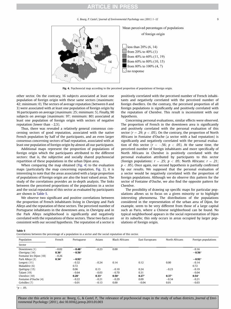
Fig. 4. Psychosocial map according to the perceived proportion of populations of foreign origin.
G. Bourg, P. Castel / Journal of Environmental Psychology xxx (2011) 1e12 9
other sector. On the contrary, 16 subjects associated at least onepopulation of foreign origin with these same sectors (maximum:42; minimum: 0). The sectors of average reputation (between 0 and3) were associated with at least one population of foreign origin by16 participants on average (maximum: 25;minimum: 5). Finally, 90subjects on average (maximum: 97; minimum: 80) associated atleast one population of foreign origin with sectors of negativereputation (lower than �2,5).
Thus, there was revealed a relatively general consensus con-cerning sectors of good reputation, associated with the nativeFrench population by half of the participants, and an even largerconsensus concerning sectors of bad reputation, associated with atleast one population of foreign origin by almost all our participants.
Additional maps represent the proportion of populations offoreign origin which the participants attributed to the differentsectors: that is, the subjective and socially shared psychosocialrepartition of these populations in the urban Dijon area.
When comparing the map obtained (Fig. 4) to the evaluationmaps (particularly the map concerning reputation, Fig. 3), it isinteresting to note that the areas associated with a large proportionof populations of foreign origin are also the least valued areas. Thestudy of the correlations provides an in-depth analysis. The linksbetween the perceived proportions of the populations in a sectorand the social reputation of this sector as evaluated by participantsare shown in Table 5.
We observe two significant and positive correlations betweenthe proportion of French inhabitants living in Chevigny and ParkAlleys and the reputation of these sectors. The perceived number ofPortuguese inhabitants in the downtown area, in Chevigny and inthe Park Alleys neighborhood is significantly and negativelycorrelated with the reputations of these sectors. These two facts areconsistent with our second hypothesis. The reputation of a sector is
Table 5Correlations between the percentage of a population in a sector and the social reputatio
Population French Portuguese Asians Black A
Sector
Downtown (1) �0.02 L0.48* �0.23 0.00Chevigny (14) 0.36* L0.56*Fontaine les Dijon (18) �0.26Park Alleys (2) 0.34* L0.92*Longvic (11) �0.32 �0.24 0.14Maladière (6) 0.72Quétigny (15) 0.06 0.13 �0.10Talant (19) �0.64 �0.03 �0.70Chenôve (10) 0.28* 0.33* 0.50*Fontaine d’Ouche (4) �0.22 �0.21 �0.29Grésilles (7) �0.01 �0.13 0.00
*p < .05.
Please cite this article in press as: Bourg, G., & Castel, P., The relevance oronmental Psychology (2011), doi:10.1016/j.jenvp.2011.01.003
positively correlated with the perceived number of French inhabi-tants and negatively correlated with the perceived number offoreign dwellers. On the contrary, the perceived proportion of allforeign populations is significantly and positively correlated withthe reputation of Chenôve. This result is inconsistent with ourhypothesis.
Concerning personal evaluations, similar effects were observed.The proportion of French in the downtown area is significantlyand positively correlated with the personal evaluation of thissector (r ¼ .29; p < .05). On the contrary, the proportion of NorthAfricans in Fontaine d’Ouche (a sector with a bad reputation) issignificantly and negatively correlated with the personal evalua-tion of this sector (r ¼ �.56; p < .05). At the same time, theperceived number of foreign inhabitants and more specifically ofNorth Africans in Chenôve is positively correlated with thepersonal evaluation attributed by participants to this sector(foreign populations: r ¼ .25; p < .05; North Africans: r ¼ .21;p < .05). Once again, our second hypothesis is partially confirmedby our results. We supposed that the personal evaluation ofa sector would be negatively correlated with the proportion offoreign populations. Although we do observe this pattern for thesector of Fontaine d’Ouche, we also find the opposite pattern forChenôve.
The possibility of drawing up specific maps for particular pop-ulations allows us to focus on a given minority or to highlightinteresting phenomena. The distributions of the populationsconsidered in the representation of the urban area of Dijon, forexample, seem to be very different from those of a large capitalsuch as Paris, where a Chinese neighborhood can be found. Notypical neighborhood appears in the social representation of Dijonor its suburbs; this only occurs in areas occupied by larger pop-ulations of foreign origin.
n of this sector.
fricans East Europeans North Africans Foreign populations
�0.16L0.56*
L0.92*0.12 0.00 �0.14
0.720.24 �0.23 �0.190.31 �0.040.27* 0.37* 0.54*0.09 �0.34 �0.21�0.04 0.01 �0.03
f psychosocial maps in the study of urban districts, Journal of Envi-
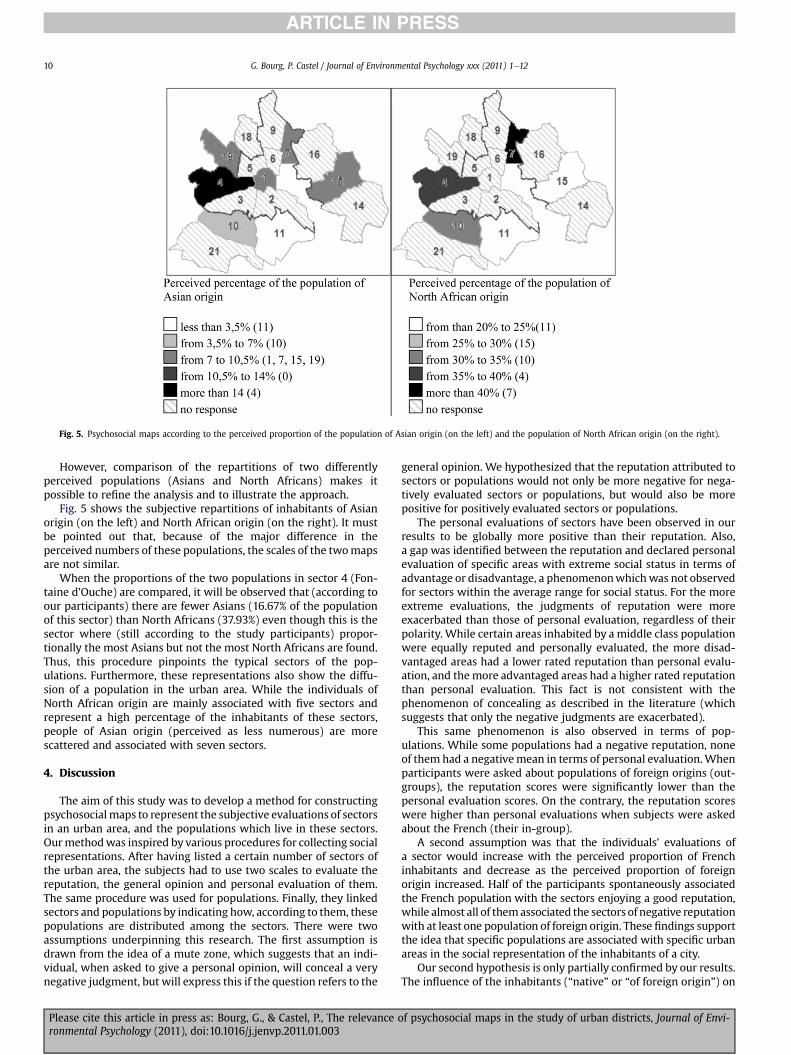
Fig. 5. Psychosocial maps according to the perceived proportion of the population of Asian origin (on the left) and the population of North African origin (on the right).
G. Bourg, P. Castel / Journal of Environmental Psychology xxx (2011) 1e1210
However, comparison of the repartitions of two differentlyperceived populations (Asians and North Africans) makes itpossible to refine the analysis and to illustrate the approach.
Fig. 5 shows the subjective repartitions of inhabitants of Asianorigin (on the left) and North African origin (on the right). It mustbe pointed out that, because of the major difference in theperceived numbers of these populations, the scales of the twomapsare not similar.
When the proportions of the two populations in sector 4 (Fon-taine d’Ouche) are compared, it will be observed that (according toour participants) there are fewer Asians (16.67% of the populationof this sector) than North Africans (37.93%) even though this is thesector where (still according to the study participants) propor-tionally the most Asians but not the most North Africans are found.Thus, this procedure pinpoints the typical sectors of the pop-ulations. Furthermore, these representations also show the diffu-sion of a population in the urban area. While the individuals ofNorth African origin are mainly associated with five sectors andrepresent a high percentage of the inhabitants of these sectors,people of Asian origin (perceived as less numerous) are morescattered and associated with seven sectors.
4. Discussion
The aim of this study was to develop a method for constructingpsychosocialmaps to represent the subjective evaluations of sectorsin an urban area, and the populations which live in these sectors.Ourmethodwas inspired by various procedures for collecting socialrepresentations. After having listed a certain number of sectors ofthe urban area, the subjects had to use two scales to evaluate thereputation, the general opinion and personal evaluation of them.The same procedure was used for populations. Finally, they linkedsectors and populations by indicating how, according to them, thesepopulations are distributed among the sectors. There were twoassumptions underpinning this research. The first assumption isdrawn from the idea of a mute zone, which suggests that an indi-vidual, when asked to give a personal opinion, will conceal a verynegative judgment, but will express this if the question refers to the
Please cite this article in press as: Bourg, G., & Castel, P., The relevance oronmental Psychology (2011), doi:10.1016/j.jenvp.2011.01.003
general opinion. We hypothesized that the reputation attributed tosectors or populations would not only be more negative for nega-tively evaluated sectors or populations, but would also be morepositive for positively evaluated sectors or populations.
The personal evaluations of sectors have been observed in ourresults to be globally more positive than their reputation. Also,a gap was identified between the reputation and declared personalevaluation of specific areas with extreme social status in terms ofadvantage or disadvantage, a phenomenonwhich was not observedfor sectors within the average range for social status. For the moreextreme evaluations, the judgments of reputation were moreexacerbated than those of personal evaluation, regardless of theirpolarity. While certain areas inhabited by a middle class populationwere equally reputed and personally evaluated, the more disad-vantaged areas had a lower rated reputation than personal evalu-ation, and themore advantaged areas had a higher rated reputationthan personal evaluation. This fact is not consistent with thephenomenon of concealing as described in the literature (whichsuggests that only the negative judgments are exacerbated).
This same phenomenon is also observed in terms of pop-ulations. While some populations had a negative reputation, noneof them had a negativemean in terms of personal evaluation.Whenparticipants were asked about populations of foreign origins (out-groups), the reputation scores were significantly lower than thepersonal evaluation scores. On the contrary, the reputation scoreswere higher than personal evaluations when subjects were askedabout the French (their in-group).
A second assumption was that the individuals’ evaluations ofa sector would increase with the perceived proportion of Frenchinhabitants and decrease as the perceived proportion of foreignorigin increased. Half of the participants spontaneously associatedthe French population with the sectors enjoying a good reputation,while almost all of themassociated the sectors of negative reputationwith at least one population of foreign origin. These findings supportthe idea that specific populations are associated with specific urbanareas in the social representation of the inhabitants of a city.
Our second hypothesis is only partially confirmed by our results.The influence of the inhabitants (“native” or “of foreign origin”) on
f psychosocial maps in the study of urban districts, Journal of Envi-
G. Bourg, P. Castel / Journal of Environmental Psychology xxx (2011) 1e12 11
the evaluation of a neighborhood seems to interact with its status(good or bad reputation). For some sectors enjoying a good repu-tation (the downtown area, Chevigny and Park Alleys), theperceived number of French inhabitants increases their reputationand personal evaluation, while the perceived number of Portugueseinhabitants decreases their reputation. However, these resultscannot be generalized to other areas or to other populations.Indeed, we do not know if the proportion of French inhabitants inan urban area of low social status increases its reputation. Nor canwe affirm that every foreign population living in a sector of goodreputation would be negatively correlated with the evaluation ofthis sector.
On the other hand, the reputation of Chenôve (a very negativelyreputed sector) increased with the perceived number of foreigninhabitants. Finally, the perceived proportion of foreign dwellers,and more specifically of North Africans, was positively correlatedwith the personal evaluation of Chenôve, but negatively correlatedwith the personal evaluation of Fontaine d’Ouche (for North Afri-cans only). These two areas had a very negative reputations.
The reputationattributedbyparticipants to anurban area is a partof the social representation of this area, as is the perceived number ofa given population group in this area. We observed a widespreadconsensus among our participants regarding the distribution of thevarious populations in urban space. In addition, the perceivedproportion of certain populations in an area is correlated with itsreputation. It thus appears that the representation of a sector’sreputation and the representation of the proportion of specificpopulations living in it are linked and socially shared. However, wecannot conclude that the negative reputation of a sector is caused byits inhabitants or that our participants perceived an large number offoreigners in an area because it has a bad reputation.
This method revealed the patterns of repartition contained inthe representations of the inhabitants. According to the subjects,while certain populations are concentrated in specific sectors,others are scattered across the territory. Furthermore, certainsectors are seen as typical of a specific population. The subjectsresponded that people of Asian origin are found in seven sectors atlow densities, whereas people of North African origin are associ-ated with five sectors and at higher proportions. However, thesectors in which the proportions of these two populations arehighest are different.
It is important to bear in mind that information on populationdistributions result from subjective responses. Effectively, it is notpossible in France to compile data on individuals according to theirethnic origins. This regulation is embedded in a culture that issupposed to stand in contrast to the Anglo-Saxon communitarianmodel. Nevertheless, many examples of subjective partitions of thepopulations have been observed in the different urban areas, as hasbeen revealed in the responses of our subjects. In addition, withoutextrapolating, it may be supposed that the subjects in this studytend to avoid certain areas because they do not appreciate them orbecause they do not appreciate the populations living there.
Félonneau (2003, p.166) has noted that “we are struck to see theextent towhich thedesire to live near similar people (in the strongestsense of the term) is outstanding and howmuch the representationsof urbanity prove to be excluding”. Likewise, the economist Maurin(2004, p.6) has observed that “each group tends to flee or bypassthe group which is directly inferior on the scale of difficulties” andthat “a more or less active accomplice in the segregation process liesin each of us”. Social distances and spatial distances cumulate ina vicious circle, thereby reinforcing the human distances.
Along with Maurin (2004), it can be assumed from these resultsthat there are not only “poor ghettos” but also “rich ghettos” onwhich different stereotypes weigh. These two types of urbandistricts are stigmatized, each in a specific way, in terms of the
Please cite this article in press as: Bourg, G., & Castel, P., The relevance oronmental Psychology (2011), doi:10.1016/j.jenvp.2011.01.003
quality of the environment and of the population living in them.The inhabiting populations of such districts might also be stigma-tized, and their inclusion or exclusion in the representation ofcertain neighborhoods might influence their subjective evaluation.
Finally, our method has focused on reputation and personalevaluation of urban areas and populations living in them in thebroad sense. In future research, it may be pertinent to formulatemore precise questions concerning both physical aspects (such asthe perceived social status of a neighborhood independently of itsinhabitants, its centrality, and its maintenance quality) and socialaspects (such as the socioeconomic level of populations, theirethnic origin, and the potential fear they induce in certain people).A more integrative method, assessing physical characteristics aswell as social ones, would help determine the extent to which theinhabitants of an area influence its perceived atmosphere, and toidentify the specific points at which this occurs.
The use of a similar method in countries where it is possible tocollect data on ethnic origins would permit a comparison of moreobjective data on the inhabitants of a city with the subjective andshared representation of this space, in view of assessing to whatextent the perceptions are biased by stereotypes. Furthermore,interviewing members of stigmatized populations could providea comparison between the representation of stigmatized areasshared by its inhabitants and the inhabitants of other areas.
References
Allen, R. L., & Hatchett, S. (1986). The media and social reality effects: Self andsystem orientations of Blacks. Communication Research, 13(1), 97e123.
Altman, I. (1975). The environment and social Behavior. Monterey, Calif: Brooks/Cole.Amir, Y. (1969). Contact hypothesis in ethnic relations. Psychological Bulletin, 71,
319e342.Aragones, J. I., & Arredondo, J. M. (1985). Structure of urban cognitive maps. Journal
of Environmental Psychology, 5, 197e212.Arce, C. (1993). Escalamiento multidimensional. Una tenica multivariante para el
analisis de datos de proximidad y preferencia. Barcelona: PPU.Bonnes, M., Mannetti, L., Secchiaroli, G., & Tanucci, G. (1990). The city as a multi-
place system: An analysis of people-urban environment transactions. Journal ofEnvironmental Psychology, 10, 37e65.
Bourdieu, P. (1993). La misère du monde. Paris: Seuil.Brown, R. (1995). Prejudice. Its social psychology. Oxford: Blackwell.Brown, B., Perkins, D. D., & Brown, G. (2003). Place attachment in a revitalizing
neighborhood: Individual and block levels of analysis. Journal of EnvironmentalPsychology, 23, 259e271.
Burger, J. M. (1995). Individual differences in preference for solitude. Journal ofResearch in Personality, 29, 85e108.
Doob, A. N., & MacDonald, G. E. (1979). Television viewing and fear of victimization:Is the relationship causal. Journal of Personality & Social Psychology, 37(2),170e179.
Duckitt, J. (1992). The social psychology of prejudice. New York: Praeger.Duncan, B., & Duncan, O. D. (1955). A Methodological Analysis of Segregation
Indexes. American Sociological Review, 20, 210e217.Entman, R. (1992). Blacks in the news: Television, modern racism, and cultural
change. Journalism Quarterly, 69, 341e361.Farley, R., Schuman, H., Bianchi, S., Colasanto, D., & Hatchett, S. (1978). Chocolate
City, Vanilla Suburbs: Will the Trend toward Racially Separate CommunitiesContinue. Social Science Research, 7, 319e344.
Félonneau, M. L. (1999). Théories Implicites de la Ville et représentations sociales dela banlieue. Les Cahiers Internationaux de Psychologie Sociale, 41, 12e30.
Félonneau, M.-L. (2003). Les représentations sociales dans le champ de l’envir-onnement. In G. Moser, & K. Weiss (Eds.), Espaces de vie: Aspects de la relationhomme-environnement (pp. 145e176). Paris: Dunod.
Félonneau, M.-L. (2004). Love and loathing of the city: Urbanophilia and urban-ophobia, topological identity and perceived incivilities. Journal of EnvironmentalPsychology, 24, 43e52.
Félonneau, M.-L., Marchand, D., & Fleury-Bahi, G. (2004). Les représentationssociales de l’urbanité. Pour une approche des régulations proxémiques dansl’espace habité. Psychologie et Société, 4(2), 113e144.
Flament, C., Guimelli, C., & Abric, J.-C. (2006). Effets de masquage dans l’expressiond’une représentation sociale. Les Cahiers Internationaux de Psychologie Sociale,69, 15e31.
Gans, H. (1962). The urban villagers: Group and class in the life of Italian-Americans.New York: Free Press of Glencoe.
Garcia-Mira, R., Arce, C., & Sabucedo, J. M. (1997). Perceived quality of neighbour-hoods in a city in northwest Spain: An individual differences scaling approach.Journal of Environmental Psychology, 17, 243e252.
f psychosocial maps in the study of urban districts, Journal of Envi-
G. Bourg, P. Castel / Journal of Environmental Psychology xxx (2011) 1e1212
Garling, T. (1976a). The structural analysis of environmental perception andcognition: A multidimensional scaling approach. Environment and Behavior, 8,385e417.
Garling, T. (1976b). A multidimensional scaling and semantic differential techniquestudy of environmental settings. Scandinavian Journal of Psychology, 17, 323e332.
Grafmeyer, Y. (1994). Sociologie Urbaine. Paris: Nathan.Hammel, D. J. (2009). Gentrification. In R. Kitchin, & N. Thrift (Eds.), International
Encyclopedia of human geography (pp. 360e367). Elsevier Science & Technology.Hernandez, B. (1983). La perception del ambiente urbano: el mapa cognitivo de
Santa Cruz de Tenerife. Unpublished report. University of La Laguna, Spain.Hernandez, B., Correa, P., & Camacho, J. (1992). Dimensiones en la valoracion resi-
dencial. Apuntes de Psicologia, 36, 91e102.Hidalgo, C., & Hernandez, B. (2001). Place attachment: Conceptual and empirical
questions. Journal of Environmental Psychology, 21, 273e281.Hunter, A. (1974). Symbolic Communities. Chicago: University of Chicago Press.Hunter, A. (1978). Persistence of local sentiments in man’s society. In C. Street (Ed.),
Handbook of Contemporary urban life (pp. 133e162). San Francisco: Jossey-Bass.Huriot, J. M., & Perreur, J. (1994). La centralité. In J. P. Auray, A. Bailly, P. H. Derycke, &
J. M. Huriot (Eds.), L’intégration régionale des espaces (pp. 63e84). Paris:Economica.
Jasinskaja-Lahti, I., Liebkind, K., & Perhoniemi, R. (2006). Perceived discriminationand well-being: A victim study of different immigrant groups. Journal ofCommunity & Applied Social Psychology, 16(4), 267e284.
Jodelet, D. (1982). Les représentations socio-spatiales de la ville. In P. H. Derycke(Ed.), Conception de l’espace (pp. 145e177). Paris: Université de Paris X.
Kasarda, J. D., & Janowitz, M. (1974). Community attachment in mass society.American Sociological Review, 39, 328e339.
Kern, C. R. (1981). Upper-income renaissance in the city: its sources and implica-tions for the city’s future. Journal of Urban Economics, 9, 106e124.
Krysan, M., Couper, M. P., Farley, R., & Forman, T. A. (2009). Does Race Matter inNeighborhood Preferences? Results from a Video Experiment. American Journalof Sociology., 115(2), 527e559.
Lacour, C. (1998). Territoires et proximités urbaines. In J. M. Huriot (Ed.), La ville oula proximité organisée (pp. 223e234). Paris: Anthropos.
LaGrange, R. L., Ferraro, K. F., & Supancic, M. (1992). Perceived risk and fear of crime:Role of social and physical incivilities. Journal of Research in Crime and Delin-quency, 29, 311e334.
Lalli, M. (1992). Urban-related identity: Theory, measurement and empirical find-ings. Journal of Environmental Psychology, 12, 285e303.
Le Bouédec, G. (1984). Contribution à la méthodologie d’étude de représentationsociale. Cahiers de Psychologie Cognitive, 4, 245e272.
Lieberson, S. (1976). An Asymmetrical Approach to Segregation. In C. Peach,V. Robinson, & S. Smith (Eds.), Ethnic segregation in cities. Athens, Ga: Universityof Georgia Press.
Liebkind, K., & Jasinskaja-Lahti, I. (2000). The Influence of Experiences of Discrim-ination on Psychological Stress: A Comparison of Seven Immigrant Groups.Journal of Community & Applied Social Psychology, 10, 1e16.
Lobmayer, P., & Wilkinson, R. G. (2001). Inequality, Residential Segregation byIncome and Mortality in US Cities. Journal of Epidemiology and CommunityHealth, 56, 183e187.
Logan, J., & Stults, B. (2001). Ethnic Diversity Grows, Neighborhood Integration Lags.http://mumford1.dyndns.org/cen2000/WholePop/WPreport/page1.html.
Lynch, K. (1960). The image of the city. Cambridge, MA: MIT Press.McGuire, K. B. (1997). The reliability and validity of a questionnaire describing
neighborhood characteristics relevant to families and young children living inurban areas. Journal of Community Psychology, 25, 551e566.
Marchand, D. (2002). Representation of the city and image of the center in twodifferent structures: Amodern and traditional one. In G. Moser, E. Pol, Y. Bernard,M. Bonnes, J. Corraliza, & V. Giuliani (Eds.), Places, people & Sustainability/Sustainability, people & places (pp. 11e24). Göttingen: Hogrefe & Huber.
Marchand, D. (2005a). Le centre-ville est-il le noyau central de la représentationsociale de la ville. Cahiers Internationaux de Psychologie Sociale, 66, 55e64.
Marchand, D. (2005b). La construction de l’image d’une ville: représentation de lacentralité et identité urbaine. In M. Robin, & E. Ratiu (Eds.), Transitions etrapports à l’espace (pp. 243e272). Paris: L’Harmattan.
Marchand, D., & Weiss, K. (2006). La crise de l’identité urbaine: stéréotypes spatiauxet mise au ban de la ville. In K. Weiss, & D. Marchand (Eds.), Psychologie socialede l’environnement. Rennes: Presses Universitaires de Rennes.
Massey, D. S., & Denton, N. A. (1986). The Dimensions of Residential Segregation.Social Forces, 67(2), 281e351.
Massey, D. S., & Denton, N. A. (1992). American Apartheid: Segregation and themaking of the Underclass. Cambridge, MA: Harvard University Press.
Please cite this article in press as: Bourg, G., & Castel, P., The relevance oronmental Psychology (2011), doi:10.1016/j.jenvp.2011.01.003
Matei, S., Ball-Rokeach, S. J., & Linchuan Qiu, J. (2001). Fear and Misperception of LosAngeles Urban Space: A Spatial-Statistical Study of Communication-ShapedMental Maps. Communication Research, 28(4), 429e463.
Maurin, E. (2004). Le ghetto français: enquête sur le séparatisme social. Paris: Seuil etla République des Idées.
Mesch, G., & Manor, O. (1998). Social ties, environmental perception, and localattachment. Environment and Behavior, 30, 504e519.
Milgram, S., & Jodelet, D. (1976). Psychological maps of Paris. In A. Proshansky,W. H. Ittelson, & L. G. Rivlin (Eds.), Environmental Psychology: People and theirphysical setting (pp. 104e124). New York: Holt, Rinehart and Winston.
Moscovici, S. (1984). Psychologie Sociale. Paris: PUF.Moser, G. (2006). Du citadin au citoyen: de la cohabitation à la convivance. In M.-L.
Rouquette. (Ed.), Ordres et désordres urbains (pp. 79e101). Perpignan: PresseUniversitaire de Perpignan.
Moser, G., Tassara, E., Félonneau, M.-L., Marchand, D., & Okumara, C. (2005). Sao-Paulo/Paris: The weight of the centrality. In B. Martens, & A. Keul (Eds.),Designing the social Innovation: Planning, building, evaluating (pp. 47e54). Göt-tingen: Hogrefe & Huber.
Myrdal, G. (1944). An American Dilemma. New York: McGraw-Hill.Nasar, J. L. (1988). Perception and evaluation of residential street scenes. In
J. L. Nasar (Ed.), Environmental Aesthetics. Theory, research and Applications (pp.275e289). Cambridge: Cambridge University Press.
O’Sullivan, A. (2005). Gentrification and crime. Journal of Urban Economics, 57,73e85.
Perkins, D. D., Meeks, J. W., & Taylor, R. B. (1992). The physical environment of streetblocks and resident perceptions of crime and disorder: Implications for theoryand measurement. Journal of Environmental Psychology, 12(1), 21e34.
Proshansky, H. M., Ittelson, W. H., & Rivlin, L. G. (1970). Freedom of choice and.-behavior in a physical setting. In H. M. Proshansky, W. H. Ittelson, & L. G. Rivlin(Eds.), Environmental psychology. New York: Holt, Rinehart & Winston.
Quillian, L. (1999). Migration Patterns and the Growth of High-Poverty Neighbor-hoods, 1970-1990. American Journal of Sociology., 105(1), 1e37.
Quillian, L., & Pager, D. (2001). Black Neighbors, Higher Crime? The Role of RacialStereotypes in Evaluations of Neighborhood Crime. American Journal of Soci-ology, 107(3), 717e767.
Rivlin, L. G. (1987). The neighborhood, personal identity, and group affiliations. InI. Altman, & A. Wandersman (Eds.), Neighborhoods and community Environments(pp. 1e34). Hillsdale, NJ: Erlbaum.
Sampson, R. J. (1989). Local friendship ties and community attachment in masssociety: A multilevel systemic model. American Sociological Review, 53,766e779.
Scannell, L., Gifford, R. Defining place attachment: A tripartite organizing frame-work. Journal of Environmental Psychology, doi:10.1016/j.jenvp.2009.09.006.(in press)
Sherif, M., & Sherif, C. W. (1953). Groups in Harmony and in Tension: An Integration ofstudies on intergroup relations. New York: Octagon.
Sommer, R. (2004). Territoriality. In C. Spelberger (Ed.), Encyclopedia of environ-mental psychology, vol. 3 (pp. 541e544). Academic Press.
Taylor, R. B. (1996). Neighborhood responses to disorder and local attachments: Thesystemic model of attachment, social disorganization, and neighborhood usevalue. Sociological Forum, 11, 41e74.
Taylor, R. B., Gottfredson, S. D., & Brower, S. (1984). Block crime and fear: Defensiblespace, local social ties, and territorial functioning. Journal of Research in Crimeand Delinquency, 21, 303e331.
Theil, H., & Finizza, A. J. (1970). A Note on the Measurement of Racial Integration ofSchools by Means of Informational Concepts. Journal of Mathematical Sociology,1, 187e194.
Twigger-Ross, C. L., & Uzzell, D. L. (1996). Place and identity processes. Journal ofEnvironmental Psychology, 16, 205e220.
Vergès, P. (1992). L’évocation de l’argent: une méthode pour la définition du noyaucentral d’une représentation. Bulletin de Psychologie, 45, 203e209.
White, M. J. (1983). The Measurement of Spatial Segregation. American Journal ofSociology, 88(5), 1008e1018.
Williams, D. R. (1998). Race, Socioeconomic Status, and Health: The Added Effects ofRacism and Discrimination. Annals of the New York Academy of Sciences, 896,173e188.
Wilson, J. Q., & Kelling, G. L. (1982). Broken window: The police and neighborhoodsafety. Atlantic Monthly, 29e38.
Woldoff, R. A. (2002). The effects of local stressors on neighborhood attachment.Social Forces, 81, 87e116.
Zukin, S. (1987). Gentrification culture and capital in the urban core. AmericanReview of Sociology, 13, 129e147.
f psychosocial maps in the study of urban districts, Journal of Envi-