The Reintegration of Urban Lacunas at Castelvecchio Calvisio (AQ) after the 2009 Earthquake:The Use...
8
M. Ioannides et al. (Eds.): EuroMed 2012, LNCS 7616, pp. 586–593, 2012. © Springer-Verlag Berlin Heidelberg 2012 The Reintegration of Urban Lacunas at Castelvecchio Calvisio (AQ) After the 2009 Earthquake: The Use of GIS 3D as a Project Monitoring Tool Carla Bartolomucci 1 , Daniele Bonzagni 2 , and Ilaria Trizio 1 1 ITC-CNR, Construction Technologies Institute, Italian National Research Council via Carducci 32, 67100 L'Aquila, Italy {carla.bartolomucci,ilaria.trizio}@itc.cnr.it 2 Department of Architecture Planning, Polytechnic of Milan via Durando 10, 20158 Milano, Italy [email protected] Abstract. 1 The paper outlines experimental work undertaken using GIS 3D aimed at verifying the results of a highly complex project, namely the reintegration of architectural and urban lacunae in the historic centre of Castelvecchio Calvisio. The research project was undertaken in view of the critical conditions found during preparation of the Reconstruction Plan in the aftermath of the L’Aquila earthquake of April 2009. Keywords: historic centre, urban planning, conservation, earthquake, ‘lacuna’, reintegration project, GIS 3D. 1 Introduction The earthquake of April 2009 struck a wide area around the city of L’Aquila, including several minor centres of notable historic-artistic and environmental- landscape interest. For the purposes of the Reconstruction Plans 2 the peculiar architectural characteristics of these historic centres which arose in the medieval fortification period and featured a particularly compact and stratified building texture, called for in-depth multi-disciplinary investigation to tackle the various aspects of ‘reconstruction’, namely historical knowledge of the territory, history of the urban evolution of villages, evaluation of the built heritage in terms of typology, construction, assessment of 1 This paper was produced jointly by the authors, with specific contribution to sections 1-2-3 by Carla Bartolomucci, to section 4 and the architectural project design by Daniele Bonzagni, to section 5 and the 3D Information System by Ilaria Trizio. 2 Responsibility for the Reconstruction Plan of Homogeneous Area 4 (Castel del Monte, Castelvecchio Calvisio, Santo Stefano di Sessanio and Villa Santa Lucia of Abruzzi) was entrusted to the Padua University (Prof. Eng. C. Modena) and to Construction Technology Institute of CNR (Eng. G. Cifani) in collaboration with the Milan Polytechnic (Prof. Arch. M. G. Folli and Prof. Arch. L. Binda), and the School of Specialisation in Architectural Heritage and Landscape of La Sapienza University of Rome (Prof. Arch. G. Carbonara, Prof. Arch. D. Fiorani).
Transcript of The Reintegration of Urban Lacunas at Castelvecchio Calvisio (AQ) after the 2009 Earthquake:The Use...
M. Ioannides et al. (Eds.): EuroMed 2012, LNCS 7616, pp. 586–593, 2012. © Springer-Verlag Berlin Heidelberg 2012
The Reintegration of Urban Lacunas at Castelvecchio Calvisio (AQ) After the 2009 Earthquake:
The Use of GIS 3D as a Project Monitoring Tool
Carla Bartolomucci1, Daniele Bonzagni2, and Ilaria Trizio1
1 ITC-CNR, Construction Technologies Institute, Italian National Research Council via Carducci 32, 67100 L'Aquila, Italy
{carla.bartolomucci,ilaria.trizio}@itc.cnr.it 2 Department of Architecture Planning, Polytechnic of Milan
via Durando 10, 20158 Milano, Italy [email protected]
Abstract.1 The paper outlines experimental work undertaken using GIS 3D aimed at verifying the results of a highly complex project, namely the reintegration of architectural and urban lacunae in the historic centre of Castelvecchio Calvisio. The research project was undertaken in view of the critical conditions found during preparation of the Reconstruction Plan in the aftermath of the L’Aquila earthquake of April 2009.
Keywords: historic centre, urban planning, conservation, earthquake, ‘lacuna’, reintegration project, GIS 3D.
1 Introduction
The earthquake of April 2009 struck a wide area around the city of L’Aquila, including several minor centres of notable historic-artistic and environmental-landscape interest.
For the purposes of the Reconstruction Plans2 the peculiar architectural characteristics of these historic centres which arose in the medieval fortification period and featured a particularly compact and stratified building texture, called for in-depth multi-disciplinary investigation to tackle the various aspects of ‘reconstruction’, namely historical knowledge of the territory, history of the urban evolution of villages, evaluation of the built heritage in terms of typology, construction, assessment of 1 This paper was produced jointly by the authors, with specific contribution to sections 1-2-3 by
Carla Bartolomucci, to section 4 and the architectural project design by Daniele Bonzagni, to section 5 and the 3D Information System by Ilaria Trizio.
2 Responsibility for the Reconstruction Plan of Homogeneous Area 4 (Castel del Monte, Castelvecchio Calvisio, Santo Stefano di Sessanio and Villa Santa Lucia of Abruzzi) was entrusted to the Padua University (Prof. Eng. C. Modena) and to Construction Technology Institute of CNR (Eng. G. Cifani) in collaboration with the Milan Polytechnic (Prof. Arch. M. G. Folli and Prof. Arch. L. Binda), and the School of Specialisation in Architectural Heritage and Landscape of La Sapienza University of Rome (Prof. Arch. G. Carbonara, Prof. Arch. D. Fiorani).
The Reintegration of Urban Lacunas at Castelvecchio Calvisio (AQ) 587
earthquake damage and safeness of buildings, decay of materials, potential socio-economic development of the territory.
Application testing of a critical aspect highlighted during definition of the Plan includes parts of the urban texture affected by previous collapse for which a 3D information system was envisaged, with the aim of verifying the volumes involved in the reintegration project.
2 Case Study
A special case in point is that of Castelvecchio Calvisio (1050 m asl), the peculiar urban structure which shows its evident origin of fortified village, governed by town planning still recognisable to this day. In fact, the historic core is oval in shape, delimited by wall-dwellings and laid out in ‘backbone’ way, consisting of a central axis with cross arteries typical of the serial apportionment assignable to late medieval epochs (XIV-XV century). The layout consists generally of dual blocks, i.e. of depth equivalent to two cells facing opposite street, with some exceptions featuring single depth with double facing building cells (Fig. 1).
Fig. 1. Plan and aerial view of the Castelvecchio Calvisio historic centre
Buildings are mainly single cell two or three storey single-family, with external stairs that may be up to the second floor. The building type is rather developed, with warehouse on ground floor separate from dwelling on the upper floors. In some cases the layout is more complex, with connecting superstructure across the main street, probably due to subsequent aggregation and development, e.g. 16th century windows.
The construction materials of the historic buildings are local limestone used in small blocks for ordinary masonry, laid in irregular way with reinforcing corner pieces consisting of larger and regular, in some cases squared off, stone elements. The use of plaster is rare, the masonry irregular face being usually left visible.
The urban and architectural peculiarities of Castelvecchio Calvisio described above are typical of a built up area of particular historic, artistic and environmental value3 which must be entirely protected in all its parts, regardless of any individual architectural constraints, in line with international reference documentation on
3 As per Ministerial Decree DM 1444/1968, art. 2.
588 C. Bartolomucci, D. Bonzagni, and I. Trizio
conservation and safeguard of historic centres. 4 In fact, here the entire historic core is a ‘monument’ to be preserved in its entirety, protecting its material and constructional characteristics, as well as its building stratifications of historic value.
Earthquake damage here is less serious than that which affected other areas down the valley closer to the epicentre; at Castelvecchio, the characteristics of the site, the compact urban texture and the presence of historic anti-seismic features, e.g. resilient arches, scarp walls, metal tie rod, etc., have channelled stress concentration to particularly weaker building cells already decaying prior to the event. For these, repair and reconstruction of damaged parts (i.e. horizontal elements, roofing) may be done using materials compatible with those typical of the local historic tradition, whereas for major reconstruction the issue is more complex, as indicated hereunder.
3 The Issue of Reintegrating ‘Lacunae’
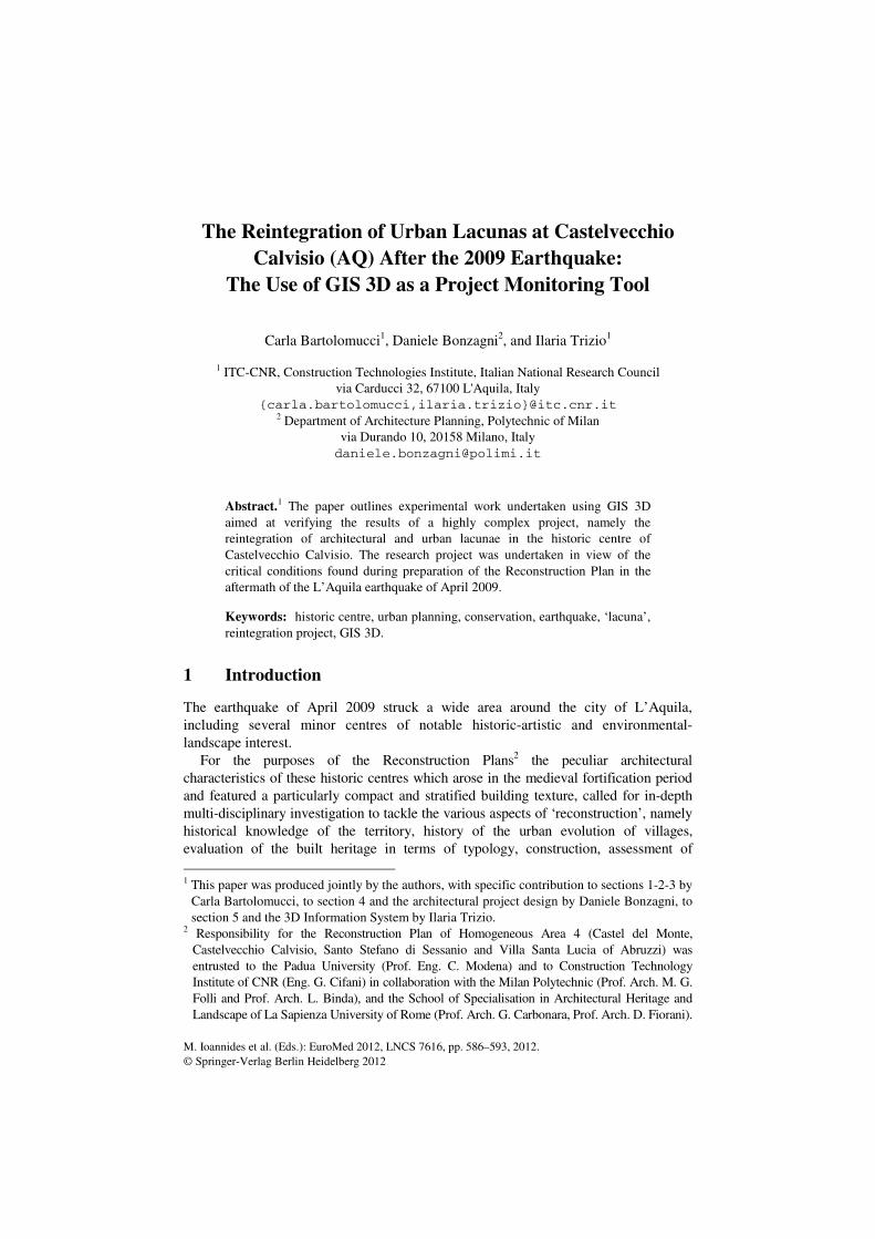
The problem of reintegrating some urban ‘lacunae’ implies the ineluctable premise of considering the entire historic core of Castelvecchio as a single ‘monument’ complex, where the missing parts are configured as lacunae of a work of art. In this sense, such lacunae break the continuity of the historic urban texture seen as unicum, adversely affecting the perception of the special features of the historic building in terms of space and layout. Although not visible from outside the town, lacunae are obvious from within, along the main road through town. Along this axis, clearly configuring the original urban core, there are a number of mutilated buildings affected by collapse following the earthquake of 1915, for which no compensation was ever made.
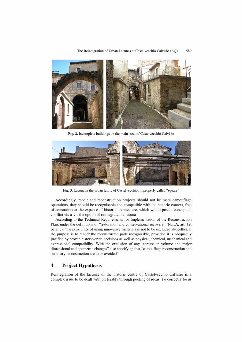
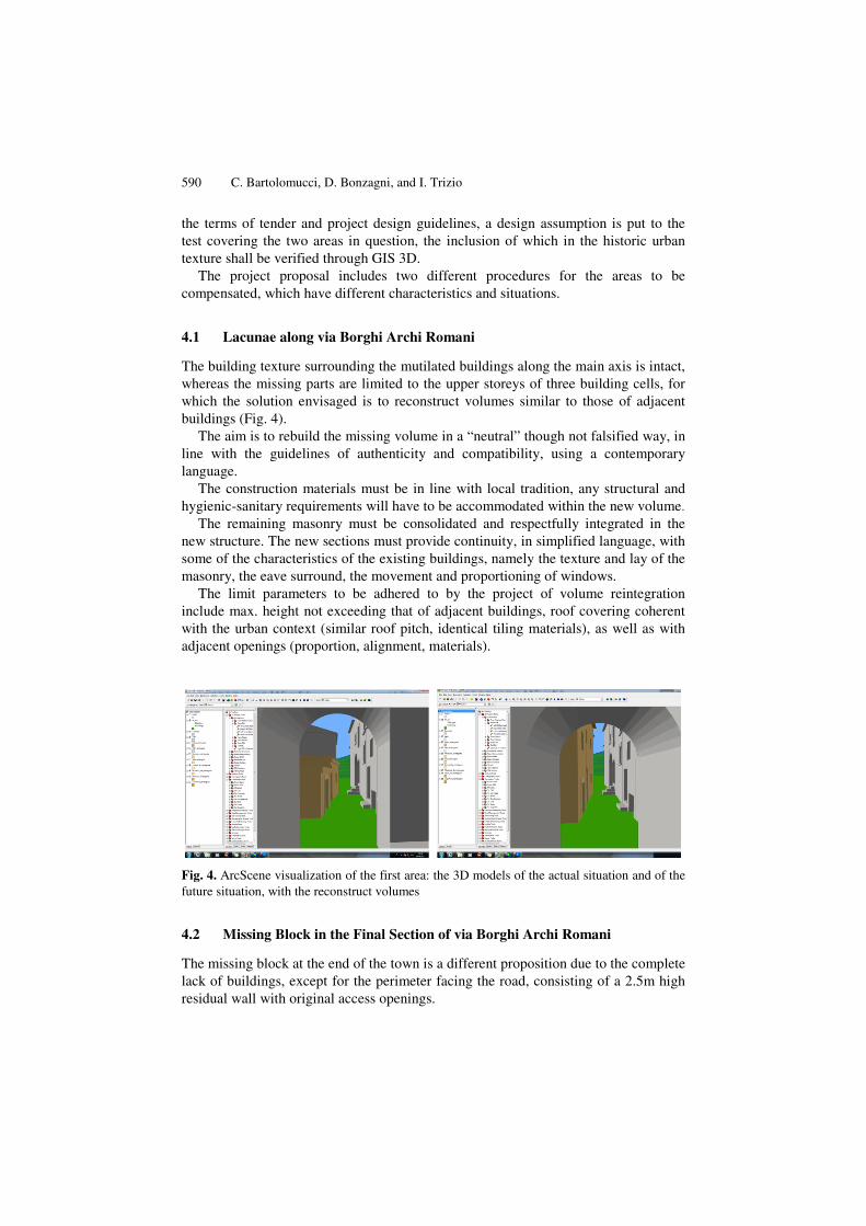
This is the situation in the initial section of via Borghi Archi Romani (the surviving ground floor of buildings and the remains of masonry of the second floor point to the original existence of an upper storey, Fig. 2) and further on in a block at the end of the road across town (where the resulting void, delimited by the remains of surviving buildings, appears an ‘interior’ in the open air improperly defined as “piazza”, Fig. 3).
In both cases the lacunae are perceived, according to the Theory of Cesare Brandi, as fully fledged “breaks in the figurative texture” obstructing the perception of the historic urban structure. 5 As the road layout defined and delimited by the buildings around it is the major feature of Castelvecchio, it is legitimate to envisage a volumetric ‘reconstruction’ exercise aimed at preventing lacunae from becoming the main factor ahead of the figurativity of the urban context.
As specified in the “Instructions for the safeguard of historic centres” (Chart of Restoration of 1972, Annex D) “not only architecture but also the town plan structure has itself significance and value. (…) Therefore, far from being confined to conservation of the formal character of individual architectural assets or single environments, restoration should be extended to protect the overall characteristics of the entire extent of the town plan including all elements which help define such characteristics”. 4 Chart of Athens, 1931; Italian Chart of Restoration, 1931; Instructions for the Restoration of
Monuments, 1938; Chart of Venice, 1964; Chart of Restoration, 1972. Annex D, Instructions for the Protection of Historic Centres, Ministry of Education Circular 117 dated 6-4-1972.
5 Cesare Brandi, Teoria del restauro (Theory of Restoration), Rome 1963, p. 18.
The Reintegration of Urban Lacunas at Castelvecchio Calvisio (AQ) 589
Fig. 2. Incomplete buildings on the main steet of Castelvecchio Calvisio
Fig. 3. Lacuna in the urban fabric of Castelvecchio, improperly called “square”
Accordingly, repair and reconstruction projects should not be mere camouflage operations, they should be recognisable and compatible with the historic context, free of constraints at the expense of historic architecture, which would pose a conceptual conflict vis-à-vis the option of reintegrate the lacuna
According to the Technical Requirements for Implementation of the Reconstruction Plan, under the definitions of “restoration and conservational recovery” (N.T.A. art. 19, para. c), “the possibility of using innovative materials is not to be excluded altogether, if the purpose is to render the reconstructed parts recognisable, provided it is adequately justified by proven historic-critic decisions as well as physical, chemical, mechanical and expressional compatibility. With the exclusion of any increase in volume and major dimensional and geometric changes” also specifying that “camouflage reconstruction and summary reconstruction are to be avoided”.
4 Project Hypothesis
Reintegration of the lacunae of the historic centre of Castelvecchio Calvisio is a complex issue to be dealt with preferably through pooling of ideas. To correctly focus
590 C. Bartolomucci, D. Bonzagni, and I. Trizio
the terms of tender and project design guidelines, a design assumption is put to the test covering the two areas in question, the inclusion of which in the historic urban texture shall be verified through GIS 3D.
The project proposal includes two different procedures for the areas to be compensated, which have different characteristics and situations.
4.1 Lacunae along via Borghi Archi Romani
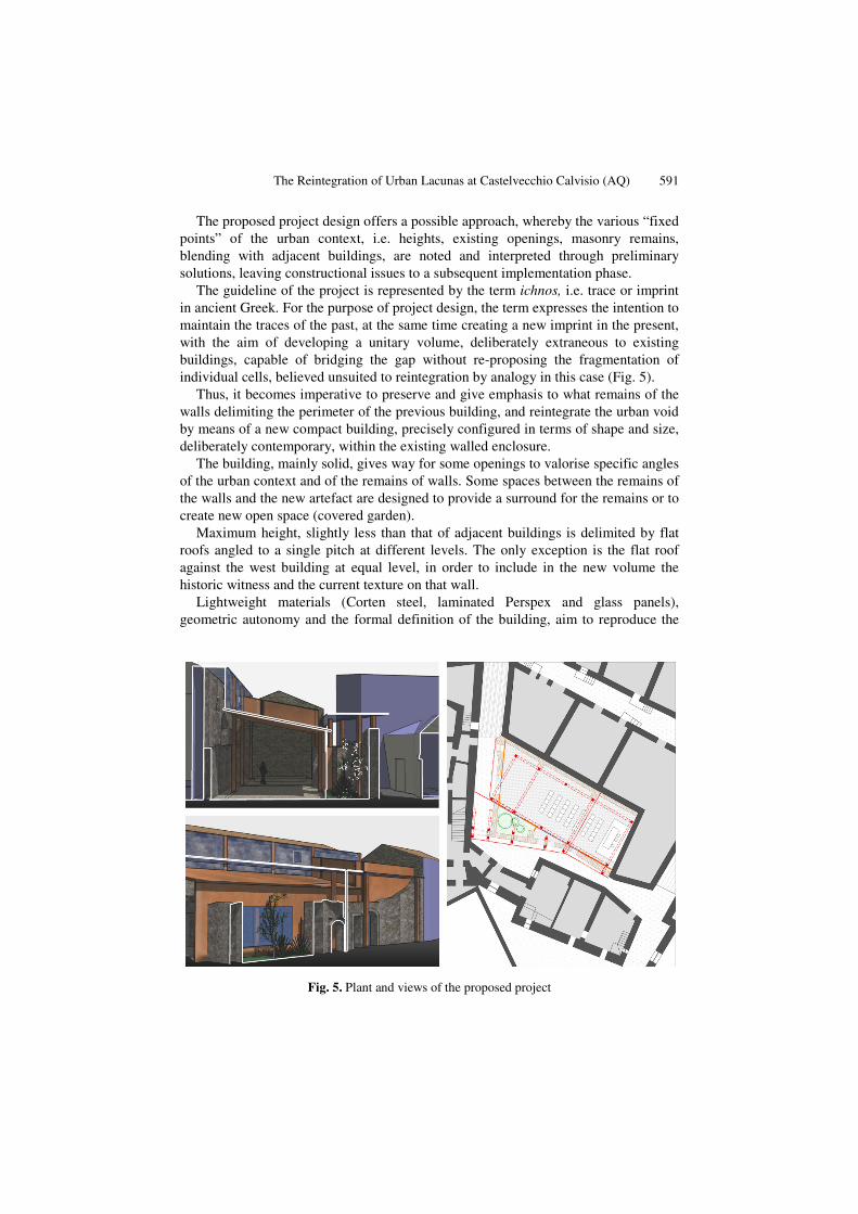
The building texture surrounding the mutilated buildings along the main axis is intact, whereas the missing parts are limited to the upper storeys of three building cells, for which the solution envisaged is to reconstruct volumes similar to those of adjacent buildings (Fig. 4).
The aim is to rebuild the missing volume in a “neutral” though not falsified way, in line with the guidelines of authenticity and compatibility, using a contemporary language.
The construction materials must be in line with local tradition, any structural and hygienic-sanitary requirements will have to be accommodated within the new volume.
The remaining masonry must be consolidated and respectfully integrated in the new structure. The new sections must provide continuity, in simplified language, with some of the characteristics of the existing buildings, namely the texture and lay of the masonry, the eave surround, the movement and proportioning of windows.
The limit parameters to be adhered to by the project of volume reintegration include max. height not exceeding that of adjacent buildings, roof covering coherent with the urban context (similar roof pitch, identical tiling materials), as well as with adjacent openings (proportion, alignment, materials).
Fig. 4. ArcScene visualization of the first area: the 3D models of the actual situation and of the future situation, with the reconstruct volumes
4.2 Missing Block in the Final Section of via Borghi Archi Romani
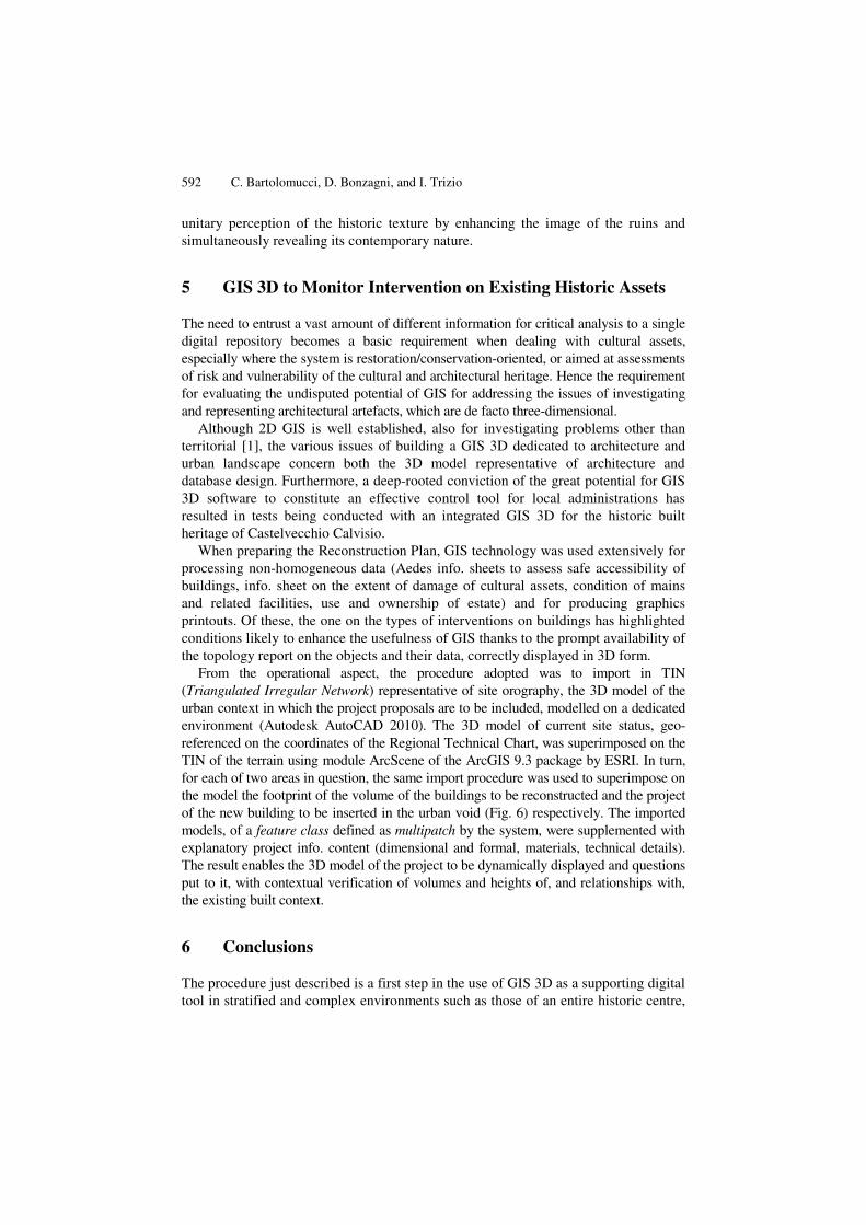
The missing block at the end of the town is a different proposition due to the complete lack of buildings, except for the perimeter facing the road, consisting of a 2.5m high residual wall with original access openings.
The Reintegration of Urban Lacunas at Castelvecchio Calvisio (AQ) 591
The proposed project design offers a possible approach, whereby the various “fixed points” of the urban context, i.e. heights, existing openings, masonry remains, blending with adjacent buildings, are noted and interpreted through preliminary solutions, leaving constructional issues to a subsequent implementation phase.
The guideline of the project is represented by the term ichnos, i.e. trace or imprint in ancient Greek. For the purpose of project design, the term expresses the intention to maintain the traces of the past, at the same time creating a new imprint in the present, with the aim of developing a unitary volume, deliberately extraneous to existing buildings, capable of bridging the gap without re-proposing the fragmentation of individual cells, believed unsuited to reintegration by analogy in this case (Fig. 5).
Thus, it becomes imperative to preserve and give emphasis to what remains of the walls delimiting the perimeter of the previous building, and reintegrate the urban void by means of a new compact building, precisely configured in terms of shape and size, deliberately contemporary, within the existing walled enclosure.
The building, mainly solid, gives way for some openings to valorise specific angles of the urban context and of the remains of walls. Some spaces between the remains of the walls and the new artefact are designed to provide a surround for the remains or to create new open space (covered garden).
Maximum height, slightly less than that of adjacent buildings is delimited by flat roofs angled to a single pitch at different levels. The only exception is the flat roof against the west building at equal level, in order to include in the new volume the historic witness and the current texture on that wall.
Lightweight materials (Corten steel, laminated Perspex and glass panels), geometric autonomy and the formal definition of the building, aim to reproduce the
Fig. 5. Plant and views of the proposed project
592 C. Bartolomucci, D. Bonzagni, and I. Trizio
unitary perception of the historic texture by enhancing the image of the ruins and simultaneously revealing its contemporary nature.
5 GIS 3D to Monitor Intervention on Existing Historic Assets
The need to entrust a vast amount of different information for critical analysis to a single digital repository becomes a basic requirement when dealing with cultural assets, especially where the system is restoration/conservation-oriented, or aimed at assessments of risk and vulnerability of the cultural and architectural heritage. Hence the requirement for evaluating the undisputed potential of GIS for addressing the issues of investigating and representing architectural artefacts, which are de facto three-dimensional.
Although 2D GIS is well established, also for investigating problems other than territorial [1], the various issues of building a GIS 3D dedicated to architecture and urban landscape concern both the 3D model representative of architecture and database design. Furthermore, a deep-rooted conviction of the great potential for GIS 3D software to constitute an effective control tool for local administrations has resulted in tests being conducted with an integrated GIS 3D for the historic built heritage of Castelvecchio Calvisio.
When preparing the Reconstruction Plan, GIS technology was used extensively for processing non-homogeneous data (Aedes info. sheets to assess safe accessibility of buildings, info. sheet on the extent of damage of cultural assets, condition of mains and related facilities, use and ownership of estate) and for producing graphics printouts. Of these, the one on the types of interventions on buildings has highlighted conditions likely to enhance the usefulness of GIS thanks to the prompt availability of the topology report on the objects and their data, correctly displayed in 3D form.
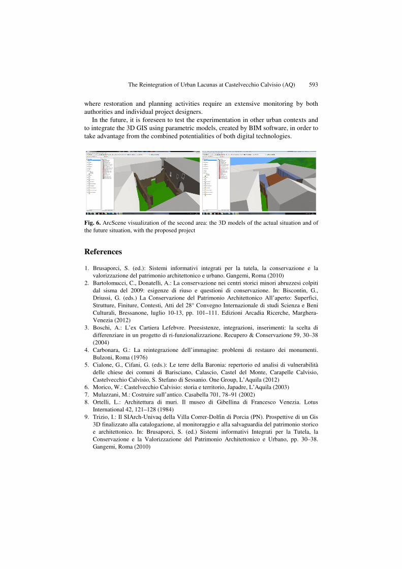
From the operational aspect, the procedure adopted was to import in TIN (Triangulated Irregular Network) representative of site orography, the 3D model of the urban context in which the project proposals are to be included, modelled on a dedicated environment (Autodesk AutoCAD 2010). The 3D model of current site status, geo-referenced on the coordinates of the Regional Technical Chart, was superimposed on the TIN of the terrain using module ArcScene of the ArcGIS 9.3 package by ESRI. In turn, for each of two areas in question, the same import procedure was used to superimpose on the model the footprint of the volume of the buildings to be reconstructed and the project of the new building to be inserted in the urban void (Fig. 6) respectively. The imported models, of a feature class defined as multipatch by the system, were supplemented with explanatory project info. content (dimensional and formal, materials, technical details). The result enables the 3D model of the project to be dynamically displayed and questions put to it, with contextual verification of volumes and heights of, and relationships with, the existing built context.
6 Conclusions
The procedure just described is a first step in the use of GIS 3D as a supporting digital tool in stratified and complex environments such as those of an entire historic centre,
The Reintegration of Urban Lacunas at Castelvecchio Calvisio (AQ) 593
where restoration and planning activities require an extensive monitoring by both authorities and individual project designers.
In the future, it is foreseen to test the experimentation in other urban contexts and to integrate the 3D GIS using parametric models, created by BIM software, in order to take advantage from the combined potentialities of both digital technologies.
Fig. 6. ArcScene visualization of the second area: the 3D models of the actual situation and of the future situation, with the proposed project
References
1. Brusaporci, S. (ed.): Sistemi informativi integrati per la tutela, la conservazione e la valorizzazione del patrimonio architettonico e urbano. Gangemi, Roma (2010)
2. Bartolomucci, C., Donatelli, A.: La conservazione nei centri storici minori abruzzesi colpiti dal sisma del 2009: esigenze di riuso e questioni di conservazione. In: Biscontin, G., Driussi, G. (eds.) La Conservazione del Patrimonio Architettonico All’aperto: Superfici, Strutture, Finiture, Contesti, Atti del 28° Convegno Internazionale di studi Scienza e Beni Culturali, Bressanone, luglio 10-13, pp. 101–111. Edizioni Arcadia Ricerche, Marghera-Venezia (2012)
3. Boschi, A.: L’ex Cartiera Lefebvre. Preesistenze, integrazioni, inserimenti: la scelta di differenziare in un progetto di ri-funzionalizzazione. Recupero & Conservazione 59, 30–38 (2004)
4. Carbonara, G.: La reintegrazione dell’immagine: problemi di restauro dei monumenti. Bulzoni, Roma (1976)
5. Cialone, G., Cifani, G. (eds.): Le terre della Baronia: repertorio ed analisi di vulnerabilità delle chiese dei comuni di Barisciano, Calascio, Castel del Monte, Carapelle Calvisio, Castelvecchio Calvisio, S. Stefano di Sessanio. One Group, L’Aquila (2012)
6. Morico, W.: Castelvecchio Calvisio: storia e territorio, Japadre, L’Aquila (2003) 7. Mulazzani, M.: Costruire sull’antico. Casabella 701, 78–91 (2002) 8. Ortelli, L.: Architettura di muri. Il museo di Gibellina di Francesco Venezia. Lotus
International 42, 121–128 (1984) 9. Trizio, I.: Il SIArch-Univaq della Villa Correr-Dolfin di Porcia (PN). Prospettive di un Gis
3D finalizzato alla catalogazione, al monitoraggio e alla salvaguardia del patrimonio storico e architettonico. In: Brusaporci, S. (ed.) Sistemi informativi Integrati per la Tutela, la Conservazione e la Valorizzazione del Patrimonio Architettonico e Urbano, pp. 30–38. Gangemi, Roma (2010)