Ferdinand Lessek - Pravěk Podkarpatské Rusi ( Ferdinand Lessek - Prehistory Ruthenia)
Journal of World Prehistory, Vol. 18, No. 1, March 2004 ( C© 2004)
The Prehistory of the Tibetan Plateauto the Seventh Century A.D.: Perspectivesand Research From China and the West Since 1950
Mark Aldenderfer1,3 and Zhang Yinong2
Until recently, there has been no sense of a Tibetan prehistory. Beginning inthe 1970s, however, Chinese archaeologists began to systematically explorethe plateau, and began to draw an outline of the deep Tibetan past. The paceof research accelerated rapidly in the 1990s, which brought this outline intosharper focus. This paper reviews what is known of Tibetan prehistory untilthe seventh century A.D., when the Tibetan empire was established. Topicscovered in this paper include a consideration of the antiquity of a humanpresence upon the plateau, changing adaptive strategies following the end ofthe glacial epoch, the advent of the Neolithic, and the emergence of socialand political complexity. Despite significant advances in our knowledge ofthe Tibetan past, much work remains to be done before models of processcan be examined in any detail.
KEY WORDS: Tibetan plateau; prehistory; adaptation to high elevation; China.
This paper is meant to introduce to the western world the archaeo-logical research performed on the Tibetan plateau by Chinese and west-ern archaeologists. The highest land on the earth, the Tibetan plateau, hasonly been systematically examined through the lens of modern archaeolog-ical theory and techniques and state support after its incorporation into thePeople’s Republic of China in 1950. Prior to this, the only archaeologicalinformation about the plateau proper available to the west consisted of thereports of western explorers, such as Roerich (1930), who remarked upon
1Department of Anthropology, University of California, Santa Barbara, California.2Department of Anthropology, Cornell University, Ithaca, New York.3To whom correspondence should be addressed at Department of Anthropology, Universityof California, Santa Barbara, California 93106-3210; e-mail: [email protected].
1
0892-7537/04/0300-0001/0 C© 2004 Springer Science+Business Media, Inc.
2 Aldenderfer and Zhang
archaeological sites he saw while on his Central Asian explorations, briefanecdotes about archaeological discoveries noted by Aufschneider (1956)during his stay in Lhasa in the 1940s, fragmentary and often inaccuratereports on ancient monuments by Christian missionaries, colonial officials(primarily from British India), and adventurers, and finally, more system-atic research by Tibetologists, such as Giuseppe Tucci, who made a numberof journeys across Tibet in the early twentieth century, and who remarkedupon the monuments, sites, and ruins of pre-Buddhist cultures and thoserelated to Tibetan Buddhism (see, for example, Tucci, 1950). In effect, untilthe latter part of the twentieth century, there was no real sense of a Tibetanprehistory, and there was certainly no significant empirical basis upon whichto develop one.
The geographical scope of this paper is primarily inside China, whichincludes most of the Tibetan plateau. Likewise, the materials and conclu-sions discussed here have been formed primarily upon the basis of Chinesearchaeological efforts after 1950. Archaeological research and culturalrelics surveys have been done in Tibet on a general and systematic basisfrom the stone tools of Paleolithic sites to Buddhist statues in a renovatedmonastery. Since this paper is concentrated on the prehistory of Tibetanplateau our review concludes in the mid-seventh century (c. A.D. 627), thedate of the ascendance of Songsten Gampo to the throne of Tibetan king-ship. His reign marks the creation of the Tibetan Empire, which grew overthe next 200 years to control the entire plateau, the fabulously wealth SilkRoad, parts of western China (including for a brief time the seat of Hanpower, Xi’an), and much of central Asia (Beckwith, 1987). We will thus notdiscuss the material remains of Tibetan Buddhism and its related art his-torical objects that mostly appear in the period after the seventh century.Western sources on the archaeology of the plateau will also be discussed,but as will be seen, there have been no western-sponsored archaeologicalprojects, and very little participation by westerners in empirical research onthe plateau until the late 1990s.
THE POLITICAL AND ACADEMIC STRUCTUREOF ARCHAEOLOGY IN CHINA AND TIBET
For the sake of a general understanding the archaeology of Tibetanplateau in China and particularly the terms and usage in this article, it isnecessary to make clear some possible confusions of the use of the term“Tibet” as well as in the nomenclature and organization of the administra-tive system for cultural resources in contemporary Tibet, which is currentlybased on Chinese ideology.
The Prehistory of the Tibetan Plateau to the Seventh Century A.D. 3
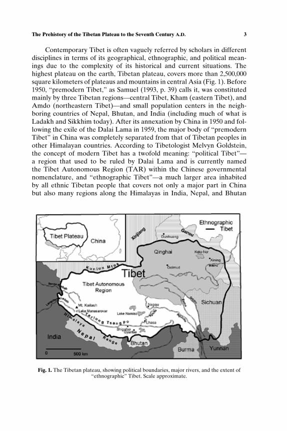
Contemporary Tibet is often vaguely referred by scholars in differentdisciplines in terms of its geographical, ethnographic, and political mean-ings due to the complexity of its historical and current situations. Thehighest plateau on the earth, Tibetan plateau, covers more than 2,500,000square kilometers of plateaus and mountains in central Asia (Fig. 1). Before1950, “premodern Tibet,” as Samuel (1993, p. 39) calls it, was constitutedmainly by three Tibetan regions—central Tibet, Kham (eastern Tibet), andAmdo (northeastern Tibet)—and small population centers in the neigh-boring countries of Nepal, Bhutan, and India (including much of what isLadakh and Sikkhim today). After its annexation by China in 1950 and fol-lowing the exile of the Dalai Lama in 1959, the major body of “premodernTibet” in China was completely separated from that of Tibetan peoples inother Himalayan countries. According to Tibetologist Melvyn Goldstein,the concept of modern Tibet has a twofold meaning: “political Tibet”—a region that used to be ruled by Dalai Lama and is currently namedthe Tibet Autonomous Region (TAR) within the Chinese governmentalnomenclature, and “ethnographic Tibet”—a much larger area inhabitedby all ethnic Tibetan people that covers not only a major part in Chinabut also many regions along the Himalayas in India, Nepal, and Bhutan
Fig. 1. The Tibetan plateau, showing political boundaries, major rivers, and the extent of“ethnographic” Tibet. Scale approximate.
4 Aldenderfer and Zhang
(Goldstein and Kapstein, 1998, p. 4). While Tibet is still in many areas re-ferred to by some scholars by its former integrity and traditional division,it has been reorganized and fragmented into several parts in China. Theseparts eventually fell into five contemporary Chinese provinces, includingthe TAR, Qinghai, Gansu, Sichuan, and Yunnan (Fig. 1). With the excep-tion of the TAR, Tibetan territory and population only constitute a smallpart in each of the other four Chinese provinces (Goldstein, 1997; Tsering,1999).
Archaeology in China is administrated by two parallel hierarchies. Oneis a line from the national Cultural Relics Bureau (Chi: guo-jia-wen-wu-ju)to each provincial/regional/city/county Cultural Relics Bureau/Committee.This bureaucracy controls most of the administrative matters related to ar-chaeology within its geographical or administrative scope. Given the cen-tripetal nature of Chinese power structure, each subinstitution is directlycontrolled by its upper ones in terms of its administration and economic re-sources. They do not necessarily have cooperative relations with a parallelinstitution. The other hierarchy is composed of the archaeological institu-tions and archaeology departments in universities usually located eitherin Beijing or in one of the five Tibetan related provinces. These include,for example, the Center for Tibetan Studies at Sichuan University andthe Institute of Archaeology at Beijing University, which has a programof Tibetan archaeology. Because of the regional division of Tibetan areastudies, as well as different hierarchical reporting structures (i.e. some unitsmay report to the Ministry of Education, while others report to the ChineseAcademy of Social Science), there is usually little communication amongthese academic units. A comprehensive concept of a “pan-Tibetan” re-search program is strictly prohibited ideologically and academically sinceit is easily connected to issues related to Tibet’s premodern integrity andthe contemporary independence discourse outside China. Although theseinstitutions are often constituted by both Chinese and Tibetan cadres, all re-search should be published in Chinese—therefore forcing all Tibetan names(including those of places and persons) into a Chinese transliteration system(pinyin) which often makes it hard to trace back the original names on mapsand in documents.
Before the 1980s, research conducted on the Tibetan plateau wasmostly devoted to natural science under the authority of the ChineseAcademy of Science and supported by the Chinese government. The onlyexception was the national ethnic identification survey, a nationwide sur-vey of all minority groups (i.e. non-Han) during 1950s and 1960s. Its intel-lectual basis was the Marxist–Leninist ideology of nationalities. During the1980s with the relative relaxation of political control and an introductionof a market-oriented economy, most archaeological institutions lost their
The Prehistory of the Tibetan Plateau to the Seventh Century A.D. 5
economic security and the political advantages they once had in the state-planned economy. The politics of archaeology have since then become acompetition for economic resources, usually from a series of state sources,such as the Ministry of Education, Academy of Social Sciences, Academyof Science, and other groups.
Within the TAR, archaeology is administered by the Tibetan Bureauof Cultural Relics (TBCR), which maintains a list of major sites foundwithin its territory. As of 2002, this inventory included approximately 1800sites. The majority of these are not archaeological, and are instead placesof historical and cultural significance. For instance, the Johkang Temple inLhasa, founded in A.D. 639, is on the list, as are the Potala Palace, the Norbu-lingka, and Ganden monastery (which is mostly in ruins). Not surprisingly,much of the effort of the TBCR is devoted to the preservation and restora-tion of Tibetan Buddhist sites and centers. Many once-active monastic andtemple institutions were destroyed during the Chinese Cultural Revolution(1966–1976), and thus became part of the archaeological record. Those ar-tifacts that were not destroyed during this period were warehoused in otherparts of China or were sold abroad on the legal and illegal art markets.Some of these centers are now being restored to their former glory, such asthe major temple complex at Tholing in western Tibet (Vitali, 2000), andsome artifacts are slowly returning to their original homes. Sites of earliertime periods did not suffer the same damage simply because so few wereknown and they were for the most part unrecognized or had no obvious ide-ological connotations. However, inadvertent destruction of even these ar-chaeological sites is becoming more common as populations expand acrossthe plateau. Also, the systematic looting of tombs of all periods by armedbands is becoming increasing common, especially in Qinghai and easternTibet. The chronically understaffed TBCR has found it difficult to managethe huge numbers of sites under its domain under these circumstances.
The TBCR employs a number of archaeologists, both Tibetan andChinese. Some of these researchers have the equivalent of a westernMaster’s degree, but there is presently no PhD-level archaeologist in thebureaucracy (although some are currently enrolled in such a program inHong Kong), and neither are there any western-trained scholars on thestaff. Typical staff duties include participating in archaeological projectsas official observers, evaluation of newly reported sites, and preservation-related tasks. Some local branches of the TBCR (at the county level in theTAR) have in fact initiated salvage projects and have conducted excava-tions. The TBCR does not itself sponsor field research projects, but insteadprovides local project approval and coordination, reviews reports, overseescuration and warehousing of materials recovered through excavation, anddirects conservation efforts.
6 Aldenderfer and Zhang
In 1999, the Tibet Museum opened its doors in Lhasa. Prior to this,there was no public institution that displayed artifacts or information aboutTibet’s past within the TAR. The museum employs a small number ofarchaeologists who are primarily responsible for developing displays, al-though they have recently begun to initiate small-scale research projectsand conduct site evaluations of newly located materials. At present, thereis limited cooperation between the museum, the TBCR, and researchprojects, but plans are being considered that would expand the museum’srole in regional research and interpretation.
The complexity and paradox in contemporary Tibet (Goldstein andKapstein, 1998) create both ironies and possibilities for a new archaeologyon this high plateau which leaves spaces not only for Chinese and westernscholars but also for Tibetans themselves. For instance, calls for thedevelopment of a new Tibetan ethnic identity in the wake of global move-ment of Tibetan independence and the Tibetan diaspora have resonatedin archaeological circles in Tibet. As recently advocated by Jiayang—aTibetan scholar who was until recently the director of Tibetan CulturalRelics Bureau—“the archaeology of Tibet needs a broader academic scopein which Tibet is not isolated from the rest of Asian cultures such as China,India, or other parts of the Himalayas” (Jiayang and Huo, 2001, p. 3).The underlying sentiment of Tibetan identity ironically coincides with theChinese official discourse of “connection of the tracks” and its interest inapproaching international academic and intellectual standards. There arecurrently ongoing negotiations directed at sending Tibetan students to thewest to study archaeology as a part of this desire for “connection of thetracks.” How this will play out in both political and academic matters is asource of considerable anxiety in TAR, China, and the west.
MODERN ECOLOGY AND PALEOENVIRONMENTS
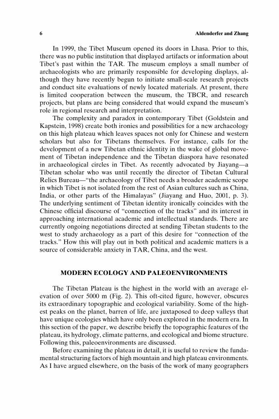
The Tibetan Plateau is the highest in the world with an average el-evation of over 5000 m (Fig. 2). This oft-cited figure, however, obscuresits extraordinary topographic and ecological variability. Some of the high-est peaks on the planet, barren of life, are juxtaposed to deep valleys thathave unique ecologies which have only been explored in the modern era. Inthis section of the paper, we describe briefly the topographic features of theplateau, its hydrology, climate patterns, and ecological and biome structure.Following this, paleoenvironments are discussed.
Before examining the plateau in detail, it is useful to review the funda-mental structuring factors of high mountain and high plateau environments.As I have argued elsewhere, on the basis of the work of many geographers
The Prehistory of the Tibetan Plateau to the Seventh Century A.D. 7
Fig. 2. Major topographic features of the Tibetan plateau. 1: Himalayas; 2: Karakorams andPamirs; 3: Kunlun Shan; 4: Arjin Shan; 5: Taklamakan Desert; 6: Qaidam Basin; 7: QilianShan; 8: Qinghai Hu (Lake Koko Nor); 9: Heixi (Gansu) corridor; 10: Chang Tang. Scaleapproximate.
and ecologists, these environments are characterized by environmental het-erogeneity, extremeness, low predictability, low primary productivity, andhigh instability and fragility (Aldenderfer, 1998, pp. 2–4). Highly dissectedtopography, combined with altitudinal effects, creates a patchy mosaic ofjuxtaposed microenvironments with varied spatial and temporal extents.Extremeness (high absolute elevations, very low temperatures, etc.) exac-erbates this variability. Low predictability is the degree to which key en-vironmental features have a predictable periodicity. High mountains andplateaus are usually characterized by low predictability. Low primary pro-ductivity is typical of high plateaus and mountains since they tend to bequite cold and depending on location, often quite dry. Finally, these en-vironments are highly unstable, with significant risk of hazard such as mas-sive erosion and damaging seismic activity. Resource patches are frequentlydestroyed though these events.
On the basis of these criteria, the Tibetan plateau is among the most ex-treme and difficult highland environments on the planet. It is fundamentallya cold, alpine environment where the average temperature in the warmestmonth is not more than 10◦C, and only three portions of the plateau—the Yarlung Tsangpo, Senge Khebab, and Langchen Khebab river valleys,are not alpine by this definition. Since the plateau mostly lies between 30and 35◦N latitude, seasonal climatic variation is strong, with a moderatelylong winter and relatively short summer, both of which are in great part
8 Aldenderfer and Zhang
contingent upon altitudinal zonation. Unlike many tropical high mountainand plateau regions, this strong seasonal variability on the Tibetan plateauimproves the predictability of precipitation to an extent.
Topography
The plateau, created largely by the collision of the northward drift ofwhat was to become the Indian subcontinent and the land mass of what wasto become Asia some 40–50 million years ago (mya), apparently reachedits modern elevation by at least 8 mya, and probably substantially earlier(Rowley et al., 2001). The Himalayas, the highest mountain range in theworld and which stretches in a vast arc along the southern margin of theplateau, were created in this ancient collision. The western and northwest-ern margins of the plateau are formed by the Karakorams and the Pamirs,which are almost as high as the Himalayas. Although these ranges arecut through by a number of large rivers, and can be traversed over veryhigh mountain passes, the combination of high elevation and extreme topo-graphic ruggedness make access to the southern and western regions of theplateau from these directions quite difficult. The northwestern boundary ofthe plateau is marked by the somewhat lower Kunlun Shan, which transi-tions into the Arjin Shan along the north-central margins of the plateau.The northeastern margin of the plateau is defined by a series of relativelylow, parallel mountain ranges, with the Qilian Shan the northernmost ofthese. In general, these northern ranges are much lower than those to thesouth and west, and do not present as much difficulty for transit. How-ever, as will be shown below, other topographic factors make this region aharsh environment. Finally, the eastern boundary of the plateau is markedby a series of northwest-southeast trending ranges created by major riversthat descend from the interior of the plateau into north-central China aswell as southeast Asia. These valley systems are very deep and narrow,and rise precipitously toward the plateau. The extreme northeastern cornerof the plateau contains the so-called Hexi (or Gansu) Corridor, where theMachu (Huang He or Yellow) River valley cuts through the mountains, andwhich affords relatively easy access to the interior of the plateau from thesteppelands to the north.
The interior of the plateau is divided by other, smaller mountain rangesthat generally run east-west. These ranges define four other major topo-graphic features: the long, relatively narrow Yarlung Tsangpo valley insouthern Tibet, the large, arid Chang Tang (Tib: byang thang) rangelandthat dominates most of the interior of the plateau, the Qaidam Basin,and the Qinghai Hu Basin, both located in the northeastern corner of theplateau.

The Prehistory of the Tibetan Plateau to the Seventh Century A.D. 9
The Yarlung Tsangpo valley and that of its major tributary drainagethe Kyichu, as well as those of numerous smaller rivers, form the modernagricultural heartland of the plateau. Elevations of the relatively flat valleyfloors range from 3700 to 3900 masl. The valley is arid to the west, and grad-ually becomes wetter toward the east. The gradient of the river is gentle,and except in deep gorges, the river and its tributaries tend to form broad,shallow, braided channels.
Surrounding these valleys are low foothills and sometimes very steepmountainsides. The Yarlung Tsangpo courses through a very narrow gorgebetween the two major population centers of Lhasa and Shigatse. As theriver flows to the east, it again enters a very deep (over 5200 masl in depth),almost impassable, canyon that contains a unique ecology.
In contrast, the Chang Tang is an arid, rolling tableland dotted withlakes, some with areas as large as 1000 km2. The elevation of the southernChang Tang ranges from 4300 to 4500 masl, while in the north, it rangesfrom 4500 to 5000 masl. As described by Schaller (1998, p. 26), “The terrainvaries from valleys hemmed in by rugged ranges, and rolling hills separatedby broad, shallow valleys, to enormous flats, the landscape becoming morespacious and higher from south to north.” Vegetation is sparse, and mostof the region is barren rock and soil, but in some places, high groundwatertables create large expanses of grazing lands.
The Qaidam Basin is a vast depression (when compared to the rest ofthe plateau) that ranges in elevation from 2600 to 3000 masl. Although alake once existed in the basin during the Oligocene, during the Pleistocene,it was large and arid (Hanson et al., 2001). Today it contains a number ofsmall lakes as well as large marshlands that serve as the source of the MachuRiver. However, the western half of the Qaidam is quite arid, and is coveredin varying degrees with shifting, blowing sands, gravel outcrops, and in someplaces, thick deposits of salts. Small oases fed by glacial meltwaters dot thenorthern margins of the basin.
The Qinghai Hu basin, at 3200 masl, is a large grassland surround-ing Koko Nor (or Qinghai) Lake. The terrain here is gently rolling, andvegetation more extensive. The lake itself is brackish.
Hydrology
Although best characterized as an arid environment, the plateau is thesource to a number of major river systems for the Indian subcontinent,southeast Asia, and China. In the west, the headwaters of the Senge Khebab(Indus), and one of its major tributaries, the Langchen Khebab (Sutlej),are found on the plateau. We have already seen that the headwaters of the
10 Aldenderfer and Zhang
Machu (Huang He) are found in northeastern Tibet. In the east, four majorrivers originate on the plateau. From south to north, they are the YarlungTsangpo (Bramaputra), Ngulchu (Salween), Zachu (Mekong), and Drichu(Yangtze). The flow from these rivers is massive; almost 28% of the waterbudget of China comes from the plateau, as does 34% of that of the Indiansubcontinent.
Over 2000 lakes of all sizes are found on the plateau, mostly in theChang Tang. The majority of these were formed during the glacial epochand are now fed primarily by glacial meltwaters or in the southern ChangTang, by convective and some monsoonal rains. As a result of their ori-gins, few have external outlets, and as a consequence, many have brack-ish or saline waters. Vast salt flats surround some of these lakes, and min-ing salt for trade primarily to the Indian subcontinent has a long history.These lakes, because of their characteristics and antiquity, are importantdata sources for tracking paleoenvironmental variability on the plateau, andconsequently, they have been the focus of intensive limnological analysis. Anumber of lakes have sacred significance, probably of great antiquity. Per-haps the most important of these is Lake Mapham (Manasarowar), whichis near the famous Mt. Tise (Kailash). Both of these geographical featuresare sacred to Tibetan Buddhists as well as Hindus, and are still today thescene of pilgrimage.
Climate
The influence of the Tibetan plateau on global climate patterns iswidely recognized (Lehmkuhl and Haselein, 2000). The height and massof the plateau affect the course of the jet stream, and this has implica-tions for other major wind patterns and weather systems at both regionaland global scales. Overall, rainfall intensity and humidity decrease fromeast to west and south to north. The formation of the plateau 8 mya cre-ated the conditions for the development of the SE Asian summer monsoonand the winter monsoon. The summer monsoon brings moisture to southAsia from across the eastern Indian Ocean as well as the Bay of Bengal,which is the primary source of the southwest Indian Monsoon (Overpecket al., 1996). It brings significant summer rainfall to the southeasternplateau. However, the Himalayas act as a barrier to this moisture, and theycreate a rain shadow along their northern margins. Storms traveling up themajor valley systems penetrate furthest into the plateau. Summer climatein eastern Tibet is also wet, created in this case by the major low-pressuresystem that develops seasonally near the source of the Machu and Drichurivers. Some summer storms cross into western Tibet from the south, but

The Prehistory of the Tibetan Plateau to the Seventh Century A.D. 11
for the most part, these storms do not penetrate deeply into the plateau,leaving most of the Chang Tang and the Qaidam Basin semiarid to arid.Winter weather patterns are dominated by the prevailing westerlies, whichare split by the mass of the plateau and Karakorams into two streams.Most of the plateau lies within the rain shadow of these winds, and conse-quently, very little moisture reaches it. Winters tend to be cold and severe,with the most frigid temperatures in the northwest and the warmest in thesoutheast.
Ecology and Biome Structure
Most authors agree that the plateau consists of 11 biomes which can beplaced into three broad altitudinal zones (Chang, 1981; Ni, 2000; Schaller,1998; Table I; see Fig. 3). Ecological structure is strongly determined bylatitude and elevation, which in turn affect precipitation. The plateau is acomplex mix of biomes, but generally, the northeast and the southwest havethe greatest complexity, species diversity, and primary productivity. In con-trast, most of the central and western portions of the plateau are quite aridand cold, and therefore have limited species diversity and productivity. Thenorth-central plateau is also home to year-round permafrost, as are someof the high peaks in the west, south, and northeast. The remainder of theplateau, aside from the Yarlung Tsangpo valley and the upper reaches ofthe Ngulchu, Zachu, and Machu rivers, is subject to seasonal frozen ground(Jian, 2000, p. 82). In short, the bulk of the plateau has very low primaryproductivity, rendering much of it useful only for pastoral pursuits today, oragriculture that is heavily dependent upon irrigation in less frigid regions.However, it is important to remember that like any high elevation environ-ment, it is also very patchy, and resources are distributed asymmetrically inboth time and space.
Table I. Modern Biome Structure of the Tibetan Plateau (from Ni, 2000)
Biome Altitudinal zone
Temperate/subalpine coniferous forest <4000 maslTemperate/subalpine deciduous forest <4000 maslTemperate/subalpine broadleaf/deciduous forest <4000 maslTropical/subtropical seasonal and rain forest <4000 maslTemperate shrublands/steppe <4000 maslTemperate steppe <4000 maslTemperate desert <4000 maslAlpine meadows/shrublands 4000–5200 maslAlpine steppe 4000–5200 maslAlpine desert 4000–5200 maslIce/polar desert >5200 masl
12 Aldenderfer and Zhang
Fig. 3. Major biomes of the Tibetan plateau (after Ni, 2000). 1: Temperate conifer forest; 2:temperate deciduous forest; 3: temperate broadleaf evergreen forest; 4: tropical seasonalrainforest; 5: temperate shrublands/meadow; 6: temperate steppe; 7: temperate desert; 8:alpine meadow/shurbland; 9: alpine steppe; 10: alpine desert. Scale approximate.
Paleoenvironments
Some authors have speculated on a deep antiquity for a human pres-ence on the Tibetan plateau (discussed in greater detail below), but there isno convincing evidence of one until late in the Pleistocene. Therefore, ourreview of paleoclimates of the plateau begins at 50,000 B.P.
Although data are sparse, at 50,000 B.P. the plateau was dominatedby the climatic conditions associated with the end of OIS (oxygen isotopestage) 4, a period of glacial advance that was cold and arid (Lehmkuhl andHaselein, 2000). Temperatures were colder than in the modern era, andsurface water would have been very scarce. Vegetation would have beensparse, and there would have been considerable areas of barren ground,gravel, and rock across much of the plateau. Most of the mountain peaks ofthe plateau were covered by glacial ice of limited extent (Lehmkuhl, 1997,1998; Zheng and Rutter, 1998). However, large areas around these moun-tain ranges would have been periglacial in character, and surrounding val-ley systems would have been subject to severe wind chill. Although beingmindful of the complexity of ecological structure on the plateau, much of itis best described as a hyperarid, cold desert at this time.
Between 50,000 and 25,000 B.P. (OIS 3), climatic conditions across theplateau improved. Glacial ice at high elevations retreated substantially, and
The Prehistory of the Tibetan Plateau to the Seventh Century A.D. 13
rising lake levels in most areas of the plateau indicate a significant increasein precipitation (Lehmkuhl and Haselein, 2000). It is reasonable to inferthat temperatures also increased. As these processes unfolded, desert gaveway to steppe formations across the plateau, substantially increasing pri-mary productivity. This in turn would have led to the expansion in rangeand numbers of the large ungulates native to the plateau. Importantly, theseimproved conditions may have ameliorated the extreme aridity of the largedesert basins just to the north of the plateau (the Taklamakan and Gobideserts), thus making movement onto the plateau from the north morefeasible.
Glaciers resumed their advance after 25,000 B.P., signaling a return toarid and cold conditions across the entire plateau. Some authors, most no-tably Kuhle (1988, 1998) have argued for the presence of a massive ice capon the entire plateau during Last Glacial Maximum (LGM) times (22,000–18,000 B.P.). More recent multidisciplinary research has shown, however,that no such ice cap existed at any time in the LGM or Holocene, and thatglacial advances during this period were purely “local” and no more ex-tensive than the glaciers of the OIS 4 advance (Schafer et al., 2002; Zhengand Rutter, 1998). Although no ice cap existed, there is no question thatplateau climate deteriorated substantially during the LGM. There is goodevidence that the summer monsoon weakened considerably, thereby pre-venting precipitation from reaching much of the plateau (Schafer et al.,2002). Glacial lakes that had reached their maximum extents during OIS 3dropped rapidly in level. Desert once again replaced steppe, and the plateauonce again became a cold, arid desert. Some climate models suggest that an-nual mean temperatures on the plateau ranged from 13 to 2◦C lower than inthe modern era (Liu et al., 2002), conditions harsher than at any time dur-ing the Late Pleistocene. This, coupled with increased aridity, would havesubstantially decreased primary productivity in most plateau biomes.
The LGM signals the start of a gradual process of desiccation across theplateau that extends throughout the Holocene. However, this general trendis marked by local and regional reversals as well as periods of intensificationof the process. For instance, the Qaidam and Qinghai basins experienced aperiod of hyperaridity from 15,000 to 9000 B.P. followed by somewhat lessarid conditions in the Holocene. The north-central margins of the plateausaw extensive dune formation from 15,000 to 13,000 B.P.. However, the east-ern portion of the plateau became more humid and warmer from 13,000to 10,000 B.P. due to the reinforcement of the Pacific summer monsoon(Lehmkuhl and Haselein, 2000), and this supported the growth and expan-sion of spruce/fir/pine forests, especially in the valley systems that descendto the southeast (Ren and Beug, 2002). Although data are sparse, there isthe high probability that broadleaf forest also expanded in the valleys of
14 Aldenderfer and Zhang
southwestern Tibet at this time. In contrast, western Tibet remained ariduntil roughly 10,000 B.P. when a major climatic reversal appeared, creatingwarm and wet conditions until 9500 B.P.. Arid conditions returned and in-tensified until 4000–3000 B.P., but were interrupted twice by wet pulses at9500–8700 and 7200–6300 B.P. (Gasse et al., 1996). These pulses apparentlystimulated the return of small groves of spruce and fir in sheltered loca-tions and where soil humidity was sufficient. Records of these wet pulseshave been recorded for central and northeastern Tibet as well. Tempera-tures during this period are believed to have been 3–4◦C warmer than thepresent.
At 6000 B.P., forests on the plateau begin to contract, a pattern also seenthrough much of China. Ren (2000) attributes this contraction to humanagency, specifically the expansion of agriculture. Although archaeologicaldata from the plateau for this time period are very thin, the timing of forestreduction is consistent with what appears to be the expansion of a Neolithiccultural “package” in the major river valleys of the eastern plateau. Climatechange, though, cannot be discounted as a correlative factor, since rainfalldiminished and colder temperatures were seen on the plateau after 3000 B.P.
(Miehe, 1996).
THE ARCHAEOLOGY OF THE PLATEAU
Despite more than 50 years of research on the plateau, it remains thecase that we are still ignorant of many of the important historical, evolution-ary, and social processes and events that took place upon it through time. Inthis section of the paper, after a brief discussion of research strategies, wewill examine the state of knowledge on the following research themes: thetiming of a human presence of the plateau and the changing adaptive strate-gies of these early foraging peoples, the appearance of Neolithic cultures,and the emergence of cultural complexity. Not surprisingly, these questionswill follow a roughly chronological sequence, and include the Paleolithic,Mesolithic (or what passes for it on the plateau), Neolithic, and historic (asdefined by Chinese scholars) periods.
Research Strategies
Archaeology in China is closely associated with historiography, and anumber of authors have noted that archaeology, except when dealing withthe Paleolithic period, is essentially a tool used to verify and examine his-torical events (Chang, 1981; Von Falkenhausen, 1993). This relationship
The Prehistory of the Tibetan Plateau to the Seventh Century A.D. 15
has a deep antiquity in China’s past, and has clearly had a significant in-fluence on the way in which archaeological research has been conducted.Problem-oriented research as defined in the west is virtually unknown inChina, where “problem” is narrowly defined in historical terms. Excava-tion to verify history is the primary research method of archaeology. Al-though full-coverage archaeological surveys have been performed in China(e.g., Underhill et al., 2002), none has yet been attempted in Tibet. Most ofthe archaeological surveys and excavations in China, including Tibet, hasbeen directed by a follow-up working orientation, such as salvage conser-vation of an early or recently looted tomb, or cleaning up a site exposedby a road construction. Furthermore, the fact that parallel institutions (i.e.two different provincial archaeological institutions) have little communi-cation or cooperation also prevents the idea of problem-oriented researchon a general scale. The Chinese Academy of Science conducted a seriesof natural science reconnaissance surveys on the plateau during the 1960sand 1970s which did find early sites, but none had archaeologists as mem-bers of such teams until the late 1970s (Huang, 1994, p. 204). Thus it is notsurprising that archaeology on the plateau, then, has been overwhelminglysite focused. In addition to history-focused projects, a number of major ex-cavation programs have been driven by conservation or salvage consider-ations, and these have often played a role in the Chinese nation-buildingenterprise. For example, from 1996 to 1998, the Shaanxi Archaeological In-stitute conducted extensive excavations at the major Buddhist temple andmonastic complex at Tholing in western Tibet. This work is described on theinstitute’s home page as a “protective excavation in Tuolinsi Temple underthe Helping Tibet Project, . . . (it) not only has achieved lots of scientificresults, but also played an active role in the national economic construc-tion and national unity.” (http://www.sai.org.cn/gk/gk2.htm). Archaeology,then, is seen not only as a research tool, but as a means by which to cre-ate a significant historical connection between Tibet and the remainder ofChina.
Peopling the Plateau
Although a number of fossil Homo remains, as well as archaic andmodern Homo sapiens specimens, have been found around the margins ofthe plateau, specifically in Yunnan and Shaanxi provinces (Brown, 1999;Etler, 1996), none have been found on the plateau itself. This has not dis-couraged speculation, however, that there is a deep antiquity for a humanpresence upon it. Huang (1994) suggests that the initial occupation of thenorthern fringes of the plateau coincided with OIS 3, and focuses on the
16 Aldenderfer and Zhang
date 30,000 B.P. as the most probable time of entry. Tong (1983, 1989) hasargued for an even earlier date of entry before 50,000 B.P.
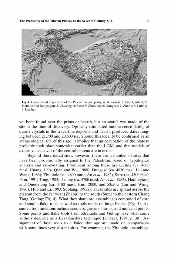
Radiometric dates and reliable archaeological contexts indicative of aPleistocene occupation of the plateau are scarce (Table II). Huang (1994)describes archaeological materials from the Xiao Qaidam site located at3100 m in the central Qaidam basin (Fig. 4). Artifacts recovered includesimple core and flake tools made on quartzite (Fig. 5). Although the de-posits from which the tools were recovered were not dated directly, os-tracod samples from stratigraphically correlated deposits dated between35,000 and 33,000 B.P. Brantingham et al. (2001b, p. 321) suggest these datesare too early, and argue for a more likely occupation of the site between22,000 and 18,000 B.P..
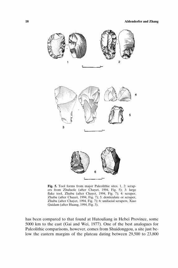
Another site of Late Paleolithic age is Chusang, at 4200 masl and lo-cated ca. 85 km northwest of Lhasa along the north branch of the TolungChu. First discovered in 1995, the site consists of 19 human hand and foot-prints impressed into a now-calcified travertine deposit (Zhang and Li,2002; Fig. 6). All the prints were pressed into the same layer of the traver-tine, and because they had rough, unsmoothed edges, were not likely tohave been cut or carved out of the rock. Size differences in the prints sug-gest that both adults and children were present when they were made. Thetravertine deposit began as a soft calcitic mud precipitated as dissolved CO2
degassed and the hot spring water became supersaturated with calcium car-bonate. The exact depositional environment of this mud is unclear from therecorded observations. The prints were formed sometime after this deposi-tion, and the mud was subsequently lithified, presumably by the addition ofcalcium carbonate cement, forming the present hard calcareous travertinedeposit. Zhang and Li also discovered what they describe as a hearth nearone concentration of prints. Unfortunately, no artifacts of any kind have
Table II. Early Chronometric Dates From the Tibetan Plateau
Site Datesa Comments
Xiao Qaidam 33.0 ± 3.0 Radiocarbon dating of ostracods35.2 ± 1.7 (Huang, 1994)
Chusang 21.7 ± 2.2 Optically stimulated21.1 ± 2.1 luminescence20.6 ± 2.9 (Zhang and Li, 2002)
Koko Nor sitesHeimahe 11.1 (13.3–12.9) Radiocarbon dating of wood
10.8 (13.0–12.8) charcoal (Brantingham et al., 2003)Jiangxigou 12.4 (15.4–14.1) Radiocarbon dating of wood
charcoal (Brantingham et al., 2003)Layihai 6745 ± 85 Wood charcoal (Gai and Wang, 1983)
aAll dates are reported as uncalibrated radiocarbon years before present unlessotherwise noted.
The Prehistory of the Tibetan Plateau to the Seventh Century A.D. 17
Fig. 4. Locations of major sites of the Paleolithic and postglacial periods. 1: Xiao Qaidam; 2:Heimhe and Jiangxigou; 3: Chusang; 4: Sure; 5: Zhuluole; 6: Duogeze; 7: Zhabu; 8: Luling;9: Layihai.
yet been found near the prints or hearth, but no search was made of thesite at the time of discovery. Optically stimulated luminescence dating ofquartz crystals in the travertine deposits and hearth produced dates rang-ing between 21,700 and 20,600 B.P.. Should this locality be confirmed as anarchaeological site of this age, it implies that an occupation of the plateauprobably took place somewhat earlier than the LGM, and that models ofextensive ice cover of the central plateau are in error.
Beyond these dated sites, however, there are a number of sites thathave been provisionally assigned to the Paleolithic based on typologicalanalysis and cross-dating. Prominent among these are Geting (ca. 4660masl; Huang, 1994; Qian and Wu, 1988), Duogeze (ca. 4830 masl; Liu andWang, 1986); Zhuluole (ca. 4800 masl; An et al., 1982), Sure (ca. 4500 masl;Hou, 1991; Tong, 1985), Luling (ca. 4700 masl; An et al., 1982), Hadongtangand Quedetang (ca. 4100 masl; Huo, 2000, and Zhabu (Liu and Wang,1986); Huo and Li, 1993; Suolang, 1991a). These sites are spread across theplateau from the far west (Zhabu) to the south (Sure) to the eastern ChangTang (Geting; Fig. 4). What they share are assemblages composed of coreand simple flake tools as well as tools made on large blades (Fig. 5). As-sumed tool functions include scrapers, gravers, burins, and unifacial points.Some points and flake tools from Zhuluole and Geting have what someauthors describe as a Levallois-like technique (Chayet, 1994, p. 30). As-signment of these tools to a Paleolithic age are made on comparisonswith sometimes very distant sites. For example, the Zhuluole assemblage
18 Aldenderfer and Zhang
Fig. 5. Tool forms from major Paleolithic sites. 1, 2: scrap-ers from Zhuluole (after Chayet, 1994, Fig. 5); 3: largeflake tool, Zhabu (after Chayet, 1994, Fig. 7); 4: scraper,Zhabu (after Chayet, 1994, Fig. 7); 5: denticulate or scraper,Zhabu (after Chayet, 1994, Fig. 7); 6: unifacial scrapers, XiaoQaidam (after Huang, 1994, Fig. 3).
has been compared to that found at Hutouliang in Hebei Province, some5000 km to the east (Gai and Wei, 1977). One of the best analogues forPaleolithic comparisons, however, comes from Shuidonggou, a site just be-low the eastern margins of the plateau dating between 29,500 to 23,800
The Prehistory of the Tibetan Plateau to the Seventh Century A.D. 19
Fig. 6. Hand-and-footprints from Chusang (after Zhang and Li, 2002).
B.P. in Ningxia Hui Autonomous Region (Madsen et al., 2001). The site iscomposed of two localities—1 and 2. Locality 1 has an assemblage com-posed of large blades and elongated flakes, some of which have been madewith a Levallois-like technique. This assemblage is very similar to thosefound at sites in the Mongolian Gobi and southern Siberia, but which datemuch earlier (49,000–33,000 B.P.). Unfortunately, no reliable direct dat-ing of the Locality 1 assemblage has been made, but Brantingham et al.(2001a) argue for a Middle Paleolithic age for the site. However, reli-able dates of a similar core-blade technology at Locality 2 range between29,000 and 23,000 B.P. If this cross-dating is accurate, it suggests a hu-man presence on the far western part of the central plateau at an earlydate.
A second technological tradition at Locality 2 of Shuidonggou isof interest as well. Madsen et al. (2001) describe a bipolar micro-core/microblade technology on small pebbles of chalcedony. Not a truemicrocore/microblade technology, it nevertheless appears to presage theappearance of such technologies later in time, and which are found at
20 Aldenderfer and Zhang
numerous sites across the plateau, especially after the LGM. There is a veryreal possibility that some of the assemblages found on the plateau and de-scribed as microcore/microblade in nature (and thus presumed to be rela-tively late in time) are in fact more similar to the bipolar technology foundat Locality 2. To verify this, however, would require an exhaustive techno-logical reanalysis of these collections.
Brantingham et al. (2003) report two stratified sites on the shores ofKoko Nor at ca. 3100 masl that were occupied between 12,400 and 10,800B.P. (Table II). Heimahe is a stratified site that contains five stone-linedhearths. No lithics were recovered in the testing, but animal bone waspresent. The second site, Jiangxigou, has a single unprepared hearth, andwith it was found debitage suggestive, but not diagnostic, of a pebble mi-croblade reduction strategy.
Unfortunately, there are no other dated sites of Pleistocene age on theplateau, thus making it difficult to determine routes of entry and the timingof its occupation. Other data types have been pressed into service to exam-ine this problem. Using mitochrondrial DNA (mtDNA) evidence, Torroniet al. (1994) argue that indigenous Tibetans have a north Asian and Siberianorigin of uncertain antiquity. They do not, however, speculate on the pro-cess by which these northern populations entered the plateau. One majorlimitation of the analysis is the very small sample of Tibetans tested. Theyfurther suggest that observed mtDNA mutations in Tibetan populationswere not the result of selective pressures for adaptation to high elevationlife. A northern or central Asian genetic contribution to Tibetans has beenconfirmed more recently by Qian et al. (2000), but they do not speculate ona likely date of the appearance of the central Asian genes.
Su et al. (2000, p. 1718), using Y chromosome haplotypes, “postulatethat the ancient people, who lived in the upper-middle Yellow River basinabout 10,000 years ago and developed one of the earliest Neolithic culturesin East Asia, were the ancestors of modern Sino-Tibetan populations.” Inthis model, a source population moves from the west-central Machu (HuangHe, Yellow) river basin onto the plateau into Qinghai sometime around6000 years ago, and then disperses rapidly across it. This reconstructionplaces the origins of the Tibetan people very late in time, well into theHolocene. As we will discuss below, while there are some interesting fea-tures to this model, it does not accord well with newly obtained data on theNeolithic period on the plateau, nor does it account for the data we havejust discussed.
Brantingham et al. (2003), taking full advantage of recent archaeolog-ical discoveries in northern and central Asia, posit a substantially differentmodel for the peopling of the plateau. Their model takes into account thephysiological challenges of life at high elevation, resource configurations,
The Prehistory of the Tibetan Plateau to the Seventh Century A.D. 21
and potential cultural responses. As a species, humans are lowlanders, andare not adapted to high elevation life. To live permanently at altitudes over2500 masl requires a suite of behavioral, cultural, and physiological adapta-tions (Aldenderfer, 1998, pp. 19–25). Native lowlanders find at high eleva-tions that work capacity is reduced, caloric needs are greater, risks of certaindiseases, including respiratory infections and altitude-induced illness are in-creased, and physiological responses to cold stress are intensified. From aphysiological perspective, these challenges can only be overcome by beingborn at altitude. Their effects can be ameliorated by cultural adaptationsthat tend to minimize the frequency and distances traveled of residentialmoves, selective patch choice to reduce the foraging radius, increased logis-tical mobility for hunting parties, embedded resource procurement strate-gies, development of a transport capacity, and caching (Aldenderfer, 1998,pp. 20–22), as well as the controlled use of fire and the adoption of sophis-ticated clothing (Aldenderfer, 2003, 2004b).
Using concepts like these, Brantingham and others propose a three-step model for the peopling of the plateau. The first step brings a sourcepopulation from the low elevation zones north of the plateau (InnerMongolia, Gansu, etc.) into northwestern China no later than 29,000–25,000B.P. and possibly earlier. The second step moves these people into theeastern Qinghai lakes region (at elevations between 3000 and 4000 masl)around 25,000 B.P. but in any case before the extremes of the LGM. It isduring this second step that physiological adaptations to high elevation con-ditions would commence. The third step, movement to the much highercentral plateau, may have occurred at the onset of LGM conditions, ca.23,000–22,000 B.P. Although the model remains to be tested, it is in gen-eral accord with the mtDNA data, sources of technological traditions, andmovement across the plateau. Should Chusang on the central plateau dateto ca. 21,000 B.P. this would help strengthen the empirical foundations of themodel. However, it remains possible that the Qinghai lake sites reported byBrantingham et al. (2003) reflect a late (post-LGM) second-step occupationof the plateau.
Changing Adaptive Strategies in the Late Pleistocene and Early Holocene
Between 11,000 and 6000 B.P., the archaeology of the plateau is essen-tially unknown. With one exception, Layihai in extreme eastern Qinghai(Gai and Wang, 1983), there is no radiometrically dated site known be-fore ca. 5000 B.P. (Table II). Consequently, it is difficult to discuss post-glacial adaptive strategies with much confidence. It is well known that sitescontaining a Neolithic cultural package (domesticated plants and animals,

22 Aldenderfer and Zhang
ceramics, sedentary life with clear investment in facilities such as houses,ground stone tools) were present on the plateau by 5000 B.P.. Althoughmost of these sites are found along the eastern margins of the plateau, someare known from the central portion of the Yarlung Tsangpo valley. MostChinese sources, as well as western models derived from historical linguis-tics and DNA analysis, favor a migration or colonization process that bringsNeolithic settlers to the plateau from the surrounding lowlands. Little con-sideration is made of possible indigenous cultural transformations, such asa local process of sedentarization, that could have taken place without a dif-fusion from lowland sources. Neither has there been research to investigatehow the pastoral economies, which are the basis of current lifeways acrossmuch of the plateau, came into being except within a diffusionist context.Obviously, the movement of people and the diffusion of traits did happen,but a more serious consideration of indigenous cultural processes is neededto balance this historical trend.
In the absence of data, we can only speculate on the nature of post-LGM and postglacial cultural adaptations. We begin with the reasonableassumption that population densities across the plateau were very low inpost-LGM times. Environmental amelioration after 18,000 B.P. encouragedthe adaptive radiation of humans and plant and animal species. Foragers onthe central plateau (should they in fact have been there and survived theextremes of the LGM) would have been able to exploit new and expand-ing niches, especially in the major river valleys. In the northeastern andsoutheastern corners of the plateau, forest expansion implies that lower el-evation plant and animal species migrated into higher elevation zones; thisin turn may have encouraged foraging groups in these valleys to expandtheir ranges into the fringes of the plateau. A process like this happenedin postglacial times along the western flanks of the Andes (Aldenderfer,1999). There, foraging groups quickly established permanent residence af-ter the initial “discovery” of the plateau (Aldenderfer, 1998, p. 142). In thenorth, however, hyperaridity in the Qinghai and Qaidam basins may haveencouraged foraging populations there to jump from the second step (3000–4000 masl) to the third step (4000–5000 masl) in Brantingham et al.’s (2003)model. This would have taken place between 12,000 and 10,000 B.P.. In ei-ther scenario, small groups of foraging people likely expanded into the mostproductive niches across the plateau.
There are a number of preceramic or aceramic sites that probably dateto the postglacial and pre-Neolithic period. Most of these sites have mi-crolithic technologies. Microliths and their varied associations continue tovex archaeological reconstructions of plateau prehistory. Most known sitescontaining microliths are surface assemblages that have been haphazardlycollected, and are thus likely to have unknown sampling biases, making
The Prehistory of the Tibetan Plateau to the Seventh Century A.D. 23
comparisons tenuous. With few exceptions, most assemblages have notbeen rigorously described, again making it difficult to identify clear tech-nological trends. It also appears that many of these sites are palimpsestoccupations created by deflation and erosion. Microliths are also knownfrom excavated sites containing ceramics and bronzes that are clearly ofNeolithic or post-Neolithic (i.e. Bronze Age) dates (Tang and Hare, 1995,p. 7). Finally, it is clear that the term itself—microlith—has been variouslydefined by Chinese archaeologists (Gai, 1985). Once applied broadly to as-semblages containing small tools, it now has a more restrictive definitionbased upon the technological definition of microblade production (bladeswith triangular or trapezoidal cross-section and less than 10 mm in width).Within this category, however, authors have described a number of reduc-tion strategies and styles (Chen, 1984; Chen and Wang, 1989; Duan, 1989;Liu, 1981; Tang, 1999).
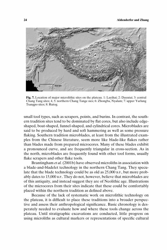
In Tibet, Chinese archaeologists often describe two traditions of mi-crolithic technologies—northern and southern (Duan, 1989; Li, 1991, 1994;Liu and Wang, 1986; Tang, 1999; Tang and Hare, 1995; Fig. 7). The north-ern tradition includes sites found in Qinghai (Layihai: Gai and Wang, 1983),the central Chang Tang, especially near Shenzha, Shuangu, and Banga (Anet al., 1982), and the northern Chang Tang (Mani, Sewugang, Suishaole,and Geladandong). The southern tradition is said to include Zhongba andNyalam (Tong, 1985) a series of sites along the middle and upper YarlungTsangpo valley (Li, 1991), and sites near Rutog in far western Tibet (Huoand Li, 1993b). The majority of these sites are aceramic, although theyare often found to be mixed with different kinds of stone tools. Also,some technological traditions are thought to extend into later ceramic pe-riods. For instance, Li (1991, p. 60) describes sites with microliths alongthe middle and upper reaches of the Yarlung Tsangpo and places theminto five categories: (1) typical microliths with small flake artifacts, (2)typical microliths with both large and small flake artifacts, (3) small andlarge flake artifacts, (4) uniform small flake artifacts, and (5) uniform largeflake artifacts. In his paper, “typical” microliths are defined as those cre-ated by direct percussion on small, funnel-shaped cores. The author spec-ulates that this type of microlith dates from 7500 to 3000 B.P. Microlithsare also found with tool forms thought to be of Paleolithic age, such as atZhuluole.
Technological distinctions define the traditions (Tang and Hare, 1995,pp. 7–9). In the north, microliths are said to be made on a wide variety ofcore types, including wedge-shaped, flat, conical and semiconical, and cylin-drical and semicylindrical (Fig. 8). Microblades are produced by pressureflaking, tend to be rectangular in shape, and are generally trapezoidal to tri-angular in cross-section. These assemblages often have a full range of other
24 Aldenderfer and Zhang
Fig. 7. Location of major microlithic sites on the plateau. 1: Layihai; 2: Dayutai; 3: centralChang Tang sites; 4, 5: northern Chang Tange sies; 6: Zhongba, Nyalam; 7: upper YarlungTsangpo sites; 8: Rutog.
small tool types, such as scrapers, points, and burins. In contrast, the south-ern tradition sites tend to be dominated by flat cores, but also include edge-shaped, boat-shaped, funnel-shaped, and cylindrical cores. Microblades aresaid to be produced by hard and soft hammering as well as some pressureflaking. Southern tradition microblades, at least from the illustrated exam-ples from the Chinese literature, seem more like blade-like flakes ratherthan blades made from prepared microcores. Many of these blades exhibita pronounced curve, and are frequently triangular in cross-section. As inthe north, microblades are frequently found with other tool forms, usuallyflake scrapers and other flake tools.
Brantingham et al. (2001b) have observed microliths in association witha blade-and-bladelet technology in the northern Chang Tang. They specu-late that the blade technology could be as old as 25,000 B.P., but more prob-ably dates to 15,000 B.P.. They do not, however, believe that microblades areof this antiquity, and instead suggest they are of Neolithic age. Illustrationsof the microcores from their sites indicate that these could be comfortablyplaced within the northern tradition as defined above.
Because of the lack of systematic work on microlithic technology onthe plateau, it is difficult to place these traditions into a broader perspec-tive and assess their anthropological significance. Basic chronology is des-perately needed to evaluate how and where these tools change across theplateau. Until stratigraphic excavations are conducted, little progress onusing microliths as cultural markers or representations of specific cultural
The Prehistory of the Tibetan Plateau to the Seventh Century A.D. 25
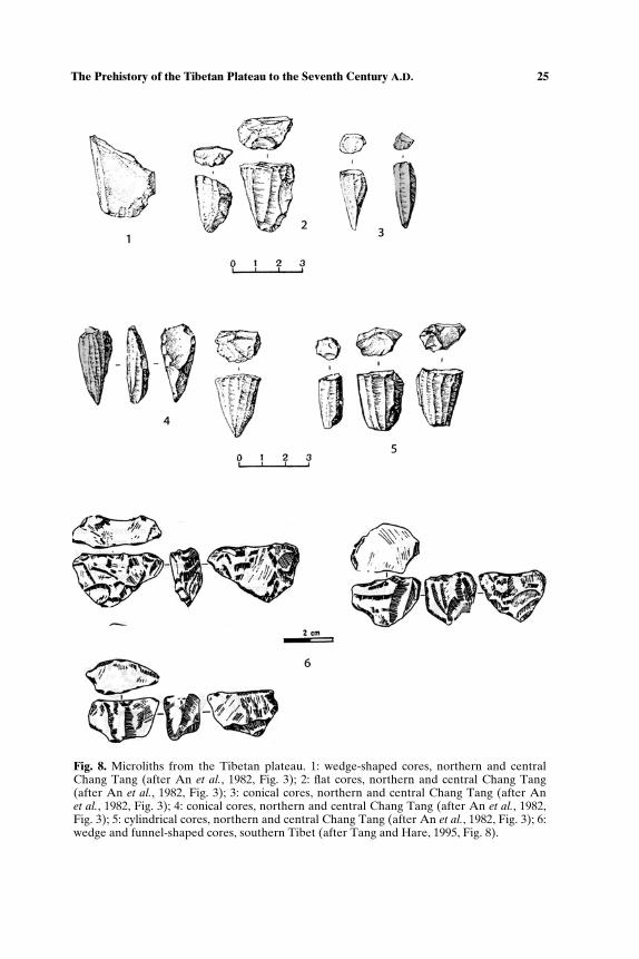
Fig. 8. Microliths from the Tibetan plateau. 1: wedge-shaped cores, northern and centralChang Tang (after An et al., 1982, Fig. 3); 2: flat cores, northern and central Chang Tang(after An et al., 1982, Fig. 3); 3: conical cores, northern and central Chang Tang (after Anet al., 1982, Fig. 3); 4: conical cores, northern and central Chang Tang (after An et al., 1982,Fig. 3); 5: cylindrical cores, northern and central Chang Tang (after An et al., 1982, Fig. 3); 6:wedge and funnel-shaped cores, southern Tibet (after Tang and Hare, 1995, Fig. 8).
26 Aldenderfer and Zhang
adaptations can be made. However, it is possible to speculate briefly on howthese tools may have been used by plateau inhabitants. We begin by assum-ing that microliths are not common until after 15,000 B.P., and quite possi-bly 10,000 B.P.. Elston and Brantingham (2002), using a risk-minimizationmodel, argue that microlithic tools become important in northern Asia(which would include the Tibetan plateau) as part of an adaptation directedat the intensification of large-game hunting in highly variable seasonal envi-ronments. They demonstrate that although composite microlithic tools aremore expensive to make than bifacial points, they are more lethal killingtools, and were more reliable than bifacial tools, thus minimizing subsis-tence risk. They further speculate that wedge-shaped cores may have beenused in high-risk situations, such as hunting for winter stores in highly vari-able environments, since tool production was more predictable than withsimple boat-shaped cores, which may have been used in less risky contexts.In Tibet, it is interesting to note that wedge-shaped cores form the primarycomponent of the northern tradition, while boat-shaped cores are found inthe south. If time is not a factor in this, this suggests that northern foragersfaced greater subsistence risk and may have had higher levels of residen-tial mobility than their southern counterparts. This is certainly consistentwith modern ecological structure, wherein the Chang Tang (the north) isa patchy, arid environment whereas the south (primarily the major rivervalley systems) is relatively benign by comparison.
The Neolithic of the Tibetan Plateau
As Underhill (1997, p. 105) notes, the Neolithic in China is said to becharacterized by “ . . . pottery, ground stone tools, sedentism, cultivation,and animal husbandry.” This definition has been extended to the Tibetanplateau, but with the clear proviso that the Neolithic there has a numberof significant differences when compared to its low-elevation counterpart,and appears also to have a much longer duration. Although there are fewerNeolithic era sites known on the plateau compared to earlier time peri-ods, excavations and data recovery at these sites are far more complete,and consequently, we have a more secure understanding of many aspects ofNeolithic lifeways than of the Paleolithic
How the Neolithic is characterized depends on location. For instance,there are a large number of Neolithic sites known from the extreme north-eastern part of Qinghai near its border with Gansu. The western Machu(Huang He or Yellow) River valley has been extensively studied exten-sively by Chinese archaeologists (Chang, 1986, pp. 138–150) and conse-quently, they have extended the Neolithic phase names from this region
The Prehistory of the Tibetan Plateau to the Seventh Century A.D. 27
into this area of the plateau. These are generally applicable to this spe-cific region, but cannot be extended beyond it. Elsewhere on the plateau,archaeological cultures are named after specific sites, such as “Qugong cul-ture” or “Karou culture.” As more information is generated, it is likely thatthese will become phase names for the Neolithic.
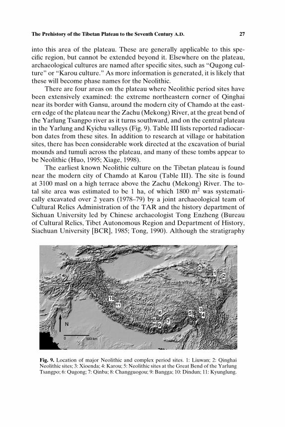
There are four areas on the plateau where Neolithic period sites havebeen extensively examined: the extreme northeastern corner of Qinghainear its border with Gansu, around the modern city of Chamdo at the east-ern edge of the plateau near the Zachu (Mekong) River, at the great bend ofthe Yarlung Tsangpo river as it turns southward, and on the central plateauin the Yarlung and Kyichu valleys (Fig. 9). Table III lists reported radiocar-bon dates from these sites. In addition to research at village or habitationsites, there has been considerable work directed at the excavation of burialmounds and tumuli across the plateau, and many of these tombs appear tobe Neolithic (Huo, 1995; Xiage, 1998).
The earliest known Neolithic culture on the Tibetan plateau is foundnear the modern city of Chamdo at Karou (Table III). The site is foundat 3100 masl on a high terrace above the Zachu (Mekong) River. The to-tal site area was estimated to be 1 ha, of which 1800 m2 was systemati-cally excavated over 2 years (1978–79) by a joint archaeological team ofCultural Relics Administration of the TAR and the history department ofSichuan University led by Chinese archaeologist Tong Enzheng (Bureauof Cultural Relics, Tibet Autonomous Region and Department of History,Siachuan University [BCR], 1985; Tong, 1990). Although the stratigraphy
Fig. 9. Location of major Neolithic and complex period sites. 1: Liuwan; 2: QinghaiNeolithic sites; 3: Xioenda; 4: Karou; 5: Neolithic sites at the Great Bend of the YarlungTsangpo; 6: Qugong; 7: Qinba; 8: Changguogou; 9: Bangga; 10: Dindun; 11: Kyunglung.
28 Aldenderfer and Zhang
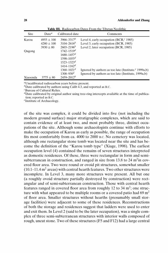
Table III. Radiocarbon Dates From the Tibetan Neolithic
Site Datea Calibrated date Comments
Karou 4955 ± 100 3966–3317b Level 4, early occupation (BCR,c 1985)4280 ± 100 3104–2616b Level 3, early occupation (BCR, 1985)3930 ± 80 2603–2196b Level 2, later occupation (BCR, 1985)
Qugong 1742–1519d
1688–1457d
1598–1055d
1523–1323d
1414–1162d
1368–1021d Ignored by authors as too late (Institute.e 1999a,b)1308–930d Ignored by authors as too late (Institute, 1999a,b)
Xiaoenda 3775 ± 80 2459–2012b
aUncalibrated radiocarbon years before present.bDate calibrated by authors using Calib 4.3, and reported as B.C.cBureau of Cultural Relics.dDate calibrated by original author using tree-ring intercepts available at the time of publica-tion; reported as B.C.
eInstitute of Archaeology.
of the site was complex, it could be divided into five (not including themodern ground surface) major stratigraphic complexes, which are said tocontain evidence of at least two, and most probably three, distinct occu-pations of the site. Although some archaeologists continue with efforts tomake the occupation of Karou as early as possible, the range of occupationfits most comfortably from ca. 4000 to 2000 B.C. No cemetery was located,although one rectangular stone tomb was located near the site and has be-come the definition of the “Karou tomb type” (Xiage, 1998). The earliestoccupation level (4) contained the remains of seven structures interpretedas domestic residences. Of these, three were rectangular in form and semi-subterranean in construction, and ranged in size from 13.8 to 24 m2in cov-ered floor area. Two were round or ovoid pit structures, somewhat smaller(10.1–11.4 m2 areas) with central hearth features. Two other structures wereincomplete. In Level 3, many more structures were present. All but one(a roughly ovoid structure partially destroyed by construction) were rect-angular and of semi-subterranean construction. Those with central hearthfeatures ranged in covered floor area from roughly 12 to 34 m2; one struc-ture with what appeared to be multiple rooms or a covered patio had 69 m2
of floor area. Smaller structures without hearths (presumably small stor-age facilities) were adjacent to some of these residences. Reconstructionsof both the storage and residences suggest that ladders were used to enterand exit them. In Level 2 (said to be the later occupation), was a single com-plex of three semi-subterranean structures with interior walls composed ofrough, uncut stone. Two of these structures (F5 and F12) had a large central
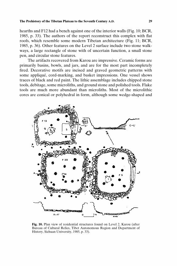
The Prehistory of the Tibetan Plateau to the Seventh Century A.D. 29
hearths and F12 had a bench against one of the interior walls (Fig. 10; BCR,1985, p. 33). The authors of the report reconstruct this complex with flatroofs, which resemble some modern Tibetan architecture (Fig. 11; BCR,1985, p. 36). Other features on the Level 2 surface include two stone walk-ways, a large rectangle of stone with of uncertain function, a small stonepen, and circular stone features.
The artifacts recovered from Karou are impressive. Ceramic forms areprimarily basins, bowls, and jars, and are for the most part incompletelyfired. Decorative motifs are incised and graved geometric patterns withsome applique, cord-marking, and basket impressions. One vessel showstraces of black and red paint. The lithic assemblage includes chipped stonetools, debitage, some microliths, and ground stone and polished tools. Flaketools are much more abundant than microliths. Most of the microlithiccores are conical or polyhedral in form, although some wedge-shaped and
Fig. 10. Plan view of residential structures found on Level 2, Karou (afterBureau of Cultural Relics, Tibet Autonomous Region and Department ofHistory, Sichuan University, 1985, p. 33).

30 Aldenderfer and Zhang
Fig. 11. Reconstruction of Level 2 structures, Karou (after Bureau of Cultural Relics,Tibet Autonomous Region and Department of History, Sichuan University, 1985, p. 36).
boat-shaped cores are present. Bone tools are abundant as well, and includeawls, probable weaving tools, needles, and combs. Decorative objects in-clude stone pendants, jade pins, perforated shells, and stone bracelets. Thepresence of ceramic spindle whorls indicates textile production, but it is notclear what was being spun.
Subsistence at Karou is said to be characterized by a mix of hunting,gathering, and plant cultivation. Animals hunted include red deer (Cervuselaphus), roe deer (Capreolus capreolus), goral (a small, goat-like antelope;Naemorhedus goral), serows (SE Asia wild goat; Capricornus sp.), Tibetangazelle (Procapra picticaudata), Chinese water deer (Hydropotes inermis),and woolly hare (Lepus ojostolus). Unidentified bovids are also present,as are various species of macaques, rodents, and rats. Pigs (Sus sp.) arepresent, and are thought to be domesticated. Plant remains include culti-vated millet, chenopods (likely to have been collected), and other plants.
Although the excavators speculate that Karou has similarities to sitesin northwestern Sichuan, such as Lizhou (BCR, 1985, p. 178), they con-clude their evaluation of the site by suggesting that it is a representation
The Prehistory of the Tibetan Plateau to the Seventh Century A.D. 31
of an indigenous Tibetan archaeological culture. Indeed, other sites in theChamdo area, such as Xiaoenda (Bureau of Cultural Relics, Tibet Au-tonomous Region [BCR], 1990; Hou, 1991) with its similar cultural content,reinforce this interpretation. Although its occupations are contemporarywith the Majiayao, Banshan, and Machang cultures to the north, they aresignificantly different from these in terms of content, and clearly do notowe their origins to them. As more data are recovered from Sichuan andYunnan, connections to the plateau from these regions may move from therealm of almost pure speculation to more reasoned analysis (Wang, 1994).
The second major Neothlic site found on the plateau is Qugong, lo-cated 5 km north of Lhasa at an elevation of 3680 masl (Huo, 2000; Insti-tute of Archaeology, Chinese Academy of Social Science and Bureau ofCultural Relics, Tibet Autonomous Region [IOA], 1991a,b, 1999b). Thesite is found along the margins of a low hill at the base of higher hills andmountains. The site was heavily eroded, and had also suffered damage fromlocal villagers who used the soil of the terrace for construction projects. Por-tions of the site were also damaged by intrusive tombs. The original extentof the site was estimated to be ca. 1 ha, and of this, ca. 0.4 ha were exca-vated. A mortuary component, containing 32 tombs, is found some 300 mto the northwest. According to the excavators, the site could have been oc-cupied as early as 1750 B.C. (Table III), and was probably abandoned by ca.1100 B.C.. Note that these occupations are considerably later in time thanthose at Karou, and they overlap substantially with the Chinese periodiza-tion of so-called Chalcolithic and early Bronze Age cultures such as Qijia(ca. 2000 B.C.), Siwa (1300–1000 B.C.) and Xindian (ca. 1000 B.C.) of Gansuand northwestern China.
The deposit is divided into early and late components. The early com-ponent had no structural features present aside from a number of ashpits and three tombs. The later component was defined as one of “rede-position,” which in this case appears to mean the reworking of the de-posit through time. The ceramic assemblage is described by the investiga-tors as “mature,” meaning that many of the vessels are finely made andhighly fired (especially when compared to the Karou assemblage), and in-clude both hand molded and wheel-thrown examples. Some of the finestceramics are a highly burnished blackware. However, decoration contin-ues to consist of geometric forms executed by incision, punctation, andsome painting. Forms include bowls, jars, and cups. The lithic assemblagestill contains a few microliths made on wedge- or boat-shaped cores, and awide variety of types, including unifacial points. Grinding stones for bothsubsistence and pigments (red ochre) are common. Bone tools includeawls, needles, points, hairpins, combs, and probable weaving implements.Only one bronze artifact—an arrowhead—was recovered from the site. A
32 Aldenderfer and Zhang
detailed analysis suggests it is of local origin. Subsistence practice was notexamined in detail for plants (only a pollen analysis was conducted), butfaunal remains included examples of yak (Bos grunniens), domesticatedsheep (Ovis aries shangi), musk deer (Moschus moschiferus), red deer(Cervus elaphus), Thorold’s deer (Cervus albirostris), domesticated pig (Susscrofa), Tibetan ass (kiang; Equus hemionus kiang), dog, and some birds.Not surprisingly, animal husbandry is of great importance, but hunting con-tinues to be a significant part of subsistence effort.
The tombs that are clearly associated with the early deposit are small,square-to-rectangular in form, with walls made of stone. The floors are soil.They contain secondary burials in a flexed position. Only one tomb hadgrave goods, which consisted of utilitarian ceramics. Unfortunately, it is notclear which tombs from the cemetery component of the site date to theNeolithic, but it seems certain that the majority date to the Bronze Ageand later (Xiage, 1998). One of these tombs contained a spectacular bronzemirror, the first found in any archaeological context in Tibet, and of clearCentral Asia origin. The dating of the mirror is controversial, but consen-sus is beginning to emerge that the mirror appeared in this portion of theplateau some time between 800 and 500 B.C. based on the examination ofstylistic motifs and its chemical composition (Huo, 1994, 1997; IOA, 1999b;Zhao, 1994).
Other sites associated with Qugong and which have had some sys-tematic work include Changguogou, located south of Lhasa on the northbank of the Yarlung Tsangpo at an elevation of 3570 masl (He, 1994; IOA,1999a; Li and Zhao, 1999), Bangga in the Yarlung Valley (Zhao, 2002), andQinba (Suolang, 1986). Although not radiocarbon dated, the archaeologi-cal assemblage, especially the ceramics, at Changguogou, are very similarto those found at Qugong. Excavations at Bangga have uncovered at leastone rectangular semi-subterranean house with 24 m2 of covered floor area,stone-lined interior storage pits (one of which was used for a secondaryburial), and ceramics similar to those at Qugong. Sites thought to be partof the Qugong tradition but which have seen limited work are those inthe great bend area (Nying-khri/Nyingchi) of the Yarling Tsangpo, such asJumu, Beibeng, and Maniweng, among others (Chayet, 1994, pp. 46–47).
Most of the authors who have worked with Qugong materials arguethat this archaeological culture has its origins in the earlier Karou culture,and as such, it is an indigenous Tibetan development. What is known ofit suggests a village-based society with limited social differentiation as in-dicated by mortuary remains. Qugong likely had trade connections withcultures in Sichuan and possibly central Asia, and certain technologies,like metal working in bronze, had apparently entered the central plateausometime before this.
The Prehistory of the Tibetan Plateau to the Seventh Century A.D. 33
If Karou and Qugong are thought to be “Tibetan,” the Neolithic cul-tures in extreme northeastern Qinghai are clearly of lower elevation ori-gin. The dating of Neolithic cultures in this area remains controversial. TheYangshao culture is well known from eastern Gansu and the central HuangHe (Yellow) River valley, and is said to date between 5000 and 3400 B.C.
(Underhill 1997, p. 118). Its presence in Qinghai has been debated, and alocal culture, Shilingxia, is said to be its extreme western variant (Chayet,1994, p. 51). However, it seems more reasonable to regard this culture as anearly expression of the following culture, Majiayao (3400–2800 B.C.), whichis well defined in Qinghai. Important sites of this culture include Sunjiazhai,Shangsunjia, and Hetaozhuang (Chang, 1986, pp. 142–144). They are saidto be between 20 and 30 smaller sites in extreme eastern Qinghai that havetraces of Majiayao culture, primarily ceramics. This culture is characterizedby rectangular semi-subterranean houses, grinding stones, polished stoneaxes, hoes, large numbers of bone tools, and impressive ceramics paintedin red and black with geometric and animal motifs. Sites in Gansu of thisculture are known to have broomcorn and foxtail millet as well as hempfruits. Cemeteries are found near the largest villages, and in the Qinghaisites, burials are secondary and found in wooden coffins. Some burials hadsignificant quantities of painted ceramics accompanying them. The next cul-ture to be found in the region is Banshan (2800–2300 B.C.), which is knownin Qinghai primarily from the famous mortuary site of Liuwan (Chayet,1994, p. 53). A total of 257 burials of this period were discovered, and burialtreatments ranged from secondary to simple, extended burials through mul-tiple burials within the same rectangular wooden coffin. Burials were ac-companied by a wide variety of artifacts, including the famous Banshanceramics, stone tools (both chipped and polished), bone tools, and somedecorative objects, including turquoise, bone, and stone beads as well asstone bracelets. The final Neolithic culture in this region is Machang (2300–2100 B.C.). Although best known from Liuwan, there are villages sites knownfrom this period in Qinghai, including Machangyan. Subsistence continuesto be focused upon millet, and residential structures are similar to those ofthe preceding cultures. The majority of burials at Liuwan date to this cul-ture, and while burials are generally similar to those of earlier cultures, theceramics now have significant number of anthropomorphic motifs as wellas geometrics that resemble certain characters of early historic writing sys-tems (Chang, 1986, p. 150). Some mortuary treatments are impressive—oneMachang burial from Liuwan had more than 90 highly decorated ceramicvessels
One additional source of data on the Neolithic is the very large num-ber of mortuary sites examined by Chinese archaeologists. In comparison tohabitation sites, which are usually buried by alluvial or colluvial processes,
34 Aldenderfer and Zhang
mortuary sites are distinctive since they often are characterized by above-surface mounds of varying shapes and sizes. Mortuary sites are found alongthe Nyechu (Longzhi) River in the Lhoka (Shennan) region in southernTibet, near Nying-khri (Nyingchi) of the Yarlung Tsangpo valley, and nearShigatse. Many of these sites have been tested and excavated, but unfortu-nately, the data recovered from them tend not to be examined systemati-cally, and few of the sites have been dated by radiometric methods. Conse-quently, typologies of mound types are constructed on the basis of the fewsites that have been dated, and by assumptions about site age and affiliationbased on cross-dating of artifact types, often from areas far-flung from theplateau. Two archaeologists—Huo (1995) and Xiage (1998) have attemptedto systematize these data for the central and southern parts of the plateau.Despite these efforts, clear patterns are not obvious. Tombs assigned to theNeolithic are described as “stone coffins,” are square or rectangular in form,and are made either with large flat slabs for walls and floors, or coursed, un-cut stone used to construct walls. An uncommon, more complex form issaid to be a stone cyst tomb with an entrance, tunnel passage, and centralchamber (Huo, 1995). Burial goods, if present, tend to be simple decora-tive objects (stone beads) or small amounts of local ceramics. Burial treat-ments tend to be flexed, and are often secondary. Some of these tombs,especially those in the vicinity of Karou, are thought to have originatedfrom migrants to the plateau of people from the adjacent, lower elevationvalleys on western Sichuan (Tong, 1978). In short, while tombs are in abun-dance on the plateau, they currently contribute little to our knowledge ofthe Neothlic because they have not been systematically dated and associ-ated with habitation sites.
The most controversial question of the Neolithic on the Tibetanplateau is the debate over the origins of what are known today as theTibetan people. Some authors have argued strongly that the majority ofthe current ethnic inhabitants of the plateau owe their origins linguistically,culturally, and biologically to migrations of people from east Asian sourcesduring the Neolithic. This issue has already arisen in the discussion of thepeopling of the plateau during the Paleolithic. We have already alluded tothe shifting meanings of the term ‘Tibet” and “Tibetan,” and thus it shouldnot be surprising that considerable confusion accompanies this debate.Renfrew (2000) has summarized current directions in research that hasattempted to correlate in a systematic manner historical linguistics, molec-ular biology, and archaeological data, and while optimistic about the futureof this synthesis, nevertheless observes that making explicit correlationsbetween languages, “races” or ethnic groups, and archaeological culturesis fraught with difficulty. Nevertheless, a number of authors have made theattempt to create such a synthesis for the occupation of the plateau. The
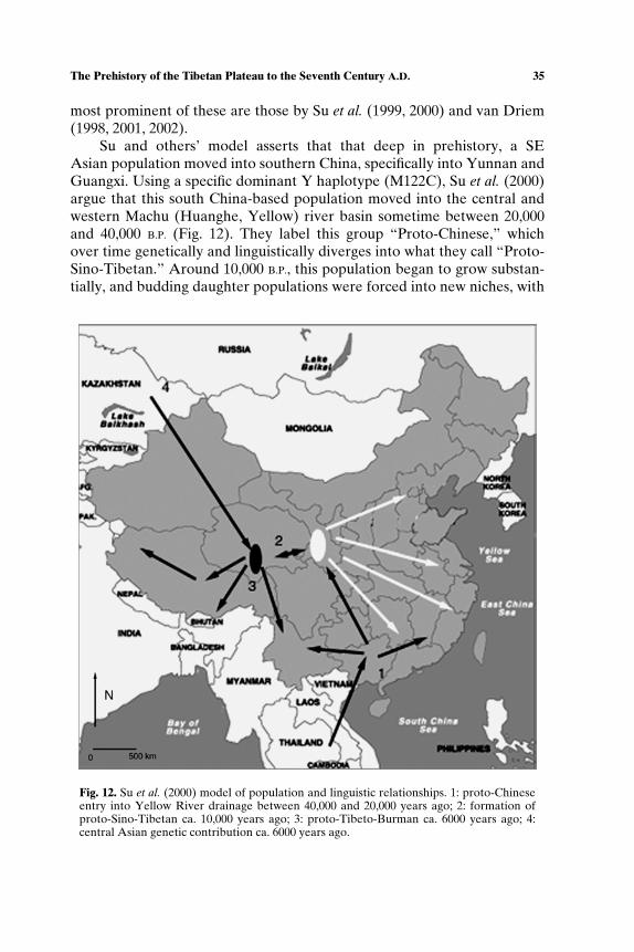
The Prehistory of the Tibetan Plateau to the Seventh Century A.D. 35
most prominent of these are those by Su et al. (1999, 2000) and van Driem(1998, 2001, 2002).
Su and others’ model asserts that that deep in prehistory, a SEAsian population moved into southern China, specifically into Yunnan andGuangxi. Using a specific dominant Y haplotype (M122C), Su et al. (2000)argue that this south China-based population moved into the central andwestern Machu (Huanghe, Yellow) river basin sometime between 20,000and 40,000 B.P. (Fig. 12). They label this group “Proto-Chinese,” whichover time genetically and linguistically diverges into what they call “Proto-Sino-Tibetan.” Around 10,000 B.P., this population began to grow substan-tially, and budding daughter populations were forced into new niches, with
Fig. 12. Su et al. (2000) model of population and linguistic relationships. 1: proto-Chineseentry into Yellow River drainage between 40,000 and 20,000 years ago; 2: formation ofproto-Sino-Tibetan ca. 10,000 years ago; 3: proto-Tibeto-Burman ca. 6000 years ago; 4:central Asian genetic contribution ca. 6000 years ago.

36 Aldenderfer and Zhang
some of these populations moving further to the west along the Machu.Around 6000 B.P., another linguistic shift occurs, with what are now called“Proto-Tibeto-Burmans,” which move from their western Machu and east-ern Qinghai focus across the Tibetan plateau. With yet another linguisticsplit, one group (Baric speakers) moves to the south, crossing the Himalaya,and moving back into northern Yunnan, Bhutan, and northeastern India.Still another group (Bodhic speakers), after having received a significantgenetic admixture of an unspecified central Asian or southwestern Siberianpopulation, moves across the entire Tibetan plateau. The authors argue thatthis model is supported by archaeology (Cavalli-Sforza et al., 1994, p. 206)and linguistics (Matisoff, 1991; Wang, 1994).
van Driem’s model is similar to that of Su and others but makes astronger attempt to integrate archaeological data. He begins with a histor-ical classification of Tibeto-Burmese languages, and divides them into twomajor groups—an eastern and western variant (van Driem, 2001, p. 399). Ofconcern here is the eastern group, which can be further subdivided into twogroups—northern (Sino-Bodic) and southern languages (which are found inSE Asia). Sino-Bodic is split into a northwestern (Bodic) and a northeast-ern (Sinitic) group of languages. Bodic can then be split into Bodish (thesource of languages spoken on the plateau) and Himalayan (various lan-guages spoken along the Himalayan chain as well as Kashmir in the distantwest). This language phylogeny is distinctly different than that proposed byMatisoff (1991).
Given the relationships between these language families and their spa-tial distribution, van Driem (2001, pp. 408–433) proceeds to create a hy-pothesis of how this patterning can be explained. He postulates the exis-tence by 11,500 B.C. of an ancestral homeland of Tibeto-Burmese speakersin the middle and upper Yangtze (Drichu) river of Sichuan. This popula-tion served as the source of the early Neolithic groups in both the eastern(Peiligang) and western (Dadiwan) Huanghe basin. Both areas were occu-pied as early as 6500 B.C., and van Driem labels them as “Northern Tibeto-Burmese” speakers (Fig. 13). He suggests that the clearest archaeologicalcorrelate of this migration is what he terms the “abrupt” replacement of lo-cal microlithic-using cultures by the Dadiwan cultivators (van Driem, 2001,p. 417). These migrants brought with them cord-marked pottery and pol-ished stone tools, which van Driem takes as cultural and ethnic markers.
The postulated lingustic divergence that created Northwestern Tibeto-Burmese (Bodic) languages is directly correlated by van Driem with theappearance of the Majiayao Neolithic in Gansu and extreme eastern Qing-hai, which he dates as early as 3900 B.C.. He argues that this group notonly migrates onto the plateau proper, ultimately spreading Bodish lan-guages across the plateau, but that it is also responsible for the appearance
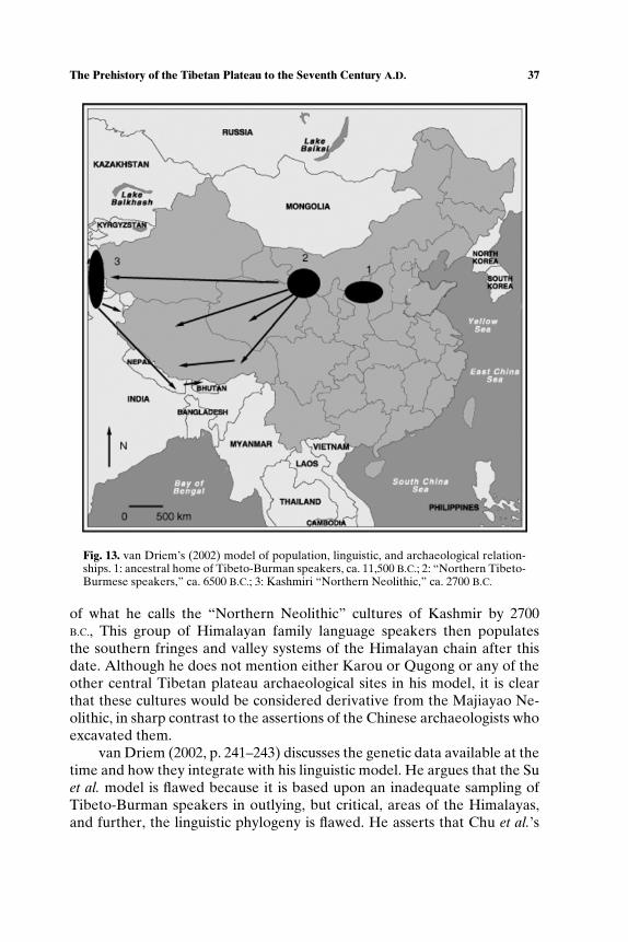
The Prehistory of the Tibetan Plateau to the Seventh Century A.D. 37
Fig. 13. van Driem’s (2002) model of population, linguistic, and archaeological relation-ships. 1: ancestral home of Tibeto-Burman speakers, ca. 11,500 B.C.; 2: “Northern Tibeto-Burmese speakers,” ca. 6500 B.C.; 3: Kashmiri “Northern Neolithic,” ca. 2700 B.C.
of what he calls the “Northern Neolithic” cultures of Kashmir by 2700B.C., This group of Himalayan family language speakers then populatesthe southern fringes and valley systems of the Himalayan chain after thisdate. Although he does not mention either Karou or Qugong or any of theother central Tibetan plateau archaeological sites in his model, it is clearthat these cultures would be considered derivative from the Majiayao Ne-olithic, in sharp contrast to the assertions of the Chinese archaeologists whoexcavated them.
van Driem (2002, p. 241–243) discusses the genetic data available at thetime and how they integrate with his linguistic model. He argues that the Suet al. model is flawed because it is based upon an inadequate sampling ofTibeto-Burman speakers in outlying, but critical, areas of the Himalayas,and further, the linguistic phylogeny is flawed. He asserts that Chu et al.’s
38 Aldenderfer and Zhang
(1998) use of microsatellite markers is a more comprehensive reconstruc-tion of east Asian population relationships, which also included groups fromoutside the region for comparative purposes, and that it is general accordwith his archaeo-linguistic reconstruction.
What are we to make of these models? While they are broadly plau-sible, they suffer from a number of problems that limit their utility. Look-ing first at the genetic data, it is clear that both suffer some methodologi-cal defects. Su et al.’s model is based upon a very small sample given thecomplexity of the argument. And while van Driem claims that the Chu andothers’ model supports his position, a careful reading belies that assertion.As expected, their model shows that Tibetans have a greater genetic sim-ilarity with the northern Chinese than they do with other east Asian peo-ples or groups from different areas. However, when they examine only eastAsian populations, their results are surprising, and place Tibetans into amixed group of southern and northern Chinese. Given this wholly unex-pected finding, Cavalli-Sforza (1998, p. 11052), while generally laudatoryof the Chu and others model, suggests these data be viewed with caution.This is especially concerning given that two studies using different geneticmarkers—Torroni and others and Qian and others—have confirmed thepresence of central Asian genes in modern Tibetan populations. We suggestthat the Chu and others study has little reliable to say about the peopling ofthe plateau, and that they offer no support for van Driem’s reconstruction.
Both models assume that archaeological cultures are direct materialindicators of ethnicity and language. Seldom, if ever, does a single artifacttype, burial practice, or stylistic motif unambiguously represent a set ofgenes or language. Moreover, the models simply assume language dispersalvia migration, and as Renfrew (2000, pp. 24–26) and others have pointedout, there are other mechanisms for language dispersal that do not assumethe direct, large-scale movement of people. Another problem with themodels is that they rely upon selective use of inaccurate and incompletearchaeological data. Both models ignore entirely the central TibetanNeolithic sites. Their use of the western Machu (Huanghe, Yellow) riverdata is generally accurately portrayed in terms of cultural content anddating, however, and to be fair to van Driem (2001, pp. 419–420), hedoes assert, following Chang (1986), that one important source of plateaupopulation is likely to be the western Drichu (Yangtze) river valleys ofwestern Sichuan.
However, perhaps the greatest flaw of both models is the simplisticway in which migration is conceived. van Driem (2001, pp. 423–425) of-fers a number of motivations for Majiayao Neolithic people to move to thewest, including ecological calamity, stress, or simply, “tidings of prosper-ity from the west.” Unfortunately, for these models, their authors appear
The Prehistory of the Tibetan Plateau to the Seventh Century A.D. 39
not to have looked carefully at their maps and considered the subsistencetechnologies of these people in their desire to move them about the land-scape. Both models have agricultural peoples from relatively low elevationsmoving up to the high plateau and across the hyperarid and frigid ChangTang. Only pastoralists thrive in these portions of the plateau, and it isfar-fetched indeed to believe that these sedentary agriculturalists somehowmoved a Neolithic “package” across the Chang Tang and into the far westwithout significant changes to that package. These models also ignore all ofthe problems created by hypoxic environments and their effects on humanphysiology. In short, they assume demic diffusion, rather than some alter-native, without thinking seriously of how the subsistence system of the cul-tures could have likewise been transported, and how these cultures adaptedto the known rigors of life at high elevation.
A more plausible model of the appearance of the Neolithic culturalpackage on the plateau is one that supports a mosaic of both demic and ac-culturation mechanisms. Demic diffusion is clearly plausible in Qinghai, butthe spread of the Majiayao Neolithic package should be limited to Qinghai.Central Tibetan plateau sites have few direct material affinities with thesecultures, and we should be looking elsewhere for their sources. We agreewith van Driem that Sichuan is a likely source for a Neolithic package, and itis very likely that demic diffusion pushed populations up the major river val-leys of the eastern plateau. Instead of moving these Tibeto-Burmese speak-ers north, then back south again, it is far more parsimonious to move themfrom Sichuan upward onto the plateau. Karou may have been founded bythis demic expansion, and if this is the case, we should find more Neolithicsites expanding up all of the major valley systems sometime after 6000 B. P.,a date consistent with Ren’s (2000) model of agricultural expansion. Themechanism for the expansion of the Neolithic across the plateau could beeither demic diffusion or acculturation, but since the data are scanty, it is notpossible to test either alternative. However, an acculturation mechanismmay be the best explanation for the presence of central Asian or southwest-ern Siberian genes in Tibetan populations according to Su and others modelif we assume that these genes were those associated with the Mesolitihc peo-ples of the plateau who adopted the Neolithic package or married into it.Qugong, as a descendant of Karou, appears to reflect an indigenous expan-sion of the Neolithic into new niches further to the west.
Just how complex are the central plateau sites? This question cannotbe answered at present simply because few sites have been excavated, andnone have yet been placed into a regional scale settlement system. Themortuary data suggest that significant social differentiation had not yetoccurred on the central plateau by ca. 1900 B.C. This stands in stark con-trast to the Qinghai Neolithic sites, where displays of wealth accompanying

40 Aldenderfer and Zhang
burials suggests some social ranking in place in that region by the end ofthe Neolithic. It is important to remember, however, that both the centralplateau and Qinghai are quite simple when compared to cultural develop-ments taking place further to the east in China, such as the Xia Dynasty,which is said to have been founded around 2200 B.C.
Toward Complexity
As we move toward the known complexity and political centralizationthat accompanies the emergence of the Tibetan empire in the mid-seventhcentury A.D., it is the case that historical documents, rather than archaeo-logical evidence, serves as the primary record of the period from the endof the Neolithic onward. In China, we now enter the period of the histori-cally known dynasties beginning with the Shang (ca. 1700–1100 B.C.) to theSui (A.D. 580–618). During this period, China itself saw varying degrees ofpolitical centralization, retraction, and territorial expansion. The majorityof these dynasties rose in eastern China, and had greater or lesser levelsof contact with and interest in the peoples and polities to the west, includ-ing what is today known as Tibet. Writing systems first appear in Shangtimes, and some authorities believe that oracle bone inscriptions dating toca. 1400 B.C. which describe the Qiang (Ch’iang) people are in fact makingreference to inhabitants of the eastern fringes of the Tibetan plateau (Stein,1972, p. 29). Whether this reference is actually specific to Tibetans, or oneof many small ethnic groups and tribes that inhabited the western fringeof China, from Gansu southward through Sichuan and into Yunnan, is un-known. Indeed, some authors note that while the Qiang are a recognizednationality within the Chinese state today, the term “Qiang” is a genericHan term for non-Han or is best read as a Han conceptualization of the“other” with a deep antiquity that reflects a distinction between a pastoraland an agricultural lifeway (Wang, 2002). What seems clear, however, isthat the Chinese written record had no clear description of the agricul-tural peoples of the central Tibetan plateau until much later in time, andmost have concluded that the Qiang were ethnically and culturally distinctfrom Tibetans (Beckwith, 1987, p. 8). In fact, the first written reference byChinese authors to central Tibet comes during Sui times with the recog-nition of a pre-empire Tibetan king named Namri Songsten, who was thefather of the first emperor of Tibet, Songsten Gampo (Snellgrove andRichardson, 1995, p. 26).
Although few other written records of Chinese interest in Tibet canbe found, there was considerable contact between Tibetan polities, suchas they were, and the Han dynasty (206–209 B.C.). The Han significantly
The Prehistory of the Tibetan Plateau to the Seventh Century A.D. 41
expanded and eventually centralized the Chinese state, and established itscapital at Ch’ang-an (Xi’an) in western China. Trade contacts with innerAsia were important, and the Han gained control of the lucrative Silk Road,which runs just along the northern fringes of the plateau eventually enteringGansu and continuing to the east. Small Tibetan polities in Qinghai (oftendescribed as “tribes” or “people’) such as the Tibetan speaking Sumpa andAza, undoubtedly benefited from participation in this trade. However, thisgives little insight into what these polities might have been like socially andpolitically.
Tibetan historical records written well after the spread of the empireand found at Dunhuang, a major religious and economic center along theSilk Road found at the very eastern margin of the Taklamakan desert, pro-vide some insight into the immediately pre-empire polities of the plateau.Although these documents are known to be combinations of myth, legend,and history of highly doubtful veracity, as summarized by Haarh (1969) andothers, the polities on the central Tibetan plateau were probably small-scalechiefly societies that inhabited the major river valleys and tributary streamsof the Yarlung Tsangpo drainage (the region of central Tibet known to-day as U-Tsang.) The term “clan” is often used to describe these groups,and these clans (or lineages) persisted as major political factors well afterthe establishment and fall of the empire. They held territory, and estab-lished major strongholds on mountain peaks surrounding the river basins.Warfare was common, as was extensive alliance building. Political leader-ship is characterized as a form of divine kingship, and religious practiceis said to have been based upon shamanic ritual, which included the wor-ship of local mountain deities and animal sacrifice (Samuel, 1993, pp. 438–444). Haarh (1969, p.128) notes that these historical sources indicate thatone of these probably mythical rulers made contact with Indian Buddhismsome five generations before the start of Songsten Gampo’s reign, althoughthe earliest known Buddhist constructions on the plateau are contempora-neous with the establishment of the empire (Vitali, 1990). Economically,these polities were based upon the use of a full suite of animal and plantdomesticates that was introduced onto the plateau during the Neolithic,but with the addition of the horse and goat, iron tools, and sophisti-cated agricultural technologies, including small-scale irrigation systems andterracing.
Unfortunately, there is almost no archaeological evidence of this pe-riod in the central Tibetan plateau, and consequently, it is not possible toeither examine the veracity of these reconstructions or track the transfor-mations of these polities as they moved toward centralization by the mid-seventh century. A large number of mortuary sites have been located on thecentral plateau, however, and while many of these have been excavated, few
42 Aldenderfer and Zhang
of them have been dated and systematically examined (Chayet, 1994, Huo,1995; Xiage, 1998; pp. 76–89).
Some of the best data on this long period are found, paradoxically, onthe Chang Tang and in far western Tibet. Although little is known todaybeyond a handful of specialists, the Zhang zhung (also Shangshung or Zan-Zun) polity once thrived in the high deserts of western Tibet between ca.500 B.C. to A.D. 625. The origins and evolution of the polity are shroudedin mystery. Legends and fragmentary history speak of migrations of peo-ples from the west into the homeland of Zhang zhung, but when these oc-curred is unknown. The nature of the polity is debated: it has been var-iously described as a small-scale coalition of territorially based linages, akingdom (Petech, 1997, p. 230), a confederation (Beckwith, 1987, p. 14), apetty state (Tucci, 1956, p. 92), and an empire. Even the location of Zhangzhung has been disputed, with some authors arguing for a vast, nebulouspolity that extended from western Tibet well into northeastern Tibet andbeyond (Chung, 1960; Tucci, 1956). But aside from the myth, legend andapparent mystery, Zhang zhung played a major role in central Asian pre-history and history. It appears to have acted as an important intermediaryof trade and the diffusion of knowledge between the Indian subcontinentand the Tibetan plateau, and for a time, was a significant political rival ofthe emerging Tibetan empire. It also acted as a filter of knowledge andcultural influences from the distant west, including Sogdiana, Persia, andthe Hellenistic world (Stein, 1972). Perhaps of even greater importance wasthe sponsorship by Zhang zhung of Bon, a belief system thought by manyto be the indigenous religion of much of the Tibetan plateau, and whichhad a profound influence of the development and evolution of TibetanBuddhism.
Some of the most interesting data on the pre-Buddhist, possibly Zhangzhung, occupation of western Tibet are those collected by Bellezza (2000,2001, 2002) in a series of remarkable exploratory trips across the ChangTang. During his more than a decade of research, he discovered almost500 archaeological sites which he has placed into four major categories:fortresses (in what appear to be defensible locations), buildings (residen-tial and religious), stela (or standing stones in a variety of configurations),and tombs. Using a combination of local myth and oral tradition, religioustexts, and other data, he argues that most of these sites were founded inthe period after ca. 1000 B.C. but before the introduction of Buddhism tothe northern plateau, which could not have occurred before the establish-ment of the Tibetan empire in the seventh century A.D., and most probablyafter its “second diffusion” in the years following A.D. 1000. Unfortunately,Bellezza has no chronological control over these sites since he was unableto collect materials from them or excavate at them. While the majority
The Prehistory of the Tibetan Plateau to the Seventh Century A.D. 43
of these sites are likely to be pre-Buddhist, just when they fall into timeand how they articulate within a settlement system is unknowable at thispoint.
Further to the south, excavations at a number of pre-Buddhist siteshave created an empirical basis for chronology in the region. Theseexcavations are a part of a larger collaborative project between westernand Chinese archaeologists designed to understand the second diffusionof Buddhism into far western Tibet (Aldenderfer, 2001a,b; Huo, 2002a,2002b; Huo and Li, 2001). During that project, a village site—Dindun—wasexcavated (Aldenderfer, 2004a, in press; Aldenderfer and Moyes, 2004) aswere two cemetery complexes, Gebusailu and Sasongtang (China Tibetol-ogy Institute, Archaeology Department of Sichuan University and Bureauof Cultural Relics, Tibet Autonomous Region, 2001a,b). The villagecomponent consisted of at least 11 structures, of which three were fullyexcavated. The structures were semi-subterranean built with coursed stoneon a rectangular plan (Fig. 14). Although the number of rooms varied, theplacement of features was consistent in them, as was the material culture,which consisted of cord-marked and unslipped plainwares, animal bone(caprids and bovids), ground-stone tools, and metal scrap. The tombs varyin size, shape (circular and rectangular), and construction details (numberof chambers, materials used). All, however, are excavated into the groundto varying depths, and one is a shaft tomb, unique in the archaeologicalrecord of this region. This tomb contained some scattered human remains,a disarticulated horse, a bronze dagger, small iron artifacts, and ceramicsidentical to those found at Dindun. Three radiocarbon dates have been runon the village and mortuary complex (2380 ± 80; 2310 ± 60; 2065 ± 60),and using the R–Combine function of Oxcal 3.8 (Bronk Ramsey, 2002),these calibrate into the most probable time frame of 400–100 B.C. Thesedates place Dindun and the cemeteries within the putative range of Zhangzhung, but the data are clearly insufficient to say that Dindun represents theZhang zhung archaeological culture. This will require far more systematicexcavation at sites across the region.
One of the structures at Dindun had a stela (or standing stone) in asmall chamber within it. Two other standing stones were found at the eastand west sides of the village (Aldenderfer, 2004a). Scattered across Tibetand the trans-Himalaya are literally thousands of standing stones of variedshapes and sizes, and which are found in a diversity of contexts that indi-cate far more humble, but complex, uses than those devoted to the royaldynasties and their activities. Standing stones first became known to thewest at the beginning of the twentieth century when the Tibetologist M. J.Bacot in 1907 described what he called a “megalith” observed in easternTibet (Macdonald, 1953, p. 64). Standing stones were subsequently reported
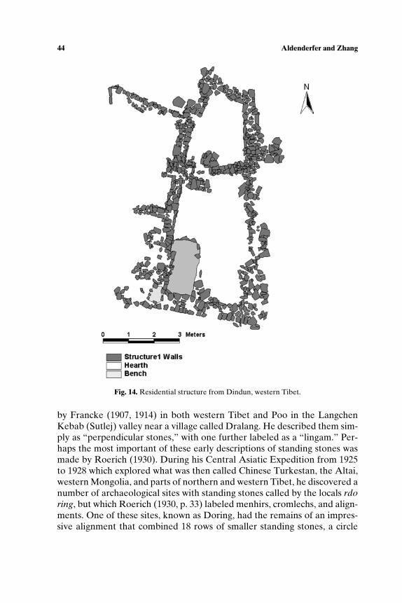
44 Aldenderfer and Zhang
Fig. 14. Residential structure from Dindun, western Tibet.
by Francke (1907, 1914) in both western Tibet and Poo in the LangchenKebab (Sutlej) valley near a village called Dralang. He described them sim-ply as “perpendicular stones,” with one further labeled as a “lingam.” Per-haps the most important of these early descriptions of standing stones wasmade by Roerich (1930). During his Central Asiatic Expedition from 1925to 1928 which explored what was then called Chinese Turkestan, the Altai,western Mongolia, and parts of northern and western Tibet, he discovered anumber of archaeological sites with standing stones called by the locals rdoring, but which Roerich (1930, p. 33) labeled menhirs, cromlechs, and align-ments. One of these sites, known as Doring, had the remains of an impres-sive alignment that combined 18 rows of smaller standing stones, a circle
The Prehistory of the Tibetan Plateau to the Seventh Century A.D. 45
of larger ones, and an arrow-shaped alignment pointing due west (Roerich,1930, p. 16). Among the speculations he offered as an interpretation of thisset of alignments were broad similarities of the Tibetan alignments withthe megalithic cultures of western Europe, and the presence of the arrowas a reflection of the indigenous “nature cult,” which he said included sunand fire worship, among other things. Elsewhere, he argued that a thoroughexamination of Bon manuscripts would help to create a context for under-standing the function of these stones.
Chinese archaeologists have examined standing stones as an aspectof mortuary practice and not specifically as an independent cultural man-ifestation (Huo, 1995). Most of their research has been devoted to basicdescriptions of alignments when encountered, and attempts to classifyvariation in them within this mortuary perspective. Bellezza (2001, 2002)has offered a number of potential explanations for their use: stone pillars invarious combinations may have had at least four roles, including territorialmarkers, monuments of clans or chieftains, markers for mortuary sites, andshrines for the worship of indigenous deities. The roles of stelae and mono-lithic alignments are interpreted through a lens of modern mythologicalbeliefs, ranging from associations with the Gesar epic to persistent featuresof Bon, including boundary markers and religious symbols (Bellezza, 2001,pp. 34–38).
Many of the stones discussed so far, indeed, the vast majority of thoseencountered by Roerich, Bellezza, and others on their expeditions, havestrong affinities to the standing stones and megalithic monuments found allacross north and central Asia and which date from the Bronze Age intohistorical times (Jacobsen-Tepfer et al., 2001). The earliest of these stand-ing stones, which possibly date to the early Bronze Age (ca. 2000 B.C.) arelarge megalithic constructions which are often elaborately carved; none ofthese are known from the Tibetan plateau. So-called “deer stones,” oftenfound singly as well as in small groups, tend to have images of deer or otheranimals or weapons carved upon their surfaces, and are frequently foundwithin small rectangular enclosures. Uncarved examples are also known,and these bear a real resemblance to some of the larger standing stonesseen on the Chang Tang. Those from Mongolia that can be dated by eval-uation of the art motifs found upon them tend to fall into the late BronzeAge or early Iron Age (ca. 1000 B.C.–A.D. 500). These general similaritiesbetween deer stone complexes and some Tibetan plateau standing stonesoffer a temptation to date those found on the Tibetan plateau to this antiq-uity. While this is plausible, it must remain a hypothesis subject to furtherrevision. The cultural affiliation of those who erected these stones are un-known, and as before, it is premature to assign these stones to Zhang zhungpeople as has been done by some authors.
46 Aldenderfer and Zhang
The only known center of the Zhang zhung polity examined by anyscholar is its putative capital, Kyunglung. The Tibetologist Giuseppe Tuccivisited it in 1933 (Tucci, 1989, pp. 189–199), and he recorded a number ofsacred and secular buildings as well as residential areas. A brief reconnais-sance by archaeologists from the Chinese Institute of Tibetology has lo-cated a number of mortuary sites in its vicinity. Kyunglung will be studiedin detail over the next 5 years, and fundamental questions about its size,the nature of its settlement hierarchy, and dating, will be addressed. Eventhese highly limited findings suggest that numerous centers should be foundacross the plateau, especially in the central valleys.
THE FUTURE OF ARCHAEOLOGY IN TIBET
The most obvious remark we can make about the future of archaeol-ogy in Tibet is that far more research of all kinds will be required beforewe can begin to address basic questions of broader anthropological con-cern, such as the origins of settled village life and the evolution of morecomplex polities. Few sites of any time period have been systematicallyexcavated, and chronological control is, as we have shown, quite limitedand spotty. And since most of the research effort of Chinese archaeolo-gists who work on the plateau is focused on the historical period, we donot expect rapid improvement of this situation. There is no question, how-ever, that Chinese archaeologists and their Tibetan counterparts will con-tinue their research. Their focus may change, however, since the centralgovernment has plans to significantly increase public spending and invest-ment in western China, which includes Tibet, over the next decade. Howmuch of this will directly benefit archaeological research is unclear sincethe stated goals of the investment program are to expand job opportu-nities by creating factories, expanding the road network, and developingpublic works projects. Some rescue archaeology may result from this ex-pansion. As an example, archaeologists from Sichuan University, ShaanxiArchaeological Institute, and the Bureau of Cultural Relics conducted abrief reconnaissance of the planned route of the Golmud-Lhasa rail line in2002.
We also expect the central government to continue its investmentin historic preservation projects on the plateau. The Potala palace (po-litical and spiritual seat of the Dalai Lamas), the Norbulingka (summerresidence of the Dalai Lama), and Jokhang temple, all in Lhasa, are onthe World Heritage list, and each has seen substantial renovation andrestoration over the past decade. Numerous small and large monastic in-stitutions and temples, such as Kumbum near Xining and Ganden near
The Prehistory of the Tibetan Plateau to the Seventh Century A.D. 47
Lhasa across the plateau have seen restoration efforts. One obvious mo-tivation for preservation is to enhance tourism as well as a genuine de-sire to preserve at least some of the architectural foundations of Tibetanhistory. In contrast, massive urban renewal projects in both Lhasa andShigatse have destroyed hundreds of traditional Tibetan structures(Larssen and Sinding Larsen, 2001). While there is no question that someof the oldest structures were unsafe and unsanitary and as such, requiredreplacement or renovation, the scale of this process and especially itsrapidity, is unsettling. A number of western organizations, such as theTibet Heritage Fund (THF), worked for a time with authorities in Lhasa todevelop a more comprehensive and rational development plan that wouldpreserve the most outstanding traditional structures, but unfortunately, theTHF was prevented from continuing this work in 2000. More recently ajoint Norwegian–Tibet University–Lhasa and state authorities group hasbeen attempting to develop a similar preservation plan, and has at a re-cent conference had an archaeologist familiar with research in urban set-tings attend (Amund Sinding Larsen, personal communication, September2003).
If the lessons learned from historic preservation apply to archaeology,the probability of a significant western presence in archaeology in theplateau appears to be slim. We believe, however, that the application ofwestern style techniques and some cooperation with western archaeologistswill be important. Although a number of areas on the plateau have beenexamined at least superficially, to date no western style systematic regionalsurvey has ever been attempted. It is our belief that as Chinese universitiesand archaeological institutes foster more cooperative ventures with theirwestern counterparts as they have in China itself, gaps of data in crucialareas of the plateau, such as in the central valleys of the Yarlung Tsangpo,will be filled in slowly. However, we also acknowledge that admittance ofwestern archaeologists to the plateau is a political issue of some delicacy.Only one western archaeologist (Aldenderfer) has been authorized towork in the TAR, and we do not expect the plateau to open to largenumbers of foreign archaeologists of any nationality in the foreseeablefuture. Cooperation will be limited to student exchanges, short-termtraining opportunities for Tibetan and Chinese archaeologists in the westand Asian universities, faculty and researcher exchanges and consultations,and museum-to-museum cooperative ventures.
Although there are many data gaps that need filling, among the moreimportant, at least to us, are the following: the question of the number andtiming of migrations to the plateau needs some resolution. Although almostall scholars interested in the problem acknowledge that a very early (pre-Homo sapiens) movement of people to the plateau is not likely, indeed,
48 Aldenderfer and Zhang
highly improbable (Aldenderfer, 2004b), there may well have been a num-ber of migrations to the plateau over the past 50,000 B.P.. As we noted above,the most probable initial entry brings people from north Asia onto theplateau sometime around 25,000–30,000 B.P.. However, it remains possiblethat entry could have been achieved from the northwest at this time (orlater, for that matter), and some have even speculated upon a route fromthe southwest up the Indus valley (Samuel, 2000). All of these are plausible,but at present lack any data by which they could be evaluated. The resolu-tion of this question will involve not only new archaeological data, but moreextensive analysis of Y haplotype, mtDNA, and other genetic data of mod-ern Tibetans as well as the recovery of ancient DNA from human remainsfrom multiple locations on the plateau.
A closely related problem is the necessity to develop a more nuancedunderstanding of culture process on the plateau. Many reconstructions ofTibetan prehistory take an explicitly diffusionist stance, and posit that peo-ple, innovations, and fundamental aspects of subsistence practice, politicalinstitutions, and cultural forms diffused onto the plateau from external, of-ten low elevation, sources. Such reconstructions ignore the reality of hy-poxia and the constraints it places upon human behavior, and often dis-count environmental conditions, such as extreme aridity or cold, that wouldmitigate against the successful establishment of plant cultivation. Further,many of these diffusions are thought to have originated from far awayplaces, such as the Middle East. Although it is now well known that verylarge-scale movements of people criss-crossed the central and east Asia inprehistory, it is not wise to assume that these movements necessarily influ-enced the plateau and were responsible for the development of complexityor any other cultural formation found upon it. There is no question thatmany items of material culture and subsistence staples in common use onthe plateau did not originate there, such as bronze and iron tools and do-mesticates like barley, millet, horse, and pig. However, these models rou-tinely ignore the context of diffusion, and simply assume a demic “spread”model for their appearance on the plateau. It is apparent that there maywell have been “indigenous” people present on the plateau when many ofthese diffusions took place, and models that describe potential interactionsare urgently needed.
We have barely begun to understand the basic outlines of the prehis-tory of the Tibetan plateau, but if this review of what has been accomplishedby Chinese and western archeologists over the past 30 years is any indica-tion, we can look forward to continued discoveries that can only be en-hanced by the attempt to place these discoveries in a broader Asian con-text, which will permit not only historical research, but also investigation ofmajor questions of anthropological concern.
The Prehistory of the Tibetan Plateau to the Seventh Century A.D. 49
ACKNOWLEDGMENTS
Aldenderfer is grateful to the Tibetan Bureau of Cultura Relics, aswell as the national Bureau of Cultural Relics, Ministry of Culture, People’sRepublic of China, for the opportunity to work in the Tibet AutonomousRegion. His coworkers at Sichuan University, Chengdu, Sichuan—Huo Weiand Li Yongxian—have been the best of colleagues, and have served ashis teachers in what is known of Tibetan archaeology. We have also ben-efited from discussions with Tang Hui-Sheng and Xu Xingwuo on differ-ent aspects of Tibetan archaeology. Amy Heller of Nyon, Switzerland, hasprovided us with useful information, and has led me through the complex-ities of the historical literature of Tibet. Holley Moyes prepared the maps,and worked with Aldenderfer in the field in western Tibet in 2001, and hasbeen a major source of inspiration and sound critique. Cynthia Beall hasoffered good advice on how to interpret genetic relationships of Tibetansand other east Asian populations, and has also given us real insight into un-derstanding the physiological complexities of life at high elevation. Thanksare also due to John Olsen and P. Jeffrey Brantingham who reviewed themanuscript and offered a number of helpful suggestions. Financial assis-tance for our research in Tibet has been provided by a donor who wishesto remain anonymous, and who has loved Tibet and the Tibetan peoplefor more than three decades. We are profoundly in his debt for makingthis dream come true. All errors of interpretation and omission are oursalone.
REFERENCES
Aldenderfer, M. (1998). Montane Foragers: Asana and the South-Central Andean Archaic, Uni-versity of Iowa Press, Iowa City.
Aldenderfer, M. (1999). The Pleistocene/Holocene transition in transition in Peru and its ef-fects upon the human use of the landscape. Quaternary Int. 53/54: 11–19.
Aldenderfer, M. (2001a). Piyang: A 10th/11th C A.D. Tibetan Buddhist temple and monasticcomplex in far western Tibet. Archaeol., Ethnol., Anthropol. Eurasia 4(8): 138–146.
Aldenderfer, M. (2001b). Roots of Tibetan Buddhism. Archaeology 54(3): 610–612.Aldenderfer, M. (2003). Moving up in the world. Am. Sci. 91: 542–549.Aldenderfer, M. (2004a). Domestic rdo-ring? A new class of standing stone from the Tibetan
plateau. Tibet Journal 28: 1–23.Aldenderfer (2004b). Early human occupations of the Tibetan plateau and Andean altiplano.
Paper presented at the American Association for the Advancement of Science, Seattle,WA.
Aldenderfer, M. (in press). Archaeology and ethnicity in far western Tibet: The evidence fromDindun. In Heller, A. (ed.), Proceedings of the Tenth IATS, Brill, Leiden.
Aldenderfer, M., and Moyes, H. (2004). Excavations at Dindun, a pre-Buddhist village site infar western Tibet. In Huo, W., and Li, Y. (eds.), Essays of the International Conferenceon Tibetan Archaeology and Art, Center for Tibetan Studies, Sichuan Union University,Chengdu, China, pp. 47–69.
50 Aldenderfer and Zhang
An, Z. et al. (1982). Paleoliths and microliths from Shenja and Shuanghu, northern Tibet. Curr.Anthropol. 23(5): 493–499.
Aufschneider, P. (1956). Prehistoric sites discovered in inhabited regions of Tibet. East West7: 74–88.
Beckwith, C. (1987). The Tibetan Empire in Central Asia, Princeton University Press, Prince-ton, NJ.
Bellezza, J. (2000). Buddhist archaeological sites in northern Tibet: An introductory report onthe types of monuments and related literary and oral historical sources. Kailash 19 (1/2):1–142.
Bellezza, J. (2001). Antiquties of Northern Tibet , Pre-Buddhist Archeological Discoveries onthe High Plateau, Findings of the Changthang Circuit Expedition, 1999, Adroit Publishers,Delhi.
Bellezza, J. (2002). Antiquities of Upper Tibet: Pre-Buddhist Archaeological Sites on the HighPlateau. Findings of the Upper Tibet Circumnavigation Expedition, 2000, Adroit Publish-ers: Delhi.
Brantingham, P., Krivoshapkin, A., Li, J., and, Tserendagva, Y. (2001a). The initial UpperPaleolithic in northeast Asia. Curr. Anthropol. 42: 735–747.
Brantingham, J., Ma, H., Olsen, J., Gao, X., Madsen, D., and Rhode, D. (2003). Speculationon the timing and nature of Late Pleistocene hunter-gatherer colonization of the TibetanPlateau. Chin. Sci. Bull. 48(14): 1510–1516.
Brantingham, P., Olsen, J., and Schaller, G. (2001b). Lithic assemblages from the Chang Tangregion, northern Tibet. Antiquity 75: 319–327.
Bronk Ramsey, C. (2002). OxCal Program v3.8. Radiocarbon Accelerator Unit, University ofOxford, Oxford.
Brown, P. (1999). The first modern East Asians? Another look at Upper Cave 101, Liujiang,and Minatogawa 1. In Omoto, K. (ed.), Interdisciplinary Perspectives on the Origins of theJapanese, International Research Center for Japanese Studies, Kyoto, Japan, pp. 105–130.
Bureau of Cultural Relics, Tibet Autonomous Region (1990). Xizang Xiaoenda xin shi qi shidai yi zhi shi jue jian bao [Brief report on the excavation of Xiaoenda Neolithic site inTibet]. Kaogu Yu Wenwu 1: 28–43.
Bureau of Cultural Relics, Tibet Autonomous Region and Department of History, SichuanUniversity (1985). Changdu Karou. [Karou: A Neolithic Site in Tibet], Cultural Relics Pub-lishing House, Beijing, China.
Cavalli-Sforza, L. (1998). The Chinese human genome diversity project. Proc. Nat. Acad. Sci.U.S.A. 95: 11501–11503.
Cavalli-Sforza, L., Menozzi, P., and Piazza, A. (1994). The History and Geography of HumanGenes, Princeton University Press, Princeton, NJ.
Chang, D.H.S. (1981). The vegetation zonation of the Tibetan plateau. Mountain Res. Dev. 1:29–48.
Chang, K.C. (1981). Archaeology and Chinese historiography. World Archaeol. 13(2): 156–169.
Chang, K. C. (1986). The Archaeology of Ancient China, Yale University Press, New Haven,CT.
Chayet, A. (1994). Art et Archeologie du Tibet, Picard, Paris.Chen, C. (1984). The Microlithic of China. J. Anthropol. Anthropol. 1: 79–115.Chen, C., and Wang, X. (1989). Upper Paleolithic microblade industries in north China and
their relationships with northeast Asia and North America. Arctic Anthropol. 26: 144–145.
China Tibetology Institute, Archaeology Department of Sichuan University and Bureau ofCultural Relics, Tibet Autonomous Region (2001a). Xi zang zha da xian pi yang dong gayi zhi gu mu qun shi jue jian bao [Brief report of a preliminary excavation of ancient tombgroups in Piyang-Dongga site of Zhada county in Tibet]. Kaogu 6: 14–31
China Tibetology Institute, Archaeology Department of Sichuan University and Bureau ofCultural Relics, Tibet Autonomous Region (2001b) Xizang Zhada xian Gebusailu mudidiaocha [Survey of the Gebusailu cemetery in Zhada County, Tibet]. Kaogu 6: 39–44.
The Prehistory of the Tibetan Plateau to the Seventh Century A.D. 51
Chu, J., Huang, W., Kuang, S., Wang, J., Xu, J., Chu, A., Yang, A., Lin, K., Li, P., Wu, W.,Geng, Z., Tan, C., Du, R., and Jin, L. (1998). Genetic relationships of populations inChina. Proc. Nat. Acad. Sci. U.S.A. 95: 11763–11768.
Chung, K. (1960) On Zhang zhung. Bull. Inst. History Philol. Acad. Sin. 4: 137–154 (Taipei,Taiwan).
Duan Qingbo (1989). Xizang xi shi gi yi cun. [Microlithic remains in Tibet.] Kaogu Yu Wenwu5: 87–109.
Elston, R., and Brantingham, P. J. (2002). Microlithic technology in northern Asia: A risk-minimizing strategy of the Late Paleolithic and Early Holocene. In Elston, R., and Kuhn,S. (eds.), Thinking Small: Global Perspectives on Microlithization, Archaeological Papersof the American Anthropological Association 12, Washington, DC, pp. 103–116.
Etler, D. (1996). The fossil evidence for human evolution in Asia. Annu. Rev. Anthropol. 25:275–301.
Francke, A. (1907). A History of Western Tibet, One of the Unknown Empires, Patridge,London.
Francke, A. (1914). Antiquities of Indian Tibet, Archaeological Survey of Indian 38, Part 1:Personal Narrative, Calcutta, India.
Gai, P. (1985). Microlithic industries in China. In Wu, R., and Olsen, J. (eds.), Paleoanthropol-ogy and Paleolithic Archaeology in the People’s Republic of China, Academic Press, NewYork, pp. 225–242.
Gai, P., and Wang, K. (1983). Huanghe shangyou Layihai xishiqi yizhi fajue baogao [Excava-tion report on a Mesolithic site at Layihai, Upper Yellow River]. Acta Anthropol. Sin. 2:49–59.
Gai, P., and Wei, Q. (1977). Hutouliang Jiushiqishidai wanqi yizhi-de faxian [Discovery of theLate Paleolithic site at Hutouliang, Hebei]. Vertebrata Pal Asiatica 15(4): 287–300.
Gasse, F., Fontes, J., Van Campo, E., and Wei, K. (1996). Holocene environmental changes inBangong Co. basin (Western Tibet). Palaeogeogr., Paleaoclimatol. Palaeoecol. 120: 79–92.
Goldstein, M. (1997). The Snow Lion and the Dragon : China, Tibet, and the Dalai Lama,University of California Press, Berkeley.
Goldstein, M., and Kapstein, M., (eds.) (1998). Buddhism in Contemporary Tibet: ReligiousRevival and Cultural Identity, University of California Press, Berkeley.
Haarh, E. (1969). The Yarlung Dynasty, University of Copenhagen, Denmark.Hanson, A., Ritts, B., Zinniker, D., Moldowan, J., and Biffi, U. (2001). Upper Oligocene la-
custrine source rocks and petroleum system of the northern Qaidam Basin, NW China.Am. Assoc. Petrol. Geol. Bull. 85: 601–619.
He, Q. (1994). Xizang Gongga xian Changguogou xinshiqi yizhi diaocha baogao [A report onthe investigation of the Neolithic sites in Changgaougou, Gongga County, Tibet]. Xizangkaogu 1: 28.
Hou, S. (1991). Xizang Kaogu Da Gang [Archaeological Survey of Tibet], People’s PublishingHouse of Tibet, Lhasa.
Huang, W. (1994). The prehistoric human occupation of the Qinghai-Xizang plateau. GotingerGeographische Abhandlungen 95: 201–219.
Huo, W. (1994). Xizang Qugong cui shi shi mu chu tu de dai bing tong jing ji qi xiang guan wenti chu tan [A preliminary discussion of the bronze mirror with an iron handle unearthedat the Qugong cyst tomb, Tibet]. Kaogu 7: 650–661.
Huo, W. (1995). Xizang Gu Dai Mu Zang Zhi Du Yan Jiu [Studies on Ancient Tibetan BurialCustoms], Sichuan People’s Publishing House, Chengdu.
Huo, W. (1997). Zai lun Xizang dai bing tong jing de you guan wen ti [A further discussion onquestions related to bronze mirrors with a handle from Tibet]. Kaogu 11: 61–69.
Huo, W. (2000). Jin shi nian Xizang kao gu de fa xian yu yan jiu [Archaeological findings andresearches in the late ten years]. Wenwu 3: 85–95.
Huo, W. (2002a). Xizang a li dong ga fu shi dian tang yi zhi de kao gu fa jue [Excavation of aBuddhist Temple in Ngari, Tibet 2002]. Wenwu 8: 34–39.
Huo, W. (2002b). Xi zang a li zha da xian xiang quan he liu yu fa xian de liang zuo fu jiao shiku [Two Buddhist caves newly discovered in Zanda County, Tibet.] Wenwu 8: 63–69.
52 Aldenderfer and Zhang
Huo, W., and Li, Y. (1993a). Ji long wen wu zhi [A Survey of the Cultural Relics in KyirongCounty]. People’s Publishing House of Tibet, Lhasa.
Huo, W., and Li, Y. (1993b). Ali di qu wen wu zhi [A Survey of the Cultural Relics in AliPrefecture]. People’s Publishing House of Tibet, Lhasa.
Huo, W., and Li, Y. (2001). Xi zang zha da xian pi yang-dong ga yi zhi 1997 nian diao cha yufa jue [Survey and excavation of the Piang-Dongga site in Zanda County, Tibet, in 1997].Acta Archaeol. Sin. 3: 397–426.
Institute of Archaeology, Chinese Academy of Social Science and Bureau of Cultural Relics,Tibet Autonomous Region (1991a). Xizang Lasa shi Qugong cun xin shi qi shi dai yi zhi diyi ci fa jue jian bao [Brief report on the first excavation of Qugong neolithic site in LhasaTibet]. Kaogu 10: 873–881.
Institute of Archaeology, Chinese Academy of Social Science and Bureau of Cultural Relics,Tibet Autonomous Region (1991b). Xizang Lasa shi Qugong cun shi shi mu fa jue jianbao [Brief report on the excavation of the Qugong burials in Lhasa, Tibet]. Kaogu 10:927–931
Institute of Archaeology, Chinese Academy of Social Science and Bureau of Cultural Relics,Tibet Autonomous Region (1999a). Xizang guoga xian chuang guo gou xin shi qi shi daiyi zhi [The Changuogou neolithic site in Gongga county, Tibet]. Kaogu 4: 1–10
Institute of Archaeology, Chinese Academy of Social Science and Bureau of Cultural Relics,Tibet Autonomous Region (1999b). Qugong in Lhasa: Excavations of an Ancient Site andTombs, Encyclopedia of China Publishing House, Beijing.
Jacobsen-Tepfer, E., Kubarev, V. D., and Tseveendorj, D. (2001). Mongolie du Nord-Ouest:Tsagaan Salaa/Baga Oigor. Repertoire des Petroglyphes d’Asie centrale, Fascicule no. 6.Sher, J. A., and Francfort, H.-P. (eds.), 2 vols., De Boccard, Paris.
Jian, N. (2000). A simulation of biomes on the Tibetan plateau and their responses to globalclimatic change. Mountain Res. Dev. 20: 80–89.
Jiayang, and Huo, W. (2001). Er shi shi ji Xizang kaogu de hui gu yu si kao [A retrospect ofarchaeology in Tibet during the 20th century]. Kaogu 6: 3–13.
Kuhle, M. (1988). The Pleistocene glaciation of Tibet and the onset of the ice ages: An auto-cycle hypothesis. GeoJournal 17: 581–595.
Kuhle, M. (1998). Reconstruction of the 2.4 km2 Late Pleistocene ice sheet on the Tibetanplateau and its impact of the global climate. Quaternary Int. 45/46: 71–108.
Larssen K., and A. Sinding Larsen (2001). The Lhasa Atlas: Traditional Tibetan Architectureand Townscape, Shambhala, Boston.
Lehmkuhl, F. (1997). Late Pleistocene, Late-glacial, and Holocene glacial advances on theTibetan plateau. Quaternary Int. 38/39: 77–83.
Lehmkuhl, F. (1998). Extent and spatial distribution of Pleistocene glaciations in eastern Tibet.Quaternary Int. 45/46: 123–134.
Lehmkuhl, F., and Haselein, F. (2000). Quaternary paleoenvironmental change on the TibetanPlateau and adjacent areas (western China and western Mongolia). Quaternary Int. 65/66:121–145.
Li, J., and Zhao, H. (1999). Xizang Gongga xian Changguogou xinshiqi yizhi [The Chang-guoguo Neolithic site in Gongga, Tibet]. Kaogu 4: 1–10.
Li, Y. (1991). Ji long luo long gou de ya lu zang bu jiang zhong shang you de shi qi yi cun—jianlun xi zang gao yuan xi shi qi yi cun de xiang guan wen ti [Deposits of stone implementsin the Gyirong area and the upper and middle reaches of the Yarlung Tsangpo River: Areference to some correlative questions about the early stone implements in Tibet]. Nanfang min zu kaogu 4: 47–63.
Li, Y. (1994). Lun Xizang de xishiqi [On the microlithic implements of Tibet]. Xizang yanjiu1: 126–132.
Liu, J., Yu, G., and Chen, X. (2002). Palaeoclimate simulation of 21 ka for the Tibetan plateauand eastern Asia. Climate Dyn. 19: 575–583.
Liu, Z. 1981. Xi zang gao yuan ma fa mu hu dong bei an deng san ge di dian de xi shi qi[Microlith from three sites on the northeast coast of Mapham lake in Tibet]. J. NanjingUniv. 4: 87–96.
The Prehistory of the Tibetan Plateau to the Seventh Century A.D. 53
Liu, Z., and Wang, F. 1986. Xi zang gao yuan duo ge ze yu zha bu di dian de jiu shi qi—jianlun gao yuan gu huan jing dui shi qi wen hua fen bu de ying xiang [Paleoliths from theDuogeze and Zhabu sites of the Tibetan plateau—On the paleo-environmental influenceon the distribution of stone culture on Tibetan plateau]. Kaogu 4: 289–299.
Macdonald, A. W. (1953). Une note sur les megaliths Tibetains. J. Asiatique 241: 63–76.Madsen, D., Li, J., Brantingham, P. J., Gao, X., Elston, R., and Bettinger, R. (2001). Dating
Shuidonggou and the Upper Paleolithic blade industry in north China. Antiquity 75: 706–716.
Matisoff, J. (1991). Sino-Tibetan linguistics: Present state and future prospects. Annu. Rev.Anthropol. 20: 469–504.
Miehe, G. (1996). On the connexion of vegetation dynamics with climate changes in High Asia.Palaeogeogr. Paleaoclimatol. Palaeoecol. 120: 5–24.
Overpeck, J., Anderson, D., Trumbore, S., and Prell, W. (1996). The southwest Indian mon-soon over the past 18000 years. Climate Dyn. 12: 213–225.
Petech, L. (1997). Western Tibet: Historical introduction. In Klimburgh-Salter, D. (ed.), Tabo:A Lamp for the Kingdom, Thames and Hudson, London, pp. 229–255.
Qian, F., and Wu, X. 1988. Zang bei gao yuan ge ting shi qi chu bu guan cha [A preliminaryobservations on the stone artifacts collected from Geting in northern Tibetan plateau].Ren Lei Xue Xue Bao 7:75–83.
Qian, Y., B. Qian, B. Su, J. Yu, Y. Ke, Z. Chu, L. Shi, D. Lu, J. Chu, and L. Jin. (2000). Multipleorigins of Tibetan Y chromosome. Hum. Genet. 106: 453–454.
Ren, G. (2000). Decline of the mid-to-late Holocene forests in China: Climate change or hu-man impact? J. Quaternary Sci. 15: 273–281.
Ren, G., and H. Beug (2002). Mapping Holocene pollen data and vegetation of China. Qua-ternary Sci. Rev. 21: 1395–1422.
Renfrew, C. (2000). At the edge of knowability: Towards a prehistory of languages. CambridgeArchaeol. J. 10: 7–34.
Roerich, G. (1930). The Animal Style Among the Nomad Tribes of Northern Tibet, SeminariumKondakovianum, Prague, Czech Republic.
Rowley, D., R. Pierrehumbert, and B. Currie. (2001). A new approach to stableisotope-based paleoaltimetry: Implications for paleoaltimetry and paleohypsometryof the High Himalaya since the Late Miocene. Earth Planet. Sci. Lett. 188: 253–268.
Samuel, G. (1993). Civilized Shamans: Buddhism in Tibetan Societies, Smithsonian InstitutionPress, Washington, DC.
Samuel, G. (2000). The Indus Valley civilization and early Tibet. In Karmay, S., and Nagano,Y. (eds.), New Horizons in Bon Studies, National Museum of Ethnology, Osaka, Japan,pp. 651–670.
Schafer, J., Tschudi, S., Zhao, Z., Wu, X., Ivy-Ochs, S., Wieler, R., Baur, H., Kubik, P., andSchluchter, C. (2002). The limited influence of glaciations in Tibet on global climate overthe past 170000 years. Earth Planet. Sci. Lett. 194: 287–297.
Schaller, G. (1998). Wildlife of the Tibetan Steppe, University of Chicago Press, Chicago.Snellgrove, D., and H. Richardson (1995). A Cultural History of Tibet, Shambhala, Boston.Stein, R. A. (1972). Tibetan Civilization, Stanford University Press, Stanford, CA.Su, B., Xiao, J., Deka, R., Seielstad, M., Kangwanpong, D., Xiao, J., Lu, D., Under-
hill, P., Cavalli-Sforza, L., Chakraborty, R., and Li, J. (2000). Y chromosome hap-lotypes reveal prehistorical migrations to the Himalayas. Hum. Genet. 107: 582–590.
Su, B., Xiao, J., Underhill, P., Deka, R., Zhang, W., Akey, J., Huang, W., Shen, D., Lu, D.,Luo, J., Chu, J., Tan, J., Shen, P., Davis, R., Cavalli-Sforza, L., Chakraborty, R., Xiong,M., Du, R., Oefner, P., Chen, Z., and Jin, L. (1999). Y- chromosome data evidence for anorthward migration of modern humans into eastern Asia during the last Ice Age. Am. J.of Human Genetics 65: 1718–1724.
Suolang, W. (1986). Naidong xian wenwu zhi. [A Survey of Cultural Relics in Ngang-RingCounty], People’s Publishing House, Lhasa, Tibet.
54 Aldenderfer and Zhang
Suolang, W. (1991). Xi zang kao gu xin fa xian zong shu [A brief summary of new archaeolog-ical discoveries in Tibet]. In Tong, E. (ed.), Nan fang min zu kaogu [Southern Ethnologyand Archaeology], Sichuan University, Chengdu, China. Vol. 4, pp. 9–24.
Tang, H. (1999). Lue lun qing zang gao yuan de jiu shi qi he xi shi qi [A preliminary researchon the Paleolith and Microlith on Tibetan plateau]. Kaogu 5: 44–54.
Tang, H., and Hare, J. (1995). Lithic tool industries and the earliest occupation of the Qinghai-Tibetan plateau. Artefact 18: 3–11.
Tong, E. (1978). Shilun chuanxibei shiguanmu de zuqun wenti [A tentative study of the eth-nicity of stone coffin burials in northwestern Sichuan]. Kaogu 2: 34–45.
Tong, E. (1983). Ren lei ke neng de fa yuan di—zhong guo xi nan di qu [Southwest China: Apossible place of origin for the human beings]. J. Sichuan Univ. 3: 3–14.
Tong, E. (1985). Xi zang kao gu zong shu [A summary of the archaeology of Tibet]. Wenwu 9:9–19
Tong, E. (1989). Xi zang gao yuan shang de shou fu [Hand axe from the Tibetan plateau].Kaogu 9: 822–826.
Tong, E. (1990). Zhong guo xi nan min zu kao gu lun wen ji [Collected Papers on Ethnoarchae-ology in Southwest China], Cultural Relics Publishing House, Beijing.
Torroni A., Miller, J., Moore, L., Zamudio, S., Zhuang, J., Droma, T., and Wallace, D. (1994).Mitochondrial DNA analysis in Tibet—Implications for the origin of the Tibetan popula-tion and its adaptation to high altitude. Am. J. Phys. Anthropol. 92: 189–199.
Tsering, S. (1999). The Dragon in the Land of Snows: A History of Modern Tibet Since 1947,Columbia University Press, New York.
Tucci, G. (1950). The Tombs of the Tibetan Kings, Serie Orientale Roma I, IsMEO.Tucci, G. (1956). Preliminary Report on Two Scientific Expeditions in Nepal, Serie Orientale
Roma X, Istituto Italiano per il Medio ed Estremo Oriente, Rome.Tucci, G. (1989). Sadhus et Brigands du Kailash: Mon Voyage au Tibet Occidental, Editions
R. Chabaud, Paris (1st edition in Italian, 1937).Underhill, A. (1997). Current issues in Chinese Neolithic archaeology. J. World Prehistory 11:
103–160.Underhill, A., Feinman, G., Nicholas, L., Bennet, G., Fang, H., Luan, F., Yu, H., and Cai,
F. (2002). Regional survey and the development of complex societies in southeasternShandong, China. Antiquity 76: 745–755.
van Driem, G. (1998). Neolithic correlates of ancient Tibeto-Burman migrations. In Blench,R., and Spriggs, M. (eds.), Archaeology and Language II, Routledge, London, pp. 67–102.
van Driem, G. (2001). Languages of the Himalayas: An Ethnolinguistic Handbook of theGreater Himalayan Region, 2 vols., Brill, Leiden, The Netherlands.
van Driem, G. (2002). Tibeto-Burman phylogeny and prehistory: Languages, material culture,and genes. In Bellwood, P., and Renfrew, C. (eds.), Examining the Farming/LanguageDispersal Hypothesis, McDonald Institute for Archaeological Research, University ofCambridge, Oxford, pp. 233–249.
Vitali, R. (1990). Early Temples of Central Tibet, Serinda Publications, London.Vitali, R. (2000). Records of Tholing. A Literary and Visual Reconstruction of the “Mother”
Monastery in Guge, Amnye Machen Institute, Dharamshala, India.Von Falkenhausen, L. (1993). On the historiographical orientation of Chinese archaeology.
Antiquity 87: 839–849.Wang, D. (1994). A further typological study of Neolithic culture in Yunnan. J. Tibetan
Archaeol. 1: 91–108.Wang, M. (2002). Searching for Qiang culture in the first half of the twentieth century. Inner
Asia 4: 131–48.Wang, Z. (1994). History of Nationalities in China, China Social Science Press, Beijing.Xiage, W. (1998). Shixi Xizang shiqian shiguanmu de xingshi yu fenqi [A tentative analysis of
types and dates of prehistoric stone coffin burials in Tibet]. Xizang yanjiu 4: 40–44.Zhang, D., and Li, S. (2002). Optical dating of Tibetan human hand- and footprints: An impli-
cation for the palaeoenvironment of the last glaciation of the Tibetan Plateau. Geophys.Res. Lett. 29: 1069.
The Prehistory of the Tibetan Plateau to the Seventh Century A.D. 55
Zhao, H. (1994). Xizang Qugong chutu de tiebing tongjing wenti yanjiu [Questions concern-ing the bronze mirror with an iron handle unearthed in Qugong, Tibet]. Kaogu 7: 47–52.
Zhao, H. (2002). Lun Xizang Bangda yizhi, Qugong wenhua, yu Xizang de shiqian wen-ming [On the Bangga site, Qugong culture, and prehistoric civilization in Tibet]. Paperpresented at the International Academic Conference on Tibetan Archaeology and Art,Beijing.
Zheng, B., and Rutter, N. (1998). On the problem of Quaternary glaciations and the extentand patterns of Plesitocene ie cover in the Qinghai-Xizang (Tibet) plateau. QuaternaryInt. 45/46: 109–122.
Copyright © 2022 FDOKUMEN