The Nyando Atlas: Mapping out the Ecosystem Condition by Agro Ecological Landscape of Nyando River...
40
1 The Nyando Atlas: Mapping out the Ecosystem Condition by Agro Ecological Landscape of Nyando River Basin James B. Kung’u and Sarah Namirembe January 2012
-
Upload
independent -
Category
Documents
-
view
0 -
download
0
Transcript of The Nyando Atlas: Mapping out the Ecosystem Condition by Agro Ecological Landscape of Nyando River...

1
The Nyando Atlas:
Mapping out the Ecosystem Condition by Agro Ecological Landscape of Nyando River Basin
James B. Kung’u and Sarah Namirembe
January 2012
2
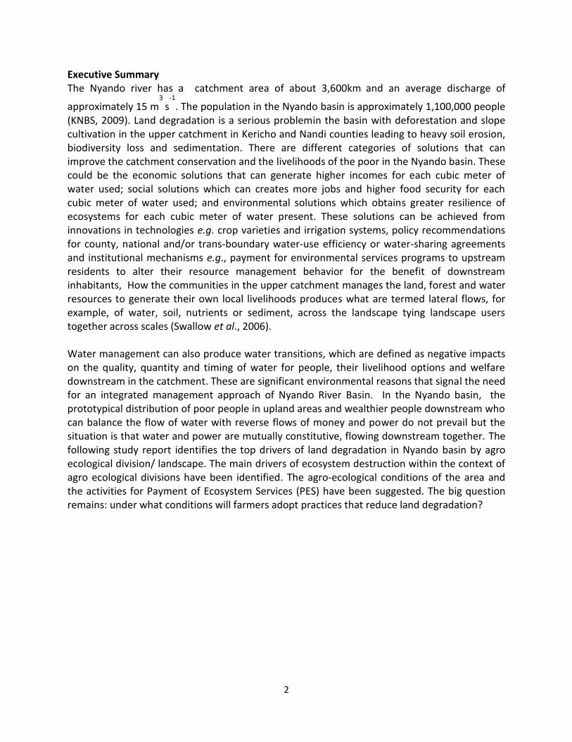
Executive Summary The Nyando river has a catchment area of about 3,600km
and an average discharge of
approximately 15 m3
s-1
. The population in the Nyando basin is approximately 1,100,000 people (KNBS, 2009). Land degradation is a serious problemin the basin with deforestation and slope cultivation in the upper catchment in Kericho and Nandi counties leading to heavy soil erosion, biodiversity loss and sedimentation. There are different categories of solutions that can improve the catchment conservation and the livelihoods of the poor in the Nyando basin. These could be the economic solutions that can generate higher incomes for each cubic meter of water used; social solutions which can creates more jobs and higher food security for each cubic meter of water used; and environmental solutions which obtains greater resilience of ecosystems for each cubic meter of water present. These solutions can be achieved from innovations in technologies e.g. crop varieties and irrigation systems, policy recommendations for county, national and/or trans-boundary water-use efficiency or water-sharing agreements and institutional mechanisms e.g., payment for environmental services programs to upstream residents to alter their resource management behavior for the benefit of downstream inhabitants, How the communities in the upper catchment manages the land, forest and water resources to generate their own local livelihoods produces what are termed lateral flows, for example, of water, soil, nutrients or sediment, across the landscape tying landscape users together across scales (Swallow et al., 2006). Water management can also produce water transitions, which are defined as negative impacts on the quality, quantity and timing of water for people, their livelihood options and welfare downstream in the catchment. These are significant environmental reasons that signal the need for an integrated management approach of Nyando River Basin. In the Nyando basin, the prototypical distribution of poor people in upland areas and wealthier people downstream who can balance the flow of water with reverse flows of money and power do not prevail but the situation is that water and power are mutually constitutive, flowing downstream together. The following study report identifies the top drivers of land degradation in Nyando basin by agro ecological division/ landscape. The main drivers of ecosystem destruction within the context of agro ecological divisions have been identified. The agro-ecological conditions of the area and the activities for Payment of Ecosystem Services (PES) have been suggested. The big question remains: under what conditions will farmers adopt practices that reduce land degradation?
3
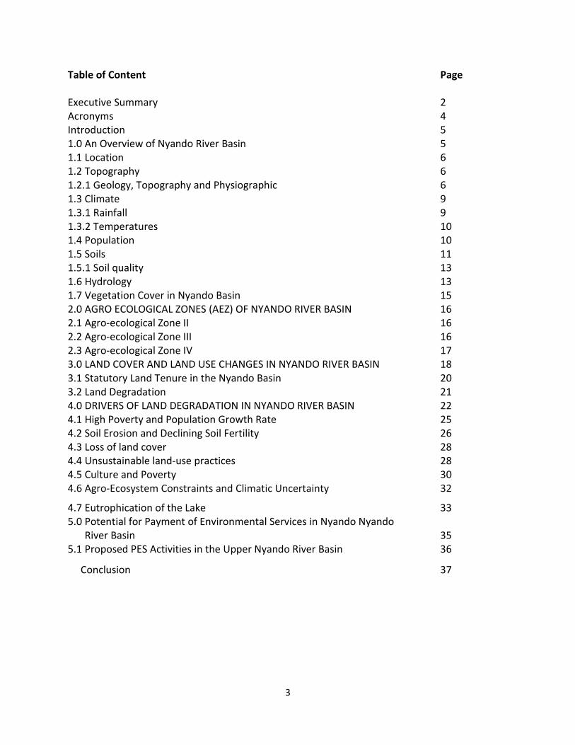
Table of Content Page Executive Summary 2 Acronyms 4 Introduction 5 1.0 An Overview of Nyando River Basin 5 1.1 Location 6 1.2 Topography 6 1.2.1 Geology, Topography and Physiographic 6 1.3 Climate 9 1.3.1 Rainfall 9 1.3.2 Temperatures 10 1.4 Population 10 1.5 Soils 11 1.5.1 Soil quality 13 1.6 Hydrology 13 1.7 Vegetation Cover in Nyando Basin 15 2.0 AGRO ECOLOGICAL ZONES (AEZ) OF NYANDO RIVER BASIN 16 2.1 Agro-ecological Zone II 16 2.2 Agro-ecological Zone III 16 2.3 Agro-ecological Zone IV 17 3.0 LAND COVER AND LAND USE CHANGES IN NYANDO RIVER BASIN 18 3.1 Statutory Land Tenure in the Nyando Basin 20 3.2 Land Degradation 21 4.0 DRIVERS OF LAND DEGRADATION IN NYANDO RIVER BASIN 22 4.1 High Poverty and Population Growth Rate 25 4.2 Soil Erosion and Declining Soil Fertility 26 4.3 Loss of land cover 28 4.4 Unsustainable land-use practices 28 4.5 Culture and Poverty 30 4.6 Agro-Ecosystem Constraints and Climatic Uncertainty 32
4.7 Eutrophication of the Lake 33 5.0 Potential for Payment of Environmental Services in Nyando Nyando River Basin 35 5.1 Proposed PES Activities in the Upper Nyando River Basin 36
Conclusion 37

4
Acronyms
FAO Food and Agriculture Organisation
GoK Government of Kenya
ICRAF International Center for Research in Agroforestry
ITCZ Inter-Tropical Convergence Zone
JICA Japan International Cooperation
KARI Kenya Agriculture Research Institute
KNBS Kenya National Bureau of Statistics
MoWRD Ministry of Water Development
NEMA National Environmental Management Authority
REDD+ Reduced Forest Degradation and Deforestation Plus
WKIEP Western Kenya Integrated Ecosystem Management Project
5
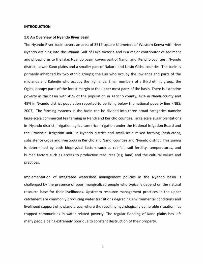
INTRODUCTION
1.0 An Overview of Nyando River Basin
The Nyando River basin covers an area of 3517 square kilometers of Western Kenya with river
Nyando draining into the Winam Gulf of Lake Victoria and is a major contributor of sediment
and phosphorus to the lake. Nyando basin covers part of Nandi and Kericho counties, Nyando
district, Lower Kano plains and a smaller part of Nakuru and Uasin Gishu counties. The basin is
primarily inhabited by two ethnic groups; the Luo who occupy the lowlands and parts of the
midlands and Kalenjin who occupy the highlands. Small numbers of a third ethnic group, the
Ogiek, occupy parts of the forest margin at the upper most parts of the basin. There is extensive
poverty in the basin with 41% of the population in Kericho county, 47% in Nandi county and
48% in Nyando district population reported to be living below the national poverty line KNBS,
2007). The farming systems in the basin can be divided into three broad categories namely:
large-scale commercial tea farming in Nandi and Kericho counties, large scale sugar plantations
in Nyando district, irrigation agriculture (rice irrigation under the National Irrigation Board and
the Provincial Irrigation unit) in Nyando district and small-scale mixed farming (cash-crops,
subsistence crops and livestock) in Kericho and Nandi counties and Nyando district. This zoning
is determined by both biophysical factors such as rainfall, soil fertility, temperatures, and
human factors such as access to productive resources (e.g. land) and the cultural values and
practices.
Implementation of integrated watershed management policies in the Nyando basin is
challenged by the presence of poor, marginalized people who typically depend on the natural
resource base for their livelihoods. Upstream resource management practices in the upper
catchment are commonly producing water transitions degrading environmental conditions and
livelihood support of lowland areas, where the resulting hydrologically-vulnerable situation has
trapped communities in water related poverty. The regular flooding of Kano plains has left
many people being extremely poor due to constant destruction of their property.
6
1.1 Location
The basin is centered on the equator at 35°10E and is situated between Lake Victoria to the
South, Nandi escarpment to the North and Mau escarpment to the Southeast. The basin is
bounded by latitude 007’48’’N and 00 24’ 36’’S and longitude 340 24’ 36’’ E and 350 43’ 12’’ E
(KARI, 2006).
1.2 Topography
1.2.1 Geology, Topography and Physiographic
The land in the Nyando basin slopes generally in the Northeast-Southwest direction. Altitude
varies from about 1,100masl at Lake Victorica shores to about 3,000masl in Londiani and
Tindereet forest. The physiography of the basin consists of scarps formed by the rift faults,
which shape the Kavirondo Rift of the main North-South oriented Rift Valley system. Foot
slopes are typical along the Nandi and Mau escarpment. A gently sloped piedmont plain and
very flat alluvial plain are mainly found in the surface of alluvial deposit and Pleistocene deposit
(JICA, 1992).
The upper catchment of Nyando river basin which is made up of Nandi and Kericho counties has
an altitude ranging between 1300 m and 2500 m in Nandi while Kericho county rises up to over
3,000 m above sea level along the Mau Ridge (GOK, 2009a; GOK 2009b). The physiography of
Nyando Basin consists of the scarps formed by the rift faults, which shape the Kavirondo Rift of
the main North South Rift Valley System (WKIEMP, 2006). Foot slopes are typically along the
Nandi and Mau escarpment. A gently sloped piedmont plain and very flat alluvial plain are
found generally in the surface of alluvial deposits and Pleistocene deposit (JICA, 1992). A gently
sloped piedmont plain and very flat alluvial plain (Kano) are widely spread in the catchment.
The land generally slopes in the Northeast-Southwest direction. The highest altitude is about
3,000 meters above sea level at Londiani and Tinderet forests to 1,100 meters above sea level
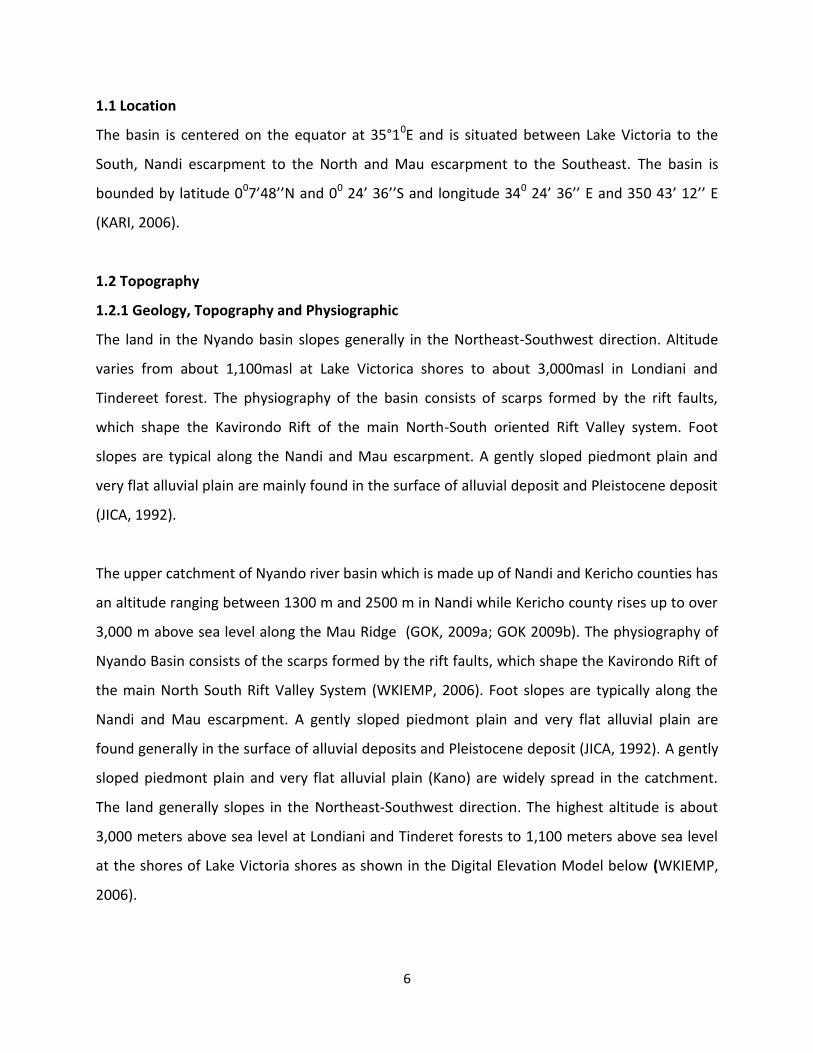
at the shores of Lake Victoria shores as shown in the Digital Elevation Model below (WKIEMP,
2006).
7
Figure 2. Digital elevation of Nyando River Basin
Source: (WKIEMP, 2006)
Nandi and Kericho counties lie at an altitude ranging between 1300m and 3000m above sea
level. Most parts of the counties are hilly with basement rock system, which is distinct to the
South and along the Nandi escarpments giving way to thick layers of red soil anthills (GOK,
2009). Kericho county on the other hand is characterized by undulating topography, with an
overall slope of the land towards the west hence the general drainage of the county is in the
same direction.
8
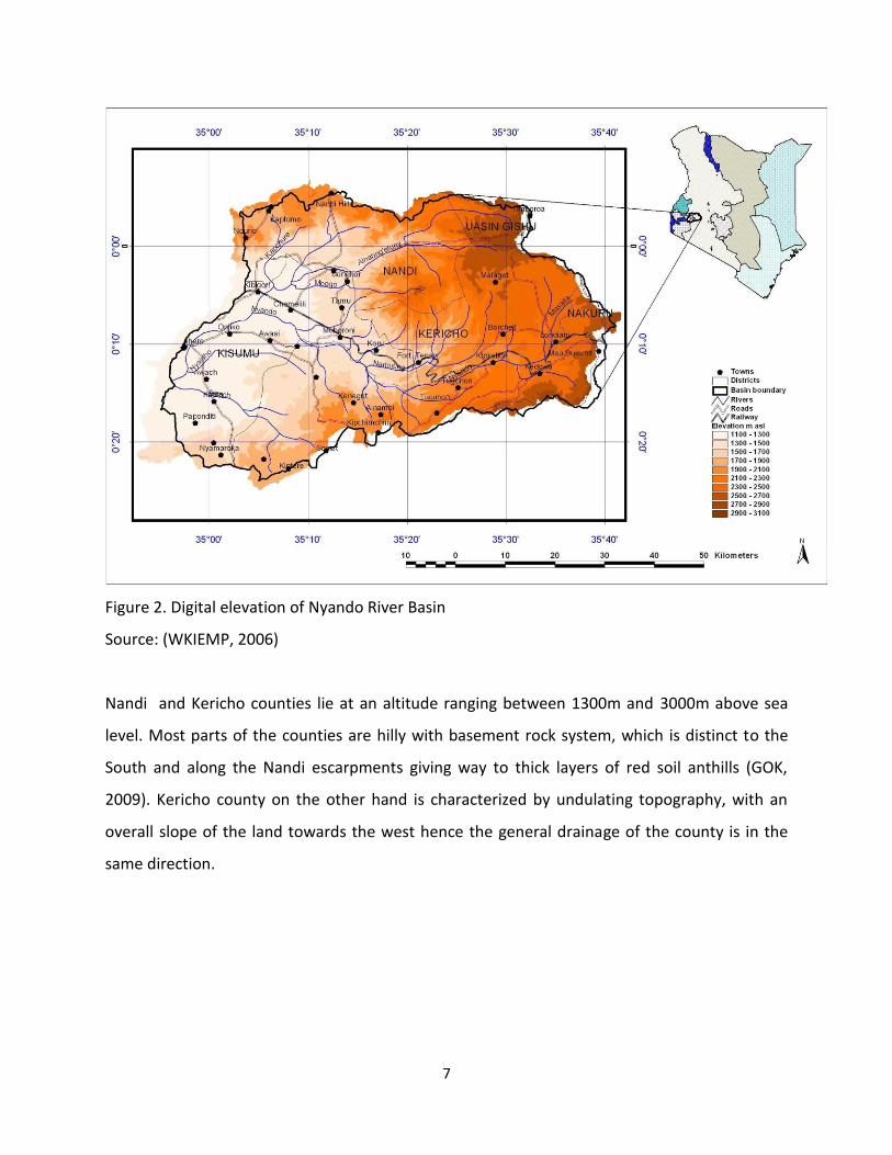
Figure 3. Relief map of Nyando river basin
Kericho county forms a hilly shelf between the Mau Escarpment and the lowland of Nyando
district with the eastward side rising to 3,000m above sea level along Mau Ridge. In the central
part of the county, there is Kericho plateau which slopes gently from about 2,500m to about
1,800m above sea level (GOK, 2009b). Nyando district within Kisumu county on the other hand
falls within the Lake Victoria Lowlands and Floodplains Region. The district is surrounded by
Lake Victoria and steep hills. The lake is to the west and Tinderet Hills to the east while Nandi
Escarpment is to the north and Kisii Hills to the south. The lowest altitude is the same as the
surface level of Lake Victoria, which is 1,134 m above sea level. The lowland area has a flat
topography while it gently changes to steep slopes in north-eastern and southern areas.
9
The lowland flat area, stretches to Miwani, Nyando and Lower Nyakach Divisions, and extends
deep into Kisumu East District and is referred to as Kano Plain. The highest point of the District
is found in Muhoroni Division, which is 1,801 m above sea level. The table land of Upper
Nyakach is referred to as Nyabodo plateau with a highest point of 1,650m (GoK, 2009). The
district has many wetlands, some of which are located in inland areas while others are along
the lakeshores.
1.3 Climate
1.3.1 Rainfall
The climate of the Nyando basin is diverse and ranges from humid to sub humid. This is
attributed to variation in altitude from the highlands to the shores of Lake Victoria. The mean
annual rainfall varies from 1,000mm near the shores of Lake Victoria to over 2000mm in the
highlands of Mau (Njogu, 2000; GOK, 2009). The annual rainfall pattern is bi-modal with peaks
during the long rains (March-May) and short rains (October-December). The first rainy season is
the most pronounced and is experienced throughout the basin from March to May (Verchot et
al., 2007). This is normally followed by a long dry spell, which starts in June and ends in August.
The short rainy season starts in October and lasts for two months until November, followed by
the long dry spell which starts in December through to February (NEMA, 2004). In the lowlands,
the climate is sub-humid tropical (~1,100 mm rain/year) with a bimodal rainfall distribution
characteristic of African equatorial latitudes located near the inter-tropical convergence zone
(ICRAF, 2003). The second rainy season differs slightly depending on the location, but usually
occurs in September/October (Onyango et al., 2005). The third peak occurs in August.
The rainfall is controlled by the northward and southward movement of the Inter-Tropical
Convergence Zone (ITCZ). However, altitude, proximity to the highlands and nearness to the
lakeshore causes considerable spatial variations in rainfall. The areas with minimal rainfall are
found around the plains and lakeshore areas of Nyando district while the highland areas of
Nandi and Kericho counties have high rainfall (Njogu, 2000). Nandi and Kericho counties have a
cool and moderately humid climate with rainfall of between 1200 mm to over 2000 mm in a
10
year. The long rains in the highlands start in early March and continue up to the end of June,
while the short rains start in September to November. Rainfall is mainly heavy in the month of
April and low in the month of February.
1.3.2 Temperatures
Temperatures in Nyando basin remain relatively stable throughout the year, although average
annual temperatures change spatially depending on the altitude. In the lowlands, average
annual temperature is 22.2 ºC while in the highlands it is 16.9 ºC (Verchot et al., 2007). The
annual monthly maximum temperatures in the lowlands range from 29 to 31 ºC, while the
annual monthly minimum temperatures range from 12 to 16 ºC (Onyango et al., 2005). In the
highlands, the climate is cool and moderately humid with mean temperatures ranging between
180C and 220C during the rainy season while during the dry season, high temperatures
averaging 260C are experienced during the month of January and December (GOK, 2009) in the
lower side of the Nandi Escarpment to the South West area neighbouring Nyando Escarpment,
lying 1300 meters above sea level (GOK, 2009c).
1.4 Population
The basin has a population of about 1,100,000 (KNBS, 2009). Nyando district in Kisumu county
has the highest percentage of the population living in the basin followed by Kericho and Nandi
counties respectively (KNBS, 2009). The people living in the basin are mainly lowland and
upland Nilotes. Luo-speaking people reside primarily in the low and mid-altitude parts of the
basin, while Kipsigis and Nandi Kalenjin reside primarily in the upper parts of the basin. The
Ogiek, a small ethnic group, customarily reside in the forests in the upper parts of the basin.
Resettlement of the large farms in the “white highlands” has led to the co-existence of distinct
clusters of Kipsigis Kalenjin with people of other ethnic groups, including Kikuyu, Kisii and
Luhya.
The Luo ethnic group are formerly cattle-herding pastoralists and they are reported to have
adopted fishing when they migrated south from the Sudan centuries ago (Dupre, 1968). The
11
community is well known in Kenya for its strength of its customary authorities and the large
number of prohibitions and restrictions on individual land use. Polygamy is common and
polygamous households have a complex system of duties and obligations. Clans and sub-clans
are very important sources of social authority and village committees are unlikely to succeed if
they do not deliberately include representatives of all clans or sub-clans. Women have very
little independent access to land under Luo customary law, with the exception of a small home
garden (Orundu) that even junior wives are entitled to (Onyango, 2002)..
1.5 Soils
The soil types in the Nyando basin derive much of their characteristics from several hydro-
geomorphic zones within the Nyando basin. The soils vary with change in elevation and the
parent material. In the highlands the soils are well drained and deep to very deep. They are
moderate to low fertility and have shallow humic topsoil and stable soil aggregates. These soils
include: nitosols, alisols, luvisols and cambisols. The soils found in degraded hills and volcanic
foot ridges, however, are shallow, rocky and boulder. These include: leptosols and cambisols. In
the lowland soils are moderately deep to deep. They have impeded drainage, sodic subsoil and
less stable aggregates. They include: luvisols, gleysols and fluvisols (Waruru et al., 2003).
The soils of the highlands especially in Kericho and Nandi counties are generally well drained,
deep to very deep and in some places shallow to moderately deep, dark reddish brown to dark
brown, friable to firm clay, with thick acid humic topsoil (Acrisols, Nitosols, Cambisols,
Ferralsols). Predominant soil types (FAO-UNESCO, 1988) include Ferrasols, Nitisols, Cambisols
and Acricsols and are structurally stable (Cohen et al., 2006).
12
.
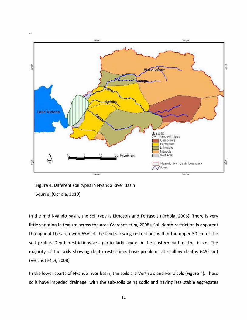
Figure 4. Different soil types in Nyando River Basin
Source: (Ochola, 2010)
In the mid Nyando basin, the soil type is Lithosols and Ferrasols (Ochola, 2006). There is very
little variation in texture across the area (Verchot et al, 2008). Soil depth restriction is apparent
throughout the area with 55% of the land showing restrictions within the upper 50 cm of the
soil profile. Depth restrictions are particularly acute in the eastern part of the basin. The
majority of the soils showing depth restrictions have problems at shallow depths (<20 cm)
(Verchot et al, 2008).
In the lower sparts of Nyando river basin, the soils are Vertisols and Ferraisols (Figure 4). These
soils have impeded drainage, with the sub-soils being sodic and having less stable aggregates

13
(Waruru et al., 2003). The soils of the plains are moderately well to imperfectly drained, deep
to very deep; brown to black, and in some places saline and sodic sandy clay loam to cracking
clay. The soils found in swamps are very poorly drained, deep to very deep, dark grey to black,
half ripe clay; in many places peaty (Gleysols, Histosols). Rice growing (irrigated) is practiced
here. During the dry seasons crops like maize, tomatoes onions and kales are grown. The other
major activity is harvesting of papyrus and other species for making mats, seats, fish traps and
thatching material (Mungai, 2004).
1.5.1 Soil quality
In Nyando River basin, there has been decrease in soil quality relative to undisturbed areas, as
indicated by a number of indicators, in areas where sheet, rill, and gully erosion have occurred.
The loss in soil quality is related to the degree of erosion. For example, sheet erosion is
reported to has decreased exchangeable bases by 39-47 % and soil organic carbon stocks by 17-
25 % compared with intact sites (Mungai, 2004). Where gully erosion has occurred the impacts
are reported to be more dramatic. The majority of the soils in the Nyando river basin are
deficient in plant-available phosphorus and it is estimated that between 63 – 73 % of the
Nyando River Basin is deficient in plant available phosphorus (defined as <8.5 mg kg –1 P-Olsen)
(Mungai, 2004). However, soil phosphorus levels are high enough to be of environmental
concern in parts of the lake plain, where erosion risk is also high.
1.6 Hydrology
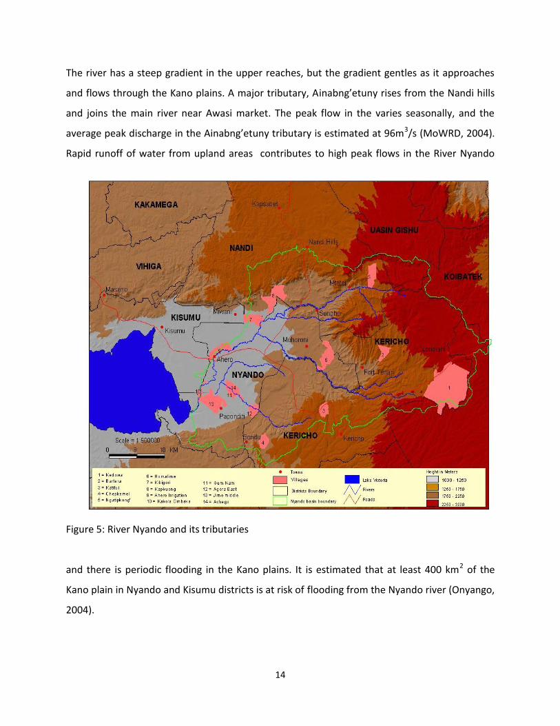
The main river, Nyando rises from the western Mau hills and traverses a distance of
approximately 170Km (Figure 5). Its drainage basin consists of five main sub-catchment areas
namely; Nyando-Nandi, Nyando-Kericho, Awach-Kano, Nyaidho-Kano and Nyando-Kano. The
Nyando and its tributaries supply water both for domestic and livestock use and for irrigation in
the sugar belt.
14
The river has a steep gradient in the upper reaches, but the gradient gentles as it approaches
and flows through the Kano plains. A major tributary, Ainabng’etuny rises from the Nandi hills
and joins the main river near Awasi market. The peak flow in the varies seasonally, and the
average peak discharge in the Ainabng’etuny tributary is estimated at 96m3/s (MoWRD, 2004).
Rapid runoff of water from upland areas contributes to high peak flows in the River Nyando
Figure 5: River Nyando and its tributaries
and there is periodic flooding in the Kano plains. It is estimated that at least 400 km2 of the
Kano plain in Nyando and Kisumu districts is at risk of flooding from the Nyando river (Onyango,
2004).
15
The Nyando River basin has the highest average slope and sediment transport index score
within the Lake Victoria basin. These are some of the biophysical factors that explain why it has
become a major contributor to the eutrophication of Lake Victoria. It is estimated that
approximately 61% of the Nyando River basin is a sediment source with an average erosion rate
of 43 metric tons per hectare per annum (t/ha/yr), translating into an average soil loss to the
lake of 3.2 million metric tons per annum since 1963 (World Agroforesty Center, 2006).
1.7 Vegetation Cover in Nyando Basin
Vegetation cover within Nyando Basin varies with the altitude. In the highlands, the vegetation
consists of evergreen broadleaf forest, where the most important tree species like Croton
megalocarpus, Diospyrus abyssinica, Funtumia latifolia, Olea welwetchii, Dombeya spp and
Dovyalis abyssinica are found. The area contains many tea plantations both in large and small
scale farms. There are also big areas covered with plantation forests especially Pinus patula and
Cupressus lustanica. Eucalyptus trees have also been planted especially in tea estate.
In the lowlands, a main distinction can be made between the native vegetation from the plains
and the one from the mid-slopes; in the first case, grasslands (Eragrostis spp., Cynodon dactylon
and sedges) with scattered acacia trees like Acacia seyal, Acacia drepanalobium and Acacia
hockii dominate. Native communities in the mid-slopes include perennial grasslands (Themeda
triandra, Hypairhenia hirta, Panicum spp., Eragrostis spp.,) among others interspersed with
evergreen and semi-deciduous bushlands (Dodonea angustifolia, Carissa edulis, Rhus
natalensis, Rhus vulgaris and Euclea divinorum mainly). In the inland valleys and at the river
mouth, Cyperus spp. wetlands and riparian vegetation (Ficus natalensis, and thickets of
Dombeya spp., among others) are the main native communities (Bargues, 2009).

16
2.0 AGRO ECOLOGICAL ZONES (AEZ) OF NYANDO RIVER BASIN
According to the Agro-ecological zone map of Kenya (Sombroek et al, 1982), the Nyando basin
falls within zones II, III and IV. Agro-ecological zone III, and IV cover Nyando district in Kisumu
county which is the lowland areas including the Kano plains and Nyando swamps.
2.1 Agro-ecological Zone II
Nyando basin Agro-ecological zone II covers mainly the highland areas of the basin, including
mountains, hills, foot slopes and upland areas. Most parts of Kericho county and some parts of
Nandi county fall under agro-ecological zone II. This zone is generally restricted to the
highlands between 1980 and 2700 meters above sea level and occurs as a forest or open
grasslands. The areas are classified as very humid (moisture index of 65-80%) with mountain
and forest ecosystem. The natural vegetation is dominated by moist forest and woodland
vegetation including evergreen trees such as (Camphor) Ocotea usambarensis, Polyscias
kikuyensis Juniperus procera, Podocarpus spp, Olea Africana, Olea hochstetteri, Ficus thonnigii,
Ficus natalensis, Warbugia ugandensis, Dombeya goetzenii, Croton megalocarpus,Teclea
simplicifolia, Arundinaria alpine, Hagenia abyssinica and Hypericum revolutum. There are many
areas where the natural vegetation has been cleared and currently replaced with tea. Dairy
farming is also a major economic activity in the area.
2.2 Agro-ecological Zone III
This zone covers semi-humid parts of Kericho and Nandi counties in areas lying between 1800-
2300 meters above sea level. The areas are characterized by dry forest and moist woodland
which are dominated by tall and flat-topped acacias such as Acacia abyssinica, Acacia tortilis
and Acacia hockii. The area has high to medium agricultural potential with maize and
pyrethrum being common indicator crops. Most parts of Kericho county especially in Kipkelion
district fall under this zone. Dairy farming, maize and wheat growing is practiced in the area.
Vegetables and Irish potatoes are also grown in the area.

17
2.3 Agro-ecological Zone IV
This zone marks the transitional area between humid and dry land environment and is
characterized by the Savanna environment. The area lies between 1,500 and 1,800 meters
above sea level. The natural vegetation is open grasslands, scattered woodlands, bushlands and
schrublands. Some of the prominent tree species found in the area include medium height to
tall acacias such as Acacia senegal, Acacia seyal and a wide range of euphorbia and shrubs such
as Tarconanthus camphoratus. The zone has medium agricultural potential with crops such as
maize and sugarcane being grown. Agro-ecological IV are mainly found in Nyando district in
Kisumu county which is the lowland areas including the Kano plains and Nyando swamps and
also some parts of Nandi county.
18
3.0 LAND COVER AND LAND USE CHANGES IN NYANDO RIVER BASIN
The land use/land cover types in Nyando basin are diverse. The diverse patterns depend on
lithology, geology, topography, moisture availability and most important human activities (Van
Der Kwast, 2002). There are various land uses within the Nyando basin. The main land use types
can be categorized into forestry and agriculture. The forest fall under government designated
land. They include Timboroa, Tinderet, Londiani, Western Mau and parts of South Nandi. Some
parts of these forests are planted with exotic tree (Pinus patula, Pinus radiate and Cupressus
spp.) which are used for commercial purposes.
According to Akotsi and Gachanja (2003), the vegetation in the area has changed considerably
from the wooded types in the past to the present shrub types. These changes can be attributed
to human activities such as deforestation, vegetation clearing, charcoal burning and
overstocking. The dominant land use in the uplands is tea growing both in big estates and in
small scale farms. Tea is a deep-rooted crop that requires a lot of rainfall and well-drained
acidic soils. Other crops found in these areas and also requiring well-drained soils are maize,
potatoes, pyrethrum, wheat and cabbages. There are also both indigenous and plantation
forests in this area. During the last 40 years, the basin has experienced dramatic land use
changes, as the land has been converted from small-scale farming to intense smallholder
cultivation. The impacts of these changes on the environment are seen in emerging
environmental problems such as deforestation and landslides (Onyango et al., 2005). High
deforestation rate has been reported at Terik, Kapsabet, and Nandi hill locations in Nandi
county and at Tideret, Buret, Kericho, Londiani, Kebenet, Kedowa and Kiptere locations in
Kericho county (Ashley,2005; Swalow, 2007; Juman, 1996 and Omuto, 2003). Most of the
hilltops in Nyando district are bare due to extensive charcoal burning while most of the basin
area is more or less continuously cropped. The two remaining forest areas in Nyando basin,
Tinderet and Mau forests, are currently being heavily deforested, and the steep sloping
escarpments-originally Government trust land are quickly being cleared due to charcoal
burning and illegal farming (ICRAF, 2000).
19
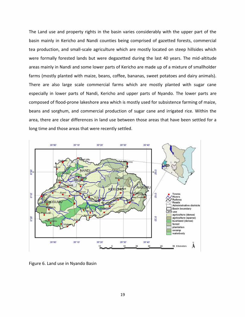
The Land use and property rights in the basin varies considerably with the upper part of the
basin mainly in Kericho and Nandi counties being comprised of gazetted forests, commercial
tea production, and small-scale agriculture which are mostly located on steep hillsides which
were formally forested lands but were degazetted during the last 40 years. The mid-altitude
areas mainly in Nandi and some lower parts of Kericho are made up of a mixture of smallholder
farms (mostly planted with maize, beans, coffee, bananas, sweet potatoes and dairy animals).
There are also large scale commercial farms which are mostly planted with sugar cane
especially in lower parts of Nandi, Kericho and upper parts of Nyando. The lower parts are
composed of flood-prone lakeshore area which is mostly used for subsistence farming of maize,
beans and sorghum, and commercial production of sugar cane and irrigated rice. Within the
area, there are clear differences in land use between those areas that have been settled for a
long time and those areas that were recently settled.
Figure 6. Land use in Nyando Basin
20
Nyando River Basin has been identified as a major source of sediment loading into lake Victoria.
The entire basin is characterized by severe soil erosion and land degradation problems that are
stratified according to topography, soils type and human activities. Accelerated runoff over the
basin has led to sheet erosion in the highlands and gully erosion and stream bank erosion in the
midlands and lowlands.
The principle causes of land and water degradation include: deforestation in the highlands and
extensive use of fragile lands on both hill slopes and the plains without proper land use
techniques. The land and water resources is the major contributor to the decreasing
agricultural productivity and increasing poverty levels among the local people. There are
serious gully erosion in areas such as Katuk-Odeyo in Nyando district which is posing a great
challenge to development and there is an urgent need for preventive measures.
3.1 Statutory Land Tenure in the Nyando Basin
The Land and water in the Nyando basin are held under a wide variety of statutory property
rights. There are at least six types of private tenure which can be identified. These include
three types of private tenure on former crown land i.e. large scale agricultural leaseholds in the
former white-owned farms which has been sub-divided into agricultural leaseholds, non-
agricultural leaseholds and four types of private tenure on trust land (freehold land in
adjudication areas, freehold land in settlement schemes, non-agricultural leaseholds, group
ranches). The different tenure types are administered under a number of statutes, including the
Government Lands Act, the Trust Lands Act, the Registration of Titles Act, the Land Adjudication
Act, and the Registered Land Act.
There are different types of public land in the Nyando basin. In both government and trust land
areas, there is land that is not alienated to any specific user. This type of public land is very
vulnerable and can be subject to abuse due to de facto open access. This land is supposed to
form the land bank from which the custodians of land draw when a development need arises.
In the Nyando basin this bank is almost empty. There is also land that is alienated for specific
public purposes such as forests, parks, government institutions, and public utilities such as
21
schools and hospitals. The use for which the land is alienated determines the custodian of such
land. These types of land are less vulnerable.
In Nyando basin, many important areas for catchment management were formally designated
as private property and were not left as public lands. This land includes spring heads, the
catchment areas immediately around spring heads, riparian areas, some wetlands, and water
harvesting structures. While private property can generally offer the tenure of land security
that is desirable while providing incentives to prevent degradation, inappropriate privatization
of land can also lead to problems, such as when the subdivision of land results in many of them
being located in steep hillsides, or when key watershed points (e.g. spring heads) that have
spatial benefits that go beyond the individual household are privatized and put under the
control of one household.
3.2 Land Degradation
The principle causes of land and water degradation as reported earlier include: deforestation in
the highlands and extensive use of fragile lands on both hill slopes and the plains without
applying proper land use techniques. This is very common at Kapkoros, Terik, Nandi hills
locations in Nandi county and at Kedowa location in Kericho county. Other identified places
include Muhoroni and Ngatipkong locations in Nyando district ((Swalow,2007; Juman, 1996,
Walsh, 2002; Ashley, 2005). Escalating soil erosion, declining soil fertility, agro-chemical
pollution, and loss of land cover are reported to contribute significantly to land degradation.
The Nyando River has been identified as carrying more sediment load than any other Kenyan
river (ICRAF, 2002). Sedimentation rates are reported to have peaked during years of major
rainfall events associated with the El Niño southern oscillation. These trends suggest that the
problems of soil erosion and soil degradation have continually worsened over the last 100
years, while at the same time the land has become more susceptible to large rainfall events
(Raburu and Okeyo-Owuor, 2002). In the past few years, soil erosion has been reported as a
major problem in Kapkoros, Kapsengere, Kapsumbeiywo, Kiowa, Kaptindo, Sarah Boit,
Kipkeibon, Kibabet, Kapsabet, Lessos and Kiowa sub locations in Nandi county while in Kericho
county, the problem has been reported in Kedowa, Kaminjeiwa, Bartera, Nyatipkong,
22
Nyaribari, Kiptegan, Cheptemel, Ngendui and Nyagacho sub locations (Swalow,2007;
Omuto,2003; Juman,1996; Walsh, 2002)
In Nyando district, soil erosion is reported to be high in Muhoroni east, Ngendui village,
Bartera, Koru, Oduwo, Tamu, Sondu and Burkamach sub locations ((Onyango, 2002; Ashley,
2005; Omuto,2003). There also exists incremental of wetland loss which is occasioned by
natural hazards and intensification of land use as well as other anthropogenic activities.
Declining soil fertility has been reported as a major problem at Kibabet, Kapsabet, Lessos, Nandi
hills, Kiowa and Kaptindo sub locations in Nandi county (Walsh, 2002) while at Kericho county,
the problem of soil fertility decline is reported at Londiani, Katuk, Nyagacho and Chilchila sub
locations. The problem is reported to have been caused by cultivation of steep slopes without
conservation measures and the leasing of grazing land to other communities i.e at Katuk
location, Kipsigis are leasing their lands to Luo community who do not employ any soil and
water conservation measures. High population increment has also been associated with soil
fertility decline in the basin ((Swalow,2007, Walsh, 2002, Omuto, 2003). In Nyando district, soil
fertility decline has been reported at Muhoroni especially at Tamu, Bartera , Ngendui, Koru,
Oduwo, Sondu and Burkamach sub locations.
There is an acute shortage of fuelwood, timber and poles due to deforestation in Nyando
district in locations like Katuk in Kericho county and Katuk-odeyo catchment in Nyando district.
Communal grazing in Katuk-odeyo hinders establishment of tree seedlings and women in these
area are reported to be going as far as Sigowet hills in Kericho county to fetch fuelwood
(Mungai, 2004). Lack of enough wood has led to the steep hills in Katuk-odeyo sub catchment
to be de-vegetated leading to huge gullies which are threatening lives and are becoming a
major hindrance to transportation (Mungai, 2004).
3 3Flooding
The upper reaches of the Nyando river is in Kericho and Nandi counties where annual rainfall is
high and it is this rain that causes the most devastating of the floods in the lower parts of the
basin especially in Upper Nyakach, Lower Nyakach, Miwani and Muhoroni sub locations in

23
Nyando district (Ong, 2002). There is reduced vegetation cover in places like Kongoni, Tinderet
and Kapsabet locations in Nandi county and Buret, Chilchila and Londiani locations in Kericho
county (Juman,1996; Omuto, 2003; Walsh, 2002; Leah, 2007). Soil erosion as a result of
inappropriate land use in the watershed and the flood plains leads to an increase in the
sediment load of river Nyando. The sediments fill up the channel in the lower course of the
river where its speed is reduced by the gentle gradient. The channel’s capacity to hold water
thus reduced becomes unable to hold the waters flowing through the river and this leads to
flooding.
The destruction of the watersheds leads to less rainwater percolating into the soils thus
increasing surface run off which causes flash floods in the lower parts of the basin. Erosion in
the upper reaches produces sediments that fill up the river channel reducing its capacity to hold
water. The high amounts of rainfall received in the catchments produces too much water for
the silted up river channel to hold, and therefore it overflows its banks causing floods. The
flatness of the land in the lower parts of the basin makes the flood waters spread over a very
large region without draining away quickly, while the black cotton soils in the area do not allow
much of the water to percolate into the soil. This chain of events indicates that though the
floods are experienced in the lower reaches of the river, the causes can be traced to the upper
reaches.
Flood control in Nyando basin requires interventions both in the upper catchments and in the
flood plains. In the upper catchments, the major task should be to increase vegetation cover
and to reduce erosion. This can be achieved through intensifying reforestation and
afforestation projects, use of appropriate farming technologies such as intercropping and mixed
cropping and controlled grazing in the range lands to prevent overgrazing. There is need for an
intensive campaign for creating awareness among the communities. This calls for mobilization
of resources and a high level of community participation to ensure sustainability which is
essential because these procedures must be continuous if they are to be effective.
24
4.0 DRIVERS OF LAND DEGRADATION IN NYANDO RIVER BASIN
The principle causes of land and water degradation in Nyando basin include: deforestation in
the highlands and extensive use of fragile lands on both hill slopes and the plains without
proper land use techniques (KARI, 2006). The overall pattern that emerges from literature
review of Nyando basin reveal an area of variable welfare and environmental quality, with
relatively tight cause and effect relation between upstream land and water use and
downstream variation in water quality and water quantity. The historical pattern shows
consistent deforestation in locations like Terik, Kapsabet and Nandi hill in Nandi county and
Buret, Londiani, Kebenet, Kedowa and Kiptere in Kericho county (Ashley,2005; Swalow,2007;
Juman,1996; Omuto,2003; Walsh, 2002; LVEMP,2006) and soil erosion in places like Kapkoros,
Terik, and Nandi hills locations in Nandi county and Kedowa, Kaminjeiwa, Bartera, Nyatipkong,
Kiptegan, Cheptemel, Ngendui and Nyagacho in Kericho county over the last hundred years,
punctuated by severe worsening of those problems during the heavy rains (Swalow,2007;
Omuto,2003; Juman,1996; Walsh, 2002). Floods in the Kano plain are becoming more severe
and frequent as the river has gradually lost its ability to buffer environmental variability. The
area of Upper Nyando is generally characterized by steep terrain at a relatively higher altitude
with slopes ranging between 1 and 51% (Verchot et al, 2008). The steepest slopes are found
through the middle of the upper Nyando where the highlands give way to the river valley. Steep
slopes are also found along the crests of the ridges. The riparian area of the Kipchorian River is
characterized by a narrow floodplain with wetland vegetation (Verchot et al., 2008).
The present land use and environmental courses of action in Nyando basin are largely
unsustainable and no longer constitute options to a sustainable future (Ochola, 2006). The use
of unsuitable agricultural practices in many parts of Nyando basin has remained an important
factor contributing to land degradation. Land degradation problems appear to be most severe
in the sub-divided agricultural leaseholds and in the freehold land in adjudication areas like
Kapkoros, Terik and Nandi hills locations in Nandi county and Kedowa and Kibabet locations in
Kericho county. In the former there are problems associated with poor land use planning
during the transition from large scale to small scale farms in the 1960s and early 1970s. Since
these lands were bought by land buying companies on behalf of various groups of shareholders,

25
they did not consider important physical factors while subdividing the lands e.g. the terrain, or
the need for public utility lands. Their main interest was to ensure that every shareholder got
some piece of land. Most of the lands buying companies were formed along ethnic lines,
which ended up creating clusters of different ethnic groups with different cultures living next to
each other on the same landscape especially in Kericho county. This has ended up weakening
some traditional systems and as a result people in these areas find statutory laws more
functional. There has also been tribal conflict with some tribes being displaced. This is in great
contrast to those areas that were designated as native reserves during the colonial era, where
people of the same ethnic groups were put together. High population growth in the designated
native reserves has led to high population pressure leading to overuse of land resources.
The effects of these factors have been exacerbated by the consequences of decisions and
policies as well as cultural, social and economic circumstances (Ochola, 2006). These factors
especially within the last twenty years have considerably changed the basin’s ecosystems which
in turn have rendered the population dependent on its vast natural resources vulnerable and
insecure in terms of poverty, food security and health (Ochola, 2006). The trends in land
degradation can be linked to imbalances in land distribution, lack of incentives for conservation,
insecure tenure and the failure to provide for diversified rural production systems.
4.1 High Poverty and Population Growth Rate
Poverty is associated with a number of inter-related problems including rapid population
growth, land degradation, and declining human health, agricultural productivity and water
quality (Shepherd et al. 2000). Evidence from the Nyando District and elsewhere in Western
Kenya indicates strong links between poverty, environment and investment in natural
resources. Poverty reduces the use of fertilizers, although it has no consistent effect on the use
of organic soil enhancement techniques such as contour bunds or improved fallows. The
chronic illness and death that is associated with HIV / AIDS especially in Nyando district in
locations like Miwani, and Awasi locations is a major cause of impoverishment. Households who
lose male income earners are likely to reduce their production of crops and their use of
purchased inputs. In view of the pervasive poverty among farming communities in the area,
26
the use of inorganic fertilizer is limited, and primary productivity is closely linked to the
inherent productive capacity of the soil.
4.2 Soil Erosion and Declining Soil Fertility
Soil degradation is recognized as a major global problem having negative impacts on
agricultural productivity, ecosystem and atmospheric change, and water and habitat quality.
However, existing data on the types, extent and severity of degradation, including at global,
regional and national levels, are not answering the needs of environmental and development
agencies. Soil erosion causes heavy sedimentation in the river, as yawning gulley eat up farms and
separate villages e.g. Katuk-odeyo in Nyando district. Intense agricultural activity has been causing
excessive flow of nutrients into the Nyando River, and subsequently, into Lake Victoria. Moderate soil
erosion in the order of 5-10 t ha-1 yr-1, is associated with substantial losses in soil nutrients and can
contribute significantly to negative farm nitrogen, phosphorus and potassium balances (Van den Bosch
et al. 1998, Shepherd and Soule, 1998).
Depletion of soil fertility via bio-fixation and subsequent crop harvest, grazing, soil organic matter
depletion and/or biomass burning exacerbate these problems and will not be resolved without the use
of inorganic fertilizers. Perhaps the single greatest threat to primary production in Nyando River Basin is
the prevalence of land degradation as indicated by the decline in soil quality in places like Kapkoros,
Terik, Kibabet and Nandi hills locations in Nandi county and Kedowa and Nyagacho locations in
Kericho county. Accelerated soil erosion and nutrient runoff from River Nyando Basin has induced a
rapid rise in nutrient levels in Lake Victoria. This has led to changes in the lake ecology and rapid growth
of aquatic weeds dominated by the water hyacinth, with adverse effects on fishing and lake transport.
Interventions that mitigate soil erosion in the basins are needed.
4.3 Loss of land cover
Land use and land cover dynamics are widespread, accelerating, and significant processes
driven by human actions but also producing changes that impact humans (Agarwal et al., 2002).
These dynamics alter the availability of different biophysical resources including soil,
vegetation, water, animal feed and others. Consequently, land use and cover changes could
lead to a decreased availability of different products and services for human, livestock,
27
agricultural production and damage to the environment as well. Land cover loss has been
reported at Kapsabet, Siria plateau, South Nandi, Nandi hills, Kiowa, Kaptindo, Kipkeibon,
Lessos and Koiwa sub-locations in Nandi county, Meteitei, Nyagacho, Chilchila, Kotetn farm
Kedowa and londiani sub-locations in Kericho county and Owaga and Ngatipkong in Nyando
district ((Leah, 2007; Onyango, 2002; Walsh, 2002; Juman,1996; Omuto,2003).
The role of vegetation cover in watersheds and the impact of deforestation on hydrological
regimes, although extensively studied, remains a controversial area of hydrological research,
particularly when considering aspects of scale. Despite the widespread popular belief that
deforestation leads to reductions in groundwater availability during the dry season, and
although responses vary widely between sites and situations, a number of hydrological studies
show that the removal of forest cover leads to higher water yields. This is associated with trees
being highly effective water pumps, extracting water from the soil and transpiring it to the
atmosphere, so that the net immediate effect of tree removal is a rise in the water table and
increased dry season flows.
Much of the basin has a history of deforestation for fuel wood, mining, grazing and agriculture
as well as other land-degrading practices. Problems associated with vegetation loss and
deforestation includes loss of terrestrial habitat and loss of soil nutrients, resulting in nutrient
enrichment of waterways and high algal growth. Vegetation changes on land affect littoral
habitats by promoting erosion and filling littoral zones with fine and coarse sediments, thus
altering habitats of littoral species. Socio-economic effects of vegetation loss and sediment
loading are numerous. These include reduced agricultural and fishing capabilities.
The impacts of historical land cover changes witnessed between 1973 and 2000 on the
hydrologic response of the Nyando River obtained through consistent classifications of selected
Landsat satellite images shows significant and varying increases in the runoff peak discharges
and volumes within the basin. In the upstream sub-catchments with higher rates of
deforestation, increases between 30 and 47% were observed in the peak discharge. In the
entire basin, however, the flood peak discharges and volumes increased by at least 16 and 10%
28
respectively. When one analysis the satellite images dating back to 1975/76 combined with
analysis of 2002 images, it shows an increase in cropland (4.9%) at the cost of forest land (8.5%)
in parts of Nyando basin. The reduction and degradation of forest land have led to increased
erosion rates. The land conversions in the upstream of Nyando basin have had a phenomenal
impact on biogeochemical cycles and biodiversity that are critical in the functioning of
watersheds and the ecosystems that evolved within them. The impacts of over exploitation of
land and forest resources are clearly evident in the degradation of watershed through
accelerated sediment generation, flash floods associated with deforestation and the aggregated
influence on regional climate. This brings into question the continuing ability of these systems
in providing the goods and services that upstream and downstream communities have enjoyed
and depended upon for millennia. The question that needs to be raised is how this problem can
be reversed by use of payment of environmental services.
4.4 Unsustainable land-use practices
Unsustainable land use decisions and agricultural practices by landholders are responsible for
watershed degradation in Nyando watershed. Over the past three decades, intensified
cultivation of marginal areas and clearance of natural habitats like wetlands, forests and
mountainous areas have been witnessed in River Nyando watershed basin. These have been
the main driving forces behind the escalating land degradation in the region (Abila, 2002).
Farmers have been encroaching into steep hills for crop production due to population pressure
without carrying out any conservation measures. A good example is in the upper catchment in
places like Kipkelion district which lies on very steep slopes with sparse vegetation. The area is
reported to be formally a forested area and a few remnant trees can be seen in the area. Places
like Jagoror and Kipsirichet locations are located in areas with large ridges and valleys which are
prone to landslides. Landslides are also seen in several parts of the basin as a result of reduced
ground cover and unsustainable soil and water management practices. Hard pans have been
exposed in some areas as a result of farming on these steep slopes. Farmers report that base-
flow water levels in the streams have been reduced tremendously as a result of tree cutting
(Verchot et al, 2008).

29
With the move to more sedentary based farming systems and over exploitation of forest
resources, sediment generation and associated discharge to water courses has been drastically
increased particularly where appropriate soil conservation measure are not implemented to
reduce erosion. This has a profound effect on the hydrodynamic capacity of water in river
channels which is the major reason for flooding in Kano plain. Sediment generation from
watersheds has accelerated with predicted increased frequencies of extreme rainfall events
associated with climate variability, further exacerbating current trends.
Scientists from the Lake Victoria Environment Management Programme, Water Quality
Component and the World Agroforestry Centre have conducted several studies of water
quality, land use and soil degradation across the Nyando basin during the last few years. Many
of those results are summarized in a proceedings volume edited by Mungai et al. (2004). An
analysis of sediment cores from the outlet of the river Nyando into Lake Victoria shows a
historical trend toward higher levels of sedimentation, with strong peaks in sediment
deposition during high rainfall events associated with El Nino. Increased nutrient and sediment
loads in the Nyando River are linked to both point and non-point sources of pollution. Key point
sources are sugar processing and agro-chemical factories, while non-point sources are the
thousands of small farm families who operate throughout the basin.
ICRAF scientists estimate that about 61% of the land in the basin is sediment “source” area with
average net erosion rates of 43 tonnes per hectare per year, while 39% of the land in the basin
is sediment sink area that accumulates about 45 tonnes per hectare per year. Sediment source
areas are further distinguished into areas with relatively high erosion rates (fast erosion) and
relatively slow erosion rates (“slow erosion.”). Fast erosion is concentrated in hillslopes in the
flood-prone Kano plains and some of the steep hillsides in the upper and mid-altitude parts of
the basin. The remaining upland forests and wetlands and some of the sugar cane and
smallholder farming areas in the mid-altitude zone appear to be net sediment sinks (Walsh et
al.,2004 ). Most of the riparian areas that could be important filters have been systematically
cleared over the last 40 years.
30
4.5 Culture and Poverty
The Nyando River basin exhibits the same characteristics as found across the Nile Basin in terms
of high population density and poverty prevalence. In 2000, the average population density of
the Nyando basin was 214 persons per square kilometer ranging to as high as more than 1200
persons per square kilometer, with an approximate total population in 2003 of 746,000 (Olaka,
2005). In 1997, the prevalence of poverty across the Nyando River basin ranged from 58 to 66%
compared with the national poverty rate of 53% (KNBS, 2007). By 2009, the population in the
basin had risen to almost 1.100,000 (GOK, 2009).
Given the importance of land access for livelihoods, it is particularly important that governance of
land issues is participatory and empowering. Land access is also an important prerequisite, in
some cases, for enhanced access to water. Reducing poor people’s vulnerability includes putting
measures in place that safeguard their access to resources and this may include providing formal
recognition to some current customary access regimes, which requires participatory forms of
planning and governance at all levels. Devolved systems of governance should allow active
participation of users in natural resources management debates. Legislation should enable the
poor to access water resources and create incentives for sustainable use, through recognizing and
incorporating people’s needs and their traditional management systems.
Women have very little independent access to land under Luo customary law, with the
exception of a small home garden (Orundu) that even junior wives are entitled to (Onyango,
2002). Lack of control over land also severely constrains women’s access to water sources, since
almost all water sources are established in private lands. Land management at the village and
farm scales are also affected by the activities of a number of important projects and
programmes.
The surprisingly large arrays of formal land tenure types and sources of statutory and
customary authority over land and water management in the Nyando basin influences land
management in Nyando river basin. While it appears that there is complex land tenure system
that creates many problems for watershed management, insecure private rights to cropland is
31
not a compelling problem. High rates of erosion in the lower part of the basin are associated
with private uncultivated areas that are overused for grazing and wood collection while high
rates of erosion in the upper part of the basin can be associated more with the private
allocation and farming of steep hillsides.
Deforestation and cultivation of riparian areas can be associated with privatization of riverine
areas, together with ineffective enforcement of rules on the use of those areas. The
Government of Kenya is currently undertaking a review of its land tenure and land policy.
Whatever emerges from that review, however, it is unlikely that there will be a large
reallocation of land from private individuals to the government. What is more feasible is that
the public and collective interests in those key components of the watershed are exerted
through new instruments such as environmental easements. However, that approach will
require engagement with key statutory and social authorities. Catchment authorities or
environment committees will be most effective if they are able to operate with the support of
social authorities such as clan elders, water and land management projects, and local
authorities.
The Nyando case is complex, perhaps more so than most other watersheds in Africa.
Nonetheless, it illustrates the importance of linking science with policy and institutional design:
better scientific understanding of the catchment hydrology can lead to a policy and programme
focus on small discrete parts of the catchment. The Nyando case also shows the need to
understand the complex linkages between property rights and watershed management
problems. And, finally, it illustrates the need to involve multiple social and statutory authorities
in watershed management, including the various government institutions whose
responsibilities and mandates often overlap and conflict.
4.6 Agro-Ecosystem Constraints and Climatic Uncertainty
In a survey by ICRAF, farmers ranked drought frequency and the unpredictability of rainfall as
their single most important constraint in the Lower Nyando. A second category of constraints
was associated with capital for inputs, labour and farm implements. Pests and diseases was also
32
identified and especially Striga infestations which poses significant problems in the area. The
problem is associated with soil fertility constraints (Verchot et al, 2008). In the upper Nyando
basin, the largest constraints at farm level are soil related problems, particularly fertility,
stoniness, erosion and water logging. Others include soil erosion and fertility problems, pests
and diseases on crops and unpredictable weather (Verchot et al, 2008).
A number of paleoclimate studies have shown that long-term climate variability in the basin is
periodic and tends to track events occurring over time periods that are characteristic of cyclical
changes in orbital insolation and forcing (e.g., Kroll-Milankovitich cycles), and global ocean and
atmospheric circulation (e.g. El Nino/La Nina cycles). Some of these studies (e.g. Stager et al.,
1996) suggest that the post-1960 ecological shift in Lake Victoria may have had climate driven
analogues over the last 10,000 years. This implies that although human impacts on the lake
basin environment may now eclipse the events taking place, climate change could be
reinforcing environmental degradation in the lake basin.
The more recent historical record shows the occurrence of an extraordinarily pluvial period
from 1961-1964 in the eastern portion of the lake basin. During this time, the water level of
Lake Victoria rose by approximately 2.5 meters, and discharges from rivers Nyando and Sondu
Miriu, for example, were 10-20 times higher than their respective 35 year decadal averages. For
the Nyando River Basin, interviews with local people suggest that many of the major soil
erosion problems either started or were dramatically accelerated in their development during
the early 1960’s. We speculate that rapid land use changes, deforestation, infrastructure
development and over-grazing structurally altered this landscape during the first half of the
20th century. Prevailing conditions during the early 1960’s may then have been such that the
basin was essentially primed for massive erosion/sedimentation during a period extraordinarily
heavy rainfall in the region.
4.7 Eutrophication of the Lake
The Nyando River basin has the highest average slope and sediment transport index score
within the Lake Victoria basin; biophysical factors explaining why it has become a major
contributor to the eutrophication of the Lake. The consequential environmental impacts in Lake
33
Victoria over the last 40 years include extended spells of anoxia; five times the concentrations
of algal biomass; 67 percent decrease in lake transparency; and explosions in invasive aquatic
species, most notably water hyacinth (Odada et al., 2004; Mungai et al., 2004). Rapid runoff of
water from upland areas contributes to high peak flows in the river and periodic flooding in the
Kano plains. At least 400 km2 of the Kano plain in Nyando and Kisumu districts is at risk of
flooding from the Nyando ( Mungai et al., 2002). Rainfall records and anecdotal reports indicate
that floods have become more frequent than they were 30-40 years ago. Floods increases the
incidence of a number of water-associated diseases among people and animals, constrain crop
and tree selection, make transportation more difficult, interrupt schooling, and destroy
property and infrastructure. Increased nutrient and sediment loads in the River Nyando are
linked to both point and non-point sources of pollution. Pollution data in the area indicate that
sugar processing and agro-chemical factories in the “sugar belt” of the basin contribute
significant amounts of phosphorus to the river (Mungai et al., 2004). Other results presented
suggest that sedimentation of the Nyando river system results from the land use practices of
tens of thousands of farm families operating throughout the catchment. ICRAF scientists
estimate that about 61% of the basin is sediment “source” areas with average net erosion rates
of 43 tonnes per hectare per year, while 39% of the basin are sediment sink areas that
accumulate about 45 tonnes per hectare per year. Sediment source areas can be further
distinguished into areas with “fast erosion” and “slow erosion.” Different types of interventions
may be appropriate to these different types of locations. International experience with
watershed management shows that effective management requires a minimum amount of
social organization around upstream-downstream linkages and water management.
Research
conducted in the Awach sub-basin of the Nyando basin shows that the main organizational
groupings relate to administrative units (provinces, districts, locations, sub-locations), land
tenure distinctions (eg settlement schemes, customary tenure areas) and ethnic distinctions
(major language groups and clans) rather than location within a catchment. The upstream /
downstream inter-personal relations that do exist tend to be driven by exchange of goods and
resources.

34
5.0 POTENTIAL FOR PAYMENT OF ENVIRONMENTAL SERVICES IN NYANDO
NYANDO RIVER BASIN
Land degradation is a serious problem in the sloping uplands. Experiences from a number of
projects in the world indicates that the problem is often not the lack of technology per se, but
the lack of economic incentives to adopt (DITSL, 1993; Cramb, 2000; Bridges et al, 2001).
Technological research has often placed excessive emphasis on soil erosion as a ‘problem’
rather than viewing it as a symptom of inappropriate land use. Limited and sporadic adoption
of seemingly viable erosion-control practices points towards the existence of other constraints
to adoption. Since the economic gains from land conservation are realized over a long period,
the incentives to investments in conservation practices should critically be dependent on
farmer’s livelihood strategies and the broader conservation policy.
The Nyando River flows from the Rift Valley highlands supplying irrigation water to vast rice
fields before it empties into Lake Victoria. Currently, the measures being taken to combat
degradation in the Nyando River basin include increasing tree cover, water harvesting, de-
silting existing water pans, the construction of new dams, rehabilitation of existing dams and
encouraging technologies that retains water on-farm.
Farmers as they implement the measures continue to encounter challenges and for example, in
Nyando district where water pans are being constructed, disputes have arisen over their
control, in particular where they are located on an individual’s farm. In other areas like Katuk-
Odeyo in Nyando district, it has been difficult to convince communities not to farm along
riverbanks as these are often the most fertile and best watered areas. Ethnic tension in Lower
Nandi and Kericho counties in recent years between inhabitants of the highlands and lowlands
further complicates matters.
The potential for local institutions and communities, i.e. Nyando county council, Kisumu water
and sewerage company (a government parastatal), Muhoroni and Sonny sugar companies, Tea
companies and estates, Kano Rice Irrigation Scheme and Kisumu Airport can become buyers of

35
environmental services. The current consortium should initiate dialogue with the organizations
to determine if they have the finances and mandate within a legal framework to use PES as a
means of more effectively addressing the Nyando basin degradation. Currently, majority of
members of consortium seems to be from the lowlands and those from the highlands where
major degradation occurs seems to be under-represented.
The evidence available from other areas shows that some techniques, particularly the
agroforestry, water management and soil fertility conservation techniques can enhance farm
productivity while at the same time reducing soil erosion and enhancing water infiltration.
However, there is need to increase vegetative cover across large areas of non-cultivated lands.
This might be accomplished through enclosures’ to encourage natural regeneration, restrictions
on free grazing, and effective prohibition on the use of river line and steep hillside areas for
cultivation, grazing and fuel wood collection. Spring protection appears to hold the potential to
be a win-win solution – improving water quality, reducing gulley erosion and improving human
health.
5.1 Proposed PES Activities in Nyando River Basin
There are various environmental services that can be marketed from Nyando River Basin. These
services include biodiversity conservation, carbon sequestration, landscape beauty, and
watershed protection. In the Upper Nyando especially in Kericho and Nandi counties; there are
still forested areas where a REDD+ project can be initiated. On the farmers’ field, on farm tree
planting and especially different agroforestry systems do exist. There is need to involve the
farmers and tea estates in carbon trade especially the Clean Development Mechanisms (CDM)
and in Voluntary Carbon Trade (VCT).
The area has the potential for farmers benefitting from biodiversity conservation market. With
the current promotion of tourism in the western circuit, farmers especially those growing tea
can be paid part of the money from income generated from tourism. There are many people
who would pay for seeing the beautiful undulating sites of tea estates. The entire area is also
made up of undulating highlands with numerous small seasonal streams, which run across the
36
cluster and drain into River Nyando (Verchot et al, 2008). Farmers should be encouraged to
practice soil and water conservation measures which will not only reduce sedimentation in river
Nyando, but also also reduce flooding in Kano plains. The government can compensate farmers
in the upper stream using the money they allocate every year for disaster management for the
flooded areas. Due to the expansion of low-input, subsistence farming, land degradation has
become widespread and most of the important tree species, some of high medicinal value and
some of high timber quality, have disappeared. Farmers can therefore be involved in payment
for water services by those suger industries, irrigation scheme, water companies and county
councils downstream. There is evidence of heavy deforestation from the sparse vegetation on
the hillsides and soil erosion is a serious problem in this area (Verchot et al, 2008). There is
therefore need to strengthen support to farm management, enterprise development and
conservation. In this area, one can promote agroforestry, soil fertility management and soil
conservation techniques on farmers’ fields. One can also promote energy efficient stoves and
water harvesting techniques throughout the basin, especially with women. For environmental
management and protection, there should be enforcement of existing laws and regulations to
protect degraded hillsides, spring heads, the collection areas of first order streams, and riverine
areas from cultivation, livestock grazing and fuelwood collection. On farm tree planting should
be promoted.
4.7 Conclusion
The catchment area of the Nyando basin is highly degraded due to deforestation, soil
erosion and soil fertility decline. Unsuitable agricultural practices in the basin is contributing
to land degradation. Rising population pressures and emerging opportunities for
commercial agricultural production and tenure insecurity are some of the major drivers
resulting in unsustainable use of in fragile sloping areas of the Nyando basin. Field-level
interventions based on specific technologies are unlikely to be adopted unless they directly
address farmers’ livelihood concerns in the context of ‘macro’ factors driving the land-use
changes. Conservation outcomes may be better achieved indirectly through approaches
that reduce the intensification pressure in sloping land. A ‘landscape’ management
37
approach, whereby interventions for productivity enhancements are targeted to favourable
parts of the landscape, is likely to be effective for generating conservation outcomes by
reducing the intensification pressure in fragile sloping lands. Land degradation problems can
be addressed if farmers are given incentives to carry out on farm tree planting and practice
soil conservation measures. Most of the forests in the catchment since they are located in
government owned land especially in the upper catchment unlike in the middle and lower
catchment where the forest belongs to the community. To conserve these forests, REDD+
should be explored while industries, water companies, irrigation schemes and county
councils should be targeted to start paying for the conservation of the catchment area. The
government should compensate the upstream communities especially in Kericho and Nandi
counties for their conservation efforts in rehabilitation of degraded areas. Part of this
money can come from the Tourism kitty and also from the ministry of special programs.

38
REFERENCES
Ashley, R. (2005). Colonial Solutions, Contemporary Problems. New Haven.
Bridges, E.M., Hannam, I., Oldeman, L.R., Penning de Vries F.W.T., Scherr, S.J. and Sombatpanit S. (eds.). 2001. Response to land degradation. Oxford & IBH Publishing. New Delhi. Cohen, L. (2004). The impact of illness on livelihoods in rural western Kenya: The influence of livelihood type, gender, and seasonality. Unpublished master’s thesis, University of Florida, Gainesville.
Cramb, R. (ed.). (2000). Soil conservation technologies for smallholder farming systems in the Philippine uplands: a socioeconomic evaluation. Canberra. ACIAR.
DITSL. 1993. Acceptance of soil and water conservation: strategies and technologies. German Institute for Tropical and Subtropical Agriculture. Witzenhausen, Germany.
Government of Kenya (GOK). (2009a). Kericho District Development Plan 2008-2012. Government printers, Nairobi
Government of Kenya. (GOK). (2009b). Nandi South District Development Plan (2008-2012). Government printers, Nairobi.
Government of Kenya (GOK). (2009c). Nandi East District Development Plan 2008-2012. Government Printers, Nairobi
ICRAF and MOARD. (2000): “ Improved land management in the lake Victoria basin: Final Technical Report, Startup Phase, July 1999 to June 2000.” ICRAF and MOARD, Nairobi, Kenya.
Japan International Cooperation Agency (1992): Feasibility study on Kano Plain Irrigation Project, Vol. II. Annexes, No.86. (JICA).
Kenya Agricultural Research Institute (KARI) 2006. Western Kenya Integrated Ecosystem Management Project (WKIEMP). Strategies for Integrated Land and Water Management for Sustainable Livelihoods in Katuk-Odeyo Sub-Watershed, Nyando River Basin, Lake Victoria Basin, KENYA. Kenya National Bureau of Statistics (KNBS). (2009). The 2009 Kenya Population and Housing Census. ‘ Counting Our People for the Implementation of Vision 2030). Volume 1 A. Ministry of Water Resources and Regional Development (2004): Land resources Development and Irrigation in Nyanza Province, South Kano.Government Printers.
Leah Onyango and Swalow J. (2007). Coping with History and Hydrology. Maseno University. Kenya
39
Lake Victoria Environmental Management Programme (LVEMP). (2006). Water quality, land use and wetland: Centre for Ecology and Hydrology. Wallingford, UK, and FAO, Rome, Italy.
Juman, C. and Ojwang, J.B. (1996). In Land We Trust. Nairobi.
Ministry of Water Resources and Regional Development (MOWRD). 2004. Land resources Development and Irrigation in Nyanza Province, South Kano. Government Printers. Mungai, D., Swallow, B., Mburu, J., Onyango, L. & Njui, A., eds. 2004. Proceedings of a Workshop on Reversing Environmental and Agricultural Decline in the Nyando River Basin. Nairobi, ICRAF, NEMA, the Water Quality Component of the Lake Victoria Environment Management Programme (LVEMP) and the Ministry of Agriculture and Rural Development National Environmental Authority [NEMA] (2004): Strategy for Flood Management in Lake Victoria Basin, Kenya.
Njogu, A.K. (2000): An Integrated River Basin Planning Approach- Nyando Case Study in Kenya: In WARFSA/WaterNet Synposium: Sustainable Use of Water Resources; Maputo. Ochola W. (2006). The Future Today – Environmental Scenarios for Africa. In UNEP. Africa Environment Outlook: Our Environment, Our Wealth. UNEP, Nairobi Ocholla, Peter omondi, (2010), The impact of flooding characteristics of The Nyando river on cotton cultivation in Lower kano plains in nyando district, Western Kenya, Msc Thesis, department of hydrology, University of Zululand Odada, E.O., Olago, D.O., Kulindwa, K., Ntiba, M., & Wandiga, S. (2004). Mitigation of environmental problems in Lake Victoria, East Africa: Causal chain and policy options analyses. Ambio, 33 (1-2), 13-23.
Omuto, C. T. (2003). Rapid Mapping of Hydraulic Conductivity in a Tropical Watershed. MSc (Agricultural Engineering) thesis. University of Nairobi, Kenya.
Onyango, L. A. (2002). Rural women s Participation in Agroforestry and its Implications on a Sustainable Environment in Nyando District, Kenya. MA (Planning) thesis, University of Nairobi, Kenya.
Onyango, L. 2002. Rural women’s participation in agroforestry and its implications on a sustainable rural environment in Nyando District. Nairobi, Department of Urban and Rural Planning, University of Nairobi. (M.A. thesis)
Onyango,L., Swallow, B., and Ruth Meinzen-Dick (2005). Hydronomics and terranomics in the Nyando basin of Western Kenya. International workshop on ‘African Water Laws: Plural
40
Legislative Frameworks for Rural Water Management in Africa’, 26-28 January 2005, Gauteng, South Africa Shepherd, K., Walsh, M., Mugo, F., Ong, C., Hansen, T.S., Swallow, B., Awiti, A., Hai, M., Nyantika, D., Ombao, D., Grunder, M., Mbote, F. and Mungai, D. 2000. Improved Land Management in the Lake Victoria Basin: Linking Land and Lake, Research and Extension, Catchment and Lake Basin. Final Technical Report, Startup Phase, July 1999 to June 2000, Working Paper Series, Working Paper 2000-2. International Centre for Research in Agroforestry and Kenya Ministry of Agriculture and Rural Development, Soil and Water Conservation Branch, National Soil and Water Conservation Programme, Nairobi, Kenya. Swallow B, Okono N, Achouri M and L Tennyson (eds.). 2006. Preparing for the next generation of watershed management programmes and projects: Africa. Proceedings of the African Regional Workshop, Nairobi, Kenya, 8-10 October 2003. Watershed Management and Sustainable Mountain Development Working Paper 8. Rome, Italy: FAO, 293pp. Swallow, B., Onyango, L., & Meinzen-Dick, R. (2007). Irrigation management and poverty dynamics: Case study of the Nyando basin in western Kenya. Available at: http://www.iwmi.cgiar.org/Publications/CABI_Publications/CA_CABI_Series/Community _Law/protected/Ch%2012.pdf Verchot et al,. (2008). Baseline Report: Nyando River Basin, Western Kenya Integrated Ecosystem Management Project Findings from the Baseline Surveys, International Centre for Research in Agroforestry, Nairobi, Kenya
Walsh, M.Shepherd, K and Verchot, L. (2004). Identification of sediment sources and sinks in the Nyando river basin. In D. Mungai, B. Swallow, J. Mburu, L. Onyango and A. Njui (eds.), Proceedings of a Workshop on Reversing Environmental and Agricultural Decline in the Nyando River Basin, ICRAF: Nairobi, Kenya, pp. 27-32. World Agroforestry Centre, (2006). Improved Land Management in the Lake Victoria Basin: Final Report of the TransVic Project. World Agroforerstry Centre Occasional Paper No. 7. World Agroforestry Centre, Nairobi, Kenya. Raburu P. O.1 and Okeyo-Owuor J.B.2, (1999). Impact of agro-industrial activities on the water quality of River Nyando, Lake Victoria Basin, Kenya, Moi University, Eldoret, Kenya