THE NSS BULLETIN - National Speleological Society
31
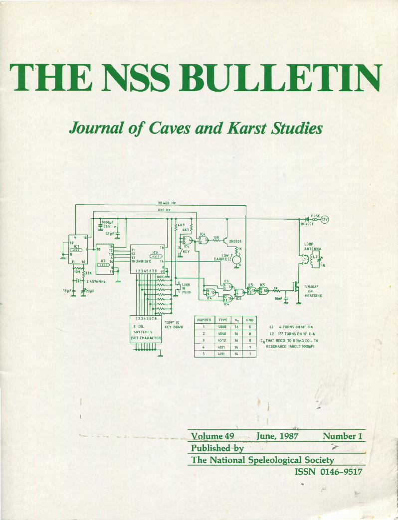
THE NSS BULLETIN Journal of Caves and Karst Studies 16 ·- 1000μF ;;i;, 25v • 0.1 μ F J;, 38 400 Hz 600 Hz 12345678 '"OFF'" IS 8 OIL KEY DOWN SWITC HES (SET CHARACTER . ... NUMBER TYPE V ee 4060 16 4040 16 4511 16 4011 14 4011 14 GND L1 l2 LOOP V N66AF ON HEATSINK 4 TUR NS ON 10"" DIA 155 TURNS ON 10" DIA CR THAT RECIO TO BRING COIL TO RESONANCE (ABOUT 1000pF) Volume 49 June, 1987 Number 1 Published by ... The National Speleological Society ISSN 0146-9517 ..
-
Upload
khangminh22 -
Category
Documents
-
view
0 -
download
0
Transcript of THE NSS BULLETIN - National Speleological Society
THE NSS BULLETIN Journal of Caves and Karst Studies
16
·-
1000µF ;;i;,25v •
0.1 µF J;,
38 400 Hz
600 Hz
12345678 '"OFF'" IS
8 OIL KEY DOWN
SWITC HES
(SET CHARACTER
. ...
NUMBER TYPE Vee
4060 16
4040 16
4511 16
4011 14
4011 14
GND
L1
l2
LOOP
VN66AF ON
HEATSINK
4 TUR NS ON 10"" DIA
155 TURNS ON 10" DIA
CR THAT RECIO TO BRING COIL TO
RESONANCE (ABOUT 1000pF)
Volume 49 June, 1987 Number 1 Published by ... The National Speleological Society
ISSN 0146-9517 ..
LIFE SCIENCES H. H. Hobbs III Wittenberg University Department of Biology Springfield, Ohio 45501
ANTHROPOLOGY Patty Jo Watson
EDITOR Andrew J. Flurkey
8838 Roos Rd. Houston, Texas 77036
BOARD OF EDITORS SOCIAL SCIENCES
Marion 0. Smith P.O. Box 8276 University of Tennessee Station Knoxville, Tennessee 37916
EXPLORATION Thomas E. Miller
EARTH SCIENCES William B. White Materials Research Laboratory Pennslyvania State University University Park, Pennsylvania 16902
CONSERVATION Allen Kurta
Department of Anthropology Washington University
Department of Geology I Geography Indiana State University
Biological Science Center Boston University
St. Louis, Missouri 63130 Terre Haute, Indiana 47809 Boston, Massachusetts 02215
BOOK REVIEWS Betty Wheeler
BUSINESS MANAGER George Huppert
Department of Geology University of Minnesota Minneapolis, Minnesota 55455
Department of Geography University of Wisconsin, Lacrosse Lacrosse, Wisconsin 54601
PROOFREADER: Frederick J. Woodson Department of Geology The University of Iowa, Iowa City, Iowa 52242
Material to be included in a given number must be received at least 90 days prior to the first of the month in which publication is desired. No submission will be accepted for publication unless and until one of the three options in our printed "Copyright Agreement" form has been selected by the author(s) and the form has been properly dated, signed, and returned to the Editor.
Discussion of papers published in The Bulletin is invited. Discussions should be 2000 words or less in length, with not more than 3 illustrations; they should be forwarded to the appropriate editor within 3 months of publication of the original paper.
A voluntary contribution of $25.00 per page is solicited from authors after their manuscripts have reached page-proof stage.
This represents about one-quarter of the cost of publication.
All issues through Volume 40 (1978) are copyrighted © by The National Speleological Society; the photocopying or reproduction, or recording by any electrical or mechanical process of any issue still in print is a violation of copyright, unless prior permission has been granted. However, abstracts, figures, and tables may be freely copied by anyone so long as proper credit is given.
Beginning with Volume 41 (1979), the complete issues are still copyrighted © by The National Speleological Society. Individual papers, however, may be in the public domain, copyrighted by the NSS, or copyrighted by the authors , personally (but with the right to grant permissions for non-profit
The NSS Bulletin (ISSN 0146-9517) is published biannually in June and December by the National Speleological Society, Inc., Cave Avenue, Huntsville, Alabama 35810. The annual subscription fee, worldwide, by surface mail, is $15 U.S . Airmail delivery outside the United States of both The NSS NEWS and The NSS Bulletin is available for an additional fee of $40 (total:$55); The NSS Bulletin is not available alone by airmail. Second-class postage paid at Huntsville, Alabama, and additional mailing offices. POSTMASTER: send address changes to The NSS Bulletin, Cave Avenue, Huntsville, Alabama 35810.
Cover: Ogot Beacon radio location device (see Anne and Andrew Bell, page 1)
use delegated to the NSS). The copyright status of each paper is given on its Iirst page. No copyrighted paper still in print may be photocopied or reproduced, or recorded by any electrical or mechanical process without prior permission; permissions for the commercial use of papers copyrighted by their authors must be obtained from the authors. As previously, abstracts, figures, and tables may be freely copied by anyone so long as proper credit is given.
A catalog of issues still in print and their cost can be obtained from our Business Office at no charge; facsimile copies of out-ofprint issues can be supplied for a nominal fee.
The "fair use doctrine" permits free copying for scholarly or educational purposes, the above conditions not withstanding.
Copyright © 1988 by the National Speleological Society, Inc .
Graphic Publishing Co ., Inc. Lake Mills, IA 50450

ANDREW BELL
A NEW RADIO LOCATION DEVICE ANNE AND ANDREW BELL*
The article describes a radio location device of a rather different design to those previously described in the literature. Its essential features are a sensitive receiver with a very narrow bandwidth and a transmitter of very simply design which is there/ ore comparatively cheap to build. The circuitry is described in some detail, as is the construction of the loop antennas used with the device. Finally some details are given of locations carried out with the device. Originating in Wales, this radio location equipment has become known as the "Ogof Beacon."
INTRODUCTION
The Ogof Beacon was conceived as an aid to cave surveying and was never intended for two-way communication. In normal operation the transmitter is taken underground and repeatedly sends a single Morse code character to be picked up by the receiver on the surface. There is a facility to plug in a manual Morse code key to override the automatic signal, and if this is done the Beacon transmitter may be used to send messages in Morse code to the surface. There is no facility for messages to be transmitted from the surface and received underground.
Although we are aware of several other radio location devices (see the first four references), the Ogof Beacon was designed almost without reference to these. This approach was taken because we wanted to base the receiver design on
a receiver previously designed and built for amateur radio frequencies (Hayward and De Maw, 1977). The Beacon operates on 38.4KHz, whereas most earlier devices used much lower frequencies.
The Ogof Beacon consists of five separate items of equipment: a comparatively cheap and simple transmitter which is carried underground; an expensive and sophisticated receiver which remains on the surface; a loop antenna for each; and finally there is a Beacon Monitor which enables the underground party to check that the Beacon is operational. Figure 1 is a photograph showing all the Ogof Beacon equipment together with an additional large receiving loop.
The transmitter when packed into its carrying case (a 95mm x 267mm x 178mm ammunition box-3.7 in. x 10.5
Figure I. Ogof Beacon equipment with additional large receiving loop. •6 Owain Close, Cyncocd, Cardiff CF2 6HN, United Kingdom.
Copyright© 1988 by Anne and Andrew Bell THE NSS BULLETIN, JUNE 1987. I
RADIO LOCATION DEVICE
in. x 7 in.) weighs about 4Kgm (8.8 lbs.). The ammunition box itself accounts for 2Kgm and the lead acid battery another lKgm. The transmitter loop antenna weighs lKgm.
The receiver in a similar ammunition box complete with its 12V nicad battery pack weighs 3.25 Kgm (7.2 lbs.). Its small loop antenna weighs just less than lKgm.
The cost, in pounds sterling,* of the electronic components comprising the equipment was approximately as follows:
Components for the transmitter excluding antenna and battery-£8.00
Battery for transmitter-£10.00 Loop Antenna for transmitter (incl. rubber
compound)-£8.00 Components for the receiver (incl. nicad battery pack;
excl. pcb)-£70.00 Small loop antenna for receiver-£5.00 Large receiving loop antenna-£6.00 Cost of development license in UK (per year)-£14.00 In normal use the transmitter is taken underground and
deposited at a prearranged site, at a prearranged time, and left transmitting. The surface party then locates the position of the transmitter on the surface and determines its depth. Typically 30-40 minutes are required to determine accurate-
4 16
12 IC1
Gill) 1
8
38 400 Hz
600 Hz
1000µF ::r:. 25 v •
0.1 µF ;J;,
16 10 121-----111 1(3
1t ~; @ID
16
ly the position and depth of the transmitter-all measurements being repeated several times.
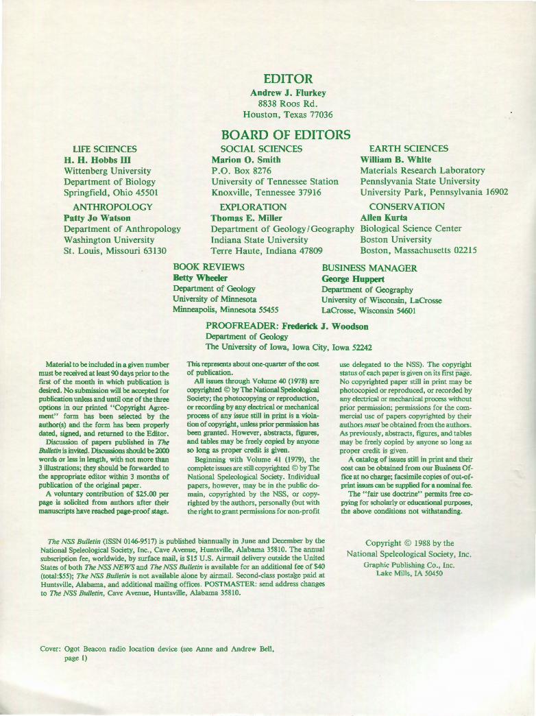
THE 0GOF BEACON TRANSMITTER
The design of the transmitter was governed by the demands of the cave environment. The equipment would obviously be placed in some jeopardy when taken to the remoter parts of cave systems. It needed to be both robust and simple (and cheap) enough to repair or replace if damaged. One further consideration was that a simple and cheap construction would make it feasible to build several transmitters which could be taken to different parts of a system simultaneously.
A continuous tone type of transmitter was considered but rejected in favour of one which repeatedly sends a Morse code character. The latter consumes less battery power although it has more complex circuitry. The transmitter frequency is crystal controlled to minimize the problems of frequency drift due to temperature variation and to some extent rough handling.
The Beacon transmitter (Fig. 2) is built around CMOS integrated circuits which during construction must be handled with extreme care to avoid destroying them with static electricity. A 2.4576 MHz crystal sets the input frequency for
LOOP
IC2 14 10(1NHIBIT) 14~~~---+-----.
~ 8 11
15pF,I
12345678 NUMBER TYPE Vee GNO "OFF" IS
8 OIL KEY DOWN 4060 16 8
SWITCHES 2 4040 16 8 !SET CHARACTER 3 4512 16 8
4 4011 14 7
5 4011 14 7
Figure 2. Ogof Beacon Transmitter. Andy Bell 1985. •Editor's note: Recent exchange rates are about $1.60 to the pound.
2. THE NSS BULLETIN, JUNE 1987
L1
L2
VN66AF ON
HEATSINK
4 TURNS ON 10" DIA
155 TURNS ON 10· DIA
CR THAT REQ'O TO BRING COIL TO
RESONANCE (ABOUT 1000pFJ

the 4060 14 stage counter. A 38.4 KHz signal is abstracted from pin 4 of the 4060. It is this signal which is modulated and amplified in later stages and used as the actual transmission signal. A 600 Hz signal is also abstracted from the 4060 and passed on to the 4040, which contains another 12 stages of counting. From the 4040, signals are abstracted from pins 4, 12, 13 and 14. These are used as inputs to the 4512 which in turn sequentially scans the DIL switches.
The eight DIL switches, together with pull-up resistors, describe the Morse code character to be transmitted. A diode is included in the transmitter to avoid damage occurring if the battery is connected the wrong way round. A series fuse is also included. The transmitter was built on 0.1 inch matrix veroboard using wire-wrap techniques, but conventional soldering should be just as good. No layout problems were experienced. The circuitry is housed in a diecast box measuring 120mm x 92mrn x 60mm (4.7 in. x 3.6 in. X 2.4 in.), on which three connectors are mounted: battery input, RF out to loop antenna and lastly one used to connect a Morse key and headphone. In an attempt to keep moisture out of the diecast box once the lid was finally in place, the box was given a coat of varnish.
The length of wire between the RF outlet and the transmission loop should not exceed 46cm (18 in.).
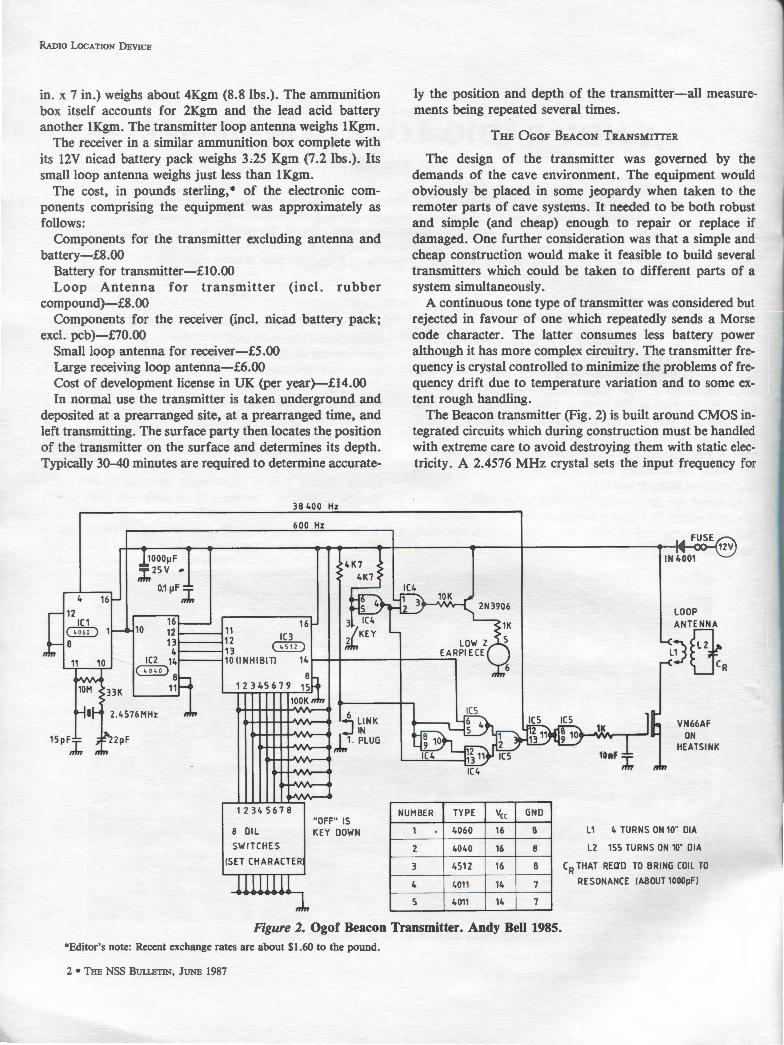
THE TRANSMITTER BATTERY
The transmitter power supply is a 12 volt sealed lead/acid battery made by Yuasa. The 2.6 ampere hour type was chosen but one of smaller capacity would do just as well. With hindsight a 12 volt 1.2 ampere hour type would have been a better choice because it is lighter, smaller and the full capacity of the 2.6AH battery has never been utilized. This family of batteries has been used to power cap lamps and thus is known to be reasonably hardy. The only modification made in this case was to glue a piece of wood to the top of the battery to make it difficult to short out the battery contacts on the side of a metal ammunition box. Such an occurrence could prove very dangerous indeed. A cable with red and black crocodile clips at one end and red and black insulated terminal plugs on the other is used to supply the power to the Ogof Beacon Transmitter. This cable is about 46cm (18 in.) in length.
THE TRANSMITTER BATTERY CHARGER
The Yuasa batteries are charged in a somewhat more
J ll II
2i.ov isv lA 1000 µF
2SV 0.1 µF lOOµF 2SV
Figure 3. Ogof Beacon TX Battery Charger. A:ndy Bell 1985.
ANDREW B ELL
sophisticated way than are the traditional miners' Oldham cap lamps. They must be presented with a constant voltage and a current limited environment. Each member of the family has its own parameters in this respect. Figure 3 shows the circuit used to trickle charge the battery. The preset resistor controls the output voltage and the parallel resistors, Rel, define the maximum current. For the Yuasa 2.6 AH battery the voltage is set at 14.7 volt and the maximum current at about 0.65 amp. It is necessary to consult the manufacturer's data to be sure of using the correct charging parameters.
THE 0GOF BEACON RECEIVER
A very sensitive receiver will compensate for a relatively inefficient transmitter and transmitting antenna. In the case of a radio location device the receiver remains on the surface in relative safety and it is therefore possible to make it a much more complicated piece of equipment. The Beacon receiver was designed around these two factors. Its essential features are its sensitivity and narrow bandwidth, the latter being necessary to reduce the level of background noise to a minimum.
As a consequence the Ogof Beacon Receiver is both complicated and relatively expensive. The construction and alignment are not a simple undertaking for the inexperienced constructor, the alignment particularly requiring specialized test equipment. The design is based on a high performance radio amateur receiver of the superhetrodyne type. The circuitry for the receiver was constructed on three double sided printed circuit boards where the top side in each case is grounded. The first board contains RF amplification, crystal controlled local oscillator and crystal ladder filter. The second contains only the two stages of IF amplification and the third contains a beat frequency oscillator (BFO), diode mixer and audio (AF) amplification. Dividing the amplification over different printed circuit boards adds to the stability of the receiver. Figure 4 is a block diagram of the Ogof Beacon Receiver.
Figure 4. Beacon Receiver Block Diagram.
The receiver works as follows (Fig. 4a): the 38.4 KHz signal from the tuned loop antenna is fed into the tuned amplifier built around Ql. From here the amplified signal is passed to a mixer built around the dual gate mosfet Q2 where the 38.4 KHz signal is mixed with a 4.469896 MHz signal resulting in a 4.433619 MHz signal, used as the intermediate frequency (IF). This frequency was chosen for the IF because crystals of this frequency are relatively cheap
THE NSS BULLETIN, J UNE 1987. 3

RADIO L OCATION D EVICE
R1 R3 R9
R2
__ C_6_ "~. " ii " x:1~if ·~rHx:1~r~' son COAX TO I. F. AMPLIFIER
RS 6 cs 'Y---.
R7
cs
OS
and easily obtainable, being commonly found in color televisions in the UK. Out of the mixer the signal is passed through a high performance 6 pole crystal ladder filter comprising X2-X7 (Hardcastle, 1979) which passes a bandwidth of about 600 Hz, a bandwidth too narrow to pass speech. A
SOACOAX TO
R17
FRONT ENo._-+-.._....-'
12V
R20
06 u 4 07
R22 I m
4 . THE NSS B ULLETIN, J UNE 1987
L17
R24 l. Cl?
Figure 4b. Beacon Receiver I.F. Amplifier.
(9
Figure 4a. Beacon Receiver Front End.
narrow bandwidth filter was used to reduce the amount of background noise thus improving the signal to noise ratio characteristic of the receiver and so its ability to receive weak signals.
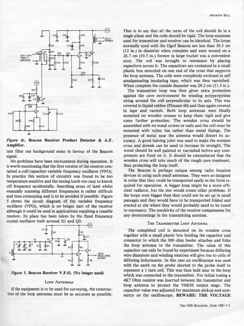
Beyond the ladder filter (Fig. 4b) the signal gets a tremendous amount of amplification from Q4 and ICl. The amount of gain provided by ICl is governed by R21, the volume control. The by now very much filtered and amplified signal is passed to a diode mixer (Fig. 4c). D8-Dl1, together with a crystal generated signal of approximately 4.433000 MHz produced by Q5. (The crystal used to provide this was selected from a batch of 4.433619 MHz crystals because it produced a pleasant audio tone in the headphones.) These two signals when mixed together result in a· signal of audio frequency which is further filtered, amplified and passed to the headphones.
The receiver has only two controls-an ON/OFF switch and a volume control. It contains a 12 Volt Nicad pack, has an input for the receiving loop antenna via a BNC connector and an output for the headphones via an 0.25 inch jack socket. It is worth using a pair of good quality communication earphones as their restricted bandwidth will to some ex-
12V
C49 cso R35 Tl
l I llls;:~~~JEs OB C47l. R34
L 1BL19 L20 09 R31 C46 • son COAX :_:;J
FROM 1.F. 010 AMPLIFIER
iC44 IC45 R3B
01
R36
R32 R37 r48
(38
I
C40 C43
Figure 4c. Beacon Receiver Product Detector & A.F. Amplifier.
tent filter out background noise in favour of the Beacon signal.
No problems have been encountered during operation. It is worth mentioning that the first version of the receiver contained a coil/capacitor variable frequency oscillator (VFO). In practice this section of circuitry was found to be too temperature sensitive and the tuning knob too easy to knock off frequency accidentally. Searching areas of land whilst manually scanning different frequencies is rather difficult and time consuming and is to be avoided if possible. Figure 5 shows the circuit diagram of the variable frequency oscillator (VFO), which is no longer part of the receiver although it could be used in applications requiring a tunable receiver. Its place has been taken by the fixed frequency crystal oscillator built around Xl and Q3.
~----------{12V
LOCAL OSCILLATOR OUTPUT
Figure 5. Beacon Receiver V.F.O. (No longer used)
Loop ANTENNAS
If the equipment is to be used for surveying, the construction of the loop antennas must be as accurate as possible.
ANDREW BELL
That is to say that all the turns of the coil should lie in a single plane and the coils should be rigid. The loop antennas used for transmitter and receiver can be identical. The loops normally used with the Ogof Beacon are less than 30.5 cm (12 in.) in diameter when complete and were wound on·a 26.7 cm (10.5 in.) former (a large bucket was a convenient size). The coil was brought to resonance by placing capacitors across it. The capacitors are contained in a small plastic box mounted on one end of the cross that supports the loop antenna. The coils were completely enclosed in self amalgamating insulating tape, which was then varnished. When complete the outside diameter was 29.2 cm (11.5 in.).
The transmitter loop was then given extra protection against the cave environment be winding polypropylene string around the coil perpendicular to its axis. This was covered in liquid rubber (Flexane 60) and then again covered in tape and varnish. Both loop antennas were finally mounted on wooden crosses to keep them rigid and give some further protection. The wooden cross should be assembled with no metal screws or nails and the coil must be mounted with nylon ties rather than metal fixings. The presence of metal near the antenna would distort its accuracy. A good halving joint was used to make the wooden cross and dowels can be used to increase its strength. The wood should be well painted or varnished before any components are fixed on it. It should be remembered that the wooden cross will take much of the rough cave treatment, thus protecting the loop itself.
The Beacon is perhaps unique among radio location devices in using such small antennas. They were so designed in order that they could be transported easily in the form required for operation. A bigger loop might be a more efficient radiator, but the size would create other problems. If the loops were bigger then they could not be set up in small passages and they would have to be transported folded and erected at site where they would probably need to be tuned to resonance. The sensitivity of the receiver compensates for any shortcomings in the transmitting antenna.
THE TRANSMITTER Loop ANTENNA
The completed coil is mounted on its wooden cross together with a small plastic box holding the capacitor and connector to which the 300 ohm feeder attaches and links the loop antenna to the transmitter. The value of this capacitor can only be found by experiment because differing wire diameters and winding tensions will give rise to coils of differing inductances. In this case an oscilloscope was used with the earth on the probe shorted to the probe itself to represent a 1 turn coil. This was then held near to the loop which was connected to the transmitter. For initial tuning a 4K7 Ohm resistor was inserted between the transmitter and loop antenna to protect the VMOS output stage. The capacitor value was adjusted for maximum pickup and symmetry on the oscilloscope. BEWARE: THE VOLTAGE
THE NSS BULLETIN, JUNE 1987. 5

RADIO LOCATION DEVICE
AROUND THE CAPACITORS MAY WELL BE IN EXCESS OF 2000 VOLTS-SUCH A VOLTAGE COULD PROVE FATAL. When the correct value of capacitor has been determined, a small amount of silicon rubber compound should be deposited around the joint of the antenna box before the lid is screwed on in an attempt to waterproof the box.
THE RECEIVER Loop ANTENNA
The receiving loop is identical to the transmitting loop except that lower voltage (and cheaper) capacitors can be used to bring the loop to resonance. In our case a 400pF preset type was used. With the transmitter operating several meters away, the receiver loop was brought to resonance _by monitoring the receiver output on an oscilloscope whilst tuning its 400pF capacitor. Extra padding capacitors may also be necessary if the required capacitance exceeds 400pF.
One other difference from the transmitting loop is that the receiving loop is terminated in a BNC connector because a screened lead must be used to join the loop to the receiver. The wooden frame for the receiver loop is fitted with a protractor and plumb line which are used in determining the depth of the location site (see below).
THE LARGE RECEIVING Loop
A large receiving loop was made especially for difficult applications where perhaps the location site is deeper than usual and interference makes reception harder. The former for this coil was a length of plastic curtain rail which was bent around into a circle and glued into position using a cyanoacrylate adhesive. (The plastic curtain rail contained no metal.) The diameter of the large receiving loop is 86.4 cm (34 in.), it is 2.5 cm (1 in.) long and contains 100 turns. Once again, the inductance of each loop constructed will vary a little, so the value of the capacitor required to bring the loop to resonance has to be found by experiment.
This loop is mounted on a wooden frame inside which the operator can walk, the frame being suspended from the operator's shoulders by webbing. Like the smaller receiving loop it has a protractor and plumb-line attached so that angles can be read off and thus the depth of the transmitter calculated.
Transmitting Loop
Ca About 1000 pF 4000V using series/parallel combinations of fixed capacitors to achieve resonance.
La 150 turns of 7 /0.2 wire of diameter 26.7cm (10.5 in.).
Lb 4 turns over La. Connector RS 444-517 mounted on the plastic box con
taining the capacitors. Cable About 46 cm (18 in.) 300 Ohms parallel feeder to
transmitter.
6. THE NSS BULLETIN, JUNE 1987
Small Receiving Loop
Ca 400 pF preset trimmer (and parallel fixed capacitor if required) adjusted to bring coil to resonance.
La 150 turns of 7 /0.2 wire of diameter 26.7cm (10.5 in.).
Lb 4 turns over La. Connector BNC mounted on plastic box containing
capacitor(s). Cable 3-4 feet of 50 Ohm coax to receiver.
Large Receiving Loop
Ca 400 pF present trimmer (and parallel fixed capacitor if required) adjusted to bring coil to resonance.
La 100 turns on a 34 inch diameter former. Lb 3 turns over La. Connector BNC mounted on plastic box containing
capacitor(s). Cable 0.9-l.2m (3-4 ft.) of 50 Ohm coax to receiver.
0GOF BEACON MONITOR
At the request of cavers who were setting up the Beacon transmitter underground, a small device for checking that the Beacon is really transmitting was designed and built. This consists of about 100 turns of 26 SWG enamelled copper wire wound on a former of diameter 90 mm (3.5 in.). The wire diameter in this case is almost unimportant. When completed the coil was slid off the former and a LED connected across its two ends. The whole assembly was then encased in plastic padding leaving the tip of the LED visible just beneath the surface of the plastic padding. (It is useful to extend the tip of the LED temporarily with plastercine.) In the first model built the LED stood proud of the surface and got broken off.
In use this device is merely held a foot or so above the center of the transmitting loop antenna and if the Beacon is transmitting the LED will be seen to flash in time with the Morse code.
CaG~"---Connector Cable
Figure 6. Circuit Diagram of All Loop Antennae.
CHOICE OF CONNECTORS
The choice of connectors for the underground equipment proved to be difficult in that most waterproof connectors

are very expensive. After considerable searching we chose a series of connectors which would not allow water to pass through them into the equipment.
We used 2mm plugs and sockets (RS type 444-517 & 444-450) to effect connection between transmitting loop antenna and transmitter. Insulated terminals (RS 423-201 & 423-239) were used to connect the battery to the transmitter. Finally we used a 7 pole connector from Farnell, (type 147076 & 147079) with a little epoxy adhesive to increase the water proofing, to bring out the Morse key and earphone signals. (RS Components and Farnell are two major suppliers of electronic components in the UK.)
LOCATING AN UNDERGROUND SPOT
The Transmitter
The underground party sets up the transmitter at the chosen site at a prearranged time. It is particularly important that the transmitting loop be perfectly horizontal because an error of a degree or two can turn out to represent several meters on the surface. A bubble level device is needed for the accurate placement of the transmitting loop. The transmitter is connected to the loop antenna and then the battery connected to the transmitter. The Beacon Monitor is then held near the transmitting loop in order' to check that the Beacon is operational. Ammunition boxes, bubble level and Beacon Monitor are moved away from the transmitting loop and the Beacon is then allowed to transmit for the agreed period.
The Surf ace Party
The surface party must consist of a minimum of two or preferably three people carrying in addition to the receiver and loop(s) the following equipment: at least two ropes, a tape measure, paper and pencil, and perhaps a stake to mark the spot. The Beacon signal can normally be received without difficulty from at least lOOm (330 ft.) away, but the exact location is usually found by nulling the signal, i.e., finding the direction in which it is weakest or completely absent. The receiver operator searches for a null by turning the loop antenna so that it lies in a vertical plain. The operator holding the loop then rotates through 180 degrees searching for a null. When this has been found a rope is laid along the line of the loop antenna. This process is repeated from several different positions and the location of the transmitter will lie directly under the interception of all the ropes. In reality, using three ropes, there will be a small "triangle of error'' which represents some uncertainty. At depths of 20m (66 ft.) this uncertainty may be represented by a circle of error of about 0.3m (1 ft.) diameter, whereas at 80m (260 ft.) depth the circle will be larger.
Depth Measurement
The receiver operator takes up a position some distance
ANDREW BELL
from the located point. Holding the loop horizontal the operator dips the front of the loop down towards the ground until a null is obtained. The angle at which the null occurs is read using the protractor and plumb line. (A second person is useful for this.) The distance from the loop to the location point (in the center of the circle of error) is measured. This distance and the angle shown on the protractor enable the depth of the transmitter to be calculated from a known formula or looked up on a graph or in a set of tables (Glover, 1976).
When measuring the depth of an underground spot three different vertical measurements may actually be involved:
1. The depth of the Beacon underneath the point where the ropes cross on the surface.
2. Any extra height lost or gained on the surface because the ground is not level and it is necessary to walk up or down hill to measure the angle of null at the offset.
3. The height of the center of the receiving loop above the ground at (2) when the measurement is taken.
To allow for these factors the following calculations are applied:
1. Pythagoras' Theorem is applied to obtain a corrected offset.
2. The formula in Glover, 1976, is applied to obtain the depth from the center of the receiving coil when the null reading is taken.
3. The various heights I depths are combined to give the depth of the Beacon beneath the point where the ropes cross.
A small BASIC progtam summarizes this:
10 PRINT "Angle"; 20 INPUT A 30 PRINT "Measured offset"; 40 INPUT F 50 PRINT "Extra height at offset"; 60 INPUT E 70 PRINT "Measurement height above ground"; 80 INPUT H 90 Fl= SQR (F2-E?:2) 100 GOSUB 150 110 LET Dl = D-E-H 120 PRINT "Depth at marker="; Dl 130 PRINT 140 GOTO 10 150 LET Al= (90-A)/ 180*PI 160 LET Bl =SQR ( (9*TAN (Al)*TAN(Al) )+8) 170 LET D=2*Fl/(Bl-(3*TAN(Al))) 180 RETURN
Full accounts of the theory behind electromagnetic induction and cave surveying will be found in earlier articles (Clark, 1978; Smith and Stephens, 1974; Jones and Birchenough, 1962; Glover, 1976).
THE NSS BULLETIN, JUNE 1987 • 7

RADIO LOCATION DEVICE
RAmo LocATIONS WITH THE 0GoF BEACON
The Ogof Beacon has been used in three of the major cave systems in South Wales: Ogof Ffynnon Ddu, Otter Hole and Ogof y Daren Cilau. In Ogof Ffynnon Ddu it was used as an aid to the surveying of the new series, Northern Lights, discovered in 1985 (Peat and Peat, 1985). The results obtained with the Beacon tallied with those obtained by conventional surveying methods. The Beacon has twice been taken to Smith's Armoury-the furthest extent of Ogof Ffynnon Ddu-to compare its measurements with those obtained some years ago with another device. Our readings here gave an average depth of 79m (259 ft.) for Smith's Armoury, a figure which disagrees with measurements previously carried out: "depth about 200 feet (199 feet and 217 feet from two tests)" (South Wales Caving Club, 1968).
The set of locations carried out at Otter Hole deserves special mention because the accuracy of the Beacon was subsequently tested by the drilling of a borehole. In association with the Royal Forest of Dean Caving Club we carried out several locations in Otter Hole, near Sump II, where the object of the exercise was to locate the sump with respect to the surface. In each case John Elliot was responsible for carrying the equipment into the cave and setting it up. With the loop antennas orientated for a maxima the signal was strong and could be heard over a wide area (at least 200m [660 ft.] away). In all of the locations, the observed nulls were wide and intederence from atmospheric disturbances was heavy. We did two depth measurements and the Beacon indicated the depth of the sump below the surface to be 85 and 91m ~279 and 299 ft.), respectively. In February 1986 a 38cm (15 m.) borehole was sunk at the point identified by the Beacon as being directly above Sump II, which is in fact on Chepstow Racecourse not far from the Piercefield Public House. The borehole did hit water and is believed to have entered Sump II, but this can only be verified by diving, and has yet to be attempted. The depth of the borehole was 94.5m (310 ft.) which reveals an error of about 7% in the Beacon measurements.
In Daren Cilau the Ogof Beacon was taken to the furthest extent of the cave accessible to non-divers. The purpose of the exercise was to pinpoint the sump pool prior to a historic dive which took the diver through the Llangattock Mountain to emerge in another cave, Elm Hole, on the other side. The radio location revealed that the existing survey made by conventional techniques was out by about 200m (660 ft.). The signal was audible 70m (230 ft.) from the located point. It was too weak, however, to attempt the nulling technique and therefore we had no option but to search for a maxima. No depth measurement was attempted, but it has been estimated that the cave is in excess of 200m (660 ft.) deep at this point.
It is difficult to quantify the range of the Beacon because no signal strength readings have been taken, and neither has the receiver sensitivity been measured. However, experience
s • THE NSS BULLETIN, JUNE 19S7
has shown that reasonable nulls can be obtained at depths of 80m (260 ft.) and at such depth the signal was "strong" when the transmitting and receiving loop antennas were aligned for a maxima signal.
The receiver is not particularly robust due to the large number of quartz crystals and tuned circuits in it. We have never taken the receiver underground but it has been carried about in a rucksack on the surface for many kilometers without problems. The transmitter itself has never given any problems. The transmission loop antenna box containing the resonating capacitor did on one occasion let in water which corroded the capacitor leads and resulted in reduced signal output. The coil itself was given a second coat of rubber after about 12 caving trips as a precautionary measure.
ACKNOWLEDGEMENTS
For assistance in design and technical discussions, radio amateurs Alan Ibbetson (G3XAQ) and John Bird (G3GIH) together with Roger Smith of SWCC. Thanks to Hugh Rice for redrawing the circuit diagrams.
REFERENCES
Clark, M. S., (l 97S), Improvements to the electromagnetic location device. Trans BCRA, S (3): IS9-163.
Smith, R . and Stephens, R. A., (1974), Inductive loops and cave surveying. Trans BCRA, I (!): SS-60.
Jones, N. & Birchenough, W., (1962), A magnetic position-finding device. Technical aids for cave exploration, CRG, No. 11: S7-102.
Glover, R. R., (1976), Cave surveying by magnetic induction. In Ellis Bryan. Surveying Caves. BCRA, Pp. 42-SS .
Hayward, Wes & De Maw, Doug, (1977), Solid state design for the radio amateur. ARRL.
Hardcastle, J. A., (1979), Ladder crystal filter design. Radio Communication, SS (2): 116-120.
Peat, J. K. & Peat, R., (19SS), Northern Lights. South Wales Caving Club Newsletter, No . 100, Pp. 4-IS .
South Wales Caving Club Log Book 30/ll/6S SEO'R & JVO.
APPENDIX 1
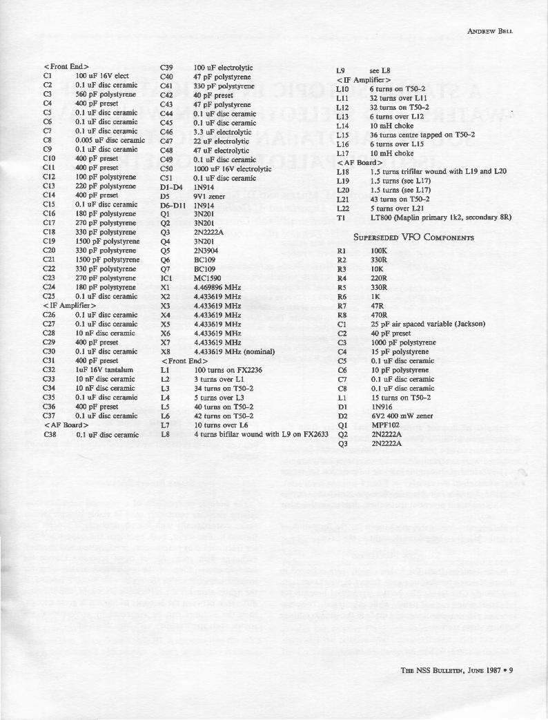
0GOF BEACON RECEIVER COMPONENTS
<Front End> R20 !OK
RI IOOK R21 SK6
R2 33K R22 !OK variable (gain control)
R3 2K2 R22 !Ok
R4 120R R23 SK6
RS IOOK R24 120R
R6 !OK R2S 3K9
R7 120R <AF Board>
RS !OK R27 120R
R9 120R R2S !OK
RIO 470R R29 4K7
Rll 22K R30 470R
Rl2 !OK R31 IK
Rl3 470R R32 !OK
<IF Amplifier> R33 22R
Rl4 SIR R34 6KS
RIS 33K R3S IK
Rl6 IOOK R36 !SK
Rl7 IOOR R37 !SOR
RIS !OK R3S 47R
Rl9 IOOR
ANDREW BELL
<Front End> C39 100 uF electrolytic L9 see LS Cl 100 uF 16V elect C40 47 pF polystyrene <IF Amplifier> C2 0.1 uF disc ceramic C41 330 pF polystyrene LIO 6 turns on TS0-2 C3 S60 pF polystyrene C42 40 pF preset Lil 32 turns over Lll C4 400 pF preset C43 47 pF polystyrene Ll2 32 turns on TS0-2 cs 0.1 uF disc ceramic C44 0.1 uF disc ceramic Ll3 6 turns over Ll2 C6 0.1 uF disc ceramic C4S 0.1 uF disc ceramic Ll4 10 mH choke C7 0.1 uF disc ceramic C46 3 .3 uF electrolytic LIS 36 turns centre tapped on TS0-2 cs O.OOS uF disc ceramic C47 22 uF electrolytic Ll6 6 turns over LIS C9 0.1 uF disc ceramic C4S 47 uF electrolytic Ll7 10 mH choke ClO 400 pF preset C49 0.1 uF disc ceramic <AF Board> Cll 400 pF preset CSO 1000 uF 16V electrolytic LIS l.S turns trifilar wound with Ll9 and L20 Cl2 100 pF polystyrene CSl 0.1 uF disc ceramic Ll9 l.S turns (see LI 7) Cl3 220 pF polystyrene Dl-D4 1N914 L20 l.S turns (see LI 7) Cl4 400 pF preset DS 9Vl zener L21 43 turns on TS0-2 ClS 0.1 uF disc ceramic D6-Dll 1N914 L22 S turns over L21 Cl6 l SO pF polystyrene Ql 3N201
Tl LTSOO (Maplin primary lk2, secondary SR) Cl7 270 pF polystyrene Q2 3N201 ClS 330 pF polystyrene Q3 2N2222A
SUPERSEDED VFO COMPONENTS Cl9 lSOO pF polystyrene Q4 3N201 C20 330 pF polystyrene QS 2N3904 Rl lOOK C21 ISOO pF polystyrene Q6 BC109 R2 330R C22 330 pF polystyrene Q7 BC109 R3 lOK C23 270 pF polystyrene I Cl MC1S90 R4 220R C24 lSO pF polystyrene Xl 4.469S96 MHz RS 330R C2S 0.1 uF disc ceramic X2 4.433619 MHz R6 IK <IF Amplifier> X3 4.433619 MHz R7 47R C26 0.1 uF disc ceramic X4 4.433619 MHz RS 470R C27 0.1 uF disc ceramic XS 4.433619 MHz Cl 2S pF air spaced variable (Jackson) C2S 10 nF disc ceramic X6 4.433619 MHz C2 40 pF preset C29 400 pF preset X7 4.433619 MHz C3 1000 pF polystyrene C30 0.1 uF disc ceramic XS 4.433619 MHz (nominal) C4 IS pF polystyrene C31 400 pF preset <Front End> cs 0.1 uF disc ceramic C32 luF 16V tantalum LI 100 turns on FX2236 C6 10 pF polystyrene C33 10 nF disc ceramic L2 3 turns over Ll C7 0.1 uF disc ceramic C34 10 nF disc ceramic L3 34 turns on TS0-2 cs 0.1 uF disc ceramic C3S 0.1 uF disc ceramic L4 S turns over L3 LI IS turns on TS0-2 C36 400 pF preset LS 40 turns on TS0-2 DI 1N916 C37 0.1 uF disc ceramic L6 42 turns on TS0-2 D2 6V2 400 mW zener <AF Board> L7 10 turns over L6 QI MPF102 C3S 0.1 uF disc ceramic LS 4 turns bifilar wound with L9 on FX2633 Q2 2N2222A
Q3 2N2222A
THE NSS BULLETIN, JUNE 19S7 • 9
Millen, Timothy M., and Dickey, D. Neil, Jr.-A Stable Isotopic Investigation of Waters and Speleothems in Wind Cave, South Dakota: An Application of Isotope Paleothermometry:: NSS Bulletin 49: - .
A STABLE ISOTOPIC INVESTIGATION OF WATERS AND SPELEOTHEMS IN WIND CAVE,
SOUTH DAKOTA: AN APPLICATION OF ISOTOPE PALEOTHERMOMETRY
TIMOTHY M. MILLEN AND D. NEIL DICKEY, JR.
Department of Geology Northern Illinois University
DeKalb, Illinois 60115
Oxygen isotopes were analyzed from cave waters and speleothems from the Lakes region, Wind Cave, to constrain possible models of boxwork formation in conjunction with previous local and regional chemical analyses of the groundwaters. Isotopic analyses of waters from Wind Cave indicate a meteoric origin (o 180w = -12.10 o/oo (SMOW) ). The cave waters are supersaturated with respect to calcite and dolomite, but regionally, groundwaters in this aquifer system are supersaturated with respect to calcite and undersaturated with respect to dolomite. These data support the Ford and Bakalowicz model for boxwork limestone formation by dedolomitization (incongruent dolomite dissolution) under phreatic conditions. Calcite-water isotopic paleothermometry indicates a temperature range of 35° to 65°Cfor boxwork limestone deposition using modern meteoric water 0180 values. This temperature range differs significantly from that proposed by White and Deike of 1000 to 150°C.
INTRODUCTION
Samples of downed speleothems and waters from the Lakes region of Wind Cave were collected by the authors under the terms of a park service special use permit. Samples collected were analyzed chemically and isotopically to:
1) Provide baseline stable isotopic information for future research in the cave,
2) Apply stable isotopic paleothermometry to the samples to constrain potential speleothem depositional models and,
3) Suggest a reasonable mechanism for the formation of the boxwork limestone deposits in the cave.
SAMPLING PROCEDURES
Water samples from the Lakes region were collected in 500 ml Nalgene bottles, one each from Calcite, Transition, and Windy City lakes. The bottles were filled beneath the lake surface and capped tightly while submerged. Temperature and pH measurements were made at the site to compare with previous studies.
Copyright © 1988 by the National Speleological Society
10. THE NSS BULLETIN, JUNE 1987
In addition to the lake water, samples of boxwork limestone, false floor deposits, calcite ice, calcite rafts, and bedrock were collected at Calcite Lake for the study. The bedrock samples collected were in contact with the boxwork deposits.
STABLE ISOTOPE SYSTEMATICS
The isotopic composition of a chemical substance containing elements commonly used in stable isotopic studies varies systematically with the physiochemical process that formed it. For water, both hydrogen and oxygen isotopes are fractionated by evaporation, precipitation, and chemical exchange with rock. All of these processes change the isotopic composition of the water, and usually alter the isofopic composition of the rocks with which it reacted. If the lighter elements are sufficiently abundant, and the mass difference between the isotopes of interest is great enough, then the isotopes can be separated by conventional gas source mass spectrometry with high precision.
l

Analytical results are expressed in standard permil (o/oo) delta (o) notation by comparing an isotopic ratio of a sample to the isotopic ratio of the same element in a standard, as shown in equation 1 for oxygen:
(I) 5180 (OJoo) = 180/ 160 SA - 180/160 ST
180/ 160 ST
x 1000
For hydrogen and oxygen in water, the reference standard is Standard Mean Ocean Water (SMOW). Carbon and oxygen in carbonate rocks are compared to the PDB (Pee Dee Belemnite) standard. Samples that yield positive values are enriched in the heavier isotope relative to the standard, while negative values reflect a depletion of the heavier isotope in the sample relative to the standard.
LABORATORY RESULTS AND D1scuss10N
Results of field and laboratory analyses of this study are shown in Tables I and II and Figures 1 and 2. Additional chemical analyses were conducted by Miller (1979) on the lake waters; these data are shown in Table III.
Table 1. Results of Water Analyses (permit)
5180 5180 52H Sample T(OC) pH (SMOW) (PDB)* (SMOW)
Calcite Lake 13.8 7.8 -12.15 -12.37 -80.28 Transition Lake 13.8 8.0 -12.04 -12.29 -82.52 Windy City Lake 14.0 8.2 -12.20 -12.42 -80.09 Average Values 13.9 8.0 -12.13 -12.36 -80.96
*The 5180w(PDB) value is equal to (5 180w [SMOW] -0.220'/oo) / 1.00022 (from Craig, 1961).
Note: Precision is ± 0.100'/oo for 5180 and 513C, ± 0.1°C for temperature, and ± 0.1 units for pH.
Table 2. Results of Isotopic Analyses and Paleothermometry Studies on Speleothems
5180(PDB) 513C(PDB) Sample (permil) (permil) T(oq•
Calcite Raft -11.98 -4.42 15.2 Calcite Ice -11.94 -4.16 15.0 Boxwork 1 -16.39 -5.77 35.7 Boxwork 2 -16.50 -5.86 36.3 False Floor (Calcite) -14.47 -5.45 26.1 False Floor (Dolomite) -6.05 -1.51 Pahasapa 1 (Dolomite) +0.37 +2.04 Pahasapa 2 (Dolomite) -2.79 +0.64 Boxwork 8°* -20.78 -7.19 61.2
*Temperatures calculated from equation 2. 5180w was assumed to be -12.400'/oo (PDB) in all cases. Calculated temperatures are ± l.0°C.
••From Ford and Bakalowicz (1983) (see Figure 3).
From Tables I and Ill, one can see that waters from the Lakes region are relatively uniform in temperature, pH, and composition. Also, from Table Ill, it appears that the lakes are supersaturated with respect to both calcite and dolomite.
MILLEN AND DICKEY
-40
• Wind C•v• L•kes !This Study)
-60 o Regional Ya luH (B.ck •1 •1..1913)
J ~ -•o .... 0
~ 0 ..
-100 .... ,"• .. ,.( ,, .
.,,.. .... o 0
-120
a cc
-140 -20
_,. -11 -17 _,. -15 -14 -13 -12 -10
c , ,o (SMOW) '%.
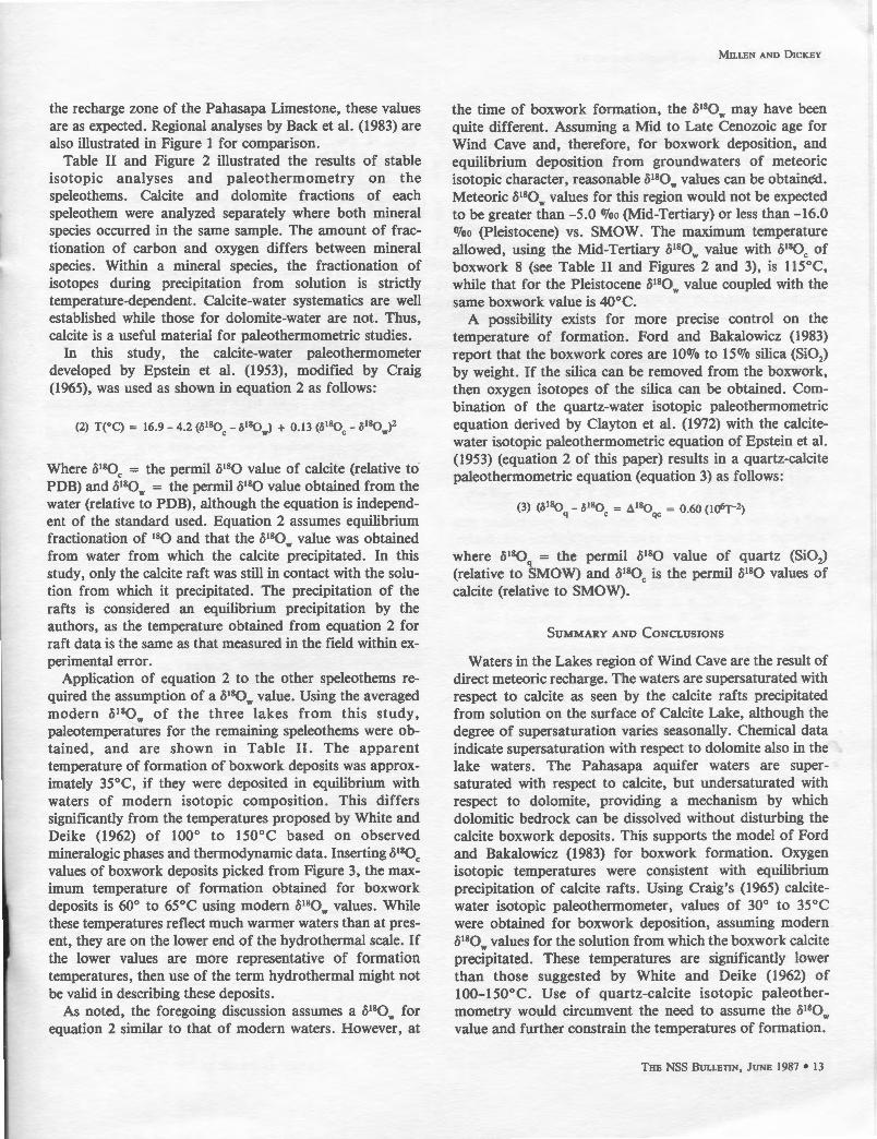
Figure 1. Plot of oD (SMOW) vs. 0180 (SMOW) for waters from the Lakes region, Wind Cave (solid squares, this study) and regional values for the Pahasapa aquifer (open squares, from Back et al., 1983). Note that all samples plot on or near the meteoric water line.
J _,
" Q
~
~" -3 .. -s
-7
-· -25
• Calcile Fraction
o Dolomite Fnct ion
. • -20 _, s
.. • s
-10 -5
618
0 IPDB) %.
Figure 2. Plot of o13C (PDB) vs 0180 (PDB) for speleothems and bedrock samples, Wind Cave. Open squares are dolomite fraction analyses, solid squares are calcite fraction analyses. 1 and 2 = bedrock samples; 3a and 3b = one false floor sample; 4 and 5 = calcite rafts from calcite lake; 6,7,8 = boxwork deposits, (6 and 7, this study; 8, Ford and Bakalowicz, 1983).
This supersaturation is shown in the field by the presence of calcite rafts which precipitate on the surface of Calcite Lake. In a more regional study of the waters in the Pahasapa aquifer, Back et al. (1983) demonstrated a supersaturation of the waters with respect to calcite over much of the region but an undersaturation with respect to dolomite. This undersaturation is considered by Back et al. (1983) to be due to the dissolution of gypsum (CaS04 • 2Hp). Dissolution of significant quantities of gypsum greatly increases the relative Ca+ 2 concentration in the water and decreases the relative Mg+ 2 concentration, thus increasing the Ca+ 2 /Mg+ 2 ratio of the water, and altering the degree of
THE NSS BULLETIN, JUNE 1987. 11

AN APPLICATION OF ISOTOPE PALEOTHERMOMETRY
J o; Q
!:. - 5
..,_u ..
-15_2~.----~,.---_,~,----~,-. ----~.--~-------'
6 110 (PDB) "'-
Figure 3. Plot of 513C (PDB) vs. ()180 (PDB), modified from Ford and Bakalowicz (1983), showing relationship between various speleothems, cave bedrock samples, and hydrothermal calcite to the hydrothermal box. Field A = 'Wind and Jewel Cave bedrock samples; Field B = stalactites and stalagmites-Iowan cave; Field C = stalactites and stalagmites-Wind and Jewel caves; Field D = boxwork deposits-Wind and Jewel caves, false floors and calcite coatings-Wind cave, calcite ice-Wind cave, and dogtooth calcite-Wind and Jewel caves; Field E = hotspring tufa's = Cascade and Fall River, S.D., and hydrothermal vein calcite-Black Hills gold mining district; Field F = stalagmites and stalactites-other Rocky Mountain caves. Numbered squares represent samples presented in Figure 2 and Table II.
Table 3. Chemical Analyses of Waters from the Lakes Region (from Miller, 1979)
Sample Temperature pH Ca +2• Mg +2• HC03• Ca/Mg Sic Sid
Calcite Lake•• 13.7 7.8 99 81 178 1.22 0.13 0.11
Transition Lake 13.8 8.1 89 86 174 1.03 0.30 0.32
Windy City Lake 14.0 8.2 79 74 148 1.07 0.34 0.35
*Parts per million (ppm). ••Averaged values for two samples.
Sic = log (IAPc/Kc)
Where IAP c - Ion Activity Product (Ca + 2) (C03 -2) in solution and Kc =
Equilibrium Activity Constant (from Langmuir, 1971).
dolomite saturation as determined by the saturation index as defined by Langmuir (1971) (Sid = saturation index of dolomite: Sid = log IAP<dl/Kcq(dl where IAP(d) is the ion activity product of the solution and Kcq(dl is the equilibrium constant for dolomite at the temperature of the solution). Therefore, in a large part of the Pahasapa Limestone aquifer, dolomite is being dissolved while calcite is being
12 . THE NSS B ULLETIN, JUNE 1987
deposited. The process of dedolomitization has significance for potential models of boxwork limestone formation.
According to Palmer (1981), there are two major theories on the origin of boxwork limestone. The traditional theory. states that cracks in the Pahasapa Limestone were filled with calcite prior to cave formation. Dissolution of the cave walls left behind less easily dissolved, coarser grained, calcite veins. This is not an entirely satisfactory explanation, because the boxwork deposits only occur in the dolomitized layers of the Pahasapa Limestone, and do not appear to extend to any great depth into bedrock as one would expect in this model (Palmer, 1981, p. 34).
In the second theory, the boxwork is considered to have formed after cave formation and drainage of cave waters. Carbonate-rich waters, drawn toward the larger cave opening by capillary action, precipitated calcite in wall fractures due to the loss of C02 from the water. Removal of the intervening wall rock by weathering in the dry cave (process unspecified, Palmer, 1981) or below a re-elevated water table by dissolution exposed the delicate boxwork fins as projections into the cave.
While the second model adequately explains the origin of the calcite filled fractures, we prefer the model of boxwork formation put forth by Ford and Bakalowicz (1983), in which deposition of boxwork limestone occurred subaqueously after the main cave network formed, which implies a Tertiary to Quaternary age for these speleothems. In this dedolomitization model (incongruent dissolution model of Wigley, 1973), large portions of the Pahasapa Limestone were first converted from limestone to dolomite by magnesium-rich waters. This conversion resulted in a loss of volume in the bedrock and produced fractures for fluid migration and early karst development. Uplift of the Black Hills in the Tertiary -produced the major fracture network which controlled fluid migration and, thus, cave formation. Calcite was precipitated into fractures and along bedding planes in the dolomite during this subaqueous phase, forming the core of the boxwork limestone. Addition of calcium to the groundwater by gypsum solution lowered the dolomite saturation index which resulted in dolomite being undersaturated in the groundwaters, as was demonstrated by Back et al. (1983) for the modern aquifer system. The source of the gypsum could have been the overlying Minnelusa Formation or relict sulfates in the Pahasapa Limestone (Back et al., 1983). Slowly the dolomitized host rock was dissolved, leaving behind the delicate fins of calcite projecting from the cave walls and ceiling as boxwork deposits. Additional coarse calcite was then deposited on the newly exposed boxwork cores prior to cave dewatering.
In Table I and Figure 1 are the results of isotopic analyses on the waters. Values obtained in this study fall very near the meteoric water line and indicate little reaction between these waters and the surrounding rock. As Wind Cave lies in
the recharge zone of the Pahasapa Limestone, these values are as expected. Regional analyses by Back et al. (1983) are also illustrated in Figure 1 for comparison.
Table II and Figure 2 illustrated the results of stable isotopic analyses and paleothermometry on the speleothems. Calcite and dolomite fractions of each speleothem were analyzed separately where both mineral species occurred in the same sample. The amount of fractionation of carbon and oxygen differs between mineral species. Within a mineral species, the fractionation of isotopes during precipitation from solution is strictly temperature-dependent. Calcite-water systematics are well established while those for dolomite-water are not. Thus, calcite is a useful material for paleothermometric studies.
In this study, the calcite-water paleothermometer developed by Epstein et al. (1953), modified by Craig (1965), was used as shown in equation 2 as follows:
Where &180c = the permil &180 value of calcite (relative to PDB) and &180w = the permil &180 value obtained from the water (relative to PDB), although the equation is independent of the standard used. Equation 2 assumes equilibrium fractionation of 180 and that the &180w value was obtained from water from which the calcite precipitated. In this study, only the calcite raft was still in contact with the solution from which it precipitated. The precipitation of the rafts is considered an equilibrium precipitation by the authors, as the temperature obtained from equation 2 for raft data is the same as that measured in the field within experimental error.
Application of equation 2 to the other speleothems required the assumption of a &180w value. Using the averaged modern &180w of the three lakes from this study, paleotemperatures for the remaining speleothems were obtained, and are shown in Table II. The apparent temperature of formation of boxwork deposits was approximately 35°C, if they were deposited in equilibrium with waters of modern isotopic composition. This differs significantly from the temperatures proposed by White and Deike (1962) of 100° to 150°C based on observed mineralogic phases and thermodynamic data. Inserting &180c values of boxwork deposits picked from Figure 3, the maximum temperature of formation obtained for boxwork deposits is 60° to 65°C using modern &180w values. While these temperatures reflect much warmer waters than at present, they are on the lower end of the hydrothermal scale. If the lower values are more representative of formation temperatures, then use of the term hydrothermal might not be valid in describing these deposits.
As noted, the foregoing discussion assumes a &180w for equation 2 similar to that of modern waters. However, at
MILLEN AND DICKEY
the time of boxwork formation, the &180w may have been quite different. Assuming a Mid to Late Cenozoic age for Wind Cave and, therefore, for boxwork deposition, and equilibrium deposition from groundwaters of meteoric isotopic character, reasonable &180w values can be obtained. Meteoric &180w values for this region would not be expected to be greater than -5.0 O/oo (Mid-Tertiary) or less than -16.0 O/oo (Pleistocene) vs. SMOW. The maximum temperature allowed, using the Mid-Tertiary &180w value with &180c of boxwork 8 (see Table II and Figures 2 and 3), is 115°C, while that for the Pleistocene &180w value coupled with the same boxwork value is 40°C.
A possibility exists for more precise control on the temperature of formation. Ford and Bakalowicz (1983) report that the boxwork cores are 100/o to 150Jo silica (Si02)
by weight. If the silica can be removed from the boxwork, then oxygen isotopes of the silica can be obtained. Combination of the quartz-water isotopic paleothermometric equation derived by Clayton et al. (1972) with the calcitewater isotopic paleothermometric equation of Epstein et al. (1953) (equation 2 of this paper) results in a quartz-calcite paleothermometric equation (equation 3) as follows:
(3) (c5 180 - 0180 = d 18o = o 60 (Hfrr-2) q c qc ·
where &180q = the permil &180 value of quartz (Si02)
(relative to SMOW) and &180c is the permil &180 values of calcite (relative to SMOW).
SUMMARY AND CONCLUSIONS
Waters in the Lakes region of Wind Cave are the result of direct meteoric recharge. The waters are supersaturated with respect to calcite as seen by the calcite rafts precipitated from solution on the surface of Calcite Lake, although the degree of supersaturation varies seasonally. Chemical data indicate supersaturation with respect to dolomite also in the lake waters. The Pahasapa aquifer waters are supersaturated with respect to calcite, but undersaturated with respect to dolomite, providing a mechanism by which dolomitic bedrock can be dissolved without disturbing the calcite boxwork deposits. This supports the model of Ford and Bakalowicz (1983) for boxwork formation. Oxygen isotopic temperatures were consistent with equilibrium precipitation of calcite rafts. Using Craig's (1965) calcitewater isotopic paleothermometer, values of 30° to 35°C were obtained for boxwork deposition, assuming modern &180w values for the solution from which the boxwork calcite precipitated. These temperatures are significantly lower than those suggested by White and Deike (1962) of 100-150°C. Use of quartz-calcite isotopic paleothermometry would circumvent the need to assume the &180w value and further constrain the temperatures of formation.
THE NSS BULLETIN, JUNE 1987. 13
AN APPLICATION OF ISOTOPE PALEOTHERMOMETRY
ACKNOWLEDGEMENTS
The authors would like to thank the following people without whom this study would not have been possible: Kay Rhode, Assistant Chief Naturalist at Wind Cave, for putting together the field crew on such short notice; the field crew, Mary Laycock (our guide), Bill Holmes, Gregg Wright, and Dennis Shreves for taking us to the Lakes, transporting equipment and samples, and keeping us out of trouble; Dr. Carla W. Montgomery, Dr. Ruth I. Kalamarides, and David B. Dathe and anonymous reviewers for providing helpful comments on this manuscript; Dr. Eugene C. Perry, Jr., Dan Grnitro, and Richard A. Socki for the use of the mass spectrometer and preparation lines, and their assistance in the lab; and Joanna Wood for typing the final manuscript.
REFERENCES
Back, W., Hanshaw, B. B., Plummer, L. N., Rahn, P. H., Rightmire, C. T., and Rubin, M., 1983, Process and rate of dedolomitization: Mass transfer and 14C dating in a regional carbonate aquifer: Geological Society of America Bulletin, v. 94, p. 1415-1429.
Clayton, R. N., O'Neil, J. R., and Mayeda, T. K., 1972, Oxygen isotope
14. THE NSS BULLETIN, JUNE 1987
exchange between quartz and water: Journal of Geophysical Research, v. 77, p. 3057-3067.
Craig, H., 1961, Standards for reporting concentrations of deuterium and oxygen-18 in natural waters: Science, v. 133, p. 1833-1834.
___ , 1965, The measurement of oxygen isotope paleotemperatures, in Tongiorgi, E., ed., Stable Isotopes in Oceanographic Studies and Paleotemperatures: Consiglio Nazionale delle Richerche, Laboratorio de Geologia Nucleare, Pisa, p. 161-182.
Epstein, S., Buchsbaum, R., Lowenstarn, H. A., and Urey, H. C., 1953, Revised carbonate water isotopic temperature scale: Geological Society of America Bulletin, v. 64, p. 1315-1326.
Ford, D. C. and Bakalowicz, M., 1983, Preliminary report upon McMaster University geochemical and isotopic studies in Wind and Jewel Caves: Report of Investigation to Wind and Jewel Caves National Parks, 16 p.
Hoefs, J., 1980, Stable Isotope Geochemistry: Springer-Verlag, New York, p. 21, 27, and 33.
Langmuir, D., 1971, The geochemistry of some carbonate ground waters in central Pennsylvania: Geochimica et Cosmochimica Acta, v. 35, p. 1023-1046.
Miller, T., 1979, Sampling of the atmosphere and carbonate aquifer at Wind Cave, South Dakota: Report of Special Use Permit to Wind Cave National Park, 11 p.
Palmer, A. N., 1981, The Geology of Wind Cave, Wind Cave National Park: Wind Cave National History Association, 44 p.
White, W. B., and Deike, G. H., III, 1962, Secondary mineralization in Wind Cave, South Dakota: The National Speleological Society Bulletin, v. 24, part 2, p. 74-87.

MARION SMITH
THE-IDENTIFICATION OF HORNER'S AND HEATON'S NITER WORKS, BATH COUNTY, VIRGINIA
MARION 0. SMITH
P. 0. Box 8276 U. T. Station
Knoxville, Tennessee 3 7996
Two Civil War niter works in Bath County, Virginia, Homer's and Heaton 's, are correlated through documentation with modern known Williams and Mountain Grove Saltpeter caves. Although there is little known about the caves proper, specific data about the size, duties, and pay of the personnel employed at the two works is presented, along with information about the organization of Conj ederate Niter District 4Vi, reports of Union raids, and sketchy estimates of the saltpeter produced.
On December 19, 1982, faint inscriptions were noticed by Dave Hubbard, Roseanne Prestipino, and Marion 0. Smith on the muddy "Signature Rock" in Williams Cave, Bath County, Virginia. Two particular scratchings, "LRAH 1863" and "T(?] Higgason," were the initial inspiration for the investigation of two Confederate government saltpeter operations and their correlation to modern known caves.
NITER DISTRICT 4112
After the Confederate congress created the Nitre Bureau in April, 1862, the South was divided into districts which were each assigned a superintendent. Several of these districts were in the Virginias, with number 4 \12 being most pertinent to this discussion. After spending over a month at Charlottesville, Lieutenant [later captain and major] James F. Jones was ordered to Augusta County on July 12, 1862. The remainder of his territory included Shenandoah, Rockingham, Highland, Bath, and Rockbridge counties, Virginia, and Pendleton County, West Virginia. By 1864 Page County, Virginia, was also included. '
Jones established his headquarters in Staunton, where he rented rooms for an office from Robert Cowan and William Frazier, at $8.50 and $12.50, respectively, a month. At this office was a small staff, which included at various times, assistant superintendents John and Charles Marshall, S. A. Richardson, William H. Tidball, and Robert T. Barton and clerks E. Jaquelin Smith and William L. Clark, Jr. Although Jones's job was to oversee all saltpeter, iron, and other mineral production or manufacture within his area, only saltpeter mining will be here addressed. 2
Within the boundaries of District 4 Y2 there were at least five government or Nitre Bureau operations. Four of these were in caves, of which two will be the primary focus of this report. 3 In addition, Jones and his assistants regulated the
Copyright © 1988 by Marion 0. Smith
mining of citizens who contracted to produce niter. During the latter stages of the war the Bureau required the production of "two pounds per hand for each working day." Although many of these individuals made saltpeter from dirt underneath houses and outbuildings, probably a few mined cave earth. Contractors in Jones's counties were paid $1 to $1.50 per pound for niter and included:
Bell and Company, A. Blair and Brother, Robert Craig, W.W. Donaghe, John F. Melton, S. K. Taylor, and Wilson and Company, Augusta; James F. Keyser and James Moyers, Bath; Samuel E. Armstrong and Woods and Company, Highland; James B. Eastham and John Welfley, Page; H. Pitzenbarger and Samuel Puffenbarger, Pendleton; [John W.] Barclay and [A. J.] Donald, John A. Barger, James E. A. Gibbs, and J. F. Taliferro, Rockbridge; Branner and [George H.] Copp, William M. Justis, P.A. Koontz, J. K. Landes, John H . Miller, Scott and Life, Michael H. See, [Henry] Weast and Life, Rockingham; Andrew J. Cullers, J. W. Hobffman, J. W. Jones, Henry Maphis, William Nicks, John Whitmire, and J. H. Zirkle, Shenandoah; Black and Shorter, J . H. Buckman, Elijah Dudley, McGuffin and Catlett, Priest and Blakemore, Spicer and Shorter, and J. W. Swintz[?], county not known.
Workers of the district were described in November, 1864, as "nearly all ablebodied young men" who were "mostly what are termed Brush men, and can only be Kept at work by the promise of exemption from military duty. An attempt to arrest one is but the signal for the whole to take to the woods or desert to the Enemy."•
Jones supplied both private and government niter operations with such equipment as buckets, kettles, axes, shovels, picks, nails, lamps, dippers, hatchets, handsaws, skimmers, steel drills, and wedges. Also, from time to time, he furnished food for laborers and forage for animals. He main-
THE NSS BULLETIN, J UNE 1987 • 15

HORNER'S AND HEATON'S NITER WORKS
tained contact with Nitre Bureau headquarters in Richmond, and presumably made reports to them, although few have been found. In early 1864, under orders from the military authorities, he organized his workmen into local defense companies, and a few months later was obliged to call them to active duty. s
R. A. HIGGASON
The name in Williams Cave is believed to be the signature of Reuben Acker Higgason, a Nitre Bureau officer. Born March 7, 1840, in Monroe County, Mississippi, he briefly (1858) attended the Military Academy at West Point, but returned home because his health would not permit him ''to go through with the duties." After this he attended the University of Mississippi and read law with his uncle, exCongressman Reuben Davis, beginning practice in 1859. The succeeding winter he moved to Caldwell, Burleson County, Texas, where he remained until the war. He then joined Company G, 5th Texas Infantry, CSA, as a private, but on June 6, 1863, was appointed a first lieutenant in the Nitre and Mining Bureau. 6
A month later the young lieutenant received the following request from Captain James F. Jones:
I wish to have an accurate description of the Caves now worked on Government account in Bath County by my agents Mr. Horner and Capt. Heaton. You will please explore them and make a Report embracing the dimensions of the Two caves the probable quantity of Earth in each, and wh~t from your own observation will be and is the average yield of nitre to the Bushel of earth. I wish also your views upon the management of these two works, their mode of making nitre, the quantity of water and ashes required for each bushel of earth, what kind of Timber makes the best ashes, & c, in other words I wish a full report from you of what is above requested as well as any thing that may occur to you appertaining to these works. when this is completed you will please report at this office, and then I wish you to visit the Government works at Keezletown, the character of the works varying here from those you are requested to examine. The earth here being produced from old Houses.
Lieutenant Higgason did make the above tour of inspection, but his report, if made, apparently no longer exists. On July 19, while back at Staunton, he mentioned in a letter to Major Richard Morton, the Nitre Bureau's second highest officer at Richmond, that he had "been around in Capt Jones's district looking at the government works" and thought he now had "a very good understanding of the process of nitre making." Further, he suggested to Morton that "as my own State is entirely cut ... from any assistance by the eastern States, there probably are a great want of officers, and operators there, in the manufacturing of munitions of war, and I have the confidence in my practical knowledge of nitre making to report myself to you for duty." Two days later Morton replied that in "a week or ten
16. THE NSS BULLETIN, JUNE 1987
days orders will be sent to you.-in the meantime your time can be profitably spent in perfecting your practical knowledge." In early August, 1863, Higgason was ordered by the chief of the Nitre Corps, Lieutenant Colonel Isaac M. St. John, to "report to Lieut J C Clemson at Atlanta Geo and proceed with him to Shreveport La" and from there "to San Antonio and report to Capt R H Temple . . . remaining in Texas two weeks" before returning "to Richmond with reports," unless Temple needed him longer. But these orders were never carried out. While enroute west, Higgason was captured September 9, 1863, in Bolivar County, Mississippi, and held a prisoner of war at Johnson's Island, Ohio, until June 11, 1865. Afterwards he returned to Burleson County, Texas, and resumed his law practice until his death, June 11, 1881. 8
By leaving his name on the wall, it is obvious that Higgason visited Williams Cave. But which Confederate government cave was it, Heaton's or Homer's? Or did the youthful lieutenant visit caves in Bath County other than the ones he was ordered to inspect? The published Virginia speleological reports list at least seven caves in Bath which have been mined for saltpeter. Of these, Clark's, supposedly utilized from the mid-eighteenth century, and Breathing have been the most extensively used. Two more saltpeter caves have recently been located and there are rumors of additional mined caves. Saltpeter historian and caver Burton Faust, who also saw the Higgason correspondence, suggested that Homer's and Heaton's works were Clark's and Starr Chapel caves, but did not clearly distinguish which cave was which works. The succeeding discussion will provide a more conclusive answer. 9
Dou GLAS CA VE
Surviving Nitre Bureau pay vouchers indicate that Homer's Works was at Douglas Cave. However, the name Douglas is not currently [1986] applied to any Bath County saltpeter cave. A partial answer to this nomenclature dilemma seems to be in the very interesting January 2, 1836, will of William Douglas which does mention a cave. Douglas divided his lands and belongings among thirteen children, offspring from two or more common law associations. The most informative portion of this document was his bequeathal to his children "by Betsy Ross deed," Sally, Sophia, Rebecca, Benjamin, William, and Anderson, each using the Ross surname. To them he left his "several parcels of Land embracing and Contiguous to the Saltpetre Cave or cove on the Cowpasture River and bounded by the lands of Joseph Mays above and by those of Thomas and Hugh McDannald below." In addition he gave them personal property which included horses, cows, sheep, hogs, wagon gears, farming utensils, grain, slaves, and "all my Saltpetre Kettles."
Other land along the river, which Douglas had owned since 1812, was left to six more sons and daughters by a
woman apparently named Griffith. This included the tract where he lived which was "known by the name of the Sexton place." 10
A deed search of the lands willed to the six Ross children has yielded interesting, although confusing results. This is because two saltpeter caves, less than a mile apart and now known as William and Clark's, were once owned by William Douglas! In addition, a third cave, also possibly mined for niter, is rumored to exist in the area once owned by Douglas.
Williams Cave is a large, complex, multi-level, maze, with both dry and muddy zones. It was surveyed between 1975 and 1979 at 17, 700 feet, and the gated entrance is some 500 feet from the bluff overlooking the Cowpasture River. It was mined for saltpeter, although the only internal evidence are "charcoal remnants scattered throughout ... in many cases, embedded in flowstone.'' 11
Benjamin F. Ross received a 161-acre parcel which included Williams Cave. In 1847 he transferred the property to his brother James Anderson Ross, who in 1851 sold it to Gabriel Cauley, the husband of Sarah (Sally) Ross. Cauley deeded 157 acres to his son Benjamin F. in 1870 and the remaining four acres in 1873 to William Ross. In 1898, J. W. and W. C. Warren, under the name J. W. Warren, Son, & Co., purchased from Benjamin F. Cauley two tracts on the Cowpasture River, consisting of 157 and 492 acres. The 157 acre tract was purchased July 21, 1899, by Charles Williams, and it in turn was owned by his son Frank P. (whose wife Sarah was a daughter of James Anderson Ross), and grandson George Gratton Williams. Blanche A., the widow of George Gratton Williams, is currently the owner of the cave. 12
Clark's is the most prominent saltpeter cave along the Cowpasture River in Bath County. The property which included the cave was left by William Douglas to his daughter Sophia Ross. In 1843 she and her husband William Griffith deeded 263 7 /8 acres, including the cave, to Johnston E. Bell of Greenbrier County. In 1849 Bell sold it to Samuel Clark who in 1866 transferred it to his son Archibald P. S. The current owners, Mrs. W. Grady Clark and her brotherin-law Gilbert Clark, report that "they heard 200 men worked in their cave in the Civil War!" Although work may have been conducted then, it is possible that the most ambitious mining took place during some earlier period, perhaps in 1812-14. Faust described Clark's as a "labyrinth of interconnecting passages and rooms," with the peter dirt deposits being "extensive, deep and numerous." He further determined that "From the amount and variety of work activities, evidenced in widely separated sections of the cave, saltpetre mining extended over a long period of time." 13
During the early 1980's Virginia caver Dave Hubbard visited Clark's Cave a number of times, and reported that he had "not found a single Civil War name in the cave-and only one post c.w. in 1880's. The names may be there but under dust-or [the] miners may have been illiterate." If
MARION SMITH
Clark's was mined as part of the same operation that worked Williams Cave, no surviving Nitre Bureau record contains either Samuel or A. P. S. Clark's name. However, A. P. S. did sell in January, 1864, some buckwheat, rye, and corn to a local Confederate quartermaster. The failure to documentarily link Clark's Cave owners to the Nitre Bureau, contrasted with records placing members of the Gabriel Cauley family at work at "Douglas Cave," plus the physical presence of Lieutenant Higgason's name, leads to the conclusion that probably the "Douglas Cave" [Homer's Works] referred to by the Confederates was Williams Cave. This conclusion, however, may someday be altered by new evidence. Irrefutably, "Douglas Cave" or Homer's Nitre Works was in the immediate vicinity of Williams and Clark's caves. 1•
HoRNER's WoRKS
The earliest known worker at Douglas Cave or Homer's Works was Lee Cauley. Over a half century after the war he wrote that when niter mining was "started at the Douglas Cave quite a number of men worked there .... Volunteers were sent to take charge of it [and] after getting every thing in working condition, I left ... and went to the army." Cauley did not tell when the operation began, but he enlisted in the military September 8, 1862. is
Surviving Nitre Bureau vouchers and payrolls provide much additional information about the personnel at Douglas Cave. Unfortunately, very little is learned about the cave itself. Between November, 1862, and July, 1864, seventy different individuals, of which seventeen were detailed free Negroes, are listed as employees at the cave. In addition, there were three "black hand[s]" and one "hired man," who were probably slaves of some of the white workers. The white laborers were detailed conscripts who ordinarily received exemptions from serving in the main field army, although they were subject to military discipline and to calls to repel Federal raids. 16
The size of the labor force fluctuated from month to month, ranging from forty-five in January, 1863, to eighteen in October, 1864. The most faithful white laborers before July, 1864, included Amos K. and Jacob H. Wright, J. B. Morris, David N. Wandless, William J. Kincaid, James A. D. Bridget, John Fox, Harvey S. Harris, Brown Cauley, A. McR. Blain, and William H. Carter, who had respectively worked 446, 424 Y4, 404 Y4, 397, 372, 371, 364Y4, 3511h, 321314, 314Y2, and 313314 days since November, 1862. The most free Negroes employed at any one period was ten, but after February, 1864, there were none. The blacks who labored the longest were Edward Taylor, in spite of his desertions, Napoleon Veny, and Archibald Jackson, who worked 137, 129Y4, and 128 days, all during the first half of 1863. The pay per day for the laborers, whether white or black, was 60 cents. For those
THE NSS BULLETIN, JUNE 1987. 17

HoRNER'S AND HEATON's NITER WORKS
who lived nearby and could furnish their own rations, the pay was a dollar a day. 17
The superintendents of the Douglas Cave Works, each paid at the rate of $75 a month, were Kennerly Craig, November, 1862-January, 1863, Robert L. Horner, about March 8, 1863-June, 1864, and Michael Maloney, from July, 1864. Craig was from Augusta County and was postmaster at Deerfield at the start of the war. From late 1863 until the surrender of Lee he was a private in the Confederate cavalry. Horner and Maloney were farmers from Fauquier and Allegheny counties, and both had been enlisted men in the Confederate army. Maloney was present from November, 1862, to June, 1864, as assistant superintendent, at $40 a month. As such, in April, 1863, he made out an affidavit that a "mule in the nitre & mining bureau" in Captain Jones's district had died the previous January. 18
Workers other than the "laborers" received a higher daily pay for their services. The only listed foreman, H. W. Quarles, earned $30 a month for one month and three days' service within the December, 1863-February, 1864, pay period. Carpenters John P. Windon and Charles H. Hughart were each paid $2 a day for 41 and 26 days' labor between November, 1862, and January, 1863. The one exception to higher pay was the "black hand" belonging to Superintendent Craig, who was paid $15 a month for 1 4/5 months' service as cook during November and December, 1862. 19
Desertions from the labor force at Douglas Cave were not uncommon. Between February, 1863, and July, 1864, nine whites and six blacks deserted. The most occurring in any one month were twelve, in February, 1863, when seven whites and five blacks took "French leave." Two of the whites and all the blacks returned in March. However, a couple months later the same five blacks deserted again. In late July-early August, 1863, Horner received pay for ''travelling expenses to feed horse through Augusta County six days, in arresting four negro deserters." These black laborers were apparently George Chambers, Edward Taylor, and James and John Williams. The only white to desert more than once was James C. Hall, who was permanently gone by August, 1863. 20
Some of the detailed workers as well as a number of civilians, most of whom lived relatively close to Douglas Cave, performed various chores for the niter works. In addition, these workers and civilians supplied food, forage, ashes, lumber, and other products.
Apparently, there was some sort of makeshift housing for the laborers at Douglas Cave. This is indicated by the 922 and 100 feet of plank supplied by Horner in November, 1863, and January, 1864, "To repair quarters." In midJanuary, 1863, Christian Rowe sold the operation "12 winder lights at 16 2/3 cts each," which may have been used in laborers' shacks. Lumber for unspecified use at the works was supplied in late 1862 by Willis Kincaid and William Mc-
18. THE NSS BULLETIN , J UNE 1987
Clung. Kincaid in November and December furnished 1,961 feet of three-quarter inch and 2,061 feet of one-inch plank, while during the latter month McClung sold to the operation 2,000 board feet of unmentioned thickness. 21
On April 7 and December 22, 1863, pine wood "to burn in boiling" was sold to the works by Christian Rowe and Horner, who were respectively paid five and four dollars a cord. A load of "pitch pine wood" was supplied the last day of 1862 by William Ross, presumably the same son of William Douglas who had been named in the 1836 will. Ross also provided ashes. In November, 1862, he and John A. Rowe sold respectively seventeen and thirty bushels at 30 cents each, while the next January James A. D. Bridget supplied twenty bushels at half that price. Rowe and Bridget were detailed employees at the works. 2 2
The bulk of the rations for the work force at Douglas Cave may have come from Confederate commissaries, although there is no evidence to support this assumption. Private individuals did, from time to time, sell foodstuffs to the works. In mid-November and early December, 1862, Gabriel Cauley, John A. Rowe, William Ross, and Robert J. Glendy supplied respectively 53, 36, 35, and 1,122 pounds of beef at 12 cents and 14 cents a pound. Earlier in the same month, John S. Crawford sold to the works a hundred pounds of flour at 12 Y2 cents per pound. The following April, Horner received payment for the purchase of 39 pounds of bacon and 61 pounds of flour at 75 cents and 10 cents per pound. Eleven months later A. K. Clayton, another employee, supplied 677 ¥.! pounds of beef for $271. 2 3
Forage for animals was at least sometimes supplied by Confederate authorities. Captain Jones requisitioned the quartermaster at Staunton to feed two "horses at work at Douglas Cave govt nitre works" November 24 and 25, 1863. A daily allowance of twelve pounds of corn and fourteen pounds of hay were to be given to each animal. In November, 1862, John S. Crawford contributed twenty-two bushels of corn and Robert J. Glendy a hundred pounds of hay, and on March 14, 1863, Crawford supplied to the works sixteen bushels of wheat and one bushel of corn for the "use of Govt horses." 2•
The Nitre Corps apparently maintained one or more wagons at Douglas Cave for daily work, and occasionally hired local civilians to do odd hauling jobs. Twice, for twenty-one days in November and December, 1862, and for five days the succeeding January, James A. D. Bridget used three and two horse teams and a wagon, at $3 a day, to do hauling at the works. On December 3, 1862, Robert S. Larew used his horse and wagon to haul unspecified articles for the cave "to and from Millboro Depot, Va. C[entral]. R.R. 14 miles," and in late May, 1863, William H. Fulton, another employee, was paid for four days' hire of a four horse team, wagon, and driver, at $10 per day, for "hauling horsefeed from Rockbridge Co . . .. 70 miles." William
Ross frequently did haul jobs for the works. Between November, 1862, and February, 1863, he on three occasions hired out an ox team and wagon, at $3 and $4 a day, to haul "wood to boil down the nitre" and "658 bushels of ashes @ 5 cts." Within the same period he twice hired out a "wagon and four horses at $4. per day," and on one of the jobs hauled seventy more bushels of ashes. About March 1, 1863, at 50 cents a day, Ross hired out a horse to the works two and a fourth days "for hauling ... to take the place of one of the govt horses which was sick." Also between November, 1862, and February, 1863, George A. Mayse, a detailed worker, did a number of haul jobs for Douglas Cave. He variously received payment for the use of two to six "oxen, wagon and driver" or "2 horses & driver." Mostly his teams carried ashes, at 5 cents a bushel. But on November 1 and during sixteen days between November 8 and December 31, they were engaged in ''hauling flour from the mill" and "wood & plank." Christian Rowe on January 16, 1863, sold a pump to the works for $35, and charged five additional dollars to haul it "to [the] cave with [a] four horse wagon." On at least two occasions, April 26, 1863, and February 1, 1864, Horner repaired wagons at his operation, and near the earlier date furnished tar for a "govt wagon." On February 15, 1863, detailed conscript James C. Hall shoed a mule at the works, while during the succeeding June and July, H. G. Revercomb performed a number of jobs on government property "near" the works. He shoed four mules, removed ten shoes from horses, repaired two and four horse wagons, including putting new iron on tires, mended harness, and repaired a wheelbarrow and shovel. 25
Several other minor details pertaining to Homer's Works have been found. On November 28, 1862, John A. Rowe, an employee, furnished "one 6 light sash @ 12\li cents per light." Late the next April, Superintendent Horner received a $1.25 each for two "strainer cloths" and a $1.50 for "repairing nitre tubs," both used in "making nitre." On October 1, 1862, for only 15 cents apiece, William Ross also supplied two cloths ''to strain nitrous liquor.'' Between then and February 10, 1863, both Ross and Horner received payment for making or mending bags "used to carry nitrous earth from the cave." Ross made twenty-two bags at a dime each and twenty-five bags at 20 cents each, while he repaired twelve "old bags" at 10 cents apiece. Horner mended ten bags "govenment property" at a quarter each. On December 1, 1862, and March 8, 1863, Superintendent Craig sold to the works "10 bags@ 75 cts" plus an axe and a cold chisel. Leather for repairs to the "pump at Douglas Cave" was supplied March 1, 1863, by Ross and February 1, 1864, by Horner. 26
The actual production of saltpeter at Homer's Works or Douglas Cave is unknown. The only figures available are found in a December, 1862, receipt to James F. Jones for a delivery to the niter refinery at Lynchburg, in his second quarter report of 1864, and an inspection report for Oc-
MARION SMITH
tober, 1864, which credit the cave with 89, 724, and 2,160 pounds. On March 14, 1863, and January 10, 1864, John S. Crawford and Robert L. Horner furnished, for a dollar and a quarter each, five and two kegs, respectively, "to send off nitre in." 21
HEAToN's WoRKS
Civil War documents reveal that the main cave used by Heaton's Niter Works was then known as Kirkpatrick Cave. It was rented to the Confederate government by Nancy Kirkpatrick for "three cents per bushel of saltpetre" made from the cave earth. The lone surviving rent voucher dated July 5, 1863, was signed by Mrs. Kirkpatrick with an "X." 28
Dirt from Heaton's Works was probably brought from other caves in the area. This certainly seemed to be the situation in March, 1863, when the payrolls of the employees at both Moyers and Kirkpatrick caves were combined. James Moyers, a Highland County farmer who had married into a Bath County family, was a niter contractor who was getting out of the business at this time. The exact location of his cave is not now known, but it must have been relatively near Kirkpatrick Cave. 29
Loudoun County farmer and ex-Confederate Infantry captain Nathaniel R. Heaton first attempted to make saltpeter late in the summer of 1862 with a partner named Buckner. It is not known where their operation was, but it may have been Kirkpatrick Cave, where Heaton definitely worked from early 1863 to 1864. At Staunton on August 30, 1862, he and his partner signed three receipts for items acquired from Captain Jones. These included ''Two large Iron Saltpetre Boilers [kettles], weighing 500 lb. Each," "Three gallons of salt," and the following lot of tools:
3 Three axes & helves 1 one ked of 8d nails
· 2 Two camp Kettles 1 one pick & handle 4 Four Shovels 1 one hand-saw
2 Two augurs 1 one hatchet 5 Five bags (2.) Two Frying pans 1 one cross cut saw
By December 9, 1862, Heaton was an "agent" or "asst supt" in Nitre District 4Yi at a $100 per month. 30
The number of free laborers at Kirkpatrick Cave fluctuated from thirty-five during April-June, 1863, to seventeen in October, 1864. During that time sixty different men, forty-seven whites and thirteen free Negroes, were borne on the payrolls. An additional black man was listed on the combined Moyers/Kirkpatrick caves roll for March, 1863. All fourteen of the blacks had been workers at Moyers Cave, but by the end of August, 1863, all were gone. Very few of the laborers were from Bath County, but perhaps as many as twenty-four of the whites were from Highland County. Several others have been identified as residents of Pendleton, Augusta, Louisa, or Rockbridge counties. 31
Between April, 1863, and July, 1864, the most reliable
THE NSS BULLETIN, JUNE 1987. 19
HORNER'S AND H EATON'S NITER WORKS
white laborers were Giles H. Gum, John C. Saunders, Mark Sharp, John B. Briscoe, Peter Wine, and Mathew H. Hull, who respectively worked 316\.4, 291 % 265%, 264%, 244%, and 234 days. Free blacks Jacob Hackly, Simon Andrews, and John Robinson worked during the April-August, 1863, period 109%, lOOYz, and 98% days each. 32
As earlier noted, Nathaniel R. Heaton was superintendent of Kirkpatrick Cave. James Moyers was listed as assistant superintendent on the combined caves' roll for March, 1863. About the 9th of that month he "Resigned being overage," but before the 31st he served as carpenter for 8 2/3 days "in erecting sheds" at Heaton's Works. Harvey S. Davis, a laborer at Moyers Cave, succeeded Moyers as assistant superintendent at Heaton's and continued as such through July, 1864. Thomas E. Cowherd, George W. Trice, and William H. H. Trice were listed as foremen on the JanuaryFebruary, 1864, roll, but the latter person did not actually work during that period. Andrew M. Masters, another faithful laborer, served as carpenter during the first seven months of 1864. The pay scale at Heaton's was the same in force at Homer's and other niter works in District 4Yz. 33
Slave labor was also used at Heaton's, and it was expensive. Four slaves belonging to George W. Trice, Sr., who were captured by the Federals in December, 1863, cost the Southern government $12,000 in a reimbursement settlement. Fourteen slaves belonging to Thomas E. Cowherd were "employed in making nitre" at Heaton's JanuaryMarch, 1864. Peter, Stephen, Ned, Davis[?], George, Madison, Armisted, Henry, and Jim were hired at $40 a month because they were "clothed by owner," while the remainder, Ashton, Watson, John[?], Phil, and another George, were hired at $25 a month. Both Trice and Cowherd were from Louisa County, Virginia, but it was probably George W. Trice, Jr., who was foreman at Heaton's. 34
Desertions were less frequent at Heaton's than at Homer's Niter Works. During the April-June, 1863, pay period Frank Broadus, Charles Mozee, Gibson Sellers, and John Moyers, all blacks, left without authorization. Mozee, however, was back by the next pay period. Christian Schmidt (or Smith) was the only white to desert, and on October 5, 1863, Captain Heaton, under orders from Captain Jones, took him "to the enrolling officer at Millboro" to be "sent to [the] army." 35
Like a number of Confederate government niter operations, a few records other than payrolls have survived which relate to Heaton's Works. These show various services or purchases performed or made by the officers, detailed laborers, and local civilians. Although the information is very sketchy, similar data as that obtained for Homer's Works is available, including details about food, forage, hauling, repair work, and miscellaneous jobs and equipment.
Between May 18 and October 9, 1863, Heaton was reimbursed by Captain Jones for 329 pounds of beef, at 20 to 40
20. THE NSS BULLETIN, JUNE 1987
cents, three gallons of beans at 50 cents, a bushel of dried apples at $5, and 4. 725 pounds of bacon at a dollar, all "for subsistence for workmen." The only other known food purchase by Heaton was on July 10, 1864, for a bushel of Irish potatoes at $3.60. On April 4 and May 14 the same year, James Moyers and Balser H. Pullin supplied sixteen pounds bacon at $1.25, five bushels Irish potatoes at $4, and 150 pounds beef at 40 cents. In mid-March, 1863, in order "to Secure provisions for [his] hands," Heaton paid $2.50 for "5 weeks rent of [a] Storage room" at M'Call [Moyers?] government niter works. 36
The number of horses used at Heaton's operation is unknown, but between March 21, 1863, and April 23, 1864, for $1 to $3 per hundred, he bought at least 4,025 pounds of hay, of which civilian William B. Vance supplied 2,300 pounds. Within the same period, scattered records show the purchase of eight and a quarter bushels of corn at $2 to $4, a half bushel of rye at $3 a bushel, five bushels of oats at $2, and twenty-five pounds of sheaf oats at 3 cents, all used as "forage for Govt horses." Heaton also stated in an affidavit that "a one eyed gray Horse," consigned to him by Captain Jones for the use of the "gov. Nitre Works at Kirkpatrick Cave," had died of disease about April 18, 1864. Vance received pay several times for providing pastorage for government mules and horses between May and July, 1863. A government wagon at Heaton's was repaired in October, 1863, by the same H. G. Revercomb who earlier had done jobs at Homer's Works.
The only known use of non-government teams at Heaton's occurred June, 1863, and July, 1864, when a "4 horse Team wagon and driver," were hired. On the former date M. H. Hull, an employee of the works, at $10 a day, hauled "wood to boil niter down," and on the latter occasion an unknown person, for $13 a day, also hauled "Timber & c" to the site "from [the] neighborhood." 37
Caleb A. Gardner, a Highland County "Day laborer," performed a number of jobs at Heaton's. Between April 13, 1863, and August 5, 1864, he was hired at least fourteen days to either shoe or remove shoes from government mules and horses in Niter District 4 Yz . Although Heaton's was only twice specifically named as the site of his work, on three other occasions it was implied that Heaton's was the site. When he was definitely at Heaton's, April 22, 1863, and February 1, 1864, Gardner provided the shoes and shoed six horses the first day and put "twenty shoes on" the second day. He also did other repairs for the Nitre Bureau and Heaton's Works. On the same two days just mentioned, he fixed at Heaton's a "wagon & chains" and "one Government wagon." On March 4, 1864, he received eighty dollars for repairing another government wagon by "putting new tire on two wheels & c," and three days later fixed a wheelbarrow. Both of these conveyances were "Employed at the Govt Nitre Works in hauling nitrous earth & c." Several months later, on August 5, Gardner earned sixty dollars at
Heaton's for furnishing the material and "putting iron tire on 6 cart wheels to cars" which were "used in hauling nitrous earth on small railroad track." The previous year, on June 30, Gardner received remuneration for "smelting work in repairing nitre tubs and hoppers" at Heaton's. 38
During February and March, 1863, James Moyers sold to Heaton's Works 1,884 feet of plank, six niter tubs, thirteen leaching hoppers, and ten drip troughs. Many of these items probably had been in use at Moyers Cave. The plank was to be used for "erecting sheds over [the] nitre works," indicating that the hoppers were outside Kirkpatrick Cave. Also for sheds, Captain Heaton purchased on February 3 and April 16 another 400 feet of plank, and on March 31, William B. Vance earned $8 for sawing 1,600 feet of plank to be used "to erect shelter." 39
A small office was apparently maintained by Heaton at his saltpeter plant. Surviving vouchers show purchases in late 1863 and early 1864 of "fifty envelopes at 5 cents each," "one quire foolscap paper," and a "\I.I pint ink." On July 10, 1864, "Blank" and "desk" books and a "quire [of] letterpaper" were bought. All these items were "for office use." 40
INCURSIONS OF THE ENEMY
Saltpeter mining in the caves of Bath and adjacent counties was disturbed at least four times by actual and threatened raids of the Union army. Brigadier General William W. Averell was responsible for the first three of these invasions. Starting August 5, 1863, he led his brigade from Winchester and traveled through or near Moorefield, Petersburg, Franklin, Huntersville [all in West Virginia], and east to Warm Springs, and southward into Allegheny County. Meeting resistance in an engagement at Rocky Gap, August 26-27, Averell returned the next day to Gatewood's [present day Mountain Grove] in Bath County, and by the 31st was in Beverly, West Virginia. While there is no mention of a raid on Heaton's Works, Averell's forces did destroy saltpeter operations near Franklin [Trout Rock], Covington, and along the Jackson River. 41
However, the following November the Federals did find Heaton's Works. After defeating the Confederate forces at the battle of Droop Mountain some thirty miles from Lewisburg, West Virginia, General Averell took the mounted troops of his brigade ''via White Sulphur Springs to near Callaghan's," and from there he "moved by Gatewood's up the Back Creek road to Franklin" and by the 17th reached New Creek. Colonel John H. Oley, 8th West Virginia Mounted Infantry, USA, reported that "On the 10th, I sent a company to destroy some saltpeter-works near Gatewood's, in the Back Creek Valley. They were found to have been in operation the day before, and were quite extensive." Two days later Oley's "advance guard again destroyed the saltpeter-works near Franklin, which he had
MARION SMITH
burned before in August. They were being repaired for immediate operations. A small work near by was also destroyed. " 42
Apparently, Heaton and his workers quickly returned to repair the damage. But just over a month later, on December 13, he was ordered by Colonel William L. Jackson to "move everything you have safely to Millborough Depot and beyond" because "the enemy are advancing on my right." Later, one of Jackson's couriers "was fired upon by the enemy at 5 p.m. at the cave," but ''escaped, reporting the destruction of the cave.'' Several of Heaton's white laborers, Harman H. Eagle, Jackson and Sampson Jordan, and J. S. Shreve, and slaves belonging to George W. Trice, Kellis, Jack, George Macon, and Lewis, were captured. Three days earlier, General Averell had left Petersburg, West Virginia, with his brigade and marched southward through the western portions of Highland and Bath counties. Turning eastward, he on December 16, struck the East Tennessee and Virginia Railroad at Salem, where he damaged the track and destroyed five bridges. By the 24th he was safely back in Union lines at Beverly, with the loss of only a few men. 43
Between December 17, 1863, and January 24, 1864, Heaton received reimbursement for lodging and food "while in charge of Govt. hands, and Property when driven from the ... Nitre Works, in Bath Co. by Genl. Averil forces." During that time he traveled to various places in Bath County, Staunton, Gordonsville, and Richmond. Earlier, on November 18, 1863, and later, on March 10, 1864, the Nitre Bureau bought from Alexander H. McClintic 436 and 756 feet of plank, plus on the latter day 510 feet of scantling "to repair the shelters" at Heaton's Works which had been "injured by the Enemy." William H. H. Trice was reimbursed $155 "For expenses incurred ... in removing Government Property, wagons and horses .... " Also during Averell's December raid, five Negroes employed by the Nitre Bureau in Bath County were captured. It is assumed that four of these were the abovementioned slaves at Heaton's Works belonging to George W. Trice. 44
On June 1, 1864, during a more formidable Union invasion of the upper Shenandoah Valley by forces under Major General David Hunter, Captain James F. Jones was ordered to report to Brigadier General John D. Imboden "for active duty in the field, with all [his] men detailed for the niter service." By the 3rd Jones had organized 130 of his men at Staunton into two companies, one of which was commanded by Quartermaster F. P. Clark until Nathaniel R. Heaton could arrive. Two days later this force participated in the Con(ederate defeat at the battle of Piedmont, and suffered losses of five killed, fourteen wounded, and eight captured, including Lieutenant Robert L. Horner. It is not clear whether Heaton arrived in time to take part in the battle, but soon afterwards the niter force was consolidated into one
THE NSS BULLETIN, JUNE 1987. 21

HORNER'S AND HEATON'S NITER WORKS
company under his command. By the end of the month the niter workers had "returned to their appropriate duties." 4 s
Activities at Heaton's were resumed. On July 1, 1864, a thousand feet of plank "For making Shelters," four drip troughs, and five hoppers, "Used in making nitre," were supplied by Roger Hickman. Although no specific site was named, these items were probably intended for Heaton's Works since Hickman lived near the Kirkpatrick family. 46
Several documents hint at the productivity of Kirkpatrick Cave. On November 14, 1862, Heaton and Buckner were paid a dollar a pound for twenty-seven pounds of saltpeter, which may or may not have been made at Kirkpatrick Cave. The next year, on May 21, Frank M. Imboden, captain of Company H, 18th Virginia Cavalry, CSA, who had been staying at Samuel V. Gatewood's seeing after his ill father, recorded that he started for Warm Springs and "Returned by Heaton's Salt Petre Works" which produced "About 50 pounds daily.'' Somewhat confusing is the hundred dollar rent voucher to Nancy Kirkpatrick for "3333 113 bushels of nitre made from the nitrous earth taken from her cave." Although the rent period is unspecified, the number of bushels of saltpeter seems excessive. It would have been more believable had the bushels referred to nitrous earth instead of saltpeter. Perhaps the best indicators of the cave's output is found in Captain Jones's "Abstract of Articles Fabricated" and an inspection report several months later. During the second quarter of 1864 Heaton's Works delivered 3,019 pounds of saltpeter, an amount nearly triple the next highest figure from the three other government operations in District 4Yi . This, it will be remembered, was when local niter mining was interrupted by General Hunter's invasion. The succeeding October the same operation was credited with 1, 866 pounds. 47
Which of the 1980's-known Bath County saltpeter caves was Heaton's Works? As mentioned above, Nitre Bureau documents repeatedly referred to it as Kirkpatrick Cave, with Nancy Kirkpatrick receiving rent from the Confederate authorities. The May 31, 1857, will of Benjamin Kirkpatrick helps to establish where "her" land was. He willed "that my granddaughter Eliza Jane Ann daughter of my son Andrew J. Iqrkpatrick do have ~O acr~s of land part of 220 acres adjoining the lands of Samuel V. Gatewood and others, said 50 acres is to be taken off at the side where . . Andrew J . . . . now lives and to include the House .... [He] and his
present wife Nancy are to have the benefits of said land during their life time." The same land may have been the subject of the Kirkpatrick's July 14, 1868, deed, given in order to secure a hundred dollar debt, to Adam G. Cleek, of their interest in a parcel of land on the western side of Back Creek Mountain. Samuel V. Gatewood is no doubt the "Gatewood" of General Averell's official reports. His wife Eugenia S. was Confederate postmistress at Mountain Grove, and after the war asked for special pardon from President Andrew Johnson. The Gatewoods and
22. THE NSS BULLETIN, JUNE 1987
Kirkpatricks were still neighbors at the time of the 1860 census. Although no document, legal or otherwise, mentions a cave, all the above data is strong circumstantial evidence that Kirkpatrick Cave is the one now known as Mountain Grove Saltpeter, a little over a mile northeast of the Mountain Grove community, and about 1,000 feet southeast of Back Creek in Sand Hollow. 48
Research of any saltpeter cave is a long and frustrating endeavor. Caves mined during the Civil War were either mined by the Confederate government or by private contractors. If mined by the government, the chances of locating information are increased, and vice versa if mining was done by private parties. Luckily, through the "discovery" of Higgason's name, and the correlation of Captain Jones's orders to him, it was learned that Homer's and Heaton's caves were government operations. This, coupled with deed searches, enabled the acquisition of sufficient data to conclude that Homer's Works was probably Williams Cave, possibly worked in conjunction with Clark's Cave, and Heaton's Works was Mountain Grove Saltpeter Cave, and not exclusively Clark's and Starr Chapel caves which Burton Faust suggested.
ACKNOWLEDGEMENTS
This paper could not have been completed without the assistance of fellow cavers Dave Hubbard of Charlottesville, Virginia, and Gregg Clemmer of Darnestown, Maryland, Mrs . Robert D. (Connie) Metheny and Mr. Richard L. Armstrong of the Bath County Historical Society, and Dr. Lynda L. Crist of the Jefferson Davis Papers, Houston, Texas. Dave interviewed the Clark and Williams families, field checked Clark's and other saltpeter caves, copied tombstones, and sought descendants of the Ross family. Gregg visited N. R. Heaton's grave in Loudoun County, Virginia, and located other biographical data about him. Mrs. Metheny gave the location of the William Douglas will and researched other will and deed records. Mr. Armstrong was especially helpful in sharing his voluminous notes about the Civil War in Bath County, and by spending many hours actually tracing the ownership of Williams, Clark's, Mountain Grove, and other caves. In addition, he also proofread this manuscript. Dr. Crist contributed by locating the biographical data about Lieutenant Higgason.
FOOTNOTES
' The War of the Rebellion: A Compilation of the Official Records of the Union and Confederate Armies (70 vols. in 128, Washington, D.C.: Government Printing Office, 1880-1901), Ser. 4, Vol. I, pp. 1054-55; James F. Jones file, Compiled Service Records of Confederate Soldiers . .. Nitre and Mining Bureau, Record Group 109, National Archives; Thomas G. Peyton, Report No. 23 , November 5, 1864, Inspection Reports and Related Records Received by the Inspection Branch in the Confederate Adjutant and Inspector General's Office, Record Group 109, National Archives. James F. Jones (cl821-0ctober 9, 1866) was a prosperous farmer from Fauquier County, Virginia, who in 1845 married Anne Lewis Mar-

shall, a granddaughter of former U.S. Supreme Court Chief Justice John Marshall. From 1862 to 1865 he served in the Confederate Nitre Bureau. Nancy C. Baird, Fauquier County Tombstone Inscriptions ([Delaplane, Va.], 1970), p. 6; James F. Jones, Case Files of Applications From Former Confederates For Presidential Pardons ("Amnesty Papers") 1865-1867, Record Group 94, National Archives; Fauquier County, Virginia 1759-1959 (Warrenton: Virginia Publishers, 1959), p. 189.
'Robert Cowan, William Frazier, John and Charles Marshall, S. A. Richardson, William H. Tidball, and William L. Clark, Jr., files, Confederate Papers Relating to Citizens or Business Firms, Record Group 109, National Archives; Robert T. Barton file, CSR; E. Jaquelin Smith file, "Amnesty Papers." Robert Cowan (b. c1810), a bookseller, and William Frazier (1812-1885), a lawyer, were both Virginia natives who lived or had lived in Staunton. Sometime before the war Frazier, who was twice a state senator, became part owner of Bath Alum and Rockbridge Alum springs, mountain watering places. John Marshall (1830-1902) was a well-to-do farmer from Fauquier County who became a Nitre Bureau assistant superintendent in the fall of 1862. His cousin, Charles Marshall, also from Fauquier County, had a similar title by late August, 1863, and Tidball was the same at least May through July, 1864. Likewise, Robert T. Barton (b. c1826), a Lexington school teacher, was assistant superintendent December, 1862, to August, 1863. E. Jaquelin Smith (c1818-fl1870), a Fauquier County farmer and neighbor of James F. Jones, was clerk for a few weeks in 1863. Clark had been captain of the Winchester Rifle Company and was severely wounded at the first battle of Bull Run, July 21, 1861. He was clerk in Jones' office by March, 1863. 1850 Census, Virginia, Augusta, 2nd District, pp. 625 and 628; (1860), Staunton, District No. 11, p. 4; (1870), Fauquier, Scott Township, p. 86; (1860), Rockbridge, Lexington, p. 163; National Union Catalog Pre-1956 Imprints, Vol. 153, p. 556; John Marshall, William Frazier, and E. Jaquelin Smith files, "Amnesty Papers"; Baird, Fauquier County Tombstone Inscriptions, p. 71; Charles Marshall, William H. Tidball, William L. Clark, Sr. and Jr. files, Citizens Papers; and Robert T. Barton file, CSR.
'The known government operated caves of District No. 4\/i, other than those discussed in this paper, were Kee Cave in Pendleton County, now probably known as Trout, and Hiner Cave in Highland County. Martin Moyers and Josiah Hiner files, Citizens Papers.
'Bell and Company, A. Blair and Brother, Robert Craig, John F. Melton, James F. Keyser, S. K. Taylor, James Moyers, Samuel E. Armstrong, James B. Eastham, Barclay and Donald, Branner and Copp, John H. Miller, Michael H. See, Henry Weast, Andrew J. Cullers, Elijah Dudley, and Priest and Blakemore files, ibid.; John W. Goodwyn and James F. Jones files, CSR; Peyton, Report No. 23, Inspection Reports. Samuel E. Armstrong (1804-August 30, 1878) and Samuel Puffenbarger (b. c1820) were Highland and Pendleton County farmers; Barclay was probably John W., who sometime during the war was conscripted and detailed as the Rockbridge County tax collector. In the 1870's he operated a general store in Lexington; James Edward Allen Gibbs (August 1, 1829-f11893), a native of Rockbridge County, was inventor of a "revolving looper" and the Wilcox and Gibbs sewing machine (1859). A strong advocate of secession, he supplied Confederate troops before superintending "the making of saltpeter" and fighting at the battle of Piedmont. Oren F. Morton, A History of Highland County, Virginia (Monterey, Va.: Published by the Author, 1911), p. 260; 1850 Census, Virginia, Highland, 25th District, p. 205; (1860), Pendleton, Sugar Grove P.O., p. 26; John W. Barclay file, "Amnesty Papers"; Richmond City Directory (1873), p. 24 [Lexington]; Oren F. Morton, A History of Rockbridge County, Virginia (Staunton, Va.: The McClure Co., Inc., 1920), pp. 329-34.
'Weast, Barclay and Donald, Cullers, Taylor, See, Branner and Copp, A. Blair and Brother, Bell and Company, and Melton files, Citizens Papers; Isaac M. St. John to Samuel Cooper, February 24, 1864, in James F. Jones file, CSR; Official Records, Ser. 1, Vol. LI, Pt. I, pp. 1225-27.
'Astride the Old San Antonio Road: A History of Burleson County, Texas (Caldwell, Texas: Burleson County Historical Society, 1979), p. 233; Washington Daily National Intelligencer, March 20, 1858, p. 3, c. 5;
MARION SMITH
Historical Catalogue of the University of Mississippi 1849-1909 (Nashville, 1910), p. 134; Reuben A. Higgason file, CSR.
'James F. Jones to Reuben A. Higgason, July 6, 1863, Records Relating to Niter and Mining Activities, Correspondence and Reports, 1862-65, Entry 38, Record Group 109, National Archives. Keezletown is a few miles east of Harrisburg, Rockingham County, Virginia. The niter works there were also called the Valley Works, and Jones' cousin-in-law Charles Marshall seems to have been in charge. Vouchers show that Marshall hired wagons to haul "nitrous earth" to the works "from houses in the neighborhood." Charles Marshall, John A. Eveman, and Henry Keller files, Citizens Papers.
'Higgason to Morton, July 19, 1863, Entry 38, RG 109, NA; Morton to Higgason, July 21, 1863, and St. John to Higgason, August 7, 1863, Reuben A. Higgason file, CSR; History of Burleson County, p. 234. John Calhoun Clemson (July 17, 1841-August 10, 1871), a grandson of the "great nullifier," Senator and Vice President John C. Calhoun, served two years as private and lieutenant before transferring to the Nitre Bureau. He, Higgason, and several others were carrying $200,000 for the use of the Bureau in the Trans-Mississippi when they were captured. After the war Clemson was killed in a train wreck. Virginia-born Robert Henry Temple (c1831-fl1901) was an assistant engineer on the Peninsula defenses in early 1862. After the Nitre Bureau was created he commanded District 7 at Knoxville, Tennessee, until October 14, 1862, when he was ordered to Texas. Paroled at Shreveport, Louisiana, June 12, 1865, he was later a civil engineer in Richmond. Ernest M. Lander, Jr., The Calhoun Family and Thomas Green Clemson: The Decline of a Southern Patriarchy (Columbia, S.C.: University of South Carolina Press, 1983), pp. 38, 210-12, 237; J . C. Clemson and R. H. Temple files, CSR; 1850 Census, Virginia, Spottsylvania, Eastern Division, p. 765; "Robinson Family," William and Mary College Quarterly, XVIII (January, 1910), p. 184; Gilbert B. Lewis, "The Reverend Henry Skyring (1729-1795) And His Family," Virginia Magazine of History and Genealogy, LIV (April, 1945), p. 163; Richmond city directories (1874-1901), passim .
'Henry H. Douglas, Caves of Virginia (Falls Church, Va.: Virginia Cave Survey, 1964), pp. 42, 126, 128, 129, 124, 152; John R. Holsinger, Descriptions of Virginia Caves, Bulletin 85 . Charlottesville, Va.: Virginia Division of Mineral Resources, 1975, pp. 61, 69-70, 72-73; Dave Bunnell, "Williams Cave: a 'Rediscovered' Oldtimer Becomes Virginia's Seventh Longest," NSS News, XXXVII (November, 1979), pp. 255-59; Letters from Dave Hubbard, September 6, 1984, January 29, March 4 and 10, 1985, and Nevin C. Davis, August 7, 1985.
'0Will Book 4, Bath County, Virginia, pp. 356-60. William Douglas was
born c1760-70 and died by June, 1837. Betsy Ross was born c1780-90 and was still alive in 1830. 1830 Census, Virginia, Bath, pp. 188, 197.
"Bunnell, "Williams Cave," pp. 255-59. ""List of land transfers showing the ownership of the Williams Cave"
accompanying Letter from Richard L. Armstrong, Millboro, Virginia, September 19, 1985.
"Deed Books, 10, 11, 12, Bath County, Virginia, pp. 138-39, 46, 246; Letter from Dave Hubbard, January 29, 1985; Burton Faust, "The Saltpetre Caves of Virginia," in Douglas, Caves of Virginia, pp. 42, 44. Archibald P. S. (May 12, 1832-February 5, 1906) and his father Samuel Clark (c1800-May 8, 1880) were farmers. Letter from Dave Hubbard, March 4, 1985; 1860 Census, Virginia, Bath, p. 254.
"Letter from Dave Hubbard, January 29, 1985; A. P. S. Clark and Gabriel Cauley files, Citizens Papers; W. B. Cauley file, Confederate Pension Application, Virginia State Library, Richmond.
"Lee Cauley's statement, May 18, 1917, in Bath County Historical Society file of U. D. C. papers; Letter from Richard L. Armstrong, August 23, 1986. Cauley (April 9, 1842-January 22, 1937), a laborer, was a son of Gabriel, the one time owner of what is now called Williams Cave. During the war he was in Company G, 11th Virginia Cavalry, CSA. Ibid.; 1860 Census, Virginia, Bath, Green Valley P.O., p. 26.
"Payrolls 8519, 8517, 10164, 10162, 10970, 10211, 10163, and 10893, Entry 56, Record Group 109, National Archives. The roster of workers at
THE NSS BULLETIN, JUNE 1987. 23

HoRNER'S AND HEATON's NITER WORKS
Homer's Niter Works, November, 1862-July, 1864, and the county of residence, if known, is as follows: Reuben R. Almond (Rockbridge), James F. Ayres, Christian Banister (Augusta black), A. D. S. Beck (Augusta) plus "hired man," Ardis Bedlman or Bedeman (black), A. McR. Blain (Augusta), James A. D. Bridget (Augusta, later a worker at Kee Cave), Alex. G. and Benjamin F. Brown, William H. Carter, Brown Cauley (Bath), George Chambers (Augusta black), J. D., James A., John, and Lewis Clark, Archibald K. Clayton (Augusta) plus "black hand," James A. Coiner, Kennerly Craig (Augusta) plus "black hand," John Fox (Augusta), Alex. Freeman (black), George Freeman (Augusta black), William H. Fulton (Augusta) plus "black hand," John Goins (Augusta black), James C. Hall (Augusta), Harvey S. Harris (Augusta), Robert, Robert B., and William Hazlett, Robert L. Horner (Fauquier), Charles H. Hughart (Bath), Otho W. Hughart, Dimen or Dimey Hunt or Hurst (black), Archibald Jackson (Bath? black), John Jackson (black), William J. Kincaid (Augusta), John A. Loan (Bath), William Loan, Michael Maloney, George A. Mayse (Bath), Alfred Miller, James Mootherspaugh (Rockbridge), Joseph B. Morris (Bath), Simon or Samuel Nickens (black), Jacob M. Painter (Augusta?), Samuel Putnam (Bath), H. W. Quarles (Louisa), John H. and Levi Reed (both blacks), William H. Roberts (Bath), Samuel Robertson or Robinson, John Ross, David Rowderbush (Bath), James H. and John A. Rowe (both Bath), Lewis D. Shanks (Bath), George H. Smith, William Snyder (Bath), William D. Steele, Edward Taylor (black), Napoleon Veny (Augusta black), David N. Wandless (Bath), William Washburne, James and John Williams (Augusta blacks), Gabriel Windon or Windham, John P. Windon (Bath), Spradley Wooten (black), Amos K. Wright (Bath), and Jacob H. Wright. Ibid.; 1860 Census, Virginia, Bath, Augusta, and Louisa, passim; Payroll 10890, Entry 56, RG 109, NA.
"Payrolls 8519, 8517, 10164, 10162, 10970, 10211, 10163, and 10893, ibid. Amos K. Wright (b. cl834), Joseph B. Morris (b. c1828), David N. Wandless (b. c1832), and W. Brown Cauley (cl840-fll915) were Bath County farmers or laborers. Cauley was another son of Gabriel. He volunteered in 1862 as a member of Company F, 52nd Virginia Infantry, CSA, but his eyesight was so defective "he was detailed to work in the Niter Works." James A. D. Bridget (b. c1830), John Fox (b. cl830), Harvey S. Harris (b. cl832), William J. Kincaid (b. cl840), A. McR. Blain (1839-April 25, 1890), and Napoleon Veny (c1823-August 9, 1885) were Augusta County residents. Blain's name with the date "July 4, 1862," has been found in Withero's Cave, Bath County. 1860 Census, Virginia, Bath, Millboro Springs P.O., p. 33; Cleek's Mills P.O., p. 27; Green Valley P.O., pp. 26 and 38; Augusta, 1st District, pp. 254, 255, 256, 261; North Sub Division, p. 211; W. B. Cauley file, Confederate Pension Applications; Margaret C. Reese, compiler, Abstract of Augusta County, Virginia Death Registers 1853-1896 (Waynesboro, Va., 1983), pp. 147, 211.
"Kennerly Craig file, "Amnesty Papers"; Robert L. Horner and Michael Maloney files, Citizens Papers; 1870 Census, Virginia, Fauquier, First Revenue District, p. 99; Robert L. Horner and Michael Maloney files, CSR (6th Virginia Cavalry and 27th Virginia Infantry); Clement A. Evans, ed., Confederate Military History (12 vols., Atlanta: Confederate Publishing Company, 1899), III, p. 1029; Payrolls, Entry 56, RG 109, NA. Kennerly Craig (cl830-June 1, 1874), a Virginia native, served in Company I, 14th Virginia Cavalry, CSA, from October 8, 1863, until the end of the war. Robert Little Horner (September 4, 1825-February 20, 1910), a native of Frederick County, Virginia, from July to November, 1861, had been a private in Company A, 6th Virginia Cavalry, CSA. Irish-born Michael Maloney (1832-fll897) came to Virginia about 1845. Before assignment to the Nitre Corps, he was private and orderly sergeant in Company C, 27th Virginia Infantry, CSA, May, 1861, to July, 1862. After the war he moved first to Augusta County and in 1887 to Washington, D.C., where he was a contractor. Kennerly Craig file "Amnesty Papers"; Reese, Augusta County Death Registers, p. 26; Baird, Fauquier County Tombstone Inscriptions, p. 201; Robert L. Horner and Michael Maloney files, CSR (6th Virginia Cavalry and 27th Virginia Infantry); Evans, Confederate Military History, III, pp. 1029-30.
24. THE NSS BULLETIN, JUNE 1987
"Payrolls 8519, 8517, 10163, Entry 56, RG 109, NA. John P. Windon (b. c1840) and Charles H. Hughart (October 25, 1821-January 31, 1901) were both native Virginia Bath County residents listed as laborers before the war. Windon fashioned kegs, dippers, tubs, and axe handles. 1860 Census, Virginia, Bath, Millboro Springs P.O., pp. 33, 36; Tombstone inscription, Windy Cove Presbyterian Church Cemetery, Bath County, Virginia; John P. Windon file, Citizens Papers.
"Payrolls 10164, 10162, 10970, 10163, and 10893, Entry 56, RG 109, NA; Horner file, Citizens Papers.
"Christian Rowe, Willis Kincaid, and William McClung files, Citizens Papers. Willis Kincaid (March 10, 1811-June 6, 1887) and William McClung (April 17, 1793-November 8, 1865) were Virginia-born farmers. McClung lived in Highland County and claimed a combined estate of $47 ,229 prior to the war. Tombstone inscription, Woodland Union Church, Bath County, Virginia; William McClung, The McClung Genealogy (Pittsburgh, Pa.: McClung Printing Company, 1904), p. 189; 1860 Census, Virginia, Bath, Millboro Springs P.O., p. 35; Highland, Clover Creek P.O., p. 77.
"Horner, Christian and John A. Rowe, William Ross, and James A. D. Bridget files, Citizens Papers. William Ross (April 5, 1820-August 5, 1903) was a farmer with combined property worth $8,000 on the eve of the war. Tombstone inscription, Woodland Union Church; 1860 Census, Virginia, Bath, Millboro Springs P.O., p. 261.
"Gabriel Cauley, John A. Rowe, William Ross, Robert J. Glendy, Horner, John S. Crawford, and A. K. Clayton files, Citizens Papers. John S. Crawford (b. cl821) and Robert J. Glendy (b. cl824) were native Virginia farmers. 1860 Census, Virginia, Bath, Green Valley P.O., pp. 25, 39.
"James F. Jones file, CSR; John S. Crawford and Robert J. Glendy files, Citizens Papers.
"James A. D. Bridget, Robert S. Larew, William H. Fulton, William Ross, George A. Mayse, Christian Rowe, and Horner files, ibid. Larew [LaRue] (July 14, 1824-April 2, 1909), a carpenter, and Mayse (cNovember I, 1826-June 8, 1903), a farmer, and Hiram Griffith Revercomb (b. c1826), a merchant, were all native Virginians. Tombstone inscriptions, Woodland Union Church; Constance C. Metheny and Eliza W. Wise, compilers, Bath County Marriage Bonds and Ministers' Returns 1791-1853 (Verona, Va.: McClure Printing Company, Inc., 1978), p. 106; 1860 Census, Virginia, Bath, Millboro Springs P.O., p. 34; Green Valley P.O., p. 26; Bath C. H. P.O., p. 2.
"Horner, John A. Rowe, William Ross, and Kennerly Craig files, Citizens Papers.
"James F. Jones file, CSR; Peyton, Report No. 23, Inspection Reports; John S. Crawford and Horner files, Citizens Papers.
"Nancy Kirkpatrick file, ibid. "Payroll 10166, Entry 56, RG 109, NA; Morton, History of Highland
County, p. 363. James Moyers (b. cl820), a Virginia-born farmer with a pre-war estate worth $15,572, was descended from a Pendleton County family. In 1840 he married Rachel S. Davis of Bath County. Ibid.; 1860 Census, Virginia, Highland, Clover Creek P.O., p. 75; Metheny and Wise, Bath County Marriage Bonds, p. 91.
'01860 Census, Virginia, Loudoun, South District, p. 111; Heaton and
Buckner and N. R. Heaton files, Citizens Papers. Nathaniel Rounceville (January 11, 1824-February 3, 1893), Virginia-born son of Dr. Jonathan (1781-1845) and Patience Heaton (1796-1855), was for a year captain, Company A. 8th Virginia Infantry, CSA. After the war he resumed farming in Loudoun County and lived in the Round Hill Community. His brother Henry (1844-1890) was a state senator during the 1880's. Letter from Gregg Clemmer, November 25, 1984; William V. Ford, editor, Ketoctin Chronicle (n. p., 1965), p. 43; John E. Divine, 8th Virginia Infantry (Lynchburg, Va.: H. E. Howard, Inc., 1983), pp. 1, 67; 1880 Census, Virginia, Loudoun, Jefferson Township, p. 30; Leesburg Washingtonian, May 24, 1890.
"Payroll 10165, Entry 56, RG 109, NA; Thomas G. Peyton, Report No. 23, November 5, 1864, Inspection Reports; 1860 Census, Virginia, Bath, Highland, Augusta, and Pendleton, passim. The names of all detailed

employees at Heaton's Works between April, 1863, and July, 1864, with the county of residence, if known, are as follows: Reuben R. Almond (Rockbridge), Simon or Simmons Andrews (black), James Benson (Highland?), Eli and James Bodkin (both l"fighland), John B. Briscoe (Highland), Frank Broadus (black), Henry M., Peter L., and Sherman H. Clark, Alexander Coffman (black), T. E. Cowherd (Louisa), Harvey S. Davis (Highland), Harman H. Eagle (Highland), Henry Folks (Highland), Sellers Gibson (black), John and William A. B. Guin (both Highland), Giles H. Gum (Highland), Jacob and John Hackly (both black), Calvin Hall (black), Nathaniel R. Heaton (Loudoun), William Hughes (black), Mathew H. Hull (Highland), William H. Hull, James S. Hupman (Highland), Jackson and Sampson Jordan (both Highland), Adam Keiser (Pendleton?), Samuel C. Lightner (Highland?), Edmond Madden (black), Walter Malcom (Highland), Andrew M. Masters (Highland), W. H. McGuire, Samuel C. Miller, James Moyers (Highland), John Moyers (black), Charles Mozee (black), Jacob M. Painter (Augusta?), Thomas H. B. Phillips, Joseph Propst (Pendleton?), John Robinson (black), Charles K. S. Rorke (Bath), J. S. Shreve (Highland?), John and Washington Todd (both Augusta), George W. and W. H. H. Trice (both Louisa), John E. Veny (black), James Wiley (Highland?), Paschal D. Williams (Highland), Peter Wine (Highland?), and D. B. Wood or Woods (Highland?). Ibid.; Payrolls 10165, 10220, 10221, 7924, 10891, 10893, Entry 56, RG 109, NA.
"Ibid. Giles H. Gum (b. cl841), John B. Briscoe (b. cl833), Peter Wine (b. cl843), and Mathew H. Hull (b. cl826) were all Virginia-born farmers or farm hands residing in Highland County. Another Peter Wine lived in Augusta County, but is not thought to have been a niter worker. John C. Saunders (b. cl833) was a Pendleton County laborer and Mark Sharp (b. cl846) was a Bath resident. Nothing is known about these black laborers. 1860 Census, Virginia, Highland, Hightown P.O., p. 37; Meadowdale P.O., pp. 29, 41: Doe Hill P.O., p. 69; Augusta, North Sub-Division, p. 233; Pendleton, Doe Hill P.O., p. 37; and Bath, Bath C.H. P.O., p. 13.
"Payrolls 10167, 10166, 10165, 10220, 10221, 7924, and 10891, Entry 56, RG 109, NA; James Moyers file, Citizens Papers. Harvey S. Harris (b. cl826), a farmer with $978 personal and $3,132 real estate, and Andrew M. Masters (b. cl827), a carpenter with personal property worth only $60, were natives and residents of Highland County. 1860 Census, Virginia, Highland, McDowell P.O., pp. 74, 91.
"George W. Trice and T. E. Cowherd files, Citizens Papers; 1860 Census, Virginia, Louisa, The Northern District, pp. 66, 75. Thomas E. Cowherd (b. cl839) was a native of Goochland County and an overseer on his father's farm. George W. (b. cl838) and William H. H. (b. cl842), sons of well-to-do George W. Trice, Sr. (b. cl804), had both earlier been employed at Organ Cave, Greenbrier County. By the summer and fall of 1864 Cowherd and George W. Trice, Jr., were both in the Iron Service at California Furnace in Rockbridge County. Ibid.; George W. Trice file, Citizens Papers; Thomas G. Peyton, Report No. 27, November 17, 1864, Inspection Reports.
"Payrolls 10165 and 10220, Entry 56, RG 109, NA; N. R. Heaton file, Citizens Papers. Smith had been a laborer at Hiner's Niter Works in December, 1862, and at Kee's Cave in March, 1863, where at the latter place he also deserted. Christian Smith and Joseph Hiner files, ibid.
"Heaton, James Moyers, and Balser H. Pullin files, ibid. Pullin, a Highland County resident, had been a worker at Moyers Cave, January, 1863. Payroll 10167, Entry 56, RG 109, NA.
"Heaton, William B. Vance, H. G. Revercomb, and M. H. Hull files, Citizens Papers. William B. Vance (b. cl81 l), a native Virginia wagon maker, was a next door neighbor to Nancy and Andrew Kirkpatrick. 1860 Census, Virginia, Bath, Bath C. H . P .O., p. IO; Metheny and Wise, Bath County Marriage Bonds, p. 105.
"Caleb A. Gardner, Citizens Papers; 1850 Census, Virginia, Highland, 25th District, p. 133.
MARION SMITH
"James Moyers, N. R. Heaton, and William B. Vance files, Citizens Papers.
'"Heaton and Vance files, ibid. "Official Records, Ser. I, XXIX, Pt. I, pp. 32-39. William Woods
Averell (November 5, 1832-February 3, 1900), a native New York West Point graduate (1851), served as brigadier general of volunteers (1862-65). Afterwards he was consul general to French Canada (1866-69) and a successful inventor. Ezra J. Warner, Generals in Blue (Baton Rouge, La.: Louisiana State University Press, 1964), p. 12.
"Official Records, Ser. I, XXIX, Pt. I, pp. 499-501, 504-8, 515-16. A reporter traveling with the Union Army wrote that the niter works near Gatewood's were burned. He also mentioned that a slave told them about the second or small saltpeter works near Franklin. It was "up a ravine." Cincinnati Gazette, November 27, 1863.
"Official Records, Ser. I, XXIX, Pt. I, pp. 920-33, 958; Payroll 10221, Entry 56, RG 109, NA; George W. Trice file, Citizens Papers. Another laborer, Henry Schmidt, was wounded the following December 25, location not recorded. William L. Jackson (February 3, 1825-March 24, 1890), Virginia-born lawyer and cousin of "Stonewall" Jackson, was colonel of the 31st Virginia Infantry and 19th Cavalry before his promotion to brigadier general (December, 1864). After the war he moved to Louisville, Kentucky. Payroll 10221, Entry 56, RG 109, NA; Ezra J. Warner, Generals in Gray (Baton Rouge, La.: Louisiana State University Press, 1959), pp. 153-54.
"N. R. Heaton, Alexander H. McClintic, and W. H. H. Trice files, Citizens Papers; Richard Morton file, CSR. Virginia-born Alexander H. McClintic (b. cl809) was a justice of the peace and farmer, who before the war claimed an estate worth $52,000. 1860 Census, Virginia, Bath, p. 15; McClintic file, "Amnesty Papers."
"Marshall M. Brice, Conquest of a Valley (Charlottesville, Va.: University of Virginia Press, 1965), passim; Official Records, Ser. I, LI, Pt. I, pp. 1,225-27. David Hunter (July 21, 1802-February 2, 1886), regular army officer who during the Civil War was a major general of volunteers. He caused a furor in the Lincoln administration when he ordered the abolition of slavery along the South Carolina coast (March, 1862). After retiring he returned to his place of birth, Washington, D.C. John D. Imboden (February 16, 1823-August 15, 1895), a lawyer born near Staunton, became a Confederate brigadier January 28, 1863. After the war he lived in Richmond and later in Washington County, Virginia, where he was involved in various mining projects. Frank P. was a son of William L. Clark, Sr., of Winchester. Horner was held prisoner at Johnson's Island, Ohio, until June 14, 1865. Warner, Generals in Blue, p. 243; Warner, Generals in Gray, p. 147; William L. Clark, Sr., file, Citizens Papers; Robert L. Horner file, CSR (Jones Battalion of Reserves, !st Virginia Local Defense).
"Roger Hickman file, ibid.; 1860 Census, Virginia, Bath, Bath C. H. P.O., p. II. Hickman (b. cl814) was a Virginia-born farmer.
"Heaton and Buckner and Nancy Kirkpatrick files, Citizens Papers; Frank M. Imboden diary in John D. Imboden Papers, University of Virginia, Charlottesville; James F. Jones file, CSR; Peyton, Report 23, November 5, 1864, Inspection Reports. Frank M. Imboden (cl841-/ll924) was a brother of General Imboden, and was a student in Staunton at the advent of the war. 1860 Census, Virginia, Augusta, Staunton Dist. No. I, p. 26; Imboden Papers, University of Virginia; Jones file, CSR; Roy Bird Cook, Lewis County in the Civil War 1861-1865 (Charleston, W.Va.: Jarrett Printing Co., 1924), p. 122.
"Will of Benjamin Kirkpatrick, Will Book 6, Bath County, Virginia, p. 611; Deed Book 12, ibid., p. 356; Eugenia S. Gatewood file, "Amnesty Papers." Samuel V. Gatewood (b. cl819) was a wealthy Virginia-born farmer, claiming property, both personal and real, worth $104,000 just prior to the Civil War. Also a Virginia native, Andrew Kirkpatrick (b. cl825) was listed as a laborer, worth only $150. His wife Nancy was eleven years his senior. 1860 Census, Virginia, Bath, Bath C.H. P.O., p. 10.
THE NSS BULLETIN, JUNE 1987. 25
BOOK REVIEWS
BOOK REVIEWS Solute Processes. (ed.) S. T. Trudgill. Chichester, Great
Britain: John Wiley & Sons, 1986. 512 Pp. $70.00.
As one is perusing the literature, this book can be easily missed because of its non-karst sounding title-Solute Processes. Although it is not technically a karst book per se, it has been written primarily by karst geomorphologists; therefore, many of the examples are from the karst literature and the processes mentioned reach their maximum effectiveness in carbonate terrains. Undoubtedly this book will be in demand by karst researchers for it is a well done state-of-the-art treatment of topics relevant to carbonate as well as non-carbonate landform development.
Although the title sounds more like a chemistry book than a book of interest to geomorphologists, the book is in fact a marriage of geochemistry and spatial attributes of the geomorphic system. Much of the present information on solution landscapes is based on empirical descriptive geomorphology or geochemical studies which measure groundwater constituents in order to infer erosion rates. The editor's objective is to fill a gap in the knowledge of solution landforms that lies between these two approaches. Rather than look at general regional erosion patterns, Trudgill is suggesting that we look at the solution interface in subcatchment areas and better understand the spatial components of solution on longitudinal slope profiles and how this results in differential erosion rates and the resulting landform variability. This approach epitomizes the process approach to geomorphology and can generate data that will lay the basis for detailed modeling studies which will help us better understand karst landforms.
In order to accomplish his goals, Trudgill has recruited an impressive team of world leaders in the field including seven geographers, one geologist, two hydrologists, and a soil specialist. The majority of the authors are British, but there is good subject matter coverage and examples from diverse locations. The resulting book is of great interest to geomorphologists, physical geographers, geologists, ecologists, hydrologists, foresters, soil scientists, and anyone interested in landforms analysis. The book is aimed primarily at the research scientist and is not intended as a text. It is highly recommended for it is well edited and contains material that will make this a valuable reference work.
The introduction by S. T. Trudgill sets the stage for the rest of the book by emphasizing the need in solute geomorphology of bringing together empirical field work and theoretical studies. Secondly, he calls for the evaluation of the spatial distribution of sub-catchment area erosion rates in order to predict differential erosion of landforms. Although this cannot be readily done under the present research methodology, he reviews the challenges that face us
26 • THE NSS BULLETIN, JUNE 1987
in the future in meeting this lofty goal. This is followed by a chapter on atmospheric solute inputs by R. Cryer who expresses concern over solute budgets in which atmospheric input is not subtracted from the resulting budget. Great attention is given to acid rain, but other types of wet and dry deposition are investigated and their impact on soil, vegetation and earth materials is explored. Nineteen pages of references follow this section, showing that Cryer has made a comprehensive survey of the literature in the field. Other chapters also have impressive bibliographies and make this book an important springboard to further research activity.
In Chapter 3, W. T. Shank explores the biological controls of solute losses from forest ecosystems. He uses research from small catchment areas to study how solute movement in both terrestrial and stream ecosystems influences solute budgets, nutrient pools, recycling of materials, and the recovery of disrupted systems. The role of soil organisms in the nitrogen and sulfur cycles is extensively discussed; and, an examination of in-stream biological transformations is presented to show their impact on the form and amount of solute losses. Further investigation of solute movement in soils is presented in Chapter 4 by K. R. J. Smettem, who addresses the problems associated with the prediction of soil solute concentrations with depth and over time. He analyzes basic porous media flow using macroscopic variables and develops diffusive-type governing equations, which in turn point to the need for further research on the input parameters. Attention is also given to the impact of soil disturbance on solute processes. In Chapter 5, D. A. Speers looks at the mineralogical control of the chemical evolution of groundwater. Speers discusses mineral stability, weathering reactions of primary minerals, mass balance, reaction path simulation, equilibrium thermodynamics, and limestone removal rates in a variety of locations.
Runoff processes and solutional denudation rates on humid temperate hillslopes is analyzed by T. P. Burt in Chapter 6. The use of models is introduced as a fertile area of research on hillslope denudation and is further developed by the authors of subsequent chapters. This is a good review of the extensive work being done in process solution modeling. Chapter 7 by D. E. Walling and B. W. Webb on solutes in river systems looks at the global and regional distribution of solutes in river water as well as the temporal behaviour of solute levels in those areas. In addition, comparisons are made of the dissolved and suspended load of streams; and, attention is focused on sampling strategies and load calculation as sources of bias in data collection. Chapter 8, by R. W. Crabtree, addresses the topic of the spatial distribution of solution erosion, with much of the chapter pertain-

ing to climatic influence on catchment scale studies and erosion on hillslopes. The chapter concludes with a geomorphological model of slope development by solution erosion and denudation.
Of more interest to cave and karst researchers is the material in Chapter 9 on solute processes and karst landforms by John Gunn. This is the only chapter that is predominantly concerned with karst, although other chapters contain material of importance to any landscape created by solution and are thus indirectly related to karst. Gunn gives a comprehensive overview of karst not only for carbonates, but also for silicates and evaporites. Solution processes and solution erosion rates in carbonate terrains are thoroughly discussed. In addition, karst hydrology is summarized by a discussion of theoretical and mathematical models, as well as through an in-depth presentation of the contributions of dye tracing techniques. Another section on karst landform evolution presents various sequential models and investigates the importance of dating techniques. The chapter concludes with directions for future karst landform studies, with an emphasis on laboratory and mathematical models. The material is very well documented and the bibliography is copius. The introduction to mathematical models for solutional development of landforms is further developed by M. J. Kirkby in Chapter 10. Kirkby presents a series of models which relate to particular aspects of solution and their effects on soil profiles and hillslope development. Detailed descriptions are offered for some of the simpler models, and concept sketches and potential applications are given for the more detailed models. Equilibrium and kenetic approaches are investigated for soil profile, hillslope, and hydrological models; with Kirkby arguing that simple linear models for solution are as appropriate as the more complex models considering the present state of knowledge.
The final chapter, Chapter 11, by S. T. Trudgill, is a concluding overall assessment of the topic of solute processes and the resulting landforms. He states that the material in this book shows that we can measure the solute erosion over large areas by analyzing the mineral constituents in the runoff, but we have little detailed knowledge of solution rates spatially within a catchment area or along a slope profile. The resulting rates have little application in the study of specific landforms and are not predictive. More data are needed and more intricate models must be developed if we are to better understand the genesis of present day landforms.
Solute Processes is a technical presentation; but, at the same time, it makes for interesting reading. It stimulates one to think about the theoretical basis of solution landscapes and opens up many research avenues that need attention. If the value of a publication is measured by how many questions it raises rather than how many it answers, this is truly a valuable book. Any graduate student in geomorphology or geohydrology will find a fertile hunting ground for research
BOOK REVIEWS
topics in these pages. The book illuminates a gap in the geomorphological literature between regional landscape denudation and empirical landform analysis. In addition, the geographical coverage of case studies is excellent with examples in the United States and United Kingdom supplemented by information from around the world. Many of the examples are not the typical carbonate karst examples familiar to karst researchers, but include information on other rock types and soil minerals.
Since the book is published by John Wiley and Sons, it has a nice professional look for it is typeset and contains nice illustrations. Unfortunately, the proofreading leaves much to be desired since there are several typographical errors and grammatical mistakes. Another negative aspect is the miniscule one and a half page index which takes away from the value of the book as a reference work. With the computer generated index programs available today and the fact that most books are computer typeset, this is a glaring oversight. On the other hand, the book presents ample bibliographies at the end of each chapter, especially the chapters by Gunn and Cryer. While on the platitudes, Trudgill is to be complimented on editing the volume in such a way as to avoid redundancy between chapters. There has been an attempt to provide transitions between the chapters and show how they are interrelated, although more work could have been done.
In conclusion, this is an excellent book that should be purchased by any serious karst geomorphologist and definitely ordered for the university and research library. The authors are the leading researchers in the field and have presented a good state-of-the-art expose. In addition, they have pointed to areas requiring further research and have written the chapters in such a way that they will undoubtedly stimulate further research.
Percy H. Dougherty, Ph.D. Department of Geography Kutztown University Kutztown, PA 19530
*Editor's note: This review is reprinted with perm1ss1on from Professional Geographer, volume 39, No. 1, 1987, Pp. 97-98.
Caves and Karst of Kentucky.* Percy H. Dougherty, ed. Kentucky Geological Survey Special Publication 12, Series XI. Lexington, KY: Kentucky Geological Survey, 1985. iii and 196 pp., maps, diags., plates. $100.00 paper (ISSN 0075-5613).
Caves and Karst of Kentucky is a collection of contributions from cavers and scientists working in the region. It is the best comprehensive summary available on the area, but is slightly marred by inconsistencies of level between chapters.
THE NSS BULLETIN, JUNE 1987. 27

BOOK REVIEWS
The stated intentions of the volume are to summarize present research, provide a reference text and bibliography, emphasize regional distinctions, consider "applied" topics, and identify needs for further research. The twelve largely original chapters are grouped into three sections: introduction (two chapters), karst regions (six chapters of between 11 and 35 pages), and four shorter contributions on "applied" areas such as cave biology and archaeology. The text has been "word processed," but numerous spelling errors have survived, and the print is unfortunately a "near letterquality" dot matrix. Nevertheless, this large format (8 112-by-11) document uses good quality paper which has permitted excellent reproduction of figures and plates.
This is a long overdue summary of work in the most "karsty" state, and provides a fairly comprehensive synthesis and source volume. A good cross-section of karst workers have contributed, but differences in approach prevents the identification of any consistent audience. The introduction and chapter on Northeastern Kentucky are descriptive, digressive and superficial, and might be aimed at the traveling tourist. Cavers (spelunkers) eager to identify exciting or unusual caves will find the chapter on Western Kentucky useful. Professionals and the numerous amateur cave scientists will be delighted by the excellent systematic
28. THE NSS BULLETIN , J UNE 1987
discussions of the Central Kentucky and Pine Mountain Karsts. However, academics may be alone in appreciating the well-crafted sections on cave biology, or cavern genesis along the Cumberland Escarpment.
Inconsistency is inevitable in any edited volume, especially in karst which attracts such a wide spectrum of en.thusiasts . However, the text does show a lack of editorial management, resulting in at least three summaries of the geologic history of Kentucky and inconsistent terminology. A section on the Blue Grass Karst has been drawn piecemeal from a major report on the area, and unlike other chapters is not easy reading. A major omission is that of true applied studies on aspects of waste management, pollution and water supply which are of major significance in the region.
This most welcome volume will be useful in parts to travelers, cavers, and scientists. It is unfortunate that the book did not receive the more readable format and editorial work that it deserved.
Chris Smart Department of Geography University of Western Ontario London, Ontario, Canada N6A 5C2

THE NSS BULLETIN Volume49 June, 1987 Numberl
CONTENTS
A NEW RADIO LOCATION DEVICE Anne and Andrew Bell . . .. .... .. .......... .. ........ ... .. - .. . ........ . ........ . .............. .. ...... .
A STABLE ISOTOPIC INVESTIGATION OF WATERS AND SPELEOTHEMS IN WIND CAVE: AN APPLICATION OF ISOTOPE PALEOTHERMOMETRY
Timothy M . Millen and D . Neil Dickey, Jr. . . . . . . . . . . . . . . . . . . . . . . . . . . . . . . . . . . . . . . . . . . . . . . . . . . . . . . . . ......... . ... . .... . . THE IDENTIFICATION OF HORNER'S AND HEATON'S NITER WORKS, BATH COUNTY, VIRGINIA
1
.10
Marion 0 . Smith ................. . . . ... . ....... . . 15
BOOK REVIEWS Percy H. Dougherty and Chris Smart ..
National Speleological Society Cave Avenue Huntsville, Alabama 35810
1238b RE HORTON H. HOBBS. III 601 WHITE OAK DR. SPRINGFIELD. OH 45504
7-88
Nonprofit Org. U.S. POSTAGE
PAID
. .26
Lake Mills, IA 50450 PERMIT NO. 25