The Making of Saigon - from the Nguyen Lords to 1954
36
1 The Making of Saigon from the Nguyen Lords to 1954 © by Dr. Vu Hong Lien British Academy and ECAF fellow 2013 London - 2013
-
Upload
independent -
Category
Documents
-
view
2 -
download
0
Transcript of The Making of Saigon - from the Nguyen Lords to 1954

1
The Making of Saigon from the Nguyen Lords to 1954 ©
by
Dr. Vu Hong Lien British Academy and ECAF fellow 2013
London - 2013

2
One astonishing fact about Vietnam that maritime travellers don’t realise until they arrive
in Saigon, today’s Ho Chi Minh city, is that their ships could easily travel up the Saigon river
to dock at the city centre, whatever the size. The ease of travelling inland from the main East-
West Maritime Route, linking China with India and further west via the South China Sea, has
enticed thousands upon thousands of mariners to make this journey over the centuries; their
journeys eventually became the reason for the birth of the city itself in the 17th
century. It
would be fair to say: without the Saigon river, there would be no Saigon, ‘without Saigon,
there would be no modern Vietnam, đổi mới and integrated as we see it today.’1
As the most important commercial hub of Vietnam, Saigon has a humble origin as a frontier
post where people from a diverse background came to make their fortune and/or to escape
their former lives, for whatever reason. The city of Saigon as we know it today took shape
over a long period of nearly 400 years, and went through several stages of development under
different masters, from Khmer kings to the Nguyễn dynasty of Vietnam, the French colonial
power, and then Vietnam again. The first time the territory was mentioned in Vietnamese
documents was in 1623 when it was called Prei Nokor of Zhenla-the old name of Cambodia.
This date was the occasion when the then king of Cambodia Chey Chetta II agreed to let the
Việt set up two custom-posts at this location and an adjacent site called Kas Krôbey (today’s
Bến Nghé of District 1)2. The names of these two locations were later changed around during
the French occupation, what was called Saigon then became today’s Chinatown Chợ Lớn,
and Bến Nghé became today’s Saigon.
1 Nguyen Dinh Dau, ‘Người Sài-gòn, có hay không?’, interview by Pham Cuong of VietNamNet (Feb-2008),
http://vietnamnet.vn accessed August 2013. ‘Không có Sài Gòn thì không có nước Việt Nam đổi mới và hội
nhập như hiện nay.’ 2 The area was called Ben Nghe in Vietnamese because it was where many buffaloes came to bathe, the younger
ones were called nghe.

3
Historically, the site of today’s Saigon was a wild and muddy area but not unhabitable as
observed by the Nguyễn when they came to establish their custom-posts. They would have
found a Khmer settlement here, surrounded by stagnant ponds and dense jungle full of
wildlife. The Khmers have settled here for many years, if not centuries, living perhaps by the
raw products they found in the area, such as wild animals, trees for building house and fuel
and a certain kind of leaves called cần đóp for roofing. The term ‘Prei’ in Khmer means
forest or jungle. They lived in stilt houses on dry high ground along a stretch of land running
north up to the Đồng Nai river, about 20 kms away. Archaeological activities during the
1940s uncovered a number of ancient Khmer artefacts, among them a clay pot made in a
typical Khmer style, in this area. Above ground, the presence of the Khmers was noted by
two typical characteristics: pieces or slabs of a stone floor, built higher than its surrounding
ground, presumed to be their temple floor, and at least one Banyan tree, a Khmer favourite
that they like to grow at Buddhist places of worship. This site has been identified as the Cây
Mai pagoda, formerly known in Vietnamese history as the Cambodian Buddhist Temple
(Chùa Cao Miên), locating at a point north of the Canal of Bến Nghé in today’s Phú
Lâm/Chợ Lớn area (District 6).
The Khmers continued to live at or nearby this location even after the Việt came to settle in
large number. Thanks to this connection, the Nguyễn later chose the area to be the exile
capital of the Cambodian king of second rank, Ang Nan (Nặc Ông Nộn) in 1674 when Ang
Nan was chased out of Cambodia during a royal dispute. Ang Nan lived here for 15 years,
and succeeded by his son. In 1697 the son returned to the Khmer capital of Oudong to marry
the current king’s daughter and eventually succeeded him as the new King of Cambodia.
Going further back in history, there had long existed at this site a highly civilised people
belonging to a culture known as Sa Huỳnh, who were skilled in crafting metal objects,
sophisticated jewelleries and knew how to cultivate rice, evidences of their existence have
been found underground in many areas of Saigon today. The Sa Huỳnh people existed from
about 1000BCE to 200CE when their name vanished. The next generation of inhabitants who
replaced them, or, perhaps, absorbed their identity, was known as the Oc-Eo culture people,
who, in turn, existed until the 7th
century when their territory became a part of Zhenla.
Artefacts from both the Sa Huỳnh and the Oc-Eo people show signs that they traded with
people from far away, such as the Roman Empire and China, but whether the site of Saigon
was a port of the trading network at the time is still unknown. Shipwrecks and their cargoes
off the coast of Vietnam from the 9th
to the 14th
century showed that the early long-distance
trade was conducted through the Gulf of Thailand, the ports of North Vietnam and the coast
of Central Vietnam. Whether there was no trade or no evidence of trade found in the area of
Saigon during these centuries is still a question without answer at this stage.
From the 14th
century onward, the boom of maritime trade with China under the Ming (1368-
1644) and with merchants from Europe, the Middle-East, and other Southeast-Asian states
provided ample opportunities for Cambodian, Burmese, Siamese and Vietnamese royals to
get rich through trading monopolies, and commoners through their peripheral activities.
International traders came to sell their goods and to buy precious stones, metals, ceramics,
silk and cotton, incense, ivory, lacquer, livestock such as elephants, and rhinoceros horn,

4
brought to them from far inland via a system of rivers linking Siam, Cambodia and the
Mekong Delta. The royals profited further from extracting their custom duties. Vietnam at the
time enjoyed similar benefits from their ports further north, such as Vân Đồn, Hanoi, Danang
and Hội An, while the Cham to their south profited from their own Vijaya, today’s Quy Nhơn
city, until they were overwhelmed by the Nguyễn.
Saigon Bien Hoa
Mekong Delta

5
Sailing in Southeast-Asia, wherever the sailors found themselves, depends on the monsoon
winds, the north-easterly wind for the southbound voyages between late December and early
March and the south-easterly wind in July for the northbound traffics. In between, the
merchants needed somewhere to stay and a number of trading depots along the East-West
Maritime Route were created as the result, Saigon was known to be one of these from the 17th
century onward. While resting, the merchants stocked up on local products which were
brought to them from the hinterland mainly by boats. A barge, or junk, could carry a larger
load and travel more efficiently than oxcarts, or by porters, who would have to negotiate
difficult and unpredictable roads. Between Cambodia, Siam, Laos and today’s coast of
Vietnam, the main waterway was the Mekong river, and its many tributaries such as the
Tonle Sap. Further north from the Mekong, the Đồng Nai river acted as the main artery
between the inland and the coast. Saigon, Prei Nokor and Kas Krôbei of the 17th
century, was
just under 100 kilometres from the coast and 18 kms from the point the Đồng Nai joined the
Saigon river at today’s city of Biên Hòa before flowing out to sea.
The 17th
century was a busy time for the Nguyễn Lords who held power in central Vietnam,
and resided in Phú Xuân, today’s Huế. Despite, or because, of their on-going war with their
rival, the Trịnh, the power behind the court in today’s Hanoi, the Nguyễn began to expand
southward to occupy more land, and to secure crucial supplies such as rice and materials for
ship-building and weapon production. Following the footsteps of the first Lord Nguyễn
Hoàng and continuing under his successors, the Việt moved steadily and systematically south
in a colonising movement later termed the Nam Tiến. They first took over a large swathe of
land from the kingdoms of Champa, the group of coastal polities occupying the lower part of
central Vietnam. By 1653, the Việt had moved far enough south to have a Khmer-Việt border
that did not exist before. By the end of the seventeenth century internal trouble had weakened
the Khmer court to the point that the Vietnamese could expand further westward and
southward, almost without resistance. Later, under the pretext that Việt immigrants were
mistreated in the Mekong Delta and at the locations they considered their own, or that they
were asked to intervene on behalf of certain factions of the Cambodian court, the Nguyễn
firmly occupied the land between the two main rivers Mekong and Đồng Nai, pushing even
further south of the Mekong river, and consolidated their presence in Saigon.
Before Chey Chetta II’s era (r.1618-28), the capital of Cambodia was Lovek by the river
Tonle Sap, halfway between Phnom Penh and the lower end of the Tonle Sap, another busy
trading post of Southeast Asia. Unfortunately, the wealth of Lovek caught the eye of the Thai
in Siam and they promptly took the city in 1594, taking away many Khmer citizens as
workers/slaves. The sack of Lovek began a decline in the fortune of Cambodia and the geo-
political importance of its capital. When the new king Chey Chetta II managed to gain partial
independence from Siam, he chose to establish a new capital at Oudong, south of Lovek, in
1618, about 40 km from today’s Phnom Penh. Chey Chetta II was well aware how precarious
his position was, and sought to strengthen it by turning to the Nguyễn in Vietnam. Relations
between the Khmer royals and the Nguyễn have been excellent since the beginning of the 17th
century. It was tightened further by his marriage to Princess Ngọc Vạn, daughter of Lord
Nguyễn Phúc Nguyên in 1620. Three years later, through this connection, Lord Nguyễn Phúc
Nguyên asked the Cambodian king to allow him to establish two custom-houses at the river

6
ports of Prei Nokor and Kas Krôbei, the reason was to collect taxes from Vietnamese
merchants trading between Vietnam, Cambodia and Siam. The traders tended to gather and
rest in this area before travelling on in either direction. Chey Chettha II agreed; the term of
the agreement was 5 years. It would not be long before both locations prospered, became
more populated and turned into thriving markets, the five-year term was not mentioned again,
even though, according to Cambodian chronicle, it was once raised as an issue after the death
of Chey Chetta II in 1627, but was quickly squashed by his Việt widow, the Nguyễn Princess.
Cambodia then degenerated into a civil war when princely factions allied with different
neighbouring states to enhance their claims to the throne. One of the factions brought in the
Vietnamese Nguyễn who intervened by force and entrenched themselves in Cambodia. The
issue of Prei Nokor and Kas Krôbei fell sideways and the Việt took over the sites
permanently.
Following the establishment of the Nguyễn custom-houses of Saigon and Bến Nghé in 1623,
Việt immigrants began to settle in the region, starting from the north-eastern area of Mô Xoài
(today’s Bà Rịa, part way between Saigon and Vũng Tàu) and the town of Nông Nại (today’s
Biên Hòa) before moving into Saigon itself. The two towns of Mô Xoài and Nông Nại then
acted as two ends of a territorial arch marking the northernmost boundary of settlements that
became Phủ Gia Định by the end of the 17th
century. In the land below this arch, people from
all walks of life and a variety of ethnicity lived together, although not always in harmony.
The most prominent among these were the Khmer, the Việt and, later, the Chinese who
arrived in 1679. These Chinese belonged to one of the two groups of 3000 Ming loyalists
who sailed south from China to ask the Nguyễn for asylum from the Qing and were told to
settle in today’s Biên Hòa, but gradually expanded south to become neighbours of the
traditional Khmers and the Việt. The second Ming group was directed to settle in today’s Mỹ
Tho on the Mekong.
Whatever their ethnic origins, the inhabitants made the most of the fertile land, the plentiful
of fish in the many streams, creeks, canals and rivers of the area and used the waterways as
their main means of transport. Commercial activities grew as more immigrants came to settle
and the area soon became a thriving zone of settlement. From then until the time the south of
Vietnam was taken by French forces in 1859, the various inhabitants of Gia Định lived side
by side, and to a lesser extent, mixed up in three distinct enclaves: the Khmer in Phú Lâm, the
Chinese in Chợ Lớn and the Việt in Bến Nghé. The Chinese were particularly industrious at
their first chosen site by the Đồng Nai river. Here, they established a large port on a river
island called Cù Lao Phố. Before long, this island became a major depôt of goods from the
Vietnamese highlands and Cambodia, earning it the name of Cảng Đại Phố (the great port of
Phố), a busy market only second to Bến Nghé, nearer to the sea. As the commercial activities
grew, the population expanded, the inhabitants then enlarged their settlements in a haphazard
way, turning them into sections of a bustling town until the Nguyễn decided to take firmer
control under Lord Nguyễn Phúc Chu.
By 1693, the Nguyễn have taken the last Cham land of Panduranga and were in the middle of
an uneasy truce with their rival, the Trịnh from the north. It was a fortuitous time for them to
pay more attention to the southern land. With Panduranga added to the existing provinces, the
new land under the Nguyễn’s control now stretched from today’s Bình Thuận to the Mekong

7
Delta, a huge piece of land that was renamed Phủ Gia Định. Nguyễn Phúc Chu then
appointed a governor, the Grand Mandarin Nguyễn Hữu Cảnh, to this Phủ.
Nguyễn Hữu Cảnh quickly established administrative units for the area, such as towns,
districts and villages and then appealed to people from northern provinces to move in to
settle. The existing Chinese were grouped into their own villages and called the Minh Hương
(Ming loyalists), a name still familiar to many Vietnamese today. In this year, the Minh
Hương were officially entered in the Việt population register. Nông Nại/Biên Hòa became
the district of Phước Long and Saigon the district of Tân Bình. Each administrative unit was
managed by a civil official, supported by a joint force of army and navy, and protected by
security guards. Under Nguyễn Hữu Cảnh, the number of people in Phủ Gia Định was
recorded as over 40,000 households, the region was listed as thousands of square kilometres.
For his governing seat, Nguyễn Hữu Cảnh chose the former Prei Nokor, Saigon, which was
quickly developed into a site where products from both the mountains and the Mekong Delta
gathered to find the best maritime traders from India, Japan, China and even further in both
east-west directions. The produce from the Mekong were transported north via a system of
rivers and canals, and from the mountains by foot-porters along the upstream of the river
Đồng Nai where it was full of rapids and cascades. Further downstream, the goods were
carried by boats as the water became calmer north of Biên Hòa.
For most of the 18th
century, the market that became the city of Saigon continued to grow out
of necessity. Houses, official buildings and garrisons were constructed but roads were
haphazardly built, ‘some were straight, others were crooked’, as the main means of transport
was still by waterways. Mid-18th
century, however, was a busy time for commerce with rice
from the Mekong Delta being the most sought after commodity. As the war between the
Nguyễn and the Trịnh intensified, the need for rice increased accordingly. Many new canals
were dug by hand during this period for the small natural rivers and creeks serving the area
tended to silt up during the dry season, forcing merchants to cease all activities and wait until
the water was high enough to travel again. The delay during the dry season became
intolerable to the Nguyễn authority. They ordered an extensive clean-up of the existing canals
and for new canals to be dug to facilitate the flow of water. The first ones were dug in
Saigon, which is today’s Chợ Lớn. A major canal called Ruột Ngựa was created in 1772, so
called because it was ‘as straight as a horse gut’. When completed, this canal played a crucial
role in the flow of riverine traffic in and out of the then Saigon.
Other canals followed suit after Saigon became a refuge for the Nguyễn Lords two years
later. Some canals were dug by official orders, others by residents to answer to their
particular needs such as the Phố Xếp in today’s Chợ Lớn. Dug in 1778 by the Ming loyalists
who emigrated to the area from their enclave in Biên Hòa after they were massacred by the
Tây Sơn in 1773. The Chinese refugees resettled on the high ground here and lived by
growing vegetables, the new canal Phố Xếp was much needed for their produce to reach the
market at Bến Nghé, via the existing system of waterways linking the area with the ports.
The convenience of water travel in Saigon and Bến Nghé drew more people to settle along
the river and canal banks, bringing with them a variety of skills, such as pottery making,

8
boat-building, wood carving, jewellery making and carpentry etc.. Each group of artisans
gathered in their own enclave, creating a rich tapestry of professional wards flourishing along
the rivers and canals of Saigon, some of them, such as the potters were still in business until
the beginning of the 20th
century, when a French canal cleaning and filling campaign drove
them out of business. The growth of the handicraft industries, in turn, inspired yet more
canals to be dug, each one carried the name of the product they were created for. Along the
canals and the rivers, there were several boatyards acting as ‘garages’ for boat repair and
maintenance. These yards were built on slightly higher ground, making them convenient for
later land constructions, once the canals were filled up to become roads in the late 19th
and
early 20th
centuries.
Back in the 18th
century, canal construction was one of the most important activities of the
Nguyễn for not only did they help to increase the production of foodstuffs, they played a
crucial role in getting supplies in and out of Gia Định for the Nguyễn’s continuing war with
the Tây Sơn. Life under the Nguyễn at the time was a life depending on water and it brought
with it a style of housing that still prevails in many areas of Saigon today, the half on-half off
stilt houses. In this style, half of the house would be on land while the other half would stick
out over the water and supported by wooden pillars. The owners’ boats could be tethered to
the pillars and waste products would be dropped onto the water. Next to this type of housing
is the boathouse version, where the owners lived entirely on their boats, which also served as
their main transport and their means of a livelihood, similar to the European gypsies and their
caravans on land. The boathouse lifestyle then gave its name to another familiar location of
Saigon, Nhà Bè, the main trading centre of Gia Định under Nguyễn Hữu Cảnh.
Nhà Bè (barge house) was the point where three rivers Đồng Nai, Saigon and Nhà Bè
converged, a few kilometres south of today’s central Saigon. It first got its name when a
businessman took the initiative to build a covered barge and equipped it with cooking
facilities to cater to the many boat traders who moored in the area while waiting for the right
tide to travel further or to return home. As river boats were small by necessity, it was hard for
the boat owners to cook comfortably on-board, the barge kitchen was most welcomed. Later
on, many more restaurant or food barges followed suit, turning the site into a busy market and
gave the site its name that is still in use today, even though the market itself has long
vanished in the late 18th
century. Up until 1775, Nhà Bè also housed a large depôt where
products taken as taxes were stored up for the annual tribute to the court in Hanoi. This depôt
was abolished after the Nguyễn Lord Nguyễn Phúc Thuần came to establish his residence in
Saigon.

9
Boat houses and traffic along one of the canals
The Nguyễn, by the second half of the 18th
century, were under heavy pressure from both
their traditional rival, the Trịnh, and a new one, the Tây Sơn from Bình Thuận. Lord Nguyễn
Phúc Thuần was defeated by the Tây Sơn at the beginning of 1775. Accompanied by his
nephew, Lord Nguyễn Phúc Ánh, Nguyễn Phúc Thuần abandoned his capital Phú Xuân and
escaped by ship to Phủ Gia Định while the Tây Sơn were in pursuit. The Nguyễn Lord settled
in Saigon but was soon defeated and on the move again. In 1777, the Tây Sơn captured Gia
Định and killed all the Nguyễn royals, including Lord Nguyễn Phúc Thuần. Nguyễn Phúc
Ánh, a young man of only 15, alone escaped the massacre to continue the war with the Tây
Sơn.
To cope with the Tây Sơn’s advance, the Nguyễn built an earthen wall along the Saigon river.
The many rivers and canals of the area then became an important part of the Nguyễn’s
military strategy from 1778 onward. Many canals were blocked or ‘mined’ by submerged
pointed stakes to stop Tây Sơn ships from entering into the area. The war was a dire time
described by Trịnh Hoài Đức as ‘there’s a shortage of everything, no supplies were coming
into the markets, only simple foodstuffs were available, salt became a rare commodity, rice
was even rarer, both commoners and officials were suffering..’
During the next two decades, Nguyễn Huệ of the Tây Sơn and the last Nguyễn Lord Nguyễn
Ánh fought a running battle up and down the southern coast of Vietnam according to the

10
monsoon winds. The land of Gia Định and its strategic city of Saigon changed hands at least
five times. When the area belonged to the Nguyễn, Nguyễn Ánh established rules and
governed it as his own territory. When the Tây Sơn took over, they established their own
rules and taxes. Like it or hate it, other ethnic people living in and around Saigon were
drafted into the war, such as the Khmer in the Nguyễn army and the Chinese who were drawn
into both armies. Apparently, they changed sides as new masters came and went, and as such,
they suffered the same fate as their chosen side’s. The Chinese in particular were severely
punished in their enclave of Cù Lao Phố/Biên Hòa in 1773, when the Tây Sơn were the
victors. Their bustling port of Đại Phố was destroyed, houses, shops and depots were burned
to the ground. Those who escaped the carnage moved down to form a new Chinese enclave in
today’s Chợ Lớn.
In January 1780, having won over in Gia Định, Nguyễn Ánh proclaimed himself king in Bến
Nghé/Saigon but did not manage to settle in the city permanently as the Tây Sơn returned to
dislodge him, forcing him to escape further south, to Hà Tiên, then Siam, and to the islands in
the Gulf of Thailand. In 1782, the Chinese in today’s Chợ Lớn were again punished under the
Tây Sơn in one of the worst massacres in the history of South Vietnam, when over 10,000
Chinese were killed, their bodies littered the rivers and canals of the area. The water was so
badly polluted that for months, nobody dared touch any fish and other river products. The
massacre of the enterprising Chinese created a shortage of many commodities, the price of
tea went up many folds in the following year, for example.
This time, though, the Chinese managed to regroup and recover enough to continue the
development of their enclave in Chợ Lớn, gradually taking over more quarters and turned
Chợ Lớn into their own Chinatown. Built to the south-southwest of today’s Saigon,
Chinatown Chợ Lớn took shape along the canal of Bến Nghé. Along both sides of the canal
they built stone steps and landing piers, shops and warehouses in bricks, some houses were
reserved as hotels for Chinese merchants from far away when they came to trade. The main
commercial style of activities then, and now, was wholesale. The main products were rice,
fresh produce, fish and salt from the Mekong Delta but a huge number of other products was
also brought here by foreign Chinese merchants.
The importance of the canal Bến Nghé to Lord Nguyễn Ánh in Saigon area prompted
Emperor Minh Mạng to engrave its image onto the largest bronze urn, representing Emperor
Gia Long, in 1836 when he created the nine bronze urns to be symbols of the Nguyễn in Huế.

11
Bến Nghé on Gia Long urn - Huế
Lord Nguyễn Ánh re-took Gia Định in a decisive battle in 1790 and was finally able to
establish his capital in Saigon. Nguyễn Ánh then began to consolidate this area as a base for a
long-term war with the Tây Sơn by establishing law and order, setting tax levels, and
organising the cultivation of the land. Soldiers were made to work in army plantations all
over the land of Gia Định to stock up rice and other staple foods. Farmers were recruited and
encouraged to form pioneering groups to develop remote areas, those who were too poor to
buy their own equipment and animals were given cattle and agriculture implements for which
they would pay back by a portion of their crops. Taxes were generally levied by measures of
rice. Soldiers and farmers alike were exempted from corvée duty for a year if they paid
enough taxes the year before.
For Saigon, his new capital, Nguyễn Ánh built a huge octagonal fortification to keep the Tây
Sơn out called the Turtle Citadel, or Thành Quy, after its shape that the Nguyễn Lord-now
king has chosen himself. The citadel was more commonly known as the Bát Quái (Ba-gua in
I-Ching). It was designed in a mixed French and Vietnamese style by a French architect,
Théodore Lebrun, and fortified according to the Vauban principles of defence3. The building
of this citadel later inspired Nguyễn Ánh to create his much more famous citadel of Huế after
3 This style was made famous by the French military engineer Sébastien Le Prestre, Marquis de Vauban (1633-
1707), who was hailed in his time as the most skilled architect in the art of building unbreachable fortifications.

12
he was crowned Emperor Gia Long in 1802. The Huế imperial citadel was of a different
shape and size but in the similar defence style of Vauban.
The Turtle Citadel
The construction of the Turtle Citadel was undertaken by 30,000 soldiers who worked day
and night under the supervision of Colonel Victor Ollivier, one of Nguyễn Ánh’s trusted
officers at the time. It was surrounded by three natural waterways, the Saigon river to the
east, the canal of Thị Nghè to the north and the canal of Bến Nghé to the south. The citadel
perimeter was measured 3,800 metres and there were 8 gates, each with its own names, such
as Càn Nguyên, Li Minh, Khôn Hậu, Khảm Hiền, Chấn Hanh, Cấm Chí, Tốn Thuận and Đoài
Duyệt under the reign of Nguyễn Ánh/Gia Long. The gates were renamed under his
successor, Emperor Minh Mạng, to become Gia Định, Phiên An, Củng Thần, Vọng Thuyết,
Phục Viễn, Hoài Lai, Tĩnh Biên and Tuyên Hóa.
Inside, the citadel was served by 8 main roads, each road started from a gate. The main
horizontal road running across the centre of the citadel coincides with today’s Hai Bà Trưng

13
street. The interior of the citadel was served by a system of canals designed for the purpose of
irrigation and transport, two of them flow out to the Saigon river from the heart of the citadel
where imperial palaces of the king, the crown prince and the queen were situated, flanked by
the arsenal, the armoury, the hospital and other peripheral buildings. A large shipyard was
built at one corner of the citadel, on the bank of the Saigon river where it connected with the
canal of Thị Nghè. Here, warships of all shapes and sizes were built for the Nguyễn to
continue their war against the Tây Sơn.
The perimeter walls of the Turtle Citadel were built with packed earth and stones quarried
from Biên Hòa, reinforced with gun turrets and guard houses. Each wall was measured over
5-metre-high, enclosing the area around the Notre Dame Cathedral of Saigon today, but
whether the heart of the citadel coincides with the Cathedral itself, as stated by a number of
scholars, is debatable. The simple reason for this is, if Hai Bà Trưng was the main road
dividing the citadel into two equal sections, then its heart cannot be the Cathedral, which
locates several hundred metres south of Hai Bà Trưng according to today’s map, unless the
then street was at a lower point than its location today. Also, according to this map, the walls
of the citadel coincide with Đinh Tiên Hoàng/Tôn Đức Thắng street, Nam Kỳ Khởi Nghĩa,
Lê Thánh Tôn, and Nguyễn Đình Chiểu.
Once completed, with a resident king in place, the Turtle Citadel became the convergence
point for all land and river traffics, the heart of the main roads linking Saigon with Phnom
Penh, the rice rich Mekong Delta, the strategic location of Biên Hòa and the riverine system
leading out to the East-West Maritime Route. The political importance of the Citadel and its
bustling commercial activities then became a magnet attracting more people to settle around
its walls and dotting along a stretch of land bordering the Bến Nghé canal, to Chợ-Lớn
proper, a few kilometres away. The urban planning of the area around the Citadel was
entrusted to a Vietnamese architect, Trần văn Học, who arranged and divided the area into
square quarters flanked by straight roads, similar to the design of a chequerboard.

14
The Turtle Citadel and its surrounding area in 1815
For over 10 years, from 1790 to 1801, the Turtle Citadel served as the seat of Nguyễn
Ánh/Gia Long while the monsoon war with the Tây Sơn continued until 1799 when Nguyễn
Ánh gained a decisive victory at Quy Nhơn. Two years later, he pushed northward to Hanoi
and eventually unified the country in 1802. Only then that Nguyễn Ánh abandoned the Turtle
Citadel to resettle in Huế. The citadel was downgraded to be a fortress guarding the land of
the south. Phủ Gia Định was renamed Trấn Gia Định and placed under a military governor.
Seven years later, the name was changed again to Gia Định Thành governed by a viceroy.
The first military governor of Gia Định Thành was Nguyễn Văn Nhơn and the last viceroy
was Lê Văn Duyệt.
Even without the presence of the king, the city of Saigon/Chợ Lớn continued to grow. The
site of the ‘city’ of Saigon was described by Trịnh Hoài Đức as about 6 kms to the south of
the trấn and served by straight roads intersected with each other to form square quarters
where the Viet and the Chinese lived together.
‘Houses and shops lined up along the roads selling silk brocade, ceramics, paper,
jewelleries, books, medicines, next to tea houses and noodle shops. There was nothing
lacking from one end of the town to the other. At the north end there were a temple
and three Chinese club houses for Fujian, Guangdong and Chiu Chow clans. When it
Cho-Lon
Saigon

15
was full moon, the area turned into a busy, noisy metropolis where boys and girls
came out to promenade up and down the streets. There was a famous well in the area,
the water was pure and sweet and never ran dry. A small river flowed past the area,
over which a wooden bridge was built and covered with a tiled roof. In the middle of
the area, there was a market called Bình An where rare and coveted goods from the
mountains, the rivers and the sea were displayed alongside local products. At night,
the market was lit by lanterns for commercial activities to continue’.
The description of the Chinese clan houses and their temples fit a major quarter of Chợ Lớn
today. Along with the construction of roads, more canals were dug during this period, the
most important one was called An Thông, a part of the Bến Nghé canal, where a number of
smaller canals, such as the Rạch Cát and the Chợ Đệm joined up, linking the two natural
rivers Vàm Cỏ Đông and Tây and the Mekong Delta with Chợ Lớn area. This particular
system of waterways was the main reason for both Chợ Lớn and Saigon to prosper under Gia
Long, Minh Mạng, Thiệu Trị and part of Tự Đức.
Under Gia Long’s successor, Emperor Minh Mạng, the Turtle Citadel was governed by the
eunuch Viceroy Lê Văn Duyệt, who was appointed to this position twice, the first time in
1812-16 under Gia Long, and again in 1820-32 under emperor Minh Mạng. He was known as
a powerful Grand Mandarin who was a strict disciplinarian, but was much feared and
respected by the locals, the remnants of the Cham and the Khmers. The Viceroy of Gia Định
was a powerful position for it had jurisdiction over the entire South Vietnam, the northern
autonomous Cham enclave in Bình Thuận and Cambodia, who was a vassal of Vietnam at the
time. Unlike his father who trusted Lê Văn Duyệt completely, Emperor Minh Mạng viewed
the Grand Mandarin with suspicion from the start, perhaps because it was rumoured that Lê
Văn Duyệt advised Gia Long against his choice as successor, also, because Minh Mạng’s
own father-in-law, Huỳnh Công Lý, was beheaded by Lê Văn Duyệt for an alleged misdeed,
regardless of the Emperor’s instruction from Huế.
Lê Văn Duyệt’s seal Tả Quân Chi Ấn, 1802

16
After this incident, Minh Mạng looked at the extent of Lê Văn Duyệt’s power with
increasing alarm, especially when the Viceroy decided to fortify the Turtle Citadel further by
building the encircling walls higher. It was an act that Minh Mạng considered as preparation
for rebellion. He decided to break up the strong grip of Lê Văn Duyệt in the south by
instigating several changes. Some of Lê Văn Duyệt’s own staff, or family members, lost their
posts during this purge, to be replaced by Minh Mạng’s own men. Among those who lost
their positions was Lê Văn Khôi, Lê Văn Duyệt’s adopted son, who was put in jail for an
unspecified offence. The Turtle Citadel was renamed Phiên An. The area under the control of
Gia Định Thành was divided into 6 smaller administrative units called provinces. From then
on, the old Gia Định became known commonly as Lục Tỉnh (the six provinces), three on the
east and three on the west.
In 1833, after the death of Lê Văn Duyệt, Lê Văn Khôi rose up, entrenched himself in the
now Phiên An Citadel and tried to establish Gia Định as an autonomous region. He
proclaimed himself the Great Commander, and organised a court as if he himself was a king.
When a powerful army and navy was despatched from Huế to lay siege to the Citadel, Lê
Văn Khôi enlisted the help from Siam. It took nearly 3 years for the forces from Huế to chase
away the Siam and capture the citadel, Lê Văn Khôi, meanwhile, died during the siege. The
citadel was razed to the ground in 1835 and nearly two thousand people were captured and
killed. Lê Văn Duyệt’s tomb was destroyed, his grave was marked by a chain and lock, as if
his remains were now in prison. In 1848, Emperor Tự Đức pardoned Lê Văn Duyệt and
awarded him a new title of Vọng các công thần, chưởng Tả quân Bình Tây Tướng quân Quận
Công, his grave was unchained and rebuilt. Today, the tomb is still revered by local residents
as a venue for worship that Saigoneses must visit during the new year celebration of Tết.
In 1836 another citadel was built as a new fortress guarding the south and was named the
Citadel of Phoenix, Thành Phụng, near and to the northeast of the old Turtle Citadel. The
Citadel of Phoenix was built as a more modest structure in square shape, over an area
flanking by today’s streets of Nguyễn Đình Chiểu, Nguyễn Bỉnh Khiêm, Mạc Đĩnh Chi and
Nguyễn Du. Guarded by four turrets at its corners, the perimeter of the Phoenix Citadel was
measure just under 2 kms, its walls were as high as its predecessor’s but only had 4 gates and
surrounded by large moats. This citadel was also known as the Gia Định citadel and, later, the
Citadelle de Saigon.

17
Thành Phụng or La Citadelle de Saigon as redrawn in 1867
Such was the picture of Saigon when the French navy arrived in February 1859, as an
offshoot of a military campaign by a joint French-Spanish naval force further north. Under
the command of Vice-Admiral Rigault de Genouilly a fleet of 12 ships came to Danang in
Sept-Oct of 1858 with the intention of taking Huế, the capital of Vietnam at the time, but they
were still unable to proceed to Huế by the end of the year. The popular revolution that they
were promised by the missionaries did not materialise. Bogged down by diseases, such as
dysentery and choléra, while meeting with strong Vietnamese resistance, the bulk of the fleet
left Danang and proceeded to the South in January of 1859. Their first target was the Phoenix
Citadel.
The ease of travel from the South China Sea to Saigon has now turned into a lethal weapon
against its survival. Following the journey that many merchant ships had taken before, the
French fleet travelled up the Saigon river to the area in front of the Phoenix Citadel. From

18
this vantage point they released a heavy barrage of bombardment against the defenders,
before launching a ground assault. The citadel quickly succumbed on February 17 1859. The
military commander Võ Duy Ninh committed suicide.
Vice-Admiral de Genouilly entered the Citadel, ordered an inventory and turned it into his
own headquarters. The battle for the citadel was not over by then, however. Under the order
of the then Emperor Tự Đức, reinforcement from the Mekong Delta was called up but they
could not retake the Citadel under heavy shelling from the French ships. The Vietnamese
then resorted to guerrilla tactics, which were affective to the point that the vice-admiral
decided to withdraw partially and to destroy the fort. On March 8 1859 French troops set up
explosives all over the Citadel, the explosions then set fire to everything within. When the
fire abated, the French force had destroyed a large arsenal of over 200 cannons, 20,000
firearms, pistols and swords, 100 tonnes of ammunition of various sorts and 80,000 tonnes of
rice, a huge amount that would have been enough to feed all the inhabitants and troops for at
least a year.
When the main French fleet went north to re-join the war in China, they left in Saigon a small
unit, only 800 men, supported by 6 ships of different sizes to control the area. Skirmishes
continued between the Vietnamese and this unit. The Việt by then had entrenched themselves
in a garrison called Kỳ-Hoà (today’s Chí Hoà), behind a solid line of defence under the
command of Nguyễn Tri Phương. It wasn’t long before the main French navy returned,
following a Franco-Chinese ceasefire in October 1860. The French fleet under the command
of Admiral Léonard Charner arrived back in Saigon in February 1861, took the Kỳ-Hoà
garrison, the last defence of Saigon disintegrated and Charner claimed victory. Two months after his taking of Saigon, Admiral Charner signed a decree dated 11 April 1861
setting out the limits of the City of Saigon (Ville de Saigon), which now included both Sài
Gòn (today’s Chợ Lớn) and Bến Nghé. These limits were later modified in October 1865
under Admiral Roze who decreed that the City of Saigon covered only the old Bến Nghé
area, a piece of land of only 3 km2 lying within today’s District 1. The area formerly known
as Saigon was separated into Chợ Lớn.
By March 1862, four out of six provinces of South Vietnam had fallen to French forces. A
Treaty was negotiated and agreed between the court of Huế and the French admiral of the
fleet. It was signed by Senior Minister Phan Thanh Giản in Saigon with Admiral Bonard
who, by then, had replaced Charner. According to the Treaty of Saigon, June 1862, Vietnam
ceded to France 3 eastern provinces, Saigon was included in the package. The provinces were
placed under the control of the French Ministry of the Navy as the first piece of French
overseas territory in Vietnam, and part of the concession known later as French Cochinchina.
The organisation of Cochinchina began even before the Treaty of 1862 was signed. The first
governor of Cochinchina, Admiral Bonard, immediately established an administration along
the line of the British system in India, and the Dutch in Java, by using local officials working
under the direction of the French authority. New taxes were imposed on opium, salt, alcohol,
and a variety of imports. The French authority in Saigon was also responsible for issuing
licenses for new factories. One of the first French companies to set up shop in Saigon was
Denis Frères who came in 1863 to occupy a block of today’s Đồng Khởi street.
The management of the eastern provinces was well in place by the time the 3 western
provinces were taken in 1867. ‘It took only 5 days to appoint all the administrative posts’.

19
From that year onward, the entire southern Vietnam, the former Lục Tỉnh, was called
Cochinchine and put in the hands of successive French naval officers, turning this period into
a time known in French as the gouvernement des amiraux, until 1879 when a civil governor, Charles Le Myre de Vilers, was appointed, following the establishment of a school to train
civil officials for the territory.
When the first French officials and settlers arrived in Saigon, they were appalled by the
peculiar geography of the city, some even commented that it was unlike any city that they
knew, others asked in bewilderment: ‘where is the city?’ when their ships entered Saigon. By
European standard, Saigon at the time was more like a shabby village than a bustling
commercial port. The dense web of rivers and canals, their accompanying type of half on-half
off housing and the presence of thousands of small boats travelling over the water maze made
a strange impression on the uninitiated. The city was sparsely populated as many had run
away to escape the fighting of the previous years. The dispersal of the bulk of the population
left many of the canals unattended and undredged. Some have half-silted up in the
intervening time, turning many former waterways into smelly and muddy ditches.
One of the first acts by the French authority then was to make the city habitable, the most
pressing task was to restore the transport system, meaning to clean up the canals. The urban
planning was entrusted to a military engineer, Colonel Coffyn, who had grand ideas about a
future city of Saigon. According to his plan, the new city would cover a large area surrounded
on three sides by water, the Saigon River, the Canal of Thi Nghe to its north and the canal of
Bến Nghé, which the French called the Canal of Cholon, to its south. To complete the picture,
he proposed a new canal to be dug on the west side, linking the Canal of Thị Nghè and the
canal of Bến Nghé. This new canal would link up all the waterways surrounding Saigon,

20
making it an island. The water perimeter of the new city would be 20 kms and it would be
able to accommodate around half a million people.
The construction of the new canal began in 1862, under the order of Admiral Bonard and it
was called the Canal de Ceinture (the Belt Canal). 40,000 men were drafted into the work,
but the project was soon abandoned. Meanwhile, some new canals, smaller, were created to
link the Saigon river with the existing ones to clear up the mud and also to get the water
flowing again for irrigation and transport. Two new canals were dug later to facilitate the
flow of transport from the Mekong Delta to Chợ Lớn, one was the Duperré canal, dug in
1877, and its sister, the canal Mirador, dug two years later to link the Duperré with Chợ Lớn.
A major canal was created much later, in 1906-8 to run parallel with the main canal Bến
Nghé and was named Canal de Doublement in French, Kênh Đôi in Vietnamese. Between
this new canal and the Bến Nghé, smaller canals were dug to link the two. Canal transport, as
it was, was still the preferred method during the first decades under French authority.
Chợ-Lớn and the Canal de Doublement
Along with the clearing, dredging and building of new waterways, a road building
programme was carried out in earnest. By then, some rudimentary thoroughfares had been
created under Gia Long, and a number of small roads have been built by French military
engineers as soon as the French began their occupation in 1859, however, road transport was
still minimal. To go from A to B by road, it was a cumbersome affair and the means were
limited. The most common method was on foot, for long-distance it was by hammocks
carried by porters, by horses or oxcarts. It took time and was taxing on both the pocket and
the body of the traveller. Altogether, there were 26 roads in Saigon covering a total distance

21
of about 15 kms by 1865, each was marked by a number, rather than a name. The road
surface was covered by either laterite or blue chip stones. One of the oldest streets of Saigon
was today’s Đồng Khởi, originally created under Gia Long to be the main road for the
Emperor to travel from the Turtle Citadel to his bathing house, built on a bamboo barge over
the Saigon river. It was a small shabby road by European standard, waterlogged in places and
was lined with areca trees and thatched houses. It was numbered 16 during the early French
period.
In 1865, the perimeter of the City of Saigon was re-drawn under Admiral Roze to cover only
a small square area of 3km2 where the Phoenix Citadel once stood. Saigon became the
administrative quarter while Chợ Lớn existed as a separate market town. The half on-half off
houses were still in fashion here but better houses also existed, made of solid wood and
covered with tiled roofs. Between Saigon and Chợ Lớn was a sparsely populated marshland
and forest where wild animals such as tigers roamed. Roads in Saigon were now renamed
under an order by Admiral de La Grandière, using French names rather than numbers, such as
Rue Lefèbre, formerly road N. 1, Rue Bonard, formerly N. 13, etc.. Road 16 now became
Rue de Catinat, after the name of one of the ships participating in the taking of Saigon in
1859.
When the 3 western provinces of South Vietnam succumbed in 1867, Admiral de La
Grandière again redrew the perimeter of Saigon, and divided the entire southern Vietnam into
25 districts (arrondissement). Saigon, Chợ Lớn and the land between were grouped into one
District of Saigon, and placed under a Commission municipale, in charge of its
administration. This Commission was changed again to Conseil in 1869 under the next
Governor-General, and headed by a Mayor. In this year, another major programme of road
improvement was launched. The oldest road, former N. 16 and now Rue Catinat was the first
to be repaired and improved to become the main shopping centre for Saigon where shops
selling all kinds of goods, from shoes to food to clothing, were established. Hotels, French
style patisserie and coffee shops, along with boutiques selling luxury goods followed, turning
this street into one of the best in early Saigon under French authority. Throughout the years
and under different regimes, this street has been renamed Tự Do (freedom) and then Đồng
Khởi (general uprising) but always retained its position as the luxury shopping place for
stylist people.
From 1867, the streets of Saigon were lit by a few street lamps, fuelled by peanut or coconut
oil. Pedestrians and vehicles were decreed to carry their own lanterns when they were out and
about at night. At home, their front doors would be lit by oil lamps. Those who did not
comply would be severely punished. Later, the coconut and peanut oil lamps were replaced
by petro-oil lamps.
In 1868, the French authority began to fill up the canals to make roads, in a larger plan to
create a system of land transport more in line with the current industrial revolution in Europe
and elsewhere. One of the first canals to be filled was the main Chợ Vải (the Grand Canal),
running from the market of fabrics at the site of today’s City Hall to the Saigon river. It was
only partially filled at first. Along its banks were two major streets, Charner street, running
on one side of the canal, Rigault de Genouilly street ran along the other side, each side had
steps leading down to the canal for boats to come and go and goods to be hauled up and
down. It took many years of deliberation within the administration of Saigon to come to a
decision to fill this canal completely in 1887. The canal became Charner street, today’s
Nguyễn Huệ, running from the Saigon river to the City Hall. Local people still referred to this

22
street by its common name of Đường Kinh Lấp (street of filled canal) for many decades after
that. When the entire canal was filled, the main retail market by its side called Bến Thành
(Port by the Citadel) was moved to another location and later re-located to today’s Bến Thành
or Saigon market.
Rue Charner along the Canal of Chợ Vải (Grand Canal) before 1887
Intersected with this street is today’s Lê Lợi street, formerly Boulevard Bonard, also a filled
canal. Today’s Hàm Nghi street is another filled canal, formerly known as the Canal of
Crocodiles, where crocodiles were kept and sold as meat. As time went by more canals were
filled to become streets, more places of entertainment were created to cater for an increasing
number of French settlers, and, to a lesser extent, immigrants of other nationalities, such as
the Indian and Malaysian.
As a traditional port-city, wharfs were an important feature for Saigon. The wharfs under
French authority came in use immediately after the taking of Saigon in 1859 for both military
and commercial services. Ships from Europe and the region came to buy rice and other
commodities regularly from 1860 onward. French maritime companies began to build their
own docking facilities along the river bank from 1861, the most active was the Messageries
Imperiales4, who owned a number of sites, one of them was today’s Nhà Rồng (House of the
Dragon) wharf, where large international cruise ships came to dock. The ‘Dragon’ in the
wharf’s name came from the emblem on the roof of this company’s headquarters.
The French City of Saigon Commercial Wharf came into service in 1864, equipped with 3
piers and a stretch of warehouses. In 1911, the port facilities were divided in two halves, one
4 This company became Messageries Maritimes in 1899.

23
for military and the other for commercial services. The military part ran from the former Gia
Long’s shipyard by the Thị Nghè Canal to the end of Rue Charner. This stretch of port
facilities later became known as Bạch Đằng wharf. The commercial part was south of this,
running as far as the Bến Nghé canal to become today’s Chương Dương wharf. Each stretch
covered about 600 metres of the riverbank and equipped with full docking facilities for a
variety of ships.
Map of the City of Saigon – 1898
From the start, life in general has not been easy in this city for the settlers. In 1865, there
were only over 500 French people living in Saigon, this figure rose quickly as more and more
companies came to establish their factories and more officials were sent to administer the
new colony. One of them was a mining engineer who was sent to Saigon in 1869. A. Petiton
lamented incessantly over his stay in Saigon, and claimed that he suffered so much here,
probably, he said, because he hated the place. Nevertheless, he gave a detailed picture of life
during the first few years under French authority. The complaint began from day one, when
he arrived in Saigon and wondered if ‘there’s land in this place?’ for all he could see was
marshland and water. The next questions were ‘where is the city?’. ‘On which bank of the
river is the city?’ Petiton asked seriously, he said. Not even the sight of large buildings in

24
European style such as the Messageries Imperiales could placate him. Later, the huge
Cosmopolitan Hotel owned by a rice rich Hongkong Chinese from Cho-Lon, Wang-tai,
seemed to leave a better impression, otherwise, in his opinion, there was nothing worth
writing home about!
Saigon at the time had a number of houses in Vietnamese style that Petiton called horrible
‘cainha’, uncomfortable, too small, too low, too hot on the head. Entertainment was limited
and bowling in the English style seemed to feature large among the expats. There was no
church, just a temporary place served as church for Europeans. According to Petiton, it
seemed three main establishments at the time were the garrison, the army hospital and the
cemetery. There were two Muslim temples and a Hindu one, none was significant. The roads
were large and made by packed earth in red colour, as such, they were in turn muddy or dusty
according to dry or wet weather.
Roads were still primitive during Petiton’s time, indeed, but that soon changed. From 1873-
74, pavements were built along existing roads, lined with leafy trees. Road surfaces were still
covered with laterite or cobblestones until 1904, when they began to be covered with asphalt.
Boulevard de la Somme (today’s Hàm Nghi)
During this first phase of development, the first Post Office for Saigon was established in
1859, a temporary structure in wood. The first stamp was issued in 1863. The botanic park

25
was established soon after that, in 1864, at its present location. It was used as a plant nursery
at first to grow seedlings for the trees to be planted along the streets of Saigon but was soon
expanded into a zoo. The first governor’s office was built under Admiral Bonard, who
imported his wooden structure from Singapore. It was a modest two story building, adorned
by a clock tower at the front. A new and much larger structure was built in 1868-69, within a
park and designed by a French architect, Georges l’Hermitte. This palace later became the
Presidential Palace under Ngô Đình Diệm until it was damaged by bombs. Later, a new
modern building was built to replace it as the Presidential Palace. This complex of building
and park is now used as a venue for large exhibitions.
Palace of the Governor-General – Photo of 1955
The main Post Office as we know today was built in bricks, in 1886-91 by the architect
Auguste Henri Vildieu and his assistant Alfred Foulhoux. The metal under-roof support was
designed by Gustave Eiffel of the Eiffel Tower fame. Its typical French architecture is still a
marvel among visitors today. Inside, engraved in two high alcoves on either side of the
entrance are two remarkable maps, one of Saigon showing all the canals and one of the
telegraph network of the region at the beginning of the 20th
century.

26
One of the maps inside the Post Office of Saigon.
For a place of worship, earlier French settlers went to a temporary wooden church at St
Joseph’s Seminary established by Bishop Dominique Lefèbvre in 1866. The main place of
worship for Roman Catholics, the red brick Notre-Dame Cathedral, was built later, in 1876. It
was designed by the architect J. Bourard and selected after a design contest by the then
Governor-General, Admiral Duperré. Architect J. Bourard also supervised the construction,
using materials imported from France. The red hue of the cathedral comes from the natural
colour of the bricks imported from Marseilles. The cathedral was adorned by 56 stained glass
windows, today only 4 of the originals are still intact. The Cathedral was completed, without
bell towers, in 1880 and was inaugurated by the first civilian governor, Charles Le Myre de
Vilers. The bell towers were added later. This fine structure is still standing in its original
place and remains the heart of Roman Catholic activities in Saigon today. The Notre-Dame
Cathedral and the Post Office, standing on one side of its ground, form two sides of a fine
square to create an oasis of tranquillity at the end of Rue Catinat, today’s Đồng Khởi.
Another less known church, the Tân-Định Church of the Sacred Heart of Jesus was built
almost at the same time to be the second largest church of the city. The importance of this
church lies in the fact that it housed the first publishing facility in Saigon, originally to
publish religious literature. Named Tân-Định Imprimerie de la Mission, it was later supported
by a school called Sainte Enfance de Tân-Định run by the Sisters of Saint-Paul de Chartres
27
who taught orphans and disadvantaged children the printing trade. One of the first
dictionaries published here is the 916-page Dictionnaire annamite-français (T v Annam-
Pha lang sa) published in 1877. Another notable structure, the Opera House was built in
1898-1900 exactly where it is today. The cosy interior and stylist architecture was an instant
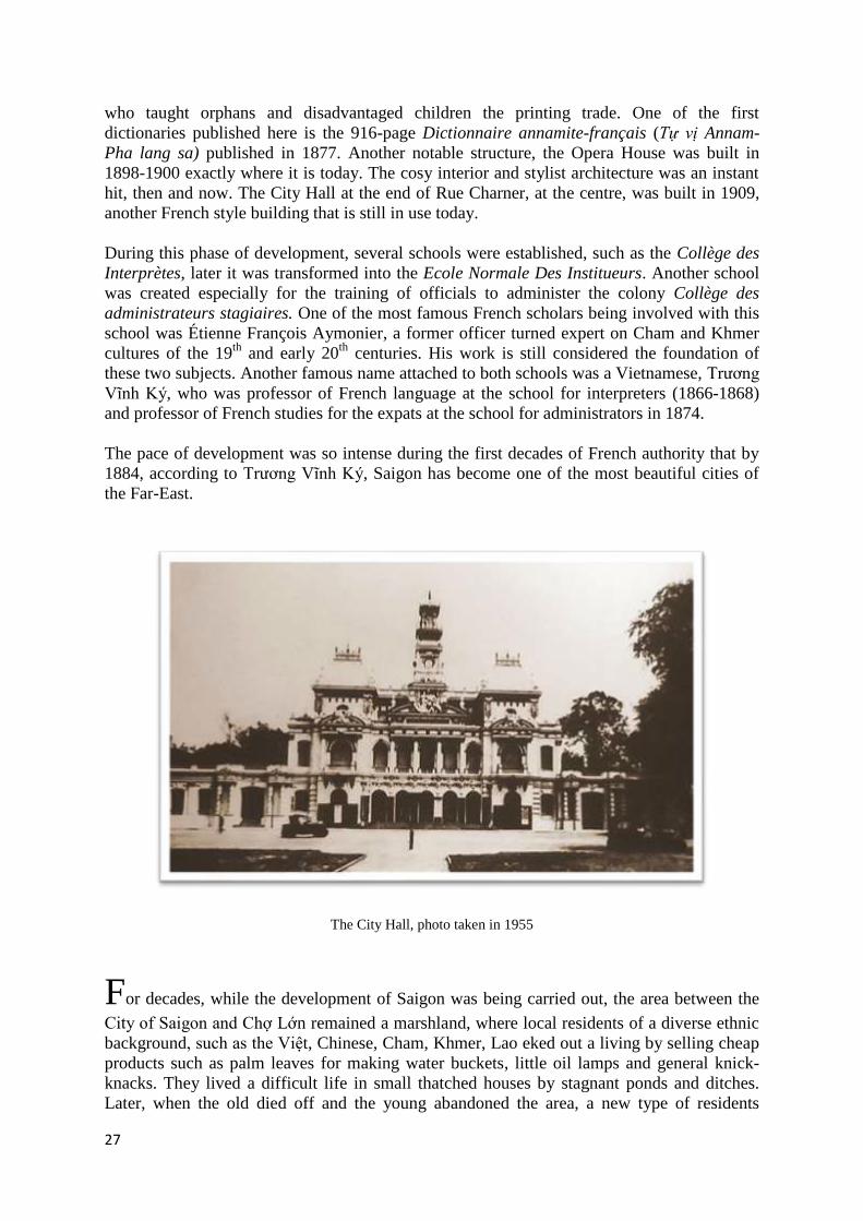
hit, then and now. The City Hall at the end of Rue Charner, at the centre, was built in 1909,
another French style building that is still in use today.
During this phase of development, several schools were established, such as the Collège des
Interprètes, later it was transformed into the Ecole Normale Des Institueurs. Another school
was created especially for the training of officials to administer the colony Collège des
administrateurs stagiaires. One of the most famous French scholars being involved with this
school was Étienne François Aymonier, a former officer turned expert on Cham and Khmer
cultures of the 19th
and early 20th
centuries. His work is still considered the foundation of
these two subjects. Another famous name attached to both schools was a Vietnamese, Trương
Vĩnh Ký, who was professor of French language at the school for interpreters (1866-1868)
and professor of French studies for the expats at the school for administrators in 1874.
The pace of development was so intense during the first decades of French authority that by
1884, according to Trương Vĩnh Ký, Saigon has become one of the most beautiful cities of
the Far-East.
The City Hall, photo taken in 1955
For decades, while the development of Saigon was being carried out, the area between the
City of Saigon and Chợ Lớn remained a marshland, where local residents of a diverse ethnic
background, such as the Việt, Chinese, Cham, Khmer, Lao eked out a living by selling cheap
products such as palm leaves for making water buckets, little oil lamps and general knick-
knacks. They lived a difficult life in small thatched houses by stagnant ponds and ditches.
Later, when the old died off and the young abandoned the area, a new type of residents

28
moved in; international and local prostitutes and small-time gangsters. The status quo
remained until 1913 when there was a decision to fill in the marsh for more land of
construction. The new market, today’s Bến Thành, was one of the major structures to be built
in this filled-in marshland. The name Bến Thành was retained after the old market by the Chợ
Vải canal. At this new location, the market became a thriving centre where goods of all
descriptions and fresh produce from the Mekong Delta were unloaded. This market was soon
followed by Tân Định and Bình Tây markets, built in 1928, for both wholesalers and
retailers. The Bình Tây was built over an old boat repair pier in Chợ Lớn by a Chinese
merchant and is today a favourite among shoppers for its abundance of goods at reasonable
prices.
Before the Bình Tây market was built, Chợ Lớn suffered a devastating fire in 1923 when
houses, depots and foodstuffs went up in smoke in a large area along the main canal. The fire
drove a great number of inhabitants away, leaving the area empty for a while. During this
time, a local canal, Hàng Bàng, was filled to make a new road linking Chợ Lớn with the
Mekong Delta. Gradually, Chinese merchants returned and it would not be long before the
area recovered and again prospered.
Bến-Thành Market
Banking was one of the first industries to be established in Saigon. Following the arrival of
the Hongkong and Shanghai Banking Corporation in 1870, the Banque de L’Indochine was
created in Paris in 1875 to handle the banking services of all Indochina and China itself. It
operated in Saigon but the money was still printed in Paris. One side of the money was in
French, the other side in Chinese characters.

29
As the road building and canal filling programme progressed, more solid bridges were
needed. New bridges gradually replaced wooden or bamboo bridges over the many remaining
canals of Saigon and Chợ Lớn, originally built for pedestrians. The majority of bridges in
Saigon today was built under the French authority, functional but not remarkable. One of the
first bridges was the Cầu Mống, a steel bridge built in 1893-94 across Bến Nghé Canal, at a
location called Quai de Belgique at the time, Chương Dương wharf in today’s terms.
Cầu Mống Bridge at Quai de Belgique. Photo taken in 1955

30
As a city once served by waterways, many canals remain today, along with their bridges. In
one district of Chợ Lớn, adjacent to the Bến Nghé canal, for example, there remain 20 canals
and 25 bridges. With road transport becoming more important in the 20th
century, more larger
bridges were built, one of Saigon best known bridges is the Y bridge, not because it is
beautiful or technological advance, but by its Y shape, allowing vehicles to get into their
preferred direction midway across. Built in 1938-41 across the Bến Nghé and the Tẻ Canals,
it was one of the latest bridges built by French authority in Saigon.
In contrast with the European lifestyle of the City of Saigon, Chợ Lớn continued to live
almost as much as before, albeit, on a much larger scale as its commercial activities grew.
Without the export restrictions imposed under the Nguyễn, the Chinese in Chợ Lớn were free
to expand their business, which, by the 1860s was mainly rice distribution. For most of the
French time in Saigon and Vietnam in general, rice was the top export and the main income
of the new colony, estimated to be 68% of the total income by 1926. The rice came up from
the Mekong Delta and also from Cambodia to be processed in both Saigon and Chợ Lớn,
before being exported to the region, Europe and even America. Rice exported from South
Vietnam at the turn of the 19-20th
centuries was ranked number 2 in world export quantity but
considered inferior to Thai and Burmese rice in quality.
The first rice mill was established in 1869 in Chợ Lớn. By 1885, rice mills became a major
feature along the Bến Nghé canal, the largest ones, such as the Rizerie à vapeur and the
Rizerie Saigonaise were owned by French companies such as Denis Frères. The smaller ones
belonged to the Chinese and the Việt. This picture changed rapidly as the local Chinese were
joined by their clan people coming from Hongkong, Singapore and southern China. Their
hold on the distribution of rice has always been tight and with new capital and manpower
coming in, the Chinese soon became top rice merchants in Southern Vietnam, through their
wholesale points in Chợ Lớn. They even took over some French companies but still
employed European engineers and mechanics. By 1905, the top four rice mills in Chợ Lớn
were owned by the Chinese. By 1914, of 10 rice mills in Chợ Lớn, 8 were owned by the
Chinese. By 1931, the number of rice mills went up dramatically to 75, of which, only 3 were
owned by French companies, the rest belonged to the Chinese. The Nam Long and the Kiến
Phong were the best known Chinese mills in the area. The presence of the rice mills in Chợ
Lớn created a serious health hazard for the area, as the husk was burned for fuel, its particles
were released into the air and mixed with dense smoke from the machinery to pollute the
entire area and became a killer of young and feeble people. Even then, immigrants still
arrived to settle, from India, Japan and Malaysia, working on peripheral types of jobs, such as
changing money, selling fabrics, clothing and processed food, or handling some new types of
public transport by road.
Even though the Chinese paid high taxes and focused on commerce, their hold on the
commerce of Saigon-Chợ Lớn became intolerable for the Vietnamese and the French
authority by the first decades of the 20th
century. The Việt began to comment critically on the
Chinese monopoly of rice and their control of prices on other staple foods. They staged a
boycott of Chinese products but without much impact. In 1923 the French authority
attempted to wrestle the control of rice and maize distribution in Saigon ports from the
Chinese by giving exclusive rights to a French company, Homberg-Candelier for 20 years.
The decision caused an uproar, not only among the Chinese but also within the Việt and the
French communities who saw it as underhanded favouritism. The protest against this decision
became a political campaign against the French authority. Criticism was openly voice by the

31
Vietnamese, backed by Chinese money and supported by a small number of sympathetic
French. From a protest against rice monopolies, the campaign was widened and turned into a
forum for many Vietnamese to vent their anger against the French colonial authority. This
protest was considered as the emerging roots for the resistance in later years.
Alcohol and opium were two other major product in Saigon from 1860 onward. Opium was
first sold privately in opium dens under license but came under the government’s control
when a manufacturing plant was established in Saigon, the Manufacture d’Opium de Saigon,
in 1881. The opium business grew massively at the beginning of the 20th
century when the
five current opium agencies of Indochina were grouped into one monopoly under the
Governor-General of Indochina Paul Doumer. Official opium was still available in large
quantity in Saigon even after the Convention of La Haye, stipulating an eradication of opium
trafficking, was signed in January 1912.
By the end of the 19th
century, land transport became easier and more popular. Different
types of vehicles gradually appeared to answer to the needs of citizens in Saigon Chợ Lớn,
apart from the traditional oxcart. The cheapest for common people was the horse-drawn Thổ
Mộ, so called because of its curve roof of woven reed and straw, similar to the hump of a
grave (Mộ). The floor of this vehicle was covered by a straw mat for 8-10 passengers to sit
next to each other anyhow, with both feet on-board, or, if it was too crowded for their feet to
be in, some of the passengers would sit with their legs hanging out at the back. Their
belongings or their market products would be put on the roof, or tied on the sides. The cart
was drawn by a single small horse.
A Thổ-Mộ on display at the Museum of Ho Chi Minh City

32
For the French and better off passengers there were the glass coaches, also drawn by
horse(s) but the passengers were enclosed in a cosy interior where they can look out through
glass windows, hence its name xe kiếng in Vietnamese. Horses’ speed was limited to a slow
trot in the centre of the city. The next type of vehicle was similar to the glass coach but open.
Horse drawn buses began to be used in 1882 between the City of Saigon and Chợ Lớn. Even
then, the number of vehicles were still very low at the beginning of the 20th
century. There
were only less than 500 horse-drawn carts in the whole of the city.
Rickshaws pulled by humans were imported first from Hongkong in 1886-92 to cater to
individuals but were not very popular at first. There were just under 400 rickshaws in Saigon
by the turn of the century. Bicycles gradually entered the scene also at the turn of the century,
a luxury item that only French colonists and very rich people could afford. The first bicycles
were imported in 1894 and by 1910 they became the means for postmen to deliver their
mails. The bicycle soon became a status symbol for Vietnamese in the 1920s and 30s. To
know how to ride was something to be proud of for both men and women, to own one was
the symbol of a fashionable lifestyle. It was truly the most coveted luxury item among young
and upwardly mobile people during these decades. The cyclo came very late, in the 1930s,
and stayed the longest among all the early vehicles for public transport. They are still in use
today but only as show pieces for visitors to experience old Saigon.
To complement the array of road vehicles, in 1881, a tramway was built between Saigon and
Chợ Lớn to accommodate a tram pulled by steam engines. More stretches of tramways
followed in 1896 and 97, linking other suburbs with Saigon. Cars were introduced into
Saigon at the beginning of the 20th
century and was extremely exclusive, only 5 existed in
1910, all owned by French officials. Ten years later, the number of cars in Saigon went up to
100, their speed was limited to 12 km/h at first but later reduced to 10 km/h in the centre.
It wouldn’t be long before the motorised omnibus began to run in Saigon, and then from
Saigon to outlying provinces and even Phompenh by 1930. Long distance railways using
steam engines began in 1886 between Saigon and Mỹ Tho on the Mekong. Stretches of other
railways followed and gradually, the trans-Vietnam railway was completed in 1936, covering
more than 2,000 kms, from Hanoi to Saigon, via the coastal towns and cities. This rail system
has been modernised several times and is still in use in Vietnam today.
The arrival of electricity in Saigon in 1893 changed the city dramatically. The marvel of
electricity was first observed at the headquarters of the Messageries Maritimes by the Saigon
river, at Port Nhà Rồng. The small number of electric bulbs running at low wattage was
viewed with awe as the wonder of modernity by locals and settlers alike. Electricity became a
subject of debates within the French administration for many years, until the first test project
was approved in 1889. The first test site for electric bulbs was the Opera house and part of
the main Rue de Catinat. It was a success and opened the way for the building of the first
electricity plant at Chợ Quán in 1896, powered by steam engines. Gradually, electrical street
lights replaced the oil lamps and by the end of the century, the area lit by electrical bulbs was
much wider, covering most of Saigon. By 1909, the main electrical plant was granted license
to provide electricity to private houses and businesses. Many quarters now had electrical
lights, even the old marshland around Bến Thành market was lit by electricity by 1929. The
steam tram was changed to electric in 1912 with the Saigon-Chợ Lớn link being inaugurated
in 1914.

33
Air travel entered the colony in 1910 when the first airplane landed in Saigon. A tiny airport,
Tân Sơn Nhất, was built in 1930 for the fledgling civil air service and went into operation in
1935. The first civil air service company was formed three years later, in 1938, its first
Saigon-Hanoi flight took place in the same year. Air transport then became the fastest link
between the two cities. By then, it took only 24 hours by plane to travel between the two,
whereas, for the same journey, it took two months by hammocks or palanquins carried by
porters, or more than a month by ship to the port of Hải Phòng, and then on to Hanoi.
In 1931, Saigon and Chợ Lớn were grouped into a region headed by a regional
Administration Committee, its chairman was appointed by the Governor-General. Chợ Lớn
area was further expanded south to include today’s Districts 4 and 7. By then, the foundation
of today’s Saigon has completed.
When the First World War was over, the world entered a new era of peace and reconstruction
that had wider implications for colonies like Vietnam. Demands for raw materials such as
rubber increased sharply. Rubber plantations using low paid labourers became the dominant
feature of colonial activities in Vietnam and elsewhere in Indochina. Acreage used for rubber
plantations increased threefold between 1917 and 1926. In the South, rubber output was
increased tenfold in the years following the end of the war and rubber became another major
product exported from Saigon. The period between the two world-wars was a time of changes
in other directions for Saigon. The anti-colonial movement was intensified with the
appearance of many active political parties in Saigon. Several locations in Saigon were
sabotaged during the 1930s and 40s. Patriotic campaigns led by educated scholars such as
Phan Chu Trinh and Phan Bội Châu were equally active culturally. Retaliation followed each
action, turning Saigon into a hotbed of anti-colonial and repressive activities. Life, however,
continued for many in Saigon.
When the Second World-War spread to the Pacific, the occupation of Vietnam by the
Japanese impoverished the country on the whole and major cities like Saigon in particular. It
left millions of people facing starvation in 1944-45 when rice was confiscated and fields were
turned into jute plantations. When the war ended in August 1945 with the surrender of Japan,
there was no immediate creditable authority in Saigon to replace them. The strongest anti-
colonial party at the time, the Viet-Minh under the leadership of Hồ Chí Minh took over.
Emperor Bảo Đại soon abdicated in Huế, leaving the ruling of the country to the newly
established revolutionary government.
A new government was quickly set up in Saigon, but did not function for long. In September
1945, an allied contingent arrived to re-establish order and to restore power to the pre-
Japanese authority, in this case, it was perceived as the French government. On the 23rd
of
September 1945, French authority returned in Saigon, Vietnamese in both north and south
Vietnam resumed their anti-colonial resistance. Saigon once again witnessed many sabotage
acts. However, life continued almost normally for many in the city. What followed for Saigon
was triggered by events at a faraway location, Điện Biên Phủ, a remote northern valley by the
Việt-Lao border. The result of the fierce battles there brought far and wide implications for
both the French authority and local residents. Following the Geneva agreement of July 1954,
France agreed to relinquish their hold on Vietnam and Indochina.
By the time the French left Vietnam and returned Saigon to the then government of the
Republic of Vietnam, Saigon had long been renown as the Pearl of the Orient thanks to its

34
urban development, its French style architecture, and its thriving commerce. While the
Nguyễn left many canals and a basic foundation for Saigon, the French colonial period had
contributed a considerable legacy in the shape of a modern infrastructure. Saigon has
managed to build on both, under different Vietnamese regimes, to become the thriving
metropolis that we see today.
© Dr. Vu Hong Lien, London, UK, 2013

35
Bibliography
Antonini, Paul, L'Annam, Le Tonkin et l'intervention de la France en Extrême-Orient, (Paris, 1889)
Bouchot, Jean, La naissance et les premières années de Saigon, ville française (Saigon, 1927)
-------, Documents pour servir à l'histoire de Saigon 1859-1865 (Saigon, 1927)
Bùi Vinh, Văn Hóa Tiền Sử Việt Nam [Pre-historic Culture of Vietnam], (Hanoi, 2011)
Choi Byung Wook, Southern Vietnam Under the Reign of Minh Mạng (1820-1841), (New York, 2004)
Crawfurd, John, Journal of an Embassy from the Governor-General of India to the courts of Siam and Cochin-
China; exhibiting a view of the actual state of those kingdoms, 2nd
edition, Vol. 1, (London, 1830)
Doudart de Lagrée et al, Voyage d'exploration en Indo-Chine : effectué pendant les années 1866, 1867 et 1868
(par une commission française présidée par M. le Capitaine de frégate, Doudart de Lagrée et publié par les
ordres du Ministre de la marine sous la direction de M. le Lieutenant de vaisseau, Francis Garnier, avec le
concours de M. Delaporte, Lieutenant de vaisseau et de MM. Joubert et Thorel, médecins de la marine,
membres de la commission), (Paris, 1873).
Đại Nam th c lục Tiền Biên [Chronicle of the Great South, Version 1], Vol. 1, trans. Viện Sử Học, (Hanoi,
1961)
Đại Nam Th c Lục, Chính Biên [Chronicle of the Great South, Official Version ], Vol. 2, trans. Nguyễn Ngọc
Tỉnh, ed. Đào Duy Anh, (Hanoi, 1963)
Đại Việt Sử Lược [Historical Annals of Great Viet], book 1, trans. Nguyễn Gia Tường, (HCM, 1993)
Đào Duy Anh, Đất Nước Việt Nam qua Các Đời [Geography of Vietnam Through the Ages], (Hà Nội, 2005)
---------, L ch Sử Việt Nam, từ nguồn gốc đến thế kỷ XIX, [The History of Vietnam, From the Origin to the 19th
Century], (Hanoi, 2006)
Geoff Wade, ‘An Early Age of Commerce in Southeast Asia, 900–1300 CE’ in Journal of Southeast Asian
Studies, 40(2), June 2009, pp 221–265
‘Indochine Annamite: la connaissance du pays jusqu’en 1900’ in BEFEO, Vol. 21, 1921
Khâm Đ nh Việt Sử Thông Giám Cương Mục [Imperial Ordered Annotated Text to Totally Reflect the History of
the Viet], Tiền Biên[First Version], vol. I, trans. Viện Sử Học, (Hà Nội, 1998)
Lê Thanh Khôi, Le Vietnam, Histoire et Civilisation, (Paris, 1955)
Li Tana, Nguyễn Cochinchina, (New York, 1998)
--------, History of Cochinchina (Đằng Trong) 1602-1777, Anthony Reid, eds, (Singapore, 1993)
Mak Phoeun & Po Dharma, ‘La première intervention militaire Vietnamienne au Cambodge (1658 – 1659)’,
BEFEO, Vol. 73, 1984
Nguyễn Khắc Viện, Vietnam, a long history, 7th
ed., (Hanoi, 2007)
Pelliot, Paul, ‘Le Fou-nan’, BEFEO, Vol. 3, 1903
Nguyễn Đình Đầu, Đ a lý Gia Đ nh - Sài Gòn - Thành phố Hồ Chí Minh (100 câu hỏi đáp về Gia Đ nh - Sài
Gòn - Thành phố Hồ Chí Minh, (HCM, 2006)
Notice historique, administrative et politique sur la ville de Saïgon. (Publiée par les soins du secrétaire général
de la mairie. 1917), gallica.bnf.fr

36
Petiton, Anatole. La Cochinchine française : la vie à Saïgon, notes de voyage, pub. 1883, gallica.bnf.fr
Quach Thu Nguyen et al, Hoi Dap ve Saigon, Thanh Pho Ho Chi Minh, Vol. 4, (HCM, 2007)
Reid, Anthony, Southeast-Asia in the Age of Commerce 1450-1680, (New Heaven, 1988)
Taylor, Keith. W, ‘Nguyen Hoang and Vietnam’s Southern expansion’ in Anthony Reid, ed., Southeast Asia in
the early modern era: trade, power and belief, (New York, 1993)
Trần Hữu Quang, Hạ tầng đô th Sài Gòn buổi đầu, (HCM, 2012)
Trần Trọng Kim, Việt Nam Sử Lược [Concise History of Vietnam], (Hanoi, 2002)
Trịnh Hoài Đức, Gia Đ nh Thành Thông Chí [Complete Geographical History of Gia Đ nh Region], trans, Lý
Việt Dũng, ed. Huỳnh Văn Tới, (Saigon, 2004)
Trương Hữu Quýnh, Đinh Xuân Lâm, Lê Mậu Hãn, Đại Cương L ch Sử Việt Nam Toàn Tập [Complete
Collection of an Outline of Vietnamese History], (Hanoi, 2010)
Vial, Paulin François Alexandre, Les premières années de la Cochinchine, colonie Française, (Paris, 1874)
Trương Vĩnh Ký, Souvenirs historiques sur Saïgon et ses environs : conférence faite au collège des interprètes
(1885), gallica.bnf.fr Bibliothèque nationale de France
Vu Hong Lien, Royal Hue, Heritage of The Nguyen Dynasty of Vietnam, in press, Riverbooks, (Bangkok,
2013/4)
Vu Hong Lien & Peter D. Sharrock, Descending Dragon, Rising Tiger: A new History of Vietnam, in press,
Reaktion Books (London, exp. 2014)
Vương Hồng Sển. Sài Gòn năm xưa (Vols I, II 1960, III 1992) (Đồng Nai-2004)
![[HOUSE OF LORDS]](https://static.fdokumen.com/doc/165x107/6313ad96fc260b71020f33d4/house-of-lords.jpg)
![Untitled - Pneusol / Tyresoil [Nguyen Thanh Long]](https://static.fdokumen.com/doc/165x107/6336b01029fb49e5aa0b50db/untitled-pneusol-tyresoil-nguyen-thanh-long.jpg)