The International Soil Moisture Network: serving Earth ... - HESS
92
The International Soil Moisture Network: serving Earth system science for over a decade Wouter Dorigo 1 , Irene Himmelbauer 1 , Daniel Aberer 1 , Lukas Schremmer 1 , Ivana Petrakovic 1 , Luca Zappa 1 , Wolfgang Preimesberger 1 , Angelika Xaver 1 , Frank Annor 2,3 , Jonas Ardö 4 , Dennis Baldocchi 5 , Marco Bitelli 6 , Günter Blöschl 7 , Heye Bogena 8 , Luca Brocca 9 , Jean-Christophe Calvet 10 , J. Julio Camarero 11 , Giorgio Capello 12 , Minha Choi 13 , Michael C. Cosh 14 , Nick van de Giesen 3 , Istvan Hajdu 15 , Jaakko Ikonen 16 , Karsten H. Jensen 17,18 , Kasturi Devi Kanniah 19 , Ileen de Kat 20 , Gottfried Kirchengast 21 , Pankaj Kumar Rai 22 , Jenni Kyrouac 23 , Kristine Larson 24 , Suxia Liu 25 , Alexander Loew 26,† , Mahta Moghaddam 27 , José Martínez Fernández 28 , Cristian Mattar Bader 29 , Renato Morbidelli 30 , Jan P. Musial 31 , Elise Osenga 32 , Michael A. Palecki 33 , Thierry Pellarin 34 , George P. Petropoulous 35 , Isabella Pfeil 1 , Jarrett Powers 36 , Alan Robock 37 , Christoph Rüdiger 38 , Udo Rummel 39 , Michael Strobel 40 , Zhongbo Su 41 , Ryan Sullivan 23 , Torbern Tagesson 4,18 , Andrej Varlagin 42 , Mariette Vreugdenhil 1 , Jeffrey Walker 38 , Jun Wen 43 , Fred Wenger 44 , Jean Pierre Wigneron 45 , Mel Woods 46 , Kun Yang 47 , Yijian Zeng 41 , Xiang Zhang 48 , Marek Zreda 49 , Stephan Dietrich 50 , Alexander Gruber 51 , Peter van Oevelen 52 , Wolfgang Wagner 1 , Klaus Scipal 53 , Matthias Drusch 54 , and Roberto Sabia 53 1 Department of Geodesy and Geoinformation, TU Wien, Vienna, Austria 2 Trans-African Hydro-Meteorological Observatory, Delft, The Netherlands 3 Department of Water Resources, Delft University of Technology, Delft, Netherlands 4 Department of Physical Geography and Ecosystem Science, Lund University, Lund, Sweden 5 Department of Environmental Science, Policy and Management, University of California, Berkeley, CA, USA 6 Department of Agricultural and Food Sciences, University of Bologna, Bologna, Italy 7 Institute of Hydraulic Engineering and Water Resources Management, TU Wien, Vienna, Austria 8 Forschungszentrum Juelich GmbH, Juelich, Germany 9 Research Institute for Geo-Hydrological Protection, National Research Council of Italy, Perugia, Italy 10 CNRM, Université de Toulouse, Météo-France, CNRS- Centre national de la recherche scientifique, Toulouse, France 11 Instituto Pirenaico de Ecología, IPE-CSIC, Zaragoza, Spain 12 Institute of Sciences and Technologies for Sustainable Energy and Mobility, National Research Council of Italy, Torino, Italy 13 Environement and Remote Sensing Laboratory, School of Civil, Architectural and Environmental Engineering, College of Engineering, Sungkyunkawan University, Jangan-gu, Suwon, Gyeonggi-do, Republic of Korea 14 USDA-Agricultural Research Service (USDA-ARS), Hydrology and Remote Sensing Laboratory, Beltsville, MD, USA 15 PlantTech Research Institute, Tauranga, New Zealand 16 Finnish Meteorological Institute, Space and Earth Observation Centre, Helsinki, Finland 17 Department of Physical Geography and Ecosystem Science, Lund University, Lund, Sweden 18 Department of Geosciences and Natural Resource Management, University of Copenhagen, Copenhagen, Denmark 19 Assistant Dean, Associate Editor - International Journal of Remote Sensing, Member - TropicalMap Research Group, Member - Centre for Environmental Sustainability and Water Security (IPASA),Faculty of Built Environment and Surveying, Universiti Teknologi Malaysia, Johor Bahru, Malaysia 20 VanderSat B.V., Haarlem, Netherland 21 Wegener Center for Climate and Global Change and Institute of Physics, University of Graz, Austria 22 Indian Institute of Technology Kanpur, India 1
-
Upload
khangminh22 -
Category
Documents
-
view
1 -
download
0
Transcript of The International Soil Moisture Network: serving Earth ... - HESS

The International Soil Moisture Network: serving Earth systemscience for over a decadeWouter Dorigo1, Irene Himmelbauer1, Daniel Aberer1, Lukas Schremmer1, Ivana Petrakovic1,Luca Zappa1, Wolfgang Preimesberger1, Angelika Xaver1, Frank Annor2,3, Jonas Ardö4,Dennis Baldocchi5, Marco Bitelli6, Günter Blöschl7, Heye Bogena8, Luca Brocca9,Jean-Christophe Calvet10, J. Julio Camarero11, Giorgio Capello12, Minha Choi13, Michael C. Cosh14,Nick van de Giesen3, Istvan Hajdu15, Jaakko Ikonen16, Karsten H. Jensen17,18, Kasturi Devi Kanniah19,Ileen de Kat20, Gottfried Kirchengast21, Pankaj Kumar Rai22, Jenni Kyrouac23, Kristine Larson24,Suxia Liu25, Alexander Loew26,†, Mahta Moghaddam27, José Martínez Fernández28, Cristian MattarBader29, Renato Morbidelli30, Jan P. Musial31, Elise Osenga32, Michael A. Palecki33, Thierry Pellarin34,George P. Petropoulous35, Isabella Pfeil1, Jarrett Powers36, Alan Robock37, Christoph Rüdiger38,Udo Rummel39, Michael Strobel40, Zhongbo Su41, Ryan Sullivan23, Torbern Tagesson4,18,Andrej Varlagin42, Mariette Vreugdenhil1, Jeffrey Walker38, Jun Wen43, Fred Wenger44, JeanPierre Wigneron45, Mel Woods46, Kun Yang47, Yijian Zeng41, Xiang Zhang48, Marek Zreda49,Stephan Dietrich50, Alexander Gruber51, Peter van Oevelen52, Wolfgang Wagner1, Klaus Scipal53,Matthias Drusch54, and Roberto Sabia53
1Department of Geodesy and Geoinformation, TU Wien, Vienna, Austria2Trans-African Hydro-Meteorological Observatory, Delft, The Netherlands3Department of Water Resources, Delft University of Technology, Delft, Netherlands4Department of Physical Geography and Ecosystem Science, Lund University, Lund, Sweden5Department of Environmental Science, Policy and Management, University of California, Berkeley, CA, USA6Department of Agricultural and Food Sciences, University of Bologna, Bologna, Italy7Institute of Hydraulic Engineering and Water Resources Management, TU Wien, Vienna, Austria8Forschungszentrum Juelich GmbH, Juelich, Germany9Research Institute for Geo-Hydrological Protection, National Research Council of Italy, Perugia, Italy10CNRM, Université de Toulouse, Météo-France, CNRS- Centre national de la recherche scientifique, Toulouse, France11Instituto Pirenaico de Ecología, IPE-CSIC, Zaragoza, Spain12Institute of Sciences and Technologies for Sustainable Energy and Mobility, National Research Council of Italy, Torino,Italy13Environement and Remote Sensing Laboratory, School of Civil, Architectural and Environmental Engineering, College ofEngineering, Sungkyunkawan University, Jangan-gu, Suwon, Gyeonggi-do, Republic of Korea14USDA-Agricultural Research Service (USDA-ARS), Hydrology and Remote Sensing Laboratory, Beltsville, MD, USA15PlantTech Research Institute, Tauranga, New Zealand16Finnish Meteorological Institute, Space and Earth Observation Centre, Helsinki, Finland17Department of Physical Geography and Ecosystem Science, Lund University, Lund, Sweden18Department of Geosciences and Natural Resource Management, University of Copenhagen, Copenhagen, Denmark19Assistant Dean, Associate Editor - International Journal of Remote Sensing, Member - TropicalMap Research Group,Member - Centre for Environmental Sustainability and Water Security (IPASA), Faculty of Built Environment and Surveying,Universiti Teknologi Malaysia, Johor Bahru, Malaysia20VanderSat B.V., Haarlem, Netherland21Wegener Center for Climate and Global Change and Institute of Physics, University of Graz, Austria22Indian Institute of Technology Kanpur, India
1

23Environmental Science Division, Argonne National Laboratory, Lemont, IL, USA24University of Colorado, Boulder, CO, USA25Key Laboratory of Water Cycle and Related Land Surface Processes, Institute of Geographic Sciences and NaturalResources Research, Chinese Academy of Sciences, Beijing, China; College of Resources and Environment/Sino-DanishCenter, University of Chinese Academy of Sciences, Beijing, China26Department of Geography, Ludwig-Maximilian-Universität, Munich, Germany27Ming Hsieh Department of Electrical and Computer Engineering, University of Southern California, Los Angeles, CA, USA28Instituto Hispano Luso de Investigaciones Agrarias, CIALE, Universidad de Salamanca, Villamayor, Spain29Laboratory of Analysis of the Biosphere, University of Chile, Santiago, Chile30Department of Civil and Environmental Engineering, Perugia University, Perugia, Italy31Institute of Geodesy and Cartography, Warsaw, Poland32Aspen Global Change Institute (AGCI), Basalt, CO, USA33NOAA National Centers for Environmental Information, Asheville, NC, United States34CNRS - Centre national de la recherche scientifique, LTHE, University of Grenoble, France35Department of Geopgraphy, Harokopio University of Athens, Athens, Greece36Agriculture and Agri-Food Canada - Science and Technology Branch, Winnipeg, MB, Canada37Department of Environmental Sciences, Rutgers University, New Brunswick, NJ, USA38Department of Civil Engineering, Monash University, Clayton, Australia39DWD, Meteorologisches Observatorium Lindenberg – Richard-Aßmann-Observatorium, Lindenberg, Germany40USDA-NRCS National Water and Climate Center, Portland, OR, USA41University of Twente, Faculty of Geo-Information Science and Earth Observation, Enschede, the Netherlands42A.N. Severtsov Institute of Ecology and Evolution, Russian Academy of Sciences, Moscow, Russia43College of Atmospheric Sciences, Plateau Atmosphere and Environment Key Laboratory of Sichuan Province, ChengduUniversity of Information Technology, Chengdu, China44Norwegian Water Resources and Energy Directorate, Oslo, Norway45MOST, ISPA, INRAE Bordeaux Aquitaine, France46University of Dundee, UK47Department of Earth System Science, Tsinghua University, Beijing, China48State Key Laboratory of Information Engineering in Surveying, Mapping and Remote Sensing (LIESMARS), WuhanUniversity, Wuhan, China49Department of Hydrology and Atmospheric Sciences, University of Arizona, Tucson, AZ, USA50International Centre for Water Resources and Global Change ICWRGC (UNESCO), Federal Institute of Hydrology,Koblenz, Germany51Department of Earth and Environmental Sciences, KU Leuven, Heverlee, Belgium52International GEWEX Project Office, Washington, DC, United States53European Space Agency, ESRIN, Frascati, Italy54European Space Agency, ESTEC, Noordwijk, The Netherlands†Deceased July 02, 2017
Correspondence: Wouter Dorigo ([email protected])
Abstract.
In 2009, the International Soil Moisture Network (ISMN) was initiated as a community effort, funded by the European
Space Agency, to serve as a centralised data hosting facility for globally available in situ soil moisture measurements (Dorigo
et al., 2011b, a). The ISMN brings together in situ soil moisture measurements collected and freely shared by a multitude
of organisations, harmonizes them in terms of units and sampling rates, applies advanced quality control, and stores them in5
a database. Users can freely retrieve the data from this database through an online web portal (ismn.earth). Meanwhile, the
2

ISMN has evolved into the primary in situ soil moisture reference database worldwide, as evidenced by more than 3000 active
users and over 1000 scientific publications referencing the data sets provided by the network. As of July 2021, the ISMN
now contains data of 71 networks and 2842 stations located all over the globe, with a time period spanning from 1952 to
present. The number of networks and stations covered by the ISMN is still growing and approximately 70% of the data sets10
contained in the database continue to be updated on a regular or irregular basis. The main scope of this paper is to inform
readers about the evolution of the ISMN over the past decade, including a description of network and data set updates and
quality control procedures. A comprehensive review of existing literature making use of ISMN data is also provided in order
to identify current limitations in functionality and data usage, and to shape priorities for the next decade of operations of this
unique community-based data repository.15
3

1 Introduction
Ground-based soil moisture measurements of land surface variables are indispensable in the process of developing, validating,
and advancing spatially contiguous data sets derived from satellites or models (Loew et al., 2017; Gruber et al., 2020). Although
the first systematic measurements of soil moisture started well before the satellite era in the former Soviet Union to support
agricultural decision making (Robock et al., 2000), it was not until the early 2000s that soil moisture monitoring networks20
started being widely established as part of hydrological and meteorological observing capacities. Particularly, the launch of
the Soil Moisture Ocean Salinity (SMOS) mission of the European Space Agency (ESA) in 2009 (Kerr et al., 2016), and the
launch of the Soil Moisture Active Passive (SMAP) mission of the National Aeronautics and Space Administration (NASA) in
2015 (Entekhabi et al., 2010), boosted the establishment of new research networks (Colliander et al., 2017).
While all networks are a valuable asset for assessing the skill of soil moisture products under various conditions and scales,25
their usage is hampered by the diversity of sensors, data formats, quality control, and accessibility mechanisms. The need of
bringing together and harmonising available soil moisture data was recognised by the international soil moisture community
and expedited by the Global Energy and Water cycle Exchanges (GEWEX) project of the World Climate Research Programme
(WCRP) with support of the Commission on Earth Observation Satellites (CEOS), the Global Climate Observing System
(GCOS), and the Group on Earth Observation (GEO). In the advent of the SMOS mission, ESA decided to provide the financial30
impetus to establish a global reference database of in situ soil moisture measurements for the purpose of satellite product
development and validation. As a result, the International Soil Moisture Network (ISMN) went online in 2010 (Dorigo et al.,
2011b, a).
The primary objective of the ISMN is to collect in situ soil moisture data sets shared by various data organisations on a
voluntary basis and make them available in a harmonized format through a centralised free and open web portal (ismn.earth).35
While 10 years after its launch the core objective of the ISMN remains valid, its functionality has expanded since then. This
new functionality includes the integration of advanced quality control methods (Dorigo et al., 2013); Section 3), the provision
of additional metadata and ancillary variables (e.g., precipitation, soil and air temperature), ongoing automation, the provision
of software code to users, and the implementation of various tools to promote the information exchange between users, the
ISMN, and the data providers. Moreover, the ISMN has substantially grown in terms of networks, stations, and data sets.40
Data from the ISMN has supported hundreds of scientific papers on soil moisture, satellite product and land surface model
validation in particular (e.g., Al-Yaari et al. (2019b); Brocca et al. (2014a); Beck et al. (2020)). Several operational data
producing services routinely access the ISMN data for repeated quality assurance, including ESA’s Climate Change Initiative
(Dorigo et al., 2017), the Copernicus Global Land Service (Bauer-Marschallinger et al., 2018), and the Copernicus Climate
Change Service (C3S; Dorigo et al. (2017)). Other domains have also exploited the ISMN data, e.g. in meteorology, drought45
monitoring, or land-atmosphere coupling (Section 4).
Despite the valuable contribution of the ISMN to satellite and climate communities, multiple challenges have yet to be
mastered, including the heterogeneous availability in space and time (Dorigo et al., 2015), scale differences between in situ
measurements and satellite or model sampling (Gruber et al., 2013), full characterisation and traceability of uncertainties, and
4
differences in spatial-temporal support of the observations caused by different measurement techniques and landscape hetero-50
geneity (Ochsner et al., 2013). New scientific avenues to improve the spatial coverage could be the inclusion of soil moisture
data sets from low cost sensors collected by citizens (Section 5.1.4. For climate applications, stable long-term reference data
are required, calling for the coordinated establishment and maintenance of Fiducial Reference Measurement (FRM) stations,
as outlined by the GEO/CEOS Quality Assurance framework for Earth Observation (QA4EO) (GCOS, 2016; Montzka et al.,
2020; Gruber et al., 2020).55
The scope of this paper is to inform readers about the evolution of the ISMN over the past decade, including a description of
network and data set updates, new quality control procedures, and new functionality of the data portal. We also review scientific
literature making use of ISMN data to assess the achievements facilitated by the ISMN and to identify current limitations in
data availability and functionality, and challenges in data provision and use. Based on this review, prerequisites and priorities
needed to ensure another decade of this unique community-based data repository are defined.60
2 The ISMN data hosting facility
Although the ISMN may be considered a mere data repository, there is much more to it: its core functionality includes col-
lecting data from participating data providing networks, harmonizing them in terms of units, sampling rates, naming, and
metadata, performing automated quality control, storing the data and metadata in a queryable database, and making them
available through a web interface. And from a system perspective, it entails even more, e.g., communication with (potential)65
data providers and users (Appendix B1).
2.1 Data and metadata summary
As of July 2021, the ISMN contains 71 networks providing access to a total of 2842 stations, approximately 10,000 soil
moisture data sets, and an additional 10,000 data sets of other meteorological variables (collocated with the soil moisture
measurements). Although the ISMN is a global network, most networks and stations are located in North America (15), Europe70
(28), Australia (3) and Asia (19) (Figure 1). New networks are continuously being added, while many existing networks are
still being upgraded with additional stations, soil moisture sensors, and meteorological variables. The diversity of networks is
large, ranging from networks with a single station to networks comprising more than 400 stations covering different landscape
types as well as periods. The distribution of stations per Koeppen-Geiger climate class is given in Figure 2.
2.75
5

Figure 1. Locations of ISMN networks and sites plotted with the ISMN package described in the Code and data availability section [Status
July 2021].
Figure 2. Distribution of ISMN-sites per Koeppen-Geiger climate classification, only categories with >20 sites are considered (Status June
2021).
Most of the networks originate from scientific initiatives in various disciplines (e.g., remote sensing, soil sciences, agricul-
ture, meteorology), and only a few are run by operational entities like national weather or environmental services. Consequently,
a lack of sustainable project funding has forced several scientific networks to close after some time. 18 out of the 71 networks
6

contained in the ISMN have become inactive and will no longer provide data set updates (Figure 3). Data go back as far as
1952 but none of the data sets spans the entire ∼70 year period. The longest available time series (∼40 years) is provided by80
the RUSWET-AGRO network in the former Soviet Union, while the longest operating network still active is SNOTEL in the
United States.
Most networks provide data set updates at yearly or irregular intervals. Data sets from six networks (ARM, COSMOS, FMI,
SCAN, SNOTEL, USCRN, WEGENERNET), comprising approximately 900 stations, are updated in near-real-time (NRT;
status July 2021), which is currently defined as once per day. While the earliest networks were sampled manually at weekly,85
fortnightly, or even monthly intervals, most current networks take their measurements using electronic devices at daily, hourly
or even more frequent sampling rates. For more details on the networks see Appendix A, Dorigo et al. (2011b), Dorigo et al.
(2013) or the individual references herein.
7

Figure 3. Overview of all available networks, the individual time span of the data availability within the ISMN, their operational status and
their updating frequency [Status June 2021].
The variables contained in the ISMN (Table 1 and 2) originate from networks that were built for various purposes, which
consequently do not all contribute the same information. Since the ISMN was initially founded as a validation database for90
satellite (surface) soil moisture data, each station in the database provides soil moisture for the upper soil layer (≤ 0.10 meter
depth). Soil moisture data sets in the ISMN can go as deep as two metres, but generally with a decreasing number of measure-
ments locations with depth (Table C1). Some stations deploy more than one sensor at a certain depth, either as replacement in
case of failure of one of the sensors or to characterise local soil moisture variability. The availability of meteorological data like
precipitation, soil and air temperature, is even more heterogeneous, depending on the scope of the network or the data sharing95
8

policy of the data providing organisation. It is also quite common that single time series in the database are composed of the
consecutive measurements of two or more different sensors, when a sensor is replaced after failure.
Table 1. Overview of all available temporally dynamic variables stored in the ISMN database. *Note that for precipitation and air temperature
the measurement height above the ground surface is indicated.
variable name abbreviation units measurement depth* [m] variable with depth? number of time series (stations)
soil moisture sm m3m−3 0.00 - 2.10 Y 10610 (2822)
soil suction su kPa 0.04 - 0.75 Y 73 (18)
soil temperature ts °C 0.00 - 2.03 Y 8113 (1629)
air temperature ta °C 2.00 - 12.00 Y 1292 (1234)
surface temperature tsf °C 0.00 - 0.00 N 126 (126)
precipitation p mm 0.00 - 2.00 N 759 (700)
snow depth sd mm 0.00 N 562 (555)
snow water equivalent sweq mm 0.00 N 507 (427)
Table 2. Overview of all available temporally static variables stored in the ISMN database.
variable name abbreviation units measurement depth [m] sensors dependency
climate classification clcl none none N
land cover classification lccl none on surface and above N
soil classification socl none none N
bulk density bd g cm−3 0.00 - 1.50 Y
sand fraction sa % weight 0.00 - 1.50 Y
silt fraction si % weight 0.00 - 1.50 Y
clay fraction cl % weight 0.00 - 1.50 Y
organic carbon oc % weight 0.00 - 1.00 Y
saturation sat % volume 0.00 - 1.00 Y
field capacity fc % volume 0.00 - 2.00 Y
potential plant available water ppaw % volume 0.00 - 2.00 Y
permanent wilting point wp % volume 0.00 - 2.00 Y
Metadata information can be divided into two categories, i.e., mandatory metadata, which allow for an unambiguous identi-
fication of each network, station, and measurement in the ISMN database (Figure D1), and optional metadata, shared by data
providers to allow more in-depth analysis of their data sets. To be consistent between sites, the mandatory variables climate,100
land cover, and soil characteristics are taken from external databases: Climate classification is taken from the Köppen-Geiger
9

database with a resolution of 0.1° (Peel et al., 2007); Dynamically evolving land cover for 2000, 2005, and 2010 is obtained
from ESA‘s Climate Change Initiative (CCI) land cover v1.6.1 with 300 meter resolution; Soil information is retrieved from
the Harmonized World Soil Database (HWSD v1.1; FAO/IIASA/ISRIC/ISS-CAS/JRC, 2009) with a 30" sampling, although
the actual resolution may strongly vary from location to location.105
If available, data providers can optionally share their own, more detailed, characterisations of land cover, soil, and qual-
ity flags with the ISMN. These are stored in addition to the same variables from external sources. All static variables per
measurement site and depth are listed in Table 2.
2.2 Data collection and harmonisation
Data collection is done either manually (mostly by email) or automated, depending on the degree of automation at the data110
provider side. Although standards for in situ soil moisture data collection are available (Colliander et al., 2017; Montzka et al.,
2020), there is no general agreement within the community, neither is it prescriptive for participation in the ISMN. Thus, the
data being contributed to the ISMN are heterogeneous with regard to units (e.g., volumetric soil moisture, water depth, mass,
soil saturation, plant available water), installation depth, integration length, and positioning of the sensors (vertical, horizontal),
the metrical system, the sampling interval, and the time zones used for the measurement time stamps.115
The first harmonisation step for all data and metadata involves the conversion of units to internationally agreed scientific units
(e.g., m and °C). Then, following the recommendations of the World Meteorological Organization for weather observation and
forecasting (Williams, 2010), all data are resampled to hourly Universal Time Coordinated (UTC) reference time steps. Data
that are available at higher sampling rates are thinned by selecting the individual measurements at the hourly UTC reference
time step or the ones that are closest in time within a window of +/- 0.5 h. If there is no measurement available within this120
interval, the respective time step is not stored in the database but can be recreated and filled with a no-data value upon download.
The temporal resampling scheme is valid for all included dynamic variables, except precipitation. Since precipitation is a flux
and not a state variable, all measurements within the hourly interval are summed to represent the full amount of precipitation
within the preceding hour (Dorigo et al., 2011b).
All soil moisture measurements provided to the ISMN are converted to volumetric soil moisture in m3m−3. Since the125
majority of networks already shares their measurements in volumetric soil moisture units often no unit conversion is needed.
For the other (mostly historical) networks, measurements are converted to volumetric units using metadata on soil properties (in
case measurements are provided as saturation level or plant available water) and/or the thickness of the soil layer represented
by the measurement (in case measurements are provided as water height or mass) (Dorigo et al., 2011b). Note, that even if all
measurements are harmonised in terms of units, differences in sampling volumes related to the sensor design and installation130
are not accounted for.
The harmonisation of measurement depths is particularly challenging, as different networks adopt different measurement
depths, similar sensors are positioned differently (horizontally vs. vertically), or their measurements represent different ob-
servation volumes, which may even differ according to the soil wetness (as for cosmic ray probes). Thus, harmonising soil
moisture measurements to one or several reference depths would require either assumptions on the measurements and soil135
10

properties or supplemental soil modelling. Additionally, since there are lots of potential uses for the data, there is no common
agreement on the optimum sampling depths. For example, satellite calibration-validation generally requires observations of the
0-5 cm layer while land surface model evaluation requires reference measurements that are representative for the layers defined
in the model (Dorigo et al., 2011b). Consequently, the ISMN does not harmonise measurement depths.
After data harmonisation, the data sets are submitted to extensive quality control procedures (Section 3. After quality control,140
all data sets of soil moisture and other variables, metadata information on networks, responsible organisations, sites, sensors as
and static soil attributes for each station are stored in a relational database.
2.3 Data portal
The ISMN can be accessed at ismn.earth and consists of a project website containing, e.g., information about networks, data,
quality control, and partners, and a data interface where users can view, query, and download the data contained in the database.145
The data interface displays the location and information of networks and single stations, and allows for plotting the available
data to gain an impression of data availability and quality. Data can be selected for time period, area, single networks, or entire
continents. Alternatively, the data download can be selected via an advanced SQL query, which allows users to make more
specific selections (e.g., for sensor brand, or a certain depth range).
The selected data are directly extracted from the database and downloads are organised per network. For each network,150
the download contains (i) the measurements and their quality flags, (ii) information about the file data organisation, (iii) a
description of the ISMN quality flags, (iv) a metadata file compliant with ISO 19115 and INSPIRE (Infrastructure for Spatial
Information in the European Community) metadata standards, and (v) information about static site characteristics (e.g., land
cover, climate class, soil characteristics).
The extracted data set files are formatted according to either the CEOP (Coordinated Energy and water cycle Observations155
Project) (Williams, 2010) standard, or a slightly modified version of the CEOP format which improves data usability (Dorigo
et al., 2011b). These standards use the ascii format but a NetCDF format is foreseen for the near future.
2.4 Data provider and user involvement
The ISMN is entirely built on the voluntary, free-of-charge contributions from scientific and operational providers. This pre-
vents the ISMN from being too prescriptive towards the data providers in terms of delivery intervals, automation and formatting.160
Hence, a careful balance is needed between inclusiveness on the one hand and data quality standards on the other. The ISMN
facilitates between users and data providers by reporting data quality issues and user feedback to the providers very six months.
This is done by means of a report on data usage statistics for each individual network, e.g., on the number of downloads, the
usage of their data in scientific publications, and flagging statistics. Together with obtaining visibility and citations, obtaining
feedback on data usage and data quality is one of the primary motivations for data providers to join the ISMN.165
More than 3000 active users have registered since 2009 (status July 2021). Data download is free of charge but user reg-
istration (compliant with the latest European Union - EU General Data Protection Regulation - GDPR privacy standards) is
11

required to prevent illegal redistribution of the data or theft of ground equipment, and to track (undisclosed) statistics on data
usage that are fed back to the data providers, e.g., by regular reports.
News feeds on the ISMN web page and a bi-annual newsletter informs the users about new networks, new data sets, data170
quality issues, important publications, workshops, and more. In addition, a dedicated forum and classical email exchange allow
users to raise and get response to issues. Moreover, open source software packages are available for reading and plotting the
data (Section 6).
3 Quality control
3.1 Quality flagging methodology175
The wide variety of sensors types and installations, measurement protocols, calibration methods, preprocessing, and quality
control procedures adopted by the data providers result in data sets with large differences in quality and filtering. In an attempt to
harmonise the reliability of the data from different networks and sensors and to allow for marking spurious observations in near-
real-time, the ISMN has adopted automated quality procedures, which are applied to all observations feeding into the ISMN
(Dorigo et al., 2013). It uses several approaches to detect dubious soil moisture measurements, which can be subdivided into180
geophysical dynamic range verification, geophysical consistency methods, and spectrum-based methods (Table 3). While the
first category of methods applies simple threshold checks directly to the measurements, the geophysical consistency methods
make use of ancillary data, either observed in situ at the same site or derived from model data (i.e., GLDAS-Noah). The
spectrum-based flags are the result of a series of conditions applied to the soil moisture measurement time series and their
first and second derivatives. The geophysical consistency and spectrum-based methods are only applied to the soil moisture185
observations, while geophysical dynamic range verification is applied to all dynamic variables in the database.
Recently, a few refinements of the original flagging procedures as described and assessed in Dorigo et al. (2013) were
implemented to increase the flagging accuracy:
– The outlier detection method (Flag D06) now allows spikes to last two consecutive time steps instead of the initial one
hour. This occurs when all conditions of Eq.[4-6] in Dorigo et al. (2013) are met, but the peak value remains unchanged190
for an additional hour. The overall impact is small (flagging numbers increase from 0.31% to 0.34%) but its impact on
extreme values can be significant.
– Flag D07 ("negative breaks (drops)") was extended with an extra possibility, which detects drops from values greater
than 0.05 to exactly 0 m3m−3 soil moisture:
xt ≥ 0.05∧xt+1 = 0 (1)195
12

Figure 4. Additionally flagged observations by network shown as fraction of total number of observations. Note that, in principle, the
cumulative sum of fractions can be >1 as the occurrence of each flag ranges between 0 and 1.
Since a spurious soil moisture drop is precondition for a low plateau (D09; "constant low values following negative
break"), also the latter is affected. Adding the extra drop detection increased flagging numbers for D07 from 0.03 to
0.05% and for D09 from 1.1 to 1.4%.
– In case more than one soil temperature, air temperature, or precipitation sensor is available at a site, a flag is raised for
the soil moisture measurement if the conditions of flags D01, D02, and D04, respectively is met at least for one of these200
sensors. This has led to a small overall increase in flags D01, D02, and D04 (< 0.8%).
All quality control procedures adopted by the ISMN have been made available under the open source license agreement (see
Section 6, https://github.com/TUW-GEO/flagit).
We assessed the refined flagging procedures by applying them to 10 networks with hourly data that include stations with
multiple soil temperature, air temperature, or precipitation sensors. Despite the very low overall impact of the refined flags, for205
some networks they are substantial (Figure 4).
Measurements that are detected as erroneous by the quality control procedures are not deleted from the database, but tagged
as such (Table 3). The flag is provided as additional attribute (“ISMN Quality Flag”) to the observation upon download and
can take one of the main categories C (exceeding plausible geophysical range), D (questionable/dubious), M (missing) or G
(good). The D flag is raised when either a geophysical-consistency or a spectrum-based check is positive. An additional number210
indicates the actual cause for flagging (Table 3). A soil moisture observation may receive multiple C- and D-type flags but the
good and missing flags are exclusive. Seven networks provide their own soil moisture quality flags, which are added to the
ISMN database in addition to the ISMN flags common to all time series. Examples are flags for data quality (without further
13

Table 3. Occurrence of flags for all variables and measurements contained in the ISMN (Status May 2021). The soil moisture flags are not
exclusive, i.e., an observation can be tagged with multiple flags.
Variable Flag Type Description Occurrence [%]
Soil moisture C01 range verification soil moisture < 0 m3/m3 0.07
C02 range verification soil moisture > 0.60 m3/m3 1.17
C03 range verification soil moisture > saturation point (based on HWSD) 4.00
D01 geophysical consistency negative soil temperature (in situ) 6.71
D02 geophysical consistency negative air temperature (in situ) 16.15
D03 geophysical consistency negative soil temperature (GLDAS) 5.23
D04 geophysical consistency rise in soil moisture without precipitation (in situ) 0.27
D05 geophysical consistency rise in soil moisture without precipitation (GLDAS) 0.25
D06 spectrum based spikes 0.19
D07 spectrum based negative breaks (drops) 0.02
D08 spectrum based positive breaks (jumps) 0.01
D09 spectrum based constant low values following negative break 0.38
D10 spectrum based saturated plateaus 1.92
Soil temperature C01 range verification soil temperature < -60◦C 0.07
C02 range verification soil temperature > 60◦C 0.17
Soil surface temperature C01 range verification soil surface temperature < -60◦C 0.01
C02 range verification soil surface temperature > 60◦C 0.09
Air temperature C01 range verification air temperature < -60◦C 0.03
C02 range verification air temperature > 60◦C 0.04
Precipitation C01 range verification precipitation < 0 mmh−1 0.08
C02 range verification precipitation > 100 mmh−1 0.24
Soil suction C01 range verification soil suction < 0 kPa 0.26
C02 range verification soil suction > 2500 kPa 0.00
Snow water equivalent C01 range verification snow water equivalent < 0 mm 20.37
C02 range verification snow water equivalent > 10000 mm 0.01
Snow depth C01 range verification snow depth < 0 mm 19.23
C02 range verification snow depth > 10000 mm 0.00
methodological description) or simple thresholds. For instance, RISMA tags soil moisture observations for frozen soils when
the average temperature of two adjacent soil layers is below 0°C (Pacheco et al., 2014). By contrast, the ISMN flag D01 "Soil215
temperature <0°C" only considers the corresponding depth. For RISMA, the frozen soil flags provided by the network and
those computed by the ISMN (D01 "soil temperature <0°C") agree for 87.8%.
14

Figure 5. Fractions of geophysical dynamic range and consistency quality flags per network. Note that, in principle, the cumulative sum of
fractions can be >1 as occurrence of each flag ranges between 0 and 1.
3.2 Flagging occurrence
The most commonly raised flag is when one of the ancillary temperature observations, i.e., in situ soil temperature (D01), in situ
air temperature (D02), or GLDAS soil temperature (D03) is <0°C (Table 3; Figure 5). Since in situ temperature measurements220
are not available for all networks and to keep consistency between networks, flags D01 and D02 are not shown in Figure 5. The
number of observations flagged as frozen soil are not an indicator of the site in general but show which networks are located in
areas with a pronounced cold season, e,g., stations from the FMI, RISMA, MAQU, SCAN, and SNOTEL networks.
The second-most common flag is C03 "soil moisture above the site-specific saturation point", which is computed from the
HWSD soil properties. The site-specific saturation point is usually lower than the globally adopted less conservative thresh-225
old of 0.6 m3/m3 (flag C02) and thus raised more often (Figure 5). However, the HWSD soil properties are uncertain and
consequently the C03 flag should be considered as indicative rather than as absolute quality indicator. Values exceeding the
saturation point are often an indication of calibration biases or atypical site conditions. For example, the large number of C03
flags obtained for BIEBRZA-S-1 network is because it is installed in a temporarily flooded marshlands with peat porosity
exceeding 80%.230
Constant values as a result of saturation plateaus (D10) or after a negative break (D09) are the most common spectrum-based
flags (Figure 6). The latter are often a sign of sensor drop outs and mostly limited to the GROW, ARM, HYDROL-NET-
PERUGIA, and USDA-ARS networks. For example, Xaver et al. (2020) evaluated the sensors used in the GROW network and
found occasional drops in soil moisture to zero, which may be the result of corroding contacts. Spikes and breaks are by nature
isolated events that do not occur over an extended period of time and thus appear less frequent in the flagging statistics. The235
relatively large number of spikes for the network SNOTEL of 0.4% is due to some extremely noisy time series.
15

Figure 6. Fractions of spectrum-based quality flags per network. Notice that, in principle, the cumulative sum of fractions can be >1 as
occurrence of each flag ranges between 0 and 1.
3.3 Effect of flagging on applications
For a selected ISMN site (SCAN, Mayday station), Dorigo et al. (2013) showed that masking flagged values has a small but
positive impact on the validation of GLDAS-Noah v1 modelled surface soil moisture and the remotely sensed VUA-NASA
AMSR-E soil moisture product. Here, we performed a more extensive assessment of the impact of excluding automatically240
detected spurious observations by the revised flagging methods (Section 3.1) by using ISMN observations available in the
period 2001-2019 to validate both ERA5 top layer (0-0.07 m) water content (Hersbach et al., 2020) and ESA CCI Soil Moisture
(v5.2; Gruber et al. (2019b), Dorigo et al. (2017), Gruber et al. (2017)). While the impact of flagging is positive for temporal
agreement (R Pearson and R Spearman) between the ISMN and ERA5, the effect is negligible for ESA CCI (Table 4). On
the other hand, the ISMN flagging reduces the unbiased Root-Mean-Squared Difference (ubRMSD) for both comparisons. The245
benefit of excluding spurious values is also obvious in Figure F1a where points are located below the 1:1 line. Again, the benefit
is less clear for ESA CCI (Figure F1c). Although validations of a satellite and a model-based are not directly comparable, one
reason for the different impact is that the ESA CCI retrievals were already flagged in the production process for values outside
valid geophysical range, inconsistencies, dense vegetation, freezing and snow-cover, while this is not the case for the ERA5
model data. Consequently, a positive effect of the ISMN flags is more effective for data sets that were not a priori masked than250
for data sets that were already filtered for spurious observations.
3.4 Other quality indicators
The automated quality control algorithms offer insight into the quality of the respective measurement time series but not
necessarily of the usability of the data sets for specific applications. Gruber et al. (2013) adopted a triple collocation approach
16

Table 4. Global validation results of surface soil moisture of ERA and ESA CCI Soil moisture against ISMN (masked and unmasked for
quality flags) for the period 2001-2019; the results for ESA CCI were produced with the QA4SM validation service (https://qa4sm.eu/
Results accessible at: doi.org/10.5281/zenodo.4288919 (absolute values - no flags); doi.org/10.5281/zenodo.4288921 (absolute values - with flags);
doi.org/10.5281/zenodo.4288915 (anomalies - no flags); doi.org/10.5281/zenodo.4288913 (anomalies - with flags). ).
Type Mask # time series [x] R Pearson [x] R Spearman [x] ubRMSD [x]
ERA5 absolute values None 7822 0.53 0.55 2.06
Flagged values 5878 0.59 0.60 0.08
ERA5 anomalies None 7822 0.44 0.46 1.21
Flagged values 5878 0.48 0.49 0.05
CCI absolute values None 1178 0.46 0.47 2.98
Flagged values 1115 0.46 0.46 0.09
CCI anomalies None 1178 0.34 0.34 1.60
Flagged values 1115 0.36 0.35 0.06
(TCA) to characterise the representativeness errors of ISMN data for coarse-scale (∼25 km) use. TCA is a statistical analysis255
using a combination of three datasets with independent error structures to estimate the random error variance in each of these
datasets. Here, we apply the TCA to estimate the representativeness errors of the ISMN data of all networks with sufficient
sampling in the period 2001-2019 for application at the coarse scale. ESA CCI SM passive soil moisture (v5.2, Gruber et al.
(2019b), Dorigo et al. (2017)) and top-layer ERA5 volumetric soil water content (Hersbach et al., 2020) are used to complement
the triplets. Spatial collocation is carried out using a nearest neighbor method with a maximum distance of 30 km, while the260
temporal collocation uses a maximum time difference of 1:20 h between the triplets. An exception was solely made for the
PBO-H2O network because its observations are provided daily at 12:00 UTC, while ESA CCI SM is given at 00:00 UTC
daily. All measurements that cover at least partly the 0.00-0.07 m depth interval are used. Systematic differences between the
datasets, i.e., multiplicative and additive biases, are being removed by scaling ERA5 and ERA CCI SM soil moisture datasets
to the in situ data prior to the TCA.265
The results for different networks are quite diverse (Figure 7). For example, the spread of errors is relatively large for OR-
ACLE but small for others (e.g., AMMA-CATCH or SKKU). The median errors per network vary between 0.03 and 0.05
m3m−3 with some outliers in both directions. Note that the triple collocation analysis estimates the combined representative-
ness and sensor errors, although the latter are assumed small comapred to the natural spatial-temporal variability Gruber et al.
(2013).270
There is a clear trend of decreasing mean errors with increasing sensor depths (Figure 8a), which is likely due to a reduction
of high-frequency signals and sensor perturbations with depth. Note, that this decreasing trend is observed despite the increasing
discrepancy in depth support between the ISMN data and the two surface soil moisture data sets (ERA5 and ESA CCI SM).
17

Figure 7. Representativeness errors of ISMN networks calculated with triple collocation analysis using top-layer ERA5 volumetric soil
water and ESA CCI SM v05.2 passive product. Values in brackets show the average number of triplets per time series and the total number
of sensors, respectively, for each network. Following Dorigo et al. (2010) we only used triplets with a Spearman correlation >0.2 between
each respective data set pair in the calculation.
Thus, theoretically, in situ representativeness errors are expected to be even lower than computed. A potential explanation
for the slight increase in the median error for the deepest layer (100-255 cm) may be small sample size and the poor soil275
parameterisation of the land surface model at this depth. Similar patterns were observed by Gruber et al. (2013).
Concerning the sensors used, there is a large spread in computed representativeness errors for TDR and capacitance sensors.
While the costly hygrometric sensors have the lowest mean error, the mean error of resistance probes is the highest (Figure
8b). Since cosmic ray and GNSS/GPS reflectometry sensors integrate over larger horizontal and vertical domains, one would
expect lower representativeness errors for these sensors compared to the point observations. However, this is not confirmed280
by our triple collocation results. Possibly, the advantage of the larger spatial support of these systems is counteracted by their
lower signal-to-noise ratio. Error information at the site-, sensor-, or data set level is currently not routinely available for the
stations in the ISMN, but would be required for a proper weighting of individual stations in large-scale validations (Gruber
et al., 2018, 2019b).
18

(a) (b)
Figure 8. Representativeness errors for different sensor depths (a) and sensor types (b) derived with triple collocation. Summary of triple
collocation characterization of random errors per sensor type. Values in brackets show the total number of sensors for each depth interval
and type respectively.
4 Impact of the ISMN on Earth system sciences285
4.1 User uptake
As mentioned earlier, over 3000 users have registered to the ISMN while 20-30 new users register each month. Most users
are based in the US, China, India and Europe (Figure 9). When asked for the intended use of the data, the four main GEO
benefit areas are water, disaster, agriculture, and climate sectors, all with a similar share between 16-30%. Most users come
from research organisations (41%), higher or secondary education (32%), and non-profit organisations (19%). Only few users290
come from public bodies (6%) or private companies (2%).
19

Table 5. Overview of purposes ISMN data are used for in scientific studies (status July 2021; n=317).
Purpose %
Satellite Validation 55.7
Model development and validation 16.2
Meteorological applications 7.5
Drought monitoring 3.8
Other applications 16.8
Figure 9. Number of users per country (status July 2021).
The large uptake of the ISMN for soil moisture studies is particularly due to the simplicity of accessing and using multiple
data sets from a wide variety of networks. Initially, the ISMN was established to facilitate the calibration and validation of
SMOS-based soil moisture products (Dorigo et al., 2011b) and still, satellite soil moisture calibration, validation, and algorithm
improvement are the primary applications served by the ISMN (Table 5). In the following, we discuss the major purposes the295
ISMN has been used for, based on a comprehensive review of all studies that used and cited the ISMN in peer-reviewed
scientific publications.
20

4.2 Satellite product evaluation and development
4.2.1 Scientific studies
Soil moisture measurements from the ISMN have been widely used as reference data set for the development and evaluation of300
satellite soil moisture products, mostly global coarse-scale surface soil moisture products (Table E1; n=212). Although initially
the goal was to support algorithm development and validation of the SMOS satellite, which was indeed the case for 85 studies,
many other satellite missions profited from the ISMN data, most notably SMAP (n=52), ASCAT (n=50), AMSR-E (n=46),
and ESA CCI (n=34). Fortuitously, the data have also been discovered for the evaluation of soil moisture products from less
used sensors, including the Chinese Feng-Yun 3B, HY-2 and Gaofen-1 satellites (Parinussa et al., 2014a, 2018; Zhao et al.,305
2014; Xing et al., 2017), MSG SIVIRI (Leng et al., 2015, 2017), MODIS (Gumbricht et al., 2017; Gumbricht, 2018), Aquarius
(González-Zamora et al., 2016), and Landsat (Zhao et al., 2017; Pradhan, 2019).
Recently, the ISMN was recognised as validation source for testing algorithms to derive soil moisture from Global Naviga-
tion Satellite Systems (GNSS; e.g., Kim and Lakshmi (2018); Chew and Small (2020). Similarly, there is an increasing trend
in the use of ISMN data for the validation of novel high-resolution satellite soil moisture products, which either downscale310
coarse-resolution products through the use of other finer resolution satellite or ancillary data (e.g., Sheng et al. (2019); Hel-
gert and Khodayar (2020)), or directly derive soil moisture from high-resolution Synthetic Aperture Aperture satellites like
Sentinel-1 (e.g., Rodionova (2019b); Foucras et al. (2020)). It should be noted that the ISMN and its contributing networks
are mostly designed for analysing time series, thus lacking reference data to assess spatial patterns in the data, particularly in
high-resolution products (de Jeu and Dorigo, 2016).315
Soil moisture measurements from the ISMN have been used as training set for various data-driven approaches. In situ
observations were ingested into machine learning frameworks together with several ancillary predictor variables, either to
simulate soil moisture at very high spatial resolution (Zappa et al., 2019) or to create long-term records (O and Orth, 2021).
Greifeneder et al. (2021) developed a machine learning approach to estimate surface soil moisture from Landsat optical and
thermal, and Sentinel-1 SAR imagery in the Google Earth Engine, using ISMN soil moisture as target variable. Large-scale320
monitoring networks are necessary to build reliable models for spatially-wide analysis, while dense networks are ideal for
accurate localized models (Senanayake et al., 2019; Abbaszadeh et al., 2019).
Usage-oriented evaluation studies have focussed on the intercomparison of multiple coarse-scale satellite products, using
the ISMN data as a reference, either to select the best performing sensor for a specific application or geographic region (e.g.,
Beck et al. (2020); Karthikeyan et al. (2017)) or to combine them in an optimal way to build a superior product (e.g., Liu et al.325
(2011); Hagan et al. (2020)).
Since direct satellite observations of soil moisture are only possible for the surface layer, most studies concentrate on the
evaluation of surface soil moisture. Yet, various studies also focus on products derived from surface soil moisture that represent
moisture in deeper (root-zone) layers, either through exponential filtering (e.g., Paulik et al. (2014); Tobin et al. (2017)),
empirical models (Pradhan, 2019), or by assimilating them in land surface models (e.g., Pablos et al. (2018); Blyverket et al.330
21

(2019)). Occasionally, the ISMN is used for the evaluation of other satellite data sets, e.g. soil temperature data to validate
freeze/thaw state (Rautiainen et al., 2016; Hu et al., 2019).
4.2.2 ISMN as part of operational services
Because of its operational nature and advanced quality control procedures, the ISMN has been identified as the primary refer-
ence data source for future operational validation systems for global satellite-based soil moisture products (Bayat et al., 2021).335
But already today, the ISMN is integrative part of several operational satellite soil moisture production chains:
– In 2005, the Satellite Application Facility on support to operational Hydrology and water management (H SAF)
started to operationally produce and validate precipitation, soil moisture, and snow products from satellites operated by
EUMETSAT (Rinollo et al., 2013). ISMN data are used for calibration and validation of various soil moisture products
produced in H SAF from the Metop Advanced Scatterometers, including global climate data records and near-real-time340
products of surface soil moisture, and a root-zone soil moisture product over Europe.
– The Climate Change Initiative of the European Space Agency (ESA CCI) uses data from the ISMN to assess each
year the quality of new soil moisture climate data record releases and their improvements with respect to forerunner
versions (Gruber et al., 2019b; Dorigo et al., 2015). Within ESA CCI, ISMN data were also used to quantify the spatial
representativeness of ESA CCI satellite and climate model data sets (Nicolai-Shaw et al., 2015b). The validation is345
systematically performed through the use of QA4SM (see hereafter) and the results and validation settings published
(e.g., https://doi.org/10.5281/zenodo.4120205).
– C3S produces authoritative, quality-assured climate data records of soil moisture and other essential climate variables
(ECVs). The satellite soil moisture products produced within C3S are routinely updated every 10 days with the latest
available satellite observations. C3S uses the ISMN soil moisture data in combination with the metadata provided to cat-350
egorise product performance per land cover and climate type (Scanlon et al., 2019). The validation is systematically per-
formed through the use of QA4SM and the results transparently published (e.g. https://doi.org/10.5281/zenodo.4736927).
– Copernicus Global Land Service (CGLS) produces within 1-2 days after satellite overpass soil moisture data sets from
Sentinel-1 and from a combination of Sentinel-1 and ASCAT (SCATSAR) (Bauer-Marschallinger et al., 2018, 2019).
The latter propagates the surface observations to deeper layers by means of the so-called soil water index (SWI). Both355
products are provided at 1 km resolution for Europe. ISMN data are used for validating moisture in surface and deeper
soil layers.
Recently, the Quality Assurance for Soil Moisture (QA4SM) service (https://qa4sm.eu) was initiated to bring together
validation methodologies, community protocols, reference data, and satellite observations to evaluate and intercompare soil
moisture data products in a coherent, standardised, and transparent way. In situ data sourced from the ISMN are integral part360
of this validation system (Scanlon et al., 2019; Gruber et al., 2020). The combination of ISMN, QA4SM, and enhanced quality
22

control protocols and selection procedures to establish a set of fiducial reference measurements, is expected to become the
standard for satellite soil moisture validation in the next years Bayat et al. (2021).
4.3 Model development and validation
In situ measurements are the most important reference source when assessing the performance of land surface models, reanal-365
yses products, and hydrological models. Although also satellite observations are a valuable validation source (e.g., Szczypta
et al. (2014)), these measure only the upper 5 cm of the soil, and hence do not allow for the validation of deeper layers. Besides,
state-of-the-art reanalysis products like ERA5 (Hersbach et al., 2020)) assimilate satellite soil moisture observations, so that
for these products in situ data remain the only truly independent validation reference. Since the sampling rate (hourly) of the
ISMN observations is generally higher, and their spatial support lower than that of most models (Reichle et al., 2004), model370
evaluation is in principle not limited by the spatial and temporal resolution of the in situ data, although representativeness
issues often remain.
In particular for global assessments, the availability of harmonised data over multiple networks makes the ISMN a preferred
reference source over data from individual networks (Xia et al., 2019). Table E2 shows that many well-established state-of-
the-art land surface model and reanalysis products have been evaluated against data from the ISMN, not only by users of375
these products (e.g. (Li et al., 2020b), but also by the developer teams themselves, e.g., Reichle et al. (2017) for MERRA2,
Albergel et al. (2020) for LDAS-Monde, and Balsamo et al. (2015); Fairbairn et al. (2019) for various European Centre for
Medium-Range Weather Forecasts (ECMWF) products.
Also a suite of new products have been assessed against the ISMN, including multi-model ensembles (Schellekens et al.,
2017; Cammalleri et al., 2015), data-driven evaporation models (Martens et al., 2017; Lievens et al., 2017) and statistical380
infiltration models Pal and Maity (2019). As for remote sensing products, a trend towards higher-resolution regional to global
model-based products can be observed. Among others, ISMN data have been used to validate new high-resolution reanalysis
products over the United States (McDonough et al., 2018) and Europe (Naz et al., 2020). Apart from soil moisture also soil
temperature data have been drawn from the ISMN for model validation purposes (e.g., Wang et al. (2016); Albergel et al.
(2015)).385
Besides the evaluation of hydrological or land surface model improvements, the ISMN has also frequently served model
development in a more fundamental way. For example, Hartmann et al. (2015) developed a large-scale karstic groundwater
recharge model over Europe and the Mediterranean and calibrated and evaluated this model with observations of actual evap-
otranspiration from FLUXNET (Baldocchi et al., 2001) and soil water content data from the ISMN. Martínez-Fernández et al.
(2021) used data from the ISMN to assess the fraction of precipitation that is stored in the soil profile. Calvet et al. (2016) used390
soil moisture and temperature data from the SMOSMANIA network contained in the ISMN to derive pedotransfer functions
for soil quartz fraction in southern France. Pal et al. (2016) developed a statistical model to estimate vertical soil moisture
profile using SCAN data of the ISMN as source, while on a similar note, Shin et al. (2018) developed a non-parametric evo-
lutionary algorithm to predict soil moisture dynamics using ISMN data over Oklahoma and Illinois. Similarly, Jalilvand et al.
(2018) estimated the drainage rate from surface soil moisture drydowns from ISMN data. A bridge between soil moisture and395
23

vegetation dynamics was made by Sawada (2018), who used ISMN data to validate a new ecohydrological land reanalysis to
better simulate the link between sub-surface soil moisture and vegetation dynamics. Finally, Brocca et al. (2015) developed a
water-balance approach to estimate rainfall from soil moisture observations based on reverse modelling and evaluated this at
several ISMN sites in Europe. Later refinements of this approach were also evaluated against data from the ISMN (Hoang and
Lu, 2019).400
4.4 Meteorological applications
Soil moisture from the ISMN has often been used to validate the land surface representations of meteorological forecasting
models. However, as meteorological forecasts often rely on the latest generation of land surface models, in practice there is often
no strict distinction between meteorological and land surface model development as described in the previous section. Notable
examples are the various generations of TESSEL models used both in the Integrated Forecasting Systems and reanalysis405
products of ECMWF, the development of which greatly profited from soil moisture and temperature data from the ISMN
(Albergel et al., 2012a, 2015). Dirmeyer et al. (2016) assessed the skill and soil moisture memory effects of various weather
and climate models with ISMN data over the United States. Similarly, Angevine et al. (2014) assessed the soil moisture skill
of the Weather Research and Forcasting Model (WRF) (Table E2).
Several studies have used the ISMN data to assess the forecast skill or new implementations of numerical weather prediction410
models. For example, de Rosnay et al. (2019) and Rodriguez-Fernandez et al. (2019) used in situ soil moisture observations
from several ISMN networks to validate the impact of assimilating SMOS brightness temperatures and soil moisture, respec-
tively, to predict soil moisture up to 5 days ahead. Similarly, Lin and Pu (2019, 2020) used ISMN data to examine the impact of
MAP soil moisture assimilation in WRF for near-surface short-range weather forecasts. Boussetta et al. (2015) used over 500
ISMN sites to assess the impact of assimilating surface albedo and vegetation states from satellite observations on numerical415
weather prediction.
From a more methodological, land-atmosphere perspective, Lee (2018) used the ISMN data to study the role of soil moisture
in triggering rainfall over West Africa. Vice versa, Zhang et al. (2019c) studied the role of rainfall on soil cooling using data
from the SMOSMANIA network in southern France.
4.5 Drought monitoring420
In a drought monitoring context, ISMN data have frequently been used in a "convergence of evidence" approach in combination
with other drought-related variables or indicators. For example, Scaini et al. (2015) compared the variability of in situ soil
moisture measurements from the ISMN, SMOS surface soil moisture, and two drought indices based on climatic information
to study droughts in Spain. Mu et al. (2019) used VNIR satellite data and soil moisture distributed by the ISMN to monitor
drought in the southern United States. On a more technical level, Gruber et al. (2018), assessed the use of spatially sparse425
ISMN in combination with a continuous model for operational agricultural drought monitoring over the United States.
ISMN data have also been used to classify new and more "traditional" drought indices, such as the Standardized Precipitation
(Evaporation) Index and the Palmer Drought Severity Index (Vicente-Serrano et al., 2012; Krueger et al., 2019). Sadri et al.
24

(2020) used the ISMN data from the RISMA network to assess a global near-real-time soil moisture index monitor for food
security using SMOS and SMAP data. Likewise, Fang et al. (2021a) used ISMN data to evaluate a new drought monitoring430
approach based on high spatial resolution soil moisture data from downscaled SMOS and SMAP data over Australia. Chen
et al. (2019) used precipitation distributed through the ISMN to evaluate a drought index derived from Sentinel-2 in Spain.
Due to relatively good coverage over Europe, Cammalleri et al. (2015) used ISMN data to assess various model soil moisture
products as input to the European Drought Observatory (EDO, http://edo.jrc.ec.europa.eu). Also Mishra et al. (2018) used data
from the ISMN to assess a suite of land surface models used to reconstruct drought events in India since the mid 1900s.435
4.6 Other applications
ISMN data have been used for various other purposes, going beyond what the ISMN was originally developed for. In addition
to supporting satellite and land surface model soil moisture product development, the ISMN has played a fundamental role in
the validation of a wide range of hybrid observation-based products, including a Soil Moisture Saturation Index (Campo et al.,
2011), apparent thermal inertia surface estimates (Notarnicola et al., 2012), an improved Antecedent Precipitation Index (API)440
formulation (Ramsauer et al., 2021), data-driven surface and root-zone soil moisture predictions (Kornelsen and Coulibaly,
2014; Manfreda et al., 2014; Wang et al., 2020a; O and Orth, 2021), improved satellite albedo products (Liu et al., 2014), and
estimates of effective permittivity and brightness temperature of organic soils Park et al. (2019).
The ISMN has frequently been used to asses the impact of assimilating satellite observations into hydrological models
(Khaki et al., 2019; Nair et al., 2020a; Gruber et al., 2015; Shin et al., 2016; Li et al., 2020b; Wang et al., 2020b), land surface445
models (Nair and Indu, 2016; Zhao and Yang, 2018; Nair et al., 2020b) and carbon models (Scholze et al., 2016). On a more
methodological level, Zhang et al. (2019a) assessed a new data assimilation scheme against ISMN observations. Gruber et al.
(2018) even assimilated spatially sparse ISMN observations directly into a spatially continuous land surface model over the
Continental US, and tested the preconditions (e.g., requirements on signal-to-noise ratio and number of sites) for having a
significant positive impact.450
The wealth of data covering a wide range of surface and climate conditions has been frequently exploited to study soil water
dynamics at various spatial and temporal scales and their (climatic) drivers (Brocca et al., 2014b; Hirschi et al., 2014; Ojha
et al., 2014; Qin et al., 2018; Kumar et al., 2019a; Tian et al., 2019a; Nicolai-Shaw et al., 2015b; Dong et al., 2020; Wang et al.,
2017; Verrier, 2020; Deng et al., 2020a), flood dynamics (Esposito et al., 2018), or the impact of soil moisture on plant growth
(Hottenstein et al., 2015).455
The ISMN has been used to develop and test new statistical validation approaches (Zwieback et al. (2013), (Gruber et al.,
2016), Afshar et al. (2019). Finally, the standards and quality control procedures adopted by the ISMN have served as a
guideline for establishing and benchmarking new networks (Kim et al., 2019; Skierucha et al., 2012b, a; Petropoulos and
McCalmont, 2017), soil moisture metadatabases (Liao et al., 2019; Xia et al., 2015), or validation services (Kumar et al.,
2012), and to assess or improve alternative sensing techniques and constellations (Xaver et al., 2020; Kapilaratne and Lu,460
2017; Nguyen et al., 2017; Mahecha et al., 2017).
25

4.7 Added scientific value of ISMN over other data sources
Although the ISMN has facilitated hundreds of scientific studies, it is impossible to quantify precisely to what degree the
ISMN has contributed to product improvements and new insights that could not have obtained otherwise. Admittedly, data
from several networks are also distributed through other portals, typically providing access to a single network (e.g., SNOTEL465
data through https://www.wcc.nrcs.usda.gov/snow/). The major contribution of the ISMN to scientific advances is primarily
given by the access to the many networks and datasets that are uniquely distributed through the ISMN, and in the easy access
to thousands of harmonised datasets with a single click.
The tracked download statistics reveal that approximately one third (34%) of the studies making use of the ISMN use
multiple networks, the choice of which depends on the scope of the study, the geographical region,and period of interest, and470
the year the study was performed (with more networks becoming available over time). Examples of such studies using data
from more than 20 different networks are Paulik et al. (2014) (23 ISMN networks used), Dorigo et al. (2015) (28), Beck et al.
(2020) (27), Grillakis et al. (2021) (27), O and Orth (2021) (51), van der Schalie et al. (2021) (46), Li et al. (2021) (20), and
Wu et al. (2021) (20).
Although it is impossible to pin down exact contribution of the ISMN to process understanding and product improvements,475
it is very likely that mainly studies have discovered flaws in satellite products that would not have been detected without the
use of the ISMN. The main reason is that the large number of networks give insight in product skill in a large variety of
climate zones, land cover types and so on, which no single network could have provided. This allows for the development of
globally more robust models and products. Secondly, the data harmonisation and unified quality control minimise the chance
that differences in skill potentially observed between locations with different environmental characteristics is an artefact of a480
different treatment of the data.
Several studies were identified that did not only use the multitude of ISMN data to expose flaws in existing products, but
also to directly improve data products and models, e.g., by calibrating hydrological model parameters for local site conditions
(Beck et al., 2020; Kang et al., 2019; Moradizadeh and Srivastava, 2021; Grillakis et al., 2021), by merging them with other
observations and models (Gruber et al., 2018; Xu et al., 2018), or as training data in machine learning approaches Pan et al.485
(2017); Eroglu et al. (2019); O and Orth (2021); Greifeneder et al. (2021).
5 Challenges and opportunities
5.1 Scientific challenges
5.1.1 Diversity of measurements
The in situ measurements of soil moisture data in the ISMN have been collected by a large variety of sampling techniques.490
The early networks contained in the ISMN (e.g., RUSWET, CHINA and MONGOLIA) are based on gravimetric sampling,
which is still considered the most accurate approach (Romano, 2014). However, it is labor-intensive and invasive and thus
26

measurements are infrequent (weekly or even coarser sampling), every time being taken from a slightly different location, may
contain systematic errors between sampling dates.
Nowadays, the most commonly used techniques for systematic in situ sampling are based on the contrasting dielectric prop-495
erties of soil and water and comprise time domain reflectometry (TDR) and frequency domain reflectometry (FDR) (Robinson
et al., 2008), e.g., AMMA-CATCH, BNZ-LTER, CARBOAFRICA, FMI, GTK, HYDROL-NET-PERUGIA, IPE, LAB-net,
ORACLE, OZNET, SASMAS, SWEX-POLAND, UDC-SMOS, WSMN, UMSOL networks). In particular, capacitance sen-
sors based on FDR are becoming more and more widespread because of their lower cost compared to TDR sensors, despite
their lower accuracy (Romano, 2014; Brocca et al., 2017). However, great technical improvements are being achieved with500
capacitance sensors, thus improving their reliability. Yet, TDR and FDR techniques only provide point measurements, i.e. they
are representative of small volumes of soil.
Slightly larger soil volumes (diameter of 15 to 60 cm) are observed with the neutron scattering method, where the density of
thermal neutrons produced by scattering of fast neutrons on soil hydrogen can be related can be related to soil moisture through
a calibration curve (Gardner and Kirkham, 1952; Romano, 2014) (e.g., IOWA network). The cosmic-ray method has been505
developed based on similar principles of neutron scattering, (Zreda et al., 2012, 2008). Cosmic-ray neutron sensors (CRNS)
are located on or above the soil surface and measure and count the number of cosmogenic neutrons in air above the land surface
and that are in equilibrium with the soil. CRNS measurements are representative of significantly larger volumes compared to
neutron probes (i.e., radius of a few 100 metres and depths between 0.12-0.70 m, depending on the soil wetness), and thus
can be used to bridge the scales between point observations and coarse resolutions of satellite observations and models. CRNS510
measurements, which are used in the COSMOS network, are sensitive to vegetation and have relatively high noise levels. To
reduce this noise, the data are resampled to daily mean values.
Also the measurements of the PBO_H2O network, which uses Global Positioning System (GPS) receivers, can be used to
bridge the scales between point and satellite sensors. GPS sensors, initially used for geophysical and geodetic applications,
have been found well suited to measure soil moisture (Larson et al., 2008). The GPS signals are representative for an area515
of approximately 300 m2 and are L-band, hence making them ideal for comparison against satellite missions like SMAP and
SMOS (Larson et al., 2008).
As shown, all measurement techniques have their strengths and limitations Bogena et al. (2015); Dorigo et al. (2011b),
which complicates their combined, bulk use. Depending on the application and process scales, the user needs to carefully
consider which networks to use or exclude and how to interpret the results obtained. A task of the ISMN could be to translate520
community-based guidelines (Gruber et al., 2020; Montzka et al., 2020) to recommendations for the use of individual datasets.
5.1.2 Spatial and temporal representativeness and scaling
Soil moisture is highly variable in space as a result of complex interactions between soil characteristics, topography, vegetation,
and meteorological conditions. Depending on the spatial scale considered, the dominant controlling factor(s) can be different
(Crow et al., 2012; Western et al., 2002). Hence, validation of satellite-derived products is hindered by the spatial mismatch525
between ground observations and satellite footprints (Gruber et al., 2020; Molero et al., 2018; Gruber et al., 2013). Ideally,
27

to reduce the representativeness error of in situ references, enough stations should be deployed within a satellite footprint to
develop robust areal soil moisture estimates (Brocca et al., 2007; Famiglietti et al., 2008; Colliander et al., 2017). However,
this is a costly solution and therefore only a limited number of sites provide such setup (Crow et al., 2012; Colliander et al.,
2017). In the ISMN, the networks VDS, BIEBRZA_S-1, RSMN, UDC_SMOS, LAB-net, FMI, USDA-ARS have been set530
up in this way. When available, in situ stations within the same satellite pixel should be averaged, either through arithmetic
mean or weighted average. Higher weights should be given to stations expected to be more representative of the satellite grid
average, e.g., by using Voronoi diagrams (Colliander et al., 2017), the inverse footprint method (Nicolai-Shaw et al., 2015a),
the time stability concept (Vachaud et al., 1985), or landscape properties such as land cover and/or soil texture (Bircher et al.,
2012). Alternatively, triple collocation analysis can be used to quantify and correct for spatial sampling errors of in situ stations535
(Miralles et al., 2010; Gruber et al., 2013). The resulting pixel-scale soil moisture ground reference, i.e., the averaged value
from dense networks with several stations per satellite grid or the original time series in the case of sparse networks with a
single station per pixel, should undergo a statistical rescaling (Gruber et al., 2020). Indeed, a direct comparison of in situ and
satellite products would be subject to representativeness errors, which may dominate the total soil moisture retrieval errors
(Chen et al., 2017; Gruber et al., 2013; Molero et al., 2018). Rescaling accounts for systematic representativeness errors arising540
from different spatial resolution and different vertical measurement support, i.e., penetration depths of microwave sensors and
in situ sensor placement depths (Gruber et al., 2013, 2020) but does not correct for random representativeness errors. One way
to address this is the triple collocation described above. Also, systematic representation errors may have a time-varying (e.g.,
seasonal) component, which, unless explicitly accounted for, may lead to temporally aliased results. In any case, even though
differences in spatial representativeness between ground and satellite measurements impact the evaluation metrics, single sta-545
tions are still a valuable source for assessing the relative skill of soil moisture products with a similar footprint (Dong et al.,
2020).
Also temporal representativeness issues may exist, but due to the hourly sampling of most datasets the ISMN usually have
a denser sampling than most remote sensing or model data sets. Thus, for most applications the ISMN can be downsampled550
to the process or observation timescale of interest. However, some of the older, manually sampled datasets have sampling
intervals of about two weeks, and thus may miss many higher frequency wet or dry spells. On a similar note, datasets with a
daily sampling or averaging (e.g., Cosmic ray or GPS reflectometry observations) may miss rainfall peaks and are unsuitable
to study sub-daily variability.
5.1.3 Integration of low-cost sensors555
The development and use of low-cost sensing technologies, especially in the environmental sciences, has seen a pronounced
increase during the last decade. Such a rise is driven by several factors, e.g., the reduced cost of micro-controllers, electric
components, and sensors (Mao et al., 2019). Even though a rich variety of low-cost soil moisture sensors based on different
measurement principles has been developed (Chawla et al., 2019; González-Teruel et al., 2019; Kumar et al., 2016), capacitance
28

sensors gained most popularity because they are relatively inexpensive, easy to operate, and provide reliable observations560
(Kojima et al., 2016).
The considerably lower cost of these sensors compared to traditional probes makes them suitable for high-density and/or
large-scale monitoring of soil moisture. The possibility to map soil moisture (as well as other environmental variables) with
an unprecedented spatial coverage can generate new insights into its dynamics and create new opportunities. For instance,
high-density networks of low-cost sensors can be used to reduce spatial representativeness errors by providing numerous565
observations within a satellite footprint (Teuling et al., 2006). Similarly, one can deploy a temporary low-cost sensors network
to identify the most suitable location(s) for long-term monitoring. Such locations could then be equipped with professional
sensors, while moving the low-cost network to other sites (Zappa et al., 2019). Another exciting opportunity offered by low-
cost sensors is the deployment of networks in low-income countries.
The ISMN has integrated low-cost sensor measurements from the GROW observatory (see next section 5.1.4), but a number570
of practical challenges arise when integrating such data. A key aspect to consider is the lifetime: depending on the robustness
of the sensor (both of electronic components, such as micro controllers, and sensor housing), reliable measurements can be
recorded for a period ranging from a few months to years (Xaver et al., 2020) but even be shorter in extreme environments.
Another aspect, particularly affecting automation, is data storage and transmission. Some low-cost sensors allow for wireless
communication with a main server ((Bogena et al., 2007), (Majone et al., 2013)), while other sensors have a limited internal575
storage and data should be collected persistently over time (e.g., every 80 days, Xaver et al. (2020)). Furthermore, it is necessary
to assess their accuracy and robustness (Castell et al., 2017). Therefore, low-cost sensors should always undergo thorough
evaluation to i) quantify the agreement of low-cost sensor measurements with gravimetric samples and/or professional probes,
ideally considering a wide range of soil and climatic conditions, ii) assess the inter-sensor variability, and iii) test the suitability
for usage in field conditions (Domínguez-Niño et al., 2019; Kizito et al., 2008; Mittelbach et al., 2012; Adla et al., 2020).580
5.1.4 Integration of citizen observations
Citizen science is defined as the involvement of non-experts in collecting data (Bonney et al., 2009). Crowd-sourced measure-
ments of soil moisture are now possible because of the development of low-cost sensors (Section 5.1.3). Crowd-sourcing has
the potential to overcome some of the most challenging issues of soil moisture monitoring, such as the use of many sensors to
address scaling issues, and the fact that the observations can be carried out anywhere, as long as there are citizens willing to585
collect the data.
An outstanding example of a citizen science project focusing on soil moisture is the GROW Observatory (growobserva-
tory.org), from which datasets spanning at least a full year of observations have been added to the ISMN. Within GROW,
thousands of low-cost sensors have been distributed to farmers, gardeners, and growers across Europe (Kovács et al., 2019).
Focus areas have been identified based on a number of scientific criteria and the presence of active and engaged communities.590
Within each focus area, covering spatial scales from 20 to 200 km, hundreds of sensors have been distributed. Some sensors
served as back-up for potential failures, so that malfunctioning sensors could be promptly replaced enabling long-term con-
tinuity of observations. In order to ensure high standards of the measurements, citizens have been trained in the selection of
29

the correct locations where to install sensors, how to properly install and maintain them through field manuals, online courses,
meet-ups and remote support (Kovács et al., 2019). Overall, more than 6000 sensors were deployed and provided soil moisture595
measurements across 13 European countries, demonstrating that citizen observatories can be integrated in EO activities and
contribute to validation of remotely sensed products (Zappa et al., 2020).
The integration of citizen observations in the ISMN is challenging for multiple reasons. Crucial is the long-term engagement
of citizens, which needs to be thoroughly addressed from the early stages of designing a citizen observatory. It is necessary to
create long-lasting communities that go beyond the duration of the contributory projects (Grainger, 2017). Successful citizen600
observatories have been those where citizens were able to benefit directly from the data collected by others (Fritz et al., 2017).
Additionally, education and resources are essential to boost individual motivation to continuous participation and to sustain re-
newal of membership as natural participation cycles change (Zappa et al., 2020). Even if proper training is provided to citizens,
uncertainty in the quality of the data is the main limitation for the use of crowd-sourced observations in science (Lukyanenko
et al., 2020). The reliability of measurements from individual sensors is unknown, because of, e.g., the selection of unsuitable605
locations, incorrect sensor installation, and existence of defective sensors. However, increasing the number of sensors within the
same satellite pixel reduces this uncertainty. Additionally, visual inspection of time series, as well as application of automated
quality flagging controls, such as those developed within the ISMN, could be used to mask suspicious observations (Xaver
et al., 2020). Overall, it has been shown that well-organized citizen science projects can provide trustworthy contributions to
the scientific community (Kosmala et al., 2016; Palmer et al., 2017).610
5.2 Operational challenges
5.2.1 Automation
Part of the contributions to the ISMN (7 networks with around 900 stations) are inserted into the ISMN in NRT. This process
is fully automated, including data downloaded from data providers, harmonisation, flagging, insertion into the database, and
updating metadata tables. However, because of different data recording and handling mechanisms at the provider side and615
differences in data sharing mechanisms and policies the ISMN is also partially manually operated and will probably also have
to continue in this way in the future. The differences between the fully automated and the manual approach is confined to data
download and data ingestion into the processing chain. Data harmonisation and quality control is automated for all data sets
(see Figure B1).
A major challenge in the automation process is the enormous heterogeneity of input data formats. Moreover, these change620
over time for individual networks, stations, and even sensors, as sensors may fail or the method for data logging is changed.
Thus, error detection and handling is of utmost importance and frequent adaptation of the system required to cover changes in
input data.
A potential way to promote the automated insertion of new data is to allow only data that comply with a strict, yet to be
defined, data standard. At the same time, this may be bear the risk of raising the barrier to contribute to the ISMN too high for625
several scientists.
30

5.2.2 Including new networks
Since data sharing with the ISMN is entirely built upon a voluntary basis and data usage is open and free, new networks may
be reluctant to join. The ISMN is in contact with several network providers who are happy to collaborate but are restrained by
data sharing policies, which does not allow data sharing at all or only after a certain time. Furthermore, for governmentally630
operated networks it is often not allowed to share data as open-access or it is unclear who can make these decisions.
Solving such issues can be supported by collaborative data hosting facilities like the Global Terrestrial Network - Hydrology
(GTN-H; gtn-h.info), who have a strong connection to governmental bodies like the International Centre for Water Resources
and Global Change under the auspices of UNESCO, the United Nations Environment Programme, the International Science
Council, and WMO.635
5.2.3 Appropriate recognition of data providers
Not all users correctly cite the ISMN and the involved networks, as stated in the terms and conditions for ISMN data use
(ISMN). Proper citation of single networks is important for giving data providers the recognition that is required to convince
funding agencies to continue supporting the maintenance and operation of these networks. In the end this does not only affect
the networks themselves but also the open-access availability of data through the ISMN as a whole. Some network providers640
have raised their concerns in this matter and, hence, continuous efforts are needed to maintain a strong visibility of network
data providers towards users.
5.2.4 Transparency and traceability
The ISMN data collection is constantly evolving: New data records are added and existing ones are extended or, if necessary,
reprocessed and corrected. Not only the data, but also the underlying code changes. These updates and any retroactive changes645
made to the data archive are tracked within the ISMN but not yet readily passed on to the users. The updates can lead to
differences in analyses on the user side, e.g., when considering obvious changes such as temporal extensions or new stations,
and lead to non-reproducible results. Therefore, any update must be traceable and clearly communicated, requiring a system to
track and store these changes. Version tracking and digital object identifiers (DOIs) are ways to identify each database access
and therefore allow tracing back to past states of the ISMN. Such a mechanism is required to make the ISMN compliant with650
the FAIR Data Principles (Wilkinson et al., 2016).
6 Conclusions
In this study we reviewed the first decade of operations of the ISMN. Besides satisfactorily fulfilling its initial target, i.e.,
supporting satellite soil moisture product validation and calibration, many additional more or less foreseen uses have emerged.
In addition, an increasing number of services and product development chains have routinely included the use of ISMN data in655
their operational structure. The ISMN started as research activity funded by ESA, and ever since ESA have provided continu-
31

ous financial support for ongoing research, development, and operations. In Spring 2021, a milestone was achieved when the
German Ministry of Transport and Digital Infrastructure announced that it will commit to permanently fund the ISMN opera-
tions and development from late 2021. The execution will be with the German Federal Institute of Hydrology (BfG) and the
International Center for Water Resources and Global Change (ICWRGC) based in Koblenz. At the same time, all network data660
sets have always been freely contributed by dedicated researchers. To guarantee the availability of these resources for climate
and environmental monitoring also for the next decade, we plead with governments and international bodies for systematic
funding also of its participating data-providing networks.
To maximise geographic coverage and data usage, the policy of the ISMN has always been to integrate datasets without strict
requirements on sensors, sampling protocol, or data quality. The resulting strongly heterogeneous data set characteristics call665
for far-going quantification and traceability of errors, from sensor calibration to data download and from the point measurement
to the spatial-temporal support of the application. Thus, besides expanding its coverage to data-poor regions and landscapes, the
ISMN shall focus the next years on developing methodologies to fully characterise the uncertainties and usability associated
with the individual datasets. An important step in this direction will be made within the ESA-funded Fiducial Reference
Measurements for Soil Moisture initiative. With the foreseen developments, the ISMN will reach a new level of maturity in the670
coming decade.
Code and data availability.
Upon registration, all data and metadata described in this paper can be downloaded for free from https://ismn.earth. A python
package to read and plot the data and metadata ((TUW-GEO/ismn: v1.1) can be accessed on https://doi.org/10.5281/zenodo.855308.675
An example of output of this package is shown in Figure 1. A python package containing the ISMN quality control procedures
for in situ soil moisture is available on GitHub (https://github.com/TUW-GEO/flagit).
Author contributions. Wouter Dorigo conceived the manuscript and wrote it together with Irene Himmelbauer, Daniel Aberer, Lukas Schrem-
mer, Ivana Petrakovic, Luca Zappa, and Wolfgang Preimesberger. All others contributed data to the ISMN and provided feedback on the
manuscript680
Competing interests. No competing interests
Acknowledgements. The authors greatly acknowledge the financial support provided by ESA through various projects: SMOSnet Interna-
tional Soil Moisture Network (contract No. 4000102722/10/NL/FF/fk and operations contract No. 3-13185/NL/FF/fk); IDEAS+ (contract
32

No. TVUK/AG/18/02082); QA4EO (contract No. TPZV/UK/AG/19/02321); QA4SM (contract No. 4000135204/21//I-BG). Additional fund-
ing for methodological advances has been received from the EU FP7 EartH2Observe project (Contract No. 603608), the EU H2020 GROW685
project (Contract No. 690199), and the QA4SM project funded by the Austrian Space Applications Programme 14 (Contract No. 866004).
Network funding has been provided by TWIGA (Contract No. 776691). Andrej Varlagin was supported by the Russian Foundation for Ba-
sic Research, project 19-04-01234-a. Alexander Gruber is funded through FWO-1224320N and FWO-1530019N grants. We acknowledge
the endorsement of various international bodies, including CEOS, WCRP GEWEX, GCOS, GTN-H, and GEO. We greatly thank all staff
members from the participating networks for their continued technical support.690
33

Appendix A: Network overview
A summary of each network is given in Table A1 while more details are given in the subsequent paragraphs.
Table A1. Main properties of networks and data contained in the ISMN.
Network abbreviation Location Number of stations Start date End date Status
AACES Australia 49 2005-05-09 2010-09-24 inactive
AMMA-CATCH Benin, Niger, Mali 7 2006-01-01 2018-12-31 running
ARM USA 35 1993-06-29 2021-05-20 running
AWDN USA 50 1997-12-31 2010-12-30 running
BIEBRZA_S-1 Poland 30 2015-04-23 2018-12-01 running
BNZ-LTER Alaska 12 1988-06-01 2013-01-01 running
CALABRIA Italy 5 2001-01-01 2012-12-31 running
CAMPANIA Italy 2 2000-07-27 2012-12-31 inactive
CARBOAFRICA Sudan 1 2002-02-08 2020-11-12 running
CHINA China 40 1981-01-08 1999-12-28 inactive
COSMOS Worldwide 108 2008-04-28 2020-03-29 running
CTP_SMTMN China 57 2010-08-01 2016-09-19 running
DAHRA Senegal 1 2002-07-04 2016-01-01 running
FLUXNET-AMERIFLUX USA 8 2000-01-01 2020-07-21 running
FMI Finland 27 2007-01-25 2021-06-05 running
FR_Aqui France 5 2012-01-01 2021-01-01 running
GROW Europe 150 2017-02-08 2019-10-08 inactive
GTK Finland 7 2001-05-16 2012-05-29 running
HiWATER_EHWSN China 174 2012-05-04 2012-09-20 inactive
HOAL Austria 33 2013-07-11 2020-12-31 running
HOBE Denmark 32 2009-09-08 2019-03-13 inactive
HSC_SEOLMACHEON Korea 1 2008-01-01 2009-01-01 inactive
HYDROL-NET_PERUGIA Italy 2 2010-01-01 2013-12-31 running
ICN USA 19 1983-01-03 2010-11-21 inactive
IIT_KANPUR India 1 2011-06-16 2012-11-22 running
IMA_CAN1 Italy 12 2011-08-23 2015-12-03 inactive
IOWA USA 6 1972-04-04 1994-11-15 inactive
IPE Spain 2 2008-04-03 2020-03-25 running
iRON USA 9 2012-08-21 2021-01-01 running
34

Table A1 continued from previous page
Network abbreviation Location Number of stations Start date End date Status
KHOREZM Uzbekistan 7 2010-04-17 2011-09-10 inactive
KIHS_CMC South Korea 18 2019-03-20 2019-12-10 running
KIHS_SMC South Korea 19 2019-03-21 2019-12-05 running
LAB-net Chile 4 2014-07-18 2020-07-14 running
MAQU China 20 2008-06-30 2019-06-01 running
METEROBS Italy 1 2011-10-23 2012-05-09 inactive
MOL-RAO Germany 2 2003-01-01 2020-06-30 running
MONGOLIA Mongolia 43 1964-04-08 2002-10-18 inactive
MySMNet Malaysia 7 2014-05-31 2015-12-31 running
NAQU China 11 2010-06-15 2019-09-12 running
NGARI China 23 2010-07-21 2019-09-10 running
NVE Norway 3 2012-01-01 2019-12-31 running
ORACLE France 6 1985-10-18 2013-09-09 running
OZNET Australia 38 2001-09-12 2018-08-27 running
PBO_H2O America, Africa, Asia 158 2004-09-27 2017-12-16 inactive
PTSMN New Zealand 20 2016-10-30 2018-11-15 running
REMEDHUS Spain 24 2005-03-15 2021-01-01 running
RISMA Canada 23 2013-04-24 2020-03-25 running
RSMN Romania 20 2014-04-09 2021-06-15 running
Ru_CFR Russia 2 2015-05-25 2020-12-13 running
RUSWET-AGRO Former Soviet Union 212 1958-04-08 2002-06-28 inactive
RUSWET-GRASS Former Soviet Union 121 1952-06-08 1985-12-28 inactive
RUSWET-VALDAI Former Soviet Union 3 1960-01-15 1990-12-15 inactive
SASMAS Australia 14 2005-12-31 2007-12-31 running
SCAN USA 239 1996-01-01 2021-06-05 running
SKKU South Korea 15 2014-05-08 2017-11-29 running
SMOSMANIA France 22 2007-01-01 2020-01-01 running
SNOTEL USA 441 1980-10-01 2021-06-03 running
SOILSCAPE USA 171 2011-08-03 2017-03-29 running
SWEX_POLAND Poland 6 2000-01-01 2013-05-06 inactive
SW-WHU China 7 2014-01-12 2015-06-03 running
35

Table A1 continued from previous page
Network abbreviation Location Number of stations Start date End date Status
TAHMO Sub-Saharan Africa 70 2015-01-01 2021-07-15 running
TERENO Germany 5 2009-12-31 2021-01-22 running
UDC_SMOS Germany 11 2007-11-08 2011-11-18 inactive
UMBRIA Italy 13 2002-10-09 2017-12-31 running
UMSUOL Italy 1 2009-06-12 2010-09-30 running
USCRN USA 115 2000-11-15 2021-06-02 running
USDA-ARS USA 4 2002-06-01 2009-07-31 inactive
VAS Spain 3 2010-01-01 2012-01-01 running
VDS Myanmar 4 2017-06-01 2021-02-13 running
WEGENERNET Austria 12 2007-01-01 2021-05-21 running
WSMN UK 8 2011-09-02 2016-02-29 running
A1 AACES
AACES stands for the Australian Airborne Cal/val Experiments for SMOS. This campaign network covers a 500 × 100 km2
study area located in South-East Australia, covering a variety of topography, vegetation- and climate classes (Rüdiger et al.,695
2007; Peischl et al., 2012). Measurements of soil moisture, soil temperature, and precipitation were taken between May 2009
and September 2010. The AACES calibration and validation campaigns were a temporary project therefore no further data sets
will be available.
A2 AMMA-CATCH
The AMMA-CATCH observatory gathered data from densely instrumented mesoscale sites in West Africa (Benin, Niger,700
Mali). The network is devoted to long-term regional monitoring of global change impacts on the critical zone. Height stations
in Benin and four stations in Niger of the network are included in the ISMN from 2006 to present, including surface soil
moisture and root-zone soil moisture until one-meter depth. For more information, see Galle et al. (2018).
A3 ARM
The Atmospheric Radiation Measurement (ARM) Program has three soil sensor networks across north-central Oklahoma705
and southern Kansas in the U.S.: The Soil Water and Temperature System (SWATS) through 2016, and presently the Soil
Temperature and Moisture Profile (STAMP) and Surface Energy Balance System (SEBS). The SWATS and STAMP have
36

profiles at 5-8 depths up to 175 cm, while the SEBS measure at 2.5 cm. All sites are co-located with a suite of meteorological
and radiative measurements available from ARM.gov (Cook, 2016a, b; Cook and Sullivan, 2018).
A4 AWDN710
The AWDN network is located in Nebraska, United States, and consists of 50 stations. The data sets were collected by the
High Plains Regional Climate Center", Data availability is from 1998 to 2010 but varies per station.
A5 BIEBRZA_S-1
Two dense soil moisture sites suited for the validation of high-resolution Sentinel-1 soil moisture products were established in
the Biebrza Wetlands in Northeastern Poland in May 2015 (Musial et al., 2016). One site is located across drained grassland715
and the second one across natural temporarily flooded marshland. They are located within 7 km distance, therefore weather
conditions are similar but soil moisture regimes differ. Both sites are equipped with 9 soil moisture stations with 5 soil probes
each and a weather station. The sites are homogeneous regarding vegetation cover. The organic peat soils feature porosity
values up to 82%. The sites are maintained by the Remote Sensing Centre of the Institute of Geodesy and Cartography (IGiK).
A6 BNZ-LTER720
The Bonanza Creek Long Term Ecological Research (BNZ-LTER) network consists of 12 stations located in the boreal forest
near Fairbanks, Alaska (Van Cleve, 2015). Soil moisture measurements start around the year 2000 for each station. In addition
to soil moisture in several depths, observations are available of soil temperature, air temperature, precipitation, snow depth and
snow water equivalent.
A7 CALABRIA725
The Calabria network operates 5 TDR stations measuring volumetric soil moisture at 30, 60 and 90 cm depth. The stations
were installed in 2000 by the “Centro Funzionale Decentrato” of the Calabria Region for hydrometeorological monitoring for
flood and landslide risk mitigation. For more information on the performance of the network see (Brocca et al., 2011).
A8 CAMPANIA
The CAMPANIA network consisted of two stations located near the city of Naples, southern Italy. It was managed by the730
"Centro Funzionale per la Previsione Meteorologica e il Monitoraggio Meteo-Pluvio-Idrometrico e delle Frane". The ISMN
contains data from the operational start in 2000 until the end of 2008. The data sets include soil moisture measured at a depth of
0.30 m, precipitation, and air temperature. For more information on the performance of the network, see (Brocca et al., 2011).
37

A9 CARBOAFRICA (recently renamed to SD_DEM)
CARBOAFRICA / SD_DEM is located outside El Obeid in Kordofan in Sudan and has been active since February 2002. It735
is operated by the Department of Physical Geography and Ecosystem Science of the Lund University, Sweden, in cooperation
with the Agricultural Research Corporation (ARC) in El Obeid, Sudan. From 2007-2009, eddy covariance measurements were
undertaken, Which are available from FLUXNET(https://fluxnet.org/). For more information, see Ardö (2013).
A10 CHINA
This agricultural monitoring campaign from 1981 to 1999 includes 40 stations with soil moisture measurements until one meter740
depth and was hosted by the Institute of Geographical Sciences and Natural Resources Research of the Chinese Academy of
Sciences in Beijing (Liu et al., 2001). The data set were transferred to the ISMN from the Global Soil Moisture Data Bank
(Robock et al., 2000) and contain measurements amde at the 8th, 18th and 28th of each month.
A11 COSMOS
The Cosmic-ray Soil Moisture Observing System (COSMOS; Zreda et al., 2012) started in 2009 with a grant from the US745
National Science Foundation as a four-year project for demonstration of the then new technology of sensing soil moisture with
cosmogenic neutrons (Zreda et al., 2008). On the completion of the project the network had 60 sites, most of them in the USA,
and a few in South America, Europe and Africa. The network produces hourly soil moisture data available in real time to all
without restrictions. After the project funding ended in 2013, the network operations continued with the support by Quaesta
Instruments, a private company. The current status is active, but the sensors are being relocated and repurposed.750
A12 CTP_SMTMN
CTP-SMTMN is a multiscale Soil Moisture and Temperature Monitoring Network on the central Tibetan Plateau (Yang et al.,
2013). The network, with an average elevation of 4650 m a.s.l., consists of 56 stations that measure soil moisture and soil
freeze/thaw status at three spatial scales (100, 25, and 9 km). The terrain is relatively flat and covered by sparse and short
grasses; the annual precipitation is about 400-50 0mm. The network has been in operation since 2010.755
A13 DAHRA
The Dahra field site is located in a typical low tree and shrub savanna environment in Senegal. To limit the uncertainty in the
comparison of remote sensing products and models, the site was selected to be flat with homogeneous vegetation cover within
a radius of at least three km. The site is equipped with two towers: a meteorological tower with meteorological, hydrological
and radiation sensors, and an eddy covariance flux tower. More info can be found at (Tagesson et al., 2014).760
38

A14 FLUXNET-AMERIFLUX
AMERIFLUX is the North-American contribution to the global FLUXNET. At this moment two sites close to Sacramento,
CA, i.e., Tonzi and Vaira Ranch, are distributed through the ISMN. Both stations provide soil moisture measurements at eight
different depths down to 0.60 m. Additionally, soil temperature, air temperature, and precipitation are provided.
A15 FMI765
This distributed network of in situ measurement stations gathering information on soil moisture and soil temperature has been
set up in recent years at the Finnish Meteorological Institute’s (FMI) Sodankylä Arctic research station in Northern Finland.
Between 2010 and 2017, 16 stations were installed around Sodankylä and 3 further north at Saariselkä. Each station covers a
vertical measuring profile and two additional horizontal measuring points. The vertical profiles have five sensors placed close
to the station at the following depths: 5, 10, 20, 40, and 80 cm in mineral and semi-organic soils, and at 5, 10, 20, 30, 40 cm in770
organic soils. The two additional horizontal measuring points, at depths of 5 and 10 cm, have been installed approximately ten
meters from the station in opposing directions to catch small-scale variations in top soil moisture. A more detailed description
is provided in (Ikonen et al., 2015, 2018).
A16 FR_Aqui
The FR-AQUI network has been set up by INRAE in the Bordeaux–Aquitaine region (southwestern France) in 2012 (Wigneron775
et al., 2018; Al-Yaari et al., 2018a). Measurements taken at this five-station network (plus the nearby ICOS Bilos site), include
soil moisture and temperature at various depths, and the height of the groundwater table. Four sites are installed in the Les
Landes forest, which is one of the largest coniferous forests in Europe, and one site is installed close to vineyards of the
Bordeaux Graves region.
A17 GROW780
GROW gathered crowd sourced observations to assess the temporal and spatial consistency of various satellite-derived soil
moisture products. 6,500 low cost sensors were deployed in 24 GROW places in 13 Countries across Europe. A subset of 150
sensors were transferred to the ISMN (Zappa et al., 2019, 2020) and contain measurements of soil moisture and air temperature.
The complete data set is licensed and available at https://doi.org/10.15132/10000156. More information on the quality of the
data can be found in Xaver et al. (2020).785
A18 GTK
The GTK network is operated by the Geological Survey of Finland and contains 7 stations throughout the country with one
station north of the polar circle. Measurements are taken from the upper soil layer until 0.9 meter depth (soil moisture and
soil temperature as well as air temperature). The data are available from the years 2001 to 2012 but the availability varies per
station.790
39

A19 HiWATER_EHWSN
The HiWATER EHWSN network is located in an irrigated farmland in the middle stream of the Heihe River Basin close to
Gobi desert, China. It consists of short time series between April and September 2012 collected at 174 stations by the Cold
and Arid Regions Environmental and Engineering Research Institute (CAREERI) of the Chinese Academy of Science (Kang
et al., 2014; Jin et al., 2014).795
A20 HOAL (new)
The Hydrological Open Air Laboratory - Soil Network (HOAL-Soilnet) has been set up in Petzenkirchen, Austria, as part of a
concerted effort to advance the understanding of water-related flow and transport processes in a 66 ha agricultural catchment
(Blöschl et al., 2016). Soil moisture has been monitored since 2013 at about 30 locations at four depths at time intervals of
30 minutes using Time Domain Transmission sensors. Measurements are taken from permanent stations, located in grassland,800
forest or at field boundaries, as well as from stations that are temporarily installed in cropland (Vreugdenhil et al., 2013).
A21 HOBE
HOBE is a hydrological observatory established in the western part of Denmark in the Skjern River catchment Jensen and
Refsgaard (2018). Within the sub-catchment Ahlergaarde data have been collected from a network 30 soil moisture stations
distributed within the sub-catchment according to respective fractions of classes representing mainly land cover and soil type805
(Bircher et al., 2012). At each station Decagon 5TE capacitance sensors have been installed at 2.5, 22.5 and 52.5 cm depths.
The sensors are logged every 30 minutes.
A22 HSC_SEOLMACHEON
HSC_SELMACHEON was a single station located in South Korea. Data were collected by the Hydrological Survey Center
(HSC) and WRRSL and are available for the period August - September 2011.810
A23 HYDROL-Net Perugia
The HYDROL-Net Perugia network Morbidelli et al. (2014a, 2017); Flammini et al. (2018a, b); Morbidelli et al. (2014b,
2011) consists of 1 station (called WEEF: Water Engineering Experimental Field) located near the city of Perugia, Central
Italy. Measurements of soil moisture at 4 different depths (0.05, 0.15, 0.25 and 0.35 m), soil temperature at 2 depths (0.05 and
0.30 m), precipitation and air temperature from January 2010 to December 2013 are included in the ISMN. HYDROL-Net815
Perugia is operated by the Department of Civil and Environmental Engineering of the Perugia University.
40

A24 ICN
The former Illinois Climate Network was operated by the Water and Atmospheric Resources Program of the Illinois State
Water Survey and formerly integrated in the Global Soil Moisture Data Bank (Hollinger and Isard, 1994). Between 1983 and
2010, ICN covered 19 stations measuring soil moisture and soil temperature down to two metres depth, as well as precipitation.820
A25 IIT_KANPUR
The network IIT_KANPUR network consisted of a single station and was managed by Hydraulics and Water Resources Labo-
ratory, Indian Institute of Technology Kanpur, India. Soil moisture measurements were made at four depths (10, 25, 50 and 80
cm) between from June 2011 to November 2012. The station was situated in the Ganga river basin, which is the largest river
basin in India and the soil type at the observation site is clayey silt.825
A26 IMA_CAN1
The IMA_CAN1 network is operated by the Institute for Agricultural and Earthmoving Machines (IMAMOTER) of the Italian
National Research Council (CNR), now part of STEMS-CNR. It is located in an experimental vineyard in Carpeneto, in
the “Alto Monferrato” hilly region, which is a valuable vine-growing and wine production area in the Piedmont Region in
northwestern Italy. The monitored vineyards are part of the “Experimental Vine and Wine Centre of Agrion Foundation”. The830
stations in the network provide measurements of soil moisture, precipitation, air temperature and humidity, hourly runoff and
event soil losses. Hourly volumetric soil moisture was measured by 12 5TM sensors in the period 2011 - 2015, both in grassed
and tilled vineyards, in correspondence of the track and no-track position, down and up the hill (Biddoccu et al., 2016; Capello
et al., 2019; Raffelli et al., 2018).
A27 IOWA835
The IOWA network was located in two catchments in the southwestern part of Iowa, USA. Soil moisture observations from 6
stations, until 2.6 meter depth, with an interval of twice a month during 1972 to 1994 (April to October) are included in the
ISMN (Robock et al., 2000). This network was formerly included in the Global Soil Moisture Data Bank.
A28 IPE
The Instituto Pirenaico de Ecologia (IPE) network runs two stations located in Aragón, north-eastern Spain. The stations840
have been collecting meteorological data with at least hourly time resolution (air and soil temperatures, soil moisture, relative
humidity, radiation, wind speed) since 2008 in a Mediterranean oak forest (Agüero) and a semi-arid pine forest (Peñaflor).
These measurements are related to dendrometer hourly records of changes in root and stem (Agüero; see (Alday et al., 2020))
or stem (Peñaflor) increment of the main tree species.
41

A29 iRON845
The interactive Roaring Fork Observation Network (iRON) is a series of 10 stations operated by the Aspen Global Change
Institute spread across the elevations of the Roaring Fork Watershed, located in the Southern Rocky Mountains of the United
States. This data set includes soil moisture at 5, 20, and 50cm, soil temperature at 20cm, and additional weather measurements
variable by station. Further information can be found in Osenga et al. (2019) or on agci.org/iron/about.
A30 KHOREZM850
The KHOREZM network in Uzbekistan is located between the Amudarya river and the border to Turkmenistan and was part of
a project conducted by Uni Würzburg, Germany (Patrick Knöfel). Seven stations with soil moisture, soi temperature, air tem-
perature and surface temperature measurements from 2010 April to 2011 September are included in the ISMN. Although soil
moisture was not observed continuously, the measurements are still a valuable contribution since no other recent observations
are available in this region.855
A31 KIHS_CMC
The Korea Institute of Hydrological Survey has been running the Cheongmicheon (CMC) network since 2009 with annually
returning measurements from March till December. It comprises 56 TDR Buriable Waveguide soil moisture sensors at 18
stations located on an area the size of a football field. All stations have a sensor installed at 0.1 m and additional sensors at
varying depths, i.e., at 0.3, 0.4, 0.6 and 0.9 m.860
A32 KIHS_SMC
KIHS_SMC is operated by the Enivronmental and Remote Sensing Lab of the Korea Institute of Hydrological Survey. The 51
soil moisture sensors (depths from 0.1 to 0.6 m) are located on a mountain slope distributed over 19 stations in close proximity
to each other.
A33 LAB-net865
LAB-net was created as the first soil moisture network in Chile to support remote sensing research on drought and water use
conflicts (Mattar et al., 2016, 2014). Three stations measuring soil moisture, soil temperature, precipitation, and air temperature
between 2014 until 2017 over various land cover types have been included in the ISMN.
A34 MAQU
The Maqu monitoring network (Su et al., 2011; Dente et al., 2012) is situated on the north-eastern fringe of the Tibetan Plateau,870
covering an area of approximately 40×80 km with the elevation varying from 3200 m to 4200 m above sea level. The network
provides access to soil moisture and temperature profiles (5 cm, 10 cm, 20 cm, 40 cm, and 80 cm) measured at a 15-min
interval. Soil moisture and temperature data from 2008 to 2018 are included in the ISMN.
42

A35 METEROBS
The METEROBS (MET European Research OBServations) network measured soil moisture at a single site between October875
2011 October and May 2012. It was located in the Apennines mountains in the rural area of Benevento, Southern Italy. Soil
Moisture measurements from five layers until 0.5 meter depth have been included in the ISMN.
A36 MOL-RAO
The MOL-RAO network is operated by the German Meteorological Service (DWD) and part of the operational measuring
program of the MOL-RAO (Meteorological Observatory Lindenberg – Richard-Aßmann-Observatory). The network is situated880
in the north-east of Germany and consists of two stations. While the Station Falkenberg has a grass type vegetation, Kehrigk is
situated in a pine forest (Beyrich and Adam, 2007). Volumetric soil moisture, soil temperature, air temperature and precipitation
are provided in half hour resolution since 2003.
A37 MONGOLIA
Soil moisture data sets for 44 stations were collected by the National Agency of Meterology, Hydrology and Environment885
Monitoring in Ulaanbaatar. All observations were taken using the gravimetric technique and initially provided as volumetric
plant-available water [%]. Volumetric soil moisture [m3/m3] was calculated by first extracting texture properties of all sites
from the Harmonized World Soil Database and subsequently calculating the wilting levels for all stations using the equations
of Saxton and Rawls (2006). Soil moisture measurements are provided three times a month ( on the 8th, 18th and 28th)from
1964 to 2002 during the warm period of the year, which runs from April until the end of October (e.g., Robock et al. (2000)).890
A38 MySMNet
The Malaysian Soil Moisture Network (MySMNet) is operational since 2014. It deploys seven stations (four on oil palm
plantation, two on shrubland and one on orchard) that collect soil moisture at 5, 50, and 100 cm depth, soil temperature at 5
cm, air temperature, and relative humidity, all on an hourly basis. The soil moisture sensors used are the WaterScout SM100
(Kang et al., 2019).895
A39 NAQU
The NAQU network is part of the Tibetan Plateau observatory of plateau scale soil moisture and soil temperature (Tibet-
obs) and consists of 11 stations located in a cold semiarid climate in Tibet at elevations over 4500 m. Soil moisture and soil
temperature have been measured at five different depths: 5, 10, 20, 40 and 80 cm from 2010 onwards. (Su et al., 2011).
A40 NGARI900
The NGARI network is part of the Tibetan Plateau observatory of plateau scale soil moisture and soil temperature (Tibet-obs)
and consists of 23 stations located in a cold arid climate in Tibet at elevations between 4200 – 4700 m. Soil moisture and soil
43

temperature have been measured at five different depths: 5 cm, 10 cm, 20 cm, 40 cm, and 80 cm from 2010 onwards. (Su et al.,
2011).
A41 NVE905
This is a network of monitoring stations of the Norwegian Water Resources and Energy Directorate (NVE). Soil moisture, soil
temperature and air temperature are measured. Currently, 3 out of 8 stations are accessible through the ISMN. The stations are
situated in the Trøndelag region in Eastern Norway. Data are available from 2012 to 2019 at more than 5 different depth layers
and down to 1.5 to 2 m depth.
A42 ORACLE910
The network ORACLE network includes 6 stations. The datasets reach back to the year 1985 and are available until 2013.
ORACLE is a research observatory east of Paris to study of the "Grand Morin" and "Petit Morin" river catchments, particularly
floods, low water periods, water quality, and the impact of human activities on the environment.
A43 OZNET
OzNet was established in 2001 with 8 sites across the Murrumbidgee catachment and a cluster of a further 5 sites in the Adelong915
and Kyeamba catchments. This was further extended in 2003 to include a total of 11 sites at Kyeamba for a GRACE validation
experiment and 13 sites at Yanco for SMOS pre-launch algorithm development and post-launch calibration-validation. The
Yanco site was further extended to have clusters of stations across 9 km and 3 km grids in crop and grasslands areas for SMAP
algorithm development, calibration, and validation (Smith et al., 2012; Young et al., 2008).
A44 PBO_H2O920
The PBO_H2O network is a former near real time network of the ISMN hosted by the University of Colorado, USA. It consisted
of 159 stations distributed in the west of the USA, Bahamas, Dominican Republic, Puerto Rico, Colombia, South Africa and
Saudi Arabia. Soil moisture (measured using GPS reflections), precipitation, air temperature and snow depth from 2004 to
2017 is stored in the ISMN database (Larson et al., 2008). The network was discontinued in 2018 because of lacking financial
support.925
A45 PTSMN
The Patitapu Soil Moisture Network (PTSMN) was established in 2016 on the hill country landscapes of the East Coast of
New Zealand’s North Island. PTSMN was deployed to capture spatiotemporal soil moisture trends on various topographical
positions distributed over a 13.8 km2 area. The network is composed of twenty multi-sensor probes that were calibrated to the
site-specific soils (Hajdu et al., 2019). The sensors provide readings at four consecutive depths down to 0.43 m.930
44

A46 REMEDHUS
REMEDHUS is the University of Salamanca Soil Moisture Measurement Stations Network and was installed in March 1999,
with a set of old TDR stations and manual measurements. It is one of the first soil moisture networks in Europe. The network
was automated and upgraded with capacitance probes in 2005. The REMEDHUS data available in the ISMN cover the period
since the automation. REMEDHUS is located in an agricultural area in the central part of the Duero basin (Spain). The network935
currently has 20 stations that hourly measure soil moisture and soil temperature in the 0-5 cm layer (González-Zamora et al.,
2018).
A47 RISMA
The Real-time in situ Soil Monitoring for Agriculture (RISMA) network was established in 2011 by Agriculture and Agri-Food
Canada at agricultural locations in Ontario, Manitoba, and Saskatchewan(Ojo et al., 2015; J., 2011; Canisius, 2011). There are940
currently 23 RISMA stations collecting hourly soil moisture/temperature data at depths to 1 – 1.5 metres in combination with
meteorological data. Calibrated, quality controlled soil moisture and weather data are provided to the ISMN on an annual basis.
A48 RSMN
The Romanian Soil Moisture Network (RSMN) consists of 19 stations homogeneously distributed over Romania. The network
is managed by the Romanian National Meteorological Administration and is part of the ASSIMO project, which aims to create945
a framework for the evaluation of current and future satellite microwave-derived soil moisture products.
A49 Ru_CFR
The Ru_CFR network includes two stations located on the territory of the Central Forest Reserve, Tver region, Russia. Since
2015, half- hourly continuous measurements of soil moisture have been carried out. Both stations provide measurements of
soil moisture at four different depths, as well as measurements of soil temperature, air temperature and precipitation.950
A50 RUSWET-AGRO, RUSWET-GRASS, RUSWET-VALDAI
The three historical RUSWET networks were agricultural prediction campaigns conducted by the State Hydrological Institute
of the Former Soviet Union within the area of present Russia. Measurements were taken from 1952 until 2002 and initially
distributed through the Global Soil Moisture Data Bank. Altogether, the networks operated 337 sites at which soil moisture
was measured three times per month via gravimetric sampling. At RUSWET-VALDAI also soil temperature, precipitation, and955
air temperature were collected. RUSWET contributes both the northernmost (on Mc-Clintock Island) and the earliest (June 8th
1952) observations to the ISMN (Robock et al., 2000).
45
A51 SASMAS
The Scaling and Assimilation of Soil Moisture and Streamflow (SASMAS) monitoring network commenced commissioning in
late 2002 with a total of 26 stations in operation by 2003 across a 6,500 km2 catchment (Rüdiger et al., 2007). Soil moisture is960
observed up to a depth of 90 cm (where possible) at depth intervals of 0-30, 30-60, and 60-90 cm. The network was developed
as a nested catchment with three different types of scales (low-resolution across the entire catchment, medium density across
to smaller subcatchment, and very high density across a 175 ha single reach. This site also hosted the second NAFE campaign
for which additional data was collected.
A52 SCAN965
The Natural Resources Conservation Service (NRCS) operates the comprehensive, US-wide Soil Climate Analysis Network.
SCAN supports natural resource assessments and conservation activities through its network of automated climate monitoring
and data collection sites. SCAN focuses primarily on agricultural areas of the U.S., Puerto Rico and the Virgin Islands. The
network consists of 216 stations located across the United States and reports soil moisture, soil temperature, precipitation,
temperature and other climatic variables hourly. Soil sensors are situated at 5, 10, 20, 50 and 100 cm depth (Schaefer et al.,970
2007).
A53 SKKU
The SKKU network was located at the evenly and moderately vegetated botanical garden in South Korea. It was operated
by Sungkyunkwan University from 2014 to 2016 as part of a project for evaluating Cosmic-Ray Neutron Probe (CRNP) soil
moisture (Nguyen et al., 2017). The network consisted of 10 stations, and soil moisture measurements were taken from 4975
different depths (i.e., 10, 20, 30, and 40 cm).
A54 SMOSMANIA
The SMOSMANIA network was installed in southern France by Météo-France, the French national meteorological ser-
vice, in order to monitor in situ soil moisture and soil temperature in contrasting soil and climatic conditions at operational
automatic weather stations (Calvet et al., 2007). The SMOSMANIA network is composed of 21 stations forming an At-980
lantic–Mediterranean transect over a large variety of mineral soils ranging from sand to clay and silt loam (Calvet et al., 2016).
A55 SNOTEL
NRCS installs, operates, and maintains an extensive, automated data collection network called SNOTEL (short for Snow
Telemetry) (Leavesley et al., 2008; Leavesley, 2010). SNOTEL is part of the Snow Survey and Water Supply Forecasting
(SSWSF) Program and is designed to collect snowpack and related climatic data in the western U.S. and Alaska. The Program985
operates under technical guidance from the NRCS National Water and Climate Center (NWCC). With the majority of the water
supply in the West arriving in the form of snow, data on snowpack provide critical information to decision-makers and water
46

managers. SNOTEL currently consists of a network of over 860 automated SNOTEL stations of which 463 stations have soil
moisture and soil temperature sensors.
A56 SOILSCAPE990
The Soil moisture Sensing Controller And oPtimal Estimator (SoilSCAPE) is a wireless soil moisture sensor network for
measurements of surface-to-root-zone profiles of soil moisture (Moghaddam et al., 2011; MOGHADDAM et al., 2016; Shuman
et al., 2010). It is designed for long-term, ultra-efficient, unattended field operations. Several networks are deployed in the US,
including in the states of California, Arizona, Colorado, Alaska, and New York. Additional deployments are planned in New
Mexico, US, and in New Zealand. The SoilSCAPE architecture includes a local coordinator (LC) and multiple end devices995
(EDs). The LC is the central command center of the network, receiving data from the several soil moisture and temperature
sensors connected to each ED. The sensors include 5TM and Teros-12, depending on how recently they were deployed.
A57 SWEX_POLAND
The oSil Water and Energy exchange - Poland (SWEX_POLAND) network was operated between 2000 and 2013 by the Insti-
tutes of Agrophysics PAS in Lublin. The network consisted of 6 stations located in the wetlands of Poleski Park Krajobrazowy1000
to support SMOS product calibration and validaton. Soil moisture and temperature measurements were taken down to 1 meter
depth, along with precipitation observations (Marczewski et al., 2010).
A58 SW-WHU
The SW-WHU network was hosted by Wuhan University (Chen et al., 2015a, b). SW-WHU is a high-density network, with
nearly 100 soil moisture and temperature sensors within 1 km2. It adopts an NB-IOT technique for data transmission at low1005
power consumption. Therefore, the data of SW-WHU is particularly valuable for soil moisture validation, monitoring, and
application at a very high spatio-temporal resolution (Zhang et al., 2018b).
A59 TAHMO
The Trans-African Hydro-Meteorological Observatory (TAHMO; tahmo.org) presently runs a network of over 600 meteoro-
logical weather stations in more than twenty African countries. The stations measure all standard weather parameters, such as1010
barometric pressure, wind speed, rainfall, and radiation. Each station also has five open ports that can be used for additional
sensors, such as soil moisture sensors. Presently, 70 stations have soil moisture sensors, some of them at several depths. Ideally,
many stations will be upgraded by soil moisture sensors in the near future.
A60 TERENO
TERENO consists of four terrestrial observatories that represent typical landscapes in Germany and Central Europe and are1015
considered to be highly vulnerable to the effects of global and climate change (Zacharias et al., 2011; Bogena et al., 2012).
47

TERENO combines observations with comprehensive large-scale experiments, integrated modeling, remote sensing and novel
measurement technologies to increase our understanding of the functioning and feedbacks of terrestrial ecosystems (Bogena,
2016). The long-term observation platform of TERENO is composed of various measurement systems, including networks of
climate and lysimeter stations, eddy-covariance towers, and networks of soil, surface water and groundwater sensors. Almost1020
all online measurements are freely accessible via the TERENO data portal (http://www.tereno.net/ddp/).
A61 UDC_SMOS
The former German UDC_SMOS network was hosted by the University of Munich, Department of Geography in cooperation
with the Bavarian Sate Research Center for Agriculture and funded by the German Aerospace Centre (DLR). It was located in
grassland in the Bavarian region around Munich city, as an official European SMOS cal/val test site. Eleven stations provided1025
soil moisture data from 2007 until 2011 until 40 cm depth measured by several types of sensors (Loew et al., 2009; Schlenz
et al., 2012).
A62 UMBRIA
This soil moisture monitoring network in the north of the Umbria region, in the upper Tiber River basin operates three stations
in real-time: Torre dell’Olmo, Petrelle, Cerbara. Each station measures at 10 cm, 20 cm, and 40 cm depth. Additional stations of1030
the network have not been operational since 2015 due to a lack of resources for their maintenance. Provided financial resources
become available, the stations that are no longer functioning will be restored (Brocca et al., 2011, 2009, 2008).
A63 UMSUOL
UMSUOL ("Umidita del Suolo") is a one-station network located close to Bologna, northern Italy. Soil moisture measurements
at seven different depths are provided by the Agenzia Regionale Prevenione Ambiente (ARPA). The ISMN contains data from1035
the years 2009 and 2010.
A64 USCRN
The U.S. Climate Reference Network (USCRN) contains 114 stations sparsely distributed across the contiguous United States.
Each station has three sets of soil moisture/temperature probes at 5 depths: 5, 10, 20, 50, and 100 cm in addition to air and
surface temperature, precipitation, relative humidity, and solar radiation (Bell et al., 2013). The stations were installed between1040
2009 and 2011 and are still in operation in 2021. The stations are maintained by the National Oceanic and Atmospheric
Administration Atmospheric Turbulence and Diffusion Division (NOAA ATDD) and their data are maintained by NOAA
National Centers for Environmental Information (NOAA NCEI).
48
A65 USDA-ARS
The United States Department of Agriculture-Agricultural Research Service (USDA-ARS) operates a number of Long Term1045
Agroecosystem Research (LTAR) sites, some of which have spatial coverage of soil moisture and soil temperature. As exper-
imental sites, the locations and configuration of the stations can change depending on the current scientific questions being
addressed. A description of the sites can be found in Jackson et al. (2011).
A66 VAS
The "Valencia Anchor Station" networis operated by the Climatology from Satellites Group and Jucar River Basin Authority1050
of the University of Valencia, Spain. The network is located in Spain and consists 3 stations. The datasets are available for the
years 2010 and 2011.
A67 VDS
The VDS network is run by VanderSat, a dutch company specialised in providing global satellite-observed data and services
over land. The VDS network consists of four stations located near the city of Bago in Myanmar. The network was installed to1055
validate satellite soil moisture products in the tropics. The network has two measurement periods, one from June 2017 to July
2018 and one from March 2020 onwards.
A68 WEGENERNET
The WegenerNet, located in the foreland of the southeastern Austrian Alps, is a long-term weather and climate monitoring
facility comprising 155 hydrometeorological stations in a dense grid with one station every about 2 km2 Kirchengast et al.1060
(2014); Fuchsberger et al. (2020). Together with a range of meteorological variables such as temperature, humidity, precipita-
tion and wind, it also measures soil moisture and temperature at 12 stations. These variables are measured at 0.2-0.3 m depth
in diverse soil types representative for the region.
A69 WSMN
The Wales Soil Moisture Network was founded in July 2011. It consists of a total of 9 monitoring sites located in Mid-Wales1065
representing a range of conditions typical of the Welsh environment, with climate ranging from oceanic to temperate and the
most typical land use/cover types. The data set acquired in the network are composed of 0-5 (or 0-10) cm soil moisture, soil
temperature, precipitation as well as other ancillary data (Petropoulos and McCalmont, 2017).
49
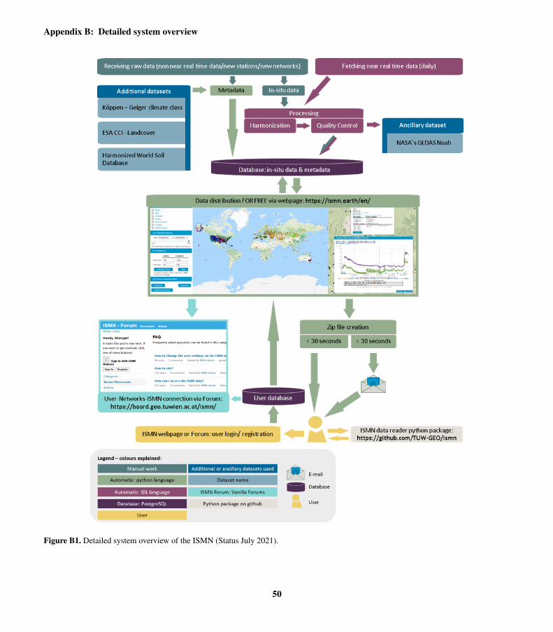
Appendix B: Detailed system overview
Figure B1. Detailed system overview of the ISMN (Status July 2021).
50

Appendix C: Soil moisture sensor availability per soil depth interval1070
Table C1. Overview of data availability per depth layers showing the total number of individual sensor brands, data sets and stations
integrated in the ISMN database. The calculations have been made in respect to horizontally and vertically placed sensors for each depth
layer.
depth from - to [m] sensors data sets stations
0.00 - 0.05 131 2116 1696
0.05 - 0.10 123 2482 1459
0.10 - 0.20 138 2690 1523
0.20 - 0.30 104 1899 1463
0.30 - 0.40 43 562 483
0.40 - 0.50 73 1463 1207
0.50 - 0.60 65 1389 1125
0.60 - 0.70 25 210 185
0.70 - 0.80 20 113 106
0.80 - 0.90 24 183 159
0.90 - 1.00 25 346 302
1.00 - 1.10 42 571 450
1.10 - 1.20 5 7 5
1.20 - 1.30 7 44 24
1.30 - 1.40 4 8 6
1.40 - 1.50 8 13 9
1.50 - 1.60 12 21 15
1.60 - 1.70 0 0 0
1.70 - 1.80 3 35 18
1.80 - 1.90 1 1 1
1.90 - 2.00 8 20 20
2.00 - 2.10 13 10 8
51

Appendix D: Metadata structure
Figure D1. Overview of all mandatory metadata information available for each station within the ISMN database.
52

Appendix E: Scientific studies using ISMN data for satellite and model product evaluation and development.
Table E1. Overview of scientific studies using ISMN data for satellite product evaluation and development.
Sensor Publications
SMOS Albergel et al. (2012c), Mecklenburg et al. (2012), Parrens et al. (2012), Sanchez et al. (2012), Schlenz et al. (2012), Wanders
et al. (2012), Pellarin et al. (2013), Fascetti et al. (2014), Petropoulos et al. (2014), Pierdicca et al. (2014), Zeng et al. (2014),
Rodriguez-Fernandez et al. (2015), Gruber et al. (2015), Hottenstein et al. (2015), Kornelsen and Coulibaly (2015), Lee and Im
(2015), Parinussa et al. (2015), Pierdicca et al. (2015a), Pierdicca et al. (2015b), Scaini et al. (2015), González-Zamora et al.
(2015), Fascetti et al. (2016), Fascetti et al. (2016), Kedzior and Zawadzki (2016), Kerr et al. (2016), Pablos et al. (2016), Piles
et al. (2016), Rautiainen et al. (2016), Scholze et al. (2016), van der Schalie et al. (2016), González-Zamora et al. (2016), Ángel
González-Zamora et al. (2016), Al-Yaari et al. (2017), Cui et al. (2017), Fascetti et al. (2017), Fernandez-Moran et al. (2017b),
Fernandez-Moran et al. (2017a), Karthikeyan et al. (2017), Lievens et al. (2017), Martens et al. (2017), Mohanty et al. (2017),
Montzka et al. (2017), Muñoz Sabater et al. (2017), Pan et al. (2017), Peng et al. (2017), Pierdicca et al. (2017), Rains et al. (2017),
van der Schalie et al. (2017), Yao et al. (2017), Al-Yaari et al. (2018b), Ebrahimi et al. (2018), Ebrahimi-Khusfi et al. (2018), Lee
(2018), Liu et al. (2018), Pablos et al. (2018), Tagesson et al. (2018), Tian (2018), van der Schalie et al. (2018), Wu et al. (2018),
Al-Yaari et al. (2019b), Al-Yaari et al. (2019a), Blyverket et al. (2019), Blyverket (2019), de Rosnay et al. (2019), Kang et al.
(2019), Ma et al. (2019), Piles et al. (2019), Rodriguez-Fernandez et al. (2019), Tian et al. (2019b), González-Zamora et al. (2019),
Beck et al. (2020), Chen et al. (2020), Helgert and Khodayar (2020), Herbert et al. (2020), Link et al. (2020), Moreno-Martínez
et al. (2020), Portal et al. (2020), Sadri et al. (2020),Dong et al. (2020),Li et al. (2020c),Wigneron et al. (2021), Balenzano et al.
(2021), Chen et al. (2021), van der Schalie et al. (2021), Xu et al. (2021), Yao et al. (2021), Zhang et al. (2021b)
ASCAT Brocca et al. (2011), Liu et al. (2011), Albergel et al. (2012c), Liu et al. (2012b), Parrens et al. (2012), Wanders et al. (2012),
Albergel et al. (2013b), Pellarin et al. (2013), Zwieback et al. (2013), Fascetti et al. (2014), Gruber et al. (2014), Parinussa
et al. (2014b), Paulik et al. (2014), Pierdicca et al. (2014), Gruber et al. (2015), Parinussa et al. (2015), Pierdicca et al. (2015a),
Pierdicca et al. (2015b), Su et al. (2015), Zwieback et al. (2015), Fascetti et al. (2016), Fascetti et al. (2016), Zwieback et al.
(2016), Fascetti et al. (2017), Gruber et al. (2017), Karthikeyan et al. (2017), Kolassa et al. (2017), Lievens et al. (2017), Massari
et al. (2017), Mohanty et al. (2017), Montzka et al. (2017), Pierdicca et al. (2017), Sure et al. (2017), Al-Yaari et al. (2018b),
Bauer-Marschallinger et al. (2018), Kim et al. (2018), Afshar et al. (2019), Al-Yaari et al. (2019b), Fairbairn et al. (2019), Gruber
et al. (2019a), Beck et al. (2020), Chen et al. (2020), Link et al. (2020), Moreno-Martínez et al. (2020), Zappa et al. (2020), Chen
et al. (2021), Kim et al. (2021), Steele-Dunne et al. (2021), Wu et al. (2021), Zhang et al. (2021b)
AMSR-E Brocca et al. (2011), Liu et al. (2011), Liu et al. (2012b), Parinussa et al. (2012), Wanders et al. (2012), Albergel et al. (2013b),
Dente et al. (2013), Dorigo et al. (2013), Zhao and Li (2013), de Jeu et al. (2014), Parinussa et al. (2014b), Zeng et al. (2014),
Coopersmith et al. (2015), Parinussa et al. (2015), Su et al. (2015), Zhao and Li (2015), Al-Yaari et al. (2016), Du et al. (2016),
Han et al. (2016), Parinussa et al. (2016), Santi et al. (2016), Zhao et al. (2016), Gruber et al. (2017), Han et al. (2017), Karthikeyan
et al. (2017), Kolassa et al. (2017), Massari et al. (2017), Mohanty et al. (2017), Su et al. (2017), Sure et al. (2017), Tobin et al.
(2017), van der Schalie et al. (2017), WANG Rui (2017), Yao et al. (2017), Lei et al. (2018), Liu et al. (2018), van der Schalie et al.
(2018), Afshar et al. (2019), Hu et al. (2019), Xie et al. (2019), Chen et al. (2020), Deng et al. (2020c), Hagan et al. (2020),Dong
et al. (2020), Chen et al. (2021), Yao et al. (2021)
53

Table E1 continued from previous page
Sensor Publications
SMAP Fascetti et al. (2016), Zeng et al. (2016), Al-Yaari et al. (2017), Cui et al. (2017), Fascetti et al. (2017), Karthikeyan et al.
(2017), Mohanty et al. (2017), Montzka et al. (2017), Pierdicca et al. (2017), Alemohammad et al. (2018), Ebrahimi et al. (2018),
Ebrahimi-Khusfi et al. (2018), Kim et al. (2018), Kim and Lakshmi (2018), Kolassa et al. (2018), Pablos et al. (2018), Santi et al.
(2018), Xu et al. (2018), Zhao et al. (2018), Al-Yaari et al. (2019b), Bai et al. (2019), Blyverket et al. (2019), Blyverket (2019),
Ebtehaj and Bras (2019), Fang et al. (2019), Ma et al. (2019), Park et al. (2019), Zhang et al. (2019b), Beck et al. (2020), Chen
et al. (2020), Fang et al. (2020), Gao et al. (2020), Gao et al. (2020), Link et al. (2020), Park et al. (2020), Portal et al. (2020),
Sadri et al. (2020), Suman et al. (2020), Sun et al. (2020), Zappa et al. (2020), Chen et al. (2021), Fang et al. (2021b), Fang et al.
(2021a), Gupta et al. (2021), He et al. (2021), Kim et al. (2021), Ojha et al. (2021), van der Schalie et al. (2021), Sun and Cui
(2021), Wu et al. (2021), Xu et al. (2021), Yao et al. (2021), Zhang et al. (2021b)
ESA CCI Gruber et al. (2013), Enenkel et al. (2016), Su et al. (2016), Cui et al. (2017), Dorigo et al. (2017), Karthikeyan et al. (2017),
Martens et al. (2017), Tobin et al. (2017), Al-Yaari et al. (2018b), Al-Yaari et al. (2019b), Al-Yaari et al. (2019a), Blyverket et al.
(2019), Blyverket (2019), Gruber et al. (2019b), Guevara and Vargas (2019), Ma et al. (2019), González-Zamora et al. (2019),
Zhu et al. (2019), Beck et al. (2020), Deng et al. (2020c), Kovacevic et al. (2020), Zappa et al. (2020), Dorigo et al. (2015), Pratola
et al. (2015), Nicolai-Shaw et al. (2015b), An et al. (2016), Liu et al. (2018), Liu et al. (2020),Chen et al. (2016), Almendra-Martín
et al. (2021), Grillakis et al. (2021), Guevara et al. (2021), Wang et al. (2021), Yao et al. (2021)
AMSR2 Kim et al. (2015a), Kim et al. (2015b), Parinussa et al. (2015), Kim et al. (2016), Wu et al. (2016), Anoop et al. (2017), Cui et al.
(2017), Karthikeyan et al. (2017), Montzka et al. (2017), Yao et al. (2017), Fang et al. (2018), Kim et al. (2018), Liu et al. (2018),
Santi et al. (2018), Hu et al. (2019), Ma et al. (2019), Beck et al. (2020), Chen et al. (2020), Hagan et al. (2020), Link et al. (2020),
Moreno-Martínez et al. (2020), Anoop et al. (2017), Chen et al. (2021), Moradizadeh and Srivastava (2021), Yao et al. (2021),
Zhang et al. (2021a)
MODIS Liu et al. (2014), Boussetta et al. (2015), Zhao and Li (2015), Pablos et al. (2016), Przezdziecki et al. (2017), Alemohammad et al.
(2018), Gumbricht (2018), Pablos et al. (2018), Kumar et al. (2019b), Park et al. (2019), Han et al. (2020), Chen et al. (2021),
Ojha et al. (2021), Sun and Cui (2021)
Sentinel-1 Paloscia et al. (2013), Liu et al. (2017), Bao et al. (2018), Bauer-Marschallinger et al. (2018), Dabrowska-Zielinska et al. (2018),
Bauer-Marschallinger et al. (2019), Greifeneder et al. (2019), Rodionova (2019b), Rodionova (2019a), Wang et al. (2019a),
Foucras et al. (2020), Han et al. (2020), Ma et al. (2020), Zappa et al. (2020), Ojha et al. (2021)
SEVIRI Zhao and Li (2013), Liu et al. (2014), Leng et al. (2015),Leng et al. (2016), Piles et al. (2016), Leng et al. (2017), Tagesson et al.
(2018), Ghilain et al. (2019)
FY-3B Parinussa et al. (2014a), Cui et al. (2017), Parinussa et al. (2018), Sheng et al. (2019), Chen et al. (2020), Hagan et al. (2020), Liu
et al. (2021)
TMI Liu et al. (2012b), Albergel et al. (2013b), Gruber et al. (2015), Karthikeyan et al. (2017), Chen et al. (2020), Hagan et al. (2020),
Chen et al. (2021)
ERS Liu et al. (2012b), Albergel et al. (2013b), Dente et al. (2013), Kolassa et al. (2013), Karthikeyan et al. (2017), Chen et al. (2021)
GNSS-IR (CYGNSS) Zhang et al. (2018a), Kim and Lakshmi (2018), Xu et al. (2018), Eroglu et al. (2019), Chew and Small (2020), Senyurek et al.
(2020)
SSM/I Liu et al. (2012b), Albergel et al. (2013b), Kolassa et al. (2013), Karthikeyan et al. (2017), Hagan et al. (2020), Chen et al. (2021)
WindSat Parinussa et al. (2012), Karthikeyan et al. (2017), Chen et al. (2020), Hagan et al. (2020)
ERS-2 Reimer et al. (2012), Pierdicca et al. (2014)
Landsat Zhao et al. (2017), Bao et al. (2018), Pradhan (2019)
GRACE Khaki et al. (2019), Sadeghi et al. (2020)
54

Table E1 continued from previous page
Sensor Publications
Aquarius/SAC-D González-Zamora et al. (2016)
FY-3C Liu et al. (2021)
GF-1 WFV Xing et al. (2017)
HY-2 Zhao et al. (2014)
MEaSUREs Chen et al. (2021)
MeMo Beck et al. (2020)
Sentinel-3 Ojha et al. (2021)
SMmodel Mimeau et al. (2020)
SMOPS Wang et al. (2021)
SMMR Chen et al. (2021)
55

Table E2. Overview of scientific studies using ISMN data for model evaluation and development.
Model Publications
ERA-Interim, ERA-Interim\Land Albergel et al. (2012b), Albergel et al. (2012a),Albergel et al. (2013a), Albergel et al. (2013b), Gruber et al.
(2013),Pierdicca et al. (2015a), Zwieback et al. (2013), Angevine et al. (2014), Balsamo et al. (2015),Cammal-
leri et al. (2015), Zwieback et al. (2015), Kim et al. (2016), Deng et al. (2020c), Deng et al. (2020b), Li et al.
(2020a), Pierdicca et al. (2015b), Nicolai-Shaw et al. (2015b), Beck et al. (2020)
ECMWF IFS Albergel et al. (2012c), Mecklenburg et al. (2012), Pellarin et al. (2013), Albergel et al. (2015), Rodriguez-
Fernandez et al. (2015)
ERA-40 Liu et al. (2012a)
ERA-5 Li et al. (2020a), Xu et al. (2021)
H-TESSEL Albergel et al. (2010), Albergel et al. (2015), Dirmeyer et al. (2016)
ISBA Albergel et al. (2010), Parrens et al. (2012), Barbu et al. (2014)
GLDAS Noah Liu et al. (2011), Dorigo et al. (2013), Angevine et al. (2014), Bi et al. (2016), Dirmeyer et al. (2016), Zawadzki
and Kedzior (2016), Pan et al. (2017), Lee (2018), McDonough et al. (2018), Mishra et al. (2018), Afshar et al.
(2019), Kedzior and Zawadzki (2016), Beck et al. (2020), Deng et al. (2020c), Solander et al. (2020), Xu et al.
(2021)
GLDAS Mosaic Bi et al. (2016), Solander et al. (2020)
MERRA, MERRA\Land, MERRA-2 Albergel et al. (2013b), Pellarin et al. (2013), Kim et al. (2016), Reichle et al. (2017), Draper and Reichle (2019),
Wang et al. (2019c), Li et al. (2020a), Xu et al. (2021)
CLM Cammalleri et al. (2015), Bi et al. (2016), Dirmeyer et al. (2016), Mishra et al. (2018), Zhao and Yang (2018)
VIC Mishra et al. (2014), Bi et al. (2016), Mishra et al. (2018), Beck et al. (2020), Solander et al. (2020), Erlingis et al.
(2021)
GLEAM Lievens et al. (2017), Martens et al. (2017), Martens et al. (2018)
LDAS Fairbairn et al. (2015), Albergel et al. (2018), Xia et al. (2019), Albergel et al. (2020)
BEACH Van doninck et al. (2012)
BEPS He et al. (2021)
CAS-LSM Wang et al. (2019b)
CFSR Li et al. (2020a)
CLSM Dong et al. (2020), Erlingis et al. (2021)
CPC Liu et al. (2012a)
CSSP Ji et al. (2017)
ESSMRA Naz et al. (2020)
GLDAS2 Wu et al. (2021)
GSFC Dirmeyer et al. (2016)
HadGEM3-GC3.05 Li et al. (2021)
HBV Beck et al. (2020)
JRA-5 Li et al. (2020a), Xu et al. (2021)
LISFLOOD Cammalleri et al. (2015)
NLDAS Noah Dong et al. (2020), Erlingis et al. (2021)
NLDAS Mosaic Dong et al. (2020), Erlingis et al. (2021)
NCEP/NCAR Pierdicca et al. (2015b), Xu et al. (2021)
Noah-MP Dong et al. (2020), Erlingis et al. (2021)
56
Table E2 continued from previous page
Model Publications
SAC Erlingis et al. (2021)
SSA Fairbairn et al. (2019)
SSMP Pal and Maity (2019)
WCDA, SCDA, OPNL Lin and Pu (2019)
WLDAS Erlingis et al. (2021)
WRF, WRF3.3-CLM4crop Angevine et al. (2014), Lu et al. (2015)
ORCHIDEE-MICT Yin et al. (2018), Raoult et al. (2021)
57

Appendix F: Effect of quality flagging on validation of ERA5 and ESA CCI soil moisture
(a) ERA5 absolute values (b) ERA5 anomalies
(c) ESA CCI absolute values (d) ESA CCI anomalies
Figure F1. Scatterplots of R Spearman between ISMN and ERA5 and ISMN and ESA CCI v05.2 combined for absolute values and anoma-
lies. A 35-day moving average window was used to calculate anomalies. Each dot represents a single time series.
58

References
Abbaszadeh, P., Moradkhani, H., and Zhan, X.: Downscaling SMAP Radiometer Soil Moisture Over the CONUS Using an Ensemble1075
Learning Method, Water Resources Research, 55, 324–344, https://doi.org/10.1029/2018WR023354, 2019.
Adla, S., Rai, N. K., Karumanchi, S. H., Tripathi, S., Disse, M., and Pande, S.: Laboratory Calibration and Performance Evaluation of
Low-Cost Capacitive and Very Low-Cost Resistive Soil Moisture Sensors, Sensors, 20, 363, https://doi.org/10.3390/s20020363, 2020.
Afshar, M., Yilmaz, M., and Crow, W.: Impact of rescaling approaches in simple fusion of soil moisture products, Water Resources Research,
55, 7804–7825, 2019.1080
Al-Yaari, A., Wigneron, J., Kerr, Y., de Jeu, R., Rodriguez-Fernandez, N., van der Schalie, R., Al Bitar, A., Mialon, A., Richaume, P., Dolman,
A., and Ducharne, A.: Testing regression equations to derive long-term global soil moisture datasets from passive microwave observations,
Remote Sensing of Environment, 180, 453–464, https://doi.org/10.1016/j.rse.2015.11.022, special Issue: ESA’s Soil Moisture and Ocean
Salinity Mission - Achievements and Applications, 2016.
Al-Yaari, A., Wigneron, J.-P., Kerr, Y., Rodriguez-Fernandez, N., O’Neill, P., Jackson, T., De Lannoy, G., Al Bitar, A., Mialon, A., Richaume,1085
P., Walker, J., Mahmoodi, A., and Yueh, S.: Evaluating soil moisture retrievals from ESA’s SMOS and NASA’s SMAP brightness temper-
ature datasets, Remote Sensing of Environment, 193, 257–273, https://doi.org/10.1016/j.rse.2017.03.010, 2017.
Al-Yaari, A., Dayau, S., Chipeaux, C., Aluome, C., Kruszewski, A., Loustau, D., and Wigneron, J.-P.: The AQUI Soil Moisture Network
for Satellite Microwave Remote Sensing Validation in South-Western France, Remote Sensing, 10, https://doi.org/10.3390/rs10111839,
2018a.1090
Al-Yaari, A., Dayau, S., Chipeaux, C., Aluome, C., Kruszewski, A., Loustau, D., and Wigneron, J.-P.: The AQUI Soil Moisture Network for
Satellite Microwave Remote Sensing Validation in South-Western France, Remote Sensing, 10, 1839, https://doi.org/10.3390/rs10111839,
2018b.
Al-Yaari, A., Ducharne, A., Cheruy, F., Crow, W. T., and Wigneron, J.-P.: Satellite-based soil moisture provides missing link between
summertime precipitation and surface temperature biases in CMIP5 simulations over conterminous United States, Scientific Reports, 9,1095
1657, https://doi.org/10.1038/s41598-018-38309-5, 2019a.
Al-Yaari, A., Wigneron, J.-P., Dorigo, W., Colliander, A., Pellarin, T., Hahn, S., Mialon, A., Richaume, P., Fernandez-Moran, R., Fan, L.,
Kerr, Y., and Lannoy, G. D.: Assessment and inter-comparison of recently developed/reprocessed microwave satellite soil moisture prod-
ucts using ISMN ground-based measurements, Remote Sensing of Environment, 224, 289–303, https://doi.org/10.1016/j.rse.2019.02.008,
2019b.1100
Albergel, C., Calvet, J.-C., Rosnay, P., Balsamo, G., W, W., Hasenauer, S., V, N., Martin, E., Bazile, E., F, B., and Mahfouf, J.-F.: Cross-
evaluation of modelled and remotely sensed surface soil moisture with in situ data in Southwestern France, Hydrology and Earth System
Sciences Discussions, 14, https://doi.org/10.5194/hess-14-2177-2010, 2010.
Albergel, C., Balsamo, G., de Rosnay, P., Muñoz Sabater, J., and Boussetta, S.: A bare ground evaporation revision in the ECMWF land-
surface scheme: evaluation of its impact using ground soil moisture and satellite microwave data, Hydrology and Earth System Sciences,1105
16, 3607–3620, https://doi.org/10.5194/hess-16-3607-2012, 2012a.
Albergel, C., de Rosnay, P., Balsamo, G., Isaksen, L., and Muñoz-Sabater, J.: Soil Moisture Analyses at ECMWF: Evaluation Using Global
Ground-Based In Situ Observations, Journal of Hydrometeorology, 13, 1442–1460, https://doi.org/10.1175/JHM-D-11-0107.1, 2012b.
59

Albergel, C., de Rosnay, P., Gruhier, C., Muñoz-Sabater, J., Hasenauer, S., Isaksen, L., Kerr, Y., and Wagner, W.: Evaluation of remotely
sensed and modelled soil moisture products using global ground-based in situ observations, Remote Sensing of Environment, 118, 215–1110
226, https://doi.org/10.1016/j.rse.2011.11.017, 2012c.
Albergel, C., Dorigo, W., Balsamo, G., Muñoz-Sabater, J., de Rosnay, P., Isaksen, L., Brocca, L., de Jeu, R., and Wagner, W.: Monitoring
multi-decadal satellite earth observation of soil moisture products through land surface reanalyses, Remote Sensing of Environment, 138,
77–89, https://doi.org/10.1016/j.rse.2013.07.009, 2013a.
Albergel, C., Dorigo, W., Reichle, R. H., Balsamo, G., de Rosnay, P., Muñoz-Sabater, J., Isaksen, L., de Jeu, R., and Wagner, W.: Skill and1115
Global Trend Analysis of Soil Moisture from Reanalyses and Microwave Remote Sensing, Journal of Hydrometeorology, 14, 1259–1277,
https://doi.org/10.1175/JHM-D-12-0161.1, 2013b.
Albergel, C., Dutra, E., Muñoz-Sabater, J., Haiden, T., Balsamo, G., Beljaars, A., Isaksen, L., de Rosnay, P., Sandu, I., and Wedi, N.: Soil
temperature at ECMWF: An assessment using ground-based observations, Journal of Geophysical Research: Atmospheres, 120, 1361–
1373, https://doi.org/10.1002/2014JD022505, 2015.1120
Albergel, C., Munier, S., Bocher, A., Bonan, B., Zheng, Y., Draper, C., Leroux, D., and Calvet, J.-C.: LDAS-Monde Sequential Assimilation
of Satellite Derived Observations Applied to the Contiguous US: An ERA-5 Driven Reanalysis of the Land Surface Variables, Remote
Sensing, 10, 1627, https://doi.org/10.3390/rs10101627, 2018.
Albergel, C., Zheng, Y., Bonan, B., Dutra, E., Rodríguez-Fernández, N., Munier, S., Draper, C., de Rosnay, P., Muñoz Sabater, J., Balsamo,
G., Fairbairn, D., Meurey, C., and Calvet, J.-C.: Data assimilation for continuous global assessment of severe conditions over terrestrial1125
surfaces, Hydrology and Earth System Sciences, 24, 4291–4316, https://doi.org/10.5194/hess-24-4291-2020, 2020.
Alday, J. G., Camarero, J. J., Revilla, J., and Dios, V. R.: Similar diurnal, seasonal and annual rhythms in radial root expansion across two
coexisting Mediterranean oak species, Tree Physiology, 2020.
Alemohammad, S. H., Kolassa, J., Prigent, C., Aires, F., and Gentine, P.: Global downscaling of remotely sensed soil moisture using neural
networks, Hydrology and Earth System Sciences, 22, 5341–5356, https://doi.org/10.5194/hess-22-5341-2018, 2018.1130
Almendra-Martín, L., Martínez-Fernández, J., Piles, M., and Ángel González-Zamora: Comparison of gap-filling techniques applied to the
CCI soil moisture database in Southern Europe, Remote Sensing of Environment, 258, 112 377, https://doi.org/10.1016/j.rse.2021.112377,
https://www.sciencedirect.com/science/article/pii/S003442572100095X, 2021.
An, R., Zhang, L., Wang, Z., Quaye-Ballard, J. A., You, J., Shen, X., Gao, W., Huang, L., Zhao, Y., and Ke, Z.: Validation of
the ESA CCI soil moisture product in China, International Journal of Applied Earth Observation and Geoinformation, 48, 28–36,1135
https://doi.org/10.1016/j.jag.2015.09.009, advances in the Validation and Application of Remotely Sensed Soil Moisture - Part 2, 2016.
Ángel González-Zamora, Sánchez, N., Martínez-Fernández, J., and Wagner, W.: Root-zone plant available water estimation using the SMOS-
derived soil water index, Advances in Water Resources, 96, 339–353, https://doi.org/10.1016/j.advwatres.2016.08.001, 2016.
Angevine, W. M., Bazile, E., Legain, D., and Pino, D.: Land surface spinup for episodic modeling, Atmospheric Chemistry and Physics, 14,
8165–8172, https://doi.org/10.5194/acp-14-8165-2014, 2014.1140
Anoop, S., Maurya, D. K., Rao, P. V. N., and Sekhar, M.: Validation and Comparison of LPRM Retrieved Soil Moisture Using AMSR2
Brightness Temperature at Two Spatial Resolutions in the Indian Region, IEEE Geoscience and Remote Sensing Letters, 14, 1561–1564,
https://doi.org/10.1109/LGRS.2017.2722542, 2017.
Ardö, J.: A 10-Year Dataset of Basic Meteorology and Soil Properties in Central Sudan, Dataset Papers in Geosciences, 2013,
https://doi.org/10.7167/2013/297973/dataset, 2013.1145
60

Bai, L., Lv, X., and Li, X.: Evaluation of Two SMAP Soil Moisture Retrievals Using Modeled- and Ground-Based Measurements, Remote
Sensing, 11, 2891, https://doi.org/10.3390/rs11242891, 2019.
Baldocchi, D., Falge, E., Gu, L., Olson, R., Hollinger, D., Running, S., Anthoni, P., Bernhofer, C., Davis, K., Evans, R., Fuentes, J., Goldstein,
A., Katul, G., Law, B., Lee, X., Malhi, Y., Meyers, T., Munger, J., Oechel, W., and Richardson, F.: FLUXNET: A New Tool to Study
the Temporal and Spatial Variability of Ecosystem–Scale Carbon Dioxide, Water Vapor, and Energy Flux Densities, ©2001 American1150
Meteorological Society, 82, https://doi.org/10.1175/1520-0477(2001)082<2415:FANTTS>2.3.CO;2, 2001.
Balenzano, A., Mattia, F., Satalino, G., Lovergine, F. P., Palmisano, D., Peng, J., Marzahn, P., Wegmüller, U., Cartus, O., Dabrowska-
Zielinska, K., Musial, J. P., Davidson, M. W., Pauwels, V. R., Cosh, M. H., McNairn, H., Johnson, J. T., Walker, J. P., Yueh, S. H., En-
tekhabi, D., Kerr, Y. H., and Jackson, T. J.: Sentinel-1 soil moisture at 1 km resolution: a validation study, Remote Sensing of Environment,
263, 112 554, https://doi.org/10.1016/j.rse.2021.112554, https://www.sciencedirect.com/science/article/pii/S0034425721002741, 2021.1155
Balsamo, G., Albergel, C., Beljaars, A., Boussetta, S., Brun, E., Cloke, H., Dee, D., Dutra, E., Muñoz Sabater, J., Pappenberger, F., de Rosnay,
P., Stockdale, T., and Vitart, F.: ERA-Interim/Land: a global land surface reanalysis data set, Hydrology and Earth System Sciences, 19,
389–407, https://doi.org/10.5194/hess-19-389-2015, 2015.
Bao, Y., Lin, L., Wu, S., Deng, K. A. K., and Petropoulos, G. P.: Surface soil moisture retrievals over partially vegetated areas from the
synergy of Sentinel-1 and Landsat 8 data using a modified water-cloud model, International Journal of Applied Earth Observation and1160
Geoinformation, 72, 76–85, https://doi.org/10.1016/j.jag.2018.05.026, 2018.
Barbu, A. L., Calvet, J.-C., Mahfouf, J.-F., and Lafont, S.: Integrating ASCAT surface soil moisture and GEOV1 leaf area index into the
SURFEX modelling platform: a land data assimilation application over France, Hydrology and Earth System Sciences, 18, 173–192,
https://doi.org/10.5194/hess-18-173-2014, 2014.
Bauer-Marschallinger, B., Paulik, C., Hochstöger, S., Mistelbauer, T., Modanesi, S., Ciabatta, L., Massari, C., Brocca, L., and Wagner,1165
W.: Soil Moisture from Fusion of Scatterometer and SAR: Closing the Scale Gap with Temporal Filtering, Remote Sensing, 10, 1030,
https://doi.org/10.3390/rs10071030, 2018.
Bauer-Marschallinger, B., Freeman, V., Cao, S., Paulik, C., Schaufler, S., Stachl, T., Modanesi, S., Massari, C., Ciabatta, L., Brocca, L., and
Wagner, W.: Toward Global Soil Moisture Monitoring With Sentinel-1: Harnessing Assets and Overcoming Obstacles, IEEE Transactions
on Geoscience and Remote Sensing, 57, 520–539, https://doi.org/10.1109/TGRS.2018.2858004, 2019.1170
Bayat, B., Camacho, F., Nickeson, J., Cosh, M., Bolten, J., Vereecken, H., and Montzka, C.: Toward operational validation systems for global
satellite-based terrestrial essential climate variables, International Journal of Applied Earth Observation and Geoinformation, 95, 102 240,
https://doi.org/10.1016/j.jag.2020.102240, 2021.
Beck, H. E., Pan, M., Miralles, D. G., Reichle, R. H., Dorigo, W. A., Hahn, S., Sheffield, J., Karthikeyan, L., Balsamo, G., Parinussa,
R. M., van Dijk, A. I. J. M., Du, J., Kimball, J. S., Vergopolan, N., and Wood, E. F.: Evaluation of 18 satellite- and model-based1175
soil moisture products using in situ measurements from 826 sensors, Hydrology and Earth System Sciences Discussions, 2020, 1–35,
https://doi.org/10.5194/hess-2020-184, 2020.
Bell, J., Palecki, M., Baker, B., Collins, W., Lawrimore, J., Leeper, R., Hall, M., Kochendorfer, J., Meyers, T., Wilson, T., and Dia-
mond, H.: U.S. Climate Reference Network Soil Moisture and Temperature Observations, Journal of Hydrometeorology, 14, 977–988,
https://doi.org/10.1175/JHM-D-12-0146.1, 2013.1180
Beyrich, F. and Adam, W.: Site and Data Report for the Lindenberg Reference Site in CEOP - Phase 1, Berichte des Deutschen Wetterdienstes,
230, Offenbach am Main, 2007, 2007.
61

Bi, H., Ma, J., Zheng, W., and Zeng, J.: Comparison of soil moisture in GLDAS model simulations and in situ observations over the Tibetan
Plateau, Journal of Geophysical Research: Atmospheres, 121, 2658–2678, https://doi.org/10.1002/2015JD024131, 2016.
Biddoccu, M., Ferraris, S., Opsi, F., and Cavallo, E.: Long-term monitoring of soil management effects on runoff and soil erosion in sloping1185
vineyards in Alto Monferrato (North West Italy), Soil and Tillage Research, 155, 176–189, https://doi.org/10.1016/j.still.2015.07.005,
2016.
Bircher, S., Skou, N., Jensen, K., Walker, J., and Rasmussen, L.: A soil moisture and temperature network for SMOS validation in Western
Denmark, Hydrology and Earth System Sciences, 16, https://doi.org/10.5194/hess-16-1445-2012, 2012.
Blöschl, G., Blaschke, A. P., Broer, M., Bucher, C., Carr, G., Chen, X., Eder, A., Exner-Kittridge, M., Farnleitner, A., Flores-Orozco, A.,1190
Haas, P., Hogan, P., Kazemi Amiri, A., Oismüller, M., Parajka, J., Silasari, R., Stadler, P., Strauss, P., Vreugdenhil, M., Wagner, W., and
Zessner, M.: The Hydrological Open Air Laboratory (HOAL) in Petzenkirchen: a hypothesis-driven observatory, Hydrology and Earth
System Sciences, 20, 227–255, https://doi.org/10.5194/hess-20-227-2016, 2016.
Blyverket, J., Hamer, P., Bertino, L., Albergel, C., Fairbairn, D., and Lahoz, W.: An Evaluation of the EnKF vs. EnOI and the Assimilation of
SMAP, SMOS and ESA CCI Soil Moisture Data over the Contiguous US, Remote Sensing, 11, 478, https://doi.org/10.3390/rs11050478,1195
2019.
Blyverket, J.; Hamer, P. B. L. A. C. F. D. L. W.: An Evaluation of the EnKF vs. EnOI and the Assimilation of SMAP, SMOS and ESA CCI
Soil Moisture Data over the Contiguous US., Remote Sens., 11, 012 046, https://doi.org/10.3390/rs11050478, 2019.
Bogena, H., Huisman, J., Oberdörster, C., and Vereecken, H.: Evaluation of a low-cost soil water content sensor for wireless network
applications, Journal of Hydrology, 344, 32–42, https://doi.org/10.1016/j.jhydrol.2007.06.032, 2007.1200
Bogena, H., Kunkel, R., Pütz, T., Vereecken, H., Kruger, E., Zacharias, S., Dietrich, P., Wollschläger, U., Kunstmann, H., Papen, H., Schmid,
H., Munch, J., Priesack, E., Schwank, M., Bens, O., Brauer, A., Borg, E., and Hajnsek, I.: TERENO - Long-term monitoring network for
terrestrial environmental research, Hydrologie und Wasserbewirtschaftung, 56, 138–143, 2012.
Bogena, H. R.: TERENO: German network of terrestrial environmental observatories, Journal of large-scale research facilities JLSRF, 2, 52,
2016.1205
Bogena, H. R., Huisman, J. A., Güntner, A., Hübner, C., Kusche, J., Jonard, F., Vey, S., and Vereecken, H.: Emerging methods for noninvasive
sensing of soil moisture dynamics from field to catchment scale: a review: Emerging methods for noninvasive sensing of soil moisture
dynamics, Wiley Interdisciplinary Reviews: Water, 2, 635–647, https://doi.org/10.1002/wat2.1097, 2015.
Bonney, R., Cooper, C. B., Dickinson, J., Kelling, S., Phillips, T., Rosenberg, K. V., and Shirk, J.: Citizen Science: A Developing Tool for
Expanding Science Knowledge and Scientific Literacy, BioScience, 59, 977–984, https://doi.org/10.1525/bio.2009.59.11.9, 2009.1210
Boussetta, S., Balsamo, G., Dutra, E., Beljaars, A., and Albergel, C.: Assimilation of surface albedo and vegetation states
from satellite observations and their impact on numerical weather prediction, Remote Sensing of Environment, 163, 111–126,
https://doi.org/10.1016/j.rse.2015.03.009, 2015.
Brocca, L., Morbidelli, R., Melone, F., and Moramarco, T.: Soil moisture spatial variability in experimental areas of central Italy, Journal of
Hydrology, 333, 356–373, https://doi.org/10.1016/j.jhydrol.2006.09.004, 2007.1215
Brocca, L., Melone, F., and Moramarco, T.: On the estimation of antecedent wetness condition in rainfall-runoff modeling, Hydrological
Processes, 22, 629–642, https://doi.org/10.1002/hyp.6629, 2008.
Brocca, L., Melone, F., Moramarco, T., and Morbidelli, R.: Antecedent wetness conditions based on ERS scatterometer data, Journal of
Hydrology, 364, 73–87, 2009.
62
Brocca, L., Hasenauer, S., Lacava, T., Melone, F., Moramarco, T., Wagner, W., A, D., Matgen, P., Martínez-Fernández, J., Llorens, P., Latron,1220
J., Martin, C., and Bittelli, M.: Soil moisture estimation through ASCAT and AMSR-E sensors: An intercomparison and validation study
across Europe, Remote Sensing of Environment, 115, 3390–3408, https://doi.org/10.1016/j.rse.2011.08.003, 2011.
Brocca, L., Ciabatta, L., Massari, C., Moramarco, T., Hahn, S., Hasenauer, S., Kidd, R., Dorigo, W., Wagner, W., and Levizzani, V.: Soil
as a natural rain gauge: Estimating global rainfall from satellite soil moisture data, Journal of Geophysical Research: Atmospheres, 119,
5128–5141, https://doi.org/10.1002/2014jd021489, 2014a.1225
Brocca, L., Zucco, G., Mittelbach, H., Moramarco, T., and Seneviratne, S. I.: Absolute versus temporal anomaly and per-
cent of saturation soil moisture spatial variability for six networks worldwide, Water Resources Research, 50, 5560–5576,
https://doi.org/10.1002/2014WR015684, 2014b.
Brocca, L., Massari, C., Ciabatta, L., Moramarco, T., Penna, D., Zuecco, G., Pianezzola, L., Borga, M., Matgen, P., and Martínez-Fernández,
J.: Rainfall estimation from in situ soil moisture observations at several sites in Europe: an evaluation of the SM2RAIN algorithm, Journal1230
of Hydrology and Hydromechanics, 63, 201–209, https://doi.org/10.1515/johh-2015-0016, 2015.
Brocca, L., Ciabatta, L., Massari, C., Camici, S., and Tarpanelli, A.: Soil Moisture for Hydrological Applications: Open Questions and New
Opportunities, Water, 9, 140, https://doi.org/10.3390/w9020140, 2017.
Calvet, J.-C., Fritz, N., Froissard, F., Suquia, D., Petitpa, A., and Piguet, B.: In situ soil moisture observations for the CAL/VAL of SMOS:
the SMOSMANIA network, pp. 1196–1199, https://doi.org/10.1109/IGARSS.2007.4423019, 2007.1235
Calvet, J.-C., Fritz, N., Berne, C., Piguet, B., Maurel, W., and Meurey, C.: Deriving pedotransfer functions for soil quartz fraction in southern
France from reverse modeling, SOIL, 2, 615–629, https://doi.org/10.5194/soil-2-615-2016, 2016.
Cammalleri, C., Micale, F., and Vogt, J.: On the value of combining different modelled soil moisture products for European drought moni-
toring, Journal of Hydrology, 525, 547–558, https://doi.org/10.1016/j.jhydrol.2015.04.021, 2015.
Campo, L., Castelli, F., Caparrini, F., and Entekhabi, D.: Production of a 5-years Dataset of Soil Moisture Maps on Italian Territory with an1240
Operational Algorithm, European Water, 35, 45–56, 2011.
Canisius, F.: Calibration of Casselman, Ontario Soil Moisture Monitoring Network, Agriculture and Agri-Food Canada, Ottawa, ON, 37pp,
2011.
Capello, G., Biddoccu, M., Ferraris, S., and Cavallo, E.: Effects of Tractor Passes on Hydrological and Soil Erosion Processes in Tilled and
Grassed Vineyards, Water, 11, 2118, https://doi.org/10.3390/w11102118, 2019.1245
Castell, N., Dauge, F. R., Schneider, P., Vogt, M., Lerner, U., Fishbain, B., Broday, D., and Bartonova, A.: Can commercial
low-cost sensor platforms contribute to air quality monitoring and exposure estimates?, Environment International, 99, 293–302,
https://doi.org/10.1016/j.envint.2016.12.007, 2017.
Chawla, S., Bachhtey, S., Gupta, V., Sharma, S., Seth, S., Gandhi, T., Varshney, S., Mehta, S., and Jha, R.: Low Cost Soil Moisture Sensors
and their Application in Automatic Irrigation System, p. 4, 2019.1250
Chen, F., Crow, W. T., Colliander, A., Cosh, M. H., Jackson, T. J., Bindlish, R., Reichle, R. H., Chan, S. K., Bosch, D. D., Starks, P. J.,
Goodrich, D. C., and Seyfried, M. S.: Application of Triple Collocation in Ground-Based Validation of Soil Moisture Active/Passive
(SMAP) Level 2 Data Products, IEEE Journal of Selected Topics in Applied Earth Observations and Remote Sensing, 10, 489–502,
https://doi.org/10.1109/JSTARS.2016.2569998, 2017.
Chen, N., Xiang, Z., and Wang, C.: Integrated open geospatial web service enabled cyber-physical information infrastructure for precision1255
agriculture monitoring, Computers and Electronics in Agriculture, 111, https://doi.org/10.1016/j.compag.2014.12.009, 2015a.
63

Chen, N., Xiao, C., Pu, F., Wang, X., Wang, C., Wang, Z., and Gong, J.: Cyber-Physical Geographical Information Service-Enabled Control
of Diverse In-Situ Sensors, Sensors (Basel, Switzerland), 15, 2565–92, https://doi.org/10.3390/s150202565, 2015b.
Chen, X., Su, Y., Liao, J., Shang, J., Dong, T., Wang, C., Liu, W., Zhou, G., and Liu, L.: Detecting significant decreasing trends of land
surface soil moisture in eastern China during the past three decades (1979–2010), Journal of Geophysical Research: Atmospheres, 121,1260
5177–5192, https://doi.org/10.1002/2015JD024676, 2016.
Chen, Y., Sun, L., Wang, W., and Pei, Z.: Application of Sentinel 2 data for drought monitoring in Texas, America, in: 2019 8th International
Conference on Agro-Geoinformatics (Agro-Geoinformatics), pp. 1–4, https://doi.org/10.1109/Agro-Geoinformatics.2019.8820491, 2019.
Chen, Y., Feng, X., and Fu, B.: A new dataset of satellite observation-based global surface soil moisture covering 2003–2018, Earth System
Science Data Discussions, 2020, 1–46, https://doi.org/10.5194/essd-2020-59, 2020.1265
Chen, Y., Feng, X., and Fu, B.: An improved global remote-sensing-based surface soil moisture (RSSSM) dataset covering 2003–2018, Earth
System Science Data, 13, 1–31, https://doi.org/10.5194/essd-13-1-2021, https://essd.copernicus.org/articles/13/1/2021/, 2021.
Chew, C. and Small, E.: Estimating inundation extent using CYGNSS data: A conceptual modeling study, Remote Sensing of Environment,
246, 111 869, https://doi.org/10.1016/j.rse.2020.111869, 2020.
Colliander, A., Jackson, T., Bindlish, R., Chan, S., Das, N., Kim, S., Cosh, M., Dunbar, R., Dang, L., Pashaian, L., Asanuma, J., Aida,1270
K., Berg, A., Rowlandson, T., Bosch, D., Caldwell, T., Caylor, K., Goodrich, D., al Jassar, H., Lopez-Baeza, E., Martínez-Fernández, J.,
González-Zamora, A., Livingston, S., McNairn, H., Pacheco, A., Moghaddam, M., Montzka, C., Notarnicola, C., Niedrist, G., Pellarin, T.,
Prueger, J., Pulliainen, J., Rautiainen, K., Ramos, J., Seyfried, M., Starks, P., Su, Z., Zeng, Y., van der Velde, R., Thibeault, M., Dorigo, W.,
Vreugdenhil, M., Walker, J., Wu, X., Monerris, A., O’Neill, P., Entekhabi, D., Njoku, E., and Yueh, S.: Validation of SMAP surface soil
moisture products with core validation sites, Remote Sensing of Environment, 191, 215–231, https://doi.org/10.1016/j.rse.2017.01.021,1275
2017.
Cook, D. R.: Soil temperature and moisture profile (STAMP) system handbook, Tech. rep., DOE Office of Science Atmospheric Radiation
Measurement (ARM) Program . . . , 2016a.
Cook, D. R.: Soil Water and Temperature System (SWATS) Instrument Handbook, Tech. rep., DOE Office of Science Atmospheric Radiation
Measurement (ARM) Program . . . , 2016b.1280
Cook, D. R. and Sullivan, R. C.: Surface Energy Balance System (SEBS) Instrument Handbook, Tech. rep., DOE Office of Science Atmo-
spheric Radiation Measurement (ARM) Program . . . , 2018.
Coopersmith, E. J., Cosh, M. H., Bindlish, R., and Bell, J.: Comparing AMSR-E soil moisture estimates to the extended record of the U.S.
Climate Reference Network (USCRN), Advances in Water Resources, 85, 79–85, https://doi.org/10.1016/j.advwatres.2015.09.003, 2015.
Crow, W. T., Berg, A. A., Cosh, M. H., Loew, A., Mohanty, B. P., Panciera, R., de Rosnay, P., Ryu, D., and Walker, J. P.: Upscaling1285
sparse ground-based soil moisture observations for the validation of coarse-resolution satellite soil moisture products: UPSCALING
SOIL MOISTURE, Reviews of Geophysics, 50, https://doi.org/10.1029/2011RG000372, [Online; accessed 2020-07-07], 2012.
Cui, C., Xu, J., Zeng, J., Chen, K.-S., Bai, X., Lu, H., Chen, Q., and Zhao, T.: Soil Moisture Mapping from Satellites: An Intercomparison
of SMAP, SMOS, FY3B, AMSR2, and ESA CCI over Two Dense Network Regions at Different Spatial Scales, Remote Sensing, 10, 33,
https://doi.org/10.3390/rs10010033, 2017.1290
Dabrowska-Zielinska, K., Musial, J., Malinska, A., Budzynska, M., Gurdak, R., Kiryla, W., Bartold, M., and Grzybowski, P.: Soil Moisture
in the Biebrza Wetlands Retrieved from Sentinel-1 Imagery, Remote Sensing, 10, 1979, https://doi.org/10.3390/rs10121979, 2018.
64

de Jeu, R. and Dorigo, W.: On the importance of satellite observed soil moisture, International Journal of Applied Earth Observation and
Geoinformation, 45, 107–109, https://doi.org/10.1016/j.jag.2015.10.007, advances in the Validation and Application of Remotely Sensed
Soil Moisture - Part 1, 2016.1295
de Jeu, R. A., Holmes, T. R., Parinussa, R. M., and Owe, M.: A spatially coherent global soil moisture product with improved temporal reso-
lution, Journal of Hydrology, 516, 284–296, https://doi.org/10.1016/j.jhydrol.2014.02.015, determination of soil moisture: Measurements
and theoretical approaches, 2014.
de Rosnay, P., Muñoz, J., Sabater, C. A., Lawrence, H., Isaksen, L., and English, S.: ECMWF Final Report on SMOS brightness temperature
activities over land: Monitoring and Data Assimilation, 2019.1300
Deng, Y., Wang, S., Bai, X., Luo, G., Wu, L., Chen, F., Wang, J., Li, C., Yang, Y., Hu, Z., Tian, S., and Lu, Q.: Vegetation green-
ing intensified soil drying in some semi-arid and arid areas of the world, Agricultural and Forest Meteorology, 292-293, 108 103,
https://doi.org/10.1016/j.agrformet.2020.108103, 2020a.
Deng, Y., Wang, S., Bai, X., Luo, G., Wu, L., Chen, F., Wang, J., Li, Q., Li, C., Yang, Y., Hu, Z., and Tian, S.: Spatiotemporal dy-
namics of soil moisture in the karst areas of China based on reanalysis and observations data, Journal of Hydrology, 585, 124 744,1305
https://doi.org/10.1016/j.jhydrol.2020.124744, 2020b.
Deng, Y., Wang, S., Bai, X., Wu, L., Cao, Y., Li, H., Wang, M., Li, C., Yang, Y., Hu, Z., Tian, S., and Lu, Q.: Comparison of soil moisture
products from microwave remote sensing, land model, and reanalysis using global ground observations, Hydrological Processes, 34,
836–851, https://doi.org/10.1002/hyp.13636, 2020c.
Dente, L., Su, Z., and Wen, J.: Validation of SMOS soil moisture products over the Maqu and Twente regions, Sensors, 12, 9965–9986, 2012.1310
Dente, L., Vekerdy, Z., de Jeu, R., and Su, Z.: Seasonality and autocorrelation of satellite-derived soil moisture products, International Journal
of Remote Sensing, 34, 3231–3247, https://doi.org/10.1080/01431161.2012.716923, 2013.
Dirmeyer, P. A., Wu, J., Norton, H. E., Dorigo, W. A., Quiring, S. M., Ford, T. W., Santanello, Joseph A., J., Bosilovich, M. G., Ek, M. B.,
Koster, R. D., Balsamo, G., and Lawrence, D. M.: Confronting Weather and Climate Models with Observational Data from Soil Moisture
Networks over the United States, Journal of Hydrometeorology, 17, 1049–1067, https://doi.org/10.1175/JHM-D-15-0196.1, 2016.1315
Domínguez-Niño, J. M., Bogena, H. R., Huisman, J. A., Schilling, B., and Casadesús, J.: On the Accuracy of Factory-Calibrated Low-Cost
Soil Water Content Sensors, Sensors, 19, 3101, https://doi.org/10.3390/s19143101, 2019.
Dong, J., Crow, W. T., Tobin, K. J., Cosh, M. H., Bosch, D. D., Starks, P. J., Seyfried, M., and Collins, C. H.: Comparison of microwave
remote sensing and land surface modeling for surface soil moisture climatology estimation, Remote Sensing of Environment, 242, 111 756,
https://doi.org/10.1016/j.rse.2020.111756, 2020.1320
Dorigo, W., van Oevelen, P., Wagner, W., Drusch, M., Mecklenburg, S., Robock, A., and Jackson, T.: A New International Network for in
Situ Soil Moisture Data, EOS, 92, 141–142, https://doi.org/10.1029/2011EO170001, 2011a.
Dorigo, W., Xaver, A., Vreugdenhil, M., Gruber, A., Dostálová, A., Sanchis-Dufau, A. D., Zamojski, D., Cordes, C., Wagner, W., and Drusch,
M.: Global Automated Quality Control of In Situ Soil Moisture Data from the International Soil Moisture Network, Vadose Zone Journal,
12, https://doi.org/10.2136/vzj2012.0097, 2013.1325
Dorigo, W., Gruber, A., Jeu, R. D., Wagner, W., Stacke, T., Loew, A., Albergel, C., Brocca, L., Chung, D., Parinussa, R., and Kidd, R.:
Evaluation of the ESA CCI soil moisture product using ground-based observations, Remote Sensing of Environment, 162, 380–395,
https://doi.org/10.1016/j.rse.2014.07.023, 2015.
Dorigo, W., Wagner, W., Albergel, C., Albrecht, F., Balsamo, G., Brocca, L., Chung, D., Ertl, M., Forkel, M., Gruber, A., Haas, E.,
Hamer, P. D., Hirschi, M., Ikonen, J., de Jeu, R., Kidd, R., Lahoz, W., Liu, Y. Y., Miralles, D., Mistelbauer, T., Nicolai-Shaw, N.,1330
65

Parinussa, R., Pratola, C., Reimer, C., van der Schalie, R., Seneviratne, S. I., Smolander, T., and Lecomte, P.: ESA CCI Soil Mois-
ture for improved Earth system understanding: State-of-the art and future directions, Remote Sensing of Environment, 203, 185–215,
https://doi.org/10.1016/j.rse.2017.07.001, 2017.
Dorigo, W. A., Scipal, K., Parinussa, R. M., Liu, Y. Y., Wagner, W., de Jeu, R. A. M., and Naeimi, V.: Error characterisation of global active
and passive microwave soil moisture datasets, Hydrology and Earth System Sciences, 14, 2605–2616, https://doi.org/10.5194/hess-14-1335
2605-2010, 2010.
Dorigo, W. A., Wagner, W., Hohensinn, R., Hahn, S., Paulik, C., Xaver, A., Gruber, A., Drusch, M., Mecklenburg, S., van Oevelen, P.,
Robock, A., and Jackson, T.: The International Soil Moisture Network: a data hosting facility for global in situ soil moisture measurements,
Hydrology and Earth System Sciences, 15, 1675–1698, https://doi.org/10.5194/hess-15-1675-2011, 2011b.
Draper, C. and Reichle, R. H.: Assimilation of Satellite Soil Moisture for Improved Atmospheric Reanalyses, Monthly Weather Review, 147,1340
2163–2188, https://doi.org/10.1175/MWR-D-18-0393.1, 2019.
Du, J., Kimball, J. S., and Jones, L. A.: Passive Microwave Remote Sensing of Soil Moisture Based on Dynamic Vegetation Scattering
Properties for AMSR-E, IEEE Transactions on Geoscience and Remote Sensing, 54, 597–608, 2016.
Ebrahimi, M., Alavipanah, S. K., Hamzeh, S., Amiraslani, F., Neysani Samany, N., and Wigneron, J.-P.: Exploiting the synergy between
SMAP and SMOS to improve brightness temperature simulations and soil moisture retrievals in arid regions, Journal of Hydrology, 557,1345
740–752, https://doi.org/10.1016/j.jhydrol.2017.12.051, 2018.
Ebrahimi-Khusfi, M., Alavipanah, S. K., Hamzeh, S., Amiraslani, F., Neysani Samany, N., and Wigneron, J.-P.: Comparison of soil mois-
ture retrieval algorithms based on the synergy between SMAP and SMOS-IC, International Journal of Applied Earth Observation and
Geoinformation, 67, 148–160, https://doi.org/10.1016/j.jag.2017.12.005, 2018.
Ebtehaj, A. and Bras, R. L.: A physically constrained inversion for high-resolution passive microwave retrieval of soil moisture and vegetation1350
water content in L-band, Remote Sensing of Environment, 233, 111 346, 2019.
Enenkel, M., Reimer, C., Dorigo, W., Wagner, W., Pfeil, I., Parinussa, R., and De Jeu, R.: Combining satellite observations to develop a global
soil moisture product for near-real-time applications, Hydrology and Earth System Sciences, 20, 4191–4208, https://doi.org/10.5194/hess-
20-4191-2016, 2016.
Entekhabi, D., Njoku, E. G., O’Neill, P. E., Kellogg, K. H., Crow, W. T., Edelstein, W. N., Entin, J. K., Goodman, S. D., Jackson, T. J.,1355
Johnson, J., Kimball, J., Piepmeier, J. R., Koster, R. D., Martin, N., McDonald, K. C., Moghaddam, M., Moran, S., Reichle, R., Shi, J. C.,
Spencer, M. W., Thurman, S. W., Tsang, L., and Van Zyl, J.: The Soil Moisture Active Passive (SMAP) Mission, Proceedings of the IEEE,
98, 704–716, https://doi.org/10.1109/JPROC.2010.2043918, 2010.
Erlingis, J. M., Rodell, M., Peters-Lidard, C. D., Li, B., Kumar, S. V., Famiglietti, J. S., Granger, S. L., Hurley, J. V., Liu, P.-W., and Mocko,
D. M.: A High-Resolution Land Data Assimilation System Optimized for the Western United States, JAWRA Journal of the American Wa-1360
ter Resources Association, https://doi.org/10.1111/1752-1688.12910, https://onlinelibrary.wiley.com/doi/abs/10.1111/1752-1688.12910,
2021.
Eroglu, O., Kurum, M., Boyd, D., and Gurbuz, A. C.: High spatio-temporal resolution CYGNSS soil moisture estimates using artificial neural
networks, Remote Sensing, 11, 2272, 2019.
Esposito, G., Matano, F., and Scepi, G.: Analysis of Increasing Flash Flood Frequency in the Densely Urbanized Coastline of the Campi1365
Flegrei Volcanic Area, Italy, Frontiers in Earth Science, 6, 63, https://doi.org/10.3389/feart.2018.00063, 2018.
66

Fairbairn, D., Barbu, A. L., Mahfouf, J.-F., Calvet, J.-C., and Gelati, E.: Comparing the ensemble and extended Kalman filters for in situ soil
moisture assimilation with contrasting conditions, Hydrology and Earth System Sciences, 19, 4811–4830, https://doi.org/10.5194/hess-
19-4811-2015, 2015.
Fairbairn, D., de Rosnay, P., and Browne, P. A.: The New Stand-Alone Surface Analysis at ECMWF: Implications for Land–Atmosphere DA1370
Coupling, Journal of Hydrometeorology, 20, 2023–2042, https://doi.org/10.1175/JHM-D-19-0074.1, 2019.
Famiglietti, J. S., Ryu, D., Berg, A. A., Rodell, M., and Jackson, T. J.: Field observations of soil moisture variability across scales: SOIL
MOISTURE VARIABILITY ACROSS SCALES, Water Resources Research, 44, https://doi.org/10.1029/2006WR005804, [Online; ac-
cessed 2020-06-18], 2008.
Fang, B., Lakshmi, V., Bindlish, R., and Jackson, T.: AMSR2 Soil Moisture Downscaling Using Temperature and Vegetation Data, Remote1375
Sensing, 10, 1575, https://doi.org/10.3390/rs10101575, 2018.
Fang, B., Lakshmi, V., Bindlish, R., Jackson, T. J., and Liu, P.-W.: Downscaling and Validation of SMAP Radiometer Soil Moisture in
CONUS, in: IGARSS 2019-2019 IEEE International Geoscience and Remote Sensing Symposium, pp. 6194–6197, IEEE, 2019.
Fang, B., Lakshmi, V., Bindlish, R., Jackson, T. J., and Liu, P.-W.: Evaluation and validation of a high spatial resolution satellite soil moisture
product over the Continental United States, Journal of Hydrology, 588, 125 043, https://doi.org/10.1016/j.jhydrol.2020.125043, 2020.1380
Fang, B., Kansara, P., Dandridge, C., and Lakshmi, V.: Drought monitoring using high spatial resolution soil moisture data over Australia in
2015–2019, Journal of Hydrology, 594, 125 960, https://doi.org/10.1016/j.jhydrol.2021.125960, https://www.sciencedirect.com/science/
article/pii/S002216942100007X, 2021a.
Fang, B., Lakshmi, V., Cosh, M. H., and Hain, C.: Very High Spatial Resolution Downscaled SMAP Radiometer Soil Moisture in the
CONUS Using VIIRS/MODIS Data, IEEE Journal of Selected Topics in Applied Earth Observations and Remote Sensing, 14, 4946–1385
4965, https://doi.org/10.1109/JSTARS.2021.3076026, 2021b.
FAO/IIASA/ISRIC/ISS-CAS/JRC: Harmonized World Soil Database (version 1.1). FAO, Rome,Italy and IIASA, Laxenburg, Austria., http:
//www.fao.org/3/a-aq361e.pdf, 2009.
Fascetti, F., Pierdicca, N., Pulvirenti, L., Crapolicchio, R., and Sabater, J. M.: Soil moisture comparison through triple and quadruple col-
location between: Metop, ERA, SMOS and in-situ data, in: 2014 IEEE Geoscience and Remote Sensing Symposium, pp. 2451–2454,1390
2014.
Fascetti, F., Pierdicca, N., Crapolicchio, R., Pulvirenti, L., and Muoz-Sabater, J.: An assessment of SMOS version 6.20 products through
Triple and Quadruple Collocation techniques considering ASCAT, ERA/Interim LAND, ISMNand SMAP soil moisture data, in: 2016
14th Specialist Meeting on Microwave Radiometry and Remote Sensing of the Environment (MicroRad), pp. 91–94, 2016.
Fascetti, F., Pierdicca, N., Pulvirenti, L., Crapolicchio, R., and Muñoz-Sabater, J.: A comparison of ASCAT and SMOS soil moisture retrievals1395
over Europe and Northern Africa from 2010 to 2013, International Journal of Applied Earth Observation and Geoinformation, 45, 135–
142, https://doi.org/10.1016/j.jag.2015.09.008, advances in the Validation and Application of Remotely Sensed Soil Moisture - Part 1,
2016.
Fascetti, F., Pierdicca, N., Pulvirenti, L., and Crapolicchio, R.: Error characterization of SMOS, ASCAT, SMAP, ERA and ISMN soil moisture
products: Automatic detection of cross-correlation error through extended quadruple collocation, in: 2017 IEEE International Geoscience1400
and Remote Sensing Symposium (IGARSS), pp. 4154–4157, https://doi.org/10.1109/IGARSS.2017.8127916, 2017.
Fernandez-Moran, R., Al-Yaari, A., Mialon, A., Mahmoodi, A., Al Bitar, A., De Lannoy, G., Rodriguez-Fernandez, N., Lopez-Baeza, E.,
Kerr, Y., and Wigneron, J.-P.: SMOS-IC: An Alternative SMOS Soil Moisture and Vegetation Optical Depth Product, Remote Sensing, 9,
https://doi.org/10.3390/rs9050457, 2017a.
67

Fernandez-Moran, R., Wigneron, J.-P., De Lannoy, G., Lopez-Baeza, E., Parrens, M., Mialon, A., Mahmoodi, A., Al-Yaari, A., Bircher,1405
S., Al Bitar, A., Richaume, P., and Kerr, Y.: A new calibration of the effective scattering albedo and soil roughness parame-
ters in the SMOS SM retrieval algorithm, International Journal of Applied Earth Observation and Geoinformation, 62, 27–38,
https://doi.org/10.1016/j.jag.2017.05.013, 2017b.
Flammini, A., Corradini, C., Morbidelli, R., Saltalippi, C., Picciafuoco, T., and Giráldez, J. V.: Experimental analyses of the evaporation
dynamics in bare soils under natural conditions, Water resources management, 32, 1153–1166, 2018a.1410
Flammini, A., Morbidelli, R., Saltalippi, C., Picciafuoco, T., Corradini, C., and Govindaraju, R. S.: Reassessment of a semi-analytical field-
scale infiltration model through experiments under natural rainfall events, Journal of Hydrology, 565, 835–845, 2018b.
Foucras, M., Zribi, M., Albergel, C., Baghdadi, N., Calvet, J.-C., and Pellarin, T.: Estimating 500-m Resolution Soil Moisture Using Sentinel-
1 and Optical Data Synergy, Water, 12, 866, https://doi.org/10.3390/w12030866, 2020.
Fritz, S., Fonte, C., and See, L.: The Role of Citizen Science in Earth Observation, Remote Sensing, 9, 357,1415
https://doi.org/10.3390/rs9040357, 2017.
Fuchsberger, J., Kirchengast, G., and Kabas, T.: WegenerNet high-resolution weather and climate data 2007 to 2019, Earth System Science
Data Discussions, 2020, 1–49, https://doi.org/10.5194/essd-2020-302, 2020.
Galle, S., Manuela, G., Peugeot, C., Bouzou-Moussa, I., Cappelaere, B., Demarty, J., Mougin, E., Panthou, G., Adjomayi, P., Agbossou,
E., Abdramane, B., Boucher, M., Cohard, J.-M., Descloitres, M., Descroix, L., Diawara, M., Do, M., Favreau, G., Fabrice, G., and1420
Wilcox, C.: AMMA-CATCH, a critical zone observatory in West Africa monitoring a region in transition, Vadose Zone Journal, 17, 1–24,
https://doi.org/10.2136/vzj2018.03.0062, 2018.
Gao, L., Sadeghi, M., and Ebtehaj, A.: Microwave retrievals of soil moisture and vegetation optical depth with improved resolution
using a combined constrained inversion algorithm: Application for SMAP satellite, Remote Sensing of Environment, 239, 111 662,
https://doi.org/h10.1016/j.rse.2020.111662, 2020.1425
Gao, L., Sadeghi, M., Feldman, A. F., and Ebtehaj, A.: A Spatially Constrained Multichannel Algorithm for Inversion of
a First-Order Microwave Emission Model at L-Band, IEEE Transactions on Geoscience and Remote Sensing, pp. 1–13,
https://doi.org/10.1109/TGRS.2020.2987490, 2020.
Gardner, W. and Kirkham, D.: Determination of soil moisture by neutron scattering, Soil Science, 73, 391–401, 1952.
GCOS: The Global Climate Observing System, https://gcos.wmo.int/en/gcos-implementation-plan, 2016.1430
Ghilain, N., Arboleda, A., Batelaan, O., Ardö, J., Trigo, I., Barrios, J.-M., and Gellens-Meulenberghs, F.: A new retrieval algorithm for soil
moisture index from thermal infrared sensor on-board geostationary satellites over Europe and Africa and its validation, Remote Sensing,
11, 1968, 2019.
González-Teruel, J., Torres-Sánchez, R., Blaya-Ros, P., Toledo-Moreo, A., Jiménez-Buendía, M., and Soto-Valles, F.: Design and Calibration
of a Low-Cost SDI-12 Soil Moisture Sensor, Sensors, 19, 491, https://doi.org/10.3390/s19030491, 2019.1435
González-Zamora, A., Sánchez, N., Gumuzzio, A., Piles, M., Olmedo, E., and Martínez-Fernández, J.: Validation of SMOS L2 and L3 soil
moisture products over the Duero Basin at different spatial scales, ISPRS - International Archives of the Photogrammetry, Remote Sensing
and Spatial Information Sciences, XL-7/W3, 1183–1188, https://doi.org/10.5194/isprsarchives-XL-7-W3-1183-2015, 2015.
González-Zamora, A., Sánchez, N., and Martínez-Fernández, J.: Validation of Aquarius Soil Moisture Products Over the Northwest of Spain:
A Comparison With SMOS, IEEE Journal of Selected Topics in Applied Earth Observations and Remote Sensing, 9, 2763–2769, 2016.1440
68

González-Zamora, Á., Sánchez, N., Pablos, M., and Martínez-Fernández, J.: CCI soil moisture assessment with SMOS soil moisture
and in situ data under different environmental conditions and spatial scales in Spain, Remote Sensing of Environment, 225, 469–482,
https://doi.org/10.1016/j.rse.2018.02.010, 2019.
González-Zamora, , Sanchez, N., Pablos, M., and Martínez-Fernández, J.: CCI soil moisture assessment with SMOS soil mois-
ture and in situ data under different environmental conditions and spatial scales in Spain, Remote Sensing of Environment, 225,1445
https://doi.org/10.1016/j.rse.2018.02.010, 2018.
Grainger, A.: Citizen Observatories and the New Earth Observation Science, Remote Sensing, 9, 153, https://doi.org/10.3390/rs9020153,
2017.
Greifeneder, F., Khamala, E., Sendabo, D., Wagner, W., Zebisch, M., Farah, H., and Notarnicola, C.: Detection of soil moisture anomalies
based on Sentinel-1, Physics and Chemistry of the Earth, Parts A/B/C, 112, 75–82, https://doi.org/10.1016/j.pce.2018.11.009, 18th Water-1450
Net/WARFSA/GWPSA Symposium on Integrated Water Resources Development and Management: Innovative Technological Advances
for Water Security in Eastern and Southern Africa., 2019.
Greifeneder, F., Notarnicola, C., and Wagner, W.: A Machine Learning-Based Approach for Surface Soil Moisture Estimations with Google
Earth Engine, Remote Sensing, 13, https://doi.org/10.3390/rs13112099, https://www.mdpi.com/2072-4292/13/11/2099, 2021.
Grillakis, M. G., Koutroulis, A. G., Alexakis, D. D., Polykretis, C., and Daliakopoulos, I. N.: Regionalizing Root-Zone Soil Mois-1455
ture Estimates From ESA CCI Soil Water Index Using Machine Learning and Information on Soil, Vegetation, and Climate, Water
Resources Research, 57, e2020WR029 249, https://doi.org/10.1029/2020WR029249, https://agupubs.onlinelibrary.wiley.com/doi/abs/10.
1029/2020WR029249, e2020WR029249 2020WR029249, 2021.
Gruber, A., Dorigo, W., Zwieback, S., Xaver, A., and Wagner, W.: Characterizing Coarse-Scale Representativeness of in
situ Soil Moisture Measurements from the International Soil Moisture Network, Vadose Zone Journal, 12, vzj2012.0170,1460
https://doi.org/10.2136/vzj2012.0170, 2013.
Gruber, A., Paloscia, S., Santi, E., Notarnicola, C., Pasolli, L., Smolander, T., Pulliainen, J., Mittelbach, H., Dorigo, W., and Wagner, W.:
Performance inter-comparison of soil moisture retrieval models for the MetOp-A ASCAT instrument, in: 2014 IEEE Geoscience and
Remote Sensing Symposium, pp. 2455–2458, https://doi.org/10.1109/IGARSS.2014.6946969, 2014.
Gruber, A., Crow, W., Dorigo, W., and Wagner, W.: The potential of 2D Kalman filtering for soil moisture data assimilation, Remote Sensing1465
of Environment, 171, 137–148, https://doi.org/10.1016/j.rse.2015.10.019, 2015.
Gruber, A., Su, C.-H., Crow, W. T., Zwieback, S., Dorigo, W. A., and Wagner, W.: Estimating error cross-correlations in
soil moisture data sets using extended collocation analysis, Journal of Geophysical Research: Atmospheres, 121, 1208–1219,
https://doi.org/10.1002/2015JD024027, 2016.
Gruber, A., Dorigo, W. A., Crow, W., and Wagner, W.: Triple Collocation-Based Merging of Satellite Soil Moisture Retrievals, IEEE Trans-1470
actions on Geoscience and Remote Sensing, 55, 6780–6792, https://doi.org/10.1109/TGRS.2017.2734070, 2017.
Gruber, A., Crow, W. T., and Dorigo, W. A.: Assimilation of Spatially Sparse In Situ Soil Moisture Networks into a Continuous Model
Domain, Water Resources Research, 54, 1353–1367, https://doi.org/10.1002/2017WR021277, 2018.
Gruber, A., De Lannoy, G., and Crow, W.: A Monte Carlo based adaptive Kalman filtering framework for soil moisture data assimilation,
Remote Sensing of Environment, 228, 105–114, 2019a.1475
Gruber, A., Scanlon, T., van der Schalie, R., Wagner, W., and Dorigo, W.: Evolution of the ESA CCI Soil Moisture climate data records and
their underlying merging methodology, Earth System Science Data, 11, 717–739, https://doi.org/10.5194/essd-11-717-2019, 2019b.
69

Gruber, A., De Lannoy, G., Albergel, C., Al-Yaari, A., Brocca, L., Calvet, J.-C., Colliander, A., Cosh, M., Crow, W., Dorigo, W., Draper, C.,
Hirschi, M., Kerr, Y., Konings, A., Lahoz, W., McColl, K., Montzka, C., Muñoz-Sabater, J., Peng, J., Reichle, R., Richaume, P., Rüdiger,
C., Scanlon, T., van der Schalie, R., Wigneron, J.-P., and Wagner, W.: Validation practices for satellite soil moisture retrievals: What are1480
(the) errors?, Remote Sensing of Environment, 244, 111 806, https://doi.org/10.1016/j.rse.2020.111806, 2020.
Guevara, M. and Vargas, R.: Downscaling satellite soil moisture using geomorphometry and machine learning, PloS one, 14, e0219 639,
2019.
Guevara, M., Taufer, M., and Vargas, R.: Gap-free global annual soil moisture: 15 km grids for 1991–2018, Earth System Science Data, 13,
1711–1735, https://doi.org/10.5194/essd-13-1711-2021, https://essd.copernicus.org/articles/13/1711/2021/, 2021.1485
Gumbricht, T.: Detecting Trends in Wetland Extent from MODIS Derived Soil Moisture Estimates, Remote Sensing, 10, 611,
https://doi.org/10.3390/rs10040611, 2018.
Gumbricht, T., Roman-Cuesta, R. M., Verchot, L., Herold, M., Wittmann, F., Householder, E., Herold, N., and Murdiyarso, D.: An expert
system model for mapping tropical wetlands and peatlands reveals South America as the largest contributor, Global Change Biology, 23,
3581–3599, https://doi.org/10.1111/gcb.13689, 2017.1490
Gupta, D. K., Srivastava, P. K., Singh, A., Petropoulos, G. P., Stathopoulos, N., and Prasad, R.: SMAP Soil Moisture Product Assessment over
Wales, U.K., Using Observations from the WSMN Ground Monitoring Network, Sustainability, 13, https://doi.org/10.3390/su13116019,
https://www.mdpi.com/2071-1050/13/11/6019, 2021.
Hagan, D. F. T., Wang, G., Kim, S., Parinussa, R. M., Liu, Y., Ullah, W., Bhatti, A. S., Ma, X., Jiang, T., and Su, B.: Maximizing Temporal
Correlations in Long-Term Global Satellite Soil Moisture Data-Merging, Remote Sensing, 12, 2164, https://doi.org/10.3390/rs12132164,1495
2020.
Hajdu, I., Yule, I., Bretherton, M., Singh, R., and Hedley, C.: Field performance assessment and calibration of multi-depth AquaCheck
capacitance-based soil moisture probes under permanent pasture for hill country soils, Agricultural Water Management, 217, 332–345,
https://doi.org/10.1016/j.agwat.2019.03.002, 2019.
Han, M., Lu, H., and Yang, K.: Development of passive microwave retrieval algorithm for estimation of surface soil temperature from1500
AMSR-E data, in: 2016 IEEE International Geoscience and Remote Sensing Symposium (IGARSS), pp. 1671–1674, 2016.
Han, M., Lu, H., Yang, K., Qin, J., Chen, Y., Zhao, L., and Lazhu: A surface soil temperature retrieval algorithm
based on AMSR-E multi-frequency brightness temperatures, International Journal of Remote Sensing, 38, 6735–6754,
https://doi.org/10.1080/01431161.2017.1363438, 2017.
Han, Y., Bai, X., Shao, W., and Wang, J.: Retrieval of Soil Moisture by Integrating Sentinel-1A and MODIS Data over Agricultural Fields,1505
Water, 12, https://doi.org/10.3390/w12061726, 2020.
Hartmann, A., Gleeson, T., Rosolem, R., Pianosi, F., Wada, Y., and Wagener, T.: A large-scale simulation model to assess karstic groundwater
recharge over Europe and the Mediterranean, Geoscientific Model Development, 8, 1729–1746, https://doi.org/10.5194/gmd-8-1729-2015,
2015.
He, L., Chen, J. M., Mostovoy, G., and Gonsamo, A.: Soil Moisture Active Passive Improves Global Soil Moisture Sim-1510
ulation in a Land Surface Scheme and Reveals Strong Irrigation Signals Over Farmlands, Geophysical Research Letters,
48, e2021GL092 658, https://doi.org/10.1029/2021GL092658, https://agupubs.onlinelibrary.wiley.com/doi/abs/10.1029/2021GL092658,
e2021GL092658 2021GL092658, 2021.
70
Helgert, S. and Khodayar, S.: Improvement of the soil-atmosphere interactions and subsequent heavy precipitation modelling by
enhanced initialization using remotely sensed 1 km soil moisture information, Remote Sensing of Environment, 246, 111 812,1515
https://doi.org/10.1016/j.rse.2020.111812, 2020.
Herbert, C., Pablos, M., Vall-llossera, M., Camps, A., and Martínez-Fernández, J.: Analyzing Spatio-Temporal Factors to Es-
timate the Response Time between SMOS and In-Situ Soil Moisture at Different Depths, Remote Sensing, 12, 2614,
https://doi.org/10.3390/rs12162614, 2020.
Hersbach, H., Bell, B., Berrisford, P., Hirahara, S., Horányi, A., Muñoz-Sabater, J., Nicolas, J., Peubey, C., Radu, R., Schepers, D., Simmons,1520
A., Soci, C., Abdalla, S., Abellan, X., Balsamo, G., Bechtold, P., Biavati, G., Bidlot, J., Bonavita, M., De Chiara, G., Dahlgren, P., Dee,
D., Diamantakis, M., Dragani, R., Flemming, J., Forbes, R., Fuentes, M., Geer, A., Haimberger, L., Healy, S., Hogan, R. J., Hólm, E.,
Janisková, M., Keeley, S., Laloyaux, P., Lopez, P., Lupu, C., Radnoti, G., de Rosnay, P., Rozum, I., Vamborg, F., Villaume, S., and Thépaut,
J.-N.: The ERA5 Global Reanalysis, Quarterly Journal of the Royal Meteorological Society, n/a, https://doi.org/10.1002/qj.3803, 2020.
Hirschi, M., Mueller, B., Dorigo, W., and Seneviratne, S.: Using remotely sensed soil moisture for land–atmosphere cou-1525
pling diagnostics: The role of surface vs. root-zone soil moisture variability, Remote Sensing of Environment, 154, 246–252,
https://doi.org/doi.org/10.1016/j.rse.2014.08.030, 2014.
Hoang, K. O. and Lu, M.: Impacts of temperature effect removal on rainfall estimation from soil water content by using SM2RAIN algorithm,
IOP Conference Series: Earth and Environmental Science, 344, 012 046, https://doi.org/10.1088/1755-1315/344/1/012046, 2019.
Hollinger, S. and Isard, S.: A Soil Moisture Climatology of Illinois, Journal of Climate, 7, 822–833, https://doi.org/10.1175/1520-1530
0442(1994)007<0822:ASMCOI>2.0.CO;2, 1994.
Hottenstein, J. D., Ponce-Campos, G. E., Moguel-Yanes, J., and Moran, M. S.: Impact of Varying Storm Intensity and Consecutive Dry Days
on Grassland Soil Moisture, Journal of Hydrometeorology, 16, 106–117, https://doi.org/10.1175/JHM-D-14-0057.1, 2015.
Hu, T., Zhao, T., Zhao, K., and Shi, J.: A continuous global record of near-surface soil freeze/thaw status from AMSR-E and AMSR2 data,
International Journal of Remote Sensing, 40, 6993–7016, https://doi.org/10.1080/01431161.2019.1597307, 2019.1535
Ikonen, J., Vehviläinen, J., Rautiainen, K., Smolander, T., Lemmetyinen, J., Bircher, S., and Pulliainen, J.: The Sodankylä in-situ soil moisture
observation network: an example application to Earth Observation data product evaluation, GID, 5, 599–629, 2015.
Ikonen, J., Smolander, T., Rautiainen, K., Cohen, J., Lemmetyinen, J., Salminen, M., and Pulliainen, J.: Spatially distributed evaluation of
ESA CCI Soil Moisture products in a northern boreal forest environment, Geosciences, 8, 51, 2018.
ISMN: ISMN stated terms and conditions for data use, https://ismn.geo.tuwien.ac.at/en/terms-and-conditions/, last accessed 20 August 2020.1540
J., L.: 2011 Installation Report for AAFC- SAGES Soil Moisture Stations in Kenaston, SK. Agriculture, 2011.
Jackson, T., Cosh, M., Bindlish, R., Starks, P., Bosch, D., Seyfried, M., Goodrich, D., Moran, M., and Du, J.: Validation of Advanced
Microwave Scanning Radiometer Soil Moisture Products, Geoscience and Remote Sensing, IEEE Transactions on, 48, 4256–4272,
https://doi.org/10.1109/TGRS.2010.2051035, 2011.
Jalilvand, E., Tajrishy, M., Brocca, L., Massari, C., Ghazi Zadeh Hashemi, S., and Ciabatta, L.: Estimating the drainage rate from1545
surface soil moisture drydowns: Application of DfD model to in situ soil moisture data, Journal of Hydrology, 565, 489–501,
https://doi.org/10.1016/j.jhydrol.2018.08.035, 2018.
Jensen, K. and Refsgaard, J.: HOBE: The Danish Hydrological Observatory, Vadose Zone Journal, 17,
https://doi.org/10.2136/vzj2018.03.0059, 2018.
Ji, P., Yuan, X., and Liang, X.-Z.: Do Lateral Flows Matter for the Hyperresolution Land Surface Modeling?, Journal of Geophysical Re-1550
search: Atmospheres, 122, 12,077–12,092, https://doi.org/10.1002/2017JD027366, 2017.
71

Jin, R., Li, X., Yan, B., Li, X., Luo, W., Ma, M., Guo, J., Kang, J., Zhu, Z., and Zhao, S.: A Nested Ecohydrological Wireless Sensor Network
for Capturing the Surface Heterogeneity in the Midstream Areas of the Heihe River Basin, China, IEEE Geoscience and Remote Sensing
Letters, 11, 2015–2019, https://doi.org/10.1109/LGRS.2014.2319085, 2014.
Kang, C. S., Kanniah, K. D., and Kerr, Y. H.: Calibration of SMOS Soil Moisture Retrieval Algorithm: A Case of Tropical Site in Malaysia,1555
IEEE Transactions on Geoscience and Remote Sensing, 57, 3827–3839, 2019.
Kang, J., Li, X., Jin, R., Ge, Y., Wang, J., and Wang, J.: Hybrid Optimal Design of the Eco-Hydrological Wireless Sensor Network in the
Middle Reach of the Heihe River Basin, China, Sensors, https://doi.org/10.3390/s141019095, 2014.
Kapilaratne, R. J. and Lu, M.: Automated general temperature correction method for dielectric soil moisture sensors, Journal of Hydrology,
551, 203–216, https://doi.org/10.1016/j.jhydrol.2017.05.050, investigation of Coastal Aquifers, 2017.1560
Karthikeyan, L., Pan, M., Wanders, N., Kumar, D. N., and Wood, E. F.: Four decades of microwave satellite soil mois-
ture observations: Part 2. Product validation and inter-satellite comparisons, Advances in Water Resources, 109, 236–252,
https://doi.org/10.1016/j.advwatres.2017.09.010, 2017.
Kedzior, M. and Zawadzki, J.: Comparative study of soil moisture estimations from SMOS satellite mission, GLDAS
database, and cosmic-ray neutrons measurements at COSMOS station in Eastern Poland, Geoderma, 283, 21–31,1565
https://doi.org/10.1016/j.geoderma.2016.07.023, 2016.
Kerr, Y., Al-Yaari, A., Rodriguez-Fernandez, N., Parrens, M., Molero, B., Leroux, D., Bircher, S., Mahmoodi, A., Mialon, A., Richaume,
P., Delwart, S., Al Bitar, A., Pellarin, T., Bindlish, R., Jackson, T., Rüdiger, C., Waldteufel, P., Mecklenburg, S., and Wigneron, J.-P.:
Overview of SMOS performance in terms of global soil moisture monitoring after six years in operation, Remote Sensing of Environment,
180, 40–63, https://doi.org/10.1016/j.rse.2016.02.042, special Issue: ESA’s Soil Moisture and Ocean Salinity Mission - Achievements and1570
Applications, 2016.
Khaki, M., Hoteit, I., Kuhn, M., Forootan, E., and Awange, J.: Assessing data assimilation frameworks for using multi-mission satellite
products in a hydrological context, Science of The Total Environment, 647, 1031–1043, https://doi.org/10.1016/j.scitotenv.2018.08.032,
2019.
Kim, H. and Lakshmi, V.: Use of Cyclone Global Navigation Satellite System (CyGNSS) Observations for Estimation of Soil Moisture,1575
Geophysical Research Letters, 45, 8272–8282, https://doi.org/10.1029/2018GL078923, 2018.
Kim, H., Parinussa, R., Konings, A. G., Wagner, W., Cosh, M. H., Lakshmi, V., Zohaib, M., and Choi, M.: Global-scale assessment and
combination of SMAP with ASCAT (active) and AMSR2 (passive) soil moisture products, Remote Sensing of Environment, 204, 260–
275, https://doi.org/10.1016/j.rse.2017.10.026, 2018.
Kim, K., Jung, S., and Lee, Y.: A Study for establishment of soil moisture station in mountain terrain (1): the representative analysis of soil1580
moisture for construction of Cosmic-ray verification system, Journal of Korea Water Resources Association, 52, 51–60, 2019.
Kim, S., Liu, Y., Johnson, F. M., Parinussa, R. M., and Sharma, A.: A global comparison of alternate AMSR2 soil moisture products: Why
do they differ?, Remote Sensing of Environment, 161, 43–62, https://doi.org/10.1016/j.rse.2015.02.002, 2015a.
Kim, S., Parinussa, R. M., Liu, Y. Y., Johnson, F. M., and Sharma, A.: A framework for combining multiple soil moisture retrievals based on
maximizing temporal correlation, Geophysical Research Letters, 42, 6662–6670, https://doi.org/10.1002/2015GL064981, 2015b.1585
Kim, S., Parinussa, R., Liu, Y., Johnson, F., and Sharma, A.: Merging Alternate Remotely-Sensed Soil Moisture Retrievals Using a Non-Static
Model Combination Approach, Remote Sensing, 8, 518, https://doi.org/10.3390/rs8060518, 2016.
Kim, S., Sharma, A., Liu, Y., and Young, S.: Rethinking Satellite Data Merging: From Averaging to SNR Optimization, IEEE Transactions
on Geoscience and Remote Sensing, https://doi.org/10.36227/techrxiv.14214035, 2021.
72

Kirchengast, G., Kabas, T., Leuprecht, A., Bichler, C., and Truhetz, H.: WegenerNet: A Pioneering High-Resolution Network for Monitoring1590
Weather and Climate, Bulletin of the American Meteorological Society, 95, https://doi.org/10.1175/BAMS-D-11-00161.1, 2014.
Kizito, F., Campbell, C., Campbell, G., Cobos, D., Teare, B., Carter, B., and Hopmans, J.: Frequency, electrical con-
ductivity and temperature analysis of a low-cost capacitance soil moisture sensor, Journal of Hydrology, 352, 367–378,
https://doi.org/10.1016/j.jhydrol.2008.01.021, 2008.
Kojima, Y., Shigeta, R., Miyamoto, N., Shirahama, Y., Nishioka, K., Mizoguchi, M., and Kawahara, Y.: Low-Cost Soil Moisture Profile1595
Probe Using Thin-Film Capacitors and a Capacitive Touch Sensor, Sensors, 16, 1292, https://doi.org/10.3390/s16081292, 2016.
Kolassa, J., Aires, F., Polcher, J., Prigent, C., Jimenez, C., and Pereira, J. M.: Soil moisture retrieval from multi-instrument obser-
vations: Information content analysis and retrieval methodology, Journal of Geophysical Research: Atmospheres, 118, 4847–4859,
https://doi.org/10.1029/2012JD018150, 2013.
Kolassa, J., Gentine, P., Prigent, C., Aires, F., and Alemohammad, S.: Soil moisture retrieval from AMSR-E and ASCAT microwave ob-1600
servation synergy. Part 2: Product evaluation, Remote Sensing of Environment, 195, 202–217, https://doi.org/10.1016/j.rse.2017.04.020,
2017.
Kolassa, J., Reichle, R., Liu, Q., Alemohammad, S., Gentine, P., Aida, K., Asanuma, J., Bircher, S., Caldwell, T., Colliander, A., et al.:
Estimating surface soil moisture from SMAP observations using a Neural Network technique, Remote sensing of environment, 204,
43–59, https://doi.org/10.1016/j.rse.2017.10.045, 2018.1605
Kornelsen, K. C. and Coulibaly, P.: Root-zone soil moisture estimation using data-driven methods, Water Resources Research, 50, 2946–
2962, https://doi.org/10.1002/2013WR014127, 2014.
Kornelsen, K. C. and Coulibaly, P.: Reducing multiplicative bias of satellite soil moisture retrievals, Remote Sensing of Environment, 165,
109–122, https://doi.org/10.1016/j.rse.2015.04.031, 2015.
Kosmala, M., Wiggins, A., Swanson, A., and Simmons, B.: Assessing data quality in citizen science, Frontiers in Ecology and the Environ-1610
ment, 14, 551–560, https://doi.org/10.1002/fee.1436, 2016.
Kovacevic, J., Cvijetinovic, Z., Stancic, N., Brodic, N., and Mihajlovic, D.: New Downscaling Approach Using ESA CCI SM Products for
Obtaining High Resolution Surface Soil Moisture, Remote Sensing, 12, 1119, https://doi.org/10.3390/rs12071119, 2020.
Kovács, K. Z., Hemment, D., Woods, M., van der Velden, N. K., Xaver, A., Giesen, R. H., Burton, V. J., Garrett, N. L., Zappa, L., Long, D.,
Dobos, E., and Skalsky, R.: Citizen observatory based soil moisture monitoring – the GROW example, Hungarian Geographical Bulletin,1615
68, 119–139, https://doi.org/10.15201/hungeobull.68.2.2, 2019.
Krueger, E. S., Ochsner, T. E., and Quiring, S. M.: Development and Evaluation of Soil Moisture-Based Indices for Agricultural Drought
Monitoring, Agronomy Journal, 111, 1392–1406, https://doi.org/10.2134/agronj2018.09.0558, 2019.
Kumar, M. S., Chandra, T. R., Kumar, D. P., and Manikandan, M. S.: Monitoring moisture of soil using low cost homemade Soil moisture
sensor and Arduino UNO, pp. 1–4, 2016 3rd International Conference on Advanced Computing and Communication Systems (ICACCS1620
), IEEE, Coimbatore, India, https://doi.org/10.1109/ICACCS.2016.7586312, [Online; accessed 2020-06-18], 2016.
Kumar, S., Newman, M., Wang, Y., and Livneh, B.: Potential Reemergence of Seasonal Soil Moisture Anomalies in North America, Journal
of Climate, 32, 2707–2734, https://doi.org/10.1175/JCLI-D-18-0540.1, 2019a.
Kumar, S. V., Peters-Lidard, C. D., Santanello, J., Harrison, K., Liu, Y., and Shaw, M.: Land surface Verification Toolkit (LVT) – a generalized
framework for land surface model evaluation, Geoscientific Model Development, 5, 869–886, https://doi.org/10.5194/gmd-5-869-2012,1625
2012.
73

Kumar, S. V., M. Mocko, D., Wang, S., Peters-Lidard, C. D., and Borak, J.: Assimilation of Remotely Sensed Leaf Area Index into the
Noah-MP Land Surface Model: Impacts on Water and Carbon Fluxes and States over the Continental United States, Journal of Hydrome-
teorology, 20, 1359–1377, https://doi.org/10.1175/JHM-D-18-0237.1, 2019b.
Larson, K., Small, E., Gutmann, E., Bilich, A., Braun, J., Zavorotny, V., and Larson, C.: Use of GPS receivers as a soil moisture network for1630
water cycle studies, Geophysical Research Letters - GEOPHYS RES LETT, 35, https://doi.org/10.1029/2008GL036013, 2008.
Leavesley: A Modelling Framework for Improved Agricultural Water-Supply Forecasting, 2010.
Leavesley, G., David, O., Garen, D., Lea, J., Marron, J., Pagano, T., Perkins, T., and Strobel, M.: A Modeling Framework for Improved
Agricultural Water Supply Forecasting, AGU Fall Meeting Abstracts, 2008.
Lee, J.: The consecutive dry days to trigger rainfall over West Africa, Journal of Hydrology, 556, 934–943,1635
https://doi.org/10.1016/j.jhydrol.2016.06.003, 2018.
Lee, J. and Im, J.: A Novel Bias Correction Method for Soil Moisture and Ocean Salinity (SMOS) Soil Moisture: Retrieval Ensembles,
Remote Sensing, 7, 16 045–16 061, https://doi.org/10.3390/rs71215824, 2015.
Lei, F., Crow, W. T., Shen, H., Su, C.-H., Holmes, T. R., Parinussa, R. M., and Wang, G.: Assessment of the impact of spatial heterogeneity on
microwave satellite soil moisture periodic error, Remote Sensing of Environment, 205, 85–99, https://doi.org/10.1016/j.rse.2017.11.002,1640
2018.
Leng, P., Song, X., Li, Z.-L., Wang, Y., and Wang, R.: Toward the Estimation of Surface Soil Moisture Content Using Geostationary Satellite
Data over Sparsely Vegetated Area, Remote Sensing, 7, 4112–4138, https://doi.org/10.3390/rs70404112, 2015.
Leng, P., Song, X., Duan, S.-B., and Li, Z.-L.: Preliminary validation of two temporal parameter-based soil moisture retrieval models using
a satellite product and in situ soil moisture measurements over the REMEDHUS network, International Journal of Remote Sensing, 37,1645
5902–5917, https://doi.org/10.1080/01431161.2016.1253896, 2016.
Leng, P., Song, X., Duan, S.-B., and Li, Z.-L.: Generation of continuous surface soil moisture dataset using combined optical and thermal
infrared images, Hydrological Processes, 31, 1398–1407, https://doi.org/10.1002/hyp.11113, 2017.
Li, M., Wu, P., and Ma, Z.: A comprehensive evaluation of soil moisture and soil temperature from third-generation atmospheric and land
reanalysis data sets, International Journal of Climatology, n/a, https://doi.org/10.1002/joc.6549, 2020a.1650
Li, M., Wu, P., Sexton, D. M., and Ma, Z.: Potential shifts in climate zones under a future global warming scenario using soil moisture
classification, Climate Dynamics, 56, 2071–2092, https://doi.org/10.1007/s00382-020-05576-w, 2021.
Li, P., Zha, Y., Tso, C.-H. M., Shi, L., Yu, D., Zhang, Y., and Zeng, W.: Data assimilation of uncalibrated soil moisture measurements from
frequency-domain reflectometry, Geoderma, 374, 114 432, https://doi.org/10.1016/j.geoderma.2020.114432, 2020b.
Li, X., Al-Yaari, A., Schwank, M., Fan, L., Frappart, F., Swenson, J., and Wigneron, J.-P.: Compared performances of SMOS-IC soil moisture1655
and vegetation optical depth retrievals based on Tau-Omega and Two-Stream microwave emission models, Remote Sensing of Environ-
ment, 236, 111 502, https://doi.org/10.1016/j.rse.2019.111502, 2020c.
Liao, W., Wang, D., Wang, G., Xia, Y., and Liu, X.: Quality Control and Evaluation of the Observed Daily Data in the North American Soil
Moisture Database, Journal of Meteorological Research, 33, 501–518, https://doi.org/10.1007/s13351-019-8121-2, 2019.
Lievens, H., Martens, B., Verhoest, N., Hahn, S., Reichle, R., and Miralles, D.: Assimilation of global radar backscatter and radiometer1660
brightness temperature observations to improve soil moisture and land evaporation estimates, Remote Sensing of Environment, 189,
194–210, https://doi.org/10.1016/j.rse.2016.11.022, 2017.
74

Lin, L.-F. and Pu, Z.: Examining the Impact of SMAP Soil Moisture Retrievals on Short-Range Weather Prediction under Weakly and
Strongly Coupled Data Assimilation with WRF-Noah, Monthly Weather Review, 147, 4345–4366, https://doi.org/10.1175/MWR-D-19-
0017.1, 2019.1665
Lin, L.-F. and Pu, Z.: Improving Near-Surface Short-Range Weather Forecasts Using Strongly Coupled Land–Atmosphere Data Assimilation
with GSI-EnKF, Monthly Weather Review, 148, 2863–2888, https://doi.org/10.1175/MWR-D-19-0370.1, 2020.
Link, M., Drusch, M., and Scipal, K.: Soil Moisture Information Content in SMOS, SMAP, AMSR2, and ASCAT Level-1 Data Over Selected
In Situ Sites, IEEE Geoscience and Remote Sensing Letters, 17, 1213–1217, 2020.
Liu, G., Chen, J.-M., Ji, L.-R., and Sun, S.-Q.: Relationship of summer soil moisture with early winter monsoon and air temperature over1670
eastern China, International Journal of Climatology, 32, 1513–1519, https://doi.org/10.1002/joc.2352, 2012a.
Liu, S., Mo, X., Li, H., Peng, G., and Robock, A.: Spatial Variation of Soil Moisture in China: Geostatistical Characterization, Journal of
The Meteorological Society of Japan - J METEOROL SOC JPN, 79, 555–574, https://doi.org/10.2151/jmsj.79.555, 2001.
Liu, S., Roujean, J.-L., Kaptue Tchuente, A. T., Ceamanos, X., and Calvet, J.-C.: A parameterization of SEVIRI and MODIS daily sur-
face albedo with soil moisture: Calibration and validation over southwestern France, Remote Sensing of Environment, 144, 137–151,1675
https://doi.org/10.1016/j.rse.2014.01.016, 2014.
Liu, Y., Dorigo, W., Parinussa, R., de Jeu, R., Wagner, W., McCabe, M., Evans, J., and van Dijk, A.: Trend-preserving blending of passive
and active microwave soil moisture retrievals, Remote Sensing of Environment, 123, 280–297, https://doi.org/10.1016/j.rse.2012.03.014,
2012b.
Liu, Y., Yang, Y., and Yue, X.: Evaluation of Satellite-Based Soil Moisture Products over Four Different Continental In-Situ Measurements,1680
Remote Sensing, 10, 1161, https://doi.org/10.3390/rs10071161, 2018.
Liu, Y., Jing, W., Wang, Q., and Xia, X.: Generating high-resolution daily soil moisture by using spatial downscaling techniques: a comparison
of six machine learning algorithms, Advances in Water Resources, 141, 103 601, https://doi.org/10.1016/j.advwatres.2020.103601, 2020.
Liu, Y., Zhou, Y., Lu, N., Tang, R., Liu, N., Li, Y., Yang, J., Jing, W., and Zhou, C.: Comprehensive assessment of
Fengyun-3 satellites derived soil moisture with in-situ measurements across the globe, Journal of Hydrology, 594, 125 949,1685
https://doi.org/10.1016/j.jhydrol.2020.125949, https://www.sciencedirect.com/science/article/pii/S0022169420314104, 2021.
Liu, Y. Y., Parinussa, R. M., Dorigo, W. A., De Jeu, R. A. M., Wagner, W., van Dijk, A. I. J. M., McCabe, M. F., and Evans, J. P.: Developing an
improved soil moisture dataset by blending passive and active microwave satellite-based retrievals, Hydrology and Earth System Sciences,
15, 425–436, https://doi.org/10.5194/hess-15-425-2011, 2011.
Liu, Z., Li, P., and Yang, J.: Soil Moisture Retrieval and Spatiotemporal Pattern Analysis Using Sentinel-1 Data of Dahra, Senegal, Remote1690
Sensing, 9, https://doi.org/10.3390/rs9111197, 2017.
Loew, A., dall’Amico, J., Schlenz, F., and Mauser, W.: The Upper Danube soil moisture validation site: measurements and activities, 2009.
Loew, A., Bell, W., Brocca, L., Bulgin, C. E., Burdanowitz, J., Calbet, X., Donner, R. V., Ghent, D., Gruber, A., Kaminski, T., Kinzel, J.,
Klepp, C., Lambert, J.-C., Schaepman-Strub, G., Schröder, M., and Verhoelst, T.: Validation practices for satellite-based Earth observation
data across communities, Reviews of Geophysics, 55, 779–817, https://doi.org/10.1002/2017RG000562, 2017.1695
Lu, Y., Jin, J., and Kueppers, L.: Crop growth and irrigation interact to influence surface fluxes in a regional climate-cropland model (WRF3.3-
CLM4crop), Climate Dynamics, 45, https://doi.org/10.1007/s00382-015-2543-z, 2015.
Lukyanenko, R., Wiggins, A., and Rosser, H. K.: Citizen Science: An Information Quality Research Frontier, Information Systems Frontiers,
22, 961–983, https://doi.org/10.1007/s10796-019-09915-z, 2020.
75

Ma, C., Li, X., and McCabe, M. F.: Retrieval of High-Resolution Soil Moisture through Combination of Sentinel-1 and Sentinel-2 Data,1700
Remote Sensing, 12, 2303, https://doi.org/10.3390/rs12142303, 2020.
Ma, H., Zeng, J., Chen, N., Zhang, X., Cosh, M. H., and Wang, W.: Satellite surface soil moisture from SMAP, SMOS, AMSR2 and ESA
CCI: A comprehensive assessment using global ground-based observations, Remote Sensing of Environment, 231, 111 215, 2019.
Mahecha, M., Gans, F., Sippel, S., Donges, J., Kaminski, T., Metzger, S., Migliavacca, M., Papale, D., Rammig, A., and Zscheis-
chler, J.: Detecting impacts of extreme events with ecological in-situ monitoring networks, Biogeosciences, 14, 4255–4277,1705
https://doi.org/10.5194/bg-14-4255-2017, 2017.
Majone, B., Viani, F., Filippi, E., Bellin, A., Massa, A., Toller, G., Robol, F., and Salucci, M.: Wireless Sensor Network
Deployment for Monitoring Soil Moisture Dynamics at the Field Scale, Procedia Environmental Sciences, 19, 426–435,
https://doi.org/10.1016/j.proenv.2013.06.049, 2013.
Manfreda, S., Brocca, L., Moramarco, T., Melone, F., and Sheffield, J.: A physically based approach for the estimation of root-zone soil1710
moisture from surface measurements, Hydrology and Earth System Sciences, 18, 1199–1212, https://doi.org/10.5194/hess-18-1199-2014,
2014.
Mao, F., Khamis, K., Krause, S., Clark, J., and Hannah, D. M.: Low-Cost Environmental Sensor Networks: Recent Advances and Future
Directions, Frontiers in Earth Science, 7, 221, https://doi.org/10.3389/feart.2019.00221, 2019.
Marczewski, W., Slominski, J., Slominska, E., Usowicz, B., Usowicz, J., S, R., O, M., Nastula, J., and Zawadzki, J.: Strategies for validating1715
and directions for employing SMOS data, in the Cal-Val project SWEX (3275) for wetlands, Hydrology and Earth System Sciences
Discussions, 7, https://doi.org/10.5194/hessd-7-7007-2010, 2010.
Martens, B., Miralles, D., Lievens, H., van der Schalie, R., de Jeu, R. A., Fernández-Prieto, D., Beck, H. E., Dorigo, W., and Verhoest,
N.: GLEAM v3 : satellite-based land evaporation and root-zone soil moisture, Geoscientific Model Development, 10, 1903–1925,
https://doi.org/10.5194/gmd-10-1903-2017, 2017.1720
Martens, B., de Jeu, R., Verhoest, N., Schuurmans, H., Kleijer, J., and Miralles, D.: Towards Estimating Land Evaporation at Field Scales
Using GLEAM, Remote Sensing, 10, 1720, https://doi.org/10.3390/rs10111720, 2018.
Martínez-Fernández, J., González-Zamora, A., and Almendra-Martín, L.: Soil moisture memory and soil properties: An analysis with
the stored precipitation fraction, Journal of Hydrology, 593, 125 622, https://doi.org/10.1016/j.jhydrol.2020.125622, https://www.
sciencedirect.com/science/article/pii/S0022169420310830, 2021.1725
Massari, C., Su, C.-H., Brocca, L., Sang, Y.-F., Ciabatta, L., Ryu, D., and Wagner, W.: Near real time de-noising of satellite-
based soil moisture retrievals: An intercomparison among three different techniques, Remote Sensing of Environment, 198, 17–29,
https://doi.org/10.1016/j.rse.2017.05.037, 2017.
Mattar, C., Santamaría-Artigas, A., Durán-Alarcón, C., Olivera-Guerra, L., and Fuster, R.: LAB-net the first Chilean soil moisture network
for remote sensing applications, in: Quantitative Remote Sensing Symposium (RAQRS), pp. 22–26, 2014.1730
Mattar, C., Santamaría-Artigas, A., Durán-Alarcón, C., Olivera-Guerra, L., Fuster, R., and Borvarán, D.: The LAB-Net Soil Moisture Net-
work: Application to Thermal Remote Sensing and Surface Energy Balance, Data, 1, https://doi.org/10.3390/data1010006, 2016.
McDonough, K. R., Hutchinson, S. L., Hutchinson, J. S., Case, J. L., and Rahmani, V.: Validation and assessment of
SPoRT-LIS surface soil moisture estimates for water resources management applications, Journal of Hydrology, 566, 43–54,
https://doi.org/10.1016/j.jhydrol.2018.09.007, 2018.1735
76

Mecklenburg, S., Drusch, M., Kerr, Y. H., Font, J., Martin-Neira, M., Delwart, S., Buenadicha, G., Reul, N., Daganzo-Eusebio, E., Oliva,
R., and Crapolicchio, R.: ESA’s Soil Moisture and Ocean Salinity Mission: Mission Performance and Operations, IEEE Transactions on
Geoscience and Remote Sensing, 50, 1354–1366, https://doi.org/10.1109/TGRS.2012.2187666, 2012.
Mimeau, L., Tramblay, Y., Brocca, L., Massari, C., Camici, S., and Finaud-Guyot, P.: Modeling the response of soil moisture to climate
variability in the Mediterranean region, Hydrology and Earth System Sciences Discussions, 2020, 1–29, https://doi.org/10.5194/hess-1740
2020-302, 2020.
Miralles, D. G., Crow, W. T., and Cosh, M. H.: Estimating Spatial Sampling Errors in Coarse-Scale Soil Moisture Estimates Derived from
Point-Scale Observations, Journal of Hydrometeorology, 11, 1423–1429, https://doi.org/10.1175/2010JHM1285.1, 2010.
Mishra, V., Shah, R., and Thrasher, B.: Soil Moisture Droughts under the Retrospective and Projected Climate in India, Journal of Hydrom-
eteorology, 15, 2267–2292, https://doi.org/10.1175/JHM-D-13-0177.1, 2014.1745
Mishra, V., Shah, R., Azhar, S., Shah, H., Modi, P., and Kumar, R.: Reconstruction of droughts in India using multiple land-surface models
(1951–2015), Hydrology and Earth System Sciences, 22, 2269–2284, https://doi.org/10.5194/hess-22-2269-2018, 2018.
Mittelbach, H., Lehner, I., and Seneviratne, S. I.: Comparison of four soil moisture sensor types under field conditions in Switzerland, Journal
of Hydrology, 430-431, 39–49, https://doi.org/10.1016/j.jhydrol.2012.01.041, 2012.
Moghaddam, M., Entekhabi, D., Goykhman, Y., Li, K., Liu, M., Mahajan, A., Nayyar, A., Shuman, D., and Teneketzis, D.: A Wireless Soil1750
Moisture Smart Sensor Web Using Physics-Based Optimal Control: Concept and Initial Demonstrations, Selected Topics in Applied Earth
Observations and Remote Sensing, IEEE Journal of, 3, 522–535, https://doi.org/10.1109/JSTARS.2010.2052918, 2011.
MOGHADDAM, M., SILVA, A., CLEWLEY, D., AKBAR, R., HUSSAINI, S., Whitcomb, J., DEVARAKONDA, R., Shrestha, R., COOK,
R., PRAKASH, G., SANTHANA VANNAN, S., and BOYER, A.: Soil Moisture Profiles and Temperature Data from SoilSCAPE Sites,
USA, https://doi.org/10.3334/ORNLDAAC/1339, 2016.1755
Mohanty, B. P., Cosh, M. H., Lakshmi, V., and Montzka, C.: Soil Moisture Remote Sensing: State-of-the-Science, Vadose Zone Journal, 16,
vzj2016.10.0105, https://doi.org/10.2136/vzj2016.10.0105, 2017.
Molero, B., Leroux, D. J., Richaume, P., Kerr, Y. H., Merlin, O., Cosh, M. H., and Bindlish, R.: Multi-Timescale Analysis of the Spatial
Representativeness of In Situ Soil Moisture Data within Satellite Footprints: Soil Moisture Time and Spatial Scales, Journal of Geophysical
Research: Atmospheres, 123, 3–21, https://doi.org/10.1002/2017JD027478, 2018.1760
Montzka, C., Bogena, H., Zreda, M., Monerris, A., Morrison, R., Muddu, S., and Vereecken, H.: Validation of Spaceborne and Modelled
Surface Soil Moisture Products with Cosmic-Ray Neutron Probes, Remote Sensing, 9, 103, https://doi.org/10.3390/rs9020103, 2017.
Montzka, C., Cosh, M., Bayat, B., Bitar, A. A., Berg, A., Bindlish, R., Bogena, H. R., Bolton, J. D., Cabot, F., Caldwell, T., Chan, S.,
Colliander, A., Crow, W., Das, N., Lannoy, G. D., Dorigo, W., Evett, S. R., Gruber, A., Hahn, S., Jagdhuber, T., Jones, S., Kerr, Y., Kim,
S., Koyama, C., Kurum, M., Lopez-Baeza, E., Mattia, F., McColl, K., Mecklenburg, S., Mohanty, B., O´Neill, P., Or, D., Pellarin, T.,1765
Petropoulos, G. P., Piles, M., Reichle, R. H., Rodriguez-Fernandez, N., Rüdiger, C., Scanlon, T., Schwartz, R. C., Spengler, D., Srivastava,
P., Suman, S., van der Schalie, R., Wagner, W., Wegmüller, U., Camacho, F., and Nickeson, J.: Soil Moisture Product Validation Best
Practice Protocol, Version 1.0, 2020.
Moradizadeh, M. and Srivastava, P. K.: A new model for an improved AMSR2 satellite soil moisture retrieval over agricultural areas,
Computers and Electronics in Agriculture, 186, 106 205, https://doi.org/10.1016/j.compag.2021.106205, https://www.sciencedirect.com/1770
science/article/pii/S0168169921002222, 2021.
Morbidelli, R., Corradini, C., Saltalippi, C., Flammini, A., and Rossi, E.: Infiltration-soil moisture redistribution under natural conditions:
experimental evidence as a guideline for realizing simulation models, Hydrology and Earth System Sciences, 15, 2937–2945, 2011.
77

Morbidelli, R., Saltalippi, C., Flammini, A., Rossi, E., and Corradini, C.: Soil water content vertical profiles under natural conditions: match-
ing of experiments and simulations by a conceptual model, Hydrological Processes, 28, 4732–4742, https://doi.org/10.1002/hyp.9973,1775
2014a.
Morbidelli, R., Saltalippi, C., Flammini, A., Rossi, E., and Corradini, C.: Soil water content vertical profiles under natural conditions:
Matching of experiments and simulations by a conceptual model, Hydrological Processes, 28, 4732–4742, 2014b.
Morbidelli, R., Saltalippi, C., Flammini, A., Cifrodelli, M., Picciafuoco, T., Corradini, C., and Govindaraju, R. S.: In situ measurements of soil
saturated hydraulic conductivity: Assessment of reliability through rainfall–runoff experiments, Hydrological Processes, 31, 3084–3094,1780
https://doi.org/10.1002/hyp.11247, 2017.
Moreno-Martínez, Á., Piles, M., Muñoz-Marí, J., Campos-Taberner, M., Adsuara, J. E., Mateo, A., Perez-Suay, A., Javier García-Haro,
F., and Camps-Valls, G.: Machine Learning Methods for Spatial and Temporal Parameter Estimation, pp. 5–35, Springer International
Publishing, Cham, https://doi.org/10.1007/978-3-030-38617-7_2, 2020.
Mu, L., Li, S., Qin, B., and Liu, K.: Drought Monitoring Using Tiangong-2 Wide-Band Spectrometer Data, in: Proceedings of the Tiangong-1785
2 Remote Sensing Application Conference, edited by Gu, Y., Gao, M., and Zhao, G., pp. 277–285, Springer Singapore, Singapore,
https://doi.org/10.1007/978-981-13-3501-3_26, 2019.
Muñoz Sabater, J., Rodriguez-Fernandez, N., Sabater, J. M., Richaume, P., De Rosnay, P., Kerr, Y., Albergel, C., Drusch, M., and Meck-
lenburg, S.: SMOS near-real-time soil moisture product: processor overview and first validation results, Hydrology and Earth System
Sciences, 21, 5201–5216, https://doi.org/10.5194/hess-21-5201-2017, 2017.1790
Musial, J. P., Dabrowska-Zielinska, K., Kiryla, W., Oleszczuk, R., Gnatowski, T., and Jaszczynski, J.: Derivation and validation of the high
resolution satellite soil moisture products: a case study of the Biebrza Sentinel-1 validation sites, Geoinformation Issues, 8, 37–53, 2016.
Nair, A. and Indu, J.: Enhancing Noah Land Surface Model Prediction Skill over Indian Subcontinent by Assimilating SMOPS Blended Soil
Moisture, Remote Sensing, 8, 976, https://doi.org/10.3390/rs8120976, 2016.
Nair, A. S., Mangla, R., P, T., and Indu, J.: Remote sensing data assimilation, Hydrological Sciences Journal, 0, 1–33,1795
https://doi.org/10.1080/02626667.2020.1761021, 2020a.
Nair, A. S., Mangla, R., P, T., and Indu, J.: Remote sensing data assimilation, Hydrological Sciences Journal, 0, 1–33,
https://doi.org/10.1080/02626667.2020.1761021, 2020b.
Naz, B. S., Kollet, S., Franssen, H.-J. H., Montzka, C., and Kurtz, W.: A 3 km spatially and temporally consistent European daily soil moisture
reanalysis from 2000 to 2015, Scientific Data, 7, 111, https://doi.org/10.1038/s41597-020-0450-6, 2020.1800
Nguyen, H. H., Kim, H., and Choi, M.: Evaluation of the soil water content using cosmic-ray neutron probe in a heterogeneous monsoon
climate-dominated region, Advances in Water Resources, 108, 125–138, https://doi.org/10.1016/j.advwatres.2017.07.020, 2017.
Nicolai-Shaw, N., Hirschi, M., Mittelbach, H., and Seneviratne, S. I.: Spatial representativeness of soil moisture using in situ, remote sensing,
and land reanalysis data, Journal of Geophysical Research: Atmospheres, 120, 9955–9964, https://doi.org/10.1002/2015JD023305, 2015a.
Nicolai-Shaw, N., Hirschi, M., Mittelbach, H., and Seneviratne, S. I.: Spatial representativeness of soil moisture using in situ, remote sensing,1805
and land reanalysis data, Journal of Geophysical Research: Atmospheres, 120, 9955–9964, https://doi.org/10.1002/2015JD023305, 2015b.
Notarnicola, C., Caporaso, L., Giuseppe, F. D., Temimi, M., Ventura, B., and Zebisch, M.: Inferring soil moisture variability in
the Mediterrean Sea area using infrared and passive microwave observations, Canadian Journal of Remote Sensing, 38, 46–59,
https://doi.org/10.5589/m12-011, 2012.
O, S. and Orth, R.: Global soil moisture data derived through machine learning trained with in-situ measurements, Scientific Data, 8, 1–14,1810
https://doi.org/10.1038/s41597-021-00964-1, 2021.
78

Ochsner, T., Cosh, M., Cuenca, R., Dorigo, W., Draper, C., Hagimoto, Y., Kerr, Y., Larson, K., Njoku, E., Small, E., and
Zreda, M.: State of the Art in Large-Scale Soil Moisture Monitoring, Soil Science Society of America Journal, 77, 1888–1919,
https://doi.org/10.2136/sssaj2013.03.0093, 2013.
Ojha, N., Merlin, O., Suere, C., and Escorihuela, M. J.: Extending the Spatio-Temporal Applicability of DISPATCH Soil Moisture1815
Downscaling Algorithm: A Study Case Using SMAP, MODIS and Sentinel-3 Data, Frontiers in Environmental Science, 9, 40,
https://doi.org/10.3389/fenvs.2021.555216, https://www.frontiersin.org/article/10.3389/fenvs.2021.555216, 2021.
Ojha, R., Morbidelli, R., Saltalippi, C., Flammini, A., and Govindaraju, R. S.: Scaling of surface soil moisture over heterogeneous fields
subjected to a single rainfall event, Journal of Hydrology, 516, 21–36, https://doi.org/10.1016/j.jhydrol.2014.01.057, determination of soil
moisture: Measurements and theoretical approaches, 2014.1820
Ojo, E. R., Bullock, P., L. Heureux, J., Powers, J., McNairn, H., and Pacheco, A.: Calibration and Evaluation of a Frequency Domain
Reflectometry Sensor for Real-Time Soil Moisture Monitoring, Vadose Zone Journal, 14, https://doi.org/10.2136/vzj2014.08.0114, 2015.
Osenga, E., Arnott, J., Endsley, K., and Katzenberger, J.: Bioclimatic and Soil Moisture Monitoring Across Elevation in a Mountain Water-
shed: Opportunities for Research and Resource Management, Water Resources Research, https://doi.org/10.1029/2018WR023653, 2019.
Pablos, M., Martínez-Fernández, J., Piles, M., Sánchez, N., Vall-llossera, M., and Camps, A.: Multi-Temporal Evaluation of Soil Moisture and1825
Land Surface Temperature Dynamics Using in Situ and Satellite Observations, Remote Sensing, 8, 587, https://doi.org/10.3390/rs8070587,
2016.
Pablos, M., González-Zamora, Á., Sánchez, N., and Martínez-Fernández, J.: Assessment of Root Zone Soil Moisture Estimations from
SMAP, SMOS and MODIS Observations, Remote Sensing, 10, 981, https://doi.org/10.3390/rs10070981, 2018.
Pacheco, A., L’Heureux, J., McNairn, H., Powers, J., Howard, A., Geng, X., Rollin, P., Gottfried, K., Freeman, J., Ojo, R., et al.: Real-time1830
in-situ soil monitoring for agriculture (RISMA) network metadata, Science and Technology, 2014.
Pal, M. and Maity, R.: Development of a spatially-varying Statistical Soil Moisture Profile model by coupling memory and forcing using
hydrologic soil groups, Journal of Hydrology, 570, 141–155, 2019.
Pal, M., Maity, R., and Dey, S.: Statistical Modelling of Vertical Soil Moisture Profile: Coupling of Memory and Forcing, Water Resources
Management, 30, https://doi.org/10.1007/s11269-016-1263-4, 2016.1835
Palmer, J. R. B., Oltra, A., Collantes, F., Delgado, J. A., Lucientes, J., Delacour, S., Bengoa, M., Eritja, R., and Bartumeus, F.: Citizen science
provides a reliable and scalable tool to track disease-carrying mosquitoes, Nature Communications, 8, 916, https://doi.org/10.1038/s41467-
017-00914-9, 2017.
Paloscia, S., Pettinato, S., Santi, E., Notarnicola, C., Pasolli, L., and Reppucci, A.: Soil moisture mapping using Sentinel-1 images: Algorithm
and preliminary validation, Remote Sensing of Environment, 134, 234–248, https://doi.org/10.1016/j.rse.2013.02.027, 2013.1840
Pan, X., Kornelsen, K. C., and Coulibaly, P.: Estimating Root Zone Soil Moisture at Continental Scale Using Neural Networks, JAWRA
Journal of the American Water Resources Association, 53, 220–237, https://doi.org/10.1111/1752-1688.12491, 2017.
Parinussa, R., Wang, G., Holmes, T., Liu, Y., Dolman, A., de Jeu, R., Jiang, T., Zhang, P., and Shi, J.: Global surface soil moisture
from the Microwave Radiation Imager onboard the Fengyun-3B satellite, International Journal of Remote Sensing, 35, 7007–7029,
https://doi.org/10.1080/01431161.2014.960622, 2014a.1845
Parinussa, R., de Jeu, R., van der Schalie, R., Crow, W., Lei, F., and Holmes, T.: A Quasi-Global Approach to Improve Day-Time Satellite
Surface Soil Moisture Anomalies through the Land Surface Temperature Input, Climate, 4, 50, https://doi.org/10.3390/cli4040050, 2016.
Parinussa, R. M., Holmes, T. R. H., and de Jeu, R. A. M.: Soil Moisture Retrievals From the WindSat Spaceborne Polarimetric Microwave
Radiometer, IEEE Transactions on Geoscience and Remote Sensing, 50, 2683–2694, https://doi.org/10.1109/TGRS.2011.2174643, 2012.
79

Parinussa, R. M., Yilmaz, M. T., Anderson, M. C., Hain, C. R., and de Jeu, R. A. M.: An intercomparison of remotely sensed soil moisture1850
products at various spatial scales over the Iberian Peninsula, Hydrological Processes, 28, 4865–4876, https://doi.org/10.1002/hyp.9975,
2014b.
Parinussa, R. M., Holmes, T. R. H., Wanders, N., Dorigo, W. A., and de Jeu, R. A. M.: A Preliminary Study toward Consistent Soil Moisture
from AMSR2, Journal of Hydrometeorology, 16, 932–947, https://doi.org/10.1175/JHM-D-13-0200.1, 2015.
Parinussa, R. M., Wang, G., Liu, Y., Lou, D., Hagan, D. F. T., Zhan, M., Su, B., and Jiang, T.: Improved surface soil moisture anomalies1855
from Fengyun-3B over the Jiangxi province of the People’s Republic of China, International Journal of Remote Sensing, 39, 8950–8962,
https://doi.org/10.1080/01431161.2018.1500729, 2018.
Park, C.-H., Montzka, C., Jagdhuber, T., Jonard, F., De Lannoy, G., Hong, J., Jackson, T. J., and Wulfmeyer, V.: A Dielectric Mixing Model
Accounting for Soil Organic Matter, Vadose Zone Journal, 18, 190 036, 2019.
Park, C.-H., Jagdhuber, T., Colliander, A., Lee, J., Berg, A., Cosh, M., Kim, S.-b., Kim, Y., and Wulfmeyer, V.: Parameterization of Vegetation1860
Scattering Albedo in the Tau-Omega Model for Soil Moisture Retrieval on Croplands, https://doi.org/10.20944/preprints202007.0717.v1,
2020.
Parrens, M., Zakharova, E., Lafont, S., Calvet, J.-C., Kerr, Y., Wagner, W., and Wigneron, J.-P.: Comparing soil moisture retrievals from
SMOS and ASCAT over France, Hydrology and Earth System Sciences, 16, 423–440, https://doi.org/10.5194/hess-16-423-2012, 2012.
Paulik, C., Dorigo, W., Wagner, W., and Kidd, R.: Validation of the ASCAT Soil Water Index using in situ data from1865
the International Soil Moisture Network, International Journal of Applied Earth Observation and Geoinformation, 30, 1–8,
https://doi.org/10.1016/j.jag.2014.01.007, 2014.
Peel, M. C., Finlayson, B. L., and Mcmahon, T. A.: Updated world map of the Köppen-Geiger climate classification, Hydrology and Earth
System Sciences Discussions, 4, 439–473, https://hal.archives-ouvertes.fr/hal-00298818, 2007.
Peischl, S., Walker, J., Rüdiger, C., Ye, N., Kerr, Y., Kim, E., Bandara, R., and Allahmoradi, M.: The AACES field experiments: SMOS1870
calibration and validation across the Murrumbidgee River catchment, Hydrology and Earth System Sciences Discussions, 9, 2763–2795,
https://doi.org/10.5194/hessd-9-2763-2012, 2012.
Pellarin, T., de Rosnay, P., Albergel, C., Abdalla, S., and al Bitar, A.: Root-zone soil moisture index complementary validation at global scale
based on triple collocation method . Comparison with State-OfThe-Art global scale root-zone soil moisture products, in: H-SAF Visiting
Scientist Program HSAF_CDOP2_VS12_02, 2013.1875
Peng, J., Loew, A., Merlin, O., and Verhoest, N. E. C.: A review of spatial downscaling of satellite remotely sensed soil moisture: Downscale
Satellite-Based Soil Moisture, Reviews of Geophysics, 55, 341–366, https://doi.org/10.1002/2016RG000543, 2017.
Petropoulos, G. P. and McCalmont, J. P.: An operational in situ soil moisture & soil temperature monitoring network for West Wales, UK:
The WSMN network, Sensors, 17, 1481, 2017.
Petropoulos, G. P., Ireland, G., Srivastava, P. K., and Ioannou-Katidis, P.: An appraisal of the accuracy of operational soil moisture estimates1880
from SMOS MIRAS using validated in situ observations acquired in a Mediterranean environment, International Journal of Remote
Sensing, 35, 5239–5250, https://doi.org/10.1080/2150704X.2014.933277, 2014.
Pierdicca, N., Pulvirenti, L., and Fascetti, F.: Multitemporal soil moisture retrieval from 3-days ERS-2 data: Comparison with
ASCAT, SMOS and in situ measurements, in: 2014 IEEE Geoscience and Remote Sensing Symposium, pp. 2459–2462,
https://doi.org/10.1109/IGARSS.2014.6946970, 2014.1885
Pierdicca, N., Fascetti, F., Pulvirenti, L., Crapolicchio, R., and Muñoz Sabater, J.: Quadruple Collocation Analysis for Soil Moisture Product
Assessment, IEEE Geoscience and Remote Sensing Letters, 12, 1595–1599, https://doi.org/10.1109/LGRS.2015.2414654, 2015a.
80
Pierdicca, N., Fascetti, F., Pulvirenti, L., Crapolicchio, R., and Muñoz-Sabater, J.: Analysis of ASCAT, SMOS, in-situ and land
model soil moisture as a regionalized variable over Europe and North Africa, Remote Sensing of Environment, 170, 280–289,
https://doi.org/10.1016/j.rse.2015.09.005, 2015b.1890
Pierdicca, N., Fascetti, F., Pulvirenti, L., and Crapolicchio, R.: Error Characterization of Soil Moisture Satellite Products: Retrieving Error
Cross-Correlation Through Extended Quadruple Collocation, IEEE Journal of Selected Topics in Applied Earth Observations and Remote
Sensing, 10, 4522–4530, https://doi.org/10.1109/JSTARS.2017.2714025, 2017.
Piles, M., Petropoulos, G. P., Sánchez, N., Ángel González-Zamora, and Ireland, G.: Towards improved spatio-temporal resolution soil mois-
ture retrievals from the synergy of SMOS and MSG SEVIRI spaceborne observations, Remote Sensing of Environment, 180, 403–417,1895
https://doi.org/10.1016/j.rse.2016.02.048, special Issue: ESA’s Soil Moisture and Ocean Salinity Mission - Achievements and Applica-
tions, 2016.
Piles, M., Ballabrera-Poy, J., and Muñoz-Sabater, J.: Dominant features of global surface soil moisture variability observed by the SMOS
satellite, Remote Sensing, 11, 95, 2019.
Portal, G., Jagdhuber, T., Vall-llossera, M., Camps, A., Pablos, M., Entekhabi, D., and Piles, M.: Assessment of Multi-Scale SMOS and1900
SMAP Soil Moisture Products across the Iberian Peninsula, Remote Sensing, 12, 570, https://doi.org/10.3390/rs12030570, 2020.
Pradhan, N. R.: Estimating growing-season root zone soil moisture from vegetation index-based evapotranspiration fraction and soil proper-
ties in the Northwest Mountain region, USA, Hydrological Sciences Journal, 64, 771–788, 2019.
Pratola, C., Barrett, B., Gruber, A., and Dwyer, E.: Quality Assessment of the CCI ECV Soil Moisture Product Using ENVISAT ASAR Wide
Swath Data over Spain, Ireland and Finland, Remote Sensing, 7, 15 388–15 423, https://doi.org/10.3390/rs71115388, 2015.1905
Przezdziecki, K., Zawadzki, J., Cieszewski, C., and Bettinger, P.: Estimation of soil moisture across broad landscapes of Georgia and South
Carolina using the triangle method applied to MODIS satellite imagery, Silva Fennica, 51, article id 1683, https://doi.org/10.14214/sf.1683,
2017.
Qin, M., Giménez, D., and Miskewitz, R.: Temporal dynamics of subsurface soil water content estimated from surface measurement using
wavelet transform, Journal of Hydrology, 563, 834–850, https://doi.org/10.1016/j.jhydrol.2018.06.023, 2018.1910
Raffelli, G., Id, M., Previati, M., Id, D., Canone, D., Gisolo, D., Bevilacqua, I., Capello, G., Biddoccu, M., Cavallo, E., Id, R., Deiana, R., Id,
G., Cassiani, G., and Ferraris, S.: Local-and Plot-Scale Measurements of Soil Moisture: Time and Spatially Resolved Field Techniques in
Plain, Hill and Mountain Sites, Water, 9, https://doi.org/10.3390/w9090706, 2018.
Rains, D., Han, X., Lievens, H., Montzka, C., and Verhoest, N.: SMOS brightness temperature assimilation into the Community Land Model,
HYDROLOGY AND EARTH SYSTEM SCIENCES, 21, 5929–5951, https://doi.org/10.5194/hess-21-5929-2017, 2017.1915
Ramsauer, T., Weiß, T., Löw, A., and Marzahn, P.: RADOLANAPI : AnHourlySoilMoistureDataSetBasedonWeatherRadar,SoilPropertiesandReanalysisTemperatureData,RemoteSensing,13,https :
//doi.org/10.3390/rs13091712, , 2021.
Raoult, N., Ottlé, C., Peylin, P., Bastrikov, V., and Maugis, P.: Evaluating and Optimizing Surface Soil Moisture Drydowns in
the ORCHIDEE Land Surface Model at In Situ Locations, Journal of Hydrometeorology, 22, 1025–1043, https://doi.org/10.1175/JHM-
D-20-0115.1, 2021.1920
Rautiainen, K., Parkkinen, T., Lemmetyinen, J., Schwank, M., Wiesmann, A., Ikonen, J., Derksen, C., Davydov, S., Davydova,
A., Boike, J., Langer, M., Drusch, M., and Pulliainen, J.: SMOS prototype algorithm for detecting autumn soil freezing,
Remote Sensing of Environment, 180, 346–360, https://doi.org/10.1016/j.rse.2016.01.012, special Issue: ESA’s Soil Moisture
and Ocean Salinity Mission - Achievements and Applications, 2016.
81
Reichle, R. H., Koster, R. D., Dong, J., and Berg, A. A.: Global Soil Moisture from Satellite Observations, Land Surface Mod-1925
els, and Ground Data: Implications for Data Assimilation, Journal of Hydrometeorology, 5, 430–442, https://doi.org/10.1175/1525-
7541(2004)005<0430:GSMFSO>2.0.CO;2, 2004.
Reichle, R. H., Draper, C. S., Liu, Q., Girotto, M., Mahanama, S. P. P., Koster, R. D., and De Lannoy, G. J. M.: Assessment of
MERRA-2 Land Surface Hydrology Estimates, Journal of Climate, 30, 2937–2960, https://doi.org/10.1175/JCLI-D-16-0720.1,
2017.1930
Reimer, A. C., Melzer, B. T., Kidd, C. R., and Wagner, D. W.: Validation of the enhanced resolution ERS-2 scatterometer soil
moisture product, in: 2012 IEEE International Geoscience and Remote Sensing Symposium, pp. 1208–1211, https://doi.org/10.1109/IGARSS.2012.6351330,
2012.
Rinollo, A., Vulpiani, G., Puca, S., Pagliara, P., Kanák, J., Labo, E., Okon, L., Roulin, E., Baguis, P., Cattani, E., Laviola, S.,
and Levizzani, V.: Definition and impact of a quality index for radar-based reference measurements in the H-SAF precipitation1935
product validation, Natural hazards and earth system sciences, 13, 2695–2705, https://doi.org/10.5194/nhess-13-2695-2013,
2013.
Robinson, D. A., Campbell, C. S., Hopmans, J. W., Hornbuckle, B. K., Jones, S. B., Knight, R., Ogden, F., Selker, J., and
Wendroth, O.: Soil Moisture Measurement for Ecological and Hydrological Watershed-Scale Observatories: A Review, Vadose
Zone Journal, 7, 358–389, https://doi.org/10.2136/vzj2007.0143, 2008.1940
Robock, A., Vinnikov, K., Srinivasan, G., Entin, J., Hollinger, S., Speranskaya, N., Liu, S., and Namkhai, A.: The Global Soil
Moisture Data Bank, Bulletin of the American Meteorological Society, 81, https://doi.org/10.1175/1520-0477(2000)081<1281:TGSMDB>2.3.CO;2,
2000.
Rodionova, N.: Correlation of the Sentinel 1 Radar Data with Ground-Based Measurements of the Soil Temperature and
Moisture, Izvestiya, Atmospheric and Oceanic Physics, 55, 939–948, 2019a.1945
Rodionova, N. V.: Backscattering from the near-surface layer of Thawed/Frozen Soils of Alaska from Sentinel 1 Radar Data,
RENSIT, 11(1), 21–30, https://doi.org/10.17725/rensit.2019.11.021, 2019b.
Rodriguez-Fernandez, N., Aires, F., Richaume, P., Kerr, Y., Prigent, C., Kolassa, J., Cabot, F., Jimenez, C., Mahmoodi, A., and
Drusch, M.: Soil Moisture Retrieval Using Neural Networks: Application to SMOS, IEEE Transactions on Geoscience and
Remote Sensing, 53, 5991–6007, https://doi.org/10.1109/TGRS.2015.2430845, 2015.1950
Rodriguez-Fernandez, N., de Rosnay, P., Albergel, C., Richaume, P., Aires, F., Prigent, C., and Kerr, Y.: SMOS Neural Network
Soil Moisture Data Assimilation in a Land Surface Model and Atmospheric Impact, Remote Sensing, 11, 1334, 2019.
Romano, N.: Soil moisture at local scale: Measurements and simulations, Journal of Hydrology, 516, 6–20, https://doi.org/10.1016/j.jhydrol.2014.01.026,
2014.
Rüdiger, C., Hancock, G., Hemakumara, H., Jacobs, B., Kalma, J., Martinez, C., Thyer, M., Walker, J., Wells, T., and Willgoose,1955
G.: Goulburn River experimental catchment data set, Water Resources Research, 43, https://doi.org/10.1029/2006WR005837,
2007.
82

Sadeghi, M., Gao, L., Ebtehaj, A., Wigneron, J.-P., Crow, W. T., Reager, J. T., and Warrick, A. W.: Retrieving global surface soil
moisture from GRACE satellite gravity data, Journal of Hydrology, 584, 124 717, https://doi.org/10.1016/j.jhydrol.2020.124717,
2020.1960
Sadri, S., Pan, M., Wada, Y., Vergopolan, N., Sheffield, J., Famiglietti, J. S., Kerr, Y., and Wood, E.: A global near-real-time soil
moisture index monitor for food security using integrated SMOS and SMAP, Remote Sensing of Environment, 246, 111 864,
https://doi.org/10.1016/j.rse.2020.111864, 2020.
Sanchez, N., Martinez-Fernandez, J., Scaini, A., and Perez-Gutierrez, C.: Validation of the SMOS L2 Soil Moisture Data in the
REMEDHUS Network (Spain), IEEE Transactions on Geoscience and Remote Sensing, 50, 1602–1611, https://doi.org/10.1109/TGRS.2012.2186971,1965
2012.
Santi, E., Paloscia, S., Pettinato, S., Brocca, L., and Ciabatta, L.: Robust Assessment of an Operational Algorithm for the
Retrieval of Soil Moisture From AMSR-E Data in Central Italy, IEEE Journal of Selected Topics in Applied Earth Observations
and Remote Sensing, 9, 2478–2492, 2016.
Santi, E., Paloscia, S., Pettinato, S., Brocca, L., Ciabatta, L., and Entekhabi, D.: Integration of microwave data from SMAP and1970
AMSR2 for soil moisture monitoring in Italy, Remote Sensing of Environment, 212, 21–30, https://doi.org/10.1016/j.rse.2018.04.039,
2018.
Sawada, Y.: Quantifying Drought Propagation from Soil Moisture to Vegetation Dynamics Using a Newly Developed Ecohy-
drological Land Reanalysis, Remote Sensing, 10, 1197, https://doi.org/10.3390/rs10081197, 2018.
Scaini, A., Sánchez, N., Vicente-Serrano, S. M., and Martínez-Fernández, J.: SMOS-derived soil moisture anomalies and1975
drought indices: a comparative analysis using in situ measurements, Hydrological Processes, 29, 373–383, https://doi.org/10.1002/hyp.10150,
2015.
Scanlon, T., Dorigo, W., Baum, D., Preimesberger, W., Buttinger, P., Bakcsa, Z., van der Schalie, R., Reimer, C., Hirschi,
M., Kidd, R., et al.: ESA CCI and C3S Soil Moisture-Recent advances and quality assurance based on the online validation
platform QA4SM., in: Geophysical Research Abstracts, vol. 21, 2019.1980
Schaefer, G., Cosh, M., and Jackson, T.: The USDA natural resources conservation service soil climate analysis network
(SCAN), Journal of Atmospheric and Oceanic Technology - J ATMOS OCEAN TECHNOL, 24, https://doi.org/10.1175/2007JTECHA930.1,
2007.
Schellekens, J., Dutra, E., Martínez-de la Torre, A., Balsamo, G., van Dijk, A., Sperna Weiland, F., Minvielle, M., Calvet,
J.-C., Decharme, B., Eisner, S., Fink, G., Flörke, M., Peßenteiner, S., van Beek, R., Polcher, J., Beck, H., Orth, R., Calton,1985
B., Burke, S., Dorigo, W., and Weedon, G. P.: A global water resources ensemble of hydrological models: the eartH2Observe
Tier-1 dataset, Earth System Science Data, 9, 389–413, https://doi.org/10.5194/essd-9-389-2017, 2017.
Schlenz, F., dall’Amico, J. T., Loew, A., and Mauser, W.: Uncertainty Assessment of the SMOS Validation in the Upper
Danube Catchment, IEEE Transactions on Geoscience and Remote Sensing, 50, 1517–1529, 2012.
83

Schlenz, F., dall’Amico, J. T., Mauser, W., and Loew, A.: Analysis of SMOS brightness temperature and vegetation opti-1990
cal depth data with coupled land surface and radiative transfer models in Southern Germany, Hydrology and Earth System
Sciences, 16, 3517–3533, https://doi.org/10.5194/hess-16-3517-2012, 2012.
Scholze, M., Kaminski, T., Knorr, W., Blessing, S., Vossbeck, M., Grant, J., and Scipal, K.: Simultaneous assimilation of SMOS
soil moisture and atmospheric CO2 in-situ observations to constrain the global terrestrial carbon cycle, Remote Sensing of
Environment, 180, 334–345, https://doi.org/10.1016/j.rse.2016.02.058, special Issue: ESA’s Soil Moisture and Ocean Salinity1995
Mission - Achievements and Applications, 2016.
Senanayake, I., Yeo, I.-Y., Tangdamrongsub, N., Willgoose, G., Hancock, G., Wells, T., Fang, B., Lakshmi, V., and Walker, J.:
An in-situ data based model to downscale radiometric satellite soil moisture products in the Upper Hunter Region of NSW,
Australia, Journal of Hydrology, 572, 820–838, https://doi.org/10.1016/j.jhydrol.2019.03.014, 2019.
Senyurek, V., Lei, F., Boyd, D., Kurum, M., Gurbuz, A. C., and Moorhead, R.: Machine Learning-Based CYGNSS Soil2000
Moisture Estimates over ISMN sites in CONUS, Remote Sensing, 12, 1168, https://doi.org/10.3390/rs12071168, 2020.
Sheng, J., Rao, P., and Ma, H.: Spatial Downscaling of the FY3B Soil Moisture Using Random Forest Regression, in: 2019 8th
International Conference on Agro-Geoinformatics (Agro-Geoinformatics), pp. 1–6, 2019.
Shin, Y., Lim, K., Park, K., and Jung, Y.: Development of Dynamic Ground Water Data Assimilation for Quantifying Soil
Hydraulic Properties from Remotely Sensed Soil Moisture, Water, 8, 311, https://doi.org/10.3390/w8070311, 2016.2005
Shin, Y., Mohanty, B. P., and Ines, A. V.: Development of non-parametric evolutionary algorithm for predicting soil moisture
dynamics, Journal of Hydrology, 564, 208–221, https://doi.org/10.1016/j.jhydrol.2018.07.003, 2018.
Shuman, D. I., Nayyar, A., Mahajan, A., Goykhman, Y., Li, K., Liu, M., Teneketzis, D., Moghaddam, M., and Entekhabi, D.:
Measurement Scheduling for Soil Moisture Sensing: From Physical Models to Optimal Control, Proceedings of the IEEE, 98,
1918–1933, https://doi.org/10.1109/JPROC.2010.2052532, 2010.2010
Skierucha, W., Sławinski, C., Wilczek, A., Zyromski, A., and Biniak-Pieróg, M.: Telemetric system for the measurement of
soil moisture based on the TDR technique, Woda Srodowisko Obszary Wiejskie, 12, 257–267, 2012a.
Skierucha, W., Wilczek, A., Szypłowska, A., Sławinski, C., and Lamorski, K.: A TDR-Based Soil Moisture Monitoring System
with Simultaneous Measurement of Soil Temperature and Electrical Conductivity, Sensors, 12, 13 545–13 566, https://doi.org/10.3390/s121013545,
2012b.2015
Smith, A., Walker, J., Western, A., Young, R., Ellett, K., Pipunic, R., Grayson, R., Siriwardena, L., Chiew, F., and Richter, H.:
The Murrumbidgee Soil Moisture Monitoring Network data set, Water Resources Research, 48, 7701–, https://doi.org/10.1029/2012WR011976,
2012.
Solander, K. C., Newman, B. D., Carioca de Araujo, A., Barnard, H. R., Berry, Z. C., Bonal, D., Bretfeld, M., Burban,
B., Antonio Candido, L., Célleri, R., Chambers, J. Q., Christoffersen, B. O., Detto, M., Dorigo, W. A., Ewers, B. E., José2020
Filgueiras Ferreira, S., Knohl, A., Leung, L. R., McDowell, N. G., Miller, G. R., Terezinha Ferreira Monteiro, M., Moore,
84

G. W., Negron-Juarez, R., Saleska, S. R., Stiegler, C., Tomasella, J., and Xu, C.: The pantropical response of soil moisture to
El Niño, Hydrology and Earth System Sciences, 24, 2303–2322, https://doi.org/10.5194/hess-24-2303-2020, 2020.
Steele-Dunne, S. C., Hahn, S., Wagner, W., and Vreugdenhil, M.: Towards Including Dynamic Vegetation Parameters in the
EUMETSAT H SAF ASCAT Soil Moisture Products, Remote Sensing, 13, https://doi.org/10.3390/rs13081463, https://www.2025
mdpi.com/2072-4292/13/8/1463, 2021.
Su, C.-H., Narsey, S. Y., Gruber, A., Xaver, A., Chung, D., Ryu, D., and Wagner, W.: Evaluation of post-retrieval de-noising of
active and passive microwave satellite soil moisture, Remote Sensing of Environment, 163, 127–139, https://doi.org/10.1016/j.rse.2015.03.010,
2015.
Su, C.-H., Ryu, D., Dorigo, W., Zwieback, S., Gruber, A., Albergel, C., Reichle, R. H., and Wagner, W.: Homogeneity of a2030
global multisatellite soil moisture climate data record, Geophysical Research Letters, 43, 11,245–11,252, https://doi.org/10.1002/2016GL070458,
2016.
Su, Y., Chen, X., Su, H., Liu, L., and Liao, J.: Digitizing the thermal and hydrological parameters of land surface in subtropical
China using AMSR-E brightness temperatures, International Journal of Digital Earth, 10, 687–700, https://doi.org/10.1080/17538947.2016.1247472,
2017.2035
Su, Z., Wen, J., Dente, L., Velde, R., Wang, L., Ma, Y., Yang, K., and Hu, Z.: The Tibetan Plateau observatory of plateau scale
soil moisture and soil temperature (Tibet-Obs) for quantifying uncertainties in coarse resolution satellite and model products,
Hydrology and earth system sciences, 15, 2303–2316, 2011.
Suman, S., Srivastava, P. K., Petropoulos, G. P., Pandey, D. K., and O’Neill, P. E.: Appraisal of SMAP Operational Soil
Moisture Product from a Global Perspective, Remote Sensing, 12, 1977, https://doi.org/10.3390/rs12121977, 2020.2040
Sun, H. and Cui, Y.: Evaluating Downscaling Factors of Microwave Satellite Soil Moisture Based on Machine Learning
Method, Remote Sensing, 13, https://doi.org/10.3390/rs13010133, https://www.mdpi.com/2072-4292/13/1/133, 2021.
Sun, H., Zhou, B., Zhang, C., Liu, H., and Yang, B.: DSCALE_mod16: A Model for Disaggregating Microwave Satellite
Soil Moisture with Land Surface Evapotranspiration Products and Gridded Meteorological Data, Remote Sensing, 12, 980,
https://doi.org/10.3390/rs12060980, 2020.2045
Sure, A., Varade, D., and Dikshit, O.: Factors determining spatio-temporal variations of soil moisture using microwave data,
in: 2017 International Conference on Emerging Trends in Computing and Communication Technologies (ICETCCT), pp. 1–5,
https://doi.org/10.1109/ICETCCT.2017.8280301, 2017.
Szczypta, C., Calvet, J.-C., Maignan, F., Dorigo, W., Baret, F., and Ciais, P.: Suitability of modelled and remotely sensed essen-
tial climate variables for monitoring Euro-Mediterranean droughts, Geoscientific Model Development, 7, 931–946, https://doi.org/10.5194/gmd-2050
7-931-2014, 2014.
Tagesson, T., Fensholt, R., Guiro, I., Rasmussen, M., Huber, S., Mbow, C., Garcia, M., Horion, S., Sandholt, I., Holm-
Rasmussen, B., Göttsche, F.-M., Ridler, M., Boke-Olén, N., Olsen, J., Ehammer, A., Madsen, M., Olesen, F., and Ardö, J.:
85

Ecosystem properties of semi-arid savanna grassland in West Africa and its relationship to environmental variability, Global
Change Biology, 21, https://doi.org/10.1111/gcb.12734, 2014.2055
Tagesson, T., Horion, S., Nieto, H., Zaldo Fornies, V., Mendiguren González, G., Bulgin, C., Ghent, D., and Fensholt, R.:
Disaggregation of SMOS soil moisture over West Africa using the Temperature and Vegetation Dryness Index based on SEVIRI
land surface parameters, Remote Sensing of Environment, 206, 424–441, https://doi.org/10.1016/j.rse.2017.12.036, 2018.
Teuling, A. J., Uijlenhoet, R., Hupet, F., van Loon, E. E., and Troch, P. A.: Estimating spatial mean root-zone soil moisture
from point-scale observations, Hydrol. Earth Syst. Sci., p. 13, 2006.2060
Tian, J., Zhang, B., He, C., Han, Z., Bogena, H. R., and Huisman, J. A.: Dynamic response patterns of profile soil moisture wet-
ting events under different land covers in the Mountainous area of the Heihe River Watershed, Northwest China, Agricultural
and forest meteorology, 271, 225–239, 2019a.
Tian, S.: Monitoring and forecasting drought through the assimilation of satellite water observations, Ph.D. thesis, Research
School of Earth Sciences, The Australian National University, https://doi.org/doi.org/10.25911/5c94abe15c9ec, 2018.2065
Tian, S., Renzullo, L. J., van Dijk, A. I. J. M., Tregoning, P., and Walker, J. P.: Global joint assimilation of GRACE and
SMOS for improved estimation of root-zone soil moisture and vegetation response, Hydrology and Earth System Sciences, 23,
1067–1081, https://doi.org/10.5194/hess-23-1067-2019, 2019b.
Tobin, K. J., Torres, R., Crow, W. T., and Bennett, M. E.: Multi-decadal analysis of root-zone soil moisture applying the
exponential filter across CONUS, Hydrology and Earth System Sciences, 21, 4403–4417, https://doi.org/10.5194/hess-21-2070
4403-2017, 2017.
Vachaud, G., Passerat De Silans, A., Balabanis, P., and Vauclin, M.: Temporal Stability of Spatially Measured Soil Water Proba-
bility Density Function, Soil Science Society of America Journal, 49, 822–828, https://doi.org/10.2136/sssaj1985.03615995004900040006x,
1985.
Van Cleve, Keith; Chapin, F. S. R. R. W.: Bonanza Creek Long Term Ecological Research Project Climate Database - University2075
of Alaska Fairbanks. http://www.lter.uaf.edu/, 2015.
van der Schalie, R., Kerr, Y., Wigneron, J., Rodríguez-Fernández, N., Al-Yaari, A., and Jeu, R.: Global SMOS Soil Moisture
Retrievals from The Land Parameter Retrieval Model, International Journal of Applied Earth Observation and Geoinformation,
45, 125–134, https://doi.org/10.1016/j.jag.2015.08.005, advances in the Validation and Application of Remotely Sensed Soil
Moisture - Part 1, 2016.2080
van der Schalie, R., de Jeu, R., Kerr, Y., Wigneron, J., Rodríguez-Fernández, N., Al-Yaari, A., Parinussa, R., Mecklenburg, S.,
and Drusch, M.: The merging of radiative transfer based surface soil moisture data from SMOS and AMSR-E, Remote Sensing
of Environment, 189, 180–193, https://doi.org/10.1016/j.rse.2016.11.026, 2017.
van der Schalie, R., de Jeu, R., Parinussa, R., Rodríguez-Fernández, N., Kerr, Y., Al-Yaari, A., Wigneron, J.-P., and Drusch,
M.: The Effect of Three Different Data Fusion Approaches on the Quality of Soil Moisture Retrievals from Multiple Passive2085
Microwave Sensors, Remote Sensing, 10, 107, https://doi.org/10.3390/rs10010107, 10.3390/rs10010107, 2018.
86
van der Schalie, R., van der Vliet, M., Rodríguez-Fernández, N., Dorigo, W. A., Scanlon, T., Preimesberger, W., Madelon,
R., and de Jeu, R. A. M.: L-Band Soil Moisture Retrievals Using Microwave Based Temperature and Filtering. Towards
Model-Independent Climate Data Records, Remote Sensing, 13, https://doi.org/10.3390/rs13132480, https://www.mdpi.com/
2072-4292/13/13/2480, 2021.2090
Van doninck, J., Peters, J., Lievens, H., De Baets, B., and Verhoest, N.: Accounting for seasonality in a soil moisture change
detection algorithm for ASAR Wide Swath time series, HYDROLOGY AND EARTH SYSTEM SCIENCES, 16, 773–786,
https://doi.org/10.5194/hess-16-773-2012, 2012.
Verrier, S.: Multifractal and multiscale entropy scaling of in-situ soil moisture time series: Study of SMOSMANIA network
data, southwestern France, Journal of Hydrology, 585, 124 821, https://doi.org/10.1016/j.jhydrol.2020.124821, 2020.2095
Vicente-Serrano, S. M., Beguería, S., Lorenzo-Lacruz, J., Camarero, J. J., López-Moreno, J. I., Azorin-Molina, C., Revuelto, J.,
Morán-Tejeda, E., and Sanchez-Lorenzo, A.: Performance of Drought Indices for Ecological, Agricultural, and Hydrological
Applications, Earth Interactions, 16, 1–27, https://doi.org/10.1175/2012EI000434.1, 2012.
Vreugdenhil, M., Dorigo, W., Broer, M., Haas, P., Eder, A., Hogan, P., Bloeschl, G., and Wagner, W.: Towards a high-density
soil moisture network for the validation of SMAP in Petzenkirchen, Austria, in: 2013 IEEE International Geoscience and2100
Remote Sensing Symposium - IGARSS, pp. 1865–1868, https://doi.org/10.1109/IGARSS.2013.6723166, 2013.
Wanders, N., Karssenberg, D., Bierkens, M., Parinussa, R., de Jeu, R., van Dam, J., and de Jong, S.: Observation uncertainty of
satellite soil moisture products determined with physically-based modeling, Remote Sensing of Environment, 127, 341–356,
https://doi.org/10.1016/j.rse.2012.09.004, 2012.
Wang, L., Li, X., Chen, Y., Yang, K., Chen, D., Zhou, J., Liu, W., Qi, J., and Huang, J.: Validation of the global land data2105
assimilation system based on measurements of soil temperature profiles, Agricultural and Forest Meteorology, 218-219, 288–
297, https://doi.org/10.1016/j.agrformet.2016.01.003, 2016.
Wang, L., He, B., Bai, X., and Xing, M.: Assessment of different vegetation parameters for parameterizing the coupled water
cloud model and advanced integral equation model for soil moisture retrieval using time series Sentinel-1A data, Photogram-
metric Engineering & Remote Sensing, 85, 43–54, 2019a.2110
Wang, L., Xie, Z., Jia, B., Xie, J., Wang, Y., Liu, B., Li, R., and Chen, S.: Contributions of climate change and groundwater
extraction to soil moisture trends, Earth System Dynamics, 10, 599–615, https://doi.org/10.5194/esd-10-599-2019, 2019b.
Wang, L., Fang, S., Pei, Z., Zhu, Y., Khoi, D. N., and Han, W.: Using FengYun-3C VSM Data and Multivariate Models to
Estimate Land Surface Soil Moisture, Remote Sensing, 12, 1038, https://doi.org/10.3390/rs12061038, 2020a.
Wang, T., Franz, T. E., Li, R., You, J., Shulski, M. D., and Ray, C.: Evaluating climate and soil effects on regional soil moisture2115
spatial variability using EOFs, Water Resources Research, 53, 4022–4035, https://doi.org/10.1002/2017WR020642, 2017.
Wang, Y., Yang, J., Chen, Y., Fang, G., Duan, W., Li, Y., and De Maeyer, P.: Quantifying the Effects of Climate and Vegetation
on Soil Moisture in an Arid Area, China, Water, 11, https://doi.org/10.3390/w11040767, 2019c.
87

Wang, Y., Shi, L., Lin, L., Holzman, M., Carmona, F., and Zhang, Q.: A robust data-worth analysis framework for soil moisture
flow by hybridizing sequential data assimilation and machine learning, Vadose Zone Journal, 19, e20 026, https://doi.org/10.1002/vzj2.20026,2120
2020b.
Wang, Y., Leng, P., Peng, J., Marzahn, P., and Ludwig, R.: Global assessments of two blended microwave soil moisture prod-
ucts CCI and SMOPS with in-situ measurements and reanalysis data, International Journal of Applied Earth Observation
and Geoinformation, 94, 102 234, https://doi.org/10.1016/j.jag.2020.102234, https://www.sciencedirect.com/science/article/
pii/S0303243420308771, 2021.2125
WANG Rui, ZHU Qingke, M. H. e. a.: Spatial and temporal variations of the surface soil moisture in the source region of the
Yellow River from 2003 to 2010 based on AMSR-E[J]., SSWC, 15(1), 22–32, 2017.
Western, A. W., Grayson, R. B., and Blöschl, G.: Scaling of Soil Moisture: A Hydrologic Perspective, Annual Review of Earth
and Planetary Sciences, 30, 149–180, https://doi.org/10.1146/annurev.earth.30.091201.140434, 2002.
Wigneron, J.-P., Dayan, S., Kruszewski, A., Aluome, C., Al-Yaari, A., Fan, L., Guven, S., Chipeaux, C., Moisy, C., Guyon,2130
D., and Loustau, D.: The Aqui Network: Soil Moisture Sites in the “Les Landes” Forest and Graves Vineyards (Bordeaux
Aquitaine Region, France), pp. 3739–3742, https://doi.org/10.1109/IGARSS.2018.8517392, 2018.
Wigneron, J.-P., Li, X., Frappart, F., Fan, L., Al-Yaari, A., De Lannoy, G., Liu, X., Wang, M., Le Masson, E., and Moisy, C.:
SMOS-IC data record of soil moisture and L-VOD: Historical development, applications and perspectives, Remote Sensing of
Environment, 254, 112 238, https://doi.org/10.1016/j.rse.2020.112238, 2021.2135
Wilkinson, M. D., Dumontier, M., Aalbersberg, I. J., Appleton, G., Axton, M., Baak, A., Blomberg, N., Boiten, J.-W., da Silva San-
tos, L. B., Bourne, P. E., Bouwman, J., Brookes, A. J., Clark, T., Crosas, M., Dillo, I., Dumon, O., Edmunds, S., Evelo, C. T.,
Finkers, R., Gonzalez-Beltran, A., Gray, A. J., Groth, P., Goble, C., Grethe, J. S., Heringa, J., ’t Hoen, P. A., Hooft, R., Kuhn, T.,
Kok, R., Kok, J., Lusher, S. J., Martone, M. E., Mons, A., Packer, A. L., Persson, B., Rocca-Serra, P., Roos, M., van Schaik, R.,
Sansone, S.-A., Schultes, E., Sengstag, T., Slater, T., Strawn, G., Swertz, M. A., Thompson, M., van der Lei, J., van Mulligen,2140
E., Velterop, J., Waagmeester, A., Wittenburg, P., Wolstencroft, K., Zhao, J., and Mons, B.: The FAIR Guiding Principles for
scientific data management and stewardship, Scientific Data, 3, 160 018, https://doi.org/10.1038/sdata.2016.18, 2016.
Williams, S.: The Coordinated Energy and Water cycle Observations Project (CEOP) Data Integration Approach, EMS, p. 798,
2010.
Wu, K., Ryu, D., Nie, L., and Shu, H.: Time-variant error characterization of SMAP and ASCAT soil moisture using Triple2145
Collocation Analysis, Remote Sensing of Environment, 256, 112 324, https://doi.org/10.1016/j.rse.2021.112324, https://www.
sciencedirect.com/science/article/pii/S0034425721000420, 2021.
Wu, M., Scholze, M., Voßbeck, M., Kaminski, T., and Hoffmann, G.: Simultaneous Assimilation of Remotely Sensed Soil
Moisture and FAPAR for Improving Terrestrial Carbon Fluxes at Multiple Sites Using CCDAS, Remote Sensing, 11, 27,
https://doi.org/10.3390/rs11010027, 2018.2150
88

Wu, Q., Liu, H., Wang, L., and Deng, C.: Evaluation of AMSR2 soil moisture products over the contiguous United States using
in situ data from the International Soil Moisture Network, International Journal of Applied Earth Observation and Geoinforma-
tion, 45, 187–199, https://doi.org/10.1016/j.jag.2015.10.011, advances in the Validation and Application of Remotely Sensed
Soil Moisture - Part 1, 2016.
Xaver, A., Zappa, L., Rab, G., Pfeil, I., Vreugdenhil, M., Hemment, D., and Dorigo, W. A.: Evaluating the suitability of the2155
consumer low-cost Parrot Flower Power soil moisture sensor for scientific environmental applications, Geoscientific Instru-
mentation, Methods and Data Systems, 9, 117–139, https://doi.org/10.5194/gi-9-117-2020, 2020.
Xia, Y., Ford, T. W., Wu, Y., Quiring, S. M., and Ek, M. B.: Automated Quality Control of In Situ Soil Moisture from the
North American Soil Moisture Database Using NLDAS-2 Products, Journal of Applied Meteorology and Climatology, 54,
1267–1282, https://doi.org/10.1175/JAMC-D-14-0275.1, 2015.2160
Xia, Y., Hao, Z., Shi, C., Li, Y., Meng, J., Xu, T., Wu, X., and Zhang, B.: Regional and Global Land Data Assimilation Systems:
Innovations, Challenges, and Prospects, Journal of Meteorological Research, 33, 159–189, https://doi.org/10.1007/s13351-019-
8172-4, 2019.
Xie, Q., Menenti, M., and Jia, L.: Improving the AMSR-E/NASA Soil Moisture Data Product Using In-Situ Measurements
from the Tibetan Plateau, Remote Sensing, 11, https://doi.org/10.3390/rs11232748, 2019.2165
Xing, C., Chen, N., Zhang, X., and Gong, J.: A Machine Learning Based Reconstruction Method for Satellite Remote Sensing
of Soil Moisture Images with In Situ Observations, Remote Sensing, 9, https://doi.org/10.3390/rs9050484, 2017.
Xu, H., Yuan, Q., Li, T., Shen, H., Zhang, L., and Jiang, H.: Quality Improvement of Satellite Soil Moisture Products by
Fusing with In-Situ Measurements and GNSS-R Estimates in the Western Continental U.S., Remote Sensing, 10, 1351,
https://doi.org/10.3390/rs10091351, 2018.2170
Xu, L., Chen, N., Zhang, X., Moradkhani, H., Zhang, C., and Hu, C.: In-situ and triple-collocation based evaluations of eight
global root zone soil moisture products, Remote Sensing of Environment, 254, 112 248, https://doi.org/10.1016/j.rse.2020.112248,
https://www.sciencedirect.com/science/article/pii/S0034425720306210, 2021.
Yang, K., Qin, J., Zhao, L., Chen, Y., Tang, W., Han, M., Zhu, l., Chen, Z., Lv, N., Ding, B., Wu, H., and Lin, C.: A Multi-Scale
Soil Moisture and Freeze-Thaw Monitoring Network on the Third Pole, Bulletin of the American Meteorological Society, 94,2175
1907–1916, https://doi.org/10.1175/BAMS-D-12-00203.1, 2013.
Yao, P., Shi, J., Zhao, T., Lu, H., and Al-Yaari, A.: Rebuilding Long Time Series Global Soil Moisture Products Using the
Neural Network Adopting the Microwave Vegetation Index, Remote Sensing, 9, https://doi.org/10.3390/rs9010035, 2017.
Yao, P., Lu, H., Shi, J., Zhao, T., Yang, K., Cosh, M. H., Gianotti, D. J. S., and Entekhabi, D.: A long term global daily soil
moisture dataset derived from AMSR-E and AMSR2 (2002–2019), Scientific data, 8, 1–16, https://doi.org/10.1038/s41597-2180
021-00925-8, 2021.
Yin, Z., Ottlé, C., Ciais, P., Guimberteau, M., Wang, X., Zhu, D., Maignan, F., Peng, S., Piao, S., Polcher, J., Zhou, F., Kim, H.,
and other China-Trend-Stream project members: Evaluation of ORCHIDEE-MICT-simulated soil moisture over China and im-
89

pacts of different atmospheric forcing data, Hydrology and Earth System Sciences, 22, 5463–5484, https://doi.org/10.5194/hess-
22-5463-2018, https://hess.copernicus.org/articles/22/5463/2018/, 2018.2185
Young, R., Walker, J., Yeoh, N., Smith, A., Ellett, K., Merlin, O., and Western, A.: Soil moisture and meteorological observa-
tions from the Murrumbidgee catchment, Department of Civil and Environmental Engineering, The University of Melbourne,
2008.
Zacharias, S., Bogena, H., Samaniego, L., Mauder, M., Fuß, R., Pütz, T., Frenzel, M., Schwank, M., Baessler, C., Butterbach-
Bahl, K., Bens, O., Borg, E., Brauer, A., Dietrich, P., Hajnsek, I., Helle, G., Kiese, R., Kunstmann, H., Klotz, S., and Vereecken,2190
H.: A Network of Terrestrial Environmental Observatories in Germany, Vadose Zone Journal, 10, 955–973, https://doi.org/10.2136/vzj2010.0139,
2011.
Zappa, L., Forkel, M., Xaver, A., and Dorigo, W.: Deriving Field Scale Soil Moisture from Satellite Observations and Ground
Measurements in a Hilly Agricultural Region, Remote Sensing, 11, 2596, https://doi.org/10.3390/rs11222596, 2019.
Zappa, L., Woods, M., Hemment, D., Xaver, A., and Dorigo, W.: Evaluation of Remotely Sensed Soil Moisture Products using2195
Crowdsourced Measurements, Eighth International Conference on Remote Sensing and Geoinformation of Environment, SPIE,
Cyprus, 2020.
Zawadzki, J. and Kedzior, M.: Soil moisture variability over Odra watershed: Comparison between SMOS and GLDAS data, In-
ternational Journal of Applied Earth Observation and Geoinformation, 45, 110–124, https://doi.org/10.1016/j.jag.2015.03.005,
advances in the Validation and Application of Remotely Sensed Soil Moisture - Part 1, 2016.2200
Zeng, J., Li, Z., Quan, C., and Bi, H.: A simplified physically-based algorithm for surface soil moisture retrieval using AMSR-E
data, Frontiers of Earth Science, 8, https://doi.org/10.1007/s11707-014-0412-4, 2014.
Zeng, J., Chen, K., Bi, H., and Chen, Q.: A Preliminary Evaluation of the SMAP Radiometer Soil Moisture Product Over
United States and Europe Using Ground-Based Measurements, IEEE Transactions on Geoscience and Remote Sensing, 54,
4929–4940, 2016.2205
Zhang, Q., Shi, L., Holzman, M., Ye, M., Wang, Y., Carmona, F., and Zha, Y.: A dynamic data-driven method for dealing with
model structural error in soil moisture data assimilation, Advances in Water Resources, 132, 103 407, https://doi.org/10.1016/j.advwatres.2019.103407,
2019a.
Zhang, Q., Yuan, Q., Li, J., Wang, Y., Sun, F., and Zhang, L.: Generating seamless global daily AMSR2 soil moisture (SGD-
SM) long-term products for the years 2013–2019, Earth System Science Data, 13, 1385–1401, https://doi.org/10.5194/essd-2210
13-1385-2021, https://essd.copernicus.org/articles/13/1385/2021/, 2021a.
Zhang, R., Kim, S., and Sharma, A.: A comprehensive validation of the SMAP Enhanced Level-3 Soil Moisture product using
ground measurements over varied climates and landscapes, Remote Sensing of Environment, 223, 82–94, 2019b.
Zhang, R., Kim, S., Sharma, A., and Lakshmi, V.: Identifying relative strengths of SMAP, SMOS-IC, and ASCAT to capture
temporal variability, Remote Sensing of Environment, 252, 112 126, https://doi.org/10.1016/j.rse.2020.112126, https://www.2215
sciencedirect.com/science/article/pii/S0034425720304995, 2021b.
90

Zhang, S., Calvet, J.-C., Darrozes, J., Roussel, N., Frappart, F., and Bouhours, G.: Deriving surface soil moisture from reflected
GNSS signal observations from a grassland site in southwestern France, Hydrology and Earth System Sciences, 22, 1931–1946,
https://doi.org/10.5194/hess-22-1931-2018, 2018a.
Zhang, S., Meurey, C., and Calvet, J.-C.: Identification of soil-cooling rains in southern France from soil temperature and2220
soil moisture observations, Atmospheric Chemistry and Physics, 19, 5005–5020, https://doi.org/10.5194/acp-19-5005-2019,
2019c.
Zhang, X., Chen, N., Chen, Z., Wu, L., Li, X., Zhang, L., Di, L., Gong, J., and Li, D.: Geospatial sensor web: A cyber-physical
infrastructure for geoscience research and application, Earth-science reviews, 185, 684–703, 2018b.
Zhao, L. and Yang, Z.-L.: Multi-sensor land data assimilation: Toward a robust global soil moisture and snow estimation,2225
Remote Sensing of Environment, 216, 13–27, https://doi.org/10.1016/j.rse.2018.06.033, 2018.
Zhao, L., Yang, Z.-L., and Hoar, T. J.: Global Soil Moisture Estimation by Assimilating AMSR-E Brightness Temperatures
in a Coupled CLM4–RTM–DART System, Journal of Hydrometeorology, 17, 2431–2454, https://doi.org/10.1175/JHM-D-15-
0218.1, 2016.
Zhao, T., Shi, J., Lin, M., Yin, X., Liu, Y., Lan, H., and Xiong, C.: Potential soil moisture product from the Chinese HY-2 scan-2230
ning microwave radiometer and its initial assessment, Journal of Applied Remote Sensing, 8, 1–12, https://doi.org/10.1117/1.JRS.8.083560,
2014.
Zhao, W. and Li, A.: A Downscaling Method for Improving the Spatial Resolution of AMSR-E Derived Soil Moisture Product
Based on MSG-SEVIRI Data, Remote Sensing, 5, 6790–6811, https://doi.org/10.3390/rs5126790, 2013.
Zhao, W. and Li, A.: A comparison study on empirical microwave soil moisture downscaling methods based on the in-2235
tegration of microwave-optical/IR data on the Tibetan Plateau, International Journal of Remote Sensing, 36, 4986–5002,
https://doi.org/10.1080/01431161.2015.1041178, 2015.
Zhao, W., Li, A., Jin, H., Zhang, Z., Bian, J., and Yin, G.: Performance Evaluation of the Triangle-Based Empirical Soil
Moisture Relationship Models Based on Landsat-5 TM Data and In Situ Measurements, IEEE Transactions on Geoscience and
Remote Sensing, 55, 2632–2645, https://doi.org/10.1109/TGRS.2017.2649522, 2017.2240
Zhao, W., Sánchez, N., Lu, H., and Li, A.: A spatial downscaling approach for the SMAP passive surface soil moisture product
using random forest regression, Journal of Hydrology, 563, 1009–1024, https://doi.org/10.1016/j.jhydrol.2018.06.081, 2018.
Zhu, L., Wang, H., Tong, C., Liu, W., and Du, B.: Evaluation of ESA Active, Passive and Combined Soil Moisture Products
Using Upscaled Ground Measurements, Sensors, 19, 2718, 2019.
Zreda, M., Desilets, D., Ferré, T., and Scott, R.: Measuring soil moisture content non-invasively at intermediate spatial scale2245
using cosmic-ray neutrons, Geophysical Research Letters, 35, https://doi.org/10.1029/2008GL035655, 2008.
Zreda, M., Shuttleworth, W. J., Zeng, X., Zweck, C., Desilets, D., Franz, T., and Rosolem, R.: COSMOS: the COsmic-ray Soil
Moisture Observing System, Hydrology and Earth System Sciences, 16, 4079–4099, https://doi.org/10.5194/hess-16-4079-
2012, 2012.
91

Zwieback, S., Dorigo, W., and Wagner, W.: Estimation of the temporal autocorrelation structure by the collocation technique2250
with an emphasis on soil moisture studies, Hydrological Sciences Journal, 58, 1729–1747, https://doi.org/10.1080/02626667.2013.839876,
2013.
Zwieback, S., Paulik, C., and Wagner, W.: Frozen Soil Detection Based on Advanced Scatterometer Observations and Air
Temperature Data as Part of Soil Moisture Retrieval, Remote Sensing, 7, 3206–3231, https://doi.org/10.3390/rs70303206,
2015.2255
Zwieback, S., Su, C.-H., Gruber, A., Dorigo, W. A., and Wagner, W.: The Impact of Quadratic Nonlinear Relations between
Soil Moisture Products on Uncertainty Estimates from Triple Collocation Analysis and Two Quadratic Extensions, Journal of
Hydrometeorology, 17, 1725–1743, https://doi.org/10.1175/JHM-D-15-0213.1, 2016.
92