The formation and maintenance of single-thread tie channels entering floodplain lakes: observations...
19
Formation and maintenance of single-thread tie channels entering floodplain lakes: Observations from three diverse river systems J. C. Rowland, 1,2 W. E. Dietrich, 1 G. Day, 3 and G. Parker 4 Received 15 May 2008; revised 15 January 2009; accepted 18 February 2009; published 2 May 2009. [1] Tie channels connect rivers to floodplain lakes on many lowland rivers and thereby play a central role in floodplain sedimentology and ecology; yet they are generally unrecognized and little studied. Here we report the results of field studies focused on tie channel origin and morphodynamics in the following three contrasting systems: the Middle Fly River (Papua New Guinea), the Lower Mississippi River, and Birch Creek in Alaska. Across these river systems, tie channels vary by an order of magnitude in size but exhibit the same characteristic morphology and appear to develop and evolve by a similar set of processes. In all three systems, the channels are characterized by a narrow, leveed, single-thread morphology with maximum width approximately one tenth the width of the mainstem river. The channels typically have a V-shaped cross section, unlike most fluvial channels. These channels develop as lakes become isolated from the river by sedimentation. Narrowing of the connection between river and lake causes a sediment- laden jet to develop. Levees develop along the margins of the jet leading to channel emergence and eventual levee aggradation to the height of the mainstem levees. Bidirectional flow in these channels is common. Outflows from the lake scour sediment and prevent channel blockage. We propose that channel geometry and size are then controlled by a dynamic balance between channel narrowing by suspended sediment deposition and incision and widening by mass failure of banks during outflows. Tie channels are laterally stable and may convey flow for hundreds to a few thousand of years. Citation: Rowland, J. C., W. E. Dietrich, G. Day, and G. Parker (2009), Formation and maintenance of single-thread tie channels entering floodplain lakes: Observations from three diverse river systems, J. Geophys. Res., 114, F02013, doi:10.1029/2008JF001073. 1. Introduction [2] On many lowland rivers, sediment-laden flows exit the mainstem river and enter floodplain lakes where they deposit their sediment load and create single-thread leveed channels (Figure 1). Through continued deposition, these channels grow, prograde and convey sediment-laden flow farther into lakes. During rising river stages, flow is directed into lakes. As river stages fall, however, lakes drain back to the river and flow in these channels reverses direction. Through tie channels, many river systems maintain both temporally and laterally stable connections between the river and off-river water bodies (ORWB) (Figure 1). A review of maps, aerial photographs, and satellite images reveals that such channels are a widespread feature of lowland floodplains around the globe (Figure 2). [3] The term ‘‘tie channel’’ originates from Blake and Ollier [1971] who used it to describe the numerous channels connecting the Fly River in Papua New Guinea to ORWB that experience regular reversals in flow between the river and floodplain. Published studies of floodplain systems suggest that tie channels play an important role in the hydrology, sedimentation and geomorphic development of these fluvial systems. For example, a detailed study of the hydrology and depositional mechanics of the Middle Fly River floodplain, Papua New Guinea [e.g., Day et al., 2008] quantified that floodplain channels convey about 20% of the flow and sediment from the river onto the floodplain. Though not focused on tie channels, prior studies on the importance of connectivity between rivers and ORWB indicate connectivity influences the distribution of water and sediment onto the floodplain and into ORWB [Smith and Perezarlucea, 1994; Mertes et al., 1996; Dunne et al., 1998] and serves critical biological and geochemical func- tions [Ward et al., 2002] such as: allowing the transfer of carbon from floodplains to rivers [Lewis et al., 2000; Thoms, 2003]; providing access for aquatic species to areas of refugia [Swales et al., 1999] and rearing habitats [Pringle JOURNAL OF GEOPHYSICAL RESEARCH, VOL. 114, F02013, doi:10.1029/2008JF001073, 2009 1 Department of Earth and Planetary Science, University of California, Berkeley, California, USA. 2 Now at Earth and Environmental Sciences Division, Los Alamos National Laboratory, Los Alamos, New Mexico, USA. 3 Newcrest Mining Ltd., Melbourne, Victoria, Australia. 4 Department of Civil and Environmental Engineering, University of Illinois, Urbana, Illinois, USA. Copyright 2009 by the American Geophysical Union. 0148-0227/09/2008JF001073 F02013 1 of 19
Transcript of The formation and maintenance of single-thread tie channels entering floodplain lakes: observations...
Formation and maintenance of single-thread tie
channels entering floodplain lakes: Observations from
three diverse river systems
J. C. Rowland,1,2 W. E. Dietrich,1 G. Day,3 and G. Parker4
Received 15 May 2008; revised 15 January 2009; accepted 18 February 2009; published 2 May 2009.
[1] Tie channels connect rivers to floodplain lakes on many lowland rivers and therebyplay a central role in floodplain sedimentology and ecology; yet they are generallyunrecognized and little studied. Here we report the results of field studies focused on tiechannel origin and morphodynamics in the following three contrasting systems: theMiddle Fly River (Papua New Guinea), the Lower Mississippi River, and Birch Creek inAlaska. Across these river systems, tie channels vary by an order of magnitude in sizebut exhibit the same characteristic morphology and appear to develop and evolve by asimilar set of processes. In all three systems, the channels are characterized by a narrow,leveed, single-thread morphology with maximum width approximately one tenth the widthof the mainstem river. The channels typically have a V-shaped cross section, unlike mostfluvial channels. These channels develop as lakes become isolated from the river bysedimentation. Narrowing of the connection between river and lake causes a sediment-laden jet to develop. Levees develop along the margins of the jet leading to channelemergence and eventual levee aggradation to the height of the mainstem levees.Bidirectional flow in these channels is common. Outflows from the lake scour sedimentand prevent channel blockage. We propose that channel geometry and size are thencontrolled by a dynamic balance between channel narrowing by suspended sedimentdeposition and incision and widening by mass failure of banks during outflows. Tiechannels are laterally stable and may convey flow for hundreds to a few thousand of years.
Citation: Rowland, J. C., W. E. Dietrich, G. Day, and G. Parker (2009), Formation and maintenance of single-thread tie channels
entering floodplain lakes: Observations from three diverse river systems, J. Geophys. Res., 114, F02013,
doi:10.1029/2008JF001073.
1. Introduction
[2] On many lowland rivers, sediment-laden flows exitthe mainstem river and enter floodplain lakes where theydeposit their sediment load and create single-thread leveedchannels (Figure 1). Through continued deposition, thesechannels grow, prograde and convey sediment-laden flowfarther into lakes. During rising river stages, flow is directedinto lakes. As river stages fall, however, lakes drain back tothe river and flow in these channels reverses direction.Through tie channels, many river systems maintain bothtemporally and laterally stable connections between theriver and off-river water bodies (ORWB) (Figure 1). Areview of maps, aerial photographs, and satellite images
reveals that such channels are a widespread feature oflowland floodplains around the globe (Figure 2).[3] The term ‘‘tie channel’’ originates from Blake and
Ollier [1971] who used it to describe the numerous channelsconnecting the Fly River in Papua New Guinea to ORWBthat experience regular reversals in flow between the riverand floodplain. Published studies of floodplain systemssuggest that tie channels play an important role in thehydrology, sedimentation and geomorphic development ofthese fluvial systems. For example, a detailed study of thehydrology and depositional mechanics of the Middle FlyRiver floodplain, Papua New Guinea [e.g., Day et al., 2008]quantified that floodplain channels convey about 20% of theflow and sediment from the river onto the floodplain.Though not focused on tie channels, prior studies on theimportance of connectivity between rivers and ORWBindicate connectivity influences the distribution of waterand sediment onto the floodplain and into ORWB [Smithand Perezarlucea, 1994; Mertes et al., 1996; Dunne et al.,1998] and serves critical biological and geochemical func-tions [Ward et al., 2002] such as: allowing the transfer ofcarbon from floodplains to rivers [Lewis et al., 2000;Thoms, 2003]; providing access for aquatic species to areasof refugia [Swales et al., 1999] and rearing habitats [Pringle
JOURNAL OF GEOPHYSICAL RESEARCH, VOL. 114, F02013, doi:10.1029/2008JF001073, 2009
1Department of Earth and Planetary Science, University of California,Berkeley, California, USA.
2Now at Earth and Environmental Sciences Division, Los AlamosNational Laboratory, Los Alamos, New Mexico, USA.
3Newcrest Mining Ltd., Melbourne, Victoria, Australia.4Department of Civil and Environmental Engineering, University of
Illinois, Urbana, Illinois, USA.
Copyright 2009 by the American Geophysical Union.0148-0227/09/2008JF001073
F02013 1 of 19
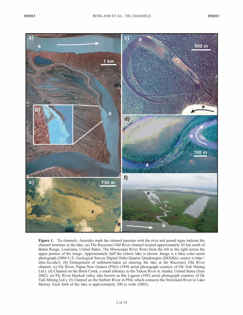
Figure 1. Tie channels. Asterisks mark the channel junction with the river and pound signs indicate thechannel terminus in the lake. (a) The Raccourci Old River channel located approximately 65 km north ofBaton Rouge, Louisiana, United States. The Mississippi River flows from the left to the right across theupper portion of the image. Approximately half the oxbow lake is shown. Image is a false color aerialphotograph (2004 U.S. Geological Survey Digital Ortho Quarter Quadrangles (DOQQs); source is http://atlas.lsu.edu/). (b) Enlargement of sediment-laden jet entering the lake at the Raccourci Old Riverchannel. (c) Fly River, Papua New Guinea (PNG) (1998 aerial photograph courtesy of Ok Tedi MiningLtd.). (d) Channel on the Birch Creek, a small tributary to the Yukon River in Alaska, United States (June2002). (e) Fly River blocked valley lake known as Bai Lagoon (1992 aerial photograph courtesy of OkTedi Mining Ltd.). (f) Channel on the Herbert River in PNG which connects the Strickland River to LakeMurray. Each limb of the lake is approximately 200 m wide (2003).
F02013 ROWLAND ET AL.: TIE CHANNELS
2 of 19
F02013
et al., 2000]; and influencing the biological and chemicalcharacteristics of ORWB [Knowlton and Jones, 1997;Miranda, 2005].[4] Although of broad significance, we have found only a
few papers outside those by our research group which offersome description of these channels. Prior work on theMiddle Fly River documented the role tie channels playin the routing of water and dispersal of sediment across thefloodplain [e.g., Day et al., 2008, 2009]. Using OpticallyStimulated Luminescence (OSL) dating of sediment,Rowland et al. [2005] determined tie channel extensionand levee accretion rates on Fly River tie channels andcompared these rates to rates for tie channels both on theLower Mississippi River and a small river in Alaska (BirchCreek). The same Lower Mississippi River tie channel wasalso the focus of a more detailed sedimentological andmorphological study reported by Rowland and Dietrich[2006].[5] Here we compare the data initially reported by
Rowland and Dietrich [2006] for the Lower MississippiRiver with previously unreported data for both the MiddleFly River and the Birch Creek to address the following twoquestions: (1) is there a characteristic morphology of tiechannels and (2) what processes lead to their formation,persistence and growth? These three field studies encom-
pass tie channels which vary widely in size and settingproviding a broad perspective on this class of floodplainchannel. For each field site we quantified the channelmorphology, rates of channel development, and sedimentgrain size of deposits, and documented processes that appearto control channel evolution and form. Despite the widelyvarying sizes, bed material and hydrology, the tie channelswere found to have a similar cross-sectional morphology andto be a common scale relative to the mainstem sourcechannel. In all cases the channel morphology appears toresult from a dynamic balance between levee sedimentation,channel scour and mass failure of the banks. The similarity ofform and process leads us to propose a conceptual model oftie channel development. While important in their own right,we also suggest that our findings about tie channels haveapplication to single-thread deltaic channels in general.
2. Field Sites and Observations
2.1. Middle Fly River Setting and Data CollectionSummary
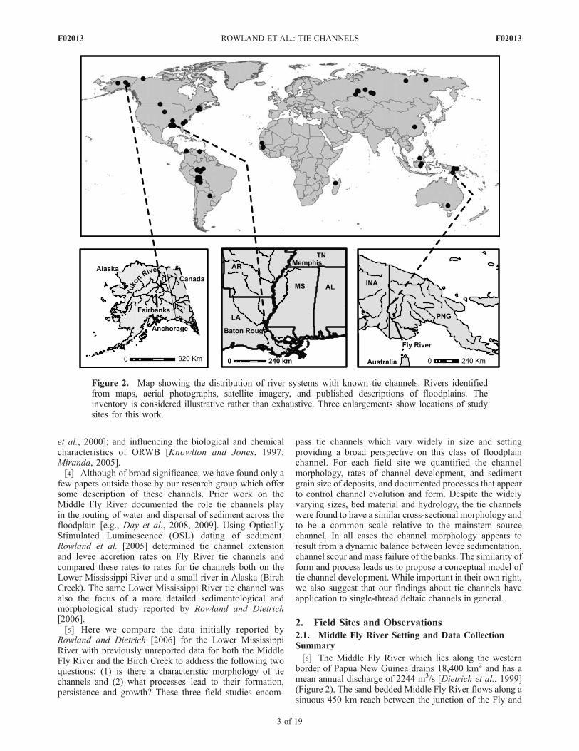
[6] The Middle Fly River which lies along the westernborder of Papua New Guinea drains 18,400 km2 and has amean annual discharge of 2244 m3/s [Dietrich et al., 1999](Figure 2). The sand-bedded Middle Fly River flows along asinuous 450 km reach between the junction of the Fly and
Figure 2. Map showing the distribution of river systems with known tie channels. Rivers identifiedfrom maps, aerial photographs, satellite imagery, and published descriptions of floodplains. Theinventory is considered illustrative rather than exhaustive. Three enlargements show locations of studysites for this work.
F02013 ROWLAND ET AL.: TIE CHANNELS
3 of 19
F02013

the Ok Tedi Rivers (D’Albertis Junction) and the confluenceof the Fly and the larger Strickland River (Everill Junction).We examined tie channels along the entire length of theMiddle Fly River. The lowland channel increases in drainagearea from 12,000 km2 to 18,400 km2 as its slope decreasesdownstream from 6.6 � 10�5 to 2 � 10�5 and its bedmaterial decreases in size from 0.3 mm to about 0.1 mm[Dietrich et al., 1999]. The Middle Fly lies in a wet, tropicalclimatic zone strongly influenced by ENSO cycle climaticevents. Annual precipitation exceeds 10 m in the head-waters and drops to 2 m on the lower portion of the MiddleFly, with drought conditions commonly occurring during ElNino events [Dietrich et al., 1999]. The Fly River is notdammed and its floodplain is unmodified by agriculture orflood control measures, but mining (and to a much lesserdegree, logging) have greatly increased the sediment load inthe Fly River system. Beginning in 1985 the Ok Tedi mine,located on the tributary of that name, began riverine disposalof tailings. Prior to the mine, the suspended sedimentconcentration of the Middle Fly averaged 100 mg/L andthe average annual sediment discharge was about 5� 106 t/a[Dietrich et al., 1999]. Postmine suspended sedimentconcentrations in the 1990s ranged on the order of 400 to500 mg/L while the total sediment load to the Middle FlyRiver increased by about four to five times [Day et al.,2008]. Prior to the onset of mining activities, 60% of theORWB along the Middle Fly River were connected to theriver via tie channels [Day et al., 2008]. Since mining andby 2005, at least one major tie channel in the lower reachesof the Middle Fly River as become plugged with sediment[Day et al., 2009], the state of other tie channels since 2005is not presently known to the authors.[7] An extensive field program conducted along the
Middle Fly River from 1990 to 1998 [e.g., Day et al.,2008] included a detailed study of tie channel morphologyand hydrology. Over the course of the program researcherssurveyed up to 17 cross-section locations along 8 tie chan-nels and recorded long profiles of 6 channels using acombination of differential global positioning system(DPGS) and stadia rod and hand level surveys. The 1990to 1998 research program established a network of water-level recorders tied to a common datum across the riversystem and along tie channels. Using water-surface slopesderived from the water-level recorders and cross-sectionalsurveys, Day et al. [2008] calculated velocities and estimat-ed discharges along several tie channels. On the basis of theaccumulation of mine-derived copper in sediments, Day etal. [2008] determined deposition rates across the Middle Flyfloodplain and in oxbow lakes, and concluded that up to40% of the total load of the river is deposited on thefloodplain, with one-half of that occurring as overbankdeposits adjacent to tie and tributary channels. Our addi-tional surveys conducted in 2003 included measurements oftie channels widths and lengths with a hand-held GPS andlaser range finder, and collection of sediment samples forgrain size and OSL analysis. We used a Coulter LS130Laser Diffraction Analyzer with a size range sensitivity of0.4 to 900 microns to determine grain-size distributions.Rowland et al. [2005] provide a detailed description of theOSL sampling and analysis methods.[8] Along the Middle Fly River, tie channels link the
mainstem to both oxbow lakes (47) and blocked valley
lakes (29). Oxbow lakes with tie channels appear to bepredominantly formed by neck rather chute cutoff process-es. On the Fly River, blocked valley lakes formed whentributaries became dammed in response to sea level riseinduced aggradation of the mainstem [Blake and Ollier,1971; Dietrich et al., 1999] (Figure 1f) and are similar tofloodplain lakes described by Vernon [1942], Baker [1978],and Kuenzi et al. [1979]. These blocked valley lakes tend tohave larger surface areas but shallower depths than oxbowlakes (3–5 m versus 10 m) and can dry out during periodsof drought. We differentiate Fly River oxbow lakes into twotypes: open and closed. In closed lakes, tie channels providethe only inlet or outlet for channelized flow to the lake.Open lakes have additional channels that allow for theexchange of water with the floodplain, other ORWBs and/or the river.
2.2. Middle Fly River Observations
[9] Sequential aerial photographs, satellite imagery, anddirect field observations of two oxbow lake cutoffs on theFly River (one of which is depicted in Figure 3) indicatethat tie channels form contemporaneously with meandercutoff and lake formation. Rather than eroding into fullyestablished plugs, tie channels appear to develop as flowinto and out of the lakes prevents plug sedimentation alongone of the oxbow margins. As sedimentation progressivelyseals off the oxbow limb an increasing percentage of waterexchanged between river and lake is routed through thechannel until it is the only conduit for flow into and out ofthe lake below flood stage. The channels may form in eitherthe up- or downstream meander limb or occasionally inboth. In other, less common instances, a channel maydevelop when the mainstem river migrates back into theexisting oxbow lake creating a direct connection betweenthe river and the open waters of the lake (Figure 1d).Caldwell and Fitzgerald [1995] found that flow-reversingoutlet delta channels in the New England region of the USAwere consistently connected to the outside of river bendsand oriented in the downstream direction (forming an acuteangle with the mainstem bank). On the Middle Fly River,this configuration is the most common but not universal.The connection angle of the channels may influence thediversion of sediment from the mainstem into the channels.The acute angle likely restricts the divergence of bed loadmaterial into the channel, as the coarse sediment wouldhave to reverse transport direction and head in an upstreamdirection to enter the mouth of the channel. On the MiddleFly River, the first tie channel to plug with sedimentfollowing increased sediment load due to mine tailingdischarge was one that connected in line with the river,pointed in a downstream direction.[10] Rainfall events commonly occur over only a fraction
of the Fly River basin leading to asynchronous river andfloodplain hydrological responses to storm events. Frequentstorm events in the headwaters result in flood pulses thatmove down the system and pump water out through thenetwork of channels onto the floodplain and into lakes. Rainon the seasonally dry mud-rich floodplain ponds, leads toflooding and outflow to the mainstem. Day et al. [2008]noted that even during a flooded state, however, rain on theplain can induce a pressure rise that drives water off thefloodplain back to the mainstem via the tie channels. During
F02013 ROWLAND ET AL.: TIE CHANNELS
4 of 19
F02013
falling river stage water drains to the mainstem through tiechannels, at times with considerable velocities [Day et al.,2008]. Through the system of water-level recorders Day etal. [2008] documented water-surface slopes along tie chan-nels up to 8.6 � 10�4 and 6 � 10�4 during flow from thelakes to the river (outflow) and from river into lakes(inflow), respectively. Both slopes are greater than themainstem slope by a factor of ten and correspond toestimated velocities up to 1.7 m/s, well in excess ofmainstem average bankfull velocities of 1 m/s [Dietrich etal., 1999].[11] Figures 1c, 1e, and 1f present typical views of tie
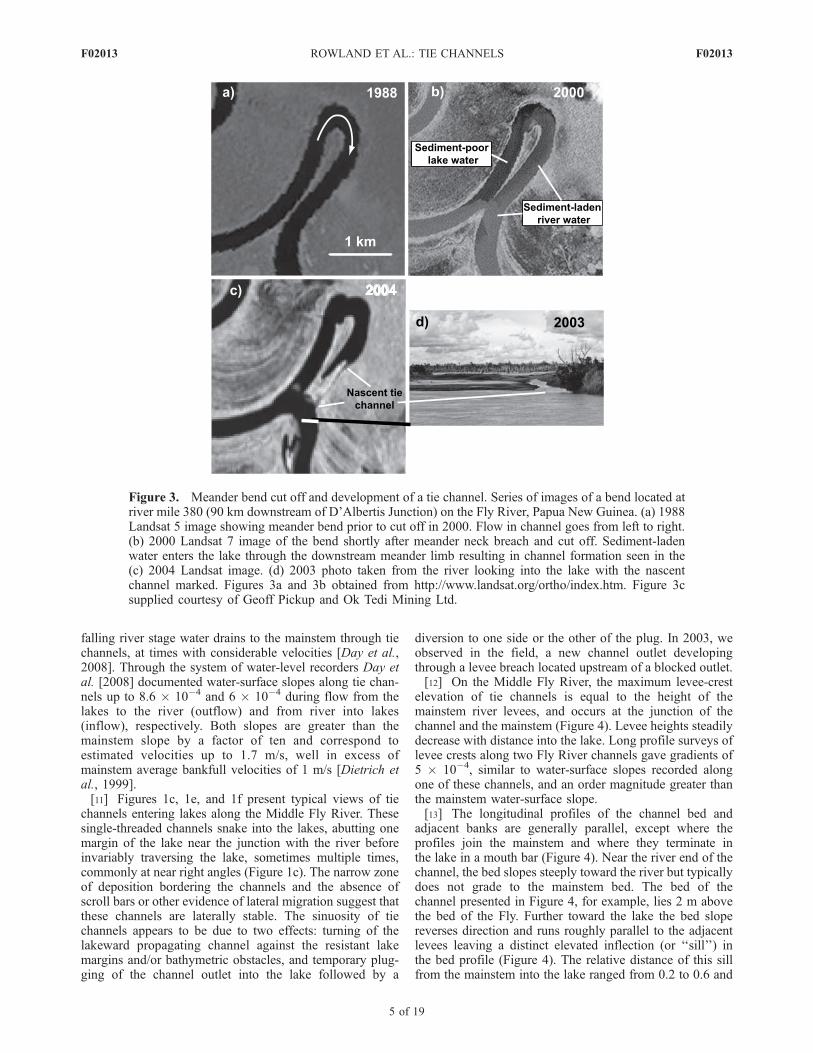
channels entering lakes along the Middle Fly River. Thesesingle-threaded channels snake into the lakes, abutting onemargin of the lake near the junction with the river beforeinvariably traversing the lake, sometimes multiple times,commonly at near right angles (Figure 1c). The narrow zoneof deposition bordering the channels and the absence ofscroll bars or other evidence of lateral migration suggest thatthese channels are laterally stable. The sinuosity of tiechannels appears to be due to two effects: turning of thelakeward propagating channel against the resistant lakemargins and/or bathymetric obstacles, and temporary plug-ging of the channel outlet into the lake followed by a
diversion to one side or the other of the plug. In 2003, weobserved in the field, a new channel outlet developingthrough a levee breach located upstream of a blocked outlet.[12] On the Middle Fly River, the maximum levee-crest
elevation of tie channels is equal to the height of themainstem river levees, and occurs at the junction of thechannel and the mainstem (Figure 4). Levee heights steadilydecrease with distance into the lake. Long profile surveys oflevee crests along two Fly River channels gave gradients of5 � 10�4, similar to water-surface slopes recorded alongone of these channels, and an order magnitude greater thanthe mainstem water-surface slope.[13] The longitudinal profiles of the channel bed and
adjacent banks are generally parallel, except where theprofiles join the mainstem and where they terminate inthe lake in a mouth bar (Figure 4). Near the river end of thechannel, the bed slopes steeply toward the river but typicallydoes not grade to the mainstem bed. The bed of thechannel presented in Figure 4, for example, lies 2 m abovethe bed of the Fly. Further toward the lake the bed slopereverses direction and runs roughly parallel to the adjacentlevees leaving a distinct elevated inflection (or ‘‘sill’’) inthe bed profile (Figure 4). The relative distance of this sillfrom the mainstem into the lake ranged from 0.2 to 0.6 and
Figure 3. Meander bend cut off and development of a tie channel. Series of images of a bend located atriver mile 380 (90 km downstream of D’Albertis Junction) on the Fly River, Papua New Guinea. (a) 1988Landsat 5 image showing meander bend prior to cut off in 2000. Flow in channel goes from left to right.(b) 2000 Landsat 7 image of the bend shortly after meander neck breach and cut off. Sediment-ladenwater enters the lake through the downstream meander limb resulting in channel formation seen in the(c) 2004 Landsat image. (d) 2003 photo taken from the river looking into the lake with the nascentchannel marked. Figures 3a and 3b obtained from http://www.landsat.org/ortho/index.htm. Figure 3csupplied courtesy of Geoff Pickup and Ok Tedi Mining Ltd.
F02013 ROWLAND ET AL.: TIE CHANNELS
5 of 19
F02013
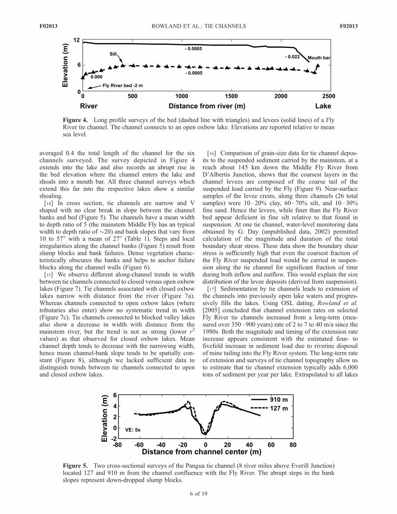
averaged 0.4 the total length of the channel for the sixchannels surveyed. The survey depicted in Figure 4extends into the lake and also records an abrupt rise inthe bed elevation where the channel enters the lake andshoals into a mouth bar. All three channel surveys whichextend this far into the respective lakes show a similarshoaling.[14] In cross section, tie channels are narrow and V
shaped with no clear break in slope between the channelbanks and bed (Figure 5). The channels have a mean widthto depth ratio of 5 (the mainstem Middle Fly has an typicalwidth to depth ratio of �20) and bank slopes that vary from10 to 57� with a mean of 27� (Table 1). Steps and localirregularities along the channel banks (Figure 5) result fromslump blocks and bank failures. Dense vegetation charac-teristically obscures the banks and helps to anchor failureblocks along the channel walls (Figure 6).[15] We observe different along-channel trends in width
between tie channels connected to closed versus open oxbowlakes (Figure 7). Tie channels associated with closed oxbowlakes narrow with distance from the river (Figure 7a).Whereas channels connected to open oxbow lakes (wheretributaries also enter) show no systematic trend in width(Figure 7c). Tie channels connected to blocked valley lakesalso show a decrease in width with distance from themainstem river, but the trend is not as strong (lower r2
values) as that observed for closed oxbow lakes. Meanchannel depth tends to decrease with the narrowing width,hence mean channel-bank slope tends to be spatially con-stant (Figure 8), although we lacked sufficient data todistinguish trends between tie channels connected to openand closed oxbow lakes.
[16] Comparison of grain-size data for tie channel depos-its to the suspended sediment carried by the mainstem, at areach about 145 km down the Middle Fly River fromD’Albertis Junction, shows that the coarsest layers in thechannel levees are composed of the coarse tail of thesuspended load carried by the Fly (Figure 9). Near-surfacesamples of the levee crests, along three channels (26 totalsamples) were 10–20% clay, 60–70% silt, and 10–30%fine sand. Hence the levees, while finer than the Fly Riverbed appear deficient in fine silt relative to that found insuspension. At one tie channel, water-level monitoring dataobtained by G. Day (unpublished data, 2002) permittedcalculation of the magnitude and duration of the totalboundary shear stress. These data show the boundary shearstress is sufficiently high that even the coarsest fraction ofthe Fly River suspended load would be carried in suspen-sion along the tie channel for significant fraction of timeduring both inflow and outflow. This would explain the sizedistribution of the levee deposits (derived from suspension).[17] Sedimentation by tie channels leads to extension of
the channels into previously open lake waters and progres-sively fills the lakes. Using OSL dating, Rowland et al.[2005] concluded that channel extension rates on selectedFly River tie channels increased from a long-term (mea-sured over 350–900 years) rate of 2 to 7 to 40 m/a since the1980s. Both the magnitude and timing of the extension rateincrease appears consistent with the estimated four- tofivefold increase in sediment load due to riverine disposalof mine tailing into the Fly River system. The long-term rateof extension and surveys of tie channel topography allow usto estimate that tie channel extension typically adds 6,000tons of sediment per year per lake. Extrapolated to all lakes
Figure 4. Long profile surveys of the bed (dashed line with triangles) and levees (solid lines) of a FlyRiver tie channel. The channel connects to an open oxbow lake. Elevations are reported relative to meansea level.
Figure 5. Two cross-sectional surveys of the Pangua tie channel (8 river miles above Everill Junction)located 127 and 910 m from the channel confluence with the Fly River. The abrupt steps in the bankslopes represent down-dropped slump blocks.
F02013 ROWLAND ET AL.: TIE CHANNELS
6 of 19
F02013

connected by tie channels, this rate is equivalent to a netlake deposition of 2% of the premine suspended sedimentload of the Fly. Day et al. [2008] estimate that the 900 km offloodplain channels (tie and tributary channels) disperseabout 20% of the postmine river suspended sediment loadinto all Middle Fly floodplain settings.
2.3. Lower Mississippi River Setting and DataCollection Summary
[18] Draining over 3.2 million km2 of North America, theLower Mississippi River has a mean annual discharge of18,400 m3/s [Mossa, 1996]. In 2002 and 2005, field inves-tigations were conducted on a single tie channel connectingthe Raccourci Old River (ROR) oxbow (30� 54.70N, 91�36.620W) to the Mississippi River (Figure 1a). The RORoxbow lake lies approximately 65 km upstream of BatonRouge, Louisiana just below Red River landing and 27 kmdownstream of the Old River Control Structure. The OldRiver Control Structure currently diverts approximately30% of the Mississippi River flow into the Atchafalayasystem. The water-surface slope of the Mississippi Riverjust upstream of the ROR site, at Natchez, Mississippi, is5.2 � 10�5 [Biedenharn et al., 2000].[19] In the vicinity of the ROR, the bed of the Lower
Mississippi River is dominated by fine sand and suspendedsediment concentrations average 420 mg/L (measured be-
tween 1950 and 1991) [Mossa, 1996]. Approximately halfof the suspended load (45%) is clay (<4 mm) sized [CatalystOld River Hydroelectric Limited Partnership, 1999]. Sincethe 1850s the concentration of suspended sediment carriedby the Lower Mississippi River has decrease between 50%[Horowitz et al., 2001] and 70% [Kesel et al., 1992]. Overthe 20th century, the timing of suspended sedimentdecreases corresponded to soil conservation measuresacross the Mississippi River watershed in the 1930s, anddam construction on major tributaries, bank stabilization,and diversion of flow at the Old River Control Structuresince the 1950s [Keown et al., 1986; Kesel et al., 1992;Mossa, 1996]. Our review of maps and aerial photographsof the Lower Mississippi River from Baton Rouge, Louisi-ana to Memphis, Tennessee found that 24 lakes (65% oftotal) at one time connected to the Mississippi River viatie channels. Today only half the lakes remain connectedto the river and dredging, agriculture and/or flood controlmeasures impact most of the connecting channels.[20] Unlike much of the Lower Mississippi River, the
ROR oxbow lake is not isolated from the river by floodcontrol levees. The lake formed by 1851 following an 1848man-made cutoff aimed at shortening the river for naviga-tion [Gagliano and Howard, 1984]. Since cutoff, theoriginal flood control levees (along the margins of pre-1848 river course) have been maintained and the lake and
Table 1. Mean Morphological Propertiesa
River System W/D ± SD Bank Slope ± SD (degrees) Levee Slope ± SDb Sill Locationc
Fly River 5.3 ± 1.6 (16) 27 ± 8 (60) 5 � 10�4 0.4 ± 0.2 (6)ROR 5.8 ± 1.8 (5) 25 ± 8 (10) 5 � 10�4 0.8Birch Creek 8.7 ± 8.8 (11)d 23 ± 11 (4) 5 � 10�3 0.2aHere W/D is the width to depth ratio and SD is the standard deviation. The numbers in parentheses are the number of
measurements.bSlope of the levee crest along majority of tie channel length.cSill distance from river/total tie channel length.dIncludes measurements on newly forming tie channel and measurements at the distal most end of the well developed tie
channel.
Figure 6. Photograph of a Fly River channel highlighting the role of vegetation in this system. Thelevee crests lie several meters beyond the edge of the vegetation on either side. The total channel width atthis location is approximately 15 m.
F02013 ROWLAND ET AL.: TIE CHANNELS
7 of 19
F02013

Figure 7. Plots of normalized channel width (W*) versus normalized channel length (D*) plotted bylake type. Width is normalized by the average local river width and the channel length is normalized bythe total surveyed length of channel. (a) Closed oxbow lakes (21 measurements from 4 channels). Bestfit linear regression is W* = 0.1 � 0.062D*, r2 = 0.88, and slope p < 0.001. (b) Blocked Valley lakes(10 measurements from 4 channels). Best fit linear regression is W* = 0.141 � 0.060D*, r2 = 0.45,and slope p = 0.03. (c) Open oxbow lakes (32 measurements from 4 channels). Best fit linearregression is W* = 0.104 � 0.009D*, r2 = 0.018, and slope p < 0.4.
Figure 8. (a) Channel-bank slopes and (b) depth measured at 16 cross sections along 9 Fly River tiechannels. Bank slopes increase with distance from the river (slope = 6.32x + 24.6, r2 = 0.14) and depthsdecrease (depth = �2.25x + 6.5, r2 = 0.36).
F02013 ROWLAND ET AL.: TIE CHANNELS
8 of 19
F02013

its associated floodplain still receive periodic floodwaters.On the tie channel itself, the only apparent human alterationof the channel is a low-head dam installed in 1965 tofacilitate boating and recreation during summer months bymaintaining minimum lake levels. The impact of the dam onchannel morphology appears limited, though it may haveinfluenced the rate at which the channel advances lakeward[Rowland and Dietrich, 2006]. In Alaska, beaver damsacross tie channels commonly control lake levels in asimilar manner [Brown and Fleener, 2001].[21] Our field studies at the ROR channel in 2002
included five cross-sectional surveys using a stadia rod,level, tape and laser range finder and collection of sedimentcores for OSL dating. In 2005, we returned to the site andsurveyed the bathymetry of the channel outlet into the lakeusing a hand-held GPS and depth finder and collected bedsamples of the channel and lake using a Ponar-type grabsampler. The cores and grab samples were analyzed forgrain-size distribution. OSL dating provided depositionrates and an independent check on channel extension ratesdetermined from hydrographic surveys and aerial photo-graphs [Rowland et al., 2005].[22] Though the field data on the ROR are more limited
than for the Middle Fly River, extensive data resources existfor the Lower Mississippi River that document the evolutionof the channel, and the hydrology and sediment load of theriver. Topographic documentation of the ROR channelbegan in 1883 and since then regular hydrographic surveysconducted by the Mississippi River Commission and the
United States Army Corps of Engineers (USACE) haverecorded its development. Aerial photographic records ofthe site date to the 1940s, and satellite imagery supplementsthis data set over the last two decades. In 2003, theLouisiana Federal Emergency Management Agency(FEMA) Project collected high-resolution topographic dataof the site using airborne laser swath mapping (ALSM) alsocommonly referred to as LIDAR [Watershed Concepts,2005]. ALSM mapping provides detailed data on leveemorphology and along-channel trends in levee height andchannel widths. Stage records of the Mississippi River,obtained 8 km upstream of the ROR at the Red RiverLanding gage, date to 1851. Extensive sediment transportdata for the river have been collected at the Tarbert Landingstation located 14 km upstream.[23] Prior research on the Lower Mississippi River also
provide limited documentation on tie channels, locallyknown as ‘‘batture channels.’’ Russell [1939] and Fisk[1947] both note the occurrence of prograding deltas inoxbow lakes but make no observations regarding theirorigin or role in lake processes. Gagliano and Howard[1984] provided data regarding the occurrence, rate ofdevelopment and some morphological characteristics ofthese channels and introduced a four-stage conceptualmodel for oxbow lake evolution that included a phase inwhich batture channels play a role in lake sedimentation. Inhis exhaustive look of Lower Mississippi River, Saucier[1994] also noted the role of batture channels in introducingsilts and clays into oxbows. Finally, Shepherd [2001] andGuccione et al. [2002] provide limited stratigraphic datafrom cores penetrating filled batture channels at ReelfootLake, Tennessee, USA.
2.4. Lower Mississippi River Observations
[24] With a maximum width of 100 m and length of 9 km,the ROR is approximately four times larger than the typicalFly River tie channel, but shows distinct similarities inmorphology, sedimentology and evolution. In planform(Figure 1a), the ROR channel is a single thread, sinuous,narrow (relative to its depth) channel with pronouncedlevees. Historical hydrographic surveys and aerial photo-graphs record the channel extension into the lake andindicate that bends in the channel course remain fixed overtime with no measurable lateral movement of the channelcenterline [Rowland and Dietrich, 2006]. If we assume thatthe processes governing channel development haveremained largely unchanged since channel formation, theprograding development of the channel and its lateralstability allow us to view changes in channel morphology
Figure 9. Grain-size distributions from the levees of a tiechannel and the suspended and bed material loads of theMiddle Fly River at a location �145 km downstream ofD’Albertis Junction. Levee distribution is the average of11 individual samples collected at 250 m intervals along thechannel, the river suspended sediment is the flow-weightedaverage at a cross section (G. Day, unpublished data, 2002),and the bed sample is a single grab sample from the middleof the river.
Figure 10. Long profile surveys of the bed (dashed line with triangles) and levees (dashed and solidlines) of the ROR tie channel. Elevations are reported relative to mean sea level.
F02013 ROWLAND ET AL.: TIE CHANNELS
9 of 19
F02013
along the channel in a temporal context. We can substitutespace for time and assume that the youngest portion of thechannel near the outlet into the lake represents the earlystages of channel development and the oldest sections nearthe river represent the most evolved morphologies.[25] The long profile, cross-section surveys and along-
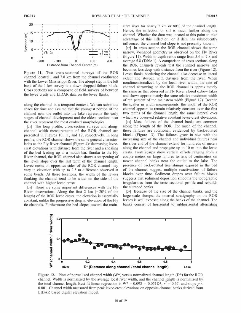
channel width measurements of the ROR channel arepresented in Figures 10, 11, and 12, respectively. In longprofile, the ROR channel shows the same general character-istics as the Fly River channel (Figure 4): decreasing levee-crest elevations with distance from the river and a shoalingof the bed leading up to a mouth bar. Similar to the FlyRiver channel, the ROR channel also shows a steepening ofthe levee slope over the last tenth of the channel length.Levee crests on opposites sides of the ROR channel mayvary in elevation with up to 2.5 m difference observed atsome bends. At these locations, the width of the leveesflanking the channel tend to be wider on the side of thechannel with higher levee crests.[26] There are some important differences with the Fly
River observations. Along the first 2 km (�20% of thelength) of the ROR levee crests, the elevation is essentiallyconstant, unlike the progressive drop in elevation of the Flytie channels. Furthermore the bed slopes toward the main-
stem river for nearly 7 km or 80% of the channel length.Hence, the inflection or sill is much further along thechannel. Whether the dam was located at this point to takeadvantage of this inflection, or if dam has subsequentlyinfluenced the channel bed slope is not presently known.[27] In cross section the ROR channel shows the same
narrow, V-shaped geometry as observed on the Fly River(Figure 11). Width to depth ratios range from 3.6 to 7.8 andaverage 5.8 (Table 1). A comparison of cross sections alongthe ROR channels reveals that the channel narrows andbecomes less deep with distance from the river (Figure 12).Levee flanks bordering the channel also decrease in lateralextent and steepen with distance from the river. Whennondimensionalized by the local river width, the rate ofchannel narrowing on the ROR channel is approximatelythe same as that observed in Fly River closed oxbow lakesand shows approximately the same relative maximum widthof ten percent of the mainstem width (Figure 12). Despitethe scatter in width measurements, the width of the RORchannel appears to remain relatively constant over the firsttwo tenths of the channel length, the same interval overwhich we observed relative constant levee-crest elevations.[28] Mass failures of the channel banks are common
along the length of the ROR. For much of the channel,these failures are rotational, evidenced by back-rotatedblocks (Figure 13). The failures grow in size with theincreasing size of the channel and individual failures nearthe river end of the channel extend for hundreds of metersalong the channel and propagate up to 10 m into the leveecrests. Fresh scarps show vertical offsets ranging from acouple meters on large failures to tens of centimeters onnewer channel banks near the outlet to the lake. Thepresence of back-rotated tree stumps exposed in the bedof the channel suggest multiple reactivations of failureblocks over time. Sediment drapes over failure blockssuggests that sediment deposition smooths the topographicirregularities from the cross-sectional profile and rebuildsthe slumped banks.[29] Because of the size of the channel banks, and the
large-scale slumps, the internal stratigraphy on the RORlevees is well exposed along the banks of the channel. Thebanks consist of horizontal to subhorizontal alternating
Figure 11. Two cross-sectional surveys of the RORchannel located 1 and 7.8 km from the channel confluencewith the Lower Mississippi River. The abrupt step in the leftbank of the 1 km survey is a down-dropped failure block.Cross sections are a composite of field surveys of betweenthe levee crests and LIDAR data on the levee flanks.
Figure 12. Plots of normalized channel width (W*) versus normalized channel length (D*) for the RORchannel. Width is normalized by the average local river width, and the channel length is normalized bythe total channel length. Best fit linear regression is W* = 0.093 � 0.051D*, r2 = 0.67, and slope p <0.001. Channel width measured from peak levee-crest elevations on opposite channel banks derived fromLIDAR based digital elevation model.
F02013 ROWLAND ET AL.: TIE CHANNELS
10 of 19
F02013
layers of fine to medium sand and layers of mud withorganic debris. The layers are massive in character andrange in thickness from a few centimeters up to tens ofcentimeters. No primary sedimentary structures such asripple marks and cross bedding were observed althoughfaint planar laminations are visible. The size distribution ofthe sandy (coarse) layers is similar to that reported for theLower Mississippi River suspended load but is much finerthan the river bed material (Figure 14). The muddy banklayers are about 60% silt and equal parts of fine sand andclay (D50 of 18 mm). The mouth bar deposits consist ofwell-sorted sand with a D50 of 300 mm and a size distribu-tion similar to that of the river-bed surface. Lakeward of themouth bar, prodelta sediments consist of clayey silt whichdecrease logarithmically in size for 1 km, after which pointthe surface layer remains relatively uniform in grain size(D50 = 10 mm, 24% clay, 72% silt) [Rowland and Dietrich,2006]. Sediment collected from the ROR channel 1700 mupstream of the mouth bar has a grain-size distributionsimilar to lake bed sediments [Rowland and Dietrich, 2006].In the channel bed, however, these clayey silts haveundergone sufficient consolidation to render them nearlyimpenetrable to grab sampler collection. The similarity ingrain size and elevation of the channel bed relative to themouth bar/prodelta crest elevation (Figure 10) suggest thatthe ROR tie channel has incised into its own prodeltadeposits as it has prograded into the lake.[30] Rowland et al. [2005] used OSL dating, historical
hydrographic surveys aerial photographs to study changesin the rate that the ROR channel has advanced into theoxbow lake since its formation in 1851. From the 1850sto the 1930s the channel advanced at 84 m/a, decreased to53 m/a from the 1930s to the 1950s, and slowed to 18 m/asince the 1980s. Rowland and Dietrich [2006] explored thepossible influence of changes in Mississippi River sedimentload, loss of flow volume due to lake infilling, changes inriver hydrology and construction of the low-head dam onthe rates of the ROR extension. They concluded thatchanges in river sediment load was the dominant cause
for extension rate changes. As with the Fly River tiechannels, both the timing and magnitude of the extensionrate changes corresponds well to changes in the sedimentload of the river.[31] Using historical hydrographic surveys and digital
elevation models, Rowland and Dietrich [2006] estimatedthe total volume of sediment introduced to the ROR oxbowby the tie channel, and calculated a sedimentation rate of4.5 � 105 t/a. By extrapolating this rate to other LowerMississippi River oxbow lakes with evidence of tie channels(prior to large-scale floodplain modifications) Rowland andDietrich [2006] estimate as much as 11 million t/a or 4% ofthe total pre-1963 load [Keown et al., 1986] of the river mayhave been deposited into floodplain lakes by these channels.
2.5. Birch Creek Setting and Data Collection
[32] The Birch Creek, a tributary to the Yukon River andthe smallest of the three river systems studied here, lies in
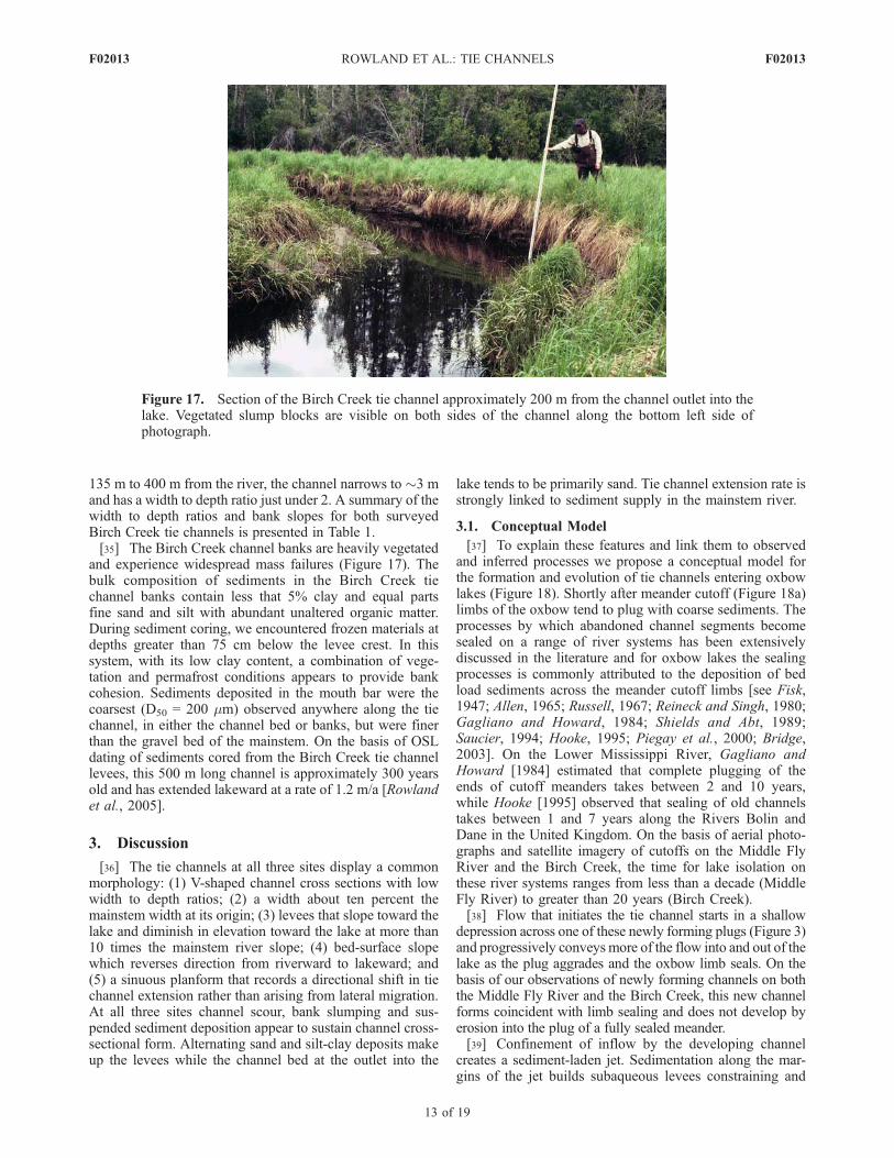
Figure 14. Grain-size distribution for the ROR channellevees (coarse layers) and mouth bar compared to distribu-tions of the Lower Mississippi River suspended and bedload fractions. Levee distribution represents the average of10 individual samples and the mouth bar 2 samples.Mississippi distributions measured at Tarbert Landingaveraged from data collected between 1974 and 1991 atriver stages >9 m [Catalyst Old River Hydroelectric LimitedPartnership, 1999]. Size distributions of the river suspendedload undetermined for particle sizes <3.9 mm.
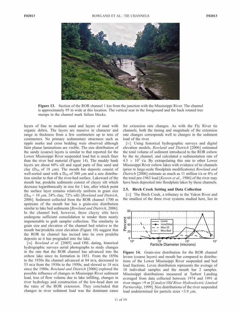
Figure 13. Section of the ROR channel 1 km from the junction with the Mississippi River. The channelis approximately 95 m wide at this location. The vertical scar in the foreground and the back rotated treestumps in the channel mark failure blocks.
F02013 ROWLAND ET AL.: TIE CHANNELS
11 of 19
F02013

the subpolar continental climatic zone near the Arctic Circle[Kostohrys and Sterin, 1996]. In the summer of 2002, weinvestigated tie channels along a 30 km lowland section ofthe Birch Creek marked by discontinuous permafrostlocated approximately 10 km northeast of Circle, Alaska(65� 53.780N, 144� 18.070W; Figure 1d). A drainage areaof 6,500 km2 supplies a mean annual discharge of 28 m3/sto this section of the Birch Creek [Kostohrys and Sterin,1996]. Because of strong seasonality, maximum dischargesof up to 550 m3/s occur during spring and summer rainevents, while periods of no flow occur during winter iceover. Characterized by high sinuosity (river length/valleylength: 2.6) and a low gradient (2.6 � 10�4), this sectionof the Birch Creek appears to lie in the gravel-sandtransition with mixed sand/gravel bed and point bars.Aside from placer mining operations in the upper reachesof the Birch Creek, no human modifications (dams,diversions, flood control or channel engineering) impactthe river system. The placer mining contributes to elevatedwater turbidity with mean total suspended solids (TSS) of151 mg/L [Vohden, 1999].[33] Data collection involved surveying channel long
profiles and cross-sectional morphology using a stadiarod, meter tapes and levels, at two lakes. The lakes includeda newly forming channel in a meander cutoff which
occurred prior to 1980 and a well-developed progradingchannel in an oxbow lake. At these sites, we also collected aseries of sediment samples for grain-size analysis, and at thewell developed channel we sampled for OSL dating.
2.6. Birch Creek Observations
[34] Figures 15 and 16 present the long profile and cross-sectional surveys for the well-developed Birch Creek ox-bow channel. This channel appears to have formed when theBirch Creek migrated into an existing oxbow lake (Figure1d). Similar to the ROR tie channel, the Birch Creekchannel-levee crests have a relatively constant height forapproximately 100 m (20% of the total length) then de-crease in elevation with distance from the creek. Thechannel bed slopes toward the river for the first 100 m thendrops in elevation at about the same rate as the levee crestsuntil it rises and merges with the levees at the mouth bar. At135 m from the river, the channel is narrow with steepbanks (28�) and a width to depth ratio of 3.5 (Figure 16). Asthe channel enters the lake (cross sections at 450 and 495 mfrom the river) levees become less pronounced and the widthto depth ratio increases as the bed shoals into the mouthbar. Along the well developed sections of the channel, themaximum width of 10 m is approximately ten percent ofthe average local width of the Birch Creek. At distances
Figure 16. Three cross-sectional surveys from the 500 m long Birch Creek channel shown in Figures 1dand 15. The surveys are located 135, 450, and 495 m from the channel confluence with the creek.Elevations are relative to lake elevation at the time of the survey.
Figure 15. Long profile surveys of the bed (dashed line with triangles) and levees (solid line) of theBirch Creek tie channel. Elevations are reported relative to an arbitrary datum.
F02013 ROWLAND ET AL.: TIE CHANNELS
12 of 19
F02013
135 m to 400 m from the river, the channel narrows to �3 mand has a width to depth ratio just under 2. A summary of thewidth to depth ratios and bank slopes for both surveyedBirch Creek tie channels is presented in Table 1.[35] The Birch Creek channel banks are heavily vegetated
and experience widespread mass failures (Figure 17). Thebulk composition of sediments in the Birch Creek tiechannel banks contain less that 5% clay and equal partsfine sand and silt with abundant unaltered organic matter.During sediment coring, we encountered frozen materials atdepths greater than 75 cm below the levee crest. In thissystem, with its low clay content, a combination of vege-tation and permafrost conditions appears to provide bankcohesion. Sediments deposited in the mouth bar were thecoarsest (D50 = 200 mm) observed anywhere along the tiechannel, in either the channel bed or banks, but were finerthan the gravel bed of the mainstem. On the basis of OSLdating of sediments cored from the Birch Creek tie channellevees, this 500 m long channel is approximately 300 yearsold and has extended lakeward at a rate of 1.2 m/a [Rowlandet al., 2005].
3. Discussion
[36] The tie channels at all three sites display a commonmorphology: (1) V-shaped channel cross sections with lowwidth to depth ratios; (2) a width about ten percent themainstem width at its origin; (3) levees that slope toward thelake and diminish in elevation toward the lake at more than10 times the mainstem river slope; (4) bed-surface slopewhich reverses direction from riverward to lakeward; and(5) a sinuous planform that records a directional shift in tiechannel extension rather than arising from lateral migration.At all three sites channel scour, bank slumping and sus-pended sediment deposition appear to sustain channel cross-sectional form. Alternating sand and silt-clay deposits makeup the levees while the channel bed at the outlet into the
lake tends to be primarily sand. Tie channel extension rate isstrongly linked to sediment supply in the mainstem river.
3.1. Conceptual Model
[37] To explain these features and link them to observedand inferred processes we propose a conceptual model forthe formation and evolution of tie channels entering oxbowlakes (Figure 18). Shortly after meander cutoff (Figure 18a)limbs of the oxbow tend to plug with coarse sediments. Theprocesses by which abandoned channel segments becomesealed on a range of river systems has been extensivelydiscussed in the literature and for oxbow lakes the sealingprocesses is commonly attributed to the deposition of bedload sediments across the meander cutoff limbs [see Fisk,1947; Allen, 1965; Russell, 1967; Reineck and Singh, 1980;Gagliano and Howard, 1984; Shields and Abt, 1989;Saucier, 1994; Hooke, 1995; Piegay et al., 2000; Bridge,2003]. On the Lower Mississippi River, Gagliano andHoward [1984] estimated that complete plugging of theends of cutoff meanders takes between 2 and 10 years,while Hooke [1995] observed that sealing of old channelstakes between 1 and 7 years along the Rivers Bolin andDane in the United Kingdom. On the basis of aerial photo-graphs and satellite imagery of cutoffs on the Middle FlyRiver and the Birch Creek, the time for lake isolation onthese river systems ranges from less than a decade (MiddleFly River) to greater than 20 years (Birch Creek).[38] Flow that initiates the tie channel starts in a shallow
depression across one of these newly forming plugs (Figure 3)and progressively conveys more of the flow into and out of thelake as the plug aggrades and the oxbow limb seals. On thebasis of our observations of newly forming channels on boththe Middle Fly River and the Birch Creek, this new channelforms coincident with limb sealing and does not develop byerosion into the plug of a fully sealed meander.[39] Confinement of inflow by the developing channel
creates a sediment-laden jet. Sedimentation along the mar-gins of the jet builds subaqueous levees constraining and
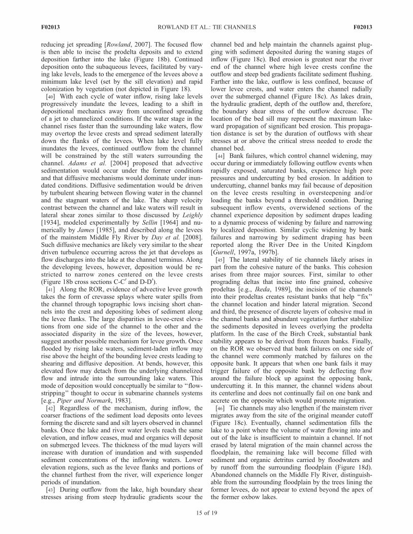
Figure 17. Section of the Birch Creek tie channel approximately 200 m from the channel outlet into thelake. Vegetated slump blocks are visible on both sides of the channel along the bottom left side ofphotograph.
F02013 ROWLAND ET AL.: TIE CHANNELS
13 of 19
F02013

Figure 18. Conceptual model of channel evolution in a closed oxbow lake. (a) Formation of the channeloccurs coincident with the sealing of the cutoff meander bend and creation of an oxbow lake.(b) Continued deposition at the river junction leads to the complete sealing of the oxbow lake from theriver (A-A0) and creation of a sediment-laden jet of water. At the terminus (D-D0) of the channel,subaqueous levees form where coarse sediment rapidly settles out of suspension along the margins of thejet and a small mouth bar forms along the channel centerline. (c) During outflow from the lake, sediment-poor water spills into the channel over inundated levees (C-C0). In the channel, outflow scours thechannel bed, removes sediment deposited during the waning stages of inflow, undercuts the banks, andtriggers bank failures. (d) Once the channel ceases to function, the lake slowly fills with mud and organicdetritus delivered by floods and runoff from the surrounding floodplain.
F02013 ROWLAND ET AL.: TIE CHANNELS
14 of 19
F02013
reducing jet spreading [Rowland, 2007]. The focused flowis then able to incise the prodelta deposits and to extenddeposition farther into the lake (Figure 18b). Continueddeposition onto the subaqueous levees, facilitated by vary-ing lake levels, leads to the emergence of the levees above aminimum lake level (set by the sill elevation) and rapidcolonization by vegetation (not depicted in Figure 18).[40] With each cycle of water inflow, rising lake levels
progressively inundate the levees, leading to a shift indepositional mechanics away from unconfined spreadingof a jet to channelized conditions. If the water stage in thechannel rises faster than the surrounding lake waters, flowmay overtop the levee crests and spread sediment laterallydown the flanks of the levees. When lake level fullyinundates the levees, continued outflow from the channelwill be constrained by the still waters surrounding thechannel. Adams et al. [2004] proposed that advectivesedimentation would occur under the former conditionsand that diffusive mechanisms would dominate under inun-dated conditions. Diffusive sedimentation would be drivenby turbulent shearing between flowing water in the channeland the stagnant waters of the lake. The sharp velocitycontrast between the channel and lake waters will result inlateral shear zones similar to those discussed by Leighly[1934], modeled experimentally by Sellin [1964] and nu-merically by James [1985], and described along the leveesof the mainstem Middle Fly River by Day et al. [2008].Such diffusive mechanics are likely very similar to the sheardriven turbulence occurring across the jet that develops asflow discharges into the lake at the channel terminus. Alongthe developing levees, however, deposition would be re-stricted to narrow zones centered on the levee crests(Figure 18b cross sections C-C0 and D-D0).[41] Along the ROR, evidence of advective levee growth
takes the form of crevasse splays where water spills fromthe channel through topographic lows incising short chan-nels into the crest and depositing lobes of sediment alongthe levee flanks. The large disparities in levee-crest eleva-tions from one side of the channel to the other and theassociated disparity in the size of the levees, however,suggest another possible mechanism for levee growth. Onceflooded by rising lake waters, sediment-laden inflow mayrise above the height of the bounding levee crests leading toshearing and diffusive deposition. At bends, however, thiselevated flow may detach from the underlying channelizedflow and intrude into the surrounding lake waters. Thismode of deposition would conceptually be similar to ‘‘flow-stripping’’ thought to occur in submarine channels systems[e.g., Piper and Normark, 1983].[42] Regardless of the mechanism, during inflow, the
coarser fractions of the sediment load deposits onto leveesforming the discrete sand and silt layers observed in channelbanks. Once the lake and river water levels reach the sameelevation, and inflow ceases, mud and organics will depositon submerged levees. The thickness of the mud layers willincrease with duration of inundation and with suspendedsediment concentrations of the inflowing waters. Lowerelevation regions, such as the levee flanks and portions ofthe channel furthest from the river, will experience longerperiods of inundation.[43] During outflow from the lake, high boundary shear
stresses arising from steep hydraulic gradients scour the
channel bed and help maintain the channels against plug-ging with sediment deposited during the waning stages ofinflow (Figure 18c). Bed erosion is greatest near the riverend of the channel where high levee crests confine theoutflow and steep bed gradients facilitate sediment flushing.Farther into the lake, outflow is less confined, because oflower levee crests, and water enters the channel radiallyover the submerged channel (Figure 18c). As lakes drain,the hydraulic gradient, depth of the outflow and, therefore,the boundary shear stress of the outflow decrease. Thelocation of the bed sill may represent the maximum lake-ward propagation of significant bed erosion. This propaga-tion distance is set by the duration of outflows with shearstresses at or above the critical stress needed to erode thechannel bed.[44] Bank failures, which control channel widening, may
occur during or immediately following outflow events whenrapidly exposed, saturated banks, experience high porepressures and undercutting by bed erosion. In addition toundercutting, channel banks may fail because of depositionon the levee crests resulting in oversteepening and/orloading the banks beyond a threshold condition. Duringsubsequent inflow events, overwidened sections of thechannel experience deposition by sediment drapes leadingto a dynamic process of widening by failure and narrowingby localized deposition. Similar cyclic widening by bankfailures and narrowing by sediment draping has beenreported along the River Dee in the United Kingdom[Gurnell, 1997a, 1997b].[45] The lateral stability of tie channels likely arises in
part from the cohesive nature of the banks. This cohesionarises from three major sources. First, similar to otherprograding deltas that incise into fine grained, cohesiveprodeltas [e.g., Ikeda, 1989], the incision of tie channelsinto their prodeltas creates resistant banks that help ‘‘fix’’the channel location and hinder lateral migration. Secondand third, the presence of discrete layers of cohesive mud inthe channel banks and abundant vegetation further stabilizethe sediments deposited in levees overlying the prodeltaplatform. In the case of the Birch Creek, substantial bankstability appears to be derived from frozen banks. Finally,on the ROR we observed that bank failures on one side ofthe channel were commonly matched by failures on theopposite bank. It appears that when one bank fails it maytrigger failure of the opposite bank by deflecting flowaround the failure block up against the opposing bank,undercutting it. In this manner, the channel widens aboutits centerline and does not continually fail on one bank andaccrete on the opposite which would promote migration.[46] Tie channels may also lengthen if the mainstem river
migrates away from the site of the original meander cutoff(Figure 18c). Eventually, channel sedimentation fills thelake to a point where the volume of water flowing into andout of the lake is insufficient to maintain a channel. If noterased by lateral migration of the main channel across thefloodplain, the remaining lake will become filled withsediment and organic detritus carried by floodwaters andby runoff from the surrounding floodplain (Figure 18d).Abandoned channels on the Middle Fly River, distinguish-able from the surrounding floodplain by the trees lining theformer levees, do not appear to extend beyond the apex ofthe former oxbow lakes.
F02013 ROWLAND ET AL.: TIE CHANNELS
15 of 19
F02013
[47] Gagliano and Howard [1984], Saucier [1994], andShepherd [2001] presented models detailing the evolutionof oxbow lakes along the Lower Mississippi River. All threemodels included stages of lake progression from active rivermeander to a terrestrial stage following complete lakesedimentation. In these models the batture channels (tiechannels) play a role in the partial infilling of lakes withsediment during the ‘‘lacustrine’’ stage. None of thesemodels, however, provides details or mechanics of tiechannel formation or evolution.[48] Individual aspects of the development and morphol-
ogy of tie channels, as detailed here, have similarities withaspects of other types of channels known to connect main-stem rivers with portions of lowland floodplain systems.These types of channels include, but are not limited to: sideand back channels, side and dead arms, crevasse and splay(in the sense of Smith et al. [1989]), slough, or just simplyfloodplain channel (in the sense of Mertes et al. [1996] andDunne et al. [1998]). Unnamed bidriectional channels con-necting distributary channels to thermokarstic lakes acrossthe Mackenzie River Delta [Marsh et al., 1999; Hill et al.,2001] also have functional similarities to tie channels,though morphologic data on these channels is not availableto make a detailed comparison with our field sites. Of alltypes of floodplain channels, however, tie channels morpho-logically appear to have the most similarities to the narrow,leveed, Stage III-type splay channels of Smith et al. [1989]occurring in Windy Lake area along the Lower Saskatch-ewan River, Canada [Smith and Perezarlucea, 1994]. Tiechannels, however, differ from these splay channels in anumber of important respects. Tie channels (1) rarely bifur-cate; (2) convey flow bidirectionally; (3) form coincidentwith lake formation rather than breaching the existingmainstem levees; (4) maintain a stable connection to themainstem for hundreds to thousands of years; and (5) appearto extract only the suspended fraction of the mainstem river’ssediment load. We note that the morphologies we observeare not universal for bidirectional floodplain channels. Forexample, the Pitt River connecting Pitt Lake with the FraserRiver in British Columbia, Canada is a bidirectional channelbut has a width to depth ratio of 50 and is approximately thesame width as the Fraser River [Ashley, 1980]. These differ-ences from our observations, may in part arise from the factthat flow into the Pitt from the Fraser is driven by ocean tidesand that large quantities of bed load sediment are transportedfrom the Fraser into the Pitt.
3.2. Controls on Channel Geometry
[49] That scale-independent, self-similar channel geome-tries should arise from jet sedimentation is perhaps notsurprising given the fundamental self-preserving hydrody-namic structure of jets [e.g., Albertson et al., 1950; Bates,1953; Abramovich, 1963; Schlichting, 1968]. Jet self-similarity, however, is scaled by the geometry of the jetorifice (in natural systems the channel geometry at itsterminus); this geometry sets the dimensions of the jet, notthe reverse. To understand the observed self-similar geom-etry of tie channels, therefore, it is necessary to understandwhat controls the geometry of the channel upstream of thechannel terminus where jet-like conditions do not prevail.[50] The cross-sectional geometry of tie channels bear
a strong similarity to cosine channel geometry derived
from threshold channel theory (for review see ASCE TaskCommittee on Hydraulics, Bank Mechanics, and Modelingof River Width Adjustment [1998]). Tractive force modelsposit that equilibrium channels evolve to a condition wherethe boundary shear stresses result in a condition of impend-ing motion for grains on the channel perimeter [ASCE TaskCommittee on Hydraulics, Bank Mechanics, and Modelingof River Width Adjustment, 1998]. Both the apparent dom-inance of mass failures as a channel width control and shearstresses in excess of that needed for suspension in tiechannels, however, suggest a tractive force theory is notapplicable to these systems.[51] Similar to tie channels, tidal inlets experience bidi-
rectional flow and fill and drain closed bodies of water.Tidal inlets have been observed to display a relationshipbetween equilibrium inlet cross-sectional area and the sizeof the tidal prism [e.g., O’Brien, 1969; Jarrett, 1976;Escoffier, 1977]. The tidal prism is the volume of waterexchanged with a coastal body of water through the inletduring the ebb and flood of the tide. An analogous volumefor tie channels would be the lake area times the stage rangeexperienced by the channel. To calculate an equivalentprism for tie channels, we used the height between thechannel sill and maximum levee height to estimate stagerange, and the measured surface areas of lakes. Variation inthese calculated volumes, however, show no clear relation-ship with channel cross-sectional area for channels on theFly River, the Birch Creek or the ROR.[52] The ubiquitous presence of mass failure blocks along
all tie channels studied here intuitively suggests a linkagebetween the characteristic channel geometries observed andcontrols on mass failure processes. We explore this possiblelinkage using a simple planar failure approach for predictingthe maximum stable bank height [Lohnes and Handy, 1968]
Hc ¼4C sin q cosf
g 1� cos q� fð Þð Þ ; ð1Þ
where C is cohesion, q is the bank slope, f is the frictionangle, and g is the unit weight of the bank materials.Equation (1) predicts a gentler bank slope for increasingbank heights if cohesion and friction angle are held constant.The observed changes in bank slope and channel depthobserved along the Fly River channels (Figure 8) suggestthat a simple bank stability model (e.g., equation (1))provides a first order explanation of observed tie channelgeometries. Additionally, for a V-shaped channel where tanqequals the maximum depth divided by half the channelwidth, the width to depth ratio of the channel may beexpressed as 2/tanq. Given this formulation, observed tiechannel-bank slope values of 15 to 45� correspond to widthto depth ratio of 8 to 2, respectively.[53] Bank stability constraints may be the first-order
control on channel geometry and the along channel trendsin geometry. These constraints alone do not explain, how-ever, the central tendency for tie channel inlet width to beabout ten percent of the mainstem channel width. Thisscaling may be set by the maximum depth of the tiechannel, which will in turn be constrained by the stagerange of the mainstem river.[54] The maximum tie channel levee elevation is that of
the mainstem river bank and the minimum bed elevation is
F02013 ROWLAND ET AL.: TIE CHANNELS
16 of 19
F02013
set by the low-flow stage of the mainstem, with this low-flow stage serving as the effective base level of the tiechannel. At low stages, flow velocities through tie channelsare greatly diminished and back water deposition from themainstem into the tie channel may be favored; the lower themean low stage of the mainstem, the lower the tie channelcan cut before these back water effects take effect. On theLower Mississippi River, the mean range in stage of 11.5 m(measured between 1851 and 2004 at Tarbert Landing datasource US Army Corps of Engineers) is close to the 12.5 mmaximum depth measured along the ROR tie channel. Onthe Middle Fly River the average stage range observed inthe lower half of the Middle Fly River is also similar to themean maximum depth of the tie channels. We lack stagedata for the Birch Creek to make a similar comparison onthat river system.[55] If river stage range controls tie channel depth and
hence channel width (via slope stability, i.e., width = 2Hc/tanq), why does mainstem river width provide a functionallength scale for normalization? The answer appears to relateto a rough scaling between river width, depth and stagerange in these lowland systems. If tie channel width (Wtc)equals 2Hc/tanq and the mainstem river width (Wm) equalsHb, where H is the mainstem mean bankfull depth and b themainstem width to depth ratio, then
Wtc
Wm
¼ 2Hc
bH tan q: ð2Þ
[56] The Middle Fly River has an average width to depthratio of 20 and the Lower Mississippi River in the vicinityof the ROR has a width to depth ratio of 60. For the MiddleFly River an Hc of 7 m results in a relative tie channel tomainstem width of 10 percent for a q of about 28�, a valueclose of the mean observed bank slope of 26�. On the ROR,to match the observed nine percent tie channel to mainstemwidth ratio requires a q of about 15�, slightly less than butclose to the 16� observed near the ROR tie channelconfluence with the Lower Mississippi River.[57] While these proposed relationships offer a promising
first-cut explanation for the observed tie channel scaling andgeometry, refinement and testing of interrelationships be-tween river stage, river width and the dynamics of tiechannel geometry would greatly benefit from additionaldata from multiple river systems. Additionally, while wedo observe (in aerial photographs and satellite imagery)very similar channel planforms and width scaling betweentie channels and their mainstem rivers for many of the riversystems highlighted in Figure 2, to those channels discussedhere, greater insights into tie channel morphodynamics maybe gained by studying exceptional tie channels, such aschannels that show bifurcations, carry bed load or exhibitsome degree of lateral mobility. In the absence of completenumerical or physical models of tie channels, exploring therange of these systems in nature offers the only opportunityto isolate and test the processes that control the morphody-namics of these channels.
4. Conclusions
[58] Field studies of tie channels on the Middle Fly River,the Lower Mississippi River and the Birch Creek (Alaska)
indicate that channels in each of these systems displaymorphologically similar forms in both planform andcross section. The common morphology of a narrow,leveed, V-shaped channel, that scales in maximum width toabout 10 percent of the mainstem width arises from acommon set of processes that appear to operate in largely ascale-independent manner. Channels initially form as flowinto and out of cutoff meanders become restricted by sedi-ment sealing the cutoff from the river. The restricted flowcreates a sediment-laden jet which leads to subaqueous leveeformation along the jet margins. As the levees grow, becomeemergent and are colonized by vegetation, the depositionalmechanics governing levee formation transitions from thoseof a partially confined jet to those of channelized flowdepositing sediment under overbank conditions. In bothdepositional conditions, shearing between still, sediment-poor lake waters and inflowing sediment-rich waters helpto drive the transfer of sediment to the flow margins. Alongthe developing channels, overbank processes such as cre-vasse splays and detachment of superelevated flow at bendsappear to also result deposition down the levees flanks.[59] Widespread bank failures along the length of chan-
nels in all three river systems suggest that the shape andsize of the channels reflect a dynamic relationship betweenchannel scour, widening due to slumping, and narrowingdue to bank sedimentation from suspended sediment depo-sition. The material properties of the channel banks (effec-tive strength) and the stage variation of the mainstem riverboth influence geometry. The mainstem river stage setsboth the maximum height to which channel levees mayaggrade and the base level to which channel beds maygrade. These two extremes control the maximum channeldepth, material strength (friction angle and cohesion) thensets channel-bank slope and width. In these lowland sys-tems, river stage appears to roughly scale with mean riverbankfull depth, which in turn scales with river width, givingrise to the observed ten percent scaling between maximumtie channel width and river width. As tie channel leveeelevations decrease with distance from the mainstem riverthe depth of the channels decrease and there is acorresponding increase in channel slopes and narrowingof the channels.[60] On the basis of our estimates from both the Middle
Fly and the Lower Mississippi River, sedimentation from tiechannels diverts a small but significant (2–4%) fraction ofthe total river load into oxbow lakes. Given the widespreadgeographic distribution and long-term stability of tie chan-nels they likely play critical but largely overlooked roles inthe ecological health of those lowland river systems thathave them. In form and evolution, tie channels representsimple deltaic channels. The morphodynamics of thechannels reported here, therefore, provides general insightabout the form and evolution of all channels formed bysediment-laden flows entering still water.
[61] Acknowledgments. This work was supported in part by a grantfrom the Institute of Geophysics and Planetary Physics (IGPP) through LosAlamos National Laboratory. Work on the Fly River was supported by theOk Tedi Mine, Inc. and the NSF Margins Source to Sink program (EAR-0203577). Additional funding support was provided by the AmericanChemical Society Petroleum Research Fund and the National Center forEarth-Surface Dynamics (NCED). Support for the Alaska fieldwork wasprovided by a Geological Society of America student research grant toJ. Rowland. For equipment and logistical support we also thank Randy
F02013 ROWLAND ET AL.: TIE CHANNELS
17 of 19
F02013
Brown, Leslie Tose, Scott Allen, Jacques Finlay, and the USGS NASQANteam for help in Alaska and Jacques LaCour, Sam Bentley, and Joel Chakyin Louisiana. Thanks also to Cathy Wilson, Taylor Perron, Wes Lauer, MaryPower, and Christine May for assistance in the collection of field data. LukePatterson assisted the archival research of aerial photographs on theMississippi River. We also thank M. Church, the Journal of GeophysicalResearch Earth Surface assistant editor, and three anonymous reviewers forcomments and suggestions that helped to clarify and focus this work.
ReferencesAbramovich, G. N. (1963), Theory of Turbulent Jets, 684 pp., Mass. Inst. ofTechnol. Press, Cambridge, Mass.
Adams, P. N., R. L. Slingerland, and N. D. Smith (2004), Variations innatural levee morphology in anastomosed channel flood plain complexes,Geomorphology, 61(1–2), 127–142.
Albertson, M. L., Y. B. Dai, R. A. Jensen, and H. Rouse (1950), Diffusionof submerged jets, Trans. Am. Soc. Civ. Eng., 115, 639–664.
Allen, J. R. L. (1965), A review of the origin and characteristics of recentalluvial sediments, Sedimentology, 5, 89–191.
ASCE Task Committee on Hydraulics, Bank Mechanics, and Modelingof River Width Adjustment (1998), River width adjustment. Part I:Processes and mechanisms, J. Hydraul. Eng., 124(9), 881–902.
Ashley, G. (1980), Channel morphology and sediment movement in a tidalriver, Pitt River, British Columbia, Earth Surf. Processes Landforms,5(4), 347–368.
Baker, V. R. (1978), Adjustment of Fluvial Systems to Climate and SourceTerrain in Tropical and Subtropical Environments, vol. 5, pp. 211–230,Can. Soc. of Pet. Geol., Calgary, Alberta, Canada.
Bates, C. C. (1953), Rational theory of delta formation, AAPG Bull., 37(9),2119–2162.
Biedenharn, D. S., C. R. Thorne, and C. C. Watson (2000), Recent mor-phological evolution of the Lower Mississippi River, Geomorphology,34(3–4), 227–249.
Blake, D. H., and C. D. Ollier (1971), Alluvial plains of the Fly River,Papua, Z. Geomorphol., 12, 1–17.
Bridge, J. S. (2003), Rivers and Floodplains: Forms, Processes, and Sedi-mentary Record, Blackwell, Malden, Mass.
Brown, R. J., and C. Fleener (2001), Beaver dam influence on fish dis-tribution in lentic and lotic habitats in the Black River drainage, Alaska,technical report, U.S. Fish and Wildlife Serv., Fairbanks, Alaska.
Caldwell, D. W., and D. M. Fitzgerald (1995), Origin of lake-outlet deltasin Maine, Sediment. Geol., 99(2), 95–110.
Catalyst Old River Hydroelectric Limited Partnership (1999), LowerMississippi sediment study, technical report, La. Hydroelectr. Ltd.Partnership, Vidalia, La.
Day, G., W. E. Dietrich, J. C. Rowland, and A. Marshall (2008), Thedepositional web on the floodplain of the Fly River, Papua New Guinea,J. Geophys. Res., 113, F01S02, doi:10.1029/2006JF000622.
Day, G., W. E. Dietrich, J. C. Rowland, and A. Marshall (2009), The rapidspread of mine-derived sediment across the Middle Fly River floodplain,in The Fly River Papua New Guinea: Environmental Studies in an Im-pacted Tropical River System, edited by B. Bolton, pp. 113 – 152,doi:10.1016/S1571-9197(08)00403-5, Elsevier, Budapest.
Dietrich, W. E., G. Day, and G. Parker (1999), The fly river, Papua NewGuinea: Inferences about river dynamics, floodplain sedimentation andfate of sediment, in Varieties in Fluvial Form, edited by A. J. Miller andA. Gupta, pp. 345–376, John Wiley, New York.
Dunne, T., L. A. K. Mertes, R. H. Meade, J. E. Richey, and B. R. Forsberg(1998), Exchanges of sediment between the flood plain and channel ofthe Amazon River in Brazil, Geol. Soc. Am. Bull., 110(4), 450–467.
Escoffier, F. F. (1977), Hydraulics and stability of tidal inlets, final report,75 pp., Natl. Tech. Inf. Serv., Fort Belvoir, Va.
Fisk, H. N. (1947), Fine-grained alluvial deposits and their effects onMississippi River activity, technical report, U.S. Army Corps of Eng.,Vicksburg, Miss.
Gagliano, S. M., and P. C. Howard (1984), The neck cutoff oxbow lakecycle along the Lower Mississippi River, in River Meandering: Proceed-ings of the Conference Rivers ’83, edited by C. M. Elliot, pp. 147–158,Am. Soc. of Civ. Eng., New Orleans, La.
Guccione, M. J., K. Mueller, J. Champion, S. Shepherd, S. D. Carlson,B. Odhiambo, and A. Tate (2002), Stream response to repeated coseismicfolding, Tiptonville Dome, New Madrid seismic zone, Geomorphology,43, 313–349.
Gurnell, A. (1997a), Channel change on the River Dee meanders,1946–1992, from the analysis of air photographs, Reg. RiversRes. Manage., 13(1), 13–26.
Gurnell, A. (1997b), Adjustments in river channel geometry associated withhydraulic discontinuities across the fluvial-tidal transition of a regulatedriver, Earth Surf. Processes Landforms, 22(10), 967–985.
Hill, P. R., C. P. Lewis, S. Desmarais, V. Kauppaymuthoo, and H. Rais(2001), The Mackenzie Delta: Sedimentary processes and facies of ahigh-latitude, fine-grained delta, Sedimentology, 48(5), 1047–1078.
Hooke, J. M. (1995), River channel adjustment to meander cutoffs on theRiver Bollin and River dane, northwest England, Geomorphology, 14(3),235–253.
Horowitz, A. J., K. A. Elrick, and J. J. Smith (2001), Annual suspendedsediment and trace element fluxes in the Mississippi, Columbia, Col-orado, and Rio Grande drainage basins, Hydrol. Processes, 15(7),1169–1207.
Ikeda, H. (1989), Sedimentary controls on channel migration and origin ofpoint bars in sand-bedded meandering rivers, in River Meandering, 12thed., edited by S. Ikeda and G. Parker, pp. 51–68, AGU,Washington, D. C.
James, C. S. (1985), Sediment transfer to overbank sections, J. Hydraul.Res., 23(5), 435–452.
Jarrett, J. T. (1976), Tidal Prism—Inlet Area Relationships, 55 pp., Dep. ofthe Army Corps of Eng., Fort Belvoir, Va.
Keown, M. P., E. A. Dardeau, and E. M. Causey (1986), Historic trends inthe sediment flow regime of the Mississippi River, Water Resour. Res.,22(11), 1555–1564.
Kesel, R. H., E. G. Yodis, and D. J. McCraw (1992), An approximation ofthe sediment budget of the Lower Mississippi River prior to major hu-man-modification, Earth Surf. Processes Landforms, 17(7), 711–722.
Knowlton, M. F., and J. R. Jones (1997), Trophic status of Missouri Riverfloodplain lakes in relation to basin type and connectivity, Wetlands,17(4), 468–475.
Kostohrys, J., and B. B. G. Sterin (1996), Water resources of Birch CreekNational Wild River, Alaska: Stream gaging data from 1989 to 1994,technical report, U.S. Bur. of Land Manage., Anchorage, Alaska.
Kuenzi, W. D., O. H. Horst, and R. V. Mcgehee (1979), Effect of volcanicactivity on fluvial-deltaic sedimentation in a modern arc-trench gap,southwestern Guatemala, Geol. Soc. Am. Bull., 90(9), 827–838.
Leighly, J. (1934), Turbulence and the transportation of rock debris bystreams, Geogr. Rev., 24, 453–464.
Lewis, W. M., S. K. Hamilton, M. A. Lasi, M. Rodriguez, and J. F. Saunders(2000), Ecological determinism on the Orinoco floodplain, Bioscience,50(8), 681–692.
Lohnes, R. A., and R. L. Handy (1968), Slopes angles in friable loess,J. Geol., 76(3), 247–258.
Marsh, P., L. F. W. Lesack, and A. Roberts (1999), Lake sedimentation inthe Mackenzie Delta, NWT, Hydrol. Processes, 13(16), 2519–2536.
Mertes, L. A. K., T. Dunne, and L. A. Martinelli (1996), Channel-flood-plain geomorphology along the Solimoes-Amazon River, Brazil, Geol.Soc. Am. Bull., 108(9), 1089–1107.
Miranda, L. E. (2005), Fish assemblages in oxbow lakes relative to con-nectivity with the Mississippi River, Trans. Am. Fish. Soc., 134(6),1480–1489.
Mossa, J. (1996), Sediment dynamics in the lowermost Mississippi River,Eng. Geol., 45(1–4), 457–479.
O’Brien, M. P. (1969), Equilibrium flow areas of inlets on sandy coasts,J. Waterw. Harbors Div., 95, 43–52.
Piegay, H., G. Bornette, A. Citterio, E. Herouin, B. Moulin, and C. Statiotis(2000), Channel instability as a control on silting dynamics and vegetationpatterns within perifluvial aquatic zones, Hydrol. Processes, 14(16–17),3011–3029.
Piper, D. J., and W. R. Normark (1983), Turbidite depositional patterns andflow characteristics, Navy Submarine Fan, California Borderland, Sedi-mentology, 30(5), 681–694.
Pringle, C. M., M. C. Freeman, and B. J. Freeman (2000), Regional effectsof hydrologic alterations on riverine macrobiota in the New World: Tro-pical-temperate comparisons, Bioscience, 50(9), 807–823.
Reineck, H. E., and I. B. Singh (1980), Depositional Sedimentary Environ-ments With Reference to Terrigenous Clastics, Springer, New York.
Rowland, J. C. (2007), Tie channels, Ph.D. dissertation, Univ. of Calif.,Berkeley, Calif.
Rowland, J. C., and W. E. Dietrich (2006), The evolution of a tie channel, inRiver, Coastal and Estuarine Morphodynamics: RCEM 2005, edited byG. Parker and M. H. Garcia, pp. 725–736, Taylor and Francis, London.
Rowland, J. C., K. Lepper, W. E. Dietrich, C. J. Wilson, and R. Sheldon(2005), Tie channel sedimentation rates, oxbow formation age andchannel migration rate from optically stimulated luminescence (OSL)analysis of floodplain deposits, Earth Surf. Processes Landforms,30(9), 1161–1179.
Russell, R. J. (1939), Louisiana stream patterns, Bull. Am. Assoc. Pet.Geol., 23(8), 1199–1227.
Russell, R. J. (1967), River and Delta Morphology, 55 pp., La. State Univ.Press, Baton Rouge, La.
Saucier, R. T. (1994), Geomorphology and quaternary geologic history ofthe Lower Mississippi valley, technical report, U.S. Army Corps of Eng.,Vicksburg, Miss.
F02013 ROWLAND ET AL.: TIE CHANNELS
18 of 19
F02013
Schlichting, D. H. (1968), Boundary-Layer Theory, 6th ed., McGraw-Hill,New York.
Sellin, R. H. J. (1964), A laboratory investigation into the interaction be-tween the flow in the channel of a river and that over its flood plain, LaHouille Blanche, 7, 793–802.
Shepherd, S. L. (2001), Characterization of Mississippi River abandonedmeander fill, northwestern Tennessee, M.S. thesis, Univ. of Ark., Fayet-teville, Ark.
Shields, F. D., and S. R. Abt (1989), Sediment depostion in cutoff meanderbends and implications for effective management, Reg. Rivers Res.Manage., 4, 381–396.
Smith, N. D., and M. Perezarlucea (1994), Fine-grained splay deposition inthe avulsion belt of the Lower Saskatchewan River, Canada, J. Sediment.Res. Sec. B, 64(2), 159–168.
Smith, N. D., T. A. Cross, J. P. Dufficy, and S. R. Clough (1989), Anatomyof an avulsion, Sedimentology, 36(1), 1–23.
Swales, S., A. W. Storey, I. D. Roderick, and B. S. Figa (1999), Fishes offloodplain habitats of the Fly River system, Papua New Guinea, andchanges associated with El Nino droughts and algal blooms, Environ.Biol. Fishes, 54(4), 389–404.
Thoms, M. C. (2003), Floodplain-river ecosystems: Lateral connectionsand the implications of human interference, Geomorphology, 56(3–4),335–349.
Vernon, R. O. (1942), Tributary valley lakes of western Florida, J. Geo-morphol., 5(4), 302–311.
Vohden, J. (1999), Hydrologic and water quality investigations related toplacer mining in interior Alaska: Summer 1998, report, 42 pp., AlaskaDep. of Nat. Resour., Juneau.
Ward, J. V., K. Tockner, D. B. Arscott, and C. Claret (2002), Riverinelandscape diversity, Freshwater Biol., 47(4), 517–539.
Watershed Concepts (2005), Edited LIDAR elevation data, Task Area 17,Atchafalaya North, Louisiana, Louisiana Federal Emergency Manage-ment Agency (FEMA) project—Phase 3 of Louisiana LIDAR data devel-opment: Pointe Coupee Parish, Louisiana, report, Cary, N. C.
�����������������������G. Day, Newcrest Mining Ltd., Level 8, 600 St. Kilda Road, Melbourne,
Vic 3004, Australia.W. E. Dietrich, Department of Earth and Planetary Science, University of
California, 307 McCone Hall, Berkeley, CA 94720, USA.G. Parker, Department of Civil and Environmental Engineering,
University of Illinois, 205 North Mathews Avenue, Urbana, IL 61801,USA.J. C. Rowland, Earth and Environmental Sciences Division, Los Alamos
National Laboratory, Los Alamos, NM 87545, USA. ([email protected])
F02013 ROWLAND ET AL.: TIE CHANNELS
19 of 19
F02013