The Evolution of the Built Environment of the Margi Ethnic ...
264
The Evolution of the Built Environment of the Margi Ethnic Group of Northeastern Nigeria By Emmanuel Awidau Birdling Copyright 2013 Submitted to the graduate degree program in Geography and the Graduate Faculty of the University of Kansas in partial fulfillment of the requirements for the degree of Doctor of Philosophy in Geography. ________________________________ Chairperson: Garth Myers (Geography) ________________________________ Co-Chairperson: So-Min Cheong (Geography) ________________________________ J. Christopher Brown (Geography) ________________________________ Kapila D. Silva (Architecture) ________________________________ Marie Alice L’Heureux (Architecture) Date Defended: April 15 th , 2013
-
Upload
khangminh22 -
Category
Documents
-
view
1 -
download
0
Transcript of The Evolution of the Built Environment of the Margi Ethnic ...

The Evolution of the Built Environment of the Margi Ethnic Group of Northeastern Nigeria
By
Emmanuel Awidau Birdling
Copyright 2013
Submitted to the graduate degree program in Geography and the Graduate Faculty of the
University of Kansas in partial fulfillment of the requirements for the degree of Doctor of
Philosophy in Geography.
________________________________
Chairperson: Garth Myers (Geography)
________________________________
Co-Chairperson: So-Min Cheong (Geography)
________________________________
J. Christopher Brown (Geography)
________________________________
Kapila D. Silva (Architecture)
________________________________
Marie Alice L’Heureux (Architecture)
Date Defended: April 15th
, 2013
ii
The Dissertation Committee for Emmanuel Awidau Birdling
Certifies that this is the approved version of the following dissertation:
The Evolution of the Built Environment of the Margi Ethnic Group of Northeastern Nigeria
________________________________
Chairperson: Garth Myers
________________________________
Co-Chairperson: So-Min Cheong
Date approved: April 23, 2013

iii
Abstract
This dissertation is a story of the evolution of the domestic sphere of the Margi ethnic group of
northeastern Nigeria. The evolution started with round huts and fences that were constructed
mainly with pieces of stones while living in the Mandara Mountain enclaves and with mud huts
surrounded with thatch mats while living on the plains and then evolved to a contemporary, but a
hybrid structure, as a result of their contact with westerners. Based on fieldwork, interviews, and
critical archival analysis of missionary and colonial papers, my narrative traces the historical,
geographical, spatial, architectural, and developmental perspectives of the infrastructure changes in
the Margi built environment in precisely 52 Margi towns, villages, and neighborhoods. This includes:
roads, residential structures, and components of modernity such as schools, churches, mosques,
hospitals, and stores (the term stores is used to account for markets, bars, convenient stores, and
restaurants). I concentrate on the type of structure, the time it was built, the changes made to the
structure, and the types of material used. I also examine individual group interests and activities by three
separate groups who exchanged ideas with each other that helped start the change on which this
dissertation is built. Along the way, and many times, these separate group interests clashed. The groups
are: the colonial authorities, the missionaries, and the Margi.

iv
Acknowledgements
My memory of self-awareness started when I was 3-years old. From then I started
encountering a lot of people (I cannot mention them all) that helped me along the way as I have
journeyed through life to this point. I always believed God sent them my way to help me achieve
my ordained purposes of existence. And, perhaps one of these purposes is to begin the process of
writing the story of the Margi evolution. I keep on hoping that future generations will refine it
and make it part of global literature. In this acknowledgement, I will mention but a few of these
people that I encountered along the way:
My mother Asbiryu (Susuyu) Sikari Awidau, my father Awidau Papka, and my step mother
Kelu Duwamiya Awidau; all worked hard raising the 10 of us children. My mother and elder
sister Umbwamtu worked hard on mum’s peanut farm to pay my exorbitant missionary school
fees. At that time, the monies earned from selling peanuts was in most cases not enough and my
father had to build mud huts and walls for extra money during the dry season to pay the
remaining fees.
After Primary School, my uncle, Yakubu Haliru, and his wife Aisa Yakubu opened their
home to me when they were staying in Kaduna and treated me like one of their blood children; it
is through them I met Bello I Pur. From then on Bello became my life-time mentor and a friend.
Bello initiated my admission into secondary school, in collaboration with Mr. N. A. Onadepo
(former principal G.S.S. Bauchi) and the late Margimari Zamdayu. After Secondary School my
uncle Bulama Wjilda and his wife Adama Zandayu Bulama, who is my mother’s cousin took me
into their home for few months when I started my first job in Mubi.
My former supervisor, the Chief Quantity Surveyor for the defunct Gongola State
Government the late O. K. Bakodo, gave me my first job in the building industry, and he

v
initiated all the training I received both in state and regional level. After which Bello I Pur
stepped in again; and in collaboration with former commissioner, Idris Medugu, they succeeded
in attaining an in-service training scholarship for me to attend American University.
While at the University of Central Missouri, Warrensburg Missouri, U.S.A., the members of
Church of the Brethren there made my family and I feel at home, especially Mr. and Mrs. James
Baile and Mr. and Mrs. Roger Irle. More especially Elizabeth Irle, who treated my family and I
as her own family (our middle child, an only daughter, was given Elizabeth’s name as a middle
name). My first son came to know her as Grandma.
In the corporate world my thanks goes to Gerald Jones, former Director of Codes
Administration, City of Kansas City, Missouri, for giving me my first professional job in the
United States where I was introduced to the enforcement of western building laws and ended up
working there for 12 years. Wilson Winn, my former supervisor at the Codes administration
Department stood by me up-until today. In fact he is the last person I talked to before I started
writing this acknowledgement.
Here at the University of Kansas, Lawrence, Kansas, my in measurable gratitude goes to a
man, by name Garth Myers (the architect of my intellectual development), he supervised my
work at the MA and PhD level; he is a global citizen in the proper sense. He is the only person I
have come across whose demeanor never changes. I came to know him as Professor Myers.
Garth Myers also hired me as his Outreach Coordinator when he was the Director of Kansas
African Studies Center here at the University of Kansas. This was a professional job even though
I was a student. Through his influence I helped organizing several global, regional and instate
conferences and went to several American cities that I never imagined I would visit. Even after
he took his present job as the Paul E. Raether Distinguished Professor in Trinity College,

vi
Hartford, Ct., he stayed with me and led me through the complex process, of writing this
dissertation and, chaired my defense. Garth Myers has given this effort to at least 95% of
Africans that attended the University of Kansas at least for the time I have been here at the
University. I have not yet came across any graduate student, white or black, that read Africa
related subject matter in any department that Myers has not been on his or her committee. I also
want to thank my committee members: Kapila Silva, (whom I visited his office almost weekly to
discuss this project); So-Ming Cheong, who is the Co-Chairperson of my dissertation committee;
Marie-Alice L’Heureux, for her help in reviewing and shaping my thinking on Margi
architecture; and J. Christopher Brown for all his help. In addition, I extend my thanks to all the
department staff for their help with the details of my PhD examination and the defense of this
dissertation.
The research for this dissertation could not have been possible without the help of the
followings institutions and the individual working there: The staff at the Church of the Brethren
Historical Library and Archives, Elgin, Illinois; The faculty and staff at the African Studies
Center, School of Interdisciplinary Area Studies, University of Oxford, United Kingdom, David
Pratten, and Wanja Knigton, more especially William Beinart (Rhodes Professor of Race
Relations & Director of Graduate Studies) who made it possible for me to present my work to
the faculty and students of the University of Oxford; Anthony Kirk-Green, a former colonial
officer for Adamawa and Borno for his invaluable insight and for spending hours with me on
several occasions both at the university and his home; the staff of Rhodes House Library in
Oxford, United Kingdom, especially Lucy McCann for her help, quickly coming to my side
when I would get confused in the volumes of old colonial records; the staff at the University of
Kansas Library, especially Kim Glover, from whom I took several computer usage classes and

vii
issues with endnote, Mickey Waxman whom worked with me throughout my data analysis on
several occasion, especially the complicated analysis of variance (Anova).
Very special thanks to my cousin Stephen Dzugwahi Birdling, and his family (the first to
welcome me to the United Kingdom). Stephen took it on himself, using his own resources, to
travel to Switzerland to procure Margi photos from Sister Hanni Schlapbach who was a
missionary in Gulak. Stephen also travelled to the Netherlands and acquired Margi photos from
Mr. and Mrs. Land who were also missionaries in Margi land in the 1960s. I cannot begin to
imagine writing this dissertation without these photos. In the words of my committee member
Marie Alice L’Heureux, “The photos are Gold mine.” Myers made similar comment, “The
photos told the story.” Thanks Brother Steve, we did it together, it is our story.
While researching in the Margi cultural landscape the following people made things possible;
first my sister Maimuna Aliyu was the first to receive me in Abuja, Nigeria and the last to see me
off when coming back to United States. Bello I. Pur and Abasiryu Wajilda were my main
advisors on Margi culture. Thawur Njabdi, Bulama Wjilda, Andrew Pteleri Mamza, Jilantikiri
Sinamai, gave me additional information I needed on the Margi cultural landscape.
Very special thanks to my cousin Sunday Hamidu Ture, who gave me his Pathfinder (SUV)
for the whole time I was researching in the Margi cultural landscape and even supplied part of
the gas. In addition, he and my brother Peter Awidau followed me to all the places I went outside
Gulak. My cousin David Haliru without questions or delay took all the photos I requested him to
take and send it to me among many other things he did.
Special thanks to the following people who went with me for six hours straight to the
Medugu Kirngu former village at Mandara Mountain top: the late Saidu Danburam, Gulak
District Head; Bello I. Pur, former Adamawa State Director of Cultural Department; Pastor
viii
Denis Lagu; Abubakar Ijafiya’s Bugie; Abubakar Lagu; Sule Yakubu, Organizer; Apagu Ijadi
Sumda; Sanusi Hamidu Dagwar; Audu Wayagari; Adamu Mohammed Siyenda; Adamu Malla;
Ijadan Maina Ularamu; Ibrahim Monde Abubakar; Umaru Kara; Mumuni Baraya; Umuru
Adamawa Danburam; Apagu Gwamamuta; Kalbamu (Kalbis) Awidau; and others who I did not
get their names.
Also special thanks to those that went with me to the Makwan Section of the Mandara
Mountain for 4 hour straight: Raymond Ijarafu Birdling, James Awidau, Ishaya Bulama, Pastor
Apagu Sinamai, Glanda Udurwa (the Chief of the Birdling Clan Black Smith),
Timothy Bulama, Ishaya Timothy, Joseph Peter Jr., and Amos Mathew Gadzama.
Thanks to the following Margi people in various towns/villages and neighborhoods that I
visited to obtain other information about the Margi: Hirarawa Sikari, Mohammud Koji, Hapsat
Abdulrazak, Usman Wulfu, Inuwa Kaki, Saidu Lawan Dzuel, Michael Papka, Bukar Papka,
Joseph Agawa Gadzama, Mulima Ijanasu, Hassan Umaru, Lawan Bello Indinda, Ibrahim Ijabula,
Mustapha Mala, Babagana Abbas Dawa, Mallam Abdullahi Kavili, Umaru Garba Izge, Karta
Yaganami,(Yaganami in his position as the DVC Administration at the University of Maiduguri
assign a university vehicle and a driver to take me to Abuja when all transportation was
grounded because of curfew), Ali Danburam, Ibrahim Ahmed Shata and his wife, and the
following Margi women for their insight on the role Margi women play in the construction of
Margi domestic sphere: Ladi Denis Afugawa, Martina Abba Shashi, Sidayu Dzugwahi, Aisa
Yakubu Haliru, Rhoda Amtagu, and Angariju Zamdayu. Philip F. Musa, and Emmanuel
Mdurvwa both explained to me the details of the evolution of Margi Babal domestic sphere
especially how the mud walls was uniquely attached to the mud huts center to center. Samuel
Ngillari’s childhood memory on the Village of Midlu was very helpful; furthermore many thanks
ix
to members of Zumunta Midwest especially Michael Adamu for his financial support when I was
leaving for my field research.
My fellow graduate students: Hilary Hungerford (who always stepped into Garth’s shoes to
answer my questions when Garth was not available), John Oakes (for his valuable advice on
everything, including the comprehensive exams), Weibo Liu (who helped me with GIS issues),
Makame Haji Muhajir, (a very experienced planner, and who gave me advice on the whole
process).
Finally, when I needed motherly advice the following women were there any time of the day
I called; Ginger Ratzlaff, an accomplished lawyer who edited my MA thesis, part of my
dissertation, and many other things I write. She and her husband Kenneth took me into their
home for 2 weeks when times were hard. My adopted sister Elizabeth Asiedu, who served as
second mother to my younger children when time are hard, and who spend hours and hours with
me on the phone any time I needed to talk to someone. In addition, she gave me advice on almost
everything from living life to academic issues. She and her husband, Richard Peasah, who I call
my brother, supported me financially directly and indirectly and for that I am grateful to them.
Thanks to Omofolabo Ajayi Soyinka, who I call on whom I called on frequently, and always
listen when I need to talk to someone. Peter Ukpokodu (for always listening), Thomas Heilke,
and Kenneth Ratzlaff (from whom I learned a lot during our weekly study of religious
philosophy books over the years).

x
Dedication
This Dissertation Is Dedicated to all Margi people regardless of Religion, Clan, or Location
And to the following who all went to be with our Lord
My Mother, the late Asbiryu (Susuyu) Sikari Awidau
My Father, the late Awidau Papka Birdling
My Elder Sister, the late Hajara Umbuamtu Awidau Waida
My best friend and a mentor, the late Emmanuel Ganda Mdurvwa
And finally to:
My Brothers and Sisters
My Primary and Secondary School class mates
xi
Table of Contents
Introduction ................................................................................................................................................... 1
Chapter 1: Situating the Research Area: Nigeria ........................................................................................ 13
1.1: The Evolution of a Space to a Place; from Kingdoms, Caliphates, and Colonial Territories to a
Republic of Small States ......................................................................................................................... 13
1.1 Overview of Nigeria...................................................................................................................... 13
1.1.2: Abundant Resources, but a Poor Built Environment, and a Poor Populace ............................. 19
1.1.3: Overview of Northern Nigeria .................................................................................................. 22
1.1.4: Adamawa State ......................................................................................................................... 24
1.1.5: Borno State ............................................................................................................................... 27
Section 1.2: The Accounts of Contact of the Margi Ethnic Group with the Outside World .................. 30
1.2.1: The First Record of Margi in the Literature .............................................................................. 30
1.2.2: Idris Alauma’s Contact with the Margi..................................................................................... 31
1.2.3: Dr. Heinrich Barth’s contact with the Margi ............................................................................ 33
1.2.4: The Margi Neighbors ................................................................................................................ 36
1.2.5: The Kilba Ethnic Group ............................................................................................................ 37
1.2.6: The Higi Ethnic Group.............................................................................................................. 37
1.2.7: Bura Ethnic Group .................................................................................................................... 38
1.2.8: Matakam or Mafa Ethnic Group ............................................................................................... 39
1.2.9: Wula Ethnic Group ................................................................................................................... 39
1.3 Conclusion ........................................................................................................................................ 40
Chapter 2: Conceptual Framework ............................................................................................................. 41
2.1: Shelter .............................................................................................................................................. 41
2.2: Modernization, Modernism, and Modernity .................................................................................... 41
2.3: Vernacular Architecture ................................................................................................................... 50
2.4: Globalization in the Post-Independence Era .................................................................................... 52
2.5: The Basis for Western Architectural Modernism ............................................................................ 55
2.6: Architecture as a tool of control ....................................................................................................... 57
2.7: Significance of the project ............................................................................................................... 64
Chapter 3: Methods ..................................................................................................................................... 66
3.1: Quantitative and Qualitative ............................................................................................................ 66
3.2.1: Adamawa State: Yola State Capital ....................................................................................... 71
3.2.2: Gulak District and Environs: Distance from Gulak in Miles/ Cardinal Direction ................. 71

xii
3.2.3: Duhu District and Environs: Distance from Shuwa in Miles/ Cardinal Direction ................. 72
3.2.5: Kirchinga, Kopa and Wuro Ngayandi District and Environs; Distance from Kirchinga in
Miles / Cardinal Direction................................................................................................................... 72
3.3.1: Borno State: Maiduguri State Capital..................................................................................... 73
3.3.3: Izege District and Environs: Distance from Izge in Miles/ Cardinal Direction ..................... 73
3.3.4: Ngurthafu district and Environs: Distance from Ngurthafu in Miles / Cardinal Direction .... 74
3.3.5: Dille District and Environs: Distance from Dille in Miles / Cardinal Direction.......... 74
3.3.6: Musa District and Environs: Distance from Musa (HQ) in Miles / Cardinal Direction ........... 74
3.3.7: Damboa District and Environs: Distance from Damboa (HQ) in Miles/Cardinal Direction.. 75
Damboa ............................................................................................................................................... 75
How I analyze the field data ....................................................................................................................... 78
Chapter 4: Margi Built Environments in the Past ....................................................................................... 79
Section 1: Typical Margi Domestic Architecture Prior to the External Influence .................................. 79
4.1.1: The Medugu Kirngu Clan ......................................................................................................... 81
4.1.2: The Birdling Clan ..................................................................................................................... 88
4.1.3: The Margi Residing on the Plains ............................................................................................. 94
4.1.5: Tampul Town ............................................................................................................................ 96
4.2: Margi Domestic Architecture in New Hamlets on the Plains, Prior to and For About 10 Years after
the Coming of the Missionaries .............................................................................................................. 98
4.2.1: The Construction Process of the Margi Ethnic Group Compound on the Plains ...................... 99
4.2.3: Preparation of Materials on the Plains .................................................................................... 101
4.2.4: The Tools ................................................................................................................................ 102
4.2.5: Positioning of Mud Huts Based on Sex, Statues, and Usage .................................................. 104
4.2.6: Setting Out of the Huts ........................................................................................................... 106
4.2.7: The Foundation ....................................................................................................................... 106
4.2.8: The Thatch Roof Structural Frame ......................................................................................... 108
4.2.9: Construction of the External Fence ......................................................................................... 113
4.3: The Role of the Women in the Construction of a Margi Compound. ............................................ 115
4.3.1: Cooking for the Working Men and Women ........................................................................... 117
4.3.2: Fetching Water for the Whole Project .................................................................................... 117
4.3.3: The Interior Finishing and its Arrangement inside Women’s Quarters .................................. 118
4.3.5: Building of Timbul (a Flat Wooden Bed) ............................................................................... 118
4.3.6: Installations of ‘Bra’ (Guinea Corn Grinding Stones) ............................................................ 119

xiii
4.3.7: Building of ‘Val’ (a Secondary Granary for the Storage of Guinea Corn in the Women’s
Sleeping Rooms) ............................................................................................................................... 121
4.3.8: Building of Kangir (a Mud Bed in the Living/Kitchen Hut) .................................................. 121
4.3.9: Installation of ‘Lamti’ (a Tri-Pod Built of a Red Earth for Supporting Cooking Clay-Pot) ... 123
4.3.10: Installation of ‘Zaka’ou’ (a Suspended Fire Wood Storage Ropes Directly Above ‘Lamti’ the
Cooking Tripod) ................................................................................................................................ 123
4.3.11: Construction of ‘shasha’ (a Ceiling Level Storage Space Suspended Directly Above ‘Bra,’
the Grinding Stones) ......................................................................................................................... 124
4.3.12: Installation of ‘Talagu’ ......................................................................................................... 125
4.3.13: Construction of Mingu Walls and Placing a Pile of Corn Stalks About 12 – 16 Feet Deep on
Top of the Two opposite Walls. ........................................................................................................ 127
4.3.14: Installing Big Water Pot under Mingu .................................................................................. 128
4.3.15: Plastering Both Rooms with Red Earth ................................................................................ 129
4.3.16: Spreading Sand under the Mingu and Wuduki (the Court Yard) .......................................... 130
4.4 Conclusion ...................................................................................................................................... 130
Chapter 5: Changes in the Margi Domestic Sphere Since the Coming of Colonial officers, Christianity
and Islam: Field Analysis .......................................................................................................................... 132
5.1: The Evolution of the Roads in the Margi Built Environment ........................................................ 132
5.2: The Evolution of the Margi Domestic Sphere Approached from Historical, Spatial, Structural and
Developmental Perspectives ................................................................................................................. 134
5.3: Bathrooms and Water Systems ...................................................................................................... 135
5.4: Public Water Sources: Lakes, River and Dams ............................................................................. 138
5.6: Cooking Fuel.................................................................................................................................. 142
5.7: Gardening in the Margi Domestic Sphere ..................................................................................... 143
5.8: The Margi Helping Relatives and Neighbors with Building Compounds ..................................... 144
5.9: The Level of Education of Informants ........................................................................................... 146
5.12: Schools the Missionaries Built..................................................................................................... 150
5.13: The Missionary Residence in Gulak ............................................................................................ 157
5.14: The Christian Churches................................................................................................................ 165
5.16: The Impact of Colonialism: The District Headquarters in Gulak ................................................ 173
5.17: Mosques ....................................................................................................................................... 177
5.18: Stores, Markets, Bars, Convenient Stores, and Restaurants ........................................................ 180
5.20 Conclusion .................................................................................................................................... 185
6.2: Birth Compound Description ......................................................................................................... 188

xiv
6.3: Description/or Characterization of the current Margi built environment ...................................... 189
6.4: Dream Home Location ................................................................................................................... 190
Chapter 7: Discussion and Conclusion ..................................................................................................... 192
7.1: How Unnecessary Wars and Oppression of the ‘Others’ in the Margi Cultural Landscape Stalled
the Margi Ethnic Groups’ Development ............................................................................................... 192
7.2: The Trickle Down of the Neoliberal Economic Activities in the Margi Cultural Landscape ....... 197
7.3: Who Has the Right to Say They Invented the High Style Residential Structures Anyway? .. 200
7.5: What the Graph is showing ............................................................................................................ 209
7.6: The Effect of Global Financial Activities in the Margi Built Environment .................................. 210
7.8: The Silent Cultural Clashes between the Three Groups in the Margi Cultural Landscape: What the
Margi Did or Did Not Do ...................................................................................................................... 213
7.9: Resistance to Loss of the Core Values of the Margi in the Forms of Compound Fencing; Detached
Kitchen Space; Animal Pens, Guinea Corn Granaries; and young Margi generations intent to build their
future homes in Margi cultural landscape. ............................................................................................ 215
“The ruin of a nation begins in the hearts and homes of its people” (Ghanaian Proverb, emphasis is
mine) ..................................................................................................................................................... 220
Directions for Future Research ............................................................................................................. 224
References ............................................................................................................................................. 226

xv
Figures and Tables
Figures
Figure 1: Current Political Map of Nigeria; source: www.mapoftheworld.com (2012) ............................. 13
Figure 2: A Map of Africa showing Nigeria; source: drawn by Weibo Liu ............................................... 14
Figure 3: A Map of Africa showing Nigeria; source: drawn by Weibo Liu ............................................... 24
Figure 4: Map of Adamawa State showing Madagali Administrative Area; Drawn by: Weibo Liu .......... 25
Figure 5: A Map of Nigeria showing Borno State; Source: Weibo Liu ...................................................... 27
Figure 6: A Map of Borno State showing Uba-Askira Administrative Area .............................................. 28
Figure 7: Ethnic Map of Nigeria; Source: 2012 www.mapoftheworld.com ............................................... 29
Figure 8: Fra Mauro’s Map of 1459 showing Margi (Mergi); Source: Falchetta, 2006. ............................ 31
Figure 9: Lake Chad and its Surrounding Area; Source: http://www.google.com/imgres ......................... 32
Figure 10: A Map by Barth and his Team; Source: Source:
http://www.mandaras.info/MandarasPublishing/ExpeditionToCentralAfrica-Petermann1854 ................. 34
Figure 11: Sketch of a typical A Typical Margi Village at the foot Hill or at the plains ............................ 63
Figure 12: A Selected Town from the 11 Administrative Areas in the Research Area; Plotted by: Weibo
Liu ............................................................................................................................................................... 71
Figure 13: A Typical Margi Dwelling in the Plains .................................................................................... 79
Figure 14: The Ptil (Gulak Chief) with some of the Research Team and (Informants) .............................. 83
Figure 15: Shows the Abandoned and Rundown Stacked Stone Fences of the old Medugu Kirngu Homes
in the Mountains ......................................................................................................................................... 84
Figure 16: This Photo Shows Remnants of Circular Rooms on the Left inside the External Fence .......... 85
Figure 17: A Remnant of the Chief’s Horse Stall, just by the entrance to the Chief’s Compound ............ 86
Figure 18: The Burial Site of the Medugu Kirngu Clan; the Circular Pile of Stones is all about 4 feet
above the ground ......................................................................................................................................... 86
Figure 19: A Circular Boulder Spliced into Two. The one on the left, facing up is used as a throne by the
Chief. ........................................................................................................................................................... 87
Figure 20: The Photo of the Second Research Team (and Informants) to the Birdling Clan Old Village in
the Mountains.............................................................................................................................................. 90
Figure 21: The Photo of the Second Research Team (and Informants) to the Birdling Clan Old Village in
the Mountains.............................................................................................................................................. 91
Figure 22: A Circular Animal Pen at Makwan, the Birdling Clan’s Former Village ................................. 91
Figure 23: An Entry Gate that is comprised of Two Large Granites split stones left and right, into my 4th
Great Grandfather’s Compound at (Makwan); the old Village of the Birdling Clan ................................. 92
Figure 24: A typical Margi Dwelling while in the Mountain ..................................................................... 93
Figure 25: A Sketch Based on Musa, Description of his Childhood Home................................................ 97
Figure 26: A Photo showing Men’s Farming Hoe; also used to dig out Earth for Construction .............. 103
Figure 27: A Typical Sickle used to harvest all type of Grass used in Construction ................................ 103
Figure 28: The Digger that was introduced shortly after the coming of the missionaries ........................ 104
Figure 29: A Sketch of the General Layout of the Margi Compound in late 1960s (Awidau’s Compound)
.................................................................................................................................................................. 105
Figure 30: Men Building a Mud Hut ........................................................................................................ 107

xvi
Figure 31: Internal Reinforcement of the Roof Structural Frame ............................................................. 109
Figure 32: Roofing; the Roof Structural Frame being covered with Misham .......................................... 111
Figure 33: The Roof Cap-Like Top Cover (Wata) being woven .............................................................. 112
Figure 34: Finished Roof Being Raised, to be placed on Top of the Mud Hut ......................................... 113
Figure 35: A Portion of Installed Thatch Mat Fence ................................................................................ 114
Figure 36: The Beginning of the Change; a Man and Son Building Mud Wall Fence ............................. 115
Figure 37: Margi Women in 1960/61 ....................................................................................................... 116
Figure 38: Photo of a Margi Woman Grinding Food Item on Uninstalled Grinding Stone ..................... 125
Figure 39: Finished Margi Women’s Calabash and Kudai (Cover for Wooden Dish) ............................. 126
Figure 40: A Typical (Detailed) Women’s Quarter .................................................................................. 127
Figure 41: Fetching Water from Childhood Well with the New Neighbors ............................................. 136
Figure 42: Yinagu River in the 1960s during one of the Yearly Fishing Authorized by the Margi Chief 139
Figure 43: Yinagu River, in 2011 ............................................................................................................. 140
Figure 44: Portion of Yinagu River, in 2011, due to Lack of Care ........................................................... 140
Figure 45: The Yinagu River Fishing Festival Sheds in Disrepair ........................................................... 141
Figure 46: One Such Example of Margi Neighbor Helping Neighbor is Corn Threshing ....................... 145
Figure 47: Additional Example of Margi helping one Another; Farming Party at Bitiku ........................ 145
Figure 48: The Second School Building in Gulak (after the Round Mud Hut) ........................................ 151
Figure 49: A photo of Mallam Bulama Wajilda Birdling, the First Gulak Native Son Headmaster of the
School as he Rests His Hands on the Old Table Tennis Table Built with Mud Brick. He started at the
school in 1960. .......................................................................................................................................... 153
Figure 50: The School/Church Bell still hanging on The Tree after 60 Years. ........................................ 153
Figure 51: The Third School Building in Gulak ....................................................................................... 154
Figure 52: The Fourth School Building Built in Gulak ............................................................................ 154
Figure 53: Photo of Women Cooking behind the School Classroom for a Church Guest from out of Town
.................................................................................................................................................................. 155
Figure 54: The Current Gulak Primary School, 2011 ............................................................................... 156
Figure 55: The Floor Plan of the First 2nd Story Residence of the Missionaries, drafted by Mrs. Bowman
in 1948 ...................................................................................................................................................... 157
Figure 56: The Notes Written at the Right Bottom on the Plan by Mrs. Bowman ................................... 158
Figure 57: The Residence under Construction .......................................................................................... 158
Figure 58: Missionary Residence Completed in 1953 .............................................................................. 159
Figure 60: A Two Room Kitchen and Storage Area in Mallam Bulama’s Compound built in 1963 ....... 161
Figure 61: A sketch of Mallam Bulama’s Compound, in 1963 ................................................................ 161
Figure 62: Mr. Adamu Chagwa’s Second Structure following Mud Hut in Hyambula, built in 1980 ..... 162
Figure 63: Mr. Adamu Chagwa’s 3rd Residence, built in the Same Compound at Hyambula in 1993 ... 163
Figure 64: A View of a Section of Jalingo, formerly known as Kirngu ................................................... 164
Figure 65: A Typical the Evolution of the Margi Domestic Spare in another village of Madagali .......... 165
Figure 66: The Second Gulak Church completed in 1968 ........................................................................ 166
Figure 67: Church with Structural Roof Frame under construction at Hyambula in 1968 ....................... 167
Figure 68: The Finished Hyambula Church in 1968 ................................................................................. 167
Figure 69: The First Midlu Church ........................................................................................................... 168

xvii
Figure 70: The 2nd Midlu Church ............................................................................................................ 168
Figure 71: The 3rd and the latest Church in Gulak built in 2009, the mother Church of the Gulak District
and it’s Environs; picture is from the inside with some of the faithful worshipping ................................ 169
Figure 72: The first Dispensary in Gulak built in 1948 ............................................................................ 170
Figure 73: The First Hospital in the Margi Cultural Landscape built at Lassa in 1956, by the Missionaries
.................................................................................................................................................................. 170
Figure 74: A New Three Room Expansion was made later to the Gulak Dispensary on the left of the First
Round Hut Dispensary in the late 1960s. .................................................................................................. 171
Figure 75: Photo of Relatives Carrying a Patient on a locally made Stretcher to Seek Treatment ........... 172
Figure 76: Gulak Hospital as of 2011 ....................................................................................................... 172
Figure 77: The Lassa Church of Brethren Mission Hospital as it was in 2011 ......................................... 173
Figure 78: The first District Office built in Gulak by the Colonial Officer as the District Headquarters in
1955 .......................................................................................................................................................... 175
Figure 79: The Current Prison of Gulak, built in 1956 ............................................................................. 175
Figure 80: A Photo of a Section of the Fulani Neighborhood (Bri) in the mid-1960s .............................. 176
Figure 81: A Photo of the First Windmill Well in Gulak, and now replaced with a New Bore Hole with a
Tap ............................................................................................................................................................ 176
Figure 82: The Remnant of the Old Water Tank Attached to the Wind Mill Constructed by the Colonial
Officers. .................................................................................................................................................... 177
Figure 83: One of the First Mosques of the early 1960s in Gulak ............................................................ 178
Figure 84: The 2nd Mosque built in Gulak ............................................................................................... 178
Figure 85: 3rd Mosque Unfinished, in Gulak Adopting Islamic Architecture .......................................... 179
Figure 86: Gulak Market in 1960; Most of the Structures on the Market were Sheds Constructed with
Thatch Mats .............................................................................................................................................. 181
Figure 87: Gulak Market in 2011 Most of the Structures are now Constructed with Cement Block and
Roofed with Corrugated Iron Sheet. The Way the Margi Appear has also Changed Over the Past 61 years
.................................................................................................................................................................. 181
Figure 88: The Latest among Convenient Stores, Restaurants and Other Establishment in Gulak .......... 182
Figure 89: A Photo of typical Margi Grave Sites in the Mountains ......................................................... 184
Figure 90: The new Grave Sites on the Church Ground Started in 1968.................................................. 184
Figure 92: The Graph of the Evolution of the Margi Built Environment from 1921–2000; (a section)
showing the Number of Houses, Churches, Schools, Mosques, and Stores built every 10 years ............. 209
Figure 93: Girls School Dining Room in one of Margi Town .................................................................. 221
Figure 94: Students Dormitory at the Same School .................................................................................. 221
Figure 95: A Gated Resident of a local Politician One mile From the School ......................................... 222
Figure 96: Police Station in another Margi Town ..................................................................................... 222
Figure 97: A Residential House of a Margi Voter .................................................................................... 223
Figure 98: A Residential House of Adamawa Elite .................................................................................. 223
Figure 99: A Margi Child Sleeping on Rock Covered with Dirt .............................................................. 224

xviii
Tables
Table 1: Nigeria’s HDI Trends Based on Consistent Time Series Data, New Component Indicators and
New Methodology ...................................................................................................................................... 21
Table 2: Trends in Nigeria’s HDI Component Indices 2005-2011 ............................................................. 22
Table 3: Human Development Index Comparing Nigeria, Sub-Saharan Africa and the World ................. 22
Table 4: A Table Showing the Survey Proportion Main Towns and their Environs .................................. 76
Table 5: A Table Showing Roads Types and Condition in Margi Built Environment ............................. 133
Table 6: A Table Showing Current Types of Structure the Margi Own ................................................... 134
Table 7: A Table Showing Compound Fencing ........................................................................................ 135
Table 8: A Table Showing if Kitchen is still as it was before ................................................................... 135
Table 9: A Table Showing If Goat/Sheep Pens and Chicken Coop are still inside the Compound .......... 135
Table 12: A Table Showing Birth Compound Changes ............................................................................ 189
Table 13: A Table Showing Current Problems of the Margi Built Environment ..................................... 190
Table 14: A Table Showing Dream Home Location ................................................................................ 191
Table 15: A Table Showing Level of Education of Respondents ............................................................. 191
Table 16: A Table Showing the Statistical Analysis of Number of Infrastructure Built From 1960 – 1970
in the (MBE) ............................................................................................................................................. 208
Table 17: A Table Showing the Statistical Analysis of Number of Infrastructure Built From 1970 – 1980
in the (MBE) ............................................................................................................................................. 208
1
Introduction
This dissertation is about how the built environment of a particular ethnic group called the
Margi has been gradually changing. Although I highlight changes beginning from 1927, when
the Margi made the first contact with the American Church of the Brethren Missionaries, and
subsequently with the Catholic Church, I concentrate more on the changes that occurred from
1960 to 2012. The Margi people are currently residing in two states in northern Nigeria. They
occupy the geographical peripheries of northwest Adamawa and southeast Borno states. The
change that occurred in the Margi built environment is more than just growth of Margi towns and
villages due to an increase in the physical infrastructure caused by population growth. It is one example
of a modernist project to influence the cultural landscapes of many ethnic groups in the global south, as
part of an agenda to modernize the ‘others’ of the ‘developing world.’ The global north felt that
advancement had been realized in their regions; they looked to the global south and saw stagnation,
which required assistance in order to meet the minimum standard to be part of the modern world that the
modernists envisioned; yet groups like the Margi were nonetheless agents in this project, adapting
modernist standards in their own ways.
The evolution of the built environment of most African ethnic groups, especially those that
experienced Colonization and Christianization like the Margi, does not necessarily include all the
inhabitants. Therefore such places provide avenues through which to study and seek to understand
power and powerlessness; the haves and the have-nots; and the ability of human greed to block empathy
for fellow inhabitants. I also try to understand the causes for and the reasons that the Margi speaking
people, whom I refer to as the Margi ethnic group, started to change their domestic sphere. Western
institutions, such as schools, churches, hospitals, and fruit orchards were introduced into the Margi
cultural landscape after 1927. I tried to understand how the Margi took these ideas and built on them;

2
how they travelled to different cities in Nigeria to work, and lived in homes that were different from their
traditional mud huts, returned to their cultural landscape, and built similar structures.
I trace the historical development of the infrastructure and changes in the built environment, in
precisely 52 Margi towns, villages, and neighborhoods. The inquiry also included the Margi people who
reside and work in the two state capitals of Borno and Adamawa, regarding any structure they might
have built in their various home towns or villages. To help me understand what I call the non-human
elements of this research, I concentrated on: the type of structure, when it was built, what changes
occurred to the structure, and the type of materials used. I also examined the individual group interests
and activities of three separate groups who exchanged ideas with each other and helped start the change
on which this dissertation is built. Along the way and many times these separate group interests clashed.
The groups are: the colonial authorities, the missionaries, and the Margi.
The first group originated in the presence of the British Government on Margi land, initially
through leaders like Frederick Lugard, who administered part or all of Nigeria, 1898-1906 and
1912-1919 (the latter period as Governor of the unified Colony of Nigeria). Lugard was
responsible for initiating British power over the Margi, which included the Margi cultural
landscape as well as the social and political aspects of the society. He then connected the power
to the Margi laypeople via the district officers, followed by regional emirs, the district heads, the
Margi ptil (chief), and the neighborhood heads (the Bulama’s). This unspoken power was in part
exercised through the provision of things such as water wells, vaccinations for humans, and
cattle, and security for the weaker groups like the Margi. These provisions by the colonial
authorities were made in exchange for the things they took away from the Margi cultural
landscape, such as tax monies, pyramids of peanuts, cotton, and extremely cheap labor provided
by the Margi and other ethnic groups (the colonial subjects). The key actors mentioned above are

3
responsible for organizing, stabilizing and holding together the relationships between the
environment, bodies, materials, and institutions that must be constantly refined and readjusted to
facilitate the activities of the colonial government (Simone, 2009: 13).
This early era in the imposition of colonial rule was followed by the presence of the
missionaries, representing two denominations of western Christian churches: the American
Brethren Church, and the Roman Catholic Church. The missionaries were incapable of accepting
the reality of Margi religiosity and culture as they found it at the time. On one hand they create
places, in the form of both non-material and material culture, such as churches, schools, and
dispensaries within the Margi cultural landscape. The main reason behind the missionary
projects was to change the Margi religion and culture according to the missionaries’ ideas of
what they thought reality ought to be (Sack, 2001: 117). On the other hand, the Margi ethnic
group, agreed to participate in exchange for security from enslavement or forceful Islamization
by the major ethnic groups. The new ways of life that embraced western religion, western
medicine, western education, and western material culture started to encroach into the towns,
villages and neighborhoods. The wind of change that gradually blew across the Margi cultural
landscape included the Margi’s willingness to start modernizing their own domestic sphere, to
conform to western norms brought to them by their new neighbors. In a short time period, the
Margi started to buy the western-devised building materials to construct semi-western homes.
The new norms clearly led many other ethnic groups in Africa that came in contact with
missionaries, colonial authorities, or other European settlers to adopt the newly imported
construction styles brought by these new neighbors.
Since this dissertation is a story about how space evolves into place, in the first chapter, I
contextualize the research project within the framework of Nigerian evolution (from space into

4
place) itself, and embed it in the political and historical evolution of the general area where the
Margi ethnic group resides. The evolution started when a variety of kingdoms in the eastern and
western part of present-day Nigeria and kingdoms and a caliphate in the north all became
colonial territories, and then finally part of a federal republic made up of small states. I show
how Nigeria struggled with its new identity as a nation after its independence in 1960 – a
struggle in some ways defined by intense ethnic differences, corruption, and a turbulent political
history. I also show how the political boundary of the Margi cultural landscape was at various
times renamed and reassigned to various political entities as new powers displaced old ones. It
shifted from naturally free and fluid space to a bounded one, as part of: an Islamic Caliphate, a
German controlled territory, a British controlled territory, a United Nation protectorate, and then
a Nigerian nation state. Most recently, the Margi people - together for generations, with the same
language and culture - were standing on the sidelines while their cultural landscape was divided
between two Nigerian states, Adamawa and Borno, imaginarily and in material fact stopping the
natural fluidity among Margi.
I theorize that, if any geographical area, anywhere in the world under a given territorial
boundary evolves in new directions socially and politically like this, it follows that the built
environment of the geographical area will also evolve. Therefore, I situate the Margi struggle
within those of many other ethnic groups’ domestic spheres in the larger context of experience
with colonization and Christianization across Africa. From this context, I can begin to move
further into the story of the evolution of the Margi built environment as an example of what
occurred among many African ethnic groups. In addition, I establish that the Margi ethnic groups
were in this general area for many centuries before European colonialism by telling the story of
their contact with pre-modern world scholars, explorers and expeditionary activities of other

5
warrior-type groups. The following foreign persons came in contact with the Margi: Fra Mauro
in 1450, Idris Alauma in 1564, and the explorers Richardson, Barth, and Overweg in the years
beginning in 1851. Finally, I introduce the other ethnic groups that at least from independence
have been living within close proximity to the Margi, the Kilba, Bura, Matakam, Higi, Sukur,
and Wula (Lugard, 1959; Falola, 2008: 93; Akinola, 1981; Tibenderana, 2003).
In chapter 2, I detail the theoretical framework. I outline the human desire to reside in groups for
safety and the construction of a habitable place for shelter; but these aspects of human need were
capitalized on and used by proponents of modernization as a package in the 1960s. Prior to this and as a
backdrop, I discuss how the missionaries from the American Church of the Brethren, Reverends Kulp
and Helser, brought the ideas of safe and habitable shelter first to the Bura ethnic group in northeastern
Nigeria in 1923, followed by the Margi ethnic group in 1927. Since the bulk of my discussion on the
evolution of the Margi built environment starts in 1960, I therefore use the keynote address, delivered
by Edward Shills in 1959 in New York at the conference on the political problems and prospects of the
“new states” in the Middle East, Asia and Africa as a starting point, because the question of modernity
was central to the influential speech. I then refer to how the United Nations World Conference on
Human Settlements in Vancouver, Canada in 1976 enforced the western notion of safe and habitable
shelter on a global stage. A “...home for the human being,” the commission stated, is “the most
important factor of social, cultural, and economic production” (United Nations Conference on Human
Settlements, Vancouver, Canada 31 May to 11 June 1976). I incorporate Vale’s idea from his book
Architecture, Power, and National Identity that “the globalization of architectural ideas and the
physical construction of the Western type of building have played an important role in the enforcement
of political control.” (1992: 10, 266; [2nd
edition 2008]); While accepting his claim in general, I
question – or test, rather - one dimension of Vale’s idea: since the Margi cultural peripheries are
6
changing rapidly along with their built environment, I wonder if this change actually equals the total
outward sign of the Margi people’s inward transformation. And if not, what are the Margi core culture
traits or signs that are not changing rapidly and are still embedded in the society even as western
architectural norms are currently being adopted? I then examine the extent to which the story of the
Margi ethnic group’s encounters with the western world that led to the change in their built
environment can represent the stories of other African ethnic groups, especially in sub-Saharan
Africa where all the land was colonized by the outside world with the exceptions of Ethiopia and
Liberia.
Chapter 3 is the methods chapter. I detail the three locations I conducted research and the
methods I used to gather all the information contained in this dissertation. There are elements of
quantitative methods in my questionnaire and in the method I used to analyze the field data; but I
used more qualitative methods for my one on one field interviews. I had to do a considerable
amount of interviewing, archival research, and field-based cultural landscape interpretation –
including photographic interpretation - because there is not enough literature available on Margi
domestic architecture as there might be in the case of other cultures. For instance, the written
scholarly record does not go back very far, nor is it deep: the first mention of the Margi living
space in the scholarly literature that I can find is by Heinrich Barth, at the town of Mulgwe on
June 7th
, 1851. He stated that “…[E]ach family has its own separate court-yard, which forms a
little cluster of huts by itself, and often at a considerable distance from the next yard …This kind
of dwelling has certainly something very cheerful and pleasant in a simple and peaceable state of
society” (Barth, 1857: 106). The second detailed mention of the Margi domestic architecture in
scholarship is by Hamman Tukur Saad, some 134 years later. He briefly examined certain

7
aspects of the indigenous architecture of eight ethnic groups in northeastern Nigeria and
published an article ‘Folk culture and architecture in northeastern Nigeria,’ in 1991.
In view of this massive lacuna, I had to go to the Margi cultural landscape, talk to as many
people as I could, interview as many as I could, and distribute questionnaires (I distributed 500
and got 400 back). I was then able to construct the changes of the Margi domestic sphere from
the bottom up. I relied heavily on twenty of my elders, some of whom were my elementary
school teachers, pastors and relatives. The insight I gained on the Margi culture when I was
writing my MA thesis and my childhood memories of growing up in a Margi household were an
immense help.
I also went to Elgin, Illinois, to the Church of the Brethren Historical Library and Archives. I
researched files maintained on the activities of the field missionaries, paying attention to those
files that contain information on Margi towns and villages. The next stop was the Rhodes House
Library in Oxford, United Kingdom. I researched the files maintained by the District Officers
that were residents of Borno and Adamawa Emirates. These two emirates were where the Margi
ethnic group resided during the colonial period. While in Oxford as a visiting scholar, I had the
opportunity to interview, and to spend time with, Professor Kirk-Greene, both at the university
and at his home. He was Assistant District Officer in the colonial districts comprising both
present Adamawa and Borno states, and he wrote the first history of the two areas. My last
destination was northern Nigeria, where all Margi ethnic group members currently live (or,
technically, I should say, all Margi who remain in Nigeria, rather than abroad), with hundreds of
questionnaires in hand, a digital tape recorder, a camera and other supplies. I led the conduct of a
survey taken in 52 of 72 Margi towns, villages and neighborhoods, including the two cities of
Yola and Maiduguri that serve as the capitals of the states of Adamawa and Borno.

8
In chapter 4, I give the reader a sense of the character of the Margi ethnic group’s domestic
architecture prior to colonization; I then discuss the period from the coming of the missionaries until
about 10 years after their arrival. That moment until about the time Nigeria won its independence in
1960 represents another section of the process of change. I use two examples each from two different
terrains. First, I discuss two clans among the Margi that left and resided in the Mandara Mountains.
Second, instead of choosing other clans, I examine two towns from among the Margi who left and
settled on the plains. When I use the terms mountain and plains for Margi people, I am referring to the
geographical differentiation in settlement patterns which occurred in the period after the Margi ethnic
group left the Lake Chad area and dispersed in different directions and settled in these locations due to
a forceful expedition to subdue them led by the 16th and 17
th century Kanuri leader Idris Alauma. I
describe how those in the mountains construct their living spaces, using photos and sketches. I also
describe how the domestic architecture changed; and the process that Margi who moved out of the
mountains and settled on the plains used to construct homes. I present the role that women played in the
construction of the Margi ethnic group’s domestic sphere. Although some clans remained in the plains
while others went to the mountains, the layout of the compound for both locations stayed very similar,
but each group used the material available in the immediate vicinity to construct their living space. In
other words, though the layouts stayed the same, the Margi used materials from the immediate
surroundings, which meant that they used more stones in the mountainous enclaves and more mud on
the plains.
In chapter 5, I present the answer to my research question 2: what have been the changes in
the Margi domestic sphere from the influences of the American Church of Brethren Mission, the
Roman Catholic Church, and the presence of the Islamic faith? To some degree, I present part of
the role colonialism played, but in a limited fashion. I look at the increase of, and changes in the

9
infrastructure - meaning the evolution of the Margi built environment approached from
historical, spatial, structural, and developmental perspectives. This includes: roads, residential
structures and components of modernity such as schools, churches, mosques, hospitals, and
stores (markets, bars, convenient stores, and restaurants). Between the American Church of
Brethren Mission, the Roman Catholic Church, the Islamic faith, and colonialism, the institution
that made the greatest impact in terms of public infrastructure development was the American
Church of Brethren Mission, followed by the Catholic Church. With the exception of the town of
Uba and Madagali, the missionaries owned almost all the schools in Margi towns and villages;
likewise the dispensaries and orchards, and of course churches. The colonial officers built wells,
district offices and prisons, and a few sheds on local open markets. There was no influence of
Islamic architecture in the Margi domestic sphere, other than the mosques that were restricted to
the Muslim neighborhood. One good example of that is in Gulak, where the colonial authorities
built a district office, a prison, windmill well, and a home for the district head, who was a
Muslim.
In chapter 6, I present the analysis of a section in my surveys, which was specifically
designed for ages 17 to 25. In this section, I tried to find out what the young Margi generation
remembers of their childhood home or what their parents told them. I was asking them what their
childhood home was built of - was it a traditional mud hut or a modern bungalow? What changes
have been made to the homes that they remember? I also asked where they will build their future
home and of what type or style. Since the evolution of a place is a continuous process, the main
purpose of this chapter is to help to give a glimpse into what might become of the Margi
domestic sphere in the future, seeing the future of the Margi built environment through the eyes
of Margi youth. Then I move to a section where the main idea is to evaluate the current problem

10
of the Margi built environment as the youth see it. I helped to orient their thinking by providing
few suggestions, such as asking if the problem is lack of planning, unemployment, and lack of
modem facilities, poverty, or something else.
Chapter 7 is my (lengthy) conclusion. I recount the activities that stalled the Margi ethnic
group’s development in the first place. The first reason, I believe, lies in the displacement that
occurred beginning in 1564, when they were forcefully move away in smaller groups from
around the Lake Chad area due to wars and oppression. This single action denied the Margi
ethnic group the capacity to stay as a group, to invent and develop their own alternative
modernity as a culture. Then I move to a discussion of the neoliberal economic order which
replaced colonization. I use James Ferguson’s ideas from his book, Global Shadows: Africa in
the Neoliberal World Order, where he makes a claim for how globalization “hops” in Africa, in
this case over the Margi cultural landscape, rather than “flowing” to it (Ferguson, 2006: 54).
Then I move to the question of modern building itself. I question the sole ownership, or the
right of any single civilization to say they solely invented high style residential structures. I
theorize that the ownership of today’s modern high style residential structure is not exclusive. I
base this argument on how the structure of shotgun and bungalow housing developed. Then I
shift to the issues of cultural landscapes. I compare the Margi cultural landscape to those of the
supposed inventors of western civilization, the ancient Greeks, when they first started. I show
how ancient Greek ideas became the basis for the City Beautiful Movement of the 1900s; and in
part, the idea from the City Beautiful Movement was exported to the global south as part of the
modernization efforts of the 1960s.
I argue that there were few differences between the Greeks’ cultural landscape during their
initial development in times of Hippodamus of Miletus, and that of the Margi cultural landscape

11
- at least at the time when the Margi had the freedom to freely thrive as a culture. Then I move to
the actual change in infrastructure in the Margi built environment. My field data showed
significance increase across the board. I wanted to know if the relationships between the changes
and colonization or the coming of the missionaries are strong. Also, I wanted to tease out how
sensitive the change was to the period when Nigerian independence was granted; and to the
global financial activities in form of the development loans that started in the 1960s, via the
World Bank, and the Structural Adjustment Program of the 1980s, among other things. I used
analysis of variance to test the positive and negative changes of the total rates of infrastructures
constructed in the Margi built environment over time.
Finally, I reiterate the development of the Margi domestic sphere starting with the contact
with the missionaries, in the late 1920s to the point when the Margi started to change their
domestic sphere. In general, until independence, the Margi compounds were still about 90% built
in the traditional manner. In fact, only some of the schools, the churches, and a few teachers and
other civil servants had square, rectangular and mud wall fences. Despite the fact that
colonialism shifted into cultural imperialism, that is, the spread of ideas and values, norms, and
knowledge, and the neoliberal economic activities that all seem to be flowing in a single
direction, I argue that there has been resistance from the core Margi values that are still
embedded in the evolution of their domestic sphere. I conclude with a summary of how the
Margi in various towns, villages, and neighborhood in general were caught between resisting
change and embracing it. While faced with the dilemma of trying to determine how best to adapt
to the reality of change, somewhere along the way they created their own architectural modernity
by producing a hybrid form of structures where the past was not totally lost nor the new totally
12
rejected, but instead another third space was created. Finally I turn my attention to and highlight
a few disturbing failures along the way, during the Margi journey to this point.
13
Chapter 1: Situating the Research Area: Nigeria
1.1: The Evolution of a Space to a Place; from Kingdoms, Caliphates, and Colonial
Territories to a Republic of Small States
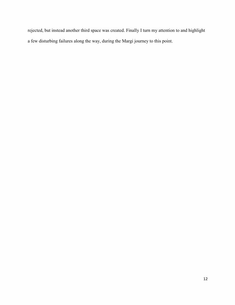
1.1 Overview of Nigeria
As I stated in the introduction, I am writing about the evolution of the built environment of a
particular ethnic group called the Margi who are situated in the northeastern Nigeria. The Margi
ethnic group is just one of the 350 or more ethnic groups residing in Nigeria today. Therefore, in
order to tell the story of how the Margi ethnic group evolved, first I lay the foundation by briefly
outlining how the geographic area of today’s Nigeria evolved into a nation-state, from
autonomous villages, kingdoms, and a caliphate, into colonial territory, and finally into a federal
republic of small states.
Figure 1: Current Political Map of Nigeria; source: www.mapoftheworld.com (2012)
14
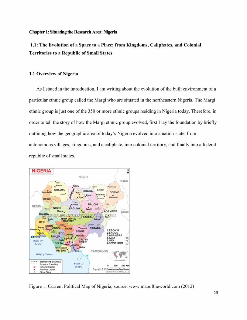
Nigeria is located in the western part of Africa. The Nigerian territorial boundary as it is
today is the creation of the United Kingdom during colonial rule. When the British came to the
western coast of this general area called Nigeria today, they took control of an area at the coast
that includes the present day city of Lagos and named it the Colony of Lagos, on August 6th
,
1861 (Lynn, 2006; Achebe, 2012). In the1890s the British expanded their authority to the eastern
Figure 2: A Map of Africa showing Nigeria; source: drawn by Weibo Liu
and the northern part of present day Nigeria. Most of the northern part of Nigeria resisted the
colonial authorities because, at that time, they had their own system of government under the
Sokoto Caliphate (Kirk-Greene, 1966). The Sokoto Caliphate consisted of administrative units
15
called the emirates, and each emirate was headed by an emir. An Islamic scholar called Othman
Dan Fodio forcefully established the caliphate through a Jihad in 1802. Dan Fodio went on to
serve as the head of the caliphate (Carland, 1985; Post, 1973). During the Jihad, the Margi ethnic
group and other minority groups were geographically situated in the caliphate, and they and
other ethnic groups like them were constantly raided for slave labor by the emirs and their sultan.
The caliphate existed for almost 100 years, until the British colonial office appointed Lord
Lugard to administer northern Nigeria in 1898 (Lugard, 1959). When Lugard took over, he used
the West African Frontier Forces (WAFF) stationed in the city of Lokoja, Nigeria, and waged
war against the Sokoto Caliphate (Falola, 2008: 93). Lugard, with his West African Frontier
Forces, defeated the sultan and his emirs in 1903 (Smaldone, 2008: 123). Lugard renamed the
old caliphate the Northern Protectorate. He also renamed the Colony of Lagos and kingdoms in
the western and eastern parts of Nigeria collectively as the Southern Protectorate. Lugard
administered the two protectorates separately, using direct rule in the Southern Protectorate and
indirect rule in the Northern Protectorate (Kirk-Greene, 1966; Achebe, 2012). Indirect rule was
first experimented with in India when the British ruled the Indian Colony through the Indian
Princes during colonization; it literally means ruling the indigenous people in the colony through
the traditional system of governance found in the region (Ferguson, 2005: 192). The British
replicated the system in northern Nigeria and ruled the Northern Protectorate through the Sokoto
Caliphate’s emirs (Salamone, 2009: 39). Finally, shortly after his return from a stint as Governor
of Hong Kong (1906-12), Lugard amalgamated the two Protectorates in 1914, creating one
colonial territory named Nigeria. The name Nigeria was coined by a journalist Flora Shaw; She
barrowed the name from Niger River running through the country. Flora Shaw coined the name
Nigeria, in the period after her work for the Manchester Guardian, before she became Colonial

16
Editor for the Times of London. She was once the lover of Sir George Tubman Goldie's, the
founder of the United Africa Company, which later becomes the Royal Niger Company. Show
became Lord Frederick Lugard's wife in 1902. She suggested the name "Nigeria" in a letter to
The Times of London, on January 8th
1897. (Suberu, 2002: 22; Falola and Heaton, 2008: 11).
In preparation for independence, a new constitution was drafted in 1954 that established three
regional governments; this was followed by federal elections in 1959 (Osaghae, 1988: 33;
Nigerian Gov. Cmd.9059; Row, 1954). On 1st October 1960, Nigeria was granted independence,
but in 1963, Nigeria broke its direct links with the British Crown and became a republic within
the British Commonwealth of Nations (Last, 1967; Kirk-Greene, 1971; Rathbone, 1971; Falola
and Heaton, 2008; Sid-Ahmad, 1984). The new republic constitution provides for a federation of
three autonomous regions: Northern, Western, and Eastern. Each of the three regions had its own
regional constitution, public service system, and marketing board responsible for the import and
export of goods (Fatile, 2011: 8). The federal government has powers limited to national issues
only - the control of the police, army, and economic planning for the republic. In 1964, a fourth
region, the Midwestern region, was created because of the demand by the people from the
western region (Mackenzie, 1999; Uwechue, 2004). But soon after, the regional structure led to a
series of crises and conflicts within and between each region. Competition grew among the
regions for control of federal government civil service positions. A federal election was
conducted in 1964, but was fouled by violence and rigging. Inter-regional and inter-ethnic
tensions continued, leading eventually to a military takeover in January 1966 (Post and Vickers,
1973). All the military officers involved in organizing the military takeover were of the Ibo
ethnic group, from the eastern part of Nigeria (Akpan, 1972; Nkwocha, 2010; Mshelia 2012).
This was the beginning of the wars for domination by the major ethnic groups in Nigeria, and
17
this action legitimized northwestern and north-central Nigeria’s Hausa-Fulani ethnic alliance to
be the power brokers of the north, where the Margi ethnic group resides. Ultimately this newly
legitimized power of the Hausa-Fulani, in collaboration with the Kanuri ethnic majority in the
northeastern quadrant, was the reason the Margi ethnic group came to be evenly divided between
the two states of Adamawa and Borno today.
In an attempt to avoid future conflict in the country, the Nigerian government abandoned the
regional structure in 1967, immediately after a civil war had started in the southeast (the Biafra
War). They created 12 states to replace the regional system (Uwechue, 2006: 74). Within the
state system, all the Margi ethnic groups were in the Northeastern state. After the states were
created, the federal government took back most of the power and created a new revenue sharing
formula, which deprived the new states’ governments the direct control of the monies earned
from the resources derived from their various states. Instead, the federal government controlled
all the revenue (De St. Jorre, 2009). The new revenue sharing formula favored the most
populated and underdeveloped states amongst the 12 newly created states. But the new revenue
sharing formula also encouraged the demand for more states by various ethnic, regional and
interest groups, and as a corollary produced an incentive for the states to inflate their population
numbers during the national census.
Additional states were created in response to demands from powerful local interest groups.
In 1976, 7 additional states were created, raising the number to 19. In this phase of state creation,
the Northeastern state, which was the largest among the 12 and where the entire Margi ethnic
group was located, was divided into three states: Borno, Bauchi and Gongola states (Aguda,
1981; Tibenderana, 2003). This time, those in charge of creating the new states split the Margi
ethnic group among two of the three states. One half of the Margi were placed in the new states

18
of Borno with its headquarters in Maiduguri and the other half in the state of Gongola with its
headquarters in Yola. Some Margi claim that the undercurrent reason for the split of the Margi
ethnic group into two states was fear of Margi intellectual domination, given the missionary-
educated status of many in the Margi ethnic group, if they were to be placed in one state. This
fear was still openly expressed by the two major ethnic groups of Kanuri in the new Borno state,
and the Fulani ethnic group in the new Gongola state, because it was common knowledge among
both of these two major ethnic groups that the American Church of the Brethren missionaries
and the Catholic Church came to the Margi ethnic domain in 1927 and 1948, respectively, and
established superior educational institutions. The Fulani and the Kanuri ethnic groups were
unwilling to let the missionaries into their domain at that time because of their Islamic faith
(Hickey, 1984).
Furthermore, in 1989, the government created three more states, making a total of 21; in
1991, 9 more states were created, making a total of 30 (Federal Govt. Printer, 1982; Suberu,
1991). During this later phase of state creation, the government divided Gongola state into 2 -
Adamawa and Taraba states. The Margi ethnic group stayed in Adamawa state, with its
headquarters in Yola. Again in 1996, the government created 6 more states, making a total of 36.
The Margi remained in Adamawa and Borno states, without change, and these are the two states
they reside in today. The long process has led to there being 36 states for a country with only one
third more land mass than the state of Texas in the United States. Since 1996, the government
has not created any new states, but pressures from different regions and interest groups for
creation of more states always exist (Akinola, 1981; Fatile, 2011).
State creation is only one aspect of the shaping of space into place. Urban development
represents another. The evolution of the Margi built environment in the Nigerian post-
19
independence era reflects or is a spillover of the evolution of other Nigeria cities, such as Lagos
with population over 8 million, Ibadan over 3 million, and Kano also with over 3 million. In
addition, there are four other Nigerian cities with a population of over a million people: Benin,
Port Harcourt, Kaduna and Maiduguri, the state capital of Borno (Falola, 2004). Within these
Nigerian cities and others that are not mentioned here, are where Nigeria’s four major ethnic
groups reside: Hausa, Fulani, Yoruba, and Igbo (Uche, 1990: 8). In addition, there are 350 or
more other ethnic groups living in Nigeria, including the Margi. English is the official national
language in addition to the regional languages of Hausa and Fulani in the north, Yoruba in the
west, and Igbo in the east. There are two major religious groups, Islam, and Christianity; Islam is
primarily but not exclusively the religion of the north and Christianity is primarily in the south
(Kalu, 2011). Yet the northern Margi ethnic group is primarily Christian, due to the influence of
the American Church of the Brethren and the Catholic Church. The two dominant world
religions succeeded in phasing out many traditional religions, including Margi traditional
religion, which existed prior to colonization and the coming of the missionaries in Margi land
(Falola, 2004; Kalu, 2011).
1.1.2: Abundant Resources, but a Poor Built Environment, and a Poor Populace
Nigeria is the second largest economy in Africa, and the world’s 10th
oil producer with a
current output of 2.4 million barrels per day. Although there has been increasing focus on
diversifying the economy, it is still highly dependent on oil and gas, which are very sensitive to
price fluctuations (Odukoya, 2006). In 2011, oil accounted for about 1/5th of Nigeria’s GDP,
80% of government revenue and over 95% of export earnings. Agriculture accounted for 35% of
GDP while employing around 70% of the population. The services sector is just over 30% and
manufacturing is 5% of GDP (UNDP, 2012). The majority of the Margi are subsistence farmers;

20
just like other ethnic groups, they are among the poorest Nigerians. The national economy is
dominated by the major ethnic groups. Since the Margi are located in two northern states that are
predominately Muslim, religion plays a role in who becomes what and what region within the
states is to be developed.
In view of the fact that Nigeria is the second largest economy in Africa and the 10th
-biggest
oil producing country in the world, its Human Development Index (HDI) is not doing as well as
it should be (Wilkinson, 2005). The Human Development Index is a summary of the long term
human progress of a country in three ways: access to knowledge, a long and healthy life, and an
adequate standard of living, the last of which indirectly includes the built environment
(Wilkinson and Clapp, 2010; UNDP, 2011). According to the United Nation Human
Development Report for 2011, the Nigerian HDI value for 2011 is 0.459. The country ranks 156
out of 187 nations; it is perhaps encouraging, though, to know that, from 2005 to 2011, Nigeria’s
HDI value rose from 0.429 to 0.459, an increase of 7.0 %, or an average annual increase of about
1.1 percent (UNDP, 2011). Still, the standard of living for the Margi ethnic group and others like
them is not adequate in terms of the availabilities of basic amenities that are part and parcel of
the built environment. For example, in all Margi towns and villages, there is no running water
other than from privately owned bore holes, no paved roads other than the main roads that lead to
Lassa, Maiduguri, Mubi, and Yola, which happen to pass through Margi towns and villages; nor
is there any sewer system, to say nothing of any urban planning for the towns.
The table below shows Nigeria’s HDI indicators between 1980 and 2011: even though the
indicators seem to be going up, the indicator for education is not growing. In the western world,
the provision of education is considered an essential role of the government in order to transform
and develop human potential and the society as whole. Since the Nigerian state governments

21
took over missionary schools in the 1970s, the educational standards of the schools have been
deteriorating all over the country including in the Margi ethnic group’s domain (Maier, 2002:
220; Campbell, 2010: 75; Kant, 2010).
Even though the Nigerian life expectancy increased by 6.4 years, and the expected years of
schooling increased by 2.2 years, note that the table shows the figures went down from 16.7 in
1980 to 8.5 in 1995. Also the Nigerian Gross National Income (GNI) per capita increased by
30.0 percent between 1980 and 2011 (UNDP, 2011). But considering the income Nigeria has
earned from oil revenues since independence in 1960, and yet the country still ranks 156 out of
187 nations, most development scholars say that the oil resources do not translate into
improvement in the people’s living standards. This is especially so among the marginalized
groups like the Margi who do not have access to government resources. In fact the oil resources
have been said to be a curse by some scholars (Watts, 2008; Kashi, 2010).
Table 1: Nigeria’s HDI Trends Based on Consistent Time Series Data, New Component
Indicators and New Methodology
Life expectancy
at birth
Expected years
of schooling
Means years of
Schooling
GNI per capita
(2005 PPP$)
HDI value
1980 45.5 16.7 .. 1,597 ..
1985 45.9 8.5 .. 1,223 ..
1990 45.6 6.6 1,271
1995 45.1 7.1 .. 1,286 ..
2000 46.3 7.8 .. 1,289 ..
2005 49.0 8.9 5.0 1,530 0.429
2010 51.4 8.9 5.0 1,990 0.454
2011 51.9 8.9 5.0 2,069 0.459
Sources: UNDP, 2011 Report

22
Table 2: Trends in Nigeria’s HDI Component Indices 2005-2011
Sources: UNDP Report for 2011
Table 3: Human Development Index Comparing Nigeria, Sub-Saharan Africa and the World
Year Nigeria Low human
development
Sub-Saharan
Africa
World
2011 0.459 0.456 0.463 0.682
2010 0.454 0.453 0.460 0.679
2009 0.449 0.448 0.456 0.676
2008 0.446 0.443 0.451 0.674
2007 0.441 0.437 0.445 0.670
2006 0.438 0.430 0.438 0.664
2005 0.429 0.422 0.431 0.660
Source: UNDP report for 2011
1.1.3: Overview of Northern Nigeria

23
After giving a brief background on Nigeria as a country, I now turn my attention to northern
Nigeria, and more specifically to the two northern states of Adamawa and Borno where the
Margi reside. As indicated in the previous section, northern Nigeria became a British
protectorate in 1903 (Smaldone, 2008). The sultan and his emirs had resisted British colonial
authority in the past. For example, the requests by the British authority that the Sokoto Caliphate
stop slavery and the maltreatment of the minority groups which were constantly raided for slave
labor in the caliphate were disregarded (Vaughan, 1995; Salau, 2008; Falola, 2011; Collingwood,
2010). At the time of the British defeat of the caliphate, although the Margi were within the
domain of the caliphate, technically they were not in the newly acquired British territory,
because the part of the caliphate where the Margi ethnic group resided was in the German
territory of Kameroon (K). The Margi of the current Adamawa and Borno states had been in the
Adamawa emirate, which constituted part of the Sokoto Caliphate, but this was already in
German hands when the British defeated the Sultan in 1903 (Vaughan, 1995). During World War
I, the British invaded Kameroon from Nigeria in 1914. The last German fort in this general area
surrendered in February 1916. After the war, the former German colony was divided between the
United Kingdom and France as of June, 28th
1919, based on a League of Nations mandate
(Schnee, 2007: 85 and 151; Kirk-Greene, 1964). The British portion in today’s Adamawa state
was then ruled from Lagos as one of the two British Cameroons (British Parliamentary
Publication, Report on the British Sphere of the Cameroons, May 1922: 62-8).
The ethnology of the world’s languages listed the Margi population of Borno state in
2006 to be 158,000 in a state with a population of 4,151,193; and those in Adamawa state
number 166,000 out of 3,178,950 in the state (Lewis, 2006; Gates Jr. and Appiah, 2010: 139). In
each state the Margi ethnic group is thus one of many minority ethnic groups. Some Margi are

24
also found in the northwestern parts of the Republic of Cameroon, where the Wandala subgroup
resides (Meek, 1931; Kirk-Greene, 1962; Migeod, 1923: 186).
Figure 3: A Map of Africa showing Nigeria; source: drawn by Weibo Liu
1.1.4: Adamawa State
The disunion of the Margi ethnic group’s cultural landscape between two states leads to
approximately half being in Adamawa. For a time, the Margi ethnic group of Adamawa state was
placed in Mubi administrative area, one of the major towns in Adamawa state. When the Local
Government system was introduced in, 1976; the Margi ethnic group was placed in Michika
Local Government Area before the current Madagali Local Government was created in 1991;
this is where all of the Margi towns and villages of Adamawa state are presently located.

25
Figure 4: Map of Adamawa State showing Madagali Administrative Area; Drawn by: Weibo Liu
The Margi residing in Adamawa state constitute the north Margi, based on C. K. Meek’s
classification (Meek, 1931).
The State of Adamawa derives its name from Madibbo Adama, a Fulani cleric who led the
19th century Jihad in Upper Benue Region under Othman Dan Fodio (Diouf, 2003: 16).
Modibbo Adama was the son of Ardo Hassan, born at Wuro Cheke in Adamawa around 1770.
He had his early Islamic studies under his father and later proceeded to Birnin Ngazargamu, for
further studies (Njeuma, 2012). Madibbo Adama became a flag-bearer, undertaking successive
conquests to establish the kingdom of Fombina. Since then, families connected to the lineage of
Madibbo Adama have formed the ruling class of Adamawa emirate, with the palace located in
Yola. Since the establishment of the kingdom of Fombina under Modibbo Adama, the
26
relationship of the kingdom with most of the minority groups in the general area, including the
Margi, has been a tense one (Abubakar, 1977). Because early on, there was constant slave
raiding attempts and forced Islamization of the minority groups by the Fulani majority (Vaughan,
1995: 14).
Adamawa state is a mountainous land, crisscrossed by the Benue, Gongola, and Yedsarem
river valleys. The valleys of Cameroon and the Mandara mountains form part of this surging
landscape, often referred to as the Adamawa Massif (Stock, 2012: 59). Adamawa state is known
for its diverse cultural heritage; in addition to the dominant Fulani, the state is inhabited by other
minority ethnic groups besides the Margi, such as the Bachama, Mumuye, Higi, Chamba, Hausa,
Kilba, Gude, Wurkum, Jukun, and Bata peoples (Heine, 2008). All these groups are primarily
engaged in farming and herding cattle, goats, and sheep, but fishing is also important along the
riverbanks. Peanut, cotton, sorghum, millet, rice, and corn are the main crops. Peanuts and cotton
are exported, as are cattle, dyed skins, and gum Arabic. Some of the Fulani are still nomadic
cattle herders, while majority of the Hausas are traders. The state has a network of roads linking
all parts of the state and the country. There is also air and water routes that now make the state
accessible during all seasons (Kirk-Greene, 1958; Abubakar, 1977; Chilver, 2010; Blench, 2011;
Njeuma, 2012).

27
Figure 5: A Map of Nigeria showing Borno State; Source: Weibo Liu
1.1.5: Borno State
Borno state is the other state in which the Margi ethnic group resides; it has a land mass of
61,435 square kilometers, the largest state in Nigeria and the last on the northeastern frontier
bordered by Niger to the north, Chad to the northeast and Cameroon to the east. Within Nigeria,
the neighboring states of Borno are Adamawa to the south, Yobe to the west and Gombe to the
southwest. The climate is hot and dry for most of the year with the Harmattan season from late
November through early February. Harmattan is a fine white powdered dust brought by the wind
from the nearby Sahara desert, and settling on everything, including humans (Rothmaler,
Seidensticker-Brikay and Tijani, 2008; Mohammed, Seidensticker-Brikay and Tijani, 2011;
Rothmaler, 2007).
The Margi homeland in Borno state is situated at the southern peripheries, in the towns of
Lassa and Uba along with many other villages, designated as the Askira/Uba Local government

28
area for administrative purposes. The towns of Askira (which means gratitude in the Kanuri
language) and Uba are currently becoming cosmopolitan in nature (Kirk-Greene, 2006: 234).
The Margi residing in these two main towns and surrounding villages are those that constitute
the south Margi, according to C. K. Meek, based on geographical and dialectical intonations
(Meek, 1931; Kirk-Greene, 1958; Heine and Nurse, 2011: 20, 83). Although many members of
the Margi ethnic group have built homes in the larger cities of Borno state, it is customary for
them to build their first homes in towns and villages of their origin; many Margi are working in
the Borno state capital of Maiduguri and other major towns in the state.
Figure 6: A Map of Borno State showing Uba-Askira Administrative Area

29
There are about thirty languages spoken in Borno whose speakers have for a long time
resided in the general area. These languages are considered independent of each other, and 26 of
these languages, including the Margi language, are classified by linguists as Afro-Asiatic, from
the Chadic family of languages (Heine and Nurse, 2011: 166). The Kanuri-speaking people are
the majority and are members of the Saharan group of languages. There are also Shuwa Arab
people in Borno who speak mainly the Arabic language (Palmer, 1936; Rothmaler,
Seidensticker-Brikay, and Tijani, 2008; Mohammed, Gisela Seidensticker-Brikay, and Tijani,
2011).
Figure 7: Ethnic Map of Nigeria; Source: 2012 www.mapoftheworld.com

30
Section 1.2: The Accounts of Contact of the Margi Ethnic Group with the Outside World
1.2.1: The First Record of Margi in the Literature
The first record in literature which places the Margi ethnic group around the Lake Chad was
that of Fra Mauro, recorded on his mid-15th
century map, on which he placed the Margi
southeast of Lake Chad (Falchetta, 2006; DeCorse, 2001: 142, 2006). There are two accounts of
when Fra Mauro drafted the map. On the web page of the Mandara publishing company, which
is based in the United Kingdom, it is indicated that Fra Mauro drafted the map in 1459 (http:
//www.mandaras.info/Margi.html). But Piero Falchettas’ book and CD-ROM (2006), Fra
Mauro's World Map, indicates that the map was sketched around 1450. In any case, the point is,
Fra Mauro placed the Margi ethnic group around the Lake Chad prior to the year 1564, when the
leader of the Saifawa Dynasty of the Kanuri, Idris Alauma, started his campaign against the
Margi and the Touareg ethnic groups (http://lah.soas.ac.uk/projects/megachad/gallery/FraMauro-
1000.html).
Fra Mauro’s map of 1459 is important because it placed the Margi together as a group in one
location prior to the diaspora under family patriarchs - primarily to the mountainous enclaves and
to the plains - due to Idris Alauma’s expedition. Consequently, the present Margi towns and
villages were established as a result. Figure 8 shows the map of 1459 by Fra Mauro, showing the
Margi at the south east corner. Fra Mauro spelled Margi as ‘Mergi’ at that time (http:
//lah.soas.ac.uk/projects/megachad/gallery/FraMauro-1000.html). At the top of the map, one can
see the word, Palude, encircled and two tributary streams coming into the circle from the
opposite side; this Palude, which means swamp or marsh in Italian, is most likely Lake Chad.
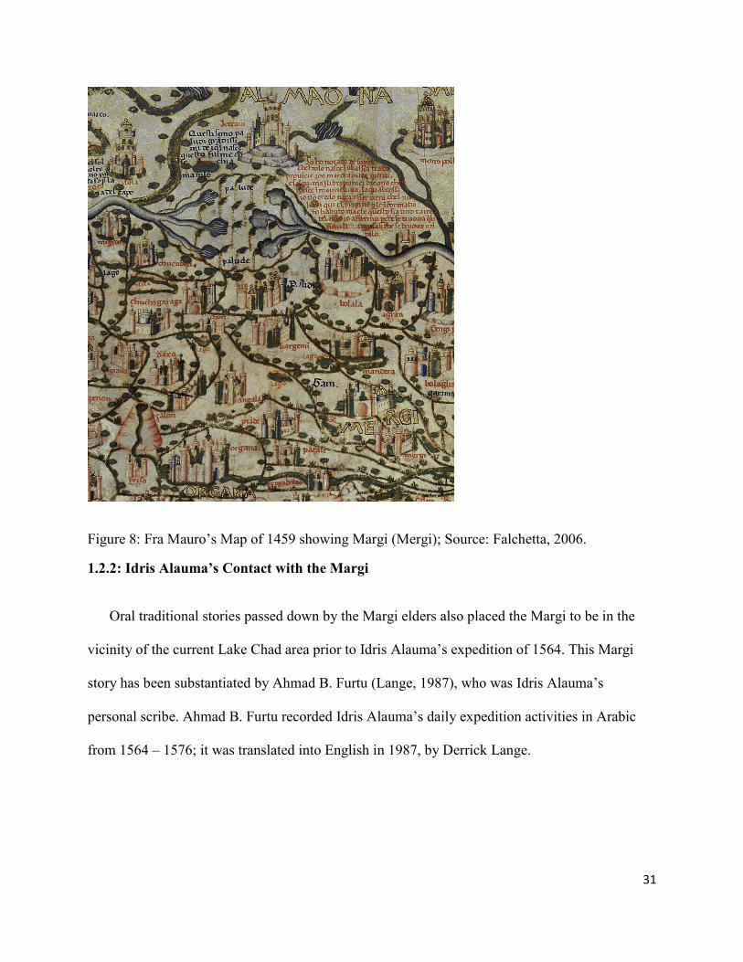
31
Figure 8: Fra Mauro’s Map of 1459 showing Margi (Mergi); Source: Falchetta, 2006.
1.2.2: Idris Alauma’s Contact with the Margi
Oral traditional stories passed down by the Margi elders also placed the Margi to be in the
vicinity of the current Lake Chad area prior to Idris Alauma’s expedition of 1564. This Margi
story has been substantiated by Ahmad B. Furtu (Lange, 1987), who was Idris Alauma’s
personal scribe. Ahmad B. Furtu recorded Idris Alauma’s daily expedition activities in Arabic
from 1564 – 1576; it was translated into English in 1987, by Derrick Lange.

32
Figure 9: Lake Chad and its Surrounding Area; Source: http://www.google.com/imgres
According to the oral Margi account passed down, the Margi lived in an area called Gazargamu
around Lake Chad prior to the Alauma expedition. On his arrival to the Lake Chad area, Alauma
waged war against the Touareg and the Margi ethnic groups (Lange, 1987: 76). Overwhelmed by
this expedition, the Margi migrated in subgroups under family patriarchs to different directions
and established the modern Nigerian Margi towns of Kwapchi, Uvu, Ezige, Mulgwe, Dille,
Lassa, Gulak, Uba, and surrounding villages. Despite living in different locations, the Margi
continued to share a language and culture; and each subgroup has maintained that they come
from “the East” at a point in time earlier than the 1450s (Kirk-Greene, 1958; Lange, 1987; Meek,
1931: 215-216 Vol. II).
Based on the record translated from Arabic to English by Derrick Lange in 1987, the
expedition against the Margi started because at a certain point the ruler of the Margi, named
Adwa, refused to join Idris Alauma on expeditions as he had previously done. Adwa, who had
held the position of chief Umura under Idris Alauma during previous campaigns, rebelled and

33
totally abstained. Adwa’s refusal angered Idris Alauma and the conflict began between the two.
Idris Alauma requested Adwa on various occasions to come back to assume his previous position
as Umura, and upon receiving no reply, Idris Alauma went after Adwa with vengeance. Idris
Alauma marched his army to Kopci, Mitku, and the rocks of Humdi but did not find Adwa;
instead, Idris Alauma found Adwa’s first wife, Gamsu, with abundant provisions. He captured
her and brought her with him to Birni Gadzargamu where Idris Alauma was residing (Lange,
1987: 34). When Adwa came back home and learned that his wife had been captured, he
followed Idris Alauma to Gadzargamu.
The ruler of the Margi then came to the town of Birni, and entered into the
presence of the Sultan and settled down before him, kneeling and prostrating
himself, casting earth upon his head with both hands together humble and abject
(Ahmad B. Furtu, in Lange, 1987: 76).
1.2.3: Dr. Heinrich Barth’s contact with the Margi
Heinrich Barth’s document from 1857 is the first record in literature to mention Margi
domestic architecture. Barth was born in Hamburg Germany, educated at Berlin University and
graduated in 1844. Though a German, he joined the British service where he learned Arabic and
other African languages in England; thereafter, he joined an expedition to western Sudan in
1849, organized and sponsored by the British Government. He was interested in the Islamic
culture of western Africa, and this curiosity led him as far as Timbuktu in present day Mali
(Barth, 1857; Kirk-Greene, 1962). From there he found his way to the general area of the present
northern Nigeria, where he visited the Margi, the Fulani, the Hausa, and many other ethnic
groups. In his 1857 book, Travels and Discoveries in North and Central Africa Vol. II, Barth
recorded his contact with the Margi ethnic group, beginning with ‘Molghoy,’ which is modern

34
Mulqwe, through Izege to the periphery of Uba, the last Margi town before entering Mubi.
Barth’s travels started from present day Borno state through Adamawa state. Figure 10 shows a
map of the part of Central Africa showing the routes of the expedition performed under the
sanction of H. M. Government by Messer’s Richardson, Barth, & Overweg in the years 1851 and
1852. The Margi Territory is circled on Longitude 11, and Latitude 14.
Figure 10: A Map by Barth and his Team; Source: Source:
http://www.mandaras.info/MandarasPublishing/ExpeditionToCentralAfrica-Petermann1854
On Saturday, June 7, 1851, at about one o’clock in the afternoon, Heinrich Barth set his eyes
on the first Margi domestic sphere at the village of Mulqwe. He spent the night and made the
following notes: “Each family has its own separate court-yard, which forms a little cluster of huts
by itself, and often at a considerable distance from the next yard. This kind of dwelling has

35
certainly something very cheerful and pleasant in a simple and peaceable state of society” (Barth,
1857: 106) After describing the Margi hamlets at Mulgwe, he turned his attention to the
inhabitants: “I was struck by the beauty and symmetry of their form, which were thus entirely
exposed to view, and by regularity of their features, which are not disfigured by incisions, and in
some had nothing of what is called the Negro type” (Barth, 1857: 106). He described a young
Margi child in the village as follows: “The boy’s form did not yield in any respect to the
beautiful symmetry of the most celebrated Grecian statues, as that of the praying boy, or that of
the diskophoros” (Barth, 1857: 107). This is how the Margi built environment was in 1851,
based on Dr. Barth’s observation. This is the first detailed written description of the Margi
settlement pattern and the Margi people, as a distinctive group (leaving aside whatever racial
prejudice Barth may have held). This description – of a distinctive people with a distinctive
cultural landscape - is similar to what I saw in the late 1960s, as a child. This sets the stage for
me to show how the Margi built environment was, and I endeavor to sketch out how this simple
way of living evolved into modern mansions, schools, churches, stores, modern open markets
and mosques.
In view of the Margi folklore passed down from one generation to another, Fra Mauro’s
map, and the daily records maintained by Ahmad B. Furtu, Idris Alauma’s scribe, Heinrich
Barth’s records of his contact with the Margi ethnic group recorded in his book, and the Map of
Part of Central Africa Showing the Routes of the Expedition performed under the sanction of H.
M. Government by Messers Richardson, Barth, & Overweg in the years 1851 and 1852, I argue
that the Margi were living in the town of Gazargamu, or at least in the general area, prior to the
expedition by Idris Alauma. The Margi ethnic group dispersed to their present locations after
that.

36
1.2.4: The Margi Neighbors
Since at least from the time of Nigerian independence, the Margi ethnic groups have been
and are still neighbors with the following ethnic groups: Kilba, Bura, Matakam, Higi, Sukur, and
Wula. As mentioned earlier, the Fulani and Kanuri ethnic groups are the majorities in the two
states where the Margi reside, and they live in the major towns of Yola and Maiduguri, with a
few Hausa in each city. This is not to say that there not any Kanuri, Fulani or Hausas living
alongside the Margi ethnic group in certain Margi towns or villages. But what it means is that
these groups that are considered Margi neighbors, including groups both large and small, have
their own towns and villages even if they share common geographical vicinity with the Margi
ethnic group. Here, I examine only the smaller ethnic communities, to show their general
commonalties with the Margi.
The first two, the Kilba and Bura ethnic groups, share words that have common meaning
with the Margi. There is no definitive evidence that any two of them have lived together. But
because of the geographical proximity which all the groups share, they become closer and tend to
do things together. The ethnic groups cooperate with each other, especially when they find
themselves in distant cities of Nigeria; I witnessed such cooperation among them when I was
staying with my uncle in Kaduna in the 1970s. Like the Margi ethnic group, some of the Margi
neighbors speak an Afro-Asiatic language belonging to the Chadic group of languages.
Considering how difficult it was to travel to this territory especially prior to independence,
when it was declared a closed territory by the British authorities, one can understand why
scholars like John Iliffe (2007: 1) consider parts of the African continent like this to be a frontier
territory and the African people as those that are able colonize the most hostile region of the

37
world on behalf of the entire human race. The northeastern Nigerian physical environment is
typical of the frontier territory about which Iliffe is talking. It is rugged and very difficult to
penetrate especially the mountainous areas; but somehow these ethnic groups residing in the
region were able to cope. They learned to use the material within their vicinities to construct
their living space. The ethnic groups mentioned above have all lived in the Mandara mountains
in different sections of the enclave.
1.2.5: The Kilba Ethnic Group
The Margi and Kilba probably lived together or at least in close proximity with each other
starting a long time ago. This is based on oral folklore passed down in each group that tells of the
past in which the ancestors of the two groups were cousins who then got separated a long time
ago. The Margi call them “bzir huba,” a phrase that means “the son removed” in Margi. Legend
has it that, when both groups were still together, the ancestor of the Kilba group was bad and he
was ordered removed from the group, hence the Margi name for them. Each ethnic group
jokingly calls the other mava, meaning slave, but this claim has never been substantiated, even
though it continues in use even today. There is a striking similarity between both languages.
1.2.6: The Higi Ethnic Group
Previously, I indicated that there are Margi called the Margi Wandala in the Republic of
Cameroon. Just like the Margi ethnic group, another section of the Higi ethnic group is still
residing in the Republic of Cameroon. The Cameroon Higi are called Kapsiki (van Beek, 1987:
157; De Bruijn, Van Dijk, and Gewald, 2007: 115). C. K. Meek opines that Higi is a Margi word
meaning aboriginals or locust (Meek 1931: 262); but I have never heard it used in either way
when growing up and I do not think Higi is a Margi word. The Higi ethnic group lives mainly in

38
the towns of Michika and Baza in Adamawa state. The two towns are almost surrounded by the
Margi towns and villages. Scholars like D. Barreteau (1984) went as far as classifying
Kapsiki/Higi under the Margi group; there is no evidence that my informants know of to suggest
that this is a correct classification. Yet most of the Kapsiki/Higi thinks that they originate from
Gudur (Barreteau, 1984: 168), and this is the same Gudur the Birdling clan of the Margi ethnic
group claims to have originated from.
Unlike the “teasing-cousin” relationship of the Margi with the Kilba, relations between
the Margi and the Higi can be strained. A fresh graduate from the University of Oxford, who
supervised the Northern Cameroons Plebiscite in the area of the Margi and their neighbors, put it
this way: “So far I have been appalled by the contrast in attitude to a stranger in Higi and Margi
lands. The Margi are embarrassingly generous. Among the Higi we have to struggle to obtain
every morsel” (Cooper, 2010: 17).
1.2.7: Bura Ethnic Group
This is the ethnic group the church of the Brethren Missionaries first settled among in 1923.
Therefore they are highly influenced by the missionaries, and a highly educated ethnic group.
But unlike the Margi, where only half reside in Borno state, the Bura ethnic group primarily
resides in Borno state, with only one Bura town of Garkida in Adamawa state. This is because of
their proximity to the Borno. The group is also known as Pabir or Babur. The Bura language is
closely related to Margi; the group lives in small, autonomous villages; and they have many very
similar cultural characteristics with the Margi (Gates Jr. and Appiah, 2010: 210; Mshelia 2010).

39
1.2.8: Matakam or Mafa Ethnic Group
Just like the Higi, and Margi ethnic groups, the Matakam or Mafa are known by different
names in Nigeria and Cameroon - as Matakam in Nigeria, and as Mafa in Cameroon. In fact,
though, in Nigeria, they consider the name Matakam as an insult. Based on my interviews with
my informants, all agreed that the Matakam ethnic group started to come to Gulak in 1958,
crossing the Mandara mountains from border towns in Cameroon. They travelled to Margi towns
to look for farm work, and gradually they started to live in Margi towns. Their general
characteristic is that they prefer living around the town or the village market area, simply
because they specialize in preparing pito, a local brew known to be their native beer, and then to
sell it on market days. Also many of the Matakam men engage in the animal butchering trade, so
they are mostly meat sellers to the Margi ethnic group on the open market days.
1.2.9: Wula Ethnic Group
The Wula ethnic group is still mostly in the Mandara Mountains, with only about 1/3 of them
that have come out to the plains or mountain slope. The Birdling clan of the Margi ethnic group
claims to descend from this ethnic group. In fact the word ‘Wula’ might have been the ancestor
name of the family patriarch that led them into the Mandara mountains when they left the Lake
Chad area. Their way of life is very similar to the Margi ethnic group.
1.1.10: Sukur Ethnic Group
There are quite a few studies written on the Sukur ethnic group. In fact their ancestral homes
in the Mandara mountains received an inscription in 1999, as a UNESCO World Heritage site
(http://whc.unorgesco./en/list/938). They live in the Mandara mountains, but a lot of families
have moved out of the mountains and are settled on the mountain slope. Just like the Birdling

40
clan, the Medugu Kirngu clan claim to have paternally descended from the Sukur ethnic group.
Their way of life is identical to that of Margi and they all have lived in the mountains in different
enclaves.
1.3 Conclusion
In this chapter, I have provided the study site’s general cultural-historical geographic context. I
have provided a broad introduction to Nigeria, and then to northern Nigeria. I have given an
accounting of the place of the Margi ethnic group – and of neighboring ethnic groups – in
regional history and historiography. In the chapter which follows, I move to the conceptual
framework of the dissertation.

41
Chapter 2: Conceptual Framework
2.1: Shelter
The need for residing in groups for safety and construction of a habitable place for shelter is
part of human nature. This need is as old as the first human. Over the years, the idea of shelter
for safety has evolved in various types and forms in different cultures, and the trend continues
into modern times (Trotter, 1971: 235; Gabel, 1985: 259). As recently as 90 years ago, 90 - 95%
of the world’s population resided in the types of shelter built without architects, commonly
known as folk or vernacular architecture (Rapoport, 1969; Silberfein, 1998). But the western
world has since decided to rewrite the codes regarding what is considered safe and habitable
shelter and succeeded in globalizing the idea as a modern standard of living. Safe and habitable
shelter of a particular character is now considered to be a prerequisite for a modern living
standard for all mankind: for the head of household on behalf of his or her family, for ethnic
groups and the survival of their members, and for any nation that seeks for their populace to
thrive (Williams and Parkman, 2003: 452; The International Building Code, 2012).
2.2: Modernization, Modernism, and Modernity
I write on how the idea of safe and habitable shelter propagated by western science has
reached some of the most remote corners of the world. In particular, I examine how the idea of
safe and habitable shelter reached the Margi in northeastern Nigeria. I examine how the domestic
sphere, and consequently the built environment of the Margi ethnic group, evolved as a result of
their coming in contact with westerners. The new western way of construction adopted by Margi
is gradually replacing or reshaping the ‘round huts built with mud’, which the Margi ancestors
used for hundreds of years.
42
I am conscious of the cultural influence and the power struggle between the current major
ethnic groups of northern Nigeria, the Kanuri and the Hausa-Fulani, with the Margi prior to
colonization (Kirk-Greene, 1958; Cohen, 1967; Njeuma, 2012). This struggle and the cultural
influence of the larger groups in Margi land were intensified when the colonial officers and the
missionaries came with their new idea of safe and habitable shelter into Margi land. These
newcomers’ influence likewise accelerated the change of Margi architecture and made it even
more complex than ever. The common thread of the social order between the Margi and their
new neighbors is the modernization of the “others” in the form of cleaner ways of living for the
Margi ethnic group.
The United Nations, in consideration of the percentage of world population which still
resides in vernacular or folk architecture, organized for the first time a world conference in
Vancouver, Canada in 1976 to address human settlement problems around the globe. This was in
part, a response to how state ideologies around the globe are reflected in their human settlement
policies. The Vancouver conference, through “The Vancouver Action Plan,” addressed issues of
safe and habitable shelter and its effect on global population, such as congestion, safety of
building structures; and the physical and spatial organization of human settlements. Prior to the
conference, development concepts such as building, planning, and housing were discussed in
development literature as separate topics (see the following, with Susan Feinstein as the primary
contributor- - http: //www.britannica.com/EBchecked/topic/619445/urban-planning). For the first
time at this conference, the topics were linked and redefined to mean the fabric of the human
settlements, either in a village, a town, or a city. In other words, these topics were linked and
redefined to mean the components which support the cultural, material, spiritual, organizational,

43
safety and other activities of the human settlers around the globe (UN Chronicle, Sep 1989; UN
Habitat, 2006).
While the UN conferences have put human settlement around the globe and its redefined
concepts in proper perspective, the conference also legitimized the western notion of safe and
habitable shelter on a global stage. A “…home for the human being,” the commission stated, is
“the most important factor of social, cultural, and economic production” (UN Chronicle, Sep
1989). To the west, a building for human habitation must have mechanical heating and cooling
systems, plumbing, electricity, gas supply, toilet, shower, and/or bathtub, mechanically heated
hot water, working smoke detectors, main entrance, windows, and much more (The International
Building Code, 2012; The International Residential Code, 2012; The International Fire Code,
2012; The International Energy Conservation Code, 2012; The International Plumbing Code,
2012; The International Mechanical Code, 2012; The International Fuel Gas Code, 2012; The
International Electrical Code, 2011; and UN Habitat Report, 2008/2009).
The Vancouver Action Plan has in essence approved the new western ideas as criteria to
define global shelter for human habitation as a new world order. But on the other hand, these
codes embody various power relationships between the have and the have-nots, the rich and the
poor countries. This in fact was the case between the Margi and other similar groups in Africa
and their new western neighbors. In addition, this new western idea reflects the western notions
of modernity as a prerequisite to the global neoliberal economic paradigms (Gilman, 2003; De
Angelis, 2005: 229-257). I argue that these rules are globalized by the west as a criterion for the
purpose of modernizing the “others” and to prepare seedling beds for global neoliberal economic
governance. At the same time, as De Angelis rightly argued in his review of the Political
Economy of Global Neoliberal Governance (2005: 229-257), “the purpose and rationale of

44
Neoliberal governance is not so clear-cut and ‘linear.’ The main problematic of the governance is
the accommodation and articulation of conflicting interests, not the achievement of a goal, which
is external to the process itself.”
Edward Shills in 1959 delivered a keynote address in New York, at the conference on the
political problems and prospects of the “new states” in the Middle East, Asia and Africa. In this
address he placed the question of modernity at the center of a debate on conceptions of
development. He emphasized that the main problem was not only how to spur development in
the postcolonial world, but also what kind of society the development proposed should strive to
create. Therefore, at least from this keynote address, one can theorize that being modern to the
modernist means being western without the burden of following the West; and it should start
with detaching the western model in some way from its geographical locus and transporting it to
the so-called developing parts of the world (Shills, 1959; Gilman, 2003: 2).
Since the inception of modernism as an idea during the age of enlightenment, but more
pertinently during the age of development, the modernist ideas have been problematic. For since
then the modernist has viewed the world in a binary form, as “the traditional" and "the modern.”
The modernization theorists of the 1960s regarded modern society as sophisticated, in control of
its environment, money-oriented, friendly to change, and characterized by intricate division of
labor. Traditional society on the other hand, is viewed as interior looking, unreceptive towards
environmentalism, illogical, apprehensive of change, and economically simple. This is how
modernists’ practitioners defined most African, Latin American, and Asian countries as
underdeveloped, which also meant unequal in power and influence (Slater, 2004; Power, 2004;
Robinson, 2006; So, 1990; Gilman, 2003; and Willis, 2005).

45
In fact, prior to Shills’ public declaration, the notion of “the traditional" on one hand, and
"the modern” on the other was silently present between the Europeans that came to Africa and
most African ethnic groups during the pre and the post-colonial era. Using the Margi ethnic
group as an example, I show the existence of this phenomenon between the living space of the
African ethnic groups and the living space of their new neighbors who could afford the modern
building materials to build modern homes, while the African ethnic groups could not afford to do
so (Myers, 2002). The economic limitations of the Margi ethnic group, just as it was with others
like them in the colonial territories, was exacerbated by the colonial tax system that became a
heavy burden on a group who were mere subsistence farmers (Kirk-Greene, 1958). Unlike the
contemporary world’s safe and habitable shelter such as that of the colonial officers’ and the
missionaries’ big and modernized houses which were built with cement blocks, modern window
frames and doors, the Margi vernacular architecture homes were built of mud surrounded with
thatch mats tied to wooden stakes. Within these mundane Margi living places, firewood was used
for heating and cooking. The drinking and cooking water had to be fetched from a well or a pond
usually shared by the neighborhood. There were no indoor toilet or bathtub; in short, none of the
amenities individuals in the West take into consideration in defining safe and habitable shelters
were available in most of the pre and early post-colonial Margi domestic sphere.
Missionaries from the American Church of the Brethren, Reverends Kulp and Helser,
brought the ideas of safe and habitable shelter first to the Bura ethnic group in northeastern
Nigeria in 1923. In 1927, as part of their mission expansion, they planted a station among the
Margi ethnic group in Lassa, a town currently in Borno state. The missionaries came to this
general area for the purpose of preaching the Christian gospel (Hickey, 1984). When the
missionaries started to live among the Margi at Lassa in 1927, they built a round hut for

46
themselves with the help of the Margi people, but used cement for flooring and plastering of the
internal wall – perhaps the first example of what may be termed “hybrid housing” in the Margi
area (Harris and Myers 2007). Next the missionaries build a square-shaped church, school house
and a western type two-story residence for themselves. They followed the same pattern each time
they planted a new station and brought more church workers from the United States to manage
the stations. The two main examples are that of Lassa in 1927 and Gulak in 1948. These two
places are currently the two major Margi towns where the Brethren Missionary first
Christianized the Margi ethnic group. When the Roman Catholic mission saw these
developments by the American Church, it planted its first station among the Margi at Kaya, a
village west of Gulak in 1948, soon after followed by the village of Shuwa, another Margi
settlement 5 miles south of Gulak, in 1958. The Catholic Church built similar structures for
school, church and residence for themselves in the two villages. These two former villages now
both grown into what can be called towns, Kaya and Shuwa, are main Margi ethnic group
settlements that are predominantly Catholic Christians. These schools, churches and residences
built by the two denominations were the first western buildings that the Margi living in these
four towns had seen, structures quite different from their usual mud huts. The settlement of the
Fulani (who are Muslims) in Gulak since 1953 did not have any effect on Margi architecture; in
fact my research shows that the Fulani built in the same ways that the Margi built their mud huts.
Some of my informants are of the opinion that the Fulani learned how to build compounds from
the Margi. This is because in the past, the Fulani move frequently with their cattle looking for
pasture; they had no permanent settlements. The Fulani first migrated from Madagali in 1953 to
Gulak. There were cattle Fulani who settled in Duhu and Shuwa villages as well during the time
when some of them came to Gulak.

47
Upon seeing how their built environment was being transformed by these western sojourners,
the Margi embarked on the change themselves starting in the mid-1960s. The evolution became
more evident in the early 1970s, primarily started by the graduates of the American and Roman
mission schools. This started to be possible because these mission-school graduates started to
become part of the civil service system that came with Nigeria’s independence in 1960. These
Margi ‘elites-to-be’ started to receive salaries in jobs such as teachers, police constables, clerks
and soldiers. These educated classes were the first among the Margi ethnic group to start altering
and incorporating non-Margi vernacular architecture that they saw from the missionaries, the
colonial officers, and elsewhere into the Margi built environment. The most common styles then
were ‘Gidan Soro,’ a single square room, or ‘Chiki-da-Parlor,’ two attached square rooms with
main entry via one of the rooms that served as a living room. The terminology is borrowed from
a synthesis of both Hausa and English vocabulary.
Thus these shotgun styles of building being adopted by the educated Margi serve as the
starting point of the transformation of the Margi settlement pattern and in essence served as a
link between the modern missionary residences, the rectangular missionary school building, the
rectangular Christian Churches, and the traditional Margi round huts fenced by thatch mats. The
embedded ideologies that came with these new structures, either the guest houses built for the
travelling colonial officers or the American and Roman missionary buildings, started to
transform the Margi built environment. Therefore any discussion of the transformation of
settlements initiated by the missionaries and the Colonial Officers, including the architecture of
the missionaries, the colonized, and the colonizers, needs to include a discussion of the nature of
colonialism and how the power relations played in the subsequent chapters (Willis 2005; Myers,
2003).

48
The power differentials between the colonial officers and the emirs are clearly shown in the
architectural landscape and social control over the colonial spaces, where there is the making of a
distinction between the established ‘inside’ and ‘outside’ (Myers, 2003). The style and size of
elite colonial houses, along with their location on a higher altitude as central sites of observation,
were essential to the power dynamic of colonial northern Nigeria. The sizes of colonial residence
were powerful indicators of wealth and status. For instance, during the colonial period, housing
was built for colonial administrators on large lots and estates called the Government Reserved
Areas (GRA). These reserved areas were separated from the colonized middle class and the
urban majority (Kawka, 2002; Myers, 2003; Myers, 2005; Willis, 2005). Thus, the power
differential started with the establishment of the Sokoto Caliphate followed by German, and then
British colonization, and continued into the Nigerian independent state. The caliphate or colonial
power was inherited by the indigenous elites, and subsequently wealth differentials have grown
exponentially in post- independence Nigeria.
During this research, the differences between the haves and the have-nots are shown in their
living spaces. Unfortunately, few of the Margi elites who build the mansions do not take into
consideration the eco-friendly aspects of the Margi settlements that have existed side by side
with the traditional Margi domestic sphere. For example, during my research, I observed many
areas of the Margi cultural landscape dotted with residential structures; some are exclusive, with
gardens and beautiful landscaping that are like any of the homes in western suburbia, some of
which I have personally inspected in the Kansas City area. But the majorities are
unsystematically built without regard to proper drainage, space for roads, water supply and
provisions for future public utilities. The effort to blend the present modern buildings and the
existing Margi domestic sphere needs to be re-assessed, because, as Vlach (1976) argued, to

49
understand the modern house building and city planning clearly, African architecture such as that
of the Margi ethnic group must first be understood beyond ecological necessity for shelter; in
fact it is a complex whole or “interlocking whole and intensive continuity” of group living space
(Vlach, 1976: 48). In another work, identifying the Brazilian house in Nigeria as the emergence
of a 20th-century vernacular house type, Vlach (1984) asks two questions: (1) How does the
traditional change? (2) How do new traditions begin? These two questions are at the heart of
what I am seeking to understand. Why it is that the Margi traditional mud huts in northeastern
Nigeria are evolving or at least transforming into a hybrid form; and how the old traditional
method of occupying the mud huts becomes compatible with the new rectangular shotgun-like or
the bungalow structures.
It seems the colonial presence, with its embodiments of various modernizing ideas, the
coming of the missionaries with new religion, and the creation of the Nigerian nation-state by the
colonizers which replaced the power of the ethnic clan patriarchs (as revealed and argued against
by the writings of theorists like Myers, Willis, Villach, Rapoport, and others) have set in motion
the evolution of the Margi settlement pattern, and are reflective of other similar African ethnic
groups - especially those African ethnic groups that went through a similar marginalizing
experience to that of the Margi. Therefore, the goal of this project is to understand the evolution
of ethnic built environments in Africa by examining the examples of changes in the Margi built
environment, from the mud huts and thatched fences to the contemporary European bungalows
in Margi towns, covering the period starting from 1960 when Nigeria became a nation-state to
the present.
50
2.3: Vernacular Architecture
AlSayyad (1992: 41) argues, in the book Forms of Dominance: On the Architecture and
Urbanism of the Colonial Enterprise, that "colonial urbanism can only be understood in its true
temporal framework; once this framework ceases to exist, then its urban products can no longer
be seen as colonial… What then, we may ask, does colonial architecture turn into after
independence?” His question, in part, inspires this study. My answer is complex for the Margi
case, but one key legacy is the transformation of vernacular architectural forms, as they became
refracted through the imported colonial (or in this case also American) forms.
In the article ‘Folk culture and architecture in northeastern Nigeria,’ Hamman Tukur
Saad briefly examined certain aspects of the indigenous architecture of eight ethnic groups in
northeastern Nigeria (the Higi, Margi, Bura, Bachama, Riverine Jukun, Angas, Taroh and the
Rukuba). This is probably the single-most important text from which my study draws and from
which it extends. Saad clustered them into three groups: (1) the Mandara highlanders,
comprising the Higi, Margi, and Bura; (2) the Benue Valley dwellers, consisting of the Bachama
and the Riverine Jukun; and (3) the Jos Plateau cluster, made up of Angas, Rukuba and Taroh
(Saad, 1991). Saad’s article briefly describes compound structure, space and symbolism, the
similarities and differences, and the construction techniques. He made sketches of the compound
layouts and elevations of the huts for all the groups. Saad combined these ethnic groups based on
distances between the settlements of one individual group to the other. The first group comprised
three ethnic groups living around the Mandara Mountains; hence he called them Mandara
highlanders. The second group, which is comprised of two ethnic groups, lives in the Benue
River valley. The last group is comprised of three ethnic groups living around Jos plateau about
500 miles from the first two groups. Saad shows that other writers such as Denyer (1978), King

51
(1980), Schwerdtfeger (1984), Moughtin (1985), Bourdieu and Minha (1985), Prussin (1985),
and (Oliver 1969, 1971, 1973, 1975 and 1986) have used Amos Rapoport’s work, House Form
and Culture (1969) as a gospel to reinforce the notion that “buildings and settlements are social
and cultural products.” Saad believes this theory downplays the roles of physical determinants
such as climate, topography, available materials, level of technology, mode of defense, and
methods of construction. Saad therefore highlighted the influences of various cultural and
physical elements on the settlement and dwelling forms of these ethnic groups.
I write on how the Western concept of safe and habitable shelter has taken root among these
ethnic groups and others like them in Africa, using the Margi ethnic group as an example. These
changes started with modernization ideas that were advocated in the 1960s and into 1970s,
among many planners and development specialists who considered African cities as pre-
industrial. This was followed by the global or the world cities paradigm under the canopy of
globalization beginning in the 1980s, 1990s, and into the 2000s, which sees most African cities
as not belonging to the map of globalization’s urban impact. But the modernist ideas have
trickled down to the African villages and engulfed mundane groups like the Margi and convinced
them that changing their mud huts to something similar to Western architecture is better and is a
more modern way of living. Needless to say that, embedded in this cultural battle is the need to
procure a larger market for western building materials.
People like Amos Rapoport and others are, on the other hand, busy trying to establish how
dimension, position, shape and exterior of traditional dwellings are above all governed by social
and cultural factors, such as spiritual beliefs, family and kinfolk configuration, power structure,
privacy, forms of economic organization, historical circumstances, symbolism and the vision of
an ideal environment (Rapoport, 1969: 46-60; Saad, 1991). But they are not saying much about
52
the impact of the western architecture on the indigenous forms of housing, an impact which
started with the modernist ideas of the 1960s. In reality, with the changing economic situations
and the introduction of modern materials that came with the modernist ideas, the forms of
dwellings of the ethnic groups in the developing world, including the Margi, started to change.
Above all, capitalist economic and social formations are entrenched and implicated in the change
of domestic architecture and the built environment of most African ethnic groups such as the
Margi. This in turn changed everyday life for the Margi and other African ethnic groups.
2.4: Globalization in the Post-Independence Era
I have indicated earlier that I concentrate on the evolution of the Margi built environment
beginning when Nigerians created a nation-state in 1960. This period was the prime of
decolonization for the African continent. During this time, America, as the leader of the victors
of World War II, came to the forefront in the global spread of western economic, political, and
cultural ideals. This effort on the part of the western nations was intended to stop the spread of
communism by the former USSR to the new or soon to be independent African states (Thomson,
1999). The ideological showdown of ‘the Cold War’ and the rush to stop communism were
critical to why certain African leaders were left in power despite their lack of legitimacy. The
leaders in turn often felt obligated to accept western devised development plans without question
(Power, 2003). Since the African ethnic groups were the building blocks of the African populace
in each of the newly formed nation-states, it follows that the transformation of the domestic
architecture of any of the African ethnic groups is an avenue by which to start investigating the
efforts by the west to modernize African people (Hungerford, 2007). Therefore, modernization
of architectural style provides a framework for understanding how globalization connects to the
53
local realities of African ethnic groups, as in the case of the Margi ethnic group, and thus is a
major part of the theoretical framework for my research.
This project combines the change in the Margi’s understanding of the urban form of domestic
architecture and the complexities of post-independence western architectural production. This is
done in order to explore how the creation of space is implicated by this evolution of the domestic
sphere and their meanings in Margi everyday life. It is this space of architectural change, this
space of everyday life for the Margi ethnic group that contains the tools to understand more
about what it means to be the poorest group placed by mandate in the emirates by the colonial
authorities (Vaughan, 1964). There are no scholarly studies of Margi architecture other than the
aforementioned article by Hamman Tukur Saad (1991), and an unpublished Master of Arts thesis
by Stephen Dzugwahi at the University of Jos, Nigeria in which he wrote on Margi traditional
worship places. However, in geography, studies by Myers (2003, 2006), Murray and Myers
(2006), Simone (2001), Robinson (2004), Watts (1983), Willis (2005), and many others have
influenced my approach, and because colonialism established the frame for modernization, it is
crucial to mention it.
What Simone (2001) has called “urbanization for engagement” may as well mean relocating,
renaming, and building new cities in Africa to engage the continent, because that is what the
colonial powers did. Those whose colonies were bounded by the ocean located their headquarters
on the coast for easy export by water. The colonial powers with landlocked territory also
relocated, renamed, and even established new cities in the interior as their headquarters, therefore
making the engagement with Africa more economically feasible for them using railway lines
(Lugard, 1892; Lugard, 1959; Simone 2001). “In Africa at least, the building of transportation
infrastructure of railway and harbor in each British colony, linking the coastal areas to the
54
interior… In this way, Nigerian colonial railways and British shipping systems linked Lagos,
Ibadan, Zaria, and Kano to London, Manchester, Liverpool, and Glasgow” (Carland: 1985: 135).
The African urban residents living in these relocated and renamed cities were caught-up in
segregated urban geographies created by the white settlers or the colonial administrators
(Simone, 2001; Myers, 2003). The interior and distant villages like those in the region occupied
by the Margi ethnic group in northern Nigeria were facing a different type of segregation based
on religion and economic suppression by the major ethnic groups like the Hausa-Fulani and the
Kanuri (Kirk-Greene and Vaughn, 1995). The segregated geographies continued into the
Nigerian nation state in the form of an invisible glass ceiling in the local and national public
service for promotion and appointment, and subsequently the economic means to improve the
built environment.
In northern Nigeria, the city of Kaduna, which served as the administrative center of the
British colony, was the first to be industrialized and served as the nucleus where all the ethnic
groups came to seek economic opportunities. Other northern cities such as Kano, Jos, Zaria, and
Maiduguri continued the growth in post-independent northern Nigeria as people moved to these
cities seeking the new opportunities that came with independence (Simone 2004). In fact, these
cities succeeded in providing the newly independent Nigeria with the right of entry to the
emerging political and economic avenues of African independent states (Hull 1978; Winters
1983; Anderson and Rathbone 2000; Simone 2004; Njoh 2006; Freund 2007). The growth of
these cities almost drained villages from around the country, as the new revenues from the oil
wells helped create new opportunities. When Nigeria gained independence from Britain in 1960,
oil production was barely 17,000 barrels per day. With the offshore discovery in 1963, the

55
barrels per day production increased rapidly, and was up to 1 million barrel per day by the time
Nigeria joined OPEC in 1971 (Heussler, 1968; Watts, 2003; Frynas and Paulo, 2006).
These new developments encouraged farmers to abandon their farming implements and
move to the cities in search of the wealth created by the oil revenue. The Margi, especially the
missionary educated ones, were no different from the others. They went to the cities, worked and
lived in various non-Margi types of buildings, and therefore acquired new ideas, which they
brought back with them to the Margi cultural landscape. The people who returned from the city
often built non-Margi buildings on their family lands. The growth of these big Nigerian cities
was unsustainable, because there was no balancing fiscal, infrastructural, or technological growth
to correspond with the chronological type of urban growth seen in the developed Western world,
because most of the development proposed by the colonizers was to facilitate the exportation of
raw materials (Beauchemin and Bocquier, 2004; UN, No. 44, 1969: 1-124).
2.5: The Basis for Western Architectural Modernism
In the post-colonial era, the Western notion of safe and habitable shelter is tied into the
universal theories of urbanism as an instrument of modernizing ‘others,’ using the dualistic
perception of “the traditional" and "the modern” as a concealment that allows the modern to
replace the traditional. It is therefore arguable now, just like Gideon Sjoberg argued earlier
during the modernist era (1961) followed by people like Robinson during the global and world
cities era (2004) that these ethnocentric attitudes of the modernist comparative conclusion on
cities solely based on data obtained from the study of the Western cities is unfortunate, because it
give the impression that there is little to learn from cities other than the Western cities. These
conclusions overlooked the rich historical origins, the growth, and the spread of the cities of the
global South. Most of the proponents of the urban ecological models, which led to the ideas of

56
global cities or the world cities paradigms (Myers, 2003, 2006, Myers, eds, 2006; Simone, 2001;
Robinson, 2004; Willis, 2005) urged that the modernist ideals that hope to modernize others in
the name of progress are residues from ideas such as those of the Chicago school of urban
ecology and sociology. These ideas are responsible for producing the discourse of
‘backwardness’ of the cities of the global South in relation to the Western cities by focusing on
cities such as London, Tokyo, and New York (Robinson, 2006).
In response, Robinson borrowed the notion of ‘Ordinary Cities’ from an article by Ash
Amin and Steven Graham to argue for giving all cities the global character of ordinariness, and
to appreciate all the world’s cities as sites of modernity. The categorization of all cities as
ordinary, Robinson argued, would end the current hierarchical categorization that privileges
cities of the global North over those of the global South. Most Western development planning
and geographical literatures pre-judge the cities and the inhabitants of the global South as
dysfunctional, traditional, and underdeveloped and therefore in need of re-making, while
innovation and progress were properties of the cities and the inhabitants of the global North
(Robinson, 2006; Myers, 2011; Pieterse 2008). This idea of the need for re-making their
domestic architecture was internalized by the educated and working class among the Margi
ethnic group just like among other African ethnic groups. The result was an unplanned eruption
of modern building in various places (Elleh, 2002).

57
2.6: Architecture as a tool of control
Vale, in his book Architecture, Power, and National Identity (1992, 2nd
edition 2008),
charted out the intricacies of the post-independence production of Western architecture in Africa.
Vale opined that the globalization of architectural ideas and the physical construction of the
Western type of building have played an important role in the enforcement of political control.
The West used architecture to re-orient the built environment, the social characteristics of the
urban areas, the geographical divides, and the economies of the post-independence African
states. The so-called modernization of cities is often hidden behind the notion of national styles.
In addition, architecture served the developing economies of the new states to articulate the
appearance of economic growth and national progress in an environment of global economic
competition, while at the same time concealing the ills of neocolonialism, in the form of the
unseen strings that came with developing capitals cities like Nairobi, Lilongwe, Abuja, and
others (Myers, 2003; Elleh, 2002).
Examining the geography of the evolution of settlement patterns with an emphasis on the
evolution of domestic architecture of the Margi ethnic group can be a window from which the
ordinariness of cities Robinson talked about can be viewed, as a building block of the ordinary in
contrast with the grand, national architecture. Buildings, including commercial, high-style or
vernacular, are the cell units of all cities. Earlier studies of African settlement structure in
geography and development planning focused primarily on the dualistic comparativeness of
already settled cities as traditional or modern, developed or undeveloped, and as the modern city
of the global North versus the primordial city of the global South, and now all global and world
cities as sites of modernity (Myers, 1998; Prussian, 1999; Rapoport, 1990; Geddes 1998,
Robinson, 2006, Myers 2003). In geography, there is a great tradition in North America and

58
Europe for studying the evolution of settlements and cultural landscapes (Sauer, 1925, 1930,
1931, 1971, 1975; Kniffen, 1931, 1932, 1968, 1987, 1990; Vlach, 1986, 1993; Barns and Vlach
2003). But there is a limited literature of this type for Africa. Since most previous studies of city
settlement are regionally based, they often neglect the local or village level, such as the Margi
ethnic group. The local or the village level evolution process and its distinctiveness is the starting
point for settlement that gradually becomes the city (Zurick, 1988).
The best example of such work that directly engages the relationships between rural
settlement structure and the development process in Sub-Saharan Africa is the book, Rural
Settlement Structure and African Development, edited by Marilyn Silberfein (1998). Silberfein
and six other geographers, four anthropologists, and a planner, including three African scholars
based in African universities (Myers, 1999), developed case studies of Burkina Faso and Nigeria
in West Africa, Rwanda and Tanzania in East Africa and then Botswana in southern Africa. The
focus of this book of case studies was on rural settlement seen from historical, spatial, structural
and developmental standpoints (Mortimore, 1998).
What makes this book one of the unique examples is that, in addition to the geographical
diversity of study areas across Africa; there is also the diversity of the researchers in terms of
their discipline. A geographer, anthropologist and a planner each will take a different approach,
yet the diversity of African settlement and the process of evolution remained a common theme.
Also, as Garth Myers noted in his review of the book (1999), “there is a general trend that, if not
directly speaking for Africa in geographical theories, at least leads to an advocacy of caution
about the applicability of Western theories of the relationship between settlement form and
development processes in African rural communities…what matters, after all, is what causes the
59
trends or whether they are progressive, in the interests of bettering the lives of most rural
Africans.”
Historically, the evolution of village territory and land occupancy patterns has been subject to
political power relations. Western planners by and large do consider preset, nucleated, reduced
settlements as more resourceful for development purposes. Most native rural settlements in
Africa involve much less permanence, clustering, or inflexibility, leading to outsiders' common
opinion of them as "disorganized." African native patterns are not, per se, the impediment that
western planning theorist or many postcolonial African governments make them out to be
(Myers, 1999). This history has mediated the relationship between local inhabitants, in this case,
the Margi ethnic group and newcomers such as the colonial officers, the missionaries, the Hausa-
Fulani, traders, travelers and the Kanuri. Also, the arrival of these newcomers to Margi villages
encouraged more newcomers to occupy portions of the local land, using other portions of the
land for other uses such as schools, offices, and livestock grazing. The new neighbors ended up
determining the social relations of production and channeling productivity away from the Margi
ethnic group, tilting the power dynamic (Silberfein, 1998; Kirk-Greene, 1959; Myers, 1999;
Vaughan, 1964 and Mortimore, 1998).
As Arif Dirlik (2003: 278) opined, “Over the last decade, globalization has replaced
modernization as a paradigm of change-and a social imaginary. The discourse of globalization
claims to break with the earlier modernization discourse in important ways, most notably in
abandoning a Eurocentric teleology of change, which in many ways has been compelled by real
economic, political and cultural challenges.” One can then argue that the evolutionary element of
globalization which exerts itself in the presence of an intensifying inequality, within local-level
dynamic as in this case among the Margi ethnic group, in other distant lands, among different

60
nationalities, and among primitive or civilized societies, has modernization elements embedded.
The process describes the development by which societies, cultures, and their economies have
turned out to be incorporated through universal association, communication, travelling, and
trade. Scholars often use this term “globalization” to refer specifically to economic globalization,
but clearly it involves the transfer of ideas, craftsmanship, and material culture as in this case the
art of architecture (Short and Kim, 1999; White and Robertson, 2003) However, I argue that
there is also a forceful globalization which is usually driven by a combination of economic greed
to acquire raw materials for industrial purposes and reselling the product to the same people,
technological superiority, and the feelings of socio-cultural, political, and biological superiority
(Bebbington and Batterbury 2001).
According to sociologists and comparative political scientists, modernization under the cover
of globalization helps to explain the causal relationship between political and economic growth,
the high level of urbanization, increasing industrialization, high GNP per capita and education,
which all taken together will lead to increases in the level of democratic participation, or so the
capitalists say (Lipsett, 1975; Harvey, 2005; Smith, 1994, 2003, 2005). But I urge that key
essentials of modernization under the cover of globalization that displace primitive modes of
production may be the key driving factors among other things. While industrialization as the
modernists’ main objective creates a demand for labor in city areas, at the same time, the
extension of capitalist ventures and establishments into rural areas like the Margi lands makes it
increasingly difficult to maintain a rural subsistence lifestyle. This rural populace, which makes
up the majority in the early stages of modernization, is characterized as unskillful, diffuse, and
with little structural opportunity for collective action (Lipsett, 1975; Smith, 1994, 2003, 2005;
Harvey, 1972, 1989, 2003, 2005, 2010).

61
Furthermore, modernist advocates hope to look at the internal factors of societies within
developing countries, while assuming that with assistance, "traditional” societies can be brought
to development in the same manner more developed societies have by attempting to classify the
social variables which donate to the social evolution and improvement of societies, and seeks to
explain the process of social evolution. But not unpredictably, modernization theory is subject to
criticism originating among world systems theorists, free-market ideologies, globalization
theorists, and dependency theorists to mention but a few. While the modernists stress the process
of change, and at the same time responses to that change, modernization also looks at the inner
dynamics while referring to social and cultural structures and the adaptation of new technologies
(Dirlik, 2002; Sauer, 1981).
For Dirlik (2002: 611-615) the euphoria over globalization, in this case architectural
production, has served to disguise the very real social and economic inequalities that are not
simply leftovers from the past, but are yields of the new developments. There is some question as
to whether globalization represents the end of the implementation of the Eurocentric style. That
globalization has an understandable appeal to a political left that has been devoted all along to
internationalism, in equality, and closer ties between peoples. For Soja (1989: 159) making
theoretical and practical sense of this contemporary restructuring of capitalist spatiality has
become the overriding goal of an emerging postmodern critical human geography (See also Soja,
1968; Berry, 1969).
Dirlik is right, the social and economic inequalities among the Margi ethnic groups and their
new neighbors, in the form of transnational corporations, and dominant ethnic groups are not
simply leftovers from the past, but are yields of the contemporary developments. The new
neighbors determine the social relations of production and channel productivity away from the
62
Margi, and other ethnic groups in Africa, therefore tilting the power dynamic. Equally, Soja is
right; understanding these current dynamics should be the overriding goal of an emerging
postmodern/critical human geographer like me. I therefore seek to examine these developments
through the evolution of the domestic architecture of the Margi ethnic group as an example of
other African ethnic groups.
As indicated earlier, the only published work that mentions Margi architecture is the
article “Folk Culture and Architecture in Northeastern Nigeria” by Saad (1991: 253-289). The
article briefly described “Compound Structure” as it was, as well as the similarities and
differences compared to Bura and Higi ethnic groups. Saad also sketched the compound layouts
and elevations for all the groups as they were. In response, my project seeks to understand how
the architecture of the Margi was affected by the “tilting power dynamic” mentioned and
gradually changing into what the Western world considered safe and habitable shelter. I believe
this work contributes to cultural, and political geography, and how indigenous domestic
architecture evolves into contemporary architecture, and in turn changes the occupants’ everyday
life along with their culture, and their cultural landscape.
This leads me to the hypothesis for this dissertation in order to provide the basis for logical
reasoning, and from which I hope to draw my conclusion. I hope that by first establishing how
the Margi lived prior to contact with the outside world, then analyzing my field research data,
which includes the changes of physical infrastructure started during colonization, the coming of
the missionaries, and the effort of the Margi ethic group themselves, the study will serve as a
mirror from which the answers to research questions, and how these changes affect the Margi
ways of life, can be viewed. Framed around the missions of these groups, my hypothesis is: The
Margi cultural peripheries are changing rapidly along with their built environment; are these
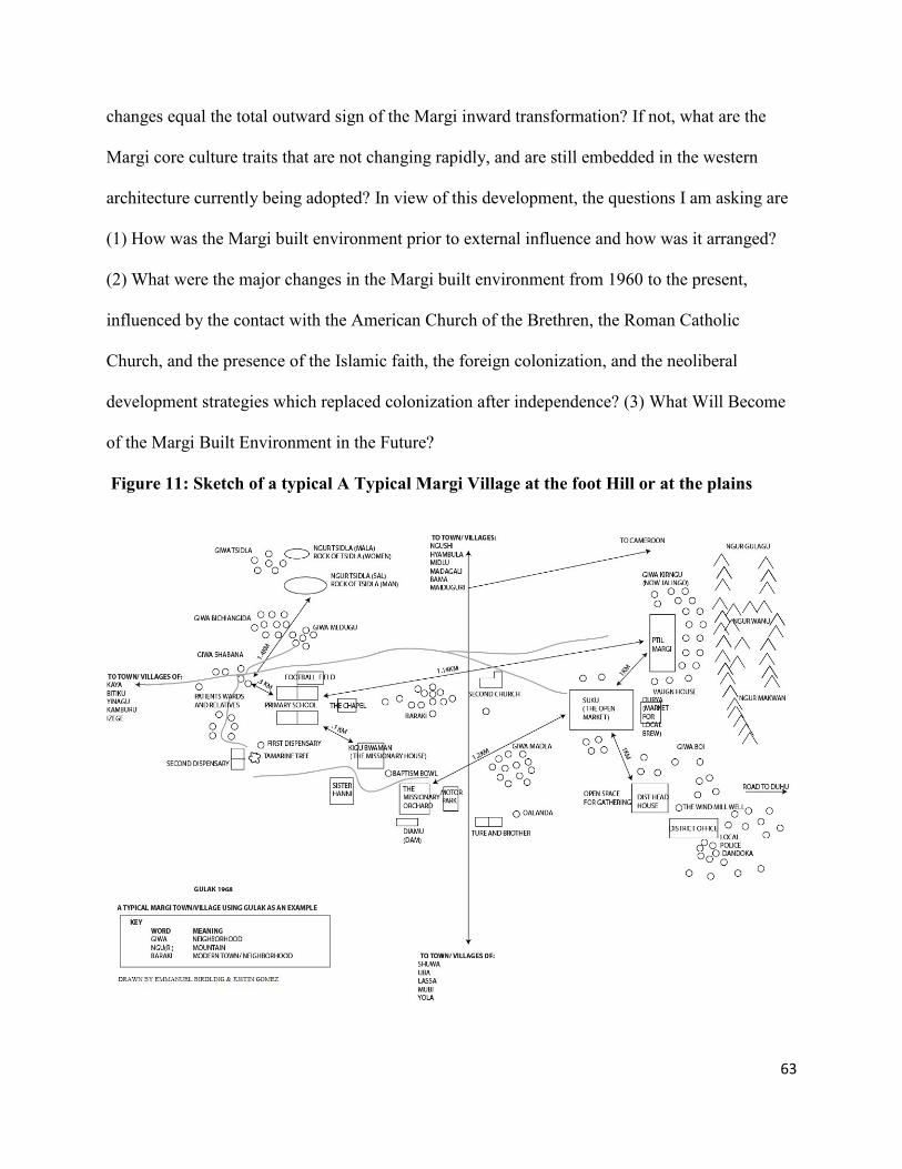
63
changes equal the total outward sign of the Margi inward transformation? If not, what are the
Margi core culture traits that are not changing rapidly, and are still embedded in the western
architecture currently being adopted? In view of this development, the questions I am asking are
(1) How was the Margi built environment prior to external influence and how was it arranged?
(2) What were the major changes in the Margi built environment from 1960 to the present,
influenced by the contact with the American Church of the Brethren, the Roman Catholic
Church, and the presence of the Islamic faith, the foreign colonization, and the neoliberal
development strategies which replaced colonization after independence? (3) What Will Become
of the Margi Built Environment in the Future?
Figure 11: Sketch of a typical A Typical Margi Village at the foot Hill or at the plains

64
2.7: Significance of the project
The significance of this project is that the stories of Margi encounters with the Western world
that led to the change in their built environment, either with the colonial officers or the
missionaries, are representative of the story of a majority of other African ethnic groups,
especially in sub-Saharan Africa where all the land was colonized by the outside world, with the
exceptions of Ethiopia and Liberia. Furthermore, the stories of the Margi’s regional encounter
with larger groups influenced by Islam like the Hausa-Fulani or the Kanuri in West Africa is
similar to other regional dynamics on the continent, such as the encounters of the Africans and
the Arabs that led to the development of the Swahili architecture in east Africa (Donley, 1990;
Allen, 1979; de Vere Allen, 1981; Horton, 2004). There is also a need to rethink the desire to
modernize the ‘others’ that emerged with western modernist thinkers which has altered the built
environments of many global societies especially in Africa, Asia and Latin America.
I chose this region, the Margi ethnic group, and this topic because most studies done in the
vicinity such as those by geographers like Michael Watts (1983), J.R. Thompson (1992), Simon
Batterbury (1998), or anthropologists like James Vaughn (who spent his life studying the Margi,
and other ethnic groups in this general area), and former colonial officers like Anthony Kirk-
Greene have not mentioned the living space of the people or the evolution of the built
environment of this region, including the Margi ethnic group. There is considerable work by
people like Shwerdtfeger (1982), Saad (1995), Nast (1997, 1998, and 2005), Pellow (2008), and
Eneh and Ati (2010), on Hausa cities, culture, and architecture, but this literature bypasses the
Margi, who have a distinct story in domestic architecture as in many other cultural factors.
Also the Margi cultural landscape/territory has a history of changing hands between the
colonial powers. It was first a part of German Kameroon (K) then later divided amongst the

65
World War I victors, where French Cameroon (C) lay to the east of the Mandara Mountains and
British Cameroon to the west of the mountains, and finally placed under UN protectorate status
prior to joining Nigeria in 1961 through a plebiscite (Lippmann, 1960). During all these
changes, the Margi ethnic group was at the center of this global drama. In fact, the section of the
British territory in which the Margi ethnic group resided was off limits to travelers until 1954.
This decision was made by the colonial powers with only limited permission granted to the
missionaries. Although my study focuses on the period beginning with independence in 1960,
this complex and divisive colonial backdrop played a role in differentiating the domestic sphere
of the Margi ethnic group.
66
Chapter 3: Methods
3.1: Quantitative and Qualitative
Although there are some elements of quantitative methods in my questionnaire, and the
approach I used when analyzing my field data, I used more of qualitative methods for my field
research. In this chapter, I mention the specific locations of my research and time period spent
there, describe the types of methods I used, and indicate number of people, and the places
involved. Finally, I provide justifications as to why I think these are the right routes that can lead
me to the answers to my research questions that were generated by my hypothesis. The specific
locations I went began with Elgin Illinois, - to the Brethren Historical Library and Archives in
June 2011. While there, I researched all the files that were maintained on the activities of the
field missionaries located in northern Nigeria. I paid special attention to those files that contained
information on Margi towns and villages. Since I already knew the names of the missionaries
that were specifically stationed in the Margi general areas, it was easier to streamline my search.
In fact, prior to my arrival at the archive, I had been in correspondence with the archival staff for
over two years; as such they had in depth knowledge as to what information that I needed. They
separated all the specific boxes that contained the files that were related to my area of interest. In
these boxes I found correspondence, meeting minutes, and articles on what was happening in the
general area of the Margi ethnic group. I was able to find the mentioned information from 1927
when the first station started in the Margi domain, until 1976, when the missionaries handed over
the school to the Nigerian State Governments; the information about the activities of the church
after 1976 also was available to me in Elgin.
The next location where I conducted archival research was at the Rhodes House Library in
Oxford, United Kingdom. I sought and obtained attachment to the African Studies Center at

67
Oxford University as a visiting fellow for the Michaelmas Term October 9th
to December 15th
2011. While I was in Oxford, I concentrated on the British colonial activities in Nigeria;
specifically the files maintained by the District Officers that were residents of Borno and
Adamawa Emirates, the two emirates where the Margi ethnic group resided during the colonial
periods. The most important colonial files pertaining to these areas, and the activities that
directly concerned the Margi ethic group, were those that came from Professor Anthony Kirk-
Greene. During the Colonial period, Kirk-Greene was the Assistant District Officer of Adamawa,
and then Borno Emirate. He wrote the first un-published history of the Adamawa, and then when
he was transferred to Borno, he also wrote the first history of Borno. He was also chosen by the
first premier of northern Nigeria to start an institute for training native District Officers in
preparation for Nigerian independence. Prof., Kirk-Greene helped to start what is today the
Institute of Public Administration at the oldest university in northern Nigeria, the well-known
Ahmadu Bello University. After his colonial appointment, Anthony Kirk-Greene became a
professor at the University of Oxford, at St. Anthony’s College where he taught for 30 years and
from where he has written extensively on northern Nigeria. I had the opportunity of meeting him
and discussing my research with him several times over the course of my visit. I also interviewed
him for three hours. He shaped my thinking on the Margi cultural landscape, an area he regularly
toured and for which he kept detailed notes on his activities as the assistant district officer. He
directed me to information that was directly related to the physical infrastructure that the British
Government developed in the Margi cultural landscape. In fact when I was given the opportunity
to present my work to the faculty and students in Oxford (in a lecture hall named after him), he
was there. He and other faculty members redirected my thinking on the influence of Islamic
culture on the Margi built environment.

68
My last destination was northern Nigeria where the Margi ethnic group lives, with hundreds
of questionnaires in hand, a digital tape recorder, a camera and other things I would need. During
the nine hours’ flight to Abuja, I had time to reflect on what Howard S. Becker wrote in his
article on “The Epistemology of Qualitative Research,” that “the variety of things called
ethnographic aren't all alike, and in fact may be at odds with each other over epistemological
details.” He opined that he would “concentrate on the older traditions, (e.g., participant
observation, broadly construed, and unstructured interviewing), rather than the newer trendy
version” (Becker, 1996: 57). In addition, I began to take solace in what Michael Quinn Patton
wrote in his book Qualitative Research and Evaluation Methods (2002). Patton informs our
understanding of ethnographic research - more specifically in my case, on the ‘emic’ perspective,
in which an observer not only sees what is happening but feels what it is like to be part of the
group, including how to avoid oppressing and preventing harm to those with whom we research.
The group, in this case, is the Margi ethnic group of northeastern Nigeria. My consolation
became even stronger when it occurred over and over to me that I belong to the Margi ethnic
group, and grew up in a Margi household, and therefore I am a participant observer and share as
intimately as possible in the life and the activities of Margi culture, which evolved along with
Margi built environment that I write about (Birdling, 2009; Gilman, 2003).
I now describe the types of methods I used, from a qualitative standpoint, and in part as a
summary of what I have already mentioned. I used the combination of archival research,
ethnographic perspective, semi-structured interviews and surveys, to investigate the evolution of
the Margi built environment. This includes the corresponding spaces shaped by such changes,
and what it means for the future of the Margi ethnic group. I utilize scholarly texts in order to

69
explain how the west used modernization under the umbrella of globalization as a disguise to
transform the cultural landscape of the “others” to be more like them.
The area where the research was conducted is situated at the border of northeastern
Nigeria and northwestern Cameron Republic. The ages of the subjects of my research ranged
from 17 to 93 years old. There were 105 of those that were between ages of 17 to 25, ages 26 to
60 were 240 in number, ages 61 to 85 were 40 in number; and finally ages 85 to 93 were 15 in
number. Exactly 13 of the subjects within the 85 – 93 year group did not remember their exact
ages; but 5 of the 13 are sure they were at least 5 years old or more when the missionaries
arrived. It had been 84 years from the time the missionaries set foot on Margi cultural landscape
and the time this research was conducted. I believe those of them that were born in the year 1922
(which made them at least five years old on the arrival of the missionaries, and first built a
station among the Margi at Lassa in the year 1927) do remember most, if not all of the changes,
that have occurred in the Margi built environment; there were a total of 5 of those that were 5 or
more years old in that year who took part in the research.
There were 10-12 of the interviewees who were 65 years old or more, and who had attended
the missionary schools, went on to obtained college degrees, and attained mid-management
positions or higher during their career in the government or private organizations. This group
provided my research with in-depth and highly intellectual opinions of the human drama that had
been and is still being played out in Margi built environment between the Margi, the Fulani, the
missionaries, and the residues of colonial activities, including how the effects of these forces still
linger in the Margi domestic sphere.
I started the research among the Margi by conducting interviews with several first
generation teachers of the Margi ethnic group and non-teachers that have spent their lives in
70
Margi land; since the intent of the dissertation was to document as much as possible how the
Margi built environment evolved from independence to the present. I hope that the future
generations and scholars can build on this dissertation. Furthermore, knowing fully well that the
Margi domestic sphere is where it is, and nothing can change the past, I turned to the younger
Margi generation for their opinion to see if they can give a glimpse into what they think will
become of the Margi domestic sphere in the future. Their opinions are presented in chapter six.
My survey was taken in 52 of the Margi towns and villages, including the two cities -
Yola and Maiduguri - that serve as the state capitals for Adamawa and Borno states. To
reasonably manage the information obtained, I grouped some of the smaller villages under the
bigger ones, as described in the following subsections.
3.2: Margi Towns and Environs
In both Adamawa and Borno, the Margi live in total of 11 administrative areas, with a total
of 72 towns and villages. I visited 52 out of the 72 and distributed questionnaires and conducted
some detailed interviews. During all the visits, I used Global Positioning System equipment to
record the latitude and the longitude points. With the help of a fellow PhD student studying GIS,
Weibo Liu, we selected at least one town from each of the 11 administrative areas and plotted the
general research area in both Adamawa and Borno states. As Figure 12 shows, the Margi of
Adamawa are located at the most northern part of the state while the Margi of Borno are located
at the southern part of the state. I would like to state that the GPS reading used to plot the town
of Kaya, is taken on the exact site of my late grandmother’s room where I was born. My
mother’s elder brother Hirarawa Sikari was able to pinpoint the exact location.

71
Figure 12: A Selected Town from the 11 Administrative Areas in the General Research Area;
Plotted by: Weibo Liu
3.2.1: Adamawa State: Yola State Capital
3.2.2: Gulak District and Environs: Distance from Gulak in Miles/ Cardinal Direction
Gulak…..Headquarters
Kaya………………………………………………………….3 West
Kuda…………………………………………………………4 West
Hyambula……………………………………………………6 North
Mazhinyi…………………………………………………….4 North

72
Bitiku………………………………………………………..7 West
Ghumbili …………………………………………………..4 East
Yinagu……………………………………………………....9 West
Jalingo……………………………………………………….2 North East
Jilang (Kafin Hausa)………………………………………...7 North
3.2.3: Duhu District and Environs: Distance from Shuwa in Miles/ Cardinal Direction
Shuwa…..Headquarters
Duhu Yelwa ………………………………………………....4 North
Duhu Ki……………………………………………………...4 North East
Mayowandu (Brishishiwa)…………………………………...4 East
Kwambila…………………………………………………….3 West
Pallam………………………………………………………...7 East
Dzu’yel……………………………………………………….6 North East
Kwajiti………………………………………………………..10 South east
3.2.4: Madagali District and Environs: Distance from Madagali in Miles/ Cardinal
Direction
Madagali…..Headquarters
Wagga………………………………………………………..3 North
Bebel…………………………………………………………3 South East
Sukur Dorowa………………………………………………..2 South
3.2.5: Kirchinga, Kopa and Wuro Ngayandi District and Environs; Distance from
Kirchinga in Miles / Cardinal Direction

73
Kirchinga …..Headquarters
Kopa………………………………………………………….4 South West
Kuda Higi…………………………………………………….2 East
Wuro Ngayandi-Ki…………………………………………...2 West
Wuro Ngayandi……………………………………………….5 West
3.2.6: Sukur District and Environs: Distance from Vilangadi in Miles / Cardinal Direction
Vilangadi..…..Headquarters
Sukur
Midlu Shalmi………………………………...........................3/4 West
Midlu Vapura………………………………………………..4 West
Gubla…………………………………………………………6 West
3.3.1: Borno State: Maiduguri State Capital
3.3.2: Lassa District and Environs: Distance from Lassa in Miles / Cardinal Direction
Lassa…..Headquarters
Samuwa………………………………………………………2
3.3.3: Izege District and Environs: Distance from Izge in Miles/ Cardinal Direction
Izge…..Headquarters
Karli…………………………………………………………2 West
Chakuraku…………………………………………………..5 North East
Bita………………………………………………………….9 North
Mbulanggiling………………………………………………..11 South West
Valanguri……………………………………………………7 North East

74
Kamburu.……………………………………………………4 East
Dagumba……………………………………………………8 North West
Tuhum………………………………………………………2 South
Gu’u Amulu………………………………………………...2 East
Madubu……………………………………………………..9 North West
Kwamdu…………………………………………………….9 North East
3.3.4: Ngurthafu district and Environs: Distance from Ngurthafu in Miles / Cardinal
Direction
Ngurthafu…..Headquarters
Yaffa……………………………………………………..2 North East
Maikadiri…………………………………………………5 North East
Bdagu…………………………………………………….9 West
Gurgyangol……………………………………………….10 East
Bagajau…………………………………………………...4 East
Giwahigi………………………………………………….5 East
Dzodzoma………………………………………………...3
3.3.5: Dille District and Environs: Distance from Dille in Miles / Cardinal Direction
Dille…..Headquarters
Pumbum……………………………………………………4 North
Kwang……………………………………………………..6 North
Huyim…………………………………………………… 2 North
3.3.6: Musa District and Environs: Distance from Musa (HQ) in Miles / Cardinal Direction

75
Burda………………………………………………….. ..2 East
Sabongari………………………………………………...8 South east
Kelle……………………………………………………..5 South East
Chul……………………………………………………...5 South
Kundlindila…………………………………………… 3 South
Dubunkwa……………………………………………….2 South
3.3.7: Damboa District and Environs: Distance from Damboa (HQ) in Miles/Cardinal
Direction
Damboa…..Headquarters
Talala……………………………………………………32 North west
Mulqwe ………………………………………………26 South east
Kurjan…………………………………………………….22 South West
Kauji….. ………………………………………………..19 South West
Azur………………………………………………………24 West
Gamsuri…………………………………………………. 24 South
Bale………………………………………………………12 South east
Bego……………………………………………………...37 South east

76
Table 4: A Table Showing the Survey Proportion of the Main Towns and their Environs
Town and its Environs Percentage of Questionnaires
Answered
Cumulative Percent
Damboa 4.1 4.1
Gulak 40.2 44.3
Izge 5.2 49.5
Lassa 12.4 61.9
Madagali 10.3 72.2
Maiduguri 8.2 80.4
Shuwa 9.3 89.7
Yola 10.3 100.0
In addition to the interviews conducted in various Margi villages and towns, I also
conducted interviews with the Margi living in Maiduguri, the capital of Borno state; and Yola the
capital of Adamawa state. As mentioned earlier these two states are where the Margi cultural
landscape is currently located in northern Nigeria. It is very common, perhaps the norm, that the
Margi people that live in these two cities own homes in the city where they reside in addition to
the homes they own in their various towns and villages in the Margi cultural landscape. By the
time I started the analysis, I had 400 detailed questionnaires answered by men and women of the
Margi ethnic group including those that were mailed to me after I left research area, and an
additional 35 detailed interviews. In each house hold, there might be two to four separate
changes made to separate structure at different times. I believe the combination gave me a
reasonably representative sample for the analysis I have made in chapter five. Based on the age
groups, it is reasonable to conclude that the majority of them have witnessed the evolution of the
Margi domestic architecture beginning from 1960, while the younger group talked about what
they foresee the future of 21st century Margi built environment would be. Having a mixture of
educated and older non-educated groups is a good thing. They are not opposed to each other, but

77
rather complement each other in the sense that, when the educated ones went left Margi villages
to attend school or work in other non-Margi towns around Nigeria, the older groups were at
home, gradually altering their domestic architecture. When the educated ones came back home
with new ideas, they helped to accelerate the changes even further. The only difference between
these two groups is that the older ones were not able to afford modern buildings materials, but
have in some ways modified their domestic sphere.
The younger and more educated groups have more resources, and they have travelled to
other city, which allows them to see different ways of living by the Nigerian major ethnic
groups, and some of them have come back home and constructed structures using modern
building materials in the Margi cultural landscape. The group ages 17 to 25 reflects the views of
the Margi of the 21st century and what safe and habitable homes mean to them. This group has
not seen the total process of change that the older groups have seen. I have also observed
building components such as roofing, windows, walls, shapes of rooms to evaluate the
percentage of what is modern and what is not in order to compare this with the result of the
survey; the two results seems to be consistent. Furthermore I have used photos taken in the 1950s
of Margi people made available to me by James Vaughn, an American anthropologist who spent
his career studying the Margi and other ethnic groups in this general area. The difference among
the photos showed some of the changes compared with photos I took during my research. I have
interpolated my samples, generalized and made conclusions about how the evolution of the
Margi built environment reflects the process of globalization, as a pretense of modernizing the
others; and the Margi ethnic group experience might be representative of other African ethnic
groups.
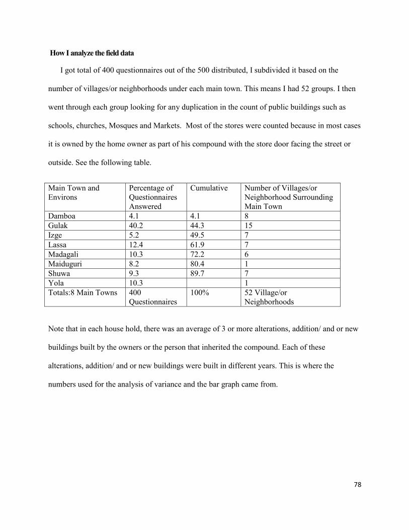
78
How I analyze the field data
I got total of 400 questionnaires out of the 500 distributed, I subdivided it based on the
number of villages/or neighborhoods under each main town. This means I had 52 groups. I then
went through each group looking for any duplication in the count of public buildings such as
schools, churches, Mosques and Markets. Most of the stores were counted because in most cases
it is owned by the home owner as part of his compound with the store door facing the street or
outside. See the following table.
Main Town and
Environs
Percentage of
Questionnaires
Answered
Cumulative Number of Villages/or
Neighborhood Surrounding
Main Town
Damboa 4.1 4.1 8
Gulak 40.2 44.3 15
Izge 5.2 49.5 7
Lassa 12.4 61.9 7
Madagali 10.3 72.2 6
Maiduguri 8.2 80.4 1
Shuwa 9.3 89.7 7
Yola 10.3 1
Totals:8 Main Towns 400
Questionnaires
100% 52 Village/or
Neighborhoods
Note that in each house hold, there was an average of 3 or more alterations, addition/ and or new
buildings built by the owners or the person that inherited the compound. Each of these
alterations, addition/ and or new buildings were built in different years. This is where the
numbers used for the analysis of variance and the bar graph came from.

79
Chapter 4: Margi Built Environments in the Past
Section 1: Typical Margi Domestic Architecture Prior to the External Influence
Figure 13: A Typical Margi Dwelling in the Plains
[I]n Great Britain, as elsewhere in Europe, the evidence leads us to the conclusion that the
earliest form of dwelling, fit to bear the name of house, was round. Round huts are still
used in Africa, and such huts seem to have been common to many different races at an
early stage of their development. In Italy the type of the round form of house lasted
down to historical times in the temples of Vesta. In England it may have been preserved
in the round temple found at Silchester and one or two round churches, like that at
Little Maple stead in Essex. In Ireland, says Professor Sullivan, ‘round houses were
made by making two basket-like cylinders, one within the other, and separated by an
annular space of about a foot by inserting upright posts in the ground and interweaving
hazel wattles between, the annular space being filled with clay; Upon this cylinder was
placed a conical cap, thatched with reeds or straw (Addy, 1905: 1).
In this chapter, I present the Margi ethnic group’s domestic architecture prior to colonization,
the coming of the missionaries, and the period prior to independence. I use two examples from

80
two different terrains, using two Margi clans and two Margi towns for the other: a) I chose two
clans among those that left and reside in the Mandara Mountains; b) Instead of choosing clans, I
worked with two towns from the Margi that left and resides on the plains. When I use the term
mountain and the plain, I am referring to the period after the Margi ethnic group left the Lake
Chad area and dispersed in different direction and settled in these locations. I describe how those
in the mountains constructed their living space, using photos, and sketches. I also describe how
the domestic architecture changed and the process for the construction after they moved out of
the mountains and settled on the plain. Above all I present the role women play in the
construction of the Margi ethnic group domestic sphere.
As indicated earlier, the Margi people lived peacefully around Lake Chad before the
expedition of the Saifawa Dynasty under the leadership of Idris Alauma from 1564 -1576. Due to
the expedition activities of Idris Alauma, the Margi ethnic group dispersed in various directions
under family patriarchs. The groups dispersed to two general locations: some groups went into
the Mandara Mountains enclaves and other groups went and settled on the plains. This explains
why the majority of the Margi towns or neighborhoods are of the same clan. But all the clans
maintained the same language and culture, and all have always maintained that they came from
the east (Kirk-Greene, 1962). However, in due course some variations in pronunciations started
to appear because of contact with other ethnic groups, especially larger groups. One example of
such a larger group is the Kanuri ethnic group. The Margi that went to Mulgwe plains started to
adopt Kanuri words because of the close proximity to Borno, where the Kanuri ethnic group still
resides (Barth, 1857: 106; Kirk-Greene 1962; Cohen, 1967).
In this chapter, I show how the built environment of the Margi ethnic group evolved in the
two locations, for those that were in the mountains and those in the plains. The compound layout

81
for both locations stayed very similar, but each group started to use material available in their
immediate vicinity to construct their living space. In other words, though the layouts stayed the
same, the materials used are from the immediate surroundings. There are two main differences
between those that went and settled at the plains and those that went to the mountainous enclave
in the manner they construct their architecture and re-order their environment. Those that were in
the mountains used pieces of stones, and those that resided in the plains used mud as the main
material. I start with those that went to the mountains. I chose two clans as examples from
among the Margi ethnic groups that chose to flee into the mountains: the Medugu Kirngu clan
and the Birdling clan.
4.1.1: The Medugu Kirngu Clan
Both of these groups are Margi, they have been living in the same mountain, relocating from
one section of the mountain to the other for over 350 years - that is, approximately from the time
they left the Lake Chad general area because of Idris Alauma’s expedition until the 1930s to the
1950s, when the majority relocated to the mountain slopes and plains. There is no evidence the
two groups have lived together in the mountain, but have had occasional contacts when attending
market or other activities especially from the beginning of the colonial rule when massive slave
raids stopped. There have been intermarriages between the groups as well, and this continued
into the modern day.
During the field research, I organized two trips to the abandoned villages at the top of the
Mandara Mountains. The first trip was to the Medugu Kirngu clan area and the other to the
Birdling clan area. During my trip to the Medugu Kirngu clan’s old village, I was accompanied
by 25 people from the Medugu Kirngu clan. Among them were: the ptil (chief), Sa’ad
Danburam, a middle-aged veterinary doctor who inherited the chiefdom of this particular

82
Medugu Kirngu clan, whose authority extends over the modern day town of Gulak; and a well-
respected member of the Medugu Kirngu clan and the Margi ethnic group in general, Bello I.
Pur, a former cultural officer who started and developed Adamawa State Arts Council, a public
department charged with the planning and implementation of all the cultural activities for the
state. Pur headed the department for 24 years and finally retired as permanent secretary in the
Adamawa state public service after 32 years. In his former position, as the director of the state
cultural office, he was the custodian of the state cultural history and affairs; in fact, his
department documented and wrote brief histories of all the ethnic groups in the state. Beyond
these two, my companions included a traditional custodian of the Medugu Kirngu clan history,
Denis Lagu, a pastor of a Christian church; and a leader of the Islamic faith. All are members of
the Medugu Kirngu clan. The rest of the group was comprised of retired military, and police
officers, civil servants, several university students, and lay people. After a tiresome mountain
climb for two hours, we reached the mountain top where the Medugu Kirngu clan was staying
until 1956. There we found remnants of a culture that once thrived on the top of the mountain
range. Figure 14 shows the ptil (Chief) with some of the member of the research team sitting at
the spot, a flat granite rock, which is halfway between the base and the top of the mountain,
where the ptils that preceded him sat and rested on their way down to the plain or on their way
back to the village on top of the mountain

83
Figure 14: The Ptil (Chief of Gulak) with some of the Research Team and (Informants)
Source: Photo by the author (December, 2011)
All of these people I mentioned agreed with the clan’s oral history custodian who was part of
this research trip that their ancestor, a man called Kumavudu, was one of the sons of the chief of
Sukur (Sukur is another ethnic group which Henrich Barth referred to as Sugu people). The
Sukur Chief is referred to as “la” in the Sukur language (Barth, 1857: 114; Vaughn, 1964; Kirk-
Greene, 1962). Kumavudu was driven from the Sukur chiefdom by his father, who was the chief
in collaboration with the Chief’s advisers, because Kumavudu had only one testicle, a deformity
that was regarded as a curse, and, therefore, he was not supposed to stay among the people or in
the chiefdom for that matter. When Kumavudu left Sukur, he wandered within the mountainous
enclaves alone and finally settled in a cave close to the Ghuwa and Kwazhi clan’s village, two
clans living together. Ghuwa and Kwazhi clans are another two of the Margi clans that fled into
the mountains. Kumavudu hunted mountain animals for food and on several occasions he
brought some meat and gave it to the children of the Ghuwa and Kwazhi clans after all the adults
had gone to the farm. Some of the parents of the Ghuwa and Kwazhi clan had asked their child
who has given them the meat, the children told the parents that they did not know his name but
that he was a male and they did not know where he came from. Then one day a dog brought the

84
meat of a small animal from which the hairs had been burned and the meat prepared. They knew
the dog could not have done that, it had to have been done by a human. So they kept an eye on
the dog in case the dog decided to go for another trip. Someone followed the dog one day, until
the dog and the man reached the cave where Kumavudu was staying.
As a gesture to Kumavudu’s kindness in bringing meat to the Ghuwa and Kwazhi clans’
children on several occasions, the Ghuwa and Kwazhi clans’ leaders invited Kumavudu to live in
their neighborhood. In addition, the clan elders gave him one of their daughters whom they
believed to be barren because she had been married for long time without giving birth and her
husband had divorced her for that reason. To the surprise of the Ghuwa and Kwazhi clans,
Kumavudu’s new wife started to have children. The children of this union are the ancestors of
the Medugu Kirrngu clan. So this clan comes from the Margi maternally, and Sukur paternally.
Figure 15: Shows the Abandoned and Rundown Stacked Stone Fences of the old Medugu Kirngu
Homes in the Mountains
Source: Photo by the Author

85
Figure 16: This Photo Shows Remnants of Circular Rooms on the Left inside the External Fence
Source: Photo by the Author
These photos shows the remnants of how the Medugu Kirngu clan lived for hundreds of
years; it is fair to say that slave raiders would have thought twice before venturing up there.
From what I saw, this group chose a strategic location which will allow them to see whoever was
coming toward the village before the person could see them, and they had poisoned arrows,
spears and other weapons waiting. Within this mountainous region, they managed to find
farming areas, water sources and plenty of mountain animals to hunt, in addition to the animals
they kept. According to the informants’ narratives, it took the colonial officers quite some time
to convince the chief and his advisors to agree to leave the mountain top and relocate down to the
foothills in 1956.

86
Figure 17: A Remnant of the Chief’s Horse Stall, just by the entrance to the Chief’s Compound
.
Source: Photo by the Author
As part of the built environment of the Mountain Margi ethnic groups, their burial ground is
a significant part of how they have changed and shaped the enclave of the Mandara Mountains
for generations. This aspect of the Margi ethnic group that was residing in the mountains also
changed after they relocated to the plains. The Christian and Islamic faiths have changed the way
burial is taking place on the plains. I give the details of the new ways of burial in my research
findings.
Figure 18: The Burial Site of the Medugu Kirngu Clan; the Circular Pile of Stones is all about 4
feet above the ground
Source: Photo by the Author
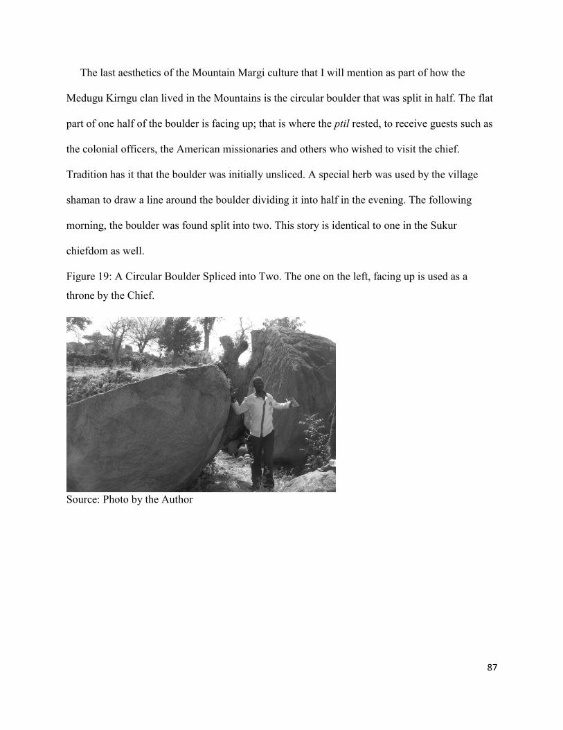
87
The last aesthetics of the Mountain Margi culture that I will mention as part of how the
Medugu Kirngu clan lived in the Mountains is the circular boulder that was split in half. The flat
part of one half of the boulder is facing up; that is where the ptil rested, to receive guests such as
the colonial officers, the American missionaries and others who wished to visit the chief.
Tradition has it that the boulder was initially unsliced. A special herb was used by the village
shaman to draw a line around the boulder dividing it into half in the evening. The following
morning, the boulder was found split into two. This story is identical to one in the Sukur
chiefdom as well.
Figure 19: A Circular Boulder Spliced into Two. The one on the left, facing up is used as a
throne by the Chief.
Source: Photo by the Author

88
4.1.2: The Birdling Clan
The location of where the Birdling Clan lived in the mountainous enclave is about 6 miles
from where the Medugu Kirngu Clan lived. The Birdling Clan believes they came from Mchakili
(another name for the Mchakili is Gudur) currently placed under the present day Cameroon
(Kirk-Greene, 1960: 433; Kirk-Greene 1967). In order to write this section, I conducted intensive
interviews with 5 elder members of the Birdling clan before the trip to the old village where they
lived in the mountains. This is in addition to the occasional conversations I have been having
with my grandfather from when I was in the elementary school until his death when I was about
23 years old. The conversations with my grandfather continued, in content terms, with my own
father for a long time after that. Furthermore, although I was residing in the United States, I had
hours of conversation with my father and his piers on the telephone over a period of 6-8 months
regarding the history and other activities of the Birdling Clan, while I was writing my MA thesis
in 2008. He was still living during my field trip to Nigeria for this dissertation research. I had
further conversations with him and a few of his friends who are members of the Birdling Clan. I
interviewed my old headmaster, Bulama Wajilda, the first native headmaster of the American
Church of Brethren Primary School in Gulak, and later headmaster of the largest Church of the
Brethren primary school in the divisional headquarters located in Mubi. Bulama also became the
administrative officer for the first Church of the Brethren Mission hospital in Lassa and finally
the first member of the Gongola State House of Assembly, representing a huge portion of the
Margi ethnic group. Another person I interviewed is Abasiryu Wajilda, the first native son
among all the Margi ethnic groups that were residing in the Mandara Mountains to receive a
history degree within a Western education. He taught in the American Church of the Brethren
Mission post-primary school for long time, then as the principal of the largest teachers college in

89
Mubi, the divisional headquarters for the entire south Margi ethnic group. In addition, this first
native historian went on to be the Director of Education at the state level and finally the state
director for the National Youth Service for the Nigerian Government. Furthermore, I also
interviewed another retired teacher, Jilantikiri Sinamai, former member of Adamawa State
House of Assembly who also attended to the church of the Brethren Schools and has live all his
life in the Margi land. All of the mentioned interviewees are members of the Birdling Clan.
It is a general consensus among the Birdling clan that they came from Mchakili, and settled
at Wanu, a portion of the mountainous enclave where the Margi Wanu clans have lived for
generations, and thus the location is named after Margi Wanu clan. When they were living at
Wanu; the Margi Wanu clan felt threatened by the sheer number of the Birdling clan, in the event
of a war breaking between the two groups. For this reason, according to them, someone they
believed to be one of the Wanu clan poisoned the water sources in form of a spring or a well
from which the Birdling clan fetch their drinking water. As a result, almost half the children of
the Birdling clan lost their lives. This was the reason the rest of the Birdling clan left Wanu and
moved to their last location in the mountainous enclave, a neighborhood called Makwan. It was
from this location they moved out of the mountains in 1934 and settled about two miles away
from the mountains. The common phrase they use for this migration is “Latu dumir adzia a du
ngu” meaning when “when we’ came down from the Mountain.”
When I organized the trip to the Birdling clan old village in the mountains, which is called
Makwan, a group of 14 people accompanied me. One of them was a former Vice Chairman of
the Madagali Local Government, where both of these mountain clans are currently residing. He
is a member of this clan. Also included were some civil servants, a local pastor, and some
university students. The most informed informant that accompanied me for this trip was Glanda

90
Udurwa, who is the direct descendant of the chief of the blacksmith for the Birdling clan. As the
chief of the blacksmith, he is the traditional funeral director for the Birdling clan. He knows the
old village very well, and he still resides very close to it. Within all the rundown remnants of the
piles of stones, he knows whose compound was where. His ancestors passed down this
information to him. He showed me where my 4th great grandfathers’ home was located, as he
was told by his ancestors. Figure 20 shows the team that accompanied me to the old Village of
the Birdling Clan in the Mandara Mountains; 6th from left standing (in a white robe) is the
current chief of the black Smith for the Birdling Clan.
Figure 20: The Photo of the Research Team (and Informants) to the Birdling Clan Old Village in
the Mountains
Sources: Photo by the Author

91
Figure 21: The Photo of rundown piles of stones that was once a compound fence at the Birdling
Clan Old Village in the Mountain
Source: Photo by the author
Figure 22: A Circular Animal Pen at Makwan, the Birdling Clan’s Former Village
Source: Photo by the Author

92
Figure 23: An Entry Gate comprised of Two Large Granites split stones left and right, into my
4th Great Grandfather’s Compound at (Makwan); the old Village of the Birdling Clan
Source: Photo by the Author
Surprisingly, most of the entry gates of the old stacked stone fences are all facing to the
south; a similar orientation was repeated at the new settlement on the ground. This is how I
remember it during my childhood when growing up in the new settlement “on the ground.” After
a series of consultations and inquiries about why the entry gate for the most part faces the south,
the answer is that it is because the wind blows from the north to south. If the gate faces north it
will bring in the dust and diseases that come with the wind into the house. With time, the
orientation started to change, especially when there was a main dirt road passing through, the
residents of the new settlement started to orient the main gate of the compound to face the dirt
road, and homes were lined up on both sides of the dirt roads.
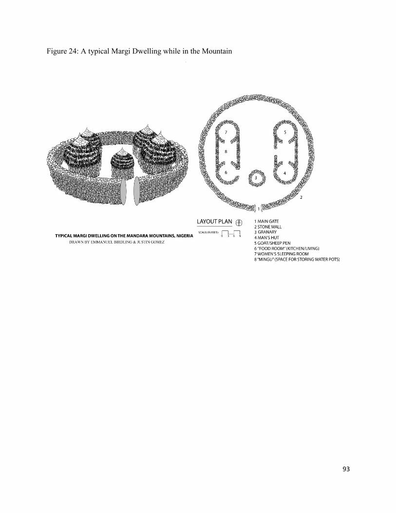
93
Figure 24: A typical Margi Dwelling while in the Mountain

94
4.1.3: The Margi Residing on the Plains
There are several Margi ethnic group clans that left and settled on the plains after their
dispersion from Lake Chad. In the previous section, I chose two Margi ethnic group clans that
were living in the mountains and analyzed their architecture while they were still in the
mountains. But for the Margi ethnic groups of the plains, I chose two towns instead of clans.
This is because there are no clear separations between the clans because of how the towns have
grown over the years. This makes the clans’ neighborhoods as units of the towns. In fact in some
cases they are all related, and at times they are sons and daughters of distant relatives or brothers
who settled very close to each other on the plains for security. This can also be said of those that
were in the mountains; they maintained their clan identity by staying together, and also for
security. I chose two towns of the Margi from the region that came under the influence of the
American Church of the Brethren mission. The reason is that the Catholic Church did not start a
station in this part of the Margi ethnic group’s domain. Furthermore, the Islamic influence is a
recent phenomenon among the Margi ethnic group. There is no Margi neighborhood that is
primarily a Muslims neighborhood, with the exception of that of the Medugu Kirngu clan, who
converted to Islam as a group in 1964. Using these two towns from the Margi ethnic group of the
plains, I trace how their architecture evolved prior to their contact with the missionaries and the
colonial officers. I show how their architecture differs from those that went into the mountains
simply because of the type of material available within the proximities of the two locations,
which each group used to construct their domestic sphere. The two locations are Lassa and
Tampul towns. During the field research for this dissertation, I went to both locations that are six
miles apart.

95
4.1.4: Lassa Town
During my visit to Lassa, I had an extensive interview with one of the first native teachers
for the American Church of the Brethren primary school in Lassa, Thawur Njabdi. Note that
Lassa is the first Margi domain where the American Church of the Brethren built a station for the
purpose of preaching the Christian gospel. Thawur Njabdi is 83 years old with a very sharp
memory. He wrote the first book in Margi, Ndir Mji Tsintsil- meaning the sayings of the wise.
During the interview, he described his childhood home, his days at the missionary primary
school as a pupil, and then as teacher, the missionary living space that they built for themselves,
his own first compound, and his present compound.
I believe the first thing that will come to the mind of any person who has the opportunity to
listen and analyze Thawur Njabdi’s story is a picture of the chronological evolution of a built
environment that can be representative of any culture anywhere in the world. But it is certainly
representative of most cultures across Africa that was influenced by foreign missionaries. In fact
he repeated how the missionary neighborhood developed in Gulak. Gulak is the next main town
that changed because of the activities of the same American Church of the Brethren mission
when they planted a new station there in 1948. The description of the setup of Njabdi’s boyhood
home is similar to the setup by the mountain Margi after they left the mountain and relocated to
the mountain slope/the plain.
He also described how the native teachers, including him, started to build the shotgun-like
structure, but using grass for the roofing in the beginning, later switching to corrugated iron
sheets. A shotgun (at least the Margi style) is a rectangular structure that consists of one, two, or
more rooms that may have one entry door or individual entry doors. The town of Lassa, Njabdi’s
home town, is the first Margi domain to come under the influence of the American Brethren

96
Church activities, and so people from Lassa are the first Margi to receive western education; the
first person of the Margi ethnic group ancestry to attend the Church of the Brethren affiliated
Universities in the United States (McPherson College in McPherson Kansas) came from Lassa. It
took 21 more years before a similar mission was planted in the next largest Margi town, Gulak. I
show in my research finding that the impact of the missionaries on Margi intellectual
development went hand in hand with the evolution of the Margi built environment. The
beginning of the changes the teachers started, as Njabdi’s story indicates, was a direct influence
of the missionaries. The teachers were in essence imitating the missionary residence, school
building and the church building which were all built in rectangular or semi-square shapes.
4.1.5: Tampul Town
I drove through Tampul on my way to Lassa town. I made observations but did not interview
anyone, because I felt I already had sufficient sources in the United States and Tampul is a
secondary example or model for my findings in comparison to Lassa. A major source is Philip
Musa, who is from Tampul, and whom I have known since 1993. He is a registered electrical
engineer, who worked for Texas Instruments as a designer for 6 years before going back to
school; he is now a professor of information management system at the University of Alabama in
the United States. Musa was born and raised in Tampul; he recalls vividly how Tampul was like
over 45 years ago. Within this time frame, he remembers who moved into his neighborhood and
who moved out, how the buildings changed with time, and who built what. Based on my
conversation with Musa, he recalled during his childhood in the mid-1960s when the whole
village, now a town, was using the traditional round huts fenced with thatch mats. The next
phase of change, according to him, began in the 1970s when the thatch mat fence was replaced
with a mud fence; but in the case of Musa’s village, the mud fence is attached to the circular mud

97
huts from center to center leaving the other semi-circular half of each mud hut to serve as the
external fence.
Figure 25: A Sketch Based on Philip Musas’ description of his Childhood Home
The information obtained from Musa, about how the first mud fence is constructed is a new
phenomenon to me, as a descendant of the Margi who were living in the mountainous enclave.
This is a variation that did not appear among any other Margi ethnic group that were in the
mountains and then moved out to the slopes and plain. This seems to have been limited to this
environs and the Margi ethnic group in this general area, the Margi of the plains. In other Margi
areas, either among those that have been on the plains from the beginning or those who were in
the mountains but moved out to the plain, the next step after the thatch fence was a rectangular
mud fence which did not attach to any room, but surrounded all the rooms in the compound.

98
When I interviewed another Margi man, Emmanuel Mdurvua who is from the general area
where Musa is from, he confirmed what Musa said, that he has also witnessed the same changes
in his own village of Burda: a mud fence attached to round huts center to center, leaving the
other semi-circular half of each mud hut to serve as an external fence. Burda village is part of
another Margi town called Mussa, a town that has been in the plains for over 350 years. (Note
that Musa’s name with one -s is similar to the town of Mussa with two- s, but this should not be
confused as one word.) My second informant, Mdurvua, was on my MA committee. He was
born and raised as a Margi from Burda neighborhood of Mussa town. He has a PhD in
Veterinary Medicine, and was a research professor for over 15 years, and now a senior scientist
at the United States Department of Agriculture. Both of these informants went to the schools that
the Church of the Brethren Mission started in Margi land, but in their individual towns, just as I
went to the same mission school in my town of Gulak.
4.2: Margi Domestic Architecture in New Hamlets on the Plains, Prior to and For About 10
Years after the Coming of the Missionaries
“Since the coming of the missionaries, people came and built homes closer and closer to
them because of the school, the dispensary, the church, the orchard, and the desire to be with
each other until the mission neighborhood developed” (Njabdi 2011). What I mean by new
hamlets on the plain, I am referring to those that never went to the mountain because of Idris
Alauma and those that just moved out of the mountain from hiding because of the presence of
the colonial power and the missionaries. Margi domestic architecture started to change with the
coming of the missionaries, but it took another 6 to 10 years after their arrival. This is because it
took a while for the pupils that started the mission schools to complete at least standard four (the
equivalent of fourth grade of today). In addition, the children recruited to attend the missionary
99
school were older than today’s traditional school age. It took fellows like Njabdi almost 10 years
to reach grade three, before coming back to the mission school as a teacher. Furthermore, it took
the new teachers, or those who joined the police force, became soldiers or did office work for the
new Nigerian nation-state another year or so before they could have enough money to start
building their own homes. One thing is for sure, though: they started to build structures similar to
the buildings the missionaries introduced or to what they saw in other places where they worked.
4.2.1: The Construction Process of the Margi Ethnic Group Compound on the Plains
To understand the construction process of the Margi ethnic group new compound, it will
help to understand the Margi relocation process. Apart from the coerce relocation as in the case
the chief of the Medugu Kirngu clan and his chiefdom, the Margi relocations were done in
groups, as happened during the mass dispersion from around Lake Chad due to Idris Alauma’s
expedition. For example, when my ancestors moved out of the mountains, they came out in
groups of three or four brothers. This account is narrated by my father and other elders I talked
to. This account is similar as told by most Margi clans. The family patriarch initiated the idea to
the men of the clan based on certain things that had happened to the group at the present
location, or a foreseen opportunity in the next proposed location. This was followed by
consultations among the men during which the selection of direction and the spot to move to was
agreed upon. Some of the reasons that influenced the decision to pick the time for moving, going
to a particular direction, and choosing particular spots were: rainy season for the year was over;
the farm work was about to come to an end, the crops (Guinea Corn) were maturing, generally a
month or so to the harvest time; the availability of water in the new location or a sign of low
water table so that a well could be dug; a sign of fertile farm land near or within walking
distance; the availability of other ethnic members in the general area; and how far the location is

100
from fellow ethnic members or relatives. Generally the preferred spot for the compound is the
presence of sandy soil for easy discharge of rain water or drainage because, if mud huts’
foundations remained water-logged, they could easily collapse. Therefore an area without proper
drainage are avoided. All the arrangement was kept secret within the group. As I recall from two
relocations my father did during my childhood, the moving occurs very early in the morning
before sunrise, generally in early November; because that is when all farm work has been done
except the crop harvest. This time of year is the coldest (lows of about 40 degrees Fahrenheit) in
the region occupied by the Margi ethnic group.
The relocation after the rain stops was preferable for the following reasons: mud hut can only
be built during the dry season; there are no attempts to do so during the rainy season, because the
tropical storms are so intense and can easily accumulate inside circular structure and can
compromises the strength of the foundation especially when the mud is still wet. Another reason
is that the temporary shelter made of thatch mats at the new site in which the family would stay
before the mud huts were built could not adequately stop the occupants and their belongings
from getting wet during the rainy season. And finally, perhaps the most important reason was the
help from men and women of the new location, since their farm work was complete, with the
exception of the harvest.
4.2.2: Construction Materials
Just like other cultures across Africa, the Margi ethnic group of the northeastern Nigeria used
the available materials in their immediate vicinity to construct their architecture. As I indicated
in the previous section, the part of the Margi ethnic group that was living in the mountains used
pieces of stones as the main portion of the building material for both the round hut and the
surrounding fence. After moving out of the mountains, the main portion of the material became

101
mud for round huts and mats woven with tall grass for the fences. The mats used for the fences
were about 8 foot high x 15 foot to 25 foot in length. The mud used for the huts were dug out of
a pit on a specific location at a reasonable distance from the building site, because it was carried
to the building site by human labor. This particular type of tall grasses are called tsaba, misham-
disu, and ghatsila in the Margi language; the first two of these type of grasses are generally
called ‘misham’ when used for roofing; and the name changes to ‘ubsar’ when the intent is to be
used for making the fencing mat, called ‘thafu’. The reason for the name change is because of
the usage and the purpose intended. The structural frame that supports the misham for the roofing
is also woven out the third type of the grasses mentioned above, the bigger and stronger type
called ‘ghatsila’. Please note that even though many of the processes that I am describing in the
rest of this chapter are in the past, I use the present tense from here on out, in the interests both of
readability and of instilling the idea that the “traditions” of the Margi can be, despite the changes
I show as still occurring, contemporary and “modern.”
4.2.3: Preparation of Materials on the Plains
The mud is dug out of a pit on a specific location at a reasonable distance to the intended
building site. The women help by bring water from the local well or a stream to mix the soil,
while the hard job of digging the mud out of the pit and mixing it with water is left for the men.
If the soil is too clayish some sandy soil will be added during this time of mixing with water;
also two to three inches of chopped grass or straw is added until the right mix is obtained, just as
described in Exodus, 5: 10 when the Jews were making brick in Egypt. This process which is
locally known as ‘Tubu i’i’, is the first step in the mud preparation; this is repeated over and over
as needed throughout the building process. The mixed mud has to remain in place for at least
three days after the first mix or more prior to the final mixing before it is used for the building.

102
The final mixing before it is handed to the builder in a ball shaped form is done in batches. The
builder can be any of the clan elders, because most of them have been building their own mud
huts for long time. The last mixing prior to the building must be malleable enough or it is
continuously tramped on with bare feet until the correct and proper mix is obtained including
additional pieces of straw if needed before it is used for the building.
4.2.4: The Tools
The type of implements used to harvest grass and dig out the mud, prior to and shortly after
the arrival of the missionaries, have been in use in Margi culture for hundreds of years. Prior to
the arrival of the missionaries, Margi implements for harvesting grass were sickles, just as a hoe
was used for farming. When venturing to distant place to harvest the grass, a man would carry
his bow and arrow, spear and, occasionally, a shield (if deemed necessary to defend in case of
attack by enemies). In addition to the farming, the hoe would be used to dig out the earth, to mix
it with water, and other preparations necessary prior to the building of the hut, including setting
out for the hut foundation. There are two types of hoes: the light one used by women for farming
(mintsu), then the bigger one (kwaji) used both for farming by men and for construction work.

103
Figure 26: A Photo showing Men’s Farming Hoe; also used to dig out Earth for Construction
Source: Photo by Peter Awidau on request
Figure 27: A Typical Sickle used to harvest all type of Grass used in Construction
Sources: Photo by the Author
A few years after the coming of the missionaries, followed by the formation of Nigeria
nation state, a shovel and a digger were introduced. In the early 1960s, as I recall, only a few
people could afford it. Some people had to borrow it or rent it for their own use.
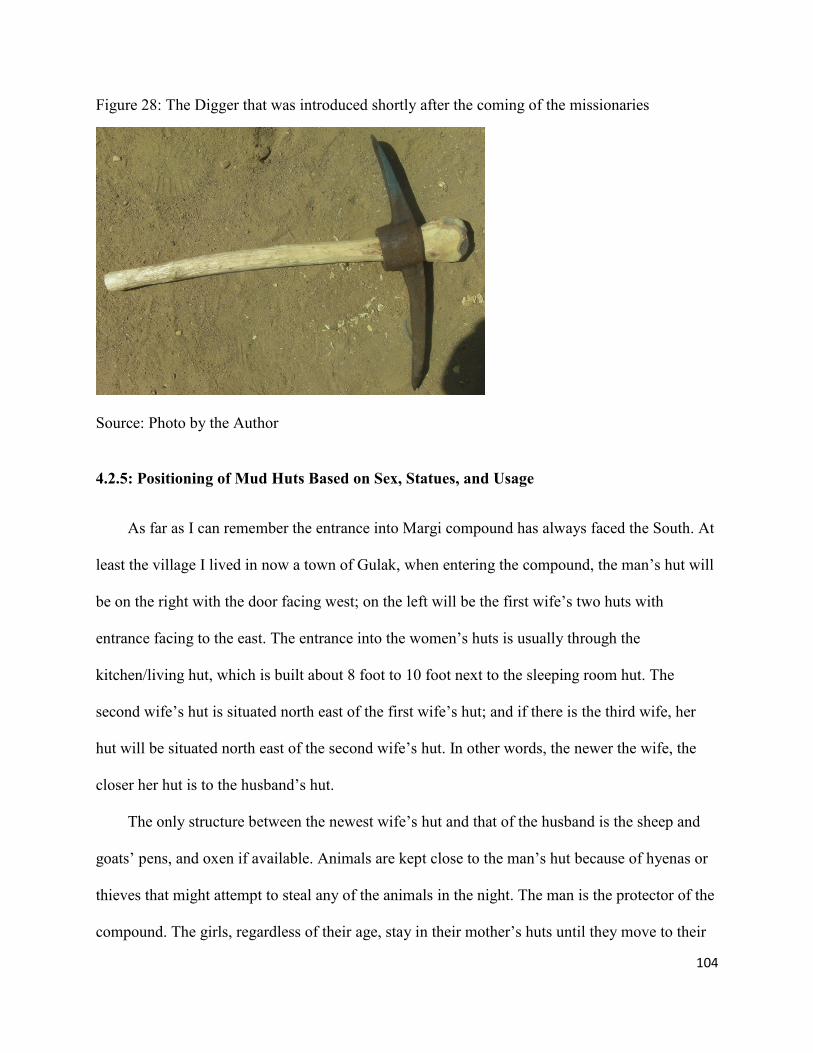
104
Figure 28: The Digger that was introduced shortly after the coming of the missionaries
Source: Photo by the Author
4.2.5: Positioning of Mud Huts Based on Sex, Statues, and Usage
As far as I can remember the entrance into Margi compound has always faced the South. At
least the village I lived in now a town of Gulak, when entering the compound, the man’s hut will
be on the right with the door facing west; on the left will be the first wife’s two huts with
entrance facing to the east. The entrance into the women’s huts is usually through the
kitchen/living hut, which is built about 8 foot to 10 foot next to the sleeping room hut. The
second wife’s hut is situated north east of the first wife’s hut; and if there is the third wife, her
hut will be situated north east of the second wife’s hut. In other words, the newer the wife, the
closer her hut is to the husband’s hut.
The only structure between the newest wife’s hut and that of the husband is the sheep and
goats’ pens, and oxen if available. Animals are kept close to the man’s hut because of hyenas or
thieves that might attempt to steal any of the animals in the night. The man is the protector of the
compound. The girls, regardless of their age, stay in their mother’s huts until they move to their

105
husbands’ home. As for the male children, from age 12 to the time they move out, a hut is built
for them in the family compound generally located southeast of the first wife’s hut, who in most
cases is their mother. The family guinea corn granary is situated in the mid-way between the first
wife’s kitchen door and the boy’s door, but not directly in the center of the courtyard of the
compound. For the most part, the location of the family granary is intended to shield the boy’s
door from the main empty space of the compound. The general layout makes the view something
close to a semicircular arrangement, as all doors face the court yard in the middle of the
compound.
Figure 29: A Sketch of the General Layout of the Margi Compound in late 1960s (Awidau’s
Compound)

106
4.2.6: Setting Out of the Huts
The setting out of the huts is done after enough mud has been dug and mixed, covered with
grass and has spent at least three days ‘setting’. The reasoning for letting it remain for three days
is for it to ‘mthu’…which means setting, and the organic substances that found their way into the
mud are fermented in order not to create bubble in the wall. The size of foundation depends on
the intent. If the intent is to bring the thatch roof from the previous compound, then the
measurement is based on the mud hut size in the previous compound; and if the intent is to
prepare a new roof then the owner can set it out, sizing it based on his needs. Two people are
required to perform the setting out. A rope woven with grass called ‘dankwadu’ is looped around
the hoe and one person holds one end of the rope at the desired center of the hut, while the
second person will make two to four inch mark on the ground by stretching the rope with the hoe
and pushing the hoe to the ground at the same time, then moving backwards. The rope controls
the distance of the hoe from the center, making a circular line while going round and round. This
movement continues until the desired depth of 2 –3” is obtained. The width of the blade of the
hoe is about 6”.
4.2.7: The Foundation
The circular foundation mark made on the ground by the hoe is the guiding center line for the
mud hut builder when placing the first layer of the mud in place. The helper will scoop a portion
of the previously mixed mud and add water and pieces of grass cut in batches of 2 to 3 inches in
length to the mud and tramp on it with bare feet as needed to attain a thorough mixture and make
it malleable enough for the builder; this will facilitate easy placement to form the foundation.

107
Figure 30: Men Building a Mud Hut
Source: Sister Hanni Schlapbach of Switzerland, photo taken 1968 to 1977
The foundation thickness is based on the intended height of the mud hut. Typically, the
height ranges from between 7 foot to 8 foot for the women’s and 8 foot to 9 foot for men’s. The
thickness of the foundation ranges from 16 inch to 24 inch for all. Before forming the
foundation, the loose top soil on both sides of the circular line is cleared with a hoe before the
foundation mud is placed using the circular line previously drawn as the center guide. The first
layer ranges from 8 inch to 12 inch in height and it will be left to dry out before the second layer
is placed. The actual building continues within the next several days until it is completed.
Always without exception, the women’s sleeping hut is built first so that the women and the
children can be safe. The second hut to be built is the hut used for both kitchen and living space
for the woman and her children; which is built about 8 foot to 10 foot next to, and parallel to, the
woman’s sleeping room.
Prior to the 1970s, there were seldom any windows, especially on women’s huts, with the
only door leading from the cooking hut /living room through the walls of the shed between the

108
living/cooking and the bedroom hut, leading directly to the bedroom hut door. The men’s hut
may have one window facing the sunset, the west, directly into the court yard. When I asked
some of my informants why the Margi ethnic group huts did not have windows, and especially
the woman’s hut, the answer given was “because of snakes.” Snakes can come in through the
windows during the day time and hide somewhere in the room and bite occupants as they are
sleeping.
4.2.8: The Thatch Roof Structural Frame
The roof structural frame for any of the huts are woven, folded and covered with thatch
misham on the ground before it is raised by a group of men and placed on top of the mud hut. It
takes a week or two to finish the process of constructing the thatch roof structural frame out of
the strongest type of tall grass available. It is important for the hatsila (the special tall and the
strongest grasses in the Margi plain) to dry out first after it is harvested and then soaked in water
before it is used. It starts with laying the dry bundle of hatsila in a pond or the bundle covered
with grass and frequently sprinkled with water. The head of the household or the man announces
the weaving of the roof structural frame to potential helpers in the neighborhood earlier, about a
week before the time. Note that most works done on building is done during the dry season from
January to the middle or end of April. That is why it is easier to solicit help from neighbors and
obtain it in a short period of time since there is no farm work during the dry season. Above all
Margi architecture is not doable in the rainy season because the mud can easily be destroyed by
the rain. The women or the woman of the house prepares the local brew for the structural frame
weaving occasion. In the early morning the men will gather and start the process. The weaving is
started by the eldest and most experienced men while the younger and less experienced ones

109
watch and help in any way they can. First the weaving is in the same manner as that of the thatch
mat but the ends are left loose.
After it reached the desired height the mat is raised and folded in a hat shape and the two
loose ends are woven together, forming a circular shape. Usually the weaving and the
reinforcement can be accomplished in two days, depending on the number of participants. The
reinforcement is done with a special type of elongated shrub called kugil. This type of shrub is
only found in the mountains.
The kugil, which will be used for reinforcing the roof frame, is harvested and dried out in
the same process as the grass that is used for the frame. A bundle of the kugil is soaked in water a
week prior to use. The method of installation is accomplished by three people. Two people go
under the circular roof and one stays outside. The reinforcement material is installed from inside,
beginning from the bottom, using an 18 inch needle-like piece of equipment made of iron with a
grass rope attached to it. A small bunch of the kugil is rolled up about 1 ½ inch in diameter, then
attached to the roof one roll at a time, then tightened-up with a rope called vivi made out of a
special grass called ihidagu.
Figure 31: Internal Reinforcement of the Roof Structural Frame
Source: Peter Awidau, on request

110
This process is continued in a circle around the internal part of the structural roof with the new
one installed on top of the previous bunch until it reaches the height of 8 inch to10 inch, which is
approximately 4 to 5 layers of the rolled kugil tied to the roof frame The same process is repeated
every twelve to eighteen inches. The construction of the frame for any round hut in the
compound is the same, with the exception of the animal pen, for which the roof’s frame may be
made out of wood or corn stalks. The art of roof making is a point of pride for a Margi man; one
is laughed at when he constructs any roof frame out of wood or corn stalk for sleeping rooms,
because it is considered a sign of laziness.
The next step is to cover the structural frame with grass called misham. In the same manner
with the stronger grass that is used for the roof frame, misham is harvested, dried out and used.
All grass harvesting is done from the middle of November to early February and the bundles are
left to dry out before they are woven with the special grass mentioned earlier called ihidagu. The
weaving of misham is done by obtaining a small bunch about ½ inch in diameter at a time, then
the ihidagu is looped around it on both sides about 12 inch from the bottom.
A typical woven bundle could be about 30 foot when stretched out. After it is woven, it is rolled
and stored until the time for use. The installation of the misham on the roof frame is achieved by
rolling the bundle of woven misham grass around the roof structural frame until a depth of about
6 inch is obtained, or enough depth to make it water tight.

111
Figure 32: Roofing; the Roof Structural Frame being covered with Misham
Source: Sister Hanni Schlapbach of Switzerland, photo taken 1968 to 1977
The installation continues upwards towards the top. For every round, the bottom part of the next
round is moved up about 1 inch above the last round until it reaches the top of the roof frame. At
the top, the misham top ends are bent over the opposite sides and sewn down by the needle- like
iron mbuti with the grass rope, creating a conical shape.
The last cover is called wata. From a distance, it looks like a cap on the roof. It is woven in
the same manner like the roof itself but using a smaller and a finer grass. It is installed and
tightened in place with the same type of grass rope, vivi used for installing the kukil to the roof
structural frame.

112
Figure 33: The Roof Cap-Like Top Cover (Wata) being woven
Source: Sister Hanni Schlapbach of Switzerland, 1968 to 1977
A needle like slim iron which is about 24” long is used to sew the wata on top of the roof. Cow
dung is used to seal the hole the iron needle might have generated during the process. After all
the process is complete, the home owner tells several men in the evening before the roof is
placed on top of the mud. The raising of the roof, as the Margi call it, “hu umbwa” is done
mostly in the early mornings. The men are situated around the roof at two to three feet distance,
center to center. After a signal is given by an elder person who may or may not be part of the
raising effort, the roof is lifted and placed on top of the hut. An adjustment is made until they
feel it is perfectly placed.

113
Figure 34: Finished Roof Being Raised, to be placed on Top of the Mud Hut
Source: Sister Hanni Schlapbach of Switzerland, 1968 to 1977
4.2.9: Construction of the External Fence
The construction of the external fence is entirely the men’s job. It starts with the harvesting
of the tall grass called ‘tsaba,’ which is amply available in the savanna grassland of northeastern
Nigeria. The men either weave the mat while the grasses are still fresh or leave it to dry out.
Either way several thatch mats ranging in sizes from 8 foot x 15 to 25 foot are woven, but the
actual quantity depends on the size of the compound, which in turn depends on how many wives
and children the man has. The next step is to harvest enough (3 inches to 4 inches in diameter x 9
½ foot to 11 foot long) poles from the backwoods. In most cases the men prefer the type of
species of trees that can grow roots and leaves, so that the termites cannot destroy it and no
replacement is needed in future.
After sufficient grass mats and poles are obtained, the process starts with marking out the line
for the fence, and along the line, the points for holes. The holes are dug along the line 2 ½
to 3 foot center to center x 2 foot deep, with enough circumferences to accommodate the
individual poles. In my experience the male children help their father dig the holes required for
the poles when constructing the fence around the buildings. After the poles are placed into the

114
hole, then the earth previously dug out of the hole is used to refill the remaining space around the
poles, the hoe is removed from the pole which was used to dig the hole, and the sharpened edge
of the pole is used to tamp down the loose soil around the pole to compact the soil in order to
make the pole to which the fence mat is fastened stable. When this process is completed, it gives
the appearance of stretches of standing grass mat externally from a distance because all the poles
that the mats are fastened to can only be seen from the inside of the compound. The next step
required to complete the external fence is to harvest enough branches from shrubs with thorns on
them from the surrounding savanna. The commonly used thorn shrub is called ‘wuya.’ The thorn
shrub is neatly arranged and fastened around the mats from the external sides of the fence mat
for the sole purpose of stopping goats or sheep from using the fence to scratch their body and
subsequently penetrating the fence for an easy way in and out of the compound.
Figure 35: A Portion of Installed Thatch Mat Fence
Source: Photo by the Author
In the early 1960s, it occurred to the Margi that the best way to stop hyena from stealing their
goats, sheep and even the barking dog is to replace the easily penetrable thatch mat fence with a
mud wall. This subsequently became a style, and in a short period it became a sign of wealth and
added additional security to the compound. In fact, with the introduction of mud walls as a fence,
families started to spend the night in the open court-yards during the hot season. The usual fear

115
of mad dogs biting and infecting humans, which are very rampant in the Margi cultural
landscape, started to disappear.
Figure 36: The Beginning of the Change; a Man and Son Building Mud Wall Fence
Source: Sister Hanni Schlapbach of Switzerland 1968 to 1977
Just like this little boy is doing, I have helped my father build the first mud wall around my
family compound. The practice helped my father become the chief mud hut builder of Gulak.
There were other men as well who were making extra income buildings mud walls for other
people.
4.3: The Role of the Women in the Construction of a Margi Compound.
A familiar model or stereotype of the African people is one of living on savanna plains,
trailing herds. In this model, it is thus implied that for the major part of their existence, they are
highly mobile, living in small bands, led by dominant males, the females submissive to male
demands. This stereotype does not apply to the Margi. The Margi are not male-dominated bands,
but families cared for and trained by the females; the family is the basis of Margi society. The
men might roam to ‘dandi’ Nigerian towns and cities to look for temporary work during dry
seasons when they are not working on their farms; but the women seek a place at which to stay,

116
a home where the offspring could be left in safety, a place convenient to the daily provision of
water and food, where supplies and possessions could be stored (Sauer, 1981: 133).
Figure 37: Margi Women in 1960/61
Source: British Library at [email protected]. Photo by Malcolm Cooper, the Plebiscite
Supervisor for Madagali/Chibunawa Districts: The Northern Cameroons Plebiscite 1960/61
The roles of women in the evolution of the Margi built environment are central to all
aspects of it. In fact, in the absence of women’s role, the Margi domestic sphere is 3/4
incomplete. Prior to completing the proposal for this dissertation, in my mind, I always
incorporated the role women played during construction of the Margi sphere into the total whole.
I never concretely separated women’s role from the total effort. One day one of my female
advisors casually asked “what role do women play in all this?” Since then, it is like a window
has been opened, and light was let into a dark room. It did not take me long to recall what my
mother and the other women from my village were doing when someone moved to the village or
relocated within the village from one site to the other. In this section, I will use the narratives
from five Margi women: Aisa Yakubu, Rhoda Amtagu, Ladi Denis, Sidayu Dzugwahi, and
Martina Abba Sashi. The information obtained from these women adds to the evidence of my
117
personal memory from seeing what my mother, her friends and relatives did when my father
moved the family two times from one site to the other.
4.3.1: Cooking for the Working Men and Women
Relocation of a compound is mostly done after all farm work has been completed except
harvesting the crops. During the mud hut construction, when men and the women of the village
come and help, they are not expected to go back to their various houses to eat lunch and then
come back. So the woman or women of the house cook (s) large meals that will feed everyone
around. This involves more work than the western cooking where everything is purchased from
the grocery store and ready to be put into the pot. In the case of the Margi women they have to
grind the corn by hand on a flat stone. This was the way corn flour was prepared in Margi land
until mid-1960s when guinea corn grinding machine started to appear in Margi cultural
landscape. The vegetables, beans, and other ingredients are sometimes fetched from the farm
including the fire wood from the surrounding woodland.
4.3.2: Fetching Water for the Whole Project
The mud requires a lot of water to mix it, so that it can be malleable for building the huts.
The men are responsible for the physical digging of the mud out of the pit from a chosen site
within a reasonable distance from the building site. A group of men start digging out the dirt
until a substantial amount is dug out enough to build at least one mud hut to start with. Then a
day is fixed for the mixing; that is when another group or the same group of men but including
some women will show up to help. The responsibility for fetching water used for mixing the mud
falls on the women; the work usually starts very early in the morning, and the women use a big
calabash (gourd) called ‘u’dabra’, going back and forth to the well or a pond to bring the water
while the men are doing the mixing with hoes. This continues for hours until the time the woman

118
of the house will start preparing lunch for the group. This may continue after lunch until dinner
time, but it depends on how much was accomplished and how soon the mixed mud is needed.
4.3.3: The Interior Finishing and its Arrangement inside Women’s Quarters
In this section I concentrate on how the women do the finishing inside the sleeping hut and
the hut used for kitchen and living room for the mother and the children. This will include the
beds, storage cooking space and the general finishing that only women know how to do.
4.3.4: The First Plastering of the Interior Walls with Finer, Smoother and More Watery
Mixed Red Earth
The first thing the woman does is to prepare a more malleable mud with finer, smother,
and more watery mixed earth, preferably without too much sand, and use it to plaster the walls
and the floors of both the mud huts. This will smooth out the uneven spots left by the men during
the building, and the uneven floor surface created when leveling the coarse earth brought in to
raise the floor lever. This first plaster by the women is not the final one. This plastering is left to
dry for few days before the women begin the installation of the internal finishing.
4.3.5: Building of Timbul (a Flat Wooden Bed)
Then the next thing is to build her own wooden bed called ‘timbil’ (Saad, 1991).
The bed consists of three 1inch x 12 inch x 7 foot flat planks cut out of local woods by the
husband or a relative. It is the responsibility of the man to obtain these flat planks, and six Y
shaped pieces of wood, each about 4 inch in diameter x 24 inch long; and three 3 inch in
diameter x 3½ foot wooden log for the construction of the wooden bed for the woman. Then the
teenage boy if one is available or the woman will dig two rows of six holes 2 foot center to
center in each row, in a rectangular fashion with two apposite holes parallel and facing each
other. The construction of the woman’s bed has been traditionally been built on the eastside of

119
the sleeping mud hut. The Y shaped wood is placed into the holes, and the exposed Y shaped
sides is left about 12 inch above the floor. A wet mud will be placed around the Y shaped woods
to keep them in place, and then left for two days or more to dry out. After that, then the 4 inch x
3½ foot poles are placed on each pair of the Y shaped wood across from each other. This is
followed by the flat planks placed perpendicular to the poles; and this completes the Margi
women’s wooden bed construction.
The same process is repeated on the west side of the sleeping hut for the children, but
because of the labor involved in obtaining the flat planks, an earth bed is constructed for the
children instead; in a similar way the earth bed is made in the living / kitchen hut or a base is
constructed similar to that of the mother, but a grass mat is made in place of the flat wood
planks. This is accomplished by building a rectangular wall about 16 inches above the ground
with one side attached to the external wall of the mud hut. The opening is filled with sand and
earth leaving about 3 inch below the wall. The top 3 inch left is filled with wet mud, plastered
and left to dry. All that is needed is a mat placed on top of the earth bed for the children to sleep
on. Usually two to three children share such bed.
4.3.6: Installations of ‘Bra’ (Guinea Corn Grinding Stones)
In Margi culture, the corn used for cooking, be it maize or the traditional guinea corn, is
ground on a large flat-top, granite stone, using another hand held smaller one flat side to press
down the corn. The flat topped granite stone measures about 2 ½ foot in length x 1 ½ foot in
width x 1 foot in depth, in a semi-circular or egg shape, is used for generations for grinding corn
flour among Margi ethnic group. The man of the house and his friends are responsible for
locating, breaking and chipping away the granite in the mountains and bringing home the two
fairly flat granite stones for the woman, who will work on the finer shaping of the stones into

120
grinding stones. This includes 4 to 6 smaller pieces about 6 inch x 6 inch x 2 inch in size. One
side of each of these stones will be chiseled flat by the woman and her friends using a piece of a
stronger type of granite stone. This takes days or weeks to complete. The corners of the bigger
stones will be shaped in a semicircular form, and so are the smaller ones. The grinding stones are
installed on the south side of the kitchen hut, because the two doors on the kitchen/ living hut are
almost both in the first quadrant of the hut. A semicircular short wall is built about 1 ½ foot
above the ground, and after the wall has dried out, the big stones are placed inside the wall side
by side with about a 2 inch gap between the two with the flat sides up. In addition, as part of this
traditional hand grinding mill, two clay pots are placed inside the wall, each directly east end of
each grinding stones close enough for the corn flour to drop into the pots during grinding. Then
many pieces of stones are used to brace the grinding stones in place, making sure the flat sides
are facing upward and upper surfaces of both the grinding stones are slightly tilted towards the
catching pots. This is followed by placing a well-mixed wet earth around the flat stones leaving
the flat upper sides about ½ inch above the surface, and it is left to dry out for several days until
the final finishing with red earth. The smaller stones are the ones the women hold in their hands
when grinding the corn into floor, by pushing forward and backward on top of the bigger ones,
with small batch of the corn pushed between the bigger stone and the smaller ones that is being
held by hand, during the grinding process (Pur, 2005).
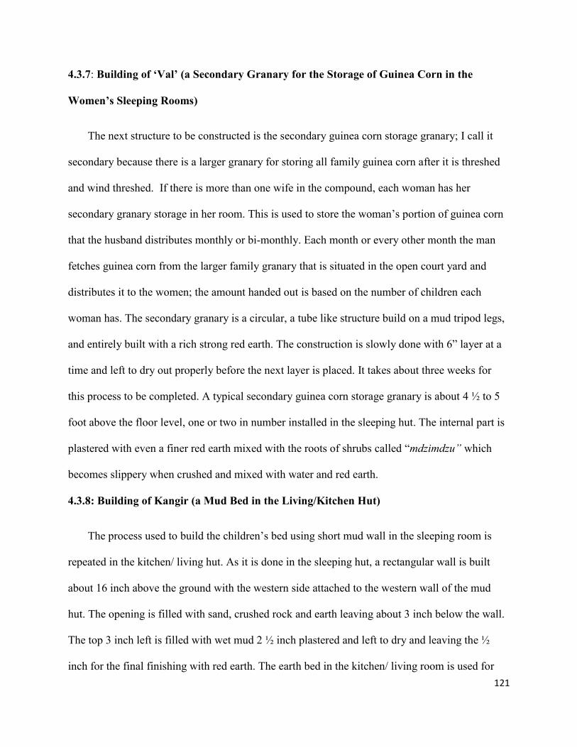
121
4.3.7: Building of ‘Val’ (a Secondary Granary for the Storage of Guinea Corn in the
Women’s Sleeping Rooms)
The next structure to be constructed is the secondary guinea corn storage granary; I call it
secondary because there is a larger granary for storing all family guinea corn after it is threshed
and wind threshed. If there is more than one wife in the compound, each woman has her
secondary granary storage in her room. This is used to store the woman’s portion of guinea corn
that the husband distributes monthly or bi-monthly. Each month or every other month the man
fetches guinea corn from the larger family granary that is situated in the open court yard and
distributes it to the women; the amount handed out is based on the number of children each
woman has. The secondary granary is a circular, a tube like structure build on a mud tripod legs,
and entirely built with a rich strong red earth. The construction is slowly done with 6” layer at a
time and left to dry out properly before the next layer is placed. It takes about three weeks for
this process to be completed. A typical secondary guinea corn storage granary is about 4 ½ to 5
foot above the floor level, one or two in number installed in the sleeping hut. The internal part is
plastered with even a finer red earth mixed with the roots of shrubs called “mdzimdzu” which
becomes slippery when crushed and mixed with water and red earth.
4.3.8: Building of Kangir (a Mud Bed in the Living/Kitchen Hut)
The process used to build the children’s bed using short mud wall in the sleeping room is
repeated in the kitchen/ living hut. As it is done in the sleeping hut, a rectangular wall is built
about 16 inch above the ground with the western side attached to the western wall of the mud
hut. The opening is filled with sand, crushed rock and earth leaving about 3 inch below the wall.
The top 3 inch left is filled with wet mud 2 ½ inch plastered and left to dry and leaving the ½
inch for the final finishing with red earth. The earth bed in the kitchen/ living room is used for

122
sitting by the children during evenings when the mother is cooking, especially during the rainy
season and for women visitors to spend the night. The kitchen/ living room is where all activities
such as cooking, grinding and storage of few dry fire woods and dry greeneries used for cooking
soup are stored out of the rain.

123
4.3.9: Installation of ‘Lamti’ (a Tri-Pod Built of a Red Earth for Supporting Cooking Clay-
Pot)
This cooking tri-pod structure called “lamti” in Margi language is constructed on the east
side, and south of the kitchen/living entry door. This is protected from view by a 3 inch x 3 foot
x 3 foot dwarf wall called “liwa” built perpendicular to the entry door. In other words the
cooking tripod is between the tips of the north east corner of the grinding stones ‘bra’ and south
of the dwarf wall. The dwarf wall protects the cooking activities and the woman doing the
cooking while siring on a stool from view through the door. The construction of this horn like
three earth legs-like tripod is done with red earth. All the circular bases of the three pods are
about 4 to 6 inch in diameter, gradually becoming smaller in diameter upward. All the three are
must be equal in height, about 8 to 12 inch above the ground.
4.3.10: Installation of ‘Zaka’ou’ (a Suspended Fire Wood Storage Ropes Directly Above
‘Lamti’ the Cooking Tripod)
Zaka’ou is used for storage of dry firewood for cooking meals during the rainy season. This
is a simple installation of three looped ropes attached to the roof frame about 1 foot center to
center used to store dry woods suspended from the roof by the zak’ou ropes during the rainy
season. The man weaves the ropes and help with the installation. Both ends of each rope is
attached to the roof frame with one end about 1 ½ foot above the other end of each rope on the
roof frame. The same process is repeated for all the three rope installed 1 foot from each other
center to center. The fire woods are inserted into the loops of all three ropes, one by one, making
all the three loops acting as one to supporting weight of the bundle of fire wood. This is about 4’
suspended above the ‘lampti’ the cooking tri-pod. The woman doing the cooking can reach the

124
fire wood if she needs to add some to the burning fire while seating on a stool; also this dries the
wood out in case some are brought in wet from rain.
4.3.11: Construction of ‘shasha’ (a Ceiling Level Storage Space Suspended Directly Above
‘Bra,’ the Grinding Stones)
This is a rectangular shade like simple storage space suspended at the roof level using 4
wooden Y shaped poles as columns or posts. All the 3 are installed on the north side of the
grinding stone (bra) to support the north ends of the beams, while the south ends are rested on
the mud hut wall. The arrangement is done in this manner so that each pair of the posts or
columns support 4 inch x 4 foot wooden beams; that in turn support a smaller woods placed on
the top of the beams in a perpendicular fashion. The voids between the woods on top of the two
beams are filled with corn stalks. The final processes in the installation is to tie down the wood
on top together in a wave like manner using a strong rope to prevent the pieces from moving or
falling off. The space above created in this process is used to store dry greeneries in pots or
gourds and other things needed for cooking. In addition, this is where the already cooked food is
kept away from the dogs and chickens. During my primary school days my lunch was always
kept there. This suspended storage structure is directly above the grinding mill stones. High
enough to allow the women do the grinding while kneeling on their knees.

125
Figure 38: Photo of a Margi Woman Grinding Food Item on extra uninstalled Grinding Stone
Source: Sister Hanni Schlapbach of Switzerland, photo taken 1968 to 1977
4.3.12: Installation of ‘Talagu’
This is a circular tube woven with rope; and hanging from the internal thatch roof frame of
the sleeping hut for storing decorated calabash or gourds. The prides of the Margi women are
their decorated calabashes of all sizes. The calabashes or gourds as it is called in the west is used
as spoons, drinking cups, carrying water, as a basket to carry goods to the market, and to store
sun dried food items, usually on top of the suspended storage space or the shasha. The calabash
seed is planted and grown alongside the red guinea corn which is planted closer to the
compound. The red guinea corn is the first to be planted and the first to be harvested as a security
for food shortage. Gourd seed are planted at the same time as the red guinea corn seeds, but
gourds take longer to mature.
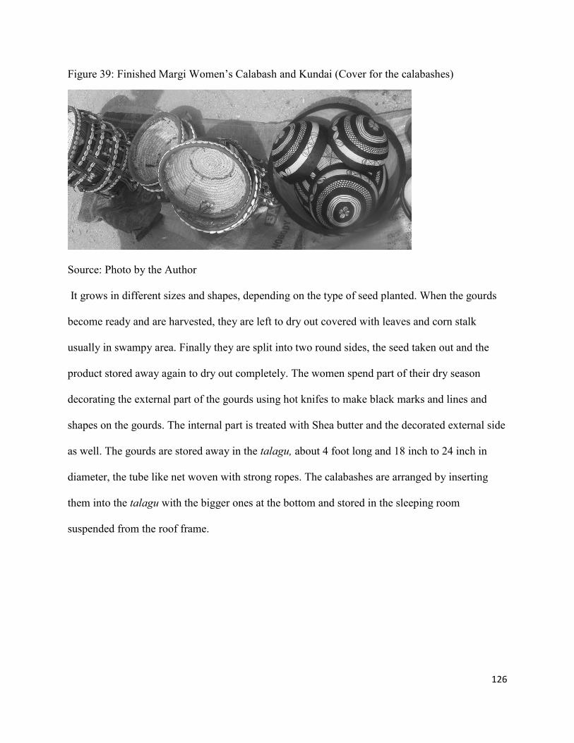
126
Figure 39: Finished Margi Women’s Calabash and Kundai (Cover for the calabashes)
Source: Photo by the Author
It grows in different sizes and shapes, depending on the type of seed planted. When the gourds
become ready and are harvested, they are left to dry out covered with leaves and corn stalk
usually in swampy area. Finally they are split into two round sides, the seed taken out and the
product stored away again to dry out completely. The women spend part of their dry season
decorating the external part of the gourds using hot knifes to make black marks and lines and
shapes on the gourds. The internal part is treated with Shea butter and the decorated external side
as well. The gourds are stored away in the talagu, about 4 foot long and 18 inch to 24 inch in
diameter, the tube like net woven with strong ropes. The calabashes are arranged by inserting
them into the talagu with the bigger ones at the bottom and stored in the sleeping room
suspended from the roof frame.

127
4.3.13: Construction of Mingu Walls and Placing a Pile of Corn Stalks About 12 – 16 Feet
Deep on Top of the Two opposite Walls.
Figure 40: A Typical (Detailed) Women’s Quarter
In the previous section of the construction process, I have indicated that, the kitchen/living
hut that is part of the woman’s quarter is built at a distance of 8 foot to 10 foot from the sleeping
hut. There are two doors on the kitchen/living room hut. One of the doors is used as the main
entry from the open court yard into the kitchen/living room hut; the second door is facing the

128
space between the kitchen/living room hut and the sleeping room hut. The space between the two
huts is bounded by two walls on both sides with the ends of the short walls attached to the
kitchen/living room wall; and the other ends of the walls are attached to the sleeping hut wall.
This creates a rectangular shaped space between the two huts. The whole structure which
includes the two walls, the enclosed space and the top, which is covered by corn stalk, is called
mingu. The purpose is to create shade for the water storage pots, protect people from rain, when
entering the sleeping hut from the living/kitchen hut or vice versa, and provide extra space in
addition to the two huts rooms. The top can be used to dry greens for dry season use, and store
clean pots.
4.3.14: Installing Big Water Pot under Mingu
Drinking water pots are very important in Margi culture. It serves as the western household
overhead tank. It is the women’s responsibility to install two or more large water pots under her
Mingu. The Margi black smith women are those that make pottery of all sizes; big, small, and
including dish like types. The black smith men are the ones making hoes, knives, and weapons;
as arrows, spear, dagger, and shields; in addition to the burial responsibility. On the average each
Margi clan have their black smith. Within the rectangular space I described below is where two
to three or four large water storage pots are installed with three quarters of their heights buried
under ground to keep the stored water cool. Any of these pots can be emptied of its water
contents and used for storing the content in preparing the local beer.

129
4.3.15: Plastering Both Rooms with Red Earth
The major work left in the finishing of the woman’s quarter is the plastering of the floors,
walls, the mud beds, the grinding stone deck, the cooking tripod area, the ‘liwa’ (the dwarf wall
that shields the cooking space from direct view from the outside through the kitchen door), and
the internal and external surfaces of the secondary granaries. The woman will locate and dig out
a substantial amount of very fine red earth, bring it home, and pile it in the center of both the
sleeping and the kitchen/living room floors. She will inform her friends if they are available to
help, and then set a date for the work. The next step is to the bushes to locate a special type of
shrubs called ‘ndzimdzu’ and dig out the roots. After obtaining enough roots of this savanna
shrub, the woman brings it home and pounds it, then places the product in a large clay pot and
fills it with water to the brim and leave it overnight. The following day she feels the product of
the pot with her hands to be sure the water is slippery enough for mixing the red earth. Then she
will sieve the crushed roots out of the water, and use the water to mix the red earth. The red earth
mixed with crushed mdzimdzu water is what Margi women used to plaster sleeping rooms and
living spaces in the rooms for generations.
The plastering starts with the walls, followed by highest spaces above the floor, which is
usually the ‘kangir’ (the mud beds), followed by the grinding stone top deck without smearing
the red earth on the flat stone surface, and gradually they work their way down to the floor of the
hut. The first thing the woman and her friends do when starting the plastering is to smear the red
earth about ½ inch thick on enough space that they can finish the smoothing out before the red
earth dries out. The women use unsliced special type of gourds called ‘shar’ for the smoothing of
the red earth as a brick layer would use trowel for smoothing a cement floor. ‘shar’ is a gourd
that is round, about 4” and up 20” in diameter on one end, with a long handle on the other end.
130
The smaller ones in diameter are split in two halves to be used as a spoon; while those that are
larger in diameter are cured in a different way and is used for carrying water, local beer and other
liquids. After the plastering is completed the rooms and their contents are left to dry out for few
days before occupying them.
4.3.16: Spreading Sand under the Mingu and Wuduki (the Court Yard)
As I have already explained earlier, mingu refers to the triangular space between the two
huts, enclosed with two walls with the both walls attached to the two huts on each end. Then a
pile of corn stalks is placed and leveled about 12 inch to 16 inch deep on top of the two walls.
This creates a shed, and under the shed the water pots are installed. The floor of the shed is
leveled and some not so coarse sand is placed and leveled about 6 inch deep. As the sand in the
court yard and under the mingu is tramped on, gradually the surfaces become solid. The
compound courtyard, called wuduki, is also leveled in such a way that the rain water is directed
outside the compound; then sand is brought in and leveled about 2 to 3 inch deep. This helps to
avoid muddy areas in the courtyard during the rainy season. The only room in the house where
sand is placed is the ‘umbua cham,’ which literarily means the light room, the general living
room with two doors, which is located at the front of the compound and also used as the main
gate, and also used as a guest room for male visitors. This is where the man of the house receives
his guests and it is used by the whole family on certain occasions.
4.4 Conclusion
In this chapter, I have described, from fieldwork, interviews, archives, my own biography, and
the photographic record which I have been able to gather, the Margi built environment and
domestic sphere prior to the coming of the missionaries, colonial officers, and cultural forces of

131
independent Nigeria. Inevitably, the structures and the styles for constructing them which I have
described are always the results of processes that are constantly in motion. For one, the Margi,
themselves moved to the places where I have located them in the 16th
century, and they moved
around within those zones of the mountains and plains. Be that as it may, the chapter suggests
the generalized state of the built environment that many would mark out as the “traditional”
Margi domestic sphere. The next chapter shows how that sphere has changed in the era of
“modernization.”

132
Chapter 5: Changes in the Margi Domestic Sphere Since the Coming of Colonial officers, Christianity
and Islam: Field Analysis
In this chapter, I detail the findings of my survey among Margi peoples regarding the built
environment. I begin with the broader infrastructure – and specifically the road network. I then
move to the material elements of the domestic sphere, including the structures, their immediate
surroundings, and processes for constructing the domestic sphere. I discuss infrastructure and
services as a part of this – electricity, water, and plumbing. This leads into my discussion of the
impacts of the missionaries later in the chapter.
5.1: The Evolution of the Roads in the Margi Built Environment
Prior to the time when the present road was constructed (in 1959) to pass through the Margi
towns of Madagali, Gulak, Shuwa, Uba, Mubi and up to Yola, there was a rough dirt road from
Maiduguri to Mubi and Yola. At that time, at least when passing through Gulak, the road was not
at all following the route as it is today; it passed through near where Jalingo ward is now
located, and near where Gulak market is located, then alongside the mountain slope, and passing
through Duhu. Long before and even after the major road was constructed, all towns and villages
were connected with foot-paths. There were foot-paths leading from most Margi towns to distant
places like Mubi, Yola, Bama, and Maiduguri. Donkeys, horses, and even camels were used to
carry loads to neighboring markets, and as a means of transportation. But as the Margi built
environment evolved, things started to change. The Margi ethnic group started to use Lorries to
carry their goods and as a means of transportation to places like Mubi, Bama, Yola, and
Maiduguri. My informants tell me that when the current road was being constructed, it became a
means of temporary employment for the local men - at least at the time when the portion within

133
their locality was being constructed. It was named “lagu gu enginia,” meaning “The Path of the
Engineers.”
Just like other ethnic groups in Africa or any other groups around the world for that
matter, the Margi depend on roads in their everyday life; for the men and women to get to the
farm, to work, to the health centers, to visit families, to the markets and for the children to get to
schools, or playgrounds among other things. In any society, roads support the agriculture,
businesses and trade which provide the jobs that lift societies like the Margi - and whole nations
- out of poverty (http: //www.worldbank.org/grsf; Swedish Road Administration 2009; Ewing,
2009). The descriptive frequency table generated from my field work data shows that the
evolution of the road system in the Margi built environment has yet to evolve to the average
usable potential. Paved roads - which have a lot of pot holes and unstable bridges in my
observation - are only 41.2 % of the roadways. Dirt roads - the majority of which are
inaccessible during rainy season (May – November) - comprise 55.7 % of the road network;
roads that are impassable because there are no bridges or just totally inaccessible by motor
vehicle make up the other 3.1% of roads. This is simply one way of seeing the general state of
underdevelopment and of limited connectivity for the Margi cultural landscape with the rest of
Nigeria.
Table 5: A Table Showing Roads Types and Condition in Margi Built Environment
Road Type Percentage Cumulative Percentage
Paved 41.2 41.7
Dirt 55.7 97.9
Not Passable 2.1 100.0
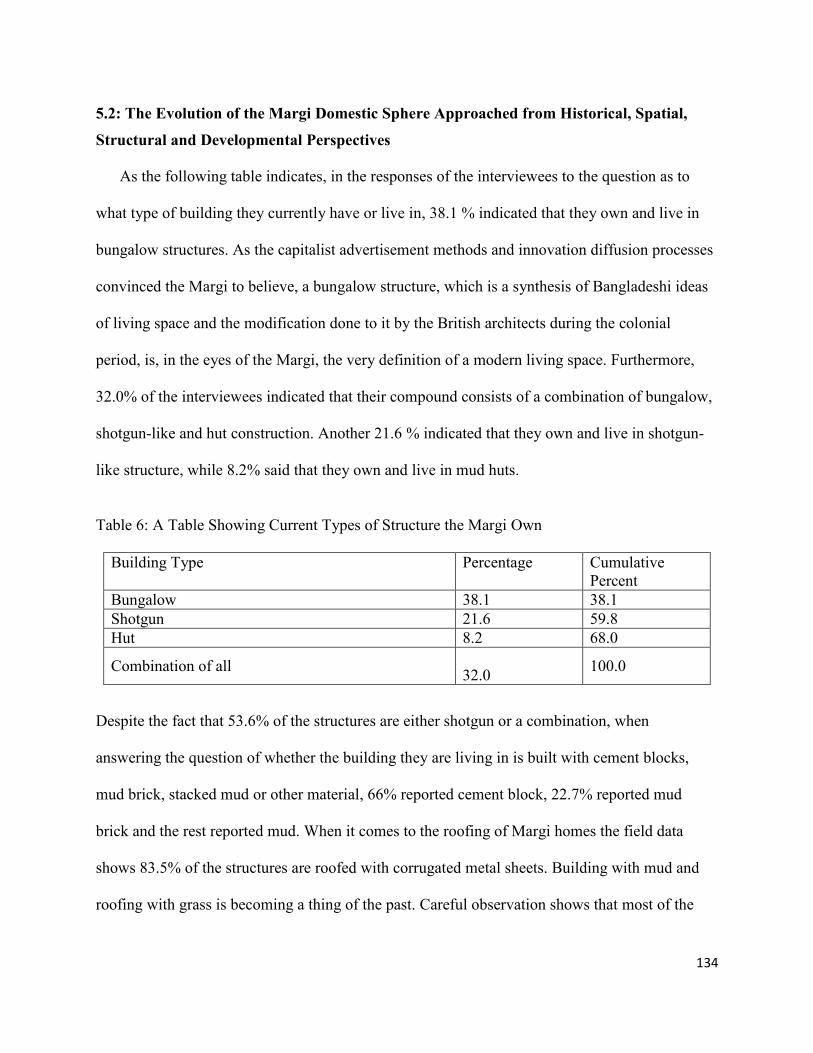
134
5.2: The Evolution of the Margi Domestic Sphere Approached from Historical, Spatial,
Structural and Developmental Perspectives
As the following table indicates, in the responses of the interviewees to the question as to
what type of building they currently have or live in, 38.1 % indicated that they own and live in
bungalow structures. As the capitalist advertisement methods and innovation diffusion processes
convinced the Margi to believe, a bungalow structure, which is a synthesis of Bangladeshi ideas
of living space and the modification done to it by the British architects during the colonial
period, is, in the eyes of the Margi, the very definition of a modern living space. Furthermore,
32.0% of the interviewees indicated that their compound consists of a combination of bungalow,
shotgun-like and hut construction. Another 21.6 % indicated that they own and live in shotgun-
like structure, while 8.2% said that they own and live in mud huts.
Table 6: A Table Showing Current Types of Structure the Margi Own
Building Type Percentage Cumulative
Percent
Bungalow 38.1 38.1
Shotgun 21.6 59.8
Hut 8.2 68.0
Combination of all
32.0 100.0
Despite the fact that 53.6% of the structures are either shotgun or a combination, when
answering the question of whether the building they are living in is built with cement blocks,
mud brick, stacked mud or other material, 66% reported cement block, 22.7% reported mud
brick and the rest reported mud. When it comes to the roofing of Margi homes the field data
shows 83.5% of the structures are roofed with corrugated metal sheets. Building with mud and
roofing with grass is becoming a thing of the past. Careful observation shows that most of the
135
huts or rooms that are still roofed with grass belong to widows or widowers, most of whom do
not have living children, and this includes the older folks living in remote villages.
Table 7: A Table Showing Compound Fencing
The compound still fenced Percentage Cumulative Percentage
Yes 96.9 97.9
No 2.1 100.0
Table 8: A Table Showing if Kitchen is still as it was before
Detached Percentage Cumulative Percentage
Yes 95.8 95.8
No 4.1 100.0
Table 9: A Table Showing If Goat/Sheep Pens and Chicken Coop are still inside the Compound
Inside Percentage Cumulative Percentage
Yes 84.5 84.5
No 15.5 100.0
5.3: Bathrooms and Water Systems
Using the crops (corn stalks) behind the compound as bathrooms (since this is a hidden
space in the rainy season), or just in the bushes during dry season are things of the past in the
Margi cultural landscape. In the early 1960s, only the teachers, missionary workers, and other
civil service personnel could afford to dig latrines in their compounds, hidden from public view
by the thatch or the mud fence. In the late1960s, there was not a single water cistern in the Margi
domestic sphere other than those of the missionaries, the guest houses for the travelling colonial
officers, and the house that the anthropologist James Vaughn built for himself and his family for
use during his research activities among the Margi. The idea of water pipes to bring fresh water
in and sanitary pipes to take soiled water out of the compound was an amenity with some

136
purposely well-defined rules of inclusion and exclusion within northern Nigerian space. Because
it was out of the realm of possibility for ordinary people in the northern Nigerian periphery, such
luxury had – and largely still has - bypassed their cultural landscape.
In the Margi villages, 89.7% of respondents reported owning individual latrines in their
compounds. 94.8 % reported using bucket bath in their domestic space. Even in the state capitals
of Adamawa and Borno, only 32% of the Margi living there reported having modern bathtubs or
showers in their homes, while 68% use the usual latrine and bucket bath. During this research,
my drinking water for the time I stayed in my birth compound came from the well I first drank
from in during my childhood, using a bucket and a rope to pull the water out.
Figure 41: Fetching Water from Childhood Well with the New Neighbors
Source: Photo by an Individual Passing by; I asked him to use my camera
I took a bucket bath with the well water on a cement platform which is part of the latrine opening
slab, protected from public view by the mud wall fence I helped my father built during my
childhood. The point is that pipes lying underground carrying water to and from the Margi
domestic sphere are still something in a distant future, or literally a pipe dream, for the rural
Margi, despite the wealth, size, and prestige of the Nigerian nation state in Africa. When it

137
comes to water, the Margi domestic sphere is not more well off than it was more than 80 years
ago when the missionaries first stepped foot on the Margi cultural landscape. Improvements have
been made in terms of the number of wells dug and the introduction of boreholes. The most
important change is the disappearance of the communally dug wells created by villagers that
were easily polluted after torrential rain, and of the natural water ponds that communities and
animals would share drinking from in the early 1960s. Some wells that were dug in the 1950s
and 1960s are still in use, but many more were dug. Boreholes have been introduced, but few
people can afford them. The usual water works taken for granted in other places are nonexistent
in the Margi vernacular landscape. The water taps that are seen are those attached to boreholes.
All across the Margi villages, only 31.3 % reported owning individual water well in their
compounds, while 68.7% reported sharing a community well. In the state capitals of Adamawa
and Borno only total of 27.8 % of the Margi reported having a water tap in their private homes,
while 72.8% used a community water tap. When responding to the question of individual
borehole ownership, 12.5 % of Margi reported having one, and 22.9 % reported having access to
a public borehole – the lower percentages reflecting the higher costs that prevent most Margi
from borehole access.
It has been about 108 years since the British started ruling northern Nigeria; it has been
more than 84 years since the Margi ethnic group came in contact with the missionaries; and
finally it has been more than 50 years since Nigeria became an independent nation-state with
vast oil resources. Yet water pipes and “modern” water network technologies have bypassed the
Margi cultural landscape, at least as of the time of this research.

138
5.4: Public Water Sources: Lakes, River and Dams
It is a very common practice in Africa for the majority of the individual households or those
that wash clothes for others for pay to go to public ponds, rivers or streams to wash the clothes.
Also, in addition to the communally dug water wells, these public water sources used to be
shared with the cattle, goats, sheep, donkeys and even wild animals. In Margi land, almost all of
these public water sources are works of nature. In other words, they are not man made like the
communal water wells. The following rivers in the Margi cultural landscape are the main
tributaries that drain into Yinagu river: yadzaram, dil-owal, biri-shishiwa, and tsugadi river. The
large river called yinagu has been and is still the main source of fish for several Margi towns and
villages in both Adamawa and Borno states. Prior to Nigerian independence, and up to the late
1960s, the ptil (Margi chief) was responsible for setting the date for yearly communal fishing. In
the mid-1970s, with the establishment of Local Government, the local government bureaucrats
took over the responsibility, and converted the yearly communal fishing into a yearly fishing
festival. This brings people from all over the Margi cultural landscape at least once a year. One
might have assumed that the responsibly of dredging and up-keep of the lake would have been
done by the local government/or state government together with its other new responsibilities.
But as comparison of the old and new photos below suggests, this responsibility has not been
lived up to.

139
Figure 42: Yinagu River in the 1960s during one of the Yearly Fishing Authorized by the Margi
Chief
Source: Sister Hanni Schlapbach of Switzerland, photo 1968 to 1977
In an article in the Journal of Animal Research International (2006: 473–477), Michael Awi
published research results from detailed interviews conducted among 200 Margi fishermen, aged
45 and over living around the river tributaries. Awi shows the demand for fish protein due to
population increase in the Margi cultural landscape, an increase in farmland; bad farming
practices which subsequently cause the blockage of the river tributaries, and poor irrigational
practices are among the factors that caused yinagu river to diminish (Awi, 2006). The research
was conducted in 5 years period from 1998 to 2003.

140
Figure 43: Yinagu River, in 2011
Source: Photo by the Author
Figure 44: Portion of Yinagu River dried-up, as of 2011, due to Lack of Care
Source: Photo by the author

141
Figure 45: The Yinagu River Fishing Festival Sheds in Disrepair
Source: photo by the author
There has been only one dam in Margi land; it was dug in Gulak in 1958, but this dam has long
been weathered away. According to my informants, the digging was initiated by the colonial
authorities in the spot where the mud used to build some of the missionary structure has been
dug out, but the work was done by the men of Gulak. According to them, the dam lasted for
about ten years before it weathered away because of lack of maintenance.
5.5: Electricity
In the 1960s, up to the early 1970s, the only sound of a generator in Lassa or Gulak came
from the missionary residence. This would only be from 7:00 pm or whenever it became dark to
10:00 pm. Even the church did not have a generator. There was no electricity in any of the Margi
towns, nor was there any one in Margi land that could afford a generator. The sources of light
then were bush lamps. The most sophisticated kerosene lamp, which used pressure, was used at
the church supplied by the missionaries for the usual market day evening service at the church.
During this research, I found the following changes. Light poles were installed by the state
142
government in the following Margi towns: Lassa, Shuwa, Gulak, madagali, Uba, and few others
by the main roads. However, the electric current does not flow regularly. There are more
individual electricity generators (called “gen” in local terminology) available than individual
water boreholes. This is so because gen is more affordable than a borehole. During the time I
spent in Gulak, the light from the national or regional grid only came on three times, and it was
very weak. In response to the research question regarding electricity from the light grid, 59.4 %
reported their homes were hooked to it. 44.8 % reported owning their own electricity generator,
and 21.9% reported owning a lamp. Let me clarify here that, even though people’s homes are
connected to the power grid, those who can afford it have a generator as a stand by. There are
some people especially at the outskirts of towns who do not have electricity connected to their
homes and do not have the resources to buy electric generator; 21.9% of such people reported
using the bush lamps of the earlier times.
5.6: Cooking Fuel
In the early 1960s up to mid-1970s, there was no Margi household within the cultural
landscape which would use a kerosene stove even if it had been available, because of the
kerosene cost. Almost all the households used a fire wood for cooking and keeping warm
especially from early November through early February when it is fairly cold. Most of the
savanna shrubs and trees have been drastically reduced to the point of complete depletion in the
Margi cultural landscape, because of their use for fuel in northern Nigeria in general. Among the
questions on my research questionnaire, I gave the informants four options as to what type of
energy the family used for cooking: kerosene stove, gas stove, electrical cooker, or firewood.
Several villagers came up to me inquiring why I was asking them if they are using electric or gas
cooking appliance, because such appliances do not exist in the Margi cultural landscape. No one

143
that lives in Margi land acknowledged using either a gas or electric cooker. Even if unreported
ones exist, they are hardly used because of the un-availability and the high cost of the cooking
gas. There is no underground cooking gas line, even in the Margi imagination. Responding to
using firewood for cooking fuel, 94.8% of the subjects reported using it, while some 21.9 %
reported using kerosene stove and 10.4 % had gas and electric appliances. The latter respondents
can be attributed to the Margi elites staying at the two state capitals, Yola and Maiduguri.
Despite all the trees planted over recent decades in the region, the Margi domestic sphere
is now more of a Sahel scrub/grassland than a savanna. During the 1960s and the 1970s, the area
was comparatively lush; the tall grasses used for roofing and thatch matts were readily available,
the scrubs full of birds and other living things were within walking distance from each
neighborhood. The water wells were not as deep as they are now. Nigerian national gas is
exported to the western world while the Nigerian populace, including the Margi ethnic group, is
left with no option but to cut down the trees. As the trees are cut down, nothing left to retain the
moisture in the soil or the near atmosphere, and desert is setting in, with its higher temperatures
and greater aridity.
5.7: Gardening in the Margi Domestic Sphere
In the early 1960s, most of the men had seasonal gardens. For example, my father always
grew maize and garden eggs plants at the back of his sleeping hut, and the area behind the goats
and sheep pen but within the compound fence. This was in addition to the large fenced cassava
farm in the front side of the family compound. In the mid-1960s, the number of gardens dropped
among men, as the men started to keep the plowing oxen and a few cows in the open behind the
sleeping room overnight protected by the compound fence where the gardens used to be.
Keeping oxen in the compound became possible as the Margi men started to use mud for fencing

144
around the mud huts instead of thatch mats that had been easily penetrated by the hyenas and
made stealing animals easy. This change drastically reduced the number of animals stolen by
hyenas in the night.
Almost all women grew two or more vegetables behind the sleeping and/kitchen and living
huts, and within the compound fence. The most common ones were ngabai and ‘umja’u’ okra.
The school children learned how to tend gardens at the missionary school and were given flower
seeds to take home for planting. Planting trees, especially fruit trees such as mango and guava,
was encouraged and many school children also participated in planting trees and shrubs. The
planting of fruit trees, flowers and shrubs (hedges) was all part of the evolution of the Margi built
environment, and I tried to find out what had become of this aspect of missionary culture passed
down to Margi school children and their parents. Through the questionnaire, I found that 61.5%
reported still having a seasonal garden behind the sleeping rooms. When it came to planting
trees, 81.3% reported still planting or having some that they had planted; but only 21.9% plant
flowers, and only 8% still plant hedges. The missionaries planted hedges to fence their modern
homes and some Margi tried to imitate this, but apparently the practice has died out.
5.8: The Margi Helping Relatives and Neighbors with Building Compounds
It was the custom of the Margi people to help their neighbors build at least the first two round
huts when a family would relocate or when a young man would build his first compound. When I
was growing up, my father moved the family two times; at least that I can remember. We had a
lot of help from relatives and neighbors to move our personal belongings to the new place and
during the construction of the new mud huts. The last time we moved, I had just begun
elementary school. Because the school was in the neighborhood, the Headmaster Bulama
Wajilda asked my classmates to come and help my family and in the evening, I recall that all my

145
friends and I could carry was the bunches of dried grass that I had been harvesting and collecting
by the house, though some older kids were able to carry other heavier things. During my
research, I tried to see if such community spirit still exists. In the research questionnaire, I asked
my informers if they built their latest structure by themselves, had help from relatives and
friends, or paid people to build it. Only 27.8 % of the respondents recorded having built it
themselves, and 20.3% reported having had some help in addition to their own effort; while 68.4
% reported paying people to build their homes (the percentages add up to more than 100%
probably because some in the second category also paid for some of the help). As a building
inspector, I understand why the Margi community spirit of helping neighbors has dropped. As
the Margi ethnic group started to adopt the western idea of safe and habitable shelter, they had to
turn to semi-experts at the very least to build these modern structures. In today’s individualistic
world, which encompassed the Margi domestic sphere in some ways, the 20.3% of the people
that reported getting some help from relatives or friends is arguably still a fairly large percentage.
Figure 46: One Such Example of Margi Neighbor Helping Neighbor is Corn Threshing
Source: Sister Hanni Schlapbach of Switzerland, photo taken 1968 to 1977
Figure 47: Additional Example of Margi helping one Another; Farming Party at town of Bitiku
town
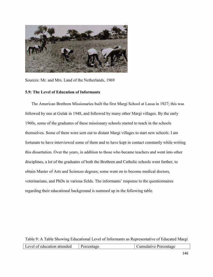
146
Sources: Mr. and Mrs. Land of the Netherlands, 1969
5.9: The Level of Education of Informants
The American Brethren Missionaries built the first Margi School at Lassa in 1927; this was
followed by one at Gulak in 1948, and followed by many other Margi villages. By the early
1960s, some of the graduates of these missionary schools started to teach in the schools
themselves. Some of them were sent out to distant Margi villages to start new schools. I am
fortunate to have interviewed some of them and to have kept in contact constantly while writing
this dissertation. Over the years, in addition to those who became teachers and went into other
disciplines, a lot of the graduates of both the Brethren and Catholic schools went further, to
obtain Master of Arts and Sciences degrees; some went on to become medical doctors,
veterinarians, and PhDs in various fields. The informants’ response to the questionnaires
regarding their educational background is summed up in the following table.
Table 9: A Table Showing Educational Level of Informants as Representative of Educated Margi
Level of education attended Percentage Cumulative Percentage

147
None 12.3 12.3
Standard 4 4.9 17.3
Class 7 16.0 33.3
Teachers College/HS 7.4 40.7
1st Degree 25.9 66.7
NCE/Diploma 24.7 91.4
Masters and above 8.6 100.0
Here, Standard 4 means the first four years of school; in the mid-1930s at Lassa, where the
first school among the Margi began, and up to the mid-1950s in Gulak and Kaya, where schools
began in 1948, most of the pupils stopped after four years if they did not pass the entrance
examination for the next level; but the main reason for stopping was actually the lack of enough
schools to accommodate them. The new Nigerian nation-state employed most of the Standard 4
school graduates into the new civil service system. Some joined the Nigerian police or the army.
Others were trained by the missionaries as carpenters, gardeners, and dispensers, mechanized
farming personnel and pastors; or they went on to work for other mission establishments. This
phenomenon is common to both the Roman Catholic Church and the American Brethren Church.
I believe that the 12.3% of the informants who indicated “none” (meaning that they had not
attended any school) are those that were over school age when the missionaries came, and
perhaps younger ones whose parents did not allow them to attend school because of farming
needs (Bowman, 1953).
Class 7, which represents 16% of the number of informants’, refers to the first seven years of
school. This group stopped because they could not pass the common entrance examination
required prior to admission into secondary school (high school). Here again in most cases there
were no enough high schools to accommodate all that passed. Most of them started to work for
various organizations including government ministries. As I recall a lot were trained as typists
and gradually promoted to clerks as they attended staff development training centers during their

148
careers. The teacher college or high school group comprises 7.4% of the total population of the
informants. They have had an additional 5 years of school after primary school attending teacher
colleges, or secondary schools. The teacher college in Nigeria is at the same level as the
secondary school. The only difference is that students at teacher colleges concentrate on
instruction instead of general subjects like the secondary schools do. The teacher college students
sit for the grade II Teachers’ Certificate examination at the end of the 5 years of study, which
qualifies them to teach in the elementary schools, while secondary school students receive
general instructions in arts and sciences. They sit for the West African School Certificate
examination at the end of the five years. The individual performances on these examinations
determine if one may proceed into higher education or not.
The National Certificate of Education or the Ordinary Diploma both take two to three years
after teacher’s college or high school. It depends on an individual’s teachers college or high
school performance. Those who complete teachers college go to NCE to obtain grade 1 teacher's
certificate and those who complete high school but do not get good grades apply for ordinary
diploma training in various professions. These groups are 24.7% of the total respondent
population. As the table indicates, 25.9% of the them complete college degrees over a quarter of
the respondents’ population, while about 8.6% of the population has a Master’s Degree or above.
Survey results suggest that the Margi – or roughly one-third of the ethnic community, if the
survey is representative - have come a long way in terms of education since the missionaries set
foot on Margi cultural landscape. Some have gone on to become army generals, governors and
deputy governors.

149
5.10: Public Gathering Places
Traditionally the Margi public place is the large area in front of the chiefs (ptils) palace,
called ‘patha.’ This is where all the traditional festivals and other gatherings take place. In due
course, young people started to use the market place for dancing on market day evenings. When
Christmas celebrations started to take root in the Margi cultural landscape, the celebration shifted
to the school compound. For example at Gulak, it took place on an empty space between the
classrooms and the chapel building. If many people would show up for the occasion, then it
would be moved to the school football field. In case of a death, the gathering for the mourning
would take place in front of the decease’s’ compound. During the dry season when the
temperature is hot, the nearest big shade tree might be chosen; this would also apply during
happy celebrations, such as that for the birth of twins, when all relatives would gather to
celebrate after the twins are about 1 year old.
5.11: The Impact of the Missionaries in the Form of the Structures Built
When it comes to the structures built by the missionaries and the colonial officers, most of
the examples I use are from main Margi towns of Lassa, Gulak, Kaya, and Shuwa, with
occasional references to some other areas like Madagali, Hyambula, Midlu and other villages,
since these first towns are the areas where the two denominations started to build schools or
churches before expanding the stations to other sections of the Margi cultural landscape. The
colonial authorities’ activities in terms of physical structures in Margi cultural landscape were
concentrated in Gulak because of its location on the main road leading to major cities like
Maiduguri, Mubi and Yola. I am telling the story chronologically using sketches and photos to
clarify the physical environment. There are, however, some gray areas that cannot be explained
clearly, or even some hidden factors at times. But history tell us that evolution of the Margi built

150
environment as of human culture in general cannot be clearly imagined in the human mind or be
represented in continuous, predictable visible photos or sketch patterns.
5.12: Schools the Missionaries Built
In general the missionaries started schools, because of their importance in shaping students’
thinking and for facilitating their recruitment in to the Christian faith. With the exception of Uba
and Madagali, almost all the schools in Margi towns and villages were owned by the
missionaries. The Church of the Brethren opened their first station 4 years after their arrival in
northeastern Nigeria among the Margi ethnic group of Lassa in 1927, followed by the town of
Gulak in 1948. Since then the schools and the church expanded to various Margi villages. About
six months later, the Catholic Church, perhaps out of fear of the domination of the Margi cultural
landscape by the Church of the Brethren, started a mission station at Kaya, a Margi village three
miles west of Gulak. The Catholics opened a second station in Shuwa in 1958, and then a church
at Madagali, 15 miles north of Gulak. In both denominations, the schools were used as
recruitment grounds into Christian faith. The pupils were recruited into the protestant or catholic
versions of the faith through the schools. The children in turn would tell their parents about their
new faith, especially their mothers, with whom they spent more time sitting around the evening
cooking fire. In response, the Margi women started to join the churches earlier than their men. In
addition to the secular subjects at the missionaries’ schools, religious instruction was at the core
of the mission objectives. The children were taught not to drink local Margi alcohol, eat any
animal or fowl sacrificed to non-Christian gods, and abstain from all immoral behaviors.
In both cases, the missionaries started the building structures modestly with the building
materials within the environment. In Gulak, for example, two of my informants who were among
the first pupils recruited for the school, informed me that they started school in a round mud hut.

151
The first school in the mud hut, as they recall, was situated on the site where Ndumari Ndijida’s
compound is presently located in Gulak.
Figure 48: The Second School Building in Gulak (after the Mud Hut)
Sources: Mr. and Mrs. Land of the Netherlands, 1968
The building also served as the first church and the school chapel, although the first Church
services actually started under a tree in Gulak, just as they had in 1923, when the Church of the
Brethren arrived in northeastern Nigeria and settled in the Bura ethnic group’s domain. The
school bell, which also served as the church bell, was attached to the nearest tree next to the door
of this building. The structure between the two trees in front of the building was the first table
tennis table in Gulak built with mud brick. Shortly after my interview with

152
Figure 49: The Remains of the ’izu’ Tree which used to be Standing in Front of Grandmother
Mimpardas’ House where the First Church Service was Conducted in Gulak
Source: Photo by David Haliru on request, 2013
Bulama Wajilda, who was one of the first pupils of the Gulak Church of the Brethren
Primary School, and also the first native son to assume the position of the Headmaster of the
school, took a walk to the old school compound with me after I interviewed him, where he
reflected on the past when he was the head of the school and I was one of his pupils. “Things
have changed…” he remarked, and I had the opportunity of taking his photo while he leaned on
the first table tennis table that the children of Gulak and the surround villages had ever seen and
played on.

153
Figure 49: A photo of Bulama Wajilda Birdling, the First Gulak Native Son Headmaster of the
School as he Rests His Hands on the Old Table Tennis Table Built with Mud Brick. He started at
the school in 1960.
Source: Photo by the Author
The only recognizable features of the old school compound are the trees, the table and the school
bell which can be seen still hanging on the tree in the photo in figure 50.
Figure 50: The School/Church Bell still hanging on The Tree after 60 Years.
Source: Photo by the Author

154
Figure 51: The Third School Building in Gulak
Source: The Messenger, December 1st, 1951 (The Church of the Brethren Magazine).
The photo in figure 52 shows the third school building in Gulak in the process of being built,
with people on top installing the woven grass misham as the roof system. It contained two
classrooms, built with mud brick. This is the first building where my age group started primary
school.
Figure 52: The Fourth School Building Built in Gulak
Source: Carol Bowman, from the Bowman Estate 1948
From 1948 until August 1951, the Gulak staff lived in the schoolhouse. It is large.
There were two rooms, each eighteen by thirty feet; these were further divided by
temporary partitions. They were comfortable….but the school was outgrowing its
small temporary quarters. Therefore, many of the happenings at Gulak during the first
half of 1951 had some relationship to the erection of a new permanent residence. As
you have no doubt heard things sometimes move slowly in tropical Africa.” This is
how James B. Bowman put it an article entitled, “Happenings at Gulak,” which

155
appeared in the American Church of the Brethren Magazine, (The Messenger, on
December 1st 1951).
This was the second building roofed with corrugated metal sheet in Gulak. The colonial
officer’s guest house formerly located northeast of the present Gulak market was the first
structure in Gulak roofed as such. In addition to using the school building for instruction, the
building was occasionally used as sleeping rooms for Christians that came out of town for church
meetings.
Figure 53: Photo of Women Cooking behind the School Classroom for a Church Guest from out
of Town
Source: Mr. and Mrs. Land of the Netherlands 1969
In many cases the school buildings evolved from one room circular mud huts with thatch roof, to
rectangular building built with mud covered with thatch roof or corrugated metal sheet, to a
rectangular building built with clay bricks with thatch roof or corrugated metal sheet.
My research survey shows the year the schools were built in the various Margi towns’
ranges from 1927 to 2011. When responding to the question of whether the school building is
built with cement block, 96.9% responded yes, while 3.1% reported mud brick or mud. When it
comes to roofing of the school buildings, 97.9% reported corrugated metal sheet while 2.1%

156
reported thatch roof. All the missionary schools in the Margi cultural landscape were taken over
by the state in 1976. This transfer process may have played a key role in fostering the
transformation of the structures.
Figure 54: The Current Gulak Primary School, 2011. These buildings were in the same spots
where the first classrooms built by the missionaries were demolished
Source: Photo by the Author
Even though it was not in the Margi domestic sphere, the American Brethren church built
both a secondary school and teachers college at Waka, located in the Bura ethnic group’s domain
where the missionaries first settled in 1923. In addition, the American missionaries built a
theological seminary at Jos, which is about 600 miles from the Margi domain. These schools
admitted most of the graduates of the mission schools from the Margi and from all the
surrounding ethnic groups. The Roman Catholic Church built a high school in Numan, a town
currently located in Adamawa state, but predominately occupied by Bachama ethnic group,
while the Catholic teachers college was built at Bazza, about 24 miles south of Gulak. Bazza is
predominately occupied by Higi (Kapsiki) peoples, closely related to the Margi. In addition, the
Roman Catholic Church built a theological seminary at Jemeta, Yola. Since Margi studied in all
of these settings, they were also influential in re-orienting Margi ideas about the domestic sphere.

157
5.13: The Missionary Residence in Gulak
The activities of the missionaries are intricately woven into every aspect of the evolution of
the Margi built environment. There is no clear division between the activities of the missionaries
and whatever else happened in the Margi cultural landscape. This includes human development
aspects. Since the coming of the missionaries, the Margi culture has been gradually changing,
ultimately creating a hybrid culture or a third space. These developments are also true of the
Margi neighbors such as the Bura, Higi and other ethnic groups among whom the missionaries
started stations.
Figure 55: The Floor Plan of the First 2nd Story Residence of the Missionaries, drafted by Mrs.
Bowman in 1948
Source: Carol Bowman, obtained from the Bowman estate

158
Figure 56: The Notes Written at the Right Bottom on the Plan by Mrs. Bowman
Source: Cut and Enlarged from the Floor-Plan by the author
Figure 57: The Residence under Construction
Source: Carol Bowman, Daughter of Mr. and Mrs. Bowman
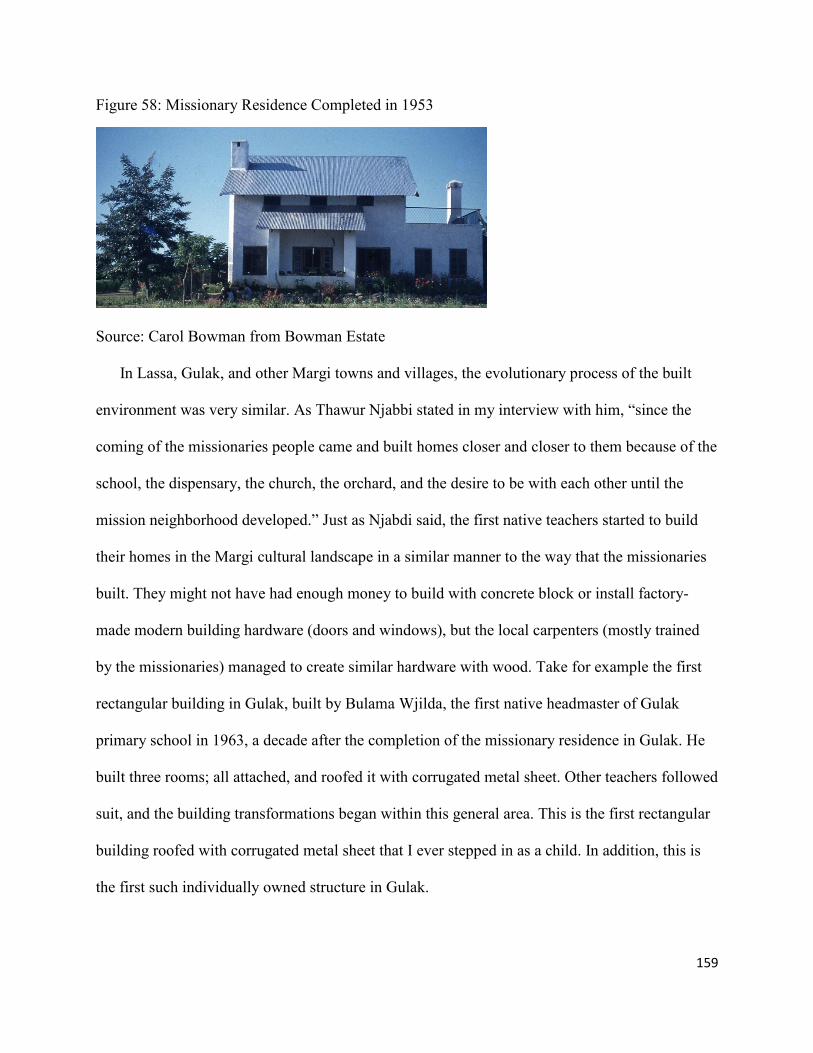
159
Figure 58: Missionary Residence Completed in 1953
Source: Carol Bowman from Bowman Estate
In Lassa, Gulak, and other Margi towns and villages, the evolutionary process of the built
environment was very similar. As Thawur Njabbi stated in my interview with him, “since the
coming of the missionaries people came and built homes closer and closer to them because of the
school, the dispensary, the church, the orchard, and the desire to be with each other until the
mission neighborhood developed.” Just as Njabdi said, the first native teachers started to build
their homes in the Margi cultural landscape in a similar manner to the way that the missionaries
built. They might not have had enough money to build with concrete block or install factory-
made modern building hardware (doors and windows), but the local carpenters (mostly trained
by the missionaries) managed to create similar hardware with wood. Take for example the first
rectangular building in Gulak, built by Bulama Wjilda, the first native headmaster of Gulak
primary school in 1963, a decade after the completion of the missionary residence in Gulak. He
built three rooms; all attached, and roofed it with corrugated metal sheet. Other teachers followed
suit, and the building transformations began within this general area. This is the first rectangular
building roofed with corrugated metal sheet that I ever stepped in as a child. In addition, this is
the first such individually owned structure in Gulak.

160
Figure 60: The first Gulak Native Headmaster Bulama Wjilda built his first Rectangular
Structure in 1963, ten years after the completion of the Missionary Residence
Source: Photo by David Haliru on request, 2013
In his effort to modernize his domestic sphere, Bulama Wajilda built another two rooms, as a
kitchen and a storage room.
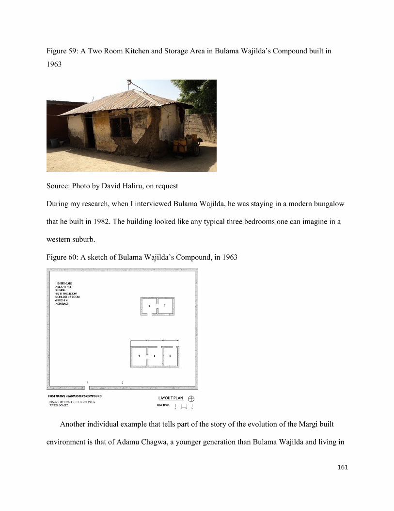
161
Figure 59: A Two Room Kitchen and Storage Area in Bulama Wajilda’s Compound built in
1963
Source: Photo by David Haliru, on request
During my research, when I interviewed Bulama Wajilda, he was staying in a modern bungalow
that he built in 1982. The building looked like any typical three bedrooms one can imagine in a
western suburb.
Figure 60: A sketch of Bulama Wajilda’s Compound, in 1963
Another individual example that tells part of the story of the evolution of the Margi built
environment is that of Adamu Chagwa, a younger generation than Bulama Wajilda and living in

162
a different town. He was a civil servant who later became a businessman and a politician. I had
the opportunity to interview him and spend time with him in his house at Hyambula (six miles
north of Gulak), a Margi town that Barth mentioned in his book when he passed through in 1851
(Barth, 1857: 106). According to Adamu Chagwa, he built his first house, a round mud hut, and
roofed it with thatch, in 1976, at age 22. Then in 1980, he built his second structure in the
compound; this time it was a shotgun-like structure, a three-room rectangular building that has
the main entry door to all three rooms from a middle room rather than from the narrow end. It is
apparent here that, in addition to being rectangular in shape, he used corrugated metal sheet for
the roofing. He also used cement for the flooring of the internal, and the external walls as shown
in the photo in figure 61. It took him four years to save enough money to make this change from
a round hut to a rectangular structure. Note that the round mud hut was not demolished; instead it
was converted into a kitchen.
Figure 61: Adamu Chagwa’s Second Structure following Mud Hut in Hyambula, built in 1980
Source: Photo by the Author
It took Adamu Chagwa another 12 years to start on another building, completed in 1993.
This time he built a European-type structure with all the modern facilities, which ranged from

163
internal bathroom with tubs, shower, toilet, and sink to a modern internal kitchen. The structure
is also hooked-up to a septic tank and soak-away; it has modern hardware, electrical wiring, and
most of the items that constitute a modern structure. Adamu Chagwa also talked of a bigger
modern building that he built in Abuja, the Nigerian Federal Capital territory. As I have
mentioned before, most Margi men and women will first of all build a home in their place of
birth prior to building anywhere else. The story of Adamu Chagwa is representative of most
Margi professionals who had the opportunity to attend school and gain employment.
In its totality, this is how Margi built environment evolved, with individuals like Bulama
Wajilda, Adamu Chagwa and many others playing their part. Their actions for the most part are
driven by the desire to be part of the modern world, as embedded in capitalist advertisement and
inculcated into them by the proponents and preachers of modernism.
Figure 62: Adamu Chagwas’ 3rd Residence, built in the Same Compound at Hyambula in 1993
Source: photo by the author
The development of the new neighborhoods in the Margi cultural landscape was not limited
to mission neighborhoods only. After the creation of the Nigerian nation-state, most of the
graduates of the missionary schools found jobs in various arms of the civil services, joined law

164
enforcement services, military and business. In a few years these Margi professionals and
business people started to come back to build homes in the Margi cultural landscape. As the
photo in figure 63 shows, one can see a round hut on the extreme left, with what looks like
rectangular mud building in front, then a shotgun-like rectangular structure in the middle,
followed by a modern two story building on the right at the slopes of the Mandara Mountains.
This is a microcosm of the evolution of the Margi domestic sphere in many of the towns and
villages.
Figure 63: A View of a Section of Jalingo, formerly known as Kirngu
Source: the author.
In the towns of Lassa, Dille, Musa and other Margi towns and villages the story of the evolution
of the built environment is similar. As with the example given of the photo taken at Jalingo
neighborhood in Gulak figure 63, the following photo in figure 64, shows a building structure in
Madagali (a Margi town about 15 miles north of Gulak). This shows another example of how the
domestic sphere evolved from mud hut, to rectangular, and then to a bungalow in an individual
compound.

165
Figure 64: A Typical the Evolution of the Margi Domestic Spare in another village of Madagali
Source: Dr. Emmanuel Mdurvwa, taken at Madagali, November, 2011
5.14: The Christian Churches
The main reason for the coming of the American and the Roman Catholic Church was to
preach the Christian Gospel (Hickey, 1984). It follows that the second building the missionaries
built after their residences is the Church. But in most cases, they start in a very simple way. For
example when the American Brethren Church first came to northeastern Nigeria and started a
station among the Bura ethnic group in Garkida, the first church meeting took place under a
tamarind tree on March 17, 1923 ( Thomasson, 1983). In Gulak, 21 years later, the Reverend
Bowman also conducted the first church meeting under a tree (Messenger, Nov 5th
1949), before
building a mud hut that served as a classroom and a church at the same time. This is followed
by a rectangular building that also serves as a classroom and a church. This is the first place my
elder sister and I attended church, when I was about five years old.
As of the time of this research, the church has grown, and the buildings have become more
sophisticated. For example, in Gulak, the church following the one in a single rectangular room
was built in 1968 (figure 65 below). The improvements here are that it is built with cement mud
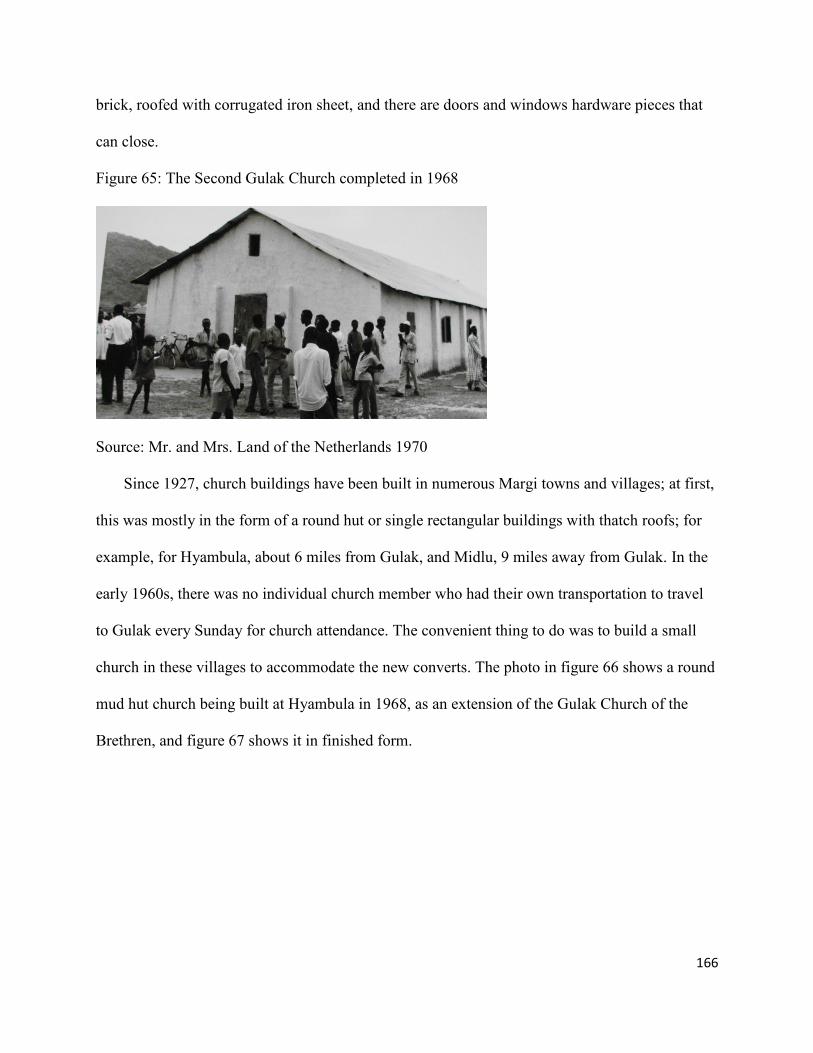
166
brick, roofed with corrugated iron sheet, and there are doors and windows hardware pieces that
can close.
Figure 65: The Second Gulak Church completed in 1968
Source: Mr. and Mrs. Land of the Netherlands 1970
Since 1927, church buildings have been built in numerous Margi towns and villages; at first,
this was mostly in the form of a round hut or single rectangular buildings with thatch roofs; for
example, for Hyambula, about 6 miles from Gulak, and Midlu, 9 miles away from Gulak. In the
early 1960s, there was no individual church member who had their own transportation to travel
to Gulak every Sunday for church attendance. The convenient thing to do was to build a small
church in these villages to accommodate the new converts. The photo in figure 66 shows a round
mud hut church being built at Hyambula in 1968, as an extension of the Gulak Church of the
Brethren, and figure 67 shows it in finished form.

167
Figure 66: Church with Structural Roof Frame under construction at Hyambula in 1968
Source: Mr. and Mrs. Land of the Netherlands 1968
Figure 67: The Finished Hyambula Church in 1968
Source: Mr. and Mrs. Land of the Netherlands 1968
The next photo in figure 68 shows a rectangular mud building at Midlu (the first church at
Midlu) as an extension of the Gulak Church of the Brethren. Midlu is about 9 miles northeast of
Gulak.

168
Figure 68: The First Midlu Church
Source: Mr. and Mrs. Land of the Netherlands 1969
Figure 69: The 2nd Church built at Midlu built in 1986 with mud bricks
Sources: Peter Awidau on request 2013
Currently, the churches that are built with modern materials, according to my survey, make
up 93.7% of the total number of churches in Margi domestic sphere. Only 6.3 % are built with
mud bricks or stacked mud. The survey shows that 94.7 % of the churches are roofed with
corrugated metal sheets, and only 5.3% are thatch roof. In the early 1960’s, almost all the
teachers sent to the villages to open new elementary schools also served as the village pastors in
addition to their teaching responsibility. The Catholic Church follows similar pattern as that of
the American Brethren church.

169
Figure 70: The 3rd and the latest Church in Gulak built in 2009, the mother Church of the Gulak
District and its Environs; picture is from the inside with some of the faithful worshipping
Source: Photo by the Author
5.15: The Missionary Dispensary, Evolved to Hospital
Some of our strangest experiences come by way of our ‘dressing station.’ The people of
this area are renowned for their much drinking. Under the influence of the local brew
they produce frequent cases for our treatment. Some of them are caused by pure and
simple fights, with stabbings, beatings and ‘cracked heads.’ Others are testing, such as
the two men who came the same day from opposite directions. Each had been involved in
a friendly argument over the efficiency of his charms to ward off injuries, specifically to
‘turn the blade of a knife.’ Needless to say, each had inflicted upon himself a rather
serious wound” (James B. Bowman, Happenings at Gulak, (The Messenger, December 1,
1951: 23).
One of the first needs the missionaries consistently tried to meet was an outpatient dispensary for
disbursement of medicine for minor ailments. As the photo below shows everyone was
welcomed, including the Muslims, the Animists and the new Christian converts

170
Figure 71: The first Dispensary in Gulak built in 1948
Source: Sister Hanni Schlapbach of Switzerland 1971
Dispensary comes hand in hand with the church and schools wherever the missionaries
establish new stations in the Margi cultural landscape. The first dispensary started in Lassa in
1927 with the founding of the mission. For a long time the Margi of Gulak and other towns and
villages went to Lassa for the treatment of major ailments. The missionaries built the first
hospital in Lassa in 1956, which served the people of Gulak and the surrounding villages for a
long time.
Figure 72: The First Hospital in the Margi Cultural Landscape built at Lassa in 1956, by the
Missionaries

171
Source: Dr. Pitcher of Alabama United States (Retired), the first Missionary Medical Director of
the Hospital 1956
The missionaries trained the staff themselves and it has served the purpose very well. Even
though there was a Government Hospital in the nearby town of Mubi, (built by the colonial
authorities) the Margi ethnic group for some reason preferred going to Lassa Mission Hospital.
My father repeatedly told a story about how he had to carry his 16 year-old sister on his back for
24 miles to Lassa Hospital in 1957, after she was bitten by a snake in the night. Because of the
distance and the time spent walking, my father sister died on the way. There are many stories
like this before the Gulak Dispensary was upgraded by the missionaries as the photo in figure 73
below shows.
Figure 73: A New Three Room Expansion was made later to the Gulak Dispensary on the left of
the First Round Hut Dispensary in the early 1960s.
Source: Sister Hanni Schlapbach of Switzerland 1968
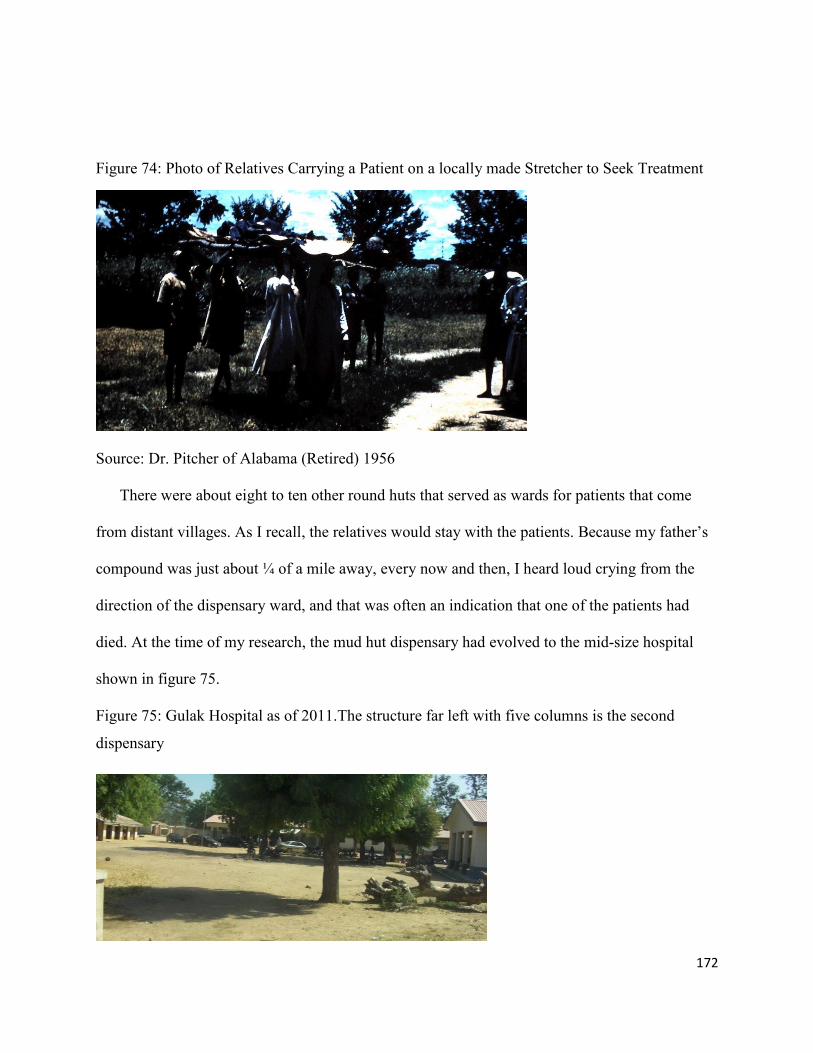
172
Figure 74: Photo of Relatives Carrying a Patient on a locally made Stretcher to Seek Treatment
Source: Dr. Pitcher of Alabama (Retired) 1956
There were about eight to ten other round huts that served as wards for patients that come
from distant villages. As I recall, the relatives would stay with the patients. Because my father’s
compound was just about ¼ of a mile away, every now and then, I heard loud crying from the
direction of the dispensary ward, and that was often an indication that one of the patients had
died. At the time of my research, the mud hut dispensary had evolved to the mid-size hospital
shown in figure 75.
Figure 75: Gulak Hospital as of 2011.The structure far left with five columns is the second
dispensary

173
Source: Photo by Author
Figure 76: The Lassa Church of Brethren Mission Hospital built in 1956, as it is in 2011
Source: Sources: Photo by Emmanuel Mdurvwa, November 2011
As of 2011, figure 76 shows what the Lassa Hospital looked like; at least a portion of it. Since
the state government took over, I am not sure that the quality of the services has been kept as it
was when the missionaries were in charge. My informants tell of how the quality of care has
dwindled to the point that patients buy the medicine prescribed from the hospitals in private drug
stores, an aspect of a capitalist system of medical services which became very convenient for
those in power.
5.16: The Impact of Colonialism: The District Headquarters in Gulak
Margi cultural landscape was taken over by the British, after the Germans lost World War I
(Schnee, 2007: 85,151, Vaughan, 1995). The territory was ruled from Lagos as British
Cameroons; with the Margi area re-classified as Madagali District by the British. After World
War II, British northern Cameroon came under the United Nations Trustee Council, but the
British still administered it from Lagos.
174
In 1923, the British authorities arrested the District Head of Madagali, a Fulani man by
the name of Hamman Yaji, who had previously been installed as a leading figure of the area by
the Germans after the German authorities assassinated his father. After the arrest, Hamman Yaji
was sent into exile in Sokoto. Soon after, under the direction of the colonial authorities, Madibbo
Adama, the head of the Adamawa Emirate (of which Madagali District was an administrative
unit), appointed another Fulani man from Yola to administer the district. But because of the
circumstances surrounding the arrest of Hamman Yaji, the new district head moved to the town
of Gulak, 15 miles south of Madagali. In Gulak, the District Head settled temporarily in an area
already occupied by a few cattle Fulani who were already living in Gulak. My informants tell me
that there had been a few cattle Fulani staying in Gulak for a long time. After this, Gulak became
the District headquarters for Madagali District. In view of the change of the District
Headquarters of Madagali District from Madagali town to the town of Gulak, the colonial
authorities felt the need to build a new District Headquarters. The construction of the new
District Headquarters included a new compound for the District head, District administrative
offices which included a law court, native police station, a well for water operated by a wind
mill, and a prison.
Wednesday, Nov. 12 [1952] was a day that those of Gulak and Lassa will remember for a
long time. The United Nations mission came to Gulak. The group was composed of
Chairman Peachley of Australia, Mr. Quiros of San Salvador, Mr. Yang of China and a
member from Belgium. The lady secretary was from Canada. The United Nations
mission was to tour in the area which is now under the United Nations trusteeship. The
Yedseram River, near Lassa used to be the border, but when the Cameroons were taken
from Germany after the 1914-1918 war, part of the area was given to France and a couple
of smaller areas to Britain. Gulak is in this territory… the resident of Adamawa Province
and Mr. Peachley went with me to meet the teachers and to greet the school children”
(Bowman, “United Nations Commission Visits Gulak,” Gospel Messenger, January 3,
1953, p.23).
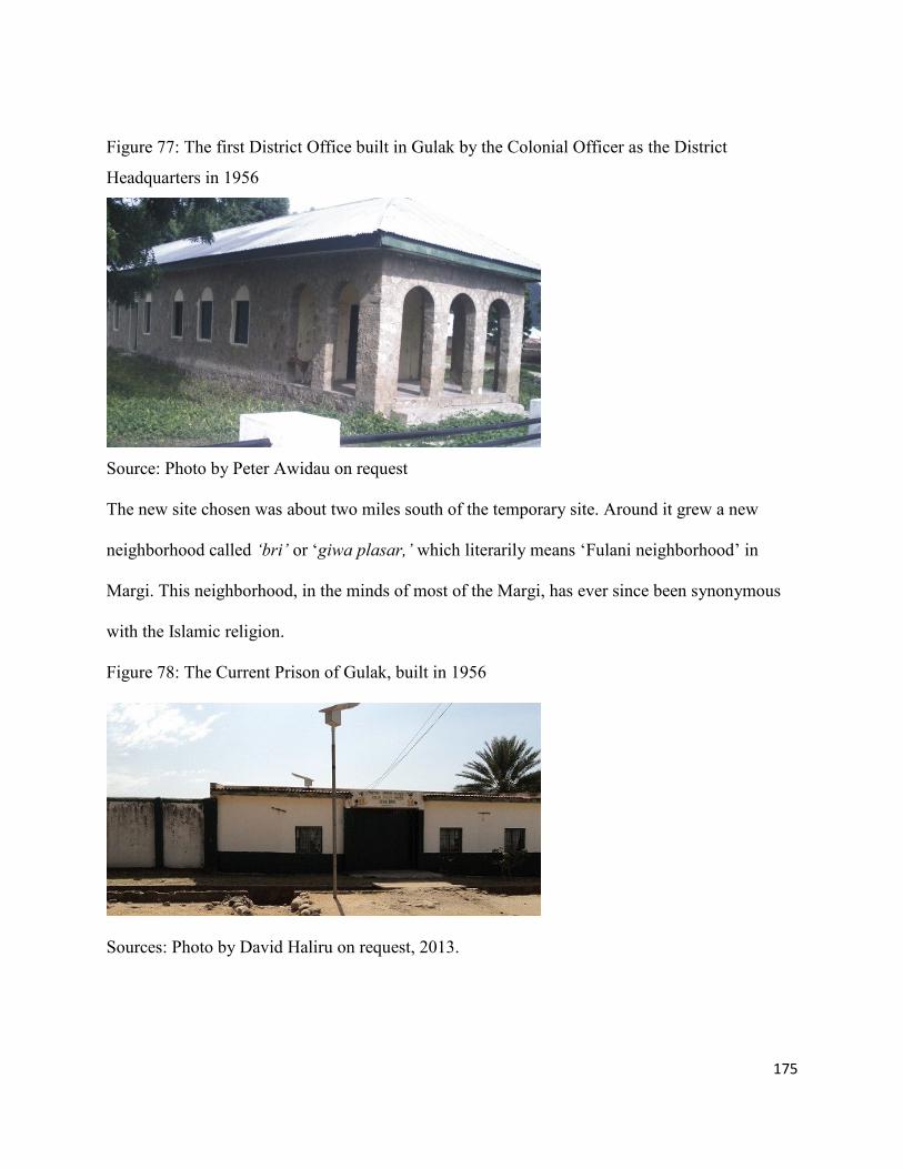
175
Figure 77: The first District Office built in Gulak by the Colonial Officer as the District
Headquarters in 1956
Source: Photo by Peter Awidau on request
The new site chosen was about two miles south of the temporary site. Around it grew a new
neighborhood called ‘bri’ or ‘giwa plasar,’ which literarily means ‘Fulani neighborhood’ in
Margi. This neighborhood, in the minds of most of the Margi, has ever since been synonymous
with the Islamic religion.
Figure 78: The Current Prison of Gulak, built in 1956
Sources: Photo by David Haliru on request, 2013.

176
Figure 79: A Photo of a Section of the Fulani Neighborhood (bri) in 1968
Source: Mr. and Mrs. Land of the Netherlands, 1968
The first borehole installed on the Margi cultural landscape (powered by a windmill) was on
this site, the new District Headquarters of Madagali District in Gulak. Most of the people I talked
to said it was a fascinating site then to the Margi ethnic group, in the late 1950s, and especially to
these coming from the villages. By the early 1960s, the wind mill was still there, though not in
operable condition. The photo in figure 80 shows the mark of the old well filled in with cement
mortar. On the right is a tap attached to a new bore hole with several plastic water containers,
kept in a line by the residents waiting for their turn to fetch water.
Figure 80: A Photo of the First Windmill Well in Gulak, and now replaced with a New Bore
Hole with a Tap
Source: Photo by Peter Awidau, on my request

177
Figure 81: The Remnant of the Old Water Tank Attached to the Wind Mill Constructed by the
Colonial Officers built in 1956
Source: Photo by Peter Awidau, on request
The colonial authorities, also built what they called the native police barracks, which was
comprised of mud huts with thatch roofs. The structures were constructed with cement floors.
5.17: Mosques
The making of a formal Fulani neighborhood in Gulak because of the transfer of the District
Headquarters from Madagali to Gulak also came with an increase in the number of mosques in
the mid-1950s. But historically, mosques had come to Margi cultural landscape along with the
cattle-owning Fulani ethnic group. In the early 1950’s, there were no standard mosques built in
Margi villages. In most cases, the Fulani selected a spot in the middle of their neighborhood,
leveled it, spread a fine sandy soil on the spot, surrounded it with pieces of stone, and designated
it as a mosque. Soon after, in the early 1960s, the mud-built mosques started to appear. The
temporary location where the Madagali District Head settled in Gulak when he left Madagali
town in 1953 was reassigned to the chief of Margi with his Medugu Kirngu clan. As earlier
indicated the clan had been staying in the Mandara Mountains literally on top of one of the
ranges. The colonial authorities negotiated with the Chief to relocate his people to occupy the

178
abandoned buildings when the District Head and his entourage left when he was re- located to
the newly built district headquarters. In 1964, the Margi chief and his entourage that were
staying with him became Muslims. This change of faith on part of the Margi chief also meant
that an increased number of mosques were built in the Gulak area.
The following photos demonstrate the changes of a mosque site from a demarcated spot to a
mud rectangular structure roofed with thatch roof, to a cement block rectangular structure with
some utility rooms, to a structure with borrowed Islamic architectural style (with a dome).
Figure 82: One of the First Mosques of the early 1960s in Gulak
Source: Mr. and Mrs. Land of the Netherlands, 1968
Figure 83: The 2nd Mosque built in Gulak
Source: Photo by David Haliru on request

179
Figure 84: 3rd Mosque Unfinished, in Gulak Adopting Islamic Architecture
Source: Photo by David Haliru on request 2013
My research survey shows that mosques started to appear in the Margi cultural landscape
beginning from at least 1944, and the latest one begun in 2009. When responding to the section
concerning the type of materials used to build the mosques, 86.4% reported cement block and
13.6% reported mud brick or mud. Concerning the roofing material for mosques, 91.4% of the
respondents reported corrugated metal sheet and 8.6% reported thatch roof. The members of the
Margi ethnic group that converted to Islam are not restricted to those in the Kirngu ward. There
are those who went to dandi (meaning big cities) such as Maiduguri, Yola, Kaduna, Kano and
other northern Nigerian cities to work and subsequently converted to Islam. Some of them came
back home and settled, and are still practicing their new religion, often in new structures that
have styles and forms quite distinct from Margi vernacular architecture.
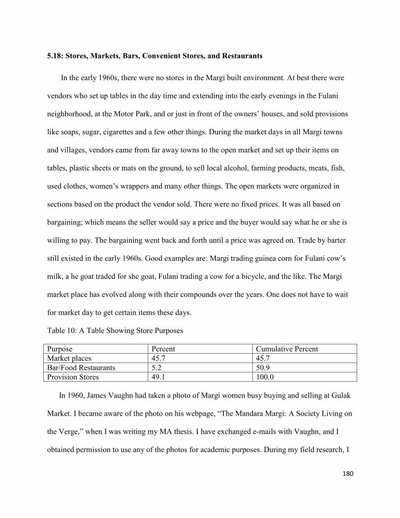
180
5.18: Stores, Markets, Bars, Convenient Stores, and Restaurants
In the early 1960s, there were no stores in the Margi built environment. At best there were
vendors who set up tables in the day time and extending into the early evenings in the Fulani
neighborhood, at the Motor Park, and or just in front of the owners’ houses, and sold provisions
like soaps, sugar, cigarettes and a few other things. During the market days in all Margi towns
and villages, vendors came from far away towns to the open market and set up their items on
tables, plastic sheets or mats on the ground, to sell local alcohol, farming products, meats, fish,
used clothes, women’s wrappers and many other things. The open markets were organized in
sections based on the product the vendor sold. There were no fixed prices. It was all based on
bargaining; which means the seller would say a price and the buyer would say what he or she is
willing to pay. The bargaining went back and forth until a price was agreed on. Trade by barter
still existed in the early 1960s. Good examples are: Margi trading guinea corn for Fulani cow’s
milk, a he goat traded for she goat, Fulani trading a cow for a bicycle, and the like. The Margi
market place has evolved along with their compounds over the years. One does not have to wait
for market day to get certain items these days.
Table 10: A Table Showing Store Purposes
Purpose Percent Cumulative Percent
Market places 45.7 45.7
Bar/Food Restaurants 5.2 50.9
Provision Stores 49.1 100.0
In 1960, James Vaughn had taken a photo of Margi women busy buying and selling at Gulak
Market. I became aware of the photo on his webpage, “The Mandara Margi: A Society Living on
the Verge,” when I was writing my MA thesis. I have exchanged e-mails with Vaughn, and I
obtained permission to use any of the photos for academic purposes. During my field research, I

181
thought I would take another photo of Margi women at the same market buying and selling in
2011. This is over 50 years since Dr. Vaughn took his photo. As I have mentioned earlier, the
Margi built environment evolved parallel with the social evolution of the Margi people. That
evolution can be seen in these photographs in myriad ways.
Figure 85: Gulak Market in 1960; Most of the Structures on the Market were Sheds Constructed
with Thatch Mats
Source: Dr. James Vaughn, 1959
Figure 86: Gulak Market in 2011 Most of the Structures are now Constructed with Cement Block
and Roofed with Corrugated Iron Sheet. The Way the Margi Appear has also Changed Over the
Past 61 years
Source: Photo by the Author
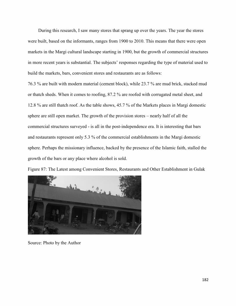
182
During this research, I saw many stores that sprang up over the years. The year the stores
were built, based on the informants, ranges from 1900 to 2010. This means that there were open
markets in the Margi cultural landscape starting in 1900, but the growth of commercial structures
in more recent years is substantial. The subjects’ responses regarding the type of material used to
build the markets, bars, convenient stores and restaurants are as follows:
76.3 % are built with modern material (cement block), while 23.7 % are mud brick, stacked mud
or thatch sheds. When it comes to roofing, 87.2 % are roofed with corrugated metal sheet, and
12.8 % are still thatch roof. As the table shows, 45.7 % of the Markets places in Margi domestic
sphere are still open market. The growth of the provision stores – nearly half of all the
commercial structures surveyed - is all in the post-independence era. It is interesting that bars
and restaurants represent only 5.3 % of the commercial establishments in the Margi domestic
sphere. Perhaps the missionary influence, backed by the presence of the Islamic faith, stalled the
growth of the bars or any place where alcohol is sold.
Figure 87: The Latest among Convenient Stores, Restaurants and Other Establishment in Gulak
Source: Photo by the Author

183
5.19: The Margi Grave Sites
Grave sites are part of the human activities and are an important part of the local cultural
landscape. Since their dispersion from near Lake Chad, the Margi who went to the mountains
started to entomb their dead in close proximity to the part of the mountainous enclave where they
resided. For example, the Medugu Kirngu clan has their burial site close to their neighborhood.
The Birdling clan has their burial site very close to their neighborhood as well. Each burial site is
named after the clan: “hur medugu” and “hur birthing,” where hu means grave, and the - r -
added indicates ownership. The same applies to other clans who reside in separate enclaves as
well. Each clan has their own Black Smith attached to them. The Black Smith men, in addition to
their normal work of smelting or making all iron implements from sickles, hoes to knives, are
also responsible for digging the grave, preparing the body, carrying it to the burial ground, and
the actual entombing. The Black Smith women are responsible for all pottery making in the
Margi culture.
Using Gulak as an example, even though some people started coming out of the
mountainous enclaves in the early 1930s, the dead were still carried back to the mountain to be
buried. This continued until 1968, when the church decided to bury their members on the church
chosen grave site; in other words, to separate the burial grounds of Christians from non-
Christians. This is how the current burial ground in Gulak was founded.
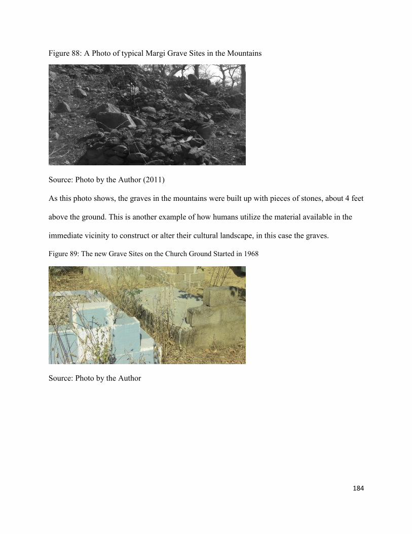
184
Figure 88: A Photo of typical Margi Grave Sites in the Mountains
Source: Photo by the Author (2011)
As this photo shows, the graves in the mountains were built up with pieces of stones, about 4 feet
above the ground. This is another example of how humans utilize the material available in the
immediate vicinity to construct or alter their cultural landscape, in this case the graves.
Figure 89: The new Grave Sites on the Church Ground Started in 1968
Source: Photo by the Author

185
5.20 Conclusion
In this chapter, the substance of the dissertation, I have surveyed the extensive, tangible
transformation of the Margi built environment in contemporary times. In my survey results and
photographic evidence, we see that Margi came to build their domestic sphere and reshape their
cultural landscapes in a manner that evolved out of the influences of missionaries, colonial
officers, and influential converts to the new religions or the new power structures over the last 50
years or so. Much of the evidence for this change came either in observations, archives, or
interviews with older, influential Margi. The first generation of the Margi to have extensive
influences from westernization and modernization seem to have led the changes. In the next
chapter, I examine the generation that has followed them, to speculate, through interviews with
them, where the youth may take the Margi domestic sphere from here.

186
Chapter 6: What Will Become of the Margi Built Environment in the Future?
6.1: The future of Margi Built Environment through the Eyes of the Margi Youth
The person is connected to place and is shaped by it. The person gives the place its
meaning, but in return receives the place’s meaning…The place’s character is
defined according to the human beings, who impose their views, attitudes, beliefs,
symbols, and myths on the places (Shamai, 1991: 355).
This particular research question tries to find out the future of the Margi built environment in
the 21st century. To answer this question, I designed a section in the questionnaire targeting
Margi youth between the ages seventeen and twenty five; hoping that they might reveal the
views of the Margi who will predominate in the 21st century, and in addition to find out what
“safe and habitable shelter” means to them. This group has not seen the total process of change
that has occurred to this point in the Margi built environment as the older generations, whom I
relied on much more in chapters 4 and 5, have. The variables in this particular research include
the following questions: What was your birth compound like when you were younger or what
did your parents tell you about it? How old were you when your birth compound was modified,
and what type of structure was it modified to? Where will you build your dream home - in a city
or in your birth place? What type of material will you use to build your dream home - with the
traditional or the contemporary European materials? In your opinion, what is the current problem
with the Margi built environment? Is living in a city good or bad? Is working in a city good or
bad? Is raising a family in a city good or bad? If all the answers are; ‘good,’… then why…? And
what does a city mean to you? The sample cities I gave are Yola, Maiduguri and Kaduna. Yola
and Maiduguri are the current capitals of Adamawa and Borno states. Kaduna is the former
capital of the northern region during the colonial administration, and where most northern ethnic
groups including the Margi flocked to, seeking new opportunities.

187
By virtue of Margi youths’ belonging in the Margi cultural groups, the schools, the
neighborhoods, religious institutions and above all the Margi households, the Margi youth both
shape and are shaped by the Margi society and the built environment the society creates. As such
they are the ideal group who can reflect and speculate on what the Margi built environment
would look like in the near future. As the older generations of Margi society ages, the dynamics
between the Margi youth as the torch-bearer and the Margi societies becomes even more
profound as it has implications for the future evolution of the Margi built environment.
The UN Habitat World Report from 2005, on the involvement of youth in cultures around
the globe (World Youth Chapter Report, 2005), informs our understanding that ageing of society
is occurring much more rapidly in the global south than it is in the global north. As of 2005, six
of every ten older persons live in the global south, and according to this report, by 2050; the
proportion is expected to rise to eighteen. Life expectancy will increase from sixty five to
seventy four as well (UN Habitat, 2005; James and James, 2004; James, 2012). In response, the
objective of this section of the research is to explain the opinions of the Margi youth toward the
future of the Margi built environment, and to reveal their intended participation in terms of what
type of building and where will they will build in the future. Their answers will determine the
extent to which a distinctive Margi built environment will continue to evolve in the 21st century.
Environments are not static; they always are in the process of change. Their decisions will have
an impact on future living conditions of the older Margi group. This may be especially
significant because, traditionally, aging Margi parents have always depended on their children
for support, especially older women who move to stay close to where their eldest male children
build homes.

188
6.2: Birth Compound Description
The Margi youth responses to the survey question that asked “what was your birth
compound like when you were younger” are tabulated in the following descriptive statistics. As
the table indicates, 67.4 % reported that their birth home was of a traditional type, or they were
told so by their parents. The traditional type means a mud huts surrounded by thatch mats tied to
a wooden stake. Only 9.5% reported their birth home to be what could be considered a modern
structure. What this suggests is that, as recently as 1986 - that is, when the Margi youth were at
least 5 years old - approximately 67.4% of the Margi domestic sphere were still considered to be
traditional type, and 23.1% were mixed
.Table 11: A Table Showing Birth Compound Description
Type Percentage Cumulative Percentage
Modern 9.5 9.5
Traditional 67.4 76.9
Mixed 23.1 100.0
In response to the question “How old were you when your birth compound was modified or
changed, and what type of structure was your birth compound changed to?” the ages reported on
the survey range from five to twenty four years old. What the range of ages means is that they
can remember what they saw or what they were told by their parents. Surprisingly almost all
those who reported their birth home as a traditional type reported changes to their homes to a
modern type of structure built with modern material. As the following table of field data and
statistics created from the field data shows, the birth compound description flipped, so to speak.
The changes from traditional to modern registered 70.7 %, leaving the traditional type at 7.3 %
and mixed structure at 22.0 %. Since the oldest respondent is 24, this means that these changes

189
occurred within the past 25 years, with the highest change of 23.1% made in the year 1996, 12.8
% made in 1994, and 10.3 made in 2006.
Table 10: A Table Showing Birth Compound Changes
Changed to: Percent Cumulative Percent
Modern 70.7 70.7
Traditional 7.3 78.0
Mixed 22.0 100.0
6.3: Description/or Characterization of the current Margi built environment
The interviewees were asked, “How would you describe/characterize the current Margi built
environment? Is it lack of planning, unemployment, lack of modem facility, poverty or
something else?” The responses are as diverse as the questions asked. As the following table
shows, the highest percentages of Margi youth 46.2% are concerned with lack of planning of the
Margi built environment; while 33.3 % are concerned with lack of modern facilities. Another
12.8 % of them felt that there were no employment opportunities. But most surprisingly only
7.7% reported poverty; apparently, despite the hopelessness that is clearly visible in the cultural
landscape, most of the Margi youth did not feel that they are poor. In addition to some notes
made by the respondents on the questionnaires as to… what is the lack of planning and lack of
modern facilities means to them, I made several follow-up phone calls to my research area and
spoke to some of the youth that I knew to have participated in this survey, and to others
randomly within the same age group, inquiring from them further on what the lack of planning
and lack of modern facilities meant to them. Almost all reaffirmed that lack of planning to them
meant: lack of general planning whereby the area is not divided into equal plots, there are no
named streets, house numbers, or parks, no clear demarcation between business and no proper
residential subdivision. At the same time, a lack of modern facilities meant to them: a lack of

190
sewer system, Pipe water connection, public toilets, cooking gas, movie theaters, steady
electricity, etc. As five of the respondents summed it up, the availability of all these modern
facilities in a home is what constitutes safe and habitable shelter.
Table 11: A Table Showing Description/or Characterization of the Margi Built Environment
Problem Percentage Cumulative Percentage
Unemployment 12.8 12.8
Lack of Modern Facilities 33.4 46.2
Poverty 7.0 53.2
Unplanned 46.8 100.0
“If a person resides in a place for many years, particularly if that person is raised there, then he
or she often develops a sense of place, feeling at home and secure there, with feelings of
belonging for the place being one anchor for his or her identity” (Hay, 1998: 6).
6.4: Dream Home Location
Despite all the concerns the Margi youth allude to regarding the Margi built environment,
and the favorable response of 90.7 % who favor living in a city, the 88.4 % favor working in the
city, and another 88.4 % favor raising a family in the city, the undercurrent of their views of the
Margi built environment is reflected in following responses as to where they intend to build their
dream homes. In other words, their hearts, and their views of a sense of place are rooted in this
place called home. Only 2. 3% of the interviewee desired to build his or her future home in the
city. An overwhelming 97.7 % want to build a contemporary bungalow close to their father’s
homes in their birth place using modern materials.

191
Table 12: A Table Showing Dream Home Location
Location Percentage Cumulative Percentage
Stay In Birth Place 97.7 97.7
Different Location 2.3 100.0
This response is interesting given that the majorities of the respondents are fairly educated, with
40.6 % holding Nigerian national certificates of education or ordinary diplomas, and are teachers
in high school; and another 31 % of them have a college degree and are professionals in various
government ministries and quasi-government organization. Only 14.3 % of them have standard
seven educations, the equivalent of seven years of school.
Table 13: A Table Showing Level of Education of Respondents
Level of education Valid Percent Cumulative Percent
Standard or Class 7 14.3 14.3
Secondary School /5 year
Teachers College
14.2 28.5
NCE/Diploma 40.6 69.1
1st Degree 31.0 100.0
The Margi traditional domestic sphere is evolving as modernization, under the umbrella of
globalization, has found a foothold in Margi cultural landscape. Just as the way the younger
Margi generation belongs to the Margi built environment that is rooted in the past and at the
same time also involved in the future, so has the modern era rooted itself in Margi land and in the
heart of Margi people and their descendants.

192
Chapter 7: Discussion and Conclusion
7.1: How Unnecessary Wars and Oppression of the ‘Others’ in the Margi Cultural
Landscape Stalled the Margi Ethnic Groups’ Development
For the discussion, first I review an attempt made by other groups in order to control,
modernize or change the Margi ethnic group’s ways of life. These attempts to change or
modernize the Margi way of life, like the earlier period when Margi were raided for slaves, starts
with the way the clans kept on moving constantly from one location to the other or chose certain
strategic locations in order to avoid their enemies. These activities are the reason why the Margi
ethnic group was restricted to nearly impenetrable environs, which also prevented contact
between the Margi clans for quite sometimes. The cosmic meanings embedded in the names of
Margi towns, villages, clan names, and other physical structures in the Margi built environment
are sometimes suggestive of this bundle of struggles with both isolation and evasion. For
example, the Margi village about 7 miles north of Gulak is called ‘wuro ngayandi’ in the Fulani
language; which means ‘the stubborn town.’ One wonders, given the Fulani’s turbulent
relationship with the Margi, if this is a stubborn town because it was difficult to control? Another
Margi town about 10 miles northwest of Gulak was known for a long time as ‘wuro dole’ in
Fulani, which means ‘forceful town.’ Even though the Margi changed it back to the original
name of Kirchinga in due course, the Fulani name is again suggestive of the challenging relations
between the Margi and their neighbors. The literal meaning of the town of “Lassa,” where the
Brethren Missionaries first established a station in 1927, is “gone and got lost.” Could this be due
to the unplanned separation that occurred in haste during the dispersion from Gazargamu? This
is, after all, where the Gadzama clan came from before Idris Alauma took it by force and made it
his headquarters. The meaning of “Gulak,” which was originally called “Gulagu,” the second

193
Margi town where the Brethren Missionaries planted a station, is “looking for a path” - a path to
where has never been explained. The clan I belong to is originally called ‘birthing,’ meaning the
movement of an ant called “thing,” that is known to move in circles in order to avoid its enemies.
Even if the missionaries Anglicized the name to ‘Birdling,’ the original name begs the question
of why a group of people would move around in a circle like an evasive ant, or name themselves
after that movement. I argue that these cosmic meanings imbued in Margi names can also tie the
Margi ethnic group into the universal truth of human existence in relation to the earth, to
geography. Whichever part of this space humankind carved out and converted into a living place,
especially as a group, in some way the place is imbued with a cosmic meaning, at least for the
group and their associates. Furthermore, revealing even a few of such meanings in the Margi
cosmic evolution will help others to capture those elements of Margi life that cannot be captured
by observing the physical structure and layout of any of the Margi towns and villages (Simone,
2009: x). There is a constructive quality to Margi names, tied to processes of place making and
meaning (Myers 1996).
For the rest of the analysis in this section, I rely on works by earlier Africanist scholars like
M. G. Smith, James Vaughn, Derrick Lange, Anthony Kirk-Greene, M. S. Kiwanuka, and C. E.
Faw, to mention but a few. I also concentrate on the works of James Ferguson, Pierre Bourdieu,
Samir Amin, and Abdoumaliq Simone. Many of these scholars have helped us to explore how
colonization, globalization or what we call modernity today reached into the territories and built
environments of African peoples like the Margi. One caveat to their very varied works, though, it
is the limited degree to which there is an acknowledgment that the processes of subjugation
started on African soil. Each successive group of the perpetrators of external oppression started
by feeling they were superior, and they consequently developed the desire to take over the

194
cultural landscape of the “others” under the pretense of civilizing, helping, or to change their
victims’ ways of life. From ancient Rome through medieval Mali, and Songhai we can find
examples of such external and internal perpetrators who serve as patterns for different forms of
colonialism (Kiwanuka, 1973). In due course, such actions were renamed conquest or
subjugation. In each case of these conquests, be it by internal or external forces there has been
continued presence of the subjugators, so that ownership of the territory could be legitimized in
the form of occupation.
As I have indicated in the previous chapters, the Margi lived as a thriving civilization around
Lake Chad. As a part of its own imperial quest for subjugation, another ethnic group the Saifawa
dynasty showed up in the Margi cultural landscape. The dynasty felt they were stronger and
better armed and decided to attempt the first wave of colonization and modernization of the
Margi ethnic group in the form of forceful conversion to Islam and the Kanem Bornu empire
under the leadership of Idris Alauma in 1564 (Lange, 1987). The Arabic word 'Islam' simply
means 'submission'. In a religious context it means complete submission to the will of ‘Allah’ an
Arabic name for God, which is used by Arab, African Muslims, and Christians alike (http:
//www.quran.com). The forceful expeditionary activities took place between 1564 – 1576; but
the Margi did not want any part of it, as such the Margi left the general area and dispersed in
different directions under autonomous family patriarchs and settled in various locations, albeit
within the same general vicinity (Lange, 1987; Kirk-Greene, 1958: 18; Birdling, 2009). This is
an example of what Samir Amin meant when he wrote in Underdevelopment and Dependence in
Black Africa-Origins and Contemporary Forms (1972) that;
[t]here were wars and anarchy almost everywhere on the continent, and the flight of
peoples towards regions of shelter which were difficult to reach and also very often poor
- such as those of the paleo-negritic peoples in the over-populated mountains of West
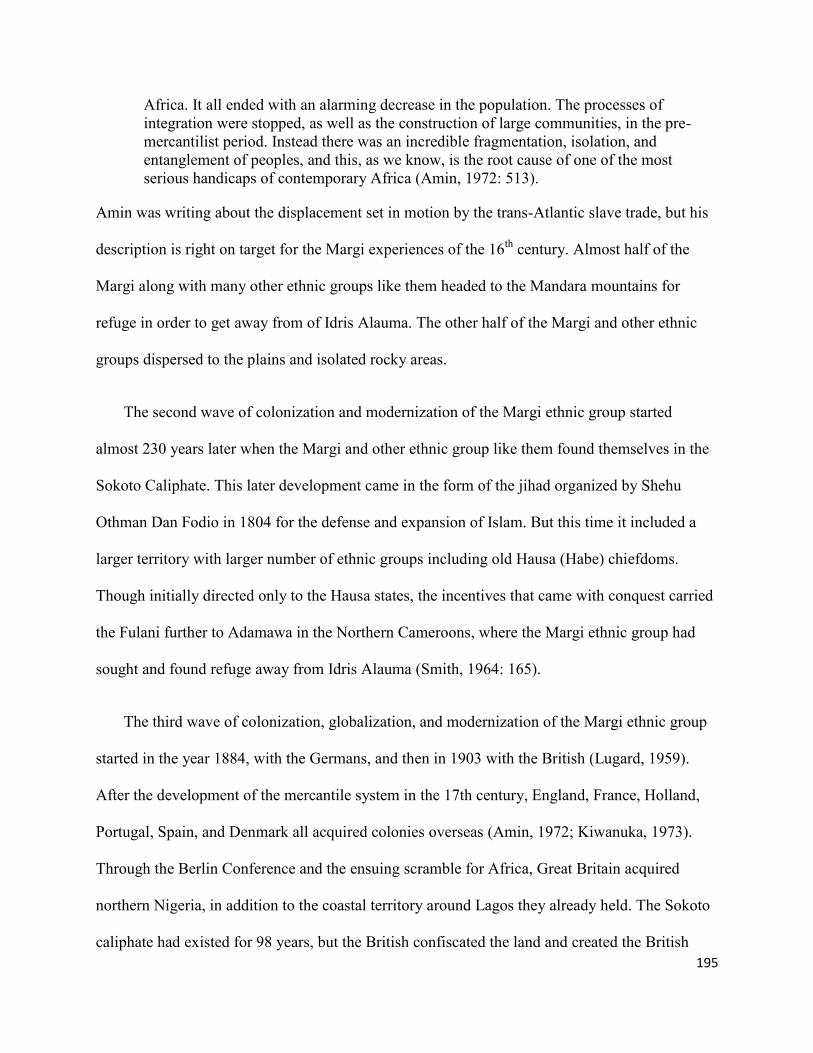
195
Africa. It all ended with an alarming decrease in the population. The processes of
integration were stopped, as well as the construction of large communities, in the pre-
mercantilist period. Instead there was an incredible fragmentation, isolation, and
entanglement of peoples, and this, as we know, is the root cause of one of the most
serious handicaps of contemporary Africa (Amin, 1972: 513).
Amin was writing about the displacement set in motion by the trans-Atlantic slave trade, but his
description is right on target for the Margi experiences of the 16th
century. Almost half of the
Margi along with many other ethnic groups like them headed to the Mandara mountains for
refuge in order to get away from of Idris Alauma. The other half of the Margi and other ethnic
groups dispersed to the plains and isolated rocky areas.
The second wave of colonization and modernization of the Margi ethnic group started
almost 230 years later when the Margi and other ethnic group like them found themselves in the
Sokoto Caliphate. This later development came in the form of the jihad organized by Shehu
Othman Dan Fodio in 1804 for the defense and expansion of Islam. But this time it included a
larger territory with larger number of ethnic groups including old Hausa (Habe) chiefdoms.
Though initially directed only to the Hausa states, the incentives that came with conquest carried
the Fulani further to Adamawa in the Northern Cameroons, where the Margi ethnic group had
sought and found refuge away from Idris Alauma (Smith, 1964: 165).
The third wave of colonization, globalization, and modernization of the Margi ethnic group
started in the year 1884, with the Germans, and then in 1903 with the British (Lugard, 1959).
After the development of the mercantile system in the 17th century, England, France, Holland,
Portugal, Spain, and Denmark all acquired colonies overseas (Amin, 1972; Kiwanuka, 1973).
Through the Berlin Conference and the ensuing scramble for Africa, Great Britain acquired
northern Nigeria, in addition to the coastal territory around Lagos they already held. The Sokoto
caliphate had existed for 98 years, but the British confiscated the land and created the British
196
colonial territory called the Northern Protectorate in 1903. When Lugard made his intentions
clear to the Sultan that he wishes to establish British rule in Northern Nigeria, the Sultan Attahiru
replied that, “between the Muslims and infidels there could be nothing but war.” (Smith,
1964:184). By the end of 1903, Lugards’ forces had overrun the caliphate and its forthcoming
administrative arrangement had been established. The Protectorate was governed through the
Provinces, each under a resident responsible to Lugard, and the provinces were subdivided into
Divisions under officers responsible to the residents (Blackwell, 1927; 1969; Smith, 1964). Time
had come for the emirs, who were literarily former owners of the ‘West African form of
plantations’ in the Sokoto Caliphate, to bow down to the British musket. Their bowing down
meant the beginning of physical freedom of the Margi and other ethnic groups like them in the
former Caliphate and an end to their isolation (Vaughn 1964; Kirk-Greene, 1958; Vaughan and
Kirk-Greene 1995).
Figure 93: Four of Sokoto Caliphate Rulers bow down to British Officers while their Dogaris,
Body Guards watching on the right in Northern Nigeria
Source: Colonial Records, Rhodes Library Oxford, U. K.

197
7.2: The Trickle Down of the Neoliberal Economic Activities in the Margi Cultural
Landscape
The changes the Margi ethnic group and others like them went through starting with Idris
Alauma through the Sokoto Caliphate to the British colony foreshadows my discussion about the
neoliberal economic order, which has replaced colonization. James Ferguson in Global Shadows:
Africa in the Neoliberal World Order claims that globalization “hops” in Africa, rather than
“flows.” He further distinguishes between “useful” and “useless” Africa for neoliberal
globalization: “Capital does not ‘flow’ from New York to Angola’s oil fields, or from London to
Ghana’s gold mines; it hops, neatly skipping over most of what lies in between. Second, where
capital has been coming to Africa at all, it has largely been concentrated in spatially segregated,
socially ‘thin’ mineral-extraction enclaves” (Ferguson, 2006: 54). I would like to add to the
discourse of capital Ferguson started. Beginning in the mid-1970s, but pertinently in the 1980s,
a new wave of what the capitalist west called development aid was introduced, but with strings
attached to tilt development towards the invading transnational corporations’ interest. This
precisely describes the neoliberal wave of globalization and modernity that trickled down to the
Margi and others like them across Africa, and subsequently affected the built environments of
the ‘others’ in the places in between the hops.
Globalization and modernity hopped over the Margi domain, because there was nothing
there in terms of minerals to benefit the British Government or the independent nation-state of
Nigeria. Secondly, this mountainous region was too rugged even for profitable farming. Just as
Ferguson gave the example on how capital leaps over other places and people, modernity leapt
over the Mandara mountains enclaves; similarity French globalization and modernity hopped
over the Kabyle peasants in French Algeria (Ferguson, 2006; Bourdieu, 1960). But at the same

198
time Kabyle peasants and the Mandara mountains inhabitants existed within the colonial
governments’ bureaucracies’ variously defined objectives, including taxing the inhabitants. On
the one hand, the deliberate objectives of the colonial order was to create and maintain a future
labor force; on the other hand, (in case of the Margi) the missionaries showed up and tapped into
this existing framework already organized by the British, and started churches and schools in this
general area. In 1927, American missionaries started such a school and church among the Margi,
followed by the Catholic missionaries in 1948. When the colonial tax system stopped with the
coming of independence, the missionary school fees took over the income from the Margi peanut
farm, and that of other groups like them that attend the missionary schools.
The colonial authorities were perhaps more than glad that the missionaries took upon
themselves the burden of “civilizing” the Margi as a potential work force for the future. This
certainly made their job easier, especially when they knew that the Christian faith is mostly about
peace, and had the potential to unify warring clans. One of the early missionary-educated Bura
man, Bitrus Sawa, who belonged to the first ethnic group that the American Church of the
Brethren had contact with in 1923, put it this way: “One of the great results was the fact that the
new faith brought together people from all walks of life and from diverse tribal and clan
backgrounds into new brotherhood; reconciliations began to take place across all lines of
hostility, a new equality of all men before God produced its transformation in individual and
communal life” (Faw, 1973: 84). In view of this development, the colonial authorities figured
that the best way to rule was to convince the clan leaders that were still residing in the
mountainous enclaves to bring their people out of the mountains to the slope, to have enough
space to grow the peanuts and the cotton that British industries needed, as Christian subjects.

199
One good example of such action by the colonial authorities came to light in 1973 when
James Vaughan interviewed the Margi king (Vaughan, 1975). The king narrated how, in 1956,
the colonial authorities convinced him to move his entire village of three hundred or more people
who were living on top of the Mandara mountains to migrate to the mountain slopes. Each head
of the household was given two pounds as an incentive. But we know that, on their arrival,
within a few months, the neighborhood was given western clothes especially the women in
exchange for their goat and ram skin attire. In a few more months, their children were recruited
to attend the newly built schools. In about 10 years, the educated children moved to big towns to
work and came home with money to build triangular or shotgun-like homes.
Ferguson further informed our understanding of neoliberal activities by pointing out that
“Usable Africa gets secure enclaves—noncontiguous ‘‘useful’’ bits that are secured, policed,
and, in a minimal sense, governed through private or semiprivate means. These enclaves are
increasingly linked up, not in a national grid, but in transnational networks that connect
economically valued spaces dispersed around the world in a point-to-point fashion” (Ferguson,
2006: 56). The “useless” African places like Margi land was left fragmented and therefore could
no longer have the collective power to bargain or trade. The Kabyle peasants of Algeria and their
urban sub-peasants, that is the lower working class, could not constitute a revolutionary force as
well (Bourdieu, 1960: 134). Their precarious economic situation, just as that of the Margi, did
not allow them to make the rational calculations of the characteristic of the French or the British
imported capitalist economy, much less achieve class consciousness. These two examples of
ethnic groups are surely models for disenchantment from the world, two examples of groups
stripped of the right to a good life by the activities of a more powerful world that eventually
guaranteed the activities of the neoliberal economic order. On one hand, the traditional order of
200
Kabyle peasants and the Margi as they had once been can be viewed through such narratives
(Bourdieu, 1960: 141). On the other hand, the economic dispositions of the two groups in the
1960s can speak of what colonialism is about. Even though colonialism lost its legitimacy,
institutions like the World Bank, and International Monetary Fund (IMF) took over, as the
continuation of the colonial enterprise. And this leads to how the totality of globalization, and
modernization affected the built environment of the Margi ethnic group and others like them
across Africa. Just as it is for the Margi, for the Kabyle “the domestic sphere is an empire within
an empire, but one which always remains subordinate because, even when it exhibits all the
properties and all the relations which define the archetypal world, it remains an inverted
reflection, a world in reverse” (Bourdieu, 1960 : 153). And so are the built environments of
many marginalized African ethnic groups like the Margi of northeastern Nigeria.
Yet it is important to recognize that, even if the Margi were placed in a subordinate,
marginalized, “useless” zone of the colonial world, and thus in a similarly “othered” edge of the
age of neoliberalism, they are not stripped of all agency in the transformation of their domestic
sphere. This agency is evident in the claims of my next section below.
7.3: Who Has the Right to Say They Invented the High Style Residential Structures
Anyway?
In this section I review writing of a few urban theorists to make the case that the
invention or ownership of today’s modern high style residential structure does not
exclusively belong to one group. In other words, I am asking, ‘which civilization has the
right to say they invented the current high style residential structures?’ In my opinion no
single civilization came up with today’s modern type of residential structure, such as those
that now predominate in Margi land, be they shotgun-like or bungalow, or other house styles

201
found among many former subjects of British colonial territories. In her book, Ordinary
Cities, Jennifer Robinson (2006) argues that “one of the strongest effects of Western urban
theory’s ongoing association with a restricted conceptualization of urban modernity is that it
postulates a privileged link between modernity and certain kinds of societies.” In so doing,
the theory has “portrayed rural and non-western societies as static and closed; the anti-thesis
of urban modernity.” I am following in Robinson’s footsteps, in saying that the western
claim to architectural modernity is not exclusive, and I am refusing their claim of the
ownership of high style residential structures (Robinson, 2006: xi). There is a need to unravel and
retell how various cultures around the globe contributed to the evolution of what we call the
shotgun, bungalow, and subsequently the high style residential structures of today, instead of
aligning their development with specific kinds of societies (Robinson, 2006: 14). Western
architectural historians typically ally the emergence of high style to the west only. But after a
critical examination of the evolution of what became the shotgun, bungalow or high style, one
finds that it is a global hybrid (King 1984). Robinson’s argument in relation to cities can be a
basis for my argument about the Margi domestic sphere. The west got away with this claim to
ownership of modernity as far back to the age of Enlightenment. At that time, Newtonian science
was exerting its greatest influence on European cultural expression and sought to find in human
affairs natural laws similar to those that have been discovered in the physical universe. For
people like Kant in those days, the Enlightenment which birthed modernity was a God-sent
liberating tool from authorities, and human reason would be capable of answering all questions
(Gilman, 2003). But contrary to Kant’s conception of modernity as a liberating tool from
authorities, the colonial authorities adopted the reverse; in fact, for them modernity became the
tool of coercion. Just as Robinson used the notions of Ordinary Cities to interrogate the geo-

202
politics of urban theory and development, we can see how the African vernacular architectural
ideas went with African ethnic groups, through slavery, across non-African space to places like
North America, South America, and the Caribbean, suggesting the greater need to interrogate the
ownership of architectural forms. Over the slavery years, the African vernacular architectural
ideas were interpreted in these cultures around the globe; and finally the hybrid form that
resulted from these transformations went back with African freed slaves to various West African
coastal regions of Dahomey, Lagos, and Freetown.
In his work, The Past is a Foreign Country, David Lowenthal (1985: 69; emphasis mine)
opined that “Tradition shouldn’t be the enemy of change” and that “we cannot function without
familiar environments… which we link… with the recognizable past, but we are paralyzed unless
we transform or replace inherited relics.” Similarly, Anthony King, in his article,
“Internationalism, Imperialism, Post-colonialism, Globalization: Frameworks for Vernacular
Architecture” (in which he drew extensively from Dell Upton’s Ordinary Buildings), suggested
that, the word ‘ordinary building’ has the power to transport individuals back in time and
space…to their roots, a place of birth and early memories, be it a castle or a mud hut. Therefore
King resented the wording ‘international’ used by two prominent authors, Hitchcock and
Johnson, who wrote the book “Styles: Architecture since 1922,” to accompany an exhibition at
New York's Museum of Modern Art in 1932. I agree with King that the word “national” should
have been used, as it is best understood in relation to the territorial nation-state where the
building exists (King, 2004: 1). Moreover it was not collectively produced by all countries. At
that point in time much of the world’s spaces were colonized; therefore, it was not a world of
nation-states, “but a world of empires and colonies; not an international but more an inter-
colonial or inter-imperial world, most of which had not gone through the experience of

203
industrialization” (King, 2004: 2). It was rather the architectural style of international industrial
capitalism, as it was developed in Euro-America, which had its origins in this particular system
of economic, political, and social organization and mode of production.
King concluded with a brief history of the origin and the development of a particular
vernacular building, the bungalow. It was identified in what is today’s modern Bangladesh in
1659 by British colonial officers and introduced to Britain. In early 1880, the idea of a bungalow
moved to the United States, and grew in maturity in California and subsequently became a
vernacular house type found in the suburban United States. This Anglo-Indian bungalow had a
significant influence on the design thinking of Britain’s leading twentieth century architects, like
C. E. A. Voysey (King, 2004: 3-7). The bungalow architectural style followed imperial Britain to
colonial northern Nigeria; the bungalow is now thoroughly a part of Margi architecture, just as
the shotgun style was adapted into Margi styles in the form of “Chiki da Palo” in the early 1960s.
Now, the question I am asking is how this movement of ideas across transnational space can be
reinterpreted in a way that connects all of the “agencies involved for the interpretation of the
social meaning of vernacular buildings” (King, 2004: 5).
The elements needed for reinterpretation of the transnational space have always been there.
The Yoruba from West Africa were taken to Haiti and Brazil as slaves. When some of them
freed themselves in 1803, they took with them a new form of African architecture (watered down
or modified by French and Greek architecture) to New Orleans and Lagos. The only thing that
needs to be done is to understand and interpret it, as King suggested, in ways that make sense.
One of these ways could be simply to give credit to all who were involved: the African slaves,
the French, Bangladeshi people and the colonial officers for the evolvement of the shotgun and
the bungalow. In other words all of the building types we have today in Margi land, as in many
204
places, are hybrid styles owned by all involved, Africa, Bangladesh, Britain and America. The
current architectural form has clearly become a set of overlapping circles of knowledge, as
Upton had proposed, refined and re-defined by being located in cross-cultural global
frameworks. In view of this, King suggested that, in fact, globalization, which is another name
for modernity, tends to suggest a singular process as its derivative globe. I suggest instead
interconnectedness, where all the cultures around the world and the agencies that keep it running.
To further show how modern architecture is not owned solely by any nation-state, let me turn
to John Michael Vlach. In his article, “The Brazilian House in Nigeria: The Emergence of a 20th
-
Century Vernacular House Type, Vlach argues that “despite the plainness of this building [the
Brazilian house], its history is complex and convoluted. Vast global interactions are shielded
behind its modest façade.” Vlach, argues that “during the 20th century the balance between
tradition and change in West Africa has tipped decidedly in the direction of change,” and that
domestic housing is one of the crucial areas that have been affected. He analyzes how the
Yoruba’s’ traditional society changed their houses in a way that made the imported design their
own. The imported design Vlach is referring to was brought to Lagos by freed slaves from Brazil
at the stage of Britain’s colonial conquest of Nigeria. These freed slaves claimed Yoruba origin,
though they had been taken against their will as slaves to Brazil (Vlach, 1984: 6). Vlach also
noted that as early as 1836, many of these Afro-Brazilians made their way back to Dahomey, a
neighboring country to Nigeria, but most of those that returned to Lagos were native Yoruba or
Yoruba descendants. By the 1880s, there were 3,321 Brazilian ex-slaves in Lagos; this number
constituted 9% of the population of Lagos at that time. They brought with them building skills,
and built places like the Shi’ite Bye Mosque, Central Mosque, and Holy Cross Cathedral, in
addition to various models of residences. Their skill and hard work encouraged the British

205
colonial governor, then Sir Henry McAlum, to send the first batch of Nigerians to England for
vocational training in 1897 (Vlach, 1984: 8).
The arc of Vlach’s narrative fits the case of Margi architectural evolution. There is a
verifiable beginning, in the form of round huts and stacked stone fences in the Mandara
mountains enclave and the plains of northeastern Nigeria. When those in the mountains moved to
the slopes of the mountains, no one ordered them to modify the house style by using all mud for
the huts and thatch mats for the fences. Then in due course the thatch fence was replaced with a
mud fence, and so on. This clearly shows how cultures invent their own modernity, being
inventive rather than imitative of a superior, mythic West (Robinson 2006). To drive the point
Vlach made about the imported Brazilian architecture home, Vlach also cited Reis Filho (1973)
and Olinto (1980), both of whom verified that the Brazilian house styles found in Lagos
represented a direct restatement of the architecture found in such Brazilian cities as Rio de
Janeiro, Bahia, and Recife. Also they added new information that, in fact, prior to the Yoruba
slave descendants’ repatriation, it had been the high point of the Greek revival embellishment in
Brazilian architecture (Vlach, 1984: 9). Greek architecture influenced Brazilian architecture and
the ideas that the slaves brought, and then the hybrid product found its way to Lagos and
influenced that of the Yoruba. The Yoruba who now modified and claimed the new Brazilian
architecture as their own took it with them to the northern part of Nigeria, a fact confirmed by
John E. Flagg (1952: 113), as cited by Vlach: “today in Nigerian cities far to the north of Yoruba
territories as Kano and Jos one will see a few of the Brazilian houses; they are signs of Yoruba
presence” (Vlach 1984: 19).
This architectural global interaction that begins to engulf West Africa has also been
attributed to the Creoles from Sierra Leone; the Creoles are freed slaves repatriated to the West

206
African coast from the United States. Some of these Creoles settled on the West African coast (in
the area now named Sierra Leone), but some of them returned to Lagos as early as 1839 (Vlach,
1984: 9). Kopytoff (1965: 44) also suggested that this group of ex-slaves stood in the middle-
ground between the elite European administrators and the indigenous populace. They arrived
from Freetown with Christianity and a new fabricated house type believed to have spread inland,
information that is seconded by Mabogunje (1961: 136), even though Mabogunje believed that
the Anglo- Creole architecture did not have an impact on the local building practices as the Afro-
Brazilians architecture did. In addition, Vlach also concedes that when all this was going on,
there were European merchants and missionaries present in Lagos at that time, and that no one
can avoid their influence in this drama. Missionaries in particular played their role in this
architectural evolution of the Yoruba. They preached against polygamy, they demanded one
man, one woman marriage - which translated into new residential patterns, since the newly
sanctioned nuclear family had no need for a large old fashioned compound (Ojo 1966: 156).
As with the Yoruba, so with the Margi: with the coming of the American Brethren
Missionary, they changed their religion to Christianity; then the Margi adopted a smaller family
structure just like the newly Christian Yoruba. To some degree, the Margi chose western
economic structures and politics, and subsequently declared war on their inherited cultural
values. They started imitating and believing everything the white missionaries did to be in the
realm of modernity (Birdling, 2009). With the creation of the Nigerian nation-state, the Margi
missionary-educated elites went to the cities and lived with the Yoruba, as they worked as police
constables, soldiers and clerks. They came home and built the type of structure they saw, while
those who remained in Margi domain work as the primary school teachers, gardeners or
dispensers, and built what they saw the missionaries were building. In this way, the Margi

207
remain busy trying to stay in the realm of hybrid modernity. Vlach’s final opinion, which I
second, is that these elements of culture acquired from the so-called developed high societies do
not have to be used in the way their originator intended. In fact, the Margi architecture evolved
to a middle ground, in which both tradition and change are joined together, where the past cannot
be declared lost, and the present is not totally ignored. It is a new tradition, but one that is not
totally new. I prefer the notion of hybrid tradition that is owned by both the past and the present,
but independent and capable of surviving on its own as the new global modernity.
7.4: Discussion of Statistical Analysis
Here I present a re-analyses of my field data using a different, more quantitative method,
statistical analysis, to see if the outcome is consistent. I then use this to contemplate whether or
not the data continue to support my dissertation statement on how the Margi built environment
has been following the pattern of the global evolution. I used analysis of variance (Anova) using
a Section of the data from 1921 to 2000. I also used the same data for graphical analysis to see if
both identifies whether or not there has been consistency in the development or evolution of the
Margi built environment.
I used analysis of variance to test the positive and negative changes of the total rates of
infrastructure constructed in the Margi built environment over time. I have indicated earlier that I
am most interested in the change that occurred beginning in the year 1960, and that is the period
the test began. The test shows a statistically significant increase in the infrastructure built across
the board that includes houses, schools, churches, mosques, and stores (the term stores is used to
account for restaurants, bars open markets, and provision stores). The increase between 1960
(M=820 SD=420.71) and 1970 (M=1720 SD=389.97) is statistically significant F (1, 4) = 11.57,
p=.027, (see table 14).

208
Table 14: A Table Showing the Statistical Analysis of Number of Infrastructure Built From 1960
– 1970 in the (MBE)
Year Mean Std. Deviation N
Year_1960 820.00 420.71 5
Year_1970 1720.00 389.87 5
Inversely, there was also a statistically significant decrease in building across all building types
between 1970 (M=1720 SD=389.97) and 1980 (M=800.00 SD=254.95), F (1, 4) = 16.15,
p=.016.
Table 15: A Table Showing the Statistical Analysis of Number of Infrastructure Built From 1970
– 1980 in the (MBE)
Year Mean Std. Deviation N
Year_1970 1720.00 389.87 5
Year_1980 800.00 254.95098 5

209
Figure 90: The Graph of the Evolution of the Margi Built Environment from 1921–2000; (a
section) showing the Number of Houses, Churches, Schools, Mosques, and Stores built every 10
years
7.5: What the Graph is showing
When the presence of the colonial officers started to be felt in the Margi cultural landscape,
coupled with the coming of the American Church of the Brethren, and the Catholic Church, there
was a general change. The Margi ethnic group who went to the mountainous enclaves to hide
from Idris Alaumas’ expedition and the slave raiding by the Sokoto Caliphate started to come out
of the mountainous enclaves and settle on the plains, this brought about massive construction of
new hamlets in the Margi cultural landscape starting from 1927, and reached its peak in 1935,
then dropped to its lowest in 1945, Most of the Margi settled around the missionary schools,
churches, dispensary and other amenities provided, and the built environment expanded
dramatically after 1950 in direct relation to this. For example, below is an extended portion of
210
notes taken during one of the Church of the Brethren planning meetings. It reveals an expansion
plan to various Margi and non-Margi towns and villages:
[N]umber of New Stations planned 7. Names of Towns- villages or districts in which
these are to be: (1) Mubi (2) Gulak (3) Gwoza (4) Shafa (5) West Margi (6) Babur, and
(7} Higi. There is a twofold strategy in planning for these seven new stations. In the first
place there is an area in the northeastern part of Nigeria which has been regarded by our
fellow mission societies as being the area for which we, as the Church of the Brethren,
are responsible. Mohammedanism, which has the prestige of being the religion of most of
the ruling groups and is thus strongly entrenched in government circles, will use every
advantage it has to win these hundreds of thousands and make them a part of its religio-
political set up. The Roman Catholics with their well-planned strategy are now actively
trying to get a foothold in this area. We have decided that God helping us we will not fail
and so have planned a certain number of these new stations as outposts or pioneer
stations in the area which has not up until now been occupied. The proposed stations at
Mubi, Gwoza, and West Margi and to a lesser extent Higi and Babur will be in the nature
of such outposts or frontier lines. Gulak is about 16 or 18 miles northeast of Lassa and is
in the most thickly populated area of the Margi who speak the dialect which is used at
Lassa. The Village Head of Gulak has about 6,000 people under him. Gulak itself is
about two miles from Duhu where some years ago Risku had charge of an out station and
lived at Duhu about 2 years. The old village of Gulak is in the Gulak Mountain – but
now, with the exception of the Chief and a dozen or so other families who still live on the
old village site, all the people have scattered out over the plains and live in scattered
hamlets.
The American Church of Brethren five year plan clearly supports the graph showing, an increase
in the houses, churches, schools, and stores at that time. There was also, around the same time,
church planting in two Margi towns by the Catholic Church. Note that the mosques were far
fewer in the Margi domain, because, based on their experiences with Idris Alauma and the
Sokoto Caliphate, Islam was less attractive to the Margi ethnic group at that point in their
history.
7.6: The Effect of Global Financial Activities in the Margi Built Environment
One may ask why the construction dropped to its nadir in1945. The answer is that after the
euphoria over the arrival of missionaries to Margi land subsided, there were not any significant

211
income earners among the Margi, other than the seasonal travelling by the Margi men to the
towns of Yalo, Maiduguri, Mubi or Bama. In most cases that lasted for about two months, at
most three during the dry season when there was no farming activity. As this graph seems to
suggest, there was statistically significant growth, beginning especially in the early 1960s. This
can be attributed to the first missionary school graduates who completed the first four, seven, or
ten years of school and obtained jobs from the missionaries as carpenters, gardeners, cook, and
even as elementary school teachers. The next thing is that there was euphoria over Nigerian
independence. That euphoria cannot be seen outside of the creation of the United Nations, the
World Bank and the International Monetary Fund (IMF). The latter two were established at
Bretton Woods, New Hampshire, in 1944. The initial purpose of the World Bank, originally
named the International Bank for Reconstruction and Development, was to help rebuild Europe
after World War II. Its first loan was for post-war reconstruction in France in 1947 (Mason and
Asher, 1973). Other developing nations including African countries were not among the bank’s
priorities at the time. In 1957, the majority of the loans made by the World Bank (approximately
52.7%) went to industrialized countries (www.cadtm.org; 2 November, 2006). It was not until
1960, that the Bank came up with a specific instrument for granting low-interest loans to
developing countries. It did so, some scholars argue, for the sole purpose of stopping the spread
of communism (The U.S. Perspective on Globalization; CIAO DATE: 9/99).
Therefore I suggest that the reason the Margi built environment started to evolve from 1960
as the analysis of variance and the graph shows, and reached its apex in new construction in 1970
must include a combination of: the decision by the British to grant independence in 1960; the
decision by the World Bank to start granting development loans to developing countries; the
creation of new and better jobs that came with the creation of independent Nigeria; and the

212
competition to win friendship with newly independent states including Nigeria by both the
Soviet block and the west, which brought capital to the new states (and Nigeria’s share trickled
down to the Margi cultural landscape). Above all, the products of the missionary schools were
now taking their place in the Nigerian public service and private companies all over the newly
independent state of Nigeria. But why did the construction rate drop from 1970 to 1980 and
remain level from 1980 to 1990; the clue can be found in the next section.
7.7: Structural Adjustment
Western capitalist countries crafted a program called 'Structural Adjustment' in collaboration
with ‘individual vulture capitalists,’ and sold it to the leaders of developing countries under the
credible pretense to paraphrase,: “this is what saved us...it will save you too.” From then on,
Structural Adjustment was exported to already vulnerable places and people around the world,
including Africa. In a way, this single action on the part of the western countries meant that the
Keynesian economics of the 1960s, which were loaded with idealism and its dualist conceptions
of development, were defunct. The powerful spatial metaphor frequently articulated in the
discourse on Structural Adjustment was globalization, and it failed. To be fair, when it comes to
the failure of Structural Adjustment Programs, at least in Africa but pertinently in Nigeria, there
were both global and local dimensions. The global dimension was that, on one hand, all activities
that made a profit should be controlled by private investors, which were mostly foreign nationals
(http: //www.cadtm.org 2 November, 2006; Collier, 1991: 339-356).
On the other hand, providing the infrastructure to sustain the privately owned money-making
industries fell on the public sector, and the costs needed to be met by indigenous society in order
to attract private investors, who would create jobs, or so they said. In other words, the World
Bank recommended privatization of profit making combined with the socialization of the cost of

213
anything that was not directly profitable. There was as much internal failure as there was external
though, because an historical geography of capitalism informs our understanding that the two
have never operated in grand isolation from each other. In Africa, and perhaps especially in
Nigeria, there were massive concentrations of economic and political power in the hands of a
few, which led to rampant corruption.
The standard economic terminology really belies the condition of the continent in 1981.
The 1970s saw a spectacular increase in black-market activity, and in a number of
countries - Ghana, Sierra Leone, and Uganda, for example - the 'underground' economy
came to dwarf the official economy. In many others - Benin, Cameroon, Guinea, Kenya,
Mali, Niger, Nigeria, Sierra Leone, the Sudan, Zaire, and Zambia among them - elaborate
networks of formally illegal transactions and trade interpenetrated the higher levels of
government. (Journal of Modern African Studies, Vol. 26, No. 1. 1988: 113-137; Collier,
1995)
The politically powerful few helped facilitate structural adjustment and reorganized production
through the deregulation of markets, devaluation of currencies, internal and external trade
liberalization, and of course devised methods to siphon the sum of loan obtained and transport it
back to the western countries, but this time around to private accounts.
In the Margi cultural landscape, the presence of that “politically powerful few” in the
1970s and 1980s was virtually nonexistent. The decrease in new structures in the built
environment is a corollary of that marginalization.
7.8: The Silent Cultural Clashes between the Three Groups in the Margi Cultural
Landscape: What the Margi Did or Did Not Do
In summary, the groups referred to in this heading, in other words the essentials that make
up the puzzle responsible for starting the transformation of the Margi built environment, are: the
presence of the British Government on Margi land, from Lugard on. Lugard was responsible for
initiating the links of the Margi cultural landscape as well as aspects of the social and political
society, to the colonizer’s world, via ties between the district officers, the emirs, the Margi ptil

214
(chief), and the neighborhood heads (the bulama). The unspoken power of the colonial spatial
system was in part exercised through the provision of things, such as wells or vaccinations for
humans and cattle, among other things; but also through taking things away, such as via tax
monies, peanuts, cotton and extremely cheap labor from the inhabitants.
The key actors mentioned above are responsible for organizing, stabilizing and holding
together the relationships between environments, bodies, materials, and institutions that must be
constantly refined and readjusted for the benefit of the colonial government (Simone, 2009: 13).
This was followed by the presence of missionaries, represented by two denominations of western
Christian churches; the America Brethren Church and the Catholic Church. The missionaries
were incapable of accepting the reality of Margi culture as they found it then, so they created
places in the form of both non-material and material culture (the church, the schools, and the
dispensaries within the Margi cultural landscape) to change the Margi culture according to their
ideas of what they thought ought to be (Sack, 2001: 117). The Margi ethnic group willingly
participated in the new activity that embodied a new lifestyle. It gradually encroached into their
cultural landscape through the colonial officers with their bigger guest houses, or the
missionaries with their new school, new medicine and new religion. The Margi choose to start
modernizing their domestic sphere to conform to the new western norms; and they found
themselves striving to buy the western material to construct semi-western homes. The new norms
clearly led many other ethnic groups in Africa that came in contact with missionaries, colonial
authorities, or other European settlers to adapt to the newly imported construction styles by their
new neighbors.
215
7.9: Resistance to Loss of the Core Values of the Margi in the Forms of Compound
Fencing; Detached Kitchen Space; Animal Pens, Guinea Corn Granaries; and young Margi
generations intent to build their future homes in Margi cultural landscape.
Although cultural imperialism, that is, the spread of ideas and values, norms, and knowledge
from the former colonial powers, has taken the place of formal colonialism, I argue that such
structures as Margi fencing show a counter-narrative. The materials used to construct the fencing
of the compound have evolved from stacked stones, to thatch mats, to mud, and finally to
western cement blocks, but the meaning as a core value in Margi culture has stood the test of
time. In other words, its meaning and use is still the same. The Margi thatch-roof mud hut
kitchen, which used to be attached to women’s sleeping huts, is now transformed into a detached
rectangular structure with cement block walls and corrugated roof; the animal pens that used to
be attached to the mans’ sleeping room are now detached and built with cement block; while
guinea corn granaries are mostly still constructed in traditional ways. In terms of cultural value,
rather than materials or shapes for structures, each has stood the test of time. The material may
have changed, but the use, location and relationship to other spaces are still the same. Above all
as the result of the survey shows in chapter six, the Margi core value of younger men building
their homes very close to their fathers are still the same.
Margi cultural peripheries are changing rapidly along with their built environment. Are these
changes equal to the outward sign of the Margi inward transformation? If not, what are the Margi
core cultures that are not changing rapidly, and are still embedded in the western architecture
currently being adopted?. My field research seems to suggest that, there has been a paternalist
notion that westerners came to help the Margi. Therefore the western modernist preachers
replaced formal colonialism with cultural imperialism; and one can argue that they were also

216
seeds-planters for capitalist wealth acquisition. But there was a considerable amount of Margi
core values resistance to every seed planted, though. This is not to say that the capitalist seed was
totally rejected by the Margi. What the research is suggesting is that there was across the board
resistance in form of alternative mixtures of ideas, that is, taking the old and the newly
introduced and creating hybrid, a third space.
Therefore I argue that the Margi ethnic group of northern Nigeria has fought the modernist
preachers back and preserved their core values which are still embedded in the totality of the
evolution of their domestic sphere: the compound fencing; detached kitchen rooms; animal pens
and guinea corn granaries, among other things. As such the Margi have created their own
modernity in form of such structures as the Margi fencing, where the meaning as a core value in
Margi culture has stood in time.
Since the 16th
century western explorers, mapmakers, architects, engineers, planners,
builders, and the missionaries have been, since in contacts with Africans, instituting the western
notion of safe and habitable structures onto African landscapes. These supposedly modern
patterns were in fact part of a strategy to incorporate, categorize, discipline and ultimately
control the production of space of the inhabitants around the colonies as sites of production.
Somehow the Margi, which I chose as the representative of other African ethnic groups who
were impacted by colonization and Christianization, have saved as much as they threw away,
remembered as much as they forgot, and recreated the new as often as they discarded the old. In
other words, the attractiveness of the contemporary architecture that came with the West is at
odds with the tugging restraint of the Margi vernacular mud huts. In the case of the Margi, the
balance between these two influences is shifting towards the modernized Western style more
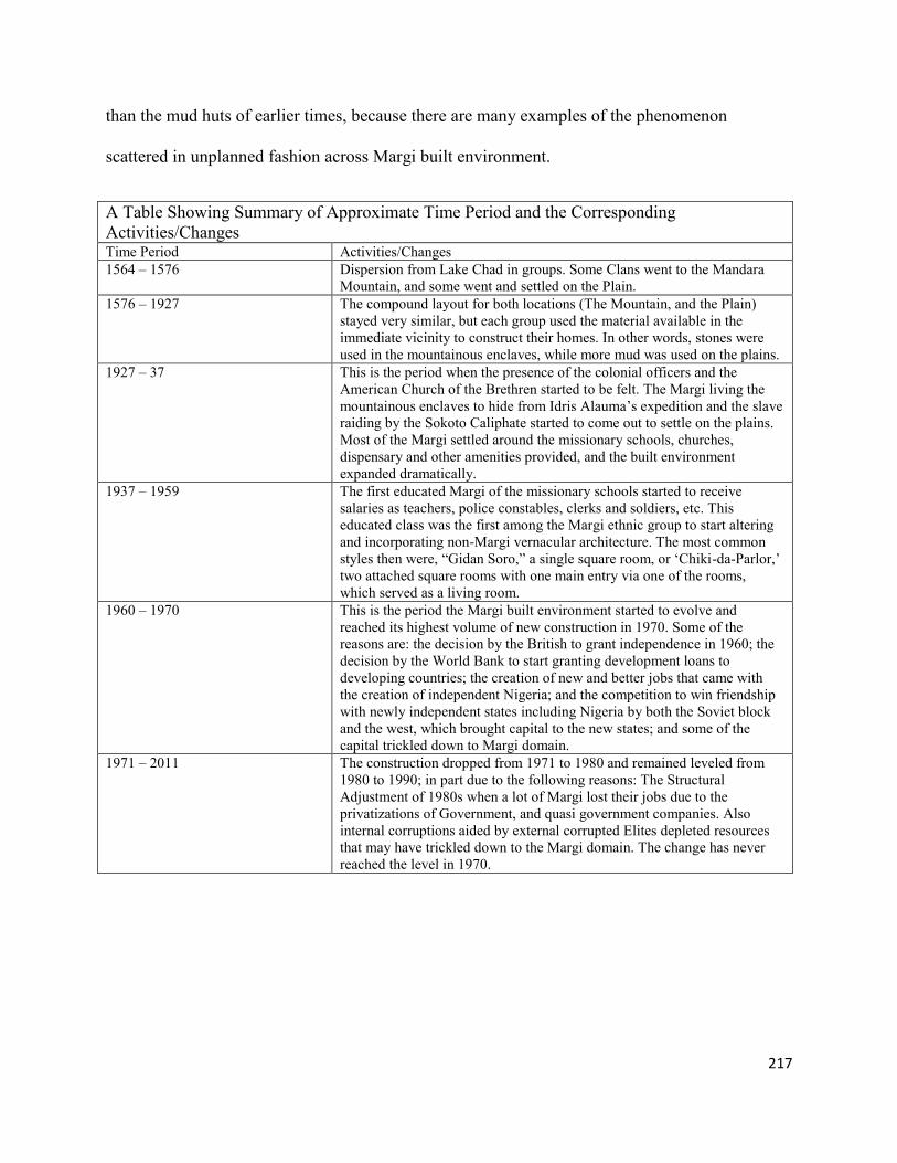
217
than the mud huts of earlier times, because there are many examples of the phenomenon
scattered in unplanned fashion across Margi built environment.
A Table Showing Summary of Approximate Time Period and the Corresponding
Activities/Changes Time Period Activities/Changes
1564 – 1576 Dispersion from Lake Chad in groups. Some Clans went to the Mandara
Mountain, and some went and settled on the Plain.
1576 – 1927 The compound layout for both locations (The Mountain, and the Plain)
stayed very similar, but each group used the material available in the
immediate vicinity to construct their homes. In other words, stones were
used in the mountainous enclaves, while more mud was used on the plains.
1927 – 37 This is the period when the presence of the colonial officers and the
American Church of the Brethren started to be felt. The Margi living the
mountainous enclaves to hide from Idris Alauma’s expedition and the slave
raiding by the Sokoto Caliphate started to come out to settle on the plains.
Most of the Margi settled around the missionary schools, churches,
dispensary and other amenities provided, and the built environment
expanded dramatically.
1937 – 1959 The first educated Margi of the missionary schools started to receive
salaries as teachers, police constables, clerks and soldiers, etc. This
educated class was the first among the Margi ethnic group to start altering
and incorporating non-Margi vernacular architecture. The most common
styles then were, “Gidan Soro,” a single square room, or ‘Chiki-da-Parlor,’
two attached square rooms with one main entry via one of the rooms,
which served as a living room.
1960 – 1970 This is the period the Margi built environment started to evolve and
reached its highest volume of new construction in 1970. Some of the
reasons are: the decision by the British to grant independence in 1960; the
decision by the World Bank to start granting development loans to
developing countries; the creation of new and better jobs that came with
the creation of independent Nigeria; and the competition to win friendship
with newly independent states including Nigeria by both the Soviet block
and the west, which brought capital to the new states; and some of the
capital trickled down to Margi domain.
1971 – 2011 The construction dropped from 1971 to 1980 and remained leveled from
1980 to 1990; in part due to the following reasons: The Structural
Adjustment of 1980s when a lot of Margi lost their jobs due to the
privatizations of Government, and quasi government companies. Also
internal corruptions aided by external corrupted Elites depleted resources
that may have trickled down to the Margi domain. The change has never
reached the level in 1970.

218
7.10: Summary of the Margi Journey and a Few Disturbing Developments
I need to reiterate here that, in the late 1940s, 1950s and early 1960s, the Margi compounds
were still about 90% built in the traditional manner. In fact, only some of the schools, churches, a
very few native school teachers’ houses and the missionary residences were constructed in
rectangular shapes, with most of the roofing still done with grass. The rest of the Margi ethnic
group were living in traditional round huts with grass roofing and in a compound of thatch mats
tied to wooden stakes that served as a protective fence.
The first educated Margi of the missionary schools started to receive salaries as teachers,
police constables, clerks and soldiers, etc. in the late 1950s, and pertinently the early 1960s. This
educated class was the first among the Margi ethnic group to alter traditional housing and
incorporate non-Margi vernacular architecture (Bello-Pur, 2004). The most common styles then
were, “Gidan Soro,” a single rectangular room, or ‘Chiki-da-Parlor,’ two attached rectangular
rooms with one main entry via one of the rooms, which served as a living room. As Bello Pur
told me,
When I was very young and still leaving at the old neighborhood on the top of the
mountain, two 20 year olds from the neighborhood went to Jos, worked and earned
money, came back and each built a rectangular rooms in their parents’ compound. This
became the talk of the neighborhood, in fact it was a prestigious thing, and they were able
to marry the most beautiful girls around
As time went by, the shotgun-like style became the common style of building that the Margi
salary earners preferred, in most cases incorporating it into their existing traditional compounds.
In many cases, the round huts still continued and were used for kitchens, animal pens, and
storage'; even for sleeping for visiting relatives and youths. In due course, the educated Margi
moved-up in their various employment opportunities around the country; the Margi traders in
various Nigerian cities began to make more money as the Nigerian oil industry boom,

219
Unfortunately, the Nigerian civil war began in 1967, barely seven years into being independent
state.
“Joining the war civilized us…especially we the unschooled” (Andrew Ijabani, a Margi
Veterans of the Nigerian Civil War of the mid-1960s). In essence, although the Nigerian civil
war was devastating, according to Andrew Ijabani, the war became an opportunity for many
Margi youths, including those that had not gone to school, to get steady employment by joining
the military. Military service took them to various Nigerian cities where they lived in non-Margi
compounds. The majority of these servicemen came back home during and after their service and
began to build non Margi building structures which were mostly rectangular on their family
lands in the Margi built environment.
This was part and parcel of the transformation process of the Margi domestic sphere and
served as a link between the Colonial District Officers residences located in colonial district
headquarters, the big missionary residences in Margi villages, the rectangular missionary school
buildings, the rectangular Christian Churches, the new (District Headquarters) referred to as
Fulani settlements, and the traditional Margi round huts fenced by thatch mats. Therefore, in
view of the embedded ideologies that came with the non-Margi structures to Margi cultural
landscape, any discussion of the transformation of the Margi cultural landscape initiated by the
missionaries and the Colonial Officers during or post-decolonization, that includes the
architecture of the missionaries, the colonized, and the colonizers, ‘required’ to include a
discussion pertaining the modernizing effects of these new structures. And in essence served as
an instrument that dismantled the unfamiliar culture of the ‘others’ and how the power relations
played out (Willis, 2005; Myers, 2003).

220
7.11: The Disturbing Development in the Journey
“The ruin of a nation begins in the hearts and homes of its people” (Ghanaian Proverb,
emphasis is mine)
The participation of Margi elites in the modern Nigerian political culture has not been free
from greed, corruption and the neglect of the Margi populace that elected them into office, and
looked up to them to improve living conditions in the Margi cultural landscape. I give one or two
examples that I believe exemplify the Margi towns and villages across the board. The Margi
society as expected has also experienced change; but a particularly disturbing change has to do
with the respect for the elders. For example, respect for elders has been shifted to younger people
that have succeeded in bulldozing their access to public funds. Respect for elders has been core
Margi value that I did not expect to be changed. Individualism has replaced the usual collective
family cooperation and desire to help each other out. The capitalist advertisement methods have
succeeded in entrenching excessive consumerism lifestyle that has birthed greed in Margi towns
and villages.
Since the area of my interest is infrastructure development, I took my camera to a few public
buildings. The following photo in figure 91 is a dining room for an all-girls secondary school in
one of the Margi towns. As the picture shows, and from what I have seen in my experience as a
city inspector for both Nigeria and the United States, the ceiling might fall down at any moment
while students are eating. Any lay person knows that if water damages a ceiling, then definitely
the roof is leaking.

221
Figure 91: Girls School Dining Room in one of Margi Town
Sources: Photo by the Author
The next photo in figure 92 is also from the same school that I visited. It shows the students’
dormitory windows boarded with corrugated metal sheet. Since it is an all-girls school and I
would not be permitted to go into their dormitory, I asked what it looks like inside, and one of
the girls said she’d rather sleep on the straw bed in her mother’s round mud hut than sleep there.
There is not enough water, she said, and the food is terrible.
Figure 92: Students Dormitory at the Same School
Sources: Photo by the Author
These school buildings are the opposite of the gated home of the local politician, just a mile from
the school.

222
Figure 93: A Gated Resident of a local Politician One mile From the School
Sources: The by the Author
The example of how Margi politicians failed their populace in a single state is not limited to
only state government politicians; the Margi politicians at the federal level who are partly
responsible for making sure, or at least for raising the issue, when the federal infrastructure in
their domain is in dilapidated condition, are not keeping up to their responsibility to the opulaces
either. The photo in Figure 94: shows a police station in another Margi town 20 miles away.
Figure 94: Police Station in another Margi Town
Source: Photo by the Author
When I was at this police station, I conversed at length with the person in charge for that day.
He told me that as long as I kept his name anonymous, he would tell me outright that the
conditions of the station are just a tip of the iceberg. “You see my uniform is just a rag,” he said;

223
when I looked closer, I also saw a police officer in flip-flops. When it comes to the differences
between the Margi elites and the people they are representing in terms of domestic sphere, it is
unimaginable. I will show one example of a house belonging to an average voter and one from
the Adamawa elite.
Figure 95: A Residential House of a Margi Voter
Photo by the Author
Figure 96: A Residential House of Adamawa Elite
Sources: Photo by the Author
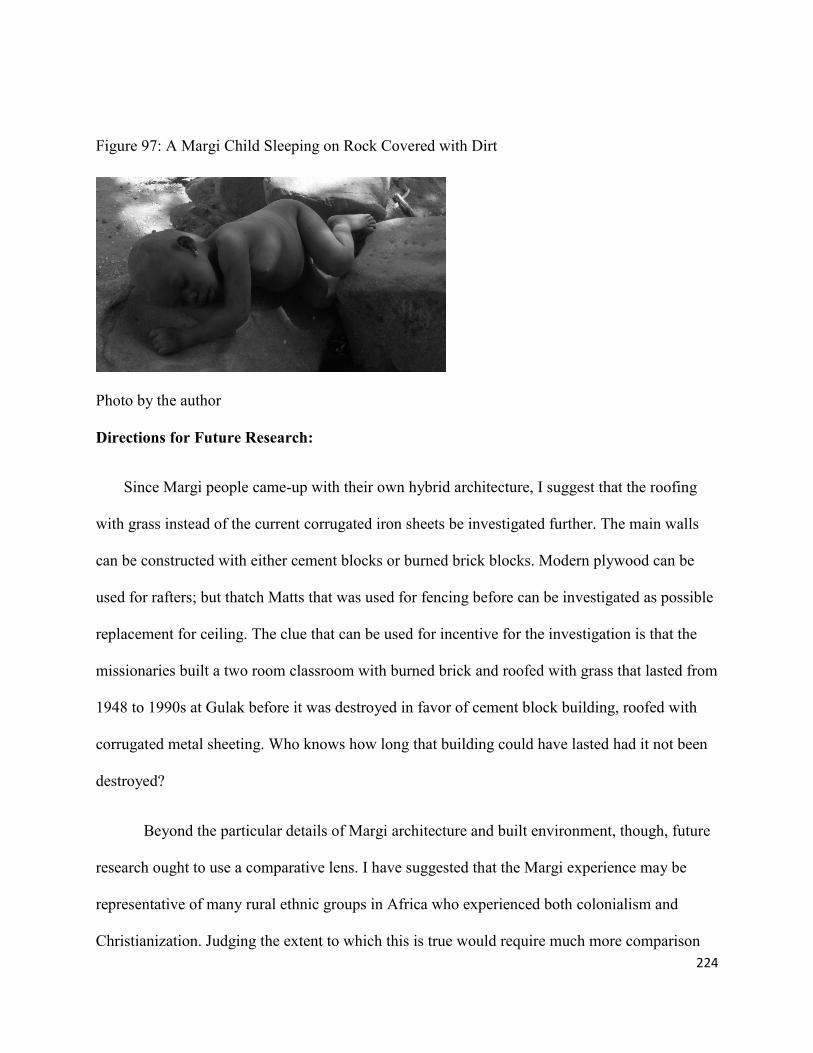
224
Figure 97: A Margi Child Sleeping on Rock Covered with Dirt
Photo by the author
Directions for Future Research:
Since Margi people came-up with their own hybrid architecture, I suggest that the roofing
with grass instead of the current corrugated iron sheets be investigated further. The main walls
can be constructed with either cement blocks or burned brick blocks. Modern plywood can be
used for rafters; but thatch Matts that was used for fencing before can be investigated as possible
replacement for ceiling. The clue that can be used for incentive for the investigation is that the
missionaries built a two room classroom with burned brick and roofed with grass that lasted from
1948 to 1990s at Gulak before it was destroyed in favor of cement block building, roofed with
corrugated metal sheeting. Who knows how long that building could have lasted had it not been
destroyed?
Beyond the particular details of Margi architecture and built environment, though, future
research ought to use a comparative lens. I have suggested that the Margi experience may be
representative of many rural ethnic groups in Africa who experienced both colonialism and
Christianization. Judging the extent to which this is true would require much more comparison

225
across the continent. There is a world of future research investigating the vernacular and hybrid
architecture of the distinctive and enduring smaller culture groups of Africa. Cultural geography
and architecture could gain considerably from careful analysis of the changing domestic spheres
and built environments of groups like the Margi.

226
References
Abrahams, P. This Island, Now. Collier Books, 1971.
Achebe, Chinua. There Was a Country: A Personal History of Biafra. Penguin, 2012.
Adams, W.M., and J. Mortimore. Working the Sahel. Taylor & Francis, 1999.
Addy, Sidney Oldall. The Evolution of the English House. S. Sonnenschein & Co., lim., 1905.
Aguda, T.A. The Legal Implications of the Creation of More States in Nigeria: (Being a Paper
Presented at the National Conference on Creation of States in Nigeria). ILE-IFE, 1981.
Ahmed, E.K.S. The Sokoto Caliphate. Ithaca Press, 1984.
Ajayi, JF Ade, and Michael Crowder. History of West Africa. Vol. 1: Longman Sc & Tech, 1985.
Akinola, GA. "Towards a Definition of Traditional African Philosophy of History-Ibadan, 1981-
1982." Journal of the Historical Society of Nigeria 11 (67-74.
Akpan, Ntieyong. The Struggle for Secession, 1966-1970: A Personal Account of the Nigerian
Civil War. Routledge, 1972.
Alacevich, Michele. The Political Economy of the World Bank: The Early Years. World Bank
Publications, 2009.
Allen, James de Vere, and Thomas H Wilson. Swahili Houses and Tombs of the Coast of Kenya.
Art and Archaeology Research Papers, 1979.
AlSayyad, Nezar. Forms of Dominance on the Architecture and Urbanism of the Colonial
Enterprise. Ethnoscapes. Aldershot ; Brookfield, U.S.A.: Avebury, 1992.
Amaazee, Victor Bong. "Blm)." Journal of African History 31 (1990): 281-93.
Amin, Samir. "Underdevelopment and Dependence in Black Africa—Origins and Contemporary
Forms." The Journal of Modern African Studies 10, no. 04 (1972): 503-24.
Anderson, D.M., and R. Rathbone. Africa's Urban Past. James Currey, 2000.
Appiah, Anthony, and Henry Louis Gates. Encyclopedia of Africa. Vol. 1: Oxford University
Press, USA, 2010.
Association, National Fire Protection. National Electrical Code 2011. National Fire Protection
Association, 2010.

227
Awi, Michael. "Management Techniques for Revitalization and Effective Utilization of Yinagu
River in Madagali Local Government Area of Adamawa State." Animal Research
International 3, no. 2 (2006): 473-77.
Backwell, H.F. The Occupation of Hausaland 1900-1904: Being a Translation of Arabic Letters
Found in the House of the Wazir of Sokoto, Bohari, in 1903. Introd. Note by M. Hiskett.
Cass, 1969.
———. The Occupation of Hausaland, 1900-1904. Being a Translation of Arabic Letters Found
in the House of the Wazir of Sokoto, Bohari, in 1903. Edited, with an Introduction, by
H.F. Backwell. 1927.
Barnes, Andrew E. "'Evangelization Where It Is Not Wanted': Colonial Administrators and
Missionaries in Northern Nigeria During the First Third of the Twentieth Century."
Journal of religion in Africa 25, no. 4 (1995): 412-41.
Barreteau, D., and C. von Graffenried. Datation Et Chronologie Dans Le Bassin Du Lac Tchad.
Ird Orstom, 1993.
Barth, H. Travels and Discoveries in North and Central Africa, 1849-1855. 1857.
Beauchemin, Cris, and Philippe Bocquier. "Migration and Urbanisation in Francophone West
Africa: An Overview of the Recent Empirical Evidence." Urban Studies 41, no. 11
(2004): 2245-72.
Bebbington, Anthony J, and SPJ Batterbury. "Transnational Livelihoods and Landscapes:
Political Ecologies of Globalization." Cultural geographies 8, no. 4 (2001): 369-80.
Becker, H.S. "The Epistemology of Qualitative Research." Ethnography and human
development: Context and meaning in social inquiry (1996): 53–71.
Beek, Walter EA van. "The Dirty Smith: Smell as a Social Frontier among the Kapsiki/Higi of
North Cameroon and North-Eastern Nigeria." Africa 62, no. 01 (1992): 38-58.
Beek, WEA van. The Kapsiki of the Mandara Hills. Waveland Press, Prospect Heights, Ill.,
1987.
Berns, Marla, and Barbara Rubin Hudson. The Essential Gourd: Art and History in Northeastern
Nigeria. Museum of Cultural History, University of California, 1986.
Berry, W. The Long-Legged House. Shoemaker & Hoard, 1969.
Birdling, Emmanuel Awidau. Rethinking the Effects of the Foreign Missionaries'mission to
Africa, Focusing on the Church of the Brethren Missonaries among the Margi Udzirngu
in Northern Nigeria. (2009).

228
Blackwell, Henry F. "Blackwell." Google Patents, 1920.
Blier, Suzanne Preston. The Anatomy of Architecture: Ontology and Metaphor in Batammaliba
Architectural Expression. University of Chicago Press, 1995.
———. Butabu: Adobe Architecture of West Africa. Princeton Architectural Press, 2003.
Bourdier, Jean-Paul, and Thi Minh-Ha Trinh. Drawn from African Dwellings. Indiana University
Press, 1996.
Bourdieu, P. Algeria 1960. Cambridge University Press, 1979.
———. "The Kabyle House or the World Reversed." Algeria 1960 (1979): 133-53.
Bratsis, Peter. "Over, under, Sideways, Down: Globalization, Spatial Metaphors, and the
Question of State Power." (2003).
Cahill, Nicholas. Household and City Organization at Olynthus. Yale University Press, 2002.
Campbell, John. Nigeria: Dancing on the Brink. Rowman & Littlefield Pub Incorporated, 2011.
Carland, John M. Colonial Office and Nigeria. Vol. 314: Hoover Institution Press, 1985.
Carlsson, Jerker, Gloria Somolekae, and Nicolas Van de Walle. Foreign Aid in Africa: Learning
from Country Experiences. Nordic Africa Institute, 1997.
Castree, Noel, and Bruce Braun. Social Nature: Theory, Practice, and Politics. Blackwell
Publishers Oxford, Malden, MA, 2001.
Ching, Francis DK, and Steven R Winkel. Building Codes Illustrated: A Guide to Understanding
the 2012 International Building Code. Vol. 6: Wiley, 2012
.
Clapp, Jennifer, and Rorden Wilkinson. Global Governance, Poverty and Inequality. Vol. 43:
Taylor & Francis, 2010.
Clarke, Somers, and Reginald Engelbach. Ancient Egyptian Construction and Architecture.
Dover Publications, 1990
Cohen, Ronald. The Kanuri of Bornu. Vol. 1: Holt, Rinehart and Winston, 1967.
Collection, Kirk-Green, C.M. Sheard, P. Wilson, and L. Robinson. The Kirk-Greene Collection:
Colonial and Post-Colonial Africa. Oriental and African Books, 1998.
Collier, Paul. "Marginalization of Africa, The." Int'l Lab. Rev. 134 (1995): 541.
229
Council, International Code. 2012 International Energy Conservation Code. International Code
Council, 2011.
———. International Fire Code 2012. Cengage Learning, 2011.
———. International Mechanical Code 2012. International Code Council, 2011.
———. International Plumbing Code 2012: Includes International Private Sewage Disposal
Code. Cengage Learning, 2011.
———. International Residential Code for One-and-Two Family Dwellings: Looseleaf Version.
Cengage Learning, 2009.
Council, International Code, and American Gas Association. 2012 International Fuel Gas Code.
Cengage Learning, 2011.
Courtney-Clarke, Margaret. African Canvas: The Art of West African Women. Rizzoli, 1990.
Crinson, Mark. Modern Architecture and the End of Empire. Ashgate Pub Limited, 2003.
De Angelis, Massimo. "The Political Economy of Global Neoliberal Governance." Review
(Fernand Braudel Center) (2005): 229-57.
De Bruijn, Mirjam, Rijk Van Dijk, and Jan-Bart Gewald. Strength Beyond Structure: Social and
Historical Trajectories of Agency in Africa. Vol. 6: Brill Academic Pub, 2007.
De Course, Fédération Internationale de Luge. "International Luge Regulations Artificial Track."
Berchtesgaden. Germany: Fédération Internationale de Luge de Course, 2006.
De St Jorre, John, and John de St Jorre. The Brothers' War: Biafra and Nigeria. Houghton
Mifflin, 1972.
De St. Jorre, J., and J. De Saint Jorre. The Brothers' War: Biafra and Nigeria. Faber & Faber,
Limited, 2009.
De Vere Allen, James. "Swahili Culture and the Nature of East Coast Settlement." International
Journal of African Historical Studies (1981): 306-34.
De Corse, C.R. West Africa During the Atlantic Slave Trade: Archaeological Perspectives.
Leicester University Press, 2001.
Denyer, Susan, and Peter McClure. African Traditional Architecture: An Historical and
Geographical Perspective. Heinemann, 1978.
Diouf, Sylviane A. Fighting the Slave Trade: West African Strategies. Ohio University Press,
2003.
230
Dirlik, A. "Global/Local." The anthropology of globalization: cultural anthropology enters the
21st century (2002): 185.
———. "Rethinking Colonialism: Globalization, Postcolonialism, and the Nation." Interventions
4, no. 3 (2002): 428-48.
Dirlik, Arif. "Empire? Some Thoughts on Colonialism, Culture, and Class in the Making of
Global Crisis and War in Perpetuity." interventions 5, no. 2 (2003): 207-17.
Dmochowski, Zbigniew R. "An Introduction to Nigeria Traditional Architecture. Vol. 1:
Northern Nigeria. Vol. 2: South West and Central Nigeria." (1990).
Donley-Reid, L.W. "A Structuring Structure: The Swahili House." Domestic architecture and
the use of space (1990): 114–26.
Donley, L.W. "Life in the Swahili Town House Reveals the Symbolic Meaning of Spaces and
Artefact Assemblages." African Archaeological Review 5, no. 1 (1987): 181-92.
Dovey, Kim. Framing Places: Mediating Power in Built Form. Routledge, 1999.
Elleh, N. African Architecture: Evolution and Transformation. McGraw-Hill, 1997.
———. Architecture and Nationalism at Abuja, Nigeria: A Study of the Ideologies of" Federal
Character," 1975-1991. Northwestern University, 2002.
———. Architecture and Power in Africa. Praeger Publishers, 2002.
Escobar, A. Encountering Development: The Making and Unmaking of the Third World.
Princeton University Press, 2001.
Ewing, Reid, and Eric Dumbaugh. "The Built Environment and Traffic Safety a Review of
Empirical Evidence." Journal of Planning Literature 23, no. 4 (2009): 347-67.
Falchetta, Piero. "Fra Mauro's World Map." e-Perimetron 1 (2006): 2.
Falconer, John Downie. On Horseback through Nigeria; or, Life and Travel in the Central
Sudan. TF Unwin, 1911.
Falola, Toyin. Globalization and Urbanization in Africa. Africa World Pr, 2004.
Falola, Toyin, and Matthew M Heaton. A History of Nigeria. Cambridge University Press, 2008.
Falola, Toyin, and Steven J Salm. Urbanization and African Cultures. Carolina Academic Press,
2005.
231
Fatile, F. Management of Inter and Intra States Boundary Conflicts in Nigeria: An Empirical
Approach. Dorrance Publishing Company, 2011.
Fatile, Femi. Management of Inter and Intra States Boundary Conflicts in Nigeria: An Empirical
Approach. Dorrance Publishing Company, 2012.
Faw, Chalmer Ernest. Lardin Gabas: A Land, a People, a Church. Brethren Press, 1973.
Ferguson, James. Global Shadows: Africa in the Neoliberal World Order. Duke University Press
Books, 2006.
Ferguson, Niall. Empire: The Rise and Demise of the British World Order and the Lessons for
Global Power. Basic Books, 2004.
Fisher, Humphery J. "The Occupation of Hausaland 1900–1904: Being a Translation of Arabic
Letters Found in the House of the Wazir of Sokoto, Bohari, in 1903. By Hf Backwell,
Edited with an Introduction by Hf Backwell (Lagos, 1927), Reprinted with an
Introductory Note by M. Hiskett, Cass Frank, London 1969, 80 Pp., 42s." The Journal of
African History 11, no. 03 (1970): 467-68.
Freund, B. The African City: A History. Cambridge University Press, 2007.
Frynas, Jedrzej George, and Manuel Paulo. "A New Scramble for African Oil? Historical,
Political, and Business Perspectives." African Affairs 106, no. 423 (2007): 229-51.
Furṭū, A.I., and D. Lange. A Sudanic Chronicle: The Borno Expeditions of Idrīs Alauma (1564-
1576) According to the Account of Aḥmad B. Furṭū. F. Steiner, 1987.
Gabel, Creighton. "Archaeology in Sub-Saharan Africa, 1800-1960." The International Journal
of African Historical Studies 18, no. 2 (1985): 241-64.
Gardi, René, René Gardi, René Gardi, and René Gardi. Indigenous African Architecture. Van
Nostrand Reinhold, 1974.
Geddes, Andrew. "The Representation of Migrants’ Interests’ in the European Union." Journal
of Ethnic and Migration Studies 24, no. 4 (1998): 695-713.
Gilman, N. Mandarins of the Future: Modernization Theory in Cold War America. Johns
Hopkins Univ Pr, 2003.
Gregory, Derek. "Colonial Nostalgia and Cultures of Travel: Spaces of Constructed Visibility in
Egypt." Consuming tradition, manufacturing heritage: Global norms and urban forms in
the age of tourism (2001): 111-51.
Hall, P. "Cities of Tomorrow: An Intellectual History of Urban Planning and Design in the
Twentieth Century 3rd Edition, Chapters 4 and 5." Wiley-Blackwell, Oxford, UK, 2002.

232
Harvey, D. The Condition of Postmodernity. Blackwell Oxford, 1989.
———. Cosmopolitanism and the Geographies of Freedom. Columbia Univ Pr, 2009.
———. The New Imperialism. Oxford University Press, USA, 2005.
———. "Revolutionary and Counter Revolutionary Theory in Geography and the Problem of
Ghetto Formation." Antipode 4, no. 2 (1972): 1-13.
———. "The Right to the City." International Journal of Urban and Regional Research 27, no.
4 (2003): 939-41.
———. Social Justice and the City. University of Georgia Press, 2010.
———. "Space as a Keyword." David Harvey: A Critical Reader, Oxford: Blackwell (2006):
270–94.
Harvey, D., and Association of American Geographers. "Society, the City, and the Space-
Economy of Urbanism." 1972.
Heine, B., and D. Nurse. A Linguistic Geography of Africa. Cambridge University Press, 2011.
Heine, Bernd, and Derek Nurse. A Linguistic Geography of Africa. Cambridge University Press,
2007.
Hespeler-Boultbee, John Jeremy. A Story in Stones: Portugal's Influence on Culture and
Architecture in the Highlands of Ethiopia, 1493-1634. CCB Publishing, 2011.
Heussler, R. The British in Northern Nigeria. Oxford U.P., 1968.
Hickey, Raymond. Christianity in Borno State and Northern Gongola. Claverianum Press, 1984.
Hogben, Sidney John, and Anthony Hamilton Millard Kirk-Greene. The Emirates of Northern
Nigeria: A Preliminary Survey of Their Historical Traditions. Oxford University Press,
1966.
Hull, Galen. "The Political Economy of Zimbabwe: Implications for the Internal Settlement."
Africa Today 25, no. 2 (1978): 27-44.
Hull, Richard W. African Cities and Towns before the European Conquest. Norton, 1976.
Hulme, David. Global Poverty: How Global Governance Is Failing the Poor. Vol. 44:
Routledge, 2010.

233
Hungerford, H., and University of Kansas. Geography. Onitsha Market Literature and
Negotiations of Modernity in Nigeria. University of Kansas, 2007.
Hyman, Isabelle, and Marvin Trachtenberg. "Architecture: From Prehistory to Postmodernity."
New York: Harry N. Abrams, 1986.
IBC, ICC. "International Building Code." International Code Council, Inc.(formerly BOCA,
ICBO and SBCCI) 4051 (2006): 60478-5795.
Idiatov, Dmitry. "A Linguistic Geography of Africa, Edited by Bernd Heine and Derek Nurse."
Linguistics 47, no. 6 (2009): 1391-99.
Iliffe, J. Africans: The History of a Continent. Cambridge University Press, 2007.
International Livestock Centre for Africa, A.A. International Livestock Centre for Africa 1991:
Annual Report and Programme Highlights. International Livestock Centre for Africa.
James, A., and A. James. Key Concepts in Childhood Studies. SAGE Publications, 2012.
Jenkins, Richard. Social Identity. Vol. 10: Routledge, 2008.
Jungraithmayr, Herrmann. "The Verb in Chadic-State of the Art1." Sprachbund in the West
African Sahel 11 (2006): 167.
Kalu, Hyacinth. The Nigerian Nation and Religion. iUniverse, 2011.
Kalu, K.N. State Power, Autarchy, and Political Conquest in Nigerian Federalism. Lexington
Books, 2009.
Kawka, R. From Bulamari to Yerwa to Metropolitan Maiduguri: Interdisciplinary Studies on the
Capital of Borno State, Nigeria. Köppe, 2002.
King, A.D. Buildings and Society: Essays on the Social Development of the Built Environment.
Routledge, 1984.
———. The Bungalow: The Production of a Global Culture. Routledge, 1984.
———. "Colonialism, Urbanism and the Capitalist World Economy." International Journal of
Urban and Regional Research 13, no. 1 (1989): 1-18.
———. "The Social Production of Building Form: Theory and Research." Environment and
Planning D: Society and Space 2, no. 4 (1984): 429-46.
———. "Writing Colonial Space. A Review Article." Comparative Studies in Society and
History 37, no. 03 (1995): 541-54.

234
King, Anthony D. Buildings and Society : Essays on the Social Development of the Built
Environment. London ; Boston: Routledge & Kegan Paul, 1980.
———. The Bungalow : The Production of a Global Culture. 2nd ed. New York: Oxford
University Press, 1995.
———. The Bungalow : The Production of a Global Culture. London ; Boston: Routledge &
Kegan Paul, 1984.
———. Colonial Urban Development : Culture, Social Power, and Environment. London ;
Boston: Routledge & Paul, 1976.
———. Global Cities : Post-Imperialism and the Internationalization of London. International
Library of Sociology. London ; New York: Routledge, 1990.
———. Urbanism, Colonialism, and the World-Economy : Cultural and Spatial Foundations of
the World Urban System. International Library of Sociology. London ; New York:
Routledge, 1990.
King, Anthony D., and State University of New York at Binghamton. Dept. of Art and Art
History. Culture, Globalization and the World-System : Contemporary Conditions for the
Representation of Identity. Current Debates in Art History 3. Binghamton, NY: Dept. of
Art and Art History, State University of New York at Binghamton, 1991.
Kirk-Greene, A. Symbol of Authority: The British District Officer in Africa. I. B. Tauris, 2006.
Kirk-Greene, A. H. M. Adamawa, Past and Present; an Historical Approach to the Development
of a Northern Cameroons Province. London, New York,: Published for the International
African Institute by Oxford University Press, 1958.
———. A Biographical Dictionary of the British Colonial Governor. Hoover Press
Bibliographical Series 61. Stanford, Calif.: Hoover Institution Press, 1980.
———. A Biographical Dictionary of the British Colonial Service, 1939-1966. London ; New
York: H. Zell, 1991.
———. Britain's Imperial Administrators, 1858-1966. St. Antony's Series. New York: St.
Martin's Press in association with St Antony's College, Oxford, 2000.
———. Crisis and Conflict in Nigeria: A Documentary Sourcebook. London,: Oxford
University Press, 1971.
———. The Emergence of African History at British Universities : An Autobiographical
Approach / C Edited by Anthony Kirk-Greene. Oxford: World View Publications, 1995.
235
———. The Genesis of the Nigerian Civil War and the Theory of Fear. Research Report -
Scandinavian Institute of African Studies No. 27. Uppsala: Scandinavian Institute of
African Studies, 1975.
———. Glimpses of Empire : A Corona Anthology. London: I.B. Tauris, 2001.
———. Maiduguri and the Capitals of Bornu = Maiduguri Da Manyan Biranen Da No Barno.
Zaria: North Regional Literature Agency ; [Printed by Gaskiya Corp.], 1958.
———. Mutumin Kirii : The Concept of the Good Man in Hausa. Hans Wolff Memorial Lecture
3. Bloomington, Ind.: The African Studies Program, Indiana University, 1974.
———. On Crown Service : A History of Hm Colonial and Overseas Civil Services, 1837-1997.
LondonNew York: I.B. Tauris ; Distributed by St Martin's Press, 1999.
———. The Principles of Native Administration in Nigeria; Selected Documents, 1900-1947.
London,: Oxford University Press, 1965.
———. "Stay by Your Radios" : Documentation for a Study of Military Government in Tropical
Africa. African Social Research Documents V. 12. Leiden Cambridge: Afrika-
Studiencentrum ; African Studies Centre, 1981.
Kirk-Greene, A. H. M., and Daniel Bach. State and Society in Francophone Africa since
Independence. St Antony's/Macmillan Series. New York: St. Martin's Press in
association with St Antony's College, Oxford, 1995.
Kirk-Greene, A. H. M., and International African Institute. Adamawa Past and Present: An
Historical Approach to the Development of a Northern Cameroons Province. London,:
Reprinted for the International African Institute by Dawsons, 1969.
Kirk-Greene, A. H. M., Paul Newman, Dorugu, and Maina Mai. West African Travels and
Adventures; Two Autobiographical Narratives from Northern Nigeria. New Haven,:
Yale University Press, 1971.
Kirk-Greene, A. H. M., and Douglas Rimmer. Nigeria since 1970 : A Political and Economic
Outline. London: Hodder and Stoughton, 1981.
Kirk-Greene, A.H.M. The Genesis of the Nigerian Civil War and the Theory of Fear.
Scandinavian Institute of African Studies, 1975.
———. "The Mba Ceremony of the Marghi." Nigerian Field 24, no. 2 (1959): 80-87.
———. Northern Nigeria's Administrative Service Training Course: A Note on Its History &
Curriculum. Institute of Administration, 1960.
———. A Redefinition of Provincial Administration: The Northern Nigerian Approach. sn,
1964.

236
———. "Tax and Travel among the Hill-Tribes of Northern Adamawa." Africa 26, no. 4 (1956):
369-79.
Kirk-Greene, AHM. "Barth's Travels in Nigeria." Freedomways 2, no. 3 (1962): 336-37.
Kirk-Greene, Anthony. On Crown Service: A History of Hm Colonial and Overseas Civil
Services, 1837-1997. IB Tauris, 1999.
Kirk-Greene, Anthony Hamilton Millard. Crisis and Conflict in Nigeria: A Documentary
Sourcebook. Vol. 2: Oxford University Press, 1971.
———. The Linguistic Statistics of Northern Nigeria a Tentative Presentation. Headley
Brothers, 1967.
Kirk-Greene, Anthony Hamilton Millard, and Douglas Rimmer. Nigeria since 1970: A Political
and Economic Outline. Africana Publishing Company, 1981.
Kirk-Greene, Anthony Hamilton Nillard. Crisis and Conflict in Nigeria. 1966.
Kirk-Greene, Anthony HM. "Adamawa." Past and Present. London: Oxford University Press
(1958).
Kiwanuka, M.S.M.S. From Colonialism to Independence: A Reappraisal of Colonial Policies &
African Reactions, 1870-1960. East African Literature Bureau, 1973.
Kopytoff, J.H., and J. Herskovits. A Preface to Modern Nigeria: The" Sierra Leonians" in
Yoruba, 1830-1890. University of Wisconsin Press, 1965.
Last, Murray. "The Sokoto Caliphate." (1967).
LeGates, Richard T. City Reader. Taylor & Francis, 2011.
Lennihan, Louise D. "Rights in Men and Rights in Land: Slavery, Wage Labor, and Smallholder
Agriculture in Northern Nigeria." Slavery and abolition 3, no. 2 (1982): 111-39.
Lewis, M Paul. Ethnologue: Languages of the World. Vol. 9: SIL international Dallas, TX, 2009.
Lippmann, W., W.O. Scroggs, W.H. Shepardson, and Council on Foreign Relations. The United
States in World Affairs. Published for the Council on Foreign Relations by Harper &
Brothers, 1960.
Lipset, S.M. Consensus and Conflict: Essays in Political Sociology. Transaction Pub, 1985.
Lowenthal, D. The Past Is a Foreign Country. Cambridge University Press, 1985.

237
Lu, Duanfang. Third World Modernism: Architecture, Development and Identity. Taylor &
Francis, 2011.
Lugard, Baron Frederick John Dealtry. The Diaries of Lord Lugard. Vol. 2: Northwestern
University Press, 1959.
Lugard, F.D. The Diaries: East Africa, Dec. 1890 to Dec. 1891. Faber & Faber, 1959.
Lugard, FD. "Travels from the East Coast to Uganda, Lake Albert Edward, and Lake Albert."
Paper presented at the Proceedings of the Royal Geographical Society and Monthly
Record of Geography, 1892.
Lynn, Martin. "The Nigerian Self-Government Crisis of 1953 and the Colonial Office." The
Journal of Imperial and Commonwealth History 34, no. 2 (2006): 245-61.
Lynn, Marvin, and Maurianne Adams. "Introductory Overview to the Special Issue Critical Race
Theory and Education: Recent Developments in the Field." Equity &Excellence in
Education 35, no. 2 (2002): 87-92.
Mabogunje, A.L. "Lagos, a Study in Urban Geography." University of London, 1961.
Mackenzie, John M. "The Popular Culture of Empire in Britain." (1999).
Maier, Karl. This House Has Fallen: Nigeria in Crisis. Basic Books, 2002.
Mason, Edward Sagendorph, and Robert E Asher. The World Bank since Bretton Woods: The
Origins, Policies, Operations, and Impact of the International Bank for Reconstruction
and Development and the Other Members of the World Bank Group: The International
Finance Corporation, the International Development Association [and] the International
Centre for Settlement of Investment Disputes. Brookings Inst Press, 1973.
Massey, Doreen. "A Global Sense of Place." Marxism today 35, no. 6 (1991): 24-29.
Miers, Suzanne. Slavery in Africa: Historical & Anthropological Perspectives. University of
Wisconsin Press, 1979.
Migdal, Joel Samuel, Atul Kohli, and Vivienne Shue. State Power and Social Forces:
Domination and Transformation in the Third World. Cambridge University Press, 1994.
Moffett, Marian, Michael W Fazio, and Lawrence Wodehouse. A World History of Architecture.
Laurence King Publishing, 2003.
Mortimore, J. Adapting to Drought: Farmers, Famine and Desertification in West Africa.
Cambridge University Press, 1989.

238
Mortimore, M. Roots in the African Dust: Sustaining the Sub-Saharan Drylands. Cambridge
University Press, 1998.
Moss, Todd, Gunilla Pettersson, and Nicolas Van de Walle. "An Aid-Institutions Paradox? A
Review Essay on Aid Dependency and State Building in Sub-Saharan Africa." Center for
Global Development working paper, no. 74 (2006): 11-05.
Mshelia, A. Araba Let's Separate: The Story of the Nigerian Civil War. AuthorHouse, 2012.
Mshelia, Ayuba. Suksuku: Stories and Folktales of the Burrah People of North-Eastern Nigeria.
AuthorHouse, 2010.
Murray, M.J., and G.A. Myers. Cities in Contemporary Africa. Palgrave Macmillan, 2007.
Myers, G.A. Disposable Cities. Ashgate, 2005.
———. "Intellectual of Empire: Eric Dutton and Hegemony in British Africa." Annals of the
Association of American Geographers 88, no. 1 (1998): 1-27.
———. "Local Communities and the New Environmental Planning: A Case Study from
Zanzibar." Area 34, no. 2 (2002): 149-59.
———. "Sustainable Development and Environmental Justice in African Cities." Geography
Compass 2, no. 3 (2008): 695-708.
———. Verandahs of Power: Colonialism and Space in Urban Africa. Syracuse Univ Pr, 2003.
Myers, GA. "Silberfein, Marilyn, Rural Settlement Structure and African Development."
ANNALS-ASSOCIATION OF AMERICAN GEOGRAPHERS 89 (1999): 183-84.
Myers, Garth Andrew. African Cities: Alternative Visions of Urban Theory and Practice [in
English]. London; New York: Zed Books Ltd., 2011.
Njeuma, Martin Z. Fulani Hegemony in Yola (Old Adamawa) 1809-1902. Langaa Rpcig, 2012.
Njoh, A.J. Tradition, Culture and Development in Africa: Historical Lessons for Modern
Development Planning. Ashgate Pub., 2006.
Nkwocha, Ann, Jon G Hall, and Lucia Rapanotti. "Design Rationale Capture in the Globalised
Enterprise: An Industrial Study." Paper presented at the Software Engineering Advances
(ICSEA), 2010 Fifth International Conference on, 2010.
Odukoya, Adelaja Odutola. "Oil and Sustainable Development in Nigeria: A Case Study of the
Niger Delta." Journal of Human Ecology 20, no. 4 (2006): 249-58.
Ofcansky, Thomas P. "A Bio-Bibliography of Fd Lugard." History in Africa 9 (1982): 209-19.

239
Ogot, Bethwell A. Unesco General History of Africa, Vol. V, Abridged Edition: Africa from the
Sixteenth to the Eighteenth Century. Vol. 5: University of California Press, 1999.
Ogundiran, Akinwumi. "Precolonial Nigeria: Essays in Honour of Toyin Falola." Trenton, NJ
Africa World press, 2005.
Ogundiya, MO, MB Okunade, and AL Kolapo. "Antimicrobial Activities of Some Nigerian
Chewing Sticks." Ethnobotanical leaflets 2006, no. 1 (2006): 28.
Ojo, GJ. Yoruba Culture. 1966.
Olinto, Antonio. Brasileiros Na África. Edições GRD, 1980.
Oliver, Paul. Dwellings: The House across the World. Phaidon, 1987.
Osaghae, Eghosa E. "The Complexity of Nigeria's Federal Character and the Inadequacies of the
Federal Character Principle'." Journal of Ethnic Studies 16, no. 3 (1988).
———. Crippled Giant: Nigeria since Independence. Indiana University Press, 1998.
Palmer, Herbert Richmond. The Bornu Sahara and Sudan. Negro Universities Press, 1970.
Palmer, HR. "The Bornu Sahara and Sudan (London, 1936)." Sudanese Memoirs 3
Perkins, Kenneth J. "Urban Forms and Colonial Confrontations: Algiers under French Rule."
History: Reviews of New Books 26, no. 2 (1998): 89-89.
Pieterse, E.A. City Futures: Confronting the Crisis of Urban Development. Zed Books, 2008.
Post, Ken, and George D Jenkins. The Price of Liberty: Personality and Politics in Colonial
Nigeria. Cambridge Univ Press, 1973.
Post, Ken, and Michael Vickers. Structure and Conflict in Nigeria, 1960-1966. Heinemann
Educational, 1973.
Post, Kenneth WJ. "The Nigerian Federal Election of 1959." Politics and (1963).
Power, Marcus, and James D Sidaway. "The Degeneration of Tropical Geography." Annals of
the Association of American Geographers 94, no. 3 (2004): 585-601.
Prazniak, R., and A. Dirlik. Places and Politics in an Age of Globalization. Rowman &
Littlefield Pub Inc, 2001.
Prussin, L., and A. Adan. African Nomadic Architecture: Space, Place, and Gender. Smithsonian
Institution Press and National Museum of African Art, 1995.

240
Prussin, Labelle. "Non-Western Sacred Sites: African Models." Journal of the Society of
Architectural Historians 58, no. 3 (1999): 424-33.
Quinn-Young, C.T., and T. Herdman. Geography of Nigeria: (New Impr. 12. Print. Longmans,
1960.
Rapoport, A. "Cross-Cultural Aspects of Environmental Design." Environment and culture 4
(1980): 7-46.
———. "Development, Culture Change and Supportive Design." Habitat International 7, no. 5-
6 (1983): 249-68.
———. "Identity and Environment: A Cross-Cultural Perspective." Housing and identity: Cross-
cultural perspectives (1982): 6–35.
Rapoport, A., and S. El Sayegh. Culture, Architecture Et Design. Locke Science Pub. Co., 2005.
———. Culture, Architecture Et Design. Infolio, 2003.
Rapoport, Amos. History and Precedent in Environmental Design. New York: Plenum Press,
1990.
———. House Form and Culture. Foundations of Cultural Geography Series. Englewood
Cliffs, N.J.,: Prentice-Hall, 1969.
———. Human Aspects of Urban Form : Towards a Man-Environment Approach to Urban
Form and Design. Urban and Regional Planning Series V. 15. 1st ed. Oxford ; New
York: Pergamon Press, 1977.
———. The Meaning of the Built Environment : A Nonverbal Communication Approach.
Beverly Hills: Sage Publications, 1982.
———. The Mutual Interaction of People and Their Built Environment : A Cross-Cultural
Perspective. World Anthropology. The Hague Chicago: Mouton ; distributed in the USA
and Canada by Aldine, 1976.
Rapoport, Amos, University of California Berkeley. Center for Environmental Design Research.,
and International Association for the Study of Traditional Environments. Sustainability
Meaning and Traditional Environments. Traditional Dwellings and Settlements Working
Paper Series V. 75. Berkeley, CA: Center for Environmental Design Research,
University of California, Berkeley, 1994.
Rapoport, SI. "The Effect of Topically Applied Substances on the Blood-Brain Barrier." Journal
of Pharmacology and Experimental Therapeutics 144, no. 3 (1964): 310.

241
Rathbone, Charles H. Open Education: The Informal Classroom: A Selection of Readings That
Examine the Practices and Principles of the British Infant Schools and Their American
Counterparts. Citation Press, 1971.
Reid, Andrew, Paul Lane, Alinah Segobye, Lowe Borjeson, Nonofo Mathibidi, and Princess
Sekgarametso. "Tswana Architecture and Responses to Colonialism." World archaeology
28, no. 3 (1997): 370-92.
Reis Filho, Nestor Goulart. Quadro Da Arquitetura No Brazil. Vol. 18: Editôra Perspectiva,
1973.
Robertson, R., and K.E. White. Globalization. 1. Analytical Perspectives. Routledge, 2003.
Rothmaler, E. Place Names in Borno and Yobe States (Northern Nigeria). University of
Maiduguri, 2007.
ROW. "Documents and Bibliography." International and Comparative Law Quarterly (1954):
363-65.
Saad, H.T. "Folk Culture and Architecture in Northeastern Nigeria." Paideuma 37 (1991): 253-
89.
Sack, Robert David. "The Geographic Problematic: Moral Issues." Norsk Geografisk Tidsskrift
55, no. 3 (2001): 117-25.
Salamone, Frank A. The Hausa of Nigeria. University Press of America, 2009.
Salau, Mohammed Bashir. The West African Slave Plantation: A Case Study. Palgrave
Macmillan, 2011.
Sauer, C.O., and Netzahaulcoyotl Historical Society. Selected Essays, 1963-1975. Turtle Island
Foundation, 1981.
Schaffer, Kristen, and Paul Rocheleau. Daniel H. Burnham: Visionary Architect and Planner.
Rizzoli International Publications, 2003.
Schnee, H. German Colonization Past and Future: The Truth About the German Colonies. Read
Books, 2007.
Shamai, Shmuel. "Sense of Place: An Empirical Measurement." Geoforum 22, no. 3 (1991): 347-
58.
Shils, Edward A. "Social Inquiry and the Autonomy of the Individual." The human meaning of
the social sciences (1959): 114-57.
Short, J.R., and Y.H. Kim. Globalization and the City. Longman, 1999.

242
Silberfein, Marilyn. Rural Settlement Structure and African Development. Westview Press, 1998.
Simone, A. "Straddling the Divides: Remaking Associational Life in the Informal African City."
International Journal of Urban and Regional Research 25, no. 1 (2001): 102-17.
Simone, A.M. "Between Ghetto and Globe: Remaking Urban Life in Africa." Associational life
in African cities: popular responses to the urban crisis (2001): 46.
———. City Life from Jakarta to Dakar: Movements at the Crossroads. Taylor & Francis, 2009.
———. "Critical Dimensions of Urban Life in Africa." Globalization and urbanization in Africa
(2004): 11.
———. "Moving Towards Uncertainty: Migration and the Turbulence of African Urban Life."
2003.
———. "On the Worlding of African Cities." African Studies Review 44, no. 2 (2001): 15-41.
Simone, Abdou Maliq. "Moving Towards Uncertainty: Migration and the Turbulence of African
Urban Life." Paper presented at the Conference on African Migration in Comparative
Perspective, Johannesburg, South Africa, 2003.
Simone, AbdouMaliq. "Between Ghetto and Globe: Remaking Urban Life in Africa."
Associational Life in African Cities. Uppsala: Nordiska Afrikainstitutet (2001): 46-63.
———. "Straddling the Divides: Remaking Associational Life in the Informal African City."
International Journal of Urban and Regional Research 25, no. 1 (2002): 102-17.
Siollun, Max. Oil, Politics and Violence: Nigeria's Military Coup Culture (1966-1976). Algora
Publishing, 2009.
Sixsmith, Judith. "The Meaning of Home: An Exploratory Study of Environmental Experience."
Journal of Environmental Psychology 6, no. 4 (1986): 281-98.
Sjoberg, G. Ethics, Politics and Social Research. Schenkman, 1961.
———. The Preindustrial City, Past and Presecct. Free Press, 1960.
Slater, D. Geopolitics and the Post-Colonial: Rethinking North-South Relations. Wiley-
Blackwell, 2004.
Smaldone, Joseph P. Warfare in the Sokoto Caliphate: Historical and Sociological Perspectives.
Cambridge University Press Cambridge, 1977.
Smith, M.G. The Hausa of Northern Nigeria. Holt, Rinehart & Winston, 1965.
243
Smith, M.G., and M. Dee. Peacekeeping in East Timor: The Path to Independence. Lynne
Rienner Pub, 2003.
Smith, Michael Garfield. "Historical and Cultural Conditions of Political Corruption among the
Hausa." Comparative Studies in Society and History 6, no. 2 (1964): 164-94.
So, A.Y. Social Change and Development: Modernization, Dependency, and World-Systems
Theories. Sage Publications, Inc, 1990.
Soja, E.W. The Geography of Modernization in Kenya: A Spatial Analysis of Social, Economic,
and Political Change. Syracuse University Press, 1968.
———. Post Modern Geographies: The Reassertion of Space in Critical Social Theory. Verso,
1989.
Soja, Edward. "Postmodern Geographies and the Critique of Historicism." Postmodern
contentions: Epochs, politics, space (1993): 113-36.
Sommer, R., and F.D. Becker. "Territorial Defense and the Good Neighbor." Journal of
Personality and Social Psychology 11, no. 2 (1969): 85-92.
Stock, R. Africa South of the Sahara, Third Edition: A Geographical Interpretation. Guilford
Publication, 2012.
Suberu, Rotimi T. Federalism and Ethnic Conflict in Nigeria. United States Inst of Peace Press,
2001.
———. "The Struggle for New States in Nigeria, 1976-1990." African Affairs (1991): 499-522.
Suberu, Rotimi T, and Larry Diamond. "Institutional Design, Ethnic Conflict Management and
Democracy in Nigeria." 400-28: Oxford: Oxford University Press, 2002.
Tamuno, Tekena N. "Separatist Agitations in Nigeria since 1914." Journal of Modern African
Studies 8, no. 4 (1970): 565-77.
Thelen, Kathleen. How Institutions Evolve: The Political Economy of Skills in Germany, Britain,
the United States, and Japan. Cambridge University Press, 2004.
Thompson, Julian R, and G Edward Hollis. "Hydrological Modelling and the Sustainable
Development of the Hadejia-Nguru Wetlands, Nigeria." Hydrological Sciences Journal
40, no. 1 (1995): 97-116.
Tibenderana, Peter K. Education and Cultural Change in Northern Nigeria, 1906-1966: A Study
in the Creation of a Dependent Culture. Fountain Pub Ltd, 2003.

244
Tijani, Hakeem Ibikunle. Britain, Leftist Nationalists and the Transfer of Power in Nigeria,
1945-1965. Routledge, 2006.
Toelken, J. "Barre 1979 the Dynamics of Folklore." Boston, MA: Houghton Mifflin Company.
Trotter, Michael M. "Prehistoric Rock Shelter Art in New Zealand." Archaeology & Physical
Anthropology in Oceania (1971): 235-42.
Turner, Frederick Jackson. "Geographical Influences in American Political History." Bulletin of
the American Geographical Society 46, no. 8 (1914): 591-95.
———. "The Significance of the Section in American History." The Wisconsin Magazine of
History (1925): 255-80.
Turner, L.D. "Some Contacts of Brazilian Ex-Slaves with Nigeria, West Africa." Journal of
Negro History 27, no. 1 (1942): 55-67.
Uche, Luke Uka. "Ideology, Theory and Professionalism in the African Mass Media." Africa
Media Review 5, no. 1 (1991): 1-16.
Un-habitat, and United Nations Human Settlements Programme. State of the World's Cities
2008/2009: Harmonious Cities. Vol. 11: Un-habitat, 2008.
Uwechue, R. Reflections on the Nigerian Civil War: Facing the Future. Trafford on Demand
Pub, 2004.
Vale, L. J. 2008. Architecture, Power And National Identity. Routledge.
Vale, Lawrence J. Architecture, Power, and National Identity. Yale University Press, 1992.
Van Beek, W.E.A. The Dancing Dead: Ritual and Religion among the Kapsiki/Higi of North
Cameroon and Northeastern Nigeria. Oxford University Press, USA, 2012.
———. The Kapsiki of the Mandara Hills. Waveland Press, 1987.
Van Beek, WEA. "Rain as a Discourse of Power: Rainmaking in Kapsiki." L’homme et l ‘eau
dans le bassin du Lac Chad, Paris: ORSTOM (1997): 285-97.
Van de Walle, Nicolas. African Economies and the Politics of Permanent Crisis, 1979-1999.
Cambridge University Press, 2001.
Vansina, Jan, Selma Leydesdorff, and Elizabeth Tonkin. Oral Tradition: A Study in Historical
Methodology. Aldine, 2006.
Vaughan, J. "Mafakur: A Limbic Institution of the Margi." Slavery in Africa: Historical and
Anthropological Perspectives (1977): 85-102.

245
Vaughan, J.H. "Culture, History, and Grass-Roots Politics in a Northern Cameroons Kingdom."
American Anthropologist 66, no. 5 (1964): 1078-95.
———. "Folklore and Values in Marghi Culture." Journal of the Folklore Institute 2, no. 1
(1965): 5-24.
———. "A Reconsideration of Divine Kingship." Explorations in African systems of thought
(1980): 120-42.
———. "The Religion and World View of the Marghi." Ethnology 3, no. 4 (1964): 389-97.
Vaughan, James H, and Anthony HM Kirk-Greene. "The Diary of Hamman Yaji: Chronicle of a
West African Muslim Ruler." Bloomington: Indiana University Press, 1995.
Vlach, J.M. "The Brazilian House in Nigeria: The Emergence of a 20th-Century Vernacular
House Type." Journal of American Folklore 97, no. 383 (1984): 3-23.
———. "The Shotgun House: An African Architectural Legacy." Afro-American Folk Art and
Crafts (1986): 275.
Vlach, John Michael. "Affecting Architecture of the Yoruba." African Arts (1976): 48-99.
Watts, Michael, and Ed Kashi. "Curse of the Black Gold: 50 Years of Oil in the Niger Delta."
Photographs by Kashi E Powerhouse Books, Brooklyn NY (2008).
Wilkinson, Rorden, and David Hulme. The Millennium Development Goals and Beyond: Global
Development after 2015. Vol. 65: Routledge, 2012.
Williams, Jerry, and Shaun Parkman. "On Humans and Environment: The Role of Consciousness
in Environmental Problems." Human Studies 26, no. 4 (2003): 449-60.
Willis, K. Theories and Practices of Development. Psychology Press, 2005.
Wilson, N. Encyclopedia of Ancient Greece. Routledge, 2009.
Wyk, GN van. "African Painted Houses. Basotho Dwellings of Southern Africa." Harry N.
Abrams, 1998.
Yeomans, Richard. The Art and Architecture of Islamic Cairo. Ithaca, 2006.
Zurick, D. Resource Needs and Land Stress in Rapti Zone, Nepal. Association of American
Geographers, 1988.

246