The Effect of Convergence Time on the Static PPP Solution
12
2 nd International workshop on “Integration of Point- and Area-wise Geodetic Monitoring for Structures and Natural Objects”, March 23-24, 2015, Stuttgart, Germany 58 The Effect of Convergence Time on the Static- PPP Solution Ashraf Abdallah Institute of Engineering Geodesy (IIGS), Stuttgart University, Stuttgart, Germany. Abstract Recently, the Precise Point Positioning (PPP) technique has been deeply investigated in surveying researches to achieve distinguished coordinates accuracy using one dual frequency GNSS instrument. In this research study, four SAPOS stations with 24 hours observation data in Baden-Württemberg State, Germany were selected to be processed. The station’s observation times were divided into different convergence times (1-hour, 2-hours, 4-hours, 6-hours, 8-hours, 12-hours and 24-hours). This paper aims to evaluate the accuracy of the static PPP solution with different convergence times using three PPP software packages, the APPS-PPP online service, the CSRS-PPP online service, and Bernese V. 5.2 software. Together, the study indicates that, APPS-PPP online service in position 3D after 4-hours 1 cm; the solution is steady after 6-hours up to 24-hours. CSRS-PPP online service shows a stable solution after 6-hours with a position 3D of 1.2 cm. Bernese software provides a position 3D of 1.44 cm after 6-hours and this solution is still improved to reach 1 cm after 24-hours convergence time. Obviously for this case study, the APPS-PPP online service provides the best PPP coordinate solution. Keywords Static GNSS-PPP, Convergence time, APPS-PPP, CSRS-PPP, Bernese software 1 INTRODUCTION Precise Point Positioning (PPP) is a positioning technique using only one single antenna. This method is different from differential GNSS (DGNSS), which needs one or more reference stations (GRINTER & ROBERTS, 2011). The GNSS Precise Point Positioning (PPP) technique is one of the most challenging surveying methods to realize a high accurate positioning (GAO, 2006). The estimation of PPP is based mainly on the ionosphere free linear combination (IF) for code ( IF ) and phase ( IF ) measurements for dual frequency GNSS data. These combinations are formed in equation (1) and (2) (MIRSA & ENGE, 2010). ) ( ) ( ) ( ) ( 2 2 2 2 1 2 2 1 2 2 2 1 2 1 el m T c r f f f f f f z S R L L L L L L L L IF (1) IF IF z S R L L L L L L L L IF N el m T c r f f f f f f ) ( ) ( ) ( ) ( 2 2 2 2 1 2 2 1 2 2 2 1 2 1 (2) Where, 1 f , 2 f :the frequencies of the GPS 1 L and 2 L signals,
Transcript of The Effect of Convergence Time on the Static PPP Solution
2nd
International workshop on “Integration of Point- and Area-wise Geodetic Monitoring for
Structures and Natural Objects”, March 23-24, 2015, Stuttgart, Germany
58
The Effect of Convergence Time on the Static- PPP
Solution
Ashraf Abdallah
Institute of Engineering Geodesy (IIGS), Stuttgart University, Stuttgart, Germany.
Abstract
Recently, the Precise Point Positioning (PPP) technique has been deeply investigated in surveying
researches to achieve distinguished coordinates accuracy using one dual frequency GNSS instrument.
In this research study, four SAPOS stations with 24 hours observation data in Baden-Württemberg
State, Germany were selected to be processed. The station’s observation times were divided into
different convergence times (1-hour, 2-hours, 4-hours, 6-hours, 8-hours, 12-hours and 24-hours). This
paper aims to evaluate the accuracy of the static PPP solution with different convergence times using
three PPP software packages, the APPS-PPP online service, the CSRS-PPP online service, and
Bernese V. 5.2 software.
Together, the study indicates that, APPS-PPP online service in position3D after 4-hours 1 cm; the
solution is steady after 6-hours up to 24-hours. CSRS-PPP online service shows a stable solution after
6-hours with a position3D of 1.2 cm. Bernese software provides a position3D of 1.44 cm after 6-hours
and this solution is still improved to reach 1 cm after 24-hours convergence time. Obviously for this
case study, the APPS-PPP online service provides the best PPP coordinate solution.
Keywords
Static GNSS-PPP, Convergence time, APPS-PPP, CSRS-PPP, Bernese software
1 INTRODUCTION
Precise Point Positioning (PPP) is a positioning technique using only one single antenna. This method
is different from differential GNSS (DGNSS), which needs one or more reference stations (GRINTER
& ROBERTS, 2011). The GNSS Precise Point Positioning (PPP) technique is one of the most
challenging surveying methods to realize a high accurate positioning (GAO, 2006). The estimation of
PPP is based mainly on the ionosphere free linear combination (IF) for code ( IF ) and phase ( IF )
measurements for dual frequency GNSS data. These combinations are formed in equation (1) and (2)
(MIRSA & ENGE, 2010).
)()()()(
22
2
2
1
2
212
2
2
1
2
1 elmTcrff
f
ff
fz
SR
L
LL
LL
LL
LIF (1)
IFIFz
SR
L
LL
LL
LL
LIF NelmTcr
ff
f
ff
f)()(
)()(22
2
2
1
2
212
2
2
1
2
1 (2)
Where,
1f , 2f :the frequencies of the GPS 1L and 2L signals,

2nd
International workshop on “Integration of Point- and Area-wise Geodetic Monitoring for
Structures and Natural Objects”, March 23-24, 2015, Stuttgart, Germany
59
Li , Li :the measured code and phase data,
r :the true geometric range, it can be calculated as a function of the satellite
position ( SX , SY , SZ ) and receiver position ( RX , RY , RZ ) as follow,
222 )()()( RSRSRS ZZYYXXr (3),
c :the vacuum speed of light, R ,
S :the receiver and the satellite clock offset,
IFN , IF :the combination integer ambiguity and the combination carrier wavelength,
)(elmTz :the troposphere zenith delay including mapping function,
, :measurement noises including the multipath.
The ionosphere-free combination removes the first order ionospheric error. Therefore, higher order
ionospheric terms have to be modelled (KEDER, ET AL., 2003); the related equations are reported in
BASSIRI & HAJJ (1993). The troposphere refraction is modelled in the equations (1) & (2) using the
term of )(elmTz , which refers to the troposphere delay including the mapping function. The
troposphere delay consists of two components, the hydrostatic dry delay, which can be predicted and
includes nearly 90 % of the troposphere delay (HOFFMANN-WELLENHOF ET AL., 2000). The
second part is known as the wet component, and it is not easy to predict (LEICK, 1995). For further
information regarding troposphere delay modelling, it is recommended to see HOPFIELD (1969),
MARINI (1972), NIELL (1992) and SAASTAMOINEN (1973). In addition to precise orbit and
satellite clock data, other biases should be considered to obtain a highly PPP accuracy such as the
absolute phase center variation for satellite and receiver antenna (PCV) (NGS, 2015), atmosphere tidal
loading; see (RAY & PONTE, 2003) & (GGFC, 2015), and ocean tidal effects; see (LE PROVOST &
LYARD, 1997) & (SCHERNECK, 2011).
PPP is an important area of interest within the field of surveying; therefore, this research paper
introduces a study of the accuracy of the static PPP technique with different convergence times.
Additionally, three PPP software packages will be utilized in this study: the APPS-PPP (Automatic
Precise Point Service) online service, the CSRS-PPP (Canadian Spatial Reference System) online
service, and Bernese V. 5.2 software. Data from Four SAPOS (SAtellitenPOSitionierungsdienst der
deutschen Landesvermessung) stations in Baden-Württemberg State, Germany were processed with
different convergence times, 1-hour, 2-hours, 4-hours, 6-hours, 8-hours, 12-hours, and 24-hours. The
paper investigates the accuracy at different convergence times with the different processing software
packages.
2 PPP SOFTWARE PACKAGES
Regarding this study, the data sets were processed to assess the effect of convergence times. They
were processed using the APPS-PPP online service, the CSRS-PPP online service and Bernese
software V. 5.2. The next chapter describes the properties and the processing parameters for each
software package.
2.1 APPS-PPP online service
Automatic Precise Positioning Service of the Global Differential GPS System (GPDGPS) is an online
service from the JPL (Jet Propulsion Laboratory- California Institute of Technology). The APPS
online service is currently based on JPL's GIPSY-OASIS software, v 6.3 (GREGORIUS, 1996). It
provides a PPP solution for the uploaded RINEX files in the static or kinematic techniques. Currently,

2nd
International workshop on “Integration of Point- and Area-wise Geodetic Monitoring for
Structures and Natural Objects”, March 23-24, 2015, Stuttgart, Germany
60
it deals only with dual frequency data. The result is shown on the web page interface for the static
technique (APPS, 2015). The available options for APPS online service are illustrated in Figure 1. The
registered user can select the processing mode, L1 code type and model the pressure data if the
meteorological model will be modelled. The online service also supplies the possibility to change the
elevation angle (APPS, 2015).
Figure 1: GIPSY-OASIS processing flowchart (APPS, 2015)
The processing parameters, which are used in the PPP processing, are illustrated below:
Reference system :ITRF2008,
Coordinate format :Cartesian (XYZ) and ellipsoidal (LLH),
Satellite orbit and clock ephemeris :JPL (JPL, 2015),
Satellite and receiver phase center offsets :IGS ANTEX (ANTEX, 2015),
Tropospheric model Dry : h 00011,0exp27.2013.1 (m), where h refers to
the ellipsoidal height of the site,
Wet :standard (0.1) + Gradient model (JPL, 2010),
Mapping function :GMF (Global Mapping Function),
Ionospheric model :Second order ionospheric delay,
Elevation angle :10°,
Interval :30 seconds.
2.2 CSRS-PPP online service
CSRS-PPP is an online service, which is provided by the Natural Resources of Canada (NRC) for PPP
solution (CSRS-PPP, 2004). It processes a single or dual frequency, and it processes also static or
kinematic data. CSRS-PPP online service is one of the most famous PPP online services. This service
is available on the website of the NRC (NRC, 2015). Figure 2 depicts the procedure of the online
service. In this procedure, the acquired data is uploaded to the website in RINEX format. Finally the
results are sent to the user via e-mail with all solution details (CSRS-PPP, 2004).

2nd
International workshop on “Integration of Point- and Area-wise Geodetic Monitoring for
Structures and Natural Objects”, March 23-24, 2015, Stuttgart, Germany
61
Figure 2: CSRS-PPP online service technique (NRC, 2015)
The processing parameters are reported below (CSRS-PPP, 2004):
Reference system :ITRF2008,
Coordinate format :Cartesian, ellipsoidal, UTM,
Satellite orbit and clock ephemeris :IGS (IGS, 2015),
Satellite and receiver phase center offsets :IGS ANTEX (ANTEX, 2015),
Tropospheric model Dry :Davis (GPT) (BÖHM, ET AL., 2007),
Wet :Hopfield model (GPT) global pressure and
temperature data (BÖHM, ET AL., 2007),
Mapping function :GMF (Global Mapping Function),
Ionospheric model :Second order ionospheric delay CSRS online
services with regard to IERS convention notes
(IERS-CONVENTIONS, 2010),
Elevation angle :10°,
Interval :30 seconds.
2.3 Bernese software
Bernese software V. 5.2 is a high quality GNSS processing software using the post processing mode.
It provides many possibilities for the GNSS measurement data in the case of static or kinematic
measurement data. Additionally, it processes the data in double-difference (Differential GNSS) and
zero-difference (PPP solution) techniques. This software is developed at the Astronomical Institute of
the University of Bern (AIUB), Switzerland (DACH, ET AL., 2007). The documentation of the
software is given in a user manual, which is available online in PDF format. Moreover, solved
examples are available, which are related to data processing under DACH & WALSER (2014). The
software has the option to obtain the PPP solution in an automatic procedure, which is called (Bernese
Protocol Engine (BPE)). As seen in figure 3, the processing flowchart starts with downloading the
orbit data and other related parameters from CODE (Center for Orbit Determination in Europe) ftp
server (CODE, 2015). The RINEX files are smoothed from outliers and cycle slips using pre-
processing tools. The orbit data and the smoothed RINEX files are inserted for clock synchronization

2nd
International workshop on “Integration of Point- and Area-wise Geodetic Monitoring for
Structures and Natural Objects”, March 23-24, 2015, Stuttgart, Germany
62
of the receiver clock with respect to the GPS time. Finally, the parameter estimation is received using
the least square adjustment theory to obtain the final static–PPP solution (DACH, ET AL., 2007).
Figure 3: Bernese processing schedule
As shown below, the processing parameters are listed:
Reference system :ITRF2008,
Coordinate format :Cartesian,
Satellite orbit and clock ephemeris :CODE (CODE, 2015),
Satellite and receiver phase center offsets :PCV.I08 (IGS08 format) (NGS, 2014),
Tropospheric model Dry :Dry GMF,
Wet :Wet GMF,
Mapping function :GMF (Global Mapping Function),
Ionospheric model :Linear ionospheric free combination,
:Higher order parameters,
Elevation angle :10°,
Interval :30seconds.
3 EXPRIMENTAL DATA, EVALUATION METHODOLOGY AND
ANALYSIS
Four SAPOS stations in Baden Württemberg State, Germany, were processed for the static PPP
solution with different convergence times. Figure 4 displays the layout of the processed stations. The
data were divided using TEQC software to different convergence times: 1-hour, 2-hours, 4-hours, 6-
hours, 8-hours, 12-hours and 24-hours (TEQC, 2015). TEQC software is executable software working
under Windows or Linux operating systems. It provides the capability to check the quality of GNSS
data and to divide the observation times. For more information, it is advisable to see TEQC (2015).
Figure 5 shows the properties of estimation stations.
CODE ftp
server
Download
orbit data RINEX data
Orbit tools Pre-processing tools
Clock Synchronization
Receiver Clock error stored to observation files
Parameter Estimation
PPP solution
2nd
International workshop on “Integration of Point- and Area-wise Geodetic Monitoring for
Structures and Natural Objects”, March 23-24, 2015, Stuttgart, Germany
63
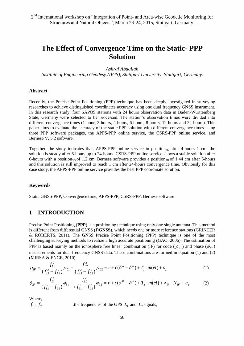
Figure 4: Layout of SAPOS’s Stations, Baden-Württemberg State, Germany © Google Earth
ID : 0384,
City : Stuttgart,
Antenna type : TRM59800.00 SCIS,
Receiver type : TRIMBLE NETR5.
ID : 0386,
City : Heilbronn,
Antenna type : TRM59800.00 SCIS,
Receiver type : TRIMBLE NETR5.
ID : 0391,
City : Geislingen,
Antenna type : TRM59800.00 SCIS,
Receiver type : TRIMBLE NETR5.
ID : 0400,
City : Tübingen,
Antenna type : TRM59800.00 SCIS,
Receiver type : TRIMBLE NETR5.
Figure 5: SAPOS stations properties (SAPOS, 2015)
From the quality check of these stations using TEQC software, properties of the processed stations can
be established as follow:
Observation date : 01 July, 2012,
Observation interval : 30 seconds,

2nd
International workshop on “Integration of Point- and Area-wise Geodetic Monitoring for
Structures and Natural Objects”, March 23-24, 2015, Stuttgart, Germany
64
GNSS system : GPS+GLONASS,
No. of tracked satellites/Epoch : 10 to 22 satellites (varied),
Data gap for in 0391 station for 4 minutes.
The PPP solution was evaluated with respect to the known coordinates for the stations in the UTM
projection and for the ellipsoidal heights. The difference values ji , between the reference known
coordinates M and the PPP results M’ are as reported in equation (4). Moreover, the error in 2D jiD ,,2
and in 3D jiD ,,3 is calculated as shown in equation (5) and (6).
', MMji (4),
22
,,2 NEjiD (5),
222
,,3 hNEjiD (6).
Where,
i :is station number,
j :is E or N or h,
E, N, h :are East, North and ellipsoidal height,
E , N ,
h :are the difference values in East, North and height.
3.1 APPS-PPP results
The observation data with different convergence times were uploaded using the registered account to
the free online services. The estimated PPP results were different with the known values; Figure 6
illustrates the error values in position2D and height directions. The horizontal axis refers to the
convergence time in hours, up to 24-hours. The vertical axis shows the error value in cm and the
results are labelled with different colours.
Figure 6: PPP error form APPS-PPP online service

2nd
International workshop on “Integration of Point- and Area-wise Geodetic Monitoring for
Structures and Natural Objects”, March 23-24, 2015, Stuttgart, Germany
65
As presented in this figure, for 1-hour convergence time, the position solution shows an error of 3 to 1
cm for position2D and up to 5 cm for height. The solution remains unreliable even after 2-hours. After
4-hours, the solution significantly improved to reach sub-cm level in the position2D and the height;
only station 0400 shows an error higher than 2 cm in height direction up to 24 hours. Afterwards, the
solution slightly varies, but it remains in the mm level. After 8-hours, there is not any improvement in
the accuracy up to 24-hours; the static-PPP solution shows millimetre level.
3.2 CSRS-PPP results
As like the APPS-PPP online service, the RINEX files with different convergence times were
uploaded to the service, and the PPP solution was sent to the user to the e-mail address with the
Cartesian and UTM coordinates. Figure 7 shows that the PPP solution after 1-hour provides an error in
position2D and height of 3 to 1 cm. This error decreases after 2-hours up to 1.5 cm and up to 2 cm for
position2D and height respectively. After that, the solution is improved to reach sub-cm level for
position2D and less than 2 cm for height direction. The solution is stable after 8-hours with a millimetre
level for position2D and up to 1.5 cm for the height direction.
Figure 7: PPP error form CSRS-PPP online service
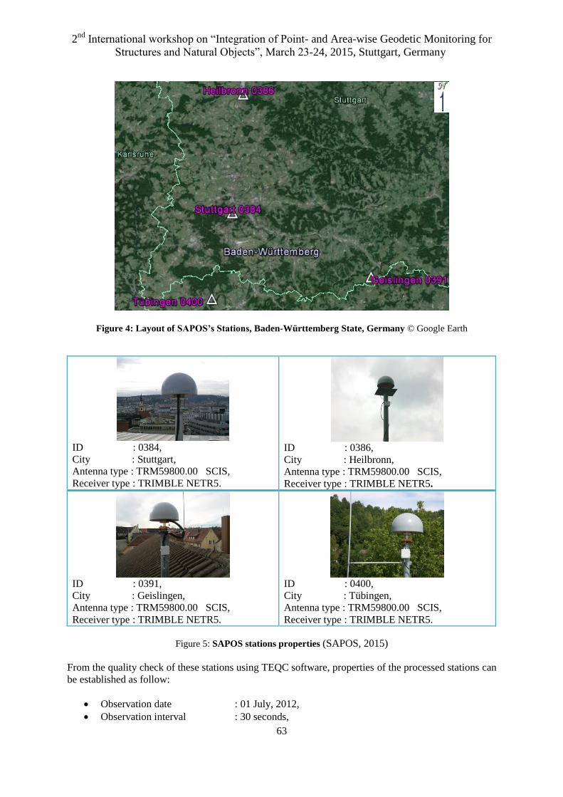
3.3 Bernese software
Using different convergence times in Bernese software, Figure 8 reports the error values in cm for the
position2D and the height for the four stations with various convergence times. The figure is gridded in
the vertical direction in the relevant studied times.
2nd
International workshop on “Integration of Point- and Area-wise Geodetic Monitoring for
Structures and Natural Objects”, March 23-24, 2015, Stuttgart, Germany
66
Figure 8: PPP error form Bernese software
In position2D graph, the solution shows non-reliable solution for the 1-hour and 2-hours with an error
on 4 to 1 cm. The highest error in reported for from station 0400. After 4-hours, the accuracy
significantly improved for all stations to reach an error of 1.30 cm to 8 mm; this accuracy reaches
values up to 1 cm after 12-hours. After 24-hours, the solution achieves 5 mm level for all stations.
Regarding the height graph, the solution reaches up to 4 cm for all stations except the station 0400 for
up to 2-hours. After 4-hours, the solution shows up to 2.2 cm accuracy level. Excluding the station
0391, the error improved to reach 1 cm after 8-hours and remains stable up to 24-hours.
3.4 Summary
This study has gone some way towards investigating of the PPP coordinate solution with different
convergence times. PPP coordinate solution was carried through using three PPP processing tools.
Therefore, Table 1 concludes the mean error in position3D for the four stations. The APPS-PPP online
service provides in position3D after 4-hours 1 cm, and after 6-hours the error is stable up to 24-hours.
Table 1: Overall statistics for all PPP software packages
Convergence
time
Position3D (cm)
APPS-PPP CSRS-PPP BERNESE
1-hour 3.02 2.65 5.38
2-hour 1.13 1.77 2.32
4-hour 1.02 1.53 1.69
6-hour 0.89 1.19 1.44
8-hour 0.82 1.10 1.22
12-hour 0.84 1.23 1.28
24-hour 0.89 1.19 1.04

2nd
International workshop on “Integration of Point- and Area-wise Geodetic Monitoring for
Structures and Natural Objects”, March 23-24, 2015, Stuttgart, Germany
67
Similar to APPS-PPP, the CSRS-PPP online service shows a stable solution after 6-hours with an error
in position3D of 1.2 cm. Regarding Bernese software, the solution is still improved after 6-hour
convergence time and reports 1 cm after 24-horurs. Obviously for this study, the APPS-PPP online
service provides the best PPP coordinate solution.
4 CONCLUSIONS
The main goal of this study was to investigate the effect of convergence time of static-PPP solutions.
The observation data of 24 hours for 4 CORS stations in Germany were divided to 1-hour, 2-hours, 4-
hours, 6-hours, 8-hours, 12-hours, and 24-hours. Three tools were utilized to get the static-PPP
solution: the APPS-PPP online service, CSRS-PPP online service, and Bernese software. The first two
tools provide the user with the PPP solution for free without any specific processing’s effort. The
second tool was a licensed copy of Bernese software, which needed more effort to obtain the solution.
On the other side, Bernese software has many parameters to be changed during the process, which
offers the possibility to study each element in the PPP solution.
Regarding the finding of this study, APPS-PPP shows a sub-cm level after 4-hour convergence times
and a stable solution after 6-hours with a position3D of 9 mm. CSRS-PPP delivers sub-cm level for
position2D and 1 cm level in height after a convergence time of 6-hour. This solution remains stable up
to 24-hours. Bernese software offers a reliable solution after 4-hourrs with 1 cm in position2D and up to
2 cm in height. The solution improves to deliver sub-cm in position2D and 1 cm for height after 8-
hours. After that, the solution is steady up to 24-hours to report a 1 cm level in position3D.
Finally, the strength key of this research paper is the longer convergence time delivers a better PPP
coordinate accuracy. Moreover, the high number of satellites is an effective parameter for getting a
better PPP solution. From this data set, APPS-PPP online service slightly out behaves the solution of
CSRS-PPP online service and Bernese software with respect to the accuracy. The free online services
could offer a good PPP solution for the user. On the other side, Bernese software could provide the
researchers with a high ability to study the different elements of PPP solutions.
For comparison with previous researches, GRINTER & JANSSEN (2012) & ABDALLAH (2013)
studied the static solution of the CSRS-PPP online service. They reported that, the solution of CSRS-
PPP after 2-hours shows a high difference comparing to the reference solution. This solution is
significantly improved between 4-hours and 12-hours and a stable solution after 12-hours to 24-hours.
These findings are matching of our case study. OCALAN, ET AL. (2013) & ABDALLAH &
SCHWIEGER (2015) studied also the comparison between CSRS-PPP and APPS-PPP. They found
that APPS-PPP online service provides a more reliable solution than the CSRS-PPP solution, which is
similar to our outcomes.
Extended efforts are needed: (i) improving the obtained accuracy from Bernese software and (ii)
studying the tropospheric parameters achieved from the different PPP software packages.
Furthermore, (iii) studying the accuracy of the static PPP solution with a limited number of satellites,
(iv) increasing the studied stations.
REFERENCES
Books:
ABDALLAH, A.: Accuracy Assessment Study of Precise Point Positioning for Static and Kinematic
Surveying. Master of science, Not published, Signatur: S7-2013,6 ed. Stuttgart University, Institute of
Engineering Geodesy (IIGS), 2013.
CSRS-PPP:On-line Precise Point Positioning ‘How to Use’ Document. Ver 1.1 Hrsg. Canada: Natural
Recourses Canada.

2nd
International workshop on “Integration of Point- and Area-wise Geodetic Monitoring for
Structures and Natural Objects”, March 23-24, 2015, Stuttgart, Germany
68
DACH, R., FRIDEZ, P., HUGENTOBLER, U. & MEINDL, M.: User manual of the Bernese GPS
Software Version 5.0. Bern, Switzerland: Astronomical Institute, University of Bern, 2007.
GREGORIUS, T.: GIPSY-OASIS II: How it works. University of Newcastel upon Tyne, 1996.
HOFFMANN-WELLENHOF, B., LICHTENEGGER, H. & COLLINS, J.: GPS: Theory and Practics.
4 ed. New York: Springer-Verlag/Wien, 2000.
IERS-CONVENTIONS: IERS Technical Note No. 36. Frankfurt am Main, Germany: Verlag des
Bundesamts für Kartographie und Geodäsie, Petit, G.; Luzum, B. (editors), 36: 137-147, 2010.
LEICK, A.: GPS Satellite Surveying. 2nd ed., Wiley, New York, 1995.
MIRSA, P. & ENGE, P.: Global Positioing System Signals, Measurements, and Performance. Revised
second ed., Ganga-Jamuna Press, 2010.
Journal articles:
ABDALLAH, A. & SCHWIEGER, V.: Static GNSS Precise Point Positioning Using Free Online
Services for Africa. Journal of Survey Review, Accepted, 2015.
BASSIRI, S. & HAJJ, G.: Higher-order ionospheric effects on the GPS observables and means of
modeling them. Manuscripta geodaetica, Springer-Verlag, 18(5), p. 280-289, 1993.
BÖHM, J., HEINKELMANN, R. & SCHUH, H.: A Global Model of Pressure and Temperature for
Geodetic Applications. Journal of Geodesy, 81(10), p. 679-683, 2007.
GAO, Y. & SHEN, X.: A New Method for Carrier Phase Based Precise Point Positioning. Journal of
the Institute of Navigation, 49(2), p. 109-116, 2002.
GRINTER, T. & JANSSEN, V.: Post-Processed Precise Point Positioning: A Viable Alternative?.
Wollongong, New South Wales, Australia, Proceedings of the 17th Association of Public Authority
Surveyors Conference (APAS2012), 2012.
GRINTER, T. & ROBERTS, C.: Precise Point Positioning: Where are we now?. Sydney, Australia,
Proc. IGNSS2011, 2011.
HOPFIELD, H.: Two-quartic topospheric refractivity profile for correcting satellite data. Journal of
Geophysical Research, 74(8), 4487-4499, 1969.
KEDER, S., HAJJ, G., WILSON, B. & HEFLIN, M.: The effect of the second order GPS ionospheric
correction on receiver positions. Geophysical Research Letters, 30(16), 2003.
MARINI, J.: Correction of satellite tracking data for an arbitrary tropospheric profile. Journal of
Radio Science, 7(2), 223-231, 1972.
NIELL, A.: Global mapping functions for the atmosphere delay at radio wavelengths. Journal of
Geophysical Research, 101(B1), 3227-3246, 1992.
OCALAN, T., ERDOGAN B., TUNALIOGLU N.: Analysis of web-based online services for GPS
relative and precise point positioning techniques. Boletim de Ciências Geodésicas, 19(2), 191-207,
2013.
LE PROVOST, C. & LYARD, F.: Energetics of the M2 barotropic ocean tides: an estimate of bottom
friction dissipation from a hydrodynamic model. Progress in Oceanography, 40(1-4), 37-52, 1997.
RAY, R. D. & PONTE, R. M.: Barometric tides from ECMWF operational analyses. Annales
Geophysicae, 21, 1897-1910, 2003.

2nd
International workshop on “Integration of Point- and Area-wise Geodetic Monitoring for
Structures and Natural Objects”, March 23-24, 2015, Stuttgart, Germany
69
SAASTAMOINEN, J.: Contribution to the theory of atmospheric refraction. Bulletin géodésique,
107(1), 13-34, 1973.
Links:
ANTEX: NGS Antenna information, http://www.ngs.noaa.gov/ANTCAL/documents/format.txt, last
accessed on January, 2015.
APPS: Automatic Precise Point Service, http://apps.gPDGNSS.net/index.php, last accessed on
February, 2015.
CODE: CODE ftp server, ftp://ftp.unibe.ch/aiub/CODE/2012/,last accessed on February, 2015.
DACH, R. & WALSER, P.: Bernese GNSS Software Version 5.2 Tutorial.
http://www.bernese.unibe.ch/docs/TUTORIAL.pdf, last accessed on February, 2015.
GGFC (2015): Atomsphere Tide Loading Calculator from Global Geophysical Fluid Center.
http://geophy.uni.lu/ggfc-atmosphere/tide-loading-calculator.html, last accessed on February, 2015.
IGS: IGS orbit and clock data products, http://igscb.jpl.nasa.gov/components/prods.html, last accessed
on February, 2015.
JPL: JPL orbit and clock data products, https://gipsy-oasis.jpl.nasa.gov/index.php?page=data, last
accessed on February, 2015.
NGS: Antenna Absolute Calibrations, http://www.ngs.noaa.gov/ANTCAL/, last accessed on February,
2015.
NRC: Natural Resources Canada, http://webapp.geod.nrcan.gc.ca/geod/tools-
outils/ppp.php?locale=en, last accessed on February, 2015.
TEQC: TEQC manual, http://facility.unavco.org/software/teqc/tutorial.html, last accessed on
February, 2015.
SAPOS: SAPOS Baden-Württemberg, Germany, http://www.sapos-bw.de/karte.php, last accessed on
February, 2015.
SCHERNECK, H.G.: Chalmers/Onsala Sapce Obsevatory. http://holt.oso.chalmers.se/loading/, last
accessed on February, 2015.
Contact:
M. Sc. Ashraf Abdallah
Institute of Engineering Geodesy, University of Stuttgart Geschwister-Scholl-Str. 24D
70174 Stuttgart
GERMANY
Tel. + 49 711 68584051
Fax + 49 711 68584044
Email: [email protected]
Web site: www.uni-stuttgart.de/ingeo