The Celestial Sphere: Coordinate Systems
23
The astrophysics for 4 th class Department of Physics/ College of Science/ University of Kirkuk 2019-2020 Prof. Dr. Wafaa H. A. Zaki Chapter one/ 4 weeks The Celestial Sphere: Coordinate Systems 1. Spherical Astronomy Spherical Astronomy is a science studying astronomical coordinate frames, directions and apparent motions of celestial objects, determination of position from astronomical observations, observational errors, etc. For simplicity we will assume that the observer is always on the northern hemisphere, we will also use degrees to express all angles unless otherwise mentioned. The Celestial Sphere is an imaginary sphere of arbitrarily large radius, concentric with Earth. The Zenith is an imaginary point directly "above" a particular location, on the imaginary celestial sphere. The opposite direction is toward the nadir. The zenith is the "highest" point on the celestial sphere. The Meridian is the great circle passing through the celestial poles, the zenith, and the nadir of an observer's location. Consequently, it contains also the horizon's north and south points, and it is perpendicular to the celestial equator and horizon. The Celestial Meridian is coplanar with the analogous terrestrial meridian projected onto the celestial sphere. Hence, the number of astronomical meridians is infinite.
-
Upload
khangminh22 -
Category
Documents
-
view
0 -
download
0
Transcript of The Celestial Sphere: Coordinate Systems

The astrophysics for 4th class
Department of Physics/ College of Science/ University of Kirkuk
2019-2020
Prof. Dr. Wafaa H. A. Zaki
Chapter one/ 4 weeks
The Celestial Sphere: Coordinate Systems
1. Spherical Astronomy
Spherical Astronomy is a science studying astronomical coordinate
frames, directions and apparent motions of celestial objects,
determination of position from astronomical observations, observational
errors, etc.
For simplicity we will assume that the observer is always on the northern
hemisphere, we will also use degrees to express all angles unless
otherwise mentioned.
The Celestial Sphere is an imaginary sphere of arbitrarily large radius, concentric with Earth.
The Zenith is an imaginary point directly "above" a particular location, on the imaginary celestial sphere. The opposite direction is toward the nadir. The zenith is the "highest" point on the celestial sphere.
The Meridian is the great circle passing through the celestial poles, the zenith, and the nadir of an observer's location. Consequently, it contains also the horizon's north and south points, and it is perpendicular to the celestial equator and horizon.
The Celestial Meridian is coplanar with the analogous terrestrial meridian projected onto the celestial sphere. Hence, the number of astronomical meridians is infinite.

The celestial sphere. Earth is depicted in the center of the celestial sphere.
2. Celestial Coordinate System
The Celestial Coordinate S
celestial objects: satellites, planets, stars, galaxies, and so on.
Coordinate systems can specify a position inmerely the direction of the object on thedistances of the stars are ignored, we needspecify their directions. Eachplane passing through the center of the celestial sphere and dividingsphere into two hemispheres along a great circle. One of the coordinates indicates the angular distanceone great circle going through the object and intersecting thisperpendicularly; the second coordinate gives theof intersection and some fixed
Each coordinate system is named for its choice of fundamental plane
The celestial sphere. Earth is depicted in the center of the celestial sphere.
Celestial Coordinate System
Celestial Coordinate System is a system for specifying positions of
celestial objects: satellites, planets, stars, galaxies, and so on.
can specify a position in 3-dimensional space, or merely the direction of the object on the celestial sphere, distances of the stars are ignored, we need only two coordinates to specify their directions. Each coordinate frame has some fixed reference
through the center of the celestial sphere and dividingsphere into two hemispheres along a great circle. One of the coordinates
gular distance from this reference plane. There is exactly circle going through the object and intersecting this
perpendicularly; the second coordinate gives the angle between that point of intersection and some fixed direction.
nate system is named for its choice of fundamental plane
The celestial sphere. Earth is depicted in the center of the celestial sphere.
is a system for specifying positions of
celestial objects: satellites, planets, stars, galaxies, and so on.
dimensional space, or celestial sphere, Since the
two coordinates to coordinate frame has some fixed reference
through the center of the celestial sphere and dividing the sphere into two hemispheres along a great circle. One of the coordinates
from this reference plane. There is exactly circle going through the object and intersecting this plane
angle between that point
nate system is named for its choice of fundamental plane.

The meridian on the celestial sphere.
A. Horizontal coordinate system
The horizontal coordinate system
uses the observer's local
in terms of altitude (or elevation) angle and azimuth.
This coordinate systemobjects are visible, and the lower hemisphere where objects cannot be seen since the Earth obstructs visiohemispheres is called the celestial horizon.
The Celestial Horizonplane that passes through the center of the Earth and is parallel to an observer’s horizon.
The pole of the upper hemisphere is called thelower hemisphere is called the
There are two independent horizontal
The meridian on the celestial sphere.
Horizontal coordinate system
horizontal coordinate system is a celestial coordinate system
uses the observer's local horizon as the fundamental plane. It is expressed
in terms of altitude (or elevation) angle and azimuth.
coordinate system divides the sky into the upper hemisphereobjects are visible, and the lower hemisphere where objects cannot be seen since the Earth obstructs vision. The great circle separating the hemispheres is called the celestial horizon.
orizon is a great circle on the celestial sphere having a plane that passes through the center of the Earth and is parallel to an
of the upper hemisphere is called the zenith. The pole of the lower hemisphere is called the nadir.
There are two independent horizontal angular coordinates:
celestial coordinate system that
plane. It is expressed
hemisphere where objects are visible, and the lower hemisphere where objects cannot be
separating the
a great circle on the celestial sphere having a plane that passes through the center of the Earth and is parallel to an
zenith. The pole of the

Altitude (E), or elevation, is the angle between the object and the observer's local horizon. positive for objects above the horizon and negative for the objects below the horizon. The zenith distance, orobviously
z = 90◦- E…………….
Azimuth (A), is the angle of the object around the horizon, usually measured from the north
Azimuth is measured from the north point (sometimes from the south
point) of the horizon around to
The main disadvantage of this system
The horizontal coordinate system is fixed to the Earth, not the stars.
Therefore, the altitude and azimuth of an object in the sky changes
with time, as the object appears to drift across the sky with the
rotation of the Earth.
Because the horizontal system is defined by the observer's local
horizon, the same object viewed from different locations on Earth
at the same time will have different values of altitude and azimuth.
elevation, is the angle between the object and the observer's local horizon. The altitude lies in the range [−90positive for objects above the horizon and negative for the objects below
distance, or the angle between the object and the zenith, is
.(1)
The horizontal coordinate system
is the angle of the object around the horizon, usually orth or south.
Azimuth is measured from the north point (sometimes from the south
point) of the horizon around to the east (0� -360� ).
disadvantage of this system:
The horizontal coordinate system is fixed to the Earth, not the stars.
Therefore, the altitude and azimuth of an object in the sky changes
with time, as the object appears to drift across the sky with the
rotation of the Earth.
Because the horizontal system is defined by the observer's local
horizon, the same object viewed from different locations on Earth
at the same time will have different values of altitude and azimuth.
elevation, is the angle between the object and the 90◦,+90◦]; it is
positive for objects above the horizon and negative for the objects below
the angle between the object and the zenith, is
is the angle of the object around the horizon, usually
Azimuth is measured from the north point (sometimes from the south
The horizontal coordinate system is fixed to the Earth, not the stars.
Therefore, the altitude and azimuth of an object in the sky changes
with time, as the object appears to drift across the sky with the
Because the horizontal system is defined by the observer's local
horizon, the same object viewed from different locations on Earth
at the same time will have different values of altitude and azimuth.

Horizontal coordinates are very useful for determining the rise and set times of an object in the sky. When an object's altitude is 0°, it is on the horizon. If at that moment its altitude is increasing, it is rising, but if its altitude is decreasing, it is setting. One can determine whether altitude is increasing or decreasing by instead considering the azimuth of the celestial object:
if the azimuth is between 0° and 180° (north–east–south), it is rising. if the azimuth is between 180° and 360° (south–west–north), it is
setting.
B. Equatorial Coordinate System
The equatorial coordinate system is a celestial coordinate system widely used to specify the positions of celestial objects. It may be applied in spherical or rectangular coordinates, both defined by an origin at the center of Earth, a fundamental plane consisting of the projection of Earth's equator onto the celestial sphere (forming the celestial equator), a primary direction towards the vernal equinox, and a right-handed convention.
The origin at the center of the Earth means the coordinates are geocentric. The fundamental plane and the primary direction mean that the coordinate system, while aligned with the Earth's equator and pole, does not rotate with the Earth, but remains relatively fixed against the background stars. A right-handed convention means that coordinates are positive toward the north and toward the east in the fundamental plane.
A star's spherical coordinates are often expressed as a
pair, rightascension and declination, without a distance coordinate.
The declination symbol δ, measures the angular distance of an object
perpendicular to the celestial equator, positive to the north, negative to
the south. For example, the north celestial pole has a declination of +90°.
Declination is analogous to terrestrial latitude,(+90°, -90°).
The right ascension symbol ,measures the angular distance of an object eastward along the celestial equator from the vernal equinox to the hour circle passing through the object (the vernal equinoxⱱ point is one of the two where the ecliptic intersects the celestial equator). Analogous to terrestrial longitude, right ascension is usually measured in sidereal hours, minutes and seconds instead of degrees, a result of the method of measuring right ascensions by timing the passage of objects
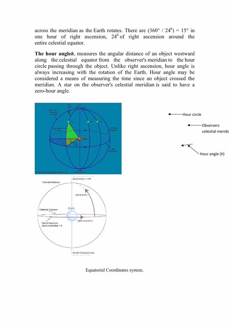
across the meridian as theone hour of right ascension, 24entire celestial equator.
The hour angleh, measures the angular distance of an object westward along the celestial equatorcircle passing through the object. Unlike right ascension, hour angle is always increasing with the rotation of the Earth. Hour angle may be considered a means of measuring the time since an object crossed the meridian. A star on the observer'szero-hour angle.
as the Earth rotates. There are (360° / 24one hour of right ascension, 24h of right ascension around the
celestial equator.
measures the angular distance of an object westward celestial equator from the observer's meridian
passing through the object. Unlike right ascension, hour angle is always increasing with the rotation of the Earth. Hour angle may be considered a means of measuring the time since an object crossed the meridian. A star on the observer's celestial meridian is said to have a
Equatorial Coordinates system.
ere are (360° / 24h) = 15° in of right ascension around the
measures the angular distance of an object westward meridian to the hour
passing through the object. Unlike right ascension, hour angle is always increasing with the rotation of the Earth. Hour angle may be considered a means of measuring the time since an object crossed the
is said to have a
Hour angle (h)
Observers
celestial meridian
Hour circle

The sidereal time
The sidereal time Θ (the hour angle of the vernal equinox) equals the hour angle plus right ascension of any object.
Θ =h+ ……..(2)
Equatorial Coordinates system with ecliptic plane
C. Ecliptic Coordinate System
The ecliptic coordinate system is a celestial coordinate system commonly used for representing the positions and orbits of Solar System objects. Because most planets (except Mercury), and many small Solar System bodies have orbits with small inclinations to the ecliptic, it

is convenient to use it as the fundamental plane (The fundamental plane is the plane of the Earth's orbit, called the ecliptic plane). The system's origin can be either the center of the Sun or the center of the Earth, its primary direction is towards the vernal equinox. The angle between equator plane and ecliptic plane is 23.5o, which is known as the obliquity of the ecliptic (ε ).
Ecliptic longitude or celestial longitude (symbols: λ) measures the angular distance of an object along the ecliptic (counterclockwise) from the primary direction (vernal equinox) (0° ecliptic longitude)(0� -360� ).
Ecliptic latitude or celestial latitude (symbols: β), measures the angular distance of an object from the ecliptic towards the north (positive) or south (negative) ecliptic pole. For example, the north ecliptic pole has a celestial latitude of +90° (+90� ,-90� ).
D. Galactic Coordinate System The galactic coordinate system is a celestial coordinate system in spherical coordinates, with the Sun as its center, the primary direction aligned with the approximate center of the Milky Way galaxy, and the fundamental plane approximately in the galactic plane. It uses the right-handed convention, meaning that coordinates are positive toward the north and toward the east in the fundamental plane.
Galactic longitude Longitude (symbol l) measures the angular distance of an object eastward
along the galactic equator from the galactic center. Analogous to
terrestrial longitude, galactic longitude is usually measured in degrees
(°)(0� -360� ).
Galactic latitude
Latitude (symbol b) measures the angular distance of an
object perpendicular to the galactic equator, positive to the north, negative

to the south. For example, the north galactic pole has a latitude of +90°.
Analogous to terrestrial latitude, galactic latitude is usually measured in
degrees (°)(+90� ,-90� ).
galactic coordinate system
Coordinate
system
Center point
(origin)
Fundamental
plane (0° latitude)
Poles
Coordinates Primary direction
(0° longitude) Latitude Longitude
Horizontal Observer Horizon Zenith,
nadir
Altitude (E) or elevation
Azimuth (A) North or south point
of horizon
Equatorial Center of
the Earth (geocentric), or Sun (heliocentric)
Celestial
equator
Celestial
poles Declination (δ)
Right ascension (α)
or hour angle (h) Vernal equinox
Ecliptic Ecliptic Ecliptic
poles
Ecliptic
latitude (β)
Ecliptic
longitude (λ)
Galactic Center of the Sun Galactic
plane Galactic
poles Galactic
latitude (b) Galactic
longitude (l) Galactic center
3. Converting Coordinates:
Conversions between the various coordinate systems are given.
Notes on conversion
λo – observer's longitude. φo – observer's latitude.

ε – obliquity of the ecliptic
Angles in the hours (
measure must be converted to decimal
calculations are performed.
Angles greater than 360° (2
to the range 0° - 360° (0
calculating machine or program.
Azimuth (A) is referred her to the south point of the
common astronomical reckoning. An object on the
south of the observer has
some other disciplines, azimuth is figured from the north.
Equatorial ←→ horizontal
Note that Azimuth (A) is
to the West. Zenith distance, the angular distance along the
circle from the zenith to a celestial object, is simply the
angle of the altitude: 90°
The altitude of an object is greatest when it is on
great circle arc between the
moment(called upper culmination, or transit) its hour angle is0 h. At the
lower culmination the hour angle is h = 12 h.
equation (4)
Thus the altitude at the upper culmination is
E
E
E
E
obliquity of the ecliptic 23.5�
Angles in the hours ( h ), minutes ( m ), and seconds ( s ) of time
measure must be converted to decimal degrees or radians
calculations are performed. 1h = 15° 1m = 15' 1s = 15"
Angles greater than 360° (2π) or less than 0° may need to be reduced
360° (0 - 2π) depending upon the particular
calculating machine or program.
) is referred her to the south point of the horizon,
common astronomical reckoning. An object on the meridian
south of the observer has A = h = 0° with this usage. In navigation
some other disciplines, azimuth is figured from the north.
←→ horizontal
Note that Azimuth (A) is measured from the South point, turning positive
Zenith distance, the angular distance along the great
to a celestial object, is simply the complementary
of the altitude: 90° − E.
………(3)
…………(4)
………..(5)
………..(6)
The altitude of an object is greatest when it is on the south meridian (the
great circle arc between the celestial poles containing the zenith). At that
moment(called upper culmination, or transit) its hour angle is0 h. At the
lower culmination the hour angle is h = 12 h. When h = 0 h, from the
Thus the altitude at the upper culmination is
E
E
) of time
before
= 15"
) or less than 0° may need to be reduced
) depending upon the particular
horizon, the
meridian to the
navigation and
some other disciplines, azimuth is figured from the north.
measured from the South point, turning positive
great
complementary
the south meridian (the
celestial poles containing the zenith). At that
moment(called upper culmination, or transit) its hour angle is0 h. At the
When h = 0 h, from the

……(7)
The altitude is positive for objects with δ>φ−90◦.Objects with
declinations less than φ−90◦can never be seen at the latitude φ. On the
other hand, when h = 12 h, we have
and the altitude at the lower culmination is
………..(8)
Stars with δ> 90◦−φ will never set. For example, in Helsinki (φ ≈ 60◦), all
stars with a declination higher than 30◦ are such circumpolar stars. And
stars with a declination less than 30◦ can never be observed there.
Suppose we observe a circumpolar star at its upper and lower
culmination. At the upper transit, its altitude is Emax =90◦−φ+δ and at the
lower transit, Emin = δ+φ−90◦.
Eliminating the latitude, we get
…….(9)
Thus we get the same value for the declination, independent of the
observer’s location.
E
E
E E
E
E

The altitude of a circumpolar star at upper and lower culmination
Rising and Setting Times
From the equation (4), we find the hour angle
moment its altitude is E
This equation can be used for computing rising and setting times. Then
= 0 and the hour angles corresponding to rising and setting times are
obtained from
cos h =-tan δ tan φ…………………(11)
If higher accuracy is needed, we have to correct for
caused by the atmosphere of the
negative value for E
about −34′.
Equatorial ←→ eclip�c
The classical equations, derived from
Equatorial ←→ galac�c
…….(16)
The altitude of a circumpolar star at upper and lower culmination
Rising and Setting Times
equation (4), we find the hour angle h of an object at the
E:
……..(10)
This equation can be used for computing rising and setting times. Then
= 0 and the hour angles corresponding to rising and setting times are
…………………(11)
If higher accuracy is needed, we have to correct for the refraction of light
caused by the atmosphere of the Earth. In that case, we must us
in (10). This value, the horizontally
←→ eclip�c
The classical equations, derived from spherical trigonometry,
…….(12)
……….(13)
……….(14)
…………….(15)
←→ galac�c
E
The altitude of a circumpolar star at upper and lower culmination
of an object at the
This equation can be used for computing rising and setting times. Then E
= 0 and the hour angles corresponding to rising and setting times are
the refraction of light
. In that case, we must use a small
refraction, is
spherical trigonometry,

………(18)
Example 1 :Find the altitude and azimuth of the Moon in Helsinki at midnight at the beginning of 1996. The right ascension is 2.9186 hand declination 19m 26s = 6.3239 h and latitude
Example 2 :The coordinates of Arcturus are Find the sidereal time at the42◦ 19′). neglecting refraction.
Example 3 :The right ascension of the Sun on June 1, and declination 22◦ 00and the Earth.
Example 4 :A star of azimuth (A)=221.22(E)= 22.076o is observed when its sidereal time is 8observer’s latitude () is 60and ecliptic latitude (
Ecliptic and Zodiac
The ecliptic is an imaginary line on the sky tthe sun. It is the projection of Earth’s orbit onto the celestial sphere, is the basis for the ecliptic coordinate system.
Zodiac: an imaginary band, centered on the ecliptic, across the celestial sphere and about 16°-Mercury, Venus, Jupiter and Saturn are always located. The band is divided into 12 intervals of 30°, each named (the Siafter the constellation of stars which it contains.
……..(17)
…………(19)
Find the altitude and azimuth of the Moon in Helsinki at midnight at the beginning of 1996. The right ascension is α 2.9186 hand declination δ = 14◦ 42′= 14.70◦, the sidereal time is
and latitude φ = 60.16◦.
The coordinates of Arcturus are α = 14h 15.7m, Find the sidereal time at the moment Arcturus rises or sets in Boston (
neglecting refraction.
The right ascension of the Sun on June 1, 1983, was 400′. Find the ecliptic longitude and latitude of the Sun
A star of azimuth (A)=221.22o from the south and altitude is observed when its sidereal time is 8h16
) is 60o N, calculate the star’s ecliptic longitude () at the time of observation.
is an imaginary line on the sky that marks the annual path of the sun. It is the projection of Earth’s orbit onto the celestial sphere,
ecliptic coordinate system.
an imaginary band, centered on the ecliptic, across the celestial -18° wide, in which the Sun, Moon and the planets
Mercury, Venus, Jupiter and Saturn are always located. The band is divided into 12 intervals of 30°, each named (the Signs of the Zodiac) after the constellation of stars which it contains.
……..(17)
…………(19)
Find the altitude and azimuth of the Moon in Helsinki at = 2h 55m 7s = time is Θ = 6h
, δ = 19◦ 11′. moment Arcturus rises or sets in Boston (φ =
1983, was 4h 35m ecliptic longitude and latitude of the Sun
from the south and altitude 16m42s .If the
N, calculate the star’s ecliptic longitude ()
hat marks the annual path of the sun. It is the projection of Earth’s orbit onto the celestial sphere, and
an imaginary band, centered on the ecliptic, across the celestial 18° wide, in which the Sun, Moon and the planets
Mercury, Venus, Jupiter and Saturn are always located. The band is gns of the Zodiac)

The zodiac signs come from the constellations which lie along the ecliptic (red line).
The Seasons The Earth's seasons are not caused by the differences in the distance from
the Sun throughout the year (these differences are extremely small). The
seasons are the result of the tilt of the Earth's axis.
The Earth's axis is tilted from perpendicular to the plane of the ecliptic by 23.45°. This tilting is what gives us the four seasons summer, autumn (fall) and winter. Since the axis is tilted, different parts of the globe are oriented towards the Sun at different times of the year.
Summer is warmer than winter (in each hemisphere) because the Sun's rays hit the Earth at a more direct angle during summer than during winter and also because the days are much longer than the nights during the summer.
The zodiac signs come from the constellations which lie along the ecliptic (red line).
The Earth's seasons are not caused by the differences in the distance from
throughout the year (these differences are extremely small). The
seasons are the result of the tilt of the Earth's axis.
The Earth's axis is tilted from perpendicular to the plane of the ecliptic by 23.45°. This tilting is what gives us the four seasons of the year summer, autumn (fall) and winter. Since the axis is tilted, different parts of the globe are oriented towards the Sun at different times of the year.
Summer is warmer than winter (in each hemisphere) because the Sun's rays hit the Earth at a more direct angle during summer than during winter and also because the days are much longer than the nights during
The zodiac signs come from the constellations which lie along the ecliptic (red line).
The Earth's seasons are not caused by the differences in the distance from
throughout the year (these differences are extremely small). The
The Earth's axis is tilted from perpendicular to the plane of the ecliptic by of the year - spring,
summer, autumn (fall) and winter. Since the axis is tilted, different parts of the globe are oriented towards the Sun at different times of the year.
Summer is warmer than winter (in each hemisphere) because the Sun's rays hit the Earth at a more direct angle during summer than during winter and also because the days are much longer than the nights during

During the winter, the Sun's rays hit the Earth at an extreme angle, and the days are very short. These effects are due to the tilt of the Earth's axis.
Solstices The solstices are days when thesouthern declinations. The winterand marks the beginning of winter beginning of summer in the southern hemisphere of the year). The summer solstice occurs on June 21 and marks the beginning of summer (this is the longest day of the year).
The Seasons on Earth
winter, the Sun's rays hit the Earth at an extreme angle, and the days are very short. These effects are due to the tilt of the Earth's axis.
are days when the Sun reaches its farthest northern and southern declinations. The winter solstice occurs on December 21 or 22 and marks the beginning of winter in the northern hemisphere and the beginning of summer in the southern hemisphere (this is the shortest day of the year). The summer solstice occurs on June 21 and marks the
of summer (this is the longest day of the year).
winter, the Sun's rays hit the Earth at an extreme angle, and the days are very short. These effects are due to the tilt of the Earth's axis.
reaches its farthest northern and solstice occurs on December 21 or 22
in the northern hemisphere and the (this is the shortest day
of the year). The summer solstice occurs on June 21 and marks the

Equinoxes Equinoxes are days in which day and night are of equal duration. The two yearly equinoxes occur when the plane of Earth's equator passes through the center of the Sun.
The Vernal Equinox: one of two points at which the ecliptic intersects the celestial equator. At it, the sun is moving along the ecliptic in a northeasterly direction and occurs in 20-21 March, in this point is meaning the beginning of spring in the Northern Hemisphere and the beginning of autumn in the Southern Hemisphere.
The autumnal equinox: occurs in 22-23 September and opposite the vernal equinox and the ecliptic intersects the celestial equator. In this point is meaning the beginning of autumn in the Northern Hemisphere and the beginning of spring in the Southern Hemisphere.

Earth's rotation is the rotationEarth rotates from the west towardspolestar Polaris, the Earth
The Earth rotates once in about 2423h 56 m 4 s with respect to the stars. Earth's rotation is slowing slightly with time; thus, a day was shorter in the past. This is due to theeffects the Moon has on Earth's rotation.modern-day is longer by about 1.7
Precession
Precession is the slow wobble of Earth's rotation axis due to our planet's non spherical shape and its Moon.
The precession of the Earth's axis has a number of observable effects.
First, the positions of the south and north celestial poles appear to move in circles against the spacecircuit in approximately lies approximately 1 ° time, and other stars will become the "north star". In approximately 3200 years, the star Gamma CPolaris for this position.
Secondly, the position of the Earth in its orbit around the Ssolstices, equinoxes slowly changes. For example, suppose that the Earth's orbital position is marked at the s
The vernal equinox
rotation of the planet Earth around its ownEarth rotates from the west towards east. As viewed from North Star or
Polaris, the Earth turns counter-clockwise.
h rotates once in about 24h with respect to the sun and once every with respect to the stars. Earth's rotation is slowing slightly
with time; thus, a day was shorter in the past. This is due to thehas on Earth's rotation. Atomic clocks
day is longer by about 1.7 milliseconds than a century ago
is the slow wobble of Earth's rotation axis due to our planet's spherical shape and its gravitational interaction with the Sun and the
The precession of the Earth's axis has a number of observable effects.
, the positions of the south and north celestial poles appear to move in circles against the space-fixed backdrop of stars, comcircuit in approximately 25800 years. Thus, while today the star Polaris
1 ° at the north celestial pole, this will change over time, and other stars will become the "north star". In approximately 3200 years, the star Gamma Cephei in the Cepheus constellation will succeed Polaris for this position.
, the position of the Earth in its orbit around the Sslowly changes. For example, suppose that the
Earth's orbital position is marked at the summer solstice, when the Earth's
around its own axis. The east. As viewed from North Star or
the sun and once every with respect to the stars. Earth's rotation is slowing slightly
with time; thus, a day was shorter in the past. This is due to the tidal show that a
than a century ago.
is the slow wobble of Earth's rotation axis due to our planet's gravitational interaction with the Sun and the
The precession of the Earth's axis has a number of observable effects.
, the positions of the south and north celestial poles appear to move fixed backdrop of stars, completing one
years. Thus, while today the star Polaris at the north celestial pole, this will change over
time, and other stars will become the "north star". In approximately 3200 ephei in the Cepheus constellation will succeed
, the position of the Earth in its orbit around the Sun at the slowly changes. For example, suppose that the
ummer solstice, when the Earth's

axial tilt is pointing directly toward the Sun. One full orbit later, when the Sun has returned to the same apparent position relative to the background stars, the Earth's axial tilt is not now directly toward the Sun: becathe effects of precession, it is a little way "beyond" this. In other words, the solstice occurred a little earlier in the orbitshorter than the sidereal year. corresponds to a period of 25800
Effects of precession
axial tilt is pointing directly toward the Sun. One full orbit later, when the Sun has returned to the same apparent position relative to the background stars, the Earth's axial tilt is not now directly toward the Sun: becathe effects of precession, it is a little way "beyond" this. In other words,
d a little earlier in the orbit, is about 20 minutes shorter than the sidereal year. At present, the rate of precessiocorresponds to a period of 25800 years.
Effects of precession and nutation on Earth’s axis of rotation.
axial tilt is pointing directly toward the Sun. One full orbit later, when the Sun has returned to the same apparent position relative to the background stars, the Earth's axial tilt is not now directly toward the Sun: because of the effects of precession, it is a little way "beyond" this. In other words,
, is about 20 minutes At present, the rate of precession
on Earth’s axis of rotation.

The relationship between the seasons and precession of Earth's axis.
Nutation :
Is a small irregularity in the precession of the equinoxes. Nutation superimposes a small oscillation, with a period of 18.6 years and an amplitude of 9.2 seconds of arc, upon this great slow movement. The cause of nutation lies chiefly in the fact that the plane of the Moon’s orbit around the Earth is tilted by about 5° from the plane of the Earth’s orbit around the Sun.
Obliquity: The obliquity is the angle between the plane of the Earth's equator and the
plane of the Earth's orbit around the Sun. it can change due to the
gravitational effects of other bodies (nutation), which in turn can affect
the earth’s climate. it is approximately 23°27' but it is not fixed. Instead,
it varies slowly because both the Earth's axis of rotation and its orbital
motion are affected by the gravitational attractions of the Moon and
planets. it oscillates between 22.1 and 24.5 degrees on a 41,000-year
cycle. If the obliquity was equal to zero, the Sun would rise at 6 a.m.
and set at 6 p.m. every day of the year, everywhere in the world. There
would be no long summer days and long winter nights. The Sun wouldn't
be high in the sky in summer and low in winter. It would take the same
path across the sky every day of the year. Every day would be the same as
every other. There would be no seasons. The whole world's weather
would be completely different. Life would probably have evolved in a
totally different way.
Astronomical System of Units:
The astronomical unit (AU) is a unit of length, the average distance
from Earth to the Sun. it is now defined as exactly 149597870700
meters (about 150 million kilometers, or 93 million miles). The
astronomical unit is used primarily as a convenient yardstick for
measuring distances within the Solar System or around other stars.
A light year ( L.Y) is a unit of length used informally to express
astronomical distances. it is the distance that light travels in vacuum
in one Julian year (365.25 days) is equal L.Y=9.45x10¹² Km. it is
most often used when expressing distances to stars and other
distances on a galactic scale.
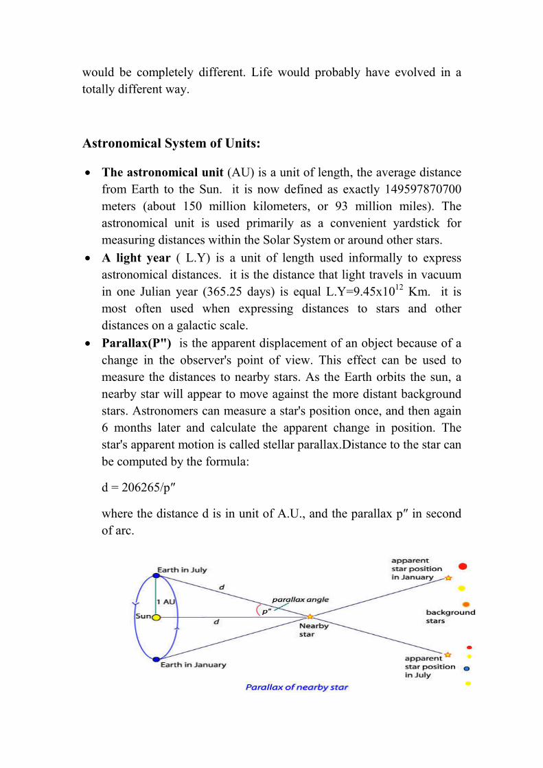
Parallax(P") is the apparent displacement of an object because of a
change in the observer's point of view. This effect can be used to
measure the distances to nearby stars. As the Earth orbits the sun, a
nearby star will appear to move against the more distant background
stars. Astronomers can measure a star's position once, and then again
6 months later and calculate the apparent change in position. The
star's apparent motion is called stellar parallax.Distance to the star can
be computed by the formula:
d = 206265/p″
where the distance d is in unit of A.U., and the parallax p″ in second
of arc.

Parallax angles of less than 0.01 arc sec are very difficult to measure
from Earth because of the effects of the Earth's atmosphere. This
limits Earth based telescopes to measuring the distances to stars about
1/0.01 or 100 parsecs away. Space based telescopes can get accuracy
to 0.001, which has increased the number of stars whose distance
could be measured with this method.
Parsec(Pc) The distance corresponding to a parallax of one second of
arc. A unit of distance defined as the distance at which 1 astronomical
unit (AU) subtends an angle of 1 sec of arc. It is a unit of length used
to measure large distances to objects outside our Solar System.1
parsec = 206265 AU = 3.26 light years.
�(�. �) =�. ��
�"
�(��) =�
�"
�� = �. ���. �
A distance of 1000 parsecs (3262 light-years) is commonly denoted
by the kilo parsec (kpc). Astronomers typically use kilo parsecs to
express distances between parts of a galaxy, or within groups of
galaxies. A distance of one million parsecs is commonly denoted by
the mega parsec (Mpc). Astronomers typically express the distances
between neighboring galaxies and galaxy clusters in mega parsecs.
One giga parsec (Gpc) is one billion parsecs — one of the
largest units of length commonly used. One giga parsec is about
3.26 billion light-years. Astronomers typically use giga parsecs to
express the sizes of large-scale structures such as the size of, and
distance to, the CfA2 Great Wall; the distances between galaxy
clusters; and the distance to quasars.
For example:
The Andromeda Galaxy is about 0.78 Mpc (2.5 million light-years)
from the Earth.
The nearest large galaxy cluster, the Virgo Cluster, is about 16.5 Mpc
(54 million light-years) from the Earth.

The galaxy RXJ1242-11, observed to have a super massive black
hole core similar to the Milky Way's, is about 200 Mpc (650 million
light-years) from the Earth.
The galaxy filament Hercules–Corona Borealis Great Wall, currently
the largest known structure in the universe, is about 3 Gpc (10 billion
light-years) across.
The particle horizon (the boundary of the observable universe) has a
radius of about 14.0 Gpc (46 billion light-years)
The Laws Of Motion Of Celestial Bodies:
Kepler’s Laws of Planetary Motion:
Johannes Kepler (1571–1630) published his three laws of planetary motion:
1. The orbits of the planets are ellipses, with the Sun at one focus
of the ellipse.
2. Planets move proportionally faster in their orbits when they are
nearer the Sun (cover equal areas in equal time.
Kepler’s Laws of Planetary Motion
3. More distant planets take proportionally longer to orbit the Sun.
The ratio of the squares of the orbital periods for two planets is
equal to the ratio of the cubes of their semi-major axes.
R3=P2 (R in AU; P in years)

As an example, the "radius" of the orbit of Mars (the length of
the semi-major axis of the orbit) is: R=P2/3=(1.88)2/3=1.52 AU
Newton’s laws of motion
1. A body at rest remains at rest, and a body in uniform motion
remains in uniform motion, unless acted on by an external
force.
2. The acceleration of a body is equal to the net applied force,
divided by the mass of the body:
a = F/m.
3. For every force there is an equal and opposite reaction force.
The third law is exemplified by a person attracted by gravity
toward a planet. There is simultaneously an equal opposite
force attracting the planet toward the person.
Newtonian gravity: The description of gravity due to Newton: The
attractive gravitational force of point mass m1 on point mass m2
separated by displacement r
� = �����
��
where G is Newton’s gravitational constant G=6.67x10⁻¹¹ N.M2/Kg2
CH.1 : 4 Weeks