Lower crustal earthquakes near the Ethiopian rift induced by magmatic processes
Upload
independentCategory
view
2download
0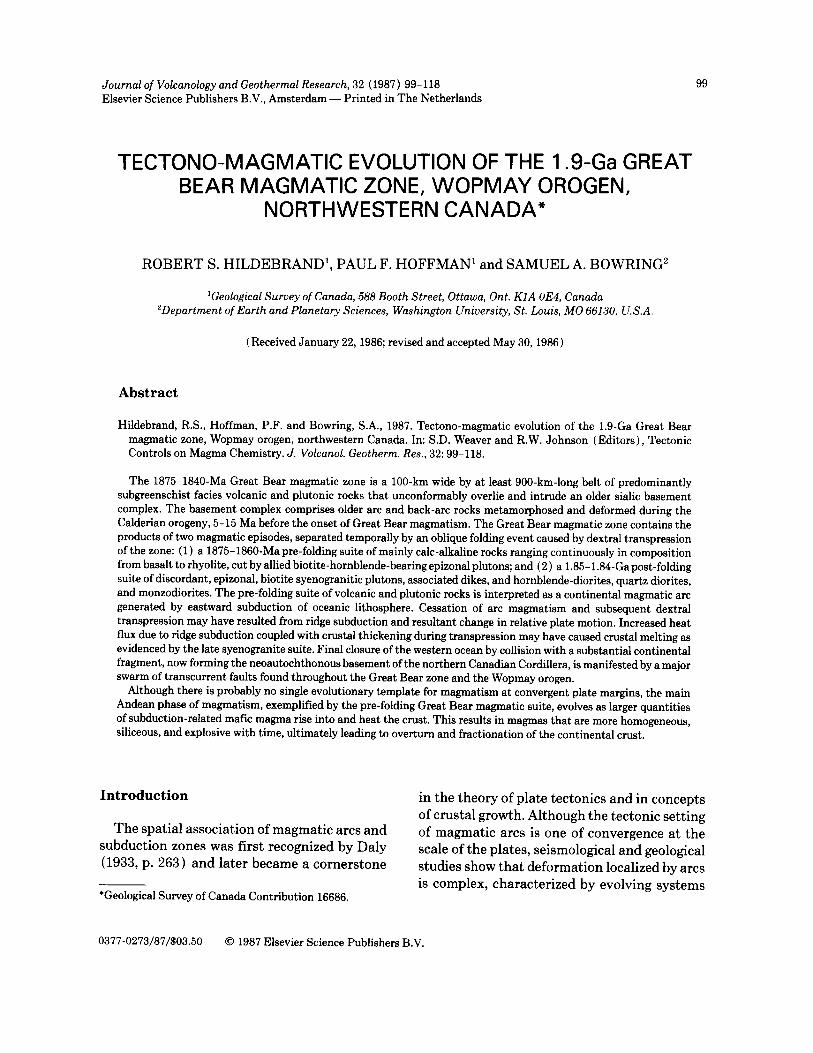
Journal of Volcanology and Geothermal Research, 32 (1987) 99-118 99 Elsevier Science Publishers B.V., Amsterdam - - Printed in The Netherlands
TECTONO-MAGMATIC EVOLUTION OF THE 1.9-Ga GREAT BEAR MAGMATIC ZONE, WOPMAY OROGEN,
NORTHWESTERN CANADA*
ROBERT S. HILDEBRAND 1, PAUL F. HOFFMAN 1 and SAMUEL A. BOWRING 2
1Geological Survey of Canada, 588 Booth Street, Ottawa, Ont. KIA OE4, Canada 2Department of Earth and Planetary Sciences, Washington University, St. Louis, MO 66130, U.S.A.
(Received January 22, 1986; revised and accepted May 30, 1986)
Abstract
Hildebrand, R.S., Hoffman, P.F. and Bowring, S.A., 1987. Tectono-magmatic evolution of the 1.9-Ga Great Bear magmatic zone, Wopmay orogen, northwestern Canada. In: S.D. Weaver and R.W. Johnson (Editors), Tectonic Controls on Magma Chemistry. J. Volcanol. Geotherm. Res., 32: 99-118.
The 1875-1840-Ma Great Bear magmatic zone is a 100-km wide by at least 900-km-long belt of predominantly subgreenschist facies volcanic and plutonic rocks that unconformably overlie and intrude an older sialic basement complex. The basement complex comprises older arc and back-arc rocks metamorphosed and deformed during the Calderian orogeny, 5-15 Ma before the onset of Great Bear magmatism. The Great Bear magmatic zone contains the products of two magmatic episodes, separated temporally by an oblique folding event caused by dextral transpression of the zone: (1) a 1875-1860-Ma pre-folding suite of mainly calc-alkaline rocks ranging continuously in composition from basalt to rhyolite, cut by allied biotite-hornblende-bearing epizonal plutons; and (2) a 1.85-1.84-Ga post-folding suite of discordant, epizonal, biotite syenogranitic plutons, associated dikes, and hornblende-diorites, quartz diorites, and monzodiorites. The pre-folding suite of volcanic and plutonic rocks is interpreted as a continental magmatic arc generated by eastward subduction of oceanic lithosphere. Cessation of arc magmatism and subsequent dextral transpression may have resulted from ridge subduction and resultant change in relative plate motion. Increased heat flux due to ridge subduction coupled with crustal thickening during transpression may have caused crustal melting as evidenced by the late syenogranite suite. Final closure of the western ocean by collision with a substantial continental fragment, now forming the neoautochthonous basement of the northern Canadian Cordillera, is manifested by a major swarm of transcurrent faults found throughout the Great Bear zone and the Wopmay orogen.
Although there is probably no single evolutionary template for magmatism at convergent plate margins, the main Andean phase of magmatism, exemplified by the pre-folding Great Bear magmatic suite, evolves as larger quantities of subduction-related mafic magma rise into and heat the crust. This results in magmas that are more homogeneous, siliceous, and explosive with time, ultimately leading to overturn and fractionation of the continental crust.
Introduction
The spatial association of magmatic arcs and subduction zones was first recognized by Daly {1933, p. 263) and later became a cornerstone
*Geological Survey of Canada Contribution 16686.
in the theory of plate tectonics and in concepts of crustal growth. Although the tectonic setting of magmatic arcs is one of convergence at the scale of the plates, seismological and geological studies show that deformation localized by arcs is complex, characterized by evolving systems
0377-0273/87/$03.50 © 1987 Elsevier Science Publishers B.V.

100
of extensional, transcurrent and compressional strains (Dewey, 1980). How arc deformation influences the magmatic processes and their products has not been well described and is, therefore, poorly understood.
In the northwest corner of the Canadian Shield is an early Proterozoic Cordilleran-type plate margin (Hoffman, 1973, 1980a, 1984; Hoffman and McGlynn, 1977; Hildebrand, 1981, 1982, 1984a,b) in which the interaction of deformation and magmatism over a period of about 100 Ma, from 1.94 to about 1.83 Ga, is remarkably well preserved and has been stud- ied in some detail. A comprehensive U-Pb zir- con dating program (Bowring and Van Schmus, 1982, in press) founded on 15 years of geologi- cal mapping permits the resolution of tectono- magmatic events on the order of 5 Ma, allowing direct comparisons with well-studied Cenozoic magmatic arcs. The purpose of this paper is to outline the tectono-magmatic evolution of the plate margin, and to describe in some detail one component of it, the Great Bear magmatic zone, which was active for a period of about 30 Ma, and includes two distinct phases of magrnatism.
Regional geology
The Great Bear magmatic zone occupies most of the western exposed part of the Wopmay oro- gen, an early Proterozoic north-trending oro- gen that developed on the western side of the Archean Slave craton between 2.1 and 1.8 Ga (Hoffman, 1973, 1980a). The orogen is divided into three major tectonic elements parallel to the trend of the belt itself. From east to west they are the Calderian accretionary wedge, the Great Bear magmatic zone, and the Hottah ter- rane (Fig. 1). Each of the 3 tectonic elements contains at least two distinct major magmatic assemblages that together form a magmatic continuum of about 100-Ma duration.
The westernmost zone, the Hottah terrane (Fig. 1 ), contains the oldest magmatic suite in the Wopmay orogen. The terrane comprises mostly amphibolite facies, sedimentary and
intermediate volcanic rocks cut by calc-alka- line biotite-hornblende-bearing plutons (1914-1902 Ma). The volcanic rocks and the plutons are interpreted as a continental mag- matic arc originally located on the western edge of the Slave craton (Hildebrand and Roots, 1985 ). The Hottah terrane is believed to extend eastward as the basement for much of the Great Bear magmatic zone (McGlynn, 1979; Hilde- brand et al., 1983).
At about 1900 Ma, arc magmatism appar- ently shut-down and a bimodal suite of sub- marine volcanic rocks (Easton, 1981, 1982; Reichenbach, 1985b, 1986) erupted through and onto block-faulted, subsided and sediment- veneered continental crust (Hoffman and Pel- letier, 1982). This tectono-magmatic phase was rather short-lived, lasting between 5 and 10 Ma, and is interpreted to represent magmatism related to intra-arc extension that culminated in the development of a marginal basin, which lay to the east of the Hottah arc (Hildebrand and Roots, 1985; Reichenbach, 1985b, 1986, in press). Whether the basin was everywhere floored by stretched continental crust or evolved into an oceanic back-arc basin is unknown, but as it widened, a 2-km-thick west-facing conti- nental margin prism comprising siliciclastic and carbonate rocks developed above the volcanic sequence, lapping well east onto the Archean basement of the Slave craton (Hoffman, 1972, 1973; Grotzinger and Hoffman, 1983; Grotzin- ger, 1986).
Within 5-10 Ma of its formation, the vol- cano-sedimentary basin fill was shortened and simultaneously intruded by a diverse suite of peraluminous to metaluminous plutons (1896-1878 Ma), collectively termed the Hep- burn intrusive suite (Lalonde, 1984). The shortening culminated in the detachment and thin-skinned eastward thrusting of the imbri- cated basinal rocks to form the Calderian accretionary wedge (Tirrul, 1983; Hoffman et al., in press) and Hepburn plutons were trans- ported and emplaced onto the nonstretched western margin of the Slave craton. Inverted

~].~.Coronotton Gulf ~-
Steal *Bear Lake ~- " . +
+ j , +. ' " iOOkm
118 ° 117 o I t 6 °
, . . ~}: l : t : t l~+ + + + ~ J " . ' . . . .
• ° • / - ~
101
67 °
66¢'~ - Great Bear Lake
:...1.
6 °o" °
120 ° i 119 °
117 °
post-orogenic
( ~ gabbro
©
© Q 0 ©
118 °
116 °
cover
biotite syenogranite suite
granodiorite-monzogranite suite
hypabyssal porphyries
mainly ash-flow tuffs
early intermediate intrusive suite mainly intermediate ash-flow tuffs and mafic-intermediate lavas
older marginal basin volcanics
Calderian accretionary wedge
Hottah Terrane
20 0 20 40 60 80 km
66 °
Fig. 1. Generalized geological map of the northern and western parts of the Great Bear magmatic zone showing the distri- bution of major rock units. This figure is based on geological mapping by the authors over the period 1973 to the present. Although virtually all of the zone has been mapped in reconnaissance fashion, this figure shows only our more detailed work in recent years. Inset maps show the location of Wopmay orogen and its tectonic subdivisions. M--Muskox intrusion; H= Hottah terrane; T= Torrie pluton, J= Jacier pluton, K--Kamut pluton.
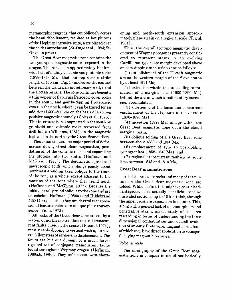
102
metamorphic isograds, that cut obliquely across the basal ddcollement, resulted as hot plutons of the Hepburn intrusive suite, were placed over the colder autochthon ( St-Onge et al., 1984; St- Onge, in press).
The Great Bear magmatic zone contains the two youngest magmatic suites exposed in the orogen. The zone is an approximately 100-km- wide belt of mainly volcanic and plutonic rocks (1878-1843 Ma) that outcrop over a strike length of 450 km ( Fig. 1 ) and cover the contact between the Calderian accretionary wedge and the Hottah terrane. The zone continues beneath a thin veneer of flat-lying Paleozoic cover rocks in the south, and gently-dipping Proterozoic cover in the north, where it can be traced for an additional 400-500 km on the basis of a strong positive magnetic anomaly (Coles et al., 1976). This interpretation is supported in the south by granitoid and volcanic rocks recovered from drill holes (Williams, 1981) on the magnetic high and in the north by the Great Bear outliers.
There was at least one major period of defor- mation during Great Bear magmatism, post- dating all of the volcanic rocks and separating the plutons into two suites (Hoffman and McGlynn, 1977). The deformation produced macroscopic folds which plunge gently about northwest-trending axes, oblique to the trend of the zone as a whole, except adjacent to the margins of the zone where they trend north (Hoffman and McGlynn, 1977). Because the folds generally trend oblique to the zone and are en-echelon, Hoffman (1980a) and Hildebrand (1981) argued that they are dextral transpres- sional features related to oblique plate conver- gence (Fitch, 1972).
All rocks of the Great Bear zone are cut by a system of northeast-trending dextral transcur- rent faults (used in the sense of Freund, 1974), most steeply dipping to vertical with up to sev- eral kilometers of strike-slip displacement. The faults are but one domain of a much larger regional set of conjugate transcurrent faults found throughout Wopmay orogen (Hoffman, 1980a,b, 1984). They reflect east-west short-
ening and nor th-south extension approxi- mately plane strain on a regional scale ( Tirrul, 1984).
Thus, the overall tectonic-magmatic devel- opment of Wopmay orogen is presently consid- ered to represent stages in an evolving Cordilleran-type plate margin developed above an east-dipping subduction zone as follows:
(1) establishment of the Hottah magmatic arc on the western margin of the Slave craton by at least 1914 Ma;
(2) extension within the arc leading to for- mation of a marginal sea (1900-1890 Ma) behind the arc in which a sedimentary succes- sion accumulated;
(3) shortening of the basin and concurrent emplacement of the Hepburn intrusive suite (1896-1878 Ma) ;
(4) inception (1878 Ma) and growth of the Great Bear magmatic zone upon the closed marginal basin;
(5) oblique folding of the Great Bear zone between about 1860 and 1850 Ma;
(6) emplacement of syn- to post-folding syenogranites (1858-1843 Ma) ; and
(7) regional transcurrent faulting at some time between 1843 and 1810 Ma.
Great Bear m a g m a t i c zone
All of the volcanic rocks and many of the plu- tons in the Great Bear magmatic zone are folded. While at first this might appear disad- vantageous, it is actually beneficial because unrivaled sections, up to 10 km thick, through the upper crust are exposed on fold limbs. This, along with a general lack of metamorphism and penetrative strain, makes study of the area rewarding in terms of understanding the three dimensional configuration and overall evolu- tion of an early Proterozoic magmatic belt, both of which may have direct application to younger, flat-lying magmatic terranes.
Volcanic rocks
The stratigraphy of the Great Bear mag- matic zone is complex in detail but basically

consists of volcano-sedimentary sequences on both the eastern and western margins and a younger dominantly volcanic sequence in the central part of the zone. Therefore, the overall structure of the zone is interpreted to be synclinal.
The oldest rocks of the western Great Bear magmatic zone unconformably overlie pillow basalts of the earlier marginal basin on a sur- face of considerable relief and comprise a het- erogeneous amalgamation of subaerial volcanic and sedimentary rocks. This sequence is exposed only along the western margin of the zone in two belts, separated by younger granites and transcurrent faults ( Hoffman et al., 1976). Although the facies are very complex, the group has been studied in some detail and it compreses mainly intermediate ash-flow tuff, erupted from large calderas, and lavas of intermediate com- position, occurring as post-collapse caldera-fill and forming large stratovolcanoes (Hilde- brand, 1981, 1983, 1984a,b, 1985).
The rocks along the eastern margin of the Great Bear zone are similar to those along the western margin but differ in that the ash-flow tuffs are mainly outflow facies rather than intracauldron facies: the tufts and lavas flowed out over rather broad alluvial plains. The sequence is also characterized by thick sections of lacustrine mudstone intruded by porphyritic intrusions. The rocks along this side of the zone unconformably overlie deformed rocks of the Calderian accretionary wedge and were origi- nally considered (Hoffman and McGlynn, 1977; Hoffman, 1978) to overlie Great Bear volcanics in the central part of the zone; however, recent detailed mapping casts doubt on this relation- ship and they are here considered to be of sim- ilar age to rocks along the western side of the zone. This is consistent with volcanic and sed- imentary facies which suggest that the volcanic front was located along the western side of the zone and that the broad expanses of outflow facies tuff and alluvial braidplains represent material deposited behind the main volcanic front.
103
The youngest supracrustal rocks in the Great Bear magmatic zone occur throughout the cen- tral part of the zone. They disconformably overlie the caldera-stratovolcano sequences in the west but occur only in tectonic contact with older rocks in the eastern part of the zone. They are mainly intermediate ash-flow tuffs of great thickness intercalated with andesitic lava flows (Hoffman and McGlynn, 1977) cut by swarms of intermediate composition porphyritic sills. Sections in the central zone differ considerably from the older sequences to the east or west in that there are, for the most part, few sedimen- tary rocks intercalated with the volcanic rocks. Even though most of the central belt has not been mapped in detail, the great thicknesses, dense welding, and high crystal content of many of the ash-flow sheets suggest that the region contains abundant coalesced and superim- posed caldera complexes.
Metamorphism All of the volcanic rocks are metamorphosed
or altered to some degree but the style and intensity vary tremendously. Although the metamorphism and alteration have not been studied in great detail, various types have been recognized in the field, under the microscope, and by chemical analysis. For example many formerly glassy lavas and tufts lost or gained constituents, especially the alkali and alkaline earth metals, during hydration and devitrifica- tion. Other volcanic rocks were altered by hot acidic water and the most altered or metamor- phosed rocks of this type occur adjacent to intrusive bodies such as those of the early inter- mediate intrusive suite (Hildebrand, 1986). Those rocks are intensely Na20 metasomatized with nearly complete loss of all elements that could not be accommodated in the albite crystal lattice.
As is typical of most young continental vol- canic fields, KeO metasomatism occurs locally. This type of alteration is characterized by a dramatic increase in K20, typically to 8-10%, with concommitant loss of NaeO to values less

104
than 1% (Hildebrand, 1981). Chapin and Lindley (1986) and Sheppard and Gude (1968) relate such changes to destruction of glass by relatively low-temperature, saline-dominated brines in evaporitic basins.
Although there is abundant evidence for local water-rock interaction, there is little evidence for regional metamorphism. Virtually all vol- canic textures, including delicate vitroclastic textures, are well-preserved. In many areas, mudstones are still red, a qualitative measure of lack of metamorphism confirmed by study of illite crystallinity elsewhere in the Wopmay orogen (Lucas, 1984).
Rocks selected for chemical analysis span the entire range from samples with fresh pyroxenes to completely recrystallized albitites. The extremely altered rocks were analyzed in order to understand the various chemical changes that took place so that chemical mobility in less altered rocks could be realistically evaluated. In the most altered rocks, affected by high-tem- perature highly acidic fluids, even the so-called "immobile elements" were mobile (Hilde- brand, 1986). Nevertheless, the least altered samples define linear arrays on variation dia- grams which are similar to magmatic trends elsewhere.
Plutonic rocks
Plutonic rocks of the zone are divided on the basis of age relations, composition, and struc- ture in a pre-folding supersuite (1875-1860 Ma) that is temporally and compositionally related to volcanic rocks; and a post-folding suite (1858-1843 Ma) with associated north to northeast-trending granitoid dikes but no known eruptive equivalents. The pre-folding supersuite is informally subdivided into 2 suites: "the early intermediate intrusive suite" and the younger "granodiorite-monzogranite suite".
Early intermediate intrusive suite This suite of plutons is temporally, spatially,
and compositionally associated with andesite
stratovolcanoes along the western part of the magmatic zone. The plutons are mainly medium-grained sheets and laccoliths, 5-25 km in diameter and 1-2 km thick, of monzonite, monzodiorite, and diorite with razor-sharp external contacts. They intruded 2-3 km beneath the surface, are compositionally het- erogeneous, metasomatically altered, had pla- gioclase as the first liquidus phase, and have kilometer-wide alteration haloes comprising an inner albite zone, a central magnetite-apatite- actinolite zone, and an outer pyritic zone ( Tir- rul, 1976; Hildebrand, 1984a, 1986). Most are seriate-textured with subhedral-euhedral hornblende and biotite. Border phases may contain serpentinized orthopyroxene and relict clinopyroxene. In general, there are few, if any, xenoliths in the plutons and room for the bod- ies was probably created by lifting, or doming, of the roof rocks. At least two plutons of this suite were unroofed during subsequent ash-flow volcanism (Hoffman et al., 1976; Hildebrand, 1981, 1984a).
Granodiorite-monzogranite suite
The granodiorite-monzogranite suite is the major pre-folding plutonic suite in the Great Bear magmatic zone. Most plutons of this suite trend northwest, parallel to the regional fold axes (Fig. 1 ). This, along with the spatial ori- entation of compositional zoning in individual plutons, suggests that the suite is folded. In general, most large plutons of this suite post- date, or are possibly coeval with, the thick cen- tral accumulations of ash-flow tuff. There are, however, several bodies that are temporally and spatially related to calderas of the slightly older western caldera-stratovolcano complexes.
In general, this suite of epizonal plutons has narrow thermal aureoles ranging in grade up to hornblende hornfels facies. Contacts with their wall rocks are commonly flat and semi-concor- dant, suggesting that many of the plutons are sheet-like in overall form. However, in at least two cases plutons of this suite have dome-

105
Q Q Q ( a )
Q
\\ / / st¢<" \,~,Q~";~\~\ / "~,. ~-.,...%,,~ ...::. ". :.
I0 55 65 90
0
A / / / ~ • \ \P I0 35 65 90
Fig. 2. a. Modal analyses of three intrusive complexes (a = Kamut pluton, b = Jacier pluton, c = Torrie pluton; see Fig. 1 for locations) in the northern Great Bear magmatic zone compared to the modal variation in the Tuolumne Intrusive Series (field outlined by dots), Sierra Nevada batholith ( Bateman and Chappell, 1979). Classification triangles after Streckheisen (1976). b. Modal analyses of pre-folding, calc-alkaline plutons of the Great Bear magmatic zone compared to the fields for plutons from the Sierra Nevada (SN) compiled from Bateman et al. (1963) and the Coastal batholith of Peru (CB), compiled from Cobbing et al. (1981) and Atherton and Sanderson (1985). The modes are also similar to, but slightly less quartz-rich overall than those of Cretaceous arc granites in Japan (see Yamada and Katada, 1970 ) but the line encompassing the Japanese modal analyses has been left out of this diagram for clarity, c. Modal analyses of the post-folding suite of plutons.
shaped roofs where they intrude the cores of caldera complexes and are interpreted as resur- gent plutons ( Hildebrand, 1984a,b).
Most commonly, members of this suite are large medium-grained, but variable, bodies of seriate-textured granodiorite and monzogran- ite; syenogranite and quartz diorite are less abundant. They typically contain 5-25% sub- hedral to euhedral biotite and hornblende, with hornblende mostly predominant. Anhedral quartz and potassium feldspar fill interstices between plagioclase and the ferromagnesian minerals. Several plutons contain 3-4% clino- pyroxene rimmed by hornblende. Apatite and zircon are the most abundant accessory minerals.
Individual plutons of this suite are composite bodies and typically have internal modal vari- ations nearly as great as those of the suite as a whole (Fig. 2). In some cases the gradations between phases occur over a few tens of centi- meters, and several rock types may occur on the same outcrop. In others the gradations take place over tens of meters.
Post-[olding syenogranite suite The plutons of the post-folding suite are
mainly biotite syenogranites and are the largest and most uniform intrusive bodies in the Great Bear magmatic zone. Whereas the contacts of the monzogranite-granodiorite plutons parallel the northwest-trending fold axes, plutons of the

106
F F F
• / •
/ ~ . ' ~ . ' . . ~ . . , : ~ / ~ .. , \
A -~M
Fig. 3. a. AFM diagram for volcanic rocks of the Great Bear magmatic zone. Dots represent individual analyses from the main volcanic sequences. Dividing line between calc-alkaline and tholeiitic fields is from Irvine and Barager (1971). b. AFM diagram for pre-folding plutonic rocks of the Great Bear zone. c. AFM diagram for post-folding plutonic rocks. The data in this and subsequent chemical plots are normalized to 100% on an volatile free basis and are from Hildebrand (1982, unpub- lished information) and Bowring (unpublished information)•
post-folding suite have external contacts that are completely discordant with respect to folds in the volcanic rocks. In at least two cases, granites of this suite have been shown to be large tabular-shaped bodies with flat floors.
Generally, members of this suite are strongly porphyritic, containing subhedral to euhedral potassium feldspar phenocrysts up to 4 cm long and subhedral crystals of plagioclase up to 1.5 cm in a fine- to medium-grained matrix of anhedral quartz, feldspar, and tiny flakes of biotite. Euhedral to subhedral prisms of horn- blende are locally present but are mostly less common than biotite.
Associated in both time and space with the post-folding suite of granites are swarms of sil- iceous dikes. The dikes generally trend north to north-northeast and are up to 20 or 30 m wide. They are similar in bulk composition to the granites (Hildebrand, 1982) and consist of variable proportions of hornblende, biotite, quartz, and feldspar phenocrysts in a generally cryptocrystalline matrix.
In the eastern part of the magmatic zone, small ovoid to linear bodies of hornblende- quartz diorite, diorite, and monzodiorite intrude, and are intruded by, the syenogranites. They are heterogeneous bodies that contain
mostly euhedral hornblende, subhedral plagio- clase with subordinate amounts of euhedral sphene, in a fine-grained groundmass of quartz and feldspar. They constitute much less than 1% of the total area covered by the syenogran- ites; are therefore volumetrically insignificant, but demonstrate that intermediate magmatism was active after folding of the Great Bear zone.
Chemis try
Chemical analyses of rocks from the Great Bear magmatic zone (Tables 1 and 2 ) indicate that the vast majority of magmatism in the zone was calc-alkaline (Fig. 3 ). Overall, the volcanic rocks form a continuous suite ranging in com- position from basalt to rhyolite, with the bulk of analyzed samples of intermediate silica con- tent (Fig. 4). They typically have less than 1% TiO2 (Table 1). A comparison of major oxide content with values for other arcs, as compiled by Ewart (1979, 1982), indicates that the mag- matic rocks of the zone are best classified as a high-K suite, similar in most oxide contents to the Andes and the Cenozoic arcs of western North America (Fig. 5).
Rare earth element (REE) analyses of both volcanic and plutonic rocks show that they are

107
TABLE 1
Representative analyses of volcanic rocks, Great Bear magmatic zone
Sample no: Lavas Ash-flow tufts
C-81-76 S-80-78 H-80-7 H-80-89 H-80-12 J-79-128 P-80-59 J-80-4 R-80-109 H-79-129 H-79-137
SiOe 49.6 48.0 54.6 53.9 56.8 55.8 63.2 63.7 66.6 67.5 72.3 TiOe 1.00 0.74 0.61 0.87 0.70 0.80 0.53 0.55 0.59 0.29 0.22 AI20:~ 17.7 19.6 18.7 14.7 15.2 15.6 15.7 15.9 16.4 13.7 12.2 Fe20:~* 9.46 9.64 5.70 7.57 8.55 8.02 5.52 5.38 4.51 3.91 3.49 MnO 0.13 0.18 0.15 0.17 0.19 0.27 0.17 0.10 0.08 0.22 0.09 MgO 5.79 4.99 2.58 6.32 3.92 5.54 2.18 2.33 1.15 2.26 0.76 CaO 5.55 9.34 6.54 6.37 5.37 6.28 4.08 3.65 3.01 0.93 0.60 Na._,O 2.80 2.10 4.13 2.00 2.61 2.78 3.39 3.20 2.89 3.02 2.41 K~O 2.78 3.02 3.73 4.08 3.53 2.92 3.63 3.80 4.66 4.83 5.91 P20~, 0.33 0.27 0.31 0.26 0.17 0.19 0.12 0.17 0.18 - - 0.04 LOI 3.38 2.76 1.70 2.33 1.68 1.44 1.80 1.17 1.08 2.38 1.66 Total 99.00 100.6 98.75 98.57 98.79 99.64 100.32 99.95 101.2 99.04 99.69
Nb 7 3 9 10 10 8 11 10 14 17 21 Zr 142 76 133 157 151 126 132 145 208 151 298 Y 23 20 25 26 27 26 32 30 34 34 64 Sr 399 435 430 578 343 357 364 376 272 176 96 U 2 6 0 8 l l 4 5 3 8 5 5 Rb 74 137 108 109 124 102 133 148 149 183 230 Th 0 4 3 12 4 3 11 12 16 24 24 Pb 9 20 12 21 23 13 37 31 32 7 6 Ga 21 21 17 19 18 20 - - 23 23 7 6 Zn 100 111 86 129 105 186 141 111 69 277 98 Cu 0 73 0 191 0 0 28 0 9 19 15 Ni 14 18 11 89 14 34 - - 4 4 11 - - Cr 4 7 27 226 49 150 0 7 0 16 - - V 204 183 151 170 167 178 318 84 48 63 239 Ba 648 743 779 1372 1049 845 683 795 1256 851 1009
Samples analyzed by AA, ICP, and XRF at Memorial University of Newfoundland and the Geological Survey of Canada; 0 = not detected; - - = not analyzed.
20 li ,'1 ~ ' 1 - ~ . . : ~ 1,,, C'~ . . . . . . . . . . .
r8 16 14 12 I0
8 6 4 2
419 52 56 6 0 6 4 6 8 72 7 6 78
wt%SiOz
Fig. 4. Histogram of silica content in volcanic rocks of the Great Bear magmatic zone illustrating its dominantly intermediate nature.
enriched in light REE and have high overall abundances (Hildebrand, 1981, 1982). A few mafic andesites have less evolved flat REE pat- terns with abundances of REE around 10-20 times chondrite. Mass balance calculations
(Hildebrand, 1982) show that it is possible to generate the more evolved REE patterns found in the high-silica andesites and the intermedi- ate tufts from the low-silica andesites by frac- tionation of plagioclase, clinopyroxene, and orthopyroxene. However, such solutions are not unique because various combinations of frac- tionation and assimilation yield the same results. Virtually all the high-silica andesites have REE abundances and patterns that are similar to the dacitic and rhyodacitic ash-flow tufts, suggesting that the tufts and lavas rep- resent different magma batches. In terms of major and trace elements it appears impossible to derive the ash-flow tufts from the andesites by fractionation using combinations of the observed phenocryst phases.

108
TABLE 2
Representative analyses of plutonic rocks, Great Bear magmatic zone
Sample no: Early intermediate intrusive suite Granodiorite-monzogranite suite Post-folding suite
J-79-62 H-79-40 C-79-12 C-79-14 H-78-351 J-80-94 HY-57-74 HY-28-74 H-80-58 P-80-36 HY-105-73
SiO~ 60.5 65.5 53.6 50.8 65.4 65.5 58.0 68.4 65.9 73.7 51.9 TiO~ 0.59 0.34 0.51 0.72 0.30 0.55 0.65 0.39 0.57 0.34 1.43 AI._,O:~ 14.1 15.9 20.6 18.9 14.6 14.4 15.0 14.6 13.6 12.7 17.5 Fe2Oa* 6.49 4.12 5.98 7.75 3.19 4.37 7.11 3.35 5.90 2.21 10.1 MnO 0.36 0.04 0.10 0.22 0.08 0.06 0.21 0.07 0.44 0.03 0.21 MgO 3.33 1.51 2.24 2.54 1.88 1.76 3.37 1.26 1.39 0.35 4.29 CaO 4.76 3.71 5.49 5.14 3.08 3.30 5.29 2.19 1.31 1.34 5.19 Na20 2.45 3.25 4.18 3.21 3.33 2.96 3.07 3.06 2.52 2.61 1.99 K20 4.15 4.03 3.5! 3.72 3.90 4.41 3.71 4.25 5.10 5.63 4.17 P~O:~ 0.14 0.10 0.26 0.55 0.06 0.10 0.22 0.10 0.14 0.08 0.32 LOI 2.88 0.64 2.81 2.81 3.98 1.40 3.00 1.80 1.45 0.92 3.50 Total 99.69 99.14 99.28 98.36 99.80 98.80 99.63 99.47 98.32 99.61 100.6
Nb 13 12 3 8 12 11 l l 12 27 22 13 Zr 185 187 64 89 138 147 150 190 340 211 160 Y 25 36 15 24 27 27 15 19 77 74 46 Sr 264 280 642 579 208 214 320 320 134 84 360 U 4 5 0 0 5 3 0 0 8 14 0 Rb 160 142 110 113 139 196 120 170 211 307 130 Th 15 17 9 1 22 15 0 19 30 43 0 Pb 62 20 5 21 6 22 31 24 64 41 23 Ga - - 13 19 21 14 - - - - - - 19 - - - - Zn 125 29 77 170 84 48 170 77 311 43 150 Cu 63 22 4 38 0 16 28 18 5 11 20 Ni - - 13 22 4 19 - - 61 35 2 - - 47 Cr 94 14 22 10 22 0 87 46 0 0 36 V 113 59 104 212 66 268 190 48 40 11 230 Ba 834 973 935 1158 537 518 1200 890 1448 518 720
Samples analyzed by AA, ICP, and X R F at Memorial University of Newfoundland and the Geological Survey of Canada; 0 = not detected; - - = not anBlyzed.
Virtually all pre-folding plutonic rocks of the zone are I-type (Chappell and White, 1974) and calc-alkaline (Fig. 3b). It is not only the entire suite which defines a classic calc-alkaline trend, and smooth trends on variation diagrams, but each individual compositionally zoned plutonic complex does so as well ( Fig. 6). This suggests that each complex represents an individual batch of magma that underwent subsequent fractionation to produce the observed trends as envisioned for the Sierra Nevada batholith (Presnall and Bateman, 1973 ). Within the pre- folding suite there is a general trend toward more siliceous compositions with time; the early intermediate suite having a lower mean silica content than the granodiorite-monzogranite suite (Fig. 7a,b).
The post-folding syenogranite suite is also calc-alkaline (Fig. 3c) and I-type but is some- what bimodal (Fig. 7c), containing mainly syenogranites and lesser quantities of inter- mediate rocks. Individual plutons of this suite, although very large, are more siliceous than either of the pre-folding suites and display less variation in composition. Most members of this suite are slightly corundum normative. The intermediate plutons of the post-folding suite are both calc-alkaline and tholeiitic ( Fig. 3c).
The Great Bear magmatic zone as a volcano- plutonic arc
The process of subduction leads to a strongly linear, or arcuate chain of magmatism in all Cenozoic arcs, whether continental or oceanic

o] 5-
5-
GO
5" >< 0
o-,e
~ : ~ 2 0 -
1 5 -
5 "
• •1 • . •
" . : . . =¢'.i, . Fe~O~m • - : . ' . . . v . . : - -.. ". ' . . . . •
• • ':: , . C a O • , 1 . " * *
• : . . : , , ~ . . ; ' . , " • j ' .~ .
¢ B ~ . ' . ' '
• " ~ • " ; • " " ~ . l " . , ~
• . . , ~ . • .. . , .:,...:.. • :t . . . '" .
: ~ ." ~ . . - • . ~ . . - 2 . . • . : . • . . : . : , : : . , . : . , . : . . . . r . ~
" " ' : . . . . " " " " K ~ O
• • . ' . . o , • . .
• • "." " % 1 " . ' . : . " : ' . 1 , ' ~ " : , 4 ,
"No20 1
• " " ' : " . . A I ~ O ~ " . . " . . _ t " • "
. . . . • , ' : • • . ' : " 4 . . ! ; ' ; " . . . • ... • . . ° .
,•• ,,_...:...::..:,, M g O • • .... .•" *,::: ! ~.:.:.-~.& .~ ••; •
• " "~," . . . . . ' , s , . a , ; . . . .
" . . . " TiO~ • " ~o . • o. • • •
: " • ; . " : ~ " ' , , : , ' : • . ' , i ' . ~ , . • • . • . • : ~ . . , ( : ; . , - • , . . ' , • • . •
55 ' eb ' 7'0 '
~ 0 ~
8b
Fig. 5. Harke r d iagrams for least a l te red volcanic rocks in the Great Bear magmat ic zone.
and most young arcs developed upon continen- tal crust, such as the Alaskan Peninsula ( Burk, 1965), Japan (Aramaki and Ui, 1982), Suma- tra (van Bemmelen, 1949; Verstappen, 1973), the Sierra Nevada batholith (Bateman, 1981, 1983 ), and the Coastal batholith of Peru ( Cob- bing et al., 1981; Pitcher, 1985), are about 100 km wide at any one time. The Great Bear mag- matic zone is such a belt, its length being at least 900 km and its width 100 km. Furthermore, it exactly parallels the ancient continental mar- gin as defined by sedimentary facies, a feature of all young arcs built on continental crust•
The regional geological and tectonic setting appears to be similar to several Cenozoic arcs in that the Great Bear magmatic zone sits upon
109
6-
4-
4-
(D
4 . - r" Cln
5-
10-
5-
20-
• . . . ~ 0 2
~ • t i
g
• . . ~ ; ; ~ . . . ~
KeO
%
• . . No20 • . • o ~ e , e e •
• : • M g O
• ..'. Co0
%
. , - . . F e 2 O 3 c . +
4.
A~ A . •
N ~
Fig. 6. Ha rke r d iagrams for pre- fo ld ing granodior i te - mon- zograni te suite. Dots = Torr ie pluton; + = Jac ie r pluton; t r iangles = K a m u t pluton; o the r symbols = o the r individ- ual p lu tons . No te t h a t several p lu tons have chemical vari- a t ions as large as the en t i re suite.
a collapsed marginal basin (Hildebrand and Roots, 1985; Reichenbach, 1985b, 1986b, in press; Hildebrand et al., 1986)• Many conti- nental arcs, such as the Coastal batholith of Peru (Cobbing et al., 1981; Atherton et al., 1983, 1985) and the Sierra Nevada batholith (Davis et al., 1978; Saleeby, 1981), straddle a closed marginal basin or a suture between an accreted terrane and continent• This may be the norm rather than the exception because subduction tends to step outboard of the accreted block fol- lowing collision and physically the Benioff Zone must dip toward the continent if subduction is to continue long enough for the slab to reach sufficient depths for arc volcanism to ensue•
The synclinal structure of the Great Bear

110
52 56 60 64 68 72 76
52 56 60 64 68 72 76
$2 ~6 60 e4 6s r2 7e
w t % S i O z
Fig. 7. Histograms showing the silica variation in the three main plutonic suites of the Great Bear magmatic zone. a. Early intermediate intrusive suite; the two peaks at either end result from more analyses of 2 plutons studied in detail. b. Monzogranite-granodiorite suite; c. Post-folding syeno- granites and quartz diorites.
magmatic zone, with the oldest rocks on both margins and the youngest in the core, is com- mon in younger continental arcs. We have else- where (Hildebrand and Bowring, 1984) hypothesized that such synclinal basins in arcs develop when the mass of basaltic andesite emplaced in the lower crust equals the mass of vitric ash transported out of the immediate region by high level winds. Irrespective of their origin, such synclinal structures with very thick sections of supracrustal rocks occur in many young continental arcs, such as the Meso- zoic-Paleogene arc of Chile (Zeil, 1979; Levi and Aguirre, 1981; ,1,berg et al., 1984), the coastal lowlands of Hokkaido, Japan (Oide, 1968), Kamchatka (Erlich, 1968, 1979 ), and the Sierra Nevada batholith (Bateman, 1968; Fiske and Tobisch, 1978; Busby-Spera, 1984).
The overall chemical composition of the suite is comparable to Cenozoic continental mag- matic arcs. The volcanic rocks of the Great Bear
magmatic zone range continuously in compo- sition from basalt to rhyolite (Figs. 4 and 5), thus forming a typical basalt-andesite-dacite- rhyolite association. The suite is calc-alkaline and all of the rocks have very low TiO2, a fea- ture common to arc rocks (Ewart, 1979, 1982; Green, 1980). REE analyses from the volcanic rocks have the l ight-REE-enrichment patterns and high overall abundances typical of conti- nental magmatic arcs such as the Andes (Thorpe et al., 1976, 1979; Atherton et al., 1979), Sardinia (Dupuy et al., 1979), and the San Juan volcanic field (Zielinski and Lipman, 1976).
Modal compositions of the pre-folding plu- tonic suites are virtually identical to classic examples of Cordilleran batholiths such as the Coastal batholith of Peru and the Sierra Nevada batholith of California (Fig. 2).
The general magmatic evolution of the zone is similar to other continental arcs in that mag- matism progressed with time from intermedi- ate stratovolcanoes and calderas to dominantly ash-flow volcanism followed by intrusion of large granodioritic-monzogranitic plutons. For example, a similar progression of arc magma- tism is known from the Cretaceous arc of Japan { Ichikawa et al., 1968).
Although any one of the above is not in itself compelling evidence, when taken together they overwhelmingly support the idea that the pre- folding rocks of the Great Bear magmatic zone represent an arc. Furthermore, if ancient arcs were generated by the same processes as those of today then the Great Bear arc provides evi- dence for the subduction of oceanic lithosphere during the early Proterozoic. In this case, the subduction must have been easterly directed because any ocean or marginal basin between the Hottah terrane and the Slave craton had already closed during the Calderian Orogeny.
Cessation of arc magmatism, origin of the syenogranites and closure of the western ocean
Arc magmatism in the Great Bear magmatic zone stopped at about 1.860 Ga (Bowring and

111
128 ° 124 ° 120 ° 116 ° 112 °
6 0 °
124 °
Bouguer anomaly field (rnilligals) - 80 - 60 -40 -20 0
6 0 °
120 ° 116 °
Magnetic "highs" (above +200gammas)
Fig. 8. Diagram showing the prominent gravity and magnetic anomalies beneath the thin Paleozoic sedimentary cover west of the Canadian Shield. See text for discussion. N W = Norman Wells, FP= Fort Providence, YK= Yellowknife.
Van Schmus, 1982; in press) and the arc rocks were folded about axes that are oblique to the overall trend of the zone (Hoffman and McGlynn, 1977). Emplacement of large, dis- cordant, epizonal granites and small bodies of quartz diorite followed between about 1858 and 1843 Ma (Bowring and Van Schmus, 1982, in press). After intrusion of the post-folding plu- tons, but probably prior to 1.81 Ga (Hoffman, 1980a; Hoffman et al., in press), the entire magmatic zone and the rest of Wopmay orogen was broken by a swarm of transcurrent faults. The following tectonic model, based on geolog-
ical, geophysical and geochronological evi- dence, is proposed to account for the cessation of Great Bear magmatism, the oblique folding, the post-folding plutons, and the transcurrent faults.
About 100-150 km west of the Great Bear magmatic zone, beneath thin Paleozoic plat- form cover, are paired gravity anomalies, high to the west, which lie between to linear mag- netic highs 200 km apart (Fig. 8). The eastern magnetic high represents the Great Bear zone and the other, termed the Fort Simpson mag- netic high, is interpreted to represent an arc on

112
a) 1875-1860 Ma
, 4 /
b).1860~1840 Me , / ~
c).,: 1840 ~-1810(?) Ma
L
Fig. 9. Cartoon illustrating the overall magmatic and tec- tonic evolution of the Great Bear magmatic zone: a. East- ward-directed subduction of oceanic crust leads to arc magmatism in the suture zone between an older accreted terrane (Hottah Terrane }, believed to represent the west side of a marginal basin in which volcanic and sedimentary rocks of the Calderian wedge were deposited, and the Slave craton between about 1875 and 1860 Ma. b. Ridge subduc- tion leads to a change in relative plate motions and the Great Bear magmatic zone is folded during transpression, c. A collision between the western margin of the amalgamated Hottah-Slave continent and an unnamed arc-bearing con- tinental block to the west, along a suture located at the east- ern margin of the Johnny Hoe gravity high, generates the conjugate transcurrent faults throughout the northwestern Canadian Shield.
the opposite side of the ocean that lay to the west of the Great Bear arc (Hoffman et al., 1982). We theorize that arc volcanism in the
Great Bear zone shut-down due to subduction of a spreading, or aseismic, ridge located in the ocean that lay between the Great Bear and Fort Simpson arc {Fig. 9a). Cessation of arc mag- matism resulting from subduction of a ridge is a common feature in Mesozoic-Cenozoic arc terranes. For example, arc volcanism stopped in Japan during the Late Jurassic as the ridge between the Farallon and Izanagi-Kula plates was subducted beneath Asia (Maruyama and Seno, 1985); in California as the East Pacific rise was subducted beneath North America (Atwater, 1970; Dickinson and Snyder, 1979); in South America during the ongoing subduc- tion of the Chile rise (Forsythe and Nelson, 1985) and the Nazca Ridge (Vogt et al., 1976) into the Peru-Chile trench; and again in Japan about 48 Ma ago following subduction of the ridge between the Pacific plate and the Kula plate (Taira, 1981, 1985; Ozawa et al., 1985; Maruyama and Seno, 1985). Arc magmatism may also be shut-down by the subduction of other high-standing topographic features such as remnant arcs, as is presently the case where the Palau-Kyushu ridge is being consumed by the Nankai trough (Kelleher and McCann, 1977).
Following cessation of arc magmatism the entire Great Bear magmatic zone was folded in an en-echelon fashion oblique to the trend of the zone as a whole ( Fig. 9b). This suggests that the relative plate motions between the two plates were different following ridge subduc- tion than before, much in the same way as rel- ative plate motions in western North America changed after subduction of the East Pacific rise (Atwater, 1970; Atwater and Molnar, 1973). The oblique, en-echelon nature of the folds indicates that in the case of the Great Bear magmatic zone such plate interactions were transpressive; that is, the entire arc was dex- trally wrenched. Although there is a major strike-slip fault near the eastern margin of the zone along which considerable movement took place, most, if not all, of the movement pre-dates Great Bear magmatism (Hoffman and McGlynn, 1977; King et al., 1983) and it can-

not be a major wrench fault responsible for the folding as is common elsewhere (Fitch, 1972; Wilcox et al., 1973 ). We suggest that such a fault is not necessary for the generation of the folds because the lithosphere beneath the arc was probably "softened" and thinned to such a degree by mafic magmas rising through, inter- acting with, and melting it that it behaved in a much more plastic manner relative to the cooler, more rigid internal zone of the Wopmay orogen to the east or the fore-arc region to the west (Dewey, 1980 ).
Shortly after folding, the suite of syenogran- ite plutons was emplaced at very high struc- tural levels. That they post-date folding is clear from their discordant relationships to the folded rocks and sheet-like form. However, the overall stress regime just prior to, or during, their emplacement may still have been transpressive because the porphyritic dike swarms associated with the suite have a north-northeast trend, compatible with dextral transpression. The syenogranites are clearly of crustal derivation and owe their origin to widespread anatexis of the lower crust, perhaps caused by the thermal effects of ridge subduction coupled with those of crustal thickening due to folding. The plu- tons are closely comparable in composition, temporal relationship to arc magmatism, tex- ture, and mineralogy to the "big-feldspar gran- ites" of the Coastal batholith (Pitcher, 1978) and the "leucoadamellites" of the New England batholith (Shaw and Flood, 1981 ) but the ori- gin of the Phanerozoic examples is unresolved at present.
The youngest syenogranite plutons of the Great Bear magmatic zone and the rest of the Wopmay orogen are sliced and broken by a regional set of conjugate transcurrent faults. Tirrul (1984) has shown that the faults prob- ably resulted from regional east-west shorten- ing. The faults are similar to swarms of transcurrent faults in other orogenic belts related to distal collisions (Freund, 1970; Mol- nar and Tapponnier, 1977; Tirrul et al., 1983).
113
We concur with Hoffman et al. (1982) that the paired gravity anomalies, located beneath the thin Paleozoic cover to the west of the Hottah terrane, may represent the site of a suture between the western margin of the Hottah ter- rane and an arc-bearing microcontinent or con- tinent. The polarity of the gravity anomalies - - high to the west, low to the east - - suggests that the leading edge of the Hottah terrane was sub- ducted beneath the eastern margin of the pos- tulated continental block represented by the Johnny Hoe gravity high (Fig. 9c). The Fort Simpson magnetic high, located just west of the gravity high, can then be interpreted as due to magnetite-rich arc plutons on the upper plate. The maximum age of such an arc is uncon- strained but the minimum age should be no younger than the age of the transcurrent fault- ing, about 1.81 Ga (Hoffman, 1980a), if the transcurrent faulting is related to the closure of the ocean west of the Hottah terrane. A sample of biotite-hornblende granodiorite, recovered from an oil well (Imperial Island No. 1 - - see Fig. 8 for location) that penetrated basement on the magnetic high, has yielded a U-Pb zircon age of 1.86 Ga, consistent with the model pre- sented here both in rock type and age. Thus, the timing of events in the Great Bear magmatic zone and the geophysical data are explained by eastward subduction of oceanic lithosphere, ridge subduction, consequent dextral trans- pression of the zone, and ultimate collision due to west-dipping subduction beneath another continental block. The extent of the Fort Simp- son magnetic high (Fig. 8) suggests that the hypothesized collided continent might underlie much of the northern Canadian Cordillera.
Discuss ion
We consider that the overall evolution of the Great Bear magmatic zone represents only about 30 Ma in the life of a continental mag- matic arc located at a convergent plate bound-

114
ary active for at least 100 Ma (Hildebrand et al., 1986). Based on Cenozoic magmato-tec- tonic interactions, changes in magma compo- sition are interpreted to reflect changes in the stress regime. For example, when magmatism is of the "classical" Andean-type the stress regime is essentially neutral. When an arc ter- rane is extended, a bimodal suite dominated by basalt results and a intra-arc, or marginal, basin may form. Alternatively, when an arc is com- pressed a somewhat bimodal suite, dominated by silicic melts similar to the post-folding suite of the Great Bear magmatic zone, may be typical.
Although there is probably no overall pattern of magmatism at convergent plate margins because the magmatism responds to a variety of stresses which themselves may vary in a non- systematic fashion, it is possible for individual phases of magmatism related to specific stress regimes to have a typical or common evolution- ary path. For example, our data for the main Andean phase of magmatism in the Great Bear magmatic zone suggest that it became more homogeneous, more explosive, and more sili- ceous with time. Plutonism became progres- sively more important, at least in the upper 10 km of crust we are able to observe, and pre-fold- ing magmatism culminated in the emplace- ment of batholithic masses at very high crustal levels.
The evolution of magmatism during the Andean phase can be explained if we consider that the rise and emplacement of mafic mag- mas into continental crust generates interme- diate to siliceous melts by crustal fusion, assimilation, and mixing (Presnall and Bate- man, 1973; Eichelberger and Gooley, 1977; Hil- dreth, 1981 ). Thus, during the earliest stages of arc development magmatism is generally inter- mediate to siliceous in composition and rela- tively small volume without large plutonic equivalents because the crust is not hot enough for large volumes of crustal melt to be gener- ated by the crystallization of basaltic magma. With increasing time and continued influx of
mafic magma into the lower crust, the temper- ature of the region is elevated and larger quan- tities of crustal melts are generated, eventually leading to greater volumes of magma that rise diapirically toward the surface. Some of the diapirs erupt to form caldera complexes and stratovolcanoes and others invade previously erupted volcanic rocks much in the manner envisioned by Hamilton and Myers (1967). Protracted intrusion by subduction-related basalt eventually raises the temperature of the lower crust to such a degree that volumes of magma on the order of hundreds of thousands of cubic kilometers begin to rise toward the sur- face. That is, the lower, or middle, crust rises diapirically to create the extensive ash-flow fields and related batholithic masses that char- acterize Andean-type continental arcs. Such "crustal overturning" coupled with the influx of mafic magma results in chemical and iso- topic fractionation of the continental crust.
Conclus ions
Detailed study of the Great Bear magmatic zone reveals that it is a linear belt of volcanic and plutonic rocks that contains the products of two distinct magmatic episodes separated by a period of oblique folding: a major calc-alka- line suite of volcanic and plutonic rocks devel- oped upon a continental margin and a suite of biotite syenogranites and subordinate inter- mediate bodies. The calc-alkaline suite is a typ- ical Andean-type volcanoplutonic arc and probably developed in a relatively neutral tec- tonic regime although located at a convergent plate margin. Calc-alkaline magmatism lasted for 15-20 Ma before it stopped and the arc folded. The somewhat bimodal post-folding suite is related to a transpressional stress regime and it may owe its origins to the combination of high heat flow during ridge subduction and crustal thickening due to transpression.
The Andean phase of magmatism in the Great Bear zone became progressively more siliceous, explosive, and homogeneous with time. The

115
observed secular t rends result f rom the pro-
t rac ted rise of mafic m a g m a s into the crust , and
their crystallization, a process t ha t increases the
ambien t t empera tu re of the crus t such tha t suc- cessive ba tches of mafic m a g m a can generate
increasingly larger quant i t ies of crusta l melts.
A c k n o w l e d g e m e n t s
We are mos t indebted to our field assis tants ,
too numerous to men t i on by name, for their
mapp ing over the years. N u m e r o u s discussions
with Sh in - Ich i Yoshikura (Koch i Univers i ty )
dur ing his e i g h t - m o n t h s tay in Ot tawa great ly
improved our unde r s t and ing of J apanese geol-
ogy. E. Hurdle ( G S C ) did mos t of the modal
analyses and K.A. Manser draf ted several of the
figures. A.N. LeCheminan t , M.B. Lamber t , I.G.
Reichenbach , M.P. Ather ton , and J.A. Gamble
crit ically read the manusc r ip t and improved its con ten t and readibility.
References
Aberg, G., Aguirre, L., Levi, B. and NystrSm, J.O., 1984. Spreading-subsidence and generation of ensialic mar- ginal basins: an example from the early Cretaceous of central Chile. In: B.P. Kokelaar and M.F. Howells (Edi- tors), Marginal Basin Geology. Backwell, Oxford, pp. 185-193.
Aramaki, S. and Ui, T., 1982. Japan. In: R.S. Thorpe (Edi- tor), Andesites. John Wiley and Sons, New York, NY, pp. 259-292.
Atherton, M.P. and Sanderson, L.M., 1985. The chemical variation and evolution of the superunits of the seg- mented Coastal Bathlith. In: W.S. Pitcher, M.P. Ath- erton, E.J. Cabbing and R.D. Beckinsale (Editors), Magmatism at a Plate Edge. Wiley & Sons, New York, NY, pp. 208-227.
Atherton, M.P., McCourt, W.J., Sanderson, L.M. and Tay- lor, W.P., 1979. The geochemical character of the seg- mented Peruvian Coastal batholiths and associated volcanics. In: M.P. Atherton and J. Tarney {Editors), The Origin of Granite Batholiths: Geochemical Evi- dence. Shiva Publishing Ltd., Orpington, England, pp. 45-68.
Atherton, M.P., Pitcher, W.S. and Warden, V., 1983. The Mesozoic marginal basin of central Peru. Nature, 305: 303-305.
Atherton, M.P., Warden, V. and Sanderson, L.M., 1985. The Mesozoic marginal basin of central Peru: a geo-
chemical study of within plate-edge volcanism. In: W.S. Pitcher, M.P. Atherton, E.J. Cobbing and R.D. Beck- insale {Editors), Magmatism at a Plate Edge. John Wiley and Sons, New York, NY, pp. 47-58.
Atwater, T., 1970. Implications of plate tectonics for the Cenozoic tectonic evolution of western North America. Geol. Soc. Am. Bull., 81: 3513-3536.
Atwater, T. and Molnar, P., 1973. Relative motion of the Pacific and North American Plates deduced from sea- floor spreading in the Atlantic, Indian and South Pacific Oceans. In: R.L. Kovach and A. Nur {Editors), Pro- ceedings of the Conference on Tectonic Problems in the San Andreas Fault System. Stanford Univ. Publ., Geol. Sci., 13: 136-148.
Bateman, P.C., 1968. Geologic structure and history of the Sierra Nevada. UMR J., 1: 121-131.
Bateman, P.C., 1981. Geologic and geophysical constraints on models for the origin of the Sierra Nevada batholith, California. In: W.G. Ernst (Editor), The Geotectonic Development of California. Prentice-Hall, Englewood Cliffs, NJ, pp. 71-86.
Bateman, P.C., 1983. A summary of critical relations in the central part of the Sierra Nevada batholith, California, USA. In: J.A. Roddick (Editor), Circum-Pacific Plu- tonic Terranes. Geol. Soc. Am., Mem., 159: 241-254.
Bateman, P.C. and Chappell, B.E., 1979. Crystallization, fractionation, and solidification in the Tuolumne Intru- sive Series, Yosemite National Park, California. Geol. Soc. Am. Bull., 90 (part I): 465-482.
Bateman, P.C., Clark, L.D., Huber, H.K., Moore, J.G. and Rinehart, C.D., 1963. The Sierra Nevada batholith-a synthesis of recent work across the central part. U.S. Geol. Surv. Prof. Pap. 414-D, 46 pp.
Bemmelen, R.W. van, 1949. The Geology of Indonesia. Martinus Nijhoff, The Hague, 732 pp.
Bowring, S.A. and Van Schmus, W.R., 1982. Age and dura- tion of igneous events, Wopmay orogen, Northwest Ter- ritories, Canada. Geol. Soc. Am., Abstr. with Programs, 14: 449.
Bowring, S.A. and Van Schmus, W.R., in press. U-Pb zir- con geochronology of early Proterozoic. Wopmay oro- gen, N.W.T., Canada: an example of rapid crustal evolution. Tectonics.
Burk, C.A., 1965. Geology of the Alaska Peninsula-Island Arc and Continental Margin. Geol. Soc. Am., Mem. 99, 250 pp.
Busby-Spera, C.J., 1984. The lower Mesozoic continental margin and marine intra-arc sedimentation at Mineral King, California. In: J.C. Crouch and S.B. Bachman (Editors), Tectonics and Sedimentation Along the Cal- ifornia Margin. Soc. Econ. Paleontol. Mineral., Pacific Section, Spec. Publ., 38: 135-156.
Chapin, C.E. and Lindley, J.I., 1986. Potassium metaso- matism of igneous and sedimentary rocks in detach- ment terranes and other sedimentary basins: economic implications. Ariz. Geol. Soc. Dig., 16: 118-126.

116
Chappell, B.W. and White, A.J.R., 1974. Two contrasting granite types. Pacific Geol., 8:173 - 174.
Cobbing, E.J., Pitcher, W.S., Wilson, J.J., Baldock, J.W., Taylor, W.R., McCourt, W.J. and Snelling, N.J., 1981. The Geology of the Western Cordillera of northern Peru. Inst. Geol. Sci. Overseas Mem. 5, 143 pp.
Coles, R.L., Haines, G.V. and Hannaford, W., 1976. Large scale magnetic anomolies over western Canada and the Arctic: a discussion. Can. J. Earth Sci., 13: 790-802.
Daly, R.A., 1933. Igneous Rocks and the Depths of the Earth. McGraw-Hill, New York, NY, 598 pp.
Davis, G.A., Monger, J.W.H. and Burchfiel, B.C., 1978. Mesozoic construction of the Cordilleran "collage", cen- tral British Columbia to central California. In: D.G. Howell and K.A. McDougall (Editors), Mesozoic Paleogeography of the Western United States. Soc. Econ. Paleontol. Mineral., Pacific Coast Paleogeography Symp., 2: 1-32.
Dewey, J.F., 1980. Episodicity, sequence, and style at con- vergent plate boundaries. In: D.W. Strangway {Edi- tor), The Continental Crust and Its Mineral Deposits. Geol. Assoc. Can., Spec. Pap., 20: 553-573.
Dickinson, W.R. and Snyder, W.S., 1979. Geometry ofsub- ducted slabs related to the San Andreas transform. J. Geol., 87: 607-627.
Dupuy, C., Dostal, J. and Coulon, C., 1979. Geochemistry and origin of andesitic rocks from northwestern Sardi- nia. J. Volcanol. Geotherm. Res., 6: 375-389.
Easton, R.M., 1981. Stratigraphy of the Akaitcho Group and the development of an early Proterozoic continen- tal margin, Wopmay orogen, N.W.T. In: F.H.A. Cam- bell {Editor), Proterozoic Basins of Canada. Geol. Surv. Can., Pap., 81-10: 79-95.
Easton, R.M., 1982. Tectonic significance of the Akaitcho Group, Wopmay Orogen, Northwest Territories, Can- ada. Ph.D. dissertation, Memorial University of New- foundland, St. John's, Newfoundland, 432 pp. (unpubl.)
Eichelberger, J.C. and Gooley, R., 1977. Evolution of silicic magma chambers and their relationship to basaltic vol- canism. In: J.G. Heacock (Editor), The Earth's Crust. Am. Geophys. Union, Geophys. Monogr., 20: 57-77.
Erlich, E.N., 1968. Recent movements and Quaternary vol- canic activity within the Kamchatka Territory. Pacific Geol., 1: 23-39.
Erlich, E.N., 1979. Recent structure of Kamchatka and position of Quaternary volcanoes. In: E.N. Erlich and G.S. Gorshkov (Editors), Quaternary Volcanism and Tectonics in Kamchatka. Bull. Volcanol., 42: 13-43.
Ewart, A., 1979. A review of the mineralogy and chemistry of Tertiary-Recent dacitic, rhyolitic, and related salic volcanic rocks. In: F. Barker (Editor), Trondhjemites, Dacites and Related Rocks. Elsevier, Amsterdam, pp. 13-121.
Ewart, A., 1982. The mineralogy and petrology of Ter- tiary-Recent orogenic volcanic rocks: with special ref- erence to the andesitic-basaltic compositional range. In:
R.S. Thorpe (Editor), Andesites. John-Wiley and Sons, New York, NY, pp. 25-95.
Fiske, R.S. and Tobisch, O.T., 1978. Paleogeographic sig- nificance of volcanic rocks of the Ritter Range pendant, central Sierra Nevada, California. In:. D.G. Howell and K.A. McDougall (Editors), Mesozoic Paleogeography of the Western United States. Soc. Econ. Paleontol. Mineral., Pacific Coast Paleogeography Symp., 2: 209-221.
Fitch, T.J., 1972. Plate convergence, transcurrent faults, and the internal deformation adjacent to southeast Asia and the western Pacific. J. Geophys. Res., 75: 2699-2709.
Forsythe, R. and Nelson, E., 1985. Geological manifesta- tions of ridge collision: Evidence from the Golfo de Pen- astaitao Basin, southern Chile. Tectonics, 5: 477-495.
Freund, R., 1970. Rotation of strike-slip faults in Sistan, southeast Iran. J. Geol., 78: 188-200.
Freund, R., 1974. Kinematics of transform and transcur- rent faults. Tectonophysics, 21: 93-134.
Green, T.H., 1980. Island arc and continent-building mag- matism - - a review of petrogenic models based on experimental petrology and geochemistry. Tectono- physics, 63: 367-385.
Grotzinger, J.P., 1986. Evolution of an early Proterozoic passive-margin carbonate platform, Rocknest Forma- tion, Wopmay orogen, N.W.T., Canada. J. Sediment. Petrol., 56: 831-847.
Grotzinger, J.P. and Hoffman, P.F., 1983. Aspects of the Rocknest Formation, Asiak thrust-fold belt, Wopmay orogen, District of Mackenzie. In: Current Res., Part B, Geol. Surv. Can. Pap., 83-1B: 83-92.
Hamilton, W. and Myers, W.B., 1967. The nature of bath- oliths. U.S. Geol. Surv., Prof. Pap. 554 C, 29 pp,
Hildebrand, R.S., 1981. Early Proterozoic LaBine Group of Wopmay orogen: Remnant of a continental volcanic arc developed during oblique convergence. In: F.H.A. Campbell (Editor), Proterozoic Basins of Canada. Geol. Surv. Can., Pap., 81-10: 133-156.
Hildebrand, R.S., 1982. An early Proterozoic continental volcanic arc at Great Bear Lake, Northwest Territories. Ph.D. thesis, Memorial University of Newfoundland, St. John's, 237 pp. (unpubl.)
Hildebrand, R.S., 1983. Geology of the Echo Bay-MacAlpine Channel area, District of Mackenzie, Northwest Territories. Geol. Surv. Can., Map 1546A.
Hildebrand, R.S., 1984a. Geology of the Rainy Lake and White Eagle Falls map areas, District of Mackenzie: Early Proterozoic cauldrons, stratovolcanoes and sub- volcanic plutons. Geol. Surv. Can., Pap. 83-20, 42 pp.
Hildebrand, R.S., 1984b. Folded cauldrons of the early Pro- terozoic LaBine Group, northwestern Canadian Shield. J. Geophys. Res., 89: 8429-8440.
Hildebrand, R.S., 1985. Geology Rainy Lake-White Eagle Falls areas. Geol. Surv. Can., Map 1589A.
Hildebrand, R.S., 1986. Kiruna-type deposits: their rela- tionship to intermediate subvolcanic plutons in the

Great Bear Magmatic zone, northwest Canada. Econ. Geol., 81: 640-659.
Hildebrand. R.S. and Bowring, S.A., 1984. Continental intra-arc depressions: a model for their origin with a Proterozoic example from Wopmay orogen. Geology, 12: 73-77.
Hildebrand, R.S. and Roots, C.F., 1985. Geology of the Rivi~re Grandin map area (Hottah Terrane and west- ern Great Bear magmatic zone), District of Mackenzie. In: Current Res., Part A, Geol. Surv. Can., Pap., 85-1A: 373-383.
Hildebrand, R.S., Bowring, S.A., Steer, M.E. and Van Schmus, W.R., 1983. Geology and U-Pb geochronology of parts of the Leith Peninsula and Riviere Grandin map areas, District of Mackenzie. In: Current Res., Part A, Geol. Surv. Can., Pap., 83-1A: 329-342.
Hildebrand, R.S., Hoffman, P.F. and Bowring, S.A., 1986. Wopmay Orogen as an evolving continental magmatic arc: magmatic response to contrasting stress regimes. Geol. Assoc. Can., Program with Abstr., 11: 81.
Hildreth, W., 1981. Gradients in silicic magma chambers: Implications for lithospheric magmatism. J. Geophys. Res., 86: 10153-10192.
Hoffman, P.F., 1972. Cross-section of the Coronation Geo- syncline (Aphebian), Tree River to Great Bear Lake, District of Mackenzie (86 J,K,O,P). In: Report of Activities, Part A, April to October, 1971. Geol. Surv. Can., Pap., 72-1: 119-125.
Hoffman, P.F., 1973. Evolution of an early Proterozoic continental margin: The Coronation Geosyncline and associated aulacogens of the northwestern Canadian Shield. Philos. Trans. R. Soc. London, Ser. A, 273: 547-581.
Hoffman, P.F., 1978. Geology of the Sloan River map-area {86K), District of Mackenzie. Geol. Surv. Can., Open File Map 535.
Hoffman, P.F., 1980a. Wopmay orogen: a Wilson Cycle of early Proterozoic age in the northwest of the Canadian Shield. In: D.W. Strangway (Editor), The Continental Crust and its Mineral Resources. Geol. Assoc. Can., Spec. Pap., 20: 523-549.
Hoffman, P.F., 1980b. Conjugate transcurrent faults in north-central Wopmay Orogen (early Proterozoic) and their dip-slip reactivation during post-orogenic exten- sion, Hepburn Lake map area, District of Mackenzie. In: Current Res., Part A, Geol. Surv. Can. Pap., 80-1A: 183-185.
Hoffman, P.F., 1984. The northern internides of Wopmay orogen. Geol. Surv. Can., Map 1576A (with marginal notes).
Hoffman, P.F. and McGlynn, J.C., 1977. Great Bear Bath- olith: a volcano-plutonic depression. In: W.R.A. Bara- gar, L.C. Coleman and J.M. Hall {Editors), Volcanic Regimes in Canada. Geol. Assoc. Can., Spec. Pap., 16: 170-192.
Hoffman, P.F. and Pelletier, K.S., 1982. Cloos Nappe in
117
Wopmay orogen: significance for stratigraphy and structure of the Akaitcho Group, and implications for opening and closing of an Early Proterozoic continental margin. In: Current Res., Part A, Geol. Surv. Can., Pap., 82-1A: 109-115.
Hoffman, P.F., Bell, I.R. and Tirrul, R., 1976. Sloan River map-area (86K), Great Bear Lake, District of Mack- enzie. In: Report of Activities, Part A, Geol. Surv. Can., Pap., 76-1A: 353-358.
Hoffman, P.F., Bowring, S.A., McGrath, P.H., Thomas, M.D. and Van Schmus, W.R., 1982. Plate tectonic model for Wopmay orogen consistent with zircon geochrono- logy, gravity and magnetic anomolies east of Mackenzie Mtns. In: Can. Geophys. Union, Abstr. Ninth Annu. Meet., 12: 13.
Hoffman, P.F., Tirrul, R., King, J.E., St-Onge, M.R. and Lucas, S.B., in press. Axial projections and modes of crustal thickening, eastern Wopmay orogen, northwest Canadian Shield. a In: S.P. Clark, Jr. (Editor), Pro- cesses in Continental Lithospheric Deformation. Geol. Soc. Am., Mem.
Ichikawa, K., Murakami, N., Hase, A. and Wadarsumi, K., 1968. Late Mesozoic igneous activity in the inner side of southwest Japan. Pacific Geol., 1: 97-118.
Irivine, T.N. and Baragar, W.R.A., 1971. A guide to the chemical classification of the common volcanic rocks. Can. J. Earth Sci., 8: 523-548.
Kelleher, J. and McCann, W., 1977. Bathymetric highs and development of convergent plate boundaries. In: M. Talwani and W.C. Pitman III (Editors), Island Arcs, Deep Sea Trenches and Back-Arc Basins. Am. Geo- phys. Union, Maurice Ewing Series, h 115-122.
King, J.E., St-Onge, M.R. and Lalonde, A.E., 1983. Wop- may Fault Zone - - a major mylonite and brittle fault belt, Internal Zone, Wopmay orogen. Geol. Assoc. Can., Programs with Abstr., 8: A37.
Lalonde, A.E., 1984. The characterization and tectonic sig- nificance of plutonic suites within central Wopmay oro- gen, N.W.T. Geol. Assoc. Can., Programs with Abstr., 9: 80.
Levi, B. and Aguirre, L., 1981. Ensialic spreading-subsi- dence in the Mesozoic and Paleogene of central Chile. J. Geol. Soc. London, 138: 76-81.
Lucas, S.B., 1984. Low-grade metamorphism in the exter- nides of Wopmay Orogen, N.W.T. BSc. thesis, Queens University, Kingston, Ont., 163 pp. (unpubl.)
Maruyama, S. and Seno, T., 1985. On the relative motion of plates around the Japan Islands and orogeny. Kagaku, 55:32-41 (in Japanese).
McGlynn, J.C., 1979. Geology of the Precambrian rocks of the Riviere Grandin and in part of the Marian River map areas, District of Mackenzie. In: Current Res., Part A, Geol. Surv. Can., Pap., 79-1A: 127-131.
Molnar, P. and Tapponnier, P., 1977. Relation of the tec- tonics of eastern China to the India-Eurasia collision:

118
Application of slip-line field theory to large scale con- tinental tectonics. Geology, 5: 212-216.
Oide, K., 1968. Geotectonic conditions for the formation of the Krakatau-type calderas in Japan. Pacific Geol., 1: 119-135.
Ozawa, T., Taira, A. and Kobayashi, F., 1985. What is the origin of the zonal arrangement of southwest Japan? Kagaku, 55:4-13 (in Japanese).
Pitcher, W.S., 1978. The anatomy of a batholith. J. Geol. Soc. London, 135; 157-182.
Pitcher, W.S., 1985. A multiple and composite batholith. In: W.S. Pitcher, M.P. Atherton, E.J. Cobbing and R.D. Beckinsale (Editors), Magmatism at a Plate Edge. John Wiley and Sons, New York, NY, pp. 93-101.
Presnall, D.C. and Bateman, P.C., 1973. Fusion relations in the system NaA1Si3Os-Ca2A12SiOs-KA1Si308-SiO2- H20 and generation of granitic magmas in the Sierra Nevada batholith. Geol. Soc. Am. Bull., 84: 3181-3202.
Reichenbach, I.G., 1985a. Stratigraphy and structure of the early Proterozoic Bell Island Group, District of Mack- enzie. In: Current Res., Part B, Geol. Surv. Can., Pap., 85-1B: 151-160.
Reichenbach, I.G., 1985b. The early Proterozoic Bell Island Group: Initiation of, and extension within, a continen- tal magmatic arc. Geol. Soc. Am., Abstr. with Programs, 17(7): 697.
Reichenbach, I.G., 1986a. Initiation of an early Proterozoic arc. Geol. Assoc. Can., Program with Abstr., 11: 117.
Reichenbach, I.G., 1986b. An ensialic marginal basin in Wopmay Orogen, northwestern Canadian Shield. Ms.C. thesis, Carleton University, Ottawa, Ont., 120 pp. (unpubl.)
Reichenbach, I.G., in press. Geology of the Bell Island Group, Wopmay Orogen, District of Mackenzie. Geol. Surv. Can., Pap.
Saleeby, J., 1981. Ocean floor accretion and volcanoplu- tonic arc evolution of the Mesozoic Sierra Nevada. In: W.G. Ernst (Editor), The Geotectonic Development of California. Prentice-Hall, Inc., Englewood Cliffs, NJ, pp. 132-181.
Shaw, S.E. and Flood, R.H., 1981. The New England Bath- olith, eastern Australia: geochemical variations in time and space. J. Geophys. Res., 86: 10530-10544.
Sheppard, R.A. and Gude, A.J. 3rd, 1968. Distribution and genesis of authigenic silicate minerals in tufts of Pleis- tocene Lake Tecopa, Inyo County, California. U.S. Geol. Surv., Prof. Pap. 597, 39 pp.
St-Onge, M.R., in press. Zoned poikiloblastic garnets: Doc- umentation of P-T paths and syn-metamorphic uplift through thirty kilometers of structural depth, Wopmay orogen, Canada. J. Petrol.
St-Onge, M.R., King, J.E. and Lalonde, A.E., 1984. Defor- mation of the Coronation Supergroup and its basement in the Hepburn metamorphic-plutonic zone of Wopmay
orogen: Redrock Lake and the eastern portion of Calder River map areas, District of Mackenzie. In: Current Res., Part A, Geol. Surv. Can., Pap., 84-1A: 171-180.
Streckheisen, A.L., 1976. To each plutonic rock its proper name. Earth-Sci. Rev., 12: 1-33.
Taira, A., 1981. On the process of formation of the Shi- manto Belt. Kagaku, 51:516-523 (in Japanese).
Taira, A., 1985. Pre-Neogene accretion tectonics in Japan: A synthesis. In: S. Akimoto, S. Uyeda and M. Kono (Editors), Recent Progress of Natural Sciences in Japan, 10: 51-63.
Thorpe, R.S., Potts, P.J. and Francis, P.W., 1976. Rare earth data and petrogenesis of andesite from the north Chi- lean Andes. Contrib. Mineral. Petrol., 54: 65-78.
Thorpe, R.S., Francis, P.W. and Moorbath, S., 1979. Rare earth and strontium evidence concerning the petrogen- esis of North Chilean ignimbrites. Earth Planet. Sci. Lett., 42: 359-367.
Tirrul, R., 1976. The geology of the Rainy Lake Igneous Complex, District of Mackenzie, Northwest Territories. B.Sc. Thesis, Queen's University, Kingston, Ont., 115 pp. (unpubl.)
Tirrul, R., 1983. Structure cross-sections of Asiak Thrust- Fold Belt, Wopmay Orogen, District of Mackenzie. In: Current Res., Part B, Geol. Surv. Can., Pap., 83-1B: 253-261.
Tirrul, R., 1984. Regional pure shear deformation by con- jugate transcurrent faulting, externides of Wopmay oro- gen, N.W.T. In: Geol. Assoc. Can., Abstr. with Programs, 9: 111.
Tirrul, R., Bell, I.R., Griffis, R.J. and Camp, V.E., 1983. The Sistan suture zone of eastern Iran. Geol. Soc. Am. Bull., 94: 134-150.
Verstappen, H.Th., 1973. A Geomorphological Reconnais- sance of Sumatra and Adjacent Islands (Indonesia). Wolters-Noordhoff, Groningen, The Netherlands, 182 pp.
Vogt, P.R., Lowrie, A., Bracey, D.R. and Hey, R.N., 1976. Subduction of aseismic oceanic ridges: Effects of shape, seismicity, and other characteristics of consuming plate boundaries. Geol. Soc. Am., Spec. Pap. 172, 59 pp.
Wilcox, R.E., Harding, T.P. and Seely, D.R., 1973. Basic wrench tectonics. Bull., Am. Assoc. Pet. Geol., 57: 74-96.
Williams, G.K., 1981. Middle Devonian carbonate barrier- complex of western Canada. Geol. Surv. Can., Open File Rep. 761.
Yamada, N. and Katada, M., 1970. Rocks under the micro- scope. Chishitsu News, 194:36-39 (in Japanese).
Zeil, W., 1979. The Andes: A Geological Review. Berlin, Gebriider Borntraeger, 260 pp.
Zielinski, R.A. and Lipman, P.W., 1976. Trace-element variations at Summer Coon volcano, San Juan Moun- tains, Colorado, and the origin of continental-interior andesite. Geol. Soc. Am., 87: 1477-1485.
Copyright © 2022 FDOKUMEN