TE RĀHUI HERENGA WAKA WHAKATĀNE - EPA NZ
283
TE RĀHUI HERENGA WAKA WHAKATĀNE LIMITED TE RĀHUI HERENGA WAKA WHAKATĀNE – COMMERCIAL BOAT HARBOUR COVID-19 Recovery (Fast-track Consenting) Act – Resource Consent Applications and Assessment of Environmental Effects 1 February 2022
-
Upload
khangminh22 -
Category
Documents
-
view
0 -
download
0
Transcript of TE RĀHUI HERENGA WAKA WHAKATĀNE - EPA NZ

TE RĀHUI HERENGA WAKA WHAKATĀNE LIMITED
TE RĀHUI HERENGA WAKA WHAKATĀNE – COMMERCIAL BOAT HARBOUR
COVID-19 Recovery (Fast-track Consenting) Act – Resource Consent Applications and Assessment of Environmental Effects
1 February 2022

Te Rāhui Herenga Waka Whakatāne Ltd - COVID-19 Recovery (Fast Track Consenting) Application – Assessment of Environmental Effects
TABLE OF CONTENTS
Part A: Resource Consent Application
Part B: Assessment of Environmental Effects
1. Introduction ___________________________________________________________ 1
1.1 Project Overview 1 1.2 Background 3 1.3 Project Objectives 10 1.4 Document Structure 11
2. Project Description _____________________________________________________ 13
2.1 Project Overview 13 2.2 Boat Harbour Stage 1 – Remediation and Enabling works 15 2.3 Boat Harbour Stage 2 – Commercial Boat Harbour, Access Channel And
Wetland Recreation 19 2.4 Boat Harbour Stage 3 – Recreational Boat Harbour 45 2.5 Management Plans 51 2.6 Consideration of Alternatives 52
3. Description of the Site and Surrounding Environment ________________________ 58
3.1 Te Rāhui Herenga Waka Whakatāne Site 58 3.2 The Surrounding Environment 72 3.3 Land Adjacent to the Site 85
4. Rule Assessment and Statutory Requirements ______________________________ 87
4.1 Introduction 87 4.2 Regionally Significant Infrastructure 87 4.3 Whakatāne District Plan 88 4.4 Regional Plans 93 4.5 National Environmental Standards for Assessing and Managing Contaminants
in Soil to Protect Human Health 2011 99 4.6 Resource Management (National Environmental Standards for Freshwater)
Regulations 2020 100 4.7 Permitted Activities 103 4.8 Additional Consenting Requirements 109 4.9 Summary of Activity Status 110 4.10 Other Legislative Requirements 111
5. Statutory Requirements Relating to Tangata Whenua ________________________ 113
5.1 Principles of the Treaty of Waitangi 114 5.2 Treaty Settlement Provisions and Redress 115 5.3 Cultural Impact Assessment 117 5.4 Customary Marine Title Groups 119 5.5 Protected Customary Rights 120 5.6 Ngāti Awa Statutory Acknowledgement 120 5.7 Principles Of The Treaty of Waitangi - RMA And Covid Act 121
Te Rāhui Herenga Waka Whakatāne Ltd - COVID-19 Recovery (Fast Track Consenting) Application – Assessment of Environmental Effects
6. Consultation Undertaken _______________________________________________ 122
6.1 Consultation Approach 122 6.2 Engagement with Iwi / Hapū 122 6.3 Other Consultation 124 6.4 Persons Who May be Adversely Affected 128 6.5 Additional Parties Identified 129 6.6 Forest and Bird 135
7. Assessment of Effects _________________________________________________ 150
7.1 Assessment of Effects Overview 151 7.2 Positive Effects 155 7.3 Cultural Effects 160 7.4 Actual and Potential Adverse Environmental Effects 173 7.5 Operational Activities: Environmental Effects 183 7.6 Conclusion: Boat Harbour Environmental Effects 201
8. Other Matters _______________________________________________________ 203
9. Statutory Considerations ______________________________________________ 205
9.1 Resource Management (National Environmental Standard for Assessing and Managing Contaminants in Soil to Protect Human Health) Regulations 2011 205
9.2 National Policy Statement for Freshwater Management 2020 and Resource Management (National Environmental Standards for Freshwater) Regulations 2020 207
9.3 New Zealand Coastal Policy Statement 2010 225 9.4 Bay of Plenty Regional Policy Statement 229 9.5 Bay of Plenty Regional Coastal Environment Plan 234 9.6 Bay of Plenty Regional Natural Resources Plan 242 9.7 Whakatāne District Plan 246 9.8 Te Mahere Whakarite Matatiki Taiao ō Ngāti Awa - Ngāti Awa Environmental
Plan 2019 250 9.9 RMA Section 104D – Non-Complying Activities 251 9.10 Statutory Assessment Summary 254
10. The Purpose of the Covid-19 Recovery (Fast-track Consenting) Act 2020 and the Resource Management Act 1991 ________________________________________ 255
10.1 The Purpose of the Covid-19 Recovery (Fast-track Consenting) Act 2020 255 10.2 The Purpose and Principles of the Resource Management Act 1991 258
11. Decision Making Considerations ________________________________________ 260
11.1 Panel’s Consideration of an Application 260 11.2 Matters for the Panel to Consider in Setting Conditions 260
12. Conclusion _________________________________________________________ 262

Te Rāhui Herenga Waka Whakatāne Ltd - COVID-19 Recovery (Fast Track Consenting) Application – Assessment of Environmental Effects
LIST OF FIGURES
Figure 1: Visual Simulation of Stage 1 of Te Rāhui Herenga Waka Whakatāne (Source: Wardale Ltd) 3
Figure 2: Location of existing commercial wharves, Whakatāne 7
Figure 3: Existing Whakatāne Public Boat Ramp and Unloading Areas 8
Figure 4: Kaputerangi Historic Reserve used as overflow parking 9
Figure 5: Concept layout of Te Rāhui Herenga Waka Whakatāne (Source: Wardale Ltd) 14
Figure 6: Project overview (Source: Wardale Ltd) 15
Figure 7: Stage 1 Earthworks Summary (Source: Tektus Report) 18
Figure 8: Proposed Stage 2 earthworks (Source: Tektus Report) 21
Figure 9: ECOncrete Eco Mat; Underwater, inter-tidal with pooled water, installation (Source: Tektus Report) 22
Figure 10: Hillcrest Stream widening, example of freshly planted turf reinforcement (Source: Tektus Report) 23
Figure 11: Proposed access channel alignment for the Boat Harbour (Source: Wildlands Terrestrial Ecology Report) 24
Figure 12: Wetland creation works (Source: Tektus Report Attachment A Engineering Drawings) 26
Figure 13: Dredging area (Source: Wardale Limited). 27
Figure 14: Indicative location of Aids (Source: Nav Safety Assessment) 28
Figure 15: Example of beacon and a buoy used as Aids (Source: Nav Safety Assessment) 29
Figure 16: Te Rāhui Herenga Waka Whakatāne – Stage 2 - Commercial Boat Harbour Layout (Source: Wardale Ltd) 30
Figure 17: Visual render of Te Rāhui Herenga Waka Whakatāne – Commercial Boat Harbour (Source: Wardale Ltd) 30
Figure 18: Stage 2 - Proposed fuel storage and supply location (Source: Tektus Report) 32
Figure 19: Location of haul out facility (purple shading) (Source: Tektus Report) 33

Te Rāhui Herenga Waka Whakatāne Ltd - COVID-19 Recovery (Fast Track Consenting) Application – Assessment of Environmental Effects
Figure 20: Stage 2 Stormwater Servicing Plan (Source: Tektus Report – Engineering Drawings) 36
Figure 21: Maintenance hardstand treatment train schematic (Source: Tektus Report) 38
Figure 22: Stage 2 – Commercial Boat Harbour Access locations (Source: Traffic Assessment) 43
Figure 23: Proposed pedestrian access paths (Source: Recreation Assessment) 44
Figure 24: Stage 3 earthworks areas (Source: Tektus Report – Engineering Drawings) 46
Figure 25: Vehicular and Pedestrian Access (Source: Traffic Assessment) 47
Figure 26: Te Rāhui Herenga Waka Whakatāne, Stage 3 Concept Layout (Source: Wardale Ltd) 48
Figure 27: GrassCrete, example permeable paving (Source: Tektus Report) 49
Figure 28: Stage 3 – Proposed fuel storage and supply location (Source: Wardale Ltd) 50
Figure 29: Shortlisted boat harbour sites (Source: PGF Business Case) 52
Figure 30: Boat harbour location Option 1 (Source: PGF Business Case) 53
Figure 31: Boat Harbour Option 2 (Source: PGF Business case) 54
Figure 32: District Plan Map - Site shown in polygon located in the Rural Plains Zone. Yellow area is the Coastal Protection Zone; Black hatching is the Significant Biodiversity Area; Blue hatching is the Ngāti Awa Statutory Acknowledgement over the river. 60
Figure 33: RCEP map - The yellow line indicates the boundary of the Coastal Environment. The IBDA-A44 extent is shown in black hatching. The blue line is the defined 'river mouth'. The CMA boundary is delineated by the SH 30 bridge. 61
Figure 34: Site location (Source: Whakatāne District Council GIS) 62
Figure 35: View to the south western site boundary (source: Wardale Limited) 63
Figure 36: Location of the MHWS based on topographic survey data (Source: T&T Coastal Assessment) 64
Figure 37: Site location (Source: Stantec Traffic Report) 66
Figure 38: Keepa Road and shared path on left hand side – view south (Source: Stantec Traffic Assessment) 68
Figure 39: Proposed Keepa Road upgrade cross-section (Source: WSP) 69

Te Rāhui Herenga Waka Whakatāne Ltd - COVID-19 Recovery (Fast Track Consenting) Application – Assessment of Environmental Effects
Figure 40: Existing servicing at the site (Source: Whakatāne District Council GIS). 69
Figure 41: Existing power pole onsite (Source: Whakatāne District Council GIS) 70
Figure 42: Keepa Road Stormwater Pump Station 71
Figure 43: Ngāti Awa Whakatāne River Statutory Acknowledgement Area 74
Figure 44: Image showing the approximate location of Toitoihuia (Source: Ngāti Awa CIA) 75
Figure 45: Contaminated areas near the site (Source: HAIL DSI Report) 77
Figure 46: Local Purpose and Keepa Road Scenic Reserve (Source: Recreation Assessment) 78
Figure 47: View of containment site and stormwater channel in the Keepa Road Scenic Reserve (Source: Wardale Limited). 79
Figure 48: IBDA-A44 extent (BOP RCEP Map 24b) 79
Figure 49: Ecological habitat around the site and surrounding areas (Source: Wildlands Terrestrial Ecology Assessment) 82
Figure 50: Location of Letter Drop undertaken on 3 September 2021 85
Figure 51: Location of Letter Drop undertaken on 3 September 2021 86
Figure 52: Estimated attributable direct, indirect and induced jobs created by the Project (Source: PGF Business Case) 155
Figure 53: Allocation of Boat Harbour revenue through time ($000) (Source: PGF Business Case) 156
Figure 54: Overall programme benefits (Source: PGF Business Case) 157
Figure 55: Project biosecurity risk assessment (construction phase, pre-mitigation) 182
Figure 56: Biosecurity risk assessment post-mitigation 196
LIST OF TABLES
Table 1: Water Quality Discharge Limits - not accounting for dilution or reasonable mixing (Source: Tektus Report) 39
Table 2: Consents Sought for Construction Activities under the WDP 89
Table 3: Consents Sought for Ongoing Activities under the WDP 90

Te Rāhui Herenga Waka Whakatāne Ltd - COVID-19 Recovery (Fast Track Consenting) Application – Assessment of Environmental Effects
Table 4: Consents Sought for Construction Activities under the RNRP and RCEP 93
Table 5: Consents sought for Ongoing Activities under the RCEP 96
Table 6: District and Regional Plan Permitted Activity Rules 104
Table 7: WHCG Comments on the proposal and the Applicant’s Response 130
Table 8: F&B’s Comments on the proposal and the Applicant’s Response 135
Table 9: F&B’s Further Comments on the proposal and the Applicant’s Response 146
Table 10: Technical assessments - conclusions on adverse effects 152
Table 11: Response to CIA recommendations to contaminated land 165
Table 12: Clause 9(2), Schedule 6 Covid Act - relevant documents to statutory assessment 205
Table 13: NES CS Regulation 10(3) Consideration 206
Table 14: NPS FM Effects Management Hierarchy considerations 214
Table 15: NES FW Regulation 56: Restricted discretionary activity – assessment matters 222
LIST OF APPENDICES
Appendix A Record of Titles
Appendix B Supporting Statement by Dayle Hunia On Behalf Of Te Rāhui Lands Trust Relating To The Application Made Under The Covid-19 Recovery (Fast-Track Consenting) Act 2020
Appendix C HAIL Environmental Ltd – Te Rāhui Herenga Waka Whakatāne - Detail Site Investigation Report (Attachments to the report are provided as Appendix C HAIL DSI Appendix A - G)
Appendix D HAIL Environmental Ltd – Te Rāhui Herenga Waka Whakatāne – Draft Site Management Plan
Appendix E Tektus Consultants Ltd - Te Rāhui Herenga Waka Whakatāne Infrastructure Report (Attachments to the report are provided as Appendix E(i) – (x))
Appendix F Horizon Energy Ltd – Indicative Service Relocation Plan
Appendix G Te Rāhui Herenga Waka Whakatāne - Proposed Consent Conditions
Appendix H Wildlands - Wetland Restoration Plan for a Proposed Boat Harbour Development at Keepa Road, Whakatāne

Te Rāhui Herenga Waka Whakatāne Ltd - COVID-19 Recovery (Fast Track Consenting) Application – Assessment of Environmental Effects
Appendix I Tonkin and Taylor Ltd - Whakatāne Boat Harbour Coastal Processes and Hazards Report
Appendix J Capt. J Dilly - Te Rāhui Herenga Waka Whakatāne Navigation Safety Assessment
Appendix K Marshall Day Acoustics Ltd - Te Rāhui Herenga Waka Whakatāne – Acoustic Assessment
Appendix L Stantec - Te Rāhui Herenga Waka Whakatāne – Transport Assessment Report
Appendix M Rob Greenaway and Associates - Te Rāhui Herenga Waka Whakatāne - Recreation and Tourism Effects Assessment
Appendix N Ngāti Awa Cultural Impact Assessment
Appendix O DHI Water and Environment Ltd, Te Rāhui Herenga Waka Whakatāne Development, Numerical Modelling Report
Appendix P HAIL Environmental Limited - Te Rāhui Herenga Waka Whakatāne - Water Quality Investigation Report
Appendix Q Wildlands – Further Assessment of Ecological Effects for a Proposed Boat Harbour and Associated Access Channel at Keepa Road, Whakatāne
Appendix R Wildlands – Assessment of potential marine and freshwater ecological effects for a for a Proposed Boat Harbour at Keepa Road, Whakatāne
Appendix S Adjacent Property Owners and Occupiers List
Appendix T LDP Ltd, External Artificial Lighting – Assessment of Environmental Effects – Te Rāhui Herenga Waka Whakatāne
Appendix U BOPRC Letter - Whakatāne Boat Harbour – Local Purpose Reserve
Appendix V Whakatāne Harbour Care Group Letter - Application for a Boat Harbour Adjacent to the Whakatane River, Covid-19 Recovery (Fast-Track consenting) Act 2020, 4 October 2021
Appendix W Forest and Bird Letter - Comments from Royal Forest and Bird Protection Society NZ Inc on an Application for a Boat Harbour Adjacent to the Whakatane River, Covid-19 Recovery (Fast-Track Consenting) Act 2020, 1 October 2021
Appendix X Isthmus Group Ltd – Te Rāhui Herenga Waka Whakatāne – Whakatāne Boat Harbour - Natural Character, Landscape and Visual Assessment Report (the Graphics Attachments to the report is provided as Appendix X(i))
Appendix Y Dr Dan McClary - Whakatāne Boat Harbour - Aquatic Biosecurity Risk Review and Assessment

Te Rāhui Herenga Waka Whakatāne Ltd - COVID-19 Recovery (Fast Track Consenting) Application – Assessment of Environmental Effects
Appendix Z InSitu Heritage Ltd, Archaeology Advice – Proposed Te Rāhui Boat Harbour Development, Keepa Road, Whakatāne
Appendix AA Whakatāne District Council Letter – Approval for Dredging activities under WDC Consent
Appendix BB Babbage Consultants Ltd – Assessment of Effects of Boat Exhaust on the water quality of the Whakatāne River
Te Rāhui Herenga Waka Whakatāne Ltd - COVID-19 Recovery (Fast Track Consenting) Application – Assessment of Environmental Effects
REPORT INFORMATION
Report Status FINAL
Our Reference MDL001352
Author Mitchell Daysh Ltd
Version Date 1 February 2022
© Mitchell Daysh Limited (2022).

A PART A
Resource Consent Application

Te Rāhui Herenga Waka Whakatāne Ltd - COVID-19 Recovery (Fast Track Consenting) Application – Assessment of Environmental Effects 1
APPLICATION FOR RESOURCE CONSENT
Under Clause 2(1) of Schedule 6 of the Covid-19 Recovery (Fast-track Consenting) Act 2020
To: Environmental Protection Authority Private Bag 63002 Wellington 6140 New Zealand Attention: June Cahill
1. APPLICANT DETAILS
Project Name and Identifier:
Te Rāhui Herenga Waka Whakatāne – Whakatāne Commercial Boat Harbour
Person or entity authorised to undertake project:
Company: Te Rāhui Herenga Waka Whakatāne
Limited
Key contact: Phil Wardale
Phone:
Email address for service: [email protected]
Postal Address: Te Rāhui Herenga Waka Whakatāne Ltd
PO Box 424, Whakatane
CONSULTANT DETAILS
Company: Mitchell Daysh Limited
Full name of consultant: Luke Faithfull
Phone: 021 545 856
Email address for service: [email protected]
Postal Address: Mitchell Daysh Limited
PO Box 300 673
AUCKLAND 0752

Te Rāhui Herenga Waka Whakatāne Ltd - COVID-19 Recovery (Fast Track Consenting) Application – Assessment of Environmental Effects 2
2. TYPE OF APPLICATION FOR RESOURCE CONSENT
Te Rāhui Herenga Waka Whakatāne Ltd is seeking all necessary resource consents to authorise the activities associated with the construction, operation and maintenance of a commercial Boat Harbour. The application also includes activities associated with the construction, operation and maintenance of the recreational berthing facilities, access channel, and the recreation of a wetland, at 2 Keepa Road, Whakatāne and within the Whakatāne River. The resource consents required include:
Whakatāne District Plan
• Land use consents as a:
• Non-complying activity for:
• Indigenous vegetation clearance within a SIBS-A of up to 2,000 m2 per year, where the sum of all disturbances does not exceed 2 ha or 10% of the scheduled feature on that site within a Schedule A area; and
• Modification of any natural landform, earthworks, deposition of fill or excavation within a scheduled feature in the SIBS-A area.
• Discretionary activity for:
• Earthworks in the Rural Plains Zone;
• Operational noise - Noise from all proposed activities which exceed the noise limits specified in Table 11:1 when measured at any point within the receiving zones of the Industrial, Light Industry, Coastal Protection and Rural Plains Zones;
• Signage – provision for signage within the site which infringes Permitted Activity Rule 11.2.19.1;
• Diesel Fuel Storage – provision for 75,000 L above ground diesel tank;
• “Marine precinct activities” in the Rural Plains Zone;
• Building Height - Buildings in the Rural Plains Zone on lots larger than 5,000 m2 in area that exceed 12 m in height; and
• Hazardous Facilities - activities involving a hazardous substance; the sites at which and structures within which hazardous substances are used, stored, handled, or disposed of.
• Restricted discretionary activity for:
Te Rāhui Herenga Waka Whakatāne Ltd - COVID-19 Recovery (Fast Track Consenting) Application – Assessment of Environmental Effects 3
• Earthworks in the CPZ that exceed 200 m2 and 100 m3 during any 12-month period; and
• Distance to boundaries - Buildings which do not comply with the setback requirements in the District Plan.
Bay or Plenty Regional Coastal Plan
• Coastal permits as a:
• Non-complying activity for:
• Construction, use and maintenance of new Regionally Significant Infrastructure in an Indigenous Biological Diversity Area-A.
• Discretionary activity for:
• Disturbance, deposition and extraction of the seabed and foreshore a in Indigenous Biological Diversity Area A and areas of Outstanding Natural Character associated with the construction, use and maintenance of the Boat Harbour (inclusive of dredging of the access channel and navigational channel within the Whakatāne River);
• Take, damming and diversion of coastal water; and
• The placement of navigational aid structures and their occupation and use in the coastal marine area (being the main body of the Whakatāne River).
• Restricted discretionary activity for:
• Stormwater discharge into coastal waters from the Boat Harbour; and
• Dredging of the Boat Harbour and access channel where these are not located in the Harbour Development Zone or the Port Zone.
Bay of Plenty Natural Resources Plan
• Land use consent as a:
• Discretionary activity for:
• Earthworks exceeding 1 ha in area and 5,000 m3;
• Earthworks in the Riparian Management Zone exceeding 500 m2 and 500 m3; and
Te Rāhui Herenga Waka Whakatāne Ltd - COVID-19 Recovery (Fast Track Consenting) Application – Assessment of Environmental Effects 4
• The modification of a wetland located in the bed of a river, the disturbance, removal, damage of any plant or the habitats of any plants or animals in the wetland.
• Restricted discretionary activity for:
• Disturbance of land and soil from vegetation clearance in the Riparian Management Zone on slopes no greater than 35 degrees; and
• Disturbance of a contaminated site by a volume greater than 400m3.
Resource Management (National Environmental Standard for Assessing and Managing Contaminants in Soil to Protect Human Health) Regulations 2011
Land use consent as a restricted discretionary activity for:
• Exceeding the thresholds for soil disturbance in Regulation 8(3) and not meeting the controlled activity requirements of Regulation 9(1); and
• Not meeting the permitted activity requirements for changing land use in Regulation 8(4) or the controlled activity requirements in Regulation 9(3).
Resource Management (National Environmental Standards for Freshwater) Regulations 2020
Land use consent as a:
• Discretionary activity under Regulation 45 for the construction of specified infrastructure (including vegetation clearance, earthworks, and land disturbance, and taking, use, damming, diversion, or discharge of water) within, or within a 10 m setback from, a natural wetland.
• Restricted discretionary activity:
• Under Regulation 47 for the maintenance and operation of specified infrastructure in a natural wetland; and
• Under Regulation 39 for the restoration activities in a natural wetland
3. BRIEF DESCRIPTION OF THE APPLICATION
The proposal is to authorise the activities associated with establishing a Commercial Boat Harbour and associated recreational berthing facilities, and the supporting infrastructure. This includes providing for the construction, operation and maintenance of an access channel in the location of the existing Kopeopeo Canal flood pump station discharge channel, capital and maintenance dredging within the Whakatāne River, and the recreation of a wetland. The key features of the Boat Harbour are summarised as in Section 2 of the Assessment of Environmental Effects (“AEE”).

Te Rāhui Herenga Waka Whakatāne Ltd - COVID-19 Recovery (Fast Track Consenting) Application – Assessment of Environmental Effects 5
The Boat Harbour is depicted on the elevations, site plans and visual simulations appended to the AEE supporting this resource consent application.
4. SCHEDULE OF APPLICATION DOCUMENTS
A list of all documents submitted with this resource consent application is provided in the following table:
Attachment number
Document name and date Author Document versions
A Records of Title N/A N/A
B Supporting Statement By Dayle Hunia On Behalf Of Te Rāhui Lands Trust Relating To The Application Made Under The Covid-19 Recovery (Fast-Track Consenting) Act 2020 (6 September 2021)
Te Rāhui Lands Trust
Final
C Te Rāhui Herenga Waka Whakatāne - Detail Site Investigation Report (January 2022) (Attachments to the report are provided as Appendix C – TRHWW - HAIL DSI Appendix A -G)) (30 September 2021)
HAIL Environmental Ltd
Final
D Te Rāhui Herenga Waka Whakatāne – Draft Site Management Plan (January 2022)
HAIL Environmental Ltd
Final
E Te Rāhui Herenga Waka Whakatāne Infrastructure Report (Attachments to the report are provided as Appendix E(i) – (x)) (30 September 2021)
Tektus Consultants Ltd
Rev 1
F Indicative Service Relocation Plan Horizon Energy Ltd
N/A
G Te Rāhui Herenga Waka Whakatāne - Proposed Consent Conditions
Mitchell Daysh Ltd
N/A
H Wetland Restoration Plan for a Proposed Boat Harbour Development at Keepa Road, Whakatāne (January 2022)
Wildlands Final
I Whakatāne Boat Harbour Coastal Processes and Hazards Report (January 2022)
Tonkin & Taylor Ltd
Version 8
J Te Rāhui Herenga Waka Whakatāne Navigation Safety Assessment
Capt. J Dilly Master
Final

Te Rāhui Herenga Waka Whakatāne Ltd - COVID-19 Recovery (Fast Track Consenting) Application – Assessment of Environmental Effects 6
Attachment number
Document name and date Author Document versions
Mariner and V. J. Muir
K Te Rāhui Herenga Waka Whakatāne – Acoustic Assessment (17 June 2021)
Marshal Day Acoustic Ltd
Rev 5
L Te Rāhui Herenga Waka Whakatāne – Transport Assessment Report (January 2022)
Stantec Rev 2
M Te Rāhui Herenga Waka Whakatāne - Recreation and Tourism Effects Assessment (August 2021)
Rob Greenaway and Associates
Final
N Ngāti Awa Cultural Impact Assessment (January 2022)
Te Rūnanga o Ngāti Awa
Final
O Te Rāhui Herenga Waka Whakatāne Development, Numerical Modelling Report (May 2021)
DHI Water and Environment Ltd
Final 1.0
P Te Rāhui Herenga Waka Whakatāne - Water Quality Investigation Report (August 2021)
HAIL Environmental Ltd
Final
Q Further Assessment of Ecological Effects for a Proposed Boat Harbour and Associated Access Channel at Keepa Road, Whakatāne (January 2022)
Wildlands Final
R Assessment of potential marine and freshwater ecological effects for a for a Proposed Boat Harbour at Keepa Road, Whakatāne (January 2022)
Wildlands Final
S Adjacent Property Owners and Occupiers List
Te Rāhui Herenga Waka Whakatāne Ltd
N/A
T External Artificial Lighting – Assessment of Environmental Effects – Te Rāhui Herenga Waka Whakatāne (17 January 2022)
LDP Ltd Final
U Whakatāne Boat Harbour – Local Purpose Reserve Letter (7 July 2021)
Bay of Plenty Regional Council
N/A

Te Rāhui Herenga Waka Whakatāne Ltd - COVID-19 Recovery (Fast Track Consenting) Application – Assessment of Environmental Effects 7
Attachment number
Document name and date Author Document versions
V Letter - Application for a Boat Harbour Adjacent to the Whakatane River, Covid-19 Recovery (Fast-Track consenting) Act 2020 (4 Oct 2021)
Whakatāne Harbour Care Group
N/A
W Letter - Comments from Royal Forest and Bird Protection Society NZ Inc on an Application for a Boat Harbour Adjacent to the Whakatane River, Covid-19 Recovery (Fast-Track Consenting) Act 2020 (1 Oct 2021)
Royal Forest and Bird Protection Society NZ Inc
N/A
X Te Rāhui Herenga Waka Whakatāne – Whakatāne Boat Harbour - Natural Character, Landscape and Visual Assessment Report (the Graphics Attachments to the report is provided as Appendix X(i)) (January 2022)
Isthmus Group Ltd
Final
Y Whakatāne Boat Harbour - Aquatic Biosecurity Risk Review and Assessment
Dr Dan McClary
Final
Z Archaeology Advice – Proposed Te Rāhui Boat Harbour Development, Keepa Road, Whakatāne (21 February 2020)
InSitu Ltd Final
AA Letter - Approval for Dredging activities under WDC Consent (Jan 2022)
Whakatāne District Council
N/A
BB Assessment of Effects of Boat Exhaust on the water quality of the Whakatāne River (July 2021)
Babbage Consultants Ltd
Final
5. DESCRIPTION OF INQUIRIES MADE TO IDENTIFY OCCUPIERS
With respect to the properties adjacent to the site, Appendix S of the AEE provides further details on the owners and occupiers of these properties.
This information has been collated from, amongst other things, the LINZ property database and other public records, and the letter drop undertaken in September 2021 asking parties to identify their status in the property. The Assessment of Environmental Effects (Section 3.3) provides further details of the process to identify the owners / occupiers.

Te Rāhui Herenga Waka Whakatāne Ltd - COVID-19 Recovery (Fast Track Consenting) Application – Assessment of Environmental Effects 8
6. IS THIS APPLICATION PART OF A PROJECT PLANNED TO PROCEED IN STAGES?
Te Rāhui Herenga Waka Whakatāne Ltd is seeking all necessary resource consents to enable the construction and operation of the Boat Harbour as part of this resource consent application. The Project will be developed in three stages generally described as:
• Stage 1 provides for the site enabling works including (non-indigenous) vegetation clearance, services relocation and removal of historical wood waste previously disposed of onsite. The earthworks for Stage 1 will involve works over the entire Boat Harbour site (over the Stage 2 and Stage 3 Project area).
• Stage 2 provides for the earthworks and construction activities required to create the commercial elements of the Boat Harbour (northern portion) including works within the Scenic Reserve and Local Purpose Reserve relating to creation of the access channel and the wetland restoration works. Following the completion of the construction activities, the Boat Harbour’s commercial elements will become operational.
• Stage 3 provides for the earthworks and construction activities required to create recreational boat harbour (southern portion). Following completion of the construction activities, the Boat Harbour’s recreational elements will become operational.
The proposed timeframe for the construction activities is set out below:
• Stage 1 and Stage 2 – Jan 2022 to June 2024 (noting that Stage 1 and 2 works will happen concurrently, subject to the contractors’ programme); and
• Stage 3 – Proposed 2027 / 2028 (subject to demand and funding approval).
7. SIGNATURE
I hereby certify that, to the best of my knowledge and belief, the information given in this application is true and correct, and that I am authorised to make this application.
I understand that the EPA can recover actual and reasonable costs incurred in relation to this application.
Signature of Applicant (or person authorised to make application):
(On behalf of Te Rāhui Herenga Waka Whakatāne Ltd by its authorised agent Phil Wardale signed this 1 February 2022)

Te Rāhui Herenga Waka Whakatāne Ltd - COVID-19 Recovery (Fast Track Consenting) Application – Assessment of Environmental Effects 9
Address for Service: Te Rāhui Herenga Waka Whakatāne Ltd PO Box 424, Whakatane
Mobile: 021 667 445
Email: [email protected]
Contact person: Phil Wardale

B PART B
Assessment of Environmental Effects

Te Rāhui Herenga Waka Whakatāne Ltd - COVID-19 Recovery (Fast Track Consenting) Application – Assessment of Environmental Effects 1
1. INTRODUCTION
1.1 PROJECT OVERVIEW
Through a transformational partnership, Te Rāhui Lands Trust (previously Rangitāiki Lot 28B No 22 Ahu Whenua Trust) (“the Trust”), Te Rūnanga o Ngāti Awa (“TRONA”), Ngāti Awa Group Holdings Limited (“NAGHL”) and the Whakatāne District Council (“WDC”) being the project partners, together with the Provincial Growth Fund (“PGF”) (managed by Kānoa), propose to develop a ‘fit for purpose’ boat harbour, providing approximately 130 commercial and recreational vessel berths and supporting activities (“the Project” or “the Boat Harbour”), on Māori freehold land at 2 Keepa Road, Whakatāne, legally described as Part Allot 28B 22 Rangitaiki PSH (“the site”).
The Project has been given the name Te Rāhui Herenga Waka Whakatāne by the Project partners with “Te Rāhui” being the Māori name for the area, and “herenga waka” meaning a mooring place. Subject to the granting of the consents sought under this application, the entity that will primarily hold the consents is Te Rāhui Herenga Waka Whakatāne Limited (“the Applicant”).
Once completed, the Project will address the current and future demand for additional commercial and recreational berthage in Whakatāne. It will also provide long-term, cultural and holistic benefits to the land and the surrounding environment, the beneficiaries of the Trust, the project partners and the wider Whakatāne district.
The site is located at an “inside” bend on the true left bank of the Whakatāne River, immediately downstream of the Landing Road bridge and adjacent to the Keepa Road and Landing Road /State Highway 30 (“SH30”)intersection. It adjoins the Keepa Road Scenic Reserve (“Scenic Reserve”), administered by the Department of Conservation (“DOC”), on the eastern boundary of the site and is also bordered by the Bay of Plenty Regional Council’s (“BOPRC”) Whakatāne River stopbank.
Te Rāhui Herenga Waka Whakatāne is to be constructed on land and connected to the Whakatāne River through a purpose-built access channel. The Boat Harbour will be developed in three stages with the first stage focusing onsite enabling and remediation works, the second stage related to the development of commercial berths and associated facilities and the third stage focusing on recreational berths and associated facilities.
The site, and wider area east of the stopbank, has a long history of modification and has previously been used as a dumping ground for wood waste material / timber peelings from the Whakatāne Mill. While this activity ceased some time ago, the material remains in situ. Material removed from the site will be assessed to ensure it is suitable to be treated as cleanfill and will be reused throughout the region, with likely end uses including farm tracks, land raising and landscaping. Where material is not suitable for reuse, it will be transported to an authorised disposal facility. Therefore, the development of the site will

Te Rāhui Herenga Waka Whakatāne Ltd - COVID-19 Recovery (Fast Track Consenting) Application – Assessment of Environmental Effects 2
enable a wider remediation of the area of ‘contamination’ from the Mill’s waste, in a manner that restores, in accordance with the landowners’ aspirations, the mauri of the whenua.
The access channel, approximately 30 m wide and approximately 180 m in length, is to be constructed along the general alignment of the BOPRC’s Kopeopeo Canal flood pump station discharge channel which passes through the Scenic Reserve before discharging into the Whakatāne River. The access channel will bisect the BOPRC flood stopbank, with the formed area of the Boat Harbour to be built to match the height of the stopbank to maintain the existing level of flood protection provided.
As the Project is a ‘Referred Project’ approved in accordance with Schedule 3 of the COVID-19 Recovery (Fast-track Consenting) Act 2020 (“Covid Act”)1, this application is made under the Covid Act. The purpose of this application is to authorise all activities associated with the construction, maintenance and operation of a commercial and recreational boat harbour inclusive of the access channel and associated river dredging.
Further to the overarching statement, project partners continue to be guided by the Ngāti Awa whakataukī (proverb), which encapsulates the partnership approach to the development of the Project:
Te kākahoroa tū tōtahi mōriroriro kā whati i te hau, te kākahoroa tū pāhekoheko e kore e whati.
The toetoe that stands in isolation will be destroyed by the elements with ease; however the toetoe that grow en masse will withstand the winds’ destructive forces.
While discussed in further detail later in this application, a visual simulation of the Commercial Boat Harbour has been provided in Figure 1 below.
1 Listed as Schedule 20 of the COVID-19 Recovery (Fast-track Consenting) Referred Projects Order 2020 on 18
June 2021.

Te Rāhui Herenga Waka Whakatāne Ltd - COVID-19 Recovery (Fast Track Consenting) Application – Assessment of Environmental Effects 3
Figure 1: Visual Simulation of Stage 1 of Te Rāhui Herenga Waka Whakatāne (Source: Wardale Ltd)
1.2 BACKGROUND
1.2.1 History of the Project
The Project forms part of the wider Whakatāne Regeneration Programme - Kaupapa Whakahaumanu o Whakatāne, which also includes proposed development and revitalisation works along the Whakatāne River riverfront and in the Whakatāne Town Centre.
The objective of the Whakatāne Regeneration Programme is to address the levels of deprivation in the eastern Bay of Plenty and the widening economic gap with the western Bay of Plenty, the lack of sufficient marine infrastructure, the need to revitalise the riverfront and the opportunity to leverage Whakatāne’s natural assets. The programme is seeking to deliver a range of benefits, including:
• Supporting boat building and marine industry growth by meeting excess demand for additional berthage, vessel haul-out and hardstand maintenance facilities;
• Increasing tourism numbers and tourism spend and delivering transformational change through stimulating tourism investment;
• Stimulating direct and indirect job creation in both the marine and tourism sectors;
• Enabling Iwi economic, commercial and cultural aspirations on the riverfront;
Te Rāhui Herenga Waka Whakatāne Ltd - COVID-19 Recovery (Fast Track Consenting) Application – Assessment of Environmental Effects 4
• Enabling growth through quality infrastructure;
• Unlocking capital value in the CBD through private sector investment; and
• Improving the public amenity and services at the riverfront and enhancing its connection to the town centre.
To inform the PGF application, WDC completed a Whakatāne Regeneration Programme Business Case2 (“the PGF Business Case”). The PGF Business Case focused on two key industry sectors, being the marine and tourism industry, that were identified to have the greatest potential impact in improving the liveability of Whakatāne and becoming the place of choice for people to live, work and play.
In particular, the PGF Business Case found that these sectors were considered to provide economic resilience and growth opportunities in Whakatāne by creating increased activity in the town centre and unlock a wider range of investment opportunities in the wider Bay of Plenty Region. It further concluded that revitalisation of the marine and tourism sectors would result in both entry to work and high value employment opportunities.
Upon approval of the PGF funding, the decision was made to progress the Project in isolation from the wider revitalisation works under the Whakatāne Regeneration Programme. This was primarily due to the immediate demand for new commercial and recreational berthing space in Whakatāne.
As a result, a Multi-Criteria Decision Analysis, facilitated by Stakeholder Strategies, was conducted on options for the Boat Harbour site. This process identified Keepa Road as the clearly preferred option for the Boat Harbour. The key advantages identified included berth capacity, landside capacity for a hardstand, boat hoist, vessel unloading compound and marine training school, alignment with Ngāti Awa’s objectives, better value for money and financial sustainability. The Keepa Road site could also accommodate all of the requirements of commercial vessels on half of the site. This would provide for future expansion to accommodate recreational vessels and a public boat ramp, or other complementary uses, in other parts of the site.
1.2.2 History of the Te Rāhui Lands Trust land block
The Raupatu of 1866 resulted in the confiscation of some 245,000 hectares (“ha”) of Ngāti Awa land. As part of the return of land by the Compensation Court, a 29 ha block was vested in Māori owners, predominantly of Ngāti Hokopū descent (a Ngāti Awa hapū). 19 ha of the block was subsequently taken by the Crown for roading, soil and water control
2 Whakatāne Regeneration Programme and PGF Application, Kaupapa Whakahaumanu o Whakatāne,
Prepared for Whakatāne District Council, Prepared by Veros Property Services.

Te Rāhui Herenga Waka Whakatāne Ltd - COVID-19 Recovery (Fast Track Consenting) Application – Assessment of Environmental Effects 5
purposes, and it was then further fragmented by the formation of the State Highway. Today, the site comprises just 11 ha, and has 1,102 owners3.
The ‘Supporting Statement by Dayle Hunia on behalf of Te Rāhui Lands Trust relating to the application made under the Covid-19 Recovery (Fast-Track Consenting) Act 2020’ (“TRLT Supporting Statement”) (refer to Appendix B) sets out in detail the history of the whenua and states that:
35. The whakapapa of Ngāti Awa is ancient with linkages to Tīpuna who resided in Aotearoa before the arrival of the Mataatua Waka. The tribal rohe of Ngāti Awa was constantly challenged for many centuries via warfare with other Iwi.
36. In the 1800’s, before colonisation, Ngāti Awa Hapū and Iwi were autonomous and prosperous. The three principal rivers of Tarawera, Rangitāiki and Whakatāne and their surrounding wetlands served as important food sources and provided the foundation for Hapū and Iwi identity as Tangata Whenua.
37. The name of the Whenua and surrounding area – Te Rāhui, is associated with more peaceful times when neighbouring Hapū and would meet to trade goods (literally translated as the day of gathering). The Whakatāne River also provided transport routes and during the 1800’s Ngāti Awa owned ships that exported goods to Australia and beyond.
38. The devastating effects of Raupatu have been well recorded elsewhere3 however, it is important to understand the significance of the Project within a contemporary context of decolonisation and Ngāti Awa efforts to reclaim Tino Rangatiratanga (self determined futures).
39. The Ngāti Awa Raupatu occurred on January 17, 1866, when approximately 245,000 acres of Ngāti Awa lands were confiscated by the Crown by proclamation for acts of perceived rebellion by some of the hapū within Ngāti Awa. The Crown used the New Zealand Settlement Act 1863 to confiscate the lands from all Ngāti Awa hapū including those traditionally occupied by Ngāti Hokopū at Whakatāne, Ōhope and Ōhiwa.
40. The legislation that followed the Raupatu provided for the establishment of the Compensation Courts for those who hadn’t participated in the rebellion and to restore some lands to the “rebel” hapū, who would otherwise be landless.
41. Approximately 77,870 acres were returned to Ngāti Awa. Several pieces of legislation were used to compel the return of the lands and on June 19, 1878, the Crown granted 2510 acres, to eight people in trust for the benefit of the Whakatāne section of the Ngāti Awa tribe and so Rangitaiki Lot 28 was created.
42. According to the Court, the Whakatāne section of Ngāti Awa consisted of Ngāti Hokopū, Ngāti Wharepaia, Ngāi Taiwhakaea and Ngāi Tapiki. The named trustees were Apanui Te Hamaiwaho, Wepiha Apanui, Hawera Te
3 As noted on page 10 of the TRLT Supporting Statement (refer to Appendix B).
Te Rāhui Herenga Waka Whakatāne Ltd - COVID-19 Recovery (Fast Track Consenting) Application – Assessment of Environmental Effects 6
Hihiri, Hori Kawakura, Hetaraka Te Tawhero, Topira Hukiki, Hoani Tuhimata and Matiu Pakiura.
43. In August, 1907, the Rangitaiki 28b Block case began at the Whakatāne Native Land Court for subdivision. On August 29, 1907, Merito Hetaraka appeared before the court to give evidence on an application made on behalf of himself, Te Hurinui Apanui and others to partition the block. Their intention was to divide the block between the four hapū, splitting the eastern part towards the Whakatāne River between Ngāti Hokopū and Ngāti Wharepaia, and the western part towards the Ōrini River between Ngāi Taiwhakaea and Ngāi Tapiki.
44. An application was also made to keep separate the coastal portion of the land, which was all sand. This portion would be eventually awarded to 228 owners and listed under the title of Rangitaiki Parish Lot 28B 1.
45. The case was adjourned and one of the contentious issues was the division of the eastern block because Ngāti Hokopū and Ngati Wharepaia were in disagreement among themselves regarding the proportion of swamp and dry land that should be included in the awards. The Court visited the land so as to mediate a result and on November 5, 1907, orders for the eastern portion were made for various portions.
46. The portion for Ngāti Hokopū, in seven orders, titled Rangitaiki Parish Lot 28B No. 3 to 9 inclusive of the southern side of the division. The portion for Ngāti Wharepaia included the northern side, unsubdivided, and titled the Rangitaiki Parish Lot 28B No. 2. Orders for Ngāi Taiwhakaea and Ngāi Tapiki were also made in regard to the western portion.
47. However, an appeal was lodged and the partitioning of the Rangitaiki 28B block was reheard in March 1909. The appeal was made by Ngāti Wharepaia on the grounds that part of the land awarded was swampy and liable to flooding, with the good land situated on the southern side of the Ōrini River. A request was made for some of the names on the owners list to be transferred. The result was, with agreement with the hapū, a revised boundary and the transfer of some names agreed to, lists were made for Rangitaiki Parish Lot 28B Nos. 3 to 10.
48. The residual land, which was made up of 69.5 acres of mudflats, was awarded on March 17, 1909, to 76 owners under the Rangitaiki Parish Lot 28B No 22 block. Between 1947 and 1978, some of the land was taken for roads as well as for soil and water control purposes, reducing the area to 27 acres or 10.92 hectares that are still held by Te Rāhui Lands Trust today.
49. In the 1980s, wood waste from the Whakatāne Mill was deposited on the site as part of a lease arrangement with the Trust and in 2011 a stormwater pump station was installed on the block, thereby further limiting any development potential. Until recently, the Trustees have always worked on a voluntary basis and income has been received via a modest cropping lease. The Trust has struggled at times to pay rates which is further complicated by the many barriers that exist for Māori Landowners. Successions via the Māori Land Court continue to occur and as at 6 April 2021 there were 1,102 owners.”

Te Rāhui Herenga Waka Whakatāne Ltd - COVID-19 Recovery (Fast Track Consenting) Application – Assessment of Environmental Effects 7
Overall, the Trust believes that the Project presents a visionary opportunity to restore the economic potential of this whenua (land) and the prosperity of the people while realising cultural aspirations with respect to the whenua, the awa (river) and the taiao (environment).
1.2.3 The Need for Te Rāhui Herenga Waka Whakatāne
1.2.3.1 Commercial berthing
Currently, Whakatāne’s commercial wharves and loading facilities are on the true right bank of the Whakatāne River, adjacent to The Strand. The Whakatāne Sport Fishing Club is adjacent the primary wharf known as the concrete wharf. The wharves are referred to as the concrete wharf, the ‘western timber’ wharf and the ‘eastern finger’ . These wharves occupy approximately 350 m of the river margin. Commercial berthage supporting the local fleet occupy all the berths on the three wharves. Current vessels work in marine tourism, inshore fishing and the aquaculture industry. Passenger fish and shellfish loading and unloading occurs from the main wharf and at the “Offloading Wharf” 300 m further downstream, as shown in Figure 2 and Figure 3 below.
Figure 2: Location of existing commercial wharves, Whakatāne

Te Rāhui Herenga Waka Whakatāne Ltd - COVID-19 Recovery (Fast Track Consenting) Application – Assessment of Environmental Effects 8
Figure 3: Existing Whakatāne Public Boat Ramp and Unloading Areas
Existing additional demand exists for commercial berthage in Whakatāne. The PGF Business Case identified a significant number of vessels on various waitlists with additional identified demand for berthage set to continue.
The limited berthage available has had a negative impact on commercial marine operations in Whakatāne including loss of revenue from delays in unloading and also income generated from vessel maintenance activities being lost to other towns and cities. There is no additional available space on the existing wharves to accommodate the current demand and no ability to support or accommodate growth of commercial marine-based industries in Whakatāne.
The shortage of commercial berths has led to vessels using temporary measures to occupy the Whakatāne wharves including rafting up to other vessels berthed on existing wharves or occupying the unloading wharf and fuel pier areas. These actions lead to adverse health and safety impacts, congestion and inefficiencies which have a range of negative flow-on effects for the vessel fleet and also other industry involved in the transportation and processing of the seafood product.
The existing commercial facilities in town do not include a vessel hoist to lift vessels from the water, nor sufficient space to provide for a hardstand for vessel haul-out and maintenance. The only option for local vessel haul-out is using a mobile crane company, which is cost prohibitive and restricted to only small vessels so is insufficient to service the full commercial fleet located in Whakatāne. With no facilities available in Whakatāne, vessels travel to Tauranga or further afield for their maintenance requirements.

Te Rāhui Herenga Waka Whakatāne Ltd - COVID-19 Recovery (Fast Track Consenting) Application – Assessment of Environmental Effects 9
There are existing limitations on recreational vessel users as the single boat ramp within the Whakatāne township experiences extremely high demand, particularly on weekends and holiday periods, with launching and parking spaces insufficient to accommodate the demand. Car and trailers are often seen queued up in the carpark area and along The Strand waiting to launch and retrieve their trailer boats. As there is little designated car and trailer parking in the vicinity of the boat ramp (approximately 50 parks provided for), the neighbouring Kaputerangi Historic Reserve becomes the primary parking overflow area (see Figure 4 below). This has direct adverse public amenity effects through loss of open space for recreational use and impacts on the river outlook due to the cars and trailers.
Vehicles towing boats travel to the existing boat ramp travel through the Whakatane CBD via any combination of Commerce Street or Kahakaroa Drive, and/or The Strand and then along Muriwai Drive. The latter is a residential area on the southern side, including the Ngāti Hokopū marae at 97 Muriwai Drive and the Mataatua marae at 105 Muriwai Drive. The Strand is designed as a low-speed environment and has numerous intersections with tight roundabouts and numerous pedestrian courtesy (i.e., not zebra) crossings. The Boat Harbour, as part of the Stage 3 – Recreational berthage development, will provide an additional boat ramp and approximately 100 car and trailer parks.
Figure 4: Kaputerangi Historic Reserve used as overflow parking
1.2.3.2 Hazard protection
Given the location of the existing wharves, berths and moorings are all within the main channel of the Whakatāne River, there is a significant, and ever present, flood risk to these

Te Rāhui Herenga Waka Whakatāne Ltd - COVID-19 Recovery (Fast Track Consenting) Application – Assessment of Environmental Effects 10
assets. When the Whakatāne River floods, the existing wharves provide very limited protection to vessels from damage from floodwaters and debris. Further, vessels berthed in the main river channel have no defence against flood waters and debris.
These events, which are increasing in frequency due to sea level rise and climate change, pose a significant health and safety risk to owners and crew trying to secure their vessels and also increase the likelihood of damage to vessels and structures. Numerous historical flood events have involved river levels exceeding the height of the wharves and also events have resulted in vessels moored in the channel suffering damage as well as the berths and wharves suffering extensive damage also.
1.3 PROJECT OBJECTIVES
The Project objectives are stated as:
• Providing long term berthing options in Whakatāne for the commercial and recreational fleet;
• Increased economic activity in the marine and tourism (and associated) sectors;
• Increased private sector investment and activity in the marine industry in the town;
• Remediation of a Māori Land block that is currently underutilised;
• Improved experience for visitors to Whakatāne and locals; and
• Improved social, cultural, economic and environmental wellbeing outcomes for locals and the environment.
Specific aspirations for some of the project partner are set out below.
1.3.1 Te Rāhui Lands Trust
The TRLT Supporting Statement states that the purpose of the document is to provide guidance to the Expert Consenting Panel to ensure that the perspective of the Māori Landowners is taken into account through the decision-making process.
The Trust aspirations for the Project are set out in the TRLT Supporting Statement and include an overarching aspiration to transform the whenua into productive use while also strengthening the relationship of tangata whenua with their ancestral lands.
The key cultural values which are relevant to the Project are identified as:
• The responsibility of Trustees to maintain and exercise Tino Rangatiratanga (self-determined futures) and Kaitiakitanga (inherited responsibility as guardians of Te Taiao).
• The other key cultural values set out in the Plan include:

Te Rāhui Herenga Waka Whakatāne Ltd - COVID-19 Recovery (Fast Track Consenting) Application – Assessment of Environmental Effects 11
• Whanaungatanga (relationships);
• Manaakitanga (care and support for others); and
• Kotahitanga (unity)
These values and their relationship to the Project are discussed in detail in the TRLT Supporting Statement.
Overall, for the Trust, the Project represents the ability to realise the potential of the whenua while also providing an important stepping stone for future environmental, social, cultural and economic development.
1.3.2 Whakatāne District Council
WDC will play a key role in supporting the Project through to completion by utilising its experience in delivering high quality public infrastructure and acting as a facilitator and driver of economic improvement activities for the people of the district. As a project partner, WDC’s investment objectives for the Project are to:
• Commit to enduring, positive Iwi/hapū partnerships and facilitate aspirations of Whenua Māori;
• Provide a future-proofed supply of berthage to the marine and tourism industry;
• Develop enduring and fit-for-purpose public infrastructure;
• Provide for the growth of the local marine industry, in turn strengthening the local economy and employment opportunities for Whakatāne residents;
• Implement marine industry training outcomes; and
• To contribute to the environmental enhancement of the Whakatāne River.
1.4 DOCUMENT STRUCTURE
This Assessment of Environmental Effects (“AEE”) has been prepared to accompany the application to the EPA for the resource consents for all activities associated with enabling the construction, operation and maintenance of Te Rāhui Herenga Waka Whakatāne.
The resource consent application and AEE is provided in accordance with the requirements of Schedule 6 of the Covid Act and provides all information required under clauses 9 to 12 of Schedule 6 of the Covid Act, and so complies with clause 3(1) of Schedule 6 of the Covid Act.
This AEE comprises 12 sections as follows:

Te Rāhui Herenga Waka Whakatāne Ltd - COVID-19 Recovery (Fast Track Consenting) Application – Assessment of Environmental Effects 12
Section 1: This introduction provides background to the Project, an overview of the rationale for the Project, identifies the Project objectives, and sets out the structure of this AEE.
Section 2: Provides a description of Te Rāhui Herenga Waka Whakatāne and the activities associated with its construction, operation and maintenance.
Section 3: Describes the environmental setting, including general site characteristics, roading and traffic, and physical setting.
Section 4: Sets out the resource consent requirements for the Project.
Section 5: Outlines the statutory requirements relating to tangata whenua under the Covid Act.
Section 6: Outlines the consultation undertaken for the Project.
Section 7: Provides an assessment of effects associated with the Project.
Section 8: Discusses the additional information required by the referral order made by the Minister for the Environment.
Section 9: Sets out the statutory framework within which the resource consent applications have been made and assesses the Project in relation to the provisions of the Covid Act and the relevant provisions of the statutory planning documents.
Section 10: Addresses the purpose of the Covid Act and Part 2 of the Resource Management Act 1991 (“RMA”).
Section 11: Addresses the decision-making considerations of the Panel under the Covid Act.
Section 12: Provides a short concluding statement.
The technical assessments prepared in support of the resource consent applications by the project partners, including the various site plans, elevations, visual simulations and civil works drawings, are appended to this AEE and referenced throughout.

Te Rāhui Herenga Waka Whakatāne Ltd - COVID-19 Recovery (Fast Track Consenting) Application – Assessment of Environmental Effects 13
2. PROJECT DESCRIPTION
This section of the AEE is provided in accordance with clause 2 and clauses 9(1)(a) and (e) of Schedule 6 of the Covid Act. It provides a description of the Project and is consistent with clauses 3 and 4 of Schedule 20 of the Covid-19 Recovery (Fast-track Consenting) Referred Projects Order 2020.
The Project is currently in an advanced concept design phase. Due to the ability of the Project to generate economic activity in the region post Covid-19 (hence the inclusion of the Project as a ‘Referred Project’ under the Covid Act), the detailed design process will occur in parallel with, and beyond, the consenting process.
2.1 PROJECT OVERVIEW
Te Rāhui Herenga Waka Whakatāne involves the construction, operation and maintenance of a boat harbour facility providing up to 130 berths (comprised of 60 commercial and 70 recreational berths) and supporting facilities and infrastructure.
The Project will be developed in three stages generally described as:
• Stage 1 provides for the site enabling works including (non-indigenous) vegetation clearance, services relocation and removal of historical wood waste previously disposed of onsite. The enabling works for Stage 1 will involve works over the entire Boat Harbour site;
• Stage 2 provides for the earthworks and construction activities required to create the commercial elements of the Boat Harbour (northern portion) including works within the Scenic Reserve and Local Purpose Reserve relating to creation of the access channel and wetland restoration. Following the completion of the construction activities, the commercial boat harbour will become operational; and
• Stage 3 provides for the earthworks and construction activities required to create recreational boat harbour (southern portion). Following completion of the construction activities, the recreational boat harbour will become operational.
The proposed timeframe for the construction activities is set out below:
• Stage 1 and Stage 2 – Jan 2022 to June 2024 (noting that stages 1 and 2 will occur concurrently, subject to the contractors’ programme); and
• Stage 3 – Proposed 2027 / 2028 (subject to demand and funding approval).
The concept layout for the Project is shown in Figure 5 with a description of the works within each stage provided below. Figure 6 provides an overview of the entire Project footprint.

Te Rāhui Herenga Waka Whakatāne Ltd - COVID-19 Recovery (Fast Track Consenting) Application – Assessment of Environmental Effects 14
Figure 5: Concept layout of Te Rāhui Herenga Waka Whakatāne (Source: Wardale Ltd)

Te Rāhui Herenga Waka Whakatāne Ltd - COVID-19 Recovery (Fast Track Consenting) Application – Assessment of Environmental Effects 15
Figure 6: Project overview (Source: Wardale Ltd)
2.2 BOAT HARBOUR STAGE 1 – REMEDIATION AND ENABLING WORKS
The primary purpose of the Stage 1 works is to remediate the site by removing the historical wood waste material.
HAIL Environmental Ltd prepared a Detailed Site Investigation report (“HAIL DSI Report”) (refer to Appendix C) for the Project area which confirms that the majority of wood waste material and topsoil at the site are within background contamination levels (for human health and the environment) and can be classified as “cleanfill” material and reused for landfilling and recontouring.
The HAIL DSI Report also identifies that “there is potential to encounter fill of unknown quality along the northern boundary of the Boat Harbour site”. Therefore, if any contaminated materials are encountered, the materials will be classified, handled and managed in accordance with the procedures set out in consent conditions and the draft Site Management Plan (“SMP”) (discussed in detail in Section 7.4.1.6 of this AEE and provided as Appendix D).
The Stage 1 works include:
• The installation of erosion and sediment control measures will be established;

Te Rāhui Herenga Waka Whakatāne Ltd - COVID-19 Recovery (Fast Track Consenting) Application – Assessment of Environmental Effects 16
• Site enabling works including vegetation clearance and relocation of internal servicing;
• Install new roadside swale drains along the eastern boundary of Keepa Road;
• Realignment of the flood channel within the site to accommodate Stage 2 works; and
• Bulk earthworks consisting of excavation and disposal of topsoil and wood waste material to various disposal sites across the wider Whakatāne region.
The elements of Stage 1 are further discussed below.
2.2.1 Construction Management Plan
Prior to the commencement of any bulk earthworks onsite for each stage of the construction activities, a Construction Management Plan (“CMP”) will be prepared for the relevant stage(s). The CMP will be prepared by the contractor following engagement and will outline appropriate protocols for the management of dust, noise, construction traffic and construction hours.
The objective of the CMPs for the Project is to specify a construction timetable, construction methodology, general site management arrangements, and site reinstatement arrangements upon completion of construction works for each stage.
The CMPs will include a Construction Traffic Management Plan (“CTMP”), an Erosion and Sediment Control Plan (“ESCP”), and a Construction Noise and Vibration Management Plan (“CNVMP”).
The CMP for Stage 1 and Stage 2 will be a combined document given those construction activities will occur concurrently.
2.2.2 Erosion and sediment control measures
Prior to any bulk earthworks commencing, the contractors will install the necessary erosion and sediment control measure to ensure that any sedimentation, erosion, and stormwater runoff is appropriately provided for.
A draft ESCP for the Project has been prepared by Tektus Consultants (“Tektus”) in general accordance with the BOPRC’s best practice guideline document, Erosion and Sediment Control Guidelines for Land Disturbing Activities - Guideline 2010/01 (“BOPRC ESC Guidelines”) and as an appendix to the Tektus Infrastructure Report (“Tektus Report”) provided as Appendix E(x).
The ESCP and Tektus Drawing 220 ‘Proposed Erosion and Sediment Control – Stage 1’ (Appendix E(i)) identifies the proposed erosion and sediment control (“ESC”) measures for Stage 1 which includes:

Te Rāhui Herenga Waka Whakatāne Ltd - COVID-19 Recovery (Fast Track Consenting) Application – Assessment of Environmental Effects 17
• Two stabilised construction entranceways with low level bunding at the boundary of the site;
• Installation of perimeter bunds and silt fencing to prevent flows external to the site from entering the earthworks area and control flows exiting the site; and
• As the works will create depression areas, any dirty runoff will be directed to and contained within the low points onsite. These will then be able to filter through the existing ground. Any excess dirty runoff that does not seep back into the ground may be pumped out to a container settling system for sediment removal treatment before draining to the existing flood channel.
Maintenance of the devices (if used) will be the responsibility of the contractor and will be overseen by the site engineer.
A final ESCP, subject to confirmation of details following the engagement of the contractor, is to be provided as a condition of consent.
2.2.3 Site clearance and relocation of internal servicing
Prior to the bulk earthworks, all existing vegetation, described as ‘planted exotic grassland’ (refer to Figure 49), within the site will be removed. Where possible this material will be mulched and reused onsite for stabilisation purposes. Where not suitable for reuse, it will be disposed of as cleanfill material and / or provided for firewood to the local iwi / hapū members.
The existing power pole located on the northern boundary of the site and another on the BoPRC stopbank adjacent to the north-eastern corner of the site will be relocated. The final location of the power poles will be confirmed during the detailed design stage and subject to discuss with the electricity provider. The indicative relocation layout is shown in the plans prepared by Horizon Energy Ltd (refer to Appendix F).
2.2.3.1 Relocation of existing stormwater services
As described in Section 3.1.7, there is an existing stormwater channel and pump station onsite servicing stormwater runoff from the site and properties across Keepa Road. While no changes are to be made to the entry and exit point, this stormwater channel will be internally realigned to accommodate the Commercial Boat Harbour footprint.
Additionally, the existing roadside swales on Keepa Road will be realigned with replacement of the existing culvert structures under each of the accessways. New culverts will also be placed within the swales at the access way locations into the site. The works for shifting the swales will be completed in sections, where the newly aligned swale will then be stabilised prior to beginning the next section. The works will start from the point of intersection with the existing flood channel within the site and work upstream so that

Te Rāhui Herenga Waka Whakatāne Ltd - COVID-19 Recovery (Fast Track Consenting) Application – Assessment of Environmental Effects 18
discharge from the road is maintained. There will be silt socks placed intermittently along the swale to reduce flow velocities, erosion potential and sediment discharge from any exposed surfaces.
Further description of the stormwater services realignment works is provided in the Tektus report.
2.2.4 Boat Harbour excavation / wood waste removal
The Stage 1 earthworks, focusing on the removal of historical wood waste, will result in a total cut volume of approximately 125,000 m3 over an area of approximately 110,000 m2 to a depth of up to 3 m below the existing ground level. The proposed Stage 1 excavations are shown in Figure 7 below.
Figure 7: Stage 1 Earthworks Summary (Source: Tektus Report)
The cut material will consist of a range of material from the historic wood waste to sand and soils. Where this material is suitable, i.e. sand and soils, it will be reused onsite to form the land component of the Boat Harbour, with the excess cut material to be transported to local reuse / cleanfill sites as discussed below.
Prior to the commencement of the bulk earthworks, an invitation will be extended to TRONA to provide a karakia / site blessing and cultural inductions to staff and contractors. Additionally, the Applicant will, subject to discussion and agreement with TRONA and the Lands Trust, comply with the appropriate accidental discovery protocols during the
Te Rāhui Herenga Waka Whakatāne Ltd - COVID-19 Recovery (Fast Track Consenting) Application – Assessment of Environmental Effects 19
earthworks. This is proposed to ensure that appropriate cultural and archaeological management procedures are implemented if koiwi, archaeological or historical remains are discovered during earthworks. Details of these methods are included in the Proposed Consent Conditions at Appendix G.
2.2.5 Cleanfill / Reuse sites
In line with the Project’s sustainability aspirations, sustainable options are actively being sought to reuse the ‘clean’ wood waste / excavated material from the site.
Reuse options include providing material to composting/landscaping operations or using the material to address flooding issues on land holdings across the region.
Where a suitable reuse option cannot be found, the excess cut material from the Stage 1 earthworks will be transported to sites within the local region for disposal. In the event that this material cannot be reused locally, it will be transported to cleanfill sites that are authorised to receive this material. Investigations for local disposal of cleanfill material from the site are ongoing.
2.3 BOAT HARBOUR STAGE 2 – COMMERCIAL BOAT HARBOUR, ACCESS CHANNEL AND WETLAND RECREATION
Stage 2 of the Project will primarily consist of the works required to construct the commercial boat harbour including:
• Earthworks to form the Boat Harbour, access channel and new wetland area;
• Construction of 60 commercial berths and associated infrastructure, commercial wharf and hardstand areas, site buildings to accommodate the office, marine training / educational and commercial activities, associated site servicing, accessways, parking, signage and lighting for the commercial boat harbour; and
• Capital dredging and placement of Aids within the main channel of the Whakatāne River between the confluence of the access channel and the river and the upstream extent of the Harbour Development Zone (“HDZ”).
The Stage 2 works will also be subject to the CMP and SMP as described for the Stage 1 works above and the Stage 2 works will occur concurrently with the Stage 1 works.
2.3.1 Stage 2 Earthworks
The Stage 2 earthworks will occur over the footprint of the commercial boat harbour site. The earthworks related to the access channel and wetland restoration works will occur in the neighbouring Scenic Reserve and the BOPRC Local Purpose Reserve. Stage 2 earthworks include:

Te Rāhui Herenga Waka Whakatāne Ltd - COVID-19 Recovery (Fast Track Consenting) Application – Assessment of Environmental Effects 20
• Excavation of the commercial boat harbour basin to a depth of 3.0 m below Chart Datum (“CD”);
• Fill material, primarily sourced from within the site (below the wood waste material), will be placed over the land footprint / building area of the site to raise ground levels to match the existing BOPRC stopbank height of approximately 4.0 m. This will ensure that the Boat Harbour provides for ongoing flood protection once the stopbank is cut through to connect the access channel and the Boat Harbour to the river;
• Create the access channel by widening the existing Kopeopeo Canal flood pump station discharge channel (described below); and
• Excavate the BOPRC stopbank to connect the Boat Harbour and access channel to the river.
The Stage 2 earthworks will consist of a cut volume of approximately 145,000 m3 cut and fill of approximately 57,000 m3 of fill with an excess cut volume of approximately 86,000 m3 over a total area of approximately 57,000 m2. The proposed Stage 2 cut and fill areas are shown in Figure 8 below where the cut areas are depicted in red shading and the green shading shows fill areas.
In addition to the above, WDC has identified a programme budget in the proposed WDC Long Term Plan 2021 – 20314 for upgrading the district’s transport network. This includes proposed works to raise Keepa Road levels by up to approximately 1.6 m to achieve 500 mm freeboard above the 1 in 100-yr ARI flood event. At the time of preparing this AEE, a decisions had been made to advance WDC’s Keepa Road upgrade but the details of the project delivery a were not confirmed.
The concept designs for the Stage 2 works include the construction of retaining along the existing Keepa Road frontage to support the raised ground height within the site prior to receipt of WDC’s road design. These retaining walls may therefore not be required but if needed will range in height between 0.5 m and up to 2 m at the highest level. The retaining walls will be terraced to ensure a maximum wall height of 1.5 m with equivalent setbacks to avoid surcharge and provide sufficient spacing for amenity planting.
4 WDC Long Term Plan 2021 – 2031, Draft Financial Information 2021 – 2031, pg. 13 – Keepa Road
Improvements Budget is approximately $4,000,000 and programmed for 2024 – 2025.

Te Rāhui Herenga Waka Whakatāne Ltd - COVID-19 Recovery (Fast Track Consenting) Application – Assessment of Environmental Effects 21
Figure 8: Proposed Stage 2 earthworks (Source: Tektus Report)
As with Stage 1, the SMP will be used to manage the excavated material and identify the process for handling excavated material. The erosion and sediment control measures, where they are additional to those required for Stage 1, will be implemented prior to the commencement of the Stage 2 earthworks. The ESCP (Appendix E(x)) and Tektus Drawing 221 ‘Proposed Erosion and Sediment Control – Stage 2’ (Appendix E(i)) identifies the proposed ESC measures for Stage 2 which include:
• Retention of the two stabilised construction entranceways and the perimeter silt fencing from Stage 1;
• Installation of diversion channels and two decanting earth bunds to capture and treat stormwater from the excavated area, discharging to land within the site;
• Placement of sheet piling between the Stage 2 and Stage 3 works area boundary to retain the Boat Harbour water body until the Stage 3 works are completed; and
• The use of silt curtains or other similar devices within the access channel where it joins the river, to maintain wetland hydrology. Bunding will not be used.
Maintenance of the ESC devices will be the responsibility of the contractor and will be overseen by the site engineer.

Te Rāhui Herenga Waka Whakatāne Ltd - COVID-19 Recovery (Fast Track Consenting) Application – Assessment of Environmental Effects 22
It is proposed that, subject to confirmation of details following the engagement of the contractor, a final ESCP is to be provided as a condition of consent.
2.3.1.1 Boat harbour basin revetment
In order to maximise boat harbour surface area, a bank batter slope of between 1(V):1(H) – 1(V):2(H) is proposed throughout. This is subject to further geotechnical guidance to be delivered during detailed design.
While also subject to detailed design, the revetment within the basin area may use areas of ‘ECOncrete Eco Mat’ or similar product in addition to more traditional armour rock. This product provides a level of stabilisation and erosion protection with the added benefit of also enabling a more hospitable settlement environment for marine flora and fauna. Additional benefits of using this type of product includes improved water retention in the intertidal zone that has a surface texture mimicking natural surfaces.
Figure 9: ECOncrete Eco Mat; Underwater, inter-tidal with pooled water, installation (Source: Tektus Report)
To complement the ECOncrete: Eco Mat/similar product, a turf reinforcement system may be installed above the tidal zone to enable planting and reduce the area of hard protection structures. An example of a recently planted system with young plants is shown in Figure 10. Plant species suited to the coastal marine environment will be specified during detailed design with a preference for eco-sourced plants.

Te Rāhui Herenga Waka Whakatāne Ltd - COVID-19 Recovery (Fast Track Consenting) Application – Assessment of Environmental Effects 23
Figure 10: Hillcrest Stream widening, example of freshly planted turf reinforcement (Source: Tektus Report)
2.3.1.2 Access channel construction and revetment
The Kopeopeo Canal flood pump station discharge channel will be widened and excavated to form the required 30 m wide access channel with a depth of 2.5 m below CD. A barge mounted excavator, or an amphibious excavator will be used to create the access channel to the required dimensions with excavated material being managed in accordance with the CMP and SMP. The proposed alignment of the access channel is shown in Figure 11 below, with areas of affected saltmarsh wetland shown in blue cross-hatching.

Te Rāhui Herenga Waka Whakatāne Ltd - COVID-19 Recovery (Fast Track Consenting) Application – Assessment of Environmental Effects 24
Figure 11: Proposed access channel alignment for the Boat Harbour (Source: Wildlands Terrestrial Ecology Report)
While subject to detailed design, and to be informed by further geotechnical guidance, a cut slope batter of 1(V):1.5(H) is proposed with rock armour providing potential for additional aquatic habitat establishment within the access channel. Traditional rock armour on geotextile filter fabric is proposed for erosion protection within the access channel to minimise boat wake effects on the channel walls and avoid ongoing erosion. Armouring will maintain the small existing estuarine channels that currently flow into the Kopeopeo Canal flood pump station discharge channel. While the channel will be stabilised, no planting is proposed in the area above the tidal zone within the access channel works footprint, as it is proposed to let the area re-vegetate naturally with species already present in the area.
Tektus Drawing 250 ‘Revetment typical cross sections’ (Appendix E(i)) provides a typical cross-section demonstrating the proposed rock armour placement within the access channel.
2.3.2 Wetland restoration
The works to create the access channel will impact approximately 0.1 ha of wetland area within the neighbouring Scenic Reserve to the south of the proposed access channel location. Therefore, to ensure that there is no loss of wetland extent or values,

Te Rāhui Herenga Waka Whakatāne Ltd - COVID-19 Recovery (Fast Track Consenting) Application – Assessment of Environmental Effects 25
approximately 0.93 ha of former saltmarsh wetland that has been smothered by wood waste5 will be recreated. This will involve undertaking excavations of approximately 6,800 m3 of wood waste material over an area of approximately 17,500 m2. Excavation would remove waste material down to natural ground level, which would be the same level as the adjacent areas of saltmarsh habitat.
The re-created saltmarsh wetland would be colonised naturally by saltmarsh species which will establish themselves as a result of flooding of the wetland during each tidal cycle. This natural regeneration process is expected to take 3-5 years and will be monitored.
All of the excavated material that is confirmed as ‘clean’ will be removed and deposited into the land within the Local Purpose Reserve adjacent to the excavated area. This area already contains similar historical wood waste material which has been capped with a layer of soil as part of previous contaminated land remediation projects.
As shown in Figure 12, this process will involve lifting the existing soil cap over the area of previously deposited wood waste within the Local Purpose Reserve, stockpiling this material and then backfilling the area with the ‘clean’ wood waste from the wetland restoration works and recapping with the stockpiled soil cap material. Once recapped, the area will be contoured and grassed. The process will be managed in accordance with the protocols set out in the SMP.
The Applicant understands that Ngāti Awa have aspirations about having the Local Purpose Reserve land returned to them and have already initiated discussions with BOPRC over this.
The methodology for the wetland restoration works is set out in the Restoration Plan (refer to Appendix H) which has been prepared by Wildlands in accordance with Schedule 2 of the NES FW. The Project Restoration Plan is described in Section 7.4.1.8 below and the indicative footprint of the wetland restoration works is shown in Figure 12 below.
5 Refer to 3.2.4.1 for a description of historical wood waste dumping activities within the Scenic Reserve.

Te Rāhui Herenga Waka Whakatāne Ltd - COVID-19 Recovery (Fast Track Consenting) Application – Assessment of Environmental Effects 26
Figure 12: Wetland creation works (Source: Tektus Report Attachment A Engineering Drawings)
2.3.3 Dredging within the Whakatāne River
Dredging within the Whakatāne River below the SH30 bridge, being within the CMA, is proposed to create sufficient depth within the main river to provide safe navigation and access to the Boat Harbour.
Dredging will be required within parts of the river from the access channel down to the existing HDZ. This application only addresses the dredging required between the access channel location and the boundary of the HDZ, as WDC currently holds a resource consent (BOPRC RC# 65217) that authorises dredging within the HDZ and through to the area where the river meets the ocean. The volume of capital in-river dredging is approximately 26,000 m3 and this will provide for an operational depth within the river of between 2 m and 2.5 m below CD.
The proposed dredging area within the Whakatāne River outside of the HDZ is shown in Figure 13.

Te Rāhui Herenga Waka Whakatāne Ltd - COVID-19 Recovery (Fast Track Consenting) Application – Assessment of Environmental Effects 27
Figure 13: Dredging area (Source: Wardale Limited).
Dredging activities will be undertaken by similar methods to those currently used by WDC under their existing consent, and it is likely that dredging programmes will be synchronised for both areas. The dredging methodology currently contained in WDC’s consent enables dredging by:
• Excavators;
• Dragline cranes;
• Cutter suction dredge;
• Auger suction dredge;
• Barge mounted pump;
• Jetting and agitation pumps; and
• Agitation disturbance.
Once the Boat Harbour is operational, maintenance dredging is expected to be required from time to time. The frequency and volumes of maintenance dredging will be based on water flows and sediment disposition in the river with the channel depth needing to be monitored.
The Tonkin and Taylor (“T&T”) Coastal Processes Assessment (“T&T Coastal Assessment”) provides more detail on anticipated boat harbour sedimentation in Appendix I. T&T estimate that maintenance dredging will be required every 5 to 10 years.

Te Rāhui Herenga Waka Whakatāne Ltd - COVID-19 Recovery (Fast Track Consenting) Application – Assessment of Environmental Effects 28
2.3.4 Navigational Aids and associated riverbed disturbance
Capt. J. V. Dilley Master Mariner, and V. J. Muir were engaged to provide a Navigation Safety Assessment for the Project (“Nav Safety Assessment”) (refer to Appendix J). As set out in the Nav Safety Assessment, the Project will include the placement, and maintenance of up to 23 navigational aids / beacons (“Aids”) in the Whakatāne River / CMA to mark the location of the navigable channel for boat harbour users. As navigation is expected to occur at night, the Aids will have lighting and reflective tape, or similar reflective material, applied as a back-up in case of light failure. The indicative location of the proposed Aids is shown in Figure 14 and in the Nav Safety Assessment.
Figure 14: Indicative location of Aids (Source: Nav Safety Assessment)
While the final location and design of the Aids will be developed in consultation with the Harbourmaster, TRONA and local user groups, examples of the types of Aids likely to be used are shown in Figure 15.

Te Rāhui Herenga Waka Whakatāne Ltd - COVID-19 Recovery (Fast Track Consenting) Application – Assessment of Environmental Effects 29
Figure 15: Example of beacon and a buoy used as Aids (Source: Nav Safety Assessment)
2.3.5 Stage 2 Commercial Activities
Stage 2 of Te Rāhui Herenga Waka Whakatāne will provide for the commercial boat harbour and the associated activities and operations including:
• Approximately 60 commercial berths;
• Commercial wharf providing loading and unloading areas;
• Handstand for vessel maintenance; and
• Buildings that will cater for, vessel maintenance, training facilities, office, café/restaurant activities and servicing of the site.
The layout of the Stage 2 development of the commercial boat harbour, which will be designed to meet the applicable Australian Standard AS3962-20016, is shown in Figure 16 and Figure 17.
6 Australian Standard AS3962-2001 – Guidelines for design of marinas. The standard sets out guidelines for
the design of marinas suitable for vessels up to 50 m in length. The Standard covers fixed berth and floating pontoon marina systems, single pontoons and floating wave attenuators. Guidance is also given for on-shore facilities such as dry boat storage, boatlifts, boat ramps and associated parking facilities.

Te Rāhui Herenga Waka Whakatāne Ltd - COVID-19 Recovery (Fast Track Consenting) Application – Assessment of Environmental Effects 30
Figure 16: Te Rāhui Herenga Waka Whakatāne – Stage 2 - Commercial Boat Harbour Layout (Source: Wardale Ltd)
Figure 17: Visual render of Te Rāhui Herenga Waka Whakatāne – Commercial Boat Harbour (Source: Wardale Ltd)

Te Rāhui Herenga Waka Whakatāne Ltd - COVID-19 Recovery (Fast Track Consenting) Application – Assessment of Environmental Effects 31
2.3.5.1 Commercial Berths
Up to 60 commercial berths are proposed to be constructed in Stage 2 and will primarily be used for tourism, fisheries, and other commercial marine activities. 24/7 access to the berths will be provided to authorised persons.
The berths will consist of floating pontoons and docks consisting of single or shared service pedestals that will provide services to vessels anchored to the bed of the basin via vertical pole structures. While the final form will be confirmed in the detailed design phase, the pontoon, docks and poles will be formed from a mixture of materials including timber, cast concrete and steel as is typical of any marina within New Zealand with a focus on the use of environmentally friendly products
Details of the berth water, wastewater and electricity servicing are provided in Section 2.3.7 below.
Access to the berths will be provided by sliding glass gates with the final design being selected in the detailed design phase of the Project.
2.3.5.2 Commercial wharf area
The commercial wharf is in the northern area of the Boat Harbour. The wharf will provide berths for loading and unloading of commercial vessels. The commercial wharf is proposed to be cantilevered over the revetment wall and will be secured from the publicly accessible areas. The commercial wharf area will house an ice machine, washdown and hardstand areas, and a diesel storage tank and refuelling facilities all servicing the commercial fleet. The commercial vessel loading and unloading activities at the wharf will be restricted to the hours of 0700-2200, Monday to Sunday.
Ice Plant
The commercial ice plant will service the requirements of the commercial fishing fleet. Currently, due to there being limited ice making in Whakatāne, ice is often transported into Whakatāne.
The ice plant will be approximately 8 m in height and occupy an area of approximately 40 m2. Due to the proposed ground level raise being approximately 3.0 m in this area the overall height of the ice plant building will be 11 m (+0.6 m freeboard).
Stage 2 Diesel Fuel Supply
The Project includes the provision of a diesel fuel facility. The final design of the facility will be agreed with the successful operator, with an above ground tank(s) of between 50,000 and 75,000 litres expected to be installed at the site as shown in Figure 18. The diesel fuel storage tank(s) will be doubled walled and separated from the wider site by the fencing that will surround the commercial wharf area.

Te Rāhui Herenga Waka Whakatāne Ltd - COVID-19 Recovery (Fast Track Consenting) Application – Assessment of Environmental Effects 32
There will be an interceptor to collect any spills from delivery trucks and the delivery lines. The fuel contractor will be required to manage any spills. Typical fuel handling and health and safety measures will be established to ensure the safe operation of the storage tanks.
As part of Project detailed design, and following procurement of the fuel provider, an Emergency Spill Management Plan will be developed for the fuelling areas. The requirement of this plan is included in the Proposed Consent Conditions appended to this AEE and will be provided to WDC for certification prior to the operation of any fuel activities on the site.
Figure 18: Stage 2 - Proposed fuel storage and supply location (Source: Tektus Report)
2.3.5.3 Commercial hardstand maintenance area and haul out facility
The commercial hard stand area and haul out area, which will be fenced off from public access for health and safety reasons, will provide for all types of vessel maintenance activities including vessel washdown, antifouling, vessel painting and paint preparation garnet blasting. All runoff from the maintenance hardstand area will be directed into the site’s wastewater management system prior to discharge or reuse onsite following treatment. The associated stormwater system is discussed further in Section 2.3.7.1 below.
The vessel maintenance shed, located on the southern Stage 2 boundary within the hardstand maintenance area, will be two storeys high to allow large vessels to be placed in the building. The works office that will be attached to the vessel maintenance shed is proposed to be 12 m in height. As the proposed fill in this area will raise the ground level to 3.5 m, the resultant height of the maintenance shed will be approximately 16 m above the existing ground level. The maintenance building footprint is approximately 1,350 m2.

Te Rāhui Herenga Waka Whakatāne Ltd - COVID-19 Recovery (Fast Track Consenting) Application – Assessment of Environmental Effects 33
The haul out area will house a 75 - 100 tonne travel lift capable of hauling out vessels up to 90 ft in length from the water to hardstand areas on the yard for cleaning and/or maintenance activities. The haul out and hardstand areas are proposed to be centrally located as shown in Figure 19 below.
Garnet blasting activity
Garnet blasting is one activity proposed to be undertaken on the hardstand area and/or within the maintenance buildings. To ensure compliance with the District Plan noise limits appropriate mitigation is proposed for noise from garnet blasting, including:
• Blasting activities to be limited to the hours of 0800 -1800, Monday to Saturday;
• When blasting occurs outside of a building, appropriate proprietary noise screening curtains (or similar) must be used; and
• Blasting will be monitored during initial outdoor garnet blasting to demonstrate compliance with noise limits including at locations representative.
Further details on the proprietary noise screening curtains are provided in the Acoustic Assessment (“Acoustic Assessment”) completed by Marshall Day Acoustics Limited (“MDA”) in Appendix K and Section 7.5.5 of this AEE.
Figure 19: Location of haul out facility (purple shading) (Source: Tektus Report)

Te Rāhui Herenga Waka Whakatāne Ltd - COVID-19 Recovery (Fast Track Consenting) Application – Assessment of Environmental Effects 34
2.3.6 Buildings
A total of five buildings are proposed as part of Stage 2 that will cater for the following activities:
• Ice production – discussed in Section 2.3.5.2;
• Vessel maintenance shed and works office – discussed in Section 2.3.5.3;
• Marine training centre;
• Office, café and ablution building; and
• Pump station.
2.3.6.1 Marine Training Centre, Office, Café and Ablution block
Two proposed buildings will house the marine training centre and office, café and ablution block. These will be located centrally in Stage 2 as shown in Figure 16 and Figure 17.
Marine training centre
The marine training centre will be located in a building approximately 9 m above the raised ground level of 3 m (new height of 12 m), with a building footprint of approximately 450 m2.
Marine training activities are proposed to be undertaken with an estimate of 30 students at any one time. While subject to confirmation as to the type of training to be competed onsite the training facilities will have appropriate mitigation measures to ensure any effects including discharge etc will be suitably managed.
Office, café and ablution building
The proposed office building will be 9 m above the raised ground level of 3 m (new height of 12 m), with a building footprint of approximately 550 m2. The building will accommodate the onsite staff responsible for the management and operation of the Boat Harbour.
Pump station
As shown in Figure 16, a pump station service building is proposed to be located on the western boundary of the site opposite the office building. This will provide a base for all onsite stormwater and wastewater processing.
The single storey building, with a footprint of approximately 200 m2 (6 m wide and up to 33 m long) will be located approximately 3 m from the boundary with Keepa Road and will include other services such as electrical switchboards.
Native planting will be provided between the building and Keepa Road with the planting details to be developed through the detail design phase as part of the site wide landscaping design.

Te Rāhui Herenga Waka Whakatāne Ltd - COVID-19 Recovery (Fast Track Consenting) Application – Assessment of Environmental Effects 35
2.3.6.2 Flood protection of buildings
The T&T Coastal Assessment (Appendix I) assessed that BOPRC may need to raise the height of the existing flood protection structures, including the BOPRC stopbank height, to align with the predicted 2040 1% Annual Exceedance Probability (“AEP”) flood event.
To future-proof the buildings onsite and to ensure adverse flooding effects are mitigated for the users of these buildings, all building floor levels are proposed achieve sufficient freeboard being the predicted 2040 1% AEP flood event + 0.5m freeboard level.
2.3.7 Stage 2 Servicing
The Tektus Report (Appendix E) provides a detailed description of the proposed servicing of the site with associated resource consent servicing plans (Appendix E(i)). The details which apply to Stage 2 of the Boat Harbour are summarised below.
2.3.7.1 Stage 2 Stormwater Management
The Tektus Report details the stormwater management for the site including for Stage 2, which provides for five primary activities onsite being runoff from:
1. Roofs.
2. The commercial wharf.
3. Vessel maintenance hardstand.
4. Impermeable carpark and accessways.
5. Permeable carpark and accessways.
The categories of stormwater discharge, including residual contaminants post-treatment, that are proposed from the site are:
a) Primary discharge of treated stormwater runoff pumped into the Boat Harbour via the pump station
b) Secondary discharge of flows exceeding the 10% AEP (10-yr average recurrence interval) event to the Boat Harbour via the proposed relocation of the Keepa Road Pump Station
c) Indirect discharge to the Boat Harbour waters via non-potable reuse of treated stormwater used for boat washing.
Runoff generated onsite will be treated, with priority to reuse stormwater onsite in a closed loop system where practicable. If onsite storage is at capacity, treated stormwater runoff will overflow and discharge via piped outfall to the Boat Harbour waters.

Te Rāhui Herenga Waka Whakatāne Ltd - COVID-19 Recovery (Fast Track Consenting) Application – Assessment of Environmental Effects 36
it is not practicable to avoid discharges to water entirely, due to site constraints including limited space, shallow grades, the need to fill the ground level to replicate the existing stopbank height, and the river water levels during design rainfall events.
Non-potable reuse of water onsite, permeable paving, treatment swales for carpark runoff, and irrigation of landscape areas significantly reduce the volume of discharges to water and maximise the volume of water connected with Papatūānuku.
The proposed stormwater management system (described in detail in the Tektus Report), is summarised below and the proposed system layout is shown in Figure 20.
Figure 20: Stage 2 Stormwater Servicing Plan (Source: Tektus Report – Engineering Drawings)
Stage 2 Stormwater management for building roof areas
Rainfall from building roofs will be collected for all events up to the 10% AEP event. It will be treated using leaf screens and first flush diverters before being conveyed to a storage tank(s) for non-potable re-use. Inert external roof materials and first flush diverters will be used to ensure roof runoff contains low contaminants.
The sizing of the rain storage tank(s) is subject to detailed design.
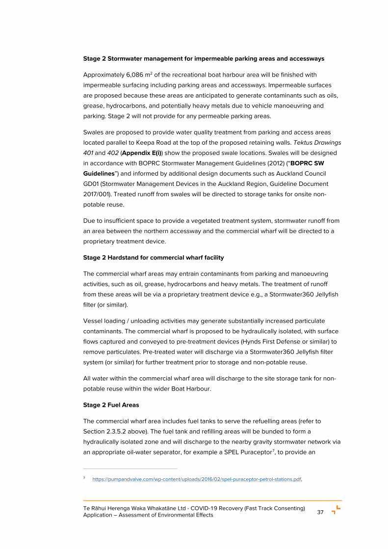
Te Rāhui Herenga Waka Whakatāne Ltd - COVID-19 Recovery (Fast Track Consenting) Application – Assessment of Environmental Effects 37
Stage 2 Stormwater management for impermeable parking areas and accessways
Approximately 6,086 m2 of the recreational boat harbour area will be finished with impermeable surfacing including parking areas and accessways. Impermeable surfaces are proposed because these areas are anticipated to generate contaminants such as oils, grease, hydrocarbons, and potentially heavy metals due to vehicle manoeuvring and parking. Stage 2 will not provide for any permeable parking areas.
Swales are proposed to provide water quality treatment from parking and access areas located parallel to Keepa Road at the top of the proposed retaining walls. Tektus Drawings 401 and 402 (Appendix E(i)) show the proposed swale locations. Swales will be designed in accordance with BOPRC Stormwater Management Guidelines (2012) (“BOPRC SW Guidelines”) and informed by additional design documents such as Auckland Council GD01 (Stormwater Management Devices in the Auckland Region, Guideline Document 2017/001). Treated runoff from swales will be directed to storage tanks for onsite non-potable reuse.
Due to insufficient space to provide a vegetated treatment system, stormwater runoff from an area between the northern accessway and the commercial wharf will be directed to a proprietary treatment device.
Stage 2 Hardstand for commercial wharf facility
The commercial wharf areas may entrain contaminants from parking and manoeuvring activities, such as oil, grease, hydrocarbons and heavy metals. The treatment of runoff from these areas will be via a proprietary treatment device e.g., a Stormwater360 Jellyfish filter (or similar).
Vessel loading / unloading activities may generate substantially increased particulate contaminants. The commercial wharf is proposed to be hydraulically isolated, with surface flows captured and conveyed to pre-treatment devices (Hynds First Defense or similar) to remove particulates. Pre-treated water will discharge via a Stormwater360 Jellyfish filter system (or similar) for further treatment prior to storage and non-potable reuse.
All water within the commercial wharf area will discharge to the site storage tank for non-potable reuse within the wider Boat Harbour.
Stage 2 Fuel Areas
The commercial wharf area includes fuel tanks to serve the refuelling areas (refer to Section 2.3.5.2 above). The fuel tank and refilling areas will be bunded to form a hydraulically isolated zone and will discharge to the nearby gravity stormwater network via an appropriate oil-water separator, for example a SPEL Puraceptor7, to provide an
7 https://pumpandvalve.com/wp-content/uploads/2016/02/spel-puraceptor-petrol-stations.pdf,

Te Rāhui Herenga Waka Whakatāne Ltd - COVID-19 Recovery (Fast Track Consenting) Application – Assessment of Environmental Effects 38
appropriately designed and sized stormwater treatment and spill containment device, fitted with a shut-off valve.
If the configuration of the oil-water separator and the location of the stormwater storage tank preclude discharge via the gravity network, pre-treated runoff from the oil-water separator would then discharge via a Stormwater360 Jellyfish filter system (or similar) for further water quality treatment prior to storage and non-potable reuse. A shut-off valve would be installed upstream of the reuse storage tank, to isolate surface runoff generated at this part of the site and intercept any spills (beyond those contained within the oil-water separator) prior to flows entering the storage tank for non-potable reuse or being conveyed to the wastewater network.
Accidental discharges and spills from this area will be managed through the production of an Emergency Spill Management Plan as a requirement of the Proposed Consent Conditions, after the engagement of a fuel provider for the Boat Harbour.
Stage 2 Stormwater management for vessel maintenance hardstand areas
Vessel maintenance activities on the hardstand and in the hardstand shed (boat washing, blasting, and application of inter-coat, paint, and antifouling) will generate a range of contaminants and a large volume of particulates / suspended solids.
The management of stormwater and waste wash water generated from this portion of the site will follow a treatment train system design. This is intended to maximise water quality treatment and achieve a water quality standard suitable for non-potable reuse. The system will collect all maintenance wash water, including all runoff from any wet processing maintenance activities occurring within the roofed area. The proposed treatment train is shown schematically in Figure 21.
Figure 21: Maintenance hardstand treatment train schematic (Source: Tektus Report)
Runoff from vessel maintenance areas will be collected via catchpits, served by dish drains. Catchpits will direct flows to a pre-treatment system for oil, grease and particulate removal through a proprietary system such as a Hynds First Defence, Stormwater360 Cascade Separator, or similar pollutant removal system.

Te Rāhui Herenga Waka Whakatāne Ltd - COVID-19 Recovery (Fast Track Consenting) Application – Assessment of Environmental Effects 39
A diversion valve will enable stormwater and waste wash water flows to be separated after pre-treatment. After pre-treatment, surface runoff generated during rainfall events exceeding 5 mm will be discharged through a Stormwater360 Jellyfish filter system (or similar) prior to conveyance to storage for non-potable re-use for the Boat Harbour.
A detailed description of the filtration devices is provided in the Tektus Report.
Stormwater Discharge Quality
A stormwater management / treatment system has been proposed, including capture and reuse, to promote ‘better than expected’ solutions ensuing from an integrated and holistic approach to water management. While the particulars will be finalised through the detailed design phase, the proposed water quality treatment system has been developed to exceed industry best practice discharge quality standards where practicable. On that basis, the stormwater management / treatment system for the site has been designed to achieve discharge quality limits as outlined by the Target Thresholds in Table 1 below.
Table 1: Water Quality Discharge Limits - not accounting for dilution or reasonable mixing (Source: Tektus Report)
Contaminant Minimum Threshold
Threshold Source Target Threshold
Temperature, °C 22 BoPRC Guideline 2012/01, Section 6.4.1, slight effect.
22
Gross Pollutants - No threshold provided in BOPRC guidance. Full capture from site
discharges
Total Suspended Solids, g/m³
150 BoPRC Guideline 2012/01, Section 7.3.2. 50
Copper, µg/L 8 ANZECC 2000 guidelines for 80% level of protection within a marine receiving environment
8
Lead, µg/L 12 12
Zinc, µg/L 43 43
Hydrocarbons, mg/l
15 ARC TP10. AC TR2013/035 concluding TPH in stormwater runoff is effectively removed with TSS.
10
The discharge limits identified in the table above have been included in the Proposed Consent Conditions in Appendix G.

Te Rāhui Herenga Waka Whakatāne Ltd - COVID-19 Recovery (Fast Track Consenting) Application – Assessment of Environmental Effects 40
Overall, inclusive of the Stage 3 development area, there will be a reduction in stormwater runoff from the site. The Tektus Report identifies that the pre-development runoff contributes approximately 37,500 m³ of stormwater runoff annually to river via the Keepa Road pump station. Under the proposed scenario, with reduced contributing land area (~3.3 ha) and onsite water collection, storage, and reuse, this is predicted to reduce to approximately 11,300 m³ of stormwater runoff annually.
2.3.7.2 Stage 2 Wastewater Servicing
Given limited existing wastewater servicing in the vicinity of the site, the proposed wastewater servicing for the site relies on a new direct connection to the existing rising main network on the southern side of SH30. This connection would be established in Stage 2 of the Project, and continue to be used through the final Stage 3.
The proposed onsite wastewater systems would incorporate the separation of ‘black water’ (principally toilet and kitchen discharges) from ‘grey water’ flow sources (comparatively clean wastewater from baths, sinks, and washing machines) which would otherwise be combined in a typical wastewater network. This arrangement makes use of the grey water resource for onsite water demands and reduces the pumped flow rate and total discharge volume requirements associated with the black water-only effluent.
Black water from the office, training centre and ablutions facilities in the Boat Harbour will be disposed directly to the existing public network. These facilities can rely on gravity flows to the pump station along the western boundary of the site.
Grey water discharge from these facilities, including all discharge from taps, handbasins, showers, and laundry facilities, will be directed to an onsite treatment facility to achieve sufficient water quality levels before conveyance to onsite storage for non-potable reuse. The grey water treatment system remains subject to detailed design processes.
Wastewater servicing at the berths will be provided by a shared connection per pair of berths to the wastewater pump station on the western boundary of the site. The berths will be connected to the wastewater pump station via 80 mm polyurethane (“PE”) pipes through a network of vacuum pumps before discharging directly to the reticulated network. Tektus Drawing 500 (Appendix E(i)) shows the Project’s wastewater servicing schematic.
2.3.7.3 Stage 2 Water Supply
The Project facilities will rely on a network of both potable and non-potable water supply demands, some of which are significant. Typically, these demands are met with a treated water supply from the public network. However, the Project presents meaningful opportunities for reused and recycled water supply throughout the site.

Te Rāhui Herenga Waka Whakatāne Ltd - COVID-19 Recovery (Fast Track Consenting) Application – Assessment of Environmental Effects 41
The Boat Harbour will be serviced with a potable water service line and a non-potable water line. Potable water will be serviced through the existing reticulated water services provided on Keepa Road and non-potable water will be provided throughout the berths and buildings for boat washing activities. Non-potable water will be harvested through rainwater collection from building roof areas and treated stormwater runoff from the site.
To ensure the different water sources are identifiable, potable water will be provided throughout the site in a blue coloured PE pipe and non-potable water will be provided via a purple coloured PE pipe. Further details of the water reticulation for the Project are provided in Tektus Drawing 600 (Appendix E(i)).
2.3.7.4 Stage 2 Firefighting
There are two existing fire hydrants nearby on Keepa Road available for firefighting water supply. Further onsite firefighting requirements within the building design remain subject to detailed design and will be confirmed through the building consent process after gaining resource consent. Nonetheless, the proposed water storage tanks and adjacent Boat Harbour waters will provide emergency bulk water supply in the event of a fire onsite.
2.3.7.5 Stage 2 Electricity and telecommunications servicing
Existing electricity and telecommunications services are available for connection. The onsite electrical and telecommunication systems remain subject to detailed design processes. Notable requirements include the temporary and permanent relocation of the flood pump power transformer through the three proposed construction stages.
An electrical supply plan has been provided by Horizon Energy and is provided in Appendix F. The existing power switch located on Keepa Road will be upgraded and the site will be sufficiently connected to the electricity supply.
Overall, the Boat Harbour will rely on new and upgraded connections to existing electricity and telecommunications utility services in the vicinity of the site. Amendments to, and relocation of, the existing onsite electricity systems will also be required (including an overhead power pole and power transformer for the flood pump system). These connections remain subject to utility provider approvals and detailed design.
2.3.8 Rubbish and recycling
A refuse area of approximately 30 m2, for rubbish collection and recycling, will be located adjacent to the Stage 2 pump station building. The refuse area will be bunded to ensure there is no runoff for the area, with all runoff directed to a proprietary treatment device.
All waste collection and management is proposed to be in accordance with the requirements of the WDC Waste Management and Minimisation Bylaw 2018 which requires hygienic upkeep, collection, and regular disposal of waste generated from the Boat Harbour. Refuse will be regularly collected by a private contractor and disposed at

Te Rāhui Herenga Waka Whakatāne Ltd - COVID-19 Recovery (Fast Track Consenting) Application – Assessment of Environmental Effects 42
authorised refuse and recycling facilities. The Operational Management Plan will provide for litter collection around the site with management of and responsibility for the site held by the Boat Harbour operations manager.
2.3.9 Lighting
Lighting will be provided for the berths, parking areas and elsewhere around the Boat Harbour, including ablution buildings and access points.
The concept for lighting design at Te Rāhui Herenga Waka Whakatāne is to provide minimal, low intensity lighting compliant with the District Plan permitted activity standards.
All lighting (including signage illumination) will avoid generating horizontal glare and lighting within the site will be downward facing. General activities onsite will typically be limited to the non-curfew hours of 7am – 10pm as identified in the District Plan. The final lighting design will be completed during the detailed design phase of the Project.
2.3.10 Signage
Up to four (4) signs are proposed to be constructed for the Project. As part of Stage 2, three (3) signs, located next to the three site access points, are proposed to be constructed.
Each sign will be a maximum of 6 m high and 2 m wide and will be lit during night-time hours. The final signage design, including lighting, will be confirmed in consultation with the Project Reference Group during the detailed design phase of the Project.
2.3.11 Gateway structure
A main gateway into Te Rāhui Herenga Waka Whakatāne is proposed to be located at one of the site accesses. Siting is to be determined during the detailed design phase, but likely will be at Entrance 3. It is intended that the gateway design will comply with relevant District Plan standards including lighting, signage and building setback requirements.
2.3.12 Stage 2 Access and parking
2.3.12.1 Stage 2 Vehicular Access
The Transport Impact Assessment (“Traffic Assessment”) (refer to Appendix L) by Stantec identifies that four access points to Te Rāhui Herenga Waka Whakatāne are proposed. Of these, three access points will be constructed during Stage 2 as shown in Figure 22, comprising two new vehicle crossings in the northern portion of the site and an upgrade of the existing crossing in the northern portion of the site. The existing vehicle crossing serving the southern portion of the site is to be retained unchanged, providing access to the existing Keepa Road pump station for ongoing operation and maintenance. Each access will be designed to cater for the nature of the vehicles using the entry point. A

Te Rāhui Herenga Waka Whakatāne Ltd - COVID-19 Recovery (Fast Track Consenting) Application – Assessment of Environmental Effects 43
description of the three new access points to be constructed during Stage 2 is provided below:
• Entry 1 is intended for large B Train HN-HO8 access to the commercial wharf within the northern part of the Boat Harbour;
• Entry 2 is intended for general access for private and commercial vehicles that will access the commercial boat harbour, office and training facilities; and
• Entry 3 will only be occasionally accessed to allow for large truck and trailer units to directly access the hardstand maintenance area, particularly large vessels being delivered to the site.
The final vehicle access point design will be confirmed through detailed design. It will be in accordance with the relevant access design specifications of District Plan Chapter 13.
Figure 22: Stage 2 – Commercial Boat Harbour Access locations (Source: Traffic Assessment)
2.3.12.2 Stage 2 Parking
The Traffic Assessment provides an assessment of the required parking spaces for the entire Project and identifies that up to 100 spaces are proposed for the commercial boat harbour and associated activities.
8 HN=Highway Normal Loading HO= Highway Overload Loading.

Te Rāhui Herenga Waka Whakatāne Ltd - COVID-19 Recovery (Fast Track Consenting) Application – Assessment of Environmental Effects 44
The design and layout of the parking areas are shown on Tektus Drawing 200: Overall Layout Plan (Appendix E(i)).
2.3.12.3 Stage 2 Pedestrian access
Pedestrian access will be provided onsite with new connections to the Local Purpose Reserve and Scenic Reserve to be constructed through the northern and southern areas of the site. The proposed pedestrian access route is shown in Figure 23 in green.
Figure 23: Proposed pedestrian access paths (Source: Recreation Assessment)
2.3.13 Stage 2 Landscaping
Landscaping of the site will be provided for as part of the detailed design phase and will be of a scale and amenity sympathetic to the coastal environment. Landscaping for the site will be designed by a suitably qualified specialist in consultation with mana whenua. To the extent possible, all plants will be sourced locally. A requirement for a Landscape Planting Plan has been included in the Proposed Consent Conditions appended to this AEE.
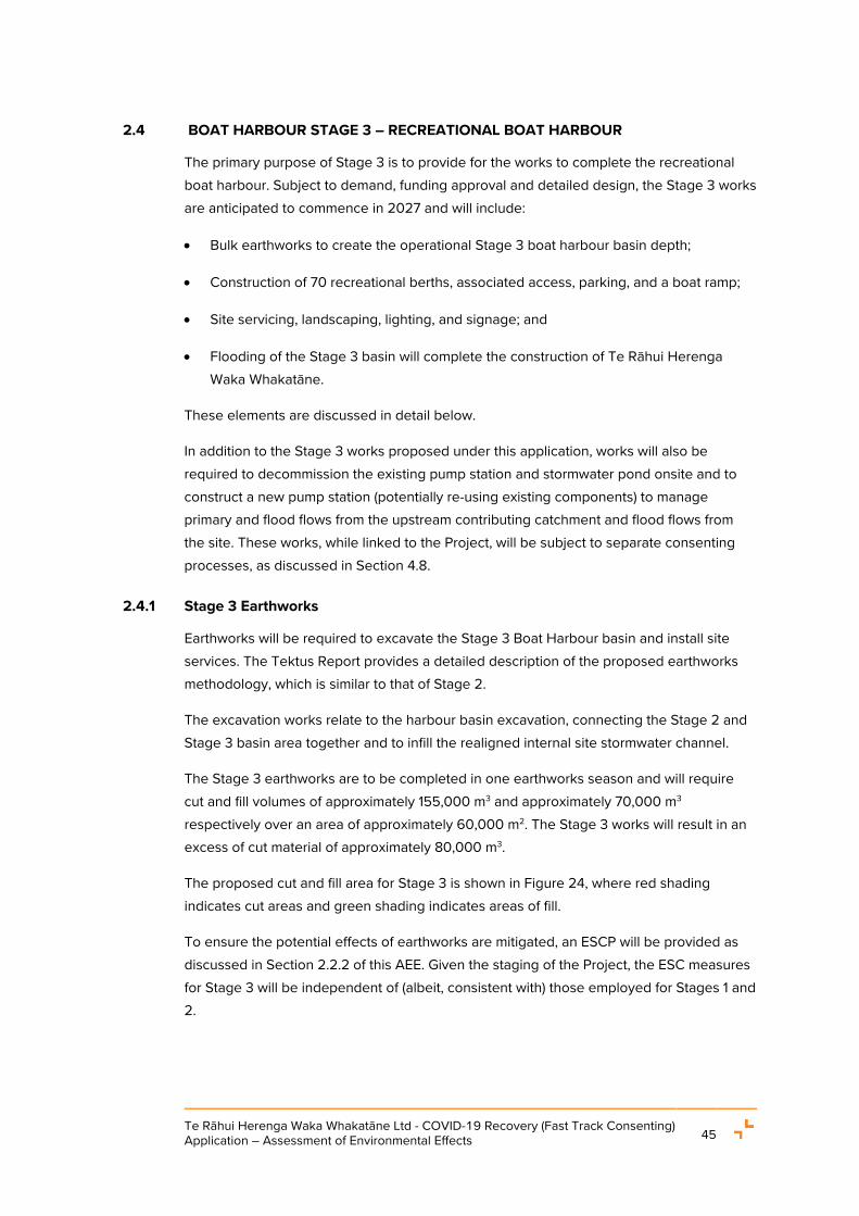
Te Rāhui Herenga Waka Whakatāne Ltd - COVID-19 Recovery (Fast Track Consenting) Application – Assessment of Environmental Effects 45
2.4 BOAT HARBOUR STAGE 3 – RECREATIONAL BOAT HARBOUR
The primary purpose of Stage 3 is to provide for the works to complete the recreational boat harbour. Subject to demand, funding approval and detailed design, the Stage 3 works are anticipated to commence in 2027 and will include:
• Bulk earthworks to create the operational Stage 3 boat harbour basin depth;
• Construction of 70 recreational berths, associated access, parking, and a boat ramp;
• Site servicing, landscaping, lighting, and signage; and
• Flooding of the Stage 3 basin will complete the construction of Te Rāhui Herenga Waka Whakatāne.
These elements are discussed in detail below.
In addition to the Stage 3 works proposed under this application, works will also be required to decommission the existing pump station and stormwater pond onsite and to construct a new pump station (potentially re-using existing components) to manage primary and flood flows from the upstream contributing catchment and flood flows from the site. These works, while linked to the Project, will be subject to separate consenting processes, as discussed in Section 4.8.
2.4.1 Stage 3 Earthworks
Earthworks will be required to excavate the Stage 3 Boat Harbour basin and install site services. The Tektus Report provides a detailed description of the proposed earthworks methodology, which is similar to that of Stage 2.
The excavation works relate to the harbour basin excavation, connecting the Stage 2 and Stage 3 basin area together and to infill the realigned internal site stormwater channel.
The Stage 3 earthworks are to be completed in one earthworks season and will require cut and fill volumes of approximately 155,000 m3 and approximately 70,000 m3 respectively over an area of approximately 60,000 m2. The Stage 3 works will result in an excess of cut material of approximately 80,000 m3.
The proposed cut and fill area for Stage 3 is shown in Figure 24, where red shading indicates cut areas and green shading indicates areas of fill.
To ensure the potential effects of earthworks are mitigated, an ESCP will be provided as discussed in Section 2.2.2 of this AEE. Given the staging of the Project, the ESC measures for Stage 3 will be independent of (albeit, consistent with) those employed for Stages 1 and 2.

Te Rāhui Herenga Waka Whakatāne Ltd - COVID-19 Recovery (Fast Track Consenting) Application – Assessment of Environmental Effects 46
It is proposed that a final Stage 3 ESCP, based on the ESC measures proposed in Tektus Drawing 222 (Appendix E(i)), will be submitted after the contractor is engaged, and in accordance with consent conditions.
Figure 24: Stage 3 earthworks areas (Source: Tektus Report – Engineering Drawings)
2.4.2 Stage 3 Recreational Activities
Up to 70 recreational berths are proposed as part of the Stage 3 development. The final configuration may change based on demand during the detailed design phase. The recreational berth and pontoon design will be similar to Stage 2, consisting of floating pontoons and docks consisting of single/shared service pedestals providing services to berthed vessels. Further details of site servicing are in Section 2.4.5 - 2.4.6 below.
24/7 access to the site will be provided for the recreational berth holders through Entrance 4.
A single storey building containing ablution facilities and the stormwater/wastewater pump station will be located adjacent to Entrance 4, as indicated in Figure 25. The ablution/pump station building will be approximately 260 m2 in area, similar to the design proposed for the Stage 2 pump station building.

Te Rāhui Herenga Waka Whakatāne Ltd - COVID-19 Recovery (Fast Track Consenting) Application – Assessment of Environmental Effects 47
A recreational boat ramp is proposed on the southern area of the truck and trailer parking areas, as indicated in Figure 26 below. The ramp will be approximately 18 m wide with a slope of approximately 12.6% and a launching capacity of 16,000 vessels per year.
A future building platform is shown in Figure 26. This provides for additional buildings on the site, subject to demand and obtaining relevant resource consents.
Figure 25: Vehicular and Pedestrian Access (Source: Traffic Assessment)
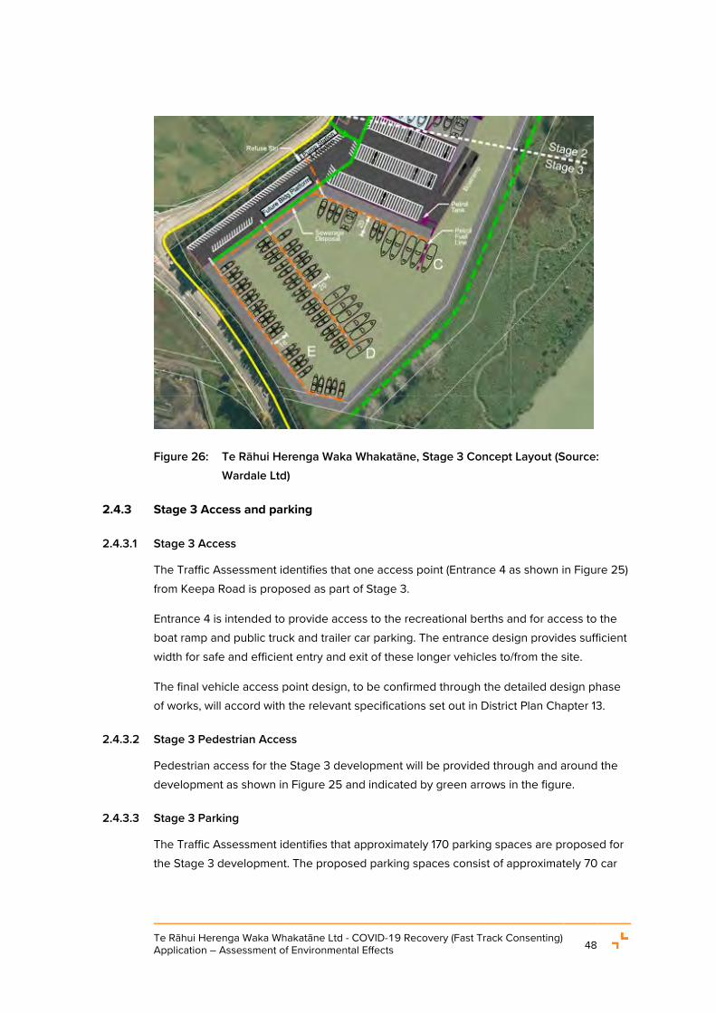
Te Rāhui Herenga Waka Whakatāne Ltd - COVID-19 Recovery (Fast Track Consenting) Application – Assessment of Environmental Effects 48
Figure 26: Te Rāhui Herenga Waka Whakatāne, Stage 3 Concept Layout (Source: Wardale Ltd)
2.4.3 Stage 3 Access and parking
2.4.3.1 Stage 3 Access
The Traffic Assessment identifies that one access point (Entrance 4 as shown in Figure 25) from Keepa Road is proposed as part of Stage 3.
Entrance 4 is intended to provide access to the recreational berths and for access to the boat ramp and public truck and trailer car parking. The entrance design provides sufficient width for safe and efficient entry and exit of these longer vehicles to/from the site.
The final vehicle access point design, to be confirmed through the detailed design phase of works, will accord with the relevant specifications set out in District Plan Chapter 13.
2.4.3.2 Stage 3 Pedestrian Access
Pedestrian access for the Stage 3 development will be provided through and around the development as shown in Figure 25 and indicated by green arrows in the figure.
2.4.3.3 Stage 3 Parking
The Traffic Assessment identifies that approximately 170 parking spaces are proposed for the Stage 3 development. The proposed parking spaces consist of approximately 70 car

Te Rāhui Herenga Waka Whakatāne Ltd - COVID-19 Recovery (Fast Track Consenting) Application – Assessment of Environmental Effects 49
parks for recreational berth users and approximately 100 car and trailer parking for recreational boat owners using the boat ramp.
Most of the Stage 3 area consists of parking and manoeuvring areas. These will be constructed in permeable paving with products like GrassCrete, as shown in Figure 27.
Figure 27: GrassCrete, example permeable paving (Source: Tektus Report)
2.4.4 Stage 3 Stormwater Servicing
Stormwater management for Stage 3 is generally consistent with the approach for Stage 2, with runoff within Stage 3 to be managed through two pump stations.
Rainfall events up to 10% AEP will be serviced by the pump station to be located adjacent to Entrance 4. The existing onsite pump station will be relocated near Entrance 4 to service runoff from 1% AEP rainfall events and flows from Keepa Road and upstream properties9.
Roof runoff and grey water from the ablution block will be collected and treated for reuse within the site in the same manner as for Stage 2.
Approximately 14,500 m2 of the Stage 3 area (including the parking and maneuvering areas) are proposed to be constructed in permeable paving. The runoff from these areas will be captured for reuse in addition to the capture volumes on site from the Stage 2 paved areas. Rainfall events which exceed the infiltration capacity of this paving will be directed via surface flow to catchpits where the stormwater will discharge via the primary gravity network, ultimately to Whakatāne awa. The Tektus Report notes that the BOPRC
9 More detail on existing stormwater servicing / pump station and the upstream properties it services is
provided in Section 3.

Te Rāhui Herenga Waka Whakatāne Ltd - COVID-19 Recovery (Fast Track Consenting) Application – Assessment of Environmental Effects 50
Stormwater Guidelines recognise permeable paving as an effective water quality system for metals, sediment, and TPH due to the infiltration inherently provided by the system and that the in-situ sandy soils on site are well suited to infiltration devices.
The northern area of permeable paving, which forms the recreational berth carparks, will discharge to the relocated Keepa Road pump station. The southern area of the carpark, which provides car and trailer parking and access to the boat ramp, will discharge via gravity to the Boat Harbour waters.
Stage 3 Fuel Areas
A 20,000 L underground petrol fuel storage tank will be located on the southern corner of the truck and trailer parking area supplying the refuelling areas on Berth C as shown in Figure 28. The tank will be installed in accordance with the parameters for underground storage tanks specified in District Plan rule 19.2.1.1(e). On completion, the Emergency Spill Management Plan for the site will be updated to encompass the petrol storage tank.
As for Stage 2, the Stage 3 fuel tank and refilling areas will be bunded and discharge stormwater for treatment through an appropriate oil-water separator. The treated stormwater will then be conveyed to the nearby gravity stormwater network. An appropriately designed and sized stormwater treatment and spill containment device, fitted with a shut-off valve will be provided for stormwater runoff from the Stage 3 fuel areas. This will provide the ability to isolate surface runoff from this portion of the site and the interception of any spills (beyond those contained within the oil-water separator) prior to flows entering the storage tank for non-potable reuse.
Figure 28: Stage 3 – Proposed fuel storage and supply location (Source: Wardale Ltd)

Te Rāhui Herenga Waka Whakatāne Ltd - COVID-19 Recovery (Fast Track Consenting) Application – Assessment of Environmental Effects 51
2.4.5 Stage 3 Wastewater servicing
Wastewater servicing for Stage 3 will be consistent with the servicing regime of Stage 2 whereby wastewater from the berths will be directed to the onsite pump station located next to Entrance 4 via vacuum pump operated pipelines (80 mm PE pipes) and discharged into the public reticulated network available on SH30. Wastewater from the ablution block will discharge directly into the public network. Further detail of the wastewater network is provided in the Tektus Report.
2.4.6 Stage 3 Utility services
Power and telecommunications can be provided to the recreational berths via existing utility services available within the site boundaries and as established as part of Stage 2. These are further discussed in the Tektus Report.
2.4.7 Stage 3 Lighting, signage, landscaping, and rubbish disposal
Lighting, signage, landscaping and rubbish disposal for the site will be similar to that described for the Stage 2 works (refer to Sections 2.3.8- 2.3.13 of the AEE) and will be appropriately designed and operated to ensure high level of amenity is provided for the recreational boat harbour users.
2.5 MANAGEMENT PLANS
A suite of management plans, offered as resource consent conditions, are proposed to ensure the actual and potential effects on the environment are avoided, remedied, or mitigated. The management plans to be prepared and certified are summarised below, while the detail of each management plan is set out in the respective parts of Section 7.
Construction Management
The key management plans associated with the construction activities are the:
• CMP including a CTMP, ESCP and CNVMP;
• SMP;
• Restoration Plan; and
• Landscape Planting Plan.
Operations Management
The key management plans associated with the operation of the Boat Harbour are the:
• Marina Management Plan (referred to herein as the “Operational Management Plan” or “OMP”); and
• Biosecurity Management Plan.

Te Rāhui Herenga Waka Whakatāne Ltd - COVID-19 Recovery (Fast Track Consenting) Application – Assessment of Environmental Effects 52
2.6 CONSIDERATION OF ALTERNATIVES
During the PGF application stage for the Whakatāne Regeneration Programme, several locations were considered to identify the best boat harbour site. A detailed description of the selection and assessment process is provided in the PGF Business Case.
In summary, a long list and short list assessment was completed that produced two options for the Boat Harbour site, as follows and shown in Figure 29 below:
• Option 1: Locate the Boat Harbour to the west of the existing Whakatāne yacht club; and
• Option 2: Locate the Boat Harbour at 2 Keepa Road that materially expands wharf capacity and provides it across the river.
Figure 29: Shortlisted boat harbour sites (Source: PGF Business Case)
2.6.1 Boat Harbour Site
The two boat harbour location options as discussed above were assessed using the Multi Criteria Decision Analysis (“MCDA”) process and methodology. Each of the options were assessed against 23 specific criteria, including non-economic and economic factors.

Te Rāhui Herenga Waka Whakatāne Ltd - COVID-19 Recovery (Fast Track Consenting) Application – Assessment of Environmental Effects 53
The MCDA process clearly revealed that Option 2 (the Keepa Road site) was the preferred option. This was the leading option on almost all of the 23 criteria assessed and was unanimously ranked first by all of the respondents.10
The MCDA process highlighted the importance of several considerations, including cultural aspirations in relation to the existing site, capacity which drives economic outcomes, environmental impacts, and resilience. The Keepa Road option ranked highly against these considerations as it provides sufficient capacity to accommodate long term berthage demands and expansion options, without requiring overbuilding early. It supports development of the tourism precinct in the current wharf area and provides greater resilience for vessels to floods and storms, as the site is outside of the river channel.
In comparison, Option 1 only provided slightly greater berthage capacity than current and anticipated near term demand. Furthermore, building a structure in the river does not align with the aspirations of Ngāti Awa for the awa and there is cultural risk, given the Option 1 location directly adjoins the Ngāti Awa site of significance at He Mātāpuna Paru. Option 1 would also have required removal of mangroves and saltmarsh wetland.
Overall, the Keepa Road site provides materially more berthage capacity compared to Option 1, creates options to further develop cultural and tourism offerings while presenting improved environmental resiliency and much lower environmental impacts.
Figure 30 and Figure 31 below show the two options for the Boat Harbour location.
Figure 30: Boat harbour location Option 1 (Source: PGF Business Case)
10 Page 81, PGF Economic Assessment Report.
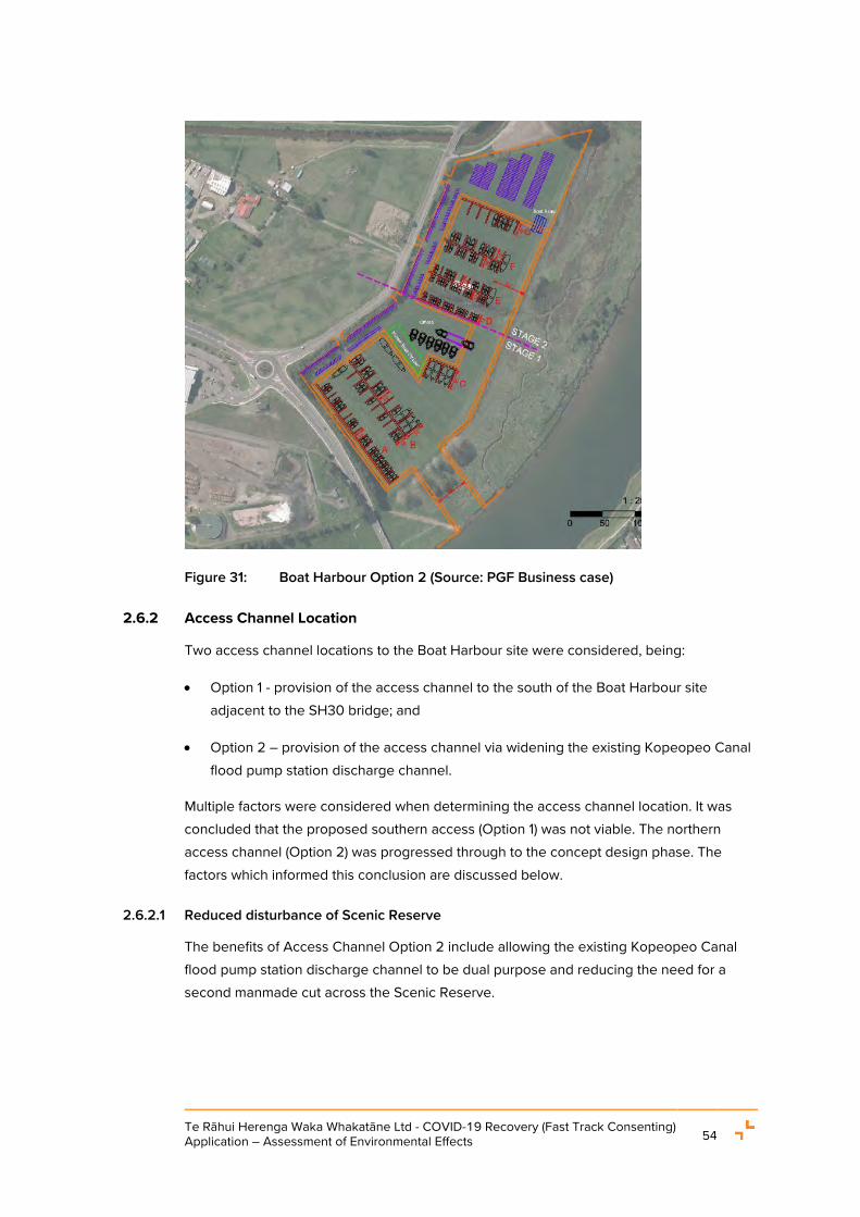
Te Rāhui Herenga Waka Whakatāne Ltd - COVID-19 Recovery (Fast Track Consenting) Application – Assessment of Environmental Effects 54
Figure 31: Boat Harbour Option 2 (Source: PGF Business case)
2.6.2 Access Channel Location
Two access channel locations to the Boat Harbour site were considered, being:
• Option 1 - provision of the access channel to the south of the Boat Harbour site adjacent to the SH30 bridge; and
• Option 2 – provision of the access channel via widening the existing Kopeopeo Canal flood pump station discharge channel.
Multiple factors were considered when determining the access channel location. It was concluded that the proposed southern access (Option 1) was not viable. The northern access channel (Option 2) was progressed through to the concept design phase. The factors which informed this conclusion are discussed below.
2.6.2.1 Reduced disturbance of Scenic Reserve
The benefits of Access Channel Option 2 include allowing the existing Kopeopeo Canal flood pump station discharge channel to be dual purpose and reducing the need for a second manmade cut across the Scenic Reserve.

Te Rāhui Herenga Waka Whakatāne Ltd - COVID-19 Recovery (Fast Track Consenting) Application – Assessment of Environmental Effects 55
2.6.2.2 Navigational Safety Considerations
The Nav Safety Assessment considers the two access channel locations and provides the following commentary:
• The use of the southern access channel option would require placement of additional Aids within the river to mark the channel. That would impact on usable space for recreational craft within this river stretch particularly waka ama and rowing boats;
• The southern access channel location is in an area on the inside bend of the river compared with the relatively straight stretch of river for the proposed northern access channel;
• The shallow water at the southern access channel location has the potential to create a hazard to navigation and as the depth at particular locations will alter with ongoing sedimentation, this was also identified as a potential hazard to navigation; and
• The primary concern with the southern channel is its location close to the SH 30 bridge. The southern access channel would meet the river at a point approximately 100 m from this bridge. Thus, vessels transiting this channel, and potentially waiting for the channel to be clear of other vessels, will be navigating in close proximity to the bridge. The Whakatāne River is reported to be tidal at this point and in times of strong flood tides and/or strong north through to east winds, there may an appreciable force in the direction of the bridge. Thus, there is the potential for vessels experiencing difficulties, such as engine failure or underestimating the effect of the wind or tide, to collide with the bridge. Such collisions would create problems, not only for the vessel, but also for the greater community as there is the possibility of causing damage to the bridge, which is critical for the transport network of the region.
Overall, from a navigation safety perspective, the south access channel does not provide a feasible or functional option for access to the Boat Harbour.
2.6.2.3 Minimised disturbance of recreational river space
The Recreation and Tourism Effects Assessment (“Recreation Assessment”) (refer to Appendix M) prepared by Rob Greenaway and Associates, identifies that the section of river between the north and southern access points currently provides a high value recreational space.
When considering the impacts of the two access channel locations on other river users, the Recreation Assessment concludes that the northern option, as proposed, is the preferable option. This option presents a reduced scale of potential conflict with existing Whakatāne River users as a result of the Boat Harbour users having to travel less distance upstream into the section of the river that has the highest use by other users (including

Te Rāhui Herenga Waka Whakatāne Ltd - COVID-19 Recovery (Fast Track Consenting) Application – Assessment of Environmental Effects 56
rowers and waka ama). Additionally, the northern access provides a reduced travel distance – in terms of fuel use and time – for boat harbour vessels.
In particular, the northern access will reduce the distance vessel’s using the site have to travel up river, into an area where use is dominated by recreational rowing / waka ama users, thus minimising the risk of conflict between vessels using the Boat Harbour and existing recreational uses of the river (rowing, waka ama and kayaking) to a greater extent than the southern access option would.
2.6.2.4 Stakeholder feedback
In consultation with NZTA about the access options, feedback was obtained that Access Channel Option 2 (northern option) was preferred. This was due to NZTA preferring any dredging and establishment of structures to be away from the SH30 bridge, Further, concerns were raised by NZTA that placing the Boat Harbour access closer to the SH30 bridge would generate increased vessel activity with a potential adverse impact on future bridge operational and upgrade/maintenance requirements.
2.6.2.5 Minimised hydrology impact
Option 1 would result in greater adverse hydrology effects on the river as the shallower river depth would need additional capital dredging and more frequent maintenance dredging.
2.6.2.6 Ecological restoration opportunities
Option 2 enables historic dredging sediment deposited on the side of the Kopeopeo Canal flood pump station discharge channel to be removed and remediated. While within background levels, traces of dioxin have been found within the Kopeopeo Canal flood pump station discharge channel. The northern access channel construction will enable sediment contaminated with dioxin to be removed from the river environment.
2.6.2.7 Construction and operational costs
The southern access (Option 2) would require additional Aids to be installed and maintained and would result in increased construction and maintenance dredging requirements with greater impacts to river hydrology. All of these additional works lead to considerable increased maintenance costs to the ongoing operation of the Project which may impact its viability for no additional gain. In this regard the southern access option (Option 1) was not preferred.
2.6.3 Alternatives assessment conclusion
Regarding the Boat Harbour location, the MCDA process, and consultation with the community and key stakeholders, identified that the proposed boat harbour site at 2 Keepa Road is the best practicable option for the Boat Harbour activity.

Te Rāhui Herenga Waka Whakatāne Ltd - COVID-19 Recovery (Fast Track Consenting) Application – Assessment of Environmental Effects 57
Regarding the access channel, following a comparison of the northern and southern boat harbour access options it was concluded the southern access channel location was not practically feasible and the northern access (Option 2) was progressed through to the concept design phase.

Te Rāhui Herenga Waka Whakatāne Ltd - COVID-19 Recovery (Fast Track Consenting) Application – Assessment of Environmental Effects 58
3. DESCRIPTION OF THE SITE AND SURROUNDING ENVIRONMENT
This section of the AEE is provided in accordance with clause 9(1)(b) of Schedule 6 of the Covid Act and provides a description of the site and surrounding area.
The site is depicted in the Tektus Drawing 001 Overall Layout Plan the Tektus Report Attachment A Engineering Design Plans in Appendix E(i).
3.1 TE RĀHUI HERENGA WAKA WHAKATĀNE SITE
3.1.1 Zoning, Overlays and Designations
The following zones, overlays and designations apply to the site under the relevant statutory documents.
• Zones
• District Plan – the Rural Plains Zone (“RPZ)11 applies to the Boat Harbour site. The Coastal Protection Zone (“CPZ”)12 applies to land within the access channel alignment and to the recreated wetland area;
• RCEP
• Coastal Environment13; and
• CMA – the ‘river mouth’ is approximately 650 m downstream of the Landing Road Bridge. This is adjacent to the northern extent of the Project. The CMA boundary is delineated by the SH 30 bridge.
11 The Rural Plains Zone includes land which has the potential for high value production due to the inherent
characteristics of the land including high ratings for versatility under the New Zealand Land Resources Inventory System (i.e. versatile land). The primary purpose of this zone is to retain the characteristics of the finite land resource and protect the rural production potential and economic growth of the District. There is also a need to provide for other activities which have a fundamental need to be located within the zone.
12 The CPZ is a strip of land adjacent to the Coastal Marine Area along the coastline and part of the Whakatāne River, where development or use may have a direct effect on the visual amenity and/or ecology of the coast, harbour and river margins. The Zone may also provide a level of protection against coastal hazard events. This zone will predominantly be an open space zone, not generally intended for development. The CPZ will apply between the Mean High Water Springs and any other defined zoned boundary to any land above the Mean High Water Springs on the margins of the coast or any Ōhiwa Harbour islands within the Coastal Marine Area, that are not otherwise shown on the Planning Maps. Land by the Whakatāne Harbour that is not zoned will adopt the zoning of adjacent land. Land zonings shall apply to the centre line of the water body.
13 Includes all of the coastal marine area, land inland to the point defined in Maps 17-35 in Appendix I to the RPS, the natural and physical resources within it, and the atmosphere above it.

Te Rāhui Herenga Waka Whakatāne Ltd - COVID-19 Recovery (Fast Track Consenting) Application – Assessment of Environmental Effects 59
• Overlays
• RCEP - An Indigenous Biological Diversity Area14 (“IBDA-A44”) applies to the area
which includes the Whakatāne River and part of the adjacent land located on the river side of the stopbank adjacent to the site (through which the access channel will pass through) and the Whakatāne River downstream of the Landing Road Bridge; and
• District Plan - A District Plan Significant Indigenous Biodiversity Site (reference BS138A) is generally contiguous with the extent of the IBDA-A44 discussed above.
• BOPRC Designation D112 - BOPRC Flood Control Reserve extends on the land to immediately to the east of the site and includes a stopbank protection structure. Consequently, the Floodway and Drainage Bylaw is relevant to any works within this area.
14 IBDA_A44 - Locations that meet the criteria contained in Policy 11(a) of the NZCPS, which directs the
avoidance of adverse effects on certain biological diversity (biodiversity) values (RCEP, pg. 27).

Te Rāhui Herenga Waka Whakatāne Ltd - COVID-19 Recovery (Fast Track Consenting) Application – Assessment of Environmental Effects 60
Figure 32: District Plan Map - Site shown in polygon located in the Rural Plains Zone. Yellow area is the Coastal Protection Zone; Black hatching is the Significant Biodiversity Area; Blue hatching is the Ngāti Awa Statutory Acknowledgement over the river.

Te Rāhui Herenga Waka Whakatāne Ltd - COVID-19 Recovery (Fast Track Consenting) Application – Assessment of Environmental Effects 61
Figure 33: RCEP map - The yellow line indicates the boundary of the Coastal Environment. The IBDA-A44 extent is shown in black hatching. The blue line is the defined 'river mouth'. The CMA boundary is delineated by the SH 30 bridge.
3.1.2 Overview
The site is located on the true left bank of the Whakatāne River, immediately downstream of the Landing Road bridge and adjacent to the Keepa Road and Landing Road/ SH 30 intersection (refer to Figure 34).
The Scenic Reserve and BOPRC stopbank adjoin the eastern boundary of the site. The Whakatāne River adjoins the eastern boundary of the Scenic Reserve.
The site and wider area east of the stopbank has a long history of modification and has previously been used as a disposal site for wood waste material/ timber peelings from the Whakatāne Mill. While this activity ceased some time ago, the material remains in situ both
at the site and throughout the adjacent wetland and in parts of the IBDA-A44.

Te Rāhui Herenga Waka Whakatāne Ltd - COVID-19 Recovery (Fast Track Consenting) Application – Assessment of Environmental Effects 62
Figure 34: Site location (Source: Whakatāne District Council GIS)
The site is an irregular shape and is predominantly flat. It is approximately 11 ha in area and comprises two similarly sized areas of pasture/crops, separated by a stormwater drainage channel, located near the centre of the site.
The stormwater channel flows from the western boundary of the site and exits the site, via a pump station, on the western boundary through the BOPRC stopbank.
The site also includes a small triangular land parcel located across SH30 to the south-west of the main parcel. This application does not propose to develop the small triangular parcel.
The site boundaries are fenced, and the site is currently used for maize cropping (Figure 35).

Te Rāhui Herenga Waka Whakatāne Ltd - COVID-19 Recovery (Fast Track Consenting) Application – Assessment of Environmental Effects 63
Figure 35: View to the south western site boundary (source: Wardale Limited)
3.1.3 Coastal Marine Area - Mean High Water Springs and common marine and coastal area
The location of the CMA and mean high water springs (“MHWS”) is important to the context of the Project. The locations of both the CMA and MHWS in relation to the Project has been discussed in the Legal Covering Letter and further detail is provided below.
3.1.3.1 Mean High Water Springs
The CMA is defined as the area of foreshore, seabed and coastal water, and the air space above the water, of which the seaward boundary is the outer limits of the territorial sea and of which the landward boundary is the line of MWHS, except where that line crosses a river (in which case the landward boundary is whichever is the lesser of 1 kilometre upstream from the mouth of the river or the point upstream that is calculated by multiplying the width of the river mouth by 5).
As stated previously, BOPRC has defined the landward boundary at the SH30 Bridge where it crosses the river, and the river mouth is shown to be some 650m downstream (see Figure 33).
The T&T Coastal Assessment identifies that based on tide levels recorded at the Whakatāne Wharf, MHWS at this location is 0.84m NZVD-16. Figure 36 shows the level of MHWS along the river and estuary at the site. MHWS generally follows the toe of the stopbanks and in discrete locations, aligns with the banks of drainage channels and adjoining low lying areas.

Te Rāhui Herenga Waka Whakatāne Ltd - COVID-19 Recovery (Fast Track Consenting) Application – Assessment of Environmental Effects 64
Figure 36: Location of the MHWS based on topographic survey data (Source: T&T Coastal Assessment)
3.1.3.2 Common marine and coastal area
In addition to the MWHS and CMA, understanding the common marine and coastal area15 is also of importance to the Project as, under s 12(2)(a) RMA, no person may, unless expressly allowed by a national environmental standard, a rule in a regional coastal plan or in any proposed regional coastal plan for the same region, or a resource consent, occupy any part of the common marine and coastal area.
Under the RMA, the common marine and coastal area has the meaning given in section 9(1) of the Marine and Coastal Area (Takutai Moana) Act 2011 (“MACAA”).
As the access channel is located within the DOC Scenic Reserve area it is covered by s2(b)(iii) of the MACAA and therefore, is not common marine and coastal area.
Additionally, regarding the Boat Harbour site, “specified freehold land” is defined in s 2 of the MACAA as including any land that, immediately before the commencement of the
15 Common marine and coastal area has the meaning given in section 9(1) of the Marine and Coastal Area
(Takutai Moana) Act 2011. The MACAA (s 2) defines common marine and coastal area as the marine and coastal area other than— (a) specified freehold land located in that area; and (b) any area that is owned by the Crown and has the status of any of the following kinds: (i) a conservation area within the meaning of section 2(1) of the Conservation Act 1987: (ii) a national park within the meaning of section 2 of the National Parks Act 1980: (iii) a reserve within the
meaning of section 2(1) of the Reserves Act 1977;

Te Rāhui Herenga Waka Whakatāne Ltd - COVID-19 Recovery (Fast Track Consenting) Application – Assessment of Environmental Effects 65
MACAA, is Māori freehold land within the meaning of section 4 of Te Ture Whenua Māori Act 1993.
Accordingly, the Boat Harbour site is covered by the “specified freehold land” exception and, once flooded, does not meet the definition of common marine and coastal area.
3.1.4 Vegetation
As detailed in the Wildlands Terrestrial Report and shown in Figure 49, vegetation on the landward side of the stopbank consists of planted exotic grassland used for maize farming activities, shelterbelts, and mixed indigenous-exotic woody riparian plantings. The shelterbelts are located on the western Keepa Road boundary and the southern SH30 boundary of the site. They consist of a mixture of she-oak and various planted indigenous species including karo, Coprosma repens, tōtara and kahikatea.
Some exotic invasive or pest species are established on the site including tree privet, Chinese privet and Phoenix palm. Riparian planting is present along the open drain that bisects the site, consisting of mixed indigenous and woody species and weeds such as pampas and gorse.
3.1.5 Access, Roading and Traffic
The existing roading and traffic environment is fully described in the Traffic Assessment and is summarised below.
3.1.5.1 Road environment
Figure 37 below shows the site location with respect the surrounding road network. The site has frontage to SH30 and to Keepa Road however there is no vehicle access to the site from SH30. SH30 is classified as a Regional Arterial Road in the District Plan and links Whakatāne with Rotorua to the west. It also provides a connection to State Highway 2 which is classified as a National Arterial Road.
Keepa Road is a two-way road with a posted speed limit of 80km/h. There are two 3.5m lanes with edge lines and a dashed centreline. There is a shared pathway (unformed gravel path) on the true right-hand side of Keepa Road for pedestrians and cyclists. Keepa Road is generally level with a gently winding horizontal alignment and it forms the primary access route to the coastal communities at Coastlands and Piripai.
Keepa Road meets SH30 at a large roundabout controlled intersection. Keepa Road widens to provide two lanes on the approach to the roundabout. SH30 has been constructed as a four-lane, median divided road between Keepa Road and Phoenix Drive, about 450m to the west, which provides the primary access to the retail centre and also some industrial activity. East of the Keepa Road roundabout, SH30 narrows to two lanes as it crosses the river over the Landing Road bridge.

Te Rāhui Herenga Waka Whakatāne Ltd - COVID-19 Recovery (Fast Track Consenting) Application – Assessment of Environmental Effects 66
Keepa Road is currently classified as a District Local Road. The primary function of a local road is property access. However, with the long-term growth in traffic volumes that has been forecast on Keepa Road , its function in the road hierarchy will become more consistent with a District Arterial Road which connect communities with the Regional Arterial Road network.
Figure 37: Site location (Source: Stantec Traffic Report)
3.1.5.2 Traffic numbers
The Annual Average Daily Traffic (“AADT”) volumes recorded on State Highway 30 at the Waka Kotahi count site 03000229 west of Keepa Road. It shows that daily traffic volumes were about 14,000 vehicle movements per day (“vpd”) over the 2010-14 period and rose to about 18,000 vpd in 2019. There has been a subsequent fall volumes in 2020 which can be attributed to the reduced travel because of the COVID 19 pandemic.
Looking at traffic flows in November 2020 for SH30, on weekdays, the hourly traffic volumes exhibit a commuter travel type profile with distinct morning and evening peaks. During the morning peak period, the hourly volumes reached about 1,800 vehicle movements per hour (“vph”). The evening peak hour volume was about 2,000 vph. The hourly profiles show a different profile at the weekend and have a single broad peak of about 1,500 vph during the middle of the day.
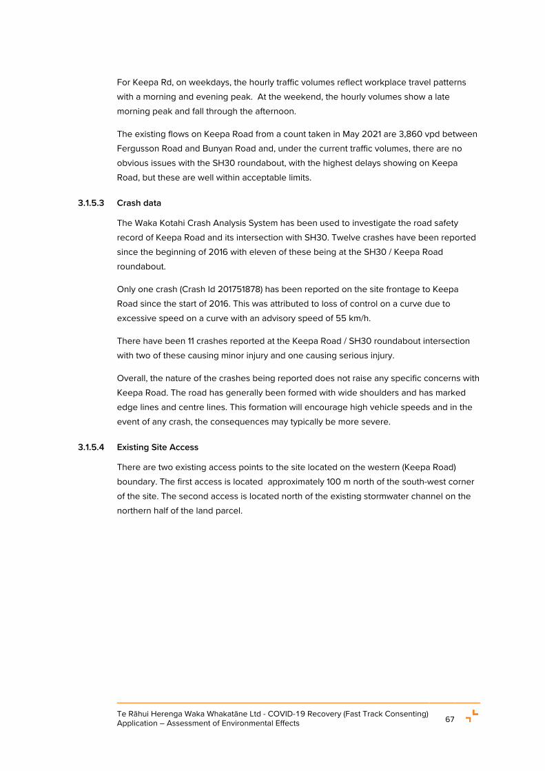
Te Rāhui Herenga Waka Whakatāne Ltd - COVID-19 Recovery (Fast Track Consenting) Application – Assessment of Environmental Effects 67
For Keepa Rd, on weekdays, the hourly traffic volumes reflect workplace travel patterns with a morning and evening peak. At the weekend, the hourly volumes show a late morning peak and fall through the afternoon.
The existing flows on Keepa Road from a count taken in May 2021 are 3,860 vpd between Fergusson Road and Bunyan Road and, under the current traffic volumes, there are no obvious issues with the SH30 roundabout, with the highest delays showing on Keepa Road, but these are well within acceptable limits.
3.1.5.3 Crash data
The Waka Kotahi Crash Analysis System has been used to investigate the road safety record of Keepa Road and its intersection with SH30. Twelve crashes have been reported since the beginning of 2016 with eleven of these being at the SH30 / Keepa Road roundabout.
Only one crash (Crash Id 201751878) has been reported on the site frontage to Keepa Road since the start of 2016. This was attributed to loss of control on a curve due to excessive speed on a curve with an advisory speed of 55 km/h.
There have been 11 crashes reported at the Keepa Road / SH30 roundabout intersection with two of these causing minor injury and one causing serious injury.
Overall, the nature of the crashes being reported does not raise any specific concerns with Keepa Road. The road has generally been formed with wide shoulders and has marked edge lines and centre lines. This formation will encourage high vehicle speeds and in the event of any crash, the consequences may typically be more severe.
3.1.5.4 Existing Site Access
There are two existing access points to the site located on the western (Keepa Road) boundary. The first access is located approximately 100 m north of the south-west corner of the site. The second access is located north of the existing stormwater channel on the northern half of the land parcel.
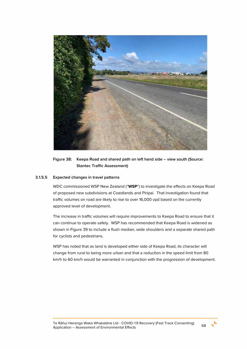
Te Rāhui Herenga Waka Whakatāne Ltd - COVID-19 Recovery (Fast Track Consenting) Application – Assessment of Environmental Effects 68
Figure 38: Keepa Road and shared path on left hand side – view south (Source: Stantec Traffic Assessment)
3.1.5.5 Expected changes in travel patterns
WDC commissioned WSP New Zealand (“WSP”) to investigate the effects on Keepa Road of proposed new subdivisions at Coastlands and Piripai. That investigation found that traffic volumes on road are likely to rise to over 16,000 vpd based on the currently approved level of development.
The increase in traffic volumes will require improvements to Keepa Road to ensure that it can continue to operate safely. WSP has recommended that Keepa Road is widened as shown in Figure 39 to include a flush median, wide shoulders and a separate shared path for cyclists and pedestrians.
WSP has noted that as land is developed either side of Keepa Road, its character will change from rural to being more urban and that a reduction in the speed limit from 80 km/h to 60 km/h would be warranted in conjunction with the progression of development.

Te Rāhui Herenga Waka Whakatāne Ltd - COVID-19 Recovery (Fast Track Consenting) Application – Assessment of Environmental Effects 69
Figure 39: Proposed Keepa Road upgrade cross-section (Source: WSP)
3.1.6 Existing servicing
Reticulated wastewater, stormwater and potable water services are located at Keepa Road available for connection to the site. There are existing power poles located to the north of the site. These features are shown in Figure 40 and Figure 41 below.
Figure 40: Existing servicing at the site (Source: Whakatāne District Council GIS).

Te Rāhui Herenga Waka Whakatāne Ltd - COVID-19 Recovery (Fast Track Consenting) Application – Assessment of Environmental Effects 70
Figure 41: Existing power pole onsite (Source: Whakatāne District Council GIS)
3.1.7 Existing Stormwater Infrastructure and consents
There is an existing stormwater pump station located approximately in the middle of the eastern boundary of the site, referred to as the Keepa Road stormwater pump station, shown in Figure 38 and Figure 42. This is a WDC asset, ID 104123 (WDC GIS). There are various consents and a Consent Order applicable to the Keepa Road stormwater pump station.
A stormwater and leachate disposal system were required by the 1986 consent authorising use of the site for solid waste (wood waste) disposal. Engineering plans for a pump station were approved in 1986, and an associated water right was granted in 1987. However, the Keepa Road stormwater pump station was not built at that time. The issue was revisited in the mid-2000s and in 2008 the Environment Court made enforcement orders by consent which required Carter Holt Harvey to design and construct a pump station and associated drainage system to a specified capacity. Subsequently, BOPRC granted resource consents authorising the Keepa Road stormwater pump station discharge and activities within the bed of the Whakatāne River (RC 65604) and the Keepa Road stormwater pump station was constructed. RC 65604 was later transferred from Carter Holt Harvey to WDC. Various easements (granted by the Māori Land Court) provided for the establishment and ongoing operation of the Keepa Road stormwater pump station, which primarily services the stormwater requirements of the land block and the neighbouring landowners on the western side of Keepa Road (“Lysaght Property”).

Te Rāhui Herenga Waka Whakatāne Ltd - COVID-19 Recovery (Fast Track Consenting) Application – Assessment of Environmental Effects 71
Figure 42: Keepa Road Stormwater Pump Station
Given the location of the pump station within the proposed footprint of the development, Tektus were asked to assess and identify a recommended approach for the long-term options for the Keepa Rd Pump Station. The Tektus Report16 provides an assessment of five different options. The options were identified on the operational basis that each option needed to provide stormwater servicing to a level to maintain water levels within the upstream catchment in accordance with the Consent Order.
Tektus identified that the option of relocating the Keepa Rd Pumpstation adjacent to Keepa Rd as part of the Stage 3 works, central to the site (aligned with existing drainage swale), as the recommended approach.
As set out in the Legal Covering Letter and identified in Section 4.8, any changes to the stormwater infrastructure and / or discharge is subject to a separate consent process. Additionally, the final design for the approach would need to be developed further.
3.1.8 Site contamination
The site appears on the BOPRC Hazardous Activities and Industries List register as an ‘Unverified HAIL – Landfill’ however, the exact location and extent of the contamination is unknown.
The HAIL DSI Report provides a detailed description and assessment of potential contamination on and around the site. The report concludes that in general all soil contamination testing results returned concentrations within acceptable limits and will not pose a risk to human health. Soil gas from wood waste material was also tested and found to be at a level considered highly unlikely to pose a risk to human health.
16 Tektus Report, Section 2.5, Table 4.
Te Rāhui Herenga Waka Whakatāne Ltd - COVID-19 Recovery (Fast Track Consenting) Application – Assessment of Environmental Effects 72
3.1.9 Geology of the site and access channel area
The HAIL DSI Report identifies that organic silt topsoil fill is found on the site between the surface level to a depth of 0.15 m, grey, mottled organ-brown sandy silt fill found between 0.15 m to 0.75 m depth and orange wood peelings with variable sand and silt fill material found between 0.75 m to 2.1 m deep.
The HAIL DSI Report identifies that below 2.1 m depth, the geology of the area around the site and the access channel area consists of typic fluvial recent soils of the Rangitaiki family being shallow well-drained sandy loam becoming increasingly stony with depth and with a high leaching risk. The site is underlain by Holocene River deposits being alluvial gravel, sand, silt, mud and clay with local peat, including modern riverbeds.
3.1.9.1 Geology of the wetland restoration area
To confirm the geology and the extent and volume of wood waste in the proposed wetland restoration area, HAIL undertook ten hand auger investigations. It was found that the proposed wetland restoration area contains a layer of degraded wood waste between 0.2 m – 0.4 m thick and overlain by 0.1 m - 0.3 m of silty clay. The wood waste comprised sawdust and bark. Except for material found in one hand auger location,17 the wood waste was found to have no visual or olfactory evidence of contamination
Overall, the analysis indicated that zinc, nickel, copper, chromium and dioxins were present in a concentration above background levels but below rural residential Soil Contaminant Standards and based on the above investigation, the wetland restoration area requiring approximately 6,800 m3 of wood waste and soil requiring removal is not considered to be contaminated however, the excavation works would be undertaken in accordance with the proposed SMP which sets out a protocol in the event that any unexpected contamination discovered.
3.2 THE SURROUNDING ENVIRONMENT
The surrounding environment consists of a mix of commercial, industrial, wetland/reserve and river/coastal environment. Te Hokowhitu a Tū ki te Rāhui Marae is located approximately 200 m west of the site. Across SH30 to the south is the Whakatāne Mill site and the south-eastern areas of the HUB site containing large format retail and commercial activities such as Farmers, Harvey Norman and Bunnings retailers.
3.2.1 Cultural Significance
The site and wider area are located within the rohe of Ngāti Awa, and its hapū, and the site itself is primarily Māori freehold land owned by the Trust. The cultural significance / associations of the site and wider area to Ngāti Awa and its hapū, and the Trust is set out
17 Being HA1, refer to the HAIL assessment for the location of HA1.

Te Rāhui Herenga Waka Whakatāne Ltd - COVID-19 Recovery (Fast Track Consenting) Application – Assessment of Environmental Effects 73
in the TRLT Supporting Statement and the Cultural Impact Assessment -Te Rūnanga o Ngāti Awa Assessment of Proposed Boat Harbour Te Rāhui Herenga Waka, Whakatāne (“the CIA”) respectively (Appendix B and Appendix N) and are summarised below.
3.2.1.1 The Trust
The TRLT Supporting Statement sets out the cultural values the Trust holds over the whenua and wider taiao and identifies that the Trust, as the landowners, hold a unique perspective both as tangata whenua and as shareholders of the Māori owned land to which the Project relates. The cultural values held by landowners in connection with the whenua and surrounding environment are therefore determined by both ancestral and contemporary relationships. The key cultural values which apply are:
• Rangatiratanga - expressed by the Trust in providing the necessary leadership and participation to navigate self-determined futures on behalf of the owners;
• Kaitiakitanga – playing a key role in sustaining mauri (life force) through the exercise of their inherited responsibility as Kaitiaki;
• Whanaungatanga – playing a key role in supporting relationships both internally (as whanau) and externally with Project Partners and the wider community;
• Manaakitanga - is expressed through the collective ethic to demonstrate care, support and respect for people and to engage in the economy in a way that empowers equitable distribution of benefits; and
• Kotahitanga - the importance of a Project governance structure designed to ensure a collective approach with iwi / hapū.
3.2.1.2 Statutory Acknowledgement area
The Ngāti Awa Statutory Acknowledgment includes the Whakatāne river from the mouth of the river to the confluence with an unnamed stream as shown in Figure 43 below.

Te Rāhui Herenga Waka Whakatāne Ltd - COVID-19 Recovery (Fast Track Consenting) Application – Assessment of Environmental Effects 74
Figure 43: Ngāti Awa Whakatāne River Statutory Acknowledgement Area
The Ngā Whakaaetanga-ā-Ture ki Te Taiao ā Toi (Statutory Acknowledgements in the Bay of Plenty) is an attachment to the RPS and Regional Plans. It incorporates statutory acknowledgements arising from Treaty of Waitangi settlement legislation negotiated between the Crown and iwi in the Bay of Plenty region and provides (at Chapter 3, section 3.7) Ngāti Awa’s Statement of Association with the Whakatāne River in relation to the cultural, spiritual, historical, and traditional association of the Whakatāne River Statutory Acknowledgement area. The Statement of Association records that one of the founding ancestors of Ngāti Awa, Tīwakawaka lived at the mouth of the Whakatāne River. The naming of various features, including rocks in the Whakatāne River, reflects the succession of explorers and ancestors who live along the Whakatāne River. The Ngāti Awa people used the Whakatāne River to access sacred sites along its banks.
In addition to the statutory acknowledgment, the CIA also identifies that:
• Whakatāne River was also valued by Ngāti Awa as:
• A place for gathering food including eels, kakahi, oysters, fish, shellfish (pipi, cockles), and whitebait, as well as artisan resources; and

Te Rāhui Herenga Waka Whakatāne Ltd - COVID-19 Recovery (Fast Track Consenting) Application – Assessment of Environmental Effects 75
• A transportation route for goods, initially by waka, and later by schooner and other boats, to and from the inland settlements across the eastern Bay of Plenty and other far-off places via the sea.
• One waahi taonga site, Toitoihuia, is present (within =/-100m from the icon shown in Figure 44 below) ‘to the east of the Whakatāne Board Mills near the approach to the Whakatāne Bridge. This area was once abundant with extensive toitoi on its banks and was a fishing and white baiting area for the inhabitants of nearby Pupuaruhe pa.’
Figure 44: Image showing the approximate location of Toitoihuia (Source: Ngāti Awa CIA)
Further discussion about the association of Ngāti Awa with the Whakatāne River and how the Project relates to Ngāti Awa is provided in the CIA.
3.2.2 Whakatāne River
3.2.2.1 Whakatāne River Hydrology
The Whakatāne River catchment covers over 1,100 km2 and extends 112 km to its upper tributaries. The DHI Water and Environment Ltd ‘Te Rāhui Herenga Waka Whakatāne Development, Numerical Modelling Report’ (“DHI Report”) (Appendix O), identifies that the

Te Rāhui Herenga Waka Whakatāne Ltd - COVID-19 Recovery (Fast Track Consenting) Application – Assessment of Environmental Effects 76
mean flow for Whakatāne River is 57.2 m3/s and the seven-day five-year low flow is 8.8 m3/s.
Additionally, the DHI Report identifies the BOPRC previously calculated that the peak flow for a mean annual flood event in the Whakatāne River is 876 m3/s and a 1% AEP peak river flow of 2820 m3/s. Further details of the river hydrology are provided in the DHI report.
3.2.2.2 Whakatāne Estuary
The Whakatāne River receives saltwater via the ocean tides and therefore, the freshwater environment is heavily influenced by a saltwater wedge which has its lowest extent at the bridge and can extend many kilometres upstream of the bridge. This reach of the river is therefore identified as being within the Whakatāne River estuary.
The Wildlands Marine and Freshwater Ecology Report identifies that the precise upstream extent of the Whakatāne estuary is unknown, although saltwater is known to penetrate during spring high tides at least as far inland as the Whakatāne Transfer and Recycling Centre which is located approximately 5.7 kilometres upstream of the SH30 bridge and approximately 6.5 kilometres upstream of the proposed site access channel.
3.2.2.3 Whakatāne River Water Quality
The Hail Environmental Water Quality Investigation Report (“Hail WQ Report”) (refer to Appendix P), provides an overview of the baseline water quality for the Whakatāne River based on the water quality data from BOPRC environmental monitoring at a site 300 m
downstream of the SH30 Bridge (Site KM938159, -37° 57′ 21″, 76° 58′ 34″).
Overall, baseline water quality of the Whakatāne River in the proximity of the site was generally good, being generally characterised by low nutrient concentrations, moderate to high Dissolved Oxygen (“DO”) concentrations, and low to moderate TSS concentrations, turbidity and microbiological counts.
3.2.2.4 Existing Whakatāne River Dredging Consent
WDC has an existing dredging consent (resource consent 65217) that provides for dredging of the Whakatāne River navigational channel within the HDZ and Opihi Spit/Entrance area.
A review of the dredging activities which occurred between 2015 - 2020 found that an annual average of 2,333 m3 was undertaken for the navigational channel area and an annual average of 1,300 m3 for the Opihi Spit/ Entrance area for the same time period. It is noted that resource consent 65217 allows for 30,000 m3 per annum for the navigational channel area and 25,000 m3 for the Opihi Spit/ Entrance area so the actual dredged volume is only a fraction of the consented volume.

Te Rāhui Herenga Waka Whakatāne Ltd - COVID-19 Recovery (Fast Track Consenting) Application – Assessment of Environmental Effects 77
3.2.3 BOPRC Local purpose reserve
The Local Purpose Reserve located to the east and northern area to the site is vested in BOPRC for soil conservation and river protection purposes. The Kopeopeo Canal, located to the north of the site, was contaminated by dioxin-containing discharges from the former Whakatāne Mill. Significant remediation to the canal was undertaken in 2018 to remove sediments contaminated with dioxin. The sediments were placed in the remediation areas located to the north of the site, known as the Kopeopeo Canal Containment Site 3 (“CS 3”) and shown in Figure 45 as ‘Area 4’.
Figure 45: Contaminated areas near the site (Source: HAIL DSI Report)
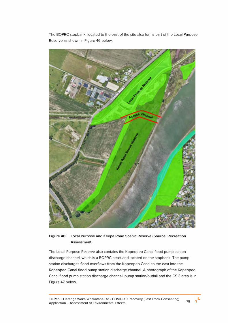
Te Rāhui Herenga Waka Whakatāne Ltd - COVID-19 Recovery (Fast Track Consenting) Application – Assessment of Environmental Effects 78
The BOPRC stopbank, located to the east of the site also forms part of the Local Purpose Reserve as shown in Figure 46 below.
Figure 46: Local Purpose and Keepa Road Scenic Reserve (Source: Recreation Assessment)
The Local Purpose Reserve also contains the Kopeopeo Canal flood pump station discharge channel, which is a BOPRC asset and located on the stopbank. The pump station discharges flood overflows from the Kopeopeo Canal to the east into the Kopeopeo Canal flood pump station discharge channel. A photograph of the Kopeopeo Canal flood pump station discharge channel, pump station/outfall and the CS 3 area is in Figure 47 below.

Te Rāhui Herenga Waka Whakatāne Ltd - COVID-19 Recovery (Fast Track Consenting) Application – Assessment of Environmental Effects 79
Figure 47: View of containment site and stormwater channel in the Keepa Road Scenic Reserve (Source: Wardale Limited).
3.2.4 Scenic Reserve
As shown in Figure 46 above, the Scenic Reserve is located between the stopbank and the Whakatāne River and includes the Kopeopeo Canal flood pump station discharge channel, which is the proposed access channel location for the Boat Harbour.
The Scenic Reserve is a 7 ha, flat, low-lying strip of land approximately 150 m wide at the north end and 100 m wide at the southern end. The Scenic Reserve area comprises part of the wider IBDA-A44 and a SIBS under the RCEP and the District Plan respectively. The extent of the IBDA-A44 Whakatane Estuary, which includes some of the Project works areas and the DOC Scenic Reserve, is shown in Figure 48 below.
Figure 48: IBDA-A44 extent (BOP RCEP Map 24b)

Te Rāhui Herenga Waka Whakatāne Ltd - COVID-19 Recovery (Fast Track Consenting) Application – Assessment of Environmental Effects 80
Wetlands with varying degrees of estuarine influence are located in the northern three-quarters of the Scenic Reserve and wood waste has historically been dumped on top of the wetlands in these northern parts of the reserve.
The wetland areas are surrounded by rank exotic grassland with local areas of exotic and indigenous trees and shrubs and a few small areas of scattered pampas within rank grassland. Local exotic trees such as willows and poplars are also present.
The southern quarter of the Scenic Reserve is mostly rank exotic grassland with exotic trees and shrubs. An estuarine channel is present, 1 m – 2 m deep with steep banks and rank exotic grasses on both sides.
3.2.4.1 Site contamination within the Scenic Reserve
As identified in the HAIL DSI Report, traces of dioxin contaminated material were found in the Kopeopeo Canal flood pump station discharge channel within ‘Area 1’ shown in Figure 45 as well as un-remediated wood waste material in the area.
Based on the laboratory analysis results, dioxin and heavy metal elements in the proposed access channel are within background range. Accordingly, material excavated from the Kopeopeo Canal flood pump station discharge channel and adjacent land can be disposed of as clean fill or used as a capping layer over the proposed wood waste repository.
3.2.4.2 Flora
The Wildlands ‘Further Assessment Of Ecological Effects For A Proposed Boat Harbour And Associated Access Channel At Keepa Road, Whakatāne’ (“Terrestrial Ecology Assessment” (refer to Appendix Q)) identifies twenty-six (26) indigenous species and forty-three (43) introduced flora in the site and around the Scenic Reserve. The survey area and identified habitats are shown in Figure 49.
3.2.4.3 Avifauna
Wildlands surveyed avifauna around the site, including the neighbouring IBDA-A44 and river margins, on 20 June 2019. Sixteen (16) indigenous species and seven (7) introduced species were recorded.
It was advised that three (3) other bird species (matuku/Australasian bittern, mohopereru/banded rail, and puweto/spotless crake) may utilise the wetland area occasionally. However, these were not recorded during the survey in June 2019.
Six (6) of the recorded bird species have threat classifications as follows:
• Kāruhiruhi/pied shag (Phalacrocorax varius varius): At Risk Recovering;
• Little black shag (Phalacrocorax sulcirostris): At Risk-Naturally Uncommon;

Te Rāhui Herenga Waka Whakatāne Ltd - COVID-19 Recovery (Fast Track Consenting) Application – Assessment of Environmental Effects 81
• Kōtuku-ngutupapa/royal spoonbill (Platalea regia): At Risk-Naturally Uncommon;
• Tarāpunga/red-billed gull (Larus novaehollandiae scopulinus): At Risk-Declining;
• Taranui/Caspian tern (Hydroprogne caspia): Threatened-Nationally Vulnerable; and
• Mātātā/North Island fernbird (Bowdleria punctata vealeae): At Risk-Declining.
Schedule 2, Table 1 of the RCEP provides a list of the avifauna subject to a New Zealand Threat Status and estuaries that are an originally rare ecosystem type. Of the listed avifauna in Table 1, three (3) bird species were recorded at the site during Wildlands’ site survey in 2019. These were:
• Caspian tern (Threatened – Nationally Vulnerable);
• North Island fernbird (At Risk- Declining); and
• Little black shag (At Risk – Naturally Uncommon).
A full list of the avifauna recorded by the Wildlands survey is provided in the Terrestrial Ecology Assessment.

Te Rāhui Herenga Waka Whakatāne Ltd - COVID-19 Recovery (Fast Track Consenting) Application – Assessment of Environmental Effects 82
Figure 49: Ecological habitat around the site and surrounding areas (Source: Wildlands Terrestrial Ecology Assessment)
3.2.5 Freshwater and marine ecology
Wildlands were engaged to conduct a freshwater and marine ecology assessment for the Project which resulted in the production of the report titled ‘Assessment of Potential Marine and Freshwater Ecological Effects for a Proposed Boat Harbour at Keepa Road,

Te Rāhui Herenga Waka Whakatāne Ltd - COVID-19 Recovery (Fast Track Consenting) Application – Assessment of Environmental Effects 83
Whakatāne’ (“Marine / Freshwater Ecology Assessment”) refer to Appendix R)). The assessment area for the freshwater and marine ecology assessment was the area between the SH30 bridge and downstream to the coast. The Marine / Freshwater Ecology Assessment refers to this assessment area as the Whakatāne estuary’ or ‘the estuary’’.
3.2.5.1 Freshwater fish species and habitat
The aquatic environment adjoining the site is below the CMA boundary, thus is technically coastal water. Nonetheless, it is also potential habitat for “freshwater” species that use this interface. The Marine / Freshwater Ecology Assessment states that the freshwater fish species likely to reside in the Whakatāne estuary are:
• Common bully (Gobiomorphus cotidianus);
• Common smelt (Retropinna retropinna);
• Inanga (Galaxias maculatus);
• Giant bully (Gobiomorphus gobioides);
• Longfin eel (Anguilla dieffenbachii);
• Shortfin eel (Anguilla australis); and
• Brown trout (Salmo trutta).
The Marine / Freshwater Ecology Assessment notes that only common bully and giant bully and inanga are likely to spawn in the estuary, and spawning is more likely to occur upstream of the SH30 bridge. Other fish species recorded upstream in the Whakatāne River are unlikely to find suitable habitat in the estuary.
In relation to freshwater habitat in the Project area, the Marine / Freshwater Ecology Assessment states that the Whakatāne estuary lacks complex cover preferred by indigenous freshwater fishes. The riverbed is dominated by a muddy substrate that offers little cover. Most rocky or vegetative cover is along the river margins but is uncovered when daily tidal fluctuations draw the river away from the banks. This tidal fluctuation also nearly empties the estuarine channels in the wetland areas, providing little continuous edge or stream habitat for freshwater fish.
For these reasons, the Marine / Freshwater Ecology Assessment state that the estuary is of relatively minor importance as a ‘place of residence’ habitat for indigenous freshwater fish.
3.2.5.2 Freshwater invertebrates
The Marine / Freshwater Ecology Assessment concludes that freshwater vegetation is limited in the estuary, and freshwater invertebrate fauna are unlikely to be present in

Te Rāhui Herenga Waka Whakatāne Ltd - COVID-19 Recovery (Fast Track Consenting) Application – Assessment of Environmental Effects 84
significant numbers, due to the saline, turbid water. It notes that kōura (freshwater crayfish) and kākahi (freshwater mussel) have not been recorded in the Whakatāne catchment.
However, invertebrate fauna were observed amongst rip rap on the bank opposite the proposed access channel during a site visit on 27 January 2021. These consisted of estuarine species, such as estuarine crabs (Helice sp.) and mudflat snails (Amphibola sp.).
3.2.5.3 Marine ecology
The Marine / Freshwater Ecology Assessment identifies that the Whakatāne estuary supports diverse flora and fauna, including species of high ecological and cultural value that utilise the marine and estuarine habitats. The presence of kuku (greenlip mussel) beds in the vicinity of the lower estuary and pinnacle rocks at the estuary entrance is a particularly notable feature, due to the cultural importance of this species.
The invertebrate faunal communities that were most recently reported to be present within the intertidal and subtidal habitats comprise common and widely distributed species that are adapted to the changeable environmental conditions within the estuary.
It is likely that a variety of marine fish species use the estuary on a temporary or permanent basis. Marine fish species that are important as kaimoana and likely to use the estuary habitat at times include kuparu/john dory (Zeus japonicas), tāmure/ snapper (Pagrus auratus), kahawai (Arripis trutta), tarakihi (Nemadactylus macropterus), haku/kingfish (Seriola lalandi lalandi), araara/trevally (Caranx georgianus), kanae/grey mullet (Mugil cephalus), yellow-eyed mullet (Aldrichetta forsteri), and patiki/sand flounder (Rhombosolea plebeia).
Parore (Girella tricuspidata) is present at the estuary entrance and further upstream18. Kōura (Jasus edwardsii) may be present in rocky habitat at the estuary entrance.
The Marine / Freshwater Ecology Assessment identified that none of the shellfish beds identified during recent field surveys are harvestable. Small and juvenile pipi and huangi/cockles were noted in subtidal channel areas.
The estuary is visited occasionally by common dolphins and fur seals and on very rare occasions by other, less common, marine mammals. There are no resident marine mammal populations in the vicinity of the estuary.
18 W.B. Shaw, pers. obs.
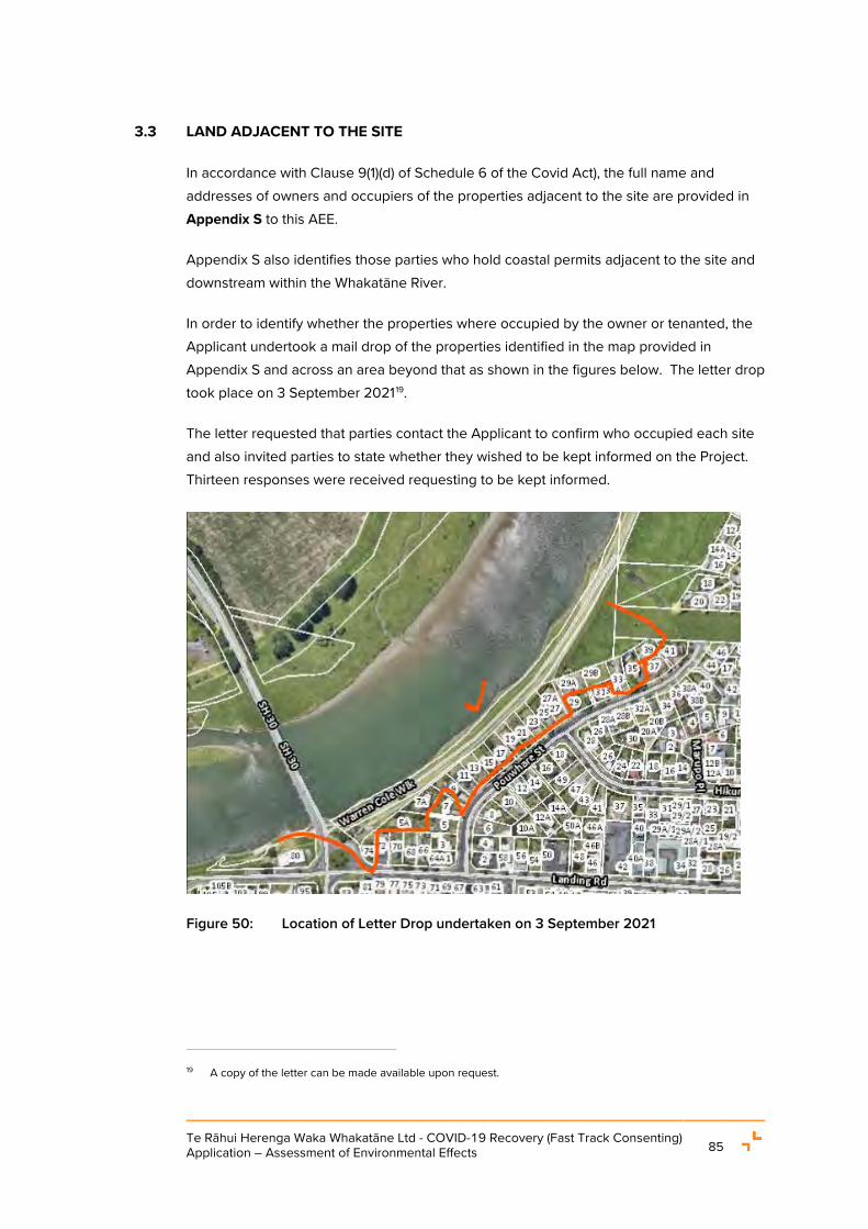
Te Rāhui Herenga Waka Whakatāne Ltd - COVID-19 Recovery (Fast Track Consenting) Application – Assessment of Environmental Effects 85
3.3 LAND ADJACENT TO THE SITE
In accordance with Clause 9(1)(d) of Schedule 6 of the Covid Act), the full name and addresses of owners and occupiers of the properties adjacent to the site are provided in Appendix S to this AEE.
Appendix S also identifies those parties who hold coastal permits adjacent to the site and downstream within the Whakatāne River.
In order to identify whether the properties where occupied by the owner or tenanted, the Applicant undertook a mail drop of the properties identified in the map provided in Appendix S and across an area beyond that as shown in the figures below. The letter drop took place on 3 September 202119.
The letter requested that parties contact the Applicant to confirm who occupied each site and also invited parties to state whether they wished to be kept informed on the Project. Thirteen responses were received requesting to be kept informed.
Figure 50: Location of Letter Drop undertaken on 3 September 2021
19 A copy of the letter can be made available upon request.

Te Rāhui Herenga Waka Whakatāne Ltd - COVID-19 Recovery (Fast Track Consenting) Application – Assessment of Environmental Effects 86
Figure 51: Location of Letter Drop undertaken on 3 September 2021

Te Rāhui Herenga Waka Whakatāne Ltd - COVID-19 Recovery (Fast Track Consenting) Application – Assessment of Environmental Effects 87
4. RULE ASSESSMENT AND STATUTORY REQUIREMENTS
4.1 INTRODUCTION
This section of the application is provided in accordance with clauses 9(1)(h), 9(2), 9(3)(a) and 9(6)(a) of Schedule 6 to the Covid Act.
The Project area, and the range of activities required to construct, operate and maintain the Boat Harbour, traverse land, freshwater and coastal environments on the margins of, and in, the Whakatāne River. As such, the relevant planning instruments are the:
• Bay of Plenty Regional Policy Statement (“RPS”);
• Whakatāne District Plan;
• Bay of Plenty Regional Coastal Environment Plan (“RCEP”);
• Bay of Plenty Regional Natural Resources Plan (“RNRP”);
• Resource Management (National Environmental Standards for Freshwater) Regulations 2020 (“NES FW”); and
• Resource Management (National Environmental Standard for Assessing and Managing Contaminants in Soil to Protect Human Health) Regulations 2011 (“NES CS”).
The relevant provisions of these instruments are summarised below.
4.2 REGIONALLY SIGNIFICANT INFRASTRUCTURE
The Project’s status as ‘Regionally Significant Infrastructure’ (“RSI”) under the RPS is fundamental to its activity status. This is particularly relevant under the RCEP and the NES FW, as the Project proposes works in the wetland area (on the eastern side of the stopbank in the Scenic Reserve) and in the IBDA-A44.
Relevantly for the Project, the RPS defines RSI as follows [emphasis added]:
Is infrastructure of regional and/or national significance and includes:
• …
• Commercial port areas including Tauranga Harbour and its channels necessary for the operation of ports and adjoining land and storage tanks for bulk liquids. …

Te Rāhui Herenga Waka Whakatāne Ltd - COVID-19 Recovery (Fast Track Consenting) Application – Assessment of Environmental Effects 88
The identification of ‘commercial port areas’ as RSI provides sufficient specificity that the Project, particularly the Stage 1 development, which focuses on the provision of commercial marine / port related activities20, meets the definition of RSI.
This is also supported by Policy CE 15B (Recognising secondary ports) of the RPS, which recognises the significance of a functioning port in Whakatāne, stating [emphasis added]:
Recognising secondary ports - Recognise the local and regional significance of ports at Whakatāne and Ōpōtiki and take into account their social and economic benefits, including the need to maintain navigation channels.
Explanation - The region’s secondary ports contribute to the wellbeing of their communities.
Policy CE 15B requires recognition of their existing and potential benefits in decision-making. Ōpōtiki and Whakatāne Ports are located in river estuaries and require ongoing dredging in order to maintain safe vessel access.
Overall, given the Project will be located in Whakatāne (Policy CE 15B) and Stage 1 proposes the development of a commercial boat harbour and supporting infrastructure for commercial marine / port related activities (commercial berthing for aquaculture and tourism, loading and unloading facilities, land-based marine industry activities, marine training centres, boat maintenance, etc.), the Project meets the RPS definition of RSI. The BOPRC’s Principal Advisor (Consents) has reviewed and confirmed that the BOPRC supports this interpretation21. As such, this interpretation is used in the rule assessment below where relevant.
4.3 WHAKATĀNE DISTRICT PLAN
The District Plan resource consents requirements are set out in the tables below. Table 2 sets out the resource consents sought for construction activities. Table 3 sets out the resource consents required for ongoing and operational activities at the Boat Harbour.
20 RCEP Definition for Port Related Activities - Industrial and commercial activities that for operational purposes
require a location near the Port, including: • Commercial fishing facilities;
• Marine berthage and storage, construction, repair, servicing and maintenance facilities – including the Tauranga Bridge Marina;
• Bulk fuel supply infrastructure including terminals, wharflines and pipelines;
• Handling, storage, processing, and transportation of cargo; and
• Navigational aids and equipment. 21 By way of email from Ella Tennent, Principal Advisor (Consents) for Bay of Plenty Regional Council dated 26
August 2021.

Te Rāhui Herenga Waka Whakatāne Ltd - COVID-19 Recovery (Fast Track Consenting) Application – Assessment of Environmental Effects 89
Table 2: Consents Sought for Construction Activities under the WDP
Activity Rule Status Comment
Whakatāne District Plan – Construction Activities
Chapter 3 Zone Descriptions, Activity Status, Information Requirements and Criteria for Resource Consents
Earthworks in the Rural Plains Zone
Rule 3.3.2.4 Discretionary activity
Earthworks for the Stage 2 and 3 Boat Harbour basin excavation, Stage 2 internal stormwater channel re-alignment works, and Stage 2 access road construction (for maintenance of the Stage 2 stormwater pump station) will require excavation within 12 m from the stopbank.
This infringes Rule 18.2.2.1(c), which limits earthworks within 12 m of a BOPRC stopbank in relation to the removal of soil (including but not limited to digging of a drain).
Chapter 11 General Provisions
Earthworks in the CPZ that exceed 200 m2 and 100 m3
during any 12-month period.
Rule 11.2.3.2 Restricted discretionary activity
The proposal will require approximately 16,000 m2 of disturbance, including approximately 3,650 m3 of cut and 3,650 m3 of fill in the CPZ.
This infringes Permitted Activity Rule 11.2.2.2.
Chapter 15 Indigenous Biodiversity
Indigenous vegetation clearance within a SIBS-A of up to 2,000 m2 per year, where the sum of all disturbances does not exceed 2 ha or 10% of the
Rule 15.2.1.7 Non-complying activity
Approximately 0.1 ha of vegetation clearance is required to construct the access channel in the SIBS BS138A.

Te Rāhui Herenga Waka Whakatāne Ltd - COVID-19 Recovery (Fast Track Consenting) Application – Assessment of Environmental Effects 90
Activity Rule Status Comment
scheduled feature on that site within a Schedule A area.
Modification of any natural landform, earthworks, deposition of fill or excavation within a scheduled feature in the SIBS-A area.
Rule 15.2.1.12 Non-complying activity
Access channel works and wetland remediation works will require earthworks in the SIBS BS138A area.
Table 3: Consents Sought for Ongoing Activities under the WDP
Activity Rule Status Comment
Whakatāne District Plan - Ongoing activities
Chapter 3 Zone Descriptions, Activity Status, Information Requirements and Criteria for Resource Consents
Operational Noise
Noise from all proposed activities shall not exceed the noise limits specified in Table 11:1 when measured at any point within the receiving zones of the Industrial, Light Industry, CPZ and Rural Plains Zone.
Rule 3.3.2.4 Discretionary activity
Operational noise in the CPZ results in minor infringements of Permitted Activity Rule 11.2.6.1 as follows:
• Night-time vessel movements will exceed the CPZ noise limit by 5 dB LAeq.
• Daytime maintenance activities will exceed the CPZ noise limit by 3 dB LAeq.
Signs
A maximum of one sign with an area of 3 m2 and maximum height of 6 m is permitted in the Rural Plains Zone.
Rule 3.3.2.4. Discretionary activity
Proposed signage infringes Permitted Activity Rule 11.2.19.1 as follows:
• Four signs are proposed.
• Each sign has an area of 12 m2.

Te Rāhui Herenga Waka Whakatāne Ltd - COVID-19 Recovery (Fast Track Consenting) Application – Assessment of Environmental Effects 91
Activity Rule Status Comment
• The signs may include illuminated imagery.
• A culturally designed gateway structure is proposed as a signpost for the Boat Harbour. This gateway structure will be designed in the detail design phase and consent is sought as the 6 m height may be exceeded.
Diesel Fuel Storage Rule 3.3.2.4 Discretionary activity
A 75,000 litre above ground diesel tank is proposed as part of Stage 2.
This infringes the Exempted Activities Rule 19.2.1.1(e) which limits the Permitted retail sale and storage of diesel to no more than 50,000 litres, and in underground, not above ground, storage tanks.
“Marine precinct activities”22 in the Rural Plains Zone.
Rule 3.4.1.1.47 Discretionary activity
All proposed operational activities onsite (for both Stages 1 and 2) are consistent with the definition of “marine precinct activities”.
Chapter 7 Rural Zone
Building Height
Buildings in the Rural Plains Zone on lots larger than 5,000 m2 in area shall not exceed 12 m in height.
Rule 7.2
Discretionary activity
The boat maintenance shed is proposed to be 12 m in height. However, the proposal includes raising existing ground level by up to 3.5 m across the proposed building location to match the existing BOPRC stopbank height.
22 Marine Precinct Activities: The District Plan defines Marine Precinct Activities as marina structures and
activities, vessel haul-out, fuelling and storage activities, boat ramps, marina offices, ancillary retail, café and commercial services and associated car parking, landscaping, infrastructure, and subdivision.

Te Rāhui Herenga Waka Whakatāne Ltd - COVID-19 Recovery (Fast Track Consenting) Application – Assessment of Environmental Effects 92
Activity Rule Status Comment
A total height of 15.5 m will result from the combined raised ground level and building height.
As such, the boat maintenance shed will exceed the Rural Plains Zone 12 m maximum building height by 3.5 m.
Distance to Boundaries
No building exclusive of artificial crop protection structures and crop support structures shall be located within 25m of all boundaries provided that;
…
f. all buildings shall be set back from the Mean High Water Springs a minimum distance of 20m plus the prescribed distance to a boundary in Rule 7.2.3.1.
Rule 7.2.3.5
Restricted discretionary activity
Consent is required to authorise the following infringements of the setbacks specified at Rule 7.2.3.1 Distance to Boundary are proposed:
• The Stage 1 pump station building will infringe the required 25 m front yard setback by approximately 22 m.
• The Stage 2 pump station building will infringe the required 25 m front yard setback by approximately 22 m.
• The Stage 1 training centre building will infringe the required 25 m front yard setback by 1.5 m.
• The Training Centre / Office will infringe the required 20 m setback from Mean High Water Springs by approximately 5 m.
• Retaining walls greater than 1.5 m in height are considered buildings by the District Plan. Retaining walls of 0.5 m to 3 m height are proposed along the western site boundary but are proposed to be terraced at a maximum wall height of 1.5 m.

Te Rāhui Herenga Waka Whakatāne Ltd - COVID-19 Recovery (Fast Track Consenting) Application – Assessment of Environmental Effects 93
Activity Rule Status Comment
Chapter 19 Hazardous Substances
Hazardous Facility
Any activity involving a hazardous substance; the sites at which and structures within which hazardous substances are used, stored, handled or disposed of; ….
19.2.2(c) Discretionary activity
The Project includes the construction of and provision for the above ground storage of up to 75,000 L of diesel fuel (hazardous substance) within the Commercial Boat Harbour development.
Regarding the ‘Effects Ratio’ (Rule 19.2.3), a conservative approach has been taken and a discretionary activity status has been applied to the activity pursuant to Rule 19.2.2(c).
4.4 REGIONAL PLANS
The activities requiring resource consents under the RNRP and RCEP are set out below. Table 4 sets out the resource consents sought for construction activities and
Table 5 sets out the resource consents required for ongoing operational activities.
Table 4: Consents Sought for Construction Activities under the RNRP and RCEP
Activity Rule Status Comment
RNRP – Construction activities outside of the CMA
Earthworks
Earthworks that are not a permitted, controlled or restricted discretionary activity under the RNRP are a discretionary activity.
LM R4 Discretionary activity
The proposal includes:
Earthworks exceeding 1 ha and 5,000 m3. A total area of approximately 125,000 m2 and a cut to fill volume of 290,000 m3 is proposed over the entire site (including the access channel area and new wetland area).
Earthworks in the Riparian Management Zone

Te Rāhui Herenga Waka Whakatāne Ltd - COVID-19 Recovery (Fast Track Consenting) Application – Assessment of Environmental Effects 94
Activity Rule Status Comment
exceeding 500 m2 area and 500 m3 volume.
Land and Soil Disturbance by Vegetation clearance
Disturbance of land and soil from vegetation clearance in the Riparian Management Zone on slopes no greater than 35 degrees where the activity does not comply with the permitted threshold in LM R7 is a restricted discretionary activity.
LM R9 (Rule 2B) Restricted discretionary activity
Vegetation clearance exceeding the permitted threshold of 400 m2 is proposed in association with works to create the Boat Harbour access channel and new wetland area.
Contaminated soil disturbance
Disturbance of a contaminated site by a volume greater than 400m3.
DW R25 (Rule 35)
Restricted discretionary activity
All soil within the site and the access channel is expected to be cleanfill. However, consent is conservatively sought to accommodate the unforeseen disturbance of contaminated material.
If contaminated material is found it will be sent to an authorised disposal site, if an appropriate, sustainable alternative disposal method cannot be found.
Modification of a wetland
The modification of a wetland located in the bed of a river, the disturbance, removal, damage of any plant or the habitats of any plants or animals in the wetland is a discretionary activity.
Rule WL R9 (Rule 85).
Discretionary activity
The proposal will result in the loss of 0.1 ha of wetland (disturbance, removal, damage of plant/habitat) and creation of 0.9 ha of new wetland area.

Te Rāhui Herenga Waka Whakatāne Ltd - COVID-19 Recovery (Fast Track Consenting) Application – Assessment of Environmental Effects 95
Activity Rule Status Comment
RCEP – Construction Activities within the CMA
New Regionally Significant Infrastructure in an Indigenous Biological Diversity Area-A
Rule SO 14. Non-complying activity
The proposal includes widening and deepening the Kopeopeo Canal flood pump station discharge channel to form the access channel for the Boat Harbour. It also requires the placement of hard protection structures along the banks of the access channel within an IBDA-A44 area but below the MHWS line.
Disturbance, deposition and extraction in Indigenous Biological Diversity Area A and areas of Outstanding Natural Character – specific circumstances
The:
1. Disturbance of the foreshore or seabed
2. Deposition of material on the foreshore or seabed, including
3. Disposal of spoil
4. Removal of sand, shell, shingle and minerals from the foreshore or seabed
5. Dredging of the foreshore or seabed
In an IBDA-A, a Discretionary Activity status applies to dredging and
Rule DD 15 Discretionary activity
The proposal requires:
• Capital dredging in the Whakatāne River (IBDA-A44 in the CMA) to provide safe navigation for the vessels using the river to access the Boat Harbour via the access channel; and
• Dredging / excavation of the seabed and foreshore of the Kopeopeo Canal flood pump station discharge channel to create the access channel.

Te Rāhui Herenga Waka Whakatāne Ltd - COVID-19 Recovery (Fast Track Consenting) Application – Assessment of Environmental Effects 96
Activity Rule Status Comment
disturbance of the foreshore and seabed for:
[…] (e) the maintenance or enhancement of navigational safety in permanently navigable harbour waters; and
(f) Dredging and other disturbance of the foreshore and seabed in the existing artificial watercourses
Take, damming and diversion of coastal water
Rule TD 4 Discretionary activity
The proposal will require damming and diversion of coastal water to flood the Boat Harbour.
Table 5: Consents sought for Ongoing Activities under the RCEP
Activity Rule Status Comment
RCEP – Ongoing Activities
Structures and use in the coastal marine area
Rule SO 13 Discretionary activity
Following the construction of the Boat Harbour, the basin will be flooded with coastal water hence the area becomes CMA. Therefore, the proposal includes the construction and use of berthing structures, floating pontoons, and supporting structures within the CMA within the Boat Harbour basin.
Note: Consent is not sought for the occupation of the structures as the Boat

Te Rāhui Herenga Waka Whakatāne Ltd - COVID-19 Recovery (Fast Track Consenting) Application – Assessment of Environmental Effects 97
Activity Rule Status Comment
Harbour site does not meet the definition of common marine and coastal area (refer to Section 3.1.3.2).
New Regionally Significant Infrastructure in an Indigenous Biological Diversity Area A or an Area of Outstanding Natural Character
Rule SO 14 Non-complying activity
The proposal includes the operation and maintenance of new RSI, being the access channel revetment, within IBDA-A44 in the CMA.
Note: Consent is not sought for the occupation of the structures as the Boat Harbour site does not meet the definition of common marine and coastal area (refer to Section 3.1.3.2).
Stormwater discharge into coastal waters from the Boat Harbour
Rule CD 7 Restricted Discretionary – Discharge of stormwater to coastal water
Restricted discretionary activity
The proposal includes:
• Stormwater discharges from the Boat Harbour that will exceed 125 litres per second for a 10-minute duration in the 10% AEP storm event which do not comply with the permitted activity stormwater discharge to coastal water under Rule CD(c)
• A boat harbour is a high-risk facility under Schedule 12 of the RCEP. The Project accordingly does not comply with the permitted activity standards for stormwater discharges to coastal water under Rule CD6 (i).

Te Rāhui Herenga Waka Whakatāne Ltd - COVID-19 Recovery (Fast Track Consenting) Application – Assessment of Environmental Effects 98
Activity Rule Status Comment
Dredging of existing navigational and access channels and marinas where these are not located in the Harbour Development Zone or the Port Zone
Rule DD 13 Restricted discretionary activity
Maintenance dredging of the harbour basin will be required throughout the proposed consent term to maintain navigational safety.
Disturbance, deposition and extraction in Indigenous Biological Diversity Area A and areas of Outstanding Natural Character – specific circumstances
The:
1. Disturbance of the foreshore or seabed.
2. Deposition of material on the foreshore or seabed, including
3. Disposal of spoil.
4. Removal of sand, shell, shingle and minerals from the foreshore or seabed.
5. Dredging of the foreshore or seabed
In an IBDA-A, a Discretionary Activity status applies where dredging and disturbance of the foreshore and seabed is proposed for the operation, maintenance and protection of RSI and for the maintenance or enhancement of navigational safety in
Rule DD 15 Discretionary activity
The safe operation of the Boat Harbour will require maintenance dredging of the access and navigational channel including the associated riverbed disturbance, dredging and possible indigenous vegetation removal in the foreshore and deposition of dredge material in the portion of the CMA that is also within the IBDA-A44.

Te Rāhui Herenga Waka Whakatāne Ltd - COVID-19 Recovery (Fast Track Consenting) Application – Assessment of Environmental Effects 99
Activity Rule Status Comment
permanently navigable harbour waters.
4.5 NATIONAL ENVIRONMENTAL STANDARDS FOR ASSESSING AND MANAGING CONTAMINANTS IN SOIL TO PROTECT HUMAN HEALTH 2011
The NES CS came into effect on 1 January 2012 and provides for territorial authority functions under s31 of the RMA with respect to contaminated land management.
The NES CS regulates the disturbance of soil and land use change on potentially contaminated sites. Land that is subject to the NES CS includes:
(7) The piece of land is a piece of land that is described by 1 of the following:
(a) an activity or industry described in the HAIL is being undertaken on it:
(b) an activity or industry described in the HAIL has been undertaken on it:
(c) it is more likely than not that an activity or industry described in the HAIL is being or has been undertaken on it.
The HAIL DSI Report identifies that the site and part of the Keepa Road Scenic Reserve and neighbouring Local Purpose Reserve where wood waste has historically been placed could be considered to fall within HAIL category G5, ‘Waste Disposal to Land’ and therefore to be (or fall within) a ‘piece of land’ under Regulation 5(7) of the NES CS.
4.5.1 Soil disturbance and land use change
Earthworks and remediation associated with the Project will require land disturbance activities exceeding the NES CS permitted thresholds of a volume of no more than 25 m3 per 500 m2 being disturbed or, for all other purposes combined, a maximum volume of 5 m3 per 500 m2 soil being removed from the site.
Noting the volumes of disturbance, while contaminant concentrations recorded onsite do not exceed the applicable Soil Contaminant Standards, some uncertainty remains about the quality of uncontrolled fill historically placed onsite and the potential presence of isolated contaminant hotspots. This uncertainty means it cannot be explicitly stated that ‘it is highly unlikely that there will be a risk to human health…’ due to the proposed change in use (Regulation 8(4) of the NES CS). As such, the proposed change in land use is subject to the restricted discretionary activity requirements of Regulation 10 of the NES CS.
The HAIL DSI Report also concluded that to manage uncertainty about the presence of contamination onsite, a restricted discretionary activity consent application should be

Te Rāhui Herenga Waka Whakatāne Ltd - COVID-19 Recovery (Fast Track Consenting) Application – Assessment of Environmental Effects 100
sought under Regulation 10 of the NES CS for the soil disturbance required for site excavations, access channel construction and wetland remediation works.
The Proposed Consent Conditions appended to this AEE require the SMP to include management and handling procedures to be implemented if contaminated soil is found during site excavations. The draft SMP (Appendix D) identifies that a sustainable approach for disposal (preferencing a local site) is preferred and that where a suitable local solution is not found, contaminated material will be disposed of to an authorised disposal site. The proposed resource consent conditions appended require the submission of a final SMP, developed in accordance with the draft SMP.
4.6 RESOURCE MANAGEMENT (NATIONAL ENVIRONMENTAL STANDARDS FOR FRESHWATER) REGULATIONS 2020
The NES FW came into effect from 3 September 2020 to regulate activities that pose risks to the health of freshwater and freshwater ecosystems and to uphold Te Mana o Te Wai.
To achieve its purpose, the NES FW prescribes national environmental standards for activities that pose risks to freshwater and freshwater ecosystems. If the NES FW specifies an activity status, this overrides any activity status separately identified in a Regional Plan(s) for the respective activities.
As the Boat Harbour meets the definition of RSI under the RPS, it also meets the specified infrastructure23 definition under the National Policy Statement for Freshwater Management 2020 (“NPS FM”), and in turn, the definition under the NES FW24.
The NES FW applies to the following Project elements:
• Activities associated with the construction of the access channel within the natural wetland25 area (land to the east of the stopbank within the IBDA-A44 (refer to Section 3.1.3); and
23 NPS FM definition - Specified infrastructure means any of the following:
(a) infrastructure that delivers a service operated by a lifeline utility (as defined in the Civil Defence Emergency Management Act 2002)
(b) regionally significant infrastructure identified as such in a regional policy statement or regional plan [emphasis added]
(c) any public flood control, flood protection, or drainage works carried out: (i) by or on behalf of a local authority, including works carried out for the purposes set out in section 133
of the Soil Conservation and Rivers Control Act 1941; or (ii) for the purpose of drainage-by-drainage districts under the Land Drainage Act 1908
24 NES FW definition - Specified infrastructure has the meaning given by the National Policy Statement for Freshwater Management
25 Natural wetland defined in the NPS FM - natural wetland means a wetland (as defined in the Act) that is not: (a) a wetland constructed by artificial means (unless it was constructed to offset impacts on, or restore, an
existing or former natural wetland); or

Te Rāhui Herenga Waka Whakatāne Ltd - COVID-19 Recovery (Fast Track Consenting) Application – Assessment of Environmental Effects 101
• Wetland restoration activities north of the access channel, within the IBDA-A44.
It is noted that recent case law has determined that the wetland provisions of the NES FW now also apply to ‘natural wetlands’ within the CMA. Therefore, this application seeks consent for activities affecting natural wetlands both above and below MHWS.
These activities require consideration under Part 3, Subpart 1 (Natural Wetlands) and Subpart 3 (Passage of fish affected by structures) of the NES FW, as discussed below.
With regards to fish passage, the NES FW regulates structures in a river or connected area26 that may impact fish passage, such as a culvert, weir, flap gate, dam or ford. The Project does not involve any activities in a river or connected area (the access channel is downstream of the river mouth, shown in Figure 33), does not propose any of the structures mentioned above, and does not propose to develop structures that would impede fish passage. Accordingly, NES FW regulations for fish passage27 are not relevant.
4.6.1 Construction of Specified Infrastructure
The Project’s construction activities require vegetation clearance, earthworks and land disturbance, and the taking, use, damming and/or diversion of, or discharge to, water within both the coastal and land environments.
The activities associated with the formation of the access channel within the IBDA-A44 (including the wetland area) are associated with the construction of specified infrastructure. They are therefore provided for under Regulation 45 as a discretionary activity under the NES FW, which states:
45 Discretionary activities 1) Vegetation clearance within, or within a 10 m setback from, a natural wetland is a
discretionary activity if it is for the purpose of constructing specified infrastructure.
2) Earthworks or land disturbance within, or within a 10 m setback from, a natural wetland is a discretionary activity if it is for the purpose of constructing specified infrastructure.
3) Earthworks or land disturbance outside a 10 m, but within a 100 m, setback from a natural wetland is a discretionary activity if it—
a. is for the purpose of constructing specified infrastructure; and
b. results, or is likely to result, in the complete or partial drainage of all or part of the natural wetland.
4) The taking, use, damming, diversion, or discharge of water within, or within a 100 m
setback from, a natural wetland is a discretionary activity if it is for the purpose of constructing specified infrastructure.
(b) a geothermal wetland; or (c) any area of improved pasture that, at the commencement date, is dominated by (that is more than 50%
of) exotic pasture species and is subject to temporary rain-derived water pooling 26 river or connected area means— (a) a river; or (b) any part of the coastal marine area that is upstream from the
mouth of a river. 27 NES FW Regulations 63-68.

Te Rāhui Herenga Waka Whakatāne Ltd - COVID-19 Recovery (Fast Track Consenting) Application – Assessment of Environmental Effects 102
This approach is consistent with that recently applied by the Expert Consenting Panel in the Matawii Water Storage Reservoir decision28 under the Covid Act. Vegetation clearance and earthworks within a wetland were treated as a discretionary activity under Regulation 45 because construction of the Matawii Water Storage Scheme qualified as regionally significant infrastructure under the relevant RPS.
4.6.2 Wetland drainage
As set out in the Wildlands Report29, the access channel construction works (excavation within, and disturbance of the wetland), and the completed access channel, will not result in the ‘the complete or partial drainage of all or part of’ the wetland area’.
In particular, the Wildlands Report states that “widening the existing channel will not affect tidal flows into and out of the wetland on both sides of the channel as water levels will be unchanged. Wetland drainage effects will not occur as water levels will not be altered.”30
On that basis, Regulations 45(3)(b), 52 and 53 of the NES FW do not apply.
4.6.3 Operation and Maintenance of Specified Infrastructure
Once constructed, the activities associated with the operation and maintenance of the access channel through the IBDA-A44 (including the wetland area) fall for consideration under either Regulation 46 (permitted activity) or Regulation 47 (restricted discretionary activity) of the NES FW.
Regulation 46 identifies that where vegetation clearance, earthworks, land disturbance or the taking, use, damming, diversion or discharge of water within a natural wetland are undertaken for the purpose of maintaining or operating specified infrastructure or other infrastructure and complies with relevant permitted activity conditions, the activities are a permitted activity.
Where the permitted activity conditions cannot be met, a restricted discretionary activity applies under Regulation 47.
The operation and maintenance of activities associated with the access channel will comply with the relevant permitted activity conditions of Regulation 46 (which include the requirement to comply with the relevant “General” conditions on natural wetland activities of Regulation 55). In particular, the activities will primarily be focused on maintenance
28 EPA Project Reference Number: LP16 29 Page 18, Wildlands report dated 18-12-20 titled Further Assessment of Ecological Effects for a Proposed boat
harbour and Associated Access Channel at Keepa Road, Whakatāne. 30 Ibid.

Te Rāhui Herenga Waka Whakatāne Ltd - COVID-19 Recovery (Fast Track Consenting) Application – Assessment of Environmental Effects 103
dredging of the access channel and can therefore be complied with through the required notification to Council and the provision of works plans for any maintenance works.
However, to ensure that all aspects of the wetland activities are authorised under all circumstances, consent is sought for the operation and maintenance works in the wetland as a Restricted Discretionary Activity under Regulation 47.
4.6.4 Restoration of Wetlands
The Project includes restoration activities within the wetland / IBDA-A44 area focused on removing historically dumped wood waste from the IBDA-A44 area and then re-creating approximately 0.93 ha of salt marsh wetland habitat at the site.
Regulation 38 of the NES FW provides for vegetation clearance, earthworks, or land disturbance, and the taking, use, damming, diversion, or discharge of water within a natural wetland for the purpose of wetland restoration as a Permitted activity. subject to compliance with the permitted activity conditions.
Where the permitted activity conditions cannot be complied with, the activities would fall for Restricted Discretionary consideration under Regulation 39.
As with the operation and maintenance activities described above, the restoration activities will be developed / designed to comply with the relevant conditions of Regulation 38 (which include the requirement to comply with the relevant “General” conditions on natural wetland activities provided in Regulation 55) particularly through the required notification to Council and also through the provision of management plans and / or works plans for restoration works.
However, the vegetation clearance and earthworks / land disturbance associated with the creation of the new wetland area will exceed the permitted limit of 500 m2 for activities of this type specified by Regulation 38(4)(b). As such, resource consent is sought for the activities associated with wetland restoration works as a Restricted Discretionary Activity under Regulation 39.
A key requirement of Regulation 39 is the development and provision of a Restoration Plan in accordance with the requirements of Schedule 2 to the NES FW. The proposed Project Restoration Plan is described in Section 7.4.1.8 below.
4.7 PERMITTED ACTIVITIES
In accordance with clause 30(2) of schedule 6 to the Covid Act, “when forming an opinion for the purposes of clause 29(1)(a), a panel may disregard an adverse effect of the activity on the environment if a national environmental standard or relevant plan permits an activity with that effect”.

Te Rāhui Herenga Waka Whakatāne Ltd - COVID-19 Recovery (Fast Track Consenting) Application – Assessment of Environmental Effects 104
This section of the AEE specifies the permitted activity conditions that can be met by the Project in accordance with clause 9(6)(a) of Schedule 6 to the Covid Act.
The table below identifies the permitted activities which are to relied upon for various temporary and ongoing activities associated with the Project.
Table 6: District and Regional Plan Permitted Activity Rules
Rule Activity Comment
District Plan
Chapter 7 Rural Zone
Rule 7.2.1.1 Building Height
Buildings in the Rural Plains Zone on lots larger than 5,000 m2 in area shall not exceed 12 m in height.
The proposed Training Centre/Office building is proposed to be 9 m in height. The ground level in the location of this building will be raised by 3 m. Overall the proposed Training Centre/Office building will not exceed the 12 m maximum building height.
The proposed ice plant building is proposed to be 8 m in height. The ground level in the location of this building is proposed to be raised by 3 m. Overall a total height of 11 m will result from the ground level raise. Therefore, the ice plant building height will comply with the 12 m maximum height limit.
Chapter 11 General Provisions
Rule 11.2.6.2 Noise
Construction Noise to comply with the provisions of NZS6803:1999 – Construction Noise
As demonstrated in the Marshall Day Acoustic Assessment report, Project construction noise can readily comply with this rule.
11.2.13 Vibration
Vibration from any activity shall in the first instance be measured and assessed in accordance with and shall comply with;
As demonstrated in the Marshall Day Acoustic Assessment report, the construction vibration can readily comply with these limits.

Te Rāhui Herenga Waka Whakatāne Ltd - COVID-19 Recovery (Fast Track Consenting) Application – Assessment of Environmental Effects 105
Rule Activity Comment
…
c. DIN 4150-3:1999 Effects of vibration on structures.
11.2.16.1 Lighting
No person shall use, on any premises, between the hours of 7:00 am and 10:00 pm, any artificial lighting in such a manner that the use of such lighting causes an added illuminance in excess of 125 lux, measured horizontally or vertically at any point 2m within the boundary of or at a building on (whichever is the closer) any adjacent land which is zoned Residential, Urban Living, Reserve or Coastal Protection, or a dwelling in the Rural Plains, Rural Foothills or Rural Coastal Zone where the dwelling is within 20m of that same boundary.
As assessed in the Lighting Assessment (Appendix T), the lighting for the site will be designed to comply with the relevant requirements of this rule.
Rule 11.2.16.2 Lighting
A person shall not use on any premises between the hours of 10:00 pm and 7:00 am any artificial lighting in such a manner that the use of such lighting causes;
a. an added illuminance in excess of 10 lux measured horizontally or vertically at any window of an adjacent dwelling or the observatory in Hurinui Avenue, Whakatāne; and
b. an added illuminance in excess of 20 lux measured horizontally or vertically at any point of any adjacent land which is used for residential purposes, or by the observatory in Hurinui Avenue, Whakatāne.
As assessed in the Lighting Assessment (Appendix T), the lighting for the site will be designed to comply with the relevant requirements of this rule.
Rule 11.2.16.4 Lighting
The exterior lighting of any building adjacent to land on which there is a dwelling or a public road or railway
As assessed in the Lighting Assessment (Appendix T), the lighting for the site will

Te Rāhui Herenga Waka Whakatāne Ltd - COVID-19 Recovery (Fast Track Consenting) Application – Assessment of Environmental Effects 106
Rule Activity Comment
shall be so selected, located, aimed, adjusted and screened as to ensure that glare resulting from the lighting does not cause an appreciable level of discomfort or distraction to any person (including drivers of vehicles on roads or train drivers).
be designed to comply with the relevant requirements of this rule.
Rule 11.2.17.1 Welding
All welding activities shall be screened from public places and adjoining properties.
All proposed welding activities will be undertaken indoors.
Rule 11.2.18.1 Navigation
Lighting shall not cause a navigational hazard or confusion with navigational safety aids.
As assessed in the Lighting Assessment (Appendix T), the lighting for the site will be designed to comply with the relevant requirements of this rule.
Rule 11.2.20.1 Accessory structures on surface of water
Structures accessory to a recreational activity on the surface of water shall not obstruct navigation of vessels in waterways.
The Boat Harbour structures, or Aids required on the water for Boat Harbour activities will not obstruct the navigation of vessels in waterways.
Chapter 13 Transportation and Services
13.2.2.1 Any new road or accessway shall be designed, constructed and located to accommodate the volume and type of traffic likely to use it in a safe and efficient manner.
As assessed by the Traffic Assessment, the accessways / entry points into the site will be designed to comply with the relevant design standards of Chapter 13.2.2.2 of the District Plan.
13.2.9.1
On-site Parking
Onsite parking shall be provided as required in Table 13:7
As assessed in the Traffic Assessment, the required number of parking spaces for the Project under the District Plan is 125. The proposal includes the provision of at least 100 car and trailer parking spaces and 170 car parking space once fully constructed.

Te Rāhui Herenga Waka Whakatāne Ltd - COVID-19 Recovery (Fast Track Consenting) Application – Assessment of Environmental Effects 107
Rule Activity Comment
13.2.19.1
Construction of Loading Spaces
All loading spaces provided in accordance with this rule shall be formed, constructed and maintained so as not to create a dust nuisance or permit vehicles to carry deleterious material such as mud, stone, chip or gravel on to a public street or road or footpath.
The proposed loading spaces will meet this requirement and shall be constructed in all-weather material.
Chapter 15 Indigenous Biodiversity
15.2.1.1.5 Any activities, other than those in 1 or 2 above, required for the protection, maintenance and restoration of any indigenous vegetation or habitat of indigenous species,
a. plant and animal pest control measures
b. replanting in indigenous species
c. fencing to exclude stock or pests.
If replanting of locally sourced searush is used to help to speed up the regeneration process for the re-created saltmarsh, the habitat would be colonised naturally by saltmarsh species
Chapter 19 Hazardous Substances and Contaminated Land
19.2.1.1
Storage and sale of petrol
The retail sale and storage of up to 100,000 litres of petrol and up to 50,000 litres of diesel in underground storage tanks, provided it can be demonstrated that the following regulations are adhered to:
i. Below Ground Stationary Container Systems for Petroleum – Design and Installation HSNOCOP 44, Environmental Protection Agency, June 2013, and
ii. Below Ground Stationary Container Systems for Petroleum – Operation HSNOCOP 45,
A 20,000-litre underground petrol storage tank is proposed as part of the Stage 3 boat harbour development and will be designed to meet the conditions of this rule.

Te Rāhui Herenga Waka Whakatāne Ltd - COVID-19 Recovery (Fast Track Consenting) Application – Assessment of Environmental Effects 108
Rule Activity Comment
Environmental Protection Agency, June 2013;
RNRP
Rule 42 Dewatering during construction.
Permitted – Take of Water and Discharge of Sediment Contaminated Water from the Dewatering of Building and Construction Sites
The dewatering of the site that will occur during construction will meet all the relevant conditions of Rule 42 (a)-(m). In particular:
(a) The discharge is not water from contaminated land (the RNRP defines contaminated land as land containing contaminants higher than background concentration levels);
…
(i) the volume of discharge from the site can meet the discharge volume limit of 80 litres per second.
(j) As assessed by Wildlands the discharge will not result in damaging aquatic ecosystems;
(k) the take and discharge of water will not result in the subsidence /erosion to the bed or banks of any surface water body or to land;
(l) The discharge will not cause flooding or ponding on any land or property occupied by another person.
AIR-R6 Abrasive blasting is permitted subject to meeting the conditions (1)-(5).
The proposed garnet blasting will comply with the relevant conditions (1)-(5) as:
(1) Appropriate screening can be provided and best practice methods during blasting of vessels;
(2) The material used for blasting can be controlled so that it does not contain

Te Rāhui Herenga Waka Whakatāne Ltd - COVID-19 Recovery (Fast Track Consenting) Application – Assessment of Environmental Effects 109
Rule Activity Comment
more than 5% free silica on a dry weight basis;
(3) The site and work areas will be kept clean, free of accumulations of blasting material and other debris;
(4) N/A Mobile abrasive blasting is not proposed;
(5) The discharge will not be noxious or dangerous, offensive or objectionable beyond the boundary of the site or discharge into any water body.
RCEP
Rule SO 3 The use, erection or placement, alteration, extension or removal of navigation aids by:
• The Regional Council or its agents; or
• The Port of Tauranga, and
• Maritime New Zealand or its agents.
The proposal includes the placement of Aids within the bed of the Whakatāne River over which the IBDA-A44 applies. This will be authorised through the Navigational Bylaw process in conjunction with the BOPRC Harbourmaster
Rule SO 9 Permitted – Maintenance of structures in IBDA A in the Coastal Marine Area
The maintenance of any authorised structure in an Indigenous Biological Diversity Area A (as identified in Schedule 2, Table 1) in the coastal marine area is a permitted activity, subject to conditions (a) – (i)
Any maintenance works for the access channel and Aids that are located in the IBDA-A44 will be undertaken in accordance with the conditions of this permitted activity rule.
4.8 ADDITIONAL CONSENTING REQUIREMENTS
While the tables above set out the resource consent requirements based on the concept design for the Project, additional consenting requirements may also be relevant to the Project. These may include:

Te Rāhui Herenga Waka Whakatāne Ltd - COVID-19 Recovery (Fast Track Consenting) Application – Assessment of Environmental Effects 110
• Potential discharges to air from the Training Facility where it cannot meet the permitted activity provisions;
• Additional consent requirements associated with the proposed café and / or retail shop onsite;
• Relocation of the stormwater pump station and pond within the Boat Harbour site which services runoff from the Lysaght site, including change or cancellation of the Environment Court enforcement order, variation of the resource consents and easements31; and
• Any necessary consents required for the authorisation of ‘non-commercial’ cleanfill disposal sites.
While these have not been included in this application, it is considered that the types of activities for which consent will be sought are standard operational activities where the actual and potential effects are well understood and can be effectively avoided, remedied or mitigated through management and control measures. Similarly, where variations to existing consent conditions or cancellation of the enforcement order are required, this is premised on the Project providing an outcome that is “at least as good if not better” than existing. Therefore, any additional consenting requirements are expected to be relatively straightforward and are not considered to hinder the overall development and operation of the Boat Harbour.
4.9 SUMMARY OF ACTIVITY STATUS
4.9.1 District and Regional Plans
Overall, under the District and Regional Planning documents, the Project will require a range of resource consents for Restricted Discretionary, Discretionary and Non‐Complying Activities.
4.9.2 NES CS
In additional to the district and regional consenting requirements for activities on contaminated land, Restricted Discretionary land use consents under Regulation 10 of the NES CS will also be required for the disturbance of soil, and the change of land use.
4.9.3 NES FW
In additional to the district and regional consenting requirements for activities affecting wetlands and freshwater, resource consents will be required under the NES FW for:
31 The authorisations required for relocating the stormwater pump station have been further discussed in the
Legal Covering Letter.
Te Rāhui Herenga Waka Whakatāne Ltd - COVID-19 Recovery (Fast Track Consenting) Application – Assessment of Environmental Effects 111
• A Discretionary Activity, being the construction of specified infrastructure (including vegetation clearance, earthworks, and land disturbance, and taking, use, damming, diversion, or discharge of water) within, or within a 10 m setback from, a natural wetland.
• A Restricted Discretionary Activity, being:
• Maintenance and operation of specified infrastructure in a natural wetland; and
• Restoration activities in a natural wetland.
4.9.4 Overall Activity Status
When applying the ‘bundled’ approach for consenting purposes, the Project requires resource consent as a Non-complying Activity.
Additionally, Section 4.7 of this AEE sets out the Project’s Permitted Activities in accordance with clause 9(6)(a) of Schedule 6 of the Covid Act.
4.10 OTHER LEGISLATIVE REQUIREMENTS
4.10.1 Department of Conservation concession
As previous identified, the access channel to connect the Boat Harbour with the Whakatāne River and the wetland restoration area will cross an area of Keepa Road Scenic Reserve which is a scenic reserve administered under the Reserves Act 1987.
For any works undertaken in a scenic reserve, the Minister for Conservation (or delegate), may grant a concession (in the form of a lease, license, permit, or easement) for activities on conservation land (including Keepa Road Scenic Reserve). A concession will be required to undertake the construction and disturbance works within the access channel and wetland restoration works. DOC has recommended that either a licence or lease would best suit the Project, as permanent structures will be constructed, and ongoing maintenance of the land and channel will be required. This concession application process will run in parallel to the Covid Act resource consent application.
4.10.2 Regional Council Bylaw Approvals
4.10.2.1 Flood Protection and Drainage Bylaws
The BOPRC Flood Protection and Drainage Bylaws 2020 (“Flood protection bylaw”) became operative on 1 February 2020.
The purpose of the flood protection bylaw is to provide a regulatory framework to protect and control flood protection and drainage assets managed by, or under the control of, BOPRC whether they are in a rural or urban environment, while balancing risk, safety to

Te Rāhui Herenga Waka Whakatāne Ltd - COVID-19 Recovery (Fast Track Consenting) Application – Assessment of Environmental Effects 112
communities, and the unique relationship tangata whenua have with whenua, taonga, and wai through their culture and traditions.32
Of particular relevance to this Project, an authority under the Flood protection bylaw is required as the existing stopbank is proposed to be excavated, disturbed and restabilised to allow access into the Boat Harbour site.
Once resource consent is obtained and detailed design is progressed, an authority under the Flood protection bylaw will be sought prior to the commencement of construction.
4.10.2.2 Navigation Safety Bylaw
The Bay of Plenty's harbours, lakes and rivers are used by thousands of people every day for a wide range of activities. To help ensure these activities can co-exist safely, BOPRC specifies rules under their Navigation Safety Bylaw to help manage these activities.33
Authorisation under the Navigation Safety Bylaw is required for the proposed Aids to be located in the Whakatāne River as described in Section 2.3.4.
Relevant authorisations under the Navigation Safety Bylaw will be sought once detailed design stage of the Project is progressed.
32 Page 7 of the Flood protection bylaw. 33 Bay of Plenty Regional Council, https://www.boprc.govt.nz/your-council/plans-and-policies/bylaws.

Te Rāhui Herenga Waka Whakatāne Ltd - COVID-19 Recovery (Fast Track Consenting) Application – Assessment of Environmental Effects 113
5. STATUTORY REQUIREMENTS RELATING TO TANGATA WHENUA
This section of the application is provided in accordance with Section 6 of the Covid Act which requires all persons performing functions and exercising powers to act in a manner that is consistent with the principles of the Treaty of Waitangi / Te Tiriti o Waitangi (“the Treaty”) and Treaty settlements.
Furthermore, this section responds to the relevant requirements of Schedule 6 to the Covid Act which include that the following information be included in an application made for a listed or a referred project:
• Clause 9(1)(i) regarding information about Treaty settlements and associated redress;
• Clause 9(5) which requires applications for resource consent to include a CIA;
• Clause 9(6)(b) regarding customary marine title groups; and
• Clause 10(1)(h) regarding protected customary rights.
These requirements are assessed, along with the requirements of Part 2 of the RMA, in the following sections. The site’s location in a Statutory Acknowledgement Area is also considered below.
The iwi and hapū who were consulted with about the Project are:
• Ngāti Awa; and
• Hapū of Ngāti Awa consulted with:
• Ngāti Hokopū ki te Whare-o-Toroa;
• Ngāti Hokopū ki Te Hokowhitu-a-Tū;
• Ngāi Taiwhakaea II;
• Ngāti Pūkeko;
• Ngāi Te Rangihouriri II;
• Ngāti Wharepaia;
• Ngāti Hikakino;
• Ngāti Rangataua;
• Ngāti Tamapare; and
• Te Patuwai.

Te Rāhui Herenga Waka Whakatāne Ltd - COVID-19 Recovery (Fast Track Consenting) Application – Assessment of Environmental Effects 114
5.1 PRINCIPLES OF THE TREATY OF WAITANGI
Section 6(a) of the Covid Act states:
In achieving the purpose of this Act, all persons performing functions and exercising powers under it must act in a manner that is consistent with— (a) the principles of the Treaty of Waitangi; …
The principles of the Treaty are commonly referred to as the principles of partnership, participation and protection. A summary of how the Project is consistent with these principles is below:
• Partnership – The Project has been developed in conjunction with the project partners who include the Trust, as landowners and tangata whenua, TRONA, as mana whenua to the site and wider area, and NAGHL as commercial representatives of Ngāti Awa.
The TRLT Supporting Statement (prepared by the Trust’s Project Manager) notes that the process of negotiation with the other project partners has enabled the Trust to exercise rangatiratanga in a contemporary context. This will continue with the Trust’s ongoing involvement with the Project through the design phase and, once marine precinct activities commence, involvement in operational monitoring.
• Participation – The TRLT Supporting Statement reflects on the engagement that ensued among the Trust’s Māori landowners34 after the site was identified in 2019 as the preferred location for a boat harbour. It notes a monthly schedule of Trustee meetings since August 2019, seven well-attended Māori landowner meetings and the appointment of three additional trustees in December 2019.
The partnership with, and participation of, TRONA in initial project design has yielded the CIA and importantly, the resource consent conditions recommended by TRONA at Appendix 8 of the CIA. Those conditions seek to advance the policies and objectives of the Te Mahere Whakarite Matatiki Taiao Ō Ngāti Awa - Ngāti Awa Environmental Plan 2019 (“NAEP”) and to integrate Ngāti Awa kaitiaki standards to manage adverse environmental effects into the Project’s consenting framework.
Additionally, ongoing participation by Ngāti Awa and its hapū is supported and provided for by the Proposed Consent Conditions relating to the establishment of a Mana Whenua Liaison Group (Proposed Condition 1.2.2). The purpose of this group is to facilitate ongoing consultation and information sharing about procedural, operational and monitoring matters between the Mana Whenua Liaison Group and the
34 Of whom there are 1,102 (Trust Statement, p. 10).

Te Rāhui Herenga Waka Whakatāne Ltd - COVID-19 Recovery (Fast Track Consenting) Application – Assessment of Environmental Effects 115
consent holder, by way of regular hui during construction and over the operational life of the Boat Harbour.
• Protection – The CIA and TRLT Supporting Statement both identify that the site is in an area of high cultural significance to Ngāti Awa and hapū, and that this significance is formally recognised by the Statutory Acknowledgement for the Whakatāne River held by Ngāti Awa.
The TRLT Supporting Statement notes that the site’s Māori landowners have voiced unanimous support for the positive economic and environmental effects of the Project. The TRLT Supporting Statement indicates that the Project will have positive implications for the exercise of kaitiakitanga and the mauri of the site and river. These outcomes are envisaged to result from the site remediation works, the Trust’s involvement in Project design and delivery and associated environmental enhancement works, and the integration of design aspirations for the Boat Harbour to demonstrate exemplary environmental performance.
The CIA discusses the policy guidance in the NAEP and RPS relating to the management and protection of Māori cultural values. Based on review of the policy guidance, the CIA recommends resource consent conditions to protect cultural values. The Proposed Consent Conditions relating to Project encompass matters such as a recommended Accidental Discovery Protocol, the engagement of cultural monitors to monitor earthworks, land disturbance and vegetation clearance activities, and the management of any contaminated soil encountered during development. The conditions recommended in the CIA in relation to Boat Harbour operations seek to protect relevant values through consideration of matters such as environmental restoration works and monitoring programmes, the production of reporting on maintenance dredging, the provision of public walking access to the river and the application of a code of conduct to Boat Harbour users, among other matters. As discussed later in this AEE, these matters are also addressed in the Proposed Consents Conditions.
5.2 TREATY SETTLEMENT PROVISIONS AND REDRESS
Clause 9(1)(i) of Schedule 6 of the Covid Act requires an application to provide:
information about any Treaty settlements that apply in the project area, including—
(i) the identification of the relevant provisions in those Treaty settlements; and
(ii) a summary of any redress provided by those settlements that affects natural and physical resources relevant to the project or project area;
“Treaty settlements” is defined in section 7(1) of the Covid Act as including relevant Treaty Settlement Acts and also Treaty settlement deeds.

Te Rāhui Herenga Waka Whakatāne Ltd - COVID-19 Recovery (Fast Track Consenting) Application – Assessment of Environmental Effects 116
The relevant Treaty Settlement Act (with associated Treaty settlement deeds) to the proposal is the Ngāti Awa Claims Settlement Act 2005. Treaty settlement deeds define the areas of interest for the relevant iwi which are geographically broad and include the proposed Project area.
5.2.1 Summary of Cultural and / or Commercial Redress
The Ngāti Awa Deed of Settlement was signed with the Crown on 8 July 2002 and codified in the Ngāti Awa Claims Settlement Act 2005. Cultural, financial and commercial redress was provided to Ngāti Awa including the following:
Cultural redress
• Eleven (11) Statutory Acknowledgement Areas that relate to rivers and reserves;
• Four Deed of Recognition areas;
• Seven areas of significance, mainly reserves, vested in Ngāti Awa;
• Four nohoanga sites;
• Official place name changes;
• Protocol agreements with Crown agencies for matters relating to, for example, fisheries, conservation and cultural heritage;
• Establishment of a Joint Advisory Committee over the Matatā Scenic Reserve and the Matatā Wildlife Refuge Reserve;
• Establishment of a Joint Management Committee for Moutohorā (Whale) Island Wildlife Management Reserve, Tauwhare Pā Scenic Reserve, and Ōhope Scenic Reserve;
• A financial gift to assist in the redevelopment of the Mātaatua meeting house complex;
• Restoration of Ngāti Awa access to traditional foods and food gathering areas. This includes customary fisheries and nohoanga; and
• Ngāti Awa has also received redress through neighbouring iwi settlement processes this includes a seat on the Rangitāiki River Forum. Ngāti Awa will be party to future settlement processes of neighbouring iwi.
Financial and commercial redress
• A combination of Crown-owned land selected by Ngāti Awa and cash; and
• Right of First Refusal to buy, at full market value, Crown-owned properties in a specified area, should they be disposed of by the Crown.

Te Rāhui Herenga Waka Whakatāne Ltd - COVID-19 Recovery (Fast Track Consenting) Application – Assessment of Environmental Effects 117
5.3 CULTURAL IMPACT ASSESSMENT
Clause 9(5) of Schedule 6 of the Covid Act requires that a consent application must include:
(a) a cultural impact assessment prepared by or on behalf of the relevant iwi authority; or
(b) if a cultural impact assessment is not provided, a statement of any reasons given by the relevant iwi authority for not providing that assessment.
Given the significance of the Whakatāne River and wider area to TRONA and its associated hapū, and the Ngāti Awa Statutory Acknowledgement and obligations under the RMA and Covid Act, TRONA was formally (via letter dated 26 January 2021) invited to prepare the CIA.
The Applicant’s engagement with TRONA representatives and the information contained in the CIA has informed the concept design of the Project and the proposed methods and measures to manage any impacts / effects of the Project on cultural values and interests.
The concluding statement in the CIA confirms that TRONA seeks the imposition of resource consent conditions that are consistent with the objectives and policies of the NAEP as well as the information provided in the CIA. Appendix 8 to the CIA sets out TRONA’s specific recommendations about the scope of the Proposed Consent Conditions.
The recommendations of the CIA have, where appropriate, been provided for in the Proposed Consent Conditions, including conditions relating to:
• Extending invitations to TRONA to attend pre-construction site meetings and, if appropriate, to hold onsite karakia and cultural inductions for construction staff.
• Having input into the final versions of the CMP and sub-plans to manage construction effects, including regard to:
• Sediment and erosion control measures.
• The monitoring of earthworks for taonga and contaminants and implementation of TRONA’s recommended Accidental Discovery Protocol if circumstances require.
• Contaminated materials handling and disposal.
• Biosecurity management.
• The integration of the Toitoihuia waahi taonga site, signage and pedestrian access to the riverbank into detailed architectural and landscaping designs.
• Accounting for potable and non-potable capture, treatment and reuse of stormwater onsite in detailed engineering designs.

Te Rāhui Herenga Waka Whakatāne Ltd - COVID-19 Recovery (Fast Track Consenting) Application – Assessment of Environmental Effects 118
• Dredging management and monitoring procedures.
• Detailed operational management documentation encompassing matters such as emergency spill response procedures, rules of use/code of conduct for Boat Harbour tenants and casual users and environmental monitoring requirements.
• The production of annual reports on the Boat Harbour’s environmental performance. The proposed resource consent conditions require these reports to be lodged with the BOPRC and liaison groups, including the Mana Whenua Liaison Group. This information sharing will provide opportunities for focussed discussions about the environmental performance of the Project.
The Applicant disagrees with four recommended conditions in Appendix 8 to the CIA as follows:
1. The CIA recommends a consent condition to regulate noise from the Boat Harbour “…particularly at times when tangihanga and other solemn activities are being undertaken at the marae”. A further consent condition is recommended by TRONA to more broadly “…protect Te Hokowhitu A Tū from reverse sensitivity issues relating to their current levels of noise and activities which preceded the proposed boat harbour”.
The Acoustic Assessment indicates that the Project will comply with a noise limit of 50 dB LAeq at Te Hokowhitu A Tū marae. The marae is in the RPZ where a noise limit of 50 dB LAeq applies and is surrounded by land in the Light Industrial Zone, where a 70 dB LAeq limit applies. Consequently, the Project will meet the applicable noise limits. As 50 dB LAeq is a noise level comparable to a quiet conversation, this is considered to satisfy the outcome sought by the CIA recommendation. The proposed noise monitoring under Proposed Condition 2.10 of the Proposed Consent Conditions in Appendix G, will confirm the operational noise from the Boat Harbour and, in the event that there is a breach of the noise standard the conditions set out a process through which compliance can be achieved.
The Applicant does not consider that the Boat Harbour is likely to cause reverse sensitivity effects in terms of noise emitted from the marae and its associated activities. The Boat Harbour will be reasonably resilient to noise. The marae is some 250 m away from the Boat Harbour site, in a RPZ and surrounded by land in the Light Industrial Zone where a 70 dB LAeq noise limit applies.
2. Appendix 8 to the CIA recommends that discharges of “contaminated and eutrophic water from the proposed Boat Harbour basin to Whakatāne River” be avoided if the basin waters require exchanging, flushing or refreshment. The Applicant considers that this recommendation is unnecessary because the outcome is achieved by the Applicant’s proposed conditions relating to discharge quality standards (Proposed Conditions 1.2.4.2 and 4.11).

Te Rāhui Herenga Waka Whakatāne Ltd - COVID-19 Recovery (Fast Track Consenting) Application – Assessment of Environmental Effects 119
The CIA recommends consent conditions to require the quality of offsite stormwater inflows to the Boat Harbour site to be monitored. Any such monitoring would involve the installation of monitoring assets on third-party land not associated with the Project. The Project proposes a consenting framework to ensure that onsite stormwater treatment will ensure that the quality of discharges from the site to the Whakatāne River will be of a higher quality than required by the Regional Plan. As such, the Applicant does not support this CIA recommendation.
3. The Applicant considers the CIA recommendation to “require monitoring to avoid shellfish beds” when dredging the Whakatāne River to be an unfeasible requirement. As noted in the technical assessments, dredging cannot avoid disturbing shellfish, and shellfish will recolonise areas after dredging is complete. As such, the disturbance of shellfish by sporadic maintenance dredging in the river channel is unavoidable.
4. The CIA states that it does not support the proposed wetland restoration activity at the location proposed by the Applicant. This opposition, and the Applicant’s response, is further discussed in Section 7.3.3 of this AEE.
5.4 CUSTOMARY MARINE TITLE GROUPS
Clause 9(6)(b) of Schedule 6 of the Covid Act requires:
if the activity is to occur in an area that is within the scope of a planning document prepared by a customary marine title group under section 85 of the Marine and Coastal Area (Takutai Moana) Act 2011, an assessment of the activity against any resource management matters set out in that planning document;
There are currently several hundred applications for recognition of CMT before the High Court under the MACAA, as well as direct negotiations being conducted with the Crown.
The CMT applications which specifically include the Project area and the Whakatāne River are yet to be heard or decided. The recent decision in Re Edwards on CMT applications35 (orders still to be finalised; decision under appeal), while located in the eastern Bay of Plenty, does not apply to the Project area or the Whakatāne River.
Therefore, there are no CMT planning documents which affect the Project, and no requirement to assess the activities against any such document under the Covid Act. Additionally, the Project will not occur in an area that is within the scope of a planning document prepared by a CMT group under section 85 of the MACAA.
35 Re Edwards (Te Whakatohea (No.2)) [2021] NZHC 1025
Te Rāhui Herenga Waka Whakatāne Ltd - COVID-19 Recovery (Fast Track Consenting) Application – Assessment of Environmental Effects 120
5.5 PROTECTED CUSTOMARY RIGHTS
Clause 10(1)(h) of Schedule 6 to the Covid Act requires an application to include an assessment of any effects of the activity on the exercise of a protected customary right.
A protected customary right can also be recognised under the MACAA and allows certain customary uses of the marine area outside the normal regulatory framework (e.g., collection of kai moana, collection of hangi stones).
As referred to above, the Re Edwards decision also granted protected customary rights to some applicants, however the areas over which these rights apply do not include the Project area or the Whakatāne River. Therefore, there are currently no protected customary rights in the Whakatāne area, so no assessment is required in this application.
5.6 NGĀTI AWA STATUTORY ACKNOWLEDGEMENT
A statutory acknowledgement is a statement in a Treaty of Waitangi settlement between the Crown and iwi partners. A statutory acknowledgement provides the Crown’s formal acknowledgement of the particular cultural, spiritual, historical and traditional association an iwi has with a site of significance or resource identified as a statutory area. The purpose of a statutory acknowledgement is:
• to require relevant consent authorities, the Environment Court, and Heritage New Zealand Pouhere Taonga to have regard to the statutory acknowledgement; and
• to require relevant consent authorities to provide summaries of resource consent applications or copies of notices of resource consent applications, to the relevant trustees for each resource consent application for an activity within, adjacent to, or directly affecting a statutory acknowledgement.
The Ngāti Awa Statutory Acknowledgement is set out in the Ngāti Awa Claims Settlement Act 2005. It recognises the cultural, spiritual, historical and traditional association of Ngāti Awa with identified “statutory areas” and enhances the ability of the iwi to participate in specified RMA processes. Schedule 10 to the Ngāti Awa Claims Settlement Act 2005 includes the Whakatāne River as a Statutory Acknowledgement Area.
Therefore, when forming a view about the actual and potential effects of the Project, it is necessary to have regard to the values and associations set out in the Ngāti Awa Statutory Acknowledgement for the Whakatāne River. The values associated with the Project site are described in further detail in the CIA and an assessment of the effects of the Project on the values described in the Ngāti Awa Statutory Acknowledgement is provided in Section 7.3 below.

Te Rāhui Herenga Waka Whakatāne Ltd - COVID-19 Recovery (Fast Track Consenting) Application – Assessment of Environmental Effects 121
5.7 PRINCIPLES OF THE TREATY OF WAITANGI - RMA AND COVID ACT
Section 6 of the Covid Act requires that all persons performing functions and exercising powers under it to act in a manner that is consistent with the principles of the Treaty and Treaty settlements. Clause 29(3) of Schedule 6 to the Covid Act requires that section 6 of the Covid Act applies, instead of section 8 of the RMA.
The following RMA Part 2 matters are also relevant. They require that in achieving the sustainable management purpose of the RMA, those exercising the functions and powers under it shall:
• recognise and provide for “the relationship of Maori and their culture and traditions with their ancestral lands, water, sites, waahi tapu, and other taonga” in s6(e), “the protection of historic heritage from inappropriate subdivision, use, and development” in s6(f), and “the protection of protected customary rights” in section 6(g);
• have particular regard to kaitiakitanga and the ethic of stewardship under sections7(a) and (aa).
An assessment which confirms the Project is consistent with the principles of the Treaty and considers those matters in Part 2 of the RMA, is provided Section 10.2 of this AEE.
Te Rāhui Herenga Waka Whakatāne Ltd - COVID-19 Recovery (Fast Track Consenting) Application – Assessment of Environmental Effects 122
6. CONSULTATION UNDERTAKEN
Clause 10(1) of Schedule 6 of the Covid Act requires that an AEE include:
(e) identification of persons who may be affected by the activity and any response to the views of any persons consulted, including the views of iwi or hapū that have been consulted in relation to the proposal:
(f) if iwi or hapū elect not to respond when consulted on the proposal, any reasons that they have specified for that decision: ...
6.1 CONSULTATION APPROACH
Given the location of the Project, the nature of the activities for which resource consent is sought and role of the Boat Harbour as a community resource once operational, the consultation approach has been developed to enable the Project team to gain an understanding of the views of iwi, stakeholders, those directly affected by the Project, and the wider community.
As the Project was one considered for funding support from the PGF, public consultation started in early 2019 when the Boat Harbour was identified as one of the key regional investments identified in the wider Bay of Plenty strategy and the Whakatāne Regeneration Projects. The PGF Business Case also required consultation and community engagement to test the various components within the proposed Boat Harbour project.
The following sub-sections provide a high-level summary of the consultation undertaken to date as part of the Project including the PGF engagement. Further, in the event the application is granted, the Applicant is committed to continued engagement with iwi, hapū, stakeholders and the community to ensure that the final design of the Project is developed with continued input and direction from those parties. This ongoing involvement has been provided for in the Proposed Consent Conditions through the provision of a Project Reference Group, and Mana Whenua and Community Liaison Groups (Proposed Conditions 1.2.1, 1.2.2 and 1.2.3).
6.2 ENGAGEMENT WITH IWI / HAPŪ
As holders of a Statutory Acknowledgement over the Whakatāne River and surrounding lands, Ngāti Awa, through TRONA, have been directly engaged with during development of the Boat Harbour concept. This has primarily occurred through their role on the Project Governance Group but also through the preparation of this application by way of providing a CIA. It is important to note that engagement with TRONA has been independent of the role that Ngāti Awa has as Project partners under their NAGHL commercial division.
Additionally, through the engagement with TRONA, the Applicant has also undertaken direct engagement with multiple Ngāti Awa hapū have a relationship with the Project area and surrounding environment. Those hapū are identified in Section 5.

Te Rāhui Herenga Waka Whakatāne Ltd - COVID-19 Recovery (Fast Track Consenting) Application – Assessment of Environmental Effects 123
Since January 2021, specific ongoing engagement has occurred with TRONA in the form of multiple hui and the provision of draft technical reports and project information for review. This came after the delivery of the Project commenced in late 2020 following the PGF’s funding announcement the week before the March 2020 COVID lockdown. A summary of the engagement with TRONA and the relevant hapū is provided below:
• 20 January 2021 – Project Introduction hui at TRONA offices where a power-point presentation was provided to introduce the Project and a verbal invitation was extended to TRONA to prepare a CIA for the Project;
• 26 January 2021 - a formal invitation (via email) was provided to TRONA to prepare a CIA for the Project. This invite was subsequently accepted, via email on 15 February 2021 with the final CIA being received in January 2022 The CIA and its findings are discussed further throughout this AEE including in Sections 7.3 and 9.8.
• February – March 2021 – numerous email exchanges and telephone calls with TRONA representatives relating to the CIA scope and provision of additional information on the Project;
• 6 April 2021 – introductory hui held with TRONA representatives and external consultants engaged by TRONA to prepare the CIA;
• April – May 2021 – various emails exchanged with TRONA and external consultants for TRONA on CIA process and information provisions;
• 27 May 2021 – Introductory hui with new external consultant engaged by TRONA to prepare the CIA;
• May – June 2021 – Various emails exchanged with TRONA and the CIA author on the CIA process, information provisions and wide engagement and process matters;
• 11 June 2021 – Additional hui held with the CIA author to provide an overview of the technical elements of the Project and outline the technical reports available to review;
• 22 June 2021 – Site visit held with CIA author;
• 22 June 2021 – A hapū-focussed hui was held at TRONA’s offices to provide a high-level project introduction to Ngāti Awa hapū representatives;
• 30 June 2021 – Ngāti Hokopu hapū hui held at TRONA offices to providing a high-level overview of the technical elements of the Project and how effects will be managed;
• May 2021 – January 2022 - Various discussions with TRONA’s CIA advisor as the drafting of the CIA was progressed and a draft of the CIA was circulated to the Applicant.

Te Rāhui Herenga Waka Whakatāne Ltd - COVID-19 Recovery (Fast Track Consenting) Application – Assessment of Environmental Effects 124
In summary, there has been ongoing engagement with Ngāti Awa / TRONA and associated hapū in relation to this Project. The input received through this consultation process has informed the development of this AEE and the supporting technical reports and assessments which are primarily summarised through the conclusions of the CIA, discussed in Section 7.3 of this AEE. As noted above, the Applicant is committed to ongoing engagement with Ngāti Awa through the role of TRONA in the project delivery.
6.3 OTHER CONSULTATION
6.3.1 Whakatāne District Council
WDC was the applicant in the PGF funding applications, so was the promoter and potential applicant for the Project before the full project was conceived which resulted in multiple joint venture partners becoming part of the Project.
As the promoter of the PGF funding applications, and later as a partner in the Project, multiple meetings were held with various teams within WDC. This included various WDC representatives being part of both the Project Governance Group as well as the representatives being on the Project Steering Group.
The Project ran from inhouse at WDC so the Project delivery team has had access to, and has completed regular engagement with, the multiple relevant teams within WDC that allowed both the PGF application, and now this application, to be developed with overall WDC backing and departmental support.
The engagement has been ongoing since June 2019 when the potential location was identified and has addressed issues including:
• Understanding the existing use of the in-town wharves where berthage exists now and how changes would be made to that area post-development of the Boat Harbour;
• Understanding the existing stormwater pump station, its usage, and any future plans for the pump station. This included understanding the history of the site and the background to decisions that have been made in the past on the site regarding the operational requirements of the pump station;
• Understanding the potential future upgrade of Keepa Road and its impacts on the development; and
• Understanding Council’s views on the number and location of entrances to the Project site.
Councillors and Community Boards were kept regularly informed of the Project through briefings from the Project Director which commenced in early 2019 when the Project was identified as one of the key components of the region’s economic development opportunities to be enabled through PGF opportunities.

Te Rāhui Herenga Waka Whakatāne Ltd - COVID-19 Recovery (Fast Track Consenting) Application – Assessment of Environmental Effects 125
6.3.2 Bay of Plenty Regional Council
The Applicant has engaged with BOPRC in their capacity as the administering authority responsible for the management of the Whakatāne River, its flood protection assets and the Local Purpose Reserve area adjacent the Boat Harbour site. This engagement has occurred since the early inception of the Project development phase, with the BOPRC allocating a representative to sit on the Project Governance Group and then, as part of the post-project delivery phase. This role was filled by the BOPRC’s General Manager of Catchments. This engagement has been via regular scheduled telephone, Zoom and face to face meetings, exchange of Project technical information and multiple site visits. The engagement has addressed issues including:
• Understanding the historic use of the neighbouring land areas, including the background to the recent remediation project on the neighbouring land;
• Provision of access to technical reports and other investigative information relating to the Project restoration area and the neighbouring Kopeopeo Canal flood pump station operated by the BOPRC;
• Use of the adjoining land for construction storage and lay down activities;
• Understanding the wider river management works underway within the Whakatane area as they relate to the Project;
• Works in the flood management area and excavations of the stopbank to create the access channel;
• Use of the existing Kopeopeo Canal flood pump station discharge channel for the location of the access channel for the Project; and
• Use of the Local Purpose Reserve for filling activities from the proposed wetland restoration.
The engagement with BOPRC has assisted in shaping the final concept design for the Project which this AEE is based on. In the event that the resource consents are granted, the consent holder’s engagement with BOPRC will continue through the Project’s detailed design phase, particularly with respect to works affecting the stopbank, the Kopeopeo Canal flood pump station discharge channel and the neighbouring property owned and administered by the BOPRC. This is primarily through the position provided for BOPRC on the Project Reference Group (Proposed Conditions 1.2.1) in the Proposed Consent Conditions.
Regarding use of the Local Purpose Reserve, by way of letter received on 7 July 2021 (refer to Appendix U), BOPRC approved the use of the neighbouring Local Purpose Reserve (referenced as “Area 3” in Figure 45) as a contractor’s yard and storage area.

Te Rāhui Herenga Waka Whakatāne Ltd - COVID-19 Recovery (Fast Track Consenting) Application – Assessment of Environmental Effects 126
Recently, the Applicant and the BOPRC have commenced drafting of a formal lease of the neighbouring land area which will for the formal basis for use of the land and the BOPRC’s support for the use of their land areas to be accessed as part of the works. The letter also acknowledged that the proposed works affecting the stopbank will require a Bylaw Authority.
Regarding works in other areas of the Local Purpose Reserve, BOPRC identifies they have no particular concerns with the proposal, and accept that formal approval for this will be sought during the detailed design phase and after discussions with Ngāti Awa and DOC. This also applies to the land area referred to as CS 3 which the applicant may seek permission to use in the event that contaminated materials are encountered during the excavation works.
Regarding BOPRC in its role as a consent authority, engagement has included the General Manager of Catchments being a conduit to various teams within BOPRC which in 2020 and 2021 has primarily focused on the opportunity to seeks consents via the Covid Act. Prior to this time, the BOPRC had various representatives sit on the PGF Whakatāne Regeneration Project governance group. This position allowed the BOPRC to have direct involvement in the various projects including the Boat Harbour proposal.
Prior to lodgement of the application, the Project Director has engaged with BOPRC Consent team to keep them abreast of the timing for lodgement for the application, which has included sharing a draft of the application and some of the supporting technical reports and draft consent plans. Additional discussions addressed the Fast-Track Application process and its requirements.
6.3.3 Department of Conservation
Discussions with DOC have been initiated by the Project delivery team and have focused on the proposed works required in the Scenic Reserve and the additional DOC concession required for works within the Scenic Reserve to create the access channel and wetland restoration.
DOC has confirmed that the necessary concession application can be progressed in parallel with the EPA’s consideration of the resource consent application. Further detail regarding the DOC concession is described in Section 4.10.1 of this AEE.
The most recent engagement with DOC in December 2021 provided a full project briefing. This meeting followed discussions during early 2021 which were focused on the areas of interest from DOC as they related to the referral application under the Covid Act. All other engagement have been focused on the proposed restoration works to the neighbouring DOC land.

Te Rāhui Herenga Waka Whakatāne Ltd - COVID-19 Recovery (Fast Track Consenting) Application – Assessment of Environmental Effects 127
6.3.4 River users / rowing clubs / waka ama clubs
Engagement with users Whakatāne River commenced via the already established Harbour Users Group. This group provides a forum for all river users including the local rowing and waka ama clubs as well as vessel owners who use the river or berth their vessels on the river.
The first engagements with this group occurred during the PGF Business Case development in 2019 as various additional berthing solutions were put forward as part of the PGF Business Case. The engagement discussed optioneering and demand assessments that were undertaken to inform the PGF Business Case.
Engagement continued through 2019 as the Boat Harbour concepts were developed ahead of the PGF funding application being submitted in September 2019. Engagement continued in 2020 post the March funding announcement and COVID-19 lockdowns and has continued through to the preparation of this application in early 2022. Specific Harbour Users Group meetings where the Boat Harbour was discussed were held in June, August and October 2019, March, June, October 2020, and in April, August and November 2021.
Although the Harbour Users Group meetings were the primary engagement mechanism, multiple members of the group have engaged with the Project Director during the Project’s development. These included specific berthage requests from the inshore fishing industry, and potential tenants of the new berths.
The key general theme of these meetings was to provide:
• Feedback into the components within the proposed boat harbour development;
• Support from users for a project that delivered additional berthage for the town where the existing berthage was over 100% utilised;
• Support for a project that considered the existing river users where the access channel was down one side of the river leaving the other side for unpowered vessels like waka ama;
• Support for vessel berthage that was outside of the existing river so that vessels could be offered protection; and
• An understanding of the proposed removal of in-town berthage post the boat harbour’s development to improve environmental outcomes.
6.3.5 Community Engagement
The Applicant has also had individual meetings with some adjacent residents during Project development phase of the Project and whilst the drafting of the application was

Te Rāhui Herenga Waka Whakatāne Ltd - COVID-19 Recovery (Fast Track Consenting) Application – Assessment of Environmental Effects 128
underway. This has included a mail drop to adjacent landowners and neighbouring residents (refer to Section 3.3 of this AEE) on the eastern side of the river with an outlook towards the proposed Boat Harbour site.
The residents that chose to reply were primarily making contact to be asked to go on the mailing list so that they could learn more about the Project and be kept abreast of news during the Boat Harbour’s construction. None made specific enquires nor stated that they were opposed to the Boat Harbour development, most were just interested in timelines for the development.
Ongoing engagement with the wider community is set to continue during 2022 in parallel with the consent processing. This engagement will focus not just on the finer detail of what has been applied for in the consent application but also the partnership makeup, the background to the branding and the Project’s proposed programme including consenting and construction.
In the event that consent is granted, the Applicant proposes to continue to provide for ongoing community engagement through the provision of a Community Liaison Group (Proposed Condition 1.2.3). The purpose of the group is to provide a forum to facilitate communication and dialogue between the consent holder and the community on issues concerning the development and operation of the Project.
6.4 PERSONS WHO MAY BE ADVERSELY AFFECTED
In terms of persons who may potentially be affected by the Project, the technical assessments attached to this AEE provided an assessment of effects on potentially affected persons in the vicinity of the site. These parties included:
• TRONA – as mana whenua and holders of a Statutory Acknowledgement over the Whakatāne River including land within the IDBA-A44 area;
• Representatives of Ngāti Hokopu – hapū of Te Hokowhitu a Tū ki te Rāhui Marae;
• DOC – as the organisation responsible for the management of the Keepa Road Scenic Reserve;
• BOPRC – as the organisation responsible for the operation and management of the Whakatāne River stopbank and flood control assets and the Local Purpose Reserve;
• – owner of the land immediately to the west of the Project site across Keepa Road which benefits from consented stormwater discharges into the stormwater pond and pump station onsite; and
• Waka Kotahi - as operator of the neighboring state highway and Keepa Road roundabout to discuss existing neighboring infrastructure including the agencies upgrades and renewals programme.

Te Rāhui Herenga Waka Whakatāne Ltd - COVID-19 Recovery (Fast Track Consenting) Application – Assessment of Environmental Effects 129
As described in Section 6.2 above, the Applicant has undertaken extensive consultation and engagement with TRONA and its hapū in preparing this application and through the CIA development process undertaken by TRONA. As set out in the CIA, subject to the recommendations in the CIA being adopted including the inclusion of specific consent conditions, TRONA has provided their support for the Project.
The engagement with, and subsequent provision of approval from, BOPRC as the manager of the flood assets and neighbouring lands, is set out in Section 6.3.2 above.
The engagement with DOC as the organisation responsible for the Scenic Reserve is set out in Section 6.3.3 above.
Engagement with has focused on confirmation that the existing stormwater pump station servicing his property will remain in its current location within the Boat Harbour site during the initial stages of the Project and will only be moved during future stages of the development subject to any necessary consents being varied and / or granted.
6.5 ADDITIONAL PARTIES IDENTIFIED
In accordance with section 24(2)(e) of the Covid Act, the Minister for the Environment decided that a Panel must invite comments on any resource consent application for the Project lodged with the EPA from the following persons or groups additional to those specified in clause 17, Schedule 6 of the Covid Act:
• Whakatāne Volunteer Coastguard Association Incorporated;
• Whakatāne Harbour Care Group; and
• Waka Kotahi / New Zealand Transport Agency.
As part of preparing this application, direct engagement with the above parties was undertaken which has been summarised below.
6.5.1 Whakatāne Volunteer Coastguard Association Incorporated
As summarised in the Nav Safety Assessment, the Coastguard was directly engaged with to provide comment on any relevant aspects of the Project, specifically the impacts associated with additional vessels using the Whakatāne River and crossing the Whakatāne Bar.
Whakatāne Coastguard are part of the Harbour Users Group and engagement has involved their members including specifically their President (Isaac Tait) through this channel.
Additionally, on 5th August 2021, an update of the Project was provided to the full Coastguard committee. The committee indicated their full support for the Project with the
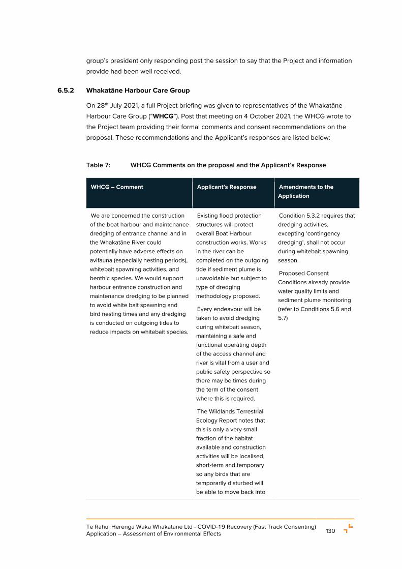
Te Rāhui Herenga Waka Whakatāne Ltd - COVID-19 Recovery (Fast Track Consenting) Application – Assessment of Environmental Effects 130
group’s president only responding post the session to say that the Project and information provide had been well received.
6.5.2 Whakatāne Harbour Care Group
On 28th July 2021, a full Project briefing was given to representatives of the Whakatāne Harbour Care Group (“WHCG”). Post that meeting on 4 October 2021, the WHCG wrote to the Project team providing their formal comments and consent recommendations on the proposal. These recommendations and the Applicant’s responses are listed below:
Table 7: WHCG Comments on the proposal and the Applicant’s Response
WHCG – Comment Applicant’s Response Amendments to the Application
We are concerned the construction of the boat harbour and maintenance dredging of entrance channel and in the Whakatāne River could potentially have adverse effects on avifauna (especially nesting periods), whitebait spawning activities, and benthic species. We would support harbour entrance construction and maintenance dredging to be planned to avoid white bait spawning and bird nesting times and any dredging is conducted on outgoing tides to reduce impacts on whitebait species.
Existing flood protection structures will protect overall Boat Harbour construction works. Works in the river can be completed on the outgoing tide if sediment plume is unavoidable but subject to type of dredging methodology proposed.
Every endeavour will be taken to avoid dredging during whitebait season, maintaining a safe and functional operating depth of the access channel and river is vital from a user and public safety perspective so there may be times during the term of the consent where this is required.
The Wildlands Terrestrial Ecology Report notes that this is only a very small fraction of the habitat available and construction activities will be localised, short-term and temporary so any birds that are temporarily disturbed will be able to move back into
Condition 5.3.2 requires that dredging activities, excepting ‘contingency dredging’, shall not occur during whitebait spawning season.
Proposed Consent Conditions already provide water quality limits and sediment plume monitoring (refer to Conditions 5.6 and 5.7)

Te Rāhui Herenga Waka Whakatāne Ltd - COVID-19 Recovery (Fast Track Consenting) Application – Assessment of Environmental Effects 131
WHCG – Comment Applicant’s Response Amendments to the Application
the area. Therefore, a requirement to avoid nesting seasons isn’t necessary.
We would support any efforts to collect any shellfish excavated during the boat harbour entrance construction and an attempt made to recreate shellfish beds elsewhere in the estuary environment.
Collection, sorting and relocation of shellfish is not feasible with small examples.
N/A
The area of salt marsh to be removed for the boat harbour entrance could potentially harbour cryptic ground bird species like marsh crake, banded rail; pukeko, bittern and weka as these birds have been detected in similar habitats in other parts of the Whakatane estuary. It would be beneficial to have an ornithologist or other appropriate person to inspect the affected salt marsh immediately prior to works commencing to ensure such native species are not present and provision is made to move any such birds if found to a safer location.
See previous comment on the need to avoid avifauna.
Subject to confirmation from the contractor once engaged, access channel excavation works will be completed on outgoing tides therefore, the flooded area would be clearer after each high tide.
N/A
WHCG supports the restoration of 0.9 ha of wetland to the north of the new entrance channel and the plant pest control that is proposed but consider further additions are needed to make for an effective restoration management plan. Our key concern is the lack of any consideration for pest animal management in this restoration plan although the plan does acknowledge they will be present (See Section 4.6 (4.6.1 and 4.6.3). Rats, hedgehogs, possums, mustelids and feral cats are common predators that live
The Applicant is not the owner of the areas to be remediated.
The Applicant acknowledges that there are existing WHCG plans for the river and wider environment which sets out enhancement aspirations. Future opportunities for enhancement should be discussed with DOC and BOPRC to address such areas of interest.
Section 7.10 has been added to the Restoration Plan (Required by Proposed Condition 1.2.10)

Te Rāhui Herenga Waka Whakatāne Ltd - COVID-19 Recovery (Fast Track Consenting) Application – Assessment of Environmental Effects 132
WHCG – Comment Applicant’s Response Amendments to the Application
within the Whakatane River margins environment. To protect native fauna, including white bait species, an effective pest control programme needs to be included in the Restoration Management plan. Preferably an animal management control plan would not restrict itself to the area being actively restored but would adopt a wider view given pest animals will range through this area and other areas on both sides of the entrance channel as well as in and around the boat harbour itself.
As summarised in the Wildlands Terrestrial Ecological Report, management of pests in only the restoration area would be complex without full fencing, so the issue is wider one across the river environment. However, the Applicant supports the inclusion of 5 years pest animal management within the Restoration area. This includes provision of trap stations and monitoring.
We would support the excavation of 'foreign materials' and restoration planting (Management Unit B) for the area identified as 7b currently grass and exotic trees.
This area is owned by the BOPRC. Recommendations on managing this area should sit with the owner.
The Applicant has chosen to focus on the unmanaged area to the east of area 7b, as this is within the DOC estate and within the same Lot as the access channel.
N/A
The WHCG would be interested in being a party to the restoration management planning.
The Applicant is happy to provide the opportunity for key stakeholders, including WHCG, to be involved in the planning and implementation of the restoration works provided for in the Restoration Plan.
An Advice Note has been added to Proposed Condition 1.2.10.1 stating ‘The Consent Holder shall provide the opportunity for the key stakeholder to be involved in the planning and implementation of restoration works provided for in the Restoration Plan. These parties may include representatives from:
• Te Rāhui Lands Trust;
• Te Rūnanga o Ngāti Awa;

Te Rāhui Herenga Waka Whakatāne Ltd - COVID-19 Recovery (Fast Track Consenting) Application – Assessment of Environmental Effects 133
WHCG – Comment Applicant’s Response Amendments to the Application
• Department of Conservation;
• Whakatāne Harbour Care Group;
• Eastern Bay of Plenty Royal Forest and Bird Society.’
Social impacts of boat harbour development.
The boat harbour and enhanced public access associated with its development will have the positive effect of encouraging more public recreation into this western side of the river. However, that may also have potential for adverse effects: e.g. rubbish, noise, potential disturbance to salt marsh fauna from increased human presence, the potential risk from uncontrolled activities of dogs entering salt marsh habitats, risk of trampling and damage to salt marsh vegetation from 'off track' unregulated excursions into these areas by people and vehicles. lt is not clear how those potential effects will be managed long term in this application but we believe they should be provided for via education, new dog bylaws, monitoring and advocacy.
Access to the new areas and existing areas of salt marsh are via the BOPRC stop bank and road accessway down the river and this is generally consistent with the access already provided.
The operators of the Boat Harbour can advocate for public consideration of the neighbouring areas which are not accessible from the Boat Harbour directly however, this is a topic to discuss with the BOPRC, the Lands Trust and Ngāti Awa for an area wide approach.
N/A
We would like to see the Biosecurity management plan recognising animal pests particularly rodents as an issue to be managed around the boat harbour. There is a risk of rodents inadvertently being transported from the proposed boat harbour to protected offshore islands
The Biosecurity Management Plan focuses on marine and freshwater species.
However, management of pests, etc around the Boat Harbour fall under the Operations Management
N/A
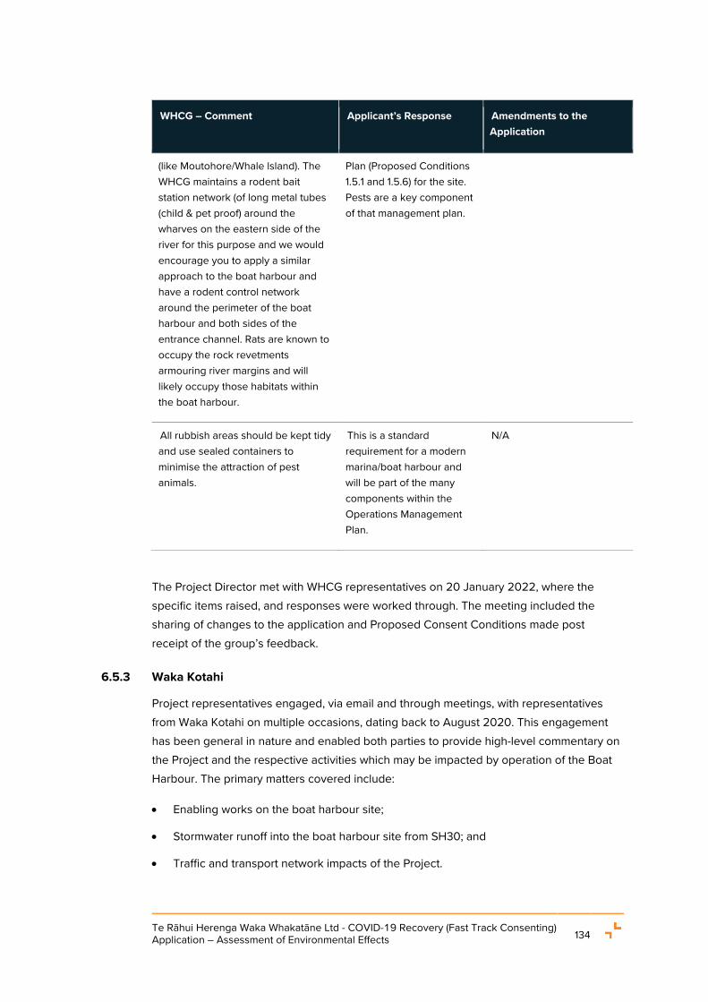
Te Rāhui Herenga Waka Whakatāne Ltd - COVID-19 Recovery (Fast Track Consenting) Application – Assessment of Environmental Effects 134
WHCG – Comment Applicant’s Response Amendments to the Application
(like Moutohore/Whale lsland). The WHCG maintains a rodent bait station network (of long metal tubes (child & pet proof) around the wharves on the eastern side of the river for this purpose and we would encourage you to apply a similar approach to the boat harbour and have a rodent control network around the perimeter of the boat harbour and both sides of the entrance channel. Rats are known to occupy the rock revetments armouring river margins and will likely occupy those habitats within the boat harbour.
Plan (Proposed Conditions 1.5.1 and 1.5.6) for the site. Pests are a key component of that management plan.
All rubbish areas should be kept tidy and use sealed containers to minimise the attraction of pest animals.
This is a standard requirement for a modern marina/boat harbour and will be part of the many components within the Operations Management Plan.
N/A
The Project Director met with WHCG representatives on 20 January 2022, where the specific items raised, and responses were worked through. The meeting included the sharing of changes to the application and Proposed Consent Conditions made post receipt of the group’s feedback.
6.5.3 Waka Kotahi
Project representatives engaged, via email and through meetings, with representatives from Waka Kotahi on multiple occasions, dating back to August 2020. This engagement has been general in nature and enabled both parties to provide high-level commentary on the Project and the respective activities which may be impacted by operation of the Boat Harbour. The primary matters covered include:
• Enabling works on the boat harbour site;
• Stormwater runoff into the boat harbour site from SH30; and
• Traffic and transport network impacts of the Project.

Te Rāhui Herenga Waka Whakatāne Ltd - COVID-19 Recovery (Fast Track Consenting) Application – Assessment of Environmental Effects 135
The most recent engagement has been summarised below.
On 22 June 2021, a meeting was held between representatives from Waka Kotahi and the Project. A Project update was provided to Waka Kotahi and requests were made regarding the stormwater runoff from the State Highway entering the site.
On 16 July 2021, the Project Director sent an email to Waka Kotahi, care of Melissa Clare (Senior Network Manager Maintenance and Operations, Eastern Bay of Plenty, Transport Services) to see if the agency had any follow up queries or concerns related to the Project after the meeting held on 22 June 2021.
Further emails were exchanged, primarily relating to the stormwater runoff onto the boat harbour site from the State Highway. While an agreement between the parties is still to be reached on this matter, it sits outside of this consenting process.
Waka Kotahi has not offered any comment on traffic or transport impacts as a result of the engagement on the Project undertaken to date.
6.6 FOREST AND BIRD
In addition to the engagement above, on 28th July 2021 a full Project briefing was given to representatives of Forest and Bird (“F&B”).
Post that meeting on 1 October 2021, F&B wrote to the Project team providing their formal comments and consent recommendations on the proposal. These recommendations and the Applicant’s responses are listed below:
Table 8: F&B’s Comments on the proposal and the Applicant’s Response
Forest and Bird Comments Applicant’s Response Amendments to the Application
(i) The reference group includes the applicants and one of the consenting bodies and could be seen as akin to having a second bite of the cherry and/or compromising the role of one of the consenting bodies (the regional council). As the professionals producing the various plans are engaged by the partnership, they should be able to vet such plans before they are lodged with the respective councils for certification, therefore this group is superfluous, apart
The investment arms of WDC and TRONA are different from the regulatory arms of the organisations. It will be up to each party to choose if it wishes to provide different representatives for each phase of the Project.
The technical advisors will draft the respective management plans in association with the Applicant and the parties who comprise the reference group will review and feedback on the contents of the plan prior to provision to Council(s) for certification. This allows for those parties to raise any key issues
N/A

Te Rāhui Herenga Waka Whakatāne Ltd - COVID-19 Recovery (Fast Track Consenting) Application – Assessment of Environmental Effects 136
Forest and Bird Comments Applicant’s Response Amendments to the Application
from the Department of Conservation.
and the Consent Holder will have to respond to these matters either through updating the plans or providing a response as to why the amendments were not adopted.
(ii) Conditions could be changed post consent without applying for a change of conditions. The current WDC Dredging consent for the Harbour Development Zone has had 2 of the original conditions removed or altered without F&B as an original submitter being notified.
Any conditions changed post issue of any consent would follow the standard RMA process as determined by the relevant Council.
Proposed Condition 1.2.1.3(a)(xi) requires any revisions to the listed management plans to be provided to the Reference Group for review prior to lodgement with Council(s)
N/A
Insert a new condition either as 1.1.3.5 or 1.1.2.1 (c) that any change proposed to conditions shall be referred back to the parties who submitted comments to the EPA.
Any conditions changed post issue of any consent would follow the standard RMA process as determined by the relevant Council
N/A
The reference group should be reconstituted to include the Community Liaison Group (CLG) which includes the Department of Conservation, the Mana Whenua Liaison Group (MWLG) as well as the community.
The purpose of the Reference Group is to provide the key Project Stakeholder’s a forum through which to review and input into the final design and management of the Project.
The purpose of the MWLG and CLG is to provide Project updates to the broader iwi / hapū groups and the wider community and stakeholders and facilitate information sharing with respect to the development and operation of the Project.
The Applicant considers that it is not appropriate to combine all of these groups together as they each have a different function.
N/A
The MWLG and CLG could select a nominee(s) from their respective
The rep from the MWLG will be Ngati Awa so they have the opportunity to appoint a delegate.
N/A

Te Rāhui Herenga Waka Whakatāne Ltd - COVID-19 Recovery (Fast Track Consenting) Application – Assessment of Environmental Effects 137
Forest and Bird Comments Applicant’s Response Amendments to the Application
groups to join with DoC for a smaller, more agile group.
1.2.3 Community Liaison Group
F&B requests it be added to the list under (j).
Accept this recommendation. Eastern Bay of Plenty Branch of the Royal Forest and Bird Protection Society added as Condition 1.2.3.1(j) in the Proposed Consent Conditions
Public Access
F&B experience is that “security issues” raised post construction result in blocking of public access. Given that the current access to the entire stopbank will be cut in the middle by the access channel, we consider it is very important to lock in public access in the conditions.
Include a condition that any future change to public access through the site as indicated in the application will be subject public notification.
Proposed Condition 2.3.2(a)(v) already requires the Architecture and Urban Design Report to include a description of the ‘Public access to and around the site including to the toitoihuia waahi taonga site identified in the Cultural Impact Assessment referenced in Table 1 “Submitted Documentation” to Condition 1.1.2.1 of the attached Schedule of Common Conditions.’
Additionally, with respect to public access, The Recreation and Tourism Report (Appendix M), states in Section 5.2.1, that:
The proposal includes the development of walking access around the Boat Harbour, as shown in Figure 1 (page 9). Access is to be provided parallel to Keepa Road within the development area linking the stopbank south of SH30 with the stopbank north of the Kopeopeo Canal overflow channel via the footpaths on SH30 and Keepa Road. Options for creation of walking access outside the Boat Harbour development area beside the Scenic Reserve are retained, although this would lead to a dead end at the Kopeopeo Canal overflow channel unless there is further development of access within the Scenic Reserve to include a loop walk.
N/A

Te Rāhui Herenga Waka Whakatāne Ltd - COVID-19 Recovery (Fast Track Consenting) Application – Assessment of Environmental Effects 138
Forest and Bird Comments Applicant’s Response Amendments to the Application
As previously stated, any conditions changed post issue of any consent would follow the standard RMA process as determined by the relevant Council.
1.3.4.1 No bulk earthworks shall commence onsite for any stage(s) of the Project until the erosion and sediment control methods specified in the ESCP are installed.
How is “bulk” defined? Specify a threshold.
Bulk Earthworks is defined within the BOPRC Erosion and Sediment Control Guidelines for Land Disturbing Activities – Guideline 2010/01
The definition from the guideline has been included as an advice note to Proposed Condition 1.3.4.1
1.5.1 Operational Management Plan: Commercial Boat Harbour
Some management requirements need to be known prior to consent e.g.
1.5.5.1 e.g. (a) vi. Managing the occurrence of people living on vessels within the Boat Harbour. It should be set in conditions whether on board living is to be permitted and under what conditions.
Reviews of management policies should be subject to oversight of the MWLG & CLG.
The operators of the boat harbour will provide for onboard living. This is consistent within most facilities of a similar nature in NZ. Management of Live Aboards will follow industry best practice which is updated from time to time.
Controls of these activities will be provided for through the Boat Harbour Operations Management Plan as required by Proposed Conditions 1.5.5.1(g) as identified.
N/A
Wetland restoration and Ecological Enhancement Plan
Mitigation
The restoration plan takes a minimal approach. Given the gross modification of the site by the former dumping of wood waste, modification or destruction of wetlands and almost total neglect by the statutory agencies that administer the area, it is imperative that the mitigation package be
The preparation of the Restoration Plan has been undertaken by Wildlands in accordance with the requirements of Schedule 2 of the NES FM as a requirement of Clause 39(5) of the NESFM. The intention of the Restoration Plan is to mitigate the effects of the loss of wetland as a result of the construction of the access channel. On that basis, the Restoration Plan appropriately addresses the requirements in the NESFM and results in a net environmental gain for the
An Advice Note has been added to Proposed Condition 1.2.10.1 stating ‘The Consent Holder shall provide the opportunity for the key stakeholder to be involved in the planning and implementation of restoration works provided for in the

Te Rāhui Herenga Waka Whakatāne Ltd - COVID-19 Recovery (Fast Track Consenting) Application – Assessment of Environmental Effects 139
Forest and Bird Comments Applicant’s Response Amendments to the Application
much more extensive than what is offered. This is very disappointing when there is the opportunity through a government sponsored and funded programme to enhance the indigenous biodiversity of the wider site. It is an undermining of the Aotearoa Biodiversity Strategy and pays no homage to the Proposed National Policy Statement on Indigenous Biodiversity.
wetland complex (increase of salt marsh wetland by approximately 15%) within the IBDA-A44. This work includes the removal of a large amount of timber peelings in the DoC estate. The commitment to relocate these is significant.
While it is acknowledged that there are other parties may have an interest / aspirations to this area, the approach has been to purposefully refine the scope of the restoration works to allow for a co-management approach to the enhancement of the wider IBDA-A area. This is consistent with the direction the Applicant received from TRONA and the Lands Trust about their future aspirations of the land adjacent to the river.
Restoration Plan. These parties may include representatives from:
Te Rāhui Lands Trust;
Te Rūnanga o Ngāti Awa;
Department of Conservation;
Whakatāne Harbour Care Group;
Eastern Bay of Plenty Royal Forest and Bird Society.’
Wildlands have noted additional opportunities for ecological restoration which include:
• Indigenous planting of the reasonably large area of exotic grassland - on the eastern side of the stopbank - between the wetland complex and the southern end of the site.
• Indigenous planting of exotic grassland areas amongst the wetland complex.
• Control of pest weeds such as pampas and willows.
• Excavation of additional new wetland in the area of exotic grassland in the southern part of the site. This would require further evaluation of ground levels and hydrology.
• There are also opportunities for a walking track around the
Refer to previous response on the acknowledgement of other parties’ interests and that there are future opportunities of co-management approach to enhancement.
For this Project, the Applicant has elected to select one of the more challenging remediation projects to consent and undertake.
Other projects remain for the community, land owners and local hapu to undertake in the future.
N/A

Te Rāhui Herenga Waka Whakatāne Ltd - COVID-19 Recovery (Fast Track Consenting) Application – Assessment of Environmental Effects 140
Forest and Bird Comments Applicant’s Response Amendments to the Application
wetland to the south of the Kopeopeo overflow canal. A small bridge may be required over the estuarine channel in the southern part of the site. 23/29 Appendix Q.
Note that the NPS FW 2020 that requires where there are adverse effects on a wetland (loss of extent or values), these effects must be managed through the application of the effects management hierarchy.
…the potential loss of 0.1 hectares is only c.1.5% of the wetland area within IBDA-A44. It should be noted that the impacts on saltmarsh wetland involve minor areas where wetland channels enter the Kopeopeo Canal flood overflow channel, i.e. the impacts will not involve losses of ‘core’ areas of wetland, and do not involve fragmentation of the wetland or changes to wetland hydrology. 17/23 Appendix Q Wildlands Report
The above text minimalizes the significance of riparian habitat and estuarine wetlands, and takes a narrow view of remediation and mitigation. As stated by WHCG, the channel is the most valuable part of the site for birds and it is being removed as habitat altogether.
We have taken guidance of the level of effects of these works from Wildlands as the Project’s technical ecological advisors.
Based on the advice from Wildlands, as set out in their Terrestrial and Freshwater/Marine Assessments (Appendix Q and R respectively), it is concluded that construction of the access channel will not result in adverse effects which are more than minor. and in particular, will not result in any loss of the extent or values of the natural wetland environment in the IBDA-A44 / SIBS area.
The channel is not being removed completely, the channel is being widened, and will still remain as a habitat. The Terrestrial Ecology Report notes that this is only a very small fraction of the habitat available and construction activities will be localised, short-term and temporary so any birds that are temporarily disturbed will be able to move back into the area.
N/A
F&B seeks restoration of all of the Scenic Reserve and the whole site east of stopbank, not just the area shown in Figure 2 p9/15 of the Restoration Plan, namely Types 5-11 in Figure 2 of Wildlands Report
As above. N/A

Te Rāhui Herenga Waka Whakatāne Ltd - COVID-19 Recovery (Fast Track Consenting) Application – Assessment of Environmental Effects 141
Forest and Bird Comments Applicant’s Response Amendments to the Application
Appendix Q Further Assessment of Ecological Effects, whilst maintaining potential for whitebait spawning. Even though there is no current evidence of inanga spawning at the site, the potential for it in future should be provided for.
Restoration Plan
In effect it is only Area B that is being restored. This is very minimalist.
Area C is only having plant pests controlled but no restoration planting. This area should have all the willows and other exotic species removed and be replanted in indigenous species aimed as fernbird habitat.
As above, the total restoration area, approximately 0.93 ha, will result in an increase of approximately 15% of the saltmarsh wetland area with the IBDA-A44. This is a significant increase.
N/A
Avifauna
There will be localised disturbance of resident birds during the construction of the access channel therefore construction should avoid the bird breeding season (October to February). As mentioned by Gaye Payze for the Whakatane Harbour Care Group, having an expert bird person on site at the time would be desirable.
Similarly excavation of the wood waste in the Scenic Reserve should also not occur at that time.
All of the above matters should be prescribed in the conditions and the Ecological Management Plan referred to the MWLG and CLG.
The Wildlands Terrestrial Ecology Report notes that works will impact only a very small fraction of the bird habitat available and construction activities will be localised, short-term and temporary so any birds that are temporarily disturbed will be able to move back into the area. Therefore, a requirement to avoid nesting seasons or to have a bird expert on site during construction isn’t necessary.
N/A
Boat Harbour Biosecurity Management Plan
Pest management is key component of the biosecurity management plan.
Added an Advice Note to Proposed Condition 4.8.2

Te Rāhui Herenga Waka Whakatāne Ltd - COVID-19 Recovery (Fast Track Consenting) Application – Assessment of Environmental Effects 142
Forest and Bird Comments Applicant’s Response Amendments to the Application
Proposed conditions:
A pest control plan is required to prevent rats “stowing away” on boats and hitchhiking to offshore islands with treasured taonga and to protect wildlife using the extended wetland. Trap and bait lines should extend from the bridge as far west and north as possible including the Scenic Reserve.
All organic waste including fish waste should be held in sealed bins.
WDC should give a written undertaking to prohibit hull cleaning at the existing boat ramp on Muriwai Drive to maximise the positive effects of the boat harbour development.
The Biosecurity Code of Practice (BCOP) should be a rule for constructions and operation of the marina and a required condition of consent. The BCOP should not be a voluntary code.
Wash down areas are to be bunded.
Monitoring regime at least annually for marine pests.
No pets in the boat harbour.
Sealed bins are part of all good marina practice and will be set out as a requirement of the Operational Management Plan.
WDC has jurisdiction and the powers to set rules for the Muriwai Road boat ramp – The Applicant is aware that WDC has recently installed a boat wash system at the ramp.
Bunding of washdown areas does not assist collect and processing of biofoul.
Monitoring will form part of the Biosecurity Management Plan (refer to Proposed Condition 4.8).
Pets are expected to be allowed onto the private property, but will be subject to management on a leash at all times.
stating that the Biosecurity Management Plan must be prepared in accordance with the Biosecurity Code of Practice.
Boat Harbour operational rules will require pets to be on a leash at all times.
Aquatic ecosystems
Dredging
The conditions should have the same timing restrictions as the current maintenance dredging consent with no dredging during the whitebait season (15 August – 30 November inclusive) and be undertaken on the outgoing tide.
Every endeavour will be taken to avoid dredging during whitebait season, maintaining a safe and functional operating depth of the access channel and river is vital from a user and public safety perspective so there may be times during the term of the consent where this is required.
Added an additional condition to Proposed Condition 5.3 requiring that dredging activities, where practicable, shall not occur during whitebait spawning season.

Te Rāhui Herenga Waka Whakatāne Ltd - COVID-19 Recovery (Fast Track Consenting) Application – Assessment of Environmental Effects 143
Forest and Bird Comments Applicant’s Response Amendments to the Application
Landscape mitigation
The proposal is a change of land use from a rural to a built environment and is an example of planning creep and a cumulative loss of an open space.
The Isthmus report states “The existing BOPRC stopbank on the western riverbank adjoining the site will screen components of the Boat Harbour from the river and eastern bank, while views from residential areas in Whakatāne toward the site are screened by the stopbank on the eastern side of the river. 203/190
This cannot be true as the level of the marina will be raised to stopbank level so buildings (sheds), cranes, vehicles etc will be visible from the heavily used Warren Cole Walkway, and the report doesn’t specifically address this.
The Isthmus Landscape Report has been updated to address this comment.
Final Landscape Report provided to F&B.
Proposed conditions to include:
All structures including Iceplant, light poles, the straddle crane and any shipping containers used to mitigate noise are to be in non-reflective, recessive colours.
Landscaping plan to include multi row perimeter planting utilising trees that develop sufficient height to exceed the height of finished buildings and structures.
Landscape Plan to be referred to MWLG and CLG for feedback.
All plantings shall have an irrigation system to maintain an annual summer watering plan and
Details of the structures on site will be set out in the Architecture and Urban Design Report (Refer to Proposed Condition 2.3) colours of buildings etc are required to be detailed in Proposed Condition 2.3.2(b)(e) which also sets out the requirement for reflective standards.
Viewshafts from the Marae are to be protected, so high multi-row planting on the boundary is not supported.
Landscape Planting Plan to be approved by the consenting authority and the reference group.
Proposed Condition 2.4.3(g) requires the Landscape Planting Plan to detail the implementation and maintenance programme and includes the
N/A

Te Rāhui Herenga Waka Whakatāne Ltd - COVID-19 Recovery (Fast Track Consenting) Application – Assessment of Environmental Effects 144
Forest and Bird Comments Applicant’s Response Amendments to the Application
shall be maintained and any losses replaced on an annual basis.
Trees planted in amenity areas can be deciduous or evergreen and be sited to allow for shade on footpaths, cycle ways and seating areas.
requirement for irrigation, fertilisers, weed and pest control, etc.
Lighting
Include in the AEE that artificial lighting has negative impacts on wildlife by disorienting seabirds seeking nests, and disturbing invertebrate life cycles by alteration of day/night cycles.
Note that local bird experts have recorded disturbance from the existing Whakatane Mill lighting.
See https://findanyanswer.com/goto/55723: Still, the AMA (American Medical Assoc) report recommends that authorities choose LED lighting with the “lowest emission of blue light possible” and says all lighting should be shielded to minimize glare and its effect on local wildlife. https://www.aau.edu/research-scholarship/featured-research-topics/colored-led-lights-could-reduce-bird-collisions-plan
“The test was repeated with five different wavelengths of light. Birds consistently avoided LED lights with peaks at 470 and 630 nanometers, which appear blue and red to the human eye. Ultraviolet (UV), green, and white light didn’t generate any obvious
LDP consultancy are the experts with all lights facing downwards.
Light selection an include specialist heads that do not require reflectors as the fitting includes such add ons.
LED is the industry standard, so if facing down then there should be minimal issue.
As set out Proposed Condition 2.8, the Consent Holder will prepare a Lighting Plan and all lighting on site will be designed to comply with WDC District Plan requirements for lighting which on site being District Plan Rule 11.2.16 (Lighting and Glare), District Plan Rule 11.2.18 (Navigation) and the glare limits recommended in AS/NZS 4282:2019 (Control of the obtrusive effects of outdoor lighting).
N/A

Te Rāhui Herenga Waka Whakatāne Ltd - COVID-19 Recovery (Fast Track Consenting) Application – Assessment of Environmental Effects 145
Forest and Bird Comments Applicant’s Response Amendments to the Application
pattern of avoidance or attraction.”
Proposed conditions:
At a minimum lighting should meet the same standard as for the Hurunui Ave Observatory or better.
Lights are to be fixed with horizontal reflectors directed downwards and shrouded so as to stop light wash striking the sides of buildings.
Lighting to be used only for safety.
Reduce the use of LED lighting where possible in accordance with research outlined above.
Signage
There should be no signage facing to the east across the river or to the public road or footpath other than the one vertical panel sign at the entrances i.e. no separate signs for any businesses operating within the site. This sign(s) should not have any lighting that would cause disorientation of birds.
Business signs will face the west, but the boat harbour may have a sign facing the east on the office.
All lighting to designed in accordance with the Lighting Plan required under Proposed Condition 2.8.
N/A
The Project Director met with F&B representatives on 20 January 2022, where the specific items raised, and responses were worked through. The meeting included the sharing of changes to the application and Proposed Consent Conditions made post receipt of the group’s feedback.
Following the meeting, by way of email received on 24 January 2022, F&B provided further comments on the proposal. These comments and the Applicant’s response (provided by way of email on 27 January 2022) are set out in the table below.

Te Rāhui Herenga Waka Whakatāne Ltd - COVID-19 Recovery (Fast Track Consenting) Application – Assessment of Environmental Effects 146
Table 9: F&B’s Further Comments on the proposal and the Applicant’s Response
Additional F&B Comments Applicant’s Response
The detail of structure colour and reflectivity of buildings and structures is of great concern. The conditions do not clearly indicate that shipping containers used as sound barriers also have to be in recessive colours and matt surfaces.
Proposed Condition 2.3.2 requires preparation of the Architecture and Urban Design Report and Condition 2.3.2(e) requires the Report to detail:
a. A schedule of the colours and materials of all external surfaces of buildings and structures visible from public places, including external cladding, roofing, spouting and joinery and incorporating the following information:
i. The colour palette described in accordance with BS 5252 and including Light Reflectance Values;
ii. The use of low reflectivity glazing and no mirror glazing; and
iii. The design and layout of the main gateway structure into the site
Regarding shipping containers which may be used as Nosie barriers, given the primary use of these containers is storage and transport they are not typically provided in colours / finishes which are reflective. However, an Advice Note has been added to condition 2.10.1 as follows:
‘Advice Note: In the event that shipping containers or other temporary structures are used as noise barriers during outdoor garnet blasting activities, these structures shall be in recessive colours and have matt surfaces / finishes.’
Public Access
It would be advantageous to the walking public if access was provided within the development area between SH 30 at the western end of the bridge, to the southern edge of the boat harbour. Whilst the public can walk along the footpath along SH30 and Keepa road to enter the site, road walking is not particularly enjoyable for pedestrians.
As shown in Figure 1 of the Recreation and Tourism Assessment (appendix M to the AEE), walking access within the development along the western boundary and through the entire site is proposed as part of the Project. Proposed Condition 2.3.2(a)(v) requires the Architecture and Urban Design report to detail ‘Public access to and around the site including to the toitoihuia waahi taonga site…’ and 2.3.2(j) which states ‘Pedestrian connections to the Local Purpose Reserve and Scenic Reserve provided through the northern and southern areas of the site generally in accordance with Figure 23 of the AEE…’

Te Rāhui Herenga Waka Whakatāne Ltd - COVID-19 Recovery (Fast Track Consenting) Application – Assessment of Environmental Effects 147
Additional F&B Comments Applicant’s Response
Stakeholder input into restoration plan
An Advice Note to Condition 1.2.10.1 is unlikely to carry any weight. Was it intended that the text in your feedback would be added to the condition?
See comments on the Restoration Plan below.
Advice note changed to condition 1.2.10.2 of the Proposed Consent Conditions as follows:
The Consent Holder must provide the opportunity for key stakeholders to be involved in the planning and implementation of restoration works provided for in the Restoration Plan. These parties may include representatives from:
a. Te Rāhui Lands Trust;
b. Te Rūnanga o Ngāti Awa;
c. Department of Conservation;
d. Whakatāne Harbour Care Group; and
e. Eastern Bay of Plenty Branch of the Royal Forest and Bird Society.
Disturbance of Avifauna
As a compromise/ rationalisation of the management of excavation of the channel, I suggest including a condition to require a suitably qualified expert to determine whether there are active nests in the vicinity that would be subject to disturbance, before excavation begins.
The Applicant is happy to include a condition of this nature and has included a new condition (Proposed Condition 1.3.4.2 -earthworks management) stating ‘Immediately prior to the any excavations within the Department of Conservation Scenic Reserve, a SQEP shall undertake a walkover of the excavation area to determine whether there are any active nests within the proposed works footprint that would be subject to disturbance. In the event that a nest is found and, if in the opinion of the SQEP it is possible, it must be relocated outside of the works footprint to a suitable alternative location within the Scenic Reserve.’
Biosecurity Management Plan
As we are not familiar with the Biosecurity Code of Practice you mention, and this is a code subject to change, we request that a condition be included to require animal and aquatic pest control.
Please specify no cats in the boat harbour as well as the dogs on a leash.
The reference to the Biosecurity Code of Practice was added at the request of F&B in the first set of feedback comments.
The Biosecurity Plan manages the potential adverse environmental effects associated with biosecurity risks and incursions in the coastal marine area and the Whakatāne River, by specifying methods to ensure that operation of the Boat Harbour integrates good biosecurity practices and complies with the RPMP with respect to aquatic pest species. It is not intended to address pest animals.

Te Rāhui Herenga Waka Whakatāne Ltd - COVID-19 Recovery (Fast Track Consenting) Application – Assessment of Environmental Effects 148
Additional F&B Comments Applicant’s Response
The Boat Harbour Operational Management Plan is intended to set out the requirements for managing pets and pest animals. Condition 1.5.5(f) has been added stating that the OMP must provide details on ‘The details of the onsite controls measures provided to ensure that the risk of pest animals, including rats and other vermin, accessing the Boat Harbour and the berthed vessels is minimised to the extent possible.’
Regarding the position of cats and dogs, the Applicant accepts the recommendation to banned cats from the Boat Harbour and that dogs must be kept on a leash at all times. The OMP (which sets out lease agreement requirements) will confirm this. Proposed Condition 1.5.5.1(a)(ix) added stating: The requirement that domestic cats are prohibited within the Boat Harbour and on berthed vessels and that domestic dogs must be restrained on a leash when in the Boat Harbour or on a berthed vessel.
Restoration Plan
• Vegetation Type 7 includes some saltwater paspalum. Will this be removed?
• Revegetation of Area C is not addressed. Forest and Bird seeks that the exotic vegetation should all be removed and the area replanted with native species, not just have the plant pests controlled.
• Why is Unit E being left? Surely if there is unexcavated wood material it should be removed at the same time as Unit B?
• Is this the area that may go back to Ngati Awa or does the BOPRC not want it excavated?
• Where this sits within the proposed wetland restoration area it will be removed.
• Based on the advice from Wildlands, this is not required as part of our proposal to mitigate any adverse effects. However, the Applicant is happy to work with Ngāti Awa, the Lands Trust F&B, WHCG, and other parties on wider restoration and enhancement opportunities in these areas.
• BOPRC advised that it is not to be excavated due to its position in relation to the stopbank.
• Have retained the advice on pest management from Wildlands as being appropriate. Placement of bait stations in the areas identified will have an effective radius of 100m so this area will be captured within the radius of bait stations in adjacent areas.
• To be addressed in the OMP – see comment above re new condition (1.5.5(f))

Te Rāhui Herenga Waka Whakatāne Ltd - COVID-19 Recovery (Fast Track Consenting) Application – Assessment of Environmental Effects 149
Additional F&B Comments Applicant’s Response
• Animal Pest control 7.10.2 - There should also be trapping around E as reinvasion is inevitable, and best practice animal control includes buffer zones.
• Traps/bait stations should be placed around the boat harbour too.
Dredging
It is suggested that wording similar to that for the main harbour dredging consent be used e.g.
• With the exception of contingency dredging [“Contingency dredging shall mean non-scheduled works essential to maintain navigation and required due to the occurrence of natural events”] provided for by Condition 5.4, dredging/excavation shall only be undertaken outside of the whitebait season (15 August to 30 November inclusive).
• Contingency dredging required during the whitebait season (15 August to 30 November inclusive) shall be undertaken on the outgoing tide only and not within 5 metres from the edge of the river channel.
• The consent holder shall undertake an assessment of the river bed levels one month prior to the commencement of the whitebait season and shall
The Applicant agrees to the additional wording of bullet point one being included in conditions, but noting that the whitebait season is 1 September to 30 October, as whitebait regulations have recently changed.
There is an issue with ‘not within 5 m of the edge of the river channel requirement.’ This is due to the primary need for excavation close to the bank of the river, as that is the most likely location for sedimentation and / or floor deposition along the river channel, particularly the section of the river where it will fork into the boat harbour access channel.
The Applicant does not anticipate that this will impact any whitebait spawning sites as the Wildlands Marine / Freshwater Ecology Assessment (Section 14.2) identifies that the only known spawning sites are well upstream of the Boat Harbour site and it confirms that it is very unlikely that significant sediment plumes – resulting from capital or operational dredging - would be carried far enough upstream to adversely affect spawning sites.

Te Rāhui Herenga Waka Whakatāne Ltd - COVID-19 Recovery (Fast Track Consenting) Application – Assessment of Environmental Effects 150
Additional F&B Comments Applicant’s Response
provide the results to the Chief Executive of the Regional Council. A decision is to be made at that time as to whether proactive reduction is required to minimise the potential for essential works during the season.
Lighting
The issue is the amount of emission of blue light. An LED needs to avoid peaks at 470 and 630 nanometers to ensure birds avoid the lights.
Further discussions with Wildlands has confirmed that having the lighting focused downwards will address any potential adverse effects of light on birds.
7. ASSESSMENT OF EFFECTS
This section of the AEE is provided in accordance with clauses 9(4), 10(1)(a), 10(1)(c) and 11 of Schedule 6 to the Covid Act which require an assessment of:
• The actual and potential effects on the environment;
• any effect on the people in the neighbourhood and, if relevant, the wider community, including any social, economic, or cultural effects;
• any physical effect on the locality, including landscape and visual effects;
• any effect on ecosystems, including effects on plants or animals and physical disturbance of habitats in the vicinity:
• any effect on natural and physical resources having aesthetic, recreational, scientific, historical, spiritual, or cultural value, or other special value, for present or future generations;
• any discharge of contaminants into the environment and options for the treatment and disposal of contaminants;
• the unreasonable emission of noise; and
• any risk to the neighbourhood, the wider community, or the environment through natural hazards or hazardous installations.
In accordance with clause 30(2) of Schedule 6 to the Covid Act, “when forming an opinion for the purposes of clause 29(1)(a), a panel may disregard an adverse effect of the activity

Te Rāhui Herenga Waka Whakatāne Ltd - COVID-19 Recovery (Fast Track Consenting) Application – Assessment of Environmental Effects 151
on the environment if a national environmental standard or relevant plan permits an activity with that effect”.
An assessment of all actual and potential effects on people and the environment is undertaken in the following sub-sections.
7.1 ASSESSMENT OF EFFECTS OVERVIEW
Numerous technical assessments were commissioned to identify and assess the actual and potential environmental effects of the Project, in accordance with Schedule 6 of the Covid Act. Those assessments are appended to this AEE and should be referred to for full details of the scope, methodology and reasoning that informs the discussion below. This sub-section summarises:
• The actual and potential environmental effects (positive and adverse) of the Project as assessed across the range of relevant technical disciplines.
• The opportunities and methods to avoid, remedy or mitigate adverse environmental effects identified in the technical assessments; and
• Any anticipated residual adverse environmental effects the technical assessments identify after recommended measures to avoid, remedy and/or mitigate environmental effects are implemented.
The technical assessments identify a range of actual and potential positive and adverse environmental effects. Notably, the assessments consistently conclude that adverse environmental effects can all be avoided, or appropriately remedied or mitigated.
As is usually the case for large, complex development proposals, the realisation of a “less than minor” adverse effects outcome depends on extensive pre-construction detailed design and certification processes, a high standard of site management for the duration of construction activities, and the development and implementation of robust management and monitoring procedures for the operational life of the Boat Harbour.
To this end, the technical assessments provide recommendations about matters that the Applicant should further investigate, resolve and report to the consent authorities for certification prior to the commencement of construction works. The pathway for this process is specified by the framework of Proposed Consent Conditions provided as Appendix G to this AEE.
The conclusions of each technical assessment about the adverse effects of the Project are summarised in the table below.

Te Rāhui Herenga Waka Whakatāne Ltd - COVID-19 Recovery (Fast Track Consenting) Application – Assessment of Environmental Effects 152
Table 10: Technical assessments - conclusions on adverse effects
Report Matters assessed Effects Conclusions
Archaeology Desktop assessment of site archaeological history and values. Field inspection to identify presence of archaeological sites.
Provision for an Accidental Discovery Protocol (via consent conditions) will comply with the Heritage New Zealand Pouhere Taonga Act 2014. No relevant adverse archaeological effects were identified. Appendix 8 of the CIA includes an Accidental Discovery Protocol to this end.
Biosecurity Assessment
Management of aquatic introduced species (“AIS”) in the region. Environmental impacts of AIS. Construction and operational biosecurity risks. Project benefits for biosecurity. Risk mitigation.
The proposal to build and operate a Boat Harbour in Whakatāne, managed to meet world-class standards, will provide net environmental and biosecurity benefits to the local area
Boat Exhaust Report
Effects of discharges from motorboat exhaust on water quality.
Any changes to river water quality due to motorboat exhaust will be less than minor.
Cultural Impact Assessment
Ngāti Awa cultural values and interests and Project alignment with relevant provisions of the Ngāti Awa Environment Plan.
TRONA assesses the site as “exceptional” compared to the sites of historic marina proposals. Implementation of the consent conditions recommended at Appendix 8 to the CIA will address potential adverse cultural effects associated with the proposal.
HAIL DSI Report Site and adjoining land use history, geology and hydrology, previous reports, sediment quality, wood waste, soil gas, management and disposal of contaminated material.
Implementation of the SMP and a site-specific erosion and sediment control plan will address any actual or potential contamination risks associated with the proposed disturbance and disposal of excavated material.
HAIL Water Quality Report
Effects of the proposal on water quality, including existing land use
The potential adverse effects on river water quality associated with

Te Rāhui Herenga Waka Whakatāne Ltd - COVID-19 Recovery (Fast Track Consenting) Application – Assessment of Environmental Effects 153
Report Matters assessed Effects Conclusions
and water and sediment quality data.
dredging areas outside the HDZ are considered no more than minor.
Lighting Assessment
Lighting design assumptions. District Plan limits on light spill. Sky glow.
Adverse effects from the proposed lighting will be negligible.
Marine and Freshwater Ecology Assessment
Estuarine habitat. Marine mammals. Fish. Freshwater vegetation. Freshwater invertebrates. Avifauna.
With appropriate construction and operational management methods in place, adverse ecological effects will be negligible or low.
Natural Character, Landscape and Visual Assessment Report
Natural character effects. Landscape effects. Visual amenity. Night-time visibility.
Any adverse natural character, landscape and visual amenity effects arising from the proposal on the receiving environment are acceptable
Navigation Safety Report
Boat harbour navigation. Access channel navigation. Navigation upstream of moorings. Whakatāne wharf area. Whakatāne Bar approach. Flooding. Navigation aids.
No significant matters of navigation safety arise from the proposal.
Noise & Vibration Assessment
Construction noise and vibration. Operational noise. Compliance with District Plan rules.
Construction noise and vibration will comply with District Plan limits.
Operational noise associated with vessel movements in the Coastal Protection Zone will produce a three-decibel non-compliance with the zone noise limits. The adverse effects of this are assessed as less than minor.
Recreation and Tourism Effects Assessment
Public access. Conflicts between watercraft. Swimming. Fishing. Surfing. Tourism.
Minor unavoidable residual adverse effects on kayaks, rowers waka ama associated with wake created by the introduction of powered vessels into the section of river between the

Te Rāhui Herenga Waka Whakatāne Ltd - COVID-19 Recovery (Fast Track Consenting) Application – Assessment of Environmental Effects 154
Report Matters assessed Effects Conclusions
Alternative access channel location. Whakatāne Yacht Club Heads and the Boat Harbour access channel.
No other adverse effects identified.
T&T Coastal Processes and Natural Hazards Report
Effects of the proposed development on the physical coastal environment, including tidal prism, currents, sediment dynamics, coastal hazards, other natural hazards.
The proposed development will have less than minor adverse effects on the present and expected future processes operating within the river, estuary and adjacent coastline.
Tektus Infrastructure Report
Earthworks. Structural engineering. Water cycle (stormwater, wastewater, water supply, and operational discharges) Utility services. Operation and maintenance.
Earthworks and construction activities will be managed in accordance with CMP methods, to ensure that potential adverse effects are less than minor. The Operational Management Plan will set out discharge controls to ensure that any adverse effects of stormwater discharges are no more than minor. It is anticipated that discharge quality will surpass the relevant standards of the RCEP. Wastewater servicing will be provided for through connection to the WDC reticulation system.
Terrestrial Ecology Assessment
Vegetation/habitat types. Flora. Fauna – avifauna, pest species.
Overall ecological effects will be minor. Adverse effects associated with the loss of a small area of saltmarsh wetland will be avoided by restoration of a larger area within the same wetland complex. This will produce an overall positive effect by way of increased wetland extent and quality.
Transport Impact Assessment
Existing site and road infrastructure. Crash data. Traffic generation and effects (construction and operational). Future road layout. Intersections. Parking.
The transportation impacts of Te Rāhui Herenga Waka Whakatāne are assessed as minor.

Te Rāhui Herenga Waka Whakatāne Ltd - COVID-19 Recovery (Fast Track Consenting) Application – Assessment of Environmental Effects 155
7.2 POSITIVE EFFECTS
The term “effect” includes “any positive or adverse effect” (RMA s 3(a)). In accordance with clause 11(a) of the Covid Act, the Project’s positive effects are summarised below.
7.2.1 Employment
Notably, the Project will make considerable contributions to employment and economic activity. The PGF Business Case estimates that the Project will create over 800 attributable direct, indirect and induced jobs in New Zealand by 2050, as follows:
• Up to 30 full-time equivalent jobs during construction.
In terms of employment generated when the Boat Harbour begins operating:
• 400 jobs are directly created in marine-based businesses (such as charter fishing, boat building and tourism boats);
• 300 jobs are indirect jobs in industries that support marine based businesses (such as bait and ice suppliers); and
• 127 are induced jobs in industries relatively unrelated to marine-based business (such as new barista jobs to serve the new employees).
Figure 23 – (as shown below in Figure 52) shows the Project’s forecasted job creation attributes.
Figure 52: Estimated attributable direct, indirect and induced jobs created by the Project (Source: PGF Business Case)
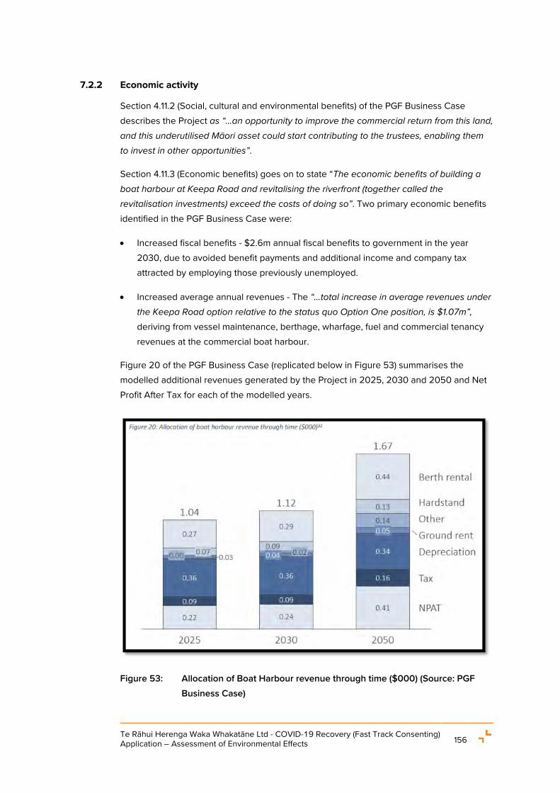
Te Rāhui Herenga Waka Whakatāne Ltd - COVID-19 Recovery (Fast Track Consenting) Application – Assessment of Environmental Effects 156
7.2.2 Economic activity
Section 4.11.2 (Social, cultural and environmental benefits) of the PGF Business Case describes the Project as “…an opportunity to improve the commercial return from this land, and this underutilised Māori asset could start contributing to the trustees, enabling them to invest in other opportunities”.
Section 4.11.3 (Economic benefits) goes on to state “The economic benefits of building a boat harbour at Keepa Road and revitalising the riverfront (together called the revitalisation investments) exceed the costs of doing so”. Two primary economic benefits identified in the PGF Business Case were:
• Increased fiscal benefits - $2.6m annual fiscal benefits to government in the year 2030, due to avoided benefit payments and additional income and company tax attracted by employing those previously unemployed.
• Increased average annual revenues - The “…total increase in average revenues under the Keepa Road option relative to the status quo Option One position, is $1.07m”, deriving from vessel maintenance, berthage, wharfage, fuel and commercial tenancy revenues at the commercial boat harbour.
Figure 20 of the PGF Business Case (replicated below in Figure 53) summarises the modelled additional revenues generated by the Project in 2025, 2030 and 2050 and Net Profit After Tax for each of the modelled years.
Figure 53: Allocation of Boat Harbour revenue through time ($000) (Source: PGF Business Case)

Te Rāhui Herenga Waka Whakatāne Ltd - COVID-19 Recovery (Fast Track Consenting) Application – Assessment of Environmental Effects 157
The Project’s overall employment and economic benefits are described in Table 21 of the PGF Business Case (replicated below in Figure 54). Note that Table 21 also refers to benefits associated with the Riverfront Revitalisation Project, which does not form part of this application.
In summary, the Project will generate employment over the long-term in sectors affected by the Covid-19 pandemic such as civil works and tourism, consistent with the purpose of the Covid Act.
Figure 54: Overall programme benefits (Source: PGF Business Case)
7.2.3 Wetland and estuarine ecology
The Terrestrial Ecology Assessment and Freshwater/Marine Ecology Assessment identify that the proposal presents opportunities for positive effects on the estuarine and IBDA-A44 environments.

Te Rāhui Herenga Waka Whakatāne Ltd - COVID-19 Recovery (Fast Track Consenting) Application – Assessment of Environmental Effects 158
The Marine / Freshwater Ecology Assessment identifies that complex hard substrate habitat for estuarine species is currently rare in the estuary environment. It notes that the revetment walls (composed of rip rap or similar material) will provide a hard substratum for settlement of marine organisms and complex three-dimensional habitat suitable for a range of marine species. Once constructed and flooded the bed and walls of the harbour will gradually be colonised by estuarine biota. As the succession progresses, increasing numbers of fish species are likely to utilise the Boat Harbour, as residents, for breeding, and for feeding. Finfish species commonly seen in marinas and boat harbours include pakirikiri (spotties), tuna (freshwater eels), whai (stingrays), aua (yellow-eyed mullet), kahawai, and patiki (flounder). Construction of the access channel is also likely to have a positive effect on marine ecology through provision of new habitat. Overall, the creation of new estuarine habitat after the Boat Harbour is constructed is a positive ecological effect.
The removal of uncapped wood waste and re-establishment of an area of saltmarsh wetland habitat is also identified as a significant positive environmental effect of the Project. The Terrestrial Ecology Assessment notes that this aspect of the Project will assist in facilitating the ecological connection between the adjacent terrestrial habitats and the wetland and estuarine ecosystems. The assessment also identifies that the proposed wetland restoration will recreate approximately 10 times more saltmarsh wetland than the area impacted by formation of the access channel to the Boat Harbour and that this would increase the area of saltmarsh wetland in IBDA-A44 by approximately 15%. The wetland restoration works are provided for through the implementation of a Restoration Plan which is further discussed in Section 7.4.1.8. The Proposed Consent Conditions include requirements to undertake the wetland restoration works in accordance with the Restoration Plan.
The Applicant acknowledges that it is the view of TRONA and a number of stakeholders, including the WHCG and F&B, that the restoration / enhancement activities should encompass a wider area of the IBDA-A44 area including the area to the south of the proposed access channel. Based on the assessments from Wildlands, such enhancement works are considered ‘Additional Enhancement Opportunities’ and are not deemed necessary to address the effects of the proposal therefore, such actions have not been included as part of this application. However, where further enhancement projects are progressed, the Applicant is supportive of such projects and is interested in being involved in a co-management type function.
7.2.4 Navigational safety and experiential values
As noted in Section 1.2.3, there is a shortage of, and a considerable waitlist for, commercial and recreational vessel berthage in Whakatāne. Makeshift/temporary berthage measures are currently used to berth eight (8) vessels at the town wharf, causing congestion and inefficiencies in navigation to/from the wharf.

Te Rāhui Herenga Waka Whakatāne Ltd - COVID-19 Recovery (Fast Track Consenting) Application – Assessment of Environmental Effects 159
The Nav Safety Assessment identifies that the new dedicated vessel berthing, haul out and maintenance, and launching ramp facilities in a safe and sheltered area provided by the Project will enable existing vessel berthage in the town wharf area to be removed. This rationalisation of berthage will allow the town wharf area to be used for the purpose of vessel loading/unloading and remove the need for vessels berthing two abreast, thus providing a less restricted navigable area for all vessels.
Additionally, the Nav Safety Assessment identifies that, given the site’s location outside the main river channel, the Boat Harbour will provide safe refuge for vessels during floods. The establishment of such refuge will enable the town wharf to be vacated by vessels before a flood eventuates, thereby reducing the risk of a vessel(s) sinking during a flood and damaging the town wharf, other vessels and the environment.
The Project may also provide an indirect positive impact on navigational safety and occupation in the Whakatāne River. The Boat Harbour will provide a safe and secure off-river facility, and so may prompt a reduction of moorings in the main river channel. The removal of moorings from this area of the HDZ may also lead to a removal of the Mooring Zone (defined by the RCEP) and therefore, a complete removal of permanent mooring from the main channel. The CIA notes this outcome is a Ngāti Awa aspiration for the river.
These positive effects were also identified by the Isthmus Natural Character, Landscape and Visual Assessment Report (“Landscape Assessment”) (refer to Appendix X). That report identified the Project’s positive effects on experiential values for users / visitors to the area, largely from improved navigational safety and increased access to the CMA.
7.2.5 Biosecurity
The Aquatic Biosecurity Risk Review and Assessment (“Biosecurity Assessment”) (refer to Appendix Y) identifies the Project as an opportunity to improve local aquatic biosecurity outcomes by preventing the establishment of aquatic introduced species. This is consistent with NZCPS and RCEP objectives for managing hazardous aquatic organisms and safeguarding and protecting natural ecosystems and indigenous flora and fauna.
The Biosecurity Assessment states “Currently there are limited opportunities for out of water cleaning in the Whakatāne area; where present, there is no capture or treatment of any of the biological arisings of cleaning, this posing a significant, uncontrolled biosecurity risk. Shifting cleaning activities to a managed facility will therefore result in improved biosecurity and general environmental outcomes for the area”. Sections 3.3 and 3.4 of the Biosecurity Assessment examine operational biosecurity matters and positive biosecurity effects in more detail. The Biosecurity Assessment concludes that with appropriate management, the Boat Harbour will provide net environmental and biosecurity benefits. To this end, the proposed resource consent conditions include requirements for the production and implementation of biosecurity management plans.

Te Rāhui Herenga Waka Whakatāne Ltd - COVID-19 Recovery (Fast Track Consenting) Application – Assessment of Environmental Effects 160
7.2.6 Public amenity
As noted in the PGF Business Case and the Nav Safety Assessment, the single boat ramp at Whakatāne experiences extremely high demand with launching and parking spaces at a premium. The Recreation Assessment identifies that the Project will double the number of dedicated trailer parks available for trailer boats in Whakatāne, and this additional parking provision “… might largely serve to reduce crowding at the existing boat ramp” which would constitute an indirect positive effect of the Project.
Overflow parking is currently accommodated on the Kapu te Rangi Historic Reserve during peak periods (entering via the paved path to the Mātaatua Waka enclosure, off the Muriwai Drive access to the boat ramp). The relocation of a portion of this parking overflow from Kapu te Rangi Historic Reserve to the car and trailer parking at the Boat Harbour (Stage 3) will improve the amenity of the Kapu te Rangi Historic Reserve to an extent. The community’s use and enjoyment of the Reserve during peak use periods (e.g., summer) will be less impacted by use of the Reserve for overflow parking, and associated vehicle noise and movements.
The Landscape Assessment also identified the Project’s positive effects on experiential values for users/ visitors to the area, largely from improved navigational safety and increased access to the CMA. The removal of vehicles from the Reserve would also result in a reduction of adverse visual amenity effects at Ngāti Awa’s Mātaatua Wharenui for tangata whenua, the community and the many tourists who visit the Wharenui.
7.3 CULTURAL EFFECTS
The Applicant has engaged with TRONA as the relevant iwi authority for the Project, as summarised in Section 5 and Section 6 of this AEE.
The Applicant has also facilitated the preparation of a CIA from TRONA (refer to Appendix N) which sets out:
• The relevance of the Statutory Acknowledgement of TRONA’s association with, and the cultural values of the Whakatāne River, to the assessment of the Project.
• Ngāti Awa’s longstanding occupation of the Whakatāne River and its banks; and
• The particularly high cultural importance of the river section and estuary between the SH30 bridge and the river mouth, including its history as the landing place of the Mātaatua waka and its ongoing use for gathering food.
• The existing congestion in the estuary for various activities, some of which are incompatible but sited close together.
• TRONA’s opposition to the potential adverse effects of 10 historic marina proposals in this section of the river, including effects such as:

Te Rāhui Herenga Waka Whakatāne Ltd - COVID-19 Recovery (Fast Track Consenting) Application – Assessment of Environmental Effects 161
• Modification of the flood storage capacity and function of the river;
• Impacts on transport of tupapaku to, and activities at, Opihiwhanaungakore urupa;
• The release of dioxin-laden sediments to the aquatic environment;
• The disturbance of ecological, biodiversity and cultural values, including the high cultural significance of the local landscape and seascape;
• Potential conflicts with established activities including swimming, boating, fishing, and whitebaiting.
• The provisions of the NAEP relevant to this proposal; and
• The Project’s potential adverse effects on cultural values, and associated recommendations for potential resource consent conditions.
The matters raised by the CIA have been incorporated into the different elements of the Project and, where relevant, are discussed in the sub-sections below. The recommendations provided in Appendix 8 of the CIA have been addressed in the respective technical assessments and reports appended to this AEE and, where relevant, these responses have been set out below.
7.3.1 Cultural Effects: Landscape and amenity effects
The CIA states that the stretch of river from the Landing Road bridge to the river mouth is a cultural landscape of great significance to Ngāti Awa and in this context, the proposed Boat Harbour site is “exceptional” compared to the sites of historic marina development proposals.
Landscape features of cultural significance include “rocks, rivers, mountains, hilltops ridgelines, including those that determined the boundaries of iwi and hapū”. To this end, the CIA recommends consent conditions to require that the design and siting of buildings and structures avoid imposing on views from Te Hokowhitu a Tū ki te Rāhui Marae towards Kohi Point and to the pa called Kapu Te Rangi above the Wairaka cultural precinct, to the east and north-east respectively.
With the proposed land forming for flood protection purposes, the tallest building on the site (the boat maintenance shed) will be approximately 15.5 m above natural ground level. The Boat Harbour site is subject to a 12 m maximum height limit pursuant to Rule 7.2.1.1(b) of the District Plan. The intervening land36 between Te Hokowhitu a Tū ki te Rāhui Marae and the Boat Harbour site is in the Light Industrial Zone where a permitted height limit of 15 m applies, pursuant to District Plan Rule 6.2.1.1.
36 23 Keepa Road (Lot 2 DP 452650) and 45 Keepa Road (Lot 2 DP 546187).

Te Rāhui Herenga Waka Whakatāne Ltd - COVID-19 Recovery (Fast Track Consenting) Application – Assessment of Environmental Effects 162
As discussed in Section 7.5.4 below, the Landscape Assessment considers this context and concludes that the Project’s landscape effects on Te Hokowhitu a Tū ki te Rāhui Marae will be ‘Low’.
Adherence to the conditions recommended by the Landscape Assessment, primarily provided for through the requirement to prepare an Architecture and Design Report requirement (Proposed Condition 2.3), will ensure that the Project design responds appropriately to the landscape values of the surroundings and thereby achieve the outcome sought by the CIA recommendations relating to landscape values of cultural significance.
7.3.2 Cultural Effects: Environmental effects
The CIA identifies the potential adverse ecological effects of disturbing migratory fauna, the loss of small areas of coastal habitat, dredging, discharges to the coastal environment, the management of soil contamination, operational pollution and biosecurity risks.
Those potential effects, and proposed management methods, are discussed in detail elsewhere in this AEE and in the appended technical assessments. By way of review, the following matters are noted:
• Disturbance of migratory fauna – The Terrestrial Ecology Assessment concludes that there will not be any adverse effect on migrating birds or fish species as a result of the proposal;
• Loss of areas of coastal habitat – The Terrestrial Ecology Assessment concludes that the proposed restoration works will restore much more coastal habitat than is lost as a result of the development.
• Dredging activities, including excavation of the riverbed and deposition to the riverbed and foreshore, will be managed through adherence to the conditions of the coastal permit. The proposed dredging-specific resource consent conditions (Proposed Conditions 5.1 – 5.7) require (inter alia):
• Advance notification of the BOPRC, Harbourmaster and public;
• Excavations to no more than -2.5m Chart Datum;
• Documentation of the disposal information for each dredging campaign;
• Management of sediment and dust generated by stockpiles of dredging spoil;
• Avoidance, where practicable, of dredging activities during the whitebait spawning season; and
• Timely reinstatement of land-based areas (such as stockpile areas) after each dredging campaign is completed.

Te Rāhui Herenga Waka Whakatāne Ltd - COVID-19 Recovery (Fast Track Consenting) Application – Assessment of Environmental Effects 163
• Construction and Operational Discharges – Table 2 of the Tektus Report responds in detail to the concerns raised in the CIA with respect to discharges from the site and the effects of those discharges. By way of summary:
• Construction discharges - The construction discharges will be managed by way of the CMP and ESCP to provide for effective management of potential erosion and sedimentation risks from construction activities and the bulk of the excavation and earthmoving works will be undertaken without direct connection to the awa, with appropriate erosion prevention and control measures in place;
• Operational discharges and stormwater management - Water management design proposes a treatment train of systems, including capture and reuse, to promote an integrated and holistic approach for water management. The proposed site practices substantially exceed industry standard practice, and detailed design will afford a high level of environmental protection, including monitoring and adaptive management. The ongoing operation of the site will be subject to an Operational Management Plan, and a commitment to ongoing monitoring of site water capture, use, and discharge quality. The system design water quality targets exceed minimum requirements, and propose ongoing monitoring to enable adaptive management in response to outcomes achieved through innovative and industry leading site design.
• Boat Exhaust effects on water quality – at the request of the hapū representative at a hui, the Applicant engaged Babbage Consultants to undertake an assessment of the effects of boat exhaust emissions on water quality and the river environment. This has been summarised in Section 7.5.9 below.
7.3.3 Cultural Effects: Contamination and wetland restoration activities
The CIA states that it does not support the proposed wetland restoration activity at the location proposed by the Applicant. While set out in detail in Appendix 8 to the CIA, the opposition to this is primarily related to:
• The concerns over the presence of historical contamination within the area identified as ‘Section 2’ and the proposed disturbance of this area associated with the filling of suitable wood waste material in this area; and
• The location of the restoration works being outside the proposed construction footprint of the Boat Harbour.
It is acknowledged that the CIA does not support the proposed wetland restoration but based on the advice from the Project’s technical advisors, it is considered that the proposed restoration is appropriate for the following reasons:

Te Rāhui Herenga Waka Whakatāne Ltd - COVID-19 Recovery (Fast Track Consenting) Application – Assessment of Environmental Effects 164
• The HAIL DSI Report (Appendix C) identifies the historic land use and filling activities and outlines the contamination levels within this area;
• The SMP (Appendix D) outlines that wood waste from the wetland restoration area will be removed to an adjoining wood waste containment area located on local purpose reserve land (see Section 2 of Figure 3), and will not be disposed as cleanfill. The containment area (site no. WHK_39) is listed on the BoPRC Selected Land Use Register (SLUR) as HAIL land use – waste storage, treatment and/or disposal; Category – management required. Works will need to comply with the Wood Waste Site Management Guidelines (Ref: BoPRC). A copy of the guidelines is provided in Appendix B of the SMP;
• The Wildlands Terrestrial Ecology Report (Appendix Q) outlines that upon completion, the wetland restoration works will result in the recreation of approximately 0.93 ha of salt marsh wetland which equates to an increase of approximately 15% in area of that type of wetland across the entire IBDA-A44 wetland complex (approximately 6.5 ha in total area);
• As there is an inevitable small loss of wetland habitat at the site of the proposed access channel, it is appropriate to undertake the restoration works within the same wider wetland complex so that there is no loss of wetland extent or values within the wetland complex. The proposed wetland restoration site is immediately adjacent to the proposed access channel;
• It is not unusual or inappropriate for a restoration site to be outside the footprint of a proposed development, where the best ecological outcome can be achieved;
• The recreation of the wetland area and the removal of the historic wood waste that has been dumped in the Scenic Reserve has the potential to positively contribute to the mauri of the site, wider wetland area and the Whakatāne River as the dumped waste will be removed and the area returned to its natural function; and
• The proposed restoration works are detailed in the Restoration Plan appended to this AEE and prepared in accordance with the NES FM requirements. The implementation of and compliance with the plan is provided for, in accordance with the NESFM Clause 39(6), as a requirement of the Proposed Consent Conditions (Proposed Condition 1.2.10).
The CIA further includes a peer review of the draft HAIL DSI Report and the draft SMP carried out by TRONA’s nominated expert forms Appendix 7 to the CIA. The peer review identified some opportunities for additional reporting and those opportunities are captured in the TRONA recommended conditions set out in Appendix 8 to the CIA.

Te Rāhui Herenga Waka Whakatāne Ltd - COVID-19 Recovery (Fast Track Consenting) Application – Assessment of Environmental Effects 165
It is the opinion of the Applicant that the HAIL DSI Report and the final draft SMP, along with the Proposed Consent Conditions (primarily Proposed Condition 1.2.9), adequately encompass the matters canvassed by the peer review and CIA recommendations. This includes the amendments made to the SMP as set out in the table below and the requirement to provide a final SMP for certification to Council which provides for targeted sampling, contaminant management protocols and monitoring and reporting. The Proposed Consent Conditions (Proposed Condition 1.2.1) also require the final SMP to be provided to the Reference Group (which includes TRONA) for review and feedback prior to provision to Council for certification. Specific responses to the CIA recommendations relating to contaminated land in Appendix 8 are provided in the table below:
Table 11: Response to CIA recommendations to contaminated land
CIA Appendix 8 – Contaminated Land Recommendations
HAIL Environmental Response Response in the Application / AEE / SMP
Be more explicit in describing the extent to which contamination is unknown
It is acknowledged that the investigations to date have not defined the full extent or degree of contamination that may be present within the proposed areas of disturbance that are required to facilitate the development. However, further intrusive investigations are unlikely to address this issue.
No changes proposed.
Include strong protocols to assess and respond to unexpected contamination
Existing protocols in the SMP are based on standard contaminated land practice. Rather than being prescriptive they acknowledge the need to cease works if suspected contamination is encountered and have suitably qualified and experience contaminated land practitioners undertake further investigations. The results of the investigations are then used to determine appropriate actions.
Through their role on the Reference Group (as provided for through the Proposed Consent Conditions), TRONA will review and provide input on the final SMP to be submitted to Council ahead of any works being undertaken.
Through this position, TRONA advisors will be able to provide further direction on contamination discovery and management protocols, particularly in areas where potential

Te Rāhui Herenga Waka Whakatāne Ltd - COVID-19 Recovery (Fast Track Consenting) Application – Assessment of Environmental Effects 166
CIA Appendix 8 – Contaminated Land Recommendations
HAIL Environmental Response Response in the Application / AEE / SMP
disturbance of dioxin impacted material may occur.
Recognise the kaitiaki requirements of Te Rūnanga o Ngāti Awa and work in partnership with Ngāti Awa to appropriately manage the environmental risk of soil contaminants
Section 1.1, paragraph 5 of the SMP acknowledges the need to “work with mana whenua to utilise mātauranga
Māori concepts to manage or remediate contaminated material where encountered.”
Section 3.2, bullet point 7 of the SMP outlines training has been updated to specifically reference that Cultural Monitors are also provided with training associated with contamination discovery and management protocols.
Avoid transportation of contaminated sediments to outside of the Ngāti Awa rohe
This position is acknowledged.
Additionally, use of CS3 as a disposal site is subject to approval from BOPRC as the consent holder; or subject to a separate consent process if we had to set up our own site.
This position is acknowledged within the application / AEE. In the event that contaminated sediments / materials are encountered, disposal within the rohe of Ngāti Awa is our preference. However, the Applicant needs to demonstrate to the panel that they can dispose of it if encountered so the application still has to refer to disposal at an authorised site as an option.
Retain contaminated soil within the rohe and treat this contamination using techniques that have already been demonstrated to work for the Kopeopeo Canal sediment
This is acknowledged in Section 3.4.1 of the SMP.
Given the evidence presented within the HAIL DSI Report, the wetland restoration area is the only area to be disturbed where dioxin contamination may be present. Investigations carried out in this area to date have not identified any significant contamination however this area received
This position is acknowledged within the application / AEE.
In the event that contaminated sediments / materials are encountered, disposal within the rohe of Ngāti Awa is our preference. However, the Applicant needs to demonstrate to the panel that they can dispose of it if
Te Rāhui Herenga Waka Whakatāne Ltd - COVID-19 Recovery (Fast Track Consenting) Application – Assessment of Environmental Effects 167
CIA Appendix 8 – Contaminated Land Recommendations
HAIL Environmental Response Response in the Application / AEE / SMP
waste from the during the time the former mill was operational and discovery of dioxin impacted waste during restoration work cannot be ruled out. If dioxin impacted waste is encountered for investigation results will be shared with TRONA project advisors to utilise these techniques where possible.
encountered so the application still has to refer to disposal at an authorised site as an option.
Acknowledge the possibility of including some 5,000 m3 of material within the existing CS3 noting this is a small volume capacity in the context of the 290,000 m3 of cut that may need to be disposed of
It is acknowledged that the redundant space within CS3 is the ideal repository for any moderate-high level dioxin impacted waste that might pose a risk if included within the existing buried woodwaste cell. Further investigation results that follow discovery will determine appropriate management and disposal requirements. If significant contamination is identified this option would need to be negotiated with BoPRC as current land manager and consent holder for the CS3 site.
As per previous response, this position is acknowledged within the application / AEE.
In the event that contaminated sediments / materials are encountered, disposal within the rohe of Ngāti Awa is our preference. However, the Applicant needs to demonstrate to the panel that they can dispose of it if encountered so the application still has to refer to disposal at an authorised site as an option.
Require further targeted sampling to provide more certainty around the extent of known hotspots and such sampling should be advanced once the project has a green light
As required, this will be undertaken prior to the earthworks outlined in 3.4.2 of the SMP.
Already provided for within the SMP.
Align visual and olfactory observations of problematic contamination with analytical data
This is intended and forms part of the recommended approaches outlined in 3.4.1 - 3.4.2 of the SMP.
Already provided for within the SMP.

Te Rāhui Herenga Waka Whakatāne Ltd - COVID-19 Recovery (Fast Track Consenting) Application – Assessment of Environmental Effects 168
CIA Appendix 8 – Contaminated Land Recommendations
HAIL Environmental Response Response in the Application / AEE / SMP
Require capable observers (monitors) under the lead of a Suitably Qualified and Experienced Practitioner to build capability and ensure confidence in the effectiveness with which the Contaminated Sites Management Plan is being implemented. This capability would build on existing partnerships created through the Kopeopeo Canal remediation project, and provide a platform for the ongoing delineation, assessment, remediation, and healing of land from woodwaste across Whakatāne. This capability is a critical part of the Contaminated Site Management Plan and further planning for how it is to be created, audited, and managed should be advanced
Already provided for within the SMP and amendment to the bullet 7 will further set out requirements.
Section 3.2, bullet point 7 of the SMP outlines training has been updated to specifically reference that Cultural Monitors are also provided with training associated with contamination discovery and management protocols.
Further investigate the opportunity for mātauranga to partner with science to improve the mauri of people and the environment as contaminated material is excavated and managed
This is intended. Section 3.4.1 of the SMP highlights this - “The entire wood waste containment area can be treated using similar mātauranga Māori concepts as the Kopeopeo Canal sediment remediation project.”
Additionally, through their position on the Reference Group, TRONA (along with other parties including the Lands) TRONA will review and provide input on the final SMP to be submitted to Council ahead of any works being undertaken.
Overall, while acknowledging the concerns raised in the CIA, the Project will apply strict management control over land disturbance - including the disturbance of areas that have been subject to historic contamination - to manage and minimise potential adverse effects including contamination risks. The adverse effects of encroachment by the access channel into a 0.1 ha area of wetland will be minimised through restoring a significantly larger area of wetland, approximately 0.93 ha, that currently is the site of historical wood waste and is identified as having ‘low ecological value’.

Te Rāhui Herenga Waka Whakatāne Ltd - COVID-19 Recovery (Fast Track Consenting) Application – Assessment of Environmental Effects 169
7.3.4 Cultural Effects: Effects on the relationship of tangata whenua with the environment
The CIA identifies the potential for loss of access to/destruction of sites of cultural significance as a concern as well as the potential for the proposal’s land disturbance activities to affect the cultural association with the whenua, the awa and the wider environment.
The Project’s design will not affect the waahi tapu site identified as Toitoihuia. Formed pedestrian access through the site to the stopbank area and river margins is provided in the concept design and this will enable the public to continue to access these areas for a range of purposes including whitebaiting, fishing and the collection of natural art/craft materials.
The risks associated with an accidental discovery of culturally significant material during construction works are subject to management controls set out in the Proposed Consent Conditions. The controls include:
• The commissioning of experienced monitors identified by TRONA to monitor earthworks for koiwi tangata and taonga tuturu.
• The training of construction staff in including a site cultural induction.
• Provision for cultural monitors to be present during excavation works across the site with the monitors receiving training, where required, associated with contamination discovery and management protocols
• The promulgation of, and adherence to, an Accidental Discovery Protocol recommended by TRONA.
Regarding in river works, consent conditions are proposed (Proposed Condition 4.9) to ensure the design and siting of Aids is developed in consultation with the Reference Group and it is expected that this consultation will ensure that any placement is useful to operators of waka ama, including those tasked with transporting tupapaku to Opihiwhanaungakore urupa.
The Proposed Consent Conditions also ensure that dredging activities are timed and undertaken to avoid or mitigate disruption to other users of the Whakatāne River. These proposed conditions are consistent with those recommended in the CIA.
Furthermore, the ongoing environmental performance of the Boat Harbour will be subject to annual performance reporting (Proposed Condition 1.5.8), which will be shared with the proposed Mana Whenua Liaison Group (Proposed Condition 1.2.2) ahead of scheduled meetings.
Te Rāhui Herenga Waka Whakatāne Ltd - COVID-19 Recovery (Fast Track Consenting) Application – Assessment of Environmental Effects 170
7.3.5 Cultural Effects: Coastal processes, natural hazards and climate change effects
The CIA identifies the potential for the Project to create an adverse effect on coastal processes and natural hazards. It also identifies the need to ensure that the potential effects of climate change should be used to inform the design of the Project.
The T&T Coastal Assessment assesses, and provides recommendations about, the potential effects of the Project on the physical coastal environment and other natural hazards, such as floods and tsunami. Section 6.9 of the T&T Coastal Assessment directly responds to the CIA recommendations.
By way of summary, the Project’s location means it will not displace flood flows nor affect coastal processes at the river outlet to the open coast. Any impacts experienced will be localised and negligible in the wider river channel area.
The Proposed Consent Conditions seek to embed management procedures during construction, and thereafter monitoring procedures, for the operation of the Boat Harbour. The conditions will ensure matters such as dredging, the occupation of the coastal marine area, erosion, scouring and post-flood assessment and remediation are accounted for and managed for the duration of the Boat Harbour’s operational life.
The proposed review conditions can be exercised by the Regional Council if investigations indicate that additional controls are needed to appropriately manage the unanticipated effects of the Boat Harbour on the coastal environment.
The foregoing is consistent with the recommendations of Appendix 8 to the CIA that all structures be designed and located to avoid creating or exacerbating erosion and flooding issues on neighbouring lands and in the Whakatāne River.
7.3.6 Cultural Effects: Operational effects
The CIA comments on potential adverse effects in terms of construction and operational noise, the cultural appropriateness of signage, access to the riverbank and wider CMA for resource gathering, the exercise of mātauranga Māori and the conduct of Boat Harbour users.
The Acoustic Assessment identifies that construction noise and vibration will be within permitted limits. It recommends that noise monitoring be initiated on the commencement of marine precinct activities. These recommendations have specific regard to the amenity of Te Hokowhitu a Tū ki te Rāhui Marae and are captured in the Applicant’s Proposed Consent Conditions (Proposed Condition 2.10).
The design of signage will be subject to review by the Reference Group (Proposed Condition 1.2.1) to be established in accordance with Proposed Consent Conditions (Proposed Condition 2.12). As such, signage design can be informed by any recommendations proffered by TRONA through its membership of the Reference Group.

Te Rāhui Herenga Waka Whakatāne Ltd - COVID-19 Recovery (Fast Track Consenting) Application – Assessment of Environmental Effects 171
Access to the riverbank and wider CMA will be improved by the Project, as discussed in the Landscape Assessment and Recreation Assessment. The Project will relieve pressure on the existing Muriwai Drive boat ramp and informal parking in Kapu te Rangi Historic Reserve, facilitate the removal of temporary mooring activities within the Whakatāne River main channel, and provide formalised through-site pedestrian access to the riverbank.
The conduct of Boat Harbour users will be regulated through the development and implementation of an Operational Management Plan (Proposed Condition 1.5). Permanent tenants will be subject to lease/license arrangements. Casual users will be subject to a user code of conduct. These requirements (implemented through Proposed Consent Conditions) will complement the Regional Council’s Navigation Safety Bylaw. The terms of the lease/license arrangements and code of conduct will, broadly, encompass all operational matters including:
• The control of vessel speeds and wake;
• Biosecurity and vessel cleaning;
• The use of sewerage pump-out facilities
• Noise; and
• Discharges from vessels.
The Proposed Consent Conditions include conditions which address these matters, in line with recommendations arising from (inter alia) the Nav Safety Assessment and Biosecurity Assessment.
Additionally, the proposed conditions relating to establishment of the three liaison groups will enable the efficacy of the lease/license and code of conduct arrangements to be monitored over time.
7.3.7 Cultural Effects: Economic effects
While noting that the tenure of the site will remain Māori freehold land vested in Te Rāhui Land Trust, the CIA records wider concerns raised at hapū engagement hui about the economic and social effects of Māori landowners being displaced by industrial and residential subdivision and development in the Coastlands area and around Te Hokowhitu a Tū ki te Rāhui Marae.
While the Applicant acknowledges this commentary, it also notes that the Boat Harbour will be open to the entire community and that the CIA confirms that the Project is not considered to be a cause of this economic activity that will displace tangata whenua.

Te Rāhui Herenga Waka Whakatāne Ltd - COVID-19 Recovery (Fast Track Consenting) Application – Assessment of Environmental Effects 172
7.3.8 Cultural Effects: Kaitiakitanga and the ongoing role of mana whenua
An overarching theme of the CIA is ensuring that mana whenua have an ongoing role, as kaitiaki of the Whakatāne River and surrounding environments, in the Project both with respect to the detailed design phase and the operational phase. The Applicant restates its commitment to providing for this.
In addition to proposed review conditions for the resource consents requested within the CIA, the Proposed Consent Conditions includes the requirement for the Applicant to invite parties to establish:
a. The Te Rāhui Herenga Waka Whakatāne Reference Group (Proposed Condition 1.2.1) – consisting of representatives from the Consent Holder, TRONA, the Lands Trust, DOC, WD Cand BOPRC. The role of this group includes the review and feedback on the Project’s management plans to be developed prior to the construction and operation of the Boat Harbour; and
b. A Mana Whenua Liaison Group (proposed Condition 1.2.2) – consisting of representatives from Ngāti Awa and its relevant Hapū. The purposes of this group is to facilitate ongoing engagement and information sharing between the Mana Whenua Liaison Group and the consent holder.
These proposed conditions require regular meetings between the consent holder and the liaison groups during the construction and operational life of the Boat Harbour.
Further, the Proposed Consent Conditions include a requirement for the production of an Annual Performance Report (Proposed Condition 1.5.8) which would set out the results of environmental and operational monitoring associated with the Boat Harbour. These Annual Reports would be provided to the abovementioned groups providing the opportunity for the reporting outcomes to be discussed and any issues worked through.
This framework of resource consent conditions provides the basis for ongoing information-sharing between mana whenua and the Boat Harbour operator. It will also provide a pathway to refine operational processes as the Project matures.
The Applicant considers that these proposed conditions align well with the recommendations of the CIA that encourage the provision of performance reporting by the operators of the Boat Harbour as well as enabling Ngāti Awa, and its hapū, to exercise their role as kaitiaki of the wider Whakatāne River environment including the Project area.
7.3.9 Cultural Effects: Concluding Statement
While there is a conflicting position with respect to the wetland restoration activity and the potential contamination of this area, the Applicant considers that the Project can be developed, constructed and operated in a manner that addresses the actual and potential effects of the Project on cultural values and interest and that it is consistent with the environmental outcomes sought by Ngāti Awa as expressed in the CIA and the NAEP.

Te Rāhui Herenga Waka Whakatāne Ltd - COVID-19 Recovery (Fast Track Consenting) Application – Assessment of Environmental Effects 173
The Applicant’s response in respect to the CIA commentary regarding the wetland restoration has been provided above. In conclusion, the Applicant considers that the concerns regarding the presence of contamination in the proposed restoration area and disturbance of that contamination will be appropriately addressed through the procedures and protocols set out in the SMP to ensure that any human health, environmental and / or cultural effects, will be appropriately managed. The restoration of approximately 0.93 ha of saltmarsh wetland within the Scenic Reserve will have constitute a positive ecological effects which in turn has the potential to positively contribute to the mauri of the restoration site and wider river side environment through removal of historic wood waste and reverting the area to its natural function.
It is further noted that the construction and wetland restoration works will all be undertaken in accordance with the Project’s SMP and construction management plans, all of which are to be finalised in consultation with the proposed Reference Group which Ngāti Awa are a part of.
Regarding the Trust, as set out in the TRLT Supporting Statement (refer to Appendix B), the Trust concludes that:
• The Project, through its support from the PGF, has enabled a once in a generation opportunity to transform the development potential of the whenua for use as a fit for purpose Boat Harbour;
• The design, delivery and long term benefits of the Project are empowering in that the Trustees are able to actively exercise Rangatiratanga over the whenua while safeguarding their inherited responsibilities as Kaitiaki;
• In addition to an increased and diversified asset base, the Trust will also benefit from job creation and new career pathways within the marine and tourism industry;
• The Project provides an innovative “off-river” solution (on a site identified by the CIA as “exceptional”) that will positively impact the mauri of the Whakatāne River and provide intergenerational benefits for years to come.
• The Project alleviates long held concerns of tangata whenua regarding previous marina proposals that were to be sited within the river channel and adjacent to waahi tapu.
Overall, the Trust stated that it recommends that the application is granted subject to the Proposed Consent Conditions.
7.4 ACTUAL AND POTENTIAL ADVERSE ENVIRONMENTAL EFFECTS
This section summarises the adverse effects identified, potential effects management measures and the overall conclusions of the technical assessments for the Project. The

Te Rāhui Herenga Waka Whakatāne Ltd - COVID-19 Recovery (Fast Track Consenting) Application – Assessment of Environmental Effects 174
effects of construction activities are considered first, followed by the Project’s operational effects.
7.4.1 Construction activities: environmental effects
The potential adverse effects of construction activities are comparable to those of any substantial development proposal.
As discussed in Section 2.2.1, and recommended by several of the technical assessments, a consent condition is proposed to require the consent holder, after engagement of the contractor, to prepare and submit a CMP for certification by the consent authorities before the commencement of construction of Stage 1 and 2 works and subsequently Stage 3.
The purpose of the CMP is to specify the overall construction management measures that will be implemented by the consent holder and shall include:
a) The construction timetable;
b) The various construction methods to be utilised onsite;
c) The proposed staging of construction;
d) General site management measures including management plans for noise and vibration, erosion and sediment control, and construction traffic; and
e) Site reinstatement measures to be implemented upon completion of works on the site.
Overall, the CMP would document the proposed management measures for actual and potential adverse effects including those identified below.
7.4.1.1 Construction activities: erosion and sediment runoff from earthworks
Erosion and sediment control is a standard construction management matter. A draft ESCP is provided in the Tektus Report (Appendix E(x)) and Tektus Drawings 220 – 222 (Appendix E(i)) illustrate methods to manage erosion and sediment runoff. The nature of the ESC methods proposed for each stage of works are identified in sections 2.2.2, 2.3.1 and 2.4.1 of this AEE.
If resource consents are granted, a final detailed ESCP will be prepared in accordance with the relevant resource consent condition to ensure compliance with the requirements of the BOPRC ESC Guidelines and in accordance with the draft ESCP and drawing provided.
7.4.1.2 Construction activities: dust suppression.
The scale, location, duration and characteristics of the Project give rise to a potential for dust nuisance. Dust control is a standard construction management matter, and it is proposed that a section of the CMP be dedicated to specifying the dust management procedures to be adopted, as outlined in the proposed resource consent conditions.
Te Rāhui Herenga Waka Whakatāne Ltd - COVID-19 Recovery (Fast Track Consenting) Application – Assessment of Environmental Effects 175
The Tektus Report identifies the main mitigation measures for dust control as:
• Water from the onsite ESC ponds or Keepa Road swale is available, if necessary, for dampening exposed areas;
• Implementation of traffic controls, including access and speed limit restrictions; and
• Ceasing works in extreme wind conditions if dust controls are proving ineffective.
Overall, given the nature of the materials / soils to be excavated onsite, likely having high moisture content and not being prone to dust generation, and the accessibility of water, dust can be managed to ensure there are no adverse effects beyond the site boundary.
7.4.1.3 Construction activities: noise and vibration.
Regarding construction noise, the Acoustic Assessment concludes that “Construction noise and vibration can readily comply with the applicable limits”. This assessment accounted for the requirements of New Zealand Standard NZS 6803:1999 “Construction Noise”, as referred in District Plan Rule 11.2.6.2. It was noted that quieter construction activities can be undertaken in compliance with the District Plan outside the hours of 7.30AM to 6.00PM, while louder construction activities will be restricted to those daytime hours.
With regards to vibration, the Acoustic Assessment confirms the appropriateness of German standard DIN 4150-3 to address the relevant matters under Rule 11.2.13.1 of the District Plan. The outcome of assessment is stated as “…construction vibration would readily comply with the cosmetic building damage limits in DIN 4150-3:1999. Furthermore, it is unlikely that vibration would be perceptible”.
Noting the positive conclusions of the Acoustic Assessment, and to provide clarity and certainty about the management of these effects, a resource consent condition is proposed to require the preparation and submission for certification of a CNVMP as part of the CMP. The purpose of the CNVMP is to is to set out the measures to ensure the best practicable option for noise management is adopted so that noise and vibration from the construction activities on the site does not exceed a reasonable level and will include:
a) The construction noise and vibration limits to be applied to the construction activities on the site;
b) The predicted construction noise and vibration levels from construction activities on the site;
c) The limitations on working days and hours;
d) The identification of surrounding receivers that are potentially sensitive to noise and / or vibration;

Te Rāhui Herenga Waka Whakatāne Ltd - COVID-19 Recovery (Fast Track Consenting) Application – Assessment of Environmental Effects 176
e) Details of the management and mitigation measures that will be implemented in order to minimise the generation of construction noise and vibration from the site; and
f) A complaints procedure in the event of noise or vibration complaints being received.
7.4.1.4 Construction activities: emissions of artificial light.
Artificial light emissions during construction activities will be designed and managed to comply with the permitted activity standards specified in Chapter 11 of the District Plan. This requirement is proposed to be incorporated into the CMP.
If construction activities produced a non-compliance with the permitted activity requirements, a separate resource consent would be applied for.
7.4.1.5 Construction activities: management of construction traffic.
It is anticipated that the Project’s construction traffic will involve a considerable volume of construction traffic movements, including some 39,000 movements (over approximately 10 months) for the transportation of excavated soil offsite associated with the Stage 1 and Stage 2 bulk earthworks.
In order to ensure that the construction traffic effects on the transportation network will be “minor” , the Applicant proposes the development and implementation of a CTMP which will include, as a minimum, the following:
• Construction dates and hours of operation including any specific non-working hours for traffic congestion / noise etc., must comply with normally accepted construction hours within Council requirements;
• Truck route diagrams;
• Temporary traffic management signage must comply with consent requirements; and
• Details of site access / egress over the entire construction period, noting that all egress points are to be positioned so that they achieve appropriate site distance.
Therefore, the Proposed Consent Conditions include the requirement for a CTMP (Proposed Condition 1.2.6). CTMPs commonly form part of a project’s CMP and it is considered that this approach is appropriate for this proposal and it will ensure appropriate mitigation and management of construction traffic effects.
7.4.1.6 Construction activities: management of site contamination
The HAIL DSI Report explains that site investigations were carried out in accordance with the NES CS, and confirms that the site is a “piece of land” for the purposes of the NES CS.
The HAIL DSI Report builds on the results of previous investigations (identified in section 8 of the report) and identifies and addresses data gaps from the previous investigations.

Te Rāhui Herenga Waka Whakatāne Ltd - COVID-19 Recovery (Fast Track Consenting) Application – Assessment of Environmental Effects 177
Fresh soil samples were collected from the Project site and analysed for contaminants. As a result of these investigations the report identifies the key site contamination considerations as:
• There is a likelihood that excavations within the proposed Boat Harbour site will encounter some fill of unknown quality at depth and along the northern boundary of the site.
• Historical wood waste and uncontrolled fill is present within the proposed wetland extension area.
• The sediments from the Kopeopeo Canal flood pump station discharge channel contain dioxin, albeit at concentrations below human health criteria, and present a low risk of adverse effects to biological organisms.
The HAIL DSI Report stated that although concentrations of contaminants do not exceed the applicable soil contaminant standards, some uncertainty still exists associated with the quality of uncontrolled fill which was historically placed onsite and the potential for isolated hotspots of contaminants. Given the latter, it cannot be confirmed that it is ‘highly unlikely’ that there will be a risk to human health due to the proposed change in use (Regulation 8(4) of the NES-CS). To manage this uncertainty a restricted discretionary consent application should be sought for soil disturbance and the proposed change in use under Regulation 10 of the NES CS. Additionally, given the uncertainty, and in line with the conservative approach to managing potential contamination, a Restricted Discretionary Activity consent under the RNRP would apply to the disturbance of those areas.
The HAIL DSI Report recommends site contamination is managed by a SMP. The draft SMP (Appendix D) sets out the proposed procedures to identify contaminant hotspots, minimise discharges to the environment and risks to human health and specify the main soil disposal options for the excavated material from the Project area. The SMP also requires the preparation of a Works Completion Report, prepared in accordance with MfE’s Contaminated Land Management Guideline No. 1: Reporting on Contaminated Sites in New Zealand, following the completion of the different stages of the earthworks and soil disturbance activities.
The Proposed Consent Conditions include a requirement for a final SMP to be submitted to the consent authority for certification following engagement of the contractor, and prior to the commencement of any soil disturbance activities.
Overall, subject to implementation of the SMP, and the CMP (which includes an ESCP), any adverse effects resulting from the disturbance of land within the site will be appropriately managed any potential contamination risks so that effects are less than minor.

Te Rāhui Herenga Waka Whakatāne Ltd - COVID-19 Recovery (Fast Track Consenting) Application – Assessment of Environmental Effects 178
7.4.1.7 Construction activities: archaeological values
InSitu Heritage Ltd were engaged to provide an archaeological assessment (“Archaeology Assessment”) of the Project area (refer to Appendix Z) which includes the following commentary:
• The site is too low-lying to have been used for early Māori horticulture or settlement;
• There are no records of archaeological finds despite the site having been highly modified since 1944;
• A field inspection of the site did not identify archaeological features; and
• The probability that earthworks will encounter intact archaeological sites is low.
The assessment concludes that given the above, and subject to the implementation of an Accidental Discovery Protocol, the adverse effects of the Project on archaeological values will be less than minor.
7.4.1.8 Construction activities: Ecological effects
As identified in Section 7.2 above, when considered in its entirety, the Project will produce positive ecological effects. This sub-section considers the assessments by Wildlands’ in both the Terrestrial Ecology Assessment and Marine and Freshwater Ecology Assessment, on the potential adverse ecological effects as a result of construction activities. The elements of construction with potential adverse effects include:
• Construction of the access channel between the Boat Harbour and the Whakatāne River (atop the Kopeopeo Canal flood pump station discharge channel alignment) will remove approximately 0.1 ha of saltmarsh wetland.
• Construction works in the IBDA-A44 / SIBS may disrupt the habitat of local birdlife.
• Capital dredging of the Whakatāne River to facilitate navigation between the Boat Harbour and the Whakatāne Bar will produce short-term discharges of suspended sediment to the river and will remove benthic marine biota (e.g., juvenile pipi and huangi/cockles) from the riverbed.
These elements are discussed further below.
Other construction activities with potential ecological effects requiring management (e.g., site contamination and sediment runoff from earthworks) are discussed earlier in this section.
Construction of the Boat Harbour access channel
The Terrestrial Ecology Assessment identifies that the small area (0.1 ha) of wetland affected by construction of the access channel is peripheral rather than part of the core

Te Rāhui Herenga Waka Whakatāne Ltd - COVID-19 Recovery (Fast Track Consenting) Application – Assessment of Environmental Effects 179
wetland, and that the proposal to recreate approximately 0.93 ha of salt marsh wetland will produce a net positive gain / environmental effect when compared to the status quo. In accordance with Regulation 39(5) of the NES FW, the details of the wetland restoration are set out in the Restoration Plan (Appendix H) which was developed in accordance with the requirements of Schedule 2 to the Covid Act. In accordance with clause 35(6) of the Covid Act, the proposed resource consent conditions include a requirement for the Restoration Plan to be implemented (Proposed Condition 1.2.10.1).
Sediment discharges to the Whakatāne River from construction of the access channel are expected to be of small volumes, for brief periods and typically involve re-suspension of the bed material. The Freshwater/Marine Ecology Assessment notes that fauna in the estuary are tolerant of muddy habitats and relatively high levels of turbidity, given the frequent flooding and substantial sediment input from the wider Whakatāne River catchment.
As such, Freshwater/Marine Ecology Assessment concludes that adverse effects on the marine habitats and biotic communities in the estuary and channel from construction of the access channel are likely to be no more than minor. Furthermore, the placement of rock revetment (or similar structure/materials) in the access channel will provide new aquatic habitat suitable for colonisation by a variety of marine life. A similar conclusion applies to the adverse effects on freshwater fauna of formation of the access channel (noting that the access channel is located within the CMA).
The Terrestrial Ecology Report identified that construction of the access channel and widening of the Kopeopeo Canal flood pump station discharge channel will not result in any impacts on wetland hydrology nor will it result in partial or full drainage of the wetland system, because the access channel and revetment has been designed to ensure it does not affect tidal flows to / from the wetland system. To ensure wetland hydrology is not affected by construction, sediment screens are proposed in preference to bunding.
Overall, it is concluded that construction of the access channel will not result in adverse effects which are more than minor. and in particular, will not result in any loss of the extent or values of the natural wetland environment in the IBDA-A44 / SIBS area.
Construction effects on birdlife
Birds may be temporarily disturbed by construction activities and an area of habitat occupied by prey species will be dredged. The Terrestrial Ecology Report notes that this is only a very small fraction of the habitat available and construction activities will be localised, short-term and temporary so any birds that are temporarily disturbed will be able to move back into the area.

Te Rāhui Herenga Waka Whakatāne Ltd - COVID-19 Recovery (Fast Track Consenting) Application – Assessment of Environmental Effects 180
Discharges of contaminants
The Marine / Freshwater Ecology Assessment notes that the HAIL DSI Report identified that the contaminant levels detected in sediments present a low risk of adverse effects on biological organisms. Wildlands recommend that sediment control measures be implemented to ensure contaminant discharges are appropriately mitigated, resulting in a “low risk” of adverse ecological effects.
In summary, Wildlands’ recommended construction management measures seek to manage the risk of sediment and contaminant discharges through sediment and contamination management techniques implemented in accordance with certified management plans.
A draft ECSP (Appendix E(x)) and a draft SMP (Appendix D) are appended to this AEE. The Proposed Consent Conditions include a requirement for final versions of these management plans to be certified by the District Council before construction activities start (Proposed Conditions 1.2.5, 1.2.7 and 1.2.9).
Dredging effects: marine biota
Capital and maintenance dredging of the Whakatāne River to establish and maintain safe navigable approaches to the Boat Harbour access channel will remove all marine biota. The turbidity caused by dredging can adversely affect the health of marine fauna. However, the Marine / Freshwater Ecology Report identifies that it is unlikely that dredging associated with the Project would result in adverse effects due to:
• The natural flood-generated sediment inputs into the river being much greater than those of dredging;
• The common types, and wide distribution, of marine species in the areas to be dredged; and
• Likely recolonisation of the affected area by the same or very similar faunal communities presently occupying the adjacent subtidal zones.
Additionally, the HAIL WQ Report concludes that contaminant levels in sediments upstream of the HDZ and in the proposed access channel are generally within the regional background range. As such, any disturbance of sediment during dredging is unlikely to result in the discharge of contaminants to the river. Based on HAIL’s investigation results the potential water quality effects associated with dredging activities upstream of the HDZ and within the Boat Harbour access channel are considered no more than minor and mitigation measures beyond those required by the HDZ dredging consent are considered unnecessary and the Proposed Consent Conditions provide conditions of this nature (Proposed Condition 5).
Te Rāhui Herenga Waka Whakatāne Ltd - COVID-19 Recovery (Fast Track Consenting) Application – Assessment of Environmental Effects 181
Dredging effects: freshwater biota
The Marine / Freshwater Ecology Assessment identifies that the main potential adverse effects of dredging on fish are turbidity and the removal of in-river debris that provides cover. Wildlands identifies that the (temporary) effects of dredging are significantly lesser than the flood events in the Whakatāne River catchment carrying sediment loads into the estuary that cause turbidity and sedimentation of much greater magnitude and duration than is likely to result from the proposed capital dredging activity.
While Wildlands state that there could be benefits of avoiding dredging activities during the key migration period for white bait, being 15 August – 30 November, it also identifies that where dredging is required during this period for provision of navigational safety, any effects of inanga spawning would be minimised as sediment is quickly washed out of the estuary thus minimising any potential effects on larvae.
Given the findings summarised above, and the established presence of maintenance dredging in the HDZ, the Marine / Freshwater Ecology Assessment concludes that the adverse effects of capital dredging on the ecological values of the Whakatāne River will be less than minor.
In summary, the Marine / Freshwater Ecology Assessment recommends conditions which provide a monitoring and reporting framework to confirm the timing of dredging to minimise sediment discharges, recording of annual sedimentation rates and dredging requirements, and hydrographic surveys to confirm that the necessary dredging levels are realised, and provision of timing restrictions on the dredging activities inclusive of avoidance of dredging, where practicable, during the whitebait spawning season. These recommendations are included in the proposed resource consent conditions (Proposed Conditions 5.1 – 5.7).
Construction effects: installation of navigational aids
The Marine / Freshwater Ecology Assessment identifies that if fixed Aids are used, the adverse ecological effects of construction noise (pile-driving) and disturbance of the bed of the estuary will be negligible, given the temporary nature of the works, the small footprint of disturbance of each pile and as the estuary is not important marine mammal habitat.
Construction effects: biosecurity
The Biosecurity Assessment notes that the movement of materials/equipment to and from the site may provide a vector for aquatic introduced species (“AIS”) which typically colonise new locations incidentally by ‘hitch-hiking’ on artificial structures or vectors.
Table 2 of the Biosecurity Assessment (shown in Figure 55 below) describes potential adverse environmental effects associated with construction activities in terms of the risk of introducing AIS (without mitigation) as partly replicated below.
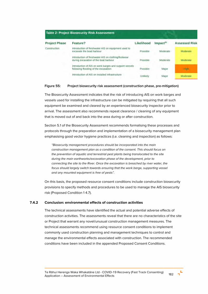
Te Rāhui Herenga Waka Whakatāne Ltd - COVID-19 Recovery (Fast Track Consenting) Application – Assessment of Environmental Effects 182
Figure 55: Project biosecurity risk assessment (construction phase, pre-mitigation)
The Biosecurity Assessment indicates that the risk of introducing AIS on work barges and vessels used for installing the infrastructure can be mitigated by requiring that all such equipment be examined and cleared by an experienced biosecurity inspector prior to arrival. The assessment also recommends repeat clearance / cleaning of any equipment that is moved out of and back into the area during or after construction.
Section 5.1 of the Biosecurity Assessment recommends formalising these processes and protocols through the preparation and implementation of a biosecurity management plan emphasising good vector hygiene practices (i.e. cleaning and inspection) as follows:
“Biosecurity management procedures should be incorporated into the main construction management plan as a condition of the consent. This should focus on the prevention of aquatic and terrestrial pest plants being translocated to the site during the main earthworks/excavation phase of the development, prior to connecting the site to the River. Once the excavation is breached by river water, the focus should largely switch towards ensuring that the work barge, supporting vessel and any mounted equipment is free of pests”.
On this basis, the proposed resource consent conditions include construction biosecurity provisions to specify methods and procedures to be used to manage the AIS biosecurity risk (Proposed Condition 1 4.7).
7.4.2 Conclusion: environmental effects of construction activities
The technical assessments have identified the actual and potential adverse effects of construction activities. The assessments reveal that there are no characteristics of the site or Project that warrant any novel/unusual construction management measures. The technical assessments recommend using resource consent conditions to implement commonly used construction planning and management techniques to control and manage the environmental effects associated with construction. The recommended conditions have been included in the appended Proposed Consent Conditions.

Te Rāhui Herenga Waka Whakatāne Ltd - COVID-19 Recovery (Fast Track Consenting) Application – Assessment of Environmental Effects 183
The above assessment is in accordance with clause 11 of Schedule 6 of the Covid Act. It is assessed that, subject to the implementation of the recommended resource consent conditions, the adverse effects of construction activities on the environment will be avoided, remedied or mitigated such that all effects are minor or less than minor.
7.5 OPERATIONAL ACTIVITIES: ENVIRONMENTAL EFFECTS
In combination with the preceding section, this section address clause 11 of Schedule 6 to the Covid Act. This section reviews the findings and recommendations of the technical assessments regarding the actual and potential adverse effects of operating the Boat Harbour. The adverse effects of some operational activities overlap with those of construction activities (dredging for example). Other effects are unrelated to construction.
7.5.1 Environmental effects: Traffic Effects and Site Access
The Traffic Assessment notes that on analysis of anticipated activities in the Boat Harbour, it is likely to generate 200-220 vehicle movements per hour across the four driveways during the morning and evening commuter peak periods. This additional volume (accounting for heavy vehicles and cars) was assessed as being within the capacity of the existing Keepa Road and SH30 infrastructure and would not require the road to be upgraded.
The Whakatāne Transport Model was used to evaluate the potential effects of this volume of traffic on the wider road network. With the forecast land use in 2036 excluding the Boat Harbour, it has been found that there would be a need for some improvements to the state highway network to increase the capacity across the Whakatāne River and at the SH30 / Landing Road roundabout to prevent severe congestion arising.
The Traffic Assessment stated that for the purposes of the assessment of the effects of the Boat Harbour on the transport network, generally anticipated capacity improvements related to wider background growth has been included within the model to represent appropriate future year network performance. With these improvements in place, the Boat Harbour will not contribute to any noticeable effects on the operation of the road network.
In the absence of any improvements to the network, the Boat Harbour would represent just one of the many sources of traffic such as the Coastlands and Piripai residential development or The Hub that would be contributing to the congestion on SH30. Based on the analysis of the expected traffic generation, it is expected to be one of the smaller contributors and accordingly, any traffic effects that could be directly attributed to the Boat Harbour would be smaller than other traffic generating activities.
Regarding site access for the Boat Harbour, Section 2.3.12.1 and Section 2.4.3 details that a total of four access points will be provided. These will be designed in accordance with the requirements of Chapter 13 of the District Plan.

Te Rāhui Herenga Waka Whakatāne Ltd - COVID-19 Recovery (Fast Track Consenting) Application – Assessment of Environmental Effects 184
When considering the applicable minimum sight distance for the four access points, the Traffic Assessment identifies that as Keepa Road is classified as a Local Road and the current posted speed limit is 80 km/h, the minimum sight distance from a vehicle access is 105 m.
Since Keepa Road has a generally straight and level alignment, the available sight distances at three of the four access points will exceed 200 m which is appropriate for the speed environment. The northernmost access point which will be the primary access to the commercial wharf area will have a sight distance of 200 m to the south but less than 140 m to the north because it is partially obstructed by the Kopeopeo Canal Bridge and trees.
While Keepa Road is currently classified as a Local Road, but its function in the road network is likely to become more consistent with an Arterial Road in the future as traffic volumes increase in response the development of the coastal communities. This means that although the available sight distances would meet the District Plan requirements with the current classification of Keepa Road, this may not be case if its classification was changed to an Arterial Road unless there was also a reduction in the speed limit.
Although any changes to Keepa Road, such as its formation, road classification or the speed limit are outside the scope of the Project and are not required, it is recommended that any planting on the site frontage is kept to a low level so that the sight distance to the north can be maximized in the event that the road classification changes.
Overall, based on the findings of the Traffic Assessment, the operational traffic effects of the proposal are minor.
7.5.2 Environmental effects: Stormwater management and operational discharges
The initial design approach for stormwater management and operational discharges was to avoid discharges to water entirely. However, site constraints including limited space, shallow grades, the need to fill the site to replicate the existing stopbank height, and the river levels during design rainfall events, mean it is not practicable to avoid all discharges.
Therefore, once operational, the Boat Harbour has the potential to discharge stormwater beyond the site. If not effectively managed and treated, these discharges may adversely affect the lower Whakatāne River receiving environment (which is CMA).
As stated in Section 2.3.7.1 of this AEE, the Tektus Report identifies five primary areas for stormwater generation and subsequent operational discharges from the Boat Harbour. Sections 2.3.7.1 and 2.4.4 of this AEE detail the proposed stormwater discharge management and treatment methods.
The Tektus Report identifies the categories of stormwater discharge generated onsite as:
1. Primary discharge of treated stormwater runoff pumped to the Boat Harbour.

Te Rāhui Herenga Waka Whakatāne Ltd - COVID-19 Recovery (Fast Track Consenting) Application – Assessment of Environmental Effects 185
a. Stage 2 via the proposed pump station. b. Stage 3, excluding permeable car and trailer parking, via the proposed relocation
of the existing Keepa Road Pump Station. c. Stage 3 permeable car and trailer parking, via direct discharge to the Boat
Harbour basin via gravity outfall.
2. Secondary discharge of flows exceeding the 10% AEP (10-yr average recurrence interval) event to the Boat Harbour basin.
a. Full site via the proposed relocation of the Keepa Road Pump Station
3. Indirect discharge to the Boat Harbour via non-potable reuse of treated stormwater used for boat washing.
The proposed onsite stormwater management system is intended for rainfall events up to and including the 10% AEP (100-yr average recurrence interval) event, providing a primary level of service in accordance with the WDC Engineering Code of Practice. The proposed system (refer to Tektus Drawings 400 - 404: Proposed Stormwater Plans (Appendix E(i))) has considered the BOPRC SW Guidelines and is further informed by current industry best practice.
The site is proposed to be serviced by a combination of a new pump station providing a primary level of service to the Stage 2 completed Boat Harbour and the relocated Keepa Road Pump Station (or new pump station of comparable capacity) providing a primary level of service to the Stage 3 works area. The secondary system, addressing flood risk and overland flow path management for events up to the 1% AEP (100-yr average recurrence interval) event, is proposed to be serviced by the relocated Keepa Road Pump Station.
The Tektus Report provides further detail beyond the summaries in Section 2.3.7.1 and Section 2.4.4 of this AEE, about how stormwater from different areas of the site will be managed, generally as follows:
• Runoff generated within the Boat Harbour will undergo extensive treatment, with priority to reuse stormwater onsite, in a closed loop system where practicable;
• Non-potable water reuse, permeable paving, treatment swales for carpark runoff, and irrigation of landscape areas significantly reduce the volume of discharge to water and maximise the volume of water connected with Papatūānuku;
• A stormwater management / treatment system is proposed, including capture and reuse, to promote ‘better than expected’ stormwater management and discharge solutions following an integrated and holistic water management approach;
• The proposed water quality treatment system has been developed to exceed industry best practice discharge quality standards (refer to Table 1 of this AEE), where practicable when balanced against costs;
Te Rāhui Herenga Waka Whakatāne Ltd - COVID-19 Recovery (Fast Track Consenting) Application – Assessment of Environmental Effects 186
• Overall, there will be a reduction in stormwater runoff from the site. The pre-development runoff contributes approximately 37,500 m³ of stormwater runoff annually to the river via the Keepa Road Pump Station. Under the Project scenario, with reduced contributing land area (~3.3 ha) and onsite water collection, storage, and reuse, this reduces to approximately 11,300 m³ of stormwater runoff annually; and
• When onsite storage is at capacity, stormwater runoff will overflow and discharge via piped outfall into the Boat Harbour.
In summary, the water management system designed by Tektus is predicated on reusing water collected onsite. This optimises te hurihanga wai (the water cycle) by minimising reliance on the reticulated potable water supply service and minimising discharges to the receiving environment except in (less frequent) heavy rainfall events when inlet capacity or onsite storage capacity is exceeded.
All water collected onsite is proposed to be treated, with the level and type of treatment targeted at process activity and source specific contaminants, before being discharged into storage for non-potable reuse, or to the Boat Harbour, and ultimately the Whakatāne River. The treatment solutions for collected runoff and wash water will exceed minimum treatment thresholds.
Ongoing monitoring of discharges is proposed to ensure that the quality of discharges is compliant, and to ensure that the treatment approach is effective and provides ongoing compliance with the proposed discharge limits (refer to Table 1 of this AEE) which are also provided for in the Proposed Consent Conditions (Proposed Conditions 1.2.4.2(e)(x) and 4.11). A water quality monitoring program is required in conjunction with the Operational Management Plan (Proposed Conditions 1.5.1 – 1.5.6). This programme will include provisions for reporting incidents and exceedances, contingencies and investigations for improvements (if and when required) and will outline the discharge quality standards or concentration limits established.
An easily accessible sampling point will be available at each outlet for monitoring purposes. Automated sampling devices may also be considered for implementation at the site which would provide regular monitoring of flow and water quality parameters. Additionally, a combination of grab sampling, continuous automated sampling, and water quality sampling following significant storm events is proposed.
Overall, operational discharges from the Boat Harbour will be effectively managed to ensure that any adverse effects on water quality will be negligible.
7.5.3 Environmental effects: Coastal processes and natural hazards
The T&T Coastal Assessment provides advice and recommendations about the potential effects of the Project on the physical coastal environment, processes and other natural hazards. The potential effects on coastal processes are summarised below.

Te Rāhui Herenga Waka Whakatāne Ltd - COVID-19 Recovery (Fast Track Consenting) Application – Assessment of Environmental Effects 187
• Tidal prism: The Project’s effects on the tidal prism are assessed as insignificant;
• Currents: The Project will create small, localised changes to currents near the access channel. The changes are assessed as not producing any noticeable change to currents in the river and estuary;
• Boat harbour, access channel and river sediment dynamics: The Project will produce “…small and localised changes to sediment transport processes” requiring maintenance dredging to maintain navigability. The T&T Coastal Assessment suggests the dredging can be undertaken using similar methods as used for the current, consented dredging in the HDZ;
• Coastal hazards (erosion): The small, localised changes to currents noted above will produce similarly small changes to erosion and accretion processes to the riverbed and banks near the access channel. These adjustments will occur within a short (approximately three months) period and no long-term adverse effects are anticipated. The T&T Coastal Assessment notes that the Project will have no impact on erosion on the open coast. It also records that the localised changes to erosion and scour patterns “…will have no effect on the stopbanks and flood protection structures” during floods;
• Coastal / natural hazards (inundation, storm surge and river floods): The T&T Coastal Assessment identifies that riverine flooding will occasionally require debris to be cleared from the access channel and that the effects of climate change will require the BOPRC stopbanks to be maintained at appropriate levels of service (a matter beyond the control of the Applicant). Modelling revealed that the Project will have no impact on existing water levels or flood levels. The T&T Coastal Assessment concludes that the Project will have no impact on local coastal inundation processes;
• The access channel opening in the stopbank will be constructed to finished levels, and with armouring, to maintain flood protection functions. During floods, the water level in the Boat Harbour will be similar to the river. As such, the T&T Coastal Assessment identifies that “…there will not be significant overtopping flow velocity … provided the stopbank continues to be well maintained, the stopbank should not experience any significant damage”. The effects on flow velocities caused by the Project are considered “…small changes relative to the large natural variations in velocities in the river”, with less than minor effects;
• Coastal hazard (tsunami): The T&T Coastal Assessment notes that the Project will not change existing tsunami risks. Given the location of the Boat Harbour, any tsunami wave will be attenuated as it travels over the Whakatāne Bar and upriver to the site.; and

Te Rāhui Herenga Waka Whakatāne Ltd - COVID-19 Recovery (Fast Track Consenting) Application – Assessment of Environmental Effects 188
• Whakatāne Heads surf break: It was assessed “…that the Boat Harbour will have no impact on the quality of the surf break” as the Project has only insignificant changes on tide flows.
The T&T Coastal Assessment provided three primary recommendations for the Project regarding coastal processes and hazards. These were:
• Development of a reporting framework to record any navigability concerns raised by users of the facility;
• Annual monitoring of the access channel and adjoining riverbed for three years after operations commence, to confirm sediment accumulation rates and consequently, maintenance dredging requirements; and
• Hydrographic surveys of the Boat Harbour after three years to confirm sedimentation rates, and after dredging to confirm the depths necessary for safe navigation are achieved.
These recommendations have been adopted in the Proposed Consent Conditions.
Overall, the T&T Coastal Assessment concluded that there are only very localised and small changes to currents in the river from the Boat Harbour, access channel and targeted dredging of shallow parts of the lower river and estuary. These changes occur in the river in the immediate vicinity of the access channel.
Additionally, the Project will not have a measurable impact on coastal processes or natural hazards in the wider river, estuary and open coast environment. Therefore, present day and potential future climate change-induced coastal and river processes are likely to occur with no observable change as a result of the Boat Harbour.
7.5.4 Environmental effects: Natural character, landscape character, visual amenity, built form and urban design
The Landscape Assessment acknowledges the functional requirement for the Boat Harbour to locate in the coastal environment. It goes on to confirm that the site is highly modified and that the site and surrounding area do not contain any High or Outstanding natural character areas identified in the RCEP.
Given the foregoing, plus the positive effects of the Project on visual amenity, experiential natural character values and urban design (discussed below) the Landscape Assessment concludes that natural character, landscape and visual amenity effects of the Project on the receiving environment are acceptable, provided that the landscape and urban design considerations of the proposal are implemented.

Te Rāhui Herenga Waka Whakatāne Ltd - COVID-19 Recovery (Fast Track Consenting) Application – Assessment of Environmental Effects 189
7.5.4.1 Natural character effects
The Landscape Assessment assessed and scored the biotic natural character values (“Moderate”) and abiotic natural character values (“Low-Moderate”) of the lower Whakatāne River context. The adverse effects of the Project on those values were assessed as “Very Low”.
The biotic and abiotic natural character values of the site were assessed as “Moderate” and “Low-Moderate” respectively. The Project’s adverse effects on these values were assessed as being “Very Low”. Additionally, the Landscape Assessment noted that the proposed site remediation and recreation of approximately 0.93 ha wetland extent will produce positive effects on the site’s biotic natural character values.
Turning to experiential natural character values, the Landscape Assessment identified the lower Whakatāne River context as possessing “Moderate” value and the site as possessing “Low-Moderate” value. The adverse effects of the Project on experiential natural character values were assessed as “Very Low” in both locations. Furthermore, it was assessed that the Project will generate positive experiential natural character effects, given the Project’s benefits for navigational safety and its contribution to continued enjoyment of, and access to the wider Eastern Bay of Plenty coastal environment for fishing, diving, aquaculture, tourism and other activities.
The Landscape Assessment’s overall assessment of the Project against the legislative framework of the RMA, NZCPS, RCEP and District Plan was that the Boat Harbour will have a low level of adverse effect on the Moderate-Low natural character values of the area.
7.5.4.2 Landscape character effects
The Landscape Assessment assesses the lower Whakatāne River as a highly modified landscape with “Moderate” landscape values. The site was assessed as possessing “Low-Moderate” landscape character value. The adverse effects of the Project on these values were assessed as “Low”.
7.5.4.3 Visual amenity effects
The Landscape Assessment identifies that the character of the views of the site will fundamentally change from an enclosed paddock to an open site with open water and harbour facilities.
The assessment considered the visual amenity effects of the Project (including artificial lighting) when encountered by visitors to the site, from Keepa Road, Te Hokowhitu a Tū ki te Rāhui Marae, SH30, the Landing Road bridge, the Whakatāne River, Warren Cole Walkway and reserves and residents on the eastern bank of the river.
It was assessed that the Project will have “Very Low” adverse visual amenity effects when encountered by visitors to the site, and “Low” adverse effects in relation to the other

Te Rāhui Herenga Waka Whakatāne Ltd - COVID-19 Recovery (Fast Track Consenting) Application – Assessment of Environmental Effects 190
parameters assessed. The development of public access through the site to the riverbank was identified as a positive visual amenity effect for visitors to the site.
With specific regard to Te Hokowhitu a Tū ki te Rāhui Marae, the Landscape Assessment states that current views from the marae towards the site are at a distance of approximately 250 m. The views from the marae to the site are either along a narrow driveway entrance from Keepa Road to the marae, or, over land in separate ownership between the marae and Keepa Road that is zoned for Light Industrial development under the WDP. While there is currently no view from the marae to the river, the site and the stopbank are visible in the distance. The proposed site boundary retaining walls will be incorporated into landscape planting and when the Keepa Road levels are raised will provide a flat or slightly sloped transition at the site’s western boundary.
The Landscape Assessment also states that, there are currently views from the marae to Kohi Point and the pā site called Kapu Te Rangi above the Wairaka cultural precinct. Foreground trees and vegetation along Keepa Road and within the wider environment may provide some limitation on how open these views are to the culturally important sites around Whakatāne. Views to Kohi Point are through the very northern end of the site which will not contain buildings or large structures. The assessment recommends that any development within the site should be sited and designed to ensure that existing views from Te Hokowhitu a Tū ki te Rāhui marae towards the cultural significant sites of Kohi Point, the escarpment behind the urban area of Whakatāne and the Kapu Te Rangi pā site are protected.
Overall, the Landscape Assessment concluded that the Project would have ‘Low’ adverse effects on the marae, as the marae is largely enclosed by land in a Light Industrial Zone. That zone enables robust buildings that could screen views between the marae and the Boat Harbour. Any views from the marae to the site along the marae’s driveway will be of quality architecture, site development and landscaping.
7.5.4.4 Built form and urban design effects
The Landscape Assessment considered the height and scale, articulation, spacing and setbacks of buildings, in combination with landscaping, within the Project site.
The Landscape Assessment identifies that the maintenance building (15.5 m height when including the finished ground height of +3 m) will breach the 12 m permitted activity height limit of the RPZ. However, the Landscape Assessment concluded that despite non-compliance with the RPZ height limit, the adverse built form effects are “Very Low” (neutral) for the following reasons:
• The larger and taller buildings are set back into the site;
• The site arrangement, layout and design can accommodate the scale of buildings and the relatively small non-compliances with the building control standards; and
Te Rāhui Herenga Waka Whakatāne Ltd - COVID-19 Recovery (Fast Track Consenting) Application – Assessment of Environmental Effects 191
• The landscaping and open space design within and on the edges of the site mitigate minor non-compliances with the building control standards.
It was furthermore considered that the Project will have a positive urban design effect. The design provides a cohesive arrangement, opens views to and through the site, establishes public access through the site and along the stopbank and provides a strong contextual response to the existing commercial marine character of the lower Whakatāne River.
All matters with respect to building design, urban form, natural character and amenity matters will be address through the development and implementation of a Architecture and Urban Design Report (Proposed Condition 2.3) for the Project.
7.5.4.5 Artificial lighting effects
LDP Limited was engaged to undertake an assessment of the potential adverse effects of artificial lighting associated with Boat Harbour operations (“Lighting Assessment”) (refer to Appendix T). The Lighting Assessment compares the lighting concept design parameters with the permitted activity performance standards specified in Chapter 11 of the District Plan for artificial light emissions.
The Lighting Assessment concludes that all artificial lighting will comply with the permitted activity performance standards and that the effects of the artificial lighting will be negligible.
To ensure that this assessment is realised in practice, the Proposed Consent Conditions (Proposed Condition 2.8) require the preparation of a Lighting Plan demonstrating compliance, to be certified by the consent authority before the Boat Harbour begins operating.
7.5.5 Environmental effects: Hazardous installations
Sections 2.3.5.2 and 2.4.4 of this AEE describes the proposed fuel installations within the commercial and recreational areas of the Boat Harbour.
The proposed petrol installation is assessed as a Permitted activity pursuant to Rule 19.2.1.1(e) of the District Plan however, consent is needed for the proposed diesel installation due to the volume of 75,000 L of storage to be provided.
7.5.5.1 Hazardous installation: site design and management
Sections 2.3.7.1 and 2.4.4 of this AEE provide summarises of the proposed management and design of the fuel storage areas across the site provided for in the Tektus Report.
The Tektus Report describes that fuel tanks and adjacent tank refilling areas will be in a hydraulically isolated zone with impermeable surfacing. The fuel tank and refilling areas will be constructed using an impermeable surface, bunded to form a hydraulically isolated

Te Rāhui Herenga Waka Whakatāne Ltd - COVID-19 Recovery (Fast Track Consenting) Application – Assessment of Environmental Effects 192
zone, and will discharge to the nearby gravity stormwater network via an appropriate oil-water separator, for example a SPEL Puraceptor, to provide an appropriately designed and sized stormwater treatment and spill containment device, fitted with a shut-off valve.
The Tektus Report goes on to identify an alternative capture, treatment and interception/isolation design option to be implemented if design parameters preclude discharges via the gravity system.
Regarding performance of the system, Rule 19.2.4.1(b), Rule 19.2.4.2(b) and 19.2.4.3(b) are permitted activity performance standards that specifically require design to prevent the entry or discharge of the hazardous substances into the stormwater drainage system. As such, these District Plan requirements would be the starting point for the final detailed design of the systems.
It is noted that Rule 19.2.4.4 of the District Plan states that compliance with the relevant Rules in 19.2.5 – 19.2.10 of the District Plan will satisfy the Rules in 19.2.4. Therefore, Proposed Consent Conditions require the Engineering Design Report (Proposed Condition 1.2.4 and ) to detail of how the fuel storage installations are designed, constructed, and managed to comply with the relevant rules including:
• Prevent leakage and spills in accordance with Rule 19.2.5 (Spill Containment System) - The OMP mandates the development and certification of an Emergency Spill Management Plan (Proposed Condition 1.5.3). The Emergency Spill Management Plan will include, inter alia, information about facility hazards, failure modes and exposure pathways and methods to adhere to relevant provisions of the Hazardous Substances and New Organism Act 1996;
• Include signage at drains in accordance with Rule 19.2.6 (Stormwater Drainage) and to display signage about the nature of the substances present within each area in accordance with Rule 19.2.9 (Signage);
• Isolate washdown and refuelling areas in accordance with the requirements of Rule 19.2.7 (Washdown Areas); and
• Ensure the petrol and diesel tanks are designed, constructed and managed to prevent leakage and spills in compliance with relevant HSNO standards as required by Rule 19.2.8 (Underground Storage Tanks).
7.5.5.2 Conclusion on hazardous installation effects
Overall, noting that the petrol storage is provided for as a permitted activity under the District Plan, any risks associated with any hazardous installations (being fuel storage and refuelling areas) will be managed to ensure they are ‘as low as reasonably practicable’ through:

Te Rāhui Herenga Waka Whakatāne Ltd - COVID-19 Recovery (Fast Track Consenting) Application – Assessment of Environmental Effects 193
• The refuelling activities will be managed through design of storage and dispensing systems that are in accordance with best practice and in compliance with relevant District Plan rules;
• The development and implementation of operational procedures for fuelling within the site as part of the OMP; and
• The development and implementation of an Emergency Spill Management Plan as part of the OMP.
7.5.6 Environmental effects: Operational noise emissions
The Acoustic Assessment identifies that most noise emissions from the Boat Harbour will readily comply with the permitted noise performance standards specified in Rule 11.2.6 of the District Plan. However, it identifies three possible sources of non-compliance for which resource consent is required. These non-compliances, and the associated recommendations, are summarised below.
Noise emitted to the CPZ may exceed the permitted standard by approximately 5 decibels as vessels travel through the zone (exiting the Boat Harbour and access channel) early in the day (i.e., “night-time” for the purposes of District Plan Rule 11.2.6). This non-compliance was assessed as unlikely to occur and is deemed to be acceptable on the basis that it will be brief and temporary. Furthermore, there are no permanent occupants within the CPZ. As such the non-compliance will be of a technical nature and will not produce adverse effects on amenity.
Noise emitted by typical daytime maintenance activities was assessed as potentially producing a 3-decibel non-compliance in the CPZ. However, this non-compliance was only detected in a conservative scenario where (a) the three loudest pieces of mechanical plant (boat hoist, water blaster and sewage plant) are operating simultaneously for 7.5 hours per day, and (b) the water blasting occurs on the hardstand area adjacent to the CPZ. The more likely scenario is intermittent operation of each piece of plant for less than 7.5 hours daily which would not produce the non-compliance.
Having regard to the infrequency, and marginal character of the potential non-compliance, plus its limited extent to the CPZ and there being no permanent occupants, the Noise & Vibration Assessment concludes that the potential adverse effects of the non-compliance are acceptable.
Garnet blasting is addressed separately as it produces significant and distinctive noise. While the maintenance operations which involve garnet blasting will be temporary in nature, when occurring without effective noise management techniques being employed the activity can produce noise levels of 130 dB LWA in a worst-case scenario.

Te Rāhui Herenga Waka Whakatāne Ltd - COVID-19 Recovery (Fast Track Consenting) Application – Assessment of Environmental Effects 194
The Acoustic Assessment recommends that all garnet blasting be subject to mitigation including:
• Restriction of the hours when garnet blasting can occur to between 8.00AM to 6.00PM (Monday – Saturday);
• Any blasting undertaken outdoors requires effective screening to enable compliance with the daytime noise limit; and
• Implementing a one-off noise monitoring program to demonstrate compliance with the District Plan noise limits (and implementing additional mitigation if non-compliances are detected).
Regarding screening of outdoor blasting activities, effective screening can be achieved with buildings, other vessels on the hardstand, well-placed shipping containers and / or temporary screening using sound absorptive ‘noise curtains’37 around the blasting area. Any screening used would be a minimum height of 4m to block line-of-sight from the blasting to neighbouring sites. Barriers would be positioned as close as practicable to the blasting to block line-of-sight between the activity and noise sensitive receivers. The panels would be abutted or overlapped to provide a continuous screen without gaps at the bottom or between panels.
Regarding monitoring, the Acoustic Assessment identifies that the monitoring will include locations representative of Te Hokowhitu a Tū ki te Rāhui Marae to the west, the Rural Plains interface to the north (e.g., 53 Keepa Road) and Residential interface to the east (e.g., 15A Tunui Pl). The subsequent monitoring report will include the location of the garnet blasting and identify any noise screening or mitigation implemented to enable compliance. To ensure ongoing compliance, the noise screening will be used as standard practice for all garnet blasting thereafter.
The implementation of these mitigation measures will ensure compliance with the District Plan “daytime” noise limits that apply to the nearest noise sensitive receivers in the adjoining zones. The Acoustic Assessment predicts compliance with the relevant noise limits at the Light Industry and Industrial interfaces but a non-compliance with the CPZ noise limit. However, the non-compliance is considered to be acceptable, for the same reasons as the non-compliant noise emissions to this zone associated with vessel movements and maintenance activities.
37 Proprietary noise curtains include:
• Hushtec ‘Premium Series Noise Barrier’ (www.duraflex.co.nz) • Soundbuffer ‘Performance Acoustic Curtain’ (soundbuffer.co.nz) • Safesmart ‘Acoustic Curtain 6.5kg/m2’ (www.safesmartaccess.co.nz)

Te Rāhui Herenga Waka Whakatāne Ltd - COVID-19 Recovery (Fast Track Consenting) Application – Assessment of Environmental Effects 195
The Acoustic Assessment also recommended that any cargo loading/unloading undertaken outside the District Plan “daytime” hours (7.00AM to 10.00PM) be monitored for compliance with District Plan noise limits.
Proposed Consent Conditions (Proposed Conditions 1.5.5 and 2.10) includes conditions in accordance with the Acoustic Assessment recommendations outlined above.
7.5.7 Environmental effects: Operational biosecurity
The Biosecurity Assessment identifies that the key biosecurity risk activities that occur during operation of the facility relate to cleaning accumulated biofouling off vessel hulls. Such cleaning can release whole or viable fragments of AIS back into the water where they can potentially invade the local environment and the highest (‘Critical’) risks will occur once the Boat Harbour is operational. Therefore, in the absence of any management, it would be highly likely that AIS would be released into the Boat Harbour.
As such, a range of management actions are necessary to reduce the likelihood, impact and risk of adverse biosecurity effects arising from the operation of the Boat Harbour.
The recommended management actions and resulting revised biosecurity risk ratings are set out in Table 3 to the Biosecurity Assessment (replicated below in Figure 56 for ease of reference). All risks are reduced from “Critical” or “High” to “Low” or, in two cases, “Moderate” as a result of mitigation / management measures being imposed.
With regards to the latter, the “Moderate” risk from in-water defouling of vessels is recommended to be eliminated by prohibiting this activity. The remaining “Moderate” risk is that the facility becomes a node of AIS infection. This risk cannot be avoided and as such, effective mitigation requires the development and implementation of a program of active facility management, to ensure Boat Harbour users comply with Regional Council biosecurity requirements.
The recommended biosecurity risk mitigation measures are provided for through the development and implementation of a Biosecurity Management Plan (“BMP”) for the Boat Harbour. This would encompass regular facility and vessel inspections, sampling and analysis of detritus from vessel cleaning, the containment and disposal on land of biofouling, entry restrictions on vessels without sufficient maintenance records and voyage history, and a public education programme emphasising good biosecurity practices. A resource consent condition requiring the development and implementation of a BMP is contained in the Proposed Consent Conditions (Proposed Condition 4.8).

Te Rāhui Herenga Waka Whakatāne Ltd - COVID-19 Recovery (Fast Track Consenting) Application – Assessment of Environmental Effects 196
Figure 56: Biosecurity risk assessment post-mitigation
Noting earlier comments about the positive biosecurity effects of the Project, the Biosecurity Assessment concludes that overall, the proposal to build and operate a Boat Harbour will provide a net environmental and biosecurity benefit to the local area.

Te Rāhui Herenga Waka Whakatāne Ltd - COVID-19 Recovery (Fast Track Consenting) Application – Assessment of Environmental Effects 197
7.5.8 Environmental effects: Maintenance dredging
Section 2.3.3 of this AEE details the dredging requirements for the Project based on the details set out with the T&T Coastal Assessment. Any dredging activities to occur within the HDZ will be undertaken as part of the existing consented maintenance dredging activities by WDC by which approval has been provided by way of letter dated 21 January 2022 (refer to Appendix AA).
The T&T Coastal Assessment identifies that the frequency of maintenance dredging will be highly dependent on the occurrence of floods down the river, as these will be the main contributor to higher velocities and forces along the banks of the river. Maintenance dredging frequency will need to be determined based on monitoring and feedback/responses from users of the Boat Harbour. Therefore, to manage the dredging requirements, T&T recommend:
• A reporting framework be included in the Boat Harbour operation manual to document identified concerns by users;
• Annual monitoring of the access channel and the riverbed 100m either side of the access channel for the first three years after the facility is opened to confirm annual sedimentation rates and dredging requirements;
• Hydrographic surveys are to be carried out after each maintenance dredging campaigns to confirm the desired dredged levels have been achieved; and
• Within the Boat Harbour, surveying should be carried out after three years of operation, to confirm sedimentation rates.
Regarding the impacts of maintenance dredging on coastal processes, the T&T Coastal Assessment identifies that provided the above recommendations are provided for and dredging is carried out in accordance with the conditions in Consent No. 65217 (refer to Appendix C of the T&T Coastal Assessment provided as Appendix I), effects of the dredging will be less than minor. The Proposed Consent Conditions provide for these recommendations (Proposed Conditions 5.1 – 5.7).
Regarding the impacts of maintenance dredging on water quality and marine and freshwater ecology, the findings and conclusions stated in Section 7.4.1.8 are also relevant here.
7.5.9 Environmental effects: Marine emissions
Following a request from hapū members during one of the hui held, the Applicant engaged Babbage Consultants Ltd to provide an assessment of the potential for the effects of boat motor exhaust on the water quality of the Whakatāne River (“Babbage Exhaust Report” (refer to Appendix BB)).

Te Rāhui Herenga Waka Whakatāne Ltd - COVID-19 Recovery (Fast Track Consenting) Application – Assessment of Environmental Effects 198
The assessment considered the current use of the river, the current river conditions, the potential discharges from boat exhausts, and the likely effects.
Overall, the report concluded that although boat exhaust gases include unburnt hydrocarbons, these are largely lost to the atmosphere, with little remaining in the water column. Nonetheless, a conservative assessment that ignores degradation of this residual, shows that in-river concentration of the more toxic constituents will be below current environmental protection guidelines. Moreover, given motorboats will use the river for transiting only, the discharges will occur briefly only as the boats move in and out of the river and into the Bay of Plenty.
Accordingly, it is considered that any changes to river water quality of the Whakatāne River due to motorboat exhaust emissions will be less than minor.
7.5.10 Environmental effects: Wetlands
The Terrestrial Ecology Assessment identifies that there is only one potential operational adverse effect on the wetland area within the IBDA-A44 being that boat wake effects in the channel have the potential to cause erosion of the channel walls and have potential impacts on wetlands on the northern and southern sides of the access channel.
While identified as a potential effect, the Terrestrial Ecology Assessment identifies mitigation measures which will ensure any adverse effects of boat wake within the access channel and wetland area is avoided. The measures are:
• Restricting boat speed within the access channel to minimise boat wake generation; and
• Armouring of the sides of the access channels.
The measures have been captured in the concept design for the Project with the access channel design including the provision of revetment along the sides (refer to Section 2.3.1.2 of this AEE) and boat speeds will be defined within the Operational Management Plan for the Boat Harbour. Therefore, it is concluded that there will not be any adverse effects on the wetland due to boat wake impacts.
It is noted that channel armouring will be designed and constructed to maintain the natural flow of estuarine channels that discharge into the access channel.
The potential impacts of discharges and water quality effects have been discussed in Section 7.5.2 and the positive effects on wetlands as a result of the Project are discussed in Section 7.2.3.
Overall, any adverse effects of the operation of the Boat Harbour on the wetland within the IBDA-A44 will be managed to ensure that they are avoided.

Te Rāhui Herenga Waka Whakatāne Ltd - COVID-19 Recovery (Fast Track Consenting) Application – Assessment of Environmental Effects 199
7.5.11 Environmental effects: Operational navigation procedures
The Nav Safety Assessment records that once the Boat Harbour begins operating, subject to the recommendations outlined below, it will help provide facilities that raise the overall safety of navigation of the Whakatāne River.
The key recommendations regarding operational navigation procedures are:
• That detailed design of the channel and buoys/beacons be informed by consultation with the Harbourmaster and local user groups;
• That tidal height boards be fitted near the Boat Harbour entrance to inform users about the tide height and available depth of water in the access and river channels before departing the facility;
• That a monitoring, marking and clearance plan be prepared to identify:
• The minimum channel depth to be maintained.
• Criteria for ongoing monitoring, both scheduled and after floods.
• A method and time frame for promulgating information to users of the Boat Harbour.
• A method and timeframe for marking shoals or hazards as these are identified.
• Timeframes and criteria around the clearance of shoal areas and/or hazards in the channels.
• That a VHF radio channel be provided for Boat Harbour users to communicate vessel movement intentions.
Where appropriate to be provided for as conditions of the consent, the recommendations have been included in the Proposed Consent Conditions.
The Nav Safety Assessment concludes that navigation to, from and around the Boat Harbour in the river and access channels will not be particularly demanding given the sheltered location, generally low river levels and tidal currents and the layout and construction of the Boat Harbour, which is designed to meet Australian Standard AS3962-2001.
There are no navigation safety matters that are not adequately addressed by existing Maritime Rules and Bylaws as is evident by the current safe navigation of vessels in the more congested area off the town wharf and navigationally challenging areas of the approach, bar area and entrance channel.

Te Rāhui Herenga Waka Whakatāne Ltd - COVID-19 Recovery (Fast Track Consenting) Application – Assessment of Environmental Effects 200
Overall, any adverse navigation safety effects as a result of the operation of the Boat Harbour will be negligible.
7.5.12 Environmental effects: Recreation and Tourism
The Recreation Assessment canvasses the potential adverse effects of the Project on public access to the coast, potential conflicts between vessels and small watercraft or swimmers, fishers and surfers, the siting of navigation aids in the river, and tourism.
The Recreation Assessment indicates that measures to mitigate potential adverse effects associated with the Project either already exist and are enforced by regulators (e.g., rules set by the Harbour Master for boat wake and speed in the river) or, can readily be implemented (e.g., displaying signage about navigation rules, constructing public access onsite to facilitate pedestrian passage to the up- and downriver stopbanks in the public reserve). However, it does recommend the following to minimise the potential for adverse effects on existing recreational values and users of the river:
• Installing public pedestrian access through the Boat Harbour linking the stopbanks upstream and downstream, with appropriate wayfinding aids.
• Inclusion of rules in occupation agreements for boats within the Boat Harbour to adhere to Rule 3.2.8 of the Bay of Plenty Regional Navigation Safety Bylaw 2017 (ensuring commercial vessels are included in the requirement to maintain a safe wake speed).
• Following up on any complaints about boat speed, wake effects and other navigational errors with Boat Harbour occupants and users of the launching ramp, with temporary or permanent exclusion from the facility an option; and including appropriate rules in the constitution for operating the Boat Harbour.
• Mounting signs within the Boat Harbour at both the launching ramp and at the common entrances to berths reminding users of the requirements to adhere to established navigation rules and to be aware of small craft operating in the River.
• Reliance on the output of a consultative procedure with the existing Harbour Users Group to establish the preferred location and form of aids to navigation within the River.
• An ongoing commitment to consultation with an existing harbour users’ group and the Harbour Master to determine recommendations for amendments to the Bay of Plenty Regional Navigation Safety Bylaw over time.
Where applicable, these recommendation have been included in the Proposed Consent Conditions.

Te Rāhui Herenga Waka Whakatāne Ltd - COVID-19 Recovery (Fast Track Consenting) Application – Assessment of Environmental Effects 201
7.5.13 Environmental effects: Mitigation and monitoring of Boat Harbour operations
Clause 10(1)(d) of Schedule 6 to the Covid Act requires an AEE to include “a description of the mitigation measures (including safeguards and contingency plans where relevant) to be undertaken to help prevent or reduce the actual or potential effects of the activity”.
A description of the proposed mitigation measures is provided in the technical assessments appended to this report and summarised in the preceding discussion. These are also documented in the Proposed Consent Conditions primarily through the requirements related to the Operational Conditions (Proposed Condition 1.5).
Clause 10(1)(g) of Schedule 6 of the Covid Act also specifies that “if the scale and significance of the activity’s effects are such that monitoring is required, a description of how the effects will be monitored and by whom, if the activity is approved”. The monitoring that is proposed as part of the construction and operation of the Project is also documented in the Proposed Consent Conditions appended to this AEE.
Specifically relevant to the Boat Harbour once operational, Policy SO 6 of the RCEP requires marinas to comply with a range of locational, operational and procedural matters. Clause (e) to Policy SO 6 states:
“Marinas and associated activities must: [content not shown here] …
(e) Have a Marina Management Plan that:
(i) Identifies the environmentally relevant features of the site;
(ii) Specifies measures to avoid, remedy or mitigate discharges of contaminants from the site, including stormwater; and
(iii) Specifies measures to avoid remedy or mitigate the release or spread of harmful aquatic organisms”.
It is proposed that an Operational Management Plan be prepared for this Project as the vehicle for the establishment and enforcement of the monitoring activities recommended across the range of technical reports. A condition (Proposed Conditions 1.5.1 - 1.5.6) of this nature is included in the Proposed Consent Conditions appended to this AEE.
7.6 CONCLUSION: BOAT HARBOUR ENVIRONMENTAL EFFECTS
This section of the report briefly reviews the detailed assessments and recommendations of numerous technical assessments. The technical assessments should be referred to for a full understanding of the scope, methodology and reasoning behind the findings and recommendations discussed above.
The PGF Business Case and technical assessments identify that the Project will deliver positive effects on local employment and economic activity, wetland ecology, navigational safety, aquatic biosecurity and public amenity.

Te Rāhui Herenga Waka Whakatāne Ltd - COVID-19 Recovery (Fast Track Consenting) Application – Assessment of Environmental Effects 202
The technical assessments identify that the Project gives rise to numerous potential adverse effects. However, the technical assessments have recommended feasible controls and measures that can be readily implemented through consent conditions to avoid, remedy and / or mitigate the adverse effects of the Project.
Overall, it is concluded that, subject to implementation of the recommended management measures, the adverse effects generated by the construction and operation of the Boat Harbour will be no more than minor.

Te Rāhui Herenga Waka Whakatāne Ltd - COVID-19 Recovery (Fast Track Consenting) Application – Assessment of Environmental Effects 203
8. OTHER MATTERS
In accordance with sections 24 and 25 of the Covid Act, on 10 May 2021 the Minister for the Environment notified the Project director that the Project had been accepted for referral to a Panel.
The Minister’s notification included a description of information to be supplied with the resource consent applications, pursuant to s 24(2)(d) of the Covid Act. The additional information the Minister requires is appended to this report and was discussed in the preceding section of this report, as follows:
1. An ecological assessment –
Refer to Section 6 of this AEE and the Terrestrial Ecology Assessment and Marine / Freshwater Ecology Assessment provided as appendices to this AEE.
2. A river flood protection assessment, including –
a. adverse effects on the Whakatāne River stopbanks b. adverse effects of erosion and scour from dredging on the stopbanks and flood
protection structures
Refer to Section 6 of this AEE and the T&T Coastal Assessment provided as an appendix to this AEE.
3. A freshwater management assessment including – a. adverse effects on the disturbance of a natural wetland b. adverse effects on freshwater ecology and water quality due to dredging of the
river
Refer to Section 6 of this AEE and the Terrestrial Ecology Assessment, the Marine / Freshwater Ecology Assessment and the HAIL WQ Assessment provided as appendices to this AEE.
4. An integrated transport assessment including, but not limited to, modelling and
analysis that covers the effects on the surrounding road network
Refer to Section 6 of this AEE and the Traffic Assessment as an appendix to this AEE.
Furthermore, the Minister’s letter specifies that pursuant to s 24(2)(e), the Panel must invite comments from three parties, additional to the parties prescribed by clause 17 to Schedule 6 of the Covid Act. The additional parties are:
• Whakatāne Volunteer Coastguard Association Incorporated;
• Whakatāne Harbour Care Group; and

Te Rāhui Herenga Waka Whakatāne Ltd - COVID-19 Recovery (Fast Track Consenting) Application – Assessment of Environmental Effects 204
• Waka Kotahi New Zealand Transport Agency.
Section 6.5 of this AEE summarises the consultation that has occurred with these three additional parties.

Te Rāhui Herenga Waka Whakatāne Ltd - COVID-19 Recovery (Fast Track Consenting) Application – Assessment of Environmental Effects 205
9. STATUTORY CONSIDERATIONS
This section assesses the Project against the statutory documents tabled below, in accordance with clauses 9(1)(h), 9(2), 9(3) of the Covid Act.
Table 12: Clause 9(2), Schedule 6 Covid Act - relevant documents to statutory assessment
Schedule 6, clause 9(2) Relevant document
(a) a national environmental standard. NES CS and the NES FM
(b) other regulations made under the Resource Management Act 1991.
No relevant regulations identified.
(c) a national policy statement. NPS FM
(d) a New Zealand coastal policy statement.
New Zealand Coastal Statement 2010 (“NZCPS”)
(e) a regional policy statement or proposed regional policy statement.
RPS (No proposed regional policy statement applies).
(f) a plan or proposed plan. RNRP, RCEP and the District Plan (No proposed plans apply).
(g) a planning document recognised by a relevant iwi authority and lodged with a local authority.
Te Mahere Whakarite Matatiki Taiao ō Ngāti Awa - Ngāti Awa Environmental Plan 2019.
9.1 RESOURCE MANAGEMENT (NATIONAL ENVIRONMENTAL STANDARD FOR ASSESSING AND MANAGING CONTAMINANTS IN SOIL TO PROTECT HUMAN HEALTH) REGULATIONS 2011
Due to historic dumping of wood waste on the site, the site is a “piece of land” for the purposes of Regulation 5(7) of the NES CS, meaning the NES CS applies.
Disturbing the soil, and changing the use, of the site are activities regulated by Regulations 5(4) and 5(6) of the NES CS respectively. The Restricted Discretionary resource consent requirements arising from the NES CS are identified in Section 4.5 of this AEE.
The matters over which discretion is restricted (Regulation 10(3)) are tabulated below, with a corresponding response to each. In summary, the development of a final SMP (in accordance with the draft SMP) as a resource consent condition, and other administrative conditions, appropriately address these considerations.

Te Rāhui Herenga Waka Whakatāne Ltd - COVID-19 Recovery (Fast Track Consenting) Application – Assessment of Environmental Effects 206
Table 13: NES CS Regulation 10(3) Consideration
NES CS Regulation 10(3) Assessment
(a) The adequacy of the detailed site investigation including— (i) site sampling: (ii) laboratory analysis: (iii) risk assessment.
The HAIL DSI Report was prepared by a ‘suitably qualified and experienced person’ and is adequate in terms of those matters
(b)The suitability of the piece of land for the proposed activity, given the amount and kind of soil contamination.
Laboratory analysis indicates that site contamination is low and excavated soil could be used as cleanfill.
The risk of previously undetected contaminant hotpots being encountered during construction activities can be addressed by implementation of the SMP, which will include direction on matters including:
Measures to monitor earthworks (including supervision of works in some parts of the site by a contaminated land practitioner).
Soil management and disposal requirements.
Health and safety procedures to deal with low-level contaminants.
Construction staff training to identify indicators of potential contamination.
Post-construction, the commercial use of the site means disturbed areas will be covered by buildings, sealed with hardstand, or permeable paving, landscaped or will form part of the harbour basin. This minimises exposure to any residual contaminated soils.
Based on the foregoing, the site is suitable for the proposed activity.
(c) The approach to the remediation or ongoing management of the piece of land, including:
(i) the remediation or management methods to address the risk posed by the contaminants to human health:
The approach to remediation is appropriate. Details of remediation are addressed in the draft SMP

Te Rāhui Herenga Waka Whakatāne Ltd - COVID-19 Recovery (Fast Track Consenting) Application – Assessment of Environmental Effects 207
NES CS Regulation 10(3) Assessment
(ii) the timing of the remediation:
(iii) the standard of the remediation on completion:
(iv) the mitigation methods to address the risk posed by the contaminants to human health:
(v) the mitigation measures for the piece of land, including the frequency and location of monitoring of specified contaminants
(d) The adequacy of the site management plan or the site validation report or both, as applicable
The draft SMP has been prepared by a ‘suitably qualified and experienced person’ and is adequate. The SMP also requires provision of a Works Completion Report
(e) The transport, disposal, and tracking of soil and other materials taken away in the course of the activity.
Discussed in Section 13.2 of the HAIL DSI Report and addressed in the draft SMP
(f) The requirement for and conditions of a financial bond.
A financial bond is not considered necessary given the low risk of encountering contaminated material and the viability of the Project's funding.
(g) the timing and nature of the review of the conditions in the resource consent.
Addressed by the Proposed Consent Conditions.
(h) The duration of the resource consent. Addressed by the Proposed Consent Conditions.
9.2 NATIONAL POLICY STATEMENT FOR FRESHWATER MANAGEMENT 2020 AND RESOURCE MANAGEMENT (NATIONAL ENVIRONMENTAL STANDARDS FOR FRESHWATER) REGULATIONS 2020
The NPS FW and NES FW provide a regulatory framework to manage freshwater resources. They apply to freshwater, including groundwater, and to estuaries and the wider CMA to the extent that these areas are the receiving environment for land use activities and discharges. The extent to which the NPS FW and NES FW applies directly to the CMA is limited, and addressed further below.
The Project’s consistency with the NPS FW and NES FW must be assessed, given (a) the Project interfaces with freshwater and the receiving estuarine and coastal marine environments, and (b) pursuant to clauses 9(2)(c) and 9(2)(a) of Schedule 6 to the Covid Act.

Te Rāhui Herenga Waka Whakatāne Ltd - COVID-19 Recovery (Fast Track Consenting) Application – Assessment of Environmental Effects 208
This section of the AEE assesses the Project against the NPS FW objective and policy framework and applicable implementation requirements, then turns to an assessment of the Project against the NES FW provisions.
9.2.1 National Policy Statement for Freshwater Management 2020
Part 1 of the NPS FW sets out a conceptual freshwater management framework (“Te Mana o te Wai”) comprising six (6) principles and a hierarchy of obligations. This framework must inform, and be given effect to by, freshwater planning processes established and implemented by regional councils.
The statutory expression of the freshwater management framework is refined through one (1) objective and fifteen (15) policies at Part 2 of the NPS FW. Implementation of the framework must follow Part 3 of the NPS FW.
The following discussion assesses the principles, obligations, objective and policies of NPS FW Part 1 and Part 2 as well as the applicable Part 3 implementation provisions against relevant features of the Project. In short, it is assessed that the Project:
• Is not prohibited by the avoidance-type provisions of the NPS FW, due to its status as “specified infrastructure”; and
• Supports the objective and is consistent with relevant policies of the NPS FW, particularly in promoting improved outcomes for the health of the freshwater environment.
NPS FW Part 1
The “Fundamental Concept” of Te Mana o te Wai and the six (6) associated principles under sub-part 1.3 highlight the interrelationships and dependencies between freshwater health, the health of the wider environment and the health of the community. The hierarchy of obligations stated here prioritises the health of water bodies and ecosystems, people’s health needs secondly and social, economic and cultural well-being thirdly. This hierarchy is also recognised in Objective 1 to the NAEP.
The Project responds to this conceptual framework insofar as the CIA (Appendix N) confirms that Principles 1.3(4)(a) “mana whakahaere”, 1.3(4)(b) “kaitiakitanga” and 1.3(4)(c) “manaakitanga” are satisfied. The CIA provides comments and recommendations about the manner in which the Project responds to the six principles of Te Mana o Te Wai which are summarised below.
Mana whakahaere (Principle A) and kaitiakitanga (Principle B) are advanced by the role and responsibility of the Trust and partners, including NAGHL and WDC, in carrying out decision-making duties and partnering with tangata whenua in actions to enhance the mauri of the site and surroundings. These aspects of the Project will drive positive freshwater management outcomes in accordance with Te Mana o Te Wai.

Te Rāhui Herenga Waka Whakatāne Ltd - COVID-19 Recovery (Fast Track Consenting) Application – Assessment of Environmental Effects 209
Manaakitanga (Principle C) is supported by the opportunities that the Project affords to create and restore wetland and aquatic habitat and to retrieve and translocate shellfish to locations where they will not be disturbed by dredging activities. This will provide for the ongoing presence of these species as part of the ecology of the river and for use as a food resource at marae, forming a part of manaakitanga extended to visitors.
Further, it is the position of the Applicant that the wetland restoration process, use of specific construction materials to create new marine habitat, design of a high-performing stormwater management system and the management of dredging activities will facilitate the outcomes described above for the mana whakahaere, kaitiakitanga and manaakitanga principles of Te Mana o Te Wai.
NPS FW Parts 2 and 3
In this section, related policy and operational provisions of the NPS FW are grouped and assessed together for cohesion, with a concluding statement about the Project’s consistency with Objective 2.1 in light of the assessment.
Policy 1: Freshwater is managed in a way that gives effect to Te Mana o te Wai. Policy 2: Tangata whenua are actively involved in freshwater management (including decision-making processes), and Māori freshwater values are identified and provided for.
Assessment: The Trust and TRONA are integral partners in the joint venture responsible for the Project and will continue to hold a key decision-making role as the Project moves through the detailed design phase and on to the construction and operation of the facility. Both parties have influenced the Project’s design parameters to actively promote beneficial outcomes for Māori freshwater (and other) values.
The relevance and influence of a Te Ao Māori perspective on the design ethos behind the Project is highlighted at section 2.1 of the Tektus Report. The design basis for water management reflects Te Hurihanga Wai (the water cycle) connecting the typical three infrastructure waters (water supply, wastewater, and stormwater) with the ultimate receiving environment – Whakatāne awa – recognising that wai (water) is connected across both physical & spiritual realms. It recognises the whakapapa relationship between water, land, and people – that the health of each cannot be considered in isolation. Project elements to be further developed in the detailed design phase of the Project (in response to conditional requirements) include:
• The integration of Te Aranga design principles, or alternatively, specific design principles developed by the Project partners.
• The installation onsite of representations of oral histories and narratives contained in pūrākau and whakataukī; and

Te Rāhui Herenga Waka Whakatāne Ltd - COVID-19 Recovery (Fast Track Consenting) Application – Assessment of Environmental Effects 210
• Further scoping of the potential to construct an onsite stormwater treatment wetland to double as a pā harakeke contributing to the availability of harakeke in the region and supporting weavers in the rohe.
TRONA have also provided guidance to the formulation of, and input into, the Project through the Iwi Management Plan and more specifically through the CIA. The CIA confirms that the Project conforms to the principles of “mana whakahaere”, “kaitiakitanga” and “manaakitanga” described in sub-part 1.3 of the NPS FW, consistent with the expression and operationalisation of Te Mana o te Wai.
Policy 3: Freshwater is managed in an integrated way that considers the effects of the use and development of land on a whole-of-catchment basis, including the effects on receiving environments.
Assessment: The Project is consistent with Policy 3 insofar as this AEE and the appended technical assessments demonstrate that an integrated approach has been taken towards assessing, and developing management measures for, the actual and potential adverse effects on freshwater. Specific consideration has been given to Project interfaces with, and the assessment and management of potential effects on, receiving estuarine and coastal marine environments.
Detailed technical consideration has been given to the effects of erosion and sediment runoff and the discharge of contaminants from construction on land, turbidity produced by capital and maintenance dredging, construction and operational biosecurity considerations and the management of post-development stormwater flows. The proposed resource consent conditions seek to apply rigorous, enforceable requirements for the management and monitoring of potential effects on freshwater for the life of the facility. The Project has adopted aspirational water quality targets, which are described in detail in the Tektus Report and summarised in Section 7.5.2 of this AEE. In brief:
• The Project proposes to manage the thermal effects of stormwater discharges to the receiving environment by using a permeable paving treatment for carpark areas where water is not collected for reuse. This will reduce the heating of stormwater runoff and therefore minimise the temperature differential when runoff is discharged. This will meet the standard (22 degrees) prescribed in the BOPRC SW Guideline.
• Gross pollutants will be captured by treatment devices with the ultimate outcome of no gross pollutant discharges. This is a high standard of performance, noting BOPRC SW Guideline does not prescribe any gross pollution management standards.
• The Project will achieve a significant improvement on discharge quality in terms of suspended solids content. A maximum of 50g/m³ is proposed, which compares favourably to the 150g/m³ suspended solids performance standard specified in the Guideline 2012/01.

Te Rāhui Herenga Waka Whakatāne Ltd - COVID-19 Recovery (Fast Track Consenting) Application – Assessment of Environmental Effects 211
• The performance standards specified in the ANZECC 2000 Guidelines for heavy metals (copper, lead and zinc) in stormwater discharges will all be met.
• The Project will improve on the ARC TP10. AC TR2013/035 15 mg/l performance standard for hydrocarbon content in discharges, with a limit of 10 mg/l proposed.
• Additionally, once operational, there will be controls put in place to manage in water boat cleaning and maintenance. These will be formalised through the Operational Management Plan and include the use of cleaning practices consistent with required by MPI biosecurity requirements and the requirement to use ‘environmentally friendly’ cleaning products, etc.
Furthermore, the proposed remediation of contaminated land and wetland re-creation components of the Project represent explicit design decisions to prioritise positive freshwater outcomes.
The Marine / Freshwater Ecological Assessment has considered effects of the Project on the whole catchment, including migratory and transitory species using the estuary, and the coastal receiving environment, and concludes that the Project aligns with this policy.
Policy 4: Freshwater is managed as part of New Zealand’s integrated response to climate change. Policy 5: Freshwater is managed through a National Objectives Framework to ensure that the health and well-being of degraded water bodies and freshwater ecosystems is improved, and the health and well-being of all other water bodies and freshwater ecosystems is maintained and (if communities choose) improved. Policy 8: The significant values of outstanding water bodies are protected. Policy 11: Freshwater is allocated and used efficiently, all existing over-allocation is phased out, and future over-allocation is avoided. Policy 13: The condition of water bodies and freshwater ecosystems is systematically monitored over time, and action is taken where freshwater is degraded, and to reverse deteriorating trends. Policy 14: Information (including monitoring data) about the state of water bodies and freshwater ecosystems, and the challenges to their health and well-being, is regularly reported on and published.
The NPS FW policies tabulated above are relevant to this Project as follows: • Policy 4: The Project will contribute to freshwater quality and will not compromise
future governmental climate change actions that may be established.
• Policy 5: Given the recent operationalisation of the NPS FW, the National Objectives Framework value and outcome setting process has not yet advanced to a point where Freshwater Management Unit settings have been prescribed in the Bay of Plenty. As such, there are no NOF parameters to measure the Project against. Nonetheless, it is noted that the Project is consistent with the general intent of Policy 5. That is, the Project will not degrade, and will contribute beneficially to, the health and well-being of the receiving environment.

Te Rāhui Herenga Waka Whakatāne Ltd - COVID-19 Recovery (Fast Track Consenting) Application – Assessment of Environmental Effects 212
• Policy 8: The site and surroundings are not an identified outstanding water body.
• Policy 11: River flow volumes will not be affected by the Project. It will not compromise or displace existing water allocations and will not facilitate water over-allocation.
• Policy 13 and Policy 14: These policies establish regional council duties to implement, and publish results from, water quality monitoring programmes across the entire Bay of Plenty region and consequential regulatory actions. These functions are outside the remit of the consent application.
Policy 6: There is no further loss of extent of natural inland wetlands, their values are protected, and their restoration is promoted. 3.22 Natural inland wetlands: This provision requires regional councils to amend their regional plan(s) and to process resource consent applications to the effect that “The loss of extent of natural inland wetlands is avoided, their values are protected, and their restoration is promoted”. This makes proposals that would affect natural inland wetlands in the manner described contrary to the policy, unless a specified exception applies.
For the purposes of the Project, the relevant exception is the status of the Project as “specified infrastructure” in accordance with that term’s definition in the NPS FW. The way the Project satisfies the tests for this exception were discussed in section 4 of this report.
Importantly, sub-clause 3.22(3)(a) requires resource consent applications to demonstrate “…how each step of the effects management hierarchy will be applied to any loss of extent or values of the wetland (including cumulative effects and loss of potential value), particularly (without limitation) in relation to the values of: ecosystem health, indigenous biodiversity, hydrological functioning, Māori freshwater values, and amenity value”.
Sub-clause 3.22(3)(b) goes on to require that regional councils issue resource consents subject to “conditions that apply the effects management hierarchy” and “a condition requiring monitoring of the wetland at a scale commensurate with the risk of the loss of extent or values of the wetland”.
The NPS FM applies to “natural inland wetlands”, which excludes natural wetlands in the CMA. The area of wetland that will be removed and the area to be recreated are largely above MHWS (refer to Figure 36), but small areas may be within the CMA.
Assessment: The Project proposes to remove 0.1 ha of ‘high value’ wetland and recreate approximately 0.93 ha of salt marsh wetland within the IBDA-A44 and SIBS area. The term “recreate” is used rather than enhance, because the area to be recreated is former wetland habitat that has been destroyed by the historical dumping of wood waste on top of the wetland habitat. As such, the effects management hierarchy (described at NPS FW clause 3.21(1)) must be applied for a resource consent application to be considered. Regarding Policy 6, when considering the ‘extent’ of the wetland, while the works involve the loss of 0.1 ha, they also include the re-creation of approximately 0.93 ha of salt marsh wetland. As set out in the Terrestrial Ecology Assessment this will contribute to an

Te Rāhui Herenga Waka Whakatāne Ltd - COVID-19 Recovery (Fast Track Consenting) Application – Assessment of Environmental Effects 213
approximately 15% increase in the extent of the wetland within the wider IBDA-A44 area. Thus, the proposal does not result in a loss of the extent of the natural wetland. When considering the values of the wetland, the NES FM defines ‘values’ as the ability of the wetland to provide for the following:
a) ecosystem health: b) Māori freshwater values: c) hydrological functioning: d) indigenous biodiversity: e) amenity. Regarding a), c), and d), the Terrestrial Ecology Assessment confirms that the Project, in particular the re-creation of the wetland, will result in a net ecological gain for the wider IBDA-A44 area as it will:
• contribute to an improvement in the ecosystem health and indigenous biological diversity through the removal of the historical wood waste and re-creation of saltmarsh wetland environment; and
• works will be designed and undertaken to ensure that the hydrological function of the wider wetland environment will not be affected.
Regarding b), notwithstanding the position of opposition identified in the Ngāti Awa CIA to the wetland restoration works, it is the Applicant’s position that the works within the wetland will not adversely impact any Māori freshwater values associated with the wetland as it will result in a removal of historical wood waste and sediment from the existing Kopeopeo pump station discharge channel. These works will also improve the ecological health and function of the wider wetland environment through the addition of approximately 0.93 ha of recreated saltmarsh wetland. These combined are anticipated to positively contribute to the mauri of the immediate and wider areas including the land and water which has suffered historical degradation through dumping of wood waste and other contamination.
Regarding e), the amenity values of the wider wetland environment will not be adversely affected as the works are considered to positively contribute to the amenity values of the IBDA-A44 area once the wetland is re-established.
Overall, it is considered that the proposed access channel design and associated restoration works optimises the consistency of the Project with Policy 6 and the proposal will not result in a loss of extent or value of the natural wetland environment. The Project has been designed to deliver the greatest practicable level of adherence to the effects management hierarchy. The basis for this assessment is tabulated below.

Te Rāhui Herenga Waka Whakatāne Ltd - COVID-19 Recovery (Fast Track Consenting) Application – Assessment of Environmental Effects 214
Table 14: NPS FM Effects Management Hierarchy considerations
Effects Management Hierarchy Assessment
(a) Adverse effects are avoided where practicable.
Adverse effects on the IBDA-A44 wetland complex are avoided to the extent practicable but cannot be avoided entirely. As discussed in Section 2.6.2, in considering siting options for the access channel, a more southerly option was not feasible due to numerous constraints (primarily non-ecological) but in any case, a more southerly access channel option would not avoid encroachments into the IBDA-A44 (e.g., see Figure 30 and Figure 31 of this report). As such, the proposed northerly option is essential, given the functional need for an access channel to connect the Boat Harbour to the Whakatāne River / CMA. This means that an adverse effect on the natural inland wetland in this area is unavoidable. Importantly the access channel will be designed and built to avoid wetland drainage.
(b) Where adverse effects cannot be avoided, they are minimised where practicable.
Adverse effects of the access channel creation on the wetland area are minimised to the extent practicable through the ‘light touch’ approach and careful alignment of the access channel with the Kopeopeo Canal flood pump station discharge channel. This approach avoids the more substantial encroachment that would be created by an entirely new access channel footprint elsewhere. It also enables there to be remediation of any existing residual contamination of the Kopeopeo Canal flood pump station discharge channel during construction of the Project. Adverse effects will be further minimised during construction activities by implementing construction management protocols to control discharges from the exposed areas. These will include those measures set out in the ESCP and will specify measures to minimise the quantity and duration of sediment discharges and turbidity (for example, timing works on the access channel for low tides to minimise sediment discharges to the river). Sediment screens rather than bunds will be used to avoid impacting wetland hydrology.

Te Rāhui Herenga Waka Whakatāne Ltd - COVID-19 Recovery (Fast Track Consenting) Application – Assessment of Environmental Effects 215
Effects Management Hierarchy Assessment
(c) Where adverse effects cannot be minimised, they are remedied where practicable.
The adverse effects on the wetland are a direct result of the disturbance of land and removal of vegetation to construct the access channel, However, as the proposal also provides for the re-creation of 0.93 ha of wetland habitat in an identified area of valued indigenous biodiversity, as well as the removal of the historical wood waste of this environment, this will remedy any adverse effects on the wetland. Overall, the proposal will in fact result in a net positive gain for the IBDA-A44 as it will increase the salt marsh wetland coverage within the area by 15%. Considering the above, there will not be any residual adverse effects on the extent or value of the wetland that are more than minor.
(d) Where more than minor residual adverse effects cannot be avoided, minimised, or remedied, aquatic offsetting is provided where possible.
Not applicable as there are no residual adverse effects on the extent or value of the wetland that are more than minor.
(e) if aquatic offsetting of more than minor residual adverse effects is not possible, aquatic compensation is provided; and
Not applicable
(f) if aquatic compensation is not appropriate, the activity itself is avoided
Not applicable.
In summary, the Project design, and the associated (and numerous) construction management procedures to be established and implemented in accordance with resource consent conditions, represent a sequential response to the effects management hierarchy. Overall, the proposal will not result in not result in a loss of extent or value of the natural wetland environment nor does it necessitate aquatic compensation and does not lead to a position where the effects on the wetland must be avoided.
Policy 7: The loss of river extent and values is avoided to the extent practicable. 3.24 Rivers: This provision requires regional councils to amend their regional plans in line with Policy 7, but with exceptions for activities that can show both a functional need to locate in a river and adherence to the effects management hierarchy. Subsequently, sub-clause 3.24(3) requires resource consent applications lodged under the above exception to show “…how each step in the effects management hierarchy will be applied to any

Te Rāhui Herenga Waka Whakatāne Ltd - COVID-19 Recovery (Fast Track Consenting) Application – Assessment of Environmental Effects 216
loss of extent or values of the river” and that resource consents must apply the effects management hierarchy via conditions of consent.
Assessment: This policy does not apply to the CMA. “River” means a continually or intermittently flowing body of “fresh water”, and freshwater excludes coastal water. “Coastal water” means seawater within the outer limits of the territorial sea and includes seawater with a substantial fresh water component; and seawater in estuaries, fiords, inlets, harbours, or embayments. Accordingly, the area of Whakatāne River downstream of the CMA boundary (the SH 30 bridge) is coastal water rather than “river”.
In case there is any uncertainty as to its application, the policy has been assessed regardless.
The nature of the Project demonstrates an inherent functional need to occupy the proposed location, insofar as a boat harbour can only operate in a marine environment.
The Project avoids the loss of river extent. Rather, it will facilitate the declamation of land that was historically filled, thereby increasing the extent of the Whakatāne River, albeit below the CMA boundary.
The Project will not result in the loss of values associated with the river. As set out at length in the technical assessments and described in earlier sections of this report, the Whakatāne River hosts a wide spectrum of ecological, economic, cultural, landscape, recreational and other values. None of these values will be “lost” as a consequence of the grant of resource consents for this Project. The Project is an opportunity to realise net benefit/improvements to various values of the Whakatāne River. Those benefits were identified in Section 7 of this AEE, but to recap, include:
• A water management system designed with a focus on reusing water collected within the site to optimise te hurihanga wai (the water cycle) by minimising potable water supply take, and minimising discharges to the receiving environment. The approach is supported by stringent water quality / discharge limits from the Boat Harbour;
• Improved biosecurity outcomes through the ability to implement of controls on the users of the Boat Harbour.
• Net ecological gain by through the re-creation of approximately 0.93 ha of salt marsh wetland and the creation of new environment / habitat for aquatic species.
• Improved navigability and safety outcomes, contributing to an improved experiential and recreational outcome.

Te Rāhui Herenga Waka Whakatāne Ltd - COVID-19 Recovery (Fast Track Consenting) Application – Assessment of Environmental Effects 217
Given the Project will contribute a net gain to, rather than detract from, river extent and values, it is wholly compliant with Policy 7, and there is no loss of river extent or values to which the effects management hierarchy needs to be applied.
Policy 9: The habitats of indigenous freshwater species are protected.
Assessment: The Marine and Freshwater Ecology Assessment notes that the indigenous freshwater fishes present in the Whakatāne catchment are migratory and will travel between open coastal waters and habitat upstream of the Boat Harbour site.
The Project is assessed not as adversely affecting indigenous fish habitat. It may have some effect on the passage of indigenous fish migrating from the ocean to upstream riverine habitat. This matter was considered with reference to the habitat and migratory patterns of inanga/whitebait while also noting the migratory habits of giant bully, estuarine triplefin, eels and other galaxiids and bullies.
The Marine and Freshwater Ecology Assessment notes that increased turbidity (e.g. from dredging) may prompt migratory movements to pause, and the Boat Harbour footprint could divert and delay the upstream passage of indigenous fish until the fish move back into the river.
The potential effect of this is described as delays to fish passage, which may affect the ability of fish to access upstream habitat. As indigenous fish grow larger their ability to climb over obstacles reduces, so delays could reduce the inland penetration of migrant species. However, the significance of the effect was assessed as unlikely to result in adverse effects as, in a worst-case scenario, the Boat Harbour would probably only slow the rate of upstream migration by a short period.
Known and predicted inanga spawning locations are all upstream of the State Highway 30 bridge , which is upstream of the Boat Harbour site. It was concluded that dredging is unlikely to circulate sediment upstream to whitebait habitat and that dredging during the whitebait migration season can be avoided unless necessary for navigation safety reasons. In any case, the Marine and Freshwater Ecology Assessment noted that the temporary daily duration of dredging (i.e., during daylight only) maintains long daily periods when migration will be unaffected by turbidity.
The Marine and Freshwater Ecology Assessment concludes that the Project provides an opportunity to improve both marine and freshwater ecological values in the Whakatāne estuary is through the provision of hard habitat structures that has the potential to produce new habitat for indigenous freshwater species.

Te Rāhui Herenga Waka Whakatāne Ltd - COVID-19 Recovery (Fast Track Consenting) Application – Assessment of Environmental Effects 218
Policy 10: The habitat of trout and salmon is protected, insofar as this is consistent with Policy 9.
Assessment: While the Whakatāne River supports a regionally significant trout fishery, including sea-run brown trout in and around the estuary, the Marine and Freshwater Ecology Assessment confirms that trout do not spawn in the estuary and will only use the estuary opportunistically to feed. As such the estuary does not form permanent habitat for trout. The Marine and Freshwater Ecology Assessment concludes that the Project will not adversely affect the trout population in the Whakatāne River. As such, the Project is considered to be consistent with this policy.
Policy 12: The national target (as set out in Appendix 3) for water quality improvement is achieved.
Assessment: NPS FW Policy 12 and Appendix 3 seek to increase the proportion of specified rivers and lakes suitable for primary contact, using E. coli and cyanobacteria levels as a measure for water quality.
The existing water quality of the Whakatāne River near the site is described in the HAIL WQ Assessment as generally good, being generally characterised by low nutrient concentrations, moderate to high DO [dissolved oxygen] concentrations, and low to moderate TSS concentrations, turbidity and microbiological counts.
The Project will not discharge E. coli to the freshwater environment. On consideration of wastewater disposal options, it was determined that connecting the site wastewater system to the reticulated network is the most appropriate method of wastewater disposal. On-site wastewater treatment and disposal was precluded, meaning the Project does not pose a risk of wastewater discharges to the river.
The HAIL WQ Assessment determined that the effects of dredging on river water quality will be acceptable due to the short-term, infrequent nature of any dredging activities, and subject to the implementation of similar mitigation measures to those specified in the WDC resource consent that authorises dredging in the HDZ downstream of the site.
It is not practicable to avoid stormwater discharges from the Boat Harbour entirely, due to constraints discussed in section 4.1.4.1 of the Tektus Report. However, the Project will significantly reduce average runoff volumes as shown in Figure 17 (Stormwater Total Monthly Runoff Volume, pre-development and post-development) of the Tektus Report and the discharges that do occur will be of a significantly improved quality compared to the permitted standards for contaminant levels in stormwater described in Guideline 2021/01.
Overall, it is considered that the Project will not result in any adverse effects that cause a decrease in water quality of the receiving environment therefore, it is consistent with Policy 12.
Te Rāhui Herenga Waka Whakatāne Ltd - COVID-19 Recovery (Fast Track Consenting) Application – Assessment of Environmental Effects 219
Policy 15: Communities are enabled to provide for their social, economic, and cultural well-being in a way that is consistent with this National Policy Statement.
Section 3.4 of the PGF Business Case describes the Eastern Bay of Plenty as “…one of New Zealand’s most deprived regions. It has high levels of unemployment, drug and alcohol abuse, and family violence. Economic growth has significantly lagged that of New Zealand and the rest of the Bay of Plenty, growing by only 40% since 2000, compared to 139% and 178% respectively. The business-as-usual outlook for the Eastern Bay of Plenty is for it to further lag New Zealand and Bay of Plenty trends in GDP and employment growth”.
The PGF Business Case identifies that Whakatāne’s marine and tourism industries contribute to local employment and economic activity but experiences constraints to growth. The Project was identified as a chance to forestall the flight, and increase the value, of these industries. The benefits of the Project were summarised as increased employment opportunities, talent attraction from other regions via the proposed educational facility, increased direct and indirect local economic activity flow-on hospitality and retail benefits from high-value visitors associated with boat building and the wider boating sector. These were further recognised through the approval of the application to be considered under the Covid Act.
The commentary below provides more specific analysis of the Project’s consistency with this policy.
Social wellbeing:
The Project will support various positive social wellbeing outcomes. It will contribute to direct and indirect local employment opportunities and provide a marine industry training facility. These outcomes have the potential to improve social outcomes.
The Boat Harbour will also increase the community’s access to, and improve the standard of, boating facilities in the eastern Bay of Plenty. It will assist to relieve adverse amenity and traffic effects associated with traffic movements and parking in the public realm around the existing boat ramp at Muriwai Drive.
Adverse effects arising from potential conflict between vessels moving to and from the Boat Harbour and other river users were examined in the Recreation Assessment. That assessment confirms that compared to a southern access channel option, the proposed northern access channel location is clearly the preferable option from a recreation perspective due to its reduced scale of potential conflict with existing Whakatāne River users.

Te Rāhui Herenga Waka Whakatāne Ltd - COVID-19 Recovery (Fast Track Consenting) Application – Assessment of Environmental Effects 220
The development of walking access through and around the Boat Harbour site was identified (section 5.2 of the Recreation Assessment) as an appropriate contribution to public amenity in creating access to a currently inaccessible section of the riverbank.
The Project was not considered to entail undue adverse effects on other recreational activities like fishing and surfing. The effects of vessel passage along the river (e.g., wake, user conflict) are already regulated by the Bay of Plenty Regional Navigation Safety Bylaw 2017 and enforced by the Harbour Master.
Overall, the Project is consistent with the enablement of positive social outcomes in a manner that is compatible with the NPS FW.
Economic wellbeing:
The economic underperformance of the Eastern Bay of Plenty region was reviewed earlier in this section, and the economic benefits of the Project were identified in the assessment of the Project’s positive effects in Section 7 of this AEE.
To re-cap, the Project will generate 30-40 jobs during construction, a similar number of permanent jobs when fully operational, and will indirectly support several hundred jobs in commercial fishing and tourism, boat servicing and building, and other sectors supplying services to the Boat Harbour and its users.
The Recreation Assessment noted that earlier consultation with the tourism industry as part of a PGF process revealed a high level of support for the proposal from the tourism sector, considering the release of wharfage space near central Whakatāne for more tourism and recreation development.
Given the foregoing, the Project is highly consistent with this aspect of Policy 15.
Cultural wellbeing:
As noted in the PGF Business Case, the Boat Harbour will provide local iwi businesses with additional capacity to expand and generate more jobs for whanau, such as relieving the current berthage constraints on Whakaari/White Island Tours operations. This will also be realised through the iwi lead marine training centre to be located onsite.
Relocating commercial and recreational boating activity to the Project site is also consistent with TRONA’s aspirations for the waterfront along the eastern section of The Strand and Muriwai Drive to be refocussed towards cultural and tourism activities. This shift will also enable progress towards stronger spatial connections between marae on the southern side of Muriwai Drive (and the broader Wairaka locality) and the river.

Te Rāhui Herenga Waka Whakatāne Ltd - COVID-19 Recovery (Fast Track Consenting) Application – Assessment of Environmental Effects 221
9.2.1.1 NPS FM - Conclusion
The principles of Te Mana o Te Wai are given effect by the primacy of freshwater management considerations in the design of the facility and associated construction and operational management planning.
The involvement of tangata whenua is a central feature of the Project and will influence detailed design work to be undertaken in post-consenting phase of project delivery.
The extent and value of natural inland wetlands will increase as a result of the proposed restoration programme. An area of the Whakatāne River that was historically filled with wood waste will be de-claimed. As such, there will be no loss of river extent and a positive contribution to river values.
Discharges from the Boat Harbour have been designed to demonstrate best practice in water quality management, by significantly outperforming the relevant applicable discharge quality standards.
The Project avoids adverse effects to the extent practicable, minimises adverse effects that cannot be avoided and provides for recreation of the saltmarsh wetland environment within the IBDA-A44 thus ensuring that residual adverse ecological effects are no more than minor. It presents opportunities to deliver positive social, economic, cultural and environmental outcomes. As such, and as the assessment above reveals, the Project is highly consistent with the NPS FW.
9.2.2 Resource Management (National Environmental Standards for Freshwater) Regulations 2020
Section 4.6 of this report assesses the NES FW rules relevant to the Project. It was assessed that the elements of the Project subject to the NES FW regulations are:
• Regulation 39 – Restoration of natural wetlands including works required to recreate approximately 0.93 ha of saltmarsh wetland as a Restricted Discretionary Activity;
• Regulation 45 – Construction of Specified Infrastructure including the activities associated with the formation of the access channel within the IBDA-A44 (including the wetland area) as a Discretionary Activity;
• Regulation 47 – Maintenance and operation of specified infrastructure including the ongoing operation and maintenance works in the wetland as a Restricted Discretionary Activity.
The following part of this report provides an assessment in accordance with the applicable NES FW Regulations and with Clauses 9(2)(a) and 9(4) of Schedule 6 to the Covid Act.

Te Rāhui Herenga Waka Whakatāne Ltd - COVID-19 Recovery (Fast Track Consenting) Application – Assessment of Environmental Effects 222
Regulations 39 and 47 – Restricted Discretionary Activity, restoration of natural wetlands and maintenance and operation of specified infrastructure
Pursuant to sub-clauses 39(4) and 47(7), the consent authority’s discretion is restricted to the matters listed at Regulation 56. These matters are reviewed in the table below.
A resource consent application under this regulation must include a Restoration Plan including the information specified in Schedule 2 to the NES FW. A resource consent granted under this regulation must include a condition requiring compliance with the Restoration Plan. A Restoration Plan is included as Appendix H to this report and the Proposed Consent Conditions at Appendix G include a condition as specified by this regulation.
The conditions of Regulation 47(5)(a) and (b) will be complied with (the duration of the activity and recording the pre-development state). Compliance with the 30-day timeframe for reinstatement (Regulation 47(5)(c)) is not required, pursuant to Regulation 47(6).
Table 15: NES FW Regulation 56: Restricted discretionary activity – assessment matters
Provision Assessment
(a) The extent to which the nature, scale, timing, intensity, and location of the activity may have adverse effects on:
(i) the existing and potential values of the natural wetland, its catchment, and the coastal environment.
As described in this report and in the Restoration Plan, the restoration activities to be carried out in the wetland include the removal of historical wood waste and in situ soils. The re-creation of 0.93 ha of saltmarsh wetland will improve the function of the wetland as habitat for indigenous species, will remove potential contamination associated with wood waste, will increase the natural filtration of stormwater runoff to the coastal marine area and increase the salt marsh wetland area within the IBDA-A44 by 15%.
The Project’s effects on the wetland are those associated with the construction of the access channel. Thereafter, maintaining and operating the Boat Harbour (specifically, the access channel) will avoid adverse effects on the wetland by implementing management measures such as the Biosecurity Management Plan and controls / discharge limits on all discharges to water.

Te Rāhui Herenga Waka Whakatāne Ltd - COVID-19 Recovery (Fast Track Consenting) Application – Assessment of Environmental Effects 223
Provision Assessment
(ii) the extent of the natural wetland Restoration will increase wetland extent by approximately 0.93 ha net which equates to a 15% increase in the extent of the saltmarsh wetland within the wider IBDA-A44 The effects of activities associated with maintaining and operating specified infrastructure will not reduce wetland extent.
(iii) the seasonal and annual hydrological regime of the natural wetland.
The restoration activity, and Boat Harbour maintenance and operational activities, will not alter the wetland hydrological regime.
(iv) the passage of fish in the natural wetland or another water body.
As noted elsewhere in this report, the Marine and Freshwater Ecology Assessment identifies that the creation of the access channel may create short delays to fish passage, if fish enter the channel / Boat Harbour rather than continuing upstream. The adverse effects of this were not considered to be of a significance that warrants mitigation.
(b) whether there are practicable alternatives to undertaking the activity that would avoid those adverse effects.
There are no practicable alternatives that would avoid adverse effects.
Adverse effects have been avoided to the extent practicable by attention to the siting and configuration of the access channel to ensure that the creation of the access channel has the lightest touch on the wetland area. This is primarily achieved through the siting of the access channel over the Kopeopeo Canal flood pump station discharge channel alignment.
The Boat Harbour has a functional need for a riverside location. Additionally, there are no feasible alternative locations for the Boat Harbour away from wetlands. Alternative sites were considered. Land north and south of the proposed site is more highly constrained than the subject site. Development in those locations would generate more adverse effects (including on ecological values) than the effects created by undertaking the Project at the proposed site.

Te Rāhui Herenga Waka Whakatāne Ltd - COVID-19 Recovery (Fast Track Consenting) Application – Assessment of Environmental Effects 224
Provision Assessment
(c) the extent to which those adverse effects will be managed to avoid the loss of the extent of the natural wetland and its values.
The restoration proposal will increase the extent and values of the natural wetland. This net environmental gain will not be impacted by, nor will it compromise, the maintenance and operation of the facility.
(d) other measures to minimise or remedy those adverse effects.
Adverse effects are avoided and minimised to the extent practicable. Residual adverse effects are managed in accordance with the effects management hierarchy.
(e) how any of those adverse effects that are more than minor may be offset or compensated for if they cannot be avoided, minimised, or remedied.
The Restoration Plan details the proposed wetland restoration works which will produce a net environmental gain and result in residual adverse effects which are no more than minor. Environmental compensation is therefore unnecessary.
(f) the risk of flooding upstream or downstream of the natural wetland, and the measures to avoid, minimise, or remedy that risk.
The estuarine wetland complex affected by the Project is well-adapted to regular flood events in the Whakatāne River. The Project is not assessed as contributing to flood risk. That risk is primarily managed by BOPRC stopbanks and by District Plan siting and design requirements for development in flood-prone areas. The creation of an access channel through the stopbank (and wetland) has been discussed with BOPRC and flood risk to the Boat Harbour site will be mitigated by matching site levels to the stopbank level.
(g) the social, economic, environmental, and cultural benefits (if any) that are likely to result from the proposed activity (including the extent to which the activity may protect, maintain, or enhance ecosystems).
As discussed elsewhere in this report, the Project entails numerous social, economic, environmental, and cultural benefits. Relevantly, these include a net gain in wetland extent approximately nine times greater than the affected area of wetland.
Regulation 45: Discretionary activities - Construction of specified infrastructure
This regulation applies to the vegetation clearance, earthworks and discharges associated with constructing the access channel through the wetland. Importantly, resource consent is not sought under Regulation 45(3) as it is not proposed to drain all/part of the wetland.

Te Rāhui Herenga Waka Whakatāne Ltd - COVID-19 Recovery (Fast Track Consenting) Application – Assessment of Environmental Effects 225
Having regard to the preceding assessment of the proposal against the provisions of the NPS FW, and the consideration here of the relevant regulations, it is considered that the grant of consent for the proposed vegetation clearance, earthworks, discharges and restoration activities in, and near, a natural wetland is an appropriate outcome with positive social, cultural economic and environmental implications. The following observations support of this view.
In accordance with the NPS FW, the proposal gives effect to Te Mana o te Wai, the fundamental concept of the NPS FW. Tangata whenua are, and will continue to be, actively involved in the design and future operation of the facility. The Project will recreate a historically impacted wetland environment that is much larger than the affected area of wetland, providing a net gain to wetland extent and value. The habitats of indigenous freshwater species, trout or salmon will not be adversely affected. The establishment of a training facility and the employment generated by the facility will support positive social and economic outcomes.
The actual and potential adverse effects of the Project have been considered through the effects management hierarchy set out at subpart 3 of the NPS FW. Consequently, adverse effects on the wetland will be avoided and minimised to the extent practicable, although cannot be entirely avoided as the facility has a functional need for the site to have a connection to the river and coastal area.
As the earthworks and vegetation clearance impact the wetland, remediation of these effects is provided through the recreation of 0.93 ha of wetland. The recreation works will be established and maintained in accordance with the Restoration Plan prepared to address NES FW Regulations 39(5) and 39(6). The restoration works will produce a significant net gain in wetland extent (approximately 15% increase) and value of the wider IBDA-A44 environment relative to the small extent (0.1 ha) of wetland removed to construct the access channel.
Discharges associated with construction of the facility (such as sediment runoff) will be subject to commonly used and proven management controls. Discharges associated with the operation of the facility will be controlled by site management plans, with an emphasis on good practice vessel hygiene and biosecurity. As discussed elsewhere in this report, post-development stormwater flows will be retained and treated onsite and stormwater discharges will either comply with, or significantly improve on, the quality standards.
9.3 NEW ZEALAND COASTAL POLICY STATEMENT 2010
Clause 9(2)(d) of Schedule 6 to the Covid Act requires an assessment of this resource consent application against the relevant objectives and policies of the NZCPS.

Te Rāhui Herenga Waka Whakatāne Ltd - COVID-19 Recovery (Fast Track Consenting) Application – Assessment of Environmental Effects 226
9.3.1 Application of NZCPS when given effect by a regional coastal plan
The RCEP was made operative on 3 December 2019. The RCEP implements the NZCPS within the context of the Bay of Plenty Region, and therefore it can be expected that the higher-order NZCPS is also satisfied.
Despite the assessment of this proposal against the RCEP later in this section, for completeness the Project is also assessed against the relevant NZCPS provisions .
9.3.2 Spatial extent of the coastal marine area in the Whakatāne River
The upriver extent of the CMA and the MHWS has been identified in Section 3.1.3. In summary, the CMA terminates at the SH30 bridge south of the proposed Boat Harbour site and the MHWS as it relates to the site is depicted in Figure 36.
9.3.3 Benefits of significant infrastructure - Objective 6 and Policy 6 (Activities in the coastal environment)
The Project demonstrates a functional need to locate in and adjacent to the CMA. It is dependent on the use of natural and physical resources in the coastal environment.
Preceding sections of this report, and the attached appendices, discuss the positive social, economic, cultural, and environmental benefits of the proposal. These include enhancing the recreation qualities and values of the CMA by improved navigation safety and efficiency (i.e., by rationalising berthing) compared to the current day, and better accessibility to the CMA for the community.
9.3.4 Te Tiriti o Waitangi - Objective 3 and Policy 2 (The Treaty of Waitangi, tangata whenua and Māori heritage)
The Project is consistent with this objective and policy given the central role of the Trust and Ngāti Awa in:
• The role of both parties on the Te Rāhui Herenga Waka Whakatāne Reference Group which will have a key role in the final detailed design for the Project including the development of the final management plans ahead of the commencement of works;
• Planning and designing the Project to incorporate a Te Ao Māori approach and enhance the mauri of the Whakatāne River – the subject of a statutory acknowledgement within the Ngāti Awa Settlement; and
• Guiding alignment with tangata whenua aspirations to support peoples’ economic wellbeing through the sustainable development of Māori land and assets.

Te Rāhui Herenga Waka Whakatāne Ltd - COVID-19 Recovery (Fast Track Consenting) Application – Assessment of Environmental Effects 227
9.3.5 Ecological outcomes - Objective 1, Policies 11 (Indigenous biological diversity) and 12 (Harmful aquatic organisms)
Section 3 of this AEE identifies that the access channel and wetland restoration areas are located within an IBDA-A44 A and SIBS which recognises that these are areas / locations that meet the criteria contained in Policy 11 of the NZCPS. The Policy 11 matters of particular relevance to the Project are:
• As identified in Section 8.1 of the Terrestrial Ecology Assessment, the wider area has the presence of ‘At-risk’ and ‘Threatened’ species of avifauna including – Policy 11(a)(i);
• The wetland habitats are of significant ecological value for indigenous vegetation including saltmarsh wetlands - Policy 11(a)(iii) and 11(b)(iii); and
• The identification of the wider area east of the stopbank, including the Whakatāne River and estuary, as IBDA-A44 under the RCEP, and SIBS under the District Plan – Policy 11(a)(vi).
Policy 11(a) requires that adverse effects shall be avoided, and Policy 11(b) elements, requires that significant adverse effects shall be avoided however other adverse effects of activities may be avoided, remedied or mitigated.
Section 6 of this AEE provides a summary of the effects of the construction and operation of the Project based on the technical assessments developed in support of the proposal. The overall conclusion of the effects assessments is that all effects will be minor or no more than minor. These conclusions apply to the Policy 11 matters identified above as follows:
• The Project will enhance the ecological values of the site and receiving environment by restoring degraded wetlands and increasing the saltmarsh wetland area by approximately 0.93 ha, removing historical wood waste from the IBDA-A44 and SIBS areas, and creating new habitat for marine species through the provision of revetment structure in the new access channel and the Boat Harbour basin.
• The construction activities will not result in any adverse effects of ‘Threatened’ or ‘At-risk’ avifauna species due to the short-term and localised nature of the works and the small footprint of the wider habitat for avifauna species being impacted by the works;
• Coastal water quality will be maintained, with the water quality effects of stormwater discharges and dredging able to be minimised and mitigated - to a higher standard than required by statutory instruments for some parameters including TSS and hydrocarbons.
Regarding Policy 12, an important ecological benefit of the Project is the scope to improve aquatic biosecurity outcomes by establishing a new, off-river facility for vessel cleaning

Te Rāhui Herenga Waka Whakatāne Ltd - COVID-19 Recovery (Fast Track Consenting) Application – Assessment of Environmental Effects 228
that is currently absent from the Eastern Bay of Plenty. This provides an opportunity to address the effects of vessel cleaning that is currently carried out on-water with no mitigation.
As set out in Section 7.5.7, identifies that the Biosecurity Assessment identifies a requirement for a range of management actions are necessary to reduce the likelihood, impact and risk of adverse biosecurity effects arising from the operation of the Boat Harbour and these are to be developed and implemented through provision of a BMP which has been included as a requirement in the Proposed Consent Conditions appended to this AEE.
Further, the Boat Harbour also provides a useful forum to publicise information about vessel hygiene and biosecurity practice to the public.
9.3.6 Natural hazards - Objective 5, Policy 24 (Identification of coastal hazards) and Policy 25 (Subdivision, use, and development in areas of coastal hazard risk)
The Project will maintain the existing level of flood protection afforded by the BOPRC stopbank structures. However, the Boat Harbour will provide a refuge for vessels from floods in the Whakatāne River, which will reduce the vulnerability of facilities at the existing Whakatāne wharf to damage from vessels breaking loose from moorings in a flood.
Tsunami risk to the Boat Harbour is reduced by the dampening effect of the distance between the site and the open coast.
Furthermore, the proposed capital and maintenance dredging have been assessed as having no adverse consequences for coastal processes. No noticeable changes to river currents, erosion on the open coast, or existing flood levels are anticipated. Localised and small changes to erosion and accretion patterns at the access channel opening are expected to resolve within approximately three months of the channel being completed.
9.3.7 Water quality - Objective 1, Policy 22 (Sedimentation) and Policy 23 (Discharge of contaminants)
The proposal is compatible with these NZCPS provisions insofar as sedimentation from earthworks and dredging will be managed to avoid and mitigate potential adverse effects. This will be achieved by adhering to procedures set out in construction and dredging management plans to control sediment discharges to water and minimise turbidity.
Discharges of contaminants to the CMA will potentially derive from stormwater flows and accidental spills. Stormwater will be detained and treated onsite with contaminant loadings at levels that either comply with, or improve on, the levels specified in the Guideline 2010/01. The risk of accidental spills will be reduced as far as practicable through site environmental management controls (e.g., regarding activities like vessel refuelling and washdown procedures). In the event of a spill, the activation of the site’s Emergency Spill

Te Rāhui Herenga Waka Whakatāne Ltd - COVID-19 Recovery (Fast Track Consenting) Application – Assessment of Environmental Effects 229
Management Plan which sets out the process / protocols for management spills to contain and mitigate the potential effects of the spill.
Ultimately, any contaminant discharges from the Boat Harbour will not degrade the coastal water quality of the receiving environment. The effects of turbidity from dredging can be appropriately managed by the use of similar parameters to those of the existing resource consent for dredging in the HDZ downstream.
9.3.8 Public access and recreation - Objective 4, Policy 18 (Public open space) and Policy 19 (Walking access)
The positive effects of the Project for public access to, and recreational use of, the CMA and coastal environment are illustrated by the provision of walking access through the site to the stopbank, improved navigational safety and better access for the community to boating opportunities. It is not anticipated that the Project will generate any unreasonable conflicts between users of the CMA, given the requirements of the Navigational Safety Bylaw will continue to apply and the location of the access channel upstream of the main recreation area of the river for rowers and waka ama.
9.3.9 Natural character and features of the coastal environment - Objective 2, Policy 10 (Reclamation and de-reclamation), Policy 13 (Preservation of natural character, Policy 14 (Restoration of natural character) and Policy 15 (Natural features and natural landscapes)
The Landscape Assessment confirms the Project is not in an area of high natural coastal character and will not have inappropriate adverse effects on the natural character of the coastal environment. A positive natural character outcome will be realised through the restoration of wetland extent in the CMA as well as the de-clamation of land historically filled with wood waste.
The site is also not in or adjacent to any outstanding natural features or landscapes, or other natural features/landscapes in the coastal environment that require the proposal to avoid any particular outcomes. The Project was assessed as likely to generate positive visual amenity by providing a new view corridor between land and the Whakatāne River and through a high quality architectural and urban design response to the site context.
9.4 BAY OF PLENTY REGIONAL POLICY STATEMENT
The RPS sets out regionally significant issues, and associated objectives and policies to address the issues. This planning policy framework is be given effect by regional plans, which are discussed later in this report.
The issues, objectives and policies relevant to this application relate to the management of the coastal environment, iwi resource management considerations, matters of national importance, natural hazards, and water quality and land use.

Te Rāhui Herenga Waka Whakatāne Ltd - COVID-19 Recovery (Fast Track Consenting) Application – Assessment of Environmental Effects 230
These are assessed in the following commentary, as required by clause 9(2)(e) of Schedule 6 to the Covid Act.
9.4.1 Management of the coastal environment
Directly relevant issues identified in the RPS are the adverse effects of development on the ecology and natural character of the coastal environment, and the avoidance of user conflicts on public space in the coastal environment.
The relevant objectives and policies to the first issue seek to manage adverse effects on the coastal environment and preserve, restore or enhance coastal natural character and ecological functions.38
To this end it is noted that the Project:
• Has a functional need to locate in the coastal environment and consequently, has a need to maintain navigation channels by dredging the river.
As detailed in Section 4.2, the Boat Harbour is deemed to be Regionally Significant Infrastructure as it will form part of a locally and regionally significant secondary commercial port facility in Whakatāne. It will contribute to meeting the economic and social needs of the district, through employment generation, the establishment of an industry training facility and provision for safer, more efficient access to the recreational values of the coastal environment.
• Is not located in an area of outstanding natural character and overall, avoids significant adverse effects on natural coastal character.
• Provides for restoration of the coastal margin and contributes positively to the life-supporting capacity of the coastal environment, through wetland restoration, the remediation of contaminated land and the creation of aquatic habitat.
• Rationalises the use of the CMA by shipping to provide more efficient berthing and biosecurity outcomes than currently prevail.
• Appropriately manages effects on water quality associated with construction and operational activities.
The relevant RPS objectives and policies to the second issue above seek equitable allocation of public space in the CMA.39 To this end it is noted that in allocating coastal space, primacy is given to activities with a functional need for a coastal location and that can efficiently use natural resources in the coastal marine area. While there will be some interactions, the Boat Harbour is not anticipated to conflict with other recreational uses in
38 Objectives 2 and 4, Policies CE 2B, 4A, 5A, 6B, 8B, 9B, 10B and 15B. 39 Objective 3, Policies CE 5A and 11B.

Te Rāhui Herenga Waka Whakatāne Ltd - COVID-19 Recovery (Fast Track Consenting) Application – Assessment of Environmental Effects 231
the Whakatāne River, with the main effect of concern (boat wake) sufficiently mitigated by the obligation of vessel masters to adhere to the existing navigational safety bylaw. The Project will facilitate the rationalisation of berthing capacity, facilitate public access through the site to the riverbank and afford the community greater opportunities for recreational boating activities in the CMA
9.4.2 Iwi resource management
Iwi resource management issues of significance relevant to this resource consent application include the protection of tangata whenua environmental values and cultural sites, inadequate inclusion of tangata whenua in decision-making (including recognition if iwi management plans), the degradation of mauri, and the unique constraints to the economic development of Māori land.
The following aspects of the Project, in the opinion of the Applicant, are noted with regard to the above issues and noting the RPS objectives and policies relevant to addressing these issues:40
• The Project is being advanced in joint partnership with, and beneficially supports social, economic and cultural wellbeing outcomes for the Trust and TRONA. These parties will play a fundamental role in the detailed design phase of the Project also through their position on the Project’s Reference Group.
• It provides significant economic uplift for under-utilised Māori land and will enable other iwi ventures at, and aspirations for, landholdings around the Whakatāne River / Muriwai Drive waterfront area within the Whakatāne CBD.
• The Project has been assessed as unlikely to adversely affect cultural artefacts, with the conditional requirement for an Accidental Discovery Protocol to be implemented if circumstances required.
• Adverse effects on the mauri of the water are to be managed by the adoption of a design approach that seeks to bring a Te Ao Māori perspective to the configuration and operations of the Boat Harbour.
• Adverse effects on the mauri of the land as a result of historical dumping are addressed through the removal of the historical wood waste from the site and within the surrounding IBDA-A.
• The Project also has the potential to deliver other positive cultural outcomes by way of narrative markers and harakeke habitat.
40 Objectives 13, 15, 16 and 17, and Policies IW 1B to 6B.

Te Rāhui Herenga Waka Whakatāne Ltd - COVID-19 Recovery (Fast Track Consenting) Application – Assessment of Environmental Effects 232
9.4.3 Matters of national importance
Matters of national importance applicable to this application are identified in sub-sections 6(a), (c), (d) and (e) of the RMA, as follows.
• Preservation of the natural character of the coastal environment and protection from inappropriate use and development.
• Protection of areas of significant indigenous vegetation and significant habitats of indigenous fauna.
• Maintenance and enhancement of public access to and along the coastal marine area, lakes, and rivers.
• The relationship of Māori and their culture and traditions with their ancestral lands, water, sites, waahi tapu, and other taonga.
The RPS identifies regionally significant issues for matters of national importance as the inadequate recognition of, provision for, and development pressures on, matters of national importance.
The RPS objectives and policies applicable align with the requirement to recognise and provide for the matters of national importance identified above41. The following commentary assesses the Project’s compatibility with RPS framework for managing matters of national importance.
The Project is considered to be “appropriate” to locate in the coastal environment, given it is RSI with a functional need for a coastal location and is anticipated to deliver social, economic, cultural and environmental benefits to Whakatāne. The Landscape Assessment confirms that the Project will not have more than minor adverse effects on coastal natural character values.
The effects of the proposed access channel on significant ecological values (in the IBDA-A44 area) have been approached through the effects management hierarchy, to deliver a net positive environmental outcome for wetland habitat and the wider IBDA-A44 environment.
The provision of public access through the site to the riverbank, and to the wider coastal environment, represent positive effects on the availability of public access to the CMA.
The Project will strengthen the relationship of tangata whenua with the site and the Whakatāne River, by providing economic use of the land, supporting existing commercial marine ventures, and generating direct employment opportunities in the construction,
41 Objectives 19 – 22 and Policies MN 1B, 2B, 4B, 5B, 7B and 8B.

Te Rāhui Herenga Waka Whakatāne Ltd - COVID-19 Recovery (Fast Track Consenting) Application – Assessment of Environmental Effects 233
fishing and marine services sectors and indirect employment in industries that service and supply those sectors.
9.4.4 Natural hazards
The relevant regionally significant natural hazard issue identified by the RPS is the matter of avoiding and mitigating natural hazard risks to, and/or caused by, the Project. RPS provisions seek that natural hazard risk in the coastal environment is not increased and encourage reductions in such risk.42
The T&T Coastal Assessment confirms the Project will:
• Not increase the risk of flooding to the surrounding environs, nor will it raise flood levels as it will maintain the existing level of flood protection provided by the BOPRC stopbanks; and
• Not generate erosion on the open coast or cause noticeable changes to river currents or the Whakatāne bar.
Additionally, any small, localised changes to sediment and erosion patterns at the access channel are anticipated to resolve quicky without creating or displacing adverse effects elsewhere. Tsunami risk to the Boat Harbour site is also mitigated by the separation between the site and the open coast.
9.4.5 Water quality and land use
The regionally significant water quality and land use issue relevant to this proposal is identified by the RPS as a decline in water quality from land use, primarily due to non-point source discharges.
Applicable RPS objectives and policies seek the maintenance or (if need be) enhancement of the mauri and quality of water and regard land use change as positive if it reduces contaminant discharges.43
As detailed in the Tektus Report, and described throughout this AEE, the Project is considered to align with these directions given the design attention to be applied to the management of stormwater runoff from the completed facility, which will meet or outperform the required discharge standards for stormwater contamination levels.
The Biosecurity Assessment concludes that detailed biosecurity management controls can be established to maintain a “Low” risk of incursions by aquatic introduced species and
42 Objective 31 and Policy NH 5B. 43 Objective 27 and Policy WL 1B.

Te Rāhui Herenga Waka Whakatāne Ltd - COVID-19 Recovery (Fast Track Consenting) Application – Assessment of Environmental Effects 234
further, that a positive biosecurity effect is likely to arise from the development of the Boat Harbour and implementation of biosecurity education and management actions.
9.4.6 Conclusion
It is assessed that the Project is well-aligned with the RPS provisions applicable to proposals with actual and potential effects on the coastal environment. It avoids generating adverse effects associated with natural hazards, and adverse effects on the allocation of public space in the coastal marine area.
Of note, the Project does not adversely affect matters of national importance and instead, entails positive effects for the extent of significant natural coastal habitat, the relationships of tangata whenua with the coastal environment and the ecological values of the CMA.
9.5 BAY OF PLENTY REGIONAL COASTAL ENVIRONMENT PLAN
Clause 9(2)(f) of Schedule 6 of the Covid Act requires an assessment of the proposal against the relevant provision of regional plans.
The RCEP objectives, policies and methods apply to the coastal environment, including land and CMA, except that the RCEP rules only apply in the CMA.
Issues identified in the RCEP that are relevant to this resource consent application include:
• The need for integrated design and management of activities that span both land and the CMA, in this case, RSI with a functional need to locate in the CMA (Issues 2 and 3).
• Recognition, maintenance and restoration of “natural heritage” values which include natural character, biodiversity and cultural values (Issues 6 – 9).
• Water quality management, for example, contaminants of concern in the Whakatāne estuary are identified as faecal microbial contamination, contaminated land leachate and stormwater (Issues 12 – 15).
• The principles of the Treaty, the distinct status of tangata whenua from other parties to the resource management process, and the consequential effects on cultural values that can arise from adverse effects occurring in the coastal environment (Issues 17 – 20, 22, 24 – 26).
• Managing exposure to and the effects of coastal hazards and climate change on the coastal environment (Issues 31 – 32).
• The recreational values of, and public access to, the coast (Issues 33 – 36).
• Ecological and biosecurity risks arising from degraded water quality and human activities undertaken in the coastal environment (Issues 37, 39 – 40).

Te Rāhui Herenga Waka Whakatāne Ltd - COVID-19 Recovery (Fast Track Consenting) Application – Assessment of Environmental Effects 235
The following commentary assesses the Project against the objectives and policies promulgated by the RCEP in response to the issues summarised above.
9.5.1 Integrated management of the coastal environment - Objective 1, Policies IR 1 and IR 2
The technical assessments prepared to support the Project have identified the range of potential positive and adverse effects on the CMA. It is noted that Policies IR 1 and IR 2 recognise and provide for the social, cultural and economic benefits associated with activities that have a functional need to locate in the CMA.
Noting the degree to which the Project can avoid, minimise and remedy adverse effects to a level that is no more than minor, and given the range of positive effects associated with the Project, it is considered to be consistent with these RCEP provisions.
9.5.2 Management of natural heritage values in the coastal environment - Objectives 1 to 5 and Policies NH 1 - NH 24
Regarding natural heritage, the relevant objectives seek, in the coastal environment, to
• Protect areas of high or outstanding natural character or landscape value.
• Protect significant ecosystems and prevent the loss of threatened habitat.
• Promote and enable ecological enhancement/restoration of indigenous biodiversity and natural heritage (such as kaimoana, natural landforms/features, cultural sites).
Policies NH 1 to NH 25 canvass considerations such as:
• Whether the proposal involves commercial development and will locate in a Port or HDZ.
• The compatibility of the proposal with existing built form and modification of the coastal environment.
• Functional need for a coastal location.
• The nature of any cumulative adverse effects.
• The avoidance of adverse effects on IBDA-A44 area and if avoidance cannot be achieved, whether the proposal has acceptable transient or minor adverse effects or:
• Is associated with indigenous biodiversity restoration or rehabilitation; or,
• Provides for public walking, cycling or boating access to and along the coastal marine area to maintain or enhance the values of outstanding natural character

Te Rāhui Herenga Waka Whakatāne Ltd - COVID-19 Recovery (Fast Track Consenting) Application – Assessment of Environmental Effects 236
areas, outstanding natural features or landscapes, or any IBDA-A (this matter is discussed further below).
• Whether adverse effects in other areas can be avoided, remedied and mitigated.
• Any net loss of saltmarsh wetlands and other environmental features, and whether an appropriately designed biodiversity offset is proposed.
• Any adverse effects on Māori cultural values and traditions.
• Whether proposals have avoided adverse effects to the extent practicable, remedied or mitigated effects that cannot be avoided, and in the case of more than minor residual adverse effects, developed an acceptable offset (where offsetting is provided for).
Given the planning framework summarised above, the following observations are relevant.
• The Project has a functional need to locate in the CMA and no other feasible locations are present in other parts of the nearby CMA (i.e., the HDZ).
• The technical assessments conclude that (with site improvements and mitigation in some cases) the Project will generate no more than minor adverse effects on the range of values of the coastal environment and CMA and in many cases will result in positive environmental effects.
• Assessment of the proposal against the effects management hierarchy confirms that adverse effects are appropriately avoided, minimised and mitigated to deliver an optimised development that is compatible with the host environment.
Turning to the management framework for IBDA-A areas set out under Policies NH 5 to NH 7 and NH 16, the following observations are relevant:
• All adverse effects on the IBDA-A44 wetland cannot be avoided (Policy NH 5(c)). The siting and alignment of the proposed access channel has been designed with a ‘light touch’ approach and therefore, minimises adverse effects on the values of IBDA-A44 to the extent practicable.
• Other potential effects (such as effects on avifauna and aquatic species) are able to be managed so that they are no more than minor.
• Based on the ecological advice, the adverse effects of the encroachment into, and disturbance of, the IBDA-A44 area are mitigated through the re-creation of new salt marsh wetland within the same wetland system thus increasing the extent of this type of wetland by 15% within the IBDA-A44 site. Therefore, the proposal will generate a net environmental gain and no more than minor adverse effects on the wetland (Policy NH 6(b) and (d)).

Te Rāhui Herenga Waka Whakatāne Ltd - COVID-19 Recovery (Fast Track Consenting) Application – Assessment of Environmental Effects 237
• As the adverse effects of the Project will be no more than minor (Policy NH 7(a)), and as it results in a net ecological benefit the Project satisfies Policy NH 7.
Proposals that meet the tests of Policy NH 7 to be considered for consenting are required to be considered against the criteria at Policy NH 16(a) – (g). Based on the descriptions and assessments of the Project earlier in this report, the Project complies with those criteria.
For the reasons outlined above, the Project also meets Policies NH 11 and NH 12, both of which require that there is no net loss of saltmarsh wetland.
9.5.3 Water quality - Objectives 6 - 8 and Policies WQ 3 and WQ 4
The RCEP promotes the enhancement of degraded coastal water quality and improved outcomes with regards to sedimentation of, and discharges of contaminants to, the CMA. The Project responds to these directions as follows:
• Coastal water quality at the site is generally good. This will be maintained by the Project via appropriate dredging and construction management measures to control sediment runoff to water and turbidity. These measures were recommended by the technical advisors, who consider that the residual effects of dredging and construction post-mitigation will be no more than minor.
• Operational activities that generate contaminated runoff will be located away from stormwater catch pits/slot drains and other entries to the stormwater management system. Additionally, operational discharges will be subject to strict discharge quality standards which have been developed to be ‘better than expected’ to the extent possible.
• Spill containment and clean-up equipment will be maintained ready onsite at fuel storage and refuelling areas in accordance with a certified management plan to be prepared in response to resource consent conditions.
• Appropriate stormwater, wastewater and emergency spill mitigation measures will be installed in accordance with Policy SO6(b) of the RCEP.
• Biosecurity management procedures for the facility and for vessels will also apply for the life of the facility to maintain appropriate water quality. Biosecurity management will be implemented by way of compliance with a certified management plan.
9.5.4 Iwi resource management - Objectives 13 – 18 and Policies IW 1 – IW11
The Project is consistent with RCEP Objectives 13 – 18 and Policies IW 1 – IW11 as tangata whenua are partners in the joint venture advancing the Project. Considerations about the acceptability and management of adverse effects of the Project on the relationship between Māori and the coastal environment and Te Mana o Te Wai are central to the successful design and delivery of the Project.

Te Rāhui Herenga Waka Whakatāne Ltd - COVID-19 Recovery (Fast Track Consenting) Application – Assessment of Environmental Effects 238
9.5.5 Coastal hazards
Coastal hazards have been accounted for in the design of the Boat Harbour and the development responds appropriately to relevant RCEP provisions on this matter.44
The T&T Coastal Assessment confirms that the Project will not contribute to coastal erosion, river flooding, scouring of the riverbed, or coastal inundation.
Future climate change effects on flood dynamics may require upgrades of the BOPRC stopbank levels on both sides of the river. However. the need for these works is not induced by the Project, and it does not compromise the ability to undertake the works when appropriate. stopbank upgrades at the site can be undertaken in due course in conjunction with the consent authorities.
Tsunami risks will not be increased by the Project and the T&T Coastal Assessment notes the attenuating influence on any tsunami waves of the shallow river entrance and the length of river up to the Boat Harbour site.
9.5.6 Recreation public access and open space
The RCEP provisions seek to ensure that the recreational values of, and public access to, the coastal environment, are appropriately provided for and managed.45 The Project is considered to be highly consistent with these RCEP directions as indicated by the following assessment:
• As previously set out, the site is the most appropriate location for the Boat Harbour
• The Project will enhance access to the CMA. Access will be provided in an integrated, formalised manner that enables the potential adverse effects of access to be managed and minimised.
• For reasons previously described the recreational values of the CMA and coastal environment will not be adversely affected in a more than minor way and the Project will positively contribute to public access to the coastal environment and the CMA.
• The Project will not generate adverse effects on the surf break at Whakatane Heads. As is noted in the Landscape and Visual Assessment, by increasing the availability of and providing a high standard of access to the CMA, the Project will produce positive experiential effects for the community.
44 Objectives 21 and 22, Policies CH2 and CH3. 45 Objectives 24 – 27, 29, 30 and Policies RA 1 – RA 4 and RA 7.

Te Rāhui Herenga Waka Whakatāne Ltd - COVID-19 Recovery (Fast Track Consenting) Application – Assessment of Environmental Effects 239
9.5.7 Activity-based RCEP provisions
This sub-section assesses activities for which the Project requires resource consent under the RCEP (including for non-complying activities) against applicable activity-based provisions.
9.5.7.1 Coastal occupation - Policies SO 1 – SO 9 and SO 12, Rules SO 13 (Discretionary), SO 14 and SO 15 (Non-complying)
The Project conforms with the guidance of Policy SO 1(a) – (c) about the types of development and structures that are appropriate to locate in the CMA and is summarised as:
• The Project is considered to comply with the relevant requirements of Policy SO 2 and it is noted with regards to sub-clause (f) of this policy that the Nav Safety Assessment considers the Project likely to support positive navigational safety outcomes.
• Preceding content in this report outlines the proposed effects management methods to be implemented, relevant to Policy SO 3.
• The Project will improve the efficient use of space in the CMA, consistent with Policy SO 4, by rationalising berthing capacity and enabling temporary moorings to be dispensed with (noting this is at the discretion of BOPRC), which supports the intent of Policy SO 9.
• The Boat Harbour satisfies the criteria for the exclusive occupation of coastal space specified in Policy SO 5.
• The proposal complies with Policy SO 6(a) because the only component of the Project located within the IBDA-A44 will be the access channel, not the Boat Harbour itself. The requirements of Policy SO 6(b) – (d) and Policy SO 12 will be complied with by the site layout and fit-out and through compliance with the Operational Management Plan that is required to be prepared in accordance with sub-clause (e).
• Policy SO 7 is complied with. Public walking access will be enhanced by providing a link through the site to the riverbank.
• The application will improve the community’s access to recreational use of the CMA, consistent with Policy SO 8.
Given the above, the tests of Section 104D(1)(b) of the RMA are satisfied in relation to the non-complying activity status of the Project under Rules SO 14 and SO 15 - in relation to the development of new regionally significant infrastructure, and structures, in an IBDA-A.

Te Rāhui Herenga Waka Whakatāne Ltd - COVID-19 Recovery (Fast Track Consenting) Application – Assessment of Environmental Effects 240
9.5.7.2 Disturbance, deposition and extraction - Policies DD 7, DD 14, DD 15, Rule DD 13 (Restricted discretionary) and Rule DD 15 (Discretionary)
As specified by Policy DD 7, dredging and disturbance od the seedbed and foreshore to create the access channel and to provide for safe navigation within the main river channel is proposed to be undertaken in accordance with the management plan that specifies the timing and methodologies to manage adverse effects on the benthic environment, and potential conflict with other users/occupants of the coastal marine area.
Policies DD 14 and DD 15 identify that dredging is a necessity to facilitate navigational operations, but that it is also necessary to design and carry out dredging in a way that minimises adverse effects on other activities in the CMA and the values of the area being dredged. The proposed dredging and disturbance activities will reflect the ambit of Policy DD 14 (i.e., to facilitate navigation) and will be undertaken in accordance with an appropriately designed and pre-certified dredging management plan.
Having regard to the matters over which discretion is restricted in relation to Rule DD 13, it is noted that the T&T Coastal Assessment recommends that the conditions of the resource consent held by the WDC (no. 65217) for dredging in the HDZ are a basis for the proposed resource consent conditions to manage capital and maintenance dredging associated with the Boat Harbour.
9.5.7.3 Coastal discharges - Policies CD 1 – CD 8 and CD 15 – CD 21, Rule CD 7 (Restricted discretionary)
The RCEP provisions relating to discharges to the CMA require significant adverse effects to be avoided and other adverse effects to be minimised. In doing so, regard must be had to the water quality standards in Schedule 10 to the RCEP (Policy CD 2), the identification of an appropriate mixing zone in the circumstances (Policy CD 4), whether land-based treatment and disposal is feasible (Policy CD 5) and the mauri of the receiving environment (Policy CD 6).
Policies CD 7 and 8 require a proposal to demonstrate the consideration given to managing accidental discharges of contaminants to the CMA and managing the disposal of substances associated with vessel operation and maintenance.
In relation to these matters, it is noted that no significant adverse effects on the attributes and values of the CMA were identified by the technical assessments undertaken in the planning and design of the proposal.
The Project has been designed to comply with, or improve on, the BOPRC performance standards for contaminant levels in stormwater discharges. Detailed stormwater management design will be undertaken in response to resource consent conditions to confirm the methodologies to be employed in complying with Schedule 10 to the RCEP, the design parameters noted in Policies CD 15 – CD 18 and ensuring that the mauri of the

Te Rāhui Herenga Waka Whakatāne Ltd - COVID-19 Recovery (Fast Track Consenting) Application – Assessment of Environmental Effects 241
receiving environment is not degraded (Policy CD 6). A review clause is included in the Proposed Consent Conditions appended to this report (Policy CD 19).
Discharges of contaminants from vessel maintenance are proposed to be captured and disposed of to land in accordance with the recommendations of the Biosecurity Assessment and also the Operational Management Plan. The cleaning of vessels in the water will be prohibited, removing the potential for contamination associated with the current lack of land-based boat maintenance facilities in the eastern Bay of Plenty.
Contingency procedures for the management of accidental discharges or spills of contaminants into the coastal marine area will be established and documented in the Emergency Spill Response Plan and Operational Management Plan that is required to be prepared in accordance with the RCEP requirements and subject to resource consent conditions requiring “certification” of the plans prior to the operation of the Boat Harbour.
The Proposed Consent Conditions include a requirement for stormwater discharges to, where practicable, improve on the ‘best practice’ standards. Given the targeted improvements on status quo compliance it is considered that the matters of discretion at Rule CD 7(a) – (e) can appropriately be deferred to the preparation of the Operational Management Plan for the site (as per CD 7(a)) following the grant of a resource consent.
9.5.7.4 Taking of coastal water - Policy TD2 and Rule TD 4 (Discretionary activity).
The Project will require coastal water to be diverted to flood the Boat Harbour basin. This triggers a Discretionary resource consent requirement and an assessment of the diversion against the considerations set out in Policy TD 2. In this regard it is noted that the Project will sustain marine ecosystems insofar as:
• Areas subject to dredging will be recolonised by the same/similar species; and,
• The construction of the bed and walls of the access channel and harbour basin will provide habitat for a range of marine species.
Additionally, the Project:
• Will have positive rather than adverse effects on the IBDA-A44 ecosystem, given a significant net gain in wetland extent will be achieved.
• Is consistent with the RCEP natural heritage policies as reviewed in Section 9.5.2 above.
• Is consistent with the recognition of, and provision for, the relationship of Māori to the Whakatane River and the guidance of Policies IW 1 to IW 11 as reviewed in Section 9.5.4 above.
• Will not increase flood risk or natural hazard risk.

Te Rāhui Herenga Waka Whakatāne Ltd - COVID-19 Recovery (Fast Track Consenting) Application – Assessment of Environmental Effects 242
9.5.8 Conclusion
The Project will not exacerbate adverse effects on the coastal environment, and is an appropriate outcome having regard to the issues for the coastal environment set out in Part Two of the RCEP.
It furthers relevant RCEP objectives for the coastal environment. These involve consideration of integrated coastal management and iwi management matters, preservation and restoration of natural heritage values, maintenance and improvement of coastal water quality, resilience to coastal hazards, and provision and management of public access to and recreational opportunities in the coastal environment.
The Project is well-aligned with the policies for integrated management of the coastal environment set out in Part Three of the RCEP.
It meets the relevant criteria for the grant of a resource consent set out in the activity-based policies and rules of Part Four of the RCEP. Importantly, with regard to the non-complying activity status that applies (Rules SO 14 and SO 15) to new infrastructure and structures in an IBDA-A, the Project is not contrary to the relevant objectives and policies of the RCEP. Furthermore, it will not produce adverse effects that are more than minor on the IBDA-A44 area. To the contrary, the Project entails a net ecological gain in the extent and values of saltmarsh wetland within IBDA-A44.
Given this assessment, it is considered that the Project represents an appropriate outcome having regard to the purpose of the RCEP and the policy framework for the coastal environment.
9.6 BAY OF PLENTY REGIONAL NATURAL RESOURCES PLAN
As set out in Section 4.4, the Project requires resource consents under the RNRP for a range of activities including earthworks and the modification of a wetland, for vegetation clearance and for the disturbance of contaminated soil).
This section assesses the Project against the RNRP provisions relevant to a determination of these consent requirements.
9.6.1 Earthworks – Rule LM R4 and modification of a wetland – Rule WL R9
The grant of consent for the proposed earthworks and wetland modification requires discretionary resource consent and as such, consideration of the assessment criteria set out in each rule. These are below.
9.6.1.1 Kaitiakitanga
Relevant provisions: KT O4, KT O5, KT O6, KT P5, KT P11, KT P14, KT P15, KT P 17, KT P 18, KT P19, KT P20, KT M12, KT M13, KT M17, KT M18, KT M19, KT M20, KT M21

Te Rāhui Herenga Waka Whakatāne Ltd - COVID-19 Recovery (Fast Track Consenting) Application – Assessment of Environmental Effects 243
The Project has had regard to the guidance provided by the provisions of the NAEP (discussed in a later section of this report).
The role of tangata whenua in project design and development ensures that consideration has been given to the effects of earthworks and wetland modification on water and land values (such as accidental discoveries, sedimentation, life-supporting capacity).
The actual and potential adverse effects of the Project on tangata whenua values are to be managed with particular regard to adopting a Te Ao Maori perspective, implementation of the concept of Te Mana o Te Wai and the high cultural significance of the Whakatāne River.
Rule WL R9(4) does not apply as it is not proposed to drain a wetland.
9.6.1.2 Integrated management
Relevant provisions: IM P1, IM P1A, IM M10, IM M12
In respect of Policy IM P1(e), the RCEP provisions relevant to the Project were assessed in the preceding section of this report, with the conclusion that the Project is an appropriate outcome.
In terms of Policy IM P1A, and as identified in the earlier section of this report assessing the NPS FW, the Boat Harbour will not cause a loss of river extent or values.
The obligations under IM M10 and IM M12 to assess the proposal in accordance with the relevant RPS and RCEP provisions are fulfilled by the earlier sections of this AEE that consider those matters.
9.6.1.3 Land management
Relevant provisions: LM O1, LM O2, LM O3, LM O5
The proposed earthworks are consistent with the above RNRP provisions insofar as the ultimate outcome of the Project will be improved life-supporting soil capacity arising from site remediation (removal of wood waste and contaminated sediments) and the effects of these works will be appropriately managed through the Proposed Consent Conditions which require the provision of a CMP inclusive of the ESCP, and the SMP.
The Project’s effects on the riparian margin are no more than minor. Notably, sediment runoff from construction activity will be controlled to maintain water quality and the ecological values of the riparian area will be improved by the proposed wetland restoration works.
9.6.1.4 Discharges
Relevant provisions: DW O9, DW O10, DW O12, DW P 15, DW P 18, DW M 28

Te Rāhui Herenga Waka Whakatāne Ltd - COVID-19 Recovery (Fast Track Consenting) Application – Assessment of Environmental Effects 244
The proposed earthworks are entirely consistent with the objectives above, noting the Project will provide an improvement to the quality of stormwater discharges, despite this not being a requirement of the RNRP in this location.
The techniques to ensure erosion or scour from stormwater discharges will be addressed by (post-consent) detailed designs. The Proposed Consent Conditions require earthworks to be managed in accordance with a CMP and ESCP developed in accordance with the BOPRC Erosion and Sediment Control Guidelines.
The design ethos of the Project seeks to capture and reuse stormwater onsite before treatment to a high standard prior to discharge – thereby avoiding degradation of the receiving environment.
9.6.1.5 Wetlands
Relevant provisions: BW P3, WL P1, WL P2, WL P3
The above provisions are specifically relevant to the resource consent requirement for modification of a wetland under Rule LW R9.
The directions of Policy BW P3 are identified earlier in this AEE in commentary about the adverse effects of the Project on aquatic ecosystems, particularly fish migration patterns and habitat. The Project will not adversely affect fish habitat, as Whakatāne River estuary is not an important habitat for the residence of freshwater fish due to the lack of complex habitat. The effects of activities such as dredging, on the migration of fish, can be mitigated by adherence to a management plan designed with regard to the timing, extent and management of dredging to minimise adverse effects on fish passage/migration. Additionally, these works will be of a relatively short duration, and the plants and faunal communities inhabiting the estuary are already adapted to periodic high turbidity and sedimentation.
The Project complies with Policies WL P1 – WL P3 as it will deliver a net gain (the addition of 0.93 ha which equates to a further 15% of the saltmarsh wetland type in IBDA-A44) in saltmarsh wetland extent, remove historical contamination from the wetland environs, and maintain wetland hydrology.
9.6.2 Vegetation clearance - Rule LM R9
Resource consent is required for vegetation clearance in the in the Riparian Management Zone pursuant to sub-clause (3) of this rule. Regarding the matters to which discretion has been restricted at sub-clauses (a) to (g), it is noted that the CMP will specify control measures for discharges, including sediment-laden stormwater discharges.
The effects of the vegetation clearance on the ecological values of the site and surroundings will be mitigated by the minimised footprint of works in areas of ecological significance as well as by wetland restoration and site landscaping. Appropriate outcomes

Te Rāhui Herenga Waka Whakatāne Ltd - COVID-19 Recovery (Fast Track Consenting) Application – Assessment of Environmental Effects 245
are to be secured by of the Proposed Consent Conditions requiring the preparation, certification and implementation of a Restoration Plan and a Landscaping Planting Plan.
9.6.3 Disturbance of contaminated soil - Rule DW R25
The disturbance of the Project site and, if encountered, the subsequent disposal of contaminated soil requires resource consent as a restricted discretionary activity. The matters to which discretion has been restricted are:
(a) The remediation processes to be employed.
(b) Degree and extent of off-site discharges.
(c) Reporting, information and monitoring requirements.
(d) The duration of the consent.
(e) The administration charges under section 36 of the Act.
(f) Matters to achieve DW O16, DW P22 and DW P23, and DW M48 and DW M52.
In accordance with the recommendations of the HAIL DSI Report, and as discussed in the earlier assessment of the proposal against the NES CS, Proposed Consent Conditions require the preparation and pre-development certification of a final SMP in accordance with the draft SMP. The SMP provides the detailed methodology for management of construction works encountering contaminants, and the disposal of contaminated material.
Having regard to sub-clause (f) of Rule DW R25, the Project is consistent with the direction of DW O16 and DW P22 insofar as the site contamination will be remediated. Site investigations have been undertaken in accordance with accepted standards, per DW P23.
The SMP, provided for in the Proposed Consent Conditions, requires that a Works Completion Report is prepared in accordance with MfE’s Contaminated Land Management Guideline No. 1: Reporting on Contaminated Sites in New Zealand. Thus the proposal is consistent with the Policy DW M48.
9.6.4 Conclusion
Broadly, the applicable RNRP assessment matters require consideration of how the Project responds to the Treaty considerations and cultural values, the degree to which integrated management is achieved and the environmental effects of discharges, earthworks and vegetation clearance.
The assessment above identifies that the Project supports the outcomes sought by the RNRP objectives and is consistent with relevant policies.
Overall, the Project is considered to align with the purpose of the RNRP and as such, the grant of resource consent under the relevant RNRP provisions would be an appropriate resource management outcome.

Te Rāhui Herenga Waka Whakatāne Ltd - COVID-19 Recovery (Fast Track Consenting) Application – Assessment of Environmental Effects 246
9.7 WHAKATĀNE DISTRICT PLAN
In terms of Clause 9(2)(f) of Schedule 6 to the Covid Act, the following assesses the proposal against the District Plan. (Section 4.3 of this AEE identifies the resource consent requirements of the District Plan that apply to this proposal).
As set out in Section 3.1.1, the site is situated with the RPZ, the CPA and affects the neighbouring SIBS (#no. BS138A). Conclusions about the Project’s consistency with the relevant objectives and policies of the District Plan are set out below.
9.7.1 Coastal Protection Zone and coastal environment
Clause 3.1.14 of the District Plan describes the CPZ as a riparian strip that is vulnerable to adverse effects on its visual amenity and ecological values, to predominantly be an open space zone, not generally intended for development. Objectives and policies for the CPZ at Chapter 8 of the District Plan seek to:
• Preserve natural coastal character.
• Ensure development on the western riverbank is sympathetic to the riparian/coastal setting and provides riverbank access.
• Maintain flood protection.
• Enable a wide range of conservation, recreational and community opportunities that are consistent with, and manage adverse effects on, the values of the CPZ.
Directions in Chapter 17 (Landscape and Coastal Environment) of the District Plan are also relevant, specifically Policies 4 to Objective LS1 and policies 1 – 3 to Objective LS4.
The Project is considered to accord with the above objectives and policies as follows:
• The Project will improve the existing highly modified character of the site. Noting that only the access channel and wetland are in the CPZ, potential adverse effects on landscape values will be minimised by repurposing the existing Kopeopeo Canal flood pump station discharge channel rather than constructing a separate access channel. Landscaping will ensure the widened access channel responds appropriately to the visual amenity of the coastal environment.
• The existing BOPRC stopbank on the western riverbank adjoining the site will screen components of the Boat Harbour from the river and eastern bank, while views from some residential areas in Whakatāne toward the site are screened by the stopbank on the eastern side of the river.
• The Landscape Assessment identified likely positive effects associated with landscaping, wetland restoration, and site remediation. That assessment confirms that

Te Rāhui Herenga Waka Whakatāne Ltd - COVID-19 Recovery (Fast Track Consenting) Application – Assessment of Environmental Effects 247
the adverse effects of the Project on biotic, abiotic and experiential attributes of the site and surrounding context of the lower Whakatāne River will be “low” or “very low” and that overall, any adverse effects on the natural character, landscape or visual amenity values of the receiving environment are acceptable.
• Furthermore, the Project will contribute to positive ecological outcomes in the CMA by facilitating better marine biosecurity measures in the area, with the provision of boat haul out and bunded cleaning facilities removing reliance on Tauranga-based haul-out facilities.
• The Project will contribute to recreational use of the CMA by increasing the availability and safety of launching facilities in Whakatāne. Public access to the western riverbank will be enhanced by the Project while maintaining the flood protection function of the stopbank.
9.7.2 Rural Plains Zone
The RPZ covers much of the rural area of the Whakatāne district. It seeks to manage rural land use and development to protect rural productivity potential. It also provides for other activities with a fundamental need to locate in the zone. The proposal responds positively to the objectives and policies of the RPZ as follows:
• The RPZ is a zone that commonly accommodates robust built form and land use activities. However, the site does not occupy a predominantly rural context, given its proximity to the prominent SH30 bridge, the nearby Light Industry Zone (which occupies the full frontage of land opposite the Project site to the west of Keepa Road and to the south of the Kopeopeo Canal), nearby Large Format Retail Zone and significant modification of the lower Whakatāne River coastal environment.
• Marine precinct activities are anticipated within the RPZ as such land use activities are provided as a discretionary activity under the District Plan.
• In light of the mixed character of the surroundings, and given the fundamental need for the Project to locate adjacent to the CMA, the Project is not considered to adversely affect rural character or amenity values. The scale and character of earthworks and built form associated with the Project is appropriate in this part of the RPZ and provide a more acceptable response to the context than traditional rural structures and buildings.
• The site has limited potential for economically viable primary production, due to its small size (in agricultural terms), and historic contamination by wood waste dumping. Site remediation may be unlikely to proceed in the absence of the Project. As such, the establishment of marine precinct activities will not compromise any latent potential of the land to accommodate productive agricultural activities.

Te Rāhui Herenga Waka Whakatāne Ltd - COVID-19 Recovery (Fast Track Consenting) Application – Assessment of Environmental Effects 248
• The Project will not produce reverse sensitivity issues that compromise existing or future rural activities in the RPZ further to the north and north-west of the site. It will however support the community’s economic, social and cultural well-being without adversely affecting the amenity and landscape values, or primary productive potential, of the RPZ.
9.7.3 Significant Indigenous Biodiversity Site BS138A
The Project unavoidably disturbs a portion of SIBS BS138A. However, the disturbance is minimised by co-locating the footprint of the access channel with the existing Kopeopeo Canal flood pump station discharge channel. Furthermore, adverse effects will be reduced to a level that is no more than minor by re-creation of salt marsh wetland habitat within the same wetland complex in the same SIBS.
The ecological assessments undertaken to inform the Project identify that the adverse effects of the proposal on SIBS are appropriately managed by the net gain in ecological values to be achieved by wetland restoration works.
These outcomes are consistent with the objectives and policies Chapter 15 of the District Plan, in particular the presence of policy support for proposals that involve ecological restoration and enhancement.
9.7.4 General matters
The proposal is well-aligned with objectives and policy in Chapter 11 of the District Plan, which address a variety of matters. The following commentary is relevant regarding matters:
• Construction noise and vibration will comply with the District Plan rules. Resource consent is sought for a minor (three decibel) breach of the CPZ noise limit relating to operational noise. The Acoustic Assessment concludes that the adverse effects of this breach are less than minor, as assessed in section 7.5.5 of this AEE.
• Dust suppression and erosion control measures will be included in the CMP.
• Artificial light will comply with the District Plan rules for light spill.
• Signage will be designed in accordance with the requirements of the District Plan transport chapter and NZTA design guidelines to ensure that the display of signage does not adversely affect traffic safety.
• The natural character and use values associated with the surface of water (Objectives Gen2 and Gen3) will be maintained and in the case of mauri and recreational values, enhanced by the Project.

Te Rāhui Herenga Waka Whakatāne Ltd - COVID-19 Recovery (Fast Track Consenting) Application – Assessment of Environmental Effects 249
9.7.4.1 Hazardous substances and land contamination
The proposal satisfies the objectives and policies of Chapter 19 of the District Plan as:
• Boat Harbour operations including refuelling, vessel maintenance and marine training activities will be undertaken in accordance with the proposed Operational Management Plan and the Emergency Spill Response Plan. This Plan will specify how hazardous substances will be stored, used, transported to the site, and disposed of and will also include contingency procedures to be enacted in the event of an accidental discharge or spill of hazardous substances or contaminants.
• Construction and remediation works are proposed to be undertaken in accordance with the CMP and the SMP, as recommended by Proposed Consent Conditions. In the event that it is encountered, the disposal of contaminated material will be to an appropriately authorised receiving facility. The Proposed Consent Conditions include requirements for evidence that contaminated material has been appropriately disposed of.
9.7.4.2 Transportation and services
Objectives TS 1 to TS 4 and the associated policies within Chapter 13 (Transportation and Services) of the District Plan are relevant. The Project is considered to accord with these provisions as follows:
• Construction traffic movements will be managed, in accordance with a CTMP, to mitigate adverse effects on the efficient operation and safety of the transport network. The CTMP, prepared in accordance with the Proposed Consent Conditions, is to set out the various traffic management procedures that will apply for the duration of construction activities.
• Access to the site will be designed to provide acceptable site entry and exit manoeuvres and adequate sightlines to maintain network safest. Site access will be designed in accordance with the design standards of the District Plan and to anticipate future upgrades to Keepa Road, ensuring that traffic movements to and from the site are safe.
• Objective TS 5 and associated policies seek to ensure that the three waters are managed to avoid adverse effects on the environment, other properties and on people. The Project is considered to respond appropriately to the directions provided by these provisions, given potable and wastewater will be connected to the reticulated network, while stormwater will be detained onsite, reused, treated and discharged to a higher standard of quality than is required by relevant water quality guidelines.

Te Rāhui Herenga Waka Whakatāne Ltd - COVID-19 Recovery (Fast Track Consenting) Application – Assessment of Environmental Effects 250
9.8 TE MAHERE WHAKARITE MATATIKI TAIAO Ō NGĀTI AWA - NGĀTI AWA ENVIRONMENTAL PLAN 2019
In terms of clause 9(2)(g) of Schedule 6 of the Covid Act, the NAEP is relevant to the Project.
It is the opinion of the Applicant that the Proposal is consistent with the relevant objectives and policies of the NAEP for the reasons summarised below.
Freshwater: The objectives and policies at Section 6.1 of the NAEP emphasise:
• The principles of Te Mana o Te Wai in freshwater management.
• The role of TRONA as a Treaty partner in freshwater management, planning and decision making.
• The need for integrated freshwater management that considers intersections between land use and water quality and quantity, and freshwater, stormwater and wastewater.
• TRONA’s vision that there be no further degradation of water quality.
• TRONA’s interests in discharge permit applications and in methods to manage and monitor the effects of water use and discharges on freshwater values.
The Project responds positively to the NAEP freshwater provisions. It recognises Te Mana o Te Wai, as set out at section 9.2 of this AEE. Project planning has sought partnership with tangata whenua through frequent consultation and the preparation of the CIA. The Proposed Consent Conditions seek to maintain this partnership through obligations for the Boat Harbour operator to report, and consult with Ngāti Awa, as mana whenua, and other stakeholders about, the results of ongoing environmental monitoring. The Project design takes an integrated approach to freshwater management, to ensure that discharges from the site at least comply with, if not surpass, regulatory water quality standards.
Land: Section 6.2 of the NAEP contains two objectives and seven policies about land management. These provisions seek recognition of:
• TRONA’s values, interests (including in Statutory Acknowledgement Areas such as the Whakatāne River) and mātauranga.
• Opportunities to use Māori (and general) land in the rohe in productive and sustainable ways.
• Interconnections between the use of land and water, and cultural, social and economic values.
The Project is compatible with these land management provisions. The Project design has recognised and sought iwi input on, the cultural values and interests associated with the

Te Rāhui Herenga Waka Whakatāne Ltd - COVID-19 Recovery (Fast Track Consenting) Application – Assessment of Environmental Effects 251
site and its setting in a wider environment of high cultural significance. The Project represents a sustainable. productive use of under-utilised Māori land. The Applicant’s Proposed Consent Conditions provide a development framework to respect the values and interests expressed through hui, the NAEP and the CIA, including opportunities to provide integrated land and water management, and provide for positive social, economic and cultural effects.
Coastal and Marine: Objectives 12, 13 and 14 and associated policies 6.4.1 – 6.4.8 of the NAEP state TRONA’s expectations for involvement in coastal planning and management, and its view that cultural values in the coastal environment are to be protected from inappropriate use and development.
The values of the coastal and marine environs at and around the Boat Harbour site are integral to the suite of technical assessments commissioned by the Applicant in the preparation of this proposal. The framework for managing potential effects on cultural values in the coastal environment centres around Proposed Consent Conditions relating to the management and monitoring of development, accidental discoveries of cultural material, discharges, provision of access to the riverbank, sympathetic design of structures and landscaping adjacent to and occupying the coastal environment and the oversight of operational activities in the coastal environment, such as Aids, dredging and the conduct of Boat Harbour users.
Fisheries: Section 6.6 (Fisheries) of the NAEP includes Objectives 17 and 18 which seek recognition of Ngāti Awa values and interests in fisheries and restoration and enhancement of fisheries. The associated policies 6.6.1 – 6.6.6 include directions relating to the monitoring of cumulative effects of activities on fisheries and kaimoana, and access to the coastal environment for customary purposes/practices. Project reporting includes consideration of these matters (in the form of aquatic ecology, recreational use and landscape assessments. Together, these assessments confirm that the Project’s adverse effects are acceptable and are accompanied by positive effects in certain instances.
The CIA provides further detailed assessment of the above matters. It sets out TRONA’s conclusion that the cultural effects of the Project are acceptable, subject to resource consent conditions to implement a rigorous environmental management and monitoring framework for the duration of the construction and operation of the Boat Harbour.
Given the foregoing, the Project is consistent with the NAEP objectives and policies and an appropriate development at the site.
9.9 RMA SECTION 104D – NON-COMPLYING ACTIVITIES
Schedule 6 Cl 32(1) and (2) of the Covid Act state:

Te Rāhui Herenga Waka Whakatāne Ltd - COVID-19 Recovery (Fast Track Consenting) Application – Assessment of Environmental Effects 252
(1) Sections 104A to 104D, 105 to 107, and 138A(1), (2), (5), and (6) of the Resource Management Act 1991 apply to a panel’s consideration of a consent application for a referred project.
(2) The provisions referred to in subclause (1) apply with all necessary modifications, including that a reference to a consent authority must be read as a reference to a panel.
Pursuant to RMA s 104D(1), a resource consent can only be granted for a non-complying activity if the consent authority is satisfied that either of the following tests are met.
• s 104D(1)(a): The adverse effects of the activity on the environment will be minor (or less); or
• s 104D(1)(b): The activity will not be contrary to the objectives and policies of the relevant Plan.
In this case, the RCEP and the District Plan are both “relevant”, given the Project triggers non-complying resource consent requirements under both.
The Project is considered to satisfy both tests as discussed below.
9.9.1 s 104D(1)(a): Adverse effects will be minor
As summarised by Table 10 in section 7.1 above, all of the technical assessments appended to this AEE conclude that the adverse effects of the Project can be avoided, remedied and / or mitigated to a point where residual adverse are minor or less.
The adverse effects of incursions into the IBDA-A44 / SIBS BS138A area will be minimised by the co-location of the access channel with an the Kopeopeo Canal flood pump station discharge channel and any residual adverse effects will addressed by the net ecological gain in salt marsh wetland extent and value to be achieved by implementing the Restoration Plan prepared in accordance with Schedule 2 to the NES FW.
The adverse effects of construction activity will be controlled by a CMP, prepared and certified by the consent authorities prior to the commencement of construction works. Specific management plans will be prepared in relation to site contamination, erosion and sediment control, construction traffic, noise and vibration, and an accidental discovery protocol (recommended by TRONA) will apply.
The adverse effects of day-to-day operational activities at the Boat Harbour will be subject to the requirements of the Operational Management Plan prepared in accordance with RCEP Policy SO 6. This will set out the measures proposed to avoid, remedy or mitigate discharges of contaminants from the site, including stormwater and discharges from boat cleaning and maintenance activities as well as monitoring requirements for the site. A Spill Management Plan will be prepared to provide protocols to manage any accidental discharges or spills.

Te Rāhui Herenga Waka Whakatāne Ltd - COVID-19 Recovery (Fast Track Consenting) Application – Assessment of Environmental Effects 253
The Proposed Consent Conditions set out the considerations to be given to the timing, management and extent of dredging activities to minimise the potential for adverse effects.
Overall, the adverse effects of the Project are no more than minor and it complies with RMA s104D(1)(a) and therefore, the Project meets the first ‘gateway’ test and the Panel can grant the application.
9.9.2 s 104D(1)(b): Activity not contrary to objectives and policies of the relevant Plan
While the first ‘gateway’ test has been met, for completeness, the Project has been considered against the second ‘gateway’ test under s104D(1)(b).
The assessment of the Project against the relevant objectives and policies of the RCEP and District Plan at sections 9.5 and 9.7 respectively of this AEE.
RCEP Policy SO 6 requires certain activities to avoid locating in IBDA-A44 areas. However, as only the access channel (and not the Boat Harbour itself) encroaches into the IBDA-A44, the Project does not breach this policy and the grant of a resource consent is not precluded.
Turning to the other relevant objectives and policies of the RCEP, as assessed in Section 9.5 of this AEE, the Project is highly consistent with policy directions relating to:
• Integrated management of the coastal environment.
• Natural heritage values in the coastal environment.
• Water quality.
• Iwi resource management considerations.
• Coastal hazards.
• Recreation public access and open space.
• Coastal occupation.
• Disturbance, deposition and extraction.
• Coastal discharges.
• Taking of coastal water.
The objectives and policies of the District Plan were assessed in Section 9.7 of this AEE. It was assessed that the Project is consistent with the:

Te Rāhui Herenga Waka Whakatāne Ltd - COVID-19 Recovery (Fast Track Consenting) Application – Assessment of Environmental Effects 254
• The objectives and policies that guide the use and development of land in the CPZ, RPZ and coastal environment.
• The indigenous biodiversity objectives and policies relevant to the management of Significant Indigenous Biodiversity Sites.
• The general objectives and policies relevant to the management of adverse effects associated with the construction and operation of the Boat Harbour.
The Project was not assessed as contrary to any objectives or policies of either of the relevant Plans and therefore, complies with RMA s104D(1)(b).
9.10 STATUTORY ASSESSMENT SUMMARY
Overall, the application is considered to be not contrary to, the applicable objectives and policies of the NPSFM, NZCPS, RPS, RCEP, RNRP, District Plan and the NAEP, and sits comfortably within the overall direction of the statutory planning documents.

Te Rāhui Herenga Waka Whakatāne Ltd - COVID-19 Recovery (Fast Track Consenting) Application – Assessment of Environmental Effects 255
10. THE PURPOSE OF THE COVID-19 RECOVERY (FAST-TRACK CONSENTING) ACT 2020 AND THE RESOURCE MANAGEMENT ACT 1991
Clauses (9)(1)(g)(i) and (ii) of Schedule 6 of the Covid Act require applications to provide an assessment of the activity against the purpose of the CRA, and the Part 2 purpose and principles of the RMA, respectively.
10.1 THE PURPOSE OF THE COVID-19 RECOVERY (FAST-TRACK CONSENTING) ACT 2020
The purpose of the CRA is “to urgently promote employment to support New Zealand’s recovery from the economic and social impacts of Covid-19 and to support the certainty of ongoing investment across New Zealand, while continuing to promote the sustainable management of natural and physical resources”.
In accordance with clause 9(1)(g)(ii) of Schedule 6 of the CRA, an assessment of the activity is required against the purpose of the CRA. In considering whether a project will help to achieve the purpose of this Act in accordance with clause 9(1)(g)(iii), regard must be had to those matters set out in section 19. The matters in section 19 are considered below.
(a) the project’s economic benefits and costs for people or industries affected by Covid-19:
The anticipated economic benefits resulting from the Project are considered to be in the order of:
• Estimated job creation of up to 30 direct full-time equivalent (FTE) jobs during the civil works and approximately 30 indirect FTE’s in marine servicing sectors. Overall, longer term job creation of 229 jobs during 2030-2050 in the commercial fishing, charter fishing, tourism, marine contracting, marine servicing, and mussels industry are expected to occur from the Project.46
• Average Boat Harbour revenue from 20205-2050 of $1.3 million per annum resulting from berthage fees, haul out and hardstand fees, revenue from marine training activities, service buildings, fuelling activities, goods wharfage fees.47
Overall, the findings of the PGF Business Case and PGF Application states that:48
The economic benefits of building a boat harbour at Keepa Road and revitalising the riverfront (together called the revitalisation investments) exceed the costs of doing so. This is driven overwhelmingly by the employment and GDP growth
46 Page 109, Whakatāne Regeneration Programme Business Case and PGF Application. 47 Page 106, Whakatāne Regeneration Programme Business Case and PGF Application. 48 Page 100, Whakatāne Regeneration Programme Business Case and PGF Application.

Te Rāhui Herenga Waka Whakatāne Ltd - COVID-19 Recovery (Fast Track Consenting) Application – Assessment of Environmental Effects 256
unlocked in directly related industries such as boat building and tourism, as well as the indirect impact of their upstream and downstream value chains, and the induced multiplier benefits of associated incomes and expenditure.
(b) the project’s effect on the social and cultural well-being of current and future generations: …
The Project is considered to have positive social and cultural effects of current and future generations as following:49
• Socially, Te Rāhui Herenga Waka Whakatāne will provide jobs which can unlock improved social outcomes and capacity to support the region’s tourism growth aspirations. The Project will create a safer riverfront environment, with commercial marine activity moved away from recreational activities. It also enhances the town’s connection to the river and provides an option to “turn the town around” in the future.
• Culturally, expanding the Boat Harbour provides local iwi businesses with the additional capacity needed to expand and generate more jobs for Whānau. Included within the commercial growth is growth within marine-based tourism businesses such as White Island Tours, which is currently constrained by berth capacity. The capacity constraint is expected to be felt more acutely by these tourism businesses in the future, as the sub-region’s tourism projects come into effect and tourism growth accelerates.
• The Project strongly aligns with Ngāti Awa’s aspirations to support greater connection to a river with cultural and heritage importance to local iwi, the region and New Zealand.
• The site is currently infilled by wood waste material and would be difficult to develop because of the unsuitable geology. The land is currently leased out to grow crops, even though it is located near Whakatāne town and surrounded by properties with much higher yields per square metre. Developing this site into a boat harbour provides an opportunity to improve the commercial return from this land, and this underutilised Māori asset could start contributing to the trustees, enabling them to invest in other opportunities.
(c) whether the project would be likely to progress faster by using the processes provided by this Act than would otherwise be the case:
By utilising the fast-track process under the Covid Act, resource consent for this application can be obtained more quickly. Accordingly, construction would commence earlier than if the typical resource consenting process under the RMA was followed.
49 Page 99-100, Whakatāne Regeneration Programme Business Case and PGF Application.

Te Rāhui Herenga Waka Whakatāne Ltd - COVID-19 Recovery (Fast Track Consenting) Application – Assessment of Environmental Effects 257
(d) whether the project may result in a public benefit by, for example,—
(i) generating employment:
(ii) increasing housing supply:
(iii) contributing to well-functioning urban environments:
(iv) providing infrastructure in order to improve economic, employment, and environmental outcomes, and increase productivity:
(v) improving environmental outcomes for coastal or freshwater quality, air quality, or indigenous biodiversity:
(vi) minimising waste:
(vii) contributing to New Zealand’s efforts to mitigate climate change and transition more quickly to a low-emissions economy (in terms of reducing New Zealand’s net emissions of greenhouse gases):
(viii) promoting the protection of historic heritage:
(ix) strengthening environmental, economic, and social resilience, in terms of managing the risks from natural hazards and the effects of climate change:
As assessed above, the Project will ensure that employment and economic benefits arise. In addition, the following benefits arise from the Project:50
• Removing part of the existing Whakatāne Town wharves allows for the reinstatement of the riverbank to its natural state and increase the potential of the public’s ability to access the river margins and the river itself.
• The hydrological performance of Te Rāhui Herenga Waka Whakatāne is much better given the site sits outside of the main channel of the Whakatāne River .
• The Project allows for greater resilience to flood and storm-driven debris. For example, at-risk boats moored in the Whakatāne River can be moved inside the groyne structure, which provides a haven from upstream debris. Climate change is expected to increase the frequency and severity of floods and storms, and therefore the resiliency value of the expanded structure will grow in the future.
(e) whether there is potential for the project to have significant adverse environmental effects, including greenhouse gas emissions:
As set out in Section 6 of this AEE, the Project activities subject to this application are not considered to result in any significant adverse effects. Furthermore, it is not considered that significant greenhouse gas emissions will result from the Project.
50 Page 100, Whakatāne Regeneration Programme Business Case and PGF Application.
Te Rāhui Herenga Waka Whakatāne Ltd - COVID-19 Recovery (Fast Track Consenting) Application – Assessment of Environmental Effects 258
(f) any other matter that the Minister51 considers relevant
There are no other matters that are considered to be relevant to this consent application.
Overall, no significant adverse effects are anticipated to occur as a result of the construction, operation or maintenance activities associated with the Project. All adverse effects will be appropriately managed by the construction methodology and CMP and the Project therefore achieves the purpose of the Covid Act.
10.2 THE PURPOSE AND PRINCIPLES OF THE RESOURCE MANAGEMENT ACT 1991
This section of the application is provided in accordance with clause 9(1)(g)(i) of Schedule 6 of the Covid Act.
The purpose of the RMA is to promote the sustainable management of natural and physical resources. In this regard, the proposal will provide a fit for purpose commercial and recreational boat harbour with positive environmental effects including net increase in saltmarsh wetland areas and remediation of historical wood waste disposal areas.
The Project will enable people and communities to provide for their social, economic, and cultural wellbeing through the establishment of additional commercial, training and recreational marine activities that will lead to a more efficient use of the site.
The construction and operation of Te Rāhui Herenga Waka Whakatāne will not affect the safeguarding of the life-supporting capacity of air, water, soil and ecosystems. Likewise, Section 6 of this AEE provides details on the measures proposed by the project partners to avoid, remedy or mitigate the actual and potential effects of the Project on the environment and to manage effects on the wellbeing of people in accordance with Section 5 of the RMA.
With respect to the key matters in Sections 6 and 7 of the RMA, the following points are pertinent:
• As discussed in the Landscape Assessment, the site and surrounding has a low natural character value due to the highly modified nature of the site and surrounding areas from flood mitigation measures. Notwithstanding this, the outlook of the residential houses on the eastern side of the river will be screened to a large degree by the existing stopbank on the eastern side of the river . The proposed activities are reasonably anticipated in a river environment located within the CMA and accordingly, the proposed Boat Harbour is considered to be an appropriate development in its coastal environment context.
• The Project demonstrates that suitable measures can be applied to ensure the significant indigenous vegetation, habitats and fauna can be safeguarded in the IBDA-
51 Being the Minister for the Environment and the Minister for Conservation: section 16(1)(a) of the CRA.

Te Rāhui Herenga Waka Whakatāne Ltd - COVID-19 Recovery (Fast Track Consenting) Application – Assessment of Environmental Effects 259
A44 and SIBS BS138A. In this regard sufficient protection is considered to be provided by the Project.
• As discussed in the Recreation Assessment, increased public access will result from the Project as a result of the public accessway to be provided through the site to the Scenic Reserve areas and Local Purpose Reserve that connects to further pedestrian paths towards the coastal environment.
• The Project at its heart is to realise the aspirations of Ngāti Awa in better utilising the land resource to provide positive cultural, economic, and environmental benefits therefore is consistent with Section 6 (e) of the RMA.
• The Archaeological Assessment concludes that the site does not contain any areas of archaeological significance and that previous development around the site has not revealed any such areas. Notwithstanding this, the TRONA have offered an Accidental Discovery Protocol to ensure appropriate procedures can be adhered to in the event of any findings of archaeological or cultural significance during construction.
• The Project will not impact on protected customary rights as none have been approved that include Project area.
• The T&T Coastal Assessment concludes that any significant risks from natural hazards have been mitigated by the Boat Harbour design to match the BoPRC flood stopbank heights to ensure any flooding hazards are appropriately mitigated.
Overall, and based on the technical assessments that have been commissioned by to inform the application, Te Rāhui Herenga Waka Whakatāne will promote the sustainable management of natural and physical resources in accordance with Part 2 of the RMA (noting that Part 2 of the RMA is not being explicitly relied upon given the full coverage of relevant resource management issues provided in the District Plan and the regional plans of the Bay of Plenty.).
Given the above assessment, Te Rāhui Herenga Waka Whakatāne will achieve the sustainable management purpose of the RMA, consistent with Sections 5, 6 and 7 of the RMA .

Te Rāhui Herenga Waka Whakatāne Ltd - COVID-19 Recovery (Fast Track Consenting) Application – Assessment of Environmental Effects 260
11. DECISION MAKING CONSIDERATIONS
Clauses 31, 32 and 35 of Schedule 6 of the Covid Act set out the matters the Panel must consider in relation to their consideration of a consent application and the setting of conditions of consent.
11.1 PANEL’S CONSIDERATION OF AN APPLICATION
Clause 31 and 32 of Schedule 6 of the Covid Act sets out those matters that a panel must have regard to and may or must disregard in their decision making in relation to a project, and any comments received in response to an invitation given under clause 17(3):
Matters to which panel must have regard:
(1) When considering a consent application in relation to a referred project and any comments received in response to an invitation given under section 17(3), a panel must, subject to Part 2 of the Resource Management Act 1991 and the purpose of this Act, have regard to—
(a) any actual and potential effects on the environment of allowing the activity; and
(b) any measure proposed or agreed to by the consent applicant to ensure positive effects on the environment to offset or compensate for any adverse effects that will or may result from allowing the activity; and
(c) any relevant provisions of any of the documents listed in clause 29(2); and
(d) any other matter the panel considers relevant and reasonably necessary to determine the consent application.
The matters which the Panel must consider have been assessed in this application as follows:
• Actual and potential effects (Section 6 of this AEE);
• The provisions of the relevant statutory documents (Section 9 of this AEE);
• Matters relating to the Treaty (Section 5 of this AEE); and
• MACAA considerations in (Section 5 of this AEE).
11.2 MATTERS FOR THE PANEL TO CONSIDER IN SETTING CONDITIONS
Clause 9(1)(j) of Schedule 6 of the Covid Act requires that an application provide the conditions that the Applicant proposes for the resource consent.
Where the Panel considers consent conditions, clause 35 of Schedule 6 of the Covid Act states that Sections 108, 108A to 112 and 220 of the RMA applies. In recommending the proposed conditions of consent for this application in accordance with clause 9(1)(j), the conditions are proposed to:
Te Rāhui Herenga Waka Whakatāne Ltd - COVID-19 Recovery (Fast Track Consenting) Application – Assessment of Environmental Effects 261
• Appropriately manage adverse effects, including providing mitigation to prevent or reduce adverse effects during and after construction in accordance with clause 10(1)(d);
• Provide for monitoring as required by clause 10(1)(g); and
• Give effect to those matters that the Panel must consider under clause 31.
The Proposed Consent Conditions, which seek to implement the mitigation and monitoring identified in the technical assessments as being necessary are appended to this AEE as Appendix G.
As the Project is currently in the concept design phase, the detailed design process will occur in parallel and beyond the consenting process. Accordingly, the plans and details provided are indicative and will evolve during the design process. Conditions are proposed to require the consent holder to provide the final details of project design and staging for certification prior to construction commencing. This approach is commonly used and enables a level of flexibility for the detailed design of structures and works as the Project evolves while setting a ‘consented envelope’ of the acceptable effects of the Project
Overall, the Proposed Consent Conditions meet the applicable application requirements under the Covid Act, and the Panel may grant the resource consent subject to the conditions in accordance with clause 35(2) of Schedule 6 of the Covid Act (noting any potential changes to respond to comments received in response to an invitation given under clause 17(2)).

Te Rāhui Herenga Waka Whakatāne Ltd - COVID-19 Recovery (Fast Track Consenting) Application – Assessment of Environmental Effects 262
12. CONCLUSION
This resource consent application submitted under the Covid Act seeks approval for all activities associated with the construction, operation and maintenance of a commercial and recreational boat harbour adjacent to the Whakatāne River, Whakatāne.
The Project achieves the purpose of the Covid Act and will provide a significant and positive contribution to the post Covid-19 economic recovery in New Zealand by providing employment and ongoing economic and social benefits at a local, regional, and national scale.
This application provides all information required under clauses 9 to 12 of Schedule 6 of the Covid Act, and so complies with clause 3(1) of Schedule 6 of the Covid Act. The application has been developed to respond to feedback from mana whenua / iwi.
The actual and potential effects on the Project site and the surrounding environment have been considered in accordance with the Covid Act requirements and can be appropriately avoided, remedied or mitigated through provision of site controls and management measures as provided for through the Proposed Consent Conditions.
The Project has been assessed to be not contrary to, the applicable objectives and policies of the relevant statutory planning documents, and sits comfortably within the overall direction of the statutory planning documents
The proposal has been assessed against, and is consistent with the decision-making considerations and tests for approval under the Covid Act, clause 31 and clause 32 of Schedule 6 sets out those matters that a panel must, subject to Part 2 of the RMA and the purpose of the Covid Act, have regard to and disregard in their decision making.
Overall, it is considered that the Project will be consistent with the purposes of the RMA and the Covid Act, and that there are no impediments to the grant of the resource consents sought by the Applicant and it is therefore requested that the application be granted subject to the Proposed Consent Conditions.