Taming technology - CiteSeerX
265
Taming technology The narrative anchor reconciling time, territory and technology in geoinformation infrastructures Henk Koerten
-
Upload
khangminh22 -
Category
Documents
-
view
2 -
download
0
Transcript of Taming technology - CiteSeerX
Taming technologyThe narrative anchor reconciling time,
territory and technology in geoinformation infrastructures
Henk Koerten
Taming technologyThe narrative anchor reconciling time,
territory and technology in geoinformation infrastructures
PROEFSCHRIFT
ter verkrijging van de graad van doctoraan de Technische Universiteit Delft,
op gezag van de Rector Magnificus prof. ir. K.Ch.A.M. Luyben,voorzitter van het College voor Promoties,
in het openbaar te verdedigen op vrijdag 21 januari 2011 om 12.30 uur
door
Hendrik KOERTEN
doctorandus in de sociologiegeboren te Sneek

Dit proefschrift is goedgekeurd door de promotoren:Prof. mr. J.W.J. Besemer Prof. dr. M.B. VeenswijkProf. mr. dr. ir. J.A. Zevenbergen
Samenstelling promotiecommissie:
Rector Magnificus, voorzitterProf. mr. J.W.J. Besemer, Technische Universiteit Delft, promotorProf. dr. M.B. Veenswijk, Vrije Universiteit Amsterdam, promotorProf. mr. dr. ir. J.A. Zevenbergen, Universiteit Twente, promotor Prof. dr. A.H. van Marrewijk, Vrije Universiteit AmsterdamProf. dr. ing. P.Y. Georgiadou, Universiteit TwenteProf. dr. ir. A.K. Bregt, Wageningen UniversityProf. mr. dr. J.A. de Bruijn, Technische Universiteit Delft
Taming technologyThe narrative anchor reconciling time,
territory and technology in geoinformation infrastructures
Henk Koerten
IOS Press BVNieuwe Hemweg 6b1013 BG AmsterdamThe NetherlandsFax +31 20 6870019E-mail: [email protected]
OTB Research Institute for the Built EnvironmentDelft University of TechnologyJaffalaan 92628 BX DelftThe NetherlandsPhone +31 15 2783005Fax +31 15 2784422E-mail [email protected]://www.otb.tudelft.nl
Design: Cyril Strijdonk Ontwerpburo, Gaarnderen; dtp: Itziar LasaCover design: Itziar LasaPrinted in the Netherlands by Haveka, Alblasserdam
ISBN 978-1-60750-698-0 (print)ISBN 978-1-60750-699-7 (online)NUR 755
Legal noticeThe publisher is not responsible for the use which might be made of the fol-lowing information.
Copyright 2011 by Henk KoertenNo part of this book may be reproduced in any form by print, photoprint, mi-crofilm or any other means, without written permission from the copyright-holder.
Contents
1 Starting a new job . . . . . . . . . . . . . . . . . . . . . . . . . . . . . . . . . . 1 1.1 Entering a new world . . . . . . . . . . . . . . . . . . . . . . . . . . . . . . . . . 2 1.2 Research focus . . . . . . . . . . . . . . . . . . . . . . . . . . . . . . . . . . . . . . . 5 1.3 Outline. . . . . . . . . . . . . . . . . . . . . . . . . . . . . . . . . . . . . . . . . . . . . . 6 1.4 The Roman surveyor and the Greek geodesist: lively archetypes in Dutch NSDI . . . . . . . . . . . . . . . . . . . . . . . . . . . . . . 8 1.4.1 The Roman cadastral surveyor . . . . . . . . . . . . . . . . . . . . . . . . . 9 1.4.2 The Greek archetype: the scientific geodesist . . . . . . . . . . . . 12 1.4.3 The geodesist: the surveyor shaping concepts of geoinformation sharing. . . . . . . . . . . . . . . . . . . . . . . . . . . . . . . 16
2 Up close with a distant view: developing a paradigm . . . . 19 2.1 Introduction . . . . . . . . . . . . . . . . . . . . . . . . . . . . . . . . . . . . . . . . 19 2.2 Rationalisation, bureaucracy and managerial thinking . . . . 23 2.3 Anthropology: an exploratory perspective . . . . . . . . . . . . . . . 28 2.4 Towards an approach for this research . . . . . . . . . . . . . . . . . . 34
3 Trying to understand: towards a narrative approach . . . . . 37 3.1 Introduction . . . . . . . . . . . . . . . . . . . . . . . . . . . . . . . . . . . . . . . . 37 3.2 The origins of interpretive research . . . . . . . . . . . . . . . . . . . . 39 3.3 Developing narrative basic concepts . . . . . . . . . . . . . . . . . . . 43 3.4 Towards a narrative approach for this research. . . . . . . . . . . 51 3.5 Conclusion . . . . . . . . . . . . . . . . . . . . . . . . . . . . . . . . . . . . . . . . . 56
4 How did he do it? Some notes on methodology . . . . . . . . . 57 4.1 Introduction . . . . . . . . . . . . . . . . . . . . . . . . . . . . . . . . . . . . . . . . 57 4.2 Ethnography: a multi-coloured phenomenon . . . . . . . . . . . . 59 4.3 Connecting theory with research: guiding concepts . . . . . . . 61 4.4 Setting things in motion: how I established a relationship
with the field . . . . . . . . . . . . . . . . . . . . . . . . . . . . . . . . . . . . . . . 63 4.5 Ethnography as communication . . . . . . . . . . . . . . . . . . . . . . . 70 4.6 Conclusion . . . . . . . . . . . . . . . . . . . . . . . . . . . . . . . . . . . . . . . . . 74
5 Geoportals: trying to tackle tempting technology . . . . . . . . 75 5.1 Introduction . . . . . . . . . . . . . . . . . . . . . . . . . . . . . . . . . . . . . . . . 76 5.2 Getting Geoportals started . . . . . . . . . . . . . . . . . . . . . . . . . . . . 78 5.3 Attempting to reduce uncertainty . . . . . . . . . . . . . . . . . . . . . . 81 5.4 Towards judgement day . . . . . . . . . . . . . . . . . . . . . . . . . . . . . . 83 5.5 Case analysis: Geoportals becomes an innovation- generating device . . . . . . . . . . . . . . . . . . . . . . . . . . . . . . . . . . . . 86 5.6 Conclusion: Geoportals is not a stand-alone case . . . . . . . . . 89

6 Nationaal Clearinghouse Geoinformatie: repetitive rhythmicity . . . . . . . . . . . . . . . . . . . . . . . . . . . . . . . . . . . . . . 91 6.1 Introduction . . . . . . . . . . . . . . . . . . . . . . . . . . . . . . . . . . . . . . . . 92 6.2 The SAG initiative pre-structuring NCGI . . . . . . . . . . . . . . . . . 93 6.3 Follow the dream: the Idéfix prototype . . . . . . . . . . . . . . . . . . 94 6.4 Letting it go: an institutionalised Idéfix as a basis for NCGI. 97 6.5 Going astray commercially . . . . . . . . . . . . . . . . . . . . . . . . . . . 102 6.6 Management back behind the wheel: Ruimte voor Geoinformatie. . . . . . . . . . . . . . . . . . . . . . . . . . . . . . . . . . . . . . 105 6.7 The Geoportals project as an enabler for a new future for NCGI . . . . . . . . . . . . . . . . . . . . . . . . . . . . . . . . . . . . . . . . . . . . . 105 6.8 Case analysis: chasing technology while forgetting to organise . . . . . . . . . . . . . . . . . . . . . . . . . . . . . . . . . . . . . . . . . . . 106 6.9 Conclusion: Geoportals and NCGI in a new light . . . . . . . . . 111
7 Large-scale base maps and GBKN: It takes three to tango . 113 7.1 Introduction . . . . . . . . . . . . . . . . . . . . . . . . . . . . . . . . . . . . . . . 114 7.2 Initiation (1968-1975) . . . . . . . . . . . . . . . . . . . . . . . . . . . . . . . . 115 7.3 Initial steps towards realisation: rural versus urban interests (1975-1985) . . . . . . . . . . . . . . . . . . . . . . . . . . . . . . . . 118 7.4 GBKN moves towards stagnation (1985-1992). . . . . . . . . . . . 128 7.5 After the turnaround (1992-2000). . . . . . . . . . . . . . . . . . . . . . 135 7.6 Gaining recognition (2000-2010) . . . . . . . . . . . . . . . . . . . . . . . 141 7.7 Conclusion: GBKN as an act of balancing interests . . . . . . . 150
8 Analysis: narrative storyboards as the key to understanding . . . . . . . . . . . . . . . . . . . . . . . . . . . . . . . . . . . 157 8.1 Introduction . . . . . . . . . . . . . . . . . . . . . . . . . . . . . . . . . . . . . . . 157 8.2 Narrative storyboards for analysis . . . . . . . . . . . . . . . . . . . . . 159 8.3 The narrative construction of geospatial infrastructure . . . 162 8.3.1 The infrastructural qualities of clearinghouse and geoportals . . . . . . . . . . . . . . . . . . . . . . . . . . . . . . . . . . . . . . . . . 162 8.3.2 Large-scale mapping becomes an infrastructure through GBKN . . . . . . . . . . . . . . . . . . . . . . . . . . . . . . . . . . . . . . . . . . . . . 163 8.4 Building Geoinformation Infrastructures: two contrasting approaches . . . . . . . . . . . . . . . . . . . . . . . . . . . . . . . . . . . . . . . . 166 8.5 Conclusion: a narrative anchor is distinctive for information infrastructures . . . . . . . . . . . . . . . . . . . . . . . . . . 170
9 Conclusions for practitioners and scientists . . . . . . . . . . 175 9.1 Introduction . . . . . . . . . . . . . . . . . . . . . . . . . . . . . . . . . . . . . . . 175 9.2 Narrative analysis as an approach to investigating geoinformation-sharing . . . . . . . . . . . . . . . . . . . . . . . . . . . . . 177
9.3 Changing concepts and steady storyboards of geoinformation-sharing . . . . . . . . . . . . . . . . . . . . . . . . . . . . . 181 9.3.1 The narrative setting and time. . . . . . . . . . . . . . . . . . . . . . . . 182 9.3.2 The narrative setting and territory . . . . . . . . . . . . . . . . . . . . 183 9.3.3 The narrative setting and technology . . . . . . . . . . . . . . . . . . 185 9.3.4 The narrative spaces in geoinformation-sharing. . . . . . . . . 186 9.4 Geoinformation-sharing in a new light . . . . . . . . . . . . . . . . . 187 9.5 Stepping out of the outside perspective: lessons for the future . . . . . . . . . . . . . . . . . . . . . . . . . . . . . . . . . . . . . . . . . . . . . 190 9.6 Final words . . . . . . . . . . . . . . . . . . . . . . . . . . . . . . . . . . . . . . . . 193
References . . . . . . . . . . . . . . . . . . . . . . . . . . . . . . . . . . . . . . 195
Interviewees . . . . . . . . . . . . . . . . . . . . . . . . . . . . . . . . . . . . 219
Projects and organisations . . . . . . . . . . . . . . . . . . . . . . . . . 221
Summary . . . . . . . . . . . . . . . . . . . . . . . . . . . . . . . . . . . . . . . 223
Samenvatting . . . . . . . . . . . . . . . . . . . . . . . . . . . . . . . . . . . 233
Gearfetting . . . . . . . . . . . . . . . . . . . . . . . . . . . . . . . . . . . . . . 243
Acknowledgements . . . . . . . . . . . . . . . . . . . . . . . . . . . . . . 253
Curriculum vitae . . . . . . . . . . . . . . . . . . . . . . . . . . . . . . . . . 255

[ 8 ]
[ 1 ]
1 Starting a new job
In springtime 1999 I had my initiation in the world of geoinformation. Zandvoort is a small seaside town near Amsterdam and after working for four years as a systems manager for this municipality, I was promoted to the post of policy advisor on ICT issues. One of my blind spots was knowledge of Geographical Information Systems (GIS), so when a conference on reusing municipal spatial information was organised, it offered me a chance to find out more about what GIS and spatial information had in store for me. As I had no idea where to start it struck me as a good learning opportu-nity.
It turned out to be a conference with about 60 participants, mostly male, represent-ing small and mid-sized Dutch municipalities. Presentations were given on re-using municipal spatial information by nationally operating companies. It appeared that a consortium of representatives of the twenty largest municipalities in the Netherlands wanted to establish an organisation to collect spatial information from all municipal-ities in the Netherlands on a voluntary basis with the aim of selling it as a national data service to the market.
They claimed that a huge market was waiting for municipal data; insurance com-panies, retail and marketing organisations could not wait to use spatial information from municipalities with a view to saving costs and developing new and innovative products.
The response from the audience was cool; this was certainly not what they had expected from this conference. As civil servants of smaller and mid-sized municipal-ities, they were being enticed by their large-sized counterparts to offer their spatial information to an organisation which would operate beyond their control. It was obvi-ous they weren’t ready for that; however, presenters from retail and insurance com-panies had some smooth stories on opportunities lying ahead. Additionally, a policy worker from the Vereniging van Nederlandse Gemeenten (Association of Netherlands Municipalities, VNG) fully supported and recommended the initiative and a business consultant showed impressive figures of possible gains (‘you don’t have to dig for gold; you are already sitting on it!’). Finally, one of the representatives of a big-twen-ty municipality showed detailed plans for founding a permanent organisation, plans that were very concrete.
While the presenters were getting more and more enthusiastic, the audience just gave up taking the information seriously. Afterwards, over a few drinks there were some heavy debates and discussions. Of course the commercial potential of the initi-ative did not go unnoticed, but generally speaking, municipal civil servants saw it as just too optimistic. They were convinced that legal and organisational barriers would bring the whole project to a standstill. The presenters, however, remained positive, they were determined to make this initiative a success.
[ 2 ]
1.1 Entering a new world
It was the above story that came to my mind when I read the job description early in the summer of 2005, before applying for the PhD position which even-tually allowed me to write this book. I wrote the story down and emailed it with a request for more information, intending it as a demonstration of cu-riosity and affinity with the topic. To cut a long story short: I got the job and started my PhD project in October 2005.
Entering a new world, it was sheer curiosity that kept me going. Given my background in computer engineering, municipal information management and research in public management, it seemed to me that the ad for a PhD project to assess ‘the success-and-failure factors of the Geoloketten project’ (Geoportals) was specially tailored to my personal desires and wishes. Also, a Master’s degree in organisation sociology and a diploma in electronic engi-neering were potentially a perfect educational background. My engineer-ing experience gave me the advantage of getting to grips with the techni-cal nature of the geoinformation sector, but above all, it was my training as a social scientist that allowed me to record a journey of discovery.
From the moment I started working, I was sure I had found my topic: con-necting social science skills with experience in a technical environment. I had gained some knowledge of geoinformation systems (GIS) from my experience as a policy advisor at the municipality of Zandvoort, but I was an absolute layman on the technical side, which was a combination of spatial data infra-structures, geodesy, cartography and civil engineering.
The aim of Geoportals, the project that I was about to embark upon, was to establish a network of information sources to disclose and present geoin-formation from the participating organisations in a thematic way. This net-work would be one of the main building blocks for the Dutch National Spa-tial Data Infrastructure (NSDI) (Hoogerwerf, 2005). The Geoportals project was part of the Ruimte voor Geoinformatie programme (Space for Geoinformation, RGI), which belonged to the Besluit Subsidies Investeringen Kennisinfrastructuur (Rule on Grants on Investments in Knowledge Infrastructure, BSIK). In order to enhance knowledge infrastructure in the Netherlands, the Dutch govern-ment granted 30 million euros of BSIK funds to RGI, which were supposed to be doubled by participating organisations, with the mission of ‘enhancement and innovation of the geoinformation infrastructure and the geo-knowledge community in the Netherlands towards sound and efficient public adminis-tration and a robust business’ (RAVI, 2003: p. 1). One of the twenty approved proposals within RGI was Geoportals, bringing together 13 geoinformation organisations in a project with a budget of 2 million euros.
The Netherlands was definitely not the only country trying to realise an NSDI; others had done so already or were launching similar projects which had in common that they were treated as technologically challenging, yet
[ 3 ]
also as relatively easy, since they were presented as connecting databas-es with different sets of data. Meanwhile, it appeared that projects like these were often postponed or cancelled, giving rise to the notion that non-techni-cal matters lent themselves more to the sharing of geoinformation Rajabifard et al., 2002; Rajabifard & Williamson, 2003; Warnest et al., 2003; Van den Toorn & De Man, 2000; De Man, 2003. However, no-one had asked how these data-sharing processes would work out in practice or how they were envisioned.
One of the goals of Geoportals was to assess the success and failure fac-tors of the project itself through a PhD research project, in fact the primary thrust of this book. I was struck by the initial PhD proposal, which was high-ly technology-centred. I felt the proposal which was among the information I received when applying for the position was ambiguous in that sense. On the one hand, the project had a clear objective: the realisation of an open, approachable, coherent network of geoportals as part of the National Spa-tial Data Infrastructure (NSDI). On the other, the proposal also addressed a clear existing problem: geodata was ubiquitous, findable and accessible, but ‘the geoinformation field was not successful in connecting demand and sup-ply from a user perspective’ (Hoogerwerf, 2005). At first glance the propos-al seemed to reflect an old and ongoing discussion on similar projects with failing user participation. Geoportals was supposed to set that right through designing the project as a learning experience to be monitored in a PhD research project.
Besides being ambiguous, the proposal harboured a discrepancy. While Geoportals was considered a success factor for NSDI, NSDI was regarded here as a success factor for Geoportals. Though it was obvious to everybody that the data to be disclosed came from different sources, that very fact was hard-ly mentioned.
The proposal suggested that societal questions regarding use of geoinfor-mation could be dealt with by building a system. This impression emerged from phrases in the proposal such as ‘a framework to be developed’, ‘search engines to be realised using standards’, and ‘development of an access mod-el’. These targets were concrete, delivering tangible functionality, while the list of key questions concerned topics such as ‘the answering of societal ques-tions’, ‘letting latent questions come to the fore’, and ‘the identification of inhibitors’. Targets reflected belief in the blessings of technology with themes such as knowledge flow, success and failure factors, and the realisation of demonstrators for cross-sector applications, which had no connection with the key questions. Demonstrators should preferably be developed for inter-action between citizen and government, but again, no connection was estab-lished between these questions and the project itself in the proposal.
All in all, the proposal gave me the impression that something tangible was going to be built and that it would be inhibited or promoted by success and failure factors. Moreover, societal impacts were isolated from this system and
[ 4 ]
were consequently not seen as affecting the success of Geoportals.That observation puzzled me. Why was the answering of societal questions
in the Geoportals project transformed into a plan to build a system with no relationship to the initial problem definition? Why was no interaction per-ceived between society and the Geoportals concept? Why were the success and failure factors of a project that would benefit society defined as having no relationship with societal issues?
I needed to dig deeper to understand all this. I discovered that the project was co-funded by a consortium of organisations. Representatives of these organisations, who formed the project team, seemed to know each other quite well and to have lots of mutual acquaintances. They felt that a whole community of geoinformation professionals was looking over their shoulders, which made them a bit nervous. For me, there was more to explore about how this single project was linked to the geoinformation community and how it was experienced as logical and obvious, while it hardly had any links with the initial problem.
Discovering another world beyond GeoportalsFrom talks with scholars and practitioners I soon learned that Geoportals was not the first attempt to disclose combined geodata from different sources. For instance, another project, the Nationaal Clearinghouse Geoinformatie (NCGI), had been launched in 1995 to advance geoinformation-sharing. At the outset of the Geoportals project in 2005, NCGI still officially existed. Members of the Geoportals project saw that the clearinghouse concept had become obsolete for the simple reason that it had lost connection with technological developments. But above all, it was for them an example of failing attempts to disclose geoinformation – for which organisational officials could be blamed. When I asked why it had failed, people pointed mainly to organisational and cultural complications. Looking further, I gained the impression that members of the Geoportals project believed that a geoinformation sector had struggled for years as a close community to tackle the problem of geoinformation-sharing but had failed to do so.
Another project of a different nature was mentioned now and then. It was seen as a reflection of the steady-going, inevitable success of the whole geoinformation sector: the Grootschalige Basiskaart Nederland (Large-Scale Base Map of the Netherlands, GBKN). Officially initiated in 1975, this project was meant to bring about a national system of large-scale base maps for use by the municipalities, the Kadaster (Kadaster is the Dutch National cadastral organisation), the utilities and any other organisation that needed them. The fact that it took GBKN more than 25 years to cover the entire country was the only negative point that was mentioned every now and then. Generally speaking, it was a success, attributable to the GI sector as well as to the joint efforts of individual municipalities, utilities and the Kadaster. Though GBKN
[ 5 ]
was still in a process of improvement and standardisation, the national gov-ernment drew up plans to make it a part of a national system of key registers. That fact alone was perceived as a sign of recognition by the national govern-ment. It was seen as the ultimate reward for the accomplishment of GBKN as such, but it also showed that an alien organisation could take away the crown jewels of an independent sector. As 80% of the total map production was real-ised in the last ten years towards the completion of the GBKN, geoinforma-tion professionals believed that technological innovation, especially fast-developing GIS technology, was the only success factor.
The more I became acquainted with representatives of the Dutch geoinfor-mation sector, the more aware I became of the existence of a geoinformation community where everybody held the conviction that geoinformation needs to be shared. The way to carry that through was to develop a National Spatial Data Infrastructure (NSDI) with technology as the key factor to accomplish it (Bregt & Meerkerk, 2006). There were thoughts about the Netherlands as the ideal place to combine geodata from different sources to generate new forms of geoinformation. Both public and private organisations would work togeth-er to achieve this goal, from which, in the end, all organisations, and even the greater public would benefit. An NSDI was seen by community members as a concept for the development of overarching solutions for the entire geoin-formation field. Different organisations, all with geodata that satisfied their own needs, would participate in this new infrastructure, thereby contributing to the higher goal of promoting geoinformation infrastructures and enabling new forms of information and services. There was just one conclusion to be drawn at this point: if I wanted to understand Geoportals, I needed to know more about the geoinformation sector.
This is a book about how the geoinformation (GI) sector in the Netherlands dealt with the concept of NSDI. It tells the story of an outsider who inves-tigated the geoinformation world from the inside. It is a tour of observation and participation that involves asking questions and digging into history in an attempt to capture the essence of NSDI in the Netherlands in its present and previous form.
1.2 Research focus
The research presented here aims to address the question how concepts re-garding geoinformation-sharing and NSDI have emerged in the geoinforma-tion sector as a whole. The Geoportals project suggests that there is an im-plicit agreement on conceptualisation, but how did these concepts come about and how are they interpreted? Do groups differ in the use and interpre-tation of these concepts? Is there some common understanding in this sector that holds individuals and organisations together?
[ 6 ]
The Geoportals project belonged to a broader initiative in which the greater part of the Dutch geoinformation sector was involved having a view on shar-ing geoinformation via the NSDI concept. I want to focus on how concepts emerged, came into being and how they affected practices of geoinformation-sharing. The idea that societal questions could be answered by building a sys-tem did not come out of the blue; Geoportals evolved from an assessment of the situation, shaped by interpretations of earlier experiences. Before NSDI and Geoportals, there were other conceptualisations of geoinformation-shar-ing. This research will focus on the conceptualisation of geoinformation-shar-ing in the Dutch geoinformation sector over time.
I shall use narrative theory to grasp the conceptualisation of geoinforma-tion-sharing (Czarniawska-Joerges, 2000; Gabriel, 2004; Veenswijk, 2006). The focus of the research implies that I have to pay attention to time aspects and interpretation. One consequence is that I also need to establish a relationship with the researched topic, which brings me to the following research ques-tions: • How can the construction of concepts of geoinformation-sharing be investigated
with narrative analysis?• How have concepts of geoinformation-sharing developed over time?• How should changes in the conceptualisation of geoinformation be interpreted?• What recommendations can be made on the basis of this study to develop geoinfor-
mation-sharing in the future?
These questions will guide this research project and will be answered in Chapter 9.
1.3 Outline
As you have already noticed, the first chapter of this book provides an intro-duction to the theme. In addition, Section 1.4 sets out a historical account of the development of geoinformation. Going back as far as the agricultural rev-olution, it links world history with Dutch history and provides useful back-ground information. This trip through the past is also needed for Chapter 8, where typifications will be redefined in theoretical terms for analysis purposes.
In organisational research two aspects of knowledge on organising are always vying for attention. Scientists feel an urge to explain, and when they do, they look back in time, trying to make sense of what happened. On the other hand, they also want to offer their knowledge to practitioners with a view on improving organisational performance. Quite often, these two dis-tinct processes of knowledge acquisition and application become blurred. In Chapter 2 an attempt is made to distinguish them as much as possible and to develop an anthropological paradigm for this research endeavour.
[ 7 ]
Organisations are often perceived to have a culture (Smircich, 1983; Allaire & Firsirotu, 1984; Schein, 1996). It has been argued that cultures are shaped, modified and altered through language in narrative processes (Boje et al., 2005; Pelkman & Veenswijk, 2008; Veenswijk & Berendse, 2008). Since we want to grasp the dynamics of organisational life in and between organisations, the concept of culture will not be used here, as it does not capture the dynam-ic aspects of the enacted environment. This research will use narratives as a theoretical perspective in an attempt to understand what goes on in organi-sational life. Narratives emerge in settings where people make sense of space, habits, norms, values, acts and experiences, both of themselves and others (Berger & Luckmann, 1967; Bruner, 1991; Weick, 1995; Gergen & Thatchenkery, 2004). A narrative approach is developed in Chapter 3, integrating grand nar-ratives and micro-stories in an attempt to integrate micro- and macro-soci-ological approaches, using narrative conceptualisations about scene, actors and actions (Boje, 2001). The scene is conceptualised as the environment framed in time, territory (elsewhere labelled as space (Burrell, 1992)) and tech-nology, which is labelled here as the narrative setting. Humans, in differ-ent constellations such as groups and organisations are narrated and called narrative spaces. Action is guided by more or less fixed narrative patterns or scripts which are utterly durable and therefore hard to change: I call them storyboards. This narrative approach developed in Chapter 3 will be used to structure case descriptions and to guide analysis.
I have chosen an ethnographic approach, which entails data collection and analysis and the establishment of relationships with audiences through the process of writing up (Watson, 1995; Golden-Biddle & Locke, 1997; Yanow & Schwartz, 2006). Methodology is often seen as only affecting the data-acquisi-tion process, therefore not touching upon presentation styles since these are regarded as unique for each ethnography (Atkinson, 1992; Schwartz & Yanow, 2009). However, I regard the writing and presentation process of ethnogra-phy as an essential part of methodology, as the application of narrative theo-ry clearly affects how research results are presented (Watson, 2000). A theory to connect the actual research activities and the writing style is discussed in Chapter 4.
As case research is the main structuring principle in this research project, three cases will be described in separate chapters. First, Chapter 5 looks at how the focus of Geoportals shifted thematically from the dissemination of geoinformation to the promotion of innovative technology. Second, Chapter 6 deals with the Nationaal Clearinghouse Geoinformatie (NCGI) case which tried to exchange geoinformation by collecting metadata on a website. Third, Chap-ter 7 looks at the project to build a national system of base maps: Grootschalige Basiskaart Nederland (GBKN). These three cases span a time period of about 35 years, a period with significant technological changes, which had a profound impact on society as a whole
[ 8 ]
In Chapter 8 the three cases are analysed. This is done through a compar-ison in narrative terms between, on the one hand, Geoportals and NCG and, on the other, the GBKN case. Narrative storyboards are the guiding and endur-ing concepts that structure thoughts on action regarding geoinformation-sharing. The narrative storyboards of utopia and myopia, developed from a theoretical interpretation of a historical sketch in Section 1.4, offer explanato-ry power to develop the concept of the narrative anchor as the distinctive ele-ment for the success of geoinformation-sharing.
The book concludes with Chapter 9, where research questions are answered and conclusions drawn about the whole research endeavour. Here, the research talks back to the audience, both theoreticians and practitioners, to embed it in existing debates.
But first we dip into history. If action is embedded in long-lasting patterns, the best way to start off is with an introduction to the history of the world of surveying and geodesy. This is done by telling a story of two archetypes that have been around in the field of geoinformation for centuries: the Roman sur-veyor and the Greek geodesist. It gives me an opportunity to trace the histo-ry of two distinct professions and to connect it with current developments in the territory of the Netherlands.
1.4 The Roman surveyor and the Greek geode-sist: lively archetypes in Dutch NSDI
In this section I explore and explain the essence of two constituent aspects of geoinformation in the Netherlands: surveying and geodesy. Both are profes-sional orientations that show how working strategies are shaped, each deal-ing with spatial positioning and orientation in its own distinct way. Survey-ing deals with the local area, mostly but not always for administrative pur-poses. Geodesy is more science-driven and aims to push forward horizons. Though they use somewhat similar routines, surveying and geodesy are two contrasting approaches that produce results for different purposes and in-terest groups (Alberda & Ebbinge, 2003). Surveying has a close relationship with property registration and public administration which can be associated with the Roman Empire, while geodesy is generally associated with science – which I will call the Greek approach.
Surveying and geodesy are related to concepts of territory. Whether it is about property, jurisdiction or the birth of a nation, someone has to decide who has ownership, who governs, and what belongs to whom. Though this was the task of the surveyor for ages, when territories became larger, the sci-entifically-oriented geodesist came into play.
[ 9 ]
1.4.1 The Roman cadastral surveyor
We have all had to draw a map at some point in our lives. Maybe it was for giving directions or to make a plan for a new garden. Most of the time a few sketchy lines on a piece of paper were enough to get the idea. If more accu-racy was wanted, a ruler, a measuring tape and an astrolabe could be used to draw an image of the real world on the right scale.
A cadastral surveyor in the Roman Empire followed a somewhat similar routine, his job was to make maps to settle boundaries between parcels of land, establishing the individual rights of owners as a necessity in economic life (Dilke, 1971). Land had economic value, so ownership had to be assessed (Koeman, 1955; Pouls, 1997). Surveying became more sophisticated under Greek scientific influence; the Romans were keen to apply it in a purposeful way in society (Forbes, 1950).
In 1325 the first recorded admission was granted to a surveyor in the low countries. It allowed him to survey and register land for taxation purpos-es (Koeman, 1983; Pouls, 1997). An ‘admitted’ surveyor was a respected man in 15th-century Netherlands, doing all kinds of certification and surveying. His report formed the basis for taxation and enabled district water boards to assess land draining rates (Koeman, 1955). In order to qualify for admission, the surveyor needed to have technical knowledge and communicative skills and to be trustworthy to people from all levels of society (Koeman, 1982). Property rights were written down in a ‘registerboock’, which provided legal certainty for land owners (Pouls, 1997). Like all trades in those days, survey-ing was practiced in a guild structure, passing from father to son, with learn-ing on the job (Muller & Zandvliet, 1987). Surveyors followed only occasional classes as they relied on self-study to prepare for the admittance exams. This was common practice until the end of the 18th century (Van Winter, 1988).
Infrastructures for nation-building; the Roman surveyor shaping the DutchKadasterAround the turn of the 19th century, when the Netherlands was in the pro-cess of establishing a national government, independently operating survey-ors became civil servants for a nationally organised cadastral organisation (Scheffer, 1978; Van der Woud, 1987). The Dutch Kadaster as an organisation was founded 1832, inheriting all the registers and maps from its local guild-based predecessors. It led to the reorganisation of cadastral functions: land surveying and land registration gradually became separate activities, spawn-ing two distinct professional identities. Parcels were surveyed in the field and drawn on maps at the Kadaster by a cadastral surveyor. The cadastral registrar, having close contact with notaries, remained at the office keeping the records. The credibility of the Kadaster as a whole was based on mortgage and prop-erty registration (Berkers, 2000). Modernisation meant, above all, the stand-
[ 10 ]
ardisation of registration procedures: a cadastral handbook from those days scarcely mention any surveying and mapping procedures (Kadaster, 1871).
An unremunerated apprenticeship was the initial step towards becoming a cadastral surveyor of the national Kadaster at the end of the 19th centu-ry. Meanwhile, the apprentice was also expected to acquire basic knowledge of mathematics, administrative procedures and geodesy through self-study (Paulussen, 1980). An appointment as a salaried surveyor followed after pass-ing the official Kadaster admittance exam.
The cadastral organisation was not eager to advance surveying techniques. It were individual surveyors that would consider using scientific methods, for which in 1884 they established the Vereniging van Kadaster & Landmeetkunde (Association for Cadaster and Surveyance) (Paulussen, 1980). Education turned out to be the catalyst to innovate surveying practices, culminating in the organisation of a three-year surveying course at an agricultural institute in 1918. As time went on, the cadastral surveyor kept his independence, being out and about, establishing and registering parcels in a cadastral map. Work-ing in the field and accompanied by his assistants, he was an independent and authoritative character, proud to be a member of the cadastral surveying association that had organised its own educational system (Van Riessen et al., 1935).
The process of urbanisation in the Netherlands was parallelled by the emergence of land consolidation programmes, which were developed to make agricultural production more efficient through the rigorous redistribution of agricultural land (Cultuurtechnische Dienst, 1939; Andela, 2000). The Minis-try of Agriculture commissioned land consolidation projects aimed at allo-cating rezoned land to farmers according to their property rights. Cadastral surveyors active in land consolidation programmes not only had to apply their general surveying skills, but needed additional abilities as well to man-age extensive projects. Surveyors acted as trustees, well-respected and with authority. These projects became known as ‘resurveying in disguise’, a means of improving cadastral maps. However, they did not bring organisation-wide awareness for better cadastral mapping since this was the responsibility of a separate land consolidation department. New mapping techniques such as photogrammetry were introduced in land consolidation projects, but were considered inappropriate in normal cadastral practice (Kruidhof, 1936).
On the 50th anniversary of the Association for Cadaster and Surveying in 1934, surveyors were far from optimistic: they regarded their cadastral organ-isation as old-fashioned and contemptuous of modernity. However, cadastral surveyors were proud of their professional independence and welcomed new methods to underscore this (Boer, 1929; Van Riessen et al., 1935; Van der Werff, 1936).
In 1936 the Association of Cadastral Surveyors formed an alliance called the Nederlandse Landmeetkundige Federatie (Dutch Surveying Federation, NLF)
[ 11 ]
with other municipal surveying associations. This created a platform for dis-cussion on large-scale maps (Tienstra, 1936). Annual conferences were held with fiery debates where thoughts on large-scale mapping were exchanged. These did not, however, lead to much progress and were more like discus-sions between individuals rather than between representatives of the munic-ipal and cadastral communities (Funnekotter, 1937; Glerum, 1937; Stoorvogel, 1939).
Until now, despite considerable and enduring investments in information technology, the essence of cadastral surveying as a profession has barely changed. Every single parcel is still administered in a cadastral record with an index map. Trust is derived from records, not from maps (Louwman & Jans-sen, 2010).
Location and cadastral concernsAdministrative standardisation from 1800 onward stimulated locally organ-ised surface-based tax systems to scale up towards the newly formed na-tional level (Scheffer, 1978). At first, cadastral mutations comprised main-ly change of ownership; however, after the 1850s, modernisation stimulated urbanisation and increased the cadastral administrative turnover (Galesloot, 1983; Van der Woud, 2006). Cadastral administration modernised accordingly, but ignored cadastral mapping (Kadaster, 1871; Soutendijk, 1881).
In a modernising country where data on land ownership had become cru-cial, the Kadaster was increasingly lagging behind in the delivery of relia-ble cadastral maps. It was not until the 1930s that urbanisation influenced a discussion on the relationship between the Kadaster and large municipal-ities on large-scale mapping (Funnekotter, 1939). Meanwhile, municipalities neither had the means nor the power to entice the Kadaster to cooperate in information-exchange (Glerum, 1937). Whereas metropolitan municipalities increasingly started to realise their own accurate and standardised mapping systems, cadastral mapping lacked quality, yet was still the only affordable source of large-scale maps for many rural municipalities.
The Kadaster as a national organisation maintained the individual parcel as the reference unit for mapping, as had been done since 1832. Metropolitan municipalities treated their maps and geodetic data as connected to territo-ry, the Kadaster regarded its parcel administration as the core infrastructure, bringing trust to economic life and forming a basis for tax collection (Theil, 1900; Maandag, 1996; Van Riessen, 2004).
Continuity in cadastral mappingUntil the 1970s the primary concern for the national government was to have a cadastral organisation linked to the Ministry of Finance in order to secure continuous tax revenues based on land ownership records with information on surface size. A geospatial yet situational representation on a large-scale
[ 12 ]
map would only support these records, and it was the cadastral surveyor who established the ultimate link between the actual surface area and the respec-tive data in the cadastral record. Consequently, the official cadastral map hardly contributed to confidence in the cadastral system as a whole, making the individual surveyor a symbol of authority and reliability, rather than the mapping system (Van Riessen et al., 1935; Paulussen, 1980). The tax system gained its credibility through rationalised bookkeeping, not through rational-ised mapping.
In a modernising world of measuring and standardisation, cadastral survey-ors were looking for ways to gain credibility through their surveying practice rather than through their position alone (Van Riessen et al., 1935; Van Riessen, 2004). The urge among individual surveyors to answer the call of moderni-ty by rationalising their profession was not recognised by the cadastral man-agement. Because meticulously maintained and nationally standardised land registers were the source of reliable information on ownership, surveyors were not taken seriously in their plea. Looking for ways to rationalise their surveying practice, cadastral surveyors established an association to promote their trade. While still being the source of information for municipal taxation purposes, today the main function of cadastral records is to secure econom-ic activity.
1.4.2 The Greek archetype: the scientific geodesist
Estimates of the earth’s perimeter were already being calculated in Ancient Egypt (Perrier, 1950). To draw a map that goes beyond the horizon required complex calculations based on measurements with delicate instruments. Geodesy emerged as the science dealing with the image of the earth, concentrating on plotting the spherical planet as a flat image on a map (Alder, 2002). The mathematical knowledge needed to accomplish that flourished in Ancient Greece, where geodesy became treated and valued as a science (Forbes, 1950). Like other sciences, geodesy blossomed at courts and universities, applying mathematics to make complex calculations as underpinnings for consistent navigational maps and establishing borders of countries and empires.
Infrastructures for nation building: the Greek geodesist working on national mapsIn the 16th century geodesy became taught at universities in the Low Coun-tries. The first known book in Dutch on establishing large distances using ge-odetic methods was published in 1532 (Frisius, 1999). Unlike other sciences, geodesy developed relatively independently of governments.
The nation of the Netherlands as we know it today emerged between 1795 and 1813 and as a demonstration of unity it was mapped using geodet-
[ 13 ]
ic methods (Van de Ven, 1976; Lintsen, 1980). The result is known as Kraijen-hoff’s triangulation, completed by an engineer from the Directorate for Pub-lic Works and Water Management with assistance from a university astrono-mer-geodesist (Uitterhoeve, 2009). The science of geodesy played a major role in the nation-building process of the Netherlands, connecting administration, large-scale water management and the military with the national territory (Lintsen, 1980; Van der Woud, 1987).
The modernisation process in the second half of the 19th century stimu-lated the scientific climate in the Netherlands (Van Berkel, 1985). It induced international standards such as Mid-European Time and Mid-European Trian-gulation created a basis for physical infrastructures that needed to be trans-lated to the Dutch situation (Van der Woud, 2006). Modernisation and science became driving forces for progress in the Netherlands, making Kraijenhoff’s triangulation obsolete as it did not comply with new, internationally devel-oped standards. New challenges arose for geodetic science: Rijkscommissie voor Graadmeting en Waterpassing (State Geodetic Commission), consisting of astronomers and geodesists, started a process of establishing a new triangu-lation (Van de Sande Bakhuysen & Van Diesen, 1880; Van der Schraaf, 1979). After completion in 1929, the updating process of the national triangulation was assigned to the Kadaster, however with the State Geodetic Commission as the independent keeper of standards remaining fully in charge, controlling its own subsection within the cadastral organisation with its own qualified surveyors (Muller & Heuvelink, 1930; Kwisthout, 1934).
Municipal infrastructures: a matter of jurisdictionModernisation and urbanisation in late 19th century created a need for large-scale maps. Rural municipalities usually could do with simple cadastral maps, but large municipalities needed accurate and detailed large-scale maps for urban planning, housing projects and utilities (Brugmans, 1973; Gale-sloot, 1983; Maandag, 1996). General housing plans had to be converted into concrete projects, for which land was expropriated and reparcelled, giving a thrust to metropolitan municipal mapmaking.
After 1870 urbanising municipalities gradually became convinced that they should take the lead in planning in order to regulate urban development (Galesloot, 1983). Building and housing inspection, utility management and urban planning required detailed and precise maps, which were drawn by qualified personnel in vast surveying departments, using accurate and pre-cise surveying methods (Nieuwenhuis, 1955). These municipal maps were fre-quently used by utility-companies to keep track of subsoil cables and pipes. Urbanisation created a lot of intense relations regarding the exchange of information on maps on a municipal scale, in which only the Kadaster was involved as a mapping organisation on a national scale, supplying informa-tion at parcel level.

[ 14 ]
Surveying departments in municipalities were dominated by civil engineers from polytechnical universities who had learned surveying as a subdiscipline, closely related to the field of geodesy, instilling in them a scientific and engi-neering attitude to work.
Territory and geodesy The occupation of the Netherlands by France (1798-1813) created circum-stances to connect geodesy to territory, to building a nation. The newly uni-fied Netherlands needed a unifying symbol, which was provided by a new na-tional map (Van der Woud, 1987). For that purpose, existing surveying meth-ods had become inadequate, so geodesist knowledge came into play to es-tablish a national network of fixed points forming a triangulation to under-gird the national map (Uitterhoeve, 2009). This map also gave a thrust to co-ordinated water management since seas and rivers were real enemies to be feared, allowing systematic collection of data for new strategies on a national scale (De Vries & van der Woude, 1995; Bosch et al., 1998).
After the introduction of the constitution in the Netherlands in 1848, new fervour brought society under the spell of a European tendency towards nor-malisation (Van der Woud, 2006). It was sheer venture into modernity, making the old obsolete, including Kraijenhoff’s triangulation. In 1861 the Prussian Government invited the Netherlands to participate in the Mittel–Europäische Gradmessung (Mid-European Triangulation), established by a Berlin-based sci-entific committee that had created a set of specifications which every par-ticipating country was obliged to respect (Kaiser, 1867). The fact that the geo-detic Prussian effort of Mid-European Triangulation was also politically driven was not recognised by Dutch geodesists and astronomers (Kaiser, 1867; Clark, 2006).
In 1866, after a false start the Netherlands Geodetic Commission started a new attempt to establish a system of national triangulation. It was complet-ed in 1930 and comprised a dense network of fixed points, subdivided into a first, second and third order network. After completion, the Kadaster was commissioned to take care of the maintenance of national triangulation. It was, in fact, the personnel who used to work for the Netherlands Geodetic Commission that was transferred to the Kadaster forming a special branch.
The new national triangulation, being a new symbol of national unity, was used for other national concerns such as the Nauwkeurigheidswaterpassing (National Levelling System) and the Waterstaatskaart (Map for the Directorate for Public Works and Water Management) (Waalewijn, 1979; Blauw, 2003). In the 1930s urban municipalities became interested in and increasingly started to use national triangulation (Dubbelt, 1968), while utilities and the Kadaster kept to their own mapping systems (Heuvelink, 1920; Van Riessen et al., 1935).
[ 15 ]
Continuity in scientific mappingThe national map was the tangible symbol of the territory of the nation for which the national triangulation system had to provide accuracy, continuity and reliability (Koeman, 1983). It acquired a sense of timelessness, a perma-nent standard, available at any moment, at any location in the land.
To underpin the timelessness of national triangulation, its human activ-ity was linked to the universe with the help of astronomers (Kaiser, 1867; Oudemans, 1873; Van Diesen, 1880; Van der Woud, 2006). Continuity was also underscored by the fact that it took considerable time and effort to com-plete triangulation projects: Kraijenhoff’s triangulation took 13 years, the first national triangulation 15 years and triangulation supervised by the Nether-lands Geodetic Commission 43 years. The more time it took to complete tri-angulation, the more it seemed to support the sense of continuity, helped by unpredictable planning since accurate measuring implied endless waiting periods for optimal weather conditions (e.g. Van de Sande Bakhuysen & Van Diesen, 1880; Stamkart & Bosscha, 1881).
The modernisation of society strengthened the image of continuity of national triangulation, focusing on accuracy and scientific methods, carried out by geodesists who saw themselves as true scientists (Haasbroek, 1974). Reliability was demonstrated by progress: declaring the old triangulation obsolete and replacing it with a new system based on cutting-edge technolo-gy (Haasbroek, 1974).
The eternal quality of national triangulation was further demonstrated by linking it to a supra-national, European system of triangulation, supervised by internationally acknowledged scientists. It was used as an external stimulus and as an excuse to reject the old system and launch a new one, underscoring the sense of progress through increased accuracy. The credibility of nation-al triangulation was enhanced when results were externally confirmed by an independent European committee.
Technology and science in geodesyThe combination of applied trigonometry and precision instruments enabled the establishment of distances exceeding 50 kilometres (Haasbroek, 1968; Berkers et al., 2004). Geodesists regarded this sophisticated form of survey-ing as indispensable for reliable territorial mapmaking, which parallelled the modernisation of the Netherlands.
In the late 1920s, when aviation became an accepted means of transporta-tion, a new form of mapmaking emerged, called photogrammetry. The tech-nique of taking photos from an aeroplane and converting them into accurate and reliable maps became an industry in itself (King, 1925; Schermerhorn, 1949; Berkers et al., 2004). Google Maps and similar initiatives have introduced photogrammetry to the general public, but now fully digitised and produced by satellites as well as aeroplanes (Falkner & Morgan, 2002).

[ 16 ]
In the late 1970s the field of geodesy started to change through the use of orbital satellites (Van der Schraaf, 1979). Remote sensing, the technique of mapping the earth through the detection of different kinds of radiation, became a main discipline, reducing photogrammetry to a subfield (Harris, 1987). The introduction of the satellite-based Global Positioning System (GPS) made it possible to perform local surveying activities without having to calcu-late positions and distances; GPS receivers are able to give continuous infor-mation on positions, angles and distances at all times.
To date, geoinformation entails all kinds of information, obtained with dif-ferent methods for different purposes. Remote sensing is mostly done by sat-ellites and occasionally by aeroplanes and helicopters, usually to collect agri-cultural, meteorological, and biological information. Surveying for construc-tion and environmental planning purposes is done with GPS equipment, using mobile Internet to send information from the field to the office and allowing desk personnel to draw a new map almost instantly.
Techniques stemming from photogrammetry have been further developed and expanded and are increasingly used for mapping activities on the ground. Cars fitted with multiple video cameras drive through the streets of a neigh-bourhood producing recordings to make full 3D digital images which can be used to collect information but also as a basis for maps (Suveg & Vosselman, 2003; Oude Elberink & Vosselman, 2009).
Technology carries the image of progress, as technological applications are always waiting to be improved. This sense of technological improvement is perpetuated by scientists with a corresponding attitude in search of the next generation of innovations.
1.4.3 The geodesist: the surveyor shaping concepts of geoinformation sharing
Now we have an idea of the geodesy and surveying professions in the Neth-erlands and how they are influenced by world-scale developments such as the agricultural revolution, modernisation and urbanisation. Accordingly, these developments also have had their impact on local and regional circum-stances, causing both professions to become intertwined with the birth of the Dutch nation. They continued to impact on societal and governmental devel-opments as they were responsible for geodetic and economic infrastructure, most visible in national triangulation and a cadastral administrative system. While both were technically oriented, the surveyor and the geodesist each played their own distinctive role in society, which is still relevant today.
Historical insights as presented in this section provide crucial historical information on the ethnographies of the respective cases. It is important to realise that there are two distinct professions in geoinformation which may not be explicitly present anymore, but still play an important role in shaping
[ 17 ]
attitudes and approaches.These typifications will form a basis for the analysis in Chapter 8, where
they will be transferred into theory-based concepts. Here the Roman surveyor returns in the storyboard of myopia and the Greek geodesist forms the basis for the storyboard of utopia. It is argued that the distinction between the two professional attitudes can still be found in practice in a less straightforward but still distinctive way. For now, this marks the end of the introductory chap-ter, but this professional sketch will return later in this book.

[ 18 ]
[ 19 ]
2 Up close with a distant view: developing a para-digm
In the early 1990s I had a tight schedule, combining the role of a part-time sociolo-gy student with a full-time job as a computer technician. I had to be efficient in com-bining assignments from my study with my daily professional work, but when a soci-ological theory was explained in the lecture room, I always had practical examples at my disposal, which profoundly affected the notions I had at that time about organis-ing.
The start of my studies in 1993 coincided with a new professional assignment; I became a resident engineer at a financial services firm employing a staff of 300. Being regarded as an experienced computer technician, who was being assigned more responsibilities and working for more important customers, this was a challenging opportunity. Being employed at a new site it also meant that apart from my technical responsibilities, I was now considered to be the liaison between the customer and the service company I worked for.
I received a request one day to give advice on how to run the helpdesk. The super-visor felt that the five helpdesk employees were doing their tasks in a very inefficient way and I was asked to design a plan for improvement.
It was a flattering and pleasing request. I had just learned about classical socio-logical theorists such as Durkheim, Weber and Parsons and I could not wait to apply their ideas in practice. Firstly, I interviewed the five helpdesk employees, who provid-ed information on their responsibilities and tasks and supplied data for an analysis which would lead to recommendations for improvement. After a week of interview-ing and several other weeks of analysis and writing, my report, which opted for a new organisational structure, was finally ready.
I handed the report to the helpdesk supervisor, who thanked me and said that he would consider using it. And that was it. I never heard anything of it again. At that time, I had no explanation. There had to be something, but what?
2.1 Introduction
Even today I still do not know what they did with my report, but now I have more understanding for the fact that my first-and-last management-consul-tancy assignment was such a disappointment. I was entirely focused on or-ganisational structure. My interviewing aimed at finding out what people were actually doing and I transferred that into job profiles, which implicit-ly meant that I was ignoring people’s motivations. It was my belief that struc-ture was the only possible way to describe an organisation and the only as-pect that needed to be manipulated to create change. It did not enter my mind to think of any other aspect. Having developed this mindset of work structuring from my study, I felt that what I did was scientifically approved. And because the customer was aware of my engineer-cum-part-time-sociolo-gy-student status, I thought they would automatically take my science-based advice. The fact that aspects other than structure could play a role here sim-
[ 20 ]
ply did not occur to me.I remembered this small episode in my career while I was thinking about an
approach for this research. What I did then was design an organisation, using theories to bring understanding. Implicitly I assumed that there is a fine line between looking back, trying to explain and looking forward, trying to plan ahead. People in organisations are inclined to make plans that appear to be based on solid research, but are in fact visions of a golden future (Peters, 1987; Osborne & Gaebler, 1993). It has become clear, however, that in management science that line between evaluation and planning is blurred and crossed all the time (Burrell, 1992).
At the end of the 19th century, when management was recognised as a profession in its own right, scientists were ready to give it credibility and to approve its methods (Drucker, 1954; Mintzberg, 1978). Also in the Netherlands academic disciplines that focused on societal issues, such as sociology, psy-chology, economics and political science, did not stop at the gates of organi-sations or at the limits of science itself; they were ready to help and were wel-comed to improve management techniques (Bloemen, 1988). From the start of the 20th century when scientific management became fashionable up to the most recent management fads, science and management have sought each other’s company, breeding insights and knowledge about how to improve the management of organisations. That smothering embrace brought scientific insights which generated guidelines on how to run an organisation (Drucker, 1954).
Organisational science is therefore a discipline with two faces: a backward-looking fundamental face that tries to understand organisational life and a forward-looking application face that wants to provide clear-cut, instant solu-tions to enable the manager to run his or her organisation in the future. The demand for scientific knowledge on how to run an organisation has never faded; professionals – theorists, consultants and practitioners – are always prepared to bridge the gap scientifically between supply and demand. The divide between knowledge and application can be explained in perspectives on time. For knowledge creation we have to look backward, we need to be eager to discover and to make sense of history in order to draw lessons for the future. On the other hand, the application side looks only ahead, planning prescriptive guidelines in order to get to grips with the future. Historical and future orientations meet in the present where we decide which way to look.
The demand for crisp scientific prescriptive guidelines to solve strategic issues in organisations has forced science to come into action and had a tre-mendous impact on how organisational science handles fundamental issues. The symbiosis of science and management has spawned not only scientifi-cally approved management techniques, but also an organisational science that is fixated on hands-on management issues and is less committed to fun-damental insights about organisations. Organisational science has become
[ 21 ]
biased towards management, leaving existential questions untouched and smudging the line between scientific knowledge and management desires.
To express this argument more philosophically: organisational research has been under the spell of the prescriptive influence of the management par-adigm, characterised as a set of assumptions, basic values and unconscious beliefs of how issues concerning the management of organisations are con-ceptualised and oriented towards the delivery of clear-cut solutions.
Because the management paradigm has been shaping ideas on organis-ing for more than a century now, I will explore it here by trying to depict its nature. After that, I will elaborate on how the anthropological paradigm has been lurking in the wings, waiting to be applied as a research paradigm to investigate organisational life without being distracted by the management paradigm. Finally I shall develop, on the basis of what has been brought for-ward, an approach to this research, which focuses on what I want to find out and how to approach that theoretically. But first, I will conclude this section by elaborating a little on what constitutes a paradigm and why it is important as a concept.
The nature of paradigmA paradigm determines how the world is or should be understood. It acts as a set of implicit and explicit rules that guides the way in which we make sense of the world around us. It is therefore hard to define. In Kuhn’s work on sci-entific revolutions (Kuhn, 1962), Masterman identified 21 different definitions of paradigm, thereby making the paradigm a rather fuzzy concept (Master-man, 1970). However, out of that long list she managed to distil three catego-ries: a paradigm as a set of meta-rules, as an environment or a community, or as a construction of ideas. These categories give the concept of paradigm more clarity.
Our common view on what constitutes a paradigm in science is often based on how Kuhn describes paradigms and paradigm shifts (Kuhn, 1962). He does not see the growth of scientific knowledge as a linear, incremental proc-ess, but as alternating between long stable periods and short, revolutionary moments. He conceptualises such stable periods as normal science, in which existing scientific insights sooner or later are called into question, causing a scientific breakthrough and fundamentally transforming normal science into a new state of normal science. A good example underpinning Kuhn’s argu-ments is the relativity theory conceptualised by Albert Einstein, which has fundamentally changed scientific insights and re-created normal science. Kuhn’s ideas have gained recognition in organisational science (Burrell and Morgan, 1979; Donaldson, 1996). Specifically, they sustain in Lewin’s con-ceptualisation of reorganisations, moving from one static state of affairs to another: unfreeze-change-refreeze (Lewin, 1947).
Kuhn’s ideas suggest that there is only one line of progress in a particu-
[ 22 ]
lar science, moving from one state to another, eventually in one direction. He sees scientific revolutions as originating in science itself, in splendid isolation (Kuhn, 1962). A multi-paradigmatic world does not fit this picture. Just as F.W. Taylor advocated ‘one best way’ of management towards a better form of real-ity (Taylor, 1947), Kuhn envisaged a single, isolated line of progress in scientif-ic paradigm with no link to society.
The management paradigm that constitutes organisational scienceModernism implies continuous improvement and a sense of progress, which has an impact on the organisational realm in the form of the management paradigm (Burrell & Morgan, 1979; Gergen, 1992). It also suggests the notion of linearity, guiding our thoughts on advancement and progress (Burrell, 1992; Hassard, 1996). Gergen sees modernism as a revival of enlightenment, a search for the fundamentals or essentials of life, with faith in progress and universal design and absorption in the machine metaphor (Gergen, 1992). Ritzer argues that the process of modernisation consists of four elements: efficiency, calculability, predictability and control, constituting an ongoing process of what he calls ‘McDonaldisation’. He regards this as a form of struc-turing and bureaucratisation that is fundamental to society and from which we cannot escape (Ritzer, 1996a).
The theory of a single, unified paradigm of organisations is called into question by Burrell & Morgan (Burrell & Morgan, 1979), who conceptualise a kaleidoscopic, constantly changing world of paradigms. The concept of par-adigmatic shifts is ignored here, giving way to the idea of co-existing and mutually influencing paradigms. In hindsight, in 1979 Burrell and Morgan gave in their book a perfect demonstration of their concept; their attempt to depict the dynamic world as they saw it can only be treated as a still in the continuous film of ever-developing paradigms.
Burrell & Morgan discerned a functionalist paradigm (a management para-digm in my wording) with an objectivist approach, which they treated as nor-mal science in the Kuhnian sense (Donaldson, 1996). The same topic, ana-lysed in a different way, has been addressed by Czarniawska (Czarniawska-Joerges, 1992), who concludes, based on the analysis of different organisation-al studies, that slowly but steadily a line of research has emerged that calls the management paradigm into question. Implicit in her analysis is the rise of a new paradigm that gradually grows out of the old one, instead of the replacement of an old paradigm by a new one as defined by Kuhn. Czarniaw-ska considers the old paradigm as still going strong and with value for many. Brown also observes a paradigmatic divide, in his terminology, between sci-entism and an interpretationist view (Brown, 1992). According to Brown, sci-entism keeps us away from what is really happening in an organisation. Rejecting scientism, he advocates a more interpretationist view. Parker pro-vides a distinction on what comes after, or what is opposed to the manage-
[ 23 ]
ment paradigm. He makes a distinction between postmodernism and post-modernism, where the latter can be viewed as an era following modernism and the former as paradigmatically opposed to modernism (Parker, 1992).
The conclusion so far has been constructed as a managerial or function-al paradigm, basic to the trinity of management practice, science and moder-nity. Alternatives do exist, but they act as niches with the function of a grind-stone, helping to shape the management paradigm, making it more explicit and clear-cut. These paradigms, all developing at their own pace, might bor-row from and collide, merge, and assimilate with other paradigms.
Now we have some sense of what a paradigm entails in relation to manage-ment, I shall look at the management paradigm in greater detail and how the dehumanised concept was made problematic. The ultimate consequence is that when, in a specific case, organisational life is investigated, theories root-ed in the management paradigm should be avoided.
2.2 Rationalisation, bureaucracy and managerial thinking
In this section I shall show how the management paradigm emerged and de-veloped from an undisputed view of the world into something that was con-stantly challenged and called into question and which became fragmented. Two related but separable concepts stood at the basis of this paradigm: ra-tionalisation and structure.
Rationalisation is the key element of Western society (Reed & Hughes, 1992). It leads to the pursuit of an ideal organisation which we want to be controllable, predictable, calculable and efficient (Clegg, 1990; Ritzer, 1996a). Many theories are based on these four principles and they all pretend to lead us to utopia (Ten Bos, 2000). In order to realise these virtues of rationalisa-tion, structures are needed, called organisations. The management paradigm offers a way of viewing organisational improvement through rationalisation, in which structures need to gradually renew (Lewin, 1947). The management paradigm is the overarching set of beliefs guiding that process. Below I give some examples of how the concept of rationalisation has been challenged.
Taking organisation for grantedSociologists try to gain insight into order and change in society by applying ideas, theories and beliefs. For sociologists, stratification has been the main sociological concept for order in Western society: a number of layers or strata representing different aspects of society are identified, thus assuming some kind of order (Ritzer, 1996b). This has invoked ideas about how stratification could be used as a form of rationalisation to move the order of society in a desired direction.
[ 24 ]
In the late 19th century management attracted scientific attention and sociological ideas about an ordered, stratified society started to take root in organisations. This fuelled the idea that rationalisation would lead to organi-sational structuring and improve organisational efficiency.
Increasingly, concepts on management started to emerge. In the United States the quest for rationalisation was downplayed to just trying to be effi-cient. Ideas about efficiency found their way through the concept of scientif-ic management (Taylor, 1947). In France there was concern about the author-ity of managers (Fayol, 1917) and in Germany the focus was on bureaucracy (Weber, 2002). These insights, meant to promote the improvement of organ-isations, represented different forms of management that were, howev-er, aimed at one goal: to rationalise organisations (Hofstede, 2004). Rational-isation became translated into the concept of organisational structure, chal-lenging organisations to improve their structure (Morgan, 1986). Organisa-tional change was conceptualised as strictly scientific and dehumanising and ignored the fact that managerial preferences were different among Western countries (Gergen, 1992). The relationship between national cultures and the-oretical preferences in organisational science was not identified until other perspectives on organisation emerged (Hofstede, 2004).
Organisations in the early 20th century were seen as independent of human activity (Silverman, 1970). The very idea of what constituted an organ-isation was not disputed, but an organisation was implicitly defined as a structure, existing independently of human activity. In the analysis of Bur-rell and Morgan, the concept of an organisation was taken for granted with-in the functional paradigm. It was a structure to be manipulated, where other aspects constituting an organisation were ignored or, at best, made subordi-nate to organisational structure (Burrell & Morgan, 1979).
Concepts of design and change challenged by the human side of organisingOne opportunity for researchers to think about the nature of organisation presented itself in Hawthorne, Indiana, in the late 1920s. Originally designed as a laboratory setting for the study of the impact of circumstances on pro-duction rates, it was discovered that when serious attention was paid to a group of workers, production rates were positively affected (Roethlisberger & Dickson, 1939). These results called the concept of organisation into ques-tion, spawning research on the impact of humans on organisations (Maslow, 1943; Selznick, 1949; McGregor, 1957; Emery, 1959; Crozier, 1964). Additionally, the concept that organisations are rooted in society started to gain attention (Lawrence & Lorsch, 1967).
However, rationalisation through structures continued to dominate organi-sational theory for decades (Morgan, 1986; Checkland & Scholes, 1990; Chan-dler, 1993; Reed, 1996). Rationality and structure became interchangeable phe-nomena, closely related to the design and change of organisations. (Burrell &
[ 25 ]
Morgan, 1979; Ritzer, 1996b). The rational drive to improve organisations cre-ated a spirit of change, implying that an organisation would never live up to its objectives and just had to be in search of improvement, and stimulated the publication of books on theories about creating change (Reed, 1996). Change started to run through the veins of management theorists because a man-made phenomenon like an organisation is a vulnerable object of improve-ment. Like tangible products, organisations get improved. As the economist Hugh Stretton puts it: ‘We take in rationality with our mother’s milk’ (cited in Reed, 1996, p. 34). Weber has noticed that the urge to do things better, to be more effective, more efficient, more punctual and more profitable can be con-nected to the Western spirit (Weber, 2002) and embedded in modernity (Clegg, 1990; Gergen, 1992). A strategy is the plan behind the will to change, behind the transfer of a structure from one state into another: unfreeze-change-refreeze (Lewin, 1947). The debate about whether ‘strategy follows structure’ or ‘structure follows strategy’ underscores the importance of structure for goal attainment within the management paradigm with structure as a static concept (Chandler, 1993).
Of course, the quest for change also invokes resistance, as not every indi-vidual in an organisation welcomes change: some prefer to keep things as they are. The resistance to change has fuelled research, as it was conceived after the Hawthorne studies that the human side of organising was unpre-dictable and merited more attention, but it did not blow away the structural concept. Bureaucracy had its fallacies and errors, but the concept of structure was not abandoned as there seemed to be no alternative: researchers simply realised that the concept of structure did not deliver the results that theo-ries had predicted (Gouldner, 1954; McGregor, 1960; Crozier, 1964; Lipsky, 1980; Perrow, 1986).
Culturally induced change In the early 1980s the debate on the human side of organising shifted towards a more socially-oriented approach which culminated in organisations be-ing regarded as cultures. Peters & Waterman popularised this line of think-ing, arguing that an organisation with a distinct structure could only perform well if it was supported by a proper organisational culture (Peters & Water-man, 1982). A trail of literature on the relationship between organisational culture and performance emerged (Ouchi, 1981; Deal & Kennedy, 1982; Peters & Waterman, 1982; Wilkins & Ouchi, 1983; Kanter, 1984; Gagliardi, 1986; Schein 1992; Trompenaars & Hampden-Turner, 1997).
These cultural ‘cookbooks’ gave the impression that real and effective change was possible, as long as it was planned and implemented by a lead-er who was willing to pursue a ‘way of doing things’. They suggested that a desired state of culture could be achieved in an organisation, leading to a bet-ter corporate performance, neutralising resistance to change. An organisation
[ 26 ]
was supposed to have both a structure and a culture, each of which needed to be manipulated to get it aligned to create change. A successful organisation should work on both its structure and culture to improve performance.
It is generally believed that the concept of organisational culture stems from the academic discipline of anthropology (Allaire & Firsirotu, 1984). How-ever, almost all authors on culture in management have a background in business administration or consultancy and therefore come from the man-agement paradigm tradition. They treat culture as a tangible aspect of an organisation with strategies aimed at tangible objects, like rituals and myths (Frissen, 1989). It has also been argued that societal cultures may act as local contingencies to organisational cultures (Hofstede, 1980). The approach of a culture that supports and fits perfectly with an organisational structure is a variation on the one-best-way doctrine coined by F.W. Taylor. Burrell & Mor-gan labelled this approach as functionalist, with culture as an object leading towards integration and order (Burrell & Morgan, 1979). Frissen defined cul-ture in this respect as a subsystem of the organisation (Frissen, 1986). These prescriptions of cultural interventions have been described and categorised (Smircich, 1983; Allaire & Firsirotu, 1984; Van Hoewijk, 1988; Frissen, 1989; Martin, 2002). The bottom line is that culture can and must be manipulated for the sake of change.
Both Gregory and Smircich have touched upon epistemological issues regarding cultures (Gregory, 1983; Smircich, 1983). Smircich in particular advo-cated an anthropological approach, viewing an organisation as a culture (‘root metaphor’) in an attempt to disconnect it from performance. She argued that theorising was moving away from the structural, ‘hard’ aspects of organisa-tion and highlighting the cultural ‘soft’ aspects (Silverman, 1970; Douglas, 1978; Handy, 1978; Pettigrew, 1979; Weick, 1982). This claim should be seen in the light of the prevailing view that cultures can be altered, as argued by Peters & Waterman. Smircich’s arguments have been interpreted as an attack on Peters & Waterman but, given the circumstances and the debate at that time, they were probably intended more as an enhancement.
All of this triggered a discussion on what culture really meant for organi-sations: was it just an aspect of organisation or did it constitute the organi-sation. The underlying question was: to what extent can culture be manipu-lated? Gagliardi, for example, was very outspoken on how management could affect the creation of vicious or virtuous circles in cultural support for organ-isational strategy (Gagliardi, 1986), while Barley stressed that the structuring of processes invoked divergent forms of spontaneously and unplanned organ-ising activities (Barley, 1986). The position of the researcher also became a point of discussion (Smircich, 1995). Interpretive research would focus on the production of meaning and positivistic research on general laws. By and by, organisational science was more inclined to look into the essence of organis-ing.
[ 27 ]
Organisational identity as a reframing attempt of culture and bureaucracyIn the 1980s some researchers gathered around discussions about what con-stitutes an organisation besides structure, framing it in the concept of organ-isational identity (Albert & Whetten, 1985; Hatch & Schultz, 2004). Albert and Whetten saw organisational identity as a concept which helped scientists as well as organisations to define themselves. Approached from organisation-al, socio-psychological and sociological angles, organisational identity would unite internal management, external positioning and classification processes in one organisational concept (Albert & Whetten, 1985).
Leading a monolithic life at first, the concept of identity was gradually expanded and deepened – recognising and distinguishing functionalist, inter-pretive postmodern aspects, and linked explicitly with culture (Whetten & Godfrey, 1998). It diverted towards psychological orientations (Brown & Star-key, 2000), but in the end, organisational identity was dragged into the man-agement paradigm to become a management instrument (Albert et al., 2000). It was argued that through processes of virtualisation and mobilisation, organisations increasingly resided only in the heads and hearts of their mem-bers instead of in organisational artefacts. This detracted from the value of externalised bureaucracies for structuring purposes. New instruments had to be developed for managing organisations, with organisational identities as the building blocks (Pratt, 2000; Alvesson & Willmott, 2002). Thus, organ-isational identities became associated with managerial identities and with organisational resistance towards implementing new strategies (Alvesson & Willmott, 2002; Kärreman & Alvesson, 2004; Thomas & Davies, 2005).
Towards understanding the constitution of organisation?The conclusion so far is that the management paradigm itself is an impedi-ment to raising existential questions about what exactly defines an organisa-tion. Even so, existential issues have been discussed and have slipped into the research agenda. For instance, Bittner left concepts about organisations, bu-reaucracy and systems out of the research design and demonstrated how po-lice work was conceptualised by the policemen themselves (Bittner, 1967). Sil-verman attempted to move away from the undisputed organisation by intro-ducing the action frame of reference (Silverman, 1970).
The question of what constitutes an organisation has inspired research, but not in a way that has seriously challenged, affected or investigated the man-agement paradigm. It still offers the most persistent and ubiquitous approach on linking rationalisation, structure and change. That interpretation is firmly rooted in practice, preventing other interpretations from coming to the fore. The management paradigm as independent of human nature still acts as the perfect vehicle for rationalisation.
The management paradigm is, however, being challenged from other spheres. In a recent Dutch public debate on how bureaucracy destroys job sat-
[ 28 ]
isfaction, the managerial way of thinking was called into question and seen as an autonomous process that inevitably threatens humans (Van den Brink et al., 2005). This showed that the management paradigm is still alive and kicking, having survived all the threats and still absorbing and incorporating other kinds of thought.
In retrospect, the culture and identity waves from the 1980s onwards should be taken as attempts to incorporate anthropological, psychologi-cal and sociological perspectives on behaviour within the management par-adigm, with limited and at times distorted results. Instead of following the avenues offered by these new perspectives, culture and identity were cut loose from their anchors, sailing into the harbour of rationality. These per-spectives helped to incorporate human behaviour, transforming it into man-ageable and predictable phenomena, and only strengthened the management paradigm, making it more persistent and ubiquitous.
I close this section with the assertion that the management paradigm, with its implicit and explicit assumptions about rationality, structure and change, is still dominant and dictates how organisations ought to be managed. Returning to the discussion on paradigm shifts, management science is still normal science, more omnipotent and inevitable than ever. Attempts by other paradigms to challenge it have been countered by a combination of neutrali-sation and incorporation. It must therefore be taken into account as a domi-nating force when developing a research perspective on organising. Since the management paradigm is dominant in organisations, it would be useless as a basis for research methodology, simply because it would blur the perspective. Albert Einstein said: ‘No problem can be solved from the same consciousness that created it; we must learn to see the world anew‘. So, what is needed is a radically different perspective, other than the object of study, to guide the research. This chapter will continue with an investigation of the anthropolog-ical paradigm as an alternative.
2.3 Anthropology: an exploratory perspective
Dismissing the management paradigm alone is not a viable option for re-search. What is needed is a paradigm to grasp what is going on within and between organisations, to take an independent, freestanding position, allow-ing us to circumvent the management paradigm, rather than to pretend to be part of it. I seek a detached view on organisational practices, allowing me to see aspects which would otherwise go unnoticed.
Anthropology is not totally unknown to organisational research. Clifford Geertz is by far the most frequently cited anthropological author in manage-ment science, mostly credited for his concept of ‘thick description’, which he considers essential to ethnography (Geertz, 1973). While many organisation-
[ 29 ]
al researchers have referred to the concept of thick description as promising, only a few have used it wholeheartedly (e.g. Kunda, 1992; Orr, 1996). While the concept of thick description has served as a symbol of the ethnographic view opposing the management paradigm (Smircich, 1983), there is a lot more to be said about anthropology than this idea alone. Anthropology is a science with a rich tradition and an impressive track record of research on lots of subjects, also influencing other scientific disciplines. History shows that anthropolo-gy and management science as such have hardly sought each other’s compa-ny, and on the few occasions when they did, the relationship was never affec-tionate.
I start with a brief outline of the origins of anthropology and demonstrate that even though the anthropological and the management paradigm have travelled separate pathways, there is definitely an inclination among anthro-pologists to take organisational aspects into account. The last section is devoted to developing arguments and a perspective for studying the manage-ment paradigm from the anthropological angle.
The origins of anthropology as a scientific disciplineThe essence of anthropology is to study humanity, to find out how human life originated and developed (Rivers, 1913). Even the Ancient Greeks raised puzzling questions about the origins of humanity, stimulating a never-ending quest for knowledge on human development (Harris, 1968; Fowler, 1975). The first obvious source for studying the origins of life is archaeology, which has a strong focus on interpretation. Archaeologists try to reconstruct prehistor-ic life with material collected from mainly unwritten sources such as bones, pottery and remains of dwellings. Anthropology as a science emerged in the 19th century, when attempts were being made to reconstruct European life. With its roots in the Enlightenment, anthropology went in search of universal laws that guided the development of cultures (Lemaire, 1975).
The first definition of human culture was formulated in Great Britain by E.B. Tylor who described it as: ‘Habits acquired by man as a member of society’ (Eggan, 1968: p. 126). Human culture was seen then as one huge single, uni-versal process or system of which European culture – with distinctive char-acteristics such as monogamy and monotheism – was the most sophisticat-ed example. Other cultures were regarded as less developed (Langham, 1981), though in Europe so-called survivals could still be found, left over from older, more primitive cultures, manifested in phenomena such as astrology, super-stition, and folklore (Tylor, 1958; Lemaire, 1975). The quest for universal laws remained prominent in anthropology until the turn of the 20th century. Start-ing in the United States, attention gradually began to shift from the search for universal laws to understanding local cultures. This led to ethnographically-oriented research (Boas, 1904).
Anthropologists became increasingly interested in primitive life as it was
[ 30 ]
found in native tribes of the Americas, the Orient and the Pacific in order to find out more about human heritage (Eggan, 1968; D’ Andrade, 1995). This gave rise to a sense of urgency among US-based researchers:
The last primitive peoples were being contacted, missionised, given new tools and new ideas. Their primitive cultures would soon become changed beyond recovery. Among many American Indian groups, the last old women who spoke the language that had developed over thousands of years were already senile and babbling in their cups; the last man who had ever been on a buffalo hunt would soon die. The time to work was now. (Original italics) (Mead, 1973: p. 127).
The shift from archaeology towards living cultures made anthropologists concentrate on the biological or tribal aspects of culture. However, the key to knowledge was still interpretation, ranging from making sense of excavated rubbish to understanding rituals. It was the Austrian anthropologist Franz Boas who imported these ideas to the USA, thereby turning the concept of culture as an evolutionary whole towards culture as a unique phenomenon tied to locally perceived circumstances.
Observation of a culture (the field) followed by a report, called an ethnogra-phy, gradually became the common approach to anthropological research. At first functionally inspired, the ethnographic view became increasingly inter-pretive (Eggan, 1968). It spread to British anthropology, where Radcliffe-Brown explained in 1909 that ethnography was ‘the term for descriptive accounts of non-literate people’. (D’ Andrade, 1995: p. 2). In 1981 Keesing wrote in an introductory book on anthropology:
Anthropologists (have) had to struggle with problems of communication as they have worked across gulfs of cultural differences.
Being unable to use tests, questionnaires, polls, experiments, and the like, in human communities where they were guests and where Western instruments of ‘objectivity’ were inappropriate, anthropologists have fallen back on human powers to learn, understand and to communicate.
There is nothing to measure, count or predict. (Keesing, 1981: p. 5).
The ideas of Boas on ethnography remained fashionable in anthropology for decades. When Margaret Mead reflected on her anthropological career, she described how unprepared she felt on her first field trip. The only prepara-tion she had received was a short introduction by Boas on how a theory could be falsified by using research data. He insisted that she, while in the field, ‘should waste time to find out’ (Mead, 1973). That way of doing research re-mained common practice for half a century, as D’ Andrade describes:
By the early 1950s, this kind of ethnography had become ‘normal science’. A good social
[ 31 ]
or cultural anthropology student could be expected to return from a year’s fieldwork with the solid descriptions of the institutions which comprised technology, economy, kinship, politics, religion and magical practices of the people studied, and could be expected to put these facts together into an argument about how these facts were organised by func-tional or structural or economic or personality factors. (D’ Andrade, 1995: p. 2).
Boas trained his students to keep their western values out of the research process and Keesing stressed the divide between one’s own culture and the one being studied:
This journey through anthropology will take us through remote corners of the world – African deserts and coral lagoons in the South Pacific – and then will take us back to the crises and complexities of the 1980s and the challenges of the century dawning ahead. We may well pause before embarking to ask why such a circuitous route, which will take us through ways of life now vanished or transformed, is worth taking (Keesing, 1981: p. 5).
Keesing asserted that the gap between one’s own culture and the ‘primitive’ culture being studied is unique for anthropology, implying that in order to perform anthropological research one has to travel from Western society to an alternative society and back. The researcher gives an account of his find-ings, translating the image of that specific culture in terms of Western socie-ty, using a vocabulary grounded in Western thought. Moving from one realm into the other is the essence of contemporary anthropology and the leitmotiv for this type of research.
The quest for meaningKeesing compares anthropology to interpreting Hamlet: ‘One cannot dig up, measure, and test Shakespeare to find out whether one’s interpretation is “true” and everybody else is wrong’ (Keesing, 1981: p. 5). Anthropology, in search of meaning and squarely interpretive, forces anthropologists to be-come engaged in a ‘classic fieldwork situation’, like an infant becomes encul-tured.
Unlike the infant, the fieldworker has his own culture as a reference when making sense of other cultures which are vulnerable to misinterpretations. A fieldworker takes the foreign culture as it comes, with no background infor-mation on circumstances, history or the wider picture.
Harris advocated anthropological approaches such as techno-environmen-tal and techno-economic (Harris, 1968; Harris, 1974), just to avoid misinter-pretation. The quest for universal laws was another response to interpretiv-ism. It was sustained in British anthropology (Langham, 1981) and manifested itself in the theory of structuralism developed by the Frenchman Claude Lévi-Strauss (Lévi-Strauss, 1963). In the USA the aim of anthropology was still to describe separate cultures, using symbolic or interpretive methods in which

[ 32 ]
every set of cultural practices carried a distinctive meaning. In the 1970s psy-chology and linguistics started to influence anthropology, spawning a cogni-tive approach with a tendency to focus on what is going on in people’s minds, influencing both the structuralist approach by Lévi-Strauss and more inter-pretive anthropologists such as Geertz (Geertz, 1973; D’ Andrade, 1995). How-ever, mainstream anthropology still leans heavily on interpretation, making the avoidance of misinterpretation a manifest subject of methodology (Ber-nard, 2002).
Anthropologists studying Western organisationThe distinguished anthropologist Alfred Kroeber said about the science of an-thropology:
It has specialised on the primitives because no other science would deal seriously with them, but it has never renounced its intent to understand the high civilisations also. (Kroeber, 1953: p. xiii).
Anthropology has focused on other themes besides primitive cultures, not least the creation of the third world, non-western urbanisation and decolo-nisation (Keesing, 1981). Aspects of Western society have also been subjected to anthropological scrutiny (Holzberg & Giovannini, 1981). Anthropological re-search methods found their way into other social sciences, while pure anthro-pological research on Western society remained only a sideshow (Holzberg & Giovannini, 1981; Gellner & Hirsch, 2001).
In the 1930s the Hawthorne studies in a factory near Chicago, initiated as an industrial psychological experiment, eventually developed into ethno-graphic research (Schwartzman, 1993). Conceived as a factory-as-a-laborato-ry for performing experimental studies on the relationship between fatigue, monotony and performance, the research findings proved highly controver-sial. The researchers had no clues, so they interviewed and observed work-ers in an attempt to find coherent answers. This culminated in the discov-ery of the role of the social system in controlling behaviour and production rates (Roethlisberger & Dickson, 1939; Schwartzman, 1993). Though the results of this first application of qualitative methods in organisational research have been recognised as quite convincing, most researchers have drawn opposite lessons and returned to quantitative/experimental methods (Schwartzman, 1993).
Lessons learned from Hawthorne by Roethlisberger & Dickson were picked up by a small group of American anthropologists, who were determined to bring this line of research further, but unfortunately, the group fell apart. One plausible reason could be that ‘real’ anthropologists ought to perform their research abroad (suitcase research) instead of studying American society (briefcase research) (Van Maanen, 1988). Additionally, anthropologists did not
[ 33 ]
want to be cast aside as applied anthropologists, as the work ethos demands that application be separate from pure research (Chapple, 1953). The most down-to-earth yet implicit explanation is given by Holzberg & Giovannini: Chapple, Arensberg and others depicted industry, work and work relations in terms of critical theory and Marxian thought, which was highly controversial in those days in Western society as a whole, let alone in organisations (Holz-berg & Giovannini, 1981).
There have been attempts to connect the worlds of anthropology with organisational practice. Allaire & Firsirotu give an overview of anthropologi-cal approaches and connect them with organisational ones (Allaire & Firsiro-tu, 1984). Though this looks like an attempt to offer new insights on organi-sational culture, it is definitely written from an anthropological perspective aimed at theorists. Wright gives an account of anthropological research on ‘policy and practice’ both in Western and non-Western settings (Wright, 1994). Gellner & Hirsch demonstrate in their book how the modus operandi of anthro-pological research, i.e. ethnography, has penetrated a lot of organisational settings as a viable approach to research (Gellner & Hirsch, 2001). They argue that ethnography is now fashionable in such disciplines as education, medi-cine and business.
In general, the qualitative, interpretive approach to organisation stud-ies is largely associated with Europe, while a more positivistic, quantitative approach is associated more with North America. Both streams of research have their own communities of practice, gathered around specific journals and congresses. Ethnographic approaches have gradually been accepted as a means of accessing structures of meaning in organisations (Boje, 2001; Ger-gen & Thatchenkery, 2004; Reijn, 2008).
Anthropology and ethnographyToday, ethnography, not necessarily in the form of anthropological research, is fully accepted in the study of organisations. At first glance, the anthropo-logical approach to the study of organisations seems to be one of many ave-nues of enquiry. This impression needs some explanation.
Ethnography is considered here as a research approach and anthropology as a paradigm. The ethnographic mode of investigation connects to many dif-ferent paradigms in organisational science, including anthropology (Burrell & Morgan, 1979). Anthropology is a highly interpretive paradigm; there have only been a few attempts to change its nature, obviously with limited suc-cess (Harris, 1968; Harris, 1974). Even though the nature of anthropology con-fines it almost exclusively to ethnographic modes of research, it is still a good thing to make a distinction between the two. Ethnography is mostly used as a research method in interpretive research, but not all ethnography is interpre-tive (Van Maanen, 1988; O’Reilly, 2005).
The anthropological paradigm of the researcher-stranger, learning the cul-
[ 34 ]
ture of an alien community and reporting with an ethnography to Western society is still going strong. It offers a basic attitude for research with its own foundations. In the next section I shall investigate whether it can be a guide for this research, or in other words, whether the anthropological paradigm can provide a lens to study the management paradigm.
2.4 Towards an approach for this research
The journey towards the unexpected is one of the characteristics of anthro-pology (Mead, 1973). The researcher seems to be carrying an empty box which will be filled during fieldwork with notes and other materials. When the re-searcher returns, that box will be emptied on some university desk and its contents analysed. The findings will be written up and published but the peo-ple in the field will never get hold of them. That ideal type of the anthropo-logical researcher, doing his or her thing in isolation, no longer holds true since the probability that he or she will have no prior knowledge of the re-search object is rather slim. This notion alone calls for a developed, well-rea-soned research design.
I have argued that the management paradigm is the culmination of how Western ideas guide what is said, done and thought in and between organi-sations. In order to study that, another paradigm is needed. In this research, this will be the anthropological paradigm, elaborated and leading to a research approach.
The management paradigm also entails management practice, filled with notions about rationalisation, structure and change. Research conducted in this tradition is, by definition, aimed at creating change for the advancement of rationality. At the same time, rationality calls for predictability, which can only be realised through a stable environment. This contradiction is crucial to the management paradigm and to what needs to be explored.
Results of research conducted within the management paradigm are stat-ed in the language of the management paradigm, mostly aimed at instant results for immediate application. Research itself affects the research object, invoking change that also needs to be studied (Bartunek, 2003). It may lead to a cyclical practice, where results of discoveries are applied at face value, followed by new discoveries, eventually creating a fast turnover in fads and fashions in management preferences. Sometimes it is seen as an obligation that academic researchers have, to help the organisation they study (Bar-tunek, 2007). The shortest cycles of this kind are found in action research, a form of organisational research firmly rooted in the management paradigm, where research and consultancy and/or implementation are gathered within the same person or team (Pålshaugen, 1998; Czarniawska, 2001).
Trying to make sense of what goes on within the management paradigm I
[ 35 ]
need to step back, using an alternative approach, explicitly not aimed at per-petuating the paradigm but at understanding its nature. That requires the conviction and role of a surprised outsider, like an anthropologist studying some remote tribe. Remaining inside the management paradigm brings to mind the tale of Baron von Münchhausen who pulled himself out of a swamp by his own hair. It also has elements of recursion, which forces me to see an identical, smaller picture of my own world in the world I study and thus pre-vents me from spotting the oddities. The anthropological paradigm interpre-tively makes sense of the management paradigm.
Another metaphor that comes to mind is the discernment by Argyris & Schön of single- and double-loop learning in organisational analysis and their plea to do the latter to make a difference (Argyris & Schön, 1978). Single-loop learning takes the organisational life as read with its norms, policies, and objectives, focusing on how the organisation is performing within its bounda-ries. Double-loop learning takes the qualities of what goes on within the sys-tem and relates them to the wider environment. It can be further clarified using the example of a thermostat in a central heating system. Single-loop learning concentrates on the way the system keeps the room or building at a fixed temperature. Double-loop learning raises questions such as: Is the heat-ing system still well-maintained? Is the house properly isolated? How does climate change affect the appropriateness of heating in general and this sys-tem in particular? The heating system compares to single-loop-learning with-in the management paradigm. Single-loop learning equates with the manage-ment paradigm, while double-loop learning equates with the anthropological paradigm.
Clearly, the most important argument for applying the anthropological par-adigm is the outside look as demonstrated above. Staying within the manage-ment paradigm is like being one’s own judge, taking for granted the things that explain the essence of the paradigm under investigation. The anthropo-logical paradigm is about an outsider’s view, comparable with making sense of a foreign culture.
The outsider’s view brings in another frame of reference. This is needed because it makes what is taken-for-granted within the researched object as odd for the researcher. Anthropologists have been accustomed to seeing for-eign cultures with Western eyes and initially not keen on developing a theory. That theory is highly desirable in this research, because as a Dutchman stud-ying the Dutch management paradigm, I might easily overlook the common things that might have defining qualities. A theory makes explicit the notions of the researcher that otherwise might be neglected.
As I want to grasp the dialogue of stability and change, I need to capture the dynamics of the management paradigm. The anthropological paradigm has to show why things change or remain the same. A cultural approach is not viable since it aims exclusively at stable patterns, (Gergen, 1994). In order to
[ 36 ]
understand stability and change, the aim must be to determine what people think and how meaning is created, sustained, altered, and how it affects what people do.
An outline of a theoryHaving clarified the role of the anthropological paradigm, it is time to select a theoretical approach. This needs an outside frame of reference with a focus on eliciting meaning.
The concept of meaning assumes the existence of human construction (Berger & Luckmann, 1967; Burrell & Morgan, 1979). It implicitly requires an outside view: meaning can only be understood by attaching the research-er to a research paradigm, separating him or her from the research subject (Wright, 1994). With Gergen, I take the position of focusing on the social con-struction of reality, using the narrative approach (Gergen, 1994). Narratives provide insights into meaning processes and are able to depict how they develop in relation to change processes. They have to provide an outline of a frame of reference for the research process so that the research topic can be approached from the outside (Berger & Luckmann, 1967; Gergen, 1994; Ber-endse et al., 2006). The next chapter develops that theory further.
[ 37 ]
3 Trying to understand: towards a narrative ap-proach
Commencing my research, I slowly became initiated in the general way of thinking in the world of geoinformation in the Netherlands. Talking to colleagues, going to con-ferences, attending discussions, reading papers, I really learned something about how geoinformation workers tend to think. They always seem to be busy with tomorrow’s technology and often use models to cope with the future. In general, models approach reality in rather technical, straightforward terms and are often implicitly used to pre-scribe desired behaviour. People just love models, they play a major role in policy doc-uments, but also in research on organisational aspects of geoinformation (e.g. Graaf-land, 1993).
Conversely, I also derived the impression that geoinformation workers are not eager to look back when it comes to assessing their profession. I am certainly not implying that they do not have a sense of history, which is well developed in the field of geod-esy. Held together by a very active association for the history of surveying and geod-esy, the geoinformation field tries to preserve the past. However, they tend to confine themselves to instruments and methods, not to mention linking them with current problems and practices.
What I found most peculiar is that in the world of geoinformation there is no incli-nation to do some kind of collective self-reflection. The future is modelled, and when for some reason that model becomes obsolete because it does not fit reality, it is replaced by a new one. As I see it, the word ‘evaluation’ is not part of the geoinforma-tion vocabulary; accordingly, learning from experiences by looking back is not a well-developed skill. Apart from assessment, which judges the here and now, evaluation is absent (Greene & Abma, 2001; Crompvoets, 2006; Grus, 2010).
3.1 Introduction
The first explanation for this non-evaluative attitude that came to my mind was that the geoinformation field is dominated by the engineering mindset. Solutions to problems are based on the latest technology, which is the tech-nology of the future. If the solution is to be found in the future, there simply is no point in looking back, because old technology is then regarded as obso-lete. In a way, the future orientation of engineers resembles the management paradigm discussed in Chapter 2, a relationship that has been recognised be-fore (Hoskin & Macve, 1988; Davis, 1998).
These observations strengthened my conviction that I needed an external viewpoint in my research, one which did not follow the logic of the manage-ment or engineering paradigm, if I was to make sense of what was going on in the field of geoinformation. As a researcher, I am preoccupied and susceptible to influences and forces from the field itself. While I know that full neutrality is impossible, I still want to be as unbiased as I reasonably can. The theoret-ical approach which I am about to develop acts as a declaration to maintain my role as a ‘business anthropologist’ (Bate, 1997). It enables me to carry out
[ 38 ]
this research with the attitude ‘to waste time just sitting about and listening’ (Mead, 1973: p. 138), but backed by an explicit methodological attitude. This theoretical approach allows me to learn from the past instead of only giving directions for the future.
Does this line of research have a history? In recent organisational science, a consistent trail of research is discernible with a cultural approach, which seems to rely heavily on classic cultural anthropological insights (Bate, 1997). In the words of Bate: ‘The “business anthropologist”, it would seem, is now firmly in residence in corporate America’ (p. 1149). Bate identifies two distinct scientific organisational disciplines: organisation behaviour and anthropolo-gy. Attempts by the ‘organisation behaviour camp’ to adopt an anthropologi-cal tack are labelled by Bate as ‘false dawns’. He claims that anthropology and ethnography are seen as disciplines with historical, contextual, process-based and actor-centred tendencies.
In Chapter 2 it was argued that anthropology and organisation studies share hardly any common ground, and if there was a kind of relationship, it was certainly never an intimate one. However, the sharp distinction envi-sioned by Bate is nowhere near as sharp as he wants us to believe (Silverman, 1970; Douglas, 1978; Handy, 1978; Pettigrew, 1979; Weick, 1982). Instead of sus-taining the management paradigm, some authors have been striving for an alternative approach.
On the other hand, some authors see the strict anthropological line of thinking as problematic for the investigation of organisational settings (Alvesson, 2002; Martin, 2002). They argue that in Western society, we cannot focus on the uniqueness of a culture in isolation, for the simple reason that many other external factors are involved. Western culture, national cultures, regional cultures, local cultures, family cultures, or organisational cultures are all connected to and are influenced by one another. It would therefore be difficult to treat an organisational culture as unique, as an isolated phenom-enon. Indeed, organisations could even be regarded as arenas with different cultures striving for attention, as they may coexist, create bonds, fight, avoid and ignore, all depending on the circumstances (Alvesson, 2002).
Given the debate and arguments, it is obvious that traditional anthropo-logically-oriented, ethnographic approaches to research need at least some enhancement in order to carry weight in contemporary, organisational set-tings. I will therefore develop an approach that has a sound anthropologi-cal foundation and which is also grounded in the theoretical principles of linguistics, sociology and social psychology. First, I shall do some theoreti-cal groundwork, building my argument up from symbolic interactionism and the micro-macro debate in sociology towards arguments for an interpretive approach. Second, I shall develop the interpretive approach towards a more specific, narrative conceptualisation. Third, I shall extend narrative thought towards an approach for this research, capable of catching narratives of sta-
[ 39 ]
bility and change. Organisational science is not unfamiliar with narrative- ori-ented research performed within the management paradigm, which has over the years gained recognition (Schwartzman, 1993; Czarniawska-Joerges, 1997; Czarniawska-Joerges, 1998; Boje, 2001; Czarniawska, 2004; Veenswijk & Ber-endse, 2008). However, these examples demonstrate that narratives in organi-sational science have been used mainly for management purposes, for inter-ventions to improve the corporate performance. After I have established the structure of a theory I shall reflect on the strengths and weaknesses of narra-tive approaches and this approach in particular.
3.2 The origins of interpretive research
This section gives an overview of theories used to provide arguments for a narrative approach in organisational theorising. Departing from symbolic in-teractionism, via the work of Irving Goffman, I shall move to Bourdieu’s Habi-tus/field theory. While serving as stepping-stones for a theoretical framework that assists the process of understanding organising, they provide arguments for what awaits attention and development. This exposé, with roots in philo-sophical strands such as pragmatism, structuralism and phenomenology, is certainly more than a sidestep. It is essential to the narrative approach which I am about to develop.
Symbolic interactionismIn 1928 Thomas and Thomas published their famous theorem: ‘If men define situations as real, they are real in their consequences’ (Thomas & Thomas, 1928). At the time of publication this theorem was cast aside as a self-fulfill-ing prophecy, unwelcome in a planned and rationalised world, but it did em-phasise what people actually think (Ritzer, 1996). It may be regarded as the start of a new approach in which the Chicago School of Sociology spawned a microscopic and socio-psychological orientation called symbolic interaction-ism (Blumer, 1969). With philosophical roots in pragmatism, symbolic inter-actionism saw the real world as actively created and interpreted by its actors using symbolic interaction (Shalin, 1986; Denzin, 1992). Symbols enable hu-mans to think and to share thoughts; their meaning may vary across space and time and be subject to change. George Herbert Mead tried to incorporate behaviourism (Skinner, 1974) into symbolic interactionism by keeping mental processes in the theory (Morris, in: Mead, 1969). In social activity he identified the ability of humans to look at themselves from an external viewpoint. Mead saw the human as an object with a ‘self’, comprising an unpredictable and creative side called ‘I’, and a side reflecting thoughts of others, called ‘me’, also referred to by Charles Horton Cooley as ‘the looking-glass self’ (Ritzer, 1996b).
[ 40 ]
Blumer was interested in how meaning was constructed and concentrat-ed on ‘the defining process through which the actor comes to forge his act’ (Blumer, 1969). Seeing action as guided by human interpretation of the situ-ation in which the individual finds himself, Blumer was aware of the influ-ence of macro-orientations on action, but refused to see them as external forces. Blumer also identified the social act as a joint action, a concept not to be understood as the sum of actions of a group of individuals, but as having a character of its own, not coercive to actors but created through action. It has been argued that symbolic interactionism has moved bare classic Skinnerian behaviourism towards an image of thinking, communicating and meaning-producing actors, able to modify meanings and symbols, regarded as a pro-cess (Denzin, 1992).
Erving Goffman extended symbolic interactionism with the concept of dramaturgical perspective derived from work by Durkheim on social facts (Manning, 1991). He was intrigued by ritualistic and unwritten rules governing the production of meaning in different situations and tried to develop a theo-retical framework. He conceptualised action as a performance, as an element of the dramaturgical perspective (Ritzer, 1996b). In his book The Presentation of Self in Everyday Life, Goffman used Cooley’s looking-glass self and Mead’s ‘I’- and ‘me’-distinction to explain how we imagine we appear to others, antici-pating the other’s judgment, and how our feelings of self develop as a result. (Goffman, 1959).
The self is a result of human interaction. It tries to give a certain impres-sion on a front stage, formed by a setting, like a classroom for a teacher or a building site for a construction worker; combined with a personal front, like a uniform for a policeman or a white gown for a surgeon. In an effort to present an idealised picture, we try to conceal certain aspects of ourselves in our per-formance. These aspects might come out in the secret in a ‘backstage’ setting. On the front stage we present the end product (a lecture, a book, a fixed roof) and conceal what goes on backstage (the many hours spent preparing a lec-ture, the trouble finding a storyline, the clumsy acts on a ladder). And if we want to give, or are forced to give a backstage image, it will be a controlled one, often only a glimpse, or showing what we want to show in a positive way. If something that is intended to remain backstage accidentally hits the front stage, coping strategies will be employed to uphold a desired image. Efforts to control were labelled ‘impression management’ by Goffman.
Goffman’s unit of analysis is a team, which may consist of any number of individuals – even a single individual, since every individual can imagine his or her own audience. Such a team shares a mutually agreed front stage and backstage and an outside world. While these terms certainly have spatial con-notations, physical space might carry all three definitions. I can retreat to my office as a backstage, I can have a discussion there with my supervisor – whereupon I treat it as a front stage – and, when I am out conducting an
[ 41 ]
interview, it belongs to the outside world.In his later work Goffman focused more and more on ritualistic aspects
of the performance in a more structuralist or objectified way of captur-ing behaviour, an inspiration for ethno-methodologists (Goffman, 1974; Dav-is, 1975; Gonos, 1977; Manning, 1991; Ritzer, 1996b: p. 217). He paid attention to mystification, roles and role-distance, social identity, stigma and framing, becoming aware of the ritualistic and institutionalising aspects, but neglect-ing to specify how and why they emerge. This left analysts with contradict-ing conclusions (Goffman, 1974; Manning, 1992), but it showed that Goffman had moved away from the symbolic interactionist ‘definition of the situation’ towards a more structural approach (Gonos, 1977).
The quest of sociology: micro-macro integrationI shall now look at the same topic from a sociological viewpoint. Sociologists try to understand society by gaining insight into how the structures in a mod-ernising process affect our lives. Though social theorists have described mo-dernity as radical (Giddens, 1991), unfinished (Habermas, 1987a), risk-avoiding (Beck, 1992) and as formalising rationality (Ritzer, 1996a); it is still here, alive and kicking, in whatever guise, and it still has an impact on what people say and do.
Sociologists are concerned with theories of societal structures and inter-action between individuals – so-called micro and macro theories – and have attempted to integrate them (Ritzer, 1996b). Giddens depicts the shap-ing of structures as a structuration process by agents that can make a differ-ence (Giddens, 1984). In his theory it looks as if agencies and structures cir-cle around aimlessly without direction or goal. Whereas Giddens treats agen-cy and structure as inseparable, Archer argues that they should be treated as distinct features, but intertwined in practice (Archer, 1988). Habermas argues in his theory of Communicative Action that there is a life-world that is gradu-ally ‘colonised’ by the system, i.e. rationality (Habermas, 1987b).
Pierre Bourdieu tried to escape from this agency-structure contradiction by reframing it to a subjective-objective dilemma, focusing on practice as a dialectical relationship between agency and structure. He saw the objective structures as socially constructed by social scientists (Bourdieu, 1989) and treated typical sociological terms such as ‘workers’, ‘labour movement’ and ‘upper class’ as constructed and applied in society by sociologists, thereby allowing an interpretive, socially constructionist approach into his framework (Berger & Luckmann, 1967; Bourdieu, 1989).
He saw practice as a more articulated expression for action in which struc-ture and agency come together in a dialectical way. Distinguishing his own definition of structure from those offered by Saussure, Lévi-Strauss and Marx, he underscored his middle position as either constructivist-structuralism or structuralist-constructivism (Bourdieu, 1989), though others are more inclined
[ 42 ]
to see him as a poststructuralist (Ritzer, 1996b).Bourdieu asserted that there are cognitive – individual or collective – dia-
lectically developed and internalised structures through which people deal with the social world; in his framework these are labelled ‘habitus’. Bourdieu referred to the field as a network of relations among objective positions, not as interactions or intersubjective ties among individuals. The field relations, external to individuals, determine the position of individual agents. Field and habitus define one another in a dialectical relationship.
An individual can maintain himself in a field by acquiring a habitus. That habitus is determined by tangible and non-tangible factors, through access to sources of different types of capital. Cultural, social and economic capi-tal may help to maintain a certain habitus that is needed in a specific field (Bourdieu, 1984). Using this approach he published studies on the academ-ic world and the world of art (Bourdieu, 1988; Bourdieu, 1992). The sense of belonging by learning ways of doing, together with money and education, were for Bourdieu determining factors for the acquisition and maintenance of a certain position in society.
Beyond the agency-structure debateInsights developed by Goffman and Bourdieu may have different points of departure, however there are similarities in their conceptualisations. Goff-man’s dramaturgical perspective may be compared to Bourdieu’s habitus. The frames developed by Goffman resemble the field concept of Bourdieu. Prac-tice is more or less exchangeable with the concept of Goffman’s front stage. Of course there are objections to this comparison, but as a general observa-tion it will do. In sum, where Goffman leaned through Durkheim to broaden the symbolic interactionist perspective, eventually arriving at the dramatur-gical perspective (Gonos, 1977; Williams, 1986; Manning, 1991; Ritzer, 1996b: p. 400); Bourdieu did the same by rejecting objectivism (Bourdieu and Wacquant, 1992).
As these two approaches have their similarities, when it comes to under-standing what is going on in contemporary organisational configurations a simple integration of approaches is insufficient since there are too many limitations. First, because such a framework gives sensible notions about the life-world affecting individual and (inter-)group behaviour, it fails to address how that image comes into being: the very issue of meaning-creation remains unaddressed. Second, it gives no clues about how these images develop over time. Since there are only occasionally some unclear ideas about the possible dynamic character of meaning, the created image will be static. Third, there is a notion that there is just one image of the life- world, univocal and ubiq-uitous to everybody. Different versions, not to mention the interference and mingling of notions about the life-world, are not foreseen. Fourth, the sug-gestion is that actors are always fully informed to make sense of their life-

[ 43 ]
world. It is assumed that all actors hold satisfactory, convincing information. Ambivalence, ambiguity and incompleteness in world views are not subject to enquiry.
So far, we have a theoretical background, based on theories from sociolog-ical, anthropological and organisational research. However, the issue that needs to be addressed is that while the theoretical notions presented hitherto provide useful hints for a theoretical approach, they do not look into the pro-cess of sense-making which is crucial for answering research questions.
As the narrative perspective pays serious attention to how meaning is cre-ated and changed, I shall build on the above theoretical notions and extend them towards a narrative approach, using linguistic, anthropological and socio-psychological insights (Gergen, 1994; Boje, 1995; Berendse et al. 2006). I shall concentrate on how insights about the life-world serve as building blocks for sense-making narratives (Verduijn, 2007).
While thought is considered as determining the ‘definition of the situation’, ‘joint action’, ‘impression management’, or ‘habitus’, the way it is produced is left out of the theory. In the next section, the perspective sketched above will be enhanced towards a narrative approach, focusing on how meaning comes into being.
3.3 Developing narrative basic concepts
With the above theories in mind I intend to present an overview of theoretical developments within the realm of the narrative approach. The topic of how people interpret an image of the world around them as reality has been wide-ly discussed (Berger & Luckmann, 1967; Schutz, 1967; Denzin, 1992; Weick, 1995; Gergen, 1999). I shall focus on the interpretation of lived experience as a guide for action where enactment processes in organisations shape images of the environment, which means that theorising is focused mainly on the or-ganisational environment.
At the beginning of the 19th century most philosophers believed that uni-versal laws as found in the physical and natural world also operated in the social world (Comte & Andreski, 1974; Hatch & Yanow, 2003). After a universal-ly-oriented era, the pursuit of general social laws become gradually disputed in the 20th century. Interpretation, meaning and sense-making were the con-cepts that guided this development towards less positivistic methods (Polk-inghorne, 1988; Hatch and Yanow 2003).
It was not until the 1990s that narratively inspired theory started to emerge in research. Verduijn distinguishes two sources of narratively inspired theo-ry (Verduijn, 2007). First, there is the ‘linguistic turn’, which is closely relat-ed to linguistic theory and inspired by Saussure, Wittgenstein, Chomsky and Derrida. Second, there is the ‘narrative turn’ stemming from literary critics
[ 44 ]
and analyses that emphasised stories represented by authors like Barthes, Bakhtin, Boje and Gabriel. The former is thought to stem from linguistic rules, while the latter is more oriented towards the content and meaning of stories. Below, I shall introduce both approaches. The narrative turn is the inspiration for my research.
Interpretation and languageWhether it takes the form of a primitive sign system or sophisticated ver-bal formulations, people use language to communicate. The ‘linguistic turn’ made language the topic of investigation through studying interpretation processes in the spoken and written word (Verduijn, 2007). The concept of language alone does not allow a relationship with time or the originator of an utterance (Ricoeur, 1973). In order to study organisations, Oswick, Keenoy & Grant conceptualised organisational discourse, connecting language to time and space, describing it as: ‘languages and symbolic media we employ to de-scribe, represent, interpret and theorise what we take to be the facticity of or-ganisational life’ (Grant et al. 1998: p. 1). In contemporary conceptions, dis-course is treated as a combination of spoken and written text, linked to time and space to make sense of the world, with no distinction between the two. Fairhurst and Putnam, in their analysis of discourse in organisational re-search, recognise two main approaches: an organisation is considered as con-versation or as text, with fundamental implications for the linkage with time and space (Fairhurst and Putnam, 1999).
The process of enactment, or interpretation, is conceived as communica-tion through symbols, mostly made up of language, be it spoken in discus-sions, meetings, speeches, gossip or small talk. By the same token, it can be written down in plans, evaluations observations and personal expressions. In management practice language is the conveyor of communication, both written and spoken (Mintzberg, 1971; Watson, 1994; Alvesson & Kärreman, 2000; Bate, 2005; Berendse et al., 2006). To get the management job done, peo-ple write, read, speak, listen and discuss (Mintzberg, 1975). Messages may be interpreted as ambiguous, convincing, impressive, polite, rude, considerate, reckless, risky, humble, etc. In the process, they create, for instance, myths, sagas, results, setbacks, challenges and strategies. Actors strive to elicit these aspects to make sense of life.
Even when researchers present innovative insights into the conceptualisa-tion of the dynamic character of meaning in organisations, there is still an undertone in their argument that interpretive research as such would not stand out as an alternative to positivism, as an enabler to mitigate, neutralise or circumvent the limitations of positivism (Grant and Oswick, 1996; Hatch & Yanow, 2003). The intention of discursive-oriented research seemed to be the introduction of a ‘set of statements that bring social objects into being’ (Park-er, in: Grant, 2003: p. 5). Apparently, discursive research is aimed more at how
[ 45 ]
developments over time are brought into a meaningful whole, instead of reg-istering experience as such (Burrell, 2000; Shenhav & Weitz, 2000). A period of time is observed from a distance, changes are seen as given, as almost inev-itable. Grant and Hardy observed that organisations do not possess meaning from the start; meaning is created and contested, and sometimes even sub-verted and marginalised (Grant, 2003). Nevertheless, discourse is still seen as an ‘alternative way of describing, analysing, and theorising the processes and practices that constitute the ‘organisation’...’ (Grant, 2003: p. 5). Put differ-ently, discourse seems to focus on how the dynamics of talk and texts create something static (Reed, 2000).
The narrative turn: conceptualising organisational dynamicsWhile language has been recognised as the dominant vehicle for the develop-ment of meaning in the discursive approach, the dynamic character of organ-isational practice has invoked interest for other lingual aspects besides text, such as metaphors, stories, novels, rituals, rhetoric, language games, drama, conversations, emotions, and sense-making (Grant et al., 1998). Grounded in literary criticism, new methods of analysis have emerged, aimed at describing stories and storylines instead of texts (Frye, 1957; Burke, 1969; Gergen, 1999; Gabriel, 2000). This more abstract conceptualisation with a focus on stories has been labelled the ‘narrative turn’ by Verduijn.
Meaning can be created, maintained, altered and destroyed (Berendse et al., 2006). It is used to contemplate, but also to manipulate and to be purpose-ful (Helmers & Buhr, 1994; Brown et al., 2008). The meaning-production proc-ess is an instrument to invoke change (Peters & Waterman, 1982; Schein, 1996; Brown, et al., 2005). Thus, meaning can be perceived as a management instru-ment which has gained a position on the intervention palette of the contem-porary manager.
According to Hatch and Yanow, the narrative turn has been fundamen-tal to interpretive organisational research (Hatch & Yanow, 2003). They argue that it is an attempt to conceptualise organisation in a more dynamic way. The shift from organisation to organising (Weick 1995), organisational stories embedded in sequences (Czarniawska-Joerges, 1997) and attention to process instead of content (Boje, 1991) is for them an indication of a fundamental re-orientation of organisational research.
Efforts have been made to conceptualise the dynamics of the meaning-cre-ation process. This process has been envisioned as people using and produc-ing frames of reference in a cyclical process of enactment-selection-retention (Weick, 1995), as a dialectical process where externalised events are objec-tified and internalised (Berger & Luckmann, 1967), or as emerging narratives edited under specific circumstances (Veenswijk, 2006).
Whereas the discourse concept is limited to meaning produced in the exchange of signs and symbols, and is in that respect closer to symbol-
[ 46 ]
ic interactionism, the narrative concept is broad in the sense that it can be regarded as structuring human memory, and therefore as a medium and process (Bruner, 1991; Alvesson & Karreman, 2000).
Narrative and storiesThe narrative concept has been linked to stories in at least three ways: nar-rative can be regarded as story (Gabriel, 2000), as telling a story (Grant et al., 1998) and as the art of telling a story (Kohler Riessman, 1993). Others have al-so conceptualised the relationship between stories and narratives (Czarniaw-ska-Joerges, 1998; Yanow, 2000; Boje, 2001; Veenswijk, 2006). With this array of conceptualisations in mind, I shall explain how story and narrative are treat-ed here.
Narrative is ubiquitous, we live in a storified world where people tell each other stories (Gabriel, 2000). Stories have even been presented as the essence of human life (Boyd, 2009). They are used for exchanging information and meaning about experiences. One person may relate the events of a meeting to another person who was not there. Or two people may tell each other a story of an event they both attended, checking if they have the same feeling about it. Whatever the purpose of storytelling, people make a selection of what they find important. When giving an account of what happened they single out events and present them in a favourable manner. Some stories are just for single use, while others are retold again and again and change over time (Tes-selaar et al., 2008).
When stories are retold, meanings get altered and, over time, stories can acquire a meaning they would never have had if they had been told just once. Meaning attributed to stories works as a frame of reference for future stories and actions. Multiple stories might start to live a life of their own, they may grow into narratives that are loosely or maybe even ill-connected to the sto-ries that brought them to life (Boje, 2001). Narratives can be universal, consti-tuting images of all manner of aspects of society. They refer to culture of all kinds of groups of people, culminating in creating identities, made up from social categories (Beech & Huxham, 2003). Identities such as carpenter, man-ager, woman, are created by storytelling, culminating in narratives. Likewise, narratives conceptualise non-human identities such as the office, workplace, the Internet, or company car. These are not fixed concepts, but narratively constructed images, which are continuously reconstructed and therefore sub-ject to change.
The dynamic character of narrative, plot and memoryWhether it is a presidential address to the people or a joke told by a col-league, without interpretation neither has any meaning. The process of giving meaning to action operates through the process of retelling, retaining and re-membering in which meaning emerges, sustains, alters or disappears. Mean-
[ 47 ]
ing-producing events are acts of storytelling. Stories, whether coherent or amorphous, are used to diffuse meaning, that is, to shape our interpretation of certain matters (Bruner, 1991). To create sense and meaning, the listener has to put all these different and sometimes even incomplete or crippled sto-ries into perspective. One result of this process might be a sensible storyline that is intended to bring some kind of perspective to a ‘soup’ of disparate, in-determinate and unfocused stories. In other words, a narrative (Boje, 2001).
Narratives are dynamic; they may emerge, change, fade away, and even dis-appear before they have impact. They guide actors in their behaviour and therefore possess a discernible plot (Czarniawska-Joerges, 1992; Boje, 2001). Having a plot does not imply, however, that narratives are always visible and recognisable. They can also be vague, implicit, unconscious and ambiguous. A story is something that can be collected and stored as research data, promi-nent or latent, sometimes almost with unconscious narrative (Gabriel, 2000).
One scholar who can be seen as a liaison between discursive and narra-tive approaches is Yiannis Gabriel. Initially, he focused on stories from a dis-course perspective, regarding narrative as just one aspect of the wider array of discursive approaches (Grant et al., 1998). Gabriel treats stories as interpre-tations of events, allowing one event to evoke different interpretations, laid down in different stories. Working out an approach, Gabriel proposes that poetic modes, with categorisations such as epic, tragic, romantic and com-ic, be used to frame stories (Gabriel, 2000). These categorisations already pos-sess some dynamic orientations (Gergen, 1999), but Gabriel uses them solely to describe single stories. Boje has attempted to change his own conceptuali-sation of meaning from texts to stories (Boje, 1991; Hatch & Yanow, 2003). He sees the organisation as a storytelling system in which stories change under the influence of the interplay between telling and hearing. Czarniawska has clearly focused on the plot by asserting that a story ought to have a start and an end, with a meaningful whole in-between (Czarniawska-Joerges, 1997). However, she also conceptualises stories as often incomplete, ambiguous and misinterpreted.
Ultimately, stories have to be brought into a meaningful whole through nar-rative. Narratives are seen as the interpretation of assembled, either real or imagined, stories. Boje when describing their impact named them, after Clair, ‘narratives dressed as theories’ (Boje, 2001). People have an urge to make sense of their world; they want to put coherence in a continuous flow of experienced events. As Weick puts it: ‘impose a formal coherence on what is otherwise a flowing soup’ (Weick, 1995: p. 66). The act of constructing a plot in stories, called narration, is necessary and inevitable for human life (Boyd, 2009).
Bruner offers a view from a more abstract level by asserting that we organ-ise our experience and memory mainly in the form of narrative. Humans store in and recall from memory statements, excuses and myths, in a narra-

[ 48 ]
tive way in order to get to grips with experience. The construction of narra-tives is not just a matter of selecting events from real life, memory or fantasy, but of constituting and framing them in a broader perspective, located in the heads of people (Bruner, 1991).
Hermeneutics and narrativesNarration gives meaning to experiences that occur either in reality or fanta-sy. Stories and narratives, conceived as shaping human memory, cannot be treated as single, isolated entities. Every single narrative is a part of a big bowl of narratives, a ‘narrative soup’ (Boje, 2001). Some have more significance than others; some narratives are meant to counter other narratives, and some even have overarching elements, keeping a way of thinking together. Narra-tives may be explicit or tacit, even taken for granted.
The hermeneutic principle implies that a specific narrative can only be understood when it is interpreted in relation to other narratives (Boje, 2001). For instance, when we conceptualise this as a ‘grand narrative’ grounded in lots of ‘micro stories’ which cannot exist without some overarching theme and vice-versa (Veenswijk, 2006), we will find it difficult to make distinctions. This notion is reminiscent of the sociological micro-macro debate mentioned in the previous section. Boje presents a concept of layered narratives (Boje, 2001). He discusses methods for analysing different forms of narrative, focus-ing on different aspects. Deconstruction, grand narrative analysis, micro sto-ry analysis, story network analysis, intertextuality analysis, causal analysis, plot analysis, and theme analysis are methods that focus mostly on one sin-gle aspect of narrative. Though hermeneutic principles prevent us from focus-ing on just one aspect of narrative because this will reveal a partial or distort-ed picture of the whole, this is exactly what Boje is offering; every chapter of his book filters one narrative aspect out of the ‘narrative soup’. Because real-ity cannot be understood through the analysis of just one aspect he implicitly suggests that the next best option is to select the best-fitting single approach.
Gergen sees narratives as value-free (Gergen, 1994). However, the presen-tation of different methods of research provided by Boje implicitly demon-strates that they could be value-laden (Boje, 2001). For instance, the section on microstoria focuses on the unknown story, the other side of the story, and great man histories that totalise ‘little people’ histories (Boje, 2001: p. 46, Table 3.1). It implies that in the ‘narrative soup’ certain aspects are just waiting to be localised and may act as research data. Boje counters Gergen on values and shows implicitly that the narrative is no exception to the rule that every method has a certain bias towards reality. Besides, the tendency to single out one aspect of narrative and present it as a research strategy is definitely not in line with the way most ethnographic research in organisations is conduct-ed. A more comprehensive approach concerning narrative is needed.
One way to avoid being forced to use some kind of layering concept is to

[ 49 ]
focus on the morphology of narratives over time as proposed by Berendse et al. (Berendse et al., 2006; Veenswijk, 2006). Narratives may or may not change over time and actors are editors in this respect, able to invoke, sustain or change narratives. A categorisation of story-scripts is proposed to conceptu-alise how a narrative will develop. By discerning distinctive scripts a model is provided to conceptualise narrative patterns.
The narrative editing approach is a valuable tool for gaining insight in that it helps us to understand how some narratives gain dominance while others fade away. However, the editing process is associated with editors and hence is at risk of putting individuals, for instance managers, too much in the fore-front. Stressing the role of the manager implicitly sustains the idea of ‘cul-ture creation’ or ‘cultural intervention’, as seen before in managerial litera-ture (Deal & Kennedy, 1982; Peters & Waterman, 1982).
The approach also ignores the narrative setting and the characteristic fea-tures of narratives. In reducing narrative dynamics to editing processes, the intrinsic and unmistakable qualities of narratives may be overlooked. Instead of individuals, the very qualities of a narrative may predict whether it will survive, fade away or die. Theory should notice whether individual editors have less influence on the editing process than expected.
Narrative, ante-narrative and storiesIn his book on narrative methods Boje makes a distinction between narra-tive and ante-narrative. Everything that precedes a narrative is treated here as ante-narrative (Boje, 2001). Verduijn equates ante-narrative with ‘lived ex-perience’ (Verduijn, 2007). Ante-narrative comes before narrative, it is specu-lative and ambiguous, it sensitises the listener to a coherent and multifacet-ed whole – almost like a bowl of spaghetti or what Boje calls a ‘Tamara of sto-ries’ (Boje, 1995) – before it is translated into a sensible narrative (Boje, 2001).
An actor might in theory know all the storylines that develop in that Tama-ra of stories. However, in practice, we are unable to be everywhere at the same time. The setting is more like a theatre, where everybody, both players and audience, are in different rooms, watching different scenes and giving mean-ing to them in different ways. Even if one individual were able to participate in every scene, it would be impossible to make sense of all the experiences at the same time. Nobody is able to grasp the full picture, just as nobody can be in all places at all times or, above all, able to interpret that immeasurable amount of information.
However, this metaphor still implies that people will do everything to get the clear, overall sense-making picture that they need, even if it means filling in the gaps with fantasies purporting to be experiences (Ricoeur, 1973; Bruner, 1991). Meaning emerges because we desperately want to understand the situ-ation. The ultimate goal is to develop a frame of reference that can be used to interpret and serve as a strategy for action.
[ 50 ]
Time and changeThe concept of change is strongly related to time. As humans, we notice that something has changed only after a certain time span has elapsed and we are able to perceive it as an interval (Bergson, 1946). As a result, we reduce change to a series of instances because only the difference in perception between one state of affairs and another gives us a clue about change.
Conceptualisations about time determine our thinking in a profound way (Burrell, 1992; Burrell, 2000; Whipp et al., 2002). The shape of a clock, the day-night pattern, seasons and mortality have influenced our concepts of time. Modernity has forced us into the pattern dictated by clocks. Now it is believed that ‘concrete lived time’ enables us more to think about the true nature of temporality than ‘clock time’ (Chia, 2002).
Change is basic to life, but hard to grasp by man. We are ‘becoming’ instead of ‘being’ (Heidegger, 1977; Burrell, 1992; Czarniawska-Joerges & Sevón, 1996). The concept of becoming brings forth our capacity to make sense of change. Even sense-making of seemingly constant artefacts, like technology, is always in flux (Orlikowski, 2000). Sense-making, or meaning-creation, can be envi-sioned as a human attempt to get to grips with change. Humans frame the influx of stimuli from an ever-changing world into concepts that will help them to make sense of things and do what is best. In the light of research, these concepts should entail the image of the individual in an organising process (Chia, 2002).
As humans strive for fixed concepts in their sense-making, shifts in mean-ing are not usually intentional, because most people want to stick to famil-iar, known frames of reference. However, meaning will change, mostly invol-untarily, due to a changing environment. The strong desire to keep narratives stable is frustrated by changing circumstances (Bergson, 1946).
These notions about stability and change can be regarded as ‘basic assump-tions’ or a ‘deep structure’ (Schein, 1992), or as closely connected with basic, dichotomous, mostly subconscious classifications that undergird human preferences, such as good/bad, left/right, male/female, life/death, human/nature, static/dynamic, order/chaos, etc. (Lévi-Strauss, 1963; Douglas, 1986). Schein asserted that the more superficial cultural notions are, the more they are subject to change. Based on my arguments here, I propose to refrain from using a system of layers and to focus, like Douglas, on how these fundamen-tals guide sense-making.
Evaluation of the narrative approachNarrative stands out as a distinct approach with its roots in linguistic and dis-course analysis. Scholars have emphasised various aspects of the narrative, such as story, plot, human memory, characters, hermeneutics, editing, ante-narrative and time. Above all, narrative analysis is a theory-driven methodol-ogy underpinning qualitative analysis of organisational life. It is by no means
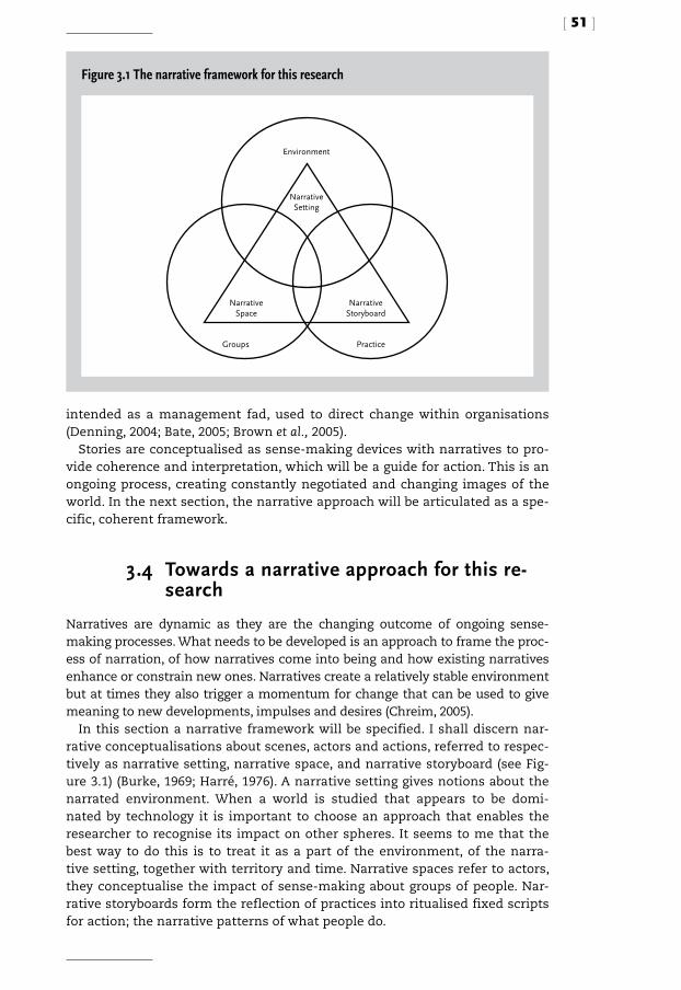
[ 51 ]
intended as a management fad, used to direct change within organisations (Denning, 2004; Bate, 2005; Brown et al., 2005).
Stories are conceptualised as sense-making devices with narratives to pro-vide coherence and interpretation, which will be a guide for action. This is an ongoing process, creating constantly negotiated and changing images of the world. In the next section, the narrative approach will be articulated as a spe-cific, coherent framework.
3.4 Towards a narrative approach for this re-search
Narratives are dynamic as they are the changing outcome of ongoing sense-making processes. What needs to be developed is an approach to frame the proc-ess of narration, of how narratives come into being and how existing narratives enhance or constrain new ones. Narratives create a relatively stable environment but at times they also trigger a momentum for change that can be used to give meaning to new developments, impulses and desires (Chreim, 2005).
In this section a narrative framework will be specified. I shall discern nar-rative conceptualisations about scenes, actors and actions, referred to respec-tively as narrative setting, narrative space, and narrative storyboard (see Fig-ure 3.1) (Burke, 1969; Harré, 1976). A narrative setting gives notions about the narrated environment. When a world is studied that appears to be domi-nated by technology it is important to choose an approach that enables the researcher to recognise its impact on other spheres. It seems to me that the best way to do this is to treat it as a part of the environment, of the narra-tive setting, together with territory and time. Narrative spaces refer to actors, they conceptualise the impact of sense-making about groups of people. Nar-rative storyboards form the reflection of practices into ritualised fixed scripts for action; the narrative patterns of what people do.
[ 52 ]
The narrative settingNarratives concerning the action environment are conceptualised as the nar-rative setting. Notions about local and global, presence and absence, strange-ness and familiarity, home and abroad, past-present-future, implicitly and/or explicitly come together in an enacted place, at a certain time, with distinc-tive props.
Change and stability in societal artefacts have been conceptualised as insti-tutionalisation (Douglas, 1986; Scott, 1995). They explain, for instance, that hospitals all over the world resemble one another because they form an insti-tutional environment with implicit guidelines that define the physical setting. If we place this example in a narrative perspective we may argue that a par-ticular hospital is a setting, narratively enacted, a locus where different narra-tives come together, in the first place because they are related to the physical environment (Yanow, 1995; Yanow, 2006). The built environment, for instance, can be narrated in at least three ways: as a place to be, as a structure or sys-tem in which you find your way, or as a narrated reference point for other narratives (Gastelaars, 2008).
Narratives on the setting also take the time aspect into account. Time is conceptualised as clock time or lived time (Chia, 2002), and concepts on past, present and future (Adam, 1990). A moment might be linked to a greater span of time or to a single instant (Hassard, 1996). The past can be ignored as a source of reflection (Antonacopoulou & Tsoukas, 2002) or welcomed and used as a source for change (Ybema, 2004).
A narrative setting is dressed with props, including the Goffmanian person-al front. Think of the way people dress according to their profession: a busi-nessman wears a suit and uses a laptop and cell phone and a doctor wears a white coat and a stethoscope. These examples show that the narrative setting has become increasingly dominated by technology, including software, and that data used on a laptop or desktop computer may be regarded as props (Orlikowski, 2007).
Actors are inclined to narrate both tangible and non-tangible aspects of the narrative setting (Schneider, 1987; Weick, 1995). For instance, a software programme is a non-tangible piece of the environment, brought to the actor through a tangible computer screen and has a fundamental impact on how things are done (Orlikowski, 2000). As the relationship between technology and man is complex, there is no such thing as the discovery of technology; it is shaped through images of how that technology is used (Bijker, 1995).
A narrative setting can be conceptualised as narrating the scene or theatre for action (Goffman, 1959; Burke, 1969). We may discern a front stage, a back-stage, and a wider environment. Goffman warns us in his conceptualisation that a physical location may have different functions: in one scene it may be a front stage, while in another it may be a backstage or even a wider environ-ment.
[ 53 ]
The image of reality is constrained by the effect of time and space on the narrative setting, making it partial, distorted and incomplete, since we can-not be present everywhere at all times (Burrell, 1992). We make sense of what we experience, offering a complete picture. Boje used the multi-stage meta-phor where, because different events happen simultaneously, nobody is able to grasp and understand the full picture. That notion makes us aware of the fact that narratives are local and tied to sense-making at a certain place and time (Boje, 1995).
With a narrative setting the lived environment is enacted, anchored in time, territory and technology. It is a relatively stable image, however vulnerable to redefinitions. Actors always resist changes to the narrative setting, but when this setting eventually becomes untenable it will explicitly or tacitly change. The interpretation of time and space is subject to change, depending on the narration of the present, past and future of the setting itself.
The narrative spaceThe second element of the theoretical framework is the concept of narrative space. One or more narrative spaces can be discerned in a narrative setting. These spaces represent groups of people and are therefore the link to human existence. They might enact a department, section, or organisation, or even a profession or religion. The interplay of narrative spaces might determine, pro-mote, mitigate or halt action, but it might also create a deadlock or a cease-fire (Veenswijk, 2006). Narrative spaces may act as a kind of zoning plan for narrated groups, either overlapping or totally divided from each other. Hu-man thought is very adaptive and able to handle quite complex combinations of narrative spaces. Narrative spaces certainly do not have links to, nor are they compliant with organisational structures (Douglas, 1986). Lipsky’s study on coping strategies in bureaucracies offers a classic, yet instructive example of how a narrative space exists beyond structures, underscoring the multi-faceted and fluid nature of organisational life (Lipsky, 1980). Also, narratives of professional cultures do not stop at the gates of organisations (Schein, 1996). Organisational boundaries may act as separating narrative spaces but at the same time narrative spaces can go beyond these. As an example, Lint-sen shows convincingly how the Corps of Civil Engineers in the Netherlands which, though formed in the Directorate for Public Works and Water Man-agement and educated at an external school, still has an impact on and even dominates civil engineering outside that organisation (Lintsen, 1980).
Since actors are in search of predictability, narrative spaces may appear to them as constant and predictable, enacting cultural entities that provide a stable enacted environment. However, narrative spaces are also vulnerable to change, as they have to adjust to new developments. They may change in either a revolutionary (as a difference between two instances) or evolutionary way (slight unrecognisable modification) (Burrell, 1992; Chia, 2002). Actors will
[ 54 ]
not notice modifications in narratives because they need the stability of nar-rative space and since this is enacted as stable, it offers a comfort zone, possi-bly envisioned as a group of people, a culture, a society or an association. It is an image which invokes prediction, a route towards a situation that is enact-ed as a desired new state of affairs. It makes people know what to do, who to trust and where to go. Within the narrative space it is clear what is important and what is not. Narrative space helps the actor to decide what is consonant or dissonant and shows the way to move on.
A narrative storyboardA world that is a constant flow of events is enacted in a way that is as stable and predictable as possible. We strive for reliable anchors to make sense of a changing world. These anchors relate to our environment and social groups, but also to action. We need them to bring stability to our thinking (Bergson, 1946; Berger & Luckmann, 1967; Weick, 1995). Storyboards are the bedrock be-neath our understanding of how to act.
There are many ways to ask for a cup of coffee in a restaurant; but we still apply modes of conduct to constrain our behaviour and stick to a certain way of doing. We would rather ask a waiter than help ourselves, and we call him with a signal rather than by shouting. Even when we drink our coffee in pub-lic, we stick to certain unwritten rules in order to present ourselves as good citizens. Research by Garfinkel has made us aware of these unwritten rules which give us confidence; we feel uncomfortable if they are not appropriate-ly applied (Garfinkel, 1984). Rule patterns provide a sequence of movements, resembling a choreography. Generally we apply these rules unconsciously. We know which action is needed in specific situations.
Narrative storyboards provide us with a mindset for action; they give clues on how to move from an initial to a desired state of affairs. They provide the narratives for action, which may still have to take place or which has already taken place, or which is experienced or implemented intentionally. One could say that a narrative storyboard results in the obvious behaviour, given the cir-cumstances conceptualised in narrative settings and narrative spaces.
Storyboards, whether simple or sophisticated, can be envisioned as a plot for action. They are the result of narrative spaces in a narrative setting. Research has shown how people in daily life enact a scene (Goffman, 1959). However, two basic elements are added here. First, whereas previous stud-ies focused only on actual behaviour, the aim is now to determine how this behaviour is enacted, or linked to the narrative realm. Second, the concept of narrative storyboard has a link to a specific narrative setting with enact-ed narrative spaces; it does not work as universal law, as pursued by Garfinkel and Goffman.
Storyboards are not fixed: they emerge, develop, fade or cease. As Wenger demonstrates, apprentices in a specific group that do routine work become
[ 55 ]
accustomed to the general way of doing. Deviant behaviour is frowned upon (Wenger, 1998). Practitioners might feel confined to one set of actions in order, for instance, to move from chaos to order (Latour and Woolgar, 1986). Howev-er, storyboards can also be persistent, unconscious and unwittingly present. The more they are taken for granted, the deeper the roots (Schein, 1992; Weick, 1995).
Accordingly, actors make predictions about action and outcomes on the basis of unwritten rules. For instance, there are many ways in which a gov-ernment organisation can communicate a new policy, but chances are that it will be in writing in a policy document. On the other hand, a football coach will give his message orally to his players and call a press conference to com-municate with the public. All these kinds of behaviour are controlled by nar-rative storyboards that are linked to narrative spaces and narrative settings. These are simple examples, but narrative storyboards can get complicated and invoke complicated behaviour.
A narrative storyboard provides predictability and stability in action. It makes clear what we can expect, which stories should be taken as relevant and how they form a logical sequence, either explicit or tacit, sometimes even without our awareness (Czarniawska-Joerges, 1998).
Since they have predictable features, storyboards may act as triggers for change. For instance, in the world of politics we have notions about politi-cians who engage in horse-trading and civil servants who execute policies. These notions remain unchanged when we observe the machinations of dai-ly politics. But if we feel that they are seriously threatened, we automatical-ly apply coping strategies: we may deny disturbing developments, formulate arguments to accommodate dysfunctional occurrences or declare oddities as exceptions to the general rule (Hampden-Turner, 1990). Occurrences may even be ignored in front of one audience and explicitly recognised in front of another (Ybema, 2008).
It is hard to exactly predict the progress of narratives. As noted by Boje, it is impossible to reconstruct where, how and with whom the action that modi-fies and generates narration will take place (Boje, 1995). However, storyboards still may be an anchor for the analysis of change. They have to be identified in order to shed light on how they connect to narrative settings and narra-tive spaces. Narrative storyboards can be simple, complicated explicit, vague, direct, deep, and superficial; they come in different guises, reflecting thoughts on narrative settings and spaces and give clues for action.
[ 56 ]
3.5 Conclusion
In this section the research paradigm discussed in Chapter 2 has been devel-oped towards a narrative theory. Literature on discourse and narrative has been reviewed, leading to an approach to elicit narratives by discerning set-tings, spaces and storyboards. The main concept of narrative developed here is that stories lead to conscious or unconscious narratives that can either be durable or subject to change.
While this theoretical approach will elicit narrative settings, spaces and storyboards, it has of course its limitations. First, it is a conceptualisation and, therefore, a simplification of reality. Though simplification offers a means to focus on general aspects, it also makes us overlook things that go unno-ticed in reality. Second, this theory also contains, implicitly and explicitly, a philosophical grounding of thoughts that focus our attention, again with the risk of missing points in reality. Third, since I am searching for narra-tives, the thing I am looking for is not visible. This research aims to go beyond the observable, towards thoughts held by individuals and groups. This calls for clear procedures and meticulous analysis. Fourth, because this research is qualitative in nature, the researcher himself is the main instrument of investigation (Leach, 1976). Without a methodological framework, qualitative research runs the risk of following personal preferences. This bias needs to be contained with an elaborate methodology, which will be presented in the next chapter.
Narratives do not simply appear out of the blue. They follow certain pat-terns within organisational environments, but not necessarily those of per-ceived organisational structures. The challenge is to discern these patterns and make sense of them. The way in which that is achieved in this research will be explained in Chapter 4.
[ 57 ]
4 How did he do it? Some notes on methodology
While doing my research, I was a fellow of a research group specialising in geoin-formation at a research institute which is part of Delft University of Technology. The group members, mainly engineers with a background in geodesy did their research on various aspects of geoinformation-sharing and enjoyed good, and at times even close contacts with the Dutch geoinformation sector. At first I felt surprised for, hav-ing studied sociology and having been trained in qualitative research, it seemed to me that the research institute did not distance itself sufficiently from its research top-ic. However, when I discussed my observations with my colleagues I learned that they were just as surprised by my reservations as I was by their tight relations. It took some time to learn each other’s frame of reference.
Gradually I realised that my colleagues were moving through the geoinformation sector in their own way and that they had become part of it to some extent. Their role was to spread methods from our institute in the field. Our department tried to make sense of how these methods were taken up and used, also reporting on the results. In a way, this reflects the way engineers in general see the role of science: they develop a model, apply it in reality and depending upon how it is received they dismiss or modi-fy it and test it again.
After some time I realised that the geoinformation sector expected my colleagues at the university to play their role as an actual part of the sector that I was studying. For me it implied that they had ceased to be just colleagues: they became part of the sector I was studying. When I shared my thoughts, norms and procedures about my ethnographic research with them in group discussions, they sometimes made jokes about my role: ‘Are you going to spy on us?’ Suddenly I realised that my fieldwork did not start outside the office building: what happened in my own research group was also of interest.
Having reached that state of mind, I started to feel discomfort. I desperately wanted to keep the research field and the work environment separate, but didn’t know how: a clear signal to think about methodology.
4.1 Introduction
The introductory story above is an example of one of the major intricacies of ethnography today. The classic anthropologist would go out to some primi-tive community in a far-away country and stay there for a considerable time making observations, doing interviews and taking field notes. Upon return, he (and increasingly she) would sit back in some university office, organise the research materials and write an ethnography (Keesing, 1981).
Today, ethnography has become an independent research method without a direct association with anthropology. It has been argued that ‘suitcase eth-nography’ is increasingly turning into ‘briefcase ethnography’ (Van Maanen, 1988), or in other words: ‘going native’ (Geertz, 1988) has become ‘being native’. Clifford Geertz has serious doubts whether such dichotomies between
[ 58 ]
the exotic field and the ‘regular’ western world have ever existed (Geertz, 1988). If the research subject is not an exotic tribe but say, a business sector in your own country, it takes more methodological consideration to maintain neutrality as an ethnographer (Latour, 1981).
Ethnography is a qualitatively-oriented way of performing research (O’Reilly, 2005). Unlike quantitative research, qualitative research must explain every step taken by the researcher in order to be convincing and rep-licable (Denzin & Lincoln, 1994). Whereas a quantitative researcher can hide behind models and statistics, a qualitative researcher uses his own presence as a research instrument. Whereas statisticians build causal models with self-created figures and formulas, qualitative researchers have to be meticulous, explanatory and exhaustive about how they collected and processed their materials.
I approached this research with the mindset of an anthropologist. It should be noted that anthropologists have a somewhat complicated relationship with qualitative methodology. They claim that methodology is essential in ethnography, the common approach to anthropological research (O’Reilly, 2005). In their view, ethnography, being more than just a research method-ology, covers the entire anthropological spectrum (Geertz, 1988; Atkinson, 1990; Golden-Biddle & Locke, 1993). Ethnography, then, becomes a vocation, a stance, or even a-way-of-life in which methodology is just one aspect of an undisputed practice in which non-methodological aspects, such as writing conventions or writing style largely determine how anthropological research is valued (Van Maanen, 1988; Atkinson, 1990). Consequently, methodology is then considered to be confined to field research and data analysis, rather than to the ethnographic research process as a whole, from preparation until (the impact of) the report (Van Maanen, 1988). Anthropologists consider meth-odology in the strict sense of the term as being important, but not crucial, as it is just a small part of ethnographic practice.
My position here is that I treat the whole process, from gaining access to the actual writing of the ethnography, as subject to methodological scruti-ny. The question of data collection is just as important as the presentation of results. I therefore strongly adhere to the ethnographic approach to research; but with a methodological account of the entire ethnographic process, imply-ing that writing style is included and therefore subject to methodological scrutiny.
Preceding chapters have already touched upon paradigms and theory; here they are connected to ethnographic practices in order to create a ‘work’ instead of a ‘text’ (Geertz, 1988: pp. 8-9). In that sense the classic ethnograph-ic approach is enhanced by the translation of theoretical assumptions into an analytic framework for the sake of doing the right thing methodological-ly when studying a Western phenomenon from a Western perspective (Latour, 1981). With this approach I am definitely not the first to pursue the narrative
[ 59 ]
orientation in ethnographic research (Watson, 2000; Duijnhoven, 2008; Duijn-hoven, 2010).
Hence, this chapter holds the essentials of a chapter on methodology in a classic ethnographic study as well as transferring theoretical concepts into analytic guidelines. A-priori theoretical assumptions on how narratives and stories change are translated into guidelines for research, which are devel-oped in the following sections. First I shall discuss some distinctive aspects of ethnography and explain the concepts. I shall then describe the research practice, focusing on the process of gaining access and the intricacies of developing a scope. Finally the art of writing an ethnography will be high-lighted, followed by a few closing remarks.
4.2 Ethnography: a multi-coloured phenomenon
Initially, I was tempted to introduce this chapter with the ideal-type descrip-tion of anthropological research. Even in classic sociologically-oriented eth-nographies, the dichotomy of a researcher ‘crossing the Rubicon’ and entering another world still appears (Whyte, 1943; Atkinson, 1990), conveying the im-age of a community under study that is hardly aware of the position and in-tentions of the researcher, and even if it is, does not have access to the eth-nography that is written after the research activities are completed and the researcher has disappeared from the scene. With the hypothetical case of La-lo Barassowah, a hunter from the nation of the Youme in the Ivory Coast who spends two years as a researcher in a Western biological laboratory, Latour made clear that this subject is of paramount importance and needs serious discussion (Latour, 1981).
Researchers have sought ways of coping with this phenomenon in soci-ological (e.g. Zaitch 2002) and organisational ethnography (Kunda, 1992; Orr, 1996; Hirsch & Gellner, 2001). Zaitch offers the most symbolic example: in his ethnographical research on Colombian drug traffickers in the Netherlands, he invited informants to his office at the university campus in Amsterdam, where he showed them his publications in order to demonstrate that his interest in the Dutch Colombian community was not police-related (Zaitch, 2002: p. 13). Ethnographies are read not only by scholars: policy advisors, organisational executives, the press and the general public can and do take notice as well. This shift has had an impact on how ethnographies are writ-ten and on how the authors perceive and deal both with the object of their research and their readers (Whyte, 1943; Bartunek, 2007). Writing an ethnog-raphy and ignoring its impact on the researched topic is no longer an option. On the contrary, anonymous actors have become the norm; named characters are exceptional in an ethnography (Humphreys & Watson, 2009).
Increased two-way communication between the observers and the
[ 60 ]
observed has serious implications for the construction of ethnographies. Take for instance Van Maanen’s distinction of three ideal types of ethnography: realist, confessional and impressionist tales (Van Maanen, 1988). Aware of the presence of influential groups, ethnographers have a tendency to stick to realist tales insofar as it is safe to reveal practices, or to be more of an impres-sionist or a confessionalist in order to prevent displeasing details from com-ing to light (see also: Humphreys & Watson, 2009).
The work of ethnographers entails the conversion of action into sto-ries (Atkinson, 1990). There are innumerable ways of achieving this, simply because the form of the actual research process is determined by local cir-cumstances. Researchers may have access to live action or they may be con-fined to secondary data such as reports, policy documents, diaries, audio recordings or video footage.
The essence of the trade is linguistic; it entails the art of transferring field notes and other texts into a full-fledged ethnography, a demanding and meticulous process, from ‘writing down’ to ‘writing up’ (O’Reilly, 2005). As distilling, purging and digesting data is essentially all about language, and because all of this is done either by a small group, or in most cases by just one individual, it is susceptible to bias, prejudice, and selectiveness. Such a process is in need of general rules of conduct, possibly even some kind of eth-ical code (Atkinson, 1990; O’Reilly, 2005). One would expect to find an estab-lished technique for taking field notes, but the opposite is the case since most anthropologists and sociologists learn their field methodology through the ‘sink-or-swim’ method (Mead, 1973; Jackson, 1990).
An ethnography is a story based on all the collected data. And precise-ly because an ethnography is a story, it is a product of interpretation, and may therefore be judged as a literary text (Atkinson, 1992; Watson, 1995; Humphreys & Watson, 2009). However, that judgement rules out some kind of method for ethnography-crafting, since the writing of a novel is seen as a purely artistic activity. Methodology might help to highlight how a story is constructed and show that further theoretical support is needed to frame the construction of an ethnography. We have to turn to methods of depicting sto-ries which are regarded as valuable guidelines for ethnography-construction in their own right.
The ultimate goal of writing an ethnography is to reach an audience and establish a relationship. Besides the distinction made by Van Maanen between realist, confessional and impressionist tales there are many other ways to analyse the ways in which stories are told (Atkinson, 1992). A broad, yet revealing distinction is to discern plot-centred and character-centred texts. A plot-centred text tells a story by working towards a clue using a time-line, with relatively distanced actors. In a character-centred text the actions get the message across by zooming in on actors taking decisions. Actor voic-es in an ethnographic text enhance the feeling of ‘being there’ and help to
[ 61 ]
establish a relationship with an audience. However, readers also need anchors in the text to get an overview, and ultimately want to relate the ethnogra-phy to their own experiences and other stories and theories. This calls for an approach that looks into practices (zooming-in) and connects through theo-ry with the outer world (zooming out) (Nicolini, 2009). The next section will focus on linking the ethnography through theory to other realms.
4.3 Connecting theory with research: guiding concepts
To establish a relationship between ethnography and the outside world, the traditional view of methodology has to be extended into an approach that in-volves the process of interpreting field notes into ethnographical text. The re-lationship between a theory that conceptualises an aspect of human life and the research topic will be made explicit and guidelines will be developed. The narrative approach thus developed – discerning a narrative setting, narrative spaces and narrative storyboards – will provide an interpretive framework. This section deals with the translation of narrative theory to a research ap-proach.
Stories and narrativesPeople have always told one another stories – and individuals in the Dutch geoinformation sector are no exception to that rule. Whether collected through interviews, observations, professional articles or policy documents, stories provide the raw material for this research. When stories present them-selves in written text, they only need to be collected; when they are orally told they can be written down. Stories may differ in form, length, aim, method of collection, circumstances and so on. The analysis process brings them togeth-er and converts them into a text that tells the results of the research, from writing down (taking notes) to writing up (writing the ethnography) (Golden-Biddle & Locke, 1993; O’Reilly, 2005).
To produce a work instead of a text, a framework of concepts is needed (Geertz, 1988). Concepts help to make sense of stories, to bring them together into a meaningful whole. Such a meaningful whole is already present in the story itself as it acts as a device for sense-making, but it is not usually a pro-cess that you can put your finger on. Meaning does not simply emerge from the research data and reveal itself instantly to the researcher. The heart of the analysis process is to construct narratives out of the many stories on hand.
In Chapter 3 narratives are conceptualised as having a clear beginning and end, with a plot to turn imperfect and ambiguous stories into a meaningful whole. The plot reveals the dominant logic in that particular situation. Nar-ratives constitute the lived situation in stories, moving from a perceived to a

[ 62 ]
desired situation. People may express doubts and ambiguities in their story-telling, they may be unwilling to speak out clearly, or they may have a hidden agenda or circumvent specific issues.
Time and changeAs the world is constantly in flux, change is everywhere. People try to get to grips with change by framing it into fixed images. We generally enact chang-es as an array of isolated moments (Bergson, 1946). Accordingly, change will be treated here as a way of moving from one state to the next. Fixed patterns in a changing world are vulnerable to change. It is the job of the researcher to frame the unnoticed as well as the noticed changes.
Both stories and narratives may change over time. When stories are told and retold, they change, as do their interpretations (Gabriel, 2000). However, because stories are framed by narratives they are still treated as fixed. Only when narratives become untenable do stories either adapt or fade away. In my attempts to depict change, I have to be aware of these factors and the very nature of narratives in the sense-making process.
When analysing research data, it is necessary to keep some kind of timeline upon which stories can be scored. This timeline not only incorporates current developments but also representations of past and future. These representa-tions also change and must be accounted for in the research process.
Territory and technologyEvery action is connected to a location and every location has an environ-ment enacted with time, territory and technology. For instance, triangulation, for ages the main practice of geodesists, entails climbing church towers, in-stalling heavy and expensive equipment and following meticulous and pre-cise measuring procedures. After the measurements are complete, geode-sists make endless calculations in an office. Sometimes cadastral surveyors had to go out to deal with disputes about landownership. Their job was to set-tle ownership by drawing imaginary lines to establish boundaries which were duly stored in files at the cadastral office.
Today, accuracy is produced by global position systems (GPS) and auto-mated equipment (Kenselaar, 1999). The production of accuracy has there-fore moved from the front stage to the backstage, hidden in sophisticated equipment and satellites. The backstage performance hidden in technologi-cal props determines the ultimate front-stage result, thereby diminishing the surveyor’s authority. It is in databases, data-viewers and other sophisticated software devices that the essence of geoinformation is constituted. The use of laptop computers to work either in the office or out and about has increased the physical detachment from the work organisation and has further virtual-ised notions about territory (Negroponte, 1995). The reality of territory is com-ing increasingly from electronically produced information. This is reflected in
[ 63 ]
the way territory and technology are treated in this research. It is my job as an ethnographer to find out how territory and technology are enacted, using the concept of narrative setting.
Narrative spacesIndividuals or individuals organised in groups are treated as actors and are conceptualised as narrative spaces. Through the process of narrative analy-sis groups and individuals are scored as narrative spaces by me as the ethno-graphic researcher. Through interviews, observation and document analysis it will become clear which narrative spaces can be discerned. It is the research-er who interprets the data as it presents itself in the subsequent cases.
These narrative spaces are constructed as they reveal themselves through oral stories in interviews or in texts, policy documents, professional arti-cles or life stories. Narrative spaces can be small or big, official or unofficial, temporary or permanent. They entail organisations, project groups, informal meeting rounds, professional associations and occasionally pressure groups and individuals.
Narrative storyboardsA narrative storyboard is a script for action, a guide for practice, offering a sense-making device for action. Storyboards provide a link between an enact-ed definition of the situation and a desired situation. Being narratives by na-ture, they will be linked to narrative settings and spaces.
As practices are multi-dimensional and varying, narrative storyboards may appear in various forms with different qualities. They are conceptualised here as linked to the narrative setting of a specific case, but they can be linked to more than one narrative space. They can be related to a specific aspect within a specific case, but also serve the sector as a whole.
As they are representations of modes of action, storyboards reflect what is strived for, mostly enacted in abstract terms. They may, for instance, strive for recognition, accuracy, efficiency, change or stability or a combination. Story-boards narrate goals and how they should be reached.
4.4 Setting things in motion: how I established a relationship with the field
In the introduction to this chapter I explained how my colleagues’ reactions to my research attitude made me ponder about methodology, raising ques-tions about the relationship between the researcher and the researched, be-fore, during and after the research process. It triggered a process of thinking and rethinking about how to design this research project: about theory, meth-odology, and ultimately, how to make sense of my experiences.

[ 64 ]
Contemplating how to start, I was sure that my research had to be quali-tatively-oriented. It was both my training and my clueless state of mind that brought me to that notion. Theoretically and methodologically the research had to be somehow culturally-oriented. But where should I go? Who should I talk to? There was so much to find out.
I started to re-read the theories on organisational culture that I had learned during my Master’s programme to get a feeling of what was new and state-of-the-art. Slowly but surely, while continuously reconsidering the literature in relation to my research topic, I became aware that the approach had to be ethnographical. However, ethnography in the Malinowskian sense would be out of the question. To be methodologically strict, it was essential to have a theory as a guide for the process of discovery to undergird the ethnograph-ic process. To support a non-managerial paradigm, the narrative perspective appeared to be freestanding and therefore suitable for guiding this research. Such a perspective should do justice not only to temporal and territorial aspects, but also to technological aspects. To me it was the most distinctive aspect of this research topic. It also had to take account of different groups that were enacted, with no distinction between the formal and the informal.
As I started to dig into the history of geoinformation in the Netherlands, an ongoing narrative, already existing for centuries, unfolded, which to my mind just had to be connected to observed contemporary practices. Still hooked on the Geoportals project alone, the acknowledgement that I had to incorpo-rate at least some history came from the Geoportals project itself, as partic-ipants increasingly referred to a former project with a similar goal: the Nati-onaal Clearinghouse Geoinformatie (NCGI) was a clear signal that the Geopor-tals project by no means had to be studied in isolation. The more I learned through reading and talking to people, the more I came to the conclusion that the geoinformation field as a whole had to be studied to be able to grasp the essence of the Geoportals project, which needed to include NCGI.
While the people I talked to almost unanimously described NCGI as a fail-ure, there was yet another project that was mentioned quite frequently and regarded as a success in the geoinformation community: Grootschalige Basis-kaart Nederland (the Large-Scale Base Map of the Netherlands, GBKN). GBKN was generally described as a slow starting project that took 25 years to com-plete and which became a success after being saved at some point by technol-ogy, which provided an escape from an awkward position.
These considerations culminated in a general design with three cases: GBKN, NCGI and Geoportals, each of which played its own unique role in the geoinformation field with its own specific history. Because Geoportals is seen as an extension of NCGI, the three cases are treated as a dichotomy in the analysis: GBKN versus Geoportals/NCGI. They are presented here as sepa-rate cases because of the research method: I was able to monitor Geoportals because it started just before I commenced my research.
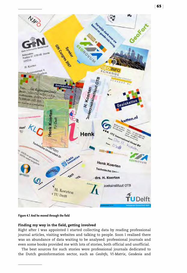
[ 65 ]
Figure 4.1 And he moved through the field
Finding my way in the field, getting involvedRight after I was appointed I started collecting data by reading professional journal articles, visiting websites and talking to people. Soon I realised there was an abundance of data waiting to be analysed: professional journals and even some books provided me with lots of stories, both official and unofficial.
The best sources for such stories were professional journals dedicated to the Dutch geoinformation sector, such as GeoInfo, VI-Matrix, Geodesia and

[ 66 ]
Nederlands Geodetisch Tijdschrift. These provided me with storified snapshots of a continuously developing sector. The history of geodesy and cadastral sur-veying came from the annual Verslag der Rijkscommissie voor graadmeting en waterpassing (since 1880) and Tijdschrift voor Kadaster en Landmeetkunde (1885-1970). I also traced some ego-documents in the form of life stories to shed light on the surveying profession.
Geoportals, the case that started this research project, had just been launched when I was appointed to my PhD post. I was able to observe Geopor-tals meetings from September 2005 onwards. Until the completion in 2008, I was present at almost all project meetings with representatives of the con-tributing organisations. I also attended workshops which presented the project to the GI community and participated in two brainstorming sessions. Additionally, I conducted interviews with key players, both at the beginning and after completion of the project.
The next step outside the office was to talk to elderly and often retired per-sons that could tell stories about GBKN that had started in 1975 and on the geodesy and surveying professions. Using the snowball method I visited these retired professionals at home, some were even in their nineties. As soon as I had the impression that new interviewees had little to add to my knowledge of geodesy, surveying and GBKN, I moved on to the NCGI case. Here, inter-viewees were still in the office. I interviewed them at their work locations. NCGI had been extensively covered by professional journals, so both the interviews and journal articles provided me with rich stories.
It was relatively easy to make interviewees talk about their profession. Peo-ple were always willing to grant me an interview and were helpful in giving names and tips on where to look. Retired professionals were eager to be inter-viewed because they were curious and I think they really enjoyed replaying the movie of their professional career to anyone showing an interest. Other interviewees considered themselves as part of the geoinformation communi-ty and were very curious about my topic and my approach; they often told me that they had been interviewed before, but not by an ethnographer.
Acquiring data, defining the scopeThe main purpose of initial interviews was to get to grips with crucial jargon, but also to find out about the position of interviewees and their respective organisations. The world behind concepts such as metadata, Spatial Data In-frastructure (SDI), and Service Oriented Architecture (SOA) had to be explored and understood. I tried to collect as much information as I possibly could on the organisations and people who were involved and their relationships.
Besides approaching people directly, I tried to engage in the geoinforma-tion community as much as possible. While wandering around, visiting con-gresses, seminars and workshops, talking to people and following sugges-tions, I usually introduced myself as a researcher interested in the organisa-
[ 67 ]
tional aspects of geoinformation infrastructures, with Geoportals as my main topic. Such an introduction often prompted people to offer their opinions on Geoportals, NCGI, GBKN, and spatial data infrastructures in general. After-wards, I always made notes of these spontaneous encounters as they provid-ed me with ‘soft’ information, and sometimes with clear stories of personal experiences.
Working that way for over two years, it appeared to me that the geoinfor-mation sector was preoccupied with cooperation. Geoportals, NCGI and GBKN were regarded as projects addressing the entire geoinformation sector, for which almost everybody felt a personal responsibility. However, though they were proud to be part of the geoinformation sector, they were not proud of a concrete project like NCGI. GBKN was seen as successful but had taken too long and Geoportals was regarded by some as failing before it even got started.
I was guided by the notion that if I was to understand the origins of these projects I had to look into the nature of the geoinformation sector. I studied books on the history of the surveyor and the geodesist, on surveying and geo-detic techniques and on how surveying and geodesy were valued through the years. At one point I decided to incorporate the history of surveying and geod-esy by using it as a basis for analysis, reflected in the historical account in the introductory chapter.
ObservationI observed the actual developments in the Geoportals case. I attended as many project team meetings as I possibly could, only occasionally missing one. I also participated in teambuilding workshops that were organised twice to develop a shared vision. Throughout the duration of the project, four sem-inars were organised to present project results, all of which I witnessed, ob-serving and asking visitors questions on how they experienced the congress and the Geoportals project as a whole. The Geoportals project had a website which was only occasionally maintained. There was also a ‘share point’ to which only Geoportals team members had access. This share point was used as a sort of project-filing cabinet. It contained a list of project members with email addresses and held every document that was considered relevant to the project.
Project participants were aware of my role and the purpose of my presence. Only occasionally, did they make a teasing remark like: ‘Are you spying on us?’ or, ‘Will this scene appear in your book?’. As I was taking notes all the time, project members were fully aware of what I was doing and sometimes even asked about the progress of my research. In general, they took it all for granted as they got accustomed to my way of working.
While gathering data, I also occasionally presented my research at a regu-lar team meeting. It was a chance for me to get feedback and for the project team to gain knowledge of my methods. I also led a discussion in 2006 at a
[ 68 ]
teambuilding workshop, where we retreated as a team to discuss and get inspiration. This gave me a somewhat independent, custodian-like role: to invoke discussion about the roles team members assumed as representa-tives of their organisation. On all these occasions my contribution to the team was clear, but as the project went on, the reason for my presence faded away, which helped me to pass as much as possible as a regular team member. At the end of Geoportals I offered to reflect on the project using my research as a basis, but received no response.
Other observations I made were on congresses on current developments such as the Basisregistraties project (BR, Base Registries), cable & pipe regis-tration and the Actueel Hoogtebestand Nederland (National Levelling Index, AHN). When socialising with participants, I always revealed my identity, profiling myself as an absolute layman and stressing my sociological back-ground – which usually created an atmosphere of experts willing to initiate the apprentice.
Spradley offers a scale for recognising different approaches to observa-tion (Spradley, 1980). He identifies non-participation, passive participation (bystander), moderate participation (not a regular, but accepted), active par-ticipation (learning appropriate behaviour) and complete participation (ful-ly participating). In the Geoportals project, my role was somewhere between moderate and active participation. In other cases, for instance, when I was observing congresses, it was more or less a mix of a passive and moderate participation.
InterviewingInterviews were carried out in four stages. When I approached potential in-terviewees by telephone or by email I always stated my intentions and pur-pose. Presenting myself as an outsider almost automatically forced my coun-terparts into an expert role. It gave them an opportunity to demonstrate their knowledge of the subject, rendering rich and abundant information. With-out exception, all the interviews took place in a friendly atmosphere. People were willing to talk; nobody refused me. They sometimes even produced doc-uments to underscore their experiences, which I occasionally borrowed for copying.
In the first stage, October 2005, I interviewed key participants in the Geoportals project. I visited their office with the aim of getting to grips with the subject and their respective backgrounds. It was also an opportunity to meet my fellow participants, my future co-workers.
The second stage concentrated on retired people from the Kadaster, Nation-al Triangulation and GBKN, mostly at their homes, some being retirement homes. Only one person preferred a more neutral venue, so we agreed to meet in a café. An appointment was made by telephone, briefly introducing my research purpose. When I started the interview, I first reintroduced my
[ 69 ]
subject and asked if they had any questions about the purpose of the inter-view. After that I invited them to tell the story of their working life, prefer-ably starting with their education. When appropriate, I asked them specific questions on certain topics that needed further elucidation. I made extensive notes for a full interview report, which was written as soon as possible after the completion of the interview. These interviews were held in 2006 and 2007.
The third stage entailed a series of interviews with participants in NCGI and GBKN who had not retired yet in 2008. The interviews were held in their offic-es, apart from three, which were held at my office because that was more eco-nomical. Again, people were always willing to talk; only occasionally was an initial appointment postponed, but never cancelled.
In the fourth and final stage I interviewed participants in Geoportals after completion of the project in autumn/winter 2008, asking these interviewees to reflect on the project. Here, the role of the apprentice could not be played anymore – at times causing people to be less cooperative than at the outset. I sometimes had to ask leading questions in order to penetrate the facade of not wanting to tell. On the other hand, they treated me now as an insider who knew the ins and outs of the Geoportals team and allowed me to ask specific questions.
Interviewing is like hopping from story to story. Every interviewee has an interesting story to tell. However, in every stage I reached a point where new interviews did not lead to new information on the topic. The decision to quit was based on continuous reflection on the stories gathered, until a saturation point was reached.
Analysing dataDuring the research period I collected data from 47 interviews, 21 observation reports of congresses, 22 observation reports of Geoportals meetings, profes-sional articles, organisational documents, advertising material and audio and video footage. I kept this data in files assigned to the respective cases and ordered them chronologically per case. Several interviews applied to one or more cases, so I categorised them in a database, scoring them per case. Ob-servational notes, together with PowerPoint handouts were also categorised into subject files, with categorisation on event sequence. Files were created per case and I went through them chronologically in order to get hold of nar-rative settings, spaces and storyboards.
Depending on the dominant types of data, I followed different procedures. In the Geoportals case, I started to make sense of events by analysing Pow-erPoint presentations, more or less to construct an ‘official story line’. Next, I went through observational data, registering my own sense-making of events. After that, I analysed observations made by others and reviewed articles in professional journals and on websites, and of course my own interviews.
In professional journals, personal accounts of the Nationaal Clearinghouse
[ 70 ]
Geoinformatie (NCGI) were hard to find. However, the bi-monthly official NCGI newsletter filled in the bigger picture. The SAG initiative, an essential element of the NCGI case, was documented in the proceedings of a few conferences on that topic. Here, observational data was almost non-existent. Other nar-ratives were sourced from columns by organisational representatives and the conducted interviews.
The GBKN case could be documented through the many professional arti-cles and internal reports from the Kadaster and the GBKN organisation. Here narratives were also obtained through interviews and professional articles. These articles could be of a descriptive nature or column-like stories by pro-fessionals, either from interviews or written by themselves. Some hot GBKN issues were seriously debated in professional journals. The persons inter-viewed ranged from professionals telling about their daily routines to a man aged 92 with a sharp memory, who recollected stories about the old days.
Information on the history of national triangulation and the Kadaster was obtained from historical writings and from professional journals, reports and autobiographies. The aim was to get a general storyline by sorting the materi-al in a chronological order, followed by a more in-depth analysis to reach and understand the cadastral surveyor and the geodesist.
4.5 Ethnography as communication
The writing process is just as important in ethnography as data collection and analysis (Van Maanen, 1988; Ybema et al., 2009). While Van Maanen would not entirely agree that the writing process forms part of the methodology, he does see it as a crucial element in ethnography. Simply piling up all the re-search data and leaving the reader to draw conclusions, most common in some of the first ethnographies (Eggan, 1968), is not an option. There are still examples of ethnographers who give a full account through the almost verba-tim publication of their observational field notes, leaving the reader clueless (Van Maanen, 1988). Thus, to make the research attractive and digestible, raw data has to be transformed and interpreted to describe and understand the research topic. Data is selected, filtered and interpreted to appear in a report-ing statement. An account of how conclusions are drawn is just as valuable as a demonstration of data-collection and analysis procedures.
It is the researcher’s job to determine what to report and in what form in order to convey the right message to the reader in a way that can be under-stood. A mode has to be found to convincingly show the key results of the research to the reader. Narratives are research data interpreted by the researcher, who uses different stories from different sources to construct them. It is research data in an analysed, condensed, studied, and meaningful framework. In that respect narrative might be considered as fiction, because
[ 71 ]
it cannot literally be related to the original research data (Duijnhoven, 2010). That said, it is still an interpretation obtained through a methodological framework and hence is just as much an interpretation as a table or a figure in quantitative research, provided it is supported by methodological justifica-tion (Atkinson, 1990; McCloskey, 1990).
A narrative in that respect reflects, recapitulates and reorders the hunch-es, suggestions and implications of narrating fragments within stories that are present in the rough research data in order to let them make sense. For that reason I used the ordering device of narrative settings, narrative spac-es and narrative storyboards. Such ordering concepts have themselves even been regarded as fictitious and not related to the research data; however, they are regarded here as linked to both research data and literature on discourse and narrative theory (Gergen, 1992).
The research questions suggest a relationship between the researcher and the researched, but also with theories and methodologies of narrative research. Any publication that aims to communicate with these two distinct groups has to be able to blend the interests of the various stakeholders. The preferences of research and practice may align neatly with one another, or they may be in opposition. Next I shall work out the guidelines for writing up this research.
A dialogue with the research communityScientists stay in their own realm when engaging in an academic debate. The developed framework that guides this research is based for the most part on literature drawn from scientific communities where there is a lively debate on the theory and methodology of narratives. Interactions ranging from social chats to official congresses have spawned books and journal articles as tangi-ble symbols of scientific production. Hopefully this book will add to that de-bate on how to do research with these theories and methodologies. This book attempts to make a difference by contributing to the current debate in both a theoretical and a methodological way.
Science does not confine itself to posing ‘how-to?’ questions; ‘what?’ ques-tions are also relevant: there is a small but emerging community of research-ers who are focusing on the organisational dynamics of geoinformation infra-structures. This research might help us to see geoinformation infrastructures in the full meaning of the term, rather than as a technical solution. In order to do so, the story told here should link to the existing debate on evaluat-ing and assessing spatial data infrastructures (SDIs) (Nedovic-Budic & Bud-hathoki, 2008; Georgiadou et al., 2009).
To talk back to the community of practice, opting for a two-way dialogueCommunication allows me as a researcher to establish a relationship with my research topic. I have digested an abundance of information that will be giv-
[ 72 ]
en back to the Dutch GI community through a hopefully sense-making book. As a researcher, I am aware that the most symbolic product of this research process, a dissertation, is almost an icon to geoinformation practitioners. Peo-ple within and around the research topic might approve of or resent my find-ings, using them as an opportunity for policymaking or as an unwelcome message that needs to be contained, neutralised and wiped out (Bartunek, 2007). What is more, for my part, this book is an invitation for dialogue.
As a result of my arguments in Chapter 2, such a dialogue is nothing less than a conversation between paradigms, or to put it differently, in the terms of Argyris and Schön, it is a double-loop result, ready to be used as a single-loop opportunity to act. Up till now I was in full control of the contents of my research and I could do everything to make it have impact. Now that it is pub-lished, it is out of my hands because others will give meaning to it and treat it as they see fit. I hope that this one-directional book will result in a two-direc-tional conversation with or within the GI community.
In the light of these statements it needs to be clear where the money comes from. The research project that constituted this book was partly funded by RGI, one of the organisations under study. This might create an awkward position for independent research, but for a number of reasons this is hard-ly the case. First, RGI granted only 40% of the total research budget, the other 60% came from Delft University of Technology. Second, the grant was part of a larger programme of which RGI was a part, with strict rules guiding the trans-ference of the budget to Delft University of Technology. Third, I tried to work as independently as possible, dedicating myself entirely to research and not taking part in any consultancy activities. Fourth, I kept my distance from the Geoportals project as explained earlier in this chapter. Fifth and finally, RGI was a temporary organisation that has since been dismantled.
RGI was in essence a programme that was meant to boost innovation with Geoportals as one of the most prestigious projects. My PhD research as part of Geoportals was conducted with a view to organisational innovation, to find ways to design effective organisation in relation to the development of geoin-formation infrastructures. Since none of the people involved really had a clue, the circumstances gave me plenty of freedom to explore. The only direct involvement of RGI was when they had doubts about my research, based on an unclear phrase in a report by the Geoportals project team. This misunder-standing was easily solved and never affected my research in any way.
An ethnography for the researchers and the researchedThis book should be treated as an artefact, intended to communicate with different audiences with converging and diverging interests. It needs to be scientifically relevant to be of help to practitioners. It also needs to be em-pirically accountable, generally accessible and preferably written in a relaxed style.
[ 73 ]
As a PhD dissertation, this book has a predictable, almost classic structure with a section on the research focus, followed by an empirical section dis-cussing the results and a concluding section with analysis and implications. I deliberately used this structure to allow easy access for the research commu-nity and to give the book scientific credibility for practitioners. As engineers are not used to narratives and storytelling and ethnographies in research, this book needs to convincingly demonstrate that the data have been scientifically collected, analysed and presented. A classic dissertational form helps in that respect. As most practitioners have personally experienced the cases in some form or other, it has to be recognisable to the GI community. This implies that each empirical chapter should tell the story of the case that is scrutinised, but with a concluding section to embed it in the theoretical framework.
In order to be convincing, ethnographies have to display that the ethno-grapher was present, in much the same way as a formal description demon-strates scientific credibility (Pratt, 1986). For anthropologists an ethnographic book must be based on fieldwork, the fact that the author ‘was there’ is cru-cial (De Holmes, 1983). The empirical chapters are attempts to demonstrate that I have indeed been there. Of course, there were developments that could not be experienced because they happened before I commenced my research; even so, this book has to give the reader the feeling that I was there by using other methods. Besides having a rather classic ethnographic look-and-feel, I used some ethnographic fiction methods introduced by Watson (Watson, 2000) which were methodologically enhanced by Duijnhoven (2010). While I treat these methods as true ethnographic innovations, I was reluctant to write in a full literary style as convincingly demonstrated by Duijnhoven. The reason is obvious: I would probably lose my practice-oriented audience if I applied what is to them a rather controversial, yet innovative style. I therefore applied it sparingly, only to depict ongoing discussions through the assem-bly of multiple accounts. This was appropriate only occasionally in Chapter 5.
Therefore, cases are described in a rather distant manner, while voicing opinions and stories through interview excerpts, quotations from profession-al journals and documents, with only very limited use of fictional dialogues based on observational notes. These fictional dialogues are presentations and interpretations of many discussions on multiple events and interpret the essence of typical, recurring and ongoing discussions. Adequate chronology has been enforced through the division into sections describing subsequent phases.
My personal relationship with the topic is embodied in the short sto-ry at the start of each chapter. These stories represent personal experiences which sometimes relate my amazement as an innocent bystander or a per-sonal struggle with a topic. First of all, they are meant to give an account of my journey through this research, which actually started long before I was appointed as a PhD candidate. These short-stories-in-italics also serve as
[ 74 ]
teasers to draw the audience into the story of that specific chapter. Finally, they offer me an opportunity to show a glimpse of the writing style I would have loved to explore, but for practical reasons as explained above, did not entirely follow.
4.6 Conclusion
This chapter was meant to shed light on methods and styles applied in this book. In a way, it is also meant to put results into perspective. It is hard to explain that an endeavour like this is never a planned, straightforward proc-ess; the reader has to take my word for that. I had to deal with dead ends, disappointments, setbacks and even failures in the course of this journey. It is in the interests of science that I had to go through all this to be where I am now, writing this down in a book which is the result of all the hard work. At times I had no idea how to proceed while at other moments the goal was clear, though it sometimes turned out to be inappropriate later on. This chap-ter closes the section that sets out the prerequisites for the essence of the re-search: the description of the fieldwork.
[ 75 ]
5 Geoportals: trying to tackle tempting tech-nology
My initiation into this research topic on the Dutch GI sector was on 14 September 2005. Even before I began my official appointment at the university, I went with my PhD supervisor-to-be to a Geoportals project meeting in Utrecht, held in a meeting room at a participating organisation. This was the project I was supposed to study for my research project: ‘Success and Failure Factors of Geoportals’. It was assumed I would participate in the project, monitoring the process and, if appropriate, do a limit-ed amount of consultancy work. It was scheduled to run from early 2005 until the end of 2008, so it was already up and running when I officially commenced my research.
During the job selection procedure, I had read the project proposal together with some other information, so I had an idea of what to expect. The project aimed at the disclosure and thematic dissemination of geoinformation. A consortium of 13 organi-sations was formed to establish different portals, indicated by colours: a red portal for geoinformation on the built environment, a green portal for nature and agriculture, etc. There had been a few meetings before, but the project was still in its initial phase.
Ten of us had gathered in a meeting room adjacent to the canteen, separated from the regular offices, so the venue had a somewhat neutral atmosphere. I got the impression that a core group of people knew each other quite well while some oth-ers were new to the group and to each other. Representing the participating organisa-tions, from both the (semi-) public and private sector, they were all technically skilled to some extent. This was the team that would manage the whole project. The discus-sion that emerged during that meeting gave me the impression that the participants were determined to build a software system to support a website that would disclose geodata from different sources, with all the design, programming and implementation that this entailed.
When introducing myself to the group, I sensed some aloofness, but when I explained my technical background the participants became more at ease. As soon as they found out that I had mastered most of the jargon used during discussions the atmosphere became even more relaxed. It felt as if they had accepted me not only as an observer but also as a participant.
The group was very determined and wanted to make something of the project. At the same time they were very insecure about how to select standards. Standardisation was perceived as absolutely necessary in order to be able to connect different sets of data. During the discussion on which standards to apply, it was often mentioned that standards were important but not really an issue, at least not an issue worth discuss-ing, because it was quite obvious to them that only relevant and current standards should be implemented. But while discussing other (considered more important) sub-jects, they always came back to the question of standards selection. They did not want to see standardisation as an issue, but actually it was, leading to agonies of doubt.
Some discussion was devoted to the fact that the Kadaster was not participating in Geoportals; this made them feel both insecure and heroic. I had already noticed that the Kadaster was considered the largest player in the GI field. Its absence gave the participants the impression that the Kadaster saw Geoportals as having no strategic value. Did the Kadaster, together with the whole GI sector, feel that Geoportals would
[ 76 ]
certainly fail? This made them feel insecure about the success, but in a way, it also gave them strength. The independence of Geoportals from large organisations such as the Kadaster could possibly be a success factor, but the general opinion about this matter was one of great insecurity.
The team members believed that Geoportals, by connecting different geodata sourc-es, could generate new geoinformation. Geoportals was discussed as a part of the Dutch National Spatial Data Infrastructure (NSDI). That fact invoked discussion on the name: Geoportals was considered old-fashioned. On the one hand, it was seen as having connotations of a counter in some government building where people have to queue. On the other, it was a concept the general public could relate to: a one-stop-shop for geoinformation. It was suggested that participants should look for alterna-tives, but nobody believed that the ultimate name would pop up.
There were mixed feelings about how to reach customers and users, and, most of all, about how to define and recognise them. It was acknowledged that this topic needed more elaboration and consideration, because the participants had only limit-ed knowledge of it. While facts and feelings about how to approach the customer were expressed and exchanged, the discussion detoured more than once towards the techni-cal aspects of Geoportals.
The project was divided into work packages to keep it manageable: the geoportal framework, the geoportal network, cases, demonstrators, and scientific research and project management. All the work packages were put on the agenda awaiting discus-sion, but only the framework and network received serious attention. This gave the project members an opportunity to present and discuss drawings of the system archi-tecture. These were passed round and discussed and some PowerPoint slides were presented on a screen. Eventually the discussions narrowed down to the question of how to connect different databases in such a way that data from different sources could be combined to generate new information. The only topic more or less outside the technical realm was a discussion about the use of standards, but the meeting did not lead to a definition of which standards should be used.
5.1 Introduction
What struck me most in that first meeting was that there seemed to be full agreement between the representatives of 13 different organisations on what goals should be reached and how they should be reached. My astonishment grew even bigger when I found out that the core group of four people knew each other only vaguely, had not worked together before and had met only a few times. I assumed that, when representatives of different organisations come together to work on some project, they first have to get acquainted and reach agreement on what and how before they do anything. In this case a few meetings seemed to be sufficient to reach a common understanding and ap-proach to set things in motion.
[ 77 ]
Over the last few decades there has been a worldwide tendency to apply spatially-oriented information or geoinformation in government and business organisations in order to improve effectiveness (Masser, 1998; Crompvoets, 2006). Within organisations this information is often managed by a Geograph-ical Information System (GIS) (Stillwell et al., 1999; Vonk et al., 2007). How-ever, geoinformation is also being increasingly shared, disseminated and exchanged between organisations (De Man & Van den Toorn, 2002). Govern-ments try to promote this trend through the establishment of National Spa-tial Data Infrastructures (NSDIs), largely designed for enhancing governmen-tal geoinformation-sharing (Rajabifard & Williamson, 2001; Nebert, 2004; De Bree & Rajabifard, 2005; Masser, 2005).
In debates on NSDI implementation, the organisational aspects of NSDIs are regarded as important, but are not treated as manageable phenomena (Georgiadou et al., 2005; Crompvoets et al., 2008). Though technical aspects are regarded as crucial (Nebert, 2004), up till now organisational structures, modes of cooperation and work relationships have grown into crucial topics in NSDI research at a very slow pace (Georgiadou et al., 2006). Organisational aspects are in this regard approached as the application of design rules bor-rowed from political science, economics and management science (Van den Toorn & De Man, 2000; De Man, 2003; Koerten, 2007). While practitioners still point to difficulties in NSDI development we still have very little knowledge of lived NSDI experiences.
This was the situation I found myself in when commencing my research on the Geoportals project. Project members had a strong focus on technolo-gy and standardisation, but also an open mind towards knowledge to get it all organised. However, when discussing how to proceed, they were not really enthusiastic about looking into organisation literature. And on the few occa-sions when they did, they turned to clear-cut models to give them clues on how to move on. A lecture by a renowned expert on information infrastruc-tures attended by the project team as a whole invoked discussion, but did not lead to significant changes.
This chapter provides an in-depth ethnographic case study of the Dutch Geoportals project. It demonstrates that it was intended to be part of the Dutch NSDI by disclosing governmental geoinformation in a thematic and organised way. However, the initial project goal of building an infrastructure gradually shifted over the course of the project, moving towards knowledge creation to facilitate innovation for further development of an NSDI.
Three phases are discernible in the Geoportals project; these will be described in detail in the next sections. The first explains how Geoportals as a concept emerged as a project stemming from the Ruimte voor Geoinforma-tie programme (Space for Geoinformation, RGI). A group of geo-profession-als launched the idea of setting up a system of Geoportals and managed to get funding from RGI with moral support from their own respective organisa-
[ 78 ]
tions. They worked hard to gain a focus on how to bring about such a system of geoportals. In the second phase, the participants became insecure about the project. Was it viable? Which target groups should be served? What tech-nologies needed to be used? Was there sufficient funding? The final phase shows a project team full of confidence, believing that a system of geoportals is not within reach, the new aim is to create innovative software applications for an NSDI.
5.2 Getting Geoportals started
The Ruimte voor Geoinformatie (Space for Geoinformation, RGI) programme started in 2002, with the basic idea of stimulating innovation in order to boost geoinformation-sharing in the Netherlands. The initial step was to bring to-gether representatives of organisations in the geoinformation field to make the goals more concrete. The result was a glossy brochure with a programme outline produced by a consortium of ten universities, 20 research institutes, 60 companies, 40 government bodies and 30 geoinformation producers (RAVI, 2003). It was argued that the government needed complex information about a complex society to develop convincing policies. To make the information manageable, it needed to be ordered spatially as geoinformation disclosed by a National Spatial Data Infrastructure (NSDI). The bottom line was to make geoinformation available in a structured manner, with independent dissemi-nation by individual organisations.
To promote future projects, RGI organised ‘brokerage and bargaining days’ on which representatives of organisations from the GI sector were invited to generate project ideas. It was in this context that the concept of Geoportals emerged. Some typical observations of those in attendance are recorded below:
RGI mobilised the field. They organised brokering and bargaining days in order to get rough ideas. Some 25 ideas were identified as potentially successful. In the end, these ideas were connected to organisations; it was just one big dating show. It became obvi-ous that some central portal facility was needed and that our organisation should play a role in its development.
I remember how Geoportals emerged. The idea behind brokering and bargaining events organised by RGI was that through discussion among representatives of geoinforma-tion organisations, ideas for concrete projects would pop up. During one of those meet-ings, the Geoportals concept just came out of a plenary discussion. Then the modera-tor asked which organisations were willing to participate. Representatives of interested organisations raised their hands, as did I. So, all of a sudden I was an initiating member of an instantly formed club of enthusiastic people who wanted to disclose geoinformation through portals.
[ 79 ]
That the overarching concept of Geoportals would be liberty united was ob-vious from the outset: a central, top-down organisation was totally out of the question. The idea was to have a network of portals of different nature, work-ing together with a minimum set of rules.
Those involved in the discussion saw the rudimentary concept of Geopor-tals as a collective idea in need of development. The thirty organisations will-ing to participate were gradually reduced to thirteen, and in October 2002, representatives from these organisations presented an initial proposal which envisioned thematically categorised, colour-coded portals such as red for the built environment, green for nature and agriculture, and brown for subsurface conditions (Schmidt & Nieuwenhuis, 2002)
After the initial submission in 2002, a rewriting process gave the project more focus. In the minutes of early project meetings there are clear concep-tions about how data should be distributed. It was stated that all the process-es for disclosure, search, diffusion and payment should be web-based, while the question of how all the different data sources were to be connected was not a matter of discussion. The first rudimentary description of the geopor-tal framework presented a static image: the portal would be based on proven technology and standards and also on a fixed notion of architecture (Hooger-werf & Vermeij, 2005).
In 2005, while the project goals were stated clearly and unambiguous-ly, at their regular meetings the representatives of the participating organi-sations expressed doubts about how to proceed. They were uncertain about the financing and procedures for reporting to RGI, but even more about the essence of the project. Now the project was about to start, the representatives felt the need for definitions about what a portal should look like, how users would be reached and what technology would be used in its setup. A typical discussion in a meeting of representatives would proceed as follows:
A: If we want to set up a proper Geoportals, we need to be clear about standards. It is obvious that we use the most recent and commonly used standards. We are not going to use any standard that has not been accepted by the community, or that has not proved to be useful.B: I agree on that. If nobody objects, we should proceed to the next topic, and that is user orientation. We have to be demand-driven, preventing us from making the same mistakes they made in the NCGI project. So how can we be demand-driven?C: First and foremost we need to disclose our data in a way that it can be readily found. Furthermore, we need to present it in a format that can be read by the user. So, we need to use the proper standards.B: I agree. We need to use proper standards, those that are widely accepted.A: Now we agreed on how to settle the standards issue, we are discussing standards again.
[ 80 ]
The motto of Geoportals was ‘liberty united’, which reflected the fact that it was a network of portals established by various organisations, each with its own autonomy, but working within a minimal set of rules. This view of Ge-oportals was often defended by explaining that it was a reaction to a former national project on geoinformation, the Nationaal Clearinghouse Geoinforma-tie (NCGI). The feeling was that NCGI had failed due to the central, top-down enforcement of detailed standards and work procedures. This had proved to Geoportals protagonists that organisations were not inclined to comply vol-untarily with strict rules. To avoid another failure, they decided to meet as a small group of motivated organisations connected through a minimal number of mutually agreed standards.
While Geoportals was sketched out in organisational terms, discussions on how to proceed always came down to technical matters. Standardisation was considered crucial, followed by the question of whether the data was accessi-ble enough. The bottom line was that the issue of technological standardisa-tion had to be settled properly. Technological matters dominated discussions:
A: Technology is not really a problem anymore. We can build everything we want without any limit. All the techniques needed are at our disposal.B: That’s right; the things that do matter are organisational aspects. Look at the US exam-ple of Geospatial One Stop. They just do it: American government agencies put every-thing they have on the web, without restrictions.C: But its quality is doubtful at best, they don’t guarantee its accuracy. I wonder if any-body actually uses it.A: If we follow the example of Geospatial One Stop, then it will look like NCGI. We have to do better than that.B: Just use the right standards. That is of paramount importance. The architecture we have developed is perfectly equipped to set up a network.A: If we stick to proven technology and standards, nothing can go wrong.B: But what is that, which standard is proven, which standard is commonly used, which one really works?C: Here we go again!
In November 2005 the core team, made up of representatives of a few ma-jor participating organisations, attempted to tackle the problems by calling the project team together for a two-day brainstorming session in a remote country hotel. The technology and standardisation issues had been declared settled, but still played a role, while the intention was to produce a strategy for developing a user-driven approach. The programme for the session men-tioned a meeting with a public relations consultant and drew attention to the question of how to make the project more user-driven. In fact, user-orienta-tion was extensively discussed, eventually leading to a ‘motto’ of which the team was very proud: ‘Able to find and allowed to use’.
[ 81 ]
The subsequent working conference at which the project was to be present-ed to the GI community in December 2005 was a pressing issue. The project team had mixed feelings about whether there was anything tangible to dem-onstrate and thought that if this was not the case it would be better to can-cel the presentation. After some deliberation it was agreed that a rudimenta-ry version of the Red Portal (information on the built environment) would be demonstrated.
Thus, in December 2005 the Geoportals project was launched before a GI audience at a conference. The core team was determined to make a con-vincing statement by showing that the project was user-driven and doing the right thing in terms of technology, but it also felt a little uncertain. The audience was familiar with RGI and its projects and knew of the existence of the Geoportals project, but was unfamiliar with the details. Sheer curiosity brought about fifty GI professionals together.
In his introduction the scientific director of RGI stressed the importance of Geoportals for RGI, proclaiming it to be a key project. The core team then gave a presentation about the demand-drivenness of the project and eluci-dated the ‘motto’. Despite the importance with which this was regarded by the project team, it barely raised the interest of the audience. However, the demonstration of a rudimentary version of the Red Portals website using data from the built environment had an astonishing effect. What the Geopor-tals team considered window-dressing was the very thing that convinced the audience of the project’s importance. In subsequent discussions it became apparent that the participants were convinced that Geoportals was RGI’s key project and that it was technically well managed and would make a differ-ence. The Geoportals project team celebrated the day as a success.
5.3 Attempting to reduce uncertainty
The project team continued its project meetings on a fixed day of the month at a centrally situated venue, a building occupied by one of the participat-ing organisations. The morning agenda was devoted to management mat-ters, while discussions prepared by a core team member or an external speak-er took place in the afternoon. However, fundamental issues would already emerge during the morning sessions and be discussed over lunch, sometimes continuing throughout the day, suggesting a certain level of insecurity. Nev-ertheless, a research paper written by project members to convince European peers expressed confidence (Zevenbergen et al., 2006).
The Geoportals project was meant to deliver all possible kinds of data to both professional users and the general public. Professional users only need-ed disclosed data while lay users could be provided with software servic-es which had to be developed for integrating, harmonising and presenting
[ 82 ]
data. Existing examples of the disclosure of geodata through websites were reviewed. Flaws emerged that convinced project members that many difficul-ties were involved in bringing together different sources. Services designed to harmonise and present data were seen as essential to Geoportals, empha-sising the user-orientation of the project, which was communicated to the GI community. The core team developed the example of a brewer who needed geoinformation to find a location for a new brewing facility. In all the subse-quent presentations and promotional material, including an RGI promotion-al film, this example – which connected different processes within different public organisations – was prominent (Van de Laak, 2007).
User-orientation also generated interest in legal aspects and the issue of digital rights management. A researcher affiliated with Geoportals translated an approach for regulating copyright on the internet into a model for the field of geoinformation (Welle Donker, 2006). This model, regulating the legal and economic aspects of geoinformation, was regarded as essential for Geopor-tals; although, however important it was felt to be, it was also seen as a sepa-rate entity, unlike technological issues. Technology was perceived as dynam-ic while the access model was perceived as static. Further development of the model was embedded in another RGI project, placing it beyond the control of the project team.
At the end of 2006 the project team began to feel uncomfortable about the lack of steering capacity at RGI. While RGI saw Geoportals as the key project of the programme, the core team regarded RGI as giving voice to individual organisations’ management and felt that it should provide an overarching framework. A serious discussion among Geoportals project participants was devoted to the role of RGI as the registrar of the National Spatial Data Infra-structure:
A: We are supposed to work on NSDI. For RGI, Geoportals are considered as focal, but they don’t say anything about the guidelines we should follow or how to connect to other projects that are part of the NSDI.B: They are talking about a test bed for NSDI, but is NSDI only a test bed then? Are we supposed to deliver something that actually works?C: We are certainly working on our data-viewer, but to what standards should it comply? Are there any organisations that are going to use it?A: They say that a new GI coordinating organisation is in the making – yet another organ-isation that is supposed to organise something. We need guidelines and all they do is establish a new organisation. This does not sound like coordination to me!D: I think that as a Geoportals team we should take a stand and do what RGI refuses: take the lead!
The core team did not feel supported by RGI, which until then had been seen as the custodian of the National Spatial Data Infrastructure, of which Geopor-
[ 83 ]
tals was a part. At the end of 2006, RGI published an article in a leading pro-fessional journal with the provocative title: Waarheen met de nationale geo-in-formatie infrastructuur? (Where to with the Dutch Geoinformation Infrastruc-ture?) (Bregt & Meerkerk, 2006). It provoked discussion but made the core team feel that RGI had no strategy.
Geoportals concentrated on the work to be done: new services had to be developed with new software. Choices had to be made on what technology to use and what standards to apply. The core team, representing three govern-ment-supported knowledge institutions and a software company, felt respon-sible for this part of the project and took up the challenge of drawing up a framework and organising software development. A participating engineering firm also did some work, but took little part in any conceptual, organisational or management activities.
The core team came together on a weekly basis to coordinate software devel-opment which was undertaken by software engineers from core team mem-ber’s organisations. In spring 2007, these efforts resulted in a data-viewer, a software device capable of consistently retrieving geodata from different sourc-es on a computer screen. The Geoportals core team were enthusiastic about it, regarding it as a step towards the ultimate goal, a system of Geoportals.
While celebrating this achievement, project members soon felt that the newly developed data viewer was already becoming outdated because new techniques were now available. This gave software engineers an opportuni-ty to develop an even more sophisticated viewer. Thus, with a tested product ready for implementation, the development process went on, with an enthu-siastic core team managing the same team of software developers. Though they worked with the newest technologies they gave the impression that these developments were quite normal for them – new technology had to be explored and applied.
5.4 Towards judgement day
In 2007 the Geoportals project was on track as far as software development was concerned, but the core team was becoming increasingly agitated, feel-ing that the initial goal of sharing geoinformation was moving out of reach. At the project team meeting in April 2007 two core team members initiated a discussion on this point in an attempt to engineer a breakthrough:
It is terribly sad that we cannot build on the achievements of RGI. It looks like manage-ment does not recognise what it is all about. In the Netherlands we have an abundance of geodata, distinguished scholars, high GIS penetration, a vast and schooled workforce and many knowledge exchange networks. Perfect circumstances for great ideas. But guess what? We just keep on chatting!
[ 84 ]
The Geoportals project team felt that nobody was in charge of developing the NSDI, and the decision-makers at RGI were depicted as abstract thinkers with no practical knowledge. A breakthrough was needed, and the appraisal of the RGI promotional conference held in March 2007 did not display any confi-dence:
A: I am sad to say that real sharing of geoinformation is further away than ever. We have just had the RGI conference in Rotterdam. It lacked any ambition. The bottom line was: ‘The NSDI has to be developed, but let’s move on as we did’. That’s not the way to get it done.B: It was a convention of the same people that you see all the time at such events; ‘the usual suspects’ were doing their ritual thing.C: It was like being in some religious rally, people celebrating and praising something of which everybody has a different image.B: It is a paradoxical situation. When we need a breakthrough, surprise, surprise, nobody wants to change, we keep on doing things as before and nothing really changes.C: Everybody talks about the costs of an NSDI, the benefits are not mentioned.A: An NSDI will add value to society, that’s the raison d’ être. If we only want an NSDI for incident management and fighting terrorism we’re on the wrong track.
Despite the uncertainty, Geoportals was considered a success by the core team because it offered technical solutions. Technology only had to be brought to a meaningful whole in order to establish the NSDI, but failing management seemed to obstruct this. Perceptions of the role of Geoportals started to change:
It is perfectly clear that it was unattainable to build an infrastructure. Just look at the budget we had for this project: it was clear even before we started that it was insufficient. Our job was to deliver building blocks to innovate for the sake of an NSDI.
We are good at the technological aspects. So if they ask us for such a project, we will handle technology. Without any guidance from RGI, it is impossible to develop an NSDI. What we can offer for a future NSDI is best practices and software tools. We form a com-munity for NSDI development.
Another conference was organised for November 2007 with a striking theme: ‘Just do it’. External experts were asked to focus on financial, legal and organ-isational aspects while Geoportals project members were keen to present on state-of-the-art technology. The message in workshops was that new software applications, as developed by Geoportals, were fully capable of integrating ge-odata from different sources. This message was symbolised using Lego blocks, representing geodata building blocks which could be put together in any pos-sible way.
[ 85 ]
Now that the finish was in sight, the project team wanted to deliver results which could be used in the future. Slowly but surely, the project goals were redefined. The obligation to produce tangible products shifted, with the Geoportals team coming to see itself as a ‘community of practice’. The image of the project as developing building blocks for an NSDI now changed, with Geoportals being reconceived as a knowledge-creating project. The atmos-phere also changed, from distress to optimism to euphoria, although one of the more sceptical project team members noted that what was really taking place was ‘expectation management’.
It was felt that the positive results should be disseminated to the GI com-munity in a research paper (Zevenbergen et al., 2009). The new sector-wide policy-coordinating organisation called Geonovum began to promote itself. While the Geoportals project team had at first thought that this organisation was covering up the failings of the geoinformation sector, they now thought that it could secure the innovative achievements of Geoportals for the future. The image of RGI changed accordingly, from being involved purely in funding to becoming a knowledge-boosting programme eligible for continuation.
At the closing conference of Geoportals in December 2008 there was confi-dence about the results. The highest civil servant responsible for geoinforma-tion in the Ministry of Housing, Spatial Planning and the Environment (VROM) was the keynote speaker, addressing 150 people at a prestigious location. A specially produced video presented the improvement of accessibility to geoin-formation as an ongoing project, suggesting that there was much work still to be done. Software applications were presented as stepping stones in a contin-uous progression, invoking a great deal of interest in newly developed tech-niques. A new website with a new name (Carta Fabrica) was launched, where the achievements of Geoportals would be posted. Both the core team and the audience were optimistic about the future.
In interviews with team members held after the completion of the project, the image of technology as dominating all developments persisted. Standards were seen as a thing of the past because technology was now capable of con-necting all forms of data. The approach was referred to as ‘Web 2.0’, signifying that GI technology of the future was obviously web-based. It was also noted by Geoportals project members that Geonovum was still working on a Nation-al Geo Register (NGR), aimed at the registration and standardisation of all gov-ernmental geodata, and that this project was obsolete because Web 2.0 would solve all the connection problems where standardisation had failed. However, most importantly, the National Geo Register was seen as a project that ham-pered innovation in the geoinformation sector.
[ 86 ]
5.5 Case analysis: Geoportals becomes an inno-vation-generating device
Using the concept of narrative setting, space and storyboard, I shall now try to make sense of the three phases of the Geoportals project. The project it-self had a clear beginning and end. There were also some preparatory activi-ties which were important for the analysis as well as the impact of the project on the Dutch GI sector.
At the start of Geoportals the project proposal aimed at the development of a geoinformation infrastructure that would serve societal needs, convert-ed into user profiles with different demand structures. However, Geopor-tals project members felt that they needed further policy support from RGI, which failed to come. The project participants started to become dissatisfied with the lack of guidelines for an overarching strategy and began developing software applications. Because they saw themselves at the vanguard of ever-changing technology, the idea of building an infrastructure slowly faded away. Instead, the goal shifted towards providing a toolbox, changing the image of Geoportals into that of a project that stimulated innovation.
A technology-dominated narrative settingThe narrative setting constitutes the scene in terms of time, territory and technology. Within Geoportals it was dominated by rapidly developing in-formation technology. It was encouraging for project participants to look to the future, and the Geoportals project acted as a means to deal collectively with the task of applying the latest technology to create new software appli-cations. Geoportals project members, acting independently of their respec-tive organisations, made new technology available, while unintentionally en-suring that no individual or organisation could be blamed for failure. Because the Geoportals project was supposed to be beneficial to the whole technology-dominated GI sector, it wanted to supply state-of-the-art technology.
Technology was considered crucial: Geoportals project participants felt at the outset that outdated technology had impeded the development of infra-structure and that it should stop. They believed it possible to apply GI tech-nology for the disclosure of data in a way that would benefit society as a whole. GI technology was seen as an ever-developing and changing phenom-enon that would be mastered through the application of standards resulting in an infrastructure with a rather static form, divided into thematically organ-ised compartments of data, which would give it a neatly arranged appearance.
Technology became the main issue as the project progressed. Services had to be developed to reach lay users, and it was felt necessary to apply state-of-the-art technology. Standards were still considered important, but now appraised as being of lesser concern. Legal aspects, however, were regarded as significant and addressed as a separate area.
[ 87 ]
Towards the end of Geoportals, technology was seen as of utmost impor-tance. It had become an unleashed phenomenon, which had been re-labelled ‘innovation’ so that it could be handled. Innovation was seen as an enabler of dynamic geoinformation management, without being chained down by standards. However, these technological innovations proved obsolete before they could even be used, not because they did not function properly but because they were superseded by even more sophisticated technology.
A self-reliant narrative spaceNarrative spaces are the groups of people acting in the narrative setting. At the outset RGI was regarded as the enabling organisation, acting on behalf of the Dutch GI community. The Geoportals project came subsequently and was regarded as beneficial to the whole sector. The Geoportals project team saw RGI as a temporary funding organisation, however being an indivisible part of the GI community and primarily involved in sustaining the Geoportals con-cept. This taken-for-granted relationship made the project team cautious, re-sponsible and somewhat self-reflective. Thus, RGI brought the GI community together around a financing source, forcing individual organisations to coop-erate with each other in order to gain funding.
The project team is regarded as a narrative space and acted as if it had a direct relationship with the GI community. Individual project members belonged to organisations that financially supported the project, but these organisations were not recognised as such within the project. As a whole, the organisations had a neutral and negligible image and were all seen as equal and as supporting the common cause of sharing GI data. GI data users were recognised as a defined group through the user motto, even though there was not yet a clear picture of them.
The management of individual participating organisations was seen as col-lectively organised into an advisory board of the RGI programme and should also be regarded here as a narrative space. RGI stressed its desire to boost innovation, but Geoportals project members saw it as unsupportive. RGI was simply not recognised as having a policy. Those individuals on the board were not seen as GI experts, but as serving the interests of individual organisa-tions, which did not necessarily chime with the interests of the Geoportals project. This made the project members realise that in order to be successful they would have to plot their own course, which was to promote the newest trends in GI technology.
Geonovum tried to compensate for the lack of an overall policy by empha-sising standards, which was explained by Geoportals project members as inhibiting the possibilities created by the application of technology. By provid-ing insufficient funding RGI was held responsible for not delivering Geopor-tals as originally planned. Realising that the initial goals were untenable, the Geoportals team redirected their aim towards innovation to facilitate the cre-
[ 88 ]
ation of an NSDI. As the RGI programme was supposed to stimulate innova-tion in geoinformation-sharing, the Geoportals project team felt quite com-fortable with their new goals.
Emerging storyboardsA storyboard structures and prescribes people’s actions. It may be unconscious and tacit or it may be prominent and provoke discussion. At first the Geoportals project was seen to be acting on behalf of the entire GI sector, totally detached from individual organisations to create a stable infrastructure. With no other rules to comply with than financial and procedural ones, the Geoportals project team felt that it had to live up to its obligation which was to explore the latest GI technology and incorporate it in a test website. However, once the new technology was ready to be used as a building block for GI infrastructure, further efforts were invested in assessing newer technological improvements. The storyboard that can be identified here aims at the production of new technologies for the GI sector. It affects the reframing of goals, moving from the creation of a static infrastructure to making available new technologies. Reframing was justified by the fact that the funding originally granted by RGI was inadequate to realise the GI infrastructure proposed in the initial plan. Reframing also complied with the motto of RGI: stimulation of innovation. During the reframing of Geoportals, new standardisation policies initiated by Geonovum were ignored and considered inappropriate to the Geoportals policy.
The propensity to focus on technology can be conceptualised into a cyclical storyboard: whenever new technology is tested and approved, newer technol-ogy is already virtually available to be tested, and eventually to be confirmed as a new standard. The data convincingly demonstrate that this cycle passed twice, following the pattern in Figure 5.1. This is the storyboard of the action occurring within the project, which can also be interpreted as a vicious circle (Masuch, 1985; Hampden-Turner, 1990).
In a world with a pressing and increasing turnover of technological innova-tions, reliable infrastructures might create stability. The two competing narra-tives of stability and change always struggle for dominance. An infrastructure is a fixed, predictable, stable, unambiguous and ubiquitous facility that users almost take for granted (Star, 1999; Edwards et al., 2007). A focus on the devel-opment of a standardised infrastructure utilises the narrative of stability, a prominent feature in the initial Geoportals project proposal. The difficulties involved in standardisation were already recognised in the project’s subti-tle: ‘liberty united’, and a strict regime of standardisation was feared, besides being considered difficult to implement. Therefore, a limited, ‘light’ version of standardisation was proposed.
Throughout the project, already from the initial presentation of the Red Portals, which was hailed as innovative, until the conclusion, when the entire
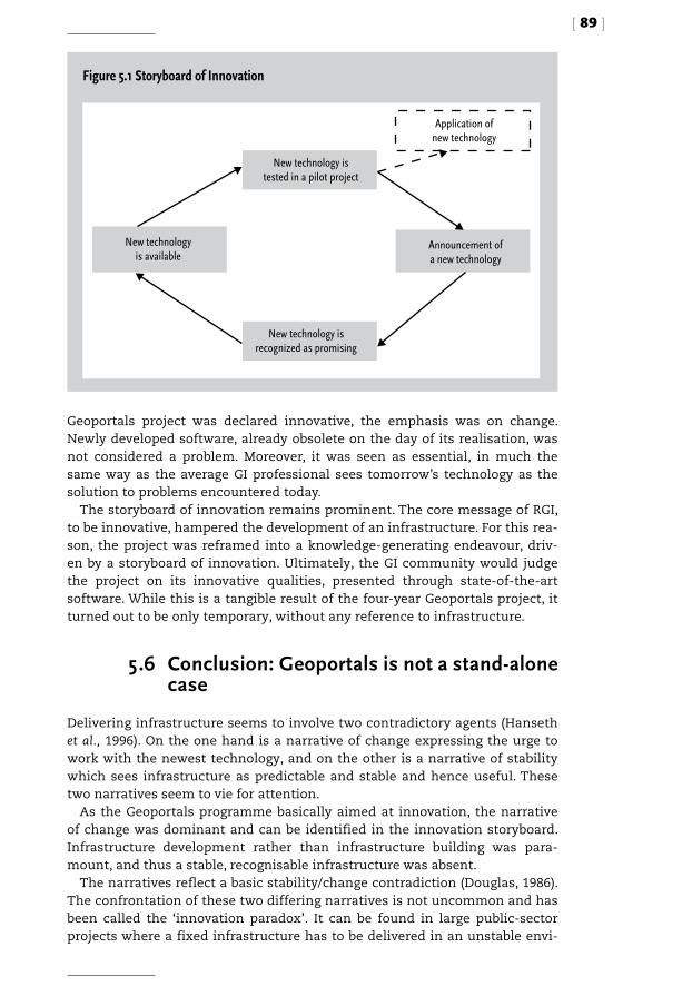
[ 89 ]
Geoportals project was declared innovative, the emphasis was on change. Newly developed software, already obsolete on the day of its realisation, was not considered a problem. Moreover, it was seen as essential, in much the same way as the average GI professional sees tomorrow’s technology as the solution to problems encountered today.
The storyboard of innovation remains prominent. The core message of RGI, to be innovative, hampered the development of an infrastructure. For this rea-son, the project was reframed into a knowledge-generating endeavour, driv-en by a storyboard of innovation. Ultimately, the GI community would judge the project on its innovative qualities, presented through state-of-the-art software. While this is a tangible result of the four-year Geoportals project, it turned out to be only temporary, without any reference to infrastructure.
5.6 Conclusion: Geoportals is not a stand-alone case
Delivering infrastructure seems to involve two contradictory agents (Hanseth et al., 1996). On the one hand is a narrative of change expressing the urge to work with the newest technology, and on the other is a narrative of stability which sees infrastructure as predictable and stable and hence useful. These two narratives seem to vie for attention.
As the Geoportals programme basically aimed at innovation, the narrative of change was dominant and can be identified in the innovation storyboard. Infrastructure development rather than infrastructure building was para-mount, and thus a stable, recognisable infrastructure was absent.
The narratives reflect a basic stability/change contradiction (Douglas, 1986). The confrontation of these two differing narratives is not uncommon and has been called the ‘innovation paradox’. It can be found in large public-sector projects where a fixed infrastructure has to be delivered in an unstable envi-
[ 90 ]
ronment (Veenswijk, 2006).It has been suggested that when problems emerge with the construction of
infrastructures, it is necessary to focus on project designs in the light of cul-tural settings (Van Marrewijk et al., 2008). However, here there was more at stake. A GI community, seemingly preoccupied with innovation, desperately requires a useable infrastructure. While one of the project participants sug-gested that infrastructures are always in a process of innovation and should be regarded as ‘moving targets’, infrastructures, in order to be used, also need to be stable. Thus, an equilibrium must be found between stability and change in relation to infrastructure.
[ 91 ]
6 Nationaal Clearinghouse Geoinformatie: repetitive rhythmicity
Commencing my fieldwork for the Geoportals Project I discovered that the ‘Natio-naal Clearinghouse Geoinformatie’ (NCGI) was used as a point of reference. From dis-cussions in the Geoportals project team I gained the impression that NCGI was ac-tually a kind of negative role model: they desperately wanted Geoportals to succeed where NCGI had failed. Geoportals had to be different. While NCGI was still in busi-ness and the Geoportals project was in the process of starting up, NCGI was regarded as a project full of failed opportunities, unable to gain success anymore. The way NC-GI was seen by Geoportals project members and others from the geoinformation field whetted my curiosity.
Around that time NCGI still had its own website which, it appeared, was no longer being updated. There were some messages stating that information on datasets and metadata would ‘soon’ be available, but these turned out to be more than a year old. My observations about NCGI were more or less in line with opinions held by Geopor-tals project members.
On the website, and in the policy documents I could get hold of, it was indicated that NCGI started in 1997 to provide metadata on geoinformation in order to stimu-late geodata-exchange. A foundation with a managerial board of representatives from geodata providers formulated a policy which was executed by a private geo-software development company, whose managing director also had a seat on the board. After I had read some articles on NCGI in professional journals, it looked to me as if eve-rybody in the Dutch GI field saw NCGI as a personal hobby of that director, and that his approach was the final and rather desperate ‘now-or-never’ attempt in a series of efforts to bring about geoinformation-sharing.
This director was regarded as a self-made man, who had started up his own busi-ness and was now head of his own geo-software company, with agenda-setting capa-bilities in relation to governmental geoinformation-sharing. According to many, he had visionary qualities: a guru, who, it was believed, could bring about the cooper-ation that was so desperately needed in order to share geoinformation amongst gov-ernmental agencies.
Having discovered all this, I was convinced that I just had to investigate NCGI, and especially the link with Geoportals. Geoportals was motivated through the opinion held by its members that the geoinformation sector had been in deep despair ever since a private software company had been allowed to have such a great impact on public policy formulation and execution. However, discussions were always about the technical side: NCGI was outdated, both in conceptualisation and the application of technology and standards. In order to deal with that, a new technologically-inspired concept was needed that would do justice to new tempting developments. I just had to find out what was NCGI about.
[ 92 ]
6.1 Introduction
The way NCGI was viewed through the eyes of Geoportals explains a lot about the latter. It can be regarded as a special form of nostalgia, a form of ideali-sation of the past to describe today’s problematic situation (Gabriel, 1993). A kind of counter-nostalgia, labelled by Ybema as postalgia, occurs when the image of a problematic past is used as a cause for a new strategy (Ybema, 2004). And this is exactly what got Geoportals going initially: we deliver where NCGI has failed. I needed to know more about NCGI to get a clearer under-standing of Geoportals.
Having gleaned this information I started my enquiries, interviewing peo-ple who had been involved in some stage of NCGI. The most common opin-ion was that the technical side of data-sharing was relatively easy while organisational aspects were hard to solve. Maybe that is why NCGI had been explained to me in a variety of technical terms, boiling down to the following summary.
Administering data in a database requires metadata, which is a registry of data describing the nature, purpose, and format of the stored data in a struc-tured, reliable and predictable way. Formal description of stored data allows administrators to manage databases and is essential for data-exchange (Bregt, 2000). Geodata is no exception to this rule: it needs to be described with metadata and is of key importance in the development of geodatabases (Dorf et al., 1993).
The urge to exchange geodata between organisations in not-for-profit and governmental settings encouraged the acceptance of metadata as the main data-structuring device. It also stimulated the development of clearinghous-es, which were seen as focal points, meant to facilitate access and coordinate exchange of geodata. Clearinghouses were considered as the access network of Spatial Data Infrastructures (SDI) (Crompvoets et al., 2008). A RAVI execu-tive explains:
The clearinghouse concept was first used in the USA, where it came on the agenda in the early nineties to disclose governmental information for policy formulation. RAVI, the Dutch network organisation for promoting standardisation and policy regarding geoinfor-mation, adapted and introduced this concept in the Netherlands. At that time, RAVI was seen as the national organisation to develop a clearinghouse for the benefit of the GI sec-tor as a whole. After some initial exploring activities, NCGI started in 1997 officially as a separate organisation, with a supervisory board formed by management executives from some nationally operating geodata-handling organisations.
This chapter is an ethnography of processes regarding the emergence of the Nationaal Clearinghouse Geoinformatie (NCGI). The way in which participants ex-perience such projects might give clues about how technologically challeng-
[ 93 ]
ing projects are conceptualised, underpinned, executed and evaluated. It cov-ers its official existence from 1997 until 2006, but also some predefining de-velopments. NCGI was web-based throughout its existence. In a technical sense it went through some serious redefinitions which were loosely coupled to general developments regarding the maturation of services on the Internet. However related, the genesis and fate of NCGI definitely has its own, internal dynamic which will be revealed in this chapter.
The research for this ethnography started after the abandonment of NCGI in 2006. Accordingly, key players were interviewed and relevant documents and websites were analysed. Documents were helpful in providing input for a factual reconstruction and also for opinions on events. Interviews were held with key players to get a representation of the pre-official, initial peri-od before 1997 and to elicit opinions from relevant insiders and outsiders. The official storyline of NCGI was largely derived from bi-monthly NCGI newslet-ters, published from September 1995 until April 2006 in a leading Dutch pro-fessional journal for the geoinformation sector. The same goes for RAVI, a governmental geoinformation policy unit which published newsletters in the same journal from December 1994 until June 2006.
I have identified six stages in the process of the rise and fall of NCGI, already starting in the early 1980s when four national policy research insti-tutes tried to cooperate on exchange of geoinformation by starting a joint geographical data organisations initiative: Samenwerkingsverband Aardkundige Gegevensverstrekkende Instituten, SAG. A few conferences were organised on the topic, none of which led to any serious collaborations. However, geoinforma-tion professionals from these institutions started to convene informally and eventually took the initiative to build a rudimentary version of an electronic catalogue, called Idéfix. After Idéfix was completed, RAVI was invited to insti-tutionalise it by making it nationally available. RAVI launched the Nationaal Clearinghouse Geoinformatie (NCGI), based on practice-based knowledge from the USA and Idéfix. After some attempts to get NCGI going, its policy was redefined and operations were outsourced to a geoinformation software com-pany. At that time, officials on the management board also became involved in Ruimte voor Geoinformatie (Space for Geoinformation RGI), a programme aimed at advancing innovation in the geoinformation sector. RGI spawned the Geoportals project, described in the previous chapter.
6.2 The SAG initiative pre-structuring NCGIWhen asked about the origin of the clearinghouse concept, almost all the in-formants referred to the Clinton Administration in the USA (Clinton, 1994). A clearinghouse was meant to be a central facility to advance disclosure of geoinformation, using a catalogue of structured metadata relating to govern-
[ 94 ]
ment geodata. Metadata would provide descriptions of the data available in the actual datasets. The idea was that potential users of geodata could easi-ly check which data would suit their purpose by browsing the catalogue pro-vided by the clearinghouse. As soon as RAVI, a policy-development institute of the Ministry of Housing, Spatial Planning and the Environment (VROM), coined the clearinghouse concept in 1995, it made efforts to establish a clear-inghouse in the Netherlands.
However, a few informants reported that they were involved in the Samen-werkingsverband Aardkundige Gegevensverstrekkende Instituten (Collaboration Geology-Data-Processing Institutions, SAG) which started in the 1980s. In 1984 four government research institutes on geology, subsoil water, country-side and the environment were aiming to cooperate on the delivery of geoda-ta (Boswinkel, 1991; Hooghart, 1991). Reliability and exchangeability of geoda-ta would enforce a nationwide unified system for mutual data-exchange and data-delivery to other government organisations such as water boards, prov-inces and municipalities. Having complementary nationwide geodatasets, these organisations claimed they needed data from their SAG partners to deliver their own information products, for which they used the National Top-ographical Map of the Netherlands as a unifying base. The SAG initiative was quite formal, with deliberations in assemblies and conferences (Boswinkel 1991; Lentjes et al., 1993), discussing modes of cooperation leading to declared milestones (Lentjes et al., 1994). They also formulated a strategy:
• Do research on reliability of measurement methods and results• Work towards uniform terms of data distribution and the realisation of a nationwide information system for geographical data as soon as possible (Boswinkel, 1991: p. 52).
Informants told me that despite serious commitment from the contributors, the initiative never matured and was not considered a success; it was more like a thrust towards further informal cooperation between organisations on the level of geodata professionals.
6.3 Follow the dream: the Idéfix prototype
Officially, the SAG initiative was not much of a success as it did not bring about true cooperation between organisations. However, it did encourage professionals from participating organisations to meet on an informal basis. They started to convene regularly as a group of like-minded people who saw it as necessary to exchange geoinformation between the organisations they worked for, as three of them explain:
After termination of the formal agreement of cooperation regarding SAG, it appeared that
[ 95 ]
the involved staff could get along with each other quite well; they kept seeing each other on a regular basis. The concept of metadata, that it is useful to describe the data that you have, had already landed. We were also discussing preliminary plans for a clearinghouse; however, we did not use the term as such.
We convened regularly. The SAG initiative had created social support. We helped each other whenever we could and stayed in touch. Then the idea of a product catalogue was raised. It held the notion that some kind of data bin had to be developed, which was later called a clearinghouse, to be separated from our own organisations.
As geo-fanatics we met twice a year and discussed matters over dinner with approxi-mately 25 people. We had discussions about how to move on; daydreaming about the future, with the ambition to tear down walls for GI (geoinformation). We wanted users to have access to GI. That was our vision and mission, there had to be a GIS infrastructure. We were idealists, discussing on a voluntary and equal basis, without any hierarchy. The question of who was in charge was never asked, there were no institutions.
During that period internet technology was making progress as one of the earlier cited geodata-professionals remembers:
At a congress in 1993, I first encountered the Internet. A demonstration at the European Space Agency stand showed how data could be collected by others via the internet. It was a kind of cataloguing system which showed what kind of data they had.
Internet was recognised as a useful concept to exchange geoinformation. While organisations optimised their own geoinformation products, existing informal relations regarding geoinformation exchange were further devel-oped.
During the 1990s, environmental issues started to dominate the pub-lic debate (NRC Handelsblad, 1995), giving a boost to the use of geoinforma-tion. Research programmes undergirding environmental policies were in need of geoinformation, which had to be produced with geodata from dif-ferent organisations (RIVM, 1988; RIVM, 1993). The Rijksinstituut Voor Volksge-zondheid en Milieuhygiëne (National Institute for Public Health and the Envi-ronment, RIVM), a research subsidiary of the Ministerie van Volkshuisvesting, Ruimtelijke Ordening en Milieubeheer (Ministry of Housing, Spatial Planning and the Environment, VROM) was in constant need of facts and figures to under-pin new policies. That information was based on data from RIVM, but increas-ingly from other sources as well, mostly former SAG members and Rijkswater-staat (Directorate for Public Works and Water Management). By that time, geo-graphical information systems (GIS) and geoinformation had become hot top-ics, also at the RIVM, as explained by staff of the day:
[ 96 ]
We were GIS-alising environmental policies. Thanks to GIS it was possible to put data found on a micro scale in a national perspective. Environmental policy was booming at that time, and that created a tremendous need for environmental data. It gave us GIS specialists strength; we were able to set things in motion. Nationally and internationally we had intensive contacts with like-minded colleagues.
I was responsible for the entire geodata acquisition process in my organisation. In 1989 I was the first person assigned to collect geodata. Soon I became head of department; I had to organise software tools, databases, and training. We had to put a lot of effort in collecting geodata from other organisations and converting and harmonising it to match it with ours. The fact that we used geodata from other sources was part of our success.
The Directorate for Public Works and Water Management, responsible for physical infrastructure, was a vast geodata-producing and -consuming or-ganisation which had a special unit for collecting and disclosing geodata: the Meetkundige Dienst (Surveying Service, MD). RIVM desperately needed geoin-formation from other sources, especially from the MD. Involved professional staff from former SAG organisations and MD developed a strong bond, acting together as a relatively closed group, trying to develop software for collecting and disseminating geodata:
We were a club of young people discussing geodata-sharing matters, and we distrust-ed the National Geodata Coordination Agency (RAVI). The only thing we wanted was to improve collaboration and coordination in geodata-exchange. Environment was hot, RIVM was in the spotlight, and it seemed that that was where the action was. In order to do what we were supposed to, we needed geodata, also a great deal from others. As a bunch of geo-specialists, we tried and tried, and eventually produced a working prototype of a catalogue. But initially, it just looked like one big dream.
There was a tremendous need for geodata; we had to integrate geodata from different sources, a hell of a job. As a group of professionals from the lower and middle ranks of geoinformation-sharing organisations, we got together twice a year. These meetings were very informal, discussions were mostly held over dinner. It looked like we were daydream-ing about the future. We had only one goal: to preach the Geo-gospel. After a few ses-sions, we agreed on building a catalogue system with the geodata of all the participating organisations in it.
These individuals spoke each other’s language. In the eyes of the participants, some other organisations did not quite understand that:
The Kadaster, the Topographic Service and the Surveying Service were not able to follow our initiatives; they seemed to focus only on their own products. However, of those three organisations, the Surveying Service was the closest, but still relatively distant.
[ 97 ]
With a budget of 110,000 euros, this kind of informal club developed in 1995 the Idéfix system, a metadata catalogue describing some 250 geodatasets owned by these participating organisations. They considered data-sharing as something to be dreamed of, an idée fixe:
Idéfix was a classic project. A few organisations were mutually dependent upon each oth-er’s data; they brought money in, and off it went. Somebody wrote a project plan and we built the prototype in six months time.
Idéfix had it all. It had metadata of about 250 datasets in use with participating organi-sations. It even contained some regular geodata, free of rights. That first version of the clearinghouse, based on Idéfix, was the best, after that it only declined. Because it was not kept up-to-date, it eventually became outdated.
There were about 250 datasets described with a metadata structure. I wrote a paper about it which we presented at a European conference. We had a software programme running on a server which could be interrogated through a Netscape browser.
Geodata specialists developed software for the system. They felt they had de-veloped a preliminary version of an application that was to be used on a na-tional scale. As soon as it was clear that such an application was technical-ly feasible, it was handed over to RAVI, at that time acting as a national agen-cy developing geodata policy. RAVI was invited because the developers of the prototype wanted it to be ‘institutionalised’. The initiators thought that their idea was now in the hands of capable people, who would advance it further and take care of the non-technical aspects.
6.4 Letting it go: an institutionalised Idéfix as a basis for NCGI
The clearinghouse concept was brought to the Netherlands around 1995 through the policy advisory organisation RAVI, as two former staff members explain:
In fact, it was Mr. Al Gore who dominated discussions with his concept of National Infor-mation Infrastructure. In 1994 I went to a conference and came back full of excitement. You have to understand that in the USA they have the Freedom of Information Act, which means that government information always has to be accessible without charge. To accomplish that, they introduced the clearinghouse principle, which also identified a sep-arate sphere of geoinformation.
At that particular US conference, the concept was brought to life. They presented the case
[ 98 ]
of bush fires. It was asserted that all the geodata needed to assess whether or not these fires were harmful to the environment was already there, but not findable, let alone acces-sible. It was stored in different datasets by different organisations in different formats on different scales, and so on. To be able to connect these datasets, a clearinghouse was needed. Datasets should be registered in a clearinghouse, so anybody who was interested could easily decide what datasets to use.
Whereas the US initiative was also environment-driven, when the clearing-house concept was introduced in the Netherlands in 1995, it was disconnect-ed from its environmental roots. Idéfix was primarily seen as a technical so-lution, capable of forming the basis for a clearinghouse, still to be institution-alised for success. The Idéfix enthusiasts were releasing their brainchild into the real world:
In spite of considerable opposition, Idéfix was developed within six months. Now we had something going that was likely to be successful, but lacked an institutional basis. That was the moment to call in RAVI. We just said: we geo-specialists have built this system. RAVI, now it is up to you to bring it further, institutionalise it and make it a success.
The first thing RAVI did was to hire a consultancy firm for a feasibility study. This firm concluded that it had high potential, possibly capable of generating a lot of revenue. That led them to suggest starting it as a commercial business, but that appeared to us as odd, so it became a foundation, legally separate from RAVI.
We were in shock hearing that our Idéfix idea was about to become a commercial enter-prise, that it was seen as profitable. It was not ours anymore; we had to let it go. We felt that our baby, that’s how we felt it, had to act as a teenager. And everybody knows how teenagers can be. With hindsight, I feel we were letting it go too easily, that we should have taken more care.
The process of professionalisation created a distance between the initiators and the cata-logue. I got a feeling of that it wasn’t ours anymore. The link between creativity and NCGI was gone and idealism did not get a chance anymore. NCGI was too soon made into a product in a business environment while it wasn’t ready for it.
It was like we had made a political instrument instead of a polished shiny car. It provided information on where to look and what data-quality could be expected. But as an insider, if you needed anything, you would call people you knew; you were not inclined to check Idéfix. However, it was a good thing Idéfix was developed, it caused a culture change. It invoked discussion. About how you would treat your own data and standards. And now these standards are there. We used to make our own software, which is something you want to avoid. It is always better to buy software, or to have IT professionals to develop or adapt it from existing software. Now those days are over, software is just there, it is avail-able.
[ 99 ]
The Nationaal Clearinghouse Geoinformatie (NCGI) was launched in October 1997 as a solution for locating geoinformation. A consulting firm published a re-port which suggested that it be launched as a commercial enterprise, but it was eventually placed under a foundation. Unlike Idéfix, which emerged out of cooperation between professionals of a few organisations, NCGI targeted the geosector as a whole. Former RAVI staff tell about their first encounters:
To get going we had to go out and sell our idea of a clearinghouse. Because it was sup-posed to work for the national geoinformation sector as a whole we went to business fairs and conferences to promote it. However, organisations were reluctant to join. In order to get more response, we developed a model that we called the maturity index. It was meant to help organisations to assess whether they were ready or not to participate in NCGI. Still results were poor. We received a lot of verbal support; still organisations did not care to join. A software engineering company rebuilt the rudimentary version of Idéfix with proper IT tools. That worked out quite well, with templates, software tools and Excel sheets.
NCGI was supposed to be the yellow pages for geoinformation on the Internet. Looking for geoinformation, you were supposed to browse through these pages. When you found what you were looking for you could send an Email to the contact person of the data source to get your dataset delivered on CD-ROM. After some time this was seen as an old-fashioned system; not only metadata, but also the geodata itself should be dissemi-nated through the Internet.
In the USA all geoinformation was free of charge and available to anyone. Here in the Netherlands governments were reluctant to disclose geoinformation. We had one goal: how to make geoinformation findable and accessible, NCGI was the instrument to make that happen.
It never really was a success. You start something up, and then it has to be maintained to be successful. There has to be something that binds, that will bring it further. Idéfix was based on metadata, but that is not what you’re after: what you want is the data behind it, that’s the ultimate goal.
Management executives of organisations like the Directorate for Public Works and Water Management, the Dutch Kadaster and Statistics Netherlands were represented on the supervisory board of NCGI, which was now financially in-dependent from RAVI (Bregt, 2000).
NCGI felt it was ready to play a professional role at national level. A former member of the supervisory board explains:
A general director of NCGI was appointed, a former manager of the Kadaster. He invited organisations to join by asking them to participate and to donate money. That was not a wise thing to do; at least, it did not help NCGI any further.

[ 100 ]
At that time, around 1996, 1997, all discussions on NCGI were about money. We had a professionally hosted website, run by a professional and competent software company for a monthly fee. That director wanted to cut costs and he knew someone who could do it cheaper. It was at the time when whizz kids were sometimes making fortunes by build-ing commercial websites. Anyway, the NCGI website was redesigned by a small software company and that started a lot of technical problems.
NCGI started to promote itself with a video message (Absil-van de Kieft & Van Putten-Cleveringa, 1995). An NCGI business plan stated that services provided on the Internet should be made more sophisticated and the number of data providers should increase in order to simulate the use of geodata (NCGI, 1998). The model was supply-driven: geodata providers were supposed to supply metadata in a standardised way for publication in the NCGI catalogue. Providers were urged to install NCGI-certified software at their own risk and expense. The move was motivated by a mutual gain: ‘taking part in NCGI is beneficial to them, because disseminating metadata by themselves would be more expensive’ (NCGI, 1998: p. 24). The business plan also contained an appendix with a SWOT-analysis by some independent consultant, in which NCGI was seen as ready for the future as it was already up and running. At the same time, this analysis depicted NCGI as a concept, based on a ‘non-evidenced gut feeling’ (NCGI, 1998: Appendix 1), supposing there was a demand for geodata. The NCGI website was seen as complying with goals initially set, but not with its expectations. The website was regarded as not known to the target group, data was not findable, procedures to keep metadata up-to-date were lacking, and staff to appraise metadata before publication had not been anticipated. While the report itself was quite optimistic about the future, the appendix pointed to a few major flaws not addressed in the core report.
At the beginning of 1998, NCGI was ready to make the best of things. In a new office and with a newly appointed director, data providers were seduced by NCGI to follow a metadata course on how to participate in NCGI. Both offi-cial newsletters and professional articles in the press claimed that partic-ipation in NCGI would be a big help in streamlining the internal informa-tion management of participants because it forced them to describe their own geodata through metadata (Mom, 1998). At a user conference in 1998 the importance of metadata for administering and exchanging geodata was stressed again. Here a future scenario was sketched about NCGI, not only as a catalogue of metadata but also as a disseminator of the ‘data behind the metadata’.
Halfway through 1998, NCGI was struck by severe technical malfunctions, which made the website inaccessible for about half a year. While the service provider was having a hard time fixing the problems, NCGI was already con-sidering new plans: providing only metadata had become old-fashioned, the
[ 101 ]
future scenario was to provide the underlying geodata as well. Meanwhile, a few organisations had disclosed their geodata through NCGI in a trial project, but had gained very little success in terms of an increase in data-use. In its newsletter NCGI proposed a new, distributed strategy: data and metadata would remain with the source organisation and NCGI would make it possi-ble through its website to both find and access that data, thus making it no longer necessary to upload metadata to NCGI. Still, standardisation was the name of the game: the Open GIS standard was promoted to make that hap-pen (RAVI, 1997).
The new concept of the distributed framework was further developed in pilot projects in 1999. However, only very few data providers disclosed data through NCGI even though the management was promoting this at business fairs, congresses and meetings. The NCGI newsletter of February 2001 can only be interpreted as a desperate cry for help: the 15 organisations repre-sented in the supervisory board are listed in an advertisement-like manner with corresponding logos, accompanied by a call to subscribe to NCGI.
While NCGI was in distress, according to quite a few informants, some seri-ous power-games were being played within the supervisory board, as a former supervisory-board member reveals:
That supervisory board blocked any progress. They were people that were keen on get-ting subjects off the agenda. By discussing them over and over again urgent matters were silently removed from the agenda, using a strategy of never be the first to dissent. By doing that, they were able to sweep each and every bright idea effectively under the car-pet. That way of managing NCGI caused stagnation. In the end that approach is killing for a project, because it runs out of budget and nothing is really achieved.
The supervisory board of NCGI was a society of ‘the more things change, the more they stay the same’. It was an all-male board of representatives of geodata organisa-tions, always keen to score off one another. They fully agreed that it was a good idea to exchange data, but did not do much to achieve that. They were serving their own inter-ests and that ultimately caused their downfall. They kept NCGI alive but prevented it from blossoming. Every time it was about to die, they reanimated it, but in the end it never got a fair chance.
Columns written in the bi-monthly newsletters of RAVI by individuals in management positions in geodata-producing organisations confirm the im-age of inertia within the supervisory board. Between autumn 1997 and the end of 2000, a few of them gave their opinion. What is striking here is the di-versity of opinions about expectations of NCGI as part of a National Geoinfor-mation Infrastructure. Some saw it as a display window, a means to advertise their products, while others saw it as a means to realise the internal goals of their own organisation. Only one official argued that by participating in NC-
[ 102 ]
GI, the internal data organisation of his company could be optimised. The fact that executives of geodata organisations saw their own role and that of their organisations as independent of NCGI is further demonstrated by articles in professional journals that stress the individual needs of organisations (Mom, 1995; Van Cann, 1995; Van der Valk, 1997; Mom, 1998). During these develop-ments NCGI was always treated positively in professional journals. The bi-monthly newsletter of NCGI, published in VI-Matrix, the leading Dutch geoin-formation journal also maintained a positive tone.
6.5 Going astray commercially
While NCGI continued as it did, it was far from financially sound. The super-visory board, as a whole, however, did keep the concept alive, as former board members explain:
At NCGI, I learned about diplomacy. As a whole, the supervisory board let everyone believe they were unanimously supporting the clearinghouse concept and the higher goal of sharing geodata. In fact, representatives supported the interests of their own organisa-tion, constantly monitoring the movements of their fellow board-members. Individually, they did not support NCGI, but as a collective, they had an interest in it. It was their way of obstructing geodata-sharing by keeping it the way it was. Budgets were just big enough to continue and tight enough to prevent daily management from creating real change.
NCGI became a costly enterprise. Large organisations that were represented on the supervisory board were asked to supply money. While the concept was extensively pro-moted, NCGI had trouble to survive financially, at least it did not collect any revenues. At that time a newly appointed director was taking measures and suggested selling the whole concept to a commercial company. And that is what happened. The clearinghouse concept, which was run by a government agency in every country, was going commercial. That was unique.
Supervisory board members first of all seemed to serve the interests of their own organisations; as a collective they were not able to change the status quo. Now that NCGI was running out of budget, the supervisory board had to take steps. As an exit strategy, at the end of 2000, NCGI was offered for out-sourcing. Three consultancy companies were invited to tender for the web hosting and the computer system maintenance. Two consultancy executives explain:
I received a phone call one day from the chairman of the supervisory board. He said, ‘We want to sell NCGI’. I told him: ‘Who wants to buy?’ He said: ‘We’re putting it out to ten-der and want you to submit a tender for a contract’. I thought: it is bankrupt anyway, but
[ 103 ]
I believed after all in the concept. I heard that at NCGI, they felt that it was really hard to implement a system handling metadata. I had the impression that it was not as hard as it seemed.
As a company, we took the risk; the NCGI supervisory board kept on doing the organi-sational stuff. That the supervisory board should remain intact was one of our require-ments. We arranged it all technically, and started off. For us, as a geo-software company, it was quite easy to do. One after another, national government units asked for our data and expertise. Projects in a multi-organisation government setting were likely to fail, but single ministries generated a lot of work that turned out to be successful. However, cus-tomers wanted to do business with us, not with NCGI. So, in the end, NCGI became a lia-bility for us, we had to let it go. NCGI evolved into a new existence, with some casualties: RAVI was abolished, and a new coordinating organisation emerged, Geonovum.
An observation from within the NCGI office:
I saw it as an escape into the future. Something like: its dead, it’s over, it’s a failure, and now we pin our hopes on a new golden age. They named it a ‘public-private partnership’. The government representation is always a problem in constructions like this. Here, dif-ferent government organisations were actually unwilling to cooperate. The same patterns we saw before returned, it didn’t solve anything.
By the end of 2001, the NCGI foundation was still formally responsible, while all operations were outsourced to this geo-software consultancy company (Mom, 2001). The consulting company that took over operational responsibili-ties was renowned for the realisation of innovative ideas. The management of the consulting company, being responsible for NCGI operations, had also been closely involved in Idéfix. Plans were made for the future. Besides having a metadata catalogue, the data described by metadata also had to be disclosed by NCGI. The involvement of this consulting company gave NCGI credibility.
In October 2001 NCGI presented itself as the ‘geo-library of the Nether-lands’, willing to lend geoinformation to ‘governments and civilians with a subscription’ (NCGI, 2001). Search facilities were to be improved and through ‘thematic exhibitions’, organisations were able to promote their geodata. The supervisory board was enlarged with representatives from the Ministry of the Interior (BZK) and the Ministry of Housing, Spatial Planning and the Envi-ronment (VROM). Additionally, new projects were launched to serve specific users, such as groups involved in land consolidation, spatial planning and the environment.
Gradually, the bi-monthly newsletter started to look like any ordinary bro-chure of a consulting firm; new assignments and contracts were mentioned to showcase the business activities of NCGI, most of which were projects for individual government organisations. Some of these projects involved data-
[ 104 ]
exchange for which NCGI did engineering and software development. NCGI was not responsible in any way for the content or the definition of these projects.
The aim and scope of NCGI shifted towards data-exchange. Its mission was reformulated in the bi-monthly newsletter of March 2003:
To manage and utilise a demand-driven neutral and public (standard-based) national geo-data infrastructure for retrieval, usage and exchange of geoinformation. Through a dedi-cated NGDI portal, governments and knowledge institutes, and in a later stage also civil-ians and the business community, can get access to geoinformation files from the Dutch government and Geo-ICT businesses.
The mission would be carried out through:
• on-line integration of external data sources• easy sharing of geoinformation sources (i.e. zoning plans, cadastral map, base maps)• using national and international standards• synergy through symbiosis with other portals• direct availability of the infrastructure• standard security available• proper maintenance and management procedures• attractive conditions through shared costs
It was further mentioned that standards were of paramount importance, to be enforced through an alliance of NCGI and RAVI.
A new strategy was the use of the portals concept. Portals were defined as thematic entry points where geoinformation on a certain topic, such as public health, the environment or public safety was grouped together and accessible. The bi-monthly newsletter of June 2003 mentions that four portals were to be established which would be part of a Spatial Data Infrastructure (SDI). NCGI as an organisation, mostly carrying out projects for individual organisations, was supposed to support the SDI concept. Increasingly, NCGI was seen as a concept, not as a tangible service, where the SDI concept was evolving from the clearinghouse concept.
In 2005 NCGI was described in the newsletters as outdated, with a central organisational structure not fit to bring about a decentralised concept. The final bi-monthly NCGI newsletter of April 2006 was still optimistic, but the then responsible ministry had already announced the termination of RAVI and NCGI, clearing the way for a new coordinating agency: Geonovum.
[ 105 ]
6.6 Management back behind the wheel: Ruimte voor Geoinformatie
In 2001 the Dutch national government launched a stimulation programme called Ruimte voor Geoinformatie (Space for Geoinformation, RGI), which was meant to promote innovation in the geodata sector (RAVI, 2003). While NCGI was still in business, RGI encouraged organisations to make project proposals eligible for RGI funding that would promote geoinformation-sharing between organisations and lead to a National Spatial Data Infrastructure (NSDI). RGI awaited proposals and made appraisals of the intended contribution to this NSDI concept.
It were virtually the same organisations with the same managers as those on the supervisory board of NCGI that promoted RGI. NCGI and RGI existed concurrently for some time. Whereas NCGI was seen as an ongoing, already declining attempt that had already undergone some serious redefinitions, RGI became the new innovation initiative, where grants could be won for the development and application of cutting-edge technology.
However, after the first project proposals were granted, that view changed, as observed by an insider:
RGI started to finance all kinds of projects without considering coherence. There were projects that were at least doubtful, that you could ask: what is the bigger picture? In that light they started to finance Geoportals, while they did the same as NCGI aimed for! I was quite annoyed about that; what is the logic behind doing double work? I think it has something to do with the fact that nobody knows what a NSDI looks like. So the idea seemed to be: let’s find out about that in the turmoil of organisations fighting for grants. But at Geoportals they were doing their own thing, they were not bothered at all.
After being regarded as a programme organisation with a coherent view on geodata exchange, the image of RGI rapidly changed towards that of a fund-ing-organisation that was aimless and adrift.
6.7 The Geoportals project as an enabler for a new future for NCGI
One of the proposals regarding RGI aimed at the establishment of a system of Geoportals and ultimately received a grant in 2005. In April 2004 it was an-nounced that the NCGI portal and NCGI as a consultant-developer would be separated, meaning that NCGI would again be a central metadata facility.
At that time, the RGI programme was stimulating the search for innovative projects in order to give geoinformation-exchange a boost. NCGI, while still not having much impact on the exchange of geoinformation, thought it was
[ 106 ]
eligible for funding, but could not convince anyone that it was innovative, as it was still based on the clearinghouse concept, which had been around for years. The RGI selection committee rewarded the geoportals proposal with a grant. In a side letter it was advised to seek cooperation with NCGI, but that was never achieved. Geoportals project members did not feel attracted to the NCGI management board, as a Geoportals team member explains:
There are all kinds of government debate circles, like RAVI and NCGI, with general man-agers from geodata organisations in them. I am a go-getter; I have shopfloor knowledge so I belong to the working class, just like the others. The fact is that ‘the head’ (manage-ment) goes in another direction from ‘the feet’ (the workforce). And that causes friction, like you see now between NCGI and Geoportals.
To them, NCGI had failed:
NCGI has existed for about 10 years now and so far it has not done a good job. It should have made itself redundant by now, through the creation of an Open GIS Infrastructure. NCGI has a limited catalogue, however, with outdated and sometimes unreliable data. Facing its third restart, it resembles a library with empty shelves with only occasionally a book, and these are the boring books, not the ones you would like to read.
Around 2005, when NCGI had undergone its third redefinition, it was seen by the members of the newly established Geoportals project as an organisation of managers with no clear view on how to breathe new life into the clearing-house concept. It was no surprise to them when NCGI was abandoned in 2006 and the system of geoportals, which still had to be developed, was seen as the backbone of a future NSDI.
6.8 Case analysis: chasing technology while for-getting to organise
Initially, the case demonstrates progress, as the clearinghouse concept prom-ised to be a major step on the road towards more cooperation in the geoin-formation sector which would culminate in the realisation of an NSDI. Look-ing more closely, the case presented here is more like a constant struggle to meet goals (Van Marrewijk et al., 2008). On the one hand, efforts were made to structure technology and procedures aimed at stimulating accessibility and predictability (Edwards et al., 2007). On the other, there was a dynamic side, where NCGI was conceptualised as a realm for applying cutting-edge con-cepts and technologies.
Fostering the self-evident higher goal of geodata exchange, the raison d’être of NCGI was never questioned. The whole project seemed to propagate the
[ 107 ]
unspoken message that the Netherlands would be a better place if its geoin-formation sector was able to exchange geodata (cf. Veenswijk & Berendse, 2008). Now I shall look at NCGI using the theoretical framework developed in Chapter 3.
An Internet-dominated narrative setting Regardless of its physical or legal whereabouts – whether on RAVI premises, in a separate office location, or at a consulting company’s offices – NCGI is ac-knowledged for its contributions to the geoinformation sector. The position of NCGI is not up for discussion, as it has an image of independence from other organisations, supported by its independent character as an Internet facility.
In the early nineties, the idea of a few geodata-processing organisations to mutually exchange their data was translated into the Idéfix solution: the technological streamlining of norms and standards that would lead to meta-data exchange. Idéfix laid a claim on the future because the proposed next step was to have it nationally implemented. The Internet was seen as provid-ing the infrastructure to hook up all geodata-consuming organisations to a national system with the centrally maintained website as its focal point. The binding national concept came from the USA and held the promise of tech-nology to solve future problems.
The internet was seen as the ultimate enabler, a new way of communica-tion that had come within reach, helping to implement new concepts of data-collection, data-dissemination and data-exchange. At first, organisations were invited to upload their metadata onto the NCGI website at their own expense. The NCGI management demonstrated unlimited faith, which they believed to be also present in prospective participating organisations. When results failed to come, the approach was changed in line with new technological possibili-ties, with the internet allowing metadata sets to stay with the participating organisation. Re-conceptualising NCGI as a system of distributed metadata sets placed even more responsibilities on individual organisations.
As Internet was seen as ubiquitous and fast-evolving, the initial NCGI plans for a metadata catalogue were enhanced with a plan to also disseminate the geodata described by the metadata through NCGI, which needed to be stored at the central website. As internet technology evolved further, the next step was taken by making plans for a distributed system which allowed data and metadata to remain with the participating organisations, while the central clearinghouse made them findable and accessible.
The Internet sustained the ‘claim on the future’ in the development of NCGI (Adam, 1990; Burrell, 1992). The case description demonstrates that NCGI was constantly focusing on the application of new technologies to guide organi-sational developments. Targets and future scenarios were constantly broad-ened without a shred of evidence that NCGI was going to comply with any of them. Throughout its existence, NCGI was not shown to actually work. Even
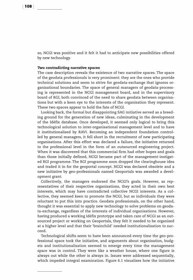
[ 108 ]
so, NCGI was positive and it felt it had to anticipate new possibilities offered by new technology.
Two contradicting narrative spacesThe case description reveals the existence of two narrative spaces. The space of the geodata professionals is very prominent: they are the ones who provide technical solutions and seem to strive for geodata-exchange that ignores or-ganisational boundaries. The space of general managers of geodata-process-ing is represented in the NCGI management board, and in the supervisory board of RGI, both convinced of the need to share geodata between organisa-tions but with a keen eye to the interests of the organisation they represent. These two spaces appear to hold the fate of NCGI.
Looking back, the formal but disappointing SAG initiative served as a breed-ing ground for the generation of new ideas, culminating in the development of the Idéfix database. Once developed, it seemed only logical to bring this technological solution to inter-organisational management level and to have it institutionalised by RAVI. Becoming an independent foundation control-led by general managers, it fell short in the recruitment of new participating organisations. After this effort was declared a failure, the initiative returned to the professional level in the form of an outsourced engineering project. When it was discovered that this commercial firm had other hopes and goals than those initially defined, NCGI became part of the management-instigat-ed RGI programme. The RGI programme soon dropped the clearinghouse idea and traded it in for the geoportal concept. NCGI was declared obsolete and a new initiative by geo-professionals named Geoportals was awarded a devel-opment grant.
Collectively, the managers endorsed the NCGI’s goals. However, as rep-resentatives of their respective organisations, they acted in their own best interests, which may have contradicted collective NCGI interests. As a col-lective, they seemed keen to promote the NCGI, but as individuals they were reluctant to put this into practice. Geodata professionals, on the other hand, thought it was essential to apply new technology to solve problems on geoda-ta-exchange, regardless of the interests of individual organisations. However, having produced a working Idéfix prototype and taken care of NCGI as an out-sourced project or working on Geoportals, they felt it needed to be organised at a higher level and that their ‘brainchild’ needed institutionalisation to suc-ceed.
Technological shifts seem to have been announced every time the geo-pro-fessional space took the initiative, and arguments about organisation, budg-ets and institutionalisation seemed to emerge every time the management space was in control. They were like a weather house, where one figure is always out while the other is always in. Issues were addressed sequentially, which impeded integral examination. Figure 6.1 visualises how the initiative
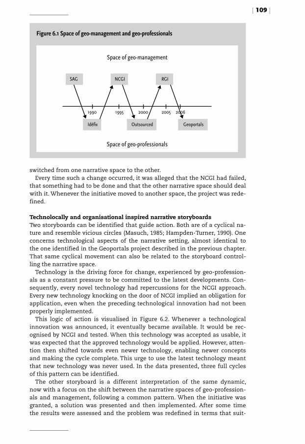
[ 109 ]
switched from one narrative space to the other. Every time such a change occurred, it was alleged that the NCGI had failed,
that something had to be done and that the other narrative space should deal with it. Whenever the initiative moved to another space, the project was rede-fined.
Technolocally and organisational inspired narrative storyboardsTwo storyboards can be identified that guide action. Both are of a cyclical na-ture and resemble vicious circles (Masuch, 1985; Hampden-Turner, 1990). One concerns technological aspects of the narrative setting, almost identical to the one identified in the Geoportals project described in the previous chapter. That same cyclical movement can also be related to the storyboard control-ling the narrative space.
Technology is the driving force for change, experienced by geo-profession-als as a constant pressure to be committed to the latest developments. Con-sequently, every novel technology had repercussions for the NCGI approach. Every new technology knocking on the door of NCGI implied an obligation for application, even when the preceding technological innovation had not been properly implemented.
This logic of action is visualised in Figure 6.2. Whenever a technological innovation was announced, it eventually became available. It would be rec-ognised by NCGI and tested. When this technology was accepted as usable, it was expected that the approved technology would be applied. However, atten-tion then shifted towards even newer technology, enabling newer concepts and making the cycle complete. This urge to use the latest technology meant that new technology was never used. In the data presented, three full cycles of this pattern can be identified.
The other storyboard is a different interpretation of the same dynamic, now with a focus on the shift between the narrative spaces of geo-profession-als and management, following a common pattern. When the initiative was granted, a solution was presented and then implemented. After some time the results were assessed and the problem was redefined in terms that suit-
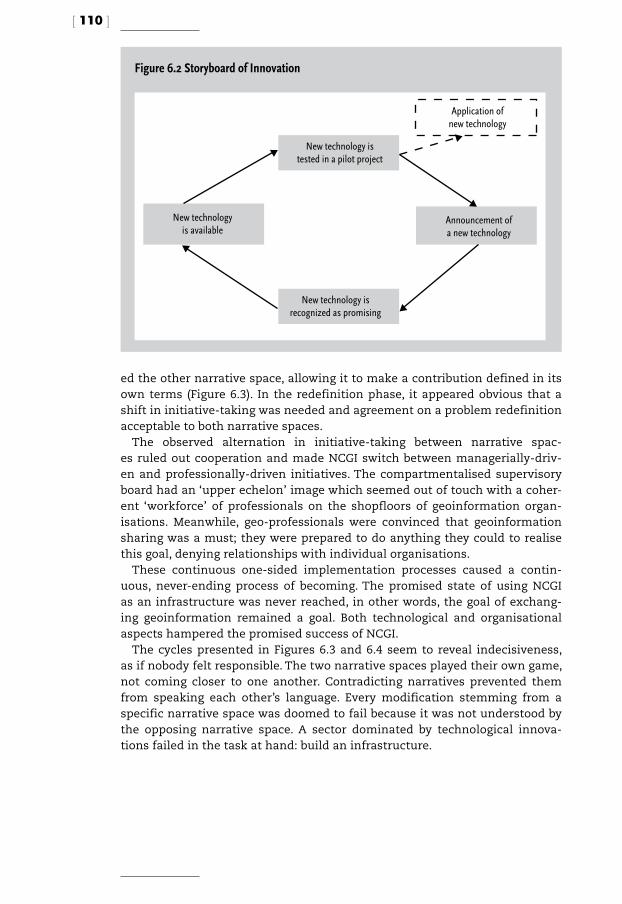
[ 110 ]
ed the other narrative space, allowing it to make a contribution defined in its own terms (Figure 6.3). In the redefinition phase, it appeared obvious that a shift in initiative-taking was needed and agreement on a problem redefinition acceptable to both narrative spaces.
The observed alternation in initiative-taking between narrative spac-es ruled out cooperation and made NCGI switch between managerially-driv-en and professionally-driven initiatives. The compartmentalised supervisory board had an ‘upper echelon’ image which seemed out of touch with a coher-ent ‘workforce’ of professionals on the shopfloors of geoinformation organ-isations. Meanwhile, geo-professionals were convinced that geoinformation sharing was a must; they were prepared to do anything they could to realise this goal, denying relationships with individual organisations.
These continuous one-sided implementation processes caused a contin-uous, never-ending process of becoming. The promised state of using NCGI as an infrastructure was never reached, in other words, the goal of exchang-ing geoinformation remained a goal. Both technological and organisational aspects hampered the promised success of NCGI.
The cycles presented in Figures 6.3 and 6.4 seem to reveal indecisiveness, as if nobody felt responsible. The two narrative spaces played their own game, not coming closer to one another. Contradicting narratives prevented them from speaking each other’s language. Every modification stemming from a specific narrative space was doomed to fail because it was not understood by the opposing narrative space. A sector dominated by technological innova-tions failed in the task at hand: build an infrastructure.
[ 111 ]
6.9 Conclusion: Geoportals and NCGI in a new light
In this chapter it becomes clear that Geoportals had in fact been a continuation of NCGI, with another name and another team of individuals, but with the same spirit. The shift of the initiative between narrative spaces in the NCGI case has a rhythm in which fits Geoportals remarkably well. The Geoportals case can be regarded as an endeavour by geo-professionals who wanted to establish cooperation in geodata-exchange. That rhythmicity makes it an initiative in a tradition: after Idéfix and the outsourcing of NCGI, geo-professionals were once again in charge within Geoportals.
Taken together, both cases can be seen as the NCGI case, describing the pattern, giving the general picture and with Geoportals giving an in-depth description of one specific stage within that pattern. Geoportals covers a peri-od of time in that rhythm when geo-professionals were placed in charge of the future of geoinformation-sharing.
Having described a pattern of recent developments, we do not even have an inkling of an explanation. With new projects already moving in the revealed pattern of shifting initiatives, it is time to put all this in another perspective. To make sense of what has been presented so far, I guess I have to look fur-ther. The next chapter is therefore devoted to an investigation of a geoin-formation-sharing initiative which has been around for over 35 years and is regarded now as a longstanding success: GBKN.

[ 112 ]
[ 113 ]
7 Large-scale base maps and GBKN: It takes three to tango
During my training as an electrical engineer in 1979, I worked a few months as an apprentice at the local gas distribution company in Sneek, a town in the Dutch prov-ince of Friesland. My first assignments in that work environment were to make blue-prints of maps. The department I worked for was a bit behind in distributing informa-tion on subsurface locations of television cables and gas pipes to other utility compa-nies and it was my job to catch up. After I had received a list of coordinates from my supervisor and a brief demonstration of the reproduction equipment, I started off. In the map room, where dimmed light came through a few small, high windows, I had to remove the corresponding big A01 from one of the many filing cabinets, take it to the heliotype machine, make a number of copies depending on the request from the or-ganisation, fold them in a prescribed way, and put them in an envelope.
While I was performing this boring routine, every once in a while my local super-visor came by to check how I was doing. During our talks he initiated me in the prin-ciples of base maps and tried to show me the system and logic of information-inter-change between utility companies. I learned that when a particular utility company wanted to repair, renew or remove a subsurface cable or pipe, they needed to know the location of other cables and pipes in order to prevent possible damage. He con-vinced me that every single utility company feared incidents that damaged their own cables or pipes, so they shared a mutual interest in providing each other with infor-mation that was as precise and up-to-date as possible. In order to accomplish that effectively, he explained, there was an exchange-standard called GBKN. What these four mysterious letters stood for was not explained, and I did not ask. To me, it sound-ed as pure logic and it felt natural that every utility company conformed to this sys-tem of base maps containing minimal topography to locate cables and pipes. Base maps made communication easy; when some other company needed information, they just mentioned the coordinates of the specific base map and it was clear to everybody which part of the mapping system was meant.
For me as an apprentice, it was impressive, but also obvious and inevitable: it was clear that nobody would like a gas pipe or a power cable to be hit and damaged by a trench digger. To me, such a system of base maps felt almost as a requirement for a safe society. The way my supervisor spoke about base maps sounded as if it had been there for decades and that it would go on like that forever. The idea of working with a solid and standardised system was confirmed both by the fact that I was told that the system of coordinates was an international standard and that every single utili-ty company was participating. It was beyond dispute that participating organisations were absolutely loyal to the common cause. I absorbed it as common practice and did not worry about a thing: I just took it as it came.
1 Measures of a DIN A0 map or drawing: 84.1 cm x 118.9 cm (www.din-formatie.de).
[ 114 ]
7.1 Introduction
While I was in that map room making copies, my image of the impact of my work was limited. My frame of reference was my own organisation, to which I was attached only temporarily, for three months. The horizon, as far as GBKN was concerned, was the limits of the organisation I worked for. In my view, GBKN was solving problems for my organisation in relation to other utility companies, of which I had no further knowledge.
When I became a PhD candidate grasping the world of geoinformation and GBKN was mentioned, these first experiences came to mind and served more or less as a frame of reference to make sense of the Grootschalige Basiskaart Nederland (Large-Scale Base Map of the Netherlands GBKN). While asking myself questions, I tried to see myself in that map room again, with a par-tial view of the concept of GBKN. It made me realise that people always have a limited view, bounded by their own imaginary horizon, when trying to make sense of their situation.
About 30 years later GBKN has acquired an image of a successful system of base maps: unified, accurate and up-to-date, serving as a multi-purpose standardised solution for large-scale mapping. It has also been criticised by insiders as an infrastructure that took 25 years to complete. They seek expla-nations for why it took so long, thereby fuelling many stories, debates and analyses (Polman, 2002). But even seemingly undisputed facts such as the start and end of GBKN are not straightforward. This chapter aims to make sense of the different kinds of meaning involved in GBKN.
In 2000 GBKN was completed, that is to say, it had been announced that the entire nation was covered with a system of large-scale base maps. Since then, the focus has been on further standardisation. Now, in 2010, the Ministry of Housing, Spatial Planning and the Environment (VROM) intends to use GBKN as part of a system of base registries, which will streamline dispersed nation-al registries into one system, guided by the WORM principle (write once, read many). These efforts will reshape GBKN into Basisregistratie Grootschalige Topografie (Base Registration of Large-scale Topography BGT), envisioned as the mark of a new era.
This section focuses on how the idea of large-scale base maps emerged, how it culminated in GBKN, developing towards an undoubted reference for large-scale mapping. The year 1975 is generally seen as the official start date of GBKN. However, long before that date, as far back as the 1930s, there were ideas and conceptualisations about standardised base maps.
The intention is to describe GBKN chronologically, discerning distinctive periods. The sections are devoted to the initiating and defining phase (1968-1975), addressing the production of large-scale maps (1975-1985), the clash between rural and urban interests leading to stagnation (1985-1992), the com-pletion phase (1992-2000) and the recognition phase (2000-2009).
[ 115 ]
The research is based on 25 in-depth interviews and the study of policy documents, professional journal articles, research reports and film footage, together with a few observations of GBKN-related events after 2005.
7.2 Initiation (1968-1975)
The year 1975 marks the official beginning of GBKN, but it was in fact the cul-mination of a lot of preparatory efforts. Lots of respondents refer to develop-ments prior to that starting point, with frequent mention of an article writ-ten in 1972 by the late Professor Koeman. As a cartographer, he published in Intermediair, a Dutch magazine for the higher educated workforce, an opin-ion about the terrible state of large-scale maps in the Netherlands (Koeman, 1972). He pointed out that a country as small as the Netherlands had three national mapping agencies, producing inconsistent, scattered and inaccurate maps. He mentioned the tradition of large municipalities with extensive sur-veying departments, but forgot to explain that these departments already had sophisticated systems of base maps on a municipal scale (Brugmans, 1973; Maandag, 1996). Others recollected an article and a report by Professor Witt in which he advocated the establishment of a cadaster for cables and pipes, based on proper large-scale maps (Witt, 1968). A key player in the start-up of GBKN points out:
It started before 1975, with a report by Professor Witt in 1971. On the occasion of its official presentation, a college friend of mine who had a senior position at the Kadaster approached me. They wanted to enforce a form of standardisation in large-scale map-making. At that time the Kadaster was interested in standardising their large-scale cadas-tral maps, which would also be in the interest of cable and pipe registration.
Change was in the air. I had ideas about large-scale photo-grammatical base maps (see: Van Wely, 1971). Koeman wrote an article in Intermediair about a lack of cooperation in developing a system of base maps and the fluctuating quality of large-scale maps. The world of mapmaking was very chaotic in those days. We had thoughts about the improve-ment of large-scale base maps, as different standards were used; however the Kadaster hardly used any of them. Nevertheless, cadastral maps were used as a de facto standard, with users fully aware of the fact that they were regarded as unreliable and not standard-ised, but were frequently used since there was nothing better available.
At the Ministry of Finance, at that time responsible for the Kadaster, they took the ini-tiative and approached me as chairman of the Dutch Geodesists Association. They want-ed me to take the lead. I had no idea where to begin, but I got information that the Dutch Geodesy Commission, of which I was a member, wanted to play a role. I thought that I could use either organisation to suit my purpose, depending on the situation I found myself in. The only thing I knew for sure was that the Kadaster had to join, because they were the only Dutch organisation with large-scale maps covering the entire nation. As
[ 116 ]
soon as the Ministry of Public Housing and Spatial Planning took over responsibility for the Kadaster, the cadastral organisation became organised on a provincial basis, which was a giant step forward.
Maps available on a national scale were cadastral maps: single-purpose, on-ly showing cadastral zoning with a minimum of topographic details, for the most part regarded as not suitable for other purposes, and lacking a proper geodetic base. A surveyor, working at a small municipality, after a career at the Kadaster tells about his first municipal experiences in the early 1960s:
My first assignment at the municipality was to make a map of a parcel the municipal-ity intended to procure. I used an old cadastral map as a basis, drawing only the par-cel because that was the only thing that was certain. However, they blamed me for that, because it was impossible to assess which parcel was involved, because I had left out all the additional information. That experience released a mental switch in me. My Kadaster attitude told me: you are the surveyor, so you are the one to decide what’s on the map. And what’s on it has to be reliable. I was not used to listening to map-users. I found out that when it was done my way, my piece of work was useless to others. This way I learned to listen to users and to work according to user requirements.
The initiatives taken were reflections of ongoing discussions held at con-gresses and seminars in the late sixties and early seventies. These develop-ments prompted representatives of scientific and professional associations to take action. The Kadaster, fully aware of the state of its cadastral maps, saw the developments towards a national system of base maps as an oppor-tunity for improvement. The cable and pipe industry was invited to join, as they would obviously need base maps: a joint endeavour might save money through sharing costs. Municipalities, especially the large ones with their so-phisticated locally organised systems of base maps, were not invited.
The quest to solve a societal problem… .Registration of cables and pipes had been a problem for decades. It had al-ready been noticed in the 1930s that proper registration of cables and pipes was crucial to avoid possible damage, preferably in a central cable and pipe register (Glerum, 1937). Society as a whole could be harmed; digging activities might cause downtime in power, gas and water infrastructures (Witt, 1968). A committee of representatives of the utility industry, municipalities and sci-ence came with a report, mentioning the cable and pipe infrastructure as the nerve centre of modern society, implying that any damage to cables and pipes would be a threat to society as a whole (Witt, 1971). The report depicted the cable and pipe industry as indifferent, not really wanting or having prob-lems with inadequate registration systems. A central register was proposed, organised by the cadastral organisation. Scientific committee members with
[ 117 ]
backgrounds in rural planning and law gave the report credibility. It tried to reconcile the interests of utilities and municipalities, requiring registration based on a system of base maps, obviously to be realised by the Kadaster. The plan mentioned three phases: first an inventory of all cable and pipe admin-istrators per square unit, then a central registration of the location of crucial cable and pipes and ultimately a register for all cables and pipes.
It was common knowledge that the Kadaster had had serious problems with their mapping responsibilities for decades (Daanje, 1938). While still working with paper maps in filing cabinets, a large percentage without a proper geodetic base, they sought an escape route. Resurveying had been a buzzword in the cadastral culture for quite some time (Theil, 1900; Hoffmann, 1908; Van Riessen et al., 1935; Haasbroek, 1940; Dubbelt, 1968). It was felt that this muddling-through policy did not work: a ‘big bang’ was needed to set things right. However, at that time the Kadaster was seen as an old-fashioned institute. A retired Kadaster employee describes it:
As a cadastral surveyor you were independent, however your output was always checked. When I started my career in the early 1950s, it was the custom that my superior kept my mapping archives in his room. He simply did not know how to be a good manager. The only thing I learned from him was how not to do it. When I became a manager myself, the first thing they said was you have to keep on surveying. This is because they expected me as a manager to check one and all, this being common management style at the Kadaster in those days.
Reliability and accuracy at the Kadaster did not come from scientific meth-ods; personal checking of output by superiors was the name of the game. However, a system of base maps was seen as the solution to settle the prob-lem of inferior maps once and for all. Since base maps would be newly made, it was believed that they would automatically have the right features and ac-curacy. The Kadaster would benefit from the availability of base maps; moreo-ver, the cadastral organisation would be responsible for producing them. Also, the establishment of a cable and pipe registration agency would work in fa-vour of the Kadaster, as it meant extra business.
… . .was reduced to efficient mappingThe report Grootschalige Basiskaart (Large-Scale Base Map, GBK) and the pre-ceding interim report were produced by an all-engineer committee, repre-senting organisations dealing with maps on a national level with map-related academic backgrounds: cartography, geodesy and surveying (Van Wely, 1973; Van Wely, 1974). Topics such as technical feasibility, production techniques, uniformity and costs were extensively addressed, based on a survey among map-producing organisations. The report hardly mentioned any organisation-al matters. The problem that needed to be solved was defined as the unavail-

[ 118 ]
ability of a system of large-scale topographic maps, while a lot of public and semi-public organisations were in need of that. The report suggested the de-velopment of a mapping system as a base for users who could add their own overlays and supplements. It had a national scope, proposing a uniform sys-tem of coordinates together with a minimal set of topographic elements and the use of either a 1:2000 or a 1:1000 scale. As one committee member said:
‘Now it is unthinkable that the Kadaster was assigned the task of making GBKN. But then it was obvious, the Kadaster was the only organisation with appropriate facilities. The Kadaster had to decide with others, for instance, cable and pipe organisations, what should appear on a standardised base map. They were not used to doing that.’
In an explanatory note the chairman of the committee stated that even though the state of cadastral maps was rather distressing, the Kadaster was still eligible to produce a nationwide system of large-scale maps.
7.3 Initial steps towards realisation: rural ver-sus urban interests (1975-1985)
The same group of people responsible for the initial GBKN report formed the newly established Centrale Karteringsraad (Central Mapping Board) in 1975, which was expected to give GBKN an independent and scientifically approved image, having been assigned the task of coordination and quality assurance. The Kadaster was commissioned by Royal Decree to begin production of GBKN and started off in rural areas. The fact that the Kadaster was organised provincially gave momentum to this approach. Large municipalities did not (want to) have a voice in promoting their detailed large-scale base maps or to discuss mapping standardisation.
In those days maps came in three different forms: as traditional draw-ings of a line-map on paper or a plastic sheet, as prepared aerial photo-as-maps, or as a newly introduced form of storage of surveying data from the field on paper tape to be plotted on a map. Techniques to convert conven-tional maps or photomaps into a digital format were still in an experimen-tal phase. While the photomap was advocated by some, a line-map had to be the ultimate result, assembled by using the fore-mentioned three distinctive techniques (Aalders, 1973; Van Wely, 1974; Zeillemaker, 1984). Map production entailed conventional surveying techniques, if possible enhanced with paper tape storage and the use of aerial photos. The end product was almost exclu-sively a map on paper or a plastic sheet.
The Kadaster, having already spent considerable time and effort on resur-veying, was not even half-way towards fulfilment. GBKN standards, defined and approved by an external committee, were also intended as the basis
[ 119 ]
for new, resurveyed cadastral maps. The transfer of the Kadaster as a pub-lic organisation from the Ministry of Finance to the Ministry of Housing, Spa-tial Planning and the Environment (VROM) in 1973 brought an atmosphere of change and hope for better days. Being hooked up to the ‘ministry of con-struction’, the Kadaster tried to change its image from a property-tax col-lector to a national supplier of spatial data. However, while it was expected that the Kadaster would take accurate mapmaking more seriously, it was still regarded as outdated within the ranks of surveyors and geodesists. A former Kadaster employee, depicted the cadastral spirit as follows:
The organisation had two pillars, the cadastral department with surveyors and the Pub-lic Registries with registrars. The name was Kadaster en Openbare Registers (cadastre and public registries). However, everybody spoke about the Kadaster because it sound-ed better. For instance, notaries did business with the Public Registries, but still called it the Kadaster. Until 1973 it was part of the Ministry of Finance. Registrars and surveyors were always busy safeguarding their respective positions and, when they got a chance, improved it at the other’s expense, sometimes even in court. Registrars were always afraid of surveyors being the prevailing discipline, feeling bad about the organisation going to the Ministry of Housing and Spatial Planning. The law was quite vague on some points and registrars were concerned about that, a striking sign of their attitude. However it were surveyors who controlled the image of the organisation.
The Kadaster had just experienced a reorganisation, an attempt to bring more unity by making the provincial unit the focal point of the organisation (Ka-daster, 1973). At the cadastral head office, a central cadastral GBKN depart-ment was put in place to enforce standardisation and to establish a relation-ship with the Central Mapping Board. Here, GBKN was seen as serving the needs of the Kadaster as much as possible. According to several interviews, the opinion at central office about GBKN seemed to be: what’s in it for the Ka-daster?
Using the resurveying budgets, 19 trial projects were proposed to gain expe-rience of mapping for GBKN. While standardisation was the message com-ing from the Central Mapping Board, trial projects were not guided or restrict-ed in any way; provincial offices were allowed to start negotiations with oth-er organisations and to diverge from developed standards if necessary. There were also still a lot of aspects related to GBKN production that had not been settled yet, so provincial offices were able to draw their own additional stand-ards. As a cadastral provincial manager from those days explains:
All of our plans were sent to the central GBKN department in Apeldoorn for approval. However, they never responded. We never received a single comment. So we could do whatever we wanted, doing it our way. There was no activity whatsoever at the head office to coordinate things. In every province they were doing it their way, creating considerable
[ 120 ]
differences among provinces. We did not get instructions in any shape or form from Apel-doorn.
The cadastral doctrine on GBKN did not work in favour of standardisation, in-stead it created considerable differences among provinces. A director of the Kadaster said in a television interview in 1976:
We only start with a certain project in a certain area when it appears that there is a demand for the product. We don’t start, so to speak, from north to south, to cover the Netherlands with large-scale base maps. (Van der Zee, 1976).
This doctrine implicitly cleared the way for the emergence of a multitude of approaches to mapmaking, allowing local configurations of stakeholders to set their own standards and work procedures. It was obvious that standardi-sation on a national level did not run through the veins of the Kadaster. Inter-views with former staff members and publications reveal that in 1975 provin-cial units within the Kadaster had considerable discretionary authority. Sur-veying procedures had become standardised, but the most recent update of the Handbook of Technical Operations of the Dutch Kadaster was at that time al-most 20 years old and cadastral maps were still of poor quality (Haasbroek, 1940; Kadaster, 1956). Former cadastral surveyors commenting on work proce-dures:
We hardly used proper surveying instruments and we worked with old cadastral maps. As the Kadaster was entirely focused on the elimination of backlogs, I had to process trans-actions. I hardly used national triangulation in my surveying. Like many of my colleagues, I hated it. Surveying with national triangulation was boring compared to the old way of working. We didn’t like that, we wanted challenging work. The more complicated the situ-ation, the better the challenge and the more complex the decisions. Applying national tri-angulation was just a matter of survey-and-go.
As a surveyor, you felt responsible for the quality of the technical side of the cadastral workload, like a doctor in a hospital guarding the wellbeing of his patients. As a surveyor you were in charge, with an eye for every detail.
GBKN received a lot of criticism within the cadastral organisation. Because we worked on GBKN, we were blamed for destroying professionalism. But the lengthy old process of re-surveying just could not continue. It would cost a fortune and would not be finished before 2050. It was GBKN that brought map renewal.
All eyes were fixed on map production, for which the Kadaster had no signif-icant role in mind for municipalities. A committee presenting a plan for the application of GBKN maps in municipal zoning plans positioned GBKN as ex-ternal to municipalities (Studiecommissie GBKN-Bestemmingsplannen, 1981).
[ 121 ]
The plan indicated that municipalities at that time did not have any influ-ence whatsoever on GBKN production.
Dispersed responsibilitiesProvincial Mapping Boards were established in every province, modelled on the National Mapping Board. Whereas independence at national level was brought in by scientists, here provincial officials chaired the board, which fur-ther consisted of managers from relevant organisations. The national call for GBKN trial projects was managed at provincial level and gave considerable discretionary power to individual provinces. A cadastral provincial manager explained:
We negotiated intensively with our local partners, but also with central office. We made our own policies, for which serious financial underpinnings were asked. That was hard, but we managed. We only used financial arguments to convince the central cadastral management. We stated that mapmaking and resurveying was cheaper in a GBKN setting than working in the traditional way. Surveying the built environment was costly, and we argued that a GBKN approach would be cheaper. This procedure stimulated the establish-ment of cartographic automation systems.
Every provincial office of the Kadaster had a special project department, dedicated entirely to land consolidation and resurveying projects, and now to GBKN trial projects as well. These departments became the focal points of developing relationships with utility companies and municipalities. It was the central doctrine which stated that a GBKN project could only be started when there was a demand that stimulated the discretionary power of individual provincial cadastral units, thus causing diversity in mapmaking and standardisation. In Friesland and Utrecht, the Kadaster took the lead, trying to reach agreements with municipalities and utilities, while in the province of Noord-Brabant, utilities and municipalities were already working on base maps. In other provinces initiatives did not lead to concrete actions. The opinion of a former cadastral provincial manager:
But of course, 11 different provincial mapping boards spawned 11 different definitions of GBKN! In every province different agreements were made. The central cadastral office was unable to guide that towards unification, it had no authority. Of course the Kadaster was seeking uniformity, but there was never a minister to stand up and make it a nation-al, uniformly defined product. The cadastral head office remained silent on that matter; they left it to the market.
Map improvement was an aim, but first of all the Kadaster wanted more tasks. They wanted to run a central cable and pipe cadaster. Ultimately, the issue deteriorated into a fight about budgets: if parties joined and shared responsibility for updating a base map, everybody would benefit. Initially, the cable and pipe industry was passive, as they did not
[ 122 ]
need accurate maps; every map they could get hold of suited their purpose. Even if it was not up-to-date they could still use it, as they had low demands.
To demonstrate the diversity among provinces I am going to focus on three specific provincial situations. Going through projects and situations in Fries-land, Utrecht and Noord-Brabant it becomes clear that local circumstances dictated the actual cooperating arrangements. I shall conclude this session by highlighting the special position that the four largest Dutch cities had in rela-tion to GBKN.
Land consolidation disguised as GBKN mapping in FrieslandGBKN made it possible for the Kadaster in Friesland to connect persistent and lasting mapping problems in land consolidation projects with resurveying. Land consolidation had been a national concern for decades. The aim was to make the farming business more efficient and economical through rezoning the farmland. The process had been ongoing since the end of the 19th centu-ry and was boosted after the famine that struck the western part of the Neth-erlands towards the end of World War II (Andela, 2000). The Kadaster was in-volved in these projects because rezoning meant the redistribution of land-ownership. In order to master large land consolidation projects, it was felt that the mapping process had to be accelerated and mapping costs had to de-crease.
In cadastral circles, land consolidation was frequently called ‘resurveying in disguise’. At the regional cadastral office in Friesland, GBKN was interpreted as an opportunity to speed up the pace of resurveying and to cut the costs of land consolidation through sharing them with utilities. The GBKN trial project ‘Het Bildt’ had to make that happen, as a former GBKN Kadaster manager from Friesland explains:
GBKN was a unique project, unique in the world and one of a kind. In 1974 we were an all-engineer staff at the Kadaster. In Friesland we had a large project department, doing projects on land consolidation and resurveying, like the trial project ‘Het Bildt’. Friesland had the largest area of land due for consolidation. We wanted to do it at a fast pace, so we needed proper mapping procedures. Old maps were useless so new ones were made. Resurveying was a kind of by-product of land consolidation and was inspirational to us. Nationwide, tens of millions had already been spent on resurveying activities; there was a central office to coordinate that. We figured out if they continued the way we used to, it would cost another 700 million guilders nationwide. That was the scene of operations. I was aware of national GBKN reports and we were inspired. We were convinced that we had to explore new avenues.
Treating GBKN production as a land-consolidation project gave the project distinct features. Commonly used photomaps on a scale of 1:8000, accurate
[ 123 ]
enough for land consolidation purposes, were blown up to the GBKN scale of 1:2000. However, though the quality was sufficient for land consolidation pur-poses, these maps were by no means precise enough for mapping the built environment. Consequently, a lot of time and money had to be spent on addi-tional surveying on-the-spot. On top of that, the GBKN trial project was scaled at the same geographical size as the land-consolidation project, involving land within the jurisdiction of five municipalities, but with the complete sur-face of only one municipality in the actual project area. As a consequence, municipalities did not feel inclined to participate. Since there was nothing in it for them, they felt no reason to take initiatives (Twynstra Gudde, 1982).
These kind of projects implied cooperation between the Kadaster and part-ners. The provincial unit of Friesland sent invitations to organisations at pro-vincial level, usually the power, gas and water companies and the provincial water board. Utilities saw the benefit of reducing mapping costs and were quite willing to join because joint map production would save money. The Kadaster tried to win over potential partners, as explained by the cadastral manager:
In the light of the GBKN project, we tried to get potential partners around the table. We took the national GBKN report as a working document and saw that base maps were needed for cables and pipes and provincial and municipal governmental issues. It was tough getting them aligned. The Provincial Water Company and the Provincial Pow-er Company were easy to convince since these organisations had vast mapping and sur-veying departments which were constantly working on map revisions. For the greater part, these revisions entailed mutations of a topographical nature, hardly allowing them to work on their actual task, to draw their cables and pipes on the map. The respective heads of the mapping departments were convinced that change was needed and that the GBKN initiative would help.
The commonly felt notion that a base map could help to reduce costs made these organisations work together. After tough negotiations, they reached agreement on technical matters regarding operating standards. The provincial Kadaster manager again:
We were all people with a technical background and we set things in motion. It was an analog product, so standardisation was about the kind of paper to be used, which became polyester, and about formats. At the bottom of the map, holes were punched on predefined positions with an accuracy of one tenth of a millimetre. These holes were needed to fit the maps in reproduction equipment and to store them in filing cabinets. As the suppliers all had their own unique systems, we had to set standards, and because we were the first to deal with this problem we had to do it ourselves, without a scenario. It took us a few years to standardise. By the way, I don’t know whether these standards ever became a national standard or not. Settling technical standardisation matters took time,

[ 124 ]
but gave the project itself a solid basis. It had a positive influence on production process-es in a later stage.
The Kadaster took the lead; we took care of production and distribution. Utility compa-nies had to buy our product. As a provincial unit of the Kadaster we were autonomous. Participating utilities mapped their cables and pipes on the base map. Later on, others who were not participating in the initial trial, like the Dutch Railway Company, followed suit.
Production costs were shared provincially, according to general rules drawn by the Cen-tral Mapping Board. 50% of the costs of GBKN were covered by the Kadaster. The water company, power company, telephone company and natural gas companies took 10% each. The last 10% would be covered by the municipality, on the understanding that if a municipality was not willing to participate, the Kadaster would stand surety for it.
The Kadaster became the initiator, coordinator, implementer and distributor of GBKN. The Provincial Mapping Board was officially in charge but the Kadaster did all the coordination and policy-setting. Cadastral surveyors trained to (re-)establish cadastral boundaries were now surveying topography, this being a new routine for them (Van der Zee, 1976). Soon after completion, the GBKN trial project ‘Het Bildt‘ was hailed as a success. While officially only a trial, it marked the start of mapping the entire province. Evaluations of GBKN production did not start until the early 1980s, initiated by the central office in Apeldoorn. By then, a few other mapping projects in Friesland were already underway.
Trial projects focused exclusively on map production; nobody had thought about updating newly completed base maps (Twynstra Gudde, 1982). Con-fronted with the first topographic changes in base-mapped areas, it appeared that municipalities were the originator of almost all changes in the built envi-ronment. As they had not been involved in trial projects, their contributions were now desperately needed.
As they were barely able to articulate their mapping desires, small munic-ipalities were insufficiently mapped. However, municipal reorganisation in Friesland in 1984 brought more professional power to larger and professional-ly more mature municipalities, as their number significantly reduced (Korsten & Tops, 1998). Newly formed municipalities without some sort of large-scale maps were eager to participate in mapping projects, and increasingly, the Kadaster invited municipalities to join.
Officially still in charge of GBKN map production, the Kadaster had no clear answer to the question of how to set up a system for updating established GBKN projects. Engineering firms started to fill this gap. An engineering con-tractor recalls:
‘Het Bildt’ was a trial project, triggering the start of other projects. As engineering con-tractors, we were actively involved. It meant business, so it was in our benefit to get inter-
[ 125 ]
ested parties around the negotiating table. We persuaded municipalities by convincing them of what they had to gain, while in other situations it was the utility sector that need-ed to be convinced. The bottom line was that we won them over by telling them that they could save money just by joining the project. Increasingly, we also received updating con-tracts, mostly with municipalities as the client.
By serving their own interests, engineering contractors advanced both GBKN production and updating. It encouraged them to play the role of the catalyst at the local level for cooperation, forcing the Kadaster into a more dependent role.
Connecting GBKN to regular cadastral affairs in the province of UtrechtIn the early 1980s the province of Utrecht was mainly a rural area with a con-siderable amount of built environment. It also had the city of the same name, the fourth largest city in the Netherlands within its jurisdiction. Here, the Ka-daster also acted independently from central office. A former cadastral man-ager:
The first chairman of the National Mapping Board said GBKN was the ultimate chal-lenge for geodesists, but nobody really understood that phrase. We received some gener-al directions, which we needed to enhance our activities. It implied that standardisation was done at the level of the Provincial Mapping Board, with representatives of munici-pals and utilities, and a few cadastral managers. We proposed standards, they reached the decisions.
At that time the Kadaster was regarded as not quite able to deliver adequate property information to municipalities due to inferior cadastral maps. Munic-ipalities making spatial development plans required detailed property infor-mation which the Kadaster was not able to supply. The Kadaster in Utrecht saw it as their duty to rectify this situation, using GBKN as a tool. A former GBKN manager in Utrecht explains:
We were supposed to get the job done with the utilities and municipalities. We needed to explain that mapmaking was expensive and that through cooperation we could all save money. All these organisations had problems with mapping, reflected by a poor qual-ity of maps. The actual costs of municipal mapmaking remained hidden, encrypted in project budgets. We proposed sharing the costs among the Kadaster, the municipalities and the utilities at the rate of 50 : 25 : 25. The first question from the municipality then was: why is it that expensive, does it really take that kind of money to make a map? We had to convince the municipalities that a mapping process was expensive and that the actual costs were hidden in municipal spatial development budgets. It was easy to con-vince the administrative leadership of municipalities and utilities that mapping was a costly endeavour, convincing mayors and aldermen was more demanding. I used to go to
[ 126 ]
town council meetings to persuade local authorities. We started that process with medi-um-sized municipalities. A city like Utrecht did not need that, they were in control and already had their own detailed basemap.
Employees of the cadastral provincial unit in Utrecht considered themselves as ambassadors with the task of convincing municipalities to become full contributors to GBKN. The city of Utrecht had its own independent cadastral property registration. This made them autonomous; so they had no reason to take part in GBKN. The manager again:
The map of the city of Utrecht was extremely detailed; we used to make jokes about it. The cadastral office was then located under the FC Utrecht soccer stadium, and after a football match there was occasional damage to the streets. Then we fooled the director of public works by saying: your map is not up-to-date, you must adjust it, it does not reflect reality anymore.
In the city of Utrecht the situation was almost perfect, cartographically speaking. In oth-er areas there were still non-resurveyed areas with poor maps; it was believed that with the help of GBKN, mapmaking would be more effective.
Because municipalities were participating in GBKN, the updating process be-came already apparent during map production.
A utility-dominated GBKN in the province of Noord-BrabantIn Noord-Brabant utility companies were already inviting municipalities to produce maps before 1975. This resulted in 1976 in the very first GBKN map sheet of the Netherlands in the municipality of Veghel in rural Noord-Brabant (Miete, 1976; Berkers, 2000). The Kadaster was not involved in its production in any sense; it was the work of an engineering contractor, commissioned by regional water and gas companies and the individual municipality. As it was produced without the Kadaster, the initial map deviated slightly from gener-al GBKN standards. The Kadaster tried to incorporate this mapping endeavour into its system and adapted the map accordingly afterwards.
It were the regionally operating utilities which dominated these produc-tion arrangements. They therefore had a strong voice in map content. Despite cadastral efforts to enforce national standards, mapping was less complete and less accurate, primarily aimed at serving the needs of utility companies, as a utility manager explains:
In 1982 I had just started my career in the utility sector. The power company took the ini-tiative for base maps in Noord-Brabant. In those days utility companies used to make their own maps for cable and pipe registration, but mapping departments had no proper mapping base. Large municipalities often had base maps, devices that the smaller ones were lacking. At the Noord-Brabant power company they started to digitise maps and
[ 127 ]
gradually they became common all over the country. In the end they were all facing the same problem, not having a topographic base map.
The GBKN map in Noord-Brabant became known as the Nietjeskaart (Blind Spot Map), because only road profiles and façades of buildings were plotted on it. Municipalities used this version, for want of a better one. So in most cases the Blind Spot Map was combined with existing municipal maps of the built environment. Larger provincial cities had their own detailed maps and did not participate in GBKN.
The four major Dutch cities follow their own routeIn the municipalities of Amsterdam, Rotterdam, The Hague, and Utrecht util-ities were organised at local municipal level. They were autonomous and in-dependent among other local municipal organisations. Here, problems were considered as internal, as a former manager of the municipality of Amster-dam explains:
Our mapping department had problems with the municipal automation centre. I had worked with its director before and he treated our department as if it was a section of his own department; he did everything possible to make us join his department, even though we belonged to a different division. When I had worked there for a week he asked me: ‘Are you to be trusted?’. I was struck with surprise, I thought: what is happening? It made our relationship rather confrontational. It all had to do with autonomy you see; they didn’t accept that we were in control. As the division of public works we had more authority because we had been able to build a tunnel.
GBKN hardly affected the municipal departments of large cities as they al-ready had detailed maps, serving all mapping needs. Large-scale development plans and urbanisation, already started in the 19th century, had forced them to have detailed and well-maintained maps of the built environment (Blaauw, 1967; Brugmans, 1973; Lievaart et al., 1984). The problem of not having large-scale maps was not felt here at all. Keeping track and mastering heavy turno-ver in the updating process however became a problem, which called for com-puter assistance. For instance, as early as 1984, the municipality of Rotter-dam already had a computer file containing all large-scale municipal topogra-phy (Zeillemaker, 1984). As a consequence, base maps were seen as essential for municipal processes, and also as vehicles for information-exchange. The same manager from Amsterdam explains:
The Public Works Division had to maintain the topographic map of the Amsterdam municipality. We were asked to automate mapping, which we did in association with the other three large municipalities in a cooperational body called SOAG. The concept was that in the Netherlands a few automation centres would handle the computational work
[ 128 ]
for all municipalities. The municipality of Amsterdam had such a centre within its own organisation. Different centres were commissioned to develop a specific software appli-cation, in Amsterdam we were supposed to develop the ARTOL system for the automa-tion of registries for topography and cables and pipes.
Reports from large municipalities themselves and cooperational bodies as well as professional articles reveal an awareness to cooperate between organ-isations at municipal level (SOAG, 1979; Gemeente Amsterdam, 1982; Zeille-maker, 1984; GSOV, 1991). SOAG promoted municipal automation projects within the four largest municipalities, firmly backed by the Vereniging van Ne-derlandse Gemeenten (Association of Netherlands Municipalities, VNG).
Large municipalities felt they had their own jurisdiction and aimed at fur-ther rationalisation of internal processes through automation (Lievaart et al., 1984). They had a tradition of urban development, a process that could only be managed by rational planning processes, backed by accurate and up-to-date maps (Nieuwenhuis, 1955; Lievaart et al., 1984; Maandag, 1996). Large municipalities were in a position to fully ignore GBKN.
7.4 GBKN moves towards stagnation (1985-1992)
It was halfway the 1980s when mapmaking and map usage ceased to be an exclusive privilege for people with a geodesist or surveying background. A policy consultant, formerly employed at the provincial administration, ex-plains:
At our office we started to draw maps digitally in 1984. We managed to digitise a topo-graphic map on a scale of 1:25,000. It was very primitive, with a VAX computer and a plot-ter, writing Fortran routines for plotter control. All the x-y coordinates were entered man-ually, a hell of a job. As soon as we had completed the map we were getting requests: could you draw it on another scale, could you add our data?
We did it all ourselves, mainly because there was nothing else available, but also because we were eager. With hindsight, it was sheer insanity: a policy worker with a mechanical engineering background writing routines for plotter pen control. If we wanted to add plane shades we had to capture all pen movements into computer code.
That pioneering role felt good, getting results motivated us. Knowing all the automa-tion details as policymakers gave us an advantage. We knew what had to be interpreted; we had knowledge about policies and about making digital maps. Major provincial poli-cy plans were based on our GIS system; we processed the data and did the groundwork.
While information technology was entering organisations at an increasing pace, the Kadaster still had its legally constituted task of producing a GBKN,
[ 129 ]
which it kept approaching as drawing a map on a paper sheet. They had in-tentions to speed up GBKN production, but it also became clear that ready-to-use large-scale GBKN maps could become outdated through changes in the built environment and that an updating routine was needed. It also appeared that mapmaking was a costly process. But again, it was on a dispersed, pro-vincial scale that measures were taken and only in rural areas was the Ka-daster influential enough to do something. In urban areas, large municipal-ities maintained their closed shop when it came to maintaining a system of base maps.
A considerable amount of municipal tasks were already map-related as municipalities were registering roads, the built environment, zoning plans, and sewers. Plans for the built environment based on these self-registered records produced information for decision-making (Ten Kroode, 1994; Carton, 2007). When set in motion, these plans led to changes, which needed to be registered in records, increasing the need for large-scale base maps.
It appeared that municipalities were the originator of most changes in the built environment and that their role in the updating process of GBKN was essential. Municipal boundary redrawing processes caused an increase in the average number of inhabitants per municipality, but more importantly, it gave a boost to professionalisation (Korsten & Tops, 1998). Local spatial prob-lems required local solutions, coordinated and provided by municipalities. They cherished their own authority, which earned them a reputation for arro-gance in the GI community. Now also mid-sized municipalities were inclined to produce a large-scale base map using GBKN norms, only allowing a sup-porting role for Kadaster and utilities.
The changing role of the KadasterIn the 1980s the Dutch economy was in a state of recession, which had a ma-jor impact on society (Bomhoff, 1982; Albeda, 1984; Thoenes et al., 1984) and reduced the number of property transactions, the major source of income for the Kadaster. Cadastral surveying departments were dealing with overcapac-ity. A former engineering contractor describes:
Through the recession, our market in the surveying business collapsed. While the Kadaster started to outsource GBKN production to engineering firms, the recession became manifest. They had an excess of surveyors doing regular cadastral tasks, which were now increasingly assigned to GBKN production, so we were losing contracts. Since the recession was also hitting us, there was no other work available, so we blamed the Kadaster because we felt it was an easy way to save their skin at our expense.
While cadastral top management was busy dealing with the worsening financial situation, GBKN became internally seen as unemployment relief work and swathed in negativity. This gave the Kadaster the image of an
[ 130 ]
overspending organisation and a liability to the ministry. The deputy-minister of VROM had mentioned to several informants that he saw the Kadaster as ‘technically bankrupt’. The image of the Kadaster also worsened among geodetic professionals. It was seen as an archaic organisation, inward-looking, not innovative and with an old-fashioned management structure. To back up this assertion frequent mention was made of the fact that in about 13 years time GBKN maps had only covered 20% of the country, for which the Kadaster was held responsible. A sense of crisis took hold of the Kadaster (Hakvoort & Veenswijk, 1998). Cost reduction was urged, which had repercussions on the primary process, as noticed by an engineering contractor:
Outsourcing was hot in national government. The Kadaster also saw it as a viable option to cut costs. They twice produced a report on that, but nothing further actually happened. Then in 1987 a message came through that the Kadaster had to lay off 10% of its staff. Its director had no idea how to manage that, but changing circumstances gave these out-sourcing reports momentum. As six engineering firms, we formed a group to negotiate with the Kadaster. We agreed to take over 240 redundant surveyors, the Kadaster guar-anteed us a certain amount of work for a period of seven years in return. These six engi-neering firms were the exclusive partner for privatisation of the Kadaster. For this rea-son, we established in 1988 ‘B6 Ltd’. The role of B6 was to act as a contractor for the Kadaster, dividing work equally among the participants. These 240 surveyors had to work for us, but many of them applied for jobs at municipalities and utilities, which reduced the number of 240 to about 30. B6 was disbanded in 1996.
With the costly obligation to produce a nationwide GBKN, the Kadaster was heading for further financial distress. Projects were dragging on with no clear objectives. It was thought that internal efficiency would improve through automated mapmaking, which started as an experiment in the province of Friesland. In an internal cadastral journal this was described as a ‘digital GBKN’ (Plantinga & Meeldijk, 1984). However, a year later, the very same project was seen as an onset for a Landelijk Kadastraal informatiesysteem (National Cadastral Information System, LKI), a system exclusively designated for cadastral purposes, with GBKN map production now seen as subordinated to the digital LKI production process and not as the main product (Plantinga, 1985). LKI would bring a digital cadastral map with a drawn GBKN map on paper as an analog spin-off product (Koen, 1988). Additionally, the Kadaster attempted to reduce its financial contribution to newly started GBKN projects (Polman, 2002). The cadastral doctrine on GBKN, that a map would only be produced when there was a demand, was abandoned. LKI was seen as crucial to internal efficiency, making the Kadaster financially sound. Separate GBKN projects, not contributing to LKI, were not likely to receive financing (Koen, 1988).
[ 131 ]
All mapping projects were still seen by the Kadaster as production projects. As mutations in a cadastral file were in most cases a simple administra-tive change of ownership, updating was seen as a minor task in LKI. Though GBKN updating was a hot topic in municipalities, the Kadaster assumed that autonomous topographic changes in a GBKN map were quite rare (Pistorius, 1989). The position of GBKN in relationship to the Kadaster at that time was assessed by a former municipal policy advisor:
At the end of the eighties the Kadaster failed to keep their house in order which made them dismiss an executive director. GBKN had cost them over a billion and the director was unable to account for how the money had been spent, because the entire mapmaking process was a mess. Then GBKN distanced itself from the Kadaster through the estab-lishment of a national cooperative body. Only then was it possible to make GBKN cov-er the entire country. Provincial initiatives aligned different provincial versions of GBKN through standardisation. This made the culture of civil servants wearing dustcoats with a ‘we are the real surveyors’ spirit at the Kadaster go away.
The first executive director ever to be externally appointed joined the Ka-daster, quite a change after a history of the promotion of former surveyors to directorships. The Kadaster would become financially sound again through budgetary independence; cadastral revenues would come exclusively from services to the public. Autonomy was enforced by detaching the Kadaster from the ministry. The struggle towards independence was accompanied by a cultural change programme (Hakvoort & Veenswijk, 1998), which also relieved the Kadaster of its responsibility to GBKN.
MunicipalitiesIn the 1980s, urban municipalities had their own digital maps, while small-er municipalities were in the process of developing them. Surveying depart-ments of large engineering consultancy firms were frequently hired to do sur-veying jobs for municipalities. A comment from an engineering contractor:
As an engineering firm we approached GBKN from the viewpoint: what’s in it for us? Does it generate work? We were always chasing after projects and wanted our consultants to be in the front line. We invested in customer relations with municipalities and utilities in order to keep work. With GBKN we just sensed that it meant business for us.
Usually tri-partite agreements were made between the Kadaster, individual municipali-ties and engineering contractors, so it was clear what we were supposed to do. After the initial trial projects we were very active in starting new things up, taking the initiative. Because it meant work for us it was in our interest to get interested parties round the table. Sometimes we had to convince a municipality of the advantages of GBKN. In other projects we took initiatives to invite utilities to participate. We had just one message for them: we can make you save money.
[ 132 ]
While the financial means of the Kadaster were diminishing and the organi-sation became preoccupied with its own fate, municipalities became more ac-tive in taking initiatives to complete a GBKN for their own jurisdiction. Availa-ble digital techniques allowed them to make a full digital GBKN, to be applied to all the different tasks on the municipal task palette. Mid-sized municipali-ties followed in the footsteps of the larger ones to standardise, automate and digitise their dispersed maps (Scheele, 1989; Dal, 1992; Snelderwaard, 1992). As they gained control over GBKN, they saw opportunities and applications for GBKN to improve their internal performance. In these processes the Ka-daster was more of a follower than a leader.
Large municipalities and the Association of Netherlands MunicipalitiesThe Vereniging van Nederlandse Gemeenten (Association of Netherlands Munici-palities, VNG) was meant to represent the interests of all municipalities, con-stantly balancing the interests of municipalities of different size and nature, but unable to please them all (Korsten & Tops, 1998). At first the VNG was in-different and consequently reluctant to promote GBKN. During the 1980s VNG became seriously involved and was inclined to promote the interests of large municipalities (Polman, 2002). As large municipalities were more powerful, it was their voice that was heard at the VNG office. When the Kadaster got in-to serious trouble, VNG pleaded with it to devolve cadastral tasks to the mu-nicipalities – specifically the large ones (Den Boer & Brouwer, 1991). Large mu-nicipalities apparently had a steady relationship with VNG policymakers, as demonstrated by this anecdote about a job application procedure relating to a transfer from a large municipality to the VNG:
I was asked to apply for this job at the VNG. My superior-to-be said: in your current job we see you here in The Hague already more than twice a week, why not make it perma-nent? It all went fast. I had already received a letter of appointment when the VNG per-sonnel department requested me to send a letter of application, just to complete the file.
In cities like Amsterdam and Rotterdam, The Hague and Utrecht, the world around base maps was a closed circuit. It was a breeding ground for map-re-lated information-exchange, leading to ideas about base maps as a vehicle for standardisation. While the GBKN concept as such was ignored, large munici-palities worked together on the development of a computer system to register topography and cables and pipes. Two managers’ comments on the Amster-dam situation:
Amsterdam was a world on its own. There was a central service, several city districts and utilities. When I started to work there, nothing really serious was happening. We said: we should develop a central facility where all spatial data come together, since everybody is both a producer and user of spatial data. It became known as the Municipal Spatial Infor-
[ 133 ]
mation System Amsterdam.In those days I was hardly aware of developments elsewhere in the spatial sector. I
worked at municipal level in Amsterdam, everything else was unimportant. I had some limited knowledge on what was going on in Rotterdam, and that was about it. Despite dif-ferent approaches we kept an eye on each other. Municipalities of The Hague and Utrecht were completely out of my sight.
GBKN did not start to play a role in Amsterdam until the late 1980s. GBKN was seen as a cadastral product, as none of our business, as we had other matters to attend to. Maps for urban development were not a problem, but cable and pipe registration was prob-lematic. The updating of registration needed to be developed. Sewer pipes, water pipes, power cables, telephone cables, cable television; all cables and pipes were registered on different maps, using different standards, even within the municipality of Amsterdam by different organisations. The solution was standardisation through automation. So we bought plotters and digitisers to set things in motion.
Every municipality was legally required to have a gemeentekadaster (municipal land registry), containing a copy of the property registration within its own jurisdiction, provided and annually updated by the Kadaster. Small munici-palities had neither the urge nor the means to actively use the information provided by the Kadaster, and large municipalities as the originator of change in the built environment, ignored it as they thought they had a better stand-ardised, more up-to-date and more accurate cadastral administration them-selves, this being crucial for their daily operations. This caused animosity be-tween the Kadaster and the VNG. A former Kadaster executive on the rela-tionship with VNG:
The Kadaster spoke intensively with the VNG about data-exchange, but the discussions were far from friendly. Under the law we were obliged to provide an annual output to municipalities, but we needed current information on street names and numbering from them. Large cities, like Amsterdam and Rotterdam, were the first to say that we should not get too big for our boots, they had it all figured out with their maps and they were the ones in charge, not only for themselves but for all metropolitan areas. The VNG was our opponent. I remember a conversation between our managing director and the head of VNG getting quite hostile. That was odd, because that director was the former director of the Amsterdam branch of the Kadaster and could get along quite well then with Amster-dam municipal managers. But at the negotiating table the VNG conveyed the message that they were the organisation to get GBKN done in metropolitan areas.
An observation from the other side of the table:
The Kadaster at that time did stupid things. They said arrogantly: we are the only ones who know everything about mapmaking and surveying. That was said while larger munic-
[ 134 ]
ipalities actually had an excellent cadastral registration system. There were large discrep-ancies between municipal and cadastral property registration. Cadastral information was based on information from public notaries which was not standardised at all, while we had a unified classification system; the Kadaster just used the descriptions from notari-al deeds. While they knew we had better information they refused to use it with the argu-ment that it was unreliable.
And another observation from Amsterdam:
In the eyes of the Kadaster we were wicked. I found out that the Kadaster had received the Address-Coordinate File from municipalities for free and were selling it to third parties. In a meeting of municipalities in the province of Noord-Holland with the Kadaster I asked them to confirm that in public. As soon as they admitted it, all hell broke loose, all munic-ipal representatives were fuming with anger. It gave us good reason to cancel the agree-ment; they were just not to be trusted.
This situation created a deadlock in the negotiations between the Kadaster and the VNG. They needed each other’s support but both refused to give an inch. Large municipalities had information that was crucial for cadastral reg-istration and vice-versa. The VNG and the Kadaster treated each other as en-emies.
UtilitiesMeanwhile, consolidations were ongoing in the utility sector, which meant that apart from in the larger cities, utilities increasingly became organised at provincial level. Consolidation was the buzzword in the utility industry and was also affecting cable and pipe registration. The sector thought that ration-alising mapmaking through base maps was the route to follow. Using base maps was essential for registering their own pipes and/or cables, for making maintenance more efficient and for passing on information about locations to other interested parties. The exact location of a cable or pipe was related to fixed objects in the neighbourhood, like houses, registered on the base map, and required simple maps with only limited accuracy.
Utilities started their own institutions to promote their interests. A US con-cept for cable and pipe registration called Automated Mapping/Facility Man-agement (AM/FM) generated an association of users of information on cables and pipes and organised annual congresses for knowledge-exchange (Den Boer & Brouwer 1991; Van Osch, 1992). Exchange of information on the loca-tion of cables and pipes between utility companies was promoted through the Kabels en Leidingen Informatiecentrum (Cables and Pipes Information Centre, KLIC), already established in the 1960s, but only with GBKN as a base could it develop towards an efficient platform for exchanging cable and pipe informa-tion.
[ 135 ]
The inability of the Kadaster to act on GBKN created an opportunity in the province of Noord-Brabant to move towards completion of its Blind Spot Map, relying heavily on investments by utility companies (Vogels, 1994; Van der Meer, 1996). Utilities were in a position to do what was in their own best inter-est through the absence of the Kadaster and municipalities that were not very active in defending their interests.
7.5 After the turnaround (1992-2000)
In 1992 the Kadaster was released from the Royal Decree of producing a nationwide GBKN, which by that time had become a burden. The National Mapping Board was transformed into a newly formed GBKN foundation, fully responsible for the completion of GBKN. Completion became conceptualised in terms of a nationwide GBKN and a date was set to mark this result. The GBKN foundation had a supervisory board with representatives of municipalities, utilities and the Kadaster. A part-time professor of geodesy became managing director of an organisational arrangement reflecting changing relations between GBKN stakeholders. Now that the Kadaster had been released of its responsibility and financial burden, municipalities were recognised as crucial for the updating process and utilities were able to make their role of map-user more distinct.
The time had come to make GBKN a nationwide product. Roughly 20% of the Netherlands was covered with standardised base maps at that time and it was estimated that new digital graphic techniques would increase produc-tivity in such a way that the remaining 80% could be accomplished within ten years. Regional cooperative bodies were established to get local and regional parties around the table to start up GBKN production processes.
In order to speed up production, a dual structure was agreed, allowing two options: either a regional cooperative body would take up map production or a municipality would take care of GBKN within its own jurisdiction, making individual deals with other parties. The latter had to be seen as a concession towards municipalities which already had or were about to have base maps. The scale of regional cooperative bodies should preferably be provincial, since organisations like the Kadaster, the national telephone company and utilities were also organised at that level.
A dual standard was also agreed on map content, a ‘Norm GBKN’ and a so-called ‘Utility GBKN’ (De Vos, 1993). The Norm GBKN was a map with minimal specifications, but usable for most municipalities and the Kadaster. The Util-ity GBKN was a standard design to give official status to the Blind Spot Map made in the province of Noord-Brabant. Agreement on a panoply of options indicated that GBKN completion was by far the most important issue.
This new organisational arrangement was presented as a viable road
[ 136 ]
towards completion and was appreciated by all organisations who expected to benefit. One sign of the regained confidence was the start of regular pub-lishing of figures of map production per province by the GBKN foundation. Percentages of areas-to-be-mapped started to shrink, one after another prov-inces were declared as completed, resulting in a final completion in early 2001.
New technologyEarly efforts to introduce information technology were aimed at automating the process of drawing maps on paper, but as technology grew more sophis-ticated, thoughts shifted towards computer files as storage devices for maps, thereby causing a revolution in mapmaking. The Geographical Information System (GIS) became the umbrella concept for managing the production pro-cess. Maps were envisioned as images to be represented from electronic da-ta files on a computer screen or printed out on paper; users became aware of the idea that a map was stored in a computer and could be combined with other data and represented even on an instantly designed map (Vonk et al., 2007).
These changes led to redefinitions of maps since electronic map stand-ardisation was seen as essential for adding or linking other kinds of infor-mation (Van Berkel-Coumans, 1997; Carton, 2007; Kraak, 2007). The first step in this trend was vectorisation, which meant that a map was no longer seen as a total image but as a set of ordered lines of known size and form. A line would have a specific form with a start and end on the map. This conceptual-isation stimulated the development towards object-oriented maps: a classifi-cation system of objects would give the map features of a relational database. Mapping theorists thought it would be possible to obtain a fully object-ori-ented map, aiming at an advanced conceptualisation, treating a map as a set of objects to be classified in a hierarchy (Van der Veen & Uitermark, 1995). In this approach a map was regarded as an object holding together other objects (property, roads) consisting of sub-objects (buildings, roadsides). A RAVI report reflecting up-to-date views boosted new developments (RAVI, 1993).
The GBKN foundation spent quite some effort on feasibility studies of object-oriented maps (Uitermark et al., 1994; Twynstra Gudde, 1997; Van den Bosch & Bontenbal, 1998). These reflected the idea that object-orientation in GBKN mapping was self-evident and simply a matter of applying a new tech-nique that would be only just a little more expensive than conventional tech-niques (Van der Veen, 1997; Van den Bosch & Bontenbal, 1998).
While object-oriented mapmaking was stimulated by the national GBKN foundation, regional bodies resisted. In 1998 the GBKN foundation declared regrettably that object-orientation was useful, but that the Dutch large-scale mapping environment was not yet ready to use it. The director of the GBKN foundation commented in retrospect:
[ 137 ]
We had put a lot of time, effort and money in a feasibility study on object-orientation. I was convinced that our line of thinking was right, but we encountered different percep-tions. My hardest decision was to adjust our level of ambition (LSV-GBKN, 2000).
While the GBKN foundation presented the object-oriented map as the next logical step, utilities and the Kadaster came to the conclusion that they would hardly benefit and municipalities thought they had a lot to gain. Moreover, it was already assumed amidst municipalities that object-orientation would be-come established (RAVI, 1997). Eventually, the GBKN foundation had to reject its plans for object-orientation (Mom, 1998; Polman, 2002).
The Kadaster in a new roleThe Kadaster, released from its legal task, remained heavily involved in GBKN. After the turnaround, which involved serious reorganisation and refocusing, they saw themselves as radically changed (Hakvoort & Veenswijk, 1998). Par-ties in the field also adopted a more favourable stance towards the Kadaster. An observation from the municipal sphere:
That cultural change at the Kadaster was desperately needed, no doubt about that. It made clear to employees that lifetime employment was over. In 1989 the Kadaster was dullsville, but the new managing director turned it into a dynamic enterprise. The agree-ment to reduce the surveying staff laid the basis for that, it created an atmosphere where he could do what was necessary. The Kadaster became regenerated.
In the new GBKN framework the Kadaster was first-of-all a map user, a cus-tomer like everyone else. GBKN was now treated as a topographical base for the cadastral map and the Kadaster was ready to externally buy GBKN. Al-so, as a nationally operating organisation, the Kadaster became known as a service provider to regional GBKN cooperative bodies. In search of a new role, the Kadaster sometimes still acted as a map producer, but this time more like a surveying contractor. However, that role ceased when it started interfering with the emerging role of service provider to GBKN. If and how the Kadaster became a service provider was dependent upon the regional situation. An ex-ample of how a Kadaster executive on GBKN saw that role:
In our province the Kadaster is a service organisation; we take care of the tender proce-dure for the surveying contracts for GBKN. It is mostly cut into large chunks to make it manageable for engineering contractors and cost-efficient. We used to do that kind of surveying, but not anymore for transparency considerations.
The role of the Kadaster also became recognised by utility companies:
The Kadaster is both a participant and a facilitator. If they know they have to bid in a ten-
[ 138 ]
der procedure, they are just like any other contractor. At the same time, it is also a con-sumer of the map product. But first of all the Kadaster is a facilitator. Financial account-ing of regional foundations is done by the Kadaster, advancing standardisation in report-ing and budgeting.
Over the years the Kadaster grew accustomed to providing services according to the needs of the customer, either independent, self-surveying municipali-ties or regional cooperative bodies. It also became involved in service delivery on a national scale, working for the national GBKN foundation.
Being reluctant at first, the Kadaster became confident in helping to stand-ardise administrative and management procedures. As one regional Kadaster manager responsible for GBKN explains:
I was already working in this province when I became aware of GBKN. Municipalities were not used to cooperating; they only served their own interests. Within the provincial office of the Kadaster it was the same thing. Municipalities were linked to cadastral tech-nical officers; with one technical officer taking care of all aspects related to that specific municipality, including GBKN. There were no guiding rules, everyone did things in their own way: price, quality, procedures: everybody had the discretionary power to set specif-ic rules. The national telephone company had to deal with at least ten different technical officers from our provincial unit, all working with different rules, procedures and stand-ards. I wrote a policy document about it, describing current practices and how they could be improved. Management responded with: if you are so smart, why don’t you start man-aging it? That is how I became responsible for improving GBKN efficiency.
At first, the Kadaster acted as a humble service provider, but it matured in its role and became a solid partner, doing the majority of the work behind the scenes and getting paid for its services. It was a way of gaining influence, leading to management of the centralised map-selling facility, which includ-ed webhosting, website management, billing, bookkeeping and legal advice.
MunicipalitiesNew GBKN guidelines made municipalities decide for themselves how to manage their base maps. Local and internal dynamics dominated decision-making on if and how to participate in GBKN. And again, large municipalities followed their own plan. A former GBKN official:
Municipalities have different reasons for participating in GBKN. Don’t forget that it took us 25 years to create a nation-covering GBKN. In that process, there were deserters with deviant ideas. In self-surveying municipalities the existing staff made maps according to their own standards. They had to deal with customers buying their map. A consideration that might play a role is human resource management; we had a situation in which a municipality became a full member of GBKN only after the last surveyor had retired.
[ 139 ]
Municipalities within the GBKN framework might wish to do the surveying themselves, compliant with GBKN standards. They were recompensated according to market prices by the regional coordinating body. Sometimes they argued about the pay, since a special-ised surveying firm would always be cheaper. However, a municipal surveyor would also do the surveying for internal non-GBKN thematic maps, which might be more effective.
The argument between municipalities about GBKN was almost exclusively based on internal factors; they sought others to team up with. An observation from a municipal manager:
We are member of ZMG, the association of self-surveying municipalities within GBKN. We have our own surveying team because we think they are better than a team from an engineering contractor. Our own staff surveys all changes. They have strong ties with the territory, better than an anonymous surveyor of some contracting firm. We always had a team like that. Using modern equipment, our two surveyors are just as productive as the six we once had. We use GPS; we have our own GPS-support station to make sure that surveying is accurate. Modern software enables us to connect surveyed points to a digit-al terrain model, based on an accurate geodetic base. This is how we work, unless we are dealing with large projects or when surveyors are on sick leave.
Every municipality has the privilege of making its own decisions. Sometimes a mayor or an alderman takes the lead, sometimes a high-ranking or even a low-ranking manager. Mostly it is a simple cost-benefit analysis or HRM poli-cy which guides decision-making.
Engineering firmsThe general trend towards outsourcing continued to spread in the 1990s, making engineering firms perform basic surveying tasks. A level playing field of surveying firms emerged for which the basis was laid by the previously mentioned emergence of ‘B6’. They progressed from an occasional surveying task towards extensive long-term surveying contracts which increasingly in-cluded project management. Regional GBKN cooperative bodies tendered for updating contracts within their jurisdiction, which forced engineering firms to innovate and to develop into full-service surveying companies. The Ka-daster, once the organisation doing the majority of surveying work, now acted in most instances as a service provider, handling the bid procedure, including the legal aspects on behalf of the GBKN regional cooperative body.
UtilitiesThe world of the utilities has been subjected to a constant stream of mergers and takeovers, as a utility manager recalls:
In 1987 I became director of a small energy company which merged into what is now one
[ 140 ]
of the few energy companies. The same happened to my former employer, who was tak-en over by the same company. I see a lot of colleagues around whom I know from my ear-lier days.
It gave them a chance to organise themselves in an efficient way, using new technologies and approaches, as the same manager explains:
NASA was a catalyst for graphic systems. IBM employees posted at NASA started a new company called Intergraph, which made maps of the moon, of airbases, maps with posi-tions of cruise missiles, everything. Soon, a user association came into being named AM/FM (Automated Mapping/Facility Management), after which a Dutch association was modelled. It was established in 1985 and held annual conferences. The Dutch branch closed down in 2002 since there were only a few large utility companies left.
Their main business is to sell energy, water or telecommunication; base maps are just a means-to-an-end for them:
As a utility company we need a simple map. A road profile and contours of the built envi-ronment will do. Municipalities need more topographic features; they sometimes have a mapping system with more than 40 map layers. When we negotiate with self-surveying municipalities we make clear our requirements for the map and stress that we only want to pay for that, not for additional features. Some municipalities go for that, others are stubborn and want to sell their sophisticated map for an unaffordable price.
Utilities have been the driving force to economise on mapmaking; they have been shown to go for the most efficient system to suit their purposes.
DissidentsWith a focus on map production, it was obvious that the participating organ-isations were only concentrating on GBKN completion. With each group pro-moting its own interests, utilities strived for the cheapest way to get a suita-ble map. The Kadaster wanted to be a service provider and the municipalities did their best to integrate GBKN in their work processes. Generally speaking, participating organisations submitted themselves to mutually agreed work-ing procedures. As explained below, individual organisations occasionally felt their interests were not properly safeguarded.
In 1992 a power and gas company in the province of Drenthe decided to produce their own large-scale base map. They argued that GBKN was lag-ging behind, that they did not need such a detailed map as GBKN, and that they could do it cheaper: ‘GBKN is just a money-wasting hobby, it is the Rolls Royce among maps, the question is: does everybody need a Rolls Royce‘ (Mom, 1994b). It invoked an audit on who was the cheapest producer, forcing other utilities to take a clear stand. And they did: they chose to stay within
[ 141 ]
the GBKN framework. Ultimately the whole situation was settled, with the gas company returning to the GBKN framework. This was not by force or persua-sion, but through the simple fact that it had been taken over by a larger com-pany, forcing it to give up its separate status.
A lot of municipalities also claimed exceptional status. As a source of infor-mation for map production, they wanted to do the surveying activities them-selves. Some even refused to participate in regional GBKN mapping boards and opted do the entire mapping process themselves, including map sales. They claimed that taking the internal municipal processes as a starting point left them no other option. Like larger municipalities, they had already pro-duced a detailed map. Quite a number of smaller municipalities, almost exclusively concentrated in a densely populated region in the province of Zuid-Holland joined in (De Kruif, 2008). In 1996 47 municipalities out of 625 were claiming a separate status for themselves, freestanding from GBKN, while another 24 wanted to act independently within the GBKN framework.
While all regional GBKN boards chose the legal form of a foundation, the GBKN board in the province of Noord-Holland formed a partnership with the Kadaster and a few utilities. It seemed to be the only way to entice other par-ties to take part in the GBKN production process without giving them a voice in some kind of organisational form. Contracts were drawn up with other par-ties, mostly municipalities, to provide mapping information (Mom, 1994a).
7.6 Gaining recognition (2000-2010)
On 23 January 2001 it was made official that GBKN covered the Netherlands with a system of unified base maps and was therefore declared as complet-ed. In the preceding years regularly published statistics had already indicat-ed that completion was on its way. It was celebrated together with its 25th an-niversary at the end of 2000. In a special issue of GBKN Journaal, it was stated that the mission to reach national coverage had been accomplished and the deputy-minister responsible for GBKN announced: ‘It is the responsibility of the field to build and maintain an optimal GBKN’ (LSV-GBKN, 2000).
Meanwhile, the Internet had become considered as essential to efficient governmental organisation and a discussion arose in government circles about the necessity of having a system of key registrations to act as a back-bone for E-government. GBKN was declared a key-registration alongside regis-trations of population, businesses and buildings to name just a few. A system of key-registration, preferably enforced by central government, required cen-tral steering and financial support. However, in 2000 the deputy-minister in charge had a different opinion:
If it appears that GBKN as a base registration needs to be safeguarded by national gov-
[ 142 ]
ernment I see it as my task to manage that, together with the involved parties. However, it is not up to me to take initiatives and it is certainly not my ambition to provide central funding (LSV-GBKN, 2000).
At the moment of GBKN completion, the professional press highlighted the 25 years of struggle and little attention was given to its future. Facts were quot-ed to demonstrate that it really did take 25 years to complete GBKN, but in-terviews with users and former directors suggested that only the period after 1992 was worth mentioning.
The director of GBKN stated that there was still a considerable amount of unfinished business to attend to (Murre, 2000; Mom, 2001a). He had a clear message: now that the entire country is covered with base maps it is time to improve standardisation. He mentioned existing plans aiming at an object-oriented mapping standard (LSV-GBKN, 1998a; LSV-GBKN, 1998b). Once pre-sented as self-evident but regrettably postponed, now was the time to imple-ment object-oriented mapping.
The message of object-oriented mapping, which first had an image of inno-vation, was now reframed as standardisation, aimed at concrete implemen-tation projects. First of all the Nuts-GBKN standard in Noord-Brabant was declared inferior and had to be upgraded to the Norm-GBKN standard. Addi-tionally, the Norm-GBKN, itself considered as a minimum standard, could also use an upgrade to more accurate specifications. Standardisation would create the nationwide uniformity which was seen as a prerequisite for more efficient updating and centralised map sales. Standardisation might generate new business because every desired extract from GBKN could be offered with a unified standard. Instead of a product in isolation, GBKN came to be seen as part of a system of key-registrations which stimulated standardisation and increased map sales.
This plan functioned as a sort of guideline; however, the real challenge was to make municipalities cooperate in the standardisation plans proposed by the National GBKN board. Below, two distinct standardisation projects are described in more detail: GBKN-Zuid and Topography Producing Municipali-ties. These two efforts can be seen as having a distinct nature, coming from the heart of GBKN, with a focus on the role of municipalities. It was suggest-ed that GBKN was a complete, ready-to-use product, but these examples show otherwise. A lot of work still had to be done to transform it into a full-fledged base registry.
Upgrading the Utility-GBKN in the southIn the southern provinces of Noord-Brabant and Limburg, GBKN was main-tained according to the so called Nuts-GBKN, a new incarnation of the much-maligned Blind Spot Map and practically unusable for municipalities, being a result of utilities taking the lead to produce a GBKN, with only passive Ka-

[ 143 ]
daster support. The mapping content of Nuts-GBKN was perfectly tailored to utility needs, but became unaffordable because it lacked financial support from other participants. Besides, municipalities held the key to the upgrading process, which made their position crucial.
In 1999 stakeholders seemed ready to improve the situation, but it took serious negotiations before the first step was taken. Finally, it was agreed that the Kadaster, utilities and municipalities, as participating parties, would contribute all their large-scale maps as a basis for the production of a Norm-GBKN. The idea was to split the costs between the Kadaster (20%), utilities (30%) and municipalities (50%). In 2002 a foundation called GBKN-Zuid was established with the above-mentioned stakeholders (or representational bod-ies) as participants. However, updating (of the Nuts-GBKN) and production (of Norm-GBKN) remained in the hands of the utilities and the Kadaster, imply-ing that things went on as before. Attempts to tempt municipalities to join were not quite successful. A former GBKN manager explains:
When I became involved, there was a business plan which was made in 2001 to convert the Nuts-GBKN into Norm-GBKN. Nuts-GBKN was seen as a product of utility compa-nies and the Kadaster. Municipalities were to be invited to join, but that didn’t work. A consultant advised that the initiative needed a manager and I was their only candidate. An agreement was made between LSV-GBKN and VNG, but municipalities in Noord-Bra-bant and Limburg had not associated themselves with the initiative. They provoked one another with gossip stories, making municipalities reluctant to participate. I regarded it as my job to create a clear situation.
The new GBKN-Zuid foundation inherited the staff that did the updating of Nuts-GBKN. They retained their office in a building of one of the participating utilities and worked according to procedures designed by the Kadaster. This made the municipalities suspicious, as revealed in an article in a profession-al journal about developments in GBKN-Zuid. A municipal representative com-ments on the dominant position of the Kadaster as a national service provider:
The management of my municipality seriously considered that option: leave GBKN-Zuid to the Kadaster and you will have no worries. But when managing it yourself, with your own staff deciding upon pricing, then the whole thing becomes more transparent, then you are able to play a leading role in discussions about market-driven pricing. The Kadaster stated that they followed national trends and that they updated their systems because other regional foundations urged them to. We asked the Kadaster: why? As a col-lective of municipalities, we are after all customer: if we decide to turn left, they just have to follow. We don’t want a situation where the Kadaster only does our will as long as their other customers agree (Mom, 2003).
Participating municipalities in GBKN-Zuid which used to manage their own
[ 144 ]
large-scale mapping now had to give up autonomy. The Norm-GBKN was warmly welcomed as a standard but the centralising tendencies of production and updating were despised. It coloured the municipal attitude towards the Kadaster and the GBKN national management board. A regional GBKN man-ager:
The national GBKN just had to be kept at a distance. They were regarded as associat-ed with the Kadaster and that was suspicious. The Kadaster appeared in two out of three proposed GBKN management models, so these models were regarded as too influential. Participation of the Kadaster had to be brought down to a minimum as far as municipali-ties were concerned.
Meanwhile, the appointed manager worked hard to get municipalities to join. As an outsider, he had to prepare himself:
I went on the road persuading municipalities to participate in GBKN. I’ll never forget the first time; I had my initiation rite in a meeting room in some sports centre. The contact group municipal geodesy arranged a meeting there and I was invited to give a presenta-tion. I entered the room and immediately felt the hostile atmosphere hanging there. It was something like: there comes that city-slicker chopping our heads off on behalf of util-ities and the Kadaster. I felt as if I was in a lion’s cage, waiting to be pounced at.
I instantly decided not to give the presentation I had prepared. Instead, I took a flip-over and asked them what was on their minds. They had the feeling that with GBKN their heads were kept underwater, that they were unable to follow their own plan. I needed to play a role in the process, and I just had to convince them that they needed to invest in a map, which would show results only after five years.
In 2006 it was agreed that the Kadaster and utilities in Noord-Brabant and Limburg would withdraw from the production process and that a new team in a new office at a more central location would take over. Somebody with a mu-nicipal background took over the management:
From the outset the initiative was regional. Utilities and the Kadaster took care of staff-ing the office assigned with the transformation. After four years, in 2006, we evaluated its progress: how should we move on? Should we outsource the project, as they did in all the other regional organisations? The seven largest involved municipalities instigated the for-mation of our own separate organisation, both for production and updating. I came in on a secondment from a municipality, rented an office, arranged proper staffing and started on the first of January 2007.
GBKN-Zuid became a municipal endeavour. It was a matter of municipal em-ployees persuading their non-cooperative fellows to participate:
[ 145 ]
It is sometimes hard to convince municipalities. They usually don’t have any insight into the costs of updating maps because they are hidden in specific projects. What a specific municipality spends on updating is often unclear. Therefore, we are also consultants. One of our staff is doing a good job on that, giving advice. Consulting is about costs, but also about managing the source of information. Updating is still considered as a by-product which needs to become the focal product.
The management of GBKN-Zuid promoted the interests of municipalities with a strong sense of local concern. It was their belief that the Kadaster and the national GBKN-organisation had to be kept at a distance. They argued that municipalities were being forced to cooperate and were not getting the prod-uct to suit their own internal purposes. However, the GBKN manager was full of confidence:
They want GBKN to be managed at the national level. That would make GBKN-Zuid obso-lete, but we think we will survive. National unitary management is impossible. I know my counterparts in the participating municipalities personally. It would seriously complicate matters when they had to talk to some central bureau. The regional scale works best. The Kadaster supports us with legal expertise. They think in terms of automation systems, lacking an eye for detail. We are focused on accuracy; however, only registering what is really needed. I have a municipal background, I speak their language. I have a municipal mark on my back that does not wear off, that’s why we do a better job than the Kadaster.
To the municipal world the Kadaster was only a subcontractor doing stand-ardised information-management work. GBKN-Zuid acted as a representa-tive, doing relationship management to keep every municipality happy. The success of GBKN-Zuid was defined by the well-being of individual municipal relationships. Without that link in the chain, they argued, the whole project would fail. Seeing it as their task to protect individual municipalities from na-tionally operating organisations, they kept the GBKN national office, the Ka-daster, and to a lesser extent the merger-happy, already semi-public utility companies at a distance.
Self-surveying and topography-producing municipalitiesGenerally speaking, in urban areas GBKN production was a municipal affair. As in non-urban areas, regional cooperative bodies were doing production on a larger scale. Being focused on swift GBKN production, every municipality had the opportunity to produce its own GBKN as long as the speed and accura-cy norms were followed. Self-surveying municipalities were generally the larg-er ones, already with a tradition of large-scale base map production which was more precise, detailed and up-to-date than a regular Norm-GBKN base map. They successfully claimed their exceptional position in the GBKN framework.
But other, somewhat smaller municipalities were also claiming an extraor-

[ 146 ]
dinary role for themselves, having their own motives. This situation was tol-erable to some extent, but utilities increasingly had problems with it, as a utility manager explains:
As a semi-public utility company, to buy our maps we have to negotiate with lots of coop-erative GBKN-bodies, each with their own structure, rules and policies. Looking at large-scale base maps, we always have to keep in mind which municipality or regional coopera-tive body is involved. On top of that, you have topography-producing municipalities mak-ing their own maps. We have to deal with them individually. And of course there are self-surveying municipalities. They are organised in a cooperative body of GBKN, but do the updating of their base maps themselves. They might be small municipalities with only a few people responsible for the updating process. It makes the process of acquiring large-scale maps quite complicated.
As a utility company, we only need a plain map with a road profile and contours of the built environment. Municipalities need more than that, often in greater detail. We nego-tiate with these municipalities and tell them what we need. We don’t need more than is specified and we certainly don’t want to pay for that. Some municipalities can go along with that, others try to sell you a detailed map at a high price.
It was in the interest of the utilities to get a plain map at the lowest price and with the least effort. They were also involved in regional cooperative bodies, ensuring an efficient mapmaking process. That utility manager again:
As a utility, we are involved in two regional bodies. Our aim is to make them more effi-cient. For example, we encourage consecutive statutory board meetings of two bodies on one day at one location. Large companies like the Kadaster and the national telephone company often have the same representatives in all those bodies. This arrangement saves them travel time. Arguments in management boards are always about budgets. Real clashes are not common, because in the end we all want to save money.
Municipalities saw base maps as essential to their daily operations and, as producers, they felt responsible. A few mid-sized municipalities preferred to take all decisions on their base maps themselves, including sales to other parties. These small- and mid-sized Topografie Producerende Gemeenten (Topog-raphy Producing Municipalities, TPGs) were located almost exclusively in the province of Zuid-Holland. They formed a community of 25 municipalities with the large municipalities of The Hague and Rotterdam taking the lead. They ar-gued that the focus on national completion of GBKN was harming their inter-ests. It meant that their standards would be dropped, as one representative explained in an interview for a professional journal:
The Norm-GBKN is aimed at the requirements of the utilities and the Kadaster. For municipalities, large-scale mapping is crucial for primary processes. The Norm-GBKN

[ 147 ]
needs to be upgraded before it can serve as base topography for municipalities. (Van der Meer & De Kruif, 2003).
Stressing that they were ‘just a gathering of civil servants representing twen-ty-five municipalities from Zuid-Holland that produce their own topography’ (Van der Meer & De Kruif, 2003), they cherished their independent position as individual municipalities. Like the organisations within GBKN, they were searching for ways to be cost-effective. Sometimes larger municipalities did the surveying for smaller ones that were unable to afford a separate survey-ing department. Routine surveying activities were also outsourced to engi-neering contractors.
TPGs positioned themselves towards GBKN as David versus Goliath. They felt they gave a voice to the individual municipality, striving for independ-ence and making internal processes effective, while central GBKN manage-ment only served the needs of large utility companies and the Kadaster. How-ever, according to statements by TPG representatives in a professional jour-nal interview and a reply by the central GBKN director, their respective posi-tions seemed to be more aligned than they were willing to admit (Murre, 2003; Van der Meer & De Kruif, 2003). They even sought cooperation with GBKN, as they intended to sell GBKN standardised base maps under their jurisdiction through the National GBKN portal.
GBKN, national government and base registriesAfter the millennium, a discussion emerged at national level on the image of government. The nature of government was changing, as organisations had automated internal processes and were increasingly chaining them between two or more organisations (Bekkers & Homburg, 2005). That called for a new set of government virtues:
• A government should answer your questions• A government should not ask for the sake of asking• A government should be nobody’s fool• A government should know what its talking about • A government should be trustworthy• A government should be cost-effective (Luitjens, 2002).
Discussions gradually concentrated on ICT-enabled registries, safeguarding the essence of government. Data was considered as of paramount importance within this context. Government registries should be effective, meaning that data should be registered only once and distributed among users, systema-tised into key-registries and base registries, with the latter holding data on natural persons, organisations, property and locations (maps) (Luitjens, 2002).
National GBKN management saw the emergence of national registries as an

[ 148 ]
opportunity to get GBKN acknowledged as a base registry, which would serve as an external driving force for standardisation and boost cooperation, both with topography-producing municipalities and GBKN-Zuid. The Ministry of the Interior actively enforced base registries, in which the Ministry of Hous-ing, Spatial Planning and the Environment (VROM) felt more or less forced to participate. At a certain point it became more supportive, but initially, accord-ing to a VROM insider, nobody at the ministry was really motivated,
I was not quite into geoinformation, but when I was assigned to coordinate base registry implementation, I became experienced. At VROM, base registries were seen as a form of punishment, not as rewarding. They were considered as mandatory and consumed con-siderable budgets, a burden to everybody. There were plenty of financial resources but still we could not get it started. At government level we were unable to explain the point of it all. We were dealing with long-term investments, longer than one cabinet term, so nobody was interested.
VROM was not truly committed. The general feeling was that the system of base registries had been invented somewhere else and that it was not in their interest to make the most of it. But that situation changed, according to that same VROM official:
We managed to get base registries thanks to the E-government programme. A law was passed and accepted by large municipalities, which secured easy implementation. VROM took responsibility for three base registries and started to invest. The E-government pro-gramme gave us strength to do a better job than for instance the Ministry of Economic Affairs. That was not a matter of unwillingness but of coinciding events. Only a few key persons just wanted to cooperate and took the lead. Such a situation may also create vul-nerability: when somebody quits, the whole team may collapse.
There were also voices within VROM to make amends for its role in the histo-ry of GBKN, as he further explains:
It took GBKN 25 years to get it done because central government failed in that matter, a historical error. It took so long because central government did not take action, VROM took cold feet. Now justice will be done to that historical error. VROM has to invest 10 million euros to get GBKN into the system of base registries.
The struggle for base registries at the level of national government was recog-nised by RAVI (Berends, 2000). National government saw municipalities as the focal point in the system of base registries, including large-scale topography (De Kruif, 2005).
GBKN central management used that opportunity as a driving force for fur-ther standardisation. However, GBKN as a Public-Private Partnership (PPP) had
[ 149 ]
to be transformed into a government-owned and centrally-managed resource. A large-scale standardisation project was launched by the GBKN central man-agement unit and subtle overtures were made to utility partners and govern-ment officials to prepare them for accepting GBKN as a base registry. Stand-ardisation was promoted by stating that the system of base registries would ultimately be mandatory for all municipalities, including Topography Produc-ing Municipalities. The central management of GBKN soon felt the political implications as it was now recognised as a determinant of government per-formance. A GBKN manager explains:
When the Cabinet fell in 2006, the process of institutionalisation of base registries came to a standstill, especially through the resignation of the Minister of VROM. At the moment when everything collapsed the case was almost settled. The new minister was not interested; she was too busy working on her profile as an environmentalist. The Kadaster was also involved in this, of course, but was not able to set things in motion again. It came to a standstill through budgetary problems of base registries. As long as VROM did not take initiatives, everybody was kept waiting. Now it is the time for VROM to negotiate with the owners of geodata, but they don’t. They postpone every decision.
Before that, it was seen as inevitable that GBKN would become a base regis-try. As stated in a GBKN brochure: ‘There is no way back’. GBKN management had a good working relationship with the Minister of VROM. The GBKN Jour-naal, a monthly newsletter, was already speculating on G-day, the date when the minister would say yes to GBKN as a base registry. She did yes, as reported in the next issue, but there were still some loose ends about financing.
That situation continued for over two years: everybody seemed to agree that GBKN should be made the Basisregistratie Grootschalige Topografie (Base Registration for Large-Scale Topography, BGT), but the hottest and most cru-cial issue, full-government financing, remained unsolved. In the meantime, VROM really was trying to make a difference in geoinformation policy by clos-ing the main policy organisation RAVI and establishing new ones. These signs were interpreted as VROM taking the lead in geoinformation policy. The GI-Beraad consisted of representatives of ministries and GI-sector organisations and Geonovum was intended to be an institute for geo-policy execution
To become strongly anchored in the system of base registries and therefore more self-evident, the transition from a PPP-organised solitary infrastructure to a government-run system made the position of GBKN less isolated. Utili-ties were willing to give up their share in GBKN production and thought about becoming just GBKN users. The Kadaster favoured base registries because they would become both a user and a producer of GBKN, as it had been pro-posed that they host all technical facilities. Municipalities were already the focal point. They were seen as the data collectors, which strengthened their position.
[ 150 ]
It became clear that GBKN as an organisation would cease to exist and that VROM would take over policy development and coordination in large-scale mapping. The first result of VROM interference was IMGEO, an information model for large-scale geoinformation, developed by representatives of a consortium of large (also some TPG) municipalities and Geonovum (Hadziavdic & Krijtenburg, 2007; Hadziavdic & Krijtenburg, 2008). Because IMGEO was strongly linked to both other base registries as well as municipal practice it was recognised as enforcing towards the GI community. As a joint product of single TPG municipalities and the GBKN organisation, it lowered the contradiction between GBKN and TPG municipalities.
7.7 Conclusion: GBKN as an act of balancing in-terests
After 35 years in business, almost everybody in the geoinformation sector agrees that GBKN was a success, that is to say, it managed to bring about, de-velop and enhance a system of base maps still relevant today. Now I shall look at the case through the lens of the theoretical framework.
Narrative settingAt the outset the narrative setting of GBKN was technologically- and nation-ally-oriented, as it was an attempt to unify: to bring all dispersed, isolated, large-scale maps of dubious quality under one national standardised map-ping system. GBKN was seen as beneficial to all large-scale map users in the Netherlands and was meant to solve static, persistent, ongoing problems. Ex-perimental and unapproved cutting-edge techniques were therefore out of the question, a solid and proven system of analogue paper maps was advo-cated. The Kadaster embraced that approach and invited utilities and inci-dental rural municipalities to join. Metropolitan municipalities stayed within their own dynamics of sophisticated mapping solutions and were neither in-clined nor invited to become involved. While in rural areas GBKN was stand-ardising drawing paper, filing cabinets and punch holes, large municipalities were busy developing their own computerised digital map, determined to use the blessings of new technologies to tackle the increasing problem of up-to-date mapmaking.
During the 1980s mid-sized municipalities increasingly took the lead in challenging the conventional technological character of GBKN. Starting to solve their mapping problems, they copied the application of technologies such as digital mapping from large municipalities, using GBKN as a standard to get other participants on board. The Kadaster, still attempting to overcome its own mapping problems of the past, then placed GBKN in a static, subor-dinate position even though, at the same time, internal municipal processes
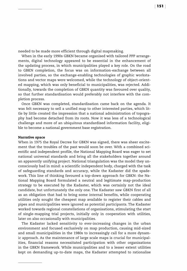
[ 151 ]
needed to be made more efficient through digital mapmaking.When in the early 1990s GBKN became organised with tailored PPP arrange-
ments, digital technology appeared to be essential in the enhancement of the updating process, in which municipalities played a key role. On the road to GBKN completion, the focus was on information-exchange between all involved parties, so the exchange-enabling technologies of graphic worksta-tions and vector maps were welcomed, while the technology of object-orient-ed mapping, which was only beneficial to municipalities, was rejected. Addi-tionally, towards the completion of GBKN quantity was favoured over quality, so that further standardisation would preferably not interfere with the com-pletion process.
Once GBKN was completed, standardisation came back on the agenda. It was felt necessary to sell a unified map to other interested parties, which lit-tle by little created the impression that a national administration of topogra-phy had become detached from its roots. Now it was less of a technological challenge and more of an ubiquitous standardised information facility, eligi-ble to become a national government base registration.
Narrative spaceWhen in 1975 the Royal Decree for GBKN was signed, there was sheer excite-ment that the troubles of the past would soon be over. With a combined sci-entific and independent profile, the National Mapping Board was eager to set national universal standards and bring all the stakeholders together around an apparently unifying project. National triangulation was the model they un-consciously had in mind: a scientific independent body, charged with the task of safeguarding standards and accuracy, while the Kadaster did the spade-work. This line of thinking favoured a top-down approach for GBKN: the Na-tional Mapping Board formulated a neutral and legitimate map-production strategy to be executed by the Kadaster, which was certainly not the ideal candidate, but unfortunately the only one. The Kadaster saw GBKN first of all as an obligation that had to bring some internal benefits, while cooperating utilities only sought the cheapest map available to register their cables and pipes and municipalities were ignored as potential participants. The Kadaster worked towards regional constellations of organisations, stimulating the start of single-mapping trial projects, initially only in cooperation with utilities, later on also occasionally with municipalities.
The Kadaster lacked sensitivity to ever-increasing changes in the urban environment and focused exclusively on map production, causing mid-sized and small municipalities in the 1980s to increasingly call for a more dynam-ic approach. As the maintenance of large scale maps is crucial for municipal-ities, financial reasons necessitated participation with other organisations in the GBKN framework. While municipalities and to a lesser extent utilities kept on demanding up-to-date maps, the Kadaster attempted to rationalise
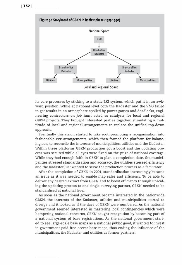
[ 152 ]
its core processes by sticking to a static LKI system, which put it in an awk-ward position. While at national level both the Kadaster and the VNG failed to get results in an atmosphere spoiled by power games and deadlocks, engi-neering contractors on job hunt acted as catalysts for local and regional GBKN projects. They brought interested parties together, stimulating a mul-titude of local and regional arrangements to replace the unified top-down approach.
Eventually this vision started to take root, prompting a reorganisation into fashionable PPP arrangements, which then formed the platform for balanc-ing acts to reconcile the interests of municipalities, utilities and the Kadaster. Within these platforms GBKN production got a boost and the updating pro-cess was secured while all eyes were fixed on the prize of national coverage. While they had enough faith in GBKN to plan a completion date, the munici-palities stressed standardisation and accuracy, the utilities stressed efficiency and the Kadaster just wanted to serve the production process as a facilitator.
After the completion of GBKN in 2001, standardisation increasingly became an issue as it was needed to enable map sales and efficiency. To be able to deliver any desired extract from GBKN and to boost efficiency through upscal-ing the updating process to one single surveying partner, GBKN needed to be standardised at national level.
As soon as the national government became interested in the nationwide GBKN, the interests of the Kadaster, utilities and municipalities started to diverge and it looked as if the days of GBKN were numbered. As the national government seemed interested in mastering local contingencies which were hampering national concerns, GBKN sought recognition by becoming part of a national system of base registrations. As the national government start-ed to see large-scale base maps as a national public good, it wanted to invest in government-paid free-access base maps, thus ending the influence of the municipalities, the Kadaster and utilities as former partners.
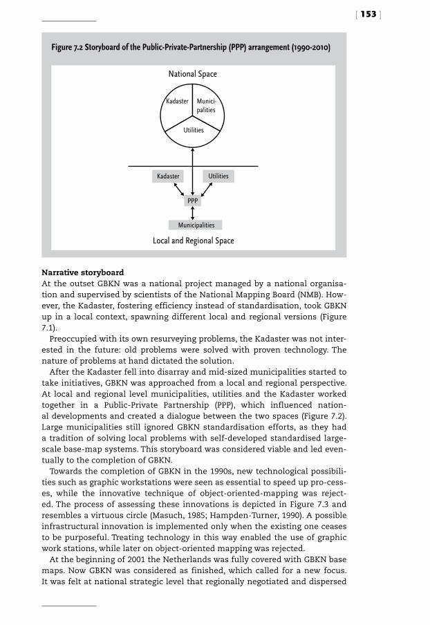
[ 153 ]
Narrative storyboard At the outset GBKN was a national project managed by a national organisa-tion and supervised by scientists of the National Mapping Board (NMB). How-ever, the Kadaster, fostering efficiency instead of standardisation, took GBKN up in a local context, spawning different local and regional versions (Figure 7.1).
Preoccupied with its own resurveying problems, the Kadaster was not inter-ested in the future: old problems were solved with proven technology. The nature of problems at hand dictated the solution.
After the Kadaster fell into disarray and mid-sized municipalities started to take initiatives, GBKN was approached from a local and regional perspective. At local and regional level municipalities, utilities and the Kadaster worked together in a Public-Private Partnership (PPP), which influenced nation-al developments and created a dialogue between the two spaces (Figure 7.2). Large municipalities still ignored GBKN standardisation efforts, as they had a tradition of solving local problems with self-developed standardised large-scale base-map systems. This storyboard was considered viable and led even-tually to the completion of GBKN.
Towards the completion of GBKN in the 1990s, new technological possibili-ties such as graphic workstations were seen as essential to speed up pro-cess-es, while the innovative technique of object-oriented-mapping was reject-ed. The process of assessing these innovations is depicted in Figure 7.3 and resembles a virtuous circle (Masuch, 1985; Hampden-Turner, 1990). A possible infrastructural innovation is implemented only when the existing one ceases to be purposeful. Treating technology in this way enabled the use of graphic work stations, while later on object-oriented mapping was rejected.
At the beginning of 2001 the Netherlands was fully covered with GBKN base maps. Now GBKN was considered as finished, which called for a new focus. It was felt at national strategic level that regionally negotiated and dispersed
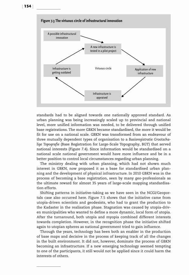
[ 154 ]
standards had to be aligned towards one nationally approved standard. As urban planning was being increasingly scaled up to provincial and national level, more unified information was needed, to be delivered through unified base registrations. The more GBKN became standardised, the more it would be fit for use on a national scale. GBKN was transformed from an endeavour of three mutually dependent types of organisation to a Basisregistratie Grootscha-lige Topografie (Base Registration for Large-Scale Topography, BGT) that served national interests (Figure 7.4). Since information would be standardised on a national scale national government would have more influence and be in a better position to control local circumstances regarding urban planning.
The ministry dealing with urban planning, which had not shown much interest in GBKN, now proposed it as a base for standardised urban plan-ning and the development of physical infrastructure. In 2010 GBKN was in the process of becoming a base registration, seen by many geo-professionals as the ultimate reward for almost 35 years of large-scale mapping standardisa-tion efforts.
Shifting patterns in initiative-taking as we have seen in the NCGI/Geopor-tals case also occurred here. Figure 7.5 shows that the initiative came from utopia-driven scientists and geodesists, who had to grant the production to the Kadaster in the realisation phase. Stagnation was caused by utopia-driv-en municipalities who wanted to define a more dynamic, local form of utopia. After the turnaround, both utopia and myopia combined different interests towards completion. However, in the recognition phase the initiative shifted again to utopian spheres as national government tried to gain influence.
Through the years, technology has been both an enabler in the production of base maps and decisive in the process of keeping track of all the changes in the built environment. It did not, however, dominate the process of GBKN becoming an infrastructure. If a new emerging technology seemed tempting to one of the participants, it still would not be applied since it could harm the interests of others.
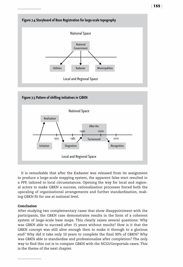
[ 155 ]
It is remarkable that after the Kadaster was released from its assignment to produce a large-scale mapping system, the apparent false start resulted in a PPP, tailored to local circumstances. Opening the way for local and region-al actors to make GBKN a success, rationalisation processes forced both the upscaling of organisational arrangements and further standardisation, mak-ing GBKN fit for use at national level.
ConclusionAfter studying two complementary cases that show disappointment with the participants, the GBKN case demonstrates results in the form of a coherent system of large-scale base maps. This clearly raises several questions: Why was GBKN able to succeed after 15 years without results? How is it that the GBKN concept was still alive enough then to make it through to a glorious end? Why did it take only 10 years to complete the final 90% of GBKN? Why was GBKN able to standardise and professionalise after completion? The only way to find this out is to compare GBKN with the NCGI/Geoportals cases. This is the theme of the next chapter.

[ 156 ]
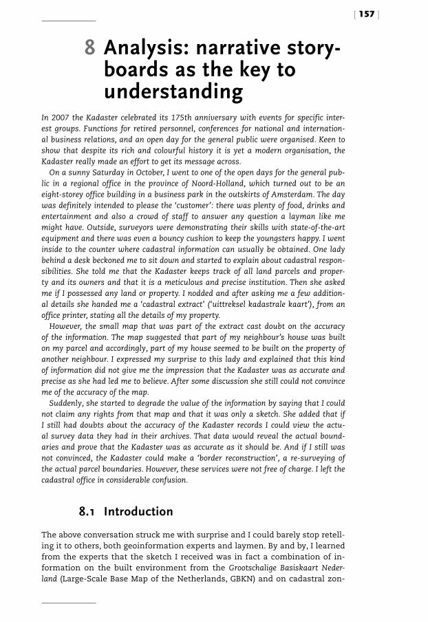
[ 157 ]
8 Analysis: narrative story-boards as the key to understanding
In 2007 the Kadaster celebrated its 175th anniversary with events for specific inter-est groups. Functions for retired personnel, conferences for national and internation-al business relations, and an open day for the general public were organised. Keen to show that despite its rich and colourful history it is yet a modern organisation, the Kadaster really made an effort to get its message across.
On a sunny Saturday in October, I went to one of the open days for the general pub-lic in a regional office in the province of Noord-Holland, which turned out to be an eight-storey office building in a business park in the outskirts of Amsterdam. The day was definitely intended to please the ‘customer’: there was plenty of food, drinks and entertainment and also a crowd of staff to answer any question a layman like me might have. Outside, surveyors were demonstrating their skills with state-of-the-art equipment and there was even a bouncy cushion to keep the youngsters happy. I went inside to the counter where cadastral information can usually be obtained. One lady behind a desk beckoned me to sit down and started to explain about cadastral respon-sibilities. She told me that the Kadaster keeps track of all land parcels and proper-ty and its owners and that it is a meticulous and precise institution. Then she asked me if I possessed any land or property. I nodded and after asking me a few addition-al details she handed me a ‘cadastral extract’ (‘uittreksel kadastrale kaart’), from an office printer, stating all the details of my property.
However, the small map that was part of the extract cast doubt on the accuracy of the information. The map suggested that part of my neighbour’s house was built on my parcel and accordingly, part of my house seemed to be built on the property of another neighbour. I expressed my surprise to this lady and explained that this kind of information did not give me the impression that the Kadaster was as accurate and precise as she had led me to believe. After some discussion she still could not convince me of the accuracy of the map.
Suddenly, she started to degrade the value of the information by saying that I could not claim any rights from that map and that it was only a sketch. She added that if I still had doubts about the accuracy of the Kadaster records I could view the actu-al survey data they had in their archives. That data would reveal the actual bound-aries and prove that the Kadaster was as accurate as it should be. And if I still was not convinced, the Kadaster could make a ‘border reconstruction’, a re-surveying of the actual parcel boundaries. However, these services were not free of charge. I left the cadastral office in considerable confusion.
8.1 Introduction
The above conversation struck me with surprise and I could barely stop retell-ing it to others, both geoinformation experts and laymen. By and by, I learned from the experts that the sketch I received was in fact a combination of in-formation on the built environment from the Grootschalige Basiskaart Neder-land (Large-Scale Base Map of the Netherlands, GBKN) and on cadastral zon-
[ 158 ]
ing from the Kadaster. Retelling that story to others provided me with many interpretations. Like
the one from a scientific geodesist who actually told me that I am not quali-fied to read such a map because I do not recognise it as a map with two dif-ferent information sources. Other experts just said that the information on the map is accurate and beyond any doubt. Maybe it suggests inaccuracy, but that is just a matter of explanation, which an expert is always willing to give. Moreover, as he explained further, accuracy of geoinformation can only be found in the underlying surveying data found in cadastral archives. Maps are just inaccurate images which are subject to misinterpretation by laymen. In other words, only the data of the actual surveying operation is certain. Fur-thermore, I was told by others that surveying data on cadastral zoning is filed in archives that also contain administrative data and that it is this adminis-trative data that holds the ultimate key to reliable cadastral information. This suggests that real accuracy only can come from the filing cabinet. To wrap this elaboration up, another geodata expert told me that, according to him, the Kadaster is making a cardinal error. As an institution that ought to have expertise, they should not provide me with a sketch which needs interpreta-tion from experts. For him it was the living proof that the Kadaster is in fact an inaccurate and a customer-unfriendly institution.
Almost every person that I have interviewed told me that the Kadaster is a powerful and necessary organisation when it comes to geoinformation. Lots of workers, both inside and outside the geoinformation field, are dependent upon cadastral information to do their job. While being so influential in the field, there is also a widely shared image that the Kadaster was and is unable to provide accurate cadastral information. The people I interviewed almost unanimously thought that the Kadaster had an acceptable parcel administra-tion and unreliable maps, based on inappropriate surveying. The alleged inac-curacy of cadastral maps was attributed to the fact that the Kadaster nev-er really started to use a proper geodetic base for their surveying and map-ping, thus replicating inaccuracy and creating a legacy of information of dubi-ous quality. I have heard amusing, sometimes even hilarious stories of inac-curate cadastral maps, like the one about a municipality in the 1970s which was making a zoning plan for a housing project, based on cadastral maps. When the municipal surveyors started surveying, it appeared that there was room in the plan for one additional house. Sometimes this allegedly inaccu-rate information is used as a base for public policy, which implicitly confirms this information as secure, correct and reliable (Louwman & Janssen, 2010; Van der Meer, 2010).
Apparently we have struck upon a contradiction in what at first glance seemed reconciled. On the one hand, there is still an almost scientific pre-occupation with accuracy, preferably promoted with methods. On the other hand, there is a way of doing things within the cadastral organisation which

[ 159 ]
keeps it from producing information of decent quality. These spheres connect to the professional attitudes depicted in Section 1.4 and have been described by Alberda and Ebbinge as high- and low-geodesy (Alberda & Ebbinge, 2003).
The conclusion of what was explained in Section 1.4 about the history of surveying and geodesy, using the archetypes of the Roman surveyor and the Greek geodesist gains a certain confirmation from this little story, signifying that this contradiction is still alive. Here I draw the conclusion that the sur-veyor and the geodesist have travelled different roads, have different back-grounds and are therefore different in character. Surveying and geodesy have both helped to shape the nation state of the Netherlands and have been involved in societal change, just as society has co-shaped these practices. Whereas the surveyor has always registered the ownership of parcels of land, thus creating a framework for unified taxation, geodesists were able to estab-lish the real size of the country’s territory for governmental and water man-agement purposes. Societal modernisation in the second half of the 19th cen-tury stimulated urbanisation and the standardisation of society, a stimulus to surveyors and geodesists alike to modernise their work practices.
As the observation at the beginning of this chapter makes clear, these role models can still be found in daily practice. It is for this reason that I have decided to make an analysis using this contradiction. In other words, this chapter will synthesise empirical work and theory using a proper methodol-ogy, starting from the professional attitudes of the surveyor and the geode-sist as described in Section 1.4. These will be transformed into narrative sto-ryboards and fitted into theory as the basis of analysis.
The next section will be devoted to the development of the narrative story-boards of myopia, with its roots in the surveying profession, and the narrative of utopia, with its roots in the geodesist profession. I shall then successive-ly analyse the GBKN case with the Geoportals and NCGI cases, followed by a comparative conclusion.
8.2 Narrative storyboards for analysis
The narrative picture of surveying and geodesy developed in Chapter 1 will be used here as reference points for analysis and incorporated into the theoreti-cal framework. The narratives of the Greek geodesist and the Roman surveyor brought to life the two storyboards discussed below. The practices of the Ro-man surveyor will be connected to the narrative storyboard of myopia and the practices of the Greek geodesist to the narrative storyboard of utopia. These storyboards will form the basis for comparative analysis.
The narrative storyboard of myopia The mission of cadastral surveyors is to register. They make decisions on
[ 160 ]
where to draw boundaries that decide which land parcel belongs to whom. Through performing that routine, a service is rendered to society: the cadas-tral activity secures economic life and business.
The safeguard of economic activity is to be found in the cadastral registry and its source of confidence is to be found in records. Once a record on a par-cel is filed, it becomes the evidence for the existence of that specific piece of property. All transactions regarding that specific parcel are based upon that record. The cadastral surveyor provides the link between the actual situation and the registrative reality in files and records. Once that link is established, nobody questions it, because that would appear as mistrusting the whole sys-tem. This makes the essence of cadastral practice more social than technical, more of a trust in society than commitment to scientific rules.
Cadastral surveyors rely upon their own autonomy when establishing a property parcel, either using sophisticated equipment or a simple measur-ing chain; it is their decision which makes the dimensions final and irrevers-ible. The personal judgement of the individual surveyor is decisive for eve-ry action in the field, which has a tremendous influence on how they inter-pret the world around them. Unlimited trust in the surveyor’s own judge-ment, together with the focus on cadastral parcels hampers the development of a coherent view on systematic mapping for a coherent national cadastral map. The professional practice aims to preserve the authority of the cadas-tral surveyor, which stands in the way of a relationship with municipalities to exchange reliable systematic cadastral information. But because the Kadaster is the only nationally operating organisation with large-scale maps, it has an influence on other organisations.
Technology is only supportive to cadastral surveyors, making daily oper-ations easier and more cost-efficient. This notion implies that there is no explicit need to use cutting-edge technology, since efficiency is considered more important than maximum accuracy.
This picture can be seen as the storyboard of myopia, characterised by an eye for detail, for unique situations and exceptions and ignoring a systematic alternative. It also implies a utilitarian view on the use of technology, neglect-ing the bigger picture, regarding it as a means to an end.
The narrative storyboard of utopiaAs a geodetic base is essential to the geoinformation sector in the Nether-lands, the scientific drive of geodesists affects the Dutch geoinformation community as a whole and the way in which geoinformation infrastructures are created. These are enacted as a quest for independence, timelessness and completeness. The Greek geodesist has the urge to maximise reliability, accu-racy and inevitability, influencing how geodetic infrastructures are used.
Geodesists are scientists, which implies that their efforts are subject to sci-entific scrutiny when they study the earth’s features. That practice also con-
[ 161 ]
nects to the Dutch nation, as the geodesist’s expertise is needed to estab-lish national territory in much the same way as the earth’s size and shape is monitored. It is the quest for universal laws that causes national triangu-lation efforts to be regarded as uncontroversial, underpinning the legitimacy of the nation. Striving for scientific accuracy also implies a search for exter-nal validity, offered by the galaxy through astronomical measurements and geostationary satellites, together with supra-national scientific committees. This externally sought validity leads to standards kept by national commit-tees like the National Geodetic Commission.
Geodesists also play a role at local level, where they establish the relation-ship between municipal authority and territory within urbanised municipali-ties. The geodesist spirit helps to enforce municipal jurisdiction by the undis-puted establishment of metropolitan municipal maps, providing as much accuracy as is needed to safeguard local infrastructures and urban plan-ning. They are able to dismiss cadastral mapping in urban municipal develop-ment as a municipal mapping source by replacing it with accurate and up-to-date maps, produced by internal mapping departments, signifying municipal authority on urban affairs.
As the professional attitude of geodesists is very scientifically-oriented, aimed at continuous improvement of the geodetic infrastructure, they prefer to use state-of-the-art technology. Both in national and municipal geodesy there is an urge to improve effectiveness, accuracy, reliability and quality – an urge to strive for something that is just out of reach, the promise of tomorrow. The most sophisticated equipment and cutting-edge methods are therefore applied by well-trained geodesists, presented by them as inevitable in order to guarantee that novel technology will be applied to keep the fire of progress burning.
These considerations lead me to discern a narrative storyboard of utopia. The application of cutting-edge technology and methods, together with a constituting role in connecting governmental authority with territory moves towards an ideal type of geodetic infrastructure. There is an unspoken, shared and future image of infrastructure guiding all the efforts to improve. Utopia is still far away and the more one tries to reach it, the more distant it becomes, making it even more ideal. Every attempt to realise some tiny part of utopia makes the future more desirable.
Utopia and myopia: storyboards for analysisUp till now, the geoinformation sector has been a closed community, able to develop and maintain these storyboards in relative isolation. The rath-er coarse storyboards of utopia and myopia have been formed in practice, guiding thoughts and behaviour, and influential in what has happened and is still happening in the geoinformation sector. They have emerged from and are grounded in the narrative setting and the narrative space I described in

[ 162 ]
Section 1.4. While they certainly are influential to one another and cannot be separated in every case, for the sake of analysis they are regarded here as di-chotomous and mutually exclusive (Douglas, 1986; Bowker & Star, 2000). The primary analytical qualities of these storyboards are recapitulated in Table 8.1, a crosstab which relates to the dominant topics of narrative settings and spaces.
Storyboards are by no means intended as normative. Of course, normative evaluations can never entirely be ruled out, but here they are meant to be solely analytical, as aids to explanation. Nor can a storyboard be exclusive-ly linked to a specific group or organisation. Of course, groups have a hand in the development of storyboards, but they may also exist inside and outside that group.
8.3 The narrative construction of geospatial in-frastructure
With narratives of geodesy and surveying narrowed down to storyboards of utopia and myopia, I will try to analyse the cases described in the preceding chapters. With these two storyboards in mind, I shall try to come to the es-sence of base maps and GBKN on the one hand, and the Nationaal Clearing-house Geoinformatie (NCGI) and the Geoportals project on the other.
8.3.1 The infrastructural qualities of clearinghouse and geoportals
The SAG initiative preludes NCGI as an attempt to establish a formal relation-ship with four participating national geoinformation-processing organisa-tions reaping the benefits. These organisations form a like-minded coopera-tion-seeking constellation, trying to work out a deal in a myopian way that will be beneficial to all concerned.
As soon as the SAG initiative was declared closed without tangible results, GI professionals from these organisations got together on an informal basis to develop Idéfix, a database with metadata for geoinformation-exchange, using state-of-the-art technology. These geodata specialists were barely concerned with the interests of their respective organisations. Geoinformation (GI)-shar-ing was the ultimate goal: they were more concerned with promoting the public interest than serving the interests of their own organisations.
Driven by a utopian storyboard, the GI professionals saw Idéfix as a role model for a national, universal standardised infrastructure for geoinforma-tion-exchange, enforced with an almost philanthropical attitude. In their view, Idéfix was the perfect engine for the clearinghouse concept, to be imple-mented at a matching institutional level, preferably approved and managed
[ 163 ]
by the RAVI umbrella-organisation at national level.Having become a separate Nationaal Clearinghouse Geoinformatie (NCGI), how-
ever, a myopian storyboard got hold of the NCGI. The board members were more inclined to protect the interests of the organisations they were ought to represent than promote the common goal. With individual corporate agendas in first place, shared attempts to make NCGI to a national infrastructure were bound to fail.
Faced with decline, the initiative was returned to utopian professionals who were given a new opportunity: a software-engineering company founded and operated by former Idéfix professionals was invited to take over all operation-al NCGI activities. With a clean slate they started to focus again on GI-shar-ing as a virtue for all, to be developed with cutting-edge technology. The sto-ryboard of utopia sets the scene, as NCGI was presented as universal and ben-eficial to everybody. However, the utopian attitude faded again along the way, as the engineering company tried to make a profit by putting its own inter-ests first, increasingly treating NCGI as a commercial billboard.
The myopian storyboard steered the management of individual organisa-tions to join forces around the idea of a national infrastructure. The Ruimte voor Geoinformatie programme (Space for Geoinformation, RGI), a programme to stimulate innovation which incorporated the already declining NCGI, was launched. RGI grants were given to innovative projects, among which the idea of establishing a system of geoportals, an attempt stemming from individual professionals from a range of geoinformation organisations. The focus shift-ed again to utopia when RGI closed NCGI and stimulated Geoportals, which again had a professionals focus on the geoinformation sector as a whole, separated from individual organisations. Because RGI preached innovation, Geoportals professionals felt they had to incorporate cutting-edge technolo-gy which they believed to be in need of adaptation and development. As the project carried on, the focus shifted from a tangible system of geoportals to the development of tools to apply new technologies to enable future infra-structures. An overarching infrastructure to disclose geoinformation was still desired, but seemed further away than ever.
8.3.2 Large-scale mapping becomes an infrastructure through GBKN
While in the 1960s and early 1970s large-scale mapmaking in the Nether-lands was done in a dispersed manner, geodetically-oriented scientists act-ed as opinion leaders towards improvement, paving the way for unified and systematically organised large-scale mapping as a national concern. They ar-gued that a national system of large-scale base maps needed to be developed. This required a national mapping standard which would be executed by a na-tionally operating organisation and backed by an official governmental deci-
[ 164 ]
sion. Plans were deliberately not linked to locally experienced problems, but expressed unity for the sake of efficiency. While ignoring existing large-scale mapping systems, all organisations involved in large-scale mapping were ex-pected to comply with the new national standard, to be introduced using state-of-the-art technology.
However, by then urban municipalities already had their own sophisticat-ed mapping systems, using cutting-edge technology and serving the local sit-uation. They looked like full-fledged local standardised mapping systems tai-lored to local needs of urbanisation as experienced at municipal level. Intent on maintaining the topicality and quality of maps in a rapidly changing envi-ronment, urban municipalities moved in the vanguard of automated mapping and strengthened their self-confidence in the process.
It is a storyboard of utopia which guides these urban developments with a strong relationship between territory and maps, relying on scientific meth-ods. However, scientists in the national arena tried to make up for the lack of a national system of large-scale base maps by creating a new system, free-standing from existing local versions. They enacted two versions of a utopia storyboard, exclusively linked to their own territory with no connection in any way.
The Kadaster, taking up the production of GBKN in 1975, connected the national initiative with its own myopian storyboard, based on the cadas-tral means-to-an-end form of infrastructure. The national, unified concern for systematic mapping became vulnerable to the cadastral mode of con-duct, making local and regional opportunities to determine where mapping initiatives should start, which organisations should be invited to cooperate, and how standards should be applied. The myopia storyboard guided the way in which GBKN was handled within the cadastral organisation, allowing the Kadaster an opportunity to seek the most suitable way of combining the assignment of GBKN with the internal quest to improve cadastral mapping.
It appears that these storyboards do not entirely add up to each other in this phase of GBKN. The Central Mapping Board had certain utopian convic-tions about how GBKN should look and how it should be implemented while GBKN was taken up by the Kadaster in a myopian way. Metropolitan munici-palities did not play a role at this stage, as they were neither inclined to asso-ciate with the myopian storyboard at Kadaster level nor the utopian story-board at national level.
Striving for harmonyDuring the 1980s ongoing urbanisation forced mid-sized municipalities to act. To gain control over the increasing turnover in changes in the built environ-ment, investments in electronic large-scale base maps were needed. Being ac-cepted as the natural registrars of municipal territory, however, the munic-ipalities had to cooperate with other organisations such as the utilities and
[ 165 ]
the Kadaster, for which GBKN provided an elegant framework. The municipal version of the utopian storyboard was the driving force for
mid-sized municipalities to have their own large-scale base maps, albeit mostly organised on a regional scale, forced by utilities and the Kadaster, as they are essential for funding. While GBKN was still treated as a national uni-fication tool, its character changed towards a national umbrella for initiatives on a regional scale, leaving individual municipalities with as much room as possible to promote their role in large-scale mapmaking.
Meanwhile, financial distress was causing trouble at the Kadaster, forcing it to give up its leading role. In the internal process of finding a new role for itself the Kadaster did not contribute to the transition of GBKN. Only after the redefinition process, which gave municipalities a more distinct and prom-inent role, did the myopic means-to an-end storyboard drive the Kadaster from its role as an exclusive GBKN mapmaker to that of an aid to regional GBKN collaboration.
The 1990s brought a new, bi-level organisational arrangement of Public-Pri-vate Partnerships (PPP) which balanced the interests of municipalities, utili-ties and the Kadaster. The myopian means-to-an-end storyboard of the util-ities and the Kadaster invited municipalities to maintain their utopian sto-ryboard. Conversely, municipalities needed the other two partners to real-ise their utopia-inflicted large-scale base maps. It is this situation of comple-mentary interests that swept the results towards national coverage for GBKN. Standards were further advanced, reflecting the benefits for all three partic-ipants: large-scale maps to serve the needs of individual municipalities as well as effective and cheap mapping on an optimal business scale for the util-ities and the Kadaster.
The utopian storyboard of municipal interests did not strive for strict standardisation on a national scale. National coverage of GBKN, however, became the myopian interest promoted by the Kadaster and utilities. These interests became balanced, as GBKN consolidated towards regional coopera-tional bodies.
Only after the completion of GBKN in 2001, when all the Dutch territory was covered by base maps did a national utopian storyboard come to life again, now promoted by the national government. Instead of a repetition of the ini-tial situation where scientific geodesists wanted nationally promoted stand-ardised mapping, now a policy unit of the Ministry of Housing, Spatial Plan-ning and Environment (VROM) saw GBKN as an essential element of a nation-al system of base registries. Additionally, urban planning was being increas-ingly carried out on a provincial and national scale, requiring standardisa-tion of procedures and dispersed information, which can be eloquently stand-ardised through the large-scale base maps of GBKN, using the tendency of national government as a whole to connect GBKN to a Dutch system of base registries.
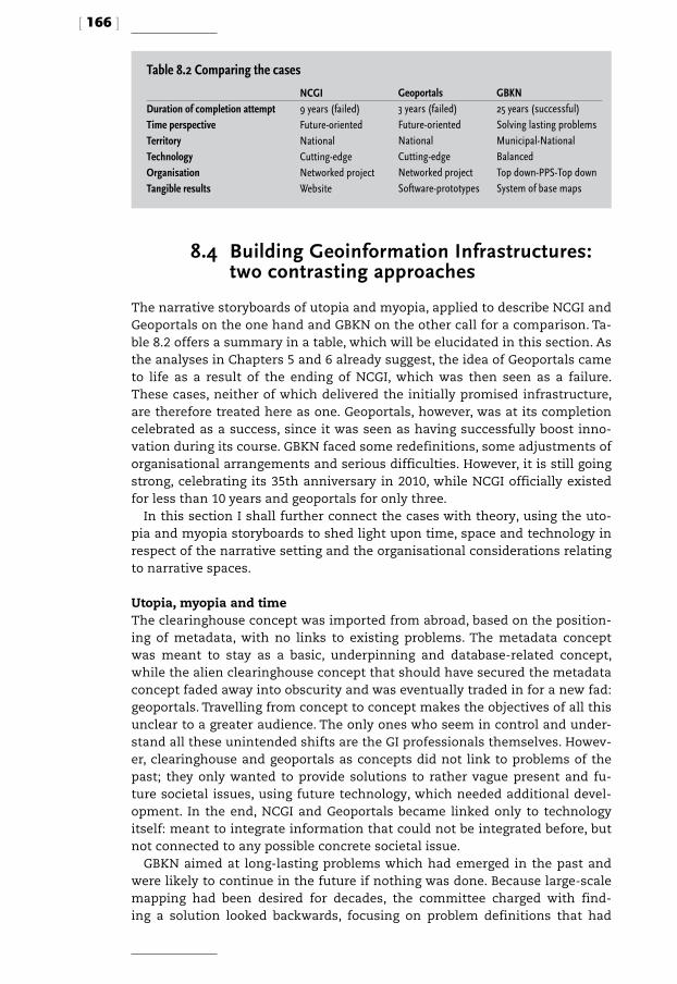
[ 166 ]
8.4 Building Geoinformation Infrastructures: two contrasting approaches
The narrative storyboards of utopia and myopia, applied to describe NCGI and Geoportals on the one hand and GBKN on the other call for a comparison. Ta-ble 8.2 offers a summary in a table, which will be elucidated in this section. As the analyses in Chapters 5 and 6 already suggest, the idea of Geoportals came to life as a result of the ending of NCGI, which was then seen as a failure. These cases, neither of which delivered the initially promised infrastructure, are therefore treated here as one. Geoportals, however, was at its completion celebrated as a success, since it was seen as having successfully boost inno-vation during its course. GBKN faced some redefinitions, some adjustments of organisational arrangements and serious difficulties. However, it is still going strong, celebrating its 35th anniversary in 2010, while NCGI officially existed for less than 10 years and geoportals for only three.
In this section I shall further connect the cases with theory, using the uto-pia and myopia storyboards to shed light upon time, space and technology in respect of the narrative setting and the organisational considerations relating to narrative spaces.
Utopia, myopia and timeThe clearinghouse concept was imported from abroad, based on the position-ing of metadata, with no links to existing problems. The metadata concept was meant to stay as a basic, underpinning and database-related concept, while the alien clearinghouse concept that should have secured the metadata concept faded away into obscurity and was eventually traded in for a new fad: geoportals. Travelling from concept to concept makes the objectives of all this unclear to a greater audience. The only ones who seem in control and under-stand all these unintended shifts are the GI professionals themselves. Howev-er, clearinghouse and geoportals as concepts did not link to problems of the past; they only wanted to provide solutions to rather vague present and fu-ture societal issues, using future technology, which needed additional devel-opment. In the end, NCGI and Geoportals became linked only to technology itself: meant to integrate information that could not be integrated before, but not connected to any possible concrete societal issue.
GBKN aimed at long-lasting problems which had emerged in the past and were likely to continue in the future if nothing was done. Because large-scale mapping had been desired for decades, the committee charged with find-ing a solution looked backwards, focusing on problem definitions that had
[ 167 ]
been formulated decades ago and had hardly changed since. It gave large-scale base maps a sense of timelessness, being universally manifest in past, present and future. The quality of being timeless made it into an independ-ent phenomenon, which was in fact the utopian essence of GBKN, regard-less of what technological standard or organisational form was fashionable. It reduced technology to being utilitarian: no matter what technology was used, the essence of large-scale base mapping did not change. Computer technol-ogy eventually became necessary to master the immense turnover in the updating process, thereby contributing to the utopian municipal requirement of GBKN base maps being up-to-date. Large-scale base maps have become the up-to-date reference point to which other, possibly changeable matters can be hooked. To sum up, GBKN seems to operate independently of time.
Utopia, myopia and territoryNCGI started out as the utopian initiative of individual geo-professionals to bring the partial Idéfix database to national level, after the myopian SAG ini-tiative of four nationally operating organisations had failed to bring about the sharing of geoinformation to four collaborating organisations. However, that utopian initiative was blocked by the joint level of NCGI which was dominat-ed by the myopian interests of individual participating organisations. Conse-quently, the common goal of establishing an infrastructure was not realised and the initiative went from a myopia-oriented NCGI to the outsourced ver-sion, controlled by the former Idéfix professionals, who advocated a strong utopian attitude to share geoinformation, treating the whole geoinformation sector as their territory and acting as if organisational boundaries had ceased to exist. As in the Idéfix days, it was felt that state-of-the-art technology and international standards should provide a sector-wide infrastructure. Howev-er, they failed to connect this with some commonly formulated objective that would appeal to geoinformation organisations. Now it appeared more as if they only wanted to share information in order to be able to develop and pro-mote their new technological gadgets. RGI tried to set things right in a myo-pian way by getting the management of organisations in place to distribute a considerable amount of research grants, but then they left it to the Geopor-tals project to formulate a new goal that could be bound to a new concept for sharing geoinformation. This eventually deteriorated to only promoting tech-nological innovations. NCGI and Geoportals were both unable to bridge the territory of individual organisation and provide a general concept of geoinfor-mation-sharing.
Initially, GBKN was only loosely linked to the national level, assuming that the utopian way of large-scale mapping concerns everybody in the Nether-lands. Becoming fragmented in myopian, Kadaster-led, local and region-al map-production endeavours, the lack of a clear national objective became evident. That GBKN had a better match with the municipal version of utopia
[ 168 ]
became manifest only after the updating routine had become vital to GBKN, changing the scope accordingly, but remaining in a nationally standardised framework. This framework was essential, allowing organisations of different territorial scales to work together and thus boosting efficiency. The myopia-driven tendency to sell extracts from maps to other parties stimulated further standardisation. However, the more GBKN became standardised at national level, the more interested the national government became. So, it took only a small step to transform GBKN into a national base registration.
Utopia, myopia and technologyNCGI and Geoportals can be regarded as unleashed technological endeav-ours. During the existence of both projects, every useful technological novelty was colonised, causing a constant shift in new techniques at an accelerating pace. Using cutting-edge technology seemed to be a virtue, eventually becom-ing the only objective of the Geoportals project. Within NCGI, Idéfix had al-ready laid the basis for this, as it pretended to be an infrastructure, but failed to connect as a technological device to organisations in the way GBKN con-nects large-scale map users. The utopia-oriented workforce of geo-profession-als was technology-bound, while individual organisations served their own interests instead of the sector as a whole.
At the outset of GBKN, scientific members of the Central Mapping Board were in favour of using new technology, such as photomaps and computers. However, representatives of the Kadaster and the utilities played this down and used regular non-computerised mapping techniques. It looked as if the utopian spirit to deliver the perfect mapping system, preferably with cut-ting-edge technology, was reduced through a myopian means-to-an-end atti-tude to a system serving the interests of the Kadaster. This conservative pol-icy contrasts with the metropolitan municipalities pursuit of computerised map storage. In the 1980s mid-sized municipalities were forced to adopt com-puter technology to master the heavy turnover in map updates, a municipal-utopian response to the myopian practice of the Kadaster. However, as inter-ests became balanced in PPP constellations, the focus on completion balanced utopian and myopian interests in a way that neutralised the utopian inclina-tion to espouse cutting-edge technology to implement object-oriented-map-ping. It appeared the right constellation to march with a somewhat loosely standardised GBKN towards completion. As GBKN came under the spell of national government, the utopian storyboard gained influence because new standards required the state-of-the-art technology of object-oriented map-ping.
Utopia, myopia and organisationWithin the organisational arrangements of NCGI and Geoportals, the utopi-an storyboard attempted to transform the Idéfix trial database into an organ-
[ 169 ]
isation of national importance, intended to safeguard a standardised clear-inghouse. While individual organisations exercised their power in the NCGI board, the voice of professionals was not heard. They took action in the out-sourcing phase, but did not reach the NCGI management board. Still aiming for standardisation, NCGI was declared outdated because it had a centralistic concept and was taken over by the RGI initiative. RGI encouraged profession-als to come up with new ideas, one of which led to the concept of geoportals, which also had no direct relationship with information-providing organisa-tions. Utopia and myopia storyboards alternately granted each other the right to take the initiative, but no dialogue emerged. The utopian ideal of having a standardised infrastructure was promoted by professionals, but failed to con-nect to organisations that were following their myopian storyboard of serving their own interests. An organisational arrangement to reconcile myopian and utopian storyboards did not emerge. The utopian storyboard remained con-nected to the professional attitude and the myopian storyboard to individual organisations without any negotiating, blending or reconciliation.
The wish to exchange geoinformation was expressed here by individual organisations, but its essence was formulated by geoinformation profession-als. The utopian attitude of the shop floor spawned the concepts of clearing-house and geoportals, but these were not connected to myopia-driven indi-vidual organisations. The Geoportals project was able to find a solution at professional level guided by a utopian storyboard but received no response at inter-organisational management level.
The organisational arrangement at the outset of GBKN suggests a hierarchy in which scientists-geodesists belonged in a higher, utopian-driven and rule-setting stratum to which the Kadaster was subject and had to follow rules in a myopic way. It functioned as a one-way street: utopia set the rules and myo-pia produced maps, compliant with national, universal, standardised, uto-pia-driven standards, for the use of the Kadaster and utilities. However, the Kadaster was in a position to refuse cutting-edge technology and to stick to conventional drawing techniques.
In the 1990s the organisational Public-Private Partnership enabled equal representation of the municipalities, utilities and the Kadaster, both at national and regional level. Completion and standardisation of GBKN got a boost from a myopian means-to-an-end approach of selling maps which cre-ated utopian effects of a universal standard and national coverage. The PPP offered both regional and national loci for the reconciliation of utopia and myopia in such a way that they would become complementary and turn into obvious and undisputed configurations. However, in situations where munici-palities felt their authority was not recognised (Noord-Brabant, TPGs in Zuid-Holland) alternative organisational arrangements arose towards balancing municipal utopian and other myopian claims. This utopia-myopia balance appeared to be the perfect vehicle to promote the use of graphic worksta-
[ 170 ]
tions to remove the backlog in updates, but also to contain emerging discus-sions on utopian, object-oriented mapping. It even helped to realise utopian goals with myopian means: the desire to sell any given extract from a nation-al standardised map advanced further standardisation. A standardising GBKN moving towards national coverage even became attractive to the informa-tion-unifying national government, which wanted GBKN to be part of a sys-tem of national base registries and thus turned it into a standardising effort of a higher order.
8.5 Conclusion: a narrative anchor is distinctive for information infrastructures
From a description of the history of surveying and geodesy I have discerned two persistent storyboards, of utopia and myopia, where utopia refers to the pursuit of accuracy, universality and standardisation in assessing the earth and myopia stands for a here-and-now, means-to-an-end approach that hon-ours exceptions. In this section I shall go through some conclusions based on this analysis.
The versatile features of geoinformation: the link with original dataIn discussions on geoinformation a lot is expected from the reuse of geoin-formation, presuming that if some kind of information is collected at one place, it can easily be used elsewhere. Of course, technical, legal and econom-ic considerations have been acknowledged in that respect (Welle Donker et al., 2010). However, other aspects regarding geoinformation-sharing have not come to the fore.
In the GBKN case it took until 1992 to realise that the essence of base maps is to be up-to-date. Up-to-date base maps is a matter of concern for every user, but first and foremost for municipalities. Standardisation in mapping is another topic that is not equally important to all participants. However, up-to-dateness and standardisation determine whether data that is collected at one place can be successfully used at another place. Within GBKN these inter-ests seem to be sufficiently balanced with financial motives to give every par-ticipant the right share.
Considering the shifts in initiative-taking and -granting, the case of NCGI and the Geoportals both demonstrate an absence of dialogue between stake-holders. There was simply no possibility of discussing the nature of informa-tion, let alone balancing the interests of the producers. Within the framework of information-exchange, be it clearinghouse or geoportals, there is no device to establish whether collected data can successfully replace data from anoth-er source held elsewhere. Metadata serves that purpose only in a very limited way. Accordingly, a link between data production and data use among differ-
[ 171 ]
ent types of organisations cannot be established.
Standardisation envisioned as top-down law enforcementStandardisation is a hot topic in the geoinformation sector. First of all, it re-lates to technical performance: strict standardisation is needed in order to successfully connect electronic devices such as databases and different types of software applications. There are also more abstract conventions to deal with in mapping, for example; standards have to be drawn on how to frame reality into an image.
Case descriptions reveal that standardisation is conceptualised and applied as a top-down process in which some central body sets rules for the field. Whether envisioned as strict and detailed regulations intended for all mem-bers of a community or merely as an understanding of general preferences, these rules – implicit or explicit – are set by a central coordinating agency and recognised by everyone concerned.
Other forms of standardisation are not recognised as such. In some case standardisation is more like a dynamic process, instead of going abruptly from a non-standardised to a standardised reality just through issuing rules. In the Geoportals case a ‘light’ version of standards was advocated, but turned out to be a rather static concept to entice organisations to participate and not the start of a process to transform vague rules into sophisticated standards.
In the GBKN case, examples can be found of dynamic rule-setting com-ing from non- standardising activities. To avoid the sale of GBKN extracts according to more than one standard, sales of random map extracts stimu-lated standardisation. That differences occur is acknowledged, but not recog-nised as a tool to improve national unified standardisation. The sale of maps was a big motivator for TPG municipalities to strengthen relations with GBKN, which again further stimulated standardisation.
Mind the time perspective: going back to the futureWhen a reference is made to infrastructure as an institution, the image has enduring and lasting qualities (Douglas, 1986; Scott, 1995). If an infrastructure is to serve society, it needs to find lasting solutions to existing and pressing problems.
At the outset of NCGI, environmental pollution was envisioned as a prob-lem of the future, triggering a desire for an infrastructure that integrated data from different sources and enabling things to be done that have not been done before. New technology was hailed with a keen eye on the future, but in the course of the project the initial problem definition was pushed to the background and traded in for the viewpoint that the application of new tech-nologies alone is crucial for multiple unspecified future problems.
In the case of GBKN the absence of base maps had been regarded as a pressing societal problem which had been around for decades and needed to
[ 172 ]
be solved now to prevent further losses to society. Consequently, GBKN was connected to problems of the past that needed to be solved once and for all in order to create a better future. Therefore, it looked backwards for its prob-lem definition and had neither the intention nor the desire to look ahead to address new problems.
A tacit factor of geoinformation infrastructures: enabling and inhibiting technology The most striking observation – also made by a lot of interviewees – is that the Dutch geoinformation sector is addicted to technology. However, where-as informed insiders see the role of technology within their sector as obvious, straightforward and simple, as a relative outsider I see it as delicate, making its influence either encouraging or disappointing.
GBKN is the living proof that technology alone is not the decisive factor in bringing about an information infrastructure. If and how innovative technolo-gy was used was decisive in making GBKN a success. The application of tech-nology has to be connected to how an infrastructure may solve problems.
At the start of GBKN in 1975 cutting-edge technology was proposed but was declined by the old-fashioned Kadaster, as it was not ready for it. On the oth-er hand, round 1990, when the updating of base maps was recognised as a problem, the newest and latest state-of-the-art GIS workstations were used because the map renewal process desperately needed to be speeded up so that changes could be registered in the built environment in good time. How-ever, only a few years later, object-oriented mapping, which would require additional technological innovations and considerable investments, was kept at a distance as it did not serve the goal of the national completion of GBKN. The impression that remains is one of pull-in and let-go, either embracing or declining innovations. There was no such response to technological temp-tations in the case of NCGI and Geoportals. Here innovative technology was focal, and regarded as essential to an information infrastructure. It divert-ed attention from the goals and gains of infrastructure towards cutting-edge technology as an ultimate, however false, source of success.
A non-tangible information infrastructure concept: the narrative anchorThe common opinion is that information infrastructures rely heavily upon their underlying technologies and that the relationship between them is rath-er straightforward (Venkatraman, 1991; Harvey, 2000; Puri, 2006). Technology is seen only as an enabler of information infrastructures.
Within this research a multi-faceted relationship emerged from the anal-ysis of the GBKN case. Here, the focus from the outset was on base maps, making them the essence of the infrastructure and a concept freestanding towards technology. Relationships could be established with different kinds of technology at various levels, depending on specific infrastructure needs,
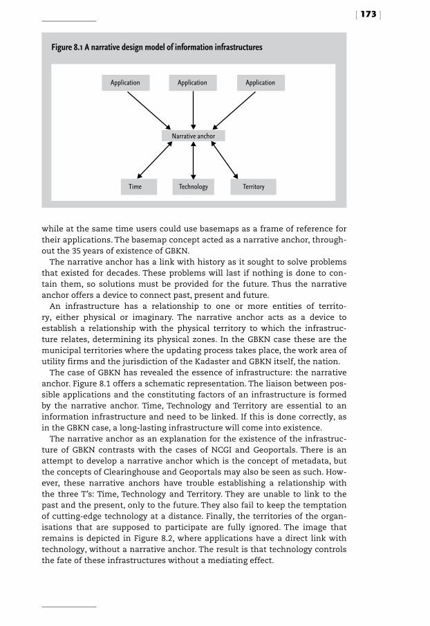
[ 173 ]
while at the same time users could use basemaps as a frame of reference for their applications. The basemap concept acted as a narrative anchor, through-out the 35 years of existence of GBKN.
The narrative anchor has a link with history as it sought to solve problems that existed for decades. These problems will last if nothing is done to con-tain them, so solutions must be provided for the future. Thus the narrative anchor offers a device to connect past, present and future.
An infrastructure has a relationship to one or more entities of territo-ry, either physical or imaginary. The narrative anchor acts as a device to establish a relationship with the physical territory to which the infrastruc-ture relates, determining its physical zones. In the GBKN case these are the municipal territories where the updating process takes place, the work area of utility firms and the jurisdiction of the Kadaster and GBKN itself, the nation.
The case of GBKN has revealed the essence of infrastructure: the narrative anchor. Figure 8.1 offers a schematic representation. The liaison between pos-sible applications and the constituting factors of an infrastructure is formed by the narrative anchor. Time, Technology and Territory are essential to an information infrastructure and need to be linked. If this is done correctly, as in the GBKN case, a long-lasting infrastructure will come into existence.
The narrative anchor as an explanation for the existence of the infrastruc-ture of GBKN contrasts with the cases of NCGI and Geoportals. There is an attempt to develop a narrative anchor which is the concept of metadata, but the concepts of Clearinghouse and Geoportals may also be seen as such. How-ever, these narrative anchors have trouble establishing a relationship with the three T’s: Time, Technology and Territory. They are unable to link to the past and the present, only to the future. They also fail to keep the temptation of cutting-edge technology at a distance. Finally, the territories of the organ-isations that are supposed to participate are fully ignored. The image that remains is depicted in Figure 8.2, where applications have a direct link with technology, without a narrative anchor. The result is that technology controls the fate of these infrastructures without a mediating effect.
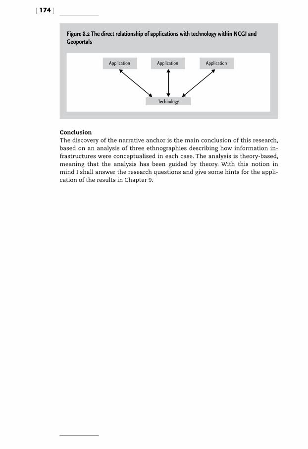
[ 174 ]
ConclusionThe discovery of the narrative anchor is the main conclusion of this research, based on an analysis of three ethnographies describing how information in-frastructures were conceptualised in each case. The analysis is theory-based, meaning that the analysis has been guided by theory. With this notion in mind I shall answer the research questions and give some hints for the appli-cation of the results in Chapter 9.
[ 175 ]
9 Conclusions for practi-tioners and scientists
GSDI is an international body, committed to bringing together and disseminating in-ternational research and practices in the world of geo-spatial data infrastructure. It organises regular conferences which attract the upper crust of the international spa-tial data community. In June 2009 one such conference was organised in the Nether-lands, in Rotterdam. The Dutch spatial policy organisation Geonovum saw this confer-ence as an opportunity to present its efforts, policies and results in the Dutch geoin-formation sector to an international audience.
Within a five-day programme, a plenary morning session was granted to the Dutch, allowing them to profile themselves as internationally-oriented spatial information professionals. After the opening address by the Mayor of Rotterdam, speakers high-lighted the results of the Ruimte voor Geoinformatie (Space for Geoinformation, RGI) programme, and at the end, the completion of a national project on registering spatial data was celebrated with the official launch of the National Geo Register of the Neth-erlands.
For this official moment on stage, a dummy book with empty pages laid open on a desk and was projected on an overhead screen. With an official strike on a knob the page suddenly was filled with a map, at least that is what appeared on the overhead screen. It was explained that the actual book on the desk still contained empty pages, but the image on the screen displayed pages filled with content. The effect was caused by the application of a novel technology called ‘augmented reality’: the view on the overhead screen was electronically enhanced with artificial images. The presentation of novel technology had an astounding effect on the audience.
I felt that this launching ceremony came close to a high-tech juggling act: the use of something flashy to distract the audience from what they ought not to notice, this being essential to the performance. It felt like a symbol of what I had experienced when observing the Geoportals project and studying NCGI: technology as a distrac-tion from what an infrastructure really is about.
After leaving the session I asked several insiders for their opinion. Quite a lot of them were still impressed by the new technology. However, informed participants who had knowledge of the National Geo Register felt it was an already unsuccess-ful new attempt to revitalise the Dutch geoinformation infrastructure. They treated it as what somebody called ‘a new NCGI’. Being convinced that a spatial infrastructure was essential, these insiders were quite certain that by making cutting-edge technol-ogy the symbol of innovation, the attempt to establish a National Geo Register had already failed.
9.1 IntroductionThe comments on the official start of a new attempt to advance Dutch geoin-formation infrastructure this chapters started with, acted as a stimulus to complete this dissertation. For me, these comments confirmed my suspi-cion that the Dutch geoinformation sector is still not inclined to look back
[ 176 ]
and learn from the past. Moreover, failures are not even recognised as such. What some qualified off-the-record as a disaster-in-the-making is officially still treated as a success. But first, let’s go back to the research in this book.
In this chapter all the stories told in previous chapters come together to form a coherent message. It will reflect on what has been argued in order to draw conclusions about this research and to connect it to significant areas of debate. The way to proceed is to reconsider the focus and research ques-tions as a reflection of the intentions of this research, or in other words, to restate the initial objective, confined to four research questions. These ques-tions will be answered here. Every subsequent section is accordingly devoted to one research question after which general conclusions will be drawn.
The research design for this study is based on my experiences in the Geoportals project. It was argued that besides delivering an essential part of the Dutch geospatial infrastructure, the project needed to offer learning opportunities for the improvement of similar processes in the future. Soon I realised that this was not so much an isolated project as an endeavour within a tradition. Consequently, in order to understand Geoportals, I had to under-stand the temporal position of the project within the Dutch geoinformation infrastructure as a whole. These considerations brought about the research focus: The conceptualisation of geoinformation-sharing in the Dutch geoinformation sector over time.
Infrastructures are considered as having a sense of timelessness, they are ubiquitous and tacit (Star, 1999; Edwards et al., 2007). On the other hand, rapid technological innovations had an influence on how Geoportals was handled and slowly but surely changed the objectives of Geoportals. It is the interplay between the long-term and short-term perspective, between past, present and future that is investigated here.
The structure of this chapter follows the four research questions developed in Chapter 1:• How can the construction of concepts of geoinformation-sharing be investigated
with narrative analysis?• How have concepts of geoinformation-sharing developed over time?• How should changes in the conceptualisation of geoinformation be interpreted?• What recommendations can be made on the basis of this study to develop geoinfor-
mation-sharing in the future?
These questions formed the guidelines for this research and each deserves an answer. The following sections will focus on the answers, limits and implica-tions.

[ 177 ]
9.2 Narrative analysis as an approach to investi-gating geoinformation-sharing
The theory-related research question has been formulated as follows: How can the construction of concepts of geoinformation-sharing be investigated with nar-rative analysis?
The groundwork for answering this question was carried out in Chapter 2, which deals with the positioning of the research enterprise defining the the-oretical approach. I indicated that a lot of research on geoinformation infra-structures (GI) is based on managerial, development-based models, aimed at designing the future (Koerten, 2007), or as Grus puts it: with ‘an ex-ante char-acter’ (Grus, 2010: p. 17). They focus on finding ‘one best way’ to develop a geoinformation infrastructure, which leads to an abundance of general rules on how to implement such a facility. If implementation projects do not work out as planned, difficulties and setbacks are analysed in the light of these guiding models, which are then modified (e.g. Pinto & Onsrud, 1995; Nedović-Budić & Pinto, 1999; Warnest et al., 2003; Box & Rajabifard, 2009). These stud-ies provide the building blocks for literature on how to implement such infra-structures (Reeve & Petch, 1999; Nebert, 2004; Masser, 2007; Nedovic-Budic & Budhathoki, 2008; Obermeyer & Pinto, 2008), reconciling GI management and GI studies with general ideas about management (Reeve & Petch, 1999; Koerten, 2008).
Because this research project focuses on how concepts and processes are used in the domain of geoinformation, an external standpoint was developed on GI management from another realm. I chose an anthropological approach, allowing me to write ethnographies of distinct cases in order to understand how cooperation takes place. The decision to look at the inside with an out-side view is essential to foreclose the use of research theories which are also connected to management theories.
A theoretical approach to guide the external standpoint was developed in Chapter 3. From concepts developed by Goffman and Bourdieu on looking at oneself ‘from the other’s point-of-view’ and the agency-structure controver-sy, I developed a narrative theory on sense-making to provide a framework which allows me to write ethnographies. This theory captures narratively how individuals and groups deal with their physical environment, with humans organised in groups and where actions are based on unconscious and per-sistent scripts. For that purpose, I discerned a narrative setting which focuses on narratives of time, space and technology, narrative spaces of groups who interact and narrative storyboards as scripts for action.
How to act as a researcher and additional reflections on research experienc-es were discussed in Chapter 4. I treated the world of GI infrastructures as a separate world, underscoring my position of an ethnographer ‘going native’, which has also traits of ‘being native’ as the researched domain is to some
[ 178 ]
extent permanently linked to the researcher’s domain (Geertz, 1988), also resembling the concept of a single-loop-system subjected to a double-loop analysis (Argyris & Schön, 1978).
The ethnographer and narrative theoryA theory guiding ethnographic research is first of all meant to capture the process of interpretation. An ethnographer sees, hears, reads, smells and feels what is going on and tries to make sense of it by taking field notes (data) and ‘head notes’ (interpretations) (Sanjek, 1990). This interpretive, sense-making process by the researcher is in need of theoretical Sanjek narrative backing.
Since language is the dominant means of communication, both the mate-rials to be analysed and the data recorded from observations and interviews are language-oriented and essential to discourse analysis (Grant et al., 1998; Keenoy & Oswick, 2003). However, communication consists of more than lan-guage: stories are told all the time in day-to-day situations to produce mean-ing in a more abstract way (Gabriel, 2000; Tesselaar et al., 2008). While close-ly related to discourse analysis, narrative analysis moves away from a strict linguistic approach, focusing on categories of stories, stories in a narrative structure and artefacts containing a story or holding narratives (Gergen, 1999; Verduijn, 2007). Narrative analysis allows researchers to interpret and under-stand spoken and written texts more comprehensively, but also to incorpo-rate non-textual material that tells a story or holds a narrative (Yanow, 1995; Berendse et al., 2006; Pelkman & Veenswijk, 2008; Veenswijk & Berendse, 2008).
It is me as an ethnographer with a detached attitude that does the observ-ing, interviewing, document-reading, film-footage-watching and website-accessing. Having no substantial background in the field under scrutiny, I try to make sense of the collected research materials. Narrative theory was used here to make the utterly subjective sense-making process by the ethnogra-pher more transparent, visible and verifiable.
Attempting to be objective through theoretically-guided subjectivityThe highly subjective process of digesting research materials into an ethno-graphic text is in need of transparency and thus calls for an attempt to con-tain the subjectivity of ethnography. One way of achieving that is to apply a methodology which makes the epistemology more accessible and comes down to opening up the process between the research and what is written in the ethnographic texts (Atkinson, 1992; Golden-Biddle & Locke, 1997). Chap-ter 4 describes this process and explains how the research data was collected and analysed and transferred into an ethnography.
But that is not the whole story. The construction of beliefs, opinions and interpretations towards ethnography can be theoretically guided. A narrative theory was developed in Chapter 3 to open up the black box of interpretation. This should ideally shed light on how the researcher arrives at his results.

[ 179 ]
Instead of leaving the narrative as some free-floating concept, it is contained in an elaborate theory.
The narrative approach entails concepts, on narrative setting entailing time territory and technology, narratives spaces of enacted groups, and narrative storyboards as scripts as a guide for action. I applied this distinction because I wanted to understand how people enact their world and consequently offer an opportunity for improvement.
The narrative approach detached from prescriptive theory cleared the way to focus on aspects that would not otherwise have come to the fore had I not chosen this theoretical and methodologically independent track. It allowed me to look beyond organisational structures and identify the deeper dynam-ics and management fads in all three cases. This approach was necessary to dig deeper than the regular management theory-as-rhetoric and to under-stand what went on in the cases studied.
What is new: time, territory and technology constituting the narrative set-tingSeveral narrative approaches have been used to study organisational circumstances, including those dealing with technology and infrastructures (Flyvbjerg, 1998; Beech, 2000; Deuten & Rip, 2000; Boje et al., 2005; Chreim, 2005; Berendse, 2008; Pelkman & Veenswijk, 2008; Veenswijk & Berendse, 2008). However, they somehow lack the distant view of the ethnographer: in one way or another they try to alter the managerial practice they intend to describe.
The narrative framework that has been developed has helped to bring about an observant, distant view, meant to focus on geoinformation infrastructures, comprising a narrative setting composed in time, technology and territory. Insight into how that setting works and relates to the other discerned narra-tive categories sheds new light on the position of technology and innovation related to cases like these.
The aim of this research was to find out how the construction of infrastruc-ture is narrated in a field dominated by a specific form of technology. Probed by literature, suggesting that concepts of infrastructures have strong ties with time (Hanseth et al., 1996; Whipp et al., 2002; Edwards et al., 2007), technolo-gy (Latour, 1996; De Wit, 1998; Kainz, 2000), and territory (Hanseth et al., 1996; Star, 1999; Bowker & Star, 2000), I tried to grasp the relationship with time, technology and territory by performing an analysis, which is discussed in Chapter 8. This made clear how narratives on past, present and future shed light on the time aspect of infrastructure.
Enacting human groups: narrative spacesThe narrative approach relates to how people enact their world, includ-ing technology. There is a research tradition that deals with the position of
[ 180 ]
technology in society (Latour, 1994; Bijker, 1995; Callon et al., 1997). Howev-er, where Latour and others advocate a role in actor-network theory (ANT) for non-humans, narrative theory tries to grasp how humans narrate their world. I regard narrative theory as a better help to ethnographers than ANT because it treats human action and sense-making as focal. Technology is an enabler for infrastructures, allowing them to be reliable and stable, just as much as technological innovations create pressure to change them. It is the relation-ship of an infrastructure with technology influencing stability and change.
Narrative spaces emerge and endure in a narrative setting. They form the narrative reflection of how human groups are enacted. Using the narrative perspective allows me to stay away from the official organisational format and to treat formal and informal groups equally. This research demonstrat-ed that knowledge of how geo-professionals organise themselves in both for-mal and informal arrangements contributed to the understanding of cases. Theoretical independence of official organisational structures was essential for this analysis and to determine how the formal and informal interacted. Sometimes even informal groups appeared to be decisive.
Narrative storyboardsTwo long-lasting and persistent narrative storyboards of utopia and myo-pia were discerned, based on an interpretation of the history of geodesy and surveying. The essence of surveying and geodetic practices appeared to have been remarkably stable throughout the centuries, initially closely linked to the respective professions, providing generations of practitioners with un-conscious scripts to guide their actions. Narrative settings have unmistakably changed, narrative spaces have emerged, functioned, altered and faded, but narrative storyboards have remained persistent, coherent and continuous.
The narrative storyboards of utopia and myopia have the value of a basic dichotomy, giving them the quality of an institution, a universal structure, or a basic underlying assumption (Lévi-Strauss, 1963; Douglas, 1986; Schein, 1992). Storyboards function as a guide for action, as a script, representing what is taken for granted, making it something inescapable and unavoidable, as an almost timeless framework to guide action.
If we take these narrative storyboards as broad generalisations, they are ubiquitous and found anywhere. In management theory such dichotomies underline basic approaches, like the distinction between top-down or bottom-up to depict management approaches or styles (Lammers, 1993), which are also used for research in the geoinformation world (Vonk et al., 2007).
However, what makes these storyboards in this narrative setting and with these narrative spaces so powerful is their uniqueness. Being around for cen-turies, they have a traceable, stable pattern, linked to professional approach-es in a distinctive sector of business. They seem almost unchangeable, deter-mining how people make sense of their world and what action they take, the
[ 181 ]
opposite of some kind of fad that can almost instantly be traded in for a new one.
Why narrative analysis?To apply narrative analysis is by no means an indication that there are no al-ternatives. There is a body of knowledge, either focusing on identity (Hatch & Schultz 2004; Ybema, 2008), culture (Smircich, 1983; Martin, 2002), cogni-tion (Eden & Spender, 1998; Strati, 1998), psychology (Leavitt & Bahrami, 1988) or even psycho-analysis (Kets de Vries, 1980; Gabriel, 1993) of organisations. What these conceptualisations to some extent have in common is a tendency to attribute human qualities to organisations. In doing so, a paradox emerg-es because attention shifts from humans enacting organisations to organisa-tional entities seen as humans, eventually making organisations as a whole the object of research.
The tendency to focus on organisations confirms the bond between the tan-gible world of organisations and their non-tangible elements, meaning that research outcomes are almost exclusively linked to formal organisations and making it extremely difficult to voice alternative groups, associations and gatherings (Albert & Whetten, 1985). Loosening the link between organisa-tional formal entities and research avoids a bias to leading research towards interventions, almost exclusively aimed at the organisational realm.
As this research aimed to approach the object of enquiry in a fairly neutral way with no specific a priori connections to any research field, these alterna-tive approaches were discarded. They are all in one way or another attached to the object of research, which is undesirable. A perfect example of such a relationship is demonstrated by Alvesson & Willmott, who see ‘Organisation-al Identity Control’ as an extension and replacement of bureaucratic con-trol (Alvesson & Willmott, 2002). The concept of control makes this research almost exclusively linked to modes of intervention, even before the process of data collection has started.
The narrative conceptualisation that has been used does not link to formal organisational entities. This theory guiding the ethnographic research process forecloses that theory affects results, being more than a guide to the ethno-graphic sense-making process.
9.3 Changing concepts and steady storyboards of geoinformation-sharing
The research question regarding the time perspective was: How have concepts of geoinformation sharing developed over time?
Three cases were studied to ascertain how geoinformation-sharing has been conceptualised. The first was Geoportals, a project intended to bring
[ 182 ]
about a system of thematic portals containing geoinformation to be disclosed through the Internet. Observations made clear that this project was closely connected to the Nationaal Clearinghouse Geoinformatie (NCGI), which was abandoned during the emergence of Geoportals. These projects were studied and analysed and the results described in Chapters 5 and 6 respectively. The third case is about a national system of base maps named GBKN which was described and analysed in Chapter 7.
Chapter 8 offered an analysis which compared the three cases, using the frame of two dominant storyboards which emerged from historical accounts: the storyboard of utopia and the storyboard of myopia. In all cases, practic-es were shaped and reshaped, where basic forms of action were maintained to stay more or less the same and are still alive today, affecting contemporary attempts to disclose geoinformation.
Below I shall describe the NCGI/Geoportals and GBKN cases using the theo-retical framework.
9.3.1 The narrative setting and time
Whereas the utopia storyboard stands for orientations on past, present and future, the myopia storyboard focuses almost exclusively on the here and now, implying fundamental differences in conceptualising time. Being contra-dictive, these storyboards appear intermittently and simultaneously in differ-ent constellations and sequences. Guiding action and invoking different per-spectives on time, they give clues about the emergence, existence and fate of the cases studied.
Clearinghouse and Geoportals: the future is nowWith the image of a database filled with metadata, the initial clearinghouse concept reflected the notion of stability. Initially presented as a system to register and unify information sources, it aimed at the disclosure of a vari-ety of geoinformation to solve specific policy issues. However, introduced in the Netherlands as the Nationaal Clearinghouse Geoinformatie (NCGI) it soon be-came an isolated facility, not linked to policy problems or problem owners and acquired a rather inward-looking profile with no perceived links to actu-al users. Using ever-developing innovative technology, it intended to register metadata meant as a tool to structure participants’ geoinformation as a pre-requisite for information exchange with the ultimate aim of creating stability.
The advancement of cutting-edge technology stimulated ideas on structur-ing in order to move from centralisation to decentralisation and back again in an endless attempt to apply the possibilities provided by a fast developing internet. As a consequence of these endless changes, prospective users just gave up, as they were hardly able to get a stable, coherent picture of NCGI.
Geoportals, which started when NCGI came to an end, fitted into that alter-
[ 183 ]
nating trend, this time focusing on decentralisation with the motto ‘liber-ty united’ and stressing the use of less coercive standards. The focus shift-ed from establishing a static framework of geoportals, towards a project to promote innovation: introducing innovative technologies to enable ‘Web 2.0’, abolishing all standards to allow technology to provide stability and change all at the same time in return for maximum flexibility. Moving from a static system to the experience of a constant stream of innovations, Geoportals was continuously hooked on the future, with no consideration for the here-and-now, let alone the past, allowing application needs of users to float away.
GBKN from a static towards a dynamic form of timelessnessThe notion that long-lasting problems had to be solved was the initial driving force behind the development of a system of base maps. When GBKN started to get into shape, it was felt that it was a now-or-never opportunity to solve once-and-for-all an uncomfortable situation that had existed for decades and affected a whole sector. The utopian storyboard guided towards the solution of a national system of base maps, while the Kadaster was at the wheel and plotting the path of production guided by the myopian storyboard.
That very utopia-dominated way of looking at things also laid the basis for a view on the next hurdle: updating. The utopian storyboard helped the pursuit of timelessness, at first ignoring the ongoing daily practice of keep-ing base maps up-to-date to make them represent the current situation at all times. It appeared that municipalities, initially hardly participating, were holding the key to transform GBKN from a static map into a dynamic, main-tained concept. The municipally-flavoured utopian storyboard of an actu-al base map became prominent, converting GBKN into a system of updating and incorporating the notion of topicality into the notion of timelessness: the containment of a never-ending flow of base maps changes caused by planned interventions in landscapes and the built environment.
9.3.2 The narrative setting and territory
Both NCGI/Geoportals and GBKN are firmly connected to either concrete or abstract notions of territory. A geoinformation infrastructure links up to spe-cific jurisdictions, which may be a nation, an organisation or some other form of organisational arrangement. The issue of territory determined the course of events in all three cases but in different ways.
Clearinghouse and Geoportals: denial of organisational territoryThe concept of a clearinghouse, initially myopian in nature, focused on pol-icy issues in a means-to-an-end manner. Idéfix redefined the clearinghouse concept into the technology of a database, ignoring the territorial claims of participating organisations and focusing exclusively on the national level.
[ 184 ]
The more universal qualities of NCGI were stressed, the interests of individu-al participating organisations were ignored, making new organisations reluc-tant to join. With the utopian policy goal of a national clearinghouse to coun-ter declining organisational participation, an outsourced NCGI would be the solution as it would give the initiative back to the shop floor of GI profession-als. However, the use of the library metaphor first helped to ignore, but later highlighted the dislocation with the financial and strategic interests of partic-ipating organisations.
The RGI programme spawned Geoportals as a project initiated by GI pro-fessionals from participating organisations. They stressed the importance of a national facility which was again not linked up to individual organisations. Organisational interests were again ignored as technological innovations became seen as the essence of Geoportals. Neither NCGI nor Geoportals were able to reconcile or unite the territories of individual organisations and the common ground of a national infrastructure.
GBKN: dynamic organising of organisational territoryDispersed problems in the Netherlands with large-scale mapping came to-gether in a national committee, triggering the utopian attitude to organise a system of base maps on a national scale. Municipalities were not includ-ed, making the utopian view national, static and timeless, rather than mu-nicipal and dynamic. In the 1980s this view did not help to keep GBKN up-to-date with the rapidly changing built environment. It were municipalities with their own jurisdictional claims to environmental changes that got GBKN mov-ing again, changing the focus from the national towards the municipal ver-sion of the storyboard of utopia, with a clear focus on a dynamic map. The interplay between utopian municipalities and the myopic Kadaster and util-ities created regional organisational arrangements, where different territori-al scales forced standardisation. The sale of standardised map-extracts to in-terested third parties further stimulated standardisation: myopian cost-effec-tiveness became a driver towards the utopian urge for structure. That almost continuous progress towards standardisation on a national scale made GBKN attractive to the national government, which is still in the process of turning it into a part of a system of national base registries.
After the Kadaster had formed the one-and-only national version of GBKN, organisations became fragmented, but later reorganised themselves into cooperative bodies where they jointly worked on standardised large-scale maps. The system of large-scale maps as a narrative anchor seemed to be a factor that bound organisations to a certain direction.
[ 185 ]
9.3.3 The narrative setting and technology
One aspect able to bring the narrative setting in a constantly accelerating flux of changes is innovative technology. Humans have a tendency to invent new ways of doing things, to apply new materials and new ways of thinking and ultimately make society increasingly complex (Rogers, 1993; Rip et al., 1995; Duysters, 1996). Technology has an enormous impact on how we do things and how we interact. The narrative storyboards of utopia and myopia both have links with technology.
The narrative storyboard of utopia is intertwined with technological progress. Striving for better mapping and more accurate spatial information calls for the application of cutting-edge technology. The narrative storyboard of myopia also has a relationship with technology, but serving as a means to an end. Whereas the utopian storyboard has a mere mandatory relationship with technological innovation, the myopian storyboard uses technology on a voluntary basis, meaning that an innovation is only applied for the sake of performance.
A technological odyssey: NCGI and Geoportals stimulating unleashed inno-vationThe concept of geoinformation-sharing, which was put on the agenda by the myopian SAG initiative, was immediately converted to utopian technological problem-solving by the Idéfix project. Geoinformation-sharing was reduced to a unifying database. RAVI, the organisation that was designated to change it into the national facility of NCGI, was unable to give it a functional meaning that would be beneficial to organisations.
After that the technological base of NCGI did not fade. Instead of concen-trating on how NCGI could play a role in society, technological advancements were brought forward and connected in a utopian way to NCGI. As a result, NCGI never became related to specific policy fields, information demands or societal questions. The Geoportals project, which started as a reaction to the failed NCGI, had that same style of requiring innovating technology to be con-vincing. At the end of Geoportals, it was even implied that technology could solve anything, from data-structuring to data presentation. Geoportals faded away as it had a strictly utopian, innovation-centred flavour.
Taming the beast: GBKN and technological innovationThe concept of base maps was the very thing that was brought forward with-in the framework of GBKN. Technology had a subsequent role, initially with the aim of serving the production process, which later turned into the base-map updating process. The myopian attitude overruled the utopian request for computer-based maps at the outset. Until the early nineties, when the Ka-daster was fully responsible, it gave GBKN a steady, somewhat old-fashioned
[ 186 ]
image. At the end of the 1980s, when municipalities increasingly claimed their participatory share, there was a turn towards digital, computer-based mapping to serve the dynamic demand for updating.
In the mid-1990s, the utopian call for object-oriented maps was coun-tered by the myopian view, which put completion before standardisation and object-orientation. After the millennium, when GBKN covered the entire country, it turned to unified, national standardisation, using object-orienta-tion in a restricted way, with a myopian attitude to costs and benefits.
9.3.4 The narrative spaces in geoinformation-sharing
In all three cases groups of people and organisations played distinct and sometimes prominent roles. Their interplay is described here.
Clearinghouse and Geoportals: professional shopfloor concepts that failed to land at the topThe search for solutions in a myopian way brought four national institutions together in the 1980s to investigate ways of sharing one another’s geoinfor-mation more effectively. This means-to-an-end call for the management of geoinformation-sharing by these organisations was translated on the geoin-formation shop floors by a workforce of geo-professionals who developed the Idéfix database. These professionals were confident that such a database, built with a utopian attitude, based on cutting-edge technology, would serve the nation, translated at national level into the concept of the clearinghouse, imported from elsewhere.
The officially established NCGI was unable to reframe that image from a technological device into that of a clearinghouse as a national solution bene-ficial to society. NCGI was seen as a technological rather than a societal solu-tion. That image persisted, even when NCGI was outsourced and given back to the geo-professionals, now working for the responsible geo-software com-pany. The metaphor of a public library did not prevent NCGI from being tied to technology, which further ignored the interests of potential participating organisations.
Ultimately NCGI was declared a failure by the RGI initiative and Geoportals took its place. At first there was a policy document demonstrating a myopi-an attitude of linking Geoportals to specific policy problems, but plans dem-onstrated again a preference to apply cutting-edge technological solutions, not linked in any way to perceived problems. The focus on innovation made it eventually lose connection with the interests of individual organisations.
The tendency to see ever-innovating technology as the driving force for the whole geoinformation sector silenced the voice of the management of indi-vidual organisations. The only way they were allowed to speak was through central coordinating organisations such as RAVI, SGI and Geonovum. Howev-
[ 187 ]
er, as representatives of the whole geoinformation sector, they were forced to sustain the dominant message that innovating technology was a key element of future geoinformation infrastructures. Consequently, the utopian view of geo-professionals remained uncontested and was confirmed by bodies that should have spoken for potential users.
GBKN: one base map serving three sectorsIn the beginning of GBKN base maps were seen as static, produced by one, nationally operating organisation, an endeavour that would benefit all other relevant organisations. The myopian attitude made the Kadaster consider GBKN primarily as a means to its own ends. To serve these efficiency aims, there were dispersed forms of cooperation with utility organisations and occasionally small municipalities. These organisational configurations certainly did not contribute to the establishment of a national standardised infrastructure.
It were municipalities that changed the image of GBKN from being stat-ic and almost inert to a dynamic mapping system, capable of mastering all changes in the built environment, and simultaneously claiming a more prom-inent municipal role. A new and level playing field was created where the Kadaster, the utility sector and municipalities treated each other more or less as equal, but with specific claims, wishes and interests. Municipalities need-ed very accurate basemaps, utilities could do with limited, less accurate base maps and the Kadaster was happy with something in-between. These prefer-ences were balanced in regional cooperational bodies, driven by the financial motive that a system of base maps was only affordable in joint cooperation.
During the 1990s and after the millennium the three types of organisation maintained a certain balance of interests. Every now and then an organisa-tion or organisational group attempted to promote its own interests, but in most cases aligned them with those of others to maintain a balance. These efforts demonstrated that anyone who wanted to break up had to pay the price.
9.4 Geoinformation-sharing in a new light
Now that we have a clear picture of our cases with the clarifying help of nar-rative theory, we come to interpretation, which relates to the next research question: How should changes in the conceptualisation of geoinformation be inter-preted?
Using this narrative approach it was possible to identify some striking dif-ferences between GBKN, still alive-and-kicking after 35 years, and NCGI and Geoportals, which both disappeared before they were able to establish any-thing lasting. To the best of my knowledge, the question why recent projects
[ 188 ]
did not deliver what was intended and expected has not yet been asked. The National Geo Register and the project called Publieke Dienstverlening
Op de Kaart (Public Service Delivery on the Map, PDOK) appear at first glance as a reprise of NCGI and Geoportals respectively, suggesting that not much has been learned from the recent past. These projects seem to resemble one another and are, in a way, one of a kind in that they are aimed at technologi-cal innovation using (European) standards, having an undefined relationship with prospective user groups.
When comparing the success of GBKN and the failure of NCGI and Geopor-tals, one striking aspect comes to the fore. After a considerable period of ini-tial troubles, a false start and vague strategies, the GBKN concept is still vivid enough to bring utopian and myopian storyboards together, which revitalise it towards a lasting kind of equilibrium. Looking into the aspects of the narra-tive setting – time, territory and technology and the narrative spaces – there is a momentum in the early 1990s which suggests that balance or reconcilia-tion leads to a focus on the long-term goal of national coverage. The emerging deadlock in the late 1980s evolved into a thrust towards a new equilibrium in which the voices of all three sectors were heard at all organisational levels and added up to an overarching end-view.
Within NCGI and the Geoportals there was a one-sided tendency towards the utopia storyboard with a strong emphasis on technological innovation. Here the myopia storyboard was almost voiceless. As a means-to-an-end sto-ryboard, it should have channelled the interests of individual organisations, voiced by their respective management, but that was not the case. On the contrary, their joint interest seemed to pay lip service to the utopian story-board, to innovation and to the exploration of cutting-edge technology. How-ever, their individual interests, or how they satisfied their individual needs for geoinformation, were not treated as they should have been.
Are there managerial explanations?The question why recent, technology-laden projects such as NCGI and Geoportals failed to live up to their expectations might be answered with straightforward, almost obvious explanations. The first one to come to mind is the time frame. GBKN, which started 35 years ago, had a different narrative setting than NCGI and Geoportals in the Internet era. However, an explanation like this has the quality of a false dawn. In 1975 there was also cutting-edge technology in the form of computers, satellites and emerging communication technology. Even then this new technology was pressing, lurking and begging to be used. The case analysis demonstrates the utopia storyboard working at full steam: geodesists in different stages of GBKN were eager to use computers, graphic work stations and object-oriented mapping – all examples of cutting-edge technology. Such an easy and straightforward explanation will not suffice. So, how do we proceed?
[ 189 ]
There is yet another time aspect involved here. One could reason that it took over 25 years to complete GBKN, while NCGI and geoportals only last-ed nine and four years respectively. GBKN was given more time, so that might be a reason for its success. However, such an assertion can be countered by the conclusion that GBKN was not given more time, but was able to enforce it. Regardless of rank or affiliation and against all odds, people simply kept on believing in it. GBKN was just too precious to fail. Why was that the case?
Another explanation could be the organisational arrangement. Only three distinct types of organisation seemed to be involved in GBKN: municipali-ties, utilities and the Kadaster. It can be suggested that it is relatively easy to get three like-minded groups organised. However, the truth is that GBKN was complicated organisation-wise. Initially, there was a diversity of organ-isations involved: from the immense Rijkswaterstaat (Directorate for Pub-lic Works and Water Management) to hundreds of small utility companies. Also, the discrepancy between the interests of large and small municipalities and the diversity of organisations in the utility field was striking. Nonethe-less, they managed to organise and re-organise themselves, applying fashion-able organisational forms (Van der Heijden, 1990). In contrast, the predecessor of NCGI, the SAG initiative only tried to reconcile the interests of four organ-isations, but failed. Even the centralised NCGI was unable to get the sector organised. This indicates that despite organisational simplicity, projects may fail where extremely complex organisational configurations succeed. So we are still in need of other explanations.
The anthropological paradigm using narrative theorySo far, some striking differences have been identified, but a satisfactory an-swer that can explain the differences between cases in terms of success and failure is still missing. I simply have to dig deeper. So let us forget the mana-gerial and technological orientations and concentrate on what narrative anal-ysis from an anthropological perspective has in store.
A point of departure is the fact that the utopian and myopian storyboards become balanced at some point in time in the case of GBKN but not in the case of NCGI and Geoportals. At that time, graphic workstations as the new-est mapping tools became common and were applied to raise the pace of the GBKN production process. Looking further, it appears that GBKN was able to embrace cutting-edge technology when it suited a purpose, but was also capable of keeping it at a distance if necessary. That ability made GBKN – as it were – an infrastructure project with no direct narrative link to technolo-gy. The application of innovative technology allowed GBKN to incorporate the municipal version of utopia and find its essence in the updating process.
That balance within GBKN comes from the ordering capabilities of the con-cept of base maps. Either decades ago or in the here and now, be it record-ed on paper or in computer files, the base map narrative is the narrative that
[ 190 ]
holds everything together. It never ceases to have a focal quality that con-nects all kinds of applications, interest groups and organisations, acting inde-pendently towards time, territory and technology. Base maps act as the narra-tive anchor to make GBKN universal, working as a narrative exchange-mech-anism for users and producers, providing them with a stable platform. The narrative of base maps connects problems of the past with solutions from past, present and future, standardising the whole Dutch territory, remaining independent of technology and binding individuals and organisations in the quest for the right organisational arrangement. The narrative anchor of base maps reduces time, territory and technology to means to achieve the great-er ambition of standardised mapping. The narrative anchor of the base map is forceful enough to maintain its presence, even if narrative spaces have a hard time balancing the storyboards of myopia and utopia. GBKN was and still is in a way independent of time: it can connect old problems with a contemporary approach aimed at the future.
Conversely, the concepts of clearinghouse and geoportals did not develop into a narrative anchor. Both were novel concepts with no relation to existing practices or lasting problems. Failing to develop a relationship with a territo-ry of participating organisations, they were unable to solve problems encoun-tered by the nation or distinctive organisations. Concepts used within NCGI and Geoportals came from the outside, had no relationship with history or the present, and were therefore unable to play the role of narrative anchor. The lack of a true narrative anchor made it unclear what could be expect-ed from NCGI and Geoportals, withholding them from establishing an equi-librium between the utopian and myopian storyboard and from being able to resist advancing technology.
9.5 Stepping out the outside perspective: les-sons for the future
Now that our investigations have come to an end and the analysis is com-plete, it is time to put the results into perspective. The last research question touches upon this: What recommendations can be made on the basis of this study to develop geoinformation-sharing in the future?
Below, I give some recommendations as a prelude to a better future. First I shall offer some reflections and previews on theoretical and methodological considerations, followed by possible effects on practice.
A theory for ethnographic infrastructure analysis? Narrative theory allows us to analyse non-tangible elements of infrastructure, bringing concepts like the narrative anchor to the fore which, according to this research, may be regarded as a decisive element in geoinformation infra-

[ 191 ]
structure. The ethnographic research process was enhanced with concepts to make the research process transparent and ordered and to allow me to make ethnographies of distinct cases and to grasp what goes on within information infrastructures. Using this approach it was possible to write ethnographies on three typical Dutch cases of geoinformation, revealing dynamics to be inter-preted within the Dutch situation. Since theory focuses primarily on the re-search process, other infrastructures of a different nature maybe also be in-vestigated with this design: information infrastructures as well as more tan-gible infrastructures, either at home or abroad.
However, it has to be borne in mind that this narrative theory has been tai-lored to the research object, geoinformation infrastructures in the Neth-erlands, in order to frame human thinking on this subject. It was expected that technology in a high-tech environment would play a major role with a considerable impact on notions of time and space. Consequently, the narra-tive setting was enacted as being dominated by time, territory and technol-ogy. Accordingly, narrative spaces were considered as humans socialising in groups, where one individual could be a member of more than one group or even be considered as a group. Finally, narrative storyboards were envisioned as scripts for action which came to life through enacted repetition of behav-ioural patterns with an influence on human action. This kind of tailoring does not rule out the application of this theoretical approach in other spheres; but it will take considered research to sort that out.
Since society is becoming increasingly technology-driven, this research approach may be suited to investigations of modern life. As (computer) tech-nology affects notions within society about time and space in a profound way, this approach might be viable for ethnographic studies of human life.
What makes this line of research advantageous is its independence of management theory. Since it does not have a relationship with bureaucra-cy, planning and prediction or any other organisational design method, it is able to make sense of human behaviour and thinking within a paradigm that lies outside the management or organisation paradigm, or paraphrasing the words of Albert Einstein, it helps to see the world anew.
Giving this research back to practitionersAs the anthropological approach to ethnographic research takes place from the outside looking in, there comes a time when results stemming from that outside standpoint have to be given back to the inside. That time is now.
This book has attempted to demonstrate that an infrastructure holds tan-gible and non-tangible aspects, of which the non-tangible narrative anchor is decisive when it comes to explaining the success and failure of geoinfor-mation infrastructures. Accordingly, a narrative anchor might be developed if it is missing. The suggestion to officials considering the launch of similar endeavours is to think through whether an information infrastructure has a
[ 192 ]
narrative anchor because it is the essential building block for holding togeth-er an information infrastructure.
Such a narrative anchor needs to be separated from, however tightly con-nected to the three T’s: time, territory and technology. Furthermore, a geoin-formation infrastructure needs to connect the past, present and future. The narrative anchor has to provide that, it has to be able to link up past, present and future problems to past, present and future territories, and to past present, and future technologies. The better these timely relationships are, the more the information infrastructure will be accepted. Problems that need to be solved might be old problems still present today, or present problems to be solved in the future. The link with the future is ideally established by solving the old problems, allowing a new and better future. If an information infrastructure is established one-sidedly and is exclusively aimed at future problems, an imbalance is created between past, present and future which is a sign of a poor or absent narrative anchor. Such an argument may sound obvious, taken-for-granted and self-evident; however, the NCGI and Geopor-tals projects clearly demonstrate that it can easily be forgotten.
The concept of territory is essential to an infrastructure and should link to the narrative anchor in a number of ways. Of course there is the physi-cal territory that the infrastructure serves which, in the three cases stud-ied, was the nation of the Netherlands. But apart from that constituting link, information-infrastructure developers need to be aware that there are other territorial links to be established. An information-infrastructure has connec-tions with different kinds of information sources, each with its own territo-ry. Such a territory can be depicted as having jurisdiction over physical ter-ritory and information. In the case of GBKN these were municipalities with sometimes regional cooperative bodies as an intermediary, and utilities act-ing on completely different scales. NCGI and Geoportals were supposed to have links with individual organisations, but these failed to mature. The nar-rative anchor has to make sure that these tangible relations are established and maintained, and that they are seen as obvious and inevitable: it has to be clear that without these the information infrastructure will not function properly.
Furthermore, the narrative anchor in an information infrastructure has to connect technology. It has to be judged upon its ability to make the function-al quality of a geoinformation infrastructure visible, not the underlying tech-nology. To be able to resist or to attract tempting technology as needed will make an information-infrastructure durable and last over time. The GBKN case demonstrated convincingly that it was able to play that role.
The essence of a narrative anchor is best demonstrated by the concept of television. Today, we are able to watch television using liquid-crystal-display flat screen TVs, with either mono or stereo sound, coming to us through air, cable or the internet. Yet the art of watching television, with its non-tangi-
[ 193 ]
ble infrastructure of programmes, channels, information and entertainment remains unchanged. Through time it has developed from black-and-white with mono sound to full-colour with surround-sound, from scheduled pro-grammes to various forms of video-on-demand. From watching exclusive-ly through a single-purpose TV-set to watching on multiple media; standards like black-and-white, colour, widescreen, MP4-format are all to a great extent upwardly and downwardly compatible and exchangeable. All these forms and standards are held together with the narrative anchor of television, as an overarching concept that holds entire industries, systems, organisations, technology and standards together, balancing the three Ts.
The base map had a similar function in the GBKN case; it created the rea-son for its existence, the non-tangible infrastructural device to keep it togeth-er. The NCGI and Geoportals case demonstrate what happens if such an essential element of infrastructure is absent or unclear: if one of the defin-ing elements is missing the project will not flourish. In the case of NCGI and Geoportals applications clung directly to technology and had a dramatic impact on durability.
The GBKN case suggests that such a narrative anchor was a natural, almost intuitively emerging device, ready and waiting to be used and set in motion. That such a thing was absent in the NCGI case and in the Geoportals project does not imply that it cannot be developed. Future research needs to aim at grasping how these narrative anchors come into being, how they develop and how they can be aided to come into play.
9.6 Final words
This is the end of this research endeavour. The time has come to give this re-search back to the GI community. Physically I have been present in the Dutch world of geoinformation: wandering around, following discussions and con-versations, observing, interviewing, just doing my research. But I kept my thoughts under wraps. Like a sponge I soaked up all the information, only oc-casionally sharing thoughts with peers or publishing articles, only occasional-ly asking clarifying questions. The reason was that I wanted to make my own judgements, but also because it took me quite some time to come to the con-clusions I have drawn in this book. The bottom line is that my ethnographic attitude forced me to keep the heart of the matter to myself.
But with the end of the book in sight, it is time to bring together theory and practice. As has been extensively argued in this book, the study was a study of management-practice and -paradigm, approached from a distant view, with an alternative paradigm. Now this research is complete and the results have been written-up, this book will start to live a life of its own, allowed to impact on the practices that have been under study.

[ 194 ]
Now that this research endeavour is complete, the anthropological limita-tions of keeping radio silence have come to an end. If the findings are applied, it will be in the management practice of daily routines. I hope this research, commissioned by RGI as a representative of the geoinformation community, and intended to offer an inside view with an outside viewpoint of that very same geoinformation community in the Netherlands, lives up to its expecta-tions.

[ 195 ]
References
Aalders, H., 1973, Automatisering en de grootschalige basiskaart, Nederlands Geodetisch Tijdschrift, pp. 137-141.
Absil-van de Kieft, I. & L. Van Putten-Cleveringa, 1995, NCGI promotional film: 6 min.
Adam, B., 1990, Time and Social Theory (Cambridge UK: Polity Press).Albeda, W., 1984, De Crisis van de Werkgelegenheid en de Verzorgingsstaat
(Kampen: J.H. Kok).Alberda, J. & J. Ebbinge, 2003, Inleiding Landmeetkunde (Delft: Delftse Uitge-
vers Maatschappij/Vereniging voor Studie- en Studentenbelangen).Albert, S., B. Ashforth & J. Dutton, 2000, Organizational Identity and Iden-
tification: Charting New Waters and Building New Bridges, Academy of Management Review 25 (1), pp. 13-17.
Albert, S. & D. Whetten, 1985, Organizational Identity, Research in Organiza-tional Behavior 7, pp. 263-295.
Alder, K., 2002, The Measure of All Things (London: Time Warner Books).Allaire, Y. & M. Firsirotu, 1984, Theories of Organizational Culture, Organiza-
tion Studies 5 (3), pp. 193-226.Alvesson, M., 2002, Understanding Organizational Culture (London: Sage
Publications).Alvesson, M. & D. Kärreman, 2000, Variety of discourse: On the study of orga-
nizations through discourse analysis, Human Relations 53 (9), pp. 1125-1149.
Alvesson, M. & H. Willmott, 2002, Identity Regulation as Organizational Con-trol: Producing the Appropriate Individual, Journal of Management Studies 39 (5), pp. 619-644.
Andela, G., 2000, Kneedbaar landschap, kneedbaar volk, de heroïsche jaren van de ruilverkaveling in Nederland (Bussum: Uitgeverij TOTH).
Antonacopoulou, E. & H. Tsoukas, 2002, Time and Reflexivity in Organization studies: An Introduction, Organization Studies 23 (6), pp. 857-862.
Archer, M., 1988, Culture and Agency: the Place of Culture in Social Theory (Cambridge: Cambridge University Press).
Argyris, C. & D. Schön, 1978, Organizational Learning: a Theory of Action Per-spective (Reading MA: Addison-Wesley).
Atkinson, P., 1990, The Ethnographic Imagination; textual constructions of reality (London: Routledge).
Atkinson, P., 1992, Understanding Ethnographic Texts (Newbury Park CA: SAGE Publications).
Barley, S., 1986, Technology as an Occasion for Structuring: Evidence from Observations of CT Scanners and the Social Order of Radiology Depart-ments, Administrative Science Quarterly 31, pp. 78-108.
Bartunek, J., 2003, Organizational and Educational Change; The Life and Role of a Change Agent Group (Mahwah NJ: Lawrence Erlbaum Associates, Publishers).
[ 196 ]
Bartunek, J., 2007, Academic-Practitioner Collaboration Need not Require Joint or Relevant Research: Toward a Relational Scholarship of Integration, Aca-demy of Management Journal 50 (6), pp. 1323-1333.
Bate, P., 1997, Whatever Happenend to Organizational Anthropology? A Review of the field of Organizational Ethnography and Anthropological Studies, Human Relations 50 (9), pp. 1147-1175.
Bate, P., 2005, Ethography with attitude: mobilizing narratives for public sec-tor change, in: Veenswijk, M. Organizing Innovation: New Approaches to Cultural Change and Intervention in Public Sector Organizations (Amster-dam: IOS Press).
Beck, U., 1992, Risk society (Newbury Park, CA: Sage Publications).Beech, N., 2000, Narrative Styles of Management and Workers, a Tale of Star-
Crossed Lovers, The Journal of Applied Behavioral Science 36 (2), pp. 210-228.
Beech, N. & C. Huxham, 2003, Cycles of Identity Formation in Interorganizatio-nal Collaborations, International Studies of Management & Organization 33 (3), pp. 28-52.
Bekkers, V. & V. Homburg, 2005, Interorganisatie: over informatierelaties, grensveranderingen en virtuele organisaties, in: Lips, M., V. Bekkers & A. Zuurmond, ICT en Openbaar Bestuur (Utrecht: Lemma), pp. 329-347.
Berends, J., 2000, Bestuurders gezocht voor authentieke registratie gebouwen, B&G (december), pp. 5-7.
Berendse, M., 2008, On the discursive construction of organizational legitima-cy, Editing narratives of change through New Years’ Speeches, 8th Inter-national Conference on Organizational Discourse 2008 (London: School of Business and Management at Queen Mary, University of London).
Berendse, M., H. Duijnhoven & M. Veenswijk, 2006, Editing narratives of chan-ge. Identity and legitimacy in complex innovative infrastructure organiza-tions, Intervention Research, pp. 73-89.
Berger, P.L. & T. Luckmann, 1967, The social construction of reality (Har-mondsworth: Penguin Books).
Bergson, H., 1946, The creative Mind (Westport CT: Greenwood Press).Berkers, E., 2000, Vol van vernieuwingsgedachten, automatisering bij het
kadaster 1945-2000 (Zutphen: Walburg Pers).Berkers, E., J. Schippers & F. Veraart, 2004, Geodesie, De aarde verdeeld en ver-
beeld, berekend en getekend (Zutphen: Walburg Pers).Bernard, H., 2002, Research Methods in Anthropology, Qualitative and Quanti-
tative Approaches (Walnut Creek CA: AltaMira Press).Bijker, W., 1995, Of Bicycles, Bakelites, and Bulbs, Toward a Theory of Socio-
technical Change (Cambridge: The MIT Press).Bittner, E., 1967, The Police on Skid-Row: a Study of Peace Keeping, Amercian
Sociological Review 32 (5), pp. 699-715.Blaauw, M., 1967, Verstedelijking... en ons kaartmateriaal, Tijdschrift voor
[ 197 ]
Kadaster en Landmeetkunde, pp. 159-167.Blauw, M., 2003, Geschiedenis van de Waterstaatskaart van Nederland, 1865-
1992 (Utrecht: Uitgeverij Matrijs).Bloemen, E., 1988, Scientific Management in Nederland 1900-1930 (Amster-
dam: NEHA).Blumer, H., 1969, Symbolic Interactionism, Perspective and Method (Engle-
wood Cliffs NY: Prentice Hall).Boas, F., 1904, The History of Anthropology, Science, Friday, October 21, 1904.Boer, H., 1929, De ramp van Heikamp (Haarlem: N/V H.D. Tjeenk Willink &
Zoon).Boje, D., 1991, The Storytelling Organization: A Study of Story Performance in
an Office-Supply Firm, Administrative Science Quarterly 36, pp. 106-126.Boje, D., 1995, Stories of the Storytelling Organization: a Postmodern Analysis
of Disney as ‘Tamara-Land’, Academy of Management Journal 38 (4), pp. 997-1035.
Boje, D., 2001, Narrative Methods for Organizational and Communication Research (London: Sage Publications).
Boje, D., M. Driver & Y. Cai, 2005, Fiction and Humor in Transforming McDo-nald’s Narrative Strategies, Culture and Organization 11 (3), pp. 195-208.
Bomhoff, E., 1982, De Kunst van het bezuinigen, (Roterdam, Erasmus Univer-siteit).
Bosch, A., W. van der Ham & H. Lintsen, 1998, Twee eeuwen Rijkswaterstaat 1798-1998 (Zaltbommel: Europese Bibliotheek).
Boswinkel, J., 1991, Samenwerkingsverband Aardkundige Gegevensverstrek-kende Instituten (SAG II), in: Hooghart, J., Geo-informatie in Nederland, Commissie voor Hydrologisch Onderzoek TNO, pp. 49-56.
Bourdieu, P., 1984, Distinction; A Social Critique of the Judgement of Taste (London: Routledge).
Bourdieu, P., 1988, Homo academicus (Stanford University Press).Bourdieu, P., 1989, Social Space and Symbolic Power, Sociological Theory 7, pp.
14-25.Bourdieu, P., 1992, Les règles de l’art: genèse et structure du champ littéraire,
Seuil.Bourdieu, P. & L. Wacquant, 1992, Argumenten voor een reflexieve maatschap-
pijwetenschap (Amsterdam: SUA).Bowker, G. & S. Star, 2000, Sorting Things Out; Classification and its Conse-
quences (Cambridge MA: The MIT Press).Box, P. & A. Rajabifard, 2009, SDI governance: Bridging the Gap Between People
and Geospatial Resources, GSDI 11, Rotterdam, The Netherlands.Boyd, B., 2009, On the Origin of Stories; Evolution Cognition and Fiction (Cam-
bridge, Mass: The Belknap Press of Harvard University Press).Bregt, A., 2000, The Dutch clearinghouse for geospatial information: corners-
tone of the national geospatial data structure, in: Groot, R. & J. McLauglin,
[ 198 ]
Geospatial Data Infrastructure: concepts, cases and good practice (Oxford: Oxford University Press).
Bregt, A. & J. Meerkerk, 2006, Waarheen met de nationale geo-informatie infra-structuur?, Geo-info 7/8, pp. 296-301.
Brown, A., P. Stacey & J. Nandhakumar, 2008, Making sense of sensemaking narratives, Human Relations 6 (8), pp. 1035-1062.
Brown, A. & K. Starkey, 2000, Organizational Identity and Learning: a Psycho-dynamic Perspective, Academy of Management Review 25 (1), pp. 102-120.
Brown, C., 1992, Organization Studies and Scientific Authority, in: Reed, M. & M. Hughes, Rethinking Organizations, New Directions in Organization Theory and Analysis, (London: Sage Publications), pp. 67.
Brown, J., S. Denning, K. Groh & L. Prusak, 2005, Storytelling in Organizati-ons, Why Storytelling is Transforming 21st Century Organizations and Management, (Burlington MA: Butterworth-Heinemann).
Brugmans, H., 1973, Geschiedenis van Amsterdam deel 6: Opgaand Tij 1848/1925 (Utrecht: Het Spectrum).
Bruner, J., 1991, The Narrative construction of Reality, Critical Inquiry 18, pp. 1-21.
Burke, K., 1969, A Grammar of Motives, (Berkeley and Los Angeles: University of California Press).
Burrell, G., 1992, Back to the Future: Time and Organization, in: Reed, M. & M. Hughes, Rethinking Organization, New Directions in Organization Theory and Analysis (London: Sage Publications), pp. 165-183.
Burrell, G., 2000, Time and Talk, Organization 7 (3), pp. 371-372.Burrell, G. & G. Morgan, 1979, Sociological paradigms and organisational anal-
ysis (London: Heinemann).Callon, M., P. Larédo & P. Mustar (Eds), 1997, The Strategic Management of
Research and Technology (Paris: Economica International).Carton, L., 2007, Map making and map use in a multi-actor context. Spatial
visualizations and frame conflicts in regional policymaking in the Nether-lands (Delft: Delft University of Technology, Faculty of Technology, Policy and Management).
Chandler, A., 1993, Strategy and Structure: Chapters in the History of the American Industrial Enterprise (Cambridge Massachusetts: MIT Press).
Chapple, E., 1953, Applied Anthropology in Industry, in: Kroeber, A., Anthropo-logy Today (Chicago: University of Chicago Press), pp. 819-831.
Checkland, P. & J. Scholes, 1990, Soft Systems Methodology in Action.Chia, R., 2002, Essai: Time, Duration and Simultaneity: Rethinking and Change
in Organizational Analysis, Organization Studies 23 (6), pp. 863-868.Chreim, S., 2005, The Continuity-Change Duality in Narrative texts of Organi-
zational Identity, Journal of Management Studies 42 (3), pp. 567-593.Clark, C., 2006, Iron Kingdom: the rise and downfall of Prussia, 1600-1947
(London UK: The Penguin Group).

[ 199 ]
Clegg, S., 1990, Modern Organizations, Organization Studies in the Postmo-dern World (London: Sage Publications).
Clinton, W., 1994, Coordinating geographic data acquisistion and access to the National Spatial data Infrastructure. Executive Order 12096, Federal Regis-ter 59, 17671-4, Washington DC, USA.
Comte, A. & A. Andreski, 1974, The Essential Comte (London: Croom Helm).Crompvoets, J., 2006, National Spatial Data Clearinghouses, Worldwide deve-
lopment and Impact (Wageningen: Wageningen University).Crompvoets, J., A. Rajabifard, B. van Loenen and T. Delgádo Fernandez (Eds),
2008, A Multi-View Framework to Assess SDIs, (Melbourne: Space for Geo-Information (RGI), Wageningen University and Centre for SDIs and Land Administration, Department of Geomatics, The University of Melbourne).
Crozier, M., 1964, The bureaucratic phenomenon (Chicago: University of Chi-cago Press).
Cultuurtechnische Dienst, 1939, Wat nu? Ruilverkaveling!! (Utrecht: Cultuur-technische Dienst).
Czarniawska-Joerges, B., 1992, Exploring complex organizations, a cultural perspective (Newbury Park CA: Sage Publications).
Czarniawska-Joerges, B., 1997, Narrating the Organization, Dramas of Institu-tional Identities (Chicago: The University of Chicago Press).
Czarniawska-Joerges, B., 1998, A Narrative Approach to Organization Studies (Thousand Oaks CA: Sage Publications).
Czarniawska-Joerges, B., 2000, The Uses of Narrative in Organization Research, GRI.
Czarniawska-Joerges, B. & G. Sevón (Eds), 1996, Translating Organizational change, de Gruyter Studies in Organization (Berlin: Walter de Gruyter).
Czarniawska, B., 2001, Is it Possible to Be a Constructionist Consultant?, Man-gement Learning 32 (2), pp. 253-266.
Czarniawska, B., 2004, Narratives of Individual and Organizational Identities, in: Hatch, M. & M. Schultz, Organizational Identity, A Reader (Oxford: Oxford University Press).
D’ Andrade, R., 1995, The development of cognitive anthropology (Cambridge UK: Cambridge University Press).
Daanje, A., 1938, Over het meten in zoogenaamde oude plans, Tijdschrift voor Kadaster en Landmeetkunde, pp. 89-94.
Dal, T., 1992, Van analoog naar digitaal... De eerste stap naar een basisregistra-tie vastgoed in Vlaardingen, NGT Geodesia (10), pp. 398-400.
Davis, M., 1975, Review Article: Frame Analysis: An essay on the Organization of Experience by Erving Goffman, Contemporary Sociology 4 (6), pp. 599-603.
Davis, M., 1998, Thinking Like an Engineer, Studies in the Ethics of a Profes-sion (New York: Oxford University Press).
De Bree, F. & A. Rajabifard, 2005, Involving Users in the Process of Using and
[ 200 ]
Sharing Geo-information within the Context of SDI Initiatives, From Pha-raohs to Geoinformatics, FIG Working week.
De Holmes, R., 1983, Shabono: Scandal or Superb Social Science, American Anthropologist 85, pp. 664-666.
De Kruif, J., 2005, Uitdaging voor gemeentelijke afdeling vastgoedinformatie?, Geo-info (6), pp. 294-298.
De Kruif, J., 2008, De topografie producerende gemeenten in Zuid-Holland, Geo-info (10), pp. 382-384.
De Man, E., 2003, Cultural and Institutional conditions for Using Geographic Information; Access and Participation, URISA Journal 15 (APA I), pp. 29-33.
De Man, E. & W. Van den Toorn, 2002, Culture and the adoption and use of GIS within organizations, International Journal of Applied Earth Observation and Geoinformation 4, pp. 51-63.
De Vos, W., 1993, Landelijk Samenwerkingsverband GBKN, Geodesia (11), pp. 558-564.
De Vries, J. & A. van der Woude, 1995, Nederland 1500-1815: De eerste ronde van moderne economische groei (Amsterdam: Uitgeverij Balans).
De Wit, O., 1998, Telefonie in Nederland 1877-1940, opkomst en ontwikkeling van een grootschalig technisch systeem (Amsterdam: Otto Cramwinkel).
Deal, T. & A. Kennedy, 1982, Corporate Cultures: The Rites and Rituals of Cor-porate Life (London UK: Penguin).
Den Boer, A. & F. Brouwer, 1991, Derde Conferentie AM/FM Nederland, NGT Geodesia (6), pp. 280-281.
Denning, S., 2004, Squirrel Inc. (San Fransisco CA: Jossey-Bass).Denzin, N., 1992, Symbolic Interactionism and Cultural Studies (Malden MA:
Blackwell Publishers Inc.).Denzin, N. & Y. Lincoln, 1994, Handbook of Qualitative Research (Thousand
Oaks CA: Sage Publications).Deuten, J. & A. Rip, 2000, Narrative Infrastructure in Product Creation Proces-
ses, Organization 7 (1), pp. 69-93.Dilke, O., 1971, The Roman Land Surveyors, an Introduction to the Agrimen-
sores (Newton Abbot: David & Charles).Donaldson, L., 1996, The Normal Science of Structural Contingency Theory,
in: Clegg S. & C. Hardy, Studying Organization, Theory & Method (London: Sage Publications).
Dorf, J., H. Scholten & R. van de Velde, 1993, Meta-Catalog: a Necessary Requi-rement for European Environmental Research, EGIS ‘93 (Genoa: Egis Foun-dation).
Douglas, M., 1978, Cultural Bias (London UK: Royal Anthropological Institute).Douglas, M., 1986, How Institutions Think (Syracuse: Syracuse University
Press).Drucker, P., 1954, The Practice of Management (New York: Harper & Row).Dubbelt, W., 1968, Het Kadaster, de opleiding en de geschiedenis, Samenge-
[ 201 ]
steld ten behoeve van de opleiding voor landmeetkundig ambtenaar van het Kadaster (Apeldoorn: Centraal Teken- en Opleidingsbureau van het Kadaster).
Duijnhoven, H., 2008, Tales of Security Practices within Spanish and Dutch Railway Operators: Translation, transformation or transgression?, 8th International Conference on Organizational Discourse (London: School of Business and Management at Queen Mary, University of London).
Duijnhoven, H., 2010, For Security Reasons; Narratives about Security Practi-ces and Organizational Change in the Dutch and Spanish Railway Sector (Amsterdam: Vrije Universiteit).
Duysters, G., 1996, Dynamics of Technical Innovation: Evolution and Devel-opment of Information technology (Cheltenham: Edward Elgar Publishing Company).
Eden, C. & J.C. Spender (Eds), 1998, Managerial and organizational cognition: theory, methods and research (London: Sage publications).
Edwards, P., S. Jackson, G. Bowker & C. Knobel, 2007, Understanding Infrastruc-ture: Dynamics, Tensions, and Design, Report of a Workshop on History & Theory of Infrastructure: Lessons for New Scientific Cyberinfrastructures.
Eggan, F., 1968, One Hundred Years of Ethnology and Social Anthropology, in: Brew J., One Hundred Years of Anthropology (Cambridge: Harvard Univer-sity Press), pp. 119-149.
Emery, F.E., 1959, Characteristics of socio-technical systems (London: Tavis-tock).
Fairhurst, G. & L. Putnam, 1999, Reflections on the organization-Communica-tion Equivalency Question: The Contributions of James Taylor and His Col-leagues, The Communication Review 3 (1-2), pp. 1-19.
Falkner, E. & D. Morgan, 2002, Aerial Mapping; Methods and Applications (Second Edition) (Boca Raton Fla. Lewis Publishers).
Fayol, H., 1917, Administration industrielle et générale, in: Dunod, H. & E. Pinat (Paris).
Flyvbjerg, B., 1998, Rationality and Power; Democracy in Practicie (Chicago: University of Chicago Press).
Forbes, R., 1950, Man the maker, a history of technology and engineering (London: Constable & Company).
Fowler, D., 1975, Notes on Inquiries in Anthropology: A Bibliographic Essay, in: Thoresen, T., Toward a Science of Man, Essays in the History of Anthropo-logy (The Hague: Mouton Publishers).
Frisius, G., 1532/1999, Een nuttig en profijtelijk boekje voor alle geografen (Delft: Nederlandse Commissie voor Geodesie/Stichting de Hollandse Cir-kel).
Frissen, P., 1986, Organisatiecultuur: een overzicht van benaderingen, M en O 6, pp. 532-544.
Frissen, P., 1989, Bureaucratische cultuur en informatisering (Den Haag: SDU).

[ 202 ]
Frye, N., 1957, Anatomy of Criticism: Four Essays (Princeton, NJ: Princeton University Press).
Funnekotter, T., 1937, De landmeetkunde van gemeentelijk standpunt bezien, Tijdschrift voor Kadaster en Landmeetkunde, pp. 214-240.
Funnekotter, T., 1939, De landmeetkunde van Gemeentelijk standpunt gezien, Derde congres van de Nederlandsche Landmeetkundige Federatie, Krasna-polsky, Amsterdam.
Gabriel, Y., 1993, Organizational nostalgia: Reflections on The Golden Age, in: Fineman, S., Emotion in Organizations (London: Sage Publications), pp. 118-141.
Gabriel, Y., 2000, Storytelling in Organizations, Facts, Fictions, and Fantasies (Oxford: Oxford University Press).
Gabriel, Y., 2004, Narratives, Stories and Texts, in: Grant, D., C. Hardy, C. Oswick & L. Putnam, The Sage Handbook of Organizational Discourse (Thousand Oaks CA: Sage Publications), pp. 61-77.
Gagliardi, P., 1986, The Creation and Change of Organizational Cultures: A Conceptual Framework, Organization Studies 7 (2), pp. 117-134.
Galesloot, F., 1983, De gemeente uitgelegd; stadsuitbreidings- en woning-bouwpolitiek in Amsterdam in de tweede helft van de 19e eeuw (Den Haag: NIROV).
Garfinkel, H., 1984, Studies in Ethnomethodology (Cambridge: Polity Press).Gastelaars, M., 2008, Talking stuff: What do buildings tell us about an organi-
zation’s state of affairs?, 8th International Conference on Organizational Discourse 2008, London.
Geertz, C., 1973, The interpretation of cultures (New York: Basic Books).Geertz, C., 1988, Works and Lives; The Anthropologist as Author (Stanford CA:
The Stanford University Press).Gellner, D. & E. Hirsch (Eds), 2001, Inside Organizations, Anthropologists at
work (Oxford: Berg).Gemeente Amsterdam, 1982, Automatisering van de kaartvervaardiging en
het kaartgebruik (Amsterdam: Gemeente Amsterdam).Georgiadou, Y., F. Harvey & G. Miscione, 2009, A Bigger Picture: Information
Systems and Spatial Data Infrastructure Research Perspectives, in: Loenen, B. van, H. Onsrud, A. Rajabifard & A. Stevens, GSDI-11 Conference procee-dings (Rotterdam: June 15-19, 2009).
Georgiadou, Y., S.K. Puri & S. Sahay, 2005, Towards a potential research agenda to guide the implementation of Spatial Data Infrastructures–A case study from India, International Journal of Geographical Information Science 19 (10), pp. 1113-1130.
Georgiadou, Y., O. Rodriguez-Pabón & K. Lance, 2006, Spatial Data Infrastruc-ture (SDI) and E-governance: A Quest For Appropriate Evaluation Approa-ches, URISA Journal 18 (2), pp. 43-55.
Gergen, K., 1992, Organization Theory in the Postmodern Era, in: Reed, M. & M.

[ 203 ]
Hughes, Rethinking Organizations. New Directions in Organization Theory and Analysis (London: Sage Publications), pp. 165-183.
Gergen, K., 1994, Realities and relationships, Soundings in Social Construc-tion (Cambridge: Harvard University Press).
Gergen, K., 1999, An invitation to Social Construction (London: Sage).Gergen, K. & T. Thatchenkery, 2004, Organization Science as Social Construc-
tion, The Journal of Applied Behavioral Science 40 (2), pp. 228-249.Giddens, A., 1984, The constitution of Society, Outline of the Theory of Struc-
turation (Cambridge: Polity Press).Giddens, A., 1991, Modernity and Self-Identity: Self and Modernity in the Late
Modern Age (Stanford CA: Stanford University Press).Glerum, M., 1937, De landmeetkunde in dienst van gemeenten. Beschouwin-
gen betreffende de kleinere en de plattelandsgemeenten. Voorstellen voor propaganda, Tweede congres van de Nederlandsche Landmeetkundige Federatie, Philips Kleuterschool, Eindhoven.
Goffman, E., 1959, The Presentation of Self in Everyday Life (New York: Dou-bleday Garden City).
Goffman, E., 1974, Frame Analysis (New York: Harper & Row).Golden-Biddle, K. & K. Locke, 1993, Appealing Work: An Investigation of How
Ethnographic Texts Convince, Organization Science 4 (4), pp. 595-616.Golden-Biddle, K. & K. Locke, 1997, Composing Qualitative Research (Thou-
sand Oaks CA: Sage Publications).Gonos, G., 1977, ‘Situation’ Versus ‘Frame’: the ‘Interactionist’ and the ‘Struc-
turalist’ Analyses of Everyday Life, American Sociological Review 42, pp. 854-867.
Gouldner, A.W., 1954, Patterns of Industrial Bureaucracy (Glencoe Ill., Free Press).
Graafland, A., 1993, Geo-Informatievoorziening in Nederlandse Gemeenten (Delft: Delftse Universitaire Pers).
Grant, D., 2003, Introduction: Struggles with Organizational Discourse, Organi-zation Studies 25 (1), pp. 5-13.
Grant, D., T. Keenoy & C. Oswick (Eds), 1998, Discourse + Organization (Lon-don: Sage Publications).
Grant, D. & C. Oswick (Eds), 1996, Metaphors and Organizations (London: Sage Publications).
Greene, J. & T. Abma, 2001, Responsive evaluation (San Francisco: Jossey-Bass).Gregory, K., 1983, Native-View Paradigms: Multiple Cultures and Culture Con-
flicts in Organizations, Administrative Science Quarterly 28, pp. 359-376.Grus, L., 2010, Assessing Data Infrastructures (Wageningen PhD thesis: Wage-
ningen University).GSOV, 1991, Digitale Grootschalige Topografie, Samen hebben de gebruikers
belang bij het geheel (Grote Steden Overleg Vastgoed).Haasbroek, N., 1940, Hermetingen in het algemeen en de hermeting van
[ 204 ]
Amsterdam in het bijzonder, Tijdschrift voor Kadaster en Landmeetkunde, pp. 16-35.
Haasbroek, N., 1968, Gemma Frisius, Tycho Brahe and Snellius and their tri-angulations (Delft: Rijkscommissie voor Geodesie).
Haasbroek, N., 1974, Investigation of the accuracy of Stamkart’s triangulation (1866-1881) in the Netherlands (Delft: Rijkscommissie voor Geodesie.
Habermas, J., 1987a, The Philosophical Discourse of Modernity: Twelve Lectu-res (Cambridge MA: Cambridge University Press).
Habermas, J., 1987b, The Theory of Comunicative Action Vol. 2 Lifeworld and System (Boston MA: Beacon Press).
Hadziavdic, E. & D. Krijtenburg, 2007, Informatiemodel geo-informatie; object-gerichte informatie-uitwisseling voor (grootschalige) geografie, Geo-info (1), pp. 4-7.
Hadziavdic, E. & D. Krijtenburg, 2008, Informatiemodel geografie; de stand van zaken, Geo-info (2), pp. 72-73.
Hakvoort, J. & M. Veenswijk, 1998, Cultuurverandering in verzelfstandigde organisaties (Delft: Eburon).
Hampden-Turner, C., 1990, Corporate Culture, from vicious to virtuous circles (London: Hutchison Business Books).
Handy, C., 1978, Gods of Management (London: Souvenir Press).Hanseth, O., E. Monteiro & M. Hatling, 1996, Developing Information Infra-
structure: The Tension Between Standardization and Flexibility, Science, Technology & Human Values 21 (4), pp. 407-426.
Harré, R., 1976, Life Sentences, Aspects of the Social Role of Language (Lon-don: John Wiley & Sons).
Harris, M., 1968, The Rise of Anthropological Theory, a History of Theories of Culture (London: Routledge & Kegan Paul).
Harris, M., 1974, Cows, Pigs, Wars and Witches: the Riddles of Culture (New York NY: Harper & Row).
Harris, R., 1987, Satellite Remote Sensing; An Introduction (London: Routledge & Kegan Paul).
Harvey, F., 2000, The social construction of geographic information systems- Editorial introduction, International Journal of Geographical Information Science 14 (8), pp. 711-713.
Hassard, J., 1996, Images of Time in Work and Organization, in: Clegg, S. & C. Hardy, Studying Organization, Theory & Method (London: Sage Publicati-ons).
Hatch, M. & M. Schultz, 2004, Organizational Identity, A Reader, Oxford Management Readers.
Hatch, M. & D. Yanow, 2003, Organization Theory as an interpretive Science, in: Knudsen, C. & H. Tsoukas, The Oxford Handbook of Organizational Theory (Oxford: Oxford University Press).
Heidegger, M., 1977, Sein und zeit (Tübingen: Max Niemeyer).

[ 205 ]
Helmers, S. & R. Buhr, 1994, Corporate Story-telling: the Buxomly Secretary, a Pyrric Victory of the Male Mind, Scandinavian Journal of Management 10 (2), pp. 175-191.
Heuvelink, H., 1920, Topographische kaart en rijksdriehoekmeting (Delft: Rijkscommissie voor Graadmeting en Waterpassing/J. Waltman jr.).
Hirsch, E. & D. Gellner (Eds), 2001, Inside Organizations (Oxford: Berg).Hoffmann, C., 1908, Stadig over de klippen (Utrecht: H. de Vroede).Hofstede, G., 1980, Culture’s consequences (Beverly Hills: Sage Publications).Hofstede, G., 2004, Cultures and Organizations: Software for the Mind (USA:
McGraw-Hill).Holzberg, C. & M. Giovannini, 1981, Anthropology and Industry: Reapraisal and
New Directions, Annual Review of Anthropology 10, pp. 317-360.Hoogerwerf, M., 2005, GeoPortal Network - Liberty United, Wageningen.Hoogerwerf, M. & B. Vermeij, 2005, Geoloketten Raamwerk versie 0.2 (Geopor-
tal Framework version 0.2).Hooghart, J., 1991, Geo-Informatie in Nederland, Geoinformatie in Nederland:
lezingendag, De Reehorst, Ede, Commissie voor Hydrologisch Onderzoek TNO.
Hoskin, K. & R. Macve, 1988, The Genesis of Accountability: The West Point Connections, Accounting, Organizations and Society 13 (1), pp. 37-73.
Humphreys, M. & T. Watson, 2009, Ethnographic practices: From ‘writing up ethnographic research’ to ‘writing ethnography’, in: Ybema, S., D. Yanow, H. Wels & F. Kamsteeg, Organizational Ethnography; Studying the Complexi-ties of Everyday Life (London: Sage).
Jackson, J., 1990, I Am a Fieldnote, Fieldnotes as a Symbol of Professional Iden-tity, in: Sanjek, R., Fieldnotes; The Makings of Anthropology (Ithaca: Cor-nell University Press).
Kadaster, 1871, Algemeene instructie voor de ambtenaren van het Kadaster (Den Haag: Algemeene Landsdrukkerij).
Kadaster, 1956, Handleiding voor de Technische Werkzaamheden van het Kadaster, vastgesteld bij de beschikking van de staatssecretaris van finan-ciën van 26 mei 1956, nr. 41.
Kadaster, 1973, Leidraad voor het functioneren van een directie in de provin-cies, Centrale directie, KADOR.
Kainz, W., 2000, The foundation technologies, in: Groot, R. & J. McLauglin, Geo-spatial Data Infrastructure: Concepts, cases and good practice (Oxford: Oxford University Press).
Kaiser, F., 1867, Rapport omtrent de Tweede Algemeene Bijeenkomst der Gematigden voor de Graadmeting in Europa, Leiden.
Kanter, R., 1984, The Change Masters, Corporate Entrepreneurs at Work (Lon-don: Unwin Paperbacks).
Kärreman, D. & M. Alvesson, 2004, Cages in Tandem: Management Control, Social Identity, and Identification in a Knowledge Intensive Firm, Organi-
[ 206 ]
zation 11 (1), pp. 149-175.Keenoy, T. & C. Oswick, 2003, Organizing Textscapes, Organization Studies 25
(1), pp. 135-142.Keesing, R., 1981, Cultural Anthropology, a Contemporary Perspective (2nd
edition) (Orlando: Hartcourt Brace Jovanovich).Kenselaar, F., 1999, Geodesiepraktijk kent nog veel onzekerheden, VI Matrix
(October).Kets de Vries, M., 1980, Organizational Paradoxes; Clinical approaches to
management (London/New York: Tavistock Publications).King, L., 1925, Graphical Methods of Plotting from Air Photographs (London:
His Majesty’s Stationary Office).Koeman, C., 1955, Uit de geschiedenis van de landmetersstatus, in: Snellius,
L.G., Lustrumboek Snellius 1950-1955, Landmeetkundig Gezelschap Snel-lius (Delft: Van der Drift).
Koeman, C., 1972, Versplintering van de kartering van Nederland, Intermediair (50).
Koeman, C., 1982, Bijdragen van het kadaster aan de kartografie van Neder-land, Op Goede Gronden (Apeldoorn: Dienst van het Kadaster en Openbare Registers).
Koeman, C., 1983, Geschiedenis van de Kartografie in Nederland, Zes eeuwen land- en zeekaarten en standsplattegronden (Alphen aan den Rijn: Cana-letto).
Koen, L., 1988, Het Kadaster en de GBKN, NGT Geodesia, pp. 555-557.Koerten, H., 2007, Blazing the trail or follow the Yellow Brick Road?, in: Probst,
F. & C. Kessler, On Geoinformation and Organizing Theory GI Days - Young researchers Forum, 10-12 september 2007, Germany, Institut für Geoinfor-matik, Universität Münster, pp. 85-104.
Koerten, H., 2008, Assessing the Organisational Aspects of SDI: Metaphors Matter, in: Crompvoets, J., A. Rajabifard, B. Van Loenen & T. Delgado, A Mul-ti-View Framework to Assess SDIs (Melbourne: University of Melbourne), pp. 235-254.
Kohler Riessman, C., 1993, Narrative analysis (Newbury Park CA: Sage Publica-tions).
Korsten, A.F.A. & P.W. Tops, 1998, Lokaal bestuur in Nederland: inleiding in de gemeentekunde (Samsom).
Kraak, M., 2007, Dit is kartografie, from http://kartoweb.itc.nl/dit_is_kartogra-fie/presentatie/index.html.
Kroeber, A., (Ed.), 1953, Anthropology Today, An Encyclopedic Inventory (Chi-cago: The University of Chicago Press).
Kruidhof, A., 1936, De karteering ten behoeve van de ruilverkaveling, Wage-ningen.
Kuhn, T., 1962, The Structure of Scientific Revolutions (Chicago: University of Chicago Press).

[ 207 ]
Kunda, G., 1992, Engineering culture: culture and control in a high-tech orga-nization (Philadelphia: Temple University Press).
Kwisthout, T., 1934, Rijksdriehoeksmeting, Tijdschrift voor Kadaster en Land-meetkunde, pp. 63-84.
Lammers, C., 1993, Organiseren van bovenaf en van onderop; een beknopte inleiding in de organisatie sociologie (Utrecht: Het Spectrum).
Langham, I., 1981, The Building of British Social Anthropology, W.H.R. Rivers and his Cambridge Disciples in the development of Kinship Studies 1898-1931 (Dordrecht: D. Reidel Publishing Company).
Latour, B., 1981, Insiders & Outsiders in the Sociology of science; Or, How Can We Foster Agnosticism, Knowledge and Society: Studies in the Sociology of Culture Past and Present 3, pp. 199-216.
Latour, B., 1994, On Technical Mediation. Philosophy, Sociology, Genealogy, Common Knowledge 3 (2), pp. 29-64.
Latour, B., 1996, Aramis or The Love of Technology (Cambridge MA: Harvard University Press).
Latour, B. & S. Woolgar, 1986, Laboratory Life: The Construction of Scientific Facts (London: Princeton University Press).
Lawrence, P. & J. Lorsch, 1967, Organizations and Environment (Boston: Har-vard Business School Press).
Leach, E., 1976, Culture and communication: the logic by which symbols are connected (Cambridge: Cambridge University Press).
Leavitt, H. & H. Bahrami, 1988, Managerial Psychology, Managing Behavior in Organizations (Chicago: The University of Chicago Press).
Lemaire, T., 1975, Over de waarde van kulturen, een inleiding in de kultuurfi-losofie (Baarn: Ambo).
Lentjes, P., A. Bregt, J. Jellema, T. Kuipers & T. Thewessen, 1993, Verder met SAG, Voorstel tot verbetering van gegevensuitwisseling tussen IGG-TNO, RGD, RIVM en SC-DLO (Wageningen: DLO-Staring Centrum).
Lentjes, P., A. Bregt, J. Jellema, T. Kuipers, T. Thewessen & F. de Vries. 1994, Catalogus digitale aardkundige bestanden (Wageningen: Samenwerkende aardkundige gegevensverstrekkende instituten (SAG)).
Lévi-Strauss, C., 1963, Structural Anthropology (New York NY: Basic Books).Lewin, K., 1947, Field theory in Social Science (New York: Harper & Row).Lievaart, W., J. Meijer & P. Ratsma, 1984, Kaarten en kaartmakers van Rotter-
dam; Tentoonstelling van de Gemeentelijke Archiefdienst Rotterdam, in samenwerking met de Dienst van Gemeentewerken, afd. B 11 Landmeten en Kartografie (Rotterdam: Gemeentelijke Archiefdienst Rotterdam).
Lintsen, H., 1980, Ingenieurs in Nederland in de negentiende eeuw, een stre-ven naar erkenning en macht (Den Haag: Martinus Nijhoff).
Lipsky, M., 1980, Street-Level Bureaucracy: Dilemmas of the Individual in Public Services (New York: Russell Sage Foundation).
Louwman, W. & B. Janssen, 2010, Vergroting juridische betrouwbaarheid
[ 208 ]
Kadaster, Geo-info 7 (4), pp. 11-15.LSV-GBKN, 1998a, Beleidsplan GBKN 1998-2002 (Apeldoorn: LSV-GBKN).LSV-GBKN, 1998b, Oriëntatie Uniformering GBKN 2002 (Apeldoorn: LSV-
GBKN).LSV-GBKN, 2000, GBKN: een homogeen infrastructureel bestand, GBKN Jour-
naal 2 (7), pp. 1-6.Luitjens, S., 2002, Een intelligente, geen alwetende overheid, het beleid achter
Stroomlijning Basisgegevens (Den Haag: Programmabureau Stroomlijning Basisgegevens).
Maandag, B., 1996, De stad in kaart gebracht, in: Moscoviter, H., Op de Groei Gemaakt; Gerieflijkheden voor een wel-ingerigte stad; Anderhalve Eeuw Gemeentewerken Rotterdam (Rotterdam: Gemeentewerken Rotterdam).
Manning, P., 1991, Drama as Life: The Significance of Goffman’s Changing Use of the Theatrical Metaphor, Sociological Theory 9 (1), pp. 70-86.
Manning, P., 1992, Erving Goffman and Modern Sociology (Stanford: Stanford University Press).
Martin, J., 2002, Organizational Culture: Mapping the Terrain (Thousand Oaks: Sage Publications).
Maslow, A.H., 1943, A Theory of Human Motivation, Psychological Review 50, pp. 370-396.
Masser, I., 1998, Governments and Geographic Information (London: Taylor & Francis).
Masser, I., 2005, GIS Worlds: Creating Spatial Data Infrastructures (Redlands CA: ESRI Press).
Masser, I., 2007, Building European Spatial data Infrastructures (Redlands CA: ESRI Press).
Masterman, M., 1970, The Nature of a Paradigm, in: Lakatos, I. & A. Musgrave, Criticism and the growth of knowledge (London: Cambridge University Press).
Masuch, M., 1985, Vicious circles in organizations, Administrative Science Quarterly 30 (1), pp. 14-33.
McCloskey, D., 1990, If You’re So Smart, the Narrative of Economic Expertise (Chicago: University of Chicago Press).
McGregor, D., 1957, The Human Side of Enterprise, Adventures in Thought and Action, Proceedings of the Fifth Anniversary Convocation of the School of Industrial Management, April 9 1957 (Cambridge: Massachusetts Institute of Technology).
McGregor, D., 1960, Theory X and theory Y, Organization Theory, pp. 358-374.Mead, G., 1969, Mind, Self and Society (Chicago: The University of Chicago
Press).Mead, M., 1973, Blackberry Winter, My Early Years (London: Angus & Robert-
son).Miete, P., 1976, De Eerste Grootschalige Basiskaart Is Klaar, Geodesia, p. 153.
[ 209 ]
Mintzberg, H., 1971, Managerial work, analysis from observation, Management Science 18 (2), pp. B97-B110.
Mintzberg, H., 1975, The manager’s job: folklore and fact, Harvard Business Review (4), pp. 49-61.
Mintzberg, H., 1978, Patterns of strategy formation, Management Science (9), pp. 934-948.
Mom, P., 1994a, GBKN-verband broze brug tussen botsende belangen, VI Matrix (3), pp. 32-34.
Mom, P., 1994b, GBKN is geldverslindende hobby, VI Matrix (March), pp. 6-7 + 47.
Mom, P., 1995, MD, clearinghouse voor meta-informatie, VI Matrix (October).Mom, P., 1998, Clearinghouse dwingt gemeenten informatiewarboel te regule-
ren, VI Matrix (February).Mom, P., 1998, Nut van objectgerichte GBKN nog steeds niet vertaald in ‘opera-
tionele meerwaarde’, VI Matrix (April).Mom, P., 2001a, GBKN is af – maar nog niet klaar, VI Matrix (Febuary).Mom, P., 2001b, NCGI krijgt weer een nieuwe kans, VI Matrix (September).Mom, P., 2003, Kinderziektes in opwaarderingsproces GBKN-Zuid veroorzaken
ergernis, VI Matrix (March).Morgan, G., 1986, Images of organization (New York: Sage Thousand Oaks).Muller, E. & K. Zandvliet (Eds), 1987, Admissies als Landmeter in Nederland
voor 1811 (Alphen aan den Rijn: Canaletto).Muller, J. & H. Heuvelink, 1930, Verslag der Rijkscommissie voor Graadmeting
en Waterpassing, aangaande hare werkzaamheden gedurende het jaar 1929, Rijkscommissie voor Graadmeting en Waterpassing.
Murre, L., 2000, GBKN anno 2000; De stand van zaken en het perspectief voor de toekomst, Kartografisch Tijdschrift 26 (2), pp. 41-48.
Murre, L., 2003, Kunnen gemeenten verantwoordelijk zijn voor topografie?, Geodesia (4), p. 179.
NCGI, 1998, Bedrijfsplan NCGI (Businessplan NCGI), (Amersfoort: National Clearinghouse Geoinformatie), p. 47.
NCGI, 2001, NCGI nieuwsbrief: NCGI, de GeoBieb van Nederland, VI Matrix (October).
Nebert, D., 2004, The SDI Cookbook, http://www.gsdi.org/pubs/cookbook/.Nedovic-Budic, Z. & N. Budhathoki, 2008, SDI Effectiveness from the User Per-
spective, in: Crompvoets, J., A. Rajabifard, B. Van Loenen & T. Delgado, A Multi-View Framework to Assess SDIs (Space for Geo-Information (RGI), Wageningen/Melbourne: University and Centre for SDIs and Land Admi-nistration, Department of Geomatics/The University of Melbourne), pp. 235-254.
Nedović-Budić, Z. & J. Pinto, 1999, Interorganizational GIS: Issues and pros-pects, The Annals of Regional Science.
Negroponte, N., 1995, Being digital (New York: Alfred A. Knopf).

[ 210 ]
Nicolini, D., 2009, Zooming In and Out: Studying Practices by Switching Theo-retical Lenses and Trailing Connections, Organization Studies 30 (12), pp. 1391-1418.
Nieuwenhuis, J., 1955, Mensen Maken een Stad 1855-1955 (Rotterdam: Dienst van Gemeentewerken in Rotterdam).
NRC-Handelsblad, 1995, Milieu verbetert, maar nog te veel CO2 (Environment improves, still too much carbon dioxide), NRC Handelsblad, Rotterdam, p. 21.
O’Reilly, K., 2005, Ethnographic Methods (London: Routledge).Obermeyer, N. & J. Pinto, 2008, Managing Geographic Information Systems,
Second Edition (New York: The Guilford Press).Orlikowski, W., 2000, Using Technology and Constituting Structures: A Practice
Lens for Studying Technology in Organizations, Organization Science 11 (4), pp. 404-428.
Orlikowski, W., 2007, Sociomaterial Practices: Exploring Technology at Work, Organization Studies 28 (9), pp. 1435-1448.
Orr, J., 1996, Talking about Machines, an Ethnography of a Modern Job (Ithaca: Cornell University Press).
Osborne, D. & T. Gaebler, 1993, Reinventing Government; How the Entrepre-neurial Spirit is Transforming the Public Sector (New York: Penguin Books).
Ouchi, W., 1981, Theory Z, How American Business can Meet the Japanese Challenge (Reading MA, Addison-Wesley Publishing Company).
Oude Elberink, S. & G. Vosselman, 2009, Building Reconstruction by Target Based Graph Matching on Incomplete Laser Data: Analysis and Limitati-ons, Sensors, pp. 6101-6118.
Oudemans, J., 1873, Levensschets van Professor Kaiser, voorgedragen te Bata-via in de Algemeene Vergadering van de Leden der Koninklijke Natuurkun-dige Vereeniging van 15 februari.
Pålshaugen, Ø., 1998, The End of Organization Theory? (Amsterdam: John Ben-jamins Publishing Company).
Parker, M., 1992, Post-modern organizations or postmodern organization the-ory, Organization Studies 13 (1), pp. 1-17.
Paulussen, P., 1980, Een leven uitgemeten. Herinneringen van P.W.H. Paulus-sen (1854-1932), te Maastricht, oud-ingenieur-verificateur van het Kadas-ter te Roermond (Beek (L.): Drukkerij De Econoom/Heemskunde Vereniging Beek).
Pelkman, P. & M. Veenswijk, 2008, Redefining organizational practice through narratives: Unraveling the Eskom backstage, African Journal of Business Management 2 (2), pp. 41-52.
Perrier, G., 1950, Kurze Geschichte der Geodäsie, wie der Mensch die Erde Gemessen und Gewogen hat (Bamberg: Bamberger Verlagshaus Meisen-bach & Co).
Perrow, C., 1986, Complex organizations, a critical essay (New York: McGraw-
[ 211 ]
Hill).Peters, T., 1987, Thriving on Chaos, handbook for a Management Revolution
(London: Alfred Knopf/Macmillan London Limited).Peters, T. & R. Waterman, 1982, In Search of Excellence, Lessons from Ame-
rica’s Best-Run Companies (New York: Harper & Row).Pettigrew, A.M., 1979, On Studying Organizational Cultures, Administrative
Science Quarterly 24 (4), pp. 570-581.Pinto, J. & H. Onsrud, 1995, Sharing Geographic Information Across Organi-
zational Boundaries: A Research Framework, in: Onsrud, H. & G. Rushton, Sharing geographic Information (New Brunswick NJ: Center for Urban Policy Research).
Pistorius, G., 1989, De relatie tussen de nutsbedrijven en de GBKN, NGT Geo-desia, pp. 124-126.
Plantinga, P., 1985, Systeem Achtkarspelen, Informatieblad Kadaster (85/2).Plantinga, P. & J. Meeldijk, 1984, Een praktijkproef m.b.t. digitale kaartverwer-
king, Informatieblad Kadaster (84/1).Polkinghorne, D., 1988, Narrative Knowing and the Human Sciences (New
York: State University of New York Press).Polman, J., 2002, Geschiedenis van de GBKN, Kartografisch Tijdschrift 26 (2).Pouls, H., 1997, De Landmeter, van de Romeinse tot de Franse tijd (Alphen aan
den Rijn: Canaletto/Repro-Holland).Pratt, M., 2000, The Good, the Bad and the Ambivalent: Managing Identifica-
tion among Amway Distributors, Administrative Science Quarterly 45, pp. 456-493.
Pratt, M.L., 1986, Fieldwork in Common Places, in: Clifford, J. & G. Marcus, Wri-ting culture; The Poetics and Politics of Ethnography (Berkeley: University of California Press), pp. 27-50.
Puri, S.K., 2006, Technological Frames of Stakeholders Shaping the Implemen-tation: A case study from India, Information Technology for Development 12 (4), pp. 311-331.
Rajabifard, A., M. Feeney & I. Williamson, 2002, The Cultural Aspects of Sharing and Dynamic Partnerships within an SDI Hierarchy, Cartography Journal 31 (1).
Rajabifard, A. & I. Williamson, 2001, Spatial Data Infrastructures: Concept, SDI Hierarchy and Future Directions, Geomatics ‘80, Tehran, Iran.
Rajabifard, A. & I. Williamson, 2003, Anticipating the cultural aspects of sharing for SDI development, Spatial Sciences (September).
RAVI, 1993, Terreinmodel Vastgoed. Een algemene classificatie voor gegevens over de aan het aardoppervlak gerelateerde ruimtelijke objecten (Apel-doorn: RAVI).
RAVI, 1997, Informatiemodel Ruimtelijke Ordening. Een classificatie voor de digitale levering van gegevens over ruimtelijke objecten in het veld van de ruimtelijke ordening (Apeldoorn: Voorlopige raad voor Vastgoedinforma-
[ 212 ]
tie).RAVI, 2003, Space for Geo-information BSIK knowledge project proposal
(Amersfoort: RAVI).Reed, M., 1996, Organizational theorizing: a historically contested terrain, in:
Clegg, S.R., W.R. Nord & C. Hardy, Handbook of Organization Studies, pp. 31-56.
Reed, M., 2000, The Limits of Discourse Analysis in Organizationa analysis, Organization 7 (3), pp. 524-530.
Reed, M. & M. Hughes (Eds), 1992, Rethinking Organization, New Directions in Organizational Theory and Analysis (London: Sage Publications).
Reeve, D. & J. Petch, 1999, GIS Organisations and People. A Socio-technical Approach (London: Taylor & Francis).
Reijn, L., 2008, Identity at work, control and commitment in postbureaucratic organizations (Amsterdam: Vrije Universiteit).
Ricoeur, P., 1973, The Model of the Text: Meaningful Action Considered as Text, New Literary Society 5, pp. 91-120.
Rip, A., T. Misa & J. Schot, 1995, Managing Technology in Society (London: Pin-ter).
Ritzer, G., 1996a, The McDonaldization of Society (Thousand Oaks CA: Pine Forge Press).
Ritzer, G., 1996b, Modern Sociological Theory (New York: McGraw-Hill Interna-tional Editions).
Rivers, W., 1913, Report on the Anthropological Research Outside America, in: Rivers, W., A. Jenks & S. Morley, Reports on the Present Condition and Future Needs of the Science of Anthropology (Washington: The Carnegie Institution of Washington), p. 200.
RIVM, 1988, Zorgen voor morgen, Nationale milieuverkenning 1985-2010 (Alphen aan den Rijn: Samsom H. D. Tjeenk Willink).
RIVM, 1993, Nationale Milieuverkenning 3 1993-2015 (Alphen aan den Rijn: Rijksinstituut voor Volksgezondheid en Milieuhygiëne).
Roethlisberger, F.J. & W.J. Dickson, 1939, Management and the Worker: An Account of a Research Program Conducted by the Western Electric Com-pany, Hawthorne Works, Chicago (Cambridge: Harvard University Press).
Rogers, E., 1993, The Diffusion of Innovations model, NATO Advanced Research Workshop on Modelling the diffusion and Use of Gegraphic Information Technologies (Sounion, Greece: Kluwer Academic Publishers).
Sanjek, R., (Ed.), 1990, Fieldnotes; The Makings of Anthropology (Ithaca: Cor-nell University Press).
Scheele, T., 1989, Wat doet Openbare werken van de gemeente Terneuzen met zijn GBKN?, NGT Geodesia (7/8), pp. 351-355.
Scheffer, A., 1978, Het Hollandse Kadaster, Nederlands Archievenblad 82, pp. 25-40.
Schein, E., 1992, Organizational culture and leadership, Jossey Bass.
[ 213 ]
Schein, E., 1996, Culture: The Missing Concept in Organization Studies, Admi-nistrative Science Quarterly 41 (2), pp. 229-240.
Schermerhorn, W., 1949, De Nederlandse Luchtkartering, Polytechnisch Tijd-schrift (39/40).
Schmidt, A. & G. Nieuwenhuis, 2002, Geoportals ‘Liberty United’, Project pro-posal for Space for Geo Information, Wageningen.
Schneider, B., 1987, The people make the place, Personnel Psychology, pp. 437-453.
Schutz, A., 1967, The Phenomenology of the Social World (Chicago IL: Northwestern University Press).
Schwartz, P. & D. Yanow, 2009, Reading and writing as method: In search of trustworthy texts, in: Ybema, S., D. Yanow, H. Wels & F. Kamsteeg, Organi-zational Ethnography; Studying the Complexities of Everyday Life (Lon-don: Sage).
Schwartzman, H., 1993, Ethnography in Organizations (Newbury Park CA: Sage Publications).
Scott, W.R., 1995, Institutions and organizations (Thousand Oaks CA: Sage Publications).
Selznick, P., 1949, TVA and the Grass Roots: A Study in the Sociology of For-mal Organization (Berkeley: University of California Press).
Shalin, D., 1986, Pragmatism and Social Interactionism, Amercian Sociological Review 51, pp. 9-29.
Shenhav, Y. & E. Weitz, 2000, The Roots of Uncertainty in Organization Theory: A Historical Constructivist Analysis, Organization 7 (3), pp. 373-401.
Silverman, D., 1970, The Theory of Organisations (London: Heinemann Educa-tional Books).
Skinner, B., 1974, About behaviorism (New York: Knopf).Smircich, L., 1983, Concepts of Culture and organizational analysis, Admini-
strative Science Quarterly 28, pp. 339-358.Smircich, L., 1995, Writing Organizational Tales: Reflections on three Books on
Organizational Culture, Organization Science 6 (2), pp. 232-237.Snelderwaard, J., 1992, GBK-Katwijk; de grootschalige basiskaart bij de
gemeente Katwijk van analoog naar digitaal, NGT Geodesia (5), pp. 190-193.
SOAG, 1979, Lokale Opstelling en/of Interaktieve/Decentrale Verwerking ten behoeve van het systeem Topografie (Den Haag: SOAG).
Soutendijk, A., 1881, De hypothecaire en Kadastrale boekhouding in Neder-land (Tiel: A. van Loon).
Spradley, J., 1980, Participant Observation (New York: Holt, Rinehart and Winston).
Stamkart, F. & J. Bosscha, 1881, Verslag der Rijkscommissie voor Graadmeting en Waterpassing, aangaande hare werkzaamheden gedurende het jaar 1880, Rijkscommissie voor Graadmeting en Waterpassing.
[ 214 ]
Star, S., 1999, The Ethnography of Infrastructure, American Behavioral Scien-tist 43 (3), pp. 377-391.
Stillwell, J., S. Geertman & S. Openshaw (Eds), 1999, Geographical Information and Planning (Berlin: Springer).
Stoorvogel, W., 1939, Landmeetkunde van gemeentelijk standpunt gezien, Derde congres van de Nederlandsche Landmeetkundige Federatie, Krasna-polsky, Amsterdam.
Strati, A., 1998, (Mis)Understanding cognition in organization theory, Scandi-navian journal of management 14 (4), pp. 309-329.
Studiecommissie GBKN-Bestemmingsplannen, 1981, Rapport van de Studie-commissie ‘GBKN-Bestemmingsplannen’, NGT Geodesia, pp. 143-145.
Suveg, I. & G. Vosselman, 2003, Reconstruction of 3D building models from aerial images and maps, ISPRS Journal of Photogrammetry and Remote Sensing 58 (3-4), pp. 202-224.
Taylor, F., 1947, Scientific Management (New York: Harper).Ten Bos, R., 2000, Fashion and utopia in management thinking (Tilburg:
Katholieke Universiteit Tilburg).Ten Kroode, R., 1994, Veel voeten in de aarde (Den Haag: VNG Uitgeverij).Tesselaar, S., I. Sabelis & B. Ligtvoet, 2008, Digesting stories – about the use of
storytelling in a context of organizational change, 8th International Con-ference on Organizational Discourse, London.
Theil, A., 1900, Een beschouwing over de richting van het Kadaster (Utrecht: De Industrie).
Thoenes, P., K. Grünwald-Schindl, D. Van Houten B. Van Steenbergen & H. De Vries, 1984, De Crisis als Uitdaging; Opstellen over heden en toekomst van de verzorgingsstaat (Utrecht: Vakgroep Planning en Beleid).
Thomas, D. & W. Thomas, 1928, The Child in America; Behavior Problems and Programs (New York: Knopf).
Thomas, R. & A. Davies, 2005, Theorizing the Micro-politics of Resistance: New Public Management and Managerial Identities in the UK Public Services, Organization Studies 26 (5), pp. 683-706.
Tienstra, J., 1936, De Bedoeling, Tijdschrift voor Kadaster en Landmeetkunde, pp. 73-76.
Trompenaars, F. & C. Hampden-Turner, 1997, Riding the Waves of Culture, Understanding Cultural Diversity in Business, 2nd edition (London: Nicho-las Brealey Publishing).
Twynstra Gudde, 1982, Proefnemingen GBKN proefproject Het Bildt (Apel-doorn: Dienst van het Kadaster en de Openbare Registers).
Twynstra Gudde, 1997, Onderzoek Objectgerichte GBKN (OOG) De vervaardi-ging van de Objectgerichte GBKN van Zevenaar, nota ten behoeve van de Definitiefase (Amersfoort: Twynstra Gudde).
Tylor, E., 1958, The Origins of Culture (New York: Harper & Brothers).Uitermark, H., J. de Jong, T. Schut & G. Troost, 1994, De objectgerichte GBKN;
[ 215 ]
Een onderzoek naar de Structurering en Inwinning van de Objectgerichte GBKN, Haalbaarheidsstudie (Apeldoorn: Geodetisch Adviesbureau Afde-ling Rijksdriehoeksmeting van het Kadaster) Rapport 6051 (3), p. 21.
Uitterhoeve, W., 2009, Cornelis Kraijenhoff 1758-1840; Een loopbaan onder vijf regeervormen (Nijmegen: Vantilt).
Van Berkel-Coumans, F., 1997, Cartografische grammatica voor thematische kaarten, VI Matrix (November).
Van Berkel, K., 1985, In het voetspoor van Stevin; geschiedenis van de natuur-wetenschap in Nederland 1580-1940 (Meppel: Boom).
Van Cann, H., 1995, Metadatamodellen lopen niet ver uiteen, structurering van ‘gegevens over gegevens’, VI Matrix (September).
Van de Laak, D., 2007, DVD: Alles draait om geo, Ruimte voor Geo-Informatie.Van de Sande Bakhuysen, H. & G. Van Diesen, 1880, Verslag der Rijkscommis-
sie voor Graadmeting en Waterpassing, aangaande hare werkzaamheden gedurende het jaar 1879, Rijkscommissie voor Graadmeting en Waterpas-sing.
Van de Ven, G., 1976, Aan de wieg van Rijkswaterstaat: wordingsgeschiedenis van het Pannerdens Kanaal (Zutphen: De Walburg Pers).
Van den Bosch, F. & R. Bontenbal, 1998, Onderzoek Objectgerichte GBKN, eind-rapport OOG 1996-1997 (Apeldoorn/Amersfoort: Landelijk Samenwerkings-verband GBKN/Twynstra Gudde).
Van den Brink, G., G. Mak, & L. Prick, 2005, Beroepszeer: waarom Nederland niet goed werkt (Amsterdam: Uitgeverij Boom).
Van den Toorn, W. & E. De Man, 2000, Anticipating cultural factors of GDI, in: Groot, R. & J. McLauglin, Geospatial Data Infrastructure: Concepts, cases and good practice (Oxford: Oxford University Press).
Van der Heijden, H., 1990, Tussen Wetenschap en Politiek; een verkenning van vertoogtheorie en politicologische paradigma’s, een vertoogtheoretische-politicologische analyse van bestuurlijke reorganisatie en ruimtelijke planning in Nederland 1973-1989 (Kampen: Mondiss).
Van der Meer, A., 1996, Landmeetkundige dimensies van de Nutswereld (I), Geodesia, pp. 463-469.
Van der Meer, A., 2010, Registreer de Wkpb-beperkingen geometrisch, Geo-info (2), pp. 4-8.
Van der Meer, A. & J. De Kruif, 2003, Gemeenten verantwoordelijk voor topo-grafie; Interview met E. Scheltes en L.A. Smit van de TPG, Geodesia (2), pp. 82-85.
Van der Schraaf, N., 1979, The Centenary of the Netherlands Geodetic Com-mission (Delft: Nederlandse Commissie voor Geodesie).
Van der Valk, M., 1997, Gebruik REGIS gaat niet tot op de bodem, VI Matrix (June).
Van der Veen, J., 1997, De Grootschalige Basiskaart van Nederland: landelijke dekking in zicht, Jaarverslag 1996 Nederlandse Commissie voor Geodesie,
[ 216 ]
NCGI (Delft: Nederlandse Commissie voor Geodesie), pp. 33-41.Van der Veen, J. & H. Uitermark, 1995, Naar een objectgerichte GBKN?, NGT
Geodesia (2), pp. 83-88.Van der Werff, W., 1936, 50 jaar geleden, Tijdschrift voor Kadaster en Land-
meetkunde: 1936: 31-32, 77-80, 120, 140-144, 193-194; 1937: 155-156, 183-184; 1939: 147-148, 187-188; 1940:58-60, 96, 128, 211-212; 1941: 55-56, 163-164, 184,; 1942: 63-64, 96.
Van der Woud, A., 1987, Het lege land, de ruimtelijke orde van Nederland 1798-1848 (Amsterdam: Meulenhoff Informatief).
Van der Woud, A., 2006, Een nieuwe wereld, het ontstaan van het moderne Nederland (Amsterdam: Bert Bakker).
Van der Zee, J., 1976, De GBKN in Friesland, Van Gewest tot Gewest, NOS.Van Diesen, G., 1880, Levensberigt van Dr. L. Cohen Stuart (Amsterdam:
Johannes Müller).Van Hoewijk, R., 1988, De betekenis van de organisatiecultuur: een literatuur-
overzicht, M & O (1), pp. 4-46.Van Maanen, J., 1988, Tales of the Field: on Writing Ethnography (Chicago:
University of Chicago Press).Van Marrewijk, A., S. Clegg, T. Pitsis & M. Veenswijk, 2008, Managing public-
private megaprojects: Paradoxes, complexity, and project design, Interna-tional Journal of Project Management 26, pp. 591-600.
Van Osch, B., 1992, GBKN-overleg in impasse? Een ‘hot item’ op de vierde Nederlandse AM/FM conferentie, NGT Geodesia, pp. 160-161.
Van Riessen, W., 2004, Het Kadaster, Historische ontwikkeling in de eerste helft van de 20e eeuw (Apeldoorn: Dienst voor het kadaster en de open-bare registers).
Van Riessen, W., F. Harkink & W. van der Werff, 1935, Met den landmeter op stap (Utrecht: J. van Druten).
Van Wely, G., 1971, De Fotokaart (Wageningen: H. Veenman & Zonen N.V.).Van Wely, G., 1973, Interim rapport Commissie Grootschalige basiskaart,
Nederlands Geodetisch Tijdschrift 3 (7), pp. 129-136.Van Wely, G., 1974, Rapport van de Commissie Grootschalige Basiskaart,
Nederlands Geodetisch Tijdschrift, pp. 219-256.Van Winter, P., 1988, Hoger beroepsonderwijs avant-la-lettre, bemoeiingen
met de vorming van landmeters en ingenieurs bij de Nederlandse univer-siteiten van de 17e en 18e eeuw (Amsterdam: Noord-Hollandse Uitgevers Maatschappij).
Veenswijk, M., 2006a, Interventies van betekenis, Management van cultuur-verandering in complexe organisatienetwerken (Amsterdam: Vrije Univer-siteit).
Veenswijk, M., 2006b, Surviving the Innovation Paradox: the Case of Megapro-ject X, The Innovation Journal: The Public sector Innovation Journal 11 (2), article 6, pp. 1-14.
[ 217 ]
Veenswijk, M. & M. Berendse, 2008, Constructing new working practises through project narratives, International Journal of Project Organisation and Management 1 (1), pp. 65-85.
Venkatraman, N., 1991, IT-Induced Business Reconfiguration, in: Scott Morton, M., The corporation of the 1990s; Information technology and organizatio-nal transformation (Oxford: Oxford University Press).
Verduijn, K., 2007, Tales of Entrepreneurship, Contributions to understanding entrepreneurial life, PhD thesis (Amsterdam: Vrije Universiteit).
Vogels, A., 1994, Zes jaar ervaring met de bijhouding van de GBKN-Brabant, Geodesia (9), pp. 371-374.
Vonk, G., S. Geertman & P. Schot, 2007, New Technologies Stuck in Old Hier-archies: The Diffusion of Geo-Information Technologies in Dutch Public Organizations, Public Administration Review, pp. 745-756.
Waalewijn, A., 1979, De tweede nauwkeurigheidswaterpassing van Nederland 1926-1940 (Delft: Rijkscommissie voor Geodesie).
Warnest, M., A. Rajabifard & I. Williamson, 2003, Understanding inter-organi-zational collaboration and partnerships in the developement of national SDI, Proceedings of URISA 2003 (Des Plaines, IL: URISA).
Watson, T., 1994, In search of management. Culture, Chaos & Control in Managerial Work (London: Routledge).
Watson, T., 1995, Shaping the Story: Rhetoric, Persuasion and Creative Writing in Organisational Ethnography, Studies in Cultures, Organisations and Societies 1, pp. 301-311.
Watson, T., 2000, Ethnographic Fiction Science: Making Sense of managerial Work and Organizational Research Processes with Caroline and Terry, Organization 7 (3), pp. 489-510.
Weber, M., 2002, The Protestant Ethic and the “Spirit” of Capitalism and Other Writings (New York NY: Penguin Group USA).
Weick, K.E., 1982, Enactment processes in organizations, in: Staw, B.M. & G.R. Salancik, New directions in organizational behavior (Malabar FL: Robert E. Krieger publishing company).
Weick, K.E., 1995, Sensemaking in organizations (London: Sage Publications).Welle Donker, F., 2006, Belemmeringen in de toegankelijkheid van (overheids)-
geoinformatie (Delft: OTB), pp. 25.Welle Donker, F., B. Van Loenen & J. Zevenbergen, 2010, Geo Shared licences:
a base for better access to public sector geoinformation for value-added resellers in Europe, Environment and Planning B: Planning and Design 37, pp. 326-343.
Wenger, E., 1998, Communities of Practice: Learning, Meaning and Identity (Cambridge: Cambridge University Press).
Whetten, D. & P. Godfrey, 1998, Identity in Organizations, Building Theory Through Conversations (Thousand Oaks CA: Sage Publications).
Whipp, R., B. Adam & I. Sabelis (Eds), 2002, Making Time; Time and Manage-

[ 218 ]
ment in Modern Organizations (Oxford: Oxford University Press).Whyte, W., 1943, Street Corner Society, The Social Construction of an Italian
Slum (Chicago: The University of Chicago Press).Wilkins, A. & W. Ouchi, 1983, Efficient Cultures: Exploring the relationship
between Culture and Organizational Performance, Administrative Science Quarterly 28, pp. 468-481.
Williams, S., 1986, Appraising Goffman, The Britisch Journal of sociology 37, pp. 348-369.
Witt, G., 1968, De wenselijkheid van een Centrale Leidingenregistratie, Tijd-schrift voor Kadaster en Landmeetkunde, pp. 145-162.
Witt, G., 1971, Rapport Studiecommissie Leidingenregistratie, Nederlands Geodetisch Tijdschrift 1 (5), pp. 91-105.
Wright, S. (Ed.), 1994, Anthropology of Organizations (London: Routledge).Yanow, D., 1995, Built Space as Story: The Policy Stories That Buildings Tell,
Policy Studies Journal 23 (3), pp. 407-422.Yanow, D., 2000, Conducting interpretive policy research (Thousand Oaks CA:
Sage Publications).Yanow, D., 2006, How Built Spaces Mean, in: Yanow, D. & P. Schwartz, Interpre-
tation and Method; emirical research methods and the interpretive turn (Armonk NY: M.E. Scharpe).
Yanow, D. & P. Schwartz, 2006, Interpretation and Method; emirical research methods and the interpretive turn (Armonk NY: M.E. Scharpe).
Ybema, S., 2004, Managerial postalgia: projecting a golden future, Journal of Managerial Psychology 19 (8), pp. 825-841.
Ybema, S., 2008, Constructing collective identity: Central, distinctive and enduring characteristics?, 8th International Conference on Organizational Discourse, London.
Ybema, S., D. Yanow, H. Wels & F. Kamsteeg (Eds), 2009, Organizational Ethno-graphy; Studying the Complexities of Everyday Life (London: Sage).
Zaitch, D., 2002, Trafficking Cocaine: Columbian Drug entrepreneurs in the Netherlands (Den Haag: Kluwer Law International).
Zeillemaker, C., 1984, Computercartografie; een ontwikkeling bij de gemeente Rotterdam, PT/Civiele Techniek 39 (5), pp. 12-21.
Zevenbergen, J., J. Bulens, M. Kuyper, H. Koerten, M. Jellema & F. Welle Donker, 2009, Geoportal Network – More Process Catalyst than Project (Ljublijana, Slovenia, UDMS).
Zevenbergen, J., M. Hoogerwerf, B. Vermeij, M. Kuyper, J. Kooijman & M. Jelle-ma, 2006, Connecting the Dutch Geo-Information Network–Liberty United, (Aalborg, Denmark: UDMS).
[ 219 ]
Interviewees
Ir. J.E. Alberda Technische Universiteit DelftDrs. J. Berends Twynstra Gudde, RAVIIr. W. van Berk KadasterProf. dr. M.J.M. Bogaerts Technische Universiteit DelftProf. dr. ir. A.K. Bregt Staring Centrum, Ruimte voor Geoinforma -
tie, Wageningen UniversityProf. dr. ir. A. van den Brink Dienst Landelijk Gebied, Wageningen Uni-
versityIr. W.A. Claessen KadasterIng. W. Eimers Kadaster, gemeente Barneveld, Fugro InparkIr. J. van Hemert KadasterMr. ir. J.L.G. Henssen KadasterJ.H. Holsbrink KadasterIr. M. Hoogerwerf Alterra, Dienst Landelijk GebiedIr. G. Jacobs Ingenieurbureau OranjewoudIr. M. Jellema Gemeente Amsterdam, Dataland, Techni-
sche Universiteit Delft, GBKN-ZuidIr. L.A. Koen KadasterMr. ing. B.C. Kok RAVI, KadasterIr. J. Kooijman TNO Bouw en OndergrondR. ten Kroode Gemeente Amsterdam, Vereniging van Nederlandse GemeentenIr. J. de Kruif Technische Universiteit Delft, gemeente
Amsterdam, gemeente UtrechtW. Kurvers Msc Provincie LimburgIng. T. Mak Provincie Noord-Holland, gemeente Alk-
maarIr. J. Meerkerk Twynstra Gudde, Ruimte voor GeoinformatieIr. A.H. van der Most KadasterIr. L. Murre Technische Universiteit Delft, Rijkswater-
staat, NCGI, GBKNA.A. Noorlander KadasterF. Olthof Kadaster, gemeente Weert, GBKN-ZuidIr. P. Plantinga KadasterIr. J. Polman KadasterB. van Rietschote Ministerie van VROM, GeonovumJ. van Sambeek Provincie Noord-BrabantIr. R. van der Schans Technische Universiteit Delft, Wageningen
UniversityProf. dr. H.J. Scholten Geodan, Vrije Universiteit AmsterdamIr. T.I.M. Schuijt Eneco EnergieDr. R. van Swol Nationaal Lucht- en Ruimtevaartlaborato-
rium
[ 220 ]
Ir. T. Thewessen GeodanIr. I.P. Toussaint KadasterDrs. R. van de Velde Rijksinstituut voor Volksgezondheid en
Milieuhygiëne, Ministerie van LNV, Geono- vumDrs. L.W. Vermeij ESRI NederlandH.H.L.M. Waijers TOP Business Partners, KLICProf. ir. G.A. van Wely Kadaster, Wageningen University
[ 221 ]
Projects and organisa-tions
Basisregistratie Grootschalige Topografie (Base Registration for Large-Scale To-pography, BGT)
Besluit Subsidies Investeringen Kennisinfrastructuur (Rule on Grants on In-vestments in Knowledge Infrastructure, BSIK)
Centrale Karteringsraad (Central Mapping Board, CKR)
Geoloketten (Geoportals)
GI-Beraad (Geoinformation Council)
Grootschalige Basiskaart Nederland (Large-Scale Basemap of the Netherlands, GBKN)
Idéfix
Kabels en Leidingen Informatiecentrum (Cables and Pipes Information Cen-tre, KLIC)
Kadaster (The Dutch Cadastre and Public Registries)
Landelijk Kadastraal informatiesysteem (National Cadastral Information Sys-tem, LKI)
Ministerie van Volkshuisvesting, Ruimtelijke Ordening en Milieubeheer (Min-istry of Housing, Spatial Planning and the Environment, VROM)
Nationaal Clearinghouse Geoinformatie (NCGI)
Publieke Dienstverlening Op de Kaart (Public Service Delivery on the Map, PDOK)
Rijkscommissie voor Graadmeting en Waterpassing (State Geodetic Commis-sion)
Rijkswaterstaat (Directorate for Public Works and Water Management)
Ruimte voor Geoinformatie (Space for Geoinformation, RGI)
Samenwerkingsverband Aardkundige Gegevensverstrekkende Instituten (Col-laboration Geology-Data-Processing Institutions, SAG)

[ 222 ]
Topografie Producerende Gemeenten (Topography Producing Municipalities, TPGs)
Vereniging van Nederlandse Gemeenten (Association of Netherlands Munici-palities, VNG)
[ 223 ]
Summary
IntroductionFor presenting information of spatial nature the obvious carrier is a map. We are only capable to understand the world behind cadastral borders, spatial zoning plans or the spatial dispersion of voting behaviour when the spatial data is presented in an understandable manner. Like numerical data can be made more intelligible using a table or figure, spatial data cannot do without a map. A quick browse through the Times Comprehensive Atlas is enough to see that maps enhance spatial information, sometimes using very sophisticated mapping techniques.
Experts often call spatial information geoinformation, which is based on geodata from multiple sources. In order to turn geodata into geoinformation different data sources are needed, which makes geoinformation workers to be inclined to share their own geodata with others, both within and outside their own organisations.
The focus of this book is on geoinformation sharing. In the Netherlands there have been attempts with different rates of success by a variety of organ-isations to disclose geoinformation in a structural way, with the underly-ing principle that society as a whole should benefit. These efforts reveal how processes of cooperation have developed and what we can learn from that.
This book tells the story of my voyage through the world of geoinformation. I have collected opinions, views, preferences reports, articles, books and vid-eo footage to process them into a comprehensible image to provide insight in the course of cooperation in order to share geoinformation.
There was a clear cause to write this book and also to give it this distinct structure. Geoportals, one out of many projects of the Ruimte voor Geoinforma-tie programme (Space for Geoinformation, RGI) received a grant to start build-ing a system of thematic portals for geoinformation. The RGI programme was meant to stimulate the Geoinformation (GI) sector to innovate and to pro-mote cooperation. It was one of the larger RGI projects which had to lead to an innovative system of geoportals to disclose geoinformation through the Internet. While intended as a hands-on-project, to bring about cooperation and innovation mainly among government agencies, there was also a budg-et dedicated to fund PhD research revealing the success- and fail factors of Geoportals. In search of a social-scientific researcher with technological affin-ity and preferably with some experience in the Dutch geoinformation-sector they selected me and I got the position. I started on October 1 2005 as a PhD candidate at Delft University of Technology.
The focus of this research is on three cases. I started with following prac-tices of Geoportals: the observation of project meetings, brainstorm sessions and project conferences, the interviewing of participants and the analysis of documents, film footage and websites. Soon I discovered that participants often made comparisons between their Geoportals project and an earlier project having a similar goal: the Nationaal Clearinghouse Geo-informatie (NCGI)
[ 224 ]
which has been studied as a second case. Because NCGI as a project had end-ed before I started my research, here research was mainly done by interview-ing and analysing documents.
Geoportals and NCGI have a relatively short history (Geoportals 2005-2008, NCGI 1995-2005), have hardly lead to tangible infrastructural results and were within the geoinformation sector hardly seen as successful. That conclusion poses the question if there were any Dutch initiatives to stimulate geoinfor-mation-exchange that did lead to identifiable results. It brought me to study a third case: Grootschalige Basiskaart Nederland (Large-Scale Base map of the Netherlands, GBKN). GBKN is a national facility that has been around for over 35 years to unite municipalities, utility companies and the national Kadaster to jointly produce, update and disseminate large scale base maps of the Neth-erlands. Like NCGI, GBKN was investigated through interviewing former par-ticipants and analysing documents, professional articles and film footage.
Already during my master study at the Faculty of Sociology at the Univer-sity of Amsterdam I got acquainted with qualitative and interpretive research methods and found out they suited me best. The method assumes that after extensive observation, interviewing, and consulting other sources it is possi-ble to write an ethnography. Here the approach is theoretically framed with insights form anthropology and sociology to eliminate personal bias from the researcher as much as possible.
Research questionThe three cases mentioned earlier are going to be investigated comparing GBKN being around for 35 years on the one hand and NCGI and Geoportals which did not lead to tangible infrastructural results. The research focus is as follows: The conceptualisation of geoinformation-sharing in the Dutch geoinforma-tion sector over time.
To establish a relationship with the researched topic brings me to the fol-lowing research questions:• How can the construction of concepts of geoinformation-sharing be investigated
with narrative analysis?• How have concepts of geoinformation-sharing developed over time?• How should changes in the conceptualisation of geoinformation be interpreted?• What recommendations can be made on the basis of this study to develop geoinfor-
mation-sharing in the future?
This research comprises three parts. The first part gives an outline of the re-search design. The introduction (Chapter 1) is followed by a chapter to posi-tion this research (Chapter 2) which is an essential stepping stone to devel-op a research theory (Chapter 3). The first part ends with an account of the methodology that was followed (Chapter 4). Part two contains the empirical part of the research with ethnographies of the respective cases: Geoportals
[ 225 ]
(Chapter 5), NCGI (Chapter 6) and GBKN (Chapter 7). The final part gives a the-ory-based comparative analysis (Chapter 8) followed by conclusions and rec-ommendations (Chapter 9). Below all chapters are summarized.
Chapter 1: introductionHere the usual introductory remarks are made about cause and purpose of the research; however this chapter also contains a section with an introduc-tion to the history of global positioning and land registration in the Nether-lands. In order to fully grasp contemporary geoinformation practices it is es-sential to have knowledge of the Dutch history of surveying and geodesy and to relate it to centuries-old global developments. Two professional archetypes are distinguished here: the Roman cadastral surveyor and the Greek scien-tifically oriented geodesist. Through the ages the cadastral surveyor is seen as a trustworthy person for registry of parcel ownership, which is a practice that came to life in the Roman Empire. A geodesist scientifically attempts to estimate form and size of the earth, a way of doing stemming from ancient Greece. Both professions deal with measurement of the earth’s surface but are totally different when it comes to their professional attitudes. A survey-or is a charismatic person surveying land with the intention to secure land-ownership in order to stimulate confidence in the economy. He only uses ad-vanced technology as he sees fit. The geodesist strives to use scientific meth-ods to establish size and shape of the earth as accurate as possible with an urge to use state-of-the-art technology. These Roman and Greek prototypes are going to be used in Chapter 8 to develop concepts serving as a basis for theoretically grounded analysis.
Chapter 2: developing a paradigmThis chapter is needed in order to connect the research with existing scientif-ic debates. A paradigm tries to define how we look upon the world around us. In line of the research question a view is developed on how to treat the world of organisations and how they treat geoinformation.
Within organisations, one is inclined to see the world from a manag-er’s point of view. Consequently, it is assumed organisations have a clear goal which is clear to everyone and that everybody within the organisation is aware how to reach that goal. People are inclined to make lots of these unconscious assumptions, for instance that every organisation has a design-able structure, that there is a person in charge that controls all members like puppets on a string and that there is one best way to achieve tangible results.
By not taking these implicit assumptions for granted, an outside view can be developed to investigate what goes on, how the exchange of geoinforma-tion takes place. Therefore I need an alternative point of view to take uncon-scious assumptions into account. A paradigm has to be developed to look from a different angle with an alternative lens, in order to understand what
[ 226 ]
goes on within organisations.The anthropological way of looking is introduced here as an alternative
lens, as a means to understand the world of geoinformation exchange, to elic-it reticent management beliefs which should otherwise go unnoticed. The guiding principle of this research is the anthropological paradigm, for which an unbiased attitude is required. An unbiased attitude has to be developed by developing a theory acting as a lens. It is the theory that is going to frame the research process to make clear what the focus is and what will be discarded.
Chapter 3: theoretical frameworkHere a theory is developed that will determine how to look into the topic of this research. It starts with a concise discussion on the interpretative strand of social scientific research. Then a comparison is made between symbolic-in-teractionism as brought forward by Erving Goffman in sociology and the at-tempt to conceptually integrate micro- and macro-approaches by French soci-ologist Pierre Bourdieu. Concepts like ‘the definition of the situation’, ‘shared action’, ‘impression management’, and ‘habitus’ are used to do this.
Interpretational processes that constitute human behaviour are neglected by Bourdieu and Goffman, while they are essential to describe intentional and sense making processes in organisations. Therefore an interpretive theory is developed stemming from discourse- and narrative theorizing which is fit to guide this research where we want to put our finger on how organisations use technology for geoinformation exchange. Fundamental to this approach is that language is fundamental to humanity. A discourse emerges out of lan-guage, which can be seen as a concept enabling humans to understand the world through telling stories. The drive towards comprehension almost unconsciously leads to more abstract forms of discourse analysis, where the focus is on storylines rather than on language as such. That brings us at nar-rative theory, where even non-lingual elements are seen as telling a story.
The theory presented for guidance of this research describes how people enact their world. The research framework distinguishes a narrative setting, narrative spaces and narrative storyboards. The narrative setting deals with the physical environment, to be subdivided into time, territory (or space) and technology. Narrative spaces can be regarded as the enactment configurations of people. People do not act spontaneously; it is based upon former experi-ences used as recipes for action which are called narrative storyboards. This theoretical narrative framework is going to be used to describe, compare and analyse the three ethnographies.
Chapter 4: research methodologyThis chapter gives an account of how the research was set up and carried out. The research is ethnographic by nature, which means that methodolo-gy affects the whole research process, from initial thoughts and design all up
[ 227 ]
to the writing-up of results and findings to present them to the researched groups and organisations and the scientific community. The essence of eth-nography is to process crude research materials into ethnographic texts that do justice to the real life that has been studied. That process is structured by using the developed concepts.
The chapter continues with an account of the research process as it has been conducted. A statement is given on how the three cases were selected, which sources were used, how interviews were conducted, where and why observations were made and under what circumstances. It also describes how the text of this book got shape.
This book is intended to contribute both to the scientific debate of research on (geo)information-infrastructures and to be a source of improvement for the (geo)information sector. In other words: besides the scientific communi-ty, also national and international decision makers and policy workers should benefit from this research.
Chapter 5: first case, GeoportalsThe empirical part of this book starts with an ethnography of Geoportals (2005-2008), to be subdivided into three parts. Geoportals was one of the projects of the programme Ruimte voor Geoinformatie (RGI), which was meant to enhance innovation and cooperation in the geoinformation sector. The ini-tial plan was to develop a technological framework for a network for easy and structured access to geoinformation. A consortium of representatives from thirteen organisations was formed to set things in motion. A brainstorm ses-sion was organised to gain focus and to develop a motto: able to find and al-lowed to use. After about a year a sense of confusion got hold of project mem-bers. They felt that to be able to create such a framework, clear guidelines were needed about what Geoportals should look like, and it was seen as obvi-ous that RGI should provide those.
Once these policies failed to come, participants started to focus exclusive-ly on technology. The Geoportals-consortium developed a data-viewer, soft-ware based on state-of the-art technology. Upon finishing the prototype, con-sortium members felt that even newer technology had made their data-view-er obsolete. So they developed an even more advanced version of the data-viewer which also was regarded outdated when finished. During the course of events, two of these cycles occurred, where an innovation worked as a thrust to a new one.
Chapter 6: second case, NCGIThe course of Nationaal Clearinghouse Geoinformatie (NCGI, 1995-2006) can be classified into six phases. Starting officially in 1995, already in 1984 repre-sentatives of four Dutch nationally operating soil science institutes gathered in formal sessions to seek cooperation for mutual exchange of geoinforma-
[ 228 ]
tion. These attempts were hardly successful; however they brought about in-tensive contacts among individual geodata-specialists of these organisations. In the second phase these individuals started to build a prototype-database (Idéfix) on an informal basis, containing so-called metadata which described all geodata of these organisations. At the same time RAVI, the policy insti-tute of the Ministry of Housing, Spatial Planning and the Environment (VROM) tried to implement the originally American idea of a clearinghouse as a cen-tral catalogue of geoinformation in the Netherlands. Soon, RAVI decided to use Idéfix as the basis for establishing a clearinghouse. The third phase starts out with the official launch of NCGI with budgets, an organisation, a steer-ing board, an office and a website. This formal approach did not make NCGI to be the national geoinformation catalogue as intended by its policy. The start of the fourth phase was marked by outsourcing NCGI to a geo-software com-pany founded by former Idéfix-professionals. They were not able to get NCGI into business, so when there was a chance to attract external funding in the Ruimte Voor Geoinformatie (RGI) programme, the sixth phase can be recognised as when Geoportals was welcomed as one of the larger projects within RGI to replace NCGI. NCGI and Geoportals appear to be initiatives for technological renewal, which are outdated as soon as innovative ideas are ready to be used in practice, which leads to a cyclic process of continuous renewal.
Chapter 7: third case, GBKNThe case of Grootschalige Basiskaart Nederland (GBKN) can be devised into five phases. It was preceded by a decade of ongoing discussions within the field about fragmented, insufficient and inaccurate large-scale maps after which scientifically oriented members of the geodetic community came with a plan to systematically cover the Netherlands with large scale maps, which only the Dutch Kadaster was seen capable to fulfil. Officially started in 1975, the Kadaster began with small projects using conventional mapping techniques. These projects were mostly in rural areas, while the demand for systematic and up-to-date large scale maps was tremendous in rapidly changing urban areas. The municipalities of Dutch major cities backed out GBKN because they already had their own sophisticated mapping systems. In phase three, at the end of the 1980s GBKN came into crisis. Only 20% of the Netherlands was cov-ered with base maps, the Kadaster had serious financial problems and mid-sized municipalities revolted because the GBKN production was not likely to speed up while they were in desperate need of up to date base maps. The Ka-daster gave up its leading role and in phase four regional Public-Private Part-nerships (PPS) and a national coordinating agency started to reconcile the in-terests of municipal, utility- and Kadaster interests. It appeared to be the per-fect institutional arrangement for a tremendous increase of GBKN produc-tion: early 2001 the Netherlands was entirely covered with GBKN-base maps. Right after this crucial point phase five started with a process of increasing
[ 229 ]
standardisation, which made GBKN as a PPP endeavour eligible to be part of a national system of base registries.
The most striking aspect of GBKN is the changing intensity to use innova-tive technology. Scientists urged in 1975 to use computer technology for map production; however the conservatively oriented Kadaster was only able to draw maps on paper. At the end of the 1980s, major investments were done allowing the use of revolutionary graphic workstations in order to meet the demand for shorter updating processes. When halfway the 1990s object-ori-ented mapping came up as an innovation in mapping, it was decline by GBKN because it would hamper the speed of map production. Only after completion of GBKN in 2001, object-oriented mapping became embraced as an innovative technique, which boosted the process of standardisation.
Chapter 8: a theory-based analysisThe explanatory part of the book commences with a comparative analysis based on the developed theoretical framework. First, the Roman surveyor and the Greek geodesist as described earlier in chapter one are to be redefined in-to storyboards guiding action. The means-to-an-end Roman surveyor trans-forms into a storyboard of myopia and the innovation-like Greek geodesist into the storyboard of utopia.
The storyboard of myopia can be recognized in the GBKN case as the atti-tude towards efficiency within the Kadaster and utility companies. The sto-ryboard of utopia comes forward in the scientific efforts on the national lev-el, as well as the municipal inclination to map its own territory as accurate and up to date as possible. In its initialising phase, the storyboard of utopia makes academics to develop science based standards and to urge for com-puter based storage of maps. However, following the storyboard of myopia, the Kadaster takes up production using conventional mapping techniques, with minimal attention for standardisation. At the end of the 1980s, the story-board of utopia forces midsized municipalities to plead for increased produc-tion and timelier updating of GBKN. This problem is solved using advanced technology, implying considerable investments in innovative graphic work-stations. A new institutional (PPP) arrangement between Municipalities, Utili-ties and the Kadaster reconciles utopia and myopia, boosting GBKN map pro-duction. This balancing act prevents object-oriented mapping to be used as the next innovation to harm the goal of having a nation covering GBKN in the year 2000. Only after reaching this goal object-oriented mapping becomes an instrument to standardise GBKN.
In the NCGI and Geoportals cases the storyboard of utopia is to be found in the attitudes of geoinformation professionals. The storyboard of myopia comes forward in the management attitudes within the involved geo-organ-isations. It is striking here that the initiative to change alternates between management and professionals, between myopia and utopia. These story-
[ 230 ]
boards do not come together in any way; they remain separated during the course of events. The storyboard of utopia makes cutting edge technology available, but the urge for constant renewal keeps NCGI and Geoportals from establishing an infrastructure. The storyboard of myopia forces management to serve the interests of the organisation they represent, rather than a collec-tively strive for unity.
Comparing GBKN with NCGI/Geoportals, the fact that strikes the most is that GBKN is intended to produce base maps, a neutral concept standing apart from technology, while Clearinghouse and Geoportals deliberately asso-ciate themselves with technology. Almost unconsciously, the base map con-cept stands between the users and time, territory and technology, as an inter-face. It can be generalised towards a more universal concept to be called nar-rative anchor: At GBKN, the narrative anchor links the elements time, territo-ry and technology of the narrative setting in such a way that the outcome is not dominated by technology. The narrative anchor enables the Kadaster to start producing GBKN with conventional techniques, after which it also ena-bles at the end of the 1980s to use cutting edge technology to speed up the updating process, and subsequently prevent object oriented mapping to harm GBKN-production targets in the 1990s.
The narrative anchor ensures stability through time, stimulates stand-ardisation processes and enables diverging technologies to be linked to the constant concept of base maps. NCGI and Geoportals both lack a narrative anchor, the clearinghouse and Geoportals- concepts are a part of and are identified as technology, and therefore become separated to make technologi-cal innovation to lead a life of its own.
Chapter 9: conclusion and recommendationsIn this chapter all that hitherto has been brought forward is going to be turned into a coherent message. The anthropological externally oriented par-adigm as developed in Chapter 2 sets common management beliefs at dis-tance to reveal centuries-old professional attitudes, which still dominate to-day’s professional thought. They are used to develop storyboards for compar-ative analysis. In Chapter 3 a narrative theory and approach is developed, to be able to analyse and compare the ethnographies presented in Chapters 5, 6 and 7. Narrative setting (environment), narrative spaces (groups of people) and narrative storyboards (ritualised action) appear to be concepts that are capable of revealing the influence of technology on geoinformation sharing. Narrative analysis brings the narrative anchor to the surface as the central concept to explain infrastructural developments in the past as well to be of help to design future geoinformation-infrastructures.
Storyboards of myopia and utopia are based on age-old professional pref-erences and determine how geoinformation in the Netherlands is handled. A narrative anchor seems to be a requirement for successful infrastructure as
[ 231 ]
it acts as a catalyst for geoinformation sharing. It is the interface to reconcile to the three T’s of the narrative setting: time, territory and technology. With-in the GBKN case, the narrative anchor helped to reconcile the storyboards of myopia en utopia boosting geoinformation sharing. This research also sug-gests that a narrative anchor needs to have a relationship with existing and enduring problems in order to be effective.
The lesson to be learned is that geoinformation sharing becomes a success when infrastructure is not defined by technology but regulated through a nar-rative anchor. Crucial for a narrative anchor in geoinformation infrastruc-tures is the ability to either attract or refuse innovative technology depending upon the situation. In the GBKN case such a narrative anchor unconscious-ly emerged, while it was absent in the NCGI and Geoportals cases. Future research should be aimed at how a narrative anchor comes into being, what factors are of influence and how they can be intentionally steered towards the development of a new information infrastructure.

[ 232 ]
[ 233 ]
Samenvatting
InleidingEen kaart is het ideale hulpmiddel om informatie met een ruimtelijke dimen-sie te presenteren. Of het nu gaat om kadastrale grenzen, de contouren van een bestemmingsplan, of de ruimtelijke spreiding van het stemgedrag van mensen, we begrijpen de boodschap van dit soort gegevens pas goed als ze op de juiste manier gepresenteerd worden. Zoals cijfers tot leven komen met be-hulp van een goede tabel of grafiek kunnen ruimtelijke gegevens niet zonder een kaart. Wie uit nieuwsgierigheid eens een willekeurige Bosatlas openslaat zal merken dat er nogal wat informatie is die zich leent om op een kaart af te beelden en dat met behulp van cartografische technieken vaak in één oogop-slag inzicht wordt geboden.
Ruimtelijke informatie wordt door ingewijden vaak geoinformatie genoemd en wordt gemaakt met geodata (ruimtelijke gegevens) die afkomstig is uit ver-schillende bronnen. Om van geodata geoinformatie te maken moeten dus ver-schillende data- of gegevensbronnen worden geraadpleegd en mensen die dit doen hebben dan ook de neiging eigen data te delen met die van anderen, zowel binnen als buiten hun eigen organisatie.
Daarmee hebben we meteen de kern van dit boek te pakken. Met wisselend succes werden en worden in Nederland pogingen ondernomen door mensen en organisaties van diverse pluimage om op een gestructureerde manier geo-data met elkaar te delen, waarbij men vaak het idee heeft dat de maatschap-pij als geheel zou moeten profiteren van de geoinformatie die dit oplevert. Pogingen uit het verleden laten zien hoe samenwerkingsprocessen zijn verlo-pen en daar zijn de nodige lessen uit te trekken.
Het verhaal dat ik hier vertel is het resultaat van mijn omzwervingen door de wereld van de geoinformatie. Ik heb meningen, opvattingen, voorkeuren en zienswijzen, rapporten, artikelen, boeken en filmfragmenten verzameld om die te verwerken tot een samenhangend beeld dat inzicht biedt in het verloop van samenwerkingsinitiatieven om tot geoinformatie-uitwisseling te komen.
Een boek schrijven doe je niet zomaar: er is een duidelijke reden geweest om dit verhaal te schrijven en ook om het op deze manier te doen. De aan-leiding was Geoloketten, dat als één van de vele projecten van het program-ma Ruimte voor Geo-Informatie (RGI) subsidie kreeg om een begin te maken met de bouw van een systeem van thematische loketten voor geoinforma-tie. RGI was bedoeld om de Geoinformatie (GI)-sector tot innovatie en samen-werking te stimuleren en Geoloketten moest als een van de grotere projecten binnen RGI leiden tot een innovatief systeem van geoloketten waarmee via het internet geoinformatie ontsloten zou kunnen worden. Terwijl dit project was gestart als een doe-project, om samenwerking en innovatie tussen voor-namelijk overheidsinstellingen tot stand te brengen was er ook geld vrijge-maakt voor promotieonderzoek naar de succes- en faalfactoren van Geoloket-ten. Men ging daarvoor op zoek naar een sociaal-wetenschappelijk onderzoe-ker met voldoende technische affiniteit en liefst enige ervaring in de geoin-
[ 234 ]
formatie-branche. Die onderzoeker ben ik, gestart op 1 oktober 2005 als pro-movendus aan de Technische Universiteit Delft.
Tijdens mijn studie organisatiesociologie aan de Universiteit van Amster-dam heb ik intensief kennisgemaakt met de kwalitatieve en interpretatieve manier van onderzoek doen waardoor ik tot de conclusie kwam dat die het beste bij mij past. Deze methode gaat er van uit dat door te observeren, te interviewen, en andere bronnen te raadplegen een etnografie geschreven kan worden. Die aanpak is hier theoretische ingekaderd met antropologische en sociologische inzichten om zo kleuring van het onderzoek door de persoonlij-ke voorkeuren van de onderzoeker zoveel mogelijk te voorkomen.
Dit onderzoek richt zich op drie casussen. Ik begon met het volgen van de praktijk van het project Geoloketten: projectvergaderingen bijwonen, deel-nemen aan brainstormsessies, aanwezig zijn bij conferenties, betrokken per-sonen interviewen en relevante documenten, videofragmenten en websites bestuderen. Al snel kwam ik erachter dat de deelnemers aan Geoloketten hun eigen project vaak vergeleken met een eerder project met een vergelijkbaar doel: het Nationaal Clearinghouse Geo-informatie (NCGI) dat is opgenomen in dit onderzoek als tweede casus. Omdat NCGI als project eigenlijk al voor-bij was toen ik mijn onderzoek startte, heb ik hier voornamelijk betrokkenen voor geïnterviewd en vakliteratuur geanalyseerd.
De genoemde projecten hebben een relatief korte geschiedenis (Geoloket-ten 2005-2008, NCGI 1995-2005), hebben nauwelijks tot tastbare infrastruc-turele resultaten geleid en worden door de geoinformatie sector daarom niet bepaald als een succes ervaren. Dan rijst de vraag of er initiatieven zijn geweest om tot geoinformatie-uitwisseling te komen die wel blijvende resul-taten hebben opgeleverd. Dit was de reden om een derde casus te onderzoe-ken: de Grootschalige Basiskaart Nederland (GBKN). Dit is een landelijke faci-liteit die al 35 jaar lang voornamelijk gemeenten, nutsbedrijven en het Kadas-ter als belanghebbende partijen laat samenwerken om grootschalige kaarten van Nederland te maken, actueel te houden en te distribueren. GBKN is net als NCGI onderzocht door het interviewen van betrokkenen en het bestuderen van documenten, artikelen en filmmateriaal.
Onderzoeksvraag Dit onderzoek richt zich op de drie genoemde casussen en vergelijkt GBKN dat al 35 jaar bestaat met de andere twee projecten NCGI en Geoloketten, die geen van beide blijvende resultaten hebben opgeleverd. Dat doe ik met de als volgt geformuleerde onderzoeksfocus: De ontwikkeling van de geoinformatieuit-wisseling in de Nederlandse geoinformatie sector.
Deze focus is nader uitgewerkt in een aantal vragen die betrekking hebben op verschillende aspecten van het onderzoek.• Hoe kan de ontwikkeling van het uitwisselen van geoinformatie op een narratieve
manier onderzocht worden?
[ 235 ]
• Hoe is die ontwikkeling door de jaren heen gegaan?• Hoe moeten veranderingen daarin worden begrepen?• Welke aanbevelingen kunnen op basis van dit onderzoek worden gedaan aan toe-
komstige initiatieven om geoinformatie te delen?
Dit onderzoek bestaat uit drie delen. Het eerste gedeelte geeft een overzicht van hoe het onderzoek is opgezet. Na een algemene inleiding (hoofdstuk 1) volgt een nadere positionering van het onderzoek (hoofdstuk 2), die nodig is als vertrekpunt om een theorie te kunnen uitwerken (hoofdstuk 3). Het eerste deel sluit af met een verantwoording waarin wordt aangegeven welke metho-dologische keuzes zijn gemaakt (hoofdstuk 4). Dan volgt het gedeelte met drie hoofdstukken met daarin etnografieën van de casussen, te weten: Geoloket-ten (hoofdstuk 5), NCGI (hoofdstuk 6) en GBKN (hoofdstuk 7). Het verklarende derde en laatste deel bevat een vergelijkende analyse op basis van de ontwik-kelde theorie (hoofdstuk 8) gevolgd door conclusies en aanbevelingen (hoofd-stuk 9). Hieronder volgt per hoofdstuk een samenvatting van het boek.
Hoofdstuk 1: inleidingNaast de gebruikelijke componenten als inleiding, aanleiding en opzet bevat dit hoofdstuk ook een paragraaf waarin in grote lijnen de geschiedenis van plaatsbepaling en landregistratie in Nederland wordt geschetst. Voor een goed begrip is het nodig om de Nederlandse landmeetkundige en geodetische ge-schiedenis te koppelen aan eeuwenoude wereldwijde ontwikkelingen om zo de hedendaagse geoinformatiepraktijk te begrijpen. Uit deze beschrijving ko-men twee beroepstypen naar voren: die van de Romeinse kadastrale land-meter en de Griekse wetenschappelijk georiënteerde geodeet. De kadastra-le landmeter wordt door de eeuwen heen steeds als vertrouwenspersoon ge-zien die de registratie van de eigendom van percelen verzorgt, een praktijk die eeuwen geleden in het Romeinse rijk min of meer zijn definitieve vorm kreeg. De geodeet is iemand die op een wetenschappelijke manier de vorm en de afmetingen van de aarde wil bepalen, een manier van werken die zijn oor-sprong vindt in de Griekse wetenschap uit de oudheid. Hoewel beide beroe-pen zich bezighouden met het opmeten van het aardoppervlak, staan ze voor wat betreft hun beroepshouding in velerlei opzicht lijnrecht tegenover elkaar. De landmeter komt naar voren als een veelal charismatische persoon die het land intrekt om percelen op te meten met als doel het veiligstellen van aan-spraken op landbezit om zo economische zekerheid te bieden, maar ook om de opgebouwde registratie eventueel als basis voor belastingheffing te laten dienen. Daarvoor gebruikt hij alleen geavanceerde technologie als hem dat goed uitkomt. De geodeet daarentegen is altijd in de weer met wetenschap-pelijke methoden om de aarde en de natie steeds nauwkeuriger op te meten, het liefst met de modernste en meest geavanceerde technologie die beschik-baar is. Deze Romeinse en Griekse typeringen worden in hoofdstuk acht uit-
[ 236 ]
gewerkt tot concepten die als basis dienen voor een theoretisch gefundeerde analyse.
Hoofdstuk 2: een paradigmaDit hoofdstuk is nodig om het onderzoek te kunnen plaatsen in de huidige wetenschappelijke debatten. Een paradigma geeft aan hoe we tegen de wereld om ons heen aankijken. In het kader van dit onderzoek gaat het om de wereld van organisaties en in het bijzonder om de wijze waarop organisaties omgaan met geoinformatie.
Binnen organisaties kijkt men vaak met een managers-blik naar het reilen en zeilen van het eigen functioneren. Zo gaat iedereen er stilzwijgend van uit dat organisaties altijd een helder doel hebben en dat aan iedereen duidelijk is hoe dat doel gerealiseerd moet worden. Mensen doen meer van deze onbe-wuste aannames, bijvoorbeeld dat een organisatie een structuur heeft die beïnvloedbaar is, dat er een leidinggevende is die de rest van de organisatie als een poppenspeler aan touwtjes heeft en dat alle geleverde inspanningen doelbewust leiden tot tastbare resultaten, die maar op één manier te berei-ken zijn.
Door dit soort impliciete veronderstellingen niet als vanzelfsprekend aan te nemen kan met een blik-van-buiten naar de praktijk van uitwisseling van geoinformatie worden gekeken. Daarvoor hebben we een alternatief denkka-der nodig dat onderbewuste en impliciete aannames van alles wat er binnen en tussen organisaties gezegd en gedacht wordt niet onmiddellijk voor waar aanneemt. Door in dit onderzoek een andere bril op te zetten probeer ik deze wereld binnen en tussen organisaties beter te begrijpen.
Daarvoor introduceer ik hier de antropologische manier van kijken als alternatieve bril om daarmee de wereld van geoinformatieuitwisseling te begrijpen, zodat stilzwijgende managementopvattingen duidelijk worden in plaats van aan het oog onttrokken. De antropologische manier van kijken wordt leidraad voor dit onderzoek. Daarvoor is allereerst een onbevangen houding nodig, die bij mij als gedeeltelijk ingewijde voor een deel ontbreekt. Dit nadeel probeer ik zoveel mogelijk te ondervangen door een theorie te ont-wikkelen die mij die bril verschaft: de theorie kadert het proces van onder-zoek in zodat duidelijk is welke bril ik als onderzoeker opheb, dus naar welke aspecten ik kijk en wat ik buiten beschouwing laat.
Hoofdstuk 3: theoretisch kaderHier wordt de theorie uitgewerkt die bepaalt hoe naar het onderwerp van on-derzoek gekeken wordt. Het begint met het beknopt bespreken van de oor-sprong van de interpretatieve stroming binnen het sociaal-wetenschappelijk onderzoek. Daarna koppel ik het symbolisch-interactionisme zoals dat door Erving Goffman in de sociologie is ingebracht aan de poging tot conceptuele integratie van micro- en macro-benaderingen van de Franse socioloog Pierre
[ 237 ]
Bourdieu. Met begrippen als ‘de definitie van de situatie’, ‘gedeelde actie’, ‘im-pressie management’, en ‘habitus’ krijgt dit gestalte.
Zingevingsprocessen van mensen om tot een bepaald gedrag te komen wor-den door zowel Bourdieu als Goffman buiten beschouwing gelaten, terwijl die toch nodig zijn om de intenties en interpretaties in organisaties te beschrij-ven en vervolgens te begrijpen. Daarom ontwikkel ik vanuit wat bekend is aan discours- en narratieve theorievorming een interpretatieve theorie die is toe-gesneden op dit onderzoek waarin de omgang met technologie een belang-rijke plaats inneemt. Dat mensen gebruik maken van taal legt de basis voor deze benadering. Door taal te gebruiken ontstaat discours, dat op te vatten is als een concept dat mensen in staat stelt om met woorden verhalen te maken om daarmee de wereld om hen heen te interpreteren. De drang om dit alles beter te begrijpen leidt bijna als vanzelf naar een meer abstracte manier van discoursanalyse, waarbij minder naar taal op zich maar meer naar verhaal-structuren wordt gekeken. Zo komen we terecht bij de narratieve benadering, waarbij zelfs niet-talige aspecten als een verhaal kunnen worden beschouwd.
De theorie die ik presenteer en waarmee ik uiteindelijk in dit onderzoek ga werken beschrijft hoe mensen betekenis geven aan de wereld om hen heen. Daarbij maak ik onderscheid tussen een narratieve omgeving (narrative set-ting) narratieve domeinen (narrative spaces) en narratieve scenario’s (narrative storyboards). De narratieve omgeving heeft betrekking op de fysieke omgeving die nader onderverdeeld wordt in tijd, territorium (ofwel plaats) en technolo-gie (de drie T’s). Narratieve domeinen zijn op te vatten als configuraties van mensen, waarbij opgemerkt wordt dat het ook mogelijk is één enkel indivi-du als domein te beschouwen. Menselijk handelen ontstaat zelden spontaan en is veelal gebaseerd op eerdere ervaringen die door mensen als recept voor actie worden gebruikt, die in dit raamwerk scenario’s worden genoemd. Dit theoretisch kader wordt gebruikt om de drie etnografieën te beschrijven, te vergelijken en te analyseren.
Hoofdstuk 4: beschrijving van de onderzoeksuitvoeringDit hoofdstuk beschrijft hoe het onderzoek is uitgevoerd. Uitgelegd wordt dat dit onderzoek etnografisch van opzet is, hier opgevat als betrekking heb-bend op het gehele onderzoeksproces – te weten van het nadenken over on-derwerp, afbakening en opzet – tot aan het opschrijven van resultaten en de terugkoppeling daarvan aan onderzochte groepen en presentatie aan andere (wetenschappelijk) geïnteresseerden. Uiteindelijk moet al het verzamelde ru-we onderzoeksmateriaal worden omgezet in een etnografische tekst die recht doet aan en soms gedwongen is rekening te houden met de praktijk. De ont-wikkelde theorie – dus met de begrippen tijd, territorium, technologie, narra-tieve groepen en praktijken – structureert dit omzettingsproces.
Het hoofdstuk gaat verder met een verantwoording van de onderzoeksuit-voering. Hoe bijvoorbeeld de drie casussen zijn geselecteerd, welke bronnen

[ 238 ]
zijn gebruikt, hoe de interviews verliepen, waar en waarom geobserveerd is en met welke specifieke omstandigheden rekening moest worden gehouden. Daarnaast wordt stilgestaan bij de manier waarop het verhaal uiteindelijk zijn definitieve vorm heeft gekregen.
De bedoeling van dit boek is naast een bijdrage te leveren aan het weten-schappelijke debat over onderzoek naar (geo)informatie-infrastructuren ook een handreiking te doen naar het werkveld. Met andere woorden: dat de beslissers en beleidsmakers in de geoinformatiesector, zowel nationaal als internationaal mogelijk iets hebben aan een onderzoek met-de-blik-van-bui-ten. Dat komt tot uiting in de vierde onderzoeksvraag waarin het geven van aanbevelingen aan de orde komt. Hier wordt aangegeven hoe dit is uitge-werkt.
Hoofdstuk 5: eerste casus: GeolokettenHet empirische gedeelte van dit boek begint met de etnografie van het project Geoloketten (2005-2008). De beschrijving valt in drie fasen uiteen die ieder in een paragraaf aan bod komen. Geoloketten was een project in het kader van het programma Ruimte voor Geoinformatie (RGI), bedoeld om innovatie en sa-menwerking binnen de geoinformatiesector te bevorderen. Het oorspronkelij-ke plan was een technisch raamwerk ontwikkelen voor een netwerkstructuur voor laagdrempelige toegang tot geoinformatie. Een consortium van vertegen-woordigers van dertien organisaties ging aan de slag om daar handen en voe-ten aan te geven. Er werd een ‘hei-sessie’ georganiseerd om zicht te krijgen op hoe deze doelstelling te realiseren, waar het motto ‘kunnen vinden en mo-gen gebruiken’ uit voortkwam. Na ongeveer een jaar begon onder de deelne-mers langzaam onduidelijkheid en onzekerheid te ontstaan. Om een derge-lijk raamwerk te realiseren waren immers beleidslijnen nodig waren waaraan Geoloketten moest voldoen, zo vond men. En die zouden dan bij RGI vandaan moeten komen. Toen dat beleid uitbleef begonnen de deelnemers zich vrij-wel uitsluitend te richten op techniek. Er werd door het Geoloketten-consorti-um op basis van de nieuwste inzichten en technieken software voor een data-viewer ontwikkeld, maar wat bleek: op het moment van gereedkomen was de toegepaste technologie eigenlijk al achterhaald. Dus werd een geavanceerdere versie gemaakt, die ook op het moment van gereedkomen alweer verouderd was. Geoloketten kende twee van deze cycli waarin een technologische op-lossing verouderd was voor hij goed en wel was ontwikkeld, daarmee steeds weer de voorwaarde scheppend voor een volgende vernieuwingsslag.
Hoofdstuk 6: tweede casus: NCGIHet Nationaal Clearinghouse Geoinformatie (NCGI, 1995-2006) omvatte zes fa-sen. Het startte officieel in 1995, maar al vanaf 1984 kwamen vertegenwoordi-gers van de vier landelijk werkende bodemkundige instituten regelmatig op vrij formele wijze bij elkaar om mogelijkheden tot samenwerking bij de on-
[ 239 ]
derlinge uitwisseling van geoinformatie te onderzoeken. Deze pogingen leid-den nauwelijks tot concrete resultaten, maar brachten begin jaren negen-tig wel een intensieve samenwerking op gang van individuele geodata-spe-cialisten die bij deze organisaties werkten. Zij brachten het initiatief tot ge-gevensuitwisseling in een volgende fase door op vrij informele basis een da-tabank (Idéfix) te bouwen, met daarin een beschrijving van geoinformatie met zogenaamde metadata van alle gegevens die de betreffende instituten in huis hadden. RAVI, het beleidsinstituut van het ministerie van VROM was op dat moment bezig het van oorsprong Amerikaanse idee van een clearing-house, ingevoerd te krijgen in Nederland. Een clearinghouse is op te vatten als een centrale catalogus met geoinformatie en RAVI besloot al snel dit clea-ringhouse te baseren op het pionierswerk van Idéfix. De derde fase, de reali-satie van het NCGI was snel een feit met financiering, een stichting, een be-stuur, een kantoor en een website. Die formele aanpak leidde er echter niet toe dat het NCGI als geoinformatiecatalogus daadwerkelijk gebruikt werd, dus werden in de vierde fase de activiteiten van NCGI ondergebracht bij een geo-software bedrijf waarin een aantal voormalige Idéfix-professionals op dat mo-ment prominente rollen vervulden. Zij waren niet in staat NCGI vlot te trek-ken zodat toen de gelegenheid zich aandiende het initiatief in de vijfde fa-se bij het stimuleringsprogramma Ruimte Voor Geoinformatie (RGI) kwam te liggen. Het toekennen door RGI van een projectbudget aan Geoloketten kan als de zesde fase binnen deze casus worden aangemerkt. NCGI en Geoloket-ten zijn op te vatten als initiatieven tot technologische vernieuwing, die ach-terhaald zijn op het moment dat er in de praktijk gebruik van kan worden gemaakt, wat leidt tot het cyclische proces van continue vernieuwing dat we eerder ook zagen bij Geoloketten.
Hoofdstuk 7: derde casus: GBKNIn de etnografie van de Grootschalige Basiskaart Nederland (GBKN) worden vijf fasen onderscheiden. GBKN is officieel gestart in 1975, maar werd voor-af gegaan door een periode van aanhoudende discussies binnen het werk-veld over voortdurende fragmentatie, onvolledigheid en onnauwkeurigheid van grootschalige kaarten. Hieruit ontstond een vanuit de wetenschappelijke wereld ingestoken plan om Nederland systematisch grootschalig in kaart te brengen, waarbij men vond dat voor de uitvoering alleen het Kadaster in aan-merking kwam. Dat begon in fase twee met behulp van conventionele tech-nieken te kaarteren op verschillende plekken in Nederland. Deze initiatieven vonden doorgaans plaats op het platteland, terwijl de behoefte aan systema-tische en actuele grootschalige kaarten van de snel veranderende stedelijke omgeving in de grote steden juist zo groot was. Gemeenten uit verstedelijk-te gebieden onttrokken zich aan de GBKN-initiatieven omdat zij zelf al in hun behoefte hadden voorzien van grootschalige kaarten. In fase drie namen eind jaren tachtig middelgrote gemeenten zelf het initiatief tot kaarteren omdat ze
[ 240 ]
ontevreden waren met het trage GBKN productie- en bijhoudingstempo. Daar-bij kwam het Kadaster mede door financiële problemen in een lastige posi-tie terecht en moest haar leidende rol in GBKN opgeven. Uiteindelijk kwam in fase vier op basis van Publiek-Private Samenwerking (PPS) een landelijke stichting waarin gemeentelijke-, nuts- en kadasterbelangen waren vertegen-woordigd om de regionale GBKN-initiatieven te coördineren. Dit leidde tot een groeispurt in het GBKN-dekkingsniveau: van twintig procent dekking be-gin jaren negentig tot volledige landelijke dekking begin 2001. Na dit cruciale punt werden in fase vijf de pogingen om tot uniforme landelijke standaardi-satie te komen geïntensiveerd, wat het op PPS-basis gerealiseerde GBKN aan-trekkelijk maakte als Basisregistratie Grootschalige Topografie, als onderdeel van het op landelijk niveau te ontwikkelen stelsel van Basisregistraties.
Wat opvalt bij GBKN is de wisselende intensiteit in het gebruik van nieu-we technologie. Ondanks de roep door wetenschappers om computertechno-logie te gebruiken werd in 1975 door het Kadaster het kaarteringsproces met conventionele technieken begonnen. Eind jaren tachtig echter werden grafi-sche werkstations ingezet om op revolutionaire wijze in de behoefte van kor-tere bijhoudingsprocessen te voorzien. Vervolgens werd halverwege de jaren negentig object-georiënteerd kaarteren als nieuwe techniek afgewezen, omdat dit het voltooiingproces van GBKN dreigde te vertragen. Na 2001 begint object-georiënteerd kaarteren door het streven naar verdere standaardisatie uiteindelijk toch gemeengoed te worden.
Hoofdstuk 8: met behulp van de theorie vergelijken en analyserenHet verklarende gedeelte van dit boek begint met een vergelijkend analytisch hoofdstuk. Daarvoor wordt het eerder in dit boek ontwikkelde theoretisch ka-der gebruikt om de drie casussen te duiden. Maar eerst nog iets over de ty-peringen van de Romeinse kadastrale landmeter en de Griekse wetenschap-pelijk georiënteerde geodeet. Zij worden hier opgepakt en geherdefinieerd als storyboards, als scripts voor actie vanuit een beroepshouding: de Romein-se landmeter komt terug als storyboard of myopia en de Griekse geodeet als sto-ryboard of utopia.
Een storyboard of myopia is te herkennen in de GBKN casus als het prak-tische, op efficiency gerichte karakter van Kadaster en nutsbedrijven. Een storyboard of utopia blijkt uit de wetenschappelijke bemoeienis op landelijk niveau met GBKN, maar ook uit de gemeentelijke neiging het eigen territori-um zo nauwkeurig en actueel mogelijk in kaart te brengen. In het begin van GBKN worden volgens het storyboard of utopia landelijke, wetenschappelijke specificaties ontwikkeld die vervolgens geleid door het storyboard of myopia met conventionele technologie bij het Kadaster worden vormgegeven, waarbij kaartproductie centraal staat en weinig aandacht is voor standaardisatie. Eind jaren tachtig komt er onder invloed van het storyboard of utopia van middel-grote gemeenten aandacht voor het in de GBKN snel verwerken van veran-
[ 241 ]
deringen van de gebouwde omgeving, waarvoor geavanceerde technologie wordt binnen gehaald omdat onontbeerlijk voor het opvoeren van het bijhou-dingstempo. Vervolgens ontstaat een nieuw institutioneel (PPS-)kader waar-in zowel op regionaal als nationaal niveau utopia en myopia met elkaar wor-den verzoend. Die balans zorgt ervoor dat object-georiënteerd kaarteren als volgende innovatie van GBKN geen kans krijgt omdat dit niet bijdraagt tot het streven naar een landsdekkende GBKN op korte termijn. Pas als die landsdek-kendheid is bereikt ontstaat er ruimte om object-georiënteerd kaarteren in te zetten als instrument om de GBKN verder landelijk te standaardiseren.
In de casussen NCGI en Geoloketten is het storyboard of utopia te her-kennen in de manier van werken van de geoinformatie professionals op de werkvloer van iedere deelnemende geo-organisatie. Het storyboard of myo-pia komt tot uitdrukking in de houding van de leiding van de verschillen-de betrokken geo-organisaties. Het valt op dat het initiatief om tot geoinfor-matie-uitwisseling te komen hier voortdurend wisselt tussen management en werkvloer, dus tussen utopia en myopia. Op geen enkel moment komen de beide perspectieven bij elkaar. Het storyboard of utopia zorgt ervoor dat steeds de nieuwste technologie beschikbaar is, maar die wordt door de drang tot vernieuwing nooit in een infrastructuur toegepast. Het storyboard of myo-pia maakt dat leidinggevenden in de eerste plaats denken aan de belangen van hun eigen organisatie, en minder ophebben met een collectief streven naar eenheid.
Als we GBKN vergelijken met NCGI/Geoloketten dan valt op dat GBKN gericht is op het realiseren van basiskaarten: een neutraal begrip naast het technologiedomein terwijl bij NCGI/Geoloketten de begrippen Clearinghouse en Geoloketten zich bijna vereenzelvigen met technologie. Het begrip basis-kaart bindt binnen GBKN onbedoeld tijd, territorium en technologie met elkaar, waardoor het is op te vatten als een universeel begrip dat hier wordt aangeduid met narratief anker: Het narratieve anker koppelt de elementen als tijd, territorium en technologie van de narrative setting op een dusdani-ge wijze dat bij GBKN technologie nooit exclusief de boventoon kan voeren. We zien dat achtereenvolgens door de werking van het narratieve anker eerst het Kadaster in staat is om met conventionele technologie te beginnen, waar-na in samenwerkingsprojecten eind jaren tachtig nieuwe grafische werksta-tions worden binnengehaald om de toegenomen bijhoudingsfrequentie bij te benen, om daarna object-georiënteerd kaarteren als bedreiging voor de GBKN-productiedoelstellingen op afstand te houden.
Het narratieve anker zorgt voor continuïteit. Het stimuleert standaardisatie-processen en maakt het mogelijk dat door de tijd verschillende technologie-en gekoppeld kunnen worden aan het constante idee van basiskaarten. Een dergelijk narratief anker wordt gemist bij NCGI en Geoloketten. De begrippen clearinghouse en Geoloketten zijn als het ware onderdeel van de technolo-gie en mede daardoor onvoldoende gekoppeld aan een op te lossen probleem
[ 242 ]
waardoor ze uiteindelijk op zichzelf komen te staan. Deze begrippen falen daardoor als narratief anker: ze leiden slechts tot ongebreidelde en onveran-kerde technologische vernieuwing die niet is ingebed in de praktijk.
Hoofdstuk 9: conclusie en aanbevelingenHier wordt de inhoud van de voorgaande hoofdstukken aan de hand van de geformuleerde onderzoeksvragen samengebracht tot een coherente bood-schap.
Het antropologische van-buiten-naar-binnen paradigma zet het manage-mentdenken (‘de waan van de dag’) in dit onderzoek op afstand. Hierdoor worden eeuwenoude beroepsoriëntaties zichtbaar die als storyboards bruik-baar zijn voor analyse. De in hoofdstuk drie uitgewerkte narratieve theorie heeft bijgedragen aan het analyseren en vergelijken van de in de hoofdstuk-ken 5, 6 en 7 gepresenteerde etnografieën. Omgeving (setting), domeinen (spa-ces) en praktijken (storyboards) blijken goede narratieve concepten te zijn om de plaats van technologie bij het delen van geoinformatie bloot te leggen. Zo komen denkpatronen in de vorm van storyboards in beeld die het narratief anker als concept hebben blootgelegd en binnen bereik hebben gebracht om in de toekomst te gebruiken bij het ontwerpen van geoinformatie-infrastruc-turen.
De storyboards van myopia en utopia zijn gebaseerd op twee eeuwenoude beroepsoriëntaties die bepalend zijn voor hoe in Nederland met geoinforma-tie wordt omgegaan. Een narratief anker is een voorwaarde voor een succes-volle infrastructuur om tot het delen van geoinformatie te komen en is nodig om als spil met verbindingen naar de drie T’s van de narrative setting: tijd, territorium en technologie. Storyboards van myopia en utopia zijn met behulp van het narratieve anker uiteindelijk in staat een relatie met elkaar aan te gaan waardoor de realisatie van een geoinformatieinfrastructuur vaart krijgt. Het lijkt er tevens op dat een narratief anker een relatie met bestaande, lang-durende problemen moet hebben wil de invoering van een geoinformatie infrastructuur succes hebben.
De belangrijkste les die hier geleerd wordt is dat het delen van geoinfor-matie pas lukt als de infrastructuur niet door de technologie zelf maar door een regulerend narratief anker bepaald wordt. Een narratief anker dient de verbinding tussen toepassing en de drie T’s van tijd, territorium en innova-tieve technologie te reguleren. Cruciaal daarbij is dat een narratief anker in staat moet zijn naar gelang de situatie de invoering van nieuwe technologie te bevorderen dan wel af te wijzen. In de GBKN casus leek een narratief anker bijna terloops te ontstaan. Vervolgonderzoek zou erop gericht moeten zijn hoe de factoren die betrokken zijn bij het ontstaan van een narratief anker ten behoeve van een infrastructuur te beïnvloeden zijn.
[ 243 ]
Gearfetting
YnliedingIn kaart is in ideaal helpmiddel by it presentearjen fan romtlike ynformaasje. Oft it no te rêden is om kadastrale grinzen, de kontoeren fan in bestimmings-plan, of de romtlike sprieding fan stimgedrach, wy begripe it boadskip fan de ynformaasje pas goed wannear’t dy op tûke wize presentearre wurdt. Lyk as sifers faak begjinne te libjen yn in tabel of in grafyk, is foar romtlike gegevens in kaart suver ûnmisber. As jo ris út klearebare neisgjirrigens in Bosatlas ie-penslane, dan fernimme jo gau genôch dat gâns ynformaasje him lient om op in kaart ôf te byldzjen en dat kartografyske techniken foar oersjoch soarg-je kinne.
Yn it sâlt bebiten eksperts neame romtelike ynformaasje dy’t basearre is op gegevens út mear as ien boarne trochstrings geoynformaasje. Guon dy’t dêr-mei wurkje, hawwe de oantrún dy gegevens yn, mar ek bûten harren eigen organisaasje mei oaren te dielen om sadwaande fan dy gegevens geoynfor-maasje te meitsjen.
Dêrmei komme wy oan by de kearn van dit boek. Mei wikseljend súkses waard en wurdt yn Nederlân war dien troch in ferskaat oan minsken en orga-nisaasjes om op strukturearre wize romtelike gegevens mei inoar te dielen, meastentiids mei as efterlizzend doel de Nederlânske maatskippij as gehiel dêrfan profitearje te litten. Troch te bestudearjen hoe’t dit soarte fan proses-sen ferrinne, binne lessen te learen foar de takomst.
Dit ferhaal is de opbringst fan myn omswalkjen yn de wrâld fan geoynfor-maasje. Ik ha mieningen, opfettings, yn rapporten, artikels, boeken en stikken film sammele om te ferwurkjen ta in byld dat ynsjoch jout yn hoe’t gearwur-kingsynitiatieven ferrinne om ta geoynformaasje-útwikseling te kommen.
Sa’n boek skriuwt men net samar: der wiene dúdlike redenen om dit fer-haal te skriuwen en ek om it op dizze wize te dwaan. Oanlieding wie Geolo-ketten, dat as ien fan in stikmennich projekten fan it programma Ruimte voor Geo-Informatie (RGI) subsydzje krige om in begjin te meitsjen mei de bou fan in systeem fan tematyske loketten foar geoynformaasje. RGI hie as doel om de geoynformaasje-sector ta ynnovaasje en gearwurking oan te setten en Geoloketten soe dan as ien fan de gruttere projekten binnen RGI ta in ynno-vatyf systeem van geoloketten liede moatte, wêrmei fia it ynternet geoin-formaasje ûntsletten wurde koe. Wyls’t dit projekt bedoeld wie as een doch-projekt, om gearwurking en ynnovaasje tusken benammen oerheidsynstel-lings ta stân te bringen, wie ek jild frijmakke foar promoasjeûndersyk nei de succes- en faalfactoren fan Geoloketten. Der waard socht nei in sosiaal-wit-tenskiplik ûndersiker dy’t de technyske aspekten ynfiele koe en dy’t leafst ek noch wat ûnderfining hie yn de wrâld fan geoynformaasje. Dy ûndersiker bin ik, útein setten op 1 oktober 2005 as promovendus oan de Technische Univer-siteit Delft.
Doe’t ik organisaasjesosiology studearre oan de Universiteit van Amster-dam bin ik yn de kunde kaam mei metoaden fan kwalitatyf en ynterpreta-
[ 244 ]
tyf ûndersyk en it die gaueftich bliken dat dy goed by my passe. Hjir haw ik leard dat observearje, interviewe, en dokumintûndersyk de basis foarmje foar it skriuwen fan in etnografy. Yn dit ûndersyk haw ik dizze metoade fierder útwurke troch him teoretysk yn te kaderjen mei ynsichten fanút de sosiolo-gy en de antropology. Dat koe ek min oars, omdat sa it ûndersyk sa neutraal mooglik útfierd wurde koe.
It lei foar de hân dat ik dit ûndersyk begûn mei it folgjen fan it dwaan en litten yn it projekt Geoloketten: by projektgearkomsten wêze, meidwaan oan brainstormsessies, konferinsjes bywenje, belutsen persoanen befreegje en ek relevante dokuminten, fideofragminten en webstekken bestudearje. It die bli-ken dat dielnimmers oan Geoloketten faak in fergeliking makken tusken har-ren eigen projekt en in earder projekt mei in selde soarte fan doel: it Natio-naal Clearinghouse Geo-informatie (NCGI). Dat wie reden genôch om dit pro-jekt as in aparte kasus te ûndersykjen. Omdat NCGI eins al dien wie foardat ik mei myn ûndersyk goed en wol út ein setten wie, haw ik foar dit ûndersyk hast allinnich mar belutsen persoanen befrege en dokuminten en artikels út fakliteratuer analysearre.
De twa hjirboppe neamde projekten ha in relatyf koarte tiid duorre en wur-de yn de geoinformaasje-sektor fuortendaliks net as in súkses beskôge. Dan lit men it as fansels yn jin omgean oft der ek inisjativen west hawwe om ta in útwikseling fan geoynformaasje te kommen dy’t wol ta taastbere en bliu-wende resultaten laat ha. Kollega’s brochten my op it spoar fan de Grootscha-lige Basiskaart Nederland (GBKN). GBKN is in nasjonale fasiliteit dy’t al 35 jier lang gemeenten, nutsbedriuwen en it Kadaster as wichtichste partijen gear-wurkje lit om grutskalige kaarten fan Nederlând te meitsjen, aktueel te hâl-den en te distribuearjen. Ek hjir hat it ûndersyk rjochte west op ynterviews en it bestudearjen fan dokuminten en artikels.
UndersyksfraachDit ûndersyk rjochtet him op de trije neamde kasussen en fergeliket GBKN dat al 35 jier bestiet mei de twa oare projekten NCGI en Geoloketten, dy’t bei-de gjin bliuwende resultaten sjen litte koene. Ik jouw dit ûndersyk stal mei de hjirneifolgjende ûndersyksfokus: De ûntjouwing fan geoynformaasjeútwikseling yn de Nederlânske geoynformaasjesektor.
Dizze fokus wurdt neier útwurke yn in oantal fragen dy’t gearhingje mei ferskate aspekten fan it ûndersyk:• Hoe kin de ûntjouwing fan it útwikseljen fan geoynformaasje op in narrative wize
ûndersocht wurde?• Hoe hat it útwikslejen fan geoynformaasje him ûntjûn troch de tiid?• Hoe moatte wy feroarings begripe?• Hokker oanrekomendaasjes kinne op grûn fan dit ûndersyk dien wurde oan takom-
stige ynitiativen om geoynformaasje te dielen?
[ 245 ]
It boek falt yn trije parten útinoar. It earste part jouwt in oersjoch hoe’t it ûn-dersyk opsetten is. Nei in algemiene ynlieding (haadstik ien) folget in nei-ere positionearring fan it ûndersyk (haadstik twa) dy’t nedich is om in teo-ry útwurkje te kinnen(haadstik trije). Dit part wurdt ôfsletten mei in ferant-wurding dêr’t de metodology taljochte wurdt (haadstik fjouwer). Dan folget in part mei dêryn trije haadstikken mei de etnografyen fan de kasussen, dat wol sizze: Geoloketten (haadstik fiif), NCGI (haadstik seis) en GBKN (haadstik sawn). It feklearjende tredde en lêste part bestiet út in fergelykjende analize op grûn fan de earder ûntwikkele teory (haadstik acht), folge troch konklúzjes en oanrekomendaasjes (haadstik njoggen). No folget per haadstik in gearfet-ting fan it boek.
Haadstik ien: ynliedingLos fan de wenstige ûnderdielen yn in ynlieding, lykas oanlieding en struk-tuer fan it boek befettet dit haadstik ek in paragraaf mei dêryn in skets fan de skiednis fan plakbepaling en lânregistraasje yn Nederlân. Dat is nedich om ieuwenâlde ûntjouwings op wrâldskaal te keppeljen oan de Nederlâns-ke lânmjitkundige en geodetyske skiednis om op dizze wize de eftergrûn fan de hjoeddeiske geoynformaasjepraktyk te begripen. Ut dy beskriuwing kom-me twa kontrastearjende beroppen nei foaren: de Romeinske kadastrale lând-mjitter en de Grykse wittenskiplik oriëntearre geodeet. De kadastrale lânmjit-ter wurdt hjoedtedei lykas eartiids as in fertrouwenspersoan sjoen dy’t de re-gistraasje fan de eigendom fan perselen fersoarget, in gewoante dy’t ieuwen lyn yn it Romeinske ryk as berop stal krige. De geodeet is immen dy’t op wit-tenskiplike wize de foarm en ôfmjittings fan de ierde bepale wol, in foarm fan wurkjen dy’t ieuwenlang basearre wie op Gryks wittenskiplik ynsjoch. Hoe-wol’t beide beroppen harren dwaande hâlde mei it opmjitten fan it ierdopper-vlak, steane se wat harren beropshâlding oanbelanget yn in soad opsichten rjocht tsjin inoar oer. De lanmjitter komt dêr nei foaren as in meast charisma-tysk persoan dy’t it fjild yngiet om perselen op te mjitten mei as doel it fei-lichstellen fan oanspraken op lânbesit om ekonomyske wissichheid te bieden, mar ek de opboude kadastrale registraasje as basis foar belestingheffing tsjin-je te litten. Hy brûkt nije technology allinnich at it him goed útkomt. De geo-deet is altyd dwaande om mei wittenskiplike metoaden de ierde en de naas-je noch sekuerder op te mjitten, leafst mei de modernste en meast avansearre techniken dy’t beskikber binne. Dizze Romeinse en Grykse typearingen wurde yn haadstik acht fierder útwurke ta konsepten dy’t as ûndergrûn tsjinje ta in teoretysk fundearre analize.
Haadstik twa: in paradigmaOm dit ûndersyk te keppeljen oan hjoeddeiske wittensskiplike debatten wurdt hjir in paradigma ûntwikkele. In paradigma jouwt oan op hokker wize tsjin de wrâld om ús hinne oansjoen wurdt, yn dit gefal nei de wrâld fan orga-

[ 246 ]
nisaasjes.Trochstrings wurdt yn organisaasjes mei in managers-blik nei it dwaan en
litten derfan sjoen. Men giet der stilswijend fan út dat organisaasjes altyd harren doel helder hawwe en dat dúdlik is hoe’t dat doel realisearre wurde moat. Yn dat ramt dogge minsken wol faker ûnbewuste oannames, lykas dat in organisaasje in struktuer hat dy’t te beynfloedzjen is, dat in liedingjaand persoan de rest fan dy organisaasje lyk in poppespiler oan toutsjes fêsthat en dat alle levere ynspanningen doelbewust ta taastbere resultaten liede sille, dy’t op mar ien manier te berikken binne.
Ik lûk hjirút de konklúzje dat om sokke implisite redenearrings net as fan-selssprekkend wêze te litten it nedich is om mei in frisse blik-fan-bûten nei de praktyk fan útwikseling fan geoynformaasje te sjen. Dêrfoar is in alterna-tyf tinkkader nedich dat net alles wat him yn en tusken organisaasjes ôfspilet fuortdaliks foar wier oannimt. Mei oare wurden: wy moatte in oare bril opset-te om dy wrâld fan organisaasjes better te begripen.
Derfoar besprek ik de antropologyske manier fan sjen nei de wrâld, om dêr-mei de wrâld sa’t dy yn en tusken organisaasjes der hinne leit better te begri-pen, sûnder rekkening hâlde te moatten mei ynterne management noeden en soargen. Hoe’t antropologen harren hâlde en drage yn in frjemde wrâld om dêr in nije kultuer te ûndersykjen wurdt foar dit ûndersyk it liedend prinsipe om nei de praktyk te sjen. Dêrfoar is perfoarst in frijmoedige hâlding fan de ûndersiker nedich, dy’t by mysels as Nederlander yn Nederlân net hielendal oanwêzich is. Dat neidiel is oer te kommen troch in teory te ûntwikkeljen dy’t wurket as in soarte fan bril: de teory kadert it proses fan ûndersyk yn, sadat bekend is hokker bril ik as ûndersiker ophaw, nei hokker aspekten ik sjoch en dermei ek wat ik bûten beskôging lit.
Haadstik trije: teoretysk kaderYn dit haadstik wurdt fanút it paradigma in teory útwurke. It begjint mei in koarte besprekking fan de oarsprong fan de ynterpretative oanpak fan sosi-aal-wittenskippelik ûndersyk. Dêrnei wurdt it symbolysk-ynteraktionisme sa’t dat troch Erving Goffman ûntwikkele is yn de sosiology, keppele oan de konseptuele yntegraasje fan mikro- en makro-benaderingen fan de Frânske sosiolooch Pierre Bourdieu. Mei begripen lykas ‘de definysje fan de sitewaas-je’, ‘dielde aksje’, ‘ympresje-management’, en ‘habitus’ wurdt dit stal jûn.
It proses fan it jaan fan betsjutting oan it dwaan en litten fan minsken wurdt troch sawol Bourdieu as Goffman bûten beskôging litten, wylst dat dochs nedich is foar in teory om de yntinsjes en ynterpretaasjes yn organi-saasjes te beskriuwen en te begripen. Dêrom ûntwikkelje ik fanút wat bekend is oan diskoers- en narratiwe teoriefoarming in ynterpretatiwe teory dy’t tas-nien is op dit ûndersyk. Ik begjin mei te konstatearjen dat minsken gebrûk meitsje fan taal. Troch taal te brûken ûntstiet diskoers, dat op te fetsjen is as in konsept dat it minsken mooglik makket om mei wurden ferhalen te meit-
[ 247 ]
sjen om dêrmei de wrâld om harren hinne te ynterpretearjen. Dit liedt hast as fansels nei in mear abstrakte wize fan beskôgjen troch jin minder op de taal sels te konsentrearjen mar mear op ferhaalstrukturen. Dan komme wy telâne by de narrative benadering, wêrby’t sawol talige as net-talige aspekten as in ferhaal sjoen wurde kinne.
De teory dy’t hjir ûntwikkele wurdt om ta te passen yn dit ûndersyk bes-kriuwt hoe’t minsken betsjutting jouwe oan harren sitewaasje. Ik meitsje ûnderskied tusken in narrative omjouwing (narrative setting) narrative groe-pen (narrative spaces) en narrative praktiken (narrative storyboards). De narra-tive setting beslacht de fysike omjouwing en wurdt neier ûnderferdield yn tiid, plak (territorium) en technology. Groepen minsken wurde sjoen as nar-rative spaces, mei de opmerking dat it ek mooglik is in individu as groep te sjen. Minsken hannelje komselden spontaan: it is meastentiids basearre op eardere ûnderfinings dy’t as senario’s foar aksje troch minsken brûkt wurde. Dy senario’s wurde yn dit ferbân storyboards neamd. Mei dit teoretysk kader wurde de trije etnografyen beskreaun en analysearre.
Haadstik fjouwer: beskriuwing fan de ûndersyksútfieringHjir wurdt ferantwurde hoe’t it ûndersyk oanpakt en útfierd is. Fanwege it et-nografysk karakter meitsje ik earst dúdlik dat metodology hjir achte wurdt it hiele ûndersyksproses te beslaan, dat wol sizze fan ûntwerp oan’t rapportaaz-je, ynklusyf de kommunikaasje fan de útkomsten fan dit ûndersyk mei ûn-dersochte groepen, it beliedsfjild en de wittenskiplike wrâld. Uteinlik moat de bringst sammele dokuminten, fideofragminten, observaasjeferslaggen en interviews liede ta in etnografyske tekst dy’t rjocht docht oan en somtiden twongen is rekkening te hâlden mei de praktyk wêr’t de etnografy op besearre is. Mei help fan de teoretyske konsepten dy’t ûntwikkele binne wurde ûnder-syksgegevens transformearre ta in etnografyske tekst.
It haadstik giet fierder mei in ferantwurding hoe’t it ûndersyk útfierd is. Dúdlik wurdt hoe’t kasussen selektearre binne, hokker boarnen brûkt binne, hoe’t it interviewproses ferrûn is, wêr en werom observearre is en mei hokker spesifike omstannichheden rekkening hâlden wurde moast. Dêrneist wurdt ek stilstien by hoe’t it ferhaal stal krigen hat. De bedoeling fan dit boek is njonken in bydrage te leverjen oan it wittenskipplike debat oer ûndersyk nei (geo)ynformaasje-ynfrastrukturen ek in hânrikking te dwaan nei it wurkfjild ta. Mei oare wûrden: de beslissers en beliedsmakkers yn de geoynformaasje-sektor, nasjonaal en ynternasjonaal profitearje te litten fan dit ûndersyk mei-de-blik-fan-bûten. Dy doelstelling stelt easken oan hoe’t de ûndersyksresulta-ten oan de lêzer tabetroud wurde en dy easken wurde hjir besprutsen.
Haadstik fiif: earste kasus, GeolokettenIt empirisk part fan dit boek set útein mei de etnografy fan it projekt Geolo-ketten (2005-2008). Der binne trije fazen te ûnderskieden dy’t elk yn in para-
[ 248 ]
graaf oan bar komme. Geoloketten wie in projekt yn it ramt fan it program-ma Ruimte voor Geoinformatie (RGI), bedoeld om innovaasje en gearwurking yn de geoynformaasjesektor te stimulearjen. It oarspronklike doel wie om in technysk ramt te ûntwikkeljen foar in netwurkstruktuer foar leechdrompeli-ge tagong ta geoynformaasje. In konsortium fan fertsjinwurdigers fan 13 or-ganisaasjes gong oan it wurk om hjir stal oan te jaan. Der waard in ‘hei-ses-sie’ organisearre om sicht te krijen op hoe’t men dizze doelstelling stal jaan koe, wêrút it motto ‘kunnen vinden en mogen gebruiken’ fuortkaam. Nei om-trint in jier begûn ûnder de dielnimmers stadichoan ûndúdlikheid te ûntste-an, want om sa’n ramt te realisearjen wie dochs algemien belied nedich wer’t Geoloketten oan foldwaan moast, en men wie fan betinken dat RGI dêr net genôch yn foarseach. Doe’t dat belied der mar net kaam, begûnen de konsor-tiumleden harren inkeld en allinne op de technyk te stoarten. Op basis fan de nijste techniken waard troch it Geoloketten-konsortium in data-viewer ûnt-wikkele, mar it die bliken dat doe’t de data-viewer ree wie om te brûken, de tapaste technology eins al efterhelle wie. Der waard besletten om in oan de nijste techniken oanpaste dataviewer te meitsjen, dy’t ek al wer ferâldere wie foardat er klear wie. Geoloketten hat twa fan dizze mominten hân wer’t in nije technologyske oplossing al ferâldere wie foar dat er ree wie om yn gebrûk te nimmen, dermei oanlieding jaand foar in folgjende fernijingsslach. Dizze konklúzje wie foar my oanlieding om fierder te sjen, om ek de kasus NCGI te ûndersykjen.
Haadstik seis: de twadde casus, NCGIBy it Nationaal Clearinghouse Geoinformatie (NCGI, 1995-2006) binne seis fazen te ûnderskieden. NCGI is offisjeel út ein set yn 1995, mar al fan 1984 ôf komme fertjintwurdigers fan fjouwer lannelik wurkjende boaiemkundi-ge ynstituten regelmjittich op formele wize gear om mooglikheden ta gear-wurking by de ûnderlinge útwikseling fan geoynformaasje te ûndersykjen. Ut dit stribjen komme gjin konkrete resultaten, mar it bringt begjin jierren njog-gentich wol yntensyf kontakt op gong tusken individuele geodata-specialis-ten dy’t by dizze organisaasjes wurkje. Sy bringe it initiatyf ta gegevensútwik-seling yn de twadde faze troch op frijwat ynformele basis in databank (Idé-fix) te bouwen, mei deryn in beskriuwing fan geoynformaasje mei saneam-de metadata fan alle gegevens dy’t de fjouwer ynstituten hawwe. RAVI, it be-liedsynstitút fan it Ministearje fan VROM is op dat stuit dwaande it fan oar-sprong Amerikaanske idee fan in clearinghouse, ynfierd te krijen yn Neder-lân. In clearinghouse is op te fetsjen as in sintrale katalogus mei geoynfor-maasje en RAVI nimt al rillegau it beslút harren clearinghouse te basearjen op it pionierswurk fan Idéfix. De tredde faze, realisaasje fan it NCGI is dan gau klear mei finansiering, in stifting, in bestjoer, in kantoar en in webstek. De frij formele oanpak liedt net ta oansprekkende resultaten, dus wurde yn de fjirde faze de aktiviteiten fan NCGI ûnderbrocht by in geo-softwarebedriuw
[ 249 ]
wêr’t in tal Idéfix-professionals fan destiids op dat momint prominente rollen hawwe. Sy binne lykwols net by steat NCGI flot te lûken en as de gelegenheid him foardocht komt it ynitiatyf yn de fyfde faze by it stimulearingsprogram-ma Ruimte Voor Geoinformatie (RGI) te lizzen. It takennen troch RGI fan in projektbudzjet oan Geoloketten kin as de seisde en lêste faze binnen deze ka-sus sjoen wurde. Beide projekten binne op te fetsjen as ynitiativen ta techno-logyske fernijing, dy’t efterhelle binne op it momint dat der yn de praktyk ge-brûk fan makke wurdt, wat liedt ta it syklise proses fan trochgeande fernijing.
Haadstik sân: de tredde casus, GBKNHjir wurdt in etnografy fan de Grootschalige Basiskaart Nederland (GBKN) presentearre, mei deryn fiif te ûnderskieden fazen. GBKN is officieel begûn yn 1975, maar waard foarôf gien troch in perioade fan oanhâldende diskus-jes yn it geoynformaasje-wurkfjild oer trochgeande fragmintaasje, ûnfolslei-nens en ûnnaukeurigens fan grutskalige kaarten. Derút ûntstie fanút de wit-tenskiplike hoeke it plan om Nederlân systematysk grutskalig yn kaart te bringen, foar útfiering kaam allinnich it Kadaster yn oanmerking. Dat set-te yn de twadde faze útein om mei konvinsionele kaartearingstechniken op ferskate plakken yn Nederlân proefprojekten te starten. Dizze ynitiativen fû-nen trochstrings plak bûten stêdlike gebieten, wer’t it ferlet oan systematyske en aktuele grutskalige kaarten fan de sterk feroarjende stêdlike omjouwing hielendal net field waard. Gemeenten út urbanisearre gebieten diene net mei oan GBKN-ynitiativen om’t dy faak al beskikten oer eigen grutskalige, krek-te en detailearre kaarten fan harren eigen gebiet. Yn faze trije namen ein jier-ren tachtich middelgrutte gemeenten sels it ynitiatyf om te kaartearen, om’t sy ûntefreden wiene mei it trage GBKN produksje- en byhâldingstempo. It Ka-daster kaam, mei troch finansjele problemen, yn in lêstige posysje telâne en moast syn liedende rol yn GBKN opjaan. Uteinlik kaam yn faze fjouwer op basis fan Publiek-Private Samenwerking (PPS) in lanlike stifting wêryn’t Ge-meentlike-, Nuts- en Kadasterbelangen fertsjinwurdige wiene om de regi-onale GBKN-ynitiativen te koördinearjen. Dat hat ta in groeispurt fan it GB-KN-dekkingsnivo laat: fan 20% begjin jierren njoggentich ta folsleine lânsdek-king begin 2001. Nei dat krusiale punt gong it yn faze fiif hurd mei fierdere unifoarmearring en lanlike standerdisearring, dat makke it op PPS-basis re-alisearre GBKN oantreklik foar de Basiregistratie Grootschalige Topografie as part fan it Landelijk Stelsel van Basisregistraties.
It falt op dat by GBKN mei wikseljende yntensiteit nije technology brûkt wurdt. Wittenskippers wolle yn 1975 GBKN it leafst mei kompjûtertechnolo-gy stal jaan, mar it Kadaster pakt it kartearingsproses mei konfinsjonele tech-niken op. Ein jierren tachtich wurde lykwols wiidweidich grafyske wurkstas-jons ynset om op revolúsjonêre wize oan it ferlet fan hegere produksjesifers en koartere byhâldingsprosessen te mjitte te kommen. Dernei wurdt healwei de jierren njoggentich objekt-oriënteard kaartearen as nije technyk ôfwiisd,
[ 250 ]
omdat dit it foltôgingsproses fan GBKN driget te fersteuren. Nei 2001 wurdt objekt-oriënteard kaartearjen lykwols deistige praktyk omdat men dan foaral stribbet nei fierdere standaardisaasje.
Haadstik acht: fergelykje en analysearje mei help fan de teoryIt ferklearjende part fan dit boek set útein mei in fergelykjend analytysk haadstik. Mei it teoretysk kader dat earder yn dit boek ûntwikkele is, wur-de de trije kasussen analysearre. Mar earst komme de beroppen fan de Ro-meinske kadastrale lânmjitter en de Grykse wittensipplik oriëntearre geodeet dy’t yn haadstik ien yntrodusjearre binne. Hjir wurde se oppakt en yn it ramt fan de teory op ‘e nij beneamd as storyboards, as skripts foar aksje fanút in beropshâlding: de Romeinske lânmjitter komt dan werom as storyboard of my-opia en de Grykse geodeet a storyboard of utopia.
In storyboard of myopia is te werkennen yn de GBKN -kasus as it prakti-se, op effisjensy rjochte karakter fan Kadaster en nutsbedriuwen. In story-board of utopia docht bliken út de wittenskiplike bemuoiing op lannelik nivo mei GBKN, mar ek út de gemeentlike oantrún it eigen territorium sa sekuer en aktueel mooglik yn kaart te bringen. Yn it oanbegjin fan GBKN waard nef-fens it storyboard of utopia lanlike, wittenskiplike spesifikaasjes ûntwikke-le dy’t dernei neffens it storyboard of myopia mei konfinsjonele technology by it Kadaster foarmjûn waard foar kaartproduksje. Ein jierren tachtich komt ûnder ynfloed fan it storyboard of utopia fanút middelgrutte gemeenten mear oandacht foar it rêd ferwurkjen fan feroarings fan de boude omjouwing yn de GBKN, wêrby’t men eins net sûnder de ynset fan nije technology kin. Dan wurde dêrnei de beide storyboards ynkapsele yn in nij ynstitusjoneel (PPS)kader wêryn’t sawol op regionaal as nasjonaal nivo utopia en myopia mei ino-ar fersoene wurde. Dy balâns soarget derfoar dat object-oriënteard kaartear-jen as innovaasje foar de GBKN gjin kâns krijt omdat it net ta stipe is foar in lânsdekkende GBKN. Neidat dy lannelike dekking berikt is komt der lyk-wols romte om objekt-oriëntearre kaartearjen yn te setten as ynstrumint om de GBKN fierder lanlik te standaardisearjen.
Yn de kasussen NCGI en Geoloketten is it storyboard of utopia wer te ken-nen yn de manier fan wurkjen fan de geoynformaasje-professionals op de wurkflier fan eltse dielnimmende geo-organisaasje. It storyboard of myopia komt ta útdrukking yn de hâlding fan de lieding fan de ferskate belutsen geo-organisaasjes. It falt op dat it inisjatyf om ta geoinformaasje-útwikseling te kommen hjir oanhâldend wikselt tusken management en wurkflier, dus tus-ken utopia en myopia. Beide perspektiven komme op gjin inkeld momint by elkoar. It storyboard of utopia soarget derfoar dat altyd de nijste technology beskikber is, mar dy wurdt troch de oantrún ta fernijing nea yn in infrastruk-tuer tapast. It storyboard of myopia makket dat liedingjaanden yn it foarste plak tinke oan de belangen fan harren eigen organisaasje, en minder ophaw-we mei in kollektyf stribjen nei ienheid.
[ 251 ]
By it fergelykjen fan GBKN mei NCGI/Geoloketten falt op dat GBKN rjoch-te is op it realisearjen fan basiskaarten: een neutraal begryp dat neist de tech-nology stiet, wylst by NCGI/Geoloketten de begrippen Clearinghouse en Geo-loketten harren súver hast identifisearje mei technology. It begryp basiskaart wurdt sa brûkt as in fenomeen dat tiid, territorium en technology mei elkoar ferbynt. It is op te fetsjen as in uniferseel begryp dat hjir ‘narrative anchor’ neamd wurdt en de eleminten tiid, territorium en technology fan de narra-tive setting op sa’n wize oan elkoar keppelt dat by GBKN de technology noait allinnich foar master opslaan kin. Troch de wurking fan it narrative anchor wurdt earst it Kadaster yn steat steld om mei konfinsjonele technology te begjinnen, wêrnei yn gearwurkingsprojekten ein jierren tachtich nije ynno-vative grafyske wurkstasjons binnenhelle wurde om de tanimmende byhâl-dingsfrekwinsje bynei te kommen, om fuort dêrnei objekt-oriënteard kaarte-arjen as in bedriiging foar de GBKN-produksjedoelstellingen op in ôfstan te hâlden.
It narrative anchor soarget foar kontinuïteit. It stimulearret standaardisaas-jeprosessen en makket it mooglik dat troch de tiid hinne ferskate technology-en koppele wurde kinne oan it konstante idee fan basiskaarten. Sa’n narrative anchor wurdt mist by NCGI en Geoloketten. Dêr binne de begrippen clearing-house en Geoloketten hast synoniem oan de technology en ek dêrtroch net genôch koppele oan in op te lossen probleem wêrmei dizze begrippen op har-ren sels stean bliuwe. Se stelle as narrative anchor teloar en liede allinich mar ta ûnbeheinde en net ferankere technologyske fernijing dy’t dêrtroch net yn de praktyk woartele is.
Haadstik njoggen: konklúzje en oanrekommandaasjesHjir wurdt de ynhâld fan de foarôfgeande haadstikken oan de hân fan de ûn-dersyksfragen bijelkoar brocht ta in koherint boadskip.
It antropologyske fan-bûten-nei-binnen paradigma soarge derfoar dat it managementtinken (‘de waan fan de dei’) op ôfstân bleau, wêrtroch ieu-wenâlde beropsoriëntaasjes sichtber wurden binne dy’t as storyboards te brûken binne yn in analize. De narrative teory dy’t yn haadstik trije útwur-ke is hat bydroegen ta it analysearjen en fergelykjen fan de yn de haadstik-ken fiif, seis en sân presentearre etnografyen. It hat bliken dien dat omjou-wing (setting), groepen (spaces) en praktiken (storyboards) goede narrative kon-septen binne om it plak fan technology by de betsjutting te jaan by it die-len fan geoynformaasje bleat te lizzen. Dertroch komme tinkpatroanen yn de foarm fan storyboards yn byld dy’t it narrative anchor as konsept binnen berik brocht hawwe.
De storyboards fan myopia en utopia binne basearre op twa ieuwenâl-de beropsoriëntaasjes dy’t bepale hoe’t yn Nederlând mei geoynformaasje omgien wurdt. In narrative anchor is in betingst foar in ynfrastruktuer dy’t fertuten docht om by it dielen fan geoynformaasje as in spil te tsinjen yn de
[ 252 ]
ferbiningen mei de trije T’s fan de narrative setting: tiid, territoarium en tech-nology. Storyboards fan myopia en utopia binne dan yn steat in relaasje mei elkoar oan te gean wêrtroch de realisaasje fan in geoynformaasje-ynfrastruc-tuer op gong komt. It liket der teffens op dat in narrative anchor in relaas-je mei besteande, langduorjende problemen ha moat as de ynfiering fan in geoynformaasje-ynfrastruktuer súkses hawwe wol.
De les dy’t hjir leard wurde kin, is dat it dielen fan geoynformaasje pas fer-tuten docht as de ynfrastruktuer net troch de technology sels mar troch it regulearjend narratyf anker bepaald wurdt, dat dan wer de relaasje tusken de tapassing en de ynnovative technology regulearret. In narratyf anker moat dan yn steat wêze om de ynfiering fan nije technology te befoarderjen, mar ek ôf te wiizen as de sitewaasje dat freget. Yn de GBKN-kasus like hast yn’t foar-bygean in narratyf anker te ûntstean, neier ûndersyk is nedich om út te finen hokker faktoaren belutsen binne by it ûnstean fan in narratyf anker en hoe’t dy te beynfloedzjen binne.
[ 253 ]
Acknowledgements
Many acknowledgements of PhD research projects make us believe that doing a PhD is a lonely adventure. Over the past five years I have experienced the opposite: it was about meeting people and building a network. It was an exer-cise in finding my way through difficult and complicated matter, which stim-ulated me to develop relationships with people that were willing to help and to give advice, only for the sake of improving my work and skills. I have dis-covered that a PhD trajectory is an opportunity to learn about interperson-al relationships and diplomacy. Many people helped me out with advice, criti-cal comments, hints and hunches. This is an attempt to thank them, with the risk of omissions.
First of all I have to thank professor Jaap Besemer and professor Jaap Zevenbergen. Both were ready to consider me a PhD candidate and were will-ing to foster and guide my social science-oriented research, taking the role of supervisor and daily supervisor respectively. They always showed confidence in my work, in early attempts as well as when this book was getting shape. Professor Arnold Bregt and Joep Crompvoets were reliable sources of advice, information and reflection while starting up my research. Also in later stag-es of the research process they showed interest and were helpful with com-ments.
Geoportals was the project I studied through observation, interviewing and reading policy documents. Project members as well as others allowed me to enter their world, even while they knew it was my job to be critical of their project. Bert, Frans, Frederika, Gerrit, Jaap, Jan, Jan, Jandirk, Jeroen, Henny, Luppo, Marc, Marjolijn, Michiel, Rob and Yonne; thank you for sharing your project experience with me.
I thank all my interviewees for their time and patience. Their openness and cooperative attitude definitely helped to enhance the quality of my research. By trusting me as an interviewer, they were willing to share with me even the most delicate details of their careers. While advancing my research I real-ised I had to dig into history, for which I turned to the Kadaster in Apeldoorn. Hans Vugts was my guide in the business archives and enabled me to discover some hidden treasures of the Dutch geoinformation sector.
In order to develop a solid theoretical and methodological base, I turned to other sources for help. Professor Marcel Veenswijk of the Vrije Universiteit of Amsterdam agreed to join the supervising team, stimulating me to dis-cover the world of narrative analysis. During our sometimes brief but always intense discussions the theoretical framework guiding this research got shape. I found out I was not the only one studying infrastructures from a nar-rative perspective. Marcel’s department and research group was a stimulating and challenging environment to explore narrative theory and time aspects in research. Alfons, Ellen, Hanneke, Ida, Jaap, Karen, Kees, Myrte and Petra, it was stimulating to discuss and to learn from you.
Professor Jean Bartunek of Boston College agreed to comment on my work
[ 254 ]
and during the conversation we had at her office in Boston I received helpful advice on establishing and maintaining my role within the research field.
In the phase of finalizing this book, Itziar Lasa Epelde did a wonderful job turning a plain manuscript into a well-designed book. Also the help and com-ments of friends and relatives was useful preparing the cover design, summa-ries, and a press release. Thank you Astrid, Lourens, Liuwe, Saskia and Willem.
My colleagues in Delft, Enschede and Wageningen provided a challenging work environment. Ad, Aegidius, Arnold, Bas, Bastiaan, Daniëlle, Demetrio, Evelien, Frederika, Garfield, Gianluca, Hendrik, Herman, Jaap, Jaap, Jitske, Joep, Joop, Luc, Lukasz, Menno, Michiel, Milly, Paul, Walter, Willem and Yola, thank you for letting me be part of your stimulating atmosphere.
The origins of my interest in academic research which resulted in this book go back to 1993 when Jantien and Miekie tempted me to commence an aca-demic study, which unleashed the scholar in me. If it was not for them, this book had not been written.
An endeavour like this would be impossible without the moral and practical support of my loved ones. Antsje, Klaas, Yke en Hinke: tankewol.
[ 255 ]
Curriculum vitae
Henk Koerten (1961) was born in Sneek and raised in Woudsend, Friesland. Af-ter receiving his MAVO-4 diploma in Balk (1977), he went to the Middelbare Technische School (MTS) in Sneek where he received a degree in electronical (1981) and electrical engineering (1982). During his compulsory military serv-ice (1982-1983) he served as a Radio Maintenance Engineer in the Dutch De-tachment of the UN peacekeeping force in Lebanon.
He began his professional career in 1984 at Getronics Service in Amsterdam, where he held positions as Field Service Engineer, Resident Engineer and Service Team Coordinator. In 1995 he started to work as a Systems Adminis-trator and ICT Policy Advisor for the municipality of Zandvoort until 2001.
In 1993 he took up a part-time study in Sociology of Labour and Organ-isations at the University of Amsterdam. After specialising in Organisations and ICT, he followed a master class in strategy consulting and after writing a thesis on a comparative study on municipal ICT policies he received his MA degree in 2000.
His academic career commenced in 2001 at Erasmus University Rotter-dam, where he worked as a researcher and lecturer at the department of Pub-lic Administration. There he participated in a research team on organisation-al changes in top structures of Dutch ministries and assisted in a research project on advisory boards of the Dutch national government.
In 2005 he was appointed as PhD candidate at OTB Research Institute for Housing, Urban and Mobility Studies of Delft University of Technology. He took part in Nethur research school (2005-2008) and visited the Vespucci Sum-mer School in Florence, Italy in 2007. He was a founding member of the OTB PhD council (2006-2008) and member of the education board (2006-2009).
ISBN 978-1-60750-698-0 (print)
ISBN 978-1-60750-699-7 (online)
It is often assumed that innovative technology is an essential resource for the establishment of an informa-tion infrastructure. This study on geoinformation infrastructures convincingly demonstrates that technol-ogy is an important and far more complex factor than much geoinformation practitioners want us to believe.
Three Dutch cases were studied, of which two were intended to develop an infrastructure deliberately applying innovative technology. Due to a constant stream of innovations these cases failed to bring about a working infrastructure.The third case was aimed at establishing a system of large-scale basemaps. These maps acted as a ‘narrative anchor’, a non-tangible interface between innovating technology and the infrastructure to be developed. Through the narrative anchor, this infrastructure has already existed for over 35 years and is likely to continue. Its success can be attributed to the ability of the narra-tive anchor to reconcile different types of technology through time, both innovative and conservative.
The conclusion of this book is that lasting and reliable future (geo)information infrastructures need to have a narrative anchor that will act as an interface between ever-innovating technology and infrastructure itself.
DELFT UNIVERSITY PRESS IS AN IMPRINT OF IOS PRESS