![Metallographic Analyses of Military Items from the Early Medieval Inhumation Cemetery in Radom, Site 4 [with T. Kurasiński, L. Klimek]](https://static.fdokumen.com/doc/165x107/6316703f0f5bd76c2f0275a5/metallographic-analyses-of-military-items-from-the-early-medieval-inhumation-cemetery.jpg)
Suutarinniemi: The Late Iron Age Inhumation Cemetery in Ii, Northern Ostrobothnia, Finland.
7
126 Fennoscandia archaeologica XXX (2013) NOTES AND NEWS Jari-Matti Kuusela, Janne Ikäheimo, Ville Hakamäki, Rosa Vilkama & Anna-Kaisa Salmi SUUTARINNIEMI: THE LATE IRON AGE/EARLY MEDIVAL CEMETERY OF II (NORTHERN OSTROBOTHNIA, FINLAND) Archaeology, Faculty of Humanities, P.O. Box 1000, University of Oulu, 90014 Oulu, Finland; cor- respoding author jari-matti.kuusela@oulu.fi INTRODUCTION In 2011 two Late Iron Age bronze artefacts – an oval brooch and a chain support – were found by a metal detectorist in Suutarinniemi, located in the Illinsaari Island in Ii, Northern Ostrobothnia (Hakamäki et al. 2013a). These finds together with the persistent local oral tradition placing the first Christian church and cemetery on the island prompted the archaeologists of the Oulu University to select the site as the place for their annual field school in 2013. The primary aim of this small-scale excavation was to investigate the context of these finds, as well as to examine the role of Illinsaari in the usage of Iijoki River val- ley during the Late Iron Age. The principal result of this excavation is that the site is a cemetery comprising both inhumation and cremation buri- als and probably dating to the Late Iron Age and Early Medieval Period. ILLINSAARI Illinsaari is a substantially large island (c 2 km 2 ) in the middle of the Iijoki River, located just north- east of the Ii village (Fig. 1). Today, due to post- glacial land uplift, the island is located about 5 km from the seashore, but during the Late Iron Age it sat directly at the mouth of the Iijoki River. Interest- ingly, the island has apparently avoided large-scale land use; as the shoreline migrated due to land uplift, the human activity moved westwards, to- wards the current centre of the Ii village, where the Late Medieval church, cemetery and marketplace have been found (see Kallio-Seppä et al. 2011). Illinsaari, on the other hand, became difficult to access efficiently due to fierce rapids enveloping it – the island was only sparsely inhabited during the Historical Period. This feature, which is also evidenced by historical maps dating from the mid- 17th century onwards, has apparently promoted the preservation of Late Iron Age and Early Medieval remains on the island: in addition to the Suutarin- niemi cemetery, two other roughly contemporary sites have been discovered recently (Hakamäki 2013; Hakamäki et al. 2013a). The cemetery is located on a south-west point- ing cape in the eastern part of the Illinsaari Island. Currently, the Iijoki River is effectively regulated by the nearby hydroelectric dam and the water level is over 5 metres lower than the top of the delta plain. In the past the erosion caused by land uplift as well as the unregulated waters of the Iijoki River have carved the flanks of the delta plain into steep slopes. The erosion has therefore exposed some of the burials with their artefacts, and the first artefact finds were in fact made in 2011 on this slope and not on the top of the delta plain. THE CEMETERY The Suutarinniemi cemetery comprises both inhu- mation and cremation burials, the total number of which as well as the boundaries of the cemetery are still unknown. However, as nearly a dozen burials were detected in 2013 within three test trenches, covering in all an area of 16 m 2 , the
Transcript of Suutarinniemi: The Late Iron Age Inhumation Cemetery in Ii, Northern Ostrobothnia, Finland.
126
Fennoscandia archaeologica XXX (2013)NOTES AND NEWS
Jari-Matti Kuusela, Janne Ikäheimo, Ville Hakamäki, Rosa Vilkama & Anna-Kaisa Salmi SUUTARINNIEMI: THE LATE IRON AGE/EARLY MEDIVAL CEMETERY OF II (NORTHERN OSTROBOTHNIA, FINLAND)
Archaeology, Faculty of Humanities, P.O. Box 1000, University of Oulu, 90014 Oulu, Finland; cor-respoding author [email protected]
INTRODUCTION
In 2011 two Late Iron Age bronze artefacts – an oval brooch and a chain support – were found by a metal detectorist in Suutarinniemi, located in the Illinsaari Island in Ii, Northern Ostrobothnia (Hakamäki et al. 2013a). These fi nds together with the persistent local oral tradition placing the fi rst Christian church and cemetery on the island prompted the archaeologists of the Oulu University to select the site as the place for their annual fi eld school in 2013. The primary aim of this small-scale excavation was to investigate the context of these fi nds, as well as to examine the role of Illinsaari in the usage of Iijoki River val-ley during the Late Iron Age. The principal result of this excavation is that the site is a cemetery comprising both inhumation and cremation buri-als and probably dating to the Late Iron Age and Early Medieval Period.
ILLINSAARI
Illinsaari is a substantially large island (c 2 km2) in the middle of the Iijoki River, located just north-east of the Ii village (Fig. 1). Today, due to post-glacial land uplift, the island is located about 5 km from the seashore, but during the Late Iron Age it sat directly at the mouth of the Iijoki River. Interest-ingly, the island has apparently avoided large-scale land use; as the shoreline migrated due to land uplift, the human activity moved westwards, to-wards the current centre of the Ii village, where the Late Medieval church, cemetery and marketplace
have been found (see Kallio-Seppä et al. 2011). Illinsaari, on the other hand, became diffi cult to access effi ciently due to fi erce rapids enveloping it – the island was only sparsely inhabited during the Historical Period. This feature, which is also evidenced by historical maps dating from the mid-17th century onwards, has apparently promoted the preservation of Late Iron Age and Early Medieval remains on the island: in addition to the Suutarin-niemi cemetery, two other roughly contemporary sites have been discovered recently (Hakamäki 2013; Hakamäki et al. 2013a).
The cemetery is located on a south-west point-ing cape in the eastern part of the Illinsaari Island. Currently, the Iijoki River is effectively regulated by the nearby hydroelectric dam and the water level is over 5 metres lower than the top of the delta plain. In the past the erosion caused by land uplift as well as the unregulated waters of the Iijoki River have carved the fl anks of the delta plain into steep slopes. The erosion has therefore exposed some of the burials with their artefacts, and the fi rst artefact fi nds were in fact made in 2011 on this slope and not on the top of the delta plain.
THE CEMETERY
The Suutarinniemi cemetery comprises both inhu-mation and cremation burials, the total number of which as well as the boundaries of the cemetery are still unknown. However, as nearly a dozen burials were detected in 2013 within three test trenches, covering in all an area of 16 m2, the
FA_XXX.indb 126FA_XXX.indb 126 5.1.2014 20:54:595.1.2014 20:54:59
127
Fig. 1. The location of Suutarinniemi cemetery in Ii, Northern Ostrobothnia, Finland.
97
2
1
8
6
3
10
11
2
1
5
4
N
= inhuma on burial
= crema on burial
= preserved part of G1
11
1
1 m
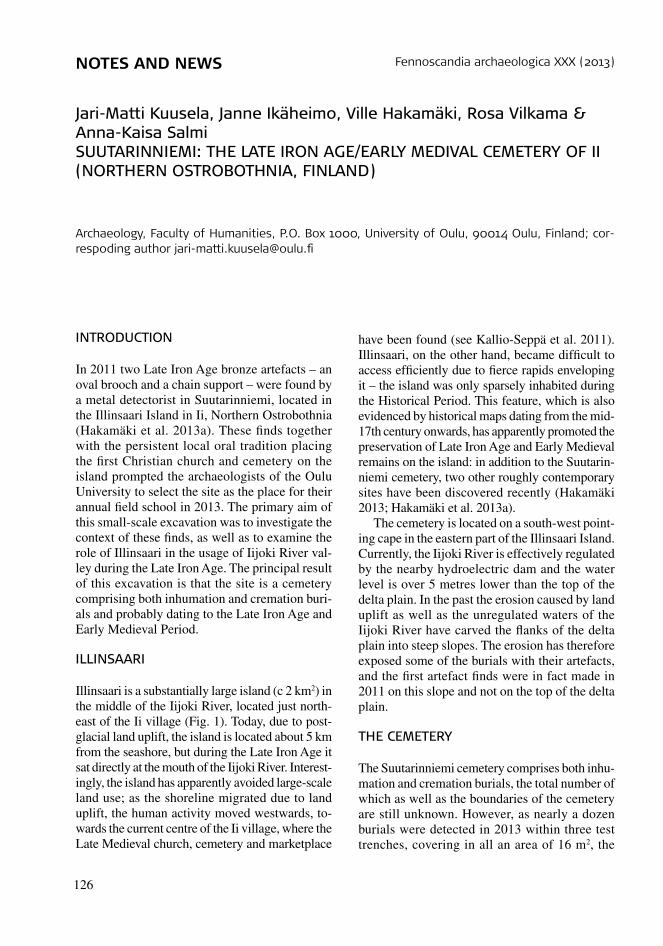
Fig. 2. Excavated areas and observed burials.
cemetery seems to be relatively extensive. In 2013 two cremation (henceforth Cremation 1 & 2) and eleven inhumation burials (henceforth Graves 1–11) were detected, and both of the former as well as fi ve of the latter (Graves 1, 2, 3, 9 & 11) were also excavated. The excavated features are discussed in more detail below.
Grave 1
The oval brooch (KM 38884: 1) found in 2011 belongs to this grave, presence of which was revealed by the discovery of several human teeth soon after the excavations had begun. It soon became evident that Grave 1 had been almost
FA_XXX.indb 127FA_XXX.indb 127 5.1.2014 20:54:595.1.2014 20:54:59
128
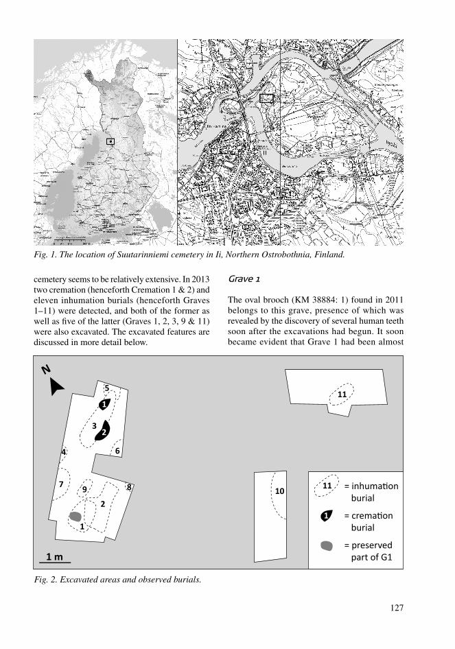
Fig. 3. Frontal bone of a large cervid in Grave 2. Photo: J. Ikäheimo.
N
25 cm
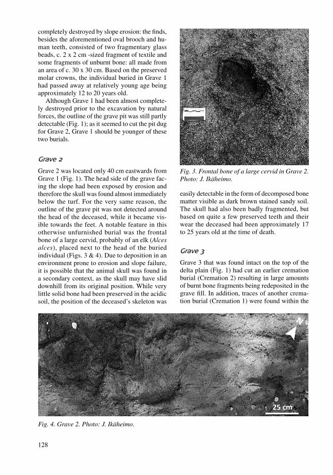
Fig. 4. Grave 2. Photo: J. Ikäheimo.
completely destroyed by slope erosion: the fi nds, besides the aforementioned oval brooch and hu-man teeth, consisted of two fragmentary glass beads, c. 2 x 2 cm -sized fragment of textile and some fragments of unburnt bone: all made from an area of c. 30 x 30 cm. Based on the preserved molar crowns, the individual buried in Grave 1 had passed away at relatively young age being approximately 12 to 20 years old.
Although Grave 1 had been almost complete-ly destroyed prior to the excavation by natural forces, the outline of the grave pit was still partly detectable (Fig. 1); as it seemed to cut the pit dug for Grave 2, Grave 1 should be younger of these two burials.
Grave 2
Grave 2 was located only 40 cm eastwards from Grave 1 (Fig. 1). The head side of the grave fac-ing the slope had been exposed by erosion and therefore the skull was found almost immediately below the turf. For the very same reason, the outline of the grave pit was not detected around the head of the deceased, while it became vis-ible towards the feet. A notable feature in this otherwise unfurnished burial was the frontal bone of a large cervid, probably of an elk (Alces alces), placed next to the head of the buried individual (Figs. 3 & 4). Due to deposition in an environment prone to erosion and slope failure, it is possible that the animal skull was found in a secondary context, as the skull may have slid downhill from its original position. While very little solid bone had been preserved in the acidic soil, the position of the deceased’s skeleton was
easily detectable in the form of decomposed bone matter visible as dark brown stained sandy soil. The skull had also been badly fragmented, but based on quite a few preserved teeth and their wear the deceased had been approximately 17 to 25 years old at the time of death.
Grave 3
Grave 3 that was found intact on the top of the delta plain (Fig. 1) had cut an earlier cremation burial (Cremation 2) resulting in large amounts of burnt bone fragments being redeposited in the grave fi ll. In addition, traces of another crema-tion burial (Cremation 1) were found within the
FA_XXX.indb 128FA_XXX.indb 128 5.1.2014 20:55:005.1.2014 20:55:00
129
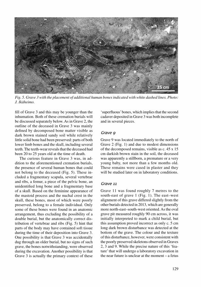
Fig. 5. Grave 3 with the placement of additional human bones indicated with white dashed lines. Photo: J. Ikäheimo.
N
25 cm
fi ll of Grave 3 and this may be younger than the inhumation. Both of these cremation burials will be discussed separately below. As in Grave 2, the outline of the deceased in Grave 3 was mainly defi ned by decomposed bone matter visible as dark brown stained sandy soil while relatively little solid bone had been preserved: parts of both lower limb bones and the skull, including several teeth. The teeth-wear reveals that the deceased had been 20 to 25 years old at the time of death.
The curious feature in Grave 3 was, in ad-dition to the aforementioned cremation burials, the presence of several human bones that could not belong to the deceased (Fig. 5). These in-cluded a fragmentary scapula, several vertebrae and ribs, a femur, a piece of the pelvic bone, an unidentifi ed long bone and a fragmentary base of a skull. Based on the feminine appearance of the mastoid process and the nuchal crest in the skull, these bones, most of which were poorly preserved, belong to a female individual. Only some of these bones were found in an anatomic arrangement, thus excluding the possibility of a double burial, but the anatomically correct dis-tribution of vertebrae and ribs (Fig. 5) hint that parts of the body may have contained soft tissue during the time of their deposition into Grave 3. One possibility is that Grave 3 was accidentally dug through an older burial, but no signs of such grave, the bones notwithstanding, were observed during the excavation. Another possibility is that Grave 3 is actually the primary context of these
‘superfl uous’ bones, which implies that the second cadaver deposited in Grave 3 was both incomplete and in several pieces.
Grave 9
Grave 9 was located immediately to the north of Grave 2 (Fig. 1) and due to modest dimensions of the decomposed remains, visible as c. 45 x 15 cm darkish brown stain in the soil, the deceased was apparently a stillborn, a premature or a very young baby, not more than a few months old. These remains were cased in plaster and they will be studied later on in laboratory conditions.
Grave 11
Grave 11 was found roughly 7 metres to the south-east of grave 1 (Fig. 1). The east–west alignment of this grave differed slightly from the other burials detected in 2013, which are generally more north-east–south-west oriented. As the oval grave pit measured roughly 90 cm across, it was initially interpreted to mark a child burial, but this assumption proved incorrect as only c. 5 cm long dark brown disturbance was detected at the bottom of the grave. The colour and the texture of this disturbance, however, were consistent with the poorly preserved skeletons observed in Graves 2, 3 and 9. While the precise nature of this ‘fea-ture’ that will undergo a laboratory excavation in the near future is unclear at the moment – a fetus
FA_XXX.indb 129FA_XXX.indb 129 5.1.2014 20:55:005.1.2014 20:55:00
130
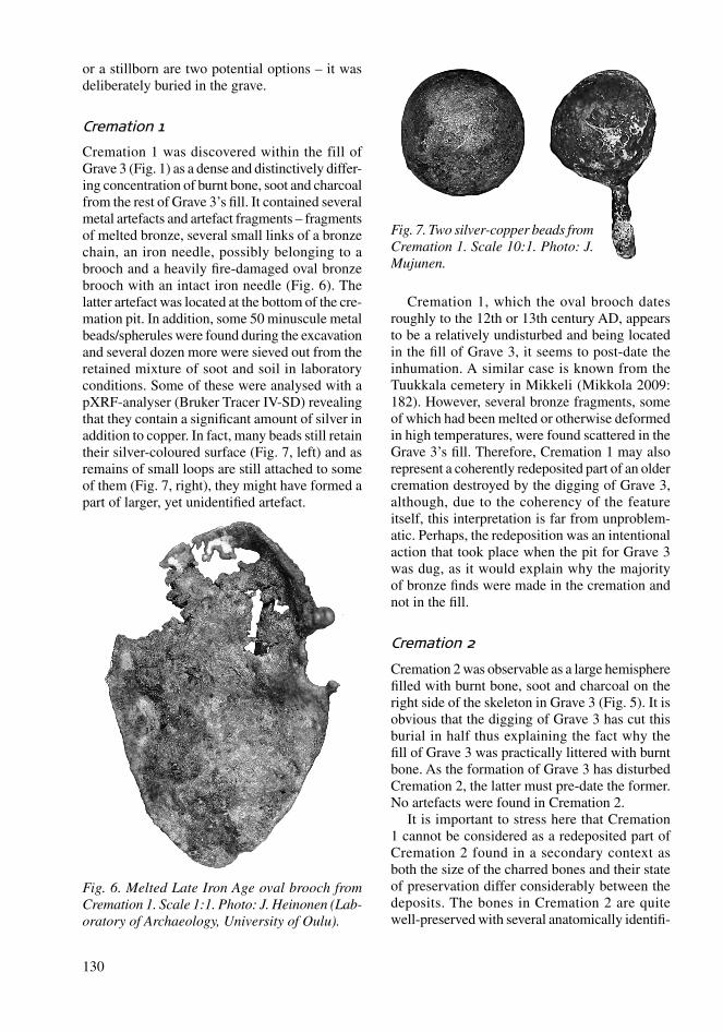
Fig. 6. Melted Late Iron Age oval brooch from Cremation 1. Scale 1:1. Photo: J. Heinonen (Lab-oratory of Archaeology, University of Oulu).
Fig. 7. Two silver-copper beads from Cremation 1. Scale 10:1. Photo: J. Mujunen.
or a stillborn are two potential options – it was deliberately buried in the grave.
Cremation 1
Cremation 1 was discovered within the fill of Grave 3 (Fig. 1) as a dense and distinctively differ-ing concentration of burnt bone, soot and charcoal from the rest of Grave 3’s fi ll. It contained several metal artefacts and artefact fragments – fragments of melted bronze, several small links of a bronze chain, an iron needle, possibly belonging to a brooch and a heavily fi re-damaged oval bronze brooch with an intact iron needle (Fig. 6). The latter artefact was located at the bottom of the cre-mation pit. In addition, some 50 minuscule metal beads/spherules were found during the excavation and several dozen more were sieved out from the retained mixture of soot and soil in laboratory conditions. Some of these were analysed with a pXRF-analyser (Bruker Tracer IV-SD) revealing that they contain a signifi cant amount of silver in addition to copper. In fact, many beads still retain their silver-coloured surface (Fig. 7, left) and as remains of small loops are still attached to some of them (Fig. 7, right), they might have formed a part of larger, yet unidentifi ed artefact.
Cremation 1, which the oval brooch dates roughly to the 12th or 13th century AD, appears to be a relatively undisturbed and being located in the fi ll of Grave 3, it seems to post-date the inhumation. A similar case is known from the Tuukkala cemetery in Mikkeli (Mikkola 2009: 182). However, several bronze fragments, some of which had been melted or otherwise deformed in high temperatures, were found scattered in the Grave 3’s fi ll. Therefore, Cremation 1 may also represent a coherently redeposited part of an older cremation destroyed by the digging of Grave 3, although, due to the coherency of the feature itself, this interpretation is far from unproblem-atic. Perhaps, the redeposition was an intentional action that took place when the pit for Grave 3 was dug, as it would explain why the majority of bronze fi nds were made in the cremation and not in the fi ll.
Cremation 2
Cremation 2 was observable as a large hemisphere fi lled with burnt bone, soot and charcoal on the right side of the skeleton in Grave 3 (Fig. 5). It is obvious that the digging of Grave 3 has cut this burial in half thus explaining the fact why the fi ll of Grave 3 was practically littered with burnt bone. As the formation of Grave 3 has disturbed Cremation 2, the latter must pre-date the former. No artefacts were found in Cremation 2.
It is important to stress here that Cremation 1 cannot be considered as a redeposited part of Cremation 2 found in a secondary context as both the size of the charred bones and their state of preservation differ considerably between the deposits. The bones in Cremation 2 are quite well-preserved with several anatomically identifi -
FA_XXX.indb 130FA_XXX.indb 130 5.1.2014 20:55:015.1.2014 20:55:01
131
= shoreline of c. AD 1100
= shoreline of c. AD 1200
= Suutarinniemi
N
200 m
Fig. 8. 12th–13th centuries AD shorelines around Illinsaari. The modern man-made isthmus linking Illinsaari to Kruunun-saari as well as deviations in elevation caused by highways have been removed. 2 m digital elevation model used in the background is © of National Land Survey of Finland.
Tolonen 2011; Kuusela 2013: 145–7; Hakamäki et al. 2013b). Therefore, Suutarinniemi fi ts well into the current picture concerning human activity in Northern Ostrobothnia during the Late Iron Age. The cemetery might also offer an explanation why burials, along with other signs of human activity, seem to ‘disappear’ from the coastal northern Finland sometime after 600 AD. In earlier times at least a part of the population was buried in cairns, thereafter below-ground level cemeteries without (surviving) above ground markings may have been preferred.
It should also be pointed out here that Suu-tarinniemi cemetery is not actually a unique site in northern Finland; the Late Iron Age/Early Medieval cemetery of Valmarinniemi in the mouth of the Kemi River – excavated in 1981, but still largely unpublished – shows a comparable co-existence of cremation and inhumation burials. The radiocarbon dated cremation burials of Val-marinniemi extend from the 11th to the 13/14th-century AD (Taavitsainen et al. 2009: 207), while coin fi nds (Jylkkä 2006: 165–6) seem to date the inhumations to the Early Medieval Period (Koi-vunen 1982; Paavola 1998: 140–2), mainly to the 14th century AD. Thus the inhumation burials seem to be younger than the cremation burials, but as no inhumations from Valmarinniemi have been radiocarbon dated some of them might be contemporary with the cremation burials.
able large fragments, whereas the bone fi nds in Cremation 1 were far more brittle and fragmented. Furthermore, no fi nds were made in Cremation 2 as opposed to the numerous metal finds in Cremation 1.
Of the large charred bone fragments in Cre-mation 2, at least three different individuals have been identifi ed in the preliminary analysis: a few months old baby, a child of no more than 8 years and over 17 year old person. Considering that all the bone fragments identifi ed to date pertain either to the fi ll of Grave 3 or to Cremation 2, these three individuals have most likely been buried together. The other alternative is that the digging of Grave 3 destroyed a third cremation burial, of which no signs, other than cremated bones, have been preserved.
PRELIMINARY INTERPRETATION
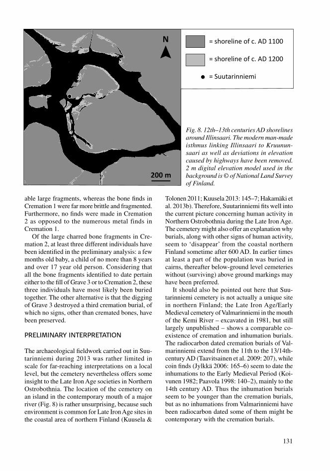
The archaeological fi eldwork carried out in Suu-tarinniemi during 2013 was rather limited in scale for far-reaching interpretations on a local level, but the cemetery nevertheless offers some insight to the Late Iron Age societies in Northern Ostrobothnia. The location of the cemetery on an island in the contemporary mouth of a major river (Fig. 8) is rather unsurprising, because such environment is common for Late Iron Age sites in the coastal area of northern Finland (Kuusela &
FA_XXX.indb 131FA_XXX.indb 131 5.1.2014 20:55:015.1.2014 20:55:01
132
Regarding the date of the burials in Suutarin-niemi cemetery, the oval brooch dates the Crema-tion 1 probably to the 12th or 13th century AD and this is also the most probable date for Grave 1 with a typologically similar oval brooch. If Cremation 1 is a primary deposition, then it is younger than Grave 3. Cremation 2, on the other hand, was damaged by the digging of Grave 3 thus making it the oldest of these three features. Hence, there seems to be no evident chronological demarcation between cremation and inhumation burials, which may have been practiced contemporaneously even in the Early Medieval Period. In any event, both the Suutarinniemi cemetery in Ii and the Valmar-inniemi cemetery in Kemi indicate that in the Late Iron Age the dead, or at least some of them, were buried in below-ground level cemeteries of which only a little or no signs have survived above ground – thus offering a plausible explanation for the apparent ‘emptiness’ of the coastal area in northern Finland during the Late Iron Age.
REFERENCES
Unpublished sourcesHakamäki, V. 2013. Ii keskustaajama-alue. Arke-
ologinen inventointi 5.–7. ja 13. elokuuta 2013. Unpublished research report. National Board of Antiquities, Helsinki.
Internet sourcesHakamäki, V., Hakonen, A., Moilanen, M. & Kuusela,
J.-M. 2013b. Pohjoissuomalainen miekkalöytö vii-den vuosikymmenen takaa. Artefactum 2. http://www.artefacta.fi /tutkimus/artefactum/2. Accessed 12 October 2013.
LiteratureHakamäki, V., Sarkkinen, M. & Kuusela, J.-M. 2013a.
Myöhäisrautakautisia ”irtolöytöjä” Pohjois-Pohjan-maalta. Muinaistutkija 1/2013: 36–42.
Jylkkä, K. 2006. Matkarahaa manalaan: Rahalöydöt Keminmaan Valmarinniemen keskiaikaisissa kirk-komaahautauksissa. Lähde: Historiatieteellinen aikakauskirja 2006: 163–75.
Kallio-Seppä, T., Ikäheimo, J. & Paavola, K. (eds.) 2011. Iin Vanhan Haminan kirkko ja hautausmaa: Arkeologisia tutkimuksia. Oulun yliopisto, Oulu.
Koivunen, P. 1982. Keminmaan kirkonpaikan tutki-mukset Valmarinniemellä kesällä 1981: Alustava raportti. Faravid 5: 37–53.
Kuusela, J.-M. 2013. Political Economy of Bronze- and Iron Age Societies in the Eastern Coast of the Bothnian Bay ca. 1500 BC–AD 1300. University of Oulu, Oulu.
Kuusela, J.-M. & Tolonen, S. 2011. A Late Iron Age site from Siikajoki, Northern Ostrobothnia, Finland. Fennoscandia archaeologica XXVIII: 79–84.
Mikkola, E. 2009. The Mikkeli Tuukkala cemetery – the 2009 excavations and new interpretations. Fennos-candia archaeologica XXVI: 177–85.
Paavola, K. 1998. Kepeät mullat: Kirjallisiin ja esineel-lisiin lähteisiin perustuva tutkimus Pohjois-Pohjan-maan rannikon kirkkohaudoista. Acta Universitas Ouluensis B Humaniora 28. Oulun yliopisto, Oulu.
Taavitsainen J.-P., Hiekkanen, M. & Oinonen, M. 2009. Keminmaan Valmarinniemen polttohautaukset. In J. Ikäheimo & S. Lipponen (eds.), Ei kiveäkään kään-tämättä: Juhlakirja Pentti Koivuselle: 203–12. Pentti Koivusen juhlakirjatoimikunta, Oulu.
FA_XXX.indb 132FA_XXX.indb 132 5.1.2014 20:55:015.1.2014 20:55:01