Stonehenge, Durrington Walls, Newgrange: Monuments to the Egyptian Bull and Cow Cults and Origins of...
49
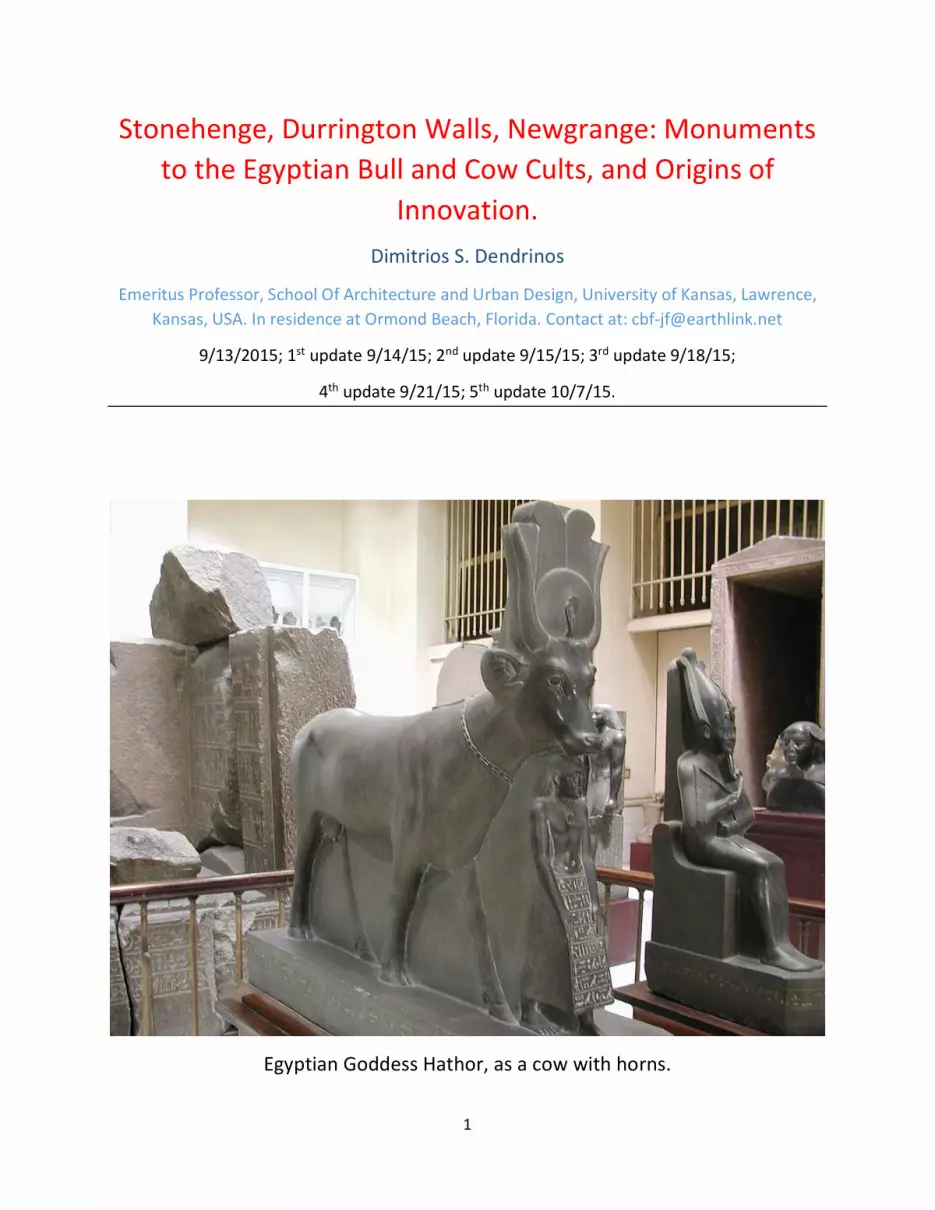
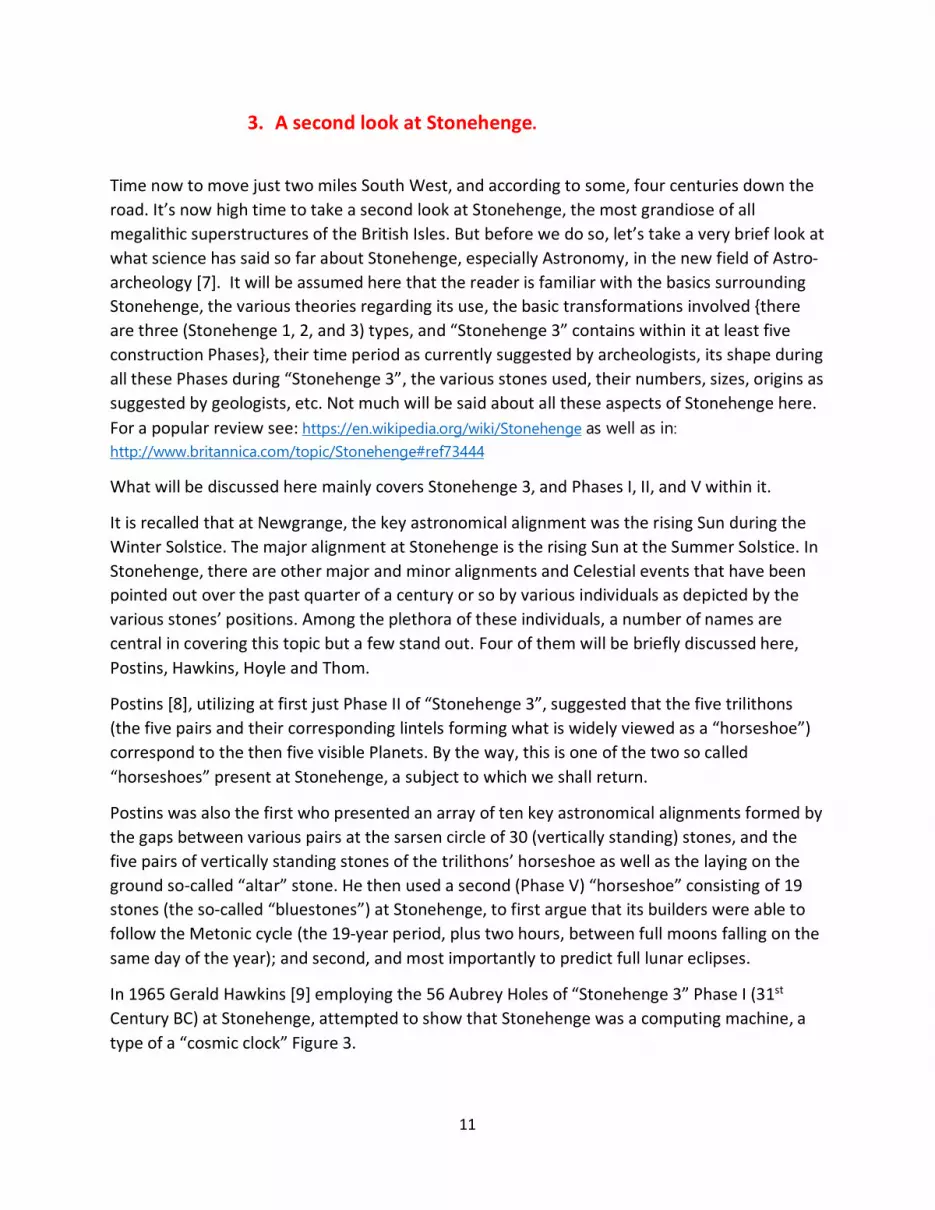
1 Stonehenge, Durrington Walls, Newgrange: Monuments to the Egyptian Bull and Cow Cults, and Origins of Innovation. Dimitrios S. Dendrinos Emeritus Professor, School Of Architecture and Urban Design, University of Kansas, Lawrence, Kansas, USA. In residence at Ormond Beach, Florida. Contact at: [email protected] 9/13/2015; 1 st update 9/14/15; 2 nd update 9/15/15; 3 rd update 9/18/15; 4 th update 9/21/15; 5 th update 10/7/15. Egyptian Goddess Hathor, as a cow with horns.
Transcript of Stonehenge, Durrington Walls, Newgrange: Monuments to the Egyptian Bull and Cow Cults and Origins of...
1
Stonehenge, Durrington Walls, Newgrange: Monuments to the Egyptian Bull and Cow Cults, and Origins of
Innovation. Dimitrios S. Dendrinos
Emeritus Professor, School Of Architecture and Urban Design, University of Kansas, Lawrence, Kansas, USA. In residence at Ormond Beach, Florida. Contact at: [email protected]
9/13/2015; 1st update 9/14/15; 2nd update 9/15/15; 3rd update 9/18/15;
4th update 9/21/15; 5th update 10/7/15.
Egyptian Goddess Hathor, as a cow with horns.
2
Brief Summary
The main purpose of this paper is to discuss the morphology of the recently brought into the public’s attention “superhenge” at Durrington Walls, as well as the real morphology of its neighbor, Stonehenge. It is shown that both henges were built following the basic morphology of a Bull Cult. In addressing the two settings, and in conjunction with the tumulus at Newgrange, it is argued that these three British Isles megastructures were the source of significant technological innovation. They played a pivotal role during the latter part of the Neolithic, in ending the “Stone Age” and delivering Humanity into a “Metals Age”. How was the Bell Beaker Culture factored into this transition is to an extent addressed in this paper.
Introduction
There are six sections to this paper. A brief discussion of these Sections follows.
Section 1 discusses the new findings at the henge referred to as “Durrington Walls” and specifically its 40-meter wide, almost C-shaped bank. Section 2 presents the arguments for recognizing in the shape of Durrington Walls’ bank the form of a bull’s horns. In this Section, the basic theoretical premise is advanced and elaborated that the Neolithic megastructures had a ground plan designed to form the main symbol of the prevailing Cult, the horns of the bull or cow deity they followed. Section 3 takes a new look into Stonehenge, after a very brief summary is supplied of the major astronomy-based theories that have been offered to date, regarding various alignments embedded in its various rings and construction Phases.
Section 4 analyzes the discerned horn’s symbol at Stonehenge, in both the trilithons’ as well as the Bluestones’ ground pattern. It is here that the key argument of the paper is found. The study pins these religious symbols to synchronous movements of cults advancing from the South East to North West alongside with waves of agriculture related production, management and technology at a speed of about 1,500 miles per millennium. This diffusion of innovation originated in the Fertile Crescent of Mesopotamia, Southern Anatolia but mainly Egypt. Agriculture related cults kept advancing onwards reaching the British Isles bringing with them agriculture and fertility related gods associated with the Bull and Cow Cults of Apis and Hathor.
In Section 5 attention returns to Durrington Walls. This “superhenge” is viewed as a part not only of a local network of monuments that includes Stonehenge and its neighboring structures, but also as a member of a powerful inter-temporal trio of monuments, including Stonehenge as well as Newgrange. It is suggested that this triple center system produced a wave of innovation which fed back on European Continental soil, creating a wave of new economic activity emanating from the British Isles that in effect transitioned Humanity from the “Stone Age” to the “Metals Age”. Within this context, the possible role played by the Bell Beaker Culture is discussed, in reference to Durrington Walls’ unprecedented and signature event, the burial of the 90+ likely sarsen stones. Woodhenge as well as Bluestonehenge are also discussed.
3
Finally, in Section 6, quite briefly, key arguments are put forward calling for a significant re-writing of the Neolithic, Chalcolithic and early Bronze Age, in view of Durrington Walls. In this re-writing, the role of the British Isles in originating significant technological and managerial innovation in agricultural production, mining and metalworking in construction is highlighted. It is argued that the role of the British Isles during the late Neolithic Era needs to be considerably upgraded. This Section also outlines the basic components of the urban and demographic infrastructure needed to achieve these innovations. In that context, a theory of city formation is put forward and elaborated.
The paper ends with Concluding Remarks as to the possible role the various groups loosely associated with the term “Bell Beaker Culture” may have played in the “Stone to Metals” transition in Human History, roughly extending over the 3200 – 2200 BC period. It is also suggested that the underlying technological developments achieved in the British Isles during the 3200 – 2600 BC period fueled if not triggered the appearance of the Egyptian megastructures of the Giza Plateau of the middle 26th Millennium BC, and the transition of a pre-dynastic Egypt to a Dynastic one. Some demographic transition hypotheses regarding changes in the population stocks of the Regions and time periods in question are also offered, as being associated with these technological and economic production related innovations.
1. Revisiting Stonehenge by way of Durrington Walls.
A recent announcement regarding a “superhenge” structure at Durrington Walls [1,2] brings renewed interest into the most widely known of all Neolithic archeological sites of the British Isles and the entire Atlantic Coast of Europe, Stonehenge. At a distance of only about two miles Northeast of Stonehenge, the Durrington Walls henge calls for revisiting its neighboring, and about four centuries younger, megalithic structure. In view of the (almost but not quite) C-shaped, maybe 90-plus megalithic sarsen stones or their remnants containing, Durrington Walls henge (a structure facing River Avon), a new visit to Stonehenge might entail some significant and novel insights.
Insights not only about Stonehenge, but about the entire range of passage tombs [3], tumuli, and henges as well as Cromlech dwellings [4], Dolmen [5], and other equivalent sites spread out over the entire Western Eurasian and North African Continents and spanning more than six Millennia (from the 7th till the 2nd Millennium BC). The henge at Durrington Walls is about to re-write Neolithic, Chalcolithic and Bronze Era History books. And this new re-consideration of History will heavily involve the role played and influences exerted by Egypt and the British Isles during the Neolithic Era and beyond.
Durrington Walls potentially offers new insights into the social and cultural milieu of the key middle 3rd Millennium BC time frame. This is the time when the so-called Bell Beaker Culture is
4
encountered in the British Isles, together with early tin and copper mining activity in Ireland. It still remains unclear as to how exactly it appeared on the scene; how was it received by the autochthonous populations; how it responded, vis-a-vis its antecedent culture(s).
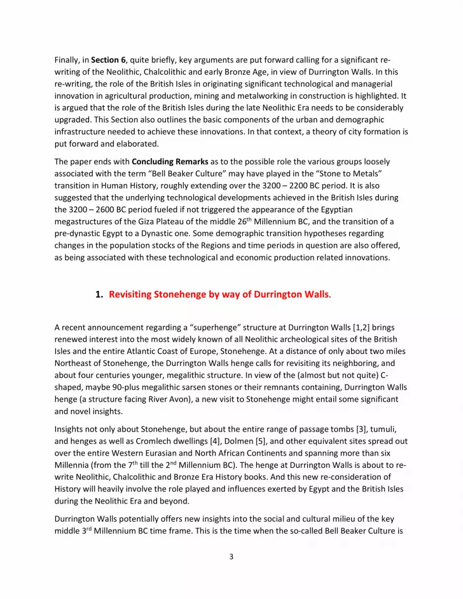
What mostly however propels this new trip to Stonehenge by way of Durrington Walls is the morphology of this “superhenge”, not so much the shape of the arc formed by the now buried megaliths, but the form of its bank. An extremely interesting henge shape punctuates the North Eastern corner of a Region dubbed the “Stonehenge Hidden Landscapes project”, by researchers at the University of Birmingham, Figure 1. Its full shape is shown in Figure 2.
Figure 1. Stonehenge and Durrington Walls, from “the Stonehenge Hidden Landscapes Project,” University of Birmingham. North is straight up.
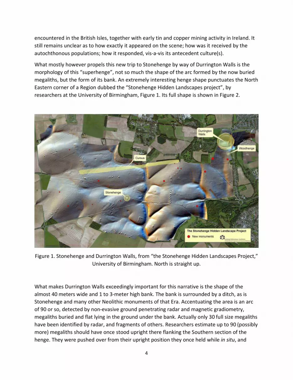
What makes Durrington Walls exceedingly important for this narrative is the shape of the almost 40 meters wide and 1 to 3-meter high bank. The bank is surrounded by a ditch, as is Stonehenge and many other Neolithic monuments of that Era. Accentuating the area is an arc of 90 or so, detected by non-evasive ground penetrating radar and magnetic gradiometry, megaliths buried and flat lying in the ground under the bank. Actually only 30 full size megaliths have been identified by radar, and fragments of others. Researchers estimate up to 90 (possibly more) megaliths should have once stood upright there flanking the Southern section of the henge. They were pushed over from their upright position they once held while in situ, and
5
were buried (at around 2500 BC) nine feet under the bank’s soil. Who exactly did this burial, and the intent behind it are still unknown.
It isn’t also known exactly when the stones were installed, thus we don’t exactly know for how long they stood upright before being toppled. Preliminary estimates put the construction of the bank at around 3100 BC. If that’ the case, then it follows that the monument was functioning for about half a millennium under some capacity or another, with or without the megaliths in situ. As mentioned, unknown is the reason why they were pushed over, and by what social or cultural group. But there are some candidates regarding the latter question, and the Bell Beakers is one of them.
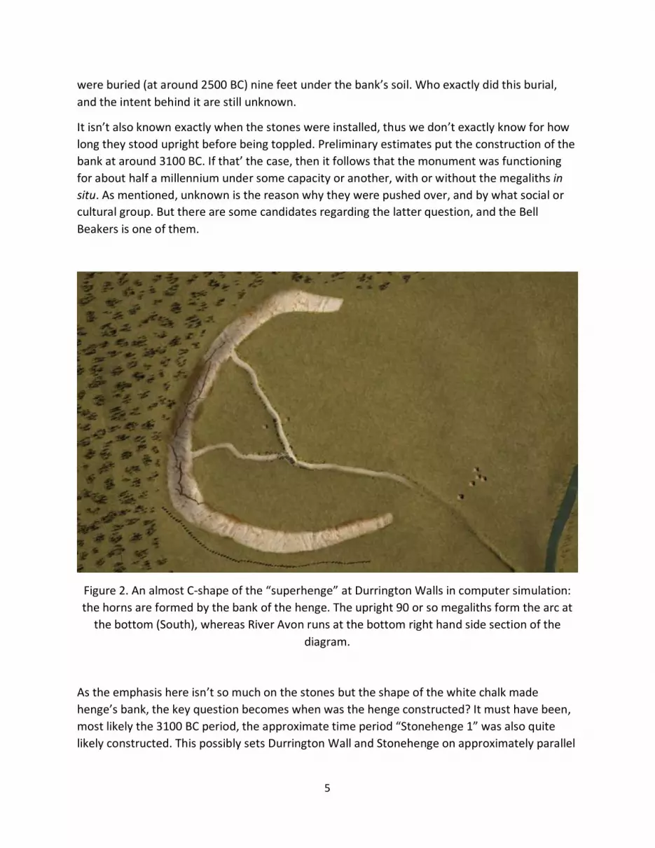
Figure 2. An almost C-shape of the “superhenge” at Durrington Walls in computer simulation: the horns are formed by the bank of the henge. The upright 90 or so megaliths form the arc at
the bottom (South), whereas River Avon runs at the bottom right hand side section of the diagram.
As the emphasis here isn’t so much on the stones but the shape of the white chalk made henge’s bank, the key question becomes when was the henge constructed? It must have been, most likely the 3100 BC period, the approximate time period “Stonehenge 1” was also quite likely constructed. This possibly sets Durrington Wall and Stonehenge on approximately parallel
6
life courses. But the key question becomes whether the 90 or so stones at Durrington Walls were put in place before or after the 75 stones of “Stonehenge 3”, Phase II (2600 to 2400 BC).
Setting aside for a moment these descriptive details, focus is now returning to the shape of the henge’s bank, a topic of major interest here. To start with, it isn’t so much the shape of how this monument’s stunning white chalk made bank looks like from the ground level, but rather from above: it has the shape of horns. A bird’s eye view makes this quite clear, in spite of the announcements in the press, that this is a C-shape (or even circular) monument.
The ground depression at this location is natural, of course, but the choice to build this henge at that particular spot was by all means not random. It was not random in reference to the specific location it occupies there by the river Avon, but also in reference to all other neighboring Neolithic monuments partially shown in Figure 1, and certainly not random in reference to Stonehenge. Durrington Walls and Stonehenge (along with also neighboring Woodhenge and another so called Bluestonehange located very close to the banks of River Avon, and possibly others) are obviously part of a local network of monuments extending over an approximately four square miles area. As we shall see in this paper, however, this must certainly be only part of the story.
They are also part of a broader network of monuments extending over the entire area of Wales and the South West part of England. It is further suggested here that this four square miles area was one of two key centers (the other being Newgrange in Ireland) of a network of monuments covering the entire setting of the British Isles and parts of Western Europe. Moreover, the suggestion is made here that this center rivaled in influence during the latter part of the Neolithic another center of power, that of Egypt. The proposition is put forward that the story of the Neolithic Era, is a story which has two major poles, one centered at the Fertile Crescent and Egypt, the other at the British Isles. They were both poles, where significant technological innovation was sparked and diffused over a considerable time span and spatial extent. This topic will be further discussed later in the paper.
2. The Bull’s Horns.
It remains to be seen exactly the extent to which the chalk bank of Durrington Walls was sculpted at the margins or in toto, and exactly when. The ditch surrounding it is entirely manmade. Although at this early stage, analysts speculate that the “superhenge” has a “diameter” of about half a kilometer, it isn’t at all sure that the henge is circular. The evidence as of today points out that it isn’t, and in fact as the computer simulation of Figure 2 shows it is far from a perfect “circle”.
As to why it’s the emphasis here on how the chalk based henge looks from above ground, it will become abundantly clear as we take another look at Stonehenge. A bird’s eye view from way
7
up reveals the real reason why some monuments were built the way they were, and what’s hidden in these bird’s eye views. These hidden from the ground but obvious from above configurations, symbols and meanings will be discussed extensively here.
Following up on a proposition advanced in a previous paper by this author, about the Kasta Tumulus near Amphipolis as well as Newgrange [6], it is suggested that architects built their structures then not so much with the intent for these structures to be seen and used by the mortals on Earth. Rather, they were built for the purview of the Heavens and of course they were conduits built by the living for the dead to reach the gods and eternity. And the dead in question were never the ordinary common folk dead; they were the dead of the ruling elite, the special dead. Thus, these edifices were put in place for the purview of those entities to which these monuments were dedicated. This proposition will attain its extreme form in the case of Egypt of the Pharaohs, and their megalithic structures.
Neolithic (and indeed all monumental Architecture down to the Roman Era), was a means used by mortals to connect to the Heavens, the gods and the spirits. To the elites of those societies in undertaking monumental construction, the driving force was in essence dual: the attainment of social control on Earth, and immortality in Heavens. Ruling elites were able to exercise social control, by implanting in their subjects the view that they were in communication with the Heavens. Monumental architecture was a durable and effective instrument to accomplish just that.
Monumental structures and their embedded ritualistic functions served as a conduit to the Supernatural, as a stairway to the Heavens and the greater forces beyond human life on Earth. Through and by their construction and uses, megastructures enable elites (either the secular Ruler or religious High Priest, in their capacity as the sole owner, beneficiary and exclusive or primary user of any superstructure) to enjoy special and extraordinary social status, and consequently exert social control over its subjects. That was accomplished by retaining and exercising monopoly power in such conduit. Inclusive in that conduit was a cult elite’s ability to use these monuments for other benefits as well, such as observe various astronomical alignments they wished from the rich menu the Heavens (the Milky Way, the Constellations, the Stars, the Sun, the Moon and the Planets) were offering them through the daily, monthly, annual and other astronomical cycles. Central among all these alignments, was the alignment the monument’s sponsoring cult deemed as the most important.
Rituals and seasonal utilization of the monuments our Neolithic ancestors built were of course for them to time human social, economic, cultural activities. But this wasn’t the main reason why they undertook astounding, at times staggering costs to enjoy earthly type benefits. By any measure, exorbitant, almost inhuman efforts were undertaken and masses were mobilized at a quite high opportunity cost. When labor was badly needed for other (even at a primitive and rudimentary level) economic activity (such as farming, mining, artisanship, trade, non-monument related construction or social services, including the formation of armies and public
8
administration) resources were expended, to a degree that surprises us even today, for the building of such megastructures.
Evidently, basic or primitive notions and principles of Economics, Business Administration and Management and Decision-making must had emerged back then. Obviously, some elementary form of workplace division of labor must had been at work, and some benefit-to-cost analysis must had been in place, to effectuate and justify such construction. No matter how undeveloped yet, given today’s standards, those societies engaged in such mega-construction economic activity must had been able to deal with and confront matters of “scale” and “diversity”. New levels in scale and diversity characterizing the megastructures of Newgrange, Durrington Walls and Stonehenge were the primary sources for innovating thinking, of this new type of work as we shall see later.
In trying to account how they computed the expected benefits to be obtained out of the incurred costs in building structures, which bring awe and astonish us today, is a formidable challenge. It requires that we possess a model that would replicate their perceived then multiple benefits and costs, their envisioned time horizons, and their perceived discount rates. Such a calculus would require us today to enter their minds and see how they perceived and evaluated tangible and intangible benefits and costs, clearly something that requires a lot of guessing on our part. But it needs to be undertaken if we really wish to understand the rationale behind these sociocultural processes which produced these monumental structures.
Noted here also is the fact that these benefits and costs (back then, as is the case today) were social group specific. Once a new social group arrives at the scene, the whole calculus changes. And it changes in a hurry, and dramatically. Megastructures themselves contain the primary evidence where such transitions are recorded, in the form of remnants from human destruction and/or upgrading and maintenance. Stonehenge and Durrington Walls are no exceptions.
Towards such a complex accounting in a benefit-cost method, we need to recognize at the outset certain fundamental assumptions built into it. In the derivation of such assumptions, a dynamic view of human structures need be taken. We need to view structures and their associated human activities in a framework which recognizes major aspects of economic and social dynamics. Such a benefit-cost method should recognize that in accounting benefits and costs, both a short and a long run view need be included.
Thus, we need to acknowledge at the very start the key motivating force and factor at work here: reaching towards the attainment of sending a message with infinite durability. Expectations these ancient social systems pegged on these superstructures, by incurring the tremendous cost of building them, was nothing less that immortality. These structures were for them to communicate with their gods on an on-going long term, permanent basis.
These monuments were a continuous offer to the gods they were dedicated, so that these gods would acknowledge their efforts and reward them accordingly. It was the social systems, through their elite sub-groups, asking in effect for on-going continuous favors. It was for these
9
societies to daily re-iterate their obedience to the gods. And they were doing it, as stated, on a continuous and permanent basis, upon the construction of these megastructures.
Periodically, these social groups may also had been paying special respects and solicit more specific divine favors. They were doing so on a repeated seasonal basis by offering sacrifices on specifically designated altars on specific days of the year. But at the end, it was primarily the permanent structure that was shown to the Heavens, not the momentary, temporal, ephemeral, seasonal, sacrifice. That would come in second, and second by a long shot. Monuments and other ritual related structures were the very long term time constants, on which periodic short term but not lasting events would be recorded.
Although primarily the basic configuration of the monuments was to convey to the Heavens a permanent, possibly “everlasting” (certainly “so hoped”, in an optimistic way, presumed by any builder) message, the specific orientation (the ground floor plan) of the monument had also a purpose. The objective behind the specific orientation of the monument relative to the Celestial Sphere was the attainment of the various alignments that have been found and argued over the past century and a half in the field of Archeology in reference to most of these monuments.
During the construction of these megalithic superstructures, many a life was no doubt spent. But this form of human sacrifice, no matter how abhorrent by today’s moral standards, must have been socially and culturally acceptable at the time. The elite group that managed the projects and mobilized the masses of surplus or slave labor for the construction of these superstructures, had the answer to any possible social resistance and discontent: It was all done to please and show love and affection to the gods. Any loss of life and temporary human suffering was done in effect for the long term benefit of the whole society, not just the elites.
So the Gods from above, the Heavens, were the primary spectators and audience of all these superstructures and the various functions humans performed in them. They were not the humans on the ground level, not even the High Priest or the Ruler and their immediate entourage. Thus, the shape that mattered was the shape shown to and seen from above – the bird’s eye view. Maybe that’s the reason why birds are venerated in many cults, rituals and religions. They share with the gods the view of human activity and habitat.
As we shall see in a bit, most of the scientific effort in “decoding” Stonehenge by astronomers, has focused on the ephemeral, albeit periodic aspects of the monument. The recording of various possible alignments and celestial events, like equinoxes, solstices, solar and lunar eclipses, planetary conjunctions and the like, has been and still apparently remains the focus. No one has spent time or effort to “decode” the very morphology or ground level floor plan of this monument, except to relegate in a nonchalant way the form of Stonehenge’s various Phases as the “horseshoe” forming trilithons and bluestones.
But the story is quite different for Stonehenge, as it is quite different for Durrington Walls, as is for Newgrange. The shape of the megalithic monument at Durrington Walls isn’t that of a circle. It is that of Bull or Cow Horns. This is the message from Durrington Walls. This is the message
10
sent through the Ages and all Areas that influenced Durrington Walls and all that space-time extent which has been influenced by Durrington Walls. And so is the message from and to Stonehenge as well. And as pointed out in [6], that was the message also from Newgrange. It’s also a message one detects at Woodhenge as well as at the Bluestonehenge also recently uncovered by M. Parker Pearson’s team right off River Avon.
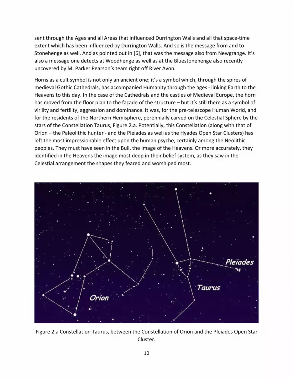
Horns as a cult symbol is not only an ancient one; it’s a symbol which, through the spires of medieval Gothic Cathedrals, has accompanied Humanity through the ages - linking Earth to the Heavens to this day. In the case of the Cathedrals and the castles of Medieval Europe, the horn has moved from the floor plan to the façade of the structure – but it’s still there as a symbol of virility and fertility, aggression and dominance. It was, for the pre-telescope Human World, and for the residents of the Northern Hemisphere, perennially carved on the Celestial Sphere by the stars of the Constellation Taurus, Figure 2.a. Potentially, this Constellation (along with that of Orion – the Paleolithic hunter - and the Pleiades as well as the Hyades Open Star Clusters) has left the most impressionable effect upon the human psyche, certainly among the Neolithic peoples. They must have seen in the Bull, the image of the Heavens. Or more accurately, they identified in the Heavens the image most deep in their belief system, as they saw in the Celestial arrangement the shapes they feared and worshiped most.
Figure 2.a Constellation Taurus, between the Constellation of Orion and the Pleiades Open Star Cluster.
11
3. A second look at Stonehenge.
Time now to move just two miles South West, and according to some, four centuries down the road. It’s now high time to take a second look at Stonehenge, the most grandiose of all megalithic superstructures of the British Isles. But before we do so, let’s take a very brief look at what science has said so far about Stonehenge, especially Astronomy, in the new field of Astro-archeology [7]. It will be assumed here that the reader is familiar with the basics surrounding Stonehenge, the various theories regarding its use, the basic transformations involved {there are three (Stonehenge 1, 2, and 3) types, and “Stonehenge 3” contains within it at least five construction Phases}, their time period as currently suggested by archeologists, its shape during all these Phases during “Stonehenge 3”, the various stones used, their numbers, sizes, origins as suggested by geologists, etc. Not much will be said about all these aspects of Stonehenge here. For a popular review see: https://en.wikipedia.org/wiki/Stonehenge as well as in: http://www.britannica.com/topic/Stonehenge#ref73444
What will be discussed here mainly covers Stonehenge 3, and Phases I, II, and V within it.
It is recalled that at Newgrange, the key astronomical alignment was the rising Sun during the Winter Solstice. The major alignment at Stonehenge is the rising Sun at the Summer Solstice. In Stonehenge, there are other major and minor alignments and Celestial events that have been pointed out over the past quarter of a century or so by various individuals as depicted by the various stones’ positions. Among the plethora of these individuals, a number of names are central in covering this topic but a few stand out. Four of them will be briefly discussed here, Postins, Hawkins, Hoyle and Thom.
Postins [8], utilizing at first just Phase II of “Stonehenge 3”, suggested that the five trilithons (the five pairs and their corresponding lintels forming what is widely viewed as a “horseshoe”) correspond to the then five visible Planets. By the way, this is one of the two so called “horseshoes” present at Stonehenge, a subject to which we shall return.
Postins was also the first who presented an array of ten key astronomical alignments formed by the gaps between various pairs at the sarsen circle of 30 (vertically standing) stones, and the five pairs of vertically standing stones of the trilithons’ horseshoe as well as the laying on the ground so-called “altar” stone. He then used a second (Phase V) “horseshoe” consisting of 19 stones (the so-called “bluestones”) at Stonehenge, to first argue that its builders were able to follow the Metonic cycle (the 19-year period, plus two hours, between full moons falling on the same day of the year); and second, and most importantly to predict full lunar eclipses.
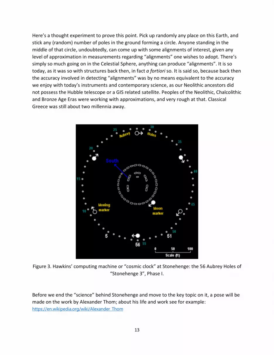
In 1965 Gerald Hawkins [9] employing the 56 Aubrey Holes of “Stonehenge 3” Phase I (31st Century BC) at Stonehenge, attempted to show that Stonehenge was a computing machine, a type of a “cosmic clock” Figure 3.
12
He suggested that the number 56 was chosen because it represents three times the number of years between two full lunar eclipses, 18.61 (so that 3x18.61=55.83 or 56 as the closest integer). Hawkins devised a clock-like mechanism, whereby by placing six alternate black and white markers at intervals 9, 9, 10, 9, 9, 10 along the perimeter’s 56 holes, and moving them one step (hole) per year he proposed that major events can be predicted, in conjunction with another movement involving a seventh movable marker. Thus, as this was the “slow” moving “hand” of that “cosmic clock” he proposed also another movement. Along the inner 30-stone sarsen circle, he put a Moon marker. That mobile marker would move one step (stone) per day (supposedly picking up the 29.53 day lunar cycle). This was the “fast” moving “hand” of this “cosmic clock”. According to Hawkins, major celestial events, including full Moons and lunar eclipses would fall when a white marker hits one of the fixed markers 5, 51 or 56 depending on the position of the Moon marker.
One clearly understands that this is a rather inaccurate calendar of course; and moreover, one has serious doubts whether the 56 Aubrey Holes were really dug in 3100 BC in anticipation of a Phase II to arrive about six centuries later (about 2500 BC, as Phase II is estimated to have commenced in around 2600 BC and ended in approximately 2400 BC) and a Phase V to materialize (a Phase which commenced in the late 20th Century BC lasting till about the end of the 17th Century BC). To assume that the 25th Century BC architect simply made use of the 56 Aubrey Holes, just because they were there, is rather difficult to accept. It is so, basically because if that were their real level of mathematical and astronomical sophistication in 3200 BC, one must assume that it would have had significantly improved by 2500 BC (and a fortiori by the 17th Century BC), rendering the Aubrey Holes either irrelevant or subject to transformation.
Following Hawkins, a fellow astronomer, Fred Hoyle, took another swipe at Stonehenge, trying to outdo Hawkins. And he did, by only using three moving markers, along the Aubrey Circle, representing the actual movement of the Sun, the Moon, and the mode of the Moon’s orbit. As a result, the monument became an analogue computer, with significant descriptive power, but little predictive one. Hoyle is said to have remarked that the architect of Phase I “Stonehenge 3” was more mathematically and astronomically sophisticated than the 22nd Century BC builder, although acknowledging that the architect of Phase II conveyed and implanted in Stonehenge more aesthetic quality.
No doubt, some of the mathematical and astronomical sophistication we now attribute to Stonehenge does accurately correspond to the mathematical, astronomical, engineering, design etc., knowledge base of those “educated” among them individuals of that Era. But not all, and certainly not exactly as we possess that knowledge today. What we discover today, as characterizing certain aspects of their buildings and other structures, may not have been intentionally embedded in them back then by their creators. Intent, in absence of written documentation, is always difficult if not impossible to establish.
13
Here’s a thought experiment to prove this point. Pick up randomly any place on this Earth, and stick any (random) number of poles in the ground forming a circle. Anyone standing in the middle of that circle, undoubtedly, can come up with some alignments of interest, given any level of approximation in measurements regarding “alignments” one wishes to adopt. There’s simply so much going on in the Celestial Sphere, anything can produce “alignments”. It is so today, as it was so with structures back then, in fact a fortiori so. It is said so, because back then the accuracy involved in detecting “alignments” was by no means equivalent to the accuracy we enjoy with today’s instruments and contemporary science, as our Neolithic ancestors did not possess the Hubble telescope or a GIS related satellite. Peoples of the Neolithic, Chalcolithic and Bronze Age Eras were working with approximations, and very rough at that. Classical Greece was still about two millennia away.
Figure 3. Hawkins’ computing machine or “cosmic clock” at Stonehenge: the 56 Aubrey Holes of “Stonehenge 3”, Phase I.
Before we end the “science” behind Stonehenge and move to the key topic on it, a pose will be made on the work by Alexander Thom; about his life and work see for example: https://en.wikipedia.org/wiki/Alexander_Thom
14
Thom’s contributions were not so much associated with either Stonehenge or Dunnrington Walls, or Newgrange. Thom [10] having worked on a great number of megalithic structures in England, Scotland and France, he came to the statistically derived conclusion that the architects and engineers and stone craftsmen of the megalithic period most likely used two standard units of measurement: what he called the “megalithic fathom” and the “megalithic yard”. The “fathom”, Thom estimated to be about 1.6 meters, whereas the “yard” he estimated to be about .83 meters.
To this author, these two measures are of some importance. In a study undertaken by this author [11], regarding the modular structure of the tomb at Kasta Hill (as revealed on the marble clad of its interior and exterior walls) two key measurements of the three-dimensional module embedded in that monument were found to be 1.36 meters and .72 meters. The close proximity of the two sets of measures is noted, especially their ratios (1.6/1.36=1.1765, and .83/.72=1.153). They are both slightly smaller than the Thom measures by a rather similar ratio. Is this pure coincidence? Or is it that some measures were passed on among masons from back then through the Centuries and Millennia from Stonehenge down to the Classical Greece architects and engineers and stone workers, gradually adjusting over the Millennia towards a (smaller than monumental) human scale?
Thom’s work is interesting from another angle as well. In spite of his rigorous and insightful contributions, acknowledged by his professional association, the Royal Statistical Society, the archeological establishment shunned him. It’s not of course surprising; the medieval parochial notion of “guild” is still pretty much with us today, and it goes far beyond Archeology. Archeologists need to recognize that in this modern era, their subjects do not fall and they can’t be kept under their monopoly status. They can no longer keep them under their exclusive domain.
A final point about the Bluestones of Stonehenge. We shall see the import of the Bluestones later in the text, after we discuss more extensively Durrington Walls. A point of interest is that the Bluestones of Stonehenge’s inner circle and second inner most Bull Horn came from apparently two sites, one is the Aubrey Holes and another is from a recently discovered “Bluestonehenge” just off the banks of River Avon. This recent discovery is presented here: https://www.youtube.com/watch?v=8LGczCvCCu0&app=desktop
Along with the recent also discovery of the buried 90+ sarsen stones at Durrington Walls, a new picture emerges, written at the chalk grounds of Salisbury Plain. It paints a picture of numerous henges co-existing at a relatively small chunk of space, a high density of henges in both space and time. This form of a network of monumental sites paints a new picture about the end of the Neolithic Era, and possibly offers hints as to what brought it about. It is this new vista into the latter part of the Neolithic that calls out attention here.
15
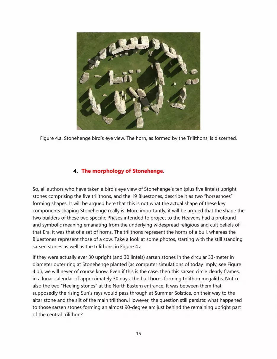
Figure 4.a. Stonehenge bird’s eye view. The horn, as formed by the Trilithons, is discerned.
4. The morphology of Stonehenge.
So, all authors who have taken a bird’s eye view of Stonehenge’s ten (plus five lintels) upright stones comprising the five trilithons, and the 19 Bluestones, describe it as two “horseshoes” forming shapes. It will be argued here that this is not what the actual shape of these key components shaping Stonehenge really is. More importantly, it will be argued that the shape the two builders of these two specific Phases intended to project to the Heavens had a profound and symbolic meaning emanating from the underlying widespread religious and cult beliefs of that Era: it was that of a set of horns. The trilithons represent the horns of a bull, whereas the Bluestones represent those of a cow. Take a look at some photos, starting with the still standing sarsen stones as well as the trilithons in Figure 4.a.
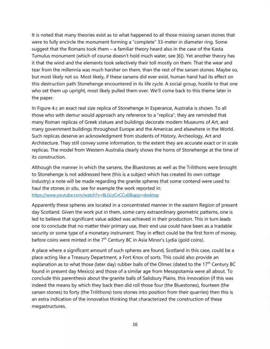
If they were actually ever 30 upright (and 30 lintels) sarsen stones in the circular 33-meter in diameter outer ring at Stonehenge planted (as computer simulations of today imply, see Figure 4.b.), we will never of course know. Even if this is the case, then this sarsen circle clearly frames, in a lunar calendar of approximately 30 days, the bull horns forming trilithon megaliths. Notice also the two “Heeling stones” at the North Eastern entrance. It was between them that supposedly the rising Sun’s rays would pass through at Summer Solstice, on their way to the altar stone and the slit of the main trilithon. However, the question still persists: what happened to those sarsen stones forming an almost 90-degree arc just behind the remaining upright part of the central trilithon?
16
It is noted that many theories exist as to what happened to all those missing sarsen stones that were to fully encircle the monument forming a “complete” 33-meter in diameter ring. Some suggest that the Romans took them – a familiar theory heard also in the case of the Kasta Tumulus monument (which of course doesn’t hold much water, see [6]). Yet another theory has it that the wind and the elements took selectively their toll mostly on them. That the wear and tear from the millennia was much harsher on them, than the rest of the sarsen stones. Maybe so, but most likely not so. Most likely, if these sarsens did ever exist, human hand had its effect on this destruction path Stonehenge encountered in its life cycle. A social group, hostile to that one who set them up upright, most likely pulled them over. We’ll come back to this theme later in the paper.
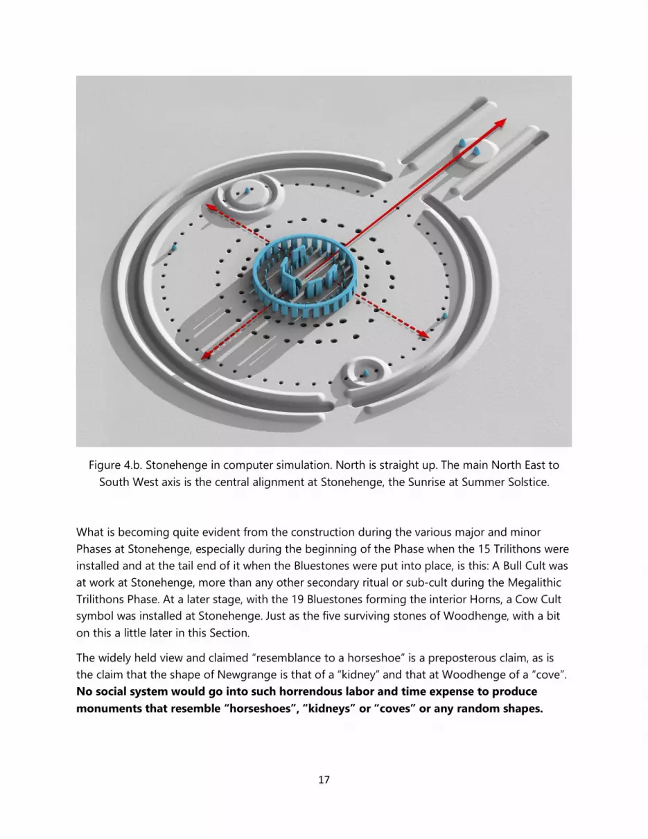
In Figure 4.c an exact real size replica of Stonehenge in Esperance, Australia is shown. To all those who with demur would approach any reference to a “replica”, they are reminded that many Roman replicas of Greek statues and buildings decorate modern Museums of Art, and many government buildings throughout Europe and the Americas and elsewhere in the World. Such replicas deserve an acknowledgment from students of History, Archeology, Art and Architecture. They still convey some information, to the extent they are accurate exact or in scale replicas. The model from Western Australia clearly shows the horns of Stonehenge at the time of its construction.
Although the manner in which the sarsens, the Bluestones as well as the Trilithons were brought to Stonehenge is not addressed here (this is a subject which has created its own cottage industry) a note will be made regarding the granite spheres that some contend were used to haul the stones in situ, see for example the work reported in: https://www.youtube.com/watch?v=8LGczCvCCu0&app=desktop
Apparently these spheres are located in a concentrated manner in the eastern Region of present day Scotland. Given the work put in them, some carry extraordinary geometric patterns, one is led to believe that significant value added was achieved in their production. This in turn leads one to conclude that no matter their primary use, their end use could have been as a tradable security or some type of a monetary instrument. They in effect could be the first form of money, before coins were minted in the 7th Century BC in Asia Minor’s Lydia (gold coins).
A place where a significant amount of such spheres are found, Scotland in this case, could be a place acting like a Treasury Department, a Fort Knox of sorts. This could also provide an explanation as to what those (later day) rubber balls of the Olmec (dated to the 17th Century BC found in present day Mexico) and those of a similar age from Mesopotamia were all about. To conclude this parenthesis about the granite balls of Salisbury Plains, this innovation {if this was indeed the means by which they back then did roll those four (the Bluestones), fourteen (the sarsen stones) to forty (the Trilithons) tons stones into position from their quarries} then this is an extra indication of the innovative thinking that characterized the construction of these megastructures.
17
Figure 4.b. Stonehenge in computer simulation. North is straight up. The main North East to South West axis is the central alignment at Stonehenge, the Sunrise at Summer Solstice.
What is becoming quite evident from the construction during the various major and minor Phases at Stonehenge, especially during the beginning of the Phase when the 15 Trilithons were installed and at the tail end of it when the Bluestones were put into place, is this: A Bull Cult was at work at Stonehenge, more than any other secondary ritual or sub-cult during the Megalithic Trilithons Phase. At a later stage, with the 19 Bluestones forming the interior Horns, a Cow Cult symbol was installed at Stonehenge. Just as the five surviving stones of Woodhenge, with a bit on this a little later in this Section.
The widely held view and claimed “resemblance to a horseshoe” is a preposterous claim, as is the claim that the shape of Newgrange is that of a “kidney” and that at Woodhenge of a “cove”. No social system would go into such horrendous labor and time expense to produce monuments that resemble “horseshoes”, “kidneys” or “coves” or any random shapes.
18
Figure 4.c. A real size replica of “Stonehenge 3” in Esperance, Australia. It shows the exact size and location of the Bull Horns resembling 15 trilithons of Phase II, and the enclosed Cow Horns
resembling 19 Bluestones of Phase V (beginning of the 22nd Century BC).
What were the shapes chosen by the builders of monuments to create, and be seen by the Heavens, must have been deeply held symbols of religious and overall cultural (economic, social and political) meaning. The Neolithic period as well as the Chalcolithic and Bronze Eras of Humanity’s History were then dominated by the Egyptian (indeed Mesopotamian and Mediterranean basin originated) Bull Cult of Apis, and that of the Cow Cult of Hathor [12]. Evidence shows that Apis, as a Bull Deity, was worshiped from the very beginning of the 3rd Millennium BC, certainly by the time of Nebra’s reign, if not much earlier.
At Stonehenge, the builder of “Stonehenge 3”, Phase II and V took a henge monument, possibly weakly linked to the Bull Cult, and firmly implanted the Bull Cult first (the part of the monument recognized today as “Stonehenge”, the signature section of England’s iconic monument), and then another architect (under possibly another cult) proceeded to implant the Cow Cult in it.
This Cow Cult must have been associated with a goddess of fertility, and the Cow Cult of Egypt. In fact, this is goddess Hathor. Worshiping of Hathor [13] is dominant during the middle of the 3rd Millennium BC. Hathor, Figure 5, the mother goddess is associated with the Milky Way, the River in the Heavens that the ancient Egyptians associated with the Nile. The major actor of the
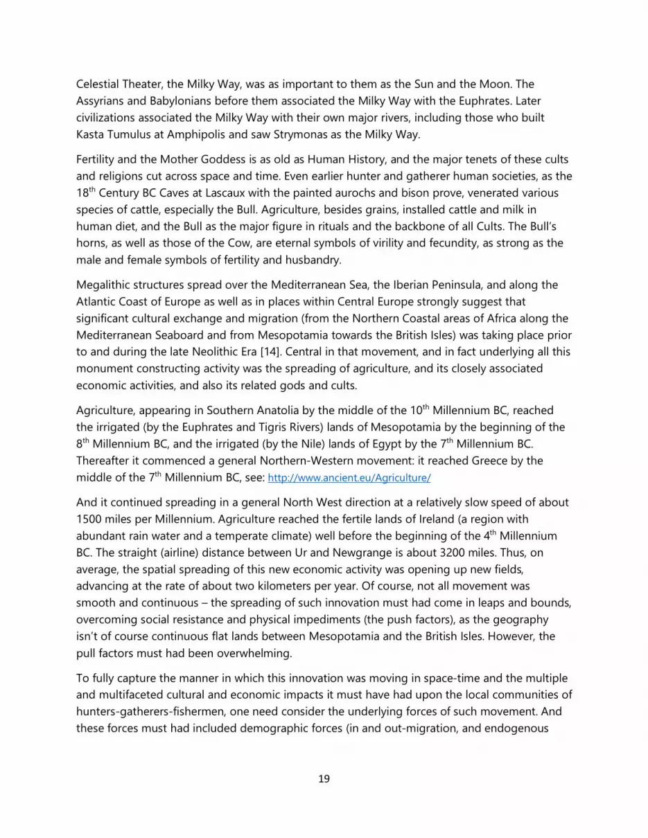
19
Celestial Theater, the Milky Way, was as important to them as the Sun and the Moon. The Assyrians and Babylonians before them associated the Milky Way with the Euphrates. Later civilizations associated the Milky Way with their own major rivers, including those who built Kasta Tumulus at Amphipolis and saw Strymonas as the Milky Way.
Fertility and the Mother Goddess is as old as Human History, and the major tenets of these cults and religions cut across space and time. Even earlier hunter and gatherer human societies, as the 18th Century BC Caves at Lascaux with the painted aurochs and bison prove, venerated various species of cattle, especially the Bull. Agriculture, besides grains, installed cattle and milk in human diet, and the Bull as the major figure in rituals and the backbone of all Cults. The Bull’s horns, as well as those of the Cow, are eternal symbols of virility and fecundity, as strong as the male and female symbols of fertility and husbandry.
Megalithic structures spread over the Mediterranean Sea, the Iberian Peninsula, and along the Atlantic Coast of Europe as well as in places within Central Europe strongly suggest that significant cultural exchange and migration (from the Northern Coastal areas of Africa along the Mediterranean Seaboard and from Mesopotamia towards the British Isles) was taking place prior to and during the late Neolithic Era [14]. Central in that movement, and in fact underlying all this monument constructing activity was the spreading of agriculture, and its closely associated economic activities, and also its related gods and cults.
Agriculture, appearing in Southern Anatolia by the middle of the 10th Millennium BC, reached the irrigated (by the Euphrates and Tigris Rivers) lands of Mesopotamia by the beginning of the 8th Millennium BC, and the irrigated (by the Nile) lands of Egypt by the 7th Millennium BC. Thereafter it commenced a general Northern-Western movement: it reached Greece by the middle of the 7th Millennium BC, see: http://www.ancient.eu/Agriculture/
And it continued spreading in a general North West direction at a relatively slow speed of about 1500 miles per Millennium. Agriculture reached the fertile lands of Ireland (a region with abundant rain water and a temperate climate) well before the beginning of the 4th Millennium BC. The straight (airline) distance between Ur and Newgrange is about 3200 miles. Thus, on average, the spatial spreading of this new economic activity was opening up new fields, advancing at the rate of about two kilometers per year. Of course, not all movement was smooth and continuous – the spreading of such innovation must had come in leaps and bounds, overcoming social resistance and physical impediments (the push factors), as the geography isn’t of course continuous flat lands between Mesopotamia and the British Isles. However, the pull factors must had been overwhelming.
To fully capture the manner in which this innovation was moving in space-time and the multiple and multifaceted cultural and economic impacts it must have had upon the local communities of hunters-gatherers-fishermen, one need consider the underlying forces of such movement. And these forces must had included demographic forces (in and out-migration, and endogenous
20
population growth) as well as social and cultural forces. As the new economic activity advanced, so must had diffused not only technological innovation but also migration of labor.
Specifically, what must be considered in that spreading of the new economic activity in space-time are the fundamental underlying factors, these being economic profit and an improvement in the quality of life of the adopters and invaders combined. Economic activity moves in space-time because it is more profitable than staying put. And so is the motivating factor behind human mobility, as the expected utility to be enjoyed (over some time horizon) as a result of out-migrating must had exceeded that of staying. Profitability of course depends not only on the land’s fertility, but also on the overall environmental conditions rendering the new lands more suitable than the old lands for specific crops and livestock. All this reasoning is the basic tenets of the field of Economic Geography, see for example and as a summary the work by the author [20]. As technological innovation and new economic activity moved, along with people and trade, so were religious beliefs and cults.
As agriculture was spreading North and West from the Fertile Crescent, so were the gods associated with it, the Bull and Cow Cults. Strains of cereal grains from Mesopotamia are found being cultivated in Ireland of the Newgrange era [15]. The Bull horns of Apis and later Osiris are also found imprinted on Newgrange [6].
Movement of human populations from the Fertile Crescent (which extends from Mesopotamia, to South East Anatolia into Upper Egypt) towards Western and Northern Europe took two major routes. One was the continental spread through Asia Minor and Central Europe; the other was the flow by way of the Mediterranean Sea. The latter flow was apparently far more culturally rich than the former migration movement. It carried with it the Bull Cult of Mesopotamia and Egypt. The spatio-temporal spreading of agriculture and its deities through Central Europe is not yet as clear. It still awaits documentation.
In addition to the archeological, DNA evidence also points to these dual migration routes, during the late, third period or “pottery rich” Neolithic. See for example that by Cavalli-Sforza [16]. Whether the lactose tolerant newly arrived migrants became also the land based and trade involved social elites that subjugated and enslaved the autochthonous hunters-gatherers-fishermen and built those megalithic structures has yet to be fully documented.
What the archeological record seems to show is that the megalithic tradition was preceded by a tradition of building megastructures from timber. Woodhenge (see for example: http://www.stone-circles.org.uk/stone/durringtonwalls.htm ) as well as pre-stone Stonehenge and pre-stone Durrington walls seems to suggest that mega-wooden structures not only set the stage for the megalithic structures which followed, but in certain instances the mega-wooden structures themselves were directly supplanted by the megalithic superstructures. Whether a previous timber-based cult was also supplanted by a later stone-based cult is not entirely clear. What is clear is that this supplanting took a special form in the case of both Stonehenge and Durrington Walls. And, although relatively large in scale wooden structures are found elsewhere
21
in Europe, Asia and Africa during the late Neolithic, these structures are especially huge in the British Isles.
A further note on Woodhenge is due here, in reference to a comment made earlier. Besides this monument being a combination of timber and stone construction (alluding to a symbolic transition from life, represented by wood, to death, i.e., permanent afterlife, represented by stone – a comment which will be significantly expanded later), the shape of the five surviving stones form a “cove” (according to the formal pronouncements by archeologists). It is of course nothing else but another manifestation of a Bull Cult’s horns shape drawn on the ground by Woodhenge’s builders, as it was that shape formed by the inner most Bluestones and the Trilithons at Stonehenge.
The metaphysical view, that stone was representing death while wood stood for life at Woodhenge, might be interesting but not very likely. A more likely view, albeit quite mundane, is simply that stone was found to be more solid as foundation than wood buried in the humid ground there. Besides, if the view that stone stood for death was the prevailing metaphysical and symbolic viewpoint held by the builders of these megalithic monuments, then the emerging with the Bronze Age wider use of stone in construction would carry with it a profoundly pessimistic message. The spirit of optimism, reflected in the use of masonry in construction, projecting a message of permanency by the architects and engineers of these structures, stands in sharp contrast to this pessimistic view.
Wooden megastructures were the product of stone tools. But the masonry of Stonehenge and Durrington Walls (the buried sarsen stones) must have been the product of metalwork, as was possibly the spiral signs on the Kerbstones at Newgrange. This could be the first incidence of the use of metals (copper based) in construction. Metal tools to stone tools substitution was the key transition at the end of the 4th Millennium BC. The labor intensive stone tool manufacturing and usage processes were succeeded by the time saving, labor skills enhancing metal work. It has been established that copper tools were used to cut the stones used for Khufu’s pyramid at the Giza Plateau, of the middle 26th Century BC. In that, copper based stone carving at both Durrington Walls (possibly – with their excavation as pending evidence to confirm it) and Stonehenge (very likely) must had preceded Khufu. On both counts, the sizes of the stones and their exact shape, conditions of these stones (sarsen, trilithons, and bluestones) demand that we make this supposition.
It is now evident that the Chalcolithic transition (the time period when the Neolithic and the Bronze Age overlap) was a key event in the Evolutionary path of Humanity’s History. It was a turbulent and culturally active period, when and where the megalithic structures of the British Isles appeared, and supplanted prior wooden superstructures. Construction of these megalithic structures was closely followed by the arrival of some form of the Bell Beaker Culture(s) on British Isles soil. One might suggest that the Bell Beakers were hostile to the essence of the Bull Cult, and were the agents of the initial destruction we observe in them, both at Stonehenge and
22
Durrington Walls. It was the moment and place in History where the pottery makers met the copper miners and workers of megalithic superstructures.
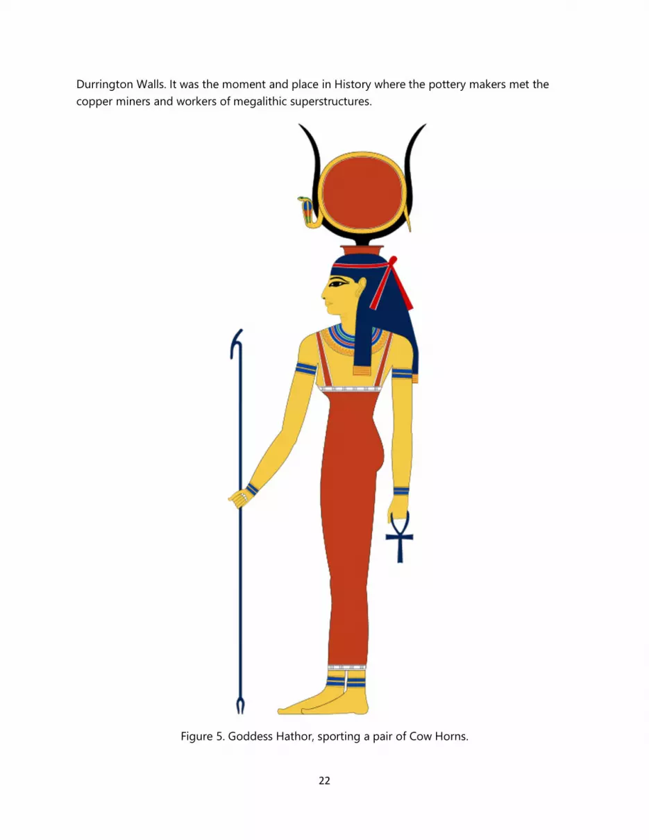
Figure 5. Goddess Hathor, sporting a pair of Cow Horns.
23
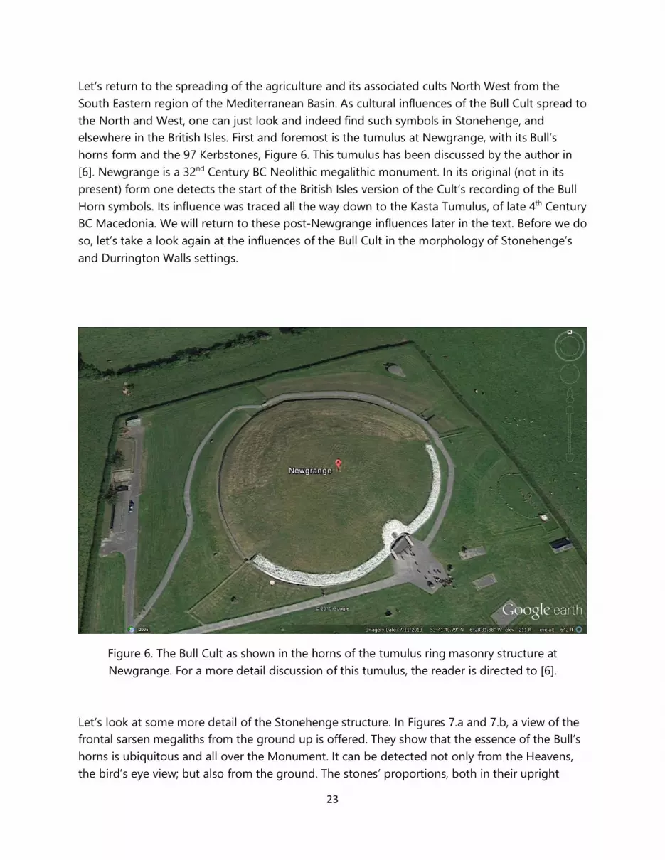
Let’s return to the spreading of the agriculture and its associated cults North West from the South Eastern region of the Mediterranean Basin. As cultural influences of the Bull Cult spread to the North and West, one can just look and indeed find such symbols in Stonehenge, and elsewhere in the British Isles. First and foremost is the tumulus at Newgrange, with its Bull’s horns form and the 97 Kerbstones, Figure 6. This tumulus has been discussed by the author in [6]. Newgrange is a 32nd Century BC Neolithic megalithic monument. In its original (not in its present) form one detects the start of the British Isles version of the Cult’s recording of the Bull Horn symbols. Its influence was traced all the way down to the Kasta Tumulus, of late 4th Century BC Macedonia. We will return to these post-Newgrange influences later in the text. Before we do so, let’s take a look again at the influences of the Bull Cult in the morphology of Stonehenge’s and Durrington Walls settings.
Figure 6. The Bull Cult as shown in the horns of the tumulus ring masonry structure at Newgrange. For a more detail discussion of this tumulus, the reader is directed to [6].
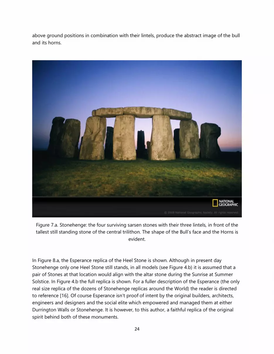
Let’s look at some more detail of the Stonehenge structure. In Figures 7.a and 7.b, a view of the frontal sarsen megaliths from the ground up is offered. They show that the essence of the Bull’s horns is ubiquitous and all over the Monument. It can be detected not only from the Heavens, the bird’s eye view; but also from the ground. The stones’ proportions, both in their upright
24
above ground positions in combination with their lintels, produce the abstract image of the bull and its horns.
Figure 7.a. Stonehenge: the four surviving sarsen stones with their three lintels, in front of the tallest still standing stone of the central trilithon. The shape of the Bull’s face and the Horns is
evident.
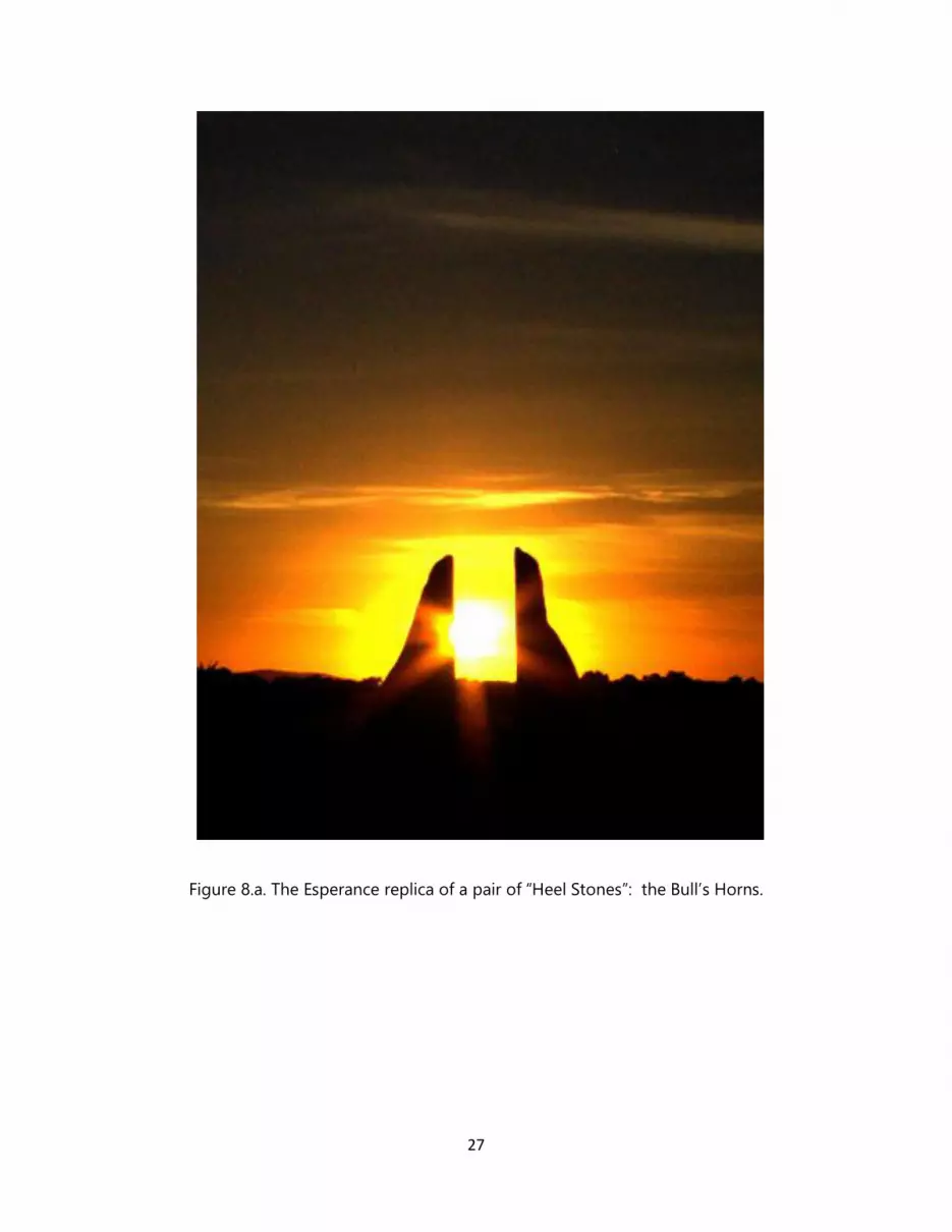
In Figure 8.a, the Esperance replica of the Heel Stone is shown. Although in present day Stonehenge only one Heel Stone still stands, in all models (see Figure 4.b) it is assumed that a pair of Stones at that location would align with the altar stone during the Sunrise at Summer Solstice. In Figure 4.b the full replica is shown. For a fuller description of the Esperance (the only real size replica of the dozens of Stonehenge replicas around the World) the reader is directed to reference [16]. Of course Esperance isn’t proof of intent by the original builders, architects, engineers and designers and the social elite which empowered and managed them at either Durrington Walls or Stonehenge. It is however, to this author, a faithful replica of the original spirit behind both of these monuments.
25
5. The Return to Durrington Walls by way of Stonehenge.
We now return to Durrington Wall’s recent find the Neolithic “superhenge” just announced by archeologists as containing underground up to about 90 megaliths. According to the published reports, Durrington Walls is a “half a kilometer in diameter” henge with a ditch, a 40-meter thick bank, along a one to three-meter high wall. It is quite evident that this description is quite loose, as even casual visual inspection shows that the henge is not circular, in fact far from it. As it was pointed out already, the bank has the morphology of horns. Durrington Walls’ monument was built and belongs to the Bull Cult, the Cult that Stonehenge belongs as well.
In [6] the link was also drawn between the Bull Cult and the late 4th Century BC Kasta Tumulus, the Macedonian monument at Amphipolis. It was argued that this cult had tentacles that reached far into space and time. In addition it was argued that a strong link existed between the Macedonian adaptation of the Bull Cult, and its exterior morphology. Moreover, the monument was tied to the Winter solstice, a la Newgrange, the Hyades Open Star cluster and the Constellation Taurus.
Apparently the so-called “Bull Cult” phenomenon was a general, all-encompassing term, something like the term “Christianity” or “Islam” today, given all their denominations, orders and sects. It was an umbrella term, where many local folklore, customs, location-specific beliefs transformed it to adjust to local circumstances and conditions, creating a locational and temporal specific body of religious beliefs and socio-cultural taboos and mores. As agricultural production differentiated and evolved so did its associated gods. In the case of Kasta Tumulus and its magnificent tomb, for example, this Cult was more specifically linked to the local Dionysus, wine attached, sub-cult [6].
26
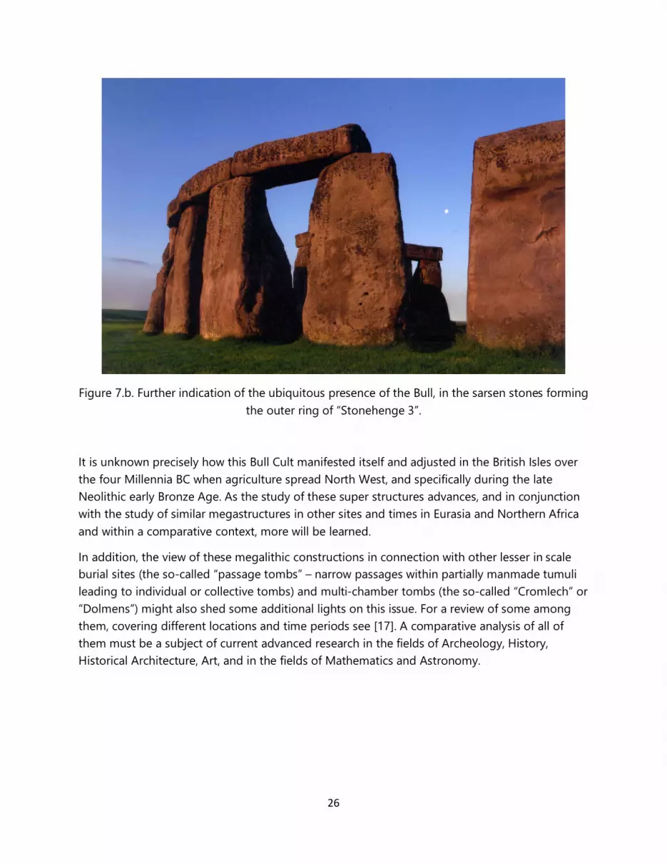
Figure 7.b. Further indication of the ubiquitous presence of the Bull, in the sarsen stones forming the outer ring of “Stonehenge 3”.
It is unknown precisely how this Bull Cult manifested itself and adjusted in the British Isles over the four Millennia BC when agriculture spread North West, and specifically during the late Neolithic early Bronze Age. As the study of these super structures advances, and in conjunction with the study of similar megastructures in other sites and times in Eurasia and Northern Africa and within a comparative context, more will be learned.
In addition, the view of these megalithic constructions in connection with other lesser in scale burial sites (the so-called “passage tombs” – narrow passages within partially manmade tumuli leading to individual or collective tombs) and multi-chamber tombs (the so-called “Cromlech” or “Dolmens”) might also shed some additional lights on this issue. For a review of some among them, covering different locations and time periods see [17]. A comparative analysis of all of them must be a subject of current advanced research in the fields of Archeology, History, Historical Architecture, Art, and in the fields of Mathematics and Astronomy.
27
Figure 8.a. The Esperance replica of a pair of “Heel Stones”: the Bull’s Horns.
28
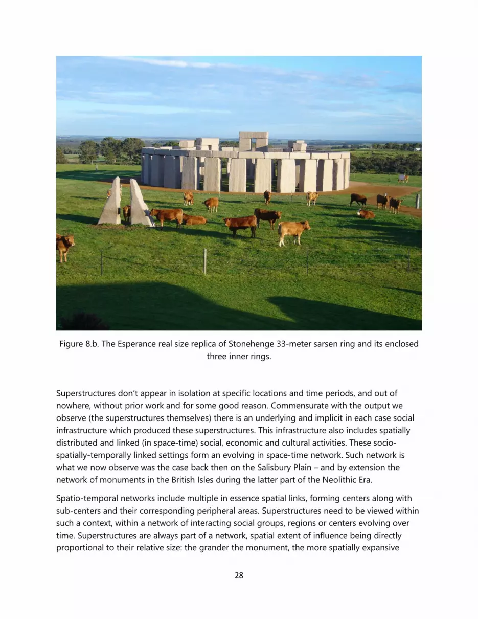
Figure 8.b. The Esperance real size replica of Stonehenge 33-meter sarsen ring and its enclosed three inner rings.
Superstructures don’t appear in isolation at specific locations and time periods, and out of nowhere, without prior work and for some good reason. Commensurate with the output we observe (the superstructures themselves) there is an underlying and implicit in each case social infrastructure which produced these superstructures. This infrastructure also includes spatially distributed and linked (in space-time) social, economic and cultural activities. These socio-spatially-temporally linked settings form an evolving in space-time network. Such network is what we now observe was the case back then on the Salisbury Plain – and by extension the network of monuments in the British Isles during the latter part of the Neolithic Era.
Spatio-temporal networks include multiple in essence spatial links, forming centers along with sub-centers and their corresponding peripheral areas. Superstructures need to be viewed within such a context, within a network of interacting social groups, regions or centers evolving over time. Superstructures are always part of a network, spatial extent of influence being directly proportional to their relative size: the grander the monument, the more spatially expansive
29
(spread out) its effective linkages must be. Megastructures do not stand alone, they are always part of a hierarchical system of structures.
Megastructures are always part of a Zipf (the rank-size rule) distribution, whereby much more abundant lower level structures (and centers) complement the smaller in number greater in size centers at the top. In general, the rule implies that a massive in size center must be linked with less massive ones, within a hierarchical structure.
This type of linkages comprises a network of interacting centers, joined by transportation (land or sea based back then) routes. They include, without being limited to, flow of commodities (output of economic activity, and raw materials), population (labor), information (including technological flows), and capital (tools, machinery or currency). It must be made clear that these linkages are multifaceted, and they include activities as diverse as trade and warfare. Not all such linkages are necessarily economic growth and social welfare enhancing at both ends of the linkage. To the contrary, some maybe exploitive and as a matter of fact rather violent and welfare reducing in nature.
Nonetheless, they obey basic principles expressed by core-periphery dependences, and the spatiotemporal distance decaying interaction law of a Spatial-Temporal Theory of distributed economic (and more broadly social) activity. These principles are also referred to as Geographic Central Place Theory, and all these notions are found in the field of Economic Geography. It is within such a context that all types of structures of that Era must be also viewed, including the Stonehenge Hidden Landscapes Project Region, Avebury, as well as all the rest of the megalithic structures of the British Isles, including the Welsh Cromlech system of settlements and dwelling, all passage tombs, tumuli, etc.
Similar must also be the approach to the Iberian Peninsula’s Almendres Cromlech [18] as well as the equivalent Neolithic megastructures of Central Europe, especially France, Germany and Denmark. Of special interest are of course the dolmens of the Near East, and especially the 7th Millennium BC dated, underwater semicircular megalithic dolmen Atlit Yam in Israel [19]. It predates “Stonehenge 1” by the better part of three millennia. Its crescent shape also suggests a Bull Cult governing it as well. And as the Central Place Theory mentioned above covers sizes of cities, and monumental structures, it must cover centers of religious beliefs and cults as well. Any great center of a particular religious cult must have been fed by subsidiary, lower level cult centers harboring similar (although not necessarily identical) beliefs and symbols.
The major hypothesis advanced here, from the limited evidence suggested is that all Neolithic megalithic structures belong to a broad category of cults referred to as the “Bull Cult”, and in their construction and design they embed fundamental morphology and symbolism that point to basic tenets of this overall prevailing in the relevant space-time framework Cult and sub-Cult. However it must be noted that this Cult must not have been by all means a homogeneous cult. Not all social groups, at various time periods and spaces were following an identical set of
30
beliefs and dogmas. There must have been some overlap, but certainly no perfect match among all these social settings spread out in the space-time context analyzed here.
Thus, when we refer to a Bull Cult which originated in the Near East and spread out over the centuries all the way to the British Isles, it is not meant to be implied that a particular set of gods and beliefs were being exactly replicated as they were moving North West in space and time. Transformations must have accompanied this diffusion, and at times not at the margins, but at its very core. Consequently, one must expect to find gross similarities between, say, the Egyptian Apis of the early 3rd Millennium BC, and the prevailing god at Stonehenge of the late 3rd Millennium BC.
So far, a key hypothesis has been elaborated in this paper, the hypothesis that within a slow moving expansion, agriculture moved from the Middle East to the North West Europe bringing along its gods and cults. This slow motion was pegged at about two kilometers per annum. Once this movement reached the British Isles, it triggered monumental construction there the likes of which Human History had never experienced before. However, the narrative doesn’t end here. This new economic activity apparently generated far reaching innovations that spread from the British Isles to the South East Europe and the Near East. The paper now traces the new wave of innovation, a fast movement propagating towards Egypt.
Although the origin of modest Neolithic megalithic structures movement (along with agriculture) commenced in the Eastern part of the Mediterranean Basin (see Atlit Yam), with central node the Egyptian superpower and spread north and North-West into Europe’s outer edges, a second wave of influence originated in the British Isles (with the buildup of the truly megalithic superstructures of Newgrange, Durrington Walls and Stonehenge), and spread back into Continental Europe and reached all the way into the Aegean and the Eastern part of the Mediterranean Sea. That new wave covered the same distance the slow agricultural movement did in about a century, and now was moving at a speed of about 30 miles per year.
Furthermore, the most powerful Center giving rise to this Western and Norther European Neolithic Superpower source of influence was Newgrange, the tumulus and its Kerbstones. Durrington Walls in combination with Stonehenge formed a major sub-center of this Neolithic British Isles based growth pole. We will have some more about this proposition a bit later, in Section 6.
Before we dwell more on this second wave of regional influences which originated now in the British Isles and spread south and east, a few comments are in order regarding “writing” “languages” and the carrying and promulgation of mathematical and astronomical knowledge and the necessary infrastructure to support it.
A misconception (and implied assumption) that persists in Archeology is that at any human setting, lack of a critical mass of records involving systemic and organized written documents (what is, in other words, what a formal “literature” contains) must imply that writing was not developed there. This general rule applies to all settings and time periods up to and including
31
the Neolithic, and of course also to the human settlements responsible for Stonehenge and Newgrange. This is a preposterous misconception, and a fundamentally wrong assumption. Writing must have existed at some (nonetheless “primitive” by today’s standards) nonetheless advanced (in reference to other then contemporary settings) stage, as must had been mathematics, economics, engineering, surveying, science and astronomy - among many other fields of human endeavor.
Such monuments simply isn’t possible to build without writing and a fairly developed language structure. Different social classes (including slaves, possibly drawn from different places than the specific place these monuments were constructed) as well as different peoples from different parts of the then known World with differing cultures and sub-cultures must had been able to communicate. And in fact communicate effectively. One might argue that in fact “organized, systemic writing” is all over these Neolithic superstructures. It can be argued that the Hawkins/Hoyle “computing” at Stonehenge was indeed a large in scale formal system of ‘writing”.
Lack of archeological records and lack of direct evidence do not necessarily imply that these advances didn’t exist. It is physically impossible to do mathematics and astronomy at the level required to build Newgrange and Stonehenge, without the ability to record observations and in general possess an efficient record keeping writing system. Of course the form of that record keeping may not have been of the type we currently assume and know. A system of “mass produced” small in size, storable, transferable and portable medium (possibly hand held stones, clay or dry mud, but not exclusively so) containing such recordings we know existed in the Neolithic. In the case of the Egyptian hieroglyphs, writing was recorded on such types of media before papyrus, which is encountered during the first Dynasty. However, formal writing must have existed before it was set in stone or clay or dry mud or papyrus.
And indeed we have clear evidence that it did. Back then, at the tail end of the Neolithic, the “medium was in fact the message” and in fact in huge characters, letters and symbols: that message was right on the monuments themselves. The monuments were the message and the writing. The replication of similar structures thus can be seen as the replicating process of a formal “writing system.” The components of these monuments, the stones-columns for instance of Stonehenge, or the quartz of Newgrange, were the letters or syllabary employed. They were not of course small in scale, hand held, and storable means of writing. However, the fact that they weren’t, it doesn’t necessarily imply that “writing” didn’t exist.
The fact that small and transferable means of writing haven’t survived to this day in abundance, doesn’t also imply they didn’t exist. Whether in formal or informal means, writing must had existed way prior to the construction of Newgrange. Most likely, formal writing was “on the wall” and all over the stones of these monuments, as it was later in the Dynastic Egypt’s monuments and tombs. Newgrange’s carving of complex symbols on its Kerbstones serves as an excellent example. In the case of Stonehenge, some remnants of writing are still present, but the bulk of it, almost certainly, has faded away. Quite possibly, in the future we shall be able to read those
32
records, as we are now reading Archimedes’ palimpsest after more than two Millennia in cover. Maybe, since the megaliths of Durrington Walls have been buried since the Neolithic times (or the Bell Beaker times) writing has been preserved on them. Their excavation might produce worldwide attention, similar to that produced by the Amphipolis archeological dig in August 2014. More on this issue will be offered in Section 6.
Let’s now review more in detail this unique and unprecedented incident at Durrington Walls, the “burial” of its 90 or so huge sarsen stones. The fact that stones are buried in Durrington Walls’ bank is something clearly in need of further review and analysis. Human burials along with various artifacts (initially small items, such as beads, arms, clothing and other personal decorative belongings and other ceremonial items intended to accompany the person buried in the afterlife) had been an early practice since the beginning of the Modern Human Era, that of Homo sapiens and the Neanderthals. Even earlier examples of burials are found, going back to 300KBP; and a recent discovery of a cave in South Africa pushes back rudimentary burial practices to 2.8MBP, in the case of Homo Naledi :
http://www.csmonitor.com/Science/2015/0910/Ancient-burial-chamber-raises-deep-questions-about-early-human-relatives-video
Past the Neolithic, bigger items and more complex arrangements are encountered in elaborate burials. Buried alongside the person or persons interred one comes across an array of objects, for example horse carriages, accompanied members of elite groups of a warrior class. In the case of Dynastic Egyptian burials involving Pharaohs, a series of chambers full of valuable objects and descriptive ceremonial writing associated with the dead were involved in burial sites.
A common characteristic of all such burials is that the burials had all benevolent intent.
But the practice of deliberately burying megalithic stones is certainly unique. It ushers a new era of burials, possibly involving malevolent intent.
Finding, at this stage of the Neolithic, burials in which significant in size human artifacts are interred is of interest from a number of angles. As these stones are estimated to be the size of the sarsen stones at Stonehenge (some about 4.5 meters in height) it follows that considerable amount of effort was spent in this activity. It was a socially conscious action with some deep symbolic meaning and most likely malevolent intent.
It is reasonable to assume that the intent was malevolent, as some of these stones are in effect significantly damaged. Their burial under the 40-feet wide chalk based bank implies the symbolic destruction of a previous cult’s symbols by a new cult. It is of considerable interest to note that the intentional burial of whole structures is rather uncommon in the BC Era over the Region of the World we are analyzing here.
We do come across a similar event quite a bit later, in the case of the Kasta Tumulus tomb, at Amphipolis. There, a two stage burial of the monument took place. The first involved the burial of the exterior wall, under a malevolent intent by the end of the 4th Century BC; and the second,
33
and final one, was a benevolent (for protection) burial of the interior of the tomb at the beginning of the 2nd Century BC [6]. In absence of a similar and earlier example, it must be concluded that Durrington Walls is the first case in the History of Humanity that such a burial occurred – a significant event.
A final note about the megaliths buried at Durrington Walls, of direct interest here. A single megalith which isn’t buried under the bank of the superhenge is a sarsen stone, exactly like the sarsen stones used at Stonehenge. Archeologists assume that the rest could also be sarsen stones. If this turns out to be the case, then it further fuels the argument that the Durrington Walls – Stonehenge complex was indeed a huge node in the network of human monuments and settlements not only in reference to the British Isles, but to the entire Western section of Eurasia and Northern Africa. It must have been the anti-pole of another huge node, Egypt, during the latter part of the Neolithic, during the Chalcolithic, and the early Bronze Age.
So, who were these peoples who invaded the British Isles, after the original agricultural technology and knowhow invasion which overtook the autochthonous local populations? Archeologists suggest that a loosely referred group called the “Bell Beaker Culture” arrived there by the mid of the 3rd Millennium BC.
If so, certainly by then the British Isles must have been a significant attractor for migration during the Bell Beaker Culture. It must be noted that who exactly were these Bell Beaker pottery producing and beer drinking peoples is still quite unclear. It is known with some certainty that they arrived at the British Isles from both the Iberian Peninsula through the Atlantic, and from Continental Europe through the Chanel. For certain, this must not have been a very homogeneous culture, as its habitation zone covers a very diverse area in European space-time.
The Western Coastal Region of the Iberian Peninsula must have been inhabited by population stocks with quite different socio-cultural codes, than the codes carried by the population stocks inhabiting the European Continental Regions around the major European river valleys. In many respects, coastal living is quite different than living along rivers. Differences in diet is part of the reason for such differentiation; accessibility and volatility to invasions is another. However, and most importantly, the limited possible expansion and movement through rivers is no match to the unlimited movement and expansion through the open seas. Mesopotamia and Egypt were developed, as river valley type civilizations. But Egypt evolved (whereas Sumerian and Assyrian Mesopotamia didn’t) because it became a Mediterranean based Sea-faring culture. Furthermore, and through the unmatched length of the River Nile, Egypt reached deep inside Africa – in other words, it kept successfully expanding. Such differences in Geography eventually mark bifurcation points in societal evolution.
Thus, within the context of the British Isles, one must not expect homogeneity in the invading Bell Beakers: they were those with a continental background, and those carriers of a sea-faring tradition. These various groups, upon getting in contact with the autochthonous population stocks (themselves quite diverse as well) must have produced considerable heterogeneity.
34
Environmental and geological differences between North and South, coastal areas and hinterland were and still are pronounced. In turn these differences contributed to differentiations within population stocks within the Isles, as the Bell Beaker invasions met the local groups. Inter-group differences vis-a-vis intra-group variance in their socio-cultural codes and mores formed the basis for population coalescing around a network of urban and rural settings. It was the beginning of a new process of clustering, a new wave of clan formation.
It is not of course the result of a haphazard process in place, but the outcome of deeply deterministic evolutionary socio-spatial events. Anything but random is that Newgrange appears at the Eastern coast of Ireland, quite close to a region in Northern Ireland where copper was mined; and the Stonehenge/Durrington Walls complex is located in the South Western part of England, close to the Wales’ copper mines. The Chalcolithic must have been in full swing in these areas. Obviously, these locations enjoyed significant comparative advantages at the time. Access to resources, topography, access to major trade and communication routes were at the heart of such location-tied comparative advantages. In short, these location specific comparative advantages (which must also include socio-cultural factors) constitute the bundle of reason a social system decides to locate any particular monument where it does (or did), and by extension, a socio-cultural system places a whole network of settlements and monuments at the specific place in space-time it does (and did).
A major socio-spatial shock must had been witnessed at the time the Bell Beaker groups’ invasion into the pre-existing human ecology of the British Isles took place. This was in fact the second major wave of an exogenous population group invading the British Isles, the first being the one that brought in agriculture and its gods and mores. Not surprising then, that Bell Beakers’ presence in the British Isles coincides with some destruction in both Stonehenge and Durrington Walls’ superhenge, and a relative decline in the importance and influence of Newgrange. Bell Beaker mores must had been at odds with the mores practiced by the builders of Stonehenge and Durrington Walls.
But it also coincides with a flow of influence originating in the British Isles and spreading East and South East, at least through trade. Newgrange, Durrington Walls, Stonehenge had by now set the stage for some major technological innovation and the start of some new economic activity the World had not seen till then. The new ideas on how to effectively manage and mobilize masses originating from the British Isles were now on the move. Managerial influences along with the use of copper tools were now bound towards the South and the South Eastern (as well as Northern and North Eastern) European regions. New work was now emanating from the British Isles. To that we come next, in Section 6.
As we turn our attention to this issue, the real magnitude and impact of the Durrington Walls – Stonehenge complex become apparent. They call for nothing less than a significant re-examination of the role the British Isles have played by the end of the Neolithic, during the Chalcolithic and ushering the Bronze Age. However, to fully comprehend this transition, a number of different key aspects in societal evolution must be brought to bear, and a diverse set
35
of sciences need to be simultaneously employed to allow us to fully capture the underlying events that took place in that critical for humanity time period.
However, before attention is switched to the necessity for a significant re-writing of the Neolithic Period’s End, some more analysis will be presented to discuss the recent findings by the M. Parker Pearson Team from the University of Sheffield regarding Durrington walls, the so-called Bluestoneshenge, and of course Stonehenge. Their work is of interest for many reasons, but a key reason is this: it doesn’t not accommodate well the recent discovery at Durrington Walls – the buried 90+ sarsen stones - in its foundational “dichotomy” claim that Stonehenge was the “realm of the dead”, whereas Durrington Walls was the corresponding “realm of the living”. In fact, their discovery of Bluestonehenge is an additional element knocking down that simple dichotomy, and pointing to a far more complex symbolic/religious/cultural meaning of the system of monuments at Salisbury Plain, and by extension of all Neolithic monuments in the British Isles.
Let’s follow the historical sequence, no matter how fuzzy, of the wooden and stone monuments in this key part of the Salisbury Plain. Around the 31st Century BC the two henges are formed, at Durrington Walls and Stonehenge, with Durrington Walls almost half a kilometer in diameter henge clearly dominant in size. This initial construction of two henges at a relatively short distance from each other along the River Avon and at a relatively short time distance as well, clearly demonstrates a number of things, central among them being the principle that a system of monuments with many nodes (centers) appears at some point time, and not a single center and then sub-centers form around it.
On a symbolic/cult/religious/political front this plurality in centers within a system of monuments also implies that as a center obeying some religious dogma (or a center of political power) comes about, it will trigger the formation of a competing set of centers where a variation or counter to that dogma (or political ideology) belief system(s) will be sheltered. Stonehenge and Durrington Walls is just a case of this simple principle. Aristotle was the first to pronounce a system of beliefs where a “thesis” will be succeeded always by an “antithesis”. He went on to suggest that in the dynamics of the two competing views, a “synthesis” would emerge. This fundamental principle in the epistemology of theory formation, was a principle hijacked by the communist ideology of the so-called “Marxists”. Over two and a half millennia of Human History however, has amply demonstrated that such an Aristotelian “synthesis” isn’t by rule the outcome. It proved to be far too optimistic, and only the physics based principle that for every force (thesis) there will certainly be a counterforce (antithesis) still remains. Stonehenge and Durrington Walls is just that: both were part of a basic Bull Cult system caught up in intra-cult competition. The hypothesis that Stonehenge (masonry) was the “realm of the dead” and Durrington Walls (wooden structure) was the “realm of the living” collapses by the very discovery of sarsen stones buried at Durrington Walls.
Durrington Walls and Stonehenge convey in essence a ubiquitous schism, the religious equivalent of Judaism and Christianity, Eastern Christian Church (Orthodoxy) and Western
36
Christian Churches (Catholicism and Protestantism), Shi’ites and Sunnis in Islam. The monuments at Salisbury Plain were possibly the first monumental manifestation of this fundamental religious/cult dichotomy. To what extent this dichotomy and pluralism was violent or peaceful we do not of course yet know. We do have evidence that destruction did take place, both at Stonehenge and Durrington Walls.
Wood mega-construction (possibly predating the Bluestones) at the Aubrey Holes of Stonehenge, the Woodhenge, and the timber phase of Durrington Walls were all different versions (possibly neighboring possibly hostile) of the religious cult and the social elite structure that constructed these henges. Most likely, Durrington Walls was the first to appear, in that critical 31st Century BC, followed by Stonehenge’s Phase I. Then during the first third of the 3rd Millennium BC stones entered the scene of megastructures in the British Isles and specifically at Salisbury Plain. This must have been accomplished with the advent of metalwork. It can’t be mere historical coincidence that copper is discovered where and when about megalithic Neolithic structures appear.
Between the 28th and 27th Century BC various phases of stone construction take place at Stonehenge, culminating with the outer ring of Bluestones around 2600 BC. By that time, the Bluestonehenge was constructed, and stone construction must have been in full swing in the British Isles. By the mid of the 26th Century BC the sarsen stones arrive at Stonehenge but by then the 90+ sarsens were already at Durrington Walls and the astronomical knowledge of the social groups in the Southern Region of the British Isles was imprinted in these monuments.
At some point in the early second half part of the 3rd Millennium BC an event of some significance takes place: the Bluestones of Stonehenge’s outer ring and the Bluestones from the Bluestonehenge by the River Avon are brought inside the sarsen stones circle of Stonehenge. This transition must have marked a time period where the conflict between the various sects at Salisbury Plain was intensifying, and the end result or resolution must had been that Stonehenge emerged as the dominant structure of the land. By the time the first half of the 3rd Millennium was coming to a close, more destruction was to follow, primarily centered around the knock down, breaking and burial of the 90+ sarsen stones at Durrington Walls and some of the destruction regarding the existing stones (and those entirely missing as of today) at Stonehenge.
Salisbury Plain in the first half of the 3rd Millennium BC must had been a unique center of masonry construction activity, religious advances and conflict, considerable inroads in political management, and significant technological innovation unparalleled in the Western Region of the Eurasian Supercontinent and Northern Africa. All that is impossible to have been accomplished without copper and writing, no matter how contemporary analysts wish to straightjacket all these advances into a strictly “stone age” practice and mentality. The Chalcolithic was dawning in the History of Humanity on the chalk grounds of Salisbury Plain.
37
6. A Need to re-write History? Of course.
Durrington Walls may be the carrier of a very powerful message, a message which may require a significant re-writing of Human History at the turn of the Bronze Age. In effect, in conjunction with Stonehenge it may have been the center that instigated the end of the Neolithic, the agency that took Humanity permanently out of the Stone Age, into the Age of the Metals. The burial of its sarsen stones may have been a symbolic act of that end. To fully comprehend however that role, we need to employ tools from Economic Geography, and the notions already alluded to earlier.
Durrington Walls, in combination with the descendent Stonehenge and the antecedent Newgrange, forms a very powerful spatio-temporal supercenter of a Neolithic human settlement- agglomeration. Going far beyond the Salisbury-Amesbury sub-region, it apparently was influenced by and has influenced a very broad socio-cultural context in space-time. In combination with the descendent and exquisite Stonehenge, and the antecedent and pioneer Newgrange, Durrington Walls completes a trio of engineering feats unsurpassed in grandeur at the time (the 3200 BC to 2400 BC period), anywhere in Eurasia and Africa, with one exception: the later coming Egyptian monuments at the Giza Plateau.
The Egyptian megastructures appeared in the first quarter of the 26th Century BC, when the Khufu Pyramid is built, followed by the Sphinx under Khafra about the middle third of the 26th Century BC time period. At that time, current History books acknowledge, Egypt was the unsurpassed superpower of the known World centered in the Eastern Part of the Mediterranean Sea. Its associations, influences, client state relationships etc. extended to the Mesopotamian Babylonian Region, the Hittites states of Asia Minor, Cyprus and Crete and mainland Greece, the Upper Nile Region well into The Sudan, and the Western African Mediterranean shores. Egypt was then the core of the so-called Fertile Crescent and the major “Growth Pole” (again, the term is taken from the field of Economic Geography) in the space covering the Entire Mediterranean Basin.
However, the “Giza Plateau” Era dominance Egypt projected as a growth center, was not the major influence Egypt exerted upon the British Isles. That influence came in earlier. In fact much earlier, when Egypt in “relative” terms, was a far more dominant of a center than the 26th Century BC Egypt of Khufu and Khafra. In the 5th to the 4th Millennium BC Egypt loomed much larger in relative terms compared to any other enclave of human presence and activity in and around the Mediterranean Sea. For back then, Egypt was the only dominant center, in the entire 3-Continent space under consideration here. Fundamental role in that dominance was Egypt’s discovery and employment of a critical innovation: the secret writing, “hieroglyphs”. This writing ushered the beginning of organized societal writing.
Egyptian hieroglyphics per se may not had become the dominant language and writing pattern of the Eastern Mediterranean world. But the fact that Egypt was the first to produce an
38
“organized system” of writing was the key. Many ad hoc symbols, that didn’t come together to form a coded “language with writing system”, appeared in many other settings, some even prior to any Egyptian proto-hieroglyphic symbols. Examples of these proto-writing systems abound in the Mesopotamian Region of the 8th to the 6th Millennium BC. The late 6th Millennium BC Dispilio Tablet from Kastoria, Greece is an example. Hieroglyphs first came about by the 5th Millennium BC, and were firmly established by the 33rd Century BC as a well-organized writing system. It was the Era that agriculture spread rapidly from the South East to the North West, as did its gods and cults. What was imported into the British Isles, along with agriculture and its gods, was the recognition that an “organized system of writing” was needed for human societies to be organized and managed. It was the Era that, along with writing, saw the appearance of Cities.
Writing appeared when agriculture ceased to be simply of the subsistence type, and entered the stages of both surplus agriculture and diversified enough in both crops, plant produce and livestock to begin trade and require storage. It was the time where the need for record keeping, and for astronomical observations to assist it became paramount. But it was also the time when multi-purpose, mixed land use, multi ethic urban centers appeared, where large scale storage facilities, wholesale and retail trading and land as well as sea routes met. It was the era when human settlements grew, beyond family and clan compounds, kernels of town living, transformed into truly “urban” areas, housing the surplus human labor. Economies of scale were triggered, urban hierarchical structures were ignited and filled the spatial extent of human endeavor. Places acquired not only trade-related access linked comparative endowments, but even more critically, defensive and strategic importance.
It was the beginning of an Era when cities would be the centers of multiple and diverse economic, social and cultural activities. The dominant cult behind each center would put its stamp on it, by constructing the major monument that would contain its symbols and beliefs, along with its projection of dominance and power. Any center’s hinterland would contain not only its own agricultural spatial extent (its monopoly and monopsony exercising domain), but also all subsidiary subordinate sub-centers and associated sub-cults. Urban centers would be combined places of worship and places to trade. They would become places to reside, during the course of both - one’s life and death. Settings of worship and settings for living and trading merged – the “multiple functions city” appeared. The reasons for this diversity of functions were naturally multiple, a key being that need for services. Such a need was too strong to isolate major religious sites from the rest of spatially distributed human endeavor. It is this reason why, in this paper, the idea that Newgrange, Durrington Walls, Woodhenge, Bluestonehenge and Stonehenge can’t be simply considered ceremonial sites. They are sites of a complex human settlement activity.
It was the era of “diversification” in both production and consumption. Within the spatial extent we are examining here, Egypt’s role was central and pioneering in this new Era of societal transition. The Nile’s Delta and Thebes became more strategically important than the
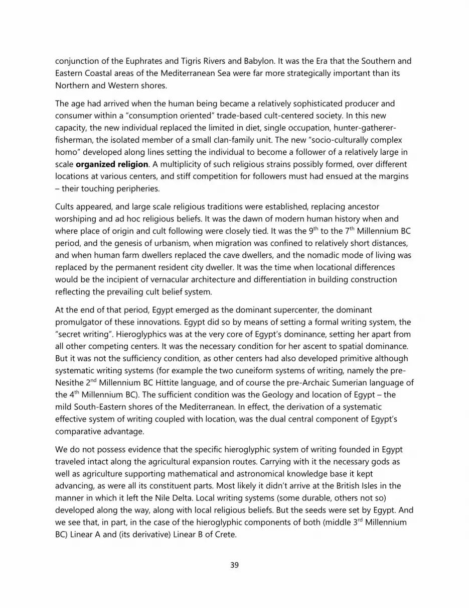
39
conjunction of the Euphrates and Tigris Rivers and Babylon. It was the Era that the Southern and Eastern Coastal areas of the Mediterranean Sea were far more strategically important than its Northern and Western shores.
The age had arrived when the human being became a relatively sophisticated producer and consumer within a “consumption oriented” trade-based cult-centered society. In this new capacity, the new individual replaced the limited in diet, single occupation, hunter-gatherer-fisherman, the isolated member of a small clan-family unit. The new “socio-culturally complex homo” developed along lines setting the individual to become a follower of a relatively large in scale organized religion. A multiplicity of such religious strains possibly formed, over different locations at various centers, and stiff competition for followers must had ensued at the margins – their touching peripheries.
Cults appeared, and large scale religious traditions were established, replacing ancestor worshiping and ad hoc religious beliefs. It was the dawn of modern human history when and where place of origin and cult following were closely tied. It was the 9th to the 7th Millennium BC period, and the genesis of urbanism, when migration was confined to relatively short distances, and when human farm dwellers replaced the cave dwellers, and the nomadic mode of living was replaced by the permanent resident city dweller. It was the time when locational differences would be the incipient of vernacular architecture and differentiation in building construction reflecting the prevailing cult belief system.
At the end of that period, Egypt emerged as the dominant supercenter, the dominant promulgator of these innovations. Egypt did so by means of setting a formal writing system, the “secret writing”. Hieroglyphics was at the very core of Egypt’s dominance, setting her apart from all other competing centers. It was the necessary condition for her ascent to spatial dominance. But it was not the sufficiency condition, as other centers had also developed primitive although systematic writing systems (for example the two cuneiform systems of writing, namely the pre-Nesithe 2nd Millennium BC Hittite language, and of course the pre-Archaic Sumerian language of the 4th Millennium BC). The sufficient condition was the Geology and location of Egypt – the mild South-Eastern shores of the Mediterranean. In effect, the derivation of a systematic effective system of writing coupled with location, was the dual central component of Egypt’s comparative advantage.
We do not possess evidence that the specific hieroglyphic system of writing founded in Egypt traveled intact along the agricultural expansion routes. Carrying with it the necessary gods as well as agriculture supporting mathematical and astronomical knowledge base it kept advancing, as were all its constituent parts. Most likely it didn’t arrive at the British Isles in the manner in which it left the Nile Delta. Local writing systems (some durable, others not so) developed along the way, along with local religious beliefs. But the seeds were set by Egypt. And we see that, in part, in the case of the hieroglyphic components of both (middle 3rd Millennium BC) Linear A and (its derivative) Linear B of Crete.
40
So now, we can speculate that Egypt’s cultural influence (need for writing, agriculture and its concomitant belief system of gods and cults) must have extended into both Western and Northern Europe before Khufu and Khafra, and indeed well prior to them. They must have originated far before the 4th Millennium BC, so that by the close of that Millennium their visible as well as invisible impacts are discernable in faraway lands. On the one hand, the visible traces of Egypt we find in the presence of agriculture, and in the various shapes of the Bull’s Horns implanted onto British Isles’ Neolithic monuments. Newgrange by the River Boyne is a glaring case in point, as is the pair of monumental henges, Durrington Walls, Bluestonehenge and Stonehenge at Salisbury. On the other hand, what is not visible, and beyond the underlying and inferred socio-cultural processes, is the essential and necessary condition in setting both agriculture and the construction of megastructures, i.e., organized writing together with mathematics and elementary of course astronomical knowledge. Maybe in the years to come this will also be firmly established by the archeological record.
The spreading of agriculture to the North and the West via the Mediterranean water routes was concomitant to this Eastern influences onto Western and Northern Europe. It must have been accompanied by significant human migration flows. As surplus labor was generated by the spreading of successful agriculture in space-time, more agriculture-related activity was produced and spread, in a positive-feedback contained within it spatio-temporal process. Thus, major demographic developments must have been set in motion. Along with an organized writing system, this new work, agriculture and its related economic activities, kept spreading. By the time Khufu came to power in Egypt, not only was the agricultural advance into Europe already well under way, a secondary wave of technological and managerial innovation was to hit Egypt back.
Actually it was not only and simply agriculture – but a concomitant set of subsidiary activities that were advancing. They included mining and trade, amphorae vase and pottery ware artisanship, ship building, town planning and building construction, human services, government, and an organized religion, among many others. It was a complex economic system now in place that set the stage for subdivisions of production along the lines of the contemporary Standard Industrial Classification (SIC) code of modern production. Cities were formed for the first time with attention to a water and sewage system.
Once the agricultural revolution and its ancillary economic activities reached the Neolithic British Isles, they were transformed and adjusted naturally to local conditions. These local conditions contained new mining sources and new human resources. Fresh in-migration resulted in a new cultural mix. In turn, that mix contributed to a basic restructuring and adaptation of both the new beliefs newly arriving migrants were carrying, as well as changes to the locally pre-existing beliefs and social mores. New ways in production and worshiping of gods must have resulted. We do not know the specific ways these large in scale societal changes manifested themselves. For sure, there were not, in all probability, smooth and gradual. Certainly they were not peaceful and painless, since all societal transitions involve pain.
41
At the end of this structural change in societal behavior, the British Isles, by the mid of the 4th Millennium BC must have experienced considerable social upheaval and societal restructuring. As a result of new societal integration, and in view of these cascading waves of innovation hitting the isles, the social groups there must have undergone changes in both their social organizations and social elite structures. Probably all this infusion of new ideas and economic activities created locally some form of a synthesis, not of course uniformly throughout the Isles. Although an overall cult type must have prevailed as agriculture was successfully introduced, each social setting in all likelihood generated its own version of the Bull and Cow Cults imported from Egypt.
A major role in these societal transformations must have been played by unfolding demographics. For a period of time (almost a millennium, in the 3500 – 2600 BC period) the tremendous infusion of innovation that permeated the British Isles must have been coupled with a population explosion. The expanded population base was now capable of providing the necessary labor force (the critical mass associated with some minimum population size requirement) commensurable in scale and magnitude with the envisioned and planned undertaking.
Population estimates associated with construction at Newgrange, Durrington Walls and Stonehenge point to associated urban centers far in excess of the population sizes of the modest cities of the late Neolithic Era. The urban form and extent of the 12th Millennium BC to the 4th Millennium BC urban centers indicate population sizes of the largest city of a recognizable regional urban hierarchy hardly exceeding a few thousand permanent residents, with the vast majority of these settlements having a population of permanent residents hovering around few hundreds. The urban hierarchy though that had to be in place to support the British Isles’ megalithic monumental structures must have been approaching five to ten times the size of the typical Neolithic urban community, with its top city possibly reaching the level of 10K permanent residents by the 32nd Century BC.
Many population centers and sub-centers of different sizes must have appeared in the British Isles in the Era of Agriculture. In all likelihood they were forming, as already suggested, a hierarchy of centers obeying a Zipf size distribution. Such distribution calls for two centers with half size population of the first in rank, and so on down the scale. At around the turn of the 4th Millennium BC, the Era of Newgrange, Durrington Walls and Stonehenge, the British Isles’ top urban area must had been approaching (if not exceeding) 10,000 people encompassing an area of about 5,000 square meters possibly accommodating about two persons per square meter of gross living space (a density slightly higher than that frequently encountered in Neolithic human settlements). Considering the settlement at (modest in size, about a 1750 square meters) Woodhenge, one can hypothesize on what it could be the top human settlement size in around a major ceremonial center. It can be estimated that the smallest of the three henges, must have witnessed an average population level at the height of its influence of about 2,500 residents. It is only these type and sizes of urban centers necessary to exist in order to sustain a labor force
42
capable of delivering multimillion man-hours of labor absolutely essential in the construction of such super structures.
Some simple calculations would provide this basis: assume that about 20 years was the construction life span of any of these monuments, see more on this argument in [6], that a third of the year was the suitable period for work (weather conditions being the key determinant here), that per day on average a worker can offer ten hours of productive work, that implies 2400 hours per active worker during the monument’s construction period. In turn, this would imply for a million of work hours, a city with about 400 workers exclusively working on the monument over its construction phase. At a labor force participation rate of 5.0 (about double the average of the current World level) it would require a population directly associated with the monument’s construction of about 2,000 persons. At the rate of a workforce with a construction employment share at around 20% (a low estimate at that), it would imply a city of around 10,000 persons to support over a 20-year period the buildup of the megastructure.
The most sizable of all settlements in the British Isles at that time must have been located along the major port-coastal area, possibly in the Southern section of the Isle. A few, lesser in size centers, must had occupied secondary coastal locations (secondary hubs of trade activity) and inland areas, located in the hinterland of the Isles and centers of storing agricultural surplus. Major trade routes and local geomorphology would determine the location of these higher up in the hierarchy settlements. It was the time that the seeds of the distribution of urban settlements as we observe it today within the British Isles possibly took place. It was also the era when farmland based elites and a trade based proto-middle class must have taken form.
At the end, whatever cult or cults resulted from that integration with the autochthonous population stocks of the British Isles surpassed in social achievements those of the Fertile Crescent. The evidence is in the megastructures it (or they) produced. Newgrange attests to that. By 3200 BC no monument in Europe, Western Asia, or Northern Africa rivals Newgrange in size, sophistication and splendor. Since we do not observe such megalithic constructions anywhere in the broader Region we are analyzing, we must search for the reasons why.
We are necessarily led to acknowledge that advances in the societal infrastructure needed to produce Newgrange must have been significant and only in place there, rendering this location unique for such construction. Agriculture must had been far more efficient there than anywhere else including the “Fertile Crescent”, to support the surplus labor necessary to carry out the megalithic constructions of the period, and also that which followed Newgrange. Natural resource availability, especially in copper, tin, gold and silver, must have also been far more efficiently exploited than anywhere in the Mediterranean basin, independent of relative abundance – pointing to a more advanced sophistication in management, engineering and mathematics. Eventually, copper and its use in metal based tools was instrumental in ushering the British Isles into the Metals Age, but management related innovation, it is suggested here, was far more important.
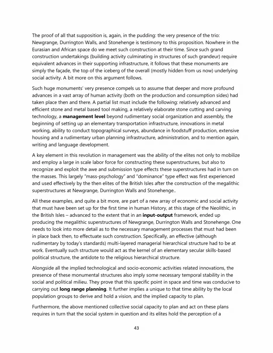
43
The proof of all that supposition is, again, in the pudding: the very presence of the trio: Newgrange, Durrington Walls, and Stonehenge is testimony to this proposition. Nowhere in the Eurasian and African space do we meet such construction at their time. Since such grand construction undertakings (building activity culminating in structures of such grandeur) require equivalent advances in their supporting infrastructure, it follows that these monuments are simply the façade, the top of the iceberg of the overall (mostly hidden from us now) underlying social activity. A bit more on this argument follows.
Such huge monuments’ very presence compels us to assume that deeper and more profound advances in a vast array of human activity (both on the production and consumption sides) had taken place then and there. A partial list must include the following: relatively advanced and efficient stone and metal based tool making, a relatively elaborate stone cutting and carving technology, a management level beyond rudimentary social organization and assembly, the beginning of setting up an elementary transportation infrastructure, innovations in metal working, ability to conduct topographical surveys, abundance in foodstuff production, extensive housing and a rudimentary urban planning infrastructure, administration, and to mention again, writing and language development.
A key element in this revolution in management was the ability of the elites not only to mobilize and employ a large in scale labor force for constructing these superstructures, but also to recognize and exploit the awe and submission type effects these superstructures had in turn on the masses. This largely “mass-psychology” and “dominance” type effect was first experienced and used effectively by the then elites of the British Isles after the construction of the megalithic superstructures at Newgrange, Durrington Walls and Stonehenge..
All these examples, and quite a bit more, are part of a new array of economic and social activity that must have been set up for the first time in human History, at this stage of the Neolithic, in the British Isles – advanced to the extent that in an input-output framework, ended up producing the megalithic superstructures of Newgrange, Durrington Walls and Stonehenge. One needs to look into more detail as to the necessary management processes that must had been in place back then, to effectuate such construction. Specifically, an effective (although rudimentary by today’s standards) multi-layered managerial hierarchical structure had to be at work. Eventually such structure would act as the kernel of an elementary secular skills-based political structure, the antidote to the religious hierarchical structure.
Alongside all the implied technological and socio-economic activities related innovations, the presence of these monumental structures also imply some necessary temporal stability in the social and political milieu. They prove that this specific point in space and time was conducive to carrying out long range planning. It further implies a unique to that time ability by the local population groups to derive and hold a vision, and the implied capacity to plan.
Furthermore, the above mentioned collective social capacity to plan and act on these plans requires in turn that the social system in question and its elites hold the perception of a
44
significant time horizon in the future. Given the inherent (back then and overall) uncertainties, both due to a rapidly changing and largely unforeseen social environment as well as a limited ability to accurately gauge and predict changes in the natural environment’s cycles, the ability by the builders of the British Isles’ megastructures to successfully speculate over such extended time horizon must be considered remarkable. Moreover, that this particular social system was capable back then to meet expectations and effectuate the execution of these plans is certainly extraordinary.
It seems that the British Isles, at this stage of the Neolithic, were the single unique place to do just that. They proved to be the location where these increasingly complex human activities met a new standard, far above all other places, in the Eurasian and African Continents. These innovation rich economic activities and collective thought processes found the time and ground ripe for them to get a foothold in Humanity’s History – and that foothold was the lands of the British Iles during the late Neolithic.
The British Isles were back then not only producers of strategic natural resources, like copper and gold, but also tin (the necessary alloy to mix with copper to produce bronze). According to conventional archeology, the Bronze Age came first in the Aegean Sea and Cyprus at around 3200 BC, the time Newgrange was built. Isotopic analysis however on bronze Aegean objects finds traces of tin mined in the British Isles [17]. This is the trade (and possibly migratory) link, directly joining the Aegean client states of Egypt at the time, with the British Isles. This finding potentially could be the smoking gun proving that the British Isles were far ahead in this development path than conventional Archeology assumes.
It is unclear, again according to conventional Archeology and History, when the Bronze Age hit the British Isles. History books tell us that the advent of bronze came late there. But this is now impossible to digest. Cyclopean walls were to arrive in Greece by the Mycenaean times, middle of the 2nd Century BC, and bronze we are told came to the Eastern Mediterranean by the time construction ended at Newgrange. This is evidence which clearly makes it impossible to now accept the conventional line by History. While Newgrange was built, the Mediterranean Basin had nothing equivalent to offer. Clearly, the British Isles in the period middle 4th Millennium BC to the first quarter of the 3rd Millennium BC (the time of the Chalcolithic) were the most advanced setting of the Region we are looking at, including not only Europe but also parts of Western Asia and Northern Africa.
Legitimately, one may ask the question: how come and we haven’t found evidence of copper tools in any Neolithic site excavated thus far of the period examined here and the monuments in focus? The answer can be also quite simple: copper at that time must have been as valuable as gold is today. No one leaves gold around to go wasted as one would potentially do back then of a stone tool. Copper can be reprocesses, thus all those original copper tools may have been re-smelted. This is another clear case where absence of evidence is not evidence of absence.
45
The Bronze Age must have arrived in the British Isles far earlier than commonly assumed. It is surprising then, and difficult to fathom the fact that the first recorded direct evidence of the Bronze Age appears in Ireland around the 2200 BC, with the Lough Ravel flat axes [17]. We must accept that it’s virtually impossible to have Newgrange, Durrington Walls and Stonehenge in a pre-Bronze British Isles, and total lack of even remotely resembling structures anywhere in the Mediterranean Basin with a 3200 BC Bronze Age startup date in place. One is led to the conclusion that the archeological record must be rather incomplete and undeveloped in the British Isles, with far more about to be uncovered.
Concluding Remarks:
The Tale of Two Neolithic Era Super Centers.
We conclude this work by going back and trying to more precisely address the implied demographic impacts involved in the basic question of this paper: what happened to all that technological, managerial and construction innovation, hiding behind Newgrange, Durrington Walls, and Stonehenge, and to an extent Bluestonehenge and Woodhenge as well? This is where possibly History books need most of the re-writing. Lack of concrete and hard data will make this concluding section rather speculative, by necessity. History needs to re-write the technological advances that took place in the British Isles, and record in full the essential socio-cultural infrastructure that gave rise to these monuments. It also needs to attribute the role that pre-dynastic Egypt played in this development.
At the turn of the 26th Century BC, the British Isles’ monument-capable-of-producing technological know-how and social organization didn’t have the right geology and culture to produce pyramids there. That technology and social organization migrated by the middle of the 26th Century BC to dynastic Egypt and the Giza Plateau. It kept moving east, hitting Ur by the 21st Century BC. In effect, a spatial cycle that commenced at the Fertile Crescent by the 7th Millennium BC, as “Stone Age” type agriculture moved northwest reaching Ireland by the end of the 4th Millennium BC, returned back in the form of technological innovation and the “Metals Age” by the end of the 3rd Millennium BC.
Population counts of population stocks (aggregate or disaggregated by region or ethnic group) covering the period and areas in question here, are not available yet. But in view of the demographic impacts recorded in National Censuses of technological innovations that occurred over the well recorded Human History, especially since the Industrial Revolution (another event associated with the British Isles – which in reference to this study is not totally unexpected) may allow some speculative statements to be put forward.
46
Demographic transitions in the form of population growth and migration rates unseen till then in Human History must have accompanied the spreading of agriculture from its South East origin, as it moved through space-time and reached the North West outer edges of the European Continent.
If that was unprecedented, the return wave of influence must have been even more demographically explosive. The much faster moving and spreading of technological innovation from the British Isles to the South East must have been accompanied by a population explosion the likes of which Humanity would have to wait for another four Millennia and the Industrial Revolution to probably experience again.
History needs to re-write the flow of all that innovation out of the British Isles into the Continental Europe and the Middle East. It needs to describe how technological knowhow diffused towards the East and South, as a new wave of innovation hit the turn of the 3rd Millennium BC. That Era of the Chalcolithic put an end to the Genus Homo “Stone Age” and ushered for Humanity the advanced Homo Sapiens Sapiensis “Metals Age”.
Nowhere here however, should the reader infer that this transition was always a “kinder and gentler” version in the treatment of the populace at large by the social elites of the day. It was not, and in fact it is doubtful that a significant improvement in the overall peoples’ welfare level was attained immediately following any of these innovations. If the industrial Revolution is any indication, such improvements must had been initially marginal. Most likely, more suffering on the average was the direct result due to painful adjustments needed. Some type of slavery, or conditions close to such form of labor, must had been ushered and institutionalized as a result of the British Isles’ megalithic construction practices and innovative management techniques.
No doubt, the form of slavery that appeared in the British Isles during Newgrange, Durrington Walls and Stonehenge and its associated mining activities, was not exactly the same form of slavery one comes across under the Pharaoh’s of Egypt, at the beginning of the Dynastic Era – or the slavery underlying the construction of the Ziggurats in Mesopotamia. The transition from the Stone Age to the Metals Age was by no means the transition from the “Industrial Age” to the “Service Age” in Human History, the (relatively short) time period where Humanity saw the average welfare level of the Globe’s population skyrocket, along with its size.
In the construction of the megalithic monuments, the British Isles introduced innovative methods in the sustained mobilization and management of huge masses of workers over a prolonged time period – an activity unseen before in human experience. Along with this innovation, the introduction of copper in construction was also instrumental. Both innovations, underwrote the phase transition in Human History, which saw dried mud type brick and wooden structures being followed by organized megalithic well designed precision type construction.
The British Isles were at the forefront of this critical “Stone to Metals Age” transition, and the trio of their mega-monuments attests to that fact. Influences from the described in this paper advances in technology attained in the British Isles during the 3200 – 2600 BC were the means
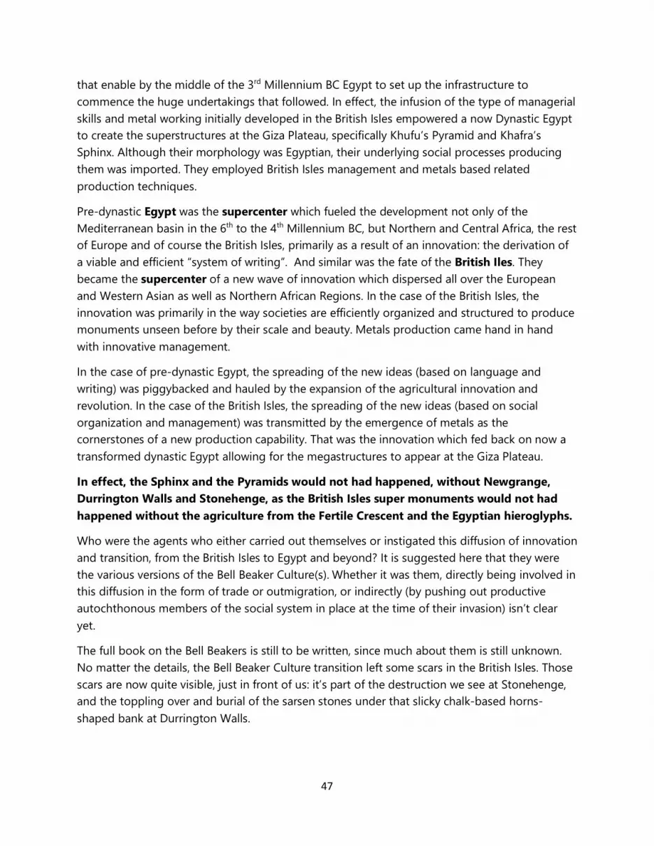
47
that enable by the middle of the 3rd Millennium BC Egypt to set up the infrastructure to commence the huge undertakings that followed. In effect, the infusion of the type of managerial skills and metal working initially developed in the British Isles empowered a now Dynastic Egypt to create the superstructures at the Giza Plateau, specifically Khufu’s Pyramid and Khafra’s Sphinx. Although their morphology was Egyptian, their underlying social processes producing them was imported. They employed British Isles management and metals based related production techniques.
Pre-dynastic Egypt was the supercenter which fueled the development not only of the Mediterranean basin in the 6th to the 4th Millennium BC, but Northern and Central Africa, the rest of Europe and of course the British Isles, primarily as a result of an innovation: the derivation of a viable and efficient “system of writing”. And similar was the fate of the British Iles. They became the supercenter of a new wave of innovation which dispersed all over the European and Western Asian as well as Northern African Regions. In the case of the British Isles, the innovation was primarily in the way societies are efficiently organized and structured to produce monuments unseen before by their scale and beauty. Metals production came hand in hand with innovative management.
In the case of pre-dynastic Egypt, the spreading of the new ideas (based on language and writing) was piggybacked and hauled by the expansion of the agricultural innovation and revolution. In the case of the British Isles, the spreading of the new ideas (based on social organization and management) was transmitted by the emergence of metals as the cornerstones of a new production capability. That was the innovation which fed back on now a transformed dynastic Egypt allowing for the megastructures to appear at the Giza Plateau.
In effect, the Sphinx and the Pyramids would not had happened, without Newgrange, Durrington Walls and Stonehenge, as the British Isles super monuments would not had happened without the agriculture from the Fertile Crescent and the Egyptian hieroglyphs.
Who were the agents who either carried out themselves or instigated this diffusion of innovation and transition, from the British Isles to Egypt and beyond? It is suggested here that they were the various versions of the Bell Beaker Culture(s). Whether it was them, directly being involved in this diffusion in the form of trade or outmigration, or indirectly (by pushing out productive autochthonous members of the social system in place at the time of their invasion) isn’t clear yet.
The full book on the Bell Beakers is still to be written, since much about them is still unknown. No matter the details, the Bell Beaker Culture transition left some scars in the British Isles. Those scars are now quite visible, just in front of us: it’s part of the destruction we see at Stonehenge, and the toppling over and burial of the sarsen stones under that slicky chalk-based horns-shaped bank at Durrington Walls.
48
References.
[1] http://www.msn.com/en-us/news/world/archaeology-on-steroids-huge-ritual-arena-discovered-near-stonehenge/ar-AAe0XKH?ocid=ansmsnnews11
[2] http://news.yahoo.com/super-henge-revealed-english-mystery-uncovered-122551717.html
[3] https://en.wikipedia.org/wiki/Passage_grave
[4] http://www.historic-uk.com/HistoryUK/HistoryofWales/cromlech-the-first-welsh-houses/
[5] https://en.wikipedia.org/wiki/Dolmen
[6] Dimitrios S. Dendrinos, August 2015, “On Certain Key Architectural Elements of Kasta Tumulus” https://www.academia.edu/15286289/On_Certain_Key_Architectural_Elements_of_Kasta_Tumulus_A_Truly_Ecumenical_Structure_Linking_Newgrange_through_Mesopotamia_and_Egypt_to_Amphipolis
[7] http://www.tivas.org.uk/stonehenge/stone_ast.html#fig1
[8] M. W. Postins, 1987, Stonehenge, Sun, Moon, Wondering Stars, Sharston Books (paperback).
[9] Gerald S. Hawkins, 1965, Stonehenge Decoded, Doubleday Books.
[10] Alexander Thom, 1955, “A Statistical examination of the Megalithic Sites in Britain”, Journal of the Royal Statistical Society, Series A (General), Part III, Volume 118, No. 3: 275-295.
[11] Dimitrios S. Dendrinos, December 4th, 2014, “The Modular Structure of the Tomb/Monument at Kasta Hill” https://www.academia.edu/10923712/The_modular_structure_of_the_tomb_at_Kasta_Hill_by_D_Dendrinos
[12] https://en.wikipedia.org/wiki/Nebra_(Pharaoh)
[13] http://www.ancientegyptonline.co.uk/hathor.html
[14] https://en.wikipedia.org/wiki/Neolithic_Europe
[15] https://en.wikipedia.org/wiki/Wheat
[16] http://esperancestonehenge.com.au/
[17] https://en.wikipedia.org/wiki/Bronze_Age_Europe
[18] https://en.wikipedia.org/wiki/Almendres_Cromlech
[19] https://en.wikipedia.org/wiki/Atlit_Yam
49
[20] Dimitrios S. Dendrinos, 1992, The Dynamics of Cities: Ecological Determinism, Dualism and Chaos, Routledge, London.
Note 1: References to what is considered to be “Encyclopedic type” knowledge are not cited.
Note 2: The narrative here, especially in reference to suggestions underlying the formation of Cities and their religious underpinnings is to an extent consistent with some basic premises but also at times in sharp contrast to that espoused by and found in Jane Jacobs’ seminal work on Cities and the Wealth of Nations: Principles of Economic Life Vintage Books, 1985 – a book with a title conjuring Adam Smith’s work.
Note 3. The updated version #5 incorporates comments on material obtained from the NOVA program contained in the National Geographic documentary: https://www.youtube.com/watch?v=8LGczCvCCu0&app=desktop
____________________________________________________________________________
© The author Dimitrios S. Dendrinos retains all rights to this work. No parts of this work can be reproduced without the written consent of the author.