
Spatial SQL: A Query and Presentation Language
23
1 Introduction Spatial SQL: A Query and Presentation Language Abstract query language presentation language Index Terms Max J. Egenhofer National Center for Geographic Information and Analysis and Department of Surveying Engineering University of Maine Orono, ME 04469, USA [email protected] This research was partially funded by grants from NSF under No. IST 86-09123, Digital Equipment Corporation under Sponsored Research Agreement No. 414, and Intergraph Corporation. Additional support from NSF through the NCGIA under grant SES 88-10917 is gratefully acknowledged. IEEE Transactions on Knowledge and Data Engineering 6 (1): 86-95, 1994. 1 —Recently, attention has been focused on spatial databases which com- bine conventional and spatially related data such as Geographic Information Systems, CAD/CAM, or VLSI. A language has been developed to query such spatial databases. It recognizes the significantly different requirements of spatial data handling and over- comes the inherent problems of the application of conventional database query lan- guages. The spatial query language has been designed as a minimal extension to the interrogative part of SQL and distinguishes from previously designed SQL extensions by (1) the preservation of SQL concepts, (2) the high-level treatment of spatial objects, and (3) the incorporation of spatial operations and relationships. It consists of two com- ponents, a to describe what information to retrieve and a to specify how to display query results. Users can ask standard SQL queries to retrieve non-spatial data based on non-spatial constraints, use Spatial SQL commands to inquire about situations involving spatial data, and give instructions in the Graphical Presentation Language GPL to manipulate or examine the graphical presentation. —Geographic Information Systems, graphical presentation, query lan- guages, query result combinations, spatial context, spatial databases, SQL, topological relationships. Recently, attention has been focused on spatial databases [34, 56] which combine con- ventional and spatially related data. The need for spatial query languages has been iden- tified in several different application domains of spatial databases such as Geographic Information Systems (GIS’s) [30], image databases [10], or remote sensing [45]. The usage of standard query languages for spatial data handling has been hindered by the
Transcript of Spatial SQL: A Query and Presentation Language

�
1 Introduction
Spatial SQL: A Query and Presentation Language
Abstract
query language presentationlanguage
Index Terms
Max J. EgenhoferNational Center for Geographic Information and Analysis
andDepartment of Surveying Engineering
University of MaineOrono, ME 04469, [email protected]
This research was partially funded by grants from NSF under No. IST 86-09123, Digital EquipmentCorporation under Sponsored Research Agreement No. 414, and Intergraph Corporation. Additional supportfrom NSF through the NCGIA under grant SES 88-10917 is gratefully acknowledged.
IEEE Transactions on Knowledge and Data Engineering 6 (1): 86-95, 1994. 1
—Recently, attention has been focused on spatial databases which com-bine conventional and spatially related data such as Geographic Information Systems,CAD/CAM, or VLSI. A language has been developed to query such spatial databases.It recognizes the significantly different requirements of spatial data handling and over-comes the inherent problems of the application of conventional database query lan-guages. The spatial query language has been designed as a minimal extension to theinterrogative part of SQL and distinguishes from previously designed SQL extensionsby (1) the preservation of SQL concepts, (2) the high-level treatment of spatial objects,and (3) the incorporation of spatial operations and relationships. It consists of two com-ponents, a to describe what information to retrieve and a
to specify how to display query results. Users can ask standard SQL queries toretrieve non-spatial data based on non-spatial constraints, use Spatial SQL commandsto inquire about situations involving spatial data, and give instructions in the GraphicalPresentation Language GPL to manipulate or examine the graphical presentation.
—Geographic Information Systems, graphical presentation, query lan-guages, query result combinations, spatial context, spatial databases, SQL, topologicalrelationships.
Recently, attention has been focused on spatial databases [34, 56] which combine con-ventional and spatially related data. The need for spatial query languages has been iden-tified in several different application domains of spatial databases such as GeographicInformation Systems (GIS’s) [30], image databases [10], or remote sensing [45]. Theusage of standard query languages for spatial data handling has been hindered by the
geometry graphical presentation
Relational QueryLanguage Spatial Relationships Spatial Query Language
retrievalpresentation
Spatial SQL
Graphical Presentation Language (GPL)
IEEE Transactions on Knowledge and Data Engineering 6 (1): 86-95, 1994. 2
lack of appropriate language support for spatial data. Query languages such as SQL [9],Quel [60], or Query-by-Example [63] are insufficient for spatial data, because they ad-dress only the particular properties of lexical data.
Some attempts have been made to apply existing (relational) query languages tospatial data as well. These languages treat spatial data as integers and strings in rela-tional form, so that users need an understanding of implementation details of spatialdata, which is comparable to seeing the treatment of reals as bit strings. Examples areGEO-QUEL [5, 33], a QUEL extension, Query-by-Pictorial-Example [11], a Query-by-Example extension, or a Quel extension for image processing [25]. Spatial data haveadditional properties, such as and , which the user mustbe able to address in a query language. The importance of spatial relationships and op-erators for spatial query languages has been recognized [28, 49, 53] and the relationalalgebra has been extended with spatial operations to a Geo-Relational Algebra [35].But a spatial query language must be more than the simple equation:
+ = . More functionality wasadded to languages, such as SQUEL which combines QUEL and graphical presentationwith which interactive communication is encouraged [36], or GEOBASE [4] which hasa flavor of inheritance and propagation of attributes and values in generalization and ag-gregation of spatial hierarchies, respectively. Similar extensions which are based uponSQL will be reviewed at more detail in section II.C.
In an earlier paper, we analyzed the requirements for a spatial query language de-scribing user concepts about spatial data and their integration into a human interface [21].In this paper we demonstrate how these concepts can be translated into the syntax ofa spatial query language. In the context of spatial data handling, a query language isseen as broader than only a solution for the of data. Here, the appropriate
of spatial data is also considered to be part of a spatial query language.Instead of developing an entire new query language from scratch, an existing database
query language is extended with spatial concepts. As the host language, SQL was cho-sen, and the resulting spatial query language is called . Similar attemptsof extending an existing query language with new concepts have been undertaken inother areas, for instance with the design of the temporal or historical query languagesTQUEL [57], TOSQL [2], and HSQL [54] as respective extensions of QUEL and SQL,and SQL dialects for date and time [14] and dynamic complex objects [47]. The par-ticular combination of the description of retrieval and graphical presentation in a singlequery language distinguishes the design of Spatial SQL from other languages. The re-trieval part is based upon SQL, the standard query language for relational databases [1].It is completed by the [20], a comprehensivetool for the description of the graphical display. The goal of Spatial SQL is to providehigher abstractions of spatial data in a query language by incorporating concepts closerto the humans’ thinking about space and the present paper explains the semantics andsyntax. Performance considerations will not be addressed here. Also, the embeddingof Spatial SQL into a human interface [21], query processing and optimization [39],and the state of the implementation [17] have been described elsewhere.
The remainder of this paper is organized as follows: Section II evaluates previ-
�
�
�
the
2 Spatial Query Languages
2.1 Guidelines for an SQL Extension
SELECT populationFROM townWHERE name = "Orono";
IEEE Transactions on Knowledge and Data Engineering 6 (1): 86-95, 1994. 3
ous SQL-based query languages for spatial databases against a list of requirements fora spatial query language and identifies particular deficiencies in the treatment of thegraphical presentation of query results. The architecture of an SQL-based spatial queryand presentation language is discussed in section III. Sections IV and V present the syn-tax and semantics of the retrieval language Spatial SQL and the Graphical PresentationLanguage GPL, respectively. An example in section VI shows the use of Spatial SQLand GPL. Finally, in section VII our conclusions are presented.
Spatial SQL is based upon the relational database query language SQL [9]. An SQLquery uses the SELECT–FROM–WHERE clause for the three operations of relationalalgebra projection, Cartesian product, and selection, respectively. In addition, aggre-gate functions, such as sum, minimum, or average, may be employed to calculate asingle value from a set of tuples [7].
The decision to exploit SQL as the backbone for a spatial query language was driven bythe recognition of efforts to standardize SQL as database query language [1]. Thereason for extending an existing query language, as opposed to developing a new one,was also influenced by the recognition that spatial databases contain both spatial andnon-spatial data which will be the subject of user queries. Three fundamental categoriesof queries in a spatial information system can be distinguished [4]:
Queries exclusively about spatial properties, e.g., “Retrieve all towns that aresplit by a river.”
Queries about non-spatial properties, e.g., “How many people live in Orono?”
Queries which combine spatial and non-spatial properties, e.g., “Retrieve allneighbors of the parcel located at 26 Grove Street.”
It is crucial for spatial query languages to provide syntactical means for all three cat-egories. Traditional query languages do so for the formulation of non-spatial queries.For example, the query for the number of people living in Orono may be expressed asthe following SQL query:
A spatial extension to a non-spatial query language must preserve all its alphanumericfunctionalities to allow the user to pose non-spatial queries appropriately.
�
�
�
2.2 Requirements for Spatial Query Languages
IEEE Transactions on Knowledge and Data Engineering 6 (1): 86-95, 1994. 4
The premise of the design of this SQL extension has been to retain the conceptsof the host language. Likewise, the characteristic structure of the language with theSELECT–FROM–WHERE clause should stay untouched.
The following concepts of standard SQL were specifically regarded:
Every query result is a relation.
The SELECT–FROM–WHERE construct is the framework of every query.
Predicates in the WHERE clause are formulated upon attributes.
Every extension of SQL as a superset of standard SQL has to live with the flaws ofSQL. For this particular work, Codd’s critique of SQL [12] is not relevant; however,other limitations in the design of SQL make the language difficult to extend for certainspatial concepts. For instance, the tabular presentation of the result, implied for everyinteractive SQL query, is inappropriate for spatial applications which frequently requiregraphical results. The spatial query language presented in this paper will not improveSQL as such and should not be considered a “better SQL.” Instead, it will be shownhow easy—or how difficult—it is to integrate certain spatial concepts into SQL.
The second guideline deals with the number of spatial additions to be made to thesyntax of SQL. The current structure of SQL with the SELECT–FROM–WHERE block(and possibly additional GROUP BY–HAVING clauses) is already considered to becomplex enough to use [48]. Additional clauses for the treatment of new conceptsare undesirable. Although such extensions—adding a clause for graphical presenta-tion, another one for graphical context, etc.—might appear as a possible solution, theywould certainly further increase the users’ problems of formulating syntactically correctqueries.
Investigations of conventional query languages identified eleven crucial requirementsfor a spatial query language which are not covered by conventional systems [21]. Theyare:
1. An abstract data type spatial with corresponding operations and relationships isnecessary so that users may treat spatial data at a level independent from internalcoding such as x-y coordinates [52].
2. The display of query results in graphical form, as the most natural form to analyzespatial data, allows for the presentation of the geometry of spatial objects and thevisualization of issues which are related to spatial objects but represented in thedatabase as non-spatial attributes.
3. The possible combination of one query result with the results of one or moreprevious queries gives rise to a dynamic interaction.
loc
2.3 SQL-Based Query Languages for Spatial Databases
IEEE Transactions on Knowledge and Data Engineering 6 (1): 86-95, 1994. 5
4. Graphical presentations frequently require the display of context, i.e., informa-tion which was not explicitly asked for but which is necessary to interpret a queryresult in its spatial location.
5. Induced by the combination of multiple query results in a single rendering, usersneed control mechanisms to check the content of a drawing.
6. An extended dialog using pointing devices for selection by pointing and directselection of a subscene promotes the usage of query results as a reference inupcoming queries and reduces the use of the keyboard [32].
7. Varying graphical presentation of spatial objects and their parts described in termsof colors, patterns, intensity, and symbols [6] is by far more complex than thedescription of the format of a table and requires dedicated language tools.
8. A descriptive legend is needed which reflects a summary of the object classesdisplayed together with their particular graphical presentation.
9. Labels play an important role in the understanding of drawings and users mustbe able to select objects to be labeled from the query language.
10. Users of conventional maps have developed significant skills to interpret the ac-tual size of objects drawn and the selection of a specific scale of a renderingallows users of computerized spatial information systems to produce maps onwhich they can continue to apply their capabilities.
11. Frequently, users work on a subscene, not the whole spatial database, and thequery language must offer them tools to restrict the area of interest to a particulargeography to which all upcoming queries will refer.
Several proposals have been made to make SQL applicable as a query language forspatial databases by incorporating solutions for some of these requirements. The mostsignificant extensions will be reviewed subsequently.
GEOQL [51] fully preserves the SQL structure and adds to the standard definitions ofSQL the concept of geometry in terms of the bounding lines of spatial objects, spatialoperators between geographic objects, and windows.
Another proposal [55] includes extensions for the treatment of spatial relations anda picture list to manage the graphical output. The spatial relations are separated from therelations among non-spatial data by means of an additional clause (WITH LOCATION)in which predicates with spatial relationships can be formulated. The picture list isadded to the attribute list of the SELECT statement. In order to distinguish which partsto print and which parts to draw, the qualifier GRAPHIC is introduced. Spatial results ofsubqueries are tagged with the postfix . This proposal assumes a standard graphicalformat for each relation which is insufficient for most queries. The treatment of relations
loc
IEEE Transactions on Knowledge and Data Engineering 6 (1): 86-95, 1994. 6
instead of attributes in the WITH LOCATION clause and the GRAPHIC qualifier doesnot conform with the general concept of SQL which requires that predicates are definedupon attributes.
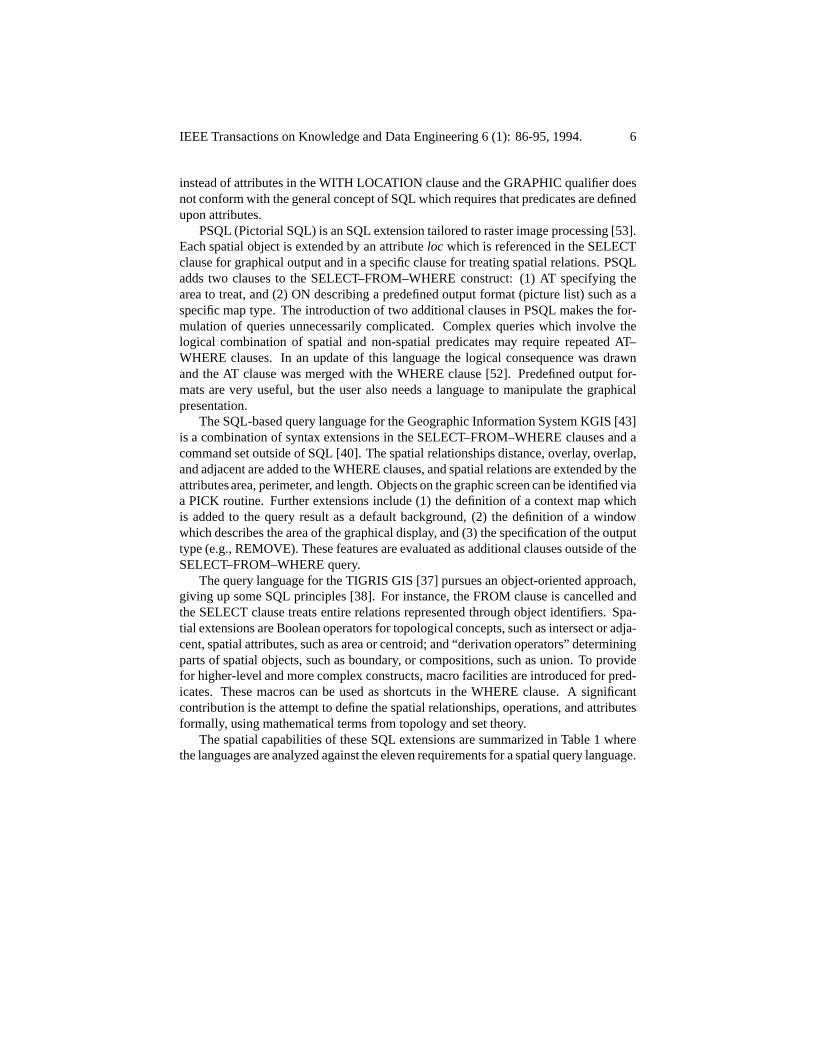
PSQL (Pictorial SQL) is an SQL extension tailored to raster image processing [53].Each spatial object is extended by an attribute which is referenced in the SELECTclause for graphical output and in a specific clause for treating spatial relations. PSQLadds two clauses to the SELECT–FROM–WHERE construct: (1) AT specifying thearea to treat, and (2) ON describing a predefined output format (picture list) such as aspecific map type. The introduction of two additional clauses in PSQL makes the for-mulation of queries unnecessarily complicated. Complex queries which involve thelogical combination of spatial and non-spatial predicates may require repeated AT–WHERE clauses. In an update of this language the logical consequence was drawnand the AT clause was merged with the WHERE clause [52]. Predefined output for-mats are very useful, but the user also needs a language to manipulate the graphicalpresentation.
The SQL-based query language for the Geographic Information System KGIS [43]is a combination of syntax extensions in the SELECT–FROM–WHERE clauses and acommand set outside of SQL [40]. The spatial relationships distance, overlay, overlap,and adjacent are added to the WHERE clauses, and spatial relations are extended by theattributes area, perimeter, and length. Objects on the graphic screen can be identified viaa PICK routine. Further extensions include (1) the definition of a context map whichis added to the query result as a default background, (2) the definition of a windowwhich describes the area of the graphical display, and (3) the specification of the outputtype (e.g., REMOVE). These features are evaluated as additional clauses outside of theSELECT–FROM–WHERE query.
The query language for the TIGRIS GIS [37] pursues an object-oriented approach,giving up some SQL principles [38]. For instance, the FROM clause is cancelled andthe SELECT clause treats entire relations represented through object identifiers. Spa-tial extensions are Boolean operators for topological concepts, such as intersect or adja-cent, spatial attributes, such as area or centroid; and “derivation operators” determiningparts of spatial objects, such as boundary, or compositions, such as union. To providefor higher-level and more complex constructs, macro facilities are introduced for pred-icates. These macros can be used as shortcuts in the WHERE clause. A significantcontribution is the attempt to define the spatial relationships, operations, and attributesformally, using mathematical terms from topology and set theory.
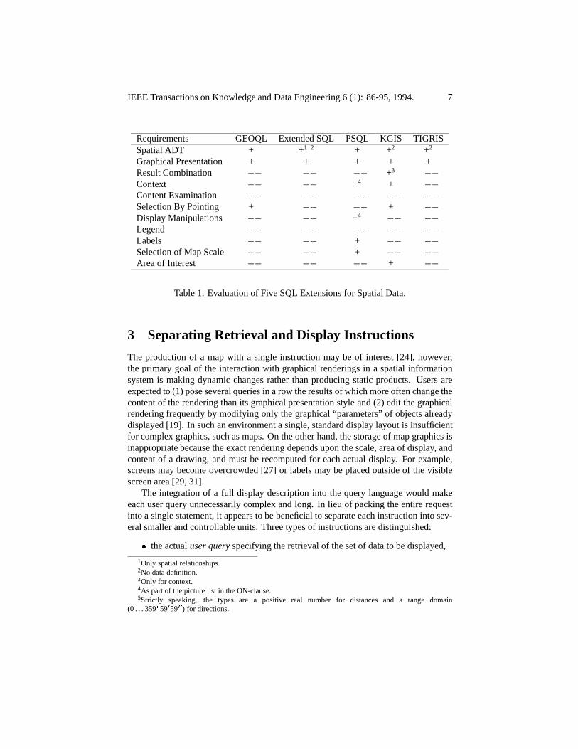
The spatial capabilities of these SQL extensions are summarized in Table 1 wherethe languages are analyzed against the eleven requirements for a spatial query language.
;
� 0 00
1
2
3
4
5
1 2 2 2
3
4
4
user query
� � � �
� � �
� � � � �
� � �
� � � �
� � � � �
� � � �
� � � �
� � � �
�
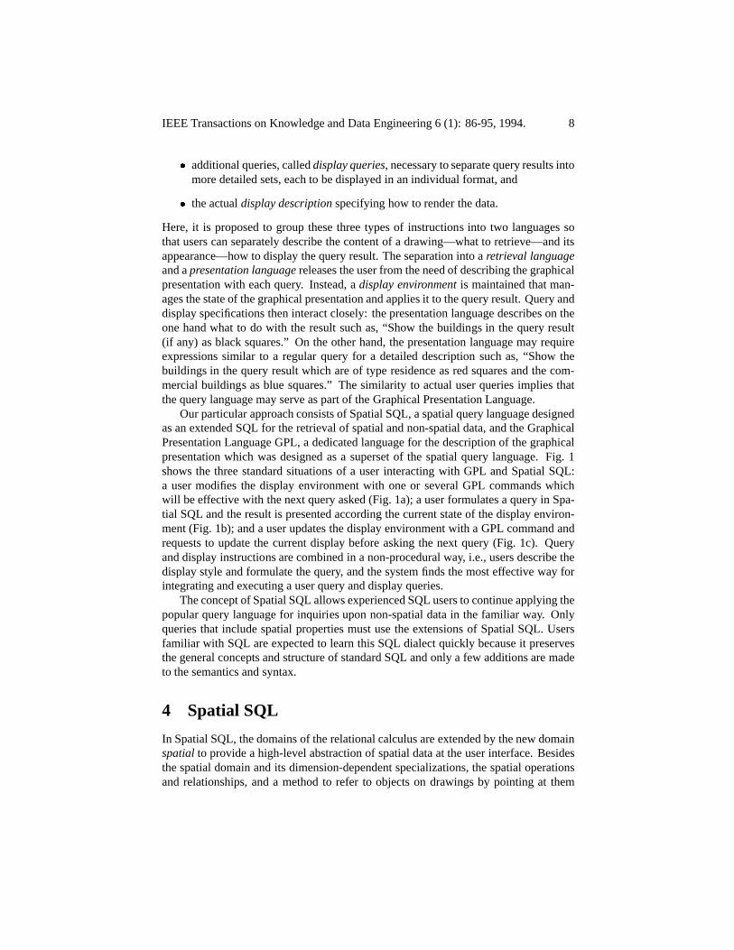
3 Separating Retrieval and Display Instructions
Only spatial relationships.No data definition.Only for context.As part of the picture list in the ON-clause.Strictly speaking, the types are a positive real number for distances and a range domain
(0 . . . 359 59 59 ) for directions.
IEEE Transactions on Knowledge and Data Engineering 6 (1): 86-95, 1994. 7
Requirements GEOQL Extended SQL PSQL KGIS TIGRISSpatial ADT + + + + +Graphical Presentation + + + + +Result Combination +Context + +Content ExaminationSelection By Pointing + +Display Manipulations +LegendLabels +Selection of Map Scale +Area of Interest +
Table 1. Evaluation of Five SQL Extensions for Spatial Data.
The production of a map with a single instruction may be of interest [24], however,the primary goal of the interaction with graphical renderings in a spatial informationsystem is making dynamic changes rather than producing static products. Users areexpected to (1) pose several queries in a row the results of which more often change thecontent of the rendering than its graphical presentation style and (2) edit the graphicalrendering frequently by modifying only the graphical “parameters” of objects alreadydisplayed [19]. In such an environment a single, standard display layout is insufficientfor complex graphics, such as maps. On the other hand, the storage of map graphics isinappropriate because the exact rendering depends upon the scale, area of display, andcontent of a drawing, and must be recomputed for each actual display. For example,screens may become overcrowded [27] or labels may be placed outside of the visiblescreen area [29, 31].
The integration of a full display description into the query language would makeeach user query unnecessarily complex and long. In lieu of packing the entire requestinto a single statement, it appears to be beneficial to separate each instruction into sev-eral smaller and controllable units. Three types of instructions are distinguished:
the actual specifying the retrieval of the set of data to be displayed,
�
�
4 Spatial SQL
display queries
display description
retrieval languagepresentation language
display environment
spatial
IEEE Transactions on Knowledge and Data Engineering 6 (1): 86-95, 1994. 8
additional queries, called , necessary to separate query results intomore detailed sets, each to be displayed in an individual format, and
the actual specifying how to render the data.
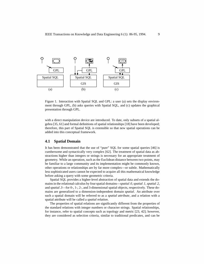
Here, it is proposed to group these three types of instructions into two languages sothat users can separately describe the content of a drawing—what to retrieve—and itsappearance—how to display the query result. The separation into aand a releases the user from the need of describing the graphicalpresentation with each query. Instead, a is maintained that man-ages the state of the graphical presentation and applies it to the query result. Query anddisplay specifications then interact closely: the presentation language describes on theone hand what to do with the result such as, “Show the buildings in the query result(if any) as black squares.” On the other hand, the presentation language may requireexpressions similar to a regular query for a detailed description such as, “Show thebuildings in the query result which are of type residence as red squares and the com-mercial buildings as blue squares.” The similarity to actual user queries implies thatthe query language may serve as part of the Graphical Presentation Language.
Our particular approach consists of Spatial SQL, a spatial query language designedas an extended SQL for the retrieval of spatial and non-spatial data, and the GraphicalPresentation Language GPL, a dedicated language for the description of the graphicalpresentation which was designed as a superset of the spatial query language. Fig. 1shows the three standard situations of a user interacting with GPL and Spatial SQL:a user modifies the display environment with one or several GPL commands whichwill be effective with the next query asked (Fig. 1a); a user formulates a query in Spa-tial SQL and the result is presented according the current state of the display environ-ment (Fig. 1b); and a user updates the display environment with a GPL command andrequests to update the current display before asking the next query (Fig. 1c). Queryand display instructions are combined in a non-procedural way, i.e., users describe thedisplay style and formulate the query, and the system finds the most effective way forintegrating and executing a user query and display queries.
The concept of Spatial SQL allows experienced SQL users to continue applying thepopular query language for inquiries upon non-spatial data in the familiar way. Onlyqueries that include spatial properties must use the extensions of Spatial SQL. Usersfamiliar with SQL are expected to learn this SQL dialect quickly because it preservesthe general concepts and structure of standard SQL and only a few additions are madeto the semantics and syntax.
In Spatial SQL, the domains of the relational calculus are extended by the new domainto provide a high-level abstraction of spatial data at the user interface. Besides
the spatial domain and its dimension-dependent specializations, the spatial operationsand relationships, and a method to refer to objects on drawings by pointing at them
H Hj
? ? 6
6 H Hj
? 6
6
f ��
��
f ��
��
f ��
��
4.1 Spatial Domain
spatial 0 spatial 1 spatial 2spatial 3
spatialspatial attribute
spatial relation
IEEE Transactions on Knowledge and Data Engineering 6 (1): 86-95, 1994. 9
GPL
Spatial SQL
(a)
GPL
Spatial SQL
GIS
(b)
GPL
Spatial SQL
GIS
(c)
Figure 1. Interaction with Spatial SQL and GPL: a user (a) sets the display environ-ment through GPL, (b) asks queries with Spatial SQL, and (c) updates the graphicalpresentation through GPL.
with a direct manipulation device are introduced. To date, only subsets of a spatial al-gebra [35, 61] and formal definitions of spatial relationships [18] have been developed;therefore, this part of Spatial SQL is extensible so that new spatial operations can beadded into this conceptual framework.
It has been demonstrated that the use of “pure” SQL for some spatial queries [46] iscumbersome and syntactically very complex [62]. The treatment of spatial data as ab-stractions higher than integers or strings is necessary for an appropriate treatment ofgeometry. While an operation, such as the Euclidean distance between two points, maybe familiar to a large community and its implementation might be commonly known,other operations or relationships are by far more complex—or subtle. Mathematicallyless sophisticated users cannot be expected to acquire all this mathematical knowledgebefore asking a query with some geometric criteria.
Spatial SQL provides a higher-level abstraction of spatial data and extends the do-mains in the relational calculus by four spatial domains— , , ,and —for 0-, 1-, 2-, and 3-dimensional spatial objects, respectively. These do-mains are generalized to a dimension-independent domain . An attribute oversuch a spatial domain will be referred to as a , and a relation with aspatial attribute will be called a .
The properties of spatial relations are significantly different from the properties ofthe standard relations with integer numbers or character strings. Spatial relationships,for instance, refer to spatial concepts such as topology and metric [23, 42]; however,they are considered as selection criteria, similar to traditional predicates, and can be
5
n O
O
O
4.2 Spatial Operations and Relationships
distance (city.geometry,highway.geometry)
Unary spatial operations
dimensionBoundary
interior
boundingNodes boundingEdges
boundary boundingNodesboundingEdges interior interiorNodes interiorEdges interiorAreas
lengtharea volume
perimeterextreme coordi-
nates complement convex hull
Binary spatial operations
distance direction
angles minimum average
Binary spatial relationship
IEEE Transactions on Knowledge and Data Engineering 6 (1): 86-95, 1994. 10
used similarly to conventional relationships. Only the specified spatial operations andrelationships apply to spatial attributes.
access a spatial property of a tuple of a spatial relation. Aunary spatial operation can be considered a function upon a spatial attribute. Importantspatial functions are those which determine the dimension of an object, its boundary,and its interior. The is 0, 1, 2, and 3 for points, lines, areas, and volumes,respectively. determines the bounding faces of an -dimensional object ,i.e., all object parts in the boundary of [16]. Complementary to boundary,calculates the interior faces, i.e., all those object parts that are not in the boundary of .The specializations of these operations determine bounding and interior faces of a spe-cific dimension, e.g., an area has the operations and forthe determination of 0- and 1-dimensional bounding object parts, respectively. For 1-and 2-dimensional objects, the set consists of the operations , ,
, , , , and .A second set of unary spatial operations deals with arithmetic operations. They
depend upon the dimension of an object. This set of operations consists of , fora 1-dimensional object, and and for 2-D and 3-D objects, respectively.More complex attributes can be derived as the combination of topological and arith-metic properties, such as the of a polygon which is defined as the sum ofthe lengths of the boundingEdges. Other unary operations, such as
[13], [8], and [35], fit into this concept and may be easilyincorporated into Spatial SQL.
calculate a value among two tuples of spatial relations,similar to the arithmetic operators for atoms of conventional domains, such as additionor multiplication. Two binary spatial operations are introduced in Spatial SQL whichmap from two spatial attributes onto a real number: (1) and (2) .Distances can be added, subtracted, multiplied with a scalar, and compared for equal-ity, order, and strict order. Directions can be compared with the same operators andsubtracted to yield . Aggregate functions, such as and , can beformulated upon distances and directions.
A prefix formulation for spatial operators, like, is more natural and preferred over the conventional infix
form of arithmetic operators. Spatial operators can occur in any SELECT clause inassociation with two spatial attributes, or in any WHERE clause as part of a non-spatialpredicate. Though spatial operators are conceptually different from aggregate func-tions, they are incorporated into Spatial SQL at the same locations.
are relationships between two spatial attributes. Theyconform with traditional binary relationships and result in a Boolean value. Hence,they can be immediately applied as predicates in the WHERE clause of SQL. SpatialSQL also preserves the infix form of traditional SQL predicates for spatial predicates.Similar to Standard SQL, which overloads relationships like less than or equal, spa-
� �
�
�
�
\ :;
\ ;
\ ;
\ ;
@A @B
A B
@A B
A @B
A B @
4.3 Spatial Data Definition
city namegeometry
CREATE TABLE city( name char (20)
geometry spatial_2 );
city
spatial
Neighbor
disjoint meet overlap inside/contains cov-ers/coveredBy equal
left/right north/southover/under
IEEE Transactions on Knowledge and Data Engineering 6 (1): 86-95, 1994. 11
tial relationships are defined upon the generalized spatial data type . The actualimplementation is invisible to the user unless a constraint is violated, such as a voidpredicate, “point contains line.”
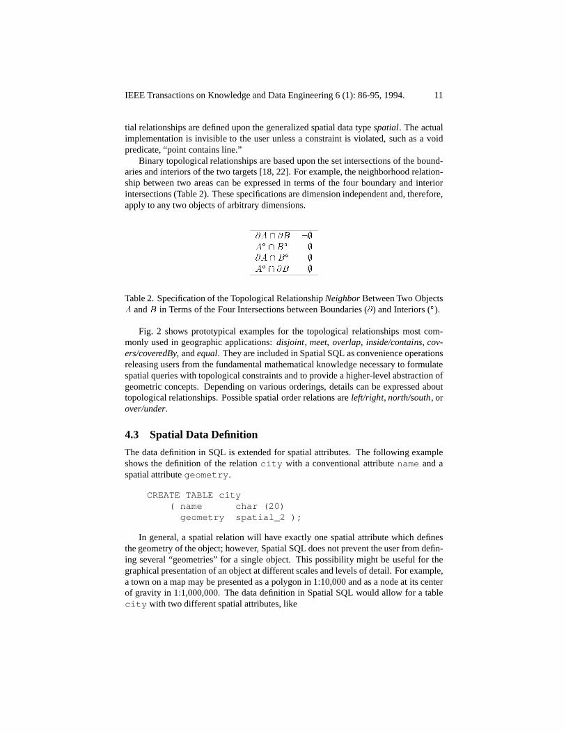
Binary topological relationships are based upon the set intersections of the bound-aries and interiors of the two targets [18, 22]. For example, the neighborhood relation-ship between two areas can be expressed in terms of the four boundary and interiorintersections (Table 2). These specifications are dimension independent and, therefore,apply to any two objects of arbitrary dimensions.
Table 2. Specification of the Topological Relationship Between Two Objectsand in Terms of the Four Intersections between Boundaries ( ) and Interiors ( ).
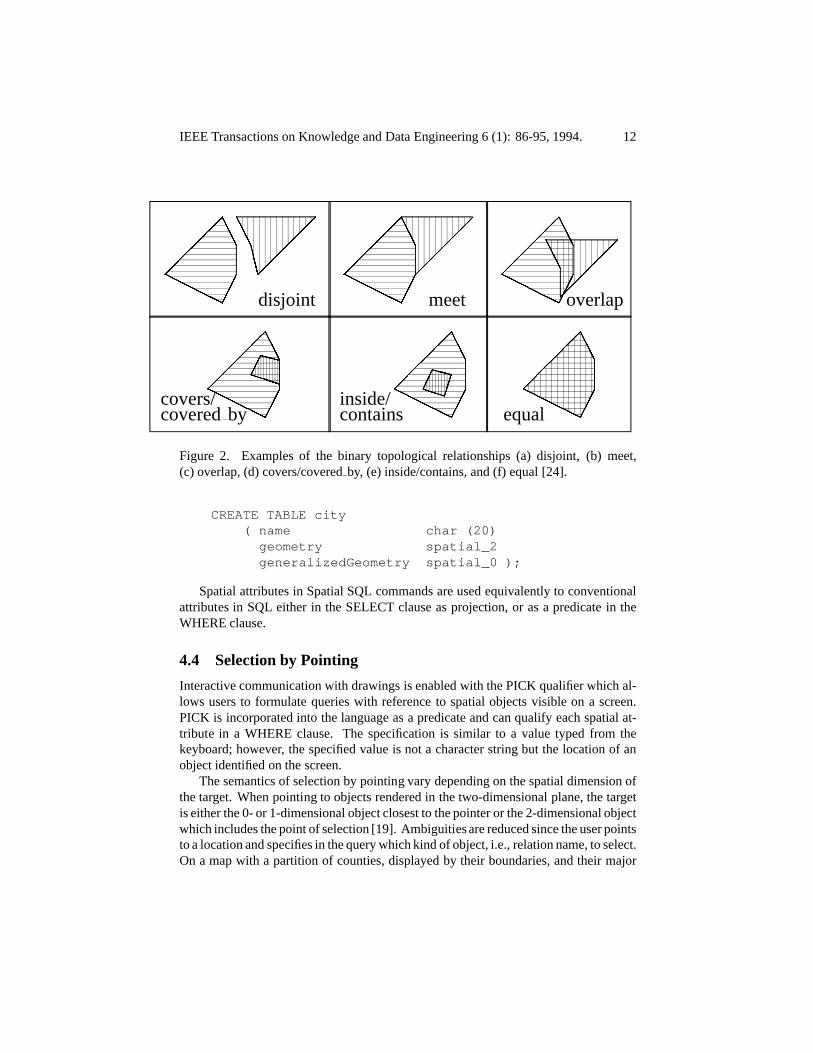
Fig. 2 shows prototypical examples for the topological relationships most com-monly used in geographic applications: , , , ,
, and . They are included in Spatial SQL as convenience operationsreleasing users from the fundamental mathematical knowledge necessary to formulatespatial queries with topological constraints and to provide a higher-level abstraction ofgeometric concepts. Depending on various orderings, details can be expressed abouttopological relationships. Possible spatial order relations are , , or
.
The data definition in SQL is extended for spatial attributes. The following exampleshows the definition of the relation with a conventional attribute and aspatial attribute .
In general, a spatial relation will have exactly one spatial attribute which definesthe geometry of the object; however, Spatial SQL does not prevent the user from defin-ing several “geometries” for a single object. This possibility might be useful for thegraphical presentation of an object at different scales and levels of detail. For example,a town on a map may be presented as a polygon in 1:10,000 and as a node at its centerof gravity in 1:1,000,000. The data definition in Spatial SQL would allow for a table
with two different spatial attributes, like
4.4 Selection by Pointing
disjoint meet overlap
covers/covered by
inside/contains equal
CREATE TABLE city( name char (20)
geometry spatial_2generalizedGeometry spatial_0 );
��
�� �
H H H H H
AA A
�� �
AA A
CC C �
��
� �
��
�� �
H H H H H
AA A
�� �
��
�� �
��
�� �
H H H H H
AA A
�� �
AA A
��
�� �
��
�� �
H H H H H
AA A
�� �
XX� �P P P �
��
� �
H H H H H
AA A
�� �
XX� �P P �
� ��
�� �
H H H H H
AA A
�� �
IEEE Transactions on Knowledge and Data Engineering 6 (1): 86-95, 1994. 12
Figure 2. Examples of the binary topological relationships (a) disjoint, (b) meet,(c) overlap, (d) covers/covered by, (e) inside/contains, and (f) equal [24].
Spatial attributes in Spatial SQL commands are used equivalently to conventionalattributes in SQL either in the SELECT clause as projection, or as a predicate in theWHERE clause.
Interactive communication with drawings is enabled with the PICK qualifier which al-lows users to formulate queries with reference to spatial objects visible on a screen.PICK is incorporated into the language as a predicate and can qualify each spatial at-tribute in a WHERE clause. The specification is similar to a value typed from thekeyboard; however, the specified value is not a character string but the location of anobject identified on the screen.
The semantics of selection by pointing vary depending on the spatial dimension ofthe target. When pointing to objects rendered in the two-dimensional plane, the targetis either the 0- or 1-dimensional object closest to the pointer or the 2-dimensional objectwhich includes the point of selection [19]. Ambiguities are reduced since the user pointsto a location and specifies in the query which kind of object, i.e., relation name, to select.On a map with a partition of counties, displayed by their boundaries, and their major
display environment
5 The Graphical Presentation Language GPL
SELECT nameFROM cityWHERE geometry = PICK;
SELECT nameFROM countyWHERE geometry = PICK;
IEEE Transactions on Knowledge and Data Engineering 6 (1): 86-95, 1994. 13
cities displayed as small circles, a user asks for the the name of a particular city byclicking to its map symbol and entering the following query:
On the other hand, if one points to the same location and specifies that the objectselected is a county, the county name will be retrieved:
Ambiguities in the selection may exist if more than one object of the class identifiedhas the same distance to the pointer position. Such situations may occur when, forinstance, a user tries to select a road pointing exactly to the intersection of two roads.Likewise, the selection of an areal object is ambiguous if the user points exactly tothe boundary of two adjacent areas. In such (rare) cases, the user will be offered thepossible choices and then asked to identify the target [21].
The Graphical Presentation Language GPL [20] provides tools for the manipulationof the graphical presentation of query results. Central to GPL is the concept of the
which handles the information about how to display query results.During query processing, this information is integrated with the user query so that thequery result is rendered according the display description. Unless the user changes theenvironment with a GPL instruction, the display environment continues to produce witheach query a map of the same style.
GPL offers instructions to SET a graphic specification, establishing the character-istics of the display environment; to CANCEL a specification, resetting the displayenvironment; and to examine (SHOW) the current values of the display environment.Environments established with GPL are effective for all subsequent Spatial SQL queriesand stay valid until they are cancelled or overwritten with a corresponding instruction.SET and CANCEL can be qualified with PERMANENT so that the instructions per-sist across sessions, and with IMMEDIATELY to allow users to update the graphicalpresentation of the current map prior to asking the next query.
Six types of graphic specification are distinguished: (1) the display mode, (2) thegraphical presentation, (3) the scale of the drawing, (4) the window to be shown, (5)the spatial context, and (6) the examination of the content.
n n
visual variables
5.1 Display Mode
5.2 Visual Variables
5.3 Scale and Window
IEEE Transactions on Knowledge and Data Engineering 6 (1): 86-95, 1994. 14
In order to combine several query results in a single drawing, the selection of the ap-propriate display mode is necessary. A major impediment for any SQL-based querylanguage with more than one kind of rendering is that the SELECT clause is over-loaded with the projection of the attributes onto the resulting relation and the impliedtabular representation [15]. Spatial SQL solves this problem by the separation of thetwo issues so that the SELECT command performs only the relational projection op-eration, and the query result will be displayed according to the current display modeselected with GPL. The six display modes are the conventional alphanumeric displayand five graphical display types [19]: (1) NEW, starting a new drawing; (2) OVER-LAY, adding the result onto an existing drawing; (3) REMOVE, erasing the result froma drawing; (4) INTERSECT, determining the common objects on the display and inthe query result; and (5) HIGHLIGHT, emphasizing the result such that it can be easilyrecognized.
With the selection of the graphic mode the placement of labels can be directed aswell. Non-spatial attributes in the SELECT clause will be represented as labels. Theiractual placement remains the task of some name placement subsystem [31].
The graphical presentation plays a more important role for spatial data than for thepresentation of lexical data in tabular form [19]; therefore, the use of(colors pattern, and symbols) [6] to specify the graphical presentation of spatial objectsis included into GPL. These graphic attributes can be specified for either an entire spa-tial relation or instances of spatial relations which fulfill specific constraints. This letsdifferent users view a spatial database from their individual perspectives and allowsthem to tailor the graphical presentation of query results to their specific needs. Com-plementary to defining these visual variables, users can check the current settings by“looking at the legend,” i.e., inquiring about the graphical presentation.
This part of GPL depends upon the user’s hardware; therefore, the set of terms forthe visual variables is is designed to be extensible so that it can be adapted to differentenvironments.
The scale of the graphical presentation and the window describing the area to be dis-played can be described with the commands SET SCALE and SET WINDOW, respec-tively. The scale is set by a positive number , representing a scale factor of 1 : .The window can be determined either by two pairs of coordinates, two diagonal pointsselected on a screen drawing, or the minimal bounding rectangle from the result of aSpatial SQL query.
6 Query Example
5.4 Context
5.5 Content
SET LEGENDCOLOR blackPATTERN dashed
FOR SELECT boundary (geometry)FROM parcel;
SET LEGENDCOLOR green, blue
FOR SELECT residence.geometry, commercial.geometry
IEEE Transactions on Knowledge and Data Engineering 6 (1): 86-95, 1994. 15
The interpretation of a graphical presentation is extremely dependent on the context andenvironment in which it is shown. Unlike lexical presentation, it is often insufficient todraw only those objects directly requested in the query. The graphical presentation ofa city as a point in the center of the screen is useless information unless context, suchas the boundary of the state, helps to identify its location [21]. GPL allows the user todefine spatial relations or specified portions with SET CONTEXT as graphical contextwhich is during query processing merged with the actual user query.
Because a combination of multiple query results may be shown in a single drawing,a control mechanism is necessary with which the user may examine the content of adrawing. The content is the logical combination of queries the results of which werecombined with OVERLAY and REMOVE. In essence, the content gives a single querywith which the drawing currently visible could have been produced. Of course, contentis only observable, i.e., users can examine the content with SHOW CONTENT, butthey cannot SET or MODIFY it.
Imagine a geographic database of Penobscot county with towns, parcels, buildings,roads, rivers, and utility lines. An insurance agent wants the following informationdisplayed on a map for a client who intends to buy a home owner’s insurance policy forthe building “26 Grove Street” in the town of Orono:
Show a map of Grove Street in Orono with all buildings, parcel boundaries,and roads. Display the residences in green, commercial buildings in blue,parcel boundaries in black. Cross-hatch roads narrower than 15 ft. Labelroads by names.
First, the graphical environment is built describing the various colors, patterns, andsymbols used.
FROM residence building, commercial buildingWHERE residence.type = "Residential" and
commercial.type = "Commercial";
SET LEGENDPATTERN cross-hatched
FOR SELECT interior (geometry)FROM roadWHERE width < 15;
SET WINDOWSELECT geometryFROM roadWHERE town.name = "Orono";
SET CONTEXTFOR road.geometry
SELECT parcel.geometry, building.geometry, road.nameFROM road, parcel, building;
SET MODE new;
SELECT road.geometryFROM road, townWHERE town.name = "Orono" and
road.name = "Grove Street" androad.geometry INSIDE town.geometry;
SET MODE highlight;SELECT building.geometryFROM buildingWHERE address = "26 Grove Street";
IEEE Transactions on Knowledge and Data Engineering 6 (1): 86-95, 1994. 16
Then the user identifies the window of interest and sets a context for the roads.
Finally, the user selects to draw a new map and enters the actual user query, a briefSpatial SQL statement.
The result is the desired map. With further Spatial SQL commands the user requestsmore information about the objects displayed or manipulates the graphical propertiesof the rendering. For example, the following commands will help the insurance agentto identify the building with address “26 Grove Street”:
The insurance agent’s primary interest is in fire fighting. How far is the building fromthe next fire station?
7 Conclusions
SET MODE alpha;
SELECT distance (building.geometry, firestation.geometry),firestation.address
FROM building, building firestationWHERE building = PICK and
firestation.type = "Fire Station";
SET LEGENDCOLOR redSYMBOL "2mm disk"
FOR SELECT geometryFROM utilityWHERE type = "Water Hydrant";
SET MODE overlay;
SELECT geometryFROM utility, buildingWHERE type = "Water Hydrant" and
building.geometry = PICK anddistance (building.geometry, utility.geometry) < 100;
SET IMMEDIATELY COLOR redFOR SELECT interior (geometry)
FROM parcelWHERE fire_damage_date >= 1980;
IEEE Transactions on Knowledge and Data Engineering 6 (1): 86-95, 1994. 17
The result is a list of fire stations and their distances to the building which the userselected by pointing (PICK). Note that the previously defined window restricts the firestations to be located in Orono.
To check the accessibility to a water hydrant from “26 Grove Street” the insuranceagent overlays the water hydrants, located within 100 ft of the building, over the currentmap.
Are there any parcels on Grove Street which had fire accidents since 1980? If yes,show them on the map.
The insurance agent checks the values of the buildings on the parcels adjacent to“26 Grove Street.”
Spatial SQL is characterized by minimal extensions to SQL and the introduction of theGraphical Presentation Language (GPL). The eleven requirements for a spatial query
O2
spatialad hoc
Acknowledgments
IEEE Transactions on Knowledge and Data Engineering 6 (1): 86-95, 1994. 18
language are satisfied with: (1) the introduction of a spatial data type and the cor-responding operations and relationships; (2) the graphical presentation directed fromGPL; (3) the display modes NEW, OVERLAY, REMOVE, INTERSECT, and HIGH-LIGHT in GPL to combine query results into a single drawing; (4) the definition ofCONTEXT in GPL; (5) the examination of CONTENT from GPL; (6) selection bypointing via the PICK qualifier in WHERE clauses; (7) the manipulation of the graph-ical presentations of objects with colors, patterns, and symbols; (8) the examination ofthe map LEGEND in GPL; (9) the combination of both graphical and alphanumericdata in a single result which enable objects to be labeled; (10) graphical presentations inspecific map scales; and (11) the selection of a spatial query window to which querieswill refer.
Several features of Spatial SQL have an object-oriented flavor, such as the complexabstract data type and its subtypes for different spatial dimensions. Recently,object-oriented SQL versions have been proposed as general query languagesfor object-oriented databases, e.g., OSQL for IRIS [26], HDBL [44], and the querylanguage [3]. HDBL and OSQL allow users to define complex data types, includinggeneralization hierarchies, and corresponding operations; however, the extension of adatabase language with a new abstract data type [14, 50, 59] is only one of the require-ments for a spatial query language. All object-oriented SQL extensions have not madeany provisions for the issues related to the graphical presentation of query results.
Spatial SQL and GPL commands are verbose if a user has to type them from akeyboard. Considerable increase of the usability of this spatial query language is ex-pected by incorporating the command line structure into a human interface, as proposedin [21]. The incorporation of the direct manipulation device into the query language isa first step toward an improved interaction with maps using pointing instead of typing.Operations like pan and zoom are good candidates to exploit this concept for whichappropriate metaphors are being examined [41]. Likewise, the implementation of GPLas a visual language is likely to boost its usability. For example, instead of typing aname for a color or pattern, users may make their choice from a control panel whichpresents a series of colors and patterns, and also allows the users to create new ones. Acartographic editor to create and manipulate cartographic symbols is an essential com-ponent of such a user interface [58]. Finally, the visualization of prototypical spatialrelations may reduce the time for learning a specific terminology and help users in theselection of the correct configuration.
Andrew Frank’s expertise and advice were helpful contributions to this paper. Thanksalso to Renato Barrera and Bruce Palmer for many stimulating discussions, Doug Hud-son who made many helpful comments on the language design, and Robert Cicognawho helped with the preparation of this paper.
2O
REFERENCES
References
ACM Trans. Database Syst.
Proc. 2nd Int. Workshop Database ProgrammingLanguages
IEEE Trans. Comp. Architecture: Pattern Analy-sis and Image Database Management
ACM Comp. Graphics
Semiology of Graphics
Proc. 13th Int. Conf. VLDB
Geo-Processing
IBM J. Res. and Develop.
Computer
IEEE Trans. SoftwareEng.
Datamation
Geo-Processing
SIGMOD Rec.
Proc. 2nd Int.Seminar Trends and Concerns of Spatial Sciences
19
[1] “X3.135-1986 American National Standard Database Language SQL,” AmericanNational Standards Institute, Jan. 1986.
[2] G. Ariav, “A temporally oriented data model,” ,vol. 11, no. 4, pp. 499–527, Dec. 1986.
[3] F. Bancilhon, S. Cluet, and C. Delobel, “A query language for the object-oriented database system,” in
, June 1989, pp. 122–138.
[4] R. Barrera and A. Buchmann, “Schema definition and query language for ageographical database system,”
, vol. 11, pp. 250–256, 1981.
[5] R. Berman and M. Stonebraker, “Geo-Quel, a system for the manipulation anddisplay of geographic data,” , vol. 11, no. 2, pp. 186–191,1977.
[6] J. Bertin, . Madison, WI: The University of WisconsinPress, 1983.
[7] G. von Bultzingsloewen, “Translating and optimizing SQL queries having aggre-gates,” in , Brighton, England, Sep. 1987, pp. 235–243.
[8] W. Burton, “Logical and physical data types in geographic information systems,”, vol. 1, no. 2, pp. 167–181, 1979.
[9] D. Chamberlin, M. Astrahan, K. Eswaran, P. Griffiths, R. Lorie, J. Mehl, P. Reis-ner, and B. Wade, “Sequel 2: a unified approach to data definition, manipulation,and control,” , vol. 20, no. 6, pp. 560–575, Nov. 1976.
[10] S.K. Chang and T. Kunii, “Pictorial database systems,” , vol. 14, no. 11,pp. 13–21, Nov. 1981.
[11] N.S. Chang and K.S. Fu, “Query-by-pictorial-example,”, vol. SE-6, no. 6, pp. 519–524, Nov. 1980.
[12] E.F. Codd, “Fatal flaws in SQL,” , vol. 34, no. 16, Aug. 1988.
[13] N. Cox, B. Alfred, and D. Rhind, “A relational data base system and a proposalfor a geographic data type,” , vol. 1, no. 3, pp. 217–229, 1979.
[14] C.J. Date, “Defining data types in a database language,” , vol. 17,no. 2, pp. 53–76, June 1988.
[15] M. Egenhofer, “An extended SQL syntax to treat spatial objects,” in, Fredericton, New Brunswick,
June 1987, pp. 83–95.
REFERENCES
Proc.3rd Int. Conf. Foundations of Data Organization and Algorithms
J. Visual Languages and Computing
Cartography and Ge-ographic Information Systems
Proc. 14th Int. Conf. VLDB
Int. J.Geographical Information Systems
Proc. Fourth Int. Symp. Spatial Data Handling
Geologisches Jahrbuch
ACM Trans. Office In-form. Syst.
Proc. 7th Int.Conf. VLDB
ACM Comp. Graphics
J. SurveyingEngineering
20
[16] M. Egenhofer, “Graphical representation of spatial objects: an object-orientedview,” Tech. Rep. 83, Department of Surveying Engineering, University of Maine,Orono, ME, July 1988.
[17] M. Egenhofer, “Spatial query languages,” PhD thesis, University of Maine,Orono, ME, 1989.
[18] M. Egenhofer, “A formal definition of binary topological relationships,” in, Paris, France,
June 1989, LNCS vol. 367, New York, NY: Springer-Verlag, pp. 457–472.
[19] M. Egenhofer, “Interaction with geographic information systems via spatialqueries,” , vol. 1, no. 4, pp. 389–413, 1990.
[20] M. Egenhofer, “Extending SQL for cartographic display,”, 1991 (in press).
[21] M. Egenhofer and A. Frank, “Towards a spatial query language: user interfaceconsiderations,” in , Long Beach, CA, Aug. 1988,pp. 124–133.
[22] M. Egenhofer and R. Franzosa, “Point-set topological spatial relations,”, vol. 5, no. 2, pp. 161–174, 1991.
[23] M. Egenhofer and J. Herring, “A mathematical framework for the definition oftopological relationships,” in ,Zurich, Switzerland, July 1990, pp. 814–819.
[24] H.-D. Ehrich, F. Lohmann, K. Neumann, and I. Ramm, “A database language forscientific map data,” , vol. A, no. 104, pp. 139–152, 1988.
[25] D.W. Embley and G. Nagy, “Toward a high-level integrated image database sys-tem,” Tech. Rep., Image Processing Laboratory, Rensselaer Polytechnic Institute,Troy, NY, Apr. 1986.
[26] D. Fishman, D. Beech, H. Cate, E. Chow, T. Connors, J. Davis, N. Derrett,C. Hoch, W. Kent, P. Lyngbaek, B. Mahbod, N. Neimat, T. Ryan, and M. Shan,“Iris: an object-oriented database management system,”
, vol. 5, no. 1, pp. 48–69, Jan. 1986.
[27] A. Frank, “Applications of DBMS to land information systems,” in, Cannes, France, Aug. 1981, pp. 448–453.
[28] A. Frank, “Mapquery—database query language for retrieval of geometric dataand its graphical representation,” , vol. 16, no. 3, pp. 199–207, July 1982.
[29] A. Frank, “Computer assisted cartography—graphics or geometry,”, vol. 110, no. 2, pp. 159–168, Aug. 1984.
REFERENCES
Pho-togrammetric Eng. & Remote Sensing
Int. J. Pattern Recognition and Art. Intell.
ACM Comp. Graphics
SIGMODRec.
Proc. Int. Conf. Extending Database Technology
ACM Trans. Database Syst.
Proc. AUTO-CARTO 8
Proc. GIS/LIS ’88
Proc. AUTO-CARTO 8
Proc. ACSM-ASPRS Annual Conv.
Proc. Fourth Int.Symp. Spatial Data Handling
Photogrammetric Eng. & Remote Sensing
21
[30] A. Frank, “Requirements for a database management system for a GIS,”, vol. 54, no. 11, pp. 1557-1564, Nov. 1988.
[31] H. Freeman and J. Ahn, “On the problem of placing names in a geographic map,”, vol. 1, no. 1, pp. 121–140, 1987.
[32] M. Friedell, J. Barnett, and D. Kramlich, “Context-sensitive, graphic presentationof information,” , vol. 16, no. 3, pp. 181–188, July 1982.
[33] A. Go, M. Stonebraker, and C. Williams, “An approach to implementing a geo-data system,” Tech. Rep., Memo ERL-M529, Electronics Research Laboratory,University of California, Berkeley, CA, June 1975.
[34] O. Guenther and A. Buchmann, “Research issues in spatial databases,”, vol. 19, no. 4, pp. 61–68, 1990.
[35] R. Guting, “Geo-relational algebra: a model and query language for geometricdatabase systems,” in , Venice,Italy, May 1988, LNCS vol. 303, New York, NY: Springer Verlag, pp. 506–527.
[36] C. Herot, “Spatial management of data,” , vol. 5, no. 4,pp. 493–513, Dec. 1980.
[37] J. Herring, “TIGRIS: topologically integrated geographic information systems,”in , Baltimore, MD, March 1987, pp. 282–291.
[38] J. Herring, R. Larsen, and J. Shivakumar, “Extensions to the SQL language tosupport spatial analysis in a topological data base,” in , SanAntonio, TX, Nov. 1988, pp. 741–750.
[39] D. Hudson, “Combined Spatial/II and RDB database operation: query coordina-tion and optimization strategies,” Tech. Rep., University of Maine, Orono, De-partment of Surveying Engineering, Orono, ME, 1988.
[40] K. Ingram and W. Phillips, “Geographic information processing using a SQL-based query language,” in , Baltimore, MD, March 1987,pp. 326–335.
[41] J. Jackson, “Developing an effective human interface for geographic informationsystems using metaphors,” in , Denver, CO,March 1990, pp. 117–125.
[42] W. Kainz, “Spatial relationships—topology versus order,” in, Zurich, Switzerland, July 1990, pp. 814–819.
[43] T. Keating, W. Phillips, and K. Ingram, “An integrated topologic database designfor geographic information systems,” ,vol. 53, no. 10, pp. 1399–1402, Oct. 1987.
REFERENCES
Proc.14th Int. Conf. VLDB
Proc. SIGMOD 83
Geo-Processing
Proc. 2nd Int. Workshop Object-Oriented Database Syst.
ACM Trans.Database Syst.
SIGMOD Rec.
Proc. IEEE 5th Int. Conf. Data Eng.
IEEE Trans. Software Eng.
Proc. SIGMOD 85
IEEE Trans. Knowledgeand Data Eng.
J. Visual Languages and Computing
22
[44] V. Linnemann, K. Kuspert, P. Dadam, P. Pistor, R. Erbe, A. Kemper, N. Sudkamp,G. Walch, and M. Wallrath, “Design and implementation of an extensible databasemanagement system supporting user defined data types and functions,” in
, Long Beach, CA, Aug. 1988, pp. 294–305.
[45] G. Lohman, J. Stoltzfus, A. Benson, M. Martin, and A. Cardenas, “Remotely-sensed geophysical databases: experience and implications for generalizedDBMS,” in , San Jose, CA, 1983, pp. 146–160.
[46] R. Lorie, and A. Meier, “Using relational dbms for geographical databases,”, vol. 2, pp. 243–257, 1984.
[47] R. Lorie and H.-J. Schek, “On dynamically defined complex objects and SQL,” in, Bad Munster am Stein-
Ebernburg, Germany, Sep. 1988, LNCS vol. 334, New York, NY: Springer-Verlag,pp. 323–328.
[48] W.S. Luk and S. Kloster, “ELFS: english language from SQL,”, vol. 11, no. 4, pp. 447–472, Dec. 1986.
[49] D. McKeown, “MAPS: the organization of a spatial database system using im-agery, terrain, and map data,” Tech. Rep. CMU-CS-83-136, Department of Com-puter Science, Carnegie-Mellon University, Pittsburgh, PA, July 1983.
[50] J. Ong, D. Fogg, and M. Stonebraker, “Implementation of data abstraction in therelational database system INGRES,” , vol. 14, no. 1, March 1984.
[51] B.C. Ooi, R. Sacks-Davis, and K. McDonell, “Extending a DBMS for geographicapplications,” in , Los Angeles, CA, Feb.1989, pp. 590–597.
[52] N. Roussopoulos, C. Faloutsos, and T. Sellis, “An efficient pictorial database sys-tem for PSQL,” , vol. 14, no. 5, pp. 630–638, May1988.
[53] N. Roussopoulos and D. Leifker, “Direct spatial search on pictorial databases us-ing packed R-trees,” in , Austin, TX, May 1985, SIGMODRec., vol. 14, no. 4, pp. 17–31.
[54] N. Sarda, “Extensions to SQL for historical databases,”, vol. 2, no. 2, pp. 220–230, June 1990.
[55] A. Sikeler, “Examination of storage structures for 3-dimensional objects (in Ger-man),” Tech. Rep., University Kaiserslautern, 1985.
[56] T. Smith and A. Frank, “Very large spatial databases: report from the specialistmeeting,” , vol. 1, no. 3, pp. 291–309, 1990.
REFERENCES
ACM Trans. DatabaseSyst.
Proc. ASPRS-ACSM Annual Conv.
Proc. ACM SIGMOD Conf. Eng.Design Applications
ACM Trans. Database Syst.
Geographic Information Systems and Cartographic Modeling
Proc. 5th Int. Conf. Statistical andScientific Database Management
IBM Syst. J.
23
[57] R. Snodgrass, “The temporal query language TQUEL,”, vol. 12, no. 6, pp. 247–298, June 1987.
[58] D. Steiner, M. Egenhofer, and A. Frank, “An object-oriented carto-graphic outputpackage,” in , Baltimore, MD, March 1989,pp. 104–113.
[59] M. Stonebraker, B. Rubenstein, and A. Guttman, “Application of abstract datatypes and abstract indices to CAD databases,” in
, San Jose, CA, 1983, pp. 107–113.
[60] M. Stonebraker, E. Wong, and P. Kreps, “The design and implementation of IN-GRES,” , vol. 1, no. 3, pp. 189–222, September 1976.
[61] C.D. Tomlin, . En-glewood Cliffs, NJ: Prentice-Hall, 1990.
[62] A. Westlake and I. Kleinschmidt, “The implementation of area and membershipretrievals in point geography using SQL,” in
, Charlotte, NC, Apr. 1990, LNCS vol. 420, NewYork, NY: Springer-Verlag, pp. 200–218.
[63] M.M. Zloof, “Query-by-example: a database language,” , vol. 16,no. 4, pp. 324–343, 1977.