1990: Tribal societies in Northern Gaul. An anthropological perspective. Amsterdam
Upload
uni-leipzigCategory
view
4download
0
This pdf of your paper in Paths to Complexity belongs to the publishers Oxbow Books and it is their copyright.
As author you are licenced to make up to 50 offprints from it, but beyond that you may not publish it on the World Wide Web until three years from publication (September 2017), unless the site is a limited access intranet (password protected). If you have queries about this please contact the editorial department at Oxbow Books ([email protected]).
An offprint from
PATHS TO COMPLEXITYCentralisation and Urbanisation in Iron Age Europe
edited by
Manuel Fernández-Götz, Holger Wendling, Katja Winger
Hardcover Edition: ISBN 978-1-78297-723-0Digital Edition: ISBN 978-1-78297-724-7
© Oxbow Books 2014Oxford & Philadelphia
www.oxbowbooks.com

Published in the United Kingdom in 2014 byOXBOW BOOKS10 Hythe Bridge Street, Oxford OX1 2EW
and in the United States by OXBOW BOOKS908 Darby Road, Havertown, PA 19083
© Oxbow Books and the individual authors 2014
Hardcover Edition: ISBN 978-1-78297-723-0Digital Edition: ISBN 978-1-78297-724-7
A CIP record for this book is available from the British Library
All rights reserved. No part of this book may be reproduced or transmitted in any form or by any means, electronic or mechanical including photocopying, recording or by any information storage and retrieval system, without permission from the publisher in writing.
Printed in the United Kingdom by Short Run Press Ltd, Exeter
For a complete list of Oxbow titles, please contact:
UNITED KINGDOMOxbow BooksTelephone (01865) 241249, Fax (01865) 794449Email: [email protected]
UNITED STATES OF AMERICAOxbow BooksTelephone (800) 791-9354, Fax (610) 853-9146Email: [email protected]/oxbow
Oxbow Books is part of the Casemate Group
Front cover: 3D reconstruction of the Heuneburg at the height of its prosperity in the first half of the 6th century BC (after Fernández-Götz & Krausse 2013; © Landesamt für Denkmalpflege Baden-Württemburg)Back cover:Reconstruction of the Pfostenschlitzmauer wall of the Donnersberg oppidum (Photo: Manuel Fernández-Götz)

CONTENTS
Foreword Prof. Michael E. Smith .......................................................................................................................................... vList of Contributors .............................................................................................................................................................. vii
GRAND NARRATIVES: THE RISE OF URBANISM IN TEMPERATE EUROPE1 Introduction: New Perspectives on Iron Age Urbanisation .......................................................................................... 2 Manuel Fernández-Götz, Holger Wendling and Katja Winger
2. Urbanisation in Temperate Europe in the Iron Age: Mediterranean Influence or Indigenous? ................................. 15 John Collis
TOWNS BEFORE THE OPPIDA: CENTRALISATION PROCESSES IN THE EARLY IRON AGE3. Understanding the Heuneburg: A Biographical Approach .......................................................................................... 24 Manuel Fernández-Götz
4. Hallstatt Urban Experience before the Celtic Oppida in Central and Eastern Gaul. Two Cases-Studies: Bourges and Vix .......................................................................................................................................................... 35 Pierre-Yves Milcent
5. Places of Memory, Hero Cults and Urbanisation during the First Iron Age in Southeast Gaul ................................ 52 Raphaël Golosetti
MODELLING COMPLEXITY: VILLAGES AND CITIES IN LATE IRON AGE EUROPE6. Oppida and Urbanisation Processes in Central Europe .............................................................................................. 64
Vladimír Salač
7. Oppida, Production and Social Status – Complexity of the Late La Tène Period in Central Europe ....................... 76 Alžběta Danielisová
8. A Historical-Semantic Approach to the Concept of ‘Oppidum’. The Example of Bibracte ...................................... 84 Dominik Lukas

vContents
9. Space, Architecture and Identity in Gaul in the 2nd/1st centuries BC ..................................................................... 101 Sabine Rieckhoff
10. Symbolic Meanings of Iron Age Hillfort Defences in Continental Europe ..............................................................111 Caroline von Nicolai
OPEN AGGLOMERATIONS AND FORTIFIED CENTRES: FROM SITES TO LANDSCAPES11. Roseldorf – An Enclosed Central Settlement of the Early and Middle La Tène Period in Lower Austria (Roseldorf/Němčice Centre) ...................................................................................................................................... 122 Veronika Holzer
12. Aspects of Iron Age Urbanity and Urbanism at Manching ...................................................................................... 132 Holger Wendling and Katja Winger
13. What’s in a Wall? Considerations on the Role of Open Settlements in Late La Tène Gaul ................................... 140 Tom Moore and Côme Ponroy
14. Enlarging Oppida: Multipolar Town Patterns in Late Iron Age Gaul ...................................................................... 156 Matthieu Poux
15. Exploring Urbanisation in the Southern French Iron Age through Integrated Geophysical and Topographic Prospection .................................................................................................................................... 167 Ian Armit, Tim Horsley, Chris Gaffney, Frédéric Marty, Nathan Thomas, Robert Friel and Ashley Haye
16. Interdisciplinary and Trinational Research into the Late La Tène Settlement Landscape of the Upper Rhine ....... 179 Lars Blöck, Andrea Bräuning, Eckhard Deschler-Erb, Andreas Fischer, Yolanda Hecht, Corina Knipper, Reto Marti, Michael Nick, Hannele Rissanen, Norbert Spichtig and Muriel Roth-Zehner
17. Caesar’s Conquest of Gaul – A Factor of Crisis or Consolidation? The Otzenhausen Oppidum and its Environment ................................................................................................................................................... 191 Sabine Hornung
AT THE EDGE OF THE WORLD? IBERIA AND BRITAIN18. The Emergence of Urbanism in Early Iron Age Central Iberia ................................................................................ 204 Jesús R. Álvarez-Sanchís and Gonzalo Ruiz-Zapatero
19. The Celtiberian Oppidum of Segeda ......................................................................................................................... 214 Francisco Burillo-Mozota
20. Are the Developed Hillforts of Southern England Urban? ....................................................................................... 224 Niall Sharples

Prof. Dr. Jesús Álvarez-sanchís
Universidad Complutense de MadridSpainEmail: [email protected]
Prof. Dr. Ian armIt
University of BradfordUnited Kingdom Email: [email protected]
Prof. Dr. francIsco BurIllo-mozota
Universidad de Zaragoza, Campus de Teruel SpainEmail: [email protected]
Prof. Dr. John collIs
University of SheffieldUnited KingdomEmail: [email protected]
Dr. AlžbětA DAnielisová
Institute of Archaeology of the Czech Academy of Sciences, Prague Czech RepublicEmail: [email protected]
Dr. manuel fernÁnDez-Götz University of Edinburgh United Kingdom Email: [email protected]
Dr. raPhaël GolosettI
Netherlands Institute for Advanced StudyThe Netherlands Email: [email protected]
LIST OF CONTRIBUTORS
Dr. veronIka holzer
Naturhistorisches Museum Wien AustriaEmail: [email protected]
Dr. saBIne hornunG
Johannes Gutenberg-Universität MainzGermanyEmail: [email protected]
DomInIk lukas m.a.Cluster of Excellence TOPOI, BerlinEmail: [email protected]
Dr. PIerre-Yves mIlcent
Université de Toulouse 2 FranceEmail: [email protected]
Dr. tom moore
Durham UniversityUnited KingdomEmail: [email protected]
Dr. carolIne von nIcolaI
Ludwig-Maximilians-Universität MünchenGermanyEmail: [email protected]
côme PonroY
Durham UniversityUnited KingdomEmail: [email protected]

vii
Prof. Dr. matthIeu Poux
Université Lyon 2Email: [email protected]
Prof. Dr. saBIne rIeckhoff
Universität LeipzigGermanyEmail: [email protected]
Dr. hannele rIssanen
Archäologische Bodenforschung des Kantons Basel-StadtSwitzerlandEmail: [email protected]
Prof. Dr. Gonzalo ruIz zaPatero
Universidad Complutense de MadridSpainEmail: [email protected]
Dr. vlADimír sAlAč
Institute of Archaeology of the Czech Academy of Sciences, Prague Czech RepublicEmail: [email protected]
Prof. Dr. nIall sharPles
Cardiff University United KingdomEmail: [email protected]
Prof. Dr. mIchael e. smIth
Arizona State UniversityUnited StatesEmail: [email protected]
Dr. holGer WenDlInG Salzburg Museum GmbH/Keltenmuseum HalleinAustriaEmail: [email protected]
Dr. katJa WInGer
Freie Universität Berlin GermanyEmail: [email protected]
List of contributors

9
Space, Architecture and Identity in Gaul in the 2nd/1st centuries BC
Sabine Rieckhoff
Oppida: The ‘first towns’ north of the AlpsAs is well known, Caesar speaks of the oppida in Gaul; modern science, however, refers to the ‘first towns’ north of the Alps. Today, there is wide consensus regarding the urban character of a number of well-researched Late Iron Age fortifications of the 2nd/1st century BC – e.g. Bibracte-Mont Beuvray in Eastern France (Dhennequin et al. 2008; Guichard forthcoming). However, there is still disagreement regarding the criteria for defining a town and ways by which these criteria might be identified. Admittedly, a kind of ‘check list’ has established itself, in Germany at least, comprising the following points: 1. topographical and administrative unity; 2. more than 1000 inhabitants; 3. division of labour and social differentiation; 4. diversity of architectural forms; 5. urban lifestyle; 6. function as a local centre. However, this list has never been of great help since it was compiled by ancient historians regarding the town
in classical Antiquity (Kolb 1984) and was insufficiently verifiable in archaeological terms (Guichard et al. 2000).
This was not least because the social structures of the oppida still remain largely unknown to us, even after more than half a century of intense research. Our knowledge about the economic basis of the oppida and the reasons for their development is not as certain as some sources suggest (Haselgrove 2006: 10). On the whole, we tend to refer back to Caesar, even though we know that his descriptions present an interpretatio romana, bound to a particular time and place. The primary sources, namely the archaeological data, are mostly of indifferent quality from a sociological point of view. For example, the presence of an aristocracy is supposedly reflected by finds of Mediterranean imports, which are regarded as prestigious. But at which point does an amphora become an object of prestige, and at which point is it just a means of transporting liquids?
The urbanisation process in the 2nd/1st centuries BC, which resulted in the development of the oppida, is traditionally portrayed in a positivist manner as a history of events. However, we actually lack the necessary knowledge of social, political, economic etc. structures, because there is simply no clear archaeological evidence for them. Therefore, this article goes beyond the persistent addressing of questions to archaeological objects that can only be answered by means of written sources, and instead looks at the potential of architecture as a means of exploring the construction of collective identities. As a case study, we will look at the Celtic city of Bibracte-Mont Beuvray (France); in terms of methodology, the analysis is based on the sociology of architecture. Following a sociology of space as well as theories of perception and semiotics, I will demonstrate in which way conclusions regarding the intention and the behaviour of actors can be drawn from interactions between architecture and social action. Urbanisation was not a mechanical demographic process. On the contrary, the architecture of the oppidum of Bibracte will be deciphered as a spatial construction programme on the part of local elites that developed the ‘town’ as an identification object in order to gain and maintain their power.

Sabine Rieckhoff102
Aims and methodsFirst of all, we should understand that the usual questions regarding the society and residents of the oppida – questions regarding their social, administrative, political, economic and religious structures – can only be answered unambiguously with the help of written sources. Archaeology, however, can only draw conclusions based on the regular behaviour of people when dealing with objects, and these have been changing in a quantitative rather than in a qualitative way over the past decades. Thus, the time has come to deploy new methods in order to ask new questions. M. Fernández-Götz has successfully demonstrated this relating to the Treveran oppida in his recent article “The Role of Sanctuaries in the Construction of Collective Identities” (Fernández-Götz 2012). I, on the other hand, would like to demonstrate this process of construction with reference to the architecture of the oppida, although not by referring to a building typology, one of which has already been established for Bibracte. Unfortunately, this classification could not contribute to the question of social structures besides commonplaces, leading the author himself to caution against a premature identification of building type with social status (Meylan 2005: 133).
There is a much more pressing need for new paradigms, as pertinent to the sociology of architecture. Consequently, we have to deal with three areas:
• A sociology of space (as proposed by G. Simmel in 1908).
• Psychological and philosophical theories of perception (as established by E. Cassirer in 1923 and by M. Heidegger in 1952).
• The semiotics of architecture (as stated by U. Eco in 1968).
With the help of these theories and theses, I would like to demonstrate – using the example of the extensively explored oppidum of Bibracte – that inferences can be drawn regarding the intention, experience and behaviour of the actors, meaning the constructors and users, and how this might be done, in order to understand the process of ‘urbanisation’ during the oppida period (Rieckhoff 2010).
Notions of spaceThe sociology of architecture is based on the thesis that there is a direct relationship between architecture and society, since social activity, be it individual or collective, is always related to space (Schäfers 2006: 19). In order to understand this, we must differentiate between physical, measurable space on the one hand and social space on the other. In turn, the social sciences differentiate between an absolute (passive) notion of space, which sees space of
whatever kind as a sort of container for social action, and a relational (active) notion of space, according to which a particular space only comes into being through the actions of the relevant actors. In this case, then, space is understood as a social construct (Schroer 2006: 47, 174).
Current sociological theories tend to favour the relational concept of space as set out by P. Bourdieu, namely that “habitus creates the habitat” (Bourdieu 1991: 32). However, the relational concept has occasionally neglected to consider the effects of spatial configurations – such as the town – once these have emerged. This interaction between space and society was already been described more than 100 years ago by the sociologist G. Simmel (1995). In the following discussion, I will take this principle as my starting point. Therefore, I regard space as a social construct that, in its turn, also structures our social interactions; and I further assume that this interaction is in each case embedded in a specific sociocultural context that is subject to change. Thus, it is also able to alter space and endow it with new meanings and functions (Schäfers 2006: 17).
Starting from these premises, I will, in the following discussion, assume that the ‘first towns’ were the result of a process of interaction in which social space took a physical form and – vice versa – architecture regulated social interactions.
Conceptualisation of spaceIn view of the theories of sociology of architecture, I will, in the following discussion, not differentiate building types by form, ground area and materials, but rather assume three spatial concepts: firstly, the static, three-dimensional enclosed space that defines an outside and an inside; secondly, its counterpart, the public and dynamic open space, comprising paths, squares, yards, etc., that defines near and far; and, thirdly, the unbuilt space, both inside the oppida (e.g. unsuitable locations for settlement or fields and pastures) and extra muros.
In order to identify the actors behind these physical spaces, i.e. the representatives of social structures, I draw on Simmel’s concept of ‘space qualities’. Space qualities are the forces regulating the social processes that result in the creation of spatial structures. Three of Simmel’s five notions of quality are suitable for our purposes (in a slightly adapted form): 1. subdividability of space by boundaries; 2. creation of locations by fixing actions; 3. correlation between proximity and distance through movement (Schroer 2006: 60). Simmel’s concept has the advantage of being, on the one hand, sufficiently abstract to be applicable to nonliterate societies as well, and, on the other hand, of drawing on concrete terms that are constitutive for urban sociology.

9. Space, Architecture and Identity in Gaul in the 2nd/1st centuries BC 103
Theories of PerceptionA spatio-sociological perspective also includes experience of space and spatial behaviour, which in turn depend on spatial perception. It is only through perception that an interactive situation between spaces and social orientation develops, because the valency people attribute to certain spaces and locations causes corresponding behaviour.
Urban sociology differentiates between four different dimensions of perception (Müller 1983: 37), drawing on a variety of theories from psychology, philosophy and sociology. Lately, this has been complemented by cognitive science, which demonstrates that the sensorial acquisition of information takes place by means of an interplay of form, colour, light, sound, temperature etc. in a selective and relational way. This means that the act of perception already implies an interpretation that depends on the specific socio-cultural paradigms of each case.
Perception is structured on the cognitive map of urban inhabitants by means of orientation elements such as paths, perspectives, focal points (targets of activities) and landmarks.
In order to memorise and recall perception, the human being depends on ‘symbolic forms’ (Cassirer 2010). Symbolisation in this context means the appropriation of reality through the bestowal of meaning. Symbolisation can occur either ‘discursively’ through language and writing, or ‘presentatively’ through, amongst other things, images, rituals, art and also built structures. This dichotomy, developed by S. K. Langer (1942), has been applied in a variety of ways, e.g. in the theory of art (N. Goodman) and in anthropology (C. Geertz).
Perception and symbolisation are themselves required for the cognitive and emotional process of identification with a built structure or a location. The identification process can take place by means of rituals, language (e.g. renaming), or integration into there own culture context, hence in the case of architecture, for example, by translation into indigenous building traditions.
Architecture and SemioticsFrom spatial perception it can be concluded that architecture is also a medium within the non-verbal communication process that occurs via non-linguistic signs. The study of the use and function of signs is the purpose of Semiotics. In archaeology, this approach has to be carefully pursued, because material sign systems do not follow the same rules as language (Hahn 2005: 137). However, U. Eco demonstrated that a ‘Semiotics of Architecture’ may actually facilitate insights if the relationship in terms of content between the architectural element on the one hand (be it a ground plan, a column, a roof tile or a stair) and the sign on the other is unambiguous, because the meaning of the sign
is the function: “According to an immemorial architectural codification, a stair or a ramp denotes the possibility of going up” (Eco 2002: 304, 308). As an example, we may look at the steps that lead to the basilica at Bibracte. They do indeed combine all semiotic functions: not only are they clearly steps (icon) but they are also an index referring to a social context, i.e. the access to a public space, and, last but not least, they are a symbol of representation and power (Szabó et al. 2007).
The Case of BibracteIn the following discussion, I will try to apply the theories devised above and the theses taken from sociology of architecture to the oppida. As a case study, I have chosen the exceptionally explored oppidum of Bibracte during the pre-Roman period (c. 120/110–60/40 BC) (Dhennequin et al. 2008).
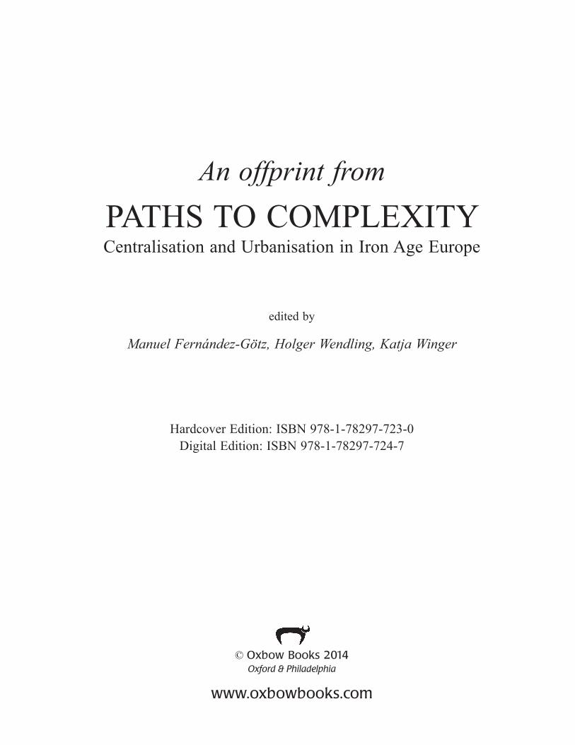
Space and RitualThe choice of location on Mont Beuvray, at a height of 820 m above sea-level in a hostile climate, in the Morvan, an extension of the Massif Central, was already an innovative spatial programme the origins of which have prompted many questions (Fig. 9.1). Even though there are formal similarities to Hellenistic fortifications that are spread over a wide area in a similar way, an oppidum is not a mere copy of foreign towns but rather an index, i.e. a sign, indicating a foreign idea, that is, however, being interpreted within a completely different cultural context north of the Alps.
Example: ArchitectureOne characteristic of almost all oppida is the negation of the natural terrain. Bibracte is in any case an extreme example. Walls with a total length of 5–7 km had to overcome elevation differences of 50–100 m. Due to natural topography, the walls seemed to be even higher, the fortification even more imposing, and there is no doubt that this was intended. Also typical for Gaul is the technique of the murus Gallicus (Fichtl 2010). This was a very complex construction of nailed beams, consuming entire forests and innumerable iron nails that, from a technical point of view, might have been unnecessary and are therefore also interpreted as a ritual phenomenon (Buchsenschutz & Ralston 2007: 765). The construction of the drystone revetment of the front required an estimated 3000 wagonloads of stone to be transported up Mont Beuvray. In spite of this extreme effort, a series of absolute datings indicates that a murus Gallicus had to be renewed every 20–25 years (Meylan 2005: 141). Nevertheless, this technique was persistently maintained. This can only be explained by the integrating effect of this
Sabine Rieckhoff104
Fig. 9.1: Bibracte-Mont Beuvray. Plan of the Celtic oppidum (after Guichard forthcoming)

9. Space, Architecture and Identity in Gaul in the 2nd/1st centuries BC 105
founding architecture (Fig. 9.2). It served as a medium of cultural memory that accorded significance both to the social act of building and to the finished wall. The construction itself brought together an enormous number of people – in Bibracte, an estimated 4000 workers, i.e. if families are also included, about 10,000 people in all (Meylan 2005: 148, 203). People gathered not only for a common project but also for a common history that was meant to be legitimised retrospectively, to be imagined prospectively and to be eternalised by means of monumentalisation (Assmann 1992: 71). By multiple repetition (in Bibracte at least four times), the construction of the wall became a ritual. Through symbolisation, the ritual served to give a meaning to collective action. In this way, the wall became a ‘presentative symbol’ – not only of remembering the past but also of a new collective identity.
Example: BoundariesBoth the alleged ‘nail offering’ and the symbolism of the wall construction point to the sacred significance of the town boundaries. It has frequently been emphasised that walls extending for several kilometres, such as those at Bibracte, were of limited strategic value. Consequently, the walls are mainly interpreted as a sign – as a symbol of both power and self-representation of local elites (Fichtl 2012a: 44–46). However, the sign not only indicated outwardly the demarcation of the society (Woolf 2006: 271) but
above all – as explained above – inwardly its cohesion. In effect, the walls formed a virtual boundary within a cosmological system of order that differentiated the familiar from the other, the tamed from the wild, the sacred from the profane, the world of the living from the world of the dead, etc. Crossing this boundary meant infringing the order which then had to be restored by means of corresponding rituals, the so-called rites de passage (Gennep 2005). This could be achieved by a simple gesture. However, there seem to have been numerous occasions requiring more complex rituals, since so many deposits of material goods, mainly consisting of iron, animals and human skeletons, were discovered within, under, in front of and behind the fortifications (Buchsenschutz & Ralston 2007; Nicolai this volume). Those are no remains of ‘barbarian’ rites but the materialisation of an idea that was already put into writing at a very early date in Mediterranean cultures: the idea of the ‘divine walls’. It is the idea of ‘beautiful’ or ‘long and high’ walls which stand under divine protection and constitute the town as a space in which humans and gods can communicate and which thus creates a collective identity (Brandt 2008).
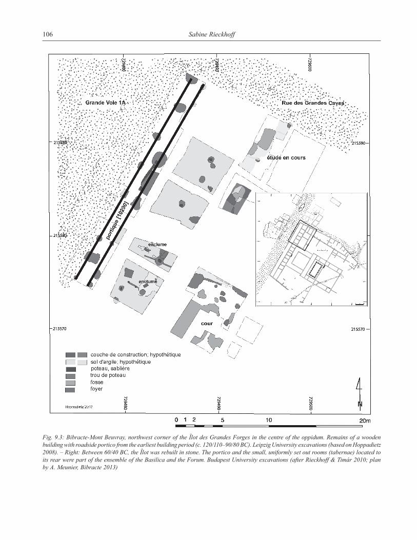
Symbolisation and Appropriation – The PorticoOur second example is a roadside wooden portico – a Mediterranean architectural element hitherto unknown in Gaul. The portico is a special, quasi perforated boundary of the enclosed space because it interlinks outside and inside.
Fig. 9.2: Bibracte-Mont Beuvray. Reconstruction of the murus gallicus of the Porte du Rebout (picture by A. Maillier, Bibracte)
Sabine Rieckhoff106
Fig. 9.3: Bibracte-Mont Beuvray, northwest corner of the Îlot des Grandes Forges in the centre of the oppidum. Remains of a wooden building with roadside portico from the earliest building period (c. 120/110–90/80 BC). Leipzig University excavations (based on Hoppadietz 2008). – Right: Between 60/40 BC, the Îlot was rebuilt in stone. The portico and the small, uniformly set out rooms (tabernae) located to its rear were part of the ensemble of the Basilica and the Forum. Budapest University excavations (after Rieckhoff & Timár 2010; plan by A. Meunier, Bibracte 2013)

9. Space, Architecture and Identity in Gaul in the 2nd/1st centuries BC 107
In the Mediterranean, porticos were primarily intended as simple protection from the sun, whether in the garden of a Roman villa or at the Forum. Increasingly, porticos enclosed squares and roads everywhere and, if deep enough, were frequently used for commercial purposes in shops, workshops or taverns (tabernae), which were located at the rear of the portico.
At Bibracte, this foreign architectural element can be verified already in the earliest phase of wood construction dating from the end of the 2nd century BC as a boundary between the main road and the Îlot des Grandes Forges, the largest building complex in the centre of the town on the Pâture du Couvent (Hoppadietz 2008; Fig. 9.3). A number of tabernae was located behind the portico that was certainly a protection against rain rather than sun during most of the year. The symbolic function of this sign must have been all the more important. There is actually a specific historical point of reference for this symbolism, namely a treaty of hospitality (hospitium publicum) between Rome and the Aedui that is dated to around the middle of the 2nd century BC (Dobesch 2001: 760). The reason for this treaty must have been the strategically advantageous position of the Aedui in relation to communication links, since their territory was crossed by important ‘Tin Roads’ (Rolley 2006). The Aeduan elites benefitted from their new political status, perhaps by material advantages in the form of presents for the hosts, but surely by gaining prestige within Gaul. I assume that this implied a social change: A loose network of landowners was converted into a politically stable community of several families or clans, uniting in a kind of synoecism to found a town ex nihilo. The representative layout of the centre, clearly referring to the model of Roman avenues, was as intentional as was the act of foundation. However, the process of acculturation is evident. The portico was given a new functional interpretation, embedded into the local method of wood construction and ascribed with symbolic meaning. As a sign, it conveyed a political message, namely the alliance of a Gaulish tribe with the greatest power in the world at the time.
Architecture and CommunicationIn Italy, porticos were increasingly used for decorative purposes in order to add value to the urban image. Thus, one might suggest, that the portico at Bibracte also had an aesthetic quality. In Gaul, there is an impressive example of the way in which the aesthetics of architecture became the medium for converting the town into an object of identification. Caesar reports that the oppidum of Avaricum (today’s Bourges) was regarded as one of the most beautiful towns of Gaul because of its walls and architecture. For this special reason, in order to save its architectural treasures, Avaricum was actually not burnt down to the ground at the
request of its inhabitants (Caesar BG VII, 15,4; Dobesch 2004: 23).
In my opinion, something comparable can be observed in Bibracte. Around 100 BC, the external wall (A) was replaced by the inner rampart (B). 20 years later, the main gate of B was in need of repair. Around 80 BC, the largest example of a Celtic town gate was built: the Porte du Rebout (Fig. 9.4). R. Hoppadietz has drawn attention to the fact that, around the same time, the îlot des Grandes Forges was also converted. The wooden columns of the portico were placed on a massive base, maybe in order to elevate the construction by another floor, the main road was broadened to 16 m and the opposite side of the road was also equipped with porticos (Hoppadietz 2008; Rieckhoff et al. 2009).
There is good reason to suggest that the simultaneous transformation of the main gate and the centre were related in a perceptional manner that was one of the reasons for reducing the size of the oppidum. In any case, the reason for widenig the gate could not have been a purely military one: The Porte du Rebout as a pincer’s gate of 21 m width without any identifiable gatehouse evidently contradicts the strategic function of this well-known type of gate – forcing the enemy into a narrow alley (Buchsenschutz et al. 1999). Therefore, we may assume that in the case of the Porte du Rebout the symbolism of prestigious Roman city gates was ‘translated’ into the local language of Celtic fortificatory architecture, even though its strategic function was thereby reduced ad absurdum.
Instead, upon passing through the gate, everybody perceived a grand panorama of the town. As the distance between the gate and the centre had been reduced, the broad and steeply rising road opened the view to the Pâture du Couvent, which was dominated by the architectural complex of the îlot des Grandes Forges which at least in part rose to at least two storeys.
Fig. 9.4: Bibracte-Mont Beuvray. Model of the Porte du Rebout (after Buchsenschutz et al. 1999).

Sabine Rieckhoff108
Public spaceExperience of spaceThere is perceptive activity between space and social action, which can be decoded semiotically or phenomenologically, i.e. by means of signs or sensory impressions. Due to this interrelation, phenomenology already played a significant role for Simmel and has since been expressed in various parts of architectural theory. As I refer to this in more detail elsewhere (Rieckhoff forthcoming), I will confine myself to stressing two points which both are considered to be specific phenomenological aspects: horizons, perspectives and fields of vision on the one hand, and, aesthetic qualities such as material structures, colours, light, sounds, etc. on the other. These sensory experiences were combined in the Porte du Rebout. The overwhelming sight of the fortification – about 8 m high from the bottom of the moat to the parapet – and the 40 m long walk through the gateway until it revealed the urban panorama created an intersubjective setting that promoted social cohesion. Communal experiences in public space – as I will shortly demonstrate by means of the water basin and the main road – were clearly part of a new spatial programme on the part of local elites who, without any doubt, succeeded in increasing the “urban sense of life” with the help of their reconstruction work around 80 BC.
Spatial designThe location of the monumental basin, a unique example of its kind in the Celtic world (Fig. 9.5), has been a cause
of perplexity ever since its discovery, because we know neither its purpose nor when it was built, since it does not demonstrate any relationship to the surrounding built environment. However, it has so far not been taken into account that the basin is topographically exposed at the fork of two main arterial roads (Meylan 2005: fig. 4.15). In ancient times, a parting of roads had always been a religious point of reference because it required a decision to be taken under the protection of a deity. The basin, rightfully referred to as lieu de mémoire (Goudineau & Peyre 1993: 45), thus surely had (also) a cultic function, and, if it was not already built around 80 BC, as assumed by R. Hoppadietz, it must have had a predecessor in some form or other (Hoppadietz 2013). With it, the centre of Bibracte had a ‘location’ around which to develop collective activities and – in the sense of Simmel – social interaction processes, converting it into a ‘focal point’ (Lynch 2001) imprinted indelibly on the cognitive map of everybody who had ever stood before it.
Spatial behaviourIt is beyond doubt that public ritual creates common identities among its participants. However, public space in itself as being in existence only at the oppida had the same effect (Fichtl 2012b). As scattered farmhouses and estates were separated from each other by considerable distances, the communication of their inhabitants apart from living and working together within the context of relationship was limited to temporary markets and feasts. In contrast to these
Fig. 9.5: Bibracte-Mont Beuvray. Reconstruction of the ship-formed water basin in the centre of the oppidum, 10.5 m long (picture by A. Maillier, Bibracte).

9. Space, Architecture and Identity in Gaul in the 2nd/1st centuries BC 109
isolated social spaces, urban paths, squares and locations resulted in a close proximity for all people – even if they were not related to or did not know each other due to their belonging to different social strata. This way, a completely new – intrinsically urban – experience of space developed. This notion was recently quite appropriately categorised as the ‘third location’ by D. Mölders (Mölders forthcoming). Apart from locations for living and working, modern urban sociology defines this ‘third location’ as areas of public space where people move, stay and communicate. Today, these are easily accessible and inviting locations such as bars and parks, and especially locations for consumption such as shopping centres or cinemas. They are characterised by an all-embracing act of socialisation and, in this respect, the concept can also be transferred to historic societies (Zurstiege 2007).
An open space for all – or a ‘third location’ – was the Grande Voie, the main road of Bibracte, the main artery of the town. Its heart was in the vicinity of the îlot des Grandes Forges where several roads met. Human circulation and the enclosure by porticos formed, as it were, a square that – in the same spatial context as the tabernae – could have had additional functions. These include market stalls on certain days or collective rites at the water basin. In this respect, the Pâture du Couvent possessed all qualities to provide an integrating zone for people of different social status. This is in contrast to the privileged walled-off post-Caesarean squares that were reserved for specific events (and also actors?) (Guichard forthcoming).
The town as an identification objectStarting from theories of sociology of architecture and with the help of examples taken from the oppidum of Bibracte, I have tried to draw conclusions regarding the actors of urbanisation in the 2nd/1st centuries BC in Gaul. In principle, I have always come to the same result: Spatial concepts provided for the acquisition and retention of power. Building was a process of identification, architecture represented collective identity, and therefore all building projects were political measures that had to be communicated through rites and symbols. The selective assimilation of Roman construction features and their integration into the familiar cultural system did not constitute a thoughtless copying but rather a hybrid self-staging involving a message primarily aimed at the familiar society. The town as an object of empathy and an intentional focus for identification became successful. Bibracte attracted so many people that, after the Gallic Wars, large-scale new planning and construction became necessary. It was the bloom of the oppidum, not its decline, which lead to its relocation to the plain at around the start of the Common Era. There, the new town continued to flourish as Augustodunum-Autun for 300 years.
BibliographyAssmann, J. (1992): Das kulturelle Gedächtnis. Schrift, Erinnerung
und politische Identität in frühen Hochkulturen. Beck, Munich.Bourdieu, P. (1991): Physischer, sozialer und angeeigneter
physischer Raum. In M. Wentz (ed.), Stadt-Räume. Campus, Frankfurt a. M./New York, 25–34.
Brandt, H. (2008): „Göttliche Mauern“ – Religion und Identität in der Antike. In S. Rieckhoff & W. R. Teegen (eds.), Beiträge zur Religion der Kelten. Leipziger Forschungen zur ur- und frühgeschichtlichen Archäologie 1, Leipzig, 1–10.
Buchsenschutz, O., J.-P. Guillaumet & I. Ralston (eds.) (1999): Les remparts de Bibracte. Recherches récentes sur la Porte du Rebout e le tracé des fortifications. Collection Bibracte 3, Centre Archéologique Européen, Glux-en-Glenne.
Buchsenschutz, O. & I. Ralston (2007): Dépôts et fortifications à l’âge du Fer. In P. Barral et al. (eds.), L’âge du Fer dans l’arc jurassien et ses marges. Dépôts, lieux sacrés et territorialité à l’âge du Fer. Actes du XXIXe colloque international de l’AFEAF, Bienne 5‒8 mai 2005. Presses universitaires de Franche-Comté, Besançon, 757–776.
Cassirer, E. (2010): Philosophie der symbolischen Formen. 3. Teil. Phänomenologie der Erkenntnis. Meiner, Hamburg.
Dhennequin, L., J.-P. Guillaumet & M. Szabó (eds.) (2008): Bibracte (Mont Beuvray). Bilan de 10 années de recherches (1996‒2005). Acta Archaeologica Hungarica 59, 1–152.
Dobesch, G. (2001): Zu zwei Daten der Geschichte Galliens. In H. Heftner & K. Tomaschitz (eds.), Gerhard Dobesch. Ausgewählte Schriften. Bd. 2 Kelten und Germanen. Böhlau, Köln/Weimar/Wien, 755–774.
Dobesch, G. (2004): Zentrum, Peripherie und “Barbaren” in der Urgeschichte und der Alten Geschichte. In H. Friesinger & A. Stuppner (eds.), Zentrum und Peripherie – Gesellschaft-liche Phänomene in der Frühgeschichte. Grundprobleme der frühgeschichtlichen Entwicklung im mittleren Donauraum. Mitteilungen der Prähistorischen Kommission 57, 11‒93.
Eco, U. (2002): Einführung in die Semiotik. Autorisierte deutsche Ausgabe von J. Trabant. Wilhelm Fink, Paderborn.
Fernández-Götz, M. (2012): Die Rolle der Heiligtümer bei der Konstruktion kollektiver Identitäten: Das Beispiel der treverischen Oppida. Archäologisches Korrespondenzblatt 42 (4), 509–524.
Fichtl, S. (ed.) (2010): Murus Celticus: architecture et fonctions des remparts de l’âge du Fer. Collection Bibracte 19, Centre Archéologique Européen, Glux-en-Glenne.
Fichtl, S. (2012a): Les premières villes de Gaule. Le temps des Oppida celtiques. Archéologie Nouvelle, Lacapelle-Marival.
Fichtl, S. (2012b): Places publiques et lieux de rassemblement à la fin de l’âge du Fer dans le monde celtique. In A. Bouet (ed.), Le Forum en Gaule et dans les régions voisines. Ausonius, Bordeaux, 41–54.
Gennep, A. van (2005): Übergangsriten. Campus, Frankfurt a. M.Goudineau, C. & C. Peyre (1993): Bibracte et les Eduens. A la
découverte d’un peuple gaulois. Errance, Paris.Guichard, V., S. Sievers & O. H. Urban (eds.) (2000): Les
processus d’urbanisation à l’âge du Fer. Eisenzeitliche Urbanisationsprozesse. Collection Bibracte 4, Centre Archéologique Européen, Glux-en-Glenne.
Guichard, V. (forthcoming): Chronique des recherches sur le Mont-Beuvray 2009‒2012. Revue archéologique de l’Est 62.

Sabine Rieckhoff110
Hahn, H.-P. (2005): Materielle Kultur. Eine Einführung. Reimer, Berlin.
Haselgrove, C. (ed.) (2006): Les mutations de la fin de l’âge du Fer. Celtes et Gaulois. L’Archéologie face à l’Histoire. 4. Collection Bibracte 12/4, Centre Archéologique Européen, Glux-en-Glenne.
Hoppadietz, R. (2008): Die Ausgrabungen der Universität Leipzig in der Îlot des Grandes Forges (Pco1) im Oppidum Bibracte-Mont Beuvray (Burgund, Frankreich). Die Befunde und Funde aus Secteur Z’1-Z’3/Pco 10000. Unpublished Master Thesis, University of Leipzig.
Hoppadietz, R. (2013): Urbane Transformationsprozesse und räumliche Dynamik als Zeugnis kulturellen Wandels. Untersuchungen im spätlatènezeitlichen Oppidum Bibracte-Mont Beuvray (Burgund, Frankreich). Unpublished Phd Thesis, University of Leipzig.
Kolb, F. (1984): Die Stadt im Altertum. Beck, Munich. Beck Langer, S. K. (1942): Philosophy in a New Key – A Study
in the Symbolism of Reason, Rite, and Art. Harvard University Press, Cambridge, Mass.
Lynch, K. (2001): Das Bild der Stadt. Bertelsmann, Gütersloh.Meylan, F. (2005) Les influences romaines dans l’architecture
et l’urbanisme de l’Oppidum de Bibracte (Mont Beuvray). Unpublished Phd Thesis, Universities of Dijon and Lausanne.
Mölders, D. (forthcoming): “Dritte Orte” im Oppidum Bibracte. Müller, G. (1983): Semiotik der gebauten Umwelt. Über den
Zusammenhang von gebauter Umwelt und Verhalten. Universität Trier, Trier.
Nicolai, C. von (forthcoming): Sichtbare und unsichtbare Grenzen. Deponierungen an eisenzeitlichen Befestigungen in Mittel- und Westeuropa. Habelt, Bonn.
Rieckhoff, S., R. Hoppadietz & D. Mölders (2009): Urbanisierung und Romanisierung im Spiegel der Architektur im keltischen Oppidum Bibracte-Mont Beuvray (Burgund, Frankreich). In P. Trebsche et al. (eds.), Architektur: Interpretation und Rekonstruktion. Beiträge zur Ur- und Frühgeschichte Mitteleuropas 55. Beier und Beran, Langenweißenbach, 141–149.
Rieckhoff, S. (2010): Raumqualität, Raumgestaltung und Raumwahrnehmung im 2./1. Jahrhundert v. Chr.: Ein anderer
Zugang zu den ersten Städten nördlich der Alpen. In P. Trebsche, N. Müller-Scheessel & S. Reinhold (eds.), Der gebaute Raum. Bausteine einer Architektursoziologie vormoderner Gesellschaften. Tübinger Archäologische Taschenbücher 7. Waxmann, Münster, 275–306.
Rieckhoff, S. (forthcoming): Qu’est-ce que nous connaissons de la société des oppida? Réflexions sociologiques et philosophiques sur l’architecture de Bibracte. In S. Péré-Noguès et al. (eds.), La construction de l’archéologie européenne (1865–1914). Colloque en hommage à Joseph Déchelette (1862–1914).
Rieckhoff, S. & L. Timár (2010): Le raccordement stratigraphique des observations archéologiques sur l’Îlot des Grandes Forges: enjeux, difficultés et premiers résultats. In Bibracte. Rapport annuel d’activité 2009. Centre Archéologique Européen, Glux-en-Glenne, 163–169.
Rolley, C. (2006): Les routes de l’étain en Méditerranée et ailleurs. In M. Szbó (ed.), Les Civilisés et les Barbares du Ve au IIe siècle avant J.-C. Celtes et Gaulois. L’Archéologie face à l’Histoire. 3. Collection Bibracte 12/3, Centre Archéologique Européen, Glux-en-Glenne, 185–192.
Schäfers, B. (2006): Architektur-Soziologie. Grundlagen – Epochen – Themen. Verlag für Sozialwissenschaften, Wiesbaden.
Schroer, M. (2006): Räume, Orte, Grenzen. Auf dem Weg zu einer Soziologie des Raums. Suhrkamp, Frankfurt a. M.
Simmel, G. (1995): Soziologie des Raumes. In G. Simmel, Aufsätze und Abhandlungen 1901‒1908. Herausgegeben von R. Kramme et al. Suhrkamp, Frankfurt a. M., 132–183.
Szabó, M., L. Timar & D. Szabó (2007): La basilique de Bibracte. Un témoignage précoce de l’architecture romaine en Gaule centrale. Archäologisches Korrespondenzblatt 37, 389–408.
Woolf, G. (2006): The end of ‘the end of the Iron Age’. In C. Haselgrove (ed.), Les mutations de la fin de l’âge du Fer. Celtes et Gaulois. L’Archéologie face à l’Histoire 4. Collection Bibracte 12/4, Centre Archéologique Européen, Glux-en-Glenne, 267–276.
Zurstiege, G. (2007): Der Konsum Dritter Orte. In K. U. Hellmann & G. Zurstiege (eds.), Räume des Konsums. Über den Funktionswandel von Räumlichkeit im Zeitalter des Konsumismus. Verlag für Sozialwissenschaften, Wiesbaden, 121–141.
Copyright © 2022 FDOKUMEN