Soft-sediment deformation structures in the Late Quaternary sediments of Ladakh: Evidence for...
11
This article appeared in a journal published by Elsevier. The attached copy is furnished to the author for internal non-commercial research and education use, including for instruction at the authors institution and sharing with colleagues. Other uses, including reproduction and distribution, or selling or licensing copies, or posting to personal, institutional or third party websites are prohibited. In most cases authors are permitted to post their version of the article (e.g. in Word or Tex form) to their personal website or institutional repository. Authors requiring further information regarding Elsevier’s archiving and manuscript policies are encouraged to visit: http://www.elsevier.com/copyright
Transcript of Soft-sediment deformation structures in the Late Quaternary sediments of Ladakh: Evidence for...
This article appeared in a journal published by Elsevier. The attachedcopy is furnished to the author for internal non-commercial researchand education use, including for instruction at the authors institution
and sharing with colleagues.
Other uses, including reproduction and distribution, or selling orlicensing copies, or posting to personal, institutional or third party
websites are prohibited.
In most cases authors are permitted to post their version of thearticle (e.g. in Word or Tex form) to their personal website orinstitutional repository. Authors requiring further information
regarding Elsevier’s archiving and manuscript policies areencouraged to visit:
http://www.elsevier.com/copyright
Author's personal copy
Soft-sediment deformation structures in the Late Quaternary sedimentsof Ladakh: Evidence for multiple phases of seismic tremorsin the North western Himalayan Region
Binita Phartiyal *, Anupam SharmaBirbal Sahni Institute of Palaeobotany, 53-University Road, Lucknow, UP 226 007, India
a r t i c l e i n f o
Article history:Received 20 February 2007Received in revised form 2 September 2008Accepted 21 November 2008
Keywords:Late QuaternaryLadakhIndusShyokSoft-sediment deformation structuresPaleoseismicity
a b s t r a c t
The exposed Quaternary sections of Ladakh show evidence of seismicity during the late Quaternary. Mul-tiple levels of soft-sediment deformation structures (seismites) are recorded from the Quaternary sedi-ments of the Spituk-Leh, along Indus Suture Zone (ISZ) and the Khalsar palaeolakes, along ShyokSuture Zone (SSZ) and Karakoraum Fault (KF). The studied sections are a part of two major tectonicallyformed palaeolakes at �35,000 yr BP. Nine levels of seismites from Spituk-Leh and eight levels from Khal-sar sections are recorded. The deformed sediments comprise of clay, silts and sand and are restricted to asingle stratigraphic layers bounded by undeformed beds suggesting synsedimentary deformation. Thevarious deformational structures identified are simple and complex convolutes, pinch and swell bedding,microfolds and microfaults, flame-like structures, pseudonodules, clay diapirs, ball and pillow structures,pillar structures, sedimentary dykes and mud lenses. The release of stress along the ISZ, SSZ and KF, mayhave been responsible for inducing seismicity in the area during the late Quaternary times which mayhave caused liquefaction as a direct consequence of permanent deformation of ground surface due toearthquakes of large magnitudes (>5 intensity). The chronological data suggests release of stresses alongISZ, SSZ and KF in the form of earthquakes between �35,000 yr BP to approximately the Last Glacial Max-ima (LGM) as evident form the available chronology.
� 2008 Elsevier Ltd. All rights reserved.
1. Introduction
The past few decades have seen a significant increase in under-standing the physical processes causing earthquakes resulting indamage to structure, property and human life. Therefore, need ofthe day is to prepare a seismic data set of present day as well as pal-aeo-earthquakes which can be acquired by monitoring present dayseismic waves and looking into Quaternary sequences for earth-quake-induced soft-sediment deformation structures (Seismites,sensu stricto Seilacher, 1969), respectively. Seismites are formedduring or shortly after deposition of horizontal sedimentary layersand are important diagnostic features of palaeoseismic studies(Sim, 1973, 1975; Sieh, 1978; Scott and Price, 1988; McKalpin,1996 and many more). These structures, linking sediment deforma-tion to seismic shock, play an important role in identifying the dis-tribution and the intensity of past tectonic activity (Allen andBanks, 1972). Various workers recently in the seismically active re-gions of Himalaya (Mohindra and Bagati, 1996; Upadhyay, 2003;Kotlia and Rawat, 2004; Singh and Jain, 2007) have reported seis-mically induced soft-sediment deformation structures.
Here is an attempt to document the seismic signatures pre-served in the sediments of Indus and Shyok valleys lying in thevicinity of Indus Suture Zone (ISZ), Shyok Suture Zone (SSZ) andKarakoram Fault (KF) (Fig. 1). The entire region is tectonically ac-tive as is evident from the topographic changes, violent seismicshocks and active deformation observed in the Himalayan rangesand the Tibetan plateau. These are the result of continued post col-lisional convergence of the Indian plate and Asian landmasses(Molnar et al., 1987; Valdiya, 1988). A convergence of �20 mm/yr (Bilham et al., 1997,2001) is accommodated across the Himalaya(Peltzor and Saucier, 1996). Interestingly, development of theHimalayan and Karakoram relief indicates active orogeny in the In-dian–Tibetan regions, during the Quaternary (Ganseer, 1980,1983)and has the same character today.
It is presumed that the movements in geologically recent timesalong the Karakoram Fault (Chevalier et al., 2005), Indus and ShyokSuture Zones were responsible for the formation of lakes. The sed-imentary sequences identified for this study are of fluvio-lacustrinenature formed by damming of the river system (Phartiyal et al.,2005) (Fig. 2). Lake sediments are considered to be quite revealingin palaeoseismic studies (Sim, 1973, 1975; Sieh, 1978; Hemptonand Dewey, 1983; Ananad and Jain, 1987; Mohindra and Bagati,1996; Maurya et al., 1997; Rodriguz-Pascua et al., 2000; Kotlia
1367-9120/$ - see front matter � 2008 Elsevier Ltd. All rights reserved.doi:10.1016/j.jseaes.2008.11.008
* Corresponding author. Tel.: +91 522 2740008/2740001; fax: +91 522 2740485.E-mail address: [email protected] (B. Phartiyal).
Journal of Asian Earth Sciences 34 (2009) 761–770
Contents lists available at ScienceDirect
Journal of Asian Earth Sciences
journal homepage: www.elsevier .com/ locate/ jaes
Author's personal copy
and Rawat, 2004; Singh and Jain, 2007). The studied lacustrine ba-sins provide a consistent and spatially finite framework to closelymonitor the palaeoseismic events. The Spituk-Leh section (Indusvalley) and Khalsar section (Shyok valley) provide ample scopefor understanding multiple phases of seismicity during the lateQuaternary and form the basis of our observations.
2. Tectonic setting, Neotectonic evidences of study area
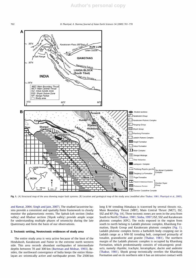
The entire study area is very active because of the knot of theHindukush, Karakoram and Pamir in the extreme north westernside. This area records abundant earthquakes of intermediatedepths between 70 and 300 km (Burtman and Molnar, 1993). Be-sides, the northward convergence of India keeps the entire Hima-layan arc seismically active and earthquake prone. The 2500 km
long E-W trending Himalaya is traversed by several thrusts viz.,Main Boundary Thrust (MBT), Main Central Thrust (MCT), ISZ,SSZ and KF (Fig. 1A). Three tectonic zones are seen in the area fromSouth to North (Thakur, 1981; Sinha, 1997) ISZ, SSZ and Karakoramplutonic complex (KPC). The rocks exposed in the region fromsouth to north belong to Ladakh plutonic complex, Khardung For-mation, Shyok Group and Karakoram plutonic complex (Fig. 1).Ladakh plutonic complex forms a batholith body cropping out inLadakh range as a NW-SE trending belt, comprised primarily oftonalite, granodiorite and granite (Thakur, 1981). The northernmargin of the Ladakh plutonic complex is occupied by KhardungFormation, which predominantly consists of volcanogenic prod-ucts, namely rhyolite, trachyte, keratophyre, dacite and andesite(Thakur, 1981). Shyok group tectonically overlies the KhardungFormation and on its northern side it has an intrusive contact with
Fig. 1. (A) Structural map of the area showing major fault systems. (B) Location and geological map of the study area (modified after Thakur, 1981; Phartiyal et al., 2005).
762 B. Phartiyal, A. Sharma / Journal of Asian Earth Sciences 34 (2009) 761–770
Author's personal copy
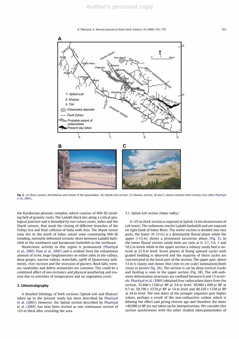
the Karakoram plutonic complex, which consists of NW-SE trend-ing belt of granitic rocks. The Ladakh block lies along a critical geo-logical juncture and is bounded by two suture zones, Indus and theShyok sutures, that mark the closing of different branches of theTethys Sea and final collision of India with Asia. The Shyok suturezone lies to the north of Indus suture zone constituting NW-SEtrending, intensely deformed tectonic slices between Ladakh bath-olith in the southwest and Karakoram batholith in the northeast.
Neotectonic activity in this region is pronounced (Phartiyalet al., 2005; Pant et al., 2005) and is evident from the voluminousamount of scree, huge fanglomerates on either sides in the valleys,deep gorges, narrow valleys, waterfalls, uplift of Quaternary sedi-ments, river incision and the recession of glaciers. Rock falls, trem-ors, landslides and debris avalanches are common. This could be acombined affect of neo-tectonics and physical weathering and ero-sion due to extremes of temperature and no vegetation cover.
3. Lithostratigraphy
A detailed lithology of both sections (Spituk-Leh and Khalsar)taken up in the present study has been described by Phartiyalet al. (2005). However, the Spituk section described by Phartiyalet al. (2005) has now been revised as one continuous section of>25 m thick after revisiting the area.
3.1. Spituk-Leh section (Indus valley)
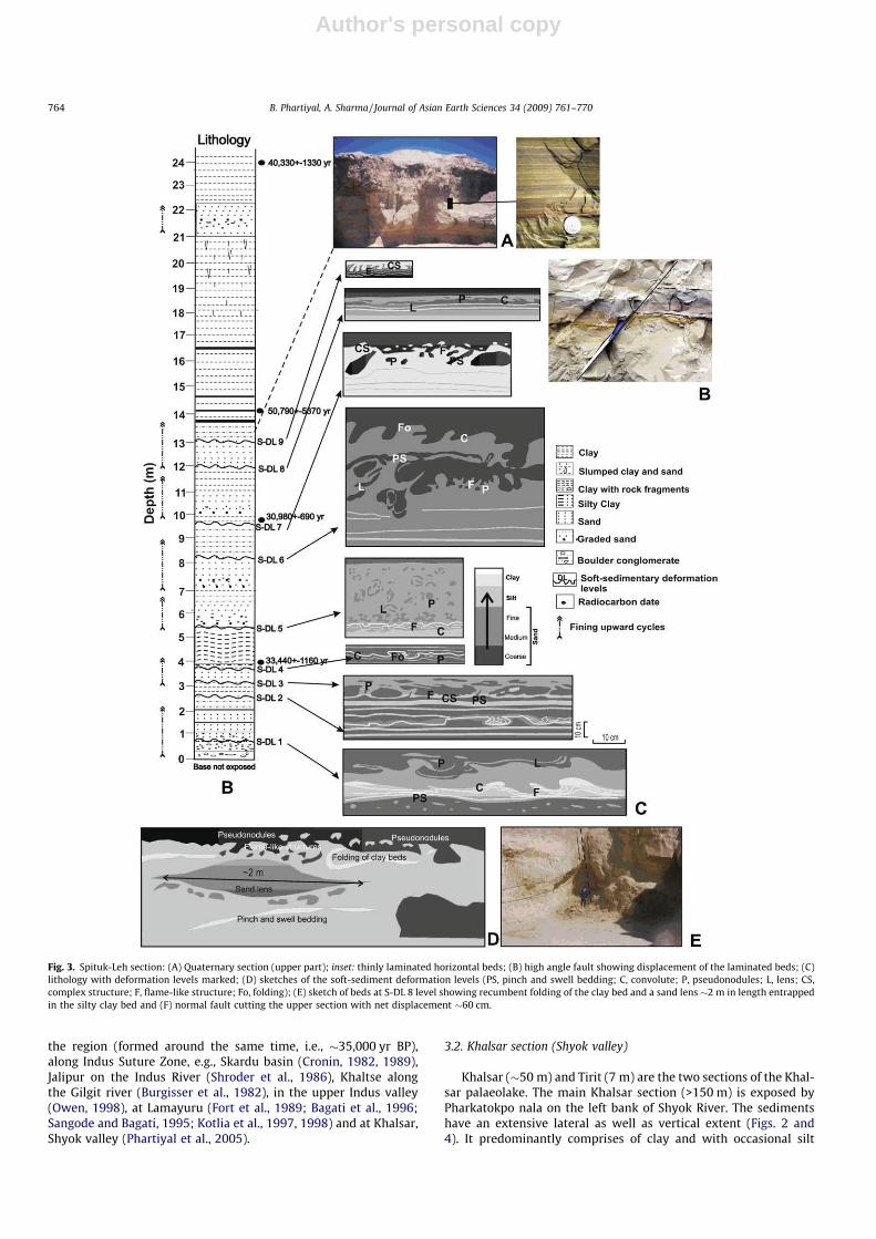
A >25 m thick section is exposed at Spituk (4 km downstream ofLeh town). The sediments overlie Ladakh batholith and are exposedon right bank of Indus River. The entire section is divided into twoparts, the lower (0–13 m) is a dominantly fluvial phase while theupper (>13 m) shows a prominent lacustrine phase (Fig. 3). Inthe lower fluvial section sandy beds are seen at 0, 3.1, 5.6, 7 and10.2 m levels while in the upper section a solitary sandy bed is no-ticed at 21.0 m level. Seven phases of fining upward cycles withgraded bedding is observed and the majority of these cycles areconcentrated in the basal part of the section. The upper part, above13 m is clayey and shows thin (mm to cm scale) laminations/beds(inset in picture Fig. 3A). The section is cut by deep vertical cracksand faulting is seen in the upper section (Fig. 3B). The soft-sedi-ment deformation structures are confined between 0 and 13 m lev-els. Phartiyal et al. (2005) obtained four radiocarbon dates from thesection, 33,440 ± 1160 yr BP at 3.8 m level; 30,980 ± 690 yr BP at9.7 m; 50,790 ± 5370 yr BP at 14 m level and 40,330 ± 1330 yr BPat 24 m level. The two dates of the younger sequence give highervalues, perhaps a result of the non-radioactive carbon which isdiluting the effect and giving reverse age and therefore the dates>40,000 yr BP are not taken up for interpretations. We consider thissection synchronous with the other studied lakes/palaeolakes of
Fig. 2. (A) River system, distribution and extent of the palaeolakes; (B) Spituk-Leh section; (C) Khalsar section; (B and C) shows relation with country rock (after Phartiyalet al., 2005).
B. Phartiyal, A. Sharma / Journal of Asian Earth Sciences 34 (2009) 761–770 763
Author's personal copy
the region (formed around the same time, i.e., �35,000 yr BP),along Indus Suture Zone, e.g., Skardu basin (Cronin, 1982, 1989),Jalipur on the Indus River (Shroder et al., 1986), Khaltse alongthe Gilgit river (Burgisser et al., 1982), in the upper Indus valley(Owen, 1998), at Lamayuru (Fort et al., 1989; Bagati et al., 1996;Sangode and Bagati, 1995; Kotlia et al., 1997, 1998) and at Khalsar,Shyok valley (Phartiyal et al., 2005).
3.2. Khalsar section (Shyok valley)
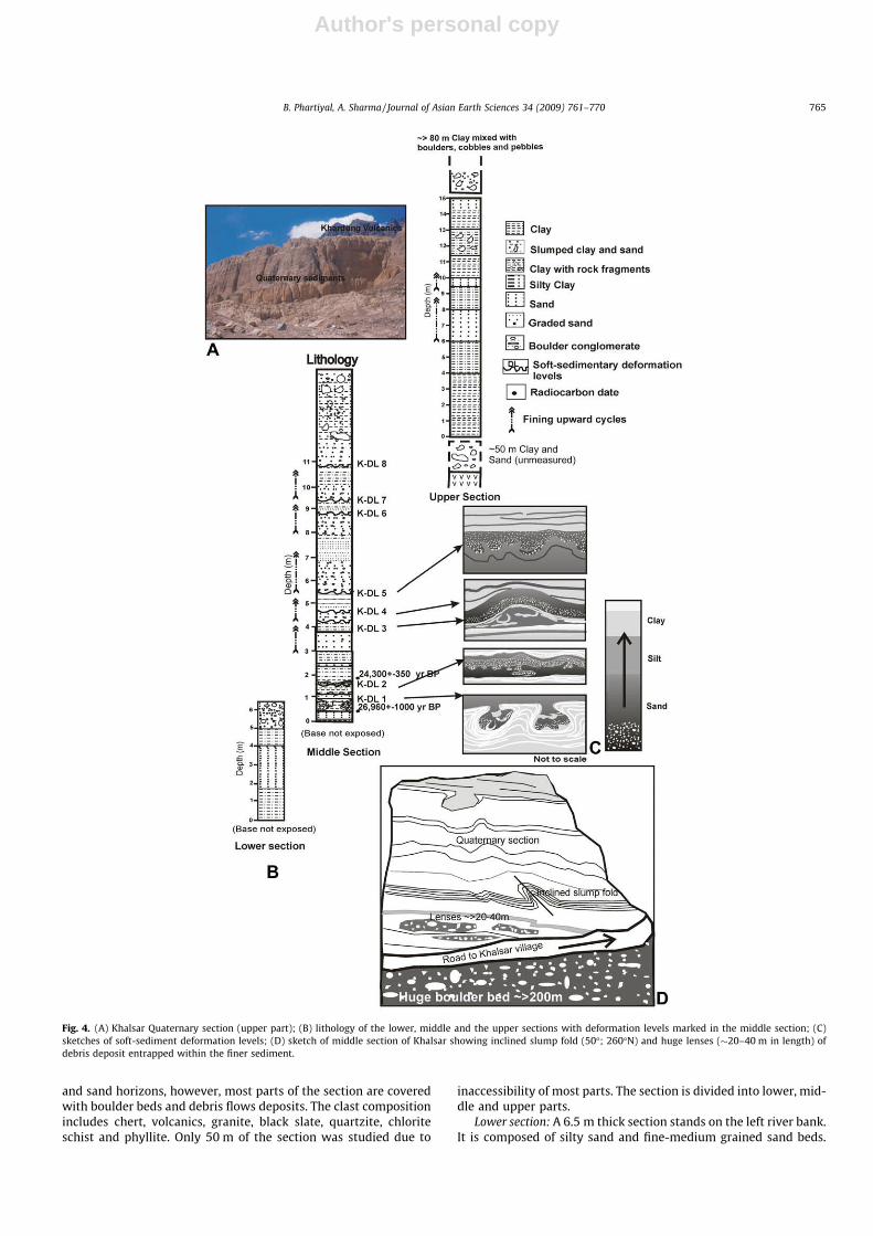
Khalsar (�50 m) and Tirit (7 m) are the two sections of the Khal-sar palaeolake. The main Khalsar section (>150 m) is exposed byPharkatokpo nala on the left bank of Shyok River. The sedimentshave an extensive lateral as well as vertical extent (Figs. 2 and4). It predominantly comprises of clay and with occasional silt
Fig. 3. Spituk-Leh section: (A) Quaternary section (upper part); inset: thinly laminated horizontal beds; (B) high angle fault showing displacement of the laminated beds; (C)lithology with deformation levels marked; (D) sketches of the soft-sediment deformation levels (PS, pinch and swell bedding; C, convolute; P, pseudonodules; L, lens; CS,complex structure; F, flame-like structure; Fo, folding); (E) sketch of beds at S-DL 8 level showing recumbent folding of the clay bed and a sand lens �2 m in length entrappedin the silty clay bed and (F) normal fault cutting the upper section with net displacement �60 cm.
764 B. Phartiyal, A. Sharma / Journal of Asian Earth Sciences 34 (2009) 761–770
Author's personal copy
and sand horizons, however, most parts of the section are coveredwith boulder beds and debris flows deposits. The clast compositionincludes chert, volcanics, granite, black slate, quartzite, chloriteschist and phyllite. Only 50 m of the section was studied due to
inaccessibility of most parts. The section is divided into lower, mid-dle and upper parts.
Lower section: A 6.5 m thick section stands on the left river bank.It is composed of silty sand and fine-medium grained sand beds.
Fig. 4. (A) Khalsar Quaternary section (upper part); (B) lithology of the lower, middle and the upper sections with deformation levels marked in the middle section; (C)sketches of soft-sediment deformation levels; (D) sketch of middle section of Khalsar showing inclined slump fold (50�; 260�N) and huge lenses (�20–40 m in length) ofdebris deposit entrapped within the finer sediment.
B. Phartiyal, A. Sharma / Journal of Asian Earth Sciences 34 (2009) 761–770 765
Author's personal copy
The upper part of the section (above 5 m) is overlain by a hugeboulder bed with sub-rounded to rounded rock fragments (Fig. 4).
Middle section: 11 m thick section shows alternating clay andsand beds. The base is not exposed. Graded bedding is seen and fivefining upward fluvial cycles are observed. Radiocarbon age at 0.6 mlevel was 26,960 ± 1000 and 1.9 m level dated to 24,300 ± 350 yrBP. A vertical fault with a 4 m displacement (Upadhyay, 2003;Phartiyal et al., 2005) in the middle section further supports theeffect of active tectonics.
Upper section: It is a 15 m thick section comprising of laminatedand uniform clay, mixed sand and silt. Two fining upward cyclesare seen in this part and is capped by >80 m debris flow (Fig. 4B).
3.3. Tirit section (Shyok valley)
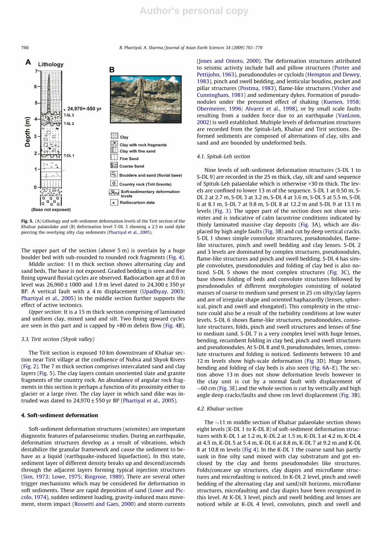
The Tirit section is exposed 10 km downstream of Khalsar sec-tion near Tirit village at the confluence of Nubra and Shyok Rivers(Fig. 2). The 7 m thick section comprises intercalated sand and claylayers (Fig. 5). The clay layers contain unoriented slate and granitefragments of the country rock. An abundance of angular rock frag-ments in this section is perhaps a function of its proximity either toglacier or a large river. The clay layer in which sand dike was in-truded was dated to 24,970 ± 550 yr BP (Phartiyal et al., 2005).
4. Soft-sediment deformation
Soft-sediment deformation structures (seismites) are importantdiagnostic features of palaeoseismic studies. During an earthquake,deformation structures develop as a result of vibrations, whichdestabilize the granular framework and cause the sediment to be-have as a liquid (earthquake-induced liquefaction). In this state,sediment layer of different density breaks up and descend/ascendsthrough the adjacent layers forming typical injection structures(Sim, 1973; Lowe, 1975; Ringrose, 1989). There are several othertrigger mechanisms which may be considered for deformation insoft sediments. These are rapid deposition of sand (Lowe and Pic-colo, 1974), sudden sediment loading, gravity-induced mass move-ment, storm impact (Rossetti and Gaes, 2000) and storm currents
(Jones and Omoto, 2000). The deformation structures attributedto seismic activity include ball and pillow structures (Porter andPettijohn, 1963), pseudonodules or cycloids (Hempton and Dewey,1983), pinch and swell bedding, and lenticular boudins, pocket andpillar structures (Postma, 1983), flame-like structures (Visher andCunningham, 1981) and sedimentary dykes. Formation of pseudo-nodules under the presumed effect of shaking (Kuenen, 1958;Obermeirer, 1996; Alvarez et al., 1998), or by small scale faultsresulting from a sudden force due to an earthquake (VanLoon,2002) is well established. Multiple levels of deformation structuresare recorded from the Spituk-Leh, Khalsar and Tirit sections. De-formed sediments are composed of alternations of clay, silts andsand and are bounded by undeformed beds.
4.1. Spituk-Leh section
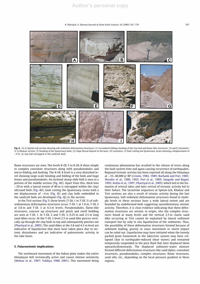
Nine levels of soft-sediment deformation structures (S-DL 1 toS-DL 9) are recorded in the 25 m thick, clay, silt and sand sequenceof Spituk-Leh palaeolake which is otherwise >30 m thick. The lev-els are confined to lower 13 m of the sequence. S-DL 1 at 0.50 m, S-DL 2 at 2.7 m, S-DL 3 at 3.2 m, S-DL 4 at 3.6 m, S-DL 5 at 5.5 m, S-DL6 at 8.1 m, S-DL 7 at 9.8 m, S-DL 8 at 12.2 m and S-DL 9 at 13.1 mlevels (Fig. 3). The upper part of the section does not show seis-mites and is indicative of calm lacustrine conditions indicated bythinly laminated massive clay deposits (Fig. 3A), which are dis-placed by high angle faults (Fig. 3B) and cut by deep vertical cracks.S-DL 1 shows simple convolute structures, pseudonodules, flame-like structures, pinch and swell bedding and clay lenses. S-DL 2and 3 levels are dominated by complex structures, pseudonodules,flame-like structures and pinch and swell bedding. S-DL 4 has sim-ple convolutes, pseudonodules and folding of clay bed is also no-ticed. S-DL 5 shows the most complex structures (Fig. 3C), thebase shows folding of beds and convolute structures followed bypseudonodules of different morphologies consisting of isolatedmasses of coarse to medium sand present in 25 cm silty/clay layersand are of irregular shape and oriented haphazardly (lenses, spher-ical, pinch and swell and elongated). This complexity in the struc-ture could also be a result of the turbidity conditions at low waterlevels. S-DL 6 shows flame-like structures, pseudonodules, convo-lute structures, folds, pinch and swell structures and lenses of fineto medium sand. S-DL 7 is a very complex level with huge lenses,bending, recumbent folding in clay bed, pinch and swell structuresand pseudonodules. At S-DL 8 and 9, pseudonodules, lenses, convo-lute structures and folding is noticed. Sediments between 10 and12 m levels show high-scale deformation (Fig 3D). Huge lenses,bending and folding of clay beds is also seen (Fig. 6A–E). The sec-tion above 13 m does not show deformation levels however inthe clay unit is cut by a normal fault with displacement of�60 cm (Fig. 3E) and the whole section is cut by vertically and highangle deep cracks/faults and show cm level displacement (Fig. 3B).
4.2. Khalsar section
The �11 m middle section of Khalsar palaeolake section showseight levels (K-DL 1 to K-DL 8) of soft-sediment deformation struc-tures with K-DL 1 at 1.2 m, K-DL 2 at 1.5 m, K-DL 3 at 4.2 m, K-DL 4at 4.5 m, K-DL 5 at 5.4 m, K-DL 6 at 8.8 m, K-DL 7 at 9.2 m and K-DL8 at 10.8 m levels (Fig 4). In the K-DL 1 the coarse sand has partlysunk in fine silty sand mixed with clay substratum and got en-closed by the clay and forms pseudonodules like structures.Folds/concave up structures, clay diapirs and microflame struc-tures and microfaulting is noticed. In K-DL 2 level, pinch and swellbedding of the alternating clay and sand/silt horizons, microflamestructures, microfaulting and clay diapirs have been recognized inthis level. At K-DL 3 level, pinch and swell bedding and lenses arenoticed while at K-DL 4 level, convolutes, pinch and swell and
Fig. 5. (A) Lithology and soft-sediment deformation levels of the Tirit section of theKhalsar palaeolake and (B) deformation level T-DL 3 showing a 2.5 m sand dykepiercing the overlying silty clay sediments (Phartiyal et al., 2005).
766 B. Phartiyal, A. Sharma / Journal of Asian Earth Sciences 34 (2009) 761–770
Author's personal copy
flame structures are seen. The levels K-DL 5 to K-DL 8 show simpleto complex convolute structures along with pseudonodules andmicro-folding and faulting. The K-DL 8 level is a very disturbed le-vel showing large-scale bending and folding of the beds and hugelenses and pseudonodules. An inclined slump slide fold is seen in aportion of the middle section (Fig. 4D). Apart from this, thick lens�30 m with a lateral extent of 40 m is entrapped within the clay/silt/sand beds (Fig. 4D), fault cutting the Quaternary strata with anet displacement of �4 m (Fig. 6I) and clay balls embedded inthe sand/silt beds are developed (Fig. 6J) in the section.
In the Tirit section (Fig 5) three levels (T-DL 1 to T-DL 3) of soft-sedimentary deformation structures occur, T-DL 1 at 1.9 m, T-DL 2at 3.8 m and T-DL 3 at 4.3 m levels. Pseudonodules, flame-likestructures, concave up structures and pinch and swell beddingare seen at T-DL 1. ln T-DL 2 and T-DL 3, 0.25 m and 2.5 m longsand dikes occur. At the T-DL 3 level 2.5 m sand dike pierces verti-cally up through the clay beds in top and subsequently pinches out(Phartiyal et al., 2005). The sand dikes at the 3.8 and 4.3 m level areindicative of liquefaction that must have taken place due to tec-tonic disturbance and are indicative of paleoseismic activity inthe lake basin.
5. Palaeoseismic implications
The northward movement of the Indian plate makes the entireHimalayan belt tectonically active and causes intense seismicity(Molnar et al., 1987; Valdiya, 1988, 2001). This movement being
continuous phenomena has resulted in the release of stress alongthe fault system time and again causing recurrence of earthquakes.Regional tectonic activity has been reported all along the Himalayaat �35–40,000 yr BP (Cronin, 1982, 1989; Burbank and Fort, 1985;Shroder et al., 1986, 1993; Fort et al., 1989; Sangode and Bagati,1995; Kotlia et al., 1997; Phartiyal et al., 2005) which led to the for-mation of several lakes and later revival of tectonic activity led totheir failure. The lacustrine sequences at Spituk-Leh, Khalsar andTirit sections are also a result of seismic activity during the lateQuaternary. Soft-sediment deformation structures found in multi-ple levels in these sections have a wide lateral extent and arebounded by undeformed beds suggesting synsedimentary seismicactivity. Therefore, it is clear evidence indicating that these defor-mation structures are seismic in origin; else the complex struc-tures found at many levels and the vertical 2.5 m clastic sanddike occurring at Tirit cannot be explained by lateral sedimenttransport but by only in situ liquefaction of the sediments. Thus,the possibility of these deformation structures formed because ofsediment loading, gravity or mass movement or storm impactcan be ruled out. Liquefaction may have initiated when the looselypacked grain framework in the lake/river system may have col-lapsed (due to earthquake-induced shear waves) and remainedtemporarily suspended in the pore fluid that later displaced themupwards/downwards. The displaced sediment–water mixtureformed different deformation structures like sand dykes, convolutestructures, pseudonodules, complex structures, flame structures,sand sills, etc., depending on the local pressure gradient in theseregions.
Fig. 6. (A–E) Spituk-Leh section showing soft-sediment deformation structures; (C) recumbent folding, bending of the clay bed and flame-like structures; (D and E) Seismites;(F–J) Khalsar section; (F) bending of the Quaternary beds; (G) huge fluvial deposit at the base; (H) seismites; (I) fault cutting the Quaternary strata showing a displacement of�4 m; (J) clay ball entrapped in the sand/silt beds.
B. Phartiyal, A. Sharma / Journal of Asian Earth Sciences 34 (2009) 761–770 767
Author's personal copy
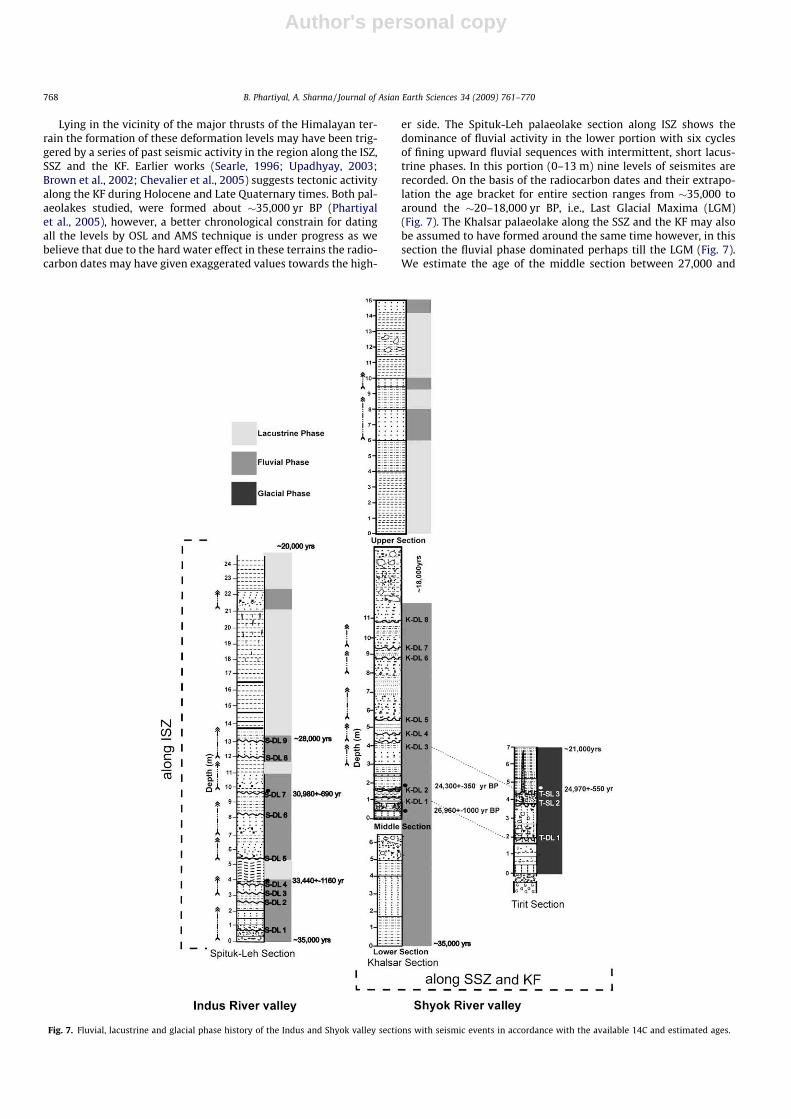
Lying in the vicinity of the major thrusts of the Himalayan ter-rain the formation of these deformation levels may have been trig-gered by a series of past seismic activity in the region along the ISZ,SSZ and the KF. Earlier works (Searle, 1996; Upadhyay, 2003;Brown et al., 2002; Chevalier et al., 2005) suggests tectonic activityalong the KF during Holocene and Late Quaternary times. Both pal-aeolakes studied, were formed about �35,000 yr BP (Phartiyalet al., 2005), however, a better chronological constrain for datingall the levels by OSL and AMS technique is under progress as webelieve that due to the hard water effect in these terrains the radio-carbon dates may have given exaggerated values towards the high-
er side. The Spituk-Leh palaeolake section along ISZ shows thedominance of fluvial activity in the lower portion with six cyclesof fining upward fluvial sequences with intermittent, short lacus-trine phases. In this portion (0–13 m) nine levels of seismites arerecorded. On the basis of the radiocarbon dates and their extrapo-lation the age bracket for entire section ranges from �35,000 toaround the �20–18,000 yr BP, i.e., Last Glacial Maxima (LGM)(Fig. 7). The Khalsar palaeolake along the SSZ and the KF may alsobe assumed to have formed around the same time however, in thissection the fluvial phase dominated perhaps till the LGM (Fig. 7).We estimate the age of the middle section between 27,000 and
Fig. 7. Fluvial, lacustrine and glacial phase history of the Indus and Shyok valley sections with seismic events in accordance with the available 14C and estimated ages.
768 B. Phartiyal, A. Sharma / Journal of Asian Earth Sciences 34 (2009) 761–770
Author's personal copy
�18,000 yr BP following the same criteria used in the Spituk-Lehsection wherein eight levels of seismites are recorded. The lacus-trine conditions may have prevailed in this section after the LGMwith intermittent short fluvial phases (Fig. 7). The seismites re-corded at Tirit (part of the same Khalsar palaeolake) may besynchronous with the levels recorded at Khalsar (Fig. 7). As thesoft-sediment deformation levels in the sections studied are notsynchronous depending of the chronologies available we assumethat multiple seismic events have occurred after 35,000 yr BP inthe Ladakh and Karakoram regions. It is interesting to note herethat nine major earthquakes with a magnitude of more than 6 havebeen recorded between 90,000 and 26,000 yr BP from Spiti valley,Tethyan Himalaya (Mohindra and Bagati, 1996; Singh and Jain,2007) and these support our observations. Thus, seismic activitieshave been common phenomena for releasing the accumulatedstress along the faults/sutures during the late Quaternary timesin this region. The voluminous amounts of scree coming downfrom the mountains, huge fanglomerates on both sides of the val-ley, waterfalls, faulting and displacement and tilt in the strata areevidences of neotectonic activity prevalent during the Quaternary(Phartiyal et al., 2005).
6. Conclusions
The seismites observed along the Indus and the Shyok River val-leys are a result of local, hydroplastic deformation during liquefac-tion. These deformation structures are associated with seismicevents as they fall well within the criteria laid down by Sim(1973, 1975) for the development of seismically induced soft-sed-iment deformation. Multiple levels of soft-sediment deformationstructures in the Spituk-Leh and Khalsar palaeolake sections areindicative of the occurrence of earthquakes repeatedly in theseareas. Formation of the lakes, record of palaeoseismicity at severalintervals, draining of such big lake systems followed by erosionand upliftment of their sedimentary record in less than 35,000years, points at intense Neotectonic activity in the area. A high-res-olution chronological data will help in the future prediction of seis-mic activity along major fault systems and suture zones.
Acknowledgments
Our sincere thanks to Dr. N.C. Mehrotra, Director, BSIP, for theconstant encouragement. Thanks are due to Dr. Ram-Awatar forhelp during field expedition. Supriyo Chakraborty is thanked forproviding the radiocarbon dates. The authors are thankful to theanonymous reviewers for the valuable suggestions and improvingthe manuscript.
References
Allen, J.R.L., Banks, N.L., 1972. An interpretation and analysis of recumbent-foldeddeformed cross-bedding. Sedimentology 19, 257–283.
Alvarez, W., Staley, E., O’Connor, D., Chan, M.A., 1998. Synsedimentary deformationin the Jurassic of southeastern Utah-A case of impact shaking. Geology 26, 579–582.
Ananad, A., Jain, A.K., 1987. Earthquakes and deformational structures (seismites) inHolocene sediments from the Himalayan–Andaman Arc, India. Tectonophysics133, 105–120.
Bagati, T.N., Mazari, R.K., Rajagopalan, G., 1996. Palaeotectonic implications ofLamayuru Lake (Ladakh). Current Science 71 (6), 479–482.
Bilham, R., Larso, K.M., Ferymueller, J.T.Project Idylhim Members, 1997. GPSmeasurements of present day convergence across the Nepal Himalayas.Nature 386, 61–63.
Bilham, R., Gaur, V., Molnar, P., 2001. Himalayan seismic hazards. Science 293,1442–1444.
Brown, E.T., Bendick, R., Bourles, D.L., Gaur, V., Molnar, P., Raisbeck, G.M., Yiou, F.,2002. Slip rates of Karakourum fault, Ladakh, India, determined using cosmicray exposure dating of debris flows and morains. Journal of GeophysicalResearch 107, 7-1–7-13.
Burbank, D.W., Fort, M., 1985. Multiple episodes of catastrophic flooding in thePeshawar basin during the past 700,000 years. Geological Bulletin of theUniversity of Peshawar 16, 43–49.
Burgisser, H.M., Gansser, A., Pika, J., 1982. Late Glacial lake sediments of the Indusvalley area, northwestern Himalaya. Eclogae Geologicae Helvetiae. 75 (1), 51–63.
Burtman, V.S., Molnar, P., 1993. Geological and geophysical evidence for deepsubduction of continental crust beneath the Pamir. Special Paper GeologicalSociety of America 281, 1–76.
Chevalier, M.L., Ryerson, F.J., Tapponnier, P., Finkel, R.C., Van Der Woerd, J., Haibing,Li., Liu, Qing, 2005. Slip-rate measurements on the Karakorum Fault may implysecular variations in fault motion. Science 307, 411–414.
Cronin, V.S., 1982. The Physical and Magnetic Polarity Stratigraphy of the SkarduBasin, Baltistan, Northern Pakistan, Masters Thesis. Dartmouth College,Hanover.
Cronin, V.S., 1989. Structural setting of the Skardu intermontane basin, KarakoramHimalaya, Pakistan. Geol. Soc. Am. 232, 183–201 (Sp. Papers).
Fort, M., Burbank, D.W., Freytet, P., 1989. Lacustrine sedimentation in a semi-aridalpine setting: an example from Ladakh, northwestern Himalaya. QuaternaryResearch 31, 332–352.
Ganseer, A., 1980. The Peri-Indian Suture zone. In: Orleans (Ed.), Bureau derecherches géologiques et miniéres. BRGM, vol. 115, pp. 140–148.
Ganseer, A., 1983. The Morphogenic phase of mountain building. In: Hsu, K.J. (Ed.),Mountain Building Processes, vol. 263. Academic Press, London, pp. 221–228.
Hempton, M.R., Dewey, J.F., 1983. Earthquake induced deformation structures inyoung lacustrine sediments, East Antolian Fault, south east Turkey.Tectonophysics 98, T7–T14.
Jones, A.P., Omoto, K., 2000. Towards establishing criteriafor identifying triggermechanisms for soft-sediment deformation: a case study of Late Pliestocenelacustrine sand and clays, Onikobe and Nakayamadaria Basins, north easternJapan. Sedimentology 47 (6), 1211–1226.
Kotlia, B.S., Shukla, U.K., Bhalla, M.S., Mathur, P.D., Pant, C.C., 1997. Quaternaryfluvio-lacustrine deposits of Lamayuru basin, Ladakh Himalaya: preliminarypaleolake investigations. Geological Magzine 134 (6), 807–812.
Kotlia, B.S., Schallreuter, I.H., Schallreuter, R., Schwarz, J., 1998. Evolution ofLamayuru paleolake in the Trans Himalaya: palaeoecological implications.Eiszeitalter u. Gegenwart 48, 177–191.
Kotlia, B.S., Rawat, K.S., 2004. Soft sediment deformation structures in the Garbyangpalaeolake: evidence for the past shaking events in the Kumaun TethysHimalaya. Current Science 876 (3), 377–379.
Kuenen, P.H., 1958. Experiments in geology. Glasgow Geological SocietyTransactions 23, 1–28.
Lowe, D.R., 1975. Water escape structures in coarse grained sediments.Sedimentology 22, 157–204.
Lowe, D.R., Piccolo, L.D., 1974. The characteristics and origin of dish and pillarstructures. Journal of Sedimentary Petrology 44, 484–501.
Maurya, D.N., Malik, J.N., Raj, R., Chamyal, L.S., 1997. Soft sediment deformation inthe Quaternary sediments in the Lower Mahi basin, Western India. CurrentScience 72, 519–522.
McKalpin, J.P. (Ed.), 1996. Palaeosiesmology. Academic Press, London, p. 588pp.Mohindra, R., Bagati, T.N., 1996. Seismically induced soft-sediment deformation
structures (seismites) around Sumdo in the lower Spiti valley (TethysHimalaya). Sedimentary Geology 101, 69–83.
Molnar, P., Burchfiel, B.C., Liang, K., Zhao, Z., 1987. Geomorphic evidence for activefaulting in the Altyn Tagh and northern Tibet and qualitative estimates of itscontribution to the convergence of India and Eurasia. Geology 15, 249–253.
Obermeirer, S.F., 1996. Using liquefaction-induces features for palaeoseismicanalysis. In: McKalpin, J.P. (Ed.), Palaeoseismology. Academic press, London,pp. 331–396.
Owen, G., 1998. Experimental soft-sediment deformation structures formed by theliquefaction of unconsolidated sands and some ancient examples.Sedimentology 43, 279–294.
Pant, R.K., Phadtare, N.R., Chamyal, L.S., Juyal, N., 2005. Quaternary deposits inLadakh and Karakoram Himalayas: a treasure trove of the palaeoclimaterecords. Current Science 88 (11), 1789–1798.
Peltzor, G., Saucier, F., 1996. Present day kinematics of Asia derived from geologicfault rates. Journal Geophysical Research 101 (27), 943–956.
Phartiyal, B., Sharma, A., Upadhyay, R., Ram-Awatar, Sinha, A.K., 2005. Quaternarygeology, tectonics and distribution of palaeo- and present fluvio/glaciolacustrine deposits in Ladakh, NW Indian Himalaya – a study based on fieldobservations. Geomorphology 65 (3–4), 241–256.
Porter, P.E., Pettijohn, F.J., 1963. Palaeocurrents and Basin Analysis. Springer, Berlin.296pp.
Postma, G., 1983. Water escape structures in the context of a depositional model ofa mass flow dominated conglomeratic fan delta. Sedimentology 30, 91–103.
Ringrose, P.S., 1989. Palaeoseismic (?) liquefaction events in the late Quaternarylake sediments at Glen Roy, Scotland. Terra Nova 1, 57–62.
Rodriguz-Pascua, M.A., Calvo, J.P., Vicente, G.De., Gomez-Gras, D., 2000. Soft-sediment deformation structures interpreted as seismites in lacustrinesediments from the Prebetic Zone, SE Spain, and their potential use asindicators of earthquake magnitudes during late Miocene. SedimentaryGeology 135, 137–156.
Rossetti, D.F., Gaes, A.M., 2000. Deciphering the sedimentological imprint ofpalaeoseismic events: an example from the Aptian Formation, northernBrazil. Sedimentary Geology 135, 137–156.
B. Phartiyal, A. Sharma / Journal of Asian Earth Sciences 34 (2009) 761–770 769
Author's personal copy
Sangode, S.J., Bagati, T.N., 1995. Tectono-climatic signatures in higher Himalayanlakes: a palaeomagnetic rock magnetic approach in the lacustrine sediments ofLamayuru, Ladakh, India. Journal of Himalayan Geology 6, 51–60.
Scott, B., Price, S., 1988. Earthquake induced structures in young sediments.Tectonophysics 147, 165–170.
Searle, M.P., 1996. Geological evidence against large-scale pre-Holocene offsetsalong the Karakoram fault: implications for the limited extrusion of the Tibetanplateau. Tectonics 15, 171–186.
Seilacher, A., 1969. Fault-graded beds interpreted as seismites. Sedimentology 13,155–159.
Shroder, J.F., Khan, S.M., Lawrence, R.D., Madin, I.P., 1986. Chronology anddeformation of Quaternary sediments, middle and upper Indus, Pakistan.Geological Society of America Bulletin 18, 749 (Abstracts with Programs).
Shroder, J.F., Owen, L., Derbyshire, E., 1993. Quaternary glaciation of the Karakoramand Nanga Parbat Himalaya in Himalaya to the Sea. Geomorphology and theQuaternary. In: Shroider, J.F. (Ed.), Geology. Springer, New York, pp. 132–158.
Sieh, K.E., 1978. Prehistoric large earthquakes produced by slip on the San AndreasFault at Pallet Creek, California. Journal Geophysical Research 83, 3907–3939.
Sim, J.D., 1973. Earthquake-induced structures in sediments of the Van NormanLake, San Fernando, California. Science ½, 161–163.
Sim, J.D., 1975. Determining earthquake recurrence interval from deformationalstructures in young lacustrine sediments. Tectonophysics 29, 144–152.
Singh, S., Jain, A.K., 2007. Liquefaction and fluidization of lacustrine deposits fromLahaul-Spiti and Ladakh Himalaya: geological evidences of palaeoseismicityalong active fault zone. Sedimentary Geology 196, 47–57.
Sinha, A.K., 1997. The concept of terrane and its application in Himalayan andadjoining regions. In: Sinha, A.K., Sassi, F.P., Papanikalao, D. (Eds.), GeodynamicDomains in Alpine Himalayan Tethys. Oxford and IBH Publishing Co. Pvt. Ltd.,New Delhi, pp. 1–44.
Thakur, V.C., 1981. Regional framework and geodynamic evolution of the IndusTsangpo Suture Zone in the Ladakh Himalaya. Transactions of the Royal Societyof Edinburgh–Earth Science 72, 89–97.
Upadhyay, R., 2003. Earthquake-induced soft-sediment deformation in the lowerShyok river valley, northern Ladakh, India. Journal of Asian Earth Science 21,413–421.
Valdiya, K.S., 1988. Tectonics and evolution of the central sector of the Himalaya.Philosophical Transactions of the Royal Society London A326, 151–175.
Valdiya, K.S., 2001. Reactivation of terrain-defining boundary thrusts in centralsector of the Himalaya. Current Science 81, 2101–2114.
VanLoon, A.J., 2002. Soft-sediment deformations in the Kleszczow Graben (CentralPoland). Sedimentary Geology 147, 57–70.
Visher, G.S., Cunningham, R.D., 1981. Convolute laminations – a theoreticalanalysis: example of Pennsylvanian sandstone. Sedimentary Geology 28, 175–189.
770 B. Phartiyal, A. Sharma / Journal of Asian Earth Sciences 34 (2009) 761–770